socio-economic impact assessment report - Volta River Authority
786
Volume 2
-
Upload
khangminh22 -
Category
Documents
-
view
0 -
download
0
Transcript of socio-economic impact assessment report - Volta River Authority

Volume 2


SOCIO-ECONOMIC IMPACT ASSESSMENT REPORT:
Environmental & Social Impact Assessment for 75 MW Wind
Power Project situated at Anloga, Srogbe & Anyanui in the
Volta Region - Ghana
Report prepared for: Report prepared by:
Seljen Consult Limited P. O. Box AT 140 Achimota-Accra
Ghana-West Africa
CSIR – Environmental Management Services P O Box 320
Stellenbosch, 7599 South Africa
Kofi Gatu
P. O. Box AT 140, Achimota-Accra.
Ghana-West Africa
Tel. +233 (0) 20 843 4557 Email: [email protected]
DECEMBER 2017

Environmental & Social Impact Assessment for the proposed development of a Wind Energy Facility in Anloga Extension (WPP1)
APPENDIX 1 - SOCIO-ECONOMIC IMPACT ASSESSMENT STUDY
pg 1
EXECUTIVE SUMMARY
As part of the project’s Environmental & Social Impact Assessment (ESIA) Study, Mr. Kofi
Gatu of Seljen Consult Limited was engaged to assess the potential socio-economic impacts that
might occur through the installation of a proposed 76-Megawatt (MW) wind energy facility that
the Volta River Authority (VRA) is developing in Ghana. The terms of reference was to evaluate
the baseline socioeconomic environment and the impact of the project on such environment with
a view to providing recommendations to mitigate these impacts.
The VRA intends to develop the wind power facility known as Wind Power Project 1 (Anloga
Extension) at a site, which is located east of the flat Volta River delta, near the communities of
Anloga, Srogbe and Anyanui on the coast in the Keta Municipality in the Volta Region of
Ghana. WPP1 will have a planned capacity of 76MW, however, the final capacity of the project
would be determined by the micro-siting of the project to minimise potential environmental and
social impacts following findings and recommendations of specialist studies. WPP1 will cover
an area of approximately 482.16 acres for the preferred layout and 309.83 acres for the
alternative layout.
The project is required to comply with the relevant Ghanaian laws and regulations, as well as the
relevant international standards for environmental and social sustainability. Key ones of
relevance to the project are in the areas of Environmental Protection, Public Health & Safety,
Labour & Other Social responsibilities as well as Land Use & Planning. Those reviewed and are
of relevance to the wind power project are discussed.
To predict the probable impact of the development it is important to have a clear understanding
of the baseline socio-economic conditions of the study area. The revised structure for Ghana
ESIA Reports requires the discussion of the following issues as part of the socio-cultural baseline
information:
• The land area taken up by the development, its location clearly shown on a map and
geographical coordinates provided.

Environmental & Social Impact Assessment for the proposed development of a Wind Energy Facility in Anloga Extension (WPP1)
APPENDIX 1 - SOCIO-ECONOMIC IMPACT ASSESSMENT STUDY
pg 2
• Human beings: (population composition and distribution, socio-economic conditions,
cultural and ethnic diversity, population growth rate);
• Land use: (agriculture, forests, industrial, commercial, residential), transportation routes
such as roads, rail, water and air, utility corridors;
• Social services: (electricity, telecommunication, water supply, hospitals, etc.);
• Cultural heritage: (unique features of the area or its people; cemetery, fetish grove,
festivals, etc.).
The above data is used as a baseline against which predicted changes can be assessed for their
significance. For this reason, the discussion of baseline socio-economic conditions has largely
covered these issues within the context of the two project communities, namely Anloga, Srogbe
and Anyanui communities, the immediate impact area as well as the Keta Municipality in the
Volta Region, which is the broader impact area. The secondary and primary data on
socioeconomic baseline information was collated at three levels of assessment, namely through
literature review, public disclosure and project briefing with stakeholders. Through this process,
an understanding of the social spectrum of the local area, the dynamics, hierarchies and wants of
the local community was obtained. The information obtained was then analysed and
summarised to identify the baseline socio-economic conditions, to determine the potential project
impacts, to develop the mitigation measures and to enable monitoring and evaluation of the
Project.
Based on the issues raised at the project briefings, status quo conditions of the study area and the
nature of the proposed development, various socio-economic impacts, both positive and
negative, are anticipated. The project benefits are at both national and local levels. At the
national level, the project benefits will include:
a) Stabilization of electricity access and reduction of power outage in Ghana
b) Promotion of renewable energy and reduction of carbon dioxide equivalent for use in
mitigating the country’s emission commitments.
c) Stimulating economic growth in Ghana.

Environmental & Social Impact Assessment for the proposed development of a Wind Energy Facility in Anloga Extension (WPP1)
APPENDIX 1 - SOCIO-ECONOMIC IMPACT ASSESSMENT STUDY
pg 3
At the local level, the positive benefits include:
a) Employment opportunities for the local community during the construction and operation
phases of the project (e.g. masons, carpenters, cooks and indirect spins-off, such as
livestock and fish trade, ecotourism, etc.);
b) The rehabilitation of existing road networks will facilitate the transportation of livestock
and fish products to external markets;
c) The project will provide human and financial assistance in the development of health and
education facilities through Corporate Social Responsibility by the Client to improve
health conditions and literacy of local community, especially the marginalized groups,
the women and the youth.
Against the above positive benefits brought about by the project, there will be some negative
socio-economic impacts emanating from both the construction and operation activities of the
wind power project, some of which are:
1. Economic displacement due to acquisition of land of an area of 482.16 acres of land.
2. Visual intrusion because of project facilities such as the wind turbines,
3. Contamination of local culture due to influx of construction employees,
4. Increased conflicts and insecurity within the community,
5. Exploitation of natural resources,
6. Increased incidences of diseases such as HIV/AIDS
7. Potential challenges and impacts of labour force management, and
8. Increased accidents and occupational hazards.
Proposed management measures have been designed to promote positive impacts and avoid,
minimize, manage, mitigate, or compensate for negative impacts. Subsequently, various

Environmental & Social Impact Assessment for the proposed development of a Wind Energy Facility in Anloga Extension (WPP1)
APPENDIX 1 - SOCIO-ECONOMIC IMPACT ASSESSMENT STUDY
pg 4
recommendations have been proposed for the client to implement to ensure that proposed
associated socioeconomic benefits are realised and impacts mitigated. Key amongst them
include:
a) Design the wind power facility to good practice standards aiming at preventing releases
(liquid waste, solid waste and dust) and minimising their potential consequences such
that any effects would be insignificant.
b) Keeping all communities abreast of all project development activities and they should
sufficiently be consulted on all matters that concern them.
c) Preparation of a “Compensation Action Plan” in order to minimize the adverse effects of
the land acquisition on individuals, communities and/or families or clans to ensure that
the PAPs are compensated properly.
d) Development of a suitable programme of mitigation in the event of any significant
chance finds in consultation with the Archaeology Department of the University of
Ghana and the National Museums Board.
e) Application of relevant national policies, labour laws and codes of concerning
employment conduct and local employment and sourcing policies are to be used to give
priorities to people within the project affected areas.
f) Preparation of a Labour Management Plan as part of their Health, Safety &
Environmental (HSE) Plan for the construction phase.
g) Provision of alternative source of energy during the implementation of the project to
ensure that uncontrolled utilization woody resources does not take place in the project
area. In addition, there will be a need to explore more efficient ways of making charcoal
through efficient kilns and saving energy with efficient stoves such as the Gyampa
Stoves.

Environmental & Social Impact Assessment for the proposed development of a Wind Energy Facility in Anloga Extension (WPP1)
APPENDIX 1 - SOCIO-ECONOMIC IMPACT ASSESSMENT STUDY
pg 5
LIST OF ABBREVIATIONS
ABBREVIATION MEANING
AIDS Acquired Immune Deficiency Syndrome
AoI Area of Influence
ARI Acute Respiratory Infection
BID Background Information Document
CBR Crude Birth Rate
CSIR-SA Council for Scientific and Industrial Research, South Africa
CWSA Community Water and Sanitation Agency
DCE District Chief Executive
EA Environmental Assessment
EBRD European Bank for Reconstruction and Development
EIA Environmental Impact Assessment
EPA Environmental Protection Agency - Ghana
EPA Environmental Protection Agency
ESIA Environmental and Social Impact Assessment
GHA Ghana Highways Authority
GHS Ghana Health Service
GLSS6/LFS Ghana Living Standard Survey 6 with Labour Force Module
GMMB Ghana Museums and Monuments Board
GN1 Guidance Note 1
GNFS Ghana National Fire Service
GSS Ghana Statistical Service
HDI Human Development Index
HIV Human Immuno Virus
HSE Health, Safety & Environment
HV High Voltage
I&AP Interested and Affected Persons
I&APs Interested and Affected Party
ICT Information and Communication Technology
ILO International Labour Organization
ISSER Institute of Statistical Social and Economic Research
KVIP Kumasi Ventilated Improved Pit latrine

Environmental & Social Impact Assessment for the proposed development of a Wind Energy Facility in Anloga Extension (WPP1)
APPENDIX 1 - SOCIO-ECONOMIC IMPACT ASSESSMENT STUDY
pg 6
ABBREVIATION MEANING
MCE Municipal Chief Executive
MDAs Ministries, Departments and Agencies
MDG Millennium Development Goal
MMDAs Metropolitan, Municipal and District Assemblies
NDPC National Development Planning Commission
OP Operational Policy
PAP Project Affected Persons
PHC Population and Housing Census
PHCR Population and Housing Census Report
PPE Personal Protective Equipment
PPP Public Private Partnership
PS Performance Standard
PWD Persons With Disability
RCC Regional Coordinating Council
REDP Renewable Energy Development Program
ROW Right of Way
RPF Resettlement Policy Framework
SCL Seljen Consult Limited
STD Sexually Transmitted Disease
TMS Traffic Method Statement
TOR Terms of Reference
UNDP United Nation Development Programme
VRA Volta River Authority
WB World Bank
WC Water Closet
WHO World Health Organization
WPP Wind Power Project
WTG Wind Turbine Generators

Environmental & Social Impact Assessment for the proposed development of a Wind Energy Facility in Anloga Extension (WPP1)
APPENDIX 1 - SOCIO-ECONOMIC IMPACT ASSESSMENT STUDY
pg 7
GLOSSARY
DEFINITIONS
Client The Client refers to the developer, in this case the Volta River Authority
Cultural Heritage Sites Cultural heritage sites Tangible and intangible cultural heritage sites and items,
Currently employed
There are two situations in which a person can be classified as being currently employed. Either the person was actually engaged in any work (as defined above) during the reference week, or he/she had an attachment to a job or business but for some reasons did not work during the reference week.
Currently Unemployed
A person is considered as currently unemployed if he/she was not engaged in any work (as defined above), had no attachment to a job or business, reported that he/she was available for work and had taken some specific steps to look for work.
Economically Active
A person is considered as economically active if he/she was employed or unemployed, or was available for work and seeking for work during the reference period; otherwise the person is economically not active.
Economically Not Active
The economically not active persons are those who did not work and were not seeking for work, that is are not currently employed or unemployed. This group includes persons such as those who are studying or performing household duties (homemakers), retired persons, the disabled and persons who were unable to work because of their age (too young or old to work).
Ethnicity Ethnicity refers to the ethnic group that a person belongs to.
Formal And Informal Settlements
Formal and informal settlements including temporary and permanent human residents with both formal and informal tenure of land/structures
Industry Industry refers to the type of product produced or service rendered at the respondent’s place of work (irrespective of the occupation the person has). In this report, information on only the main product produced or service rendered in the establishment during the reference period has been considered.
Labour Force
This is the proportion of a country’s working-age population that engages actively in the labor market, either by working or looking for work. It provides an indication of the relative size of the supply of labor available to engage in the production of goods and services.
Local Applies to the site and the closest communities which are Anloga, Anyanui, and Srogbe
Municipality Applies to the Keta Municipality
Occupation Occupation refers to the type of work the person is engaged in at the establishment where he/she worked.

Environmental & Social Impact Assessment for the proposed development of a Wind Energy Facility in Anloga Extension (WPP1)
APPENDIX 1 - SOCIO-ECONOMIC IMPACT ASSESSMENT STUDY
pg 8
DEFINITIONS
Population Dynamics Population dynamics including population size, structure, settlement patterns and migration;
Regional Applies to wider area of Volta Region
Social Infrastructure Social infrastructure including both tangible (i.e. schools, community centers, electricity and potable water services) and intangible items (i.e. meeting places, fishing areas etc.
Stakeholder A stakeholder to the project refers to any individual or group which is potentially affected directly or indirectly by the proposed project or who has an interest in the proposed Project and its potential impacts.
Work Work refers to any economic activity performed by the respondent that contributes to economic production of goods and services.
WPP1 The means the 76MW Wind Power Project 1 to be located in Anloga, Srogbe and Anyanui communities and its environs within the Keta Municipal of the Volta Region of Ghana.

Environmental & Social Impact Assessment for the proposed development of a Wind Energy Facility in Anloga Extension (WPP1)
APPENDIX 1 - SOCIO-ECONOMIC IMPACT ASSESSMENT STUDY
pg 9
TABLE OF CONTENTS
EXECUTIVE SUMMARY 1 LIST OF ABBREVIATIONS 5 GLOSSARY 7 SOCIO-ECONOMIC IMPACT ASSESSMENT 13 SPECIALIST CURRICULUM VITAE 178 SPECIALIST DECLARATION 181
1. INTRODUCTION 13
2. TERMS OF REFERENCE FOR SPECIALIST 15
3. PROJECT DESCRIPTION 17
4. APPLICABLE LEGISLATION AND PERMIT REQUIREMENTS 20
4.1 Overview 20 4.2 Environmental Protection 20
4.2.1 Applicable Laws 20 4.2.2 Applicability to Project 22
4.3 Public Health & Safety 22 4.3.1 Applicable Laws 22 4.3.2 Applicability to Project 25
4.4 Labour & Other Social Responsibility Laws 25 4.4.1 Applicable Laws 25 4.4.2 Applicability to Project 27
4.5 Land Use & Planning Laws 27 4.5.1 Applicable Laws 27 4.5.2 Applicability to Project 32
5. METHODOLOGY 33
5.1 Literature Review 33 5.2 Public Disclosure 34 5.3 Project Briefing of Stakeholders 35
5.3.1 Meeting with Project Affected Communities 38 5.3.2 Meeting with Landowners 39 5.3.3 Consultations with State Agencies 39 5.3.4 Public Forum 40
6. DESCRIPTION OF THE AFFECTED ENVIRONMENT 54
6.1 Overview 54 6.2 Land Requirements 55 6.3 Background of Project Communities 56 6.4 Governance Structure 60
6.4.1 Formal Administrative Structures 60 6.4.2 Traditional Administration Structures 61
6.5 Demographics 61

Environmental & Social Impact Assessment for the proposed development of a Wind Energy Facility in Anloga Extension (WPP1)
APPENDIX 1 - SOCIO-ECONOMIC IMPACT ASSESSMENT STUDY
pg 10
6.5.1 Population Size, Composition & Age Structure 61 6.5.2 Fertility 65 6.5.3 Migration 65 6.5.4 Religion & Ethnic Composition 66
6.6 Archaeological, Heritage & Cultural Structure 66 6.7 Land Tenure System 69 6.8 Economic Characteristics 72
6.8.1 Economic Activity Status 72 6.8.2 Agricultural Activity 73 6.8.3 Occupation 77 6.8.4 Tourism Potential and Development 78 6.8.5 Oil & Gas Development in the Keta Basin 80
6.9 Education & Literacy 81 6.10 Health Profile 82
6.10.1 Health Status 82 6.10.2 HIV/AIDS 82 6.10.3 Maternal Death 84
6.11 Vulnerability, Exclusion and Empowerment 84 6.12 Persons with Disability (PWD) 84 6.13 Social Services 86
6.13.1 Health Services 86 6.13.2 Telecommunication Systems and Uses 87 6.13.3 Road Network 88 6.13.4 Water Transport 89 6.13.5 Households 89 6.13.6 Water and Sanitation 90 6.13.7 Access to Utilities and Household facilities 92
7. IDENTIFICATION OF KEY ISSUES 93
7.1 Overview 93 7.2 Employment Opportunities 94 7.3 Changes in Land Use 94 7.4 Compensation for Loss Property 95 7.5 Risk to Public Safety and Health 96 7.6 Eco Tourism Potential 97 7.7 Improvement in Infrastructure 97 7.8 Impact on Oil & Gas Development in the Keta Basin 98 7.9 Environmental Challenges 98 7.10 Change Management 99
8. HIGH LEVEL ASSESSMENT OF IMPACT/RISKS AND IDENTIFICATION OF MANAGEMENT ACTIONS 100
8.1 Positive Impacts of Proposed Project 100 8.1.1 Stabilization of Electricity 101
8.1.1.1 Operational Phase 101 8.1.1.2 Enhancement Measures 101
8.1.2 Potential for Carbon Market 102 8.1.2.1 Operational Phase 102 8.1.2.2 Enhancement Measures 102

Environmental & Social Impact Assessment for the proposed development of a Wind Energy Facility in Anloga Extension (WPP1)
APPENDIX 1 - SOCIO-ECONOMIC IMPACT ASSESSMENT STUDY
pg 11
8.1.3 Promotion of Economic Growth 103 8.1.3.1 Operational Phase 103 8.1.3.2 Enhancement Measures 104
8.1.4 Increased Employment 105 8.1.4.1 Constructional Phase 105 8.1.4.2 Enhancement Measures 107 8.1.4.3 Operational Phase 108 8.1.4.4 Enhancement Measures 109
8.2 Negative Impacts on Proposed Project 111 8.2.1 Impact on Land Use 111
8.2.1.1 Construction Phase 111 8.2.1.2 Mitigation 113 8.2.1.3 Operational Phase 113 8.2.1.4 Mitigation 115
8.2.2 Impacts on Land Quality 115 8.2.2.1 Constructional Phase 115 8.2.2.2 Mitigation 116 8.2.2.3 Operational Phase 116 8.2.2.4 Mitigation 117
8.2.3 Impacts on Land Acquisition 117 8.2.3.1 Constructional Phase 117 8.2.3.2 Mitigation 118 8.2.3.3 Operational Phase 122 8.2.3.4 Mitigation 123
8.2.4 Impacts on Labour and Working Conditions 123 8.2.4.1 Constructional Phase 123 8.2.4.2 Mitigation 124 8.2.4.3 Operational Phase 126 8.2.4.4 Mitigation 127
8.2.5 Impact on Historical & Cultural Heritage Resources 127 8.2.5.1 Mitigation 131 8.2.5.2 Operational Phase 132 8.2.5.3 Mitigation 132
8.2.6 Impacts on Community, Health, Safety and Security 133 8.2.6.1 Constructional Phase 133 8.2.6.2 Mitigation 135 8.2.6.3 Operational Phase 138 8.2.6.4 Mitigation 139
8.2.7 Traffic and Transport Impacts 141 8.2.7.1 Constructional Phase 141 8.2.7.2 Mitigation 143 8.2.7.3 Operational Phase 145 8.2.7.4 Mitigation 146
8.3 Potential Cumulative Impacts 146 8.4 Impacts of Project Decommissioning 148
9. CONCLUSION & RECOMMENDATIONS 152
9.1 Conclusion 152 9.2 Recommendations 154
10. REFERENCES 156

Environmental & Social Impact Assessment for the proposed development of a Wind Energy Facility in Anloga Extension (WPP1)
APPENDIX 1 - SOCIO-ECONOMIC IMPACT ASSESSMENT STUDY
pg 12
11. APPENDICES 159
Appendix 1: Background Information Document for the Wind Power Project Appendix 2: Scoping Notice Appendix 3: Pictures from Project Briefings
TABLES
Table 3-1: Wind Turbine Distribution of WPP 1 18 Table 5-1: Stakeholders’ Perceptions & Needs 41 Table 6-1: Geographical Coordinates for WPP1 55 Table 6-2: Land Requirements for WPP1 56 Table 6-3: Population By Sex and Age in the Project Communities 63 Table 6-4: Activity Status of Project Communities 72 Table 6-5: Agriculture & Non-Agriculture Households in Project Communities 76 Table 6-6: Employed population 15 years and older by occupation and sex 77 Table 6-7: Employment sector of persons 15 years and older by sex in project communities,
2010 78 Table 6-8: Educational level persons 3 years and older in the project communities 82 Table 6-9: Types of Disability in the Project Communities 85 Table 6-10: Health facilities in Keta Municipal 86 Table 6-11: Mobile Phone Ownership By Sex in the Project Communities 88 Table 6-12: Types of Household dwellings in the three project communities 90 Table 6-13: Drinking Water Sources in Project Communities 91 Table 8-1: Ratings of Project Associated Positive Impact 110 Table 8-2: Ratings of Project Associated Negative Impact 149
FIGURES
Figure 3-1: Location of the site for WPP1 with preferred and alternative layouts 17 Figure 6-1: Map of Keta Municipal showing project communities 59
PLATES
Plate 6-1: The walled Takpe Vikpe shrine in the project area near the sea. 68 Plate 6-2: Mama Blode river/lagoon deity and associated sacred groove 68 Plate 6-3: Hunua Kofi Gborsike Fuidoglo’s shrine village at Toviakorpe/Anloga 68 Plate 6-4: Cassava Farm 75 Plate 6-5: Vegetable Farm 75 Plate 6-6: Canoes belonging to fishermen at Anloga 76 Plate 6-7: Some fishing activities at the Anloga beach near the project site 76 Plate 8-1: Project Transport Route 141

Environmental & Social Impact Assessment for the proposed development of a Wind Energy Facility in Anloga Extension (WPP1)
APPENDIX 1 - SOCIO-ECONOMIC IMPACT ASSESSMENT STUDY
pg 13
SOCIO-ECONOMIC IMPACT ASSESSMENT
1. INTRODUCTION
Mr. Kofi Gatu of Seljen Consult Limited conducted the assessment of the potential socio-
economic impacts that might occur through the proposed construction, operation and
decommissioning of a 76-Megawatt (MW) Wind Energy Facility in Anloga, Srogbe and
Anyanui communities (WPP1) in the Keta Municipal of the Volta Region of Ghana which is
being developed by the Volta River Authority (VRA), a power utility company in Ghana.
This socio-economic baseline study seeks to:
Understand the existing environmental and socio-economic context, and provide a benchmark of
pre-project conditions to help predict proposed project induced changes and inform impact
predictions (positive and negative), and assessments of the ability of social receptors to benefit
from, adapt to and/or accept change;
a) Understand the existing socio-economic development context in the Study Area and the
extent to which the proposed Project supports and is aligned with local development
objectives, if applicable;
b) Identify individual stakeholders and stakeholder organizations that may have roles and
responsibilities about implementation of the proposed Project (e.g. local administrators,
politicians and development NGOs) as well as stakeholders who are sensitive to the
proposed Project or able to support in the implementation of information disclosure and
mitigation measures; and
c) Inform the client on how best to distribute information and collect feedback from
stakeholders.

Environmental & Social Impact Assessment for the proposed development of a Wind Energy Facility in Anloga Extension (WPP1)
APPENDIX 1 - SOCIO-ECONOMIC IMPACT ASSESSMENT STUDY
pg 14
This Report presents an overview of the social receiving environment within the Study Area. It
focuses on the social and economic effects that have potential to occur because of the
construction and operation of the proposed WPP1.
Environmental & Social Impact Assessment for the proposed development of a Wind Energy Facility in Anloga Extension (WPP1)
APPENDIX 1 - SOCIO-ECONOMIC IMPACT ASSESSMENT STUDY
pg 15
2. TERMS OF REFERENCE FOR SPECIALIST
The terms of reference were to evaluate the baseline socioeconomic environment and the impact
of the project on such environment with a view to providing recommendations to mitigate these
impacts. The evaluation was to include an analysis of the situation and possible legal and
regulatory requirements. Information to be obtained was to cover the following:
• Population and Demographics
• Ethnic, Religious and Cultural Heritage
• Historical resources
• Aesthetics and Tourism
• Infrastructure
• Education
• Land tenure and Land Ownership
• Land Use
• Employment/Manufacturing
• Agriculture
• Public Health (including HIV/AIDS)
Specifically, the TOR include the following:
• Provide the degree of fit with local, regional and national economic development
visions and plans including renewable energy plans.
• To collate the socio-economic baseline data
• Provide a context for understanding feedback from stakeholders, specifically verifying
reports from stakeholders and beginning to understand the differences between
stakeholders’ perceptions of impacts and actual impacts.
• Feed into proposed Project design and customizing of mitigation measures;
• Identify the impacts on overall economic development potential in the area including
impacts on commercial enterprises nearby the site (incl. tourism, agriculture, small
businesses and others).

Environmental & Social Impact Assessment for the proposed development of a Wind Energy Facility in Anloga Extension (WPP1)
APPENDIX 1 - SOCIO-ECONOMIC IMPACT ASSESSMENT STUDY
pg 16
• Identify impacts associated with project on direct and indirect employment and
household incomes.
• Potential negative impacts on neighbouring land owners that have economic
implications.
• Provide a basis for monitoring from which to evaluate actual residual impacts, and the
success of mitigation measures following implementation;

Environmental & Social Impact Assessment for the proposed development of a Wind Energy Facility in Anloga Extension (WPP1)
APPENDIX 1 - SOCIO-ECONOMIC IMPACT ASSESSMENT STUDY
pg 17
3. PROJECT DESCRIPTION
The wind power facility known as Wind Power Project 1 (Anloga Extension) or WPP1 is to be
developed at a site, which is located east of the flat Volta River delta, near the communities of
Anloga, Srogbe and Anyanui on the coast in the Keta Municipality in the Volta Region of Ghana
and has estimated capacity of 76MW. Currently, to reach the demanded capacity, 38 VESTAS
V110 each with 2 MW with a hub height of 95 m for the preferred layout or 3.45 MW nominal
power and on a hub height of 126 m above ground level for the alternative layout are to be
installed bring the capacity to 76 MW. The high number of turbines and the relatively small area
has resulted in splitting the study area into the three sub sites for the preferred layout and two for
the alternative layout (See Figure 3-1 and Table 3-1).
Figure 3-1: Location of the site for WPP1 with preferred and alternative layouts

Environmental & Social Impact Assessment for the proposed development of a Wind Energy Facility in Anloga Extension (WPP1)
APPENDIX 1 - SOCIO-ECONOMIC IMPACT ASSESSMENT STUDY
pg 18
Table 3-1: Wind Turbine Distribution of WPP 1
Site Install Capacity for preferred layout Install Capacity for alternative layout
Anyanui, north of the town 22MW - Eleven (11) Wind Turbines N/A
Anloga, south of the town along the beach
16MW- Eight (8) Wind Turbines 44.85 MW- Thirteen (13) Wind Turbines
Srogbe 38MW - Nineteen (19) Wind Turbines 31.05 MW- Nine (9) Wind Turbines
Total 76MW 75.9MW
However, the final capacity of the project would be determined by the micro siting of the project
to minimise potential environmental and social impacts following findings and recommendations
of specialist studies, for example to reflect findings of pre-construction survey works or to
further refine the site layout to avoid areas of deep peat prior to construction.
WPP1 will cover an area of approximately 482.16 acres (refer to Table 6-2) for the preferred
layout and 309.83 acres for the alternative layout. WPP1 will have the following main
components, which will affect the social and economic characteristics of the affected
communities due to the land take and project activities:
Wind turbine area
- Wind turbines;
- Hard standing areas
Building Infrastructure:
- Offices;
- Operational and maintenance control centre;
- Warehouse/workshop;
- Ablution facilities;
- Converter/Inverter stations;
- On-site substation building; and
- Guard Houses.

Environmental & Social Impact Assessment for the proposed development of a Wind Energy Facility in Anloga Extension (WPP1)
APPENDIX 1 - SOCIO-ECONOMIC IMPACT ASSESSMENT STUDY
pg 19
Associated Infrastructure
- Access roads;
- Internal gravel roads;
- Fencing;
- Stormwater channels; and
- Temporary work area during the construction phase (i.e. laydown area).
The electricity generated at the proposed Wind Power Project 1 would be evacuated via a newly
constructed 69/33 kV substation onsite and would be connected to the grid via a new 161 kV
overhead transmission line of approximately 67.5 km from the onsite substation to the existing
Asiekpe Substation. In principle, a single transformer would be sufficient for the transmission of
the maximum wind farm capacity of 76 MW. However, to increase the reliability of wind farm
operation and to allow maintenance on the transformer, a two-transformer setup is more
plausible.
Details on the project description is provided under Chapter 3 of the ESIA report.

Environmental & Social Impact Assessment for the proposed development of a Wind Energy Facility in Anloga Extension (WPP1)
APPENDIX 1 - SOCIO-ECONOMIC IMPACT ASSESSMENT STUDY
pg 20
4. APPLICABLE LEGISLATION AND PERMIT REQUIREMENTS
4.1 OVERVIEW
The project is required to comply with the relevant Ghanaian laws and regulations, as well as the
relevant international standards for environmental and social sustainability. Key ones of
relevance to the project are in the areas of Environmental Protection, Public Health & Safety,
Labour & Other Social responsibilities as well as Land Use & Planning. Those reviewed and are
of relevance to the wind power project are listed below and discussed.
4.2 ENVIRONMENTAL PROTECTION
4.2.1 Applicable Laws
a) The Constitution of the Republic of Ghana, 1992 came into force on January 7th, 1993.
The Constitution is the fundamental law of Ghana and provides the framework on which
all other laws stand. Within Article 36 of Chapter 0 - Directive principles of State policy,
the Ghana Constitution states “The State shall take appropriate measures needed to
protect and safeguard the national environment for posterity; and shall seek co-operation
with other states and bodies for purposes of protecting the wider international
environment for mankind”. Within the Article 41(k) of the same Chapter 0, it is also
stated, “it shall be the duty of every citizen […] to protect and safeguard the
environment”. The right to information is guaranteed by the Constitution under Chapter 5
– Fundamental human rights and freedoms, Article 21(1) (f) stating that “All persons
shall have the right to information subject to such qualifications and laws as are
necessary in a democratic society”.
This principle is shown also in the stakeholder consultation requirements within the EIA
process. Based on the framework established by the Constitution of the 4th Republic of
Ghana, the government initiates policy actions and legislation to promote sound

Environmental & Social Impact Assessment for the proposed development of a Wind Energy Facility in Anloga Extension (WPP1)
APPENDIX 1 - SOCIO-ECONOMIC IMPACT ASSESSMENT STUDY
pg 21
environmental protection and management. It is also in response to the provisions of the
Constitution that the Parliament promulgated the Environmental Protection Agency Act
1994, which establishes the EPA who is responsible for enforcement of environmental
laws.
b) The Ghana EPA Guidelines, Volume 2 Report – a follow up report linked to the
Environmental Assessment Regulations, LI 1652 (1999) requires that a social impact
assessment should address a range of issues. Those potential impacts and benefits
considered applicable to the project are as follows:
Social discontent, unhappiness, increased illness, and a loss of economic
productivity, leading to loss of income;
Impact on demographics and employment levels;
Impact on the general lifestyle of local communities;
Effects on the sacred and cultural sites of importance to the local community due
to their cultural beliefs; and
Contribution to local infrastructure and economic development and social
facilities.
c) World Bank OP 4.01 – Environmental Assessment (Jan. 1999) evaluates a project's
potential environmental risks and impacts in its area of influence; examines project
alternatives; identifies ways of improving project selection, siting, planning, design, and
implementation by preventing, minimising, mitigating, or compensating for adverse
environmental impacts and enhancing positive impacts; and includes the process of
mitigating and managing adverse environmental impacts throughout project
implementation. EA considers the natural environment (air, water, and land); human
health and safety; social aspects (involuntary resettlement, indigenous peoples, and
physical cultural resources); and trans-boundary and global environmental aspects.
d) IFC Performance Standard 1 (PS1) (2012): Assessment and Management of
Environmental and Social Risks and Impacts - and supporting Guidance Note 1 (GN1)

Environmental & Social Impact Assessment for the proposed development of a Wind Energy Facility in Anloga Extension (WPP1)
APPENDIX 1 - SOCIO-ECONOMIC IMPACT ASSESSMENT STUDY
pg 22
requires social risks and impacts of the project to be identified. The level of assessment
should be proportionate to the location, scale and potential significance of the impacts. A
social baseline should be presented on which to make the assessment. The assessment
should consider all relevant risks and impacts, referring, where relevant, to Performance
Standards 2-8 (IFC, 2012). If relevant, include mitigation and management measures
relating to significant social impacts identified within an ESAP.
4.2.2 Applicability to Project
These legal requirements provide guidance on assessing the proposed Project’s potential
environmental and social risks and impacts and addressing these through planning and
mitigation. The wind power project has been subjected to an environmental assessment and
permitting prior to construction and issues on socio economic impacts are to be considered. This
is ongoing, and it is important that mitigation measures provided to ensure improved likelihood
and compensation are implemented as required.
4.3 PUBLIC HEALTH & SAFETY
4.3.1 Applicable Laws
a) Factories, Shops and Offices Act of 1970 (Act 328) was enacted to promote and
ensure the health, welfare and safety of persons employed in the country as well as the
responsibilities of the employer. Under the Act, employers are required to ensure that a
safe and healthy workplace is provided for the safety, health and welfare of all
employees.
b) Ghana National Fire Service Act, 1997 (537) mandates that a Fire Certificate be
required for premises used as a public place or place of work. The owner or occupier of
the premises shall apply to the Chief Fire Officer for a Fire Certificate, which will be
valid for 12 months from the date of issue and subject to renewal. Power facilities
require a fire certificate.

Environmental & Social Impact Assessment for the proposed development of a Wind Energy Facility in Anloga Extension (WPP1)
APPENDIX 1 - SOCIO-ECONOMIC IMPACT ASSESSMENT STUDY
pg 23
c) Road Traffic Acts, 2004, Act 683 act deals with restrictions on road use in the interest
of Road safety, registration and licensing of motor vehicles and trailers, licensing of
drivers of motor vehicles, test of vehicles and issuance of road use certificates and
licensing of drivers of commercial vehicles. It is supported by the Road Traffic
(Amendment) Regulations (1995), LI 952, LI953 and the Road Traffic (Amendment)
Act 2008 (Act 761)
Any driver plying on the road cannot use a mobile phone, they cannot put a child on
their lap whilst driving nor can a child below the age of fifteen sit on a passenger seat
beside the driver. The act enforces the rule that all passengers should have their seat
belts on. In addition, drivers would be required to carry on their vehicles all necessary
accessories like fire extinguishers and genuine driving license. Again, no driver would
be allowed to drive when he or she is improperly dressed.
d) Workmen’s Compensation Law, 1986 recasts the law in relation to compensation
awarded to workers for personal injuries arising out of and in the course of their
employment. It governs, inter alia, the employer's liability in such cases, the distribution
of compensation in the event of the worker's death (including a related schedule),
degrees of partial incapacity set forth in a schedule, determination of claims, remedies
against the employer and third parties, protection of compensation against attachment or
assignment, payment of medical expenses and provision of medical aid, and
occupational diseases (with 13 such diseases listed in an attached schedule).
The new enactment grew out of a study undertaken by the Tripartite National Advisory
Committee on Labour. It repeals the Workmen's Compensation Act 1963 (No. 174) and
the 1966, 1968 and 1969 amendments thereto. Statutory Instruments made under those
Acts remain in force until amended, varied or revoked in accordance with the provisions
of the new law.
e) Persons with Disability Act, 2006, Act 715 Act provides for persons with disability, to
establish a National Council on Persons with Disability and to provide for related
matters. The law requires owners or occupiers of public structures to provide

Environmental & Social Impact Assessment for the proposed development of a Wind Energy Facility in Anloga Extension (WPP1)
APPENDIX 1 - SOCIO-ECONOMIC IMPACT ASSESSMENT STUDY
pg 24
appropriate facilities to make them easily accessible by persons with disability. The
Act deals with issues such as rights, employment, education, transportation, housing
facilities, effective health care, adequate medical rehabilitation services, generation and
dissemination of relevant information and participation of PWDs in cultural activities.
Pursuant to the passage of the Disability Act 2006 (Act 715), the National Council on
Persons with Disability was established in line with Article 41 of the Persons with
Disability Act.
f) The National HIV & AIDS STI Policy of 2004 and revised in Feb. 2013 has been
developed to address the very serious health and developmental challenges posed by
HIV/AIDS. The policy provides the framework for Ghana’s strategy to reduce the
spread of HIV infection. It provides the necessary statement of commitment around
which a legislative framework will be built for an Expanded Multi-Sectorial Response
to reduce further spread of the epidemic, and for the protection and support of people
infected with HIV/AIDS in Ghana. Subsequently, a National HIV/AIDS Strategic
Framework for Ghana has been formulated in recognition of the developmental
relevance of the disease. Ghana, by this document has joined the global community in a
united effort to combat the epidemic. The Strategic Framework document is updated
periodically, and it provides for a Workplace HIV Policy. Ghana has now developed a
National HIV/AIDS Strategic Plan 2016-20.
g) IFC Performance Standard 4: Community Health, Safety, and Security recognises
that project activities, equipment, and infrastructure can increase community exposure
to risks and impacts. PS4 requires that the risks of health and safety to the Affected
Communities is assessed. The risk and impact should be minimised with mitigation and
control measures. The risk factors to be included are infrastructure and equipment
design, hazardous materials, ecosystem, exposure to disease, and risk of emergency.
Security for the development should not use disproportionate force against local
communities.

Environmental & Social Impact Assessment for the proposed development of a Wind Energy Facility in Anloga Extension (WPP1)
APPENDIX 1 - SOCIO-ECONOMIC IMPACT ASSESSMENT STUDY
pg 25
4.3.2 Applicability to Project
The safety of the public as well as all workers is critical in project execution, and these legal
requirements seek to ensure public safety and compensation in the event of injury. The laws seek
for projects to anticipate and avoid adverse impacts on health and safety of the affected
communities during the project life from both routine and non-routine circumstances. Projects
are to ensure that the safeguarding of personnel and property is carried out in accordance with
relevant human rights principles and in a manner, that avoids or minimises risks to the Affected
Communities. Subsequently, risks associated to public health, safety and security is required to
be assessed.
The tenets of the law place a large share of the burden of supporting workers injured at the
workplace on the shoulders of the employers. The project and its contractors will be responsible
for the health and safety of workers and the impacted communities as well as the public. The
project shall be responsible for providing for the payment of compensation to workers for
personal injuries caused by accidents arising out and during their employment. In addition,
developmental activities of the project will provide equal opportunities for all persons, including
persons with disabilities and the project should not discriminate against a qualified applicant or
employee because of the known disability. HIV&AIDS education for workers is key and must be
adhered.
4.4 LABOUR & OTHER SOCIAL RESPONSIBILITY LAWS
4.4.1 Applicable Laws
a) Labour Act 2003 (Act 651) of 2003 consolidates and updates the various pieces of former
legislation and introduces provisions to reflect International Labour Organisation (ILO)
Conventions ratified by Ghana (see Section 3.5). The Labour Act covers all employers and
employees except those in strategic positions such as the armed forces, police service,
prisons service and the security intelligence agencies. It ensures employer and employee
relationships. Section 9(c) mandates an employer to take all practicable steps to ensure that
the worker is safe from risk of personal injury or damage to his or her health during and in
the course of the workers’ health while lawfully on the employer’s premises.

Environmental & Social Impact Assessment for the proposed development of a Wind Energy Facility in Anloga Extension (WPP1)
APPENDIX 1 - SOCIO-ECONOMIC IMPACT ASSESSMENT STUDY
pg 26
Provisions specifically related with occupational health, safety and environment are included
with the Part XV of the Labour Act. These include general health and safety conditions,
exposure to imminent hazards, employer occupational accidents and diseases reporting.
b) National Labour Commission Regulations 2006, LI 1822 is to aid the Labour
Commission exercise the powers conferred on it under Section 152 of the Labour Act, 2003,
Act 651. The Regulations provide for mainly negotiation, mediation and arbitration
procedures and arrangements to ensure that labour related disputes and complaints are
resolved amicably. It provides a sample form (Complaint Form A) for registering of
complaints at the Labour Commission if mediation procedures are to be adopted. The LI
provides for various options available to workers or employers through which disputes or
complaints can be resolved. The key institution of concern here is the Labour Commission.
c) Labour Regulations, 2007 (LI 1833) contains regulations concerning employment
agencies, conditions of employment, organised labour, employment of persons with
disability, health and employment, restriction on recruitment including prohibition of human
trafficking.
d) Children’s Act No. 560 of 1998 defines a child as a person below the age of eighteen years.
It is stated within the Sections 12 and 87 of the Act 560, that child must not be engaged in
exploitative labour. Exploitative labour is defined by a labour depriving the child of its
health, education or development.
e) Commission on Human Rights and Administrative Justice Act (Act No. 456 of 1993)
establishes a Commission on Human Rights and Administrative Justice to investigate
complaints of violations of fundamental human rights and freedoms, injustice and corruption,
abuse of power and unfair treatment of persons by public officers in the exercise of their
duties, with power to seek remedy in respect of such acts or omissions.
f) National Vocational Training Act (Act No. 351 of 1970) obliges all employers to provide
training for their employees for the attainment of the level of competence required for the
performance of their jobs and to enhance their career, according to the provisions of the

Environmental & Social Impact Assessment for the proposed development of a Wind Energy Facility in Anloga Extension (WPP1)
APPENDIX 1 - SOCIO-ECONOMIC IMPACT ASSESSMENT STUDY
pg 27
National Vocational Training Act (Act 351) of 1970 and the National Vocational Training
Regulations (Executive Instrument 15).
4.4.2 Applicability to Project
These legal requirements seek to promote the fair treatment, non-discrimination and equal
opportunity of workers. They aim to stablish, maintain and improve the worker management
relationship and to promote compliance with national labour and employment laws. The project
is therefore expected to protect workers, including vulnerable categories of workers such as
children, migrant workers, workers engaged by third parties, and workers in the clients supply
chain. In addition, the project is required to promote safe and healthy working conditions and
health of workers and to avoid the use of forced labour.
4.5 LAND USE & PLANNING LAWS
4.5.1 Applicable Laws
a) The Constitution of Ghana and the protection of individual property is outlined in
Article 20 and this provides for the protection from deprivation of property unless such
acquisition is made in the interest of defence, public safety, public order, public morality,
town and country planning, or the development or utilisation of property to promote
public interest.
Under the same Article 20 of the Constitution, such compulsory acquisition of property
by the State should be made under a law which makes provision for prompt payment of
fair and adequate compensation as well as a right of access to a High Court by any person
who has interest in or right over the property for the determination of his interest or right
and the amount of compensation to which he is entitled.
b) Local Government Service Act, 2003 Act 656 established a Local Government Service,
and this was to provide for the objects, functions, administration and management of the
Service and for connected purposes. The object of the Service is to secure the effective
administration and management of local government in the country.

Environmental & Social Impact Assessment for the proposed development of a Wind Energy Facility in Anloga Extension (WPP1)
APPENDIX 1 - SOCIO-ECONOMIC IMPACT ASSESSMENT STUDY
pg 28
c) Lands Commission Act (2008) Act 76 provides for the management of public lands and
other lands and for related matters. The Commission manages public lands and any other
lands vested in the President by the Constitution or by any other enactment or the lands
vested in the Commission. The act advises the Government, local authorities and
traditional authorities on the policy framework for the development of areas to ensure
that the development of individual pieces of land is co-ordinated with the relevant
development plan for the area concerned. The commission formulate and submit to
Government recommendations on national policy with respect to land use and capability;
advice on, and assist in the execution of, a comprehensive programme for the registration
of title to land throughout the Republic in consultation with the Title Registration
Advisory Board established under section 10 of the Land Title Registration Act, 1986.
d) State Lands (Amendment) Act (2005) Act 586, relates to compulsory acquisition in
the country which has relied on State Lands Act, 1962 (Act 125) and State Lands
(Amendment) 2005, Act 586. The two statutes are limited to the acquisition of private
interest in real estate whiles stool lands are acquired drawing on Administration of Lands
Act, 1962 (Act 123). States Lands (Act 125) also provide for lump sum of compensation
payable to property owners affected by acquisition. Section 4 also spells out the
procedure for making claims whiles section 11 also outlines mechanism for settlement of
disputes generating from dissatisfaction of compensation.
e) The State Lands Regulations (1962) LI 230 was passed for inspecting and making a
recommendation as to the suitability or otherwise of any land proposed to be acquired.
The Regulation requires the setting up of a Site Advisory Committee for this function.
After the submission of an application to acquire land, a Site Advisory Committee’’ is set
up in order to assess the application. The application is then assessed by the Ministry to a
Land Commission, which prepare an executive instrument. Once this instrument is
accepted and endorsed by the Minister, it is published in the newspapers and property
owners can submit claims. The valuation board estimates the corresponding
compensation. Compensation is then made to the property owners and sometimes
resettlement is followed. Administration of Lands Act 1962 (Act 123) empowers the

Environmental & Social Impact Assessment for the proposed development of a Wind Energy Facility in Anloga Extension (WPP1)
APPENDIX 1 - SOCIO-ECONOMIC IMPACT ASSESSMENT STUDY
pg 29
Minister responsible for lands to manage stool lands in accordance with the provision of
the law.
f) Stools Lands Act, 1994 (Act 481) establishes the management and administrative
processes applicable to Stool land and describes the appropriate distribution of any
revenue accrued from stool lands.
g) Lands (Statutory Wayleaves) Act 1963 (Act 186) provides for entry on any land for the
construction, installation and maintenance of works of public utility, and for the creation
of rights of way for such works. The owner / occupier of the land must be formally
notified at least a week in advance of the intent to enter, and be given at least 24 hours‘
notice before actual entry. An authorized person may enter at any time for inspecting,
maintaining, replacing or removing any specified works (Section 5). Any damage due to
entry must be compensated in accordance with the established procedure, unless the land
is restored or replaced. In the case of roads, not more than one-fifth of a plot may be
taken and the remainder must be viable, or the entire plot must be taken; Section 6-3(b).
The Act and its accompanying Regulation, the Lands Statutory Wayleave Regulation
1964 (LI 334) provides the modalities and procedures for the acquisition of the Statutory
right of ways.
h) National Museums Decree (1969) NLCD 387, the Executive instrument (EI 42) of
1972 and the National Museums Regulation (EI 29) of 1973 provides for the
management of any antiques and archaeological finds. This is the law governing the
activities and operations of the Ghana Museums and Monuments Board (GMMB).
Procedures to be followed on the discovery of any such artefacts are outlined in NLCD
387. Any archaeological finds during the construction activities shall be reported
accordingly. Ghana ratified the World Heritage Convention in 1975. Therefore, GMMB
is guided by the operational guidelines for the implementation of the World Heritage
Convention.
i) Survey Act 1962, Act 127 relates to geological, soil and land survey. Part II of the Act
deals with demarcation and survey of lands. Under the law, the sector minister may

Environmental & Social Impact Assessment for the proposed development of a Wind Energy Facility in Anloga Extension (WPP1)
APPENDIX 1 - SOCIO-ECONOMIC IMPACT ASSESSMENT STUDY
pg 30
appoint official surveyors and the Chief Survey Officer (Director of Surveys) may
license private surveyors. It is the official surveyor or licensed surveyor that shall certify
plans for attachments to instruments of conveyance, leases, assignment, charge or
transfer. Under the law it is an offence to damage, destroy or alter any boundary mark.
The Act 127 with its amendments gave legal backing to the Director of Surveys to
carryout cadastral and other surveys through official surveyors who work directly under
him at the Survey Division of the Lands Commission. It also gave authority to the
Director of Surveys to recommend from time to time experienced surveyors to the
Minister responsible for Lands to be licensed to undertake surveys.
j) Resettlement Policy Framework (RPF), 2011 document was developed in 2011 by the
Ministry of Finance and Economic Planning as part of the Government of Ghana’s
Public-Private Partnership (PPP) programme. This programme was established to
increase investment in public service delivery and infrastructure in support of the
country’s growing development needs. The developments and projects proposed by the
PPP are likely to involve land acquisition and resettlement impacts, which are addressed
by the RPF.
The RPF has been developed in line with the World Bank/IFC Performance Standards
and as part of a World Bank funding application for support of the PPP programme. The
RPF guidelines and requirements must be adhered to during the planning, construction
and operation of any PPP project. This Project will be developed and operated by VRA
representing the Government of Ghana in collaboration with various stakeholders. As
such, the Project can be considered as PPP, and these guidelines will be taken into
consideration in the planning and implementation of the resettlement aspects related to
land acquisition.
k) World Bank OP 4.11 – Physical Cultural Resources (July 2006), Revised April 2013
addresses physical cultural resources, which are defined as movable or immovable
objects, sites, structures, groups of structures, and natural features and landscapes that
have archaeological, paleontological, historical, architectural, religious, aesthetic, or

Environmental & Social Impact Assessment for the proposed development of a Wind Energy Facility in Anloga Extension (WPP1)
APPENDIX 1 - SOCIO-ECONOMIC IMPACT ASSESSMENT STUDY
pg 31
other cultural significance. Physical cultural resources may be located in urban or rural
settings, and may be above or below ground, or under water. Their cultural interest may
be at the local, provincial or national level, or within the international community. Any
project involving significant excavations, demolition, movement of earth, flooding, or
other environmental changes are to take cognisance of this policy in the ESIA.
l) World Bank OP 4.12 - Involuntary Resettlement (December 2001), Revised April
2013 is triggered in situations involving involuntary taking of land and involuntary
restrictions of access to legally designated parks and protected areas. The policy aims to
avoid involuntary resettlement to the extent feasible, or to minimise and mitigate its
adverse social and economic impacts. It promotes participation of displaced people in
resettlement planning and implementation, and its key economic objective is to assist
displaced persons in their efforts to improve or at least restore their incomes and
standards of living after displacement. The policy prescribes compensation and other
resettlement measures to achieve its objectives and requires that borrowers prepare
adequate resettlement planning instruments prior to Bank appraisal of proposed projects.
m) IFC Performance Standard 5: Land Acquisition and Involuntary Resettlement
recognises that project-related land acquisition and restrictions on land use can have
adverse impacts on communities and persons that use this land. Involuntary resettlement
refers both to physical displacement (relocation or loss of shelter) and to economic
displacement (loss of assets or access to assets that leads to loss of income sources or
other means of livelihood) because of project-related land acquisition and/or restrictions
on land use. The objectives are to avoid, and when avoidance is not possible, minimize
displacement by exploring alternative project designs.
PS5 also aims to avoid forced eviction and to anticipate and avoid, or where not possible,
minimize adverse social and economic impacts from land acquisition or restrictions on
land use by:
i) Providing compensation for loss of assets at replacement costs and
Environmental & Social Impact Assessment for the proposed development of a Wind Energy Facility in Anloga Extension (WPP1)
APPENDIX 1 - SOCIO-ECONOMIC IMPACT ASSESSMENT STUDY
pg 32
ii) Ensuring that resettlement activities are implemented with appropriate disclosure of
information, consultation, and the informed participation of those affected.
Further objectives include the need to improve, or restore, the livelihoods and standards of living
of displaced persons and to improve the living conditions among physically displaced persons
through the provision of adequate housing with security of tenure at resettlement sites.
4.5.2 Applicability to Project
These legal requirements seek to avoid, and when avoidance is not possible, minimise avoid
forced eviction. It also expects to anticipate and avoid, or where avoidance is not possible,
minimise adverse social and economic impacts from land acquisition or restrictions on land use
by (i) providing compensation for loss of assets at replacement cost and (ii) ensuring that
resettlement activities are implemented with appropriate disclosure of information, consultation,
and the informed participation of those affected. Projects are expected to improve, or restore, the
livelihoods and standards of living of displaced persons as well as the living conditions among
physically displaced persons through the provision of adequate housing with security of tenure at
resettlement sites. They also seek to protect cultural heritage from the adverse impacts of project
activities and support its preservation and to promote the equitable sharing of benefits from the
use of cultural heritage.
Land is to be acquired under the project and this can lead to the possibility of land restrictions
and economic displacement of the community members. The Project will need to adhere to the
regulations previously mentioned and ensure the project is implemented according to the
management structures in place in the region. This is particularly relevant if resettlement and
livelihood restoration are needed. The project will need to ensure that they communicate and
build relationships with the correct levels of local government in the region where the project site
is located. Although the project will take place in an area that has already been disturbed, the
project will need to still take cognisance of tangible and intangible cultural heritage sites and
items, including archaeological heritage within the Area of Influence. This will also need to
include basic mitigation for the construction phase, such as a chance find procedure for the
construction phase.

Environmental & Social Impact Assessment for the proposed development of a Wind Energy Facility in Anloga Extension (WPP1)
APPENDIX 1 - SOCIO-ECONOMIC IMPACT ASSESSMENT STUDY
pg 33
5. METHODOLOGY
To predict the probable impact of the development it is important to have a clear understanding
of the baseline socio-economic conditions of the study area. This is used as a baseline against
which predicted changes can be assessed for their significance. Subsequently, the terms of
reference (TOR) for the socioeconomic assessment study as provided under Section 2.0 of this
report required the evaluation of the baseline socioeconomic environment and the impact of the
project on the environment with a view to providing recommendations to mitigate these impacts.
The secondary and primary data on socioeconomic baseline information was collated at three
levels of assessment, namely through literature review, public disclosure and project briefing
with stakeholders. Through this process, we obtained an understanding of the social spectrum of
the local area, the dynamics, hierarchies and wants of the local community. This involvement
also gave us an opportunity to introduce ourselves and present the project to the local area. The
information obtained was then analysed and summarised to identify the baseline socio-economic
conditions, to determine the potential project impacts, to develop the mitigation measures and to
enable monitoring and evaluation of the Project. Proposed management measures have been
designed to promote positive impacts and avoid, minimize, manage, mitigate, or compensate for
negative impacts.
5.1 LITERATURE REVIEW
The team reviewed the social economic factors, the existing information and available socio-
economic studies of the study area. Key documentations reviewed concerning the baseline
socioeconomic data for the project area included the following:
a) 2014-17 Medium Term Development Plan for the Keta Municipal Assembly prepared
within the context of the Ghana Shared Growth & Development Agenda.
b) 2010 Population & Housing Census, District Analytical Report, Keta Municipality,
Ghana Statistical Service, October 2014
Environmental & Social Impact Assessment for the proposed development of a Wind Energy Facility in Anloga Extension (WPP1)
APPENDIX 1 - SOCIO-ECONOMIC IMPACT ASSESSMENT STUDY
pg 34
c) 2010 Population & Housing Census, Regional Analytical Report, Volta region, Ghana
Statistical Service, June 2013
d) 2010 Population & Housing Census, National Analytical Report, Ghana Statistical
Service, May 2013
e) 2014 Year Performance Report: Keta Municipal Health Directorate, February 2014
f) Ghana Living Standards Survey 6 with Labour Force Module (GlSS6/LFS),
2012/2013: Ghana Statistical Service, September 2013.
The team also assessed the legislative requirements for such an assessment in Ghana to
international standards and the information obtained discussed under Section 4.0 of this report. In
addition, a review of the Scoping Report for WPP1 (June 2016) that was submitted to the Ghana
Environmental Protection Agency (EPA) and scoping opinion and all other available
consultation feedback has been undertaken to inform this assessment. This allowed for a better
understanding of the local context, potential vulnerabilities and stakeholder perceptions. It must
be noted that the source of data or information were not independently verified. Never-the-less,
the existing data can be seen as indicative of the current situation. The specialist, therefore, does
not assume responsibility for their accuracy or fullness in completion of fact or ideas.
5.2 PUBLIC DISCLOSURE
As part of disclosing project information to the public, the study team developed a Background
Information Document (BID)1 for the project. The rationale for the BID is to allow Interested
and Affected Party (I&APs) to register their interest in the project to get the opportunity to be
involved in the Scoping and ESIA Processes through receiving information, raising issues of
concern and commenting on reports. Inputs from I&APs, together with the literature and
consultative information and assessment provided for input into this document
1 See Appendix 1 for the BID

Environmental & Social Impact Assessment for the proposed development of a Wind Energy Facility in Anloga Extension (WPP1)
APPENDIX 1 - SOCIO-ECONOMIC IMPACT ASSESSMENT STUDY
pg 35
In addition, the Client also placed a Scoping Notice in the national newspapers of the proposed
wind energy facilities to serve as public information for the Scoping Report for the EIA Study, as
required under the procedures for the conduct of EIA in accordance with Regulation 15 (1) of LI.
1652. The Scoping Notice was disclosed in the August 9, 2016 edition of the Daily Graphic as
well as the August 24, 2016 edition of the Ghanaian Times. Any person(s) who have an interest,
concern, or special knowledge relating to potential environmental effects of the proposed
undertaking may contact or submit such concerns, etc2. The Scoping Notice was also placed at
the Keta Municipality as well as vantage areas within the communities for the information of the
locals. It must be noted that the Scoping Report for the ESIA Study is available at the Client’s
website at www.vra.com. Feedback on the Scoping Report has served as information source for
a good appreciation of the socio-economic dynamics in the area.
5.3 PROJECT BRIEFING OF STAKEHOLDERS
Using a participatory approach, the study team used its existing knowledge of the region and
knowledge of the social dynamics within the area to approach and engage government
institutions and the communities surrounding the project site. Primary data collected for this
analysis was both qualitative and quantitative, and was derived from key informants’ interviews,
village-level surveys, community meetings and focus group discussions. The Study Team
conducted interviews with the various stakeholders including community leaders, local
government officials, government departments, the affected farmers or individuals within the
project area.
Verbal brief, in Ewe (local language) or in English language as may be appropriate, on project
information provided the stakeholders were as follows:
a) Increased electricity demand requires that other sources of generation are developed to
meet the demand.
2 See Appendix 2 for Scoping Notice

Environmental & Social Impact Assessment for the proposed development of a Wind Energy Facility in Anloga Extension (WPP1)
APPENDIX 1 - SOCIO-ECONOMIC IMPACT ASSESSMENT STUDY
pg 36
b) VRA’s REDP intends to develop a mixed Renewable Energy portfolio in various
potential locations noted/established to have available RE resources
c) VRA has since 2014 undertaken a one-year wind measurement at eight (8) locations in
Ghana for the development of the first 150MW of Wind Energy.
d) Various sites have been identified within the Anloga Beach, Anyanui and the road
leading to Saviotula Junction at Srogbe within the Keta Municipality as potential sites for
a 75MW.
e) Again, sites have been identified at Goi and Wokumagbe in the Ada West District as
potential sites for a 75MW.
f) Feasibility studies are now ongoing to finalise the design for the project at the various
sites.
g) Project development will entail the following:
Construction of Access and Internal road network linking all wind turbines
Procurement and Installation of the finally selected Wind turbines, made up of 75
MW, 38 VESTAS V110 each with 2 MW nominal power and on a hub height of
95 m.
Installation of corresponding number of step-up transformers mounted at the foot
of each turbine tower
Construction of operations and control building; substation and grid connection.
The integration of the wind farm to the existing grid will be done by a new to be
built sub-station 69/33 kV substation in the wind farm and a new to be built
dedicated 69 kV overhead transmission line of approximately 37 km to the
existing grid at the Sogakofe Substation. Alternatively, the connection to the 161-
kV level existing in substation Asiekpe, located some 30 km additional distance
towards the north, has also been selected.

Environmental & Social Impact Assessment for the proposed development of a Wind Energy Facility in Anloga Extension (WPP1)
APPENDIX 1 - SOCIO-ECONOMIC IMPACT ASSESSMENT STUDY
pg 37
Within the wind farm, all 38 WTGs will be connected on MV level to the sub-
station.
Construction of underground electrical collection system leading to the project
substation
Impact during Construction phase
h) Operation of the wind farm will require the following environmental issues to be
addressed:
Land Use Changes
Visual Effects
Noise Effect
Flicker Effects
Cultural Heritage and Archaeological Issues
Flora
Fauna (Wildlife, Birds)
Wetland Impacts
Aviation & Telecommunications Impact
Wind Farm Development Advantages (positive effects)
Recreational and Tourism Issues
i) VRA has engaged SCL and CSIR-SA to undertake the ESIA for the study.
j) The ESIA is on-going and relevant health, safety, environmental, social and economic
issues are being identified for input into the ESIA study report. Studies being undertaken
include Flora & Faunal Assessment, Bird Assessment, Heritage and Archaeological
Assessment, Wetland Impact Assessment, Aviation & Communication Impact, Property
Valuation, Noise and Flicker Impact, Socio-Economic Evaluation & Assessment.

Environmental & Social Impact Assessment for the proposed development of a Wind Energy Facility in Anloga Extension (WPP1)
APPENDIX 1 - SOCIO-ECONOMIC IMPACT ASSESSMENT STUDY
pg 38
k) As part of the ESIA, SCL is mandated to undertake stakeholder engagement and issues
raised by stakeholders are to inform the terms of reference for the study, which will guide
the client in the finalisation of the project design.
l) It is expected that the ESIA Studies for the 2 projects are to be completed by June 2016
for which an Environmental permit is to be issued to allow for physical construction to
commence.
m) Physical construction could commence by close of 2017.
A power point presentation on the key issues on the project was also prepared and made to
stakeholders during the engagements where applicable. The various briefing with the I&APS
undertaken are discussed below3. Table 5-1 provides the list of the issues and needs raised at the
various briefing from the perspectives of the various stakeholders.
5.3.1 Meeting with Project Affected Communities
At the scoping sessions with communities around the proposed site, groups and individuals were
first provided all relevant information about siting of, construction at and operation of the Wind
Farm and the Consultants’ experience on projects like the one that is being proposed. The
community representatives consulted were:
Traditional heads of the project affected community of Srogbe
Traditional Heads of the project affected community of Anloga
Klevi Clan of the project affected community of Anyanui
Barteh Clan of the project affected community of Anyanui
Community heads of Wededeanu, a settler community on the Anyanui Lands
Community heads of Tunu, a settler community on the Anyanui Lands
3 See Appendix 3 for pictures for the project briefings

Environmental & Social Impact Assessment for the proposed development of a Wind Energy Facility in Anloga Extension (WPP1)
APPENDIX 1 - SOCIO-ECONOMIC IMPACT ASSESSMENT STUDY
pg 39
Some of the resident communities already knew about the project, but did not know the specific
details, particularly about the environmental issues involved.
5.3.2 Meeting with Landowners
A meeting was held with landowners on January 12, 2016 at the Keta Municipal Assembly. A
presentation on the project was made which informed the stakeholders of the client’s operations
in the power sector and the areas where the wind farm sites will be located and the layouts of the
sites. The presentation informed the landowners of the land area required for the project and the
type of land acquisition the VRA is seeking. It further informed them on the ongoing EIA and
the schedule of the project.
The Municipal Coordinating Director at the time, Mr. Nicholas Niaje, who chaired the meeting
in his remarks, informed the meeting that the Municipal Assembly facilitates projects by
assisting in acquiring the resources required for projects. He encouraged the landowners to hire
experts to advise them on the project and encouraged the landowners to cooperate with VRA.
At the meeting, the Landowners were informed about a new site that had been added which is in
Srogbe along the road leading to Savietula Junction. The landowners indicated that the correct
town names were important, and that Savietula Junction and Alaklpe Junction are suburbs of
Srogbe therefore the Savietula site name should be corrected to Srogbe. Indeed, it was respect to
this engagement process that the current project location name of Srogbe was adopted.
5.3.3 Consultations with State Agencies
Various engagements were held with key officials of various state agencies within the Keta
Municipality. A major formal consultation was held with relevant state agencies within the Keta
Municipal on April 13, 2016 at the Municipal Assembly to brief them on the project to allow for
the relevant issues of concern to be discussed. At this forum, the purpose of the EIA and the
steps to be followed was presented.
State agencies within the Keta Municipality consulted are listed below:
Town & Country Planning Department

Environmental & Social Impact Assessment for the proposed development of a Wind Energy Facility in Anloga Extension (WPP1)
APPENDIX 1 - SOCIO-ECONOMIC IMPACT ASSESSMENT STUDY
pg 40
Information Services Department
Physical Planning Department
Department of Agriculture
Department of Community Development
National Commission for Civic Education
National Disaster Management Organization
Works Department
Ghana National Fire & Rescue Services
Ghana Wildlife Department
Department of Urban Roads
Department of Agriculture
Department of Social Welfare
National Commission of Civic Education
Municipal Health Directorate
Municipal Education Directorate
5.3.4 Public Forum
In October 2016, the study team organised a major formal consultation involving both the public
and state agencies in the Keta Municipal. At these consultations, the outcomes from the EIA
study as well as the way forward and opportunity to comments on the ESIA report was presented
to attendees.

Environmental & Social Impact Assessment for the proposed development of a Wind Energy Facility in Anloga Extension (WPP1)
APPENDIX 1 - SOCIO-ECONOMIC IMPACT ASSESSMENT STUDY
pg 41
Table 5-1: Stakeholders’ Perceptions & Needs
Date Stakeholder Location Summaries of Main Inquiries, Proposals and
Concerns presented by Stakeholders Response
February 5, 2016
Klevi Clan of Anyanui
House of a Community
Elder
1. They have been briefed on the project by the personnel from the VRA
No Response needed.
2. They are glad that their community has been chosen for such a project
No Response needed.
3. They want the negotiation for the acquisition of their land done quickly and the payment done promptly
This will be done after the project site has been properly demarcated and the total area clearly determined
4. They expect the other packages such as scholarships and provision other social amenities for the people
The Compensation Action Plan and the VRA’s Social Responsibility Program will adequately address this concern
5. They want workers to be recruited from the community
The Local content policy of VRA will be applicable to the project and the contractor will be required to consider locals for recruitment. The contractor will subsequently be advised to consider this proposal from the community. However, this will be dependent on the skill set available within the community and what is required to successfully execute the project.
6. They want workers to respect their traditions and observe festivals
These issues are being captured during the ESIA study and will be made known to the contractor for adherence. The workers and the entire team will be adequately briefed on these traditional rights and festivals.
7. They are prepared to share the compensation with the ‘Bate’ clan.
VRA is grateful for this decision
8. They will allow the project to continue while VRA is grateful for this decision and would be most obliged if

Environmental & Social Impact Assessment for the proposed development of a Wind Energy Facility in Anloga Extension (WPP1)
APPENDIX 1 - SOCIO-ECONOMIC IMPACT ASSESSMENT STUDY
pg 42
Date Stakeholder Location Summaries of Main Inquiries, Proposals and
Concerns presented by Stakeholders Response
they resolve the ownership issues. the process if facilitated
February 5, 2016
Community heads of
Wededeanu (Anyanui)
Fetish Priest’s House
1. They are happy that their community has been chosen
No Response needed.
2. They will want adequate compensation for their farm lands and crop
Property evaluation will be done and payment effected in line with requirements of the Lands Commission.
3. They are concerned that the presence of the project will affect their health and reduce the level of rain they receive.
Associated impacts like noise and shadow flicker are being investigated and the siting of the turbines will be done in order to mitigate these. Meanwhile, there is no evidence that the presence of wind power project affect the level of rains receive in that community
4. They should be considered in the recruitment especially as securities, masons etc.
This is dependent on the skill set available within the community and what is required to successfully execute the project. Meanwhile, the Local content policy of VRA will be applicable to the project and the contractor will be required to consider locals for recruitment
February 5, 2016
Community heads of Tunu
(Anyanui)
Community Meeting Place
1. The community heads are not aware of the project development and what it entails.
Details of the project was explained to them
2. If land is to be acquired, VRA should endeavour to pay adequate compensation for loss of farm lands and crops.
Development of the Compensation Action Plan will adequately address this concern
3. The issue of local content be considered critically and local labour should be considered during recruitment.
The Local content policy of VRA will be applicable to the project and the contractor will be required to consider locals for recruitment. The contractor will subsequently be advised to consider this proposal from the community. However, this will be dependent on the skill set available within the community

Environmental & Social Impact Assessment for the proposed development of a Wind Energy Facility in Anloga Extension (WPP1)
APPENDIX 1 - SOCIO-ECONOMIC IMPACT ASSESSMENT STUDY
pg 43
Date Stakeholder Location Summaries of Main Inquiries, Proposals and
Concerns presented by Stakeholders Response
and what is required to successfully execute the project.
4. VRA should endeavor to provide other packages such as scholarships and provision other social amenities for the people
The community will benefit from the VRA’s Community Development programme which provides among others, educational scholarships to needy students in project impacted communities.
February 7, 2016
Barteh Clan of Anyanui
Chief’s House 1. They believe they are the true owners of the land as a result they are not happy that the Klevi clan has been consulted for the release of the land for the project instead of the Barteh Clan.
VRA requested them to resolve the land ownership issues with the Klevi Clan so that compensation would be paid to the rightful owner. Meanwhile, it is only when the rightful is determined that any money can be issued, thus, any delay in the resolving the land ownership will also result in compensation payment delays,.
2. They were however, happy that their area is being considered for the siting of the project
VRA is grateful for this decision
3. They will allow the project to continue while they resolve the land ownership issues.
VRA is grateful for this decision and would be most obliged if the process if facilitated
February 7, 2016
Traditional Heads of Anloga
House of the Clan Head
1. The locals have been briefed on the project by the personnel from the VRA and has been promised in advance payment of 30% for lands to be acquired.
Any initial part payment to be made will be dependent on the completion of land acquisition process which is currently being firmed up with the help of the Lands Commission
2. VRA should endeavor to provide other packages such as scholarships and provision other social amenities for the people.
The community will benefit from the VRA’s Community Development programme which provides among others, educational scholarships to needy students in project impacted communities.

Environmental & Social Impact Assessment for the proposed development of a Wind Energy Facility in Anloga Extension (WPP1)
APPENDIX 1 - SOCIO-ECONOMIC IMPACT ASSESSMENT STUDY
pg 44
Date Stakeholder Location Summaries of Main Inquiries, Proposals and
Concerns presented by Stakeholders Response
3. The issue of local content be considered critically and local labour should be considered during recruitment.
The Local content policy of VRA will be applicable to the project and the contractor will be required to consider locals for recruitment. The contractor will subsequently be advised to consider this proposal from the community. However, this will be dependent on the skill set available within the community and what is required to successfully execute the project.
4. Construction workers should endeavor to respect traditions and observe festivals.
These issues are being captured during the ESIA study and will be made known to the contractor for adherence. The workers and the entire team will be adequately briefed on these traditional rights and festivals.
February 9, 2016
Keta Municipal Assembly
Office of Municipal
Coordinating Director
1. Government was glad the power project is being brought to the country as it will augment power production in the country and that VRA has made the Keta Municipality aware of the wind power project since 2014
No Response needed.
2. A forum was organized for land owners sometime in January 2016 and concerns raised at the forum is that the project implementation seems to delay and this is causing anxiety amongst the affected landowners
Projects development in the power sector is quite laborious and requires very forms of studies to come to a final decision on exactly what is to be done. It is therefore important that land owners and the municipality in general to exercise some patience since a project of such magnitude requires several processes including the Wind Measurement and ESIA before actual construction

Environmental & Social Impact Assessment for the proposed development of a Wind Energy Facility in Anloga Extension (WPP1)
APPENDIX 1 - SOCIO-ECONOMIC IMPACT ASSESSMENT STUDY
pg 45
Date Stakeholder Location Summaries of Main Inquiries, Proposals and
Concerns presented by Stakeholders Response
3. As a Municipality, we are happy of this intention by the client/proponent and we are willing and ready to provide all the necessary support towards this project from our end.
VRA is grateful for this decision
4. A key issue in our District is the acquisition of land and land ownership matters. We request this is taken into key considerations before the actual project development commences.
VRA recognises that compensation issues are key to the success of the project. To facilitate compensation payments, Land owners are urged to have a proper land title document to their property. VRA will also conduct further checks to determine the true owners of the land before compensations are paid.
5. We request the client engage the assembly men to identify key hotspots for consideration in the project development. Also, there should be that corporate social responsibility effort from the client during the project development towards the affected communities.
It is planned to engage the assembly members specifically to serve as contact person for any grievances that will arise. The community will benefit from the VRA’s Community Development programme, which provides among others, educational scholarships to needy students in project impacted communities.
6. Data on district is available in the Medium-Term Development Plan and would be made available to SCL for use in the ESIA.
VRA is grateful for this decision
7. VRA should also look at its impact on previous projects like the Akosombo hydropower which has resulted in sea erosion and the formation of sand bars of over 4-6m high along the shore at Keta.
This issue is well noted and there will be a flood risk assessment as well as wetland assessment to determine mitigative measures to be employed on the project.

Environmental & Social Impact Assessment for the proposed development of a Wind Energy Facility in Anloga Extension (WPP1)
APPENDIX 1 - SOCIO-ECONOMIC IMPACT ASSESSMENT STUDY
pg 46
Date Stakeholder Location Summaries of Main Inquiries, Proposals and
Concerns presented by Stakeholders Response
February 9, 2016
Keta Municipal Health
Directorate
Office of Municipal
Public Health Nurse
1. Accidents, robbery and baby delivery mostly happen during the nights, thus generation of electricity is very important to the health service.
No Response needed.
2. Its good VRA is looking at alternative sources of power to supplement current supply as inadequate power supply is affecting health delivery in the district especially for storage of drugs.
No Response needed.
3. They however haven’t heard of the project and would be grateful if detail information so they can make informed input
Background information document on the project will be made available to them in due course. This document contains all issues there is to the project
4. Data on district health is available and would be made available to SCL for use in the ESIA
VRA is grateful for this decision
February 9, 2016
Keta Municipal Education Directorate
Office of Public Relations Officer
1. They haven’t heard of the project and would be grateful if detail information so they can make informed input.
Background information document on the project will be made available to them in due course. This document contains all issues there is to the project
2. Data on district education is available and would be made available to SCL for use in the ESIA
VRA is grateful for this decision
February 9, 2016
Traditional Heads of Srogbe
Compound of House of Stool
Father
1. They have been briefed on the project by the personnel from the VRA.
No Response needed.

Environmental & Social Impact Assessment for the proposed development of a Wind Energy Facility in Anloga Extension (WPP1)
APPENDIX 1 - SOCIO-ECONOMIC IMPACT ASSESSMENT STUDY
pg 47
Date Stakeholder Location Summaries of Main Inquiries, Proposals and
Concerns presented by Stakeholders Response
2. They are glad that their community has been chosen for such a project
No Response needed.
3. They want the negotiation for the acquisition of their land done quickly and the payment done promptly.
This will be done after the project site has been properly demarcated and the total area clearly determined. VRA recognises that compensation issues are key to the success of the project. To facilitate compensation payments, Land owners are urged to have a proper land title document to their property. VRA will also conduct further checks to determine the true owners of the land before compensations are paid.
4. They expect the other packages such as scholarships and provision other social amenities like schools, improvement in the road network for the people
The community will benefit from the VRA’s Community Development programme which provides among others, support for educational activities including scholarships, community infrastructure, health, environmental management, among others in project impacted communities.
5. They want workers to be recruited from the community
The Local content policy of VRA will be applicable to the project and the contractor will be required to consider locals for recruitment. The contractor will subsequently be advised to consider this proposal from the community. However, this will be dependent on the skill set available within the community and what is required to successfully execute the project.
6. They want workers to respect their traditions and observe festivals
These issues are being captured during the ESIA study and will be made known to the contractor for adherence. The workers and the entire team will be adequately briefed on these traditional rights and festivals.

Environmental & Social Impact Assessment for the proposed development of a Wind Energy Facility in Anloga Extension (WPP1)
APPENDIX 1 - SOCIO-ECONOMIC IMPACT ASSESSMENT STUDY
pg 48
Date Stakeholder Location Summaries of Main Inquiries, Proposals and
Concerns presented by Stakeholders Response
February 9, 2016
Community heads of Gblife
Community (Anyanui)
House of Acting Chief
1. They are not aware of the project and what it entails
Background information to the project will be made available to them in due course. This document contains all issues there is to the project
2. They will want adequate compensation for their farm lands and crop
This will be done after the project site has been properly demarcated and the total area clearly determined. VRA recognises that compensation issues are key to the success of the project. To facilitate compensation payments, Land owners are urged to have a proper land title document to their property. VRA will also conduct further checks to determine the true owners of the land before compensations are paid.
3. They are concern that the presence of the project will affect their health
Associated impacts like noise and shadow flicker are being investigated and the siting of the turbines will be done in order to mitigate these.
4. They should be considered in the recruitment especially as securities, masons etc.
The Local content policy of VRA will be applicable to the project and the contractor will be required to consider locals for recruitment. The contractor will subsequently be advised to consider this proposal from the community. However, this will be dependent on the skill set available within the community and what is required to successfully execute the project
5. They expect the other packages such as scholarships and provision other social amenities for the people
The community will benefit from the VRA’s Community Development programme which provides among others, support for educational activities including scholarships, community infrastructure, health, environmental management, among others in project impacted communities.

Environmental & Social Impact Assessment for the proposed development of a Wind Energy Facility in Anloga Extension (WPP1)
APPENDIX 1 - SOCIO-ECONOMIC IMPACT ASSESSMENT STUDY
pg 49
Date Stakeholder Location Summaries of Main Inquiries, Proposals and
Concerns presented by Stakeholders Response
April 13, 2016
State Agencies within Keta
Municipality
Office of the Municipal
Coordinating Director
1. What are the impacts on the local people with respect to resettlements?
An area of approximately 177.46 ha of land is required and acquired for the projects. This will result in loss of livelihood for land owners and farmers who utilise the land for agricultural and other socio-economic activities. These lands will be valued and compensation paid for. Development of the Compensation Action Plan will adequately address this concern.
2. What will be the impact on power generations when the estimated wind speed reduces during project operations?
The project is expected to add on to the net power generated in the country. As with very other source of power, its ability to generate electricity will be affected by one factor or the other. VRA is developing a portfolio of power plants to ensure that there is back up in the event that any is affected.
3. Compensation issues are very critical to the local people thus, the project should ensure adequate and prompt compensation.
Property valuation will be done, and payment effected in line with requirements of the Lands Commission.
4. The development on the Akosombo Dam has negatively affected the socio-economic life of the people of Keta, and therefore how assured are they that this current project will not affect same?
The level of impact associated with hydro power is very different from that of the wind power. VRA is undertaken a socio-economic study of the project and all issues regarding this will be assessed and relevant mitigative measures provided and implemented
5. Can VRA help farmers who pump underground water for their crops have reduced electricity tariffs?
This will require an advocacy effort and farmer groups should lead the discussion with the Municipal Assembly

Environmental & Social Impact Assessment for the proposed development of a Wind Energy Facility in Anloga Extension (WPP1)
APPENDIX 1 - SOCIO-ECONOMIC IMPACT ASSESSMENT STUDY
pg 50
Date Stakeholder Location Summaries of Main Inquiries, Proposals and
Concerns presented by Stakeholders Response
6. Will the cost of wind power generated be very different from that of hydro and thermal power?
Each source of power has its own cost. Wind power is far more expensive that thermal which is also more expensive than hydro. However, PURC will consolidate the various costs within the energy mix and charge one fee to customers.
7. Cant VRA provide solar energy in the communities?
VRA is mandated to supply bulk power and therefore does not undertake home connection. However, Energy Commission is now involved in the promotion of home solar panels and should be contacted on such issues.
8. VRA should endeavour to adhere to all fire requirements associated with the project development
The project will require a Fire permit, thus, VRA will formally notify the GNFRS of the project development to enable them to inspect and advise on fire requirements.
9. How will the project mitigate the impact on birds, as the project is located close to the Keta Lagoon Complex Ramsar site, which is known to harbour significant number of birds?
A bird’s study is underway to assess the impact and provide mitigative measures as required.
10. Has VRA considered boosting the tourism potential to be realised from the development of the project?
This will be the role of the Keta Municipal assembly and therefor there is the need to start considering its impact in the Municipal developmental agenda.
11. Information sharing should be a key part of the project so that the Keta Municipal will be apprised with project development issues.
This is a key part of the project to ensure success and VRA will at every step make the affected assembly aware of project status and challenges
October 19, 2016
General Public Keta Municipal Assembly
1. Method of communication to invite the public to the meeting needs to be improved. The draft report needs to be given to the chiefs in
The client offered to hand deliver copies of the Scoping Report to the various Chiefs as was requested.

Environmental & Social Impact Assessment for the proposed development of a Wind Energy Facility in Anloga Extension (WPP1)
APPENDIX 1 - SOCIO-ECONOMIC IMPACT ASSESSMENT STUDY
pg 51
Date Stakeholder Location Summaries of Main Inquiries, Proposals and
Concerns presented by Stakeholders Response
Conference Hall order for them to show community members.
2. The project will be constructed on farm land, however many farmers were not aware of this meeting. VRA needs to identify the real owners of all land they will be constructing on. How did VRA identify land owners?
Identification of lands to be acquired is ongoing, and it is only when this has been completed that VRA will deal with the landowners and subsequently the farm owners.
3. The region is important for migratory birds and turtles. A good study should be conducted to assess the impacts of the facility on these species.
A wetland impact assessment study is ongoing as part of the study to address this impact.
4. For Srogbe particularly, VRA is to meet with traditional authorities or no construction will take place. Chiefs should be met with so that they may also receive compensation
All required traditional protocols will be observed prior to project construction to address these concerns.
5. The presumption made by VRA is that the individuals currently on the land are the landowners may not be correct. VRA to be sure of landowners prior to paying out any compensation.
Land search is being done at the Lands Commission to confirm all landowners for compensation purposes. However, VRA will also need the support of the Chiefs and community leaders to assist with the identification process
6. Will the project cause the rate of coastal erosion to increase?
No, the project will not cause an increase in the rate of coastal erosion. This is because the turbines revolution per hour can’t cause any form of erosion. Rather, the project could rather be impacted upon by the coastal erosion and so remediation works will need to be done to mitigate such an impact.
7. Was off shore wind farm considered by VRA?
No, off shore wind farm has not been considered yet by VRA. VRA at this stage is looking at onshore wind farms.

Environmental & Social Impact Assessment for the proposed development of a Wind Energy Facility in Anloga Extension (WPP1)
APPENDIX 1 - SOCIO-ECONOMIC IMPACT ASSESSMENT STUDY
pg 52
Date Stakeholder Location Summaries of Main Inquiries, Proposals and
Concerns presented by Stakeholders Response
8. What are the social responsibility aspects of the project? How is VRA giving back to the community? Fishing stakes should be given to farmers as part of this social responsibility.
Communities within the Keta Municipal already benefits form VRA Corporate social responsibility. The community will continue to benefit from the VRA’s Community Development programme which provides among others, support for educational activities including scholarships, community infrastructure, health, environmental management, among others in project impacted communities.
9. The roads should run from West and East to allow for cultural observation
The feasibility study has identified the most feasible route that the project should utilise and VRA will be bound to go according to that.
10. As vegetation such as coconut trees will be removed, VRA should compensate villagers who use this vegetation for economic gain.
VRA will compensate for any property to be impacted upon by the project
11. The beaches are of use for the tourism industry. Has VRA thought of utilising the and north of the lagoon as wind speeds are higher than at the coast?
Areas with wind speed has been determined scientifically and these are the areas that VRA is considering, in addition to other socioeconomic factors,
12. Can VRA sell power generated to people in the village at lower prices?
VRA is mandated by law to generate electricity and sell to bulk utility companies. It supplies electricity directly to its own townships, like Akuse, Akosombo, Aboadze etc. Under this project, VRA cannot sell electricity to the nearby communities.
13. What is the conventional distance of wind turbines from settlements?
Various factors go into the determination of such distances. For this project, such an assessment is ongoing and factors such as noise and shadow flicker impacts are critical considerations
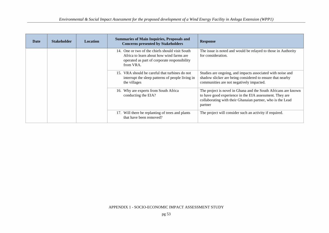
Environmental & Social Impact Assessment for the proposed development of a Wind Energy Facility in Anloga Extension (WPP1)
APPENDIX 1 - SOCIO-ECONOMIC IMPACT ASSESSMENT STUDY
pg 53
Date Stakeholder Location Summaries of Main Inquiries, Proposals and
Concerns presented by Stakeholders Response
14. One or two of the chiefs should visit South Africa to learn about how wind farms are operated as part of corporate responsibility from VRA.
The issue is noted and would be relayed to those in Authority for consideration.
15. VRA should be careful that turbines do not interrupt the sleep patterns of people living in the villages
Studies are ongoing, and impacts associated with noise and shadow slicker are being considered to ensure that nearby communities are not negatively impacted.
16. Why are experts from South Africa conducting the EIA?
The project is novel in Ghana and the South Africans are known to have good experience in the EIA assessment. They are collaborating with their Ghanaian partner, who is the Lead partner
17. Will there be replanting of trees and plants that have been removed?
The project will consider such an activity if required.

Environmental & Social Impact Assessment for the proposed development of a Wind Energy Facility in Anloga Extension (WPP1)
APPENDIX 1 - SOCIO-ECONOMIC IMPACT ASSESSMENT STUDY
pg 54
6. DESCRIPTION OF THE AFFECTED ENVIRONMENT
6.1 OVERVIEW
This section presents a description of the social and economic characteristics of the project area.
It is anticipated that the most significant socio-economic impacts will occur within Anloga,
Srogbe and Anyanui communities and its environs within the Keta Municipal of the Volta
Region of Ghana. For this reason, the discussion of baseline socio-economic conditions as
indicted earlier was looked at within the context of these three communities, the immediate
impact area as well as the Keta Municipal in the Volta Region, which is the broader impact area.
The revised structure for Ghana ESIA Reports requires the discussion of the following issues as
part of the socio-cultural baseline information and these have been examined in this Report:
• The land area taken up by the development, its location clearly shown on a map and
geographical coordinates provided.
• Human beings: (population composition and distribution, socio-economic conditions,
cultural and ethnic diversity, population growth rate);
• Land use: (agriculture, forests, industrial, commercial, residential), transportation routes
such as roads, rail, water and air, utility corridors
• Social services: (electricity, telecommunication, water supply, hospitals, etc);
• Cultural heritage: (unique features of the area or its people; cemetery, fetish grove,
festivals etc).

Environmental & Social Impact Assessment for the proposed development of a Wind Energy Facility in Anloga Extension (WPP1)
APPENDIX 1 - SOCIO-ECONOMIC IMPACT ASSESSMENT STUDY
pg 55
6.2 LAND REQUIREMENTS
Out of the total surface area of 1,086 km2, approximately 362 km2 (about 30 percent) is covered
by water bodies. The largest of these is Keta Lagoon, which is about 12 km at its widest section
and 32 km long. Hence, the remaining land area is only 724 km2, a situation which creates severe
constraints on access to land for development in the Municipality. WPP1 will cover an area of
approximately 482.16 acres (refer to Table 6-2) for the preferred layout and 309.83 acres for the
alternative layout. The geographical coordinates for the proposed layouts are provided in Table
6-1. A Right of Way of 200m, 100 m each side of a wind turbine will be acquired with respect to
the Anloga site, however, that for Anyanui and the Srogbe site will be 120 m, i.e., 60 metres on
each side. In addition, land for the substation as well as a right of way of 30m will be acquired
with the associated 67.5 Km 161 kV Transmission line.
Table 6-1: Geographical Coordinates for WPP1
Site Coordinates for preferred layout Coordinates for alternative layout
Anyanui
Anyanui 1
5o 47’ 37.81” N / 0o 44’ 16.33” E
5o 47’ 33.28” N / 0o 44’ 15.28” E
5o 47’ 25.77” N / 0o 45’ 16.17” E
5o 47’ 21.28” N / 0o 45’ 16.20” E
N/A
Anyanui 2
5o 47’ 50.71” N / 0o 43’ 28.18” E
5o 47’ 51.10” N / 0o 43’ 32.54” E
5o 47’ 24.29” N / 0o 43’ 32.27” E
5o 47’ 24.29” N / 0o 43’ 32.27” E
N/A
Srogbe
5o 48’ 32.91” N / 0o 48’ 22.56” E
5o 48’ 36.13” N / 0o 48’ 25.52” E
5o 47’ 12.27” N / 0o 49’ 43.10” E
5o 47’ 09.44” N / 0o 49’ 40.42” E
5o 48’ 32.91” N / 0o 48’ 22.56” E
5o 48’ 36.13” N / 0o 48’ 25.52” E
5o 47’ 12.27” N / 0o 49’ 43.10” E
5o 47’ 09.44” N / 0o 49’ 40.42” E
Anloga Beach
5o 46’ 42.08” N / 0o 51’ 02.20” E
5o 46’ 40.66” N / 0o 51’ 02.43” E
5o 47’ 11.69” N / 0o 55’ 06.32” E
5o 47’ 07.13” N / 0o 55’ 06.73” E
5o 46’ 42.08” N / 0o 51’ 02.20” E
5o 46’ 40.66” N / 0o 51’ 02.43” E
5o 47’ 11.69” N / 0o 55’ 06.32” E
5o 47’ 07.13” N / 0o 55’ 06.73” E

Environmental & Social Impact Assessment for the proposed development of a Wind Energy Facility in Anloga Extension (WPP1)
APPENDIX 1 - SOCIO-ECONOMIC IMPACT ASSESSMENT STUDY
pg 56
Table 6-2: Land Requirements for WPP1
Site Land Required for preferred layout
(acres) Land Required for alternative
layout (acres)
Anyanui
Agbledomi 106.60
Anyanui 65.84
Total - Anyanui 172.45
Srogbe
Srogbe 122.49 122.49
Salo 65.68 65.68
Total - Srogbe 188.17 188.17
Anloga Beach
Amey Clan 65.43 65.43
Togobo Clan 9.00 9.00
Whuti 47.10 47.10
Total - Anloga 121.54 121.66
Total 482.16 acres 309.83
Source: VRA Communication – August 2017
6.3 BACKGROUND OF PROJECT COMMUNITIES
Keta Municipality is located east of the Volta estuary, about 160km to the east of Accra, off the
Accra-Aflao main road. It shares common borders with Akatsi District to the north, Ketu North
and South Districts to the east, South Tongu District to the west and the Gulf of Guinea to the
south. The wind farm site is in three communities in the Keta Municipal, namely Anloga, Srogbe
and Anyanui. These communities are located on the south-east coast of Ghana, east of the Volta
River mouth and west of the Keta Lagoon and therefore slightly above sea level (See Figure
6-1)4. Anloga lies to the east of the Volta River and south of the Keta Lagoon. Anloga is the
traditional and ritual capital of the 36 traditional states of Anlo Ewe people. The land is owned
by the Adzovia clan although sections have been given out to some individuals within the clan.
The administration and transfer of the clan land within the community is done by the elders of
the clan while those that have been acquired by the individuals are handled by the individuals.
4 Source: Keta Municipal Health Directorate, Year 2014 Report (Feb. 2015)

Environmental & Social Impact Assessment for the proposed development of a Wind Energy Facility in Anloga Extension (WPP1)
APPENDIX 1 - SOCIO-ECONOMIC IMPACT ASSESSMENT STUDY
pg 57
According to the Regent (Afatsawu Agbavitor), the Stool father (Francis Atsu Lumor), and
elders of Srogbe, the community was first settled by a branch of the Like clan known as the
Dzezizi. The people of Whuti Sroegbe celebrate Norvikporgbe festival in addition to
Hogbetsotso. They have a war deity call Sri. It is believed that Sroegbe is the corrupted form of
the town deity ‘Sri’. This deity is a tree by the lagoon. The Dzezizi branch of the Like clan also
have a deity known as Apim and it is also located along the sea. The Whuti lands are owned by
three clans namely; Bate, Adzorvia and Like.
According to Togbe Gamor II, the divisional chief of Anyanui, the town, Anyanui, was derived
from a deity called Mama Gbortonunyanui. On the issue of ownership of the proposed land for
the project, he said the project land belongs to the Bate clan. To him, the land in question was
acquired from the Klevi by his grandfather. He made mention that at time the Anyanui land was
advertised to be sold by the Klevi clan, his rich grandfather who was by then living in Togo was
informed so he sent money (cowries) through Ashigbi to purchase the land. The payment was
made to Torgbui Gadagbui, the head of the Klevi clan in about 1750. It is out of benevolence that
the Bate Chiefs allowed Torgbui Gadagbui and his people to stay at the far end of the land at a
place called Xorsekordzi. More importantly, in the words of Torgbe Gamor II, even though it is
true that an Anyanui land belongs to the Bate clan, it is a communal property and no single
individual reserves the right to its ownership. He is of the view that the advent of this important
project led to the rise of multiple claims to the ownership of the Anyanui lands by the Klevi clan.
Togbe was quick to mention that a legal tussle regarding the true ownership of the land that was
adjudicated at the Ho high court in 1965 was won by the Bate clan.
There are some communities such as Tunu, Gblife and Wededeanu within the catchment area of
the project although none of them is to be displaced. Tunu is about 300 meters to the north of the
project site. According to the elders, Tunu used to be a forest area populated with lions and other
dangerous animals. Their ancestors who first settled on the land were hunters who used to set
traps for game. One of the hunters set a trap in the forest with the mouth facing the present day
Tunu and instructed other hunters not to pass where the gun or the trap was set. Since then the
area has been referred to as Tu nu in Ewe; meaning ‘gun mouth’. To put simply, the Tunu
Township was named after that hunting phrase. Clans currently settled in Tunu include the
Lafeawo, Adzorviawo, Toviawo, and Kleviawo. According to the elders, they don’t pay tribute

Environmental & Social Impact Assessment for the proposed development of a Wind Energy Facility in Anloga Extension (WPP1)
APPENDIX 1 - SOCIO-ECONOMIC IMPACT ASSESSMENT STUDY
pg 58
to the chief of Anyanui but their forebears used to because Tunu land belongs to the Anyanui
traditional area. Gblife is a second community in the project area of Anyanui and it is situated by
a lagoon. In the wisdom of the elders, Gblife is named after a male deity called Gbli. Even
though the deity is domiciled in Tunu they have a female deity called Kpokpo. The elders made
it known to us that Gblife land was given to the Toviawo clan of Glife by the Bate clan in
Anyanui. The Gblife people do not have a chief but a Headman (Amegakpui) and their
paramountcy is at Dzita.

Environmental & Social Impact Assessment for the proposed development of a Wind Energy Facility in Anloga Extension (WPP1)
APPENDIX 1 - SOCIO-ECONOMIC IMPACT ASSESSMENT STUDY
pg 59
Figure 6-1: Map of Keta Municipal showing project communities

Environmental & Social Impact Assessment for the proposed development of a Wind Energy Facility in Anloga Extension (WPP1)
APPENDIX 1 - SOCIO-ECONOMIC IMPACT ASSESSMENT STUDY
pg 60
6.4 GOVERNANCE STRUCTURE
In Ghana, two parallel government systems operate at the local level: the district assembly
administrative structure and the traditional administrative system. While the district
administration consists of elected representatives and central government appointed personnel,
the traditional administration derives from the chieftaincy institutions. At the community level,
the elected assemblyperson serves as the main link between the district assembly and the
community and these play important roles in community mobilization and development.
Paramount Chiefs and elders constitute the traditional administrative institution and they play
both judicial and executive functions within the communities, carrying great influence. They are
the traditional custodians of the land and are recognized by the formal administrative structures.
In the traditional setting, the traditional authorities also have their own court system, which
adjudicates cases relating to land dispute, chieftaincy tittle disputes, violation of traditional
customs, and disputes between localities, families and individuals. The chiefs in the district are
members of the Regional house of chief and represent the interest of the people.
This section explains briefly the governance and administrative structures relevant to the
proposed Project, including informal and formal leadership structures.
6.4.1 Formal Administrative Structures
The Keta Municipal Assembly in the Volta Region is the highest administrative and political
authority in the project area. There are two (2) constituencies in the Municipality which are Anlo
and Keta Constituencies. The legislative and deliberative organ of the Assembly is made up of
seventy-four (74) Assembly Members, including one (1) Municipal Chief Executive (MCE) who
chairs the Executive Committee in performing the executive and administrative functions of the
Assembly, (2) Members of Parliament from the Keta and Anlo constituencies in addition to fifty
(50) elected Assembly Members and twenty-one (21) government appointees. The project is
sited within three (3) Sub- District Structures namely Anloga, Whuti-Srogboe and the Dzita-
Anyanui Zonal Councils in the Keta Municipal. The project sites fall within the Anlo
constituency.

Environmental & Social Impact Assessment for the proposed development of a Wind Energy Facility in Anloga Extension (WPP1)
APPENDIX 1 - SOCIO-ECONOMIC IMPACT ASSESSMENT STUDY
pg 61
6.4.2 Traditional Administration Structures
The Traditional Council is composed of several area councils. The traditional authorities
administer stool lands, holding them in trust for the people, and arrange the celebration of
traditional festivals. They are also the custodians of traditional beliefs and customs, passed on
from one generation to another. The traditional authorities also have courts that adjudicate on
matters relating to stool lands, lineage and family lands, chieftaincy disputes, violations of
traditions and disputes between localities, lineages, families and individuals. In the Volta Region,
no paramountcy owes allegiance to another paramountcy.
Keta Municipality is fortunate to have one main ethnic group (Anlo), which minimizes potential
conflicts resulting from multi ethnicity. The Anlo Traditional Council is headed by a paramount
chief, the Awoamefia of Anlo who serves as a symbol of unity among all people in the
Municipality. There are other chiefs with their own areas of influence who assist the Awoamefia
in the promotion of peace and stability in the Municipality. There is relative peace on the
chieftaincy and political fronts due to pre-emptive measures taken by the municipality command
with the collaboration of Municipal Security Council. As indicated, the project sites fall within
the Anlo constituency, with the traditional authority being the Anlo Traditional Council, the
renowned and powerful authority in the entire Anlo Kingdom, and headed by the Awoamefia.
6.5 DEMOGRAPHICS
6.5.1 Population Size, Composition & Age Structure
The 2010 Population and Housing Census put the total population of the Keta Municipality at
147,618, which forms 7.0 percent of the Regional total population. The population constitutes
53.6 percent females and 46.4 percent males with an annual growth rate of 2.5 percent, which is
slightly higher than the regional figure of 2.4 percent. The projected population of the
Municipality for 2015 is 155,918. Out of the total population of 155,918, males are expected to
be 72,408 representing (46.44%) while that of females was 83510 representing (53.5 percent).
Table 6-3 shows the population by age and sex of the three project communities in the 2010
PHC. Anloga is the only urban community amongst the three (3) project communities, which is
with a population of above 5,000 people. Anloga’s population as at 2010 was 22,722, out of

Environmental & Social Impact Assessment for the proposed development of a Wind Energy Facility in Anloga Extension (WPP1)
APPENDIX 1 - SOCIO-ECONOMIC IMPACT ASSESSMENT STUDY
pg 62
which 10,652 (46.8%) are males. Anyanui has a population of 2,316 with a male population
1075 (46.4%) whilst Srogbe has a population of 1195 out of which 553 (46.2%) are males. These
three (3) communities are among the 20 largest communities in the Municipal.
The Municipality is the most urbanised district in the region with more than half 53.3 percent of
the district’s population living in the urban areas with 46.7 percent of the population living in the
rural areas. The population density of the Keta Municipality was 211.9 persons per km2 in 2000
(water bodies excluded). The density reduced to 196.0 persons per km2 in 2010. This is
significantly higher than the national and regional figures of 103.4 persons per km2 and 103.0
persons per km2 respectively. This higher density is attributed to the presence of large water
bodies, which occupy one-third of the total land area. The population dynamics of the
Municipality may be determined largely by fertility and mortality processes. Persons of
Ghanaian parentage constitute a large percentage of the population in the Keta Municipality.
There are Ghanaians with dual citizenship in the Municipality, though the proportion is small.
Households in the Municipality are predominantly male-headed. The extended family living
arrangements dominates in the Municipality. The age-dependency ratio is the ratio of the
dependent-age population (those under age 15 and ages 65 and older) to the working-age
population (15 to 64 years). The age dependency ratio for the Municipality is about 78
dependents (child and old age) for every 100 people working. This means that 100 persons in the
active population group are being depended on by 78 persons in the inactive population group. In
relation to the sex structure, there are more males (51.1%) than females (48.9%) who are under
15 years in the Municipality. There are large proportions of children (12.4%) below five years in
the Municipality. The population below 15 years (0-14) is 34.6 percent. Population between the
ages of 15-19 comprises 11.0 percent of the total population in the Municipality.

Environmental & Social Impact Assessment for the proposed development of a Wind Energy Facility in Anloga Extension (WPP1)
APPENDIX 1 - SOCIO-ECONOMIC IMPACT ASSESSMENT STUDY
pg 63
Table 6-3: Population By Sex and Age in the Project Communities
Age Anyanui Srogbe Anloga
Male Female Total Sex ratio Male Female Total Sex ratio Male Female Total Sex ratio
0-4 143 139 282 103 67 79 146 85 1,365 1,307 2,672 104
5-9 162 131 293 124 61 70 131 87 1,215 1,166 2,381 104
10-14 150 131 281 115 67 64 131 105 1,233 1,144 2,377 108
15-19 129 121 250 107 53 58 111 91 1,337 1,238 2,575 108
20-24 93 98 191 95 52 40 92 130 1,081 1,016 2,097 106
25-29 71 90 161 79 45 52 97 87 707 820 1,527 86
30-34 40 65 105 62 42 38 80 111 591 710 1,301 83
35-39 46 62 108 74 37 44 81 84 522 692 1,214 75
40-44 38 72 110 53 28 28 56 100 452 651 1,103 69
45-49 36 45 81 80 22 33 55 67 491 565 1,056 87
50-54 58 69 127 84 21 27 48 78 453 560 1,013 81
55-59 23 50 73 46 9 17 26 53 296 410 706 72
60-64 18 41 59 44 13 22 35 59 252 429 681 59
65-69 15 31 46 48 8 21 29 38 183 330 513 55
70-74 20 36 56 56 6 19 25 32 174 326 500 53
75-79 14 24 38 58 9 5 14 180 134 279 413 48

Environmental & Social Impact Assessment for the proposed development of a Wind Energy Facility in Anloga Extension (WPP1)
APPENDIX 1 - SOCIO-ECONOMIC IMPACT ASSESSMENT STUDY
pg 64
Age Anyanui Srogbe Anloga
Male Female Total Sex ratio Male Female Total Sex ratio Male Female Total Sex ratio
80-84 12 19 31 63 3 6 9 50 82 209 291 39
85-89 5 11 16 45 6 11 17 55 47 116 163 41
90-94 2 5 7 40 2 4 6 50 28 66 94 42
95+ - 1 1 - 2 4 6 50 9 36 45 25
Total 1,075 1,241 2,316 87 553 642 1,195 86 10,652 12,070 22,722 88
Source: Ghana Statistical Service, 2010 Population and Housing Census

Environmental & Social Impact Assessment for the proposed development of a Wind Energy Facility in Anloga Extension (WPP1)
APPENDIX 1 - SOCIO-ECONOMIC IMPACT ASSESSMENT STUDY
pg 65
6.5.2 Fertility
The fertility rate for the Municipality is 3.1 children per woman age 15-49, which is slightly
lower than the regional rate of 3.4 children per woman. The numbers of male and female
children ever born are 85,330 and 86,365 respectively and children who survived are 69,440
(81.4%) males and 72,347 (83.8%) females respectively. The crude death rate for the
Municipality is 12.3 per 1,000 population. This also implies that there are approximately 12
deaths per 1,000 population. The reported under five (age 0-4) male deaths were slightly higher
than the female deaths. From age groups 15-19 to 50-54 the proportion of female deaths were
higher than male deaths, which may be attributed to maternal deaths. Among those who were
born elsewhere in another region, migrants from the Northern, Central and Ashanti region have
had the longest stay (20+ years) in the Municipality than migrants from any other region. Even
though Total Fertility Rate is relatively low in the Municipality, (3.1 children per woman aged
15-49 years), most women do not have control over their reproductive health especially when it
comes to regulating fertility and using contraceptives, there is a need to integrate family life
education into school curriculum and out-of-school programs.
6.5.3 Migration
Migration is a socio-economic phenomenon, which is a result of complex mechanisms involving
social, psychological, economic, political and institutional determinants. The movement of
population in space is incidental to carrying out daily activities in life, such as commuting to and
from places of work and travelling for business or for pleasure. These movements are often
monitored and analysed for specific purposes. The duration of stay distinguishes the temporary
stay from a short stay. However, when such mobility involves a permanent sojourn in the place
of destination, it is considered as migration. Migration is therefore defined as a geographical
movement involving a change from a usual place of residence over a defined territory beyond a
defined period (United Nations, 2012).
The 2010 PHC shows that there are total of 26,960 migrants residing in the Keta Municipality.
Out of this number, 14,464 were born elsewhere in the Volta Region, 8,027 percent were born
elsewhere in another region, while the rest 4,226 were born outside Ghana. In terms of duration
of residence, majority of the migrants (35.3%) have been residing in the Municipality for ten

Environmental & Social Impact Assessment for the proposed development of a Wind Energy Facility in Anloga Extension (WPP1)
APPENDIX 1 - SOCIO-ECONOMIC IMPACT ASSESSMENT STUDY
pg 66
years or more. Besides, amongst those who were born elsewhere in another region, migrants
from the Northern, Central and Ashanti region have had the longest stay (20+ years) in the
Municipality than any other region recording 23.6%, 21.7% and 20.2% respectively. These
migrants can be a potential asset for the district by tapping their skills and using them for the
benefits of the district. It can however be a potential problem if they become a liability to the
district by engaging in nefarious activities.
6.5.4 Religion & Ethnic Composition
Within the Keta Municipal, the predominant religion is Christianity, which constitutes about 72.8
percent of the population followed by traditional religion 25.4 percent, Muslim 1.0 percent and
others, 0.8 percent. However, some people practice Christianity alongside traditional religion.
Ethnic Composition of the Keta Municipality is highly homogeneous with Ewes dominating
(98.7%) while the other tribes constitute the remaining (1.3%).
6.6 ARCHAEOLOGICAL, HERITAGE & CULTURAL STRUCTURE
Cultural resources and heritage comprise tangible historical/archaeological sites, documents and
artefacts together with religious/spiritual sites (sacred sites) and activities important to local
communities, customary law, traditional beliefs, values and practices. Keta Municipality is part
of Anlo Traditional Council, which has 36 states and headed by a paramount chief, the
Awoamefia of Anlo who serves as a symbol of authority among all people in the Municipality.
Other chiefs with their own areas of influence assist the Awoamefia in the promotion of peace
and stability in the Municipality.
The main festival is the Hogbetsotso, which symbolizes the great exodus of Ewes from their
ancestral home, Notsie, to their present abode around the 15th Century. The Hogbetsotso
Festival, which is celebrated at Anloga, the traditional home of the Anlos, attains a grand final
with a durbar of Chiefs and people amidst pomp and pageantry on the first Saturday of every
November. Display of rich cultural values, resource mobilisation for development and peaceful
co-existence are prominent issues considered during the occasion.

Environmental & Social Impact Assessment for the proposed development of a Wind Energy Facility in Anloga Extension (WPP1)
APPENDIX 1 - SOCIO-ECONOMIC IMPACT ASSESSMENT STUDY
pg 67
Experts from the Department of Archaeology & Heritage Studies from the University of Ghana
have undertaken a separate archaeological, heritage and cultural study and details of this is
provided in a specialist report submitted as part of the ESIA study. The study did not reveal any
significant heritage remains that could be directly impacted on by the project. The project site is
not located in a designated archaeological priority area nor contains any scheduled ancient
monuments, listed buildings or locally listed buildings. There are no listed heritage sites located
within the area of the property proposed for the project site. The most common type of
archaeological site encountered in the study area were active heritage resources. These include
the following:
a) Walled Takpe Vikpe shrine in the project area (See Plate 6-1) near the sea
b) The Mama Blode river/lagoon deity and associated sacred groove (See Plate 6-2)
c) The Hunua Kofi Gborsike Fuidoglo’s shrine village at Toviakorpe/Anloga (See Plate
6-3).
The Tunu community at Anyanui are said to also have a deity known as Gbli. Some taboos
associated with this deity are:
• Women in their menstruation period do not visit the shrine of the deity.
• Women in their menstruation period do not visit the river side
• Running and diving into the lagoon is a taboo
• Fetching water from the lagoon with a black pot is a taboo
• Hooting is prohibited in the town
• Having sexual intercourse on the bare ground is unacceptable
• They don’t engage in economic activities on Thursdays
At the Srogbe project area, an abandoned village/hamlet once called Komiga Kofe or Kpodzi
was identified by the study and was characterised by house mounds and remains of palm trees.

Environmental & Social Impact Assessment for the proposed development of a Wind Energy Facility in Anloga Extension (WPP1)
APPENDIX 1 - SOCIO-ECONOMIC IMPACT ASSESSMENT STUDY
pg 68
Plate 6-1: The walled Takpe Vikpe shrine in the project area near the sea.
Source: Archaeological & Cultural Heritage Impact Assessment: ESIA for Wind Power Project (Anloga, Sroegbe & Anyanui Project Sites), April 2017
Plate 6-2: Mama Blode river/lagoon deity and associated sacred groove
Source: Archaeological & Cultural Heritage Impact Assessment: ESIA for Wind Power Project (Anloga, Sroegbe & Anyanui Project Sites), April 2017
Plate 6-3: Hunua Kofi Gborsike Fuidoglo’s shrine village at Toviakorpe/Anloga
Source: Archaeological & Cultural Heritage Impact Assessment: ESIA for Wind Power Project (Anloga, Sroegbe & Anyanui Project Sites), April 2017

Environmental & Social Impact Assessment for the proposed development of a Wind Energy Facility in Anloga Extension (WPP1)
APPENDIX 1 - SOCIO-ECONOMIC IMPACT ASSESSMENT STUDY
pg 69
6.7 LAND TENURE SYSTEM
Under the existing arrangement Ghana’s land tenure systems, traditional land-owning authorities
(stool chiefs, clan heads and skins) hold allodial (absolute ownership) title to land on behalf of
their people. Leases and rentals over a satisfactory period for economic/commercial activities are
possible and involve permission by the allodial titleholders to use the land. However, the land
must revert to the community or the allodial titleholder at the end of the lease or cessation of the
activity for which the lease was granted in the first place. Thus, outright ownership of land is still
a rare form of land tenure in Ghana.
Ghana’s land tenure system impedes the country’s socio-economic development, and is
completely out of place in a modern, progressive country. The Anloga area of the Volta Region
of Ghana presents a classic case of rational environmental resource management, against the
backdrop of limited land space, capricious weather conditions, impoverished soils, hydrological
perturbations and intense population pressure. Based on a local initiative, the farmers adopted a
highly specialised system of horticulture as a sustainable coping strategy to redress the
environmental ills. The farming system, involving shallot cultivation, is intricately linked with an
elaborate system of land tenure, institutionalised to streamline the individual’s usufractory right.
A study in 2001 showed that although a patrilineal inheritance system prevails in the area,
pockets of matrilineal system had also evolved, making the inheritance system quite
complicated. The religious importance attached to the patrilineal system of inheritance makes the
pattern of land holding much skewed in favour of men. However, though women may not be
active partners in shallot farming and in transactions pertaining to land, their absolute control
over the distribution network of the end-product places them at a pivotal position in the farming
system. Investigations into patterns of land tenure, including gender patterns and possible
temporal changes, revealed that apart from the inheritance system through which the majority of
the people acquire land for farming, other tenure agreements – share cropping, renting, pledging
and leasehold also exist. The study concluded that outright land sales have been completely

Environmental & Social Impact Assessment for the proposed development of a Wind Energy Facility in Anloga Extension (WPP1)
APPENDIX 1 - SOCIO-ECONOMIC IMPACT ASSESSMENT STUDY
pg 70
replaced by pledging, whilst sharecropping is gradually giving way to renting, but the general
pattern of land tenure in the area had not changed significantly over the last 25 years.5
The variety of customary arrangements, combined with some inconsistencies in the procedures
for deed and title registration, make it difficult, though not impossible, for potential investors to
acquire large parcels of land for large-scale economic activities. This is particularly the case
where the activity has a long economic gestation period. In addition, the different traditional
ownership structure, in some cases, requires negotiations with a large number of allodial
titleholders. Such negotiations can often be protracted, cumbersome, frustrating and expensive.
The current land tenure system constitutes a serious disincentive to investment in Ghana’s
economy. The lack of several large-scale commercial agricultural projects in Ghana, similar to
those existing in some francophone West African countries such as the Ivory Coast, can be partly
attributed to the problems associated with acquiring land for economic activities. It is unlikely
that serious large overseas investors would be prepared to undertake protracted negotiations, on a
one-to-one basis, with several allodial titleholders in order to put together suitable large parcels
of land for large-scale commercial agricultural projects. Even where this is possible, investors
potentially face the problem of on-going litigation over the legal right of the land they have
acquired or leased. It is not uncommon for the rights to land, which has already been leased or
rented and compensation duly paid by an investor to one allodial titleholder, to be challenged or
disputed by another allodial titleholder. One commonly hears of stories from friends where
disputes have arisen when individuals had successfully negotiated parcels of land for
residential/commercial construction only to be challenged by other parties, who also claim
ownership of, or interest in, the same parcel of land.
Land tenure is a complex subject for the project area where access to land is shaped by Ghana’s
inheritance systems, tenure arrangements and land-use patterns. Most of the land in the affected
areas is held under customary land tenure systems. The land in the affected communities are
owned by clans. Clan land is generally not considered for sale as it belongs to those living there,
their ancestors and their progeny.
5 Jesee sey Ayivor (2001): Patterns of land tenure in Anloga, Ghana

Environmental & Social Impact Assessment for the proposed development of a Wind Energy Facility in Anloga Extension (WPP1)
APPENDIX 1 - SOCIO-ECONOMIC IMPACT ASSESSMENT STUDY
pg 71
Land ownership and transfer processes are similar within the all the three communities of
Srogbe, Anloga and Anyanui:
• The site at Srogbe is located at ‘SALO’ along the Dabala - Anloga highway. It is owned
by the ‘LIKÉ’ clan (Dzezizi Branch) who are residence of the Srogbe (Saviotula)
township. The administration of the land is done by the Stool Father, the Regent and the
elders of the clan.
• The Anloga site is located along the Anloga beach stretch. The location is separated from
the main Anloga township by a huge depression which is cultivated during dry season
and floods during wet season. The land is owned by the Adzovia clan although sections
have been given out to some individuals within the clan. The administration and transfer
of the clan land within the community is done by the elders of the clan whilst those that
have been acquired by the individuals are handled by the individuals. Except for some
fisher folks dragging their boat and net from the sea onto the property, the land is
virtually idle.
• At Anyanui, the site is located along the Dzita Anyanui – Tunu road. There are some
communities such as Tunu, Gblife and Wededeanu within the catchment area of the
project although none of them is likely to be displaced.
The project will necessitate land acquisition resulting in both physical and economic
displacement. During the ESIA exercise, various bodies and processes were found to be involved
in the land acquisition. The team also identified some legitimate representatives for the
acquisition of community lands especially at Anloga and Srogbe. However, we found that the
ownership of the affected lands at Anyanui is being contested between two clans, namely the
‘Bate’ Clan from Anyanui and the ‘Klevi’ Clan of Dzita and these has to be resolved for the
smooth implementation of the project.

Environmental & Social Impact Assessment for the proposed development of a Wind Energy Facility in Anloga Extension (WPP1)
APPENDIX 1 - SOCIO-ECONOMIC IMPACT ASSESSMENT STUDY
pg 72
6.8 ECONOMIC CHARACTERISTICS
6.8.1 Economic Activity Status
For the Keta Municipality, the economically active population is (63.9%) of which (93.5%) are
employed and (6.5%) are unemployed. The proportion of economically active male is 65 percent
of which (94.5%) are employed and (5.5%) unemployed whiles that for the female economically
active population is 63 percent with (92.7%) employed whiles (7.3%) are unemployed. The
economically not active population is (36.1%) with those in full time education recording the
highest percentage of (45.4%) and pensioners or retires recording the lowest of 3.8 percent. The
proportion of male to female economically not active population for the district is (35%) and
(37%) respectively with (60%) of males in full time education almost twice that of females
(34.5%) in full time education, (25.1%) are too old/young to work and (24.5%) of females did
home duties (household chores) whiles only (10.3%) of males did the same.
Table 6-4 highlights the activity status of the members in the three project communities.
Percentage unemployed persons was highest at Anyanui (17.2%), followed by Srogbe (13.6%)
and Anloga (4.9%).
Table 6-4: Activity Status of Project Communities
Activity Status Anloga Anyanui Srogbe
Male Female Total Male Female Total Male Female Total
Economically active 4,724 5,423 10,147 397 527 924 260 317 577
Employed 4,507 5,139 9,646 337 428 765 235 263 498
Unemployed 217 284 501 60 99 159 25 54 79
Economically not active 2,115 3,030 5,145 223 313 536 98 112 210
Total 6,839 8,453 15,292 620 840 1460 358 429 787
Source: Ghana Statistical Service, 2010 Population and Housing Census

Environmental & Social Impact Assessment for the proposed development of a Wind Energy Facility in Anloga Extension (WPP1)
APPENDIX 1 - SOCIO-ECONOMIC IMPACT ASSESSMENT STUDY
pg 73
6.8.2 Agricultural Activity
The Keta Municipality is mainly an agrarian economy, with the majority of the population
engaged in crop farming, livestock keeping, fishing and other agricultural related activities and
trading. About the type of agricultural activity, crop farming represents the main type of
agriculture activity adopted by the populace in both the urban and rural areas followed by
livestock rearing. While fish farming recorded the least type of agricultural activity engaged in
by the people. The Municipality is one of the major vegetable producers in the Volta Region. It
is well known for its shallots, which are produced in the flood plains along the Angaw and Keta
Lagoons and streams. The main shallot producing areas are Anloga, Anyanui, Agbledomi, Dzita,
Atorkor, Srogboe, Whuti, Woe and Tegbi. Other vegetables such as okro, tomato and pepper are
also extensively cultivated either as pure stands or as intercrops depending upon the season, with
the alluvial soils along the lagoons providing ideal sites for their production. The new developed
technology of tube well irrigation has given a new impetus in the production levels of previously
unknown crops and horticulture in the Municipality.
Maize and cassava are also grown as off-season crops, along the littoral but as main season crops
in the northern parts of the Municipality. Coconut is also cultivated along the littoral even though
it is no more the main source of income for the people as it used to be some years ago as a result
of the Cape St Paul Wilt Disease, which appeared in the Municipality in the Woe area around
1932 and devastated large numbers of trees and still causing havoc. Fishing is carried out in the
sea, lagoons and rivers. Several types of fishing gears are used for fishing in the sea. These
include beach seine, Ali, Polo, Watsa, Set nets and Drift gill nets. Some of these fishing gears
have proved to be inappropriate and efforts are being made to regulate them. Shrimps, Oysters
and other edible bivalves are harvested from water bodies. Livestock production is a secondary
vocation to most farmers in the Municipality. The Municipality is very popular for rearing ducks
and geese. Local poultry (fowls) are also kept on free range. A few women keep turkeys, while
pigeons are pastimes for the wealthy men in the society. Few farmers keep improved poultry.
Poultry is abundant in commercial towns along the littoral where the demand is highest. Sheep
and goats are also found in most homes and are fed on household waste.

Environmental & Social Impact Assessment for the proposed development of a Wind Energy Facility in Anloga Extension (WPP1)
APPENDIX 1 - SOCIO-ECONOMIC IMPACT ASSESSMENT STUDY
pg 74
A wide range of small-scale industrial activities which are owned and managed mainly by sole
proprietors has been identified in the Municipality and employs about 13% of the labour force.
The agro-based: fish processing, cassava processing, the mining: quarry, exploitation of salt and
sand winning, wood-based: carpentry, standing brooms, textile: dressmaking, kente weaving,
service: hairdressing, vehicle repair/fitting mechanics, radio/TV mechanics, masonry, ceramics,
pottery.
Vegetables and cassava are the main farming activities taking place on some parts of the
proposed project sites as shown in Plate 6-4 and Plate 6-5. Fishing activities take place at the
shores of the proposed site. Some sailors dock their wooden canoes at the seashore and drag their
nets from one side to another along the site. The residents of Srogbe and Anyanui also engages in
fishing and crab trapping activities on the lagoon. Table 6-5 shows agriculture and non-
agriculture households in the three project communities. The proposed sites are also a grazing
field for livestock. Mangroves and other plant species in the proposed project site are used as
cooking fuel (firewood) and gardening. Grass/straw used for roofing homes, craft and weaving
can also be obtained at the Srogbe site. Again, the mangroves play a primary production role in
providing nutrients for prawns and juvenile fish in the lagoon. In addition, some herbs are
harvested from the vegetation on the proposed sites, which is used for medicinal purposes.
Moreover, there is potential for tourism and recreation, the proposed sites are located around
communities situated on a lower coast strip with a great potential of beach development, massive
tourist during festivals in addition to the slope of the beaches and fine sand at the shores, which
provides a beautiful view of the towns by the sea. Many leisure activities can be developed.
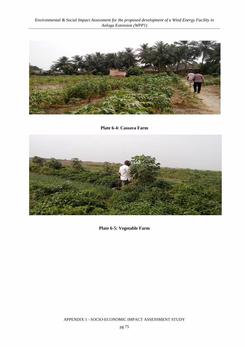
Environmental & Social Impact Assessment for the proposed development of a Wind Energy Facility in Anloga Extension (WPP1)
APPENDIX 1 - SOCIO-ECONOMIC IMPACT ASSESSMENT STUDY
pg 75
Plate 6-4: Cassava Farm
Plate 6-5: Vegetable Farm

Environmental & Social Impact Assessment for the proposed development of a Wind Energy Facility in Anloga Extension (WPP1)
APPENDIX 1 - SOCIO-ECONOMIC IMPACT ASSESSMENT STUDY
pg 76
Plate 6-6: Canoes belonging to fishermen at Anloga
Plate 6-7: Some fishing activities at the Anloga beach near the project site
Table 6-5: Agriculture & Non-Agriculture Households in Project Communities
Households in agriculture Anyanui Anloga Srogbe
Number Percent Number Percent Number Percent
Agriculture household 281 49.7 2,521 43.6 49 14.6
Non-agriculture household 284 50.3 3,260 56.4 287 85.4
Total 565 100.0 5,781 100.0 336 100.0
Source: Ghana Statistical Service, 2010 Population and Housing Census

Environmental & Social Impact Assessment for the proposed development of a Wind Energy Facility in Anloga Extension (WPP1)
APPENDIX 1 - SOCIO-ECONOMIC IMPACT ASSESSMENT STUDY
pg 77
6.8.3 Occupation
Data on employment sector of employed persons 15 years and older in the Keta Municipal in
20106 is shown in Table 6-6. Almost 35 percent of the employed population 15 years and older
in the Municipality are engaged as skilled agricultural, forestry and fishery workers (34.8%).
This is followed by craft and related trades workers (25.4%) and services and sales workers
accounting for 21.8 percent. Clerical support workers and technicians and associate professionals
recorded the lowest with (1%) and (1.2%) respectively. The employment characteristics of the
population indicate employment in low skills among the employed population that are mostly
self-employed without employees. Such employment hardly generates employment for others.
Its been noted that there is therefore the need to create jobs for the economically active group
since they form a majority of the population in the Municipality.
Table 6-6: Employed population 15 years and older by occupation and sex
6 Source: Ghana Statistical Service, 2010

Environmental & Social Impact Assessment for the proposed development of a Wind Energy Facility in Anloga Extension (WPP1)
APPENDIX 1 - SOCIO-ECONOMIC IMPACT ASSESSMENT STUDY
pg 78
Data on employment sector of persons 15 years and older by sex in the three project
communities in 2010 is shown in Table 6-7.
Table 6-7: Employment sector of persons 15 years and older by sex in project communities, 2010
Employment status Anloga Anyanui Srogbe
Male Female Total Male Female Total Male Female Total
Employee 743 422 1,165 62 22 84 79 15 94
Self-employed without employee(s) 2,684 3,620 6,304 265 360 625 94 196 290
Self-employed with employee(s) 247 181 428 8 22 30 15 8 23
Casual worker 219 185 404 1 - 1 34 17 51
Contributing family worker 532 545 1,077 - 11 11 4 20 24
Apprentice 49 161 210 1 13 14 8 7 15
Domestic employee (Househelp) 27 21 48 - - - 1 - 1
Other 6 4 10 - - - - - -
Total 4,507 5,139 9,646 337 428 765 235 263 498
Source: Ghana Statistical Service, 2010 Population and Housing Census
6.8.4 Tourism Potential and Development
As a low lying coastal plain with the highest point only 53 metres above sea level interspersed
with lagoons, creeks and mangrove forests, the Keta Municipality offers a great potential for
tourism development in the country. The main tourists’ sites in the municipality include:
Breeding of Sea Turtles: The Beach or the Coastline between Anloga and Dzita
and much especially around Dakordzi and Akplorwotorkor records a lot of
Seasonal Sea Turtles which come on-shore to lay eggs for hatching. The scene is
so interesting attractive to watch during the months of August, September and
October.

Environmental & Social Impact Assessment for the proposed development of a Wind Energy Facility in Anloga Extension (WPP1)
APPENDIX 1 - SOCIO-ECONOMIC IMPACT ASSESSMENT STUDY
pg 79
Lagoons: The lagoons also provide calm water bodies for cruising and other
water sports. Three major lagoons are found in the Municipality, namely Keta,
Angaw and Avu. The Keta Lagoon is the largest in the country and has several
islands such as Seva, Dudu and Xevi Kpodzi (bird sanctuary). The lagoons offer
opportunities for angling since they are rich in tilapia, mudfish and others such as
crabs, shrimps and scallop.
Mangrove Swamps: Along the main Angaw, Avu and part of Keta lagoon are
very extensive stretches of mangrove swamps. Opportunities exist for visitors to
cruise through the mangrove forest or to study its ecology.
Ramsar Site: The Anlo- Keta wetlands have been designated Ramsar Site
because it provides sanctuaries for several birds including migratory and resident
ones, especially water fowls. It is said that the Anlo- Keta Ramsar Site is at the
crossroad of several thousands of migratory birds that fly the Mediterranean and
the South-Atlantic flyway. Some of the birds which nest, rest, feed and breed
there include the various types of terns, gulls and pelicans. There is, therefore, the
great need for the construction of bird watching towers to attract more tourists
into the Municipality.
Sandy Beaches: The Keta Municipality is blessed with several kilometres of very
clean and unique golden beaches in the country which can offer places of
relaxation to tourists. The beaches drenched in brilliant sunshine have sands
ranging from fine to coarse grained types. The coconut clad sandy beaches are
interspersed with bare sandy surfaces stretching from Azizanu to Dzelukope near
Keta.
Festivals: The main festival is the Hogbetsotso, which symbolizes the great
exodus of Ewes from their ancestral home, Notsie, to their present abode around
the 15th Century. The Hogbetsotso Festival, which is celebrated at Anloga, the
traditional home of the Anlos, attains a grand final with a durbar of Chiefs and
people amidst pomp and pageantry on the first Saturday of every November.

Environmental & Social Impact Assessment for the proposed development of a Wind Energy Facility in Anloga Extension (WPP1)
APPENDIX 1 - SOCIO-ECONOMIC IMPACT ASSESSMENT STUDY
pg 80
During such festivals, religious cults are displayed through some magical
performances. Such cults include the Korku and Yewe cults. One interesting
feature is to see the members of Korku cult cut themselves without effect with
sharp knives.
Fort Prinzenstein: This Danish Fort build in 1784 at Keta is one of the most
spectacular relics of colonialism in the Municipality. It played a key role in the
infamous triangular slave trade involving West Africa, England and North
America. Efforts need to be made to save this important historical monument
from total destruction by sea waves and to preserve it as an important tourist
resort. The Keta Sea Defense Project has greatly saved the Fort from further
destruction and still has a story to tell.
Atorkor Slave Market: In addition to Keta, Atorkor was the second slave market
in the Municipality. The trade was masterminded by one Ndorkutsu. A
monument was raised in the area where this wicked activity took place. The Keta
Municipal Assembly intends to convert the place into an important tourist resort.
A beginning has been made with the construction of a sculpture showing a slave
dealer giving orders to slaves with a whip.
Anlo Military Headquarters, Tsiame: This is yet another important tourist spot
where the Anlos during their historical wars gathered to plan war strategies
against their enemies. It is located at Tsiame, north of Keta and at that very spot
today, stands a grove, which tourists can visit.
6.8.5 Oil & Gas Development in the Keta Basin
The Keta Basin has been known for oil and gas potentials for centuries but had not seen any
major activity to tap the oil and gas resources of the area. The basin is also known for mining of
salt, tourism, vegetable farming and aquaculture. Currently, an exploration agreement is in place
for the exploration in the Keta basin for oil and gas. Because of this opportunity, efforts are
underway to create awareness for fishermen and the public on oil and gas exploration in the

Environmental & Social Impact Assessment for the proposed development of a Wind Energy Facility in Anloga Extension (WPP1)
APPENDIX 1 - SOCIO-ECONOMIC IMPACT ASSESSMENT STUDY
pg 81
Municipality. The need to build capacity to take advantage of the employment opportunities of
this development by the community members is underway.
6.9 EDUCATION & LITERACY
Keta Municipality has various educational institutions which cater for different categories of the
school going population. These include institutions for pre-school, basic, primary and secondary
education in the Municipality and grouped into the 10 educational circuits for effective
supervision. These are Abor-Tsiame, Anloga, Anyako-Afiadenyigba, Atiavi-Hatorgodo,
Dzelukope-Vui, Dzita-Anyanui, Keta, Shime, Srogboe-Kome and Tegbi-woe. Of these 10
circuits, Keta, Dzelukope-Vui, Tegbi-Woe, Anloga and Abor-Tsiame are urban oriented while
the rest are rural. There are 354 schools in the Municipality, which was made up of 120 Pre-
schools (90 public and 30 private), 120 Primary schools (88 public and 32 private), 97 Junior
High schools (77 public and 20 private), 12 Senior High/Technical Schools (10 public and 2
private), 5 Technical/Vocational (1 public and 4 private) and Health Assistants (Clinical )
Training School.
About 76 percent of persons 11 years and older are literate. Out of the total population 11 years
and older who are literate, 52 percent constitutes the male population while the rest (48%)
constitutes the female population aged 11 years and older. Some renowned educational facility
within the municipality includes the Keta Senior High School, which is one of the best secondary
schools in the country. Other institutions include the Keta Business School, Anloga Technical
Institute, among others. About 88.7 percent are enrolled in basic school, 9.0 percent in
secondary/senior high school, 0.9 percent in vocational/technical/commercial school, and 0.8
percent in tertiary institutions. The educational level persons 3 years and older in the three
project communities is shown in Table 6-8.

Environmental & Social Impact Assessment for the proposed development of a Wind Energy Facility in Anloga Extension (WPP1)
APPENDIX 1 - SOCIO-ECONOMIC IMPACT ASSESSMENT STUDY
pg 82
Table 6-8: Educational level persons 3 years and older in the project communities
Category Anloga Anyanui Srogbe
Male Fem. Total Male Fem. Total Male Fem. Total
Nursery 311 303 614 7 11 18 7 13 20
Kindergarten 590 563 1,153 110 86 196 33 36 69
Primary 2,730 2,989 5,719 303 321 624 173 194 367
Junior Senior School 1,771 1,915 3,686 199 196 395 134 120 254
Middle School 1,232 1,119 2,351 98 63 161 69 43 112
Senior Secondary School 919 726 1,645 42 21 63 20 15 35
Secondary 227 144 371 13 4 17 4 2 6
Vocational/Technical/Commercial 475 268 743 11 9 20 9 10 19
Post middle / secondary certificate 186 169 355 26 8 34 2 - 2
Post-secondary diploma 263 127 390 13 6 19 8 5 13
Bachelor degree 171 55 226 8 - 8 3 1 4
Post graduate (Cert., Diploma, Masters, PHD, etc.,) 26 7 33 3 - 3
Total 8,901 8,385 17,286 830 725 1,555 465 439 904
6.10 HEALTH PROFILE
6.10.1 Health Status
Malaria remains a public health concern, as it is the leading cause of morbidity in Ghana and
continues to be the topmost diseases that affect majority of the people in the Municipality.
Malaria trend in the Municipality has been increasing over years ranging from 59,561(31.4%) in
2012 to 78,276 (41.2%) in 2013 followed by upper respiratory tract infection representing 27,168
(14.4%) in 2012 to 32,389 (17.1%) in 2013. .
6.10.2 HIV/AIDS
The HIV prevalence in Ghana, over the years, describes Ghana’s epidemic as generalized
according to World Health Organisation classification. There has been a steady decline of HIV

Environmental & Social Impact Assessment for the proposed development of a Wind Energy Facility in Anloga Extension (WPP1)
APPENDIX 1 - SOCIO-ECONOMIC IMPACT ASSESSMENT STUDY
pg 83
prevalence since 2003 when the country recorded 3.6% among antenatal clients. The prevalence
among pregnant women in 2014 was 1.6%. With respect to regional HIV prevalence in 2014,
Eastern Region recorded the highest prevalence in the country whilst Northern region recorded
the lowest. The prevalence rate in the Volta Region in 2014 was 2.2% (GAC, 2014). The Ghana
Statistical Service medium projection assuming the impact of AIDS indicates that the country’s
population will increase from 18.91 million in 2000 to 30.2 million in 2025 and if this trend
continues, the population will reach about 32.0 million in 2030, with an average annual growth
rate of about 1.88%. In this case, the urbanization rate is expected to increase from 43.75% in
2000 to 62.94% in 2025 and about 63.4% in 2030.
The Keta Municipality has also been affected by the generalized HIV/AIDS epidemic in Ghana.
Just like most parts of Ghana, the epidemic has grown steadily until its current state. Because
sero- prevalence surveys have not been carried out in the general population, data on actual
prevalence and incidence is lacking; the number of HIV and AIDS cases seen at the various
service provision points gives a crude indication of the state of the epidemic.
Two problems generally arise from the use of these figures:
Under-reporting of both HIV infected persons and AIDS cases to hospital
Use of non-disaggregated data on HIV and AIDS cases seen: this is constrained
by over-reporting by inclusion of persons from outside the district seeking care in
the municipality and persons from the municipality seeking care outside the
district; problems with double counting and other aspects of data quality
notwithstanding.
Females tend to be bearing a disproportionate portion of the burden. The productive age group
20-39 years followed by 40-60 years’ account for the majority of cases; however, HIV infection
among young children due mostly to mother to child transmission is also a reality to be dealt
with.
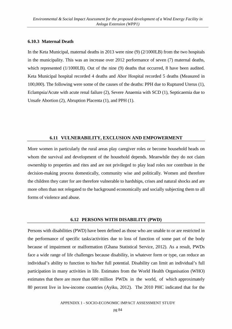
Environmental & Social Impact Assessment for the proposed development of a Wind Energy Facility in Anloga Extension (WPP1)
APPENDIX 1 - SOCIO-ECONOMIC IMPACT ASSESSMENT STUDY
pg 84
6.10.3 Maternal Death
In the Keta Municipal, maternal deaths in 2013 were nine (9) (2/1000LB) from the two hospitals
in the municipality. This was an increase over 2012 performance of seven (7) maternal deaths,
which represented (1/1000LB). Out of the nine (9) deaths that occurred, 8 have been audited.
Keta Municipal hospital recorded 4 deaths and Abor Hospital recorded 5 deaths (Measured in
100,000). The following were some of the causes of the deaths: PPH due to Ruptured Uterus (1),
Eclampsia/Acute with acute renal failure (2), Severe Anaemia with SCD (1), Septicaemia due to
Unsafe Abortion (2), Abruption Placenta (1), and PPH (1).
6.11 VULNERABILITY, EXCLUSION AND EMPOWERMENT
More women in particularly the rural areas play caregiver roles or become household heads on
whom the survival and development of the household depends. Meanwhile they do not claim
ownership to properties and rites and are not privileged to play lead roles nor contribute in the
decision-making process domestically, community wise and politically. Women and therefore
the children they cater for are therefore vulnerable to hardships, crises and natural shocks and are
more often than not relegated to the background economically and socially subjecting them to all
forms of violence and abuse.
6.12 PERSONS WITH DISABILITY (PWD)
Persons with disabilities (PWD) have been defined as those who are unable to or are restricted in
the performance of specific tasks/activities due to loss of function of some part of the body
because of impairment or malformation (Ghana Statistical Service, 2012). As a result, PWDs
face a wide range of life challenges because disability, in whatever form or type, can reduce an
individual’s ability to function to his/her full potential. Disability can limit an individual’s full
participation in many activities in life. Estimates from the World Health Organisation (WHO)
estimates that there are more than 600 million PWDs in the world, of which approximately
80 percent live in low-income countries (Ayiku, 2012). The 2010 PHC indicated that for the

Environmental & Social Impact Assessment for the proposed development of a Wind Energy Facility in Anloga Extension (WPP1)
APPENDIX 1 - SOCIO-ECONOMIC IMPACT ASSESSMENT STUDY
pg 85
Keta Municipality, 10,632 persons with disability was recorded representing 7.2 percent of the
total Municipal population. Females with disability were slightly higher than males. Table 6-9
shows the various types of disabilities in the three project communities.
Table 6-9: Types of Disability in the Project Communities
Type of disability
Anyanui Srogbe Anloga
Male Female Total Male Female Total Male Female Total
Sight 10 12 22 13 33 46 174 304 478
Hearing 12 7 19 7 15 22 44 99 143
Speech 18 10 28 3 5 8 56 63 119
Physical 32 24 56 16 19 35 95 146 241
Intellectual 19 7 26 2 9 11 110 207 317
Emotional 47 58 105 16 16 32 124 209 333
Other forms of disability 2 1 3 2 5 7 16 25 41
Total 140 119 259 59 102 161 619 1,053 1,672
Disability is now considered a societal development issue because of its direct relationship to
poverty. The development of a nation depends on the important contributions of not only a
segment of the population but on the collective contributions of every individual, including
PWDs. To this extent, government and civil society organizations in recent years have made
progress in addressing disability issues, resulting in some positive gains in improving the lives of
PWDs in Ghana. Notable among these is the Persons with Disability Act, 2006, (Act 715). The
Act deals with issues such as rights, employment, education, transportation, housing facilities,
effective health care, adequate medical rehabilitation services, generation and dissemination of
relevant information and participation of PWDs in cultural activities. Pursuant to the passage of
the Disability Act 2006 (Act 715), the National Council on Persons with Disability was
established in line with Article 41 of the Persons with Disability Act. Additionally, the Ghana
Shared Growth and Development Agenda (2010 -2013) Volume 1, also includes the
development and implementation of an action plan to fulfil the provisions of the Persons with

Environmental & Social Impact Assessment for the proposed development of a Wind Energy Facility in Anloga Extension (WPP1)
APPENDIX 1 - SOCIO-ECONOMIC IMPACT ASSESSMENT STUDY
pg 86
Disability Act and the development of targeted social interventions for PWDs (National
Development Planning Commission).
6.13 SOCIAL SERVICES
6.13.1 Health Services
The municipality can boast of about 33 health facilities, which provide various levels of services
as shown in Table 6-10. The two hospitals have a total bed state of 200. There are four
permanent doctors in the Municipal hospital and three doctors in the Catholic Mission hospital.
While preventive services are free, access to health services have been greatly enhanced by the
Municipal Wide Mutual Health Insurance Scheme.
Table 6-10: Health facilities in Keta Municipal
Facility type Number
Hospital 2
Health centres (public) 11
Health centre (mission) 1
Private clinic (general services) 3
Private maternity 3
Functional CHPS zone 6
RCH centre 1
CHPS zone yet to be operationalised 6
TOTAL 33
Source: Keta Municipal Health Directorate
There is a health centre situated at the western end of Anloga about 1.5miles from the town and
lies on the southern part of the main road from Keta to Anyanui. The Anyanui Health Centre has
a catchment area population of 13,732 people with fourteen communities and nine outreach sites.
The centre provides 24 hours service comprising general, OPD, Family life, Child health, Family
planning, Counselling & Testing services for HIV. Besides the presence of these medical
facilities, some indigenous residents also rely on herbal and traditional medication. Herbalists

Environmental & Social Impact Assessment for the proposed development of a Wind Energy Facility in Anloga Extension (WPP1)
APPENDIX 1 - SOCIO-ECONOMIC IMPACT ASSESSMENT STUDY
pg 87
and some traditionalists rely on herbs and divine intervention for the medicinal needs of their
clients
6.13.2 Telecommunication Systems and Uses
Information and Communication Technologies (ICT) have become important tools in today’s
knowledge-based information society and economy. This role of ICT in an emerging economy
such as Ghana’s, has been widely recognized at various levels. The recognition is reflected in
actions such as the development and deployment of a national ICT infrastructure, institutional
and regulatory framework for managing the sector, promoting the use of ICT in all sectors of the
economy, implementing e-governance in all government institutions and the construction of a
National Data Centre as well as Regional Innovation Centres.
The Keta Municipality is well endowed with communication networks. These include Mobile
phones and fixed lines from many communication networks including MTN, VODAFONE,
ZAIN, KASAPA, TIGO and GLO. Ghana Post has post office as well as courier services. Again,
there are two (2) Radio Stations in the Municipality namely, Jubilee Radio and Hogbe FM and
these can be used for communication purposes for the project. While 41.9 percent of persons
aged 12 years and older in the Municipality reports that they own mobile phones only six percent
of them use the internet. The rate of ownership of desktop/laptop by households is very low.
Table 6-11 shows mobile phone ownership by sex in the three project communities.

Environmental & Social Impact Assessment for the proposed development of a Wind Energy Facility in Anloga Extension (WPP1)
APPENDIX 1 - SOCIO-ECONOMIC IMPACT ASSESSMENT STUDY
pg 88
Table 6-11: Mobile Phone Ownership By Sex in the Project Communities
Anyanui
Male Female Total
Yes 278 271 549
No 441 642 1,083
Total 719 913 1,632
Srogbe
Yes 205 192 397
No 189 286 475
Total 394 478 872
Anloga
Yes 4,042 4,140 8,182
No 3,506 4,976 8,482
Total 7,548 9,116 16,664
6.13.3 Road Network
Within the Keta Municipality, the first-class road (74.8km) traverses the coast from Havedzi
through Keta-Anloga-Dabala to join the main Accra-Aflao road. Road Network has 74.8km of
first class, 30.05km second class and 52.30km of third class road. The northern section of the
Municipality between Abor and Anyako is accessible by second class road. The Keta-Aflao
stretch of road which was completely destroyed by sea erosion between Keta and Horvi has now
been constructed under the Keta Sea Defence Project by the Central Government. Settlements in
the north of the Municipality (Abor-Atiavi-Hatorgodo axis) are linked mostly by second-class
roads and are complemented by feeder roads.
The middle and southwestern sections of the Municipality (Angaw and Klomi lagoon basin) are
poorly accessible mainly by third class roads and footpaths. Generally, the Municipality is
relatively more accessible as indicated by a relatively highroad density of 194.7 meters/km2. This
mode of transport is used for passenger and cargo services, passenger buses and mini-buses with
a seating capacity of 16-40 are used for these services. Truck services are used to carry mainly

Environmental & Social Impact Assessment for the proposed development of a Wind Energy Facility in Anloga Extension (WPP1)
APPENDIX 1 - SOCIO-ECONOMIC IMPACT ASSESSMENT STUDY
pg 89
tomatoes, shallots, salt and fish to outside the Municipality while manufactured goods and
foodstuffs like rice, yams, maize and building materials are imported.
6.13.4 Water Transport
Lagoon transport, though important is poorly developed. In the case of water transport the
services are privately owned. Non-motorized local canoes are used to transport goods and people
across the lagoons. Another setback is the seasonal fluctuations in the water level, which render
movement very slow and even cumbersome. The siltation of the lagoon has also generally
reduced the water level. The major routes are Anyako/Seva-Anloga, Afiadenyigba-Keta-Anloga,
Atiavi-Keta-Anloga, and Alakple/Kodzi/Fiahor-Keta-Anloga. The seasonal drying up of the
lagoon makes water transport unreliable and time consuming as opposed to road transport (over
90 per cent of the population use road transport regularly).
6.13.5 Households
It has long been established that man’s most basic needs are food clothing and shelter. Housing
is both a social good, providing core security for households, neighborhoods, societies and
communities and an economic good stimulation growth and development. The total number of
houses in the Municipality is 30,309 with 15,164 located in the urban and 15,145 in the rural
areas. The number of households in the Municipality is 37,705. The average numbers of persons
per household is 1.2, which is the same as the regional average and higher than national average
of 7.1.
The population per house for the urban areas (5.1) is relatively lower than the rural areas (4.5).
The commonest type of dwelling units occupied by households in the district is compound
houses. On the average, compound house accounts for more than half (47.5%) of all dwelling
units in the Municipality, followed by separate houses which forms (39.2%) of all occupied
dwellings. Semi-detached houses form the third commonest type of occupied dwellings,
constituting 6.8 percent. Dwellings in tents, kiosks, containers and shops constitute small
proportions of occupied dwellings. Table 6-12 indicates the types of dwellings in the three
project communities.

Environmental & Social Impact Assessment for the proposed development of a Wind Energy Facility in Anloga Extension (WPP1)
APPENDIX 1 - SOCIO-ECONOMIC IMPACT ASSESSMENT STUDY
pg 90
The quality of life of the people in the Municipality depends largely on the type of houses they
live in, access to potable water, education, health, electricity, and adequate sanitary facilities
among others. The data shows, however, that access to these facilities tends to be poor and non-
existent in some homes and communities.
Table 6-12: Types of Household dwellings in the three project communities
Type of dwelling Anyanui Srogbe Anloga
Number Percent Number Percent Number Percent
Separate house 391 69.2 132 39.3 2,268 39.2
Semi-detached house 23 4.1 24 7.1 267 4.6
Flat/Apartment 1 0.2 6 1.8 232 4.0
Compound house (rooms) 147 26.0 146 43.5 2,610 45.1
Tent 3 0.5 2 0.6 9 0.2
Huts/Buildings (same compound) - - 7 2.1 176 3.0
Huts/Buildings (different compound) - - 9 2.7 88 1.5
Improvised home (kiosk/container, etc) - - 1 0.3 9 0.2
Living quarters attached to office/shop - - 5 1.5 41 0.7
Uncompleted building - - 4 1.2 79 1.4
Other - -
2 0.0
Total 565 100.0 336 100.0 5,781 100.0
6.13.6 Water and Sanitation
In the Keta Municipality, greater majority of the households (40.5%) rely on pipe-borne outside
dwelling. The proportion of urban (50.4%) is almost twice to rural (28.8%) for pipe-borne
outside dwelling. About 9 percent of households have pipe-borne inside dwelling. The 2010
Population and Housing Census Report shows the different methods of solid waste disposals in
the municipality. Close to 50 percent of the population disposed of their solid waste by dumping
them in public dump or open space (48%) and disposing by burning (18.7%) whiles (13.5%)

Environmental & Social Impact Assessment for the proposed development of a Wind Energy Facility in Anloga Extension (WPP1)
APPENDIX 1 - SOCIO-ECONOMIC IMPACT ASSESSMENT STUDY
pg 91
buried their waste. Table 6-13 shows the various sources of drinking water in the three project
communities. Pipe borne outside dwelling is the most popular source of drinking water in all
three communities.
Table 6-13: Drinking Water Sources in Project Communities
Drinking water Anyanui Srogbe Anloga
Number Percent Number Percent Number Percent
Pipe-borne inside dwelling 25 4.4 18 5.4 605 10.5
Pipe-borne outside dwelling 287 50.8 169 50.3 3,193 55.2
Public tap/Standpipe 62 11.0 72 21.4 167 2.9
Bore-hole/Pump/Tube well - - - - 86 1.5
Protected well - - 18 5.4 841 14.5
Rain water - - 1 0.3 3 0.1
Bottled water 1 0.2 4 1.2 3 0.1
Satchet water 2 0.4 45 13.4 287 5.0
Unprotected well 188 33.3 9 2.7 574 9.9
Protected spring - - - - 18 0.3
Tanker supply/Vendor provided - - - - 1 0.0
Unprotected well - - - -
Unprotected spring - - - - 2 0.0
River/Stream - - - - 1 0.0
Total 565 100.0 336 100.0 5,781 100.0
Sanitation disposal of both liquid and solid household waste, toilet and bathing facilities is very
poor in the district. It appears that expenditure on solid waste disposal and drainage is rarely seen
as forming part of a portfolio of investments in public health. Rather, it is generally perceived by
decision makers as comparable with other investments such as roads or public transportation,
which are not considered to be public health interventions. Sewage disposal should be planned
as a major health intervention. Its linkage to financial sustainability of the National Health

Environmental & Social Impact Assessment for the proposed development of a Wind Energy Facility in Anloga Extension (WPP1)
APPENDIX 1 - SOCIO-ECONOMIC IMPACT ASSESSMENT STUDY
pg 92
Insurance Scheme (NHIS) needs to be explored given that several diseases are linked to poor
sanitation.
The proportion using public toilets is also quite high. The district initiatives to construct them
as revenue-generating units and this might explain the pervasive use of public toilets in spite
of the unhygienic conditions of most the facilities. Actually, the district has a big
role to play in the provision of adequate public toilet facilities and maintaining their hygiene.
Almost one in ten dwelling units does not have access to any toilet facilities and household
members use the bush/beach and open fields. Laws requiring property owners to provide toilet
facilities in houses should be enforced by the district and should apply to owner-occupier
households.
6.13.7 Access to Utilities and Household facilities
The main source of lighting for most housing units in the Keta Municipality is kerosene lamp
(53.1%) with followed by electricity (41.8%) and flashlights/touch (2.9%). The main source of
fuel for cooking for most households in the municipality is wood (42.2%), charcoal is used by
almost 41 percent of households whiles 12 percent uses gas. About 43 percent (43.4%) of
households in the Municipality has no toilet facilities, the urban to rural ratio is (37.6%) and
(50.2%) respectively. (29.1%) of households rely on public toilets (WC, KVIP). Almost 44
percent of households have their own bathroom for exclusive use, shared separate bathroom in
the same house (16.1%) and shared open cubicle (15.7%). There is the need to continue
exploring non-traditional sources of energy and supporting initiatives aimed at addressing the
lighting needs of off-grid households by making safe, affordable, durable, and environmentally
sustainable lighting available to the masses through solar and other means. There is potential to
expand solar energy to accelerate economic growth and the district or government needs to
invest more time and money to make solar energy more available and affordable.
Environmental & Social Impact Assessment for the proposed development of a Wind Energy Facility in Anloga Extension (WPP1)
APPENDIX 1 - SOCIO-ECONOMIC IMPACT ASSESSMENT STUDY
pg 93
7. IDENTIFICATION OF KEY ISSUES
7.1 OVERVIEW
As indicated, the socio-economic impact assessment has involved a series of stakeholder
consultations including that with community members and elders, landowners, traditional
authorities and heads of key governmental agencies. In addition to this, we organised a
stakeholder forum in October 2016 where we invited the public and state agencies for a briefing
on the project. At these consultations, the project team explained the findings of the outcomes
from the various independent studies and Table 5-1 outlines the stakeholders’ perceptions and
needs arising out of these engagements.
Based on the issues raised at the project briefings, status quo conditions of the study area and the
nature of the proposed development, the key socio-economic issues of concern can be
summarised as follows:
• Employment Opportunities;
• Changes in Land Use
• Compensation for Loss Property
• Risk to Public Safety and Health
• Ecotourism Potential
• Improvement in Infrastructure
• Impact on Oil and Gas Development in the Keta Basin
• Environmental Challenges
• Change Management
A synopsis of these issues are provided below:

Environmental & Social Impact Assessment for the proposed development of a Wind Energy Facility in Anloga Extension (WPP1)
APPENDIX 1 - SOCIO-ECONOMIC IMPACT ASSESSMENT STUDY
pg 94
7.2 EMPLOYMENT OPPORTUNITIES
Employment for locals has been one of the key issues of concern to all parties during the
stakeholder engagements. The Chiefs expressed the need for their community members to
benefit from the expected employment opportunities under the project. The issue of local content
be considered critically and local labour should be considered during recruitment. Specifically,
the community members should be the first to benefit from menial works such as security,
masons, labourers, etc.
The Client explained that its Local Content Policy will be applicable to the project and the
contractor will be required to consider locals for recruitment. This project will bring in
employment opportunities for the local inhabitants. Some of the workforce could be sourced
from the communities where the project is located. Low to medium skilled workers such as
construction workers (Masons, carpenters and steel benders), drivers and cooks abound in some
of these communities. Again, there is the likelihood of an indirect employment through suppliers
and other complementary industry such as transport, hotelier among others. In addition, the
possibility of a skill transfer or skill training for the local recruits will positively influence the
local economy
The Client will subsequently explain to the contractor to consider this proposal from the
community. However, this will be dependent on the skill set available within the community and
what is required to successfully execute the project.
7.3 CHANGES IN LAND USE
The implementation of the project will lead to a permanent loss of land by the locals who mostly
depend on such resources for a living. The project will necessitate land acquisition and both
physical and economic displacement. This will result in loss of livelihood for landowners and
farmers who utilise the land for agricultural and other socio-economic activities. The residents
indicated that they had been informed by the Chiefs and land owners that the project would be
developed near their village soon, and therefore they should not carry out anymore
constructions of any permanent structures.

Environmental & Social Impact Assessment for the proposed development of a Wind Energy Facility in Anloga Extension (WPP1)
APPENDIX 1 - SOCIO-ECONOMIC IMPACT ASSESSMENT STUDY
pg 95
7.4 COMPENSATION FOR LOSS PROPERTY
The proposed project would affect Land and property owners, especially farms, and this should
be compensated according to the existing Government of Ghana compensation regulations and
procedures. Some other business activities may be suspended during the construction stage but
will be restored with the completion of project construction. Such activities may also be entitled
to be paid compensation because on their business activities. In addition, various request as
compensation for deity and pacification rights prior to project implementation have also been
made.
Acquisition of lands is to be done after the project site has been properly demarcated and the
total area clearly determined. Currently, there is anxiety about compensation by landowners and
this has to be critically looked at and properly addressed. The community heads of Tunu and
Gblife Community, all in Anyanui, requested that if land is to be acquired, VRA should
endeavour to pay adequate compensation for loss of farmlands and crops. The traditional Heads
of Anloga indicated that they had been briefed on the project by the Client’s personnel and has
been promised in advance payment of 30% for lands to be acquired.
Ownership of the affected lands at Anyanui is being contested between two clans, namely the
‘Bate’ Clan from Anyanui and the ‘Klevi’ Clan of Dzita. During the consultations, the Bate
believed they are the true owners of the land as a result they are not happy that the Klevi clan has
been consulted for the release of the land for the project instead of the Bate Clan. Both the Klevi
Clan of Anyanui and the Traditional Heads of Srogbe requested for a quick negotiation for the
acquisition of their land and the payment done promptly. The Client has requested the Bate Clan
to resolve the land ownership issues with the Klevi Clan so that compensation would be paid to
the rightful owner. Meanwhile, it is only when the rightful is determined that any money can be
issued, thus, any delay in the resolving the land ownership will also result in compensation
payment delays.
Indeed, in response to the BID, some individuals also have expressed concern about possible
lease agreements that may have been entered into between VRA and some landowners. There is

Environmental & Social Impact Assessment for the proposed development of a Wind Energy Facility in Anloga Extension (WPP1)
APPENDIX 1 - SOCIO-ECONOMIC IMPACT ASSESSMENT STUDY
pg 96
therefore the need for ensuring that landownership issues are cleared for smooth project
implementation.
The Client recognises that compensation issues are key to the success of the project and is
developing a “Compensation Action Plan” to adequately address this concern. The Client will
have to demarcate lands and explain the modalities and time for compensation payment as soon
as possible in order not to create any antagonism with the landowners. This will be done after the
project site has been properly demarcated and the total area clearly determined. Property
valuation will be done, and payment effected in line with requirements of the Lands
Commission. To facilitate compensation payments, Landowners are urged to have a proper land
title document to their property. The Client will also conduct further checks to determine the true
owners of the land before compensations are paid.
7.5 RISK TO PUBLIC SAFETY AND HEALTH
Various stakeholders raised concerns that the possible influx of migrant workers may result in
increased sexual activities, which may result in escalation of sexually transmitted diseases and
unwanted pregnancies as well as increased pressure on infrastructure, services (such as
healthcare) and roads, particularly with the establishment of informal settlements. The resultant
effect of increased unwanted pregnancies may include increase in abortion, school dropout rate,
broken homes among others. Additional traffic and transport from huge haulages may result in
accidents and injury to the community members.
Coinciding with the influx of migrant workers is typically a raise in demand for goods and
services during the construction period, which can result in a rapid expansion in supply chain
businesses operating in the area. This will result in increases in formal employment and informal
labour. Officials from the Health Services Directorate advised that accidents, robbery and baby
delivery mostly happen during the nights, thus generation of electricity is very important to the
health service. It was good the Client is looking at alternative sources of power to supplement
current supply as inadequate power supply is affecting health delivery in the district especially
for storage of drugs.

Environmental & Social Impact Assessment for the proposed development of a Wind Energy Facility in Anloga Extension (WPP1)
APPENDIX 1 - SOCIO-ECONOMIC IMPACT ASSESSMENT STUDY
pg 97
7.6 ECO TOURISM POTENTIAL
The siting of the project will attract more tourists to the proposed project location and the
potential spillover effect of tourist to explore the rich culture, traditions, festivals, beaches and
other existing tourist site and the potential to invest in tourist related infrastructure. The Local
Government Authority is therefore urged to consider boosting the ecotourism potential to be
realised from the development of the project. It must be noted that this will be the role of the
Keta Municipality and therefor there is the need to start considering its impact in the Municipal
developmental agenda. This issue was discussed to enable the Keta Municipality factor this their
developmental plans following the completion of the project.
Another key issue was for workers to respect their traditions and observe festivals. It was
therefore important that this be made known to the contractor for adherence. The workers and the
entire team should be adequately briefed on these traditional rights and festivals. Issues related to
the allowable activities on the land about of do’s and don’ts as required by their taboos needs to
be respected by project contractors.
7.7 IMPROVEMENT IN INFRASTRUCTURE
Many of the stakeholders requested for the enhancement of existing infrastructure as part of the
project development. Indeed, they made various request for the project to contribute to
improving roads and providing health and educational facilities. The construction of the wind
farm is likely to lead to improvement in infrastructural facilities such as access roads, water and
electricity supplies for the affected communities. At the national level, it is apparent that the
implementation of the Wind Power Project will have positive impact on the Country’s long-term
development agenda as laid out by the Client with the goal of improving the power situation in
the country.
At completion, the wind power project is projected to add an extra 100MW – 150MW into the
country’s national grid. This will go a long way in enabling the country realize the planned
incremental power supply in the country. In principle, this will augment the country’s plan to
accelerate rural electrification programme in the different parts of the Country. The result is an

Environmental & Social Impact Assessment for the proposed development of a Wind Energy Facility in Anloga Extension (WPP1)
APPENDIX 1 - SOCIO-ECONOMIC IMPACT ASSESSMENT STUDY
pg 98
attendant multiplier effect on socio-economic benefit likely to arise from power supply.
Execution of the project presents the country with a prospect to depend less on the costly fuel
powered options and steering in a period of green energy with less environmental problems.
Stakeholders also raised the issue that the development on the Akosombo Dam has negatively
affected the socio-economic life of the people of Keta, and therefore there was concern that there
was the need to assure them that wind power project will not affect it. In view of this, the Keta
Municipal expects other packages such as scholarships and provision other social amenities for
the people. The Client made it known that the level of impact associated with hydropower is very
different from that of the wind power. Currently, the Keta Municipality currently benefits from
VRA’s Corporate Social Responsibility Program due to the presence of the Akosombo Dam
within the locality and this be expanded now the VRA is implementing another power project in
the locality.
7.8 IMPACT ON OIL & GAS DEVELOPMENT IN THE KETA BASIN
As indicated, currently an exploration agreement is in place for the exploration of oil and gas in
the Keta basin. The EPA in their review comments indicated that the location of the wind power
project falls within the Keta Basin where seismic activities are ongoing for oil and gas
development and there was the need to determine the compatibility of the two projects. VRA and
the Ghana National Petroleum Corporation will therefore have to work together to address this
issue.
7.9 ENVIRONMENTAL CHALLENGES
One of the key concerns was the project to mitigate the impact on birds, as the project is located
close to the Keta Lagoon Complex Ramsar site, which is known to harbour significant number of
birds. Again, it was noted that during the constructional phase, the wastes that would be
generated if not collected and safely disposed of, are likely to pose environmental problems to
the surrounding communities. Other environmental effects of concern were the effect of noise,
dust, and traffic movements on economic and leisure amenities during the construction stage.

Environmental & Social Impact Assessment for the proposed development of a Wind Energy Facility in Anloga Extension (WPP1)
APPENDIX 1 - SOCIO-ECONOMIC IMPACT ASSESSMENT STUDY
pg 99
The Client noted that a detailed EIA study was underway, and this would look at these impacts
and propose mitigation measures to address them. Associated impacts like noise and shadow
flicker would be investigated and the siting of the turbines will be done to mitigate these. In
addition, the execution of the project presents the country with a prospect to depend less on the
costly fuel powered options and steering in a period of green energy with less environmental
problems.
7.10 CHANGE MANAGEMENT
A major concern raised by the stakeholders was that the project implementation seems to delay,
and this is causing anxiety amongst the affected landowners. This was one of the main issues by
the Keta Municipality. This is because landowners are now unavailable to take major decisions
on how to utilise their lands, as they are now aware that the Client intends to acquire them for the
project. Various investors have also expressed interest, however as this is a state project and the
impact is national on nature, it is considered as priority. It is therefore important the Change
management’s issues especially with respect to project timelines and duration should be
communicated expeditiously to stakeholders.
The Client explained that projects development in the power sector is quite laborious and
requires very forms of studies to come to a final decision on exactly what is to be done. It is
therefore important that land owners and the municipality in general to exercise some patience
since a project of such magnitude requires several processes including the Wind Measurement
and ESIA before actual construction. The Client will however endeavour to keep the
stakeholders and landowners informed on project status for planning purposes.

Environmental & Social Impact Assessment for the proposed development of a Wind Energy Facility in Anloga Extension (WPP1)
APPENDIX 1 - SOCIO-ECONOMIC IMPACT ASSESSMENT STUDY
pg 100
8. HIGH LEVEL ASSESSMENT OF IMPACT/RISKS AND IDENTIFICATION OF MANAGEMENT
ACTIONS
Key socioeconomic issues of concern raised by the public as well as through field investigations
have been highlighted under Chapter 4 of this report. The potential social, economic, health and
public safety related impacts likely to be associated with the Project from site preparation to its
operational phase are listed and detailed out in the following sections.
8.1 POSITIVE IMPACTS OF PROPOSED PROJECT
The VRA has currently developed a 5-10 year Renewable Energy generation target of 164.5
MW comprising 150MW of wind power and 14.5MW of solar power. This is in line with the
National Renewable Energy Law and takes cognisance of the local and export demands as well
as system constraints. The object of this law is to promote the sustainable development and
utilization of RE resources for electricity and heat generation. The goals of the renewable energy
sub-sector are to increase the proportion of renewable energy in the total national energy mix and
ensure its efficient production and use.
The support for renewable energy projects is guided by the need to address climate change as
well as a rationale that Ghana has a very attractive range of renewable resources, particularly
solar and wind and that renewable applications are in fact the least-cost energy service in many
cases - and more so when social and environmental costs are considered. The proposed project
will have significance positive environment impacts when compared to other forms of power
production including the thermal power production, which involves the burning of fossil fuel.
The major positive impacts of the project will include stabilization of electricity in Ghana,
potential for carbon market, promotion of economic growth in the country, increased
employment in the project area among other positive benefits. The ratings of the significance of
these positive impacts are outlined in Table 8.1 and the rationale for arriving at these ratings
provided in the corresponding texts. Measures have been also proposed for implementation to
enhance these positive impacts.
Environmental & Social Impact Assessment for the proposed development of a Wind Energy Facility in Anloga Extension (WPP1)
APPENDIX 1 - SOCIO-ECONOMIC IMPACT ASSESSMENT STUDY
pg 101
8.1.1 Stabilization of Electricity
8.1.1.1 Operational Phase
Developing the wind power facility to feed the national grid with about 76MW of power will
contribute to creating a stable and reliable power supply base and solving the serious domestic
power supply volatility experienced in Ghana over recent years. Again, the current primary
energy generation sources in Ghana have experienced serious limitations due to low water levels
and oil and gas supply constraints. Consequently, wind facility coming on stream by 2020 will
provide broader electricity supply market space as well as optimize the power generation
portfolio and improving generation mix and power supply stability and reliability in Ghana.
The wind facility is envisaged to contribute significantly to addressing potential power demand
and supply growth in-balance and deficit soon, as it will play a significant role in the stabilization
of power situation in the country during the operational phase. Stabilisation of electricity can be
described to be definite and has a high positive impact on the country (+16) as it will lead to
improvement of environment and individual livelihoods for the entire country during the 25
years of its operations.
8.1.1.2 Enhancement Measures
To ensure continuous availability of electricity, the following enhancement measures are
proposed:
• Regular and routine maintenance of wind power facilities.
• Capacity building of operational and maintenance staff for the purposes of developing
their efficiency.
• Development of policy options that supports competitive markets with equitable rate
structures.
• Provide reliable electricity supply with a socially acceptable level of local or large-scale
outages;
• Develop a system to allow a smooth transition in the architecture and operation of the
present power system;

Environmental & Social Impact Assessment for the proposed development of a Wind Energy Facility in Anloga Extension (WPP1)
APPENDIX 1 - SOCIO-ECONOMIC IMPACT ASSESSMENT STUDY
pg 102
• Operations and maintenance activities are environmentally benign; and socially
equitable.
8.1.2 Potential for Carbon Market
8.1.2.1 Operational Phase
Developing a renewable energy resource will lessen the need to use fossil fuels such as coal.
Wind power generation does not require fuel for turbine operation, and has no emissions directly
related to electricity production. As such, operations of wind turbines do not
produce CO2, SO2, NOx or particulate matter or any other form of air pollutant. Thus, one of the
direct benefits that Ghana will enjoy by developing its renewable energy resources such as this is
the avoidance of generation of Greenhouse Gases (GHG).
In June 2015, VRA notified the UNFCCC of this wind power facility and plans taken to prepare
a Project Design Document to identify its carbon savings for carbon trading under the Clean
Development Mechanism (CDM). However, the process stalled due to suspension of CDM
application. Currently however, the wind power projects have been included as part of the
Ghana’s Nationally Determined Commitments to help the country achieve its legally-binding
targets of reducing greenhouse gases for the period 2020 - 2030 following the signing and
ratification of the Paris Agreement by the country. The inclusion of the project as part of the
nationally determined commitments can be described as definite and has a high positive impact
(+16) as it will lead to improvement of environment due to low carbon emissions and individual
livelihoods for the entire country during the 25 years of its operations.
8.1.2.2 Enhancement Measures
It is important that to enhance the contribution of the wind power project to reduction of
greenhouse gases and its contribution to climate change impacts, there should be regular and
routine maintenance of wind power facilities for continuous operations of the plant to ensure it
displaces energy sources from fossil fuels.

Environmental & Social Impact Assessment for the proposed development of a Wind Energy Facility in Anloga Extension (WPP1)
APPENDIX 1 - SOCIO-ECONOMIC IMPACT ASSESSMENT STUDY
pg 103
8.1.3 Promotion of Economic Growth
8.1.3.1 Operational Phase
This project will play a significance role in stimulating economic growth in Ghana. The power
input will contribute significantly to the Ghana’s Electrification Programme, which has potential
to promote spin-off effects on rural economy. The project also has power export potential to the
neighbouring countries, especially Togo. Today the energy situation in Ghana is unsatisfactory
as evidenced by the frequent unplanned power outages, an important circumstance which slows
down the economic development in the country. Power produced by this project will largely
change this situation.
Currently, nearly 43% of the power capacity in Ghana is based on hydropower at Akosombo,
Akuse and Bui, with about 56% being thermal based7. Over the last ten years or so, the country
has paid a heavy price for over reliance on hydropower. The country from 2011 to 2015
undertook load shedding between 400 and 700 Megawatts of power during off-peak and peak
periods, respectively due to a shortfall in production. The crisis came about because of poor
water levels in the three dams (Akosombo, Kpong and Bui), the lack of gas flow from the West
Africa Gas Pipeline in Nigeria to thermal plants in Ghana for production as well as the
breakdown of some plants. The crisis took a toll on industry, businesses and domestic
consumers. In the 2013 World Bank Enterprise Survey on Africa, the widespread, poor
electricity supply was mentioned as one of the biggest barriers to growth in Ghana’s economies,
and a hindrance to many multinational investors. The World Bank8 has indicated that electricity
is the second most important constraint to business activities in the country and that Ghana lost
about 1.8% of GDP during the 2007 power crisis.
Reduction of hydropower production during the dry spells was compensated by increasing the
power production of the diesel plants and of course rationing of power. This increased the cost of
power production. ISSER9, in its 2014 study10 also indicates that on the average, the country is
7 National Energy Statistics, 2006-2015, Energy Commission, April 2016
8 World Bank, Energizing Economic Growth in Ghana: Making the Power and the Petroleum Sectors Rise to the Challenge, February 2013
9 ISSER is Institute of Statistical Social and Economic Research

Environmental & Social Impact Assessment for the proposed development of a Wind Energy Facility in Anloga Extension (WPP1)
APPENDIX 1 - SOCIO-ECONOMIC IMPACT ASSESSMENT STUDY
pg 104
losing production worth about US$ 2.1 million per day (or, US$ 55.8 million per month) just
being caused by the power crisis alone and that the country lost about US$680 million in 2014
translating into about 2% of GDP due to the power crisis. It further indicated that firms that do
not have access to sufficient electricity have lower output/sales, and that not having sufficient
electricity lowers firm’s annual sales by about 37-48%. These experiences have underscored the
need to diversify the power sources in Ghana and this is what the project will achieve during its
operations.
The project has the potential of reducing the cost of the power. This is because the power
generated from the project will cost far less than from any other existing sources on the long-
term as its production cost will not increase thereafter. In effect, this implies that the project has
the potential to usher the country into a low-power tariff regime in the end. This has not only a
positive effect on the cost of the energy production but will also lead to economic gains through
improved competitiveness.
Again, the proposed project may also offer potential economic benefits at the local level through
ecotourism as well as the procurement of goods and services. Road enhancement will occur due
to the wind power installations and associated facilities to support these developments. Some
local businesses’ will benefit from the influx of migrant workers due to an increase in trade of a
variety of products, including agricultural, fishing, services, recreational activities, amongst
others.
The impact of the project in the promotion of economic growth during the 25 years of its
operations can be said to be medium positive (+9) as it is national and of long term in nature and
definite.
8.1.3.2 Enhancement Measures
The following enhancement measures are proposed:
10 Electricity Insecurity and its impact on Micro and Small Businesses in Ghana, Charles Ackah, Senior Research fellow, ISSER, University of Ghana, 2015.

Environmental & Social Impact Assessment for the proposed development of a Wind Energy Facility in Anloga Extension (WPP1)
APPENDIX 1 - SOCIO-ECONOMIC IMPACT ASSESSMENT STUDY
pg 105
• Ensure stably priced electricity for consumers to promote local businesses.
• Payment of taxes to Government for national developments.
• Provide job opportunities for locals and nationals to enhance their economic
development.
• Landowner lease and project revenue payments as part of Corporate Social
Responsibilities to enhance local economy.
• Promote ecotourism potential of the wind power project to enhance local development
and revenue generation.
8.1.4 Increased Employment
8.1.4.1 Constructional Phase
Initial consultation with the residents revealed that they are aware of the imminent
commencement of the project, which is very close to their location. The residents expressed
positive feedback about the commencement of this development and the Project as being
beneficial for their local economy. When asked about how they believe these developments will
benefit them economically, they indicated that the commencement of the construction of such
projects would bring opportunities for employment, which could continue during their operation.
Some of the women expressed their positive attitude towards the developments as they see them
as opportunities for them to engage in petty trading and food vending with the construction
workers on site. This, they hope, will improve their livelihoods financially and enable them to
pay for their children’s education. The residents indicated that they had been informed by the
Chiefs and land owners that the project would be developed near their village soon, and therefore
they should not carry out anymore constructions of any permanent structures.
The Project has the potential to create jobs in the local area both directly and indirectly during the
construction phase. As indicated, this project will bring in employment opportunities for the local
inhabitants. Direct job opportunities will be available for high calibre professionals including
engineers, mechanics and consultants. It is, however, unlikely that the local community will
benefit from this calibre of specialised job market. Of greater relevance to the local community
will be job opportunities involving unskilled and semi-skilled labour especially during the
rehabilitation of the roads and the construction of the wind park and staff buildings.

Environmental & Social Impact Assessment for the proposed development of a Wind Energy Facility in Anloga Extension (WPP1)
APPENDIX 1 - SOCIO-ECONOMIC IMPACT ASSESSMENT STUDY
pg 106
It is expected that the project will create approximately 50 direct construction employment
opportunities over this period (i.e. 8 skilled, 18 semi-skilled, and 24 low skilled). Construction
crews will constitute mainly skilled and semi-skilled workers. Unskilled jobs will be offered
mainly to the local people particularly during the construction phase. About 10 VRA support
staff will be present in addition to the above. About 5 expatriate workers are expected to be on
site.
During the road rehabilitation and construction phases of the project, over 50 members of local
communities in the project area will be hired by the project as drivers, masons, loaders,
carpenters, cooks, security personnel and other assorted personnel. Indirectly the project will
create opportunities for self-employment in the project area especially during the rehabilitation of
the roads and the construction of the wind park facility. Since the project will require local
materials for the above project activities, the local community stand to benefit from their
engagement in several activities including the making of ballast, collection of sand, cutting of
building stones, making of concrete blocks and transportation of goods and building materials.
Other employment opportunities in the project area will spring from spin-off activities including
trade, accommodation, and supply of goods and services to both the skilled and unskilled labour.
In addition to direct benefits from the employment of residents, the proposed project may also
offer potential economic benefits through the procurement of goods and services. It is assumed
that most of this procurement will be at a regional or national level due to shortages in suitable
industry and service providers in the social study area. Some local businesses’ will benefit from
the influx of migrant workers due to an increase in trade of a variety of products, including
agricultural, fishing, services, recreational activities, amongst others. Nonetheless, the price of
food and other goods sold in the surroundings of the site may increase due to this influx of
workers. It is expected that this impact will however be limited to the construction phase.
Increased income generating opportunities will be experienced at a national, regional and more
local level to varying scales, causing different degrees of economic growth. However, most of
employment during construction is likely to be relatively short-term and significant employment
opportunities for local communities may be limited due to the low levels of education, skills and
limited experience and training opportunities that the local people have. This can result in a large

Environmental & Social Impact Assessment for the proposed development of a Wind Energy Facility in Anloga Extension (WPP1)
APPENDIX 1 - SOCIO-ECONOMIC IMPACT ASSESSMENT STUDY
pg 107
percentage of skilled and semi-skilled workforce being sourced on a temporary or permanent
basis from outside of the local community.
Receptors in the Social Area of Influence (AoI) that may be able to make the most of these
opportunities are those who have received some experience of formal employment, gained basic
education or learned English language skills. Typically this may be youthful males who have
received some education, have experience working for the government or other international
companies, or who have learnt some English. It should be noted that at the local level the overall
lack of education, skills and capacity means that vulnerability is high, meaning a large majority
would be ill equipped to maximise benefits.
Construction of the project will lead to a positive impact on the employment of the area and
region. During the constructional phase, this project will create job opportunities in the project
area and beyond, including the international community. Local labour sources and local
resources will be utilised where possible. It is expected that many of the workers will either
originate from the neighbouring area or be staying in houses and apartments in nearby
communities. The impact of employment created during construction will be definite and is
considered a positive effect from the project. The local community will benefit from job
opportunities for the semi-skilled and unskilled cadres who will form the bulk of the labour
force, thus the project has the potential to lead to economic development and therefore of
medium positive (+10) impact.
8.1.4.2 Enhancement Measures
• Measures are to be designed and adhered to regarding employment and workforce
policies to mitigate environmental, health and social impacts that are associated with the
influx of formal and informal workers by the Contractor.
• Design and adhere to employment and workforce policies
• Local employment and sourcing policies are to be used to give priorities to people
within the three project communities and the Keta Municipality and this must be done
in line with VRA Local Content Policy.

Environmental & Social Impact Assessment for the proposed development of a Wind Energy Facility in Anloga Extension (WPP1)
APPENDIX 1 - SOCIO-ECONOMIC IMPACT ASSESSMENT STUDY
pg 108
• Announcement of job opportunities must be made via both the electronic and print
media. Announcements must be in English and the local dialects since a large
proportion of the populace in the project area have no formal education.
• Food vendors from the local communities must be encouraged to sell their food to
workers at designated place at within the project site.
• The Contractors’ workforce should procure food stuff and fish from the local
communities, thus providing a source of income for such communities.
• The local communities therefore must be encouraged to earn their income through the
sale of cooked food to workers.
• Apply relevant national policies, labour laws and codes concerning employment
conduct
• Institute appropriate grievance mechanisms to address concerns of both workers and the
public
• Appoint a Community Liaison Officer as a designated point of contact for the
community.
• Prepare Labour Management Plan as part of HSE Plan for the construction phase.
• Supply the workers with STD prevention devices including the male and female
condoms
• Put in place a worker grievance mechanism including monitoring and resolving of such
concerns.
• Put in place mechanisms to deter the work force from engaging in activities which has
the potential of causing conflict with the communities
• Put in place suitable measures to maintain a healthy environment for the labour force.
8.1.4.3 Operational Phase
Approximately 20 technical persons on shift basis shall be hired for operations at the wind farm
and power plant during operational phase. This number will be in addition to those engaged at
site for security and administrative duties expected. At this stage in the project development, the
origin of these workers is unknown. Other employment opportunities in the project area will

Environmental & Social Impact Assessment for the proposed development of a Wind Energy Facility in Anloga Extension (WPP1)
APPENDIX 1 - SOCIO-ECONOMIC IMPACT ASSESSMENT STUDY
pg 109
spring from spin-off activities including trade, accommodation, and supply of goods and services
to both the skilled and unskilled labour and those to be associated with the tourism potential of
the project.
The socio-economic environment of the social study area is characterised by a low degree of
livelihood productivity with some degree of diversity. The study showed low levels of
educational achievement and capacity within the project area. From the household survey it is
determined that majority of household respondents have only reached 2nd cycle and primary
school. During the operational phase, it is assumed that many beneficiaries for employment will
be educated Ghanaians with experience in the power sector who can provide a swift response to
labour requirements with minimum training. Based on the baseline conditions it is assumed that
very few of these types of candidates will be available from within the local area. As a result,
employment benefits are expected to be experienced mainly by beneficiaries from nearby urban
centres such as Accra and Tema. Looking at the numbers involved, the potential intensity on
employment is low, national and of long-term duration and definite and is described as medium
positive (+9) in nature.
8.1.4.4 Enhancement Measures
The enhancement measures outlined under the constructional phase is also very pertinent to the
operational phase. In addition, eensuring continuous electricity availability will help
manufacturing sectors which are often constrained by a lack of reliable power to produce more,
consume more inputs from other sectors, and hence create additional employment.

Environmental & Social Impact Assessment for the proposed development of a Wind Energy Facility in Anloga Extension (WPP1)
APPENDIX 1 - SOCIO-ECONOMIC IMPACT ASSESSMENT STUDY
pg 110
Table 8-1: Ratings of Project Associated Positive Impact
Aspect/ Impact
Pathway
Nature of
Potential
Impact/ Risk
Status Spatial
Extent Duration
Consequence/
Intensity Probability Reversibility Irreplaceability
Significance Confidence
Level Without
Enhancement
With
Enhancement
CONSTRUCTIONAL PHASE
Job Creation Increase in
Employment
Opportunities
Positive International Temporal Medium Definite High Replaceable Medium High High
OPERATIONAL PHASE
Electricity
Availability
Stabilization of
Electricity
Positive National Long
Term
High Definite Low Moderate High High High
Climate Change Contribution
Towards
National
Determined
Commitments
Positive National Long
Term
High Definite Low High High High High
Economic Growth Promotion of
Economic
Growth
Positive National Long
Term
Medium High Low Moderate Medium Medium Medium
Job Creation Increase in
Employment
Opportunities
Positive National Long
Term
Low Definite Low Moderate Medium Medium Medium

Environmental & Social Impact Assessment for the proposed development of a Wind Energy Facility in Anloga Extension (WPP1)
APPENDIX 1 - SOCIO-ECONOMIC IMPACT ASSESSMENT STUDY
pg 111
8.2 NEGATIVE IMPACTS ON PROPOSED PROJECT
Although this project will realise tremendous economic benefits and other positive impacts as
outlined above, it will also have negative effects on the socio-economic environment. The socio-
economic negative impacts of the project will be triggered mainly by challenges in land
acquisition and compensation issues, land use and quality as well as the increased population in
the project area following the commencement of the installation of proposed wind power project.
As the local community and other people from outside the project area respond to employment
opportunities, the project area will witness an increase in human population in this remote area.
This influx of people is likely to lead to many negative socio-economic impacts including
cultural contamination, health issues, increased insecurity and community conflicts, challenges
of labour force management, increased accidents from traffic and transport and occupational
hazards. A summary of the assessment of the various impacts are outlined in Table 8-2 and the
rationale for arriving at these decisions provided in the subsequent texts.
8.2.1 Impact on Land Use
8.2.1.1 Construction Phase
There is a significant development of the land in communities affected by the project. These
includes residential houses, commercial centres (markets), churches and schools. However,
much of the areas covered by the project traverses’ natural vegetation, wetlands and swamps.
The proposed sites are also a grazing field for livestock. Mangroves and other plant species in the
proposed project site are used as cooking fuel (firewood) and gardening. Grass/straw used for
roofing homes, craft and weaving can also be obtained at the Srogbe site. Again, the mangroves
play a primary production role in providing nutrients for prawns and juvenile fish in the lagoon.
In addition, some herbs are harvested from the vegetation on the proposed sites, which is used
for medicinal purposes.
As indicated, the project will necessitate land acquisition resulting in both physical and economic
displacement. A Right of Way of 200m, 100 m each side of a wind turbine will be acquired with
respect to the Anloga site, however, that for Anyanui and the Srogbe site will be 120 m, i.e., 60
metres on each side. In addition, land for the substation as well as a right of way of 30m will be

Environmental & Social Impact Assessment for the proposed development of a Wind Energy Facility in Anloga Extension (WPP1)
APPENDIX 1 - SOCIO-ECONOMIC IMPACT ASSESSMENT STUDY
pg 112
acquired with the associated 66 Km 161 kV Transmission line. A total of 482.16 acres (refer to
Table 6-2) or 1.95km2 of land is estimated to be required for the project within the project
communities Anloga, Srogbe and Anyanui. This represents 0.2% of the total available land area
of 724km2 in the Keta Municipal. The land to be affected by the implementation of the proposed
project has the following categories of land-uses, agricultural lands, potential agricultural lands
or fallow agricultural lands. Land for the project site has been surveyed and is to be acquired.
The demarcation of the land for the project would result in some potential effects on land-use
characteristics such as hunting as well on the fauna within the project environment, however, on
a minimal basis. The major activity requiring mitigation is the land-use as this ultimately leads to
loss of land for hunting and possible land-use conflicts.
Constructional activities could lead to a direct impact of physical displacement of residential
communities (with or without legal entitlement) or economic displacement from key activities
such as fishing or farming, because of the development and associated infrastructure and this can
plunge households into poverty and / or dislocate communities severing extended support
networks such as childcare. If located on land impacted by the project, the people and houses
will need to be relocated to make way for the project and new land or alternative means of
subsidence or livelihood generating activities may be required. The acquisition of the project
enclave has direct impact to adversely affect land tenure and ownership and land-use planning
characteristics, as land will have to be acquired from some individuals, communities and/or
stools. These are negative because the lands will be lost to the community members, however,
there will be the opportunity to embark on some specific farming/economic activities, which will
be agreed upon with the Client.
The significance rating of the impact on land use is said to be HIGH NEGATIVE (-13). The
potential intensity of this impact is high and negative as various people will lose their lands and
livelihood. The spatial extent of the impact will be specific only to the project site, however, the
duration of the impact will be long term but irreversible as the land will be acquired and its uses
will be restricted from then on.

Environmental & Social Impact Assessment for the proposed development of a Wind Energy Facility in Anloga Extension (WPP1)
APPENDIX 1 - SOCIO-ECONOMIC IMPACT ASSESSMENT STUDY
pg 113
8.2.1.2 Mitigation
Land ownership structures and land-use characteristics will change within the affected area. This
potential adverse effect on land ownership and land-use requires mitigation measures to
minimize the impact on individuals and the community. Under the Local Government Act, 1993
act 462, the Town and Country Planning Department will be responsible for the overall planning
and development control within its jurisdiction and will be responsible for the integration of
social, economic and physical development of the project area. The Town & Country Planning
will also have to demarcate the area and map out accordingly.
To maintain harmony among various communities in the project area, there
will be a dire need to raise awareness about the project. Of special importance is awareness about
project benefits that different communities stand to gain. The project management should,
however, guard against raising expectations that cannot be met. All communities need to be kept
abreast of all project development activities and should sufficiently be consulted on all matters
that concern them.
The project should engage a neutral person who is accepted by all the communities in the project
area to interact with communities, raise awareness on the project activities and to resolve any
conflicts that may arise between the project and the communities involved. VRA is considering
various alternatives available to ensure that minimal land is utilised for the project as well as
avoiding lands that are under litigation.
With the successful implementation of the above recommended mitigation, the high negative
significance of this impact is expected to decrease to low.
8.2.1.3 Operational Phase
Most households within the social study area have high level of dependency and communal use
of lands where families and individuals are engaged in subsistence farming. Subsistence
cropping is not a controlled activity by any authority. Farmers with authority from landowners
use portions of lands for farming. As indicated, the land to be affected by the implementation of
the proposed project has the following categories of land-uses, agricultural lands, potential

Environmental & Social Impact Assessment for the proposed development of a Wind Energy Facility in Anloga Extension (WPP1)
APPENDIX 1 - SOCIO-ECONOMIC IMPACT ASSESSMENT STUDY
pg 114
agricultural lands or fallow agricultural lands. Due to land acquisition, farming activities may
now be restricted during the operational phase, as the acquired land will now be used for wind
power operations involving regular monitoring of the performance of the wind turbine generators
(WTGs) and minor maintenance carried out when required as well as annual maintenance of the
WTGs. The Project will be operational 24 hours a day, seven days a week with the proposed
operational period of the Project being 25 years.
This impact to land access is definite and of medium term duration as farmers may return to use
the lands once wind turbines are installed. The loss to access of lands for subsistence farming
will also affect income generation ability by residents. The impact of loss of income or lowered
income generation is definite and will occur in the medium term. Roads in the study area will
also be enhanced because of the project development and thus may enhance the landscape and
enhance investments.
All degraded areas resulting from the road rehabilitation and wind park construction activities
including the quarries, borrow pits, cuts and fills and other disfigured surfaces in the project area
and environs, need to be landscaped and suitable grass, shrubs and trees planted to blend with the
environment. The presence of the wind park facility in otherwise an unspoilt natural environment
is likely to be visually intrusive to some people. It has the potential to attract observers from the
normal scenery. It is therefore necessary to paint the turbine, mast, blades and other components
with colours that blend with the environment especially shades of pale green, brown and gray in
order to further reduce visual intrusion in the project area. It may, however, be noted that the
wind park is not an ordinary sight and being a novelty, could be appealing to a wide cross-
section of local community, other Ghanaians and even foreign visitors. Indeed, it could as well
be a local attraction drawing many observers from beyond the project area. The area could
however become a tourist attraction due to the physical presence of the wind turbines
infrastructure. This provides opportunity for establishment of recreational and entertainment
facilities in the project area to support this new development.
The significance rating of the impact on land use is said to be MEDIUM NEGATIVE (-9).
Land use restrictions will be definite during operations will be definite. However, the land
acquired may be available for limited farming activities. The potential intensity of this impact is

Environmental & Social Impact Assessment for the proposed development of a Wind Energy Facility in Anloga Extension (WPP1)
APPENDIX 1 - SOCIO-ECONOMIC IMPACT ASSESSMENT STUDY
pg 115
medium and negative. The spatial extent of the impact will be specific only to the project site.
The duration of the impact will be long term and irreversible as the land will be acquired and its
uses will be restricted from then on.
8.2.1.4 Mitigation
Resettlement and livelihood restoration activities will be formulated as sustainable development
activities that at least restore but aim to improve the standards of living and long-term wellbeing
of the affected persons. This will include a consideration of existing land uses and recreational
activities within the vicinity of the site, local tourism activities, employment generation and any
indirect economic effects arising from the proposed Wind Power Project.
With the successful implementation of the above recommended mitigation, the medium negative
significance of this impact is expected to decrease to low.
8.2.2 Impacts on Land Quality
8.2.2.1 Constructional Phase
Contamination of ground and groundwater at the development site may be present because of
past releases. However, as the site is a greenfield development, these risks are considered low.
Possible sources of contamination associated with construction work may include spills, leaks, or
deliberate discharges of oil or fuel. Other substances may include raw materials, fluids,
intermediate produces, wastes and effluents. Dredged material may contain contaminants. As
such, substances will be in small quantities, the intensity of any such contamination may be
direct, low, and reversible.
The significance rating of the impact of the project on land quality during the constructional
phase can be described as VERY LOW (-0.75). Substances that will have the potential for
ground and groundwater contamination will be small quantities, the intensity of any such
contamination may be direct, negative and low and reversible. The spatial extent of the impact
will be specific only to the project site. The duration of the impact will be temporal and
reversible. The probability of the impact on land quality is low.

Environmental & Social Impact Assessment for the proposed development of a Wind Energy Facility in Anloga Extension (WPP1)
APPENDIX 1 - SOCIO-ECONOMIC IMPACT ASSESSMENT STUDY
pg 116
8.2.2.2 Mitigation
The design of the facility to good practice standards will aim to prevent such releases and
minimise the potential consequences such that any effects should be insignificant. Clearing and
grading of access and corridor tracks of the wind turbines and the excavation of foundation and
tower base areas will be limited to the minimum area requirements. Other measures for
minimizing erosion and managing excavated materials, wastewater from excavations and
accidental spillage of oil, fuel and paints are valid for the prevention of ground and ground water
quality.
With the successful implementation of the above recommended mitigation, the very low
negative significance of this impact is expected to remain very low.
8.2.2.3 Operational Phase
When the Project is completed, the areas surrounding new installations will be reinstated to their
former state. The construction compound will be removed after construction and the area
reinstated. Operation and maintenance (O&M) of wind farms is different from O&M of
conventional power plants. To run conventional power plants, the purchase of fuel (or coal or gas
etc.) is necessary. In case of failures, the machines will stop and do not produce energy - but do
also not consume fuel anymore; therefore, the loss of revenue is limited. It is different with wind
farms. The “fuel” is the wind. It is free of charge, but is fluctuating; therefore, the aim is to run
the WTG as much as the wind speed is in a meaningful level. It is expected that operational
activities of the wind power facilities will not have any direct impact on the quality of the land.
The significance rating of the impact of the project on land quality during the operational phase
can be described as VERY LOW (-0.75). Substances that will have the potential for ground and
groundwater contamination will be small quantities, the intensity of any such contamination may
be direct, negative and low and reversible. The spatial extent of the impact will be specific only
to the project site. The duration of the impact will be temporal and reversible. The probability of
the impact on land quality is low.

Environmental & Social Impact Assessment for the proposed development of a Wind Energy Facility in Anloga Extension (WPP1)
APPENDIX 1 - SOCIO-ECONOMIC IMPACT ASSESSMENT STUDY
pg 117
8.2.2.4 Mitigation
As in the constructional phase, the design of the facility to good practice standards during the
operational phase will also aim to prevent such releases and minimise the potential consequences
such that any effects should be insignificant. Other measures for minimizing spillage of oil, fuel
and paints are valid for the prevention of ground and ground water quality.
With the successful implementation of the above recommended mitigation, the very low
negative significance of this impact is expected to remain very low.
8.2.3 Impacts on Land Acquisition
8.2.3.1 Constructional Phase
The project will necessitate land acquisition and both physical and economic displacement of. It
is hoped that physical displacement for associated facilities can be avoided as much as possible.
Again, some land acquisition and economic displacement is anticipated for the Rights of Way
(ROW) for the access roads and associated transmission lines. During the study, some legitimate
representatives for the acquisition of community lands especially at Anloga and Srogbe were
identified. However, ownership of the affected lands at Anyanui is being contested between two
clans, namely the ‘Bate’ Clan from Anyanui and the ‘Klevi’ Clan of Dzita. If not mitigated
appropriately and early, resettlement impacts can cause great controversy and result in significant
public objections, time delays and considerable cost overruns for the project. The Client will
need to properly manage this through sensitization and information sharing.
Vegetables and cassava are the main farming activities taking place on some parts of the
proposed project sites. Fishing activities take place at the shores of the proposed site. Some
sailors dock their wooden canoes at the seashore and drag their nets from one side to another
along the site. The residents of Srogbe and Anyanui also engages in fishing and crab trapping
activities on the lagoon. The proposed sites are also a grazing field for livestock. Mangroves and
other plant species in the proposed project site are used as cooking fuel (firewood) and
gardening. Grass/straw used for roofing homes, craft and weaving can also be obtained at the
Srogbe site. Again, the mangroves play a primary production role in providing nutrients for

Environmental & Social Impact Assessment for the proposed development of a Wind Energy Facility in Anloga Extension (WPP1)
APPENDIX 1 - SOCIO-ECONOMIC IMPACT ASSESSMENT STUDY
pg 118
prawns and juvenile fish in the lagoon. In addition, some herbs are harvested from the vegetation
on the proposed sites, which is used for medicinal purposes.
There will be no physical displacement of residential communities (with or without legal
entitlement) because of project activities. However, economic displacement from key activities
such as fishing or farming because of the development and associated infrastructure can plunge
households into poverty and / or dislocate communities severing extended support networks such
as childcare. If not mitigated appropriately and early, resettlement impacts can cause great
controversy and result in significant public objections, time delays and considerable cost
overruns for the project.
The significance rating of the impact of the project on compensation during the constructional
phase can be described as High Negative (-13). Land acquisition and economic displacement
will require compensation, and this is definite. PAPs to be impacted are currently being
enumerated and the property cost under valuation in collaboration with the Lands Commission.
The intensity of this impact can be said to be high, negative and direct. The spatial extent of the
impact will be specific to the people within the project site. The duration of the impact will be
long term and irreversible and will last during the lifetime of the project. There is a definite
probability of the impact on occurring.
8.2.3.2 Mitigation
The project requires the acquisition of land for the development of the wind power projects in the
various areas. Baseline socio-economic surveys has been undertaken to confirm potential for
residence and farming or other economic activity sites on the project area and provide a cut-off
date against opportunistic settlers moving into the area. During the study, it was determined that
due to economic displacements and lands to be acquired; there will be need for compensation as
part of the proposed project. To minimize the adverse effects of the land acquisition on
individuals, communities and/or families or clans a detailed survey of project-affected persons is
being carried out as part of the ESIA for the purposes of compensation payment. Prompt,
adequate and fair compensation will be paid to all project-affected persons before the start of
constructional activities.

Environmental & Social Impact Assessment for the proposed development of a Wind Energy Facility in Anloga Extension (WPP1)
APPENDIX 1 - SOCIO-ECONOMIC IMPACT ASSESSMENT STUDY
pg 119
As part of the process, VRA shall engage the Land Valuation Division of the Ghana Lands
Commission (Ho Office) to determine the compensation to be paid for the crops and any other
identified infrastructure within the site. Cognisance has been taken of IFC PS5 and consultations
are ongoing with the Property Affected Persons (PAPs). Currently, project-affected persons
(PAPs) are being engaged in a meaningful manner, and to provide opportunity for their
participation in the planning and execution of resettlement programs. In view of this, the client is
considering involuntary compensation as an integral part of project design, and subsequently
deal with resettlement issues from the earliest stages of project preparation. A “Compensation
Action Plan” report is under preparation by the same Land Valuation Division and the Client, to
ensure that the PAPs were compensated properly.
Alongside the valuation and compensation process, there is the legal administration of land
acquisition that must be undertaken. Those to be considered are the Local Government Service
Act, 2003 Act 656, Lands Commission Act (2008) Act 76, State Lands (Amendment) Act (2005)
Act 586, and the State Lands Regulations (1962) LI 230. The new Lands Commission Act
(2008) Act 76 provides for the management of public lands and other lands and for related
matters and the Commission will to assist in the execution of, a comprehensive programme for
the registration of title to lands to facilitate compensation payment to land owners.
Thus, the land acquisition procedures are to be carried out in accordance with national
regulations. This entails the Client communicating with the Ministry of Lands and Natural
Resources to apply for land for the specific project. Then the Public and Vested Lands
Management Divisions (PVLMD) in the region initiates proceedings by establishing a
committee which reviews the site and advises if land chosen conflicts with any existing
developments or land transaction underway. With approval of the land and an interim valuation
certificate to estimate compensation, the Ministry will formally notify authorisation to acquire
the designated lands in the public interest.
In a project of this magnitude where the developer must contend with the acquisition of a large
area of land, involuntary resettlement of displaced local communities becomes a thorny issue. In
such cases, the donors would prefer that the developer follow the guidelines contained in the
World Bank (WB) Operational Policy on Involuntary Settlement (OP 4.12) in the resettlement of
Environmental & Social Impact Assessment for the proposed development of a Wind Energy Facility in Anloga Extension (WPP1)
APPENDIX 1 - SOCIO-ECONOMIC IMPACT ASSESSMENT STUDY
pg 120
the project-affected persons (PAPs) as well as the IFC Performance Standard 5: Land
Acquisition and Involuntary Resettlement. The WB guidelines recognize that involuntary
resettlement brought about by development projects, if unmitigated, is likely to cause severe
economic, social and environmental risks. The policy addresses direct economic and social
impacts that are caused by the involuntary taking of land, resulting in:
a) Relocation or loss of shelter;
b) Loss of assets or access to assets; and
c) Loss of income sources or means of livelihood, whether the affected persons must move
to another location.
The Bank’s policy advocates that where feasible, involuntary resettlement should be avoided or
minimized. In addition, the resettlement must be conceived and executed as a sustainable
development program, providing sufficient investment resources to enable persons displaced by
the project share in project benefit. In this case persons displaced must be:
a) Meaningfully consulted and should have opportunity to participate in the planning and
execution of the resettlement;
b) Compensated for their losses at full replacement cost prior to civil works;
c) Assisted with the move and supported during the transitional period in the
resettlement site; and
d) Assisted in their effort to improve their former living standards, income
earning capacity and production levels or at least to restore them.
To adhere to both national and internationals requirements, the “Compensation Action Plan”
would seek to achieve the following:

Environmental & Social Impact Assessment for the proposed development of a Wind Energy Facility in Anloga Extension (WPP1)
APPENDIX 1 - SOCIO-ECONOMIC IMPACT ASSESSMENT STUDY
pg 121
• To determine the compensation and resettlement strategy in accordance with the local
Laws and Regulations of both Ghana and World Bank guidelines on involuntary
resettlement;
• To compensate Project-Affected Persons (PAPs) fully and fairly for all assets lost
permanently or temporarily, this means timely payment of full replacement value prior to
construction;
• To ensure that only PAPs who meet agreed eligibility criteria will be entitled to
compensation and relocation measures;
• To ensure that lack of legal rights to land and assets occupied or used will not preclude a
PAP from entitlement to resettlement and compensation measures;
• To assist PAPs in proportion to impact, recognizing the special needs of vulnerable
populations; i.e. widows, orphans, HIV/AIDS victims, elderly people and handicapped
people;
• To ensure that PAPs who lose income-generating resources are assisted in their efforts to
improve their livelihoods and standards of living or at least restore them, in real terms, to
pre-project levels;
• To disclose the proposed mitigation measures to the local community prior to
resettlement and conduct ongoing consultation with affected communities during the
resettlement process and afterwards;
• To provide a grievance procedure whereby local people can lodge concerns and
complaints regarding the resettlement;
• To consult with Project-Affected Persons (PAPs) in a meaningful manner, and to provide
opportunity for their participation in the planning and execution of resettlement
programs;

Environmental & Social Impact Assessment for the proposed development of a Wind Energy Facility in Anloga Extension (WPP1)
APPENDIX 1 - SOCIO-ECONOMIC IMPACT ASSESSMENT STUDY
pg 122
• To facilitate a smooth integration with the host communities;
• To ensure that pre-construction and actual construction work on each particular affected
site will not commence until PAPs have been satisfactorily compensated and/or
relocated.
Our initial investigations revealed that, before one can enter the land for any physical
development at Srogbe, a traditional rite must be performed, and this must be addressed. Owners
of the shrines encountered within the project area have agreed to carry out of certain
traditional/customary rites if the project will affect them. It is expected that requirements for
various pacifications for entering onto lands in the project area as indicated by the landowners
will be outlined in the CAP for the project. Out of respect for the sensibilities of the owners and
the communities, the items for the rites is not discussed here. VRA should do all within its
means to ensure that these rites are successfully carried out and prompt and adequate
compensation paid when it becomes necessary to impact on these community properties. VRA
should however endeavour to align the project activities to avoid these community properties
prior to the commencement of construction activities.
It is expected that project activities connected with the road rehabilitation will not displace local
communities in the project area or any section traversed by the earmarked access roads. The
proposed road rehabilitation will follow the current Right of Way (ROW) for the existing road
and therefore, there will virtually be no displacement of local people and destruction of property.
With the successful implementation of the above recommended mitigation, the high negative
significance of this impact is expected to decrease to low.
8.2.3.3 Operational Phase
As indicated, a “Compensation Action Plan” report is under preparation to ensure that the PAPs
are compensated properly prior to project development. From experience, land ownership issues
are expected to persist during the operational phase of the project. In cases, where property
owners could not be traced after all efforts have been made during the constructional phase
additional efforts will be made during the operational phase to locate such people.

Environmental & Social Impact Assessment for the proposed development of a Wind Energy Facility in Anloga Extension (WPP1)
APPENDIX 1 - SOCIO-ECONOMIC IMPACT ASSESSMENT STUDY
pg 123
Outstanding payments will be effected during this phase. The significance rating of the impact of
the project on compensation during the operational phase can be described as Medium Negative
(-7.0). Land acquisition and economic displacement will require compensation. PAPs to be
impacted are to be paid prior to project development. The intensity of this impact can be said to
be medium low, negative, direct and irreversible. The spatial extent of the impact will be specific
to the people within the project site
8.2.3.4 Mitigation
A “Compensation Action Plant” report is under preparation by to ensure that the PAPs were
compensated properly. It is expected that its implementation would continue during the
operational phase. Further, VRA should put in place appropriate grievance mechanisms to
address concerns of both workers and the public as part of a wider Stakeholder Engagement Plan
enabling community concerns to be documented and resolved in a timely fashion. The Client
should effect prompt payment of outstanding compensation and continue to institute appropriate
grievance mechanisms to address concerns of both workers and the public should continue to be
put in place.
With the successful implementation of the above recommended mitigation, the medium negative
significance of this impact is expected to decrease to very low.
8.2.4 Impacts on Labour and Working Conditions
8.2.4.1 Constructional Phase
It is envisaged that the client will employ as many people as possible from the surrounding local
villages and towns. Workers will be hired for periods lasting from a few days (for specific
construction tasks) to the full extent of the construction period. Peak employment is estimated to
be 6 months. Temporary camps will not be required to house the workforce. The Client is
advised to hold discussions with the house owners in order to determine if the facilities will be
suitable for senior level workers.
Productivity has been known to deteriorate on construction sites due to labour unrest, leading to
a negative impact on the cost and quality of construction as well as the livelihood and morale of

Environmental & Social Impact Assessment for the proposed development of a Wind Energy Facility in Anloga Extension (WPP1)
APPENDIX 1 - SOCIO-ECONOMIC IMPACT ASSESSMENT STUDY
pg 124
workers. Wages, bonus and other compensation disputes remains the main reason for work
stoppages and accounting for working days lost. Given the important role of labour productivity
and industrial action to workers and to the economy, there is the need for the client to play an
increasingly active role in mitigating the damages resulting from industrial action.
EPC companies, contractors, and subcontractors usually have contracts with a defined work
scope, duration, start date, and other parameters to base their estimate. A change in a project
scope of any kind usually means there will be associated productivity impacts that can be
attributed to inefficiencies as well. Often, the design is incomplete or changes are made that will
impact the original estimate. The original project may have been planned for partial execution in
wet weather and other inefficiencies; however, the changes will probably constitute additional
impacts and inefficiencies.
One key example is owners will very often demand the same completion date, despite the added
work scope. This may require overtime, second shift work, rework, additional crafts, and many
other impacts to the original plan and estimate. This increase in person-hours, constraints, and
other resources would affect the cost and schedule. Another impact that may occur is the need
for new or additional material, constraints, and equipment, which affect the sequence, duration,
and schedule of work packages. There could also be an increase in idle time of workers waiting
on material. Such changes may cause work force increases and work areas to be overcrowded
with workers who now need to share and occupy the same workspace, scaffolding, or equipment
with other crafts, causing a further drop in productivity.
The significance of the impact on labour and working conditions during constructional phase is
Low Negative (-3). The potential intensity if this impact occurs is described as medium
negative, site specific and temporal in nature and probable to occur, if relevant measures are not
put in place.
8.2.4.2 Mitigation
The Client should apply relevant national policies, labour laws and codes concerning
employment conduct as discussed under Section 4.4 to regulate behaviour of workers in the local
communities. Measures should be designed and adhered to regarding employment and

Environmental & Social Impact Assessment for the proposed development of a Wind Energy Facility in Anloga Extension (WPP1)
APPENDIX 1 - SOCIO-ECONOMIC IMPACT ASSESSMENT STUDY
pg 125
workforce policies to mitigate environmental, health and social impacts that are associated with
the influx of formal and informal workers by the Contractor. Local employment and sourcing
policies are to be used to give priorities to people within the project affected areas.
The Client should put in place appropriate grievance mechanisms to address concerns of both
workers and the public as part of a wider Stakeholder Engagement Plan enabling community
concerns to be documented and resolved in a timely fashion. The Client should appoint a
Community Liaison Officer as a designated point of contact for the community. Ensure that the
community understands that this person is a point of contact for the project and that they can
have access to him/her always, that they act as means of communication with the project
management and are a potential source of conflict resolution with the project as well. This
Community Liaison Officer should be integrated into the management of the grievance
mechanism process.
The Client should prepare a Labour Management Plan as part of their Health, Safety &
Environmental (HSE) Plan for the construction phase. This should cover maximising
employment opportunities for the project within the local communities, managing expectations,
and reducing the potential for influx into the area during the construction. The Plan will also aim
to take into account vulnerable groups such as women. The Plan will include for job training and
capacity building during the construction activities.
This influx of workers will be limited for the Project, with clear recruitment and employment
policies put into place. The Project will aim to reduce the influx of workers by:
a) Making clear that there will be no recruitment of workforce “at the gate”, clearly
advertising the formal recruitment process, hence discouraging an influx of opportunistic
in-migrants; and
b) Work in conjunction with local authorities, municipalities, village Chiefs and their staff
to discourage settlement of opportunistic in-migrants.

Environmental & Social Impact Assessment for the proposed development of a Wind Energy Facility in Anloga Extension (WPP1)
APPENDIX 1 - SOCIO-ECONOMIC IMPACT ASSESSMENT STUDY
pg 126
It is understood that no temporary accommodation will be provided or constructed for the
workforce. If, however camps are developed, they will need to be designed and
operated by the contractor in accordance with the requirements set by IFC PS2 and
the relevant guidelines within the guidance document Workers’ Accommodation: Processes and
Standards: A Guidance Note by IFC and the European Bank for Reconstruction and
Development (EBRD).
In order to maintain a healthy environment for the labour force, the project management
should put in place suitable measures to clean the environment associated with labour camps.
This will include proper disposal of human waste. The Client needs to put in place mechanisms
for the collection of all wastes generated (solid wastes, organic wastes, food remains, garbage
etc.), in the labour camps, segregate the various wastes and arrange for subsequent disposal
through either efficient incineration or disposal in a sanitary landfill.
With the successful implementation of the above recommended mitigation, the low negative
significance of this impact is expected to decrease to very low.
8.2.4.3 Operational Phase
Approximately 20 technical persons on shift basis shall be hired for operations at the wind farm
and power plant during operational phase. This number will be in addition to those engaged at
site for security and administrative duties expected. Other employment opportunities in the
project area will spring from spin-off activities including trade, accommodation, and supply of
goods and services to both the skilled and unskilled labour. Increased income generating
opportunities will be experienced at a national, regional and more local level to varying scales,
causing different degrees of economic growth. It is assumed that the majority of beneficiaries
will be educated Ghanaians with some experience in the power sector who can provide a swift
response to labour requirements with minimum training. Based on the baseline conditions it is
assumed that very few of these types of candidates will be available from within the local area.
The socio-economic environment of the social study area is characterised by a low degree of
livelihood productivity with some degree of diversity. The study showed low levels of
educational achievement and capacity within the project area. From the household survey it is

Environmental & Social Impact Assessment for the proposed development of a Wind Energy Facility in Anloga Extension (WPP1)
APPENDIX 1 - SOCIO-ECONOMIC IMPACT ASSESSMENT STUDY
pg 127
determined that majority of household respondents have only reached 2nd cycle and primary
school. As a result, this benefit is expected to be experienced mainly by beneficiaries in urban
centres such as Accra.
Receptors in the Social Area of Influence (AoI) that may be able to make the most of these
opportunities are those who have received experience of formal employment, gained basic
education or learned English language skills. Typically, this may be youthful males who have
received some education, have experience working for the government or other international
companies. It should be noted that at the local level the overall lack of education, skills and
capacity means that vulnerability is high, meaning a large majority would be ill equipped to
maximise benefits. Experience has shown that such situations usually causes the community
members to be peeved that others have been successful, with its subsequent negative attitudes to
the project and the workers that have been engaged. Vandalism sometimes results from such ill
feelings.
Any labour unrest or community vandalism or attack during the operational phase will result in
project shut down and loss of 75MW of power to the national grid, and its subsequent impact on
the economy.
The significance of the impact on labour and working conditions during operational phase is
Medium Negative (-6.5). The potential intensity if this impact occurs is described as medium
negative, national and temporal in nature and probable to occur, if relevant measures are not put
in place.
8.2.4.4 Mitigation
Mitigation measures proposed for the constructional phase will be same as the operational phase.
With the successful implementation of the above recommended mitigation, the medium negative
significance of this impact is expected to decrease to very low.
8.2.5 Impact on Historical & Cultural Heritage Resources
Constructional Phase

Environmental & Social Impact Assessment for the proposed development of a Wind Energy Facility in Anloga Extension (WPP1)
APPENDIX 1 - SOCIO-ECONOMIC IMPACT ASSESSMENT STUDY
pg 128
Cultural resources and heritage comprise tangible historical/archaeological sites, documents and
artefacts together with religious/spiritual sites (sacred sites) and activities important to local
communities, customary law, traditional beliefs, values and practices. It should be noted that the
assessment of impacts and development of mitigation actions for some cultural features cannot
be wholly segregated from other social impact assessments and there will be overlap in some
mitigation actions. The sensitivity of a cultural feature to direct impacts reflects the level of
importance assigned to it. This is the product of a number of factors, including for features of
present day cultural value: its current role; its cultural or sacred associations, its aesthetic value;
association with significant historical events or traditions and its role as a sacred site or local
landmark; and in addition, for those of heritage value, its potential as a resource of
archaeological data.
The significance of an impact, either direct or upon setting (indirect), on a site is assessed by
combining the magnitude of the impact and the sensitivity of the site. The impacts will either be:
Direct impact involving physical damage to cultural features or disruption to customary
law, practice and tradition. Any direct impacts on tangible features will be permanent
and irreversible
Indirect impact including visual impact on cultural features, influences the appreciation
of the inter-relationship between these sites, impacts on the relationship of a site to the
wider landscape and impacts on significant views from and to sites.
Construction activities and land take has the potential to impact on areas of cultural heritage.
Potential impacts that may disturb or damage on cultural heritage or historical resources may
arise from site digging for construction. Potential impacts on archaeology may relate to the
possibility for disturbance, removal or destruction of archaeological deposits during construction
activities. Specific activities with the potential to affect archaeology may include the excavations
of foundations and piling. Archaeological relics could be delivered to the site at any time during
the life of the site, but the occurrence will be seldom and random. This is high priority only
initially. Proposed development works or longer-term effects of an operational development may

Environmental & Social Impact Assessment for the proposed development of a Wind Energy Facility in Anloga Extension (WPP1)
APPENDIX 1 - SOCIO-ECONOMIC IMPACT ASSESSMENT STUDY
pg 129
affect archaeological heritage that was not identified prior to the commencement of development
works.
The main impacts relate to areas of ground excavation required for construction purposes e.g. lay
down areas of work camps, new access roads, etc. As with any project site, there is a potential
for previously unrecorded cultural sites to lie within. As all unknown cultural heritage will be
sub-surface it is only direct impacts arising from disturbance that could occur. Disturbance
within the project area following operation could potentially occur during the excavation works
of building facilities, infrastructure, pipelines and the installation of fencing for other works. As
the value of archaeological resources is predicated on their discovery within a specific geological
host unit, construction of the proposed project could result in a net gain to the science of
paleontology by allowing fossils that would not otherwise have been found to be recovered,
identified, studied, and preserved.
As indicated, Archaeological, heritage and cultural studies have been concluded by experts from
the Department of Archaeology & Heritage studies from the University of Ghana and the report
outlined various sites of importance that needs to be considered during project implementation.
The project area including the actual area impacted by the road construction and the wind park
siting has so far not been reported to have any cultural property including
archaeological discoveries. The project site is not located in a designated archaeological priority
area nor contains any scheduled ancient monuments, listed buildings or locally listed buildings.
There are no listed heritage sites located within the area of the property proposed for the project
site.
Various heritage sites identified for consideration includes:
a) Deity called Takpe Vikpe which is a walled male deity located on the shore within the
project area about 10 meters away from the sea.
b) Female deity called Mama Blode of a river/lagoon by the project area. It is also
associated with a sacred forest near the river.

Environmental & Social Impact Assessment for the proposed development of a Wind Energy Facility in Anloga Extension (WPP1)
APPENDIX 1 - SOCIO-ECONOMIC IMPACT ASSESSMENT STUDY
pg 130
c) Fenced household/village located about 100m to the east of the project area and 50 m
from the sea at Anloga that serves as a shrine containing many deities (eg. Madugu,
Klamor, Korshie, Anyigbator, Dzakpa, Azor and Tsingeli) which are often consulted by
interested supplicants.
d) Deity tree by the lagoon belonging to people of Whutti Sroegbe
e) Deity known as Apim located along the sea and belonging to the Dzezizi branch of the
Like clan
The proposed project has the potential to impact on the cultural landscape. Some notable cultural
taboos were documented in the project that needs to be observed to minimize its impact. It was
indicated that hooting is prohibited on the shore of Anloga. In addition, red dresses or colors are
prohibited around the area.
The Tunu community at Anyanui also has a deity known as Gbli. Some taboos associated with
this deity are:
• Women in their menstruation period do not visit the shrine of the deity.
• Women in their menstruation period do not visit the river side
• Running and diving into the lagoon is a taboo
• Fetching water from the lagoon with a black pot is a taboo
• Hooting is prohibited in the town
• Having sexual intercourse on the bare ground is unacceptable
• They don’t engage in economic activities on Thursdays
As indicated earlier, people of Whutti Sroegbe have a deity which is a tree by the lagoon. The
Dzezizi branch of the Like clan also have a deity known as Apim and it is also located along the
sea. More importantly, Whuti lands are owned by three clans namely; Bate, Adzorvia and Like.
According to the stool father, a number of ritual items for the pacification of the stool will be
expected before the commencement of work and signing of the lease. However, all of these

Environmental & Social Impact Assessment for the proposed development of a Wind Energy Facility in Anloga Extension (WPP1)
APPENDIX 1 - SOCIO-ECONOMIC IMPACT ASSESSMENT STUDY
pg 131
deities are not in the project area, but could be of significance depending on how the locals raise
issues.
The impact of the proposed project on the cultural landscape is expected to occur during the
construction phase. The significance of the impact on historical and cultural heritage during the
constructional phase is Low Negative (-2.5). There will be no direct impact on historical and
cultural heritage resources even though various sites have been identified. Looking at the type of
resources identified, the intensity of this impact can be said to be medium low. The spatial extent
of the impact will be local. The duration of the impact will be temporal and will last during the
construction period with a probability of occurring.
8.2.5.1 Mitigation
Under the study, various pacification rites have been discussed with the various caretakers and
these shall be subjected to negotiations during implementation to pave way for constructional
activities to commence. Such information should be included in the “Compensation Action Plan”
for the study. In addition, the Client should put in place a procedure for chance finds. As with
any project site, there is a potential for previously unrecorded cultural sites to lie within.
Disturbance within the project area could potentially occur during the excavation works of
building facilities, infrastructure, pipelines and the installation of fencing for other works. An
appropriate watching brief will be implemented to ensure that in the case of unearthing important
archaeological finds during excavation, the following procedure, which is derived from the
National Museum Decree 1969, (NLCD 387), for dealing with all such finds, shall be triggered.
In the event of any significant finds, the Client should implement a suitable programme of
mitigation agreed upon with the Archaeology Department of the University of Ghana and the
National Museums Board. Again, the project contractor should brief all site workers on sensitive
cultural issues onsite as part of the workforce “Code of Conduct” training.
With the successful implementation of the above recommended mitigation, the low negative
significance of this impact is expected to decrease to very low.

Environmental & Social Impact Assessment for the proposed development of a Wind Energy Facility in Anloga Extension (WPP1)
APPENDIX 1 - SOCIO-ECONOMIC IMPACT ASSESSMENT STUDY
pg 132
8.2.5.2 Operational Phase
There are no documented sites of archaeological, historical, or cultural significance at the
proposed plant site and in its vicinity as stated earlier. Only very limited ground or excavation
works are expected during the operational phase of the project. It is therefore not anticipated that
there will be any impact on such resources during this phase. However, as indicated, there may
also be impacts upon unknown sites during any excavation work during this phase.
The significance of the impact on historical and cultural heritage during the operational phase is
Very Low Negative (-0.75). Looking at the type of resources identified and the rural landscape to
one characterized by electrical infrastructure, the intensity of this impact can be said to be low.
The spatial extent of the impact will be site specific. The duration of the impact will be temporal
and with low probability of occurring.
8.2.5.3 Mitigation
Under the study, various pacification rites have been discussed with the various caretakers and
these shall be subjected to negotiations during implementation to pave way for constructional
activities to commence. In addition, the Client should put in place a procedure for chance finds.
As with any project site, there is a potential for previously unrecorded cultural sites to lie within.
Disturbance within the project area could potentially occur during the excavation works of
building facilities, infrastructure, pipelines and the installation of fencing for other works. An
appropriate watching brief will be implemented to ensure that in the case of unearthing important
archaeological finds during excavation, the following procedure, which is derived from the
National Museum Decree 1969, (NLCD 387), for dealing with all such finds, shall be triggered.
In the event of any significant finds, a suitable programme of mitigation agreed upon with the
Archaeology Department of the University of Ghana and the National Museums Board should be
implemented. Again, all site workers will be briefed on sensitive cultural issues onsite as part of
the workforce “Code of Conduct” training.
With the successful implementation of the above recommended mitigation, the very low
negative significance of this impact is expected to remain very low.

Environmental & Social Impact Assessment for the proposed development of a Wind Energy Facility in Anloga Extension (WPP1)
APPENDIX 1 - SOCIO-ECONOMIC IMPACT ASSESSMENT STUDY
pg 133
8.2.6 Impacts on Community, Health, Safety and Security
8.2.6.1 Constructional Phase
Health and safety requirements are key aspects for any developmental project, which is seeking
for international lending or loan financing. According to IFC Performance Standard 2,
“economic growth through employment creation and income generation should be accompanied
by protection of the fundamental rights of workers”. Occupational health and safety is contained
under section 23 of the IFC PS 2 and requires that, “the client will provide safe and healthy work
environment, taking into account inherent risk in this particular sector and specific classes of
hazards in the clients works areas including physical, chemical, biological and radiological
hazards”. The requirements and conditions of this standard are applied to the development of
this project.
In Ghana, there is not an abundance of health and safety regulations, however, the practice is
promoted under the Factories, Shops and Offices Act of 1970 (Act 328), the Ghana National Fire
Service Act, 1997 (537) and the Workmen Compensation Act, 1987 (PNDL 187). Nevertheless,
the promotion of health and safety practices on projects of this nature is discussed in many
government document and national guidelines. These standards, laws and guidelines, will protect
workers during the project construction and operation period.
Implementation of the project will increase volume of human and motor traffic. Increase in
human and motor traffic will be aggravated by the transportation of construction materials and
proposed wind plant accessories and other equipment required to install the wind park facility
from Tema. This is likely to result in a higher risk of accidents occurring, and relocation of
facilities to allow for smooth transportation.
During the implementation of the road rehabilitation and wind park construction phases, several
activities including vehicular transport, operation of heavy machineries and blasting of hard rock
in quarries have potential for accidents risks among both the project workers and the local
community. Factors that may exacerbate this situation are inadequate appropriate working gear
for project workers including the helmets, overalls, boots and gloves.

Environmental & Social Impact Assessment for the proposed development of a Wind Energy Facility in Anloga Extension (WPP1)
APPENDIX 1 - SOCIO-ECONOMIC IMPACT ASSESSMENT STUDY
pg 134
The road rehabilitation, construction of the wind power facilities, and other project activities may
lead to creation of stagnant water bodies in quarries, borrow pits and depressions created
during the construction works. Although water collected in the depressions may be a respite for
pastoral animals, the resultant stagnant water bodies are likely to be suitable habitats for the
breeding of mosquitoes that is the disease vector for malaria.
There will be the potential for increased road traffic accidents from increased construction traffic,
right from transportation of materials from Tema. The risks of accidents and injury will mainly
concern the construction workers. During construction, non-local employees are typically
employed on a ‘single’ basis, they will not come with their families. Often, they can be housed
close to the construction sites either in purpose built accommodation of within the nearby
communities, which will most be likely in this case. Health hazards due to dust, noise and
equipment soot can be minimized by daily water sprinkling on all dusty working areas and
keeping machinery regularly and properly serviced / tuned by the contractor.
The project is located off the coast of Keta in the Keta Municipality. From the social surveys
conducted, most common illness in the various communities are; malaria, cholera, diarrhoea and
headaches. Except for headaches, significant number of persons in household has suffered the
effect from one of these diseases illness. Malaria is spread by the Anopheles mosquito, which
breeds in water spools and chocked gutters. Cholera is an acute illness caused by the ingestion of
food and water contaminated with bacterium. The prevalence of these diseases is because of poor
sanitary conditions within the areas. From the study, it was identified that sanitation conditions
are poor and in some areas, no proper waste management system was identified. With the
significant potential influx of workers to the project area, it is expected that communicable
diseases will increase among workers through interaction with local communities and vice versa.
Migration will occur to the surrounding areas as there is an opportunity for employment.
Coinciding with the influx of migrant workers is typically a raise in demand for goods and
services during the construction period which can result in a rapid expansion in supply chain
businesses operating in the area. This will result in increases in formal employment and informal
labour. This expansion may result in migration into the area. The impacts that may arise from the
presence of migrant and/or expatriate employees largely comprise the following:

Environmental & Social Impact Assessment for the proposed development of a Wind Energy Facility in Anloga Extension (WPP1)
APPENDIX 1 - SOCIO-ECONOMIC IMPACT ASSESSMENT STUDY
pg 135
a) Inappropriate behaviour and lack of respect for local leadership and cultural norms on the
part of expatriate workers;
b) Conflict resulting in part from resentment by skilled nationals and residents if they
perceive that expatriates have been hired into jobs for which they are suitably qualified;
c) Disruption of local communities with an increase in crime and anti-social behaviour;
d) Spread of transmissible diseases including HIV/AIDS both within the workforce and
between the workforce and the local community;
e) Resentment of non-local nationals by residents if they are perceived to have taken jobs
that could be successfully filled by local people, or due to non-integration with the local
community; and
f) Increased local demand for consumer goods and housing with resulting encouragement
for improved supply resulting in financial hardship and benefits for local people; and,
g) Increased pressure on infrastructure, services (such as healthcare) and roads, particularly
with the establishment of informal settlements.
The significance rating of the impact of the project on community health, safety and security can
be described as Medium Negative (-9.0). The intensity of this impact can be said to be high with
local to regional influence. The duration is temporal and reversible with a high probability to
occur.
8.2.6.2 Mitigation
The Client should develop Health and safety measures related to the working conditions as part
of the Health and Safety Plan prior to the commencement of construction works. This plan
should include recommendations and measures to protect the surrounding villages / communities
during this phase of the Project. Aspects to be covered in this Plan include:

Environmental & Social Impact Assessment for the proposed development of a Wind Energy Facility in Anloga Extension (WPP1)
APPENDIX 1 - SOCIO-ECONOMIC IMPACT ASSESSMENT STUDY
pg 136
a) Barricading the working areas;
b) Health and safety training for all employees;
c) Health and safety training on the use of chemical and hazardous materials
d) Provision of the appropriate Personal Protective Equipment (PPE);
e) Traffic management plan and driver training;
f) Accident prevention monitoring;
g) Training in the use of all equipment;
h) Safeguards of environmental pollution of water resources;
i) Safeguards in hazardous materials handling and transportation;
j) First Aid access and communications; and
k) Emergency Preparedness Plan and Emergency Response Procedures.
In addition, health education about communicable diseases will be undertaken as part of the
induction training for workforce members. This will include health education on STIs as well as
diseases such as malaria. As such, provision would be made for education awareness of
communicable diseases within the wider community. Induction training will be undertaken for
construction and operation personnel covering aspects such as health, safety and environmental
and cultural awareness.
There will be an influx of people during construction, although this will be minimised via the
Labour Management Plan. Such influx or in-migration can result in an increase in the wealth in
the project area, however, this can also lead to negative impacts on the surrounding
villages/communities. This is because the project may also experience the influx of night-time

Environmental & Social Impact Assessment for the proposed development of a Wind Energy Facility in Anloga Extension (WPP1)
APPENDIX 1 - SOCIO-ECONOMIC IMPACT ASSESSMENT STUDY
pg 137
(sex) workers to the area, which may result in the increase in sexually transmitted infections and
HIV cases. Regarding the influx of commercial sex workers into project area following the
project activities, the project should be prepared for an increase in the prevalence of HIV/AIDS.
To prevent the spread of HIV/AIDS in the project area, the developer and other stakeholders
including the administration, community leaders, opinion leaders, and other stakeholders must
organize and support education programmes to increase awareness and change public
attitudes towards HIV/AIDS and other sexually transmitted diseases (STDs). To protect the
project workers, there will be a need for the project developer to supply the workers with STD
prevention devices including the male and female condoms.
Worker grievance mechanism will be put in place for both construction and operation so that
workers can raise reasonable workplace concerns and for the monitoring and resolving of such
concerns. All personnel will be informed of this mechanism at the time of being hired. In
addition, a complaint redress committee should be formed to receive and facilitate resolution of
concerns and grievances about the socioeconomic concerns raised by individuals or groups from
the project affected communities. This is so because in spite of best efforts, there is a possibility
that the individuals / communities affected by the project will be dissatisfied with the measures
adopted to address the adverse impacts of the project and addressing the grievances at the root
level will ensure the timely and successful implementation of the project.
The main functions of the committee will be as follows:
• To provide a mechanism for aggrieved persons to report on problems arising because of
project activities.
• To facilitate and prioritize the grievances of project affected persons that needs to be
resolved.
• To ensure reporting to the aggrieved parties about the developments regarding their
grievances and the decision of the project authorities.

Environmental & Social Impact Assessment for the proposed development of a Wind Energy Facility in Anloga Extension (WPP1)
APPENDIX 1 - SOCIO-ECONOMIC IMPACT ASSESSMENT STUDY
pg 138
To ensure that the committee provides a solution to the grievances, the committee should be
headed by the Project Engineer with representation from professionals with background in Social
Work, Economics, Land Administration and Law. The community should also involve an
impartial representative from the communities, district or municipal officers, traditional,
religious and community leaders.
The project management should also put in place mechanisms to deter the work force from
engaging in cutting of trees for fuel wood, charcoal burning, and building material and for any
other purposes, which has the potential of causing conflict with the communities. This will deter
the labour force from unnecessary cutting and trampling of vegetation and enhance the
protection of the scanty natural vegetation of the project area. To maintain a healthy environment
for the labour force, the project management should put in place suitable measures to clean the
environment associated with labour camps. This will include proper disposal of human waste.
The Client needs to put in place mechanisms for the collection of all wastes generated (solid
wastes, organic wastes, food remains, garbage etc.), in the labour camps, segregate the various
wastes and arrange for subsequent disposal through either efficient incineration or disposal in a
sanitary landfill.
With the successful implementation of the above recommended mitigation, the medium negative
significance of this impact is expected to decrease to very low.
8.2.6.3 Operational Phase
Health and occupational hazards associated with the proposed project are cross cutting issues,
which may occur in the project area due to a combination of several project processes including
influx of workers, creation of ponding conditions, increased human and motor vehicle traffic and
operations of the installed wind park facility. Public safety, Occupational safety and health
hazards associated with the project are extremely significant and must be the first priority of site
management as they pose potential threat to the safety and health of the workers. These hazards
could be from falling and/or swinging objects, potential collapse of towers due to rainstorms or
vandalism, falling from heights and snakebites.

Environmental & Social Impact Assessment for the proposed development of a Wind Energy Facility in Anloga Extension (WPP1)
APPENDIX 1 - SOCIO-ECONOMIC IMPACT ASSESSMENT STUDY
pg 139
Due to the nature of technology involved, the wind park operation and maintenance activities
will be minimal. Nevertheless, there are potential occupational hazards with regard to work force
engagement in both daytime and/or night-time activities albeit on a small scale. The nature of
occupational hazards will include:
Machine/equipment injury risk;
Occupational noise and vibration;
Fire risk;
Risk of exposure to electro-magnetic radiation;
The risk of electrical shock; and
Miscellaneous hazards.
The significance rating of the impact of the project on community health, safety and security can
be described as Low Negative (-2.25). Considering the number of workers involved at this stage,
the intensity of this impact can be said to be Medium, the spatial extent of the impact will be
local, the duration of the impact will be long term and reversible there is a low probability of the
impact occurring.
8.2.6.4 Mitigation
Operation of the plant could have an impact on the public and workers through general operation
activities and because of accidental spills and fires. During the construction, operation and
decommissioning phases of the proposed project, the Client will mainly adopt the IFC
Occupational Health and Safety (OHS) Guidelines for wind energy projects in the prevention of
accidents, containment of health hazards and management of security and fire outbreaks among
other contingencies in the project area. Appropriate warning signs will also be provided at the
site where there is a risk to health and safety. The design of the substation includes mechanisms
for ensuring the highest standard of safety and protection. A comprehensive fire detection and
protection system will be installed to cover all equipment on site that could constitute a fire risk.

Environmental & Social Impact Assessment for the proposed development of a Wind Energy Facility in Anloga Extension (WPP1)
APPENDIX 1 - SOCIO-ECONOMIC IMPACT ASSESSMENT STUDY
pg 140
Even though the communities within the project area is a relatively peaceful area, land rights and
acquisition issues usually become fraught with insecurity problems. This was experienced during
the ESIA process where the consultant’s specialists were attacked by a mob for being suspected
trespassers on the land. The Client should therefore take precautions to beef up the security of the
wind park and the staff quarters. There will be a need to hire services of the local guards.
However, the local guards will need to be reinforced by a more professional security force from
the leading security firms in Ghana. In addition, an alarm system should be installed as a backup
for the above outlined security measures. Even more important, the project management should
cultivate harmonious co-existence between itself and the local communities in the project area.
As stated in Section 6.13.7 of this report, the main source of fuel for cooking for most
households in the municipality is wood and charcoal, also made from wood. Any increased
population in the project area will make high demand of fuel wood resources. There is therefore
a need for the provision of alternative source of energy during the implementation of the project
to ensure that uncontrolled utilization woody resources does not take place in the project area. In
addition, there will be a need to explore more efficient ways of making charcoal through efficient
kilns and saving energy with efficient stoves such as the Gyampa Stoves. The project should
encourage the local population through support of the relevant local CBOs to conserve the plant
resources including participation in planting of trees and mangrove rehabilitation in the project
area.
With the successful implementation of the above recommended mitigation, the low negative
significance of this impact is expected to decrease to very low.

Environmental & Social Impact Assessment for the proposed development of a Wind Energy Facility in Anloga Extension (WPP1)
APPENDIX 1 - SOCIO-ECONOMIC IMPACT ASSESSMENT STUDY
pg 141
8.2.7 Traffic and Transport Impacts
8.2.7.1 Constructional Phase
The shipping port would be Tema and from there the transport distance to the sites would be
around 160 km for Anloga. The main part of the route is on the N1 (Accra - Aflao road). The
routes are shown in Plate 8-111. The existing road network reaches close to the selected sites and
only very few kilometres of access roads have to be built new for reaching the selected sites.
Additionally, there is a small water crossing near Anloga and some turnings in the villages and
settlements around Anloga may require the removal of existing small buildings. As an
alternative to passing the villages, the construction of a new bypass road is under consideration.
Plate 8-1: Project Transport Route
All roads are to be reviewed four (4) months before the start of the project. Work will commence
with improvement of the access road connecting the site with the national Accra – Aflao
Highway N1. Any dirt road to the identified sites will require widening, spreading gravel and
compaction to upgrade/ build to a standard that is suitable for the 60-foot flat-bed trucks in good
weather conditions. Lay-bys will be built at suitable points for ease of crossing. The roads within
the project area shall be suitably compacted / strengthened to withstand the onset of torrential
11 Source: Draft Feasibility Study for Anloga Wind Farm, August 2015

Environmental & Social Impact Assessment for the proposed development of a Wind Energy Facility in Anloga Extension (WPP1)
APPENDIX 1 - SOCIO-ECONOMIC IMPACT ASSESSMENT STUDY
pg 142
surface flow and land submergence/inundation. Since the entire project area is flat, road gradient
will not be an issue. A truck test is to be performed after the road works are done.
The proposed sites are well served by public transport; the local bus service known as the Metro
Mass, as well as short-hub transport, popularly known as “Tro-tro”, as well as taxis runs several
times on the route. However, encroachment and traffic load on the designated road are not
considerably heavy. Hence, traffic congestion during the construction phase will not be a major
issue. However, suitable temporal segregation of traffic will be undertaken, in order to ease the
load of traffic in the project area. Due to local movements/traffic inside villages, the proposed
roads are to be crossed during night-time and all access roads within villages must be clear to
allow the transports.
Equipment, supplies and personnel will move in and out from the site using the access road and
the Accra – Aflao NI Highway. WTG components will require delivery via specialised heavy
goods vehicles, which would be escorted along the public highway and upgraded access tracks.
Heavy vehicles carrying the wind turbines and necessary equipment will operate from the Tema
Port and take the link road to the NI Highway for onward journey to project sites site by the dirt
road which will be upgraded to take the heavy load of towers (~162 tons), rotor blades (~60
tons), turbines (Nacelle ~82 tons), machinery and equipment. Analysis of the difficulties to be
encountered on these routes has been performed and recommendations have been made on how
to overcome them. Within this context, the access to the site of along the N1 shows no major
obstacles, only small works are necessary at roundabouts and turnings to assure sufficient space
without electricity poles, traffic signs, etc.
The site will receive many truckloads of fill material, construction materials daily for the
constructional period. Concrete plant and some material (cabling, cement etc.) will be
transported to the site via normal articulated heavy goods vehicles. Aggregate for tracks and
foundations will be sourced from off-site quarries in proximity to the Project therefore no borrow
pits are proposed. Building materials supply to the site would be frequent for sand, stones,
cement, and blocks, especially during early stages of the construction period. In addition to this
are the equipment and machinery, and this would be delivered to be project site, via road to the
project sites.

Environmental & Social Impact Assessment for the proposed development of a Wind Energy Facility in Anloga Extension (WPP1)
APPENDIX 1 - SOCIO-ECONOMIC IMPACT ASSESSMENT STUDY
pg 143
The roadway and entrance/exit design, driver safety, and roadworthiness of the trucks are all
important issues, as is the need to contain all garbage, trash and fluids in the load. In terms of
total traffic generated by the construction phase, daily movements will be low. Transport of
equipment and material would not require any specialised vehicles and would be highly minimal
and therefore and does not have any impacts on the project. Administrative measures would have
to be put in place to stagger the delivery of construction equipment and materials to the port sites.
There will also be traffic created by many of the workers who will drive to the site each day to
work. The requirement will only be for the delivery of workers at the start and end of each day
and the construction materials during the working day, both to the depots and to the construction
sites.
There can be serious disruptions to local traffic and also accidents during the construction period.
The significance rating of the impact of the project on community health, safety and security can
be described as Medium Negative (-9.0). This may be as a result from the transportation of
machinery and materials from Tema to the project site and the intensity of this impact can be
described as high with both local and regional influence. It will be temporal and reversible in
nature with a high probability of occurring.
8.2.7.2 Mitigation
The Client should develop a Traffic Method Statement (TMS) for the construction phase with
the aim of minimizing disturbance to the nearby residents, industrial workers and general road
users. The TMS will govern vehicle movements in and out of the site. The TMS will include,
amongst other things details of signage requirements, transportation times etc. In addition, a
health and safety management plan for all operating vehicles and machines.
To reduce/avoid any potential impacts in relation to traffic, the Client should ensure that:
• Local authorities are involved in defining optimum project traffic routes and
times for transit;
• Defensive driving training will be provided to drivers;

Environmental & Social Impact Assessment for the proposed development of a Wind Energy Facility in Anloga Extension (WPP1)
APPENDIX 1 - SOCIO-ECONOMIC IMPACT ASSESSMENT STUDY
pg 144
• Speed limits will be enforced for heavy good vehicles and workforce
transportation vehicles;
• The provision of site vehicle maintenance to ensure technical failures do
not occur;
• Avoid densest areas of traffic, if possible, through planning and channelling of traffic.
• Install traffic safety signage at vantage points along access routes with the project sites.
Install traffic calming measures (speed bumps and rumble strips) to slow traffic down
where heavy vehicles cross or enter busy roads. Install traffic calming measures (speed
bumps and rumble strips) to slow traffic down where heavy vehicles cross or enter busy
roads.
• Engage communities on road risk and educate them through constant communications,
road signals as well as with communications with the local authorities and community
leaders
• Improve and enhance community sensitization on road traffic accidents within the
project area.
• Install speed control limits for the project and ensure all vehicles comply with the site
driving regulations.
• Develop and implement a “No Drinking” “No Alcohol” policy on site during both
construction and operation. Monitor all vehicles and ensure they have a “No Alcohol”
sticker. The same must be done for all construction equipment and machines. Monitor
all vehicles and ensure they have a “No Alcohol” sticker. The same must be done for all
construction equipment and machines.
• Conduct periodic and routine alcohol checks for all site drivers and site workers.
The Client should ensure coordination with the Ghana Highway Authority and Department of
Urban Roads to minimise interference between installation and operation following guidelines of
the “Road Reservation Management: Manual for Coordination” (June 2001). The Client should
give a Notice of Work as outlined in Appendix 1 of the manual and this should be accompanied
by a sketch of the location plan. Thus, in all cases, where the project will affect public roads due
notification to the public and appropriate authorities (GHA, Urban Roads and/or Keta
Municipality) will be given as required.

Environmental & Social Impact Assessment for the proposed development of a Wind Energy Facility in Anloga Extension (WPP1)
APPENDIX 1 - SOCIO-ECONOMIC IMPACT ASSESSMENT STUDY
pg 145
With the successful implementation of the above recommended mitigation, the medium negative
significance of this impact is expected to decrease to very low.
8.2.7.3 Operational Phase
Currently, the road conditions of project area are in a very poor state. In order to facilitate smooth
transportation of wind power equipment, the project will improve access roads to the wind
turbines at the project site. The rehabilitated road will improve communication in the project area
and promote economic activities. There may be some alterations in the existing road traffic
movements associated with the operational phase of the project, however, in the long term, once
the proposed power station is operational, the traffic generated will be small, and will not
contribute significantly to the existing traffic volumes in the area. The additional traffic
generated by the development can be accommodated by spare capacity in the existing highway
network.
Approximately 20 technical persons on shift basis shall be hired for operations at the wind farm
and power plant during operational phase. These staff will work a shift pattern, which combined
with car sharing would result in a small increase of the order of about 5 vehicles arriving in any
day. The increase in traffic would therefore be barely detectable within the day-to-day variation
in the project area. As such, the operation of the wind power plant will not have a material
impact on the operation of the existing roads. The operational phase of the scheme is not
expected to have any significant impact on road safety. Severance, vibration, visual intrusion,
driver delay will not be a significant impact. Nor will the operational phase of the project have a
detrimental effect on pedestrian amenity.
The significance rating of the impact of the project on traffic and transport during project
operations can be described as VERY LOW (-1.5). Taking account of the low overall total traffic
movement that will occur, impacts are predicted to be low. The spatial extent of the impact will
be local. The duration of the impact will be during the operational duration and long term and
there is a low probability of the impact on occurring.

Environmental & Social Impact Assessment for the proposed development of a Wind Energy Facility in Anloga Extension (WPP1)
APPENDIX 1 - SOCIO-ECONOMIC IMPACT ASSESSMENT STUDY
pg 146
8.2.7.4 Mitigation
The Traffic Method Statement (TMS) developed for the construction phase will continue to be
used for the operational phase. The TMS aims at minimizing disturbance to the nearby residents,
industrial workers and general road users. In the long term, once the proposed power station is
operational, the traffic generated will be small, and will not contribute significantly to the
existing traffic volumes in the area Due to the reliability of such new plant, requirements for
maintenance will be minimised, limiting the number of site visits necessary by maintenance
staff. Car sharing will be encouraged. The additional traffic generated by the development can be
accommodated by spare capacity in the existing highway network.
With the successful implementation of the above recommended mitigation, the very low
negative significance of this impact is expected to remain very low.
8.3 POTENTIAL CUMULATIVE IMPACTS
Cumulative impacts are impacts on the environment that result when the effects of implementing
the project’s activities are added to the effects of other past, present and
reasonably foreseeable future actions. Cumulative impacts are important because impacts of
individual projects may be minor when considered in isolation but quite significant when the
projects are viewed collectively cumulative impacts with existing and planned facilities may
occur during construction and operation.
Currently there are no wind power projects in Ghana. However, in future the coastal area in the
Volta and Greater Accra Regions are likely to be associated with the establishment of other wind
power projects. There is the potential for cumulative effects to occur when considering the
Project in conjunction with other operational wind farms in the area or those consented or in
planning. The nearest for a similar wind power project will be the 76.5MW Wind Power Project
2 (Wokumagbe and Goi) to be in Wokumagbe and Goi communities in the Ada West District in
the Greater Accra Region also belonging to the Client and those being implemented by one
Upwind International AG in different stages of development within the same vicinity.

Environmental & Social Impact Assessment for the proposed development of a Wind Energy Facility in Anloga Extension (WPP1)
APPENDIX 1 - SOCIO-ECONOMIC IMPACT ASSESSMENT STUDY
pg 147
Cumulative impacts from operation of project will need to be considered in relation to the
proposed developments.
At a national level, the impacts of the project as a whole had been considered in the context of
effects on the national economy and compliance with national policy. The project will make a
significant contribution to national energy policy by moderating Ghana’s dependence on fuel
based energy. It will also provide stable and economic energy supplies, enhancing the
sustainability of existing industry in the country.
None of the wind farms is yet to be built and hence the socio-economic effects of each at the
regional level are yet to be realised. Cumulative benefits are likely to result through land rent,
community funding, employment and associated indirect impacts. When considering the
proposed developments in conjunction with the Project, there is the potential for further benefits
resulting from local employment and community funding. Should construction occur
concurrently then temporary effects on recreational activities may be noted. As identified
previously, measures will be employed during construction to minimise nuisance caused to users
of local roads, for example cyclists and walkers. With mitigation in place, it is envisaged that
cumulative impacts would be overall of low and of negligible significance.
From the wind feasibility studies for the project, the coastline of the Keta Municipal is well
endowed with potential extractable wind power. Therefore, the prevailing suitable wind
attributes in the area are likely to attract other developers to install wind park facilities near the
project area. A situation where other wind development projects are established close to the
project area, will lead to cumulative and long-term impacts in the project area, far beyond what
has been predicted for this project. If this happens, the country in general and the project area are
likely to be beneficiaries of cumulative positive impacts of the additional wind park facilities
including further improvement in transportation, provision of employment and social benefits
and enhancement of economic growth. However, increased projects close to the project area may
enhance the negative impacts including loss habitats and biodiversity, increased pressure on
natural resources, increased insecurity and unplanned settlements, visual intrusion and increased
pollution among other negative impacts. In addition, the likely increase in incidences of
HIV/AIDS and increased cultural contamination among the local community in the impacted

Environmental & Social Impact Assessment for the proposed development of a Wind Energy Facility in Anloga Extension (WPP1)
APPENDIX 1 - SOCIO-ECONOMIC IMPACT ASSESSMENT STUDY
pg 148
area are likely to cause long-term and cumulative social impacts if no attempts are carried out to
contain the situation at an early stage of project development.
8.4 IMPACTS OF PROJECT DECOMMISSIONING
Generally, the disposal of the turbine components during project de-commissioning has the
potential to affect the environment. However, this may not be the case for the project area. It is
likely that the turbine will be dismantled and re-exported, since 88% (by weight) of the turbine
can be re-used. This means that the environment is spared extra extraction of non-renewable
resources. However, there will be wasted energy used to break down the turbine from the
project site. In addition, de-commissioning activities will cause some minor negative impacts on
the flora and physical environment of the project area. Following the de-commissioning of the
turbines, buildings belonging to the project will either be acquired by the Government or other
selected stakeholders in the project area. It is important to note that the proposed wind farm will
be in the project area for a long time. It is expected that after 20-25 years; new wind mills will
replace the old ones. The project buildings will last about 50 years before they are replaced.
The project is expected to have similar impacts as the construction phase during
decommissioning phase. Key negative impacts will be on Land Quality, Community, Health,
Safety and Security as well as Traffic & Transport and the ratings of these impacts are outlined
under Table 8-2. Mitigative measures proposed for the constructional phase for these impacts
also pertains to the decommissioning phase.

Environmental & Social Impact Assessment for the proposed development of a Wind Energy Facility in Anloga Extension (WPP1)
APPENDIX 1 - SOCIO-ECONOMIC IMPACT ASSESSMENT STUDY
pg 149
Table 8-2: Ratings of Project Associated Negative Impact
Aspect/ Impact
Pathway
Nature of
Potential
Impact/ Risk
Status Spatial
Extent Duration
Consequence/
Intensity Probability
Reversibility
Irreplaceability
Significance Confidence
Level Without
Mitigation
With
Mitigation
CONSTRUCTIONAL PHASE
Land Use Loss of land for
personal and
commercial use
Negative Site
Specific
Long Term High Definite Low Moderate High Low Medium
Land Quality Land pollution Negative Site
Specific
Temporal Low Low High Low Very Low Very Low Medium
Land Acquisition Loss of
Properties
Negative Site
Specific
Long Term High Definite Non-
reversible
High High Low High
Labour & Working
Conditions
Reduction in
productivity
Negative Local Temporal Medium Probable High Low Low Very Low Medium
Historical &
Cultural Heritage
Resources
Destruction / loss
of Historical &
Cultural Heritage
Resources
Negative Local Temporal Medium Low Probable High Low Low Very Low Medium
Community, Health,
Safety and Security
Injury to public Negative Regional Temporal High High
Probable
High Low Medium Very Low Medium
Traffic & Transport Increase in traffic
and road
accidents
Negative Regional Temporal High High
Probable
High Low Medium Very Low Medium

Environmental & Social Impact Assessment for the proposed development of a Wind Energy Facility in Anloga Extension (WPP1)
APPENDIX 1 - SOCIO-ECONOMIC IMPACT ASSESSMENT STUDY
pg 150
Aspect/ Impact
Pathway
Nature of
Potential
Impact/ Risk
Status Spatial
Extent Duration
Consequence/
Intensity Probability
Reversibility
Irreplaceability
Significance Confidence
Level Without
Mitigation
With
Mitigation
OPERATIONAL PHASE
Land Use Permanent loss
of land for
personal and
commercial use
Negative Site
Specific
Long Term Medium Definite Low High Medium Very Low Medium
Land Quality Land pollution Negative Site
Specific
Temporal Low Low
probable
High Low Very Low Very Low Medium
Land Acquisition Loss of
Properties
Negative Site
Specific
Long Term Medium Low Definite Non-
reversible
High Medium Very Low High
Labour & Working
Conditions
Reduction in
productivity
Negative National Temporal High Probable High Low Medium Very Low Medium
Historical &
Cultural Heritage
Resources
Destruction / loss
of Historical &
Cultural Heritage
Resources
Negative Site
Specific
Temporal Low Low Low Moderate Very Low Very Low High
Community, Health,
Safety and Security
Injury to public Negative Local Medium Medium Low High Low Low Very Low Medium
Traffic & Transport Increase in traffic
and road
accidents
Negative Local Long Low Low High Low Very Low Very Low High
DECOMMISSIONING PHASE
Labour & Working Reduction in Negative Local Temporal Medium Probable High Low Low Very Low Medium

Environmental & Social Impact Assessment for the proposed development of a Wind Energy Facility in Anloga Extension (WPP1)
APPENDIX 1 - SOCIO-ECONOMIC IMPACT ASSESSMENT STUDY
pg 151
Aspect/ Impact
Pathway
Nature of
Potential
Impact/ Risk
Status Spatial
Extent Duration
Consequence/
Intensity Probability
Reversibility
Irreplaceability
Significance Confidence
Level Without
Mitigation
With
Mitigation
Conditions productivity
Community, Health,
Safety and Security
Injury to public Negative Regional Temporal High High
Probable
High Low Medium Very Low Medium
Traffic & Transport Increase in traffic
and road
accidents
Negative Regional Temporal High High
Probable
High Low Medium Very Low Medium
Land Quality Land pollution Negative Site
Specific
Temporal Low Low High Low Very Low Very Low Medium

Environmental & Social Impact Assessment for the proposed development of a Wind Energy Facility in Anloga Extension (WPP1)
APPENDIX 1 - SOCIO-ECONOMIC IMPACT ASSESSMENT STUDY
pg 152
9. CONCLUSION & RECOMMENDATIONS
9.1 CONCLUSION
Today the energy situation in Ghana is unsatisfactory as evidenced by the frequent unplanned
power outages, an important circumstance which slows down the economic development in the
country. Power produced by this project will largely change this situation. Nearly 43% of the
power capacity in Ghana is based on hydropower. Over the last thirty years or so, the country has
paid a heavy price for over reliance on hydropower due to poor rainfalls into the Volta Lake
leaving power rationing in its wake. Reduction of hydropower production during the dry spells
was compensated by increasing the power production of the diesel plants and of course rationing
of power. This increased the cost of power production.
Comprehensive execution of the proposed wind power project will have far-reaching effects
nationally and in the project area. This project will play a significance role in stimulating
economic growth in Ghana. The power input will contribute significantly to the Ghana’s Rural
Electrification Programme, which has potential to promote spin-off effects on rural economy in
Ghana. The project also has power export potential to the neighbouring countries including Togo
and Benin as well as La Cote D’Ivoire. The extents of the predicted environmental and socio-
economic impacts have been carefully examined at various stages of the project planning.
Based on the issues raised at the project briefings, status quo conditions of the study area and the
nature of the proposed wind power project, the following socio-economic impacts are
anticipated:
• Land Use
• Land Quality
• Traffic & Transport
• Compensation for Loss Property
• Labour & Working Conditions
• Historical & Cultural Heritage Resources

Environmental & Social Impact Assessment for the proposed development of a Wind Energy Facility in Anloga Extension (WPP1)
APPENDIX 1 - SOCIO-ECONOMIC IMPACT ASSESSMENT STUDY
pg 153
• Community, Health, Safety & Security
These identified impacts could be positive and negative. The project benefits are at both national
and local levels. At the national level, the project benefits will include:
a) Diversification of power sources - Implementation of the project presents Ghana with an
opportunity to rely less on the expensive fossil fuel fired powered alternatives;
b) Promotion of renewable energy and reduction of carbon dioxide equivalent for use in
mitigating the country’s emission commitments. The proposed project will achieve CO2
emission reduction by replacing electricity generated by fossil fuel fired power plant
connected to the national grid.
c) Stabilization of electricity access and reduction of power outage in Ghana - At its
completion, the project is expected to add an extra 75 MW of power into the country’s
national grid. This will bolster the country’s plan to expedite rural electrification
programs in different parts of the country. The end result is an attendant multiplier
effect on the socio-economic parameters of the whole country and stable power supply
network;
d) Reduction of the cost of the power - The power generated from the project will cost far
less than from any other existing sources on the long-term as its production cost will not
increase thereafter. In effect, this implies that the project has the potential to usher the
country into a low-power tariff regime in the end. This has not only a positive effect on
the cost of the energy production but will also lead to economic gains through improved
competitiveness;
At the local level, the positive benefits include:
a) Employment opportunities for the local community during the construction and operation
phases of the project (e.g. masons, carpenters, cooks and indirect spins-off, such as livestock
and fish trade, ecotourism, etc.);

Environmental & Social Impact Assessment for the proposed development of a Wind Energy Facility in Anloga Extension (WPP1)
APPENDIX 1 - SOCIO-ECONOMIC IMPACT ASSESSMENT STUDY
pg 154
b) The rehabilitation of existing road networks will facilitate the transportation of livestock and
fish products to external markets;
c) The project will provide human and financial assistance in the development of health and
education facilities through Corporate Social Responsibility by the Client in order to improve
health conditions and literacy of local community, especially the marginalized groups, the
women and the youth.
Against the above positive benefits brought about by the project, there will be some negative
socio-economic impacts emanating from both the construction and operation activities of the
wife power project, some of which are:
a) Economic displacement due to acquisition of land of an area of about 482.16 acres of land.
b) Visual intrusion because of project facilities such as the wind turbines,
c) Contamination of local culture due to influx of construction employees,
d) Increased conflicts and insecurity within the community,
e) Exploitation of natural resources,
f) Increased incidences of diseases such as HIV/AIDS
g) Potential challenges and impacts of labour force management, and
h) Increased accidents and occupational hazards.
9.2 RECOMMENDATIONS
Various recommendations have been proposed for the client to implement to ensure that
proposed associated socioeconomic benefits are realised and impacts mitigated. Key amongst
them include:

Environmental & Social Impact Assessment for the proposed development of a Wind Energy Facility in Anloga Extension (WPP1)
APPENDIX 1 - SOCIO-ECONOMIC IMPACT ASSESSMENT STUDY
pg 155
a) Design the wind power facility to good practice standards aiming at preventing releases and
minimising its potential consequences such that any effects would be insignificant.
b) Keeping all communities abreast of all project development activities and they should
sufficiently be consulted on all matters that concern them.
c) Preparation of a “Compensation Action Plan” in order to minimize the adverse effects of
the land acquisition on individuals, communities and/or families or clans to ensure that the
PAPs are compensated properly.
d) Development of a suitable programme of mitigation in the event of any significant chance
finds in consultation with the Archaeology Department of the University of Ghana and the
National Museums Board.
e) Application of relevant national policies, labour laws and codes of concerning employment
conduct and local employment and sourcing policies are to be used to give priorities to
people within the project affected areas.
f) Preparation of a Labour Management Plan as part of their Health, Safety & Environmental
(HSE) Plan for the construction phase.
g) Provision of alternative source of energy during the implementation of the project to ensure
that uncontrolled utilization woody resources does not take place in the project area. In
addition, there will be a need to explore more efficient ways of making charcoal through
efficient kilns and saving energy with efficient stoves such as the Gyampa Stoves.

Environmental & Social Impact Assessment for the proposed development of a Wind Energy Facility in Anloga Extension (WPP1)
APPENDIX 1 - SOCIO-ECONOMIC IMPACT ASSESSMENT STUDY
pg 156
10. REFERENCES
1. 2010 Population & Housing Census, District Analytical Report, Keta Municipality,
Ghana Statistical Service, June 2013
2. 2010 Population & Housing Census, National Analytical Report: Ghana Statistical
Service, May 2013
3. 2010 Population & Housing Census, Regional Analytical Report, Volta Region: Ghana
Statistical Service, June 2013
4. 2014 Status Report: Ghana AIDS Commission
5. 2014-17 Medium Term Development Plan for the Keta Municipal Assembly prepared
within the context of the Ghana Shared Growth & Development Agenda.
6. Asumadu, Kwaku (2003): Reform Of Ghana's Land Tenure System - An Opportunity To
Enhance Socio-Economic Development (http: // www.ghanaweb.com/ GhanaHomePage/
features/ artikel.php?ID=36246)
7. Ayiku, C. N. A. (2012). Giving visibility to persons with disability - providing a helping
hand. at http://opinion.myjoyonline.com/pages/feature/201208/92607.php retrieved on 23
August, 2012
8. Electricity Insecurity and its impact on Micro and Small Businesses in Ghana, Charles
Ackah, Senior Research fellow, ISSER, University of Ghana, 2015.
9. Ghana AIDS Commission, 2014 Status Report, 2015.
10. GhanaDistricts.com. Retrieved 15 January 2013.

Environmental & Social Impact Assessment for the proposed development of a Wind Energy Facility in Anloga Extension (WPP1)
APPENDIX 1 - SOCIO-ECONOMIC IMPACT ASSESSMENT STUDY
pg 157
11. HM Omotia Ofori Payin (2010): Chiefs And Traditional Authorities And Their Role In
The Democratic Order And Governance: Institute of Economic Affairs, Constitutional
review Series 9, 2010.
12. Hull, K (2009). Understanding the Relationship between Economic Growth,
Employment and Poverty Reduction. Available at http:// www.oecd.org /dac /
povertyreduction / 43280288.pdf (Accessed on 18th April, 2013).
13. ISSER is Institute of Statistical Social and Economic Research
14. Jesee sey Ayivor (2001): Patterns of land tenure in Anloga, Ghana,
15. Kendie, S.B., Enu-Kwesi, F. & Guri, B.Y. (2008). The role of traditional authorities in
the decentralized system in the Brong Ahafo and Central Regions. Accra: CIKOD and
GTZ
16. Lake Turkana Wind Power Project: Environmental & Social Impact Assessment Study
Report - July 2009.
17. National Development Planning Commission (2012): 2011 GSGDA Annual Progress
Report. Government of Ghana, Accra.
18. Proposed gouda wind energy facility and associated infrastructure, Western Cape
Province, Final Environmental Impact Assessment Report, 2011.
19. Rasmus Schleef (2014): State Actors and Traditional Authorities in Ghana: Collaborative
Provision of Peace and Security: Kofi Annan Peacekeeping Training Centre; Policy Brief
7:14.
20. Renewable Energy Development Programme, Ghana: Draft Feasibility Study for 75 MW
Wind Power Project 1 (WPP1) in Keta Municipality in the Volta Region; December
2016

Environmental & Social Impact Assessment for the proposed development of a Wind Energy Facility in Anloga Extension (WPP1)
APPENDIX 1 - SOCIO-ECONOMIC IMPACT ASSESSMENT STUDY
pg 158
21. UNDP (2010) Human Development Report 2010: The real Wealth of Nations: Pathways
to Human Development Palgrave MacMillan, New York.
22. World Bank, Energizing Economic Growth in Ghana: Making the Power and the
Petroleum Sectors Rise to the Challenge, February 2013.
23. World Health Organisation (2011). Summary World Report on Disability. Geneva,
WHO.

Environmental & Social Impact Assessment for the proposed development of a Wind Energy Facility in Anloga Extension (WPP1)
APPENDIX 1 - SOCIO-ECONOMIC IMPACT ASSESSMENT STUDY
pg 159
11. APPENDICES
Appendix 1: Background Information Document for the Wind Power Project
Appendix 2: Scoping Notice
Appendix 3: Pictures from Project Briefings

Environmental & Social Impact Assessment for the proposed development of a Wind Energy Facility in Anloga Extension (WPP1)
APPENDIX 1 - SOCIO-ECONOMIC IMPACT ASSESSMENT STUDY
pg 160
APPENDIX 1:
BACKGROUND INFORMATION DOCUMENT FOR THE WIND POWER PROJECT

Environmental & Social Impact Assessment for the proposed development of a Wind Energy Facility in Anloga Extension (WPP1)
APPENDIX 1 - SOCIO-ECONOMIC IMPACT ASSESSMENT STUDY
pg 161

Environmental & Social Impact Assessment for the proposed development of a Wind Energy Facility in Anloga Extension (WPP1)
APPENDIX 1 - SOCIO-ECONOMIC IMPACT ASSESSMENT STUDY
pg 162

Environmental & Social Impact Assessment for the proposed development of a Wind Energy Facility in Anloga Extension (WPP1)
APPENDIX 1 - SOCIO-ECONOMIC IMPACT ASSESSMENT STUDY
pg 163

Environmental & Social Impact Assessment for the proposed development of a Wind Energy Facility in Anloga Extension (WPP1)
APPENDIX 1 - SOCIO-ECONOMIC IMPACT ASSESSMENT STUDY
pg 164

Environmental & Social Impact Assessment for the proposed development of a Wind Energy Facility in Anloga Extension (WPP1)
APPENDIX 1 - SOCIO-ECONOMIC IMPACT ASSESSMENT STUDY
pg 165

Environmental & Social Impact Assessment for the proposed development of a Wind Energy Facility in Anloga Extension (WPP1)
APPENDIX 1 - SOCIO-ECONOMIC IMPACT ASSESSMENT STUDY
pg 166

Environmental & Social Impact Assessment for the proposed development of a Wind Energy Facility in Anloga Extension (WPP1)
APPENDIX 1 - SOCIO-ECONOMIC IMPACT ASSESSMENT STUDY
pg 167

Environmental & Social Impact Assessment for the proposed development of a Wind Energy Facility in Anloga Extension (WPP1)
APPENDIX 1 - SOCIO-ECONOMIC IMPACT ASSESSMENT STUDY
pg 168

Environmental & Social Impact Assessment for the proposed development of a Wind Energy Facility in Anloga Extension (WPP1)
APPENDIX 1 - SOCIO-ECONOMIC IMPACT ASSESSMENT STUDY
pg 169

Environmental & Social Impact Assessment for the proposed development of a Wind Energy Facility in Anloga Extension (WPP1)
APPENDIX 1 - SOCIO-ECONOMIC IMPACT ASSESSMENT STUDY
pg 170
APPENDIX 2: SCOPING NOTICE

Environmental & Social Impact Assessment for the proposed development of a Wind Energy Facility in Anloga Extension (WPP1)
APPENDIX 1 - SOCIO-ECONOMIC IMPACT ASSESSMENT STUDY
pg 171

Environmental & Social Impact Assessment for the proposed development of a Wind Energy Facility in Anloga Extension (WPP1)
APPENDIX 1 - SOCIO-ECONOMIC IMPACT ASSESSMENT STUDY
pg 172
APPENDIX 3: PICTURES FROM PROJECT BRIEFINGS

Environmental & Social Impact Assessment for the proposed development of a Wind Energy Facility in Anloga Extension (WPP1)
APPENDIX 1 - SOCIO-ECONOMIC IMPACT ASSESSMENT STUDY
pg 173
CONSULTATIONS WITH LANDOWNERS

Environmental & Social Impact Assessment for the proposed development of a Wind Energy Facility in Anloga Extension (WPP1)
APPENDIX 1 - SOCIO-ECONOMIC IMPACT ASSESSMENT STUDY
pg 174
CONSULTATIONS WITH HEADS OF KETA MUNICIPAL ASSEMBLY

Environmental & Social Impact Assessment for the proposed development of a Wind Energy Facility in Anloga Extension (WPP1)
APPENDIX 1 - SOCIO-ECONOMIC IMPACT ASSESSMENT STUDY
pg 175
CONSULTATIONS WITH CHIEF AND ELDERS OF SROGBE
CONSULTATIONS WITH CHIEF OF ANYANUI
CONSULTATIONS WITH ELDERS OF GBLIFE-ANYANUI

Environmental & Social Impact Assessment for the proposed development of a Wind Energy Facility in Anloga Extension (WPP1)
APPENDIX 1 - SOCIO-ECONOMIC IMPACT ASSESSMENT STUDY
pg 176
CONSULTATIONS WITH BARTEH CLAN OF ANYANUI
MEETING WITH TOGBE GASU AND LANDOWNERS OF THE ANLOGA PROJECT
SITE
CONSULTATION WITH MEETING WITH ELDERS OF XORSEKORDZI
COMMUNITY

Environmental & Social Impact Assessment for the proposed development of a Wind Energy Facility in Anloga Extension (WPP1)
APPENDIX 1 - SOCIO-ECONOMIC IMPACT ASSESSMENT STUDY
pg 177
STAKEHOLDERS’ FORUM

Environmental & Social Impact Assessment for the proposed development of a Wind Energy Facility in Anloga Extension (WPP1)
APPENDIX 1 - SOCIO-ECONOMIC IMPACT ASSESSMENT STUDY
pg 178
SPECIALIST CURRICULUM VITAE
1.0 PERSONAL DATA
Contact Address: P. O. Box AT 427, Achimota, Accra
Mobile Number: 0208434557
Email: [email protected]
Profession: Environmental & Social Impact Practioner
2.0 SUMMARY PROFILE
Kofi Gatu has an educational background in Environmental Psychology, Human Resource Management and Local Government Administration, and now with over 10 years’ experience in Environmental Assessments, primarily in the Leadership and integration functions. In this role, Kofi has conducted several research/data collation for input into several ESIAs for companies in order to strengthen their green credentials in the marketplace and protect the environment. His various roles have included stakeholder mapping/engagement, community mobilisations, identification and quantification of socio-economic issues, including legal implications for both project/property affected persons.
Kofi joined Moses Consulting Limited, an Environmental Consultancy firm , in 2007 as an Associate Consultant providing specific input into the coordination of Environmental Scoping, Environmental Impact Assessment (EIA) studies, Environmental Auditing as well as the production of Environmental Management Plans (EMP) and Environmental Progress Reports, as part of compliance of relevant regulatory bodies and organizations.
In 2009, Kofi joined Seljen Consult Limited as Technical Director of the company. His various roles and responsibilities has now gained him immense expertise in project design and management, proposal development, social survey, establishments of grievance mechanism/ resolutions, scientific/environmental research involving data collection and analysis, stakeholder analysis and their appraisal for input into ESIA reports, including facilitating the processes of acquiring Environmental Protection Agency permits and certificates.
Kofi is now proficient in application of sustainable development concepts and the use of both local (AKOBEN Rating) and International Standards Organisation (ISO) Principles (ISO 9,000, 14,000 & OHSAS 18,000) for effective management of the environment and the qualitative production of goods and services for clients, especially in the extraction, utilities, processing, recycling, mining, manufacturing and production in line with both Ghanaian and international safeguard requirements, such as the IFC, World Bank, Equator Principles, etc.

Environmental & Social Impact Assessment for the proposed development of a Wind Energy Facility in Anloga Extension (WPP1)
APPENDIX 1 - SOCIO-ECONOMIC IMPACT ASSESSMENT STUDY
pg 179
3.0 EDUCATION
2012- 2014: MA in Local Gov’t Administration and Organization: Institute of Local Government 2010 -2012: MSc. Environmental Psychology: University of the Rockies, Denver Colorado-USA 2006-2008 Bachelor in Business Studies Management (Human Resources Managements):
Wisconsin International University College 2002 -2005: BA Psychology with Philosophy: University of Ghana
4.0 EMPLOYMENT RECORD
Employer: Seljen Consult Limited
Period: January 2009 – Till Date
Position: Technical Director
Job Functions: Project Design & Management, Proposal Development, Coordinating activities for acquisition of Environmental permits for clients.
Employer: Moses Consulting Limited
Period: July 2007 - January 2009
Position: Associate Consultant
Job Functions: Conducting Environmental Scoping, Environmental Impact Assessment (EIA) studies, Environmental Auditing/Due diligence as well as the production of Environmental Management Plans (EMP) and Environmental Progress Reports, for clients as part of compliance of relevant regulatory bodies and organizations.
RECENT CONSULTANCY ASSIGNMENTS:
1. Preliminary Environmental Assessment for Achimota-Mallam Transmission Line Upgrade Project, Ghana Grid Company Limited, March 2012
2. Environmental & Social Impact Assessment for the Construction of Community Senior High School Project , Ministry of Education –World Bank Funded Project in the Greater Accra, Eastern and Volta Regions, September to December 2014.
3. Health Impact Assessment for Romex Mining Resources, Amoamang, Upper Denkyera West District. November 2013
4. Preliminary Environmental Assessment for Prestea-Bogoso Transmission Line Upgrade Project, Ghana Grid Company Limited, March 2012 ( in progress)
5. Proposed 401 Eastern Corridor Transmission Line, GridCo

Environmental & Social Impact Assessment for the proposed development of a Wind Energy Facility in Anloga Extension (WPP1)
APPENDIX 1 - SOCIO-ECONOMIC IMPACT ASSESSMENT STUDY
pg 180
6. Environmental & Social Impact Assessment (ESIA), P.W. Ghana Limited Quarry Project, Shai Hill, Feb 2014
7. Environmental & Social Impact Assessment (ESIA), P.W. Ghana Limited Estate Airport Project
8. Preliminary Environmental Assessment, Volta River Authority Water Restructuring Project, selected Resettlement Communities
9. Environmental & Social Impact Assessment, Community Water & Sanitation Water Restructuring Project, Asutsuare.

Environmental & Social Impact Assessment for the proposed development of a Wind Energy Facility in Anloga Extension (WPP1)
APPENDIX 1 - SOCIO-ECONOMIC IMPACT ASSESSMENT STUDY
pg 181
SPECIALIST DECLARATION
I, Kofi Gatu, as the appointed independent specialist, hereby declare that I:
I act as the independent specialist in this application;
I perform the work relating to the application in an objective manner, even if this results in views and findings that are not favourable to the applicant;
regard the information contained in this report as it relates to my specialist input/study to be true and correct, and do not have and will not have any financial interest in the undertaking of the activity, other than remuneration for work performed in terms of any specific environmental management Act;
I declare that there are no circumstances that may compromise my objectivity in performing such work;
I have expertise in conducting the specialist report relevant to this application, including knowledge of the any Acts, Regulations and any guidelines that have relevance to the proposed activity;
I will comply with the Acts, Regulations and all other applicable legislation;
I have no, and will not engage in, conflicting interests in the undertaking of the activity;
I have no vested interest in the proposed activity proceeding;
I undertake to disclose to the applicant and the competent authority all material information in my possession that reasonably has or may have the potential of influencing - any decision to be taken with respect to the application by the competent authority; and - the objectivity of any report, plan or document to be prepared by myself for submission to the competent authority;
I have ensured that information containing all relevant facts in respect of the specialist input/study was distributed or made available to interested and affected parties and the public and that participation by interested and affected parties was facilitated in such a manner that all interested and affected parties were provided with a reasonable opportunity to participate and to provide comments on the specialist input/study;
I have ensured that the comments of all interested and affected parties on the specialist input/study were considered, recorded and submitted to the competent authority in respect of the application;
all the particulars furnished by me in this specialist input/study are true and correct; and
I realise that a false declaration is an offence
Signature of the Specialist:
Name of Specialist: Kofi Gatu
Date: September 30, 2017


TERRESTRIAL ECOLOGY IMPACT ASSESSMENT:
Scoping and Environmental and Social Impact Assessment for
the proposed Development of the 76MW Wind Power Project
situated at Anloga, Srogbe & Anyanui (Anloga Extension) in
the Volta Region of Ghana
Report prepared for: Report prepared by:
Seljen Consult Limited P. O. Box AT 140 Achimota-Accra
Ghana-West Africa
CSIR – Environmental Management Services P O Box 320
Stellenbosch, 7599 South Africa
Dr. James Kojo Adomako
Department of Botany University of Ghana
P. O. Box LG 55 Legon
Tel: 054-434-0346 Email: [email protected]
DECEMBER 2017

Environmental & Social Impact Assessment for the proposed development of a Wind Energy Facility in Anloga Extension (WPP1)
APPENDIX 2 - TERRESTRIAL ECOLOGY IMPACT ASSESSMENT
pg 1
EXECUTIVE SUMMARY
Dr James Kojo Adomako was appointed by Seljen Consult Limited to conduct an assessment of
the potential impacts on Terrestrial Ecological resources that might occur through the proposed
construction, operation and decommissioning of a 76 Megawatt (MW) Wind Energy Facility in
Anloga Extension (WPP1) areas in the Greater Accra region, Ghana. Two layout alternatives
were considered in this study.
The aim of the study was to identify the presence of terrestrial flora and fauna species and
sensitive areas in the study area and to inform the Environmental Management Plan (EMP)
developed as part of this ESIA to assist VRA in managing the discovered ecological resources in
a responsible manner, to protect and preserve them.
The following three main vegetation types were encountered in the study areas:
• Coastal grassland and thicket
• Estuarine mangrove
• Lagoon margin
Seventy-four (74) species belonging to 43 families and 69 genera were identified in the study
area. The family represented by the greatest number of species was Gramineae with 8 species.
This was followed by Cyperaceae and Rubiaceae with 6 species each. All other families recorded
were represented by less than 6 species.
The mangrove habitat is composed of Rhizophora Sp, Avicennia germinans and Conocarpus
erectus which are listed as Least Concern by IUCN but show decreasing population trends
globally. The Thicket vegetation harbours species such as Ritchiea reflexa (Gold star species),
Sansevieria liberica and Uvaria chamae which are restricted to the coastal scrub and thicket
vegetation zones of Ghana. These habitats are therefore critical.
Some of the fauna that are known to occur in the area enjoy some level of protection under
Ghana’s wildlife laws. The rare Sitatunga (Tragelaphus spekii) is known to exist in the Keta

Environmental & Social Impact Assessment for the proposed development of a Wind Energy Facility in Anloga Extension (WPP1)
APPENDIX 2 - TERRESTRIAL ECOLOGY IMPACT ASSESSMENT
pg 2
lagoon complex. Also of significance are the Nile monitor (Varanus niloticus), and several snake
species.
The key impacts (medium significance without mitigation) identified during this assessment are
as follows:
Construction phase
• Potential loss of protected and listed species associated with the clearing of vegetation.
• Removal of mangrove vegetation and brackish water swamp vegetation lagoon margin
can cause intense evaporation of water body and destruction of habitats.
• Compacting of soils leading to death and displacement of some faunal and microbial
species as well as to the competition of some plant species over others.
• Harsh chemical control measures may be used which might have negative impacts on
non-target plant species and the environment.
• Disturbance of fauna during construction activities and opportunistic animal species
may benefit from the construction activities.
Operation phase
• Noise, Accidents and Disturbance of fauna during the operation of the proposed wind
turbines.
The above impacts are anticipated to be of low significance following the effective
implementation of key recommended mitigation measures. All other impacts on flora and fauna
associated with the construction, operation and decommissioning of the proposed project have
been assessed to be of low/very low significance without and with mitigation measures. Both
layouts (preferred and alternative layout) are anticipated to lead to the same level of impacts.
The following key management actions are recommended to be implemented:
• Where possible, species of conservation concern are to be identified prior to
construction and adequate measures taken to protect them. Such species could be

Environmental & Social Impact Assessment for the proposed development of a Wind Energy Facility in Anloga Extension (WPP1)
APPENDIX 2 - TERRESTRIAL ECOLOGY IMPACT ASSESSMENT
pg 3
translocated to safe areas in the project area or their propagules collected and replanted
outside the project impact areas.
• Ensure that camp sites, lay down areas and other temporary areas are located in areas of
low sensitivity and that they are clearly demarcated
• Demarcate construction and no go areas and keep clearing to a minimum.
• Ensure a rehabilitation and re-vegetation programme is effectively implemented.
• Compile and implement an invasive or alien species management programme.
• Construction of new tracks should be kept to the barest minimum and the use of existing
roads should be encouraged.
• Mechanical control should be used for all vegetation clearing.
• Minimised compaction by minimising the number of passes of heavy trucks to and from
the project sites.
• Adopt a faunal rescue plan and prohibit hunting/poaching activities.
• Ensure a good housekeeping during construction activities and all vehicles at the site
should adhere to a low speed limit.
The preferred layout is recommended since the alternative layout would not lead to any significant
reduction of the anticipated impacts.

Environmental & Social Impact Assessment for the proposed development of a Wind Energy Facility in Anloga Extension (WPP1)
APPENDIX 2 - TERRESTRIAL ECOLOGY IMPACT ASSESSMENT
pg 4
LIST OF ABBREVIATIONS
GLOSSARY
DEFINITIONS
Alien Invasive species These are species whose introduction and/or spread outside their natural past or present distribution threaten biological diversity
CITES Appendix 1 Threatened species which cannot be traded in
CITES Appendix 2 Species for which levels of trade are limited
NWC Regulations Schedule 1
The hunting, capturing or destroying of these species is prohibited at all times
NWC Regulations Schedule 2
The hunting capturing or destroying of these species is absolutely prohibited between 1st August and 1st December of any season. The hunting, capturing or destroying of any young animal, or adult accompanied by its young, of these species is absolutely prohibited at all times
Duration The timeframe during which the risk/impact will be experienced
Economic Index EI reflects the degree to which economic species occur in a sample
Endangered In danger of extinction, and survival unlikely if the causal factors continue operating
CITES Convention on international trade in endangered species of wild flora and fauna (Appendices, 1975)
EI Economic Index
GHI Genetic Heat Index
IUCN International Union for Conservation of Nature
kV Kilo Volts
MW Mega Watts
NWC National wildlife conservation regulations (Schedules, 1995)
PI Pioneer Index
VRA Volta River Authority

Environmental & Social Impact Assessment for the proposed development of a Wind Energy Facility in Anloga Extension (WPP1)
APPENDIX 2 - TERRESTRIAL ECOLOGY IMPACT ASSESSMENT
pg 5
DEFINITIONS
Flora Flora is the plant life occurring in a particular region or time, generally, the natural occurring or indigenous (native plant life)
Genetic Heat Index GHI is a score reflecting how much of a biodiversity hotspot a sample of vegetation is. GHI is calculated in terms of the concentration of globally significant species in the sample, weighted by the degree of rarity
Indeterminate Known to be “Endangered” or “Vulnerable”, but there is not enough information to say which category is appropriate
Least Concern Does not qualify for Critically Endangered, Endangered, Vulnerable or Near Threatened
Magnitude The anticipated severity of the impact
Pioneer Index PI reflects the degree to which pioneer species occur in a sample
Pioneer species Hardy species which are the first to colonize previously disrupted or damaged ecosystems, beginning a chain of ecological succession that ultimately leads to a more bio diverse steady-state ecosystem.
Probability The chance of the impact/risk occurring
Rare Small localised world populations, and therefore at risk, but are currently not “Endangered” or “Vulnerable”
Significance Will the impact cause a notable alteration of the environment?
Spatial extent The size of the area that will be affected by the risk/impact
Species A group of living organisms consisting of similar individuals capable of exchanging genes or interbreeding.
Vulnerable Believed likely to move to “Endangered” category, if the causal factors continue operating

Environmental & Social Impact Assessment for the proposed development of a Wind Energy Facility in Anloga Extension (WPP1)
APPENDIX 2 - TERRESTRIAL ECOLOGY IMPACT ASSESSMENT
pg 6
TABLE OF CONTENTS
EXECUTIVE SUMMARY 1 LIST OF ABBREVIATIONS 4 GLOSSARY 4 TERRESTRIAL ECOLOGY IMPACT ASSESSMENT 9 CURRICULUM VITAE OF JAMES K. ADOMAKO (DR.) 70 SPECIALIST DECLARATION 76
1. INTRODUCTION & METHODOLOGY 9
2. TERMS OF REFERENCE 10
3. PROJECT DESCRIPTION 11
4. APPLICABLE LEGISLATION AND PERMIT REQUIREMENTS 12
5. METHODOLOGY 13
5.1 Literature Survey and Information Sources 13
5.2 Field Survey 13 5.2.1 Flora inventory 13 5.2.2 Faunal inventory 18
5.3 Assumptions and Limitations 18
6. DESCRIPTION OF THE AFFECTED ENVIRONMENT 19
6.1 General vegetation of the study area 19
6.2 Floristic Composition of the Study Sites 23 6.2.1 IUCN category of plant species 26 6.2.2 Star Rating 27 6.2.3 Invasive Alien species 27 6.2.4 Bioquality analysis 27 6.2.5 Classification of habitat types 28
6.3 Fauna 29
7. IDENTIFICATION OF KEY ISSUES 40
7.1 Key Issues Identified 40
8. ASSESSMENT OF IMPACTS AND IDENTIFICATION OF MANAGEMENT ACTIONS 42
8.1 Construction Phase 42 8.1.1 Loss of vegetation and protected/listed species due to the clearing of
vegetation 42 8.1.2 Increase in potential erosion during the clearing of vegetation 44 8.1.3 Removal of mangrove vegetation and brackish water swamp vegetation can
cause intense evaporation of water body and destruction of habitats 45

Environmental & Social Impact Assessment for the proposed development of a Wind Energy Facility in Anloga Extension (WPP1)
APPENDIX 2 - TERRESTRIAL ECOLOGY IMPACT ASSESSMENT
pg 7
8.1.4 Impacts on fauna and flora due to compaction of soils by traffic and through the use of compactors 45
8.1.5 Impact on plants due to the release of fine particulate matter or sediment into the environment 46
8.1.6 Weed and pest control 47 8.1.7 Introduction of alien (sometimes invasive) species of biodiversity to the area
in and around the wind facility 48 8.1.8 Impacts on fauna during construction activities 49
8.2 Operation Phase 50 8.2.1 Alteration of micro-climate 50 8.2.2 Impact on fauna during the operation of the wind turbines 50 8.2.3 Impact on flora during maintenance activities. 51 8.2.4 Loss of connectivity and habitat fragmentation may result if fauna avoid the
area or cannot move through the area on account of the presence of the facility. 52
8.3 Decommissioning Phase 53 8.3.1 Exotic weed invasion as a consequence of abandonment of site and cessation
of weed control measures 53 8.3.2 Exposed soil increases erosion risks 53 8.3.3 Impacts on fauna 54
8.4 Cumulative Impacts 55 8.4.1 Cumulative impact 1: Reduced ability to meet conservation obligations &
targets 55 8.4.2 Cumulative Impact 2: Impact on the disruption of broad-scale ecological
processes 55
9. IMPACT ASSESSMENT SUMMARY 56
10. CONCLUSIONS AND RECOMMENDATIONS 67
11. REFERENCES 69
TABLES
Table 1: Policy and Legal Frameworks applicable to this project 12 Table 2 Coordinates and elevations of sampling locations 14 Table 3: IUCN Star Rating categories 15 Table 4: Plant species encountered in the Study Sites 23 Table 5: Distribution of IUCN status in the flora 26 Table 6: Distribution of star rating in the flora 27 Table 7: Bioquality analysis of the project sites 28 Table 8: Classification of sites in terms of habitats 29 Table 9: List of Fauna present in the study area 31 Table 10: Direct impacts assessment summary table for the Construction Phase for the
preferred and alternative layout 57

Environmental & Social Impact Assessment for the proposed development of a Wind Energy Facility in Anloga Extension (WPP1)
APPENDIX 2 - TERRESTRIAL ECOLOGY IMPACT ASSESSMENT
pg 8
Table 11: Impact assessment summary table for the Operational Phase for preferred and alternative layout 63
Table 12: Decommissioning Phase Impact assessment summary table for preferred and alternative layout 65
FIGURES
Figure 1: Location of the site for WPP1 with preferred and alternative layouts 9 Figure 2: Sample plot locations 15
PLATES
Plate 1: Patchy strand vegetation on sandbar at Anloga 19 Plate 2: Poorly developed thicket clumps on the sandbar at Anloga 20 Plate 3: Vegetable (Onion and Pepper) farm in low lying area beyond the sandbar at
Anloga 20 Plate 4: Brackish water swamp with expansive coverage of Cyperus articulatus at Srogbe 21 Plate 5: Grassland with isolated clumps of Rhizophora sp. 21 Plate 6: Grassland with thicket clump dominated by Borassus aethiopum at Srogbe site 21 Plate 7: Grassland with thicket on well-drained soils at Anyanui 22 Plate 8: Sacred grove at Anyanui 22 Plate 9: Mangrove swamp with Paspalum vaginatum (foreground), Acrostichum aureum
(mid ground) and Rhizophora sp. (background). 23

Environmental & Social Impact Assessment for the proposed development of a Wind Energy Facility in Anloga Extension (WPP1)
APPENDIX 2 - TERRESTRIAL ECOLOGY IMPACT ASSESSMENT
pg 9
TERRESTRIAL ECOLOGY IMPACT ASSESSMENT
1. INTRODUCTION & METHODOLOGY
Dr James Kojo Adomako was appointed by Seljen Consult Limited to conduct an assessment of
the potential impacts on Terrestrial Ecological resources that might occur through the proposed
construction, operation and decommissioning of a 76 Megawatt (MW) Wind Energy Facility in
Anloga Extension (WPP1) (Figure 1) areas in the Volta region, Ghana.
Figure 1: Location of the site for WPP1 with preferred and alternative layouts
Environmental & Social Impact Assessment for the proposed development of a Wind Energy Facility in Anloga Extension (WPP1)
APPENDIX 2 - TERRESTRIAL ECOLOGY IMPACT ASSESSMENT
pg 10
The aim of the study was to identify potential terrestrial flora and fauna species and sensitive
areas that may occur in the study area. This study aims to inform the ESIA in the development of
a comprehensive Environmental Management Plan (EMP) to assist VRA in managing the
discovered ecological resources in a responsible manner, to protect and preserve them.
2. TERMS OF REFERENCE
The assessment of the current ecological status of the proposed project site as well as impacts
associated with the proposed project was undertaken in line with IFC PS 6 and World Bank OP
4.04. The scope of work was based on the following broad Terms of Reference which have been
specified for this specialist study:
• List the prominent plant species (trees, shrubs, grasses and other herbaceous species of
special interest) present for vegetation unit and ecosystem delimitation and determine the
spatial distribution of native vegetation patches across the site.
• Identify plant and animal/fauna species (including bats) of conservation importance;
which could possibly occur at the site.
• Assess impacts of the proposed wind development on terrestrial ecology, including loss of
habitat and habitat fragmentation, potential risks for erosion, impacts on potential
ecological corridors, loss of ecosystems services, etc.
• Make recommendation on the suitability of the proposed site for the project regarding the
extent of impacts on ecology.

Environmental & Social Impact Assessment for the proposed development of a Wind Energy Facility in Anloga Extension (WPP1)
APPENDIX 2 - TERRESTRIAL ECOLOGY IMPACT ASSESSMENT
pg 11
3. PROJECT DESCRIPTION
Any aspect of a development that disturbs the ground (e.g. foundations, roads, trenches and
superstructures (e.g. wind turbines, buildings, fences)) would introduce impacts on terrestrial
ecology. This project referred to as WPP1 will have the following main components which will
impact on terrestrial ecology:
Wind turbine area
o Wind turbines;
o Hard standing areas
Building Infrastructure:
o Offices;
o Operational and maintenance control centre;
o Warehouse/workshop;
o Ablution facilities;
o Converter/Inverter stations;
o On-site substation building; and
o Guard Houses.
Associated Infrastructure
o Access roads;
o Internal gravel roads;
o Fencing;
o Storm water channels; and
o Temporary work area during the construction phase (i.e. laydown area).
Detailed project descriptions can be found in Chapter 3 of this ESIA report.

Environmental & Social Impact Assessment for the proposed development of a Wind Energy Facility in Anloga Extension (WPP1)
APPENDIX 2 - TERRESTRIAL ECOLOGY IMPACT ASSESSMENT
pg 12
4. APPLICABLE LEGISLATION AND PERMIT REQUIREMENTS
Table 1 briefly describes the legislation and permit requirements pertaining to fauna, flora and its
related resources in Ghana, and how it applies to the proposed project.
Table 1: Policy and Legal Frameworks applicable to this project
Policy and Legal Framework
Summary of Core Requirements Relation to Project
Biodiversity Strategies and Action Plan, 1998
An action plan to ensure sustainable use of the country's biological resources as enshrined in the Convention on Biological Diversity.
This project may cause the loss of some biological resources at the construction phase and should thus be guided by this Action plan.
Economic Plants Protection Act, 1979
An Act to provide for the prohibition of the destruction of specified plants of economic value and for related matters.
Destruction of economic plants listed in this framework during the construction phase of this project will be an offence.
Environmental Assessment Regulation, 1999, LI 1652
An Act which ensures that all projects conform to Environmental safety regulations of Ghana
This project may have a short to long term impact on the local and regional environment; hence should be regulated by the provisions of this Act.
Pesticide Control and Management Act, 1996
An Act to provide for the control, management and regulation of pesticides in Ghana and to provide for related matters.
This project should be guided against the use of pesticides.
Rivers Act, 1903 An Act to regulate the use of certain rivers and to provide for related matters.
Gallery vegetation of river bodies in and around the project site should be protected in compliance to the rivers Act.
Timber Resource Management Regulations, 1998
An Act which regulates how timber resources are accessed and used.
Destruction of timber resources in any forest reserve in relation to this project without permit will be an offence to the Republic of Ghana.
Wild Animals Preservation Act 1961 (Act 43)
An Act to consolidate and amend the law relating to wild animals, birds and fish and to continue the observance of the Convention signed at London on nineteenth day of May, 1900.
Required in this project to protect habitats of wild animals.
Wildlife Conservations Regulations, LI 685, 1971 (and Amendments)
A legislative instrument for restrictions on wildlife destruction and hunting, game licencing and export of game and trophy.
The project should be guided against the destruction of habitats of wild animals and the killing of animals listed in the wholly or partly protected category of this legal framework.

Environmental & Social Impact Assessment for the proposed development of a Wind Energy Facility in Anloga Extension (WPP1)
APPENDIX 2 - TERRESTRIAL ECOLOGY IMPACT ASSESSMENT
pg 13
5. METHODOLOGY
The methodology used in this study to determine the potential impacts of the proposed wind
facility and associated infrastructures on terrestrial ecology included:
• a desktop study; and
• a field survey.
5.1 LITERATURE SURVEY AND INFORMATION SOURCES
A literature review was conducted to access existing information on the flora and fauna of the
project area and to ascertain the broad vegetation types of the study area. The literature consulted
included Taylor (1960), Hutchinson and Dalziel (1954-72) and Hall and Swaine (1981).
5.2 FIELD SURVEY
The following objectives were set for the field survey:
• To determine the spatial distribution of native vegetation patches across the site.
• To determine the presence of faunal species
• To record GPS locations of Sample point positions.
• To determine critical terrestrial ecological features that would be affected negatively by
the proposed project.
5.2.1 Flora inventory
A reconnaissance walk along access routes crisscrossing the study area and along the external
boundaries was undertaken to obtain an overview of the extent, topography and complexity of the
vegetation. A rapid assessment of vascular plant species was conducted in the proposed site for

Environmental & Social Impact Assessment for the proposed development of a Wind Energy Facility in Anloga Extension (WPP1)
APPENDIX 2 - TERRESTRIAL ECOLOGY IMPACT ASSESSMENT
pg 14
WPP1 near the communities of Anloga, Srogbe and Anyanui on the coast in the Keta
Municipality in the Volta Region. Due to the low diversity in the project area, the sample sweep
method (large circular quadrats – 20m radius) was used. A total of twelve 20 m radius sweep
sample plots (7 plots in Anloga, 6 plots in Srogbe and 8 plots in Anyanui) were studied at the
proposed project site (Table 2). The locations of the sample plots are shown in Figure 2 below.
Table 2: Coordinates and elevations of sampling locations
Sample number Coordinates
ANLOGA
A1 Lat N 5.783033; Long 0.899678
A2 Lat 5.784303; Long 0.899223
A3 Lat 5.782216; Long 0.893457
A4 Lat 5.783388; Long 0.893454
A5 Lat 5.782239; Long 0.88242
A6 Lat 5.781515; Long 0.88278
SROGBE
B1 Lat. 5.802684; Long 0.811177
B2 Lat 5.800958; Long 0.811958
B3 Lat 5.801151; Long 0.810827
B4 Lat 5.799749; Long 0.808675
B5 Lat 5.795516; Long 0.805467
B6 Lat 5.791953; Long 0.805131
ANYANUI
C1 Lat 5.803827; Long 0.726517
C2 Lat 5.801594; Long 0.727287
C3 Lat 5.800936; Long 0.725271
C4 Lat 5.800883; Long 0.723509
C5 Lat 5.795467; Long 0.728145
C6 Lat 5.794208; Long 0.726196

Environmental & Social Impact Assessment for the proposed development of a Wind Energy Facility in Anloga Extension (WPP1)
APPENDIX 2 - TERRESTRIAL ECOLOGY IMPACT ASSESSMENT
pg 15
Figure 2: Sample plot locations
Specimens of species that could not readily be identified in the field were identified in the Ghana
Herbarium, in Accra. Nomenclature follows the Flora of West Tropical Africa (Hutchinson and
Dalziel, 1972). The conservation status of the species encountered were defined using the IUCN
category and the star rating system adopted in the Forest Reserves of Ghana Geographic
Information Exhibitor manual (Hawthorne, 1995) (Table 3).
Table 3: IUCN Star Rating categories
Rating Description
Black Star species Species rare internationally and at least uncommon in Ghana; urgent attention to conservation of populations needed
Gold Star species Fairly rare internationally and/or locally
Blue star species Widespread internationally but rare in Ghana or vice-versa
Scarlet star species Common, but under serious pressure from heavy exploitation
Red Star species Common, but under pressure from exploitation
Pink Star species Common and moderately exploited. Also non-abundant species of high potential value
Green Star species No particular conservation concern, common in Ghana

Environmental & Social Impact Assessment for the proposed development of a Wind Energy Facility in Anloga Extension (WPP1)
APPENDIX 2 - TERRESTRIAL ECOLOGY IMPACT ASSESSMENT
pg 16
The proportions of species in the various categories were estimated and used in commenting on
the conservational significance of the area.
The Bioquality of the study area was assessed using the Genetic Heat Index (GHI), the Economic
Index (EI) and the Pioneer Index (PI), allowing prioritising the sites for various land uses (Box 1)
(Hawthorne & Abu-Juam, 1995).
• A high Genetic Heat Index signifies that the area is of greater conservation priority and
relatively rich in rare species such that loss or degradation of the area would represent a
highly significant decline of genetic resources from the world and in Ghana in particular.
• A high Economic Index signifies that the area of the sample has a high priority for greater
protection from, or at least more fine-grained control of, exploitation.
• A high Pioneer Index signifies that the area is well populated with pioneer species.
Samples plots dominated by pioneer species are usually disturbed areas at the onset of
ecological succession.

Environmental & Social Impact Assessment for the proposed development of a Wind Energy Facility in Anloga Extension (WPP1)
APPENDIX 2 - TERRESTRIAL ECOLOGY IMPACT ASSESSMENT
pg 17
Box 1. Calculation of GHI, PI & EI
GHI = [(BkS x BkW) + (GS x GW) + (BuS x BuW)] x 100
N
where:
BkS = Number of Black star species
BkW = Weight applicable to Black star species
GS = Number of Gold star species
GW = Weight applicable to Gold star species
BuS = Number of Blue star species
BuW = Weight applicable to Blue star species
N = Total number of species in a sample
NB. Black, Gold & Blue star weights are: 27, 9, 3 respectively
PI = [(Pioneers x Pw) + (NPLDs x NPLDw)] x 100
N
where:
Pw = Pioneer weight
NPLDw = NPLD weight
N = Total number of species in a sample
NB. Pioneer and NPLD weights are 2 & 1 respectively
EI = [(SC x SCw) + (RD x RDw) + (PK x PKw)] x 100
N
where:
SC = Number of Scarlet star species
RD = Number of Red star species
PK = Number of Pink star species
SCw = Scarlet star weight
RDw = Red star weight
Pkw = Pink star weight
N = Total number of species in a sample
NB. Scarlet, Red and Pink star weights are: 3, 2 & 1 respectively

Environmental & Social Impact Assessment for the proposed development of a Wind Energy Facility in Anloga Extension (WPP1)
APPENDIX 2 - TERRESTRIAL ECOLOGY IMPACT ASSESSMENT
pg 18
5.2.2 Faunal inventory
Four main methods were used in the faunal survey:
• direct/opportunistic observation,
• identification of animal spoors,
• interviews, and
• desk surveys of available literature (Hughes & Barry, 1969; Serle et al., 1992; Delany &
Happold, 1979; Kingdon, 1987; Hughes, 1988; Haltenorth & Diller, 1988; Larsen,
1994).
Direct/opportunistic observation involved recording any animal sightings or animal trails while
driving or walking within the project area. Transect walks to spot animal spoors (any sign left by a
living animal, such as feeding sites, regular pathways, tracks, footprints, faecal pellets, nests, etc.)
were also undertaken. Some individuals in villages within the project area were also interviewed
to gather information about the fauna of the area. The interviews focused mainly on the various
animals that commonly occurred in the area and their relative abundance.
5.3 ASSUMPTIONS AND LIMITATIONS
As a result of the use of random sweep sampling method, minor outliers within the site may not
have been evaluated. The random sampling method, if correlated to topography and other aspects,
is however a robust method of evaluating habitat across a large area. Upon the finalisation of the
detailed design of the proposed project, an evaluation of the final footprint should be undertaken
(subsequent to the issuing of an Environmental Permit (should one be granted for the proposed
project) and upon completion of the detailed engineering prior to the commencement of
construction).

Environmental & Social Impact Assessment for the proposed development of a Wind Energy Facility in Anloga Extension (WPP1)
APPENDIX 2 - TERRESTRIAL ECOLOGY IMPACT ASSESSMENT
pg 19
6. DESCRIPTION OF THE AFFECTED ENVIRONMENT
6.1 GENERAL VEGETATION OF THE STUDY AREA
The project area lies in the coastal guinea savanna zone, which stretches from the east of Accra to
the Western tip of Nigeria. This coastal guinea savanna zone interrupts the Upper Guinea forest
ecosystem which occupies the coastal region of West Africa. The extent and quality of the Upper
Guinea forest have declined considerably in response to human influences, notably growth of
cities and agriculture.
The existing natural vegetation of the project area is a mosaic of Coastal Thicket and Grassland as
well as Lagoon margin and Estuarine Mangrove. The sand bar above the highwater mark has a
narrow stretch of Coastal Strand Vegetation.
At the Anloga site, the existing vegetation is a patchy and degraded coastal strand and thicket
vegetation on the sandbar (Plate 1). Some of the species encountered in the strand are Cyperus
maritimus, Remirea maritima, opuntia vulgaris, Ipomoea pes-caprae and Diodia vaginalis. The
thicket clumps associated with the strand have species such as Chrysobalanus orbicularis,
Flacourtia flavescence, Sansevieria liberica and Azadirachta indica (Plate 2). Vegetable
cultivation (Pepper, shallots, okra) occurs beyond the sandbar (Plate 3).
Plate 1: Patchy strand vegetation on sandbar at Anloga

Environmental & Social Impact Assessment for the proposed development of a Wind Energy Facility in Anloga Extension (WPP1)
APPENDIX 2 - TERRESTRIAL ECOLOGY IMPACT ASSESSMENT
pg 20
Plate 2: Poorly developed thicket clumps on the sandbar at Anloga
Plate 3: Vegetable (Onion and Pepper) farm in low lying area beyond the sandbar at Anloga
The existing vegetation at the Srogbe site consists of expansive brackish water swamp (Plate 4),
dominated by Cyperus articulatus and Typha domingensis, with scattered mangrove and thicket.
The mangrove vegetation is composed of Rhiziphora sp, Avicennia germinans, Conocarpus
erectus, Paspalum vaginatum and Acrostichum aureum (Plate 5). The well drained areas at the
site have degraded thicket vegetation with species such as Azadirachta indica, Zanthoxylum
xanthoxyloides, Borassus aethiopum, Cassytha filiformis, Elaeis guineensis and Ritchiea reflexa
(Plate 6).

Environmental & Social Impact Assessment for the proposed development of a Wind Energy Facility in Anloga Extension (WPP1)
APPENDIX 2 - TERRESTRIAL ECOLOGY IMPACT ASSESSMENT
pg 21
Plate 4: Brackish water swamp with expansive coverage of Cyperus articulatus at Srogbe
Plate 5: Grassland with isolated clumps of Rhizophora sp.
Plate 6: Grassland with thicket clump dominated by Borassus aethiopum at Srogbe site

Environmental & Social Impact Assessment for the proposed development of a Wind Energy Facility in Anloga Extension (WPP1)
APPENDIX 2 - TERRESTRIAL ECOLOGY IMPACT ASSESSMENT
pg 22
The Anyanui site consists of grassland and thicket vegetation (Plate 7) as well as mangrove. A
woodlot and a sacred grove (Plate 8) are located within the project site. The woodlot is composed
of mainly Acacia mangium. The grassland and thicket is composed of species such as Sporobolus
pyramidalis, Imperata cylindrica, Panicum maximum, Securinega virosa, Dialium guineense,
Byrsocarpus coccineus, Flacourtia flavescens, Allophyllus africanus and Waltheria indica. The
mangrove vegetation and brackish water swamp is composed of species such as Typha
doimngensis, Acrostichum aureum, Avicennia germinans, Rhizophora sp., paspalum vaginatum,
Cyperus ariculatus and Sesuvium portulacastrum (Plate 9). The mangrove swamps are sensitive
habitats that require conservation action. Some species such as Ritchiea reflexa have restricted
habitat which is threatened in Ghana.
Plate 7: Grassland with thicket on well-drained soils at Anyanui
Plate 8: Sacred grove at Anyanui

Environmental & Social Impact Assessment for the proposed development of a Wind Energy Facility in Anloga Extension (WPP1)
APPENDIX 2 - TERRESTRIAL ECOLOGY IMPACT ASSESSMENT
pg 23
Plate 9: Mangrove swamp with Paspalum vaginatum (foreground), Acrostichum aureum (mid ground) and Rhizophora sp. (background).
6.2 FLORISTIC COMPOSITION OF THE STUDY SITES
74 species belonging to 43 families and 69 genera were identified in the study area. The family
represented by the greatest number of species was Gramineae with 8 species. This was followed
by Cyperaceae and Rubiaceae with 6 species each. All other families recorded were represented
by less than 6 species. In all, leguminous families (Caesalpiniaceae, Mimosaceae and
Papilionaceae) had a combined total of 7 species.
A list of all the plant species along with their families, life form, Star rating and IUCN status
encountered in the study areas is presented in Table 4.
Table 4: Plant species encountered in the Study Sites
SPECIES FAMILY LIFE FORM STAR RATING IUCN STATUS
Abrus precatorius Papilionaceae Climber Green NA
Acacia mangium (E) Mimosaceae Tree NE NA
Acrostichum aureum Pteridaceae Herb NE LC
Agave sisalana Asparagaceae Herb NE NA
Allophyllus africanus Sapindaceae Tree Green NA
Amaranthus spinosus Amaranthaceae Shrub NE NA
Andropogon gayanus Gramineae Herb NE NA

Environmental & Social Impact Assessment for the proposed development of a Wind Energy Facility in Anloga Extension (WPP1)
APPENDIX 2 - TERRESTRIAL ECOLOGY IMPACT ASSESSMENT
pg 24
SPECIES FAMILY LIFE FORM STAR RATING IUCN STATUS
Annona senegalensis Annonaceae Tree NE NA
Avicennia germinans Avicenniaceae Tree NE LC
Azadirachta indica Meliaceae Tree NE NA
Bambusa vulgaris Gramineae Tree Green NA
Borassus aethiopum Palmae Tree NE NA
Bridelia ferruginea Euphorbiaceae Tree NE NA
Byrsocarpus coccineus Connaraceae Shrub NE NA
Carissa edulis Apocynaceae Tree NE NA
Carpolobia lutea Polygalaceae Shrub Green NA
Cassytha filiformis Lauraceae Climber NE NA
Catharanthus rosea Apocynaceae Shrub NE NA
Chassalia kolly Rubiaceae Shrub Green NA
Chrysobalanus orbicularis Rubiaceae Shrub Green NA
Coccoloba uvifera Polyganaceae Tree NE NA
Cocos nucifera Palmae Tree NE NA
Commelina erecta Commelinaceae Herb Green LC
Conocarpus erectus Combretaceae Shrub NE LC
Cynodon dactylon Gramineae Herb NE NA
Cyperus articulates Cyperaceae Herb NE LC
Cyperus distans Cyperaceae Herb NE LC
Cyperus maritimus Cyperaceae Herb NE NA
Cyperus rotundus Cyperaceae Herb NE NA
Dialium guineense Caesalpiniaceae Tree Green NA
Dichrostachys cinerea Mimosaceae Shrub NE LC
Diodia scandens Rubiaceae Climber Green NA
Diodia vaginalis Rubiaceae Herb NE NA
Drypetes sp. Euphorbiaceae Tree NE NA
Ehretia cymosa Boraginaceae Tree Green NA
Elaeis guineensis Palmae Tree Pink NA
Ficus elastic Moraceae Tree Blue NA

Environmental & Social Impact Assessment for the proposed development of a Wind Energy Facility in Anloga Extension (WPP1)
APPENDIX 2 - TERRESTRIAL ECOLOGY IMPACT ASSESSMENT
pg 25
SPECIES FAMILY LIFE FORM STAR RATING IUCN STATUS
Flacourtia flavascens Flacourtiaceae Tree Green NA
Fuirena umbellate Cyperaceae Herb NE LC
Gossypium hirsutum Malvaceae Shrub NE NA
Grewia carpinifolia Tiliaceae Climber Blue NA
Heteropogon contortus Gramineae Herb NE NA
Imperata cylindrica (E) Gramineae Herb NE NA
Indigofera hirsuta Papilionaceae Shrub NE NA
Ipomoea pes-caprae Convolvulaceae Climber NE NA
Jasminum dichotomum Oleaceae Climber Green NA
Lonchocarpus sericeus Papilionaceae Tree NE NA
Mangifera indica Anacardiaceae Tree NE DD
Millettia thonningii Papilionaceae Tree Blue NA
Morinda lucida Rubiaceae Tree Green NA
Newbouldia laevis Bignoniaceae Tree Green NA
Opuntia vulgaris Cactaceae Tree NE NA
Paspalum vaginatum Gramineae Herb NE LC
Passiflora foetida Passifloraceae Climber NE NA
Pentodon pentandrus Rubiaceae Shrub NE LC
Philoxerus vermicularis Amaranthaceae Herb NE NA
Phoenix reclinata Palmae Tree NE NA
Remirea maritima Cyperaceae Herb NE NA
Rhizophora mangle Rhizophoraceae Tree NE LC
Ritchea reflexa Capparaceae Climber Gold NA
Sansevieria liberica Agavaceae Herb Blue NA
Scoparia dulcis Scrophulariaceae Shrub NE NA
Secamone afzelii Asclepiadaceae Climber Green NA
Securinega virosa Euphorbiaceae Shrub NE NA
Sesuvium portulacastrum Aizoaceae Herb NE NA
Sporobolus pyramidalis Gramineae Herb NE NA
Sporobolus virginicus Gramineae Herb NE NA

Environmental & Social Impact Assessment for the proposed development of a Wind Energy Facility in Anloga Extension (WPP1)
APPENDIX 2 - TERRESTRIAL ECOLOGY IMPACT ASSESSMENT
pg 26
SPECIES FAMILY LIFE FORM STAR RATING IUCN STATUS
Thespesia populnea Malvaceae Tree NE NA
Typha domingensis Typhaceae Herb NE LC
Uvaria chamae Annonaceae Climber Blue NA
Vernonia colorata Compositae Tree Green NA
Vitex doniana Verbanaceae Tree NE NA
Waltheria indica Sterculiaceae Shrub NE NA
Zanthoxylum xanthoxylioides Rutaceae Tree NE NA
Note: LC – least concern; NA – Not yet assessed; NE – Not evaluated; (E) – Exotic species
Phoenix reclinata and Acacia mangium were the most frequent species occurring in nearly 43 –
48% of the samples studied. Acacia mangium is an exotic species which is commonly planted in
woodlots because it is a fast-growing species.
6.2.1 IUCN category of plant species
Most of the species (82.43%) have not been yet assessed by the IUCN. 16.22% of the species is of
least concern and 1.35% is Data deficient (Table 5). Although the conservation status of
Avicennia germinans (Black mangrove), Rhizophora mangle (Red mangrove) and Conocarpus
erectus (Silver-leaved Buttonwood) are of least concern (Table 4), their population trend is
decreasing internationally.
Table 5: Distribution of IUCN status in the flora
IUCN Status Frequency %
Least concern (LC) 12 16.22
Data deficient (DD) 1 1.35
Not yet accessed (NA) 61 82.43
Total 74 100.00

Environmental & Social Impact Assessment for the proposed development of a Wind Energy Facility in Anloga Extension (WPP1)
APPENDIX 2 - TERRESTRIAL ECOLOGY IMPACT ASSESSMENT
pg 27
6.2.2 Star Rating
The majority of the species (68.92%) has not yet been evaluated (NE) in terms of the star rating
system. Green, Blue, Gold and Pink star species followed with 21.62%, 6.76% and 1.35% and
1.35% respectively (Table 6).
The Gold star species (Fairly rare internationally and/or locally) encountered in this study was
Ritchiea reflexa. The Blue star species (Widespread internationally but rare in Ghana or vice-
versa) encountered in this study includes Sansevieria liberica, Ficus elastica, Grewia carpinifolia,
Millettia thonningii and Uvaria chamae.
Table 6: Distribution of star rating in the flora
Star Rating Frequency %
Green 16 21.62
Blue 5 6.76
Gold 1 1.35
Pink 1 1.35
Not evaluated 51 68.92
Total 74 100.00
6.2.3 Invasive Alien species
The invasive alien species encountered in this study was Imperata cylindrica.
6.2.4 Bioquality analysis
The following indexes have been evaluated for the proposed project sites for WPP1:
• The Genetic Heat Index (GHI) value calculated for the project site at Anloga was 43.3
(Table 7). This implies that the site is a hot spot for globally rare plant species, i.e. the area
is relatively rich in species threatened in Ghana by overexploitation. Destruction of the
vegetation for construction purposes can therefore result in the loss of such species in the
area. In particular, Ritchiea reflexa, a Gold star species (Fairly rare internationally and/or

Environmental & Social Impact Assessment for the proposed development of a Wind Energy Facility in Anloga Extension (WPP1)
APPENDIX 2 - TERRESTRIAL ECOLOGY IMPACT ASSESSMENT
pg 28
locally) was encountered at Anloga. On the other hand, Anyanui and Srobge recorded low
GHI values thus raising no conservation concerns.
• Economic Index (EI) values for all three sites were generally low ranging from 0.9 to 2.5
(Table 7). This implies that all three areas are generally low in the occurrence of
Economic plants.
• The Pioneer Index (PI) values of WPP1 sites range between 69 and 87.9 (Table 7). Such
high PI values indicate that the sites are well populated with pioneer species. During
secondary succession, pioneer species are first to arise. This implies that the area has been
disturbed and thus has few or no primary species.
WPP1 sites were found to be poor in species richness (Table 7) but some have sensitive sites such
as the mangrove and lagoon margin, which may be affected during the construction phase.
Table 7: Bioquality analysis of the project sites
Location Species Richness PI EI GHI
Anyanui 51 78.0 1.2 5.4
Srobge 30 69.0 2.5 16.7
Anloga 33 87.9 0.9 43.4
6.2.5 Classification of habitat types
The habitat types present in the project impact areas are presented in Table 8. Anloga has a strand
and thicket vegetation on the sandbar which habours some species of conservation concern (viz.,
Ritchiea reflexa and Sansevieria liberica). Thus, it is an area of high sensitivity. Srogbe and
Anyanui have significant mangrove habitats which provide ecosystem services and economic
benefits to the people. Harvesting of mangrove resources has led to some degradation of the
habitat.

Environmental & Social Impact Assessment for the proposed development of a Wind Energy Facility in Anloga Extension (WPP1)
APPENDIX 2 - TERRESTRIAL ECOLOGY IMPACT ASSESSMENT
pg 29
Table 8: Classification of sites in terms of habitats
Classification Community
Anloga Srogbe Anyanui
Habitat type Natural habitat (Strand vegetation) Natural habitat (Mangrove swamp / Dry
Lagoon)
Natural habitat (Mangrove forest/
Thicket clump/seasonally wet reed swamp)
Current State Partly degraded Partly degraded Partly degraded
Importance Hosting Ritchiea reflexa (Fairly rare internationally and/or locally)
Sansevieria liberica (Blue star plant species i.e., Widespread
internationally but rare in Ghana or vice-versa).
Gallery to Srogbe water body
Gallery to water body as well as site for seasonal
floods.
Status High sensitivity Moderate sensitivity Moderate sensitivity
6.3 FAUNA
The viable wildlife populations of Ghana support a growing eco-tourism industry to complement
the nation’s strong cultural and historical attractions. Most of the wildlife is however found in the
protected areas which are probably the only safe refuge for them against illegal hunting and
habitat degradation from industrial activities.
The terrestrial fauna of Ghana includes relatively small animals living in primary or secondary
vegetation. These include frogs, toads, snakes and mice as well as smaller antelope species such
as bushbuck. Notable among the mammals in Ghana are forest elephant, Red River Hog, and
Leopards. The Primates species include Senegalese bush baby, Bosman’s potto, Mona monkey,
Spot-nosed monkey, and Black-and-white colobus. There are over 230 species of birds and 600
butterfly species. Reptiles are also fairly represented.
With the decrease in fish catches in recent years, the hunting of wild animals for sale and
consumption of bushmeat has increased sharply. As a result the biomass of terrestrial wildlife
species has dramatically declined in most coastal areas of Ghana (World Bank 2006; Brashares et

Environmental & Social Impact Assessment for the proposed development of a Wind Energy Facility in Anloga Extension (WPP1)
APPENDIX 2 - TERRESTRIAL ECOLOGY IMPACT ASSESSMENT
pg 30
al. 2004). Recent increase in coastal development has also resulted in declines in wildlife species
and their habitats.
The WPP1 project area lacks significant wildlife resources because of extensive agricultural and
human settlement developments.
Based on the information gathered from the various methods and desktop analysis, Table 8
presents a faunal list of the study area. A number of the species known to occur in the area are of
both national and global (IUCN, CITES) conservation significance (Anon, 1986).

Environmental & Social Impact Assessment for the proposed development of a Wind Energy Facility in Anloga Extension (WPP1)
APPENDIX 2 - TERRESTRIAL ECOLOGY IMPACT ASSESSMENT
pg 31
Table 9: List of Fauna present in the study area
Phylum Class Order Family
CITES (1975) /National
conservation status (NWC Regulations,
1995)
IUCN status
INVERTEBRATES/ INSECTS
Achatina sp. (Snail) Mollusca Gastropoda (Snails) No data available No data available
Archachatina sp. Mollusca Gastropoda (Snails) No data available No data available
Julus sp. (Millipede) Arthropoda Myriapoda No data available No data available
Graphium policenes Arthropoda Insecta (Insects) Lepidoptera (Butterflies) Papilionidae No data available No data available
Papilio cypraeophila Arthropoda Insecta (Insects) Lepidoptera (Butterflies) Papilionidae No data available No data available
Papilio demodocus Arthropoda Insecta (Insects) Lepidoptera (Butterflies) Papilionidae No data available No data available
Acraea sp. Arthropoda Insecta (Insects) Lepidoptera (Butterflies) Nymphalidae No data available No data available
Bematistis sp. Arthropoda Insecta (Insects) Lepidoptera (Butterflies) Nymphalidae No data available No data available

Environmental & Social Impact Assessment for the proposed development of a Wind Energy Facility in Anloga Extension (WPP1)
APPENDIX 2 - TERRESTRIAL ECOLOGY IMPACT ASSESSMENT
pg 32
Phylum Class Order Family
CITES (1975) /National
conservation status (NWC Regulations,
1995)
IUCN status
Bicyclus sp. Arthropoda Insecta (Insects) Lepidoptera (Butterflies) Nymphalidae No data available No data available
Catacroptera cloanthe Arthropoda Insecta (Insects) Lepidoptera (Butterflies) Nymphalidae No data available No data available
Charaxes sp. Arthropoda Insecta (Insects) Lepidoptera (Butterflies) Nymphalidae No data available No data available
Cymothoe sp. Arthropoda Insecta (Insects) Lepidoptera (Butterflies) Nymphalidae No data available No data available
Danaus chrysippus Arthropoda Insecta (Insects) Lepidoptera (Butterflies) Nymphalidae No data available No data available
Euphedra sp. Arthropoda Insecta (Insects) Lepidoptera (Butterflies) Nymphalidae No data available No data available
Zonoceros variegatus Arthropoda Insecta (Insects) Orthoptera (Grasshoppers) No data available No data available
Palthothyreus sp. Arthropoda Insecta (Insects) Hymenoptera (Ants, Bees) No data available No data available
AMPHIBIANS
Xenopus tropicalis (Clawed Toad) Cordata Amphibia Anura (Salientia) Pipidae (Clawed Toads)
No data available No data available
Afrixalus dorsalis (Leaf folders) Cordata Amphibia Anura (Salientia) Hyperoliidae No data available No data

Environmental & Social Impact Assessment for the proposed development of a Wind Energy Facility in Anloga Extension (WPP1)
APPENDIX 2 - TERRESTRIAL ECOLOGY IMPACT ASSESSMENT
pg 33
Phylum Class Order Family
CITES (1975) /National
conservation status (NWC Regulations,
1995)
IUCN status
available
Afrixalus laevis Cordata Amphibia Anura (Salientia) Hyperoliidae No data available No data available
Afrixalus nigeriensis Cordata Amphibia Anura (Salientia) Hyperoliidae No data available No data available
Hyperolius baumanni (Reed frogs) Cordata Amphibia Anura (Salientia) Hyperoliidae No data available No data available
Hyperolius bobirensis Cordata Amphibia Anura (Salientia) Hyperoliidae No data available No data available
Hyperolius concolor Cordata Amphibia Anura (Salientia) Hyperoliidae No data available No data available
Hemisus guineensis (Shovel-nosed Frog) Cordata Amphibia Anura (Salientia) Hemisisdae (Shovel-nosed Frogs)
No data available No data available
Dicroglossus occipitalis (Common Frog) Cordata Amphibia Anura (Salientia) Ranidae (Frogs) No data available No data available
Hylarana albolabris (Common Frog) Cordata Amphibia Anura (Salientia) Ranidae (Frogs) No data available No data available
Hylarana occidentalis Cordata Amphibia Anura (Salientia) Ranidae (Frogs) No data available No data available

Environmental & Social Impact Assessment for the proposed development of a Wind Energy Facility in Anloga Extension (WPP1)
APPENDIX 2 - TERRESTRIAL ECOLOGY IMPACT ASSESSMENT
pg 34
Phylum Class Order Family
CITES (1975) /National
conservation status (NWC Regulations,
1995)
IUCN status
Phrynobatrachus accraensis (Puddle Frogs)
Cordata Amphibia Anura (Salientia) Ranidae (Frogs) No data available No data available
Bufo maculatus Cordata Amphibia Anura (Salientia) Bufonide (True Toads)
No data available No data available
Bufo regularis (Common Toad) Cordata Amphibia Anura (Salientia) Bufonide (True Toads)
No data available No data available
Geotrypetes seraphini (Caecilian) Cordata Amphibia Apoda (Gymnopiona) Caecilidae (Leg-less Amphibians)
No data available No data available
REPTILES
Pelomedusa subrufa (Marsh Terrapin) Cordata Reptilia Chelonia (Testudinata) Pelomedusidae S.2 *
Pelusios gabonensis (Gaboon Terrapin) Cordata Reptilia Chelonia (Testudinata) Pelomedusidae (Side-necked Terrapins)
S.2 *
Pelusios niger Cordata Reptilia Chelonia (Testudinata) Pelomedusidae (Side-necked Terrapins)
S.2 *
Kinixys erosa (Sweigger's Hingeback) Cordata Reptilia Chelonia (Testudinata) Testudinidae (Hinge-back Land Tortoises)
C.2 S.2 *
Kinixys homeana (Hinged Tortoise) Cordata Reptilia Chelonia (Testudinata) Testudinidae (Hinge-back Land
C.2 S.2 *

Environmental & Social Impact Assessment for the proposed development of a Wind Energy Facility in Anloga Extension (WPP1)
APPENDIX 2 - TERRESTRIAL ECOLOGY IMPACT ASSESSMENT
pg 35
Phylum Class Order Family
CITES (1975) /National
conservation status (NWC Regulations,
1995)
IUCN status
Tortoises)
Trionyx triunguis (River Turtle) Cordata Reptilia Chelonia (Testudinata) Trionychidae (Soft-shelled Turtles)
S.2 *
Agama agama (Agama/Rainbow Lizard) Cordata Reptilia Squamata (Lizards and Snakes) Agamidae No data available No data available
Agama paragama [sylvanus] Cordata Reptilia Squamata (Lizards and Snakes) Agamidae No data available No data available
Mabuya perrotetii (Pink Bellied Skink) CordataReptiles Reptilia Squamata (Lizards and Snakes) Scincidae (Skinks) No data available No data available
Chamaeleo gracilis (Chameleon) Cordata Reptilia Squamata (Lizards and Snakes) Chamaeleonidae (Chameleons)
C.2 *
Ancylodactylus spinicollis Cordata Reptilia Squamata (Lizards and Snakes) Gekkonidae (Geckos)
No data available No data available
Hemidactylus brookei (Common House/Brooke's Gecko)
Cordata Reptilia Squamata (Lizards and Snakes) Gekkonidae (Geckos)
No data available No data available
Hemidactylus fasciatus (Banded Gecko) Cordata Reptilia Squamata (Lizards and Snakes) Gekkonidae (Geckos)
No data available No data available
Lygodactylus conraui Cordata Reptilia Squamata (Lizards and Snakes) Gekkonidae (Geckos)
No data available No data available
Lygodactylus picturatus Cordata Reptilia Squamata (Lizards and Snakes) Gekkonidae No data available No data
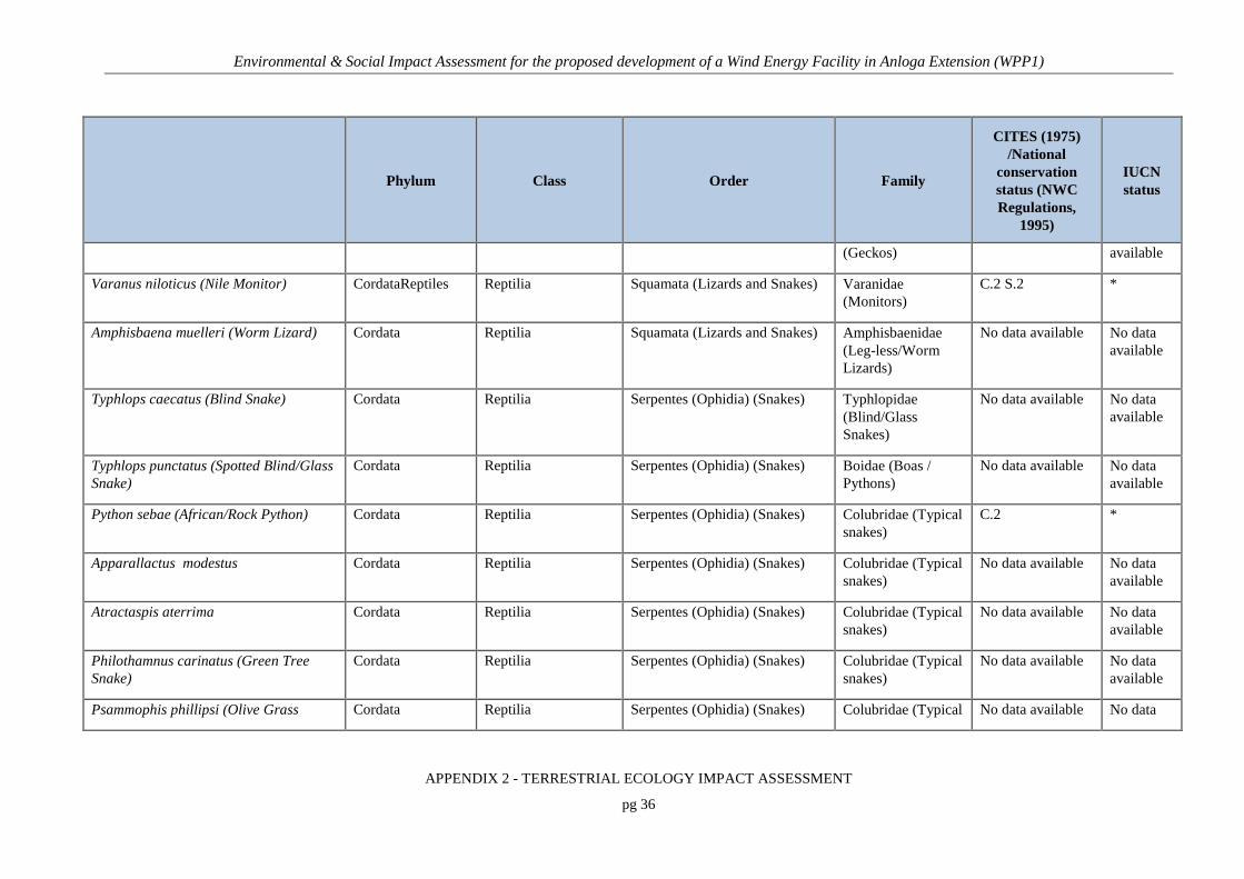
Environmental & Social Impact Assessment for the proposed development of a Wind Energy Facility in Anloga Extension (WPP1)
APPENDIX 2 - TERRESTRIAL ECOLOGY IMPACT ASSESSMENT
pg 36
Phylum Class Order Family
CITES (1975) /National
conservation status (NWC Regulations,
1995)
IUCN status
(Geckos) available
Varanus niloticus (Nile Monitor) CordataReptiles Reptilia Squamata (Lizards and Snakes) Varanidae (Monitors)
C.2 S.2 *
Amphisbaena muelleri (Worm Lizard) Cordata Reptilia Squamata (Lizards and Snakes) Amphisbaenidae (Leg-less/Worm Lizards)
No data available No data available
Typhlops caecatus (Blind Snake) Cordata Reptilia Serpentes (Ophidia) (Snakes) Typhlopidae (Blind/Glass Snakes)
No data available No data available
Typhlops punctatus (Spotted Blind/Glass Snake)
Cordata Reptilia Serpentes (Ophidia) (Snakes) Boidae (Boas / Pythons)
No data available No data available
Python sebae (African/Rock Python) Cordata Reptilia Serpentes (Ophidia) (Snakes) Colubridae (Typical snakes)
C.2 *
Apparallactus modestus Cordata Reptilia Serpentes (Ophidia) (Snakes) Colubridae (Typical snakes)
No data available No data available
Atractaspis aterrima Cordata Reptilia Serpentes (Ophidia) (Snakes) Colubridae (Typical snakes)
No data available No data available
Philothamnus carinatus (Green Tree Snake)
Cordata Reptilia Serpentes (Ophidia) (Snakes) Colubridae (Typical snakes)
No data available No data available
Psammophis phillipsi (Olive Grass Cordata Reptilia Serpentes (Ophidia) (Snakes) Colubridae (Typical No data available No data

Environmental & Social Impact Assessment for the proposed development of a Wind Energy Facility in Anloga Extension (WPP1)
APPENDIX 2 - TERRESTRIAL ECOLOGY IMPACT ASSESSMENT
pg 37
Phylum Class Order Family
CITES (1975) /National
conservation status (NWC Regulations,
1995)
IUCN status
Snake) snakes) available
Thelothornis kirtlandii (Twig/Vine/Bird Snake)
Cordata Reptilia Serpentes (Ophidia) (Snakes) Colubridae (Typical snakes)
No data available No data available
Dendroaspis. viridis (Green/Tree Mamba)
Cordata Reptilia Serpentes (Ophidia) (Snakes) Elapidae (Cobras and mambas)
No data available
Naja melanoleuca (Black-and-white Cobra)
Cordata Reptilia Serpentes (Ophidia) (Snakes) Viperidae (Vipers and Adders)
No data available No data available
Atheris chlorechis (Green Tree Viper) Cordata Reptilia Serpentes (Ophidia) (Snakes) Viperidae (Vipers and Adders)
No data available No data available
Atheris squamigera Cordata Reptilia Serpentes (Ophidia) (Snakes) Viperidae (Vipers and Adders)
No data available No data available
Bitis gabonica (Gaboon Adder/Viper) Cordata Reptilia Serpentes (Ophidia) (Snakes) Viperidae (Vipers and Adders)
No data available No data available
Bitis nasicornis (Rhinoceros Viper) Cordata Reptilia Serpentes (Ophidia) (Snakes) Viperidae (Vipers and Adders)
No data available
Causus maculatus (Night Adder) Cordata Reptilia Serpentes (Ophidia) (Snakes) Viperidae (Vipers and Adders)
No data available No data available
MAMMALS

Environmental & Social Impact Assessment for the proposed development of a Wind Energy Facility in Anloga Extension (WPP1)
APPENDIX 2 - TERRESTRIAL ECOLOGY IMPACT ASSESSMENT
pg 38
Phylum Class Order Family
CITES (1975) /National
conservation status (NWC Regulations,
1995)
IUCN status
Crocidura spp. (White-toothed Shrews) Cordata Mammalia Insectivora Soricidae (Shrews) No data available No data available
Eidolon helvum (African Fruit Bat) Cordata Mammalia Chiroptera Pteropodidae S.2 *
Hypsignathus monstrosus (Hammer headed Bat)
Cordata Mammalia Chiroptera Pteropodidae S.2 *
Perodicticus potto (Common/Bosman's Potto)
Cordata Mammalia Primates Loridae C.2 S.1 *
Galago senegalensis (Senegal Galago/Bush Baby)
Cordata Mammalia Primates Galagonidae C.2 S.1 *
Galagoides demidoff (Lesser/Dwarf Galago)
Cordata Mammalia Primates Galagonidae S.1 *
Epixerus ebi (Red-headed forest Squirrel)
Cordata Mammalia Rodentia Sciuridae No data available No data available
Funisciurus anerythrus (Redless Tree Squirrel)
Cordata Mammalia Rodentia Sciuridae S.2 *
Funisciurus leucogenys (Orange-headed Tree-Squirrel)
Cordata Mammalia Rodentia Sciuridae S.2 *
Funisciurus pyrrhopus (Cuvier's Fire-footed Tree-squirrel)
Cordata Mammalia Rodentia Sciuridae S.2 *
Paraxerus poensis (Small Green/Bush Cordata Mammalia Rodentia Sciuridae No data available No data

Environmental & Social Impact Assessment for the proposed development of a Wind Energy Facility in Anloga Extension (WPP1)
APPENDIX 2 - TERRESTRIAL ECOLOGY IMPACT ASSESSMENT
pg 39
Phylum Class Order Family
CITES (1975) /National
conservation status (NWC Regulations,
1995)
IUCN status
Squirrel) available
Cricetomys gambianus (Gambian/Pouched Giant Rat)
Cordata Mammalia Rodentia Muridae S.2 *
Mus spp. (Common Mice) Cordata Mammalia Rodentia Muridae No data available No data available
Thryonomys swinderianus (Cutting Grass/Cane Rat)
Cordata Mammalia Rodentia Thryonomidae (Grasscutters)
No data available No data available
Atilax paludinosus (Marsh Mongoose) Cordata Mammalia Carnivora Herpestidae S.2 *
Tragelaphus scriptus (Bushbuck) Cordata Mammalia Artiodactyla Bovidae S.2 *
Tragelaphus spekii gratus (Sitatunga) Cordata Mammalia Artiodactyla Bovidae S.1 LC No data available
Note:* Fauna of local, national or international conservation significance
+ Fauna observed or whose presence was confirmed through interviews
E – Endangered, LC – Least Concerned, Vu – Vulnerable, R - Rare
[C.1] … CITES Appendix 1; [C.2]… CITES Appendix 2
[S.1] NWC Regulations Schedule 1; [S.2] NWC Regulations Schedule 2

Environmental & Social Impact Assessment for the proposed development of a Wind Energy Facility in Anloga Extension (WPP1)
APPENDIX 2 - TERRESTRIAL ECOLOGY IMPACT ASSESSMENT
pg 40
7. IDENTIFICATION OF KEY ISSUES
7.1 KEY ISSUES IDENTIFIED
The key potential issues identified during the study are as follows:
Construction phase
• Permanent loss of vegetation cover and potential loss of listed/rare plant species
associated with the turbines footprint and new access roads during construction is
expected.
• In swampy areas, there may be the need to pump out water from the excavations and this
would further increase erosion from surface runoff and increase sediment flow in-to
nearby water bodies. Increased erosion risk would be likely to result due to the loss of
plant cover and soil disturbance created during the construction phase. This may impact
downstream riparian and wetland habitats if a lot of silt enters the drainage systems.
• Removal of mangrove vegetation will cause the exposure of water bodies to direct
sunlight thus increasing the rate of evaporation.
• Clearing of vegetation and compaction of soils could lead to death and displacement of
some faunal species.
• Impact on plants due to the release of fine particulate matter or sediment into the
environment.
• Harsh chemical control measures for weed and pest control may be used which might
have negative impacts on non-target plant species and the environment.
• Introduction of alien (sometimes invasive) species of biodiversity to the area in and
around the wind facility.

Environmental & Social Impact Assessment for the proposed development of a Wind Energy Facility in Anloga Extension (WPP1)
APPENDIX 2 - TERRESTRIAL ECOLOGY IMPACT ASSESSMENT
pg 41
• Presence and operation of construction machinery on site. This will create a physical
impact as well as generate noise, pollution and other forms of disturbance at the site.
Operational Phase
• Alteration of micro-climate.
• The operation of the facility may generate noise and disturbance which may deter some
fauna from the site as well as impact the activities of others within the site.
• Maintenance activities such as vegetation clearing may impact the biodiversity of the site
if not conducted in a sensitive manner.
• Loss of connectivity and habitat fragmentation may result if fauna avoid the area or cannot
move through the area on account of the presence of the facility.
Decommissioning
Decommissioning is assumed to entail the removal of the hard infrastructure from the facility and
the rehabilitation of the cleared and disturbed areas. The following impacts are likely to be
associated with this phase of the development:
• Increased erosion risk due to the loss of plant cover and soil disturbance created during the
decommissioning phase. This may impact downstream riparian and wetland habitats if a
lot of silt enters the drainage systems. The disturbance would also be likely to increase the
vulnerability of the area to alien plant invasion.
• Presence and operation of machinery on site. This will create a physical impact as well as
generate noise, pollution and other forms of disturbance at the site.
• Impacts on fauna during decommissioning activities.

Environmental & Social Impact Assessment for the proposed development of a Wind Energy Facility in Anloga Extension (WPP1)
APPENDIX 2 - TERRESTRIAL ECOLOGY IMPACT ASSESSMENT
pg 42
8. ASSESSMENT OF IMPACTS AND IDENTIFICATION OF MANAGEMENT ACTIONS
8.1 CONSTRUCTION PHASE
A high level of disturbance is likely to occur for the duration of the construction phase. Such
disturbance will relate to vegetation clearing, excavation, noise and general anthropogenic
influences associated with the building of the facility on site. This may include the cutting and
removal of vegetation for the establishment of new internal gravel roads (a permanent
transformation) and the cutting and trampling of vegetation at the proposed location for the wind
turbines and laydown areas.
8.1.1 Loss of vegetation and protected/listed species due to the clearing of vegetation
The clearing of vegetation for roads, turbine foundations and crane pads will lead to disturbance
of the area and loss of biological diversity, including the potential loss of globally/locally rare
species. Gold star species such as the Ritchea reflexa was encountered at Anloga. On the other
hand, Anyanui and Srobge recorded low GHI values thus raising no conservation concerns.
Increased human presence can lead to poaching, illegal plant harvesting and other forms of
disturbance such as fire.
The impact of the development on vegetation would be of local extent, but of high intensity given
the high sensitivity of the Anloga site (presence of Ritchea reflexa species) for both alternatives.
The impact is assessed to be long-term as the majority of cleared areas are required for roads and
other infrastructure and will not be rehabilitated. The probability of the loss of vegetation is
definite as clearing of the vegetation is required ahead of construction and the probability of
impacting a protected/listed or rare species is rated as probable.
Given the above, the loss of vegetation and protected/listed or rare species due to the clearing of
vegetation is anticipated to be of medium significance without mitigation for both the proposed
and the alternative layouts as the Gold Star species is present in Anloga which will be impacted
for both alternative layouts.

Environmental & Social Impact Assessment for the proposed development of a Wind Energy Facility in Anloga Extension (WPP1)
APPENDIX 2 - TERRESTRIAL ECOLOGY IMPACT ASSESSMENT
pg 43
Mitigation
Although the WPP1 site is poor in species richness, the following key mitigation measures are
recommended to be implemented by the project applicant:
• Undertake a walk through the site while doing micro-sitting of the turbines to avoid
species of concern as much as possible.
• Undertake a pre-construction walk through the site to identify species of concern that
can be translocated if necessary
• Ensure that construction staff has attended an environmental awareness training to
ensure that basic environmental principles are adhered to.
• Demarcate areas that will need to be cleared and keep clearing areas to a minimum.
• Demarcating and labelling no-go areas in proximity to the development footprint, such
as sensitive areas
• No listed/protected or rare plant may be dislocated or disturbed without the permission
of the environmental manager
• Ensure that camp sites, lay down areas and other temporary areas are located in areas of
low sensitivity and that they are clearly demarcated
• Mangrove revegetation and tree planting should be undertaken to reverse the decline in
the vegetation cover of the project footprint.
• Lost biodiversity on the disturbed area should be restored through planting of
appropriate trees and shrubs and protection of fauna species and their habitat.
• The GoG quarantine inspection and procedures should be followed to ensure that
invasive or alien species do not enter the area.
• Construction of new tracks should be kept to the barest minimum and the use of existing
roads should be encouraged. Track routes should be selected in such a way as to
minimize any damage to farms and crops.
• Mechanical control should be used for all vegetation clearing.
• Removal of stream bank vegetation (especially bamboo/mangrove) must be avoided as
much as possible.

Environmental & Social Impact Assessment for the proposed development of a Wind Energy Facility in Anloga Extension (WPP1)
APPENDIX 2 - TERRESTRIAL ECOLOGY IMPACT ASSESSMENT
pg 44
• Cutting of trees must be done by a certified timber contractor, and strictly in line with
the prescribed safety guidelines. The landing area of falling trees should be carefully
selected to minimize damage to farms. Adequate warning should be given to ensure that
public safety is not compromised.
• Clearing of vegetation should be minimised to the project area
With the successful implementation of the above recommended mitigation, the medium
significance of this impact is expected to decrease to low for both preferred and alternative
layouts.
8.1.2 Increase in potential erosion during the clearing of vegetation
Vegetation clearing and soil disturbance will lead to an increase in soil being exposed, which may
leave the disturbed areas vulnerable to erosion. This may impact downstream wetland habitats if a
lot of fine particulate matter or sediment enter into the environment. In addition, the construction
of many hard surface areas for roads, laydowns, etc. will generate water run offs which can also
increase erosion risks of surrounding areas. However, most parts of the site contain a high
proportion of grass within the vegetation and grasses should increase in density rapidly within
wetter areas and should in most instances help to prevent erosion in areas receiving runoff.
Given the above, impacts associated with erosion have been assessed to be of local extent, short
term duration and medium intensity for both preferred and alternative layouts. The probability that
erosion and associated impacts do occur is probable and the significance is therefore anticipated to
be low, without mitigation.
The following mitigation measures are recommended:
• A rehabilitation and re-vegetation plan should be developed prior to construction.
• Regular monitoring of the site during construction for erosion problems.
• Topsoil should be removed and stored separately and should be reapplied where
appropriate as soon as possible in order to encourage and facilitate rapid regeneration of
the natural vegetation on cleared areas.
• Establishment of revegetation in exposed areas

Environmental & Social Impact Assessment for the proposed development of a Wind Energy Facility in Anloga Extension (WPP1)
APPENDIX 2 - TERRESTRIAL ECOLOGY IMPACT ASSESSMENT
pg 45
• Erosion management plan should be considered right from construction phase.
With the successful implementation of the above recommended mitigation, the low significance is
expected to decrease to very low for the preferred and the alternative layout.
8.1.3 Removal of mangrove vegetation and brackish water swamp vegetation can cause intense evaporation of water body and destruction of habitats
The mangrove vegetation and brackish water swamp is composed of species such as Typha
doimngensis, Acrostichum aureum, Avicennia germinans, Rhizophora sp., Paspalum vaginatum,
Cyperus ariculatus and Sesuvium portulacastrum. The mangrove swamps are sensitive habitats
that require conservation action. Aside from protecting water bodies from intense evaporation,
mangrove vegetation serves as habitats and brooding sites for brackish and freshwater organisms.
This medium rated impact is expected to affect footprint of local extent. Mangrove forest can be
replaced through replanting. There is almost 25% chance of removing a few mangroves in the
proposed wind power project site.
The duration of this impact of removing the mangrove vegetation is expected to be long term
unless mitigation strategies are adopted.
Without mitigation, the negative impact is anticipated to be of medium significance for both
preferred and alternative layouts.
The following mitigation measures are recommended:
• Mangrove revegetation
• Avoiding destruction of mangrove swamp where possible
With the successful implementation of the above recommended mitigation, the significance of this
impact is expected to decrease to low for both preferred and alternative layouts
8.1.4 Impacts on fauna and flora due to compaction of soils by traffic and through the use of compactors
Depending upon the nature of soils (particle size, clay and mineral content etc.) changes in habitat
form may arise within the site in the long term as plant species that are tolerant of or prefer

Environmental & Social Impact Assessment for the proposed development of a Wind Energy Facility in Anloga Extension (WPP1)
APPENDIX 2 - TERRESTRIAL ECOLOGY IMPACT ASSESSMENT
pg 46
particular soils benefit at the expense of other species which are less tolerant. The intensity of this
impact has been rated as high due to the fact that the impact will eventually lead to reduction in
biodiversity. Moreover, in the situation where invasive alien species benefit, they will enjoy rapid
growth at the expense of economic and rare plants in the project footprint.
Soil compaction can also lead to the death and displacement of some faunal and microbial
species. This probable impact is expected to be long term and spread to about 10 km away from
the project site.
Without mitigation, this negative impact is anticipated to be of medium significance for both
preferred and alternative layouts.
The following mitigation measures are recommended:
• The number of passes of heavy trucks to and from the project sites should be regulated
and minimised.
With the successful implementation of the above recommended mitigation, the significance of this
impact is expected to decrease to low for both preferred and alternative layout.
8.1.5 Impact on plants due to the release of fine particulate matter or sediment into the environment
The clearing of vegetation for roads, turbine foundations and crane pads during the construction
phase will result in the release of fine particulate matter which is likely to settle on plant surfaces.
The particles impair respiration by blocking the stomata through which gaseous exchange occur.
Furthermore, the particles reduce the surface area available for chlorophyll to trap solar energy for
photosynthesis. The intensity of this impact is rated medium due to the fact that inefficiencies in
respiration and photosynthesis can result in weakening and death of plants. Moreover,
microorganisms and fauna that survive on such plant leaves will be displaced. There is also the
likelihood of changing the visual morphology of plants in the project footprint.
However, this is a temporal impact that which can be reversed by rainfall as long as excavation
activities ceases.

Environmental & Social Impact Assessment for the proposed development of a Wind Energy Facility in Anloga Extension (WPP1)
APPENDIX 2 - TERRESTRIAL ECOLOGY IMPACT ASSESSMENT
pg 47
The impact of the settlement of particulate matter on the leaf surfaces of plants would be of local
extent (<10 km), the probability of particulate matter settling on plant surfaces is probable.
Without mitigation, the negative impact is anticipated to be of low significance for both preferred
and alternate layouts.
The following additional mitigation measures are recommended:
• Artificial wash off can remedy the impact
• Excavation activities should not be carried out during high wind speed moment of the
day. This will reduce the extent of spread of the particulate matter in the project
footprint. Minor trenches and holes should be dug manually to reduce the release of
particulate matter.
With the successful implementation of the above recommended mitigation, the significance of this
impact is expected to decrease to very low for the preferred and the alternative layout.
8.1.6 Weed and pest control
Harsh chemical control measures may be used which might have negative impacts on non-target
plant species and the environment.
Weed and pest control chemicals are usually in sprayable form, making them easier to soak into
undesired plant foliage and animals. The intensity of this impact is rated medium due to the fact
that chemical drift can result in damage to none target economical or rare plants and animals.
Over time, the vegetation of the project site and its footprint will change as a result of residual
chemicals in the soil. Chemical usage in weed and pest control is probable and long term activity
that will last throughout the construction and operation phases of the project. The damage caused
by chemicals usually has low reversibility.
Without mitigation, the negative impact of chemical weed and pest control is anticipated to be of
medium significance for the preferred and alternative layout.
The following mitigation measures are recommended:

Environmental & Social Impact Assessment for the proposed development of a Wind Energy Facility in Anloga Extension (WPP1)
APPENDIX 2 - TERRESTRIAL ECOLOGY IMPACT ASSESSMENT
pg 48
• Mechanical weed control should be used instead of chemical weed control
• Avoid the use of chemicals in the control of pests, rodents, snakes etc. around the
project site and settlement areas.
• In situations where chemical control is inevitable, adopt spot application strategy in
chemical application instead of the broadcast method in other to minimize exposure to
non-targeted plants and animals.
With the successful implementation of the above recommended mitigation, the significance of this
impact is expected to decrease to very low for the preferred and the alternative layout.
8.1.7 Introduction of alien (sometimes invasive) species of biodiversity to the area in and around the wind facility
During the construction phase, the introduction of exotic vegetation or the invasion of disturbed
areas by exotic vegetation through either a physical vector (e.g. machinery, vehicles etc.) or more
“natural” dispersion vectors (e.g. wind, avian dispersion) is probable.
The changes in vegetation as a result of the introduction of invasive alien species will last for
long. However, the impact is expected to be contained within 10 km off the project site. The
intensity is rated low due to the fact that the area is already degraded. Only a few native plants
were identified during the survey. Pioneer index ranged between 69.0 and 87.9 (suggests the high
number of pioneer species growing in the area).
Without mitigation, the negative impact is anticipated to be of low significance for the preferred
layout and low significance for the alternative layout.
The following mitigation measures are recommended:
• Inspection of all persons and machinery before entry to the site
• Quarantine and elimination of all suspected carriers of invasive alien species
• Use only plants and seed collected on-site for revegetation.
With the successful implementation of the above recommended mitigation, the significance of this
impact is expected to remain low for both preferred and the alternative layout.
Environmental & Social Impact Assessment for the proposed development of a Wind Energy Facility in Anloga Extension (WPP1)
APPENDIX 2 - TERRESTRIAL ECOLOGY IMPACT ASSESSMENT
pg 49
8.1.8 Impacts on fauna during construction activities
The intensity of the negative impact on fauna during the construction phase is rated as medium.
This is because there is high probability of ousting of fauna through disturbance and human
presence. Opportunistic animal species may benefit from the construction activities; in particular
the exclusion of predators from the site may benefit former prey species which will take refuge
within the area, skewing populations and predator – prey relations.
Another impact on fauna during the construction phase is that of lighting during late and early
hours during construction. This may result in the death, injury and relocation of several animals
inhabiting the project area. Increased human presence can also lead to poaching, illegal plant
harvesting and other forms of disturbance such as fire
The short term effect of the impacts is expected to be localized extent with a low chance of
reversibility.
Without mitigation, the negative impact is anticipated to be of medium significance for the
preferred and alternative layout. This phase is however transient and during the operational phase,
levels of disturbance and activity will be considerably reduced.
The following mitigation measures are recommended:
• Faunal rescue plan should be adopted
• Hunting activities should follow the Wildlife Act
• All vehicles at the site should adhere to a low speed limit.
• No litter, food or other foreign material should be thrown or left around the site and
should be placed in demarcated and fenced rubbish and litter areas.
With the successful implementation of the above recommended mitigation, the medium
significance of this impact is expected to decrease to low for the preferred and alternative layout.

Environmental & Social Impact Assessment for the proposed development of a Wind Energy Facility in Anloga Extension (WPP1)
APPENDIX 2 - TERRESTRIAL ECOLOGY IMPACT ASSESSMENT
pg 50
8.2 OPERATION PHASE
The Operation phase is less impactful on the flora and fauna. Access roads to turbines would be
maintained as well as vegetation controlled in the immediate vicinity of the turbines.
8.2.1 Alteration of micro-climate
Changes in wind speed and wind direction during operation may affect the flight of migratory
birds. Dispersion of fruits and seeds, photoperiod, pollination, fruit formation and morphology of
plants may be affected by the changes in micro-climate induced by the wind turbines during
operation.
The status of the indirect impact is rated as neutral with a local spatial extent and long-term
duration. The intensity of the impact is rated as low. The probability of the impact is assessed as
probable. Without mitigation, the indirect impact is anticipated to be of low significance for the
preferred layout and very low significance for the alternative layout.
The following mitigation measures are recommended:
• Monitoring plan for native plants the project footprint.
• Relocation of affected rare species.
With the successful implementation of the above recommended mitigation, the significance of this
impact is expected to remain to very low for the preferred and the alternative layout.
8.2.2 Impact on fauna during the operation of the wind turbines
Although activity at the site is likely to be relatively low during operation, some impact on fauna
may still occur as a result of personnel present on site as well as the operation of maintenance
vehicles. Direct interactions between the turbines and terrestrial fauna are likely to be low. The
operation of the facility will generate noise and disturbance which may deter some fauna from the
site as well as impact the activities of others within the site. The operation of turbines and wind
blades can cause injuries and deaths to flying birds in the vicinity (refer to Appendix 3 Birds
Impact Assessment study). This localized impact will persist as long as the project is in operation
with probability of 50%. Hence the intensity of this impact is rated as high. The reversibility of
this impact is very low.

Environmental & Social Impact Assessment for the proposed development of a Wind Energy Facility in Anloga Extension (WPP1)
APPENDIX 2 - TERRESTRIAL ECOLOGY IMPACT ASSESSMENT
pg 51
Without mitigation, the negative impact is anticipated to be of medium significance for both
preferred and alternative layouts.
The following mitigation measures are recommended:
• Provision of critter paths within the fencing should be considered in the design.
• Promote and support faunal presence and activities within the proposed PV facility by
prohibiting hunting, trading and consumption of bush meat in the project sites
• Access to the site should be strictly controlled.
• All vehicles at the site should adhere to a low speed limit and any fauna on roads should
receive right or way or can be moved off the road in the direction that the animal was
moving in the case of slow-moving fauna such as tortoises.
• Any chemical spills at the site should be handled in the appropriate manner as
determined by the nature of the spill.
With the successful implementation of the above recommended mitigation, the significance of this
impact is expected to decrease to low for both, the preferred and alternative layouts.
8.2.3 Impact on flora during maintenance activities.
Maintenance activities such as vegetation clearing will impact the biodiversity of the site if not
conducted in a sensitive manner. This a site specific impact with long term duration. Probability
of occurrence is 75%, however, lost species can be replaced through replanting. The intensity is
rated as medium since it involves the possible loss of species and habitats.
Without mitigation, the negative impact is anticipated to be of low significance for both preferred
layout and alternative layouts.
The following mitigation measures are recommended:
• Avoid broadcast spraying of chemical herbicides during vegetation clearance
• Uproot and burn invasive alien species ones spotted
• Replant native rare plants in buffer zones to prevent extinction.

Environmental & Social Impact Assessment for the proposed development of a Wind Energy Facility in Anloga Extension (WPP1)
APPENDIX 2 - TERRESTRIAL ECOLOGY IMPACT ASSESSMENT
pg 52
• Minor vegetation clearance should be done manually.
With the successful implementation of the above recommended mitigation, the significance of this
impact is expected to decrease to very low for both preferred and alternative layouts.
8.2.4 Loss of connectivity and habitat fragmentation may result if fauna avoid the area or cannot move through the area on account of the presence of the facility.
The presence of the facility and the associated transformation of intact vegetation, would pose a
threat to the connectivity of the landscape and the ability of fauna and flora to respond to
environmental change. The potential severity of the disruption is to a large extent related to the
surrounding vegetation and the contrast between the natural vegetation and the hardened surfaces
of the facility. In the current context, the extent of disruption of landscape connectivity is likely to
be low as the site is disturbed.
In the long-term the facility is not likely to create significant local or regional population-level
impact as it is likely that sufficient numbers of individuals would be successfully moving about
the landscape to prevent spatial fragmentation of their populations. The impact of the facility on
the fragmentation of the landscape is likely to be of local extent, low intensity and low
significance.
The following mitigation measures are recommended:
• Minimising the development footprint wherever possible.
• Revegetation of all cleared and bare areas created by the facility with local species.
• Key mitigation measures proposed by the specialist include:
• Fences and other structures which impede faunal movement should be avoided where
possible

Environmental & Social Impact Assessment for the proposed development of a Wind Energy Facility in Anloga Extension (WPP1)
APPENDIX 2 - TERRESTRIAL ECOLOGY IMPACT ASSESSMENT
pg 53
8.3 DECOMMISSIONING PHASE
8.3.1 Exotic weed invasion as a consequence of abandonment of site and cessation of weed control measures
Exotic weed invasion is a likely consequence the removal of wind turbines. Decommissioning of
site will see increased disturbance of the land and therefore increased susceptibility to exotic weed
invasion.
The spatial extent of this impact is local with medium-term duration. The consequence and
probability of the impact are respectively rated as moderate and probable. The reversibility and
irreplaceability of the impact are respectively rated as high and low. The significance of the
impact without mitigation is rated as low. Significance without mitigation is low. Significance
with mitigation is low.
Mitigation:
• Lost biodiversity on the disturbed area should be restored through planting of
appropriate trees and shrubs.
• The GoG quarantine inspection and procedures should be followed to ensure that
invasive or alien species do not enter the area.
• The landing area of falling turbines should be carefully selected to minimize damage to
vulnerable plants and human lives. Adequate warning should be given to ensure that
public safety is not compromised.
• Mitigation would include monitoring of the land and redress of exotic weeds found
present on site.
8.3.2 Exposed soil increases erosion risks
Increased erosion risk due to the loss of plant cover and soil disturbance created during the
decommissioning phase. This may impact downstream riparian and wetland habitats if a lot of silt
enters the drainage systems. The disturbance would also be likely to increase the vulnerability of
the area to alien plant invasion.

Environmental & Social Impact Assessment for the proposed development of a Wind Energy Facility in Anloga Extension (WPP1)
APPENDIX 2 - TERRESTRIAL ECOLOGY IMPACT ASSESSMENT
pg 54
Given the above, impacts associated with erosion have been assessed to be of local extent, short
term duration and medium intensity for both preferred and alternative layouts. The probability that
erosion and associated impacts does occur is probable and the significance is therefore anticipated
to be low, without mitigation.
The following mitigation measures are recommended:
• Establishment of revegetation in exposed areas
• Construction of proper permanent drainage system
With the successful implementation of the above recommended mitigation, the low significance is
expected to decrease to very low for the preferred and the alternative layout.
8.3.3 Impacts on fauna
The presence and operation of machinery on site will create a physical impact as well as generate
noise, pollution and other forms of disturbance at the site.
In addition, increased human presence can lead to poaching, illegal plant harvesting and other
forms of disturbance such as fire.
The short term effect of the impacts is expected to be localized extent with a low chance of
reversibility.
Without mitigation, the negative impact is anticipated to be of low significance for both preferred
and alternative layouts.
The following mitigation measures are recommended:
• Faunal rescue plan should be adopted
• Hunting activities should follow the Wildlife Act
• All vehicles at the site should adhere to a low speed limit.
• No litter, food or other foreign material should be thrown or left around the site and
should be placed in demarcated and fenced rubbish and litter areas.

Environmental & Social Impact Assessment for the proposed development of a Wind Energy Facility in Anloga Extension (WPP1)
APPENDIX 2 - TERRESTRIAL ECOLOGY IMPACT ASSESSMENT
pg 55
8.4 CUMULATIVE IMPACTS
Cumulative impacts on the flora and fauna, if other projects of similar nature are constructed in
the area, would be significant. The implementation of the mitigation measures outlined below
would reduce the significance level to very low.
8.4.1 Cumulative impact 1: Reduced ability to meet conservation obligations & targets
The loss of unprotected vegetation types on a cumulative basis from the broad area may impact
the countries’ ability to meet its conservation targets, particularly the Gold Star index vegetation.
Mitigation measures inherent to the project design include:
• Preconstruction walk-through of the facility, especially the roads and turbine locations
to ensure that sensitive habitats are avoided.
• Minimise the development footprint as far as possible.
As there are no other large development projects in the project’s area of influence, the cumulative
impact for both alternatives is thus assessed to be of low significance.
8.4.2 Cumulative Impact 2: Impact on the disruption of broad-scale ecological processes
The presence of the facility and associated infrastructure could potentially contribute to the
disruption of broad-scale ecological processes such as dispersal, migration or the ability of fauna
to respond to fluctuations in climate or other conditions. There are no other renewable energy
facilities in the broad area the cumulative impact of these on habitat loss and the broad scale
disruption of landscape connectivity is currently not a concern.
Mitigation measures inherent to the project design include:
• Preconstruction walk-through of the facility, especially the roads and turbine locations
to ensure that sensitive habitats are avoided.
• Minimise the development footprint as far as possible.
Key mitigation measures proposed by the specialist include:

Environmental & Social Impact Assessment for the proposed development of a Wind Energy Facility in Anloga Extension (WPP1)
APPENDIX 2 - TERRESTRIAL ECOLOGY IMPACT ASSESSMENT
pg 56
• Stringent construction-phase monitoring of activities at the site to ensure that mitigation
measures are adhered to and that the overall ecological impact of the development is
maintained at a low level.
• The use of structures which may inhibit movement of fauna, such as mesh and electric
fencing should be avoided as far as possible.
As there are no other large development projects in the project’s area of influence, the cumulative
impact for both alternatives is thus assessed to be of low significance.
9. IMPACT ASSESSMENT SUMMARY
The assessment of potential impacts and recommendation of mitigation measures as discussed
above are collated in Tables 10 to 12 below.

Environmental & Social Impact Assessment for the proposed development of a Wind Energy Facility in Anloga Extension (WPP1)
APPENDIX 2 - TERRESTRIAL ECOLOGY IMPACT ASSESSMENT
pg 57
Table 10: Direct impacts assessment summary table for the Construction Phase for the preferred and alternative layout
CONSTRUCTION PHASE
Aspect/
Impact
Pathway
Nature of
Potential
Impact/ Risk
Status Spatial
Extent Duration
Consequence/
Intensity Probability Reversibility Irreplaceability
Potential Mitigation
Measures
Significance Confidence
Level Without
Mitigation
With
Mitigation
Vegetation
clearance
Loss of habitat
and listed/rare
species
Negative Site
and
Local
Long-
Term
High Probable Low Low • Any unwarranted
destruction of vegetation
and habitats beyond the
designed wind park should
be discouraged.
• Lost biodiversity on the
disturbed area should be
restored through planting
of appropriate trees and
shrubs and protection of
fauna species and their
habitat.
• Undertake a pre-
construction walk through
the site to identify species
of concern that can be trans
located if necessary
• Mechanical control should
be used for all vegetation
clearing.
• No listed/protected or rare
plant may be dislocated or
disturbed without the
Medium Low High

Environmental & Social Impact Assessment for the proposed development of a Wind Energy Facility in Anloga Extension (WPP1)
APPENDIX 2 - TERRESTRIAL ECOLOGY IMPACT ASSESSMENT
pg 58
CONSTRUCTION PHASE
Aspect/
Impact
Pathway
Nature of
Potential
Impact/ Risk
Status Spatial
Extent Duration
Consequence/
Intensity Probability Reversibility Irreplaceability
Potential Mitigation
Measures
Significance Confidence
Level Without
Mitigation
With
Mitigation
permission of the
environmental manager
• Cutting of trees must be
done by a certified timber
contractor, and in line with
the prescribed safety
guidelines.
Increase in
potential
erosion during
the clearing of
vegetation
Negative Local Short
term
Medium Probable Moderate Moderate • A rehabilitation and
revegetation plan should be
developed as part of the
EMP
• Regular monitoring of the
site during construction for
erosion problems.
• Topsoil should be removed
and stored separately and
should be reapplied where
appropriate as soon as
possible in order to
encourage and facilitate
rapid regeneration of the
natural vegetation on
cleared areas.
Low Very low High

Environmental & Social Impact Assessment for the proposed development of a Wind Energy Facility in Anloga Extension (WPP1)
APPENDIX 2 - TERRESTRIAL ECOLOGY IMPACT ASSESSMENT
pg 59
CONSTRUCTION PHASE
Aspect/
Impact
Pathway
Nature of
Potential
Impact/ Risk
Status Spatial
Extent Duration
Consequence/
Intensity Probability Reversibility Irreplaceability
Potential Mitigation
Measures
Significance Confidence
Level Without
Mitigation
With
Mitigation
• Erosion management plan
Removal of
mangrove
vegetation and
brackish water
swamp
vegetation
lagoon margin
can cause
intense
evaporation of
water body
and
destruction of
habitats.
Negative Local Long-
Term
Medium Highly
Probable
Moderate Low • Mangrove revegetation
• Avoiding destruction of
mangrove swamp where
possible
Medium Low High
Movement of
Heavy Trucks
and laying of
concrete floors
Compacting of
soils leading
to death and
displacement
of some faunal
and microbial
species as well
as to the
competition of
some plant
Negative Site
specific
Long-
term
Medium Highly
Probable
High Low • The number of passes of
heavy trucks to and from
the project sites should be
regulated.
Medium Low Medium

Environmental & Social Impact Assessment for the proposed development of a Wind Energy Facility in Anloga Extension (WPP1)
APPENDIX 2 - TERRESTRIAL ECOLOGY IMPACT ASSESSMENT
pg 60
CONSTRUCTION PHASE
Aspect/
Impact
Pathway
Nature of
Potential
Impact/ Risk
Status Spatial
Extent Duration
Consequence/
Intensity Probability Reversibility Irreplaceability
Potential Mitigation
Measures
Significance Confidence
Level Without
Mitigation
With
Mitigation
species
Impact on
plants due to
the release of
fine particulate
matter or
sediment into
the
environment
Negative Local Short-
term
Medium Probable High
reversibility
Moderate • Artificial wash off using a
sprinkler.
• Excavation activities
should not be carried out
during high wind speed
period of the day. This will
reduce the extent of spread
of the particulate matter in
the project footprint.
• Minor trenches and holes
should be constructed
manually in order to
reduce the release of
particulate matter.
Low Very low High
Weed and Pest
control
Harsh
chemical
control
measures may
be used which
might have
negative
impacts on
non-target
plant species
Negative Site
specific
Long-
term
Medium Low
probability
Low Moderate • Mechanical control should
be used for all vegetation
clearing.
• Avoid the use of chemicals
in the control of pests,
rodents, snakes etc around
the project site and
settlement areas.
Medium Very low High

Environmental & Social Impact Assessment for the proposed development of a Wind Energy Facility in Anloga Extension (WPP1)
APPENDIX 2 - TERRESTRIAL ECOLOGY IMPACT ASSESSMENT
pg 61
CONSTRUCTION PHASE
Aspect/
Impact
Pathway
Nature of
Potential
Impact/ Risk
Status Spatial
Extent Duration
Consequence/
Intensity Probability Reversibility Irreplaceability
Potential Mitigation
Measures
Significance Confidence
Level Without
Mitigation
With
Mitigation
and the
environment.
• In situations where
chemical control is
inevitable, adopt spot
application strategy in
chemical application
instead of the broadcast
method in other to
minimize exposure to non-
target plants and animals.
Transportation
of people,
materials and
equipment
Introduction
of alien
(sometimes
invasive)
species of
biodiversity to
the area in and
around the
wind facility
Negative Local Long-
term
Low Probable Low Moderate • Inspection of all persons
and machinery before entry
to the site
• Quarantine and elimination
of all suspected carriers of
invasive alien species
• Use only plants and seed
collected on-site for
revegetation
Low Low High
The clearing of
vegetation and
ousting of
fauna through
construction
activities
Disturbance of
fauna and
opportunistic
animal species
may benefit
from the
construction
Negative Local Long-
Term
High Probable Low Low • Faunal rescue plan should
be adopted
• Hunting activities should
follow the Wildlife Act
- All vehicles at the site
Medium Low High

Environmental & Social Impact Assessment for the proposed development of a Wind Energy Facility in Anloga Extension (WPP1)
APPENDIX 2 - TERRESTRIAL ECOLOGY IMPACT ASSESSMENT
pg 62
CONSTRUCTION PHASE
Aspect/
Impact
Pathway
Nature of
Potential
Impact/ Risk
Status Spatial
Extent Duration
Consequence/
Intensity Probability Reversibility Irreplaceability
Potential Mitigation
Measures
Significance Confidence
Level Without
Mitigation
With
Mitigation
activities should adhere to a low
speed limit.
- No litter, food or other
foreign material
should be thrown or
left around the site and
should be placed in
demarcated and fenced
rubbish and litter areas

Environmental & Social Impact Assessment for the proposed development of a Wind Energy Facility in Anloga Extension (WPP1)
APPENDIX 2 - TERRESTRIAL ECOLOGY IMPACT ASSESSMENT
pg 63
Table 11: Impact assessment summary table for the Operational Phase for preferred and alternative layout
OPERATIONAL PHASE
Aspect/ Impact
Pathway
Nature of
Potential
Impact/ Risk
Status Spatial
Extent Duration
Consequence/
Intensity Probability Reversibility
Irreplace-
ability
Potential
Mitigation
Measures
Significance
Confidence
Level Without
Mitigation
With
Mitigation
Alteration of
micro-climate
Changes in
temperature, wind
direction and
speed
Neutral Local Long-Term Medium Probable High Low • Monitoring of plant
populations and
replanting of native
rare plants in buffer
zones
Low Very low Medium
Impact on fauna
during the
operation of the
wind turbines.
Noise, Accidents
and Disturbance
Negative Local Long-Term High Probable Low Very Low • Provision of critter
paths within the
fencing should be
considered in the
design.
• Promote and
support faunal
presence and
activities within the
proposed PV
facility
Medium Low High

Environmental & Social Impact Assessment for the proposed development of a Wind Energy Facility in Anloga Extension (WPP1)
APPENDIX 2 - TERRESTRIAL ECOLOGY IMPACT ASSESSMENT
pg 64
OPERATIONAL PHASE
Aspect/ Impact
Pathway
Nature of
Potential
Impact/ Risk
Status Spatial
Extent Duration
Consequence/
Intensity Probability Reversibility
Irreplace-
ability
Potential
Mitigation
Measures
Significance Confidence
Level
Impact on flora
during
maintenance
activities.
Loss of
biodiversity and
habitats
Negative Site-
specific
Long-Term Medium Probable Low Moderate • Avoid broadcast
spraying of
chemical herbicides
during vegetation
clearance
• Uproot and burn
invasive alien
species ones
spotted
• Replant native rare
plants in buffer
zones to prevent
extinction.
• Minor vegetation
clearance should be
done manually.
Low Very low High
Operation of the
wind turbines
Loss of
connectivity and
habitat
fragmentation
may result if
fauna avoid the
area or cannot
move through the
area on account
of the presence of
the facility
Negative Local Long- term Low Probable Low Low • Minimising the
development
footprint wherever
possible.
• Revegetation of all
cleared and bare
areas created by the
facility with local
species.
Low Low

Environmental & Social Impact Assessment for the proposed development of a Wind Energy Facility in Anloga Extension (WPP1)
APPENDIX 2 - TERRESTRIAL ECOLOGY IMPACT ASSESSMENT
pg 65
Table 12: Decommissioning Phase Impact assessment summary table for preferred and alternative layout
DECOMMISSIONING PHASE
Aspect/ Impact
Pathway
Nature of
Potential
Impact/ Risk
Status Spatial
Extent Duration
Consequence /
Intensity Probability
Reversibility
Irreplace-
ability
Potential
Mitigation
Measures
Significance Confidence
Level Without
Mitigation
With
Mitigation
Exotic weed
invasion as a
consequence of
abandonment of site
and cessation of
weed control
measures
Habitat and
species change
Negative Local Medium-
Term
High Probable Low Low • Lost biodiversity on the
disturbed area should be
restored through planting
of appropriate trees and
shrubs.
• The GoG quarantine
inspection and
procedures should be
followed to ensure that
invasive or alien species
do not enter the area.
• Mitigation would
include monitoring of
the land and redress of
exotic weeds found
present on site
Low Low High
Exposed soil
increase in erosion
Habitat and
species
population
change
Negative Local Short-term Medium Probable Medium Low • Establishment of lawn in
exposed areas
• Establishment of lawn
in exposed areas
• Construction of proper
permanent drainage
system
Low Very low Medium

Environmental & Social Impact Assessment for the proposed development of a Wind Energy Facility in Anloga Extension (WPP1)
APPENDIX 2 - TERRESTRIAL ECOLOGY IMPACT ASSESSMENT
pg 66
DECOMMISSIONING PHASE
Aspect/ Impact
Pathway
Nature of
Potential
Impact/ Risk
Status Spatial
Extent Duration
Consequence /
Intensity Probability
Reversibility
Irreplace-
ability
Potential
Mitigation
Measures
Significance Confidence
Level Without
Mitigation
With
Mitigation
Impacts on
fauna during
construction
decommissioni
ng activities
Negative Local Short term Medium Probable Low Low Low Very Low Medium

Environmental & Social Impact Assessment for the proposed development of a Wind Energy Facility in Anloga Extension (WPP1)
APPENDIX 2 - TERRESTRIAL ECOLOGY IMPACT ASSESSMENT
pg 67
10. CONCLUSIONS AND RECOMMENDATIONS
The study identified the mangrove and thicket vegetation as critical habitats that would be
impacted by the project through clearance. The thicket has species such as Ritchiea reflexa, which
is of conservation concern in Ghana. Furthermore, some fauna would be dislodged or destroyed
with the implementation of the project. The soil would be compacted and as such could prevent
natural regeneration after temporary facilities are removed.
Wind energy facilities are diffuse and distributed across a broad area and the footprint from an
ecological perspective is considerably greater than the extent of transformation. Nevertheless, the
areas of the site consist of plant communities with relatively low floral diversity.
The major impacts associated with the development are likely to occur during the construction
phase. A large amount of physical disturbance and activity will occur during construction and
effective management of associated impacts would be a key element in reducing the overall
impact of the development. The key mitigation measures identified in this report include the
following basic activities, which are detailed in the report:
• Careful pre-construction micro-siting of the infrastructure of the development.
• Preconstruction walk-through of the development footprint to locate species and habitats
of conservation concern that should either be avoided or translocated prior to construction.
• Stringent construction-phase monitoring of activities at the site to ensure that mitigation
measures are adhered to and that impacts such as erosion and alien plant invasion are
managed before that become serious impacts that may be difficult to control.
• Minimising the footprint of the development as much as possible, with particular emphasis
on rehabilitation of disturbed areas with local species.
• Ensure a rehabilitation and re-vegetation programme is effectively implemented.

Environmental & Social Impact Assessment for the proposed development of a Wind Energy Facility in Anloga Extension (WPP1)
APPENDIX 2 - TERRESTRIAL ECOLOGY IMPACT ASSESSMENT
pg 68
• Adopt a faunal rescue plan and prohibit hunting/poaching activities.
• Ensure a good housekeeping during construction activities and all vehicles at the site
should adhere to a low speed limit
During the course of the ESIA process, the turbine layout has been adapted to accommodate the
various sensitivities identified in the various specialist studies. This has been a critical element in
reducing the overall impact of the development. A similar approach should be adopted with
regards to the associated infrastructure such as roads and underground cabling.
It is recommended that as far as possible, species of conservation concern are identified and
adequate measures taken to protect them. Such species could be translocated to safe areas in the
project area or their propagules collected and replanted outside the project impact areas.
The preferred layout is recommended since the alternative layout would not lead to any significant
reduction of the anticipated impacts.

Environmental & Social Impact Assessment for the proposed development of a Wind Energy Facility in Anloga Extension (WPP1)
APPENDIX 2 - TERRESTRIAL ECOLOGY IMPACT ASSESSMENT
pg 69
11. REFERENCES
1. Anon. (1986) The IUCN Red List of Threatened Animals. The IUCN Conservation
Monitoring Centre, Cambridge, U.K.
2. Delany, M.J. & D.C.D. Happold (1979) Ecology of African Mammals. Longman, London.
3. Haltenorth, T. & H. Diller (1988) A Field Guide to the Mammals of Africa including
madagascar. Collins, London
4. Hawthorne, W. 1995. Forest of Ghana Geographic Information Exhibitor manual.
IUCN/ODA/Forest Dept. Republic of Ghana.
5. Hawthorne, W.D. & Abu Juam, 1995. Forest Protection in Ghana (with particular reference to
vegetation and plant species). IUCN, Gland, Switzerland and Cambridge
6. Hughes, B. (1988) Herpetology in Ghana (West Africa). British Herpetological Society
Bulletin. 25: 29-38
7. Hutchinson, J. and J.M. Dalziel. 1954-1972. Flora of West Tropical Africa. Crown Agents,
London.
8. Kingdon, J. (1997) The Kingdon Field Guide to African Mammals. Academic Press, London.
9. Larsen, T. (1994) The Butterflies of Ghana- Their Implications for Conservation and
Sustainable Use. MS Thesis (Unpubl.).
10. Serle, W., Morel, G. J. and Hartwig, W. (1992) Birds of West Africa. Collins, London, 351 pp
11. Taylor, C.J. 1960. Synecology and Silviculture in Ghana. Thomas Nelson, Edinburgh

Environmental & Social Impact Assessment for the proposed development of a Wind Energy Facility in Anloga Extension (WPP1)
APPENDIX 2 - TERRESTRIAL ECOLOGY IMPACT ASSESSMENT
pg 70
CURRICULUM VITAE OF JAMES K. ADOMAKO (DR.)
Full Name: James Kojo Adomako (Dr.)
Profession: Ecological Specialist
Date of Birth: August 28, 1961
Nationality: Ghanaian
Contact Address: Department of Botany, University of Ghana, P. O. Box LG 55, Legon
Tel: 054-434-0346
Email: [email protected]
Membership of Professional Body:
Ghana Science Association
Key Qualifications:
Dr. James Kojo Adomako is a botanist by profession and currently has a Ph.D. in ecology. He has undertaken various floral and faunal surveys, including that of fresh and marine water and which he has presented at various workshops and conferences. His research work in the field of ecology is extensive and has over 50 research papers to his name. He has worked as an individual consultant to many environmental consultancy firms during which he conducted ecological studies and provided recommendations on impacts and mitigation measures as a result of project development.
As terrestrial ecologist, Dr. Adomako has been responsible for the specific inputs into many environmental and scientific assignments some of which are indicated below:
• Consultant for WWF-International on the Biodiversity Convention, 1992-1994
• National Expert on Mangroves for the GEF Gulf of Guinea Large Marine Ecosystem Project 1997-1999

Environmental & Social Impact Assessment for the proposed development of a Wind Energy Facility in Anloga Extension (WPP1)
APPENDIX 2 - TERRESTRIAL ECOLOGY IMPACT ASSESSMENT
pg 71
• Mapping of sudd vegetation on the Kpong head pond, Volta River Authority 1998-99
• Consultant Ecologist on the under listed Environmental Impact Studies
• Environmental Audit of small scale mining operations in Ghana, GTZ/Minerals Commission, 1993
• Dunkwa Environmental Audit, L&W of South Africa/SGMC
• Environmental impact studies for Aplaku and Nungua septage treatment projects, AY&A Consult, 1998
• Environmental impact studies for the Kwabenya Landfill Project, AY&A Consult, 1998
• Studies on the Underlying Causes of Deforestation and Forest Degradation in Ghana, ICA-Ghana, 1998
• Ecological Baseline Studies for Korle Lagoon, Scott Wilson Kirkpatirck & Co.Ltd, 1998-1999
• Kotoka International Airport runway expansion project, AY&A consult,1999
• Prestea-Obuasi transmission Line Right-of-Way, Refast, VRA, 2000
• Winneba water supply expansion project, AY&A,2000
• Aboadze-Tema transmission line Right-of-Way extension project, Refast Lines/VRA, 2002
• West Africa Gas Pipe Line Project, ESL/ICF Consulting, 2002-2003
• Floral Survey of the Biodiversity Component of the NRMP, Forestry Commission/ERML, 2001-2002
• Ex-Post Project Studies of 4 GEF-SGP funded Projects in Ghana, Global Environment Fund, 2004 - 2005.
• Tamale water supply Expansion project, AY&A Consult, 2006
• Ethnobotanical Survey in Inland Valley Sites, Inland Valleys Rice Development Project, GOG/AfDB/MoFA, 2006-2008 (Team Leader)

Environmental & Social Impact Assessment for the proposed development of a Wind Energy Facility in Anloga Extension (WPP1)
APPENDIX 2 - TERRESTRIAL ECOLOGY IMPACT ASSESSMENT
pg 72
• EIA and EMP for Oil Palm Project, Dekel Oil, Abidjan Cote D’Ivoire, 2008
• Adomako, J.K.1992. The role of NGOs in Biodiversity Conservation in Ghana. In Laing, E. et al (eds) Proc. of the Workshop on Biological Diversity, Accra.
• Sackey, I., Laing, E. and Adomako, J.K.1993. L=etat actuel des mangroves du Ghana. In Diop, E.S. (ed.) 1993. Conservation et Utilisation Rationnelle des Forets de Mangrove de L=Amerique Latine et de L=Afrique. ISME Mangrove Ecosystems Tech. Reports Vol.3/ IITO TS-13 Vol.II
• Jumah, A.H., Adomako, J.K. and Abbiw, D.K. 1993. Environmental Audit of Small Scale Mining Concessions in Ghana. Consultant’s Report, GTZ, Accra.
• Mensah, A.H., Abbiw, D.K. and Adomako, J.K. 1994. Studies on Disturbance of Environment in Small Scale Mining Concessions in Ghana. In Gordon, C. (ed) Proc. of 5th Fac. of Science Colloq., 1994, Legon, Accra.
• Ameka G., Adomako, J.K., de-Graft Johnson, K.A.A., Cheek, M. and Swaine, M.D. 1996. Rheophytes of Ghana In Van Der Maessen et al. (eds) The Biodiversity of African Plants, 780-782. Kluwer, Netherlands.
• Ameka G., Adomako, J.K., de-Graft Johnson, K.A.A., Cheek, M. and Swaine, M.D. 1996. Rheophytes of Southern Ghana. In Proc. 7th Fac. of Science Colloq. 1996, Legon, Accra
• Oteng-Yeboah, A.A., Enu-Kwesi, L., Adomako, J.K. and Abbiw, D.K. 1995. Effects of Different Harvesting Practices on Biodiversity in Selected High Forest Ecosystems in Ghana. Tech. Rreport, BSP/WWF Grant # MS 28.
• Sackey, I., Adomako, J.K. and Laing, E. 1996. Regeneration and Productivity Studies in two contrasting Mangrove ecosystems in Ghana. In Evans S.M. et al (eds) The Coastal Zone of West Africa: Problems and Management. Penshaw Press.
• Oteng-Yeboah, A.A., Enu-Kwesi, L., Abbiw, D.K. and Adomako, J.K. 1996. Effects of gathering and Collection of some Non-Timber Forest Products on Biodiversity in Ghana. In Oteng-Yeboah, A.A. and Enu-Kwesi, L. (eds.) Proc. of Workshop on Biodiversity,1996, Accra.
• Enu-Kwesi, L., Oteng-Yeboah, A.A., Adomako, J.K. and Abbiw. D.K. 1996. Effects of Timber Logging on Biodiversity in selected High Forest Ecosystems in Ghana. In Oteng-Yeboah, A.A. and Enu-Kwesi, L. (eds.) Proc. of Workshop on Biodiversity, 1996, Accra

Environmental & Social Impact Assessment for the proposed development of a Wind Energy Facility in Anloga Extension (WPP1)
APPENDIX 2 - TERRESTRIAL ECOLOGY IMPACT ASSESSMENT
pg 73
• Armah, A.K., Adomako, J.K. and Agyapong, E.K. 1996. An Appraisal of the Status of Mangroves in Ghana. In Proc. International Workshop on Mangroves, Gulf of Guinea Large Marine Ecosystem Project, August 1996, Abidjan.
• Gabriel Ameka, James Adomako, M.D. Swaine and K.A. DeGraft-Johnson 1996. Ghanaian Forest River Chemistry. Tropical Biology Newsletter No. 68.
• A.K. Armah, G.A. Darpaah, G. Wiafe, J.K. Adomako and S. Fiagbedzi. 1997. Save Sea Turtles: A primer on sea turtle conservation for coastal communities in Ghana. Resource and Environment Development Organisation, Accra.
• E.E. Adomako, J.K. Adomako and T.P. Bayliss-Smith 1997. Conservation by tradition: the case of the Guako sacred grove. In D.S. Amlalo et al (eds) Biodiversity Conservation; Traditional knowledge and Modern Concepts. EPA/MAB/UNESCO, Accra.
• A.K. Armah, G.A. Darpaah, G. Wiafe, J. Adomako, S.Q. Quartey, C.E. Abotchie, F. Ansah and S. Fiagbedzi. 1997. Traditional and Modern Perspectives in Marine Turtle Conservation in Ghana. In D.S.Amlalo et al (eds) Biodiversity Conservation; Traditional knowledge and Modern Concepts. EPA/MAB/UNESCO, Accra.
• R.K Akuamoah, D. Obeng-Ofori, J.K. Adomako and G.K. Ameka. 1997. Termite-Resistant Plants - Possible Raw Material for the Wood Industry. In A. Menyeh et al (eds) Proc. 20th GSA Biennial Conference, Kumasi.
• Ameka, G.K., Adomako, J.K., DeGraft-Johnson, K.A.A, Cheek, M. and Swaine, M.D.1997. Rheophytes of Africa. In A. Menyeh et al (eds) Proc. 20th GSA Biennial Conference, Kumasi
• A.K. Armah, J.K. Adomako and E.K. Agyapong 1997. Towards Sustainable management of Mangroves in Ghana. GOG LME Newsletter No.6, pp 8-9.
• James K. Adomako and Nana(Dr.) Abayie Boateng 1998. The Underlying causes of Deforestation: A Case Study of the Tain Tributaries II Forest Reserve and its surrounding areas in the Brong-Ahafo Region of Ghana. A paper presented at the African Regional Workshop on the Underlying Causes of Deforestation and Forest Degradation, ICA-Ghana/UNIFF, Accra.
• James K. Adomako and Ebenezer Laing 1999. The Vegetation and Environment of the Kakum National Park. J. Ghana Science Association Vol.1(3) 104-125.
• James K. Adomako and Ebenezer Laing 1999. Studies on some aspects of the regeneration of Piptadeniastrum africanum. Abstract No. 30, Book of Abstracts GSA 21st Biennial Conference, Accra.

Environmental & Social Impact Assessment for the proposed development of a Wind Energy Facility in Anloga Extension (WPP1)
APPENDIX 2 - TERRESTRIAL ECOLOGY IMPACT ASSESSMENT
pg 74
• James K. Adomako and A.K. Armah 1999. Gulf of Guinea Large Marine Ecosystem Project Final Report on Mangrove Survey, 1999.
• G.K. Ameka, J.K. Adomako, K.A.A. deGraft-Johnson, M. Cheek and M.D. Swaine (2002). Rheophytes of Africa – A Review. J. Ghana Science Association 4(1) 83-96
• Adomako, J.K. 2005. Mangroves of Ghana – A Status Report: A presentation made at the UNIDO,/UNDP/UNEP-GCLME Regional Training Workshop on Mangrove Restoration, 19-23 September, 2005, Accra.
• Swaine, M.D., Adomako, J.K., Ameka, G.K., DeGraft-Johnson, K.A.A. and Cheek, M. (2006). Forest River Plants and Water Chemistry in Ghana. Aquatic Botany 85(4) 299-308.
• Ameka, G.K., DeGraft-Johnson, K.A.A. and Adomako, J.K. (2007).Water Quality at the Habitat of the Podostemaceae in Ghana. WAJAE. 11: 65-75
• Ameka, G.K., DeGraft-Johnson, K.A.A. and Adomako, J.K. (2008).Water Chemistry and the Distribution of Podostemaceae in Ghana. Ghana J. Sci. 48:15-23
• Tsikata, D, Attuquayefio, D.K., Ofori-Sarpong, E., Adomako, J.K. 2005. Ex-Post Study of the “Kuka Zuli Agro-forestry/Sustainable Agriculture” Project, Ghana. Report submitted to UNDP Global Environment Facility, Small Grants Programme, New York
• Tsikata, D, Attuquayefio, D.K., Ofori-Sarpong, E., Adomako, J.K. 2005. Ex -Post Study of the “Tuobodom SDA (JSS) Afforestation” Project, Ghana. Report submitted to UNDP Global Environment Facility, Small Grants Programme, New York.
• Tsikata, D, Attuquayefio, D.K., Ofori-Sarpong, E., Adomako, J.K. 2005. Ex Post Study of the “Reviving the Biodiversity of Sango Lagoon and adjacent Wetlands” Project, Ghana. Report submitted to UNDP Global Environment Facility, Small Grants Programme, New York.
• Tsikata, D, Attuquayefio, D.K.,Ofori-Sarpong, E., Adomako, J.K. 2005. Ex Post Study of the “NationalWorkshops on Refrigeration and the Environment in Ghana” Project, Ghana. Report submitted to UNDP Global Environment Facility, Small Grants Programme, New York.
• Enu-Kwesi, L.,Oteng-Yeboah, A.A., Adomako, J.K., and Abbiw, D.K. 2009. People, Logging and Changes in the Environment of Selected High Forest Ecosystems in Ghana. In Ardayfio-Schandorf, E. and Momsen, Janet H. (eds) Gender: The State and Different Environmental Places; Perspectives from Developing Countries in Africa and Asia. Ghana Universities, Accra

Environmental & Social Impact Assessment for the proposed development of a Wind Energy Facility in Anloga Extension (WPP1)
APPENDIX 2 - TERRESTRIAL ECOLOGY IMPACT ASSESSMENT
pg 75
• Jesse Ayivor , Christopher Gordon , James Adomako and Yaa Ntiamoa-Baidu 2011. Challenges of managing forest reserves: Case study of Atewa range forest reserve, Ghana. Nature & Faune, Vol. 25, Issue 2: 56-63
Education:
a. PhD Botany (Ecology), University of Ghana, 2004, b. Certificate (Diatom Taxonomy), University College London, 1998 c. MPhil Botany (Ecology), University of Ghana, 1991 d. BSc. (Hons) Botany with Zoology, University of Ghana, 1986
Employment Record: Year: February 2001 to date Employer: University of Ghana Position: Senior Lecturer Responsibilities: Teaches courses in Plant Ecology, Anatomy of Seed Plants,
Conservation and Environmental Studies Year: September 1992 - February 2001 Employer: University of Ghana Position: Lecturer Responsibilities: Teaches courses in Plant Ecology, Anatomy of Seed Plants and
Conservation Year: 1986 – 1988 Employer: University of Ghana Position: Teaching Assistant Responsibilities: Assisting lecturers in practical assignment and course work in botany
studies Languages: Languages: Speaking Reading Writing English Excellent Excellent Excellent Akan Excellent Excellent Excellent Ga Excellent Excellent Excellent

Environmental & Social Impact Assessment for the proposed development of a Wind Energy Facility in Anloga Extension (WPP1)
APPENDIX 2 - TERRESTRIAL ECOLOGY IMPACT ASSESSMENT
pg 76
SPECIALIST DECLARATION
I, DR. JAMES KOJO ADOMAKO, as the appointed independent specialist, hereby declare that I:
• I act as the independent specialist in this application;
• I perform the work relating to the application in an objective manner, even if this results in views and findings that are not favourable to the applicant;
• Regard the information contained in this report as it relates to my specialist input/study to be true and correct, and do not have and will not have any financial interest in the undertaking of the activity, other than remuneration for work performed in terms of any specific environmental management Act;
• I declare that there are no circumstances that may compromise my objectivity in performing such work;
• I have expertise in conducting the specialist report relevant to this application, including knowledge of any Acts, Regulations and any guidelines that have relevance to the proposed activity;
• I will comply with the Acts, Regulations and all other applicable legislation;
• I have no, and will not engage in, conflicting interests in the undertaking of the activity;
• I have no vested interest in the proposed activity proceeding;
• I undertake to disclose to the applicant and the competent authority all material information in my possession that reasonably has or may have the potential of influencing – any decision to be taken with respect to the application by the competent authority; and – objectivity of any report, plan or document to be prepared by myself for submission to the competent authority;
• I have ensured that information containing all relevant facts in respect to the specialist input/study was distributed or made available to interested and affected parties and the public and that participation by interested and affected parties was facilitated in such a manner that all interested and affected parties were provided with a reasonable opportunity to participate and to provide comments on the specialist input/study;
• I have ensured that the comments of all interested and affected parties on the specialist input/study were considered, recorded and submitted to the competent authority in respect of the application;
• All the particulars furnished by me in this specialist input/study are true and correct; and
• I realize that a false declaration is an offence
Signature of the specialist:
Name of the specialist: Dr. James Kojo Adomako
Date: February 19, 2017


ORNITHOLOGICAL IMPACT ASSESSMENT:
Scoping and Environmental and Social Impact Assessment for
the proposed Development of the 76MW Wind Power Project
situated at Anloga, Srogbe & Anyanui (Anloga Extension) in
the Volta Region of Ghana
Report prepared for: Report prepared by:
Seljen Consult Limited P. O. Box AT 140 Achimota-Accra
Ghana-West Africa
CSIR – Environmental Management Services P O Box 320
Stellenbosch, 7599 South Africa
Dr Erasmus Henaku Owusu P. O. Box LG 67, Legon, Accra-Ghana
DECEMBER 2017

Environmental & Social Impact Assessment for the proposed development of a Wind Energy Facility in Anloga Extension (WPP1)
APPENDIX 3 - BIRDS IMPACT ASSESSMENT STUDY
pg 1
EXECUTIVE SUMMARY
This study aims at assessing the potential impacts on avifauna associated with the proposed
construction, operation and decommissioning of a 76 Megawatt (MW) Wind Energy Facility
(WEF) (“WPP1”) in Anloga Extension areas in the Volta Region, Ghana. It will also inform the
development of a comprehensive Environmental Management Plan (EMP) to assist Volta River
Authority (VRA) in managing the impacts on avifauna in a responsible manner.
On the whole the proposed sites for the power project have been highly modified by subsistence
agriculture and perennial inundation of most of the marshy areas. Although some bird species of
national conservation concern, mainly raptors belonging to the family Accipitridae were
recorded at the site, these were not significant and other species recorded are common and
widespread in Ghana as well within their geographic range. The key impacts associated with
WEFs and birds are:
Construction phase:
• Habitat Destruction,
• Disturbance and Displacement
Operation Phase
• Collision with turbines
• Disturbance and displacement
• Disruption of bird movements
Decommissioning Phase:
• Disturbance and Displacement
Birds have proven to be resilient to most habitat changes, but impacts from developments such as
wind turbines could have significant consequences on bird populations, particularly, vulnerable
species. In general the study did not record any species or an ecological entity whose presence at
both preferred and alternative layouts should preclude the development of the proposed project
as both have similar potential impacts with regards to avifauna.

Environmental & Social Impact Assessment for the proposed development of a Wind Energy Facility in Anloga Extension (WPP1)
APPENDIX 3 - BIRDS IMPACT ASSESSMENT STUDY
pg 2
The main impacts on avifauna identified as part of this study include disturbance associated with
habitat destruction during the construction phase as well as disruption of local bird movement
patterns and collision with turbines during the operational phase, which will remain of medium
significance with mitigation measures. The other impacts on avifauna have been assessed to be
of low significance following the effective implementation of recommended mitigation
measures. Both layouts (preferred and alternative layout) are anticipated to lead to the same level
of impacts.
The key mitigation measures proposed in the study include:
• A pre-construction monitoring programme is recommended, particularly during the
migration months where higher bird activity would be recorded. 24 hour-a-day
monitoring during the three months September, October and November should be
undertaken. Such real-time monitoring should be continued throughout the life of the
facility to allow modification of the wind turbine operational regime in response to the
presence of significant numbers of these birds.
• The review of monitoring data and results should strive to identify sensitive locations,
including turbines that may require additional mitigation. If unacceptable impacts are
observed (in the opinion of the bird specialist and independent review), the specialist
should conduct a literature review specific to the impact (e.g. collision and/or
electrocution) and provide updated and relevant mitigation options to be implemented.
As a starting point for the review of possible mitigations, the following may need to be
considered:
o Assess the suitability of using deterrent devices to reduce collision risk (e.g.
DTBird© and ultrasonic/radar/electromagnetic deterrents for bats)
o Identify modification options to turbine operation to reduce collision risk if
absolutely necessary and if other methods are not achieving the desired results
(e.g. temporary curtailment or shut-down on demand).

Environmental & Social Impact Assessment for the proposed development of a Wind Energy Facility in Anloga Extension (WPP1)
APPENDIX 3 - BIRDS IMPACT ASSESSMENT STUDY
pg 3
LIST OF ABBREVIATIONS
ABBREVIATION MEANING
CEMP Construction Environmental Management Plan
CSIR Council for Scientific & Industrial Research
dB Decibels
ECO Environmental Control Officers
EIA Environmental Impact Assessment
EMPr Environmental Management Programme
ESIA Environmental & Social Impact Assessment
HV High Voltage
IBA Important Bird Area
IUCN International Union for the Conservation
km kilometre
kV kilovolts
m metre
MV medium voltage
MW Megawatt
PA Protected Area
SCL Seljen Consult Limited
S/S substation
sp. species
VRA Volta River Authority
WEF Wind Energy Facility
WPP 2 Wind Power Project 2

Environmental & Social Impact Assessment for the proposed development of a Wind Energy Facility in Anloga Extension (WPP1)
APPENDIX 3 - BIRDS IMPACT ASSESSMENT STUDY
pg 4
GLOSSARY
DEFINITIONS
Barrier effect Phenomenon where bird movement is stampeded by barrier between
feeding areas and breeding areas, thus affected productivity and
populations.
Vulnerable species A taxon is Vulnerable when the best available evidence indicates that
it meets any of the criteria A to E for vulnerability (see Red List
Categories and Criteria Booklet for details), and it is therefore
considered to be facing a high risk of extinction in the wild.
Refugia habitat Remnants of habitat within a matrix of land use options that serve as
refuge for species once their usual colonising site is altered.
Biome and Range
Restricted species
Birds whose global distributions are restricted to the Guinea-Congo
Forest block and the Upper Guinea Forest.

Environmental & Social Impact Assessment for the proposed development of a Wind Energy Facility in Anloga Extension (WPP1)
APPENDIX 3 - BIRDS IMPACT ASSESSMENT STUDY
pg 5
TABLE OF CONTENTS
EXECUTIVE SUMMARY 1 LIST OF ABBREVIATIONS 3 GLOSSARY 4 ORNITHOLOGICAL IMPACT ASSESSMENT 7 CURRICULUM VITAE OF ERASMUS HENAKU OWUSU 54 SPECIALIST DECLARATION 55
1. INTRODUCTION 7
2. TERMS OF REFERENCE FOR SPECIALIST STUDY 8
2.1 ASSUMPTIONS 10 2.2 LIMITATIONS 10
3. PROJECT DESCRIPTION 11
4. APPLICABLE LEGISLATION AND PERMIT REQUIREMENTS 12
5. METHODOLOGY FOR ASSESSMENT OF IMPACTS 15
5.1 AVIFAUNA 15 5.2 DATA ANALYSIS 17
6. DESCRIPTION OF THE AFFECTED ORNITHOLOGICAL ENVIRONMENT 18
6.1 VEGETATION AND BIRD MICRO-HABITATS 18 6.2 AVIFAUNAL COMMUNITY 19
7. IDENTIFICATION OF KEY ISSUES 23
7.1 KEY ISSUES IDENTIFIED DURING SCOPING 23 7.2 KEY ISSUES IDENTIFIED DURING THE PUBLIC CONSULTATION
PROCESS 25
8. HIGH LEVEL ASSESSMENT OF IMPACTS/RISKS AND IDENTIFICATION OF MANAGEMENT ACTIONS 26
8.1 CONSTRUCTION PHASE 26 8.1.1 Habitat Destruction 26
8.1.1.1 Mitigation 27
8.1.2 Disturbance and Displacement 29 8.1.2.1 Mitigation 30
8.2 OPERATIONAL PHASE 31 8.2.1 Collision with Wind Turbines 31
8.2.1.1 Mitigation 32
8.2.2 Disturbance and Displacement 34

Environmental & Social Impact Assessment for the proposed development of a Wind Energy Facility in Anloga Extension (WPP1)
APPENDIX 3 - BIRDS IMPACT ASSESSMENT STUDY
pg 6
8.2.2.1 Mitigation 35
8.2.3 Disruption of Bird Movements/ Patterns 35 8.2.3.1 Mitigation 35
8.3 DECOMMISSIONING PHASE 36 8.3.1 Disturbance and Displacement 36
8.3.1.1 Mitigation 36
8.4 CUMULATIVE IMPACTS 37
9. IMPACT ASSESSMENT SUMMARY 39
10. CONCLUSION AND RECOMMENDATIONS 42
11. REFERENCES 45
12. APPENDICES 50
Appendix 12.1: Keta Lagoon Complex Survey January 2014
Keta Lagoon Complex Survey January 2015
Keta Lagoon Complex Survey January 2016
TABLES
Table 1: Core requirements of applicable legislation and their relation to the project 14 Table 2: Terrestrial Bird Species of Concern based on flight patterns and habitat preference 19 Table 3: Bird species observed during the second field survey (November 2017) 22
FIGURES
Figure 1: Location of the site for WPP1 with preferred and alternative layouts 7 Figure 2: Patches of mangroves at Anloga 18

Environmental & Social Impact Assessment for the proposed development of a Wind Energy Facility in Anloga Extension (WPP1)
APPENDIX 3 - BIRDS IMPACT ASSESSMENT STUDY
pg 7
ORNITHOLOGICAL IMPACT ASSESSMENT
1. INTRODUCTION
Dr. Erasmus Owusu from The University of Ghana and Mr Patrick Morant from the Council for
Scientific and Industrial Research were appointed to conduct an assessment of the potential
impacts on avifauna associated with the proposed construction, operation and decommissioning
of a 76 Megawatt (MW) Wind Energy Facility (WEF) (“WPP1”) in Anloga Extension areas in
the Volta Region, Ghana (Figure 1). Dr Andrew Agyekumhene (Site Manager of the Muni-
Pomadze Ramsar Site, Wildlife Division, Forestry Commission) was also contracted to
undertake a field survey during November 2017.
Figure 1: Location of the site for WPP1 with preferred and alternative layouts

Environmental & Social Impact Assessment for the proposed development of a Wind Energy Facility in Anloga Extension (WPP1)
APPENDIX 3 - BIRDS IMPACT ASSESSMENT STUDY
pg 8
This study aims to inform the Environmental & Social Impact Assessment (ESIA) in the
development of a comprehensive Environmental Management Plan (EMP) to assist Volta River
Authority (VRA) in managing the impacts on avifauna in a responsible manner.
2. TERMS OF REFERENCE FOR SPECIALIST STUDY
Birds are present in almost every habitat type. In Ghana, the avifauna constitutes a significant
and important component of the fauna resources of all ecological zones. In many cases, birds
have been used in identifying priority areas for biodiversity action (Conservation International,
1999, BirdLife International, 1998) and have proved to be reliable indicators of terrestrial
biological richness and environmental conditions (Stattersfield, et al., 1998). Although they may
not provide an ideal early warning signal of environmental deterioration; a change in bird
population, species diversity and composition in a given habitat over a period of time is often
indicative of ecological changes.
The Scope of Work is based on the following broad Terms of Reference, which have been
specified for this specialist study:
• Undertake an ornithological survey to assess the biodiversity value of avifauna within
the project area;
• Identify the potential threats to the identified bird species within the various phases of the
project and prescribe interventions to mitigate identified issues;
• Provide inputs into the “Ecological Survey & Habitat Assessment Study” Report by
preparing an “Ornithological Impact Assessment Report”.
This Bird Impact Assessment report has been compiled based on the information and data
collected during the Scoping phase as well as four days of field observations in the month of
October and November 2017. The Bird Impact Assessment Report contains the following:

Environmental & Social Impact Assessment for the proposed development of a Wind Energy Facility in Anloga Extension (WPP1)
APPENDIX 3 - BIRDS IMPACT ASSESSMENT STUDY
pg 9
• A description of the existing environment with regards to bird species and their habitats.
Those bird species which are most likely to occur on site or be impacted upon as a result
of the proposed development must be identified and described.
• A description of the potential impacts of the proposed facility on bird species.
• Recommendations for the management and mitigation of impacts.
The results of this analysis should be used to:
Inform the final turbine layout (or where the layout cannot be finalized within the ESIA, the
assessment should be used to define no go areas and areas that should be sufficiently buffered).
Assess the significance of the potential impact of the proposed project alternatives and related
activities - with and without mitigation - on avifaunal species and communities (with regards to
potential disturbance, displacement, habitat loss and mortality through collision), including
consideration of the spatial and temporal extent of these impacts.
Inform actions that should be taken to prevent or, if prevention is not feasible, to mitigate
negative impacts during the planning, construction and operational phases of the development.
Inform the nature and extent of monitoring required during and post-construction
Highlight whether the proposed development is fatally flawed and should not be recommended
for approval.

Environmental & Social Impact Assessment for the proposed development of a Wind Energy Facility in Anloga Extension (WPP1)
APPENDIX 3 - BIRDS IMPACT ASSESSMENT STUDY
pg 10
2.1 ASSUMPTIONS
Some assumptions included:
• Most species in the areas would be detected;
• Larger species would easily be detected and identified; and
• This study assumes that the information sources used are accurate and reliable.
2.2 LIMITATIONS
The major limitations encountered included:
• Monitoring programmes need to sample a wide set of environmental variables on site
and this was not possible for the study. The length of time allocated for the study of bird
species abundance and richness in an area is largely influenced by the time (season) of
study (in this case dry season, where most of the vegetation had been burnt)
• Estimation of the flight height with no reference points against which to judge this is
difficult and subjective
• The presence of the observers on site is certain to have an effect on the birds itself. For
example during walked transects, certain bird species will flush more easily than others,
certain species may sit undetected, certain species may flee, and yet others may be
inquisitive and approach the observers. Likewise with the vantage point counts, it is
extremely unlikely that two observers sitting in position for three hours will have no
effect on bird flight. Some species may avoid the vantage point position, because there
are people there, and others may approach out of curiosity. In almost all data collection
methods large bird species will be more easily detected, and their position in the
landscape more easily estimated.

Environmental & Social Impact Assessment for the proposed development of a Wind Energy Facility in Anloga Extension (WPP1)
APPENDIX 3 - BIRDS IMPACT ASSESSMENT STUDY
pg 11
3. PROJECT DESCRIPTION
Birds have proven to be resilient to most habitat changes, but impacts from developments such as
wind turbines could have significant consequences on bird populations, particularly vulnerable
species. Such impacts could result from habitat loss associated with the construction of all
components of the proposed facility and direct strikes on the turbines; barrier effects; and noise
generated during the operation phase. The following main components of the proposed
development may have impacts on avifauna:
Wind turbine area: - Wind turbines; and
- Hard standing areas;
Building Infrastructure: - Offices;
- Operational and maintenance control centre;
- Warehouse/workshop;
- Ablution facilities;
- Converter/Inverter stations;
- On-site substation building; and
- Guard Houses.
Associated Infrastructure: - Access roads;
- Internal gravel roads;
- Fencing;
- Stormwater channels; and
- Temporary work area during the construction phase (i.e. laydown area).
The proposed project will include 38 individual wind turbines with an approximate generation
capacity of 2 MW each for the preferred layout and 22 wind turbines of 3.45 MW for the
alternative layout. The a hub height of up to 95 m and a rotor diameter of 110 m for the preferred
layout and hub height of 112 m and rotor diameter of 136 m for the alternative layout. A detailed
description of the proposed project can be found in Chapter 3 of the ESIA report.

Environmental & Social Impact Assessment for the proposed development of a Wind Energy Facility in Anloga Extension (WPP1)
APPENDIX 3 - BIRDS IMPACT ASSESSMENT STUDY
pg 12
4. APPLICABLE LEGISLATION AND PERMIT REQUIREMENTS
The main domestic legislations governing wildlife in Ghana include:
1. Wild Animals Preservation Act, 1961 (Act 43) as variously amended;
2. Wildlife Conservation Regulation, 1971 (LI 685) as variously amended;
3. Wildlife Reserve Regulation, 1971 (LI 710) as variously amended;
4. Wetland Management (Ramsar Sites) Regulation 1999.
The Wild Animals Preservation Act, 1961 (Act 43) was subsequently amended by the Wild
Animals Preservation (Amendment) Law, 1983 (PNDCL 55), and Forestry Commission Act,
1999 (Act 571). The main provisions of this Act include:
• It gives the Government the right to establish Protected Areas (PAs);
• It regulates hunting and trade in wild animals; including birds and trophies;
• It restricts the import and export of trophies without certificate;
• It prohibits certain methods of hunting;
• It contains five Schedules (of animals and birds) which provides various degrees of
protection;
• It gives game officers the police powers of arrest;
• It provides indemnity to game officers for acts performed in good faith;
• It provides the institutional framework for management and conservation of wildlife,
vested in Wildlife Division of Forestry Commission;
• It empowers the Sector Minister to make regulations for the administration of the Act;
and
• It provides for sanctions in the event of non-compliance;
This law amends the five (5) Schedules provided under Act 43 and replaces them with three (3)
new Schedules.

Environmental & Social Impact Assessment for the proposed development of a Wind Energy Facility in Anloga Extension (WPP1)
APPENDIX 3 - BIRDS IMPACT ASSESSMENT STUDY
pg 13
The Wildlife Conservation Regulations, 1971 (LI 685), as variously amended
• This law amends the five (5) Schedules provided under Act 43 and replaces them with
three (3) new Schedules.
• Schedule I deals with animals that are under complete protection at all times (i.e.
throughout the year). It is forbidden to hunt, capture or destroy any of the species
contained in this Schedule. Examples include Chimpanzees, lions, and elephants.
• Schedule II provides for animals that are under complete protection between 1st August
and 1st December and those protected at all times when accompanied by their juvenile
members. Examples include the Mona monkey, spotted hyenas, crested porcupines and
tree bears.
• Schedule III deals with animals under complete protection between 1st August and 1st
December. This Schedule further includes:
- The prohibition of certain methods of hunting, such us using fires;
- It provides for the acquisition of game licenses for hunting of wild animals;
- Enforcement of the law(s) entrusted to staff of the Wildlife Division;
- The seizure of any equipment or apparatus in possession of any person who has
contravened the law;
- Permits required for the export of any animal and trophy;
- Killing in defense of person(s); and
- The provision of sanctions for breach of any of the provisions under the law.
The Wildlife Reserves Regulations, 1971 (LI 710), as variously amended, includes the following
main provisions:
• To provide for the creation of national parks, game production reserves, strict nature
reserves and wildlife sanctuaries;
• To provide for rules and regulations on entry;
• To prohibit certain activities within wildlife PAs
• To provide for the protection of plant and animal life therein; and
• It provides sanctions in events of non-compliance.

Environmental & Social Impact Assessment for the proposed development of a Wind Energy Facility in Anloga Extension (WPP1)
APPENDIX 3 - BIRDS IMPACT ASSESSMENT STUDY
pg 14
Table 1 briefly describes the legislation and permit requirements pertaining to avifauna and its
related resources in Ghana, and how it applies to the proposed project.
Table 1: Core requirements of applicable legislation and their relation to the project
Policy and Legal Framework
Summary of Core Requirements Relation to Project
The Wildlife Conservation Regulations,
1971 (LI 685) as variously amended
All species in schedule I of the regulation are wholly protected throughout the year
The cattle egret and the yellow-billed kite and all raptors belonging to the family Accipitridae that were recorded in the project area, are fully protected. Hence any activity that would be
undertaken would need to ensure that such species are not negatively impacted
Wetland Management (Ramsar Sites) Regulations
1999
Under this regulation, no person shall through his/ her activities
1) pollute ant water,
2) use poison, chemicals, explosives or any prohibited method for fishing,
3) the use of seine nets or other nets with mesh size below 25 mm;
4) do any other act that has or likely to have an adverse effect on the environment
The affected area falls within the Keta Lagoon complex Ramsar Site and therefore activities undertaken within the area are regulated.
The aspect of the regulation that is directly connected to the project has to do with restriction on hunting, capture, harm or deliberately disturb any wild animals, including roosting, breeding and nesting birds.
The Wild Animals Preservation Act, 1961
(Act 43)
1) gives the Government the right to establish protected areas
2) regulation of hunting and trade in wild animals; including birds and trophies
3) iii)To provide for sanctions in the event of non-compliance.
The Keta Lagoon complex as Ramsar site is also a protected area under the management of the Forestry Commission through the Wildlife Division of Ghana

Environmental & Social Impact Assessment for the proposed development of a Wind Energy Facility in Anloga Extension (WPP1)
APPENDIX 3 - BIRDS IMPACT ASSESSMENT STUDY
pg 15
5. METHODOLOGY FOR ASSESSMENT OF IMPACTS
In order to assess the potential impacts, a standard field survey was conducted to determine, inter
alia, the avian species composition of the selected sites. These included direct and indirect field
observations and a combination of appropriate study methods.
5.1 AVIFAUNA
The initial field observations included two standard methods, transect and point counts. The two
methods were selected based on the following;
a) The habitat of the proposed site is generally uniformly coastal savanna, with clear views
for observing birds. Along the coast, lagoons that are documented habitat for migratory
water birds exist.
b) Point counts using distance bands enable the estimation of species abundance and
density.
The species list would be augmented by opportunistic observations. The method for bird
identification and nomenclature followed that of Borrow and Demey (2001). Bird surveys were
carried out in all the major representative habitat conditions. Major habitat types and site
condition were predetermined using the current vegetation maps of the sites.
It is important to note that either method provides a quick and effective means of assessing the
avifauna composition in different micro-habitat types. For the transects, counts were carried out
every 200 m along footpaths and other access ways at the sites. Counts were carried out between
6:30 am and 10:00 am, and between 4:00 pm and 6:00 pm for four days per site, to ensure the
complete species list has been exhausted. For each point of count, focus notes were taken on
movement patterns of the flocks with respect to the proposed wind farm location and which
species were involved.

Environmental & Social Impact Assessment for the proposed development of a Wind Energy Facility in Anloga Extension (WPP1)
APPENDIX 3 - BIRDS IMPACT ASSESSMENT STUDY
pg 16
The procedure for the point counts which was undertaken in patches, fell outside of the main
transect and ensured that the species list would be exhausted. Hence the data was used to enrich
the species list. Since the primary purpose of the study was to identify and document the
presence of bird species at the site, no distance limits were set for observations and, hence, any
bird seen or heard anywhere in and around the site will be identified and recorded with the aid of
telescopes and binoculars.
In addition to the above, filed surveys along the Anloga beach where turbines are proposed, were
conducted by Dr Andrew Agyekumhene (Site Manager of the Muni-Pomadze Ramsar Site,
Wildlife Division, Forestry Commission) for four days during the month of October and
November 2017. The Vantage Point (VP) survey was used in the assessment. The survey
comprised a series of watches from a fixed location to quantify the flight activity of birds at the
proposed development site. The selection of vantage points (number and locations) was based on
field conditions (e.g. size of area, topography etc). The surveys were conducted in the early
morning and early evening to cover the periods when birds are most active.
The information that was collected on each survey day include:
• Survey start and end time
• Cloud cover
• Wind speed (using the Beaufort scale)
• Wind direction
• Visibility
• Bird species
• Flight height band of bird
• Time of bird at flight height band
• Bird activity at each flight height band
Mortality counts involved observations around each of the meteorological masts that have been
installed on the sites to ascertain whether there were any signs of collision.

Environmental & Social Impact Assessment for the proposed development of a Wind Energy Facility in Anloga Extension (WPP1)
APPENDIX 3 - BIRDS IMPACT ASSESSMENT STUDY
pg 17
5.2 DATA ANALYSIS
Bird species recorded at the sites will be grouped according to their family using the appropriate
authorities and checklists, in this case, Borrow and Demey (2010). Global conservation and
national protection status of each species will be assessed using the International Union for the
Conservation of Nature (IUCN) Red List of Threatened species (IUCN, 2012). The assessment
of national protection status was based on the Ghana Wildlife Conservation Regulation 1971 (LI
685), where all species listed in Schedule I of the Wildlife Conservation Regulation are
accorded full protection or wholly protected. Other measures of conservation significance such
as Biome and Range Restriction (Bibby, et al., 1992; Stattersfield, et al., 1998) were used to
consolidate the knowledge of conservation status of various species. Biome and Range
Restricted species are birds whose global distributions are restricted to the Guinea-Congo Forest
block and the Upper Guinea Forest. This attribute is important in any baseline study, in view of
the rapid rate of disappearance of the Guinea - Congo Forest of West and Central Africa.

Environmental & Social Impact Assessment for the proposed development of a Wind Energy Facility in Anloga Extension (WPP1)
APPENDIX 3 - BIRDS IMPACT ASSESSMENT STUDY
pg 18
6. DESCRIPTION OF THE AFFECTED ORNITHOLOGICAL ENVIRONMENT
6.1 VEGETATION AND BIRD MICRO-HABITATS
The vegetation on the site which falls within the Keta Municipality in the Volta Region
comprises coastal savannah scrub. This primarily consists of wooded areas of mainly neem trees,
scattered mango and palm trees. The land is generally flat with few undulating slopes. The
primary land use observed during the survey is crop farming for watermelons and other
vegetables such as pepper and okra. The whole landscape is farmed using raised beds. Cattle
grazing were observed across the study landscape with significant levels of fuel wood collection.
The nature of the habitat with regards to farming makes it conducive for birds as it offers a very
good area for foraging particularly for granivorous bird. The flat and windy nature is also ideal
for raptors such as the Yellow-billed Kite to soar and hunt for prey. The mangroves at Anyanui
offer refugia habitat for certain bird species, particularly, the herons. Internationally, the study
area falls within the Keta Lagoon Complex which is designated as a Ramsar Site and an
Important Bird Area (IBA) (Ntiamoa-Baidu et al, 2001). Some key micro habitats include
patches of mangroves (Figure 2) and old farmlands.
Figure 2: Patches of mangroves at Anloga

Environmental & Social Impact Assessment for the proposed development of a Wind Energy Facility in Anloga Extension (WPP1)
APPENDIX 3 - BIRDS IMPACT ASSESSMENT STUDY
pg 19
6.2 AVIFAUNAL COMMUNITY
A list of species of that is likely to be impacted (Table 2) has been generated based on the
abundance of the species, the flight patterns, and habitat preferences. All the species listed are
“Least Concern” on the IUCN Red List, hence their populations can be considered to be at low
risk. The listing here is therefore based on commonness and the risk of high probability of
encountering wind turbines and obstructions from access roads etc.
Table 2: Terrestrial Bird Species of Concern based on flight patterns and habitat preference
Species Rational Conservation Status
National
CONSTRUCTION PHASE
Common Bulbul Clearance of habitat leading to displacement. Mid canopy bird.
Common, no special protection
Vinaceous Dove Clearance of habitat leading to displacement Common, no special protection
Village Weaver Clearance of habitat leading to displacement Common, no special protection
Yellow-crowned Gonolek Clearance of habitat leading to displacement Common, no special protection
Zitting Cisticola Clearance of habitat leading to displacement Common, no special protection
Black-crowned Tchagra Clearance of habitat leading to displacement Common, no special protection
Brown Babbler Clearance of habitat leading to displacement. Gregarious and could be easily trapped
Common, no special protection
Bronze Mannikin Clearance of habitat leading to displacement. Usually in large flocks in mid canopy
Common, no special protection
Northern Red Bishop Clearance of habitat leading to displacement Common, no special protection
Black-rumped Waxbill Clearance of habitat leading to displacement Common, no special protection
Black-billed Wood Dove Clearance of habitat leading to displacement Common, no special protection
African Wattled Lapwing Clearance of habitat leading to displacement Common, no special

Environmental & Social Impact Assessment for the proposed development of a Wind Energy Facility in Anloga Extension (WPP1)
APPENDIX 3 - BIRDS IMPACT ASSESSMENT STUDY
pg 20
Species Rational Conservation Status
National
CONSTRUCTION PHASE
protection
Northern Grey-headed Sparrow Clearance of habitat leading to displacement Common, no special protection
Red-eyed Dove Clearance of habitat leading to displacement Common, no special protection
Yellow-billed Shrike Clearance of habitat leading to displacement Common, no special protection
Tawny-flanked Prinia Clearance of habitat leading to displacement Common, no special protection
OPERATION PHASE
Yellow-billed Kite Flight pattern increases its collision potential Wholly protected
Purple Glossy Starling Flight pattern increases its collision potential Common, no special protection
Pied Crow Flight pattern increases its collision potential Common, no special protection
Western Grey Plantain-eater Flight pattern increases its collision potential Common, no special protection
Barn Swallow Flight pattern increases its collision potential Common, no special protection
White-throated Bee-eater Flight pattern increases its collision potential Common, no special protection
African Grey Hornbill Flight pattern increases its collision potential. Medium sized bird with mid canopy
movement
Common, no special protection
Besides the terrestrial bird species listed in Table 2 above, five species of terns (Grimes, 1977)
and at least three species of waders (Delany et al., 2009) could be affected by the proposed
Anloga project. These two groups can be expected to forage and roost along the coastline. The
terns hunt for fish in the inshore waters whereas the waders feed on invertebrates in the swash
zone.

Environmental & Social Impact Assessment for the proposed development of a Wind Energy Facility in Anloga Extension (WPP1)
APPENDIX 3 - BIRDS IMPACT ASSESSMENT STUDY
pg 21
Grimes (1977) used radar to track the terns moving from their fishing grounds to inland roost
sites on saltpans near Accra. The tern species are the Black Chlidonias nigra, Royal Sterna
maxima, Sandwich S. sandvicensis, Common S. hirundo and Roseate S. dougalli. These terns are
present during the boreal (Northern Hemisphere) autumn (September - December) during their
southwards migration down the west coast of Africa. Upwelling, which occurs in autumn, results
in shoals of fish, mainly sardine Sardinella aurita moving inshore where they are preyed upon by
the terns. In spring no upwelling occurs and the terns travel northwards to their breeding grounds
via a different route thus are not likely to be present in the Anloga area in significant numbers.
Delany et al. (2009) list three species of waders, Common Ringed Plover Charadrius hiaticula,
White-fronted Plover C. marginatus, and Sanderling Calidris alba, that could be present in the
Anloga area throughout the boreal winter from autumn to spring. These birds forage along the
shore when sea conditions permit but will move inland to feed in shallow wetlands when the sea
conditions are too rough.
Both these tern and wader species can be expected to roost on the beach at Anloga or on island in
the wetlands and thus are at risk from collision with the wind turbine blades. Terns in particular,
based on the experience of Grimes (1977) may fly inland to roost after dark thereby exacerbating
the risk of collision.
The surveys undertaken for the ESIA only indicated the presence of few terns and no waders. It
is therefore possible that the Anloga coast may not support significant numbers of these birds
(Table 3). Results from previous surveys at the Keta Ramsar site (Appendix 14.1) and from field
observations in similar wetlands (Ramsar sites) shows that the numbers of birds fluctuate
considerably over the years. This could have accounted for the much lower of birds observed
during the survey undertaken during the peak arrival season in November 2017. In addition, the
birds usually aggregate more around the lagoon than on the beach front, which could also
contribute to the lower number of birds observed.
However, the surveys undertaken as part of this ESIA were too few in number and limited in
scope and thus may not have provided representative data on these birds. Ideally 24 hour-a-day

Environmental & Social Impact Assessment for the proposed development of a Wind Energy Facility in Anloga Extension (WPP1)
APPENDIX 3 - BIRDS IMPACT ASSESSMENT STUDY
pg 22
monitoring during the three months September, October and November should be undertaken to
clarify the situation. Such real-time monitoring should be continued throughout the life of the
facility to allow modification of the wind turbine operational regime in response to the presence
of significant numbers of these birds.
Table 3: Bird species observed during the second field survey (November 2017)
List of Species Conservation Status
National (WCR, 197, LI 685)
Black Shouldered Kite Completely protected
Common Tern Partly protected
Long-tailed Cormorant Partly protected
Sandwich Tern Partly protected
Western Reef Egret Completely protected
Yellow-billed Kite Completely protected
An extensive list of common waterbird species and their abundance on coastal Ramsar Sites,
including Keta Ramsar Site, as obtained in a single count in January 2017 can be found in
Appendix 4 of the Wetland Impact Assessment Report. (Appendix 6 of this ESIA Report).

Environmental & Social Impact Assessment for the proposed development of a Wind Energy Facility in Anloga Extension (WPP1)
APPENDIX 3 - BIRDS IMPACT ASSESSMENT STUDY
pg 23
7. IDENTIFICATION OF KEY ISSUES
7.1 KEY ISSUES IDENTIFIED DURING SCOPING
The following key issues related to avifauna have been identified during the ESIA process:
Construction phase
• Habitat Destruction:
A certain amount of natural habitat will be altered and removed during the construction of the
proposed facility. Building a new wind farm can therefore affect birds if the turbines are put up
in an area that is frequently used directly by the birds. This may lead to the displacement of birds
from the proposed site. However, the magnitude of the impact will depend on the conservation
status of the species concern.
• Disturbance and Displacement:
Noise and human presence associated with construction activities may disturb birds in the
surrounding areas. Other disturbances include burning and flashing of birds in an attempt by
local community members to prevent them from destroying grain and pepper farms. New wind
farms can act as a barrier for birds and lead to behaviour and flight pattern changes. For example,
some wind farms could create a barrier between feeding areas and breeding areas, thus affecting
productivity and populations. Equally, wind farms can also fragment habitats used by one bird
species, making the two smaller pieces of habitat less useful. Regular maintenance of access
routes and associated clearing of vegetation may also cause habitat fragmentation.
Operation phase
• Disturbance and Displacement:
Wind turbine blades create noise that can affect the ability of birds to communicate with one
another. According to the U.S. Fish and Wildlife Service, a 3 decibel (dB) increase in sound

Environmental & Social Impact Assessment for the proposed development of a Wind Energy Facility in Anloga Extension (WPP1)
APPENDIX 3 - BIRDS IMPACT ASSESSMENT STUDY
pg 24
from turbines can reduce the distance across which birds are able to communicate by 30 %. An
increase in 10 dB reduces the distance by 90 %. The turbine noise can also cause long-term
hearing damage in some bird species.
• Disruption of bird movements:
Wind turbines may also pose a physical barrier to the movement of birds across the landscape,
which may induce alterations to their migration paths, and it may cause an increase in the
distances that birds have to traverse, as well as increase their energy expenditure and potentially
prevent movement of birds to ecologically important areas such as ephemeral wetlands.
• Collision with wind turbines:
This involves the direct strike of birds with wind turbine, killing them instantly. It is on record
that songbirds/passerines, which are common in the project area, are susceptible to collisions.
Birds are most susceptible to being hit by a wind turbine blade when the wind farm is in their
migration corridor and when the bird is flying at low elevations, which can happen during bad
weather.
The number of birds impacted by collision is influenced by a number of factors, including:
• Number of birds in the vicinity of the WEF;
• The species of birds present and their flying patterns and behaviour; and
• The turbine layout, height and size of the rotor swept area.
Large birds with poor manoeuvrability are generally at greater risk of collision with structures,
and species that habitually fly at dawn and dusk or at night are perhaps less likely to detect and
avoid turbines (e.g. cranes arriving at a roost site after sunset, or flamingos flying at night)
(Jenkins et al. 2015). Collision risk may also vary for a particular species, depending on age,
behaviour and stage of annual cycle (Drewitt & Langston 2006).
The precise location of a wind farm site can be critical. Soaring species may use particular
topographic features for lift (Barrios & Rodriguez 2004; De Lucas et. al. 2008) or such features

Environmental & Social Impact Assessment for the proposed development of a Wind Energy Facility in Anloga Extension (WPP1)
APPENDIX 3 - BIRDS IMPACT ASSESSMENT STUDY
pg 25
can result in large numbers of birds being funnelled through an area of turbines (Drewitt &
Langston 2006). Birds also lower their flight height in some locations, for example when
following the coastline or crossing a ridge, which might place them at greater risk of collision
with rotors.
The size and alignment of turbines and rotor speed are likely to influence collision risk; however,
physical structure is probably only significant in combination with other factors, especially wind
speed, with gentle winds resulting in the highest risk (Barrios & Rodriguez 2004; Stewart et. al.
2007). De Lucas et. al. (2008) found that turbine height and higher elevations may heighten the
risk (taller/higher = higher risk), but that abundance was not directly related to collision risk, at
least for Eurasian Griffon Vulture Gyps fulvus.
Decommissioning Phase
• Disturbance and Displacement:
Activities occurring during the decommissioning phase, such as traffic and noise, may have
similar impacts on avifauna as in the construction phase. Birds that may have utilised the
electrical infrastructure for nesting may be vulnerable to disturbance impacts, particularly if the
nests are disturbed or removed during the dismantling of infrastructure.
7.2 KEY ISSUES IDENTIFIED DURING THE PUBLIC CONSULTATION PROCESS
Based on the comments raised by Interested and Affected Parties (I&APs) during the
presentation of the scoping report on April 13, 2016, the Bird Impact Assessment also needed to
address the impacts of the WEF at the location of the Keta Lagoon Ramsar site known to harbour
significant number of birds and important migratory birds.
Environmental & Social Impact Assessment for the proposed development of a Wind Energy Facility in Anloga Extension (WPP1)
APPENDIX 3 - BIRDS IMPACT ASSESSMENT STUDY
pg 26
8. HIGH LEVEL ASSESSMENT OF IMPACTS/RISKS AND IDENTIFICATION OF MANAGEMENT
ACTIONS
The methodology used to assess the potential impacts on avifauna is detailed in Chapter 2 of the
ESIA report. The identified impacts/ risks posed to avifauna during the construction, operation
and decommissioning phases are detailed below.
8.1 CONSTRUCTION PHASE
The disturbance normally associated with the construction of a wind farm is temporary.
However, this depends on the time taken to construct a wind farm and many other factors,
including the scale of the project, the terrain and climate. In the project area, a key activity likely
to impact on bird species includes the clearing of vegetation associated with the construction of
proposed wind turbines and associated infrastructure, particularly roads, which can adversely
alter the habitat quality of birds, but only for short periods, depending on the intensity of other
anthropogenic activities that may be stimulated as a result of the creation of access routes. The
clearing of vegetation will lead to two main impacts on avifauna in the project:
• Habitat Destruction,
• Disturbance and Displacement
8.1.1 Habitat Destruction
Construction typically takes 9 - 18 months (Kingsley & Whittam, 2005), which is likely to
coincide with periods of bird breeding. Construction usually begins with the development of
roads, followed by the excavation and pouring of the concrete foundations for the towers. This is
followed by digging trenches and the burial of underground electrical cables. Substations and
any other buildings are then built; followed lastly by the assembly and testing of the turbines.
The erection of a turbine usually takes 1 day. It is envisaged that during the construction phase,
clearing of habitat used by birds for food and roosting within the site would result in the
displacement of birds (Owusu & Roberts, 2016).

Environmental & Social Impact Assessment for the proposed development of a Wind Energy Facility in Anloga Extension (WPP1)
APPENDIX 3 - BIRDS IMPACT ASSESSMENT STUDY
pg 27
The scale of habitat loss resulting from the construction of a WEF and associated infrastructure
depends on the size of the project, but is likely to be small per turbine base i.e. 2 – 5 % of the
total development area (Drewitt & Langston, 2006) of a WEF. Therefore, due to the relatively
small footprint of the WEF and degraded and altered state of the vegetation in the affected area,
in most cases, habitat destruction or alteration due to clearing of natural vegetation is unlikely to
be of much significance. Fragmentation of habitat can be an important factor for some smaller
bird species. This disturbance could cause certain birds to avoid the entire site, thereby losing a
significant amount of habitat effectively. In addition, the aerial habitat which will be lost by birds
should be considered.
The destructive impact of the development on bird habitat would be of direct local extent for
both alternative and preferred layouts, and permanent as the majority of cleared areas are
required for roads and other infrastructure and will not be rehabilitated. The potential intensity of
the impact on birds is expected to be Medium for the preferred and alternative layouts, given that
there are species of Least Concern in the project area, and the development has the potential to
reduce the quality of the environment and result in habitat loss. The probability of the impact on
birds is rated as highly probable because of the previously- and currently cultivated nature of
different sites within the project area, which attracts birds.
Given the above, the destruction of bird habit due to the clearing of vegetation is anticipated to
be of medium significance for the preferred and alternative layout, without mitigation. The
significance is predicated to be medium with mitigation for both proposed layouts.
8.1.1.1 Mitigation
Disturbance distances of up to 850 m have been recorded for wintering waterfowl and waders for
onshore wind turbines (the distance from wind turbines in which birds are either absent or the
population density is less than expected) (e.g. Pedersen and Poulsen, 1991; Kruckenberg &
Jaene, 1999; Larsen & Madsen, 2000; Kowallik & Borbach-Jaene, 2001; Hötker, et al., 2006;
Madsen & Boertmann, 2008). A distance of 600 m is the maximum reliably recorded distance
for the majority of species (Langston & Pullan, 2003; Drewitt & Langston, 2006). Assuming an
absence of habituation, a precautionary complete avoidance distance would be in the region of

Environmental & Social Impact Assessment for the proposed development of a Wind Energy Facility in Anloga Extension (WPP1)
APPENDIX 3 - BIRDS IMPACT ASSESSMENT STUDY
pg 28
300 m for wintering waders and wildfowl, with a precautionary displacement distance of 600 m;
the expected population reductions would be in the region of 100% within 0 - 300 m and 50%
within 300 - 600 m (Owusu & Roberts, 2016). Specific mitigation actions include:
• Buildings (e.g. offices, storage areas etc.) and high traffic areas should be situated in
areas that are already disturbed, where possible.
• Minimizing the footprint areas of infrastructure wherever possible, i.e. length and width
of roads and the size of hard standing areas, laydown areas, and vehicle turning areas.
• Avoid wholesale clearing of the landscape and only clear areas critical to the project.
• Avoid prolonged disturbance by phasing clearing and ground work activities.
• Utilize existing roads and farm tracks, where possible, and keep road lengths to an
absolute minimum. Ring and alternate roads to turbines should be avoided.
• Avoid any off-road driving and unnecessary earth moving, or vegetation damage or
removal.
• Any clearing of stands of alien trees on site should be approved first by an avifaunal
specialist, since certain raptor species breed in these areas and should not be impacted.
• Any site rehabilitation should use only indigenous plant species.
• Minimise the impact on natural vegetation by keeping staff numbers to a minimum, as
well as the number of large vehicles and general vehicular traffic.
• Avoid any development in sensitive zones and no-go areas.
• Environmental Control Officers (ECOs) must oversee activities and ensure that the site
specific construction environmental management plan (CEMP) is implemented and
enforced;
• The avifaunal specialist should conduct a site walkthrough prior to construction,
confirming the final road as well as the final turbine positions, to identify any
nests/breeding activity of sensitive species, as well as any additional sensitive habitats
within which construction activities may need to be excluded.
• Rehabilitation of all disturbed areas (e.g. temporary access tracks and laydown areas)
must be undertaken following construction; and a habitat restoration plan must be
developed by a specialist and included within the CEMP.

Environmental & Social Impact Assessment for the proposed development of a Wind Energy Facility in Anloga Extension (WPP1)
APPENDIX 3 - BIRDS IMPACT ASSESSMENT STUDY
pg 29
• Providing wide corridors between clusters of closely spaced turbines, as recommended
by Langston & Pullan (2003).
• According to Winkelman (1992), the layout of a wind farm is an important determinant
of collision risk, with dense clusters of turbines potentially being less damaging for
wintering, feeding and possibly breeding birds, in that it dissuades them from flying
amongst the turbines.
8.1.2 Disturbance and Displacement
Certain sensitive species can be impacted by disturbances and noise from staff and construction
activities, especially during feeding and breeding periods, which can result in effective habitat
loss through a perceived increase in predation risk (Frid & Dill, 2002; Percival, 2005). There are
various Species of Concern occurring on the WEF site (see Table 2), which may become
displaced, either temporarily (i.e. for some period during the construction activity) or
permanently (i.e. never returning to the site). This displacement into less suitable habitat may
reduce their ability to survive and reproduce.
This is a negative impact restricted to the construction site (local) and duration is temporary
(~1.5 years), limited to the duration of the construction phase. The irreplaceability of the
receiving environment is low. The severity of the impact can be mitigated partially, but some
disturbance is likely to occur. The consequence of this impact is medium as the environment will
continue to function in a modified manner. The significance of the impact is rated as Low for the
preferred and alternative layout prior to the application of mitigation measures, and is Low
following mitigation.
Impacts on breeding success are anticipated to be of medium intensity on a short term duration.
The impact would be highly probable and is therefore rated as medium before mitigation. With
the effective implementation of mitigation actions, the impact on breeding success is anticipated
to be of low significance.

Environmental & Social Impact Assessment for the proposed development of a Wind Energy Facility in Anloga Extension (WPP1)
APPENDIX 3 - BIRDS IMPACT ASSESSMENT STUDY
pg 30
8.1.2.1 Mitigation
Generally, the spacing between turbines should be greater than 200 m in order to avoid inhibiting
bird movement (barrier effect). This recommended distance is also often the amount of spacing
required by industry to reduce wake effects of large turbines on neighbouring turbines (Kingsley
& Whittam, 2005). However, the wide spacing of turbines, in an attempt to reduce the likelihood
of inhibiting bird movement, may potentially increase the area of displacement due to
disturbance (Percival, 2001).
Given the open nature of the habitat in this project, with predominantly widespread and common
species (of no or least conservation concern), the displacement of such bird species from portions
of a wind farm is unlikely to have population consequences. However, the following specific
actions are recommended:
• The implementation of a site specific CEMP is required, which must provide an
appropriate and detailed description of how construction activities must be conducted.
During construction, all contractors are to adhere to the CEMP and should apply good
environmental practice.
• The avifaunal specialist should conduct a site walkthrough prior to construction,
confirming the final road alignment, as well as the final turbine positions, to identify
any nests/breeding/roosting activity of sensitive species, as well as any additional
sensitive habitats and no go areas. These results may inform the final construction
schedule, including reducing the construction time, scheduling activities around avian
breeding and/or movement schedules, and lowering levels of associated noise.
• Where necessary and under the supervision of an avifauna specialist, nests and roost
sites should be removed from the turbine cluster area prior to construction.
• Access routes and layout areas should, as much as possible, be devoid of farmlands
which serve as feeding grounds for most of the bird species encountered.
• A precautionary disturbance distance of 1 km should be implemented around wader
habitat.
• Minimise the number of staff on site, as well as the number of large vehicles and
general vehicular traffic.

Environmental & Social Impact Assessment for the proposed development of a Wind Energy Facility in Anloga Extension (WPP1)
APPENDIX 3 - BIRDS IMPACT ASSESSMENT STUDY
pg 31
• Sensitive zones and no-go areas (e.g. nesting sites) which must be avoided must be
demarcated.
8.2 OPERATIONAL PHASE
The development of new wind farms can affect birds because of the "barrier effect" it has on
birds. This happens when the new wind farm causes birds to change their behaviour to avoid
flying through the developed area. This affects bird movement patterns and, potentially, their
eventual displacement. For example, some wind farms could create a barrier between feeding
areas and breeding areas, thus affecting productivity and populations. Obstruction of the flight
path for certain bird species, particularly raptors and large flocks, is therefore a major concern in
the industry. Other impact sources include the regular maintenance of access routes through
clearing of vegetation, thereby causing habitat fragmentation. This can also affect birds if the
turbines are put up in an area that is frequently used directly by the birds. However, the
magnitude of the impact depends on the rarity of the habitat type. During the operational phase,
the main impacts on avifauna include:
• Collision with turbines
• Disturbance and displacement
• Disruption of bird movements
8.2.1 Collision with Wind Turbines
The average mortality rate from turbines in Europe fall within the average range of 6.5 and 1.6
bird per turbine per year in North America 1.6 (Rydell et al. 2012). Not all birds that fly through
a WEF at heights swept by rotors automatically collide with blades. Certain bird species have
extremely high avoidance rates. A radar study conducted for an off-shore WEF in Denmark
showed that less than 1% of bird flights were at risk due to close proximity to the turbines, and it
was clear that the birds (in this case; ducks and geese) effectively avoided the turbines (Desholm
and Kahlert, 2005). Whilst a lack of data makes current avoidance rates for Ghanaian species

Environmental & Social Impact Assessment for the proposed development of a Wind Energy Facility in Anloga Extension (WPP1)
APPENDIX 3 - BIRDS IMPACT ASSESSMENT STUDY
pg 32
unknown, comparisons can be drawn between functionally similar species in order to inform an
assessment, for example Verreaux’s Eagle with Golden Eagle.
The majority of studies on collisions caused by wind turbines have recorded relatively low
mortality levels (Madders & Whitfield, 2006); however this may largely be a reflection of the
fact that many of the studied wind farms are located away from large concentrations of birds. It
is also noteworthy that many records are based only on finding carcasses, with no correction for
carcasses that were overlooked or removed by scavengers (Drewitt & Langston, 2006).
The cautionary approach to assessing this impact is due to the lack of monitoring data as well as
the location of the proposed WEF near a designated Ramsar Site.
Bird mortality is a direct, negative impact that can occur over the full duration of the project’s
lifespan (long-term). It can affect regional populations if, for example, dispersing eagles continue
to collide with turbines as they attempt to populate an available territory (sinkhole effect). The
consequence of this impact is potentially severe and recent data from wind farms in South Africa
(Ralston Paton et al., 2017) demonstrates that mortalities are very likely to occur, and
irreversible in terms of the deceased individuals and possibly also irreversible at a population
level. The significance of the impact is rated as High prior to the application of mitigation
measures, in particular due to the lack of detailed monitoring. With the effective implementation
of the recommended management actions, this impact is anticipated to be of medium
significance.
8.2.1.1 Mitigation
• Additional pre construction monitoring is recommended, particularly during the
migration months where higher bird activity is expected. A 24 hour-a-day monitoring
during the three months September, October and November should be undertaken. Such
real-time monitoring should be continued throughout the life of the facility to allow
modification of the wind turbine operational regime in response to the presence of
significant numbers of these birds.

Environmental & Social Impact Assessment for the proposed development of a Wind Energy Facility in Anloga Extension (WPP1)
APPENDIX 3 - BIRDS IMPACT ASSESSMENT STUDY
pg 33
• Develop and implement a carcass search programme for birds during the first 24
months of operation (at the start of operations at the wind farm). It is recommended to
make use of webcams.
• Develop and implement a 24 month post-construction bird activity monitoring
programme, including thorough and ongoing nest searches and nest monitoring, which
mimics the pre-construction monitoring surveys/ walkthroughs as described in Section
8.1.1.1 and 8.1.2.1.
• Frequent and regular review of monitoring data (activity and carcass) and results by an
avifaunal specialist to establish the requirement for continued monitoring studies
(activity and carcass) throughout the operational and decommissioning phases of the
development, i.e. the frequency and scope of surveys can be adjusted as a result of
experience gained during the first 2 years (e.g. focus the monitoring programme during
the migration period).
• The review of monitoring data and results should strive to identify sensitive locations,
including turbines that may require additional mitigation. If unacceptable impacts are
observed (in the opinion of the bird specialist and independent review), the specialist
should conduct a literature review specific to the impact (e.g. collision and/or
electrocution) and provide updated and relevant mitigation options to be implemented.
As a starting point for the review of possible mitigations, the following may need to be
considered:
o Assess the suitability of using deterrent devices to reduce collision risk (e.g.
DTBird© and ultrasonic/radar/electromagnetic deterrents for bats)
o Identify modification options to turbine operation to reduce collision risk if
absolutely necessary and if other methods are not achieving the desired results
(e.g. temporary curtailment or shut-down on demand).
• Nests and roost sites should be removed from the turbine cluster area to reduce raptor
flight activity and subsequent possible collisions.
• As much as possible the ponds and pools in close proximity of turbines should be
avoided as these serve as water sources for most bird species.

Environmental & Social Impact Assessment for the proposed development of a Wind Energy Facility in Anloga Extension (WPP1)
APPENDIX 3 - BIRDS IMPACT ASSESSMENT STUDY
pg 34
• Turbines should be placed outside of high sensitivity areas, such as ridge edges and nest
buffers.
• If it becomes necessary, based on outcomes of the operation monitoring results,
regulation of the operation of the turbines so as to reduce collision risks must be
employed. If the real-time assessment proves that more collisions are occurring,
turbines can be regulated during operations by reducing speed or stopping them of
during certain months when we know (from the surveys) that significant numbers of
birds move through the project area.
• If permissible by the Ghana Civil Aviation Authority (GCAA), the use of constant
lighting on top of turbines should be avoided, as this may disorientate birds in flight.
Intermittent lighting should rather be used.
8.2.2 Disturbance and Displacement
Operational activities such as turbine and road maintenance, fencing, etc. and associated noise
can lead to the disturbance and displacement of birds, by effectively avoiding the area for
feeding or breeding which could result in habitat loss, and ultimately a potential reduction in
breeding success (Larsen & Madsen, 2000; Percival, 2005). Turbines may also disrupt bird flight
paths, whereby some species may alter their routes to avoid them (Dirksen et al., 1998; Tulp et
al., 1999; Pettersson & Stalin, 2003). While this reduces the chance of collisions it can also
create a displacement or barrier effect, as discussed in Section 8.1.2, which could result in an
increased energy expenditure and lower breeding success (Percival, 2005).
Raptors are generally fairly tolerant of wind farms, and continue to use the areas for foraging
(Thelander et al., 2003; Madders & Whitfield, 2006; Ralston Paton et al., 2017), and may
therefore not be affected by displacement, however this subsequently increases their risk of
collision. Maintenance activities can disturb sensitive species occurring on site. Furthermore,
species nesting on the project site may be disturbed during routine maintenance.
This negative impact is of potentially Low consequence and has a long-term duration (will
continue throughout the operational phase of the project). The Likely disturbance is restricted to
local populations and is moderately reversible once the activity ceases. The significance of the

Environmental & Social Impact Assessment for the proposed development of a Wind Energy Facility in Anloga Extension (WPP1)
APPENDIX 3 - BIRDS IMPACT ASSESSMENT STUDY
pg 35
impact is rated as low prior to the application of mitigation measures, and as low following
mitigation.
8.2.2.1 Mitigation
• The on-site WEF manager (or a suitably appointed Environmental Manager) must be
trained by an avifaunal specialist to identify the potential priority species and Red Data
species as well as the signs that indicate possible breeding by these species. If a priority
species or Red Data species is found to be breeding (e.g. a nest site is located) on the
operational WEF, the nest/breeding site must not be disturbed and an avifaunal specialist
must be contacted for further instruction.
8.2.3 Disruption of Bird Movements/ Patterns
The movement of birds across the landscape may be physically disrupted by WEFs, which may
alter migration routes, increase distances travelled and energy expenditure, and/or block
movement to important areas such as ephemeral wetlands or prey sources. The disruption of bird
movements is likely to be more significant as a cumulative impact with surrounding
developments, and it is difficult to measure and assess; making it difficult to identify appropriate
mitigation measures. Although some mitigation may be possible by avoiding placing turbines in
obvious flyways and making turbines more visible through lighting; the significance of this
impact will remain unchanged.
The disruption of bird movements constitutes a direct, potentially negative regional impact, with
long-term effects. However, the impacts will cease as soon as the turbines are removed (highly
reversible). The consequence of this impact is considered medium. The significance of the
impact is rated as medium prior to the application of mitigation measures, and as medium
following mitigation.
8.2.3.1 Mitigation
• The construction of turbines must be avoided within any high sensitivity zones
identified through pre-construction monitoring, and

Environmental & Social Impact Assessment for the proposed development of a Wind Energy Facility in Anloga Extension (WPP1)
APPENDIX 3 - BIRDS IMPACT ASSESSMENT STUDY
pg 36
• In order to reduce the possible impact on the movement patterns of nocturnal migratory
species, an intermittent and coloured lighting on turbines is preferred, rather than
constant white light. (to be confirmed by the Ghana Civil Aviation Authority (GCAA))
• A precautionary disturbance distance of 1km should be implemented around wader
habitat.
• As much as possible the ponds and pools in close proximity of turbines should be
avoided as these serve as water source for most bird species.
8.3 DECOMMISSIONING PHASE
8.3.1 Disturbance and Displacement
Activities associated with the decommissioning phase, such as traffic and noise, may have
similar impacts on avifauna as in the construction phase. Rehabilitation across the whole area
affected by the project footprint must be conducted during decommissioning, with special
emphasis on managing hazardous areas and the proper disposal of waste materials. This direct
impact is site restricted (local) and will last for the length of the decommissioning phase
(medium-term). The likely occurrence of this impact can however be mitigated. The impact
holds a medium consequence, while the significance is rated as low prior to the application of
mitigation measures, and as low following mitigation.
8.3.1.1 Mitigation
• A site specific EMP must provide an appropriate and detailed description of how
decommissioning activities must be conducted during this phase. All contractors are to
adhere to the EMP and should apply good environmental practice during
decommissioning.
• The appointed ECO must be trained by an avifaunal specialist to identify the potential
priority species and Red Data species, including any signs that could indicate possible
breeding by these species. During audits/site visits, the ECO must pay careful attention
to such breeding activities of Red Data species, and should train the construction staff to
identify Red Data species, followed by regular questioning of staff as to the regular

Environmental & Social Impact Assessment for the proposed development of a Wind Energy Facility in Anloga Extension (WPP1)
APPENDIX 3 - BIRDS IMPACT ASSESSMENT STUDY
pg 37
whereabouts on site of these species. If breeding of any of the Red Data species is
confirmed (e.g. if a nest site is found), decommissioning activities within 500 m of the
breeding site must cease, and an avifaunal specialist is to be contacted immediately for
further assessment of the situation and instruction on how to proceed.
• Prior to decommissioning, an avifaunal specialist should conduct a site walkthrough,
covering the turbine areas to identify any nests/breeding/roosting activity of sensitive
species, as well as any additional sensitive habitats. The results may inform the final
decommissioning schedule within the proximity of that specific area, including
shortening activity times, scheduling activities around avian breeding and/or movement
schedules, and lowering levels of associated noise.
8.4 CUMULATIVE IMPACTS
According to Kingsley & Whittam (2005) and Percival (2005) there is little relationship between
the scale of a wind farm and the amount of bird mortality that occurs. For examples a large,
appropriately sited wind farm may kill fewer birds than a small, poorly sited one. However, in
isolation, it is unlikely that small numbers of fatalities per year at a wind farm would be
considered significant, unless some of those fatalities were of threatened species, in which case
impacts might occur at the population level. It should also be noted that cumulative effects of
small numbers of fatalities at two or more wind farms may be sufficient to result in population
impacts. As a result when considering potential impact, it is important to consider the average
effect of each turbine, the cumulative effect of the total number of turbines and associated
structures such as overhead power lines, meteorological masts on a farm, and even the
cumulative impact of other wind farms in the range of a bird population, particularly where rare
or threatened species occur. (Australian Wind Energy Association 2002; Everaert & Stienen
2007).
With regards to the proposed development at Anloga, it is unlikely there will be any disruption to
the wetland hydrology. Also the birds observed in the area are species of no conservation
concern as there is the wider landscape with several options available for species to adapt.

Environmental & Social Impact Assessment for the proposed development of a Wind Energy Facility in Anloga Extension (WPP1)
APPENDIX 3 - BIRDS IMPACT ASSESSMENT STUDY
pg 38
In general given that the habitat is an open modified one with predominantly widespread and
common species of no conservation concern, the displacement of such bird species from portions
of a wind farm is unlikely to have population consequences.

Environmental & Social Impact Assessment for the proposed development of a Wind Energy Facility in Anloga Extension (WPP1)
APPENDIX 3 - BIRDS IMPACT ASSESSMENT STUDY
pg 39
9. IMPACT ASSESSMENT SUMMARY
The assessment of potential key issues, as discussed above, is collated in Table 4 below.

Environmental & Social Impact Assessment for the proposed development of a Wind Energy Facility in Anloga Extension (WPP1)
APPENDIX 3 - BIRDS IMPACT ASSESSMENT STUDY
pg 40
Table 4: Summary table of the direct impacts identified for the Construction, Operational and Decommissioning Phases for the preferred and alternative layouts
Aspect/ Impact Pathway
Nature of Potential
Impact/ Risk Status
Spatial Extent
Duration Consequences/
Intensity Probability
Reversibility (of impact)
Irreplaceability (of resource)
Significance Confidence
Level Without
Mitigation With Mitigation
CONSTRUCTION PHASE
Clearing of vegetation
Habitat Destruction
Negative Local Permanent Medium Highly
probable Moderate Moderate Medium Medium Medium
Noise and disturbance from
construction activities Noise and
disturbance from construction
activities
Habitat loss and displacement
through perceived increased
predation risk
Negative Local Temporary Medium Probable Moderate Low Low Low Medium
Reduced breeding success
Negative Local Short term Medium Highly
Probable Moderate Low Medium Low Medium
OPERATIONAL PHASE
Collisions with wind turbines during
operation Bird mortality Negative Regional Long-term Very high
Highly probable
Irreversible Moderate High due to the low level of confidence
Medium Low
Disturbance (incl. noise) from maintenance
activities
Habitat loss and displacement
through perceived increased
predation risk
Negative Local Long-term Low Probable Moderate Moderate Low Low Medium
Turbine avoidance Disruption and
alteration of local bird
Negative Regional Long-term Medium Probable High Moderate Medium Medium Low

Environmental & Social Impact Assessment for the proposed development of a Wind Energy Facility in Anloga Extension (WPP1)
APPENDIX 3 - BIRDS IMPACT ASSESSMENT STUDY
pg 41
Aspect/ Impact Pathway
Nature of Potential
Impact/ Risk Status
Spatial Extent
Duration Consequences/
Intensity Probability
Reversibility (of impact)
Irreplaceability (of resource)
Significance Confidence
Level Without
Mitigation With Mitigation
movement patterns
DECOMMISSIONING PHASE
Disturbance (incl. noise) from
decommissioning and rehabilitation
activities
Habitat loss and displacement
through perceived increased
predation risk
Negative Local Medium-
term Medium Probable High Moderate Low Low Medium
Reduced breeding success
Negative Local Medium-
term Medium Probable High Moderate Low Low Medium
CUMULATIVE IMPACTS
Clearing of vegetation
Disturbance of avifauna due to
habitat Destruction
Negative Local Long-term Medium Probable Moderate Moderate Medium Low Medium

Environmental & Social Impact Assessment for the proposed development of a Wind Energy Facility in Anloga Extension (WPP1)
APPENDIX 3 - BIRDS IMPACT ASSESSMENT STUDY
pg 42
10. CONCLUSION AND RECOMMENDATIONS
On the whole the proposed sites for the power project have been highly modified by subsistence
agriculture and perennial inundation of most of the marshy areas. Although some bird species of
national conservation concern, mainly raptors belonging to the family Accipitridae were
recorded at the site, these were not present in significant number and other species recorded are
common and widespread in Ghana as well within their geographic range. In general the study did
not record any species or an ecological entity whose presence at both preferred and alternative
layouts should preclude the development of the proposed project as both have similar potential
impacts with regards to avifauna.
The main impacts on avifauna identified as part of this study include disturbance associated with
habitat destruction during the construction phase as well as disruption of local bird movement
patterns and collision with turbines during the operational phase, which will remain of medium
significance with mitigation measures. The other impacts on avifauna have been assessed to be
of low significance following the effective implementation of recommended mitigation
measures. Both layouts (preferred and alternative layout) are anticipated to lead to the same level
of impacts.
The following key recommendations for monitoring are made:
• A pre-construction monitoring programme is recommended, particularly during the
migration months where higher bird activity would be expected. A 24 hour-a-day
monitoring during the three months September, October and November should be
undertaken. Such real-time monitoring should be continued throughout the life of the
facility to allow modification of the wind turbine operational regime in response to the
presence of significant numbers of these birds.
o The aim is to establish appropriate monitoring criteria, to verify the predicted
impact of the project, and to ensure that any unforeseen impacts are detected
and the mitigation adjusted where needed at an early stage. Also the

Environmental & Social Impact Assessment for the proposed development of a Wind Energy Facility in Anloga Extension (WPP1)
APPENDIX 3 - BIRDS IMPACT ASSESSMENT STUDY
pg 43
monitoring plan will ensure that mitigating measures and impacts of the
project during construction and operational phases are implemented.
o Also the monitoring results will provide information on the actual nature and
extent of key impacts and the effectiveness of mitigation and benefit
enhancement measures put in place and through a feedback mechanism, can
be used enhance environmental compliance.
• The recommended monitoring programme will:
o confirm the location of the proposed turbines in relation to migration routes,
o estimate the number of birds regularly present or resident within the project area,
o confirm patterns of bird movement in the vicinity of the proposed project and
o therefore assess collision risks for key species
• Develop and implement a programme for birds during the first 24 months of operation
(at the start of operations at the wind farm).
The review of monitoring data and results should strive to identify sensitive locations, including
turbines that may require additional mitigation. If unacceptable impacts are observed (in the
opinion of the bird specialist and independent review), the specialist should conduct a literature
review specific to the impact (e.g. collision) and provide updated and relevant mitigation options
to be implemented. As a starting point for the review of possible mitigations, the following may
need to be considered:
• Assess the suitability of using deterrent devices to reduce collision risk (e.g. DTBird©
and ultrasonic/radar/electromagnetic deterrents for bats)

Environmental & Social Impact Assessment for the proposed development of a Wind Energy Facility in Anloga Extension (WPP1)
APPENDIX 3 - BIRDS IMPACT ASSESSMENT STUDY
pg 44
• Identify modification options to turbine operation to reduce collision risk if absolutely
necessary and if other methods are not achieving the desired results (e.g. temporary
curtailment or shut-down on demand).

Environmental & Social Impact Assessment for the proposed development of a Wind Energy Facility in Anloga Extension (WPP1)
APPENDIX 3 - BIRDS IMPACT ASSESSMENT STUDY
pg 45
11. REFERENCES
Australian Wind Energy Association. 2002. Best practice guidelines for implementation of wind
energy projects in Australia. Australian Wind Energy Association, Melbourne.
Avian Power Line Interaction Committee (APLIC). 1994. Mitigating Bird Collisions with Power
Lines: The Stat of the Art in 1994. Edison Electric Institute, Washington D.C. 78 pp.
Barrios, L. & Rodriguez, A. 2004. Behavioural and environmental correlates of soaring-bird
mortality at on-shore wind turbines. Journal of Applied Ecology 41: 72–81
Bibby, C.J., Collar, N.J., Crosby, M.J., Heath, M.F., Imboden, C.H., Johnson, T.H., Long, A.J. &
Thirgood, S.J. 1992. Putting Biodiversity on the Map: Priority Areas for Global Conservation.
Cambridge. International Council for Birds Preservation (ICBP).
Borrow, N. & Demey, R. 2001. Birds of Western Africa. Christopher Helm, London, UK.
Delany, S, Scott, D, Dodman, T and Stroud, D. 2009. An Atlas of Wader Populations in Africa
and Western Eurasia. . Wetlands International. 524 pp.
Desholm, M. & Kahlert, J. 2005. Avian collision risk at an offshore wind farm. Available online:
http://rsbl.royalsocietypublishing.org/content/1/3/296.full
Dirksen, S., Spaans, A.L., & van den Winden, J. 1998. Nocturnal collision risks with wind
turbines in tidal and semi-offshore areas. In: Ratto, C. F., & Solari, G. (eds.), Wind Energy and
Landscape: 99-108. Proc. 2nd European and African Conference on Wind Engineering,
Balkema, Rotterdam.
Drewitt, A.L. & Langston, R.H.W. 2006. Assessing the impacts of wind farms on birds. Ibis 148
(Suppl. 1): 29 - 42.

Environmental & Social Impact Assessment for the proposed development of a Wind Energy Facility in Anloga Extension (WPP1)
APPENDIX 3 - BIRDS IMPACT ASSESSMENT STUDY
pg 46
Evaraest J. & Stienen E.W.M. 2007. Impact of wind turbines on birds in Belgium: Significant
effect on breeding tern colony due to collision. Biodiversity and Conservation 16:3345-3359.
Frid, A. & Dill, L.M. 2002. Human-caused disturbance stimuli as a form of predation risk.
Conservation Ecology 6(1): 11
Grimes, L G. 1977. A radar study of tern movements along the coast of Ghana. Ibis 119: 28 - 36.
Hötker, H., Thomsen, K.-M. & Jeromin, H. 2006. Impacts on biodiversity of exploitation of
renewable energy sources: the example of birds and bats—facts, gaps in knowledge,
demands for further research, and ornithological guidelines for the development of renewable
energy exploitation. Unpublished report of the Michael-Otto-Institut im NABU, Bergenhusen.
Jenkins, A.R., van Rooyen, C.S., Smallie, J.J., Harrison, J.A., Diamond, M., Smit-Robinson,
H.A. Ralston, S. 2015. Bird and Wind-Energy Best-Practice Guidelines. Best-Practice
Guidelines for assessing and monitoring the impact of wind-energy facilities on birds in southern
Africa. Third Edition (previous versions 2011 and 2012). BirdLife South Africa and Endangered
Wildlife Trust, Johannesburg, South Africa.
Kingsley, A. & Whittam, B. 2005. Wind turbines and birds. A background review for
environmental assessment. Environment Canada, Canadian Wildlife Service, Quebec.
Kowallik, C. & Borbach-Jaene, J. 2001. Impact of wind turbines on field utilisation by geese in
coastal areas in northwest Germany. Vogelkundliche Berichte aus Niedersachsen 33: 97 – 102.
Kruckenberg, H. & Jaene, J. 1999. Influence of a windfarm on feeding geese at Rheiderland
(Lower Saxony, Germany). Natur und Landschaft 74: 420-427
Langston, R.H.W. & Pullan, J.D. 2003. Windfarms and birds: an analysis of the effects of
windfarms on birds, and guidance on environmental assessment criteria and site selection
issues. Unpublished report T-PVS/Inf (2003) 12, by Birdlife International to the Council of

Environmental & Social Impact Assessment for the proposed development of a Wind Energy Facility in Anloga Extension (WPP1)
APPENDIX 3 - BIRDS IMPACT ASSESSMENT STUDY
pg 47
Europe, Bern Convention on the conservation of European Wildlife and Natural Habitats.
RSPB/ 58 p.
Larsen, J.K. & Madsen, J. 2000. Effects of wind turbines and other physical elements on field
utilization by pink-footed geese (Anser brachyrhynchus): a landscape perspective. Landscape
Ecology 15: 755–764.
Madders, M. & Whitfield, D.P. 2006. Upland raptors and the assessment of wind farm impacts.
Ibis 148: 43-56.
Madsen, J. & Boertmann, D. 2008. Animal behavioural adaptation to changing landscapes:
spring-staging geese habituate to wind farms. Landscape Ecology 23: 1007-1011.
Ntiamoa-Baidu, Y., Owusu, E.H., Daramani, D.T. & Nuoh, A.A. 2001. Ghana. In L. Fishpool,
D.C. & Evans, M.I. (eds). Important Bird Areas in Africa and associated islands: Priority sites
for conservation, pp 367-389. Newbury and Cambridge, UK: Pisces Publications and BirdLife
International (BirdLife Conservation Series No. 11).
Owusu, E.H. & Roberts, J. 2016. Ornithological Monitoring for the Proposed Ayitepa Wind
Farm Project. Final Report, prepared for NEK (Ghana) Ltd and Lekela Power B.V.
Pedersen, M. B. & Poulsen, E. 1991. Impact of a 90 m/2 MW wind turbine on birds. Avian
responses to the implementation of the Tjaereborg Wind Turbine at the Danish Wadden Sea.
Danmarks Miljoeundersoegelser, 1 - 44.
Percival, S. 2005. Birds and windfarms: what are the real issues? British Birds 98: 194-204.
Percival, S.M. 2001. Birds and Wind Turbines in Britain. British Wildlife, 12: 8 - 15.
Pettersson, J. & Stalin, T. 2003. Influence of offshore windmills on migration of birds on
southeast coast of Sweden. Report to GE Wind Energy.

Environmental & Social Impact Assessment for the proposed development of a Wind Energy Facility in Anloga Extension (WPP1)
APPENDIX 3 - BIRDS IMPACT ASSESSMENT STUDY
pg 48
Ralston Paton, S., Smallie J., Pearson A., & Ramalho R. 2017. Wind energy’s impacts on birds
in South Africa: A preliminary review of the results of operational monitoring at the first wind
farms of the Renewable Energy Independent Power Producer Procurement Programme in South
Africa. BirdLife South Africa Occasional Report Series No. 2. BirdLife South Africa,
Johannesburg, South Africa
Stattersfield, A.J, Crosby, M.J., Long, A.J. & Wege, D.C. 1998. Endemic Bird Areas of the
world: priorities for biodiversity conservation. Cambridge. BirdLife International.
Taylor, M.R., Peacock, F. & Wanless, R.M. (eds). 2015. The 2015 Eskom Red Data Book of
birds of South Africa, Lesotho and Swaziland. BirdLife South Africa, Johannesburg.
The International Union for Conservation of Nature (IUCN). 2012. IUCN Red List Categories
and Criteria: Version 3.1. Second Edition. Gland, Switzerland and Cambridge, UK. IUCN. 32
pp.
Thelander, C.G & Smallwood, K.S. 2008. Bird Mortality in the Altamont Pass Wind Resource
Area, California. The Journal of Wildlife Management 72(1), 215-223. DOI: 10.2193/2007-032
Thelander, C.G., Smallwood, K.S., & Rugge, L. 2003. Bird risk behaviors and fatalities at the
Altamont Pass Wind Resource Area. National Renewable Energy Laboratory, Golden, Colorado,
USA.
Tulp, I., Schekkerman, H., Larsen, J.K., van der Winden, J., van de Haterd, R.J.W., van Horssen,
P., Dirksen, S. & Spaans, A.L. 1999. Nocturnal flight activity of sea ducks near the windfarm
Tunø Knob in the Kattegat. IBN-DLO Report No. 99.30.
van Rooyen, C.S. 2004. The Management of Wildlife Interactions with over-headlines. In The
fundamentals and practice of Over-head Line Maintenance (132 kV and above), pp 217-245.
Eskom Technology, Services International, Johannesburg.

Environmental & Social Impact Assessment for the proposed development of a Wind Energy Facility in Anloga Extension (WPP1)
APPENDIX 3 - BIRDS IMPACT ASSESSMENT STUDY
pg 49
van Rooyen, C.S. and Ledger, J.A. 1999. Birds and utility structures: Developments in southern
Africa. In Ferrer, M. & G.F.M Janns (eds). Birds and Power lines. Quercus: Madrid, Spain,
pp.205-230.
Winkelman, J.E. 1992. De invloed van de Sep-proefwindcentrale te Oosterbierum (Friesland). op
vogels, 1: Aanvaringsslachtoffers, Arnhem, The Netherlands.: RIN-rapport 92/2, IBN-DLO

Environmental & Social Impact Assessment for the proposed development of a Wind Energy Facility in Anloga Extension (WPP1)
APPENDIX 3 - BIRDS IMPACT ASSESSMENT STUDY
pg 50
12. APPENDICES
Appendix 12.1
Keta Lagoon Complex Survey January 2014
Scientific name English name Total Counts Total Species
Phalacrocorax africanus Long-tailed Cormorant 282
Ardea cinerea Grey Heron 11
Egretta garzetta Little Egret 447
Egretta gularis Western Reef Egret 216
Calidris alba Sanderling 55
Calidris ferruginea Curlew Sandpiper 7 992
Calidris minuta Little Stint 288
Charadrius hiaticula Ringed Plover 954
Himantopus himantopus Black-winged Stilt 334
Limosa lapponica Bar-tailed Godwit 1
Numenius phaeopus Whimbrel 51
Pluvialis squatarola Grey Plover 14
Tringa erythropus Spotted Redshank 3 205
Tringa hypoleucos Common Sandpiper 391
Tringa nebularia Greenshank 1 234
Tringa stagnatilis Marsh Sandpiper 683
Tringa totanus Redshank 21
Larus fuscus Lesser Black-backed Gull 1
Sterna albifrons Little Tern 184
Sterna hirundo Common Tern 85
Sterna maxima Royal Tern 119
Sterna sandvicensis Sandwich Tern 85
Alcedo atthis Common Kingfisher 23
16 676 23

Environmental & Social Impact Assessment for the proposed development of a Wind Energy Facility in Anloga Extension (WPP1)
APPENDIX 3 - BIRDS IMPACT ASSESSMENT STUDY
pg 51
Keta Lagoon Complex Survey January 2015
Scientific name English name Total Counts Total Species
Phalacrocorax africanus Long-tailed Cormorant 1248
Ardea cinerea Grey Heron 97
Ardeola ralloides Squacco Heron 3
Egretta alba Great White Egret 87
Egretta ardesiaca Black Heron 196
Egretta garzetta Little Egret 436
Egretta gularis Western Reef Egret 386
Egretta intermedia Intermediate Egret 83
Actophilornis africana African Jacana 7
Calidris alba Sanderling 225
Calidris ferruginea Curlew Sandpiper 3 550
Calidris minuta Little Stint 62
Charadrius dubius Little Ringed Plover 27
Charadrius hiaticula (Common) Ringed Plover 305
Charadrius pecuarius Kittlitz's Sandplover 21
Glareola pratincola Common Pratincole 49
Himantopus himantopus Black-winged Stilt 716
Limosa lapponica Bar-tailed Godwit 41
Numenius arquata Eurasian Curlew 46
Numenius phaeopus Whimbrel 25
Pluvialis squatarola Grey Plover 28
Tringa erythropus Spotted Redshank 5 755
Tringa hypoleucos Common Sandpiper 129
Tringa nebularia Greenshank 953
Tringa stagnatilis Marsh Sandpiper 30
Tringa totanus Redshank 71
Vanellus spinosus Spur-winged Plover 5
Larus fuscus Lesser Black-backed Gull 18

Environmental & Social Impact Assessment for the proposed development of a Wind Energy Facility in Anloga Extension (WPP1)
APPENDIX 3 - BIRDS IMPACT ASSESSMENT STUDY
pg 52
Scientific name English name Total Counts Total Species
Rynchops flavirostris African Skimmer 1
Sterna albifrons Little Tern 1
Sterna maxima Royal Tern 1
Sterna sandvicensis Sandwich Tern 7
Milvus migrans Black Kite 187
Alcedo cristata Malachite Kingfisher 18
Ceryle rudis Pied Kingfisher 231
15 045 35
Keta Lagoon Complex Survey January 2016
Scientific name English name Total Counts Total Species
Phalacrocorax africanus Long-tailed Cormorant 632
Ardea cinerea Grey Heron 77
Ardeola ralloides Squacco Heron 4
Egretta alba Great White Egret 219
Egretta ardesiaca Black Heron 166
Egretta garzetta Little Egret 954
Egretta gularis Western Reef Egret 425
Calidris alba Sanderling 517
Calidris ferruginea Curlew Sandpiper 5 197
Calidris minuta Little Stint 43
Charadrius dubius Little Ringed Plover 212
Charadrius hiaticula (Common) Ringed Plover 972
Charadrius marginatus White-fronted Sandplover 143
Charadrius pecuarius Kittlitz's Sandplover 94
Himantopus himantopus Black-winged Stilt 505
Limosa lapponica Bar-tailed Godwit 3
Numenius phaeopus Whimbrel 41

Environmental & Social Impact Assessment for the proposed development of a Wind Energy Facility in Anloga Extension (WPP1)
APPENDIX 3 - BIRDS IMPACT ASSESSMENT STUDY
pg 53
Scientific name English name Total Counts Total Species
Pluvialis squatarola Grey Plover 158
Tringa hypoleucos Common Sandpiper 227
Tringa nebularia Greenshank 500
Tringa stagnatilis Marsh Sandpiper 111
Tringa totanus Redshank 43
Chlidonias niger Black Tern 650
Larus fuscus Lesser Black-backed Gull 66
Sterna albifrons Little Tern 234
Sterna dougallii Roseate Tern 108
Sterna hirundo Common Tern 190
Sterna maxima Royal Tern 408
Sterna sandvicensis Sandwich Tern 411
Milvus migrans Black Kite 23
Alcedo cristata Malachite Kingfisher 6
Ceryle rudis Pied Kingfisher 159
13 498 32

Environmental & Social Impact Assessment for the proposed development of a Wind Energy Facility in Anloga Extension (WPP1)
APPENDIX 3 - BIRDS IMPACT ASSESSMENT STUDY
pg 54
CURRICULUM VITAE OF ERASMUS HENAKU OWUSU
PERSONAL Name: Dr Erasmus Henaku Owusu Date of Birth: 30th October 1967 Marital Status: Married Nationality: Ghanaian Languages: English (Fluent), French (Read), Akan (Twi-Fluent) Address: P. O. Box LG 67, Legon, Accra-Ghana Mob: 233-24-465-6359 E-mail: [email protected] or [email protected]
PROFILE
Dr Erasmus H. Owusu is a Conservation Scientist and a Senior Lecturer at the University of Ghana Legon. He holds a PhD in Biodiversity Management from the University of Kent, Canterbury, UK. Dr Owusu has extensive knowledge of natural resource and environmental conservation in Ghana and Africa with 22 years functional experience. His areas of expertise include community-based natural resource management; protected areas management & planning; environmental impact assessment as well as monitoring and evaluation of environmental projects. Since the year 2003, he has lectured in Conservation Sciences, Animal Ecology, Wildlife Management, and Wetland Ecology, among others, at undergraduate level. Within the same period he lectured in Advanced Animal Ecology, Human Dimensions of Conservation Science and Ecological Restoration at the graduate level at the University of Ghana. Dr Owusu has published 38 articles comprising 30 in refereed journals, five (5) as book chapters and three (3) Books. He co-authored the Birds of Ghana and was the project manager of the Important Bird Areas of Africa Project which was funded by the GEF/UNDP. The project surveyed and compiled forest of important biodiversity under his supervision and he co-authored the Ghana chapter of the Important Bird Areas of Africa and Associated Islands which was an outcome of the project. He was part of the core team that established the Kakum National Park in Ghana.
At the international level, Dr Owusu is currently the representative of Western Africa on the Technical Committee of the African Euro-Asian Waterbird Agreement (AEWA-Bonn Germany), and Representative of West Africa on the East Atlantic Flyway Initiative Task Force (UK). He is currently the only African serving as International Jury Member of the Quarry Life Award Programme for Restoration of Degraded Mining Sites of Heidelberg Cement Group, Germany. He was a Member of the Global Council of BirdLife International (UK) from 2008-2009 and served as the Chair of the Council of African Partners of BirdLife International between 2005 and 2006.

Environmental & Social Impact Assessment for the proposed development of a Wind Energy Facility in Anloga Extension (WPP1)
APPENDIX 3 - BIRDS IMPACT ASSESSMENT STUDY
pg 55
SPECIALIST DECLARATION
I, Dr Erasmus Owusu........., as the appointed independent specialist, hereby declare that I:
I act as the independent specialist in this application;
I perform the work relating to the application in an objective manner, even if this results in views and findings that are not favourable to the applicant;
Regard the information contained in this report as it relates to my specialist input/study to be true and correct, and do not have and will not have any financial interest in the undertaking of the activity, other than remuneration for work performed in terms of any specific environmental management Act;
I declare that there are no circumstances that may compromise my objectivity in performing such work;
I have expertise in conducting the specialist report relevant to this application, including knowledge of the any Acts, Regulations and any guidelines that have relevance to the proposed activity;
I will comply with the Acts, Regulations and all other applicable legislation;
I have no, and will not engage in, conflicting interests in the undertaking of the activity;
I have no vested interest in the proposed activity proceeding;
I undertake to disclose to the applicant and the competent authority all material information in my possession that reasonably has or may have the potential of influencing - any decision to be taken with respect to the application by the competent authority; and - the objectivity of any report, plan or document to be prepared by myself for submission to the competent authority;
I have ensured that information containing all relevant facts in respect of the specialist input/study was distributed or made available to interested and affected parties and the public and that participation by interested and affected parties was facilitated in such a manner that all interested and affected parties were provided with a reasonable opportunity to participate and to provide comments on the specialist input/study;
I have ensured that the comments of all interested and affected parties on the specialist input/study were considered, recorded and submitted to the competent authority in respect of the application;
all the particulars furnished by me in this specialist input/study are true and correct; and
I realise that a false declaration is an offence
Signature of the Specialist: _______ ________________________
Name of Specialist: ___Dr Erasmus Owusu__________________
Date: __________________18th January 2017_________________


ARCHAEOLOGICAL & CULTURAL HERITAGE IMPACT ASSESSMENT:
Scoping and Environmental and Social Impact Assessment for
the proposed Development of the 76MW Wind Power Project
situated at Anloga, Srogbe & Anyanui (Anloga Extension) in
the Volta Region of Ghana
Report prepared for: Report prepared by:
Seljen Consult Limited P. O. Box AT 140 Achimota-Accra
Ghana-West Africa
CSIR – Environmental Management Services P O Box 320
Stellenbosch, 7599 South Africa
Wazi Apoh (Dr.)
Department of Archaeology and Heritage Studies P. O. BOX, LG 3
University of Ghana Legon -Accra
DECEMBER 2017

Environmental & Social Impact Assessment for the proposed development of a Wind Energy Facility in Anloga Extension (WPP1)
APPENDIX 4 - HERITAGE IMPACT ASSESSMENT STUDY
pg 1
EXECUTIVE SUMMARY
Dr Apoh Wazi was appointed by Seljen Consult Limited to conduct an assessment of the potential
impacts to archaeological and cultural heritage resources, that might occur through the proposed
construction, operation and decommissioning of the 76 Megawatt (MW) Wind Energy Facility
(WEF) in Anloga Extension (WPP1).
The primary aims of this assessment are to describe the archaeological and cultural heritage
resources baseline, assess the potential impacts on archaeological and cultural heritage resources
associated with the proposed WEF and identify effective and practicable mitigation measures to
assist VRA in managing the discovered heritage resources in a responsible manner, in order to
protect, preserve, and develop them within the framework provided by the National Museums
Decree (1969) NLCD 387. Heritage resources are unique and non-renewable; as such any impact
on such resources must be seen as an impact that should be mitigated where possible. As the value
of archaeological resources is predicated on their discovery within a specific geological host unit,
construction of the proposed project could result in a net gain to the science of palaeontology by
allowing fossils that would not otherwise have been found to be recovered, identified, studied, and
preserved.
The following wide range of places and objects were investigated during the survey:
a) Places, buildings, structures and equipment
b) Places to which oral traditions are attached or which are associated with living
heritage;
c) Historical settlements and townscapes;
d) Landscapes and natural features;
e) Geological sites of scientific or cultural importance;
f) Archaeological and palaeontological sites;
g) Graves and burial grounds,
h) Movable objects
Key findings from this study include:

Environmental & Social Impact Assessment for the proposed development of a Wind Energy Facility in Anloga Extension (WPP1)
APPENDIX 4 - HERITAGE IMPACT ASSESSMENT STUDY
pg 2
a. Archaeological, heritage and cultural studies undertaken by experts from the Department
of Archaeology & Heritage studies from the University of Ghana did not reveal any
significant archaeological remains that could be directly impacted on by the project. The
most common type of heritage resources encountered in the study area were active
heritage resources. These will definitely be highly impacted during the construction
phase and include the Hunua Kofi Gborsike Fuidoglo’s shrine village at
Toviakorpe/Anloga, the walled Takpe Vikpe shrine in the project area near the sea and
the Mama Blode river/lagoon deity and associated sacred groove.
b. The proposed project has the potential to impact on the cultural landscape. Some notable
cultural taboos were documented in the project that needs to be observed to minimize its
impact. It was indicated that that hooting is prohibited on the shore of Anloga. In
addition, red dresses or colours are prohibited around the area.
Various recommendations have been proposed for the client to implement to ensure that
proposed associated benefits are realised and impacts mitigated. Key actions include:
c. Preparation of a “Compensation Action Plan” in order to minimize the adverse effects of
the relocation of the shrines and land acquisition on individuals, communities and/or
families or clans to ensure that the PAPs are compensated properly.
d. Development of a suitable programme of mitigation in the event of any significant
chance finds in consultation with the Archaeology Department of the University of
Ghana and the National Museums Board.

Environmental & Social Impact Assessment for the proposed development of a Wind Energy Facility in Anloga Extension (WPP1)
APPENDIX 4 - HERITAGE IMPACT ASSESSMENT STUDY
pg 3
LIST OF ABBREVIATIONS
GLOSSARY
DEFINITIONS
Heritage UNESCO’s 1972 convention defines heritage as our legacy from the past, what we live with today and what we pass on to the future generations. My perspective is that: It is a complex of inherited tangible and intangible legacies that are usually bequeathed by individuals, families, groups, communities, societies, nations, continents and the globe.
Cultural Resources The UNESCO 1972 convention views cultural resources as “monuments, groups of buildings and sites with historical, aesthetic, archaeological, scientific, or anthropological value…it can also be cultural practices or sites with extrinsic cultural and socio-economic value.
Chance Finds Any artefact or cultural material of significant archaeological value that is accidentally encountered in the course of the project.
EP Environmental Permit
EIA Environmental Impact Assessment
ESIA Environmental & Social Impact Assessment
UNESCO United Nations Education, Scientific and Cultural Organization
GMMB Ghana Museums and Monuments Board

Environmental & Social Impact Assessment for the proposed development of a Wind Energy Facility in Anloga Extension (WPP1)
APPENDIX 4 - HERITAGE IMPACT ASSESSMENT STUDY
pg 4
TABLE OF CONTENTS
EXECUTIVE SUMMARY 1 LIST OF ABBREVIATIONS 3 GLOSSARY 3 ARCHAELOGICAL & CULTURAL HERITAGE IMPACT ASSESSMENT 6 SPECIALIST EXPERTISE 33 SPECIALIST DECLARATION 36
1 INTRODUCTION 6
2 TERMS OF REFERENCE 7
3 PROJECT DESCRIPTION 8
4 APPLICABLE LEGISLATION AND PERMIT REQUIREMENTS 9
5 METHODOLOGY 10
5.1 Literature Survey and Information Sources 11 5.2 Field Survey 11 5.3 Interviews and focus group meetings 11 5.4 Limitations 12
6 DESCRIPTION OF THE AFFECTED CULTURAL AND HISTORICAL ENVIRONMENT 13
7 IDENTIFICATION OF KEY ISSUES 15
7.1 Sensitivity of the site in relation to the proposed activity 15
8 ASSESSMENT OF IMPACTS AND IDENTIFICATION OF MANAGEMENT ACTIONS 20
8.1 Construction Phase 21 8.1.1 Disturbance, damage to and destruction of heritage resources 21 8.1.2 Impacts to the Cultural Landscape 21
8.2 Operational Phase 24 8.2.1 Impacts to the Cultural Landscape 24
8.3 Decommissioning Phase 24 8.3.1 Impacts to the Cultural Landscape 24 8.3.2 Damage to and Destruction of Heritage Resources 25
8.4 Cumulative Impacts 25
9 IMPACT ASSESSMENT SUMMARY 26
10 CONCLUSION AND RECOMMENDATION 30
11 REFERENCES 32

Environmental & Social Impact Assessment for the proposed development of a Wind Energy Facility in Anloga Extension (WPP1)
APPENDIX 4 - HERITAGE IMPACT ASSESSMENT STUDY
pg 5
TABLES
Table 1: Dates and location of interviewees for documentation of heritage resources in the study area 12
Table 2: List of cultural heritage resources found during the survey for WPP1 preferred and alternative layouts. 19
Table 3: Impact assessment summary table for the Construction Phase for preferred and alternative layout 27
Table 4: Impact assessment summary table for the Operational Phase for preferred and alternative layout 28
Table 5: Impact assessment summary table for the Decommissioning Phase for preferred and alternative layout 29
FIGURES
Figure 1: Location of the site for WPP1 with preferred and alternative layouts 6 Figure 2: Hunua Kofi Gborsike Fuidoglo’s shrine village at Toviakorpe/Anloga 17 Figure 3: The walled Takpe Vikpe shrine in the project area near the sea. 18 Figure 4: Mama Blode river/lagoon deity and associated sacred groove 18
Figure 5: Identified heritage resources in relation to the proposed project site 23

Environmental & Social Impact Assessment for the proposed development of a Wind Energy Facility in Anloga Extension (WPP1)
APPENDIX 4 - HERITAGE IMPACT ASSESSMENT STUDY
pg 6
ARCHAELOGICAL & CULTURAL HERITAGE IMPACT ASSESSMENT
1. INTRODUCTION
Dr Apoh Wazi was appointed by Seljen Consult Limited to conduct an assessment of the
potential impacts to archaeological and cultural heritage resources that might occur through the
proposed construction, operation and decommissioning of the 76 Megawatt (MW) Wind
Energy Facility in Anloga Extension (WPP1) (Figure 1) areas in the Volta Region, Ghana.
Figure 1: Location of the site for WPP1 with preferred and alternative layouts
The aim of the study is to identify possible archaeological and cultural heritage sites, finds and
sensitive areas that may occur within the study area. The Archaeological and Cultural Heritage

Environmental & Social Impact Assessment for the proposed development of a Wind Energy Facility in Anloga Extension (WPP1)
APPENDIX 4 - HERITAGE IMPACT ASSESSMENT STUDY
pg 7
Impact Assessment aims to inform the ESIA in the development of a comprehensive
Environmental Management Plan (EMP) to assist VRA in managing any discovered heritage
resources in a responsible manner, in order to protect, preserve, and develop them.
2. TERMS OF REFERENCE
The purpose of the Archaeological and Cultural Heritage study is to recommend mitigation
measures for any heritage resources that would be adversely affected by the proposed
development and assist VRA in managing the discovered heritage resources in a responsible
manner, in order to protect, preserve, and develop them within the framework provided by the
National Museums Decree (1969) NLCD 387. Heritage resources are unique and non-
renewable; as such any impact on such resources must be seen as an impact that should be
mitigated where possible.
The following wide range of places and objects were investigated during the survey:
i) Places, buildings, structures and equipment
j) Places to which oral traditions are attached or which are associated with living
heritage;
k) Historical settlements and townscapes;
l) Landscapes and natural features;
m) Geological sites of scientific or cultural importance;
n) Archaeological and palaeontological sites;
o) Graves and burial grounds,
p) Movable objects
The key impacts and recommendations of this study have been captured in Chapters 6, 7 and
8 of the ESIA report.

Environmental & Social Impact Assessment for the proposed development of a Wind Energy Facility in Anloga Extension (WPP1)
APPENDIX 4 - HERITAGE IMPACT ASSESSMENT STUDY
pg 8
3. PROJECT DESCRIPTION
This project referred to as WPP1 will have the following main components which may impact
on the archaeology and cultural heritage resources:
Wind turbine area:
- Wind turbines; and
- Hard standing areas;
Building Infrastructure:
- Offices;
- Operational and maintenance control centre;
- Warehouse/workshop;
- Ablution facilities;
- Converter/Inverter stations;
- On-site substation building; and
- Guard Houses.
Associated Infrastructure:
- Access roads;
- Internal gravel roads;
- Fencing;
- Stormwater channels; and
- Temporary work area during the construction phase (i.e. laydown area).
Any aspects that disturb the ground (e.g. foundations, roads, trenches) may affect
archaeological, palaeontological, cultural heritage resources and graves, while all
superstructures (e.g. wind turbines, buildings, fences) would introduce impacts to the cultural
landscape.

Environmental & Social Impact Assessment for the proposed development of a Wind Energy Facility in Anloga Extension (WPP1)
APPENDIX 4 - HERITAGE IMPACT ASSESSMENT STUDY
pg 9
4. APPLICABLE LEGISLATION AND PERMIT REQUIREMENTS
The National Museums Decree (1969) NLCD 387, the Executive instrument (EI 118) of 1969 and
the National Museums Regulation (EI 29) of 1973 provide the guidelines for this study. These
legal documents, besides expounding on the duties and regulations of the Ghana Museums and
Monuments Board (GMMB), also provide a definition of antiquities, monuments and cultural
artefacts and protect a variety of archaeological and cultural heritage resources.
The definitions applicable to the protected heritage resources are as follows:
The National Museums Decree (1969) NLCD 387 indicates under Article 31 that
‘Antiquity means an object of archaeological interest or land in which any such object is
believed to exist or was discovered, including any land adjacent to such object or land
which in the opinion of the Board is reasonably required to maintain the object or the
land or its amenities or to provide access thereto, or for the exercise of proper control or
management over such object or land; or
Any work of art or craftwork, including any statue, modelled clay figure, cast or
wrought iron metal carving, house post, door, ancestral figure, religious mask, staff,
drum, bowl, ornament, utensil, weapon, armour, regalia, manuscript or document, if
such work of art or craftwork is of indigenous origin and
i) was made or fashioned before the year 1900 or-
ii) is of historical, artistic, or scientific interest and is or has been used at any time in
the performance, and for the purpose of, any traditional ceremony.
‘Objects of archaeological interest’ means-
a) any fossil remains of man or of animals found in association with man; or
b) any site, trace or ruin of an ancient habitation, working place, midden or sacred place;
or
c) any cave or other natural shelter, or engraving, drawing, inscription, painting or
inscription on rock or elsewhere; or

Environmental & Social Impact Assessment for the proposed development of a Wind Energy Facility in Anloga Extension (WPP1)
APPENDIX 4 - HERITAGE IMPACT ASSESSMENT STUDY
pg 10
d) any stone object or implement believed to have been used or produced by early man; or
e) any ancient structure, erection, memorial, causeway, bridge, cairn, tumulus, grave,
shrine, excavation, well, water tank, artificial pool, monolith, group of stones,
earthworks, wall gateway or fortification; or
f) any antique tool or object of metal, wood, stone clay, leather, textile, basket ware or
other material which is of archaeological interest
In addition, the above laws provide the foundational rules on the conduct of research on
antiquities, protection and conservation as well as the sale and export of antiquities. Section 8(1)
The National Museums Decree (1969) NLCD 387 requires that a permit be obtained from the
GMMB before the search for any antiquities can begin.
5. METHODOLOGY
The methodology used in this study to determine potential impacts on archaeological, historical
and cultural heritage resources associated with the construction and operation of the proposed
wind facility consisted of the following approach:
• a desktop study;
• interviews and focus group meetings; and • a field survey of the existing cultural heritage resources.
The assessment details are summarised as follows:
Type of specialist investigation The specialist investigation was for an Archaeological and Cultural Heritage assessment
Date of specialist investigation Field work was completed between 5-9 February and 21 and 25 July 2016
Season, relevance of season Seasonality has no relevance on the fieldwork completed in relation to heritage resources
The following methods were used to identify historical and cultural heritage resources:
archaeological reconnaissance survey, ethnographic study, and visual anthropological field
methods and techniques.

Environmental & Social Impact Assessment for the proposed development of a Wind Energy Facility in Anloga Extension (WPP1)
APPENDIX 4 - HERITAGE IMPACT ASSESSMENT STUDY
pg 11
5.1 LITERATURE SURVEY AND INFORMATION SOURCES
A survey of available literature was carried out to assess the general heritage context into which
the development would be set. This literature included published material, unpublished
commercial reports and online material.
5.2 FIELD SURVEY
The WPP1 sites and their alternative site locations were archaeologically assessed in the field from
5-9 February 2016 as well as 21-25 July 2016. The assessment included conducting a
reconnaissance surveys in transect at the proposed preferred layout sites to record key
ethnographic objects and surface archaeological materials in the project areas. The location of
possible archaeological sites and heritage resources were recorded with the use of a GPS. A
number of shovel test pits were dug to test some of the sites for buried cultural remains. None of
these test pits revealed any buried remains of significant cultural value. The use of video and
photographic documentation of sites, objects, landscapes, the built environment, craft production
processes, sacred ceremonies, and other tangible lifeways in the project area were also deployed.
5.3 INTERVIEWS AND FOCUS GROUP MEETINGS
Interviews and focus group discussions were held between 5-9 February 2016, to document the
heritage resources, cultural practices and oral accounts; including migration and settlement
histories of descendant communities in the project areas.

Environmental & Social Impact Assessment for the proposed development of a Wind Energy Facility in Anloga Extension (WPP1)
APPENDIX 4 - HERITAGE IMPACT ASSESSMENT STUDY
pg 12
Table 1: Dates and location of interviewees for documentation of heritage resources in the study area
Dates Location Interviewees
5/2/16 Community Elder’s House Community Elder of Klevi Clan of Anyanui
5/2/16 Chief Fetish Priest’s House; Community heads of Wededeanu (Anyanui)
5/2/16 Community Meeting Place Community heads of Tunu (Anyanui)
6/2/16 Reconnaissance Survey of project Site and shrine village at Toviakorpe/Anloga
Hunua Kofi Gborsike Fuidoglo’s
6/2/16 Compound of Togbe Gasu, Overseer of Takpe Vikpe Shrine
Togbe Gasu and Clan Elders
7/2/16 Chief’s House Barteh Clan of Anyanui
7/2/16 House of Clan head Traditional Heads of Anloga
9/2/16 Office of Municipal Coordinating Director
Keta Municipal Assembly
9/2/16 Compound of Sroegbe Stool Father Traditional Heads of Srogbe
9/2/16 House of Acting Chief Community heads of Gblife Community (Anyanui)
5.4 LIMITATIONS
5.4.1 Size of the study area and time constraints
Due to the substantial size of the study area, only samples of the area were archaeologically tested
to discover buried remains.

Environmental & Social Impact Assessment for the proposed development of a Wind Energy Facility in Anloga Extension (WPP1)
APPENDIX 4 - HERITAGE IMPACT ASSESSMENT STUDY
pg 13
6. DESCRIPTION OF THE AFFECTED CULTURAL AND HISTORICAL ENVIRONMENT
The wind farm site is located in three communities in the Keta Municipal, namely Anloga, Srogbe
and Anyanui. Keta Municipality is part of Anlo Traditional Council, which has 36 states and
headed by a paramount chief, the Awoamefia of Anlo who serves as a symbol of authority among
all people in the Municipality. There are other chiefs with their own areas of influence who assists
the Awoamefia in the promotion of peace and stability in the Municipality. The main festival is
the Hogbetsotso, which symbolizes the purported great exodus of Ewes from their ancestral home,
Notsie, to their present abode around the 17th Century. The Hogbetsotso Festival, which is
celebrated at Anloga, the traditional home of the Anlos, attains a grand finale with a durbar of
Chiefs and people amidst pomp and pageantry on the first Saturday of every November. Display
of rich cultural values, resource mobilisation for development and peaceful co-existence are
prominent issues considered during the occasion.
Anloga lies to the east of the Volta River and south of the Keta Lagoon. Anloga is the traditional
and ritual capital of the 36 traditional states of the Anlo Ewe people. The land is owned by the
Adzovia clan although sections have been given out to some individuals within the clan. The
administration and transfer of the clan land within the community is done by the elders of the clan
while those that have been acquired by the individuals are handled by the individuals.
The site at Srogbe is located at ‘SALO’ along the Dabala - Anloga highway. It is owned by the
‘LIKÉ’ clan (Dzezizi Branch) who are residence of the Srogbe (Saviotula) township. The
administration of the land is done by the Stool Father, the Regent and the elders of the clan.
According to the Regent (Afatsawu Agbavitor), the Stool father (Francis Atsu Lumor), and elders
of Sroegbe, the community was first settled by a branch of the Like clan known as the Dzezizi.
The people of Whuti Sroegbe celebrate Norvikporgbe festival in addition to Hogbetsotso. They
have a war deity call Sri. It is believed that Sroegbe is the corrupted form of the town deity ‘Sri’.
This deity is a tree by the lagoon. The Dzezizi branch of the Like clan also have a deity known as
Apim and it is also located along the sea. The Whuti lands are owned by three clans namely; Bate,
Adzorvia and Like.

Environmental & Social Impact Assessment for the proposed development of a Wind Energy Facility in Anloga Extension (WPP1)
APPENDIX 4 - HERITAGE IMPACT ASSESSMENT STUDY
pg 14
According to Togbe Gamor II, the divisional chief of Anyanui, the town, Anyanui, was derived
from a deity called Mama Gbortonunyanui. On the issue of ownership of the proposed land for the
project, he said the project land belongs to the Bate clan. To him, the land in question was
acquired from the Klevi by his grandfather. He made mention that at time the Anyanui land was
advertised to be sold by the Klevi clan, his rich grandfather who was by then living in Togo was
informed so he sent money (cowries) through one Ashigbi to purchase the land. The payment was
made to Torgbui Gadagbui, the head of the Klevi clan in about 1750. It is out of benevolence that
the Bate Chiefs allowed Torgbui Gadagbui and his people to stay at the far end of the land; at a
place called Xorsekordzi.
More importantly, in the words of Torgbe Gamor II, even though it is true that an Anyanui land
belongs to the Bate clan, it is a communal property and no single individual reserves the right to its
ownership. He is of the view that the advent of this important project led to the rise of multiple
claims to the ownership of the Anyanui lands by the Klevi clan. Togbe was quick to mention that a
legal tussle regarding the true ownership of the land that was adjudicated at the Ho High Court in
1965, was won by the Bate clan.
There are some communities such as Tunu, Gblife and Wededeanu within the catchment area of
the project although none of them are to be displaced. Tunu is about 300 meters to the north of the
project site. According to the elders, Tunu used to be a forest area populated with lions and other
dangerous animals. Their ancestors who first settled on the land were hunters who used to set traps
for game. One of the hunters set a trap in the forest with the mouth facing the present day Tunu
and instructed other hunters not to pass where the gun or the trap were set. Since then, the area has
been referred to as Tu nu in Ewe; meaning ‘gun mouth’. To put simply, the Tunu Township was
named after that hunting phrase. Clans currently settled in Tunu include the Lafeawo,
Adzorviawo, Toviawo, and Kleviawo. According to the elders, they don’t pay tribute to the chief
of Anyanui but their forebears used to do so because Tunu land belongs to the Anyanui traditional
area.
Gblife is a second community in the project area of Anyanui and it is situated by a lagoon. In the
wisdom of the elders, Gblife is named after a male deity called Gbli. Even though the deity is
domiciled in Tunu, they have a female deity called Kpokpo. The elders made it known to us that

Environmental & Social Impact Assessment for the proposed development of a Wind Energy Facility in Anloga Extension (WPP1)
APPENDIX 4 - HERITAGE IMPACT ASSESSMENT STUDY
pg 15
Gblife land was given to the Toviawo clan of Glife by the Bate clan in Anyanui. The Gblife
people do not have a chief but a Headman (Amegakpui) and their paramountcy is at Dzita.
7. IDENTIFICATION OF KEY ISSUES
Cultural resources and heritage comprise tangible historical/archaeological sites, documents and
artefacts together with religious/spiritual sites (sacred sites) and activities important to local
communities, customary law, traditional beliefs, values and practices. It should be noted that the
assessment of impacts and development of mitigation actions for some cultural features cannot be
wholly segregated from other social impact assessments and there will be overlap in some
mitigation actions.
7.1 SENSITIVITY OF THE SITE IN RELATION TO THE PROPOSED ACTIVITY
The sensitivity of a cultural feature to direct impacts depends on the level of importance assigned
to it. This is the product of a number of factors, including features of present day cultural value;
its current role; its cultural or sacred associations, its aesthetic value; association with significant
historical events or traditions and its role as a sacred site or local landmark. For cultural features of
heritage value, its potential as a resource of archaeological data will also affect its sensitivity. The
significance of an impact, either direct or indirect, on a site is assessed by combining the
magnitude of the impact and the sensitivity of the site. The impacts will either be:
• Direct impact: involving physical damage to cultural features or disruption to
customary law, practice and tradition. Any direct impacts on tangible features will be
permanent and irreversible. Other possible direct impacts include preventing public
access, interference with customary ritual practices (e.g., at shrine sites), or those
caused by disturbance from noise, vibration, drainage or other changes in hydrology.
• Indirect impact: including visual impact on cultural features, impacts on the
appreciation of the inter-relationship between these sites, impacts on the relationship
of a site to the wider landscape and impacts on significant views from and to sites.

Environmental & Social Impact Assessment for the proposed development of a Wind Energy Facility in Anloga Extension (WPP1)
APPENDIX 4 - HERITAGE IMPACT ASSESSMENT STUDY
pg 16
Also, the lack of observance of intangible cultural taboos associated with the site.
Some of these aforementioned issues can be considered direct impacts when the
project affects them directly.
Potential impacts on heritage resources may relate to the possibility for disturbance, removal or
destruction of archaeological deposits or cultural heritage features during construction activities.
Specific activities with the potential to impact archaeology include ground excavations
(foundations and piling) required for construction purposes e.g. lay down areas of work camps,
new access roads, etc.
As with any project site, there is a potential for previously unrecorded cultural sites to lie within.
As all unknown cultural heritage will be sub-surface, it is only direct impacts arising from
disturbance that could occur. Archaeological relics could be found on the site at any time during
the lifetime of the facility, but the occurrence of archaeological heritage that was not identified
prior to the commencement of development works will be seldom and random. This is high
priority only during the initial phase of the project. Disturbance within the project area following
operation could potentially occur during the excavation works of additional building facilities,
infrastructure, pipelines, cable lines and the installation of fencing for other works.
As the value of archaeological resources is predicated on their discovery within a specific
geological host unit, construction of the proposed project could result in a net gain to the science
of palaeontology by allowing fossils that would not otherwise have been found to be recovered,
identified, studied, and preserved.
The project site is not located in a designated archaeological priority area nor contains any
scheduled ancient monuments, listed buildings or locally listed buildings. There are no listed
heritage sites located within the area of the property proposed for the project site. As indicated,
further archaeological, heritage and cultural studies undertaken by experts from the Department of
Archaeology & Heritage studies from the University of Ghana did not reveal any significant
archaeological remains that could be directly impacted on by the project.

Environmental & Social Impact Assessment for the proposed development of a Wind Energy Facility in Anloga Extension (WPP1)
APPENDIX 4 - HERITAGE IMPACT ASSESSMENT STUDY
pg 17
The most common type of heritage resources encountered in the study area and which will be
impacted, were active heritage resources. These include the Hunua Kofi Gborsike Fuidoglo’s
shrine village at Toviakorpe/Anloga (Figure 2), the walled Takpe Vikpe shrine in the project area
near the sea (Figure 3) and the Mama Blode river/lagoon deity and associated sacred groove
(Figure 4). Table 2 lists the archaeological and cultural heritage resources that have been recorded
in the study area during the course of the project.
Figure 2: Hunua Kofi Gborsike Fuidoglo’s shrine village at Toviakorpe/Anloga

Environmental & Social Impact Assessment for the proposed development of a Wind Energy Facility in Anloga Extension (WPP1)
APPENDIX 4 - HERITAGE IMPACT ASSESSMENT STUDY
pg 18
Figure 3: The walled Takpe Vikpe shrine in the project area near the sea.
Figure 4: Mama Blode river/lagoon deity and associated sacred groove

Environmental & Social Impact Assessment for the proposed development of a Wind Energy Facility in Anloga Extension (WPP1)
APPENDIX 4 - HERITAGE IMPACT ASSESSMENT STUDY
pg 19
Table 2: List of cultural heritage resources found during the survey for WPP1 preferred and alternative layouts.
Location Co-ordinates
Description Heritage Significance
Suggested Mitigation
1 N05° 47.043’
E000° 53.999’
Toviakorpe (Figure 1).
This is a fenced household/village located about 100m to the east of the project area and 50 m from the sea at Anloga. The place also serves as a shrine containing many deities (e.g., Madugu, Klamor, Korshie, Anyigbator, Dzakpa, Azor and Tsingeli) which are often consulted by interested supplicants.
According to Hunua Kofi Gborsike Fuidoglo, he anticipates that the execution of the project is likely to disturb the peace of the deities and as a result they can halt the project spiritually.
High Hunua Fuidoglo indicated that the Toviakorpe land belongs to the Tovia clan. However, he inherited his from his grandmother and eventually bought it from the clan. He is in support of the intended windmill project on the site and will be willing to be relocated provided VRA will procure the same size of land and build a house with the same number of rooms on it for him. He said he has 12 rooms on his compound some of which he uses to accommodate the deities.
2 N05° 46.955’
E000° 53.737’
Takpe Vikpe Shrine (Figure 2). It is a walled male deity located on the shore within the project area about 10 meters away from the sea . According to the sources, these two deities help the community a lot. In case of poor fish catch at sea and in the river, they often perform some rituals for the deity to turn their fortunes around.
High Togbe Gasu oversees the deity. According to him, the relocation of the shrine is necessary. However, this will involve further spiritual consultations and an elaborate ritual.
3 N05° 47.030’
E000° 52.925’
Mama Blode (Figure 3). It is the deity of a river/lagoon by the project area. It is associated with a sacred forest near the river. According to Togbe Gasu, the Mama Blode deity hates light.
Medium Since there is a likelihood that floodlights may be used during the construction, the light must not be directed on the river.
Also, there will be the need to pacify the deity for her not to disrupt the project or stop the provision of fish for the people.

Environmental & Social Impact Assessment for the proposed development of a Wind Energy Facility in Anloga Extension (WPP1)
APPENDIX 4 - HERITAGE IMPACT ASSESSMENT STUDY
pg 20
In addition to the resources within the project area, the people of Whutti Sroegbe have a deity
which is a tree by the lagoon. The Dzezizi branch of the Like clan also have a deity known as
Apim and it is also located along the sea. More importantly, Whuti lands are owned by three clans
namely; Bate, Adzorvia and Like. According to the stool father, a number of ritual items for the
pacification of the stool will be expected before the commencement of work and signing of the
lease. However, all of these deities are not in the project area and thus will not be impacted by the
project.
8. ASSESSMENT OF IMPACTS AND IDENTIFICATION OF MANAGEMENT ACTIONS
The methodology applied to predict and assess impacts/risks is detailed in Chapter 6 of the ESIA
report.
Direct archaeological and cultural heritage impacts during the construction / decommissioning and
operation phases are likely to result from a number of project interventions and/or activities:
• Construction Phase:
o Damage to and destruction of heritage resources.
o Impacts on cultural landscape
o Gain to the science of archaeology
• Operations Phase:
o Impacts on cultural landscape
• Decommissioning Phase:
o Damage to and destruction of heritage resources.
o Impacts on cultural landscape
The following section describes the potential impacts during the construction, operations and
decommissioning phases and assesses them utilising the impact rating methodology provided by
the CSIR. Refer to the impact summary tables for the high level assessment of potential impacts

Environmental & Social Impact Assessment for the proposed development of a Wind Energy Facility in Anloga Extension (WPP1)
APPENDIX 4 - HERITAGE IMPACT ASSESSMENT STUDY
pg 21
(Tables 3, 4 and 5). The impacts on archaeological and cultural resources, associated with the
construction and operation of the proposed wind facility will be similar for both the preferred and
the alternative layout. The significance rating for both alternatives is the same according to the
impact rating methodology, the significance of the cultural heritage impacts for the Alternative
Layout will be marginally lower.
8.1 CONSTRUCTION PHASE
8.1.1 Disturbance, damage to and destruction of heritage resources
Construction activities have the potential to impact on heritage resources. Potential impacts that
may disturb or damage heritage/cultural resources often arise from ground excavation required for
construction purposes; e.g. laying down areas of work camps, new access roads, etc. It is
anticipated that any known heritage sites located within the final development footprint (refer to
Table 1) would be relocated to minimise impacts and any unknown could possibly be physically
damaged or, more likely, destroyed when the surface is levelled in preparation for construction.
The potential impact or damage to and destruction of heritage resources is predicted to be a
negative, direct impact. The impact is rated with a site specific spatial extent and a permanent
duration. The intensity and probability of the impacts are respectively rated as high given the
significant heritage resources (e.g., Shrines) identified on the site. The reversibility of the impact
and irreplaceability of the resource are respectively rated as non-reversible and high. As a result of
the high heritage importance in the area, the significance of any impacts is likely to be high. It
should, however, be ensured that all works take place within the authorised footprint so as to avoid
impacts to any nearby tangible and intangible heritage resources. With effective mitigation
including dialogue with community members and compensation and moving the shrines, the
impact would be medium.
8.1.2 Impacts to the Cultural Landscape
The proposed project has the potential to impact on the cultural landscape (i.e. impacts on Mama
Blode). Some notable cultural taboos were documented in the project area. It was indicated that

Environmental & Social Impact Assessment for the proposed development of a Wind Energy Facility in Anloga Extension (WPP1)
APPENDIX 4 - HERITAGE IMPACT ASSESSMENT STUDY
pg 22
that hooting is prohibited on the shore of Anloga. In addition, red dresses or colours are prohibited
around the area.
The Tunu community at Anyanui also has a deity known as Gbli. Some taboos associated with
this deity are:
• Women in their menstruation period do not visit the shrine of the deity.
• Women in their menstruation period do not visit the river side
• Running and diving into the lagoon is a taboo
• Fetching water from the lagoon with a black pot is a taboo
• Hooting is prohibited in the town
• Having sexual intercourse on the bare ground is unacceptable
• They don’t engage in economic activities on Thursdays
As indicated earlier, people of Whutti Sroegbe have a deity which is a tree by the lagoon. The
Dzezizi branch of the Like clan also have a deity known as Apim and it is also located along the
sea. More importantly, Whuti lands are owned by three clans namely; Bate, Adzorvia and Like.
According to the stool father, a number of ritual items for the pacification of the stool will be
expected before the commencement of work and signing of the lease. However, all of these deities
are not in the project area and thus will not be impacted by the project. The proposed project will
impact the heritage resources identified in section 1.6 of this report for both the preferred and
alternative layouts. The proposed project will result in the identified shrines (e.g., Toviakorpe and
Takpe Vikpe shrines) being moved and thus affecting the communities ability to observe cultural
rites in the project area. Since there is a likelihood that floodlights may be used during the
construction, the light must not be directed on the river. Also, there will be the need to pacify the
deity, Mama Blode, for her not to disrupt the project or stop the provision of fish for the people.
Figure 5 is an illustration of the heritage sites in relation to the proposed project area.

Environmental & Social Impact Assessment for the proposed development of a Wind Energy Facility in Anloga Extension (WPP1)
APPENDIX 4 - HERITAGE IMPACT ASSESSMENT STUDY
pg 23
Figure 5: Identified heritage resources in relation to the proposed project site
The impact of the proposed project on the cultural landscape is expected to occur during the
construction. These potential impacts are predicted to be negative, direct and indirect with a local
spatial extent, and a long-term duration for all phases. The impacts of the proposed project on
cultural landscape are anticipated to be of high significance before mitigation and very low after
mitigation, if the shrines are relocated.
Effective mitigation measures include dialogue with community members and compensation and
moving the shrines.

Environmental & Social Impact Assessment for the proposed development of a Wind Energy Facility in Anloga Extension (WPP1)
APPENDIX 4 - HERITAGE IMPACT ASSESSMENT STUDY
pg 24
8.2 OPERATIONAL PHASE
8.2.1 Impacts to the Cultural Landscape
During the operational phase, the addition of wind turbines to the landscape will result in a marked
change in its character from a rural landscape to one characterized by electrical infrastructure.
Given that the Government of Ghana has commissioned the National Renewable Energy Law
which calls for a mix in energy generation sources in Ghana and increased use of renewables,
precedent has already been set for electrical development, the intensity of the impact of the
proposed project on the cultural landscape is anticipated to be medium. The probability of the
impact is rated as very high given the tangible and intangible significance and nature of the
cultural resources identified on the site. The reversibility of the impact and irreplaceability of the
resource are respectively rated as high and moderate.
The key recommendation associated with this impact is that though the shrines and their current
locations are very important to the people, they are prepared to negotiate for their relocation to a
new environment for the greater good of Ghana. However, the project must consistently ensure
strict observation of the cultural taboos. During the operation phase, the significance of this impact
is expected to be high before mitigation and medium after mitigation if the project consistently
ensures sensitivity and strict observations of the cultural taboos.
8.3 DECOMMISSIONING PHASE
8.3.1 Impacts to the Cultural Landscape
The impact of the proposed project on the cultural landscape is expected to occur during the
decommissioning phases. These potential impacts are predicted to be negative, direct and indirect
with a local spatial extent, and a long-term duration for all phases. The impacts of the proposed
project on cultural heritage of the site are anticipated to be of very high significance before
mitigation and very low after mitigation if the shrines are relocated.
Mitigation measures are for the project applicant to ensure strict observation of cultural taboos and
all development occurs in the development footprint.

Environmental & Social Impact Assessment for the proposed development of a Wind Energy Facility in Anloga Extension (WPP1)
APPENDIX 4 - HERITAGE IMPACT ASSESSMENT STUDY
pg 25
8.3.2 Damage to and Destruction of Heritage Resources
Removal of infrastructure during decommission activities has the potential to impact on
archaeological resources. Potential impacts that may disturb or damage archaeological resources
often arise from ground excavation required for decommissioning purposes; e.g. laying down
areas of work camps, new access roads, etc. It is anticipated that any heritage sites located within
the final development footprint would be physically damaged or, more likely, destroyed when the
surface is levelled in preparation for decommissioning if areas that were not disturbed before
during construction are disturbed. The potential impact of damage to and destruction of heritage
resources is predicted to be a negative, direct impact. The impact is rated with a site specific
spatial extent and a permanent duration. The intensity and probability of the impacts are
respectively rated as medium. The reversibility of the impact and irreplaceability of the resource
are respectively rated as non-reversible and high. As a result of the high heritage importance in the
area, the significance of any impacts is likely to be very low.
Mitigation measures are for the project applicant to ensure all development occurs in the
development footprint.
8.4 CUMULATIVE IMPACTS
The development of multiple wind energy facilities in the area, will result in many cultural
heritage resources (e.g., Hunua Kofi Gborsike Fuidoglo’s shrine village and the walled Takpe
Vikpe shrine) being disturbed and /or destroyed over a wide area. Cumulative impacts would be
negative and direct in nature. They would occur at the local level and would be permanent.
Because the WEF is not in a designated archaeological priority area and that there are no listed
sites of high archaeological significance were found within the present study area, the cumulative
impact consequence is rated as slight with the probability of impacts being unlikely. There are
currently no proposed wind energy facilities in a 20 km distance from the project area.
Environmental & Social Impact Assessment for the proposed development of a Wind Energy Facility in Anloga Extension (WPP1)
APPENDIX 4 - HERITAGE IMPACT ASSESSMENT STUDY
pg 26
9. IMPACT ASSESSMENT SUMMARY
The assessment of potential impacts and recommendation of mitigation measures as discussed above are collated in Tables 3 to 5 below.

Environmental & Social Impact Assessment for the proposed development of a Wind Energy Facility in Anloga Extension (WPP1)
APPENDIX 4 - HERITAGE IMPACT ASSESSMENT STUDY
pg 27
Table 3: Impact assessment summary table for the Construction Phase for preferred and alternative layout
CONSTRUCTION PHASE
Direct Impacts
Aspect/ Impact Pathway
Nature of Potential
Impact/ Risk Status
Spatial
Extent Duration Intensity Probability
Reversibility
of Impact
Irreplace-ability
Potential
Mitigation
Measures
Significance of Impact and Risk
Specialist Confidence
Level in Assessment
Without Mitigation/
Management
With Mitigation/
Management (Residual
Impact/ Risk)
Clearing of site and excavation
works
Damage or destruction of
heritage
resources
Negative Site Permanent High Definite Non-reversible High
Ensure all works occur inside the approved
development footprint.
Relocate all shrines within the project area
High Medium High
Clearing of site and construction of the proposed
facility
Impacts to the cultural landscape
Negative Local Long term Medium Definite High Moderate Ensure strict observation
of cultural taboos High Very Low High
Clearing of site and excavation
works
Gain to the science of
archaeology Positive Site Permanent Medium Definite - -
Proper documentation and reporting of chance
finds Medium Medium High

Environmental & Social Impact Assessment for the proposed development of a Wind Energy Facility in Anloga Extension (WPP1)
APPENDIX 4 - HERITAGE IMPACT ASSESSMENT STUDY
pg 28
Table 4: Impact assessment summary table for the Operational Phase for preferred and alternative layout
OPERATIONAL PHASE
Direct Impacts
Aspect/ Impact Pathway
Nature of Potential
Impact/ Risk Status
Spatial Extent
Duration Intensity Probability Reversibility
of Impact
Irreplace-ability
Potential
Mitigation
Measures
Significance of Impact and Risk
Specialist Confidence Level in
Assessment Without
Mitigation/ Management
With Mitigation/ Management
(Residual Impact/ Risk)
The presence of the proposed
facility
Impacts to the cultural
Landscape Negative Local Long term Medium Definite High Moderate
Continuous dialogue to key
Elders in the community
High Medium High

Environmental & Social Impact Assessment for the proposed development of a Wind Energy Facility in Anloga Extension (WPP1)
APPENDIX 4 - HERITAGE IMPACT ASSESSMENT STUDY
pg 29
Table 5: Impact assessment summary table for the Decommissioning Phase for preferred and alternative layout
DECOMMISSIONING PHASE
Direct Impacts
Aspect/ Impact
Pathway
Nature of Potential
Impact/ Risk Status
Spatial
Extent Duration Intensity Probability
Reversibility
of Impact
Irreplace-ability
Potential
Mitigation
Measures
Significance of Impact and Risk
Confidence Level Without Mitigation/
Management
With Mitigation/
Management (Residual
Impact/ Risk)
The presence of
construction vehicles
Impacts to the cultural
landscape Negative Local Long term Medium
Highly probably
High Moderate
Ensure strict observation of cultural taboos
Ensure all works occur
inside the development
footprint.
Medium Very Low High
Removal of infrastructure
Damage or destruction of archaeological
resources
Negative Site Permanent Medium Unlikely Non-
reversible High
Ensure all works occur
inside the development
footprint.
Very low Very low High

Environmental & Social Impact Assessment for the proposed development of a Wind Energy Facility in Anloga Extension (WPP1)
APPENDIX 4 - HERITAGE IMPACT ASSESSMENT STUDY
pg 30
10. CONCLUSION AND RECOMMENDATION
The project site is not located in a designated archaeological priority area nor contains any
scheduled ancient monuments, listed buildings or locally listed buildings. There are no listed
heritage sites located within the area of the property proposed for the project site. As indicated,
archaeological, heritage and cultural studies were conducted at some of the noted sites by experts
from the Department of Archaeology & Heritage studies of the University of Ghana and showed
no archaeological remains of significant value.
However other cultural heritage sites of importance that needs to be considered during project
implementation include:
a) Deity called Takpe Vikpe which is a walled male deity located on the shore
within the project area about 10 meters away from the sea.
b) Female deity called Mama Blode of a river/lagoon by the project area. It is also
associated with a sacred forest near the river.
c) Fenced household/village of Toviakorpe located about 100m to the east of the
project area and 50 m from the sea at Anloga that serves as a shrine containing
many deities (e.g. Madugu, Klamor, Korshie, Anyigbator, Dzakpa, Azor and
Tsingeli) which are often consulted by interested supplicants.
d) Deity tree by the lagoon belonging to people of Whutti Sroegbe
e) Deity known as Apim located along the sea and belonging to the Dzezizi
branch of the Like clan.
Key impacts are associated with the construction phase. Once built, it is unlikely that the operation
of the facility would impact on any areas of cultural interest. Future decommissioning and closure
of the proposed new wind energy generating facility would not adversely impact archaeological
resources either because the ground disturbed during these activities would have been already
disturbed, and impacts mitigated as required, during the construction of the proposed project.

Environmental & Social Impact Assessment for the proposed development of a Wind Energy Facility in Anloga Extension (WPP1)
APPENDIX 4 - HERITAGE IMPACT ASSESSMENT STUDY
pg 31
Given that all the activities related to project during the construction, operational and
decommissioning stages shall be confined to the designated site, and the nature and magnitude of
the activities are too small, when mitigated, the impact on cultural resources will be medium to
very low. The identified shrines in the areas surveyed will not be directly affected by construction
activities should they be moved. However, it is expected that requirements for various
pacification should be outlined in the Compensation Action Plan for the project. There is a chance
that other heritage and archeologically resources may be found in the area and construction
activities are likely to have an impact on these. Similarly, all chance finds or artefacts of cultural
value accidentally encountered in all phase of work must be reported to Ghana Museums and
Monuments Board.

Environmental & Social Impact Assessment for the proposed development of a Wind Energy Facility in Anloga Extension (WPP1)
APPENDIX 4 - HERITAGE IMPACT ASSESSMENT STUDY
pg 32
11. REFERENCES
Anquandah, J.R 1982 Rediscovering Ghana’s Past. Harlow, Essex and Accra: Sedco and Longman. Apoh, W and K. Gavua 2016 “We Will Not Relocate until Our Ancestors and Shrines Come with Us.” Heritage and Conflict Management in the Bui Dam Project Area, Ghana. In Peter Schmidt, and Innocent Pikirayi (eds), Community Archaeology and Heritage in Africa: Decolonizing Practice. Pg 204-249. Routledge Deacon, J. 1993. Archaeological Sites as National Monuments in South Africa: A Review of Sites Declared since 1936. South African Historical Journal, 29: 118-31 Etse, P. Y. 2003 The Roles of the Ghana National Museum in the Management of Archaeological and Cultural Resources. Unpublished Undergraduate Dissertation, University of Ghana. Fowler D.D. 1982 Cultural Resource Management. In Schiffer; M.B (ed). Advances in Archaeological Method and Theory Volume 5. Academic Press. New York Fowler J. M, 1974 Protection of the Cultural Environment in Federal law. In Dolgin, E.L and Guilbert, T.C (eds) Environmental Law. West Publishers Co. St. Paul Gavua, K. and Apoh, W. 2011a. Alternative site conservation strategies in Ghana: The Adome Ancient Ironworking Site. Conservation and Management of Archaeological Sites 13 (2-3): 212-230 2011b Report on Salvage Archaeology at the Bui Dam Project Site Prepared for Bui Power Authority. King, T.F 2005 Doing Archaeology: A Cultural Resource Management Perspective. Left Coast Press Inc. California Moratto, M.J 1474. Conservation Archaeology: A Bibliography. San Francisco State University Conservation Papers, No.1 Nkumbaan, N. 2010 Defining Archaeology in Ghana: A Historical Interpretation. In Sinha-Kerkhoff, K. and Alatas, S. F. (eds). Academic Dependency in the Social Sciences: Structural Reality and Intellectual Challenges. MANOHAR. Delhi

Environmental & Social Impact Assessment for the proposed development of a Wind Energy Facility in Anloga Extension (WPP1)
APPENDIX 4 - HERITAGE IMPACT ASSESSMENT STUDY
pg 33
SPECIALIST EXPERTISE
Dr. Wazi Apoh (HOD/Senior Lecturer, Frederick Douglass Scholar)
Department of Archaeology and Heritage Studies
University of Ghana, P.O. Box LG 3,
Legon-Ghana
Date of birth: March 23, 1972; Sex: Male;
Languages spoken: English, Ewe, Ga, Dagaare, Twi
Nationality: Ghanaian (Ghana); Phone: 0542676293; E mail [email protected]
Educational Background
Doctor of Philosophy Degree in Archaeological Anthropology; conferral date 12-21-2008
Master of Philosophy Degree in Archaeology, University of Ghana, Legon 1999-2001
Publications J. Anquandah, B. Kankpeyeng & Wazi Apoh (Eds) 2014 Current Perspectives on the Archaeology of Ghana. A Department of Archaeology and Heritage Studies Reader. Sub-Saharan Publishers. Accra. ISBN 9789988647988. Apoh, W and Lundt, B (Eds) 2013 Germany and Its West African Colonies: “Excavations” of German Colonialism in Post-Colonial times. Lit Verlag, Berlin. ISBN 9783643903037 Apoh, W 2010 Concise Anthropology: The Five-Field Approach. Kendall/Hunt Publishers ltd ISBN: 9780757572456 Apoh, W., K. Wissing W., Treasure, and J., Fardin 2017 Law, Land and What Lies Beneath: Exploring Mining Impacts on Customary Law and Cultural Heritage Protection in Ghana and Western Australia. African Identities. Francis Taylor Fardin, J., Treasure, W., Apoh, A. and K. Wissing 2016 From Mabo to Obuasi: Mining, Heritage and Customary Law in Ghana and Western Australia, Journal of Natural Resources Law, Vol 34.No. 2, 191-211.
Environmental & Social Impact Assessment for the proposed development of a Wind Energy Facility in Anloga Extension (WPP1)
APPENDIX 4 - HERITAGE IMPACT ASSESSMENT STUDY
pg 34
Apoh, W 2013b “The Archaeology of German and British Colonial Entanglements in Kpando-Ghana” International Journal of Historical Archaeology. Volume 17, Number 2, 351-375 Apoh W and Kodzo Gavua 2016 “We Will Not Relocate until Our Ancestors and Shrines Come with Us.” Heritage and Conflict Management in the Bui Dam Project Area, Ghana. In Peter Schmidt, and Innocent Pikirayi (eds), Community Archaeology and Heritage in Africa: Decolonizing Practice. Pg 204-249. Routledge Gavua, K and Apoh, W 2011a “Alternative Site Conservation Strategies in Ghana: The Adome Ancient Ironworking Site.” In Conservation and Management of Archaeological Sites, Vol. 13 Nos 2–3: 212–230 Apoh, W and K. Gavua 2010 “Material Culture and Indigenous Spiritism; The Katamansu Archaeological ‘Otutu’ (Shrine).” In African Archaeological Review. Volume 27 (3): 211-235 Project Reports June 2014: Final Report. Archaeology and Cultural Heritage Assessment/Reconnaissance Survey project at the Anglogold Ashanti Obuasi Tailings Site. Report prepared for Golder Associates & Anglogold. December 2012: Final Report. Appolonia-City of Light Cultural Heritage Impact Assessment (CHIA) (Salvage Archaeology). Project Commissioned by Appolonia Development Company Ltd (December 2012) November 2012 Final Report. King City Cultural Heritage Impact Assessment (CHIA) (Salvage Archaeology). Project Commissioned by King’s City Development Company Ltd (November 2012) June 2011 Salvage Archaeology at the Bui Dam Project site prepared for Bui Power Authority by Dr. Kodzo Gavua and Dr. Wazi Apoh, Department of Archaeology and Heritage Studies, University of Ghana. April 2011 Archaeological and Cultural Heritage Baseline Survey/Assessment within the Scantogo project area in Tabligbo, Togo. Report prepared for Golder Associates & Scantogo by Dr. Wazi Apoh, Department of Archaeology and Heritage Studies, University of Ghana. International Collaborative Research Projects
January 2015-Present: Co-Director of the Gonja Archaeological Project. A collaborative archaeological project between the Department of Archaeology and Heritage studies, University of Ghana, Legon and the Archaeology and Population in Africa laboratory, the University of Geneva, Switzerland.

Environmental & Social Impact Assessment for the proposed development of a Wind Energy Facility in Anloga Extension (WPP1)
APPENDIX 4 - HERITAGE IMPACT ASSESSMENT STUDY
pg 35
August-December 2014: Comparative anthropological research on impact of mining on customary law and heritage resources at the Newmont-Akyem and Anglogold Ashanti Obuasi mine impacted communities in Ghana and the Northern Star mine impacted community of Wiluna in Western Australia
Research and Cultural Impact Assessment Projects
May 2014. Consultant Archaeologist for Golder Associates Ghana, Ltd. Engaged in Cultural Impact Assessment at Anglogold Ashanti Tailings Mine Site
December 2012. Engaged in Salvage archaeology at Appolonia-Accra under the Appolonia-City of Light Cultural Heritage Impact Assessment (CHIA) project. Project Commissioned By Appolonia Development Company Ltd (December 2012) November 2012 Engaged in Salvage archaeology at Takoradi under the King City Cultural Heritage Impact Assessment (CHIA) project. Project Commissioned by King’s City Development Company Ltd (November 2012) 02/2011: Consultant Archaeologist for Golder Associates Ghana, Ltd. Engaged in Cultural Impact Assessment at the Scantogo site near Tabligbo in Togo 01/2011-Present: Coordinator of Bui Dam Visual Anthropological Data Collection Phase (Bui Dam Resettlement Project)
11/15/2009-12/17/2010 & 02/24/2010-03/05/2010: Coordinated Bui Dam Salvage Archaeology Project as part of the Environmental, Social and Cultural Impact Assessment Project.
5/26/2003-7/31/2008: Worked as a Senior Research Aide in the Public Archaeology Facility (PAF) of the Dept. of Anthropology, Binghamton University under Dr. Nina Versaggi (Director). Cultural Resource Management duties include: site surveys, excavations and laboratory processing and analysis of archaeological data from New York State.
Environmental & Social Impact Assessment for the proposed development of a Wind Energy Facility in Anloga Extension (WPP1)
APPENDIX 4 - HERITAGE IMPACT ASSESSMENT STUDY
pg 36
SPECIALIST DECLARATION
I, DR WAZI APOH, as the appointed independent specialist, hereby declare that I: I act as the independent specialist in this application; I perform the work relating to the application in an objective manner, even if this results in views and findings
that are not favourable to the applicant; regard the information contained in this report as it relates to my specialist input/study to be true and correct, and do
not have and will not have any financial interest in the undertaking of the activity, other than remuneration for work performed in terms of any specific environmental management Act;
I declare that there are no circumstances that may compromise my objectivity in performing such work; I have expertise in conducting the specialist report relevant to this application, including knowledge of the any
Acts, Regulations and any guidelines that have relevance to the proposed activity; I will comply with the Acts, Regulations and all other applicable legislation; I have no, and will not engage in, conflicting interests in the undertaking of the activity; I have no vested interest in the proposed activity proceeding; I undertake to disclose to the applicant and the competent authority all material information in my possession
that reasonably has or may have the potential of influencing - any decision to be taken with respect to the application by the competent authority; and - the objectivity of any report, plan or document to be prepared by myself for submission to the competent authority;
I have ensured that information containing all relevant facts in respect of the specialist input/study was distributed or made available to interested and affected parties and the public and that participation by interested and affected parties was facilitated in such a manner that all interested and affected parties were provided with a reasonable opportunity to participate and to provide comments on the specialist input/study;
I have ensured that the comments of all interested and affected parties on the specialist input/study were considered, recorded and submitted to the competent authority in respect of the application;
all the particulars furnished by me in this specialist input/study are true and correct; and I realise that a false declaration is an offence
Signature of the Specialist: _______________________________
Name of Specialist: DR WAZI APOH
Date: January 20, 2017


AVIATION AND COMMUNICATION
IMPACT ASSESSMENT:
Scoping and Environmental and Social Impact Assessment for
the proposed Development of the 76MW Wind Power Project
situated at Anloga, Srogbe & Anyanui (Anloga Extension) in
the Volta Region of Ghana
Report prepared for: Report prepared by:
Seljen Consult Limited
P. O. Box AT 140 Achimota-Accra
Ghana-West Africa
CSIR – Environmental Management Services P O Box 320
Stellenbosch, 7599 South Africa
Emmanuel Hayford
P.O. Box KU 68
Winneba Contact: +233 24 4687326
Email:[email protected]
DECEMBER 2017

Environmental & Social Impact Assessment for the proposed development of a Wind Energy Facility in Anloga Extension (WPP1)
APPENDIX 5 - AVIATION IMPACT ASSESSMENT STUDY
pg 1
EXECUTIVE SUMMARY
Emmanuel Hayford was appointed by Seljen Consult Limited to conduct a specialist study on the
potential impacts on aviation associated with the proposed construction, operation and
decommissioning of the 76 Megawatt (MW) Wind Energy Facility in Anloga Extension (WPP1)
in the Volta region, Ghana. Two layout alternatives were considered in the Aviation Impact
Assessment.
The Ghana Civil Aviation Authority (GCAA), the Government Agency responsible for aviation
regulation and air navigation services, requires all prospective wind turbine developers to submit
an aviation safety impact assessment. This document describes the available baseline aviation
data, the potential impact of the proposed wind turbine development on aviation safety (air traffic
management, airport airspace safeguarding and the general safety of air navigation installations).
The assessment took into consideration issues related to the protection of the Airport Airspace
Obstruction and Safeguarding, Communication, Navigation and Surveillance and Air Traffic
Management of both the Kotoka International Airport (KIA) and the future Prampram
International Airport.
The aviation safety impact assessment revealed the following:
The proposed WEF in Anloga Extension is not anticipated to affect the navigable
airspace, in accordance with the Ghana Civil Aviation Authority (GCAA) standards,
The proposed wind farm will not impact upon aircraft operations to and from Accra
(Kotoka International Airport) as well as from the future Prampram Airport
Flights operating under the Visual Flight Rules (VFR) should not be affected by the
proposed wind farm as these flights are required to be conducted at a minimum height of
500 ft above ground level outside populous areas and will be above the level of the
turbines.

Environmental & Social Impact Assessment for the proposed development of a Wind Energy Facility in Anloga Extension (WPP1)
APPENDIX 5 - AVIATION IMPACT ASSESSMENT STUDY
pg 2
The structures will be sufficiently conspicuous by day, and at night, local en-route lowest
safe altitudes (LSALTs) will provide clearance required for flights under the Instrument
Flight Rules (IFR) and night operations under the Visual Flight Rules (Night VFR).
It is not anticipated to have any impacts on aviation safety during the construction and
decommissioning phase. The only identified impact during operation phase is that of the
interference with communication, Navigation and Surveillance. This impact is anticipated to be
of very low significance for both the preferred and the alternative layouts.

Environmental & Social Impact Assessment for the proposed development of a Wind Energy Facility in Anloga Extension (WPP1)
APPENDIX 5 - AVIATION IMPACT ASSESSMENT STUDY
pg 3
LIST OF ABBREVIATIONS
ABBREVIATION MEANING
ATC Air Traffic Control
APPROX Approximately
CAA Civil Aviation Authority
CNS Communication, Navigation and Surveillance
DOC Document
EPA Environmental Protection Agency
Ft Feet
GA General Aviation
GCAA Ghana Civil Aviation Authority
GCARs Ghana Civil Aviation Regulations
GPS Global Positioning System
ICAO International Civil Aviation Organization
ILS Instrument Landing System
IFR Instrument Flight Rules
KIA Kotoka International Airport
KM Kilometer
LOS Line of Sight
M Meter
MW Mega Watts
NM Nautical Mile
OLS Obstacle Limitation Surface
PANS‐ OPS Procedures for Air Navigation Services–Operations
PSR Primary Surveillance Radar
SSR Secondary Surveillance Radar
VFR Visual Flight Rules
VMC Visual Meteorological Conditions
VRA Volta River Authority
WGS World Geodetic System

Environmental & Social Impact Assessment for the proposed development of a Wind Energy Facility in Anloga Extension (WPP1)
APPENDIX 5 - AVIATION IMPACT ASSESSMENT STUDY
pg 4
GLOSSARY
DEFINITIONS
Aerodrome A defined area on land or water (including any buildings, installations and
equipment) intended to be used either wholly or in part for the arrival,
departure and surface movement of aircraft.
An aerodrome includes but is not limited to the following: airport, airstrip,
heliport, helistop, vertiport, gliderport, seaplane base, ultralight flightpark,
manned balloon launching facility, or other aircraft landing or take off area.
Navigable airspace The airspace above the minimum altitudes of flight prescribed by the
Regulations and includes airspace needed to ensure safety in the take-off and
landing of aircraft.
Wind farm A group of wind turbines in the same location used to produce electricity. A
large wind farm may consist of several hundred individual wind turbines and
cover an extended area of hundreds of acres of land.

Environmental & Social Impact Assessment for the proposed development of a Wind Energy Facility in Anloga Extension (WPP1)
APPENDIX 5 - AVIATION IMPACT ASSESSMENT STUDY
pg 5
TABLE OF CONTENTS
EXECUTIVE SUMMARY 1
LIST OF ABBREVIATIONS 3
GLOSSARY 4
TABLE OF CONTENTS 5
AVIATION AND COMMUNICATION IMPACT ASSESSMENT 7
1. INTRODUCTION 7
2. TERMS OF REFERENCE 8
3. PROJECT DESCRIPTION 9
4. APPLICABLE LEGISLATION AND PERMIT REQUIREMENTS 9
4.1 GHANA CIVIL AVIATION AUTHORITY (GCAA) POLICY 10
4.2 OBSTRUCTION STANDARDS 11
4.3 NOTICE REQUIREMENTS FOR CONSTRUCTION OR ALTERATION 13
5. METHODOLOGY 14
5.1 LITERATURE REVIEW 14
5.2 CONSULTATION WITH STAKEHOLDERS 14
5.3 FIELD SURVEY AND COMPILATION OF DATA 15
5.4 DETAILED ANALYSIS 15
6. DESCRIPTION OF THE AFFECTED AVIATION ENVIRONMENT 17
7. IDENTIFICATION OF KEY ISSUES 19
7.1 NAVIGATION FACILITIES (RADAR) 19
7.2 EFFECTS ON RADIO NAVIGATION AIDS (COMMUNICATION, NAVIGATION AND SURVEILLANCE) 20
7.3 INSTRUMENT FLIGHT PROCEDURES (IFP) 20
7.4 INSTRUMENT FLIGHT RULES (IFP) 21
7.5 VISUAL FLIGHT RULES (VFR) 21
7.6 MINIMUM SAFE ALTITUDES 22
7.7 IMPACT ON AIRSPACE AROUND AERODROMES 22
7.8 AVIATION LIGHTING 26
8. HIGH LEVEL ASSESSMENT OF IMPACTS/RISKS AND IDENTIFICATION OF MANAGEMENT ACTIONS 27
8.1 CONSTRUCTION PHASE 27
8.2 OPERATIONAL PHASE 27
8.2.1 Interference with Communication, Navigation and Surveillance (CNS) signals 27

Environmental & Social Impact Assessment for the proposed development of a Wind Energy Facility in Anloga Extension (WPP1)
APPENDIX 5 - AVIATION IMPACT ASSESSMENT STUDY
pg 6
8.3 DECOMMISSIONING PHASE 29
8.4 CUMMULATIVE IMPACTS 29
9. IMPACT ASSESSMENT SUMMARY 29
10. CONCLUSION AND RECOMMENDATIONS 31
11. REFERENCES 32
12. APPENDICES 37
Appendix 1: Table of coordinates of telecommunication towers
Appendix 2: Turbine locations in relation to telecommunication towers
Appendix 3: Interference zones
TABLES
Table 1: Stakeholder consultation 15
Table 2: Impact assessment summary table for the Operational Phase for the preferred and alternative layout 30
FIGURES
Figure 1: Location of the site for WPP1 with preferred and alternative layouts 7
Figure 2: Location of the KIA and the proposed PramPram airports in relation to the study sites. 18
Figure 3: Protection Zones of Kotoka international Airport (KIA) 24
Figure 4: Proposed Protection Zones of future Prampram international Airport on 1:50,000 topographic map 25

Environmental & Social Impact Assessment for the proposed development of a Wind Energy Facility in Anloga Extension (WPP1)
APPENDIX 5 - AVIATION IMPACT ASSESSMENT STUDY
pg 7
AVIATION AND COMMUNICATION IMPACT
ASSESSMENT
1. INTRODUCTION
Emmanuel Hayford was appointed by Seljen Consult Limited to conduct an assessment of the
potential impacts on aviation safety, associated with the proposed construction, operation and
decommissioning of the 76 Megawatt (MW) Wind Energy Facility in Anloga Extension (WPP1)
in the Volta region, Ghana (Figure 1).
Figure 1: Location of the site for WPP1 with preferred and alternative layouts
This study aims at informing the Environmental and Social Impact Assessment (ESIA) in the
development of a comprehensive Environmental Management Plan (EMP) to assist VRA in
managing any aviation impacts.

Environmental & Social Impact Assessment for the proposed development of a Wind Energy Facility in Anloga Extension (WPP1)
APPENDIX 5 - AVIATION IMPACT ASSESSMENT STUDY
pg 8
2. TERMS OF REFERENCE
The purpose of the specialist study was to undertake an aviation safety impact assessment and to
identify various cross sectional issues that are likely to impinge on aviation safety and efficiency,
as well as, recommending appropriate interventions to mitigate potential issues, if any, for the
benefit of the country.
The Scope of Work is based on the following broad Terms of Reference, which have been
specified for this specialist study:
Review of Civil Aviation Legislative Framework regarding installation of highrise
structures
Conduct a literature review
Consultation with relevant aviation stakeholders
Field survey and compilation of data
Detailed analysis of new and existing data
Conduct an Obstruction evaluation for Obstacle Limitation Surfaces
Conduct an Obstruction evaluation for PANS-OPS Surfaces
Determine the potential interference with CNS Signals
Develop Alternative Intervention Schemes
Determine management actions for possible Risk of Intrusions into the Protected
Airspace of Airports
Determine management actions for possible Risks of Interference to CNS Signals
Develop information materials for client’s use at public hearing and public workshops
about the project regarding the impacts on aviation.
The key impacts and recommendations of this study have been captured in Chapters 6, 7 and 8 of
the ESIA report.

Environmental & Social Impact Assessment for the proposed development of a Wind Energy Facility in Anloga Extension (WPP1)
APPENDIX 5 - AVIATION IMPACT ASSESSMENT STUDY
pg 9
3. PROJECT DESCRIPTION
In Ghana, all structures higher than 10 metres above ground level must be assessed and
registered as potential obstacles to aviation. Given that the proposed wind turbines for WPP1
have hub heights that range between 95 m (plus 55 m rotor radius) to 112 m (plus 68 m rotor
radius) for the preferred layout and alternative layout, these could present a potential impact to
aviation.
The preferred and alternative layouts can be seen in Figure 1 above. Details on the project
description can be found in Chapter 3 of the ESIA report.
4. APPLICABLE LEGISLATION AND PERMIT
REQUIREMENTS
Standards and guidelines established by the Ghana Civil Aviation Authority (GCAA) and the
International Civil Aviation Organization (ICAO) stipulate suitable distances/dimensions for any
proposed development in the vicinity of aerodromes. These guidelines are used to ensure wind
farms that may pose a threat to aviation are not erected in the vicinity of airports and proposed
airports. ICAO Annex 14 specifically addresses the issue of wind turbines. These standards have
been implemented in Ghana by the Ghana Civil Aviation Act 678 of 2004 (GCAAct) and Part
27 (the Airports (Protection of Airspace)) of the Ghana Civil Aviation (Aerodrome) Regulations
(GCAR), 2011, L.I. 2004.
Under the provisions of the GCAAct 678 of 2004 and the Part 27 of the GCARs of 2011 (L.I.
2004), the GCAA is the competent authority that approves or refuses the erection of structures on
or near an aerodrome as well as proposed future aerodrome. If deemed necessary, the GCAA, in
coordination with the Metropolitans, Municipals and District Assemblies (MMDAs), can order
the removal of high rise structures which are classified as an obstruction or a hazard to aircraft
operations by the Authority.

Environmental & Social Impact Assessment for the proposed development of a Wind Energy Facility in Anloga Extension (WPP1)
APPENDIX 5 - AVIATION IMPACT ASSESSMENT STUDY
pg 10
The GCAR Part 27 promulgates the requirements to be met in relation to obstacles and hazards
and establishes standards for determining obstructions to air navigation. It requires the proponent
of a proposed structure to notify the GCAA of their intention to erect any structure anywhere in
the country and to provide the proposed height and location coordinates of the structure.
In accordance with the GCAR Part 27, the Authority’s Safety Inspectors shall determine after
conducting an aeronautical assessment that a high-rise structure is, or will not be hazardous to
aircraft operation. The GCAA shall subsequently direct the proponent to light or mark the hazard
in accordance with the Manual of Standards (MOS) – Aerodromes Advisory Circular Obstacle
Marking and Lighting.
If a wind turbine is found to penetrate a defined airspace surrounding an airport, it will be
defined as an obstacle and shall be dealt with in accordance with the requirements set out in the
GCAR Part 27 and that of the Manual of Standards (MOS), – Aerodromes.
The Ghana Civil Aviation Authority, under the legislative instruments protecting civil aircraft
safety, also protects the interests of the Ghana Air Force (GAF) aircraft operations. This is done
in coordination with the GAF.
According to international (ICAO) standards, aviation operations may be conducted at a height
of 150 m (500 feet) above ground level, and lower if these can be carried out without being a
hazard or nuisance to persons or property on the ground. Any obstacle protruding above this
height is thus considered a danger to aviation.
4.1 GHANA CIVIL AVIATION AUTHORITY (GCAA) POLICY
The GCAAct emphasizes the need for conserving the navigable airspace for aircraft; preserving
the integrity of the national airspace system; and protecting air navigation facilities from either
electromagnetic or physical encroachments that would preclude normal operation A structure is
therefore considered to have an adverse aeronautical effect if it exceeds the obstruction standards
of the GCAR, and/or is found to have physical or electromagnetic radiation effect on the

Environmental & Social Impact Assessment for the proposed development of a Wind Energy Facility in Anloga Extension (WPP1)
APPENDIX 5 - AVIATION IMPACT ASSESSMENT STUDY
pg 11
operation of air navigation facilities, unless the obstruction evaluation study determines
otherwise.
If a structure is found to have a significant adverse impact, a "hazard" determination will be
issued and will establish whether the proposed development would be a hazard to air navigation
or not. The outcome of an evaluation of a proposed construction or alteration may be one of the
following:
object will exceed a standard but will not be a hazard to air navigation; or
object will exceed a standard and will be a hazard to air navigation
However, in most cases, the GCAA works with the proponent until the conditions are met for a
"no hazard" determination.
4.2 OBSTRUCTION STANDARDS
There are established standards for determining obstructions to air navigation as well as Industry
best practices; including the Ghana Civil Aviation Regulation (GCAR) Part 27, Aerodrome
Manual of Standards (MOS) and Ghana Civil Aviation guidelines. These apply to existing and
proposed manmade objects, objects of natural growth and terrain. The standards apply to the use
of navigable airspace by aircrafts and to existing air navigation facilities, such as an air
navigation aid, airport, airway, instrument approach or departure procedure, or approved off
airway route. Additionally, those standards apply to a planned facility or use, or a change in an
existing facility or use.
The GCAA conducts aeronautical studies to determine the impact of a proposed structure, an
existing structure that has not yet been studied by the GCAA, or an alteration of an existing
structure on aeronautical operations, procedures, and the safety of flight. These studies include
evaluating:

Environmental & Social Impact Assessment for the proposed development of a Wind Energy Facility in Anloga Extension (WPP1)
APPENDIX 5 - AVIATION IMPACT ASSESSMENT STUDY
pg 12
1. The impact on present and future arrival, departure, and en-route procedures for
aircraft operating under visual flight rules and any possible changes in those
operations and procedures that would eliminate or alleviate the conflicting demands;
2. The impact on present and future arrival, departure, and en-route procedures for
aircraft operating under instrument flight rules and any possible changes in those
operations and procedures that would eliminate or alleviate the conflicting demands;
3. The impact on existing and planned public use aerodromes;
4. Airport traffic capacity of existing public use aerodrome and public use aerodrome
development plans received before the issuance of the final determination;
5. Minimum obstacle clearance altitudes, minimum instrument flight rules altitudes,
approved or planned instrument approach procedures, and departure procedures;
6. The potential effect on operations of ATC radar, direction finders, ATC tower line-
of-sight visibility, and physical or electromagnetic effects on air navigation,
communication facilities, and other surveillance systems;
7. The aeronautical effects resulting from the cumulative impact of a proposed
construction or alteration of a structure when combined with the effects of other
existing or proposed structures and any possible changes in the proposal that would
eliminate or alleviate the conflicting demands.
An obstruction evaluation study shall identify:
a) the effect the proposed development would have:
i. on existing and proposed public-use and military airports and/or aeronautical
facilities.

Environmental & Social Impact Assessment for the proposed development of a Wind Energy Facility in Anloga Extension (WPP1)
APPENDIX 5 - AVIATION IMPACT ASSESSMENT STUDY
pg 13
ii. on existing and proposed visual flight rule (VFR)/instrument flight rule (IFR)
aeronautical departure, arrival and en-route operations, procedures, and minimum
flight altitudes.
iii. regarding physical, electromagnetic, or line-of-sight interference on existing or
proposed air navigation, communications, radar, and control systems facilities.
iv. on airport capacity, as well as the cumulative impact resulting from the structure
when combined with the impact of other existing or proposed structures
b) the nature of marking and/or lighting on the development
The GCAR Part 27 states that all forms of development, which are beyond 10 nm and is 46 m
(150 ft) or higher requires regulatory clearance. The proposed WEF exceeds this recommended
height as the proposed hub heights range from 95 m to 126 m for the preferred and alternative
layout will be above the recommended threshold of the GCAA (height of 46 m).
4.3 NOTICE REQUIREMENTS FOR CONSTRUCTION OR ALTERATION
Each applicant proposing any kind of construction, including wind turbines, shall apply to the
GCAA for an obstruction evaluation and the granting of airspace safety permits for wind turbine
developments (wind farm)/wind monitoring tower installations.

Environmental & Social Impact Assessment for the proposed development of a Wind Energy Facility in Anloga Extension (WPP1)
APPENDIX 5 - AVIATION IMPACT ASSESSMENT STUDY
pg 14
5. METHODOLOGY
The methodology used for this study consisted of the following approach to determine potential
impacts on aviation (aircraft navigable airspace as well as aerodrome operations and expansion)
from the proposed construction and operation of wind turbines:
A Literature review
Consultation with key stakeholders
A field survey and
A detailed analysis.
Further details on the above methodology can be found below.
5.1 LITERATURE REVIEW
In order to address the objectives of the study, a comprehensive literature review was conducted.
The purpose of the literature review was to understand the unique features of wind turbine
impact, background information on the project and the site, current and proposed aerodromes
and CNS installations across the country and other factors that are likely to influence decision
making.
5.2 CONSULTATION WITH STAKEHOLDERS
Project stakeholders are individuals and organizations that have interest and can influence the
project from different perspectives. Since the objective of the assignment identified various
cross sectional issues that are likely to impinge on aviation safety, the aviation consultant
identified relevant stakeholders in the aviation community and determined the requirements and
expectations. Table 1 below lists the stakeholders consulted and the nature of consultation.

Environmental & Social Impact Assessment for the proposed development of a Wind Energy Facility in Anloga Extension (WPP1)
APPENDIX 5 - AVIATION IMPACT ASSESSMENT STUDY
pg 15
Table 1: Stakeholder consultation
Name Organisation Date Nature of consultation
Peter Akewetey GCAA 3/03/2016 Face-to-face
Isaac Otu GACL 23/03/2016 Face-to-face
James Narh Lawerteh Assemblyman 4/04/2016 Face-to-face
Gilbert Akaba Ag. District Coordinating
Director
4/04/2016 Face-to face
Emmanual Andoh NCA 21/04/2016 Telephone call
5.3 FIELD SURVEY AND COMPILATION OF DATA
The aviation consultant carried out a number of surveys and gathered field data to identify
elements that will aid the aviation risk assessment process. Field surveys were carried on both
proposed project locations from 2nd to 4th February, 2016. This visit was done to ascertain the
situation on ground and some of the key elements that were looked at include grade aerodrome
sites, geographic coordinates of wind turbines (WGS 84), accurate elevation data, air traffic route
characteristics, radar coverages and line-of-sight. Brief reconnaissance visits were undertaken to
affiliate with the conditions at the project site. Introductory meetings were held with the client’s
representatives to rationalise emerging issues from the reconnaissance for smooth execution of
the project during the field survey, confirmation of site coordinates and physical
characteristics/data of the proposed wind turbine project area using hand held global positioning
system (GPS) and the coordinates were plotted on google earth and geographic information
system (GIS).
5.4 DETAILED ANALYSIS
A full scale obstruction evaluation and airport airspace analysis (OE/AAA) was performed to
ensure that the effect of each turbine is taken into consideration. Details of the OE/AAA are as
follows:

Environmental & Social Impact Assessment for the proposed development of a Wind Energy Facility in Anloga Extension (WPP1)
APPENDIX 5 - AVIATION IMPACT ASSESSMENT STUDY
pg 16
Obstruction evaluation (Airport Obstacle Limitation Surfaces)
Obstruction evaluation (PANS-OPS Obstacle Identification Surfaces)
Also, potential Interference with CNS Signals was assessed in detail to create a balance for safe
coexistence of the wind farm and airport.
Site data was compared with information from the Ghana Civil Aviation Authority (GCAA)
standards and international best practices, including lighting guidance on wind turbines. An
evaluation and analysis of all aviation activities related with the proposed site was considered
and topographical maps, approach charts (including consideration of airspaces/navigation
warnings-prohibited, restricted and danger areas) were reviewed.

Environmental & Social Impact Assessment for the proposed development of a Wind Energy Facility in Anloga Extension (WPP1)
APPENDIX 5 - AVIATION IMPACT ASSESSMENT STUDY
pg 17
6. DESCRIPTION OF THE AFFECTED AVIATION
ENVIRONMENT
The proposed wind farm project site is located on the south-eastern portion of Kokota
International Airport (KIA) and the proposed Prampram Airport as can be seen in Figure 2. The
preferred and alternative layout turbine have hub heights which range from 95 m to 126 m
respectively, however the largest turbine being considered in this study has a maximum height of
150 m above ground level. As these proposed wind turbines could cause hazard to aircraft
navigable airspace, GCAA must be notified for assessment of the risk this proposed structure
may pose to civil aircraft operation.
The current aviation infrastructures available at KIA include, but are not limited to, very wide
omnidirectional range (VOR) radar, outer marker beacon, middle maker beacon, inner marker
beacon, localizer and glideslope. These facilities are located at more than 100 km from WPP1.
The proposed future Prampram Airport is closer, approximately 80 km from the proposed wind
turbine project sites (WPP1).
The airport master plan showing a comprehensive study of the Prampram airport and describing
the short, medium, and long-term development plans was not available at the time of this study.
As such, technical decisions concerning siting of airport infrastructure like radars is not certain.
Figure 2 below illustrates the location of the KIA and the location of the proposed PramPram
airports in relation to the study sites.

Environmental & Social Impact Assessment for the proposed development of a Wind Energy Facility in Anloga Extension (WPP1)
APPENDIX 5 - AVIATION IMPACT ASSESSMENT STUDY
pg 18
Figure 2: Location of the KIA and the proposed PramPram airports in relation to the study sites.

Environmental & Social Impact Assessment for the proposed development of a Wind Energy Facility in Anloga Extension (WPP1)
APPENDIX 5 - AVIATION IMPACT ASSESSMENT STUDY
pg 19
7. IDENTIFICATION OF KEY ISSUES
Potential key issues related to civil aviation include turbines presenting a physical obstacle to Air
Navigation, interference with Communication as well as Navigation and Surveillance (CNS)
signals and impact on Air Traffic Control Operations. Moreover, the greatest risk to aviation is
linked to the cumulative effects of large scale developments in areas that are sensitive in terms of
aviation.
The potential impacts of wind turbines on surveillance and navigation equipment are
predominantly caused by the energy transmitted by the radar and returned by the turbines. The
returned energy can result in the false detection of aircraft (i.e. clutter) or create blind spots
behind wind facilities. In severe cases, the amount of returned energy can saturate the radar
receiver and result in the radar system not being able to make any further detection. In terms of
civil aviation this impact is most pronounced on the primary radar systems at major aerodromes.
Such systems can be affected by any development in radio line of sight (which is generally 20%
further than optical line of sight) and is thus dependent on the height of the turbine and the
terrain. The size (i.e. rotor diameter) and distance from the radar station further determines the
magnitude of the impact. It is generally unlikely for this impact to occur if development is further
than 35 km from the radar station.
The key potential aviation issues identified during the study regarding the impacts are described
below:
7.1 NAVIGATION FACILITIES (RADAR)
The wind farm would have no effect on navigation facility installations of the KIA and the
proposed Prampram International Airport, since the proposed wind turbine site is beyond 15 km
from the KIA and from the general proposed airport location in accordance with the
recommendations provided in ICAO’s Guidance Material on Managing Building Restricted
Areas, which is applicable to any obstacle.

Environmental & Social Impact Assessment for the proposed development of a Wind Energy Facility in Anloga Extension (WPP1)
APPENDIX 5 - AVIATION IMPACT ASSESSMENT STUDY
pg 20
Experiences from other airports across the globe can be assessed and adopted to manage this
issue, should any navigation systems be constructed near the project in future.
7.2 EFFECTS ON RADIO NAVIGATION AIDS (COMMUNICATION, NAVIGATION AND SURVEILLANCE)
Ground based radio navigation aids could suffer from similar reflection and deflection effects as
with radar. The effect of this may be that an aircraft is not tracked accurately towards the aid on
the designated air route. This false tracking can cause the aircraft to deviate too far from the
intended flight track and expose it to obstacles which infringe on the clearances defined in the
design of the particular flight procedure in instrument conditions.
Similarly, visually navigated aircraft may be tracked erroneously due to a conflict of navigation
data available from maps and navigation aids. Line of sight (LOS) principles apply but this type
of facility will normally be protected by preventing new structures if they will extend above an
elevation angle of one (1̊) degree as seen from the site of the radio navigation aid. This means
that, at ground level, a 150 m high wind turbine should be located at a minimum of 8 km from
the radio navigation aid to avoid any impacts.
Impacts on radio navigation aids are assessed and it does not fall within 15 km from both KIA
and Prampram airport. There is however a possibility that CNS may be affected thus the impact
has been rated as very low in the impact assessment section.
7.3 INSTRUMENT FLIGHT PROCEDURES (IFP)
Instrument Flight Procedures can be affected by tall structures in their vicinity. The wind farm
would have no effect on IFP for the KIA and the proposed Prampram International Airport.
Hence, there will be no significant effect on CNS because it is further than 15 km radus and also
not in the radar line of sight.

Environmental & Social Impact Assessment for the proposed development of a Wind Energy Facility in Anloga Extension (WPP1)
APPENDIX 5 - AVIATION IMPACT ASSESSMENT STUDY
pg 21
The Instrument Flight Procedures for the proposed Prampram airport have not, to the author’s
knowledge, been designed yet. The wind farm will not lie on the proposed extended runway
centre line and it is anticipated that it will be possible to design any required procedures to
accommodate the wind farm safely.
7.4 INSTRUMENT FLIGHT RULES (IFP)
Aircraft operating under the IFR are navigated by reference to cockpit instruments which process
data from aircraft systems, ground-based NAVAIDS or satellites. All regular public transport
(RPT) jet aircraft operating into Ghana operates under the IFR within controlled airspace. The
proposed wind farm location is a low lying area and en route aircraft with reference to KIA are
always at high altitude in that area. In addition, the proposed wind facility (preferred and
alternative layout) is located beyond 15 km radius from both airports. It is therefore not
anticipated that the proposed wind facility will have any impact on the operation of the KIA.
The complete airport master plan for the proposed future airport was not available at the time of
this study. However, it is not anticipate that the proposed wind turbine site will have any
negative impact on the operation of the proposed aerodrome.
7.5 VISUAL FLIGHT RULES (VFR)
Aircraft operating under VFR may do so only in visual meteorological conditions (VMC)
defined as an average range of visibility of 5,000 m forward of the cockpit, horizontal cloud
clearance of 1,500m and vertical cloud clearance of 3,500 m. At the moment there is no
prescribed or designated VFR traffic operation around this area. The entire Ghana airspace is a
designated controlled airspace and pilots are to fly with reference to Air Traffic Control (ATC)
clearance.
VFR traffic in daylight hours is not confined to air routes and these aircraft may operate
anywhere provided they do so in VMC and observe the same rules from ATC for selecting their
cruising altitude.

Environmental & Social Impact Assessment for the proposed development of a Wind Energy Facility in Anloga Extension (WPP1)
APPENDIX 5 - AVIATION IMPACT ASSESSMENT STUDY
pg 22
In these conditions wind farms should be easily visible and have no impact on VFR flying
activity, if applicable.
Military pilots periodically conduct low level flying training at that location. However, the
training may not veer off to the proposed wind farm areas. Special use airspace, extending to
varying heights, is defined on air navigation charts and identified as Prohibited, Restricted or
Danger. For safety reasons flight into this airspace may be prohibited or restricted or the airspace
may be designated as a danger area to warn pilots to take additional care. The proposed wind
turbine projects do not fall within any of this special use airspace.
7.6 MINIMUM SAFE ALTITUDES
A pilot must maintain a safety margin between their aircraft and any obstacles beneath them.
This defines a minimum safe altitude at which an aircraft can fly in any particular region.
Introducing tall structures in an area can, therefore, increase the minimum safe level accordingly.
The turbines would be the tallest structure in their immediate vicinity, and this may affect the
minimum safe level in the area. Any restrictions imposed by the turbines will be relevant for the
surveillance minimum altitude charts associated with the proposed Prampram airport. It is
important to note that any increase in the minimum safe altitude due to the turbines will be
modest. There are no anticipated impacts.
It should be noted that the maximum turbine altitude above mean sea level would be comparable
to the terrain altitude approximately 10.5km to the west of the proposed airport location. The
Prampram Airport is proposed to be located approximately 80 km from the proposed wind
turbine project site (WPP1).
7.7 IMPACT ON AIRSPACE AROUND AERODROMES
There are two key airspace surfaces surrounding the aerodrome airspaces:
Obstacle Limitation Surface (OLS)

Environmental & Social Impact Assessment for the proposed development of a Wind Energy Facility in Anloga Extension (WPP1)
APPENDIX 5 - AVIATION IMPACT ASSESSMENT STUDY
pg 23
Procedures for Air Navigation Services – Operations Surfaces (PANS-OPS surfaces)
Obstacle Limitation Surface (OLS)
An Obstacle Limitation Surface (OLS) is an imaginary three-dimensional plane around an
airport that should not be breached by a physical structure. They define the volume of airspace
that should ideally be kept free from obstacles in order to minimize the danger to aircraft during
an entirely visual approach or during the final visual segment of an instrument approach
procedure.
The purpose is to ensure that the airspace around aerodromes is free from obstacles so as to
permit the intended aircraft operations at the aerodrome to be conducted safely. It is also to
prevent the aerodrome from becoming unusable by the growth of obstacles around the
aerodrome.
These surfaces are of a permanent nature and comprise the reference datum which defines an
obstacle. Anything above the vertical limits of the OLS is regarded as an obstacle. Obstacles are
reported so that GCAA can determine if they are “hazardous” and therefore need to be marked
and/or lit to ensure they are prominently identified.
Airspace requirements will depend on the nature and scale of activities at an aerodrome but
could extend to a radius of 15 km. The OLS also need to be considered in relation to both current
and future aerodrome developments and activities.
Wind turbines may be acceptable in the areas covered by the OLS but will need to be assessed in
relation to critical manoeuvres such as the approach to land and possible low level missed
approaches, and a reduced power take-off following an engine failure.
The obstruction evaluation assessment of the proposed project, against the KIA and Prampram
airport as depicted in Figures 3 and 4 below shows that the wind turbine project is further away

Environmental & Social Impact Assessment for the proposed development of a Wind Energy Facility in Anloga Extension (WPP1)
APPENDIX 5 - AVIATION IMPACT ASSESSMENT STUDY
pg 24
from the airport safeguarding protection zones and as such the wind turbine’s operation phase
will have no impact on both airports given that the proposed project falls outside the OLS
defined by the GCAA and the International Civil Aviation Organisation (ICAO) for both
airports. Therefore, no breach would occur.
Figure 3: Protection Zones of Kotoka international Airport (KIA)

Environmental & Social Impact Assessment for the proposed development of a Wind Energy Facility in Anloga Extension (WPP1)
APPENDIX 5 - AVIATION IMPACT ASSESSMENT STUDY
pg 25
Figure 4: Proposed Protection Zones of future Prampram international Airport on 1:50,000 topographic map
Procedures for air navigation services - aircraft operations (pans-ops surfaces)
Airspace associated with aircraft instrument approach and departure procedures is defined by the
PANS-OPS surfaces for an aerodrome. These surfaces are ascertained in accordance with the
criteria specified in the International Civil Aviation Organization (ICAO) Procedures for Air
Navigation Services - Aircraft Operations (Doc 8168, PANS-OPS).
The PANS-OPS surfaces are intended to safeguard an aircraft from collision with obstacles when
the pilot is flying by reference to instruments. The designer of an instrument procedure
determines the lateral extent of areas needed for an aircraft to execute a particular manoeuvre.
The designer then applies minimum obstacle clearance to structures, terrain and vegetation
within that area to determine the lowest altitude at which the manoeuvre can be safely executed.

Environmental & Social Impact Assessment for the proposed development of a Wind Energy Facility in Anloga Extension (WPP1)
APPENDIX 5 - AVIATION IMPACT ASSESSMENT STUDY
pg 26
As a result, PANS-OPS surfaces cannot be infringed on any circumstances. These airspace
requirements will depend on the nature and scale of activities at an aerodrome but could
determine the acceptable obstacle heights to a radius of 10 - 20 km from the aerodrome.
There are no anticipated impacts on procedures for air navigation services – PANS-OPS
Surfaces.
7.8 AVIATION LIGHTING
In order to prevent any adverse effect from the proposed wind turbine project, all tall structures
as well as other high-rise objects during the constructional phase should have obstruction lights
in accordance with Ghana Civil Aviation Authority (GCAA) standards. The Ghana Civil
Aviation Authority (GCAA) has produced and published guidance with regard to aviation
lighting for tall structures. Wind turbines are listed as structures that require lighting and
marking. Lighting will be in accordance with GCARs Obstacle Marking and Lighting and be
operated in a manner consistent with a general duty of care towards aviation.
The guidance states that lights should be positioned to ensure that a pilot has an unobstructed
view of at least one light at each level. The guidance states that structures above 45 metres
require intermediate lights spaced equally between the top lights and ground level. The spacing
between lights should not exceed 45 metres.
For structures that exceed 150 metres in height, the obstruction lighting should be of high
intensity, which means flashing white lights (40-60 flashes per minute). The intensity
requirements are:
Minimum of 200,000 candela during the day.
Minimum of 20,000 candela during twilight.
Minimum of 2,000 candela during the night.

Environmental & Social Impact Assessment for the proposed development of a Wind Energy Facility in Anloga Extension (WPP1)
APPENDIX 5 - AVIATION IMPACT ASSESSMENT STUDY
pg 27
It is recommended that the lighting and marking requirements for the development are discussed
with the GCAA. In practice, wind turbines are often not fitted with markings or intermediate
lights. This can vary from one country to another.
8. HIGH LEVEL ASSESSMENT OF IMPACTS/RISKS
AND IDENTIFICATION OF MANAGEMENT
ACTIONS
The methodology applied to predict and assess impacts/risks is detailed in Chapter 6 of the ESIA
report. The Aviation Impacts during Construction, Operation and Decommissioning Phases of
the proposed WPP1 are discussed below.
8.1 CONSTRUCTION PHASE
The aviation impacts on the proposed wind turbine development have been assessed in this study
and there are no anticipated impacts during the construction phase.
8.2 OPERATIONAL PHASE
The potential impacts of a WEF on aviation during the operational phase include Interference
with Communication, Navigation and Surveillance (CNS) signals.
8.2.1 Interference with Communication, Navigation and Surveillance (CNS) signals
During the operational phase of the project, tall structures may interfere with electromagnetic
transmissions. Steel towers and rotating turbine blades can cause reflection and/or deflection of
radiated waves and cause interference with aviation communication, navigation and surveillance
(CNS) systems established for air traffic management. The CNS system includes aerodrome
based and en-route navigation aids (NAVAIDS) and radar used for air traffic control at

Environmental & Social Impact Assessment for the proposed development of a Wind Energy Facility in Anloga Extension (WPP1)
APPENDIX 5 - AVIATION IMPACT ASSESSMENT STUDY
pg 28
aerodrome and/or en-route surveillance. Two types of radar are used for air traffic control (ATC)
and surveillance primary radar and secondary surveillance radar (SSR).
Primary radar works by radiating electromagnetic energy and detecting a return signal from
reflecting objects. Comparison of the return signal with the original transmission provides
information such as the direction and range of the target from the radar site. ATC radars are
designed to filter returns from stationary objects to avoid moving targets, primarily aircraft,
being obscured by radar clutter.
Other than this means of differentiating between stationary and moving targets, primary radar
cannot determine the type of object detected and has no means of determining the height of the
object. Secondary Surveillance Radar (SSR) emits radio frequency (RF) interrogation messages
that trigger automatic responses from a transponder on board an aircraft. The transponder reports
aircraft identification and altitude.
Primary radar can detect aircraft up to 50 NM from the radar sensor while Secondary
Surveillance Radar (SSR) can detect aircraft up to 250 NM. This is referred to as the radar
coverage. Despite that, KIA Radar coverage extends as far as the proposed wind farm project
location, the proposed wind farm project will not pose any significant hazard to aircraft
navigation in that environment.
The study assessed all the available documents/literature per the proposed types of flying
activities that could be conducted in this area in close proximity to the proposed wind farm. An
assessment of the impact of the wind farm on the proposed future aerodrome has concerns that
will have to be operationally addressed. Given that the detailed design of the Prampram airport
(planning, design, and construction of terminals, runways and navigational aids like radar) have
not yet been finalised, potential impacts of the proposed project on the proposed airport cannot
be assessed.
Impacts on Interference with Communication, Navigation and Surveillance (CNS) signals for
KIA are assessed to be of local extent and long-term duration (i.e. the impact and risk will occur
Environmental & Social Impact Assessment for the proposed development of a Wind Energy Facility in Anloga Extension (WPP1)
APPENDIX 5 - AVIATION IMPACT ASSESSMENT STUDY
pg 29
for the project duration). The probability of the impact is rated as improbable. Given the above,
the significance of the impact is rated as very low for the preferred and the alternative sites.
8.3 DECOMMISSIONING PHASE
The decommissioning of the proposed wind turbine project would have no impact on aviation,
hence a written notification to the GCAA on the decommissioning should be enough.
8.4 CUMMULATIVE IMPACTS
At this stage, it is premature to provide a systematic analysis of how the concentration of two or
more wind energy facilities is going to impact on aviation activities and the aviation community,
as the existing information on the potential cumulative impacts of these wind farm projects is
inadequate.
Despite the inadequate information, on-going studies have made some references to possible
cumulative impacts as a result of the number of wind turbine generators proposed in specific
geographic area. This would be a good area for research in future. Going forward, the aviation
industry should partner with industry stakeholders and researchers to discuss issues of potential
impacts associated with concentrated wind turbines in a particular geographic location As there
are no other large development projects in the project’s area of influence, the cumulative impact
for both alternatives is thus assessed to be of very low significance.
9. IMPACT ASSESSMENT SUMMARY
The assessment of potential impacts and recommendation of mitigation measures as discussed
above are collated in Table 2 below.

Environmental & Social Impact Assessment for the proposed development of a Wind Energy Facility in Anloga Extension (WPP1)
APPENDIX 5 - AVIATION IMPACT ASSESSMENT STUDY
pg 30
Table 2: Impact assessment summary table for the Operational Phase for the preferred and alternative layout
OPERATIONAL PHASE
Direct Impacts
Aspect/ Impact
Pathway
Nature of Potential
Impact/ Risk Status
Spatial Extent
Duration Intensity Probability Reversibility Irreplaceability Mitigation Measures
Significance of Impact Confidence
Level Without
Mitigation
With
Mitigation
Impact of
Radar
Interference with
Communication
Navigation and
Surveillance
(CNS) signals
Negative Local Long term Low Improbable High Low N/A Very Low Very Low High

Environmental & Social Impact Assessment for the proposed development of a Wind Energy Facility in Anloga Extension (WPP1)
APPENDIX 5 - AVIATION IMPACT ASSESSMENT STUDY
pg 31
10. CONCLUSION AND RECOMMENDATIONS
It can be concluded that the wind farm could have some form of interference on CNS system of
the proposed future airport; however, this perceived interference would be very low for both the
preferred and the alternative layouts.
The following best practice measure is recommended and would involve a collaborative and
coordinated approach between the proponent, the GCAA and the industry. This approach would
help to ensure continued investment in mitigation actions in the interest of aviation and wind
energy, given their importance.
In practice, the wind farm is not expected to have any effect on instrument flight procedures due
to the wind farm’s distance from the airport (i.e. 100 km and 80 km from the KIA and the
proposed Prampram airport respectively) and its direct approach routes in line with the provision
of the GCARs.
High intensity lighting would need to be mounted on the wind turbine nacelles, with potential
additional intermediate lighting on the turbine towers based on guidance from the GCAA.

Environmental & Social Impact Assessment for the proposed development of a Wind Energy Facility in Anloga Extension (WPP1)
APPENDIX 5 - AVIATION IMPACT ASSESSMENT STUDY
pg 32
11. REFERENCES
ICAO Annex 14 Volume 1 (Aerodrome Design and Operations), 7th edition
Ghana Civil Aviation Authority (GCAA) Act, 2004, Act 678)
Ghana Civil Aviation (Aerodrome) Regulations Part 27
ICAO Document on Procedure for Air Navigation Services-Operations (PANS-OPS)
Ghana Civil Aviation Guidelines, 2016 Managing the Risk of Wind Turbine Developments
(Wind Farm)/Wind Monitoring Tower Installations to Aviation Safety
Managing the Impact of Wind Turbines on Aviation Prepared by the Airspace & Safety Initiative
Wind farm Working Group in consultation with DCLG, RTPI, and Planning Officers
www.pagerpower.com
Eurocontrol Guidelines on How to assess the potential of Wind Turbines on Surveillance Sensors
“Managing the impact of Wind Turbines on Aviation” by Air Space and Safety Initiative Wind
farm Working Group (ASIWWG)
CAA Policy Statements on lighting for tall structures,
http://www.caa.co.uk/docs/33/20121122PolicyStatementWTG.pdf
http://www.caa.co.uk/docs/33/DAP_LightingEnRouteObstaclesAndWindTurbines
http://www.ead.eurocontrol.int/eadbasic/pamslight12F7B41C44093026F4726315FAC19FD6/7F
E5QZZF3FXUS/EN/AIC/P/0212011/EG_Circ_2011_P_021_en_2011-04-21.pdf

Environmental & Social Impact Assessment for the proposed development of a Wind Energy Facility in Anloga Extension (WPP1)
APPENDIX 5 - AVIATION IMPACT ASSESSMENT STUDY
pg 33
12. CURRICULUM VITAE
EMMANUEL NKWANTA HAYFORD
P.O. Box KU 68 Winneba Contact: +233 24 4687326 Email:[email protected] COMPETENCE
Airport Engineer, Certified ICAO ACIP Integrated Safety Management Instructor, Airport
Certification Specialist, Obstruction Evaluation/Airport and Airspace Analysis (OEAAA) Specialist, with over 13
years of experience as Aerodrome Safety Inspector. EDUCATION
Graduate Diploma in Occupational Health, Safety and Environment, GIMPA, Ghana
- 2010 Graduate Diploma in Airport Engineering, Nanyang Technological
University/Singapore Aviation Academy, Singapore -
2005 B.Sc. Civil Engineering, University of Science and Technology, Kumasi, Ghana
- 1999
COURSES ATTENDED
IATA Dangerous Goods Regulations (DGR) Initial Category 6 Course, Accra
- 2014 Aircraft Accident Investigation Course -
2014 ICAO Aeronautical Meteorology Inspectors Basic Training Course, Accra -
2013 Resolution of Safety Concerns (International FAA Academy Course, 15209001) ,
Accra - 2013 ICAO Aerodrome Inspectors Course (i.e. GSI Aerodromes), Accra, Ghana -
2012 International Airport Certified Employee Program (IACE) by AAAE/FAA, Accra -
2010 Inspector Training Systems and OJT Instructor Course by FAA, Accra, Ghana

Environmental & Social Impact Assessment for the proposed development of a Wind Energy Facility in Anloga Extension (WPP1)
APPENDIX 5 - AVIATION IMPACT ASSESSMENT STUDY
pg 34
- 2010 Work Tracking System (Course 21000054) by FAA, Accra, Ghana -
2010 On-the-job training (OJT) course for ICAO ACIP ISM SMS Instructors, Accra, Ghana
- 2010 ICAO State Safety Programme (SSP) & SMS Train-the-Trainer Course, S. Africa -
2009 Airspace and Procedures, Mike Monroney Aeronautical Center (MMAC), Oklahoma
City- 2009 ICAO Safety Management System (SMS) Training Course, Addis Ababa, Ethiopia
- 2008 Internal Auditor Training by AIR-TEC Africa, Accra-Ghana -
2007 Airport Ramp Operations & Management, Singapore Aviation Academy -
2007 Aerodrome Certification, Operations and Auditing, Gatwick, UKCAA
- 2005 Basic Obstruction Evaluation and Airport/Airspace Analysis (OE/AAA) Course,
MMAC, Oklahoma City, OK, U.S.A. - 2002
WORKSHOP & SEMINARS
Runway Safety and Pavement Maintenance Seminar for Africa by FAA, Lagos,
Nigeria- 2012 Ninth Meeting of the Aerodrome Operations Planning Sub-Group
(AOP/SG/9),Senegal - 2011 Course in Improving Workplace Attitude by Ghana Employers Association -
2010 Personnel Licensing and Aircraft Operations Seminar (PEL/OPS) by ICAO ACIP,
Accra - 2009 Seminar on Air Safety Administration for African Countries, Beijing, China
- 2009 Aerodrome Emergency Planning Workshop, by ICAO, Abuja, Nigeria
- 2006 1st ICAO Western & Central African Region (WACAF) Workshop on Certification of
Aerodromes, Dakar, Senegal - 2003
Total Quality Management (TQM) – AMISU Management Consultant - 2000
Materials Engineers Seminar on Bituminous Surfacing – specifications and
workmanship

Environmental & Social Impact Assessment for the proposed development of a Wind Energy Facility in Anloga Extension (WPP1)
APPENDIX 5 - AVIATION IMPACT ASSESSMENT STUDY
pg 35
EXPERIENCE
Ghana Civil Aviation Authority - 2001 to
date
Senior Aviation Safety Inspector (Aerodrome Safety & Standards)
Obstacle Evaluation and Airport Airspace Analysis (OE/AAA) specialist, responsible
for airspace reviews and supervision of obstruction evaluation exercise; On-the-job training (OJT) instructor for OE/AAA Specialist Key member, WGS-84 Obstacle Surveys & Maintenance Team Supervision of development and management of obstacle data Certified ICAO State Safety Programme (SSP)/Safety Management Systems (SMS)
Instructor Part-time lecturer at the Ghana Civil Aviation Training Academy Aerodrome Expert, Aviation Safety Technical Committee for the Banjul Accord Group
Aviation Safety Oversight Organisation (BAGASOO) Leader, ICAO SSP Planning Committee (Ghana) Leading member - Drafting of all five (5) parts of Ghana Civil Aviation Regulations
relating to aerodrome construction, certification and operations, and safeguarding,
including offshore helicopter landing sites. Coordinator - Certification of aerodromes Leader - Development of Manual of Standards for Aerodromes and all guidance
materials, forms and checklists relating to aerodromes Aerodrome Inspections/Audits Wealth of experience in aerodrome site selection & conduct of aeronautical reviews of
airport proposals; Provision of guidance on broad range of aviation issues to aerodrome operators and
airport consultants; Maintaining effective relationships with clients and performing surveillance activities Conduct initial and OJT to Aviation Safety Inspectors Leading member, Implementation Committee - Performance Based Navigation in the
Accra FIR
SKILLS
Excellent knowledge of Ghana Civil Aviation Regulations (GCARs) Sound knowledge of ICAO Annex 14 and other related documents; ICAO Doc 9774
on certification of aerodromes; ICAO Doc 9859 (Safety Management Manual); Knowledge of safe work practices related to aerodrome operations; Ability evaluate aerodrome designs and interpret aerodrome plans and specifications; Ability to effectively communicate orally and in writing; Ability to work in a team and instructional abilities to train others;

Environmental & Social Impact Assessment for the proposed development of a Wind Energy Facility in Anloga Extension (WPP1)
APPENDIX 5 - AVIATION IMPACT ASSESSMENT STUDY
pg 36
Capacity to take initiative, exercise tact and sound judgment, and able to maintain good
inter-personal relations with subordinates, superiors, other employees and the public Computer literate (excellent with Microsoft office applications & fair knowledge of
AutoCAD) QGIS Use of surveying instruments.
LANGUAGE SKILLS
Competence Scale of 1 to 5 (1-excellent; 5-basic) Language Reading Speaking Writing English 1 1 1 French 4 5 4 Fante 1 1 1 Twi 2 1 2 Effutu/Awutu - 1 - Ga 4 4 3

Environmental & Social Impact Assessment for the proposed development of a Wind Energy Facility in Anloga Extension (WPP1)
APPENDIX 5 - AVIATION IMPACT ASSESSMENT STUDY
pg 37
13. APPENDICES
APPENDIX 1: Table of coordinates of telecommunication towers
TELECOMMUNICATION TOWERS
TOWER COMPANY COORDINATES HEIGHT ELEVATION
Kasseh Ada Helios Tower Ghana Limited
05° 53' 44.52"N 000° 30' 55.91"E 60m 55ft
Krasseh Ada Globacom Ghana Limited 05° 54' 12.00"N 000° 31' 08.85"E 36m 68ft
Krasseh Ada Americal Tower Company Limited 05° 53' 48.52"N 000° 31' 26.72"E 36m 55ft
Dogo Ada Globacom Ghana Limited 05° 53' 12.875"N 000° 33' 43.52"E 36m 18ft
Samavey Kope Americal Tower Company Limited 05° 52' 02.57"N 000° 33' 54.91"E 36m 13ft
Samavey Kope Globacom Ghana Limited 05° 50' 58.32"N 000° 26' 08.73"E 36m 18ft
Big Ada Americal Tower Company Limited 05° 49' 35.50"N 000° 36' 54.88"E 40m 13ft
Big Ada Vodafone Ghana Limited 05° 49' 29.64"N 000° 35' 53.64"E 60m 18ft
Ada Helios Tower Ghana Limited 05° 47' 45.60"N 000° 37' 21.26"E 60m 7ft)
Ada Americal Tower Company Limited 05° 47' 37.35"N 000° 37' 20.49"E 40 13ft
Ada Vodafone Ghana Limited 05° 47' 04.18"N 000° 37' 39.52"E 60m 22ft
Ada Foah Globacom Ghana Limited 05° 46' 53.40"N 000° 37' 53.69"E 40m 25ft
Ada Foah Americal Tower Company Limited 05° 47' 02.95"N 000° 38' 09.63"E 60m 18ft

Environmental & Social Impact Assessment for the proposed development of a Wind Energy Facility in Anloga Extension (WPP1)
APPENDIX 5 - AVIATION IMPACT ASSESSMENT STUDY
pg 38
APPENDIX 2: Turbine locations in relation to telecommunication towers

Environmental & Social Impact Assessment for the proposed development of a Wind Energy Facility in Anloga Extension (WPP1)
APPENDIX 5 - AVIATION IMPACT ASSESSMENT STUDY
pg 39
APPENDIX 3: Interference zones


WETLANDS IMPACT ASSESSMENT REPORT:
Ecological Survey and Wetland Habitat Assessment Report as part of
the Environmental and Social Impact Assessment for a 75MW Wind
Power Project situated at Anloga, Srogbe and Anyanui on the coast in
the Keta Municipality in the Volta Region, Ghana
Report prepared for: Report prepared by:
Seljen Consult Limited P. O. Box AT 140 Achimota-Accra
Ghana-West Africa
CSIR – Environmental Management Services P O Box 320
Stellenbosch, 7599 South Africa
Charles Christian Amankwah
General Services Manager / Wetlands Coordinator Wildlife Division (Forestry Commission)
P. O. Box MB 239 Ministries Post Office
Accra
Tel. +233 (0) 244 262467 Email: [email protected]
Alexander Michael Whitehead
SDP Ecological and Environmental Services PO Box 1016
Ballito 4420
South Africa
Tel. +27732684157 Email: [email protected]
DECEMBER 2017

Environmental & Social Impact Assessment for the proposed development of a Wind Energy Facility in Anloga Extension (WPP1)
APPENDIX 6 - WETLANDS IMPACT ASSESSMENT STUDY
pg 1
EXECUTIVE SUMMARY
This report provides an overview of the wetland and aquatic ecology of the Srogbe, Anloga and
Anyanui sites for a proposed 76 MW wind power facility (WPP 1). The three sites make up the
project area, which is situated within the Keta Lagoon Complex Ramsar Site. The project area
was characterised by estuarine habitat (mangroves, salt marsh, brackish lagoons and tidal
channels), freshwater wetlands (floodplain wetlands and depressions) and open water bodies
(freshwater). Existing disturbances included human settlement and associated activities and
infrastructure (roads in particular). The Anloga site was unique in that it presented a coastal dune
environment, influenced by the adjacent seashore environment.
A review of the status quo revealed that the wetland and estuarine habitats were highly functional
systems with high ecological importance. The coastal zone, appeared to be more disturbed, but
was sensitive to coastal erosion. Changes to the hydrology of the Volta River have influenced the
coastal catchment and is considered a significant driver of ecological and coastal change within
the Keta Region. Key issues identified and discussed included the following:
• Wetland birds, both resident and migratory species.
• Local artisanal fisheries
• Disturbance of estuarine, freshwater and coastal habitats and ecology, including aquatic
and semi aquatic fauna.
• The potential for flooding
• Concerns regarding coastal erosion
A number of impacts were identified and have been summarised in Table (i) below. Impacts will
generally be higher during the construction phase due primarily to the presence of recognised
and clear disturbances associated with construction activities such as habitat loss and the
disturbance of fauna.
Two alternative layouts options were assessed, the preferred layout and the alternative layout.
The preferred layout included turbine clusters at all three sites, while the alternative layout option
only presents turbine clusters at Srogbe and Anloga. The absence of turbines at the Anyanui site

Environmental & Social Impact Assessment for the proposed development of a Wind Energy Facility in Anloga Extension (WPP1)
APPENDIX 6 - WETLANDS IMPACT ASSESSMENT STUDY
pg 2
meant a reduced impact on freshwater ecosystems for the alternative layout option relative to the
preferred layout option. All other impacts were comparable between the two layout options.
Based on the findings and in order to further reduce the identified impacts, two additional layout
variations were proposed for the Srogbe and Anyanui sites. These presented possible turbine
relocation sites to reduce the disturbance of mangrove and freshwater wetland habitat
respectively.
Overall, after the consideration of mitigation measures and management actions, impact
significance for identified construction phase, operational phase and cumulative impacts varied
between very low and medium, with the majority described as being of low significance.

Environmental & Social Impact Assessment for the proposed development of a Wind Energy Facility in Anloga Extension (WPP1)
APPENDIX 6 - WETLANDS IMPACT ASSESSMENT STUDY
pg 3
Table (i): Summary of Impacts
Impact Significance rating
Key mitigation/optimisation measures (summarised) Without With
CONSTRUCTION PHASE IMPACTS
Disturbance of wetland birds due to habitat loss (Preferred)
LOW VERY LOW • Check construction area for nests prior to construction. • Safely remove and relocate and birds that become trapped
Disturbance of wetland birds due to habitat loss (Alternative)
LOW VERY LOW • Check construction area for nests prior to construction. • Safely remove and relocate and birds that become trapped
Disturbance of other fauna due to construction related activities – excavation/noise (Preferred)
LOW VERY LOW • Capture and relocate fauna
Disturbance of other fauna due to construction related activities – excavation/noise (Alternative)
LOW VERY LOW • Capture and relocate fauna
Interruption of local fishing activities (Both options)
VERY LOW VERY LOW • None required
Estuarine disturbance – loss of nursery habitat (Both options)
MEDIUM LOW • Shift turbines at Srogbe to outside of the mangrove area • Manage construction phase, particularly the extent of the disturbance footprint.
Disturbance of coastal dynamics (Both options)
MEDIUM LOW • Shift turbines inland. • Consider coastal dynamics during design of footing/foundations.
Loss of freshwater wetland habitat (Preferred only)
HIGH MEDIUM • Construction phase management only
Loss of freshwater wetland habitat (Preferred only if relocation possible)
HIGH LOW • Shifting of turbines out of the wetland area, and • Construction phase management
OPERATIONS PHASE IMPACTS
Bird strikes and disturbance of resident birds (Preferred)
MEDIUM LOW • Long term monitoring by avian specialist
Bird strikes and disturbance of MEDIUM LOW • Long term monitoring by avian specialist

Environmental & Social Impact Assessment for the proposed development of a Wind Energy Facility in Anloga Extension (WPP1)
APPENDIX 6 - WETLANDS IMPACT ASSESSMENT STUDY
pg 4
Impact Significance rating
Key mitigation/optimisation measures (summarised) Without With
resident birds (Alternative) Fauna may become trapped in infrastructure area (Preferred)
LOW VERY LOW • Regular inspections and checks • Capture and relocate
Fauna may become trapped in infrastructure area (Alternative)
LOW VERY LOW • Regular inspections and checks • Capture and relocate
Artisanal fisheries – limitation of access (Both options)
VERY LOW VERY LOW • Maintain/allow access to fishing grounds
Loss of estuarine habitat and change in processes (Both options)
MEDIUM VERY LOW • Shift turbines outside of mangrove habitats (Srogbe)
Alteration of coastal processes and increased erosion risk (Both options)
MEDIUM LOW • Design of Anloga foundations must consider erosion risk/coastal dynamics
Freshwater wetlands – contamination associated with maintenance activities (Preferred only)
MEDIUM LOW • Store hazardous substances correctly during maintenance
Change in functionality due to infilling/land reclamation (Preferred option only)
LOW LOW • Ensure adequate drainage and connectivity
DECOMMISSIONING PHASE IMPACTS
Removal of infrastructure and rehabilitation
LOW VERY LOW • Rehabilitate areas disturbed during decommissioning • Management of decommissioning phase
CUMULATIVE IMPACTS
Other development and associated infrastructure
LOW LOW • Design associated infrastructure accordingly. • Broad spatial planning of the Keta region identifying future development nodes and new
infrastructure. Increase in settlement and Pressure on the Keta Lagoon system
MEDIUM MEDIUM • Cannot be effectively managed by the applicant as the situation is complex

Environmental & Social Impact Assessment for the proposed development of a Wind Energy Facility in Anloga Extension (WPP1)
APPENDIX 6 - WETLANDS IMPACT ASSESSMENT STUDY
pg 5
LIST OF ABBREVIATIONS
AEWA Agreement on the Conservation of African-Eurasian Migratory Waterbirds
amsl Above mean sea level
CITES Convention on International Trade in Endangered Species of Wild Fauna and Flora
EIA Environmental Impact Assessment
EMC Environmental Management Committees
FAO Food and Agriculture Organisation
IUCN International Union of Conservation of Nature
LI Legislative Instrument
MAR Mean Annual Rainfall
MMDAs Metropolitan, Municipal and District Assemblies
NCRC Nature Conservation Research Centre
UNEP United Nations Environment Programme
WRRI Water Resources Research Institute

Environmental & Social Impact Assessment for the proposed development of a Wind Energy Facility in Anloga Extension (WPP1)
APPENDIX 6 - WETLANDS IMPACT ASSESSMENT STUDY
pg 6
GLOSSARY
DEFINITIONS
Change in ecological character
Within the context of the Ramsar Convention, change in ecological character is the impairment or imbalance in any biological, physical, or chemical components of the wetland ecosystem, or in their interactions, which maintain the wetland and its products, functions and attributes.
Modified habitats Areas that may contain a large proportion of plant and/or animal species of non-native origin, and/or where human activity has substantially modified an area's primary ecological functions and species composition. Modified habitats may include areas managed for agriculture, forest plantations, reclaimed coastal zones, and reclaimed wetlands.
Natural habitats Areas composed of viable assemblages of plant and/or animal species of largely native origin, and/or where human activity has not essentially modified an area's primary ecological functions and species composition.
Critical habitats Areas with high biodiversity value, including (i) habitat of significant importance to Critically Endangered and/or Endangered species; (ii) habitat of significant importance to endemic and/or restricted-range species; (iii) habitat supporting globally significant concentrations of migratory species and/or congregatory species; (iv) highly threatened and/or unique ecosystems; and/or (v) areas associated with key evolutionary processes.
Convention on Wetlands Also known as the Ramsar Convention, is an intergovernmental environmental treaty established in 1971 by UNESCO, and coming into force in 1975.
Ramsar Site A Ramsar Site is a wetland site designated of international importance under the Ramsar Convention.
Wetland Means land which is transitional between terrestrial and aquatic systems where the water table is usually at or near the surface, or the land is periodically covered with shallow water, and which land in normal circumstances supports or would support vegetation typically adapted to life in saturated soil.
Environmental & Social Impact Assessment for the proposed development of a Wind Energy Facility in Anloga Extension (WPP1)
APPENDIX 6 - WETLANDS IMPACT ASSESSMENT STUDY
pg 7
TABLE OF CONTENTS
EXECUTIVE SUMMARY 1 LIST OF ABBREVIATIONS 5 GLOSSARY 6 WETLANDS IMPACT ASSESSMENT 11 CURRICULUM VITAE OF CHARLES CHRISTIAN AMANKWAH 99 CURRICULUM VITAE OF ALEXANDER MICHAEL WHITEHEAD 102 SPECIALIST DECLARATIONS 106
1. INTRODUCTION 11
2. TERMS OF REFERENCE 12
3. PROJECT DESCRIPTION 13
4. APPLICABLE LEGISLATION AND PERMIT REQUIREMENTS 16
4.1 National 16 4.2 International Treaties and Conventions 20
5. METHODS OF ASSESSMENT 21
5.1 Mapping of sensitive areas 21 5.2 Present Ecological State and Ecological Importance and Sensitivity 21
5.2.1 Estuarine ecosystems 21 5.2.2 Wetland ecosystems 23
5.3 Wetland Functionality 26 5.4 Assumptions and gaps 27
6. DESCRIPTION OF THE AFFECTED ENVIRONMENT 28
6.1 Physical Features 30 6.1.1 Climate 30 6.1.2 Hydrology, surface waters and flooding 33 6.1.3 Geology and soils 35 6.1.4 Coastal erosion 36 6.1.5 Keta-Aflao Coastal Stretch 37
6.2 Biological Features 37 6.2.1 Overview 37 6.2.2 Floral Diversity 38 6.2.3 Mangroves 40 6.2.4 Faunal Diversity 41
6.2.4.1 Birds 41 6.2.4.2 Estuarine and freshwater fish and aquatic fauna 43 6.2.4.3 Marine Reptiles and Mammals 43 6.2.4.4 Terrestrial fauna 45
7. IDENTIFICATION OF KEY ISSUES 46
7.1 Overview 46

Environmental & Social Impact Assessment for the proposed development of a Wind Energy Facility in Anloga Extension (WPP1)
APPENDIX 6 - WETLANDS IMPACT ASSESSMENT STUDY
pg 8
7.2 Key issues 46
8. ECOSYSTEM HEALTH AND SENSITIVITY 48
8.1 Wetland and estuarine ecosystems 48 8.1.1 Freshwater 48
8.1.1.1 Floodplain Wetlands and depressions 48 8.1.1.2 Water bodies (open water) 49
8.1.2 Estuarine 50 8.1.2.1 Mangroves 50 8.1.2.2 Estuarine/tidal channels 51 8.1.2.3 Salt marsh/salt flat 52 8.1.2.4 Lagoon 54
8.2 Present Ecological State 56 8.2.1 Wetland ecosystems 56 8.2.2 Estuarine ecosystems 58
8.3 Wetland functionality 59 8.4 Ecological Importance and Sensitivity 61
8.4.1 Wetland ecosystems 61 8.4.2 Estuarine ecosystems 62
9. ASSESSMENT OF IMPACTS/RISKS AND IDENTIFICATION OF MANAGEMENT ACTIONS 64
9.1 Wetland Birds 64 9.2 Other fauna 67 9.3 Impact on local artisanal fisheries 69 9.4 Estuarine Impacts 70 9.5 Coastal Impacts 74 9.6 Freshwater Wetland Impacts 77 9.7 Impacts associated with flooding 81 9.8 Decommissioning impacts and management/mitigation actions 82 9.9 Cumulative Impacts 83
9.9.1 Other development and associated infrastructure 83 9.9.2 Settlement and increased pressure on Keta Lagoon 83
9.10 Impact summary 84
10. CONCLUSION AND RECOMMENDATIONS 89
11. REFERENCES 95
12. APPENDICES 108
Appendix 1: Criteria for Identifying Wetlands of International Importance
Appendix 2: List of macrophyte species from Keta lagoon and associated Angor wetlands.
Appendix 3: Wetland and aquatic habitat mapping
Appendix 4: List of common waterbird species and their abundance on coastal Ramsar Sites, including Keta Ramsar Site, as obtained in a single count in January 2017.

Environmental & Social Impact Assessment for the proposed development of a Wind Energy Facility in Anloga Extension (WPP1)
APPENDIX 6 - WETLANDS IMPACT ASSESSMENT STUDY
pg 9
TABLES
Table 1: Relevant treaties and conventions 20 Table 2: Ecological Management Classes based on the PES score 23 Table 3: Interpretation of scores for determining present ecological status 24 Table 4: Ecological importance and sensitivity categories. Interpretation of median scores
for biotic and habitat determinants. 25 Table 5: Classes for determining the possible extent to which a benefit is being supplied.
The score represents the overall score for each benefit, e.g. flood attenuation (Kotze et. al. 2007). 26
Table 6: Number of species and individual waterbirds observed on coastal Ramsar Sites in Ghana, January 2017 count. (Source: Wildlife Division, 2017). 42
Table 7: Scores assigned to the attributes associated with the determination of the PES of the wetland systems within the project area. 57
Table 8: Scores assigned to the attributes associated with the determination of the PES of the estuarine systems within the project area. 59
Table 9: Ecoservices scores for the 15 ecoservices associated with the identified wetland system. 61
Table 10: Scores and criteria for determining the EIS of the wetland system. 62 Table 11: The EIS of the estuarine systems within the project site. 63 Table 12: ESIA level Impact assessment summary table for the Construction Phase 85 Table 13: ESIA level Impact assessment summary table for the Operational Phase 87 Table 14: ESIA level Impact assessment summary table for the Decommissioning Phase 88 Table 15: ESIA level cumulative impact assessment summary table 88 Table 16: Summary of the PES. EIS and functionality assessment. 90
FIGURES
Figure 1: Location of the site for WPP1 with preferred and alternative layouts 14 Figure 2: The proposed positioning of the turbine clusters for Preferred Layout and
Alternative layout. 15 Figure 3: The extent of the Keta Lagoon Complex Ramsar Site and sensitive areas. 29 Figure 4: Mean Annual Rainfall Levels of Ghana (Source: Climate Hazards Group InfraRed,
2017) 31 Figure 5: Average annual rainfall and temperatures in Ghana (MacMillan, 2007) 32 Figure 6: Map of Southern Ghana showing the coastal zones 33 Figure 7: Schematic Map of the Volta River Estuary showing the Songor and Keta lagoon.
The approximate position and extent of WPP 1 is indicated by the red frame. 34 Figure 8: Vegetation of the Coastal Zone of Ghana 38 Figure 9: Map of the world showing the position of Ghana on the boundary of two
international bird migratory routes (Birdlife International 2010) 41 Figure 10: A freshwater wetland near the proposed structures at Anyanui. 49

Environmental & Social Impact Assessment for the proposed development of a Wind Energy Facility in Anloga Extension (WPP1)
APPENDIX 6 - WETLANDS IMPACT ASSESSMENT STUDY
pg 10
Figure 11: Mangrove habitat west of the Salo/Srogbe Road. 50 Figure 12: A significant tidal channel within the project area. 52 Figure 13: An example of salt marsh habitat within the project area. 53 Figure 14: Salt marsh east of the Salo/Srogbe Road. Note the dominance of specialised
vegetation and the lack of other savannah and coastal species. 53 Figure 15: Sesuvium portulacastrum within a salt marsh habitat. 54 Figure 16: View of the Keta Lagoon 55 Figure 17: A smaller coastal lagoon near Anloga. 55 Figure 18: The recommended position of the Srogbe turbine cluster to avoid mangrove habitat
loss and reduce local estuarine impacts. 73 Figure 19: Recommended alternative positioning of the eastern most 5 turbines in Anyanui, to
avoid infilling and alteration of wetland habitat. 79

Environmental & Social Impact Assessment for the proposed development of a Wind Energy Facility in Anloga Extension (WPP1)
APPENDIX 6 - WETLANDS IMPACT ASSESSMENT STUDY
pg 11
WETLANDS IMPACT ASSESSMENT
1. INTRODUCTION
Charles Amankwah of the Wildlife Division (Ghana Forestry Commission) and Alex Whitehead
of SDP Ecological and Environmental Services were appointed to conduct an aquatic ecology
(including wetlands) specialist study as part of the ESIA for the proposed construction, operation
and decommissioning of a 76 Megawatt (MW) Wind Energy Facility (WEF) (“WPP1”) in
Anloga Extension areas in the Volta Region, Ghana.
The report provides a reference in terms of wetlands (including estuarine habitats), their extent
and their relation to the proposed development, in line with the requirements of the
Environmental Assessment Regulations, 1999 (LI 1652) and as outlined in the Environmental
Impact Assessment (EIA) Guidelines for the Energy Sector, Volume 1, 2010.
The potential aquatic and wetland impacts of the proposed wind energy project were reviewed
within the context of the ecological sensitivity of the Keta region and potential mitigation
measures were recommended to minimise key impacts. Impacts on associated fauna such as
birds, bats and marine turtles have also been included in this study. Where possible, influences
on the local communities have been highlighted, given their dependence on the local freshwater,
estuarine and marine resources.
Two alternative layouts for the proposed wind power project have been assessed in this report.
Further recommendations regarding the layout of the turbines and the associated infrastructure
have been provided in addition to other relevant mitigation and management measures.

Environmental & Social Impact Assessment for the proposed development of a Wind Energy Facility in Anloga Extension (WPP1)
APPENDIX 6 - WETLANDS IMPACT ASSESSMENT STUDY
pg 12
2. TERMS OF REFERENCE
The following broad terms of reference were specified for the aquatic ecology specialist study:
• A desktop aquatic biodiversity assessment of the study area. This will cover the study
area and a 500m development buffer in relation to available information on the aquatic
vegetation (including streams and rivers).
• Maps depicting demarcated aquatic and wetland vegetation delineated to a scale of
1:10 000, following the recognized methods and international standards.
• The determination of the Present Ecological State (PES) and Ecological Importance and
Sensitivity (EIS) of water bodies within the study area, estimating their biodiversity,
conservation and ecosystem function importance with regard ecosystem services.
• Recommend buffer zones and no-go areas around delineated aquatic areas within the
study area, based on the relevant legislation or best practice.
• Identification and assessment of wetland and aquatic impacts.
• Provide mitigations regarding project related impacts, including engineering services
that could negatively affect demarcated aquatic vegetation units and potentially aquatic
fauna.
• Recommend specific actions that could enhance the aquatic functioning in the areas,
allowing the potential for a positive contribution by the project.

Environmental & Social Impact Assessment for the proposed development of a Wind Energy Facility in Anloga Extension (WPP1)
APPENDIX 6 - WETLANDS IMPACT ASSESSMENT STUDY
pg 13
3. PROJECT DESCRIPTION
This project referred to as WPP1, will have the following main components which may impact
on the aquatic ecology aspects:
Wind turbine area:
- Wind turbines; and
- Hard standing areas;
Building Infrastructure:
- Offices;
- Operational and maintenance control centre;
- Warehouse/workshop;
- Ablution facilities;
- Converter/Inverter stations;
- On-site substation building; and
- Guard Houses.
Associated Infrastructure:
- Access roads;
- Internal gravel roads;
- Fencing;
- Stormwater channels; and
- Temporary work area during the construction phase (i.e. laydown area).
A detailed description of the project components is included in Chapter 3 of the ESIA report.
Two layouts have been assessed as part of this specialist study (Figure 1):
• Preferred layout: It is proposed to place turbines in three groupings, one to the east
along the coastline (Anloga), a central grouping adjacent to the Srogbe road and a
western grouping inland of Anyanui.

Environmental & Social Impact Assessment for the proposed development of a Wind Energy Facility in Anloga Extension (WPP1)
APPENDIX 6 - WETLANDS IMPACT ASSESSMENT STUDY
pg 14
• Alternative layout: For this alternative layout, turbines would only be placed at two
locations, one group of turbines at the eastern Anloga site and one at the central site
(Srogbe). This alternative will result in fewer turbines at the eastern (Anloga) site and
additional turbines at the central site.
Figure 1: Location of the site for WPP1 with preferred and alternative layouts

Environmental & Social Impact Assessment for the proposed development of a Wind Energy Facility in Anloga Extension (WPP1)
APPENDIX 6 - WETLANDS IMPACT ASSESSMENT STUDY
pg 15
Figure 2: The proposed positioning of the turbine clusters for Preferred Layout and Alternative layout.

Environmental & Social Impact Assessment for the proposed development of a Wind Energy Facility in Anloga Extension (WPP1)
APPENDIX 6 - WETLANDS IMPACT ASSESSMENT STUDY
pg 16
4. APPLICABLE LEGISLATION AND PERMIT REQUIREMENTS
The Project is required to comply with the relevant Ghanaian laws and regulations, and
International Conventions to which Ghana is a signatory (as well as the relevant international
standards including Performance Standards) for Environmental and Social Sustainability. The
relevant laws and regulations applicable to the assessment of impacts of wind energy production
on aquatic ecology (including wetland) are discussed below:
4.1 NATIONAL
Environmental regulation within Ghana falls under the requirement of the EPA Act 1994, Act
490. The Act 490 mandates the EPA with the responsibility for environmental and compliance
for development activities. Supporting legislation includes the Ghana EIA Procedures 1995 and
the Environmental Assessment Regulations 1999 (L.I 1652), which are consistent with Section
28 of the EPA Act 490 and ensures impact assessment for all projects/developments likely to
affect the environment.
Other applicable legislations to the current project include:
• Wild Animal Preservation Act, 1961 (Act 43), passed to protect wildlife by conserving
representative samples of Ghana’s ecosystems.
• Wildlife Conservation Regulation, 1971 (LI 685) that provides a system of permits and
certificates for regulating international trade in line with CITES regulations. It is the
main instrument under which endangered species are legally protected through trade;
• Wildlife Reserves Regulations 1971 (LI 710) empowers the government to establish
wildlife Protected Areas, including Ramsar Sites (and Marine Protected Areas) and also
defines permissible and non-permissible activities within the Protected Area.

Environmental & Social Impact Assessment for the proposed development of a Wind Energy Facility in Anloga Extension (WPP1)
APPENDIX 6 - WETLANDS IMPACT ASSESSMENT STUDY
pg 17
Fisheries, Wetlands, Coastal and Marine laws and regulations
• Fisheries Act, 2002 (Act 625) that provides for the regulation and management of
fisheries, the development of the fishing industry, and the sustainable exploitation of
fishery resources;
• Wetland Management (Ramsar Site) Regulations 1999 (LI 1659) regulates management
of Ramsar Sites also defines wetland areas of environmental sensitivity and permissible
and non-permissible activities within designated Ramsar site or wetlands of
International Importance;
• Rivers Ordinance, 1903 (Cap 226);
• The Act establishing the Water Resources Commission, among others, deals with
pollution of water;
• There are numerous laws and regulations covering protection of coastal and marine
resources: Maritime Zones Law, 1986; Town and Country Planning Ordinance; the
Towns Ordinance; National Building Regulations, 1996; Local Government Act, 1999;
and Oil in Navigable Water Act, 1964.
Land
• Land Planning and Soil Conservation Act, 1957;
• Town and Country Planning Ordinance 1945 (Cap 84);
• National Land Policy, 1999 aims to protect a variety of habitat types, and recognizes
Forest reserves, National Parks and wildlife reserves and similar land categories
including Ramsar Sites as fully protected ecosystem for biodiversity conservation;
• Beaches Obstruction Ordinance, 1897 (Cap 240);
• Land Planning and Soil Conservation (Amendment) Act, 1957 (No. 35 of 1957)
• Volta River Development Act, 1961
Local Government Law
• Local Government Act, Act 462 gives local authorities (Metropolitan, Municipal and
District Assemblies (MMDAs)) the responsibility for overall development of their areas
Environmental & Social Impact Assessment for the proposed development of a Wind Energy Facility in Anloga Extension (WPP1)
APPENDIX 6 - WETLANDS IMPACT ASSESSMENT STUDY
pg 18
of jurisdiction, including improvement and management of human settlements,
management of solid waste, and other environmental issues.
• The Metropolitan, Municipal and District Assemblies (MMDAs): The development
planning and administration of the MMDAs is fashioned by the Decentralization Policy
and Local Government Act 462 (1993), introduced in 1988. The Policy mandates the
Assemblies to enact byelaws that ensure good sanitation and to abate all nuisances
within their jurisdiction. It also seeks to involve local communities in the political,
social and economic administration of their districts within the broad framework of the
national economic, social and political objectives. The assemblies work through
committees and subcommittees, and in all cases has Environmental Management
Committees (EMC) which handles issues related to the environment, including
wetlands.
• Traditional management practices: a strong traditional base for protection of natural
resources through indigenous management systems exists in Ghana. Most wetlands
and their resources, for example, are protected and regulated through varied traditional
practices, which involve customary laws or taboos. Though these rules and regulations
are steeped in traditional beliefs, their main effect is to control resource use, which is
generally observed by local populations. The administration of these traditional
practices is not legally integrated with the district administrative structure though they
provide viable and dependable structure through which development programmes are
initiated and implemented. Chiefs and their elders perform executive, legislative and
judicial functions at the village or community level.
The existing coastal Ramsar Sites are generally not government acquired. Access to land
within the Ramsar Sites partly remains under the control of the traditional authorities in
most local communities and generally has to be consulted (Danso, 1998).
A number of Environmental related Policies exist in Ghana. These include:
o The National Environment Policy, 2012
o National Wetlands Conservation Strategy, 1999 and its 2007 revised version,
National Wetlands Conservation and Action Plan (2007-2016) comprise 12

Environmental & Social Impact Assessment for the proposed development of a Wind Energy Facility in Anloga Extension (WPP1)
APPENDIX 6 - WETLANDS IMPACT ASSESSMENT STUDY
pg 19
programme areas, covering conservation and sustainable use of wetland
resources;
o National Land Policy, 1999, recognises wetlands as environmental conservation
areas and precludes practices such as: physical draining of wetland water;
draining of streams and water courses feeding the wetlands and human
settlements and their related infrastructural developments in wetlands. The
policy, however, seeks to promote the use of wetlands for farming, grazing,
fishing, timber production and salt-winning, provided that such uses serve to
conserve the ecosystem, biodiversity and sustainable productivity of wetlands.
Other relevant policies are:
o Forest and Wildlife Policy, 2012
o Tourism Development Policy, 2006
o National Health Policy, 2007
o Energy Policy, 2010
The policies on marine and coastal protection, management and development are pivoted
on the following three major areas:
o Integrated coastal zone management and sustainable development ;
o Marine environmental protection, both from land-based activities and from sea-
based activities; and
o Sustainable use and conservation of marine living resources (both of the high
seas and under national jurisdiction).
Important steps have been pursued towards the realization of prudent management of the
marine and coastal environment. These include:
o Coastal Zone Management Indicative Plan, 1990
o National Environmental Action Plan, 1994
o Draft Integrated Coastal Zone Plan, 1998
o Coastal Zone Profile of Ghana, 1998

Environmental & Social Impact Assessment for the proposed development of a Wind Energy Facility in Anloga Extension (WPP1)
APPENDIX 6 - WETLANDS IMPACT ASSESSMENT STUDY
pg 20
o National Oil Spill Contingency Plan with specific reference to the marine
environment, 2002
o Environmental sensitivity map of the coastal areas of Ghana, 1999 and 2004
4.2 INTERNATIONAL TREATIES AND CONVENTIONS
Ghana has ratified or acceded to a large number of environmental and social international treaties
and conventions. Those which may be relevant to the project are listed in Table 1 below:
Table 1: Relevant treaties and conventions
Treaties and Conventions Year Ratified
African Convention on the Conservation of Nature and Natural Resources 1968
Convention on Biological Diversity 1992
The Convention on Wetlands of International Importance Especially Waterfowl Habitat (RAMSAR Convention)
1971
The Convention Concerning the Protection of World Cultural and Natural Heritage 1972
The Convention on the Prevention of Marine Pollution by Dumping of Wastes and other Matters, London
1972
The Convention on International Trade in Endangered Species of Wild Fauna and Flora (CITES), Washington
1973
International Covenant on Economic, Social and Cultural Rights 2000
International Convention for the Co-operation in the Protection and Development of the Marine and Coastal Environment of the West and Central African Region - the Abidjan Convention
1981
United Nations Framework Convention on Climate Change 1996
United Nations Convention to Combat Desertification 1997
Agreement on the Conservation of African-Eurasian Migratory Waterbirds (AEWA) 2004

Environmental & Social Impact Assessment for the proposed development of a Wind Energy Facility in Anloga Extension (WPP1)
APPENDIX 6 - WETLANDS IMPACT ASSESSMENT STUDY
pg 21
5. METHODS OF ASSESSMENT
5.1 MAPPING OF SENSITIVE AREAS
The identification of sensitive wetland and aquatic habitats was done using aerial photography
and where possible on site verification during the site visit. ESRI online resources and Google
Earth were used as aerial photography sources.
The identified habitats were classified as:
• Freshwater – wetlands (floodplain wetlands), water body (open water)
• Estuarine – mangroves, estuarine/tidal channels, salt marsh/salt flat, lagoon
The extent of these habitats was determined within a 500 m radius of the proposed wind turbines
and associated infrastructure and road network (including larger arterial roads that may require
upgrading).
5.2 PRESENT ECOLOGICAL STATE AND ECOLOGICAL IMPORTANCE AND SENSITIVITY
5.2.1 Estuarine ecosystems
The method used to determine the present ecological state (PES) of the estuarine systems is
described by Taljaard et al. (1999).
This assessment method requires at least desktop data consisting of the following:
• Hydrology and estuarine physical dynamics
• Estuarine water quality
• Flora
• Fauna

Environmental & Social Impact Assessment for the proposed development of a Wind Energy Facility in Anloga Extension (WPP1)
APPENDIX 6 - WETLANDS IMPACT ASSESSMENT STUDY
pg 22
Typically, the functional zone is defined as the area of tidal influence, generally up to 5m amsl.
A description of the reference state of the system is required and is based on available
information.
For the PES assessment the following criteria were scored from 0 to 5 in terms of change (0
critically modified, 5 natural) and the scores then assigned a confidence value based on the
nature of the available information:
• Percentage of MAR currently abstracted
• Changes in seasonal river inflow patterns
• Changes in mouth condition
• Changes in water quality
• Changes in natural instream habitat
• Changes in riparian habitat
• Plants, including microalgae and macrophytes
• Benthic invertebrates
• Fish
• Birds
The Ecological Importance and Sensitivity (EIS) was then estimated using four criteria, which
were scored from 1 to 5. The four criteria include:
• Rare/endangered/limited populations
• Habitat diversity (richness)
• Rarity of an estuary or unique estuarine features
• Input to the sea
Using the present ecological state score, an ecological management class (EMC) was assigned to
the estuarine system within the study area (refer to Table 2).

Environmental & Social Impact Assessment for the proposed development of a Wind Energy Facility in Anloga Extension (WPP1)
APPENDIX 6 - WETLANDS IMPACT ASSESSMENT STUDY
pg 23
Table 2: Ecological Management Classes based on the PES score
MEAN PRESENT ECOLOGICAL STATE SCORE
RECOMMENDED EMC CLASS
DESCRIPTION
> 4 A
Unmodified, natural – the natural abiotic template should not be modified. The characteristics of the resource should be completely determined by unmodified natural disturbance regimes. There should be no human induced risks to the abiotic and biotic maintenance of the resource.
> 3 and <= 4 B
Largely natural with few modifications – only a small risk of modifying the natural abiotic template and exceeding the resource base should be allowed. The risk to the well-being and survival of intolerant biota (depending on the nature of the disturbance) may be slightly higher than expected under natural conditions.
> 2 and <= 3 C
Moderately modified – a moderate risk of modifying the natural abiotic template may be allowed. Risks to the well-being and survival of intolerant biota (depending on the nature of the disturbance) may generally be increased with some reduction of resilience and adaptability at a small number of localities.
> 1 and <= 2 D
Largely modified – a large risk of modifying the abiotic template and exceeding the resource base may be allowed. Risks to the well-being and survival of intolerant biota (depending on the nature of the disturbance) may generally be allowed to increase substantially with resulting low abundance and frequency of occurrence.
<= 1 Not acceptable, should be
upgraded to at least a Class D
5.2.2 Wetland ecosystems
The method for determining the Present Ecological State (PES) of the wetlands is described by
Duthie (1999a). This method was applicable to the current study as the method utilised available
information and aerial photography with site verification rather than the collection of primary
data as more detailed methods require. The method consists of 4 steps:
1) Literature review
2) Aerial photographic assessment
3) Site visit and use of local knowledge

Environmental & Social Impact Assessment for the proposed development of a Wind Energy Facility in Anloga Extension (WPP1)
APPENDIX 6 - WETLANDS IMPACT ASSESSMENT STUDY
pg 24
4) Assessment of criteria and generation of preliminary PES scores.
The criteria used for the PES assessment include the following:
1) Hydrology
2) Water Quality
3) Geomorphology and
4) Biota
The criteria and attributes were scored between 0 and 5 and the confidence levels are scored
between 1 and 4. A PES category is assigned based on the average score (Table 3).
Table 3: Interpretation of scores for determining present ecological status
Interpretation of Mean of Scores for all Attributes: Rating of Present Ecological Status Category (PES Category)
WITHIN GENERALLY ACCEPTABLE RANGE
CATEGORY A
>4; Unmodified, or approximates natural condition.
CATEGORY B
>3 and<=4; Largely natural with few modifications, but with some loss of natural habitats.
CATEGORY C
>2 and <=3; moderately modified, but with some loss of natural habitats.
CATEGORY D
=2; Largely modified. A large loss of natural habitats and basic ecosystem functions has occurred.
OUTSIDE GENERAL ACCEPTABLE RANGE
CATEGORY E
>0 and <2; Seriously modified. The losses of natural habitats and basic ecosystem functions are extensive.
CATEGORY F
0; Critically modified. Modifications have reached a critical level and the system has been modified completely with and almost complete loss of natural habitat.

Environmental & Social Impact Assessment for the proposed development of a Wind Energy Facility in Anloga Extension (WPP1)
APPENDIX 6 - WETLANDS IMPACT ASSESSMENT STUDY
pg 25
The "Ecological importance" of a water resource is an expression of its importance to the
maintenance of ecological diversity and functioning on local and wider scales. The "Ecological
sensitivity" refers to the system’s ability to resist disturbance and its capability to recover from
disturbance once it has occurred (Duthie 1999b). In order to obtain an indication of the EIS of a
wetland system, a number of determinants are rated on a scale of 0 to 4 (Duthie 1999b). The
determinants are split into two categories – primary determinants and modifying determinants.
The determinant scores are summed and the median calculated. The median is indicative of a
predetermined EIS category (Table 4). Based on the median, an ecological management class
(EMC) was then assigned for the wetland system.
Table 4: Ecological importance and sensitivity categories. Interpretation of median scores for biotic and habitat determinants.
Ecological Importance and Sensitivity Category (EIS) Range of Median
Recommended Ecological
Management Class
Very high
Floodplains that are considered ecologically important and sensitive on a national or even international level. The biodiversity of these
floodplains is usually very sensitive to flow and habitat modifications. They play a major role in moderating the quantity and quality of water
of major rivers.
>3 and <=4 A
High
Floodplains that are considered to be ecologically important and sensitive. The biodiversity of these floodplains may be sensitive to flow and habitat modifications. They play a role in moderating the quantity
and quality of water of major rivers.
>2 and <=3 B
Moderate
Floodplains that are considered to be ecologically important and sensitive on a provincial or local scale. The biodiversity of these
floodplains is not usually sensitive to flow and habitat modifications. They play a small role in moderating the quantity and quality of water of
major rivers.
>1 and <=2 C
Low/marginal
Floodplains that are not ecologically important and sensitive at any scale. The biodiversity of these floodplains is ubiquitous and not
sensitive to flow and habitat modifications. They play an insignificant role in moderating the quantity and quality of water of major rivers.
>0 and <=1 D

Environmental & Social Impact Assessment for the proposed development of a Wind Energy Facility in Anloga Extension (WPP1)
APPENDIX 6 - WETLANDS IMPACT ASSESSMENT STUDY
pg 26
5.3 WETLAND FUNCTIONALITY
Utilization was made of the Wet-EcoServices tool (Kotze et. al. 2007) to determine the
functionality of the delineated wetlands. This usually involves the identification of the various
hydrogeomorphic (HGM) units, followed by an assessment of each unit according to the scoring
criteria provided. In this instance, given the extent and complexity of the floodplain wetlands
within the study area, the identified wetlands were treated as one hydrogeomorphic unit –
essentially a large floodplain wetland associated with the Volta River.
A Level 2 assessment of their respective “Ecoservices” was undertaken. In total 15 eco-services
(e.g. nutrient removal, phosphate removal etc.) which they provide were evaluated and an eco-
services score was calculated for each service. This score indicates the level of benefit (service)
offered by the HGM units and is ultimately an indication of the HGM units functional status.
During the scoring process, criteria associated with each ecoservice were scored from 0 – 4 (0 =
low, 4 = high)
Criteria are split into two sections; “effectiveness” and “opportunity”. The average value of
criterion for each section provides a score of effectiveness and opportunity. The average of the
effectiveness and opportunity scores provide an overall score for the specific ecoservice
rendered. The overall score was then assigned to a class. Table 5 below provides the classes for
determining the extent to which a “functional benefit” is provided based on the overall scores
Table 5: Classes for determining the possible extent to which a benefit is being supplied. The score represents the overall score for each benefit, e.g. flood attenuation (Kotze et. al. 2007).
Score: <0.5 0.5-1.2 1.3-2.0 2.1-2.8 >2.8
Rating of the likely extent to which a benefit is being
supplied
Low Moderately
Low Intermediate
Moderately High
High
This method aligns with the wetland functions provided by the National Wetlands Conservation
Strategy (1999) for wetlands in Ghana.
Environmental & Social Impact Assessment for the proposed development of a Wind Energy Facility in Anloga Extension (WPP1)
APPENDIX 6 - WETLANDS IMPACT ASSESSMENT STUDY
pg 27
5.4 ASSUMPTIONS AND GAPS
Given the scope of the project the opportunity for primary data collection was limited.
The data, literature and assumptions used to prepare this report were primarily sourced or derived
from documents or information provided by others and are duly acknowledged or referenced.
The source of data or information was not independently verified. The specialist, therefore, does
not assume responsibility for their accuracy or fullness in completion of fact or ideas.
It has been assumed that the final layout of the WEF will take cognizance of this and the other
specialist studies, with particular reference to the internal services such as road, underground
cabling and storm water management. It is therefore assumed that the developer will apply best
practice principles during the final design phase, recognizing the recommendations in this report.
In order to obtain a comprehensive understanding of the dynamics of the aquatic environment
within a study site, as well as the status of endemic, rare or threatened species in any area,
assessments should always consider investigations at different time scales (across seasons/years)
and through replication. However, due to time constraints these long-term studies are not feasible
and are mostly based on instantaneous sampling.
It should be further emphasised that information, as presented in this document, only has
reference to the study area as indicated in the accompanying maps. Therefore, this information
cannot be applied to any other area without detailed investigation.
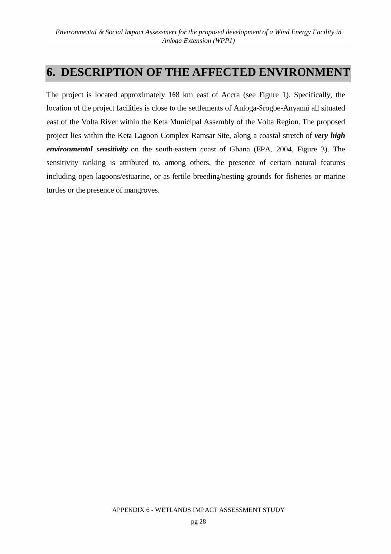
Environmental & Social Impact Assessment for the proposed development of a Wind Energy Facility in Anloga Extension (WPP1)
APPENDIX 6 - WETLANDS IMPACT ASSESSMENT STUDY
pg 28
6. DESCRIPTION OF THE AFFECTED ENVIRONMENT
The project is located approximately 168 km east of Accra (see Figure 1). Specifically, the
location of the project facilities is close to the settlements of Anloga-Srogbe-Anyanui all situated
east of the Volta River within the Keta Municipal Assembly of the Volta Region. The proposed
project lies within the Keta Lagoon Complex Ramsar Site, along a coastal stretch of very high
environmental sensitivity on the south-eastern coast of Ghana (EPA, 2004, Figure 3). The
sensitivity ranking is attributed to, among others, the presence of certain natural features
including open lagoons/estuarine, or as fertile breeding/nesting grounds for fisheries or marine
turtles or the presence of mangroves.

Environmental & Social Impact Assessment for the proposed development of a Wind Energy Facility in Anloga Extension (WPP1)
APPENDIX 6 - WETLANDS IMPACT ASSESSMENT STUDY
pg 29
Figure 3: The extent of the Keta Lagoon Complex Ramsar Site and sensitive areas.

Environmental & Social Impact Assessment for the proposed development of a Wind Energy Facility in Anloga Extension (WPP1)
APPENDIX 6 - WETLANDS IMPACT ASSESSMENT STUDY
pg 30
Preliminary consultation with the manager of the Keta Lagoon Complex Ramsar Site and the
review of the management plan (Keta Lagoon Ramsar Site, 1999) revealed that the site was
zoned into core, buffer and transitional zones based on perceived environmental sensitivity
measure for management purposes.
The zonation map for the Keta Lagoon Complex Ramsar Site is not available to depict the
reference location of the project facilities to the zones. However, the exact locations of the
project at Anloga-Srogbe-Anyanui area are said to be within a buffer zone, which may require a
more detailed impact assessment than the transition zone (Site Manager, personal Comm.).
6.1 PHYSICAL FEATURES
6.1.1 Climate
The climate of Ghana is tropical, warm and comparatively dry along the southeast coast; hot and
humid in the southwest of Ghana and hot and dry in the north, with temperatures varying with
season and elevation. The majority of the country’s average rainfall falls 1 000 – 1 250 mm
between the years 1981-2010 (Figure 4). The weather in Ghana is controlled by the position and
intensity of the Azores anticyclone (high pressure centre) in the North Atlantic and the St Helena
anticyclone in the South Atlantic. Rainfall throughout Ghana is determined by two prevailing air
masses: the hot and dry Tropical Continental Air Mass (NE trade winds) and the warm and
humid Tropical Maritime Air Mass (SW trade winds).

Environmental & Social Impact Assessment for the proposed development of a Wind Energy Facility in Anloga Extension (WPP1)
APPENDIX 6 - WETLANDS IMPACT ASSESSMENT STUDY
pg 31
Figure 4: Mean Annual Rainfall Levels of Ghana (Source: Climate Hazards Group InfraRed, 2017)
The mean annual temperature in Ghana ranges from 25.9 °C to 29.7 °C due to the low latitude of
Ghana (Figure 5). The average daily temperature of Tema, which is approximately 127km from
Anloga, is 27.7°C. The coolest time of the year is between June and September when the main
rainfall occurs. Variations in temperature both annually and daily are quite small. In most areas
the highest temperatures occur in March, the lowest in August.

Environmental & Social Impact Assessment for the proposed development of a Wind Energy Facility in Anloga Extension (WPP1)
APPENDIX 6 - WETLANDS IMPACT ASSESSMENT STUDY
pg 32
Figure 5: Average annual rainfall and temperatures in Ghana (MacMillan, 2007)
A noteworthy climatic phenomenon in Ghana is the harmattan winds which blow in from the
northeast from December to March, bringing dust from the Sahara and reducing visibility to as
little as 1 km (0.6 miles). This dry desert wind lowers the humidity and creates hot days and cool
nights in the north. In the south, the effects of this wind are felt in January.
The proposed project sites lie within the dry equatorial climatic region of Ghana, which covers
the entire south eastern coastal belt of the country. Temperatures are high throughout the year
and range between 23°C and 33°C. August is normally the coldest month in the area. Rainfall is
heavy during the major rainy season between March and September. The average rainfall is 750
mm per annum. Relative humidity ranges from 60% in the dry season to 80% in the rainy
season. Evaporation ranges from 5.4 mm to 6.8 mm and is very high during the dry season
(November -March). This is attributed to the proximity to the sea, the Volta River and other
water bodies.

Environmental & Social Impact Assessment for the proposed development of a Wind Energy Facility in Anloga Extension (WPP1)
APPENDIX 6 - WETLANDS IMPACT ASSESSMENT STUDY
pg 33
The prevailing wind direction is from the southwest all year round (the south-west monsoons).
This is a characteristic feature for the entire coastal belt of the country (Tumbulto, 1997).
6.1.2 Hydrology, surface waters and flooding
Ghana lies along the Gulf of Guinea (30 5´ W and 1010´ E and 40 35´N and 110 N) and has an
area of about 239,000 km2 and a 550 km coastline with about 90 lagoons and associated
wetlands. Some of the lagoons are closed and others open to the sea (Mensah, 1979).
The coastal zone covers about 6.5% of the total area (Figure 6) and houses about 25% of the
national population as well as 60% of the nation’s industries.
Figure 6: Map of Southern Ghana showing the coastal zones
The coastline has three geomorphic units. The West Coast (≈95 km), extends from the Ghana's-
Côte d’Ivoire border to the Ankobra River estuary where there are gently sloping sandy beaches;
the Central Coast (≈321 km) from the Ankobra estuary to Tema with rocky headlands and
sandbars or spits enclosing coastal lagoons and the East Coast (≈149 km), stretching from Tema

Environmental & Social Impact Assessment for the proposed development of a Wind Energy Facility in Anloga Extension (WPP1)
APPENDIX 6 - WETLANDS IMPACT ASSESSMENT STUDY
pg 34
to the Ghana-Togo border where the shoreline is sandy and characterized by considerable coastal
erosion (Ly, 1980).
The main watercourse along the East Coast is the Volta River, which discharges into the sea
through an estuary at Ada-Foah, with extensive surrounding wetland floodplains and mangrove
swamps on either side of its lower reaches (Figure 7). The Songor and the Keta Ramsar sites
form part of the Volta River estuary within the project area of influence along the eastern
coastline. The effective catchment area of the lower Volta estuary is estimated to be over 1,520
km2 (estimated from total area of Songor and Keta Ramsar Sites). Notable on the eastern side is
the Keta lagoon that receives inflow from the Todzie River through the neighboring Avu lagoon
via several small tributaries. Others are the Aka and Belikpa streams which enter the Keta lagoon
directly from the north.
Figure 7: Schematic Map of the Volta River Estuary showing the Songor and Keta lagoon. The approximate position and extent of WPP 1 is indicated by the red frame.

Environmental & Social Impact Assessment for the proposed development of a Wind Energy Facility in Anloga Extension (WPP1)
APPENDIX 6 - WETLANDS IMPACT ASSESSMENT STUDY
pg 35
The regulated flow in the Volta delta began when Akosombo and Kpong hydro-power plants
were commissioned in 1965 and 1984, respectively. The reservoir has reduced downstream flow
patterns and effectively eliminated the dynamic interactions between the river and its floodplains,
wetlands, deltas, estuaries, mangrove and beach environments. The resulting change in fauna and
flora encouraged the growth of disease vectors such as schistosomiasis carrying snails, and
created changes in the flow regime between the interconnecting creeks and streams between the
Lower Volta River and the Avu–Keta basin, including the Avu, Keta and Angaw lagoons.
Parts of the project core sites are considered to be vulnerable to flooding and as such, if the
proposed facilities are built at current levels it is likely that they will be susceptible to inundation.
If ground levels at the sites are raised to protect them from flooding this could however
exacerbate flood risk in other low lying areas, potentially resulting in farmland or properties
locally being flooded more frequently and or more severely than currently occurs.
In addition climate change related changes in sea level and or rainfall could further alter the flood
regime locally. Essentially the Keta region is dynamic and susceptible to hydrological changes,
whether natural or induced.
6.1.3 Geology and soils
The geological formations of the Ghana coastal areas are said to be influenced by the processes
of continental drift during the Cretaceous period of about 135 million years ago. The underlying
basement formations consist of hard granites, granodiorites and metamorphosed lava and
pyroclastics. Some coastal areas are covered by Ordovician and Devonian sandstone and shale.
The area consists of the Caenozoic (Quaternary-Recent and Tertiary-Eocene) formations that
include unconsolidated sands and clays of lagoon, delta and littoral areas, partly consolidated red
continental deposits of sandy clay and gravel. It consists of a thick section of marine sands, clay,
shale, limestone, sandstone and some gravel which underlie more recent sediments in the coastal
areas and dips towards the southeast. The recent deposits comprise unconsolidated sand, clay and
gravels of river valleys especially along the lower Volta River, marine clays along the northern
banks of the lagoons and marine sands along the coastal littoral stretch from Aflao to Anyanui
(Junner & Bates 1945). Groundwater occurrence in this hydrogeological province is controlled

Environmental & Social Impact Assessment for the proposed development of a Wind Energy Facility in Anloga Extension (WPP1)
APPENDIX 6 - WETLANDS IMPACT ASSESSMENT STUDY
pg 36
by matrix flow. Borehole yields for standard size wells (125 mm diameter) reaching a mean
depth of 52 m is generally in the range 0.7–27.5 m3h-1 with a mean value of 2.7 m3h-1.
Transmissivity values are generally low due to high clay content of the regolith. They vary from
0.23 m2h-1 in the clayey regolith to 4.0 m2h-1 in the fissured zones (WRRI, 1993). These ranges
are often exceeded in the Keta basin.
The soils in the area are predominantly coastal savanna ochrosols. The organic matter content is
generally low, with a pH of less than 5.5. Coastal savanna ochrosols are mainly red and brown,
moderately well drained medium to light texture soils developed over Voltaian sandstone,
granite, philites and schists. They are generally low in organic matter due to insufficient
accumulation of biomass.
Other soil types are the Keta, Amo and Oyibi (normal) series found on the higher grounds in the
immediate surroundings of the mangrove swamps. The Keta series are developed on the narrow
coastal sand dunes which separate the sea from the lagoons; the Amos series are developed in
Volta alluvium and the Oyibi (normal) series developed around the edges of the lagoons and are
susceptible to periodic flooding by slightly to moderately saline water, i.e., brackish water.
The Volta River has a dominant influence on the geomorphology of this coast. The project
locations are mostly sandy and characterized by the deltaic features of the Volta River. Fluvial
sediments from the river, as well as, marine and fluvial-marine sediment make up the surface
geology of the area. The beaches comprise medium to coarse sand and rise steeply (a slope of
about 1:10) in elevation to about 2 m above Mean Sea Level (MSL).
6.1.4 Coastal erosion
Coastal erosion, flooding and shoreline retreat are serious problems along the coast of Ghana.
Past human impacts, inappropriate management interventions, climate change and sea-level rise
have been identified as major contributing factors (Armah, 1991). Several consequences could
be expected from sea level rise in Ghana. In particular, low-lying sandy coastal areas at the
eastern coast such as the Volta Delta and Keta lagoon could be profoundly affected. The
expected impacts of sea-level rise are: direct inundation (or submergence) of low-lying wetland
and dry land areas; erosion of soft shores by increasing offshore loss of sediment; increasing

Environmental & Social Impact Assessment for the proposed development of a Wind Energy Facility in Anloga Extension (WPP1)
APPENDIX 6 - WETLANDS IMPACT ASSESSMENT STUDY
pg 37
salinity of estuaries and aquifers; raised water tables; and exacerbated coastal flooding and storm
damage (IPCC, 2007). These impacts have in turn influence on coastal habitats, bio-diversity and
socio-economic activities.
6.1.5 Keta-Aflao Coastal Stretch
Generally, the shoreline south of the Volta Delta runs virtually straight from west to east.
Following the damming of the Volta River erosion became critical averaging about 2 - 3 m/year
due to the cutting off of substantial amounts of sediments that previously reached the littoral
zone.
The coastal recession in the Keta area was estimated to have increased from 4 m/year before the
construction of the dam on the Volta River in 1965 to 8 m/year after the dam construction (Ly,
1980). Episodes of shore erosion over the last several decades have caused losses of about 70%
of the original residences and buildings in the towns and the coastal road between Keta and
Havedzi. The only shorelines of the East Coast that are stable are the shores from Aflao to
Blekusu and from Dzelukope to Anloga.
Coastal defence works aimed at protecting the Keta area from further erosion as well as flooding
from the Keta lagoon were completed in early 2004. This has effectively stopped the erosion at
Keta and reclaimed land for rehabilitation.
6.2 BIOLOGICAL FEATURES
6.2.1 Overview
The coastal savanna zone covers approximately 12,000 km², some 5% of the land area. This zone
runs westward from the Togo border, includes the delta of the Volta river, and narrows in width
until it is replaced by forest zones in the Sekondi–Takoradi area, just east of Ghana’s
southernmost extremity, Cape Three Points (Figure 8). The vegetation consists of grasses and
shrubs. Some mangrove stands occur in the south-east, around the Volta lagoons, and also in the
west around the Amanzuri wetlands. Most of the mangrove forests in the east are degraded as a
result of heavy exploitation.

Environmental & Social Impact Assessment for the proposed development of a Wind Energy Facility in Anloga Extension (WPP1)
APPENDIX 6 - WETLANDS IMPACT ASSESSMENT STUDY
pg 38
Figure 8: Vegetation of the Coastal Zone of Ghana
Ten wetland types based on the classification of the Ramsar Convention on Wetlands (Ramsar,
Iran, 1971) occur in the coastal zone of Ghana (Gordon et. al., 1998). The south eastern coastal
area which comprises the study area, has wetland habitats including swamps, sandy beaches,
lagoons, estuaries and mangroves. The wetland areas have a relatively low diversity of plant and
animal species. The area has been modified by different anthropogenic activities such as
settlement and farming, but small areas of primary vegetation may be intact.
6.2.2 Floral Diversity
The coastline vegetation is characterized by salt tolerant grasses like Paspalum vaginatum,
Sporobolus robustus, the rhizomatous sedge Cyperus articulatus and the succulent forb
Sesuvium portulacastrum. Madreporarian corals are found nearer to the shore of lagoons. Further
landwards on floodable higher ground are grasses such as Brachiaria distachyoides, Imperata
cylindrica, Panicum repens, tall grasses such as Andropogon gayanus, and Vetiveria fulvibarbis.
Other vegetation includes the herbs Cassia mimosoides and Croton lobatus, and sedge
Fimbristylis pilosa.
50 0 50 KilometersN
#
#
#
#
#
#
#
#
#
#
#
#
#Apam
Tema
LomeKeta
AdaPrampram
LaACCRA
Winneba
Cape Coast
Sekondi
Cape Three Points
Axim
200nm
200nm
CENTRAL COAST
EAST C
OAST
WEST COASTGULF
OF
GUINEA
CO
TE D'IVO
IRE
TOGO
5° 5°
6° 6°
7° 7°
3°
3°
2°
2°
1°
1°
0°
0°
1°
1°
Coastal scrub and grassland
Guinea savanna
Moist-semi deciduous forest
Rain forest
Strand and mangrove zone
LEGEND

Environmental & Social Impact Assessment for the proposed development of a Wind Energy Facility in Anloga Extension (WPP1)
APPENDIX 6 - WETLANDS IMPACT ASSESSMENT STUDY
pg 39
The terrestrial vegetation of the area is largely degraded and the terrain is characterised by farms,
secondary growth on abandoned farms, and eroded lands invaded by Neem Azadirachta indica,
and isolated trees like Fan Palm Borassus aethiopum, Mango Magnifera indica, Silk cotton Tree
Ceiba pentandra and Baobab Adansonia digitata.
A hydro-biological survey of the Keta lagoon by Finlayson, et. al. (2000), informed a
preliminary definition of the floral baseline of the site. A list of aquatic and wetland plants found
in the Keta lagoon, in the swamps that occur between the lagoons and the Volta River, and in the
Angor channel connecting Keta to the Volta River, is given in Appendix 2. The list is certainly
not comprehensive as it is confined to the plants found at particular survey sites in a particular
season. However, given the length of the list – 136 species in total, with 109 in Keta and
surrounding swamps and 27 in the Angor channel – it is highly probable that this represents a
major component of the macrophytic flora of the area.
The most dominant species were the large emergent species Typha domingensis, Scirpus
littoralis and the rampant grass Paspalum vaginatum. These species were most common in the
freshwater zones around both lagoons and towards the Volta River. At some sites they occurred
together or in close proximity, whereas at others there was a definite monodominance. The
relationship between these species and their preferred growth conditions is not known, but it is
assumed that water depth and the extent of inundation would be influential. The drier and saline
areas around the lagoons are characterised by a Sesuvium portulacastrum and Sporobolus
pyriamidalis association. Whilst these species preferentially grow in the drier and more saline
areas they also seem to be influenced by the extent of freshwater flooding, but again there is no
evidence on which to base more specific comments.
The dry salt flats and shallow saline water bodies are dominated by Sesuvium portulacastrum
and/or Cyperus articularis with some Sporobolus pyramidalis and Paspalum vaginatum. The
deeper swamps adjacent to the wetlands contained extensive stands of Paspalum vaginatum,
both in wet and dry conditions, and the tall Typha domingensis are generally found in wet areas
or areas that prone to flooding.

Environmental & Social Impact Assessment for the proposed development of a Wind Energy Facility in Anloga Extension (WPP1)
APPENDIX 6 - WETLANDS IMPACT ASSESSMENT STUDY
pg 40
The vegetation on the sand dunes or beach heads is subject to temperature extremes, high
evaporation rates, sea sprays, windiness and unstable and unconsolidated substrates. Coconut
(Cocos nucifera) plantations dominate the dunes whilst the ground cover is dominated by
rhizomatous and straggling species including the sedges Cyperus maritime and Remirea
maritime, the herbs, Alternanthera maritima, Canavalia rosea, and Ipomoea pes-caprae, and the
grasses Paspalum vaginatum, Sporobolus robustus and S. virginicus. The creeping succulent
forb Sesuvium portulacastrum, Philoxerus vermicularis, and xerophytes Euphorbia glancophyll
and Opuntia vulgaris exist in the zone. Occasionally Thespesia populnea and the Indian almond
Terminalia catapa may also occur (Boghey, 1957). The algae in the brackish habitats are rather
poor and represented by ten species.
6.2.3 Mangroves
Mangroves along the coastline of Ghana are associated with coastal lagoons and estuaries. Their
distribution is sparse and nature degraded through over-cutting and conversion to salt pans.
Good stands of mangroves are restricted to three main areas: the Amanzule wetlands in the
Western Region, the Kakum River estuary west of Cape Coast (Central Region), and the Volta
Delta. White mangrove (Avicennia africana), red mangroves (Rhizophora racemosa) and black
mangroves (Laguncularia racmosa) are the dominant species. Typically Rhizophora and
Laguncularia species are found on the seaward side of lagoons whilst Avecinnia is found on the
landward side of the swamps (FAO/UNEP, 1981).
The Avecinnia africana and Rhizophora racemosa are common at the project sites. Rhizophora
racemosa is not considered threatened by the IUCN Red List of Threatened Species and
Avicennia africana has not been evaluated. The continual development of these species in the
project areas is supported by the inundation of the mudflats of brackish water from the Volta
River and the creeks.
Associated with the mangroves are swamp grasses and buttonwood (Cornocarpus erectus).
Faunal composition includes the lagoon crab (Cardiosoma amartum), mudskipper
(Periophthalmus papilio), Tilapia species, weaver birds, pied king fisher and western reef egret.
Mangroves also play an important role as nursery areas for many species of fish and crustaceans.

Environmental & Social Impact Assessment for the proposed development of a Wind Energy Facility in Anloga Extension (WPP1)
APPENDIX 6 - WETLANDS IMPACT ASSESSMENT STUDY
pg 41
6.2.4 Faunal Diversity
The large numbers of coastal lagoons and marine ecosystem provide rich and diverse habitats for
significant populations of water birds, turtles and mammals of conservation importance.
6.2.4.1 Birds
Ghana is on the boundary of two international migratory water bird flyways – the East Atlantic
Flyway and the Mediterranean Flyway and receives diverse migratory bird species along the
coast (Figure 9). Therefore, about 90% of the bird populations in the coastal regions of Ghana
are migrant species, which makes the coast very important in terms of the global conservation
effort.
Figure 9: Map of the world showing the position of Ghana on the boundary of two international bird migratory routes (Birdlife International 2010)

Environmental & Social Impact Assessment for the proposed development of a Wind Energy Facility in Anloga Extension (WPP1)
APPENDIX 6 - WETLANDS IMPACT ASSESSMENT STUDY
pg 42
Several coastal habitats are important for their biodiversity as well as for rare and endangered
species. Sandy beaches, lagoons and floodplains on the coast provide feeding, roosting and
nesting sites for a great number of birds, including mainly waterbirds such as waders, terns,
herons/egrets etc.
Only five coastal protected areas currently exist within the country. These areas are all located
onshore and are protected under the Ramsar convention (Ramsar, Iran, 1971) - the Muni-
Pomadze, Densu Delta, Sakumo Lagoon, Songor Lagoon and the Keta Lagoon Complex Ramsar
sites. The lagoon areas offer the highest avifaunal diversity. Species counts exceeding 40 have
been recorded. They are the most important wetlands on the Ghanaian coast for waterbirds and
are ranked fourth most important water bird sites on the Gulf of Guinea coast (Ntiamoa-Baidu et.
al. 1998). The Songor Ramsar site is also recognised as a UNESCO biosphere reserve. Like all
other coastal Ramsar Sites in Ghana, the Keta and Songor sites were identified and listed as
Wetlands of International Importance based on their regular support of 1% of the individuals in a
population of one species or subspecies of waterbird - Criterion 6 of Criteria for Identifying
Wetlands of International Importance (Appendix: 1).
The Ghana coast continues to be important for some species of waterbirds of the East Atlantic
population using the different coastal wetlands, including the five coastal Ramsar Sites as staging
or wintering sites (Appendix 4). Table 6 below shows number of species and individual
waterbirds observed on coastal Ramsar Sites in Ghana in January 2017.
Table 6: Number of species and individual waterbirds observed on coastal Ramsar Sites in Ghana, January 2017 count. (Source: Wildlife Division, 2017).
Ramsar Site No. of waterbird
species
No. of waterbird individuals
Densu Delta 31 13,233
Muni-Pomadze 25 1,998
Sakumo 25 614
Songor 28 4,098
Keta 37 29,762
Total 51 54,885

Environmental & Social Impact Assessment for the proposed development of a Wind Energy Facility in Anloga Extension (WPP1)
APPENDIX 6 - WETLANDS IMPACT ASSESSMENT STUDY
pg 43
Peak counts of waterbirds in Ghana are observed between September and November. Therefore,
the noticeably low numbers of waterbirds observed at these Ramsar sites during the January
2017 waterbirds count does not devalue the importance of these sites (Wildlife Division, 2017).
The avifauna of the estuaries consist of herbivorous feeding ducks that feed in the freshwater
marshes, as well as visual and tactile surface foraging waders feeding on both dry and wet
mudflats. Stalking herons can also be found in this habitat and these feed in the dry and wet
mudflats and within the shallow waters. A list of common waterbird species and their abundance
on coastal Ramsar Sites, including Keta Ramsar Site, as obtained in a single count in January
2017 can be found in Appendix 4.
6.2.4.2 Estuarine and freshwater fish and aquatic fauna
The fish fauna of a number of lagoons and estuaries have been documented. The dominant
species in most lagoons belong to the Cichlidae, notably the black-chinned tilapia Sarotherodon
melanotheron which makes up 80% to 99% of the fish biomass (Pauly, 1975, 1976; Koranteng et
al., 1998, 2000).The remaining fish fauna are freshwater and marine species. Juveniles of marine
fish are notably common in open (tidal) lagoons (Mensah, 1979, Pauly, 1975, 1976; Blay, 1998).
Such systems serve as a vital nursery, providing food and sanctuary for juvenile fish. A number
of marine fish species rely on functioning estuaries and lagoons for successful recruitment.
The wetlands of Volta Delta area, by aggregate, constitute about 70% of the coverage area of all
the coastal wetlands of Ghana with over 50 species of fish, crustaceans and mollusc.
6.2.4.3 Marine Reptiles and Mammals
6.2.4.3.1 Marine Turtles
In general, five species of sea turtles have been identified as commonly nesting in the Gulf of
Guinea (Marquez, 1990). About 70% of the 550 km shoreline of Ghana presents suitable sites for
nesting turtles. These are the Leatherback Turtle (Oermochelys coriacea), Green Turtle
(Chelonia mydas), Hawksbill Turtle (Eretmochelys imbricata), Loggerhead Turtle (Caretta
caretta) and Olive Ridley Turtle (Lepidochelys olivacea). Leatherback and Hawksbill turtles are

Environmental & Social Impact Assessment for the proposed development of a Wind Energy Facility in Anloga Extension (WPP1)
APPENDIX 6 - WETLANDS IMPACT ASSESSMENT STUDY
pg 44
classified globally as Critically Endangered, green turtles as Endangered and Olive Ridley turtles
as Vulnerable in the IUCN Red List of Threatened Species.
All five of the above named species of sea turtle are thought to nest on beaches in Ghana. Sea
turtles are afforded protection in Ghana under the Wildlife Conservation Regulations, 1971 (LI
685), which prohibits hunting, capture and destruction of animals.
Beach cliffs impede emerging turtles from accessing suitable nesting sites along the beaches.
Cliffs of 1.68 m high resulting from erosion by sea waves along the beach have been recorded at
the beaches of the project sites (Agyeman, 2008).
Olive Ridley turtles can normally climb cliffs between 40-50 cm and will move as far as 80-120
m above the higher tidal mark to nest. Leatherback and Green turtles can only climb very gentle
slopes and do not move far from high water mark to nest. The Leatherback, Olive Ridely and the
Green Turtle are most common in the beaches close the project site (Anloga), which they use for
nesting generally between October and January.
6.2.4.3.2 Manatee
The West African manatee (Trichechus senegalensis) occurs in coastal marshlands as well as
inland marshlands of Ghana. The mammal attracts much socio-cultural interest in Ghana.
Communities living along the Avu lagoon do not use the manatee meat as food, but consider it as
high priced meat which is processed for the markets in Accra. Some communities in the North
Tongu District regard the West African manatee as deity and therefore perform rituals to pacify
the gods when they are un-intentionally caught in fishermen’s net.
The West African manatee is globally classified as vulnerable by the International Union for
Conservation of Nature and Natural resources (IUCN). In Ghana however, no assessment of the
manatee population has been carried out. A large number of manatees have been reportedly
killed by local hunters in the Tano, Afram and Avu lagoon. In one dry season, over 40
individual manatees were reported killed along the Avu lagoon. Ofori-Danson and Agbogah
(1998) reported one hunter killing over 17 individuals in the Afram River.

Environmental & Social Impact Assessment for the proposed development of a Wind Energy Facility in Anloga Extension (WPP1)
APPENDIX 6 - WETLANDS IMPACT ASSESSMENT STUDY
pg 45
Fishermen in the Lower Volta associated wetlands and elsewhere reported fewer manatee
sightings in recent times compared to the pre-impoundment period of the Volta River (Ofori-
Danson and Agbogah 1998). These reports suggest that the manatee population is under threat of
possible extinction from increasing over exploitation.
6.2.4.4 Terrestrial fauna
The rare ungulate, the Sitatunga (Tragelaphus spekei gratus) was common along the Volta River
but their population was reduced close to extinction with the construction of the Akosombo dam
in the early 60s, which led to loss of its original habitat. The Sitatunga was thought to have gone
extinct in West Africa in the 70s and 80s, but a small population was discovered in an inland
fresh water lagoon (Avu lagoon) of the Lower Volta River system (NCRC, 2005).
Habitat destruction, burning and draining of wetlands are the major threats to the long-term
survival of the species. Sitatunga is classified as an endangered animal species and wholly
protected under Wildlife laws of Ghana.

Environmental & Social Impact Assessment for the proposed development of a Wind Energy Facility in Anloga Extension (WPP1)
APPENDIX 6 - WETLANDS IMPACT ASSESSMENT STUDY
pg 46
7. IDENTIFICATION OF KEY ISSUES
7.1 OVERVIEW
Wetlands are dynamic areas, open to influence from natural and human factors. In order to
maintain their biological diversity and productivity and to allow wise use of their resources by
human beings, an agreement and understanding is needed between the various owners, occupiers
and interested parties.
The scope of assessment was initially based upon baseline knowledge of the project area and
subsequently updated to accommodate relevant findings after public and statutory consultation
during the scoping phase.
7.2 KEY ISSUES
The potential issues of concern identified during the scoping phase include:
• Impact on birds/bats during the construction and operation phase of the project.
• The removal of natural vegetation containing threatened, protected and endemic species
such as mangroves;
• An increased exotic infestation due to disturbances of the wetland ecosystem. There are
a number of invasive plant species in the Keta lagoon and the catchment areas. Invasive
terrestrial plants common in the area include Azadirachta, Prosopis julifora, Mimosa
pigra, Parkinsonia aculeata, Zanthoxylum xanthoxyloides. Also common are aquatic
and semi-aquatics such as Pistia stratiotes, Azolla filiculoides, A. pinnata, Typha
domingensis, Ceratophyllum demersum, Vossia cuspidata, Oxycarium cubense. There is
the high tendency for these non-native plants to increase and spread due to disturbances
during the construction phase of the project.
• Increased dust deposition during construction, particularly if construction is undertaken
during the dry season.

Environmental & Social Impact Assessment for the proposed development of a Wind Energy Facility in Anloga Extension (WPP1)
APPENDIX 6 - WETLANDS IMPACT ASSESSMENT STUDY
pg 47
• High risk of coastal flooding and erosion: The main environmental hazard to be
expected at the project sites is flooding. The flat nature of the topography of Keta
Municipality coupled with climate change impacts exposes the area to serious threat of
flood. The project area consists of approximately 25 km of coastline which is fast
eroding posing a great threat to human life, property, infrastructure, tourism and marine
turtle nesting sites.
Species of marine turtles listed on the IUCN list of endangered species as "Vulnerable" and
"Endangered" are known to utilise the nearby sandy beach fronts as nesting grounds (See section
6.2.4.3.1). However, the marine turtles do not utilise the beaches beyond the high steep cliffs
resulting from erosion by sea waves. The turtle nesting grounds will not be significantly
impacted during the construction or operational phases of the project as the Anloga project site is
well above areas accessible for turtle nesting.
There will be no impact on freshwater mammals, such as the Sitatunga considering the absence
of their preferred habitats (within deep fresh water lagoons) and the human disturbances in close
proximity to the project sites.

Environmental & Social Impact Assessment for the proposed development of a Wind Energy Facility in Anloga Extension (WPP1)
APPENDIX 6 - WETLANDS IMPACT ASSESSMENT STUDY
pg 48
8. ECOSYSTEM HEALTH AND SENSITIVITY
8.1 WETLAND AND ESTUARINE ECOSYSTEMS
A spatial representation of the freshwater and estuarine habitats is provided in Appendix 3. The
specific habitats are discussed below.
8.1.1 Freshwater
8.1.1.1 Floodplain Wetlands and depressions
A number of interconnected freshwater wetland areas lie within the WPP1 project area. These
are generally situated some distance from the estuarine channels and are connected by poorly
defined flow channels. Many of the extensive wetland areas consist of small depressions
maintained by a shallow water table and linked by surface flow during the wet season.
Essentially these wetlands are embedded within the extensive Volta River floodplain/Keta
lagoon basin, arising where suitable topographical, hydrological and geohydrological features
allow.
The vegetation found within these systems is dominated by hygrophilous grasses (Figure 10) and
robust sedges. Where sustained open water was present, emergent, floating and submerged
aquatic macrophytes are present.
From a faunal perspective, these wetland habitats provide numerous aquatic and semi aquatic
habitats suitable for amphibians, invertebrates, small mammals and juvenile fish.

Environmental & Social Impact Assessment for the proposed development of a Wind Energy Facility in Anloga Extension (WPP1)
APPENDIX 6 - WETLANDS IMPACT ASSESSMENT STUDY
pg 49
Figure 10: A freshwater wetland near the proposed structures at Anyanui.
8.1.1.2 Water bodies (open water)
Open freshwater dominated water bodies occur within larger freshwater wetlands, inland of the
project area near Srogbe and along the fringes of Keta Lagoon. These are generally shallow and
lined with emergent macrophytes. These systems appeared to be maintained during the dry
season by ground water (fresh water sitting on top of denser salt water) and fed during the wet
season by seasonal channels linked to the upper reaches of the Volta River floodplain.
Vegetation is similar to that associated with the wetland areas, however emergent and aquatic
macrophytes are dominant.
These open bodies of freshwater are likely to provide refuge for freshwater fish species that are
less tolerant of saline conditions, amphibians and water birds.

Environmental & Social Impact Assessment for the proposed development of a Wind Energy Facility in Anloga Extension (WPP1)
APPENDIX 6 - WETLANDS IMPACT ASSESSMENT STUDY
pg 50
8.1.2 Estuarine
8.1.2.1 Mangroves
Within the project area, mangrove forests are a significant estuarine habitat both in terms of area
(coverage) and ecological value. Mangroves are found along the marginal extent of almost all
tidal channels and lagoon areas, often extending landward along minor channels. Large
mangrove areas are present to the west of the Salo/Srogbe Road and around the Anyanui site
(Figure 11). Some loss of mangrove habitat was noted within the project area, mainly due to the
establishment of road infrastructure and the need for wood, primarily as a fuel source.
The mangroves are dominated by three tree species, the White mangrove (Avicennia africana),
red mangrove (Rhizophora racemosa) and black mangrove (Laguncularia racemosa).
Mangroves are important sanctuaries for juvenile estuarine and marine fish (e.g. Lutjanus
species.), which feed and reside within the dense cover provided by the roots of R. racemosa in
particular.
Figure 11: Mangrove habitat west of the Salo/Srogbe Road.

Environmental & Social Impact Assessment for the proposed development of a Wind Energy Facility in Anloga Extension (WPP1)
APPENDIX 6 - WETLANDS IMPACT ASSESSMENT STUDY
pg 51
Mangroves represent a globally and regionally important ecosystem, providing a range of
ecosystem services to humans and, therefore, warranting special conservation measures (Olson et
al., 2000). In this regard, mangrove forests are important for the following reasons:
• they are highly productive, producing a large proportion of the organic matter that
forms the basis of the food chains within the estuarine and nearshore coastal
environment;
• they provide a sheltered nursery aquatic environment and habitat for many fish, prawn,
crab and invertebrate species;
• they stabilise the coastline and trap sediments that would otherwise enter the sea, at
least in some situations; and
• they provide a source of wood for construction, fuel (e.g. for fish-smoking) and tannin.
8.1.2.2 Estuarine/tidal channels
These consist of wide channels where tidal flow is present. These areas are well defined
characterised by open water and dense marginal vegetation consisting usually of mangrove forest
(Figure 12). These channels provide a permanent link between the main channel of the Volta
estuary and the Keta Lagoon. Secondary and split channels often occurred.
These channels transport fish and invertebrate larvae in and out of the estuarine system and are
important for maintaining connectivity between the ocean and nursery habitats. The channels
also maintain the hydrological regimen and facilitate the cyclical changes in salinity and
distribution of sediment required to maintain habitats such as mangroves.

Environmental & Social Impact Assessment for the proposed development of a Wind Energy Facility in Anloga Extension (WPP1)
APPENDIX 6 - WETLANDS IMPACT ASSESSMENT STUDY
pg 52
Figure 12: A significant tidal channel within the project area.
8.1.2.3 Salt marsh/salt flat
Salt marsh/salt flats are extensive flat areas characterised by xerophytic conditions and saline
soils. These areas are found landward of the mangrove areas and indicate the outer limit of the
estuarine habitat and saline influence (Figure 13 and 14). Salt marsh areas are inhabited by
specialised plant species that are able to handle the xerophytic conditions. Grasses and succulents
such as Sesuvium portulacastrum, Paspalum vaginatum and Sporobolus virginicus are dominant
(Figure 15).
Although of low diversity, the salt marsh vegetation is unique and highly adapted to the
conditions.

Environmental & Social Impact Assessment for the proposed development of a Wind Energy Facility in Anloga Extension (WPP1)
APPENDIX 6 - WETLANDS IMPACT ASSESSMENT STUDY
pg 53
Figure 13: An example of salt marsh habitat within the project area.
Figure 14: Salt marsh east of the Salo/Srogbe Road. Note the dominance of specialised vegetation and the lack of other savannah and coastal species.

Environmental & Social Impact Assessment for the proposed development of a Wind Energy Facility in Anloga Extension (WPP1)
APPENDIX 6 - WETLANDS IMPACT ASSESSMENT STUDY
pg 54
Figure 15: Sesuvium portulacastrum within a salt marsh habitat.
8.1.2.4 Lagoon
The Keta lagoon is the most significant lagoon system in the WPP 1 project area (Figure 16).
Smaller lagoons are present within the sand bar separating Keta Lagoon form the sea,
immediately inland of the coastal zone, within the dune slack (Figure 17). These lagoon systems
are brackish open water systems. The Keta lagoon is fed by freshwater (Aka and Tordzi Rivers)
and salt water via the channel link with the Volta estuary mouth.
As mentioned previously, the Keta lagoon is a Ramsar site and supports a number of fish and
bird species and sustains a plethora of mirco-habitats along its margin. The lagoon has been
influenced by land reclamation and artificial drainage and inlet channels, which have altered the
nature of system in some areas.
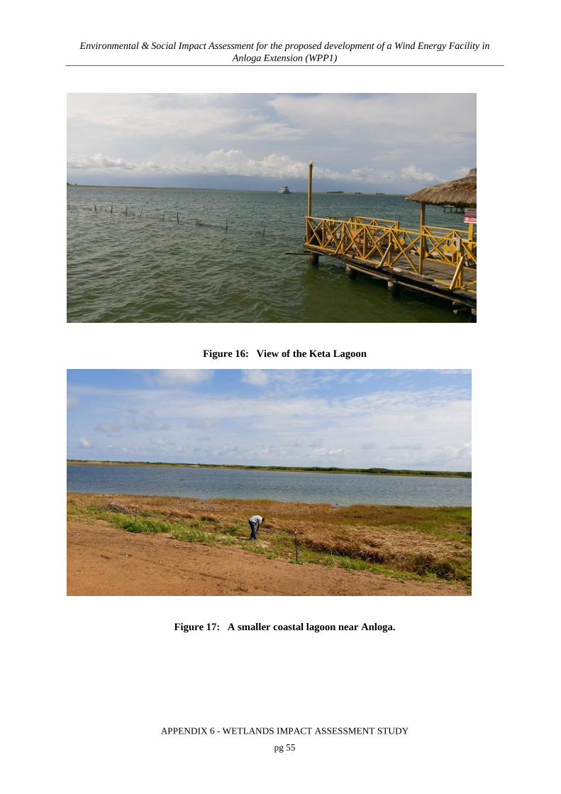
Environmental & Social Impact Assessment for the proposed development of a Wind Energy Facility in Anloga Extension (WPP1)
APPENDIX 6 - WETLANDS IMPACT ASSESSMENT STUDY
pg 55
Figure 16: View of the Keta Lagoon
Figure 17: A smaller coastal lagoon near Anloga.

Environmental & Social Impact Assessment for the proposed development of a Wind Energy Facility in Anloga Extension (WPP1)
APPENDIX 6 - WETLANDS IMPACT ASSESSMENT STUDY
pg 56
8.2 PRESENT ECOLOGICAL STATE
8.2.1 Wetland ecosystems
Based on the criteria of assessment (Table 7), the PES of the floodplain wetland system within
and adjacent to the project area was considered to be “largely natural” or Ecological Category
“B”. The hydrological changes to the Volta river by the hydro-electric dams has undoubtedly
had a long term effect on the freshwater wetland systems of the lower Volta River, including
those within the project area. Being embedded within a floodplain the systems are highly
dependent on flood waters for freshwater inputs and rejuvenation. The changes to the flooding
regimen have probably resulted in the reduction of effective wetland area and an encroachment
of saline habitat (salt marsh).
The changes in flow dynamics of the Volta River have changed the macro scale sediment
regimen of the floodplain, with less sediment reaching the lower reaches of the Volta River and
its associated floodplain habitats.
The floodplain itself was not found to be directly affected by dams and impoundments. The
water quality appeared to be relatively unaffected by settlement in the floodplain area, although
localised deterioration is likely in the immediate vicinity of settlements, where potential
contaminants may be present. Physical disturbances within the wetland areas were limited to
infilling for road crossings, agriculture and occasionally the creation of minor artificial channels.
The former two disturbances have resulted in minor wetland habitat loss. Alien fauna and flora
appeared limited and much of the wetland fauna and flora appeared intact.

Environmental & Social Impact Assessment for the proposed development of a Wind Energy Facility in Anloga Extension (WPP1)
APPENDIX 6 - WETLANDS IMPACT ASSESSMENT STUDY
pg 57
Table 7: Scores assigned to the attributes associated with the determination of the PES of the wetland systems within the project area.
Criteria and attributes Relevance Score ConfidenceHydrologicalFlow Modification Consequence of abstraction, regulation by impoundments or
increased runoff from human settlements or agricultural land. Changes in flow regime (timing, duration, frequency), volumes, velocity which affect inundation of wetland habitats resulting in floristic changes or incorrect cues to biota. Abstraction of groundwater flows to the wetland.
3 2
Permanent Inundation Consequence of impoundment resulting in destruction of natural wetland habitat and cues for wetland biota. 5 3
Water QualityWater Quality Modification From point or diffuse sources. Measure directly by laboratory
analysis or assessed indirectly from upstream agricultural activities, human settlements and industrial activities. Aggravated by volumetric decrease in flow delivered to the wetland
4 3
Sediment Load Modification Consequence of reduction due to entrapment by impoundments or increase due to land use practices such as overgrazing. Cause of unnatural rates of erosion, accretion or infilling of wetlands and change in habitats.
3 2
Hydraulic/GeomorphicCanalisation Results in desiccation or changes to inundation patterns of
wetland and thus changes in habitats. River diversions or drainage.
4 3
Topographic Alteration Consequence of infilling, ploughing, dykes, trampling, bridges, roads, railway lines and other substrate disruptive activities which reduces or changes wetland habitat directly or through changes in inundation patterns.
3 3
BiotaTerrestrial encroachment Consequence of desiccation of wetland and encroachment of
terrestrial plant species due to changes in hydrology or geomorphology. Change from wetland to terrestrial habitat and loss of wetland functions.
3 2
Indigenous Vegetation Removal Direct destruction of habitat through farming activities, grazing or firewood collection affecting wildlife habitat and flow attenuation functions, organic matter inputs and increases potential for erosion.
3 3
Invasive Plant Encroachment Affect habitat characteristics through changes in community structure and water quality changes (oxygen reduction and shading).
4 2
Alien Fauna Presence of alien fauna affecting faunal community structure. 4 2Overutilisation of Biota Overgrazing, Over-fishing, etc 3 3
39 283.5 2.5
Category B
TotalMean

Environmental & Social Impact Assessment for the proposed development of a Wind Energy Facility in Anloga Extension (WPP1)
APPENDIX 6 - WETLANDS IMPACT ASSESSMENT STUDY
pg 58
8.2.2 Estuarine ecosystems
Estuarine systems are sensitive to changes in river flow. In this instance, the reduction in
flow/change in seasonality for flow within the main Volta River is likely to have resulted in
changes in a number of parameters including salinity and salinity gradients, turbidity, sediment
load and mouth/channel state. This in turn influences the functioning of the estuarine system and
habitats potentially reducing the favourability of the system for recruitment of juvenile fish and
invertebrates.
Despite the hydrological changes to the system the biotic community appear only marginally
changed with plant diversity, avian and invertebrate diversity largely intact. Some loss of
mangrove habitat was identified in the Srogbe and Keta areas, however large areas of
undisturbed mangrove forest remain.
Overall, the estuarine system was considered to be “largely natural” (ecological category B) and
despite hydrological changes, remained intact and functional (Table 8).

Environmental & Social Impact Assessment for the proposed development of a Wind Energy Facility in Anloga Extension (WPP1)
APPENDIX 6 - WETLANDS IMPACT ASSESSMENT STUDY
pg 59
Table 8: Scores assigned to the attributes associated with the determination of the PES of the estuarine systems within the project area.
8.3 WETLAND FUNCTIONALITY
Based on the Wet-ecoservices scores (Table 9), the floodplain wetland system is highly
functional providing valuable physical, biodiversity and socio-economic ecoservices. With
reference to Table 9 the following ecoservices were rated as “high”:
• Flood attenuation
Component Brief Description of Change (if any) Score ConfidenceHabitat-related or abiotic components:% of natural MAR currently abstracted Small scale abstraction being
undertaken4 Low
Changes in seasonal river inflow patterns Construction of hydro power dams has altered flow patterns of the Volta River significantly
1 High
Changes in mouth condition (i.e. frequency and duration of mouth closure)
Mouth always open4 Low
Changes in water quality (referring to system variables, nutrients and toxic substances)
Minor pollution expected from adjacent settlements
4 Low
Changes in natural in-stream habitat (i.e. estuary bed modification, channel modification, infilling, migration barriers, bridges, weirs, bulkheads, training walls, canalisation, jetties, marinas)**
Some canalisation noted
4 Medium
Changes in riparian habitat (i.e. flood plain development, bank vegetation, agriculture, grazing, industry, housing, infrastructure, recreational development)
Removal of mangroves, small scale agriculture and settlement
3 High
Biotic components:Plants, including microalgae and macrophytes (i.e. change in botanical importance score)
No change identifiable5 Low
Benthic invertebrates No change identifiable 5 LowFish (i.e. change in estuarine health index score for fish) Decrease in freauency of certain
species due to exploitation and changes in hydrological and salinity regimens
3 Medium
Birds No change. The Volta estuary and associated Keta lagoon are important bird areas.
5 Medium
3.5
B
MEAN ECOLOGICAL INTEGRITY SCORE (averaging the 9 scores above. If no information is available for one of the 9 components, then it is not a divisor
Category

Environmental & Social Impact Assessment for the proposed development of a Wind Energy Facility in Anloga Extension (WPP1)
APPENDIX 6 - WETLANDS IMPACT ASSESSMENT STUDY
pg 60
• Phosphate removal
• Nitrate removal
• Toxicant removal
• Erosion control
• Carbon storage
• Maintenance of biodiversity
• Provision of harvestable natural resources
• Provision of cultivated foods
Flood attenuation is a very important ecoservice given the low lying nature of the
Keta/Anloga/Anyanui areas. Floodplain wetland systems absorb and slow flood waters aiding
dissipation and limiting the extent to which floods affect the surrounding area. The sheer extent
of the floodplain wetland system and the dense vegetation are attributes responsible for effective
flood attenuation.
The vegetation cover and connectivity of the system both in terms of surface and subsurface flow
account for the high scores associated with filtration functions. These functions become more
valuable as human settlement increases.
Many of the wetland depressions embedded within the greater floodplain wetland system are
relatively inaccessible and offer ideal sanctuary for a range of biota including sensitive and rare
species.
In contrast, but of importance to the local communities are the natural resources and agricultural
opportunities provided by the wetland system. Grazing within temporary wetland zones was
noted, as was the cultivation of various cash crops.

Environmental & Social Impact Assessment for the proposed development of a Wind Energy Facility in Anloga Extension (WPP1)
APPENDIX 6 - WETLANDS IMPACT ASSESSMENT STUDY
pg 61
Table 9: Ecoservices scores for the 15 ecoservices associated with the identified wetland system.
8.4 ECOLOGICAL IMPORTANCE AND SENSITIVITY
8.4.1 Wetland ecosystems
The wetland system associated with the project area is of a high significance in terms of
ecological importance and sensitivity (Table 10). The reasons are fairly straight forward:
1) The habitats are linked with the Keta Lagoon which is a declared Ramsar site. Any
changes to the associated habitats will influence the integrity of the core habitat.
2) The floodplain wetland areas support a number of unique and rare species.
3) The wetland habitats fall within a recognised and important bird migration corridor.
4) The changes to the hydrological regimen of the Volta have illustrated the sensitivity of
the floodplain wetlands to hydrological changes.
Parameter Effectiveness Opportunity Final ScoreFlood Attenuation 3.0 3.0 3.0Stream Flow Regulation 2.2 2.2Sediment Trapping 3.5 2.0 2.8Phosphate Removal 3.8 2.3 3.0Nitrate Removal 4.0 3.0 3.5Toxicant Removal 3.3 3.0 3.2Erosion Control 3.8 2.5 3.1Carbon Storage 3.3 3.3Maintenance of Biodiversity 3.3 2.6 2.9Supply for Human Consumption 2.0 2.0Provision of Harvestable Natural Resources 3.6 3.6Provision of Cultivated Foods 3.8 3.8Cultural Significance 1.8 1.8Characteristics Contributing to Tourism Value 2.6 2.6Education and Research 1.5 1.5

Environmental & Social Impact Assessment for the proposed development of a Wind Energy Facility in Anloga Extension (WPP1)
APPENDIX 6 - WETLANDS IMPACT ASSESSMENT STUDY
pg 62
Table 10: Scores and criteria for determining the EIS of the wetland system.
8.4.2 Estuarine ecosystems
The EIS of the estuarine system within the project area is considered to be very high (A) (Table
11). The estuarine and brackish water system effectively forms the core of the Ramsar site and is
recognised for their biodiversity and conservation importance. A diverse range of estuarine
habitats were identified, while the system supports a number of rare and endangered species, the
most well-known being the manatee.
Determinant Score Confidence
PRIMARY DETERMINANTS
Rare & Endangered Species 3 3
Populations of Unique Species 3 4
Species/taxon Richness 2 4
Diversity of Habitat Types or Features 2 4
Migration route/breeding and feeding site for wetland species
4 2
Sensitivity to Changes in the Natural Hydrological Regime
4 2
Sensitivity to Water Quality Changes 2 3
Flood Storage, Energy Dissipation & Particulate/Element Removal
3 3
MODIFYING DETERMINANTS
Protected Status 4 4
Ecological Integrity 3 3
TOTAL 30 32
MEDIAN 3 3.2
OVERALL ECOLOGICAL SENSITIVITY AND IMPORTANCE
High (B)

Environmental & Social Impact Assessment for the proposed development of a Wind Energy Facility in Anloga Extension (WPP1)
APPENDIX 6 - WETLANDS IMPACT ASSESSMENT STUDY
pg 63
Table 11: The EIS of the estuarine systems within the project site.
Essentially the wetland system (floodplain wetland and smaller freshwater wetlands embedded
therein) and estuarine system (estuarine channels and lagoons) are valuable ecological assets and
highly functional systems supporting a number of important habitats and faunal communities.
The ecological state (PES) of the wetland and estuarine system was found to be “largely natural”
despite hydrological changes to the Volta River. In terms of ecological importance (EIS), the
wetland system was rated as “high” while the estuarine system was rated “very high”.
Component Brief Motivation Score ConfidenceRare/endangered/limited populations
Use of the system by rare fauna e.g. Manatee5 High
The number of habitat types in an estuary should be tallied using the following list: 1. open surface water area2. sand flats3. mudflats4. submerged macrophyte beds5. intertidal salt marsh6. supratidal salt marsh7. reeds and sedges8. mangroves9. lagoon swamp forest10. rocks11. deep channels
Rarity of an estuary or unique estuarine features
Presence of unique features and rarity of the system type on a national scale
5 High
Input to sea Estuaries are rated according to size and their potential input of sediments and nutrients to the coastal zone.
3 Medium
4.5
A
5 High
MEAN ECOLOGICAL IMPORTANCE SCORE (averaging the 4 scores above)Category
Habitat diversity (richness)

Environmental & Social Impact Assessment for the proposed development of a Wind Energy Facility in Anloga Extension (WPP1)
APPENDIX 6 - WETLANDS IMPACT ASSESSMENT STUDY
pg 64
9. ASSESSMENT OF IMPACTS/RISKS AND IDENTIFICATION OF MANAGEMENT ACTIONS
9.1 WETLAND BIRDS
The wetland and estuarine habitats within the Keta Ramsar Site serve as a wintering ground for
resident, migratory birds (en route the East Atlantic flyway) and other wildlife species and need
to be preserved. Presently, terns, waders and herons in particular, are not seriously threatened by
human activities. There was no evidence of bat hibernation areas and roosts within the period of
visit. However, the presence of houses and human settlements presents the possibility of bats
utilisation of the environment.
Construction phase
The footprint and potential area of disturbance is relatively small compared to the available area
which birds have to forage and nest. Although habitat loss will occur and while having some
influence on birds, this is considered to be a minor impact from an avian perspective given the
availability of vast areas of similar or better habitat.
Nesting sites may be disturbed, however, mortality is expected to be very low as the footprint of
disturbance and the probability of encountering a high density nesting site is considered very
low, particularly in areas such as Anloga (within a densely populated area) and Srogbe (adjacent
to a main road).
Construction related disturbances that may interfere with bird foraging or nesting (with the
exception of habitat loss) will be temporary in nature.
Due to the location of the construction activities away from the main lagoon and perceived prime
habitats for water and migrating birds, the construction activities are unlikely to directly
influence bird migration or water birds, the two most significant bird groups that utilise the Keta
Complex Ramsar Site. The construction phase is therefore not anticipated to present any physical
barriers to the birds preventing their movement.

Environmental & Social Impact Assessment for the proposed development of a Wind Energy Facility in Anloga Extension (WPP1)
APPENDIX 6 - WETLANDS IMPACT ASSESSMENT STUDY
pg 65
Based on the above, the impact of the construction phase of the proposed wind facility on
wetland bird migration is anticipated to be of low significance without mitigation for layouts.
Management actions
The following management actions must be undertaken prior to the commencement of
construction:
• The construction zone must be inspected for active nesting sites by an ornithologist. The
ornithologist must make a recommendation regarding the need to relocate the nests.
• During construction, should any birds become trapped within the construction area, they
must be relocated safely.
With the effective implementation of the above recommended management actions, the
significance of the impacts of the proposed wind facility on birds/bats migration is anticipated to
be very low for the preferred and the alternative layout during the construction phase.
Operation
From available information, the scale and the spread of the project facilities and the biologically
important nature of the broad project area, including areas of estuaries, open lagoons and the sea
(Gulf of Guinea) demonstrate that the project may have the potential for direct and indirect
adverse impacts on the avifaunal and potentially bat biodiversity during the operation phase.
There is clear evidence that active wind turbines present a threat to the lives of birds and bats.
The risk appears to be much greater in some areas than in others. The presence of large wind
turbines may cause birds to avoid the site, thus losing a foraging resource and requiring extra
energy to fly around it.
The key ornithological issues to be considered with respect to the proposed wind energy
development are likely to include the following:
• Potential impacts on migratory bird species due to the risk of collision with turbines.

Environmental & Social Impact Assessment for the proposed development of a Wind Energy Facility in Anloga Extension (WPP1)
APPENDIX 6 - WETLANDS IMPACT ASSESSMENT STUDY
pg 66
• Non-breeding, wintering birds within or adjacent to the site may be disturbed and/or
displaced as a result of the functioning of the turbines. Individuals may also collide with
the turbines.
The project may have a significant additional influence on birds through collision with the
associated infrastructure, including overhead transmission lines, meteorological masts,
substations and lighting.
The probability of the active turbines resulting in collisions and other disturbance related impacts
as described is theoretically high. The habitat presented by the Keta Lagoon Complex Ramsar
Site is highly irreplaceable and a wind power facility that obstructs or deters birds from accessing
or using the habitat will have a highly significant influence on the bird population. On the
contrary, bird populations may adjust their flight paths, in which case the turbines will be of no
influence. The significance of the potential impact that the project may have on the bird
population (for both alternatives) is thus considered to be medium although the level of
confidence of this prediction is low given the.
Management actions
Given the low confidence and uncertainty surrounding the likelihood of collisions during the
operational phase, it is highly recommended that a bird strike monitoring programme be
implemented during the first 24 months of operation. The programme should involve regular site
inspections around the base of each turbine with the intention of recording the number and
species of dead birds (if any) found.
Review of Alternatives
The Preferred layout involves the establishment of wind turbines within 3 zones (Anyanui,
Anloga and Srogbe) while the Alternative layout involves the establishment of wind turbines in
only 2 zones – Anloga and Srogbe. Of the three turbine sites, Anloga and Srogbe are most likely
to have an influence on migrating birds or resident birds moving between the coastal zone and
Keta Lagoon. Disturbance of resident birds utilising moist grassland and wetland areas is most
likely at Anyanui.

Environmental & Social Impact Assessment for the proposed development of a Wind Energy Facility in Anloga Extension (WPP1)
APPENDIX 6 - WETLANDS IMPACT ASSESSMENT STUDY
pg 67
Both alternatives pose concerns form an avifaunal perspective with the Preferred layout likely to
have a higher probability of having an impact on birds due to the presence of a third turbine node
at Anyanui thus potentially disturbing resident bird activities and migratory birds/moving birds
heading to or from the Avu Lagoon in addition to the Keta Lagoon.
Refer to the specialist avian assessment for further detailed assessment of bird related impacts
and additional management action.
9.2 OTHER FAUNA
Construction
The installation of such large structures, along with supporting roads, and the associated clearing
of wetland vegetation, will have a negative effect because of the loss, degradation, and
fragmentation of habitat. The project is expected to cause displacement of wildlife through
habitat conversion/degradation from land clearing activities. Although no endangered species of
fauna were encountered during the visit, members of nearby communities confirm the presence
of a variety of smaller wildlife including amphibians, reptiles, small mammals and invertebrates.
Apart from the marine turtles that utilise the sandy beach fronts as nesting grounds, low densities
of some common terrestrial reptiles including the Royal python Python regae, the common
lizard Agama agama and the Monitor lizard Varanus niloticus are reported to be present in the
project area. The degraded mangroves, mainly Avicennia africana, along the margins of the
lagoon, waterlogged grassland, riverine woodland and scattered thickets of shrubs, climbers and
small trees on higher ground serve as suitable habitat for these reptiles. The habitat and its
associated fauna will be directly impacted by the construction of the wind energy infrastructure,
however once complete the operation of the turbines offers little threat to terrestrial fauna.
Given the above, the impact of the proposed wind facility on other fauna during the construction
phase is assessed to be temporary, site specific and of medium-low to low intensity for the
preferred and alternative layout respectively. This impact is therefore anticipated to be of low
significance without mitigation for both the preferred and the alternative layout.

Environmental & Social Impact Assessment for the proposed development of a Wind Energy Facility in Anloga Extension (WPP1)
APPENDIX 6 - WETLANDS IMPACT ASSESSMENT STUDY
pg 68
Management actions
Terrestrial and semi aquatic fauna are mobile and are likely to move away from the site to the
nearest refuge once construction commences. Should fauna become trapped within the
construction site or become threatened by activities, a capture and relocation programme should
be implemented. Ad hoc removals during construction should also be effected. The pre-
construction capture and relocation programme will ensure that vulnerable terrestrial or semi
aquatic fauna can be captured and relocated prior to disturbance and potential loss. Candidates
for removal include amphibian species that utilise a particular isolated depression which has been
identified for infilling. The details of the capture and relocation programme will have to be
finalised during the planning phase.
With the effective implementation of the above recommended management actions, the
significance of the impacts of the proposed wind facility on other fauna during the construction
phase is anticipated to be very low for the preferred and the alternative layout.
Operation
If fenced, fauna may become trapped within the fenced area. No other threat to terrestrial fauna
has been identified for the operational phase. As such, the impact significance of the operation of
turbines for both the Preferred and Alternative layouts is considered to be low.
Management actions
Should the sites be fenced, the implementation of “critter paths” can be used to allow either the
escape of any trapped fauna or allow the free movement of small fauna, should total exclusion
not be an option. The latter has been successfully implemented at photovoltaic solar plants in
South Africa. Additional input may be required from a herpetologist.

Environmental & Social Impact Assessment for the proposed development of a Wind Energy Facility in Anloga Extension (WPP1)
APPENDIX 6 - WETLANDS IMPACT ASSESSMENT STUDY
pg 69
Review of Alternatives
The Anloga coastal turbine cluster is unlikely to affect marine turtles due to its position above the
beach slope and within the dune and dune slack area. The Srogbe road turbine cluster is
positioned within a salt marsh and mangrove habitat which are not important habitats for
terrestrial fauna. The Anyanui cluster is the most likely to result in the disturbance of terrestrial
and semi aquatic fauna, particularly amphibians which utilise the moist grassland and freshwater
wetland areas within the cluster site. Therefore, the preferred layout which proposes to establish
the Anyanui cluster is likely to have a marginally greater influence (but still of low significance
as described above) on terrestrial and semi aquatic fauna.
9.3 IMPACT ON LOCAL ARTISANAL FISHERIES
Construction
Land reclamation for the project development may have an impact on local artisanal fisheries,
through disturbance of nursery habitat (mangrove), disturbance of local fish landing sites, and
ultimately the livelihoods of the local people.
The construction activities may interfere with fisherman’s access routes or fish landing sites.
This is however likely to be intermittent and temporary in nature as once construction is
complete, many of the access routes should become usable.
As such, the significance of the impact on the local fisherman is considered to be low to very
low.
Management actions
Due to the low level of the predicted impact, the only management action proposed is to consider
where local access are relative to the proposed turbine cluster and ensure that access to these
areas is not restricted during construction. If access is limited, alternative routes/access needs to
be allowed for.

Environmental & Social Impact Assessment for the proposed development of a Wind Energy Facility in Anloga Extension (WPP1)
APPENDIX 6 - WETLANDS IMPACT ASSESSMENT STUDY
pg 70
Operation
Residual impact on local fisherman through the restriction of access may exist. The placement of
the turbines is not likely to interfere with fishing or have a significant influence on the fish
population. The probability of the turbines influencing local fishing practices is low as is the
impact intensity. The overall impact significance is considered to be very low.
Management actions
The turbines must not restrict access or use of the surrounding area. Access restriction measures
must be limited to the individual turbines and essential infrastructure.
Review of Alternatives
The Srogbe road pylon cluster is a concern as it may result in significant loss of mangrove
habitat to the west of the Srogbe Road. This cluster is present in both the Preferred layout and the
Alternative layout, thus both alternatives pose the same level of threat. Mangrove areas may
potentially be used as fishing areas. In the context of the project area, salt marsh appears to be
less threatened and certainly less important from an artisanal fishing perspective.
9.4 ESTUARINE IMPACTS
Construction
Estuarine
The project location can be described as an area of modified wetland and estuarine habitats
linked with the Keta lagoon and forming an integral part of the Volta river estuary and wetland
system. An initial visit to the project site undertaken in early March and October 2016, indicated
that much of the proposed project site was generally poor in flora and fauna diversity with salt
flats covered with Sesuvium portulacostrum, and thicket vegetation that is seasonally flooded,
but also includes more sensitive estuarine habitats, particularly of mangroves in the case of the

Environmental & Social Impact Assessment for the proposed development of a Wind Energy Facility in Anloga Extension (WPP1)
APPENDIX 6 - WETLANDS IMPACT ASSESSMENT STUDY
pg 71
Anyanui and Srogbe project sites. These project sites may provide safe haven for wildlife species
possibly including species of conservation interest. Despite areas of sensitivity, it is considered
unlikely that the estuarine and lagoon system would meet the International Standards definition
of natural or critical habitat.
Although estuarine habitats, particularly mangroves are recognised nursery habitats, the study
did not identify the presence of protected fish species within the proposed development sites or
the coastal lagoons and other water bodies near the project sites. The loss of nursery habitat will
be comparatively small, limited to the footprint of the turbine infrastructure only. Fish will
simply be able to move to other sections of mangrove. As such alternative nursery habitat is
available in abundance and replaceable.
Potential vectors of change associated with the construction phase include construction vehicles
operating within mangrove areas, a loss of vegetation cover, the disturbance of soils, and
topographical changes.
Within the estuarine habitats (mangrove areas) such vectors are likely to cause localised turbidity
as well as the potential for hydrocarbon contamination. The tidal nature and regular ebb and flow
is likely to dilute and disburse any pollutants/sediment reducing the retention time and
opportunity for the effects to take place. The loss of vegetation cover may expose the disturbed
areas to scour during the ebb and flow of the tide.
Given the above, the estuarine impact is anticipated to be of medium significance without
mitigation for both the preferred layout and the alternative layout. This is primarily due to the
small footprint situated within mangrove habitats and the localised nature of the direct impacts.
Management actions
The estuarine impacts are directly linked to the placement of infrastructure and turbines within
mangrove habitat. This is particularly evident at Srogbe where numerous turbines are positioned
within a mangrove habitat. The relocation of these structures would alleviate the majority of the
potential estuarine impacts. A proposal is provided in Figure 18. This relocation is highly

Environmental & Social Impact Assessment for the proposed development of a Wind Energy Facility in Anloga Extension (WPP1)
APPENDIX 6 - WETLANDS IMPACT ASSESSMENT STUDY
pg 72
recommended. In addition the following management measures must be implemented to mitigate
and reduce the resultant impacts:
• Clearing of vegetation to be kept to a minimum, keeping the width and length of the
earth works to a minimum
• Land reclamation must be limited to essential areas only
• Effective site management and proper disposal of hydrocarbon fluids will alleviate
concerns of contamination
• The number of new roads will be kept to a minimum and as far as possible existing
roads will be used only requiring a degree of upgrading
• All services must be coupled to the access roads thus minimising the development
footprint
• Chemicals used must be stored safely on site and surrounded by bunds. Chemical
storage containers must be regularly inspected so that any leaks are detected early.
• No stockpiling should take place within a wetland area.
• All stockpiles must be protected from erosion and stored outside of the mangrove
footprint.
• Stockpiles must be located away from estuarine channels.
The estuarine impacts for both alternatives are assessed to be of low significance with the
effective implementation of the recommended mitigations.

Environmental & Social Impact Assessment for the proposed development of a Wind Energy Facility in Anloga Extension (WPP1)
APPENDIX 6 - WETLANDS IMPACT ASSESSMENT STUDY
pg 73
Figure 18: The recommended position of the Srogbe turbine cluster to avoid mangrove habitat loss and reduce local estuarine impacts.
Operation
Foundations within estuarine zones are likely to interfere with current and sediment dynamics.
Indirect impacts as result of the changes in these drivers are likely to have an effect on channel
scour within the estuarine habitats. It is anticipated to be of medium significance without
mitigation for both the preferred layout and the alternative layout.
Management actions
At Srogbe, the relocation of the turbines (refer to Figure 17) would alleviate the majority of
estuarine impacts, however should this not be possible, the following must be implemented
during the operational phase:

Environmental & Social Impact Assessment for the proposed development of a Wind Energy Facility in Anloga Extension (WPP1)
APPENDIX 6 - WETLANDS IMPACT ASSESSMENT STUDY
pg 74
• During operational maintenance, drip trays must be utilised to prevent lubricant
spillages. All lubricants must be stored correctly if kept on site. Alternatively all
lubricants and other hazardous substances must be stored off site between maintenance
operations.
• Hydrocarbon spill kits must be kept on site
• Any spills must be cleaned up rapidly to avoid prolonged exposure and to contain the
extent of the spill.
• Where land reclamation has taken place maintaining the hydrology through adequate
drainage/system connectivity is considered important to maintaining some degree of
tidal influence. An example includes incorporating culverts beneath access roads to
maintain connectivity and flow between sections of mangrove that have been segmented
by infill.
The impact for both alternatives is assessed to be of very low significance with the effective
implementation of the recommended mitigation measures.
Review of Alternatives
Mangrove habitat is likely to be lost and infilled at the Srogbe Road site. The Anyanui cluster is
of least concern from an estuarine perspective. The Srogbe Road cluster is one of the core
development zones in both alternatives making both the preferred and alternative layouts a
concern from an estuarine perspective.
9.5 COASTAL IMPACTS
Construction
The proposed project will not have any significant adverse impact on the sandy beach since the
vegetation along the beach is already degraded and only a small width of beach will be impacted
by the infrastructure associated with the wind energy facilities during construction phase. The
few coconut plantations and strand vegetation occupying the dunes have no conservation

Environmental & Social Impact Assessment for the proposed development of a Wind Energy Facility in Anloga Extension (WPP1)
APPENDIX 6 - WETLANDS IMPACT ASSESSMENT STUDY
pg 75
importance. Despite the low ecological importance of these areas, coastal erosion remains a
concern and may jeopardize the integrity of structures in the future.
Within coastal dune and dune slack habitats, the mobilisation of sand and the influence of wind
on sand movement may become a problem. Some habitat loss (although generally degraded) will
arise from the direct disturbance during construction with additional loss or alteration likely as a
result of sand movement. Where open water bodies are present in the dune slack, water quality
may become affected by hydrocarbon contaminants.
During construction, the following disturbances can be expected and could result in the identified
impacts - construction vehicles operating within the coastal zone, a loss of vegetation cover, the
disturbance of soils, and topographical changes.
Coastal impacts are anticipated to be of a medium significance without mitigation for both the
preferred layout and the alternative layout primarily due to the proximity to the beach front, the
potential to influence the local coastal dynamics and the history of serious coastal erosion
experienced by the coastline within the project area.
Management actions
Prior to the commencement of construction it is recommended that the Anloga turbines be
subject to a coastal erosion risk assessment to ensure the positioning of these structures is
sustainable and feasible. The results of this assessment should indicate whether the proposed
turbines be positioned back form the frontal dune area.
Furthermore the design of the foundation and structures must take cognisance of the risk of
coastal erosion and where possible involve the use of soft engineering options. The expertise of a
coastal erosion specialist or coastal engineer must inform the final placement and design of the
Anloga cluster.

Environmental & Social Impact Assessment for the proposed development of a Wind Energy Facility in Anloga Extension (WPP1)
APPENDIX 6 - WETLANDS IMPACT ASSESSMENT STUDY
pg 76
The coastal impacts (Anloga) are largely physical in nature given the degraded nature of the
habitat. The following must be implemented during construction to reduce the extent of
disturbance and ultimately the significance of the construction related impacts:
• Implement wind and sand control measures. Shade cloth fencing and the use of other
soft geofabrics must be used to retain and control sediment.
• Additional input in this regard may be required by a coastal erosion specialist to
determine if the proposed turbine cluster at Anloga will have any influence on the local
coastal geomorphology and to determine the level of risk posed to the turbine cluster by
the coastal erosion
• No plant may operate in the littoral active zone (i.e close to or below the high water
mark)
• Hardened surfaces must be kept to a minimum
• Fuel and other hazardous substances must be stored off site to reduce the risk of
contamination should a storm or coastal erosion even affect the site.
The impact for both alternatives is assessed to be of low significance with the effective
implementation of the recommended mitigations.
Operation
The presence of hardened foundations within the dynamic coastal zone will influence localised
sediment transfer and ultimately localised coastal erosion. Hardened structures may concentrate
wave energy during storm events exacerbating erosion in adjacent areas. The significance of
these impacts are likely to be medium without the implementation of management actions for
both alternatives.
Management actions
The impact of the foundations on the coastal dynamics is highly dependent on the design thereof
and the consideration of prevailing conditions. Implementation of such measures prior to
construction will reduce the impacts during operation.

Environmental & Social Impact Assessment for the proposed development of a Wind Energy Facility in Anloga Extension (WPP1)
APPENDIX 6 - WETLANDS IMPACT ASSESSMENT STUDY
pg 77
If correctly designed, the impact on coastal dynamics should be of low significance for both
alternatives.
Review of Alternatives
The Anloga cluster is proposed to stretch along a large portion of the coastal zone, with turbines
positioned within the frontal dune and dune slack zones. This is likely to have localised effects
on the stability and integrity of the dune system as a result of foundations for the turbines and
infilling for access roads. Therefore, the preferred layout and the alternative layout are both a
concern from a coastal perspective as both include proposed turbines as Anloga.
9.6 FRESHWATER WETLAND IMPACTS
The Anyanui turbine cluster site was the only portion of the project site where freshwater
wetland habitat will be affected by the proposed placement of turbines. As such, the following
impact assessment applies specifically to the Anyanui site, and the implementation of the
preferred layout. Anyanui has been excluded from the Alternative layout which makes the
Alternative layout favourable for the avoidance of freshwater wetland impacts.
Construction
Freshwater ecology would be impacted primarily from the raising of land to erect wind turbines
and construction of access routes through the wetlands.
Fish and fish spawning as well as breeding areas could be impacted during construction (and
operation), particularly as access routes are constructed through open pools or wetland habitats.
The displacement of freshwater fish due to land reclamation is likely to be a permanent impact as
this will permanently alter the character of the project core areas. Land reclamation may have
additional impacts on water quality as the increased vehicular activity and dumping of fill
material will create zones of turbidity. Dead vegetation that has been removed or pushed aside is
likely to decay, potentially reducing oxygen levels and creating pockets of anoxic conditions.

Environmental & Social Impact Assessment for the proposed development of a Wind Energy Facility in Anloga Extension (WPP1)
APPENDIX 6 - WETLANDS IMPACT ASSESSMENT STUDY
pg 78
Depending on the extent of disturbance during construction, some loss of ecoservices (temporary
or permanent) may occur. Likely scenarios relate primarily to hydrological or physical wetland
functions, where flow is interrupted or blocked limiting the ability of the affected section to
perform ecoservices such as nitrate removal or flood attenuation. The significance of the impacts
are related to the extent and positioning of the infilling. It appears that the majority of infilling
will occur along the wetland margins or only affect small portions of the specific wetland,
however the changes will ultimately be permanent and the impacts a certainty.
At the moment, the sites are used for agricultural purposes with some evidence of residential
settlements and as such have been altered from their natural state by human activities.
Given the above, this impact is anticipated to be of high significance without mitigation for the
preferred layout.
Management actions
The following essential management actions must be implemented during the construction
phase:
• Effective site management and proper disposal of hydrocarbon fluids will alleviate
concerns of contamination.
• Clearing of vegetation to be kept to a minimum, keeping the width and length of the
earth works to a minimum
• The number of new roads will be kept to a minimum and as far as possible existing
roads will be used only requiring a degree of upgrading
• All services must be coupled to the access roads thus minimising the development
footprint
• Chemicals used must be stored safely on site and surrounded by bunds. Chemical
storage containers must be regularly inspected so that any leaks are detected early.
• No stockpiling should take place within a wetland area.
• All stockpiles must be protected from erosion, stored on flat areas where run-off will be
minimised, and be surrounded by bunds.

Environmental & Social Impact Assessment for the proposed development of a Wind Energy Facility in Anloga Extension (WPP1)
APPENDIX 6 - WETLANDS IMPACT ASSESSMENT STUDY
pg 79
• Stockpiles must be located away from river channels.
The impact on freshwater wetland ecology associated with the construction of the preferred
layout is assessed to be of medium significance with the implementation of the above.
In addition, adjusting the project area to avoid wetland areas watercourses and sensitive habitats
would be ideal from an ecological perspective, but may not be feasible. This would apply
specifically to the Anyanui cluster (only for the Preferred layout), where the 5 eastern most
turbines fall within or close to wetland areas. Either these turbines should be abandoned or
repositioned closer to the main road (see Figure 19 below). If implemented the proposed turbine
relocation (alternative positioning) will reduce the impact of the layout further to a low
significance, subject to the effective implementation of the standard management actions
mentioned initially.
Figure 19: Recommended alternative positioning of the eastern most 5 turbines in Anyanui, to avoid infilling and alteration of wetland habitat.

Environmental & Social Impact Assessment for the proposed development of a Wind Energy Facility in Anloga Extension (WPP1)
APPENDIX 6 - WETLANDS IMPACT ASSESSMENT STUDY
pg 80
Operation
No significant impacts on freshwater ecology are anticipated during the operation phase, at this
stage. Hydrocarbon contamination and reduced wetland functionality could arise. The former,
from lubricating fluid spillages and the later if land reclamation is undertaken.
Contamination by lubricants may result in the localised disturbance and possibly the killing of
aquatic fauna and flora at the site of the spill. The stagnant nature of the freshwater wetland
systems may result in the contamination remaining largely local and in close proximity to the
source. Contamination may be temporary i.e. a small spillage occurs and is quickly cleaned up or
more prolonged, in the event of a leak from the turbine itself. The latter may go long periods
without identification or rectification. At worst the impact significance is likely to be medium
(before mitigation).
The effects of land reclamation may manifest themselves during the operational phase as
changes in surface flow and loss or alteration of aquatic and wetland habitat. Over time such
changes may have localised effects on the water quality and aquatic/wetland fauna and flora
ultimately affecting community structure and usage. Such changes may render a small portion of
the wetland dysfunctional or with impaired functionality. This impact is essentially a residual
impact as result of the construction phase disturbance. As such the significance of the land
reclamation on wetland functionality during the operational phase is low (before mitigation).
Management actions
To address the abovementioned operation impacts on freshwater wetlands, the following
management actions are recommended:
• During operational maintenance, drip trays must be utilised to prevent lubricant
spillages. All lubricants must be stored correctly if kept on site. Alternatively all
lubricants and other hazardous substances must be stored off site between maintenance
operations.
• Hydrocarbon spill kits must be kept on site

Environmental & Social Impact Assessment for the proposed development of a Wind Energy Facility in Anloga Extension (WPP1)
APPENDIX 6 - WETLANDS IMPACT ASSESSMENT STUDY
pg 81
• Any spills must be cleaned up rapidly to avoid prolonged exposure and to contain the
extent of the spill.
• Where land reclamation has taken place maintaining the hydrology through adequate
drainage/system connectivity is considered important to maintaining some degree of
wetland functionality. An example includes incorporating culverts beneath access roads
to maintain connectivity and flow between a section of wetland that has been infilled.
If implemented correctly, such measures are highly likely to reduce the residual impact
significance. This may occur through the reduction of the probability of the impact occurring and
the reduction of the resultant impact’s magnitude. The impact after mitigation is likely to be low.
Review of Alternatives
The Anyanui cluster is positioned within and adjacent to a freshwater wetland and moist
grassland system. Some loss and alteration of habitat is likely to arise as a result of the
establishment of the turbine cluster. Because the Anyanui cluster has been excluded from the
Alternative Layout, this is the favourable layout option from a freshwater wetland perspective.
9.7 IMPACTS ASSOCIATED WITH FLOODING
The risk of flooding to the wind turbines must be confirmed by a hydrologist. Based on the
changes to the hydrology of the Volta River following the installation of the two hydro-electric
power dams and the resultant controlled flow, seasonal flooding resulting form the Volta River is
unlikely, however flooding may result from localised rainfall. The interaction of this additional
freshwater flow with tidal forces and wave overtopping during storm events may result in
flooding of the project area.
Due to the potential flood risk, it is recommended that a flood risk assessment be undertaken
prior to the commencement of construction.

Environmental & Social Impact Assessment for the proposed development of a Wind Energy Facility in Anloga Extension (WPP1)
APPENDIX 6 - WETLANDS IMPACT ASSESSMENT STUDY
pg 82
9.8 DECOMMISSIONING IMPACTS AND MANAGEMENT/MITIGATION ACTIONS
The primary impacts are associated with the construction phase and operational phase. Should
the project be decommissioned and the turbines removed, the affected areas are likely to return to
a state similar to the status quo, except where infilling and foundations have been established and
cannot be removed.
Impacts as a result of decommissioning are likely to be temporary in nature and be related the
following:
• Operation of plant used to dismantle the turbines
• Physical disturbances associated with the breaking up of platforms or removal of roads
Likely impacts may include:
• Localised turbidity which may temporarily displace fish and aquatic fauna.
• Vibration and noise which may temporarily displace fauna (fish, birds, terrestrial
fauna).
• Waste material such as rubble, steel and potentially used hydrocarbon lubricants which
may contaminate the surrounding soil and water.
Essential management measures include the following:
• Rehabilitation of the turbine sites. This must include removal of all material and hard
structures. The vacant area must be ripped and seeded/planted if terrestrial.
• Waste disposal skips must be available during decommissioning.
• The working area must be screened using shade cloth fencing (terrestrial sites only)
For both layout options, decommissioning impacts are considered to be of low significance.

Environmental & Social Impact Assessment for the proposed development of a Wind Energy Facility in Anloga Extension (WPP1)
APPENDIX 6 - WETLANDS IMPACT ASSESSMENT STUDY
pg 83
9.9 CUMULATIVE IMPACTS
9.9.1 Other development and associated infrastructure
The habitat loss from the actual turbines is likely to be limited, depending on their placement,
and too small to have a significant impact on the overall integrity of the Keta Lagoon/Volta
estuary complex. Changes associated with other associated activities such as the upgrade of
roads may result in the loss of more estuarine and wetland habitat where the footprint of the main
roads will be increased in addition to the obvious habitat loss associated with the turbines.
Because of the relatively small extent of the disturbance and the nature of the habitat that will be
disturbed by the upgrade of associated infrastructure (road servitude areas, existing bridge
crossings) the significance of the cumulative impact is expected to be low.
Additionally, there are no existing wind or gas energy related facilities or infrastructure on the
wetland areas adjoining the selected project sites. The cumulative impact of construction of
several new large infrastructure for the projects is therefore not likely to significantly alter the
wetlands hydrological system during the construction or operational phase of the project.
Management actions
To ensure that the impact of associated infrastructure and related upgrades remain low it is
essential that the following be implemented:
1) existing servitudes and routes be used wherever possible.
2) Where new routes are required, the route of least impact is implemented.
3) The construction phase be managed and undertaken according to the relevant
environmental management plans.
9.9.2 Settlement and increased pressure on Keta Lagoon
The establishment of WPP1, if successful, may prompt the establishment of further similar
projects or additional phases, stimulating local growth. This may have a concomitant negative

Environmental & Social Impact Assessment for the proposed development of a Wind Energy Facility in Anloga Extension (WPP1)
APPENDIX 6 - WETLANDS IMPACT ASSESSMENT STUDY
pg 84
effect on the integrity of the Keta Lagoon and its status as a Ramsar site as the extent of
settlement and associated activities such as agriculture, artisanal fishing and salt mining. These
activities are high intensity activities, expanding habitat loss and habitat change. The changes are
also permanent. The impact significance is thus considered to be medium.
Management actions
Due to the social complexity of the area, managing and controlling such activities may be
difficult, requiring broad scale planning and inter-ministry co-operation. No management actions
are proposed.
9.10 IMPACT SUMMARY
A summary of identified impacts, impact significance and mitigation and management measures
is provided below in Tables 12 to 15.

Environmental & Social Impact Assessment for the proposed development of a Wind Energy Facility in Anloga Extension (WPP1)
APPENDIX 6 - WETLANDS IMPACT ASSESSMENT STUDY
pg 85
Table 12: ESIA level Impact assessment summary table for the Construction Phase
CONSTRUCTION PHASE
Direct Impacts
Aspect/ Impact
Pathway
Nature of Potential Impact/
Risk
Alternative Site Status
Spatial
Extent Duration Intensity Probability
Reversibility
of Impact Irreplaceability
Can the Impact/Risk be Avoided?
Can the Impact/Risk be Mitigated/ Managed?
Mitigation
Measures
Significance of Impact and Risk
Confidence
Level Without Mitigation/
Management
With
Mitigation/ Management
(Residual Impact/ Risk)
Disturbance of Wetland Birds
Disturbance of birds/bats
associated with the loss of habitat
Preferred Negative Site specific
Permanent (habitat loss,
other disturbances temporary)
Medium - Low Probable Moderate reversibility
Low irreplaceability
No Yes Check for nests and important habitat prior to
commencement of construction
Low Very Low Medium
Disturbance of Wetland Birds
Disturbance of birds/bats
associated with the loss of habitat
Alternative Negative Site specific
Permanent (habitat loss,
other disturbances temporary)
Medium - Low Probable Moderate reversibility
Low irreplaceability
No Yes Check for nests and important habitat prior to
commencement of construction
Low Very Low Medium
Disturbance of other fauna
Construction related activity
such as excavation and noise
Preferred Negative Site specific
Temporary Medium Highly probably
High reversibility
Replaceable No Yes Capture and relocate fauna
Low Very low Medium
Disturbance of other fauna
Construction related activity
such as excavation and noise
Alternative Negative Site specific
Temporary Medium - Low Probable High reversibility
Replaceable No Yes Capture and relocate fauna
Low Very low Medium
Artisanal fisheries
Interruption of fishing activities of
locals.
Both Negative Site specific
Temporary Low Low probability
Low reversibility
Low irreplaceability
No Yes No mitigation required Very low Very low Medium
Estuarine Loss of nursery habitat due to construction
activities and Loss of habitat due to excavation and
infilling
Both Negative Site specific
Permanent Medium-Low Definite Non-reversible High irreplaceability
No Yes Shift turbines at Srogbe outside of mangrove
habitats. Construction phase management.
Medium Low Medium
Coastal Disturbance of coastal dynamics
Both Negative Site specific
Permanent Medium Probable Non-reversible High irreplaceability
No Yes Move coastal turbines (Anloga) inland out of frontal dune habitat.
Consider coastal dynamics during design
of footing
Medium Low Medium

Environmental & Social Impact Assessment for the proposed development of a Wind Energy Facility in Anloga Extension (WPP1)
APPENDIX 6 - WETLANDS IMPACT ASSESSMENT STUDY
pg 86
CONSTRUCTION PHASE
Direct Impacts
Aspect/ Impact
Pathway
Nature of Potential Impact/
Risk
Alternative Site Status
Spatial
Extent Duration Intensity Probability
Reversibility
of Impact Irreplaceability
Can the Impact/Risk be Avoided?
Can the Impact/Risk be Mitigated/ Managed?
Mitigation
Measures
Significance of Impact and Risk
Confidence
Level Without Mitigation/
Management
With
Mitigation/ Management
(Residual Impact/ Risk)
Freshwater wetlands
Loss of habitat due to excavation and infilling. Changes in water quality associated with
habitat and hydrological
changes
Preferred Negative Site specific
Permanent Medium Definite Non - reversible
High irreplaceability
No Yes Construction phase management only –
• Disposal of hydrocarbon lubricants
• Minimal clearance of vegetation
• Minimal road infrastructure
• Services linked with roads
• Safe chemical storage
• No stockpiling in wetlands
• Stockpiles away from rivers/channels
High Medium Medium
Freshwater wetlands
Loss of habitat due to excavation and infilling. Changes in water quality associated with
habitat and hydrological
changes
Preferred Negative Site specific
Permanent Medium Definite Non - reversible
High irreplaceability
No Yes Shift turbine at Anyanui to outside of wetland
habitat and construction phase management as
listed above
High Low Medium

Environmental & Social Impact Assessment for the proposed development of a Wind Energy Facility in Anloga Extension (WPP1)
APPENDIX 6 - WETLANDS IMPACT ASSESSMENT STUDY
pg 87
Table 13: ESIA level Impact assessment summary table for the Operational Phase
OPERATIONAL PHASE
Direct Impacts
Aspect/ Impact Pathway
Nature of Potential Impact/ Risk
Alternative Site Status
Spatial
Extent Duration Intensity Probability
Reversibility
of Impact Irreplaceability
Can the Impact/Risk be
Avoided?
Can the Impact/Risk be
Mitigated/ Managed?
Mitigation
Measures
Significance of Impact and Risk
Confidence
Level
Without Mitigation/
Management
With
Mitigation/ Management
(Residual Impact/ Risk)
Disturbance of Wetland Birds
Bird strikes by operating turbines and general disturbance of
resident birds. May influence migrating
birds to Keta Lagoon and Avu Lagoons
Preferred Negative Local (but
possibly inter-
national
Permanent Medium – Low Highly probable
Low reversibility
Replaceable No Yes Long term monitoring by relevant specialists
Medium Low Low
Disturbance of Wetland Birds
Bird strikes by operating turbines and general disturbance of
resident birds. May influence migrating birds to Keta lagoon
Alternative Negative Local (but
possibly inter-
national
Permanent Medium – Low Highly probable
Low reversibility
Replaceable No Yes Long term monitoring by relevant specialists
Medium Low Low
Disturbance of other fauna
Fauna may become trapped in
infrastructure or area.
Preferred Negative Site specific
Permanent Low Probable Low reversibility
Replaceable No Yes Capture and relocate fauna. Regular
inspections and checks
Low Very low Medium
Disturbance of other fauna
Fauna may become trapped in
infrastructure or area.
Alternative Negative Site specific
Permanent Low Probable Low reversibility
Replaceable No Yes Capture and relocate fauna. Regular
inspections and checks
Low Very low Medium
Artisinal fisheries Limiting access to fishing areas and
potential to interfere with livelihood.
Both Negative Site specific
Permanent Low Low probability
Low reversibility
Low irreplaceability
No Yes Allow access to fishing grounds and resources.
Very low Very low Medium
Estuarine Loss of habitat and a change in estuarine
processes.
Both Negative Site specific
Permanent Medium-Low Definite Non-reversible High irreplaceability
No Yes Shift turbines outside of mangrove habitats.
Medium Very low Medium
Coastal Alteration of coastal processes and
increased risk of coastal erosion
Both Negative Site specific
Permanent Medium Probable Non-reversible High irreplaceability
No Yes Design of Anloga foundations must
consider coastal erosion risks
Medium Low Medium
Freshwater wetlands
Contamination associated with
maintenance activities.
Preferred Negative Site specific
Permanent Medium Probable Non-reversible High irreplaceability
No Yes Store hazardous substances/materials
correctly during maintenance.
Medium Low Medium
Freshwater wetlands
Impacts of land reclamation on
wetland functionality.
Preferred Negative Site specific
Permanent Medium-Low Probable Non-reversible High irreplaceability
No Yes Adequate drainage/system
connectivity
Low Low Medium

Environmental & Social Impact Assessment for the proposed development of a Wind Energy Facility in Anloga Extension (WPP1)
APPENDIX 6 - WETLANDS IMPACT ASSESSMENT STUDY
pg 88
Table 14: ESIA level Impact assessment summary table for the Decommissioning Phase
DECOMMISSIONING PHASE
Direct Impacts
Aspect/ Impact Pathway
Nature of Potential Impact/ Risk
Alternative Site
Status Spatial
Extent Duration Intensity Probability
Reversibility
of Impact Irreplaceability Can the Impact/Risk be
Avoided? Can the Impact/Risk be Mitigated/ Managed?
Mitigation
Measures
Significance of Impact and Risk
Confidence
Level
Without Mitigation/
Management
With
Mitigation/ Management
(Residual Impact/ Risk)
Return to status quo
Removal of infrastructure and
rehabilitation
Both Neutral Site specific
Temporary Low Definite NA NA No Yes Rehabilitate areas disturbed during decommissioning
Low Very Low Medium
Table 15: ESIA level cumulative impact assessment summary table
Cumulative Impacts
Aspect/ Impact
Pathway
Nature of Potential Impact/ Risk
Alternative Site
Status Spatial
Extent Duration Intensity Probability
Reversibility
of Impact Irreplaceability Can the Impact/Risk be
Avoided? Can the Impact/Risk be Mitigated/ Managed?
Mitigation
Measures
Significance of Impact and Risk
Confidence
Level Without Mitigation/
Management
With
Mitigation/ Management
(Residual Impact/ Risk)
Other development
and associated
infrastructure
The upgrade of main roads and other associated infrastructure to
support this project
Both Negative Local Medium term Medium Low probability
Non-reversible Moderate irreplaceability
Yes Yes Design associated infrastructure accordingly.
Broad spatial planning of the Keta region
identifying future development nodes and
new infrastructure.
Low Low Low
Increase in settlement
and Pressure on the Keta
Lagoon system
The lagoon is under pressure form
increasing settlement, usage
and agriculture. The success of WPP1
and the potential for similar projects may
increase development and pressures on the
lagoon.
Both Negative Regional Permanent High Probable Non-reversable High irreplaceability
No No Cannot be effectively managed by the
applicant as the situation is complex
Medium Medium Low

Environmental & Social Impact Assessment for the proposed development of a Wind Energy Facility in Anloga Extension (WPP1)
APPENDIX 6 - WETLANDS IMPACT ASSESSMENT STUDY
pg 89
10. CONCLUSION AND RECOMMENDATIONS
A review of available information and a preliminary site investigation indicated that the project
location falls within the Keta lagoon Complex Ramsar Site characterized by extensive lagoon,
estuarine habitat and freshwater wetlands. The lagoon and associated habitats support a diverse
range of fauna and flora, but are known specifically for their importance for migratory birds.
Identified sensitive habitats included:
1) Mangrove
2) Salt marsh
3) Tidal channels
4) Lagoons
5) Freshwater wetlands and depressions
6) Open water bodies (freshwater)
The Volta River, the most significant watercourse in the region, has been subjected to extreme
changes in hydrology as a result of two hydro-power dams established during the 1960’s and
1980’s. The hydrological changes have affected the wetland ecosystem with significant coastal
erosion having been recorded since the completion of the second dam. The PES, EIS and
wetland functionality results are summarised in Table 16. Despite the hydrological changes, the
estuarine and wetland systems remain highly functional and ecologically important systems.

Environmental & Social Impact Assessment for the proposed development of a Wind Energy Facility in Anloga Extension (WPP1)
APPENDIX 6 - WETLANDS IMPACT ASSESSMENT STUDY
pg 90
Table 16: Summary of the PES. EIS and functionality assessment.
Ecosystem PES EIS Functionality (ecoservices)
Freshwater wetland B (Largely Natural) High High
Estuarine B (Largely Natural) Very High NA
Based on the available data, a number of potential wetland and aquatic impacts were identified,
mainly associated with the potential for habitat loss due to the land reclamation for the
establishment of the turbine clusters and the operation of the turbines. Impacts included:
1) Interference with bird migration and behaviour through bird strikes and residual
disturbances such as flight path diversion.
2) Displacement of other fauna during construction. Fauna may become trapped or their
activity affected by the infrastructure.
3) Loss of mangrove habitat may have an influence on fish recruitment in some areas and
temporarily disturb fishing activities.
4) Physical impacts such as habitat loss within the coastal and estuarine environments and
the potential to change dynamics at a site specific level (e.g. increased coastal erosion at
localised points).
5) Physical disturbance and loss of wetland habitat through infilling and site specific
hydrological alterations.
Although not an impact of the proposed turbines, the risk of flooding and the influence that this
may have on the construction and operation of turbines was highlighted as a potential issue based
on the nature of the surrounding area.

Environmental & Social Impact Assessment for the proposed development of a Wind Energy Facility in Anloga Extension (WPP1)
APPENDIX 6 - WETLANDS IMPACT ASSESSMENT STUDY
pg 91
Long term cumulative impacts identified included the following:
1) The influence of other development and associated infrastructure that may arise as a
result of WPP1.
2) Changes to the Keta Lagoon as a result of increased settlement and utilisation.
During the exercise however, two ecological/biophysical issues were identified that will require
further evaluation and operational phase monitoring:
1) The potential risk to the birds population; and
2) The risk posed by coastal erosion and the changes that the Anloga cluster may have on
the coastal dynamics;
A number of the impacts were applicable to both proposed alternatives, however the Preferred
layout was likely to have a slightly more significant impact on freshwater wetland habitat,
avifauna and other fauna than the Alternative layout. This was due to the Anyanui cluster
proposed as part of the Preferred layout, which directly affects a freshwater wetland system. In
both alternative layouts, the positioning of the turbine cluster at Srogbe is a concern as it will
directly impact on mangrove habitat, which is a significant and sensitive estuarine habitat. It is
recommended that this cluster should be reviewed and potentially relocated to the east of the
road into the less sensitive salt marsh area.
Although the Present Ecological State would be considered important for the study area system,
i.e. largely natural and moderately modified, with the proposed mitigation the impact
significance for all the impacts could be reduced to medium to low significance.
Key management actions and mitigation measures proposed include the following:

Environmental & Social Impact Assessment for the proposed development of a Wind Energy Facility in Anloga Extension (WPP1)
APPENDIX 6 - WETLANDS IMPACT ASSESSMENT STUDY
pg 92
• Construction Phase
o Prior to the commencement of construction a flood risk assessment must be
undertaken to determine the flood risk posed to the turbines.
o Prior to commencement of construction, input form a coastal erosion specialist is
recommended to determine the potential influence on local coastal erosion and
provide input into the design of the turbine foundations to potentially limit coastal
impacts. Turbine foundations must take consideration of coastal erosion and
related forces. “Soft” engineering options may be required following input form a
coastal engineer or coastal erosion specialist (Anloga).
o Final positioning of Anloga turbine cluster to be confirmed following the coastal
erosion risk assessment
o Relocate the turbine cluster at Srogbe to the eastern aside of the road (highly
recommended).
o Construction zone must be inspected for active bird nesting site by an
ornithologist.
o Any birds that become trapped in the construction area must be removed and
safely relocated.
o Relocation of sensitive terrestrial and semi aquatic fauna prior to construction
o Safely remove trapped terrestrial fauna
o Construction activities must not limit or restrict access to natural resources
(fishing sites, etc.)
o Clearing of vegetation (specifically mangrove vegetation) must be kept to a
minimum
o Hydrocarbon lubricants and fuels must be stored and disposed correctly and
safely
o The establishment of new access roads must be kept to a minimum. Where
possible utilize or upgrade existing roads.

Environmental & Social Impact Assessment for the proposed development of a Wind Energy Facility in Anloga Extension (WPP1)
APPENDIX 6 - WETLANDS IMPACT ASSESSMENT STUDY
pg 93
o Services to follow road servitudes
o All chemicals (in addition to hydrocarbons) must be stored correctly
o No material is to be stockpiled in wetland areas, mangrove areas or adjacent to
tidal channels
o Stockpiles must be protected from erosion/slumping
o Implement wind and sand control measures (Anloga)
o No plant may operate in the littoral active zone (near or below the high water
mark) (Anloga)
o Hardened surfaces must be kept to a minimum
o Fuel and other hydrocarbons must be stored off site (Anloga)
• Operational phase
o Monitoring of the turbine sites and recording of bird strikes (if any)
o Drip trays must be utilised during maintenance operations when changing
hydrocarbon lubricants
o Hydrocarbon spill kits must be kept on site
o Hydrocarbon spills must be cleaned up rapidly
o Adequate drainage must be provided where infilling has occurred to maintain
wetland and estuarine system connectivity
• Decommissioning Phase
o Rehabilitation of the turbine sites
o Removal of all waste (skips to be provided and serviced regularly)
o The working area must be screened using shade cloth fencing (terrestrial sites
only)
The following additional actions recommended by not essential, but if implemented will further
reduce impact significance:

Environmental & Social Impact Assessment for the proposed development of a Wind Energy Facility in Anloga Extension (WPP1)
APPENDIX 6 - WETLANDS IMPACT ASSESSMENT STUDY
pg 94
• Construction Phase
o Management of construction noise
o Limit construction footprint (this will limit habitat loss)
o Relocate some of the turbines within the Anyanui cluster to avoid freshwater
wetland habitats
• Operational Phase
o Habitat enhancement or creation as an offset for habitat loss
o If the turbine sites are fenced, “critter paths” should be provided to allow smaller
terrestrial fauna to move freely.

Environmental & Social Impact Assessment for the proposed development of a Wind Energy Facility in Anloga Extension (WPP1)
APPENDIX 6 - WETLANDS IMPACT ASSESSMENT STUDY
pg 95
11. REFERENCES
Agyeman, D. (2015). Songor Ramsar and UNESCO Man and Biosphere Reserve. Annual Report –
discussions and analysis of implemented activities. Wildlife Division, Accra, Ghana.
Agyeman, D. (2008). Socio-cultural and environmental factors influencing nesting and conservation of
marine turtles, Ada-Foah, Ghana.
Amatepkor, J.K. (1997). Soils and Land use in the Lower Volta Mangrove Project Area. Technical Report
No. 8. Series Editor: Gordon C. DFID/Ghana Wildlife Department/EPA. 37p.
Armah, A. K., (1991). Coastal erosion in Ghana: caurses, patterns, research needs and possible solutions.
In: Coastal zone '91 conference of ASCE (American Society of Civil Engineers), New York, pp
2463-2473.
Armah, A. K, Amlalo D.S. (1998). Coastal zone profile of Ghana. Vol. vii. Gulf of Guinea Large Marine
Ecosystem Project. Ministry of Environment, Science and Technology, Accra p111.
Armah, A.K., Darpaa, G.A. Wiafe, G., Adomako, K.K. & Fiagbedzi, S. 1997. Save sea turtles: A primer
on sea turtle conservation for COASTAL communities in Ghana Royal Crown Press Ltd. Accra,
Ghana.
Boateng, I., (2009). Development of Integrated Shoreline Management Planning: A Case Study of Keta,
Ghana
BirdLife International (2010) Spotlight on flyways. Presented as part of the BirdLife State of the world's
birds website. Available from: http://www.birdlife.org/datazone.
BirdLife International (2016). Important Bird and Biodiversity Area factsheet: Keta Lagoon Ramsar Site.
Downloaded from http://www.birdlife.org on 18/03/2016.
Boere, G. C., Galbraith, C. A. and Stroud, D. A. (eds) (2006). Waterbirds around the world. The
Stationery Office, Edinburgh, UK. 960 pp. Available at: http://www.jncc.gov.uk/page-3891.
Baughey,A.S.(1957). Ecological studies of tropical coast-lines. The Gold Coast, West Africa. J.
Ecol.45(3), 665-687.

Environmental & Social Impact Assessment for the proposed development of a Wind Energy Facility in Anloga Extension (WPP1)
APPENDIX 6 - WETLANDS IMPACT ASSESSMENT STUDY
pg 96
Danso E. (1998). Community level stakeholder analysis. In: Study of Development Options for Ghana
Coastal Wetlands. Final Report. Vol.II. NRIL/EPA, Accra, Ghana.
Delany, S. and Scott, D. (2006). Waterbird Population Estimates. Fourth Edition. Wageningen: Wetlands
International.
Duthie A. (1999a): Appendix W4: IER (floodplain wetlands) Present Ecological Status (PES) method.
Resource Directed Measures for Protection of Water Resources: Wetland Ecosystem. Department
of Water Affairs and Forestry, South Africa.
Duthie A. (1999b): Appendix W5: IER (Floodplains) : Determining the Ecological Importance and
Sensitivity (EIS) and the Ecological Management Class (EMC). Resource Directed Measures for
Protection of Water Resources: Wetland Ecosystem. Department of Water Affairs and Forestry,
South Africa.
EPA (2014). Songor Ramsar Site and Man and Biosphere Reserve Management Plan.
EPA/UNESCO/MAB.
EPA/World Bank (1996): Towards an Integrated Coastal Zone Management Strategy for Ghana. The
World Bank Washington D.C. USA /Environmental Protection Agency, Accra.
EPA/UNOPS, (2004). Environmental Sensitivity Map for Coastal Areas of Ghana, Vol. 1-3, UNDP,
Accra
EPA – Coastal Zone Indicative Management Plan (CZIMP), (1990). Inventorisation of coastal resources,
coastal processes, land use, urban development, planning and management guidelines.
FAO/UNEP (1981): Tropical Forest Resources Assessment Project. Forest Resources of Tropical Africa
Part II: Country Briefs, FAO Rome, Italy. 586pp.
Finlayson, C. M., Gordon C., Ntiamoa-Baidu Y., Tumbulto J., & Storrs M. (2000). The hydrobiology of
Keta and Songor lagoons: Implications for coastal wetlands management in Ghana. Supervising
Scientist Report 152, Supervising Scientist, Darwin.
Gordon, C. and Amatekpor J. K., (1999).eds. “The Sustainable Integrated Development of the Volta
Basin in Ghana.” Volta Basin Research Project, University of Ghana, Legon, Accra.

Environmental & Social Impact Assessment for the proposed development of a Wind Energy Facility in Anloga Extension (WPP1)
APPENDIX 6 - WETLANDS IMPACT ASSESSMENT STUDY
pg 97
Gordon C 1996. The state of the coastal and marine environment in the Gulf of Guinea: Ghana. Large
Marine Ecosystem Project for the Gulf of Guinea,
IPPC, 2007: Climate Change 2007: Impacts, Adaptation and Vulnerability. Contribution of Working
Group II to the Fourth Assessment Report of the Intergovernmental Panel on Climate Change,
M.L. Parry, O.F. Canziani, J.P. Palutikof, P.J. van der Linden and C.E. Hanson, Eds., Cambridge
University Press, Cambridge, UK, 976pp.
IUCN. 2004. IUCN Red List of Threatened Species. IUCN, Gland, Switzerland. Available at:
http://redlist.org (accessed on 2005/09/23).
Kotze D.C., Marneweck G.C., Batchelor A.L., Lindley D. S. and Collins N.B. (2007) –WET-Ecoservices:
Technique for rapidly assessing ecosystem services supplied by wetlands. WRC Report No. TT
339/09, Water Research Commission, Pretoria.
Ly, C.K. (1980): The role of the Akosombo Dam on the Volta River in Causing Erosion in Central and
Eastern Ghana (West Africa). Mar. geol., 37, 1980, pp. 323-332.
Mensah, M.A., 1979. The hydrology and fisheries of the lagoons and estuaries of Ghana. Mar. Fish. Res.
Rep. (7):13 p.
Ntiamoa-Baidu, Y. , Owusu, E. H., Dramani, D.T., and Nouh, A. A., (2001): Ghana Pp. 367-389 in L. D.
C. Fishpool and M. I. Evans, eds. Important Bird Areas in Africa and associated islands: Priority
sites for conservation. Newbury and Cambridge, UK: Pisces Publication and BirdLife
International (BirdLife Conservation Series No.11).
Ntiamoa-Baidu, Y. & Gordon, C., (1991). Coastal Wetlands Management Plans: Ghana. Report to World
Bank, Department of Zoology, University of Ghana, Accra.
Ntiamoa-Baidu, Y. (1991) Seasonal changes in the importance of coastal wetlands in Ghana for wading
birds. Biological Conservation 57: 139–158.
Piersma, T. & Ntiamoa-Baidu, (1995). Waterbird Ecology and the Management of Coastal Wetlands in
Ghana. Ghana Coastal Wetlands Management Project. Netherlands Institute for Sea Research
(NIOZ) / Ghana Wildlife Society Report 1995, No.6.
Environmental & Social Impact Assessment for the proposed development of a Wind Energy Facility in Anloga Extension (WPP1)
APPENDIX 6 - WETLANDS IMPACT ASSESSMENT STUDY
pg 98
Ramsar Convention on Wetlands of International Importance. (1971). Criteria for Identifying Wetlands of
International Importance. Adopted by the 7th (1999) and 9th (2005) Meetings of the Conference
of the Contracting Parties to guide implementation of Article 2.1 on designation of Ramsar Sites.
Sackey I., Laing E, Adomako J.K., (1993) : State of Mangroves in Ghana. In Diop. E.S. Field C.D. &
Vannucci M. (eds), Proceedings of a workshop on Conservation and Sustainable Utilization of
Mangrove Forests in Latin America and Africa Regions. Vol. 2, Dakar, 20-22 January 1993.
ITTO/ISME Project PD114/90(F).
Smit, C. J. and Piersma, T. (1989): Numbers, midwinter distribution and migration of wader populations
using the East Atlantic Flyway. Pp. 24-63 in H. Boyd and J. Y. Pirot, eds. Flyways and reserve
networks for water-birds. Slimbridge, UK: IWRB.
Taljaard S., Adams J. and Bok A. (1999): Section D; Procedure for rapid determination of RDM for
estuaries. Water Resource Protection and Assessment Policy Implementation Process. Resource
Directed Measures for Protection of Water Resources: Estuarine Ecosystems Component.
Department of Water Affairs and Forestry, South Africa.
Tumbulto. J.W. (1997). Hydrology of the Lower Volta Mangrove Project area. Technical Report No.7.
Series Editor: Gordon C. DFID/Ghana Wildlife Department/EPA. 56p.
Wildlife Division, (2017). Waterbirds and Wetlands Count of the East Atlantic Flyway, January 2017.
Final Report submitted To Wetlands International.
Wildlife Division, (1999). Coastal Wetlands Management Project (CWMP): Keta Ramsar Site
Management Plan.
Wildlife Division, (2002): Consolidated Wildlife Laws of Ghana, 2nd ed. Accra.
WRRI, (1993). Inventory of assessment of perennial springs and streams in the Volta Region. CSIR
Water Resources Research Institute - Unpublished Consultancy Report. DANIDA funded
consultancy.

Environmental & Social Impact Assessment for the proposed development of a Wind Energy Facility in Anloga Extension (WPP1)
APPENDIX 6 - WETLANDS IMPACT ASSESSMENT STUDY
pg 99
CURRICULUM VITAE OF CHARLES CHRISTIAN AMANKWAH
1. PERSONAL RECORD Full Name: CHARLES CHRISTIAN AMANKWAH Date of Birth: 01 – 12 – 1959
Nationality: Ghanaian Marital Status: Married with 2 Children Contact Address: Wildlife Division (Forestry Commission), Box MB.239, Accra Telephone: (233) 21 401210 / 401277 Mobile: 0244-262467 Email: [email protected]
2. EDUCATION
• University of Leicester, UK (1991–1993) M.Sc. Natural Resources Management • KNUST, Kumasi Ghana (1984–1988) B.Sc. (Hons.) Biological Sciences • Konongo-Odumase Secondary School, Ghana (1973-1981), GCE ‘O’ & ‘A’ levels
3. EMPLOYMENT RECORD
• Wildlife Division (Forestry Commission), (1995 – to date): • GES: Science Teacher: Accra Girls’ Sec. School (1990/1991), • GES: Science Teacher Konongo-Odumase Sec. Sch. (1994/1995) • National Service Secretariat, Ghana: Service Person: Team Leader – Community
Improvement Unit (Fisheries) (1988-1990) 4. TRAINING & EXPERIENCE
• Pursued degree in Biological Sciences and Masters in Natural Resource Management.
• Built requisite knowledge through regular short courses in Ghana and abroad. • Exposed to biodiversity related (Protected Area and Wetlands) management systems
through job training, national and international training and workshops. • Strong background training in natural resources management with extensive field
work in ecological and social data collection, collation, inventory, analyses and information cataloging.
• Extensive skills in reporting and presentations at local and international meetings; 5. CURRENT POSITIONS
• General Services Manager/Wetlands Coordinator: Wildlife Division • National Focal Point: Ramsar Convention on Wetlands • Focal Point: Biodiversity Component of the GEF/Word Bank funded Sustainable
Land and Water Management Project (SLWMP) hosted by Ministry of Environment, Science, Technology and Innovation (MESTI) (2011-2016);

Environmental & Social Impact Assessment for the proposed development of a Wind Energy Facility in Anloga Extension (WPP1)
APPENDIX 6 - WETLANDS IMPACT ASSESSMENT STUDY
pg 100
• Reviewer: Natural Resources Sector Technical Review Committee, EPA Environmental Impact Assessments of development projects for recommendation on compatible land-use practices within wetland conservation areas and other Protected Areas;
6. COMPLIMENTARY JOB TRAINING
• Study Tour to Brazil and Mexico on Payment for Environmental Services, August 18 - September 1, 2012.
• Global Environment Facility (GEF)/World Bank, Environment Alert: Training Workshop in Writing Skills, Nov 1997, Accra, Ghana.
• Royal Society for the Protection of Birds (rspb): Practical Attachment Training to some Nature Reserves of the (RSPB), UK, July 1996, UK.
• Ramsar Bureau/IUCN, Wetlands Inventory Training Course, Dec. 2000, Kampala, Uganda
• Forestry Commission (FC), Training Programme in Team Building and Motivation, April 2004, Ghana Institute of Management & Public Administration (GIMPA), Accra,
• Japan International Co-operation Agency (JICA), Short Course in Wetland Conservation: Sept. – Nov. 1998, Japan.
• Protected Area Management & Wildlife Conservation Project (PAMWCP), Wildlife Division, Study Tour on Community Conservation Initiatives in Nature Conservation, April – May 1997, Kenya & Tanzania.
• Department for International Development (DfID), Short Course in Aquatic Resources, Environment and Project Management, May – June 1997, University of Hull, UK
• Remote Sensing Applications Unit, Dept. of Geography and Resource Development, Course in Spatial Information Management Technologies, Remote Sensing and GIS in Natural Resources Planning & Management, December, 1999, Univ. of Ghana, Legon,
• Cross-Learning Dialogue on Climate Change Adaptation, Centre for African Wetlands, University of Ghana, September 2010.
7. LIST OF WORK
• K.A.A. deGraft-Johnson, J. Blay, F.K.E. Nunoo, C.C. Amankwah, 2010. “Biodiversity Threats Assessment of the Western Region of Ghana”. The Integrated Coastal and Fisheries Governance (ICFG) Initiative, Ghana.
• Asmah R., Dankwa H., Biney C.A, Amankwah, C.C. 2008. Trends analysis relating to pollution in Sakumo Lagoon, Ghana. African Journal of Aquatic Science, 2008, 33(1):81-93.
• Adzobu, C.D., Owusu, E. H., Amankwah, C. C., Ayivor, J. S., 2004. Preliminary Inventory of Wetlands in Ghana. Report prepared for IUCN-BRAO, West Africa Regional Office, Burkina Faso.
• Amankwah, C. C., 1992. Conservation, Management and Protection of African Wetland Vegetation, Zoology Dept., Univ. of Leicester, Leicester, UK.
• Amankwah, C. C., 1992. The advantages & problems of using remote sensing techniques in forestry management. Zoology Dept., Univ. of Leicester, UK.

Environmental & Social Impact Assessment for the proposed development of a Wind Energy Facility in Anloga Extension (WPP1)
APPENDIX 6 - WETLANDS IMPACT ASSESSMENT STUDY
pg 101
• Amankwah, C. C., 1992. An evaluation of the importance of habitat variation in the assessment of river pollution using macro-invertebrates. Thesis submitted for MSc. Degree, School of Biological Sciences, Zoology Department, Univ. of Leicester, UK.
• Amankwah, C. C., 1988. The influence of applied combined phosphorus and Endomycorrhizal Inoculation on the Growth of Vigna subterranean (Bambara groundnut). Thesis submitted for B.Sc. Degree. Dept. of Biological Sciences, UST, Kumasi, Ghana
Referees: Nana Kofi Adu-Nsiah Executive Director Wildlife Division (FC) P. O. Box M.239, Accra Tel: 021 401210 Mobile : 0244107143 / 0208120120 Email: [email protected]
Prof. Yaa Ntiamoa-Baidu Dean, School of Research & Graduate Studies Center for African Wetlands ℅ P. O. Box LG67 University of Ghana, Legon, Accra Tel:021-512-835/6 : Mobile : 0244769081 Email: [email protected]

Environmental & Social Impact Assessment for the proposed development of a Wind Energy Facility in Anloga Extension (WPP1)
APPENDIX 6 - WETLANDS IMPACT ASSESSMENT STUDY
pg 102
CURRICULUM VITAE OF ALEXANDER MICHAEL WHITEHEAD
Name: Alexander Michael Whitehead Profession: Environmental Consultant/Ecologist Date of Birth: 30/08/1983 Current Employment: Sustainable Development Projects cc (SDP Ecological and
Environmental Services) Position: Ecologist/Environmental Consultant Years with Firm: 11 Years of experience: 11 Nationality: South African Disability: None Marital Status: Married Education: Matric – Glenwood High School, Durban, 2001 Contact number: 073 268 4157 Email address: [email protected] Driver’s License: Code B Tertiary Qualifications: Institution [ Date from - Date to ]
Degree(s) or Diploma(s) obtained:
Rhodes University [2002-2004] BSc Ichthyology and Entomology (with distinction in Ichthyology) Rhodes University [2005] BSc (Hons.) Ichthyology and Fisheries Science (with distinction)
Professional Affiliations: South African Council for Natural Scientific Professions – Reg. No. 400176/10 (Ecological Science) Fields of interest:
• Ichthyology • Entomology • Aquaculture • Aquatic Ecology
Key Skills and experience:
• Computer skills – (MS Word, STATISTICA, Excel, MS Access, PRIMER 5 (multivariate statistical program), CAP 4 (multivariate statistical program));
• Staff supervision • Project management – management of Environmental Authorization processes and
internal project management • Bioassessment - Experience in sampling aquatic invertebrates (SASS 5) and
ichthyofauna (Electrofishing and estuarine sampling techniques);

Environmental & Social Impact Assessment for the proposed development of a Wind Energy Facility in Anloga Extension (WPP1)
APPENDIX 6 - WETLANDS IMPACT ASSESSMENT STUDY
pg 103
• Water quality - Experience in carrying out water samples and interpreting results in both freshwater and estuarine environments;
• Wetland and riparian habitat delineation – Delineation of wetland and riparian areas using accepted methods (DWAF 2005);
• Wetland functionality assessments – Assessment of wetland functionality using ecological indicators and standard methods such as Wet-Ecoservices and Wet-Health.
• Aquatic assessments – Assessment of freshwater ecosystems using bioassessment/sampling protocols, water quality data and ecological indicators.
• Terrestrial ecological assessments – General biodiversity assessments and identification of sensitive habitats.
• Environmental Impact Assessment (EIA) and Basic Assessment (BA) Processes – Undertaking and management of all aspects of the environmental approval processes. Project experience includes housing developments, aquaculture projects, industrial developments, coastal development, infrastructure, agri-industry and renewable energy (solar)
• Environmental management – Compilation of practical EMPr documents and environmental management processes.
• Rehabilitation – Compilation of wetland and terrestrial rehabilitation plans as well as practical experience in planning and conducting weed eradication and re-vegetation programs.
• Environmental monitoring and auditing – Environmental Control Officer (ECO) duties in both the construction and operational project phases. Experience includes ECO duties for the construction of housing developments, coastal infrastructure including piers and sand pumping schemes, industrial development and industrial operations and renewable energy projects.
• Open space and conservation planning – Identification of areas of open space or conservation importance.
• GIS competence (QGIS) and database usage (SANBI BGIS) • ARC MAP 10.1 competent. • Botanical/protected species permits and Risk Assessments – Permit applications under
the National Forest Act (84 of 1998), Natal Nature Conservation Ordinance (15 of 1973) and National Environmental Management: Biodiversity Act (10 of 2004).
• Environmental Legislation – A good understanding of various statutes associated with environmental processes.
• Water Use License Applications – Managing the WULA process for Section 21 activities under the National Water Act (36 of 1998).
• ISO 14001 Environmental Management Systems • National (Kwazulu-Natal, Western Cape, Eastern Cape, Northern Cape, Limpopo
Province, Free State, Gauteng) and international (Ghana) experience.

Environmental & Social Impact Assessment for the proposed development of a Wind Energy Facility in Anloga Extension (WPP1)
APPENDIX 6 - WETLANDS IMPACT ASSESSMENT STUDY
pg 104
Employment History:
• December 2003- January 2004 Sustainable Development Projects cc. Student work. Assisting with field research and preliminary report compilation. General administrative duties.
• January 2006 – Current Sustainable Development Projects cc. Environmental consultant and specialist ecologist. Core duties included the following: EIA/BA reports/BID document compilation, client liaison, basic management of the
environmental authorisation process. Environmental control officer duties, compliance monitoring. Water Use License Applications. Compilation of specialist ecological reports including bio-assessment, wetland
functionality assessments, wetland delineations, general terrestrial and aquatic ecological assessments.
GIS Additional tasks include provide enviro-legal opinions on proposed developments and offer general advise for environmental matters (e.g. stocking of fish into dams, suitable plant species). General business administration and management. Key Clients:
• ESKOM • Umgeni Water • Kwadukuza Municipality • eThekwini Municipality • Motheo Construction Group • Scatec Solar • CSIR
Other Experience and training: 1. Co-author on a paper presented at ASA conference in Grahamstown during 2005
“Testing clove oil as an anaesthetic for long distance transport of live fish: the case of the lake Victorian cichlid Haplochromis obliquidens”. Journal of Applied Ichthyology 22 (2006) 510-514
2. Main author “Reproductive and feeding biology of the endangered fiery redfin, Pseudobarbus phlegethon (Barnard 1938) (Teleostei: Cyprinidae), in the Noordhoeks River, South Africa.” Published in the African Journal of Aquatic Science Volume 32 No. 3 (2007) 99-111
3. Completed a LLM Natural Resources Law Course (Mr. E. Couzens University of Kwazulu-Natal) during 2007. NDP.
4. Attended the following workshops/short courses: • “Development of the new South African sludge guidelines series: Training
Sessions on Volume 1, 2 and 3” hosted by the Department of Water Affairs and

Environmental & Social Impact Assessment for the proposed development of a Wind Energy Facility in Anloga Extension (WPP1)
APPENDIX 6 - WETLANDS IMPACT ASSESSMENT STUDY
pg 105
Forestry and the Water Research Commission and presented by Dr. Heidi Snyman and Elize Herselman (18 July 2007).
• “Grass identification: Introduction to Grasses, How to Identify Grasses and Practical Grass Identification” presented by Fritz van Oudtshoorn (3 March 2009)
• “Habitat creation as offset for coastal development” presented by Prof. Mike Elliot and Mr. Nick Cutts (16 and 17 July 2009).
5. Co-author “Agricultural impact on the pelagic ecosystem of the Small temporarily open/closed
Seteni Estuary, South Africa”. Marine and Estuarine Research 2013, 64, 1-13. 6. QGIS training course - Dominic Wieners EKZN Wildlife. Basic GIS training including
practical utilization of GIS software and familiarity with EKZN Wildlife GIS data. 7. Sembcorp Siza Water ISO 14001, 18001 and 9001 service provider training (September
2014). 8. ESRI ArcGIS Basic Training Course, 27 – 31 October 2014 – SAQA NQF level 6
competency received for “Demonstrate an understanding of the context of GI Science” 9. National Training and Development Buffer Zone Workshop, 29 & 30 October 2015, La
Mercy Beach Hotel, Tongaat. Hosted by the Institute of Natural Resources NPC and Eco-Pulse Consulting.
Referees 1) Jeremy Cahill Company: Jack’s Fisheries Position: Aquaculture Manager (Former eThekwini Municipality Northdene Tilapia Hatchery Manager) Contact Details: Cell: 079 9149213 Email: [email protected] 2) Mike Webster Company: HSG Position: Environmental Consultant Contact Details: Tel: 031 9401208 Cell: 084 2067882 Email: [email protected] 3) Francis Smith Company: Geosure (Pty) Ltd Position: Associate/Geologist/Geotechnical Engineer Contact Details: Tel: 072 2971617 Email: [email protected]

Environmental & Social Impact Assessment for the proposed development of a Wind Energy Facility in Anloga Extension (WPP1)
APPENDIX 6 - WETLANDS IMPACT ASSESSMENT STUDY
pg 106
SPECIALIST DECLARATIONS
I, CHARLES CHRISTIAN AMANKWAH, as the appointed independent specialist, hereby declare that:
I act as the independent specialist in this application;
I perform the work relating to the application in an objective manner, even if this results in views and findings that are not favourable to the applicant;
I regard the information contained in this report as it relates to my specialist input/study to be true and correct, and do not have and will not have any financial interest in the undertaking of the activity, other than remuneration for work performed in terms of any specific environmental management Act;
I declare that there are no circumstances that may compromise my objectivity in performing such work;
I have expertise in conducting the specialist report relevant to this application, including knowledge of the any Acts, Regulations and any guidelines that have relevance to the proposed activity;
I will comply with the Acts, Regulations and all other applicable legislation;
I have no, and will not engage in, conflicting interests in the undertaking of the activity;
I have no vested interest in the proposed activity proceeding;
I undertake to disclose to the applicant and the competent authority all material information in my possession that reasonably has or may have the potential of influencing - any decision to be taken with respect to the application by the competent authority; and - the objectivity of any report, plan or document to be prepared by myself for submission to the competent authority;
I have ensured that information containing all relevant facts in respect of the specialist input/study was distributed or made available to interested and affected parties and the public and that participation by interested and affected parties was facilitated in such a manner that all interested and affected parties were provided with a reasonable opportunity to participate and to provide comments on the specialist input/study;
I have ensured that the comments of all interested and affected parties on the specialist input/study were considered, recorded and submitted to the competent authority in respect of the application;
all the particulars furnished by me in this specialist input/study are true and correct; and
I realise that a false declaration is an offence
Charles Christian Amankwah
15 May 2017

Environmental & Social Impact Assessment for the proposed development of a Wind Energy Facility in Anloga Extension (WPP1)
APPENDIX 6 - WETLANDS IMPACT ASSESSMENT STUDY
pg 107
I, ALEXANDER MICHAEL WHITEHEAD, as the appointed independent specialist, hereby declare that:
I act as the independent specialist in this application;
I perform the work relating to the application in an objective manner, even if this results in views and findings that are not favourable to the applicant;
I regard the information contained in this report as it relates to my specialist input/study to be true and correct, and do not have and will not have any financial interest in the undertaking of the activity, other than remuneration for work performed in terms of any specific environmental management Act;
I declare that there are no circumstances that may compromise my objectivity in performing such work;
I have expertise in conducting the specialist report relevant to this application, including knowledge of the any Acts, Regulations and any guidelines that have relevance to the proposed activity;
I will comply with the Acts, Regulations and all other applicable legislation;
I have no, and will not engage in, conflicting interests in the undertaking of the activity;
I have no vested interest in the proposed activity proceeding;
I undertake to disclose to the applicant and the competent authority all material information in my possession that reasonably has or may have the potential of influencing - any decision to be taken with respect to the application by the competent authority; and - the objectivity of any report, plan or document to be prepared by myself for submission to the competent authority;
I have ensured that information containing all relevant facts in respect of the specialist input/study was distributed or made available to interested and affected parties and the public and that participation by interested and affected parties was facilitated in such a manner that all interested and affected parties were provided with a reasonable opportunity to participate and to provide comments on the specialist input/study;
I have ensured that the comments of all interested and affected parties on the specialist input/study were considered, recorded and submitted to the competent authority in respect of the application;
all the particulars furnished by me in this specialist input/study are true and correct; and
I realise that a false declaration is an offence
Alexander Michael Whitehead
15 May 2017

Environmental & Social Impact Assessment for the proposed development of a Wind Energy Facility in Anloga Extension (WPP1)
APPENDIX 6 - WETLANDS IMPACT ASSESSMENT STUDY
pg 108
12. APPENDICES
Appendix 1:
Criteria for Identifying Wetlands of International Importance
Adopted by the 7th (1999) and 9th (2005) Meetings of the Conference of the Contracting Parties,
superseding earlier Criteria adopted by the 4th and 6th Meetings of the COP (1990 and 1996), to
guide implementation of Article 2.1 on designation of Ramsar Sites.
Group A of the Criteria
Sites containing representative, rare or unique wetland types
Criterion 1: A wetland should be considered internationally important if it contains a representative, rare, or unique example of a natural or near-natural wetland type found within the appropriate biogeographic region.
Group B of the Criteria
Sites of international importance for
conserving biodiversity
Criteria based on species and ecological communities
Criterion 2: A wetland should be considered internationally important if it supports vulnerable, endangered, or critically endangered species or threatened ecological communities.
Criterion 3: A wetland should be considered internationally important if it supports populations of plant and/or animal species important for maintaining the biological diversity of a particular biogeographic region.
Criterion 4: A wetland should be considered internationally important if it supports plant and/or animal species at a critical stage in their life cycles, or provides refuge during adverse conditions.
Specific criteria based on waterbirds
Criterion 5: A wetland should be considered internationally important if it regularly supports 20,000 or more waterbirds.
Criterion 6: A wetland should be considered internationally important if it regularly supports 1% of the individuals in a population of one species or subspecies of waterbird.
Specific criteria based on fish
Criterion 7: A wetland should be considered internationally important if it supports a significant proportion of indigenous fish subspecies, species or families, life-history stages, species interactions and/or populations that are representative of wetland benefits and/or values and thereby contributes to global biological diversity.
Criterion 8: A wetland should be considered internationally important if it is an important source of food for fishes, spawning ground, nursery and/or migration path on which fish stocks, either within the wetland or elsewhere, depend.
Specific criteria based on other taxa
Criterion 9:A wetland should be considered internationally important if it regularly supports 1% of the individuals in a population of one species or subspecies of wetland-dependent non-avian animal species.

Environmental & Social Impact Assessment for the proposed development of a Wind Energy Facility in Anloga Extension (WPP1)
APPENDIX 6 - WETLANDS IMPACT ASSESSMENT STUDY
pg 109
Appendix 2:
List of macrophyte species from Keta lagoon and associated Angor wetlands.
(Adopted from: Finlayson, et. al., 2000).
Species Keta lagoon Angor channel
Abutilon mauritianum X Acrochaetium aureum X X Acrostichum aureum X Andropogon contortus X Andropogon gayanus Avicennia nitida X X Azadirachta indica X Azolla africana X Bacopa crenata X Blumea aurita X Borassus aethiopum X Borreria natalensis X Brachiaria mutica X Brachiaria pyramidalis X Canavalia rosea X Ceratophyllum demersum X X Ceratopteris cornuta X Chara sp. X Chloris gayana X Cocos nucifera X Commelina africana X Commelina benghalensis X X Conocarpus erectus X Crotalaria retusa X Cyclosorus denudataus X Cynodon sp.(not flowering) X Cyperus articulatus X X Cyperus denudatus X Cyperus distans X X Cyperus esculentus X Cyperus rotundus X Diodea serrulata X Dodder cuscatha X Echinochloa pyramidalis X Eclipta prostrata X Elaeis guineensis X Eleocharis atropurpurea X X Eleocharis dulcis X Eleocharis mutata X Ficus capensis X Fimbristylis dichotoma X Fimbristylis ferruginea X

Environmental & Social Impact Assessment for the proposed development of a Wind Energy Facility in Anloga Extension (WPP1)
APPENDIX 6 - WETLANDS IMPACT ASSESSMENT STUDY
pg 110
Species Keta lagoon Angor channel
Fimbristylis obtusifolia X Fuirena umbellata X Gossypium heterophylla X Grewia villosa X Heteropogon contortus X Hibiscus micrantha X Hygrophilla auriculata X Imperata cylindrica X Indigofera spicata X Ipomoea aquatica X X Ipomoea mauritiana X Ipomoea pes-caprae X Ipomoea rubens X Killinga nemoralis X Lactuca taraxacifolia X Launea taxifolia X Leersia hexandra X Lemna paucicostata X Leptochloa caerulescens X Ludwidgia stolonifera X Ludwigia erecta X Ludwigia leptocarpa X Ludwigia stolonifera X Luffa cylindrica X Marsilea polycarpa X Mimosa pigra X Mimosa pudica X Mitracarpus scaber X Mitragyna inermis X Nauclea sp. X Neptunia oleracea X Nymphaea lotus X X Nymphaea micrantha X X Opuntia sp. Oryza longistaminanta X Parkinsonia aculeata X Paspalum orbiculare Paspalum polystachyum X X Paspalum vaginatum X Passiflora foetida X Passiflora glabra X Pentadon pentandrus X Philoxerus vermicularis X Phoenix dactylifera X Phragmites karka X Phyllanthus amarus X Physallis micranta X

Environmental & Social Impact Assessment for the proposed development of a Wind Energy Facility in Anloga Extension (WPP1)
APPENDIX 6 - WETLANDS IMPACT ASSESSMENT STUDY
pg 111
Species Keta lagoon Angor channel
Pistia stratiotes X Polygonum lanigerum var. africanum X X Polygonum salcifolium X Pycereus lanceolatus X Remirea maritima Rhizophora racemosa X X Rimerea maritima X Ruppia maritima X Salvinia nymphellula X Scaveola plumieri Schizachyrium sanguinium X Schwankia americana X Scirpus cubensis X Scirpus cubensis with atriculatus infloresence X Scirpus littoralis X Securinega virosa X Sesbania sesbans X Sesbania sp. X Sesuvium portulacastrum X Setaria anceps X Sida cordifolia X Sphenoclea zeylanica Sporobolus maritima Sporobolus pyramidalis X X Sporobolus virginicus X Stachytarpheta angustifolia X Teramnus labialis X Typha domingensis X X Urena lobata X Utricularia inflexa X Vernonia cinerea X Vigna ambacensis X Vigna radiata X Vetiveria fulvibarbis X Vossia cuspidata X X Wolfia arrhiza X Xanthozylon xantholoides X

Environmental & Social Impact Assessment for the proposed development of a Wind Energy Facility in Anloga Extension (WPP1)
APPENDIX 6 - WETLANDS IMPACT ASSESSMENT STUDY
pg 112
Appendix 3:
Wetland and aquatic habitat mapping

Environmental & Social Impact Assessment for the proposed development of a Wind Energy Facility in Anloga Extension (WPP1)
APPENDIX 6 - WETLANDS IMPACT ASSESSMENT STUDY
pg 113

Environmental & Social Impact Assessment for the proposed development of a Wind Energy Facility in Anloga Extension (WPP1)
APPENDIX 6 - WETLANDS IMPACT ASSESSMENT STUDY
pg 114

Environmental & Social Impact Assessment for the proposed development of a Wind Energy Facility in Anloga Extension (WPP1)
APPENDIX 6 - WETLANDS IMPACT ASSESSMENT STUDY
pg 115

Environmental & Social Impact Assessment for the proposed development of a Wind Energy Facility in Anloga Extension (WPP1)
APPENDIX 6 - WETLANDS IMPACT ASSESSMENT STUDY
pg 116
Appendix 4:
List of common waterbird species and their abundance on coastal Ramsar Sites, including
Keta Ramsar Site, as obtained in a single count in January 2017.
(Source: Wildlife Division, 2017)
Species Densu Delta
Muni -Pomadze
Sakumo Songor Keta Grand Total Common Name Scientific Name
Common Sandpiper Actitis hypoleucos 51 48 15 36 32 182 African Jacana Actophilornis africanus
54
54
Great White Egret Ardea alba 194
59
261 514 Yellow-billed Egret Ardea brachyrhyncha
1 1
Grey heron Ardea cinerea 649 2 9 4 144 808 Purple Heron Ardea purpurea 1
3
8 12
Squacco Heron Ardeola ralloides 15
16
31 Turnstone Arenaria interpres 2
1 8 11
Cattle Egret Bubulcus ibis
71
71 Senegal Thick-knee Burhinus senegalensis
2
2
Dwarf Bittern Butorides striata
1 1 Sanderling Calidris alba 140 83
123 201 547
Knot Calidris canutus
38 1 2 1 42 Cerlew sand piper Calidris ferruginea 1613 113 13 1512 14395 17646 Little stint Calidris minuta 430
933 902 2265
Ruff Calidris pugnax
5
5 Ringed plover Charadrius hiaticula 3775 236 2 569 2610 7192 White-fronted Plover Charadrius marginatus
3
5 8
Kittlitz's plover Charadrius pecuarius
73 345 418 Black Tern Chlidonias niger 85 99 27
102 313
Fulvous Whistling Duck Dendrocygna bicolor
5
00 5 White-faced Whistling Duck Dendrocygna viduata 24
3
174 201
Black Heron Egretta ardesiaca 99
1 7 107 Little egret Egretta garzetta 446 17 71 96 407 1037 Western reef heron Egretta gularis 394 12 2 35 124 567 Common Moorhen Gallinula chloropus 24 1 25 Collared Practincole Glareola pratincola 1 101 102 Black-wing stilt Himantopus himantopus 601 54
60 903 1618
Caspian Tern Hydroprogne caspia
1 1 Lesser black backed gull Larus fuscus
1
19 20
Black-headed gull Larus ridibundus
18 18

Environmental & Social Impact Assessment for the proposed development of a Wind Energy Facility in Anloga Extension (WPP1)
APPENDIX 6 - WETLANDS IMPACT ASSESSMENT STUDY
pg 117
Species Densu Delta
Muni -Pomadze
Sakumo Songor Keta Grand Total Common Name Scientific Name
Bar-tailed godwit Limosa lapponica 8 13
3 11 35 Black-tailed godwit Limosa limosa
13 13
Long-tailed Cormorant Microcarbo africanus 3270 37 20
5465 8792 Curlew Numenius arquata 39
7 46
Whimbrel Numenius phaeopus 159 35
1 42 237 Grey plover Pluvialis squatarola 23 75
62 29 189
Avocet Recurvirostra avosetta
1 1 Painted snipe Rostratula benghalensis 1 0 1
2
Roseatte tern Sterna dougallii
1
1 Common tern Sterna hirundo 110 411
254 929 1704
Little tern Sternula albifrons
137 232 369 Royal Tern Thalasseus maximus 388 212
50 127 777
Sandwich Tern Thalasseus sandvicensis 238 352
51 371 1012 Wood sand piper Tringa glareola 160
15 2 2 179
Greenshank Tringa nebularia 277 124 31 75 1817 2324 Marsh sand piper Tringa stagnatilis 12 19 16 6 46 99 Redshank Tringa totanus 4 7
8 1 20
Wattle Plover Vanellus senegallus
19
19 Spur-winged plover Vanellus spinosus
5 53 1 2 61
Terek Sandpiper Xenus cinereus
1
1
Grand Total 13,233 1,998 614 4,098 29,762 49,705

Environmental & Social Impact Assessment for the proposed development of a Wind Energy Facility in Anloga Extension (WPP1)
APPENDIX 6 - WETLANDS IMPACT ASSESSMENT STUDY
pg 118
Species distribution of waterbirds on coastal Ramsar Sites in Ghana, January 2017 count.
(Source: Wildlife Division, 2017)
Family Densu Delta
Muni -Pomadze
Sakumo Songor Keta Grand Total
Anatidae 24 8 174 206
Ardeidae 1798 31 231 137 952 3149
Burhinidae 2 2
Charadridae 3798 319 74 705 2991 7887
Glareolidae 1 101 102
Jacanidae 48 54 102
Laridae 1 37 38
Phalacrocoracidae 3270 37 20 5465 8792
Rallidae 24 1 25
Recurvirostridae 601 54 61 903 1619
Rostratulidae 1 1 2
Scolopacidae 2895 433 96 2702 17478 23604
Sternidae 821 1075 27 492 1762 4177
Grand Total 13,233 1,998 614 4,098 29,762 49,705


NOISE AND SHADOW IMPACT ASSESSMENT:
Scoping and Environmental and Social Impact Assessment for
the proposed Development of the 76MW Wind Power Project
situated at Anloga, Srogbe & Anyanui (Anloga Extension) in
the Volta Region of Ghana
Report prepared for: Report prepared by:
Seljen Consult Limited P. O. Box AT 140 Achimota-Accra
Ghana-West Africa
CSIR – Environmental Management Services P O Box 320
Stellenbosch, 7599 South Africa
Airshed Planning Professionals (Pty) Ltd
P. O. Box 5260 Halfway Gardens, 1685
South Africa
DECEMBER 2017

Environmental & Social Impact Assessment for the proposed development of a Wind Energy Facility in Anloga Extension (WPP1)
APPENDIX 7 - NOISE AND SHADOW IMPACT ASSESSMENT STUDY
pg 1
EXECUTIVE SUMMARY
Airshed Planning Professionals (Pty) Ltd (Airshed) was appointed by the Council for Scientific
and Industrial Research (CSIR) to conduct a specialist study on potential noise and shadow flicker
impacts of the project through the construction, operation and decommissioning of a 76-megawatt
(MW) Wind Energy Facility (WEF) in Anloga Extension areas in the Volta Region of Ghana
(Figure 1). The project is referred to as Wind Power Project 1 (WPP1). Two layout alternatives
are under consideration.
The main objectives of the study were therefore to determine the significance of noise and shadow
flicker impacts, and to identify and recommend suitable management and mitigation measures to
ensure the impact of WPP1 on the receiving environment is minimised. To achieve the study
objectives the following tasks were included in the Terms of Reference (ToR).
• A desktop review of existing data and literature on noise and flicker effects, both
published and unpublished in order to determine the environmental baseline.
• A study of Ghanaian and international requirements pertaining to:
o Environmental noise measurement and impact criteria for day- and night-time; and
o Shadow flicker impacts.
• A short-term baseline noise survey, incl.:
o Attended short term measurements during day- and night-time;
o Surveys of ground characteristics and other site-specific features that influence the propagation of noise such as meteorology, topography etc.
o The identification of all existing sources of environmental noise such as communities, industries and public roads.
• A study of the receiving environment by referring to:
o Survey results;
o Noise and shadow flicker sensitive receptors; and
o Details on the physical environment i.e. meteorology, land use and topography.

Environmental & Social Impact Assessment for the proposed development of a Wind Energy Facility in Anloga Extension (WPP1)
APPENDIX 7 - NOISE AND SHADOW IMPACT ASSESSMENT STUDY
pg 2
• Desktop environmental noise impact study:
o The compilation of a noise source inventory incl. identification and quantification sound power levels (LW’s) associated with proposed operational phase activities and description of noise sources typically present during the construction and decommissioning phases.
o Noise propagation simulations of wind turbine generator (WTG) noise during the operational phase using the WindPRO software.
o Compliance and impact assessment by comparing simulated noise levels to the relevant noise criteria as identified.
o The identification of noise management and mitigation measures based on the findings of the compliance and impact assessment.
• Desktop shadow flicker impact study:
o Determining the impact of shadow flicker and identifying the need for it to be addressed and modelled if required due to the presence of receptors. If required, assessing the potential for shadow flicker impacts on property occupiers in the vicinity of WPP1, using internationally recognised guidelines or standards.
• The recommendation of monitoring and management measures to be included in the
WPP1 Environmental Management Plan (EMP).
The results of the environmental noise and shadow flicker impact studies are summarised below.
Environmental Noise
Given the findings of the environmental noise study it is concluded that the significance of
environmental noise impacts during the construction and decommissioning phases is low for the
preferred and alternative layout. The significance of operational phase noise impacts for both the
preferred and alterative layout is considered medium but should be reduced to low with the
implementation of management and mitigation measures recommended in this report as a
condition of project approval.
During the construction and decommissioning phases of the project, low significance noise
impacts may be maintained by implementing basic good practice measures such as the

Environmental & Social Impact Assessment for the proposed development of a Wind Energy Facility in Anloga Extension (WPP1)
APPENDIX 7 - NOISE AND SHADOW IMPACT ASSESSMENT STUDY
pg 3
maintenance of diesel mobile equipment, traffic management, and limiting noise generating
activities to day-time hours.
The medium significance rating for the operational phase is based on the finding that exceedance
of noise impact guidelines may occur up to 4.7 rotor diameters from the preferred layout WTG
arrays and 3.6 rotor diameters from the alternative layout WTG arrays. Given available satellite
imagery, several residential structures fall within this distance from WPP1, specifically at Anloga.
Special measures (such as operating certain WTGs at lower noise modes and or relocation) must
be adopted to manage noise impacts at all NSR within 4.7 rotor diameters from V110 WTGs, and
3.6 rotor diameters from V136 WTGs.
It is also concluded that, from an environmental noise perspective, the alternative layout is the
preferred option for the following reasons:
• Residents in and around Anyanui, where lower background noise levels prevail in
comparison with Anloga, will not be impacted.
• The alternative layout necessitates the use of larger WTGs. The Vestas V136 WTG with
the serrated LNTE at the optimised operational mode has a reference LW of 105.5 dB
which is comparable to the 106 dB of the smaller WTG (Vestas V110) with the LNTE,
proposed for use with the preferred layout.
• At the same LW, larger WTGs result in lower ground level noise due to increased
emission height (95 m vs. 112 m), distance from receptors, as well as larger distances
between WTGs.
Shadow Flicker
It is concluded that shadow flicker impacts, only of concern during the operational phase are of
medium significance (for the preferred and alternative layout) and must be reduced by
implementing the appropriate mitigation measures as a condition for project approval.
Receptors at Anloga within 3 rotor diameters of the eastern WTG array must be relocated. This
requirement will be met if the recommendations for the mitigation of noise impacts are met.

Environmental & Social Impact Assessment for the proposed development of a Wind Energy Facility in Anloga Extension (WPP1)
APPENDIX 7 - NOISE AND SHADOW IMPACT ASSESSMENT STUDY
pg 4
To further reduce shadow flicker impacts at Anloga and those SSRs within the 8 to 30-hour real
shadow impact zone, VRA should consider shutting down WTGs proposed as part of the eastern
WTG array of WPP1 during early morning and afternoon hours from October to February. From
a shadow flicker perspective, the preferred layout it slightly more preferred since the impact area
of the V110 WTGs is somewhat smaller than the larger V136 WTGs.

Environmental & Social Impact Assessment for the proposed development of a Wind Energy Facility in Anloga Extension (WPP1)
APPENDIX 7 - NOISE AND SHADOW IMPACT ASSESSMENT STUDY
pg 5
LIST OF ABBREVIATIONS AND TERMINOLOGY
DEFINITIONS
Airshed Airshed Planning Professionals (Pty) Ltd
CSIR Council for Scientific and Industrial Research
dB Descriptor that is used to indicate 10 times a logarithmic ratio of quantities that have the same units, in this case sound pressure.
dBA Descriptor that is used to indicate 10 times a logarithmic ratio of quantities that have the same units, in this case sound pressure that has been A-weighted to simulate human hearing.
DTI Department of Trade and Industry
EHS Environmental, Health, and Safety (IFC)
EMP Environmental Management Program
EPHC Environment Protection Heritage Council (Australia)
ETSU Energy Technology Support Unit (UK)
GEPA Ghana Environmental Protection Agency
Hz Frequency in Hertz
IEC International Electro Technical Commission
IFC International Finance Corporation
ISO International Standards Organisation
Kn Noise propagation correction factor
K1 Noise propagation correction for geometrical divergence
K2 Noise propagation correction for atmospheric absorption
K3 Noise propagation correction for the effect of ground surface;
K4 Noise propagation correction for reflection from surfaces
K5 Noise propagation correction for screening by obstacles
MW Power in mega watt
LAeq (T) The A-weighted equivalent sound pressure level, where T indicates the time over which the noise is averaged (calculated or measured) (in dBA)
LA90 The A-weighted 90% statistical noise level, i.e. the noise level that is exceeded during 90% of the measurement period. It is a very useful descriptor which provides an indication of what the LAeq could have been in the absence of noisy single events and is considered representative of background noise levels (LA90) (in dBA)
LAFmax The A-weighted maximum sound pressure level recorded during the measurement period
LAFmin The A-weighted minimum sound pressure level recorded during the measurement

Environmental & Social Impact Assessment for the proposed development of a Wind Energy Facility in Anloga Extension (WPP1)
APPENDIX 7 - NOISE AND SHADOW IMPACT ASSESSMENT STUDY
pg 6
period
LNTE Low noise trailing edge
LP Sound pressure level (in dB)
LPA A-weighted sound pressure level (in dBA)
LPZ Un-weighted sound pressure level (in dB)
Ltd Limited
LW Sound Power Level (in dB)
m2 Area in square meters
m/s Speed in meters per second
NSR Noise sensitive receptor
p Pressure in Pa
Pa Pressure in Pascal
µPa Pressure in micro-pascal
pref Reference pressure, 20 μPa
Pty Proprietary
SLM Sound Level Meter
SSR Shadow sensitive receptor
ToR Terms of Reference
UK United Kingdom
VRA Volta River Authority
WEF Wind energy facility
WHO World Health Organisation
WPP1 Wind Power Project No. 1
WTG Wind turbine generator
% Percentage

Environmental & Social Impact Assessment for the proposed development of a Wind Energy Facility in Anloga Extension (WPP1)
APPENDIX 7 - NOISE AND SHADOW IMPACT ASSESSMENT STUDY
pg 7
TABLE OF CONTENTS
EXECUTIVE SUMMARY 1 LIST OF ABBREVIATIONS AND TERMINOLOGY 5 NOISE AND SHADOW IMPACT ASSESSMENT: ESIA PHASE 11
1. INTRODUCTION 11
2. TERMS OF REFERENCE 13
3. PROJECT DESCRIPTION 15
3.1 Environmental Noise 15 3.1.1 Background to Environmental Noise and the Assessment thereof 15
3.1.1.1 Perception of Sound 15 3.1.1.2 Frequency Weighting 17 3.1.1.3 Adding Noise Levels 18 3.1.1.4 Environmental Noise Propagation 18 3.1.1.5 Environmental Noise Indices 19
3.1.2 Construction Phase Noise 19 3.1.3 Operational Phase Noise 20
3.1.3.1 Noise Mechanisms of Wind Turbines 20 3.1.3.2 Wind Turbine Selections for WPP1 23
3.1.4 Decommissioning Phase Noise 25 3.2 Shadow Flicker 26
4. APPLICABLE LEGISLATION 27
4.1 Environmental Noise Level Guidelines 27 4.1.1 Environmental Noise Standards in Ghana 27 4.1.2 IFC Environmental Noise Level Guidelines 28 4.1.3 The Assessment and Rating of Noise from Wind Farms According to
ETSU-R-97 (1996) 28 4.2 Guidelines for Shadow Flicker 32
5. METHODOLOGY AND STUDY APPROACH 34
5.1 EnvironMEntal Noise Impact Study 34 5.1.1 Study of the Receiving Acoustic Environment 34 5.1.2 Source Inventory 36 5.1.3 Noise Propagation Simulations 36
5.1.3.1 ISO 9613 37 5.1.3.2 WindPRO Noise Calculation Model Parameters 38
5.1.4 Assumptions and Limitations 39 5.2 Shadow Flicker Study 39
6. DESCRIPTION OF THE BASELINE ENVIRONMENT 42
6.1 Noise and Shadow Sensitive Receptors 42 6.2 Background Noise Levels 42
7. NOISE AND SHADOW FLICKER IMPACTS 49

Environmental & Social Impact Assessment for the proposed development of a Wind Energy Facility in Anloga Extension (WPP1)
APPENDIX 7 - NOISE AND SHADOW IMPACT ASSESSMENT STUDY
pg 8
7.1 Environmental Noise 49 7.1.1 Construction and Decommissioning Phases 49 7.1.2 Operational Phase 52
7.1.2.1 WPP1 Preferred Layout 53 7.1.2.2 WPP1 Alternative Layout 54
7.1.3 Main Findings 58 7.2 Shadow Flicker 58
8. SIGNIFICANCE ASSESSMENT AND MITIGATION MEASURES 64
8.1 Environmental Noise 64 8.1.1 Construction and Decommissioning Phases 65
8.1.1.1 Compulsory Measures 65 8.1.1.2 Good Practice Measures 66 8.1.1.3 Monitoring 69
8.1.2 Operational Phase 70 8.1.2.1 Separation Distance 71 8.1.2.2 WTG Design and Reduced Noise Modes 71 8.1.2.3 Monitoring 72
8.2 Shadow Flicker Impact Significance and Mitigation Measures 76 8.2.1 Compulsory Measures 76 8.2.2 Good Practice Measures 76
8.3 Cumulative Impacts 77
9. CONCLUSIONS 82
9.1 Environmental Noise 82 9.2 Shadow Flicker 83
10. REFERENCES 84
11. ANNEX A – CALIBRATION CERTIFICATES 86
12. ANNEX B – WINDPRO DECIBEL REPORTS 89
13. ANNEX C – WINDPRO SHADOW REPORTS 108
14. ANNEX D – NOISE SURVEY DATA 125
14.1 Fieldwork Photographs 125 14.2 Detailed Survey Results 128

Environmental & Social Impact Assessment for the proposed development of a Wind Energy Facility in Anloga Extension (WPP1)
APPENDIX 7 - NOISE AND SHADOW IMPACT ASSESSMENT STUDY
pg 9
TABLES
Table 1: Aerodynamic noise mechanisms (Manwell, McGowan, & Rogers, 2009) 22 Table 2: Noise data (LWA) for the 2 MW V110 WTG with serrated low noise trailing edge
(LNTE) (Lahmeyer International, 2016) 24 Table 3: Noise data (LWA) for the 3.45 MW V136 WTG with serrated LNTE (Vestas, 2016;
Lahmeyer International, 2016) 25 Table 4: GEPA environmental noise standards 28 Table 5: IFC Noise Level Guidelines 28 Table 6: Sound level meter details 35 Table 7: Summary of background noise data, LA90, as measured and reported by Airshed
and VRA 47 Table 8: Background LA90 at NSRs 48 Table 9: Noise data for construction and demolition equipment 50 Table 10: Summary of noise simulation results for WPP1 preferred layout where tabulated
values represent maximum impacts within each receptor group 54 Table 11: Summary of noise simulation results for WPP1 alternative layout where tabulated
values represent maximum impacts within each receptor group 55 Table 12: Simulated shadow hours per year at discrete SSRs 60 Table 13: Impact assessment summary table for the construction phase of the preferred and
alternative layout 79 Table 14: Impact assessment summary table for the operational phase of the preferred and
alternative layout 80 Table 15: Impact assessment summary table for the decommissioning phase for the preferred
and alternative layout 81
FIGURES
Figure 1: Location of the site for WPP1 with preferred and alternative layouts 12 Figure 2: The decibel scale and typical noise levels (Brüel & Kjær Sound & Vibration
Measurement A/S, 2000) 16 Figure 3: A-weighting curve 17 Figure 4: Types of noise generated by wind turbine operation 21 Figure 5: Schematic of airflow around a rotor blade and components as well as total LW’s for
a 2 MW wind turbine at a downwind distance of 115 m (Manwell, McGowan, & Rogers, 2009) 23
Figure 6: Example wind-dependant noise limits for typical background noise conditions (ETSU-R-97, 1996) 32
Figure 7: Average monthly possibility of sunshine, www.weartherbase.com 41 Figure 8: Wind distribution over 1-year at Anloga West 41 Figure 9: Noise sensitive and shadow receptors around the western section of WPP1 near
Anyanui 44 Figure 10: Noise sensitive and shadow receptors around the central section of WPP1 near
Srogbe 45

Environmental & Social Impact Assessment for the proposed development of a Wind Energy Facility in Anloga Extension (WPP1)
APPENDIX 7 - NOISE AND SHADOW IMPACT ASSESSMENT STUDY
pg 10
Figure 11: Noise sensitive and shadow receptors around the eastern section of WPP1 near Anloga 46
Figure 12: LAeq as a function of area and distance from construction/demolition activities using the default LWA of 65 dBA/m2 for heavy industrial activities 52
Figure 13: WindPRO simulation results, LA90 for WPP1 preferred layout with Vestas V110 WTGs with serrated LNTE at operational modes 0, and 2 56
Figure 14: WindPRO simulation results, LA90 for WPP1 alternative layout with Vestas V136 WTGs with serrated LNTE at operational modes 0, and SO4 57
Figure 15: Simulated real shadow impacts of a single Vestas V110 and V136 WTG located within the WPP1 area in Anloga, Ghana 61
Figure 16: WindPRO simulation results, real shadow flicker for WPP1 62 Figure 17: Graphic calendar shadow flicker results for SSR 29 (WindPRO reference AC) 63 Figure 18: Buffer for the Anyanui section of WPP1, for noise impact mitigation 73 Figure 19: Buffer for the Srogbe section of WPP1, for noise impact mitigation 74 Figure 20: Buffer for the Anloga section of WPP1, for noise impact mitigation 75 Figure 21: Three rotor diameter buffer for the Anloga section of WPP1, for shadow flicker
impact mitigation 78 Figure 22: Photographs of noise survey site “Airshed Site 1, central” 125 Figure 23: Photographs of noise survey site “Airshed Site 2, Anyanui” 126 Figure 24: Photographs of noise survey site “Airshed Site 3, Anloga” 127 Figure 25: Detail day-time survey results, WPP1, Airshed site 1, central, near Srogbe 128 Figure 26: Detail day-time survey results, WPP1, Airshed site 2, Anyanui 129 Figure 27: Detail day-time survey results, WPP1, Airshed site 3, Anloga 130 Figure 28: Detail night-time survey results, WPP1, Airshed site 1, central, near Srogbe 131 Figure 29: Detail night-time survey results, WPP1, Airshed site 2, Anyanui 132

Environmental & Social Impact Assessment for the proposed development of a Wind Energy Facility in Anloga Extension (WPP1)
APPENDIX 7 - NOISE AND SHADOW IMPACT ASSESSMENT STUDY
pg 11
NOISE AND SHADOW IMPACT ASSESSMENT: ESIA PHASE
1. INTRODUCTION
Airshed Planning Professionals (Pty) Ltd (Airshed) was appointed by the Council for Scientific
and Industrial Research (CSIR) to conduct a specialist study on potential noise and shadow flicker
impacts associated with the proposed construction, operation and decommissioning of a 76-
megawatt (MW) Wind Energy Facility (WEF) in Anloga Extension areas in the Volta Region of
Ghana (Figure 1). The project is referred to as Wind Power Project 1 (WPP1). Two layout
alternatives are under consideration.
Noise will be generated during the construction, operational as well as decommissioning phases
of WPP1. Shadow flicker impacts will be limited to the operational phase of the project. The main
objectives of the study were therefore to:
• For environmental noise
o Determine the extent to which the existing acoustic climate of the area will be affected by noise as a result of WPP1; and
o Identify and recommend suitable management and mitigation measures to ensure the impact of WPP1 on the receiving acoustic environment is minimised.
• For shadow flicker
o Determine the impact of shadow flicker on nearby receptors; and
o Identify and recommend suitable management and mitigation measures to ensure that the impacts associated with shadow flicker of WPP1 on nearby sensitive receptors is minimised.

Environmental & Social Impact Assessment for the proposed development of a Wind Energy Facility in Anloga Extension (WPP1)
APPENDIX 7 - NOISE AND SHADOW IMPACT ASSESSMENT STUDY
pg 12
Figure 1: Location of the site for WPP1 with preferred and alternative layouts

Environmental & Social Impact Assessment for the proposed development of a Wind Energy Facility in Anloga Extension (WPP1)
APPENDIX 7 - NOISE AND SHADOW IMPACT ASSESSMENT STUDY
pg 13
2. TERMS OF REFERENCE
To achieve the study objectives, the following tasks were included in the Terms of Reference
(ToR):
• A desktop review of existing data and literature on noise and flicker effects, both
published and unpublished in order to determine the environmental baseline.
• A study of Ghanaian and international requirements pertaining to:
o Environmental noise measurement and impact criteria for day- and night-time; and
o Shadow flicker impacts.
• A short-term baseline noise survey, including:
o Attended short term measurements during day- and night-time;
o Surveys of ground characteristics and other site-specific features that influence the propagation of noise such as meteorology, topography etc.
o The identification of all existing sources of environmental noise such as communities, industries and public roads.
• A study of the receiving environment by referring to:
o Survey results;
o Noise and shadow flicker sensitive receptors; and
o Details on the physical environment i.e. meteorology, land use and topography.
• A desktop environmental noise impact study which involved:
o A compilation of a noise source inventory including identification and quantification of sound power levels (LW’s) associated with proposed operational phase activities and description of noise sources typically present during the construction and decommissioning phases.
o Noise propagation simulations of wind turbine generator (WTG) noise during the operational phase.
o Compliance and impact assessment by comparing simulated noise levels to relevant noise criteria as identified.

Environmental & Social Impact Assessment for the proposed development of a Wind Energy Facility in Anloga Extension (WPP1)
APPENDIX 7 - NOISE AND SHADOW IMPACT ASSESSMENT STUDY
pg 14
o Identification of noise management and mitigation measures based on the findings of the compliance and impact assessment.
• A desktop shadow flicker impact study to:
o Determining the impact of shadow flicker and identifying the need to address and mode if required due to the presence of receptors. If required, assessing the potential for shadow flicker impacts on property occupiers in the vicinity of WPP1, using internationally recognised guidelines or standards.
• The recommendation of monitoring and management measures to be included in the
WPP1 Environmental Management Plan (EMP).
Additionally, the ToR included training on WEF noise impact assessments to Volta River
Authority (VRA) staff. Training included:
• An introduction to the physics of sound;
• Measurement of sound (practical showing the settings required on a noise meter) as well
as the technical requirements from a measuring standard;
• An introduction to WindPro (BASIS and DECIBEL modules);
• Inputting digital elevation data, noise sensitive receptors and turbines;
• Modelling of a windfarm layout with the correct standards;
• Generating reports in WindPRO; and
• Integration of WindPRO with Google Earth.
The required Environmental and Social Impact Assessment (ESIA) end-product from the noise
assessment, was to provide a comprehensive and detailed Noise and Shadow Flicker Impact
Assessment (N&SFIA) that presents and evaluates the noise and shadow flicker impact of the
wind turbines under different operating conditions.

Environmental & Social Impact Assessment for the proposed development of a Wind Energy Facility in Anloga Extension (WPP1)
APPENDIX 7 - NOISE AND SHADOW IMPACT ASSESSMENT STUDY
pg 15
3. PROJECT DESCRIPTION
3.1 ENVIRONMENTAL NOISE
3.1.1 Background to Environmental Noise and the Assessment thereof
Before more details regarding WPP1, the approach and methodology adopted in the study is
given, the reader is provided with some background, definitions and conventions used in the
measurement, calculation and assessment of environmental noise.
Noise is generally defined as unwanted sound transmitted through a compressible medium such as
air. Sound in turn, is defined as any pressure variation that the ear can detect. Human response to
noise is complex and highly variable as it is subjective rather than objective.
Noise is reported in decibels (dB). “dB” is the descriptor that is used to indicate 10 times a
logarithmic ratio of quantities that have the same units, in this case sound pressure. The
relationship between sound pressure and sound pressure level is illustrated in the equation given
below wherein Lp is the sound pressure level in dB, p is the actual sound pressure in Pa, and pref is
the reference sound pressure (pref in air is 20 µPa).
𝐿𝐿𝑝𝑝 = 20 ∙ log10 �𝑝𝑝𝑝𝑝𝑟𝑟𝑟𝑟𝑟𝑟
�
where Lp is the sound pressure level in dB, p is the actual sound pressure in Pa; and pref is the
reference sound pressure (pref in air is 20 µPa).
3.1.1.1 Perception of Sound
Sound has already been defined as any pressure variation that can be detected by the human ear.
The number of pressure variations per second is referred to as the frequency of sound and is
measured in hertz (Hz). The hearing frequency of a young, healthy person ranges between 20 Hz
and 20 000 Hz.

Environmental & Social Impact Assessment for the proposed development of a Wind Energy Facility in Anloga Extension (WPP1)
APPENDIX 7 - NOISE AND SHADOW IMPACT ASSESSMENT STUDY
pg 16
In terms of LP, audible sound ranges from the threshold of hearing at 0 dB to the pain threshold of
130 dB and above. By doubling sound pressure (in Pa), the sound pressure level increases by 6
dBA. The smallest perceptible change is about 1 dB. Noise levels have to increase by 8 to 10 dBA
to appear significantly louder (Brüel & Kjær Sound & Vibration Measurement A/S, 2000).
Figure 2: The decibel scale and typical noise levels (Brüel & Kjær Sound & Vibration Measurement A/S, 2000)

Environmental & Social Impact Assessment for the proposed development of a Wind Energy Facility in Anloga Extension (WPP1)
APPENDIX 7 - NOISE AND SHADOW IMPACT ASSESSMENT STUDY
pg 17
3.1.1.2 Frequency Weighting
Since human hearing is not equally sensitive to all frequencies, a ‘filter’ has been developed to
simulate human hearing. The ‘A-weighting’ filter simulates the human hearing characteristic,
which is less sensitive to sounds at low frequencies than at high frequencies (Figure 3). “dBA” is
the descriptor that is used to indicate 10 times a logarithmic ratio of quantities, that have the same
units (in this case sound pressure) that has been A-weighted.
Figure 3: A-weighting curve
-80
-70
-60
-50
-40
-30
-20
-10
0
10
1 10 100 1000 10000 100000
DB A
DJU
STM
ENT
FREQUENCY (HZ)
A-WEIGHTING CURVE

Environmental & Social Impact Assessment for the proposed development of a Wind Energy Facility in Anloga Extension (WPP1)
APPENDIX 7 - NOISE AND SHADOW IMPACT ASSESSMENT STUDY
pg 18
3.1.1.3 Adding Noise Levels
Since sound pressure levels are logarithmic values, the sound pressure levels as a result of two or
more sources cannot just simply be added together. To obtain the combined sound pressure level
of a combination of sources such as those at an industrial plant, individual sound pressure levels
must be converted to their linear values and added using:
𝐿𝐿𝑝𝑝_𝑐𝑐𝑐𝑐𝑐𝑐𝑐𝑐𝑐𝑐𝑐𝑐𝑟𝑟𝑐𝑐 = 10 ∙ log �10𝐿𝐿𝑝𝑝110 + 10
𝐿𝐿𝑝𝑝210 + 10
𝐿𝐿𝑝𝑝310 +⋯ 10
𝐿𝐿𝑝𝑝𝑝𝑝10 �
This implies that if the difference between the sound pressure levels of two sources is nil the
combined sound pressure level is 3 dB more than the sound pressure level of one source alone.
Similarly, if the difference between the sound pressure levels of two sources is more than 10 dB,
the contribution of the quietest source can be disregarded (Brüel & Kjær Sound & Vibration
Measurement A/S, 2000).
3.1.1.4 Environmental Noise Propagation
Many factors affect the propagation of noise from source to receiver. The most important of these
are:
• The type of source and its sound power, LW;
• The distance between the source and the receiver;
• Atmospheric conditions (wind speed and direction, temperature and temperature
gradient, humidity etc.);
• Obstacles such as barriers or buildings between the source and receiver;
• Ground absorption; and
• Reflections
To arrive at a representative result from either measurement or calculation, all these factors must
be taken into account (Brüel & Kjær Sound & Vibration Measurement A/S, 2000).

Environmental & Social Impact Assessment for the proposed development of a Wind Energy Facility in Anloga Extension (WPP1)
APPENDIX 7 - NOISE AND SHADOW IMPACT ASSESSMENT STUDY
pg 19
3.1.1.5 Environmental Noise Indices
In assessing environmental noise either by measurement or calculation, reference is generally
made to the following indices:
• LAeq (T) – The A-weighted equivalent sound pressure level, where T indicates the time
over which the noise is averaged (calculated or measured).
• LA90 – The A-weighted 90% statistical noise level, i.e. the noise level that is exceeded
during 90% of the measurement period. It is a very useful descriptor which provides an
indication of what the LAeq could have been in the absence of noisy single events and is
considered representative of background noise levels.
• LAFmax – The maximum A-weighted noise level measured with the fast time weighting.
It’s the highest level of noise that occurred during a sampling period.
• LAFmin – The minimum A-weighted noise level measured with the fast time weighting.
It’s the lowest level of noise that occurred during a sampling period.
3.1.2 Construction Phase Noise
Several activities associated with the construction/erection of wind turbines and hard standing
areas, buildings and ancillary infrastructure will generate noise. Noise is emitted by construction
equipment used for the fabrication, and erection of infrastructure including all related activities
such as land clearing, site preparation, excavation, clean-up, and landscaping.
Construction equipment can be described or divided into distinct categories. These are
earthmoving equipment, materials handling equipment, stationary equipment, impact equipment,
and other types of equipment. The first three categories include machines that are powered by
internal combustion engines. Machines in the latter two categories are powered pneumatically,
hydraulically, or electrically. Additionally, exhaust noise tends to account for most of the noise
emitted by machines in the first three categories (those that use internal combustion engines)
whereas engine-related noise is usually secondary to the noise produced by the impact between
impact equipment and the material on which it acts (Bugliarello, Alexandre, Barnes, & Wakstein,
1976).

Environmental & Social Impact Assessment for the proposed development of a Wind Energy Facility in Anloga Extension (WPP1)
APPENDIX 7 - NOISE AND SHADOW IMPACT ASSESSMENT STUDY
pg 20
Construction equipment generally produces noise in the lower end of the frequency spectrum.
Reverse, or moving beeper, alarms emit at higher frequency ranges and are often heard over long
distances.
Noise generated during construction is highly variably since it is characterised by variations in the
power expended by construction equipment. Besides having daily variations in activities, major
construction projects are accomplished in several different phases where each phase has a specific
equipment mix depending on the work to accomplish during that phase.
3.1.3 Operational Phase Noise
3.1.3.1 Noise Mechanisms of Wind Turbines
Wind turbine operation generates four types of noise namely tonal, broadband, low-frequency,
and impulsive (Figure 4) (Manwell, McGowan, & Rogers, 2009).
• Tonal noise, is noise at discrete frequencies that is caused by wind turbine components
such as meshing gears, nonlinear boundary layer instabilities interacting with a rotor
blade surface, by vortex shedding from a blunt trailing edge, or unstable flows over
holes or slits.
• Broadband noise, is characterized by a continuous distribution of sound pressure with
frequencies greater than 100 Hz. It is often caused by the interaction of wind turbine
blades with atmospheric turbulence, and is also described as a characteristic ‘swishing’
or ‘whooshing’ sound.
• Low frequency noise, in the range of 20 Hz to 100 Hz, is mostly associated with
downwind turbines i.e. machines have the rotor placed on the lee side of the tower. It is
caused when the turbine blade encounters localized flow deficiencies due to the flow
around a tower, wakes shed from other blades, etc. The wind turbine generator units
proposed for WPP1 are upwind machines with rotors facing the wind.
• Impulsive noise, involves short acoustic impulses or thumping sounds that vary in
amplitude with time characterize this noise. They may be caused by the interaction of
wind turbine blades with disturbed air flow around the tower of a downwind machine,
and/or the sudden deployment of tip breaks or actuators.

Environmental & Social Impact Assessment for the proposed development of a Wind Energy Facility in Anloga Extension (WPP1)
APPENDIX 7 - NOISE AND SHADOW IMPACT ASSESSMENT STUDY
pg 21
There are various causes of the noise emitted from operating wind turbines. These can be divided
into two categories, namely (1) aerodynamic noise, and (2) mechanical noise.
Aerodynamic noise is generated by several complex flow phenomena of air around the rotor
blades (Manwell, McGowan, & Rogers, 2009). It tends to increase with blade tip speed or tip
speed ratio and is broadband in nature. It is typically also the largest source of wind turbine noise.
During turbulent wind conditions, blades may emit low-frequency noise as they are buffeted by
changing winds. Aerodynamic noise mechanisms, divided into three distinct groups, and its
importance in wind turbine noise impacts, are summarised in Table 1.
Figure 4: Types of noise generated by wind turbine operation
Tonal
Noise at discrete frequencies
Components i.e. meshing gears, boundary layer
instabilities, vortex shedding, unstable
flows over holes and slits
Broadband
Continuous distribution of sound
pressure with frequencies >100 Hz
“Swishing”
Interaction of WTG blades with atmospheric turbulence
Low-frequency
Noise in frequency range 20 to 100 Hz
WTG blade interacts with flow deficiencies
and wakes
Impulsive
Impulses or thumping that vary in amplitude
with time
Interaction between WTG blades and disturbed airflow
around tower

Environmental & Social Impact Assessment for the proposed development of a Wind Energy Facility in Anloga Extension (WPP1)
APPENDIX 7 - NOISE AND SHADOW IMPACT ASSESSMENT STUDY
pg 22
Table 1: Aerodynamic noise mechanisms (Manwell, McGowan, & Rogers, 2009)
Type of noise Indication Mechanism Main characteristics and importance
Low frequency noise
Steady thickness noise; steady loading noise
Rotation of blades or rotation of lifting surfaces
Frequency is related to blade passing frequency, not important at current rotational speeds
Unsteady loading noise
Passage of blades through tower velocity deficit or wakes
Frequency is related to blade passing frequency, small in cases of upwind turbines, possibly contributing in case of wind farms
Inflow turbulence noise
Interaction of blades with atmospheric turbulence
Contributing to broadband noise; not yet fully quantified
Airfoil (blade) self-noise
Trailing-edge noise Interaction of boundary layer turbulence with blade trailing edge
Broadband, main source of high frequency noise (770 Hz to 2 kHz)
Tip noise Interaction of tip turbulence with blade tip surface
Broadband; not fully understood
Stall, separation noise
Interaction of turbulence with blade surface
Broadband
Laminar boundary layer noise
Nonlinear boundary layer instabilities interacting with the blade surface
Tonal, can be avoided
Blunt trailing edge noise
Vortex shedding at blunt trailing edge
Tonal, can be avoided
Noise from flow over holes, slits and intrusions
Unstable shear flows over holes and slits, vortex shedding from intrusions
Tonal, can be avoided
The relative motion of mechanical components and the dynamic response that results, results in
mechanical noise. Main mechanical noise sources include the gearbox, generator, yaw drives,
cooling fans, and auxiliary equipment such as hydraulics (Manwell, McGowan, & Rogers, 2009).
Noise emitted by these components tend to be tonal in character but may have broadband
components. Mechanically generated noise can also be transmitted, amplified and radiated by the
hub, rotor and tower. The transmission of the noise can be air-borne (directly from the component
into air) or structure-borne (noise transmitted along other structural components before being
radiated to air). The diagrams in Figure 5, retrieved from ‘Wind Energy Explained’ by Manwell,
McGowan, & Rogers (2009), provides a visual representation noise from operating wind turbines.

Environmental & Social Impact Assessment for the proposed development of a Wind Energy Facility in Anloga Extension (WPP1)
APPENDIX 7 - NOISE AND SHADOW IMPACT ASSESSMENT STUDY
pg 23
(a) Aerodynamic noise, schematic of flow around a rotor blade
(b) Components and total sound power level for wind turbine (2 MW, 115 m downwind)
Figure 5: Schematic of airflow around a rotor blade and components as well as total LW’s for a 2 MW wind turbine at a downwind distance of 115 m (Manwell, McGowan, & Rogers, 2009)
3.1.3.2 Wind Turbine Selections for WPP1
WPP1 will consist of either:
• a total of 38 Vestas V110 wind turbine generator units with 2 MW rated power, hub
height at 95 m, and rotor diameter of 110 m (the preferred layout); or
• a total of 22 Vestas V136 wind turbine generator units with 3.45 MW rated power, hub
height at 112 m, and rotor diameter of 136 m (the alternative layout).
Both units can be specified with one of several different 'noise modes'. Each mode is set in the
turbine software as part of the installation, although it may be changed to another mode later.
Each unique (distinct) noise mode implies a different power curve, so that for quieter operation,
some energy yield is sacrificed. Noise mitigation is managed by adjustments to the blade pitch
angle.

Environmental & Social Impact Assessment for the proposed development of a Wind Energy Facility in Anloga Extension (WPP1)
APPENDIX 7 - NOISE AND SHADOW IMPACT ASSESSMENT STUDY
pg 24
For both the preferred and alternative layouts different operational noise modes were considered.
Operational noise modes and associated power curves were obtained from WTG specification
sheets and the feasibility study (Lahmeyer International, 2016). LW data for the Vestas V110 and
V136 wind turbine generator units are presented in Table 2 and
Table 3 respectively. Note that all sound power levels reported below are under the following
conditions:
• Measurement standard: International Electrotechnical Commission
(IEC) 61400-11 ed. 3
• Maximum turbulence at hub height: 30%
• Inflow angle (vertical): 0±2º
• Air density: 1.225 kg/m3
Table 2: Noise data (LWA) for the 2 MW V110 WTG with serrated low noise trailing edge (LNTE) (Lahmeyer International, 2016)
Wind speed, 10 m above ground (m/s) Noise mode 0 Noise mode 1 Noise mode 2
3 95.3 95.3 95.0 4 96.0 95.8 95.6 5 97.0 97.0 96.5 6 100.8 101.0 100.6 7 102.4 102.4 100.6 8 104.6 103.5 100.6 9 106.0 103.7 100.6
10 106.0 103.8 100.6 11 106.0 103.8 100.6 12 106.0 103.8 100.6
Rated power (kW) at 12 m/s 2 000 1 950 1 150

Environmental & Social Impact Assessment for the proposed development of a Wind Energy Facility in Anloga Extension (WPP1)
APPENDIX 7 - NOISE AND SHADOW IMPACT ASSESSMENT STUDY
pg 25
Table 3: Noise data (LWA) for the 3.45 MW V136 WTG with serrated LNTE (Vestas, 2016; Lahmeyer International, 2016)
Wind speed, at hub height (m/s)
LWA (dBA) LWA (dBA)
Available sound optimized modes
Mode 0 Mode SO1 Mode SO2 Mode SO3 Mode SO4 3 92.2 92.2 92.2 92.2 92.2 4 92.5 92.5 92.5 92.5 92.5 5 94.5 94.5 94.5 94.5 94.5 6 97.4 97.4 97.4 97.4 97.4 7 100.5 100.5 100.5 100.5 98.0 8 103.4 103.3 103.0 102.1 98.0 9 105.4 104.4 103.5 101.8 98.0 10 105.5 104.4 103.5 101.2 98.0 11 105.5 104.4 103.5 100.8 98.0 12 105.5 104.4 103.5 100.4 98.0 13 105.5 104.4 103.5 100.2 98.0 14 105.5 104.4 103.5 100.2 98.0 15 105.5 104.4 103.5 101.3 98.0 16 105.5 104.4 103.5 102.1 98.0 17 105.5 104.4 103.5 102.3 98.0 18 105.5 104.4 103.5 102.4 98.0 19 105.5 104.4 103.5 102.4 98.0 20 105.5 104.4 103.5 102.4 98.0
Rated power (kW) at 12 m/s 3 450 kW 3 400 kW 3 370 kW 2 700 kW 1 040 kW
3.1.4 Decommissioning Phase Noise
At the end of its operational lifetime, the WEF will be decommissioned and infrastructure
removed. Information regarding the decommissioning phase was limited at the time but it can be
reasonably assumed that noise sources and impacts would be similar to those of the construction
phase.
It is expected to include the demolition and (or) removal of wind turbines and hard standing areas,
buildings and ancillary infrastructure. Noise will also be emitted by mobile equipment and all
related activities such as land clearing, site preparation, excavation, clean-up, and landscaping.

Environmental & Social Impact Assessment for the proposed development of a Wind Energy Facility in Anloga Extension (WPP1)
APPENDIX 7 - NOISE AND SHADOW IMPACT ASSESSMENT STUDY
pg 26
3.2 SHADOW FLICKER
When the moving blades of a wind turbine rotor cast moving shadows, shadow flicker occurs.
This flickering effect may annoy people living close to the turbine. Sunlight may also be reflected
from gloss-surfaced turbine blades and cause a “flashing” effect. Shadow flicker and blade glint is
more of a problem in higher and lower latitudes, and the low angle of the sun in the sky (Manwell,
McGowan, & Rogers, 2009).
In the worst-case conditions in Norther Europe, flickering only occurs for approximately 30
minutes a day for 10 to 14 weeks during winter. To mitigate shadow flicker and blade glint
impacts European countries typically avoid wind turbines operation during short impact periods,
site turbines taking account of the shadow path on nearby residences, and using non-reflective,
no-gloss blades. In Denmark, a minimum separation distance of 6 to 8 rotor diameters between
the turbine and closest neighbour is recommended (Manwell, McGowan, & Rogers, 2009).
To calculate shadow flicker impacts, the following information is typically needed:
• The position of wind turbine generator units and operational times;
• Hub heights and rotor diameters;
• The position of the shadow receptor object and its orientation;
• The geographic position of the project with time zone and daylight savings time
information, if applicable; and
• Information about the earth’s orbit and rotation relative to the sun.

Environmental & Social Impact Assessment for the proposed development of a Wind Energy Facility in Anloga Extension (WPP1)
APPENDIX 7 - NOISE AND SHADOW IMPACT ASSESSMENT STUDY
pg 27
4. APPLICABLE LEGISLATION
Noise level guidelines and limits for calculating shadow flicker impacts are discussed in Sections
4.1 and4.2 respectively.
4.1 ENVIRONMENTAL NOISE LEVEL GUIDELINES
This study refers to environmental noise standards published by the Ghana Environmental
Protection Agency (GEPA), and guidelines published by the International Finance Corporation
(IFC) in their General Environmental, Health, and Safety (EHS) Guidelines.
In the absence of specific of noise guidelines in Ghana for WEFs, reference is also made to the
report compiled as an Energy Technology Support Unit (ETSU) project by a working group on
wind turbine noise and facilitated by the United Kingdom (UK) Department of Trade and Industry
(DTI).
4.1.1 Environmental Noise Standards in Ghana
The GEPA specifies environmental noise standards for various zones during both day- and night-
time (Table 4). Given the predominantly rural and residential nature of the study area and
receptors, environmental noise standards for Zone A is considered most applicable. In residential
areas with negligible or infrequent traffic (Zone A), outdoor noise levels at noise sensitive
receptors should not exceed 55 dBA during the day, and 48 dBA during the night.
It should be noted that standards for Zone A are comparable to the IFC guidelines for residential,
educational and institutional receptors (see Section 4.1.2).

Environmental & Social Impact Assessment for the proposed development of a Wind Energy Facility in Anloga Extension (WPP1)
APPENDIX 7 - NOISE AND SHADOW IMPACT ASSESSMENT STUDY
pg 28
Table 4: GEPA environmental noise standards
Zone Description Permissible noise level in dBA
Day (06:00 to
22:00)
Night (22:00 to
06:00) A Residential areas with negligible or infrequent transportation 55 48 B1 Educational and health facilities 55 50 B2 Areas with commercial or light industrial activities 60 55 C1 Areas with light industry, entertainment, public assembly or places
of worship 65 60
C2 Commercial areas 75 65 D Light industrial areas 70 60 E Heavy industrial areas 70 70
4.1.2 IFC Environmental Noise Level Guidelines
The IFC General EHS Guidelines on noise address impacts of noise beyond the property
boundary of the facility under consideration and provides noise level guidelines.
The IFC states that noise impacts should not exceed the levels presented in Table 5, OR result
in a maximum increase above background levels of 3 dBA at the nearest receptor location off-
site (IFC, 2007). For a person with average hearing acuity an increase of less than 3 dBA in the
general ambient noise level is not detectable. ∆ = 3 dBA is, therefore, a useful significance
indicator for a noise impact.
Table 5: IFC Noise Level Guidelines
Receptor Type One-hour LAeq (dBA)
07:00 to 22:00
One-hour LAeq (dBA)
22:00 to 07:00
Industrial 70 70 Residential, Institutional and Educational 55 45
4.1.3 The Assessment and Rating of Noise from Wind Farms According to ETSU-R-97 (1996)
The main aim of the report by the Working Group on Noise from Wind Turbines (ETSU-R-97,
1996), was to provide information and advice to developers and planners on the environmental

Environmental & Social Impact Assessment for the proposed development of a Wind Energy Facility in Anloga Extension (WPP1)
APPENDIX 7 - NOISE AND SHADOW IMPACT ASSESSMENT STUDY
pg 29
assessment of noise from wind turbines. It contains the consensus view of the members of the
Noise Working Group who have extensive experience in assessing and controlling environmental
impact of noise from wind farms.
Noise limits derived by the Noise Working Group took into account:
• Existing standards and guidance relating to noise;
• The need of society for renewable energy sources to reduce the emission of atmospheric
pollutants in pursuance of energy policies;
• The ability of manufacturers to meet noise limits;
• Research of Noise Working Groups in the UK, Denmark, the Netherlands, and
Germany; and
• The professional experience of members of the Noise Working Group.
An important finding by the Noise Working Group was that absolute noise limits, applied at all
wind speeds, are not suited to wind farms and that limits set relative to the background noise are
more appropriate. To accurately determine the impact of wind turbine noise (which varies with
wind speed), background noise over a range of wind speeds must be measured. They do however
make allowances for circumstances where a more simplified approach, based on a fixed limit,
may be appropriate.
They further recommend that noise limits should only be set for wind speeds up to 12 m/s as
recorded at a height of 10 m above ground level, siting the following reasons:
• In the UK wind speeds are not often measured at speeds greater than 12 m/s;
• Reliable measurement of background noise levels and turbine noise is difficult in high
wind conditions;
• Turbine manufacturers are unlikely to be able to provide information on LW’s at high
wind speeds for similar reasons; and
• If a wind farm meets noise limits at wind speeds lower than 12 m/s it is most unlikely to
cause loss of amenity at higher wind speeds.

Environmental & Social Impact Assessment for the proposed development of a Wind Energy Facility in Anloga Extension (WPP1)
APPENDIX 7 - NOISE AND SHADOW IMPACT ASSESSMENT STUDY
pg 30
Separate noise limits should also be applied for day- and night-time, since during the night,
protection of external amenity becomes less important and the emphasis should be on preventing
sleep disturbance. Whereas day-time limits should be derived from background noise data taken
during quiet periods of the day, night-time noise levels must be derived from background noise
data collected at night. Periods of the day are defined as follows:
• Quiet day-time periods:
o All evenings from 18:00 to 23:00;
o Saturdays from 13:00 to 18:00;
o All day Sunday
• Night-time from 23:00 to 07:00
Furthermore:
• The LA90,10min descriptor should be used for both background and windfarm noise. It
allows the reliable measurement of noise without interference from relatively loud,
transitory noise events from other sources.
• When setting limits, it should be borne in mind that the LA90,10min of the wind farm is
likely to be about 1.5 to 2.5 dBA less than the LAeq over the same period.
• Limits are applicable to free-field (except for ground reflection) measurements in the
vicinity of NSRs.
• The cumulative effect of all wind turbines within an area must be considered. Existing
wind farms must not be considered as part of the prevailing background noise.
• Background noise levels upon which limits are based and the noise limits themselves
must be based on typical rather than extreme values at any given wind speed. The
approach entails the derivation of limits from average levels but also appreciating that
both background and turbine noise levels can vary over several dB for the same nominal
conditions.
• Variation in background noise level with wind speed must be determined by correlating
LA90,10min noise measurements taken over a period of time, with average wind speeds
measured over the same 10 min periods and then fitting a curve to the data.

Environmental & Social Impact Assessment for the proposed development of a Wind Energy Facility in Anloga Extension (WPP1)
APPENDIX 7 - NOISE AND SHADOW IMPACT ASSESSMENT STUDY
pg 31
• Noise from a WEF should be limited to 5 dBA above background for both day- and
night-time.
• In low noise environments the day-time level of the LA90,10min of the WEF should be
limited to an absolute level within the range of 35 to 40 dBA. The actual choice of value
will depend on:
o The number of dwellings in the neighbourhood of the wind farm;
o The effect of noise limits on the power generation capacity (i.e. operational mode vs power output sacrifice); and
o Duration and level of exposure.
• The fixed night-time limit is 43 dBA. The value was derived from the 35 dBA sleep
disturbance criteria with a 10 dBA allowance for noise attenuation through an open
window and 2 dBA subtracted to account for the use of LA90,10min rather than LAeq,10min.
• The day- and night-time lower fixed limits can be increased to 45 dBA and the
permissible margin above background increased where the occupier of the property has
some financial involvement in the wind farm.
• If noise from a WEF is limited to an LA90,10min of 35 dBA up to wind speeds of 10 m/s
measured 10 m above ground level, then this condition alone would offer sufficient
protection of amenity and background noise surveys would be unnecessary.
• Recommended wind dependent limits based on typical background noise curves are
presented in Figure 6.
• Penalties should be applied if wind turbines present tonal character.

Environmental & Social Impact Assessment for the proposed development of a Wind Energy Facility in Anloga Extension (WPP1)
APPENDIX 7 - NOISE AND SHADOW IMPACT ASSESSMENT STUDY
pg 32
(a) Example of night-time noise criterion at typical background noise levels
(b) Example of day-time noise criterion at typical background noise levels
Figure 6: Example wind-dependant noise limits for typical background noise conditions (ETSU-R-97, 1996)
4.2 GUIDELINES FOR SHADOW FLICKER
International regulations for shadow flicker vary widely. The most comprehensive regulations are
those implemented in Germany. The limits are:
• A maximum of 30 hours per year and 30 minutes per day of astronomical maximum
shadow (worst-case);

Environmental & Social Impact Assessment for the proposed development of a Wind Energy Facility in Anloga Extension (WPP1)
APPENDIX 7 - NOISE AND SHADOW IMPACT ASSESSMENT STUDY
pg 33
• A maximum of 8 hours per year for real shadow impact.
The limit is based on the following:
• The angle of the sun over the horizon must be at least 3 degrees; and
• The blade of the wind turbine must cover at least 20% of the sun.
Other European countries refer to German regulations with some minor modifications. For
example, although no official guidelines have been set, Sweden and Demark use the 10-hour
criterion for real shadow impact rather than 8. In the UK, no official limits are in force, however
an assessment is required at all dwellings within 10 rotor diameters of turbine locations. In both
the Republic of Ireland and Northern Ireland a worst-case limit of 30 hours per year, 30 minutes
per day has been set.
In Australia, the Victorian guidelines specify a limit of 30 hours per year whereas the South
Australian development plan suggests that shadows need only be considered out to a distance 500
m from the turbine.
One commonality in most regulations is the 30 hours per year limit which, according to the
Australian Environment Protection and Heritage Council (EPHC, 2010), appears to be based on a
German court ruling which set this as the acceptability limit for a particular wind farm.
Subsequent studies have supported its use as a reasonable determinant for acceptable levels of
annoyance. The EPHC notes however, that one study concluded that setting a limit based on
hours per year is overly simplistic, as survey results show that the time of day and year at which
shadow flicker occurs is important in determining its annoyance value. In the above court ruling
and in the subsequent studies, the 30 hours per year limit is taken as the modelled (worst-case)
limit, not the actual amount of shadow flicker, which may be considerably less because of cloud
cover. This interpretation is not, however, universal and some regulations (notably in Australia)
use 30 hours per year as the actual limit (EPHC, 2010).
For the purpose of this assessment, 30 hours per year of actual shadow impact was adopted as the
assessment criterion.

Environmental & Social Impact Assessment for the proposed development of a Wind Energy Facility in Anloga Extension (WPP1)
APPENDIX 7 - NOISE AND SHADOW IMPACT ASSESSMENT STUDY
pg 34
5. METHODOLOGY AND STUDY APPROACH
5.1 ENVIRONMENTAL NOISE IMPACT STUDY
The approach to the environmental noise impact study and its components are discussed in more
detail in this section.
5.1.1 Study of the Receiving Acoustic Environment
A study of the receiving acoustic environment was made by referring to:
• The results of a short-term baseline noise survey conducted by Airshed and
supplemented by data collected by VRA.
• The identification of potential noise sensitive receptors; and
• Details on the physical environment i.e. meteorology, land-use and topography and how
these factors affect local atmospheric noise propagation.
The extent of noise impacts as a result of an intruding noise depends largely on existing noise
levels in an area. Higher ambient noise levels will result in less noticeable noise impacts and a
smaller impact area-the opposite also holds true. Increases in noise will be more noticeable in
areas with low ambient noise levels. For WEFs both ambient and wind turbine noise increase with
wind speed.
The survey methodology, which closely followed guidance provided by the IFC (2007), is
summarised below:
• The survey was designed and conducted by a trained specialist on 17, 18 and 19
October 2016 at three sites (Figure 9, page 44; Figure 10, page 45; Figure 11, page 46).
• Sampling was carried out using a Type 1 sound level meter (SLM) that meet all
appropriate IEC standards and is subject to calibration by an accredited laboratory
(Annex A). Equipment details are included in Table 6.
• The acoustic sensitivity of the SLM was tested with a portable acoustic calibrator before
and after each sampling session and found to be within acceptable limits.

Environmental & Social Impact Assessment for the proposed development of a Wind Energy Facility in Anloga Extension (WPP1)
APPENDIX 7 - NOISE AND SHADOW IMPACT ASSESSMENT STUDY
pg 35
• Samples, 10 to 15 minutes in duration, representative and sufficient for statistical
analysis were taken with the use of the portable SLM capable of logging data
continuously over the sampling time period. Samples representative of the day- and
night-time acoustic environment were taken.
• LAeq (T); LAFmax; LAFmin; LA90 and 3rd octave frequency spectra were recorded.
• The SLM was located approximately 1.5 m above the ground and no closer than 3 m to
any reflecting surface.
• Measurements are not affected by residual noise and extraneous influences, e.g.
electrical interference and any other non-acoustic interference, and the instrument was
operated under the conditions specified by the manufacturer.
• A detailed electronic log and record was kept. Records included site details, weather
conditions during sampling and observations made regarding the acoustic environment
of each site.
Table 6: Sound level meter details
Equipment Serial Number
Purpose Last Calibration Date
Brüel & Kjær Type 2250 Lite SLM
S/N 2731851
Attended 15 to 30-minute sampling. 26 January 2016
Brüel & Kjær Type 4950 ½” Pre-polarized microphone
S/N 2709293
Attended 15 to 30-minute sampling. 26 January 2016
SVANTEK SV33 Class 1 Acoustic Calibrator
S/N 57649 Testing of the acoustic sensitivity before and after each daily sampling session.
14 June 2016
VRA conducted noise measurements in February 2015, the results of which are reported in the
‘Anloga and Anyanui Background Noise Level Assessment Report’ (VRA, 2015). They recorded
LAeq,5min over 24-hours at three sites, once during a weekday and once during the weekend. The
locations of noise sampling sites are shown in Figure 9 and Figure 10 (VRA, 2015).
NSRs generally include private residences, community buildings such as schools, hospitals and
any publicly accessible areas outside a facility/development property boundary. Homesteads and
residential areas which were included in the assessment as NSRs were identified from available
satellite imagery and during visits to site.

Environmental & Social Impact Assessment for the proposed development of a Wind Energy Facility in Anloga Extension (WPP1)
APPENDIX 7 - NOISE AND SHADOW IMPACT ASSESSMENT STUDY
pg 36
5.1.2 Source Inventory
Wind turbine noise, its characteristics and origins, have been discussed in detail in Section 3.1.3.
A-weighted noise emissions, LWA’s as it is referred to, as per the specifications for the Vestas
V110 and V136 units were applied in the study. For both the preferred and alternative layouts the
‘default’ operational mode and one lower noise operational or design mode was considered (Table
2 and Table 3, pages 24 and 25).
For the 38 Vestas V110 units to be used with the preferred layout, the reference LWA’s for
operational mode 0 and mode 1 are 107.3 dBA and 105 dBA respectively Reference LWA’s for
operational mode 0/0-0S and mode 0 (includes a serrated trailing edge) of the 22 Vestas V136
units proposed for use with the alternative layout, are 108.2 dBA and 105.5 dBA respectively.
5.1.3 Noise Propagation Simulations
As per the requirements and ToR of the project, use was made of WindPRO and its BASIS and
DECIBEL modules. To calculate the noise impact of one or more wind turbines, WindPRO
requires the following information:
• Wind turbine positions and elevation;
• Wind turbine hub height and noise emissions LWA,ref at one or more wind speeds and if
possible, at different frequencies;
• Pure tone contents in wind turbine noise;
• The location of NSRs;
• Impact criteria; and
• The required calculation model.
For the study of noise impacts from WPP1, use was made of the International Organisation for
Standardization’s (ISO) 9613-2 model ‘Acoustics, Attenuation of sound during propagation
outdoors, Part 2: General method of calculation’. With the ISO 9613-2 model, the user has access
to all the parameters available in WindPRO.

Environmental & Social Impact Assessment for the proposed development of a Wind Energy Facility in Anloga Extension (WPP1)
APPENDIX 7 - NOISE AND SHADOW IMPACT ASSESSMENT STUDY
pg 37
5.1.3.1 ISO 9613
ISO 9613 specifies an engineering method for calculating the attenuation of sound during
propagation outdoors in order to predict the levels of environmental noise at a distance from a
variety of sources. The method predicts the equivalent continuous Α-weighted sound pressure
level under meteorological conditions favourable to propagation from sources of known sound
emission. These conditions are for downwind propagation or, equivalently, propagation under a
well-developed moderate ground based temperature inversion, such as commonly occurs at night.
The method also predicts an average A-weighted sound pressure level. The average A-weighted
sound pressure level encompasses levels for a wide variety of meteorological conditions. The
method specified in ISO 9613 consists specifically of octave-band algorithms (with nominal
midband frequencies from 63 Hz to 8 kHz) for calculating the attenuation of sound which
originates from a point sound source, or an assembly of point sources. The source (or sources)
may be moving or stationary. Specific terms are provided in the algorithms for the following
physical effects; geometrical divergence, atmospheric absorption, ground surface effects,
reflection and obstacles. A basic representation of the model is given in the equation below:
𝐿𝐿𝑃𝑃 = 𝐿𝐿𝑊𝑊 −�[𝐾𝐾1,𝐾𝐾2,𝐾𝐾3,𝐾𝐾4,𝐾𝐾5]
where;
• LP is the sound pressure level at the receiver;
• LW is the sound power level of the source;
• K1 is the correction for geometrical divergence;
• K2 is the correction for atmospheric absorption;
• K3 is the correction for the effect of ground surface;
• K4 is the correction for reflection from surfaces; and
• K5 is the correction for screening by obstacles.

Environmental & Social Impact Assessment for the proposed development of a Wind Energy Facility in Anloga Extension (WPP1)
APPENDIX 7 - NOISE AND SHADOW IMPACT ASSESSMENT STUDY
pg 38
This method is applicable in practice to a great variety of noise sources and environments.
5.1.3.2 WindPRO Noise Calculation Model Parameters
The WindPRO DECIBEL model setup makes it possible to choose settings from a range of
parameters. Settings for the WPP1 are:
• Wind speed: loudest up to 95% of rated power. WindPRO chooses the highest noise
level irrespective of wind speed. Note: at the calculated average wind speeds of 6 to 6.5
m/s at wind turbine hub heights, noise levels are at their maximum.
• Octave data: In the absence of octave band source noise data, calculations were limited
to the total noise value.
• Ground attenuation: General, terrain specific ground attenuation was selected.
WindPRO calculates ground attenuation for each wind turbine-NSR pair as a weighting
of hard and soft terrain along line-of sight.
• Meteorological coefficient: Defined to reflect damping due to special meteorological
conditions i.e. propagation in the upwind direction. EMD, the developers of WindPro
recommend using 0 since for wind turbines, noise is considered for downwind impact
• Type of demand in calculations: Use was made of the fixed 43 dBA guideline (ETSU-
R-97, 1996) recommended for night-time for initial noise impact screening.
• Noise values in calculation: as per the ETSU recommendation, LA90 noise levels were
calculated.
• Pure tones: Since, for modern turbines pure tones are a rare phenomenon, penalties are
only applied if the specifications of wind turbines indicate its presence.
• Height of emission point above ground level: NSRs were simulated at 1.5 m above
ground level.
• Deviation from official noise demands: None.
• Air absorption: Standard ISO 9613 air absorption coefficients.
Noise levels were simulated over an area of 188 km2 at 250 m intervals and at NSRs. All
simulation parameters are indicated in summary reports generated by WindPRO. These are
included in Annex B.

Environmental & Social Impact Assessment for the proposed development of a Wind Energy Facility in Anloga Extension (WPP1)
APPENDIX 7 - NOISE AND SHADOW IMPACT ASSESSMENT STUDY
pg 39
5.1.4 Assumptions and Limitations
The noise impact study is based on a number of assumptions and is subject to certain limitations,
which should be borne in mind when considering information presented in this report.
• Since the loudest LW’s up to 95% of rated power were applied in simulations, results
presented in this report may be considered conservative since it assumes continuous
maximum noise emission levels.
• Wind dependent background noise levels were not available for the study area. The
monitoring of baseline noise levels as per the recommendations of the IFC for WEFs
(2015) were provided for in the original scope of work for the noise impact assessment.
VRA later changed requirement to short-term spot measurements as a result of time and
budget constraints. In determining background noise levels, use was therefore made of
average recorded background LA90 levels as recommended by ETSU (1996).
• Cumulative impacts are assessed by adding expected impacts from this proposed
development to existing and proposed developments with similar impacts in a 20-km
radius.
5.2 SHADOW FLICKER STUDY
Shadow flicker impacts were determined using the WindPRO SHADOW module. SHADOW
calculates how often and the time of day a specific shadow receptor (SRs) will be affected by
shadows generated by one or more WTGs. These calculations are ‘worst-case’ or ‘astronomical
maximum shadow’ based solely on the position of the sun relative to WTGs and SSRs. If the
weather is overcast or calm, or the rotor plane is parallel with the line between the sun and SSR,
the WTG will not produce a shadow impact but the impact will still appear in calculations.
SHADOW calculates the position of the sun relative to each WTG rotor at 1-minute intervals for
a period of one year. If the shadow of the rotor, assumed to be solid, falls on a SSR for a
calculation step, it is registered aa a minute of shadow impact. SHADOW assumed the following
standard parameters:
• The diameter of the sun 1 390 000 km

Environmental & Social Impact Assessment for the proposed development of a Wind Energy Facility in Anloga Extension (WPP1)
APPENDIX 7 - NOISE AND SHADOW IMPACT ASSESSMENT STUDY
pg 40
• The distance to the sun 150 000 000 km
• Angle of attack 0.531 degrees
Theoretically, this will result in shadow impacts up to 48 km behind a 45 m rotor. However,
shadows would not reach the theoretical maximum due to the optical characteristics of the
atmosphere. When the sun is very low on the horizon the shadow dissipates before it reaches the
receptor. Exactly how far a shadow will be visible is not known but German guidelines have set a
limit of 2.5 km or coverage of 20% of the sun disk, whichever is the shortest.
SRs are objects for which the potential risk for shadow impact is calculated. Since very little is
known about the orientation and construction of SSRs in the study area, use is made of the
“greenhouse” mode which conservatively assumes the receptor faces all directions.
Furthermore, wind WTGs that are not within line of sight were excluded from calculations. The
calculation is done using terrain data.
Shadow impacts were calculated for ‘worst-case’ and ‘real’ conditions. Worst-case, as discussed
earlier, assumes no clouds, the wind direction aligned with WTG and SSR, and continuous
operation. Circumstances more representative of ‘real’ conditions were taken into account by
specifying (a) monthly sunshine possibilities, and (b) wind direction statistics.
Data on the former was obtained from Weatherbase at
http://www.weatherbase.com/weather/weather.php3?s=601993&cityname=Anloga-Ghana. Wind
statistics were obtained from the report by Lahmeyer International (2015) for WPP1. It was still
conservatively assumed that wind turbines will be operational all hours of the year. Monthly
sunshine possibilities and wind direction statistics as applied in calculations are graphically
presented in Figure 7 and Figure 8 respectively.
All SHADOW model inputs and results reports are included in Annex C.

Environmental & Social Impact Assessment for the proposed development of a Wind Energy Facility in Anloga Extension (WPP1)
APPENDIX 7 - NOISE AND SHADOW IMPACT ASSESSMENT STUDY
pg 41
Figure 7: Average monthly possibility of sunshine, www.weartherbase.com
Figure 8: Wind distribution over 1-year at Anloga West
60.1 60.9 60 58.8 56
40.8 40.2 45.1
51.4
62.1 68.8
61.9
0
10
20
30
40
50
60
70
80
Jan Feb Mar Apr May Jun Jul Aug Sep Oct Nov Dec
AV E R A G E M O N T H LY P O S S I B I L I T Y O F S U N S H I N E ( % )
SSE; 6%
SSW; 34%
WSW; 45%
WSW; 6%
0%10%20%30%40%50%
N
NNE
ENE
ENE
ESE
SSE
SSE
SSW
WSW
WSW
WNW
NNW
W I N D D I S T R I B U T I O N O V E R 1 - Y E A R , R E C O R D E D AT T H E A N LO G A - W ES T W E AT H E R M A S T

Environmental & Social Impact Assessment for the proposed development of a Wind Energy Facility in Anloga Extension (WPP1)
APPENDIX 7 - NOISE AND SHADOW IMPACT ASSESSMENT STUDY
pg 42
6. DESCRIPTION OF THE BASELINE ENVIRONMENT
6.1 NOISE AND SHADOW SENSITIVE RECEPTORS
Villages likely to be most affected by noise and shadow flicker include Anloga and Anyanui.
Whereas the preferred layout for WPP1 will affect both Anloga and Anyanui, noise and shadow
impacts associated with the alternative layout will be limited to Anloga. For the purpose of this
assessment a total of 31 discrete NSRs and SSRs, representative of maximum impacts within each
village, were identified from available satellite imagery. The locations of these relative to WPP1
are shown in Figure 9, Figure 10, and Figure 11 for the western, central and eastern sections of the
WEF.
6.2 BACKGROUND NOISE LEVELS
Airshed conducted a background noise survey on 17, 18 and 19 October 2016 at the three sites
indicated in Figure 9 and Figure 10. VRA conducted noise measurements at three sites (Figure 9
and Figure 10) in February 2015, the results of which are reported in the ‘Anloga and Anyanui
Background Noise Level Assessment Report’ (VRA, 2015). The results of these are summarised in
this section with detailed results included in Annex D.
During the Airshed campaign, a slight breeze from the south-southwest with average wind speeds
between 0.3 and 2 m/s was recorded; ambient air temperature was between 28 ºC and 33 ºC,
humidity between 67% and 78%, with some cloud cover. Conditions during the VRA campaign
were similar, with a breeze from the southwest and temperatures between 24ºC and 33 ºC.
Measurements and observations within Anloga, and at its southern border indicate noise levels
influenced by noise from the ocean (waves breaking on the beach) and community activities,
specifically road traffic and farming. Natural sources of noise include wind rustling trees and
other vegetation, birds, frogs, and insects. Anyanui was found to be somewhat quieter than
Anloga since its further away from main transport routes as well as the ocean. Community
activities and natural noise sources such as the wind, birds, frogs, and insects influence
background noise levels in Anyanui most notably. Despite reduced community activity at
night, night time noise levels were frequently found to be higher than during the day. This is

Environmental & Social Impact Assessment for the proposed development of a Wind Energy Facility in Anloga Extension (WPP1)
APPENDIX 7 - NOISE AND SHADOW IMPACT ASSESSMENT STUDY
pg 43
mostly attributed to increased frog and insect noise but may also be a result of noise from
the ocean surf which will propagate further during night-time conditions. There is no notable
difference between weekday and weekend noise level. As per the recommendation of ETSU,
background noise levels at NSRs were determined based on average LA90 values rather than
extremes. Since background noise levels are highly variable throughout the study area, different
background noise levels were assigned to NSRs depending on their location in relation to
community activities, roads, the ocean, and measurement locations. These assignments are
summarised in Table 8.

Environmental & Social Impact Assessment for the proposed development of a Wind Energy Facility in Anloga Extension (WPP1)
APPENDIX 7 - NOISE AND SHADOW IMPACT ASSESSMENT STUDY
pg 44
Figure 9: Noise sensitive and shadow receptors around the western section of WPP1 near Anyanui

Environmental & Social Impact Assessment for the proposed development of a Wind Energy Facility in Anloga Extension (WPP1)
APPENDIX 7 - NOISE AND SHADOW IMPACT ASSESSMENT STUDY
pg 45
Figure 10: Noise sensitive and shadow receptors around the central section of WPP1 near Srogbe

Environmental & Social Impact Assessment for the proposed development of a Wind Energy Facility in Anloga Extension (WPP1)
APPENDIX 7 - NOISE AND SHADOW IMPACT ASSESSMENT STUDY
pg 46
Figure 11: Noise sensitive and shadow receptors around the eastern section of WPP1 near Anloga

Environmental & Social Impact Assessment for the proposed development of a Wind Energy Facility in Anloga Extension (WPP1)
APPENDIX 7 - NOISE AND SHADOW IMPACT ASSESSMENT STUDY
pg 47
Table 7: Summary of background noise data, LA90, as measured and reported by Airshed and VRA
Site Description Coordinates Measurement date and time
Notes and observations Weekday LA90 in dBA
(duration)
Weekend LA90 in dBA
(duration)
Day-time Night-time
Day-time Night-time
Airshed Site 1 Anloga, central section of WPP1
0.822664° E 5.791029° N
Day-time 18/10/2016 11:43 Night-time 19/10/2016 01:16
Background noise levels affected by road traffic, insects, birds and frogs. Wind generated noise in mangroves, trees and other vegetation.
32.4 (15 min)
45.4 (15 min)
Airshed Site 2 Anyanui, western section of WPP2
0.729372° E 5.795581° N
Day-time 18/10/2016 12:28 Night-time 19/10/2016 00:27
Quiet environs, away from community. Birds, insects, frogs and wind in vegetation.
34.5 (15 min)
42.0 (15 min)
Airshed Site 3 Anloga, eastern section of WPP1
0.879924° E 5.784285° N
Day-time 18/10/2016 15:42 Ocean clearly audible, manual farming activities, birds, insects, frogs, and wind in vegetation.
43.5 (15 min)
VRA Site 1 Anloga 1, on southern border of Anloga, 500 m from shoreline, 800 from main road, on pepper farm
0.900511° E 5.787526° N
Weekday 24/02/2015 Weekend 07/03/2015
Ocean, breeze, faring and fishing activities and community noise.
50.9 (5 hours)
49.6 (8 hours)
47.4
(5 hours) 47.0
(8 hours)
VRA Site 2 Anloga 2, on southern border of Anloga, 330 m from shoreline, 700 m from main road, on farm
0.878752° E 5.784091° N
Weekday 26/02/2015 Weekend 07/03/2015
Ocean, breeze, faring and fishing activities and community noise.
61.6
(5 hours) 62.1
(8 hours) 55.5
(5 hours) 53.3
(8 hours)
VRA Site 3 Anyanui, on northern outskirts of Anyanui
0.733180° E 5.786800° N
Weekday 05/03/2015 Weekend 03/05/2015
Main sources of noise from wind in vegetation and the Anyanui community.
51.2
(5 hours) 53.2 (8 hours)
52.4
(5 hours) 52.8 (8 hours)

Environmental & Social Impact Assessment for the proposed development of a Wind Energy Facility in Anloga Extension (WPP1)
APPENDIX 7 - NOISE AND SHADOW IMPACT ASSESSMENT STUDY
pg 48
The following important assumptions/limitations with regards do background noise levels should
be noted:
• Background noise levels could not be determined at different wind speeds. Levels used
in this assessment are for low wind speed conditions which prevailed during
measurements.
• Where Airshed and VRA noise levels are averaged, it is done so giving equal weight to
15 min and 5 hour or 8 hour levels. This approach yielded a somewhat conservative
estimate of background noise levels.
• LA90 values were determined from VRA data by considering quiet day-time hours
between 18:00 and 23:00, and night-time hours between 23:00 and 07:00, as defined by
ETSU (1996).
Table 8: Background LA90 at NSRs
Receptor group NSR numbers
Background quiet day-time LA90 (dBA)
Background night-time LA90 (dBA)
Measurement reference site
Anyanui, WPP1 western
section
1, 3, 5, 6, 7, 8, and 9
46.0 49.4 Average of Airshed site 2 and VRA site Anyanui
2, and 4 34.5 42.0 Airshed site 2 10 51.7 53.0 Average of Airshed site 3,
VRA site Anloga 1 and Anloga 2
Salo, WPP1 central section
11 32.4 45.4 Airshed site 1
Anloga, WPP1 central section
12, 13, 14, 15, 16, and 17
51.7 53.0 Average of Airshed site 3, VRA site Anloga 1 and
Anloga 2 Anloga, WPP1 eastern section
18 to 31 51.7 53.0 Average of Airshed site 3, VRA site Anloga 1 and
Anloga 2

Environmental & Social Impact Assessment for the proposed development of a Wind Energy Facility in Anloga Extension (WPP1)
APPENDIX 7 - NOISE AND SHADOW IMPACT ASSESSMENT STUDY
pg 49
7. NOISE AND SHADOW FLICKER IMPACTS
In this section, the results of noise and shadow flicker simulations are discussed in more detail.
7.1 ENVIRONMENTAL NOISE
7.1.1 Construction and Decommissioning Phases
Table 9 lists diesel mobile equipment that might be used in the construction of roads, platforms
and erection of WTGs, and typical LWA’s for such equipment. LWA’s were sourced from the
British Standard BS 5228-1:2009 code of practice for noise and vibration on construction and
open sites (BSI, 2008). Resulting LAeq at 10 m, 100 m and 500 m from each activity or piece of
equipment is also included in Table 9 and compared to the day-time Ghana EPA noise standard of
55 dBA. LAeq’s were calculated assuming hemispherical propagation and by conservatively not
taking into account atmospheric and ground attenuation.
The impact of most activities reduces to below the Ghana EPA noise standard and IFC guideline
for residential areas within 30 m to 350 m from the activity or piece of operational equipment.
During the demolition of WTG platforms, the breaking of concrete may result in impacts up to
700 m from the platform.
The European Commission (EC) Working Group for the Assessment of Environmental Noise
(WG-AEN) developed default area based LWA’s for heavy industrial, light industrial, commercial,
and port activities that are recommended for use when a detailed source inventory is not available.
By assuming that construction and demolition activities within a certain area of activity will
generate 65 dBA/m2, the default for heavy industrial activities (EC WG-AEN, 2006), LAeq as a
function of downwind distance can be calculated assuming hemispherical noise propagation.
Figure 12 shows the likely impact area for different sized construction/demolition areas.

Environmental & Social Impact Assessment for the proposed development of a Wind Energy Facility in Anloga Extension (WPP1)
APPENDIX 7 - NOISE AND SHADOW IMPACT ASSESSMENT STUDY
pg 50
Table 9: Noise data for construction and demolition equipment
Activity Equipment LWA (dBA)
LAeq (dBA) at distance "d"
10 m 100 m 500 m
Sound level data on site preparation
Clearing site Dozer (142 kW) 103 75(a) 55 41 Tracked excavator (102 kW) 106 78 58 44 Wheeled backhoe loader (62 kW) 96 68 48 34
Distributing of material
Articulated dump truck (tipping fill) (187 kW)
102 74 54 40
Articulated dump truck (187 kW) 109 81 61 47 Earthworks Dozer (142 kW) 109 81 61 47
Tracked excavator (226 kW) 107 79 59 45 Loading lorries Tracked excavator (75 kW) 107 79 59 45
Wheeled loader (193 kW) 108 80 60 46 Rolling and compacting
Dozer (towing roller) (142 kW) 109 81 61 47 Hydraulic vibratory compactor (tracked excavator)
106 78 58 44
Vibratory roller (29 kW) 102 74 54 40
Sound level data on piling and ancillary operations
Rotary bored piling – cast in situ
Compressor for mini piling (45 kW) 103 75 55 41 Large rotary bored piling rig 111 83 63 49 Mini piling rig (29 kW) 104 76 56 42 Mini tracked excavator (17 kW) 96 68 48 34 Tracked drilling rig (104 kW) 110 82 62 48
Welding / cutting steel piles
Gas cutter (cutting top of pile) 96 68 48 34 Generator for welding 101 73 53 39 Hand-held gas cutter 93 65 45 31 Hand-held welder (welding piles) 101 73 53 39
Sound level data on general site activities
Distribution of materials
Articulated dump truck (194 kW) 109 81 61 47 Fuel tanker lorry 104 76 56 42 Fuel tanker pumping 100 72 52 38 Tracked excavator (41 kW) 99 71 51 37 Wheeled backhoe loader (62 kW) 95 67 47 33 Wheeled excavator (90 kW) 94 66 46 32
Lifting Caged material hoist (electric) 96 68 48 34 Lifting platform (35 kW) 95 67 47 33 Mobile telescopic crane (260 kW) 110 82 62 48 Tower crane (51 kW) 105 77 57 43 Tracked mobile crane (240 kW) 103 75 55 41 Wheeled mobile crane (275 kW) 98 70 50 36
Miscellaneous Angle grinder (grinding steel) (2.3 kW) 108 80 60 46 Mixing concrete Cement mixer truck (discharging) 103 75 55 41
Concrete mixer truck (216 kW) 108 80 60 46 Power for lighting Diesel generator (15 kW) 93 65 45 31
Pumping water (7.5 kW) 93 65 45 31 Power for site cabins Diesel generator 94 66 46 32

Environmental & Social Impact Assessment for the proposed development of a Wind Energy Facility in Anloga Extension (WPP1)
APPENDIX 7 - NOISE AND SHADOW IMPACT ASSESSMENT STUDY
pg 51
Activity Equipment LWA (dBA)
LAeq (dBA) at distance "d"
10 m 100 m 500 m Pumping concrete Concrete mixer truck (discharging) &
concrete pump (pumping) 103 75 55 41
Pumping water Water pump (diesel) (10 kW) 96 68 48 34 Water tanker extracting water 107 79 59 45
Dust suppression Dust suppression unit trailer 106 78 58 44
Sound level data on road construction works
Earthworks Articulated dump truck (194 kW) 109 81 61 47 Bulldozer (250 kW) 114 86 66 52 Tracked excavator (172 kW) 108 80 60 46
Paving Asphalt paver (and tipper truck) (94 kW) 112 84 64 50 Road planing Road planer (185 kW) 110 82 62 48 Rolling and compaction
Road roller (95 kW) 108 80 60 46
Trenching Tracked excavator (27 kW) 102 74 54 40 Wheeled excavator (51 kW) 98 70 50 36
Sound level data on demolition
Breaking up concrete Breaker mounted on backhoe (59 kW) 120 92 72 58 Hand-held pneumatic breaker 111 83 63 49 Pulverizer mounted on excavator (147 kW) 104 76 56 42
Breaking up/cutting steel
Gas cutter 107 79 59 45 Tracked excavator (74 kW) 111 83 63 49
Crushing concrete Tracked crusher (172 kW) 110 82 62 48 Dumping rubble Articulated dump truck (dumping) (250 kW) 108 80 60 46
Tracked excavator (loading truck) (228 kW) 113 85 65 51
Notes:
(a) Shaded cells indicate exceedance of Ghana EPA day-time noise guideline of 55 dBA

Environmental & Social Impact Assessment for the proposed development of a Wind Energy Facility in Anloga Extension (WPP1)
APPENDIX 7 - NOISE AND SHADOW IMPACT ASSESSMENT STUDY
pg 52
Figure 12: LAeq as a function of area and distance from construction/demolition activities using the default LWA of 65 dBA/m2 for heavy industrial activities
7.1.2 Operational Phase
The propagation of noise generated by WPP1 during its operational phase was calculated with
WindPRO in accordance with ISO 9613. Site specific acoustic parameters and source data
discussed in Section 3.1.3.2, were applied in the model for the following scenarios:
1. Preferred layout, 38 Vestas V110 WTGs (with serrated LNTE):
a. Optimised operational mode 0 at a reference LWA of 106 dBA
b. Operating in mode 1 at a reference LWA of 103.8 dBA
c. Operating in mode 2 at a reference LWA of 100.6 dBA
2. Alternative layout, 22 Vestas V136 WTGs (with serrated LNTE):
a. Optimised operational mode 0 at a reference LWA of 105.5 dBA
b. Operating in mode SO1 at a reference LWA of 104.4 dBA
20
40
60
80
100
120
0 250 500 750 1000 1250 1500
L AEQ
(DBA
)
DISTANCE FROM ACTIVITY (M)
L AEQ AS A FUNCTION OF AREA AND DISTANCE FROM CONSTRUCTION/DEMOLITION ACTIVITIES
DEFAULT EC WG-AEN LWA, 65 DBA/M 2
50 m x 50 m 100 m x 100 m
250 m x 250 m 500 m x 500 m
1 000 m x 1 000 m Ghana EPA day-time noise standard

Environmental & Social Impact Assessment for the proposed development of a Wind Energy Facility in Anloga Extension (WPP1)
APPENDIX 7 - NOISE AND SHADOW IMPACT ASSESSMENT STUDY
pg 53
c. Operating in mode SO2 at a reference LWA of 103.5 dBA
d. Operating in mode SO3 at a reference LWA of 102.4 dBA
e. Operating in mode SO4 at a reference LWA of 98 dBA
Results are presented in tabular form (Table 10 and Table 11) as well as graphically in the form of
isophones (Figure 13 to Figure 14) for modes 0 and the first modes that will meet guidelines at all
NSRs. An isophone is a line on a map connecting points at which a given variable (in this case
LA90) has a specified constant value. This is analogous to contour lines on a map showing terrain
elevation. In the assessment of environmental noise, isopleths present lines of constant noise level
as a function of distance. Detailed WindPro reports are included in Annex B.
7.1.2.1 WPP1 Preferred Layout
The preferred layout proposed for WPP1, using V110 WTG units with serrated LNTE, operating
at the optimised power mode (mode 0), will not result in exceedance of the 55-dBA day-time
guideline of the IFC and Ghana EPA limit at NSRs. Due to low day-time baseline noise levels an
increase of 6.5 dBA is expected at residents of Anyanui situated north of the western section of
the preferred layout.
Noise levels in exceedance of the night-time IFC guideline (45 dBA) and Ghana EPA limit
(48 dBA) at residences along the southern edge of Anloga are indicated. Given prevailing
background noise levels in Anloga, the increase in noise levels is however expected to be low
(less than 3 dBA).
Simulations indicate that at a reduced noise operational mode (mode 2), noise impacts may be
reduced to within assessment criteria.

Environmental & Social Impact Assessment for the proposed development of a Wind Energy Facility in Anloga Extension (WPP1)
APPENDIX 7 - NOISE AND SHADOW IMPACT ASSESSMENT STUDY
pg 54
Table 10: Summary of noise simulation results for WPP1 preferred layout where tabulated values represent maximum impacts within each receptor group
Village and WPP1 section Anyanui, WPP1 western
section
Salo, WPP1 central section
Srogbe, WPP1 central section
Anloga, WPP1 eastern section
Discrete NSRs 1, 3, and
5 to 9 2, 4 10 11 12 to 17 18 to 31
Background LA90 (dBA)
Day-time 46 34.5 51.7 32.4 51.7 51.7 Night-time 49.4 42 53 45.4 53 53
WPP1 V110 LNTE | LA90 (dBA) | Assessment criteria 45 dBA (IFC) and 48 dBA (Ghana EPA)
All WTGs at operational mode 0 40.4 39.9 23.8 21.3 43.5 49.3(a)(b) All WTGs at operational mode 1 38.8 36.8 22 18.7 43.6 45.1(b) All WTGs at operational mode 2 35.6 33.6 18.8 15.5 40.4 41.9
Increase in day-time LA90 above background (dBA) | Assessment criterion 5 dB (ETSU-R-97, 1996)
All WTGs at operational mode 0 1.1 6.5(c) 0.0 0.3 0.6 2.0 All WTGs at operational mode 1 0.8 4.3 0.0 0.2 0.6 0.9 All WTGs at operational mode 2 0.4 2.6 0.0 0.1 0.3 0.4
Increase in night-time LA90 above background (dBA) | Assessment criterion 5 dB (ETSU-R-97, 1996)
All WTGs at operational mode 0 0.5 2.1 0.0 0.0 0.5 1.5 All WTGs at operational mode 1 0.4 1.1 0.0 0.0 0.5 0.7 All WTGs at operational mode 2 0.2 0.6 0.0 0.0 0.2 0.3
Notes:
(a) Exceeds the Ghana EPA night-time limit of 48 dBA
(b) Exceeds the IFC night-time guideline of 45 dBA
(c) Exceeds the ETSU guideline of 5 dB
7.1.2.2 WPP1 Alternative Layout
The alternative layout of WPP1 will only impact residents of Anloga. It will potentially result in
noise levels in exceedance of the night-time Ghana EPA limit guideline of 48 dBA and IFC
guideline of 45 dBA at residences within the southern part of Anloga. Given prevailing
background noise levels in Anloga, the increase in noise levels is however expected to be low
(less than 2 dBA). At low noise operating mode SO4, noise levels can be reduced to with
assessment criteria.

Environmental & Social Impact Assessment for the proposed development of a Wind Energy Facility in Anloga Extension (WPP1)
APPENDIX 7 - NOISE AND SHADOW IMPACT ASSESSMENT STUDY
pg 55
Table 11: Summary of noise simulation results for WPP1 alternative layout where tabulated values represent maximum impacts within each receptor group
Village and WPP1 section Anyanui, WPP1 western
section
Salo, WPP1 central section
Srogbe, WPP1 central section
Anloga, WPP1 eastern section
Discrete NSRs 1, 3, and
5 to 9 2, 4 10 11 12 to 17 18 to 31
Background LA90 (dBA)
Day-time 46 34.5 51.7 32.4 51.7 51.7 Night-time 49.4 42 53 45.4 53 53
WPP1 V136 LNTE | LA90 (dBA) | Assessment criteria 45 dBA (IFC) and 48 dBA (Ghana EPA)
Mode 0 Neg.(d) Neg. Neg. 20.7 42.6 49.1(a)(b)
Mode SO1 Neg. Neg. Neg. 19.6 41.5 48.0(b) Mode SO2 Neg. Neg. Neg. 18.7 40.6 47.1(b) Mode SO3 Neg. Neg. Neg. 17.1 39 45.5(b) Mode SO4 Neg. Neg. Neg. 13.2 35.1 41.6
Increase in day-time LA90 above background (dBA) | Assessment criterion 5 dB (ETSU-R-97, 1996)
Mode 0 Neg. Neg. Neg. 0.3 0.5 1.9 Mode SO1 Neg. Neg. Neg. 0.2 0.4 1.5 Mode SO2 Neg. Neg. Neg. 0.2 0.3 1.3 Mode SO3 Neg. Neg. Neg. 0.1 0.2 0.9 Mode SO4 Neg. Neg. Neg. 0.1 0.1 0.4
Increase in night-time LA90 above background (dBA) | Assessment criterion 5 dB (ETSU-R-97, 1996)
Mode 0 Neg. Neg. Neg. 0.0 0.4 1.5 Mode SO1 Neg. Neg. Neg. 0.0 0.3 1.2 Mode SO2 Neg. Neg. Neg. 0.0 0.2 1.0 Mode SO3 Neg. Neg. Neg. 0.0 0.2 0.7 Mode SO4 Neg. Neg. Neg. 0.0 0.1 0.3
Notes:
(a) Exceeds the Ghana EPA night-time limit of 48 dBA
(b) Exceeds the IFC night-time guideline of 45 dBA
(c) Exceeds the ETSU guideline of 5 dB
(d) Neg. – negligible
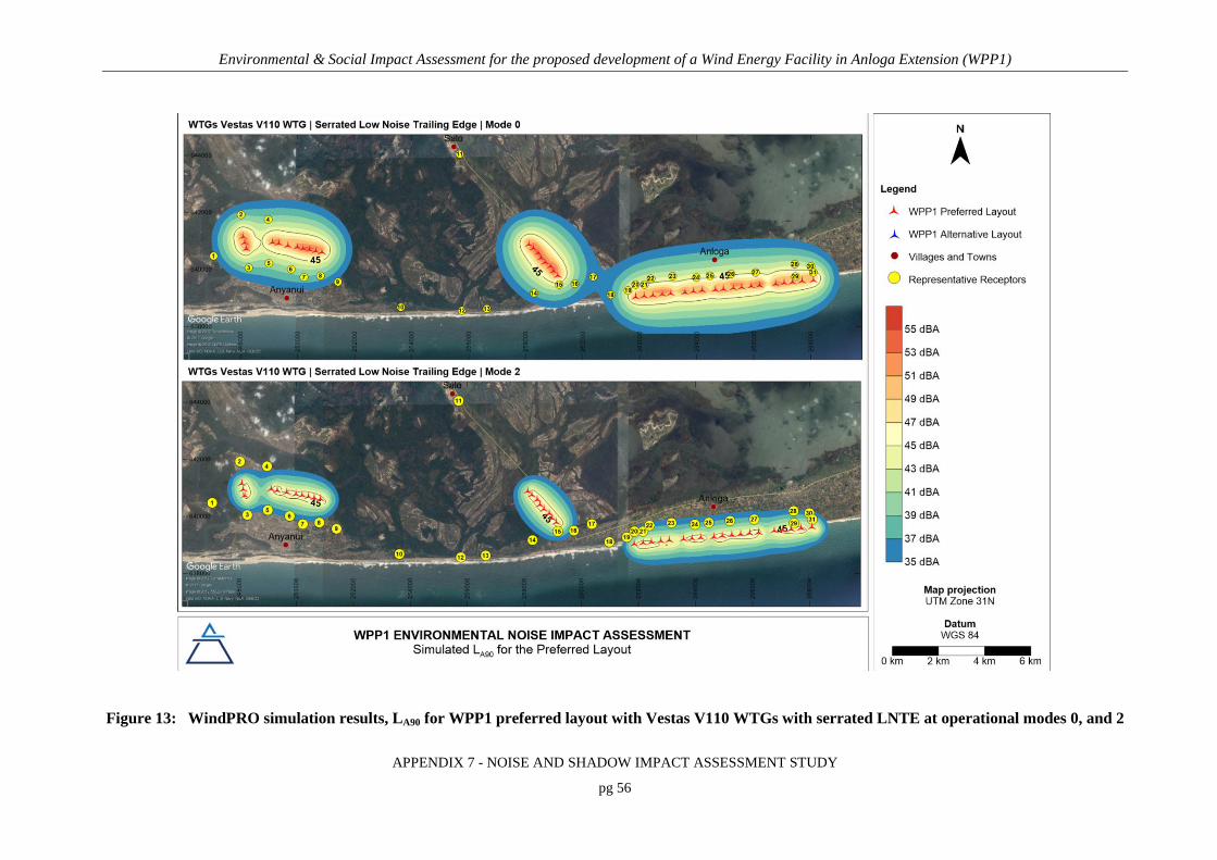
Environmental & Social Impact Assessment for the proposed development of a Wind Energy Facility in Anloga Extension (WPP1)
APPENDIX 7 - NOISE AND SHADOW IMPACT ASSESSMENT STUDY
pg 56
Figure 13: WindPRO simulation results, LA90 for WPP1 preferred layout with Vestas V110 WTGs with serrated LNTE at operational modes 0, and 2

Environmental & Social Impact Assessment for the proposed development of a Wind Energy Facility in Anloga Extension (WPP1)
APPENDIX 7 - NOISE AND SHADOW IMPACT ASSESSMENT STUDY
pg 57
Figure 14: WindPRO simulation results, LA90 for WPP1 alternative layout with Vestas V136 WTGs with
serrated LNTE at operational modes 0, and SO4

Environmental & Social Impact Assessment for the proposed development of a Wind Energy Facility in Anloga Extension (WPP1)
APPENDIX 7 - NOISE AND SHADOW IMPACT ASSESSMENT STUDY
pg 58
7.1.3 Main Findings
In summary:
• From an environmental noise perspective, the alternative layout is the preferred option
for the following reasons:
o Residents in and around Anyanui, where lower background noise levels prevail in comparison with Anloga, will not be impacted.
o The alternative layout necessitates the use of larger WTGs. The Vestas V136 WTG with the serrated LNTE at the optimised operational mode has a reference LW of 105.5 dB which is comparable to the 106 dB of the smaller WTG (Vestas V110) with the LNTE, proposed for use with the preferred layout.
o At the same LW, larger WTGs result in lower ground level noise due to increased emission height (95 m vs. 112 m), distance from receptors, as well as larger distances between WTGs.
• Exceedance of impact guidelines (night-time IFC guideline of 45 dBA) may occur:
o up to 4.7 rotor diameters from WTG arrays of the preferred layout; and
o up to 3.6 rotor diameters from WTG arrays of the alternative layout.
• Given available satellite imagery, some residential structures fall within these distance
from WPP1.
• Special measures (such as operating certain WTGs at lower noise modes) must be
adopted to manage noise impacts at all NSR within 4.7 rotor diameters from V110
WTGs, and 3.6 rotor diameters from V136 WTGs.
7.2 SHADOW FLICKER
Shadow flicker as a result of WPP1 during its operational phase was calculated with the
WindPRO SHADOW module. Model parameters discussed in Section 5.2 were applied in the
calculations for the following two scenarios:
1. Preferred layout using 38 Vestas V110 WTGs
2. Alternative layout using 22 Vestas V136 WTGs

Environmental & Social Impact Assessment for the proposed development of a Wind Energy Facility in Anloga Extension (WPP1)
APPENDIX 7 - NOISE AND SHADOW IMPACT ASSESSMENT STUDY
pg 59
Both worst-case and real estimated of shadow impacts were calculated. Results are presented in
tabular form (Table 12) as well as graphically in the form of isopleths for a single V110 and V136
WTG located within the WPP1 project area (Figure 15). In this instance isopleths connect points
at which real shadow hours per year has a specified constant value. Cumulative real shadow
flicker impacts are shown in Figure 16. For detailed WindPRO reports, refer to Annex C.
Shadow impacts lie in the east-west plane, more or less parallel to the coastline. For the Vestas
V110 WTG, the maximum shadow impact of 407 hours per year occurs approximately 60 m to
the northeast of the WTG (Figure 15). Real shadow impacts are expected to exceed 30 hours per
year at residences along the southern edge of Anloga. The maximum shadow impact is expected
at SSR 29 (WindPRO reference AC), where a real shadow impact of 131 hours per year is
predicted.
For the Vestas V136 WTG, the maximum shadow impact of 34 hours per year occurs
approximately 80 m to the east-northeast of the WTG (Figure 15). Real shadow impacts are
expected extend somewhat further and will exceed 30 hours per year at residences along the
southern edge of Anloga (SRs19, 26, 29, and 31).
From the detailed calendar reports generated by WindPRO (Annex C), it was also found that
shadow impacts at Anloga will occur mostly during sunrise and sunset hours e.g. 06:00 to 07:00
and 17:00 to 18:00. Calendar plots indicate the time of day, and day of year that shadow flicker
will occur as well as the WTG responsible for the shadow. As an example, the calendar plots for
SSR 29 (WindPRO reference AC) are shown in Figure 17.
From a shadow flicker impact perspective, the preferred layout is favoured since the Vestas V110
WTGs have smaller shadow impact zones.

Environmental & Social Impact Assessment for the proposed development of a Wind Energy Facility in Anloga Extension (WPP1)
APPENDIX 7 - NOISE AND SHADOW IMPACT ASSESSMENT STUDY
pg 60
Table 12: Simulated shadow hours per year at discrete SSRs
Village and WPP1
Section No.
WindPRO Reference
Preferred Layout with Vestas V110 WTGs
Alternative Layout with Vestas V136 WTGs
Maximum shadow h/y
Real shadow h/y
Maximum shadow h/y
Real shadow h/y
Anyanui, WPP1 western section
1 A 08:20:00 02:53:00 00:00:00 00:00:00 2 B 00:00:00 00:00:00 00:00:00 00:00:00 3 C 00:00:00 00:00:00 00:00:00 00:00:00 4 D 00:00:00 00:00:00 00:00:00 00:00:00 5 E 09:53:00 03:34:00 00:00:00 00:00:00 6 F 00:00:00 00:00:00 00:00:00 00:00:00 7 G 00:00:00 00:00:00 00:00:00 00:00:00 8 H 00:00:00 00:00:00 00:00:00 00:00:00 9 I 00:00:00 00:00:00 00:00:00 00:00:00
Srogbe, WPP1 central section
10 J 00:00:00 00:00:00 00:00:00 00:00:00 11 K 00:00:00 00:00:00 00:00:00 00:00:00 12 L 00:00:00 00:00:00 00:00:00 00:00:00 13 M 00:00:00 00:00:00 00:00:00 00:00:00 14 N 00:00:00 00:00:00 00:00:00 00:00:00 15 O 00:00:00 00:00:00 00:00:00 00:00:00 16 P 00:00:00 00:00:00 00:00:00 00:00:00 17 Q 06:29:00 01:43:00 60:57:00 14:34:00
Anloga, WPP1 eastern section
18 R 15:56:00 05:14:00 22:55:00 07:30:00 19 S 55:51:00(a) 17:19:00 104:41:00(a) 32:57:00(a) 20 T 27:11:00(a) 08:30:00 22:02:00 06:43:00 21 U 59:28:00(a) 18:44:00 65:46:00(a) 20:59:00 22 V 09:01:00 02:49:00 38:58:00(a) 12:17:00 23 W 14:34:00 04:41:00 13:19:00 04:09:00 24 X 28:23:00 11:52:00 42:43:00(a) 17:40:00 25 Y 40:59:00(a) 14:43:00 38:47:00(a) 15:14:00 26 Z 28:32:00 12:36:00 76:27:00(a) 30:30:00(a) 27 AA 35:15:00(a) 12:37:00 60:33:00(a) 27:05:00 28 AB 00:00:00 00:00:00 05:49:00 03:55:00 29 AC 308:18:00(a) 131:24:00(a) 332:41:00(a) 162:29:00(a) 30 AD 08:11:00 05:26:00 15:32:00 09:48:00 31 AF 46:26:00(a) 28:37:00 86:07:00(a) 53:06:00(a)

Environmental & Social Impact Assessment for the proposed development of a Wind Energy Facility in Anloga Extension (WPP1)
APPENDIX 7 - NOISE AND SHADOW IMPACT ASSESSMENT STUDY
pg 61
Figure 15: Simulated real shadow impacts of a single Vestas V110 and V136 WTG located within the WPP1 area in Anloga, Ghana
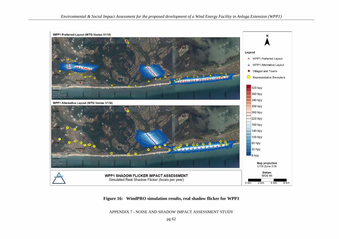
Environmental & Social Impact Assessment for the proposed development of a Wind Energy Facility in Anloga Extension (WPP1)
APPENDIX 7 - NOISE AND SHADOW IMPACT ASSESSMENT STUDY
pg 62
Figure 16: WindPRO simulation results, real shadow flicker for WPP1

Environmental & Social Impact Assessment for the proposed development of a Wind Energy Facility in Anloga Extension (WPP1)
APPENDIX 7 - NOISE AND SHADOW IMPACT ASSESSMENT STUDY
pg 63
WPP1 Preferred Layout
WPP1 Alternative Layout
Figure 17: Graphic calendar shadow flicker results for SSR 29 (WindPRO reference AC)

Environmental & Social Impact Assessment for the proposed development of a Wind Energy Facility in Anloga Extension (WPP1)
APPENDIX 7 - NOISE AND SHADOW IMPACT ASSESSMENT STUDY
pg 64
8. SIGNIFICANCE ASSESSMENT AND MITIGATION MEASURES
8.1 ENVIRONMENTAL NOISE
The acoustic climate of the WPP1 area and noise levels within the communities of Anloga and
Anyanui will be impacted during the construction, operational, and decommissioning phases.
Whereas the significance of construction and decommissioning phase impacts are hereafter
assessed based on typical noise impacts during construction and decommissioning activities, noise
impacts associated with the operational phase are assessed based on the results of environmental
noise calculations and simulations.
To determine the significance of noise impacts, the assessment of the CSIR’s prescribed
methodology was adopted (refer to Chapter 1 of the ESIA report). It allows for the assessment of
direct, indirect as well as cumulative impacts, without and with mitigation and management.
When considering environmental noise, the impact is always direct in nature. Furthermore, since
the impact of a project is dependent on prevailing background noise levels, noise assessments by
default, consider cumulative impacts. The cumulative impact with proposed developments within
20 km are however also considered if applicable.
The significance of environmental noise impacts associated with the proposed construction and
decommissioning of WPP1 is considered low for both the preferred and alterative layout (Table
13 and Table 15). Low impact significance implies that the impact may result in minor alterations
of the environment and can be easily avoided by implementing appropriate mitigation and
management measures. Such measures proposed for adoption in WPP1 environmental
management plan are discussed in detail in Section 8.1.1, and entails general good practice for
managing environmental noise impacts from these phases.
Operational phase noise impacts associated with the preferred and alternative layout are
anticipated to be of medium significance (Table 14). This means the impact will result in
moderate alteration of the environment and can be reduced or avoided by implementing the

Environmental & Social Impact Assessment for the proposed development of a Wind Energy Facility in Anloga Extension (WPP1)
APPENDIX 7 - NOISE AND SHADOW IMPACT ASSESSMENT STUDY
pg 65
appropriate mitigation measures. The impact will also only have an influence on the decision-
making if not mitigated. Specific measures for the mitigation and management of noise during the
operational phase are discussed in more detail in Section 8.1.2. With these measures implemented,
the significance of the residual impact can be reduced to low.
8.1.1 Construction and Decommissioning Phases
The main impact of construction and decommissioning phases are disturbance as a result of
increased environmental noise levels caused by traffic, earthworks, infrastructure erection and
demolition.
Noise from construction/decommissioning works can be difficult to control for several reasons,
including:
• Activities are carried out in the open;
• Although transient in nature, it can cause notable disturbances when ongoing;
• Noise arises from many different activities and types of plants and the intensity and
character can vary significantly at different phases of construction/decommissioning;
• Sites cannot be excluded by planning control from areas sensitive to noise.
The impact for both alternatives is local in extent, of temporary duration, highly reversible and as
a result is of low significance. With the alternative layout for WPP1, residents of Anyanui will
however not be impacted by construction/demolition noise.
8.1.1.1 Compulsory Measures
To manage noise impacts and ensure low significance noise impacts, the following must be
included in the project’s environmental management plan:
• Construction and decommissioning activities must be limited to day-time working
hours;
• Implement a complaint register at site offices where members of the public can easily
communicate issues to VRA and contractors. In response to any complaints received,
short term monitoring must be conducted as per the methodology set out in

Environmental & Social Impact Assessment for the proposed development of a Wind Energy Facility in Anloga Extension (WPP1)
APPENDIX 7 - NOISE AND SHADOW IMPACT ASSESSMENT STUDY
pg 66
Section 8.1.1.3. Once the source or sources of noise resulting in complaints have been
identified, appropriate good practice measures (Section 8.1.1.2) must be implemented.
8.1.1.2 Good Practice Measures
The measures discussed in this section are measures typically applicable to construction sites and
considered good practice by the IFC (2007) and BSI (2008). They are also considered applicable
to the decommissioning phase. Noise control measures can be applied at the source, at the
receiver, or the path from source to receiver. The focus of the measures below is on noise control
at the source and the path from source to receiver.
General Good Practice Measures
General measures to reduce noise levels at the source include:
a) Avoiding unnecessary revving and idling times for all mobile construction equipment.
b) Minimising individual construction vehicle engine, transmission, and body
noise/vibration. This is achieved through the implementation of an equipment
maintenance program.
c) Keeping temporary construction roads well maintained and avoiding steep inclines.
d) Using rubber linings in for instance chutes and dump trucks to reduce impact noise.
e) Minimizing drop height of materials to reduce impact noise.
f) The sequential start-up of equipment and plants rather than simultaneously.
g) All movements and activities on site should take cognisance of the location of NSRs and
normal operating hours of the site as far as is practicable.
h) Minimising the need for trucks/equipment to reverse. This will reduce the frequency at
which disturbing, but necessary, reverse warnings will occur. Alternatives to the
traditional reverse ‘beeper’ alarm such as a ‘self-adjusting’ or ‘smart’ alarm could be
considered. These alarms include a mechanism to detect the local noise level and
automatically adjust the output of the alarm is so that it is 5 to 10 dB above the noise level
near the moving equipment. The promotional material for some smart alarms does state

Environmental & Social Impact Assessment for the proposed development of a Wind Energy Facility in Anloga Extension (WPP1)
APPENDIX 7 - NOISE AND SHADOW IMPACT ASSESSMENT STUDY
pg 67
that the ability to adjust the level of the alarm is of advantage to those sites ‘with low
ambient noise level’ (Burgess & McCarty, 2009). Also, when reversing, vehicles should
travel in a direction away from NSRs if possible.
i) Limit construction traffic and activities to day-time work hours (08:00 to 17:00).
Specifications and Equipment Design
If a construction site is within an especially sensitive area, equipment and methods to be
employed should be reviewed to ensure the quietest available technology is used. Equipment with
lower sound power levels must be selected in such instances and vendors/contractors should be
required to guarantee optimised equipment design noise levels.
Enclosures
A far as is practically possible, source of significant noise should be enclosed. The extent of
enclosure will depend on the nature of the machine and their ventilation requirements. Generators
and air compressors are examples of such equipment. It should be noted that the effectiveness of
partial enclosures and screens can be reduced if used incorrectly, e.g. noise should be directed into
a partial enclosure and not out of, there should not be any reflecting surfaces such as parked
vehicles opposite the open end of a noise enclosure.
Use and Siting of Equipment
Plant and equipment should be sited as far away from NSRs as possible. Also:
a) Machines (e.g. cranes) used intermittently should be shut down between work periods or
throttled down to a minimum and not left running unnecessarily. This will reduce noise
and conserve energy.
b) Plants or equipment from which noise generated is known to be particularly directional,
should be orientated so that the noise is directed away from NSRs.
c) Acoustic covers of engines and compressors should be kept closed when in use or idling.

Environmental & Social Impact Assessment for the proposed development of a Wind Energy Facility in Anloga Extension (WPP1)
APPENDIX 7 - NOISE AND SHADOW IMPACT ASSESSMENT STUDY
pg 68
d) Construction materials such as beams and bricks should be lowered and not dropped.
Maintenance
Regular and effective maintenance of equipment and plants are essential to noise control.
Increases in equipment noise are often indicative of eminent mechanical failure. Also, sound
reducing equipment/materials can lose effectiveness before failure and can be identified by visual
inspection.
Noise generated by vibrating machinery and equipment with vibrating parts can be reduced
through the use of vibration isolation mountings or proper balancing. Cutting tools and saws must
be kept sharp to reduce frictional noise. Noise generated by friction in conveyor rollers, trolley
etc. can be reduced by sufficient lubrication.
Naturally, if noise activities can be minimised or avoided, the amount of noise reaching NSRs will
be reduced. Alternatively, the distance between source and receiver must be increased, or noise
reduction screens, barriers, or berms must be installed.
Distance
To increase the distance between source and receiver is often the most effective method of
controlling noise since, for a typical point source at ground level, a 6 dB decrease can be achieved
with every doubling in distance. It is however conceded that it might not always be possible.
Ideally, stationary plants such as generators, compressors, cement and asphalt works (if
applicable) should be located as far away from NSRs within the development footprint.
Screening
If noise control at the source and the use of distance between source and receiver is not possible,
screening methods must be considered. The effectiveness of a noise barrier is dependent on its
length, effective height, and position relative to the source and receiver as well as material of
construction. To optimize the effect of screening, screens should be located close to either the
source of the noise, or the receiver.

Environmental & Social Impact Assessment for the proposed development of a Wind Energy Facility in Anloga Extension (WPP1)
APPENDIX 7 - NOISE AND SHADOW IMPACT ASSESSMENT STUDY
pg 69
The careful placement of barriers such as screens or berms can significantly reduce noise impacts
but may result in additional visual impacts. Although vegetation such as shrubs or trees may
improve the visual impact of construction sites, it will not significantly reduce noise impacts and
should not be considered as a control measure.
Site buildings such as construction offices and stores can be grouped together to form a
substantial barrier between construction activities and nearby NRs. Similarly, one may use
construction materials such as bricks, timber and aggregate if placed strategically.
8.1.1.3 Monitoring
Noise monitoring at sites where noise is an issue or may become an issue is essential. In the event
that noise related complaints are received during either the construction or decommissioning
phase, short term (24-hour) ambient noise measurements should be conducted as part of
investigating the complaints. The results of the measurements should be used to inform any
follow up interventions.
The following procedures should be adopted for all noise surveys during the construction and
decommissioning phase:
• All surveys should be designed and conducted by a trained specialist.
• Sampling should be carried out using a Type 1 SLM that meets all appropriate IEC
standards and is subject to annual calibration by an accredited laboratory.
• The acoustic sensitivity of the SLM should be tested with a portable acoustic calibrator
before and after each sampling session.
• Samples of at least 24 hours in duration and sufficient for statistical analysis should be
taken with the use of portable SLM’s capable of logging data continuously over the
time period. Samples representative of the day- and night-time acoustic environment
should be taken.
• The following acoustic indices should be recoded and reported: LAeq (T), statistical
noise level LA90, LAFmin and LAFmax, octave band or 3rd octave band frequency spectra.
• The SLM should be located approximately 1.5 m above the ground and no closer than 3
m to any reflecting surface.

Environmental & Social Impact Assessment for the proposed development of a Wind Energy Facility in Anloga Extension (WPP1)
APPENDIX 7 - NOISE AND SHADOW IMPACT ASSESSMENT STUDY
pg 70
• Efforts should be made to ensure that measurements are not affected by the residual
noise and extraneous influences, e.g. wind, electrical interference and any other non-
acoustic interference, and that the instrument is operated under the conditions specified
by the manufacturer. It is good practice to avoid conducting measurements when the
wind speed is more than 5 m/s, while it is raining or when the ground is wet.
• A detailed log and record should be kept. Records should include site details, weather
conditions during sampling and observations made regarding the acoustic environment
of each site.
The investigation of complaints should include an investigation into equipment or machinery that
could likely result or resulted in noise levels annoying to the community. This could be achieved
with source noise measurements.
8.1.2 Operational Phase
The main impact of the operational phase is disturbance as a result of increased environmental
noise levels caused by operating WTGs.
The impact for both alternatives is local in extent, long-term in duration, and highly reversible and
with highly likely probability. Without mitigation, the impact significance rating is medium. It can
be reduced to low significance if the recommended management and mitigation measures are
adopted and adhered to. With the alternative layout for WPP1, residents of Anyanui will not be
impacted by operational phase noise.
Measures to prevent and control noise are mainly related to engineering design standards and
turbine siting. With modern turbines, mechanical noise is usually significantly lower than
aerodynamic noise, and continuous improvement in aerofoil design is reducing the latter (IFC,
2015). Additional recommended noise management measures might include:
• Operating turbines in reduced noise mode.
• Building walls/appropriate noise barriers around potentially affected buildings (only an
option in hilly terrain, due to the height of turbines).
The measures recommended and discussed below are compulsory for WPP1.

Environmental & Social Impact Assessment for the proposed development of a Wind Energy Facility in Anloga Extension (WPP1)
APPENDIX 7 - NOISE AND SHADOW IMPACT ASSESSMENT STUDY
pg 71
8.1.2.1 Separation Distance
Increasing the distance between source and receiver is an essential mitigation measure since noise
reduction options for WTGs are limited. For an elevated point source such as a WTG, a 6-dB
decrease can be achieved with every doubling in distance.
It is recommended that no new permanent residences be permitted within 4.7 rotor diameters of
the WPP1 preferred layout, or 3.6 rotor diameters of the WPP1 alterative layout.
Relocation of residences already within these zones will be required if operating at lower noise
modes as recommended in Section 8.1.2.2 are not possible.
At the recommended separation/buffer distances, 520 m for the preferred layout and 480 m for the
alternative layout with WTGs (with LNTE) at optimised operational modes, residents of Anloga
and Anyanui will be protected from noise levels in excess of 45 dBA. The 4.7 and 3.6 rotor
diameter separation zones are shown in Figure 18, Figure 19, and Figure 20 for the Anyanui,
Srogbe, and Anloga sections of WPP1.
8.1.2.2 WTG Design and Reduced Noise Modes
The benefit of running WTGs in reduced noise operating modes have been illustrated for both the
preferred and alternative layouts of WPP1.
Changes to the operational modes of the following WTGs with NSRs within the recommended
buffer distances (as identified from satellite imagery) are required to meet assessment criteria:
• For the preferred layout, with Vestas V110 WTGs with LNTE, hub height 95 m, and
rotor diameter of 110 m:
o During the day:
Mode 2: WTG nos. 2, 4, and 5 (Figure 18)
Required to ensure an increase in day-time noise levels of less than 5 dBA
at Anyanui residents north of the western section of the preferred layout.
o During the night:
Mode 2: WTG nos. 19 to 22, 25 to 33, 38 (Figure 19, and Figure 20)

Environmental & Social Impact Assessment for the proposed development of a Wind Energy Facility in Anloga Extension (WPP1)
APPENDIX 7 - NOISE AND SHADOW IMPACT ASSESSMENT STUDY
pg 72
To ensure night-time noise levels at closest residences of Anloga remain
below 45 dBA.
o All other WTGs at optimised operational mode (mode 0).
• For the alternative layout, with Vestas V136 WTGs with LNTE, hub height 112 m, and
rotor diameter 136 m:
o During the night:
Mode S04: WTG nos. 9, 10, 11, 14 to 19, 22 (Figure 19, and Figure 20)
To ensure night-time noise levels at closest residences of Anloga remain
below 45 dBA.
8.1.2.3 Monitoring
ETSU (1996) and the IFC (2015) clearly specify noise monitoring practices for WEFs. Methods
closely follow the IFC’s general monitoring requirements but requires the additional monitoring
of wind speed. Environmental noise measurements at receptors near WEF’s need also be longer in
duration to facilitate determining impacts under various wind conditions.
At least one monitoring station should be installed in Anloga, along its southern edge, and one in
Anyanui (at the cluster of residents north of the array), to verify the findings of this assessment. It
is recommended that such a station be maintained for a period of 1 year from the day the WEF is
fully operation. The specification of such a remote semi-permanent station will depend on power
supply options, security of equipment, and remote data access options.

Environmental & Social Impact Assessment for the proposed development of a Wind Energy Facility in Anloga Extension (WPP1)
APPENDIX 7 - NOISE AND SHADOW IMPACT ASSESSMENT STUDY
pg 73
Figure 18: Buffer for the Anyanui section of WPP1, for noise impact mitigation

Environmental & Social Impact Assessment for the proposed development of a Wind Energy Facility in Anloga Extension (WPP1)
APPENDIX 7 - NOISE AND SHADOW IMPACT ASSESSMENT STUDY
pg 74
Figure 19: Buffer for the Srogbe section of WPP1, for noise impact mitigation

Environmental & Social Impact Assessment for the proposed development of a Wind Energy Facility in Anloga Extension (WPP1)
APPENDIX 7 - NOISE AND SHADOW IMPACT ASSESSMENT STUDY
pg 75
Figure 20: Buffer for the Anloga section of WPP1, for noise impact mitigation

Environmental & Social Impact Assessment for the proposed development of a Wind Energy Facility in Anloga Extension (WPP1)
APPENDIX 7 - NOISE AND SHADOW IMPACT ASSESSMENT STUDY
pg 76
8.2 SHADOW FLICKER IMPACT SIGNIFICANCE AND MITIGATION MEASURES
Shadow flicker impacts are only of concern during the operational phase of a WEF.
Operational phase shadow flicker impacts are anticipated to be of medium significance for both
the preferred and the alternative layouts (Table 14). This means the impact will result in moderate
alteration of the environment and can be reduced or avoided by implementing the appropriate
mitigation measures. The impact will also only have an influence on the decision-making if not
mitigated. Prevention and control measures to avoid significant shadow flicker impacts generally
include the following:
• Site wind turbines appropriately to avoid shadow flicker being experienced; or
• Wind turbines can be programmed to shut down at times when shadow flicker limits are
exceeded.
The IFC recommends that, if it is not possible to locate the wind energy facility/turbines such that
neighbouring receptors experience no shadow flicker effects, the predicted duration of shadow
flicker effects experienced at a sensitive receptor should not exceed 30 hours per year and 30
minutes per day on the worst affected day (IFC, 2007).
8.2.1 Compulsory Measures
Shadow flicker impacts in exceedance of impact criteria at SSRs were only found to occur as a
result of the Anloga section of WPP1. To mitigate these shadow flicker impacts, SSRs within
the 30 hours per year, real shadow impact must be relocated. Residences in Anloga within
this zone of approximately 3 rotor diameters are shown in Figure 21. With the relocation of
receptors within five rotor diameters for noise, shadow flicker impacts will also be avoided.
8.2.2 Good Practice Measures
To further reduce shadow flicker impacts at Anloga and those SSRs within the 8 to 30-hour real
shadow impact zone, VRA should consider shutting down WTGs proposed as part of the Anloga
Section of WPP1 during early morning and afternoon hours. Curtailment periods per WTG can be
determined from calendar plots included in Annex C.

Environmental & Social Impact Assessment for the proposed development of a Wind Energy Facility in Anloga Extension (WPP1)
APPENDIX 7 - NOISE AND SHADOW IMPACT ASSESSMENT STUDY
pg 77
8.3 CUMULATIVE IMPACTS
To the author’s knowledge there are no another wind power projects within 20 km of WPP1 that
may result in cumulative environmental noise, or shadow flicker impacts.

Environmental & Social Impact Assessment for the proposed development of a Wind Energy Facility in Anloga Extension (WPP1)
APPENDIX 7 - NOISE AND SHADOW IMPACT ASSESSMENT STUDY
pg 78
Figure 21: Three rotor diameter buffer for the Anloga section of WPP1, for shadow flicker impact mitigation

Environmental & Social Impact Assessment for the proposed development of a Wind Energy Facility in Anloga Extension (WPP1)
APPENDIX 7 - NOISE AND SHADOW IMPACT ASSESSMENT STUDY
pg 79
Table 13: Impact assessment summary table for the construction phase of the preferred and alternative layout
Construction Phase, Preferred and Alterative Layout
Direct, cumulative impacts
Aspect/ Impact
Pathway
Nature of Potential
Impact/ Risk
Site
Alternative Status
Spatial
Extent Duration Intensity Probability
Reversibility
of Impact
Irreplace-
ability
Can the
Impact/Risk be
Avoided?
Can the
Impact/Risk be
Mitigated/
Managed?
Potential Mitigation Measures
Significance of Impact
Confidence
Level Without
Mitigation/Management
With
Mitigation/Management
Construction noise,
traffic, bulk
earthworks, infra-
structure erection
Disturbance as a result of
increased environmental
noise levels caused by
construction of WTGs
Preferred
layout Negative Local Temporary Medium
Highly
likely
Highly
reversible Low No Yes
Compulsory:
- Limit activities to day-
time hours, complaints
register and investigation
through short term
monitoring.
Good practice
- Basic good practice
noise and, traffic
management.
Low Low Medium
Alternative
layout Negative Local Temporary Medium
Highly
likely
Highly
reversible Low No Yes
Compulsory:
- Limit activities to day-
time hours, complaints
register and investigation
through short term
monitoring.
Good practice
- Basic good practice
noise and, traffic
management.
Low Low Medium

Environmental & Social Impact Assessment for the proposed development of a Wind Energy Facility in Anloga Extension (WPP1)
APPENDIX 7 - NOISE AND SHADOW IMPACT ASSESSMENT STUDY
pg 80
Table 14: Impact assessment summary table for the operational phase of the preferred and alternative layout
Operational Phase, Preferred and Alternative Layout
Direct, cumulative impacts
Aspect/
Impact
Pathway
Nature of Potential
Impact/ Risk
Site
Alternative Status
Spatial
Extent Duration Intensity Probability
Reversibility
of Impact Irreplaceability
Can the
Impact/Risk
be Avoided?
Can the
Impact/Risk be
Mitigated/
Managed?
Potential Mitigation Measures
Significance of Impact
Confidence
Level Without
Mitigation/Management
With
Mitigation/Management
WTG
noise
Disturbance as a
result of increased
environmental noise
levels caused by
operational WTGs
Preferred
layout Negative Local
Long-
term Medium
Highly
likely
Highly
reversible Low No Yes
Compulsory:
- WTG at low noise operating mode 1
(LWA ≤105 dBA) - Relocation of permanent residences
within 5 rotor diameters.
- Maintaining 5 rotor diameter buffer
around WEF.
Medium Low Medium
Alternative
layout Negative Local
Long-
term Medium
Highly
likely
Highly
reversible Low No Yes
Compulsory:
- WTG at low noise operating mode 0
(LWA ≤105.5 dBA) with serrated training edge
- Relocation of permanent residences
within 5 rotor diameters.
- Maintaining 5 rotor diameter buffer
around WEF.
Medium Low Medium
Shadow
Flicker
Disturbance as a
result of shadows cast
by operational WTGs
Preferred
layout Negative Local
Long-
term Medium
Highly
likely
Highly
reversible Low No Yes
Compulsory:
- Relocation of permanent residences at
Anloga within approximately 3 rotor
diameters.
- Maintaining 5 rotor diameter buffer as
recommended for noise, around Anyanui
and Srogbe sections.
Good Practice:
- Curtailing WTG operation at Anloga
section during early morning and
afternoon hours.
Medium Low Medium
Alternative
layout Negative Local
Long-
term Medium
Highly
likely
Highly
reversible Low No Yes
Compulsory:
- Relocation of permanent residences at
Anloga within approximately 3 rotor
diameters.
- Maintaining 5 rotor diameter buffer as
recommended for noise, around Anyanui
and Srogbe sections.
Good Practice:
- Curtailing WTG operation at Anloga
section during early morning and
afternoon hours.
Medium Low Medium

Environmental & Social Impact Assessment for the proposed development of a Wind Energy Facility in Anloga Extension (WPP1)
APPENDIX 7 - NOISE AND SHADOW IMPACT ASSESSMENT STUDY
pg 81
Table 15: Impact assessment summary table for the decommissioning phase for the preferred and alternative layout
Decommissioning Phase, Preferred and Alternative Layout
Direct, cumulative impacts
Aspect/ Impact
Pathway
Nature of Potential Impact/
Risk
Site
Alternative Status
Spatial
Extent Duration Intensity Probability
Reversibility
of Impact
Irreplace-
ability
Can the
Impact/Risk be
Avoided?
Can the
Impact/Risk be
Mitigated/
Managed?
Potential Mitigation
Measures
Significance of Impact
Confidence
Level Without
Mitigation/Management
With
Mitigation/Management
Construction noise,
traffic, bulk
earthworks, infra-
structure erection
Disturbance as a result of
increased environmental noise
levels caused by
decommissioning activities
WTGs
Preferred
layout Negative Local Temporary Medium
Highly
likely
Highly
reversible Low No Yes
Compulsory:
- Limit activities to day-
time hours, complaints
register and
investigation through
short term monitoring.
Good practice
- Basic good practice
noise and, traffic
management.
Low Low Medium
Alternative
layout Negative Local Temporary Medium
Highly
likely
Highly
reversible Low No Yes
Compulsory:
- Limit activities to day-
time hours, complaints
register and
investigation through
short term monitoring.
Good practice
- Basic good practice
noise and, traffic
management.
Low Low Medium

Environmental & Social Impact Assessment for the proposed development of a Wind Energy Facility in Anloga Extension (WPP1)
APPENDIX 7 - NOISE AND SHADOW IMPACT ASSESSMENT STUDY
pg 82
9. CONCLUSIONS
9.1 ENVIRONMENTAL NOISE
Given the findings of the environmental noise study it is concluded that the significance of
environmental noise impacts during all project phases are considered medium but should be
reduced to low with the implementation of management and mitigation measures recommended in
this report as a condition of project approval.
During the construction and decommissioning phases of the project, low significance noise
impacts may be achieved by implementing basic good practice measures such as the maintenance
of diesel mobile equipment, traffic management, and limiting noise generating activities to day-
time hours.
The medium significance rating for the operational phase is based on the finding that exceedance
of noise impact guidelines may occur up to 4.7 rotor diameters from the preferred layout WTG
arrays and 3.6 rotor diameters from the alternative layout WTG arrays. Given available satellite
imagery, several residential structures fall within this distance from WPP1, specifically at Anloga.
Special measures (such as operating certain WTGs at lower noise modes and or relocation) must
be adopted to manage noise impacts at all NSR within 4.7 rotor diameters from V110 WTGs, and
3.6 rotor diameters from V136 WTGs.
It is also concluded that, from an environmental noise perspective, the alternative layout is the
preferred option for the following reasons:
• Residents in and around Anyanui, where lower background noise levels prevail in
comparison with Anloga, will not be impacted.
• The alternative layout necessitates the use of larger WTGs. The Vestas V136 WTG with
the serrated LNTE at the optimised operational mode has a reference LW of 105.5 dB
which is comparable to the 106 dB of the smaller WTG (Vestas V110) with the LNTE,
proposed for use with the preferred layout.

Environmental & Social Impact Assessment for the proposed development of a Wind Energy Facility in Anloga Extension (WPP1)
APPENDIX 7 - NOISE AND SHADOW IMPACT ASSESSMENT STUDY
pg 83
• At the same LW, larger WTGs result in lower ground level noise due to increased
emission height (95 m vs. 112 m), distance from receptors, as well as larger distances
between WTGs.
9.2 SHADOW FLICKER
It is concluded that shadow flicker impacts, only of concern during the operational phase are of
medium significance (for the preferred and alternative layout) and must be reduced by
implementing the appropriate mitigation measures as a condition for project approval.
Receptors at Anloga within 3 rotor diameters of the eastern WTG array must be relocated. To
further reduce shadow flicker impacts at Anloga and those SSRs within the 8 to 30-hour real
shadow impact zone, VRA should consider shutting down WTGs proposed as part of the eastern
WTG array of WPP1 during early morning and afternoon hours from October to February.
From a shadow flicker perspective, the preferred layout it slightly more preferred since the impact
area of the V110 WTGs is somewhat smaller than the larger V136 WTGs.

Environmental & Social Impact Assessment for the proposed development of a Wind Energy Facility in Anloga Extension (WPP1)
APPENDIX 7 - NOISE AND SHADOW IMPACT ASSESSMENT STUDY
pg 84
10. REFERENCES
Brüel & Kjær Sound & Vibration Measurement A/S. (2000). www.bksv.com. Retrieved October
14, 2011, from Brüel & Kjær: http://www.bksv.com
BSI. (2008). Code of practice for noise and vibration control on construction and open sites - Part
1: Noise. BS 5228-1:2009.
Bugliarello, G., Alexandre, A., Barnes, J., & Wakstein, C. (1976). The impact of noise pollution |
A socio-technological introduction. Pergamon Press.
Burgess, M., & McCarty, M. (2009). Review of Alternatives to 'Beeper' Alarms for Construction
Equipment. Canberra: University of New South Wales.
DEFRA. (2006). Update of noise database for prodiction of noise on construction and open sites.
EC WG-AEN. (2006). Position Paper | Final Draft | Good Practice Guide for Strategic Noise
Mapping and the Production of Associated Data on Noise Exposure. Brussels: European
Commission.
EPHC. (2010). Draft National Wind Farm Development Guidelines. Adelaide: Commonwealth of
Australia and each Australian State and Territory.
ETSU-R-97. (1996). The Rating and Assessment of Noise from Wind Farms | Working Group on
Noise From Wind Turbines.
IFC. (2007). General Environmental, Health and Safety Guidelines.
IFC. (2015). Evironmental, Health, and Safety Guidelines for Wind Energy. World Bank Group.
Lahmeyer International. (2015). Technical Report | Renewable Energy Development Programme,
Ghana | Draft Feasibility Study for Anloga Wind Farm. Bad Vilbel: Lahmeyer International
GmbH.

Environmental & Social Impact Assessment for the proposed development of a Wind Energy Facility in Anloga Extension (WPP1)
APPENDIX 7 - NOISE AND SHADOW IMPACT ASSESSMENT STUDY
pg 85
Lahmeyer International. (2016). Techical Report | Renewable Energy Development Programme,
Ghana | Draft Feasibility Study for the 75 MW Wind Power Project 1 (WPP1) in Keta
Municipality in the Volta Region. Bad Vibel: Lahmeyer International GmbH.
Manwell, J. F., McGowan, J. G., & Rogers, A. L. (2009). Wind Energy Explained | Theory,
Design and Application (2nd ed.). Chichester: John Wiley & Sons Ltd.
Vestas. (2014). General Specification V110-2.0 MW 50Hz VCS. Aarhus: Vestas Wind Systems
A/S.
Vestas. (2016). Performance Specification V136-3.45 MW 50/60 Hz. Aarhus: Vestas Wind
Systems A/S.
VRA. (2015). VRA Renewable Energy Development Programme: Wind Energy Project Phase 1 |
Anloga and Anyanui Background Noise Level Assessment Report.

Environmental & Social Impact Assessment for the proposed development of a Wind Energy Facility in Anloga Extension (WPP1)
APPENDIX 7 - NOISE AND SHADOW IMPACT ASSESSMENT STUDY
pg 86
11. ANNEX A – CALIBRATION CERTIFICATES

Environmental & Social Impact Assessment for the proposed development of a Wind Energy Facility in Anloga Extension (WPP1)
APPENDIX 7 - NOISE AND SHADOW IMPACT ASSESSMENT STUDY
pg 87

Environmental & Social Impact Assessment for the proposed development of a Wind Energy Facility in Anloga Extension (WPP1)
APPENDIX 7 - NOISE AND SHADOW IMPACT ASSESSMENT STUDY
pg 88

Environmental & Social Impact Assessment for the proposed development of a Wind Energy Facility in Anloga Extension (WPP1)
APPENDIX 7 - NOISE AND SHADOW IMPACT ASSESSMENT STUDY
pg 89
12. ANNEX B – WINDPRO DECIBEL REPORTS

Environmental & Social Impact Assessment for the proposed development of a Wind Energy Facility in Anloga Extension (WPP1)
APPENDIX 7 - NOISE AND SHADOW IMPACT ASSESSMENT STUDY
pg 90

Environmental & Social Impact Assessment for the proposed development of a Wind Energy Facility in Anloga Extension (WPP1)
APPENDIX 7 - NOISE AND SHADOW IMPACT ASSESSMENT STUDY
pg 91
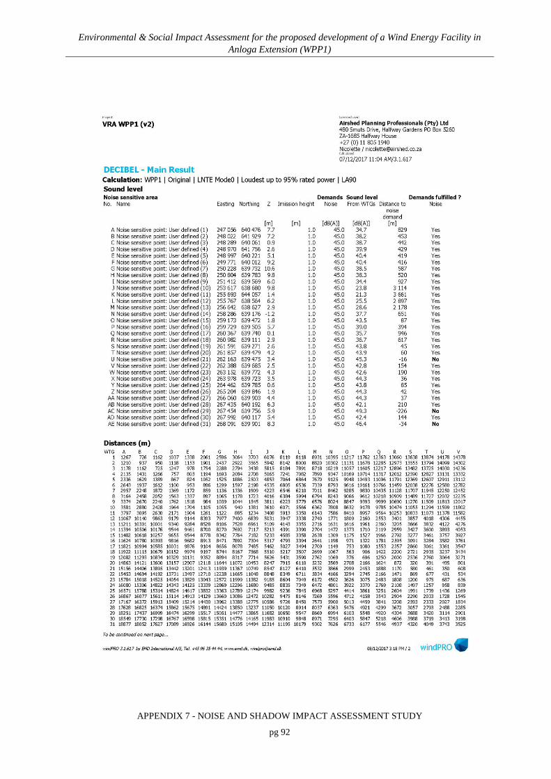
Environmental & Social Impact Assessment for the proposed development of a Wind Energy Facility in Anloga Extension (WPP1)
APPENDIX 7 - NOISE AND SHADOW IMPACT ASSESSMENT STUDY
pg 92

Environmental & Social Impact Assessment for the proposed development of a Wind Energy Facility in Anloga Extension (WPP1)
APPENDIX 7 - NOISE AND SHADOW IMPACT ASSESSMENT STUDY
pg 93

Environmental & Social Impact Assessment for the proposed development of a Wind Energy Facility in Anloga Extension (WPP1)
APPENDIX 7 - NOISE AND SHADOW IMPACT ASSESSMENT STUDY
pg 94

Environmental & Social Impact Assessment for the proposed development of a Wind Energy Facility in Anloga Extension (WPP1)
APPENDIX 7 - NOISE AND SHADOW IMPACT ASSESSMENT STUDY
pg 95

Environmental & Social Impact Assessment for the proposed development of a Wind Energy Facility in Anloga Extension (WPP1)
APPENDIX 7 - NOISE AND SHADOW IMPACT ASSESSMENT STUDY
pg 96

Environmental & Social Impact Assessment for the proposed development of a Wind Energy Facility in Anloga Extension (WPP1)
APPENDIX 7 - NOISE AND SHADOW IMPACT ASSESSMENT STUDY
pg 97

Environmental & Social Impact Assessment for the proposed development of a Wind Energy Facility in Anloga Extension (WPP1)
APPENDIX 7 - NOISE AND SHADOW IMPACT ASSESSMENT STUDY
pg 98
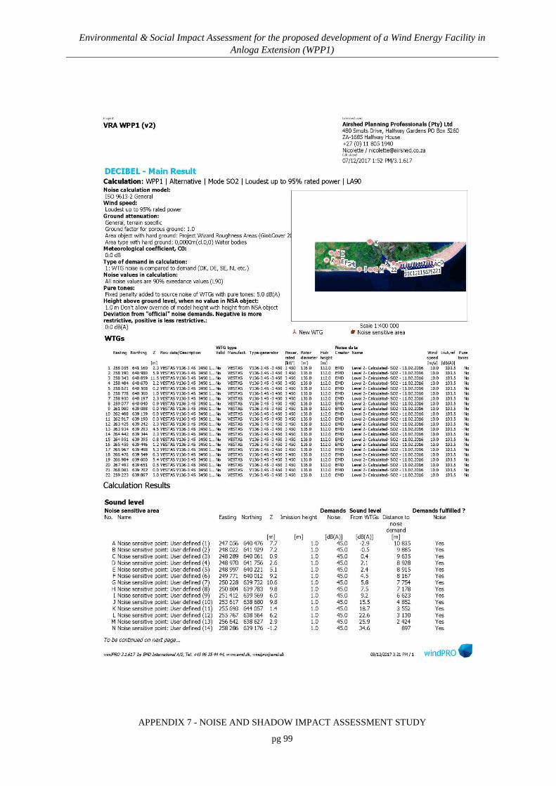
Environmental & Social Impact Assessment for the proposed development of a Wind Energy Facility in Anloga Extension (WPP1)
APPENDIX 7 - NOISE AND SHADOW IMPACT ASSESSMENT STUDY
pg 99

Environmental & Social Impact Assessment for the proposed development of a Wind Energy Facility in Anloga Extension (WPP1)
APPENDIX 7 - NOISE AND SHADOW IMPACT ASSESSMENT STUDY
pg 100

Environmental & Social Impact Assessment for the proposed development of a Wind Energy Facility in Anloga Extension (WPP1)
APPENDIX 7 - NOISE AND SHADOW IMPACT ASSESSMENT STUDY
pg 101

Environmental & Social Impact Assessment for the proposed development of a Wind Energy Facility in Anloga Extension (WPP1)
APPENDIX 7 - NOISE AND SHADOW IMPACT ASSESSMENT STUDY
pg 102

Environmental & Social Impact Assessment for the proposed development of a Wind Energy Facility in Anloga Extension (WPP1)
APPENDIX 7 - NOISE AND SHADOW IMPACT ASSESSMENT STUDY
pg 103

Environmental & Social Impact Assessment for the proposed development of a Wind Energy Facility in Anloga Extension (WPP1)
APPENDIX 7 - NOISE AND SHADOW IMPACT ASSESSMENT STUDY
pg 104

Environmental & Social Impact Assessment for the proposed development of a Wind Energy Facility in Anloga Extension (WPP1)
APPENDIX 7 - NOISE AND SHADOW IMPACT ASSESSMENT STUDY
pg 105
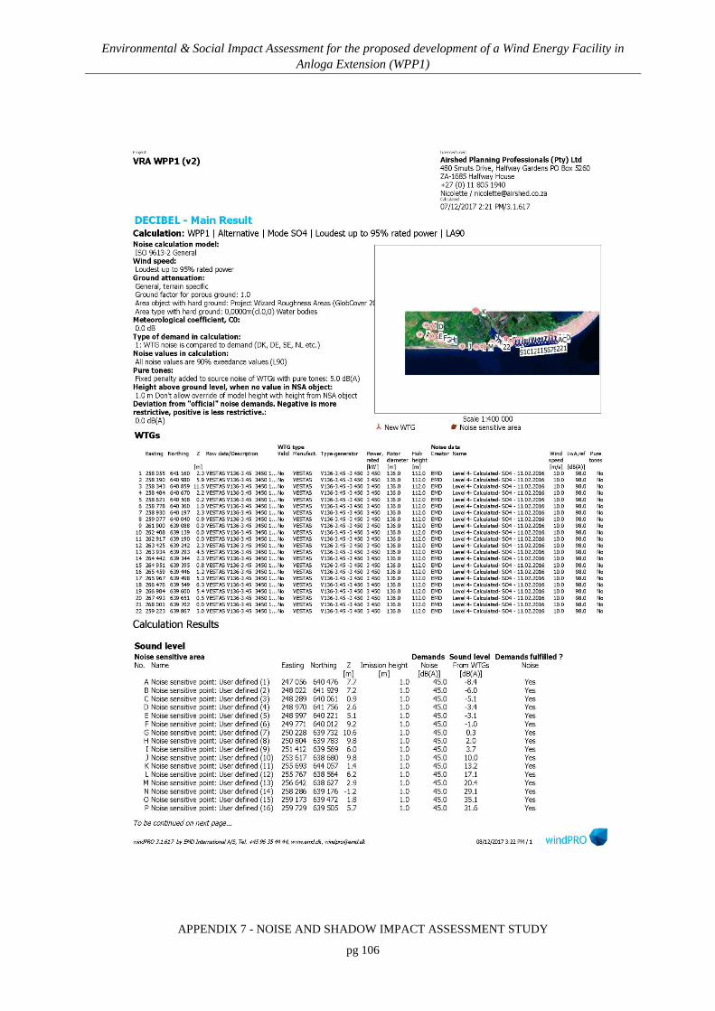
Environmental & Social Impact Assessment for the proposed development of a Wind Energy Facility in Anloga Extension (WPP1)
APPENDIX 7 - NOISE AND SHADOW IMPACT ASSESSMENT STUDY
pg 106

Environmental & Social Impact Assessment for the proposed development of a Wind Energy Facility in Anloga Extension (WPP1)
APPENDIX 7 - NOISE AND SHADOW IMPACT ASSESSMENT STUDY
pg 107
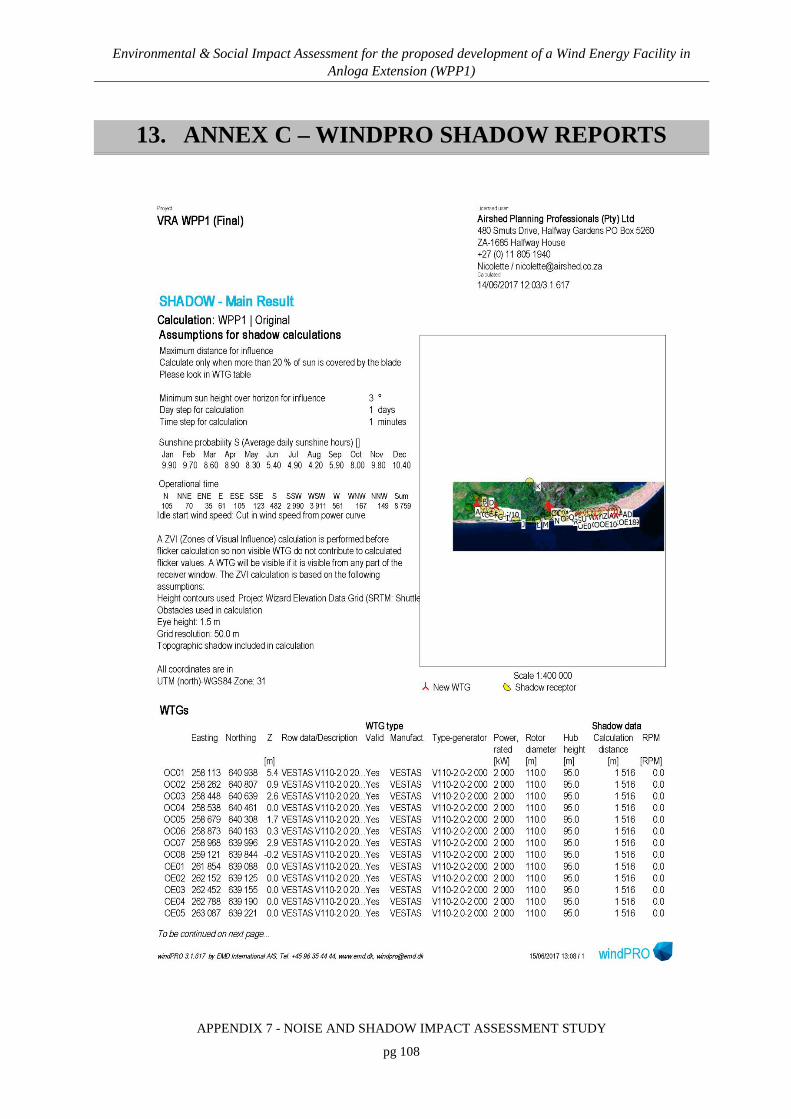
Environmental & Social Impact Assessment for the proposed development of a Wind Energy Facility in Anloga Extension (WPP1)
APPENDIX 7 - NOISE AND SHADOW IMPACT ASSESSMENT STUDY
pg 108
13. ANNEX C – WINDPRO SHADOW REPORTS

Environmental & Social Impact Assessment for the proposed development of a Wind Energy Facility in Anloga Extension (WPP1)
APPENDIX 7 - NOISE AND SHADOW IMPACT ASSESSMENT STUDY
pg 109

Environmental & Social Impact Assessment for the proposed development of a Wind Energy Facility in Anloga Extension (WPP1)
APPENDIX 7 - NOISE AND SHADOW IMPACT ASSESSMENT STUDY
pg 110

Environmental & Social Impact Assessment for the proposed development of a Wind Energy Facility in Anloga Extension (WPP1)
APPENDIX 7 - NOISE AND SHADOW IMPACT ASSESSMENT STUDY
pg 111

Environmental & Social Impact Assessment for the proposed development of a Wind Energy Facility in Anloga Extension (WPP1)
APPENDIX 7 - NOISE AND SHADOW IMPACT ASSESSMENT STUDY
pg 112

Environmental & Social Impact Assessment for the proposed development of a Wind Energy Facility in Anloga Extension (WPP1)
APPENDIX 7 - NOISE AND SHADOW IMPACT ASSESSMENT STUDY
pg 113

Environmental & Social Impact Assessment for the proposed development of a Wind Energy Facility in Anloga Extension (WPP1)
APPENDIX 7 - NOISE AND SHADOW IMPACT ASSESSMENT STUDY
pg 114

Environmental & Social Impact Assessment for the proposed development of a Wind Energy Facility in Anloga Extension (WPP1)
APPENDIX 7 - NOISE AND SHADOW IMPACT ASSESSMENT STUDY
pg 115

Environmental & Social Impact Assessment for the proposed development of a Wind Energy Facility in Anloga Extension (WPP1)
APPENDIX 7 - NOISE AND SHADOW IMPACT ASSESSMENT STUDY
pg 116

Environmental & Social Impact Assessment for the proposed development of a Wind Energy Facility in Anloga Extension (WPP1)
APPENDIX 7 - NOISE AND SHADOW IMPACT ASSESSMENT STUDY
pg 117

Environmental & Social Impact Assessment for the proposed development of a Wind Energy Facility in Anloga Extension (WPP1)
APPENDIX 7 - NOISE AND SHADOW IMPACT ASSESSMENT STUDY
pg 118

Environmental & Social Impact Assessment for the proposed development of a Wind Energy Facility in Anloga Extension (WPP1)
APPENDIX 7 - NOISE AND SHADOW IMPACT ASSESSMENT STUDY
pg 119

Environmental & Social Impact Assessment for the proposed development of a Wind Energy Facility in Anloga Extension (WPP1)
APPENDIX 7 - NOISE AND SHADOW IMPACT ASSESSMENT STUDY
pg 120

Environmental & Social Impact Assessment for the proposed development of a Wind Energy Facility in Anloga Extension (WPP1)
APPENDIX 7 - NOISE AND SHADOW IMPACT ASSESSMENT STUDY
pg 121

Environmental & Social Impact Assessment for the proposed development of a Wind Energy Facility in Anloga Extension (WPP1)
APPENDIX 7 - NOISE AND SHADOW IMPACT ASSESSMENT STUDY
pg 122

Environmental & Social Impact Assessment for the proposed development of a Wind Energy Facility in Anloga Extension (WPP1)
APPENDIX 7 - NOISE AND SHADOW IMPACT ASSESSMENT STUDY
pg 123

Environmental & Social Impact Assessment for the proposed development of a Wind Energy Facility in Anloga Extension (WPP1)
APPENDIX 7 - NOISE AND SHADOW IMPACT ASSESSMENT STUDY
pg 124

Environmental & Social Impact Assessment for the proposed development of a Wind Energy Facility in Anloga Extension (WPP1)
APPENDIX 7 - NOISE AND SHADOW IMPACT ASSESSMENT STUDY
pg 125
14. ANNEX D – NOISE SURVEY DATA
14.1 FIELDWORK PHOTOGRAPHS
Figure 22: Photographs of noise survey site “Airshed Site 1, central”

Environmental & Social Impact Assessment for the proposed development of a Wind Energy Facility in Anloga Extension (WPP1)
APPENDIX 7 - NOISE AND SHADOW IMPACT ASSESSMENT STUDY
pg 126
Figure 23: Photographs of noise survey site “Airshed Site 2, Anyanui”

Environmental & Social Impact Assessment for the proposed development of a Wind Energy Facility in Anloga Extension (WPP1)
APPENDIX 7 - NOISE AND SHADOW IMPACT ASSESSMENT STUDY
pg 127
Figure 24: Photographs of noise survey site “Airshed Site 3, Anloga”

Environmental & Social Impact Assessment for the proposed development of a Wind Energy Facility in Anloga Extension (WPP1)
APPENDIX 7 - NOISE AND SHADOW IMPACT ASSESSMENT STUDY
pg 128
14.2 DETAILED SURVEY RESULTS
Figure 25: Detail day-time survey results, WPP1, Airshed site 1, central, near Srogbe

Environmental & Social Impact Assessment for the proposed development of a Wind Energy Facility in Anloga Extension (WPP1)
APPENDIX 7 - NOISE AND SHADOW IMPACT ASSESSMENT STUDY
pg 129
Figure 26: Detail day-time survey results, WPP1, Airshed site 2, Anyanui

Environmental & Social Impact Assessment for the proposed development of a Wind Energy Facility in Anloga Extension (WPP1)
APPENDIX 7 - NOISE AND SHADOW IMPACT ASSESSMENT STUDY
pg 130
Figure 27: Detail day-time survey results, WPP1, Airshed site 3, Anloga

Environmental & Social Impact Assessment for the proposed development of a Wind Energy Facility in Anloga Extension (WPP1)
APPENDIX 7 - NOISE AND SHADOW IMPACT ASSESSMENT STUDY
pg 131
Figure 28: Detail night-time survey results, WPP1, Airshed site 1, central, near Srogbe

Environmental & Social Impact Assessment for the proposed development of a Wind Energy Facility in Anloga Extension (WPP1)
APPENDIX 7 - NOISE AND SHADOW IMPACT ASSESSMENT STUDY
pg 132
Figure 29: Detail night-time survey results, WPP1, Airshed site 2, Anyanui


VISUAL IMPACT ASSESSMENT:
Scoping and Environmental and Social Impact Assessment for
the proposed Development of the 76MW Wind Power Project
situated at Anloga, Srogbe & Anyanui (Anloga Extension) in
the Volta Region of Ghana
Report prepared for: Report prepared by:
Seljen Consult Limited P. O. Box AT 140 Achimota-Accra
Ghana-West Africa
CSIR – Environmental Management Services P O Box 320
Stellenbosch, 7599 South Africa
SRK Consulting (South Africa) (Pty) Ltd
Postnet Suite #206 Rondebosch, 7701
South Africa
DECEMBER 2017

Environmental & Social Impact Assessment for the proposed development of a Wind Energy Facility in Anloga Extension (WPP1)
APPENDIX 8 - VISUAL IMPACT ASSESSMENT
pg 1
EXECUTIVE SUMMARY
Scott Masson from SRK Consulting (South Africa) (Pty) Ltd (SRK) was appointed by the
Council for Scientific and Industrial Research (CSIR) to conduct a specialist study on the visual
and aesthetic impacts (Visual Impact Assessment (VIA)) of the project through the proposed
construction, operation and decommissioning of a 76 Megawatt (MW) Wind Energy Facility
(WEF) (“WPP1”) in Anloga Extension areas in the Volta Region, Ghana. Two layout alternatives
were considered in the VIA.
The primary aims of the VIA are to describe the visual baseline, assess the visual impacts of the
WEF and identify effective and practicable mitigation measures. The focus of the VIA study is on
the very visible wind turbines.
The basis for the visual character of the study area is provided by the topography, vegetation and
land use of the area, giving rise to a generally flat landscape with a mosaic of waterbodies, mud
flats and salt marshes with low-intensity cultivated fields and villages on higher ground, with
significant influence from the sea. The open topography, varied vegetation and traditional forms
of crop farming integrated into the landscape are visually appealing, but not necessarily regionally
distinctive. In this sense there is an element of sameness and predictability about the visual quality
of the area. However, Keta Lagoon, Volta River Estuary and other open waterbodies are distinct
natural features in the landscape. The areas’ sense of place is also highly influenced by the coast.
The visibility of WPP1 is high, due to the high visibility of the turbines in a flat landscape and the
close proximity of receptors to the turbines. Potential visual receptors include residents of
surrounding villages, visitors to Keta lagoon, road users, farmers, and fishermen.
Visual impacts will be generated in the Construction, Operations and Decommissioning Phases of
the project. Table A below summarises:
• The impacts assessed in the VIA;

Environmental & Social Impact Assessment for the proposed development of a Wind Energy Facility in Anloga Extension (WPP1)
APPENDIX 8 - VISUAL IMPACT ASSESSMENT
pg 2
• Their significance before and following the implementation of essential mitigation measures;
and
• The key mitigation measures on which the significance rating is based (where applicable).
Note that the impact ratings for the layout alternatives in Table A are the same.
Table A: Summary of Impacts
Impact
Significance rating Key mitigation/optimisation measures (summarised)
Without With
CONSTRUCTION PHASE IMPACTS
Altered Sense of Place and Visual Intrusion from Construction Activities
Medium (-ve)
Low (-ve)
• Limit and phase vegetation clearance;
• Utilise existing access roads as far as possible;
• Avoid excavation, handling and transport of materials which may generate dust under very windy conditions;
• Enforce speed limit of 30km/hr on site;
• Consolidate the footprint of the construction camp to a functional minimum and screen the yard;
• Keep construction sites tidy and all activities, material and machinery contained within an area that is as small as possible;
• Rehabilitate disturbed areas incrementally and as soon as possible; and
• Set targets for the use of local labour to give locals a sense of ownership and pride in the project.
Altered Sense of Place from Increased Traffic
Medium (-ve)
Low (-ve)
• Limit construction activities to Mondays to Saturdays between the hours of 07h00 and 18h00; and
• Maintain all vehicles and equipment in good working order.
OPERATIONS PHASE IMPACTS
Altered Sense of Place and Visual Intrusion from the WEF
High (-ve)
High (-ve)
• Minimise associated infrastructure on site;
• Plant large indigenous trees around receptors in the immediate vicinity of the WEF to provide visual screening; and
• Maintain a uniform size (height) and colour (white) of the turbine towers, nacelles and blades and avoid any markings.
Altered Sense of Place and Visual Character caused by
Medium (-ve)
Low (-ve)
• Clarify the requirements of the Ghana Civil Aviation Authority and clarify if pilot activated lighting is possible;

Environmental & Social Impact Assessment for the proposed development of a Wind Energy Facility in Anloga Extension (WPP1)
APPENDIX 8 - VISUAL IMPACT ASSESSMENT
pg 3
Impact
Significance rating Key mitigation/optimisation measures (summarised)
Without With
Light Pollution at Night
• Direct security lighting inwards and downwards to avoid light spillage and trespass; and
• Avoid working at night unless absolutely necessary
Altered Sense of Place from Shadow Flicker
High (-ve)
Low (-ve)
• Calculate the effects of shadow flicker on those residents located within 1 km of the wind turbines.
DECOMMISSIONING PHASE IMPACTS
Altered Sense of Place and Visual Intrusion from Decommissioning Activities
Medium (-ve)
Low (-ve)
• Utilise existing access roads as far as possible;
• Avoid handling and transport of materials which may generate dust under very windy conditions;
• Enforce speed limit of 30km/hr on site;
• Consolidate the footprint of the site camp to a functional minimum and screen the yard;
• Keep all activities, material and machinery contained within an area that is as small as possible; and
• Rehabilitate disturbed areas incrementally.
Altered Sense of Place from Increased Traffic
Medium (-ve)
Low (-ve)
• Limit decommissioning activities to Mondays to Saturdays between the hours of 07h00 and 18h00; and
• Maintain all vehicles and equipment in good working order.
Although the significance rating for both alternatives is the same according to the impact rating
methodology, the significance of the visual impacts for the Alternative Layout will be marginally
lower (even though the height of the turbines will be ~ 20 m higher than the Preferred
Alternative), particularly for the residents of Anyanui, because turbines are not proposed north of
Anyanui.
It should be recognised, however, that there is a degree of subjectivity in determining receptors’
responses to WEFs - wind turbines may be perceived as negative or positive, majestic or
dominant, depending on receptors’ perception of the landscape and the value they ascribe to
‘green energy’. Many societies acknowledge that renewable energy projects reduce dependency
on fossils fuels (and associated carbon emissions / climate change) and are therefore more tolerant
of visual and sense of place impacts that there would be for other similar scale projects.

Environmental & Social Impact Assessment for the proposed development of a Wind Energy Facility in Anloga Extension (WPP1)
APPENDIX 8 - VISUAL IMPACT ASSESSMENT
pg 4
LIST OF ABBREVIATIONS
EHS Environmental, Health and Safety
ESIA Environmental and Social Impact Assessment
GIS Geographic Information Systems
SRK SRK Consulting (South Africa) (Pty) Ltd
VAC Visual Absorption Capacity
VIA Visual Impact Assessment
VRA Volta River Authority
WEF Wind Energy Facility
GLOSSARY
DEFINITIONS
Aspect The direction a slope faces with respect to the sun.
Landscape Integrity The relative intactness of the existing landscape or townscape, whether natural, rural or urban, and with an absence of intrusions or discordant structures (Oberholzer, 2005).
Nacelle The casing that houses all of the generating components in a wind turbine.
Sense of Place The unique quality or character of a place, whether natural, rural or urban. Relates to uniqueness, distinctiveness or strong identity. Sometimes referred to as genius loci meaning 'spirit of the place' (Oberholzer, 2005).
Viewshed The topographically defined area from which the project could be visible.
Visibility The area from which the project components would actually be visible and which depends upon topography, vegetation cover, built structures and distance.
Visual Absorption Capacity
The potential for the area to conceal the proposed development.
Visual Character The elements that make up the landscape including geology, vegetation and land-use of the area.
Visual Exposure The zone of visual influence or viewshed. Visual exposure tends to diminish exponentially with distance.
Visual Impact A description of the effect of an aspect of the development on a specified

Environmental & Social Impact Assessment for the proposed development of a Wind Energy Facility in Anloga Extension (WPP1)
APPENDIX 8 - VISUAL IMPACT ASSESSMENT
pg 5
component of the visual, aesthetic or scenic environment within a defined time and space (Oberholzer, 2005).
Visual Intrusion The nature of intrusion of an object on the visual quality of the environment resulting in its compatibility (absorbed into the landscape elements) or discord (contrasts with the landscape elements) with the landscape and surrounding land uses.
Visual Quality The experience of the environment with its particular natural and cultural attributes.
Visual Receptors Individuals, groups or communities who are subject to the visual influence of a particular project (Oberholzer, 2005).
Environmental & Social Impact Assessment for the proposed development of a Wind Energy Facility in Anloga Extension (WPP1)
APPENDIX 8 - VISUAL IMPACT ASSESSMENT
pg 6
TABLE OF CONTENTS
EXECUTIVE SUMMARY 1 LIST OF ABBREVIATIONS 4 GLOSSARY 4 VISUAL IMPACT ASSESSMENT 8 SPECIALIST EXPERTISE 70 SPECIALIST DECLARATION 72
1. INTRODUCTION & METHODOLOGY 8
2. TERMS OF REFERENCE 9
3. PROJECT DESCRIPTION 11
4. APPLICABLE LEGISLATION AND PERMIT REQUIREMENTS 12
5. METHODOLOGY 13
5.1 Approach to the VIA Study 13 5.2 Method 16 5.3 Assumptions and Limitations 17
6. DESCRIPTION OF THE AFFECTED VISUAL ENVIRONMENT 18
6.1 Landscape Character 18 6.1.1 Topography 18 6.1.2 Vegetation 19 6.1.3 Land Use 20
6.2 Visual Character 21 6.3 Visual Quality 22 6.4 Sense of Place 24
7. ANALYSIS OF THE MAGNITUDE OF THE VISUAL IMPACT 25
7.1 Visual Exposure 25 7.2 Visual Absorption Capacity 28 7.3 Visual Receptors 29 7.4 Viewing Distance and Visibility 30 7.5 Landscape Integrity 38 7.6 Magnitude of the overall Visual Impact 39
8. IMPACT ASSESSMENT AND MITIGATION MEASURES 40
8.1 Construction Phase 41 8.1.1 Altered Sense of Place and Visual Intrusion from Construction Activities 41 8.1.2 Altered Sense of Place from Increased Traffic 42
8.2 Operations Phase 43 8.2.1 Altered Sense of Place and Visual Intrusion from the WEF 43 8.2.2 Altered Sense of Place and Visual Character caused by Light Pollution at
Night 45

Environmental & Social Impact Assessment for the proposed development of a Wind Energy Facility in Anloga Extension (WPP1)
APPENDIX 8 - VISUAL IMPACT ASSESSMENT
pg 7
8.2.3 Altered Sense of Place from Shadow Flicker 46 8.3 Decommissioning Phase 47
8.3.1 Altered Sense of Place and Visual Intrusion from Decommissioning Activities 47
8.3.2 Altered Sense of Place from Increased Traffic 48 8.3.3 Cumulative Impacts 49
9. CONCLUSION AND RECOMMENDATIONS 53
10. REFERENCES 57
11. APPENDICES 59
TABLES
Table 1: Typical Visual Character Attributes 23 Table 2: Visual Absorption Capacity Criteria 28 Table 3: Distance Categories 31 Table 4: Visibility Criteria 33 Table 5: Visibility from Viewpoints 37 Table 6: Landscape Integrity Criteria 38 Table 7: Magnitude of Overall Visual Impact 39 Table 8: Impact assessment summary table for the Construction Phase 50 Table 9: Impact assessment summary table for the Operations Phase 51 Table 10: Impact assessment summary table for the Decommissioning Phase 52
FIGURES
Figure 1: Location of the site for WPP1 with preferred and alternative layouts 8 Figure 2: Schematic Approach to the VIA study 15 Figure 3: Floodplains inland of the project area (left) and coastal lagoon (right) 19 Figure 4: Saline marsh and a stand of mangroves in the background (left) and a mosaic of
degraded savannah vegetation and farmland (right) 20 Figure 5: Crop farming along the lagoon (left) and crop fields located on higher ground
around Anyanui (right) 21 Figure 6: Visual Exposure (Preferred Layout) 7-26 Figure 7: Visual Exposure (Alternative Layout) 7-27 Figure 8: Visual Exposure vs Distance (Adapted from Hull and Bishop, 1998) 31 Figure 9: Viewpoints (1) 34 Figure 10: Viewpoints (2) 35 Figure 11: Viewpoints (3) 36 Figure 12: Suggested layout amendments of Anloga WEF 44 Figure 13: Markings on the tower (or nacelle / blades) increase the visual intrusion of the
turbine 45

Environmental & Social Impact Assessment for the proposed development of a Wind Energy Facility in Anloga Extension (WPP1)
APPENDIX 8 - VISUAL IMPACT ASSESSMENT
pg 8
VISUAL IMPACT ASSESSMENT
1. INTRODUCTION & METHODOLOGY
Scott Masson from SRK Consulting (South Africa) (Pty) Ltd (SRK) was appointed by the
Council for Scientific and Industrial Research (CSIR) to conduct a specialist study on the visual
and aesthetic impacts (Visual Impact Assessment (VIA)) of the project through the proposed
construction, operation and decommissioning of a 76 Megawatt (MW) Wind Energy Facility
(WEF) (“WPP1”) in Anloga Extension areas in the Volta Region, Ghana (Figure 1).
Figure 1: Location of the site for WPP1 with preferred and alternative layouts

Environmental & Social Impact Assessment for the proposed development of a Wind Energy Facility in Anloga Extension (WPP1)
APPENDIX 8 - VISUAL IMPACT ASSESSMENT
pg 9
The primary aims of the VIA are to describe the visual baseline, assess the visual impacts of the
project and identify effective and practicable mitigation measures. More specifically, the aims are
to:
• Determine the character and sensitivity of the visual environment;
• Identify visual resources and key viewing corridors / viewpoints;
• Determine and groundtruth the existing visual character and visual quality in order to
understand the sensitivity of the landscape;
• Identify potential impacts of the project on the visual environment through analysis and
synthesis of the following factors:
o Visual exposure;
o Visual absorption capacity;
o Sensitivity of viewers (visual receptors);
o Viewing distance and visibility; and
o Landscape integrity;
• Assess the impacts of the project on the visual environment and sense of place using the
prescribed impact assessment methodology; and
• Recommend practicable mitigation measures to avoid and/or minimise / reduce impacts
and enhance benefits. Assess the effectiveness of proposed mitigation measures using
the prescribed impact assessment methodology.
2. TERMS OF REFERENCE
The following broad terms of reference were specified for the visual specialist study:
• A desktop review of any existing data and literature relevant to the specialist field of
expertise which will inform the rest of the assessment process in terms of
documentation (e.g., legislation, national and international examples of similar
developments) and availability of data (sensitive landscapes and visual receptors, spatial

Environmental & Social Impact Assessment for the proposed development of a Wind Energy Facility in Anloga Extension (WPP1)
APPENDIX 8 - VISUAL IMPACT ASSESSMENT
pg 10
data for visibility analyses and landscape assessment). The desktop review also provides
a basis for evaluating the confidence levels for the overall assessment.
• A desktop analysis using GIS and available spatial data was used during the preliminary
study to determine:
o Potential sensitive visual receptors (viewpoints, residences, tourists);
o Preliminary zone of visual influence; and
o Principal representative viewpoints.
• A photographic survey which used results of the desktop analyses to provide the
following:
o Photographic record of the visual baseline for views from principal viewpoints.
o The actual zone of visual influence by determining the effect of vegetation, buildings and topography on visibility in the study area.
o Identification of sensitive receptors (viewers and landscape elements that will be affected by the proposed development).
• The landscape baseline incorporated results from the desktop review and field survey to
provide a description of the existing character and condition of the landscape. Factors
such as geology, topography, land cover and human settlements that combine in
particular ways to form the landscape are described, as well as the ways they combine
to create unique landscape types within the study area. `
• The visual baseline information gathered during the field survey on the influence of
vegetation and topography on the potential visibility of the wind farm provides a basis
for determining the Zone of Visual Influence and the practical extents of the area for
which the visibility analyses was done. The visual absorption capacity (VAC) for the
area was determined to aid in site selection and mitigation.
• The following criteria were used to assess the magnitude and significance of the
potential visual impact of a development:
o Potential visibility of the development;
o Sensitivity of visual receptors to changes in the quality of their views;
o Distance of the development from sensitive viewers (visual exposure); and
o Compatibility of the development with the 'sense of place' of the area (visual intrusion).

Environmental & Social Impact Assessment for the proposed development of a Wind Energy Facility in Anloga Extension (WPP1)
APPENDIX 8 - VISUAL IMPACT ASSESSMENT
pg 11
• Photo-montage and 3D modelling were used to compare existing visual conditions with
probable scenarios if the development is introduced to the landscape.
• Develop a monitoring programme to be included in the EMP, if applicable.
3. PROJECT DESCRIPTION
This project referred to as WPP1 will have the following main components which will impact on
the visual and aesthetic aspects:
Wind turbine area:
o Wind turbines; and
o Hard standing areas;
Building Infrastructure:
o Offices;
o Operational and maintenance control centre;
o Warehouse/workshop;
o Ablution facilities;
o Converter/Inverter stations;
o On-site substation building; and
o Guard Houses.
Associated Infrastructure:
o Transmission lines;
o On-site substation;
o Access roads;
o Internal gravel roads;
o Fencing;
o Stormwater channels; and
o Temporary work area during the construction phase (i.e. laydown area).
The proposed project will include 38 individual wind turbines with an approximate generation
capacity of 2 MW each for the preferred layout and 22 wind turbines of 3.45 MW for the

Environmental & Social Impact Assessment for the proposed development of a Wind Energy Facility in Anloga Extension (WPP1)
APPENDIX 8 - VISUAL IMPACT ASSESSMENT
pg 12
alternative layout. The turbines will have a hub height of up to 95 m and a rotor diameter of
110 m for the preferred layout and hub height of 112 m for the alternative layout. A detailed
description of the proposed project can be found in Chapter 3 of the ESIA report.
4. APPLICABLE LEGISLATION AND PERMIT REQUIREMENTS
There are very few guidelines that provide direction for visual assessment and none for Ghana. In
their absence, this VIA has been guided by the international Landscape Institute’s “Guideline for
Landscape and Visual Impact Assessments” (2013) and the South African Department of
Environmental Affairs and Development Planning’s “Guideline for Involving Visual and
Aesthetic Specialists in EIA Processes” (2005), both of which have been considered in the VIA
study.
The World Bank Group’s Environmental, Health and Safety (EHS) Guidelines for Wind Energy
(2015) identify environmental issues specific to wind energy projects. Guidelines for landscape
and visual impacts are provided, as follows:
• A WEF may have an impact on viewscapes, especially if visible from or located near
residential areas or tourism sites. Visual impacts typically concern the turbines (e.g.
colour, height, and number of turbines).
• Impacts may also arise in relation to the WEF’s interaction with the character of the
surrounding landscape. Impacts on Legally Protected and Internationally Recognized
Areas of importance to biodiversity and cultural heritage features are also a
consideration. Preparing zone of visual influence maps and photomontages from key
viewpoints is recommended to inform both the assessment and the consultation
processes.
• Avoidance and minimisation measures to address landscape and visual impacts are
largely associated with the siting and layout of wind turbines and associated
infrastructure (e.g. access tracks, substations).

Environmental & Social Impact Assessment for the proposed development of a Wind Energy Facility in Anloga Extension (WPP1)
APPENDIX 8 - VISUAL IMPACT ASSESSMENT
pg 13
• Consideration should be given to turbine layout, size, and scale in relation to the
surrounding landscape character and surrounding visual receptors (e.g., residential
properties, users of recreational areas/routes).
• Consideration should also be given to the proximity of turbines to settlements,
residential areas, and other visual receptors, to minimise visual impacts and impacts on
residential amenity, where possible. All relevant viewing angles should be considered
when considering turbine locations, including viewpoints from nearby settlements.
• Other factors can be considered in relation to minimizing visual impacts:
o Incorporate community input into wind energy facility layout and siting;
o Maintain a uniform size and design of turbines (e.g., type of turbine and tower, as well as height);
o Adhere to country-specific standards for marking turbines, including aviation/navigational and environmental requirements, where available;
o Minimize presence of ancillary structures on the site by minimizing site infrastructure, including the number of roads, as well as by burying collector system power lines, avoiding stockpiling of excavated material or construction debris, and removing inoperative turbines; and
o Erosion measures should be implemented and cleared land should be promptly re-vegetated with local seed stock of native species.
The EHS Guidelines for Wind Energy has been considered in the VIA study.
5. METHODOLOGY
5.1 APPROACH TO THE VIA STUDY
Wind turbines are significant vertical elements in the landscape and the default is that the
associated visual impact is always anticipated to be high. It should be recognised, however, that
there is a degree of subjectivity in determining receptors’ responses to WEFs - wind turbines may
be perceived as negative or positive, majestic or dominant, depending on receptors’ perception of
the landscape and the value they ascribe to ‘green energy’.

Environmental & Social Impact Assessment for the proposed development of a Wind Energy Facility in Anloga Extension (WPP1)
APPENDIX 8 - VISUAL IMPACT ASSESSMENT
pg 14
Given the nature of visual issues, assessing the visual impacts of WEFs in absolute and objective
terms is not achievable. Thus, qualitative as well as quantitative techniques are required. In this
VIA, emphasis is placed on ensuring that the methodology and rating criteria are clearly stated
and transparent.
The approach adopted for the VIA study is intended to be as accurate and thorough as possible.
Analytical techniques are selected so as to endorse the reliability and credibility of the assessment.
The approach to and reporting of the VIA study comprise three major, phased elements (as
depicted in Figure 2 below):
1. A description of the visual context (baseline);
2. The identification and discussion of the potential visual impacts; and
3. An assessment of those potential impacts.
Visual impacts are assessed as one of many interrelated effects on people (i.e. the viewers and the
impact of an introduced object into a particular view or scene) (Young, 2010). In order to assess
the visual impact the project has on the affected environment, the visual context (baseline) in
which the project is located must be described. The inherent value of the visual landscape to
viewers is informed by geology / topography, vegetation and land-use and is expressed as Visual
Character (overall impression of the landscape), Visual Quality (how the landscape is
experienced) and Sense of Place (uniqueness and identity).
Visual impact is measured as the change to the existing visual environment caused by the project
as perceived by the viewers (Young, 2010). The visual impact(s) may be negative, positive or
neutral (i.e. the visual quality is maintained). The magnitude or intensity of the visual impacts is
determined through analysis and synthesis of the visual absorption capacity (VAC) of the
landscape (potential of the landscape to absorb the project), zone of visual influence or exposure,
visibility (viewing distances), compatibility of the project with landscape integrity (congruence),
and the sensitivity of the viewers (receptors).

Environmental & Social Impact Assessment for the proposed development of a Wind Energy Facility in Anloga Extension (WPP1)
APPENDIX 8 - VISUAL IMPACT ASSESSMENT
pg 15
Sources of visual impacts are identified for the construction, operations and decommissioning
phases of the project. The significance of those visual impacts is then assessed using the
prescribed impact rating methodology.
Mitigation measures recommended to avoid and/or reduce the significance of negative impacts, or
to optimise positive impacts, are identified for the project. Impact significance is re-assessed
assuming the effective implementation of mitigation measures.
Figure 2: Schematic Approach to the VIA study

Environmental & Social Impact Assessment for the proposed development of a Wind Energy Facility in Anloga Extension (WPP1)
APPENDIX 8 - VISUAL IMPACT ASSESSMENT
pg 16
5.2 METHOD
The following method was used to assess the visual baseline for the project:
• Collect and review visual data, including data on topography, vegetation cover, land-
use, and other background information;
• Undertake fieldwork (16 – 20 October 2016), comprising an extensive reconnaissance
of the study area, particularly the project site and key viewpoints. The objectives of the
fieldwork were to:
o Familiarise the specialist with the site and its surroundings;
o Identify key viewpoints / corridors; and
o Determine and groundtruth the existing visual character and quality in order to understand the sensitivity of the landscape;
Visual ‘sampling’ using photography was undertaken to illustrate the likely zone of influence and
visibility. The location of the viewpoints was recorded with a GPS.
• Undertake a mapping exercise using ArcGIS to identify:
o Potential visual resources; and
o Potential visual receptors.
The following method was used to assess the visual impact of the project:
• Make field observations at key viewpoints to determine the likely distance at which
visual impacts will become indistinguishable;
• Rate impacts on the visual environment and sense of place based on a professional
opinion and the prescribed impact rating methodology (refer to Chapter 2 of the ESIA
report); and
• Recommend mitigation measures to and/or reduce the significance of negative impacts
or optimise positive impacts.

Environmental & Social Impact Assessment for the proposed development of a Wind Energy Facility in Anloga Extension (WPP1)
APPENDIX 8 - VISUAL IMPACT ASSESSMENT
pg 17
5.3 ASSUMPTIONS AND LIMITATIONS
As is standard practice, the VIA study is based on a number of assumptions and is subject to
certain limitations, which should be borne in mind when considering information presented in this
report.
• VIA is not, by nature, a purely objective, quantitative process, and depends to some
extent on subjective judgments. Where subjective judgments are required, appropriate
criteria and motivations for these are clearly stated;
• The assessment is based on technical information supplied to SRK, which is assumed to
be accurate. This includes the proposed locations, dimensions and layouts of the project;
• Contour detail at the scale required to generate a viewshed was not available at the time
of the study;
• A study by Visual Resource Analysis at Argonne National Laboratory (Sullivan, date
unknown) determined that, under favourable viewing conditions, WEFs are judged to be
major foci of visual attention at up to 19 km, the facilities would be unlikely to be
missed by casual observers at up to 32 km and could be major sources of visual contrast
at up to 16 km. For the purposes of this study, a radius of 30 km is used to define the
study area for WPP1;
• The focus of the VIA study will be on the very visible wind turbines;
• Simulations of the turbines were produced for the preferred layout only as the visual
intrusion of both alternatives is considered to be similar;
• The photograph simulations are only intended to provide stakeholders with an
indication of the visibility of the turbines in the landscape. The representation of the
turbines in the simulated photographs is based on the accuracy of the information
provided by the client and the computer software (ArcGIS, AutoCAD, Google Earth,
Sketchup and Adobe Photoshop) used to generate the simulated photographs; and
• This study does not motivate for or against the project, but rather seeks to give insight
into the visual character and quality of the area.

Environmental & Social Impact Assessment for the proposed development of a Wind Energy Facility in Anloga Extension (WPP1)
APPENDIX 8 - VISUAL IMPACT ASSESSMENT
pg 18
6. DESCRIPTION OF THE AFFECTED VISUAL ENVIRONMENT
The following description of the affected environment focuses on the Visual Character of the area
surrounding and including the project area and discusses the Visual Quality and Sense of Place1.
A more comprehensive baseline description of the area is provided in Chapter 4 of the ESIA
Report. This baseline information provides the context for the visual analysis.
6.1 LANDSCAPE CHARACTER
Landscape character is the description of the pattern of the landscape, resulting from particular
combinations of natural (physical and biological) and cultural (land use) characteristics. It focuses
on the inherent nature of the land rather than the response of a viewer (Young, 2000). Each of the
key characteristics is discussed below.
6.1.1 Topography
The topography of the area, together with the tropical climate and the proximity to the coast,
provide the framework for the basic landscape features and visual elements of the study area.
WPP1 is located on a relatively flat depositional coastline characterised by sandy beaches and
with surrounding floodplains and closed lagoons behind narrow sand bars. From the coastline, the
topography rises gently across coastal plains consisting of waterways, mudflats and salt marshes
(Figure 3).
The WEF is located within the braided Volta River delta and west of Keta Lagoon. Keta Lagoon,
a declared Ramsar site, is an extensive shallow brack-water lagoon closed to the sea
(www.birdlife.org).
According to the project Draft Feasibility Study (Lahmeyer International, 2015), the soils
throughout the coastal savannah zone are predominantly black tropical earths, tropical grey earths,
1 These terms are explained in the relevant sections below.

Environmental & Social Impact Assessment for the proposed development of a Wind Energy Facility in Anloga Extension (WPP1)
APPENDIX 8 - VISUAL IMPACT ASSESSMENT
pg 19
acid vleisols and sodium vleisols. Except for tropical black earths, known locally as Akuse clays,
most of these soils have only limited agricultural potential.
Figure 3: Floodplains inland of the project area (left) and coastal lagoon (right)
6.1.2 Vegetation
The main vegetation type in the study area is saline marsh, with mangrove stands
(mainly Avicennia sp.) and waterlogged grassland along the margins of waterbodies (birdlife.org)
(Figure 4).
On higher ground, terrestrial vegetation largely consists of degraded coastal savanna,
characterised by farmland, secondary vegetation on abandoned farms and eroded lands with small
shrubs and isolated trees (Figure 4) such as Borassus aethiopum (fan palm), Mangifera indica
(mango), Ceiba pentandra (silk cotton tree) and Adansonia digitate (baobab)
(www.birdlife.org).

Environmental & Social Impact Assessment for the proposed development of a Wind Energy Facility in Anloga Extension (WPP1)
APPENDIX 8 - VISUAL IMPACT ASSESSMENT
pg 20
Figure 4: Saline marsh and a stand of mangroves in the background (left) and a mosaic of degraded savannah vegetation and farmland (right)
6.1.3 Land Use
Anthropogenic activities in and around the project area comprise mainly crop farming and fishing.
The area surrounding WPP1 has large tracts of natural vegetation cover where the soils are too
wet for agriculture.
Agricultural activity (mostly small crops) is at a subsistence level, in small fields generally located
on higher (dry) ground. The patchwork of fields is interspersed with trees and shrubby vegetation
(Figure 5).
Landscape degradation is widespread, caused by harvesting of the mangroves for fuel, extensive
drainage/damming and cultivation for agriculture, heavy grazing by cattle and livestock, and
rubbish dumping.
Communities in the densely populated area are largely poor. The villages of Agbletokwei,
Anyanui, Salo and Anloga are the most significant settlements in the study area. A surfaced
(tarred) road provides access to WPP1 from the N1 past Salo.

Environmental & Social Impact Assessment for the proposed development of a Wind Energy Facility in Anloga Extension (WPP1)
APPENDIX 8 - VISUAL IMPACT ASSESSMENT
pg 21
Figure 5: Crop farming along the lagoon (left) and crop fields located on higher ground around Anyanui (right)
6.2 VISUAL CHARACTER
Visual character is descriptive and non-evaluative, which implies that it is based on defined
attributes that are neither positive nor negative. A change in visual character cannot be described
as having positive or negative attributes until the viewer’s response to that change has been taken
into consideration. The probable change caused by the project is assessed against the existing
degree of change caused by previous development.
Typical character attributes, used to describe the visual character of the affected area and to give
an indication of potential value to the viewer, are provided in Table 1.
The basis for the visual character of the overall area is provided by the topography, vegetation and
land use of the study area, giving rise to a generally flat landscape with a mosaic of waterbodies,
mud flats and salt marshes with low-intensity cultivated fields and villages on higher ground, and
significant influence from the sea and coastline.
The WPP1 area can be described as a natural transition landscape associated with the interface
between the coastline, the villages interspersed within cultivated fields and natural wetter areas
further inland.

Environmental & Social Impact Assessment for the proposed development of a Wind Energy Facility in Anloga Extension (WPP1)
APPENDIX 8 - VISUAL IMPACT ASSESSMENT
pg 22
6.3 VISUAL QUALITY
Aesthetic value is an emotional response derived from our experience and perceptions. As such, it
is subjective and difficult to quantify in absolute terms. Studies in perceptual psychology have
shown that humans prefer landscapes with higher complexity (Crawford, 1994). Landscape
quality can be said to increase when:
• Topographic ruggedness and relative relief increases;
• Water forms are present;
• Diverse patterns of grasslands, shrubs and trees occur;
• Natural landscape increases and man-made landscape decreases; and
• Where land-use compatibility increases.
The visual quality of the study area is largely ascribable to the diverse patterns of grassland and
salt marsh interspersed with irregularly shaped fields and wetlands. Views over the ocean
contribute to a sense of ‘openness’ and underpin the visual quality of the area. The open
topography, varied vegetation and traditional forms of crop farming that have been integrated into
the landscape are visually appealing, but not necessarily regionally distinctive.
The Volta River delta drainage network, Keta Lagoon and coastline provide visual interest in the
landscape surrounding WPP1.
Some elements detract slightly from visual quality in the project area, notably the degraded (and
abandoned) farmlands and eroded areas. Nevertheless the visual quality of the study area is
considered to be high.

Environmental & Social Impact Assessment for the proposed development of a Wind Energy Facility in Anloga Extension (WPP1)
APPENDIX 8 - VISUAL IMPACT ASSESSMENT
pg 23
Table 1: Typical Visual Character Attributes
Highly Transformed Landscape –
Urban/Industrial
Transition Landscape
Modified Rural Landscape
Natural Transition Landscape
Untransformed Landscape –
Natural
Substantially developed landscape. High levels of visual
impact associated with buildings,
factories, roads and other related
infrastructure (e.g. powerlines).
Transitional landscape
associated with the interface between, rural, agricultural
area and more developed suburban
or urban zones.
Typical character is rural
landscape, defined by field patterns, forestry plantations and
agricultural areas and associated
small-scale roads and buildings.
A changing landscape character associated with the interface between natural areas and modified rural /
pastoral or agricultural zones.
No / minimal impact associated with the
actions of man. National parks,
coastlines, pristine forest areas.
Source: CNDV, 2006
http://www.shandinglu.org http://www.nightjartravel.com http://www.boschkloof.com

Environmental & Social Impact Assessment for the proposed development of a Wind Energy Facility in Anloga Extension (WPP1)
APPENDIX 8 - VISUAL IMPACT ASSESSMENT
pg 24
6.4 SENSE OF PLACE
Our sense of a place depends not only on spatial form and quality, but also on culture,
temperament, status, experience and the current purpose of the observer (Lynch, 1992). Central to
the idea of ‘sense of place’ or Genius Loci is identity. An area will have a stronger sense of place
if it can easily be identified, that is to say if it is unique and distinct from other places. Lynch
defines ‘sense of place’ as “the extent to which a person can recognise or recall a place as being
distinct from other places – as having a vivid or unique, or at least a particular, character of its
own” (Lynch, 1992:131).
It is often the case that sense of place is linked directly to visual quality and that areas/spaces with
high visual quality have a strong sense of place. However, this is not an inviolate relationship and
it is plausible that areas of low visual quality may have a strong sense of place or – more
commonly – that areas of high visual quality have a weak sense of place. The defining feature of
sense of place is uniqueness, generally real or biophysical (e.g. trees in an otherwise treeless
expanse), but sometimes perceived (e.g. visible but unspectacular sacred sites and places which
evoke defined responses in receptors). Tourism can sometimes serve as an indicator of sense of
place insofar as it is often the uniqueness (and accessibility) of a space/place which attracts
tourists.
Land uses or activities that occur in an area contribute to the sense of place which is fairly similar
to the wider region. In this sense, there is an element of sameness and predictability about the
visual quality of the area. However, the Keta Lagoon, Volta River Estuary and other open
waterbodies are distinct natural features in the landscape. The area’s sense of place is also highly
influenced by the coast.

Environmental & Social Impact Assessment for the proposed development of a Wind Energy Facility in Anloga Extension (WPP1)
APPENDIX 8 - VISUAL IMPACT ASSESSMENT
pg 25
7. ANALYSIS OF THE MAGNITUDE OF THE VISUAL IMPACT
The following section outlines the analysis that was undertaken to determine the magnitude or
intensity of the overall visual impact resulting from the project. Various factors were considered
in the assessment, including:
• Visual exposure;
• Visual absorption capacity;
• Potential visual receptors;
• Visibility and viewing distance; and
• Integrity with existing landscape.
The analysis of the magnitude or intensity of the visual impact, as described in this section, is
summarized and integrated in Table 7 and forms the basis for the assessment and rating of the
impact as documented in Section 8.
7.1 VISUAL EXPOSURE
Visual exposure is determined by the zone of visual influence. Visual exposure analysis assumes
maximum visibility of the project in an environment stripped bare of vegetation and structures. It
is therefore important to remember that the project is not necessarily visible from all points within
the zone of visual influence as views may be obstructed by elements such as trees, dense scrub,
built structures and/or localised variations or irregularities in topography.
Overall, the visual exposure of the WEF (for the preferred layout and alternative layout) will be
high as the wind turbines will be exposed across an extensive area. The turbines, with a vertical
height of > 95 m (from ground level to turbine nacelle), will be clearly visible in a flat landscape
(represented in Figure 6 and Figure 7).
The viewing distance and likely visibility of the turbines are discussed in Section 7.4.

Environmental & Social Impact Assessment for the proposed development of a Wind Energy Facility in Anloga Extension (WPP1)
APPENDIX 8 - VISUAL IMPACT ASSESSMENT
pg 7-26
Figure 6: Visual Exposure (Preferred Layout)

Environmental & Social Impact Assessment for the proposed development of a Wind Energy Facility in Anloga Extension (WPP1)
APPENDIX 8 - VISUAL IMPACT ASSESSMENT
pg 7-27
Figure 7: Visual Exposure (Alternative Layout)
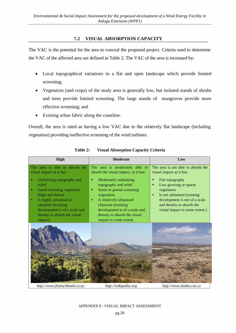
Environmental & Social Impact Assessment for the proposed development of a Wind Energy Facility in Anloga Extension (WPP1)
APPENDIX 8 - VISUAL IMPACT ASSESSMENT
pg 28
7.2 VISUAL ABSORPTION CAPACITY
The VAC is the potential for the area to conceal the proposed project. Criteria used to determine
the VAC of the affected area are defined in Table 2. The VAC of the area is increased by:
• Local topographical variations in a flat and open landscape which provide limited
screening;
• Vegetation (and crops) of the study area is generally low, but isolated stands of shrubs
and trees provide limited screening. The large stands of mangroves provide more
effective screening; and
• Existing urban fabric along the coastline.
Overall, the area is rated as having a low VAC due to the relatively flat landscape (including
vegetation) providing ineffective screening of the wind turbines.
Table 2: Visual Absorption Capacity Criteria
High Moderate Low
The area is able to absorb the visual impact as it has:
Undulating topography and relief
Good screening vegetation (high and dense)
Is highly urbanised in character (existing development is of a scale and density to absorb the visual impact).
The area is moderately able to absorb the visual impact, as it has:
Moderately undulating topography and relief
Some or partial screening vegetation
A relatively urbanised character (existing development is of a scale and density to absorb the visual impact to some extent.
The area is not able to absorb the visual impact as it has:
Flat topography Low growing or sparse
vegetation Is not urbanised (existing
development is not of a scale and density to absorb the visual impact to some extent.)
http://www.franschhoek.co.za
http://wikipedia.org http://www.butbn.cas.cz

Environmental & Social Impact Assessment for the proposed development of a Wind Energy Facility in Anloga Extension (WPP1)
APPENDIX 8 - VISUAL IMPACT ASSESSMENT
pg 29
http://commons.wikimedia.org
http://blogs.agu.org http://fortheinterim.com
7.3 VISUAL RECEPTORS
Receptors are important insofar as they inform visual sensitivity. The sensitivity of viewers is
determined by the number of viewers and by how likely they are to be impacted upon. Potential
viewers include the following:
• Residents: Residents within the study area are concentrated along the coastline.
Visibility from individual households within the larger villages is likely to be lower,
since the peri-urban fabric of structures obstructs views beyond the very immediate
foreground. Although the turbines along the beach at Anloga would be particularly
obtrusive (and intrusive) to views over the ocean, local communities seem to place less
value on the visual amenity of the beach, evidenced by the inward orientation of
households towards roads or over crop fields (and away from the coast).
Village residents spend a large proportion of their day outdoors, often at or beyond the
village edge (where there are no screening structures), which increases their sensitivity as
visual receptors. Viewers from the abovementioned villages are considered highly
sensitive receptors.
• Visitors/tourists: Visitors to the Keta Lagoon protected area are particularly sensitive
receptors. These receptors will have clear views of the WEF across the open
waterbodies and flat landscape.
• Road users: The Salo Road from the N1 (Accra – Aflao Rd) is the main access road to
the Anloga area. This road then runs parallel to the coast between Keta Lagoon and the

Environmental & Social Impact Assessment for the proposed development of a Wind Energy Facility in Anloga Extension (WPP1)
APPENDIX 8 - VISUAL IMPACT ASSESSMENT
pg 30
coast through the village of Anloga, where road use is particularly intensive - road users
along this section of the road include pedestrians and motorcyclists and many small
businesses and shops are located along the road.
A number of less significant unsurfaced roads also fall within the study area. The number
of motorists travelling along these roads is low; motorists are transient (and moving at
speed) and so are exposed to visual impacts for a relatively short period. In summary, road
users, are considered moderately sensitive receptors.
• Farmers and fishermen: Farmers in the project area work in cultivated open fields
where the screening effects of vegetation are curtailed and visibility is raised. Farmers
are considered as moderately sensitive receptors. Although fishermen will have clear
views of many of the turbines, views from the open ocean towards the coast are
generally less meaningful (except in/from very busy water ways). Note again that
farmers and fishermen mostly are residents in the villages described above.
The sensitivity of viewers or visual receptors potentially affected by the visual impact of the
project is considered to be moderate.
7.4 VIEWING DISTANCE AND VISIBILITY
The distance of a viewer from an object is an important determinant of the magnitude of the visual
impact. This is because the visual impact of an object diminishes/attenuates as the distance
between the viewer and the object increases. Thus the visual impact at 1 000 m would, nominally,
be 25% of the impact as viewed from 500 m. At 2 000 m it would be 10% of the impact at 500 m
(Hull and Bishop, 1988 in Young, 2000).

Environmental & Social Impact Assessment for the proposed development of a Wind Energy Facility in Anloga Extension (WPP1)
APPENDIX 8 - VISUAL IMPACT ASSESSMENT
pg 31
Figure 8: Visual Exposure vs Distance (Adapted from Hull and Bishop, 1998)
Three basic distance categories can be defined for a project of this scale (as discussed in Table 3):
• Foreground;
• Middleground; and
• Background.
A range of viewpoints were selected in order to identify potential receptors and to provide an
indication of the likely visibility of the project. The viewpoints were not randomly selected, but
were chosen because they are likely to best represent the visibility of the project to receptors.
Table 3: Distance Categories
FOREGROUND (0 – 5 km) The zone where the turbines will dominate the frame of view. The WEF will be highly visible unless obscured.
MIDDLEGROUND (5 – 15 km) The zone where colour and line are still readily discernible. The turbines will be moderately visible but will still be easily recognisable.
BACKGROUND (> 15 km) This zone stretches from 15 km to the point from where the turbines can no longer be seen. Objects in this zone can be classified as marginally visible.
The selected viewpoints are shown in Figure 9 to Figure 11, and views from these viewpoints are
shown in the accompanying photographs included as Appendix A. The criteria used to determine

Environmental & Social Impact Assessment for the proposed development of a Wind Energy Facility in Anloga Extension (WPP1)
APPENDIX 8 - VISUAL IMPACT ASSESSMENT
pg 32
the visibility of the project are set out in Table 4 and the visibility of from each viewpoint is
summarised in Table 5.
The visibility of the project can be summarised as follows:
• The turbines (for both alternatives) adjacent to Salo Road (north-west of Anloga)
(Figure 9) will be highly visible to the limited number of receptors using this road. The
mangroves west of these turbines will provide partial screening to receptors to the west
(i.e. residents of Anyanui located ~7 km west). The turbines will be visible to residents
on the northern edge of Anloga (located ~400 m south), but the peri-urban built fabric
of Anloga will provide effective screening to many of the residents. The turbines will be
highly visible to visitors to Keta Lagoon or fishermen on the lagoon although these
receptors would be approximately 5 km east of the turbines;
• The turbines (for Preferred Alternative only) north of Anyanui (Figure 10) will be
highly visible to residents and farmers on the northern edge of Anyanui (~ 1km south).
The peri-urban built fabric of Anyanui and isolated stands of trees will provide effective
screening to many of the residents in Anyanui. The mangroves east of these turbines
will provide partial screening to residents of Anloga (~8 km east); and
• The turbines (for both alternatives) along the beach, south of Anloga (Figure 11) will be
highly visible to residents and farmers on the southern edge of Anloga (~ 400 m north).
The peri-urban built fabric of Anloga will provide partial screening to many of the
residents in Anloga. The majority of Anloga residents are within 1 km of the turbines,
and the turbines may be visually overpowering to these residents. However, many
households are generally orientated towards the main road, away from the turbines.
Overall, the visibility of the project components is high, due to the high visibility of the turbines in
a flat landscape and the close proximity of receptors to the turbines.

Environmental & Social Impact Assessment for the proposed development of a Wind Energy Facility in Anloga Extension (WPP1)
APPENDIX 8 - VISUAL IMPACT ASSESSMENT
pg 33
Table 4: Visibility Criteria
NOT VISIBLE Project cannot be seen
MARGINALLY VISIBLE
Project is only just visible / partially visible (usually in background zone)
VISIBLE Project is visible although parts may be partially obscured (usually in middleground zone)
HIGHLY VISIBLE Project is clearly visible (usually in foreground or middleground zone)

Environmental & Social Impact Assessment for the proposed development of a Wind Energy Facility in Anloga Extension (WPP1)
APPENDIX 8 - VISUAL IMPACT ASSESSMENT
pg 34
Figure 9: Viewpoints (1)

Environmental & Social Impact Assessment for the proposed development of a Wind Energy Facility in Anloga Extension (WPP1)
APPENDIX 8 - VISUAL IMPACT ASSESSMENT
pg 35
Figure 10: Viewpoints (2)

Environmental & Social Impact Assessment for the proposed development of a Wind Energy Facility in Anloga Extension (WPP1)
APPENDIX 8 - VISUAL IMPACT ASSESSMENT
pg 36
Figure 11: Viewpoints (3)

Environmental & Social Impact Assessment for the proposed development of a Wind Energy Facility in Anloga Extension (WPP1)
APPENDIX 8 - VISUAL IMPACT ASSESSMENT
pg 37
Table 5: Visibility from Viewpoints
Viewpoint # Location Co-ordinates Direction of view
from the viewpoint
Distance from the viewpoint to the nearest turbine
Time Photograph
Taken
Potential Significant Receptors and Visibility
1a & b Salo Road bridge outside Anloga
5°46'54.90"N; 0°49'48.47"E
North-west 550 m 09h30 • Users of Salo Road – Highly Visible
• Residents of Anloga – Highly Visible
2a Salo Road 5°47'27.26"N; 0°49'21.27"E
North-west 250 m 09h45 • Users of Salo Road – Highly Visible
2b South-east
3a Outside village of Anyanui 5°47'43.50"N; 0°43'43.92"E
West 350 m 10h40 • Farmers - Highly Visible
3b East
4 Outskirts of Anyanui 5°47'6.98"N; 0°43'35.31"E
North 800 m 11h00 • Residents of Anyanui – Highly Visible to Visible
• Farmers - Highly Visible
5 Outskirts of Anyanui 5°46'21.88"N; 0°45'24.06"E
North-west 2 200 m 11h10 • Residents of Anyanui – Highly Visible to Visible
• Users of Anyanui Road - Visible
6a Outskirts of Anloga 5°47'3.16"N;
0°52'47.74"E
South-east 370 m 12h45 • Residents of Anloga - Highly Visible to Visible
• Fishermen / farmers – Highly Visible 6b South-west
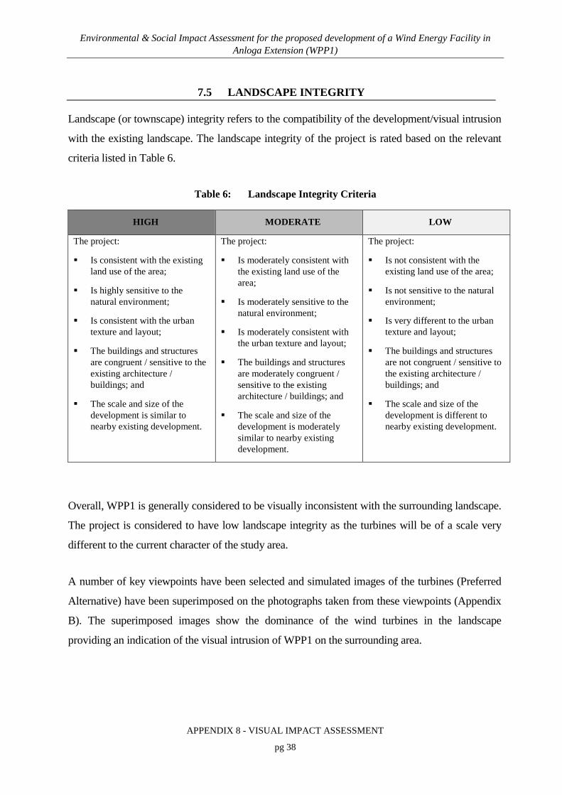
Environmental & Social Impact Assessment for the proposed development of a Wind Energy Facility in Anloga Extension (WPP1)
APPENDIX 8 - VISUAL IMPACT ASSESSMENT
pg 38
7.5 LANDSCAPE INTEGRITY
Landscape (or townscape) integrity refers to the compatibility of the development/visual intrusion
with the existing landscape. The landscape integrity of the project is rated based on the relevant
criteria listed in Table 6.
Table 6: Landscape Integrity Criteria
HIGH MODERATE LOW
The project:
Is consistent with the existing land use of the area;
Is highly sensitive to the natural environment;
Is consistent with the urban texture and layout;
The buildings and structures are congruent / sensitive to the existing architecture / buildings; and
The scale and size of the development is similar to nearby existing development.
The project:
Is moderately consistent with the existing land use of the area;
Is moderately sensitive to the natural environment;
Is moderately consistent with the urban texture and layout;
The buildings and structures are moderately congruent / sensitive to the existing architecture / buildings; and
The scale and size of the development is moderately similar to nearby existing development.
The project:
Is not consistent with the existing land use of the area;
Is not sensitive to the natural environment;
Is very different to the urban texture and layout;
The buildings and structures are not congruent / sensitive to the existing architecture / buildings; and
The scale and size of the development is different to nearby existing development.
Overall, WPP1 is generally considered to be visually inconsistent with the surrounding landscape.
The project is considered to have low landscape integrity as the turbines will be of a scale very
different to the current character of the study area.
A number of key viewpoints have been selected and simulated images of the turbines (Preferred
Alternative) have been superimposed on the photographs taken from these viewpoints (Appendix
B). The superimposed images show the dominance of the wind turbines in the landscape
providing an indication of the visual intrusion of WPP1 on the surrounding area.

Environmental & Social Impact Assessment for the proposed development of a Wind Energy Facility in Anloga Extension (WPP1)
APPENDIX 8 - VISUAL IMPACT ASSESSMENT
pg 39
7.6 MAGNITUDE OF THE OVERALL VISUAL IMPACT
Based on the above criteria, the magnitude or intensity of the overall visual impact that is
expected to result from the project has been rated. Table 7 provides a summary of the criteria, a
descriptor summarizing the status of the criteria and projected impact magnitude ratings.
The overall magnitude of the visual impact that is expected to result from the project is rated as
high. The low level of compatibility of the project and the high visibility of the turbines increases
the intensity of the project.
Table 7: Magnitude of Overall Visual Impact
CRITERIA RATING COMMENTS
Visual Exposure High The project will be exposed across an extensive area.
Visual Absorption Capacity Low Relatively flat landscape (including vegetation) provides ineffective screening.
Viewer Sensitivity (Receptors) Moderate Sensitive receptors in close proximity to the WEF.
Viewing Distance and Visibility
High High visibility of the turbines in a flat landscape and close proximity to receptors.
Landscape Integrity Low Scale of turbines incompatible with the existing nature of the area.

Environmental & Social Impact Assessment for the proposed development of a Wind Energy Facility in Anloga Extension (WPP1)
APPENDIX 8 - VISUAL IMPACT ASSESSMENT
pg 40
8. IMPACT ASSESSMENT AND MITIGATION MEASURES
Direct visual and aesthetic impacts in the construction / decommissioning and operations phases
are likely to result from a number of project interventions and/or activities:
• Construction Phase:
o Earthworks, vegetation clearance and resultant scarring;
o Construction activities and presence of heavy construction vehicles and equipment;
o Dust generation; and
o Construction traffic.
• Operations Phase:
o Change in character of the site and landscape caused by wind turbines;
o Nightglow nuisance caused by security lighting and aviation warning lights; and
o Change in character of the site and landscape caused by shadow flicker.
• Decommissioning Phase:
o Decommissioning activities and presence of heavy construction vehicles and equipment;
o Dust generation; and
o Traffic.
The visual and aesthetic impacts generated by the project are likely to be associated with changes
to sense of place and visual intrusion.
The following section describes the potential visual impacts during the construction, operations
and decommissioning phases and assesses them utilising the impact rating methodology provided

Environmental & Social Impact Assessment for the proposed development of a Wind Energy Facility in Anloga Extension (WPP1)
APPENDIX 8 - VISUAL IMPACT ASSESSMENT
pg 41
by the CSIR. Refer to the impact summary tables for the high level assessment of potential
impacts (Table 8, Table 9 and Table 10).
8.1 CONSTRUCTION PHASE
8.1.1 Altered Sense of Place and Visual Intrusion from Construction Activities
Visual impacts will be generated by construction activities such as vegetation stripping and bulk
earthworks, which can cause scarring, and from construction infrastructure, plant and materials on
site (e.g. site camp, cranes and stockpiles). Dust generated at the site will be visually unappealing
and may further detract from the visual quality of the area. Such impacts are typically limited to
the immediate area surrounding the construction site and to the construction period.
Loss of sense of place is expected during construction since construction activities and the change
in the state of the site (scarring, construction equipment and dust generation) are incongruent with
the current character and nature of the surrounding area.
The impact for both alternatives is assessed to be of medium significance and with the
implementation of mitigation, is reduced to low (Table 8).
The significance of the visual impact for the Alternative Layout will be marginally lower2,
particularly for the residents of Anyanui because turbines, and therefore construction activities,
are not proposed north of Anyanui.
Essential mitigation measures include the following:
• Limit and phase vegetation clearance and the footprint of construction activities to what
is absolutely essential;
• Utilise existing access roads as far as possible;
• Avoid excavation, handling and transport of materials which may generate dust under
very windy conditions;
2 The impact for the Alternative Layout is still assessed to be of medium significance without mitigation and of
low significance with the implementation of mitigation.

Environmental & Social Impact Assessment for the proposed development of a Wind Energy Facility in Anloga Extension (WPP1)
APPENDIX 8 - VISUAL IMPACT ASSESSMENT
pg 42
• Enforce speed limit of 30km/hr on site;
• Consolidate the footprint of the construction camp to a functional minimum. Screen the
yard with materials that blend into the surrounding area;
• Keep construction sites tidy and all activities, material and machinery contained within
an area that is as small as possible;
• Rehabilitate disturbed areas incrementally and as soon as possible, not necessarily
waiting until completion of the Construction Phase; and
• Set targets for the use of local labour to give locals a sense of ownership and pride in
the project.
8.1.2 Altered Sense of Place from Increased Traffic
The increased number of construction vehicles on the road (and the related noise impacts) will
reduce the sense of place to neighbouring receptors. The impaired sense of place will have a
greater impact within the foreground as sensitive receptors in close proximity to the access roads
will be particularly exposed to this impact.
The impact for both alternatives is assessed to be of medium significance and with the
implementation of mitigation, is reduced to low (Table 8).
The significance of the visual impact for the Alternative Layout will be marginally lower3,
particularly for the residents of Anyanui because turbines, and therefore construction traffic, are
not proposed north of Anyanui.
Essential mitigation measures include the following:
• Limit construction activities to Mondays to Saturdays between the hours of 07h00 and
18h00, or in accordance with relevant District bylaws, if applicable; and
• Maintain all generators, vehicles and other equipment in good working order.
3 The impact for the Alternative Layout is still assessed to be of medium significance without mitigation and of
low significance with the implementation of mitigation.

Environmental & Social Impact Assessment for the proposed development of a Wind Energy Facility in Anloga Extension (WPP1)
APPENDIX 8 - VISUAL IMPACT ASSESSMENT
pg 43
8.2 OPERATIONS PHASE
8.2.1 Altered Sense of Place and Visual Intrusion from the WEF
There is a degree of subjectivity in determining receptors’ responses to WEFs - wind turbines may
be perceived as negative or positive, majestic or dominant, depending on receptors’ perception of
the landscape and the value they ascribe to ‘green energy’. Many societies acknowledge that
renewable energy projects reduce dependency on fossils fuels (and associated carbon emissions /
climate change) and are therefore more tolerant of visual and sense of place impacts that there
would be for other similar scale projects.
The WEF will change the sites from unbuilt, predominantly natural to built sites.
The turbines at 95 m and 112 m (from ground level to turbine nacelle) for the Preferred
Alternative and the Alternative Layout, respectively, will be prominent vertical elements in the
landscape. The turbines will be visually overpowering and dominating to receptors within 1 km of
the turbines. There are many receptors (residents) within 1 km of the WEF at Anloga and
Anyanui (note, the closest receptor is within 200 m of a turbine). Visual intrusion is likely to be
significant to these receptors.
WPP1 will be incompatible with the existing land use which is more rustic and natural. The beach
is also a highly sensitive visual landscape.
The impact for both alternatives is assessed to be of high significance with and without the
implementation of mitigation (Table 9). The significance of the visual impact for the Alternative
Layout will be marginally lower4 (even though the height of the turbines will be ~ 20 m higher
than the Preferred Alternative), particularly for the residents of Anyanui, because turbines are not
proposed north of Anyanui.
It is difficult to mitigate tall vertical elements in the landscape, but essential mitigation measures
include:
4 The impact for the Alternative Layout is still assessed to be of high significance with and without the
implementation of mitigation.

Environmental & Social Impact Assessment for the proposed development of a Wind Energy Facility in Anloga Extension (WPP1)
APPENDIX 8 - VISUAL IMPACT ASSESSMENT
pg 44
• Minimise associated infrastructure on site (access roads, transformers, store rooms) to
reduce visual clutter;
• Plant large indigenous trees around receptors in the immediate vicinity of the WEF to
provide visual screening to partially reduce the visual impact on these receptors; and
• Maintain a uniform size (height) and colour (white) of the turbine towers, nacelles and
blades and avoid any markings on the turbine (Figure 13).
Internationally it is recognised that coastlines are unique visual and tourism assets. Compliance
with international best practice may require that turbines are not placed on the beach at Anloga.
However, in Anloga, local communities seem to place less value on the visual amenity of the
beach, evidenced by the inward orientation of households towards roads or over crop fields (and
away from the coast). For the Alternative Layout, and as best practice, Volta River Authority
(VRA) should consider relocating a number of proposed turbines from the beach at Anloga to the
site north of Anyanui so as to create visual corridors through to the coastline (Figure 12).
VIA SCOPING PHASE INPUT
Anloga WEF Project No.
499656
Figure 12: Suggested layout amendments of Anloga WEF

Environmental & Social Impact Assessment for the proposed development of a Wind Energy Facility in Anloga Extension (WPP1)
APPENDIX 8 - VISUAL IMPACT ASSESSMENT
pg 45
Figure 12: Markings on the tower (or nacelle / blades) increase the visual intrusion of the turbine
8.2.2 Altered Sense of Place and Visual Character caused by Light Pollution at Night
According to the Draft Feasibility Study (Lahmeyer International, 2015), the Ghana Civil
Aviation Authority may prescribe that one “Medium Intensity Light Type B/C” must be placed on
top of the nacelle and one “Low Intensity Light Type A/B” must be placed 45 m up the wind
turbine tower. In addition, security lighting may be installed at the WEF.
The lighting at the WEF may contribute to light pollution in the area, since existing ambient night
time light in the area is low, in a relatively undeveloped area with minimal lighting. The
additional lighting from the WEF will alter the visual character of the landscape at night.

Environmental & Social Impact Assessment for the proposed development of a Wind Energy Facility in Anloga Extension (WPP1)
APPENDIX 8 - VISUAL IMPACT ASSESSMENT
pg 46
Lighting is not easily screened by vegetation and topography, and receptors’ experience of the
impact is more intense. Good external security lighting design and lighting fixtures can restrict the
upward emission of light into the atmosphere reducing the visual impact (altered sense of place).
The impact for both alternatives is assessed to be of medium significance and with the
implementation of mitigation, is reduced to low (Table 9). The significance of the visual impact
for the Alternative Layout will be marginally lower5, particularly for the residents of Anyanui,
because turbines are not proposed on the site north of Anyanui.
Essential mitigation measures include the following:
• Clarify the requirements of the Ghana Civil Aviation Authority and clarify if pilot
activated lighting is possible;
• Direct security lighting inwards and downwards to avoid light spillage and trespass.
External lights should be fitted with reflectors (“full cut-off” luminaires) to direct
illumination downward and inward to the specific illuminated areas; and
• Avoid working at night unless absolutely necessary.
8.2.3 Altered Sense of Place from Shadow Flicker
Shadow flicker is the flicker of the sun through the turbine blades. Shadow flicker can be defined
spatially but with some difficulty as sun angles, climate, and viewpoints determine the presence,
duration and level of flicker (CNdV, 2006). Shadow flicker is considered significant within 1 km
of a turbine (http://www.windvigilance.com).
Guidelines developed in Germany (WEA-Schattenwurf-Hinweise, date unknown) are the most
widely adopted and state the following:
• Shadow flicker should not occur for more than 30 hours per annum; and
• Shadow flicker should not occur for more than 30 minutes per day.
5 The impact for the Alternative Layout is still assessed to be of medium significance without mitigation and of
low significance with the implementation of mitigation.

Environmental & Social Impact Assessment for the proposed development of a Wind Energy Facility in Anloga Extension (WPP1)
APPENDIX 8 - VISUAL IMPACT ASSESSMENT
pg 47
Shadow flicker will be significant for those residents located within 1 km of the wind turbines
(unless screened by vegetation or structures).
The impact for both alternatives is assessed to be of high significance and with the
implementation of mitigation, is reduced to low (Table 9).
Essential mitigation measures include the following:
• Calculate the effects of shadow flicker (taking account of local screening) on those
residents located within 1 km of the wind turbines and relocate residents accordingly (in
accordance with a Resettlement Action Plan).
8.3 DECOMMISSIONING PHASE
8.3.1 Altered Sense of Place and Visual Intrusion from Decommissioning Activities
Visual impacts generated during the Decommissioning Phase will be similar to those generated
during the Construction Phase: from infrastructure, plant and materials on site (e.g. site camp,
cranes) and dust. Such impacts are typically limited to the immediate area surrounding the WEF
and to the decommissioning period.
Loss of sense of place is expected during decommissioning since activities and the change in the
state of the site (decommissioning equipment and dust generation) are incongruent with the
current character and nature of the surrounding area.
The impact for both alternatives is assessed to be of medium significance and with the
implementation of mitigation, is reduced to low (Table 10).

Environmental & Social Impact Assessment for the proposed development of a Wind Energy Facility in Anloga Extension (WPP1)
APPENDIX 8 - VISUAL IMPACT ASSESSMENT
pg 48
The significance of the visual impact for the Alternative Layout will be marginally lower6,
particularly for the residents of Anyanui because turbines, and therefore decommissioning
activities, are not proposed north of Anyanui.
Essential mitigation measures include the following:
• Utilise existing access roads as far as possible;
• Avoid handling and transport of materials which may generate dust under very windy
conditions;
• Enforce speed limit of 30km/hr on site;
• Consolidate the footprint of the site camp to a functional minimum. Screen the yard
with materials that blend into the surrounding area;
• Keep all activities, material and machinery contained within an area that is as small as
possible; and
• Rehabilitate disturbed areas incrementally and as soon as possible, not necessarily
waiting until completion of the Decommissioning Phase.
8.3.2 Altered Sense of Place from Increased Traffic
The increased number of heavy vehicles on the road (and the related noise impacts) will reduce
the sense of place to neighbouring receptors. The impaired sense of place will have a greater
impact within the foreground as sensitive receptors in close proximity to the access roads will be
particularly exposed to this impact.
The impact for both alternatives is assessed to be of medium significance and with the
implementation of mitigation, is reduced to low (Table 10).
The significance of the visual impact for the Alternative Layout will be marginally lower7,
particularly for the residents of Anyanui because turbines, and therefore construction traffic, are
not proposed north of Anyanui.
6 The impact for the Alternative Layout is still assessed to be of medium significance without mitigation and of
low significance with the implementation of mitigation.

Environmental & Social Impact Assessment for the proposed development of a Wind Energy Facility in Anloga Extension (WPP1)
APPENDIX 8 - VISUAL IMPACT ASSESSMENT
pg 49
Essential mitigation measures include the following:
• Limit decommissioning activities to Mondays to Saturdays between the hours of 07h00
and 18h00, or in accordance with relevant District bylaws, if applicable; and
• Maintain all generators, vehicles and other equipment in good working order.
8.3.3 Cumulative Impacts
The visual quality of the study area is largely ascribable to the predominantly natural landscape
interspersed with traditional forms of agriculture. There are some elements that detract slightly
from the visual quality of the project area, but no industrial activities, renewable energy projects
or prominent vertical elements were identified within the project’s area of influence.
As there are no other large development projects in the project’s area of influence, the cumulative
impact for both alternatives is thus assessed to be of very low significance.
7 The impact for the Alternative Layout is still assessed to be of medium significance without mitigation and of
low significance with the implementation of mitigation.

Environmental & Social Impact Assessment for the proposed development of a Wind Energy Facility in Anloga Extension (WPP1)
APPENDIX 8 - VISUAL IMPACT ASSESSMENT
pg 50
Table 8: Impact assessment summary table for the Construction Phase
CONSTRUCTION PHASE
Direct Impacts
Aspect/ Impact Pathway
Nature of Potential Impact/ Risk
Status Spatial
Extent Duration Intensity Probability
Reversibility
of Impact Irreplaceability
Can the Impact/Risk be Avoided?
Can the Impact/Risk be Mitigated/
Managed?
Essential
Mitigation
Measures
Significance of Impact
and Risk
Confidence
Level
Alternative Site
Without Mitigation/
Management
With
Mitigation/ Management
(Residual Impact/ Risk)
Earthworks and vegetation clearance
Altered sense of place and visual intrusion from construction
activities
Preferred Layout and Alternative
Layout
Negative Local Temporary Medium-
Low Definite High Moderate No Yes
• Limit and phase vegetation clearance and the footprint of construction
activities to what is absolutely essential;
• Utilise existing access roads as far as possible;
• Avoid excavation, handling and transport of materials which may
generate dust under very windy conditions;
• Enforce speed limit of 30km/hr on site;
• Consolidate the footprint of the construction camp to a functional
minimum. Screen the yard with materials that blend into the surrounding
area;
• Keep construction sites tidy and all activities, material and machinery
contained within an area that is as small as possible;
• Rehabilitate disturbed areas incrementally and as soon as possible, not
necessarily waiting until completion of the Construction Phase; and
• Set targets for the use of local labour to give locals a sense of ownership
and pride in the project.
Medium Low High
Construction activities and
presence of heavy construction vehicles and equipment
Dust generation
Construction traffic
Altered sense of place from increased traffic
Preferred Layout and Alternative
Layout
Negative Local Temporary Medium-
Low Definite High Moderate No Yes
• Limit construction activities to Mondays to Saturdays between the hours
of 07h00 and 18h00, or in accordance with relevant District bylaws, if
applicable; and
• Maintain all generators, vehicles and other equipment in good working
order.
Medium Low High

Environmental & Social Impact Assessment for the proposed development of a Wind Energy Facility in Anloga Extension (WPP1)
APPENDIX 8 - VISUAL IMPACT ASSESSMENT
pg 51
Table 9: Impact assessment summary table for the Operations Phase
OPERATIONS PHASE
Direct Impacts
Aspect/ Impact Pathway
Nature of Potential Impact/ Risk
Status Spatial
Extent Duration Intensity Probability
Reversibility
of Impact Irreplaceability
Can the Impact/Risk be Avoided?
Can the Impact/Risk be Mitigated/
Managed?
Potential
Mitigation
Measures
Significance of Impact
and Risk
Confidence
Level
Alternative Site
Without Mitigation/
Management
With
Mitigation/ Management
(Residual Impact/ Risk)
Change in character of site
caused wind turbines
Altered sense of place and visual intrusion
from the WEF
Preferred Layout and Alternative
Layout
Negative Regional Long-term
High Probable High Low No No
• Minimise associated infrastructure on site (access roads, transformers,
store rooms) to reduce visual clutter;
• Plant large indigenous trees around receptors in the immediate vicinity
of the WEF to provide visual screening to partially reduce the visual
impact on these receptors; and
• Maintain a uniform size (height) and colour (white) of the turbine
towers, nacelles and blades and avoid any markings on the turbine.
High High High
Security lighting and aviation
warning lights
Altered Sense of Place and Visual Character
caused by Light Pollution at Night
Preferred Layout and Alternative
Layout
Negative Regional Long-term
Medium-Low
Definite High Low No Yes
• Clarify the requirements of the Ghana Civil Aviation Authority and
clarify if pilot activated lighting is possible;
• Direct security lighting inwards and downwards to avoid light spillage
and trespass. External lights should be fitted with reflectors (“full cut-
off” luminaires) to direct illumination downward and inward to the
specific illuminated areas; and
• Avoid working at night unless absolutely necessary.
Medium Low High
Shadow flicker
Altered Sense of Place from Shadow Flicker
Preferred Layout and Alternative
Layout
Negative Local Long-term
High Highly
Probable High Moderate Yes Yes
• Calculate the effects of shadow flicker (taking account of local
screening) on those residents located within 1 km of the wind turbines
and relocate residents accordingly (in accordance with a Resettlement
Action Plan).
High Low High

Environmental & Social Impact Assessment for the proposed development of a Wind Energy Facility in Anloga Extension (WPP1)
APPENDIX 8 - VISUAL IMPACT ASSESSMENT
pg 52
Table 10: Impact assessment summary table for the Decommissioning Phase
DECOMMISSIONING PHASE
Direct Impacts
Aspect/ Impact Pathway
Nature of Potential Impact/ Risk
Status Spatial
Extent Duration Intensity Probability
Reversibility
of Impact Irreplaceability
Can the Impact/Risk be Avoided?
Can the Impact/Risk be Mitigated/
Managed?
Essential
Mitigation
Measures
Significance of Impact
and Risk
Confidence
Level
Alternative Site
Without Mitigation/
Management
With
Mitigation/ Management
(Residual Impact/ Risk)
Construction activities and
presence of heavy construction vehicles and equipment
Altered sense of place and visual intrusion
from decommissioning activities
Preferred Layout and Alternative
Layout
Negative Local Temporary Medium-
Low Definite High Moderate No Yes
• Utilise existing access roads as far as possible;
• Avoid handling and transport of materials which may generate dust
under very windy conditions;
• Enforce speed limit of 30km/hr on site;
• Consolidate the footprint of the site camp to a functional minimum.
Screen the yard with materials that blend into the surrounding area;
• Keep all activities, material and machinery contained within an area that
is as small as possible; and
• Rehabilitate disturbed areas incrementally and as soon as possible, not
necessarily waiting until completion of the Construction Phase.
Medium Low High
Dust generation
Traffic Altered sense of place from increased traffic
Preferred Layout and Alternative
Layout
Negative Local Temporary Medium-
Low Definite High Moderate No Yes
• Limit decommissioning activities to Mondays to Saturdays between the
hours of 07h00 and 18h00, or in accordance with relevant District
bylaws, if applicable; and
• Maintain all generators, vehicles and other equipment in good working
order.
Medium Low High

Environmental & Social Impact Assessment for the proposed development of a Wind Energy Facility in Anloga Extension (WPP1)
APPENDIX 8 - VISUAL IMPACT ASSESSMENT
pg 53
9. CONCLUSION AND RECOMMENDATIONS
The following findings are pertinent:
• The basis for the visual character of the overall area is provided by the topography,
vegetation and land use of the area, giving rise to a generally flat landscape with a mosaic of
waterbodies, mud flats and salt marshes with low-intensity cultivated fields and villages on
higher ground, with significant influence from the sea.
• The WPP1 area can be described as a natural transition landscape associated with the interface
between the coastline, the villages interspersed within cultivated fields and the natural water
features and wetlands further inland.
• The visual quality of the overall area is largely ascribable to the diverse patterns of grassland
interspersed with irregularly shaped fields and wetlands. Views over the ocean contribute to a
sense of ‘openness’ and underpin the visual quality of the area. The open topography, varied
vegetation and traditional forms of crop farming that have been integrated into the landscape
are visually appealing, but not necessarily regionally distinctive.
• The Volta River delta drainage network provides visual interest in the landscape surrounding
the WPP1.
• Some elements detract slightly from visual quality in the project area, notably the degraded
(and abandoned) farmlands. Nevertheless the visual quality of the study area is considered to
be high.
• Land uses or activities that occur in an area contribute to the sense of place, which is expected
to be fairly similar to the wider region. In this sense there is an element of sameness and
predictability about the visual quality of the area. However, Keta Lagoon, Volta River Estuary
and other open waterbodies are distinct natural features in the landscape. The areas’ sense of
place is also highly influenced by the coast.

Environmental & Social Impact Assessment for the proposed development of a Wind Energy Facility in Anloga Extension (WPP1)
APPENDIX 8 - VISUAL IMPACT ASSESSMENT
pg 54
• The visual exposure of the WEF will be high as the wind turbines will be exposed across an
extensive area.
• The area is rated as having a low VAC due to the relatively flat landscape providing
ineffective screening of the wind turbines.
• Potential visual receptors of the project include residents of surrounding villages, visitors to
Keta lagoon, road users, farmers, and fishermen. The sensitivity of viewers or visual receptors
potentially affected by the visual impact of the project is considered to be moderate.
• The visibility of the project components is high, due to the high visibility of the turbines in a
flat landscape and the close proximity of receptors to the turbines.
• The project is considered to have low landscape integrity as the turbines will be of a scale
very different to the current nature of the study area.
• Visual impacts will be generated by construction activities. Loss of sense of place is expected
during construction since construction activities and the change in the state of the site
(scarring, construction equipment and dust generation) are incongruent with the current nature
of the surrounding area.
• The increased number of construction vehicles on the road and the related noise impacts will
reduce the sense of place to neighbouring receptors. The loss of sense of place will have a
greater impact within the foreground as sensitive receptors in close proximity to the access
roads will be particularly exposed to this impact.
• There is a degree of subjectivity in determining receptors’ responses to WEFs - wind turbines
may be perceived as negative or positive, majestic or dominant, depending on receptors’
perception of the landscape and the value they ascribe to ‘green energy’. Many societies
acknowledge that renewable energy projects reduce dependency on fossils fuels (and
associated carbon emissions / climate change) and are therefore more tolerant of visual and
sense of place impacts that there would be for other similar scale projects.

Environmental & Social Impact Assessment for the proposed development of a Wind Energy Facility in Anloga Extension (WPP1)
APPENDIX 8 - VISUAL IMPACT ASSESSMENT
pg 55
• The WEF will change the sites from unbuilt, predominantly natural to built sites. The wind
turbines will be prominent vertical elements in the landscape. The turbines will be visually
overpowering and dominating to those receptors within 1 km of the turbines. There are many
receptors (residents) within 1 km of WPP1 (note, the closest receptor is within 200 m of a
turbine).
• The lighting at the WEF may contribute to light pollution in the area, since existing ambient
night time light in the area is low, in a relatively undeveloped area with minimal lighting. The
additional lighting from the WEF will alter the visual character of the landscape at night.
• Shadow flicker is the flicker of the sun through the turbine blades and is considered
significant within 1 km of a turbine, unless localised elements screen flicker.
• Although the significance rating for both alternatives is the same according to the impact
rating methodology, the significance of the visual impacts for the Alternative Layout will be
marginally lower (even though the height of the turbines will be ~ 20 m higher than the
Preferred Alternative), particularly for the residents of Anyanui, because turbines are not
proposed north of Anyanui.
• Internationally it is recognised that coastlines are unique visual and tourism assets.
Compliance with international best practice may require that turbines are not placed on the
beach at Anloga. However, in Anloga, local communities seem to place less value on the
visual amenity of the beach, evidenced by the inward orientation of households towards roads
or over crop fields (and away from the coast). For the Alternative Layout, and as best practice,
VRA should consider relocating a number of proposed turbines from the beach at Anloga to
the site north of Anyanui so as to create visual corridors through to the coastline.
• Visual impacts will be generated by decommissioning activities. Loss of sense of place is
expected during decommissioning since activities and the change in the state of the site
(decommissioning equipment and dust generation) are incongruent with the current nature of
the surrounding area.

Environmental & Social Impact Assessment for the proposed development of a Wind Energy Facility in Anloga Extension (WPP1)
APPENDIX 8 - VISUAL IMPACT ASSESSMENT
pg 56
• The increased number of heavy vehicles on the road and the related noise impacts will reduce
the sense of place to neighbouring receptors. The loss of sense of place will have a greater
impact within the foreground as sensitive receptors in close proximity to the access roads will
be particularly exposed to this impact.
• As there are no other large development projects in the project’s area of influence, the
cumulative impact is assessed to be of very low significance.

Environmental & Social Impact Assessment for the proposed development of a Wind Energy Facility in Anloga Extension (WPP1)
APPENDIX 8 - VISUAL IMPACT ASSESSMENT
pg 57
10. REFERENCES
Birdlife International, (2016). Songor Ramsar Site and Keta Lagoon Ramsar Site. Website:
http://www.birdlife.org/. Accessed: April 2016.
Boschkloof, (2012). Cederberg Farm Experience. Website: http://www.boschkloof.com/cederberg-guest-
farm-citrusdal.htm. Accessed: October 2012.
Author unknown, (2009). Shan Ding Lu. Website: http://www.shandinglu.org. Accessed: August 2012.
CNDV, (2006). Strategic Initiative to Introduce Commercial Land Based Wind Energy Development to the
Western Cape: Towards a Regional Methodology for Wind Energy Site Selection. Reports 1 – 6.
Crawford, D., (1994) Using remotely sensed data in landscape visual quality assessment, Landscape and
Urban Planning. 30: 17-81.
Lahmeyer International, (2015). Renewable Energy Development Programme, Ghana: Draft Feasibility
Study for Lekpoguno/Aklabnya Wind Farm and Renewable Energy Development Programme, Ghana:
Draft Feasibility Study for Anloga Wind Farm.
Landscape Institute, (2013). Guidelines for Landscape and Visual Impact Assessment. Third Edition.
Lynch, K., (1992). Good City Form, The MIT Press, London.
Night Jar Travel (Pty) Ltd, (2012). Night Jar Travel South Africa. Website: http://www.nightjartravel.com.
Accessed: August 2012.
Oberholzer, B., (2005). Guideline for involving visual & aesthetic specialists in EIA processes: Edition 1.
CSIR Report No ENV-S-C 2005 053 F. Republic of South Africa, Provincial Government of the Western
Cape, Department of Environmental Affairs & Development Planning, Cape Town.
Sullivan, R. et al, (date unknown). Wind Turbine Visibility and Visual Impact Threshold Distances. Visual
Resource Analysis. Website: http://visualimpact.anl.gov/windvitd/. Accessed: April 2012.

Environmental & Social Impact Assessment for the proposed development of a Wind Energy Facility in Anloga Extension (WPP1)
APPENDIX 8 - VISUAL IMPACT ASSESSMENT
pg 58
The Society for Wind Vigilance, (2016). Visual Health Effects and Wind Turbines. Website:
http://www.windvigilance.com. Accessed: April 2016.
World Bank Group, (2015). Environmental, Health, and Safety Guidelines for Wind Energy. 7 August,
2015.
Young, G., (2000). First Draft Gamsberg Zinc Project: Specialist Study Report: Visual Environment.
Newtown Landscape Architects, 10 March 2000.

Environmental & Social Impact Assessment for the proposed development of a Wind Energy Facility in Anloga Extension (WPP1)
APPENDIX 8 - VISUAL IMPACT ASSESSMENT
pg 59
11. APPENDICES
Appendix A – Viewpoint Photographs
Appendix B – Photograph Simulations

Environmental & Social Impact Assessment for the proposed development of a Wind Energy Facility in Anloga Extension (WPP1)
APPENDIX 8 - VISUAL IMPACT ASSESSMENT
pg 60
APPENDIX A: Viewpoint Photographs

Environmental & Social Impact Assessment for the proposed development of a Wind Energy Facility in Anloga Extension (WPP1)
APPENDIX 8 - VISUAL IMPACT ASSESSMENT pg 61
Viewpoint 1

Environmental & Social Impact Assessment for the proposed development of a Wind Energy Facility in Anloga Extension (WPP1)
APPENDIX 8 - VISUAL IMPACT ASSESSMENT pg 62
Viewpoint 2

Environmental & Social Impact Assessment for the proposed development of a Wind Energy Facility in Anloga Extension (WPP1)
APPENDIX 8 - VISUAL IMPACT ASSESSMENT pg 63
Viewpoint 3

Environmental & Social Impact Assessment for the proposed development of a Wind Energy Facility in Anloga Extension (WPP1)
APPENDIX 8 - VISUAL IMPACT ASSESSMENT pg 64
Viewpoint 4
Viewpoint 5

Environmental & Social Impact Assessment for the proposed development of a Wind Energy Facility in Anloga Extension (WPP1)
APPENDIX 8 - VISUAL IMPACT ASSESSMENT pg 65
Viewpoint 6

Environmental & Social Impact Assessment for the proposed development of a Wind Energy Facility in Anloga Extension (WPP1)
APPENDIX 8 - VISUAL IMPACT ASSESSMENT pg 66
APPENDIX B: Photograph Simulations

Environmental & Social Impact Assessment for the proposed development of a Wind Energy Facility in Anloga Extension (WPP1)
APPENDIX 8 - VISUAL IMPACT ASSESSMENT pg 67
Viewpoint 1a (top) and Viewpoint 2a (bottom)

Environmental & Social Impact Assessment for the proposed development of a Wind Energy Facility in Anloga Extension (WPP1)
APPENDIX 8 - VISUAL IMPACT ASSESSMENT pg 68
Viewpoint 4 (top) and Viewpoint 5 (bottom)

Environmental & Social Impact Assessment for the proposed development of a Wind Energy Facility in Anloga Extension (WPP1)
APPENDIX 8 - VISUAL IMPACT ASSESSMENT pg 69
Viewpoint 6a

Environmental & Social Impact Assessment for the proposed development of a Wind Energy Facility in Anloga Extension (WPP1)
APPENDIX 8 - VISUAL IMPACT ASSESSMENT
pg 70
SPECIALIST EXPERTISE
Specialisation Visual impact assessments (VIA), environmental impact assessment, environmental planning and site sensitivity studies; and landscape architectural design and planning
Expertise Scott has been involved in the field of environmental and landscape
architecture for the past 9 years. His expertise includes: • environmental impact assessments and environmental
management plans; • visual impact assessments; • integrated waste and water management plans; • environmental audits and due diligence; • environmental control officer work; • environmental planning and sensitivity studies; and • landscape architectural planning and design.
Employment 2011 – present 2009 – 2011
SRK Consulting (Pty) Ltd, Environmental Consultant, Cape Town Megan Anderson Landscape Architects, Candidate Landscape Architect
Publications I have been interviewed and quoted in numerous environmental and
sustainability articles published in the press and sector specific journals including Civil Engineering Contractor. Position IT, Cape Business News and To Build.
Scott Masson
Profession Senior Environmental Consultant and VIA Specialist
Education MLA, L. Arch, Cape Town, 2008
BSc (Hons), Environmental Management, Cape Town, 2004
BSc, Environmental Management, Cape Town, 2003
Registrations /
Affiliations
Certified Environmental Assessment Practitioner of South Africa
Professionally Registered Landscape Architect

Environmental & Social Impact Assessment for the proposed development of a Wind Energy Facility in Anloga Extension (WPP1)
APPENDIX 8 - VISUAL IMPACT ASSESSMENT
pg 71
Visual Impact Assessment (VIA) • CSIR, VIA for two wind energy facilities in the Greater Accra District, Ghana, 2016 - ongoing
• Mineral Sands Resources (Pty) Ltd, VIA for the extension of Tormin Mine, Western Cape, 2016 – ongoing
• Tronox Mineral Sands (Pty) Ltd, VIA for the Slimes Dam 6 at Tronox Namakwa Sands Mine, Western Cape, 2016
• Department of Forestry, Fisheries and Agriculture, VIA for a proposed Aquaculture Development Zone in Saldanha Bay, Western Cape, 2016
• Matzikama Municipality, VIA for the proposed construction of four abalone farms in Doringbaai, Western Cape, 2015 - 2016
• Eskom, VIA for the proposed Merino substation and Bon-Chretien-Merino powerline in Ceres, Western Cape, 2016
• Transnet Capital Projects, VIA for the construction of additional substations, transmission infrastructures and area lighting masts near the Port of Saldanha, Western Cape, 2015-2016
• EFG Engineers, VIA for a the proposed bypass road in Hermanus, Western Cape, 2015-2016
• Liesbeek Leisure Club (Pty) Ltd, VIA for a the proposed redevelopment of the River Club, Western Cape, 2015-2016
• Eskom, VIA for the proposed TISF at Koeberg, Western Cape, 2015-2016
• Tronox Mineral Sands (Pty) Ltd, VIA for a the proposed expansion of the Namakwa Sands Mine, Brand-se-Baai, Western Cape, 2012-2013
• Vale, VIA for a proposed phosphate mine in Mozambique, 2011-2012
• Courtrai Developments, VIA for a proposed retirement village in Paarl, 2011
• CSIR Environmental, VIA for an EIA proposal for four wind energy facilities, Swellendam, Mossel Bay, Heidelberg and Albertinia, Western Cape, 2010
• CSIR Environmental, VIA for a proposed eco-residential estate and nature reserve, Jacobsbaai, Western Cape, 2010
• Vodacom, VIA for a proposed cell phone mast at Hermanus golf course, on Graymead farm near Villiersdorp and on a farm in Klipdale, 2009

Environmental & Social Impact Assessment for the proposed development of a Wind Energy Facility in Anloga Extension (WPP1)
APPENDIX 8 - VISUAL IMPACT ASSESSMENT
pg 72
SPECIALIST DECLARATION
I, SCOTT MASSON, as the appointed independent specialist, hereby declare that: I act as the independent specialist in this application;
I perform the work relating to the application in an objective manner, even if this results in views and findings that are not favourable to the applicant;
I regard the information contained in this report as it relates to my specialist input/study to be true and correct, and do not have and will not have any financial interest in the undertaking of the activity, other than remuneration for work performed in terms of any specific environmental management Act;
I declare that there are no circumstances that may compromise my objectivity in performing such work;
I have expertise in conducting the specialist report relevant to this application, including knowledge of any Acts, Regulations and any guidelines that have relevance to the proposed activity;
I will comply with the Acts, Regulations and all other applicable legislation;
I have no, and will not engage in, conflicting interests in the undertaking of the activity;
I have no vested interest in the proposed activity proceeding;
I undertake to disclose to the applicant and the competent authority all material information in my possession that reasonably has or may have the potential of influencing - any decision to be taken with respect to the application by the competent authority; and - the objectivity of any report, plan or document to be prepared by myself for submission to the competent authority;
I will ensure that the comments of all interested and affected parties on the specialist input/study will be considered, recorded and submitted to the competent authority in respect of the application;
all the particulars furnished by me in this specialist input/study are true and correct; and
I realise that a false declaration is an offence.
Signature of the Specialist: Name of Specialist: Scott Masson Date: 26 September 2017


Environmental & Social Impact Assessment for the proposed development of a Wind Energy Facility in Anloga Extension (WPP1)
APPENDIX 9 - PUBLIC PARTICIPATION
pg 1
TABLE OF CONTENTS
List of participants at the public forum for WPP1 October 2016 2 Appendix 9.1 2
EPA’s Response to the Project Registration 13 Appendix 9.2 13
Energy Commission Provisional License, dated 27 July 2015 14 Appendix 9.3 14
Minutes of the meeting between VRA and GNPC 15 Appendix 9.4 15
Copies of the correspondences between VRA and Ghana Civil Aviation Authority GCAA 22 Appendix 9.5 22
The signed List of participants at the State agency’s forum 32 Appendix 9.6 32
Comments from the EPA have been included in (letter dated September 14, 2016). 35 Appendix 9.7 35
VRA to Ghana Highway Authority 40 Appendix 9.8 40
Comments received during the review of the BID and the Scoping Report 41 Appendix 9.9 41
Correspondences between VRA and Ministry of Lands and Natural resources 51 Appendix 9.10 51
Correspondences between VRA and Land Owners 53 Appendix 9.11 53
SCL Invitation letters to State Agencies 56 Appendix 9.12 56

Environmental & Social Impact Assessment for the proposed development of a Wind Energy Facility in Anloga Extension (WPP1)
APPENDIX 9 - PUBLIC PARTICIPATION
pg 2
List of participants at the public forum for WPP1 October 2016 Appendix 9.1

Environmental & Social Impact Assessment for the proposed development of a Wind Energy Facility in Anloga Extension (WPP1)
APPENDIX 9 - PUBLIC PARTICIPATION
pg 3

Environmental & Social Impact Assessment for the proposed development of a Wind Energy Facility in Anloga Extension (WPP1)
APPENDIX 9 - PUBLIC PARTICIPATION
pg 4

Environmental & Social Impact Assessment for the proposed development of a Wind Energy Facility in Anloga Extension (WPP1)
APPENDIX 9 - PUBLIC PARTICIPATION
pg 5

Environmental & Social Impact Assessment for the proposed development of a Wind Energy Facility in Anloga Extension (WPP1)
APPENDIX 9 - PUBLIC PARTICIPATION
pg 6

Environmental & Social Impact Assessment for the proposed development of a Wind Energy Facility in Anloga Extension (WPP1)
APPENDIX 9 - PUBLIC PARTICIPATION
pg 7

Environmental & Social Impact Assessment for the proposed development of a Wind Energy Facility in Anloga Extension (WPP1)
APPENDIX 9 - PUBLIC PARTICIPATION
pg 8

Environmental & Social Impact Assessment for the proposed development of a Wind Energy Facility in Anloga Extension (WPP1)
APPENDIX 9 - PUBLIC PARTICIPATION
pg 9
Stakeholder database:
Stakeholder Name Position
Keta Municipal Assembly
Hon. Sylvester Tornyeava Municipal Chief Executive
Nicholas Niaje Municipal Coordinating Director
John Ntibere Planning Officer
Hilda Dapaah Arthur Planning Officer
Woanya Makafui Development Committee Chairman (Assemblyman for Anloga)
Richard Sefe Presiding member
Samuel Dompreh Municipal Engineer
Aaron Teku Mun. Works Dept.
Kennedy Sekyi I S D
Fabian Vorvoir Budget Officer
Anttoinette Aheto Procurement Officer
Benjamin Sagodo Dept of Agric
Freedom Vitashie Information Officer
Keta Municipal Health Service
Dr. Andrews Ayaim Municipal Health Director
Grace Kpedadzah Municipal Public Health Nurse
Keta Municipal Education Service
Derrick Vanlare Public Relations Officer
John Gbekor Asst. Director, Monitoring & Supervision
Ghana Wildlife Division Abdul-Kareem Fuseini Supervisor
Dept. of Cooperatives Jennifer Glover Assistant Cooperative Officer
Dept. of Environmental Health
Jerry Ziddah Municipal Environmental Health Officer
National Commission for Civic Education
Godwin Agbenyo Municipal Director
Department for Comm. Development
Edith Tay Municipal Dedevelopment Officer
NADMO Dominic Kpodo Municipal Administrator
Works Estate Daniel Nyatso Municipal Estate Officer
Information Serv. Dept Freedom Vitashie Municipal Informatioin Director
Dept. of Social Welfare Faustina Barldee Municipal Social Welfare Officer
Ghana Fire & Rescue Service Gifty Tagoe Municipal Fire Officer
Dept. Comm. Dev. Celestina A. Attipoe Municipal Community Development Officer

Environmental & Social Impact Assessment for the proposed development of a Wind Energy Facility in Anloga Extension (WPP1)
APPENDIX 9 - PUBLIC PARTICIPATION
pg 10
Stakeholder Name Position
Dept. Of Agriculture Sagodo Benjamin Municipal Agric Development Officer
Srogbe Community
Francis Atsu Lumor Stool father
Regent Fatsawu Dzoley Agbavitor Regent
Tsimenu Attipoe Elder
Shine Agbavitor Family Assistant Secretary
Kotoku Vivor Chief Fisherman
Solomon Danyo Dzoke Family Secretary
Taviam Agbenyega Elder
Kwadzo Fianyeku Elder
Apertorgbir Nuesedonu Elder
Eyra Kusorgbor Elder
Anloga Community
Dumega Gasu Agbedzi Head of Amevu clan
Gabriel K. Agbedzi Elder
Regent Fatsawu Agbavitor Agbavitor Family
Kofi Agbedzi Elder
Kobla Hosu Vegetable farmers Association
John Logah Vegetable farmers Association
Agbenyegah Ladzekpo Vegetable farmers Association
Hedzro Ashimadi Vegetable farmers Association
Doe Nkekeshi Chief Fisherman
Noble Agbavitor Elder
Amuzu Kanagbo Elder
Alfred Gbeze
James Avevor
Avevor James Landlord, Anloga
Anyigbavor Doe
George Yaovi Sebuavah Elder
Togbe Gborsike Fetish Priest
Hon Woanya Makafui Assemblyman, Anloga Lashibi
Gasu Agbedzi
John K. Togobo Landlord, Anloga
Edward Ahiabor KEMVEFA Chairman
Roland Tudzi KEMVEFA Chairman
Jaspa Lavi
Dra/ Togobo family of Tovle Clan Anthony Kobla Agbedeka
Dr. Francis Ahiaku

Environmental & Social Impact Assessment for the proposed development of a Wind Energy Facility in Anloga Extension (WPP1)
APPENDIX 9 - PUBLIC PARTICIPATION
pg 11
Stakeholder Name Position
Anyanui Community
Togbe Gamor Chief of Anyanui
Clement Ahiankui
William Ahiaku Ayedzinu Regent - Klevie Clan
Leo Daledor Elder - Klevie Clan
Cephas Gagblah Elder - Klevie Clan
T.K. Heletsi Clan Elder
David Ahiaku Adzieelder Elder - Klevie Clan
Johnson Ahiaku Believer Elder - Klevie Clan
WO1 (Rtd) Anyeku Kennedy Elder - Klevie Clan
Gboglah Godson
Edwin Kusime Assemblyman
Hon Godson Gagbla Assemblyman
Furguson Agbanyo Togbe Tsidi Rep
Gershon Anagli Elder - Barteh Clan
Samuel Anagli Elder - Barteh Clan
Gbeda gbologah Elder-Barteh Clan
Awushie Gbologah Elder - Barteh Clan
Tunu Community (Anyanui)
Hunor Alloyito Linguist
Zatey Dagodzo Elder
Zikpi Francis Elder
Godwin Agbeyangah Elder
Gblife Community (Anyanui)
Yaw Gbetsey Sampson Acting Chief
Kpetsi Kobla Elder
Kpetsi Kojo Elder
Christopher Kpondo Elder
Seth Akarwodo Elder
Akpatsu Vincent Kofi Elder
Wededeanu (Anyanui) Kutu Awumey Elder
Wokumagbe John Alipuiteye Sowa Narh Linguist
Kofi Samuel Akwetey Regent
EPA
Benjamin Oppong Darkwah Ag. Regional Director, EPA
Osei Aaron
Moses Amevor
Adzeman Naa-Dei
Kwaku Digah Simon
Raymond Eddah
Agbledomi Agbenyadzi Thomas Farmer

Environmental & Social Impact Assessment for the proposed development of a Wind Energy Facility in Anloga Extension (WPP1)
APPENDIX 9 - PUBLIC PARTICIPATION
pg 12
Stakeholder Name Position
Agbanator E Farmer
Michael Nanevi Elder
Dzita
Agnes Vitasi
Believer Ahiaku
Albert Dagbui
Ahianyo Gabriel
Joseph Agbenyese
Togbui Azametsi III Chief of Dzita
Gagbla Godson
Simon C. Ahiada
Ahiaku William
Ahiaku David
Ahiaku Livinston
Gagbla Cephas
Adidome
Rejoice Ntsiri Journalist, Jubille Radio
Dr. Simon Soroe PPO
Paulina Seddor National Service Person
Aaron Osei Driver

Environmental & Social Impact Assessment for the proposed development of a Wind Energy Facility in Anloga Extension (WPP1)
APPENDIX 9 - PUBLIC PARTICIPATION
pg 13
EPA’s Response to the Project Registration Appendix 9.2

Environmental & Social Impact Assessment for the proposed development of a Wind Energy Facility in Anloga Extension (WPP1)
APPENDIX 9 - PUBLIC PARTICIPATION
pg 14
Energy Commission Provisional License, dated 27 July 2015 Appendix 9.3

Environmental & Social Impact Assessment for the proposed development of a Wind Energy Facility in Anloga Extension (WPP1)
APPENDIX 9 - PUBLIC PARTICIPATION
pg 15
Minutes of the meeting between VRA and GNPC Appendix 9.4

Environmental & Social Impact Assessment for the proposed development of a Wind Energy Facility in Anloga Extension (WPP1)
APPENDIX 9 - PUBLIC PARTICIPATION
pg 16

Environmental & Social Impact Assessment for the proposed development of a Wind Energy Facility in Anloga Extension (WPP1)
APPENDIX 9 - PUBLIC PARTICIPATION
pg 17

Environmental & Social Impact Assessment for the proposed development of a Wind Energy Facility in Anloga Extension (WPP1)
APPENDIX 9 - PUBLIC PARTICIPATION
pg 18

Environmental & Social Impact Assessment for the proposed development of a Wind Energy Facility in Anloga Extension (WPP1)
APPENDIX 9 - PUBLIC PARTICIPATION
pg 19

Environmental & Social Impact Assessment for the proposed development of a Wind Energy Facility in Anloga Extension (WPP1)
APPENDIX 9 - PUBLIC PARTICIPATION
pg 20

Environmental & Social Impact Assessment for the proposed development of a Wind Energy Facility in Anloga Extension (WPP1)
APPENDIX 9 - PUBLIC PARTICIPATION
pg 21

Environmental & Social Impact Assessment for the proposed development of a Wind Energy Facility in Anloga Extension (WPP1)
APPENDIX 9 - PUBLIC PARTICIPATION
pg 22
Copies of the correspondences between VRA and Ghana Civil Aviation Authority GCAA
Appendix 9.5

Environmental & Social Impact Assessment for the proposed development of a Wind Energy Facility in Anloga Extension (WPP1)
APPENDIX 9 - PUBLIC PARTICIPATION
pg 23

Environmental & Social Impact Assessment for the proposed development of a Wind Energy Facility in Anloga Extension (WPP1)
APPENDIX 9 - PUBLIC PARTICIPATION
pg 24

Environmental & Social Impact Assessment for the proposed development of a Wind Energy Facility in Anloga Extension (WPP1)
APPENDIX 9 - PUBLIC PARTICIPATION
pg 25

Environmental & Social Impact Assessment for the proposed development of a Wind Energy Facility in Anloga Extension (WPP1)
APPENDIX 9 - PUBLIC PARTICIPATION
pg 26

Environmental & Social Impact Assessment for the proposed development of a Wind Energy Facility in Anloga Extension (WPP1)
APPENDIX 9 - PUBLIC PARTICIPATION
pg 27

Environmental & Social Impact Assessment for the proposed development of a Wind Energy Facility in Anloga Extension (WPP1)
APPENDIX 9 - PUBLIC PARTICIPATION
pg 28

Environmental & Social Impact Assessment for the proposed development of a Wind Energy Facility in Anloga Extension (WPP1)
APPENDIX 9 - PUBLIC PARTICIPATION
pg 29

Environmental & Social Impact Assessment for the proposed development of a Wind Energy Facility in Anloga Extension (WPP1)
APPENDIX 9 - PUBLIC PARTICIPATION
pg 30

Environmental & Social Impact Assessment for the proposed development of a Wind Energy Facility in Anloga Extension (WPP1)
APPENDIX 9 - PUBLIC PARTICIPATION
pg 31

Environmental & Social Impact Assessment for the proposed development of a Wind Energy Facility in Anloga Extension (WPP1)
APPENDIX 9 - PUBLIC PARTICIPATION
pg 32
The signed List of participants at the State agency’s forum Appendix 9.6

Environmental & Social Impact Assessment for the proposed development of a Wind Energy Facility in Anloga Extension (WPP1)
APPENDIX 9 - PUBLIC PARTICIPATION
pg 33

Environmental & Social Impact Assessment for the proposed development of a Wind Energy Facility in Anloga Extension (WPP1)
APPENDIX 9 - PUBLIC PARTICIPATION
pg 34

Environmental & Social Impact Assessment for the proposed development of a Wind Energy Facility in Anloga Extension (WPP1)
APPENDIX 9 - PUBLIC PARTICIPATION
pg 35
Comments from the EPA have been included in (letter dated September 14, 2016).
Appendix 9.7

Environmental & Social Impact Assessment for the proposed development of a Wind Energy Facility in Anloga Extension (WPP1)
APPENDIX 9 - PUBLIC PARTICIPATION
pg 36

Environmental & Social Impact Assessment for the proposed development of a Wind Energy Facility in Anloga Extension (WPP1)
APPENDIX 9 - PUBLIC PARTICIPATION
pg 37

Environmental & Social Impact Assessment for the proposed development of a Wind Energy Facility in Anloga Extension (WPP1)
APPENDIX 9 - PUBLIC PARTICIPATION
pg 38

Environmental & Social Impact Assessment for the proposed development of a Wind Energy Facility in Anloga Extension (WPP1)
APPENDIX 9 - PUBLIC PARTICIPATION
pg 39
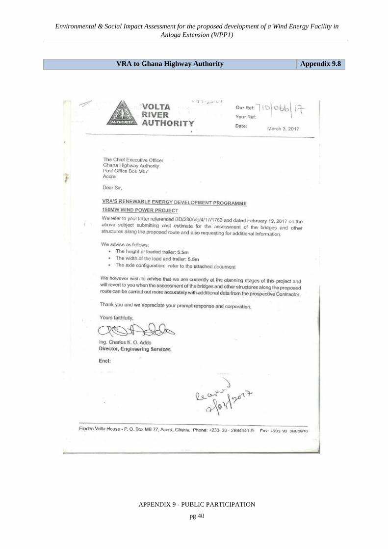
Environmental & Social Impact Assessment for the proposed development of a Wind Energy Facility in Anloga Extension (WPP1)
APPENDIX 9 - PUBLIC PARTICIPATION
pg 40
VRA to Ghana Highway Authority Appendix 9.8

Environmental & Social Impact Assessment for the proposed development of a Wind Energy Facility in Anloga Extension (WPP1)
APPENDIX 9 - PUBLIC PARTICIPATION
pg 41
Comments received during the review of the BID and the Scoping Report Appendix 9.9
Date Stakeholder Location Summaries of Main Inquiries, Proposals and Concerns
presented by Stakeholders Response
January 12, 2016
Land owners Keta Municipal Assembly
1. The landowners enquired about the distance of the buffer zones for the wind farms and how this will affect the land use in those areas. They explained that due to the limited available land, VRA should consider smaller buffer zones or an arrangement with farmers to farm in the buffer zones. They indicated that the project should be beneficial to the communities and that the project should not be unduly delayed.
The ESIA will determine the safe buffer zones for the wind farm and the Compensation Action Plan will determine any social interventions required by the project.
February 5, 2016
Klevi Clan of Anyanui
House of a Community Elder
2. They have been briefed on the project by the personnel from the VRA
No Response needed.
3. They are glad that their community has been chosen for such a project
No Response needed.
4. They want the negotiation for the acquisition of their land done quickly and the payment done promptly
This will be done after the project site has been properly demarcated and the total area clearly determined
5. They expect the other packages such as scholarships and provision other social amenities for the people
The Compensation Action Plan and the VRA’s Social Responsibility Program will adequately address this concern
6. They want workers to be recruited from the community
The Local content policy of VRA will be applicable to the project and the contractor will be required to consider locals for recruitment. The contractor will also be advised to consider this proposal from the community. However, this will be dependent on the skill set available within the community and what is required to successfully execute the project.

Environmental & Social Impact Assessment for the proposed development of a Wind Energy Facility in Anloga Extension (WPP1)
APPENDIX 9 - PUBLIC PARTICIPATION
pg 42
Date Stakeholder Location Summaries of Main Inquiries, Proposals and Concerns
presented by Stakeholders Response
7. They want workers to respect their traditions and observe festivals
These issues are being captured during the ESIA study and will be made known to the contractor for adherence. The workers and the entire team will be adequately briefed on these traditional rights and festivals.
8. They are prepared to share the compensation with the ‘Bate’ clan.
VRA is grateful for this decision
9. They will allow the project to continue while they resolve the ownership issues.
VRA is grateful for this decision and would be most obliged if the process is facilitated
February 5, 2016
Community heads of Wededeanu (Anyanui)
Fetish Priest’s House 1. They are happy that their community has been chosen No Response needed.
2. They will want adequate compensation for their farm lands and crop
Property evaluation will be done and payment effected in line with requirements of the Lands Commission.
3. They are concerned that the presence of the project will affect their health and reduce the level of rain they receive.
Associated impacts like noise and shadow flicker are being investigated and the siting of the turbines will be done in order to mitigate these. Meanwhile, there is no evidence that the presence of the proposed wind power project will affect the level of rain receive in that community.
4. They should be considered in the recruitment especially as securities, masons etc.
This will be dependent on the skill set available within the community and what is required to successfully execute the project. Meanwhile, the Local content policy of VRA will be applicable to the project and the contractor will be required to consider locals for recruitment
February 5, 2016
Community heads of Tunu (Anyanui)
Community Meeting Place
1. The community heads are not aware of the project development and what it entails.
Details of the project was explained to them
2. If land is to be acquired, VRA should endeavour to pay adequate compensation for loss of farm lands and crops.
Development of the Compensation Action Plan will adequately address this concern

Environmental & Social Impact Assessment for the proposed development of a Wind Energy Facility in Anloga Extension (WPP1)
APPENDIX 9 - PUBLIC PARTICIPATION
pg 43
Date Stakeholder Location Summaries of Main Inquiries, Proposals and Concerns
presented by Stakeholders Response
3. The issue of local content be considered critically and local labour should be considered during recruitment.
The Local content policy of VRA will be applicable to the project and the contractor will be required to consider locals for recruitment. The contractor will also be advised to consider this proposal from the community. However, this will be dependent on the skill set available within the community and what is required to successfully execute the project.
4. VRA should endeavor to provide other packages such as scholarships and provision other social amenities for the people
The community will benefit from the VRA’s Community Development programme which provides among others, educational scholarships to needy students in project impacted communities.
February 7, 2016
Barteh Clan of Anyanui
Chief’s House 1. They believe they are the true owners of the land as a result they are not happy that the Klevi clan has been consulted for the release of the land for the project instead of the Barteh Clan.
VRA requested them to resolve the land ownership issues with the Klevi Clan so that compensation would be paid to the rightful owner. Meanwhile, it is only when the rightful is determined that any money can be issued, thus, any delay in resolving the land ownership will also result in compensation payment delays.
2. They were however, happy that their area is being considered for the siting of the project.
VRA is grateful for this decision
3. They will allow the project to continue while they resolve the land ownership issues.
VRA is grateful for this decision and would be most obliged if the process is facilitated
February 7, 2016
Traditional Heads of Anloga
House of the Clan Head
1. They have been briefed on the project by the personnel from the VRA and have been promised an advance payment of 30% for lands to be acquired.
Any initial part payment to be made will be dependent on the completion of the land acquisition process which is currently being firmed up with the help of the Lands Commission.
2. VRA should endeavor to provide other packages such as scholarships and provision other social amenities for the people.
The community will benefit from the VRA’s Community Development programme which provides among others, educational scholarships to needy students in project impacted

Environmental & Social Impact Assessment for the proposed development of a Wind Energy Facility in Anloga Extension (WPP1)
APPENDIX 9 - PUBLIC PARTICIPATION
pg 44
Date Stakeholder Location Summaries of Main Inquiries, Proposals and Concerns
presented by Stakeholders Response
communities.
3. The issue of local content be considered critically and local labour should be considered during recruitment.
The Local content policy of VRA will be applicable to the project and the contractor will be required to consider locals for recruitment. The contractor will also be advised to consider this proposal from the community. However, this will be dependent on the skill set available within the community and what is required to successfully execute the project.
4. Construction workers should endeavor to respect traditions and observe festivals.
These issues are being captured during the ESIA study and will be made known to the contractor for adherence. The workers and the entire team will be adequately briefed on these traditional rights and festivals.
February 9, 2016
Keta Municipal Assembly
Office of Municipal Coordinating Director
1. Government was glad the power project is being brought to the country as it will augment power production in the country and that VRA has made the Keta Municipality aware of the wind power project since 2014
No Response needed.
2. A forum was organized for land owners sometime in January 2016 and concerns raised at the forum is that the project implementation seems to delay and this is causing anxiety amongst the affected landowners
Projects development in the power sector is quite laborious and requires a number of studies to come to a final decision on exactly what is to be done. It is therefore important that land owners and the municipality in general exercise some patience since a project of such magnitude requires several processes including the Wind Measurement and ESIA before actual construction.

Environmental & Social Impact Assessment for the proposed development of a Wind Energy Facility in Anloga Extension (WPP1)
APPENDIX 9 - PUBLIC PARTICIPATION
pg 45
Date Stakeholder Location Summaries of Main Inquiries, Proposals and Concerns
presented by Stakeholders Response
3. As a Municipality, we are happy of this intention by the client/proponent and we are willing and ready to provide all the necessary support towards this project from our end.
VRA is grateful for this decision
4. A key issue in our District is the acquisition of land and land ownership matters. We request this is taken into key considerations before the actual project development commences.
VRA recognises that compensation issues are key to the success of the project. To facilitate compensation payments, Land owners are urged to have a proper land title document to their property. VRA will also conduct further checks to determine the true owners of the land before compensations are paid.
5. We request the client engage the assembly men to identify key hotspots for consideration in the project development. Also, there should be that corporate social responsibility effort from the client during the project development towards the affected communities.
It is planned to engage the assembly members specifically to serve as contact person for any grievances that will arise. The community will benefit from the VRA’s Community Development programme which provides among others, educational scholarships to needy students in project impacted communities.
6. Data on district is available in the Medium Term Development Plan and would be made available to SCL for use in the ESIA.
VRA is grateful for this decision
7. VRA should also look at its impact on previous projects like the Akosombo hydropower which has resulted in sea erosion and the formation of sand bars of over 4-6m high along the shore at Keta.
This issue is well noted and there will be a flood risk assessment as well as wetland assessment to determine mitigative measures to be implemented during construction and operation of the project.
February 9, 2016
Keta Municipal Health Directorate
Office of Municipal Public Health Nurse
1. Accidents, robbery and baby delivery mostly happen during the nights, thus generation of electricity is very important to the health service.
No Response needed.

Environmental & Social Impact Assessment for the proposed development of a Wind Energy Facility in Anloga Extension (WPP1)
APPENDIX 9 - PUBLIC PARTICIPATION
pg 46
Date Stakeholder Location Summaries of Main Inquiries, Proposals and Concerns
presented by Stakeholders Response
2. Its good VRA is looking at alternative sources of power to supplement current supply as inadequate power supply is affecting health delivery in the district especially for storage of drugs.
No Response needed.
3. They however haven’t heard of the project and would be grateful if detail information so they can make informed input
Background information document on the project was made available to them at the meeting. This document contains all issues there is to the project
4. Data on district health is available and would be made available to SCL for use in the ESIA
VRA is grateful for this decision
February 9, 2016
Keta Municipal Education Directorate
Office of Public Relations Officer
1. They haven’t heard of the project and would be grateful if detail information so they can make informed input.
Background information document on the project was made available to them at the meeting. This document contains all issues there is to the project
2. Data on district education is available and would be made available to SCL for use in the ESIA
VRA is grateful for this decision
February 9, 2016
Traditional Heads of Srogbe
Compound of House of Stool Father
1. They have been briefed on the project by the personnel from the VRA.
No Response needed.
2. They are glad that their community has been chosen for such a project
No Response needed.
3. They want the negotiation for the acquisition of their land done quickly and the payment done promptly.
This will be done after the project site has been properly demarcated and the total area clearly determined. VRA recognises that compensation issues are key to the success of the project. To facilitate compensation payments, Land owners are urged to have a proper land title document to their property. VRA will also conduct further checks to determine the true owners of the land before compensations are paid.

Environmental & Social Impact Assessment for the proposed development of a Wind Energy Facility in Anloga Extension (WPP1)
APPENDIX 9 - PUBLIC PARTICIPATION
pg 47
Date Stakeholder Location Summaries of Main Inquiries, Proposals and Concerns
presented by Stakeholders Response
4. They expect the other packages such as scholarships and provision other social amenities like schools, improvement in the road network for the people
The community will benefit from the VRA’s Community Development programme which provides among others, support for educational activities including scholarships, community infrastructure, health, environmental management, among others in project impacted communities.
5. They want workers to be recruited from the community
The Local content policy of VRA will be applicable to the project and the contractor will be required to consider locals for recruitment. The contractor will also be advised to consider this proposal from the community. However, this will be dependent on the skill set available within the community and what is required to successfully execute the project.
6. They want workers to respect their traditions and observe festivals
These issues are being captured during the ESIA study and will be made known to the contractor for adherence. The workers and the entire team will be adequately briefed on these traditional rights and festivals.
February 9, 2016
Community heads of Gblife Community
(Anyanui)
House of Acting Chief
1. They are not aware of the project and what it entails Background information document on the project was made available to them at the meeting. This document contains all issues there is to the project
2. They will want adequate compensation for their farm lands and crop
This will be done after the project site has been properly demarcated and the total area clearly determined. VRA recognises that compensation issues are key to the success of the project. To facilitate compensation payments, Land owners are urged to have a proper land title document to their property. VRA will also conduct further

Environmental & Social Impact Assessment for the proposed development of a Wind Energy Facility in Anloga Extension (WPP1)
APPENDIX 9 - PUBLIC PARTICIPATION
pg 48
Date Stakeholder Location Summaries of Main Inquiries, Proposals and Concerns
presented by Stakeholders Response
checks to determine the true owners of the land before compensations are paid.
3. They are concern that the presence of the project will affect their health
Associated impacts like noise and shadow flicker are being investigated and the siting of the turbines will be done in order to mitigate these.
4. They should be considered in the recruitment especially as securities, masons etc.
The Local content policy of VRA will be applicable to the project and the contractor will be required to consider locals for recruitment. The contractor will also be advised to consider this proposal from the community. However, this will be dependent on the skill set available within the community and what is required to successfully execute the project
5. They expect the other packages such as scholarships and provision other social amenities for the people
The community will benefit from the VRA’s Community Development programme which provides among others, support for educational activities including scholarships, community infrastructure, health, environmental management, among others in project impacted communities.
April 13, 2016
State Agencies within Keta Municipality
Office of the Municipal
Coordinating Director
1. What are the impacts on the local people with respect to resettlements?
An area of approximately 177.46 ha of land is required and would be acquired for the projects. This will result in loss of livelihood for land owners and farmers who utilise the land for agricultural and other socio-economic activities. These lands will be valued and compensation paid for. A Compensation Action Plan will be developed to adequately address this concern.

Environmental & Social Impact Assessment for the proposed development of a Wind Energy Facility in Anloga Extension (WPP1)
APPENDIX 9 - PUBLIC PARTICIPATION
pg 49
Date Stakeholder Location Summaries of Main Inquiries, Proposals and Concerns
presented by Stakeholders Response
2. What will be the impact on power generations when the estimated wind speed reduces during project operations?
The project is expected to add on to the net power generated in the country. As with very other source of power, its ability to generate electricity will be affected by one factor or the other. VRA is developing a portfolio of power plants to ensure that there is back up in the event that any is affected.
3. Compensation issues are very critical to the local people thus, the project should ensure adequate and prompt compensation.
Property evaluation will be done and payment effected in line with requirements of the Lands Commission.
4. The development on the Akosombo Dam has negatively affected the socio-economic life of the people of Keta, and therefore how assured are they that this current project will not impact same?
The level of impact associated with hydro power is very different from that of the wind power. VRA is undertaken a socio-economic study of the project and all issues regarding this will be assessed and relevant mitigative measures provided and implemented.
5. Can VRA help farmers who pump underground water for their crops have reduced electricity tariffs?
This will require an advocacy effort and farmer groups should lead the discussion with the Municipal Assembly
6. Will the cost of wind power generated be very different from that of hydro and thermal power?
Each source of power has its own cost. Wind power is far more expensive that thermal which is also more expensive than hydro. However, PURC will consolidate the various costs within the energy mix and charge one fee to customers.
7. Cant VRA provide solar energy in the communities? VRA is mandated to supply bulk power and therefore does not undertake home connection. However, Energy Commission is now involved in the promotion of home solar panels and should be contacted on such issues.
8. VRA should endeavour to adhere to all fire requirements associated with the project development
The project will require a Fire permit, thus, VRA will formally notify the GNFRS of the project development to enable them inspect and advise on fire requirements.

Environmental & Social Impact Assessment for the proposed development of a Wind Energy Facility in Anloga Extension (WPP1)
APPENDIX 9 - PUBLIC PARTICIPATION
pg 50
Date Stakeholder Location Summaries of Main Inquiries, Proposals and Concerns
presented by Stakeholders Response
9. How will the project mitigate the impact on birds, as the project is located close to the Keta Lagoon Complex Ramsar site, which is known to harbour significant number of birds?
A birds study is underway to assess the impacts on birds and provide mitigative measures as required.
10. Has VRA considered boosting the tourism potential to be realised from the development of the project?
This will be the role of the Keta Municipal assembly and therefor there is the need to start considering its impact in the Municipal developmental agenda.
11. Information sharing should be a key part of the project so that the Keta Municipal will be apprised with project development issues.
This is a key part of the project to ensure success and VRA will at every step make the affected assembly aware of project status and challenges

Environmental & Social Impact Assessment for the proposed development of a Wind Energy Facility in Anloga Extension (WPP1)
APPENDIX 9 - PUBLIC PARTICIPATION
pg 51
Correspondences between VRA and Ministry of Lands and Natural resources
Appendix 9.10

Environmental & Social Impact Assessment for the proposed development of a Wind Energy Facility in Anloga Extension (WPP1)
APPENDIX 9 - PUBLIC PARTICIPATION
pg 52

Environmental & Social Impact Assessment for the proposed development of a Wind Energy Facility in Anloga Extension (WPP1)
APPENDIX 9 - PUBLIC PARTICIPATION
pg 53
Correspondences between VRA and Land Owners Appendix 9.11

Environmental & Social Impact Assessment for the proposed development of a Wind Energy Facility in Anloga Extension (WPP1)
APPENDIX 9 - PUBLIC PARTICIPATION
pg 54

Environmental & Social Impact Assessment for the proposed development of a Wind Energy Facility in Anloga Extension (WPP1)
APPENDIX 9 - PUBLIC PARTICIPATION
pg 55

Environmental & Social Impact Assessment for the proposed development of a Wind Energy Facility in Anloga Extension (WPP1)
APPENDIX 9 - PUBLIC PARTICIPATION
pg 56
SCL Invitation letters to State Agencies Appendix 9.12

Environmental & Social Impact Assessment for the proposed development of a Wind Energy Facility in Anloga Extension (WPP1)
APPENDIX 9 - PUBLIC PARTICIPATION
pg 57

Environmental & Social Impact Assessment for the proposed development of a Wind Energy Facility in Anloga Extension (WPP1)
APPENDIX 9 - PUBLIC PARTICIPATION
pg 58

Environmental & Social Impact Assessment for the proposed development of a Wind Energy Facility in Anloga Extension (WPP1)
APPENDIX 9 - PUBLIC PARTICIPATION
pg 59
![Complexitat i fenomen (socio)lingüístic [Complexity and (socio)linguistic phenomenon]](https://static.fdokumen.com/doc/165x107/63130623c32ab5e46f0c3b37/complexitat-i-fenomen-sociolingueistic-complexity-and-sociolinguistic-phenomenon.jpg)