Central Planning Authority
129
1 Central Planning Authority Minutes for a meeting of the Central Planning Authority held on February 5, 2014 at 10:00 a.m. in the Conference Room, 1 st Floor, Government Administration Building, Elgin Avenue. 4 th Meeting of the Year CPA/04/14 Mr. A. L. Thompson (Chairman) (apologies) Mr. Robert Watler Jr. (Deputy Chairman) (except 2.3) Mr. Edgar Ashton Bodden (absent) Mr. S. T. (Tommie) Bodden (apologies) Mr. Dalkeith Bothwell (Acting Chairman 2.3) Mr. Joseph Coe Mr. Ray Hydes Mr. Trent McCoy Mr. Rex Miller Mr. Eldon Rankin (except 2.6) Mr. Selvin Richardson Ms. Sharon Roulstone Mr. Fred Whittaker (except 2.1) (left at 12:45) Mr. Haroon Pandohie (Executive Secretary) Mr. Ron Sanderson (Assistant Director of Planning (CP)) 1. Confirmation of Minutes 2. Applications 3. Enforcements 4. Development Plan Matters 5. Planning Appeal Matters 6. Matters from the Director of Planning 7. CPA Members Information/Discussions
-
Upload
khangminh22 -
Category
Documents
-
view
4 -
download
0
Transcript of Central Planning Authority

1
Central Planning Authority
Minutes for a meeting of the Central Planning Authority held on February 5, 2014 at 10:00 a.m. in the Conference Room, 1st Floor, Government Administration Building, Elgin Avenue.
4th Meeting of the Year CPA/04/14
Mr. A. L. Thompson (Chairman) (apologies)
Mr. Robert Watler Jr. (Deputy Chairman) (except 2.3)
Mr. Edgar Ashton Bodden (absent)
Mr. S. T. (Tommie) Bodden (apologies)
Mr. Dalkeith Bothwell (Acting Chairman 2.3)
Mr. Joseph Coe
Mr. Ray Hydes
Mr. Trent McCoy
Mr. Rex Miller
Mr. Eldon Rankin (except 2.6)
Mr. Selvin Richardson
Ms. Sharon Roulstone
Mr. Fred Whittaker (except 2.1) (left at 12:45)
Mr. Haroon Pandohie (Executive Secretary)
Mr. Ron Sanderson (Assistant Director of Planning (CP))
1. Confirmation of Minutes 2. Applications 3. Enforcements 4. Development Plan Matters 5. Planning Appeal Matters 6. Matters from the Director of Planning 7. CPA Members Information/Discussions

2
List of Applications Presented at CPA/04/14
1. 1 Confirmation of Minutes of CPA/02/14 held on January 22, 2014. .................... 4
1. 2 Confirmation of Minutes of CPA/03/14 held January 23, 2014. ......................... 4
2. 1 CI SPORT SHOOTING ASSOCIATION Block 67A Parcel 25 Rem 1 (FA89-0332) (P13-0496) ($1.45 million) (DE) .................................................................. 5
2. 2 COPPERBELT LTD. Block 22E Parcel 423 (F13-0276) (P13-1076) ($3,000) (KA) ...................................................................................................................... 21
2. 3 AL KEBAB/GYRO HUT LTD. Block 23B Parcel 97 (F13-0246) (P13-0985) (P14-0062) ($5,000) (KA) .................................................................................... 22
2. 4 THE WESTIN GRAND CAYMAN Block 11D Parcel 45 (FA94-0233) (P13-1022) ($11,350) (DE) ............................................................................................ 25
2. 5 LOOKOUT HOLDINGS LTD. Block 43E Parcel 157 (F13-0253) (P13-1015) (P08-1431) ($12,174) (CS) ................................................................................... 27
2. 6 BRIGHT START LEARNING Block 13B Parcel 154 (FA82-0056) (P13-1078) ($800) (KA) .......................................................................................................... 31
2. 7 LUIS & LEATHA MOREJON Block 24E Parcel 393 (FA93-0249) (P12-1076) (P13-0980) ($185,938) (DE) ................................................................................. 35
2. 8 BOB WHITE Block 17A Parcel 93 (F13-0237) (P13-0950) (P13-0951) ($750,000) (KA) ................................................................................................... 37
3. 1 DWEAINY WILSON Block 13D Parcel 310 (CE14-0005) (CM/JM) ............... 39
4. 1 EMBASSY INVESTMENTS LTD. Block 12C Parcel 154, Block 12D Parcels 24 and 79 Rem 1, Block 12E Parcels 89 and 104 (RZ13-0002) (HP) ....................... 40
4. 2 CAYHESSE CHARITABLE FOUNDATION LTD. Block 11B Parcel 56 Rem 3 (RZ13-0003) (HP) .............................................................................................. 45
6. 1 AUTHORIZATION TO ENTER UPON LANDS PER SECTION 39 OF LAW
................................................................................................................................ 48
6. 2 SOLAR PANEL FARM Block 43A Parcel 346 ................................................. 49
6. 3 COASTAL WORKS LICENSE APPLICATION (PAL Development Ltd.) Block 11D Parcel 33(nn) ...................................................................................... 49
6. 4 PRENTICE PANTON Block 57E Parcel 118 (CE14-0006) (JM) ..................... 49
6. 5 PRENTICE PANTON Block 23C Parcel 25 (CE14-0007) (JM) ....................... 50
6. 6 NORMAN DIXON Block 22E Parcel 84 (CE14-0008) (CM) ............................ 50
6. 7 ROBERT O. THOMPSON Block 20B Parcel 82 (CM/JM) .............................. 50
6. 8 NORTHWARD PRISON (HP) .......................................................................... 50

3
6. 9 COX LUMBER BODDEN TOWN (HP) ........................................................... 50

4
APPLICANTS THAT APPEARED BEFORE THE CENTRAL PLANNING AUTHORITY
APPLICANT NAME TIME ITEM PAGE
C.I. Sport Shooting Assoc. (DE)
10:30 2.1 5
Copperbelt Ltd. (KA) 10:50 2.2 21
Al Kabob/Gyro Hut Ltd. (KA) 11:10 2.3 22
The Westin Grand Cayman (DE)
11:30 2.4 25
1.0 CONFIRMATION OF MINUTES
1. 1 Confirmation of Minutes of CPA/02/14 held on January 22, 2014.
Moved: Dalkeith Bothwell
Seconded: Eldon Rankin
Confirmed
1. 2 Confirmation of Minutes of CPA/03/14 held January 23, 2014.
Moved: Rex Miller
Seconded: Selvin Richardson
Confirmed
5
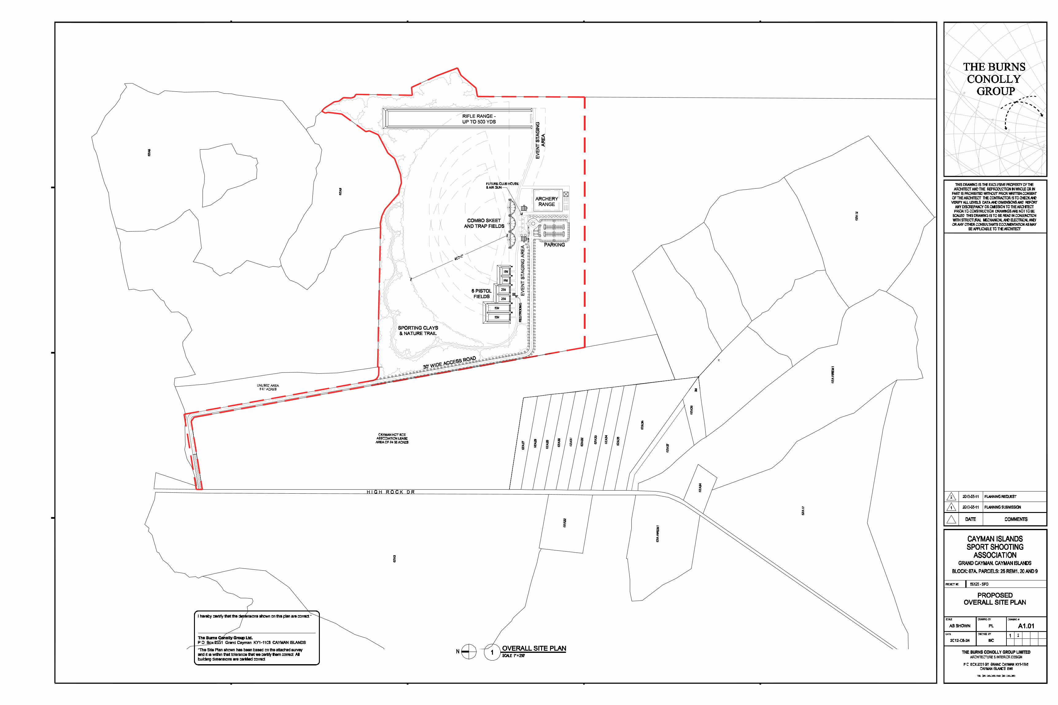
2. 1 CI SPORT SHOOTING ASSOCIATION Block 67A Parcel 25 Rem 1 (FA89-0332) (P13-0496) ($1.45 million) (DE)
Application for a commercial/recreational sport shooting facility.
Appearance at 10:30
Fred Whittaker declared a conflict and left the meeting room.
FACTS
Location Off High Rock Road, East End
Zoning A/R
Notice Requirements Objectors
Parcel Size 230 acres
Current Use Quarry
Proposed Use Sport Shooting Facilities
Building Size 8,612.27 sq. ft.
Building Coverage 0.06406%
Proposed Parking 106
BACKGROUND
October 2, 2013 (CPA/21/13; Item 2.2) - It was resolved to adjourn the application, for the following reason:
1) The Authority requires comments from the Water Authority and the Department of Agriculture regarding the potential for the lead from gun ammunition to contaminate the ground water resources in the area of the proposed shooting facility.
Decision: It was resolved to adjourn the application, for the following reason:
1. In accordance with a sampling plan established in consultation with the Water Authority, the applicant shall carry out sampling to establish background levels of lead, antimony, arsenic and pH found in soil and ground water at the site. The results of the sampling plan shall be submitted to the Central Planning Authority.
AGENCY COMMENTS
Comments from the Department of Environment, Water Authority, National Roads Authority and Chief Environmental Health Officer are noted below.
2.0 APPLICATIONS
APPEARANCES (Items 2. 1 TO 2. 4)
6
Department of Environment
“The Department’s Technical Review Committee has reviewed the proposed application and offers the following comments and recommendations:
BACKGROUND
The subject parcel is located off High Rock Road, East End as shown in Figure 1. The Department’s Habitat Map classifies this parcel mainly as ‘Dry Shrubland and Dry Forest and Woodland’ with areas of ‘Semi-permanent Flooded Grasslands’ and ‘Man-Modified’ as shown in Figure 2. The presence of man-modified land along the northern boundary of the application site (see Figure 2) is a result of historic quarrying activity that had illegally encroached into Crown-owned land.
Figure 1: Boundary of Application Site (Source: LIS, 2008)
Figure 2: Showing Site Habitat with Proposed Commercial Sport Shooting Buildings and Range Site Plan Overlay (Source: DoE 2010 Habitat Map and Site Plan Submitted 21 June 2013)
Dry shrubland and dry forest and woodlands support significant and unique biodiversity and are key habitats for terrestrial biodiversity in the Cayman Islands. These habitats host several endemic plants and trees which are unique to each of these habitats. In Cayman’s dry shrubland, for example, Scolosanthus roulstonii is a species unique to Grand Cayman and is almost exclusively found in the xerophytic shrublands of the east interior of the island and is classified as an endangered species (Burton, F.J., 2008). In the dry forest and woodland, the Red Birch Bursera simaruba, and the Cabbage Tree Guipure discolor are usually dominant species.
The main canopy, emergents and understorey give the dry forest and woodlands its complex structure offering a wide range of habitats for fauna as species in the dry forest and woodland occur at a wide range of abundances i.e. some species being extremely sparsely distributed throughout the habitat. The open canopy of dry shrubland and the semi-permanent flooded grassland facilitates the penetration of light through the foliage which contributes to the creation of an important habitat for reptiles in particular the endemic Blue Iguana (Cyclura caymanensis), and supports a diversity of resident and migratory birds.
COMMENTS /RECOMMENDATIONS
Against the background provided, the Department offers the following comments:
• The site is predominantly pristine primary habitat therefore the Department would normally recommend that any areas of hard standing or structures are located in the previously-disturbed man-modified areas of the site. However, the applicant’s agent has advised that the layout has been influenced by the path of the sun in order to avoid the glare of the sun. The Department therefore recommends the following :
Any land clearing should be prohibited pending the applicant demonstrating that they have acquired the requisite funding to finance the
7
full development of the site as proposed. This would prevent the unnecessary premature clearance of primary habitat, possibly years in advance of any actual site development.
The site should be left vegetated until ready for construction. Only the footprint of the building and facilities amenities should be cleared maintaining as much natural vegetation as possible. Burning cleared/felled vegetation should be prohibited in favour of chipping, mulching or composting organic waste and the utilization of this recycled material on site.
• The location of the nature trail is located predominantly in the man-modified area of the site, which has been the subject of quarrying activity. Therefore the purpose of having a nature trail in this location is somewhat redundant as most of the mature vegetation and habitat of ecological significance has been cleared. The nature trail would be best located on the southern side of the application site where there is still primary vegetation.”
Water Authority #1
Please be advised that the proposed development is located over the East End Fresh Water Lens, a major water resource of the Island. The Water Authority (WA) is charged to protect this resource from contamination and depletion. WA’s requirements for this development include measures protective of this resource.
Wastewater Treatment:
The following requirements apply to the initial phase outlined on the submitted plans. The developer is advised that estimated flows for the initial phase of development slightly exceed the maximum allowed (1,800 gallons per day (GPD)) for treatment by septic tank(s). Given the limited information currently available on facility use (frequency and duration of use, number of users), requirements for the initial phase call for septic tanks with the understanding that one or more aerobic treatment units will be required to serve all flows from the development when plans for subsequent phases and user data indicate that the maximum flows for treatment by septic tank(s) will be exceeded. The existing septic tanks can then be retrofitted to serve as a pre settling and or pump tank(s) for the aerobic treatment unit(s).
• Proposed restroom block: a septic tank with a minimum capacity of 1,500 US gallons shall be provided.
• Proposed clubhouse: a grease interceptor with a minimum capacity of 600 US gallons shall be provided to pre-treat the kitchen flows from fixtures and equipment with grease-laden waste. The outlet of the grease interceptor shall be plumbed to the sanitary sewage line leading to a septic tank with a minimum capacity of 2,000 US gallons.
• The septic tanks and grease interceptor shall be constructed in strict accordance with WA standards.
8
• Septic tank effluent shall be discharged via gravity flow to an effluent disposal well. Disposal wells shall be constructed in strict accordance with the WA standards. Site-specific minimum depths for effluent well construction are as follows: 137 ft borehole; 127 feet of grouted casing.
The estimated flows are shown below. Note that septic tank capacities provide for a retention time of 36 to 48 hours. Grease interceptor capacity is based on 1 gallon per square foot of seating area; the minimum capacity is 600 US gallons.
Excavation:
Please be advised that Section 34 (1) of Water Authority Law (2011 revision) requires that anyone who undertakes the construction, replacement or alteration of a quarry is required to obtain a permit from the Authority, subject to such terms and conditions as it deems fit.
The Authority has deemed fit, in a policy approved by the Board of the Water Authority in November of 2002, to place a condition on any excavation over a fresh water lens to prohibit excavation into the groundwater table. The Water Authority will not permit this proposed excavation into the East End freshwater lens.
Water Supply:
Please be advised that connection of the proposed development to the Water Authority’s piped water supply system will require an extension. It is the policy of the Water Authority – Cayman to extend water distribution lines in public roads at no cost; extensions in non-public areas are done at the owner’s expense. The timing of any pipeline extension is at the sole discretion of the Water Authority.
• The developer is required to notify the Water Authority’s Engineering Department at 949-2387, without delay, to be advised of the timing of the extension and the site specific requirements for connection.
• In addition to guidelines for constructing potable water mains, there are specific requirements for water meter installation at developments requiring five or more meters per parcel or lot. Determination of the required layout for multiple-meter installations is at the sole discretion of the Water Authority.
Copies of the Authority’s Guidelines for Constructing Potable Water Mains (Revised August 2011) and Standard Detail Drawings of Multiple Meter Installations (April 2010) are available at the Water Authority’s office on Red Gate Road.
• The developer shall submit plans for the installation of the specified infrastructure to the Authority for approval.
• The site’s water-supply infrastructure shall be installed to the Authority’s specifications, under the Authority’s supervision.
• The developer’s request for connection to the Authority’s public water system will be acted upon after the site’s water-supply infrastructure has been

9
installed in accordance with the WAC specifications, and passed specified tests.
The Authority shall not be held responsible for delays and/or additional costs incurred by the developer due to the developer’s failure to provide sufficient notice to the Authority.”
Water Authority #2
1. “Previous Water Authority Memoranda of 2 and 4 July 2013 regarding this proposal
Please note that the revised memorandum sent 4 July 2013 omitted the section regarding excavation, based on representation by the developer’s agent that “The lakes were removed with the final Planning application.” We have not received a plan so revised through your office and therefore revert to our 2 July 2013 comments until omission of the lakes is confirmed by your office. The 2 July 2013 memo is attached.
2. Summary - Lead Contamination of Groundwater from Ammunition, Permitting per Water Authority Law to Monitor and Mitigate Impacts
The Water Authority (WA) takes this opportunity to address the issue of potential groundwater contamination from lead ammunition at the proposed shooting range. We regret that the issue was not considered in the initial review due to unfamiliarity with ammunition, and are grateful for the opportunity to correct the oversight.
WA undertook a literature search, focusing on the issue in Florida, the nearest jurisdiction with similar hydrogeology and well documented and easily accessible policy information. The literature shows that the occurrence of lead contamination of groundwater resources at shooting ranges is well documented and widespread. Lead contamination poses serious risks to public health and the environment.
Per sections 19 and 34 of the Water Authority Law (2011 Revision), all groundwater in the Cayman Islands is vested in the Crown and is controlled by the Authority in name and on behalf of the Crown. Activities, likely to affect groundwater, require a permit from the Authority.
In order to protect the groundwater at the proposed shooting range, the Water Authority requires the proponent to apply for a permit under section 34 of the Water Authority Law (2011 Revision). This permit will include conditions to ensure proper protection of the groundwater at the proposed shooting range. Conditions would include the following:
1. Use of non-toxic shot types, as listed by the U.S. Fish and Wildlife Service (U.S. Fish and Wildlife Service, 2013)
2. Development and implementation of a management plan such as that found in Appendix D of Best Management Practices for Environmental Stewardship of Shooting Ranges in Florida (Florida Department of Enviornmental Protection, 2004). The plan details appropriate design features for
10
stormwater management and for containment, recovery and recycling of spent ammunition on the pistol and rifle firing range. Reporting requirements include range logs maintained for each firing area to include date, ammunition type and rounds fired; logs to be available for inspection.
3. Baseline monitoring to be determined by the Water Authority and carried out at the expense of the developer.
4. Periodic monitoring by the developer/operator, as required by the Water Authority.
The remainder of this memorandum provides relevant background information on the review of relevant literature and data as conducted by the Water Authority.
3. Discussion and review of relevant information
Following is a brief discussion of the process, levels, impacts and mitigation of lead contamination from spent ammunition. Cited references with links are found at the end of the document.
For context, the site map was overlaid on a water resources map to show the proposed site’s location relative to the East End Freshwater Lens, a major water resource which WA is charged to protect from contamination and depletion. Reproduction of LIS data in this document, in whole or in part, by any means is prohibited without the prior permission of the Chief Surveyor, Lands and Survey Department. © Cayman Islands Government www.caymanlandinfo.ky
Process of Contamination
Generally, the lead content by weight found in shotgun pellets is 97% and in jacketed bullets is 90% (University of Florida, 2002). When spentpellets or bullets are left to weather in the shot-fall zone, the lead can dissolve and then leach through soil or fractured rock into groundwater.
The amount of lead that migrates into soil and groundwater and the distance it travels depends on several factors including:
• The amount of lead accumulated in the drop zone.
• The length of time the lead has weathered.
• The annual amount of precipitation.
• The pH of rain water, surface water, ground water, and surface and subsurface soils.
• The amount of time the source is in contact with acidic water or soil.
• Soil type and chemistry.
• Depth to ground water.
• Ground water chemistry.
(Colorado Department of Public Health and Environment, 2012).
11
A study, conducted by the University of Florida’s Department of Soil and Water on lead contamination at shooting ranges, found that conditions in Florida: sandy soils extremely low in clay and organic matter and low in pH, enhance lead weathering and leaching. In general, subtropical and tropical environments, i.e. high humidity, high temperature and high rainfall enhance lead weathering and leaching (University of Florida, 2002).
Levels of lead Contamination
In the Florida study, six public shooting ranges were sampled; the results varied significantly from site to site. Total lead concentrations in surface soils ranged from a few hundred to tens of thousands mg/kg with most exceeding US EPA’s critical level of 400 mg/kg total lead. Total and dissolved lead concentrations in the surface waters ranged from 2 to 694 µg/L with most exceeding US EPA’s drinking water standard of 15 µg/L. The potential for leaching to groundwater was assessed based on a ratio of the total lead found in soils and results from TCLP (Toxicity Characteristic Leaching Procedure) tests of the soil, assuming that the ratio of TCLP lead to total lead reflects the mobility of lead in soils. The ratios ranged from <1% to 80% indicating that 1 to 80% of the lead in the soil could be leached into groundwater (University of Florida, 2002). The results confirm that levels of contamination can be significant and are site specific based on the factors listed above.
Adverse Impacts of Lead Contamination
Once in the environment, lead can have many adverse effects on humans, animals and plants. Human exposure to lead can result in a wide range of health problems in adults, including kidney dysfunction, high blood pressure, reproductive problems, digestive problems, concentration and memory problems, neurological disorders, convulsions, coma and death. Effects on children include headaches, impaired vision and motor skills, behavior and learning problems, hearing problems, damage to brain and nervous system, and a reduced growth rate. Effects on animals due to excessive lead exposure, primarily from ingestion, include increased mortality rates. Waterfowl are particularly susceptible to lead ingestion, especially in areas where shooting occurs over or near water. Other environmental effects of elevated lead levels include plant toxicity (Colorado Department of Public Health and Environment, 2012).
It is important to note that freshwater lenses in Cayman are a limited and critical resource. The East End lens in particular is the largest of the lenses and supports the East End reservoir where trucked water can be obtained for potable and non-potable purposes. The East End Reservoir provides a critical and strategic water source in the event of a natural disaster when the availability of potable water produced at reverse osmosis plants can be reduced. The East End Lens also supports several significant agricultural uses and some direct residential use.
Mitigation of Risk of Contamination
Given the following:
• the potential for lead contamination at shooting ranges

12
• the proposed location directly over the Island’s largest, most productive freshwater lens,
• the significant risks that lead poses to public health and the environment, and
• the availability of alternative shot types
• The following mitigation and monitoring requirements would be considered:
• use of non-toxic shot types, as listed by the U.S. Fish and Wildlife Service (U.S. Fish and Wildlife Service, 2013)
• development and implementation of a management plan such as that found in Appendix D of Best Management Practices for Environmental Stewardship of Shooting Ranges in Florida (Florida Department of Environmental Protection, 2004). The plan details appropriate design features for stormwater management and for containment, recovery and recycling of spent ammunition on the pistol and rifle firing range. Reporting requirements include range logs maintained for each firing area to include date, ammunition type and rounds fired; logs to be available for inspection.
• baseline monitoring to be determined by the Water Authority and carried out at the expense of the developer
• periodic monitoring by the developer/operator, as required by the Water Authority.”
Water Authority #3
“The Water Authority has reviewed the report prepared on behalf of the proponent for the Shooting Range, regarding the potential for lead contamination.
The Water Authority does not deem it necessary to provide a detailed review/comment on the report, other than the following 3 points:
1. The review carried out by Water Authority and the developer cover the same subject and most statements in the report are not necessarily conflicting with the Water Authority’s review.
2. The limited field test results in the report for pH of soil and surface water are not adequate to support the conclusion made by the proponent/agent for the project in an article in the 11 December 2013 Caymanian Compass:
“Mr. Connolly expects the application to pass. He said the soil in Grand Cayman is alkaline rather than acidic, and there is no danger of lead dissolving into the soil and seeping into the water lens.”
In addition to a broader sampling of soil and surface water in the area, the pH of groundwater and rainwater must also be considered. As the report and literature indicates, at pH levels greater than 7.5, leaching of lead is minimal. It is important to note then, that based on long term Water Authority monitoring data, the average pH of groundwater from the East End well field
13
is 7.2 . Local data on the pH of rainwater will be needed, but according to http://www.epa.gov/acidrain/education/site_students/phscale.html :
“Normal, clean rain has a pH value of between 5.0 and 5.5, which is slightly acidic. However, when rain combines with sulfur dioxide or nitrogen oxides—produced from power plants and automobiles—the rain becomes much more acidic.”
Soil considerations, other than pH, that affect the mobility of lead include the physical characteristics and distribution of the soils. The Department of Agriculture may provide further details in their review of the issue.
3. The report states: “As the Bluff formation on which the site sits is highly permeable and receives moderate amount of rainfall compared to the rest of the island is (sic) anticipated that any dissolved and mobile lead would migrate directly through the lens and towards the ocean.” It is not clear what this statement exactly means or implies. The migration of lead through the lens will depend on a number of factors and indeed levels of lead in groundwater may increase as a result of the accumulation and weathering of lead ammunition. If the shooting range is established there is a risk of lead contamination of groundwater and this risk needs to be mitigated through the measures and permit as outlined in our memorandum of 10 December.
The Authority’s position as communicated in our memorandum of 10 December 2013 remains. A Water Authority staff member can be available for the CPA meeting when this development is discussed to provide technical guidance on the Water Authority’s position.”
National Roads Authority
“As per your memo dated June 19th, 2013 the NRA has reviewed the above-mentioned planning proposal. Please find below our comments and recommendations based on the site plan provided.
General Issues
The 30’ wide access road alignment on the adjacent development (CIHRA Racing Track- P12-1099) should correspond with this proposed development or vice versa.
Road Capacity Issues
The traffic demand to be generated by the proposed development could not be accurately assessed. However, the impact of the proposed development onto High Rock Road is considered to be minimal.
Access and Traffic Management Issues
A thirty (30) ft. wide road parcel needs to be provided in order to have adequate access as the NRA does not endorse the use of vehicular ROW because when the Roads Authority is asked to take over the private land acquisition issue will arose when the road is declared a public road pursuant to Section 5 of the Roads Law.
14
Entrance and exit curves shall have no less than fifteen (15) feet radius curves, and have a width of twenty-two (22) ft.
Two-way driveway aisles shall be a minimum of twenty-two (22) ft. wide.
A six (6) foot sidewalk shall be constructed on Access Road, within the property boundary, to NRA standards.
Tire stops (if used) shall be place in parking spaces such that the length of the parking space is not reduced below the sixteen (16) feet minimum.
Stormwater Management Issues:
The applicant is encouraged to implement state-of-the-art techniques that manage stormwater runoff within the subject parcel and retain existing drainage characteristics of the site as much as is feasible through innovative design and use of alternative construction techniques. However, it is critical that the development be designed so that post-development stormwater runoff is no worse than pre-development runoff. To that effect, the following requirements should be observed:
The applicant shall demonstrate, prior to the issuance of any Building Permits, that the Stormwater Management system is designed to embrace storm water runoff produced from a rainfall intensity of 2 inches per hour for one hour of duration and ensure that surrounding properties and/or nearby roads are not subject to stormwater runoff from the subject site.
• The stormwater management plan shall include spot levels (existing and finished levels) with details of the overall runoff scheme. Please have applicant provide this information prior to the issuance of a building permit.
• Construct a gentle ‘hump’ at the entrance/exit (along the entire width of each driveway) in order to prevent stormwater runoff from and onto Access Road. Suggested dimensions of the ‘hump’ would be a width of 6 feet and a height of 2-4 inches. Trench drains often are not desirable.
• Curbing is required for the parking areas to control stormwater runoff.
• Roof water runoff should not drain freely over the parking area or onto surrounding property. Note that unconnected downspouts are not acceptable. We recommend piped connection to catch basins or alternative stormwater detention devices. If catch basins are to be networked, please have applicant to provide locations of such wells along with details of depth and diameter prior to the issuance of any Building Permits.
At the inspection stage for obtaining a Certificate of Occupancy, the applicant shall demonstrate that the installed system will perform to the standard given. The National Roads Authority wishes to bring to the attention of the Planning Department that non-compliance with the above-noted stormwater requirements would cause a road encroachment under Section 16 (g) of The Roads (Amendment) Law, 2004 (Law 11 of 2004). For the purpose of this Law, Section 16(g) defines encroachment on a road as
15
"any artificial canal, conduit, pipe or raised structure from which any water or other liquid escapes on to any road which would not but for the existence of such canal, conduit, pipe or raised structure have done so, whether or not such canal, conduit, pipe or raised structure adjoins the said road;"
Failure in meeting these requirements will require immediate remedial measures from the applicant.”
Chief Environmental Health Officer
“The following comments are submitted with respect to the above application:
1. Insufficient information has been provided to complete an assessment of this application. One of the main questions to be answered is if this is an indoor or outdoor facility. There are no detailed plans provided for the shooting ranges.
The nature of the facility suggests that a statutory nuisance may occur as a result of its operations in contravention of the Public Health Law (2002 Revision) Part III and specifically section 7 subsections 2 (t) and 2 (w).
Several studies of firing ranges have shown that exposure to lead and noise can cause health problems. Lead exposure occurs mainly through inhalation of lead dust, skin contact with lead from bullets, or ingestion. Even in outdoor firing ranges, personal breathing zone lead levels can exceed the NIOSH recommended exposure limit and OSHA) permissible exposure limit.
1. Revised plans and specifications must be submitted showing the design considerations to applied including ventilations systems for the control of lead dust and measures to control noise pollution.
2. This application also includes a restaurant. The details provided for the proposed restaurant do meet the DEH’s minimum criteria for a restaurant. Revised plans shall be submitted showing the proposed restaurant complying with the DEH’s minimum restaurant design requirements.”
LETTER FROM APPLICANT
“We act on the behalf of our clients, Cayman Islands Sport Shooting Association.
Please find attached an application for the creation of an international class sport shooting complex in East End.
As you know the existing range near airport is on CIAA property and will be shut down to allow the eventual expansion of the airport. It is very important facility as all sport shooting in the Cayman Islands occur there.
I would like to highlight a few point of the facility:
The CISSA has received a signed lease from the Government at the new location. The Government has also been kind to allow a concession on the planning fees due to the fact that this is a non-profit organization and it is critical to the RCIPS.
The RCIPS will continue to use this range for important firearm training.
It will allow the Cayman Islands to host international class competitions adding another dimension to our tourism.
16
The location was chosen as it is remote with the relative no residence is close proximity of it. It is next to the larry quarry and its industrial activity.
Should you require any additional information please do not hesitate to call. Looking forward to a favourable response to this application.”
OBJECTIONS
Letter #1
“I write to you with regards to a Notice of Application for Planning Permission that I received recently. The applicant is Cayman Islands Sport Shooting Association c/o the Burns Connolly Group Ltd, who has applied for planning permission for the purpose of constructing a Sport Shooting Centre on Block 67A Parcel 25 Rem1, 20 and 9 near to the old quarry on High Dr.
I am the owner of the property which is within the vicinity of the abovementioned property, 67A 10 of which I am the single proprietor. I would like to take this opportunity to formally object to this requested development of the property in question.
The main reason for my objection is the reduction in value that my property will experience based on the low probability of sale of my property for future development because it is adjacent to shooting centre. I also feel that if I choose to develop the property in the future or use for collateral my property will down in worth.
if there is a possibility of the developers purchasing my lot at fair market value, to include in their development, I am open for negotiations; but under the current situation I have to object based on the reduction in value of my property if a gun range was placed next to my property.
Please advise me of the future steps that will be taken with regards to this matter. I am also contactable via telephone @ 916-3491. I look forward to resolution of this issue.”
Letter #2
“Based on the information received and further investigation of this matter, our family formally OBJECTS to this project on the basis that:
1. The development of any such facility will negatively impact the present and ALL future overall development of this area in East End;
2. The property values will be grossly affected in the immediate and extended areas;
3. There would be devastating noise pollution, not just on the immediate proposed development site but for ALL the extended properties and the current and future homes that will fall within the boundaries of East End over which the noise will travel.
4. Included in this negative impact zone are the further land subdivision and other individual upscale homes and properties that have been, and are
17
continuing to be constructed along Farm Road.
5. Once approval for this range is given, it cannot be challenged in a future court of law;
6. There is extremely little or no financial gain or contribution to be gained from such a development and finally,
7. From an investigation of the current membership of the Gun Club, there are NO MEMBERS from this East End District admitted to or associated with the general membership of this highly selective club. The organization and its members should develop such a facility in the immediate area from which its membership derives.
Ultimately, however, whether or not members are included from East End, we value the potential uses of the property for ourselves and other private land owners. We do not want a business nearby that would negatively impact the value, limit the uses, and decrease future enjoyment of the property.
Please also acknowledge when you have received this communication. Thank you.”
Letter #3
“We the above named Marvin Verneal & Elizabeth Frederick owners of Block 67A Parcel 14 do hereby object to any kind of shooting facility in this area. The reasons for this are following:
1. Our property has always and is presently being used for the rearing of cattle and as such shooting in this area can be life threatening to both our cattle and our own lives.
2. This kind of firearm use will devalue the property by making it too risky use.
3. If we in the future wish to develop this property, it will be impossible to make use of it.
In closing, we do hope that this project will be denied planning permission.”
Letter #4
“We hereby object to the proposed development of shooting facility on the above stated property.
Though supporting shooting sports, hunting and outdoor activities, there is no doubt that the continuous and substantial use of lead shot in a concentrated area will contaminate the East End water lens. As the accompanying documentation will show this has been the result of similar developments in other locations. Lead is easily accumulated in the body and cause a myriad of health problems. There is a genuine risk of lead accumulation in humans from the consumption of this water if this development is approved.
As this water is used for livestock and crop faming by some in the district for personal use, as well as the source for some of the country potable water and for emergency water supply in the event of natural disasters, it is our opinion that
18
this proposed development poses too great a risk to property owners, farmers, district residence and to the entire country in time when emergency water supplies may be needed.
Though we understand the desire of the CISSA to have a new and larger facility, it is our opinion that such facility should be located in an area where it will not contaminate a fresh water lens.
Additionally, the noise from this facility will greatly reduce the ability of our property to be enjoyed as it current is.
We therefore request that the Central Planning Authority refuse planning permission for this proposed development.”
An information package is included with the letter – see Appendix A
Letter #5
“We, the undersigning East End Farmers hereby object to the above mentioned development. It is our opinion that this proposal if granted permission, will cause lead contamination to the water lens which we depend on to water our livestock and irrigate our crops. Lead will accumulate in our crops and animals and will eventually accumulate in humans who consume the produce and meat. In addition, some residents still consume water directly from the Water Lens. The Water Authority also removes water from the water lens as part of the potable Municipal supply. the water from the water lens is a major part of emergency water supply in time of natural disaster and projects such as this that pose significant risk of contamination should not be approved.
The health risk from lead is well documented and will affect the health of over livestock and even more importantly human health. We therefore request that this proposed project not be approved.”
One of the persons that signed the letter, Annie K. Price, also submitted an information package at the CPA meeting held on October 2, 2013 (see Appendix B)
Letter #6
In regards to your application of a sports shooting center on block 67A Parcel 25 Rem 1, 20 and 9, I object on grounds of contamination of the ground water with lead the water in this is used to supply the reservoir which distribute islands wide and used for cattle and domestic use in our homes.
I am a leading cow raiser in East End and my meat goes island wide.”
PLANNING DEPARTMENT ANALYSIS
General
The application is for a commercial sports shooting facility. This site is located off High Rock Road, East End.
19
Zoning
The property is zoned Agricultural/ Residential and the proposed use is a permitted use per Regulation 21 (2011 R).
Specific Issues
a) Zoning
Regulation 21 of the Development and Planning Regulations (2011R, as amended) states that in the Agricultural/Residential zone, if the Authority is satisfied that the land is not situated over a water lens and is not particularly suited to agriculture, it may permit development which complies with the requirements for the low density residential zone. In this instance, the property is over a water lens, but is the site of the former High Rock Quarry so the issue of allowing development over the water lens would appear to have already been accepted. Also, the site is not particularly suited for agriculture. As such, the Authority could allow the proposed development if it complies with the requirements of the low density residential zone [Regulation 9(8)].
If the applicant must comply with the requirements of the low density residential zone, then the Authority must consider a couple of key points. If only the requirements 9(8) apply, then the proposed use could not be approved as it is not listed in the types of permissible uses. However, non-residential uses may be allowed in a residential zone if certain procedural requirements are satisfied. Therefore, if all of the requirements for Low Density apply, then the Authority must look at the procedural requirements as well. As such, the Authority must determine if the proposed use is commercial for the purposes of Regulation 9(3) or if it is considered “any other variation of the primary use”, in which case Regulation 9(4) would apply which requires polling. In this instance, the applicant placed two newspaper advertisements and notified adjacent land owners, which would comply with regulation 9(3). However, if Regulation 9(4) applies then they would have to poll and the application would have to be adjourned for this to occur.
If all of the provisions of the residential zones apply, then Regulation 9(5) must be considered which states that “no use of land in a residential zone shall be dangerous, obnoxious, toxic or cause offensive odours or conditions or otherwise create a nuisance or annoyance to others.” The sports shooting facility may affect water quality and will surely result in loud noises which could adversely affect the residents in the area.
SUPPLEMENTARY ANALYSIS
At the meeting of the Central Planning Authority (CPA) on October 2, 2013 (CPA/21/13: Item 2.3), it was resolved to adjourn the application for the following reason:
1. The Authority requires comments from the Water Authority and the Department of Agriculture regarding the potential for the lead from gun ammunition to contaminate the ground water resources in the area of the proposed shooting facility.

20
The Department has now received comments from both the Water Authority and Department of Agriculture regarding the potential for the lead from gun ammunition to contaminate the ground water resources in the area of the proposed shooting facility in the Cayman Islands. The Department did also receive a report from the applicant regarding their views on the potential for ground water contamination and that is included as Appendix 1 (now Appendix ‘C’). The applicant’s report was circulated to the Water Authority for review and they have provided comments regarding same contained in the Agency Comments section above.
At 10:30, Eddie McLean, Burns Conolly, Robert Marsden and Omar Grant appeared on behalf of the applicant. Rutherford McLaughlin, Romeo Frederick (on behalf of Marvin Frederick), Justin Woods and Annie K. Price appeared as objectors. There was discussion between the applicant’s representatives, the objectors and the Authority members regarding several issues including:
• Mr. Marsden summarized the report he had submitted for the applicant
• Safety features of the facility
• Potential for lead contaminating ground water and the soil characteristics of the site
In considering the application, the Authority determined that the proposed use is that of a commercial/recreation shooting club and therefore the applicable procedural requirements are those of Section 13(6) of the Development and Planning Law (2011R) and Regulation 9(3) of the Development and Planning Regulations (2013R).
The Authority noted that two appendices (A and B) that formed part of the minutes from CPA/21/13; item 2.2 were not included with the Agenda for today’s meeting. The Authority directed that the appendices be included in the minutes of today’s meeting because the members were aware of them, they form part of the application and they were available for review. The Department was reminded to ensure that all appendices be included in any future Agenda when this application is being considered by the Authority and that Appendix 1 in today’s Agenda be renamed as Appendix C.

21
2. 2 COPPERBELT LTD. Block 22E Parcel 423 (F13-0276) (P13-1076) ($3,000) (KA)
Application for a temporary freestanding sign.
An appearance was scheduled at 10:50am, but the applicant contacted the Department advising that they would be unable to attend today’s meeting.
FACTS
Location Adjacent to Grand Harbour Round-a-bout
Zoning N COM
Notice Requirements No Objectors
BACKGROUND
CPA/02/14; Item 2.18 - CPA adjourned the application for a temporary sign to invite the applicant to discuss the proposal
Decision: It was resolved to adjourn the application and re-invite the applicant to appear before the Authority to discuss concerns with the application.
PLANNING DEPARTMENT ANALYSIS
General
The applicant is requesting planning permission for a temporary free standing sign to be located on a vacant parcel near the round-a-bout by Grand Harbour. The size of the sign is as follows:
Sign: Width: 7’-0”; Length: 16’-0”; Total Height: 11’; Area: = 112 sq. ft.
It is noted that the sign would not be illuminated.
Zoning
The property is zoned Neighbourhood Commercial and the Department would offer the following specific issues addressed below.
Specific Issues
a) Sign Size
The Central Planning Authority’s Sign Guidelines states that the maximum size of free-standing signs shall be 32 sq. ft and that billboard signs are prohibited. From a planning perspective, the applicant could reduce the size of the sign to comply with the sign guidelines. The Authority is reminded that this is a temporary sign for a conference in February 20, 2014.
SUPPLEMENTARY ANALYSIS
The application was previously discussed at CPA/02/14; Item 2.18. The Authority adjourned the application to invite the applicant to discuss the size and type of
22
proposed signage.
2. 3 AL KEBAB/GYRO HUT LTD. Block 23B Parcel 97 (F13-0246) (P13-0985) (P14-0062) ($5,000) (KA)
Application for a mobile vending truck and storage container.
Appearance at 11:50
Robert Watler Jr. declared a conflict and left the meeting room. Dalkeith Bothwell sat as Acting Chairman.
FACTS
Location Corner of Shamrock Road and Selkirk Drive
Zoning N COM
Notice Requirements No Objectors
Parcel Size 0.56 acres
Proposed Use Permanent Electrical
Building Size 190 sq. ft.
BACKGROUND
CPA/02/14; Item 2.17 - CPA adjourned the application to invite the applicant to the meeting.
Decision: It was resolved to refuse planning permission, for the following reason:
1. The applicant has applied to retain the mobile food truck and storage container permanently on the site and is seeking a permanent electrical connection for the use of the site. The Authority is of the view that the permanent use of the site for these uses will not be consistent with the established character of the surrounding area which is that of permanent structures with a high degree of design reflective of the architectural traditions of the Island and a departure from this established character would unacceptably detract from the amenity of the area.
The Authority further advises that the storage container and portable toilet must be removed from the site no later than 30 days from the date of this decision.
The Authority wishes to remind the applicant of the right to appeal pursuant to section 48(1) of the Development and Planning Law (2011 Revision). Such appeal shall be made by Notice in writing, and referred to as "Notice of Appeal". It shall be signed by yourself or your attorney-at-law and filed along with the prescribed CI$50.00 filing fee, in the offices of the Chief Officer of Planning, Agriculture, Housing and Infrastructure within the fourteen (14) day period as stipulated in Section 48(1).
23
Immediately thereafter the appellant shall serve a copy of the Notice of Appeal on the Director of Planning and on all parties who may have filed objections or been heard at the hearing of the application to which the appeal relates. A copy of the Appeal Rules for the Development and Planning Law may be obtained from the Clerk of the Legislative Assembly.
AGENCY COMMENTS
Comments from the Chief Environmental Health Officer and National Roads Authority are noted below.
Chief Environmental Health Officer
“The following comments are submitted with respect to the above application:
An application was submitted to the Department of Environmental Health, for comments on Application for Permanent Electrical Power for Mobile Truck, located on Block 23B Parcel 97.
The Department cannot approve such as proposed. Note the following
The location does not provide the necessary sanitary facilities that meet the Department standards. A portable toilet is unacceptable for a food handling operations. Note that the proposed location is not one of those that were approved during the initial stage for certificate of occupancy. All locations that were approved previously had sufficient access to a proper sanitary facility.”
National Roads Authority
“As per your memo dated December 2nd, 2013 the NRA has reviewed the above-mentioned planning proposal. Please find below our comments and recommendations based on the site plan provided.
Road Capacity Issue
The impact of the proposed development onto Selkirk Drive is considered to be minimal.
Access and Traffic Management Issues
Entrance and exit curves shall have no less than fifteen (15) feet radius curves, and have a width of twenty-four (24) ft.
Two-way driveway aisles shall be a minimum of twenty-two (22) ft. wide.”
PLANNING DEPARTMENT ANALYSIS
General
The application is for a mobile vending truck and storage container. The site located on the corner of Shamrock Road and Selkirk Drive.
Zoning
The property is zoned Neighbourhood Commercial and while the proposed use is a permitted use per Regulation 13 the Department would offer comments on
24
certain specific issues addressed below.
Specific Issues
a) Suitability
The application includes a mobile vending truck, storage container, parking area, portable toilet and garbage bins. The Authority should assess if this permanent use is suitable for the site and surrounding area. Land owners within a 300’ radius were notified and newspaper ads were posted. No comments were received.
b) Parking and Marl Surface
The site plan shows twelve (12) parking spaces to be provided on the existing marl surface. Eight (8) of the parking spaces would abut Shamrock Road. The Department recommends the site layout be re-arranged to show parking along the east and north boundary only or setback a minimum of 20’ from the boundary along Shamrock Road, in accordance with Section 8(8)(c) of the Development and Planning Regulations (2013 Revision). There is currently a 2.5’ high lattice fence around the site with a rope entrance way onto Selkirk Drive. The Authority also needs to assess if parking stops are required to formalize the parking on the marl surface and if the marl surface is acceptable.
c) DEH Comments
Note the comments from DEH with regard to food safety and the use of portable toilet.
d) Other Issues
The Authority should note there is an existing 20’ container on the site. The agent states that it is used to store “equipment that will be used for a future project”. The Authority should assess the suitability of the container on the site.
SUPPLEMENTARY ANALYSIS
This application was previously discussed at CPA/02/14; Item 2.17. The CPA adjourned the application to invite the applicant in to discuss the application.
At 11:50am, Alan Silverman, Laura Silverman and Duschene Haye appeared on behalf of the applicant. The applicants and the Authority discussed several issues, including:
• the purpose of the application;
• the need for permanent power;
• the suitability of using the site permanently for this use; and
• the need for and visual appearance of the storage container and portable toilet.
25
2. 4 THE WESTIN GRAND CAYMAN Block 11D Parcel 45 (FA94-0233) (P13-1022) ($11,350) (DE)
Application for a freestanding sign.
Appearance at 12:10
FACTS
Location On West Bay Road next to the Governor’s Residence and Villas of Galleon
Zoning H/T
Notice Requirements No Objectors
Parcel Size 3.206 acres
Current Use Hotel
Proposed Use Hotel Sign
BACKGROUND
CPA/02/14; Item 2.11 - It was resolved to adjourn the application and invite the applicant to appear before the Authority to discuss concerns with the appearance and location of the proposed sign.
Decision: It was resolved to grant planning permission, subject to the following conditions:
1) The applicant shall submit a revised plan showing the sign located a minimum of two feet from the inside edge of the sidewalk.
2) Unless specifically authorized otherwise in writing by the Central Planning Authority, the Development shall be carried out strictly in accordance with the approved plans.
PLANNING DEPARTMENT ANALYSIS
General
The application is for a double-sided freestanding directional sign (4’ wide by 9’ high) on the road frontage of the subject parcel where the existing landscaping area exists. This site is located on West Bay road next to the Governor’s Residence and Villas of Galleon.
Zoning
The property is zoned Hotel/Tourism and while the proposed use is a permitted use per Section 10 of the Development and Planning Regulations (2013 Revisions), the Department would offer comments on certain specific issues addressed below.
26
Specific Issues
a) Sign
The sign is proposed to be made of aluminium skin frame and routed to black with plexi and panels and poles covers (as shown on the plans).
The proposed sign will be setback behind the existing sidewalk which is approximately 10’ from West Bay Road. The Department is of the opinion that the proposed sign will be a visible distraction to motorists coming out of the existing south entrance and exit driveway of the Westin Hotel.
The Department recommends that the applicant relocate the proposed sign to a suitable location or further behind or in line with the existing landscaping plants or trees. Also, the Department recommends that the applicant remove all existing signs within the existing landscaping area and/or add to the proposed freestanding sign.
SUPPLEMENTARY ANALYSIS
The Department met with the applicant’s agent onsite and appointed out all the signs to be removed from the existing landscaping and suitable location to place these sign. The Department also pointed out a possible location for the proposed sign to be placed on the ridge of the existing landscaping approximately 11’ from the edge of the West Bay Road as shown in the new picture plan submitted on January 28, 2014. This proposed location is visible to pedestrian and vehicle traffic exiting out of the Westin Hotel.
At 12:10pm, Chris Onwubugh Galbreith appeared on behalf of the applicant.
There was a general discussion between Mr. Galbreith and the members pertaining to the purpose of the sign and its location. There was agreement that the sign could be moved two feet from the sidewalk.
27
2. 5 LOOKOUT HOLDINGS LTD. Block 43E Parcel 157 (F13-0253) (P13-1015) (P08-1431) ($12,174) (CS)
Application for an eighteen (18) lot subdivision.
FACTS
Location Lookout Road, Bodden Town
Zoning LDR
Notice Requirements No Objectors
Parcel Size 5.69 acres
Current Use Vacant
Proposed Use Subdivision
Density 3.2
Allowable Density 4
Number of Units 18
Decision: It was resolved to grant planning permission, subject to the following conditions:
1) Prior to the commencement of any site works such as filling, grading and road construction (with the exception of minor land clearing needed to establish site levels for the preparation of a stormwater management plan), the applicant shall submit:
a) Specifications of any proposed underground utilities; including location, type of utilities, and trench dimensions.
b) A stormwater management plan prepared in accordance with the requirements of the Managing Director, NRA and approved by the Central Planning Authority. The plan shall be designed to embrace storm water runoff produced from a rainfall intensity of 2 inches per hour for one hour of duration and should include, but not be limited to, the location of all drainage facilities and general grading details of the parcels (roads included). In general, the entire site shall be graded in such a manner that stormwater runoff is no more than that which occurred during predevelopment conditions along private boundaries with any excess runoff directed to one central drainage facility or a series of facilities. The plan shall include proposed lot grading in order to facilitate the implementation of condition 2) b) below. Additionally, if the plan includes drainage swales then cross-sections of the swales must be provided.
2.0 APPLICATIONS
REGULAR AGENDA (Items 2. 5 TO 2. 8)
28
2) Prior to the subdivision plan being finalized, the following conditions shall be satisfied:
a) All underground utilities shall be inspected and approved by the relevant agencies prior to the utilities being buried.
b) The property shall be filled in such a manner as to ensure that the subdivision road and a reasonable building envelope for each lot are filled to 4 feet above mean sea level, with the remaining subdivision land being filled and/or graded to a level that will assist in the drainage of the subdivision per the stormwater management plan required in condition 1) c) above. After filling the site, the applicant shall submit a plan prepared by a registered land surveyor indicating spot heights at regular intervals, including the finished grade of constructed access road (s), if any.
c) The approved stormwater management system shall be installed on site.
d) The final subdivision plan shall indicate a vehicular easement over the subdivision access road in favour of each lot. The final plan must be accompanied with the requisite grant of easement forms detailing the easements to be registered.
e) The access road (s) abutting the proposed lots shall have a minimum of a 30' wide demarcated road parcel and shall be constructed with asphalt and approved by the Central Planning Authority prior to the lots being registered. The applicant shall liaise with the Managing Director, National Roads Authority (NRA), at predetermined stages of road construction to ensure compliance with the requisite standards. Failure to do so may render the project unacceptable. Please be advised that the road base shall be constructed to National Roads Authority (NRA) minimum design and construction specifications for subdivision roads. The NRA shall inspect and certify road base construction prior to road surfacing activities.
f) The applicant shall provide water infrastructure for the entire sub-division. The applicant shall submit plans for the water supply system for approval by the Water Authority. The water supply system shall be installed to the Water Authority’s specifications, under the Water Authority’s supervision. Copies of these specifications are available at the Water Authority’s office on Red Gate Road.
g) The applicant shall request to have the sub-division connected to the Water Authority’s public water system. This request will be acted upon after the pipelines on the sub-division have been installed in accordance with the WAC specifications and have passed all specified tests.
h) The surveyor's final drawing shall include the surveyed dimensions of all lots and shall be submitted to the Director of Planning for approval prior to the survey being registered.
29
AGENCY COMMENTS
Comments from the Water Authority and National Roads Authority are noted below.
Water Authority
Please be advised that the Water Authority’s requirements for this development are as follows:
Water Supply:
The proposed development site is located within the Water Authority’s piped water supply area.
• The developer shall contact Water Authority’s Engineering Services Department at 949-2837, without delay, to be advised of the site-specific requirements for connection to the public water supply.
• The developer shall submit plans for the water supply infrastructure for the development to the Water Authority for review and approval.
• The developer shall install the water supply infrastructure within the site, in strict compliance with the approved plans and the Water Authority’s Guidelines for Constructing Potable Water Mains and under the Water Authority’s supervision.
The Authority shall not be held responsible for delays and/or additional costs incurred by the developer due to the developer’s failure to provide sufficient notice to the Authority.
Wastewater Treatment:
• Please be advised that wastewater treatment and disposal requirements for built development are subject to review by the Water Authority.”
National Roads Authority
“As per your memo dated December 2nd, 2013 the NRA has reviewed the above-mentioned planning proposal. Please find below our comments and recommendations based on the site plan provided.
Access Road Junctions
Please note below NRA’s requirement per access road junctions. Intersections shall not be diametrically opposed and shall be offset by a minimum of two hundred (200) feet, in the case of this subdivision access onto Lookout Road would be preferable or offset by 100ft.
DESIGN AND CONSTRUCTION SPECIFICATIONS FOR SUBDIVISION ROADS & PROPERTY DEVELOPMENT
4.6.6 ACCESS ROAD JUNCTIONS:
a) Access road junctions within the subdivision shall be offset by a minimum of two hundred feet (200’) and;
30
b) intersections shall not be diametrically opposed
Stormwater Management Issues
A comprehensive drainage plan needs to be provided by the applicant for the entire project.
The applicant shall demonstrate that the Stormwater Management system can be designed to include storm water runoff produced from a rainfall intensity of 2 inches per hour for one hour of duration and ensure that surrounding properties that are lower, and nearby public roadways are not subject to stormwater runoff from this site.
The applicant is encouraged to consider stormwater management techniques other than deep wells, and to contact the NRA for advice on these alternative control measures.
Infrastructure Issues
Phase 1 Lookout Gardens - It is noted that the CPA has released Abbotsford Drive, which is part of Phase 1 of the parent subdivision that failed its initial road inspection in 2011. The NRA/government will not take responsibility for any future upkeep required for this road.
The subdivision's road base shall be constructed to NRA minimum design and construction specifications for subdivision roads - this includes elevations, minimum longitudinal slopes and minimum cross fall of minus 2 percent from the centre line to the shoulder.
All internal roadway curves (horizontal alignment) shall be no less than 46 feet centreline radius. This requirement ensures that the minimum vehicle sweeps for a standard garbage and/or fire truck can be accommodated by the site layout.
The roadway shall be HMA. The NRA shall inspect and certify the road base construction prior to HMA surfacing activities.
The NRA advises the CPA to require the developer to provide for signage (stop signs, etc.), street lighting and any other traffic calming measures on the proposed roads of the subdivision. Once the roadway has been taken over as a public road, the NRA can then assume that responsibility.”
PLANNING DEPARTMENT ANALYSIS
General
The applicant is requesting planning permission for an eighteen (18) lot subdivision.
Zoning
The site is zoned Low Density Residential. The proposed development is allowed in the zone; however, the Department wishes to discuss the following concerns.
31
Specific Issues
a) NRA Comments
The Department strongly disagrees with comments of NRA regarding the location of the access onto Lookout Rd. The Department is of the view that NRA’s recommendation will introduce traffic movement problems, not prevent them. The Department supports the subdivision layout as designed.
b) Existing Vehicular Easement
There is a 30’ vehicular easement that runs along the eastern edge of the site and the Lookout Holdings master subdivision. It appears that this easement is redundant as the Lookout Holdings development has accommodated access to 43A 409 Rem1 through its subdivision roads. Therefore the Department recommends the easement be expunged.
c) LPP
The applicant is not proposing to provide any LPP for this subdivision. The Department notes that this parcel is a remainder piece of a larger subdivision, where an LPP parcel was previously created (43E-102).
2. 6 BRIGHT START LEARNING Block 13B Parcel 154 (FA82-0056) (P13-1078) ($800) (KA)
Application for the after-the-fact creation of an outdoor play area for Bright Start Learning Centre.
Eldon Rankin declared a conflict and left the meeting room.
FACTS
Location Seven Mile Shops, West Bay Road
Zoning H/T
Notice Requirements NA
Parcel Size 2.47 acres
Current Use PreSchool
Proposed Use Outdoor Play Area
Building Size 396 sq. ft.
Decision: It was resolved to grant planning permission, subject to the following condition:
1) Unless specifically authorized otherwise in writing by the Central Planning Authority, the Development shall be carried out strictly in accordance with the approved plans.
32
AGENCY COMMENTS
Comments from the Chief Environmental Health Officer and Department of Education are noted below.
Chief Environmental Health Officer
“The following comments are submitted with respect to the above application:
An application was submitted to the Department of Environmental Health, for comments on the proposed Outdoor Play Area located on Block 13B Parcel 154.
The Department has no objections to the proposed, but note that we have a concern that the proposed play area is adjacent to the outdoor seating area for the coffee shop (Icoa). This area is used as a smoking area and it’s a possibility that children could be exposed to second hand smoke.”
Department of Education (Early Childhood Care and Education Unit)
“Thank you for the information regarding the Planning Application for Bright Start Learning.
The current requirement for outdoor play space as per the Department of Environmental Health’s Guidelines (which we have adopted as well), is 40 sq. ft. per child registered at the centre. The square footage which Ms. Dilbert is proposing will only be enough for 9-10 children to be registered. The area does look safe and well protected, and I have no doubts that the children will be safe in that area. However, I would think Ms. Dilbert would need more than 9-10 children registered at Bright Start to make it a viable business. When we visited earlier in the year, we were not aware of the square footage, but did confirm that the general area she indicated to us would be viable as an option.
I would certainly wait on the response from DEH, however, as it is their Guidelines that specify 40 sq. ft. per child of outdoor space. I do know that this area is directly outside a large room where Ms. Dilbert has set up a play structure with a slide, climbing equipment, etc. Perhaps DEH would consider that as an extension of the outdoor area, with the understanding that there is free flow between the 2 areas. If that is acceptable to DEH, then that would increase the square footage by quite a lot, thus increasing the number of children that can be registered at Bright Start. However, this area is really not outdoor space, even though it is set up with gross motor play equipment.”
LETTERS FROM APPLICANT
Letter #1
“I write to submit an application for the change of use of a portion of the 7 mile shops sidewalk to a outdoor play area for the recently approval for the Bright Start Learning centre at 7 Mile Shops. However, an outdoor space if needed to meet the requirements of the Early Childhood Unit preschool registration. Therefore I write to request your consideration on use of a corner outdoor space directly on front of unit #11A.
33
Currently some tenants of the plaza utilize their immediate outdoor space for outdoor dining; while the large corner space directly in front of the play centre (unit #11A) is not utilized by any tenants or visitors of the plaza. During a visit from the Early Childhood Department earlier this year, it was confirmed that use of the corner sidewalk space in front of the play centre would enable the Learning centre to be registered. Following this visit, approval was obtained from a play area from the landlord.
For the proposed enclosure, I am requesting a non-permanent design; constructed as four (4) heavily framed planter boxes without any interior or exterior climbing ledges. The weight and width of the boxes would prevent any tipping or movement by the children. Additional, a non-permanent set up would enable for easy cleaning, maintenance and removal in the event of a hurricane. The suggested area would not interfere with patrons traveling along to neighbouring front door spaces of as there is an additional 9 to 15 feet of walk space along corridor.
As a safety measure, I proposed to align the enclosure to star from the two (2) side walls of the building and meet at an existing column, creating a rectangular space and capturing the free space perfectly. Additionally, one of the centre’s front doors would open directly into the outdoor space allowing children to only access the secured out door space. Please see photos and drawings below of proposed space.”
Letter #2
“I write in response to the submission from DEH for your consideration.
I am somewhat surprised by these comments and do not feel that the comment is warranted. It is not possible that second hand smoke would or could effect the children while in the play area due to several factors including the location & wind direction, distance & capacity, and timing.
Firstly the play area in located almost around the corner from where the possible Icoa patrons be smoking. And as you know due to the wind and breezes in the area any smoke from a "one off" person would disperse and dissipate into the immediate space of the person smoking. It is impossible for the smoke and not travel down the passage way and around a corner to where the children may or may not be playing at that time. Therefore having no effect on the out door play area.
Secondly, the nearest chair to the play area is 15 feet away and the other chairs progressively further and further away from the play area towards the direction of the road. There are only 4 - 6 tables with 2 chairs each set up at any given time in front of the Icoa space, and the possibility that all will be smokers is approximately 2 in 8 given results from studies the North American second hand smoke. Please note that I am a past employee of the DEH with a BSc degree in Environmental Health and over 10 years experience; therefore I am quite knowledgeable and familiar with these studies and results.
34
Thirdly, the children follow a daily routine and are scheduled to use the play area after arrival, and before 9am when the outdoor play area is cool. During this period of the morning patrons of Icoa are 90% pick up or take out as they are hurrying back to work. Icoa usually experiences high traffic from patrons who use the out door seating during lunch between 12pm and 2:30pm, the time period in which our children are having their lunch and afternoon nap. Furthermore, we do not encourage the children to go outside in the afternoon due to the increased afternoon heat. So, due to our daily routine the children's outdoor play time does not correspond with the high traffic use of Icoa out door seating resulting in no exposure. Additionally, the preschool programme is closed on the weekends, please find our routine attached.
Thank you for your time and consideration on this matter.”
PLANNING DEPARTMENT ANALYSIS
General
The application is for the after-the-fact creation of an outdoor play area for Bright Start Learning centre in the Seven Mile Shops.
Zoning
The property is zoned Hotel/Tourism and while the proposed use is a permitted use per Regulation 10 the Department would offer comments on certain specific issues addressed below.
Specific Issues
The applicant has converted an existing space within the walkway into a play area by erecting fencing using planter boxes. The Department has no concerns with the proposal as the existing area is an underutilized space. The walkway area for the rest of the shopping plaza has not been compromised and Fire Services have approved the proposal and have no concerns regarding emergency exits. The location of the play area in close proximity to the car park is no different than other pre-school play areas on the island which are in close proximity of main roads.
35
2. 7 LUIS & LEATHA MOREJON Block 24E Parcel 393 (FA93-0249) (P12-1076) (P13-0980) ($185,938) (DE)
Application for an after-the-fact detached house and addition to an existing house.
FACTS
Location Off Siberia Avenue within the Prospect Subdivision, George Town
Zoning LDR
Notice Requirements No Objectors
Parcel Size 0.449 acres
Current Use House
Proposed Use House Addition
Building Size 1,430.29 sq. ft.
Density 2.22
Allowable Density 4
Building Coverage 17%
Total Site Coverage 17%
Existing Parking 2
Required Parking 2
Number of Units 1
Decision #1: It was resolved to grant planning permission for the addition to the existing house, subject to the following conditions:
1) The applicant is required to apply for a Building Permit from the Director of Planning. Construction shall not commence prior to the issuance of a Building Permit.
2) Unless specifically authorized otherwise in writing by the Central Planning Authority, the Development shall be carried out strictly in accordance with the approved plans.
The applicant shall obtain a Final Certificate (of Fitness for Occupancy) prior to occupying the building(s).
If the existing grade level does not currently provide for it, the applicant is reminded that the finished floor level of all buildings should be at least five feet (5') above mean sea level, [i.e. two feet (2') above the Vidal Bench Mark].
Decision #2: It was resolved to grant planning permission for the after-the-fact detached house, subject to the following conditions:
36
1) The applicant is required to apply for a Building Permit from the Director of Planning within 6 months of the date of this decision.
2) Unless specifically authorized otherwise in writing by the Central Planning Authority, the Development shall be carried out strictly in accordance with the approved plans.
The applicant shall obtain a Final Certificate (of Fitness for Occupancy) within 12 months of the date of this decision.
PLANNING DEPARTMENT ANALYSIS
General
The application is for an after-the-fact detached house and addition to an existing house. This site is located off Siberia Ave within the Prospect Subdivision, George Town.
Zoning
The property is zoned Low Density Residential and while the proposed use is a permitted use per Regulation 9 (8) (2013 R), the Department would offer comments on certain specific issues addressed below.
Specific Issues
a) Lot Size
The lot size required for the two (2) existing detached dwellings is 10,000 sq. ft. for each detached house per Regulation 9(8)(d) (2013 R). The required lot size for the two existing units (houses) is 20,000 sq. ft. The subject parcel size is 0.4490 acres or 19,558.44 sq. ft. The lot size does not comply with the calculated minimum required lot size. The applicants are seeking a lot size variance for 441.56 sq. ft.
b) Side Setback (ATF House)
The side setback is 5’ from Block 24E Parcel 29 which does not comply with the required minimum side setback as specified in Regulation 9(8)(j) which is 10’ for side setback for single storey (2013 R).
The applicant has notified all the affected landowners who have not objected to the lesser lot size and side setback for the proposal. Therefore, the applicant is requesting a variance for lot size and side setback for this application.
37
2. 8 BOB WHITE Block 17A Parcel 93 (F13-0237) (P13-0950) (P13-0951) ($750,000) (KA)
Application for a house and pool.
Appearance at 11:10
FACTS
Location Daum Quay, Crystal harbour
Zoning LDR
Notice Requirements Objectors
Parcel Size 0.291 acres
Current Use Vacant
Proposed Use House and Pool
Building Size 5,947 sq. ft.
Building Coverage 34%
Proposed Parking 3
Required Parking 1
Decision: It was resolved to adjourn the application and invite the applicant and objector to appear before the Authority to discuss concerns with the application.
LETTER FROM APPLICANT
“We write on behalf of our client, Bob White, with regards to a rear setback variance on the above noted parcel.
We request permission to develop the proposed pool with an 8ft rear setback instead the required 20ft and give the following reasons:
1. The proposed pool poses no adverse effect to the adjacent parcels including the fronting road, the subject parcel or the neighbourhood.
2. The site development complies with all other relevant planning requirements.
3. The adjacent property owners were served notice and no objections have been received.
We look forward to your favourable response to this variance request.”
PLANNING DEPARTMENT ANALYSIS
General
The application is for the construction of a house and pool. The site is located on Daum Quay, West Bay.
38
Zoning
The property is zoned Low Density Residential and while the proposed use is a permitted use per Regulation 9 (8), the Department would offer comments on certain specific issues addressed below.
Specific Issues
a) Setbacks
Regulation 8(10)(d) states where the shoreline is a canal or inland waterway, all structures and buildings including ancillary buildings, walls and structures, shall be setback a minimum of 20 feet from the high water mark. The proposed pool would be 7’10” feet from the canal. Regulation 8(11) states the Authority may grant permission for a setback to be located at a lesser distance than that prescribed in those paragraphs having regard to –
(a) the elevation of the property and its environs;
(b) the geology of the property;
(c) the storm/beach ridge;
(d) the existence of a protective reef adjacent to the proposed development;
(e) the location of adjacent development; and
(f) any other material consideration which the Authority considers will affect the proposal.
The Authority should assess if an exceptional circumstance exists to warrant building the pool within the waterfront setback. The adjoining properties were notified as required in section 8(13)(d) and no objections were received.
b) Site Coverage
Regulation 9(8)(h) states the maximum site coverage for detached houses is twenty-five per cent of the lot size. The proposed house would result in a total site coverage of thirty-four per cent. Regulation 8(13) states the Authority may grant planning permission to carry out development that does not comply with all or any of those provisions if the Authority is satisfied that:
(a) the development is a Government-approved low cost housing programme;
(b) there is sufficient reason to grant a variance and an exceptional circumstance exists, which may include the fact that -
(i) the characteristics of the proposed development are consistent with the character of the surrounding area;
(ii) unusual terrain characteristics limit the site’s development potential; or
(iii) the proposal will not be materially detrimental to persons residing or working in the vicinity, to the adjacent property, to the neighbourhood, or to the public welfare;
39
(c) the development is a planned area development pursuant to regulation 24 (1); or
(d) in the case of an application where lesser setbacks are proposed for a development or a lesser lot size is proposed for a development, the adjoining property owners have been notified of the application.
The Authority should assess if an exceptional circumstance exists to warrant allowing a total site coverage of thirty-four per cent.
c) After-the-Fact Dock
The Authority should note that aerial photos show that a dock was built at some point between 2008 and 2013. The Authority should assess if an enforcement notice be issued for this dock.
d) Objection
The adjacent properties were notified and one objection was received. The applicant has provided a letter of response to the objection. The Authority should note that neither the objector nor the applicant wished to appear before the CPA.
3.0 ENFORCEMENTS
3. 1 DWEAINY WILSON Block 13D Parcel 310 (CE14-0005) (CM/JM)
Storage of three (3) 40’ metal containers, one (1) 20’ metal container and building material.
FACTS
Location Greenwood Drive
Zoning HDR
BACKGROUND
The CPA previously authorized the issuance of an enforcement notice to Eduardo Lee Coulson, but the land has now been purchased by Mr. Wilson. As a result, a new enforcement case has been opened.
Decision: It was resolved to authorise the issuance of an Enforcement Notice in accordance with section 18 of the Development and Planning Law (2011 Revision, as amended). Enforcement Notice to take effect at the end of the period of 28 days from the date of service and compliance with the Enforcement Notice to be completed within the period of 28 days from the date when the Notice takes effect, subject to the provisions of section 18 (5) (6) of the law.
40
DEPARTMENT OF PLANNING ANALYSIS
Subsequent to an inspection on the above site, it was observed that three (3) 40’ metal containers, one (1) 20’ metal container and building material are being stored on site.
4.0 DEVELOPMENT PLAN MATTERS
4. 1 EMBASSY INVESTMENTS LTD. Block 12C Parcel 154, Block 12D Parcels 24 and 79 Rem 1, Block 12E Parcels 89 and 104 (RZ13-0002) (HP)
Application for rezone from Neighbourhood Commercial and Low Density Residential to Hotel/Tourism.
FACTS
Location Esterley Tibbetts Highway, George Town
Zoning NC and LDR
Size of Area to be Rezoned 9.255 acres
BACKGROUND
September 4, 2013 (CPA/19/13; Item 4.2) - It was resolved to advertise the proposed amendment for the 60 day period as per Section 11 (2) in the Development and Planning Law (2011 Revision).
Decision: It was resolved to forward the application to the Ministry of PLAH&I for onward transmission to the Legislative Assembly for debate, subject to Cabinet approval.
AGENCY COMMENTS
Comments from the Department of Environment, National Roads Authority and Water Authority are noted below.
Department of Environment
“The Department’s Technical Review Committee (TRC) has reviewed the proposal to re-zone the above mentioned properties and at this stage has no comments.”
National Roads Authority
“As per your memo dated April 15th, 2013 the NRA has reviewed the above-mentioned planning proposal. Please find below our comments and recommendations based on the site plan provided.
The NRA has no objections or concerns’ regarding the above proposed rezone, as it is compatible with surrounding land uses.”
41
Water Authority
“The Water Authority has no requirements specific to the proposed rezoning, but the redevelopment of the parcels will be subject to review and conditions relating to:
Water Supply:
The proposed rezone/redevelopment site is located within the Cayman Water Company's (CWC) water supply area. The developer is required to liaise with the Cayman Water Company to determine the location of existing water supply infrastructure to ensure its protection during redevelopment, and to determine site-specific requirements for connection of the redevelopment.
Wastewater Treatment:
The proposed rezone/redevelopment site is within the Water Authority's West Bay Beach Sewage System (WBBSS) collection area. All redevelopment will be required to connect to that system. The developer is required to liaise with the Water Authority, at the earliest stage of planning for redevelopment, to identify the location of existing wastewater infrastructure to ensure its protection during redevelopment, and to determine site-specific requirements for connection to the WBBSS.
The developer is advised that in addition to WBBSS infrastructure, the Britannia condominium developments (Stratas 79, 147 and 215 located on 12D25, 12040, 12080) own and operate a private wastewater collection system that conveys their wastewater to the WBBSS via pressure sewer line(s). The private collection system likely crosses 12D79REM1 at some point; however, the Water Authority does not have as-built drawings of the private collection system given that it was originally constructed to convey the wastewater to a treatment system operated by CWC at their facility located on 12D79REM1. When CWC shut down that wastewater treatment system, the flows were re-routed to the Water Authority's WBBSS. Identification of any part of the private wastewater infrastructure that could be impacted by the redevelopment of these properties is therefore the responsibility of the owners of the infrastructure.”
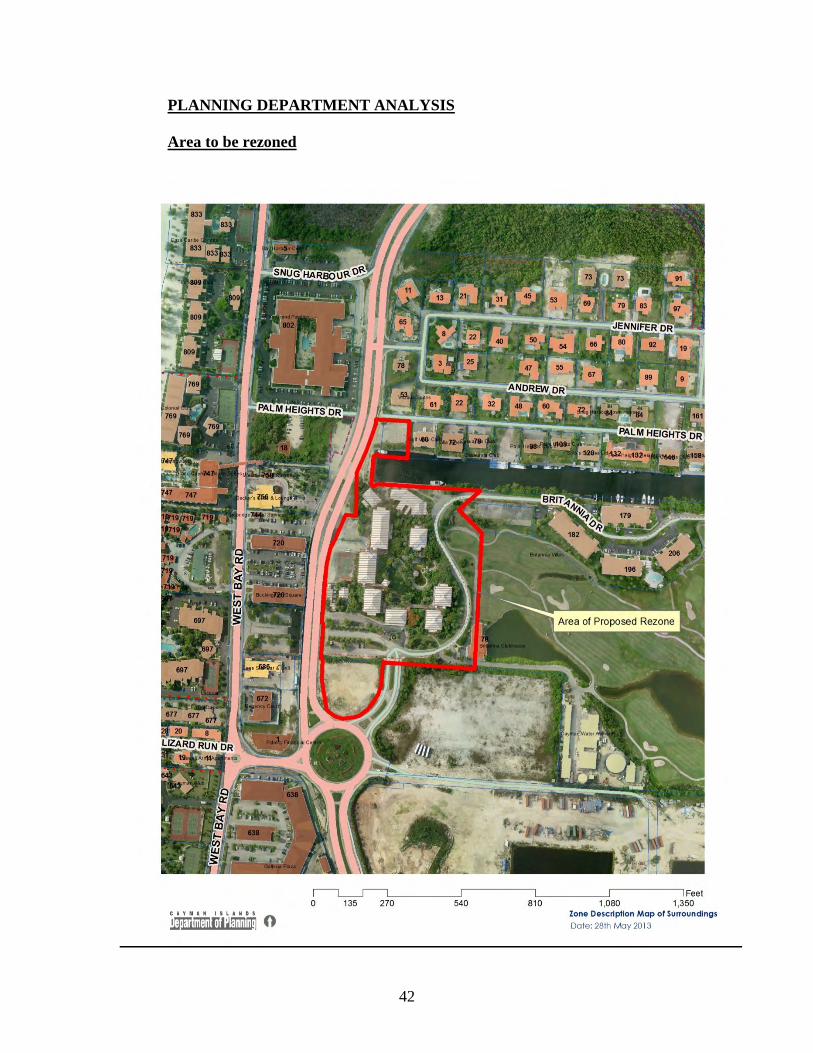
42
PLANNING DEPARTMENT ANALYSIS
Area to be rezoned

43
General
The site is currently not operational as it is pending redevelopment. Historically, it was used as a hotel formerly - the inland complex of the Hyatt Regency Grand Cayman. The buildings were damaged by hurricane Ivan. Some of the buildings
44
have been demolished and the remaining buildings have been deconstructed to the basic shell and core.
Vehicular access to the site is off the Esterley Tibbetts Highway, via Britannia Drive. There is also pedestrian access off Palm Heights Drive.
The applicant has indicated in the attached preliminary concept plan and in their application letter that the proposed rezone is to facilitate the redevelopment of the former inland Hyatt Regency hotel site into a complex inclusive of: hotel, restaurant, spa, one and two bedroom condos, a conference centre and retail buildings. The former Hyatt Regency Hotel was built on a split zoned site with both Hotel/Tourism (HT) and Neighbourhood Commercial (NC), with Low Density Residential (LDR) to the north. The existing buildings range from two story to four and five story. In the immediate environs of the site, contextual buildings range from two to four story.
From Lands and Survey data the amount of land zoned HT in George Town is 503.33 acres or 6.35% out of a total of 7, 904.5 acres. The amount of NC is 6.13% or 484.47 acres. Re-allocating 4.2 acres of NC to HT as proposed in the rezone application will make a marginal difference to the amount of HT in George Town; essentially an increase of 0.058 % and likewise reducing the amount of NC by 4.2acres will reduce the overall amount of NC by 0.054%.
Specific Issues
Rezoning the land from Neighbourhood Commercial to Hotel /Tourism would allow a maximum building height of 10 storeys or 130 feet, as the land would fall within the Hotel/Tourism Zone 1 as shown on Schedule 4 of the Development and Planning Regulations. This would be an increase from the 3 storeys or 40 feet that is currently allowed in the NC zone. The majority of the former hotel is on land zoned HT and any redevelopment of that area could potentially be 10 storeys in height. As the area of land zoned NC is situated between the existing HT land and the Esterley Tibbetts Highway, the proposed change from NC to HT appears to be a logical extension of the HT zone that would facilitate a more economic redevelopment of the former hotel site. The Department has no particular concern with this aspect of the rezoning as it appears consistent with several goals and objectives of The Development Plan 1997.
The Department does not support rezoning the LDR portion of the site to HT as the maximum potential building height of 10 storeys or 130 feet is not complementary to the existing one and two storey houses and apartments in the surrounding residential area. Any future development on the Low Density Residential portion of the site should be in keeping with the height, scale and massing already established in the area.
SUPPLEMENTARY ANALYSIS
Notice of the proposal for alteration to the Development Plan was advertised in the Caymanian Compass on 23rd and 25th September and 1st and 4th October 2013 respectively. No objections or representations were received on the proposed amendments.
45
4. 2 CAYHESSE CHARITABLE FOUNDATION LTD. Block 11B Parcel 56 Rem 3 (RZ13-0003) (HP)
Application for a rezone from Low Density Residential to Neighbourhood Commercial.
FACTS
Location Esterley Tibbetts Highway, George Town
Zoning LDR
Size of Area to be Rezoned 4.35 acres
BACKGROUND
September 18, 2013 (CPA/20/13; Item 4.1) - It was resolved to advertise the proposed amendment for the 60 day period as per Section 11 (2) in the Development and Planning Law (2011 Revision).
Decision: It was resolved to forward the application to the Ministry of PLHA&I for onward transmission to the Legislative Assembly for debate, subject to Cabinet approval.
AGENCY COMMENTS
Comments from the Chief Environmental Health Officer, Department of Environment, Department of Tourism, National Roads Authority and Water Authority are noted below:
Chief Environmental Health Officer
“The following comments are submitted with respect to the above application:
An application was submitted to the Department of Environmental Health, for comments on request for rezone, located on Block 11B Parcel 56REM3.
The Department has no objections to the proposed.”
Department of Environment
“The Department’s Technical Review Committee (TRC) has reviewed the proposal to re-zone the above mentioned property and at this stage has no comments.
Please do not hesitate to contact the Department should you have questions.”
Department of Tourism
“Please see below, full comments are contained in the Appendix:
Recommendation
“In conclusion, the Department of Tourism has no objections to proceed to neighbourhood commercial use. The Department of Tourism would recommend a
46
letter of ‘no objection’ from the Department of Environment.
The Department of Tourism is available to discuss these recommendations or answer any questions in regards to these comments.”
National Roads Authority
“As per your memo dated April 26th, 2013 the NRA has reviewed the above-mentioned planning proposal.
Please find below our comments and recommendations based on the site plan provided.
The NRA has no objections or concerns regarding the above proposed rezone.”
Water Authority
“The Water Authority has no requirements specific to the proposed rezoning, but development of the parcel will be subject to review for:
Water Supply:
The proposed rezone site is located within the Cayman Water Company's (CWC) water supply area. The developer is required to liaise with the Cayman Water Company to determine the location of existing water supply infrastructure to ensure its protection during redevelopment, and to determine site-specific requirements for connection of the development.
Wastewater Treatment:
The proposed rezone site is within the Water Authority's West Bay Beach Sewage System (WBBSS) collection area. All development will be required to connect to that system. The developer is required to liaise with the Water Authority, at the earliest stage of planning for development to determine site-specific requirements for connection to the WBBSS. (West Bay Beach Sewage System)”
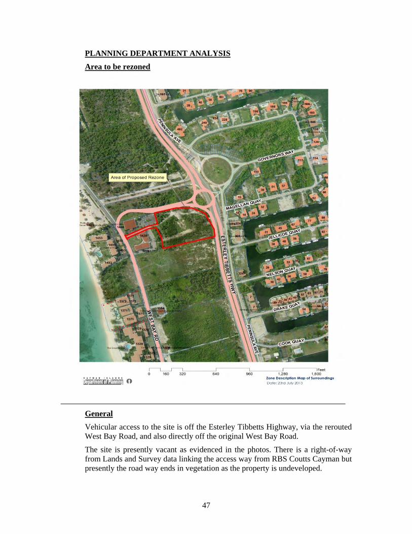
47
PLANNING DEPARTMENT ANALYSIS
Area to be rezoned
General
Vehicular access to the site is off the Esterley Tibbetts Highway, via the rerouted West Bay Road, and also directly off the original West Bay Road.
The site is presently vacant as evidenced in the photos. There is a right-of-way from Lands and Survey data linking the access way from RBS Coutts Cayman but presently the road way ends in vegetation as the property is undeveloped.
48
Specific Issues
The applicant has indicated in their application letter that the parcel was originally zoned Neighbourhood Commercial but it was rezoned to Low Density Residential in 2007. The Department has been able to confirm that the site was zoned Commercial on the 1977 Development Plan, but then shows as Low Density Residential on the 1997 Development Plan ( 2010 revision). The neighbouring parcels between the Esterley Tibbetts Highway and West Bay Road are also zoned Neighbourhood Commercial.
From Lands and Survey data the amount of land zoned Neighbourhood Commercial in West Bay is 162.652 acres or 3.92% % out of a total of 4148.485 acres in West Bay. The amount of Low Density Residential is 44.59 % or 1849.945 acres. Re-allocating 4.35 acres of Low Density Residential to Neighbourhood Commercial as proposed in the rezone application will make a marginal difference to the amount of Low Density Residential in West Bay; essentially an decrease of 0.1015 %. Rezoning the site Neighbourhood Commercial will increasing the amount of Neighbourhood Commercial in West Bay by 0.1056%, to a total of 4.025%.
Rezoning the site to Neighbourhood Commercial is in keeping with the surrounding Neighbourhood Commercial zoning and is more appropriate for the site as it is on the corner of the Esterley Tibbetts Highway and the rerouted West Bay Road. The adjacent parcels already have two story commercial buildings in the form of RBS Coutts Cayman and Trafalgar place. From a planning perspective this is a better use of the land as it allows for a denser mix of uses will afford residents access to services, amenities, employment.
SUPPLEMENTARY ANALYSIS
Notice of the proposal for alteration to the Development Plan was advertised in the Caymanian Compass on 30th September and 2nd, 8th and 11th October 2013 respectively. No objections or representations were received on the proposed amendments.
5.0 PLANNING APPEAL MATTERS
6.0 MATTERS FROM THE DIRECTOR OF PLANNING
6. 1 AUTHORIZATION TO ENTER UPON LANDS PER SECTION 39 OF LAW
Pursuant to Section 39 of the Development and Planning Law (2011 Revision), the Authority is supposed to authorize in writing persons to enter land for the purposes of enforcement and site inspections, however, this has never been done in practice. The Department recommends that Section 39 be addressed at this time and the required administrative process be implemented. The Department
49
recommends that the Authority approve of the following written authorization and that it be signed by the Chairman on behalf of the Authority.
Written Order
The Central Planning Authority hereby authorizes in writing that officers of the Department of Planning may enter upon land at a reasonable time pursuant to Section 39(1) (a) through (d) of the Development and Planning Law (2011 Revision).
The Authority considered the information provided by the Department and resolved to support the proposal and directed that the written authorization be prepared and signed by the Chairman of the CPA.
6. 2 SOLAR PANEL FARM Block 43A Parcel 346
The Authority was advised that a prospective applicant had contacted the Department regarding two procedural matters. The Authority considered the matters and determined that:
a) the proposed use is considered commercial therefore section 13(6) of the Law and section 9(3) of the Regulations apply; and
b) per Regulation 8(12C)(c), the required notification radius can be reduced to 500’ from the perimeter of the area that will be used for the solar panel farm.
6. 3 COASTAL WORKS LICENSE APPLICATION (PAL Development Ltd.) Block 11D Parcel 33(nn)
The Authority reviewed the application and resolved to advise the Ministry FC&E that the Authority does not support the application in the absence of an approved and built development on the subject property as the Authority is concerned that the proposed dock could be used for commercial water sports purposes until the property is developed for its primary use.
6. 4 PRENTICE PANTON Block 57E Parcel 118 (CE14-0006) (JM)
The Authority was advised that illegal construction and excavation has occurred on the site without the required permission.
Decision: It was resolved to authorise the issuance of an Enforcement Notice in accordance with section 18 of the Development and Planning Law (2011 Revision, as amended). Enforcement Notice to take effect at the end of the period of 28 days from the date of service and compliance with the Enforcement Notice to be completed within the period of 28 days from the date when the Notice takes effect, subject to the provisions of section 18 (5) (6) of the law.
50
6. 5 PRENTICE PANTON Block 23C Parcel 25 (CE14-0007) (JM)
The Authority was advised that the subject site was being stockpiled with what appears to be unsuitable fill material. The Authority reviewed the available photographs and determined that the fill was suitable and that no enforcement action would be authorized at this time.
6. 6 NORMAN DIXON Block 22E Parcel 84 (CE14-0008) (CM)
The Authority was advised that the subject site was being used for vehicle storage and repair.
Decision: It was resolved to authorise the issuance of an Enforcement Notice in accordance with section 18 of the Development and Planning Law (2011 Revision, as amended). Enforcement Notice to take effect at the end of the period of 28 days from the date of service and compliance with the Enforcement Notice to be completed within the period of 28 days from the date when the Notice takes effect, subject to the provisions of section 18 (5) (6) of the law.
6. 7 ROBERT O. THOMPSON Block 20B Parcel 82 (CM/JM)
The Authority was advised that the subject site was being used for vehicle storage and repair.
Decision: It was resolved to authorise the issuance of an Enforcement Notice in accordance with section 18 of the Development and Planning Law (2011 Revision, as amended). Enforcement Notice to take effect at the end of the period of 28 days from the date of service and compliance with the Enforcement Notice to be completed within the period of 28 days from the date when the Notice takes effect, subject to the provisions of section 18 (5) (6) of the law.
6. 8 NORTHWARD PRISON (HP)
The Authority was advised that an application for planning permission will soon be submitted and there has been an inquiry about the required notification process. The Authority determined that newspaper advertisements would not be required and that the owners of the following three properties would have to be notified of the application: Block 37A Parcels 26, 27 & 118.
6. 9 COX LUMBER BODDEN TOWN (HP)
The Authority considered and accepted the applicant’s phasing proposal for the last building (truss plant) on the site. All of the other buildings can be completed

51
without having to complete the parking area or sidewalk in front of the truss plant. Those items will have to be completed when the truss plant is completed.
7.0 CPA MEMBERS INFORMATION/DISCUSSIONS

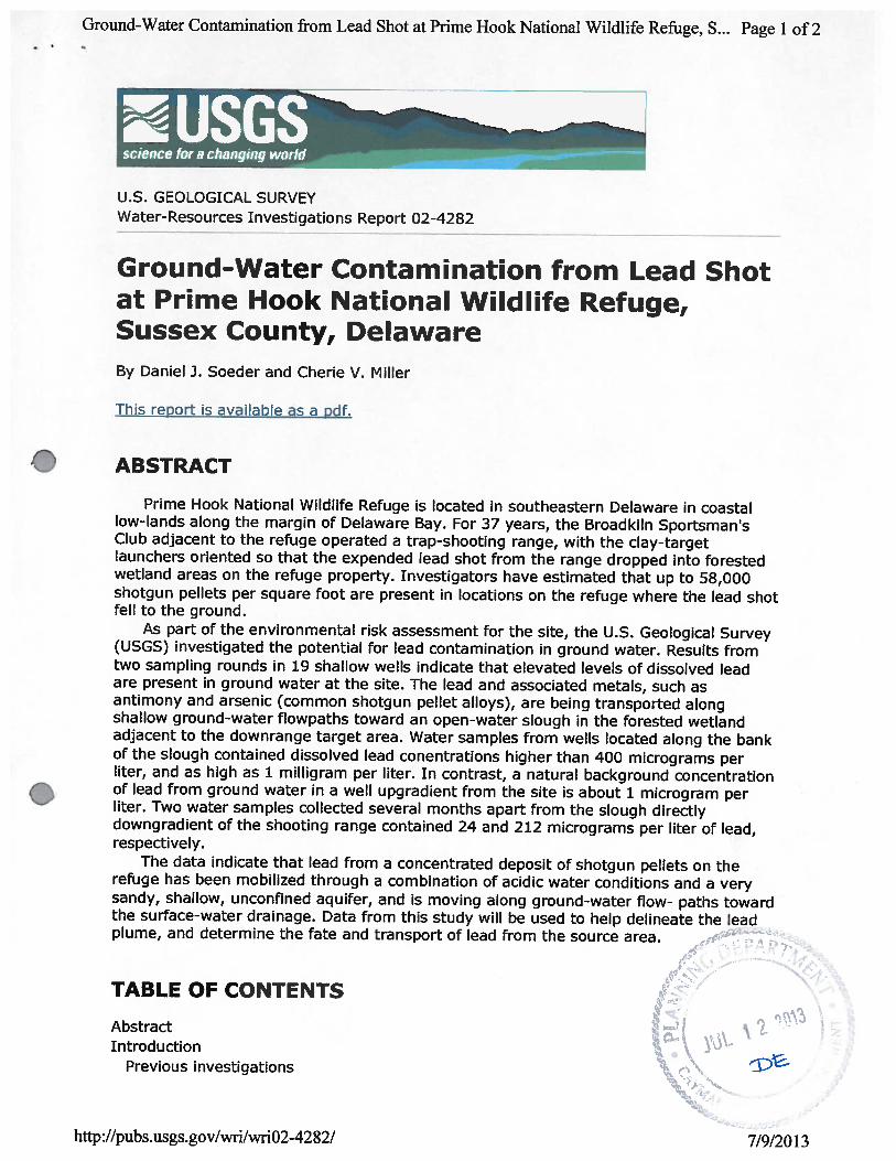


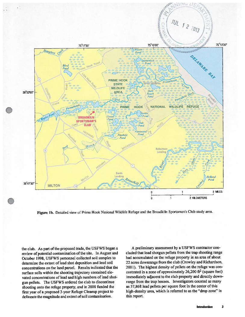
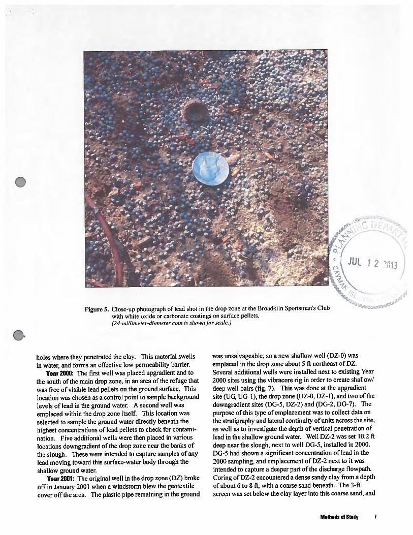

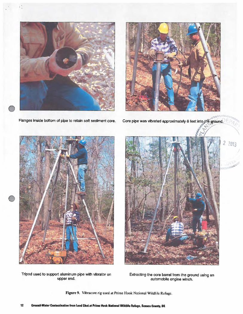
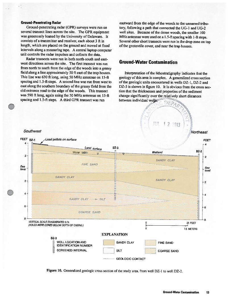
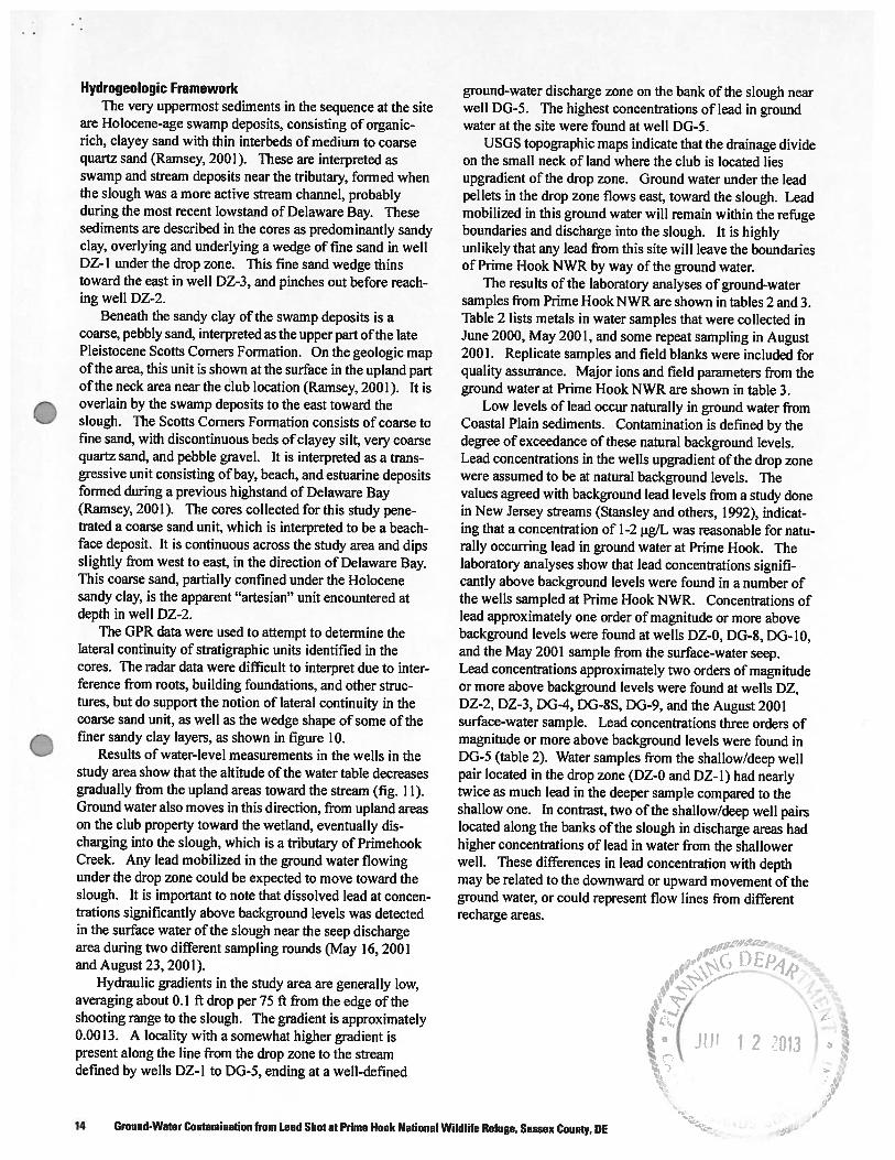
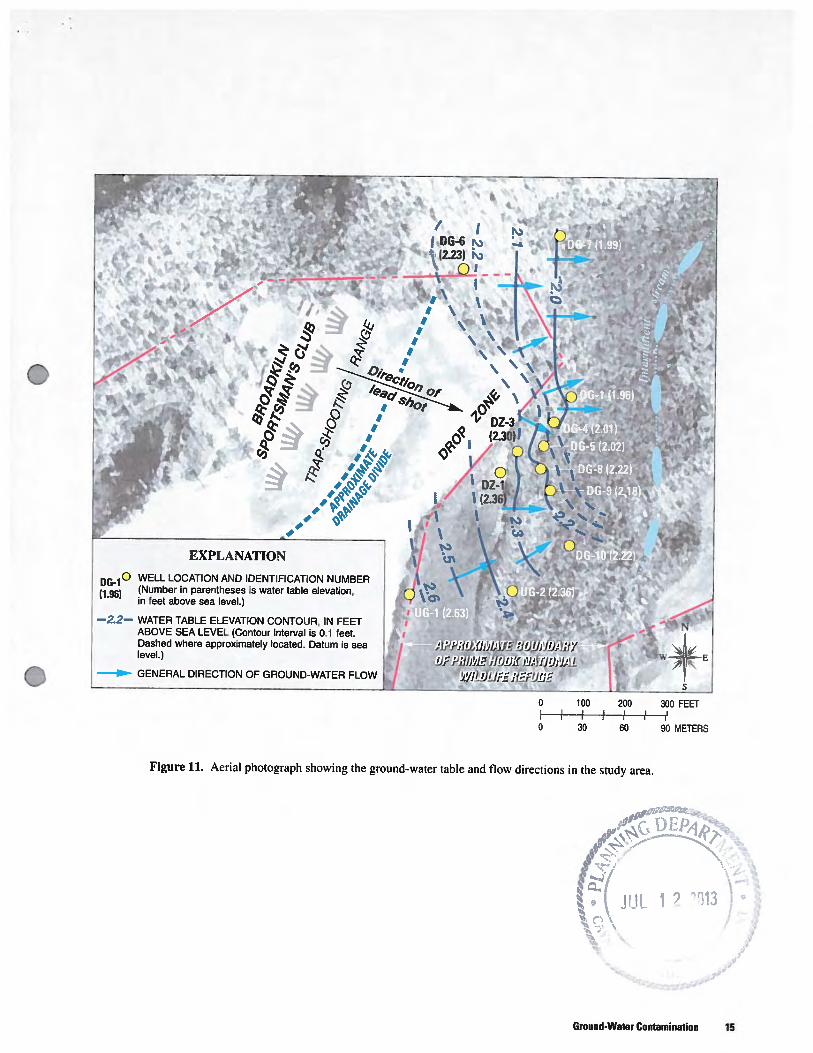
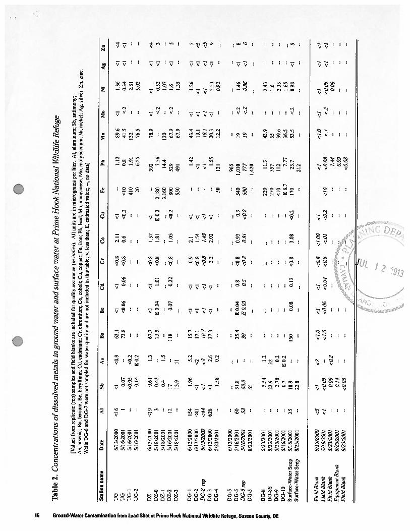
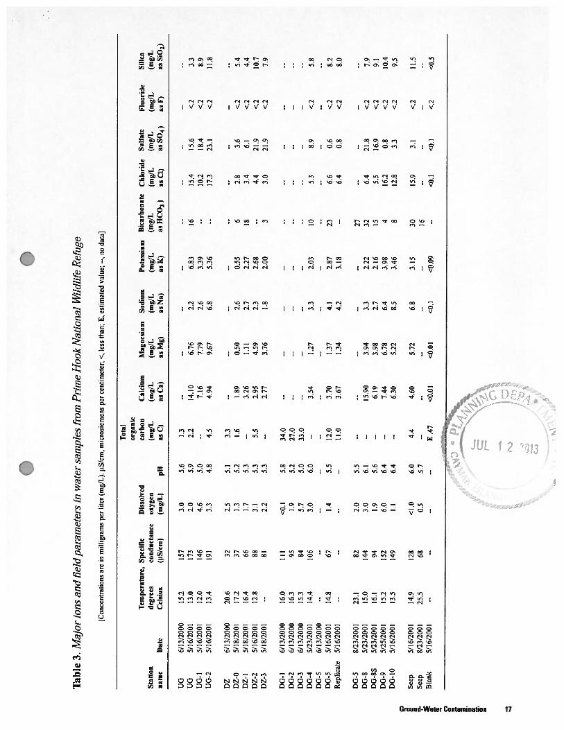
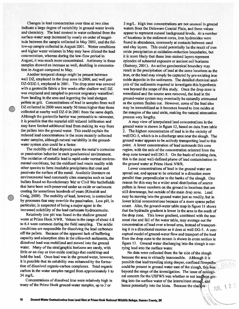
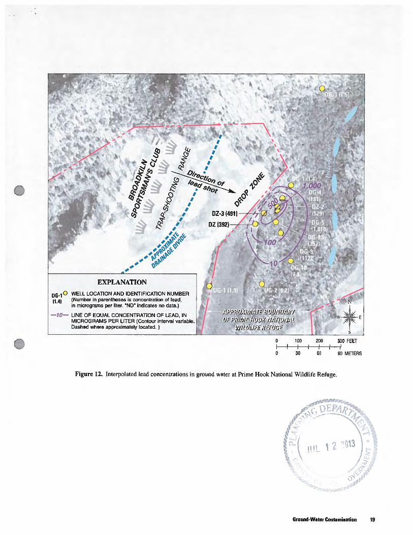
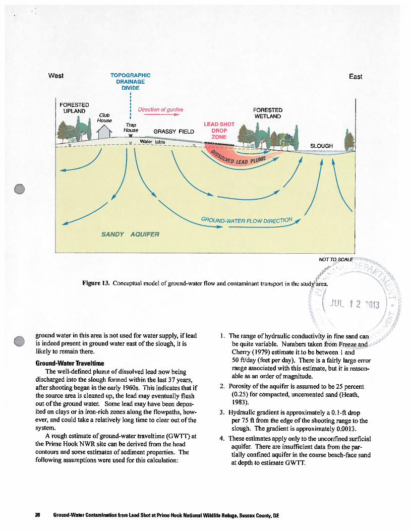
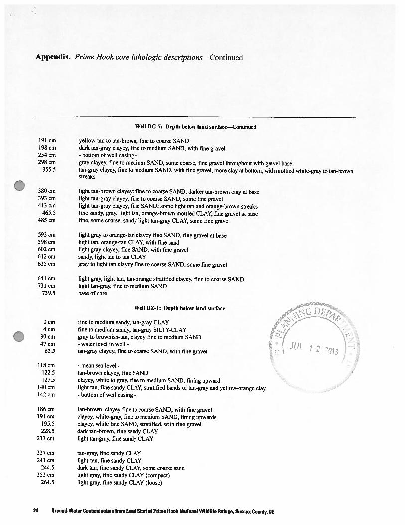
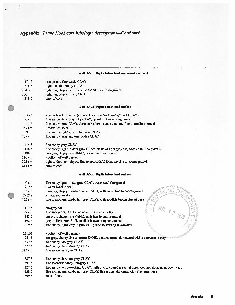
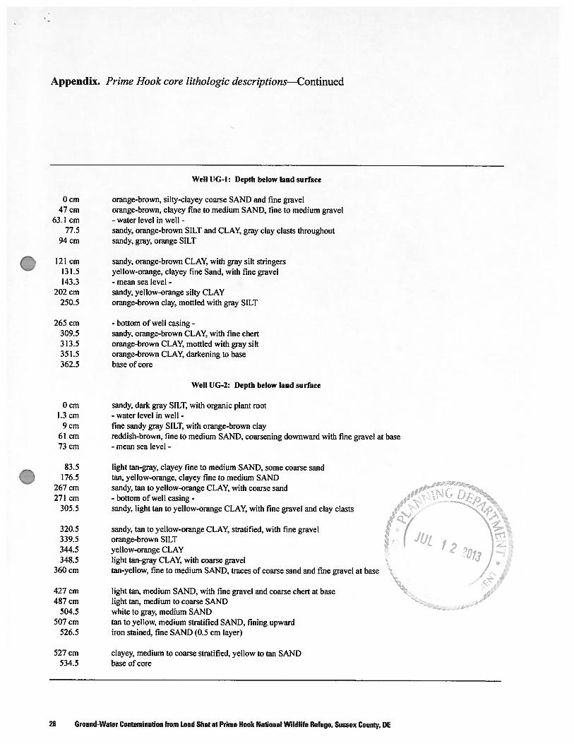

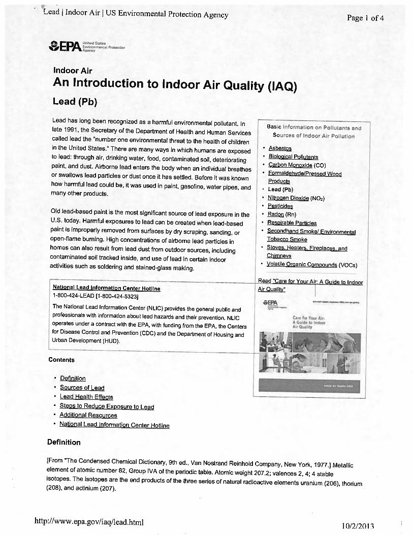
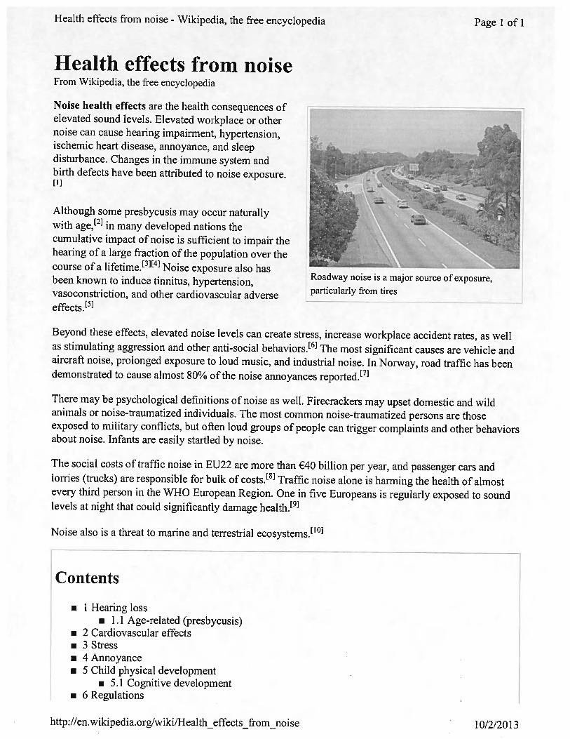


Literature Study Report on the Potential Impacts of Lead from the Proposed CISSA Outdoor Shooting
Range
by
Robert Marsden
This report was prepared for CISSA submission to the Cayman Islands Central Planning
Authority as a supplement to their Planning Application
December 2013
i
ABSTRACT
The purpose of this report is to show the potential impact that lead based ammunition may
have on soil and groundwater at the proposed CISSA, Cayman Islands Sport Shooting Association
outdoor range in the district of East End. This report will present the site characteristics and
literature to support the perceived impact that the range will have on groundwater lead levels from
the weathering of spent lead ammunition. The report will also propose potential mitigation
measures to further minimize the impact of lead ammunition on groundwater and soils.
ii
LIST OF FIGURES PHOTOS AND TABLES Photo 1. Middle of clay target range on tree line looking north over last 1/5th of shot fall zone….... 2
Photo 2. Typical ground condition on majority of shot fall zone………………………………….. 3
Photo 2a. Typical ground condition on majority of shot fall zone………………………………... 4
Photo 2b. Typical ground condition on majority of shot fall zone………………………………... 5
Figure 1. Map of Grand Cayman showing Isohyets (mm) for 1987[5]…………………………………...... 6
Figure 2. Geological map of Grand Cayman [7]………………………………………………………….. 7
Figure 3. East End lens configuration and monitoring well network [9]………………………………… 8
Photo 3. Sieved soil samples……………………………………………………………………….. 9
Photo 4. Soil sampling site for sample #1 & #3…………………………………………………………….. 10
Photo 5. Soil sampling site for sample #2…………………………………………………………………….. 11
Photo 6. Surface water site for pH………………………………………………………………… 11 Table 1. Soil types tested pHs……………………………………………………………………... 12
iii
TABLE OF CONTENTS ABSTRACT................................................................................................................................. i LIST OF FIGURES PHOTOS & TABLES.................................................................................. ii TABLE OF CONTENTS….........................................................................................................iii INTRODUCTION…………....................................................................................................... 1 SITE LOCATION AND CHARACTERISTICS.………………………………………................ 2 RESULTS AND DISCUSSIONS................................................................................................. 2 MISCELLANEOUS DESCRIPTIONS ......................................................................................... 8 CONCLUSIONS AND RECOMMENDATIONS .......................................................................... .13 REFERENCES ......................................................................................................................... ... 15 APENDICES ............................................................................................................................ ... 16 APPENDIX A WAC SOIL & GROUNDWATER TEST RESULTS.................................... …... 16 APPENDIX B SITE DRAWING....................................................................................................... 20
1
INTRODUCTION
The objective of this report is to identify the potential risk factors that contribute to the
transport of lead into the soils and groundwater on the proposed CISSA site. Historical data for
the investigation of lead and heavy metal contamination in soils and groundwater is largely non-
existent in Cayman except for some data collected by the Water Authority in relation to the post
hurricane Ivan debris site monitoring in East End. Studies into the weathering and transport into
groundwater of lead and other heavy metals associated with ammunition have been conducted in
the continental USA and these will be used for the basis of this report. Measures to mitigate lead
leaching from spent ammunition are available, however it is not yet known which will be
applicable or feasible to use in the best management practices, BMPs for this site going forward
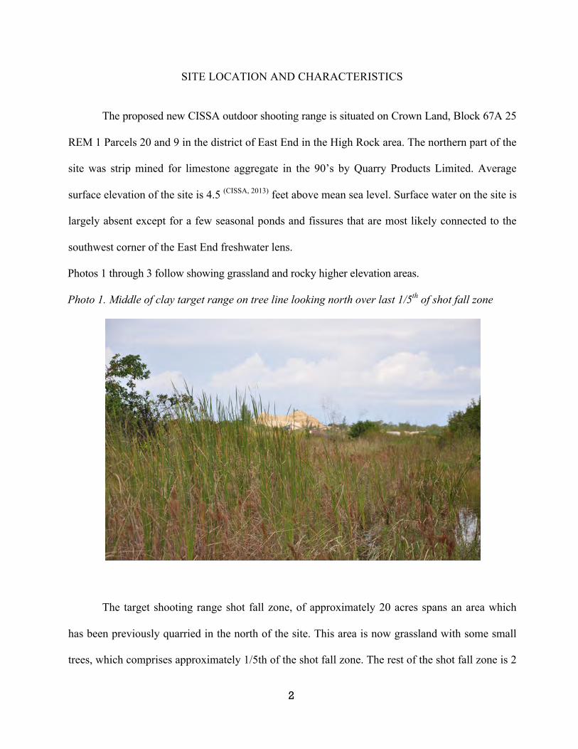
2
SITE LOCATION AND CHARACTERISTICS
The proposed new CISSA outdoor shooting range is situated on Crown Land, Block 67A 25
REM 1 Parcels 20 and 9 in the district of East End in the High Rock area. The northern part of the
site was strip mined for limestone aggregate in the 90’s by Quarry Products Limited. Average
surface elevation of the site is 4.5 (CISSA, 2013) feet above mean sea level. Surface water on the site is
largely absent except for a few seasonal ponds and fissures that are most likely connected to the
southwest corner of the East End freshwater lens.
Photos 1 through 3 follow showing grassland and rocky higher elevation areas.
Photo 1. Middle of clay target range on tree line looking north over last 1/5th of shot fall zone
The target shooting range shot fall zone, of approximately 20 acres spans an area which
has been previously quarried in the north of the site. This area is now grassland with some small
trees, which comprises approximately 1/5th of the shot fall zone. The rest of the shot fall zone is 2
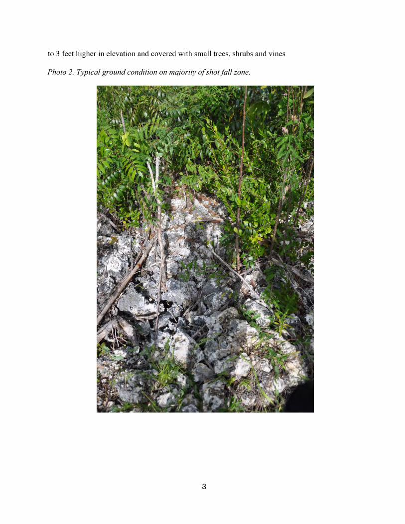
3
to 3 feet higher in elevation and covered with small trees, shrubs and vines
Photo 2. Typical ground condition on majority of shot fall zone.
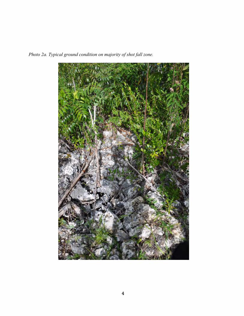
4
Photo 2a. Typical ground condition on majority of shot fall zone.
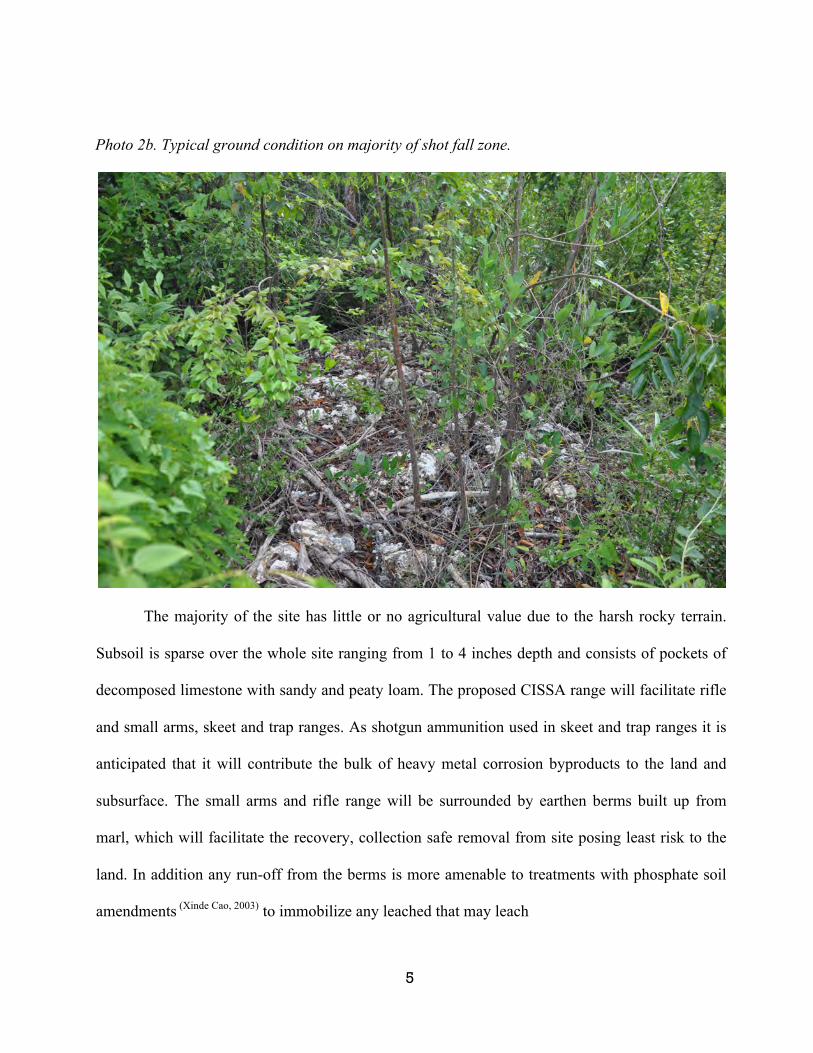
5
Photo 2b. Typical ground condition on majority of shot fall zone.
The majority of the site has little or no agricultural value due to the harsh rocky terrain.
Subsoil is sparse over the whole site ranging from 1 to 4 inches depth and consists of pockets of
decomposed limestone with sandy and peaty loam. The proposed CISSA range will facilitate rifle
and small arms, skeet and trap ranges. As shotgun ammunition used in skeet and trap ranges it is
anticipated that it will contribute the bulk of heavy metal corrosion byproducts to the land and
subsurface. The small arms and rifle range will be surrounded by earthen berms built up from
marl, which will facilitate the recovery, collection safe removal from site posing least risk to the
land. In addition any run-off from the berms is more amenable to treatments with phosphate soil
amendments (Xinde Cao, 2003) to immobilize any leached that may leach
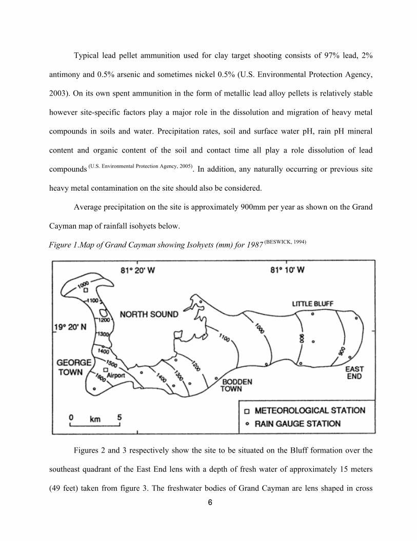
6
Typical lead pellet ammunition used for clay target shooting consists of 97% lead, 2%
antimony and 0.5% arsenic and sometimes nickel 0.5% (U.S. Environmental Protection Agency,
2003). On its own spent ammunition in the form of metallic lead alloy pellets is relatively stable
however site-specific factors play a major role in the dissolution and migration of heavy metal
compounds in soils and water. Precipitation rates, soil and surface water pH, rain pH mineral
content and organic content of the soil and contact time all play a role dissolution of lead
compounds (U.S. Environmental Protection Agency, 2005). In addition, any naturally occurring or previous site
heavy metal contamination on the site should also be considered.
Average precipitation on the site is approximately 900mm per year as shown on the Grand
Cayman map of rainfall isohyets below.
Figure 1.Map of Grand Cayman showing Isohyets (mm) for 1987 (BESWICK, 1994)
Figures 2 and 3 respectively show the site to be situated on the Bluff formation over the
southeast quadrant of the East End lens with a depth of fresh water of approximately 15 meters
(49 feet) taken from figure 3. The freshwater bodies of Grand Cayman are lens shaped in cross

7
section. They are predominantly unconfined and due to their mixing with seawater at their
boundaries they do not agree with the Ghyben-Hertzberg model and dynamic equilibrium and
react to tidal fluctuation (BESWICK, 1994)
Figure 2. Geological map of Grand Cayman (BESWICK, 1994)
The lenses in Grand Cayman exhibit high permeability down to depths of 50m (164 feet)
and show permeability increases with depth. This is the reason there are no rivers or streams since
rainfall quickly percolates through the rock. Groundwater is in continual motion through pores in
the formation and it dissolves and carries away any soluble material. For the most part in the Bluff
formation of the East End lens groundwater flow is diffuse except for where it encounters joints or
caverns where it becomes free flow (BESWICK, 1994, p. 65). The freshwater in Cayman is rich in
bicarbonate ions (300-400ppm) with a pH of greater than 7. Rainfall absorbs carbon dioxide from
the atmosphere and subsurface which liberates a weak carbonic acid solution, which further
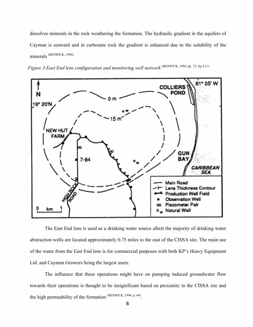
8
dissolves minerals in the rock weathering the formation. The hydraulic gradient in the aquifers of
Cayman is seaward and in carbonate rock the gradient is enhanced due to the solubility of the
minerals (BESWICK, 1994)
Figure 3.East End lens configuration and monitoring well network (BESWICK, 1994, pp. 72, fig 4.11)
The East End lens is used as a drinking water source albeit the majority of drinking water
abstraction wells are located approximately 0.75 miles to the east of the CISSA site. The main use
of the water from the East End lens is for commercial purposes with both KP’s Heavy Equipment
Ltd. and Cayman Growers being the largest users.
The influence that these operations might have on pumping induced groundwater flow
towards their operations is thought to be insignificant based on proximity to the CISSA site and
the high permeability of the formation (BESWICK, 1994, p. 64).
9
SOIL & SURFACE WATER pH RESULTS AND DISCUSSIONS
Samples of soil were taken at 3 sites along a north south access road cut through the
center of the site. The three sieved (<2mm) soil samples are shown below. The samples range
from mostly decomposed limestone through a limestone with some decomposed organic matter to
a spongy peat loam.
Photo 3. Sieved soil samples
10
Photo 4. Soil sampling site for sample #1 & #3
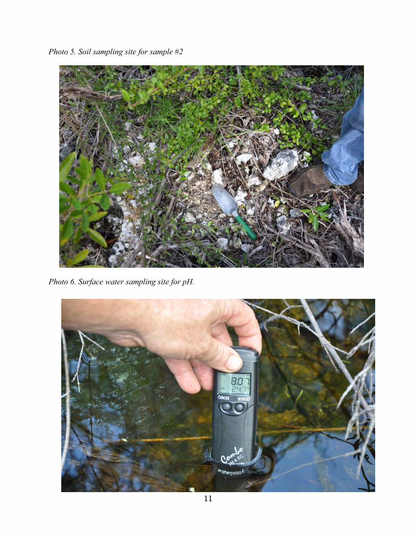
11
Photo 5. Soil sampling site for sample #2
Photo 6. Surface water sampling site for pH.
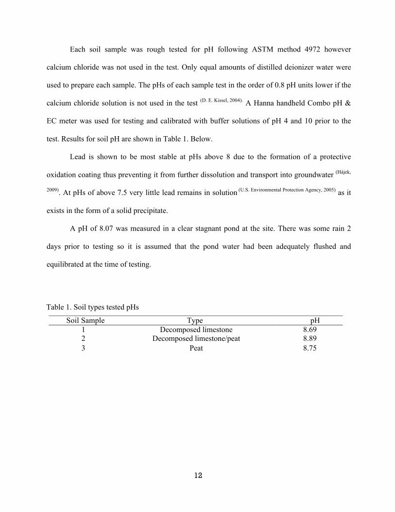
12
Each soil sample was rough tested for pH following ASTM method 4972 however
calcium chloride was not used in the test. Only equal amounts of distilled deionizer water were
used to prepare each sample. The pHs of each sample test in the order of 0.8 pH units lower if the
calcium chloride solution is not used in the test (D. E. Kissel, 2004). A Hanna handheld Combo pH &
EC meter was used for testing and calibrated with buffer solutions of pH 4 and 10 prior to the
test. Results for soil pH are shown in Table 1. Below.
Lead is shown to be most stable at pHs above 8 due to the formation of a protective
oxidation coating thus preventing it from further dissolution and transport into groundwater (Hájek,
2009). At pHs of above 7.5 very little lead remains in solution (U.S. Environmental Protection Agency, 2005) as it
exists in the form of a solid precipitate.
A pH of 8.07 was measured in a clear stagnant pond at the site. There was some rain 2
days prior to testing so it is assumed that the pond water had been adequately flushed and
equilibrated at the time of testing.
Table 1. Soil types tested pHs
Soil Sample Type pH 1 Decomposed limestone 8.69 2 Decomposed limestone/peat 8.89 3 Peat 8.75
13
CONCLUSIONS AND RECOMMENDATIONS
Site specific conditions at the proposed CISSA site upon initial investigation seem to be
conducive to minimizing lead oxidation and leaching with soil pHs around 8 This can be further
backed up by Water Authority testing of soils and groundwater for lead in 2007 as shown in the
table and map in the appendix A. Had samples of post Ivan construction and demolition debris been
analyzed to provide a comparison then a direct correlation of how much lead leached into the
ground might have been possible. The only deduction that can be made from the water Authority
data is that any lead leaching into the groundwater from the soil may at levels below 10ppb.
Important to note is that the test for total lead in groundwater accounts for all elemental lead no
matter what form it is in. An assessment based on the potential for mobility of lead cannot be made
without separate analysis lead compounds existing and the same goes for the potential for leaching
from soil. There are 2 other test methods that simulate precipitation induced leaching from wastes
and soils but careful consideration as to which method best simulates in-situ conditions prior to
selection.
As the Bluff formation on which the site sits is highly permeable and receives a moderate
amount of rainfall compared to the rest of the island is anticipated that any dissolved and mobile
lead would migrate directly through the lens and towards the ocean. Again this is based on
assumption and would need to be proven by quarterly groundwater monitoring.
Phosphate additions to soil have shown to reduce the levels of lead leaching, this method
would be ideally suited to treatment of soils at the bases of berms around the rifle and pistol ranges.
Run-off might be contained by installation of a plastic membrane liner prior to the construction of
the berms.

14
The clay target range shot fall zone is 20 acres and not well suited to soil augmentation with
phosphate. Since existing soil and groundwater conditions (pH) are high enough to minimize the
amount of lead weathering I recommend a long term groundwater monitoring plan to first test for
any background lead, antimony and arsenic at the site and selected wells in the area. From then on
perform a quarterly testing of the same sample points. I suggest drilling a 2-inch, 30 foot deep
monitoring well, screened top to bottom. The well should be placed as close as possible to the
center of the clay target shot fall zone and that it be tested before the onset of the dry season, say by
mid January 2014.
With regards to types of non-toxic shotgun ammunition there are various types available
with have primarily been developed for hunting purposes. The varying types use soft steel, tin
bismuth and tungsten alloys and polymer, copper and brass coatings. Prices for these types of
shotgun loads are as much as 6 times that of traditional lead loads. Steel shot is the least expensive
but also has drawbacks in that it cannot be used for sanctioned competition. Steel is also not
suitable for some riles as it can damage barrels and chokes. Lastly there is a danger with steel shot
that it has a tendency to bounce back from the target since it does not deform as well as lead.
Going forward CISSA should be proactive in its endeavors to continually keep abreast of
new technologies employed at shooting ranges to mitigate the impact of lead to ground. And any
new lead mitigation technologies found to be feasible and cost effective should be used at the new
site.
15
REFERENCES
Beswick, K.-C. S. Ng (1994). The Cayman Islands: Natural History and Biogeography, Volume 71, Chapter 4. Kluwer.
CISSA. (2013, November 26). VP. (R. Marsden, Interviewer)
D. E. Kissel, P. F. (2004). Salt Concentration and Measurement of Soil pH. University of Georgia, Atlanta.
Hájek, V. C. (2009). Lead contamination of an agricultural soil in the vicinity of a shooting range. University of South Bohemia, Czech Republic, Department of Applied Chemistry. Springer Science & Business Media B.V.
U.S. Environmental Protection Agency. (2005). Best management practices for lead at outdoor shooting ranges. New York EPA. New York: US EPA.
U.S. Environmental Protection Agency. (2003). TRW Recommendations for performing human health risk analysis on small arms shooting ranges. Washington, DC:EPA, Office of Solid Waste and Emergency Response. OSWER.
Xinde Cao, L. Q. (2003). Weathering of Lead Bullets and Their Environmental Effects at Outdoor Shooting Ranges. 32, 526–534.
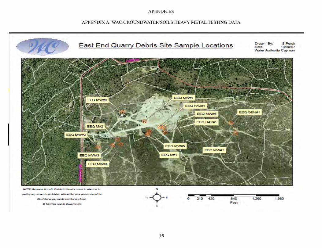
APENDICES
APPENDIX A: WAC GROUNDWATER SOILS HEAVY METAL TESTING DATA
16
LabLink Analytical Data ReportEast End Quarry Debris Site
World Health Organization
(WHO)Collected Parameter Units EEQ GEN#1 EEQ M#1 EEQ M#2 EEQ HAZ#1 EEQ HAZ#2 Residential Commercial Drinking water 25-Jun-07 pH su 7.6 7.7 7.7 7.5 7.525-Jun-07 Solids, Percent % 80.4 80.5 75.2 89.2 81.425-Jun-07 Arsenic mg/kg 1.9 8.1 2.7 2.5 3.4 0.8 3.7 29 1025-Jun-07 Barium mg/kg <12 <12 <13 <11 <12 110 87000 *** 70025-Jun-07 Cadmium mg/kg 0.26 0.31 <0.26 0.43 0.33 75 1300 8 325-Jun-07 Chromium mg/kg 20.9 21.6 18.9 21.7 28.9 210 420 38 5025-Jun-07 Lead mg/kg <6.2 17 7 <5.3 11.5 400 920 *** 1025-Jun-07 Mercury mg/kg 0.13 0.17 0.26 0.16 0.19 3.4 26 2.1 1
Notes from Florida Standards:*** Leachability values may be derived using the SPLP Test to calculate site-specific SCTLs or may be determined using TCLP in the event oily wastes are present.
Water Authority Note: given that detected levels were far less than Florida Direct Exposure limits, sampling for leachability was not called for.
EEQ M#1EEQ M#2
EEQ HAZ#1EEQ HAZ#2EEQ GEN#1
EE Quarry Haz Waste Area 2EE Quarry Off Site Random Sample 1
Monitoring Point IdentificationEE Quarry Mulch Area 1
Florida Direct Exposure
Florida leachability to
fresh groundwater
SOIL & GROUNDWATER REMEDIATION REFERENCE STANDARDS
ADOPTED BY WATER AUTHORITY 2005
EE Quarry Mixed Debris AreaEE Quarry Haz Waste Area 1
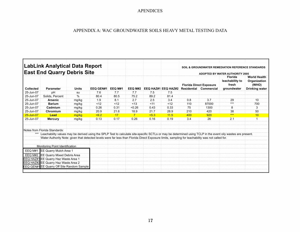
APENDICES
APPENDIX A: WAC GROUNDWATER SOILS HEAVY METAL TESTING DATA
17
LabLink Analytical Data ReportEast End Quarry Debris Site
World Health Organization
(WHO)Collected Parameter Units EEQ GEN#1 EEQ M#1 EEQ M#2 EEQ HAZ#1 EEQ HAZ#2 Residential Commercial Drinking water 25-Jun-07 pH su 7.6 7.7 7.7 7.5 7.525-Jun-07 Solids, Percent % 80.4 80.5 75.2 89.2 81.425-Jun-07 Arsenic mg/kg 1.9 8.1 2.7 2.5 3.4 0.8 3.7 29 1025-Jun-07 Barium mg/kg <12 <12 <13 <11 <12 110 87000 *** 70025-Jun-07 Cadmium mg/kg 0.26 0.31 <0.26 0.43 0.33 75 1300 8 325-Jun-07 Chromium mg/kg 20.9 21.6 18.9 21.7 28.9 210 420 38 5025-Jun-07 Lead mg/kg <6.2 17 7 <5.3 11.5 400 920 *** 1025-Jun-07 Mercury mg/kg 0.13 0.17 0.26 0.16 0.19 3.4 26 2.1 1
Notes from Florida Standards:*** Leachability values may be derived using the SPLP Test to calculate site-specific SCTLs or may be determined using TCLP in the event oily wastes are present.
Water Authority Note: given that detected levels were far less than Florida Direct Exposure limits, sampling for leachability was not called for.
EEQ M#1EEQ M#2
EEQ HAZ#1EEQ HAZ#2EEQ GEN#1
Florida Direct Exposure
Florida leachability to
fresh groundwater
SOIL & GROUNDWATER REMEDIATION REFERENCE STANDARDS
ADOPTED BY WATER AUTHORITY 2005
EE Quarry Mixed Debris AreaEE Quarry Haz Waste Area 1EE Quarry Haz Waste Area 2EE Quarry Off Site Random Sample 1
Monitoring Point IdentificationEE Quarry Mulch Area 1
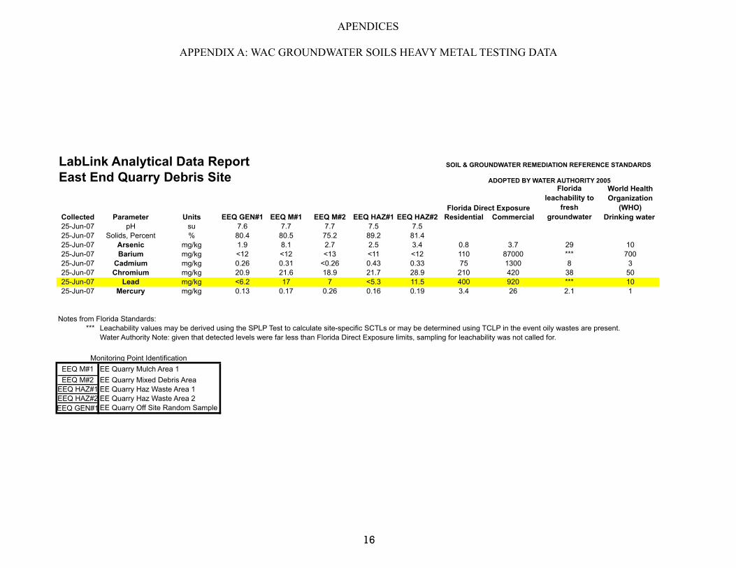
APENDICES
APPENDIX A: WAC GROUNDWATER SOILS HEAVY METAL TESTING DATA
16
LabLink Analytical Data ReportEast End Quarry Debris Site
World Health Organization
(WHO)Collected Parameter Units EEQ GEN#1 EEQ M#1 EEQ M#2 EEQ HAZ#1 EEQ HAZ#2 Residential Commercial Drinking water 25-Jun-07 pH su 7.6 7.7 7.7 7.5 7.525-Jun-07 Solids, Percent % 80.4 80.5 75.2 89.2 81.425-Jun-07 Arsenic mg/kg 1.9 8.1 2.7 2.5 3.4 0.8 3.7 29 1025-Jun-07 Barium mg/kg <12 <12 <13 <11 <12 110 87000 *** 70025-Jun-07 Cadmium mg/kg 0.26 0.31 <0.26 0.43 0.33 75 1300 8 325-Jun-07 Chromium mg/kg 20.9 21.6 18.9 21.7 28.9 210 420 38 5025-Jun-07 Lead mg/kg <6.2 17 7 <5.3 11.5 400 920 *** 1025-Jun-07 Mercury mg/kg 0.13 0.17 0.26 0.16 0.19 3.4 26 2.1 1
Notes from Florida Standards:*** Leachability values may be derived using the SPLP Test to calculate site-specific SCTLs or may be determined using TCLP in the event oily wastes are present.
Water Authority Note: given that detected levels were far less than Florida Direct Exposure limits, sampling for leachability was not called for.
EEQ M#1EEQ M#2
EEQ HAZ#1EEQ HAZ#2EEQ GEN#1
EE Quarry Haz Waste Area 2EE Quarry Off Site Random Sample 1
Monitoring Point IdentificationEE Quarry Mulch Area 1
Florida Direct Exposure
Florida leachability to
fresh groundwater
SOIL & GROUNDWATER REMEDIATION REFERENCE STANDARDS
ADOPTED BY WATER AUTHORITY 2005
EE Quarry Mixed Debris AreaEE Quarry Haz Waste Area 1
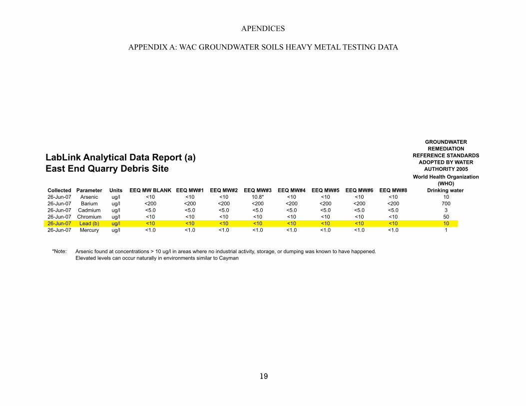
APENDICES
APPENDIX A: WAC GROUNDWATER SOILS HEAVY METAL TESTING DATA
19
LabLink Analytical Data Report (a)East End Quarry Debris Site
Collected Parameter Units EEQ MW BLANK EEQ MW#1 EEQ MW#2 EEQ MW#3 EEQ MW#4 EEQ MW#5 EEQ MW#6 EEQ MW#8 Drinking water 26-Jun-07 Arsenic ug/l <10 <10 <10 10.8* <10 <10 <10 <10 1026-Jun-07 Barium ug/l <200 <200 <200 <200 <200 <200 <200 <200 70026-Jun-07 Cadmium ug/l <5.0 <5.0 <5.0 <5.0 <5.0 <5.0 <5.0 <5.0 326-Jun-07 Chromium ug/l <10 <10 <10 <10 <10 <10 <10 <10 5026-Jun-07 Lead (b) ug/l <10 <10 <10 <10 <10 <10 <10 <10 1026-Jun-07 Mercury ug/l <1.0 <1.0 <1.0 <1.0 <1.0 <1.0 <1.0 <1.0 1
*Note: Arsenic found at concentrations > 10 ug/l in areas where no industrial activity, storage, or dumping was known to have happened. Elevated levels can occur naturally in environments similar to Cayman
World Health Organization (WHO)
GROUNDWATER REMEDIATION
REFERENCE STANDARDS ADOPTED BY WATER
AUTHORITY 2005