Transmit/receive module for L-band phased array synthetic aperture radar with polarisation control

This article was downloaded by: [Indian Institute of Remote Sensing], [Mr Arun KumarSardar]On: 21 May 2012, At: 22:40Publisher: Taylor & FrancisInforma Ltd Registered in England and Wales Registered Number: 1072954 Registeredoffice: Mortimer House, 37-41 Mortimer Street, London W1T 3JH, UK
Geocarto InternationalPublication details, including instructions for authors andsubscription information:http://www.tandfonline.com/loi/tgei20
Snow physical parameters estimationusing space-based Synthetic ApertureRadarPraveen K. Thakur a , S.P. Aggarwal a , P.K. Garg b , R.D. Garg b ,Sneh Mani c , Ankur Pandit a & Sanjeev Kumar da Water Resources Division, IIRS, 4-Kalidas Road, Dehradun,248001, Indiab Civil (Geomatics) Eng., IIT, IIT Roorkee, Roorkee, 247667, Indiac Snow and Avalanche Study Establishment (DRDO), RS Lab,Chandigarh, Indiad SASE, Bahang, Manali, Manali, 175131, India
Available online: 08 Mar 2012
To cite this article: Praveen K. Thakur, S.P. Aggarwal, P.K. Garg, R.D. Garg, Sneh Mani, AnkurPandit & Sanjeev Kumar (2012): Snow physical parameters estimation using space-based SyntheticAperture Radar, Geocarto International, 27:3, 263-288
To link to this article: http://dx.doi.org/10.1080/10106049.2012.672477
PLEASE SCROLL DOWN FOR ARTICLE
Full terms and conditions of use: http://www.tandfonline.com/page/terms-and-conditions
This article may be used for research, teaching, and private study purposes. Anysubstantial or systematic reproduction, redistribution, reselling, loan, sub-licensing,systematic supply, or distribution in any form to anyone is expressly forbidden.
The publisher does not give any warranty express or implied or make any representationthat the contents will be complete or accurate or up to date. The accuracy of anyinstructions, formulae, and drug doses should be independently verified with primarysources. The publisher shall not be liable for any loss, actions, claims, proceedings,

demand, or costs or damages whatsoever or howsoever caused arising directly orindirectly in connection with or arising out of the use of this material.
Dow
nloa
ded
by [
Indi
an I
nstit
ute
of R
emot
e Se
nsin
g], [
Mr
Aru
n K
umar
Sar
dar]
at 2
2:40
21
May
201
2

Snow physical parameters estimation using space-based Synthetic
Aperture Radar
Praveen K. Thakura*, S.P. Aggarwala, P.K. Gargb, R.D. Gargb, Sneh Manic,Ankur Pandita and Sanjeev Kumard
aWater Resources Division, IIRS, 4-Kalidas Road, Dehradun 248001, India; bCivil (Geomatics)Eng., IIT, IIT Roorkee, Roorkee 247667, India; cSnow and Avalanche Study Establishment(DRDO), RS Lab, Chandigarh, India; dSASE, Bahang, Manali, Manali 175131, India
(Received 22 July 2011; final version received 23 February 2012)
This study has been done using Polarimetric Synthetic Aperture Radar (SAR)data to estimate the snow physical properties (snow wetness and snow density),in Manali sub-basin of Himachal Pradesh, India. The SAR data used are ofRadarsat-2 (RS2) and Environmental Satellite, Advanced Synthetic ApertureRadar (ASAR). SAR-based inversion models were implemented in Mathematicaand MATLAB, and have been used for finding out wet and dry snow dielectricconstant, snow wetness and snow density. The SAR-based inversion models wereimplemented separately for fully polarimetric RS2 and dual polarimetric ASARAlternate Polarization System datasets. Masks for forest, built area, layover andshadow were considered in estimating snow parameters. The overall accuracy interms of R2 value comes out to be 0.86 for snow wetness and 0.84–0.72 for snowdensity based on the ground truth data for subset area of Manali sub-basin ofBeas river up to Manali.
Keywords: polarimetric SAR; snow density; snow wetness; inversion model;Manali
1. Introduction
The Himalaya holds one of the largest reservoirs of fresh water in the form of glaciersand snow outside the Polar region. About 10% of total area of the Himalaya is coveredwith glaciers and additional area, and nearly 30% supports the snow cover (Singh andSingh 2001, Singh et al. 2011). According to the estimation, there are about 9575glaciers, covering an area of about 38,000 km2 in the Indian part of the Himalaya(Raina 2009). The snow physical parameters, such as snow wetness, which show thedegree of liquid water content in snow pack, along with snow density and SnowWaterEquivalent (SWE) are the most important parameters for many water resources-relatedstudies, such as snowmelt runoff and snow avalanche modelling (Rees 2006). Thetraditional survey of these parameters is very expensive and difficult in ruggedHimalayanMountains. The optical remote sensing has been used effectively to map thesnow cover area (SCA) (Rango and Salomonson 1975,Dhanju 1983,Dozier 1984, 1989,Hall et al. 1995), qualitative snow wetness (Gupta et al. 2005) and snow grain size withhyperspectral data (Dozier 1998, Dozier and Painter 2004). The mountain shadow,
*Corresponding author. Email: [email protected]
Geocarto International
Vol. 27, No. 3, June 2012, 263–288
ISSN 1010-6049 print/ISSN 1752-0762 online
� 2012 Taylor & Francis
http://dx.doi.org/10.1080/10106049.2012.672477
http://www.tandfonline.com
Dow
nloa
ded
by [
Indi
an I
nstit
ute
of R
emot
e Se
nsin
g], [
Mr
Aru
n K
umar
Sar
dar]
at 2
2:40
21
May
201
2

clouds and retrieval of physical properties of snow using optical data remain a majorgap area, and in these cases, Synthetic Aperture Radar (SAR) offers a better alternativeto estimate the snow and glacier dynamics parameters, as shown in various studies(Braun and Rao 2001, Rau et al. 2001, Storvold et al. 2006, Thakur et al. 2009, Singhand Venkataraman 2009), and is discussed in detail in next section.
1.1 SAR for snow studies
The potential of SAR imagery for monitoring snow cover was discussed as early as1980s (Goodison et al. 1980, Rott and Matzler 1987), recognizing its advantages ofhigh spatial resolution, insensitivity to cloud and operability at night (Nagler andRott 2004, Rees 2006, Bartsch et al. 2007). However, the relation between the imageand the actual snow map is difficult to establish with SAR than with optical sensors.Dry snow does not change the backscattering from ground significantly incomparison to bare ground. In addition, SAR images are hampered with the effectsof speckle and geometric distortion due to layover, foreshortening and shadowing.Several authors (Baghdadi et al. 1997, Koskinen et al. 1999, 2010, Nagler and Rott2000, 2004) have shown that wet snow can be mapped accurately with SAR, due tothe reduction in backscattering. SAR data have capabilities of detecting the extent ofwet snow cover in mountainous areas (Rott et al. 1992, Rott and Davies 1993, Shiet al. 1997). Recently, Luojus et al. (2006, 2009) improved SCA estimation approachto monitor wet SCA in boreal forest. Snow cover mapping accuracy can be enhancedby using the coherence in addition to SAR intensity information (Strozzi et al. 1999).The algorithm of Bernier and Fortin (1998) and Bernier et al. (1999) has been used tocalculate the SWE from the SAR data. This algorithm forms its basis on twoequations: the first equation defines the linear relationship between the snow thermalresistance and the backscattering ratio between a winter image and reference (snow-free) image (sw7 sr) in decibels (dB) and the second infers the SWE from theestimated snow thermal resistance and a function of the mean density of the snowcover. Shi and Dozier (2000) demonstrated the use of the Shuttle Imaging Radar(SIR) C-L-X datasets to estimate snow water equivalence. A new inversion methodwas developed by Niang et al. (2007) for snow density and snow liquid water contentretrieval using C-band SAR data from ENVISAT ASAR alternating polarization(APS) in the alpine region. In context of IndianWestern Himalayans, a small researchhas been done using polarimetric SAR data to infer snow properties, except for therecent work reported using dual polarization Environment Satellite (ENVISAT)-Advanced Synthetic Aperture Radar (ASAR) and Advanced Land ObservingSatellite (ALOS)-Phased Array type L-band Synthetic Aperture Radar (PALSAR)data (Singh and Venkataraman 2007, 2009, 2010, Thakur et al. 2008, 2009, Snehmaniet al. 2010). None of these studies had used fully polarimetric data for inferringthe snow parameters; therefore, the present study is an attempt to address this gaparea as well as to evaluate the existing methods of snow wetness and densityestimation using C-band SAR data in the part of north-western Himalaya (NWH).
1.2 Backscattering from snow
Radar backscattering from a snow surface depends upon the dielectric constant ofthe surface (Ulaby and Stiles 1980, Rott 1984, Tiuri et al. 1984), its roughnessproperties and the geometry of the scattering (Evans 1963, Ambach 1980, Nyfors
264 P.K. Thakur et al.
Dow
nloa
ded
by [
Indi
an I
nstit
ute
of R
emot
e Se
nsin
g], [
Mr
Aru
n K
umar
Sar
dar]
at 2
2:40
21
May
201
2

1982, Hallikainen et al. 1986, Matzler 1987). Many mathematical models of surfacescattering have been developed, some based on physical laws, some on empiricaldata fitting and some on a combination of the two (Strozzi 1996, Strozzi and Matzler1998, Rees 2006). Backscattering from a typical snow pack can be appropriatelymodelled by a sum of contributions from the snow surface, the volume scatteringfrom the snow layer and the contribution from the ground (Figure 1). The totalbackscatter for the wet snow is mainly from surface and volume scattering only,whereas snow–ground surface scatter dominates in the dry snow pack. The terms A,B and C of Figure 1 are explained as follows: (A) backscattering from the snow–airinterface, (B) volume scattering from the snow pack and (C) backscattering from theunderlying ground surface.
1.3 Study area
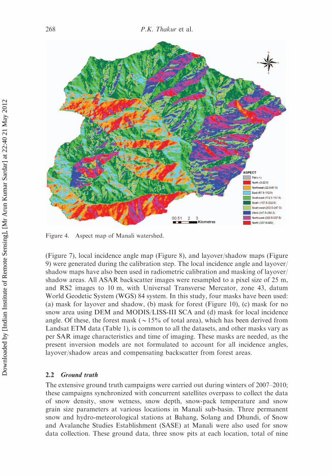
The Beas basin up to Manali town with an area of 350.21 km2 has been selected forthis study (Figure 2). The Beas basin rises from Rohtang pass 4350 m above meansea level, 51 km north of Manali. The Beas Kund glacier is the main source of waterfor Beas up to Manali. The Digital Elevation Model (DEM) and aspect map of studyarea are given in Figures 3 and 4 respectively. Climate of the study area is cool anddry, with cold season from October to February, hot season from March to June andrainy season from July to September. Snowfall, generally, occurs in December toMarch at an elevation above 2000 m and the most of the region is cut off from thelower region as most of the mountain passes are closed. August is the wettest monththroughout the water year. The maximum rainfall occurs during July to Septemberand the minimum rainfall occurs during October to January. Temperatures rangefrom a mean daily minimum of between 715 and 08C in January to a meanmaximum of 20 and 308C in June (Thakur et al. 2010).
1.4 Data and software used
The data used in this study are listed in Table 1. The Environment for VisualizingImage (ENVI) 4.3 with SARSCAPE 4.2, Mathematica 7.0, MATLAB 2010, Cþþand ERDAS Imagine 10.0 softwares were used for SAR processing, inversionmodelling and image processing, and Arc Map is used for map products generation.The ground field data of weather and snow parameters were collected duringconcurrent satellite overpass dates.
Figure 1. Backscatter from a snow pack.
Geocarto International 265
Dow
nloa
ded
by [
Indi
an I
nstit
ute
of R
emot
e Se
nsin
g], [
Mr
Aru
n K
umar
Sar
dar]
at 2
2:40
21
May
201
2

2. Methodology
2.1 SAR data pre-processing
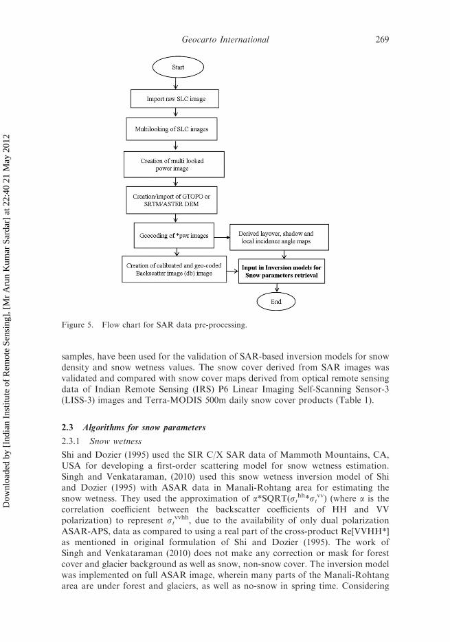
The SAR pre-processing was done with SARSCAPE software for converting rawSAR images into geo-coded backscatter images. The overall flow chart of SARpreprocessing is shown in Figures 5 and 6 shows the approach used for snow wetnessand snow density retrieval used calibrated SAR backscatter images. The raw ASARimages (*.n1) and Radarsat-2 (RS2) quad polarization (*.xml) were first read andconverted into single look complex (SLC) images. These SLC images were multi-looked to create the power (*.pwr) images. In mountainous areas, the topography
Figure 2. Study area with Manali sub-basin of Beas River.
266 P.K. Thakur et al.
Dow
nloa
ded
by [
Indi
an I
nstit
ute
of R
emot
e Se
nsin
g], [
Mr
Aru
n K
umar
Sar
dar]
at 2
2:40
21
May
201
2

significantly affects the geometry and radiometry in the SAR image, thus geo-codingand calibration using Digital Elevation Models (DEM) are required in order torelate the data to signature data (Frei et al. 1993, Holecz et al. 1993, Rosich andMeadows 2004). The radiometric and geometric calibration of these multi-lookedimages was done using ASTER Global DEM. The calibrated backscatter image
Table 1. Data used in the study.
Satellite Sensor Polarization/typeResolution
(m) Dates
ENVISAT ASAR HH/VV 25 30, 11 March, 10 February,20, 25 January 2008and 20 January 2009
Radarsat-2 Radarsat-2 HH/VV/HV/VH 10 29 January 2010IRS P6 LISS 3 Visible, IR, SWIR
(4 bands)24 16 March 2008
LANDSAT ETMþ Visible, IR, SWIR,TIR(8 bands)
30 November 2000
Terra ASTER Global DEM 30 2009Terra MODIS Daily snow cover
product (MOD10A1)500 2008–2010
Figure 3. Digital Elevation Model (DEM) map of Manali watershed.
Geocarto International 267
Dow
nloa
ded
by [
Indi
an I
nstit
ute
of R
emot
e Se
nsin
g], [
Mr
Aru
n K
umar
Sar
dar]
at 2
2:40
21
May
201
2
(Figure 7), local incidence angle map (Figure 8), and layover/shadow maps (Figure9) were generated during the calibration step. The local incidence angle and layover/shadow maps have also been used in radiometric calibration and masking of layover/shadow areas. All ASAR backscatter images were resampled to a pixel size of 25 m,and RS2 images to 10 m, with Universal Transverse Mercator, zone 43, datumWorld Geodetic System (WGS) 84 system. In this study, four masks have been used:(a) mask for layover and shadow, (b) mask for forest (Figure 10), (c) mask for nosnow area using DEM and MODIS/LISS-III SCA and (d) mask for local incidenceangle. Of these, the forest mask (*15% of total area), which has been derived fromLandsat ETM data (Table 1), is common to all the datasets, and other masks vary asper SAR image characteristics and time of imaging. These masks are needed, as thepresent inversion models are not formulated to account for all incidence angles,layover/shadow areas and compensating backscatter from forest areas.
2.2 Ground truth
The extensive ground truth campaigns were carried out during winters of 2007–2010;these campaigns synchronized with concurrent satellites overpass to collect the dataof snow density, snow wetness, snow depth, snow-pack temperature and snowgrain size parameters at various locations in Manali sub-basin. Three permanentsnow and hydro-meteorological stations at Bahang, Solang and Dhundi, of Snowand Avalanche Studies Establishment (SASE) at Manali were also used for snowdata collection. These ground data, three snow pits at each location, total of nine
Figure 4. Aspect map of Manali watershed.
268 P.K. Thakur et al.
Dow
nloa
ded
by [
Indi
an I
nstit
ute
of R
emot
e Se
nsin
g], [
Mr
Aru
n K
umar
Sar
dar]
at 2
2:40
21
May
201
2
samples, have been used for the validation of SAR-based inversion models for snowdensity and snow wetness values. The snow cover derived from SAR images wasvalidated and compared with snow cover maps derived from optical remote sensingdata of Indian Remote Sensing (IRS) P6 Linear Imaging Self-Scanning Sensor-3(LISS-3) images and Terra-MODIS 500m daily snow cover products (Table 1).
2.3 Algorithms for snow parameters
2.3.1 Snow wetness
Shi and Dozier (1995) used the SIR C/X SAR data of Mammoth Mountains, CA,USA for developing a first-order scattering model for snow wetness estimation.Singh and Venkataraman, (2010) used this snow wetness inversion model of Shiand Dozier (1995) with ASAR data in Manali-Rohtang area for estimating thesnow wetness. They used the approximation of a*SQRT(st
hh*stvv) (where a is the
correlation coefficient between the backscatter coefficients of HH and VVpolarization) to represent st
vvhh, due to the availability of only dual polarizationASAR-APS, data as compared to using a real part of the cross-product Re[VVHH*]as mentioned in original formulation of Shi and Dozier (1995). The work ofSingh and Venkataraman (2010) does not make any correction or mask for forestcover and glacier background as well as snow, non-snow cover. The inversion modelwas implemented on full ASAR image, wherein many parts of the Manali-Rohtangarea are under forest and glaciers, as well as no-snow in spring time. Considering
Figure 5. Flow chart for SAR data pre-processing.
Geocarto International 269
Dow
nloa
ded
by [
Indi
an I
nstit
ute
of R
emot
e Se
nsin
g], [
Mr
Aru
n K
umar
Sar
dar]
at 2
2:40
21
May
201
2

these points, the present work attempts to estimate the snow wetness using fullquad polarization (HH, HV, VV, VH) data of RS2 of Manali and surrounding areasusing Shi and Dozier (1995) algorithm, with mask for forest, layover/shadow, glacierand snow/non-snow pixels. The main inversion model used for snow wetness isdescribed in detail by Shi and Dozier (1995). The essential details of the modelare given below. In snow wetness model, the total backscatter st
pp at a givenpolarization is assumed from surface (ss
pp) and volume (svpp) scattering from near
the top of snow pack. The t, s, v in subscript represent the total, surface and volumescattering components, respectively, and pp in superscript represents polarizationstate.
sppt ¼ spps þ sppv : ð1Þ
The real part of cross-product of VV and HH complex scattering elements,Re[St
vvSthh*] are also related to surface and volume backscattering coefficient by
svvhht ¼ Re Svvt Shh�
t
� �¼ svvhhs þ svvhhv : ð2Þ
The first-order volume scattering from an inhomogeneous dielectric half spacemedium is given by:
sppv ¼ 3=4oT2ppexp 2s2 k1cos yi � k2cos yið Þ2
h ið3Þ
where Tpp is the power transmission coefficients for a plane interface for vertical andhorizontal polarization, s is the standard deviation of the random surface height ando is the volume-scattering albedo, which depends on snow density, snow wetness,
Figure 6. Flow chart for snow wetness and density estimation using SAR-based inversionmodels.
270 P.K. Thakur et al.
Dow
nloa
ded
by [
Indi
an I
nstit
ute
of R
emot
e Se
nsin
g], [
Mr
Aru
n K
umar
Sar
dar]
at 2
2:40
21
May
201
2

snow particle size variations and shape (Ulaby et al. 1982). If snow particles areassumed to be spherical grains, with random orientation, o becomes independentof polarization (Shi and Dozier 1995). Thus, the ratio for the first-order volumebackscattering signals of VV and HH polarization can be represented as a functionof the local incidence angle and dielectric constant. DT(yi, es), DTV(yi, es) andDTH(yi, es) represent the volume backscattering ratios for VV and HH, Re[VVHH*]to HH. Therefore, Equation (3) can be approximated as follows:
DT yi; esð Þ ¼ sVVvskkv¼ T2
vv yi; esð ÞT2hh yi; esð Þ
ð3:1Þ
DTH yi; esð Þ ¼ svvhhv
shhv¼
Re Tvvhh yi; esð Þ� �2T2hh yi; esð Þ
ð3:2Þ
DTV yi; esð Þ ¼ svvhhv
svvv¼
Re Tvvhh yi; esð Þ� �2T2vv yi; esð Þ : ð3:3Þ
In this case of surface backscattering, it is the function of the permittivity of wetsnow, which mainly depends on snow density, snow wetness and the roughness of
Figure 7. Local Incidence Angle map (30 March 2008).
Geocarto International 271
Dow
nloa
ded
by [
Indi
an I
nstit
ute
of R
emot
e Se
nsin
g], [
Mr
Aru
n K
umar
Sar
dar]
at 2
2:40
21
May
201
2

the air–snow interface. The surface backscattering is modelled using a first-orderIntegral Equation Model (IEM) (Fung 1994) for ss
vv, sshh and ss
vvhh at C-band forrange of snow wetness (1–15%), standard deviation of surface height (1–7 mm),surface correlation length (2.3–25 cm) and incidence angles (208–708) (Shi andDozier 1995). The final simplified surface backscattering is given in Equation (4).
spps ¼ app�� ��2 SR
a yið Þ þ b yið ÞSR
� �ð4Þ
where avv and ahh are the same as in Small Perturbation Model (SPM) (Cloude1992), SR¼ (ks)2W is the surface roughness parameter, where W is the Fouriertransform of the power spectrum of the surface correlation function, a and b arecoefficients that depend on the incidence angle and are derived from nonlinearregression analysis (Shi and Dozier 1995). The final snow wetness inversion modelis derived by simplifying the above equations (Shi and Dozier 1995), and where onlyunknown is dielectric constant of wet snow:
M1 avxRe avva�hh� �
� avxDRS �DTSð Þ þ bvxM2
� �¼M2 avxRe avva�hh
� �þ bvxM2
avhxDRS �DTSð Þ
� ��DTV avvj j2
� �ð5Þ
Figure 8. Calibrated Sigma0HH image (30 March 2008).
272 P.K. Thakur et al.
Dow
nloa
ded
by [
Indi
an I
nstit
ute
of R
emot
e Se
nsin
g], [
Mr
Aru
n K
umar
Sar
dar]
at 2
2:40
21
May
201
2

where
M1 ¼ svvhht �DTV yi; esð Þ � svvt ð5:1Þ
M2 ¼ svvt þ shht �DTV � svvhht ð5:2Þ
DTS ¼ DTV yi; esð Þ þ DTH yi; esð ÞDTV yi; esð ÞDTH yi; esð Þð Þ ð5:3Þ
DRS ¼avv yi; esð Þj j2 þ ahh yi; esð Þj j2
Re avv yi; esð Þa�hh yi; esð Þ� � : ð5:4Þ
The coefficients avx, bvx and avhx are derived with statistical analyses and dependonly on incidence angle. These coefficients were calculated for each ASAR and RS2images separately in MATLAB from the relation given in Shi and Dozier (1995). Thealgorithm needs no information about the volume scattering albedo or the surfaceroughness, and with known local incidence angle, it calculates the snow-packpermittivity, which can be directly related to snow wetness using the followingrelations. The permittivity of wet snow (Equation 6.3) is modelled as the permittivityof dry snow value given by Kendra et al. (1994), which depends on density alone
Figure 9. Layover Shadow mask map (30 March 2008)
Geocarto International 273
Dow
nloa
ded
by [
Indi
an I
nstit
ute
of R
emot
e Se
nsin
g], [
Mr
Aru
n K
umar
Sar
dar]
at 2
2:40
21
May
201
2

(Equation 6.1) plus an incremental increase (refer to Equation 6.2), which in turndepends only on snow wetness.
e0ds ¼ 1þ 1:7rds þ 0:7r2ds: ð6:1Þ
This incremental increase, De0s, in the permittivity was given by (Hallikainen et al.1986)
De0s ¼ 0:02m1:015v þ 0:073m1:31
v
1þ fs.fw
� �2ð6:2Þ
where fs is the frequency at which the permittivity is measured, fw¼ 9.07 GHz is therelaxation frequency of water at 08C and is expressed in per cent. If the incrementalincrease De0s is known (Equation 6.3), an accurate estimate of snow wetness, mv
can be obtained by inverting Equation (6.2) (Kendra et al. 1998). If the density ofsnow is known, then the base contribution to e0s represented by the dry snowcomponent e0ds can be calculated, thus the incremental increase in wet snowpermittivity is given by:
De0s mvð Þ ¼ e0s mv; rð Þ � e0ds rð Þ: ð6:3Þ
The wet snow permittivity e0s is obtained using the inversion model explained above(Equations 5–5.4), and is used in Equation (6.3) along with Equation (6.1) to find the
Figure 10. Forest mask of Manali sub-basin.
274 P.K. Thakur et al.
Dow
nloa
ded
by [
Indi
an I
nstit
ute
of R
emot
e Se
nsin
g], [
Mr
Aru
n K
umar
Sar
dar]
at 2
2:40
21
May
201
2

De0s; once the incremental increase is known, Equation (6.2) is used to find snowwetness in per cent.
2.3.2 Snow density
This study has used two approaches for dry snow density estimation from SARdata. In the first approach, a modified algorithm of Shi and Dozier (2000) has beenused. Shi and Dozier (2000) used the SIR C-L-X datasets of Mammoth Mountains,CA, USA, for snow water equivalence estimation by inferring, snow density,subsurface properties and snow depth. SIR-C’s L-band (1.25 GHz) sensor was usedto estimate the dry snow density, subsurface dielectric properties and soilroughness. The backscatter from snow ground interface sgpp for HH and VVpolarization is simulated using the IEM model (Fung et al. 1992, Fung 1994, Fungand Chen 2010) for a wide range of incidence angles, dielectric and roughnessconditions, and incidence wave numbers corresponding to a range of snowdensities from 100 to 550 kg m73. The main inversion model for snow densityestimation, which originally made for L-band co-polarized data is given below, buthas been modified to C-band SAR data at the level of coefficients calculations, byupdating the wave number, k, as that of the C-band SAR data and is explained indetail in this section. Assuming the dry snow pack has no significant volumebackscattering at L-band (as well as C-band) as snow grains are much smaller thanincident L and C-Band wavelengths, no significant volume scattering can begenerated by a snow pack (Shi and Dozier 2000); therefore, the total backscattercan be written as:
stpp k0; yið Þ ¼ T2pp yið Þsgpp k1; yrð Þ ð7:1Þ
where stpp is the total backscatter in a given polarization (pp), k0 is the incident wavenumber at the air–snow interface in cm71, k1 is the incident wave number at thesnow–ground interface in cm71 for the given radar frequency, yi is the incidenceangle at air–snow interface and yr is the refractive angle in snow pack or theincidence angle at snow–ground interface. Note that the dielectric contrast (eg/es)should be used instead of eg (relative dielectric constant of ground) and that k1should be used instead of k0 when calculating the backscattering sgpp at the snow–ground interface. In the present study, we have used the wave number k0, as 1.13,corresponding to ASAR C-band frequency of 5.33 GHz and wavelength of 5.6 cm ofENVISAT ASAR to recalculate the coefficients of Equation (7.2). In this study, thesnow pack is assumed to be of single layer equivalent density, instead of multi-layersnow pack, which has density variations. Since most of natural terrain considered inthe study area has a small surface roughness (dry winter grassland and barren areas)and random surface slope, single scattering will dominate over multiple scattering inmost situations. In this study, it should be noted that at C-Band (ASAR frequency),snow density affects the magnitude of the volume scattering and the surfacescattering properties at the snow–ground interface, this will affect the overallaccuracy of estimated snow density; therefore, it is the limitation of this inversionmodel.
Finally, the algorithm for estimation of snow density, which uses only sthh andstvv SAR measurements, is given as:
Geocarto International 275
Dow
nloa
ded
by [
Indi
an I
nstit
ute
of R
emot
e Se
nsin
g], [
Mr
Aru
n K
umar
Sar
dar]
at 2
2:40
21
May
201
2

log10
ffiffiffiffiffiffiffisthh
pThh yi; esð Þ þ
ffiffiffiffiffiffiffistvv
pTvv yi; esð Þ
" #¼ a yr; k1ð Þ þ b yr; k1ð Þlog10 �
sthhT2hh yi; esð Þ
þ stvvT2vv yi; esð Þ
� �
þ c yr; k1ð Þlog10 �sthh
T2hh yi; esð Þ
� �þ d yr; k1ð Þlog10 �
sthhT2vv yi; esð Þ
stvvT2hh yi; esð Þ
� �þ e yr; k1ð Þlog10
�sthhT
2vv yi; esð Þ
stvvT2hh yi; esð Þ
� �2: ð7:2Þ
In above equation, Tpp is Fresnel transmission coefficient and depends on thepolarization ‘pp’, the incidence angle yi at the air–snow interface and thedielectric constant of the snow-pack es, es is the only unknown in Equation (7.2)and yi can be calculated from a combination of the ASAR orbital data and aDEM. The coefficients a to e have been calculated for full image by using themodified wave number, k0 as 1.13 corresponding to C-band ASAR data, ascompared to the value 0.29 for L-band, as used in original formulation of Shi andDozier (2000). Therefore, for a given C-Band SAR measurements of sthh and stvv,we can estimate es numerically by varying the coefficients a, b, c, d and e to findthe root of Equation (7.2). It does not require a priori knowledge of the dielectricand roughness properties of the soil under the snow, but the accuracy of thisinversion model will be higher for L-band as compared to C-band. Furthermore,snow density can be estimated from Looyenga’s (1965) semi-empirical dielectricformula, which provides a good fit to Polder and van Santen’s physical formula(Matzler 1996).
es ¼ 1:0þ 1:5995rs þ 1:861r3s: ð7:3Þ
The second approach for estimating the snow density from C-band SAR datauses the ASAR-APS dual polarization data (Snehmani et al. 2010). In this approachfor developing an algorithm for snow density estimation, the volume scatteringmodel and the SPM have been used with an exponential correlation (Ulaby et al.1986) function for the surface backscattering contribution from the snow–groundinterface. The final inversion model (Snehmani et al. 2010) is given in Equation (7.4)and it is a function of only dielectric constant of the dry snow.
sAPðvvhhÞt ¼
shht �Tvvj j2
Thhj j2
!� avvj j
ahhj j
� �þ svvt
Tvvj jThhj j
� �� avvj j
ahhj j
� �þ 1
ð7:4Þ
where avv and ahh are the same as in SPM (Cloude 1992), and Tvv and Thh are Fresneltransmission coefficients. By knowing the incident angle, Equation (6.4) can be usedto estimate the dielectric constant of the snow, which can be directly related to snowdensity using Looyenga’s (1965, equation 7.3) semi-empirical formula.
The accuracy of snow wetness and snow density results with respect to groundmeasurements has been done using coefficient of determination or R2 (Steel andTorrie 1960). The coefficient of determination is a measure of how well the regressionline represents the data (Nagelkerke 1991). If the regression line passes exactly
276 P.K. Thakur et al.
Dow
nloa
ded
by [
Indi
an I
nstit
ute
of R
emot
e Se
nsin
g], [
Mr
Aru
n K
umar
Sar
dar]
at 2
2:40
21
May
201
2

through every point on the scatter plot, it would be able to explain all of thevariation.
3. Results and discussion
3.1 Snow wetness
The snow wetness maps are shown in Figures 11–15. In these maps, the snowwetness areas are classified in various categories (Table 2), with highest wetness classis highlighted as bold number in Table 2. The maximum wetness area (450%) hasbeen observed for 30 and 11 March data sets of ASAR followed by 10 February 2008and 29 January 2010. The area under snow wetness classes 5 and 6 (410–15%) isvery high in case of 30 March 2008 image, and this gradually decreases from Marchto February. Similarly, the snow wetness classes 1–2 (dry snow to 2% wetness) aredecreasing from January to March images. The decreasing wetness values andincreasing less wetness or dry snow area (March to January) match well with thedecreasing trend of air temperatures from spring to winter period. The RS2 quadpolarization data (HH/HV/VH/VV) of 29 January 2010 were used for snow wetnessin full polarization and also in dual polarization mode to estimate st
vvhh asRe[VVHH*] and as a*SQRT(st
hh*stvv), respectively. The snow wetness areas and
the range (Figure 11) derived from full polarization RS2 data are different from thewetness maps estimated from dual mode (HH/VV) RS2 data (Figure 12). Based onthe ground truth in Manali and Solang on 29 January 2010, there was a freshsnowfall on morning of 29th in this area, and snow wetness and snow density were
Figure 11. Snow wetness map with quad pol RS2 data by using stvvhh as Re[VVHH*].
Geocarto International 277
Dow
nloa
ded
by [
Indi
an I
nstit
ute
of R
emot
e Se
nsin
g], [
Mr
Aru
n K
umar
Sar
dar]
at 2
2:40
21
May
201
2

Figure 12. Snow wetness map with HH/VV combination of RS2 data by using stvvhh as
a *SQRT(stvv*st
hh).
Figure 13. Snow wetness map derived from 10 February 2008 ASAR-APS (HH/VV) data.
278 P.K. Thakur et al.
Dow
nloa
ded
by [
Indi
an I
nstit
ute
of R
emot
e Se
nsin
g], [
Mr
Aru
n K
umar
Sar
dar]
at 2
2:40
21
May
201
2

Figure 14. Snow wetness map derived from 11 March 2008 ASAR-APS (HH/VV) data.
Figure 15. Snow wetness map derived from 30 March 2008 ASAR-APS (HH/VV) data.
Geocarto International 279
Dow
nloa
ded
by [
Indi
an I
nstit
ute
of R
emot
e Se
nsin
g], [
Mr
Aru
n K
umar
Sar
dar]
at 2
2:40
21
May
201
2

measured above normal in these areas. This can be the reason why both the snowwetness methods estimated 425% of area as wet snow, even during January. Thewetness maps derived from Real part (Figure 11) matched better with ground data ascompared to the wetness maps derived from SQRT approximation (Figure 12), withtotal dry snow area as 21% of total area and wet snow near Solang, mainly in thesouth aspect areas. As the air temperature in higher altitudes (43000 m) is muchlesser than the air temperature at sites with lower altitudes (53000 m), a lowerdegree of wetness is expected at higher elevations. It was observed that the current
Table 2. SAR-derived snow wetness class ranges as fraction of total watershed area (0-1).
ClassSnow wetnessclass range (%)
Snow wetness class as fraction of total watershed area (0-1)
30/03/2008 11/03/2008 10/02/200829/01/2010
(real)29/01/2010(square root)
1 Dry snow 0.00 0.10 0.12 0.21 0.062 0–2 0.08 0.03 0.07 0.05 0.053 2–5 0.15 0.06 0.06 0.03 0.084 5–10 0.12 0.12 0.12 0.03 0.14
5 10–15 0.07 0.06 0.06 0.02 0.076 415 0.13 0.10 0.09 0.14 0.087 All masks 0.45 0.53 0.48 0.51 0.51
Figure 16. Snow density derived from 20 January 2009 ASAR-APS (HH/VV) data.
280 P.K. Thakur et al.
Dow
nloa
ded
by [
Indi
an I
nstit
ute
of R
emot
e Se
nsin
g], [
Mr
Aru
n K
umar
Sar
dar]
at 2
2:40
21
May
201
2
algorithm tends to overestimate the wetness in both Real- and SQRT-based RS2images for few areas in higher elevations. The snow wetness derived from ASAR-APS data (SQRT approximation; Figures 13–15) gives an increasing trend in wetnessfrom 10 February to 30 March. The estimated snow wetness matches well with theexpected wetness on different aspect areas of watershed. In all the maps, the southernaspect has higher wet areas and northern aspect has less wet areas, as southern aspectreceives more sunshine as compared to northern aspect (Dozier and Frew 1990),resulting in more wetness in southern aspect (Ehrler et al. 1997).
The accuracy (in terms of R2, coefficient of determination) of the results aftervalidation with the field data of Dhundi and Solang sites comes out to be*0.86. Thepresent snow wetness results are comparable with the results of Singh andVenkataraman (2010) for the same area and also show that the approach used byShi and Dozier (1995) can be applied to Himalayan areas. It should be noted that,both the studies need further refinement in the inversion model, as the snow wetnessvalues in higher elevation are not validated and in comparison to general trend ofdecrease in the air temperature with elevation, and snow wetness in these areas areoverestimated as per results of current inversion model.
3.2 Snow density
The density maps for 2008 winter season are shown in Figures 16–19. The snowdensity derived using modified Shi and Dozier (2000) algorithm (Approach I) is
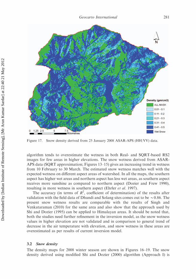
Figure 17. Snow density derived from 25 January 2008 ASAR-APS (HH/VV) data.
Geocarto International 281
Dow
nloa
ded
by [
Indi
an I
nstit
ute
of R
emot
e Se
nsin
g], [
Mr
Aru
n K
umar
Sar
dar]
at 2
2:40
21
May
201
2

shown in Figure 19 and this algorithm was implemented only for Solang-Dhundisub-area of Manali Sub-basin. The algorithm of Snehmani et al. (2010) (ApproachII) was run for full Manali watershed. The dry snow area estimated using ApproachII for 20 January 2008, comes out to be 6% of total area, with snow density rangesfrom 0.1 to 0.2 g cm73, as compared to Approach I, where it is estimated as 49%.Similarly, the wet snow area in Approach II was 30% but for Approach I, it was nil.The ground observations show that the mean snow density of snow pack at Dhundiduring 20, 25 January 2008 and 20 January 2009 varied from *0.09 to 0.15 g cm73
and snow depth varied from *235, 196 and 120 cm, respectively. Therefore, thesnow density retrieved from Approach I matches better with ground observations,as compared to Approach II, where snow density is overestimated. Overall, theASAR-APS data-based snow density is overestimated using Approach II (Table 3)as compared to Approach I. The overestimation was also evident from the fact that,it has the large area in density class 40.4 g cm73 and also the large area under wetsnow class (snow density4 0.5 g cm73) in the higher elevations, whereas airtemperature in these areas are less as compared to lower elevation area. Therefore,this approach needs to be refined to work at entire basin scale. Similarly, theApproach I need to be tested with L-band SAR data, as well as considering the fullwatershed area for dry snow density retrieval. The snow-pit-based ground sample ofDhundi, Solang and Manali was used for accuracy assessment for snow wetness and
Figure 18. Snow density derived from 20 January 2008 ASAR-APS (HH/VV) data.
282 P.K. Thakur et al.
Dow
nloa
ded
by [
Indi
an I
nstit
ute
of R
emot
e Se
nsin
g], [
Mr
Aru
n K
umar
Sar
dar]
at 2
2:40
21
May
201
2

snow density (Figures 20 and 21). The overall coefficient of determination, R2 forApproach I is *0.84 and for Approach II is 0.72.
The R2 calculated here only represents the ground observation vs. derived valuesat three sites, but maps have been created for full watershed area or part of image.The snow wetness and snow density derived from SAR-based inversion models couldnot be verified at higher elevation areas. This is due the fact that there are noaccessibility in these higher altitude areas in winters due to closing of roads in heavysnowfall conditions, and also, there are no ground observation sites at elevationsabove 3500 m above mean sea level. These inversion models are applicable toincidence angle range of 25–708 for snow wetness and 10–708 for snow density(Approach I). These results of both the approaches are less accurate as compared tothe original model results of Shi and Dozier (2000) and Snehmani et al. (2010). Incase of Approach I, as we have used C-band, it has added to slightly more snow–ground scatter and volume scatter, which has resulted in less accuracy, as comparedto original results of Shi and Dozier (2000). Still, the accuracy of Approach I forsnow density estimation is relatively higher than that of Approach II. For ApproachII, the accuracy of results given in this study is less as compared to Snehmani et al.(2010). However, the later study does not reflect overall picture, as the entiremodel was run on full ASAR image, without forest/glacier mask, and ground pointswere taken only in few selected areas. Therefore, both the results of snow wetness
Figure 19. Snow density derived from 20 January 2008 ASAR-APS (HH/VV) data (modifiedShi and Dozier (2000) algorithm).
Geocarto International 283
Dow
nloa
ded
by [
Indi
an I
nstit
ute
of R
emot
e Se
nsin
g], [
Mr
Aru
n K
umar
Sar
dar]
at 2
2:40
21
May
201
2

and snow density need to be checked with more ground data uniformly distributed atall elevations and land-use classes to give more accurate results and its further use insnowmelt runoff and snow avalanche models.
In both cases of estimated snow wetness and snow density maps, the amount ofwatershed area under various masks varies from 19 to 53%, with the percentage areaunder these masks more in snow wetness case. This is due to the presence of highrelief and steep slopes present in study area, which makes large area of watershedoutside the permissible range of local incidence angle (25–708) of snow wetnessinversion model. The relative contribution of layover, shadow and forest masksis 19–27% in the case of snow density maps (Approach II, Table 3), where nomask for local incidence angle is used. Thus, there is a strong need for creating aseparate forest backscatter model for study area, along with inversion models, whichhas higher range of applicability in terms of local incidence angle. The layover,shadow effects are minimized by selecting the higher incidence angle (4408) SARdata.
Figure 20. Observed vs. estimated snow wetness.
Table 3. SAR-derived snow density class ranges as fraction of total watershed area (0-1).
Class
Snow densityclass range (%)
Snow density class as fraction of totalwatershed area (0-1)
Density class 20/01/2008 25/01/2008 20/01/2009 20/01/2008 (Shi)
1 0.06–0.1 0.00 0.00 0.00 0.022 0.1–0.2 0.06 0.05 0.10 0.493 0.2–0.3 0.05 0.04 0.05 0.024 0.3–0.4 0.05 0.05 0.05 0.035 0.4–0.5 0.08 0.06 0.07 0.046 Wet snow 0.30 0.25 0.28 0.007 All masks 0.19 0.27 0.19 0.39
284 P.K. Thakur et al.
Dow
nloa
ded
by [
Indi
an I
nstit
ute
of R
emot
e Se
nsin
g], [
Mr
Aru
n K
umar
Sar
dar]
at 2
2:40
21
May
201
2

4. Conclusions
For the estimation of snow permittivity, snow wetness and snow density inHimalayan region, the inversion model is applied on radar backscattering coefficient.For solving complex equations on each incidence angle, we have developed code inMATLAB, Mathematica and Cþþ. No incidence angle mask was used for snowdensity model with Approach II. This study concludes that ASAR-APS-basedinversion models tend to overestimate the snow wetness and snow density, mainly inareas of higher elevations, and further ground truth and refinement of inversionmodels are needed for their operational use by user’s agencies and governmentdepartments. The snow wetness results are better as compared to snow density modelresults. The present study also concludes that the snow density inversion model(Approach I, modified Shi and Dozier 2000) needs to be tested with L-band data ofstudy area, as well as refinements and more modifications in original coefficients ofthe inversion model with C-band SAR data. These changes are required to improvethe accuracy of estimated snow density and its operational usability in hydrologicaland snow avalanche models. Additionally, the full quad polarization data of RS2 ofDecember-January (dry snow period) are needed to test and improve accuracy ofsecond approach (Snehmani et al. 2010) of snow density estimation. In case of thesnow wetness inversion model, the difference in snow wetness values estimated fromfull quad polarization data of RS2 and dual polarization data of ASAR-APS is notthat much clear using just one RS2 data that of 29 January 2010, where wetnessareas are relatively less. Therefore, more quad polarization RS2 data, mainly duringFebruary and March (wet snow period) are required for complete analysis andquantification of effect of fully quad polarization data on snow wetness estimation.Overall, the results of this study can be used for snowmelt runoff modelling andsnow avalanche modelling in selected areas, where model validation has been done.In future, the effect of vegetation cover and underlying glacier on mapping of snowcover, estimation of snow wetness and snow density will be included to apply thisinversion model at river basin scale.
Figure 21. Observed vs. estimated snow density.
Geocarto International 285
Dow
nloa
ded
by [
Indi
an I
nstit
ute
of R
emot
e Se
nsin
g], [
Mr
Aru
n K
umar
Sar
dar]
at 2
2:40
21
May
201
2
References
Ambach, W.D., 1980. The dielectric behavior of snow: a study versus liquid water content. In:A. Rango, ed. NASA workshop on microwave remote sensing of snowpack properties.NASA conference publication 2153. Ft. Collins, CO: NASA, 59–62.
Baghdadi, N., Gauthier, Y., and Bernier, M., 1997. Capability of multi-temporal ERS-1 SARdata for wet-snow mapping. Remote Sensing of Environment, 60, 174–186.
Bartsch, A., et al., 2007. Monitoring of spring snowmelt with Envisat ASAR WS inthe Eastern Alps by combination of ascending and descending orbits. In: Proceedingsof the Envisat symposium 2007, 23–27 April, Montreux, Switzerland (ESA SP-636, July2007).
Bernier, M. and Fortin, J.P., 1998. The potential of time series of C-band SAR data tomonitor dry and shallow snow cover. IEEE Trans Geosciences and Remote Sensing, 36 (1),226–243.
Bernier, M., et al., 1999. Determination of snow water equivalent using RADARSAT SARdata in eastern Canada. Hydrological Processes, 13, 3041–3051.
Braun, M. and Rau, F., 2001. Using a multi-year data archive of ERS-SAR imagery formonitoring snow line positions and ablation patters on the King George Island ice cap(Antarctica). EARSeL eProceedings, 1, 281–291.
Cloude, S.R., 1992. Uniqueness of target decomposition theorems in radar polarimetry.In: W.-M. Boerner, ed. Direct and inverse methods in radar polarimetry, Part 1. Dordrecht,Netherlands: Kluwer Academic, 267–296.
Dhanju, M.S., 1983. Studies of Himalayan snow cover area from satellites. In: Goodison,B.E., ed. Proceedings of symposium on hydrological applications of remote sensing andremote data transmission, held during the XVIIIth Assembly of the IUGG, August,Hamburg, cosponsored by WMO and UNESCO, IAHS (145), 401–409.
Dozier, J., 1984. Snow reflectance from Landsat-4 Thematic Mapper. IEEE Transactions onGeoscience and Remote Sensing, GE22 (3), 323–328.
Dozier, J., 1989. Spectral signature of Alpine snow cover from the Landsat Thematic Mapper.Remote Sensing of Environment, 28, 9–22.
Dozier, J., 1998. Remote sensing of the alpine snow cover: a review of techniques andaccomplishments from the visible wavelengths through the microwave. In: Internationalconference on snow hydrology the integration of physical, chemical, and biological systems,6–9 October, Brownsville, VT. U.S. Army Cold Regions Research and EngineeringLaboratory Hanover, NH, Special Report, 98–10.
Dozier, J. and Frew, J., 1990. Rapid calculation of terrain parameters for radiation modelingfrom digital elevation data. IEEE Transaction on Geoscience and Remote Sensing, 28 (5),963–969.
Dozier, J. and Painter H.T., 2004. Multispectral and hyperspectral remote sensing of alpinesnow properties. Annual Review of Earth and Planetary Science, 32, 465–494.
Ehrler, C., Seidel, K., and Martinec, J., 1997. Advanced analysis of snow coverbased satellite remote sensing for the assessment of water resources. In: Baumgartner,M.F., Schultz, G. A., and Johnson, A.I., eds. Proceeding of symposium on remote sensing andgeographic information systems for design and operation of water resources systems, held duringthe Fifth IAHS Scientific Assembly, April–May, Rabat, Morocco, IAHS (242), 93–101.
Evans, S., 1963. Dielectric properties of ice and show – a review. Journal of Glaciology, 5,773–792.
Frei, U., Graf, C., and Meier, E., 1993. Cartographic reference systems. In: Schreier, G. ed.SAR geocoding: data and system. Karlsruhe, Germany: Wichmann Verlag, 213–234.
Fung, A.K., 1994. Microwave scattering and emission models and their applications. Norwood,MA: Artech House.
Fung, A.K. and Chen, K.S., 2010. Microwave scattering and emission models for users.Norwood, MA: Artech House.
Fung, A.K., Li, Z., and Chen, K.S., 1992. Backscattering from a randomly rough surface.IEEE Transactions of Geoscience and Remote Sensing, 30, 356–369.
Goodison, B.E., Waterman, S.E., and Langham, E.J., 1980. Application of synthetic apertureradar data to snow cover monitoring. In: Sixth Canadian symposium on remote sensing, 21–23 May, Halifax, Nova Scotia. Kanata, Canada: Canadian Aeronautics and SpaceInstitute, 263–271.
286 P.K. Thakur et al.
Dow
nloa
ded
by [
Indi
an I
nstit
ute
of R
emot
e Se
nsin
g], [
Mr
Aru
n K
umar
Sar
dar]
at 2
2:40
21
May
201
2

Gupta, R.P., Haritashya, U.K., and Singh, P., 2005. Mapping dry/wet snow cover in theIndian Himalayas using IRS multi spectral imagery. Remote Sensing of Environment, 97,458–469.
Hall, D.K., Riggs, G.A., and Salomonson, V.V., 1995. Development of methods for mappingglobal snow cover using moderate resolution imaging spectroradiometer data. RemoteSensing of Environment, 54, 127–140.
Hallikainen, M., Ulaby, F.T., and Abdelrazik, M., 1986. Dielectric properties of snow in the 3 to37 GHz range. IEEE Transactions on Antennas and Propagation, AP–34, 1329–1339.
Holecz, F., et al., 1993. Topographic effects on radar cross section. In: Proceedings of CEOSSAR Calibration Workshop, 20–24 September, ESA-ESTEC, ESA WPP-048, 23–28.
Kendra, J.R., Sarabandi, K., and Ulaby, F.T., 1998. Radar measurements of snow:experiment and analysis. IEEE Transactions on Geoscience and Remote Sensing, 36 (3),864–879.
Kendra, J.R., Ulaby, F.T., and Sarabandi, K., 1994. Snow probe for in situ determination ofwetness and density. IEEE Transactions on Geoscience and Remote Sensing, 32, 1152–1159.
Koskinen, J., et al., 1999. Snow monitoring using radar and optical satellite data. RemoteSensing of Environment, 69, 16–29.
Koskinen, J.T., et al., 2010. Monitoring of snow cover properties during the spring meltingperiod in forested areas. IEEE Transactions on Geoscience and Remote Sensing, 48 (1),50–58.
Looyenga, H., 1965. Dielectric constant of heterogeneous mixtures. Physica, 21, 401–406.Luojus, K.P., et al., 2006. Accuracy assessment of SAR data-based snow-covered area estimation
method. IEEE Transactions on Geoscience and Remote Sensing, 44 (2), 277–287.Luojus, K.P., et al., 2009. Enhanced SAR-based snow-covered area estimation method for
boreal forest zone. IEEE Transactions on Geoscience and Remote Sensing, 47 (3), 403–407.Matzler, C., 1987. Applications of the interaction of microwaves with the natural snow cover.
Remote Sensing Review, 2, 259–387.Matzler, C., 1996. Microwave remote sensing of dry snow. IEEE Transactions on Geoscience
and Remote Sensing, 34 (2), 573–581.Nagelkerke, N., 1991. A note on a general definition of the coefficient of determination.
Biometrika, 78 (3), 691–692.Nagler, T. and Rott, H., 2000. Retrieval of wet snow by means of multi-temporal SAR data.
IEEE Transactions on Geoscience and Remote Sensing, 38, 754–765.Nagler, T. and Rott, H., 2004. Snow classification algorithm for ENVISAT ASAR. In:
Proceedings of the 2004 Envisat & ERS Symposium, 6–10 September, Salzburg, Austria (ESASP-572, April 2005). Noordwijk, Netherlands: ESA Publications Division, ESTEC, 169.
Niang, M., et al., 2007. New inversion method for snow density and snow liquid water contentretrieval using C-band data from ENVISAT/ASAR alternating polarization in alpineenvironment. In: ENVISAT symposium, 23–27 April, Montreux, ESA SP–636. Noordwijk,Netherlands: ESTEC.
Nyfors, E., 1982. On dielectric properties of dry snow in the 800 MHz to 13 GHz region.Helsinki: Helsinki University of Technology, Radio Laboratory, Report S13.
Raina, V.K., 2009. Himalayan glaciers – a state-of-art review of glacial studies, glacial retreatand climate change. MOEF discussion paper, by Ministry of Environment & Forests(MOEF), Government of India and G.B. Pant Institute of Himalayan Environment &Development Kosi-Katarmal, Almora, 1–60.
Rango, A. and Salomonson, V.V., 1975. Employment of satellite snow cover observations forimproving seasonal runoff estimates. In: Proceedings of workshop on operationalapplications of satellite snow cover observations, organized by NASA and the Universityof Nevada, Reno, NV, NASA-SP-391, 157–174.
Rau, F., et al., 2001. Radar glacier zones and its boundaries as indicators of glacier massbalance and climatic variability. EARSeL eProceedings, 1, 317–327.
Rees, W.G., 2006. Remote sensing of snow and ice. Boca Raton, FL: CRC Press, 137–156.Rosich, B. and Meadows, P., 2004. Absolute calibration of ASAR Level 1 products generated
with PF-ASAR. ENVI-CLVL-EOPG-TN-03-0010, Issue 1, revision 5.07, ESA-ESRIN.Rott, H., 1984. The analysis of backscattering properties from SAR data of mountainous
regions. IEEE Journal of Oceanic Engineering, 9, 347–355.Rott, H. and Davies, R.E., 1993. Multifrequency and polarimetric SAR observations on
alpine glaciers. Annals of Glaciology, 17, 98–104.
Geocarto International 287
Dow
nloa
ded
by [
Indi
an I
nstit
ute
of R
emot
e Se
nsin
g], [
Mr
Aru
n K
umar
Sar
dar]
at 2
2:40
21
May
201
2

Rott, H., Davis, R.E., and Dozier, J., 1992. Polarimetric and multifrequency SAR signaturesof wet snow. In: Proceedings of the international geoscience and remote sensing symposium,26–29 May, Houston, TX. Piscataway, NJ: IEEE, 1658–1660.
Rott, H. and Matzler, C., 1987. Possibilities and limitations of synthetic aperture radar forsnow and glacier surveying. Annals of Glaciology, 9, 195–199.
Shi, J. and Dozier, J., 1995. Inferring snow wetness using C-band data from SIR-C’spolarimetric synthetic aperture radar. IEEE Transactions on Geoscience and RemoteSensing, 33, 905–914.
Shi, J. and Dozier, J., 2000. Estimation of snow water equivalence using SIR-C/X SAR, Part I:inferring snow density and subsurface properties. IEEE Transactions on Geoscience andRemote Sensing, 38, 2465–2474.
Shi, J., Dozier, J., and Hensley, S., 1997. Mapping snow cover with repeat pass syntheticaperture radar. In: IEEE Proceedings of IGARSS’97, 3–8 August, Singapore. Piscataway,NJ: IEEE, 628–630. ISBN-0-7803-3839.
Singh, P. and Singh, V.P., 2001. Snow and glacier hydrology. Volume 37 of Series, WaterScience and Technology. Dordrecht, Netherlands: Kluwer Academic, 742.
Singh, V.P., Singh, P., and Haritashya, U.K., eds., 2011. The encyclopedia of snow, ice andglaciers. Berlin: Springer, 1254.
Singh, G. and Venkataraman, G., 2007. Snow wetness estimation using advanced syntheticaperture radar data. Journal of Applied Remote Sensing, 1, 013521.
Singh, G. and Venkataraman, G., 2009. Snow density estimation using polarimetric ASARdata. In: Proceedings of IEEE IGARSS09, 2, II–630–II–633.
Singh, G. and Venkataraman, G., 2010. Snow permittivity retrieval inversion algorithm forestimating snow wetness. Geocarto International, 25 (3), 187–212.
Snehmani, et al., 2010. Development of an inversion algorithm for dry snow densityestimation and its application with ENVISAT-ASAR dual co-polarization data. GeocartoInternational, 25 (8), 597–616.
Storvold, R., et al., 2006. SAR remote sensing of snow parameters in Norwegian areas –current status and future perspective. Journal of Electromagnetic Waves and Applications,20 (13), 1751–1759.
Steel, R.G.D. and Torrie, J.H., 1960. Principles and procedures of statistics. New York:McGraw-Hill, 187, 287.
Strozzi, T., 1996. Backscattering measurements of snow covers at 5.3 and 35 GHz. Dissertation(PhD). Institute of applied Physics, University of Bern, Bern, Switzerland.
Strozzi, T. and Matzler, C., 1998. Backscattering measurements of Alpine snow covers at5.3 and 35 GHz. IEEE Transactions on Geoscience and Remote Sensing, 36, 838–848.
Strozzi, T., Wegmuller, U., and Matzler, C., 1999. Mapping wet snow cover with SARinterferometry. International Journal of Remote Sensing, 20, 2395–2403.
Thakur, P.K., et al., 2008. Snow cover area and glaciers extraction in Manali sub-basin usingmulti polarimetric ENVISAT ASAR data. In: Proceedings of ISRS national symposium onadvances in remote sensing technology with special emphasis on microwave remote sensing,18–20 December, Ahemdabad, India.
Thakur, P.K., et al., 2009. Snow cover mapping using multi-sensor SAR data for parts ofwestern Himalayas. In: International Symposium on Snow and Avalanches (ISSA), at Snowand Avalanche Establishment (SASE), 6–10 April, Manali, India.
Thakur, P.K., et al., 2010. Hydrological and 1-D hydrodynamic modeling in Manali sub-basinof Beas river, Himachal Pradesh, India. In: Proceedings of ASCE-EWRI internationalconference on 3rd international perspective on current & future state of water resources & theenvironment, 5–7 January, Chennai, India.
Tiuri, M., et al., 1984. The complex dielectric constant of snow at microwave frequencies.IEEE Journal of Oceanic Engineering, 9, 377–382.
Ulaby, F.T., Moore, R.K., and Fung, A.K., 1982. Microwave remote sensing, active andpassive, from theory to applications. Vol. II. Reading, PA: Addison-Wesley.
Ulaby, F.T., Moore, R.K., and Fung, A.K., 1986. Microwave remote sensing, active andpassive, from theory to applications. Vol. III. Reading, PA: Addison-Wesley.
Ulaby, F.T. and Stiles, W.H., 1980. The active and passive microwave response to snowparameters, Part II: water equivalent of dry snow. Journal of Geophysics Research, 83,1045–1049.
288 P.K. Thakur et al.
Dow
nloa
ded
by [
Indi
an I
nstit
ute
of R
emot
e Se
nsin
g], [
Mr
Aru
n K
umar
Sar
dar]
at 2
2:40
21
May
201
2
Copyright © 2022 FDOKUMEN