Towards High Molecular Weight Poly(bisphenol A carbonate ...
Upload
independentCategory
view
1download
0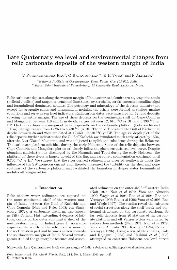
Late Quaternary sea level and environmental changes fromrelic carbonate deposits of the western margin of India
V Purnachandra Rao∗, G Rajagopalan∗∗, K H Vora∗ and F Almeida∗
∗National Institute of Oceanography, Dona Paula, Goa 403 004, India.∗∗Birbal Sahni Institute of Palaeobotany, 53 University Road, Lucknow, India.
Relic carbonate deposits along the western margin of India occur as dolomite crusts, aragonite sands(pelletal / oolitic) and aragonite-cemented limestones, oyster shells, corals, encrusted coralline algaland foraminiferal-dominated nodules. The petrology and mineralogy of the deposits indicate thatexcept for aragonite sands and foraminiferal nodules, the others were formed in shallow marineconditions and serve as sea level indicators. Radiocarbon dates were measured for 62 relic depositscovering the entire margin. The age of these deposits on the continental shelf off Cape Comorinand Mangalore, between 110 and 18 m depth, ranges between 12, 610 14C yr BP and 6,390 14C yrBP. On the northwestern margin of India, especially on the carbonate platform (between 64 and100 m), the age ranges from 17,250 to 6,730 14C yr BP. The relic deposits of the Gulf of Kachchh atdepths between 35 and 25 m are dated at 12,550 – 9,630 14C yr BP. The age vs. depth plot of therelic deposits further indicates that the Gulf of Kachchh was inundated much early, atleast by 15 ka,after the Last Glacial Maximum, and was subjected to uplift and subsidence during the Holocene.The carbonate platform subsided during the early Holocene. Some of the relic deposits betweenCape Comorin and Mangalore plot on or, closely follow the glacio-eustatic sea level curve. Despiteabundant siliciclastic flux discharged by the Narmada and Tapti during the early Holocene, theplatform off these rivers is largely devoid of this flux and carbonate sedimentation continued until6,700 14C yr BP. We suggest that the river-derived sediment flux diverted southwards under theinfluence of the SW monsoon current and, thereby, increased the turbidity on the shelf and slopesoutheast of the carbonate platform and facilitated the formation of deeper water foraminiferalnodules off Vengurla-Goa.
1. Introduction
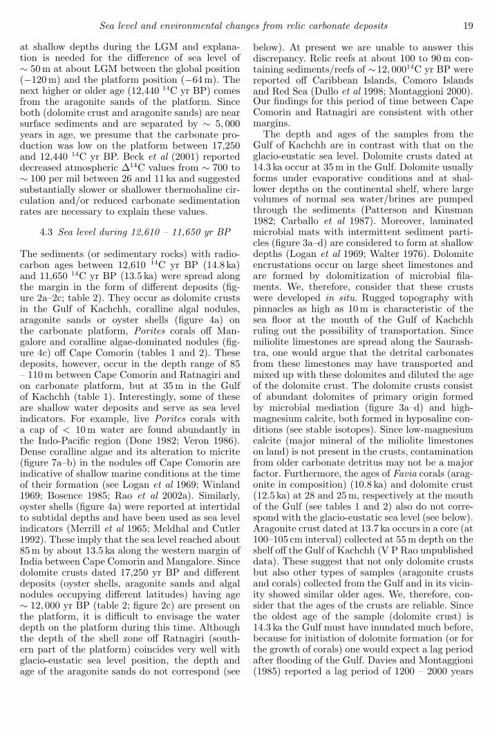
Relic shallow water sediments are exposed onthe outer continental shelf of the western mar-gin of India, between the Gulf of Kachchh andCape Comorin (Nair and Pylee 1968; von Stack-elberg 1972). A carbonate platform, also knownas Fifty Fathom Flat, extending 4 degrees of lati-tude, occurs on the outer continental shelf of thenorthwestern margin of India (figure 1). As a con-sequence, the width of the relic zone is more inthe northwestern part and becomes narrow towardsthe southwestern margin of India. Several investi-gators studied the geomorphic features and associ-
ated sediments on the outer shelf off western India(Nair 1975; Nair et al 1979; Vora and Almeida1990; Wagle et al 1994; Rao et al 1994; Rao andVeerayya 1996; Rao et al 1996; Vora et al 1996; Raoand Wagle 1997). The studies reveal the existenceof reefal structures along the shelf break and bio-hermal structures on the carbonate platform. Sofar, relic deposits from 20 stations of the carbon-ate platform and off Vengurla-Goa were dated byradiocarbon methods (Nair 1974; Nair et al 1979;Vora and Almeida 1990; Rao et al 1994; Rao andVeerayya 1996). Using a few of these dates, Kaleand Rajaguru (1985) and Hashimi et al (1995)attempted to construct Holocene sea level curves
Keywords. Late Quaternary sea level; western margin of India; subsidence; uplift; depositional environment.
Proc. Indian Acad. Sci. (Earth Planet. Sci.), 112, No. 1, March 2003, pp. 1–25© Printed in India. 1
2 V Purnachandra Rao et al
0 200km
N
INDIA
Arabian Sea
24˚
20˚
16˚
12˚
8˚
67˚E 71˚ 75˚ 79˚
Gulf ofKachchh
Saurashtra
Mumbai
Ratnagiri
Mormugao
Mangalore
Kochi
30m
60m
200m
Indus
R.
Gulf of KhambatNarmada R.Tapti R.
Cape Comorin
N
Carbonate Platform
4,5
31,2
6
78
15
1617
12
13,1411
10 9
2223
2019
21
24 25
26
2728
2931
32
33
36
3435
3837 41
42
4346 47
45
3940
48
49
5052 51
53
54
55
56
57
59
5860
18
44
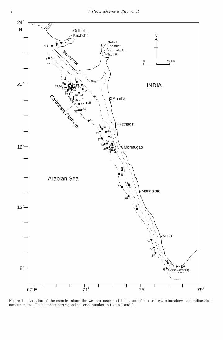
Figure 1. Location of the samples along the western margin of India used for petrology, mineralogy and radiocarbonmeasurements. The numbers correspond to serial number in tables 1 and 2.
Sea level and environmental changes from relic carbonate deposits 3
for the western margin of India. These two curvesare indeed different from one another and also dif-fer with the glacio-eustatic sea level curve of Fair-banks (1989). The data points making the sea levelcurves in Kale and Rajaguru (1985) and Hashimiet al (1995) are largely inferred/estimated agesand, actual measured dates of the samples fall awayfrom the curves. Rao et al (1996) have discussedseveral problems in the data used for preparingthese curves and also explained why the curvesare unacceptable to represent sea level changesoff western India. Moreover, no radiocarbon dateswere available for the relic reefs/sediments of thelarger part of the western Indian margin (off Goa-Cape Comorin, Saurashtra or the Gulf of Kachchh)when these sea level curves were constructed. Inother words, the significance of these relic sedi-ments in relation to late Quaternary sea level andenvironmental changes has not yet been compre-hended. Here, we have determined the age of asmany as 42 relic deposits of different types cover-ing the entire margin under the Project “Sea levelchanges along the western margin of India duringthe late Quaternary” funded by the Departmentof Science and Technology, New Delhi. The pur-pose of the paper is to update the inventory ofthe radiocarbon ages of relic deposits on this mar-gin, synthesize results on sea level changes in rela-tion to glacio-eustatic sea level and impact of sealevel/environmental changes on sediment deposi-tional environment during the late Quaternary.
2. Material and methods
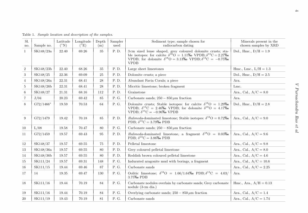
The sediments/sedimentary rocks recovered fromthe western margin of India during different cruisesof RV Gaveshani (G), ORV Sagar Kanya (SK) andMV Nand Rachit (NR) by Peterson Grab. Pipedredge with chain bag at the bottom and bucketdredge were used for the present study (figure 1).Table 1 shows the locations, depths and descrip-tion of the sediments and also the samples chosenfor different analyses. In the case of dredge samplesthe location and depth of the samples are estimatesof their averages at the start and end of dredg-ing. Samples selected from each station were ultra-sonically cleaned. The samples were split into twohalves. One half was used for preparing thin sec-tions and studied under petrological microscope.The other half was powdered, subjected to X-raydiffraction studies and then dating by radiocarbonmethods were carried out at the Birbal Sahni Insti-tute of Palaeobotony, Lucknow. Minerals presentin each sample and ratio of major carbonate min-erals are shown in table 1. Dolomite (D), aragonite(A) and high-magnesium calcite (H) are marineminerals; their ratios indicate relative abundance
of one mineral with respect to the other. Sincelow-magnesium calcite (C) can originate from theinfluence of meteoric water, one should be cau-tious if its percentage is higher in a given sam-ple. We are aware that the calcite and aragonitehave different absorption coefficients for X-rays andpeak heights of these minerals in the X-ray dif-fractogram are not a true reflection of their abun-dance. We have prepared a calibration curve basedon pure mixtures of aragonite (A) and calcite (C).From this curve it is evident that the weight per-centage of aragonite is 80%, 70%, 60% and 50%when A/C peak height ratio in the mixture is 1.0,0.5, 0.3 and 0.18, respectively. Samples analysedhere have consistently shown higher A/C ratios(> 2) (see table 1) indicating that the weight per-centage of aragonite is > 90% and therefore theradiocarbon age dating on them is reliable. Oystershells (see table 1) are originally made up of low-magnesium calcite (C) and the 14C date on themis valid. Measured 14C ages were calibrated usingCALIB rev. 4.3 of Stuiver et al (1998) and are givenin table 2. During calibration a local deviation in∆R – 100 ± 30 for Goa-Cape Comorin region and163 ± 30 for Gulf of Kachchh - Goa was used,following Dutta et al (2001). Corrected radiocar-bon ages are obtained by subtracting surface oceanreservoir age – 400 years and 100 years in localdeviation in ∆R. We have discussed the correctedand calibrated radiocarbon ages in the text so thatone can compare these ages with the age of thesediments on land. Three sediment samples anda dolomite crust were dated by Accelerator MassSpectrometer (AMS) at the Woods Hole Oceano-graphic Institution (WHOI), USA. The conven-tional radiocarbon ages are younger than that ofAMS ages by 500 to 800 years for the samples ofthe same station (see table 2). This arose becauseAMS age measurements were made on a few oolitegrains carefully picked up from > 250 µm fraction,whereas conventional radiocarbon age determina-tions were done on the sediments in the size range250–850 µm.
3. Results
3.1 Relic deposits of the Gulf of Kachchh
The type of relic deposits recovered along the con-tinental margin varied significantly from north tosouth (table 1). The samples recovered at dif-ferent stations from the Gulf of Kachchh arelarge sheet limestones encrusted by 0.5 to 1.0 cmthick dolomite crusts, 3 cm sized lense-shapeddolomite crusts, corals belonging to the Favi-idae family (Leptastrea transversa) and micriticlimestones (table 1; figure 2a). Dolomite crusts
4V
Purnachandra
Rao
etal
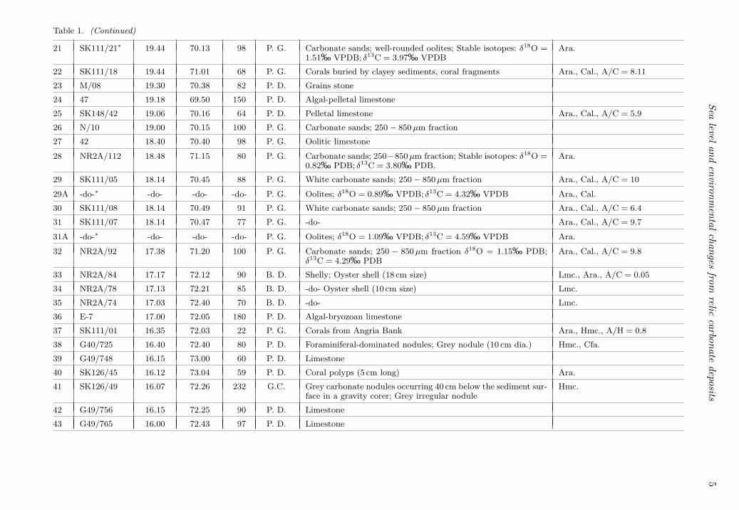
Table 1. Sample location and description of the samples.
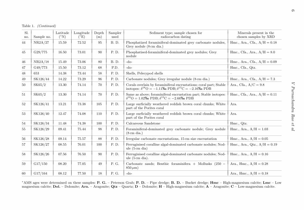
Sl. Latitude Longitude Depth Sampler Sediment type; sample chosen for Minerals present in theno. Sample no. (◦N) (◦E) (m) used radiocarbon dating chosen samples by XRD
1 SK148/23a 22.40 69.26 35 P. D. 3 cm sized lense shaped, grey coloured dolomite crusts; sta-ble isotopes: for calcite δ18O = 1.11‰ VPDB; δ13C = 2.27‰VPDB; for dolomite δ18O = 3.13‰ VPDB; δ13C = −0.75‰VPDB
Dol., Hmc., D/H = 1.9
2 SK148/23b 22.40 68.26 35 P. D. Large sheet limestones Hmc., Lmc., L/H = 1.3
3 SK148/25 22.36 69.09 25 P. D. Dolomite crusts; a piece Dol., Hmc., D/H = 2.5
4 SK148/26a 22.31 68.41 28 P. D. Abundant Favia Corals; a piece Ara.
5 SK148/26b 22.31 68.41 28 P. D. Micritic limestone; broken fragment Lmc.
6 SK148/27 21.31 68.16 112 P. D. Grainstone Ara., Cal., A/C = 8.0
7 J/04 20.23 69.42 85 P. G. Carbonate sands; 250 − 850 µm fraction Ara.
8 G72/1466∗ 19.59 70.53 64 P. G. Dolomite crusts; Stable isotopes: for calcite δ18O = 1.29‰VPDB; δ13C = 2.46‰ VPDB; for dolomite δ18O = 4.17‰VPDB; δ13C = −0.96‰ VPDB
Dol., Hmc., D/H = 2.8
9 G72/1479 19.42 70.18 85 P. D. Halimeda-dominated limestone; Stable isotopes: δ18O = 0.72‰PDB; δ13C = 3.79‰ PDB
Ara., Cal., A/C = 9.0
10 L/08 19.58 70.47 80 P. G. Carbonate sands; 250 − 850 µm fraction
11 G72/1459 19.57 69.43 95 P. D. Halimeda-dominated limestone, a fragment δ18O = 0.03‰PDB; δ13C = 3.86‰ PDB
Ara., Cal., A/C = 9.6
12 SK148/37 19.57 69.55 75 P. D. Pelletal limestone Ara., Cal., A/C = 9.8
13 SK148/36a 19.57 69.55 80 P. D. Grey coloured pelletal limestone Ara., Cal., A/C = 8.0
14 SK148/36b 19.57 69.55 80 P. D. Reddish brown coloured pelletal limestone Ara., Cal., A/C = 4.6
15 SK111/24 19.57 69.31 148 P. G. Indurated aragonite mud with borings, a fragment Ara., Cal., A/C = 10.6
16 SK111/15 19.44 69.46 87 P. G. Carbonate sands Ara., Cal., A/C = 2.25
17 14 19.35 69.47 130 P. G. Oolitic limestone; δ18O = 1.66/1.64‰ PDB; δ13C = 4.03/3.75‰ PDB
Ara.
18 SK111/16 19.44 70.19 84 P. G. Carbonate nodules overlain by carbonate sands; Grey carbonatenodule (3 cm dia.)
Hmc., Ara., A/H = 0.13
19 SK111/16 19.44 70.19 84 P. G. Overlying carbonate sands; 250 − 850 µm fraction Ara., Cal., A/C = 1.4
20 SK111/19 19.43 70.19 81 P. G. Carbonate sands Ara., Cal., A/C = 1.74
Sealevel
andenvironm
entalchanges
fromrelic
carbonatedeposits
5Table 1. (Continued)
21 SK111/21∗ 19.44 70.13 98 P. G. Carbonate sands; well-rounded oolites; Stable isotopes: δ18O =1.51‰ VPDB; δ13C = 3.97‰ VPDB
Ara.
22 SK111/18 19.44 71.01 68 P. G. Corals buried by clayey sediments, coral fragments Ara., Cal., A/C = 8.11
23 M/08 19.30 70.38 82 P. D. Grains stone
24 47 19.18 69.50 150 P. D. Algal-pelletal limestone
25 SK148/42 19.06 70.16 64 P. D. Pelletal limestone Ara., Cal., A/C = 5.9
26 N/10 19.00 70.15 100 P. G. Carbonate sands; 250 − 850 µm fraction
27 42 18.40 70.40 98 P. G. Oolitic limestone
28 NR2A/112 18.48 71.15 80 P. G. Carbonate sands; 250−850 µm fraction; Stable isotopes: δ18O =0.82‰ PDB; δ13C = 3.80‰ PDB.
Ara.
29 SK111/05 18.14 70.45 88 P. G. White carbonate sands; 250 − 850 µm fraction Ara., Cal., A/C = 10
29A -do-∗ -do- -do- -do- P. G. Oolites; δ18O = 0.89‰ VPDB; δ13C = 4.32‰ VPDB Ara., Cal.
30 SK111/08 18.14 70.49 91 P. G. White carbonate sands; 250 − 850 µm fraction Ara., Cal., A/C = 6.4
31 SK111/07 18.14 70.47 77 P. G. -do- Ara., Cal., A/C = 9.7
31A -do-∗ -do- -do- -do- P. G. Oolites; δ18O = 1.09‰ VPDB; δ13C = 4.59‰ VPDB Ara.
32 NR2A/92 17.38 71.20 100 P. G. Carbonate sands; 250 − 850 µm fraction δ18O = 1.15‰ PDB;δ13C = 4.29‰ PDB
Ara., Cal., A/C = 9.8
33 NR2A/84 17.17 72.12 90 B. D. Shelly; Oyster shell (18 cm size) Lmc., Ara., A/C = 0.05
34 NR2A/78 17.13 72.21 85 B. D. -do- Oyster shell (10 cm size) Lmc.
35 NR2A/74 17.03 72.40 70 B. D. -do- Lmc.
36 E-7 17.00 72.05 180 P. D. Algal-bryozoan limestone
37 SK111/01 16.35 72.03 22 P. G. Corals from Angria Bank Ara., Hmc., A/H = 0.8
38 G40/725 16.40 72.40 80 P. D. Foraminiferal-dominated nodules; Grey nodule (10 cm dia.) Hmc., Cfa.
39 G49/748 16.15 73.00 60 P. D. Limestone
40 SK126/45 16.12 73.04 59 P. D. Coral polyps (5 cm long) Ara.
41 SK126/49 16.07 72.26 232 G.C. Grey carbonate nodules occurring 40 cm below the sediment sur-face in a gravity corer; Grey irregular nodule
Hmc.
42 G49/756 16.15 72.25 90 P. D. Limestone
43 G49/765 16.00 72.43 97 P. D. Limestone
6V
Purnachandra
Rao
etal
Table 1. (Continued)
Sl. Latitude Longitude Depth Sampler Sediment type; sample chosen for Minerals present in theno. Sample no. (◦N) (◦E) (m) used radiocarbon dating chosen samples by XRD
44 NR2A/27 15.59 72.52 95 B. D. Phosphatized foraminiferal-dominated grey carbonate nodules,Grey nodule (8 cm dia.)
Hmc., Ara., Cfa., A/H = 0.18
45 G29/775 16.50 73.01 90 P. D. Phosphatised-foraminiferal-dominated grey nodules; Greynodule
Hmc., Cfa., Ara., A/H = 8.0
46 NR2A/18 15.49 73.06 80 B. D. -do- Hmc., Ara., Cfa., A/H = 0.09
47 G49/773 15.50 73.12 68 P.D. -do- Hmc., Cfa., Qtz.
48 653 14.38 73.44 58 P. D. Shells, Pelecypod shells –
49 SK126/44 14.22 73.29 96 P. D. Carbonate nodules; Grey irregular nodule (8 cm dia.) Hmc., Ara., Cfa., A/H = 7.3
50 SK65/2 13.30 74.14 70 P. D. Corals overlain by foraminiferal encrustations; coral part; Stableisotopes: δ18O = −1.11‰ PDB; δ13C = −2.16‰ PDB
Ara., Cfa., A/C = 9.8
51 SK65/2 13.30 74.14 70 P. D. Same as above; foraminiferal encrustation part; Stable isotopes:δ18O = 1.02‰ PDB; δ13C = −2.66‰ PDB
Hmc., Cfa., Ara., A/H = 0.11
52 SK126/41 13.21 73.38 105 P. D. Large surficially weathered reddish brown coral chunks; Whitepart of the Porites coral
Ara.
53 SK126/40 12.47 74.08 110 P. D. Large surficially weathered reddish brown coral chunks; Whitepart of the Porites coral
Ara.
54 SK126/34 11.48 74.38 100 P. D. Calcareous Sandstone Hmc., Qtz.
55 SK126/29 09.41 75.44 98 P. D. Foraminiferal-dominated grey carbonate nodule; Grey nodule(8 cm dia.)
Hmc., Ara., A/H = 1.03
56 SK126/28 09.14 75.57 88 P. D. Irregular carbonate encrustations, 15 cm size encrustation Hmc., Ara., A/H = 0.05
57 SK126/27 08.55 76.01 100 P. D. Ferruginised coralline algal-dominated carbonate nodules; Nod-ule (5 cm dia)
Hmc., Ara., Qtz., A/H = 0.19
58 SK126/26 07.56 76.50 90 P. D. Ferruginised coralline algal-dominated carbonate nodules; Nod-ule (5 cm dia).
Hmc., Ara., A/H = 0.16
59 G17/150 08.20 77.05 49 P. G. Carbonate sands; Benthic foraminifera + Mollusks (250 −850 µm)
Ara., Hmc., A/H = 0.28
60 G17/164 08.12 77.50 18 P. G. -do- Ara., Hmc., A/H = 0.18
∗AMS ages were determined on these samples: P. G. – Peterson Grab; P. D. – Pipe dredge; B. D. – Bucket dredge; Hmc – High-magnesium calcite; Lmc – Lowmagnesium calcite; Dol. – Dolomite; Ara. – Aragonite; Qtz – Quartz; D – Dolomite; H – High-magnesium calcite; A – Aragonite; C – Low-magnesium calcite.
Sealevel
andenvironm
entalchanges
fromrelic
carbonatedeposits
7
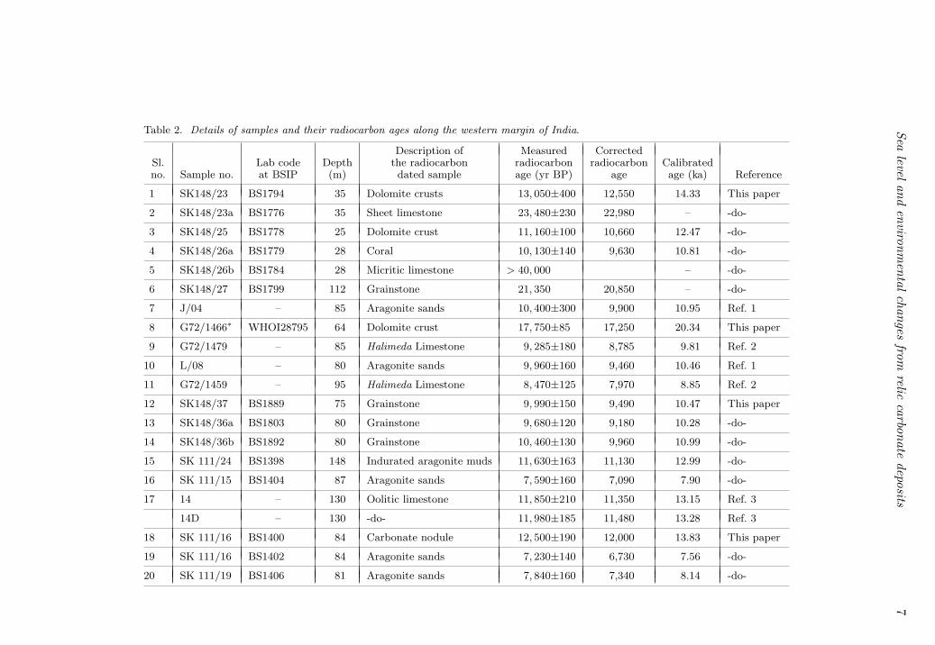
Table 2. Details of samples and their radiocarbon ages along the western margin of India.
Description of Measured CorrectedSl. Lab code Depth the radiocarbon radiocarbon radiocarbon Calibratedno. Sample no. at BSIP (m) dated sample age (yr BP) age age (ka) Reference
1 SK148/23 BS1794 35 Dolomite crusts 13, 050±400 12,550 14.33 This paper
2 SK148/23a BS1776 35 Sheet limestone 23, 480±230 22,980 – -do-
3 SK148/25 BS1778 25 Dolomite crust 11, 160±100 10,660 12.47 -do-
4 SK148/26a BS1779 28 Coral 10, 130±140 9,630 10.81 -do-
5 SK148/26b BS1784 28 Micritic limestone > 40, 000 – -do-
6 SK148/27 BS1799 112 Grainstone 21, 350 20,850 – -do-
7 J/04 – 85 Aragonite sands 10, 400±300 9,900 10.95 Ref. 1
8 G72/1466∗ WHOI28795 64 Dolomite crust 17, 750±85 17,250 20.34 This paper
9 G72/1479 – 85 Halimeda Limestone 9, 285±180 8,785 9.81 Ref. 2
10 L/08 – 80 Aragonite sands 9, 960±160 9,460 10.46 Ref. 1
11 G72/1459 – 95 Halimeda Limestone 8, 470±125 7,970 8.85 Ref. 2
12 SK148/37 BS1889 75 Grainstone 9, 990±150 9,490 10.47 This paper
13 SK148/36a BS1803 80 Grainstone 9, 680±120 9,180 10.28 -do-
14 SK148/36b BS1892 80 Grainstone 10, 460±130 9,960 10.99 -do-
15 SK 111/24 BS1398 148 Indurated aragonite muds 11, 630±163 11,130 12.99 -do-
16 SK 111/15 BS1404 87 Aragonite sands 7, 590±160 7,090 7.90 -do-
17 14 – 130 Oolitic limestone 11, 850±210 11,350 13.15 Ref. 3
14D – 130 -do- 11, 980±185 11,480 13.28 Ref. 3
18 SK 111/16 BS1400 84 Carbonate nodule 12, 500±190 12,000 13.83 This paper
19 SK 111/16 BS1402 84 Aragonite sands 7, 230±140 6,730 7.56 -do-
20 SK 111/19 BS1406 81 Aragonite sands 7, 840±160 7,340 8.14 -do-
8V
Purnachandra
Rao
etal
Table 2. (Continued)
Description of Measured CorrectedSl. Lab code Depth the radiocarbon radiocarbon radiocarbon Calibratedno. Sample no. at BSIP (m) dated sample age (yr BP) age age (ka) Reference
21 SK111/21∗ WHOI 98 Aragonite sands 12, 250±50 11,850 13.49 -do-
22 SK111/18 BS1598 68 Coral 3, 050±180 2,550 2.70 -do-
23 M/08 – 82 Grains stone 8, 960±200 8,460 9.21 -do-
24 47 – 150 Algal-pelletal Limestone 11, 150±130 10,650 12.48 Ref. 1
47D 150 -do- 11, 040±400 10,540 12.33 Ref. 1
25 Sk148/42 BS1804 64 Grainstone 11, 000±140 10,500 12.54 This paper
26 N/10 – 100 Aragonite sands 11, 330±350 10,830 12.74 Ref. 1
27 42 – 98 Oolitic limestone 9, 200±140 8,700 9.70 Ref. 1
28 NR2A/112 Fr112 80 Aragonite sands 8, 340±185 7,840 8.64 Ref. 2
29 SK 111/5 BS1445 88 Aragonite sands 9, 490±140 8,990 9.91 This paper
29A SK111/5∗ WHOI 88 Oolites 10, 250±45 9,750 10.98 -do-30 SK 111/8 BS1449 91 Aragnoite sands 12, 940±130 12,440 14.28 -do-31 SK 111/7 BS1447 77 -do- 10, 680±140 10,180 11.63 -do-
31A -do-∗ WHOI -do- -do- 11, 100±45 10,600 12.51 -do-
32 NR2A/92 FR0092 100 Aragonite sands 10, 080±250 9,580 10.72 Ref. 2
33 NR2A/84 BS1457 90 Oyster shell 9, 700±110 9,200 10.28 This paper
34 NR2A/78 BS1456 85 -do- 12, 420±130 11,920 13.81 -do-
35 NR2A/74 BS1454 70 -do- 11, 230±160 10,730 12.74 -do-
36 E-7 – 180 Algal-bryozoan Lime 10, 420±250 9,920 11.00 Ref. 4stone
37 SK 111/1 BS1394 22 Coral 240±110 – – This paper
38 G29/725 – 80 Carbonate nodule 8, 400±150 7,900 8.84 Ref. 5

Sealevel
andenvironm
entalchanges
fromrelic
carbonatedeposits
9Table 2. (Continued)
39 G49/748 – 60 Limestone 7, 850±130 7,350 8.18 Ref. 5
40 SK126/45 BS1386 59 Coral polyps 2, 890±90 2,390 2.50 This paper
41 SK126/49 BS1388 232 Algal nodule 19, 260±280 18,760 22.15 -do-
42 G49/756 – 90 Limestone 9, 440±150 8,940 10.00 Ref. 5
43 G49/765 – 97 -do- 8, 380±140 7,880 8.82 Ref. 5
44 NR2A/27 BS1452 95 Phosphatized carbonate 8, 840±120 8,340 9.21 This papernodule
45 G49/775 90 -do- 7, 500±200 7,000 7.85 Ref. 6
46 NR2A/18 BS1451 80 -do- 8, 510±140 8,010 8.91 This paper
47 G49/773 – 68 -do- 8, 300±135 7,800 8.69 Ref. 6
48 653 – 58 Shells 9, 140±130 8,640 9.70 Ref. 4
49 SK126/44 BS1385 96 Carbonate nodule 11, 480±230 10,980 12.92 This paper
50 SK65/2 – 70 Coral part 8, 280±140 7,780 8.64 Ref. 7
51 SK65/2 – Foraminiferal part 8, 090±210 7,590 8.41 Ref. 7
52 SK126/41 BS1384 105 Porites coral 13, 110±150 12,610 14.77 This paper
53 SK126/40 BS1381 110 Porites coral 12, 020±140 11,520 13.42 This paper
54 SK126/34 BS1379 100 Calcareous sandstone 15, 070±300 14,570 17.33 This paper
55 SK126/29 BS1378 98 Carbonate nodule 8, 970±160 8,470 9.44 -do-
56 SK126/28 BS1376 88 Irregular algal encrustation 9, 840±150 9,340 10.33 -do-
57 SK126/27 BS1375 100 Carbonate nodule 10, 050±290 9,550 10.81 -do-
58 SK126/26 BS1373 90 -do- 12, 150±310 11,650 13.48 -do-
59 G17/150 BS1460 49 Benthic foraminifers+ 8, 100±150 7,600 8.42 -do-mollusks
60 G17/164 BS1462 18 -do- 6, 890±90 6,390 7.31 -do-
∗AMS age; Ref. 1 – Nair et al 1979; Ref. 2 – Rao et al 1994; Ref. 3 – Rao and Veerayya 1996; Ref. 4 – Nair and Hashimi 1980;Ref. 5 – Vora and Almeida 1990; Ref. 6 – Borole et al 1987; Ref. 7 – Rao and Lamboy 1996; D – Duplicate analysis.
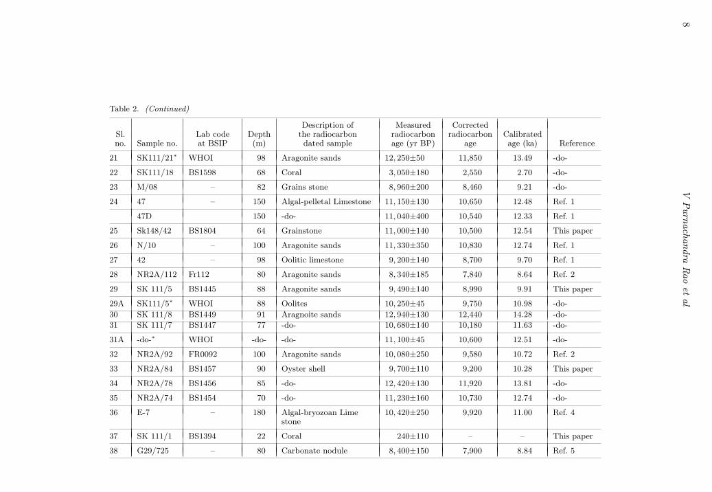
10 V Purnachandra Rao et al
13,05023.480
11,16010,130
>40,000
21,350
24˚
23˚
22˚
200m
20m
50m
100m200m
1000m
20m
50m
100m
67˚ 68˚ 69˚ 70˚E
Indus R.
INDUSCANYON
Gulf of Kachchh
N
Figure 2(a). Measured radiocarbon ages of the samples off the Gulf of Kachchh.
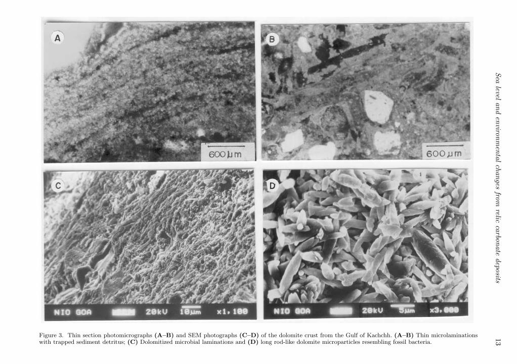
consist of quartz, dolomite and high-magnesiumcalcite, whereas the associated sheet limestonesconsist of calcite and quartz. Thin sections indicatethat the dolomite crusts consist of abundant thindolomite micro-laminations or laminations withtrapped sediment detritus (figure 3a–b). SEM stud-ies indicate that these laminations are caused byencrustation of microbial filaments, which weredolomitized directly (figure 3c). Rod-shaped andelongated dolomite microparticles resembling fos-silized bacteria are also abundant (figure 3d). Oxy-gen (δ18O = 3.13‰) isotopes of the dolomite(table 1) indicate its formation in hyposaline condi-tions. The carbonate minerals (dolomite and high-magnesium calcite) forming the dolomite crust aremarine. The ages of the dolomite crusts at 35 mand 25 m are 12,550 14C yr BP (14.3 ka) and 10,66014C yr BP (12.5 ka), respectively. The corals at25 m are dated at 10.8 ka. The ages of the sheetlimestones (22,980 14C yr BP) and micritic lime-stones (> 40, 00014C yr BP) respectively are at theextreme end and beyond the ages datable by 14Cmethod (table 2; figure 2a).
3.2 The carbonate platform
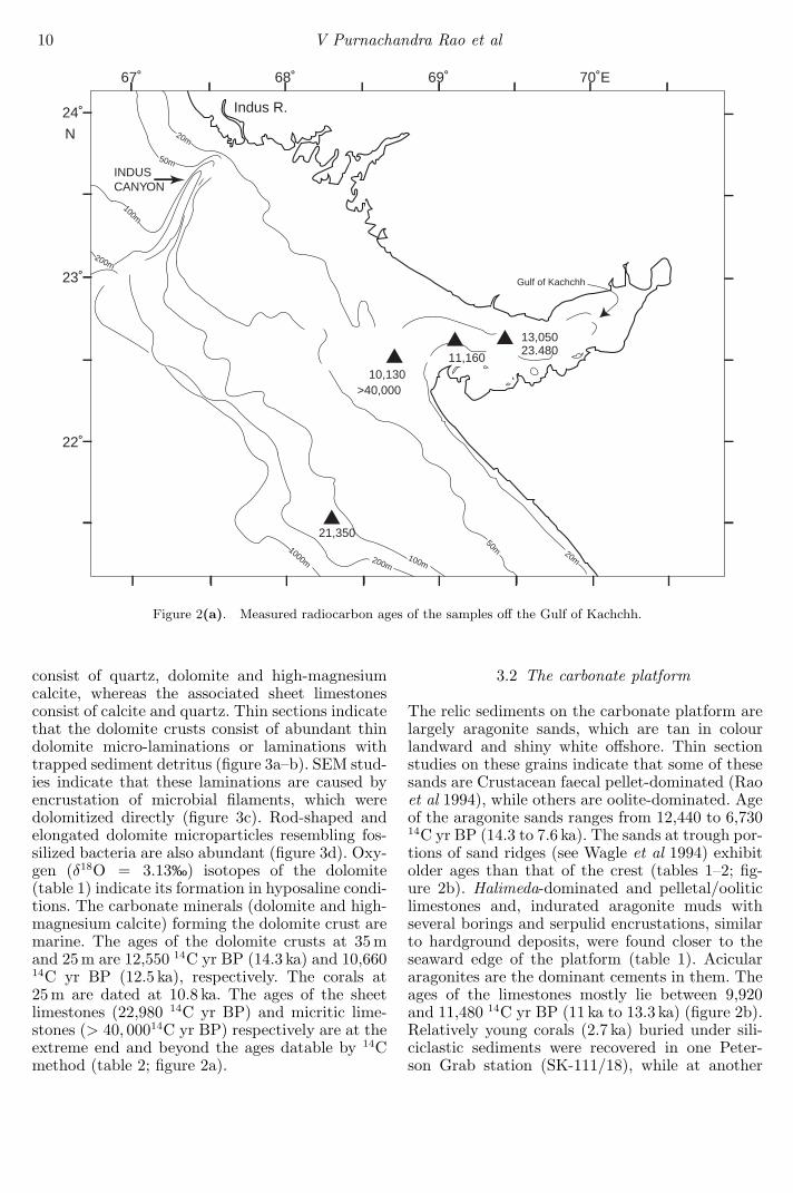
The relic sediments on the carbonate platform arelargely aragonite sands, which are tan in colourlandward and shiny white offshore. Thin sectionstudies on these grains indicate that some of thesesands are Crustacean faecal pellet-dominated (Raoet al 1994), while others are oolite-dominated. Ageof the aragonite sands ranges from 12,440 to 6,73014C yr BP (14.3 to 7.6 ka). The sands at trough por-tions of sand ridges (see Wagle et al 1994) exhibitolder ages than that of the crest (tables 1–2; fig-ure 2b). Halimeda-dominated and pelletal/ooliticlimestones and, indurated aragonite muds withseveral borings and serpulid encrustations, similarto hardground deposits, were found closer to theseaward edge of the platform (table 1). Aciculararagonites are the dominant cements in them. Theages of the limestones mostly lie between 9,920and 11,480 14C yr BP (11 ka to 13.3 ka) (figure 2b).Relatively young corals (2.7 ka) buried under sili-ciclastic sediments were recovered in one Peter-son Grab station (SK-111/18), while at another
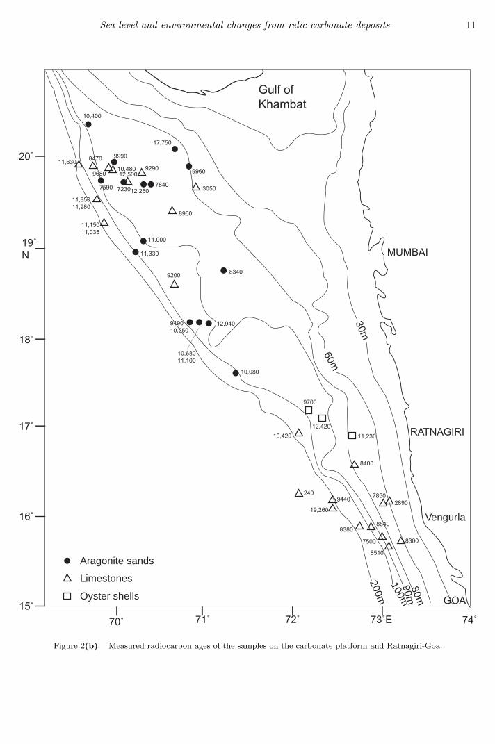
Sea level and environmental changes from relic carbonate deposits 11
10,080
9700
12,420
10,420 11,230
8400
2409440
19,260
8380
78502890
8840
Gulf of Khambat
MUMBAI
RATNAGIRI
GOA
20˚
19˚N
18˚
17˚
16˚
15˚
70˚ 71˚ 72˚ 73˚E 74˚
10,400
17,750
9960
3050
11,630 8470
968010,480
9990
9290
7590
83409200
11,330
11,000
8960
784012,2507230
12,500
11,85011,980
11,15011,035
949010,250
10,68011,100
12,940
7500 8300
8510
30m
60m
80m
200m100m90m
Aragonite sands
Limestones
Oyster shells
Vengurla
Figure 2(b). Measured radiocarbon ages of the samples on the carbonate platform and Ratnagiri-Goa.
12 V Purnachandra Rao et al
9,140
11,480
Goa
Mangalore
Calicut
Cochin
Quilon
Trivandrum
Cape Comorin
78˚E76˚74˚72˚
16˚
14˚
12˚
10˚
8˚
N
50m100m200m
8,2808,08513,110
12,020
15,070
8,970
9,840
10,050
8,100
12,150
6,890Shells
Carbonate Nodules
INDIA
Figure 2(c). Measured radiocarbon ages of the samples off Goa-Cape Comorin.
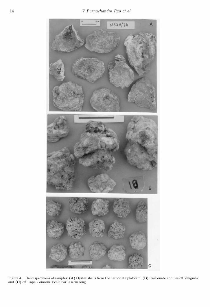
station (SK-111/16) coralline-algal nodules (dated12,000 14C yr BP) occur beneath the aragonitesands dated at 6,730 14C yr BP (7.6 ka). A shellzone comprising of oyster shells of different sizesoccurs off Ratnagiri (table 1; figure 2b; figure 4a).The largest shells have the oldest age (11,920 14Cyr BP) (table 2). Dolomite crusts also occur at64 m water depth on the northeastern edge of the
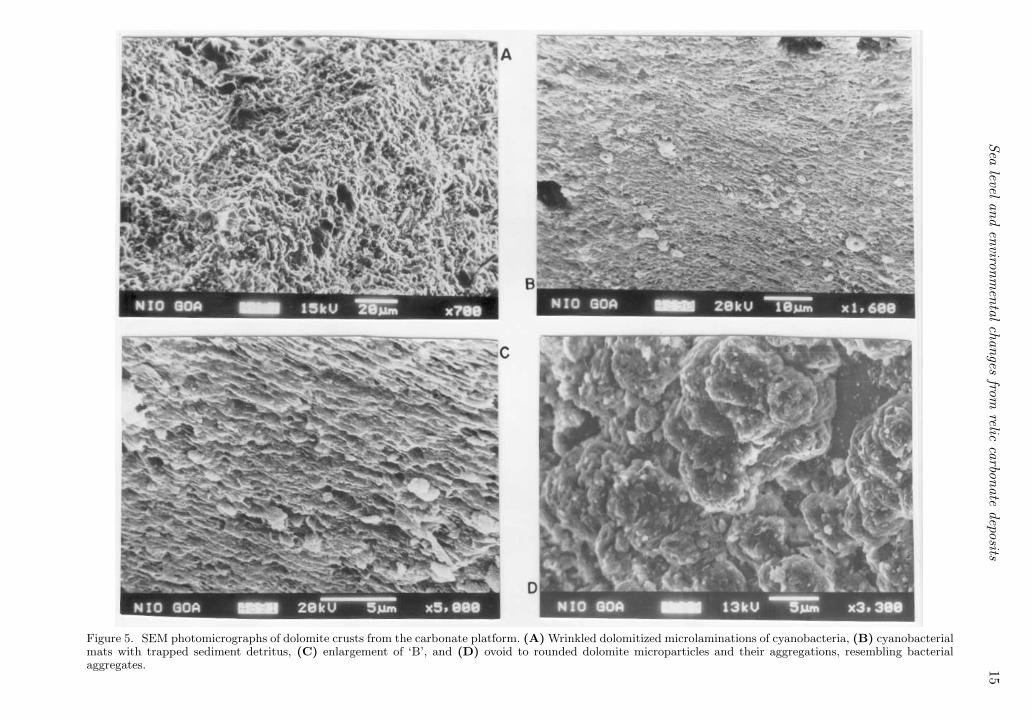
platform. Dolomite, high-magnesium calcite andquartz are dominant minerals and, feldspar, marc-asite and pyrrhotite are minor. SEM studies indi-cate that the crust contains irregularly laminateddolomitized cyanobacterial filaments (figure 5a) orlaminated microbial mats with entrapped particles(figure 5b–c) and dolomite microparticles (5µm)resembling fossil bacteria or their aggregates
Sealevel
andenvironm
entalchanges
fromrelic
carbonatedeposits
13
Figure 3. Thin section photomicrographs (A–B) and SEM photographs (C–D) of the dolomite crust from the Gulf of Kachchh. (A–B) Thin microlaminationswith trapped sediment detritus; (C) Dolomitized microbial laminations and (D) long rod-like dolomite microparticles resembling fossil bacteria.
14 V Purnachandra Rao et al
Figure 4. Hand specimens of samples: (A) Oyster shells from the carbonate platform, (B) Carbonate nodules off Vengurlaand (C) off Cape Comorin. Scale bar is 5 cm long.
Sealevel
andenvironm
entalchanges
fromrelic
carbonatedeposits
15
Figure 5. SEM photomicrographs of dolomite crusts from the carbonate platform. (A) Wrinkled dolomitized microlaminations of cyanobacteria, (B) cyanobacterialmats with trapped sediment detritus, (C) enlargement of ‘B’, and (D) ovoid to rounded dolomite microparticles and their aggregations, resembling bacterialaggregates.
16 V Purnachandra Rao et al
(figure 5d). Oxygen isotopes (δ18O = 4.17‰) ofthe dolomite (table 1) indicate hypersaline condi-tions at the time of its formation. The AMS ageof the crust is 17,250 14C yr BP (20.3 ka) (table 2;figure 2b). Dolomite crusts are the oldest samplesso far reported for near surface sediments of thecarbonate platform.
3.3 Vengurla - Mangalore
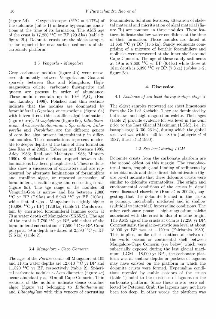
Grey carbonate nodules (figure 4b) were recov-ered abundantly between Vengurla and Goa andsparsely between Goa and Mangalore. High-magnesium calcite, carbonate fluorapatite andquartz are present in order of abundance.These nodules contain up to 10% P2O5 (Raoand Lamboy 1996). Polished and thin sectionsindicate that the nodules are dominated byforaminiferal (Gypsina) encrustations (figure 6a)with intermittent thin coralline algal laminations(figure 6b–c). Mesophyllum (figure 6c), Lithotham-nium, Archaeo-lithothamnium, Sporolithon, Litho-porella and Porolithon are the different generaof coralline alga present intermittently in differ-ent nodules. These associations represent moder-ate to deeper depths at the time of their formation(see Rao et al 2002a; Taberner and Bosence 1985;Adey 1986; Reid and Macintyre 1988; Minnery1990). Siliciclastic detritus trapped between thelaminations has been phosphatized. These nodulesalso show a succession of encrusters and are rep-resented by alternate laminations of foraminiferaand coralline algae, or repeated succession offoraminifera, coralline algae and encrusting corals(figure 6d). The age range of the nodules offVengurla-Goa is narrow and lies between 7,00014C yr BP (7.9 ka) and 8,940 14C yr BP (10 ka),while that of Goa - Mangalore is slightly higher(10,980 14C yr BP) (12.9 ka) (table 2). Corals over-lain by encrusted foraminiferal laminae occur at70 m water depth off Mangalore (SK65/2). The ageof the coral is 7,780 14C yr BP, while that of theforaminiferal encrustation is 7,590 14C yr BP. Coralpolyps at 59 m depth are dated at 2,390 14C yr BP(2.5 ka) (table 2).
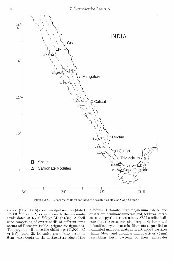
3.4 Mangalore - Cape Comorin
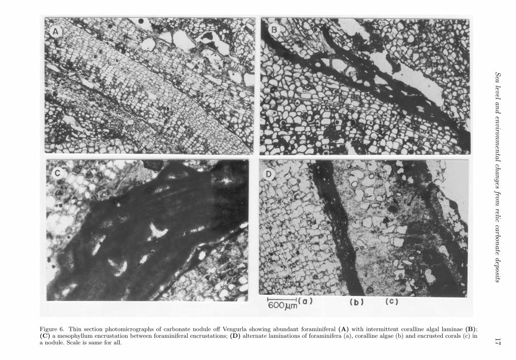
The ages of the Porites corals off Mangalore at 105and 110 m water depths are 12,610 14C yr BP and11,520 14C yr BP, respectively (table 2). Spheri-cal carbonate nodules ∼ 5 cm diameter (figure 4c)occur abundantly at 90 m off Cape Comorin. Thinsections of the nodules indicate dense corallinealgae (figure 7a) belonging to Lithothamniumand Lithophyllum with thin veneers of encrusting
foraminifera. Solution features, alteration of skele-tal material and micritisation of algal material (fig-ure 7b) are common in these nodules. These fea-tures indicate shallow water conditions at the timeof their formation. These nodules are dated at11,650 14C yr BP (13.5 ka). Sandy sediments com-prising of a mixture of benthic foraminifers andmollusks were recovered at the inner shelf aroundCape Comorin. The age of these sandy sedimentsat 49 m is 7,600 14C yr BP (8.4 ka) while those at18 m depth is 6,390 14C yr BP (7.3 ka) (tables 1–2;figure 2c).
4. Discussion
4.1 Evidence of sea level during isotope stage 3
The oldest samples recovered are sheet limestonesfrom the Gulf of Kachchh. They are dominated byboth low- and high-magnesium calcite. Their ages(table 2) provide evidence for sea level in the Gulfprior to the Last Glacial Maximum (LGM), i.e., inisotope stage 3 (50–26 ka), during which the globalsea level was within −40 to −80 m (Labeyrie et al1987; Bard et al 1990).
4.2 Sea level during LGM
Dolomite crusts from the carbonate platform arethe second oldest on this margin. The cyanobac-terial mats, trapping and binding of sediments bymicrobial mats and their direct dolomitization (fig-ure 5a–d) indicate that these dolomite crusts weresimilar to dolomite stromatolites. The origin andenvironmental conditions of the crusts in detailwere discussed elsewhere (Rao et al 2002b), sug-gesting that the dolomite formed in the crustsis primary, microbially mediated and in shallow(subtidal to intertidal) hypersaline conditions. Theother carbonate phase – high-magnesium calciteassociated with the crust is also of marine origin.The AMS age of the crusts at 64 m is 17,250 yr BP.Contrastingly, the glacio-eustatic sea level at about18,000 yr BP was at −120 m (Fairbanks 1989).This implies, unlike other continental shelves ofthe world oceans or continental shelf betweenMangalore-Cape Comorin (see below) which weresubaerially exposed during the last glacial maxi-mum (LGM – 18,000 yr BP), the carbonate plat-form was at shallow depths or pockets of lagoonsmay have existed on the platform in which thedolomite crusts were formed. Hypersaline condi-tions revealed by stable isotopes of the crusts(table 1) point to the existence of lagoons on thecarbonate platform. Since these crusts were col-lected by Peterson Grab, the lagoons may not havebeen too deep. In other words, the platform was
Sealevel
andenvironm
entalchanges
fromrelic
carbonatedeposits
17
Figure 6. Thin section photomicrographs of carbonate nodule off Vengurla showing abundant foraminiferal (A) with intermittent coralline algal laminae (B);(C) a mesophyllum encrustation between foraminiferal encrustations; (D) alternate laminations of foraminifera (a), coralline algae (b) and encrusted corals (c) ina nodule. Scale is same for all.
18V
Purnachandra
Rao
etal
Figure 7. Thin section photomicrograph (A) and SEM photograph (B) of the coralline algal nodules off Cape Comorin. Lithothamnium overlain by lithophyllum(A) and, micritisation of algal material (B).
Sea level and environmental changes from relic carbonate deposits 19
at shallow depths during the LGM and explana-tion is needed for the difference of sea level of∼ 50 m at about LGM between the global position(−120 m) and the platform position (−64 m). Thenext higher or older age (12,440 14C yr BP) comesfrom the aragonite sands of the platform. Sinceboth (dolomite crust and aragonite sands) are nearsurface sediments and are separated by ∼ 5, 000years in age, we presume that the carbonate pro-duction was low on the platform between 17,250and 12,440 14C yr BP. Beck et al (2001) reporteddecreased atmospheric ∆14C values from ∼ 700 to∼ 100 per mil between 26 and 11 ka and suggestedsubstantially slower or shallower thermohaline cir-culation and/or reduced carbonate sedimentationrates are necessary to explain these values.
4.3 Sea level during 12,610 – 11,650 yr BP
The sediments (or sedimentary rocks) with radio-carbon ages between 12,610 14C yr BP (14.8 ka)and 11,650 14C yr BP (13.5 ka) were spread alongthe margin in the form of different deposits (fig-ure 2a–2c; table 2). They occur as dolomite crustsin the Gulf of Kachchh, coralline algal nodules,aragonite sands or oyster shells (figure 4a) onthe carbonate platform, Porites corals off Man-galore and coralline algae-dominated nodules (fig-ure 4c) off Cape Comorin (tables 1 and 2). Thesedeposits, however, occur in the depth range of 85– 110 m between Cape Comorin and Ratnagiri andon carbonate platform, but at 35 m in the Gulfof Kachchh (table 1). Interestingly, some of theseare shallow water deposits and serve as sea levelindicators. For example, live Porites corals witha cap of < 10 m water are found abundantly inthe Indo-Pacific region (Done 1982; Veron 1986).Dense coralline algae and its alteration to micrite(figure 7a–b) in the nodules off Cape Comorin areindicative of shallow marine conditions at the timeof their formation (see Logan et al 1969; Winland1969; Bosence 1985; Rao et al 2002a). Similarly,oyster shells (figure 4a) were reported at intertidalto subtidal depths and have been used as sea levelindicators (Merrill et al 1965; Meldhal and Cutler1992). These imply that the sea level reached about85 m by about 13.5 ka along the western margin ofIndia between Cape Comorin and Mangalore. Sincedolomite crusts dated 17,250 yr BP and differentdeposits (oyster shells, aragonite sands and algalnodules occupying different latitudes) having age∼ 12, 000 yr BP (table 2; figure 2c) are present onthe platform, it is difficult to envisage the waterdepth on the platform during this time. Althoughthe depth of the shell zone off Ratnagiri (south-ern part of the platform) coincides very well withglacio-eustatic sea level position, the depth andage of the aragonite sands do not correspond (see
below). At present we are unable to answer thisdiscrepancy. Relic reefs at about 100 to 90 m con-taining sediments/reefs of ∼12, 00014C yr BP werereported off Caribbean Islands, Comoro Islandsand Red Sea (Dullo et al 1998; Montaggioni 2000).Our findings for this period of time between CapeComorin and Ratnagiri are consistent with othermargins.
The depth and ages of the samples from theGulf of Kachchh are in contrast with that on theglacio-eustatic sea level. Dolomite crusts dated at14.3 ka occur at 35 m in the Gulf. Dolomite usuallyforms under evaporative conditions and at shal-lower depths on the continental shelf, where largevolumes of normal sea water/brines are pumpedthrough the sediments (Patterson and Kinsman1982; Carballo et al 1987). Moreover, laminatedmicrobial mats with intermittent sediment parti-cles (figure 3a–d) are considered to form at shallowdepths (Logan et al 1969; Walter 1976). Dolomiteencrustations occur on large sheet limestones andare formed by dolomitization of microbial fila-ments. We, therefore, consider that these crustswere developed in situ. Rugged topography withpinnacles as high as 10 m is characteristic of thesea floor at the mouth of the Gulf of Kachchhruling out the possibility of transportation. Sincemiliolite limestones are spread along the Saurash-tra, one would argue that the detrital carbonatesfrom these limestones may have transported andmixed up with these dolomites and diluted the ageof the dolomite crust. The dolomite crusts consistof abundant dolomites of primary origin formedby microbial mediation (figure 3a–d) and high-magnesium calcite, both formed in hyposaline con-ditions (see stable isotopes). Since low-magnesiumcalcite (major mineral of the miliolite limestoneson land) is not present in the crusts, contaminationfrom older carbonate detritus may not be a majorfactor. Furthermore, the ages of Favia corals (arag-onite in composition) (10.8 ka) and dolomite crust(12.5 ka) at 28 and 25 m, respectively at the mouthof the Gulf (see tables 1 and 2) also do not corre-spond with the glacio-eustatic sea level (see below).Aragonite crust dated at 13.7 ka occurs in a core (at100–105 cm interval) collected at 55 m depth on theshelf off the Gulf of Kachchh (V P Rao unpublisheddata). These suggest that not only dolomite crustsbut also other types of samples (aragonite crustsand corals) collected from the Gulf and in its vicin-ity showed similar older ages. We, therefore, con-sider that the ages of the crusts are reliable. Sincethe oldest age of the sample (dolomite crust) is14.3 ka the Gulf must have inundated much before,because for initiation of dolomite formation (or forthe growth of corals) one would expect a lag periodafter flooding of the Gulf. Davies and Montaggioni(1985) reported a lag period of 1200 – 2000 years
20 V Purnachandra Rao et al
between initial flooding and start-up phase for thecoral settlement in the Great Barrier Reef (GBR).Keeping this in view, we suggest that after the LastGlacial Maxima (LGM), the Gulf must have inun-dated atleast by ∼ 15 ka. Corals of the Faviidaefamily are characteristic of turbid water and occurat shallow depths (1–6 m) (Veron 1986). Thesecorals occur at 28 m in the Gulf and are dated at10.8 ka. The glacio-eustatic sea level was, however,at ∼ 70 m by 11 ka (Fairbanks 1989). This impliesthat the Gulf of Kachchh was uplifted atleast by∼ 40 m sometime after 10.8 ka.
The Kachchh region is seismically active andcontrolled by a series of normal and low-anglereverse faults, which are exposed in certain regions.Several Th230/U234 ages on miliolite limestones ofSaurashtra and Kachchh indicated three episodesof uplift and miliolite deposition during the Pleis-tocene (Baskaran et al 1989). Recent regional stud-ies have shown the uplift of the northern Kachchhat different times in Holocene, including 8,500 yrBP, 5,000 yr BP and 2,500 yr BP (Parkash et al2000) and subsidence of Bet Dwarka sometimeafter 3,870 yr BP (Rao 1996; Vora et al 2002).Although the uplift time at 8,500 yr BP (9.6 ka)on land is close to the younger age of the sam-ple (coral – 10.8 ka) from the Gulf of Kachchh,other regional uplift times and subsidence time ofthe Bet Dwaraka cannot be accounted with ourdata. Palaeoseismological studies further indicatethat the Kachchh region experienced large andmoderate earth quakes, including the ones in themost recent years (1891, 1956 and 2001). Some ofthese earthquakes are caused by blind faults andinduced surface deformation and widespread liq-uefaction including lateral spreading (see Rajen-dran et al 2001). We, therefore, suggest that theGulf of Kachchh was subjected to complex tec-tonic movements (including uplift and subsidenceat different times) during the late Pleistocene andHolocene and it is difficult to quantify the rate ofuplift/subsidence.
4.4 Sea level between 10,000 and 7,000 yr BP
The age of the aragonite sands (oolites and aragon-tic faecals) from 15 stations on the carbonate plat-form (figure 2b) ranges between 12,440 and 6,730yr BP implying that carbonate sedimentation con-tinued until 6,730 yr BP. The colour differences ofthese sands from east to west of the platform sug-gest that there is no mixing of sands from differentdepths. If one considers that oolites form in shallowmarine conditions and serve as sea level indicators(Illings 1954; Loreau and Purser 1993), it is nec-essary to envisage intertidal to subtidal conditionson the platform during their formation. This seemsunlikely here, because the glacio-eustatic sea level
rose by ∼ 80 m between 12,000 and 7,000 yr BP.This implies that oolites may not be considered assea level indicators and can even form at deeperdepths (Kump and Hine 1986; Rao et al 1996). Raoet al (1994) suggested that some of these sands arearagonitic faecals and, Halimeda bioherms acted asthe source of aragonite mud for the formation offaecals. It is also difficult to explain the continuedgrowth of Halimeda bioherms with the rise of sealevel by about 80 m.
The limestones (G72/1459, G72/1479) collectedat 95 m and 85 m water depth on the platform showsolution features, needle fibre aragonite and drusycalcite cements indicating vadose diagenetic condi-tions of the platform. The age of the limestone at85 m depth is about 8,785 14C yr BP (Rao et al1994) (table 2; figure 2b). The glacio-eustatic sealevel at 9,000 yr BP was ∼ −37 m (Fairbanks 1989)implying that a difference of sea level of about∼ 50 m have to be explained.
4.5 Age vs depth relation of the samples
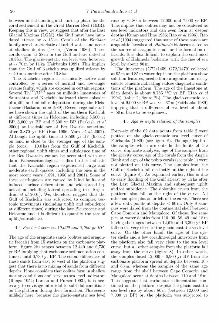
Forty-six of the 62 data points from table 2 wereplotted on the glacio-eustatic sea level curve ofFairbanks (1989) (see figure 8). The age/depth ofthe samples which are outside the limits of thecurve, duplicate analyses, age of the samples fromthe gravity cores, age of the corals from the AngriaBank and ages of the polyp corals (see table 1) werenot plotted on this curve. The samples from theGulf of Kachchh fall distinctly on the right of thecurve (figure 8). As explained earlier, this is dueto early flooding of the Gulf atleast by 15 ka afterthe Last Glacial Maxima and subsequent upliftand/or subsidence. The dolomite crusts from theplatform also fall on the right of the curve. Allother samples plot on or left of the curve. There area few data points at depths < 60 m. Only 8 sam-ples were dated from the continental shelf betweenCape Comorin and Mangalore. Of these, five sam-ples at water depths from 110, 90, 58, 49 and 18 mhaving their ages between 12,610 and 6,390 yr BPfall on or, very close to the glacio-eustatic sea levelcurve. On the other hand, the ages of the oys-ter shells and a few coralline-algal limestones fromthe platform also fall very close to the sea levelcurve, but all other samples from the platform fallaway from the curve (figure 8). In other words,the samples dated 12,000 – 6,900 yr BP from thecarbonate platform spread at depths between 105and 65 m, whereas the samples of the same agerange from the shelf between Cape Comorin andMangalore occur at depths between 110 and 18 m.This suggests that carbonate sedimentation con-tinued on the platform despite the glacio-eustaticsea level rise by about 80 m (between 12,000 and7,000 yr BP) or, the platform was subjected to
Sea level and environmental changes from relic carbonate deposits 21
Aragonite sandsCarbonate nodules & limestonesShells
0
10
20
30
40
50
60
70
80
90
100
110
1200 2 4 6 8 10 12 14 16 18
Dep
th (
m)
Age (kyr)
Figure 8. A plot of corrected radiocarbon ages and depth of the samples on a glacio-eustatic sea level curve of Fairbanks(1989).
intermittent neotectonic activity and then carbon-ate growth continued. We are indeed concerned andcareful about documenting the neotectonic activityon the platform, as many do not believe this pos-sibility on the passive margins such as Indian mar-gins. However, evidences such as (a) deeper waterterraces (Rao and Veerayya 1996), (b) limestonesof early Holocene age showing vadose diagenetictextures (see Rao et al 1994), (c) dolomite crustsdated 17,250 yr BP at 64 m depth and (d) age ofthe aragonite sands (12,440 – 6,730 yr BP) on theplatform cannot be explained by any other singlemechanism. Even considering that aragonite on theplatform is of biogenic origin (derived from Hal-imeda bioherms), it is difficult to envisage a mas-
sive carbonate production with the rise of sea levelabout 90 m, between 12,440 yr and the present. Itis known that the glacio-eustatic sea level reachedits present position at about 6000 years BP. Ifone assumes aragonite forms even in deeper water,the controlling factor for the cessation of arago-nite sands after 6,730 years BP, and absence of ter-rigenous sediments, between 12,440 yr BP and thepresent, on the platform despite its position off therivers need explanation. Keeping these in view, webelieve that the platform may have been at a differ-ent elevation during LGM and subsequently sub-sided during the Holocene. The exact time/timesand rate/rates of subsidence are unknown and it isdifficult to quantify the phases of subsidence with
22 V Purnachandra Rao et al
the existing data. Since aragonite cemented vadosediagenetic limestones (G72/1459) were formed at8.85 ka, we presume that atleast one phase of sub-sidence of the platform must be after 8.85 ka. Thecarbonate platform was an isolated feature dur-ing the Eocene. The sediments originated from theRiver Indus accumulate abundantly on the westernslopes of the platform and sediments from the Nar-mada and Tapti on the eastern slope of the plat-form and in the Dahanu depression (inner shelf)since Eocene. The sediments thus accumulated onthe slopes of the platform acted as load on the plat-form. The combined effect of water and sedimentload may have been responsible for the subsidenceof the platform.
4.6 Inferred environmental conditions
The relic ages of the Porites reefs (14.8 to 13.4 ka)off Mangalore indicate reef development stoppedafter 13.4 ka. There may be two reasons for theirdemise. The reefs may have been affected by therapid changes in sea level caused by the main phaseof deglaciation and to the melt water pulse (MWP)1 A (Fairbanks 1989) or catastrophic rise events(Blanchon and Shaw 1995) occurred at about 14 ka.Palaeoclimate records from several sites of thewestern margin of India suggest enhancement ofmonsoonal precipitation about 15 ka (Thambanet al 2001) and intensified precipitation between 11and 9 ka (Van Campo 1986). Such intensificationcould have resulted in large flux of fresh water andsediment into coastal water thereby reducing watertransparency, salinity and increasing nutrient fluxand creating eutrophic conditions. Such conditionsare considered to inhibit coral growth (Hallock andSchlager 1986). The rapid sea level rise also inter-rupts sedimentation and starving of sediments,that would correspond to diastem recording a typi-cal drowning unconformity. Hardground conditionsare indeed evident at about this time (13.1–12.3 ka)on the relict deposits occurring at the seaward edgeof the carbonate platform and are represented asindurated aragonite muds, serpulid encrustationson algal nodules or Halimeda or pelletal/ooliticlimestones with several borings (tables 1 and 2; fig-ure 2b).
Patches of coral fragments dated 7,780 14C yrBP and 2,550 14C yr BP or polyp corals dated2,390 14C yr BP occur at depths between 60 and70 m off Mangalore, carbonate platform and Ven-gurla (tables 1 and 2). These indicate intermit-tent oligotrophic conditions (atleast locally) on theshelf during which corals were formed. Present daycorals (dated 240 yr BP) at 22 m on the AngriaBank (SK111/1), located away from the continen-tal shelf, indicate suitable conditions for reef devel-opment in the shallow offshore banks.
It is indeed amazing how carbonates developedwhen one considers the geographic settings of theplatform, age of the sediments on it and envi-ronmental conditions during the early Holocene.Firstly, the platform is located off the river mouthsof Narmada and Tapti, which debouch 58.7 millioncu. m. of water and several tons of suspendedand bed load annually through the Gulf of Kham-bat (Rao 1975). The water depths on the plat-form range between 60 and 110 m. Since the glacio-eustatic sea level at 10,000 yr BP was at 60 m(Fairbanks 1989), one would expect the platformat or slightly below the sea level at this time andriver discharged sediments transported right ontothe platform. Secondly, enhanced monsoonal con-ditions have been reported during 13,000 – 6,000yr BP (Van Campo 1986; Sarkar et al 2000; Tham-ban et al 2001). As a consequence, one wouldexpect large fresh water and siliciclastic flux duringthis time. Thirdly, it is well known that carbon-ate sedimentation rates are inversely proportionalto the siliciclastic flux. In view of the above, onewould expect abundant terrigenous flux and, as aresult cessation of carbonate growth on the plat-form. However, carbonate sedimentation continueduntil 6,730 yr BP and the platform sediments con-tain only < 10% terrigenous flux. This implies theriverine flux delivered either filled the innershelf –Dahanu Depression – wherein sediments are beingaccumulated since Eocene, and/or diverted south-wards under the influence of southwest monsooncurrent (Banse 1968). If the latter is the case, onewould expect a high degree of turbidity in thewater column on the shelf south of the carbonateplatform. The age of the foraminiferal-dominatednodules (figure 4b) (9,400 and 7,500 yr BP) off Ven-gurla - Goa (figure 2b) (south of the platform) indi-cates their formation during intensified monsoonalconditions. The constituents of the nodules indi-cate their deeper water origin. We therefore pro-pose that these nodules are characteristic of turbidwaters and support our argument that the riverineflux was directed southwards for the reasons givenbelow.• Hottinger (1983) and Plaziat and Perrin (1992)
reported well-developed abundant foraminiferal-dominated nodules and indicated that they evensurvive in turbid conditions, unfavourable forencrusting corallines.
• The intermittent micro-laminations of corallinealgae probably represent seasonal growth (fig-ure 6b–c) when waters were more transpar-ent under non-monsoonal seasons. During mon-soonal months foraminifera are favoured due toexcess turbidity which excludes coralline algae(see Reid and Macintyre 1988).
• Phosphatized sediment detritus trapped betweenlaminations indicate abundant flux to the region
Sea level and environmental changes from relic carbonate deposits 23
and suboxic conditions at or closer to the seabed at the time of their formation. Intensifiedmonsoons and associated upwelling brings largenutrient input and reduces the temperature anddissolved oxygen contents at subsurface depthsand these conditions are not conducive for coralsand coralline algal growth. The cyclic bandsof foraminifera, coralline algae and corals (fig-ure 6d) in the nodules may indicate improve-ment in environmental conditions in the watercolumn from turbid to eutrophic to clearer andoligotrophic at the time of their formation.
5. Conclusions
• Relic carbonate deposits on the western mar-gin of India occur as dolomite crusts, aragonitesands, vadose diagenetic limestones, corallinealgal and foraminiferal-dominated nodules, oys-ter shells, Faviidae/Porites corals and benthicforaminifera/mollusk-dominated sediments.
• The relic deposits dated ∼ 12, 000 – 6, 390 14Cyr BP spread on the outer and inner continen-tal shelf at depths of 110 – 18 m between CapeComorin and Mangalore, but occur within a nar-row depth range (105 – 65 m) on the carbonateplatform of the northwestern margin of India.Relic deposits of the Gulf of Kachchh (25 – 35 m)are dated at 12,550 – 9,630 14C yr BP. Relicdeposits of the isotope stage 3 also found in theGulf.
• The age vs depth plot of the samples indi-cates that the Gulf of Kachchh was uplifted andthe carbonate platform subsided during earlyHolocene. A few samples were dated on the shelfoff Cape Comorin-Mangalore. Of these five sam-ples plot on or, close to the glacio-eustatic sealevel.
• Occurrence of Porites corals at 12,610 to 11,520,∼7, 780 and ∼2, 550 14C yr BP indicate intermit-tent oligotropic conditions. Ecological successionfrom corals to coralline algae and to foraminiferalencrustated nodules, indicates changing watercolumn conditions with respect to the nutrientsand turbidity, probably due to intensified mon-soons during the early Holocene.
• The sediments of the Narmada and Tapti werelargely deposited on the inner shelf or, divertedsouthwards during the early Holocene, facili-tating carbonate growth on the platform andforaminiferal nodules off Vengurla-Goa.
Acknowledgements
We thank Dr. E Desa, Director of the NationalInstitute of Oceanography, Goa for the encour-
agement. We thank the Editor, Earth and Plan-etary Sciences and anonymous reviewers for con-structive comments on the earlier manuscript. Thiswork was financed by the Research Project (No.ESS/CA/A1-25-97) ‘Sea level changes along thewestern margin of India during the Late Quater-nary’ of the Department of Science and Technology,New Delhi. This work is NIO contribution no. 3805.
References
Adey W H 1986 Coralline algae as indicators of sea level;In: Sea level Research - A manual for the collection andevaluation of data (ed) O Van de Plasche (Free University,Amsterdam, Geobooks, Norwich) p. 229–280
Banse K 1968 Hydrography of the Arabian Sea shelf of Indiaand Pakistan and effects on temporal fishes; Deep SeaResearch 15 45–79
Bard E, Hamelin B and Fairbanks R G 1990 U/Th agesobtained by mass spectrometry in corals from Barbados:sea level during the past 130,000 years; Nature 345 405–408
Baskaran M, Rajagopalan G and Somayajulu B L K 1989230Th/234U dating of Quaternary carbonate deposits ofSaurashtra, India; Chemical Geology 79 65–82
Beck J W, Richards D A, Edwards R L, Silverman B W,Smart P L, Donahue D J, Hererra-Osterheld S, Burr G S,Calsoyas L, Jull A J T and Biddulph D 2001 Extremelylarge variations of atmospheric 14C concentration duringthe last glacial period; Science 292 2453–2458
Blanchon P and Shaw J 1995 Reef-drowning during the lastdeglaciation: evidence for catastrophic sea level rise andice sheet collapse; Geology 23 4–8
Borole D V, Rajagopalan G and Somayajulu B L K 1987Radiometric ages of phosphorites off the west coast ofIndia; Marine Geology 78 161-165
Bosence D W J 1985 The morphology and ecology of amound-building coralline alga (Neogonialithon strictum)from the Florida Keys; Palaentology 28 189–206
Carballo J D, Land L S and Miser D E 1987 Holocenedolomitization of supratidal sediments by active tidalpumping, Sugarloaf Key, Florida; J. Sediment. Petrol. 57153–165
Done T J 1982 Patterns in the distribution of coral commu-nities across the central Great Barrier Reef; Coral Reefs1 95–107
Davies P J and Montaggioni L 1985 Reef growth and sealevel change: the environmental signature; Proc. of the5th International Coral Reef Congress, Tahiti 3 477–515
Dullo W Ch, Camoini G F, Blomeier D, Colonna M, Eisen-hauer A, Faure G, Casanova J and Thomassin B A 1998Morphology and sediments of the fore-slopes of Mayotte,Comoro Islands: direct observations from a submersible.Spec. Pubs. Int. Ass. Sediment. 25 219–236
Dutta K, Bhushan R and Somayajulu B L K 2001. ∆R cor-rection values for the northern Indian Ocean; Radiocar-bon 43 483–488
Fairbanks R G 1989 A 17,000 year glacio-eustatic sea levelrecord: influence of glacial melting rates on the YoungerDryas event and deep-ocean circulation; Nature 342 637–642
Hashimi N H, Nigam R, Nair R R and Rajagopalan G 1995Holocene sea level fluctuations on western Indian conti-nental margin: An update; J. Geol. Soc. India 46 157–162
Hallock P and Schlager W 1986 Nutrient excess and thedemise of coral reefs and carbonate platforms; Palaios 1389–398
24 V Purnachandra Rao et al
Hottinger L 1983 Neritic macroid genesis, an ecologicalapproach; In: Coated grains (ed) Y Peryt (New York:Springer) p. 38–57
Illings L V 1954 Bahamian calcareous sands; AAPG Bull.38 1–95
Kale V S and Rajaguru S N 1985 Neogene and Quaternarytransgressional and regressional history of the west coastof India – An overview; Bull Deccan College Res Inst. 44153–165
Kump L R and Hine A C 1986 Ooids as sea level indica-tors; In: Sea level Research: A manual for the collectionand evaluation of data (ed) O Van de Plasche (GeobooksNorwich) p. 175–194
Labeyrie L D, Duplessy J C and Blanc P L 1987 Variationsin mode of formation and temperature of oceanic deepwaters over the past 125,000 years; Nature 327 477–482
Logan B W, Harding J L, Ahr W M, Williams J D andSnead R G 1969 Carbonate sediments and reefs, YucatanShelf, Mexico; AAPG Memoir 11 1–98
Loreau J P and Purser G H 1993 Distribution of ultrastruc-ture of Holocene ooids in the Persian Gulf; In: The Per-sian Gulf (ed.) G H Purser (New York: Springer-Verlag)p. 279–328
Meldhal K H and Cutler A H 1992 Neotectonics andTaphonomy: Pleistocene Molluscan shell accumulationsin the northern Gulf of California; Palaios 7 187–197
Merrill A S, Emery K O and Rubin M 1965 Ancient oystershells on the Atlantic continental shelf; Science 147 398–400
Minnery G A 1990 Crustose coralline algae from the FlowerGarden Banks, Northwestern Gulf of Mexico: Controls ondistribution and growth morphology; J. Sediment. Petrol.60 992–1007
Montaggioni L F 2000 Post-glacial reef growth; C R AcadSci. Paris Sciences de la Terre et des Planets 331 319–330
Nair R R 1974 Holocene sea levels on the western continentalshelf of India; Proc. Indian Acad. Sci. 79B 197–203
Nair R R 1975 Nature and origin of small scale topographicprominences on the western continental shelf of India;Indian J. Mar. Sci. 4 25–29
Nair R R and Hashimi N H 1980 Holocene climatic infer-ences from the sediments of the western Indian con-tinental shelf; Proc. Indian Acad Sci. Sec. B 89 229–315
Nair R R and Pylee A 1968 Size distribution and carbonatecontent of the sediments of the western shelf of India;Bull. Nat. Inst. Sci. India 38 411–420
Nair R R, Hashimi N H and Gupta M V S 1979 Holocenelimestones of part of the western continental shelf ofIndia; J. Geol. Soc. India 20 17–23
Parkash B, Kumar S, Rao M S, Giri S C, Kumar C S,Gupta S and Srivastava P 2000 Holocene tectonic move-ments and stress fields in the western Gangetic plains;Curr. Sci. 79 438–449
Patterson R J and Kinsman D J 1982 Formation of dia-genetic dolomite in coastal sabkha along Persian Gulf;AAPG Bull. 66 28–43
Plaziat J-Cl and Perrin Ch 1992 Multikilometer-sized reefsbuilt by foraminifera (Solenomeris) from the early Eoceneof the Pyrenean domain (S. France, N. Spain): Palaeoecologic relations with coral reefs; Palaeogeogr. Palaeocli-mat. Palaeoecol. 96 195–231
Rajendran K, Rajendran C P, Thakkar M and Tuttle M P2001 The 2001 Kutch (Bhuj) earthquake: Coseismic sur-face features and their significance; Curr. Sci. 80 1397–1405
Rao K L 1975 India’s water wealth (New Delhi: Orient Long-man) 255 pp.
Rao S R 1996 From Dwaraka to Kurukshetra; J. MarineArchaeol. 5/6 61–71
Rao V P and Lamboy M 1996 Genesis of apatite in thephosphatized limestones of the western continental shelfof India; Marine Geology 136 41–53
Rao V P and Wagle B G 1997 Geomorphology and surficialgeology of the western continental shelf and upper slopeof India: A review; Curr. Sci. 73 330–350
Rao V P, Veerayya M, Nair R R, Dupeuble P A and LamboyM 1994 Late Quaternary Halimeda bioherms and arago-nitic faecal pellet-dominated sediments on the carbonateplatform ‘of the western continental shelf of India; MarineGeology 121 293–315
Rao V P and Veerayya M 1996 Submarine terrace limestonesfrom the continental slope off Saurashtra-Bombay: Evi-dence of late Quaternary neotectonic activity; Curr. Sci.71 36–41
Rao V P, Veerayya M, Thamban M and Wagle B G 1996Evidences of late Quaternary neotectonic acitivity andsea level changes along the western continental margin ofIndia, Curr. Sci. 71 213–219
Rao V P, Montaggioni L, Vora K H, Almeida F and Rao KM 2002a Significance of the carbonate reefs of the south-western margin of India; Sediment. Geol. (in press)
Rao V P, Kessarkar P, Krumbein W E, Krajewski K P andSchneider R J 2002b Microbial Dolomite crust from thecarbonate platform of the western margin of India; Sedi-mentology, (in press).
Reid R P and Macintyre I G 1988 Foraminiferal-algalnodules from the eastern Carribian: Growth historyand implications on the value of nodules of palaeo-environmental indicators; Palaios 3 424–436
Sarkar A, Ramesh R, Somayajulu B L K, Agnihotri R, Jull AJ T and Burr G S 2000 High resolution Holocene monsoonrecord from the eastern Arabian Sea; Earth and PlanetaryScience Letters 177 209–218
Stuiver M, Reimer P J, Bard E, Beck J W, Burr G S,Hughen K A, Kromer B, McCormac F G, van der Plicht Jand Spurkm M 1998. INTCAL 98 radiocarbon age cali-bration, 24,000-0 cal BP. Radiocarbon 40 1041–1083
Taberner C and Bosence D W J 1985 Ecological suc-cession from corals to coralline algae in Eocene Patchreefs, Northern Spain; In: Paleoalgology: ContemporaryResearch and Applications (eds) D F Toomey andM H Nitecki (Berlin: Springer-Verlag), pp. 226–236
Thamban M, Rao V P, Schneider R R and Grootes P M2001 Glacial to Holocene fluctuations in hydrography andproductivity along the southwestern continental marginof India; Palaeogeogr. Palaeoclimat. Palaeoecol. 165 113–127
Van Campo E 1986 Monsoon fluctuations in two 20,000 yrBP: Oxygen isotope records off southwest India; Quat.Res. 26 376–388
Veron J E N 1986 Corals of Australia and the Indo-Pacific,(London: Angus and Robertson) 644 pp.
von Stackelberg U V 1972 Faziesverteilung in sedimentesIndich-Pakistanischen Komtinental-Randes; (ArabischesMeer), Meteor Forschungsgebn, Reiche C.9 1–73
Vora K H and Almeida F 1990 Submerged reef systemson the central western continental shelf of India; MarineGeology 91 255–262
Vora K H, Wagle B G, Veerayya M, Almeida F and Karisid-daiah S M 1996 A 1300 km long late Pleistocene-Holoceneshelf edge barrier reef system along the western conti-nental shelf of India: occurrence and significance; MarineGeology 134 145–162
Vora K H, Gaur A S, Price D and Sundaresh 2002 Culturalsequence of Bet Dwarka island based on thermolumines-cence dating; Curr. Sci. 82 1351–1356
Sea level and environmental changes from relic carbonate deposits 25
Wagle B G, Vora K H, Karisiddaiah S M, Veerayya Mand Almeida F 1994 Holocene submarine terraceson the western continental shelf of India: Implica-tions for sea level changes; Marine Geology 117 207–225
Walter M R 1976 Stromatolites, Developments in Sedimen-tology 20 790 pp. (Amsterdam: Elsevier)
Winland H D 1969 Stability of calcium carbonate poly-morphs in warm shallow seawater; J. Sediment. Petrol.39 1579–1587
MS received 22 April 2002; revised 30 September 2002
Copyright © 2022 FDOKUMEN