SHORTER CONTRIBUTIONS TO GENER.AL GEOLOGY
248
· DEPARTMENT OF THE INTERIOR FRANKLIN K. LANE, Secretary UNITED STATES GEOLOGICAL SURVEY GEORGE OTIS SMITH, Director PROFESSIONAL PAPER 120 SHORTER CONTRIBUTIONS TO GENER.AL GEOLOGY 1918 DAVID WHITE, CHIEF GEOLOGIST WASHINGTON GOVERNMENT PRINTING OFFICE 1919
-
Upload
khangminh22 -
Category
Documents
-
view
0 -
download
0
Transcript of SHORTER CONTRIBUTIONS TO GENER.AL GEOLOGY
~-------------------~------------------------~--~
· DEPARTMENT OF THE INTERIOR FRANKLIN K. LANE, Secretary
UNITED STATES GEOLOGICAL SURVEY GEORGE OTIS SMITH, Director
PROFESSIONAL PAPER 120
SHORTER CONTRIBUTIONS TO GENER.AL GEOLOGY
1918
DAVID WHITE, CHIEF GEOLOGIST
WASHINGTON GOVERNMENT PRINTING OFFICE
1919

'I
DEPARTMENT OF THE INTERIOR FRANKLIN K. LANE, Secretary
UNITED STATES GEOLOGICAL SURVEY GEORGE OTIS SMITH, Director
Professional Paper 120
SHORTER CONTRIBUTIONS TO GENERAL GEOLOGY
1918
DAVID WHITE, CHIEF GEOLOGIST
WASHINGTON GOVERNl\IENT PRINTING OFFICE
1919


CONTENTS. l The letters in parentheses preceding the titles are those used to designate the papers ·ror advance publication.]
Page. (A) New determinations of c·arbon dioxide in water of the Gulf of Mexico, by R. C. Wells (published June 20,
1918) ....................................................................... ·....................... 1 (B) Geology of northeastern Moritana, by A. J. Collier (p{lblished Dec. 12, 1918).............................. 17 (C) Deposits of Claiborne and Jackson age in Georgia, by C. W. Cooke and H. K. Shearer (published June 4, 1918). 41 (D) rrhe structure and stratigraphy of Gravina and Revillagigedo islands, Alaska, by Theodore Chapin (pub-
lished Aug. 22, 1918)................................................................................ 83 (E) rl\vo lamprophyre dikes near Santaquin and Mount Nebo, Utah, by G. F. Loughlin (published June 14,
1918) .................... · ... .-................................ · .................. ·..................... 101 (F) Relations of late Paleozoic and early Mesozoic formations of southwestern Montana and adjacent parts of
Wyoming, by D. D. Condit (published Oct. 21, 1918)................................................ 111 (G) New graphic method for determining the depth and thickness of strata and the projection of dip, by H. S.
Palmer·(published Aug. 21, 1918).................................... ... . . .. . . . . . . . . . . . . . . . . . . . . . . . . . . . 123 (R) A contribution to the geology of northeastern Texas and southern Oklahoma, by L. W. Stephenson (pub
lished Nov. 22, 1918)............................................................................... 129 (I) Some American Cretaceous fish scales, with notes on the classification and distribution of Cretaceous fishes,
by T. D. A. Cockerell (published April 24, 1919)..... . . . . . . . . . . . . . . . . . . . . . . . . . . . . . . . . . . . . . . . . . . . . . . . . . 165 Index.................................................................................................... 203
ILLUSTRATIONS.
PLATE I. Map of northeastern Montana showing the distribution of the geologic formations.................... 18 II. A, Gorge of Rock Creek, Valley County, Mont.; B, Grain field near Scobey, Mont.; C, Camp in the foot-
hills of the Little Rocky Mountains, Phillips County, Mont...................................... 20 III. A, View up the valley of Cottonwood Creek, Phillips County, Mont.; B, Badlands of Bearpaw shale
near Lisn1as, ~{on t. . . . . . . . . . . . . . . . . . . . . . . . . . . . . . . . . . . . . . . . . . . . . . . . . . . . . . . . . . . . . . . . . . . . . . . . . . . . 21 IV. A, Lower part of the Lance formation, showing spherical concretions; B, Arenaceous sandstone show-
ing eolian cross-bedding........................................................................ 32 V. A, Pinnacle of soft sandstone of Lance formation; B, Erosion form of Lance formation . . . . . . . . . . . . . . 33
VI. A, View south across the Missouri Valley, Valley and Dawson counties, Mont.; B, Gravel pit at Wolf Point, Mont.; C, Loglike concretion in Fort Union formation.................................... 36
VII. Map showing distribution of the Eocene formations of Georgia..... . . . . . . . . . . . . . . . . . . . . . . . . . . .. . . . . . . 50 VIII. A, Wave-cut bench, Dall Bay, Gravina Island, Alaska; B, Conglomerate, Blank Inlet, Gravina Island;
C, Slate and graywacke, Blank Inlet, Gravina Island; D, Anticline on Vallenar Bay, Gravina Island. 88 IX. Map showing outcrops of Phosphoria and equivalent formations in southwestern Montana and adjacent
parts of " 7yoming ................... :......................................................... 112 X. Stratigraphic sections in southwestern Montana and Yellowstone National Park.................... 114
XI. A, Canyon of Indian Creek, Madison Range, Mont.; B, Principal peak in Snowcrest Range, Mont... 116 XII. A, View westward along crest of Centennial Range from1 point near Montana principal meridian;
B, Shaly calcareous beds along crest of Centennial Range, equivalent to Dinwoody formation of Wyoming. . . . . . . . . . . . . . . . . . . . . . . . . . . . . . . . . . . . . . . . . . . . . . . . . . . . . . . . . . . . . . . . . . . . . . . . . . . . . . . . . . . 117
XIII. A, North face of Bannock Peak, Yellowstone Park; B, Upturned beds on south slope of Owl Creek Mountains, Wyo., near Shotgun Creek, T. 7 N., R. 1 E............ . . . . . . . . . . . . . . . . . . . . . . . . . . 118
XIV. Alinement diagram for computing deptl;l.......................................................... 124 XV. Alinement diagram for computing thickness...................................................... 126
XVI. Alinement diagram for computing projected dip.................................................. 128 XVII. Geologic map of part of northeastern Texas and southern Oklahoma............................... 130
XVIII. Correlation table showing the relation of the subdivisions of the Comanche series in Grayson County, Tex., to the formations of the same series in other parts of Texas and Oklahoma........ 134
XIX. A, Trinity sand and loose slabs of Goodland limestone at Rock Bluff (Old Marshall Bluff) on Red River 8! miles northwest of Denison, Grayson County, Tex.; B, Goodland limestone on Little Mineral Creek in northern Grayson County, Tex............................................... 136
XX. A, Top of Kiamichi clay, overlain by limestone member of Duck Creek formation, in bluff above Tl~omson Ferry, Red River, 11 miles northwest of Denison, Grayson County, Tex.; B, Slabs of Gnjphaca-bearing impure limestone from the upper part of the Kiamichi clay at the locality shown inA .... :.................................................................................... 138
III

IV CONTENTS.
PLATE XXI. A, Earthy facies of the lower part of the Fort Worth limestone on the Oklahoma side of Red River, at the Missouri, Kansas & Texas Railway bridge 5 miles north of Denison, Grayson County, Tex.; B, Fossil fucoids (?)on the under side of a slab of Fort Worth limestone, at
Page.
the locality shown in A . . . . . . . . . . . . . . . . . . . . . . . . . . . . . . . . . . . . . . . . . . . . . . . . . . . . . . . . . . . . . . 139 XXII. A, Upper part on the Weno clay in the east bank of Washita River at the Frisco Railroad
bridge 21 miles west of Platter, Bryan County, Okla.; B, Weno-clay in a cut of the Frisco . ~ailroad a mile north of the station at Denison, Grayson County, Tex................... 140
Xxiii. A, Main Street limestone in a cut of the Missouri, Kansas & Texas Railway 3 miles west of the station at Denison, Grayson County, Tex.; B, "Quarry" limestone, underlain by the Weno clay, in'a cut of the Frisco Railroad three-quarters of a mile north of Denison, Grayson County, Tex........................................................................ 141
XXIV .. A, Woodbine. sand. in a cut on the Missouri, Kansas & Texas Railway it miles west by south of the station at Denison, Grayson County, Tex.; B, Main Street limestone under
. ·lain by the Pawpaw sandy member of the Denison formation near the subway south of the Missouri, Kansas & Texas Railway station at Denison, Grayson Connty, Tex . . . . . . . . 112
XXV. A, San'd and. Clay 'o£ the Woodbine formation at Hyatts Bluff, on Red River' 5 miles north-west of Ravenna, Fannin County, Tex.; B, Ferruginous sand of the Woodbine formation in the ·sherman road, .2 miles southwest of Denison, Grayson County, Tex............... 143
XXVI. A, Topography in the hilly area underlain by the Woodbine sand 1t miles southwest of Denison, Grayson County, Tex.; B, A detail of topography in a small branch valley under-lain by the Woodbine sand, 1! miles southwest of Denison, Grayson County, Tex....... 144
XXVII. A, Contact between the Eagle Ford clay and the Austin chalk in a quarry of the Texas Port-. land Cement Co., 3 miles west of Dallas, Tex.; B, "Fish-bed conglomerate" (?) in the
bed of a branch 3 miles south of Ravenna, Fannin County, Tex ......... _.............. 145 XXVIII. A, Annona tongue of Austin chalk in the bank of a creek 5! miles west of Leonard, Fannin
County, Tex.; B, Building-stone facies at top of Annona tongue of Austin chalk in an abandoned quarry 3 miles south of Honey Grove, Fannin County, Tex. . . . . . . . . . . . . . . . . 148
XXIX. A, Basal beds of the Pecan Gap chalk in a cut of the Gulf, Colorado & Santa Fe Railway half a mile east of the station at Pecan Gap, Delta County, Tex.; B, Fossiliferous concretionary layer of calcareous sandstone in the Wolfe City sand in a cut of the Gulf,. Colorado & Santa
.. Fe Railway 1! miles east by north of Wolfe City, Hunt County, Tex..................... 15'1 XXX. A, Structure section across the Preston anticline from a poi:pt near the northeast corner of the
Denison quadrangle to Sherman, Grayson County, Tex.; 13., Structure section from Ladonia, Fannin County, to a point near Farmersville, Collin County, Tex.; C, Gener~lized diagrammatic section showing the physical and age relations of the formations of the Gulf series in northeastern and central Texas . . . . . . . . . . . . . . . . . . . . . . . . . . . .. . . . . . . . . . . . . . . . . . . 155
XXXI-XXXVII. Cretaceous fish scales ................................................ · .................... 189-202 FIGURE ·1. Curve showing variation of loosely combined carbon dioxide in surface sea water with temperature. 13
· 2. Sketch map of the geology ofT. 25 N., Rs. 25 and 26 E. principal meridian, Mont................. 21 3. Section of the laccolith of the Little Rocky Mountains, Mont..................................... 23 4. Section in badlands south of Wood Mountain, Saskatchewan; Canada, showing the relation of Fort
Union formation, upper part of Lance formation, lower part of Lance formation, and :,3earpaw shale....................................................................................... 31
5. Generalized sections of Fort Union and Lance formations, showing their relation to the Bearpaw shale from its outcrop northwest of Opheim to Plentywood, Mont.; north of Missouri River from
. Brockton to the Dakota line; and in the Larb Hills, in T. 24 N., R. 33 E................ . . . . . . . .. 34 6. Relations of the Bowdoin dome to· the structure prevalent in the Little Rocky Mountains, Mont... 38 7. Section from Grovetown to Griffin's Landing, Savannah River, Ga................................ . 50 8. Diagram showing the relations between the Ocala limestone and the Barnwell formation.......... 53 9. Section from Rich Hill, Crawford County, to the mouth of Gum Creek, Crisp County, Ga.......... 53
10. Map of southeastern Alaska showing position of Gravina and Revillagigedo islands................. 83 ·11. Geologic sketch map of Gravina Island and a part of Revillagigedo· Island; Alaska................. 84 12. Structure section across Gravina and Revillagigedo islands, Alaska............................... 87 13. Geologic map of the Santaquin and Mount Nebo region, Utah ................. ~ .... ,.............. 102 14. Diagrammatic cross section from Idaho-Montana State line ·near Yellowstone Park to the vicinity
of Helena, Mont ............................ · ................................. :............... 114 · 15. Diagram showing three cases in computing depth................................................. 123 16. D;iagram showing three cases in computing thickness .................................... _. . . . . . . . 124 17. Diagram for deviation of formula for projected dip .................................. : . . . . . . . . . . . . 125 18. Diagram showing three stages in derivation of principle of the alinement diagr~m.... .............. 126 19. Diagram for derivation of the interrelation of M1, M2, M3 , D1, and D2 •••••••••••••• :.............. 127

SHORTER CONTRIBUTIONS TO GENERAJ.J GEOLOGY, 1.918.·
NEW DETERMINATIONS OF CARBON DIOXIDE IN WATER .OF THE GULF OF MEXICO.
By RoGER C. WELLS.
INTRODUCTION. how nearly saturated the water is with respect
Although the carbon dioxide in sea water to that substance. is the subject of a very extensive literature I have been enabled to make the determina and many determinations of it have been tions described in this paper through the inter n1ade, recent advances in ge~chemistry have est and cooperation of T. W. Vaughan, of brought out new relations that require further the United States Geological Survey, and determinations in order to show the con- H. F. Moore, of the Bure~u of Fisheries nection, if any exists, between the history of Mr. Vaughan pointed out the need of such the water, its temperature, its geographic determinations, particularly for American location, the life it contains, and its saturation waters, and Mr. Moore authorized the collection with calcium and magnesium compounds. In of the samples, which were actually collected 1914 Clarke and Wheeler/ in a paper.on crinoid by W. w.· Welsh and shipped in "citrate of skeletons, pointed out for the first time that magnesium" bottles to the chemical laboratory the proportion of magnesium carbonate in of the Geological Survey for analysis. It is a crinoids is in some way dependent on tempera- great pleasure to express appreciation for the ture. This observation led to the publication assistance offered by all those who helped to of a number of papers presenting facts and make the study possible. theories bearing on the subject.2 There is no ·question that the water of the
Even earlier the investigations of Vaughan s Gulf of ~1:exico 1s . essentially similar to that on coral reefs and those of Branner 4 on the of the open ocean. An analyais of the salts stone reefs of Brazil had led to the consideration 1n water off Loggerhead Key, near Florida, of physical factors in the deposition of calcium made by George Steiger in the chemicallaboracarbonate in certain localities. Johnston has tory of ~he United States Geological Survey, is pointed out that the deposition of calcium shown Ill Table 1, together with Dittmar's carbonate by organic agencies may be closely mean of 77 analyses of ocean water. related to the inorganic factors that determine TABLE I.-Analyses of oceanic salts.a
'Clnrkc, F. W., and Wheeler, W. C., The composition of crinoid skeletons: U. S. Ocol. Survey Prof. Pnpcr 90, pp. 33-37J 191.'>.
D Wells, R. C., '!'he solubility of magnesium carbonate h1 natural waters: Am. Chcm. Soc. Jour., vol. 37, pp. 1704-1707, 1915. Johnston, John, Tho solubility-product constant of calcium and magnesium carbonates: 1dom, pp. 2001-2020. Wells, n. C., The solubility of calcite in water ln. contnct with tho atmosphere, and its variation with temperature: Washington Acad. Sci. Jour., vol. 5, pp. 617-622, 1915. Johnston, John, and Wllliamson, E. D., Tho complete solubility curve of calcium carbonate: Am. Chern. Soc. Jour., vol. 38, pp. 975-983, 1916. Johnston, John, Merwin, H. E., and Williamson, E. D., The several forms of cnlcium carbonate: Am. Jour. Sci., 4th sor., vol. 41, pp. 473-512,' 1916. Johnston, John, and Williamson, E. D., Tho rOle of inorganic agencies In tho deposition of calcium carbonate: Jour. Geology, vol. 24, pp. 729-749, 1916.
8 Vaughan, T. W., The present status of the investigations of the origin of barrier coral reefs: Am. Jour. Sci., 4th sor., vol. 41, pp. 131-135, 1916. Sco also Carnegie Inst. Washington Pub. 133, pp. 173-177, 1910; Pub. 182, pp. 69-iS, 191•!; Year Hook 14, p. 222, 1916, and Pub. 213, p. 227, 1918.
4 Branner, J. C., Stone roofs on tho northeast coast of Brazil: Ocol. Soc. Amcrlctl Hull., vol. 16, pp. 1-12, 1905.
Cl .............................. . Br ............................. . S04 ••••••••••••••••••••••••••••••
003 •••••.•••.•••••••••••••••••••••
Na .............................. . K ................................ . Ca ............................. . ~1g ............................. .
1 2
55.24 .17
7.54 . 34
30. 80 1. 10 1. 22 3. 59
100.00
55. 29 .19
7. 69 . 21
30. 59 1. 11 1. 20 3. 72
100.00
a Clarke, F. W., The data of geochemistry, 3d cd.: U.S. Goo!. Survey Hull. 616, p. 123, 1916.
1. Salts in water of GulfofMexico; George Steiger,analyst. 2. Salts in ocean water, mean of 77 analyses; W. Ditt
mar, analyst. 1

2 SB:ORTER CONTRIBUTIONS TO GENERAL GEOLOGY, 1918.
Although the analysis of Gulf _water cited in this table shows the essential similarity of the water to sea water, it seems likely that the total carbon dioxide has been stated as 003 • 'The value stated amounts to 0.091 gram C02 per liter, which is about that of ordinary sea water. Dittmar's figure, on the other hand, does not account for all the C02
normally present in sea water. It is generally believed that carbon dioxide, in so far as it cqnstitutes part of the salts in sea water, is present both as c·arbonate and as acid carbonate, commonly termed "bicarbonate." It was. to ascertain the relative proportions of carbonate and bicarbonate in the water that the determinations recorded in this paper were made.
Such determinations have also been made by Dole/ by titration methods, pn water from Southwest Channel, Tortugas, Fla. Dole's results are as follows:
Gram C02 as HC03 : per liter.
Highest. . . . . . . . . . . . . . . . . . . . . . . . .. 0. 088 Lowest......................... . 059 Mean ............ · ................ 069
C02 as C03 :
Highest. . . . . . . . . . . . . . . . . . . . . . . . . . 022 Lowest ........................ ~ . 011 Mean........................... . 017
Total C02 :
Highest. . . . . . . . . . . . . . . . . . . . . . . . . . 099 Lowest......................... . 080 Mean ........... ,............... . 086
Titration methods, however, have been called in question by Johnston/ and for that reason it seemed especially desirable to apply new methods where possible. The present contribution by no means exhausts the subject. Further determinations are needed in connection with the alkalinity of the water determined at the source.
DEFINITION OF TERMS.
. Much of the haze that has long befogged the subject of the. carbonates in sea water is due to the different meanings given to the same terms by different investigators. It is surprising how tenaciously old terms persist in spite of well-proved facts warranting their abandonment. Some of these terms are so indefinite
1 Dole, R. B., Some chemical characteristics of sea water at Tortugas and around Biscayne Bay, Fla.: Carnegie Inst. Washington Pub. 182, p. 73, 1914.
2 Johnston, John, Determination of carbonic acid, combined and free in solution, particularly in natural waters: Am. Chern. Soc. Jour., vol. 38, p. 947, 1916.
that they convey no exact meaning unless they are repeatedly defined by the author who uses them. The word "salinity," for example, is used by some writers to include only part of the salts that exist in sea water and by others to include them all. The word " alkalinity" is used by some as a measure of the combined carbonate and bicarbonate concentration expressed in the same unit, and by others to indicate the hydroxide or hydrogen ion concentration. There are many modes of attack in ~this problem, but nearly every one involves some theory, so that it becomes· most necessary to keep clearly in view how much is fact and how much is theory and i1ot to confuse the two so that neither is of ~ny assistance.
In the present paper sea water is held to be a " phase " in the sense of the phase rulethat is, a liquid capable of dissolving certain solids and gases up to the point of "saturation." Carbon dioxide is one of the gases that can thus be dissolved in sea water, and the determinations made (see Table 2) give the total carbon dioxide that can be extracted from the water after the addition of acid-that is, all the carbon dioxide that exists in the water in anvform.
As already stated most of tlie carbon dioxide in sea water is commonly considered to be present as bicarbonate and carbonate, thus constituting the acid radicles of corresponding salts. Thus practically all the dissolved matter in sea water can be thought of as a group of salts the sum of whose basic radicles is chemically equivalent to the sum of their· acid radicles. This equivalence holds very closely for the analyses cited in Table 1 when the various forms in which carbon dioxide is cmnbined are correctly stated. Nothing leads to greater confusion, however, than to attempt to make an arbitrary combination of the various acid and basic constituents determined by analysis, and for this reason it is well to realize that such an expression as "the solubility of calcite in sea water" does not imply that calcium carbonate exists as such in sea water any more than that carbon dioxide exists as such, although both substances are doubtless present in these forms to some extent. 'When such compounds are added to sea water they react with other substances and enter into the complex kinetic equilibrium. that exists in the

CARBON DIOXIDE IN WATER OF THE GULF OF MEXICO. 3
water between all the salts and their ions, poured into a graduated 250 cubic centimeter hydrates, and hydrolytic products. The single flask and then into the distilling flask, and the worcl "carbonate" will therefore express the 'boiling was begun immediately. The results. group constituting the carbonat.e radicle (CO~), ,obtained are stated in Table 2. which would have to be taken in the form of a The locations given in Table 2 correspond to salt with the various other salts to make up an 'the following station numbers of the Bureau of artificial ·sea water. ·The term "bicarbonate" Fisheries: will have a similar meaning. The chemical Lat. 29° 38' N., long. 87° O' ,v., station 10447. symbols for these radicles will be COs and Lat. 29° 53' N., long. 87° 7' W., station 10448. IIC09 • \Vhen ions are meant the symbols Lat. 30° 5' N., long. 87° 12' W., station 10449. will bear additional signs for the electric 4 miles northwest of Pensacola Light, station 1.0450.
chru:ges, thus: COs- and IIC03-. The same Sample 1, obtained near Fowey Rocks Light, sy:mbols inclosed in brackets are generally outside Biscayne Bay, Fla., was a portion of used to represent concentrations in gram water collected at regular intervals between n1olecules, or Inols, per liter, thus: [COs] or July 26 and August 3, 1915/ and had stood for [C03 -]. part of the time to April, 1917, in a green glass
TABLE 2.-Total carbon diox·ide in samples of water from the Gulf of :Mexico. ·
Sample No. Location.
1 Lat. 25 ° 351 N., long. 80° 6' W ................................ .
2 Lat. 29° 38' N., long. 87° 01 W ................................ . 3 ..... do ...................................................... . 4 ..... do ...................................................... . 5 ..... do ........................................... · ........... . 6 ..... do ........................................................ .
7 Lat. 29° 53' N ., long. 87° 71 W ................................ . 8 ..... do ...................................................... . 9 ..... do ...................................................... .
10 ..... do ...................................................... . 11 .. · ... do ...................................................... .
12 Lu.t. 30° 51 N., long. 87° 12' W ................................ . 13 ..... do ...................................................... .
14 4 miles northwest of Pensacola Light .......................... . 15 ..... do ...................................................... .
Depth.
Meters. 0
0 50
100 150 210
0 25 50
100 130
0 20
0 10
Temper-ature. Chlorine. Total C0 2 .
o C.
18.9 19.4 18.5 13.3 10.2
20.0 20.1 19.6 18.2
. 15.8
18.3 .18.4
16. 7 16.4
Grmns per Gram per liter. liter.
20.37 0.106
20.21 .093 20.23 .092
...................... ............. 20.20 .099 19.94 .190
20.52 .092 20.39 . 092 20.40 .094 20.52 .100 20.40 . 098
20.48 .095 20.38 .092
18.34 . 088 19.66 . 092
DETERMINATION OF TOTAL CARBON DIOXIDE.
The total carbon dioxide was determined by boiling 250 cubio centimenters of the water, after the addition of hydrochloric acid, for 10 to 15 minutes, driving out the gas with a stream of pw·e air and collecting it in weighed tubes containing soda lime, the apparatus used being that generally employed in the analysis of carbonate rocks.1 The water had been preserved and shipped, after collection, in "citr~te of n1agnesium" bottles, with only a very sn1all bubble of air space. After the bottle was opened a portion of the sarn.ple was
bottle with considerable air space. The result for the total C02 in this sample may have been affected by exposure of the sample before analysis. The otlier samples were collected in January, 1917, preserved in "magnesium citrate" bottles with practically no mr space, and analyzed in April, 1917.
1 Hillebrand, W. F., Tho analysis of carbonate and silicate rocks: U. B. Goo!. Survey Dull. 422, p. 180,1910.
The results seem to show . that the total content of carbon dioxide increases slightly with increase of depth. The· average content for the.samples of surface waters is 0.092 gram per liter. The average for all samples is 0.094 gram per liter. Naturally .it is interesting to
2 Dole, R. D., and Chambers, A: A., Salinity of ocean water at Fowey Hocks, Fla:: __ CaT~egie lust. Washington Pub. 213, p. 284, 1918.

4 SHORTER CONTRIBUTIONS TO GENERAL GEOLOGY, 1918.
compare these figures with those obtained by other investigators. ·
the total carbon dioxide is a little higher than in intermediate waters, for reasons that are discussed on page 11. The average for the bottom waters is O.i01; that for the inter-
Dittmar gives only four determinations on surface waters that are comparable with these, and aU of them involve determinations of the "loosely combined" carbon dioxide, which were made by J. Y. Buchanan by a method that is not generally considered to yield exact results. However, they are as follows: 1
mediate waters is 0.095. ·
Sample No.
265 1573 1581 1687
Tornoe found the average in 78 analyses of sea water to be 0.096 gram of carbon dioxide per liter, and results of the same order were obtained by N atterer.2 Ruppin 3 found in the
TABLE 3.-Dittmar and Buchanan's determinations of total carbon dioxide in surface waters.
Locality. Tempera- 002. ture.
o C. Gram per
liter. South Atlantic Ocean, lat. 22° 15' S., long. 35° 37' W .............................. 22.8 0. 106 South Atlantic Ocean, lat. 23° 27'S., long. 13° 51' W .............................. 25. 1 . 099 South Atlantic Ocean, lat. 19° 55'S., long. 13° 56' W ..................... · ......... 24. 7 . 093 North Atlantic Ocean, lat. 21° 231 N., long. 31° 15' W .............................. 22.8 .092
The results of the analyses of the 14 samples of Gulf water are in fair agreement with the four results of Buchanan's analyses of four samples of water from the surface of the
North Sea, at a depth of 5 meters, 0.091 gram of carbon dioxide per liter, and at 460 meters 0.095 gram.
Estimates by Dole of the total carbon dioxide in the Gulf water at Tortugas are gtven on open ocean.
TABLE 4.-Dittmar and Buchanan's determinat?:ons of total carbon dioxide in deep waters.
SaiD.ple Locality. Depth. Tempera- 002. No. ture.
Fathoms. 0 c. Gram per liter.
21 North Atlantic Ocean, lat. 23° 101 N., long. 38° 42' W .................. B 2, 720 2.5 0.096 66 North Atlantic Ocean, lat. 19° 411 N., long. 65° 71 W ................... B 3,878 ········-· .112
120 North Atlantic Ocean, lat. 32° 54' N ;, long. 63° 22' W .................. B 2,360 2.4 .102 283 South Atlantic Ocean, lat. 29° 351 S., long. 28° 9' W ................... 1,000 2.8 .109 353 Indian Ocean, lat. 46° 46'S., long. 45° 31' W .................... : .... B 1, 375 2.0 .118 378 Indian Ocean, lat. 60° 52'S., long. 80° 201 W ......................... B 1, 260 ·········· .128 383 Indian Ocean, lat. 65° 42'S., long. 79° 49' W ......................... B 1,675 .......... .149
(556) South Pacific Ocean, lat. 14° 7' S., long. 153° 43' E .................... B 2,450 2.2 .101 594 West Pacific Ocean, lat. 5° 24'S., long. 130° 37' E .... ~ ............... 400 6.4 . 094 791 North Pacific Ocean, lat. 11° 24' N ., long. 143° 16' E ................... B 4,475 1. 8 . 086 912 North Pacific Ocean, lat. 36° 23' N., long. 174° 31' E ................... B 2, 775 1.6 . 090
1221 South Pacific Ocean, lat. 32° 36'S., long.·137° 43" W ................... B 2,375 1. 7 .103 1300 South Pacific Ocean, lat. 38° 7' S., long. 94° 4' W ....... : . ............ B 1,500 1.8 .102 678 West Pacific Ocean, lat. 5° 47' N., long. 124° 1' E ..................... 50 25.4 . 081
1270 South Pacific Ocean, lat. 39° 13' S., long. 118° 49' E ................... B 2,250 1.4 .100 1313' South Pacific Ocean, lat. 38° 6' S., long. 88° 2' E ..................... B 1,825 1.8 .108 1356 South Pacific Ocean, lat. 32° 50'S., long. 77° 61 W ..................... 50 12.0 .102 1388 South Pacific Ocean, lat. 42° 43'S., long. 82° 11' W .................... B 1,450 2. 0 .112 1405 South Pacific Ocean, lat. 48° 27'S., long. 74° 30' W .................... B 345 7.8 . 097 1438 South Pacific Ocean, lat. 52° 45' S., long. 73° 461 W .................... B 245 7.8 .102 1494 South Atlantic Ocean, lat. 35° 39'S., long. 50° 471 W .................. B 1,900 0.6 . 098 1697 North Atlantic Ocean, lat. 26° 21' N ., long. 33° 37' W .................. B 2,965 3. 1 . 092. 1707 North Atlantic Ocean, lat. 32° 411 N ., long. 36° 6' W ................... 400 9.8 . 091
The results obtained by combining the data page 2, but it should be noted that Dole did of Dittmar and Buchanan for deeper waters not dire~tly determine the total carbon dioxide. are given in Table 4. Most of these· were
2 Clarke, F. W., The data of geochemistry, 3d ed.: U.S. Geol. Survey "bottom" waters (marked "B "), in which nun. 616, p. 144, 1916.
a Ruppin, E., Die Alkalinitat des Meerwassers: Zeitschr. anorg. 1 Challenger Rept., Physics and chemistry, vol. 1, p. 215, 1884. Chemie, vol. 66, p. 122, 1910.

CARBON DIOXIDE IN WATER OF T'E;E GULF OF MEXICO. 5
Dole also obtained figures ranging from 0.055 In 1916 I performed two experiments .w_ith to 0.109 in Biscayne Bay, the lowest being sea water to determine its total content of for water in Featherbed Bank, at 26.4° C., and carbon dioxide at two definite temperatures, he concluded from the salinities that evapo- 1° C. and 28° C., after prolonged agitation of ration was going on in the shallow water of the the water with outdoor air, an excess of calbay at the time his samples were taken. This cite also being present in the water. The mean action should also be accompanied by a loss partial pressure of C02 was 0.000318 atmosof carbon dioxide, as actually observed. His phere, according to my determinations, and average for the total carbon dioxide is 0.084 the two normalities found for C03 + HC03 were gram per liter. 0.00236 and 0.00196, respectively. The result
.THEORETICAL AMOUNT OF CARBON DIOXIDE IN for total C02 at 1° C.\ was 0·101 gram per liter, SEA WATER. and that at 28° C. was 0.078 gram. These
results agree essentially with those calculated If there are sources of carbon dioxide in the by the formula of Fox/ which gives 0.100 and
deep sea and the circulation of the water is 0.075, respectively. slight, one might expect, theoretically, to find Fox's formula, expressed in the terms used very considerable concentrations of carbon in the present discussion, is dioxide in such water. The pressure of the water would hold far larger proportions of any gas in solution than could remain dissolved at atmospheric pressure or smaller partial pressures. As very little is known about the extent to which moving creatures transfer carbon dioxide from place to place, the regulation of the concentration at depth would appear to be governed chiefly by the supply of carbon dioxide and by the rate of circulation of the water. At the surface, on the other hand, there is a tendency toward an equilibrium between the water and the atmosphere in respect to carbon dioxide, which Schlosing believed to be the governing factor in determining the carbon dioxide content of the atmosphere. This el]_uilibrium can be studied in the laboratory and the results compared with those obtained by observations made in different parts of the ocean.
The equilibrium referred to may also involve the solution or deposition of calcium carbonate. A water in contact with calcium carbonate should theoretically dissolve more carbon dioxide from the atmosphere than one without .access to calcium carbonate, but my own experiments on tlll.s. point indicate that sea water exposed to a normal atmosphere gives off carbon dioxide at all temperatures above the very lowest, so that under surface conditions sea water in and between the temperate zones must be regarded as saturated with calciun1 carbonate. Therefore, laboratory experiments dealing with the equilibrium at ordinary temperatures yield the same results in the presence and in the absence of calcium carbonate.
()
Total C02 (grams per liter) =~+pb
where n=the normality of C03 +HC03 , a= value given in Table. 5, p=partial pressure of C02 in at·mospheres, and b =value given in Table 6.
TABLE 5.-Values of "a" for a solution of normality 1 at different temperatures and partial pressures of C0 2 •
p. oo. 20. 10°. 16°. 20°. '28°.
-----------0.0002 40.42 40.08 38. 70 37. 69 37.00 35. 64 . 0003 42.09 41. 79 40.58 39. 67 39.07 37.86 . 0004 43. 11 42.83 41. 71 40.87 40. 31 39. 19 . 0005 43. 77 43.51 42.47 41. 69 41. 17 40. 13 . 0006 44. 37 44. 15 43. 24 42.56 42. 11 41. 21
TABLE 6.-Values of "b" for different salinities and temperatures.
[Chlorine in grams per thousand.]
Tern-pera- 01=0. 01=2. 01=10. 01=18. 01=20. ture
(o C.).
---------0 3. 39 3. 34 3. 16 2.98 2. 93 4 2. 91 2.87 2. 69 2. 53 2. 50 8 2. 53 2. 50 2. 34 2. 18 2. 14
12 2.21 2. 18 2.07 1. 96 1. 93 16 1.95 1. 92 1.81 1. 70 1.67 20 1. 73 1. 71 1. 63 1.56 1. 54 24 1. 54 1. 53 1.47 1. 42 1.'40 28 1. 38 1.36 1. 28 1. 21 1. 19
1 Fox, C. J. J., On the coefficients of absorption or nitrogen and oxygen in distilled water and sea water and of atmospheric carbonic acid in sea water: Faraday Soc. Trans., vol. 5, p. 82, 1909.

6 SHORT'ER CONTRIBUTIONS TO GENERAL GEOLOGY, 1918.
COMPARISON OF RESULTS WITH EQUILffiRIUM Other data than this eomparison (see p. 5) CONDITIONS. incline me to the· view that surface sea water
We are now in a position to compare the de- ·is .. generally fully l saturated with respect to terminations of the. total carbon dioxid~ ·in atmospheric conditions; if so, there is some the samples, of Gulf watter with those repre- small constant error in the determinations or senting equilibrium with the atmosphere. For in· one of the factors on which the comparison this purpose I shall use 0.000318 atmosphere is based. ' The most interesting feature 'of the for the average carbon dioxide content of the comparison is the fact that the deeper waters atmosphere. 1 The normalities required in the seem to-be as near!to an equilibrium with the calculation were determined as described· in ·atmoSphere, for their temperature, as the sursucceeding pages ·and are stated in Table 10: face waters. That being true, what is the The comparison is shown in Table 7.. · ·source of their car: bon dioxide 1 It seems diffi-
TABLE 7 .-Comparison of total carbon dioxide found in the Gulf waters with that representing equilibrium with the · · ·atmosphere.
Sample No. Locality~ Depth. T 0 002 for
empera- Total C 2 equilib-ture. found. rium.
oc. Gram per liter.
Gram per liter.
2 _Lat. 29° 381 N., long. 87° 01 W ~ .......... · ...... -.- ........... . 3 ..... do ............. ----·· ... ------··- .. -·------ .. -- ...... -·--
Meters. 0
50 150 210
18. 9 19.4
0.093 0.094 . 092 .098
g :::: :~~:::::: :::::·::: :::: :·: ::·:: :: ::·:::::·::::::: :::: :::·: :::::: 13.3 . 099 .099 10.2 .100 .100
7 Lat. 29° 531 N., long. 87° 71 W .............. ~ .......... _ .... . 0 25 50
100
20.0 .. 092 . 095 8 ..... do ........... - .... -.- ...... --.---.-.- .... ----.- .. ----.- 20. 1 . 092 . 094 9 ..... do ......... -- .............................. -- ..... · .... . 19. 6 . 094 . 098
10 ..... do ....................... -.- ......... - .. - ... -.-- ... -- .·. 18.2 .100 . 098 11 ..... do ........ .' .......... -... · ... -~:-.·_ ... :~.- ....... - ....... . 130 15.8 . 098 . 099
12 Lat. 30° 51 N., long. 87° 12' W .............................. . 0 20
18.3 .095 . 097 13 ..... do .......... -- ..... -- ..... - .......... -- .. -- .. ---- .... -. 18.4 . 092 . 097
14 4 miles northwest of Pensacola Light. .................... · .... · 0 10
16. 7 . 088 .091 15 ..... do ....................... -- .............. - ..... - ...... . 16.4 . 092 . 097
The agreement between the last two columns of Table 7 is striking. In content of C02 the Gulf waters appear to be very nearly in equilibrium with the atmosphere-so nearly that the probable experimental error in the determinations of the normality of 003 +HC03
would account for a positive or negative difference between many of the figures in the two columns. The same might be said of an error in the carbon dioxide content of the atmosphere used in the calculations or in the other factors entering into the comparison. From the data of Table 7 I do not feel warranted in concluding that any of the waters is either saturated or unsaturated with carbon dioxide under atmospheric conditions, but all the samples are evidently very near the condition of equilibrium.
1 Tho higher value, 0.000353, recently published by Kendall, is for laboratory air. See Kendall, James, The specific conductivity of pure water in equilibrium with atmospheric ca:rbon dioxide: Am. Chern. Soc. Jour., vol. 38, p. 1490, 1916.
cult to account for this ·adjustment by assuming that portions of the water have corn.e from cold regions where they were in contact with the atmosphere and have transported carbon dioxide all that distance. A portion of water in passing from the polar regions might lose and gain carbon dioxide a number of times before arriving in the Gulf of Mexico. Has the water of the Gulf of :Mexico access to more immediate sources of carbon dioxide than the atmosphere 1 Where the facts .are so suggestive it is natural to seek for some hypothesis to explain them, and the most plausible one appears to be that living forms either carry or supply the carbon dioxide necessary to maintain eq uili bri urn.
Even Dittmar's results for carbon dioxide in the cold bottom waters of the ocean (Table 4) are approximately equal to the requirements for equilibrium with the atmosphere, although
0

CARBON DIOXIDE IN WATER OF THE GULF OF MEXICO. 7
a few of the individual determinations show variations in one ·direction or the other. Inasmuch as the figures given by Dittmar include Buchanan's determinations and as the other factors on which the above comparisons rest are -the work of many investigators, it must be admitted that the close approach of these waters to equilibrium with the atmosphere is really 'remarkable, as is also the fact that this relation is found in waters as deep as 3,000 fathoms. It seems as if organic agencies must contribute carbon dioxide to these deep waters, fori tis difficult to see how currents in the ocean could possibly carry carbon dioxide from the surf ace in the colder regions to all the localities in the ocean that have been investigated and could produce by mere mixture samples approaching so closely the requirements for equilibrium. Buchanan 1 writes on this point:
Down to nearly 2,000 fathoms life is still abundant; below this depth, however, the amount rapidly decreases till, at about 2,800 fathoms, it is, for carbonic acid producing purposes, practically extinct.
The preceding discussion suggests that the conditions maintained by organic and biochemical activity in the ocean correspond almost exactly with the physico-chemical conditions of equilibrium between sea water and a normal atmosphere at the temperatures involved.
DETERMINATION OF TOTAL CARBONATE AND BICARBONATE.
The determination of total carbonate and bicarbonate is sometimes referred to as that of the "alkalinity" and sometimes as that of the total base balancing carbonate and bicarbonate. Following Dittmar, investigators generally assume that there is no free base in sea water and that acid is consumed solely in setting free carbonic acid from carbonate and bicarbonate. Tho determination mentioned was made by titration with 0.02 normal sodium hydrogen sulphate. Methyl orange may be used as indicator, but the determinations were in fact carried out with paranitrophenol. The results obtained in titrating depend somewhat on the end point selected. The final reaction in the neutralization is
N ai-IC03 + N aHS04 = N a2S04 + H2COs
From this reaction it is evident that the indicator used should not give an indication for
Although carbonic acid is commonly considered 'to exert no action upon methyl orange, it really, as has long been known, develops a marked shade of red, and on this fact depends Kuster's method of titrating to the same shade as that produced in water saturated with carbonic acid. 2 His method gives correct results with relatively concentrated solutions of bicarbonates. In the present case, however, the concentration of bicarbonate is very small and the solution is far from being saturated with carbon dioxide at the true end point. After neutralizing with acid sulphate there will be present about 0.004 7 gram of C02 for 50 cubic centimeters of sea water. Evidently, the proper end point is indicated by the color produced by this amount of C02 in the same volume of water as that finally present in an actual determination. Experiment showed that this amount of C02 effects a scarcely perceptible change in methyl orange. If titration is carried to the first perceptible change· in tint, or better, to a standard color produced by the amount of C02 known to be present, the acid used will correspond, as nearly as can be determined, to the total base balancing carbonate and bicarbonate.
In the hope of obtaining better results with some other indicator than methyl orange the behavior of paranitrophenol was studied~ The indicator solution contained 1 gram in 250 cubic centimeters of water. The tests made are shown in Table 8;
TABLE B.-Comparisons of color in 50 .cubic centimeter solutions in casseroles.
Solution.
la. Distilled water .......... . 2a. Distilled water, 0.0047 gram
C0 2, 4 drops indicator.
Color.
No color. Scarcely perceptible col
or at first; a faint color appears slowly on standing.
3a. Distilled water, 1 drop in- ' Clearlyperceptiblecolor. dicator.
1 b. Distilled water ....... ~ . . . No color. 2b. A solution of neutral sea Scarcely perceptible col-
salta (prepared by neu- or at first; a faint color tralizing the carbonates appears slowly on in actual sea water with standing. the calculated quantity of acid and boiling out the carbon dioxide), 0.0047 gram C02, 4 drops indicator.
3b. Distilled water, 1 drop indicator.
Clearly perceptible color.
H200s but for the first excess of N aHS04'1 2 Kiistcr, F. w., Kritische Studien zur volumctrischcn Bcstimmung von karbouathaltigcn Alkalilaugcn und von Alkalikarbonaten:
• 13uchanan, J. Y., Roy. Soc. London Proc., vol. 22, p. 483, 1874. Zeitschr. anorg. Chemie, vol. 13, p. 127, 1897.

8 SHORTER CONTRIBUTIONS TO GENERAL GEOLOGY, 1918.
The shades of color produced by the indicator were found to depend considerably on the qufility of the distilled water used. Freshly boiled water, after cooling, is perceptibly more alkaline than water as it comes regularly from the still or water that has stood in the laboratory some time, on account of the difference in carbon dioxide content. Solutions made up as described under 2a and 2b were used as furnishing the standard color for the proper end point. For the greatest possible accuracy it would appear that the preparation of the standard should be deferred until after the determination of total C02 • It is possible that better results could be obtained in Nessler tubes than in casseroles, but the glass of certain Nessler tubes was found to be rather too soluble for the purpose. No error seemed to be introduced in the very weak solutions of C02 under investigation by working in casseroles, and the color
· showed up well in diffused daylight. However, it is doubtful if the results obtained with paranitrophenol were more accurate than those obtained with methyl orange.
As nearly as could be determined the titrations were significant to about 1 per cent of the quantities being titrated, so that the combined normality of carbonate and bicarbonate in sea water ought to be determinable within 1 per cent by this method. Practically, however, the attainment of such accuracy would probably require a number of titrations on each sample.
As the small samples of water available for the determinations recorded in this paper did not permit more than two titrations, and some samples only one, any single result is probably not nearer the true value than 2 per cent.
The solution of NaHS04 used for titrating the samples of sea water, to determine the total base balancing carbonate and bicarbonate, was standardized with a solution containing sodium carbonate and bicarbonate in essentially the same proportion and concentration as in sea water. In this way the conditions at the end point were similar in both the standardization and the determinations. The results obtained in the standardization are shown in Table 9.
TABLE 9.-Standardization of NaHS04 solution with solu· tions of NaHC03 and Na2C03 •
Na2C03 • NaHS04 •
Normality NaHC03 • of
NaHS04 •
Gram. Gram. c.c. 0. 00794 .......... 0.00143 5. 89 0.0206 . 00794 .......... . 00143 5. 87 . 0207 . 00794 .......... . 00143 5.82 . 0209 . 00794 .......... . 00143 5. 81 . 0209 . 00794 .......... . 00143 5. 92 . 0206 . 00794 .......... .. 00143 5. 86 . 0207
Mean ....... .............. ---------- . 0207
The results of the titrations are shown in the fourth column of Table 10. They are expressed in terms of normality, a normal solu- ~
TABLE 10.-Determina.tions of carbonate and bicarbonate in water from the Gulf of :Afexico.
Sample No. Locality. Tempera- C03 +HC03 HC03 nor- 003 nor-
ture (0 0.). normality. mality. mality.
1 Lat. 25° 35' N ., long. 80° 61 W .................................... ~ 0.00268 0.0021 0. 0006
2 Lat. 29° 38' N ., long. 87° 01 W............................. 18. 9 3 ..... do................................................... 19. 4
. 00239 . 0018 . 0006
. 00250 . 0017 . 0008 4 ..... do................................................... 18. 5 . 00242 ........... ····------5 ..... do................................................... 13. 3 . 00245 . 0020 . 0004 6 ..... do................................................... 10. 2 . 00245 . 0021 . 0004
71 Lat. 29° 53' N. 1 long. 87° 71 W............................. 20.0 8 ..... do................................................... 20. 1
. 00242 . 0018 . 0007
. 00239 . 0018 . 0005 9 ..... do ........... :....................................... 19.6 . 00250 . 0018 . 0007
10 ..... do................................................... 18. 2 . 00249 . 0020 .. 0005 11 ..... do................................................... 15. 8 . 00249 . 0020 . 0005
12 Lat. 30° 51 N., long. 87° 12' W .... ·.. . . . . . . . . . . . . . . . . . . . . . . . 18. 3 13 ..... do .... •.............................................. 18. 4
. 00245 . 0019 . 0006
. 00245 . 0017 . 0007
. 00230 . 0017 . 0006
. 00241 . 0018 . 0006 14 4 miles northwest of Pensacola Light....................... 16. 7 15 ..... do.................................................... 16. 4
Mean, exclusive of No. 1. ................................... . . 00244 . 00185 . 00058 I

CARBON DIOXIDE IN WATER OF THE GULF OF MEXICO. 9
tion being one containing 1 gram equivalent of reacting substance per liter-that is, as 1nany gran1s as the molecular weight reduced to a univalent basis. As is mentioned on page 3, sample 1 had stood for most of the time from July, 1915, to April, 1917, in a green glass "acid" bottle with some air space. The other samples were collected in January, 1917, preserved in bottles with practically no air space, and analyzed in April, 1917. Without doubt it would have been better if the titrations could have been n1ade on shipboard immediately after the samples were taken. The high value of the carbonates in sample 11nay be due to attack :of the glass bottle. The figures for the other 14 samples may also be slightly high for the same reason, but if the difference between sa1nple 1 and the others represents the effect of standing in glass for 17 months, the correction for any one of the 14 results is only about 2 per cent of its value, a correction just about equal to the possible experin1ental error.
DISCUSSION OF RESULTS FOR THE TOTAL CARBONATE AND BICARBONATE.
Dittmar made determinations of the "alkalinity"-that is, the combined carbonate and . bicarbonate-in 130 samples of water collected on the Ohallenger. 1 It was his opinion that the results were unaffected by long preservation of the water in glass bot.tles. The mean of all his determinations gives a normality of 0.00249. The meanior the Gulf waters, as shown above, is 0.00244. Ruppin obtained on shipboard in
with an excess of calcite, was agitated by a current of outdoor air for long periods at different temperatures, and the dissolved carbonates were determined by titration with 0.02 normal NaHS04, methyl orange being used as indicator. The results obtained are shown in Tables 11 and 12.
TABLE H.-Determinations of total C03+HC03 when calcite is added to sea water at 1 ° C. and air passed daily.
Time.
.Start ...................... . 10 days ................... . 12 days ................... . 14 days ................... . 33 days .................... · 40 days ................... .
Carbonates per liter
normality.
0.00247 . 00246 . 00241 .002~ . 00230 . 00236
'rABLE 12.-Determinations of total C¥J3+HC03 when calcite is added to sea water at roo·m temperature and air passed daily.
Tem- Carbonates Time. pera- per liter ture
(oC.). normality.
Start ............. ,. ........ 0.00247 10 days ............ 25 . 00225 12 days ............ 25 . 00221 14 days ............ 26 . 00215 33 days ............ 28 . 00199 35 days ............ 29 . 00208 40 days ............ 28 . 00196
the North Sea 0.00238. Dole's figures for the The results obtained show that under conwater at 'fortugas (p. 2) give a normality of. ditions otherwise similar there is a tendency 0.00234. for the colder sea water to retain more car-
Now, as pointed out in the introduction, bonate in solution than the warmer sea water. there is a need for study of the relation between What was not expected, however, is the fact the solubility of calcium and magnesium com- that the colder water did not dissolve fresh pounds and temperature. In 1915 I investi- calcite but appears rather to have remained gated the solubility of magnesium and calcium almost unchanged during the 40 days' run. carbonates in pure water and determined the In other words, sea water appears to be so far relation between the solubility of calcite in saturated with respect to calcium carbonate water in contact with the atmosphere and the that in contact with the atmosphere at 1° C. temperature. (For reference see p. 1.) Fur- it neither has nor acquires an appreciable thor determinations seemed desirable for solvent action on calcite. J\.t higher ternsea water, and such determinations have peratures it undergoes a slow diminution in its now been made on a portion of the water content of carbonates on being agitated in collected at Fowey Rocks Light, outside contact with outdoor air. Biscayne Bay, Fla. The water, in contact To ·compare with the above determinations,
I Dittmar, W., Challenger Uopt., Physics nnd chemistry, vol. 1, p. 124, 1884.
I had, fortunately, been able to make a few titrations at sea. At two points in the

10 SHORT·ER CONT·RIBUT10NS TO GENERAL GEOLOGY, 1918.
Caribbean Sea, about latitude 13° N., longi. tude 81° W.; the. normality of the carbonates was found to be 0.00236 and 0.00238 at 25 ° C. Water from the Pacific off Payta, Peru, at 24° ·C., gave 0.00226. These figures are a little higher than those found in the laboratory after a few days' agitation and suggest a condition of saturation, under atmospheric conditions, although they throw no light on the variations with temperature.·
TABLE 14.-Ruppin's determinations of C0.3+HC03 for water of the No~t~ Sea, depth 5 meters ..
Let us now consider all the data available on surface sea water to see if the results show a definite relation between the normality of carbonate and bicarbonate and the temperature.
Of Dittmar's 130 results the 14 for surface waters· are reproduced in Table 13, after recalculation to the terms used here.
Date.
Feb. 18, 1907 ................... . May 6, 1907 ................... . May 10, 1907 ......... ~ ........ . May 8, 1907 .................... . May 5, 1907 ................... . May 12, 1906 .................. . May 19, 1906 .................. . Nov. 14, 1906 ................... .
Do ........................ . May 11, 1906 .................. . Nov. 14, 1906 .................. .
Do ......................... . Nov. 1g, 1906 ................... . Aug. 17, 1906 .................. .
Do ........................ . Aug. 15, 1906 ................. ~.
Do ........................ .
Tempera- CO HCO ture a+· 3
Co C.). normali,ty.
4. 5 6. 0 6.2 6.4 G. 7 7. 5 9. 1 9. g 9. 4 9. 4 9. 5
11. 4 12. 4 15. 1 15. g 15. 9 16. 2
O.Oo2g6 . oo2g6 . oo2g2 . 00240 . 002g7 . 00242 . 00241 . 002g8 . 002g8 . 00242 . 002g8 . 002g9 . 00240 . 002g2 . oo2g6 . 002g9 . 002g4
It is difficult to see much if any regularity with regard to temperature. in the results given in Table 13. There i3 a slight indication that the normality of 003 +HC03 decreases with rising temperatme, but the results are too few and too unreliable to show 'the relation with certainty.
Mean .................•............ . 00238
Sample No.
g84 1271 1471
2 9
1700 1687 "265 g27
1581 157g 201
1127 668
Apparently, then, although the variation in the no~mality of'C03 +HC03 with temperature can be shown in the laboratory, it is not very evident in published determinations for surface water of th9 open ocean.
TABLE 1g.-Dittmar's determinations of C03+HC03 for surface waters.
Locality. Tempera-
COa+HC03 ture Co C.). normality.
Indian Ocean, lat. 65° 42'S., Ion§. 79° 491 E ............................... · ...... -1.1 0.00~55 South Pacific Ocean, lat. g3o 56' ., long. 116° 81 W ............................. 11. 9 . 00234 South Atlantic Ocean, lat. 41° g9' S., long. 54° 48' W ............................ 15.g . 002g5 North AtlaRtic Ocean, lat. 27° 24' N., long. 16° 55' W ............................ 18.0 . 00286 North Atlantic Ocean, lat. 24° 22' N ., long. 24° 111 W ............................ 19.4 . 00260 North Atlantic Ocean, lat. goo 20' N., long. g6o 61 W ............................. 21. 9 . 00248 North Atlantic Ocean, lat. 21° g3' N., long. g1o 15' W ............................ 22.8 . 00248 South Atlantic Ocean, lat. 22° 15' S., long. g5o g7' W ............................ 22.8 . 00260 Indian Oceap., lat. g6o 48'S., 19° 24' E ......................................... 22.8 . 00253 South Atlantic Ocean, lat. 19° 551 S., long. 13° 56' W ............................ 24. 7 . 00250 'South Atlantic Ocean, lat. 23° 27'S., long. 13° 51' W ............................ 25. 1 . 00246 North Atlantic Ocean, lat. 1.0° 251 N., long. 20° go' W ............................. 25.5 . 00241 South Pacific Ocean, lat. go 48'S., long. 152° 56' W .............................. 26. 1 . 00240 Near Philippine Islands, lat. 9° 10' N., long. 124° 25' E .......................... 27.2 . 00234
Mean ................................................................... .......... . 00249
Further determinations were made in the North Sea by Ruppin on the Poseidon.1 Some of his results are shown in Table 14.
Analyses of some of the warmer and nearly inclo~ed seas, on the other hand, show a decrease in the carbonate content. Natterer 2'
found that in the Red Sea, for instance, the carbonates are low and the deposition of solid carbonates takes place. It is evident that chiefly in such portions o~ the ocean or in the
In Ruppin's results, also, no relation between the carbonate content and the temperature can be discovered.
1 Ruppin, E., Die Alkalinit1it des Meerwassers: Zeitschr. anorg. Chemie, vol. 66, p. 122, 1910. 2Natterer, K., Monatsh. Chemie, vol. 20, p. 1, 1899.

CARBON DIOXIDE IN WATER OF THE GULF OF MEXICO. 11
polar regions will there be fopnd marked manifestations of the temperature effect on the normality of COs +f.ICOs.
In Dittmar's determinations for cold bottom waters, however, high values of the normality are found. But as the mean of his figures for the surface waters of Table 13, 0.00249, agrees with the mean of all his determinations, it follows thut the intermedi~te samples actually show a lower normality of carbonates than either surface or bottom samples. I· obtain from his data 0.00243 for 49 samples from intermediate depths. Moreover,· the mean for 25 samples at temperatures below 11° is e~~ctly the
Table 15 cont~in~ a summary. of the conclusions so far suggested concerning the total C02 and the normality of the bases balancing C03 and HCOs with reference to a condition of equilibrium with the atmosphere. . The conclusions concerning ocean water do
not involve the greatest depths or the c.o.ld polar regions. It will be seen that by po~tulating a slight deficit of C02 and bases in the intermediate ocean waters these waters will be ready to increase their C02 if they come in to contact with the bottom. As a matter of fact, however, they must be surrounded by extensive layers of water in which equi.librium pre-
TAm,E 1.5.-Conclusions suggested from the investigation with reference to a condition of equilibrium with the atmosphere;
Depth. 002. Bases. 0
Ocean water of tempern.te re- turface ................. Slight excess ................. Slight deficit ..................
Slight excess. Intermediate ........... Slight deficit. · gionsdown to3,000fathoms. Bottom ................. Equilibrium or excess ......... Equilibrium or excess.
Gulf of Mexioo water ....... {Surface ................. Slight excess ................. Equilibrium ......... · .........
Slight excess. Intermediate ...........
same as the mean for 24 samples at temperatures above 11°. The value 0.00243 would therefore appear to be the most representative value of the normality for the whole ocean. But the variation with temperature, except for the bottom samples, does not appear in. Dittmar's results. Such a variation, however, is found in the Gulf waters. It may be that in the intermediate waters of the open ocean there is lacking a source of the bases or possibly of C02 • On the bottom there n;tay be a source of carbon dioxide in the decay of organic mntter and of the bnses in the inorganic materinl, which would explain high results for bottom samples. The slight excess in the COs +HCOs normn.lity for the surface waters, however, is more difficult to account for. If it is due to additional bases, where do they come from~ Possibly river water or organic life at the surfn.ce-such as algae-ac.t as competent sources of the hades. The atmosphere or organic life could furnish the carbon dioxide, but in view of the experiments whose results are given in Tables 11 and 12 sea water does not appear to be in a condition to receive carbon dioxide from the atmosphere except at the very coldest temperatures. This leaves river water and organic life as the chief probable agencies contributing carbon dioxide to the surface waters of the ocean.
Equilibrium.
vails,· as the surface and bottom .. concentrn.tions are excessive. It is interesting to recall in this connection that the waters of the southern and western Pacific seem to be defieien t in both carbon dioxide and bases balancing COs and HCOs. These very general conclusions are the. best that can be drawn from all the evidence. In any actual· series of samples, however, variations seem to occur which suggest that there rna y well be local variations due to organic activity that operates faster than the mixing of the water. Chemi-cal tests are commonly made on comparatively small samples of the water, and it may be that greater constancy would be obtained if larger samples could be employed.
CALCULATION OF CARBONATE AND BICARBONATE.
The amounts of carbonate and bicarbonate present may first be calculated on the assumption that all the C02 found is combined as C03 and HC03 balancing bases. Thus, for water 7 in Tables 2 and 10 let x=normality of C03 and y =normality of HC03 • Then
22x + 44y = 0. 092 and x + y = 0.00242
whence y = 0.0018 and x = 0.0007. The results thus obtained for the 15 samples
are shown in the last two columns of Table 10.

12 SHORTER CONTRIBUTIONS TO GENERAL GEOLOGY, 1918.
These results ·average, as they stand; 0.0018 for the bicarbonate normality and 0.0006 for the carbonate normality .. Dole's average results for Tortugas water, obtained exclusively by titration methods, are 0.0016 and 0.0008, respectively (from 0.069 and 0.017 gram C02 in the two forms; see p. 2). From Dittmar's figure of 0.092 gram per liter for the total C02
in water of the North Atlantic at 22.8° C. (Table 3) and a normality of 0.00243 for HC03 +CO:u I obtain 0.0018 and 0.0006 for the normalities of HC03 and COs, respectively, which are identical with the figures for the Gulf surface water, given in Table 10. . Let us next consider the magnitude of the error introduced by neglecting free carbon ,dioxide in the above calculations. The combination of Dole;s mean values for COs and I-ICOs with my mean value for the total C02
in surface Gulf water gives 0.006 gram· per liter free C02 • If this figure correctly represents the free C02 it would leave for sample 7, for example, 0.092-0.006 = 0.086 gram C02 for the HCOs and C03 • The calculation will then be as on pa;ge 11 :
22x+44y =0.086 and x+ y =0.00242
whence y = 0.0015, the normality of HCOs, and x = 0.0009, the normality of COs balancing an equivalent amount of base. These results differ markedly from those first obtained, namely, 0.0018 and 0.0007 for the normalities of HCOs and COs respectively, and show clearly the order of the uncertainty involved in the concentrations under discussion. It should be noted, however, that the uncertainty is no longer in the amount of total C02 but only in the separate concentrations of the three forms in which the C02 is conventionally stated.
Johnston1 states that the free carbon dioxide can be calculated if the total ion concentration of base, lB+], and the hydrogen-ion concentration, [H+], are known. The hydrogen-ion concentration can be determined by indicators or by the hydrogen electrode, but for several reasons it was not determill!ed in the waters under scrutiny. The determination of [B+] involves some theory and uncertainty, and
1 Johnston John The determination of carbonic acid, combined and free, in solutlon, p~rticularly in natural waters:· Am. Chern. Soc. Jour., vol. 38, p.· 955, 1916.
therefore a few illustrative calculations must suffice. Johnston gives the· following figures for the free carbon dioxide when [B+] equals 0.001, which is comparable with the normality of HCOs found in sea water:
[H+]. Free carbon dioxide.
10-6 Gram pe:r liter.
0. 130 10-7 .013 lo-s . 0013 10-9 . 00016
For [B+) = 0.01 the corresponding values are ten times those given above.
Suppose that in sample 7 [H+] = 10-7 and [B+]=0.002, then free C02 =0.026 gram per liter, leaving . 0.092-0.026 = 0.066 gram for I-I COs+ COs. The calculation will then be, as before, '
22x + 44y = 0.066 and x+ y=0.00242
whence y=0.0006, the normality of I-IC03 , and x = 0.0018, the normality of COs. These results may probably be regarded as extreme, as [I-I+] for sea water may be as low as or lower than lo-s. If [H+] = 10-s the free C02 will be 0.0028 gram, making HC03 = 0.0016 and COs= 0.0008. If [B+] il?l less than 0.002 the quantity of free C02 will be less.
In a paper on the alkalinity of sea water Sorensen and Palitzsch 2 record determinations on a series of 24 samples of surface water from the Atlantic in which [H+] ranges from 1 o-6.84 to 1 o-7 .sl.
Recent determinations by Gaarder s yield values for [OH-] running from 0.5 X I0-7
to 25 x 10-7 ; or, for 20°, [H+] = 1.3 X I0-7
to 2.6 x 10⁻⁹, which is somewhat less acid
than that obtained by Sorensen and Palitzsch. According to the determinations of McClen
don 4 the water at Tortug~s gives [H+] =
1 o-s.l to 1 o-s.z.
2 Sorensen, S. P. L., and Palitzsch, S., Sur le mcsurage de la concentration en ions hydrogime de l'eau de mer: Lab. Carlsberg Com pt. rend. trav., vol. 9, p. 8, 1910. ·
a Gaarder, Torblorn, Hydroxyl number of pure water and sea water: Tidskrift Kemi Farm. Terapi, vol. 13, pp. 93-105, 135-137, 152-156, 169-172,181-187,198-201,1916.
4 McClendon, J. F., Experiments with Tortugas sea water: Carnegie Inst. Washington Year Book 15, p. 207, 1916. See also Mayer, A. G., Observations upon the alkalinity of the surface water of tho tropical Pacific: Nat. Acad. Sci. Proc., vol. 3, p. ~48, 1917.

CARBON DIOXIDE .IN WATER OF THE G.ULF OF MEXICO. 13
Some further light is thrown on this problem These relations correspond to the known by the comparison brought out in Table 7: effect of temperature on the solubility of It was shown that the Gulf waters appear to carbon dioxide in water, on the solubility of be very near equilibriu1n with the atmosphere. calcium carbonate in water, and on the That being true, we may evaluate the free C02 hydrolysis of carbonates. An increase in by the second term of Fox's equation (p. 5). total 002 therefore corresponds to an increase as that term is intended to represent the C02 in HC08 but not in COs. present in physical solution, the average For the sake of completeness, Buchanan's partial presstrre of C02 for all the waters determinations, made during the cruise of the being taken as, say, 0.00032 atmosphere .. Ohal·lffiger, of the amount of carbon dioxide The free C02 thus calculated ranges fro:q1 elim.lnated from sea water by boiling are 0.0005 to 0.0006 gram per liter. Although 'presented for comparison. There has long I-Ienry's law is now known to be inapplicable been some uncertainty as to the exact sigwith exactness to very dilute solutions of C02, nificance of the results/ but they must be of the figures just given are far smaller than those calculated above for [l-J+] = 10-7 and 10-s. Further investigation is needed to clear up this discrepancy.
0.06 0
In view of the uncertain factors here noted ~ the figw·es in. 'rable 10 1nay be allowed to stand ] .05
as preliminary estimates of the proportions i of carbonate and bicarbonate. In future determinations it will be desirable to evaluate j [I-I+] along with the other determinations and ~
0
8. correct for the free C02 as far as possible. ~ .040
It would obviously be incorrect to calculate c
the COs and I-ICOs separately from the total C02 without correcting for the free C02 wheil
.080
~
~ ~
' 0
0 c.
"" "" ~ ~ X
~ X )( ~
~
0 0 10 20
Temperature
the total C02 is exceptionally high and tl1e . total I-ICOs +COs low, but such high total C02
seems to be the exception in warm ocean water. If we assume a mean value of 0.003
I C 11 h FIGURE 1.-0urve showing variation of loosely combined carbon
gram per iter of free 0 2 in a t e samples dioxide in surface sea water with temperature. The crosses represent of Gulf water analyzed, the mean values for tho 12 means given in Table 16.
the HC08 and COs ;normalities for the Gulf 1 . va ue as comparative determinations, having water would be 0.0017 and .0.0007 respectively. all been made by the same method. I have As a matter of fact, however, the free C02. studied Buchanan's results for surface waters varies from one sample to another, like the with reference to the equilibrium that should other concentrations, and· a complete state- exist between the waters and the atmosphere ment for each sample would require the in respect to carbon dioxide, and I find the determination of at least three unknown quan- clearest indication of a relation between the tities-better four, in order to check the results. temperatw·e of the water and its content of
An examination of the results for the car- loosely combined carbon dioxide. Apparently, bonate and bicar~onate . give~ in Table 10 also, there is a difference between the Atlantic s~ows that there Is a .shght Increas~ of the and the Pacific waters, but if the results for biCarbonate concentratiOn and a s~Ight. d~-· the surface waters are arranged solely accordcrease ~f ~he carb?nate concentratiOn Indi- ing to temperature the general relation is that c~ted With Inc~ease In depth, or, one rna~ s~y, th~ amount of loosely combined carbon dioxide ~Ith decrease In temperature. The va.n~tw.n is grea~er in the colder waters. (See Table 16 IS not gr~at but ~tppears to be real; If It IS and' fig. 1.) real, an Increase 1n temperature corresponds to a decrease in total C0
2, in the total C0
3 + 1 Challenger Rept., Physics and chemistry, vol. 1, p. 100, 1884. Pre
I-ICOs, and in HCOs, and an increase I·n COs. sumably Buchanan's results give the C02 of bicarbonate together with free C02 if present.
28288°-19-2

14 SHORT·ER CONTRIBUTIONS TO GENERAL GEOLOGY, .1918.
TABLE 16.-Buchanan's determinations of loosely combined carbon dioxide in surface ocean water, arranged according to the temperature of the water. ·
. . t
Sample Tempera- Loose Locality. carbon No. ture. dioxide.
oc. Gram per liter.
389 South Indian Ocean, lat. 64° 521 S., long. 83° 12' E .. _____________ ................. -1.7 0.049 386 South Indian Ocean, lat. 66° 291 S., long. 78° 18' E ................................ - . 7 . 056 396 South Indian Ocean, lat. 64° 1' S., long. 87° 411 E ............................ _ ... _ .4 . 049 382 South Indian Ocean, lat. 64° 21 S., long. 79° 55' E ....................... _. __ ...... .7 . 066 387 South Indian Ocean, lat. 65° 10' S., long. 78° 421 E ...................... _ .. : .. _ ... .7 . 052 380 South Indian Ocean, lat. 62° 221 S., long. 80° 41 E .................... _ ...... ____ ._ 1.1 . 064
l\1ean ... __ . _ . _ .... ___ .... ______ . ___ . _______ . _ . _ ... _ .. _________________ · ____ .1 . 056
415 South Indian Ocean, lat. 53°131 S., long.109° 231 E ................. : .......... _ .. 4.3 . 052 354 South Indian Ocean, lat. 46° 16' S., long. 48° 271 E .............. :· ........... _ ..... 5.0 . 054 364 South Indian Ocean, lat. 46° 53'S., long. 51° 521 E._ ...................... _ ..... _. 5.0 . 047 360 South Indian Ocean, lat. 46° 81 S., long. 49° 40' E .............................. _ .. 5.8 .051 417 South Indian Ocean, lat. 50° 54'S., long. 118° 3' E ................................ 7.2 .054
Mean .......... : ................ ------------·-·------------------·-----·-- 5.5 . 052
1272 South Pacific Ocean, lat. 38° 43'S., long. 112° 31' W ................................ 11.8 I . 037 1287 South Pacific Ocean, lat. 39°191 S., long. 101°191 W---~--- .................... _ ... 12.5 .042 1378 S:outh Pacific Ocean, lat. 42° 19' S., long. 84° 47' W ................................ 12. 7 . 047 1390 South Pacific Ocean, lat. 45° 311 S., long. 78° 91 W ............................... _. 12.7 .049 1314 South Pacific Ocean, lat. 38° 19' S., long. 84° 251 W ............................... _ 13.6 . 037 1375 South Pacific Ocean, lat. 39~ 41' S., long. 86° 331 W __ . _. _ ......................... _ 13.9 . 046
Mean .... _ ......... _ ...... ________ . ____________ .. ____________ . _ . _ ... ______ 12.9 .043
1462 South Atlant'ic Ocean, lat. 42° 321 S., long. 56° 291 W .............................. 14.2 . 039 1374 South Pacific Ocean, lat. 38° 59'S., long. 83° 53' W ................................ 14.2 .051
\ 1301 South Pacific Ocean, lat. 37° 551 S., long. 93° 561 W ................................ 14.7 . 035 1366 South Pacific Ocean, lat. 36° 171 S., long. 83° 50' W ~ _ .. _ ................... _ ....... 15.5 .048 1367 South Pacific Ocean, lat. 36° 581 S., long. 83° 40' W ............... _ ........ _ ...... _ 15.5 -047 471 South Pacific Ocean, lat. 37° 2' S., long. 160° 481 E .. __ ._ .......................... 15.6 . 050
Mean .... _____ ... ______ _. __ . ____________ ._. __ . __ . __ .. _. _________ . __________ 15.0 -045
1342 South Pacific Ocean, lat. 33° 20'S., long. 74° 24' W ------- .. --- ... -- .............. -I 16.9 -036 1352 South Pacific Ocean, lat. 32° 50'S., long. 77° 6' W .......... _ ... _. _. _ ... _ .......... 17.5 . 038 497 South Pacific Ocean, lat. 31° 23'S., long. 177° 48' W---------- ... ------------------ ·1 17.8 . 059 949 North Pacific Ocean, lat. 37° 35' N., long. 163° 461 W ............................... 17. 9 . 029
Mean ..... --- .. ----.-------------~------------------:--------~-------.~--- -I 17.5 . 040
504 South Pacific Ocean, lat. 28° 25'S., long. 177° 93' W ............. _ ... _. _ ._ .......... 19.4 . 041 276 South Atlantic Ocean, lat. 27° 541 S., long. 31° 221 W _. ___ . _ ... _____ ......... _ .. _ .. 19.4 .043
1508 South Atlantic Ocean, lat. 36° 55'S., long. 44° 50' W .. _____ .. ____ ..... _ ... _ .. _ .. _. 20.0 .034 1699 North Atlantic Ocean, lat. 29° 50' N., long. 35° 55' W ....... _. _ ...... · ........ __ .... 20.5 .034 836 North Pacific Ocean, lat. 28° 23' N., long. 137° 45' E ....... _. ___ .. _._ .. ___ ... _ .... __ 20.8 . 03.2 267 South Atlantic Ocean, lat. 24° 43'S., long; 34° 171 W _. ___ ............ ___ . _. __ . ____ 21.0 . 042
Mean. -.. - - . - - . - - - - .. - . - - - - -·_: . -·- - - ... - - - - - - - - - .. - - - - - - - - . - . - - - - ........ - -I 20.2 .038
136 North Atlantic Ocean, lat. 37° 52/ N., long. 42° I' W ..................... _ ... _._ .. _I 21. 1 .053 117 North Atlantic Ocean, lat. 34° 511 N., long. 63° 59' W ............................. _1 21.4 .045 910 North Pacific Ocean, lat. 35° 551 N., long.l71° 541 E ................... _._ .... _ .... 21. 7 . 035 826 West Pacific Ocean, lat. 24° 471 N., long. 138° 34' E .................... _._ ......... 21.8 . 021 926 North Pacific Ocean, lat. 36° 59' N., long. 178° 561 W ............................... 21. 9 . 027 512 South Pacific Ocean, lat. 23° 18' S., long. 173° 26' W ................... _ ........ _ .. 21. 9 .036
Mean·-···------·-------------------------------·--------------------·-··· ,21. 6 .036
75 North Atlantic Ocean, lat. 27° 491 N., long. 64° 591 W .......................... __ .. 22. 2 .048 1687 North Atlantic Ocean, lat. 21° 33' N., long. 31° 151 W .................. _ ........... 22.8 . 037 1684 North Atlantic Ocean, lat. 17° 491 N., long. 28° 281 W ... __ ............. _ .. __ ...... _ 22. 7 .038
265 South Atlantic Ocean, lat. 22° 15' S., long. 35° 371 W .... __ ........... _ .. __ .. _ : . ... 22.8 . 059 119 North Atlantic Ocean, lat. 32° 54' N., long. 63° 221 W ...... ___ .. _. _ ....... : ........ 23. 3 .042
Mean •....••••••••••••..•••.•.. ~ ..••••••.............. ____ ... ______ .. _____ 22.8 . 045

CARBON DIOXIDE IN WATER OF THE GULF OF MEXICO. 15
TABLE 16.-Buchanan's determinations of loosely combined carbon dioxide in surface ocean water, arranged according to the temperature of the water-Continued.
Sample Locality. Tempera- Loose carbon No. ture. dioxide.
oc. Gram per liter.
990 North Pacific Ocean, lat. 30° 51' N., long. 154° 23' W .............................. . 68 North Atlantic Ocean, lat. 21° 26' N., long. 65° 16' W ..... ______ ............. ____ ..
515 South Pacific Ocean, lat. 20°9'S., long. 176° 471 W ............................... . 1581 South Atlantic Ocean, lat. 19° 55'S., long. 13° 56' W ............................. . 572 West Pacific Ocean, lat. 11° 37'S., long. 142° 59' E ................................ .
1573 South Atlantic Ocean, lat. 23° 27'S., lcng. 13° 51' W .......... , ................... · 1590 South Atlantic Ocean, lat. 14° 59'S., long. 13° 42' W ............................. .
256 South Atlantic Ocean, lat. 14° 51'S., long 37° 1' W ................................ .
23.9 0.019 24.4 .046 24.5 . 061 24. 7 .038 25.0 . 027 25. 1 . 035 25. 1 . 035 25.3 . 033
1\fean ............ ·.·· ........... -.- .... -.-- .. -- ···- ·- · · ······ · ··· ·· · · · · · · · · 24.7 . 037
209 North Atlantic Ocean, lat. 7° 71 N., long. 16° 11' W ............................... . 817 West Pacific Ocean, lat. 21° 17' N., long. 140° 40' E .............................. . 214 North Atlantic Ocean, lat. 6° 15' N., long. 16° 5' W ............................... . 539 South Pacific Ocean, lat. 16° 32'S., long. 163° 12' E .............................. . 228 North Atlantic Ocean, lat. 1° 471 N., long. 24° 26' W .............................. . 216 North Atlantic Ocean, lat. 4° 34' N., long. 13° 52' W .............................. .
25. 7 .043 25.8 . 025 25.9 ·. 038 25.9 . 032 26.0 . 043 26. 1 .043
1\fean .................................................................... . 25.9 . 037
215 North Atlantic Ocean, lat. 5° 48' N., long. 14° 20' W .............................. . 581 West Pacific Ocean, lat. 7° 13' S., long. 134° 18' E ................................. . 557 South Pacific Ocean, lat. 13° 50' S., long. 151° 49' E ............................... . 661 West Pacific Ocean, lat. 12° 21' N., long. 122° 15' E ................................ .
1097 North Pacific Oce?tn, lat. 7° 26' N ., long. 149° 22' W ............................... . 682 North Pacific Ocean, lat. 4° 33' N., long. 127° 61 E ................................ .
26. 2 . 046 26.4 . 039 26. 7 . 036 26.7 . 037 26. 8 .029 26.9 .025
Mean .................................................................... . 26.6 . 035
602 West Pacific Ocean, lat. 1°42'S., long. 127° 7' E .................................. . 7GO North Pacific Ocean, lat. 4° 21' N., long. 145° 18' E.; ............................. .
1662 North Atlantic Ocean, lat. 7° 10' N ., long. 15° 10' W .............................. .
27. 9 .042 28.4 .030 28.6 .034
1\Iean .................................................................... . 28.3 . 035
We are now in a position to make a statement of the constituents of the salts in Gulf water, say for the surface at a temperature of 18° to 20°0., which shall include the tota.l 002 as carbonate and bicarbonate. Based on Steiger's analysis (Table 1), it is given in Table 17, which includes also a si1nilar statement, based on Dittmar's analysis, for ocean water, say the open Atlantic at n1oderate depth at 18° to 20°.
Table 18 gives the results of a calculation of the chemical equivalence of the basic and acid radicles that constitute the salts in the water based on the percentages of the constituents shown in Table 17.
TAm.E 17 .-Revised analyses of salts in the G1tlf of Mexico and ocean water.
Gulf of Mexico. Ocean.
Cl............................... 55.23 55.21 Br. ............................... . 17 .19 S04-............................. 7. 54 7. 68 HC03 ••••• ..... ... .. .. .. .. .. .... • 31 . 31 003 •••••••• ••• •• • • • • • • • • • • • • • • • • • • • 05 . 05 N a.. . . . . . . . . . . . . . . . . . . . . . . . . . . . . . 30. 79 30. 54 K............................... 1.10 1.11 Ca................................ 1. 22 1. 20 Mg ................................
1 __ 3,...... • ..,...59,.....
1 ______ 3_. 7~1
100.00 100.00
TABLE lB.-Equivalence of basic and acid salt constituents whose percentages are given in Table 17.
Basic radi-
Reacting values.
Acid racli-
Reacting values.
cles. cles. Gulf. Ocean. Gulf. Ocean.
---Na ......... 1. 339 1. 328 CL ........ 1. 558 1.557 K ........... . 028 . 028 Br .......... . 002 . 002 Ca .......... . 061 . 060 804-- ...... . 157 .160 Mg ........ . 295 . 305 HC03 ••••• . 005 . 005
C03 ••••••• . 002 . 002 ------ ------
Sum of ba- Sum of acid sic equiv- equiv-alents .... 1. 723 1. 721 alents ... 1. 724 1. 726

16 SHORT'ER CONTRIBUTIONS TO GENERAL GEOLOGY, 1918.
SUMMARY.
The determinations of carbon dioxide in water of the Gulf of Mexico recorded in this paper show that the total carb_on dioxide increases with depth-that is, with decreasing temperature-and the amounts found are very near though slightly below those required for equilibrium with atmospheric carbon dioxide, as calculated by Fox's equation. Determinations of the total concentration of base held in balance with the carbonate and bicarbonate radicles were also made; this quantity apparently increases slightly with decreasing temperature. The data presented
do not permit an exact evaluation of the ''free '' carbon dioxide in the water, but a consideration of the uncertain factors upon which computation of the free carbon dioxide rests indicates that the amount is probably so small in the Gulf water that no appreciable error is made by expressing the total carbon dioxide found as a mixture of carbonate and bicarbonate. At any rate, the constituents thus determined, taken in the form of sallis and dissolved in the appropriate amount of pure water, would reproduce the Gulf water under the conditions existing when the samples were collected.
()

GEOLOGY OF NORTHEASTERN MONTANA.
By ARTHUR J. CoLLIER.
INTRODUCTION.
REGION EXAMINED.
A large region in northeastern Montana .has never been thoroughly explored by geologists, owing to the fact that it is a part of the Great Plains and the belief that it is too monotonous and uninteresting to tempt anyorie to turn aside frmn the pronounced geologic features a little farther w~st, for which Montana is noted. This region includes parts of Sherida~, Val!ey, Phillips, and Blaine counties. Its mvestigat.ion was begun by Smith 1 in 1908, when .he made a O'eologic survey of the Fort Peck Indmn Reservation. Beekly 2 explored a strip of land along the :Montana-North Dakota line from Missouri River to the international boundary, and Bauer 3 examined the townships in which Plentywood and Scobey are situated.
Their results are here included with those of the writer, who during the field seasons of 1915 and 1916 was engaged in an investigation of tho liQ'Il.ite resources of the remainder of this regio;, which extends from a line :vithin 12 n1ilos of the Montana-North Dakota boundary westward about 200 miles. In the western hu,lf of the region very little lignite was found, and the work was of the nature of a hasty reconnaissance extending from the international boundary to Missouri River. A few townships are covered by old land surveys, a~d the corners are located with difficulty, other townships are still unsurveyed, and in some the work ho.s not yet been completed; though the corners were found in the field, no plats wore available. The townships in the eastern
1 Smith, C. D., The Fort Peck Indian Reservation lignite field, Mont.: U. S. Oeol. Survey Dull. 381, pp. 40-59, 1910.
2 neokly, A. L., Tho Culbertson lignite field, Valley County, Mont.: · U. S. Oool. Survey Bull. 471, Pl'~· 319-358, 1912.
s Bauer, c. A., Lignite iu tho vicinity or Plentywood and Scobey, ShoridauCouuty, Mont.: U.S. Oeol. Survey Bull. 541, pp.293-315, 1914.
part of the region. have been surveyed by the General Land Office within the last six or seven years. In the examination of the lignite be~s ih this area the plane table and telescopiC alidade were in constant use, and the locations of the outcrops were tied to the section corners, which are usually marked by iron posts and are easily found.
ACKNOWLEDGMENTS.
W. T. Thorn, jr., and R. F. Baker 'vere assigned to the :field party in 1915, and IL R. Bennett accompanied the writer in 1916. Edwin T. Conant was employed as teamster and assistant during both seasons. Much of the information contained in this report is the result of the faithful work done by these men.
W. C. Alden, who in 1916 began. an investigation of the glacial features of eastern Montana, visited the party in the field and has frequently been consulted in the office. l-Ie has mooe many valuable suggestions, used in the prepara-tion of this paper. .
Acknowledgment is also due to :Mr. Barnum Brown, of the American Museum of Natural History, for suggestions made in the course of the field season of 1916.
As the work in many parts of the region was more or less of a reconnaissance nature the only available map·s were township plats made by the General.Land Office. The Bowdoin, Saco,. Hinsdale, arid Cherry Ridge topographic maps of the United States Geological Survey; the maps to be published by the International Boundary Commission; the topographic maps of the Fort Peck Indian Reservation made by the General Land Office in connection with the township surveys and published by the Geological Survey; and the m_aps published by the Missouri River Commission have all been used in preparing this report.
17

18 SHORTER CONTRIBUTIONS TO GENERAL GEOLOGY, 1918.
The base map (Pl. I) is compiled from the township plats, with additions from the few topographic maps available and the field notes made by the writer and his assistants.
PREVIOUS PUBLICATIONS.
1875.
Dawson, G. M., Geology and resources of the 49th parallel, British-North American Boundary Commission.
1886.
McConnell, R. G., On the Cypress Hills, Wood Mountain, and adjacent country: Geol. Survey Canada Ann. Rept., vol. 1.
Cope, E. D., The vertebrates of the Swift Current Creek region of the Cypress Hills: Idem, pp. 79-85.
McConnell discovered the interesting Oligocene mammal remains in the Cypress Hills, a few miles north of the international boundary, and Cope's report is on the fossil remains of the region.
1891.
Cope, E. D., The species from the Oligocene or lower Miocene beds of the Cypress Hills: Canada Geol. Survey Contr. Paleontology.
1896.
Weed, W. H., and Pirsson, L. V., Geology of the Little Rocky Mountains: Jour. Geology, vol. 4, pp. 399-428.
1906.
Calhoun, F. H. H., The Montana lobe of the Keewatin ice sheet: U. S. Geol. Survey Prof. Paper 50.
1907.
Brown, Barnum, The Hell Creek beds of the Upper Cretaceous of Montana: Am. Mus. Nat. Hist. Bull. 23. In this paper Brown refers to an extension of the "Hell Creek beds" northward across Missouri River, and hence in this field.
1909.
Dowling, D. B., Coal :fields of Manitoba, Saskatchewan, Alberta, and eastern British Columbia: Canada Geol. Survey Pub. 1035.
1910.
Pepperberg, L. J., The Milk River coal field, Mont.: U. S. Geol. Survey Bull. 381, pp. 82-107.
Smith, C. D., The Fort Peck Indian Reservation lignite ::fields, Montana: U. S. Geol. Survey Bull. 381, pp. 40-59.
1912.
Beekly, A. L.; The Culbertson lignite field, Valley ·County, Mont.: U.S. Geol. Survey Bull. 471, pp. 319-358.
1914.
Rose, Bruce, Willowbunch coal area, Saskatchewan: Canada Geol. Survey Summ. Rept. for 1913, pp. 153-164.
Bauer, C. M., Lignite in the vicinity of Plentywood and Scobey, Sheridan County, Mont.: U.S. Geol. Survey Bull. 541, pp. 293-315.
1915.
Rose, Bruce, The Wood :Mountain coal area, Saskatchewan: Canada Geol. Survey Summ. Rept. for 1914, pp. 64-67.
1916.
Stebinger, Eugene, Possibilities of oil and ga.-, in northcentral Montana: U.S. Geol. Survey Bull. 641, pp. 4!J-Gl.
Rose, Bruce, Wood Mountain-V\7illowbunch coal area, Saskatchewan: Canada Geol. Survey Mem. 89.
1917.
Collier, A. J., The Bowdoin dome, Montana, a possible reservoir of oil or gas: U. S. Geol. Survey Bull. 661, pp. 193-209 (Bull. 661-E).
Collier, A. J., and Thorn, W. T., jr., The Flaxville gravel and its relation to the other high-terrace gravels of the northern Great Plains: U. S. Geol. Survey Prof. Paper 108, pp. 179-184 (Prof. Paper 108-J).
SURFACE FEATURES.
The region here described is a part of the Great Plains of North America. By this designation it is not intended to imply that the whole area consists of only one plain, for in fact there are at least three levels at which remnants of fairly 'vell marked surfaces approaching plains can be discovered and between which there are more or less irregular slopes and escarpments. It can be assumed that at some very rem.ote time the whole of the Great Plains constituted one plain, which was subsequently elevated and probably warped. The increased slope made it possible for the streams to sink their channels into the plain and as time went on to destroy most of its even surface by the headward cutting of the tributaries. Other periods of uplift and erosion have made possible the production of partial plains below the original one, until the region to-day is marked by a series of terraces or remnants of these plains. Adjacent to the southwest corner of the region described are the high peaks of. the Little Rocky Mountains, which owe their origin to a totally different cause, namely, an intrusion of igneous rocks with which the underlying strata not elsewhere exposed are brought to the surface. Except for the Little Rocky Mountains the relief between the lowest point and the highest in this region is about 1,400 feet.
The highest points are in a series of plateaus near the Canadian line which are capped and protected from erosion by gravel. The plateau in the western part of the region stands at

U. S. GEOLOGICAL SURVEY
Base from U. S. Geological Survey map of Montana
QUATERNARY ~
TERTIARY TERTIARY (?) ~
Eocene (f) ~
CRETACEOUS
Upper Cretaceous
.1lfontltna group
DLDDDD Alluvium Flaxville gravel Fort Union Lance formation Bearpaw shale "Jtidith River
formation fOrmation Scale~
;;.,"""...;;"====ii""".,..,;c==i..-...0°<=============~z~MUes
GEOLOGIC MAP OF NORTHEASTERN MONTANA Geology compiled from the work of C. D. Smith , A. L Beekly, C. A. Bauer, and A. J. Collier Surveyed in 1908-16 By Arthur J. Collier
1918

GEOLOGY OF NORTHEASTERN MONT AN A. 19
3,000 to 3,400 feet above the sea, as is indicated on the Cherry Ridge topographic map of the Geological Suryey; east of it, for about 30 miles, no remnants of the high plateau are found, but in the neighborhood of Opheim there is another extensive plateau at an altitude of about 3,100 feet, east of which the elevation declines to about 2, 700 feet in a plateau south of the town of Redstone.
The Larb IIills, 1 near Missouri River, also consist of an undulating plateau about 3,000 feet in altitude but differing from the plateau far
. ther north in not having a thick gravel cover. Outside of the areas occupied by these pla
teaus there is a marked bench of rolling land from 200 to 500 feet below the higher level. This bench can be seen to good advantage from Big Muddy Creek, northeast of Redstone, to the North Dakota line, as shown in the maps of the Boundary Commission, and ranges in altitude from 2,300 to 2,500 feet. At the
. international boundary the Big Muddy Valley has steep walls rising 260 feet to the comparatively level plain. West of Big Muddy Creek tllis bench continues with varying altitudes, and along the forks of Poplar River it consists of long slopes extending from the upper escarpnlent down within 200 feet of the river ·level. West of Opheim it consists of level-topped areas, of sloping grass-covered llills, and of badlands in which the shale is exposed. It ranges in altitude from 2,5.00 feet near Milk River to 3,000 feet at the international boundary near the crossing of Frenchman Creek. The valleys of Rock, Frenchman, Whitewater, Cottonwood, and other creeks cut across this bench and are especially deep near Milk River. A view of the gorge of Rock Creek is given in Plate II, A, and the valley of Cottonwood Creek is shown in Plate III, A.. South of Milk River the elevated areas are generally somewhat lower, and the streams cutting across them occupy broad valleys from 100 to 400 feet in depth.
1 Tho namo Larb Hills has boen applied to the uplands immediately south of Saco and has been publisl1od on tho Bowdoin, Saco, and Hinsdalo topographic maps of tho United States Geological Survey. That this is au error is affirmed by many of the old inhabitants of the region. Messrs. Henry Carpenter and L. W. Gibson, who resided near the Missouri for many years, assort that tho urune was first applied to a rclatlvoly small area cast of Timber Crook. It is applied to the whole group of highlands ncar Missouri River on tho map by Calhoun published in U. S. Gool. Survey Prof. Paper 50.
The valleys of Missouri and Milk rivers, ranging in altitude from 1,900 to 2,300 feet and lying from 100 to 500 feet below the level of the bench just described, together with the valleys of the smaller streams, constitute the lowest land in this region. The valley of Milk River is bordered by pronounced bluffs. It is in places several miles in width and was probably formed by a much larger stream than that which now occupies it. Calhoun 2 is authority for the sttl,tement that tllis valley was once occupied by Mis&ouri River and that it was completely filled with ice during the glacial epoch so that the river was forced to cut for itself a new valley (the present course) 50 miles to the south.
The present valley of Mi~souri River near the mouth of the Musselshell is cut from 300 to 500 feet in the bench described and is not more than 3 miles across from rim to rim. (See maps published by the Missouri River Commission.) The river flows eastward in this narrow valley for many miles to the mouth of Big Dry Creek, in whose former valley it flows back to its original channel at the mouth of Milk River.
The effect produced by . the n1oving of the continental ice sheet across this region is interesting and varied. In some areas the evidence of glaciation is almost entirely lacking, but even in such areas, if the surface has not been covered by deposits made since the glacial epoch, boulders of granite brought from the far-away shores of Hudson Bay, or large bodies of boulder clay, in part from the same source, can be found here and there. In addition to this evidence there are several glacial moraines marked by small irregularly placed lake beds separated by rounded hills. There are two large areas of this kind near the Canadian boundary--one in the eastern part of the region and the other extending fron1 VVhitewater Creek to the west side of the reO'ion b
mapped. A description of the surface would not be
complete without some reference to the Little Rocky ~1ountains, adjacent to the southwestem part of the region. These mountn,ins, as has
2 Calhoun, F. R. R., The Montana lobe of the Keewatin icc sheet: U. S. Geol. Survey Prof. Paper 50, pp. 38-42, 1906.

20 SITORTER CONTRIBUTIONS· TO GENERAL GEOLOGY, 1918.
beAn shown by Weed and Pirsson/ are of a peculiar type in that they have a central core of very 'old rocks covered by a mass of porphyry (a laccolith) intruded at some time very much later than the formation of the sedimentary rocks and are flanked by the upturned edges of the deep-seated strata. They furnish the only clue that can be obtained in this region to the strata that lie far beneath the surface. The Black Hills of South Dakota and Wyoming 2 present a much better known example of this form of mountain uplift, and the Little Rocky Mountains can be described as a miniature reproduction of the Black Hills. On the Little Rocky :Mountains there is a comparative abundance of timber, not only yellow pine and cedar but in n1any places fir, tamarack, and lodgepole pine.
SETTLEMENT OF THE REGION.
From the days of Lewis and Clark (1804-1806) to the completion of the Northern Pacific Railway (1883) :Missouri River was the great northern route of communication between the East and the W e~St. Steamboats plied regularly on its muddy waters, bringing in supplies of all kinds and taking out pelts that the great fur com.panies had collected from the Indians and trappers. At that time many forts were built on the banks of the river to guard against attacks by the Indians, and one of the most important of these was Fort Union, which stood in this area opposite the mouth of Yellowstone River.
The building of the first railway ended the river traffic, and as the region adjacent to the in tern a tional boundary was out of the ordinary line of travel, it was little visited until the completion of the Great Northern Railway about 1889. Up to that ti1ne the only inhabitants were Indians, trappers, traders, and woodcutters for the river steamers. Mter the building of the Great Northern Railway the country was practically given over to the raising of cattle and sheep. The railway sta-
at many of ·these places, the principal crop being blue-joint hay. The :Milk River irrigation project of the Reclamation Service, begun many years later, has improved large areas of low-lying land. About seven years ago a tide of new life in the guise of "dry land" honlesteaders set in and is still swelling, though the more desirable land has been occupied. To meet this sweep of immigra~ion, townships have been surveyed, branch railroads built or projected, and new towns established. The best land~ from the farmer's point of view, is that on the flat surfaces of the higher plateaus, . where the soil is easily worked and produces good crops of grain and flax. The bench lai1ds are usually more rolling in character and are generally strewn with glacial boulders which must be gathered up before plowing. The soil on the benches in the eastern part of the region is derived largely from sandy forn1ations and is easily cultivated and fully equal to that of the plateaus. (See Pl. II, B.) Large areas in the western part are underlain by shale, · which forms a gumbo soil difficult to cultivate and on which the surface forms are more varied, but there are at many places large areas in which the invasion of ice during the glacial epoch has left a sandy soil that is easily tilled. The new homestead law, passed in 1917, which enables the settler to acquire 640 acres of land for grazing, will certainly encourage further settlement and will force the abandon1nent of the methods of the old stock-raising days.
The principal towns in this region are Culbertson, Poplar, Wolf Point, Glasgow, Vandalia, Hinsdale, Saco, and :Malta, on the main line of the Great Northern Railway; Plentywood ano Scobey, on a branch of the Great Northern; Outlook and Whitetail, on the St. Paul, Minneapolis & Sault Ste. }.1arie Railway; ·and Glentana and Ophein1, on proposed railroads not yet built.
STRATIGRAPHY.
tions became distributing points and have GENERAL SECTION.
been t~e pri~cipal settlements for many ~ears.· The sedimentary rocks range from the preSmall 1rngatwn plants have been established Cambrian core of the Little Rocky Mountains
I Weed, w. H., and Pirsson, L. v., Geology of the Littl,e Rocky to the Recent alluvium of the existing streams. Mountains: Jour. Geology, vol. 4, PP· 399-428, 1896. The source of the information regarding the
2 Darton, N.H., U.S. Geol. Survey Geol.Atlas,Sundance folio (No. 127), 19os. rock from the pre-Cambrian to the Carbonifer-

cr . S. GEOLOGICAL SURVEY PROFESSIONAL PAPER 120 PLATE II
A . GORGE OF ROCK CREEK, VALLEY COUNTY, MONT.
B . GRAIN FIELD NEAR SCOBEY, MONT.
C. CAMP I THE FOOTHILLS OF THE LITTLE ROCKY MOUNTAINS, PHILLIPS COUNTY, MONT.
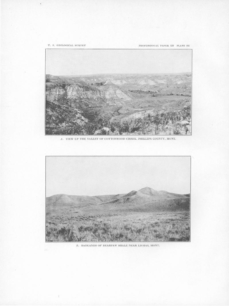
U. S. GEOLOGICAT, SURVEY PROFESSIONAL PAPER 120 PLATE III
A. VIEW UP THE VALLEY OF COTTONWOOD CREEK, PHILLIPS COUNTY, MONT.
B. BADLANDS OF DEARPAW SHALE NEAR LISMAS, MONT.

GEOLOGY OF NORTHEASTERN MONTANA. 21
ous is an article by Weed and Pirsson,t from which the followmg remarks on the rocks below the Carboniferous arc adapted. The .section from the Carboniferous to the Claggett shale of the Cretaceous system was examined during
owing to undetected variations in the clip. The areal distribution of the formations is shown in figure 2.
QUATERNARY OR TERTIARY ~ .Ple'l.stor;ene or Zate Pliocene
Terrace gravels
The descriptions of the formations above the Claggett shale are the results of work done by
R 26 E.. R 25 E.
0 SMiles ~-----L------L------L----~~----~
2 3 4
SEDIMENTARY ROCKS
CRETACEOUS
Montana group Colorado roup
Lower Cretaceous ,.---A----.
~mrn~·~~,~ Jud1th~1ver Claggett Eag)el?l Coloradogroup Mowry Kootenaic?J fo.rmabon slia1e sana stone above Mowryst)ale shale formation
SEDIMENTARY ROCKS' (ss,sandsto11t1member) IGNEOUS ROCKS
CAMBRIAN PRE-CAMBRIAN
~~ Limestone Limestone,lime- Crystalline
stoneconglomerate, schists shale,and quartzite
FIGURE 2.-Sketch map of tho geology ofT. 25 N., Rs. 25 and 2G E. principal meridian, Mont.
the field season of 1916. Only one measure- the writer and his assistants in 1915 and 1916, ment of the section exposed was made, and it and the areal distribution of the~e formations is n1ay be found to be 1nore or less inaccurate shown in Plate I. The geologic section is as
'Wood, W. H., and Pirsson, L. V., op. cit., pp. 399-428. given on page 22.

22 SHORTER CONTRIBUTIONS TO GENERAL GEOLOGY, 1918.
Section of formations in northeastern Montana.
System. Seri.es. I Group and forma- Thickness Character. tion. (feet).
Sandy soil derived from Flaxville gravel, Fort Union, Lance, and Judith River formations. Gumbo soil derived from
Recent. the Bearpaw and Claggett shales.
Quater- " Alluvium deposited in the flood plains of streams. nary. ------Unconformity Scattered boulders, t~ll, and moraines.
Pleisto-cene. Gravel deposited in Milk River valley by preglacial ~,.::issouri
River. Unconformity
Quater- Pleisto-cene or Gravel and silt north of Malta. Gravel O!l benches around nary or late Plio- Little Rocky Mountains. Tertiary. cene.
Unconformity Early Pli-
Flaxville gravel. ocene or 0-100 Gravel, sand, and clay, in some places cemented 'vith calcite. Miocene.
Tertiary. Unconformity
Eocene. Fort Union for- 0-1,400 Yellowish sandstone and shale carrying beds of lignite. mation.
180-200 Somber-colored shale and sandstone; lignite beds. Tertiary)?). Eocene(?). Lance formation.
80-200 Yellowish sandstone and shale. .......... ................
Bearpaw shale. 800-1,000 Dark-gray shale; marine fossils; gumbo soil. 0.. ::l Judith River Light-colored shale and sandstone; marine and fresh-water 0 400-425 bO formation. fossils; a somewhat sanely soil. <:il ~ Claggett shale. 750 Dark-gray shale, marine fossils, gumbo soil. c6 +"
Upper §
Eagle (?) Light-colored sandstone present in Little Rocky Mountains Creta- ~ sandstone. 100 but probably absent in Bowdoin dome and points west.
Creta- ceo us. ceous. 0..
875 Bluish-gray to black shale. ::l 0 Light-colored sandstone capped by thin layer of fossililerous ~ 60± limestone. 0 '0
<:il 325 Dark-blue shale. '""' 0 '0
Mowry shale. 100 Platy siliceous shale; weathers into porcelain-like debris. 0
LowerCre- Kootenai ( ?) for- 825 Variegated shale interbedded with yellow and brown sand-taceous. mation. stone.
Upper 200 .. Massive cross-bedded sandstone. Jurassic. Ellis formation. Jurassic. 200-300 Thin-bedded limestone and shale.
U nconfprmity Carboni£- Mississip- Madison lime- Massive fossiliferous limestone.
erous. pian. stone. Thin-bedded limestone.a
Devonian (?) and Dark-gray and black fetid limestone.a Siluri-an(?).
Thin-bedded limestone.a
Cambrian. Limestone conglomerate. Green shale. Quartzite.
Pre-Cam- Black crystalline amphibole schist.a brian.
a Adapted from Weed, W. H., and Pirsson, L. V., Geology of the Little Rocky Mountains: Jour. Geology, vol. 4, pp. 399-428, 1896.

GEOLOGY OF NORTHEASTERN MONTANA. 23
PRE-CAMBRIAN ROCKS.
The core of the Little Rocky Mountains is composed of crystalline schist (fig. 3). The type most usually seen is a fine-grained, dense, compact black crystalline amphibole schist or n.mphibolite, which splits into fragments with bright surfaces. These rocks are reported by Weed and Pirsson as being clearly altered sandstones. They are certainly older than the Cambrian.
PORPHYRY LACCOLITH.
Overlying the pre-Cambrian core of the Little Rocky Mountains is a great lenslike mass or laccolith of porphyry (see fig. 3), which was intruded at a much later date and which arched the overlying rocks in·~o a dome. The
w.
Fossils collected by Weed and Pirsson from the limestone mentioned in the section were examined by Walcott, who identified Ptychoparia oweni Hall and Obolella nana l\1:eek and Hayden. Both are :Middle Cambrian forms.
SILURIAN AND DEVONIAN SYSTEMS (1).
Above the Cambrian rocks (figs. 2 and 3) are slate-colored and black fetid limestones possessing the general characteristics of the Silurian and Devonian rocks as developed in the Rocky Mountain region to the west. No fossils were found in these rocks, and their tentative reference to the Silurian and Devonian systems by Weed and Pirsson is based on their lithologic character and position between the Cambrian and Carboniferous rocks.
Anto.ine Butte c.
Granite Butte
FIGURE 3.-Soction of tho laccolith of tho Littlo Rocky Mountains, Mont. (After Weed and Pirsson.) a, Crystalline schists; b, granite porphyry; c, Cambrian; d, Silurian ( ?) and Devonian (?); e, Carboniferous;/, Mesozoic.
exact thickness of the porphyry has not been measured, but it is known to be 300 or 400 feet on the principal summits, where it rests upon black mica schist into which the streams have cut their gorges. The outlying buttes, like those shown in figure 3, probably represent lomtl thickenings or possibly separate intrusions of porphyry from which, in many places. the overlying rocks have not bee1~ eroded.
CAMBRIAN SYSTEM.
Camb!'ian rocks, of which Weed and Pirsson give the following section, lie upo11 the laccolith just described.
Section of Cambrian 1·ocks in Little Rocky Mountains, :Mont.
Thin-bedded fissile limestone, pure limestone with shell remains alternating with impme sandy and more or less conglomeratic beds; general color
Feet.
CARBONIFEROUS SYSTEM.
MADISON LIMESTONE.
The Carboniferous rocks (fig. 2) consist of several hundred feet of somewhat thinly bedded limestone at the base, capped by several hundred feet of massive, thick-bedded limestone which appears to be characteristic. of the Mississippian Madison limestone through-out the Rocky Mountain region. From this formation Weed and Pirsson report five species of fossils collected by E. S. Dana and pronounced lower Carboniferous by Whitfield.1
Several collections of fossils, made principally by H. R. Bennett, have been examined by G. H. Girty, who has identified at least 22 species and who declares that the formation is identical with the Madison limestone of other parts of Montana. I-Iis report follows:
gray .......................................... . Limestone conglomerates and gray shale, greenish
sandy layers alternating with pure argillaceous beds. There are so,me thin beds of limestone
25 Sec. 33, 'f. 25 N ., R. 24 E. (lot 19):
from which a few fossils were taken ........... . Green shale canying limestones and conglomerates. Green or copperas-colored shale .................... . Interval in which the beds are not exposed ......... . QuartJ~ite changing to conglomerate near the base,
generally flesh-colored, mostly brecciated and rusty ......................... ~ ................. .
40 50 30
300
75
520
Zaphrentis sp. Syringipora surcularia. Rhipidomella aff. R. burlingtonensis. Schuchertella chemungensis? Productus ovatus. Productus aff. P. viminalis. Productus gallatinensis? Productus (Strophalosia?) sp. Spirifer aff. S. incertus.
1 Ludlow, William, Reconnaissance from Carol, M:ont., to Yellow .. stone National Park, p. 129, Washington, 1876.

24 SHOR.TER CONTRIBUTIONS TO GENERAL GEOLOGY, 1918.
Sec. 33, T. 25 N., R. 24 E.-Continued. Brachythyris suborbicularis? Martinia? sp. Syringothyris carteri. Athyris lamellosa. Euomphalus sp.
Sec. 36, T. 25 N., R. 15 E. (lot 21): Zaphrentoid corals. Euomphalus sp.
Same location as above but lower in section (lot 22): Triplophyllum sp. Schuchertella chemungensis. Chonetes ornatus. Spirifer centronatus. Reticularia cooperensis.
Sec. 27, T. 25 N., R. 26 E. (lot 25): Leptaena analoga. Schuchertella chemungensis. Chonetes loganensis. Chonetes ornatus. Chonetes logani. Pustula n. sp. Productus ovatus. Productus arcuatus? Productus sp. Camarotoechia metallica; Camarotoechia sp. Dielasma aff. D. burlingtonense. Spirifer centronatus.r Syringothyris carteri. :Martinia rostrata. Spiriferina solidirostris. Reticularia cooperensis. Composita humilis. Cliothyridina cf. C. crassicardinalis. Platyceras sp.
Same location as above but higher in the section (lot 26): Triplophyllum sp. Schuchertella chemungensis. Chonetes logani. Chonetes ornatus. Spirifer centronatus. Spiriferina solidirostris.
Sec. 22, T. 25 N., R. 25 E. (lot 36): Triplophyllum sp. Fenestella, several sp. Pinnatopora sp. Batostomella sp. Rhombopora sp. Cystodictya sp. Schuchertella chemungensis? Schizophoria? sp. Chonetes ornatus. Chonetes logani. Chonetes loganensis. Productus arcuatus? Pustula n. sp. Camarotoechia atf. C. herrickana. Camarotoechia metallica. Spirifer centronatus. Camarotoechia mysticensis. Camarotoechia sp. Spiriferina solidirostris.
Sec. 22, T. 25 N., R. 25 E.-Continued. Reticularia cooperensis. Martinia rostrata. Composita sp. Cliothyridina incr3ssata? Eumetria aff. E. vera. Entolium shumardianum. Platyceras sp. Griffithides? sp.
It is probable that all six collections are of lower Mississippian age and belong to the Madison limestone, though they show several different faunal facies. Lots 22, 25, 26, and 36 are typical Madison faunas. Lot 21 shows too little for definite identification of the horizon. Lot 19 suggests a typical Burlington more than a typical Madison fauna, yet the Madison is in part of Burlington age, and collections from it sometimes show a markedly Burlington facies, like this one.
The Madison limestone is the most striking formation surrounding the Little Rocky Mountains. It is the encircling girdle of the mountains, in which the picturesque canyons are cut. Seen from a distance it appears like a great horizontal bed, but on closer examination it is found to be turned up at high angles and its edge cut by deep canyons. The three small outlying domes sho·wn in figure 2 are 1nade up wholly of this limestone.
JURASSIC SYSTEM.
ELLIS FOHl\fATION.
Overlying the · ~rfadison limestone in the Little Rocky Mountains is a formation made up of shale and shaly and sandy limestone (fig. .2), which was described by Weed and Pirsson. A fauna from it, ·determined by T. W. Stanton as Jurassic, consisted of the following forms:
Ammonite fragments of undetermined species. Belemnites densus Meek and Hayden. Pleuromya subcompressa Meek. Astarte meeki Stanton. Modiola subimbricata Meek. Gryphaea calceola var. nebrascensis Meek and
Hayden.
Larger collections from this formation were made by H. R. Bennett during the field season of 1916 and were identified by J. B. Reeside, jr., as follows:
9832. Sec. 27, T. 25 N., R. 26 E. From shale above thinbedded shale and limestone which overlies the Madison limestone:
Ostrea strigilecula White. Belemnites densus Meek and Hayden. Pleuromya sp.? Indeterminable casts of pelecypods.

GEOLOGY OF NOR.THEASTERN MONT AN A.
9832. Sec. 27, 1'. 25 N., R. 26 E.-Continued. Small ammonite distinct from described American
forms but evidently a cardioceratjd. 9833. Same locality as 9832 but lower in the section:
Gryphaea calceola var. nebrascensis Meek and Hayden.
Ostrea strigilecula White. Pleuromya subcompressa Meek. Astarte? sp. Hhynchonella sp. undescribed. Belemnites densus Meek and Hayden. Serpula sp. undet. Fragment of an undescribed ammonite, suggesting
Perisphinctes. 9834. Sec. 7, '1'. 25 N., H. 26 E. From thin-bedded lime
stone above the Madison limestone: Fragments of an ammonite suggesting Perisphinctes. Gryphaea calceola var. nebrascensis Meek and
Hayden. Pleuromya subcompressa Meek. Pholadomya kingi Meek. Lima Cinabarensis Stanton. Cucullaea? sp. cf. C. haguei :Meek. Camptonectes extenuatus Meek and Hayden. Thracia? sp. like 1'. arcuata Meek but very much
larger. H.hynchonella sp. undescribed. Belemnites densus Meek and Hayden. Astarte meeki Stanton. Cyprina? sp.
9835. Sec. 7, 1'. 25 N., H. 26 E. From shale above thin-bedded limestone which overlies the Madison limestone:
Dosinia? sp. undct. Eumicrotis curta Hall. Ostrea strigllecl.1la White. Belemnites densus Meek and Hayden. Weathered casts of undetermined pelecypods. Smn.ll ammonite distinct from described forms but
evidently a cardioceratid.
Those fossils are Upper Jurassic. Jviost of the species arc known in the Sundance and Ellis formations, but several ammonites and a Rhynchonella are unlike any known Sundance forms.
The detail of part of the Ellis formation which has been identified paleontologically is as follows:
Section of Ellisfonnation. Feet.
Shale with interbedded sandstone and limestone .. 100± Limestone, thin be.ddecl, shaly, and calcareous
shale .......................................... 200
300±
Above the shaly portion there is a . more or less massive sandstone, which is tentatively considered as also belonging to the Ellis, though no fossils were found in it. It presents the following character in sec. 7, T. 25 N., R.26E.:
Section of the sandstone in the upper part of the Ellis fonnation.
Sandstone, massive, white, cross-bedded ......... . Shale, variegated ................................ . Sandstone, yellowish, and thinner bedded ........ .
Feet. 50 50
100
200'
The formation is almost identical with the Sundance formation of the Black I-Iills and the Ellis of other parts of Montana. As the :Madison limestone is ·of Mississippian age, there is necessarily an unconformity between it and the Ellis (Upper Jurassic), but the actual contact of the two formations has not been recognized. A photograph (Pl. II, 0) taken in the flanks of the Little Rocky Mountains in sec. 23, T. 25 N., R. 25 E., shows the camp situated on the outcrop of the Ellis formation in the foreground and the outcrops of the older formations in the background.
CRETACEOUS SYSTEM.
KOOTENAI ( ~) FORMATION.
The sandstone just described is overlain in the Little Rocky Mountain section by variegated shale interbedded with yellow and brown sandstones, which are believed to represent the I{ootenai formation (Lower Cretaceous) of other parts of Montana, though they may ·possibly include the Morrison. The shale is in places blue, green, red, and gray. The approximate thickness, as determined by only one measurement, is 825 feet. From 100 to 200 feet above the massive sandstone there is an exposure of carbonaceous sandstone and sandy shale containing woody fragments and impressions of poorly preserved stems which may represent the coal beds occurring in the Kootenai in the neighborhood of Great Falls or the corresponding Lakota of the Black Hills. No fossils were found in this part of the section during the season of 1916, but ·weed and Pirsson report that it contains Goniabasis sublaevis Meek and Hayden, Oorbicula cytheriformis Meek and Hayden, and an Ostrea.
COLORADO GROUP.
MOWRY SHALE.
Above the Kootenai ( ~) formation is a wellmarked siliceous shale (fig. 2) which has been recognized at several localities and is the highest formation described by Weed and Pirsson in their paper on the geology of the Little

26 SHOR.TER CONTRIBUTIONS TO GENERAL GEO.LOGY, 1918.
Rocky Mountains. When freshly broken it is brown or black, but on weathering it becomes light colored and breaks into porcelain-like debris. It contains numerous fish scales and bones, some of which can be found on nearly every piece examined, and on some specimens the trails of small marine animals, probably crustaceans, were also found. Thin sections under the microscope show that the material of this shale consists of small, angular grains of quartz interbedded with a dark amorphous substance, probably carbon. Two distinct forms of Infusoria were seen, but their nature could not be determined in the material at hand. In appearance this shale resembles the shale of the Green River formation (Eocene) in Colorado and Utah, from which oil may be obtained by distillation, but a small fragment tested by distillation yielded only a trace of oil. On the basis of its lithologic similarity and content of fish scales, this shale is correlated with the Mowry shale, which occurs at several localities in Wyoming and southern Montana. Around the Little Rocky Mountains its outcrop is marked by a low ridge covered with pines. The thickness of the formation is about 100 feet.
COLORADO GROUP ABOVE THE MOWRY SHALE.
Above the Mowry shale, in the region surrounding the Little Rocky Mountains, there is about 325 feet of dark-blue shale which differs slightly in color from the dark-gray gumbo shale higher in the section. The exposures are not continuous, and little can be said of the details of this part of the section.
fossils found in it were baculites, a few of which, collected from limy concretions, were submitted to J. B. Reeside, jr., who reports upon them as follows:
Baculites sp., usually referred to B. asper Morton. It is quite distinct from the related Pierre B. asper and from B. anceps obtusus. It has been collected from several localities in the Benton of Montana. (Collection 9841.)
MONTANA GROUP.
EAGLE (1) SANDSTONE.
The sandstone that lies above the shale just described in the region surrounding the Little Rocky Mountains is marked by a ridge about 30 feet high (fig. 2), the top of which is covered with large limestone concretions resting on sandstone. One poorly preserved specimen of Nernodon, referable to an undescribed species from the Claggett near Havre, was found (collection 9842). The same formation was seen at a locality about 3 miles southeast of the point where the section was measured, and although it was not closely studied it was thought to be about 100 feet thick. This sandstone is about 750 feet below the base of the Judith River formation, and if it is the Eagle sandstone it proves that the overlying formation varies a great deal in thickness, for the Eagle sandstone is described by Stebinger 1
as being from 350 to 500 feet below the,base of the Judith River formation .. Reports of drilling northeast of Malta, in the Bowdoin dome, seem to indicat~ that the Eagle sandstol)e is not present there as a mappable unit.
CLAGGETT SHALE.
This shale is overlain by a sandstone capped The Claggett shale represents part of a by a foot or more of impure limestone contain- marine formation called the Pierre shale in ing fossil gastropods and pelecypods which have I regions to the east and southeast, which to the been identified by T. W. Stanton as of Benton west is represented by four formations-the age. J. B. Reeside, jr., who examined the ·Eagle sandstone, Claggett shale, Judith River collection, reports the following species: Callista formation, and Bearpaw shale. Of these formaorbiculata Hall and Meek, Pachymelania? sp. tions the Judith River is of fresh-water origin. undescribed, Amauropsis? sp. undescribed. The Claggett shale on the east side of the The stratigraphic position of this sandstone is Little Rocky Mountains, where its top and not far from that of the Frontier formation of bottom are exposed, measures approximately Wyoming and southern Montana. Its thick- 750 feet. In the center of the Bowdoin dome ness could only be estimated and is given in the north of ·saco about 500 feet of the upper part table as about 60 feet. of the formation is exposed. Stebinger, work-
The sandstone noted above is overlain by ing in the vicinity of Havre, about 90 miles to about 875 feet of bluish-gray to black shale, the west, reports the thickness of this formation much of which is concealed and in which sandy
1 Stebinger, Eugene, Possibilities of oil and gas in north-central facies if present were not recognized. The only Montana: u.s. Geol. survey Bull. 641, p. sa, 1917.

GEOL9GY OF NOR.THEASTER.N MONTANA. 27
as frOin 350 to .300 feet. It consists of a darkgray shale which on weathering forms typi_cal gumbo soil. Scattered through the formatiOn in many places are concretions Qr masses of impure limestone, many of .which contain marine fossils, or of aragonite, a mineral resembling fossil wood. The formation also contains large flakes of selenite or transparent gypsum, and water in wells, springs, or small streams in the area of its outcrop is always more or less alkaline. This shale forms the lower slopes of the valley of Milk River betwee~ I-Iinsdale and Malta. Two collections of fossils fron1 it were referred to J. B. Reeside, jr., who identified one species, Baculites compressus Say, regarded as characteristic of the Pierre shale.
About 70 feet of strata in the upper part of the Claggett shale appear to form a transition zone between the Claggett and the Judith River· formation. This zone is found on the west side of the Bowdoin dome, north of :Malta. On the north side of the dome, near Whitewater post office, it does not contain the characteristic sandstone, and it can not be recognized at all on the east side near I-Iinsdale. The following sections will illustrate this peculiarity:
Sections of the transition zone of the Claggett and Judith Ri·ver formations.
West or the Bowdoin dome nenr the center or T. 31 N., R. 30 E.
Typical.Tudith River formation. Feet.
Shale resembling the Claggett ..................... 50± Sandstone resembling Judith River formation con-
taining abundant marine fossils .................. 20± Typical Claggett formation.
70±
North or the Bowdoin dome in Tps. 34 nnd 35 N., R. 32 E.
Typical.Tudith River formation. Shale containing fossils similar to those of the marine
sandstone of the preceding section ................ 50± Typical Claggett shale.
The following lots of fossils collected from the upper part of the Claggett shale have been identified by Mr. Reeside, who finds that they are marine forms characteristic of the Pierre shale. lOOHi. Sec. 32, T. 35 N., R. 32 E.:
Lunatia subcrassa Meek and Hayden. 10017. Sec. 25, T. 33 N., R. 30 E.:
Tancrediaame1·icana Meek and Hayden (fragments): Lunatia subcrassa Meek and Hayden.
9829. North half ofT. 31 N., R. 30 E.: Cardium speciosum Meek and Hayden. Tancredia americana Meek and Hayden. Lunatia subcrassa Meek and Hayden. Haminea subcylindrica Meek and Hayden.
9830. Western part ofT. 31 N., R. 30 E., south of Assinni-boine Creek:
Anatina sp. undescribed. Mactra alta Meek and Hayden. Tancredia americana Meek and Hayden. Cardium speciosum Meek and Hayden. Anchuria sp. undet. Lunatia subcrassa Meek and Hayden. Placenticeras intercalare Meek. Baculites compressus Say.
JUDITH RIVER FORMATION.
Above the Claggett shale lies the Judith River formation, esttmated from several imperfect measurements to range from 400 to 425 feet in thickness. The outcrop of this formation surrounds the Bowdoin dome, standing out as a light-colored formation in the hill south of the railroad from Malta to Vandalia and north· of the railroad near Valleytown and Lovejoy. It also crops out in one of the surrounding sandstone ridges of the Little Rocky Mountains. It probably extends east of the Bowdoin dome beneath the surface, at least as far as the mouth of Milk River, where it has probably been reached in an artesian well at a depth of 7 50 feet .. To the southeast the Judith River formation is not recognizable as a distinct unit, as shown by the gas wells sunk on the Glendive anticline. A characteristic view of the Judith River formation is given in Plate III, A. The formation con-sists of extremely variable beds of hard brown sandstone, soft, friable light-colored sandstone, and light-gray shale; and on account of their variability no beds·were found that. would serve as horizon markers. In describing this formation Stanton and I-Iatcher 1 say:
A detailed section taken at any point is of little value, since a similar section made at a distance of only a mile or two would give a quite different sequence of the alternating strata of sandstones and shales.
Some of the details of this formation may be seen from two sections which were measured in its upper part on the east side of Rock Creek, as follows:
1 Stanton, T. W., and Hatcher, J. B., Geology and paleontology or the Judith River beds: U.S. Geol. Survey Bull. 257, p. 34, 1905.

28 SHORTER .CONTRIBUTIONS TO GENERAL G~OLOGY, 1918.
Sections of part of the Judith River formation. Shale, brown ................................... .
Feet.
On east canyon wall of Rock Creek, in.sec. 20, T. 34 N., R. 36 E. Lignite .............. : ........................... . i t
5 Bearpaw shale above Judith River formation. Sandstone, massive, grayish, with iron concretions
scattered or in beds; weathers yellowish; some red bands cross-bedded ........................ .
Shale, brown, in places approaching lignite ....... . S~nd_stone, soft, yellowish g~ay, and gray shale ... . Lignite .......................................... . Shale, brown ................................. · .. . Shale, gray .................................. _ .. .
.,. Shale, dark, carbonaceous ....... · ................ . Shale, gray, and sandstone ................. .- ..... . Lignite ............................................ . Shale, brown ................................... . Shale, gray ............. _ ....................... . Shale, brown ......................... · .............. . Sanstone, soft, with iron concretions ............... . Shale, sandy, brown ............................. . Sandstone, soft, gray ..................... · ........ . Clay, shale gray ................................. . Shale, brown ................................... . Sandstone, soft, gray, and sandy shale ............. . Sandstone, concretion bed ...... , ................. . Shale, soft, sandy, gray ........................... . Sandstone, iron-concretion bed ................ : .. . Shale, blue and gray ......... .' ................... . Concretions ...................................... . Shale, gray ..................................... . Shale, brown ........................ : .......... . Sandstone, soft, gray and yellow .........•........ Sandston~, massive; weathers brown; arkosic, con-
taining much feldspathic and feriomagnesian materiaL This bed forms conspicuous ledges ....
Sandstone, soft, gray; some shale~ ..•.............. Base of formation not exposed.
Feet·
32 2
23
~ 1
Sh~le, brown ................................... . Shale, blue-gray ................................ . Shale, brown ................................... . Shale, sandy ..... .' .............................. . Sandstone, concretions .......................... . Shale, gray .................. _ .. _ ............... . Sandstone, soft, gray ............................. . Shale, dark .................... _ ................ .
4 ·Sandstone, soft, gray, and sanely shale ............. . i Shale, brown ................................... .
5 Sandstone, massive, soft, gray or yellowish, weath! ering yellowish; certain beds weather out as masi sive reddish layers or as huge concretions; shows
G some cross-bedding ............................. . 3
1 2 6 4 3 9 1 5 1 4 1 4 2
17
7 20
165
Base of formation not exposed. '
12 1 6 1
10 13 3
14 2
101±
296±
East canyon wall of Rock Creek, near line between sec. 32, T. 34 N., R. 36 E., and sec. 4, T. 33 N., R. 36 E •.
The base of this formation is not very definitely marked and can not everywhere be separated from the upper part of the Claggett shale; but its top can be readily recognized in the few places· where it is well exposed. The upper part of the Judith River formation consists of a massive sandstone in the two sections cited and in the neighborhood of the Little Rocky Mountains, and is overlain by characteristic Bearpaw shale. At other places in the region the massive sandstone is not prominent, and in one or two localities a small bed of lignite within a few feet of the top has been mined. Stanton and Hatcher report a layer of shell brec'cia consisting of shells of Ostrea subtrigonalis near the top of the Judith River formation as its most persistent horizon marker, but such beds were not seen in the neighborhood of the Bowdoin dome. Invertebrate fossils collected from the formation during the season of 1916 have been examined by Mr. Reeside, who reports that six lots consist of marine forms and one lot from the flanks of the Litt]e Rocky Mountains contains fresh-water forms of Judith River types. The species identified are as follows:
Glacial gravel. Feet. Sandstone, massive, gray; w~athers yellow or red-
dish; some thin beds; cross-bedded ........... ·.. 47 Shale, gray....... . . . . . . . . . . . . . . . . . . . . . . . . . . . . . . . 6 Sandstone, soft, gray ............................ . Shale, gray ...................................... . Shale, brown ................................... . Shale, gray .................................... ~ . Shale, brown ....... ~ .......................... :. Sandstone, soft, gray ............................. . Shale, brown, with 3 inches of lignite ......... : ... . Shale, gray ..................................... . Shale, brown ................................... . Shale, blue ...................................... . Sandstone, soft .............................. ' ... .-Shale, brown ................................... . Sandstone, soft, gray ............... · .............. . Shale, blue-gray ................................ . Concretions ...................................... . Sandstone, soft, massive, gray .................... .
2 4 3 2 1 5 2 5 6 2 9
1! .3 5 6
18
9826. Sec. 36, T. 33 N., R. 37 E., on road: Plates of an undescribed barnacle. Tancredia americana Meek and Hayden. Cardium speciosum Meek and Hayden. Protocardia sp.?, large form. Mactra sp.? Inoceramus sp. ?, very young individual. Nucula sp.? Lunatia subcrassa Meek_ and Hayden.

GEOLOGY OF NORTHEASTERN MONTANA. 29
982G. Sec. 3G, T. 33 N., R. 37 E., on road-Continued. Sections of Judith River formation in northeastern Montana. Of. Trachytriton vinculum Meek and Hayden. Scaphites sp., fragment suggesting S. nic?lleti
Morton. Baculites sp.?, fragment.
Most of this lot consists of casts lacking essential details. The Protocardia?, Lvnatia, and Scaphites suggest Bearpaw rather than typical Judith River.
984B. SvV. t sec. 21, T. 33 N., R. 37 E., on Eagle Creek; upper part of Judith River formation:
Liopistha. undata Meek and Hayden. Pteria nebrascana Edwards and Solander.
Marine; Pierre fauna.
41. Sec. 4, T. 33 N., R. 37 E., on Bitter 0reek; upper part of Judith River formation:
Natica sp.? Mactra sp.? Serpula sp.?
The only fresh-water forn1s are found in the following lot: 9837. See. 21, T. 25 N., R. 26 E., sandstone about middle
of Judith River formation at east end of Little Rocky :Mountains:
Unio cf. U. primaevus White. Unio cf. U. suprag~bosus Whiteaves.
This lot consists of fragments which suggest a reference to the Judith River but are too poor to be conclusive Unig supragibbosu.s occtus in the Canadian Belly River and in the Judith River formation. U. primaevtt.s is a .Tuclit:h River species.
Inasn1uch as this lot of fresh-waterforms is from the 1niddle of the formation, while the 1najority of the fossils found are marine, it is probable that the Judith River formation of this area is marine at the top and bottom.
Bones of fresh-water dinosaurs were collected at several localities and were examined by C W. Gihnore, of the National Museun1, who f~und then1 too fragmentary for specific determination.
'
Specirnens of petrified wood,· described by F. I-I. l{nowlton as that of cone-bearing trees were collected at several places in the Judith River formation, but no deterrpinable fossil leaves were found.
This forn1ation contains small lenticular beds of lignite or subbituminous coal which are too thin to be of value. Local n1ines fron1 which the farmers have obtained a small amount of fuel were examined at the points where the following sections were measured:
28288°-19-3
I
Location.
Sec.· T.N. R.E.
----
21 33 37
------4 33 37
-
------5 33 37
------15 32 37
------1G 32 37
------7 34 3()
------12 34 35
------32 34 35
------6 33 35
------20 34 34 ..
------5 35 34
--351 34 9
9 28 32 ------
9 28 34
Section.
Ft. in. Bearpaw· shale. Sand~~o~e ................... 20±
Ligmte ................. 8 Sandstone and shale ........ 15± Slu~Je,_ carbonaceous, and
hgmte .................... 2±
Bearpaw shale. Sandstone and shale ......... 59 0
Lignite ................. 6 Sandstone and shale ........ 22 . 0 Shale, carbonaceous ........ 2 0
Lignite .................. 8 Shale, carbonaceous ........ 2 0
Shale, blue ................ 4 6 Shal~, <:arbonaceous ........ 6
Lignite ................. 1 2 Shale, carbonaceous ...... ,· . 6
Sandstone .................. 10 0 Lignite ............ · ..... 1 4
Shale, sandy gray .......... 3 0
Lignite, a few inches.
Shal~, g:ay ................. 5 0 Lignite .................. 1 4
Shale, brown ............... 1 0
Ligt;1ite ..... ~ ............ 6
Shale, gray ....... · ...... ! ~ .. 5 ·0 Shal~, b_roW'n ............... 2
Ligmte ................. 8 Shale, brown ............... 4 Shale, gray.
Shal~, g_ray ................. 5 0 Ligmte ................. 10
Shale, brown ............... 8 Shale, gray.
Shale ........ · ............... 10 0 Lignite ................. 6
Shale, bro:wn. Shale, gray ................. 1+
Lignite ................. 6
'Lignite .................. 8
Lignite ................. 6-10
Bearpaw shale. Judith River formation ..... 50± Clay,_ bl~ck, carbonaceous .. 1 6
Lignite ................. 10

30 SHORTER CONTRIBUTIONS TO GENERAL GEOLOGY, 1918.
BEARPAW SHALE.
The Bearpaw shale, from 800 to 1,000 feet thick is, as shown on Plate I, the most widespread formation exposed in the region described, and overlies the Judith River formation. It consists essentially of dark-gray shale which forms a gumbo soil and presents an uninteresting and monotonous landscape. This shale is exposed in many places along escarpments and canyons and forms badlands which lack the variety due to the presence of harder beds. A characteristic view of the badlands of the Bearpaw shale is given in Plate III, B. The fossils are all of marine types; Baculites, Inoceramus, and oysters are very abundant,·and occasionally the remains of a gigantic marine saurian are found. The formation in places contains limy concretions, in which the lime 'is in the form of aragonite showing cone in cone structure or appearing like the stu:mps of large trees. Calcite also is present in many of these concretions, and smaller masses of barite were noted in several localities. The formation contains more or less gypsum, which at some places is transparent and at others occurs in· uncrystallized forms replacing the calcite of oyster shells. The water from the Bearpa w shale, like that· from the Claggett, is usually alkaline.
The following invertebrate fossils were collected during the field season of 1916 and were identified by J. B. Reeside,_ jr.: 9825. SW. t sec. 22, T. 33 N., R. 37 E.:
Inoceramus sagensis Owen. r
Heteroceras sp. related to H. newtoni Meek but probably undescribed.
Pierre fauna; fossils not distinctive of Bearpaw shale. 9827. Sec. 36, T. 36 N., R. 36 E.: .
Ostrea patina Meek and Hayden. So far as known this form is confined to the Bearpaw
shale. 9828. Sec. 5, T. 36 N., R. 26 E.:
Chlamys nebrascensis Meek and Hayden. Baculites compressus Say. Of. Trachytriton vinculum Say. Membranipora sp. undescribed (identified by R. S. · Bassler).
Pierre fauna. 9838. Sec. 21, T. 25 N., R. 26 E.:
Ostrea patina White 9839. Sec. 21, T. 25 N., R. 26 E.:
Inoceramus sagensis Owen. Baculites sp., fragments. ·
Pierre fauna.
10020. Sec. 10, T. 23 N., R. 36 E., 150 to 200 feet below top of Bearpaw shale:
Scaphites nodosus var. plenus Meek. Baculites compressus Say. Cyprimeria? sp., single weathered individual.
Pierre fauna. 10021. Southwestern part of T. 23 N., R. 36 E., 50 to 100
feet below top of Bearpaw shale: Baculites compressus Say.
Pierre fauna. 10024. Northeastern part ofT. 23 N., R. 34 E., 50 feet be
low top of Bearpaw shale, -on Timber Creek: Baculites compressus Say.
Pierre fauna. 10025. T. 26 N., R. 34 E., along Larb Creek; middle of
Bearpaw shale: Baculites sp., fragments.
Pierre fauna. 10028. T. 24 N., R. 41 E., near top of Bearpaw shale:
Inoceramus sagensis Owen. Protocardia subquadrata Edwards and Solander. Anomia sp., fragments. Y oidia evansi Meek and Hayden. Lunatia sp., fragments. Dentalium gracile Meek and Hayden. Anch~ sp., fragment. Actaeon attenuatus Meek and Hayden. Scaphites sp., probably young S. nodosus plenus
Meek. Bearpaw shale.
Parts of skeletons of two large marine reptiles collected in this region, one found several years ago by Ira Taylor, were submitted to C.· W. Gilmore, who identified one of them (from sec. 23, T. 37 N., R. 35 E.) as consisting of numerous parts of vertebrae, limb bones, fragmentary teeth, jaws, and other fragments of a large plesiosaurian reptile; and the other (from sec. 23, T. 34 N., R. 38 E.) as consisting of numerous vertebrae and other parts of the skeleton of a mososaurian reptile. Neither of these forms was otherwise determinable. The remains of both animals are found only _in. marine or brackish-water formations
TERTIARY (1) SYSTEM.
LANCE FORMATION.
The Lance formation, which overlies the Bearpaw shale, as here identified, is composed of two more or less distinct members in the eastern and southern parts of the region described. In the northwestern part, in the Cherry Ridge quadra:ngle, the exposures are too meager to indicate their character.

GEOLOGY OF NOR.THEAST'ERN MONTANA. 31
The lower member has been described by Dawson,t who estimated the thickness at 80 feet a.nd referred it to the Fox Hills sandstone. Figure 4, reproduced fr01n Dawson's report, shows ~he relation of the two members near the international boundary northwest of Opheim. The lower n1ember is here composed of yellowish and rusty sands grading into arenaceous clay toward its base. It is characterized by large, irregular sandy concretions which in places approach a more or le~s sphericnl form and are slightly darker than the pre.vniling color of the for1nation. So far as the writer knows 1narine fossils have not been obtained from this member within the region described. Rose/ in his description of beds he designated Fox Hills sandstone in the Wood J\1ountain district of Canada., gives a list of the fossils found by R. G. J\1cConnell in beds designated Pierre anq. Fox Hills forma-
South Dakota. Small exposures of this member are found in T. 37 N., R. 40 E., and T. 35 N., R. 44 E., where it is similar in lithologic character to the rocks northeast of Opheim.
In the Larb Hills, in the southern part of the region described, a similar ·n1ember having a thickness of. about 100 feet where measured in sec. 13, T. 24 N., R. 32 E., rests upon the Bearpaw shale and is capped by a harder sandstone. The same succession of beds is exposed south of J\1issouri River, where Brown 3
reports collecting i4 species of marine invertebrate fossils, identified as the Fox Hills fauna, from concretions found on Hell Creek. l-Ie further reports ~ that in the san1e valley, 20 feet below the base of the sandstone he calls Fox Hills, the r~mains of a large trachodont dinosaur were discovered. The specimen was found in place partly embedded in a large calcareous concretion that was weathered out
FiouuE 4.-8ection in badlands south of Wood Mountain, Saskatchewan, Canada, showing the relation of Fort Union formation (a), upper part of Lance formation (b), lower part of Lance formation (c), and Bearpaw shale (d).
tions in the Cypress Hills, but as no effort is n1ade to distinguish between the formations the list is probably of little value.
A very good exposure of yellowish sandstone, resen1bling that at the boundary, covers 2 or 3 square miles in and around sec. 34, T. 36 N., R. 39 E. In this sandstone, which surely lies only a short distance abQve the Bearpaw shale, was found a well-preserved fossil bone which Gilmore identified as "the proxin1al half of the left ischium of a trachodont dinosaur. So far as it can be ·compared it appears identical with the same element in Trachodon annectens J\1arsh, from the Lance formation." The finding of this fossil justifies the belief that the lower prert of the Lance is a fresh-water deposit and should not be classified as the Fox Hills sandstone, which in the type locality is marine. It may, however, be conteinporaneous with the Fox Hills sandstone of
1 Dawson, G. M:., Geology or tho 49th parallel, British North American Boundary Commission, Montreal, 1875.
ll Rose, Bruce, 'Vood Mountain-Willowbunch coal areas, Saskatchewan: Canada Gool. Survey Mem. 89, p. 32, 1916.
and broken. The humeri were still covered with shale and well preserved.
This member northwest of Opheim is probably the same as that found on J\1issouri River in the southeastern part of the region here described and called the Fox Hills sandstone by Smith.5 (See Pl. IV, A.) It is described in a later report by Beekly 6 as the Colgate sandstone member of the Lance formation, consisting of 50 to 150 feet of buff sandstone interstratified with somber-colored and yellow clay. The type locality is the vicinity of Colgate station on the Northern Pacific Railway, described by Calvert;7
The upper member of the Lance formation is composed of shale and argillaceous sandstone and is characteristically of somber color. Its
a Brown, Barnum, The Hell Creek beds of Montana: Am. Mus. Nat. Hist. Bull. 23, p. 827, 1907.
4 Idem, p. 826. 5 Smith, C. D., The Fort Peck Indian Reservation lignite field, Mont.:
U.S. Geol. Survey Bull. 381, p. 42, 1908. o Beekly, A. L., The Culbertson lignite field, Valley County, Mont.:
U. S. Geol. Survey Bull. 471, pp. 329, 330, 1912. . 7 Calvert, W. R., Geology of certain lignite fields in eastern Montana:
U. 8. Geol. Survey Bull. 471, pp. 194, 195, 1912.

•
32 SHORTER CONTRIBUTIONS TO GENERAL GEQLOGY, 1918.
foot bones, vertebra, chevrons, etc., of Thescelosaurus neglectus Gilmore; caudal vertebra of a carnivorous dinosaur, not determinable; two fragments of a turtle shell, probably pertaining to the genus Aspidontes. The presence of Thescelosaurus neglectus would indicate that these fossils came from the Lance formation, for the four or five specimens of the genus known at this time are all from the Lance.
A single vertebra collected near the top of the ·Lance formation in sec. 27, T. 37 N., R. 46 E., is that of Ohamposaurus sp., characteristic of both.the Lance and Fort Union formations.
Several small collections of invertebrate fossils, made in the Larb Hills, have been identified by Mr. Reeside as follows:
10022. Sec .. 29, T. 24 N., R. 35 E. Unio brachyopisthus. Unio holmesianus.
1 Brown, Barnum, op. cit., pp. 823-845.
10023. Sec. 29, T. 24 N., R. 35 E. Unio cf. U. brachyopisllms White. Sphaerium subellipticum Meek and Hayden .
• Viviparus sp., fragment. · 10026. Sec. 29, T. 24 N., R. 3·5 E.
Tulotoma thompsoni White. 10027. Sec. 25,. T. 25 N., R. 34 E.
Sphaerium subellipticum Meek and Hayden. Campeloma multilineata Meek and Hayden.
All are probably from the Lance formation. Fossil wood from the Lance formation has
been identified by Knowlton as that of coniferous trees, but no identifiable fossil plants were collected.
TERTIARY SYSTEM.
2 Rose, Bruce, Wood Mountain-Willowbunch coal areas, Saskatchewan: Canada Geol. Survey Mem. 89, pp. 69-83, 1916. Bauer, C. M., Clay in northeastern Montana: U. S. Geol. Survey Bull. 540, pp. 369-372, 1914.
a Beekly, A. L., The Culbertson lignite field, Valley County, Mont.: U.S. Geol. Survey Bull. 471, pp. 326, 331, 1912.
• 4 Rogers, G. S., The Little Sheep Mountain coal field, Dawson, Custer, and Rosebud counties, Mont.: U. S. Geol. Survey Bull. 531, pp .. 12, 13, 1913.

•
U. S. GEOLOGICAL SURVEY PROFESSIONAL PAPER" 120 PLATE IV
A. LOWER PART OF THE LANCE FORMATION, SHOWING SPHERICAL CONCRETIONS.

U. S. GEOLOGICAL SURVEY PROFESSIONAT, PAPER 120 PLATE V
B. EROSION FORM OF LANCE FORMATION.

GEOLOGY OF NORTHEASTERN MONTANA. 33
Union formations exposed from Redstone to Plentywood (Pl. I) is much generalized:
Generalized section of the Lance and Fort Union formations between Redstone and Plentywood, Mont.
Fort Union formation: Ft. in.
Sandstone and shale ..................... . 81 0 J_,ignite ..................... - ........ · 6
Sandstone and shale ..................... . 67 0 Shale ................................... . 52 0
Lignite, Richardson bed .............. . 6± Sandstone and shale more or less concealed 320±
Lignite, upper Eagles Nest bed ..... : . 6 3 Shale and sandstone, yellowish .......... . 50±
Lignite, lower Eagles Nest bed ...... . 4 0 Shale and sandstone, yeilowish .......... . 70 0
Lignite ............................ . 10 Shale and sandstone, yellowish .......... . 19 0
Lignite .• : ........................... . 1 2 Shale and sandstone, yellowish .......... . 18 0
Lignite •.•.......................... 4 Shale, grading upward into sandstone,
yellowish ............................ . 20 0 Lignite ............................ .
Shale I1nd sandsto~e, yellowish .......... . 1 6
60± Lignite, Redstone bed ............... . 6 0
Shale and sandstone, yellowish .......... . 22 0 Lignite ............................ . 2 0
Lance formation: Shale and sandstone, somber color ..... . 30 0
Lignite ............................ . 1 10 Shale and sandstone, somber color ..... . 27 0
!.ignite ............................ . 6 0
872±
Tl1e following generalized section of the Fort Union and its lignite beds as exposed on Missouri River in the southeastern part of the region is taken from Beeldy's report: 1
Generalized sect·ion showing the distribution of lignite beds ~·n the Fort Unionformation.
Culbertson field, 2 miles cast or Lakeside. Ft. in.
Sandstone with some shale ................... . Lignite .................................. .
Sandstone and shale ......................... . Lignite, bed DD ........................ ..
Sandstone and shale .......................... . Lignite, bed CC ......................... .
Sandstone and clay ........................ . Lignite ................................ .
Fort Peck field west or Big Muddy Creek.
[C. D. Smith, 1908.1 Clay ....................................... .
Lignite, bed D .......................... . Sandstone and clay ........................ .
Lignite, bed C ......................... . Sandstone ancl clay ........................ .
Lignite, bed B ......................... . Sandstone and clay .... , ................... .
Lignite ................................ . Clay ....................................... .
Lignite, bed A .. · ..... ~ ................. . Somber-colored beds (Lance).
Ft. in.
121 0 1 0
24 o' 4 4
70 0 2 5
130 0 5 7
416 8
6 0 9 0
95 0 2 0
115 0 3 0
275 0 5 0
15 0 7 7
532 7
1,390_ 3
The following section, measured in sec. 18, T. 24 N., R. 33 E., shows the relations of the Fort Union, Lance: and Bearpaw formations in the Larb Hills: Section showing the relation of the Fort Union, Lance, and
Bearpaw formations in the Larb Hills, },font.
Fort Union formation: Ft. in. Sandstone, yellowish ................... . 50 0
Lignite ............. · ............... . 3 Sandstone, soft, yellowish .............. . 20 0
Lignite ............................ . 1 0 Sandstone, soft, yellowish .............. . 11 0
Lignite ............................ . 1 0 Sandstone, soft, yellowish .............. . 20 0
Lignite ............................ . 6 0
109 3
Clay and shale .............................. . 125 0 Lance formation: Lignite, bed IT ......................... .
Clay and shale .............................. . Lignite, bed G ........................... .
Clay and sanely shale ......................... . I ... ignite .................................. .
Sandstone and clay .......................... . ! .. ignite .................................. .
Sandstone and shale ........................ ..
Cu.lbcrtson field, sec. 3, T. 27 N., R. 56 E.
Lignite, bed F .... -...................... . Sandstone and shale ......................... .
Lignite, bed E ........................... .
1 Beckly, A. L., op. cit., p. 331.
4 o Shale and sandstone, somber color ........ . 50 0 70 0 Lignite.~ .......................... . 6 4 0 Shale and sandstone, somber color; con-
150 0 tains dinosaur bones ................... . 100 0 1 10 Concealed .............................. . 100 0
30 0 Shale, sandy ............................ . 100 0 1 2 Bearpaw shale.
55 0 350 6
441 0 459 9
The relations of these sections are shown gra.phically in figure 5.
7 o Full descriptions of the lignite beds in each 45 0 .township are given in other reports.2
6 4 2 U. S. Geol. Survey Bull. 381, pp. 40-59, 1910; Bull. 471, pp. 319-358,
1912; Bull. 541, pp. 293-315, 1914; and a report not yet publish!)d.
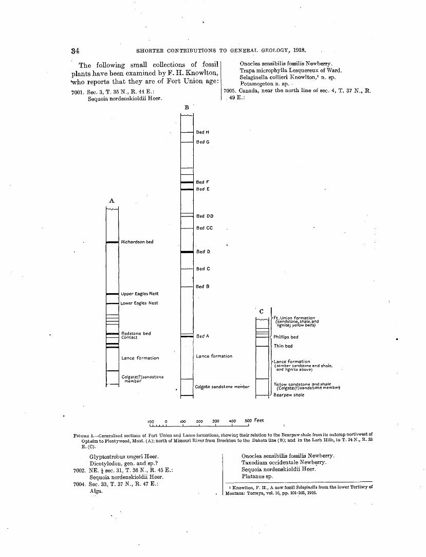
34 SHORTER CONTRIBUTIONS T'O GENERAL GEOLOGY, 1918.
The following small collections of fossil plants have been examined by F. I-I. Knowlton, who reports that they are of Fort Union age:
7001. Sec. 3, T. 35 N., R. 44 E.: Sequoia nordenskioldii Heer.
A
Richardson bed
Upper Eagles Nest
Lower Eagles Nest
Redstone bed Contact
B
Bed H
Bed G
Bed F'
Bed E
Bed DO
Bed CC
Bed D.
Bed C
Bed B
Bed A
Onoclea sensibilia fossilis Newberry. Trapa microphylla Lesquereux of Ward. Selaginella collieri Knowlton,• n. sp. J?otamogeton n. sp. ·
7005. Canada, near the north line of sec. 4, T. 37 N., R. 49 E.:
c
l Ft. Union formation (sandstone, shale. and lignitej yellow beds)
Phillips bed
Thin bed
Lance formation Lance formation
Colgate(?)sandstone member
100 0 100
Colgate sandstone me.:nber
200 300 400 soo Feet
Lance formation (somber sandstone and shale, ·and lignite above)
Yellow sandstone and shale (Colgate(?)sandstone member)
Bearpaw shale
FIGURE 5.-Generalized sections of Fort Union anc;l Lance formations, showing their relation to the Bearpaw shale from its outcrop northwest of Opheim to Plentywood, Mont. (A); north of Missouri River from Brockton to the Dakota line (B); and in the Larb Hills, in T. 24 N., R. 33 E.(C).
Glyptostrobus ungeri Heer. Dicotyledon, gen. and sp.?
7002. NE.!sec. 31, T. 36 N., R. 45 E.: Sequoia nordenskioldii Heer.
7004. Sec. 33, T. 37 N., R. 47 E.: Alga.
Onoclea sensibilis fossilis Newberry. Taxodium occidentale Newberry. Sequoia nordenskioldii Heer .' Platanus sp.
1 Knowlton, F. H., A new fossil Selaginelb from the lower Tertiary of Montana: Torreya, vol. 16, pp. 101-:1U3, 1916.

GEOLOGY OF NORTHEASTERN MONTANA. 35
7505. Canada, near the north line of sec. 4-Continued. Grewia sp. · Persea sp.
7006. SE. i sec. 21, T. 36 N., R. 52 E.: Taxodium occidentale Newberry. Sequoia no_rdenskioldii Heer. Grewia pealei Ward.
7272. NE. t sec. 36, T. 37 N., R. 3~ E.: Sequoia nordenskioldii Heer. Glyptostrobus europaeus Unger. Fragments of a dicotyledon.
Collections of invertebrates, on which T. W. Stanton has reported, were made at. the following localities: 9837. SW. t sec. 6, T. 35 N., R. 45 E.: .
Unio ep. fragments. Campeloma producta White. Campeloma multilineata Meek and Hayden.
Fort Union. 9380. T. 36 N., R. 46 E.:
· Vivipu.rus sp. Probably Fort Union.
9381. Sec. 13, T. 3.4 N., R. 50 E.: Unio sp. Campeloma multilineata Meek and Hayden.
Fort Union.
FLAXVILLE GRAVEL.
With the Fort Union the conformable series stops, and the formations representing the later history of the region are surficial deposits of rather small extent laid down during favorable intervals between great time breaks when erosion was prevalent and no sediments were deposited.
The Flaxville gravel, 1 shown in several areas along the international boundary, is a few feet to lOO.feet thick and caps a series of plateaus upon eroded surfaces of the Fort Union, Lance, nnd Bearpaw formations at altitudes ranging from 2,600 feet at the east end to 3,200 feet at the west end of the region described, near the international boundary. It is composed of gravel, sand, clay, volcanic ash, and marl·and in places ia cemented with calcite. The gravel consists of pebbles derived from the quartzite m~d argillite of the Rocky Mountains.
Fragments of fossil.vertebrates found at 25 wic}.ely distributed localities have been submitted to J. W. Gidley, who states that the beds which contained them can not be older than Miocene or younger than early Pliocene and that they are probably upper Miocene.
1 Collier, A. J., and Thom, W. T., jr., Tho Flaxville grovel and its relation to other high torroco grovels of tho northern Groat Plains: U.S. Gool. Survey Prof. Pupor 108, pp. 179-184, 1917 (Prof. Paper 108-J).
The time break between the Fort Union formation (Eocene) and the Flaxville gravel (Miocene) is in part represented by the Oligocene· deposits found on a still higher plateau in the Cypress Hills in Canada, 50 miles away.
TERTIARY OR QUATERNARY SYSTEM.
LATE PLIOCENE OR EARLY PLEISTOCENE
DEPOSITS'.
Below the Flaxville level there are extensive areas across which the present streams have eroded valleys from 100 to 500 feet in depth. Stratified silt and gravel are to be found in a very few places on this level, and from one df these exposures of gravel in sec. 23, T. 33 N., R. 35 E., a single fossil tooth was collected which Dr. Gidley identified as that of a horse resembling the living species. As the gravel from which it came is clearly older than the last advanoo of ice during the glacial epoch, the formation is regarded as of either late Pliocene or early Pleistocene age. 2
Extensive benches slope gently away from the Little Rocky Mountains at several levels. These benches are capped with gravel containing many pebbles of limestone and porphyry derived from the neighboring mountains and are almost surely of Tertiary age, for in some places the gravel on them is overlain by glacial drift. The lowest bench is probably equivalent to the late Pliocene or early Pleistocene bench in the region north of Milk River with which it is tentatively correlated. The presence of undissolved limestone pebbles seems to forbid the assignment of these benches to an. earlier period.
QUATERNARY SYSTEM.
ALLUVIUM: 01'' PREGLACIAL RIVERS.
Since late Pliocene or early Pleistocene time streams have been at work eroding the pre~ent valleys. The effects of this erosion can be seen in the escarpments north and south of Milk River between Tampico and Malta, where at one place 300 feet of beds belonging to the Claggett and Judith River formations, capped by late· Phocene or early Pleistocj3ne gravel, are exposed. The cutting of the river valley must have occurred early in Pleistocene time, when the valley of :Milk River was occupied by
s Idem, p. 18Z.
c
•

0
•
36 SHORTER CONTRIBUTIONS TO GENERAL GEOLOGY, 1918.
·~ much larger river, the Missouri/ and along ItS banks and flood p1ains gravel, silt, and sand were ·deposited. Some of this material ·can be :aeen in pits northwest of Saco and north of Malta. The gravel ·here differs from the Flaxville grayel in that it contains numerous fragments of porphyry.
Similar deposits occur at several points in the first benches above the flood plain of the Missouri between Milk River and the North Dakota line, and are best exposed where gravel pits are operated by the Great Northern Railway. In the summer of 1917 a pit was operq.ted at Wolf Point, where a new freight division of the railway was being installed and where the photograph reproduced in Plate VI, B, was taken. Wolf Point lies about 25 feet above the Missouri, and the gravel pit is in the second bench, about 20 feet higher. ;The section exposed is about as follows:
Section exposed in gravel pit at Wolj.Point.
S ·1 · h . Feet.
01 , w1t a few scattered granite boulders on the surface........................................ 1
Glacial till, containing granite cobbles............. 5 Gravel, chiefly quartzite but containing fragments
of sandstone, porphyry, and near.the bottom shale. 13 Shale, Bearpaw.
19
The gravel is interstratified with lenses of sand, and the bedding planes are ne::trly .horizontaL · The gravel consists for the most part of .well,..rounded pebbles of .quartzite, probably derived, from the Flaxville gravel, but it contains some pebbles of porphyry and fragments of sandstone and of fossiliferous Bearpaw shale near the bottom. A thorough search failed to reveal any .glacial material $Uch as granite pebbles. It was evidently deposited by Missouri River in preglacial time, for it is overlain by glacial till containing many more or less .angul~r frag_ments of granite. Another gravel pit 2 miles west of Brockton shows finely laminated sand. The bedding at the west end of the pit hes nearly horizontal, whereas that at the east end dips east about 70°. The surface has been eroded irregularly and is covered with glacial till to a maximum depth of about 15 feet. The bottom of this pit is about 40 feet above the present river level.
1 Calhoun, F. H. H., The Montana lobe of the Keewatin ice sheet: U. S. Geol. Survey Prof. Paper 50, pp. 34-45, 1906 .
GLACIAL MORAINES AND DRIFT.
Overlying the gravel in the Milk River valley as well as the Flaxville gravel and all the higher benches described there is in manv places a sprinkling of glacial poulders, among which specimens of limestone from Lake Winnip_eg and of granite from the Hudson Bay regiOn are abundant. One large limestone erratic about 20 feet long was found by W. C.· Alden and the writer just north of Nelson· Reservoir. At the time this glacial drift was introduced the :Missouri was probably forced out of the Milk River valley and compelled to flow through a narrow valley south of the Larb Hills. WJlen the glacial epoch was over and the ice sheet had retreated for the last time the waters that could collect in the o~d channel formed Milk River,· which flows in a very meandering course over the old valley floor. In addition to the scattered boulders there are in the northern part of this region accumulations of glacial material. in which the topography is suggestive of moraines. There are also in the southern part of the region some large areas covered by till or boulder clay.
ALLUVIUM.
Soil of various ki1:1ds, brought in since the glacial epoch, has been deposited along Milk River and other streams of the region. On the flood plains of Milk River there is usually a gumbo soil, derived from the shale of the country, which forms a sticky mud when wet. The river has brought down a small quantity of sand in some places, and where this is deposited the soil is more easily cultivated than the gumbo.
Milk River since _the retreat of the ice has trenched its flood plain about 10 or 12 feet, developing intricate meanders, and back of the river there· are oxbow lakes which show the extent of the flood plain.
Big M;uddy Creek, in the .eastern part of the region, flows in a valley cut fron1 100 to 300 feet below the late Pliocene or early Pleistocene bench. Its flood plain is about a mile wide and is co:vered with fine silt, which provides the material that doubtless suggested the :p.ame for the creek and makes it difficult to cross on account of the muddy banks. The gravel terraces, from 20 to 50 feet above the

U. S. GEOLOGICAL SURVEY PROFESSIONAL PAPER 120 PLATE VI
A. VIEW SOUTH ACROSS THE MISSOURI VALLEY, VALLEY AND DAWSON COUNTIES, MONT.
B . GRAVEL PIT AT WOLF POINT, MONT.
C. LOGLIKE CONCRETION IN FORT UNION FORMATION.

GEOLOGY OF 'NOR.THEASTER.N MONT AN A. 37
flood plain, were probably formed by the large ·river that occupied the Big Muddy Valley and received its water and load of.sand and gravel directly from the front of the glacier to the north, near the end of the glacial epoch.1
Along Eagle, Beaver, and Whitetail creeks . . ' tributaries of the Big Muddy, there are at many places beaver dams, above which are long strips of flood plain called beaver-dam· land.
.The allu:ium along the forks of Poplar River consists largely of reworked Flaxville gravel, and because of this gravel the streams ca~ be ·easily ·forded at nearly all places.
Rock Creek has a long, narrow canyon so precipitous that it was considered to be too rough to survey by the surveyors of the Land Office. The upper end of this canyon is near Barr post office, above which the valley is broad and filled with alluvium.
Frenchman Creek, by far the largest strean1 entering Milk River from the north, rises far to the northwest in Canada and after crossin(J' the international boundary flows in a con1~ paratively nar~ow valley which ht,ts probably been eroded since· the last glacial advance. The flood plain along it is in general narrower than the flood plains of most of the other streams.
White~vater Creek, farther west than Frenchulan Creek, was probably situated in about its present com·se before the advance of the lar(J'e Wisconsin glacier. Its valley is at least a mile wide. and is filled by an extensive glacial n1ormne. Cottonwood Creek in its lower part has a compm:atively narrow flood plain; the upper part of Its com"Se is called Woody Island Coulee. The water in this coulee apparently at one tin1e flowed eastward and entered the valley of Whitewater Creek, but its.old channel was blocked with glacial drift, and only one or two lakes are left to indicate its former position.
Beaver Creek, which ente1'S Milk River from the so.uth, occupies a broad valley bedded with silt, n1aking the stream difficult to ford. The lower part of this valley coincides with that of the Musselshell, which before the advance of
· the Wisconsin glacier flowed into the Missouri in the valley of Milk River-. The upper part of the valley of Beaver Creek from T. 27 N., R. 30 ~.,to t~e Coburn ranch, in T. 25 N., R. 26 E., IS largely filled with glacial till, in which
the creek is at places intrenched about 20 feet. In preglacial time it probably reached the old channel of the ~1issouri by way of Alkali Creek. For about 12 miles from T. 27 N., R. 30 E., to T. 26 N., R. 32 E., Beaver Creek occupies a narrow valley cut in the Bearpaw shale.
Larb Creek, east of Beaver Creek, occupies a very broad valley, and its bed is cut in alluvium. There is an easy pass from its head over the divide to the present course of the Missouri, as there is also from Beaver Creek.
SOIL OF THE UPLANDS.
The soil on the plateau surfaces of the re(J'ion varies with the char~cter of the underl;ing rock. The most interesting soil is that which caps the Flaxville gravel. '.(his soil is from a few inches to several feet thick and has a sli(J'htly dark .col.or. It is. bound together by ~rass roots In Its upper part and contains the bones of the bis?n. With the exception of that on the Boundary Plateau, this soil does not appear to contain much glacial material. South of Glasgow there is an extensive upland surface beneath which lies the Bearpaw: shale,· but ~ere there is a sandy soil which owes ~ts origin In part to the advance of the ice. Over much ·of the western part.of the area there is a (J'umbo soil derived directly from the Bearpa; shale which it overlies. The soil on the Larb flills is sandy, being derived from 'the disinte(J'ration b
of the Lance formation underlying it, mixed with a small amount of glacial material. The soil overlying the Judith River formation is sandy and not quite so good as that which overlies the Fort Union and Lance formations.
In .the parts of the region covered by glacial moraines many small lakes have been filled since the retreat of the ice. The filling is gen~ ~rally·grass and other plants that have grown In the water, together with materials that have blown from the sides. These old lake beds are in many places used for farm lands. In the large moraine-covered area, which has its center around Whitewater Creek a great many of these lakes are still unfilled, and water persists in them throughout the average summer.
STRUCTURE.
The Bowdoin dome/ northeast of Malta, in the. western part of the region, is the most obviOus structural feature, and from it the
I Hoso, nruco, Wood M:ountain-Willowbnnchcoalarea, Saskatchewan: 2 c lli Canada Gool. Survey Mom. 89, p. 50, 1916
. 0 er, A. J., The Bowdoin dome, Montana, a possible reservoir of oil or gas: U.S. Gaol. Survey Bull. 661, pp. 193-209, 1917 (Bull. 661-E).

38 SHORTER CONTRIBUTIONS TO GENERAL GEOLOGY, 1918.
strata dip away in all directions. The dips are usually less than 1°, and where they have been determined by careful instrumental surveys they are best recorded in feet to the mile. The Little Rocky Mountains, about 40 miles southeast of the Bowdoin dome, present an abrupt uplift of the strata accompanied by an intrusion of igneous rocks,· forming a laccolith, but this disturbance does not extend far from the base of the mountain. The beds around this uplift are tilted at angles in some places as high as 70°. The relation of the Bowdoin dome to the structure prevalent in the Little Rocky Mountai:q.s is shown in figure 6.
In the area immediately .surrounding the Bowdoin dome the field work has not been in sufficient detail to ascertain whether or not there are minor structural features, but such features are known to exist in the eastern part of the region. The Poplar don1e, on Missouri River, described by Smith/ is evide!ltly such a
SE.
ing a maximum width of about 2 miles is present. In the valley of Big Muddy Creek similar variations .occur in the strike and dip. Such features probably are present in the western part of the region but they are very difficult to find because most of the rocks exposed are shale, in which it is practically impossible to trace individual beds for any distance.
Two small faults having a displacement of less than 15 feet each may be seen on the north side of Coal Creek in T. 37 N., R. 45 E., and a third fault of similar proportions displaces one of the lignite beds near the northwest corner of T. 36 N., R. 52 E. No other faults are known in either the eastern or the western part of the area of flat-lying beds, though they may be present. ~In the escarpments of the Flaxville plateau and the late Pliocene or early Pleistocene bench large blocks of strata may break away fron1 their natural position and slump, giving the appearance of a condition
Bowdoin Dome NW.
Froun.E 6.-Relations of the Bowdoin dome to the structure prevalent in the Little Rocky Mountains, Mont. a, Madison limestone; b, Ellis formation; c, Kootenai(?) formation; d, Colorado group; e, Eagle(?) sandstone;/, Claggett shale; g, Judith River formation; h, Betirpaw shale.
feature, as it brings up a large elliptical area of which might result froJ;n faulting. This has Bearpaw shale nearly surrounded by the Lance occurred at many places in the Judith River formation. The formations in1mediately con- formation around the Bowdoin dome. Faults cerned dip away from it in all directions. The of great displacement were seen in the Little lignite beds along the river east of Brockton dip Rocky :Mountains and in the writer's opinion eastward at about 100 to 135 feet to the mile. are common there, but they can not be deIn directions other than east of the dome, scribed without further work in the field. where its presence only intensifies the general A word should be said in regard to the struc.dip, its effect does not reach farther than 15 ture of the Larb Hills. Calhoun 2 makes the miles away and probably the dips are much statement that these hills represent a dome lower than those to the east. Similar small whose character is similar to that of the Little undulations of the strata can be inferred from Rocky Mountains but which is not eroded sufthe distribution of the Lance and Fort Union ficiently to expose the underlying rocks. This outcrops north of the Poplar dome, and several statement is incorrect, for the Larb Hills are such features, which are not readily detected, simply an outlier of the large area of Lance and were found in the course of mapping the lig- Fort Union rocks exposed south of Missouri nite beds. River, and the strata here have a uniformly
In the vicinity of Scobey, where the general .low dip to the south. It is assumed, theredip. of .the rocks is toward the east, there is a fore, that Calhoun did not make a personal westward dip for about a mile. Northeast of examination of these hills but relied on infor~ Scobey, south of Coal Creek, a small dome hav-: mation obtained from so·me ot~er source.
t Smith, C. D., The Fort Peck Indian Reservation lignite field, Mont., U. S. Geol. Survey Bull. '381, p. 44, 1910.
2 Calhoun, F. H. H., op. cit., p. 12.

GEOLOGY OF NOR.THEASTERN MONTANA. 39
The major part of the present structure in into it by way of the lower portion of the both the large flat-lying portions of the forma- Beaver Creek valley. By this change about tion.':> and the highly upturned portions in the 70 miles of the lower part of Musselshell River Littl~ Rocky Mountains was introduced sub-. was· diverted. Larb Creek was probably a sequent to the deposition of the Fort Union much larger stream heading south of the formation and before that of the Oligocene Missouri and passing through the Larb Hills gravel in the Cypress Hills, for this gravel rests by way of 'the Timber Creek valley. The unconformably upon the eroded surfaces of glacier from the north filled the whole of the the Fort Union, Lance, and Bearpaw forma- Milk River valley and was thick and active tions indiscriminately. In other words, this enough to cover the Larb Hills with glacial
·revolution occurred in late Eocene time. drift. At its front the great volume of water That a 1ninor part of the folding may have due to melting ice and an attendant moist been accomplished since the deposition of the climate easily eroded a new channel in the Fla.."\:ville gravel is indicated by the fact that soft Lance formation and Bearpaw shale. A ·some of the streams in the eastern part of the view south across the gorge of the Missour.l, region occupy synclinal valleys and by the ab- 700 to 800 feet in depth, is shown in Plate ·sence of the· Flaxville gravel between Opheim VI, A. and the Boundary Plateau, it being assumed An old channel of the Missouri from Cuithat an uplifted portion of the plateau would bertson to Lakeside, which is followed by the be n1ore subject to erosion than the lower- Great Northern Railway, and a broad depreslying part. sion extending from the Big Muddy Valley
ADJUSTMENTS OF DRAINAGE.
:Most stream adjustments in northeastern Montana are due to the invasion of ice during the glacial epoch. One of the most obvious features of this kind can b~ seen on Wolf Creek, a tributary of the Big Muddy, for its headwaters have been diverted and captured by the South Fork of Eagle Creek, largely because of glacial drift piled across its valley in tsecs. 8 and 9, T. 34 N., R. 51 E. Reference has been made to the change in the course of Woody Island Coulee, in T. 36 N., R. 28 E., by the filling up of its valley with glacial drift and to a possible old cour.se of the headwaters of Beaver Creek by way of Alkali Creek to :Mille River, a short distance abo~e Malta.
The most pronounced stream adjustment in this region, however, is the diversion of :Missouri River fron1 the Milk River valley, which Calhoun 1 has described. The present valley of the Missouri south of the Larb Hills is practically a canyon 800 feet deep and not more than 2 miles across from rim to rim, whereas its old valley, now occupied by Milk River, is much broader and shallower. Before the river was diverted :Musselshell River flowed
1 Calhoun, li'. H. H., op. cit., pp. 34-45.
at Medicine Lake northwestward, crossing the State boundary about 6 miles south of the Canada line, have been described by Beekly.2
The course of the depression is marked by a chain of shallow intermittent lakes. Bauer 3
has assumed that this feature also is an old channel of the :Missouri, in which it flowed northward to I-Iudson Bay by way of Souris and Assinniboine rivers before the glacial epoch. The south end of this depression near Poplar has recently· been inspected by Alden, who states 4 that its floor is about 200 feet above that of the present valley of the Missouri, and that its topography blends with the long slopes which characterize the early Pleistocene or late Pliocene bench of this region. Alden suggests that the river prob&bly occupied this valley as long ago as the Pliocene epoch and that it was diverted at the time of the first invasion of ice early in the Pleistocene. The late Pliocene or early Pleis-· tocene gravel described on pages 35-36 was probably laid down in or near the channel of one of the streams which contributed to form this river.
2 Beekly, A. L., Tho Culbertson lignite fteld, Mont.: U.S. Geol. Survey Bull. 471, pp. 320-.123, 1912.
s Bauer, C. M., A sketch of the late Tertiary history of the upper Mi&· souri River: Jour. Geology, vol. 23, pp. 52-58, 1915.
• Alden, W. C., oral communication .
•

•

DEPOSITS OF CLAIBORNE AND JACKSON AGE IN GEORGIA.
By CHARLES WYTHE CooKE and I-IAROLD KuRTZ SHEARER.
INTRODVCTION.
In 1911 the Goo logical · Survey of Georgia ·published as Bulletin 26 a "Prelimina~·y repo-rt on the geology of the Coastal Plain. of Georgia," by Otto Veatch and Lloyd William Stephenson, prepared in cooperation with the United States Geological Survey under the &Upervision of T. Wayland Vaughan, geologist in charge of Coastal Plain investigations, who contributed the determinations of the invertebrate fossils of the Tertiary and Quaternary formations. Although this report constituted· a decided advance in our knowledge of the geology of the Coastal Plain o.f Georgia, it was admittedly of reconnaissance character, and corrections and additions to it were to be 0.."\:pected. During the last few years field work has been prosecuted .vigorously in the Coastal Plain of Georgia, and the additional information thus accumulated throws light upon certain problems of stratigraphy left unsolved by Veatch and Stephenson and alters considerably son1e of their correlations. The <>bject of the present paper is to present the new evidence regarding the age and correlation of the Eocene formations of Georgia and to revise in accordance with present knowledge the descriptions of the deposits of Claiborne and Jackson age.
SUMMARY OF EOCENE AND LOWER OLIGOCENE FORMATIONS AS KNOWN TO 1911.
The chapters on the Eocene and lower Olig·Ocene fonnations in the Coastal Plain report will be briefly summarized. · Veatch and Stephenson recognized the following formations: Lower Oligocene:
Vicksburg formation. Eocene:
Jackson formation. Claiborne group.
Barnwell sand. McBean formation.
Congaree clay member (at base). Wilcox formation. .Midway formation.
The Midway and Wilcox formations are confined to the region west of Perry, I-Iouston County. East of Perry both formations are overlapped by younger strata.
The McBean formation of Veatch and Stephenson consists mainly of clays in the nature of fuller's earth, of marls, sandy limestones, and calcareous glauconitic sands. An extensive . marine fauna containing many characteristic lower (Jlaiborne mollusks occurs in the marls on McBean Creek,··Burke County, and also in the lower part of Shell Bluff on Savannah River. A series of fuller's earth grading into calcareous clay which is exposed at short intervals from Grovetown, Columbia County, southwestward along the Fall Line to Bibb and Twiggs counties~ was correlated on lithologic grounds with Sloan's Congaree "phase" of the South Carolina Eocene and designated the "Congaree clay rnember of the McBean formation."
The Barnwell sand, correlated with Sloa\1's Barnwell "phase" in South Carolina, consists largely of unconsolidated red and varicolored sands, with some indurated beds of gray sandstone and lumps of silicified limestone or flint. They stated that it overlies directly the McBean fo'rmation and is in contact with both the 'marls and the "Congaree" clay member of that formation, but the nature of the contact had not been satisfactorily determined. In places the Barnwell overlaps the McBean formation and rests directly upon the Lower Cretaceous: It carries a; marine fauna which contains a number of species in common with the Gosport sand of Alabama (upper Chiiborne) and was correlated with that formation.
The Jackson form~;ttion as originally mapped by Veatch and Stephenson included a smalL patch on Chattahoochee River, a small outlier on the Cretaceous at Rich I-Iill, Crawford County, and a long, narrow area-running fr01n a point about 8 miles southwest of Sandersville to a point 6 miles east of Montezuma. On
41

42 SHORTER CONTRIBUTIONS TO GENERAL GEOLOGY, 1918.
the map accompanying the report on the ground waters of the Coastal Plain of Georgia by the same authors 1 this area was extended into southwestern Sumter County.
The Vicksburg format!on of Veatch and Stephenson included besides strata of true Vicksburg. age the great mass of limestone underlying the lower drainage basin qf Flint. and Chattahoochee rivers and forming the northern extension of the Ocala limestone of Florida. ·
RECENT INVESTIGATIONS AND THE INCEPTION OF THE PRESENT WORK.
The recent discovery that the Ocala. limestone is of Jackson age 2 has largely increased the known areal extent of the deposits of that age, at the expeuse of the Vicksburg formation. The area of deposits of Jackson age has been further extended by Brantly,3 to include most of those parts of Wilkinson and Twiggs counties formerly mapped as Claiborne. Brantly also expressed the o}:>inion that the "Congaree" clay of previous reports seems to be the continuation of the Jackson limestone and fuller's earth of I-Iouston County.4 The same opinion concerning the stratigraphic relations of the '' Congaree '' clay was reached by H. K. Shearer, assistant State geologist, in the course of field investigations of the fuller's earth deposits of Georgia,5 but as the published correlation of the ''Congaree" clay with the Claibqrne group seemed to be supported by as good paleontologic evidence ~ts the correlation of the limestone with the Jackson, he was uncertain to which epoch the fuller's earth deposits properly belong.
At the request of Prof. S. W. McCallie, State geologist of Georgia, C. Wythe Cooke was assigned by the United States Geological Survey to accompany Mr. Shearer over the field, with the object of reconciling the discrepancies between the apparent stratigraphic relations of the deposits in eastern and central Georgia as determined by Mess:rS. Brantly and Shearer and
1 U.S. Geol: Survey Water-Supply Paper 341, pl. 3, 1915. 2 Cooke, C. W., The age of the Ocala limestone: U. S. Geol. Survey
Prof. Paper 95, pp .. 107-117, 1915. 3 Brantly, J. E., Report on the limestones and marls of the Coastal
Plain of Georgia: Georgia Geol. Survey Bull. 21, 1916. 4 Idem, p. 8. 6 Since the completion of this manuscript Shearer's report on the
bauxite and fuller-'s earth of the Coastal Plain of Georgia has been pub~ lished as Bulletin 31 of the Georgia Geological Survey. He has adopted the correlations proposed here.
the ages indicated by previously published lists of fossils.
Field work was done by the writers jointly from March 20 to April 19, 1919, and during that time all the n1ost significant known exposures of Eocene strata in the region between Flint and Savannah rivers were visited and collections of fossils were n1ade wherever possible.
The succeeding fortnight was spent by :Mr. Cooke in visiting the type localities of the South Carolinian Eocene for the purpose of deternlining the propriety of applying the names Congaree and Barnwell to geologic formations in Georgia. Mr. Shearer subsequently exan1ined the Claiborne deposits in Georgia west of Flint River. The results of :Mr. Cooke's previous (1914) studies of the Ocala limestone are also incorporated in this paper.
The writers are indebted to Prof. E. W. Berry, of Johns Hopkins University, and to Dr. R. S. Bassler, of the National Museum, for reports on the plant remains and Bryozoa, respectively, and to Dr. Joseph A. Cushman for identifications of the Foraminifera. The other fossils collected in the course of this investigation have been identified by Mr. Cooke, who has also had the privilege of examining the collections in the National Museum upon which were based the correlations published in the preliri::tinary report on the geology of the Coastal Plain of Georgia. The present paper was prepared under the direction of T. Wayland Vaughan, geologist in charge of Coastal Plain investigations of the United States Geological Survey, who has given it continuous personal attention and has made a number of suggestions that have been adopted by the writers.
CRITICAL SECTIONS AND EOCENE FAUNAS OF EASTERN GEORGIA.
DRY BRANCH.
In the vicinity of Dry Branch, Twiggs County, are good exposures of Eocene beds which were referred to the Claiborne group by Veatch and Stephenson,. on the basis of Vaughan's identific~tions of the fossils, but which later discoveries have shown to be of Jackson age. The following section is typical. The formation names used are those adopted in this report.

{j
DEPOSITS OF CLAIBORNE AND JACKSON AGE IN GEORGIA. 43
Section at the mines of the Georg·ia Kaolin Co., 2 miles east of Dry Branch.
Vicksburg or Barnwell formation: Feet. 7. Red sand, capping hill, about. . . . . . . . . . . 80
Barnwell formation (Twiggs clay member): 6. Greenish-gray fuller's earth (buff when ~
. dry) .................................. 30-40± Ocala limestone (Tivola tongue):
5. Impure white argillaceous limestone, grading into fuller's earth. Pinches out toward the north and northwest and is absent in the northwestern part of the quarry. Contains many Bryozoa. Separated from the underlying bed by a somewhat irregular contact............ 0- 5
Barnwell formation (lower part): 4. Yellow sand with black carbonaceous
stains. Contains a few large bones of. Basilosaurus cetoides (Owen) 1 ••••••••••• 1- 2!
3. Yellow to red sand, medium coarse, irreg-ularly bedded........................ 12
2. Gray sandstone with calcareous cement, loaded with casts of mollusks. Pinches out at north end of quarry, where the kaolin is overlain by glauconitic sand.. 0- ~
Unconformity. Lower Cretaceous:
1. White kaolin. . .. .. . . . . . .. . . . . .. . . . . . . . . 15-20
The fossils collected from the basal Eocene at this locality are listed below. Station 7691. Pit of Georgia Kaolin Co., 2 miles east of
Dry Branch, Ga. Bed 2 of section. Basal sandstone immediately ovedying the Lower Cretaceous. Cooke and Shearer, collectors, 1916.
Levifusus trabeatus (Conrad)? Levifusus sp. · Ficus filius (Meyer). Turritella sp. Mesalia vetusta (Conrad). Calyptraea sp. N ucula magnifica Conrad. Leda cf. L. mater Meyer. Leda cf. L. plicata (Lea). Leda·regina-jacksonis Harris? Glycymeris staminea (Conrad)? Glycymeris sp. Barbatia cuculloides (Conrad). Ostrea trigonalis Conrad. Ostrea sp. Pteria limula (Conrad)? Panope porrectoides (Aldrich). Corbula oniscus Conrad var. Corbula densata Comad. Phacoides (Miltha) pandatus (Conrad). Phacoides alveatus (Conrad) var. Phacoides (Here) sp. Tellina, 2 sp. Macoma sp. Metis sp. Tagelus sp. Meretrix securiformis (Conrad)? Protocardia nicolleti (Conrad).
1 Identified by C. W. Gilmore.
Many of the mollusks in this list occur in both Claiborne and Jackson deposits, but Ficus filius, Leda mater, Leda regina-jacksonis, Ostrea trigonalis, Meretri:-c securiformis, and Protocardia nicolleti are particularly characteristic of the Jackson and are rare or unknown in older beds. M esalia vetusta, which had been previously thought to be confined to the upper Claiborne (Gosport greensand horizon), has recently been found at the base of the Jackson formation at Sims, Yazoo County, Miss.
Basilosaurus cetoides, the zeuglodon, which occurs in bed 4, is so far 'as known confined to the Jackson, and in most places is most abundant near the top.
According to R. S. Bassler, the Bryozoa in bed 5 constitute a fauna peculiar to the middle Jackson. The same fauna occurs at Rich Hill, Crawford County, and numerous other loculities in central Georgia and will be referred to for convenience as the Rich I-Iill facies of the Jackson fauna.
The fuller's earth of bed 6, a greenish hacldy clay of low specific gravity, resembles the beds exposed at numerous localities in central and eastern Georgia and referred by Veatch and Stephenson to the "Congaree" clay member of the McBean formation.
The red sand at the top of the section was correlated by Veatch and Stephenson with
·the Barnwell sand, and the und~rlying beds :were placed doubtfully with the McBean formation.2
Certain problems in stratigraphy, which the authors cited were unable to explain under the supposition that the strata near Dry Branch ·are of Claiborne age, vanish immediately when it is discovered that the deposits are of Jackson age. For instance, they say: 5
According to Dr. Vaughan the evidence of the fossils shows that Jackson strata occur near the mines of the Georgia Kaolin Co., 2 miles southeast of Dry Branch. There is an exposure of 15 feet of soft white argillaceous marl in a small ravine one-half mile southeast of the clayworking plant, which contains Bryozoa and other fossils and is similar lithologically to the marl at Rich Hill. It lies 10 to 15 feet above the white clay beds of the Cretaceous and is overlain by 125 feet of bluish or drab lami.nated sandy clay and red sand, the clay containing thin slabs of quartzite or sandstone. In this vicinity Claiborne fossiliferous strata occur at both higher and lower levels than this marl, and' the presence of J~t:ckson beds in tlus
.2 Veatch, Otto, and Stephenson, L. W., Geology ·or the Coastal Plain or Georgia: Georgia Geol. Survey Bull. 26, p. 256, 1911.
a Idem, p. 304.

44 SHORTER CONTRlBUTIONS TO GENERAL' GEOLOGY, 1918.
position implies either a deep erosion unconformity between the two formations or a flexure. Exposures in this vicinity, so far as they have been examined, afforded no evidence of an unconformity or of any faulting or folding of the beds. Further detailed field work is necessary to solve tlris problem 'Of stratigraphy.
The problem has been solved by the discovery that the beds higher and lower than the marl are Jackson and not Claiborne.
SOUTH OF PERRY.
Other localities which presented difficulties to Veatch and Stephenson are Mossy Hill and Ross Hill, in Houston County. These hills are a few miles apart qn the escarpment south of Mill and Flat creeks, which extends northeastward, approximately parallel to the general strike of the formations of the Coastal Plain in this part of the State. Ross I-Iill is crossed on the road from Perry to Elko, 3 miles south of Perry, and Mossy HilJ lies on the National Highway (the road from Perry to Henderson) about 5.7 miles southwest of Perry.
The entire section at .Ross Hill, with the exception of 10 feet at the top, was referred by Veatch and Stephenson to the Jackson formation, and this correlation was supported by lists of fossils identified by Vaughan. The following section measured by the writers is in essential agreement with that of Veatch and Stephenson.1 The base of the section is 2·5 feet above Mill Creek.
Section on Perry-Elko road at Ross Hill.
Oligocene (?): Feet. Vicksburg formation (?):
7. Concealed to edge of plowed field on top of hill, which rises a few feet higher.· The surface is st.rewn with lumps of sparingly fossiliferous chert .......... 15
Eocene (all of Jackson age) : Barnwell formation:
6. Soft cream-colored to yellow sandy limestone with casts of fossils. Lunularia distans, Endopachys, Calyptraea, Leda, and Pecten.......................... 4±
5. Light-colored limestone at base; upper part concealed but with debris of soft limestone with Periarchus pileus-sinen-sis and Bryozoa. . . . . . . . . . . . . . . . . . . . . 15
4. Hackly cream-colored calcareous clay (fuller's earth) with lime concretions. 24
Ocala limestone (Tivola tongue): 3. Cream-colored limestone, soft when
fresh, with a hard ledge at bottom. Has been quarried in part. · ContainR Pecten perplanus and many Bryozoa.. 7~
1 Op. cit., p. 301.
Section on Perry-Elko road at Ross Hill-Continued.
Eocene (all of Jackson age)-Conti'nued. Feet. Ocala limestone (Tivola tongue)-Continued.
2. Soft greenish-yellow limestone, speckled with glauconite and with locally indurated nodules or ledges. Very argillaceous toward the top and contains numerous soft, irregular lime concretions. Bryozoa ............... .
1. Pale cream-colored soft limestone, replete with Bryozoa (Rich Hill fac.:.es of Jackson fauna). Hard ledges near the top. Contains also Periarchus pileus-sinensis. Exposed east of the road................................ 38
The following section was n1easured in a gully on Ross Hill about 300 yards west of the Perry-Elko road. The top of the hill here is probably 40 feet or more higher than at the road. The base of the section is by barometer 40 feet above the bridge over Mill Creek.
Section on Ross Hill 800 yards west of Perry-Elko road.
Oligocene (?): Vicksburg formation (?): Feet.
14. Red sand with "buckshot" ferrugi-nous lumps. Fragments of fossilifer-ous chert on top. . . . . . . . . . . . . . . . . . . . 30
Eocene: Barnwell formation (Twiggs clay member):
13. Glauconitic clay and fuller's earth, poorly exposed..................... 15±
12. Glauconitic grains in a matrix of yellowish, calcareous clay. Pecten sp., etc .... ·............................ 2!±
11. Gray hackly clay (fuller's earth); upper 2 feet containing lenses or nodules of glauconitic material resembling bed 12 ...... :. ... .. .. . . .. . . .. . . . ....... 7t±
10. Lens or nodule of greenish-gray limestone with casts of Corbula, probably C. wailesiana........... .. .. .. . . . . . . . . 1
9. Fuller's earth........................ 4 8. Limestone.......................... 1 7. Calcareous fuller's earth. . . . . . . . . . . . . • 15 6. Continuous ledge of gray limestone
with poorly preserved mollusks..... ! 5. Calcareous fuller's earth containing
soft, white chalk nodules........... 3! 4. Hard light-gray limestone, softer at
bottom. Contains some Bryozoa, Flabellum, Turritella carinata, Mesa-lia vetusta, Pecten, Meretrix, and Periarchus pileus-sinensis............. 3
3. HaclrJy cream-colored calcareous clay (fuller's earth). The base oftliis bed is the same as the base of bed 4 of preceding section. . . . . . . . . . . . . . . . . . . 35
Ocala limestone (Tivola tongue): 2. Soft argillaceous limestone loaded with
Bryozoa (Rich Hill facies of Jackson fauna). Contains also Ostrea trigonalis and Pecten perplanus. . . . . . . . . 7
1. Hard and soft ledges of limestone with Bryozoa, Pecten perplanits,· and Periarchus pileus-sinensis very abundant. 17

DEPOSITS OF CLAIBOHNE AND JACKSON AGE IN GEORGIA. 45
Bed 4 is particularly significant in that it shows the presence of Turritella carinata and Mesalia vetusta, which were considered by Vaughan to be diagnostic upper Claiborne fossils, well above the base of the deposits of Jackson ·nge.
The geologic conditions at Mossy Hill appear to be similar to those at Ross I-Iill, but the exposures are less con1plete. The following section, exposed in and near an old quarry about 100 yards east of the National Highway, extends frOin a gully below the quarry to a lev~l bench on the road.
Seclion at Mossy Hill.
Oligocene, Vicksburg formation: 13. Red argillaceous sand with chert fragments,
commencing at a level bench on the National Highway and capping the up-land area to the south . . . . . . . . .. . .. .. . . . . . 30
Eocene: Barnwell formation (Twiggs clay member): 12. Mostly concealed, but interbedded fuller's
ea1:th and bryozoan limestone are exposed in a gully east of the road a few feet below the bench .................................. 25
11. Yellow to green, partly indurated glauconitic marl..................................... 5
10. Calcareous clay 1·esembling fuller's earth, with a locally indurated stratum at top......... 5!
9. Impure yellowish limestone with casts of fossils................................... 2;
8. Concealed................................ 6 7. Clay or fuller's earth with chalk concretions.. 2 6. Concealed ................................ 14 5. Calcareous fuller's earth, exposed on road-
side.................................... 3 4. Hard limestone............................ ; 3. Calcareous fuller's earth.................... 2; 2 Argillaceous fossiliferous limestone with hard
ledges; quarried. . . . . . . . . .. . .. . . . . . . . . . .. . 11 1. Gray calcareous clay with lime nodules below,
grading upward into fuller's earth with lime nodules; exposed in gully below quarry.,. 21
·The stratum immediately below the bed from which these species were oollected contains Bryozoa which R. S. Bassler refers to the horizon of the deposits of Jackson age at Baldock, S. C. The stratum in the quarry from which the fossils were collected seems to be identical with bed 4 of the section on Ross Hill west of the Perry-Elko road. Not only are the species, so far as they oan be identified, the same, but the rooks in which they are embedded look alike, and the sections both above and below the fossiliferous . zone are similar. Moreover, the topographic relations of the two localities are such as to indicate that the beds at both are at ·the same horizon, provided, of course, that there are no structural disturbances, of which there is no evidence.
In the Coastal Plain reportt the lower part of the section at Mossy Hill was referred to the Claiborne group on the basis of collections of fossils made by T. W. Vaughan and· S. W. McCallie. The species collected by Vaughan at Mossy Hill are listed as follows:
Flabellum cuneiforme Lonsdale. Turbinolia pharetra Lea. Endopachys maclurii (Lea).
*Turritella carinata Lea. *Mesalia vetusta (Conrad).
Calyptraea aperta (Solander). Dentalium thalloides Conrad. Nucula ovula Lea. Leda sp. Leda sp. Glycymeris idoneus (Conrad)?
*Phacoides alveatus (Conrad). Venericardia, 2 or 3 sp. Cytherea sp. Crassatellites sp. Corbula oniscus Conrad or wailesiana Harris. Corbula densata Conrad?
From bed 2 the following species were Geologic horizon, Claiborne. Species marked * are obtained: not known from the Jackson.
Station 7682. Quarry on Mossy Hill. Cooke and Shearer, ollectors, f916:
Endopachys sp. Lu.nularia distans (Lonsdale). Turritellacarinata Lea. Mesalia vetusta (Conrad). Leda cf. L. plicata (Lea). G 1 ycymeris sp. Pecten perplanus Morton. Phacoides alveatus (Conrad). ~:filtha claibor:nensis (Conrad). Dentalium sp.
28288°-19-4
It will be noted that the only species ohecked tts not known fron1 the Jackson are Turritella carinata, M.esalia vetusta, and Phacoides alveatus. The first and second have since been found in the beds of Jackson age at Ross Hili, and th~ second and ·third at the mine of the Georgia Kaolin Co. One of the undetermined species of Leila listed occurs also at the latter place.
1 Veatch, Otto, and Stephenson, L. W., op. cit., pp. 258-260.

46 SHORTER CONTRIBUTIONS TO GENERAL GEOLOGY, 1918.
The fossils collected by McCallie are listed as follows:
Turbinolia pharetra Lea. Flabellum cuneiforme Lonsdale. Plej on a petrosa (Conrad).
*Turritella carinata Lea. Mesalia vetusta (Conrad). · Dentalium thalloides Conrad; Nucula ovula Lea. Leda.
*Glycymeris trigonella (Conrad). Pteria sp.
*Phacoides alveatus (Conrad). *Phacoides aff. P. claibornensis (Conrad).
Venericardia planicosta Lamarck. *Venericardia·alticostata (Conrad). Cytherea sp.
*Crassatellites protextus (Conrad). *Corbula oniscus Conrad. *Pteropsis lapidosa (Conrad).
Species marked * are not known from beds above the Claiborne. Pteropsis lapidosa is characteristic of the lower Claiborne.
This does indeed look like a Claiborne fauna, and with the data then available Vaughan was perfectly justified in referring these fossils to the Claiborne group; but, as we shall see later, nearly all the species checked have since been found associated with Jackson fossils. The exception to these is P~eropsis lapidosa, which elsewhere seems to be confined to the lower Claiborne. As this collection of fossils apparently is not now in the National Museum, the identifications of the species could not be checked nor could the matrix be examined to ascertain whether there had been accidental mixture of specimens from different localitie!:?.
There is some uncertainty as to the locality at which the fossils ascribed to Mossy Hill were obtained. According to Veatch and Stephenson/ Mossy Hill is on the Perry-Elko road 4! miles south of Perry, a location corresponding nearly with that of Ross Hill. However, as there seems to be little doubt that the horizon is the same as that from which the writers obtained Turritella carinata and Mesalia vetusta, the exact locality is of no particular importance.
VICINITY OF GIBSON.
A collection made by the writers from sandstone ledges exposed on the hillside east of Rocky Comfort Creek, on the Brassell property, 2 miles northeast of Gibson, Glascock
1 Op. cit., p. 258.
County, shows the presence in Georgia of a fauna not previously recognized east of Arkansas. The fossils are preserved in the fonn of hollow molds or siliceous pseudomorphs, some of which ha:ve weathered out of the sandy matrix. The rock, which is an indurated facies of the: basal sand bed of the Eocene that is of widespread distribution in this part of the State, is exposed to a thickness of 3 or 4 feet but probably extends somewhat deeper. It lies not far above the Cretaceous, but the con'Otact is not exposed here. The fossils collected are enumerated in the accompanying list, in which the initials C and J signify that the species so marked occur elsewhere in Claiborne and Jackson deposits, respectively.
Station 7710. Brassell property, 2 miles northeast of Gibson, Glascock County. Cooke and Shearer collec-: tors, 1916.
OJ Flabellum cuneiforme Lonsdale. J Astrhelia burnsi Vaughan?
OJ Cancellaria gemmata Conrad. Olivella sp.
OJ Margin ella semen Lea? ' Psilocochlis mccalliei (Dall). OJ Lapparia pactilis (Conrad). OJ Plejona petrosa (Conrad). J Levifusue branneri Harris.
OJ Levifusus trabea.tus (Conrad). OJ Mazzalina inaurata (Conrad) var.
Fueinue aff. F. bellus (Conrad). J Murex marksi Harris.
OJ Peeudoliva vetusta (Conrad). OJ Calyptraphorus velatus (Conrad).
Ceri thi urn sp. J Ficus :filius (Meyer).
OJ Turritella carinata Lea. OJ Mesalia vet,Ista (Conrad). OJ Natica minima Lea.
J Natica permunda Conrad? Dentalium sp.
J Leda regina-jacksonis Harris. OJ Leda multilineata Conrad? OJ Glycymeris staminea (Conrad) OJ Pteria limula (Conrad).
Crenella sp. Pecten n. sp.
CJ Corbula densata Conrad. OJ Phacoides (Miltha) claibornensis (Conrad).
Phacoicles sp. · OJ Crassatellites protextuo (Conrad) var.
Crassatellites n. sp? OJ Macrocallista perovata (Conrad)? OJ V enericardia planicosta (Lamarck). C Venericardia alticostata Conrad var.
To this list should be added the following, which were obtained with other fossils from the same horizon at station 7711, on the east

DEPOSITS OF CLAIBORNE AND ;r ACKSON AGE IN GEORGIA. 47
side of Deep Creek, 3-?f miles northeast of Gibson and about It miles from the Brassell locality:
J Turritella clevelandia Harris. Leda plicata (Lea) var. Trinacria? sp.
J Corbula wailesiana Dan.·
The section there is as follows:
Section on roadside east of Deep Creek, 9! miles northeast of Gibson.
Eocene (Barnwell formation): Feet. 7. Mottled red or orange-colored sand. . . . . . . . . . . 50± 6. Fuller's earth with sand laminae ........... 11 5. Unconsolidated sand similar to No.4....... 5 4. White or gray fossilifero"us sandstone like that
on Brassell property. . . . . . . . . . . . . . . . . . . . . . 6 3. Gray clayey sand........................... 4 2. Concealed ................................ 10
Cretaceous: 1. Kaolin and white sand ...................... 15
This fauna, which occurs within 15 feet of the Eocene-Cretaceous unconformity, bears a remarkably close resemblance to that occurring at White Bluff and Crowleys Ridge, Ark., which was formerly referred to the Claiborne group but is now correlated with the lower Jackson.1 It is rather surprising to encounter such species as Levifusus branneri, Murex marlcsi, and Turritella clevelandia, which are typical of the Jackson deposits in Arkansas, so far east of their previously known r.ange; but their presence, as well as the general aspect of the fauna, is good evidence that the beds containing them occupy approximately the same stratigraphic position. The presence of Astrhelia burnsi, Ficus filius, Natica permunda, Leda r·egina-jaclcsonis, and Oorbula wailesiana affords strong additional evidence that the deposits are of Jackson age.
It will be noted that this list, which is much more comprehensive than any previously compiled from this region, contains nearly all the species that were considered by Vaughan to be diagnostic of the upper Claiborne. There are, in addition, a few species that are abundant at this horizon in Georgia but have not yet been found elsewhere. Among these may be mentioned Psilocochlis mccalliei and an undescribed species of Pecten which has hitherto been confused with Pecten wilcoxii and P. wahtubbeanus.
Fossils representing this same horizon and embedded in a similar matrix of gray sandstone
t Stophonson, L. ·w., and Crider, A. F., Geology and ground waters or northeastern Arkansas: U. S. Geol. Survey Water-Supply Paper 399, pp. 73-84, 1916.
which were collected by McCallie on the English plantation, 1 t miles north of Gibson, were referred by Veatch and Stephenson 2 to the McBean formation. The revised list follows: Station 3943. English plantation, 1! miles north of
Gibson. S. W. McCallie, collector, 1904. Flabellum cuneiforme Lonsdale. Endopachys maclurii (Lea). Mazzalina inaurata (Conrad). Plejona petrosa (Conrad). Turritella clevelandia Harris. Turri tell a sp. Pecten n. sp. Pteria limula (Conrad)? Panopesp. . Phacoides (Miltha) claibornensis (Conrad). Venericarclia alticostata Conrad var.
The same fauna has. been recognized at several·localities between Glascock and Bibb counties and is usually found in more or less indurated gray sandstone resembling that near Gibson. All these exposures were referred by Veatch and Stephenson to the Claiborne group,..-some to the McBean formation, others to the Barnwell sand.
BROWNS MOUNTAIN AND VICINITY.
At Browns Mountain, Bibb County, 9 miles southeast of Macon, the strata were referred to the Barnwell sand.3
At this locality the main exposures consist of about 20 feet of hard gray sandstone, part of which appears to grade into sandy limestone. rt· contains fossils that are locally abundant but are not very well preserved. Above the sandstone are poor exposures of bryozoan limestone with Pecten. perplanus ?. Beneath the· sandstone are incomplete ·exposures of fuller's earth and sand.
The relations are more evident on a hill on the Marion road, four-tenths of a mile southwest of Bond's store, where the following section was observed:
Section on Mar~on road 9 miles southeast of Macon.
Eocene: Foot. 6. Hard sandstone and q~tartzite, to top of hilL.. 7 5. Mottled plastic clay... . . . . . . . . . . . . . . . . . . . . . . 3 4. Red sand..... . . . . . . . . . . . . . . . . . . . . . . . . . . . . . . 4 3. Soft fossiliferous sandstone .................... 0-4 2. Basal conglomerate; white kaolin pebbles in
cross-bedded sand. Contact with Cretaceous not precisely located because of lithologic similarity. . . . . . . . . . . . . . . . . . . . . . . . . . . . . . . . . . 55
Cretaceous: 1. Coarse white kaolinic sanu to stream leveL . . . G5
2 Op. cit., p. 273. a Idem, pp. 25S-260.

48 SHORTER CONTRIBUTIONS TO GENERAL GEOLOGY, 1918.
Stratum 3 of the section consists of a discontinuous ledge of sandstone which in places is reduced to lumps embedded in incoherent ·sand. It contains casts of mollusks, including Pecten n. sp. Bed 6 is also unequally indur_.ated but is more persistent than bed 3. It carries Periarchus pileus-sinensis and other fos·sils. Beds 3 to 6 are equivalent to the hard rock on Browns Mountain, half a mile away.
The following lists enumerate the species collected in this vicinity:
Station 7695. Hilltop oil Macon-1V[arion road four-tenths of a mile southwest of Bond's store, Bibb County. C. Wythe Cooke, collector, 1916.
Nucula ovula Lea? Leda regina-jacksonis Harris? Glycymeris-sp. Pecten n. sp. Cytherea sp. Periarchus pileus-sinensis (Ravenel)?
Station 7696. Browns Mountain, near Bond's~ store, 9 miles southeast of Macon. C. Wythe Cooke, collector, 1916.
Flabellum cuneiforme Lonsdale. Lunularia sp. Turri tella sp. Mesalia vetusta (Conrad). Calyptraea sp. Nucula spheniopsis Conrad. Leda mater Meyer. Pecten n. sp. Pecten perplanus Morton? (cast of interior). Diplodonta sp. Phacoldes (Miltha) claibornensls (Conrad). Protocardia sp. Crassatellites sp.
Station 3993. Browns Mountain. S. W. McCallie, col-lector, 1909.1
Flabellum cuneiforme Lonsdale. Endopachys maclurii (Lea). Periarchus pileus-sinensis (Ravenel). Calyptraphorus velatus Conrad. Turritella carinata Lea. Mesalia vetusta (Conrad). Calyptraea aperta (Solander). N ucula magnifica Conrad? Pteria sp. Pecten n. sp. Crassatellites prot~xtus (Conrad) var. Astarte tellinoides Conrad? V enericardia al ticostata Conrad var. Phacoides (Here) hamatus Dall. Phacoides alveatus (Conrad). Protocardia nicolleti (Conrad). Pitaria perovata (Conrad). Cytherea sp. Psammobia sp. Panope porrectoides (A~drich). Corbula oniscus Conrad.
1 Veatch, Otto, and Stephenson, L. W ., op. cit., p. 295. Identified by T. w. Vaughan; list revised by C. W. Cooke.
LITTLE KEG CREEK.
A large collection of fossils that is especially interesting because it shows the intimate relationships of the Claiborne and Jackson faunas was obtained on the east side of Little Keg Creek, 7 miles north-northwest of Sandersville. Without the knmyledge of the extended range of certain species acquired since the publication of the report on the Coastal Plain of Georgia, this assemblage of forms would have been unhesitatingly referred to the upper Claiborne. As it stands, the numerical proportions of Claiborne and Jackson species recognized are practically the same, and the discovery of one or two additional species might turn the scale to one side or the other. When the numerical evidence is inconclusive in determining the age of a fauna, the philosophic course appears to be to attribute greater significance to the initial appearance of new forms than to the survival of old species. According to this reasoning the fauna at Keg Creek is lower Jacksonian, and it is so considered in this report. Moreover, this correlation is in accordance with that deduced from other stratigraphic criteria.
Section on east side of Little Keg Cieek, Washington County, 7 miles north-northwest of Sandersville.
Eocene: , Feet. 4. Coarse red sand with a few small quartz peb-
bles; 40 feet above the base is a 10-foot bed of white sand and' yellow and white clay. . 100
3. Greenish plastic clay.. . . . . . . . . . . . . . . . . . . . . . G~
2. Coarse red sand grading into overlying bed. Fossils very abundant but restricted to 6 inches at bottom .................... - .. -. 1!
Unconformity (altitude 360 feet above sea level). Cretaceous:
1. White sand with lenses of kaolin, to level of creek .................................. -- 60
The fossils in the following list were collected from the base of bed 2, which is a local pocket filling a hollow in the Cretaceous surface.
Station 7707. Roadside east of Little Keg Creek, 7 miles north-northwest of Sandersville. Immediately above the Cretaceous. Cooke and Shearer, collectors, 1916:
OJ Flabellum cuneiforme Lonsdale. J Astrhelia burnsi Vaughan.
Astrhelia sp. Volvula sp. ·
OJ Actaeon idoneus Conrad. Actaeon sp. Terebra sp.
C Cochlespirella nana (Lea)? · Turritidae, 3 sp.
DEPOSITS OF CLAIBORNE AND .JACKSON AGE IN GEORGIA. 49
Station 7707-Continued. CJ Conus sauridens Conrad. CJ Cancellaria gemmata Conrad.
Cancellaria, 2 sp. Olivella sp.
C Ancillina scamba (Conrad). CJ Marginella semen Lea.
Conomitra sp. J Psilocochlis mccalliei (Dall).
Caricella n. sp. CJ Plejona petrosa (Conrad). CJ Lappru.·ia pactilis (Conrad).
Fusinus sp. Clavilithes sp.
CJ Levifusus trabeatus (Conrad)? C Phos sagenus (Conrad). C Terebrifusus amoenus (Conrad). J Ficus filius (Meyer).
CJ Calyptraphorus velatus (Conrad). Cerithiopsis sp.
CJ Turritella carinata Lea. CJ Mesalia vetusta (Conrad). ,
Epitonium sp. · Turbonilla sp.
J Sinistrella americana (Aldrich)? Qalyptraea sp.
CJ Lunatia minima (Lea). Neverita sp.
CJ Dentalium sp. CJ N ucula magnifica Conrad? CJ N ucula ovula Lea. CJ Leda multilineata Conrad. CJ Glycymeris staminea (Conrad).
Glycymeris sp. C Crenella isocru.·dioides (Lea).
CJ Corbula oniscus Conrad. QJ Corbula densata Conrad. C Corbula alabamiensis Lea. C Corbula fossata var. extenuata Dall.
CJ Pitaria perovata (Conrad). CJ Pitaria mortoni (Conrad). CJ Miltha pandata (Conrad)? CJ Lucina subvexa Conrad? CJ Phacoides alveatus (Conrad)?
Astarte cf. A. tellinoides (Conrad). CJ Crassatellites protextus (Conrad) var.
J Crassatellites n. sp.? J Protocardia nicolleti (Conrad). ·
CJ Venericardia planicosta (Lamarck). J Venericardia sp. (small).
CJ Venericardia a1ticostata Conrad var.
Sufficient evidence has been advanced in the preceding pages to show, first, that certain strata referred by Veatch and Stephenson to the McBean formation overlie limestones that are definitely of Jackson age and, second, that the fauna of the Barnwell formation appears to be more closely related to Jackson than to Claiborne faunas and that the fossiliferous beds at some places lie directly upon Lower Cretaceous strata.
Below is given a systematic.outline of the stratigraphy of the deposits of Claiborne and Jackson age as it is interpreted in the light of the new evidence.
STRATIGRAPHY OF DEPOSITS OF CLAIBORNE AND JACKSO~ AGE IN GEORGIA.
DEPOSITS OF CLAIBORNE AGE.
FORMATIONS INCLUDED.
The Claiborne group receives its name from Claiborne Landing, Alabama River, Ala., the site of a town formerly of considerable importance but now almost deserted. In the type region the group is divided into three formations, the lowest being the Tallahatta buhrstone, the middle the Lisbon formation, and the upper the Gosport sand. The correlations between Alabama and Georgia are not precise enough to justify the use of any of these formation names in Georgia.
According to the interpretation of Veatch and Stephenson, nearly all the deposits of Eocene age in Georgia were in~luded in the Claiborne group, and their map shows Claiborne formations extending across the entire width of the State. They recognized two formations within the group-a lower, the McBean formation with the so-called Congaree clay member, and an upper, the Barnwell sand. The recent detailed field studies of Shearer and Brantly have shown that the so-called "Congaree clay member of the McBean formation" properly constitutes part of the Barnwell formation, and studies of the fossils by Cooke, as set forth in the preceding part of this paper, have shown that the residue of their McBean formation in central Georgia also be~ longs to the Barnwell. The paleontologic evidence also indicates that the Barnwell formation is of Jackson rather than of upper Claiborne age, as previously supposed, and this conclusion is corroborated by diastrophic and other stratigraphic criteria.
As restricted by the elimination of the Barnwell formation and parts of the McBean formation the outcropping strata of Claiborne age in Georgia are confined to two separate areas-a small irregular area in the valleys of McBean Creek and Savannah River, in the extreme eastern part of a the State, and a long, narrow strip in western Georgia, extending from Chattahoochee River eastward to a point

50 SHORTER CONTRIBUT10NS TO GENERAL GEOLOGY, 1918.
a few miles . ~-""':a cn a
o-l
:s ~ ·c 0
~ ;a_ P=l '@ ..cl Vl
~ ~ §_ ~ ~
-1: 'll
t :t:l -~ ~-~ .... ~
N:! "' 6-.... :~ ~
c 0
:;:; ro
,bE §<E 8~ . ~ ~ 1~ 8 Ff-g ..., <1>
6 ::t5 z
t 0
".j:j .ro E
<E Qj ~ c '-
d3
b~yond Flint River. In the intermediate region the Claiborne deposits are overlapped by strata of Jackson age. The beds of Claiborne age in the Savannah area retain the name McBean for-
IJ)
.! :?;:
~ ai 0 Iii~
.e; P:<
~ § I> d
CIJ
~ bil
~ §
1-=l 1"/J
i:a § cs .£
~ Ll1 0 ~ I> 0
c'5 s 0 .;:: ~ .s "5 <l>
CIJ
0 I .,..:
"" ~ t!l ~
mation, but those in the ChattahoocheeFlint River area, which were included by Veatch and Stephenson in the McBean formation and Barnwell sand, will oe design a ted in this report undifferentiated Claiborne. The areal distribution is shown on the geologic rna p (Pl. VII).
McBEAN FORMATION.
NAME.
The McBean formation was named by Veatch and Stephenson 1 from the town of McBean, in Richmond County, Ga., and from McBean Creek, . which forms the boundary between Richmond and Burke counties.
STRATIGRAPmC RELATIONS.
The McBean formation rests unconformably upon the Lower Cretaceous strata and is overlain by the Barnwell formation. The contact with the Barnwell is obscure, but it appears probable that there exists at least local unconformity between the two formations.
In the Savannah area ~ ~ ~ 8 ~- ~ ~ the Claiborne strata
:..
~ !lave been overlapped by c'S the Barnwell formation,
though probably not so much as farther west,
1 Op. cit., p. 237.
but the valley of Savannah River has been incised so deeply that the overlapping portion of the Barnwell formation has been cut away along the river far enough to expose the McBean in its proper position above the Cretaceous. . (See section, fig. 7 .)
LITHOLOGIC CHARACTER AND TmCKNESS.
The McBean formation consists chiefly of gray marl or sandy limestone and yellow sand with a little lignitio n1atter and greenish olay. The greatest thickness thus far observed at one locality is not n1ore than 80 feet, and the total stratigraphic thickness along the outcrop in Georgia probably does not greatly exceed · 100 feet.
PALEONTOLOGIC CHARACTER.
A large collection of well-preserved shells, chiefly mollusks, was obtained by Earle Sloan on the south side of McBean Creek near the Augusta-Waynesboro ·road. On the basis of these shells Vaughan 2 correlates the strata with the Lisbon formation of Alabama and Mississippi, the St. Maurice formation of Louisiana, and the Cook Mountain formation of Texas. The same fauna has been found at several localities in Aiken and Orangeburg counties, S. C. The following list of speoies from Sloan's Scarp, McBean Creek, is quoted from the report on the Coastal Plain: 3
Endopachys maclurii (Lea) • Ringicula biplicata (Lea). Conus sauridens Conrad. Pleurotoma kelloggi Gab b. Pleurotoma texacona Harris. Pleurotoma terebriformis Meyero
· Pleurotoma childre:ni Lea. Pleurotoma lesueuri Lea. Pleurotoma nodocarinata Gabb. Pleurotoma aff. P. rugosa Lea. Amblyacn:m stantoni Vaughan. Amblyacrum huppertzi var. penrosei Harris? Mangelia in fans Meyer. Marginella cohimba Lea . Marginella semen Lea. Caricella demissa var. texana Gabb. Caricella aff. C. pyruloides (Conrad). Clavelithes humerosus Conrad •. Fusus bellus Conrad. Fusus mortoni Lea. Lirofusus thoracicus (Conrad). Typhis graciLis Conrad. Pyrula (Fusoficul~) texana Harris. Leiorhynus promtus Conrad. Laevibuccinum prorsum Conrad. Mitrella mississippiensis Meyer and Aldrich.
2 Idem, p. 240. a Idem, pp. 239-240.

U.S. GEOLOGICAL SURVEY
Base from U. S. Geological Survey 1:1,000,000 scale map of the United States now in preparation
F L 0 R D A
GEOLOGIC MAP OF PART OF THE COASTAL PLAIN OF GEORGIA
1918
PROFESSIONAL PAPER 120 PLATE VII
33°
0
l.J
......
~
< ~
~
[-.,
~
From geologic map by T. Wayland Vaughan, L. W. Stephenson, and Otto Veatch, with modifications by C. W. Cooke and H. K. Shearer
LEGEND SEDIMENTARY ROCKS
D Ocala limestone Barnwell formation
(White granular limestone; (Chiefly red sands and vellowish cla'IJB Jcwk:ronfossils) with chert beds; JaclaJOn/os:rils)
McBean formation Undifferentiated Claiborne (Sand and ca.lcarcoue marls) ( Calcareou.s nw:rl, impure limestone,
sand, and clay; Claiborne foBBilB)
UNCONFORMITY
Wilcox formation (Sands, clays, and sheU marls)
UNCONFORMITY
D Midway formation
(Sands, clays, marls, and limestones)
UNCONFORMITY
Ul ::J 0
Upper Cretaceous sands, ILl u clays, and marls <I;
(Ripley and Eutaw formations) I-ILl
and Lower Cretaceous arkosic 0:::
sands, sanily clays, and pure u
white clays
IGNEOUS ROCKS z
Crystalline rocks n Q_

DBPOSITS OF CLAIBOR.NE AND JACKSON AGE IN GEORGIA. 51
Phos sugenum (Conrad). Bnccina.nops altile (Conrad). Pseudoliva vetusta (Conrad) I.~acinia alveata Conrad. '1\trritella nasuta Gab b. '.rurritella nasuta vru:. houstonia Harris. Turritella arenicola Conrad. Turritella carinata Lea. Mesalia claibornensis. (Conrad). Tuba ru1tiquata Conrad. Am althea pygmaea (Lea). Calyptrea aperta (Solander). Crepiclula. lirata Conrad. Lu:natia eminula (Conrad). Natica semilunata I.~ea. Sigaretus declivis Conrad. Solarium elaboratum Conrad (young). Solariorbis depressa (Lea) var. Dentalium mmulatum Meyer. Nucuht ovula Lea. Nucula magnifica Conrad. Leda media Lea. Yoldia psammotaea Dall. Area rhomboidella Lea: Ostrea sellaeformis Conrad. Pecten wahtubbeanus Dall. Crttssatellites protextus (Conrad). Venericardia sp. (also at Lisbon, Ala.).' V e:nericardia al ticostata (Conrad). Venericardia plru1icosta Lamarck. Phacoides papyraceus (Lea). Bornia prima (Aldrich). Cytherea discoidalis Conrad. Metis raveneli (Conrad). Telli.na mooreru1a Gab b. Pteropsis lapidosa Conrad. Corbula alabamiensis Lea. Corbula densata Conrad. Corbula fossata vttr. extenuata Dall.
AREAL DISTRIBUTION, PHYSIOGRAPHIC EXPRESSION AND STRUCTURE.
So far as lmown, exposures of the McBean for1nation in Georgi~ are confined to Richnlond and Burke counties, forming a narrow strip nlong Savannah River north of _Griffin's Landing, 16 1niles below Shell Bluff, and covering the southern half of Richmond County in and north of the valley of McBean Creek. In general, the forn1ation is too thickly. covered by younger strattt to have exerted n1uch influence on the topography, but along th~ streams in the southern part of tho area the harder lodges of lin1estone fonn pron1inent bluffs. No irregularities have boon detected in the structure of the McBean for1nation. The upper surface of the fonnation sl.opes even1y seaward at the rate of about 10 feet to the mile, and tho underlying beds evidently have a slightly steeper dip.
UNDIFFERENTIATED CLAIBORNE DEPOSITS.
The Claiborne deposits in western Georgia are best exposed in the bluff on Chattahoochee River at Fort Gaines and in the Danville Ferry bluff on Flint River, 16! miles east of Americus. In the intermediate region the formation is thin and poorly exposed. Along Chattahoochee River Langdon 1 distinguished a lower "buhrstone" and an upper calcareous member of the Claiborne, but the division has not been recognized farther east.
Between Flint and Chattahoochee rivers the Claiborne rests upon the Wilcox formation, from which it is separated by an erosion unconformity, which has been observed at Fort Gaines and at Cuthbert. The Claiborne deposits are overlain unconformably by red argillaceous sand of undetermined age, which greatly resembles contiguous beds in the Claiborne and is with difficulty distinguished from them.
DEPOSITS OF JACKSON AGE.
FORMATIONS INCLUDED.
Two forn1ations of Jackson age occur m Georgia-the Barnwell forn1ation, including the Twiggs olay member, and the Ocala limestone, including the Tivola tongue. These are partly equivalent in age but are very different in lithology and present different faunal facies.
The Ocala limestone underlies a large part of Florida and southern Alabama and a considerable area in the southwestern part of Georgia. The Barnwell formation extends from Houston County, Ga., beyond Savannah River an unknown distance into South Carolina.
The Ocala lin1estone and the Barnwell formation interfinger and merge laterally into each other, but an arbitrary line drawn at the DoolyHouston county line delimits fairly well the main bodies of the formations. However, the Twiggs clay n1ember of the Barnwell formation extends southward a short distance into the Ocaht area and a bed of bryozoan-bearing limestone, which will be referred to as the Tivola. tongue of the Ocala lin1estone, projects as far north as Rich Hill, Crawford County, and forn1s an in1portant horizon marker near the base of the Barnwell formation in Houston, Twiggs, and adjacent counties.
1 Langdon, D. W., Geology of the Coastal Plain of Alabama, pp. 744-745, Alabama Gaol. Survey, 1894.

52 SHORTER CONTRIBUTIONS TO GENERAL GEOLOGY, 1918.
BARNWELL FORMATION.
NAME.
Mr. Vaughan informs the present writers that he made a trip with Mr. Sloan into Barnwell County, S. C., for the special purpose of visiting the type locality of the Barnwell formation, and that he incorporated the results of observations made at that time in the following paragraph in the report by Veatch and Stephenson: 1
Mr. Earle Sloan 2 has used the name Barnwell '' buhr ~?ands" or Barnwell ''phase" for red ferruginous sands that immediately overlie the McBean formation as defined in this report. The type area of the Barnwell sand is in Barnwell County, S. C., where its stratigraphic position is as stated. Sloan, who has also studied the area in Georgia adjacent to Savannah River, states that the Barnwell ''phase" is represented by the sands that overlie the
. fossiliferous marls of Shell Blufi. As there ·are sands of lower stratigraphic position but very similar in appearance to the Barnwell, Sloan, in several instances, confused the lower horizon with his Barnwell. A notable instance of this confusion is seen in his referring to the Barnwell the fossiliferous sands near Hixon's bridge on Tinker's. Creek. 3
The horizon of the fossils of this exposure is far down in the McBean formation. However, it is evident that Sloan intended this name to apply to the red ferruginous sands of the upper horir.on and not to those of the lower. He has orally given the information that he has found Turritella carinata Lea in the Barn well sand in Barnwell County, S. C., and he is positive in his opinion that in the type area there is similarity in stratigraphic position and in both lithologic and faunal characters with the fossiliferous red ferruginous· sands overlying the McBean formation in Burke County, Ga.
Although no speci:fio locality is mentioned by Sloan in either of his papers cited as the type of his "Barnwell buhr sands," it is evident that he had in n1ind the higher horizon which "irregularly overlaps the upper margin of the Santee marls." 4
The stratigraphic sucoession in western South Carolina, acoording to Vaughan,5 is as follows:
At the base are silicified clays, fuller's earth, the Congaree shales of Sloan; these are overlain by glauconitic sandy marls, locally with silicified shells and buhr rock, and calcareous beds, the Cawcaw shales and marls of Sloan, which are equivalent to his Warley Hill marl, Santee marl, an~ Mount Hope marl of the Santee area and which are
1 Geology of the Coastal Plain of Georgia, p; 285, 1911. 2 Handbook of South Carolina, pp. 86, 90, Columbia, S. C., Dept. Agr.,
Commerce, and Immigration, 1917; Catalogue of the mineral localities of South Carolina, pp. 449, 460, South Carolina Geol. Survey, 1908.
a Catalogue of the mineral localities of South Carolina, pp. 268, 460. 4 Handbook of South Carolina, p. 90. 6 Index to the stratigraphy of North America: U. S. Geol. Survey
Prof. Paper 71, p. 737, 1912.
succeeded hy calcareous beds containing in their lower portion larg~ numbers of Ostrea georgiana, these beds in turn being overlain by red sands, the typical Bamwell buhr sand of Sloan.
Inasmuch as the name Barnwell, as used by Veatch and Stephenson, was restricted to deposits composed almost entirely of sand, they employed the appropriate formational name Barnwell sand. For this· is substituted, in the present paper, the nan1e Barnwell formation, which is applied to a less ~hon1ogeneous composite of materials, including, in addition to the Barnwell sand of Veatch and Stephenson, their so-o3lled "Congaree" olay and the Ostrea georgiana zone of their MoBean formation.
TWIGGS CLAY MEMBER.
Extensive deposits of fuller's earth grading into caloareous clay of similar properties, which Veatch and Stephenson regarded as forming part of the :McBean formation and which they designated the "Congaree clay member of the McBean formation," have been found to occupy a much higher stratigraphie position than the Congaree shales of Sloan in South Carolina, with which they were correlated but which underlie the South Carolina equivn.lents of the MoBean forma.tion3 and to be of Jackson ago. These deposits are characteristically developed in Twiggs County, and for that reason they are here named 'Twiggs clay member. Exposures near Pikes Peak station, on the :Macon, Dublin & Savannah Railroad, are regarded as typical. The Twiggs clay is treated here as a member of the Barnwell forma.tion.
STRATIGRAPHIC RELATIONS.
In the Mississippi embayment, according to Berry,6 the hist third of Claiborne time was marked qy a greater or less emergence of land, which was followed at the beginning of Jackson time by a pronounced transgression of the sea. Similar conditions appear to have prevailed in Georgia ~ast of Flint River. The recession during late Claiborne time in Georgia is more or less cqnj ectural, but the theory of transgression in Jackson time is supported by unequivocal evidence. The Jackson sea crept far inland up the drowned valleys of the old Claiborne land area, across the beveled edges of. the lower Eocene and Cretaceous strata,
o Berry, E. W., Erosion intervals in the Eocene of the Mississippi embayment: U.S. Geol. Survey Prof. Paper 95, p. 82, 1915.

' . . DEPOSITS OF CLAIBORNE AND JACKSON AGE IN GEORGIA. 53
until its waves beat in places upon the crys- becomes calcareous and n1erges into limestones talline rocks of the Piedmont. The transgres- of the Ocala, and in the east, where it merges sion of the sea that took place during Barnwell into marl and oyster-shell beds of the Barnwell time app:ears to have been followed, in eastern formation. Along the northern margin of the Georgia, at least, by a slight en1ergence of the outcrops the clay men1ber is overlain with land which thrust back the Vicksburg shore slight unconformity by red sands that apparline. At a subsequent period, perhaps dur- ently belong also to the Barnwell formation. ing the :Miocene epoch, the sea again ad- This unconformity is exposed at Pikes Peak and vanced but did not attain its former 1naxi- Grovetown, l;>ut it evidently represents a withmum extent. drawal of the sea for only a short distance and
FIGURE 8.-Diagram showing tho relations between the Ocala limestone and the Barnwell formation.
The· Barnwell formation rests with at least local unconformity upon the McBean formation or, where that is absent, unconformably upon older strata. The relations of the Barnwell formation to the overlying strata are less obvious. On account of the similarity in appearance of much of the Barnwell to younger depositg of various ages, it is in many places di:fiicult to distinguish between them or to be certain of the identity of the ov;erlying formation.
The Twiggs clay member occupies a position at the base and near the landward margin of the Barnwell for1nation. Although the conditions of deposition were such that the fuller's earth and clays of silnilar character occur as lenses and discontinuous beds, exposures are
N.
F'eot·
500
40
30
200.
100
Rich Hill Fort Viilley
l Barnwell formation ~ -- Twiggs clay metnberof Barnwell formatoon
;~::-:.---
CrystJJIIine nocks
for a short period of time, because farther south the clay men1ber is conformable with the remainder of the Barnwell formation. In the regions north and also east of Wilkinson County, where the Ocala limestone is absent, the clay rests directly upon the surface of the Lower Cretaceous or is separated from it by only a thin bed of sand; at a few places lobes of the clay member overlap the Cretaceous beds entirely and rest upon the crystalline rocks of the Piedmont area. The most notable of these overlaps are at Roberts and Grovetown.
The Barnwell formation appears to have been laid down at nearly the same time as the Ocala limestone but in a part of the sea supplied more abundantly with sand and mud, and
s. Byrom.v.ii.J.e Gum.~ek
l 1 . ::lo
St>alcvel o '-------------------------=~------==--~ 0._, __ _..9 __ ---'-'-10 __ _.1~ Miles
FIGURE 9.-Scction from Rich Hill, Crawford County, to the mouth of Gum Creek, Crisp County, Ga.
abundant in a belt extendingfromDoolyCounty the lateral transition from the siliceous sedito Columbia County, more than halfway across ments of the Barnwell to the limestones of the the Stn.te. The mode of origin of the Twiggs Ocala is gradual. The Tivola tongue of the clay n.nd the agencies that produced its peculiar Ocala limestone, which intrudes far into the physical properties are not clearly understood, main area of th~ Barnwell, represents a ternbut its situation indicates that it may have been porary invasion of the calcareous phase of deformed in long, narrow lagoons or bays to which position beyond its usual limits. The supposed coarse sediments had only occasional access but relations between the Barnwell formation and which appear to have had free communication the Ocala limestone are shown in the accomwith theopenseain thesouthwest, where the clay parrying diagram (fig. 8) and section (fig. 9}.

0
54 SHORTER CONTRIBUTIONS TO GENERAL GEOLOGY, 1918.
At the base of the Barnwell formation along Savannah River is a bed of impure limestone or marl that contains large numbers of shells of Ostrea georgiana Co:rirad, a huge oyster, some specimens of which attained a length of nearly 2 feet. This species appears in eastern Georgia to be restricted to the lower part of the Barnwell formation. The Ostrea georgiana zone has been traced for m.iles into South Carolina, and it seems probable that this zone represents a tongue of the Cooper marl of South Carolina and that it is continuous beneath the cover of younger deposits in sou the as tern Georgia with the Ocala limestone of Georgia and Florida. Local oyster beds that appear to oecupy the same stratigraphic position as the bed on Savannah River have been seen as far west as Danville.
LITHOLOGIC CHARACTER.
The greater part of the Barnwell formation is sandy, comprising widespread deposits of coarse brilliant-red sand which appears to derive its color from weathered glauconite, together with locally indurated beds of gray sandstone which in places approaches quartzite in texture, and basal conglomerates resembling the gravels of the Pleistocene terraces. The sand in many localities incloses masses of flint, many of which are fossiliferous and appear to represent the silicified remnants of limestone lenses. Some of the flint is in scattered lumps, but most of it is restricted to well-defined zones.
The Twiggs clay member of . the Barnwell consists typ'ically of greenish-gray siliceous clay of low specific gravity, not plastic but breaking with a hackly fracture and exhibiting all the J=>roperties of f~er; s earth. The fuller's earth grades laterally into calcareous clay of similar appearance and properties and thence into argillaceous limestone. Some of the clay is free from grit, but most of it is interbedded with thin layers of sand.
"At places where the fuller's earth was not deposited and north of the limit of clay deposition beds of. yellowish-green glauconitic sand extend to the base of the Barnwell formation. Near the base of the formation are lo.cal beds of lignite, shaly aluminous sandsto;ne, quartzite, and completely silicified sandy limestone.
THICKNESS.
1n eastern Georgia the thickness of the Barnwell formation has not been accurately deter-
mined, because the contact with the overlying formations is uncertain. In the Shell Bluff section 65 feet belong to this formation. At Louisville, whichisabout 10milesfrom the CretaceousBarnwell contact, 100 feet of beds referred to the Barnwell formation are exposed from Rocky Comfort Creek up to the level of the town. In a deep well near Louisville the top of the Cretaceous is thought to have been reached at a depth of about 350 feet, 1 but this thickness probably includes som.e Claiborne strata in addition to the Barnwell formation. The available uvidence does not indicate a thickness greater than 200 feet for the Barnwell formation in eastern Georgia, and it may be considerably less.
In Twiggs County the beds referred to the Barnwell formation extend from the surface of the Lower Cretaceous in the Dry Branch kaolin mines, at an altitude of 400 feet above sea level, to the tops of the higher hills in the vicinity of Pikes Peak, at an altitude of 625 feet. The formation is little more than 200 feet thick.
In Houston County, as the Tivola tongue of the Ocala limestone thickens the Barnwell formation becomes thinner, and only about 100 feet of the Ross Hill section may be referred to it.
The Twiggs clay member attains its maximum thickness near Pikes Peak in Twiggs County, where fuller's earth occurs at two distinct horizons separated by a bed of greenish fossiliferous sand, the whole being 100 feet thick. In Houston County the 100 feet of fuller's earth, calcareous clay, and sand of the Barnwell formation may be considered as belonging almost entirely to the Twiggs clay member. South of these counties the clay becomes thinner as the underlying Tivola tongue of the Ocala limestone thickens. To the northeast, also, the Twiggs clay becomes thinner along the strike, and at few ·places in Jefferson and Columbia counties is it as thick as 20 feet.
PALEONTOLOGIC CHARACTER.
The fauna of the Barnwell formation has already been discussed at some length (pp. 42-49). In general terms, it is an assemblage of shallowwater or littoral species which inherited many elements from the preceding upper Claiborne or Gosport fauna but which includes a number of species not known from older deposits.
1 McCallie, S. W., A preliminary report on the underground waters of Georgia: Georgia Geol. Survey Bull. 15, p. 129, 1908.

DEPOSITS OF CLAIBORNE AND JACKSON AGE IN GEORGIA. 55
The Mollusca constitute the dominant element, being represented by numerous genera and species. Bryozoa are abundant in what n1ay be regarded as transition beds between the Barnwell and laterally adjacent formations but are scarce in n1ore typical deposits. Corals are repr~sented by a few very prolific species, and ec4inoderms by P e'riarchus pileus-sinensis and Mortonella quing_uefaria. The most significant vertebrate thus far discovered is the huge zeuglodon Basilosaurus cetoides, which is particuhu·ly valuable as a guide fossil.
The Twiggs clay 1nember of the Barnwell forn1ation has yielded a small flora which assists in correlating isolated ~xposures of the fonnation with one another but which presents inconclusive evidence for determining the age of the deposits because the floras of the upper Claiborne and lower Jackson are very similar. As originally described by Berry/ the flora included only 17 species of plants, all of thmn new, but recent collections have increased. the total to 26, and n1ost of them have since been discovered elsewhere. The following list with conuncnts has been fm·nished by Prof. Berry:
Flora of the 'Pwiggs clay rnernber of the Barn 'Well formation.
~ ~ ~ -ci ,!. ::s § . s ~ .£ ~ o:! d ~ . C1l
.S§ ..... s:= t: s:=._3 II< o:~ ..... §·.§ ~o:! 0 s;+> o. ~ ..c ~ -tJS ~
IJ)o .~ 0
~ o:!
H 0 ~
-------------1---- ---- --Acrostichum georgianUJ:?-.... . . . . . . . . . . . . X X .... Arund? pseudogoeJ?perti......... . . . . X X X X Carpolithus naJU.SOldes ...... ~ ...................... . Castanea claibornensis ................. · .............. . Cassin. georgiana ..................................... . Conocarpus eocenica..... . . . . . . . . . . . . . . . . . . . . X X Cupanites nigricans a .................•...•.. I •••••••• 9inmtmomu~ au&'ustum. . . . . . . . . . . . . . . . . X ....... . Dodpnaea v1scoso1des.... . . . . . . . . . . . . X X . . . . X Ficus claibornensis .... ~.... . . . . . . . .................. . ]i"icus newtonensis. . . . . . . . . . . . . . . . . . . . . . X ....... . Malapoennasp ...................................... . ~~im~s! tes geo:gian us.... . . . . . . . . . . . . . X X ....... . M OJlllSia amencn.na.......... . . . . . . . . . X ........... . Pestalozzi tes minor ................................ . Pisonia cla.ibornensis............ . .. . X ........... . Pistia claibornensis ................................ . Pteris inq uireuda.... . . . . . . . . . . . . . . . . . . . . X ....... . Pota.moF'eton megaphy 11 us. . . . . . . . .................. . lthi~opJtora eo(:enica. . . . . . . . . . . . . . .................. . Sapmd us georguma.. . . . . . . . . . . . . . . . . X X ....... . Sophora claiborneana... . . . . . . . . . . . . . . . . . X . . . . X Sophora wilcoxiana.... . . . . . . . . . . X X ........... . Sphaerites claibornensis ............................. . Tenninalia phaeocarpoides....... . . . . . . . . . . . . . . . . X 'l'hrinax eocenica................ . . . . X X
"Oreon River formation of Wyoming.
To summarize this list, it may be noted that of the 26 species found in Georgia 1 comes up from the Wilcox, 3 occur in the St. Maurice, 8 occur in the Yegua, 10 in the Lisbon, and 3 in the Gosport, making 13 of the 26 that occur in known Claiborne. One additional E"pecies occurs in the Green River of Wyoming.
Six of the Georgia species occur in the Jackson. Although the Twiggs clay flora is thus apparently more like the Claiborne flora of other areas than it is like the Jackson, two features make this similarity more apparent than real. One is the fact that the continental deposits in Texas referred to the Yegua, in which several of the Georgia species reappear, are believed by me to be of Jackson age. The second modifying factor is that the buik of the known Claiborne flora is found in the upper Claiborne and that this upper Claiborne flora is but slightly modified in passing over into the Jackson.
It should not be overlooked that 10 species, or 38 per cent of the total number, have not yet been found elsewhere and that subsequent collecting may change the relative proportions of Claiborne and Jackson species. The 26 species of plants lmown to science out of the hm1dreds that must have existed at the san1e .time form so insignificant a part of the flora that they ought not to be considered as necessarily representative of the whole. :Moreover, as pointed out by Ulrich,2 paleobotanists are prone to place disputed formations lower in the time scale than is indicated by the marine invertebrates, because the plants attain their greatest developmertt during the emergent interval preceding 'the introduction of the new marine fauna.
. AREAL DISTRIBUTION.
The Barnwell formation extends in a broad belt fron1 Savannah River nearly to Flint River, but in the western half of this belt, the area lying west of Oconee River, the formation is intermediate in character between the typical Barnwell and the Ocala limestone, merging in to the Ocala toward the south, or seaward, and toward the southwest. In the description by counties the southwestern boundary of the formation is arbitrarily placed at the HoustonDooly county line, although the Twiggs clay member and perhaps also some of the overlying red sands extend for some distance south of this line, and a wedge of bryozoan-bearing limestone (the Tivola tongue of the Ocala limestone) projects into the Barnwell formation in I-Iouston, Twiggs, and adjacent counties, an'd
2 Ulrich, E. 0., Correlation by displacements of the strand line and 1 :Berry, K W., ~rl1o Upper Cretaceous and l<~ocene floras of South the function and proper use or fossils in correlation: Geol. Soo. America
Carolina and Georgia: U. S. Geol. Survey Prof. Paper 84, p. 129, 1914. Bull., vol. 27, p. 465, 1916.

56 SHORTER CONTRIBUTIONS TO GENERAL GEOLOGY, 1918.
forn1s an important horizon marker near the base of the formation. (See n1ap, Pl. VII, and section, fig. 8.)
The Barnwell formation occupies considerable areas in Burke, Richmond, Jefferson, Glascock, Washington, Wilkinson, Twiggs, and I-Iouston counties and smaller parts of adjacent counties. The northern boundary is very irregular, the plain forming the surface of the formation having been deeply dissected by strmtms that have cut their valleys down into the Cretaceous strata, leaving promontories and erosional outliers of the Barnwell in the interstream areas. The southern boundary is likewise irregular, but in reverse order,.having long salients extending down the river valleys.
The Twiggs clay member in eastern Georgia is confined chiefly to the northern edge of the area occupied by the Barnwell formation, but toward the west its outcrop widens until it practically coincides with that of the formation as a whole. It is characteristically developed near Grovetown, Columbia County, and outcrops have been noted at short intervals from that locality to Rich Hill, in Crawford County.
PHYSIOGRAPHIC EXPRESSION.
· The unconsolidated sands of the Barnwell formation have yielded readily to erosional agencieB and, especially along the faU line, have been deeply trenched. The harder sandstones have resisted better and in a few places, as at Browns Mountain, form hills of considerable height. In most places the Twiggs clay member is overlain by beds of sand, but where not so protected it shows a tendency to form barren "washes" or grassy slopes.
STRUCTURE.
The Barnwell formation strikes approximately northeastward.
From exposures along the Macon-Perry road (National Highway) in Houston County the slope of the Cretaceous surface is estimated at more than 12 feet but not more than 20 feet to the mile. The dip of the Barnwell formation is a little less than that of the surface upon which it lies and is probably about 10 feet to the mile.
"In Twiggs County the slope of the upland plain is 9 feet. to the mile measured parallel to the Macon, Dublin & Savannah Railroad from
Pikes Peak to Danville (southeast). The dipof the Barnwell formation, which is a little:. steeper than the slope of the plain, is probably between 10 and 15 feet to the mile.
In the eastern part of the State the upper surface of the Lower Cretaceous beds is very irregular, and the dip can not be stated with certainty. The base of the Barnwell formation in this region slopes from 500 feet above sea level at Grovetown to 80 feet at Griffin's Landing, a fall of 420 feet in 36 miles, or a. little more than 11 feet to the mile toward the southeast.
Except for the slight tilt townrd the southeast the beds of the Barnwell formation are, practically undisturbed. The only indica-. tion of later movements detected is a local. anticline, cut through by the railroad at. Pikes Peak, in which the limbs dip 4 ° SE. and 3°NW.
OCALA LIMESTONE.
NAME.
In 1892 Dall 1 applied the name Ocala to· limestone deposits exposed in the vicinity of· Ocala, Marion County, Fla., and some years. later the same author described a number of· species of mollusks from the Ocala limestone and published a partial list of the species. found in it. 2 This fauna was first recognized in Georgia by Vaughan, 3 who correlated the outcrops of limestone in Flint River near· Bainbridge with the Ocala "zone," and the. name Ocala limestone was recently employed. by Cooke 4 in referring to the same deposits.
The Ocala limestone as defined in this report. includes the greater pa!-t of the Vicksburg· formation of Veatch and Stephenson 5 as well as most of the Jackson formation of the same, authors. The Tivola tongue of the Ocala lime-· stone is typically exposed at the quarry of · the Planters Limestone Co., 2 miles south of· Tivola. (See p. 76.)
1 Dall, w. H., Correlation papers-Neocene: U.S. Geol. Survey Rull .. 84, p. 103, 1892.
2 Dall, ·w. H., Contributions to the 'l'ertiary fauna of Florida, pt. 6: . Wagnet Inst. Trans., vol. 3, pp. 1219-1654, 1903.
a Vaughan, T. W ., A Tertiary coral reef near Bainbridge, Ga.: Science, new ser., vol. 12, p. 873, 1900; The Eocene and lower Oligocene coral faunas of the United States: U. S. Geol. Survey Mon. :39, p. 31, 1900.
c Cook-e, C. W ., The age of the Ocala limestone: U. S. Geol. Survey Prof. Paper 95, p. 110, 1915; The stratigraphic position and faunal asso- · ciates of the orbitoid Foraminifera of the genus Orthophragmina from_ Georgia and Florida: U. S. Geol. Survey Prof. Paper 108, pp. 109-113,, 1917 (Prof. Paper 108-G).
G Veatch, Otto, and Stephenson, L. W ., op. cit., pp. 296-362.

DEPOSITS OF CLAIBORNE .AND .JACKSON AGJ<j IN GEORGIA . 57
STRATIGRAPHIC RELATIONS.
The relations of the Ocal~ limestone to both "the underlying and the overlying formations are imperfectly known. At its northeastern limits the formation overlaps upon older strata (see fig. 8, p. 53), and similar conditions 1n11y prevail toward the west, but whether the overl11p extends all the way to Chattahoochee River is uncertain. At any rate, the Cl11iborne deposits are not completely over-
. The Ocala limestone appears to have been deposited almost contemporaneously with the Barnwell formation, with which it is interbedded in the transition area. The Tivola tongue, which extends for many miles into the area occupied by the Barnwell, lies beneath the larger mass of that formation, but in most places is underlain by thin sandy beds that are classed with the Barnwell.
lapped in the west, as in central Georgia. LITHOLOGIC CHARACTER.
The Ocala limeston~ is overlain by the The Ocala limestol).e consists chiefly of soft Vicksburg formation, but the Vicksburg has white or cream-colored limestone that in been eroded so much that its original relations places is composed almost entirely of the reto the Ocala are very obscure. Where the mains of Foraminifera and Bryozoa. The two formations have been observed in contact lower portion is more arenaceous and in places no evidence of physical break in sedimentation approaches sandstone in composition. In the between them has been detected. In the transition. area at the northeastern extremity vicinity of Bainbridge the upper surface of of the formation the Ocala beoomes highly the Ocala is exceedingly irregular, having argillaceous and merges into the Twiggs clay suffered considerably from degradational agen- member of the Barnwell formation. cies, but how 1nuch this unevenness is due to On exposed surfaces at many localities the solution and disintegration of comparatively pores of the soft limestone have been filled up recent date or to what extent it antedates by infiltration of calcium carbonate, which has the deposition of the overlying beds is at pres- "case hardened" the outer layers of the rock ent unknown. The Vicksburg in this region into hard semicrystalline limestone. That is apparently represented mostly by scattered processes of silicification have been active in lumps of residual flint, the main overlying certain regions is shown by large masses of forn1ation belonging to the Apalachicola group .. white flint or silicified limestone that are strewn ·The following note is introduced through the over the surface or ·embedded in residual sand, -courtesy of Messrs. Vaughan and Bassler: but such action has by no means been confined
In 1915 Vaughan 1 pointed out that a species of coral to the Ocala limestone, as it has attacked referred to by him as Orbicella cellulosa (Duncan) is com- the Vicksburg and Chattahoochee limestones mon to Vicksburg deposits at Vicksburg, Miss., to the as well. basal Chattahoochee at Bainbridge, Ga., to the 'l.'ampa formation at Tampa, Fla., and to the Antigua formation
·Of Antigua. Recent unpublished results obtained by Vaughan from his studies of the corals and associated organisms in the base of the Chattahoochee formation and in the Antigua formation of Antigua indicate that these deposits are of middle Oligocene age and that they are stratigraphically only a little above the upper Vicksburgian Byram calcareous marl 2 of Mississippi. Bassler has identified Bryozoa characteristic of the Marianna limestone (middle Vicksburgian) in chert found associated with the corallifet·ous chert in the vicinity of Bainbridge but not in the same chert masses as the corals. As the Bryozoa and the corals have not been fo~md together, they seem to represent different horizons. A considerable number of mollusks occurring also at Vicksburg have been listed from these beds by Dall, 3 but a critical com-parison of the faunas has not been attempted.
1 Cnrnoglo lnst. Washington Year Book 13, p. 360, 1915. s Defined by C. Wythe Cooke in Correlation of the deposits of Jackson
·and Vicksburg ages In Mississippi and Alabama: Washington Acad. Sci. Jour., voi. 8, pp. lSG-198, 1918.
s Doll, W. H., A contribution to the invertebrate fnunaofthe Oligocene ·bods of ]<'lint lllvor, Ga.: U. S. Nat. Mus. Proc., vol. 51, pp. 48&-489, 1916.
TmCXNESS.
Reliable data concerning the thickness of the Ocala limestone are lacking. In a well at Albany 4 the drill is believed to have entered the Claiborne at a depth of about 280 feet, and the total thickness of the Ocala in this vicinity probably does not greatly exceed 300 feet. At Bainbridge the drill penetrated 7 50 feet of limestone, but how much of this is of Jackson age is unknown~ The Tivola tongue in few .places exceeds 40 feet in thickness and is commonly much thinner.
PALEONTOLOGIC CHARACTER.
The Ocala limestone contains a large and characteristic bryozoan fauna., of which about 90 species have been found in Ge~rgia. 5
'Georgia Geol. Survey Bull. 26, pp. 317-318, 1911. 6 Canu, Ferdiuand, and Bassler, R. S., manuscript list.

58 SHORTER CONTRIBUTIONS TO. GENERAL GEOLOGY, 1918.
Foraminifera are exceedingly abundant and in places constitute a large part of the rock, but lists are not yet available. The orbitoid Foraminifera are abundant, being represented by several species of Orthophragmina, both smooth and stellately marked, and also by species of Lepidocyclina. Species of both genera have been erroneously referred to Orbitoides mantelli, which is the type species of the genus Lepidocyclina and appears to be peculiar to the horizon of the Vicksburg represented by the Marianna limestone.· Operculina is common in the middle or lower part of the formation.
tremity the Ocala is interbedded with or transitional to the Barnwell formation. Northeast of tllis line the lowea portion of the formation, the Tivola tongue, extends into the Barnwell area through Houston, Twiggs, and Bleckley counties, and parts of Wilkinson and Crawford counties. Throughout much of its areal extent the formation is concealed from view by a thin cover of younger strata, mainly sands, but it is exposed along watercourses, and its presence in the interstream areas is indicated by lime sinks and flint boulders.
PHYSIOGRAPmC EXPRESSION.
Echinodermata attained during Ocala time a The ready solubility of the Ocala limestone greater ,development than during any other has assisted in the degradation of its surface. part of the Tertiary period in the Atlantic and In the region lying between Flint and ChattaGulf Coastal Plain area. These forms appear hoochee rivers underground solution has been to be very much restricted in vertical range, extensive, and the plain is dotted with lime and it seems probable that more detailed work sinks and ponds, ranging from shallow saucerwill result in the discrimination of several zones shaped circular depressions to sinks of considerby means of them. Periarchus pileus-sinensis able size. The region is a flat low-lying plain, appears to be restricted to the Tivola horizon; in marked contrast to the high sandy plateau other species, which occur higher in the forma- upheld by the Alum Bluff formation east of tion, are Oidaris georgiana, Laganum? crustu- Flint River. · Small surface streams are not loides, Schizaster floridanus, Macropneustes abundant, much of the drainage going through mortoni,' Oassidulus (Rhynchopygus) depressus, subterranean channels. Oassidulus (Pygorhynchus) conradi, Oassidulus In the northeastern part of the area occupied (Pygorhynchus) georgiensis, Eupatagus caroli-. by the Ocala limestone, solution appears t(} n~nsis, Oliogopygus haldermani, and Agassizia have played a part in the formation of topoconradi. graphic forms subordinate to that of mechan-
A rather extensive molluscan fauna is con- ical agencies. The harder limestone ledges. tained in the Ocala limestone, but compara- have resisted erosion better than the clay de-· tively few forms have been preserved well posits with which they are interbedded, with enough for determination. A noteworthy ex- the result that the limestone stands out in ceptio:Q to this is found in the pectens, which steep slopes or bluffs. occur in great abundance and are beautifully STRUCTURE.
preserved. Pecten perplanus, a typically Jack- The Ocala limestone has not been studied in ·son species, is present, together with several sufficient detail to permit accurate determina-· closely related species or varieties. Amusium tion of its structure, and the scarcity of recogocalanum, originally described from Florida, is nized horizon markers makes such determina-· widely distributed in Georgia. tion difficult. The formation as a whole ap-·
AREAL DISTRIBUTION. pears to be inclined very gently seaward at.
The Ocala limestone occurs at or near the surface over a broad belt lying chiefly in the drainage basins of Chattahoochee and Flint rivers .. (See geologic map, Pl. VII.) The belt crosses Chattahoochee River between Saffold and a point about 4 miles above the mouth of Flint River, an airline distance of . nearly 30 miles; thence it extends northeastward to the Dooly-Houston county line, but at that ex-
the rate of probably 10 feet to the mile. Gen-· tie flexures may exist, but none have been detected.
ECONOMIC GEOLOGY.
The greater part of the workable limestones. and marl deposits of the Coastal Plain of Geor-· gia pertain to the Ocala limestone. These have. been treated in detail by Brantly.1
1 Brantly, J. E., Georgia Geol. Survey Bull. 21, 1916.

DEPOSITS OF CLAIBORNE AND JACKSON AGE IN GEORGIA. 59
SUMMARY.
The· differences between the interpretation of the stratigraphy of Georgia here offered and that of Veatch and Stephenson may be brit3fly summarized as fo,llows:
The deposits of Claiborne age, which they mapped as extending uninterruptedly across the entire width of the State, have been restricted to two areas, one along Savnnnah River and McBean Creek and the other between Flint and Chattahoochee rivers: The deposits of Claiborne age in the east retain the name McBean formation, but those in the west are called undifferentiated Claiborne.
The Barnwell Sfi;nd, which they regarded as of upper Claiborne age, is raised in the time scale and placed in the Jackson epoch with the nan1e altered to Barnwell formation. The socalled'" Congaree clay member of the McBean formation" is placed bodily in the Barnwell forn1ation and, together with calcareous clays which were already correlated with the Jackson formation, is renamed Twiggs clay member, the name Congaree being inappropriate becnuse the clay is now known to be much younger than the typical Congaree shales of Sloan. Those parts of their McBean formation left after the· elimination of the undifferentiated Claiborne and the typical McBean formation are here included in the Barnwell for1nation.
The littoral facies of th~ Bnrriwell fauna bears an exceedingly close relationship to the littoral fauna of the Gosport sand of Alabama but is tl'ansitional between that fauna and typical Jackson faunas and contains enough distinctive species to justify the reference of it to the Jackson epoch. The discovery of evidence of an extensive transgression of the sea upon the old land surface at the beginning of Barnwell time corroborates the reference of the forn1ation to the beginning of a new stage rather than to the closing period of an old.
The greater portion of the Vicksburg formation of Veatch and Stephenson is transferred to the Jackson epoch, under the name Ocala · li.Inestone, and the Jackson formation of their usage is divided between the Ocala limestone and the Barnwell formation. The residue of the Vicksburg formation is left untouched for the present.
LOCAL DETAILS.
McBEAN FORMATION.
.ilfcBean.-Several sections along the south side of Mc.Bean Creek, southeast of MoBean station, are given by Vaughan/ and locn.lities farther upsb.ream are described by Br.antty.2
These descriptions show that the McBean forn1ation is variable within short distances. East of the Cent~al of Georgia Railway the formation consists largely of sand, clay, and lign.itic material, with n1arl only near the base of the section. West of the railway the n1arl beds becmne much thicker, reaching a thiekness of over 50 feet, all above creek level, on the Newton Palmer property. The two following sections a.re typica.l of the beds east and west of the railway: Section on Newton Palmer property, McBean Cre6k, on west
side of Central of Georgia Railway. [:Measured by J. E. Brantly, op. cit., p. 46.]
Barnwell formation ( ?) : . .Feet.
6. Concealed interval; sandy soil on top of hill.. 34 McBean formation:
5. Soft white argillaceo.us "rotten" limestone. .. . 7 4. Medium hard highly fossiliferous limestone;
fossils poorly preserved.................... 2 3. Soft, "rotten" to consolidated cream-colored
argillaceous limestone. . . . . . . . . . . . . . . . . . . . . 45 2. Blue glauconitic clay like fuller's earth...... 6 1. Hard arenaceous fossili£erous limestone. . . . . . . 2
Creek bed. 96
Section in g'ully on south side of McBean Creek, a quarter of a mile east of the bridge on the Augusta-Savannah public road.
[Measured by C. W. Cooke.]
Barnwell formation (?): Feet.
6. Brilliant red massive a~illaceous sand, very coarse in lower portion . . . . . . . . . . . . . . . . . . . . 20
McBean formation: 5. Coarse incoherent yellow sand; at the top a lo
cally indurated ledge of friable white sandstone, which elsewhere is represented by carbonaceous sand. . . . . . . . . . . . . . . . . . . . . . . . 30
4. Coarse quartz sand in a matrix of greenish· yellow clay.............................. 4
3. Fine yellow sand, incoherent at top, argillaceous below, with patches of calcareous and carbonaceous, almost ligi1itic material...... 5
2. Soft fine-grained sandy gray calcareous marl, with a few fragments of shells and some hard nodules.................................. 3
1. Concealed interval to creek level, about...... 30
92
t Veatch, Otto, and Stephenson, L. W., op. cit., p. 242. ~Brantly, J. E., Report on the limestones and marls of the Coastal
Plain of Gilorgia: Georgia Geol. Survey Bull. 21, pp. 44-50, 1916.

60 SHOR.TER CONTRIBUTIONS TO GENERAL GEOLOGY, 1918.
In the bottom of the gully at the second locality were found a few fragments of fossiliferous chert that were probab-ly derived from the red sand, bed 6 of the section. The relations of the upper bed to bed 5 are somewhat obscure, but it seems probable that there is an erosional unconformity between them.
On the Waynesboro road, at the foot of the hill leading down to McBean Creek, a few fragments of shells were seen in yellow sand, apparently bed 3 of the preceding section. The shells are not disseminated throughout the sand but are segregated into sinall patches of shell marl. This is probably the horizon from which Sloan obtained the large collection of fossils listed on pages 50-51.
Silver Blu_(f.-The southernmost exposure of the Lower Cretaceous beds and the best section of the lower part of the McBean formation is seen at Silver Bluff, 27 miles· by river below Augusta and 12 miles above Shell Bluff.
Section at Silver Bluff, Savannah River.
[Described by H. K. Shearer. Measured at west end of bluff on South Carolina side.]
Recent: 8. Soil; gray sandy loam .................... .
Eocene-McBean formation:
Feet. 2
Shell Bluff.-Shell Bluff, on Savannah River, 163 miles from the mouth of the river, is one of the classic localities in the study of the geology of the Coastal Plain of Georgia and South Carolina and has been described by many geologists during the last century. The 140 to 150 feet of beds exposed there have previously been correlated with various formations ·from the Claiborne to the Vicksburg. In the report on the geology of the Coastal Plain of Georgia the whole series was referred to the Claiborne group, and the line of division between the McBean formation and the Barnwell sand was placed at the top of the Ostrea georgiana zone. However, Vaughan 1 says in that report:
The McBean formation includes two paleontologic horizons. The lower one * * * is especially characterized by Pleurotoma nodocarinata Gabb, Turritella nasuta Gabb, Turitella nasuta var. houstonia Harris, Ostrea sellaeformis C;:nrad, Pteropsis lapidosa Conrad, and Co'rbulajossata Meyer and Aldrich.
A higher horizon is represented especially well along Savannah River, between Shell Bluff, upstream, and Griffin's Landing, downstream. Along this stretch of the river a prominent ledge, largely composed of Ostrea georgiana Conrad, forms the top of the McBean formation. Although this formation could be subdivided along Savannah River, it was found impracticable to extend the subdivision westward, for which reason the Ostrea georgiana bed is considered as constituting its upper portion.
7. Coarse mottled argillaceous sand. . . . . . . . . . . . 6 6. Lenticular mass of crumbly, sandy iron
stained clay, somewhat like fuller's ea.rth. Maximum thickness .................. _ . . . 6 The red sand overlying the Ostrea georgiana
5. Coarse red and yellow cross-bedded sand .... 10 zone was called the Barnwell san<;l, which was 4. Layer of sand cemented by limonite........ .1 then supposed to be of Claiborne age. Since
Unconformity. the publication of the Coastal Plain report, Lower Cretaceous: however, R. S. Bassler 2 has identified Bryozoa
3. Laminated yellow and brown sandy clay, maximum.............................. 2 characteristic of the Jackson deposits from the
2. Blue highly plastic clay free from grit....... 2. 5 Ostrea georgiana zone, and careful stratigraphic l. Yellow-gray arenaceous clay· · · · · · · · · ·- · · · · 2. 5 work has resulted in the recognition of this
31. 1
The strata classed as Lower Cretaceous were slightly folded prior to the deposition of the overlying material, but there is no evidence elsewhere of any considerable distlirbance of the beds. The beds above the unconformity are believed to lie at the same horizon or a little lower than the marl beds of Claiborne age at Shell Bluff, but as they were deposited very near the shore line they contain no calcareous material. If the correlation of these 'beds is correct, the Cretaceous surface dips beneath the river level near the mouth of McBean Creek.
horizon in the Barnwell formation at numerous localities in central Georgia.
The following generalized section at Shell Bluff is made up from the writers' notes and from sections previously published. 3 The Ostrea georgiana zone occurs only downstream from the boat landing, but the underlying beds are exposed in the steep part of the bluff above the landing.
1 Georgia Geol. Survey Bull. 26, p. 240, 1911. 2 Oral communication. a For more detailed sections s~e Sloan, Earle, Catalogue of the mineral
localities of South Carolina: South Carolina Geol. Survey, 4th ser., Bull. 2, pp. 271-272, 1908. Veatch, Otto, and Stephenson, L. W ., Georgia Geol. Survey Bull. 26, pp. 243-247, 1911. Brantly, J. E., Georgia Geol. Survey Bull. 21, p. 51, 1916.

. DEPOSITS OF CLAIBORNE AND ;r ACKSON AGE IN GEORGIA. 61
Generalized section at Shell B,lu.ff.
Barnwell formation: :Feet. 7. Apparently ~11 red argillaceous saud to level
of upland plain. The surface of the plain is covered by several feet of loose gray sand, but clayey sand for road building is obtained from shallow trenches along the roads...... 35
6. Ostrea georgiana zone. The base of the oyster bed is 80 feet above zero water level in the river, and although exposures are not contiuous, oysters are found up to 110 feet above water level. The oyster ledge at the base of the zone contains very large shells in a matrix of yellowish sand. Above this is a bed of calcareous conglomerate containing quartz pebbles. Above the conglomerate bed the oysters are in a matrix of yellowish marl or hard calcareous clay, having some of the characteristics of fuller's earth. The matrix of the oyster shells contains Bryozoa of the Rich Hill facies of the Jackson fauna ..... .
McBean formation: 30
5. Concea.led interval between th~ upper and lower bluffs. Covered by talus from the Ostrea georgiana zone and other overlying formations but probably is a bed of sand.. 10
4. Moderately hard to hard light-colored marl, with few fossils. . . . . . . . . . . . . . . . . . . . . . . . . . . 9
3. :Ledge of hard brown coquina-like rock, with numerous hollow casts of fossils..... . . . . . . . . (3
2. White to purplish sandy limestone, made up largely of fossils. This is the most important fossiliferous stratum of the McBean formation, and Vaughan collected from it a total of 35 species. It is characterized by large specimens of Ostrea sellaefonnis... . . . . . . . . . . 6
1. Sanely and argillaceous marl,· not abundantly · fossiliferous; in layers differing considerably in co)or, hardness, and chemical composition. A number of analyses show calcium carbonate content ranging from 50 to 90 per cent, but the actual local variation is even greater, for there are thin ledges of comparatively pure limestone and other beds of slightly ca.Icareous sand and clay. The color, as a whole, appears light gray, but individual beds ha.ve various shades of white, yellow, buff, gray, and greenish yellow. This bed is exposed as au almost vertical cliff, rising from water level, in which the harder layers form projecting ledges........ 50
The 99-foot bench mark of the United States Army Engineers is situated near the ba.se of the bluff, and low-water level in the river is reported to be 87 feet above sea level. The preceding section starts approximately 90 feet above sea level and extends to an altitude of 235 feet, with the base of the Barnwell at 170 feet.
On Savannah River downstream from Shell Bluff marl of the McBean for1nation is exposed
28288 °-·19--5
at Demerie's Ferry, Hancock Landing, Utley Point, and Blue Bluff and finally passes beneath water level at Griffin's Landing, where it is overlain unconformably by the Ostrea georgiana zone and calcareous fuller's earth.
UNDIFFERENTIATED CLAIBORNE DEPOSITS.
Fort Gaines .-A c01nplete section of the Wilcox and Claiborne formations is exposed in a high bluff along the Georgia side of Chattahoochee River at Fort Gaines and in the slopes from the terrace on which the town is built up to the level of the upland plain. The sections given below show the character of the Claiborne in this vicinity.
Section along road leading eastfrom the·Raym,ur Hotel, Fort Gaines.
L'l'hicknesses approximate. Measured by L. '\V. Stephenson,'t with com· ments by H. K. Shearer.)
Age unknown: Feet. 8. Coarse red ferruginous pebtJly sand. (Similar
material extends down the hill for some distance, probably creep.) Thickness to top of hill, half a mile from the liotel........... 50
Eocene: Undifferentiated Claiborne: 7. Greenish sanely clays and argillaceous sands,
more or less weathered and mottled......... . 40 6. Compact fine greenish-gray sa.ndstone, with
fossil prints (fossils collected)............... 3 5. Pale-green fine loose sand ............... ,.... 3 4. Compact fine greenish-gray sandstone, with
fossil prints (fossils collected)............... 3 3. Light-green compact, finely arenaceous clay.
A part of the bed is indurated, breaks with hackly fracture, and resembles the silicified fuller's earth of eastern Georgia ................ 7
2. Fine green sandstone........................ ~
1. Greenish clays and sands, more or less weathered and mottled. . . . . . . . . . . . . . . . . . . . . . . . . . 65
175
The following fossil mollusks fr01n beds 4 and 6 were identified by T. W. Vaughan:
Plejona sp. Turritella sp. Leda pharcida Dall? V enericardia planicosta Lamarck. .Miltha claibornensis (Conrad). Cytherea sp. Solen lisbonensis Aldrich?
The preceding section starts at an altitude of 225 feet above sea level, 15 feet below the level of the business section of Fort Gaines, which is on the second (upper) river terrace. The following section is exposed in the bluff a quarter of a mile below the wagon bridge and
1 Georgia.Geol. Survey Bull. 26, p. 263,1911.
62 SHORTER CONTRIBUT10NS TO GENERAL GEOLOGY, '1918.
has its top at the edge of the terrace, at an altitude of 215 feet above sea level.
Section of bluff at Fort Gaines.
(Measured by Otto Veatch; descriptions revised by H. K. Shearer.)
Pleistocene : 9. Coarse red sand with pebbles in the Feet.
lower half; caps the bluff........... 15 Eocene:
Q
Undifferentiated Claiborne: 8. Drab fine-grained laminated clay with
sand partings; has the appearance of fuller's earth but is not nearly so light and porous as the Twiggs clay, of Jackson age, and apparently has . a more kaolinic base. . . . . . . . . . . . . . . 8
7. Yellow and grayish glauconitic sand. Locally it is oxidized and contains limonite-cemented crusts .......... 10-12
6. Clay and sand, in part calcareous; consists of drab carbonaceous clay at base, sand in middle, and very sandy shell marl at the top ....... .
5. Indurated clay layer or drab claystone; contains fossils and is similar lithologically to the claystone east of the town of Fort Gaines. (See pre-ceding section)...... . . . . . ........ .
4. Grayish argillaceous sand ........... . 3. Yellowish and gray quartz sand; con
tains calcareous sand nodules; small pebbles noted at the base; fossils X enophora, Venericardia planicosta . ....................... .
Unconformity(?). Wilcox formation:
2. Clay, in part carbonaceous; calca-reous, and lignitic sand, etc ...... .
Unconformity. Midway formation:
1. Impure limestone, maximum ....... .
20
2-2.5 6
2-2.5
39
20
124
In this section the Claiborne beds occupy the interval from 150 to 200 feet above sea level, and in the preceding section they extend from 225 to 350 feet, indicating a total thickness of 200 feet, only 25 feet of which is concealed. Tht3 top of the Claiborne has not been accurately located at this place, but on the Edison road, half a mile southeast of Fort Gaines, the Claiborne is overlain unconformably .by sand interbedded with purple and white mottled plastic clay at an altitude of 355 feet above sea level.
The Claiborne strata are exceedingly variable in composition in the vicinity of Fort Gaines, and their lithologic appearance' at the town is completely unlike that a mile away. This
difference is shown at a locality on the Lower River Road, three-quarters of a mile south of· Fort Gaines, where there is an exposure of 85 feet of drab clay which is in part massive and sandy, in part interlaminated with sand, and is not fossiliferous. The clay crops out between 180 and 265. feet above sea level and is thought to be of Claiborne age.
Cuthbert.-In the cuts on the Central of Georgia Railway west of Cuthbert two unconformities, believed to mark the top and bottom of the Claiborne, are exposed. The lower unconformity, at an altitude of 410 feet above sea level, is seen near the 121-mile post, 3 miles west of Cuthbert.
Section 3 miles west of Cuthbert, near 121-mile post, Central of Georgia Railway.
Undifferentiated Claiborne: Feet.
5. Dark-red argillaceous sand with a few clay laminae.................................. 14
4. Fine gravel.................................. 1 Unconformity. Wilcox formation:
3. Light-colored argillaceous sand, with laminae and beds 2 or 3 feet thick of clay like fuller's earth .................... •.· ..... -~........ l.o
2. Red argillaceous sand, with clay laminae..... 30 1. Blue and gray banded clay, with some sand
laminae, dense, approaching kaolin rather than fuller's ea~th in properties. . . . . . . . . . . . 30
85
A second unconformity is exposed 1 mile farther east, in the cut near th~ 120-mile post, at an altitude of 460 feet.
Section 2 miles west of Cuthbert, near 120-mile post, Central of Georgia Railway.
Oligocene: Undifferentiated Vicksburg: 2. Yellow plastic clay, partly laminated but with
bedding much distorted by slump. Distributed through the clay are boulders and irregular masses of chert, containing fossils, most of which are undeterminable, but the Vicksburg species Pecten poulsoni was recognized. . . . . . . . . . . . . . . . . . . . . . . . . . . . . • . . 10+
Unconformity. (The unconformity is very irregular within a vertical range of 5 feet and is marked locally by a layer of ferruginous sandstone 1 to 2 inches thick, or by a thin ban4 of carbonaceous sand or clay.)
Eocene: Undifferentiated Claiborne: 1. Brown to yellow and red sand, a glauconitic
sand more or less weathered, with local masses cemented by limonite............. 5+
Exposures between the two cuts show that the entire 50 feet of beds of the Claiborne consist of red sand, with only a few laminae of clay.

DEPOSITS OF CLAIBORNE AND JACI\:SON AGE IN GEORGIA. .63
. BARNWELL FORMATION.
BURKE COUNTY.
The Barnwell formation in Burke County consists of calcareous clay and shell marl overlain by red sand oontaining ledges of fossiliferous chert. The Ostrea georgiana zone, ·which is characteristically developed at Shell Bluff (see pp. 60-61) and other localities on Savannah River, has been recognized also at several places in the interior. At Keys Mill, on Brushy Creek, in the northwest corner of Burke County, 3 miles northwest of St. Clair, a bed of Ostrea georgiana similar to that at Shell Bluff and apparently occurring at the same stratigraphic horizon is exposed ih an excavation near the mill dam. The section at this locality follows. .
Sect·ion at Keys ~Mill.
Barnwell formation: Feet. 5. Reel argillaceous sand containing laminae of
yellow plastic clay near the base and quartz gravel beds and a few fragments of chert near the top.............................. 40
4. Coarse yellow sand, carbonaceous at the base.. 10 3. Pale-green, somewhat calcareous hackly clay
or fuller's earth containing thin beds and irregular pockets of sand. The contact with the oyster bed is sharp. . . . . . . . . . . . . . . . . . . . 8
2. Lru·ge shells of Ostrea georgiana in a matrix of hard white limestone w1th patches of green-
porous to dense and vitreous red flint containing numerous poorly preserved foasils (Turritella, Periarchus, etc.). The bed is at least 15 feet thick.
Other notable outcrops of chert were found at the following localities: W aynesboro-~iillen road 1 mile south of Waynesboro, altitude 260 feet above sea level; Waynesboro-St. Clair road 10 miles west of Waynesboro, altitude 335 feet, ledge 5 feet thick; Waynesboro-Hephzibah road 3.1 miles northwest of Waynesboro, altitude 285 feet, 1 foot of vitreoua chert overlying 5 feet of porous chert; Girard-Millhaven road 2.1 miles southeast of Girard, altitude 220 ( ~) feet; Girard-Millhaven road 7.3 miles southeast of Girard, altitude 220 ( ~) feet, fragments of white vitreous flint. '
Chert beds exposed at Johnsons Landing and Stony Bluff on Savannah River in or opposite Screven County, along the lower course of Brier Creek below Girard, and at the former site of Millhaven on Beaverdam Creek were mapped as Vicksburg in the Coastal Plain report but without very strong paleontoloO'ic
. b evidence. Vaughan 1 later suggested that the rock at Johnsons Landing may be of Jackson age and stated that it contains Pecten perplanus, which is now considered diagnostic of the Jackson.·
ish clay. A few incrusting Bryozoa were found; other fossils are present but not determinable. Similar material is reported to extend to a depth of 70 feet. Thickness seen ..................................... .
Recent investigations indicate that the main chert beds at all the localities cited are probably at the same geologic horizon a.c:; those exposed
7 throughout Burke and Jefferson counties-1. Concealed interval to level of the mill pond that is, near the top of the Barnwell forma-
(altitude 300 (?) feet above sea level) ..... .
70
5 tion-but chert of later age may be present at some of them. The upper surface of the Barnwell therefore dips below water level in Savannah River between Stony Bluff and the mouth of Brier Creek, in Screven County.
Outcrops of chert beds are abundant throughout Burke County. They range in altitude from about 300 feet above sea level in the northern part of the county, where they are found near the hilltops, to 200 feet or less in the stream beds of the southern part. . Nearly all the chert appears to lie at practically the same horizon (near the top of the Barnwell) and may be residual from one thin but per-sistent bed of limestone. ·
The thickest and most extensive exposures arc in bluffs along Rocky Creek (altitude about 280 feet above sea level) near the Louisville road, 3.3 miles southwest of Waynesboro. The slope up to 20 feet above water level in Rocky Creek is covered with great blocks of soft and
RICHMOND COUNTY.
The Barnwell formation caps the hills north of McBean Creek, where it over1ies the McBean formation, but in the absence of characteristic beds it is almost impossible to distinguish one formation from the other. In the vicinity of Bath and in the western part of the county the Barnwell contains at its base beds of indurated fuller's earth which directly overlie the Cr~taceous. A long, narrow area of Barnwell beds caps the ridge between Butler and Spirit creeks
1 U. S. Gebl. Survey Prof. Paper 71, p. 739, 1912.

64 SHORTER CONTRIBUTIONS TO GENERAL GEOLOGY, 1918.
and extends northwestward into Columbia County, where it overlaps the Lower Cretaceous beds to the edge of the crystalline area. As fossils are very rare in all the formations of Richmond County, the mapping of the contacts must depend largely on lithology and topography.
A good section of the lower beds of the Barnwell formation is exposed near a spring on the north slope of Mount Enon, an isolated remnant of the original plain, near the Dean's Bridge road, 14 miles southwest of Augusta and about 3 miles northeast of Bath.
Eocene: Section on north slope of .Mount Enon.
Feet.
Barnwell formation: 8. Apparently all red sand to top of hill.
Near the top are fragments of dense banded cherty sandstone ... c......... 60
Twiggs clay member: 7. Soft whi.te fuller's earth; as the top of
the bed is not exposed, the thickness
are very interesting and important. The McBean formation ia absent, and probably it never extended so far north. The calcareous beds found in the Barnwell farther south and west are here lacking, an"d the formation consists of beds of fuller's earth, clay shale, or lignite, lying directly above the Lower Cretaceous and overlain by red sand. An unconformity between the clay member and the red sand was noted at several places and may be of general occurrence throughout the county, and there are indications of local unconformities within the red sand. As the beds are aU of shallow-water origin, these unconformities may have been produced by very slight oscillations in the level of the land or by currents.
Phinizy Gully.-The relations of the Barnwell strata to the Lower Cretaceous are well shown in a gully in the abandoned Augus.taWrightsboro public road, 1 mile northeast of
may be greater than .indicated ....... . 6. Argillaceous sandstone wi.th abundant
but poorly preserved fossils and rounded quartz pebbles an inch ln maximum·diameter .................. .
3 Grovetown, on the Phinizy property. This locality is especially interesting because it furnished a large collection of Eocene plants,
1 described py Berry/ and because the uncon-5. Coarse yellow sand .................. . 4. Light-drab claystone, with angular
and conchoidal fracture on weather-
11 formity between the Cretaceous and the Eocene is so well exposed here.
ing. Has a high Sl0 2-Al20 3 ratio and is a silicified fuller's earth, exactly llke that at Hatcher's Mill and at Wrens, Jefferson County............. . 11
3. Gray plastic clay..................... 1 Unconformity. Lower Cretaceous:
2. Indurated sandy kaolin, or flint clay. 10 l. Kaoli.nic sand, etc., not measured.
97 The altitude of the top of the hill is about
400 feet. At Bath about 25 feet of indurated fuller's
earth is exposed irr the slope above the spring and bath house on the Walker property, and the bed is seen at several other places in the vicinity, but at Hepzibah, 6 miles farther east, the fuller's earth beds are absent. In the pit of the Albion Kaolin Co. the Cretaceous kaolin is overlain by 100 feet of red and yellow argillaceous sand without any conspicuous c~ay beds.
COLUMBIA COUNTY.
The only Eocene deposits of Columbia County are several lobes that extend into the southern part of the county near Grovetown, Forrest, and Harlem, but some of the exposures
Section of Phinizy Gully, 1 mile northea't of Grovetown.
Eocene: Foet. Barnwell formation:
6. Yellow to red argillaceous sand, coarse and pebbly near base. C'aps hill to east of gully, to an altitude of 540 feet ............................. 50+
5. Laminated plastic greenish clay.... 0-3 4. Conglomerate of varicolored kaolin
pellets in red sand. Contains some fragments of lignltized wood...... 0-2 Unconformity(?).
Twiggs clay member: 3. Larninated shaly fuller's earth, con
taining leaf impressions. The bed-ding dips west at a smaller angle tha_n the unconformity below. Pinches out toward the east...... 0-6
Lower Cretaceous: 2. Silicified white sandy kaolin or flint
clay; has. been described as" argillaceous sandstone." The bedding dips 10° E.; the unconformity above dips 15° W. in the head of the gully......................... 12
1. Soft plastic white kaolin, interbedded with white and yellow sand, with some kaolin conglomerate near the bottom of the exposure. . 12
1 Berry, E. W., U. S. f1eol. Survey Prof. Paper 84, pp. 130-131, 1914.

DEPOSITS O:F CLAIBORNE AND JACKSON AGE IN GEORGIA. 65
Gro'IH~town.-Fuller's earth exposed in the railroad cut at Grovetown station extends 4 feet above track level and is overlain unconformably by red sand. The large cut south of the st-ation shows 20 feet of cross-bedded red and white sand, overlying the fuller's earth. The altitude of the station is 495 feet above sen, level, and the highest exposure of fuller's earth is at 500 feet.
Fuller's earth was formerly mined on the Fiske property, about a quarter of a mile ea~t of the station. When visited in 1916 the pit was filled with water, but according to the section criven by Veatch and Stephenson 1 it pene- -trnted 1.0 to 12 feet of fuller's earthJ whioh lay immedintely above white olay of Lower Cretaceous ago. The earth was not a com~ercial success for bleaching, probably because It contains a considerable amount of pyrite, which readily becomes oxidized to iron sulphate and sulphurous acid ~ter dryin~. .
From this pit were obtained colleotwns of fossil plants, which have been studied and described by Berry.2
A well at Usry Bros.' gin, near Grovetown station, penetrated 12 feet of fuller's e~rth that is very massive and thick bedded ~n_d IS cut b_y several systems of widely spaced JOints. It Is dark gray when fresh and wet. but ?econles aln1ost white on drying and weathermg. It contains flakes of mica, small crystals of pyrite, and fragments of carbonized wood and sten1s.
ChazJman lignite mine.-About 3 miles south of Grovetown a bed of lignite and lignitic clay occupies the horizon of the Twiggs clay. This material was formerly mined by W. C. Chapman for use as a fertilizer filler, but it was sufficion tly carbonaceous to be used as fuel under the boiler at the grinding plant. .
Section in lignite pit 8 miles south of Grovetown.
Barnwell formation: Feet. 13. Gray or brownish incoherent sand, cap
ping the hilL . . . . . . . . . . . . . . . . . . . . . 3-4 12. Coarse red argillaceous sand, with a bed
of fine gravel at the base............ 10 Apparent unconformity.
11. White, yellow, and red laminate'd plas-tic clay ........................ -.... 1-4
10. Coarse angular yellow quartz sand; containslimonite fragments and in places fine graveL... . . . . . . . . . . . . . . . . . . . . . 1,5
1 Op. oft., p. 269. s Berry, E. W., op. cit., pp. 129-163.
Barnwell formation-Continued. Feet:-9. Varicolored cross-bedded sand and fine . gravel, with some layers of white
plastic clay a few inches thick. . . . . . 35 8. White to buff or pink plastic clay, fill-
ing depressions in the surface of the lignite ............................. 0-1
Unconformity. Twiggs clay member:
7. Black lignite. . . . . . . . . . . . . . . . . . . . . . . . . 2-4 6. Gray plastic clay. . . . . . . . . . . . . . . . . . . . . 1 5. Black lignite......................... 1 4 .. Gray clay, extremely plastic.......... 1 3. Black lignite, containing large frag-
ments of carbonized wood. . . . . . . . . . . 1 2. Light-brown plastic lignitic clay....... l. 5 1. Dark-broWn clayey lignite............. 1. 5
75±
JEFFERSON COUNTY.
Nearly the whole of Jefferson County is underlain by the Barnwell formation, and its outcrop covers all of the county except a part near the northern boundary, where several streams have cut their valleys down into the Lower Cretaceous beds, and the area south of Louisville, where the hills are capped by beds of Miocene (Aluin Bluff) age or younger.
The Twiggs clay member is thin but fairly persistent and appears in a line of exposures of fuller's earth across the northern part of the c~unty. In general, the fuller's earth of this county contains less iron and is· whiter than o
the deposits farther west. Some of it is soft and very light and porous, but farther east a lai:ger proportion has become indurated into rather hard rock by the deposition of silica in the pores. Some of the silicified fuller's earth resembles the indurated Cretaceous kaolins found in the same area but may be distinguished from them on analysis by its much higher ratio of silica to alumina. Southward from the northern border of the Barnwell forn1ation the earth grades into calcareous clay, marl, and oyster-shell beds, which have few of the characteristics of a true fuller's earth.
The upper part of the Barnwell forn1ation is made up of a considerable but w1measured thickness of red sand containing thin beds of plastio clay, locally indurated layers of fossiliferous or barren sandstone and thin beds of fossiliferous flint residual from original lenses of impure limestone. .
Louisville.-One of the best sections of the upper part of the Barnwell formation is ex-
0
66 SHORTER CONTRIBUTIONS-TO GENERAL GEOLOGY, 1918.
posed in a gully on the east slope of Rocky Comfort Creek, about 300 yards above the wagon bridge three-quarters of a mile west of Louisville.
Section three-quarters of a mile west of Louisville.
Barnwell formation: Feet.
8. Massive brilliant-red argillaceous sand..... 10+ 7. Fine white silica or tripoli1 probably a de-
composed chert bed ..................... 1-2 6. Indurated yellow sand...................... 6 5. Bluish and yellow mottled clay, laminated
but rather plastic, intermediate in proper-ties between fuller's earth and common pipe clay.......... . . . . . . . . . . . . . . . . . . . . . 3
4. Coarse gray sand with a little clay, partly concealed................................ 14~
3. Gray sand and yellow clay, locally indurated. 2 2. Concealed intervaL..... . . . . . . . . . . . . . . . . . . . 15 1. Blue calcareous fossiliferous argillaceous
sand, weathering yellow; from creek (215 feet above sea level)... . . . . . . . . . . . . . . . . . 5
57'
As the red· sand bed, No. 8, continues to the level of Louisville Court House (315 feet above sea level), the total thickness is 100 feet.
A bed of Ostrea georgiana shells in a matrix of calcareous clay resembling fuller's earth is exposed at low water in the south bank of Ogeechee River, 200 yards upstream from Cowart:S Bridge, 2.6 miles south of Louisville. The
c bed is entirely similar to those at Danville, Twiggs County, and at Shell Bluff. Its altitude is a few feet below the base of the section on Rocky Comfort Creek.
At Warren's Mill, on Big Creek 3 miles eastnortheast of Louisville, a bed of rock contain~ ing Ostrea georgiana was excavated for use in building a dani. There are no natural exposures of the oyster bed, but above water level in the creek (altitude 245 feet above sea level) is exposed 3 feet of blue calcareous fuller's earth, which dries and weathers white. This grades upward, by interbedding, into yellow argillaceous sand containing laminae of fuller's earth and fragments of oyster shells.
Old Town.-At Old ,Town Plantation, 8.4 miles by road southeast of Louisville, a bed of rotten fossiliferous chert in the red sand is exposed on the slopes up to 20 feet above the level of a small creek (altitude between 220 and 250 feet). Collections of fossils made by S. W. McCallie, Earle Sloan, and T. W. Vaughan were identified by Vaughan, who supplied the fol-
lowing .list of fossils for the Coastal Plain report: 1
Mortonia sp. Caricella pyruloides Conrad. Turritella carinata Lea. Mesalia vetusta (Conrad). Calyptraea aperta (Solander). Glycymeris staminea (Conrad). Glycymeris idonea (Conrad). Glycymeris n. sp. Crassatellites protextus var. lepidus Dall. Crassatellites n. sp. Venericardia alticostata Conrad. Cytherea perovata Conrad. Spisula praetenuis (Conrad). Corbula densata Conrad. Lunulites distans Lonsdale.
More recent collections.furnished the species in the following list:
Station 7428. Old Town road, east side of Boiling Spring Creek. J. E. Brantly, collector, 1915.
Mortonella quinquefaria (Say)? Plejona petrosa (Conrad)? Turritella carinata Lea. Mesalia vetusta (Conrad). Glycymeris staminea (Conrad). Venus? sp. Cytherea perovata Conrad. Crassatellites protextus (Conrad) var. Protocardia sp. Diplodonta aff. D. ungulina (Conrad), very close to
species in basal Jackson at Sims, Miss.
Wrens.-Fuller's earth is exposed at anumber of localities in the vicinity of Wrens and has been cut by many wells in and around the village. The earth is almost white, nonplastic, and noncalcareous and shows various degrees of induration. A section is exposed on the north slope of Brushy Creek, on the Louisville road 1 mile south of Wrens.
Section 1 mile south of Wrens.
Barnwell formation: Feet. 4. Yellow sand with interlaminated clay 1
conformable with the underlying fuller's earth............................ 20
Twiggs clay member: 3. Slightly indurated fuller's earth, porous,
laminated, greenish when wet but becoming pure white on drying. Contains laminae and beds of greenish sand as much as several feet thick........... 20
2. Light-greenish argillaceous sand, slightly indurated.............................. 5
1. Concealed interval from creek level. . . . . . 5
50
1 Georgia Geol. Survey Bull. 26, p. 292, 1911.

DEPOSITS OF CLAIBORNE AND .JACKSON AGE IN GEORGIA.
The section extends from 360 to 410 feet above sea level, and 410 feet is also the altitude of Wrens station.
Indurated fulfer's earth.unconformably overlies the Cretaceous at an altitude of 325 feet above sea level at Hatcher's Mill, on Reedy Creek 5.2 miles north of Wrens; and at Patterson's Bridge, on Brier Creek 7. 7 miles northeast of Wrens, is an exposure of sandy laminated fuller's earth, a part of which is indurated and resembles that at Hatcher's Mill.
GLASCOCK COUNTY.
The unconformity separating the Lower Cretaceous from the Barnwell formation is plainly shown on the Gibson-Mitchell road at Jumpirig Gully Creek, 2 miles west of Gibson. The section at this locality was given by Veatch and Stephenson 1 and ne~d not be repeated here. All the strata above the CretaceousEocene unconformity, which lies at an altitude of 410 feet, should be referred to the Barnwell formation.
An. interesting section, which shows the variability of the basal beds of the Barnwell, is exposed in the pits of the Harbison & Walker Refractories Co., east of milepost 48 on the Augusta Southern Railroad, 2 ·miles east of Gibson. The· pits are. in the eastern escarpment of Rocky Comfort Creek.
s~ction in ~re-clay mine 2 miles east of Gibson.
Eocene:
Section at Rocky Comfort Creek 1 .. i miles north· of Gibson.
Eocene: BarnwE'll formation: Feet.
9. Massive red sand to top of hill .......... 45 8. Interbedded red sand and red and gray
plastic clay. . . . . . . . . . . . . . . . . . . . . . . . . 10 7. Mottled argillaceous sand, without kaolin
fragments ........................... 20 6. Mottled argillaceous sand, with small an
gular fragments of indurated kaolin... 7 5. Fine gravel, with angular fragments of
indurated kaolin........ . . . . . . . . . . . . . 1 4. Limonite-cemented sandstpne.......... . 1
Unconformity. Lower Cretaceous:
3. Yellow, white, and mottled kaolinic sand 5 ·2. Concealed intervaL ......... : ......... 50
Pre-Cambrian(?): . 1. Granite....... . . . . . . . . . . . . . . . . . . . . . . . . . 20
158. 1
The altitude of this section. is 355 to 515 feet above sea level, and the Cretaceous beds occupy only the interval from 375 to 430 feet. The granite mass outcropping to 20 feet above the level of the creek is prohably a hill or monadnock in the pre-Cretaceous surface, as no more igneous rock is seen for some miles farther north.
Other localities in Glascock County, with the· fossils obtained at them, have been discussed on pages 46-4 7.
WASHINGTON COUNTY.
Barnwell formation: 4.. Yellowish sand with few pebbles ..... .
The Barnwell formation is present throughout a large part of Washington County. The
Fcc~ bed within the formation most easily recog-nized by its lithology is the fuller's earth of the 3. Conglomerate of yellow sand and peb
bles; where bed 2 is absent, this bed rests directly upon the Cretaceous... . 0-6
2. Gray to yellow indurated laminated clay or shale, with leaf impressions; at the base is a patch of impure lignite which grades upward into the gray plastic clay; fills erosion hollows in the sur-face of the Cretaceous. . . . . . . . . . . . . . ()-4
Unconformity (altitude 340 feet above sea level). Lower Cretaceous:
1. Gray fire clay and indurated kaolin, not very hard but extremely brittle...... 10-15
On the Gibson-Warrenton road 1.4 miles north of Gibson is exposed a section of the entire Cretaceous and lower part of the Eocene. There are no fossil.-bearing beds, but the section is typical of deposition near the shore line.
1 Op. cit., p. 273.
Twiggs clay member, which, although discontinuous and variable in thickness, can be traced by a line of outcrops from Oconee across the county to Chalker. The beds underlying the fuller's earth average about 50 feet in thickness and consis.t chiefly of calcareous clay and sand, with locally indurated beds of quartzite containing a characteristic lower Jackson fauna. Above the Twiggs clay member is red sand, with lenses of impure limes~one containing Mortonella quinquefaria (Say), which probably represent the chert zones of Jefferson and Burke counties. The exposures of limestone extend from Wring Jaw Landing, on Oconee River a short distance south of the .Washington County line, to Sunhill, passing between San-dersville and Tennille, and outliers of the same

.68 SHORTER CONTRIBUTIONS TO GENERAL GEOLOGY, 1918.
rock are thought to occur 2i miles south o£ Warthen, but details are not available.
Bujf'alo Creek.-The Barnwell formation is well exposed in the steep escarpment east of Buffalo Creek, and sections have been measured along the roads east of Sheppard's Bridge, which is 3 miles north of the mouth of the creek and east of Turnpike Bridge, 5 miles farther north. Section along road east of Sheppard's Bridge, 1! miles north
of Oconee. Eocene:
Barnwell formation: Feet. 9. Red sand with plastic clay, laminated
toward base .................. '? • • • • 70 Twiggs clay member:
8. Plast.lc laminated yellowish-green clay 12 7. Light-yellow nonplastic porous fuller's
earth............................. 5 6. Gray plastic clay, more or less sandy. 14 5. Massive gray argillaceous sand, with
casts of fossils, Pecten perplamu;, Panope, GlycymP.ris............... 6!
4. Interbedded sand and fuller's earth.. 7! 3. Gray, very plastic sandy clay, becom-
ing more sandy toward the top. The upper portion contains Flabelbnn and other poorly preserved fos-sils .............................. 27
2. Gray sand, mottled with red; at base contains quartz pebbles as much as 1! inches long; day laminae near the top ........................ · . . 6
Lower Cretaceous: 1. Cross-bedded kaolinic sand from level
of Buffalo Creek. This may include the basal beds of the Eocene, as the contact has not been exactly deter-mined .......... , ............ ' .... 70
218
The altitude of the: base of bed 2 of the preceding section is about 285 feet above sea level.
Section along road east of Turnpike Bridge. Eocene:
Barnwell formation: Feet.
Eocene-Continued. Barnwell formation-Continued. Feet.
Twiggs clay member-Continued. 6. (]overed interval. Beds probably 'of
same character as the next underlying stratum. A spring emerges near the top of the interval. . . . . . . . 20
5. Dark-gray sandy clay....... . . . . . . . . . 5 4. Greenish, slightly pl~tic clay, resem
bling fuller's earth in appearance, containi'ng considerable sand and a few fossils . . . . . . . . . . . . . . . . . . . . . . 25
3. Sandy and calcareous clay, containing Flabellum.......... . . . . . . . . . . . . . . . 3
2. Gray sandy clay at base, grading upward into blue or greenish, very plastic gumbo or pipe clay.... . . . . . 12
Unconformity (altitude 300 feet above sea le,~el). Lower Cretaceous:
1. Light-colored sand containing lenses of white kaolin, from level of Buf-falo Creek. . . . . . . . . . . . . . . . . . . . . . . . 70
220
Sandersville.-Near the Little Keg Greek bridge, 7.2 miles by road northwest of Sandersville and 8 miles in an air line northeast of Turnpike Bridge (see section and discussion, p. 48), the fuller's-earth bed is not present, but it comes in again farther south and is exposed where the same road crosses Rocky Branch, 3.2 miles by road northwest of Sandersville. Section along public road south of Rocky Branch, 3.2 miles
northwest of Sanders11ille.
Barnwell formation: Feet. . 6. Massive red sand to top of. hill. . . . . . .. . . . . . 90 5. Gray and yellow argillaceous sand........ 12
Twiggs clay member: 4. Greenish fuller's earth, containing a few
laminae of sand. . . . . . . . . . . . . . . . . . . . . . . 10 3. Red sand with laminae and thin beds of
greenish fuller's earth............. . . . . . 10 2. Gray and greenish clay,· becoming sandy
and fosslliferons toward the top ... ·. . . . . 7 1. Concealed interval from level of Rocky
Branch.·.............................. 5
134
9. Red sand........................... 35 As the base of this section is at an altitude of 330 feet, it can not be far above the top of
10 the Cretaceous. Twiggs clay member:
8. Greenish plastic laminated sandy clay 7. Fuller's earth. The exposures are not
quite continuous, and there may be interbedded sandy strata in the covered intervals. All the earth in sight, however, appears to be of sufficient purity for use as a bleaching earth. · It is light greenish yellow, fine grained, nonplastic, noncalcareous, and somewhat iron stained on account of its proximity to the surface but contains very little sand ...
Limestone referred to the upper part of the Bl).rnwell formation is exposed at the spring and lime sink at "the head of Limestone Creek, 1 mile south of the; courthouse at Sandersville. The topographic relations of the exposures are well shown in the sketch map by Brantly. 1
The section is as follows: 1 Brantly, J. E., Limestones and marls of the Coastal Plain of Georgia.
40 'Georgia Geol. Survey Bull. 21, p. 59, 1916.

0
DEPOSITS OF CLAIBORNE AND ;r ACKSON AGE IN GEORGIA. 69
Section 1 mile south of Sanders·ville. J the presence of outliers of this bed several Barnwell formation: Feet. miles north of the exposures described.
6. Red sand to top of hilL .................... 10± l·Varthen.-A good exposure of the Twiggs 5. Coarse gray sandstone, irregularly indurated clay member of the Barnwell formation is
and terminating laterally in red sand...... 6 f d 4. Grn.y sand, oxidized red and yellow, exposed oun on the property of A. J. Irwin, 3 miles
along road ............................... 15 south of W m'then and 6 miles north of Sanders-3. Light-gray chalky limeston..,; contains M"or- ville, at the head of a branch of Little Keg
tonella quinquefaria (Say) in abundance Creek. and casts of other fossils; Ostrea georgiana is reported here. 1 Exposed in sink. . . . . . . . 12
2. Gray, very sandy limestone with obscure fossils................................... 5±
1. Bright-blue incoherent sand, apparently grading latera.lly into gray sandy limestone. Exposed in streain below sink ....... .' . . . . . 2
The altitude of the base of the exposure is 400 feet, which must be approxima~ely 100 feet above the top of the Cretaceous and stratigraphically higher than the calcareous fuller's earth and limestone beds found in a well near Limestone Church, 3 miles down the creek. The yellowish and mottled sands that cap the hills within a mile south of this exposure probably belong to the Alum Bluff· formation, which overlaps the beds of Vicksburg age.
SunhiZZ.-Limestone of the same horizon as that exposed at Sandersville was formerly used in the manufacture of lime at Sunhill. The old kiln and quarry are on the south slope of Williamson's Swamp Creek, an eighth of a mile southeast of the station. Brantly 2 gives the following section:
Section in old quarry at Sunhill. 0 • Feet.
Section on Irwin property, 3 miles south of Warthen.
Barnwell formation: Feet. 5. Massive red sand. This be~. overlies the
clay with a sharp contact, showing no sib'll of gradation, which may represent a local unconformity.. .. .. . . . . . . .. .. . . 40
Twiggs clay member: 4. Greenish plastic clay and indurated
sandy clay.............................. 2 3. Good fuller's earth, brownish gray when
dry, laminated, brittle, and free from grit ............. ·...................... 8
2. Plastic greenish clay, with a tendency to crumble on drying... . . . . . . . . . . . . . . . . . 15
1. Greenish sandy, nonplastic clay resembling fuller's earth, containing thin beds of sand and plastic clay........ . . . . 20
85
This section extends from 365 to 450 feet above sea level, with the top of the clay member at 410 feet. The normal qip of the beds would carry the clay well below the limestone exposures at Sandersville and Sunhill.
On the property of John and George Powell,
1 about 1 mile north of the locality on the Irwin property just described, are outcrops of a bed of white to dark-brown cherty sandstone containing small masses and veinlets of iridescent
6. Red argillaceous sand............................ 10 L Medium-grained white sand grading into yellow
5 opal, some of which are said to be large enough 2 to cut as gems. Much fragmental material : from this bed is scattered in the vicinity of the
sand .......................................... . 3. ·white calcareous clay .......................... . 2. AronaceouA limestone or calcareous sandstone .... . 1. Hard white com pact, partly crystalline limestone.
outcrops. The chert contains silicified fragments of echinoids, but determinable fossils are rare.
29
As the altitude of the base of· this section is 355 feet above sea level and as the normal dip of the beds is about 10 feet to the mile toward the southeast, the lim~stone must lie at about the sa.me horizon as that at Sandersville.
Speci1nens of Mortonella quinquefaria (Say) in a n1atrix of limestone like that near Sandersville and Sunhill, collected by S. W. McCa.llie on the 'f. W. S1nith farm, 2! miles south of Warthen (U. S. G. S. station 3953), indicate
t Veatch, Otto, ll!ld Stephenson, L. W ., Georgia Geol. Survey Bull. 26, p. 253, 1911.
1 Op. cit., p. 61.
The stratigraphic position of this chert bed is very near the base of the Barnwell. Beds of chert and sandstone at the base of the Barnwell are more extensively developed and more fossiliferous farther northeast, in the vicinity of Chalker and Gibson.
Ohalker.-Near milepost. 65 on the Augusta Southern Railroad, 1 t miles southwest of Chalker, a lens of sandy kaolin of Lower Cretaceous age (used in the manUfacture of common pottery) is overlain unconformably by 6 feet of bedded yellow to white clayey sand of

70 SHORTER CONTRIBUTIONS TO GENERAL GEOLOGY, 1918.
Eocene age. A quarter of a mile southwest of the pottery pit about 10 feet of indurated fuller's earth is exposed above the railroad level, overlain by a thin bed of quartzite, ·and below the railroad level and just above the Cretaceous is a bed of hard fossiliferous sandstone. The following· species were obtai~~d at this· locality: Station 7708. Base of Barnwell formation, Augusta South
ern Railroad, H miles southwest of Chalker, Washington County, Ga., Cooke and Shearer, collectors, 1916.
Mesalia vetusta Conrad. Turritella carinata Lea. Cerithit1m sp. Glycymeris staminea (Conrad). Mytilus texanus (Gabb ). Corbula alabamiensis Lea. Meretrix sp. V enericardia sp.
To these . should be added Flabellum. cuneiforme Lonsdale, Barbatia cuculloides (Conrad), and Ostrea georgiana Conrad~ (identified by T. W. Vaughan1
), which were collected by S. W. McCallie at the same locality (station 3945).
One mile south of Chalker, where the road to SandersviUe ascends from the Ogeechee Valley to the upland plain, a section is exposed which carries no fossiliferous beds but shows well the character of the Barnwell formation.
Section along Sandersville road 1 mile south of Chalker.
Eocene: Barnwell formation: Feet.
10. Massive· red and mottled ·sand to top of hill.......................... 30
The Cretaceous surf ace in ·this area, as well as in the counties farther east, is much more irregular than to the west, showing a drop of no less than 50 feet between this exposure (altitude about 385 feet) and the vicinity of the sandstone exposures not more than a mile away.
WILKINSON COUNTY.
The upland areas of Wilkinson County are underlain by beds of Jackson age, but Oconee River and Commissioners and Big Sandy creeks h.ave cut their valleys down into the Lower Cretaceous strata.. The Barnwell strata cover the southern part of the county and form a narrow lobe along the ridge between Big Sandy and Commissioners creeks and an elon-gated erosional outlier between Commissioners Creek and Oconee River. Both of the latter areas extend beyond the northern boundary of the county. Chert of Vicksburg age is found along the southern county line, and it is possible, as in Twiggs County, that a part of the red sand farther north belongs to that formation.
A gradual change in the character of the deposits of Jackson age from west to east is noticeable in the area between Ocmulgee and Oconee rivers. The Tivola tongue of the Ocala limestone is nearly 50 feet thick along the Ocmulgee, in Twiggs and Houston counties, but it pinches out before reaching the Oconee. In Wilkinson County it is thin and very impure and is absent at many localities. The largest exposure is on the property of the Generalo Bauxite Corpora-tion near Toomsboro, but the bed there car~ ries only about 50 per cent of calcium carbonate,. the remainder being sand and clay. The limestone that is exposed on Oconee River at Wring
9. Red sand with laminae of white and bright-purple clay. This coloring is characteristic of the Alum Bluff formation in the southern part of the State, but it is unlikely that that formation extends so far north ..................... .
8. Yellow and mottled sand ........ : ... . Twiggs clay member:
7. Greenish laminated fuller's earth, stained and somewhat plastic on account of weathering ............ .
17 Jaw Landing, Johnson County,Z is correlated 16 not with the bryozoan-bearing limestone of the
southwestern part of the State but with the limes.tone beds at a higher Jackson horizon
11 which are exposed near Sandersville. (See 6. Coarse yellow sand ................ . 5. Greenish laminated fuller's earth,
free from sand ................... . 4. Concealed interval.. ............... . 3. Fuller's earth containing a little sand. 2. Sand with laminae of fuller's earth ..
Lower Cretaceous: 1. White sand with kaolin lenses; to
level of Chalker station ........... .
1 'Georgia Geol. Survey Bull. 26, p. 276, 1911.
11 pp. 68-69.) 0
In Wilkinson County the Twiggs clay mem-1 her is less persistent and less pure than in
10 Twiggs County, and the material is generally 4 4 too sandy or calcareous to serve as a commer-
cial fuller's earth. Locally both limestone and fuller's earth are absent, and the Barnwell for-
55 mation consists entirely of red sand with a few 159 thin beds of plastic clay or gumbo.
2 Veatch, Otto, and Stephenson, L. W ., op. cit., p. 305.

D19POSITS OF CLAIBORNE AND JACKSON AGE IN GEORGIA. 71
Gordon.-A section typical of the beds in the northern part of the county is exposed in a pit of the Savannah Kaolin Co., 1 mile south of Gordon.
Section in pit of Samnnah Kaolin Co. Eocene:· :Feot
Barnwell formation (upper part): 5. Red and mottled argillaceous sand
to the top of the hill.............. 60 'l~wiggs clay member:
4. Greenish-yellow fuller's earth, con-
Toomsboro.-ln the immediate vicinity of Toomsboro no limestone nor fuller's earth is exposed and ·the Barnwell seems to,) consist entirely of red sand, but the missing beds crop out on the property of the General Bauxite Corporation, 3 miles west of the station. No complete section is exposed. The following section is made up from aneroid readings taken at widely separated outcrops:
tabling chalk nodules and a few Section on property of the General Bauxite Corporation, fossils ................ ··· .. ······· 10 3 ?niles west of Toomsboro.
Ocala limestone (Tivola tongue): 3. Sandy limestone, with Pecten per-
plantts and abundant bryozoa..... 4 Barnwell formation (basal part):
2. Argillaceous glauconitic sand filling erosion depressions in the Cretaceous surface.............. . . . . . . . . . 0-2
Unconformity. Lower Cretaceous:
1. Massive white kaolin.. ... . . . . . . . . . . . 30
106
Bed 3 of tllis section represents the tip of the Tivola tongue of the Ocala limestone.
Big Sandy Valley.-ln the exposures along the Valley of Big Sandy Cree:k the Tivola tongue of limestone is genm:ally absent or is I,'epresented by local beds of fossiliferous chert, but the fu1ler's earth bed is well developed. A typical section is exposed along the public road on the southwest side of Big Sandy. Creek near Saud Bed Bridge, 3 miles south of Irwinton. S.cction ncar Sand Bed Bridge, on southwest side of Big Sandy
• Creek. Eocene:
Barnwell formation: Feet. G. Red, yellow, and mottled argillaceous
sand, containing some thin beds of plastic clay ........................ · 40
Twiggs clay member: 5. Thin bed of sticky yello·wish clay, not
well exposed ..... ,................ 5? 4. Fuller's earth, containing a few part
ings of yellow sand not over 1 inch ·thick, but the greater part of the interval is thick-bedded light-colored earth............................. 25
3. Very plastic bluish clay; several feet exposed, but the top and bottom of the bed are concealed............. 5?
2. At bottom red sand with laminae of clay resembling fuller's earth; above, mottled red and bluish clayey sand....... .. . .. . . .. .. .. . . . 25
Unconformity. Lower Cretaceous:
1. Massive white kaolin................ 15
115
Eocene: Barnwell formation:
5. Red sands capping hills. Twiggs clay member:
4. Calcareous fuller's earth ........ .
Altitude in feet.
300 Ocala limestone (Tivola tongue):
3. Hard and· soft yellow impure limestone (50 per cent CaC03),
containing Pecten perplanus, Periarchus pileus-sinensis, and Bryozoa of the Rich Hill facies of the Jackson fauna .......... 270-290
Unconformity : ......................... ·...... 250 Lower Cretaceous:
2. Bauxite lenses. 1. Kaolin and kaolinic sands.
BALDWIN COUNTY.
So far as known, only one lobe of the Barnwell formation enters Baldwin County. The Barnwell material forms the overburden at the fire-clay pits of the Stevens Bros. Co.,· at Stevens Pottery; and in one of these pits the section given below was measured.
Section in clay pit, S.tevcns Pottery.
Eocene: Barnwell formation (Twiggs clay member): Feet.
5. Soil, consisting of weathered fuller's earth· mixed with red sand. . . . . . . . . . . . . . . . . . 3
4. Fuller's earth, sandy, iron-stained, of higher specific gravity than commercially valuable earth of Twiggs County but very similar to the latter in appearance and composition; contains casts of fossils. . . . . . . . . . . . . . . . . . . . . . . . . . . . . . . . 12
3. Blue argillaceous marl; Bryozoa very abundant in lower part; Mollusca more abundant toward top .. :............... 10
2. Light-g1·een glauconitic clayey sand filling minor irregularities in the Cretaceous surface; contains a few Bryozoa.. . . . . . . . 0-2
Lower Cretaceous: 1. Massive kaolin, locally sandy or bauxitic,
used as fire clay........................ 20
47
72 SHORTER CONTRIBUTIONS TO GENERAL GEOLOGY, 1918.
Station 7755. Bed 3 of section at Stevens Pottery, Central of Georgia .Railway, Baldwin County, Ga. C. Wythe Cooke, collector, 1916. ·
Bryozoa. (Rich Hlll facies of Jackson fauna). Turritella cf. T. arenicola var. branneri Harris. Calyptraea sp. N ucula ovula Lea. Yoldia sp. Leda cf. L .. coelata Conrad. Leda albirupina Harris? Panope oblongata (Conrad)? Pecten perplanus Morton? Pseudamusium sp. Corbula oniscus var. ·(probably) wailesiana Dall. Phacoides (Miltha) claibornensis Conrad. Tellina sp. Tagelus? sp. Cytherea discoidalis Conrad? (also at Roberts). Venericardia planicosta (Lamarck). Venericardia sp.
JONES COUNTY.
Several small isolated areas of beds of Jackson . age extend in to the southern part of Jones County, locally overlapping the Lower· Cretaceous deposits and resting upon the crystalline basement rocks.
Interesting exposures of fossiliferous beds occur in the cuts of the Georgia Railroad, near Roberts, 9.4 miles by rail northeast of Macon. The best section is shown in the cut 1 mile northeast of the station, near the overhead crossing of the Central of Georgia Railway.
Section in cut 1 mile northeast of Roberts. 1
Eocene: Barnwell formation: Feet.
6. Loose rod sand, containing a few scattered quartz pebbles; no fossils observed.......................... 10
Twiggs clay member: 5. Greenish and drab laminated sandy
clay (fuller's earth), porous and of low, specific gravity............... 12
4. Laminated sandy clay containing white chalk nodules and casts of fossils. The upper 2 feet of the bed is very fossiliferous. This bed i.~ a typical calcareous fuller's earth..... 8
3. Bluish fossiliferous mud or marl....... 8 Crystalline basement:
2. Concealed a few feet .................. · ? 1. Crystalline igneous rock.
The igneous rock does not appear· in this cut but crops out in the next cut, a quarter of a mile farther northeast, where it is overlain by red sand. The highest altitude reached by the crystalline rock in this cut is 590 feet; the base of bed 3 in the section is 595 feet above sea level.
I Adapted from Veatch, Otto, and Stephenson, L. W., op. cit., p. 280.
The amount of overlap of the Barnwell beds on the crystalline rock at this point is not great, for in a cut less than a mile south of Roberts the red sand of JackSon age unconformably overlies gray micaceous kaolinic sand ·of the Cretaceous. ·
Bed 3 closely resembles the corresponding stratum (No. 3) in the section at Stevens Pottery, and the sections are similar in other respects.
The exposures near Roberts were first studied by Harris/ who referred the strata to the upper Wilcox ("Lignitic"). Preliminary study of collections of fossils made by McCallie, Sloan, and Vaughan led Vaughan 3 to the conclusion that the beds are of lower Claiborne age. It appears, however, that the determinations of the most critical species were based on very imperfect material, and the correctness of some of them is open to question. The· list of species as here revised contains a number of species in common with the lower tTackson fauna of Arkansas and bears a close resemblance to that of the species occurring in the lower part of .the Barnwell formation near Gibson. This opinion of the age is in accordance with the lithologic and structural evidence, whichcshows that these beds are of the same age as the fuller's earth and bryozoanbearing limestone of Twiggs County. Therevised list of species follows:
Fossils from cut on Georgia Railroad 1 mile east of Roberts, Jones County.
[Identified by T. W. Vaughan; list revised by C. W.C~oko.)
Collectecl by-
:McCallie. Sloan and Vaughan.
Endopachys maclurii (Lea) ................... . X Cylichna sp ................... ,. . . . X Plejona petrosa (Conrad). . . . . . . . . . . . X X Clavelithes sp. . . . . . . . . . . . . . . . . . . . . . X ........ . Mazzalina sp . . . . . . . . . . . . . . . . . . . . . . . . . . . . . . . . X Levifusl!s branneri Harris? ............
1
......... X Pseudohva vetusta (Conrad)......... . . . . . . . . . X Turritella a pita De Greg. . . . . . . . . . . . . X ........ . TurriteJla sp. . . . . . . . . . . . .. . . . . . . . . . . . . . . . . . . X Turri tell a carinata Lea?. . . . . . . . . . . . . X ........ . Turritella arenicola Conrad .................. . Natica sp....... ...................... X Calyptraea aperta (Solander). . . . . . . . X Adeorbis sp ...................... ·... X N ucula ovula Lea..... . . . . . . . . . . . . . . X Yoldia aff. Y. psammotaeaDall.. ..... X Leda alhirupina Harris..... . . . . . . . . . X I,eda sp ..................................... . Trigonarca sp..... .. . . . . . . . . . . . . . . . . . X
X X
X
X X X
2 Harris, G. D., Eocene outcrops in central Georgia: Bull. Am. Paleon· tology, vol. 4, p. 4, 1902.
a Georgia Geol. Survey Bull. 26, p. 282, 191L

DEPOSITS OF CLAIBOR-NE AND JACKSON AGE IN GEORGIA. 73
Fossils frorn cut on Georgia Railroad 1 rnile east of Roberts, extends less than an inch from the surface, Jones County-Continued. whereas in the northern part of the county the
Collected by- material is oxidized to depths of many feet.
Section in ft.tller 's-earth mine of the General Reduction Co. "~~"" C ll' Sloanand l lf ·z J ·'P'k p k m.c a 1e. Vaughan. ~a a rn~ e nort ~west o, ~ es ea .
Glycymeris sp ............................... . Glycymeris trlgone1la (Conrad)? ..... -~ X Ostr?a a:Iabamiensis Lea ..................... . Ptena hrnula (Conrad) ....................... . Pecten. n. sp ................................ .
Pe0~~1~:a~~~~-~~~~~s!~~-~! _s_c_i ~1-t~l-I~~~~~. x
X X X X X
Modiolus alabamiensis Aldrich....... X · ........ . Periploma sp ................................ . Venericardia planicosta (Lamarck). . . X Protocardia, probably P. nicolleti
(Conrad) .......................... --·-----· Phacoides (Miltha) claibornens.is 1 (Conrad) .. :....................... X Cytherea sp .................................. . Cvtherea discoidalis Conrad'? ................ . P8ammobia sp...................... X Spisula parihs (Conrad) or S. fune-
ra.ta (Conrad) ............................ .. Corbula onisr.us Conrad............... X Corbula alabamiensls Lea............. X
TWIGGS COUNTY.
X X
X
X X X
X X X
Vicinity of Pilces Peak.-The Twiggs clay member of the Barnwell attains its greatest thickness in Twiggs County, where, at Pikes Peak, it is mined for use as fuller's earth. The n1en1ber changes considerably in character fr01n north to south within the county. The best exposm·es in the northern part are on the property of the General Reduction Co., near Pikes Peak, where there are two well-defined beds of fuller's earth in an interval of about 100 feet. The lower bed is about 45 'feet thick, the upper n1ore than 20 feet, and the ·two are separated by a bed of greenish-yellow fossiliferous sand which reaches a thickness of 30 feet. The earth in this vicinity is not calcareous, except nen.r the base, where it grades into lilnestone. Where leached and oxidized by surface water it has a pale-yellow to cream color and is extreJnely light and porous; but below the zone of oxidation it is usually dark gray and contains organic 1natter and pyrite. Farther south, in the neighborhood of Danville n.nd Westlake, for instance, the fuller's-earth bed becomes tbitmer as the underlying limestone thickens and the clay bep01nes more and more calcareous. The calcareous clay is blue or gray when unoxidized, but becomes cream-colored or yellow at the surfa.ce. As it is n1uch less pervious than the noncalcareous variety farther north, the zone of oxidation in many parts of its outcrop
Barnwell formation(?): Feet. 8. Massive dark-red sand.................. 17 7. Fine quartz gravel, indistinctly bedded. 10 6. Varicolored sands with thin layers and
' fragments of sticky plastic "gumbo" clay. Some layers of the sand are slight-ly indurated. . . . . . . . . . . . . . . . . . . . . . . . . 8
Unconf9rmity (?). Twiggs clay member:
5. Light-colored fuller's earth. The lower . portion is thin bedded, with fine sandy
partings stained by oxides of iron and manganese. Toward the top the earth becomes more massive, and the beds are several feet thick between partings. The whole mass of fuller's earth is cut by joints in various directions, and iron and manganese stains are found along the joint planes. Some of the joints and partings are. slickensided, showing that slight movements, probably caused by shrinkage, have occurred. This bed, which is uniform in texture and composition and is very light and porous, constitutes the commercially valuable fuller's earth .... ~ . . . . . . . . . . . . . . . . . . . . 17
4. Dark-colored fuller's earth, almost black when wet but becoming light gray on drying. The dark color is probably due to organic matter. The clay contains visible crystals of pyrite and gives off a strong odor of sulphur dioxide when dried at 100° C. It also contains scattered concretions of hard siliceous material. The black layer thins to the north and west-that is, the slope of its upper surface follows the slope of the hill. The line of contact with the light-colored earth is sharp and even, but there is no visible change in texture, and the contact was observed to cut obliquely across the sand partings (bedding planes). It is evident that the light earth has been derived from the dark variety by leaching and oxidation of pyrite and carbonaceous matter. . . . . . 5
3. Yellow-drab fuller's earth. The lower part of the ·bed is mottled and banded with grains and layers of dark-color~d oxides of iron and manganese. . . . . . . . . 1
' 2. Greenish-yellow sand· containing some poorly preserved fossils. This bed is shown in borings in the floor of the mine and in wells near the mill. . . . . . . . . . . . . 50
1. Light-yellow fltller 's earth, penetrated in wells near the -mill. . . . . . . . . . . . . . . . . . . . ?_
108

')
74 SHORTER CONTRIBUTIONS TO GENERAL GEOLOGY, 1918.
Unconformity (?). Eocene: Barnwell formation:
5. Red sand................................... 10 4. Plastic "gumbo" clay........................ 2 3. Red sand ............................. :..... 10 2. Concealed interval from creek to railroad level 15 1. Marl exposures in creek bed (station 7699).. . . ?
98
The irregularity of the upper surface of the fuller's-earth bed indicates an unconformity between beds 5 and 6, and an unconformity at the same horizoQ. is seen between the red sand and the fuller's earth in the railroad cut at Pikes Peak station. In the absence of paleontologic evidence it can not be certainly stated whether this unconformity is within the Barn-well or whether it separates the Barnwell for- The unconformity between beds 5 and 6 mation from the Vicksburg formation'. may be the same as that seen at Pikes Peak.
On the property of J. D. Crump, which Turkey Oreek.-Beside the tracks of the adjoins that of the General Reduction Co. on Macon, Dublin & Savannah Railroad just the northwest, and on the Lowe' Wall property, south of Turkey Creek, 1! miles northwest of 1 mile farther south, 12 feet of limestone con- Danville, hackly. yellow fuller's earth, sometaining Bryozoa (Rich Hill facies of Jackson what calcwreous and containing several thin fauna), Periarchus pileus-sinensis, and Pecten ledge~ of hard argillaceous limestone near th~ perplanus occurs at an altitude a little more , top, rises 10 or 15 feet above the swamp level. than 100 feet lower than the top of the fuller's At the top (altitude about 380 feet) is a earth in the section just given (which is 585 stratum of sandy calcareous clay loaded with feet above sea level). The limestone is under- shells of Ostrea georgiana associated with imlain by tenacious yellow sand. pres~ions of other mollusks, including a large
Gallemore.-A fossiliferous marl, consisting of Myt~zu.s?. fine quartz sand in a matrix of clay and calcium ~ectwns near Dry Branch have been decarbonate, is exposed in the bed of Turkey scribed on pages 42-44 and need not be repeated Creek (altitude, 380 feet above sea level) at here.
BIBB COUNTY. Gallemore, or Willis, 4 miles northeast of Danville. That this marl is a shoal-water deposit of Jackson age is shown by the species in the following list: Station 7699. Boulders below mill at Gallemore, Twiggs
County, Ga. C. Wythe Cooke, collector, 1916. Plejona petrosa (Conrad). Mesalia vetusta (Conrad). Nucula sp. Leda coelata (Conrad)? Glycymeris staminea (Conrad)? Corht.ila oniscus Conrad. Spisula parilis Conrad? Panope sp. Meretrix sp. Phacoides (Miltha) claibornensis (Conrad). Phacoides (Miltha) pandatus (Conrad)? Phacoides (Here) alveatus (Conrad). Venericardia planicosta (Lamarck).
All these species are represented by casts and molds. The following additional species, iden-tified by T. W. Vaughan, were cited from this locality by Veatch and Stephenson:1 Oalyp-traea aperta (Solander), Turritella carinata Lea, and Diplodonta ungulina (Conrad) ~
An area underlain by the Barnwell formation extends into the southern part of Bibb County near•Dry Branch and includes the localities at Browns Mountain and Bond's store which have already been described (pp. 4 7 --48).
About 1! miles south of Bond's store, on the John Tharpe estate near the boundary between Twiggs and Bibb counties, the fuller's-earth beds become very prominent but the bryozoanbearing limestone and sandstone are absent. The section is well exposed in gullies above and below the level of the Macon-Marion road.
Section on the John Tharpe estate, :Macon-Marion road 10 miles southeast of Macon.
Eocene: Barnwell formation: Feet.
4. Red sand, probably extending to top of hill, 75 feet in all. Thickness seen 55
Twiggs clay member: 3. Gray hackly fuller's earth, more or
less sandy throughout but especially so at top and bottom. . Crassatellites and fossil plants (station 7694) found
Section along public road east from Gallemore. 20 feet below top.................. 80 Oligocene (?):Vicksburg formation (?): Feet. 2. Yellow sand to level of road........ 20
7. Red argillaceous sand . . . . . . . . . . . . . . . . . . . . . . . 60 Unconformity. 6. Basal conglomerate of red sand containing Lower Cretaceous:
limestone and quartzite pebbles........... 1 1. White plastic kaolin llJld kaolinic sand ?
1 Op. cit., p. 256. 155

DEPOSITS OF CLAIBORNE AND JACKSON AGE IN GEORGIA. 75
Prof. E. W. Berry has kindly furnished the Section on Weatherly place, on east side of Shellstone Creek,
d b Jt miles· east of Ainslie. following annotated list of plants collecte y the writers at this locality:
Station 7694. Tharpe estate, 10 miles southeast of Macon. Acrostichum georgianum Berry (common; new to
locality). Dodon.aea viscosoides Berry (common). Ficus claibornensis Berry (common). Pteris inquirenda Berry (n~w to locality; also at
Newton, Miss.). Pisonia claibornensis Berry. Rhizophora eocenica Berry. Myrica nigricans Lesquereux (new to locality; also
Green River formation of Wyoming. Referred by me to Cu.panites).
Potamogeton sp. (new). Carpolithus najasoides Berry, n. sp. (seed).
The following additional species were collected by Prof. Berry at the same locality: 1
Arundo pseudogoepperti Berry. Conocarpus eocenica Berry? Malapoen.na sp. Mimosites georgiana Berry. Sphaerites claibornensis Berry.
South and west of :Macon there ~re several isolated exposures of red sand with. thin beds of plastic clay unconformably overlying the liO'ht-colored sands and clays of the Upper and L~wcr Cretaceous and resembling the Barnwell deposits of northern Hou~ton County.
BLEOKLEY COUNTY.
As the outcrops of the Barnwell beds in Bibb County are typical of near-shore deposition those of the northern part of Bleckley
1 •
County are typical of the deeper-water depos1ts now found near the southern limit of exposure of deposits of Jackson age. The deposits of Jackson age in this county are almost entirely calcareous, consisting of blue clay of the fuller'searth type, sanely marl, and bryozoan-bearing limestone, overlain by red sand which belongs largely to the Vicksburg for111-ation. .
Residual Oligocene or Eocene: Vicksburg or Barnwell formation:
6. Red argillaceous sand to top of escarpment. No sharp line of contact between
Feet.
this ~nd the underlying heel......... . . . 40 Eocene:
Barnwell formation '(Twiggs clay member): 5. Cream-colored fuller's earth (weathered),
with some sand. . . . . . . . . . . . . . . . . . . . . . . 20 Ocala limestone (Tivola tongue):
4. Hard pinkish, partly crystalline limestone. 3. Medium hard white, highly fossiliferous
limestone ........................... .
1
5 2. Soft white porous, friable, highly fossilif
erous limestone......... . . . . . . . . . . . . . . 15 1. Creek bottom land. . . . . . . . . . . . . . . . . . . . . . 3
84
The following fossils from the Weatherly place were identified by C. W. Cooke:
·Upper 1 foot of bed 3: Periarchus sp. Semele? sp.
Lower 1 foot of bed 3: Lunulites sp. Flabellum wailesii Conrad? Endopachys maclurii (Lea)? Dentalium sp. Leda multilineata Conrad. Panope sp. Crassatellites sp.
Bed 2: Bryozoa (Rich Hill facies of Jackson fauna). Periarchus pileus-sinensis (Ravenel)? Pecten perplanus Morton.
Deese property.-Limestone and calcareous fuller' s~earth beds of Jackson age are well exposed on the.property of J. T. Deese on the southeast side of Shellstone Creek, 10 miles north of Cochran. The beds show local variations, but the following section; measured in a gully near the Deese residence, may be taken as typical.
Section on Deese property, near Shellstone Creek.
Ainstie.-An excellent exposureoof the Ti- Oligocene or Eocene: vola tongue of the Ocala limestone occurs on Vicksburg or Barnwell formation: tho east side of Shells tone Creek 1 i miles east 9· Red sand with chert ledges, to the flat
Feet.
summit of the hilL................... 50 of Ainslie. 'fhe following section is adapted Eocene:
from that given by Brantly: 2 Barnwell formation (Twiggs clay member):
1 Derry, E. W., The Upper Cretaceous and Eocene floras of South Cl\folina o.ud Georg in: U. S. Ocol. Survey Prof. Paper 84, p. 131, 1914.
2 Br!lJltly, J. E., Georgia Oeol. Survey Bull. 21, p. 21, 1916.
8. Blue calcareous fuller's earth, 'thin bedded, fossiliferous, more sandy than the underlying beds........................... 3
0

0
SHORTER CONTRIBUTIONS TO GENERAL GEOLOGY, 1918.
Eocene-Continued. Barnwell formation-ContiJRued. Feet.
7. Thin bed of hard impure fossiliferous lime~ stone, probably. . . . . . . . . . . . . . . . . . . . . . 2
6. Blue calcareous fuller's earth weathered to light yellowish gray at the surface. . . . . . 20
5. Blue calcareous fuller's earth, containing harder and more calcareous layers.. . . . . 10
4. Blue calcareous fuller's earth, almost free from sand and grit ... ·.................. 20
3. Concealed intervaL . . . . . . . . . . . . . . . . . . . . 10 2. Interbedded hard massive blue argilla~
ceous limestone and blue calcareous fuller's earth. (These are varying phases of the same formation, the hard~ ness depending on the percentage of calcium carbonate).................... 5
1. Rotten fossiliferous limestone. . . . . . . . . . . . 5
125
The base of this section (altitude, about 300 feet above sea level) is about 10 feet higher than the top of the Tivola tongue of the· Ocala limestone exposed in the escarpment of Shellstone Creek 1 ~ miles northwest of the Deese residence and is stratigraphically above it.
HOUSTON COUNTY.
North of Perry red sand extends above the Cretaceous-Eocene unconforn1ity to a maximum thickness of 50 feet. This bed probably corresponds in stratigraphic position with the yellow unconsolidated sands underlying the Tivola tongue of the Ocala limestone but may belong to the Midway formation.
Sections at Ross Hill and Mossy Hill, near Perry, are discussed on pages ~4-46.
In the quarry of the Planters Limestone Co., near the crossing of the Georgia Southern & Florida Railway and the Perry-Fitzgerald branch of the Dixie Highway, 2 miles south of Tivola station, the following section is exposed:
Section in Planters Limestone Co.'s quarry, 2 miles south of Tivola.
Eocene: Barnwell formation (Twiggs clay member): Feet.
2. Calcareous cream-colored clay resembling fuller's earth, grading downward into argillaceous marl. This material starts at the top of the hill southeast of the quarry and is exposed in bare washes on the slope. There are conspicuous .harder and more calcareous ledges 20 and 22 feet above the base of the member. The marl at the base contains numerous Bry~ ozoa, with Ostrea trigonalis and Pecten perplanus, but the upper fuller's-earth beds are not fossiliferous... . . . . . . . . . . . . . 33
Ocala limestone (Tivola tongue): 1. Soft to medium-hard light cream~colored
to white porous bryozoan limestone, exposed from the lowest point in the quar~ ry to the top of the working face....... 39
72
The deposits of Jackson age present considerable diversity in Houston County. The Ti·v-ola tongue of the Ocala limestone enters the county from the south, with a thickness estimated by Brantly 1 at 45 feet. Its outcrop forms a narrow belt across the south-central part of the county to Grovania, and the principal exposures are in the steep escarpments along the south side of Indian Creek and its tributaries. From Grovania the limestone outcrop swings northward along the Georgia Southern & Florida Railway to Bonaire and In a gully along the raih-oad siding near the occupies an area more than 10 miles wide quarry a~d probably not more than. 5 feet between the railway and Ocmulgee River. below the bottom of ~he pit, .there is an expo-
The Tivola tongue appears to be absent sure of 7 feet of medium-grained :yellow sand. north of Perry, but it has probably been re- The top of t~e Creta~eous can no~ he far below. moved from that area by erosion, for outliers f The follow~ng fossils were obtained from bed of the bed occur farther north at Rich Hill, · 1 of the sectiOn: . Crawford County. . Station 7689. Quarry 2 miles south of Tivola. Cooke and
The Tivola tongue of the Ocala limestone is Shearer, collectors. overlain by the Twiggs clay member of the Orthophragn:llna, stellately marked species.
Barnwell formation, which in this county Lepidocyclina sp. Bryozoa (Rich Hill fauna).
consists principally of calcareous cream-col- Periarchus pileus~sinensis (Ravenel). ored clay resembling fuller's earth, forms the Cypraea fenestralis Conrad? upper slopes of the Indian Creek escarpment Mesalia? sp. and of other hills, and attains a thickness of Ostrea sp. about 100 feet. Pecten perplanus Morton.
Panope sp. 1 Brantly, J. E., op. cit., p. 82. Protocardia nicolleti (Conrad)?

DEPOSITS OF OLAI~ORNE AND J ACKSO~ ,AG~ ~N GEO~G~. 77'·
CRAWF<?.RD COUNTY.
The interesting oceuri"ence.·o(strata of Jackson age at Rich Ifill, 6 miles east of Roberta, hasbeen well described by Veatch and ·Stephenson.1 The variability of the strata, indicating deposition near the shore, is illustrated by the following additional sections described by Shearer:
Section in a gully on the north side'oj Rich Hill: .
Eocene'; Barnwell formation: Feet.
4. Dark-red argillaceous saud, with thin beds of plastic clay near the
/ ' base ...... .- ... .- ... ~ .... ~......... 30
Twiggs clay member: 3. Fuller's-earth horizon. At the base
the clay is greenish, coarse grained, and fossiliferot1s; at the top, mas-
. sive, rather plastic, and .stain~.d by ir<;>fl deposited from percol~t-ing water ...... ~ ....... ~ . . . . . . . . . 25
2. Unconsolidated yellow sand, grad-. ing upward into fossiliferous yel
low sandy clay, which here repre~ sents the Tivola tongue Rf the ·
Unconformity. Ocala limestone ... : ...... ; . . . . . . 10
Lower Cretaceous: l. Kaolinic sand with a lens of massive I
kaolin at the· top ... ,; .. ~ ...... ~.: 100+
165 Section in a gitlly'on the -south side of Rich Hill . .
Eocene: Baniwell fo'rmation (upper part): Feet.
8. Dark-red argillaceous sand, with thin beds of plast~~. ~lay near ~he base ................ ~ ...... : .. .- : 40
Twiggs clay member: 7. Fuller's-earth horizon. The clay is
light greenish yellow in color, very slightly calcareous at the top but becoming more so toward the base ........................ :... 10
Ocala limestone (Tivola tongue): G. Hard massive argillaceous lime-
stone ................. ·.......... 3 5. Soft massive argillaceous limestone,
with few if any fossils............ 7 4. Bryozoan limestone of varying hard
·ness. This.is the bed from which the fossils listed below were collected........................... 10
3. Sandy marl (gradational phase).... ! Barnwell formation (basal part): .
2. Unconsolidated light-yellow sand.. 25 Unconformity. Lower Cretaceous:
1. kaolinic sand with lenses of massive kaoliu ......... ~ ... : ............ 100+
1 Op. cit., pp. 299-300.
28288°-19-6
195+
The fossils from Rich-.J;liH, l~sted by ·.T. · w~·· Vaughan in the Cqastal Plain report, 2 are aS. follows:
Periarchus pileus-sinensis (Ravenel). :Plejona sp. Calyptraea aperta (Solander). Ostrea ·georgiana Conrad·. _P~ctep perplanus M-<>.rton. · · ' · ,,_. ::.·· Pecten (propably P. nuperus Conrad), you~g ·and.
po<;>r specimen. Venericardia sp. . Lucina sp., found also 5! miles south· of Perry. ·: Panope sp.
Th~ calcare<;ms bed~ of the prec~ding ~~c-· tio:r;ts ar~ of undoubted Jackson age, and t~e Bryozoa of. the Rich Hill facies of the J a~kson fauna, as identified by R. S. Bassler, foriQ. valuable horizon markers.
The unconfo;rmity on the south side of the hill is 25 feet lower than that on the north side, showing an erosion d~pressi"o.p. . ~n . t.~~ Cretac~ous surface, and in this depre~sion the. sand, and J.imestone be~s ~·epre$entmg 'tlie Ocala are much thicker than over the old hilltops. . . T·he base 9~ the d.epos.its ~f J ~~~SP~. age here is consi~erably higher ~f~n 'at any point in Ho':lston or Twiggs pou.n,ties, but. t:P.e. exact altitude is not known. The altitude of the top of the hillis probably' ab<;>ut 700 'feet~·
OCALA.' LIM~STO~E.
AREA NORTH OF ·DOOLY COUNTY.
The local details of the Ocala limestone in the area north of Dooly County have been given in the preceding discussion of ~he Ba~nwell formation and will not be repeated here. The type locality of the Tivola tongue . of the Ocala limestone is described on page 76.
DOOLY COUNTY.
The Twiggs clay member of the Barnwe)l formation extends southward from Houston County into Pooly County 'J?ut becomes increasingly calcareous· and merges into the Om1J~ limestone. '!_'he .Tivola tongue qf the O<?~la · limestone is well develope~· in Dooly Cop.nty and has been seen at a number of natural. exposures.
On the J. M. Carter pr9perty, 1! miles southeast of Lilly, 20 feet or more of soft white limestone composed largely of Bryozoa bu~ containing also Pecten perplanus and P eriarchus
2 Georgia Geo.l. Survey Bull. 26, p. 300, 1911.

78 SHOR.TE;R CONTRIBUTIONS TO GENERAL GEOLOGY, 1918.
pileus-sinensis is exposed. Brantiy. 1 reports The last two species named were fQ~d also 20 feet of limestone overlain by 17 feet of at' the railroad bridge below ·spring Creek calcareous fuller's earth on the L. Frieden prop- (station 7108). · · · erty, 9 miles east of Montezuma. At a small quarry on the Averitt property,
EXPOSURES ON AND NEAR FLINT RIVER. 300 or 400 yards SOUthwest of the corner of Strata of Jackson age first appear in the lots 7 and 26! half a mile east of Hugunen
banks of Flint River about 3-! miles above the Ferry and 1 I_Uile south of Daphne station, Crisp crossing of the Seaboard Air Line Railway west .~ounty (statwn_7~37), the rock is a soft white of Cordele. From this point exposures occur )Imestone containmg Orthophragmina jlintensis at short intervals to Fort Scott, about ·11 miles · Cus~an, numerous Bryozoa, and an uncleabove the .confluence of Flint and Chattahoo- . termin~d pecten, probably Amusium ocalanwn chee rivers. As most of the exposures show (Dal~): ~ analysis of the limestone from this little diversity, detailed discussion here will be loca~Ity given by Brantly
3 shows 85 per cent
restricted to those which have furnished the calCium carbonate. Better exposure~ of this best collections of fossils or which are other- rock occur in a sink about 300 yards east of wise of interest. the quarry, where 23 feet of soft argillaceoue
The lithologic variation in the Ocala lime- white ~me~tone. co~taining. small specks of stone, as displayed along Flint River, is slight. glauconite IS ove~lain by 18 feet of reddish In the upper reaches of the river the rock sandy loam. The course of an underground which presumably constitutes the lower portio~ stream that flows through this sink can be of the formation, is prevailingly finer grained traced ~orthwest~ard b~ means of _long,_ narand less harsh in texture than that farther row slot-shaped sinks whiCh expose It at Inter-south, where tests of Foraminifera and Bryozoa vals to Gum ~reek. . . compose a large proportion of the limestone. The following sectiOn, which was measured
Above Albany.-The following fossils were by J. E. Bran~ly a~d C. ~ythe Cooke on the obtained from the Ocala limestone on Flint east bank of Flint Riv~r 1 mile above the mouth River 3 miles above the Seaboard Air Line of Ced~r Creek, Crisp County, is quoted with a Railw~y bridge: few ~nnor changes from Brantly's report on Station 7106. Flint River at mouth of Sprl.ng Creek, the limestones and marls of Georgia.'
Sumter County. Brantly and Cooke, collectors, 1914. Orbitoid Foraminifera. Flabellum wailesi· (Conrad)? Schizaster :floridanus Clark? Turritella sp. Nucula sp. Pecten perplanus Morton. Crustacean.
The Ocala limestone exposed at this locality consists of about 14 feet of white or creamcolored limestone in thin beds,· alternating in degree of hardness a:nd containing a little glauconite. Analysis of the rock shows· 85.8 per cent calcium carbonate. 2
A quarter of a mile below this point the following fossils were Qbtained: Station 7107. West bank of Flint River a quarter of a
mile below the mouth of Spring Creek. Brantly and Cooke, collectors.
Orbitoid Foraminifera. Bryozoa. Periarchus, probably·P. pileus-sinensis (Ravenel). Mitra? sp. Pecten perplanus Morton. Amusium ocalanum (Dall).
1 Brantly, J. E., op. cit., p. 112. 2 Idem, p. 120.
Section of Limestone Bluff on Armstrong place.
Pleistocene: .11. Sands and gravel. ....................... .
Ft. in. 7 0
Ocala limestone: 10. Mostly concealed, but with several small
exposures of soft white, finely granular limestone and hard, partly crystalline light-gray limestone. Bryozoa, Pecten, etc................................... 8
9. Hard, very light gray crystalline lime-stone ................................ .
8. Alternating 6 to 10 inch layers of soft and slightly harder white, finely granular limestone: . . . . . . . . . . . . . . . . . . . . . . . . . . . . 1
7. Hard, very light gray crystalline lime-stone ........................ : ....... .
6. Alternating 6 to 10 inch layers of soft and slightly harder white, finely granular limestone... . . . . . . . . . . . . . . . . . . . . . . . . . . 7
5. Medium-hard white, partly crystalline limestone. . . . . . . . . . . . . . . . . . . . . . . . . . . . 4
4. Soft white limestone.................... 4 3. Hard white limestone containing Bryo
zoa; iorms a projecting ledge........... 4 2. Soft light-gray limestone, with specks of
glauconite and a few nodules of chert.. . 8
8 Idem, p. 158. t Idem, p. 159.
0
3
6
3
6
0 0
0
0

DEPOSITS OF CLAIBOR.NE AND JACKSON AGE IN GEORGIA. 79
Ocala limestone-Continued. 1. Hard white, partly crystalline limestone,
irregularly weathered, to water's edge at 2-foot stage, Contains (station 7110) Lumtlaria distans and other Bryozoa, Flabellttm, Nttcula, Glycymeris, Pecten, AmttSittm ocalamtm, and Crassatellites. . 2 6
On the east bank of Flint River at the bend to the west 6 miles below Burke Ferry and about 6 miles above the bridge of the Georgia Southwestern & Gulf Railway, near Warwick, Worth County (station 7115), the material exposed consists of white compact limestone rising 5 feet above water level and overlain by flint boulders, sand, and gravel. Orthophragmina fiintensis Cushman ·and Operculina sp. were collected here.
The section at a bluff on the west bank of Flint River about 1! miles above the bridge of the Georgia Southwestern & Gulf Railway is as follows:
Section in bltt.ff on west bank of Flint River. Feet.
3. Covered slope to top of hill.. . .. . . . . . . . . . . . . . . 22 Ocala limestone:
2. Hard ledges of compact white semicrystalline limestone (station 7117).... . . . . . . . . . . . . . . . . 3
1. Compact white limestone, mostly soft but with harder places. Contains (station 7116) Orthophragmina Jlintensis and Laganum? crustuloides (Morton)? To water level at 4-faot stage............................... 20
From bed 2 (station 7117) were collected the following: ·
Foraminifera: Orthophragmina :Bintensis Cushman.
Bryozoa: Several species.
Echinodermata: Laganum? crustuloides (Morton)?
Mollusca: Ostrea sp. Pecten perplanus Morton. Pecten suwaneensis Dall.
On the east bank of Flint River in Worth County near the Dougherty County line, about 16 miles above Albany (station 7119), the rock consists of 5 feet of limestone, the upper part white, lower part gray, overlain by flint fragments. It contains Orthophr:agmina fiintensis Cushman, Operculina sp., and Pecten suwaneensis Dall. On the east bank of Flint River in 'Dougherty County, about 8 miles above Albany, at the mouth of a small creek (station 7235), the following fossils were obtained from soft white limestone, 8 feet in
exposed thickness, containing concretionary masses of hard limestone:
Bryozoa. Laganum? crustuloides (Morton).· Schizaster fl.oridanus Clark? Macropneustes mortoni (Conrad)? Ostrea sp. Pecten perplanus Morton. Pecten suwaneensis Dall.
(/Vicinity of Albany.-The following section was observed in the bank of Kinchafoonee Creek at the power plant 2 miles north of Albany:
Section on Kinchafoonee Creek 2 miles north of Albany. Feet.
4. River sands....... . . . . . . . . . . . . . . . . . . . . . . . . . . 15 Ocala limestone:
3. Hard pink or yellow limestone with Cidaris georgiana and Amu..num ocalanum.......... 2!
2. Hard pinkish limestone with Bryozoa, echinoids, and Amusium ocalanum. . . . . . . . . . . . . 2!
1. White, cream-colored, or yellow granular limestone with Amusium ocalanum and casts of corals. To water level in Kinchafoonee Creek.................................... 5
Above bed 3 there is reported to be 5 feet of limestone which was inaccessible at the time this section was measured. Other sections at this locality that do not differ materially from this have been ·recorded by Veatch and Stephenson 1 and by Brantly.2
The fossils in the following list were collected from loose blocks on the dump heap below the dam at the power plant: Station 7121. Excavation below dam ·at power plant on
Kinchafoonee Creek 2 miles north of Albany, Ga. Cooke and Brantly, collectors, 1914.
Foraminifera: Operculina sp.
Echinodermata: Cidaris georgiana Twitchell. Cassidulus (Rhynchopygus) depressus
Twitchell? Cassidulus (Pygorhynchus) conradi (Con-
rad). . Eupatagus carolinensis Clark? Linthia wilmingtonensis Clark? Macropneustes mortoni (Conrad).
Mollusca: Eucymba ocalana Dall. Cypraea fenestralis Conrad. Ostrea sp. Gryphaeostrea sp. Pecten perplanus Morton, varieties. Amusium ocalanum Dall. Mya.? sp.
1 Veatch, Otto, and Stephensou, L. W., op. cit., p. 316. 1 Brantly, J. E., op. cit., p. 135.

80 SHOR.TER CONTRIBUTIONS TO GENERAL GEOLOGY, 1918.
Between ·Albany and Red Bluff.-The following fossils were found in white, gray, or cream:-colored limestone extending about 2 feet above water level. .
Station 7125. West bank of Flint River in Baker County about 3 miles below Dewberry Ferry (Bacont~m Landing) and about 13 miles above Newton. Brall.tly and Cooke, collectors, 1914.
Flabellum sp. Cypraea fenestralis Conrad. Cerithium sp. Turritella sp. Calyptraea.sp. Glycymeris sp. Pecten perplanus Morton.
.. Pecten indecisus Dall. Amusium ocalanum (Dall)? Spondylus sp ... Plicatula, Ocala sp. Venericardia sp.
· The .following species were collected from lumps of hard limestone excavated from the channel:
Station· 7126. East bank of Flint Riv~r at Dry Breacl ·Shoals, Mitchell County, 8! or 9 miles below Newton.
Forarq.:inifera: Orthophragmina mariannensis var. papillata
Cushman. . ·· · Orthophragmina georgiana Cushman.
Anthozoa: · . Trochoseris n. sp.
Echinodermata: Cidaris georgiana Twitchell. Laganum? crustuloides (Morton)? Oligopygus haldermani (Conrad).
Mollusca: Mitra sp. Chama sp. Limopsis sp. Barbatia sp. Ostrea trigonalis Conrad. Amusium ocalanum (Dall). Pecten perpl-anus Morton. Spondylus sp. Plicatula, Ocala sp. Mya? sp. V enericardia vicks burgiana Dall. Venericardia sp. Crassatellites sp.
Station 7127. Loos~ blocks excavated from the channel of Flint River, a'quarter of a mile below Norman's Ferry, Mitchell County, midway between Newton and Bainbridge. Cooke and ~rantly, collectors, 1914.
Lepidocyclina sp. and other Foraminifera. Lunularia sp. and other Bryozoa.
- Cidaris georgia~a Twitchell. Oligopygus haldermani (Conrad). Laganum sp.
· Cypraea sp.
I
Station 7127-Continued. Xenoph01:a sp. Glycymeris sp. Barbatia sp. Amusium ocalanum (Dall) var. Spondylus sp. Lima halensis Dall. Plicatula, Ocala sp. Chama sp. Crassatellites sp. Venericardia sp. Mya? sp~
. On the east bank of Flint River in Decatur County, l·mile below Windell's Landing and aqout 15 miles above Bainbridge (station 7129), Orthophragmina mariannensis var. papillata Cushman and an undetermined species of Pecten were found in 5 feet of irregularly.
· weathered pinkish limestone. Vicinity of Bainbridge.-The Ocala lime
stone is the oldest formation in the vicinity of Bainbridge, and all its exposures appear to . represent a single horizon. It is a soft, coarsely granular limestone varying in color from white to yellow and composed largelY. of tests of Fora~inifera and Bryozoa, whi<;h on exposed s11rfaces have become firmly cemented or ''case-hardened" into a brittle, semicrystalline limestone, but which when freshly exposed are only slightly coherent. The rock appears to lie v:ery nearly horizontal, but the upper sur.face is exceedingly irregular and jagged, with
. pinnacles extending in places to 20 feet above water level. The irregularity is due in part to erosion prior to the deposition of the overlying materials and in part to subsequent solution. The Ocala is overlain unconformably by a complex series of red and variegated sands and carbonaceous clays containing chert fragments with impressions and siliceous pseudomorphs of mollusks and corals of lower Oligocene age. The Ocala itself appears to have been subjected to the silicifying agencies to a lesser extent, for chert fragment::; carrying Ocala fossils are only ·occasionally found. The accidental inclusion of some of these in the collections of the coralliferous chert has unfortunately been interpreted as a mingling of .the' Ocala and Chattahoochee faunas. 1
The following species have been identified from localities near Bainbridge:
1 Dall, W. H., A contribution-to the invertebrate fauna of the Oligocene beds of FUn~ ~iver, Ga.: U.S. N~t. Mus. Proc., vol. 51, p. 488, 19~6.

DEPOSITS OF CLAIBORNE AND .JACKSON AGE IN GEORGIA. 81
Station 7099. East bank of Flint River half a mile above Station 7097-Continued. Reel Bluff. C. Wythe Cooke, collector. Bryozoa:
Foraminifera: About 34 species, most of them new. Orthophragmina georgiana Cushman. Echinodermata:
Bryozoa: Cidaris georgiana Twitchell. Many species. Cassidulus (Pygorhynchus) conradi (Conrad).
Echinodermata: Oligopygus haldermani (Conrad). Oligopygus haldermani (Conrad). Agassizia conradi (Bouve). Agassizia con.radi (Bouve)? Eupatagus carolinensis Clark?
Stations 3387, 6159, 7098. Red Blu(f, Flint River, 7 miles Mollusca: above Bainbridge. Vaughan, Stephenson, and Cooke, Ostrea, 2 sp. collectors. Pecten perplanus Morton.
Foraminifera: Amusium ocalanum (Dall). Orthophragmina americana Cushman. Plicatula, Ocala sp. Orthophragmina mariannensis Cushman. Cardium sp. Orthophragmina georgiana Cushman. Stations 3293, 6171. Bainbridge. A. H. Brooks and L. W. Orthophragmina vaughani Cushman. Stephenson, collectors.
Bryozoa: Lepidocyclina sp. and other Foraminifera. Mn.ny species. Bryozoa, many species.
Echinodermata: Cidaris georgiana Twitchell. Oligopygus haldermani (Conrad). Cassidulus (Pygorhynchus) georgiensis Twitchell. Laganum? crustuloides (Morton)? Oligopygus haldermani (Conrad). Cassidulus (Pygorhynchus) georgiensis Twit- Ostrea trigonalis Conrad.
chell. Pecten perplanus Morton. Agassizia conradi (Bouve). Amusium ocalanum (Dall).
Mollusca: Pecten perplanus Morton. Pecten indecisus Dall. Pecten suwaneensis Dall. Amusium ocalanum (Dall).
Station 70!)7. Bluff on east side of Flint River near old factory three-quarters of a mile north of the Atlantic Coast :Line Railway station at Bainbridge. Vaughan, Cooke, and Mansfield, collectors.
Foraminifera: Orthophragmina georgiana Cushman. Lepidocyclina sp. and many others.
EXPOSURES WEST OF FLINT RIVER.
For local details of the Ocala limestone west of Flint River, the reader is referred to the county descriptions in Brantly's report on the limestones and marls of the Coastal Plain of Georgia.1
1 Brantly, J. E., Georgia Gcol. Survey Bull. 21, 1916.


TI-lE STRUCTURE AND STRATIGRAPHY OF GRAVINA AND REVILLAGIGEDO ISLANDS, ALASKA.
By THEODORE CHAPIN.
INTRODUCTION. LOCATION.
SCOPE OF PAPER. The area under discussion is included within · This paper is intended to supplement a the Ketchikan district, which lies in the south
report by Philip S. Smith1 on the same region. ern part of southeastern Alaska, the panhandle · Tho finding on Gravina Island of Triassic fossils, which previously had been reported from but one other locality in southeastern Alaska, 1nade his paper of particnlar interest. Since the publication of Smith's report the writer has had the opportunity to make further studies and to.gather additional data on the structure and stratigraphy of the rocks of Gra 'rina Island and adjacent regions. The discovery of fossils of Jurassic or Cretaceous age has made possible some changes in the geologic mapping and furnished the basis for the interpretations which are here presented, not as final conclusions butasareasonable working hypothesis for future field work. The structure and stratigraphy of the rocks of Gravina Island are more clearly understood by a consideration of their relation to a larger area including a part of Revillagigedo Island (fig. 10).
'rhis paper is a preliminary re
~
r---------~~~----------~~~~~~~~~--un 1>
0......._.._._......._._50...........,......_.,_10._0 _____ __;:,o200 MILES
138
port On an area in the SOUthern FIGURE 10.-Map of southeastern Alaska showing position of Gravina and Revillagigedo
part of the Ketchikan district. islands.
A more complete report on the whole district, strip of Alaska extending along the seaboard incluging a description of. the mineral resources, from Mount Fairweather to Dixon Entrance·. is now in preparation. The accompanying Southeastern Alaska is composed of a mainland geologic sketch map (fig. 11) is drawn from the area and a fringe of islands known as Alexanfield notes of P. S. Smith and the writer. der Archipelago. The Ketchikan district lies
1 Notos on tho geology or Gravina Island, Alaska: U.S. Geol. Survey Prot. Paper 95, pp. 97-105, 1915.
wholly within the Pacific Mountain system, ! a geographic province which, as defined · J?i
83

84 SHORTER CONTRIBUTIONS TO GENERAL GEOLOGY, 1918.
Brooks, 1 includes a broad zone of ranges forming a conca\ .:; belt parallel to the southern coast of Alaska.
SURFACE FEATURES.
PHYSIOGRAPHIC PROVINCES.
Physiographically the Ketchikan district falls naturally into three main provinces. One comprises essentially the mainland area· and
\)
The dominating feature of. the mainland province is the Coast Range, a high mountain mass with elevations 0f 7,000 to 8,000 feet. Brooks 2 describes it as follows:
The Coast Range extends from near the boundary of Washington northward through British Columbia into southeastern Alaska, where it lies partly in Alaska and partly in Canadian territory. Following the coast line for nearly 900 miles it passes inland behind the St. Elias
A N N' E T T E
IS LAN 0
LEGEND BEDDED ROCKS,
Rhyolite H ~ J~~i! ~ &:a:-11-
Conglomerate,slate, ;)~g:i
an~cke }~~0
-~;)<(:I
G'"•To"•·r·te r Slate,sandstone,lime· ~ stone,and phyllite g~
•
!::!~::! :::~~ ~t~ r·t:r ,~
Con[]]J[]Jglomerate }~~ o .. o
Crystalline schist ~f~
Va~~~~;1:T:.~on }t (Conglomerate, lime- c
stone, and shale) INTRUSIVE: ROCKS
~ Quart:z diorite and granite
0 Strike and dip
5E3:=::E~=::;;:e:::::;;;:i:O=:=:=:=:=:=:=::=i5=:=:=:=:=:=::==310 MILES
FIGURE iL-,G~ologic sketch map-of Gravina Island and a part of Revillagigedo Island, Alaska.
adjacent islands.''- It inchides the Coast Range Range riear the head of Lynn CanaL Thence it can be and may be denominateq. the Coast Range or traced northward, decreasing in altitude and 'gradually :mainland province. The eastern or Prince of losing definition· until it finally merges with the interior
plateau near Lake Kluane, in longitude 130° 30'. This Wales Province comprises Prince of Wales Is- range has no well-defined crest line but is rather' a com-land and· the islands to· the west. Between plex of irregular mountain masses occupying a coastal these·· two mountaino~us areas lies an inter.:.. strip between tlie Pacific Ocean and the Central Plateau
montane lowla~d province including Clarence region. 'Strait, Revillagigedo Channel, and Behin Canal The Prince_. of Wales· physiogr~phic province .. and low-lying- areas along' their shores. . . .... ;:. is 'don:iinated by a complex .group of short,
1 Brooks, A. ii., Preliminary report on the Ketchikan mining district, Alaska: U. S. Geol. Survey Prof. Paper 1, p. 14, 1902.
2 Brooks, A. H., The geography and geology of Alaska: U. S. Geol. Survey Prof. Paper 45, p. ~8, 1906.

GRAVINA AND REVILLAGIGEDO ISLANDS, ALASKA. 0 85
rugged ranges reaching elevations of about 0 Gravina Island lies along the border line 4,000 feet. In the northern part of the Alex- between the Coast Range and lowland provander Al.·chipelago these are not sharply dif- inces. 0 Two low ranges of hills, the California ferenti11ted from the Coast Range and· were Range and Dall Ridge, extend across the entire regarded by Brooks as 11 southeastern extension island from northwest to southeast. Dall of the St. Elias Range.1 In the Ketchikan Ridge r·eaches a maximum elevation of about district, however, 11s h11s been pointed out, the 2,000 feet, and California Range of over 2,500 Prince of V\7 ales mou.nt11inous region is quite feet. Between these two ranges of hills, exdistinct from the Coast Range, from which it is tending from Vallenar Bay to Bostwick Inlet, . separated by the lowl11nd province·. It is cor- is a low depression only a few feet above sea related with the V 11ncouver Range, onamed by level. Another depression extends from Blank D11wson 2 and consisting .of" ali irregular moun- Inlet to a point opposite Ward Cove. It lies tain system which in its submerged parts between California Range and a low r11nge that constitutes Vancouver Island and the Queen borders Tongass Narrows from Gravina Point Ch11rlotte Islands." northward for about 4 miles.
The lowland province as here defmed com- A striking parallelism exists between the prises the sub1narine area covered by the waters ranges of hills, the i.nterv~ning valleys, and the of Cln.rence Strait, Revillagigedo Channel, and large bays-Vallenar, Bostwick, and Blank Nichols Pass~ge, and the bordering lowlands. inlets. All have a dominant northwesterly 1'his lowland is evidently a submerged portion clirection, approximately parallel to the strucof the Pacific coast downfold,3 a series of basins ture of the bedrock, which has evidently been forming a more or less continuous depression the controlling factor in the topographic extending fron1 the ·Gulf of California to development. British Columbia and 1Uaska. This lowland province would thus be correlated with Puget Sound 11nd with the lowl11nds covered by the sound sepoarating Queen Charlotte and V 11ncouver isl11nds in British Columbia from the m11inland. The 11rea under discussion lies wi-thin and along the border of this lowland
· provii1ce, 11n a.rea covered iargely by Mesozoic sediments which apparently occupy an overturned synclin11l fold.
REVILLAGIGEDO ISLAND.
Revillagigedo Island, with the exception of a fringe of lowland along Tongass Narrows, belongs to the main] and province. It is a large island of 1,120 square miles separated from the mainland by Behm Canal, a semicircular fiord 'that borders the northern p11rt of the island. The interior of the island is high and rugged, its pe11ks reaching elevations of 4,000 feet. Three long fiords-Thorne Arm, Carroll Inlet,
GRAVINA ISLAND. and George Inlet-break the southern coast
Gravina Island lies b~tween Clarence Strait 0
into irregular-shaped peninsulas.
and Revillagigedo Chani1el and is separated SUMMARY OF FORMATIONS AND STRUCTURE. from Revillagigedo Island by Tongass Narrow's, . 11 n11rrow, sh11llow channel a quarter of a mile .. The rocks. of ?ravina Islan~ and th~t po:- ~ to 2 miles wide and in pl11ces less than 100 feet ti_on of. Revillagiged~ Island Inc~uded In .this deep. 'fhe island is roughly triangular~ It discussiOn are essentially l\{esozoiC for~atwns has rather straight shore lines on two coasts, that rest u_nconformably upon Carbonifero~s but the southe11st coast is very irregular iii and D~von~an rocks ·(fig. ~.1),- The Mesozoic sh~pe, being broken by two deep bays, Blank format~ons Include :t~ee distmct terranes, all and Bostwicic inlets, and by n1inor indenta- of whwh ar~ fossi~Iferous. Th~ lower an~ tions. The lo~1gest dimension of the island is upper terranes, whi~h are ~om~antly ~edi:.. 21 Iniles, and its maximum width is 9 miles. mentary, are ~espectively Triassic a.nd either It has an area of about 100 square miles. Upper Jur.assiC or. Lower ~~etac~ous .. ':fhe
,o . terrane· of Intermediate stratigraphiC .pOsitiOn, o 1 Brooks, ,A, H., Tho geography tmd geology of Alaska: U.S. Gcol. composed of volcanic rocks ai'ld intercalated Survey Prof. Pap,or 45, p. 29, 1906.
s Dll\\~Soon, a.M., Roy. Soc. Canada Proc. and Trans., vol. 8, so~. 4, sediments~ contains fossils· of Upper Jurassic or p. ·1•
1890. · 0
• Lower Cretaceous age but may include also u Willis, Bal.loy, U.S. Gaol. Survey Gaol. Atlas, 'l'acomafolio (No. 54),
p.1, 1899. · · . : 0
0 0
• : • • • Triassic rocks.. Ter'tiary lava .flows occur on·
•

0
86 SHORTER CONTRIBUTIONS TO GENERAL GEOLOGY, 1918.
the southern part of Gravina Island but are not widely distributed. The most recent formations are marine glacial deposits that lie above the present high tide.
The intrusive rocks of the Ketchikan region comprise for the most part the dioritic and granitic rocks of the Coast Range. They are not, however, oonfined to the Coast Range but occur in large bodies on the islands. The age of these intrusives is regarded as late Jurassic
. and Cretaceous. The following table shows the correlation of
the Mesozoic formations of Gravina Island with those of Graham and Vancouver islands as described by Canadian geologists.:
Island Triassic conglomerate, limestone, and black slate are overlain by volcanic rocks and intercalated sediments of Triassic or Jurassic age, which, in turn, are overlain by the slate and graywacke of Blank Inlet, determined to be Jurassic or Cretaceous. Succeeding the Jurassic or Cretaceous sediments are volcanic rocks, with black slates and tuffs. Here the section is interrupted by a boss of granite, beyond which are black slates and phyllites, limestone, and schistose conglomerate. Beyond the conglomerate occur crystalline schists and massive semicrystalline_limestone-bearing fossils regarded as certainly Paleozoic and probably Carboniferous. This anomalous posi-
Correlation table of :Mesozoic formations of Gravina, Graham, and Vancouver islands.
Graham Island.a Vancouv~r Island.b
Age. Gravina Isiand. Formation. Lithologic character. Formation. Lithologic character.
Upper Creta- I Queen Char- Fossiliferous· shales N anaimo· se- Conglomerates, sand-ceous. lotte series. and conglomerates, ries. stones, and shales,
with coal. with coal.
Lower Creta- Conglomerate, sand-ceous. stone, and gray- I wacke ..
Batholithic Batholithic Juras- Granodiorites, Upper
Quartz diorite, etc. intrusives, Quartz diorite, etc. and dike in- quartz SlC. diorites, etc. etc. trusives.
Andesitic flows and Sicker series Middle Juras- Volcanic flows and Yakoun for- Agglomerates, tuffs, (Jurassic or tuffs ; schistose, slaty,
sic. tuffs with interca- mation. and flows. Triassic). t u ff a c e o u s, and lated sediments. quartzose sediments. Volcanic breccias.
Lower Juras-Dark-colored, :fi n e-
sic.
Maude for-
Conglomerate, lime- mation.
Upper Triassic. stone, sandstone, and slate.
a Mackenzie, J.D., Canada Geol. Survey Mem. 88, 1916.
Across the area including Gravina Island and the southern part of Revillagigedo Island the beds present a domin~nt northwest strike and, except locally, dip northeast, giving the appearance of simple monoclinal structure ov:er a wide area. (See fig. 12.) These beds, however, are believed to represent overturned and truncated isoclinal folds and thus give the impression of a much greater thickness of sediments than really exists. The evidence for this conclusion lies in the following observed facts. On the southwest coast of Gravina
grained, thinly laminated fossilif-erous argillites, Sutton forma- Crystalline lime-grading upward into tion, Van- stones, metamorphic tuffs and agglomer- couvervol- andesites, and pyro..: ates. P o s s i b 1 y canics. clastic rocks. detrital conglomer-ates at base.
b Clapp, C. H., Canada Geol. Survey Mem. 13, 1912.
tion of the Paleozoic and Mesozoic rocks is probably due to an overturned position of one limb of the syrlcline.
From the slate and graywacke area of Blank Inlet the general sequence of rocks is the same toward the northeast as it is toward the southwest, and it is believed that the similar rocks are in fact the same beds exposed on two limbs of an overturned fold, the trough of which is exposed on Blank Inlet. The volcanic rocks on each side of the Blank Inlet area of slate and graywacke are similar and may be correlated,

GRAVINA AND REVILLAGIGEDO ISLANDS, ALASKA. 87
as there is little reason to doubt their identity. Tho slates and phyllites of Revillagigedo Island are much more schistose than the black slates and sandstones of Gravina Island, with which they are corr~ated, but' this is evidently due to the contact metamorphism caused by the adjoining intrusive granite. The other sediments of Revillagigedo Island are also more metamorphosed than their supposed equivalents on Gravina Island. The lin1estone is crystalline and the conglomerate is schistose, but these differences in metamorphisn1 are also easily accottnted for, not alone by the smail body of granite sho,vn in the sketch but also by the immense batholith of the Coast Range.
Along this eastern lin1b of the syncline is a greatly disturbed belt which apparently continues the entire length of southeastern Alaska along the border of the intrusives of the Coast Range. In this disturbed belt .the fold-
sw. TRIASSIC
(in part or wholly UpperTriassic::)
·S 0
bedded with thin limestones, calcareous shales, argillites, and sandstones containing Devonian fossils.
STRUCTURE AND STRATIGRAPHY.
The structure and stratigraphic relations of the Devonian beds are not clear. The beds are closely folded and deformed, and the relations are obscured by 1novement along the contacts. From South V al.lenar Point eastward the beds trend dominantly northwest and dip northeast at varying angles. From the present position of the beds the base of the formation appears to be the conglomerate, which appar-
e ently rests upon the Mesozoic volcanic beds of the west coast of the island. This anomalous condition indicates an overturned position of the beds.
· On the west coast of V allenar Bay, about a mile east of South V allenar Point, is the crest
NE •. TRIASSIC CARBONIFEROUS
(in part or wholly Upper Triassic) (probably late CarbOniferous)
5 10 Miles
FIGURE 12.-Structuro section across Gravina and Revillagigedo islands, Alaska.
ing is much more close, and the beds are more tightly compressed and, if correctly interpreted, are in part overturned. The structural form is not a simple syncline and might more correctly be termed a synclinoriun1, for one prominent anticline and a number. of n1inor folds occur, the details of which are brought out more fully in the discussion of the different formations.
DEVONIAN ROCKS.
VAL.LENAR FORMATION.
DISTRIBUTION AND CHARACTER.
The oldest rocks recognized by the writer are tho Devonian beds exposed on the west coast of Vallenar Bay, on Gravina Island. They consist of eonglomerate, limestone, calcareous shales, sandstone, and argillites. The conglomerate is composed of cobbles of schist, quartz, and limestone embedd~d in a schistose matrix. The conglomerate is in part inter-
of a very sharply folded anticline (Pl. VIII, D), which has involved the calcareous shales and argillites. It is believed that these are the lowest of the Devonian beds and that the limestones and conglomerates to. the west are stratigraphically higher in the section and occupy the overturned limb of a steeply pitching anticline that is overturned toward the west. It may be that the schistose conglomerate containing an abundance of limestone cobbles is a member of the Mesozoic greenstone and intercalated sedimentary beds. The contact with the Mesozoic beds at the head of V allenar ·Bay is covered by gravels. This anticline along which the Devonian beds are brought to the surface on V allenar Bay is presumably the same fold that extends along Dall Ridge to Seal Cove and forms a minor fold in the broad synclinorium involving all the rocks between the west coast of Gravina Island and George Arm.

88 SHORTER CONTRIBUTIONS TO GENERAL GEOLOGY, 1918.
AGE AND CORRELATION.
The Devonian rocks. of V allena:r Bay were :first described as the V allenar "series" by Brooks, 1 who states:
The Vallenar series [is] so named from its type exposures on Vallenar Bay, at the northern end of Gravina Island. The series is composed essentially of limestones and calcareous schists with some black slates.
Fossils were collected at this locality by Brooks in 1901 and determined by Charles Schuchert as Devonian. More collections were made in 1905 and 1906 by the Wrights and E. M. Kindle 2 who report:
One mile west of Vallenar Bay, Gravina Island.-The.material from this locality, while generally insufficient· for specific determination, is much better than that obtained ·last year (1905) and leaves no doubt as to the Devonian age of the beds west of Vallenar Bay. Several specimens of Atrypa reticularis are present. This fixes the horizon as not later than Carboniferous, while the association of Chonetes cf. manitobensis, Spirijer sp., Proetus sp., and Cyclonemasp. indicate a horizon of Devonian age, probably middle Devonian.
Some poorly preserved material collected by the writer in 1915 was determined by T. W. Stanton as probably Devonian.
The beds of V allenar Bay were correlated by Brooks with rocks on Long Island. 3 Middle Devonian rocks of similar character occur on Clover Bay, on the east coast, and Hunter ·Bay and Klakas Inlet, on the west coast of Prince of Wales Island and on Hotspur ~sland.
CARBONIFEROUS ROCKS.
BEDS INCLUDED.
The term "Ketchikan series" was applied by Brooks 4 to argillaceous and carbonaceous rocks with some limestone beds and finely foliated slates and phyllites that o~cur on Tong ass N arrows, riear Ketchikan, on Revillagigedo Island, and on Cleveland Peninsula. Brooks considered these rocks to be In part Carboniferous and in part Mesozoic and suggested that probably the limestones· are Carboniferous and the slates
period of deposition extended even beyond the Carboni£~ erous period into the Triassic, especially when the extensive development of Triassic strata to the south in British Columbia, as described by G. M. Dawson, is taken into consideration. The evidence thus far gathered, however, indicates Carboniferous age for the greater portion of these crystalline schists and argillites.
Brooks. noted that the limestones overlie the argillites (slate and greenstone) and thus appear to be younger. This confusion was due to their overturned position, the older beds actually overlying the younger ones.
The assignment of the rocks mapped by Brooks as the "Ketchikan series" to both Carboniferous and Triassic is in harmony with the writer's interpretations. The part of Brooks's "Ketchikan series" that stratigraphically underlies the conglomerate and massive limestone which in this report are correlated with the Upper Triassic 'rocks of Gravina Island is here regarded as Carboniferous.
DISTRIBUTION AND CHARACTER.
The rocks herein assigned to the Carboniferous are essentially crystalline schists and limestone. In areal distribution they occupy
· a . broad belt along the border of the Coast Range, extending from the mouth of Portland Canal northwestward for an unJrnown distance. In the area under discussion they are restricted to a small area on Revillagigedo Island near the head of George Arm. The schists make up. the greater part of the series. They are evidently the result of contact metamorphism induced by the intrusive rocks. An adequate description of them would ~equire a detailed petrographic study of the rocks in the field and an intensive microacopic study, ne~ther of which has been made by the writer. The limestone constitutes a relatively small part of the series." It occurs in beds 100 feet in maximum thickness intercalated with the crystalline schists. It is dominantly w.hite and crystalline.
STRUCTURE ·AND: STRATIGRAPHIC RELATIONS-. are Triassic.
The Wrights 5 state: The Carboniferous rocks. are closely folded and contorte_d. Theyocc:upyagreatlydis~urbed
In view of the comparatively w~ak paleontologic and stratigraphic evidence bearing on the precise age of these belt along the western . border of the Coast argillites and crystalline schists, it is 'possible that their Range and form .the overturned. limb of a
· · ' · syriclinorium in which are involved all the I Brooks, A. H., Preliminary report on the Ketchikan mining district, · . · · • '
Alaska: u.s. Geol. survey Prof. Paper 1, p. 42,1902. formatiOns east of Clarenc~ Strait. The other ~ 'Vright, F. E., and C. W~, The Ketcl:iikan and Wrangell mining dis- limb of the syricline comes to the surface on
tnots, Alaska: u.s. Geol. Survey Bull. 347, p. 50, 1008. h . f a' . I I d a Brpok~, A. H., op. cit., p. 4.3. t e western coast o ravma san . 4Brooks,A.H.,PreliminaryreportontheKetchikanminingdistrict, The base of the Carboniferous schists and
Alaska: U.S. Geol. Survey Prof. Paper 1, p. 44, 1902. 1
.. - · · ; · · d Th · 1 5 Wright, F. E. and c. w., op. cit.; p. 56. Imestones Is not expose . ey apparent y

U. S. GEOLOGICAL SURVEY PROFESSIONAL PAPER 120 PLATE VIII
A. WAVE-CUT BENCH, DALL BAY, GRAVINA ISLAND, ALASKA. B. CONGLOMERATE, BLANK INLET, GRAVINA ISLAND.
,-~ - \,, $ -
:::. ·1 , _
--~\ .......... ~'
-. '
C. SLATE AND GRAYWACKE, BLANK INLET. GRAVINA ISLAND. D. ANTICLINE ON VALLENAR BAY. GRAVINA ISLAND.

r;RAVIN A A~D REVILJ;A~IGEDO ISLANpS, ALASKA. . . . 89
overlie ~qnglomerate and limestone beds whose age is· unknown but which are regarded.· as Upper Triassic. The strata at this locality, however, n.re believed to be overturned so that the normal sequence of ~he beds i~ reversed. (See :fig. 12.)
AGE AND CORRELATION.
Fossils were collected from the limestone near Coon Island at the head of George Arm by Mr. Brooks, who states that the many crinoid stems suggest that at least the limestones belong to the upper Paleozoic. C. W. Wright also collected fossils from George Arm, on which E. M. Kin~le reports as follows: 1
No. 966. Point on southeast side of George Inlet 10 miles from its head, Revillagigedo Island.-'l.'he fossils from this point comprise only crinoid stems, which, however, are so abundant as to make up a large portion of the rock. Crinoid stems can not ordinarily be used for correlation. However, th.eir great ahuuda~ce here seems to justify a surmise that they very probably represent a Carboniferous horizon. Crinoids in such abundance as is shown by these
This fauna is known to be at but one other point in Alaska -Porcupine mining district-wher~ some of the same species were obtained last year. This fauna also is entirely dissimilar from those of the Mississippi Valley and Appalachian region and finds nearer affinities i~ those of western United States and of eastern Europe (Russia).
These schists and limestones are therefore tentatively reg~rded . as late Carboniferous. Their relation to the Devonian beds of V allenar Bay is not evident, as the two are ~owhere known to be in contact. If these schists and limestones are correctly correlated ~ith tl1e ]ate Carboniferous it would appear that there is. ln.cking in this region a very .thick section of Carboniferous rocks wbj.G~ Btf~ \0dely developed on the west coast of fri,t;tpe ... of Wales Island:. These include Mi~sis~ipp~an: ·limesto.ne .. a~d. cherts, which. are prol;>ably. the equivalent of the Lisburne limef?tone, ~nd · Pennsylva~an limestones that include Moscovian· and Gsche-lian faunas. · · · ..,. .
TRIASSIC ROCKS.
specimens occur in very few places, if anywhere, outside BEDS INCLUDED. of Carboniferous horizons. In the absence of other evi-dence the horizon represented may be referred tentatively The. term "Gravina series" was :first applied· to the Carboniferous. by Brooks 3 to ~as~iv.e conglomerate overlfl,J.n·
Other collections made by P. S. Smith in by black slates or shales occurring on the sou.th 1913 contained nothing of determinative value end of Gravina Island: He included in his but were considered as probably Paleozoic. mapping of this "series'" the.somewhat siffiil.ar No collections were made by the writer, but massive congl~merates il.lld associated black the crinoid-bearing beds were observed at a slates and arenac~ous sediments of' the ~est number of places. coast, Bostwick I~let, and Blank~ Iclet a~,d
The:r;e is little doubt of the Carboniferous age suggested its probable extensio~ tq <?th~r: of at -least one of the .fossiliferous beds in this places. As a resu}.t of recent investigation~,. series of schists and limestones, but their exact how:ever, the sedi~entary rocks of ~ravir},a age and stratigraphic positio.n .are much in Island originally defined as the "G-:ravi~ip. doubt. Lithologi~ally, except in amount of series" are now known to include two sedi-' n1etan1orphism, they resemble the slate and meiJ-tary formatio~s-one of Triassi~ ~ge. ~~<;(. limestone <;>f the Porcupine district. The one of Jurassic or Cretaceous age. These hvo · slates and limestone beds of the Porcupine dis- sediment~ry formations are associated with trict are not fossiliferous, but from closely volcanic roc~s of intermedi~te stratigraphic· associated massive limestone beds fossils were position. Brooks first regarded the "G~avina, collected which G. H. Girty first doubtfully series" · as Cretaceous and 'co.rrelated it with' referred to the lower Carboniferous but later the Queel_l Charlotte series of Vancouver an·d . dotol'lnined as upper Carboniferous. Regard- Queeri Charlotte island~, but later he stated· ing a similar fauna from Admiralty Island, that its identity with the ''Vancouver series" · Gi:rty 2 says: (T~iassic) seemed equally probable.4 His cor-
~I~he fauna from point at southeast entrance to Pybus relations with both Triassic and Cret~ceous Bay, Adluiralty Island, which also seems to occur at point· formations, made. without ~ny fossils, p~ov~~ on divide between Chapin .Bay ari:d Herring Bay, Admi- · substantially correct: ralty Island, is without doubt upper Carbon,iferous in age __________________ ___..::.______ and probably cau be designated Pen;no-Carboniferous.
'Wright, Jt'. E. and C. 'N., op. cit., p. ·55. s U. S. Goo!. Survey Bull. 287, p. 143, 1906.
a Brooks, A. H., Preliminary report on the Ketchikan mining district, Alaska: U.S. Geol. Survey Prof. Paper 1, p. 45, 1902.
• Bropks, A. H., The geography and geology of Alaska: U. S. Geor: Survey Prof. Paper 45, p. 226, 1906
. 0
9o SHORTER CONTRIBUTIONS TO GENERAL .GEOLOGY, .1918.
DISTRIBUTION AND CHARACTER.
The Upper Triassic rocks on Gravina Island comprise a gradationally conformable series of conglomerates, limestones, sandstones, and slates. T~ey are most typically exposed on the southwest coast of the island, where they occupy a narrow belt that extends from a small cove opposite Dall Bay northwestward for about 7 miles. Unfossiliferous rocks, presum~bly of the same formation, to judge from litholo.gic similarity and structural relations, occupy a narrow belt that extends across George Arm and Carroll Inlet.
On Gravina Island the Upper Triassic rocks fall naturally into three main divisions-one composed essentially. of conglomerate, one essentially of limestone, and one of interbedded black slate, sandstone, conglomerate, and limestone.· These three conformable terranes are shown by fossils to be probabiy Upper Triassic. Overlying the Upper Triassic sediments, with apparent conformity, are volcanic agglomerates and. intercalated sedimentary beds which are, at least in part, of Upper Jurassic or lower Cretaceous age and possibly in part of Upper Triassic age.
The exposed basal member of the series on Gravina Islarid is a coarse conglo~erate that extends along the southwest coast of the island from Conglomerate Point northwestward to Open Bay and occupies three narrow strips whose continuity is broken by Fivemile Cove, Thompson Cove, and Threemile Cove. The conglomerate is a heavily bedded, massive rock. T?e boulders are essentially. of angular coarsegrained granite resembling the granite of Annette Island, and the matrix is quartz-feldspar sand presumably derived from the same source as the boulders. Intercalated with the coarse conglomerate are thin beds of sandstone, which are composed of the same material as the matrix of the conglomerate, and gradational beds of grits. Thin beds of fossiliferous limestone and black slate with.pronounced cleavage occur sparingly. The congbmerate and intercalated sandstone beds are strongly indurated and break with prominent fractures across the boulders.
On a small cove south of Threemile Cove 1
the conglomerate is finer grained toward the top and passes upward into grits, sandstone, and slate which are overlain by a large block
1 Threemile Cove has appeared in t)J.e literature as "cove 3 miles north of Dall Head."
'of fossiliferous massive limestone. There has been some movement along this cont~ct, so that the relations are confused, but the limestone is apparently above the conglomerate and sandstone. On Thompson Cove the conformable relations of the limestone to the conglomerate, sandstone, and slate are more evident, although here also there has been some faulting.
In the upper part of the conglomerate the beds are thinner and the material is much finer grained. and contains more sandstone, slate, and thin beds of limestone, which are conformably overlain by the massive limestone.
The limestone varies in appearance from place to place. On Thompson Cove and Open Bay it is a soft gray fossiliferous rock, corals being especially abundant. On Threemile Cove it is more closely folded, is considerably silicified, and weathers out brick-red. The limestone here is less fossiliferous, and the fossils are poorly preserved. The greater amount of deformation of the limestones on Threemile Cove is probably the result of contact metamorphism induced by the intrusive rocks of Dall Head.
The massive limestone is conformably overlain by a great thickness of black slate with intercalated beds of conglomerate, sandstone, and limestone. These beds crop out along the coast of Gravina Island for a distance of about 3 miles north of the limestone area and extend to the high hills of Dall Ridge north of Dall Head. Similar rocks are exposed on Bostwick Inlet and Seal Cove and extend northwestward in a belt from 2 to 3 miles wide to Vallenar Bay and North Vallenar Point.
The dominant rocks of this series are blackclay slates having a pronounced cleavage. Intercalated with the slate are thin beds of quartz sandstone, quartzite, and conglomeratic sandstone. The limestone beds are not numerous but are usually fossiliferous. The interbedded limestone layers are about 20 to 30 feet in thickness but appear to be lenticular.
The black slate and associated sediments are closely folded, especially on Threemile Cove, where the beds are thrown into sharp contorted folds. The beds on V allenar Bay are much more regular and show none of the close folding.
On Revillagigedo Island associated conglomerate, limestone, schistose slates, and phyllites are correlated with the sedimentary series of Gravina Island on the basis of similarity of

GRAVINA AND REVILLAGIGEDO ISLANDS, ALASKA. 91
lithology and sequence and· stratigraphic and STRUCTURE. structural relations. The beds are exposed on ·The Triassic conglomerate, limestone, and George. Arm, Carroll Inlet, and Thorne Arm. black slate of the west coast of Gravina Island, 1"he litho~ogic similarity of these rocks to the' although closely folded, maintain a general Triassic rocks of Grav~na. Island is m~rked, strike of about N. 70° W. The beds dip northno~w~t~standing the~ mor~ s?histos~ nature, east and occupy one limb of the synclinorium, whiCh IS clue to thmr. proximity to the large which clips ben~ath the volcanic rocks and masses of intrusive rocks. The conglom~rate is. comes to the surface in Bostwick Inlet and very schistose, and the cobbles are mashed and presumably also on Revillagigedo Island near ~eformecl. !he)imeston~ is white a~d crystal- the head of George Arm, where the beds are lme, and the slates are In part schistose and involved in the overturned limb of the synmight 1nore correctly be .termed phyllites and clinorium. schists. Similar slates, phyllites, and schists . occur on the north end of Tong ass Narrows.
These .rocks show different degrees of metamorphism. The most extreme phases occur along the borders of the plutonic bodies of Revillagigeclo Island, and the amount of metamorphism varies more OI' less directly with its nearness to the igneous· rock. On Tong ass
· Narrows the slates show little metamorphism except cleavage and the development of a little secondary mica. As the igneous rocks are approached the metamorphism becomes more noticeable. On Ward Cove the slates have a very pronounced schistosity and· contain considerable secondary mica and hornblende. The most prominent type is a dark-gray rock with acicular hornblende crystals a centimeter in length, white mica, quartz, and colorless garnet in large euhedral crystals. Pyrite is locally abundant. Another type is a dark-'green schist.composecl essentially of hornblende and quartz. Garnet is an abundant accessory. It occurs in euheclral crystnls partly altered to calcite and quartz. Epidote, chlorite, and pyrite also occur.
No fossils have been found in these rocks, but on account of their stratigraphic position between the Carboniferous rocks of Revillagi- . gedo Island and the supposedly Triassic or Jm·assic volcanic rocks· of Tong ass Narrows and Gravina Island, they appear to occupy about the same horizon as the Triassic slates and sandstones of Gravina Island. The sequence of this series is also the same as the Triassic succession of sedimentary beds of Gravina Island-conglomerate, " limestone, argillaceous and arenaceous sediments. From the present relation of the beds the sequence on the two islands appears to be reversed, but this is due to the overturned position of the section on Revillagigedo Islan~. ·
STRATIGRAPHlC RELATIONS. 0
The base of the Upper Triassic series of Gravina Island is not visible. The lowest part exposed occurs at Threemile and Thompson coves, where the actual base of the conglomerate is concealed by the water. At Vallenar Bay the Triassic rocks overlie Devonian sediments 'that come to the surface along the axis of an anticline. The contact is covered by the Quaternary deposits of Vallenar Bay. The presence of Devonian pebbles in the conglomerates of Threemile Cove indicates an underlying rock of that age, and on George Arm the supposedly Triassic rocks rest upon Carboniferous rocks. A marked unconformity at the base of the Upper Triassic rocks is thus evident.
On Gravina and Revillagigedo islands the Triassic rocks are in places conformably overlain by volcanic beds of. Upper Triassic or Jurassic age and in places ·unconformably by slate and graywacke of Jurassic or Cretaceous age. The conglomerate and sandstone of Dall Head are invaded by dioritic rocks, presumably of Jurassic or Cretaceous age, and are unconformably overlain by Tertiary lavas.
ORIGIN.
The Upper Triassic rocks are the products of normal deposition and are evidentlyof marine origin, as shown by the fauna present in all the members. They are believed to represent an unbroken period of deposition, but the abrupt change from conglomerate to massive limestone and black slate with numerous intercalations of limestone, conglomerate, and sandstone indicates that the rocks were de-. posited under· constantly changing conditions. The massive conglomerate was evidently a basal formation and was laid down in comparatively shallow water near the shore line and ~~rived its material from the products of

9.~· SHO~TER ·C_ONTRIBU~IO;NS . TO. ~:ENER:AL GEOLOGY, 1918.
land waste. The :o;rganic -nature of the lime- .ing. fro:p1 the. upper;r;nost part of the Carbon.-. st~~e is_cl~_arJy .. proved by the great abundance ,iferou.s or from the Mesozoic. These beds were of orgaruc_ i.¢I_h~il;ls, especially corals, which· it : tl;l.u~: doubtfully referred to the Mesozoic for co~~~lris. '':r:.4e .· ~chists an~ pJ:yl~tes were' . spwe years, but recent collections have shown or~ginally ·slate~ .. ·and s~n~stones·, probably of t4,em to be without much doubt 'I'riassi9 and m~r~~e .9rig!~, bu~ have .been changed to their probably Upper Triassic. . present condition. PY th~· contact influence of Collections made by Martin and .Overbeck the intrusive ro9ks~ , · ·-· · · · from the lin1estone beqs of Tlu·eemile Cove
AGE AND COJ;tltELATION. occurring beneath the black slate were deter-. mined by T. W. Stanton as follows: ·
The age-of these ·rocks is shown by a large 8830 (G. C. M. No.2). Gravina Island,. south arm of "cove nuniber .. :of0 fossil: colleetions, made frorri all 3 lniles north of Dall Head." Massive limestone out-members of the series, to be Triassic, probably crop -fi~ar anchorage behind wooded island.' Upper T~i::.t~!;!~,G~·.. -- ··· ;Undetermined corals of Mesozoic type, two or three
Jrossils ~glle9t~_d l;>y G. Q. Martin and R. M:. · ····.gener~uepr.esented. · Overbeck_··. ''froffi·'t.he massive 'conglori:i'erate• at Ostr~a}_.sp... . .· . ':. .
· - · · - fseudoip.~lalli,~? ~P .. , ~p.terpal cast. . t~e· e.x.P'1sed 'Qase of. this serief? were d~te~fuiri.ed Arcestes??:· sp
0 fragni.(mt; may not even be an am-
by T. w~- Sta:ri'tol} as·~ol~ow.s; ... . - . . . · · .. monite. .. -~ .. · · · · : ,. · : · · Probably TriassiC.
8&a1 (G. C. M. No. 3). Gravi~a Island near 8~30~ Large ·l~.es~one nodule i~ conglo~era~e·; The whole nodule 8832 (G. C. M. No: 4). Gravina Island, near south foreland. ·is a nautiloid .. with deeply lobed sut't.U;e,· possibly refer~ · .· 0~ ar~ of "cove 3 miles north of Dall Head," near:.con-
able · to··Cosmoriautilus. On· the back is a ·Rhyncho- tact. with conglomera~e.. · . · · Undeterinined ~.oral frag-~_e.nt· .
. ·nella (?). Probably Triassic. . ~ . . . · · Pentacrinus sp:·, segment of column.
8~33"(G. G ... ¥, No. p). GraVIna Island, south arm o~ cov~, .. p b bl T . . · 3 miles· north .. of Dall Head. Near zone .of noduhir . '· · ro a Y nasSlc. . · · · · ·
· ·. · · .: ··f. ·1··· · t ' 1 m. rat· · Th' 1·0· t app ars. 8834 (G. C. M. No.6). GraVIna Island, north arm of "cove masses o 1mes one 1n congo e e. 1s e · . . . to be Devonian . . a pules north of Dap Head., Mass~ve hmestone in. ·; . . : , · . .. . . . . reef we~t of cabin. Probably ab9ut 100 feet below 8704. · M;r. Ma.ftrp. s op1n10n, With whiCh the Writer Corals, probably several genera.
ag~~e~, is that the Triassic conglomerate rests Cassianella sp. unconforriuibly upon Devonian rocks, and the My~phoria?? sp. Devonian fossils from Threemile Cove were ob- N atlca sp. thiried'eitherfrom boulders in the co11glo~erate MuT. r~his?nia? sp.
. . . nass1c. o!·from unrecog~ized Devonian rocks occurring ,883~ (G. C.· M. No. 7). Gravina Island, near 8834', from iri'complex structural relations with the Triassic thin-bedded limestone interbedded with shale about 20 beas. The· beds on Threerriile and Thompson or 30 feet below 8834. co:~i3~ a.re faulted and also closely fold,ed and Corals; several genera represented.
co_·.·:ht. ort.ed, thus being thr,own into com_ plex Spiriferina? sp. Myophoria? sp.
siructural relations.. From the wording of the N atica sp. loc"dli.ty description given above it would Turritella? sp. appear quite possible that the fossils· were col- Pseudomelania? sp. 'lected from included masses of limestone in the Tr~chyceras_? sp:, small fragment.
conglomerate. In 1916 A. H. Bro9ks and t~1e writer collected fossils from narrow bands of limestone .. definitely interbedded with the conglomerate~ J. B. Reeside reports on thes.e as follows: 9~99 (16 ACh 136). Threemile Cove; Gravina Island.
Echinoid spi~e, _:possibly of_Cidaris. Age ~mdetermined.
Fossils were first collected from Threemile · Cove in 1906 by 'the W~ights.1 The exact locality is unc~rta~, but the matrix of the fossiliferous rocks is described as c.alca'reous schist·, which is evidently the· siliceous limestone. The fauna was regarded by G: H. Girty as com-
1 Wright, F. E. and C. W., op: cit., p. 52.
Triassic.
The following collections made by the writer in 1915 from the limestone overlying the massive conglomerate were determined by Mr. Stanton: 9531 (15 4-Ch ll1). V\Test coast o~ Gr~vi_n.a Island.
2} miles north of Dall Head. Echinoid spines. Undetermined corals. Ostrea? sp. Gryphaea'? sp. Pecten sp. Natica? sp. Turritella? sp. .
Cove
The fossils in this lot ~r~ poorly preserved an~ . mostly fragmentary. They are apparently Mesozoic and may be Triassic.

GRAVINA AND REVILLAGIQEDO ISLANDS, ALASKA. 93
15 (ACh 121). Northeast shore of Thompson Cove, Gravina 9532 (15 ACh 113). Threemile Cove, Gravina Island, 300 Island. yards southeast of north end of cove and about 700 yards
Corals, genus undetermined. north of 15 ACh 112. Fossils from black slate and lime-Pentacr:inus sp. stone. Echinoid spine. · The black slate shows fragmentary specimens of Ostrea? sp. Halobia cf. H. superba Mojsisovics, of Upper Trias-Solemya? sp. sic age, while the limestone shows imperfect speci-Turritella? sp. mens which seem to be referable to Aucella and Spiriferina? sp. hence is probably of Upper Jurassic age.
Probably Triassic. 9534 (15 ACh 122). Northeast shore of Thompson Cove,
Gravina Island. This lot includes unrletermined corals, Ostrea?,
Turrjtella?, and undetermined gastropods. Probably Triassic.·
9535 (15 ACh 123). North shore of Thompson Cove, Gravina Island.
Pecten? sp. Gryphaea? sp. Tialobia sp. Undetermined ammonite.
Triassic. 9536 (15 ACh 129). Fivemile Cove, Gravina Island.
Limestone apparently overlying massive conglomerate. Corals, several undetermined genera. Bryozoa? Pecten sp. Purpurina?? sp. Undetermined slender gastropod.
Probably ~riassic. 9537 (15 ACh 130). Fivemile Cove, Gravina Island.
Corals, several genera. Bryozoa? Myophoria sp. Purpurina?? sp. Turbo? sp.
Trinssic. 9538 (15 ACh 132). Fivemile Co:ve, Gravina Island, im
mediately nQrth of 9537. Gryphaea sp.
Probably Triassic.
Two lots of fossils collected by P. S. Smith frmn the black slate of Threen1ile Cove (8704) and also from Fivemile Cove (8705) were subtnitted to J\1r. Stanton, who reported as follows:
The only fossil species recognized in these two lots is a Halob·ia, which is closely related to if riot identical with If. superba Mojs.isovics, an Upper Triassic species. The rock!s from which these collections came are therefore refen·cd to ~he Triassic.
The writer n1ade the following c9llections in 1915 frmn the black slate and interbedded litnestone and sandstone beds of Threemile Cove, Thon1pson Cove, and Dall Ridge. Stanton reports: 15 ACh 112. Threemile Cove, Gravina Island, 300 yards
north of 15 ACh 111. ' Spiriferina? sp.
Tialobia? sp. Probably Trinssic.
28288°-19-7
The limestone and black slate from which the fossils regarded as Upper Triassic and Upper Jurassic were obtained are apparently interbedded. This anomalous occurrence may be due to very closely infolded Jurassic rocks, but it ·appears· more probable that the doubtful Jurassic forms are not· correctly identified.
9533 (15 ACh 115). Thompson Cove, Gravina Island. Halobia slates in fault block.
Cidaris? sp., imprint of surface. Halobia ct H. superb a ·Mojsisovics:
Triassic ..
15 ACh 124. Dall Ridge, 1 miles north of Dall Head, Gravina Island.
Echinoid spines, etc. Probably Trinssic.
The f~llowillg c9llection was identified by J. B. Reeside: 9900 (16 ACh 137). Threemile Cove, Gravina Island.
Cerithium? sp., fragment showing part of two whorls.
Isastraea cf. I. profunda Reuss. Thamnastraea cf. T. rectilamellosa Winkl. Spongiomorpha? sp. Hydrozoan, undetermined. Natica? sp.
These forms are apparently of the Upper Triassic coral fauna referred by J. P. Smith to the N oric.
The conglmnerate sandstones near tll.e crest of Dall Ridge contain Devonian fossils, but as these are fragmentary and occur in pebbles they indicate nothing more than the postDevonian age of the rocks. IGrk reports: 15 ACh 126. Dall Ridge, 4 miles riorth of Dall Head.
Fragmental fossils apparently occurring as pebbles in conglomerate. At least one of the fossils is Devonian. It is a coral, probably Alveolites.
Black slates and sandstone.s exposed on the west coast of Bostwick Inlet are correlated, on :structural grounds and lithologic similarity, with the upper part of the T~iassic rocks on the west coast of the island, but fossils collected by different men have served to confuse the relations. The fossils listed below were collected in 1914 by J\1artin and Overbeck from

94 SHORTER CONTRIBUTION~ TO GENERAL GEOLOGY, 1918.
the west shore of Bostwick Inlet and identified by T. W. Stanton: 8836 (G. C. M. No. 8). Gravina Island, Bostwick Inlet,
west shore near entrance. From angular nodules in a brecciated(?) nodular limestone.
Terebratula sp. Spiriferina? sp. Pecten sp. Plicatula? sp. Cassianella sp. Myophoria sp. Myophoria or Trigonia sp. Nacula sp. Astarte? sp. Arcestes? sp.
Triassic. This assemblage suggests the fauna of the lower part of the Modin formation in California, which was tentatively assigned to the Jurassic.
Near. this same locality P. S. Smith 1 also collected fossils on which Girty reports as follows:
wick Inlet, which is unknown elsewhere in Alaska, may mark a Lower Triassic horizon, also unknown in Alaska. lie states:
As Mr. Girty points out, this ·fauna is entirely unlike any other from Alaska. It therefore affords little aid in solving the stratigraphic position of the beds on Gravina Island. Certain significant deductions, however, suggest themselves. In general in southeastern Alaska the known Carboniferous rocks are limestones and not lithologically similar to the rocks of Gravina Island. The rocks here discussed are much less dynamically metamorphosed and are less intensely deformed than the known Devonian or Carboniferous rocks of the region. Their relation to the andesitic agglomerates and flows fits in better with an assumed Mesozoic age than with a Paleozoic age. The almost uninterrupted succession of beds from a basal (?) conglomerate to shales containing unquestioned Triassic fossils on the southwestern coast suggests that the doubtfully determined genera from that locality, provisionally assigned to the Carboniferous, justify the suggestion made by Mr. Girty at that time that they may mark a Triassic
Three lots from Bostwick Inlet, Gravina Island, contain horizon. No Lower Triassic is known in Alaska. Is it not round crinoid stems (13AS170) and a single compressed
possible that this fauna from Bostwick Inlet, which is pelecypod (13AS169), suggesting the genus Posidonomya. unknown elsewhere in Alaska, fits into this as yet unfilled The third lot (13AS171) contains a pelecypo(i fauna inter- gap? esting and varied but entirely new to me. As these fossils , at best show only the shapes and some of them the sculpture, and as pelecypods of similar external appearance may belong to widely different genera, the identifications made here are offered with doubt. Though similar doubt tacitly surrounds many pelecypod identifications in faunal lists and elsewhere, I have expressed it in this case by the use of question marks because the age of the whole fauna is involved in such uncertainty. In lot 171 five types are represented more or less abundantly and by specimens more or less good. These are Glossites? cf. G. lingualis, Schizodus? cf. S. appressus, Paracyclas? cf. P. ellipticus, Crenipecten? cf. C. crenulatus, Elymella? cf. E. nuculoides. Besides these, however, there are a good many indeterminate forms, some of which suggest the genera Leda, Chonetes??, Pseudomonotis??, Aviculipecten, and Nucula. The age of the fauna is quite uncertain. You declined for the time being to admit it into the Triassic, and nothing resembling it has thus far been brought in from the Alaskan Carboniferous. The generic and specific resemblances suggested above might indicate a Devonian fauna~ but neither has any Devonian fauna related to this been obtained from Alaska. The genus Chonetes, if definitely present, would at least limit the geologic age to the upper Paleozoic, but the specimen is so imperfect that even
Its reference to the Lower Triassic, however, seems improbable, for the fauna is in the upper part of the formation, above the position of the Iialobia-bearing slates (determined as Upper Triassic) and immediately below the Upper Jurassic or Lower Cretaceous volcanic rocks. Its reference to the Upper Triassic or the Lower or Middle Jurassic would be more in keeping with the observed relations.
The term "Vancouver series" was first applied by Dawson 2 to the entire mass of volcanic materials and interbedded limestones, flaggy argillites, and quartzites that unconformably underlie the Cretaceous rocks of Vancouver Island. At that time, on the evidence of intercalated fossiliferous beds, this series of rocks was regarded as largely Triassic, although the possibility of its including both Jura<ssic and Carboniferous rocks was recognized. The "Vancouver series" was later subdivided by Clapp,3 who has shown that it is in part Jurassic and possibly also Carboniferous. The Triassic rock<s of Gravina Island are probably the equivalent of parts of the u Vancouver series" of Vancouver and Queen Charlotte islands.
the identification as a brachiopod is doubtful. Thus the age of this, the best fauna in the collection,
must for the present remain undesignated. It would be highly rash to attempt any definite age determination or conclusion for the other lots, containing, as they do, for the most part, only crinoid stems (even that being doubtful in some cases), though they may tentatively be placed in the Paleozoic.
Regarding . this report Smith suggests that this doubtfully determined fauna from Bost-
1 Notes on the geology of Gravina Island, Alaska: Prof. Paper 95, p. 103, 1915.
Triassic rocks are widespread throughout Alaska and occur at many places in southe.astern Alaska. Fossils of Upper Triassic age
s Daw5on, G. M., Canada Geol. Survey Ann. Rept. 1886, p. ioB. a Clapp, C. H., Southern Vancouver Island: Canada· Geol. Survey
Mem. 13, p. 37, 1912.

GRAVINA AN~ REVILLAGIGEDO ISLANDS, ALASKA. 95
hav-o been fmmd on Admiralty, Kupreanof, and Screen islands.
~fartin 1 states that the abundant corals in some of these Triassic rocks of Gravina Island suggest that they may represent the lower Noric coral fauna of iliamna Lake. He considers that the Triassic limestones of southeastern Alaska, ~hich in general are characterized by faunas containing llalobia cf. II. superba Mojsisov-ics, correspond at least approximately in position to the Chitistone limestone of the Copper River valley.
UPPER TRIASSIC OR JURASSIC ROCKS.
The 1·ocks designated greenstone and slate on the map are made up of an interbedded series of altered tuffs, flows, and black slates, with some intrusives, occurring on Gravina and Revillagigedo islands. The greenstones and slates overlie the Upper Triassic rocks with apparent conformity. On the evid~nce of a few fossila found in the intercalated sediments and on structural grounds and analogy with rocks oi: known age these rocks are regarded as Upper Triassic or Jurassic.
DISTltiBUTION.
The greenstone and slate occupy three parallel belts on Gravina Island. One extends. from South Vallenar Point to Seal Cove, another from the east shore of Bostwick Inlet to Vallenar Point, and the third along Tongass Narrows from Old Indian Town to Gravina Point. Northeast of Tongass Narrows similar rocks extend from Radio station to Herring Bay.
CHARACTER AND STRATIGRAPHIC RELATIONS.
The rocks consist essentially of volcanic breccias and tuffs with interbedded black slates and water-laid :fine-grained tuffaceous sediments. Certain green schistose tuffs apparently interbedded with the more massive tuffs and breccias n1ay be older infolded rocks, and so1ne graywn.ckes and slates may be younger infolded rocks.
'fhe detailed sequence of the yolcanic rocks of Gravina Island has not been worked out. In general they may be divided into two parts-a lower series of purely igneous material, mainly coarse pyroclastic rocks and breccias
I Mo.rtin, G. C., Triassic rocks of Alaska: Geol. Soc. America Bull., vol. 27, p. 700, 1916.
and an upper series of mixed water-laid tuffs and black slates and limestone, with porphyritic basic rocks of similar composition, evidently partly intrusive and partly explosive .. No sharp line separates the two parts, which the writer has not differentiated on the geologic map. The black slates pass into green fissile tuffs, and these into more massive varieties, so that as a rule a sharp line of contact can not be drawn between them. By more detailed work the lower purely volcanic material might be separated from the upper mixed sedimentary an.d igneous material. The limestone bodies are too small to be shown on a map.
The base of the volcanic rocks is evidently the coarse breccia that overlies the Upper Triassic sediments of the west coast of Gravina Island. This breccia occupies the southern part of Dall Ridge and portions of Califorrna Ridge. It is a fine-grained green rock with large angular fragments set in a dense matrix of the same composition.
The breccia passes upward into finergrained tuffs, in part at least water-laid material with which are intercalated black slates and thin beds of crystalline limestone. Th(} black slates are typical clay slates having a well-developed cleavage, with bedding planes discernible in places. The slates are plainly conformable with the green tuffs.
The black slates and green. bedded tuffs are best developed along the north shore of Tongass Narrows from Ketchikan to Mountain. Point. The black slates are in places considerably metamorphosed and schistose and might more correctly be called phyllites. They are closely interbedded with and grade int<> fissile green tuffs, both of which are interbedded with more massive tuffs. The green tuffs are also schistose and in places completely recrystallized. The greater part of the· town of Ketchikan stands on rocks of this character, and excavations for street building show both the blocky and fissile types. The most schistose types are completely recrystallized and consist of secondary quartz, feldspar, calcite, epidote, and chloritic material. The massive types consist essentially of secondary epidote, hornblende, chlorite, sericite, and calcite, with pyroxene and plagioclase feldspar crystals almost entirely replaced by secondary minerals.

96 SHO~TER CONTRIBUTIONS TO GENERA~ GEOLOGY, 1918.
The schistose green tuffs refer!ed to by Brooks 1 as greenstone schist and by Smith 2 as the green schist near Ketchikan, were regarded by both as Paleozoic. According to the present interpretation of t1le structure of Gravina and Revillagigedo islands these tuffs stratigraphically overlie the massive ignec,ms rocks carrying Jurassic fossils and occupy a position near the top of the formation. Their schistose na
mental rocks indicates that they also were submarine. . ,
AGE AND CORRELATION.
The age determination of the greenstone an~ slates re~ts upon rather slender paleontologiC foundatiOn. The collections from Bostwick Inlet were submitted to Mr. Stantcn, who reports as follows:
ture is believed to be due to contact meta- 9528 (15 ACh 104). Bostwick Inlet, Gravina Island. morphism induced by the intrusive masses of · 9529 (15 ACh 105). Bostwick Inlet, Gravina Isl~nd. Revillagigedo Island, as indicated by tl;le in- Aucella sp.
f Probably Upper Jurassic; possibly Lower Creta-
crease o schis~osity toward the igneous rocks ceous. on the northeast. 9530 (15 ACh 106). Bostwick Inlet, Gravina Island.
The base of the greenstone and slate series Pecten? sp. is evidently the coarse breccia found along the Not sufficient for determining age but probably west _coast of Gravina Island. It overlies the from same formation as 9528 and 9529.
Upper Triassic sediments with apparent con-1
These fossils were collected from the west formity. _ As previously bro~ght out, the coast of Bostwick Inlet about half a mile breccia grade~ upward into a m9re dominantly south of the localities from which the. Triassic sediment~ry series of green tuffs and black and doubtful collections were made. The slates which ~re ·unconformably overlain by fossils occur in sedimentary beds apparently conglomerate, slate, and graywacke of Upper interbedded with the. volcanic breccias and Jurassic or lower Cretaceous age. overlying. the Triassic sediments, but the
relations are somewhat obscured by- the. gravel STRUCTURE.· covering.
On Gravina Island the volcanic rocks of . Some correlations with rocks of known age Dall Ridge occupy the trough of an, over- ·are suggested. The·greenstone and slate series turned syncline, and the other tWO. areas-one !3Xtends more or less COntinuously along the extending from Vallenar Point· to Bostwick mainland and adjacent islands of southeastern Inlet and the other on Tongass Narrows- Alaska. In the Juneau region the recent form the two limbs ~f another . overturned detailed work of Spencer and Eakin shows a syncline, the trough of which contains the section similar to that exposed along Tongass Upper Jurassic or Lower Cretaceous sedimen- Narrows and adjacent islands, and Brooks, tary rocks of Blank Inlet. The-volcanic rocks who has studied both sections, believes that the on the northeast shore of Tongass Narrows are black slate and greenstones of Ketchikan also believed to be overturned and to overlie should be correlated with the andesitic flows stratigraphically the phyllites of Ward Cove an~ ~lack _slates of Juneau, which carry and George .Arm and the Carboniferous sehist Triassic fossils. The finding of Upper Triassic to the northwest, which seem to overlie the fossils by Spencer and Eakin 3 in the slate and volcanic rocks.. greenstone series of Juneau suggests to the
ORIGIN. writer the possibility that the rocks of Tongass
The volcanic breccias at the base of the series are evidently the product of volcanic explosions. The perfect stratification of much of this igneous material and the conformable intercalations of slate and limestone show that at least portions of it were deposited or collected in water. The pillow-like structure of some of. the· flows that occur with the frag-
Narrows are of similar age~ Smith 4 notes the similarity between the volcanic rocks of Gravina Island and the augite melaphyres of the region north of Juneau, referred by Knopf5
to the Upper Jurassic or Lower Cretaceous and. it is not at all unlikely that the uppe; portiOn of the slate and greenstone series of the Ket?hikan district may be the equivalent
1
- • • 8 U.S. Gaol. Survey Thirty-eighth Ann. Rr.pt. p. 90 1917. Brooks, A. H., Prehmmary report on the Ketchikan inining district, . 4 Smith, P. s., op. cit., p. 164. ' '
A~aska_: U.S. Geol. ~urvey Prof. Paper 1, p. 48,1902.- ·· r 5 Knopf, Adolph, The Eagle River region, southeastern Alaska· • Sllllth, P. S., op Cit., P· 100. U.S. Gaol. Sm:vey Bull. 502, p. 18, 1912. .

GRAVINA. AND. REVILLAGIGEDO ISLANDS, ALASKA. 97
of the volcanic rocks associated with. the stone contains· igneous material..- The Maude Berners formation. The slate and greenstone formation· is regarded on fossil· eviden·ce ·as of the Ketchikan district may thus be corre- Upper Triassic and Lower Jur!Lssic. latcd with both the Triassic and Jurassic rocks ':fhe conformably overlying Yakouil forma-of the Juneau region. tion ~onsists of water-laid agglomerates and
Hocks of greater . value for purposes of tuffs, conglomerates, lavas, and possibly intrucorrelation occur on Vancouver arid Queen sives. Fossils contained in the intercalated Charlotte islands. The ''Vancouver series," sediments indicate a· Jurassic age, suggesting first- defined by Dawson as 1'riassic, was· later. correlation with the Tuxedni sandstone '(Midsubdivided by Clapp 1 on the basis of distribu- dle Jurassic). tion, lithology, and structure into the Nitmat 'The correlation of the lower part of the valformation, Vancouver volcanics, Sutton· for- canic rocks of .Gravina Island· with the Vanmation, Sicker series, and Metchosin volcanics. couver volcanics and the upper part of the I-Ie uses the term ''Vancouver group" in Maude formation is suggested. The upper part place o:f ''Vanc·ouver series" as used by Daw- of the volcanic rocks .of Gravina Island may sou. The Nitinat formation is made up of be the equivalent, at le~st in part, of the Sicker highly altered calcareous sediments and is series and the Yakoun formation. The age regarded as Jurassic or Triassic ( ~). The of tl?-e Gravina Island volcanic rocks is qy no ·vancouver volcanics are composed largely of means certain. It !s not at all unlikely that volcanic materials with interbedded sediments .. -they cont~in qoth 'Priassic and _Jurassic rocks On the evidence of fossils collected from the and . possibly some infolded Paleozoic rocks intercuJated limestone beds of the Sutton for- also. mation the Vancouver volcanics are regarded by Clapp as lowermost Jurassic. The Jurassic UPPER JURASSIC OR LOWER CRETACEOUS ROCKS. •
age of these rocks~ however, is not· accepted by Martin, 2 who considers that the fossil ·evidence is not conclusive and that the Sutton limestone fauna may with equal confidence be called Upper Triassic. The Sicker series is made up of metamorphic, chiefly schistose sedimentary and volcanic rocks, with intrusive porphyrites. The stratigru.phic relation of this '"series" to the "Vancouver group" of which it 'forms a part is not certain, but it is believed to occur above the Vancouver volcanics.
DISTRIBUTION AND CHARACTER.
A formation consisting ess6ntially of interbedded. conglomerate, graywacke, and black slate exposed along a wedge-shaped strip extending from Blank Inlet to the northeast coast of Gravina Island (see Pl. VIII, Band 0) is determined on fossil evidence to be Upper Jurassic or Lower Cretaceous, and similar rocks just northwest of Ward Cove are correlated with this formation.
The conglomerate does not appear to he the On Gi·aham Island, one of the 'Queen Charlotte group, the "Vancouver group" was sub- basal member ~ut ~ccurs at inter:als throughdivided by Ma~Kenzie 3 into the l\1aude forma- out the formatiOn In~erbedded With the graytion, referred to the Lower Jurassic and·possi- wa~ke and slate. !tIS compose~ of rather fine bly in part to the Triassic, and the Y akoun I grained pe?ble~ With a few boulde_rs -~s much formation, of Middle Jurassic age. The l\1aude as a foot In diameter.. The matnx Is essenfornlation is composed of a lower part, made tially a graywacke but contains a considerable up of banded slaty and flaggy argillites, in amount of igneous rock fragments. The places carbonaceous, and an upper part of pebbles and cobbles are mostly igneous and feldspathic sandstones. Partly crystalline bi- resemble the volcanic rocks of Gravina Island. tu:minous massive limestones are provisionally Pebbles of dioritic rocks resembling the pluclassed with the 1\!Iaude formation. Near the tonic rbcks· of the Coast Range also occur. top of the formation, where it begins to grade No members of this formation are known to into the overlying Yakoun formation, the sand- be of igneous origin, although both matrix
1 ctupp, c. H., op cit., p. 37. and cobbles of some of the conglomerates 9 Murtin, a. c., op. cit., P· 709. contain so great an amount of igneous material a MucKonzio, J. D., Geology of Graham Island, B. C.: Canada Geol.
survOIY Mem. ss, p. 39, 1916. that they resemble agglomerates.

'98 SHORTER CONTRIBUTIONS TO GENERAL GEOLOGY, 1918.
The conglomerate passes by increasing fineness and decrease of igneous material into typical-looking. graywacke with angular slate fragments. Microscopic examination of the graywacke shows it to consist essentially of quartz and feldspar grains with angular fragments of slate and decomposed particles of dioritic rocks, hornblende, pyroxene, and epidote. Flakes of biotite may be secondary, but no marked schistosity has developed.
The slates are very fissile black clay slates and are closely interbedded with the graywacke members. The slates have a marked cleavage. (See Pl. VIII, 0.)
STRATIGRAPHIC RELATIONS.
These Upper Jurassic or Lower Cretaceous beds overlie the volcanic rocks of Gravina Island· described above and/ regarded as Triassic or Jurassic, but in most places the relations are rather obscure. On the northeast· shore of Bostwick Inlet near the entrance the slates and graywacke overlie the eroded surface of
o the volcanic rocks with marked unconformity. On the northeast shore of Gravina Island conglomerates and graywacke overlie the volcanic rocks without apparent angular unconformity. The conglomerate and graywac~e of Ward Cove are noticeably unconformable upon the black phyllite that has been correlated with the Upper Triassic !"ocks.
STRUCTURE.
The conglomerate, slate, and graywacke beds of Blank Inlet occupy the trough of an overturned syncline in which are also involved the volcanic rocks of Gravina Island, which actually overlie them on the east shore of Blank Inlet.
ORIGIN.
These Upp.er Jurassic .or Lower Cretaceous conglomerates, graywackes, and slates are the products of normal deposition in a shallow sea. The constantly changing character of the deposits indicates corresponding changes of con.:. ditions during their deposition. The materials of the rocks were apparently derived in part from the volcanic rocks of Gravina Island near by and in part froJp. the surrounding regions.
AGE AND CORRELATION.
The age determination of the slates and graywackes of Blank Inlet rests on a single
fossil collection from which only one form was identified. Mr. Stanton reports: 9527 (15 ACh 99). Blank Inlet, 1! miles nor~h of Blank
Point, Gravina Island. Belemnites sp.
Jurassic or Lower Cretaceous.
Smith 1 correlated the conglomerates and other sediments on the west coast of Gravina Island with these somewhat similar ones on Blank Inlet. However, besides the fossil evidence which now shows that the two are distinct, there are very marked differences in the lithology. The conglomerates of Threemile Cove are composed essentially of a peculiar type of igneous rock that was not noted on Blank Inlet, where the conglomerates contain a great amount of greenstones and dioritic rocks similar to the intrusives of the Coast Range, types neither of which was observed in the ·conglomerate of the west coast. The sedimentary beds of both Bostwick Inlet and the west coast contain beds of siliceous sandstone and quartzite but no appreciable amount of graywacke. On Blank Inlet the reverse is true; the arenaceous beds are dominantly graywacke, and pure quartzose beds are lacking. Structural differences are also very apparent. The conglomerate of Blank Inlet is considerably sheared; the rocks of the west coast are massive. This might appear to indicate a greater age for the rocks of' Blank Inlet but the greater amount of deformation is no doubt due to the difference in composition of the rocks, the soft agglomeratic material being much more easily affected than the granite. It is a noticeable fact that the few diorite boulders in the conglomerate of Blank Inlet have withstood the deformation.
The rockS of the Queen Charlotte series, with which these beds of conglomerate, slate, and graywacke on Gravina Island were at first correlated, are now determined as Upper Cretaceous 2 and are thus younger than any known rocks of Gravina Island. The conglomerate, slate, and graywacke of Blank Inlet are possibly the equivalent ·of the Berners formation of Eagle River, the conglomerate, graywacke, and slate of Admiralty Island and other places in southeastern Alaska, and the Valdez group of Prince William Sound.
1 Smith, P. S., op. cit., p. 104. 2 Ma.cKenzie, J. D., op. cit., p. 65.

GRAVINA AND REVILLAGIGEDO ISLANDS, ALASKA. 99
TERTIARY ROCKS.
The only rocks of Tertiary age within the area. consist of rhyolite, which occurs on the peaks of Dall Head and extends from Thompson Cove nearly to Seal Cove. It is a lightgray dense rock composed essentially of quartz and feldspar. o It overlies unconformably the granite and greenstones of Dall Head and has not shared in the mineralization of the under.lying rocks. It was regarded by the Wrights and Smith as Tertiary.
QUATERNARY ROCKS.
GLACIAL DEPOSITS.
DISTRlBUTION AND CHARACTER.
The most recent sediments are the glacial deposits. Rocks of this character are not abundant but have been found at one place on Gravina Island. About half a mile northwest of the cabin at the head of Dall Bay is a small exposure of glacial material about 80 feet above sea level. The outcrop is concealed on all sides by vegetation. The exposed base contains about 2 feet of glacial till and blue clay and is overlain by stratified beds of glacial gravel about 5 or 6 feet thick. Fossils occur in both the blue clay and the stratified gravel.
AGE AND CORRELATION.
A s1nall collection of fossils from the glacial deposits was subn1itted to W.- H. Dall, who reports:
I have examined the material from Dall Bay, Gravina · Isl.and. The material is a "boulder clay" which disinte
grates in water, and when it is strained off the fossils remain in a clean condition. Near the Treadwell m'ine opposite Juneau the same formation extends to an altitude of 200 feet. The species contained in Mr. Chapin's collection are as follows:
Cylichnella n. sp. Bela violacea Mighels. Colus sp., fragment. Cardium (Cerastoderma) ciliatum Fabricius. Axinopsis viridis Dall. Macoma calcarea Gmelin. Saxicava arctica Linne. Mya intermedia Dall. Balanus sp., fragment.
The assembly ·naturally indicates the colder climate associated with the period of glaciation.
These fossiliferous deposits occur about 80 feet above high tide, a position that indicates n.n uplift of the land since the glacial epoch. Corroborative proof of a recent uplift is found
in the elevated wave-cut benches found in this vicinity. That part of Gravina Island south of Dall Head, the bold promontory that marks the south end of the highlands of the island, is a flat plain (Pl. VIII, A). This and similar features on Annette Island and at other places near by ·are regarded as wave-cut benches. Smaller features of the same character are lowlying, flat benches along the coast, some a few feet above high tide and others only partly above water. The higher benches are forested and dissected by erosion; but others near the water level are bare of vegetation and apparently have been· only recently ·uplifted, and it is not at all :unlikely that this emergence has continued to the present time. As the benches are developed only locally, however, it is probable that the uplift was of a differential character and that some parts of the region are sinking below sea level and others are rising, owing to the warping nature of the n1~vement.
MARINE GRAVELS.
During the period in. which the fossiliferous deposits of Dall Bay stood at sea level the low depression that connects Vallenar Bay and Bostwick Inlet was evidently in large part flooded if not wholly covered. It is thus safe to assume that the gravels that mantle the floor of this '' through'' valley are largely marine, although partly reworked by later stream action. The valley floor is covered by vegetation which hides the deposits.
INTRUSIVE ROCKS.
The intrusive rocks of Dall Head were not examined in detail by the writer. On the west coast of Gravina Island they are apparently dioritic in composition and along the contact with ·the sediments are gneissoid. This structure is regarded as purely cataclastic; the gneissoid effect is commonly noted in the diorites at other places in the Ketchikan district and is not regarded as evidence of an older gneiss. On the extreme southern point of Gravina Island, however, Smith noted gneisses which he regards as Paleozoic, intruded by igneous rocks. He states: 1
At this place they consist of highly metamorphic gneisses and amphibolites which have been intruded by igneous rocks. Undoubtedly the older rocks have been metamorphosed locally by the younger intrusives, but apparently
1 Smith, P. S., op. cit., p. 97.

100 SHORTER CONTRIBUTIONS TO GENERAL GEOLOGY, 19·18.
they were considerably metamorphosed dynamically before they were intruded. No definite determination of the age of the gneisses and amphibolites has been made. Judged by their physical character they seem to be much older than any of the known late Paleozoic rocks. Although their aspect may be due in large measure to the contact effects produced in proximity to the large intrusive masses, the impression gained in the. field, and not dispelled by later investigations in the office, is that those rocks are probably at least as old as the middle or earlier part of the Paleozoic era.
The relation of the old gneisses and amphibolites to the other sedimentary rocks of the region is indefinite, because they occupy only a small area at the extreme end of the island and are surrounded on all sides by sea or by a large area of younger igneous rock. No other rocks on Gravina Island are correlated with these rocks near Dall Head.
The great abundance of coarse angular blocks of granite occurring in the Upper Triassic conglomerate suggests a near-by land mass of this rock. The gneisses noted above 1nay be a remnant of this old land mass, but if so the granite must be locally metamorphosed, for the cobbles of the conglomerate are massive and have suffered little metamorphism. As previously stated, the material of the conglomerate is lithologically similar to the granite of Annette Island and is su,pposedly from a stock of similar composition.
The intrusives of Dall Bay and Seal Cove are granites and associated pegmatites or alaskites. These are composed essentially of quartz and orthoclase with a subordinate amount of muscovite and secondary sericite. They range in texture from medium-grained holocrystalline rocks to fine-grained aphanitic <and porphyritic phases. They are evidently the equivalent of similar rocks occurring at several places on Prince of Wales Island and other localities. Wherever the relations were observed the granite has been found to be later than the quartz diorite and associated intrusives of the Coast Range, and is probably Cretaceous. The granite and quartz diorite of Gravina Island have not been separated on the map.
The intrusive rocks of Revillagigedo Island are quartz diorites and ·associated types and are to be correlated with the intrusives of the Coast Range. They occur as batholithic masses cutting diagonally across the sedimentary formations. They are regarded as Middle or Upper Jurassic, as the conglomerates of Upper Jurassic or Cretaceous age contain many boulders of similar rock, which is lacking in the earlier conglomerates.

TWO LAMPROPHYRE DIKES NEAR SANTAQUIN AND MOUNT NEBO, UTAH.
By G. lf· LouGHLIN.
INTRODUCTION.
No description of lamprophyre dikes in Utah has heretofore been published/ and this paper is presented as an addition to the petrology of the State. The two dikes here described are on the west slope of the Wasatch. Mountains, near Santaquin and Mount N ebo, and were noted by the writer in 1912, while he was en:.. gaged in a reconnaissance of the ore deposits of central Utah.
LOCAL. GEOLOGY.
STRATIGRAPHY.
The steep western front· of the Wasatch Mountains in the Santaquin and Mount N ebo region exposes rocks of pre-Cambrian~ Paleozoic, and Tertiary age, whose relations are c01nplicated by overthrust and block faulting.2
(See fig. 13.) The pre-Cambrian is represented by reddish
gneissoid. granite with pegmatite veins and included bodies of schist, exposed for 2 miles or more along the lower west· slope of the main range southeast of Santaquin. This granite is overlain unconformably by Cambrian quartzite, dipping 28° E., which does not appear to be over 800 feet thick (aneroid measurement). rrhe quartzite is prominent along the middle west slope' east of Santaquin and about 5 miles northeast of Mona. It passes upward into Cambrian shale, which corresponds to the Ophir formation to the north and west, and this is followed by a great thickness of limestones, the lower beds of which are probably
• 13. S. Butler has informed the writer that he.has noted several biotite lamprophyro dikes during his recent detailed studies or the Cottonwood and Park City area in Utah. . 2 Loughlin, 0. J<,., Reconnaissance in tho southern Wasatch Moun·
,tt\ins,'Utah: J'our. Oe'ology, vol. 21, pp. 447-451, 1913.
of Cambrian age and the higher beds certainly of Mississippian age. The upper Mississippian includes thin quartzite beds intercalated with limestone and shale. The limestones form the greater part of the range throughout the region, occupying most of the summit areas and upper western slopes and extending down to the west base of the range in the Mount Nebo mining district northeast of Mona.
The Tertiary rocks include coarse reddish conglomerate and concretionary limestone, which rest unconformably upon the Mississippian. They veneer the low ridges south and southwest of Santaquin and are very extensive on the east slope of the main range. These rocks are overlain by a coarse latite or andesite breccia, most of whose outcrops have been reduced to aggregates of loose cobbles.
DIKE ROCKS.
The only intrusive rocks noted in the region are the lamprophyre dikes that form the subject of this paper. The northern dike is southeast of Santaquin, on the Black Balsam claim. It cuts pre-Cambrian granite, is 3 feet thick, trends northeastward, and dips about 70° SE. It is closely paralleled for part of its course by a vein of calcite and fluorite which contains a little chalcopyrite, galena, and corresponding oxidation minerals. The southern dike is south of the mouth of Bear Canyon, northeast of Mona, on the property worked by the Eureka Leasing & Mining Co. in 1912. It cuts Mississippian limestone, is 4 feet wide, strikes N. 45°-50° E., and has a vertical dip.
There is no local evidence by which these dikes can be correlated with other igneous rocks. From their petrographic character, however, and their lack of deformation, it is
101

102 SHORTER CONTRIBUTIONS T'O GENERAL GEOLOGY, 1918.
assumed that they represent a late stage of the I by granodiorite and quartz diorite to the Tertiary volcanic period, which is well repre- north in the Cottonwood-American Fork resented by latites ~or andesites on Long Ridge, gion.2 Lamprophyre dikes in the last-named
SE===~==~==~==~====~O=====================JSMJLES Contour interval500 feet
:Datum is mean sea level
FIGURE 13.-Geologic map of the Santaquin and Mount Nebo region, Utah. JR, pre-Cambrian granite; £,Cambrian quartzite; Cm, MississippianandcarlierUmestones; T, Tertiaryconglomerateand volcanic rocks; L,lampropbyredikes. ·List ofmines: 1, Union Chief; 2, Santaquin Chief and Santaquin King; 3, Big Nebo; 4, Eva and Nebo Highland; 5, Spider; 6, Freddie Lode (Eureka Leasing Co.).
west of Mona; by rhyolites, latites, and mon- region, according to Butler, are the latest of the zonite farther west, in the Tintic district/ and intrusive rocks.
'Lindgren, Waldemar, and Loughlin, G. F., Geology and ore deposits of the Tin tic mining district, Utah: U. S. Geol. Survey Prof. Paper 107, pp. 42-75 (in press).
2 Butler, B. S., and Loughlin, G. F., A reconnaissance of the Cottonwood-American Fork mining region, Utah: U.S. Geol. Survey Bull. 620, pp. 174-177, 1916. .

LAMPROPHYR.E DIKES NEAR SANTAQUIN AND MOUNT NEBO, UTAH. 103
STRUCTURE.
The attitude of the strata is for the most part homoclinal, with a prevailing dip of about 30° E., but some folds with steep to vertical ·dips are prominent east and northeast of Mona.
megascopic mineral, forming irregular scales and tablets 3 millimeters or less in diameter. These phenocrysts constitute about 20 per cent of the rock and give it the characteristic luster of lamprophyre. Alteration products of olivine, consisting largely of calcite in small thinly scattel'ed spots, are visible on close inspection of the dike near Santaquin. The application of dilute hy9.rochloric acid produces brisk effervescence in both rocks.
MICROSCOPIC CHARACTER.
NORTHERN DIKE.
The most striking structural features of the region have been produced by overthrust and block faulting. The overthrusts are exposed, though not very clearly, east and south of .Sa'ntaquin, near the north and south ends of the pre-Cambrian granite area; also along the west base of the range about 5 miles northeast of Mona. At all these places :Mississippian limestone is overridden by Cambrian quartzite. 'The overthrust northeast of Mona c1early ante- The northern dike, as seen in thin section, dates the block faulting, as shown in figure 13. consists of a prevailingly glassy groundmass ·The relation of the overthrusts to local folding 'Crowded with· phenocrysts of augite, biotite is not clear. They may be synchronous with olivine, and magnetite and minute crystals of ·or later than the folding, which elsewhere in apatite. Phenocrysts 0.5 to 1 millimeter in ·utah is assigned to post-Jurassic time but diameter constitute about 25 per cent of the -clearly antedates the intrusions of monzonite rock. Feldspar is present only in the groundand related rocks with which ore deposits are mass. The feldspar and glass form less than genetically connected. The writer's investi- 50 per cent of the rock. Calcite, fibrous monogations in the Cottonwood-American Fork 1 and clinic amphibole, and chalcedonic quartz are ·west Tintic 2 districts, however, have proved alteration products. that the overthrusts in those districts are older Augite is· the most abw1dant microscopic than the igneous intrusions and any accom- phenocryst, making up about 35 per cent of panying deformations, which are probably of the rock. It forms typically twinned prisearly Tertiary age, and he provisionally corre- matic automorphic grains. The main part has lates the overthrusts in the Santaquin and an extinction angle (r td~) between 45° and Mount Nebo region with those in the districts 50°, whereas that of a narrow marginal zone is ·mentioned. about 5o greater. These angles do not accord
The block faulting is marked by norma] with Rosenbusch's statement a. that the py:faults of northward and east-northeastward roxenes of lamprophyres are of the diopsidic trends, most of which coincide in position with variety, and this is one characteristic in which ·canyons. These faults were formed by the the tw9 dikes are exceptional. The augite is disturbances that caused the main uplift of the very free from alteration. "Wasatch Mountains and the ranges of the Oli.vi~e. in hypautomo~p~ic crystals as much ·Great Basin. They are later than the volcanic as 2 millimeters long ong1nally formed about breccia and presumably later than the two· 3 per cent of the rock. These crystals are now lamprophyre dikes and· the ore deposits of the mostly altered to aggregates of calcite and a region, but there is no means of comparing the .finely fibrous to platy monoclinic amphibole . .age of the dikes with any local faulting. A f~w crystals are replaced by serpentine and
calcite. No secondary magnetite accompanies THE DIKES.
MEGASCOPIC CHARACTER.
The rocks are dark gray to black, dense, and porphyritic. Biotite is the only conspicuous
1 I .. oughlln, G. F., op. cit., pp. 440-443. Butler, B.S., and Loughlin, G. 1~., A reconnaissance of the Cottonwood-American Fork mining rl'glon, Utah: U.S. Geol. Survey Bull. 620, pp. 178-179, 1916.
2 Butler, D. S., and Loughlin, G. F., Ore deposits of Utah: U. S. Geol. Survey Prof. Paper 111 (in press).
the alteration products .. Biotite forms many irregular to automorphic
brown grains and tablets, most of them less than 0.5 millimeter long but some more than 1 millimeter. The larger phenocrysts have borders that are darker bl'own than the main pal't, a common feature in the biotite of lampro-
3 Rosenbusch, H., Elemente der Gestcinslehrc, p. 233, 1906.

104 SHOR.TER CONTRIBUTIONS TO GENERAL. a·EOLOGY, 1918.
phyres. All the· biotite is of distinctly later In this rock biotite is more abundant than growth than augite and oliVine.· ·As a whole it augite, constituting about 20 per cent of the is free from alteration, but a "few of the larger section. It ·forms hypautomorphic crystals, phenocrysts contain a little calci.te. · · the largest of which are not much over 1 milli-
Magnetite is present in fine grains, mostly of meter in diameter. Its pleochroism, as a square outline, ·thickly scattered throughout whole, is from medium brown to white. The the section. It is for the most part of later borders of the crystals are darker brown than growth than the three minerals just described. the main part. The central parts of some crysN o inclusions of it are found in the augite or tals are ·olive-colored. Alteration products, olivine except along their margins, and very which are very scarce, include calcite and few are found in the biotite. chlorite. The biotite crystallized later than
Apatite forms many small typical prisms. the augite. They _appear to be mostly inclosed in biotite, Augite forms hypautomorphic grains, none but many in the groundmass may have been more than 1· millimeter long. The more overlopked, owing to their close resemblance to prominent grains constitute about 5 per cent the smallest augite crystals in transmitteq of the rock; Some grains show a little alteralight. · No pyrite was identified in this section, tion to calcite, and some have fringes and veinalthough the chemical analysis signifies the lets of a very finely fibrous mineral, probably presence of 0.24 per cent. amphibole. ·
Feldspar is present in places, forming a poiki- Apatite forms prominent though small typi-litic matrix for the minerals already described. cal prisms, the largest 0.2 millimeter long. It occurs in divergent or radiating aggregates, Magnetite is present only as fine grains of as shown by its extinction, but each aggregate square outline, some of which are altered to appears to be a homogeneous crystal in other hematite. respects. Its mean index of refraction is a The radiating feldspar which makes up the little above 1.52 and, together with the di- groundmass has a mean index of refraction a verging habit, suggests albite. The isotropic little above 1.52 and a large ax1al angle and is groundmass has an index of refraction a little optically positive. These properties all indiabove 1.51. In a few places it forms small cate albite. No orthoclase was recognized. rounded areas free from phenocrysts and re- Little or no isotropic material is present in the sembling an isotropic mineral such as analcite; groundmass. but in some of these areas incipient growths of Pyrite forms a few irregul.ar grains as much feldspar are recognizable, and no gelatinization as 0.3 millimeter in diameter, which may be was obtained by evaporat.ion ~th hydro- impregnations of the groundmass rather than chloric acid. There is no sharp boundary primary crystals. between these rounded areas and the rest of Calcite, besides impregnating augite ~nd the groundmass. biotite, forms a few small round to irregular
aggregates impregnating the groundmass. Some Chalcedonic quartz fornis a few small irregu- of these are accompanied by chalcedonic quartz
lar aggregates in the groundmass and is closely and smne by pyrite. associ a ted with calcite. · .
SOUTHERN DIKE.
The. southern dike, as seen in thin section, consists of phenocrysts of biotite, augite, apatite, and magnetite in a groundmass of feldspar which has a distinctly diverging or radiating habit. Alteration~products are pyrite, calcite, chalcedonic quartz, chlorite, and hematite.
CHEMICAL COMPOSITION.
The chemical composition of the northern (Santaquin) dike is shown by the analysis in column 1 of the accompanying table, which includes also the most closely corresponding analyses given by W ashington. 1
I Washington, H. S., Chemical analyses of igneous rocks: U.S. Geol. Survey Prof. Paper 14, pp. 315-317, 1903. A second edition (Prof. Paper 99) of this work has been issued since the completion of the present paper.

LAMPROPHYRE DIKES NEAR. SANTAQUIN ANDOMOUNT N:EBO, :UTAH. 105
Chemical analyses of lmnprophyre from Santaquin, Utah, and rocks of similar composition.
1 2 3 4 ·5 6 7 8 9 10 ll 12
--- ---1·---1·--- ----------------1----1-----------SiO;.. . . . . 45. 59 45. 47 46. 67 48. 36 51. 68 48. 73 52. 09 48. 66 44. 27 46. 47 49. 45 50. 79 Al:Pa. . . . 12. 02 13. 07 12. 64 12. 42 14. 07 ll. 92 11. 93 12. 36 10. 73 15. 97 14. 41 15. 26 Fe20 3 •••• 3. 84 6. 72 6.13 5. 25 4. 71 4. 79 1. 84 3. OS 3. 63 5. 97 3. 39 3. 29 FeO. .. . . . 5. 05 12. 43 10. 17 2. 48 4. 57 1 4. 56 7. 11 5. 86 · 5. 87 4. 27 5. 01 5. 54 MgO..... 7. 09 2. 80 5. 64 9. 36 7. 72 5. 93 12.48 . 8. 09 13.05 5. 87 8. 26 6. 33 CaO. . . . . 10. 21 6. 79 11. 48 8. 65 6. 65 9. 24 7. 84 9. 97 10. 80 10. 54 6. 73 5. 73 N a;~_0. . . . 1. 82 · 2. 04 1. 64 1. 46 2. 45 2. 62 2. 04 2. 71 1. 07 1. 69 2. 54 3. 12 K 2u...... 3. 90 3. 36 2. 31 3. 97 4. 16 2. 47 3. 01 5. 15 4. 43 4. 83 4. 69 2. 79
~~~~8~:::: ~:~~ ... ~--~~----~--~: .... ~--~: .... ~--~~----~--~~--- .... ~~.} 1.46 3.23 2.32 2.43 2.74
~~d~: :::: i: ~i :::::::: :::::::: ... i." is .... i." os. t ~~ : i~ .... :97 .... i." 37 .... i." 33. · 1J~ i: g~ Zr02 ••••• None ........................................................................................ . P>?01 ..... 1.33 .52 .74 .84 .72 .32 .34 1.07 .83 .73 1.12 .35 .M.nu..... . 16 . 21 . 19 . 13 Trace. . 36 . 15 . 13 . 06 . 01 . . 13 . 07 BaO..... . 20 . . . . . . . . . . . . . . . . . 29 ........ Trace. . . . . . . . . . 40 . 48 ....................... . SrO...... .16 . . . . . . . . . . . . . . . . . . . . . . . . . . . . . . . . . . . . . . . . . . . . . . . . . 09 . 18 ....................... . s.... . . . . . . 13 . . . . . . . . . . . . . . . . . . . . . . . . . 13 . 34 . . . . . . . . . . . . . . . . . . . . . . . . . . . . . . . . . . . . . . . . . .••.... Cr,03 ••••• Notdet. . 28 . 34 Trace. . . . . . . . . . . . . . . . . ·.
010
7 _· ·. _-·_. · .. · -. ·_ -_ .· _· .· ·_ ·. _· .·'.· · .. · · .. · _· _· .· _· · .. · .· .· ·. · __ ·j_· · .. · .· .· .· .·•·
NfO .................................................... . Cl....................... . . . . . . . . . . . . . . . . . . . . . . . . .11 ............................................... . Li20. . . . . . . . . . . . . . . . . . . . . . . . . . . . . . . . . . . . . Trace. Trace. . .............................................. .
Sum .... 100.31 Specific
99. 85 100. 49
2. 331 2. 703
99. 93 100. 03 100. 05 100. 24 100. 00 100: 00 100. 00 100. 00 100. 00
gravity. a 2. 755 2.94
a Apparent specific gravity. The apparent specific gravity of the southern (Mona) dike is 2. 680.
1. Albite ininette, Black Balsam claim, Santaquin, Utah. .George Steiger, analyst. . 2, 3. Basalt, Assab, near Massowa, Abyssinia. Ricciardi, L .. , Soc. geol. italiana Boll.~ vol. 5, p. 59, 1886. 4. Absarokite, Clarks Fork, Yellowstone National Park. Iddings, J.P., Jour. Geology, vol. 3, p. 938, 1895; U.S.
Geol. Survey Mon. 32, pt·. 2, p. 329, 1899. · · · 5. Absarokite, Two Oce~n Pass, Yellowston~ National Park. Iddings, J. P., U. S. Geol. Survey Mon. 32, pt. 2,
p. 329, 1899. . 6. Kersantite, Big Horn Pass, Yellowstone National Park. Iddings, J. P., U. S. Geol. Survey Mon. 32; pt. 2,
p. 70, 1899. . - ' 7. Kentallenite, Glen Shira, Argyllshire, Scotland. Hill, J. B., and Kynaston, H., Geol. Soc. London Quart.
Jour., vol. 56, p. 537, 1900. · · .. ' · 8. Average shonkinite= Daly, R. A., Am. Acad. Arts and Sci. Proc., vol. 45, p. 228, 1910. 9. Average missourite. Daly, R. A., op. cit., p. 229. 10. Average leucite basalt. Daly, R. A., op. cit., p. 229. 11. Average minette. Daly, R. A., op. cit., p. 233. 12. Average kersantite. Daly, ·R.· A., op: cit., p. 233.
The noteworthy features of this analysis are low Si02 and relatively high alkalies, with K 20 in excess of N a20, which class the rock with alkaline varieties rather than normal basalt; also the high content of H 20, 002, Ti02, and P 20 5 • The :H20 + is only in part accounted for by biotite and the fibrous amphibole to which olivine is altered, and the remainder is evidently present in the isotropic groundmass, partly in stnall bubble inclusions and partly in solid solution. 002 is present in calcite, which was introduced either at the close of consolidation or somewhat later, at the time of ore deposition. The Ti02 is definitely referred to fine rutile needles in biotite and is doubtless present as a minor component of
biotite; augite, and magnetite. The fact that the finely powdered rock is almost entirely picked up by a weak hand magnet is proof that little or no free ilmenite is present. The high P 20 5 is attributable to abundant apatite, which is a characteristic feature of lamprophyres and certain other rocks of similar chemical composition.
Apparent discrepancies between the analysis and the mineral composition (mode) of the rock are the high OaO (about 6.5 per cent available for silicates), in contrast to the absence of· calcic plagioclase, an.d the relatively high K 20, in contrast to the absence of recognizable· orthoclase. In the calculation of the mode;· however, the OaO is found to be just sufficient

106 SHORTER CONT~IBUTIONS TO GENERAL GEOLOGY, 1918.
to satisfy augite. The K 20 in excess of that required by biotite evidently belongs to the glassy groundmass. ·
The difference between the norm and mode is shown below. The orthoclase in the norm includes the large quantity of K 20 actually present in biotite, the albite includes the small quantity of N a20 in augite, and the anorthite includes much of the CaO and all of the Al20 3
in augite. The diopside and hypersthene and part of the olivine, magnetite, and ilmenite in the norm are actually present in augite and biotite.
Calculated mineral composition of lamprophyre dike at Santaquin, Utah. ·
Norm.
Orthoclase. . . . . . . . . . 22. 80 Albite........... . . . . 15. 20 Anorthite ........... 13. 34 Diopside ............ 14. 73 Hypersthene........ 8. 85 Olivine............. 3. 69 Magnetite........... 5. 57 Ilmenite............. 3. 19 Apatite ............ , 3. 02 Pyrite............... . 24 Calcite.............. 4. 30 Water ( + ). . . . . . . . . . 3. 59 Water (- ). . . . . . . . . . 1. 64
Mode.
Orthoclase molecule 1 11. 12 Albite ............... 12. 05 Anorthite ........... None. Augite .............. 35. 04 Biotite....... . . . . . . . 21. 27 Olivine... . . . . . . . . . . 1. 04 Magnetite........... 2. 78 Ilmenite............. . 91 Apatite............. 3. 02 Pyrite~.............. . 24 Calcite.............. 4. 30 Chalcedony.......... 3. 90 Water ( +) unas-
signed. . . . . . . . . . . . . 2. 83 Water(-) .......... 1. 64
As no analyses of the augite or biotite were made, the calculation of the mode is only approximate. The assumed composition of these two minerals is based on analyses of augites and biotites from rocks that are similar in composition to the Santaquin lamprophyre.2 According to this assumption the CaO not present in apatite and calcite is exactly the amount required by the augite, a condition perfectly in accord with the optical character of the augite and the only recognizable feldspar, albite. The absence of modal anorthite causes the ratios of AI20 3
to K 20 (1.9) in biotite and of A120 3 to CaO (0.30) in augite to be higher than the average for these minerals, but no higher than in some of the analyses tabulated by Cross, Iddings, Pirsson, and Washington.2
The low percentage of olivine in the mode compared to that estimated in thin section is doubtless due to small errors in the assumed
1 In glassy groundmass. . . 2Cross, Whitman, Iddings, J.P., Pirsson, L. V., and Washington,
H. s., Quantitative classification of igneous rocks, tables 12 and 14, 1903. .
MgO and FeO contents of biotite and augite. The rather high percentage of chalcedony is. attributed to similar errors in the assignment of silica.
Further evidence to confirm some of the foregoing statements was afforded by treating the rock with strong hydrochloric acid and evaporating to dryness. The constituents dissolved are shown in the second column bel~w.
Partial analyses of constituents of lamprophyre dikes soluble in hydrochloric acid.
-Dike at Santaquin.
Dike at Per Mona.:
cent in Soluble Differ- Soluble com- in HOI. ence. in HOI. plete
analysis.
Al20 3+P20s ......... 13.35 10. 13 3.22 4. 10 Fe203 ••••••••••••••• 3.84 7.42 ········ 5.31 FeO ................. 5.05 ........ ......... . ........ MgO ................ 7.09 4.51 2.58 4.22 CaO .................. 10.21 5. 41 4.80 5.52 Ti02 ................ 1.67 . 95 . 72 . 51 C02 ............... 1. 91 1. 91 . 00 . .........
In the Santaquin dike' there is only about 1.9· per cent soluble CaO in excess of that in calcite and apatite, and this may as well have ·come from slight corrosion of augite as from any undetected sodic plagioclase. The soluble magnesia is mainly that derived from olivine and biotite; the iron from· olivine, biotite, and magnetite; the titanic oxide from biotite and magnetite. The alumina is derived largely from biotite, but the proportion can not be told without determining the soluble alkalies. The soluble MgO and CaO indicate ·roughly the ratio in augite, which is only slightly less than. that assumed in the calculation of the mode. Microscopic examination of the insoluble residue showed it to consist mostly of augite and -scales of isotropic silica left by biotite, with small amounts of albite, fibrous amphibole, and glassy groundmass.
The soluble portion of the dike near Mona. agrees well with that of the Santaquin dike as regards MgO and CaO. Its lower content of Al20 3 and Fe20 8 is due in part to the incomplete decomposition of biotite, shown by microscopic examination of the residue, and perhaps in part to the greater insolubility of its thor-· oughly crystallized feldspathic groundmass.

LAMPROPHYR.E DIKES NEAR SANTAQUIN AND MOUNT NEBO, UTAH. 107
CLASSIFICATION.
According to the quantitative classification tho Santaquin dike is designated by the coordinates III.5.3.3 (kentallenose). The excess of K~O over· N a20 is only a little lower than that of 11!.5.3.2 (absarokose). According to its mode, it belongs to the minette-kersantite group of lamprophyres.· It differs from typical minette and kersantite, however, in possessing a largely isotropic groundmass and in this respect resembles monchiquite or analcite basalt; but the isotropic material has too high an index of refraction for analcite, is not readily soluble, and does not gelatinize in hydrochloric acid. The rock differs further from minette in containing no recognizable orthoclase or anorthoclase, although its mode shows that one or both of these minerals would appear if crystallization were completed. It differs more markedly from kersantite in the absence of a conspicuous amount of anorthite molecule in the feldspar and is best designated by the name vitrophyric "albite minette." The name "albite minette" is equnlly applicable to the dike near Mona.
In chemical composition the Santaquin dike differs considerably from the minettes represented in tJ:e superior analyses tabulated by Washington.1 These are designated in thequantitretive system by 1!.5.2.3 (monzonose), II.5.2.4 (akerose), and 11.5.3.2 (not named). They differ from the Santaquin· rock in having higher Si02 andA120 3 , lower Fe20 9 , FeO, and CaO, and two of the threehaveloviTer MgO and higher N a20. Of the minettes analyzred since the publication of Washington's t~bles in 1903, a rock de-
·' scribed by Ransome 2 ~13 lower than the Santaquin rock in Si02 and Al20 9 and higher in K 20, Ti02, and especially P 20 5 , corresponding to the coordinates 11!.6.1.2 (washingtonose)~ Another minette, described by Cross,3 resembles this one more closely than the Santaquin rock. Of the analyzed minettes described by Daly,4
two are designated monzonose and one I1I.5.2.2 (prowersose).· The latter, an olivineaugite minette, agrees with the Santaquin rock
· rather closely in percentages of Si02 , Al20 3 ,
Na20, ~d K 20, and in having a glassy ground-
1 WMhington, H. S., op. cit., pp. 255, 263, 265. D llansomo, P. IJ., An apatitic minetto from northeMtern Washlngton:
Am. Jour. Sci., 4th scr., vol. 26, pp. 33i-339, 1908. a Cross, Whitman, Dike rocks of tho Apishapa quadrangle, Colo.:
U.S. Oeol. Survey Prof. Paper 90, pp. 18-20, 1915. • Daly, :n.. A., Opology of tho Nortb American Cordillera at tpo forty
ninth pamllol: Canada Goo!. Survey Mem. 38, pp. 306-312, 1912.
mass. A lamprophyre between minette and kersantite, described by . Schrader,5 is designated by the coordinates II.5.3.3 (shoshonose). These differences in classification show that the relatively few rocks sufficiently similar in mineral composition· to be classed as minette vary considerably in relative amounts of chemical constituents.
There is closer agreement . between the Santaquin dike and three of the four inferior analyses of nlinette tabulated by Washington, 6
although these show considerably more Al20 3 •
Compared with Daly's average of 10 analyses of minette 7 (column 12,- p. 105) the analysis of the Santaquin rock is rather low in Si02 and Al20 3 , about normal in Fe20 9 and MgO, high in CaO, and rather low in alkalies, though similar in the N a20-K20 ratio. High II20 and P 20 5 are characteristic of several minettes, as is high Ti02 to a less extent.
One analysis of altered kersantite (column 6, p. 105) is very similar to that of the Santaquin rock except in the ratio of N a20 to K 20 and in low P 20 5 • Most analyses of kersantite, however, are higher in Si02 and Al20 3 and lower in iron oxides MgO and Ca0.8
SIMILAR ANALYSES OF OTHER ROCKS.
Analyse's 2, 3, 4, 5, and 7 in the table on page 105 represent other rocks that in some respects agree more closely with the Santaquin rock than the minettes and kersantites whose analyses are given. With the exception of Nos. 2 and 3, which are .termed basalt, the rocks represented by these analyses are the uncommon absarokite and kentallenite. All except No. 4 (absarokose) belong to the subrang kentallenose. The Santaquin rock differs from the absarokites in its abundance of biotite and from both absarokite and kentallenite in its lack of calcic plagioclase.
Although single analyses of shonkinite differ in various ways from· that of the Santaquin rock, falling in groups 1!.6.2.3, 11!.6.1.1, and 1II.6.2.3 of the quantitative system, Daly's average analysis of shonkinite (column 8) is
5 Schmder, F. C., Mineral depositsofthe Cerbat Range, Black Mountains, and Grand Wash Cliffs, Mohave County, Ariz.: U.S. Geol. Survey Bull. 397, pp. 32-33, 1909.
o Washington, H. S., op. cit., p. 397. 1 Daly, R. A., Average chemical compositions of igneous rock types;
Am. Acad. Arts and Sci. Proc., vol. 45, p. 233, 1910. a WMhington, H. S., op. cit., pp. 227, 251, 259, 265, 269, 271, 281,315,
317, 411,413.

108 SHORTER CONTRIBUTIONS TO GENERAL GEOLOGY, 1918.
very similar, as are his average analyses of missourite and leucite basalt.1 The similarity of the minettes of the Highwood Mountains to the shonkinites of the same region was pointed out by Pirs$on.2 The relatively low content of water, especially H;O +, in shonkinites may be attributed in part to its escape during relatively prolonged crystallization as well as to freedom from alteration.
regards ratio of feldspar,. though high in fernie minerals.
The isolation of the Santaquin dike froin other intrusive rocks prevents more than general speculation regarding its origin, which may be attributed, first, to a concentration of fen1ic constituents and normative calcic plagioclase in a monzonite magma; second, to conditions that caused the crystallization of abundant biotite and aluminous augite instead of less
CORRELATION AND GENESIS. aluminou~ mafic minerals and calcic plagioclase: Minettes and kersantites are· generally re- It may be assumed, in accordance with Bowen's
garded as mafic products, complementary to hypothesis,5 that at some stage in the period of aplites, of the differentiation of granitic and moU:zonitic Intrusions and eruptions parts of dioritic magmas and are found closely associ- the magma undergoing gravitative differentiaated with large intrusive masses of these rocks. tion became enriched in alkalies, ,water, and The nearest mass of post-Cambrian granite or other volatile constituents, which both ingranodiorite. to Santaquin and Mona is about 35 creased fluidity and lowered the temperatures miles to the north, in the Cottonwood and of crystallization. Fur.~her differentiation was American Fork mining region/ and the only thus promoted, and separation of the heavier other intrusive mass within an equal distance constituents continued. These constituents is the monzonite stock of the Tintic mining dis- may have been redissolved to some extent by trict, 18 miles to the west.4 The fact that the sinking to a depth where the temperature was .dike near Mona cuts Carboniferous limestone high enough, thus forming a basic submagma precludes correlation with the pre-Cambrian /l'elat~~ely high in alkalies and water. Whether granite of the Santaquin district. Correlation or not this happened, final cryst,allization took, of the dikes with certain intrusive stocks is place as follows: Olivine crystallized until the. therefore impossible. As the Cottonwood and temperature became too low for it to exist in Tin tic stocks, above mentioned, were intruded equilib~ium with the magma; then, instead of in Tertiary time, and as the extensive sheets of hypersthene, diopside, and calcic plagioclase, lavas in central Utah were erupted in Tertiary the more complex mineral, augite, formed. time, it is inferred that the two dikes .also are Although augite contains very little water, the of Tertiary age. fact that it does not crystallize from dry fusions
The volcanic breccia in the Sari~aquin district indicates that water and other volatile constituis of latitic or andesitic character, as are the ents of the magma may have been the factors greater part of the v~~Danic rocks to the west that determined its crystallization. The zonal. c
as far as the Tintic district. The only rhyo- character of the augite, showing an increase in lites of the region are closely related to the ·content of alumina as it grew, is of interest in. monzonite and latite of the Tintic district in view of the absence of the anorthite molecule both occurrence and composition. It seems in th~ feldspar of the rock. At still lower ten1-·. probable, therefore, that the two minettes perature biotite, a hydrous mineral that probunder discussion are 'genetically related to a ably contains fluorine, crystallized, perhaps monzonitic magma represented· by the latite overlapping the period of later augite in the breccias and flows of the region. The norm of groundmass to some ext.ent. After the larger the Santaquin dike (p. 106) is monzonitic as biotite crystals had nearly attained their
1Daly,R.A.,op.cit.,pp.22S,229. growth, n1agnetite crystals begin to forn1, but .. 2 Pirsson, L. v., Petrography and geologY, of the igneous rocks of the the magma solidified before they c~uld attain
Highwood Mountains, Mont.: U.S. G~ol. Survey. Bull. 237,pp. 145-146, , 1905. · any considerable size.
a Butler, B. s., and Loughlin, G. F., A reconnaissance of the Cotton- The position of apatite in the order of crys-wood-American Fork mining region, Utah: U. S. Geol. Survey Bull. 620, pp. 175-176,1916. tallization is not so de:fini te as that of any of the
4 Lindgren, Waldemar, and Loughlin, G. F., Geology and ore deposits of the Tintic mining district, Utah: U.S. Geol. Survey Prof: Paper 107, r. Bowen, N. L., The later stages of the evolution of the igneous rocks:. pp. 64-69 (in press); · Jour. Geology, supplement to vol. 23, No.8, pp. 41-61, 1915.

LAMPROPHYRE DIKES NEAR SANTAQUIN AND MOUNT NEBO, UTAH. 109
other minerals, owing to the small size of its zation. Olivine is evidently unst~le in their crystals. They are clearly older than the large presence, even at high temperatures. Other biotite crystals but are not found inclosed in minerals or glass in equilibrium with them at olivine or augite. high temperatures are subject to attack by
Crystallization of feldspar, partial in the San- them at low temperatures, and the long time taquin dike and complete in the Mona dike, since consolidation, supplemented by dynamic n1arked the final stage of consolidation. Con- disturbances that caused fracturing, would siderable of the water and other volatile matter favor hydration and carbonatization. The not entering into biotite was retained in the presence of metalliferous deposits in contact rock, either as minute fluidal inclusions or dis- with or close by the Santaquin and. Mona dikes solved in the glass groundmass. The retention leaves the source of water and carbon dioxide of water and other volatile matter may be an in their alteration products in doubt, but the ilnportant factor in rendering lamprophyres suggestion may be worthy of consideration in especially subject to hydration and carbonati- the study of other lamprophyres.
28288°-19-8

•
't

RELATIONS OF LATE PALEOZOIC AND EARLY MESOZOIC FORMATIONS OF SOUTHWES'TERN MONTANA AND ADJACENT PARTS OF WYOMING.
By D. DALE CONDIT.
SUMMARY OF CONCLUSIONS.
The object of this paper is twofold-to present evidence found in southwestern Montana concerning the great Jurassic base-leveling and its bearing on the solution of certain stratigraphic problems Involving late Paleozoic, Triassic, and Jurassic formations, and to set forth the relations of those formations to beds in western Wyoming. The conclusions briefly stnnmarized are as follows:
Prior to the encroachment of the sea from the northwest in late Jurassic time prolonged erosion and base-leveling occurred over much of the Rocky Mountain region. From the Idaho State line near Yellowstone National Park northward to the vicinity of Helena the erosion surface thus produced truncates beds of Triassic and Carboniferous age, through a stratigraphic range of about 1,000 feet.
·The Quadrant quar~zite at the type locality in the northwestern part of Yellowstone Park is approximately equivalent to the Amsden and Tensleep formations in Wyoming. The Park City (Pennsyhranian and Permian), Dinwoody (Lower Triassic), and Chugwater (largely Triassic) of the Wyoming. section are in part represented by the Teton formation of Yellowstone Park. The quartzitic cherty basal beds of the Teton, containing the phosphate rock, are equivalent to the Phosphoria formation of Idaho, which corresponds to the upper part of the Park City formation. In western Montana north of latitude 45° 30' the overlying Triassic shaly limestone and red shale were removed by the Jurassic eros~ on and the Ellis formation (Upper Jurassic) rests on the pe,rtly eroded Phosphoria formation.
FIELD WORK.
The information set forth in this paper was obtained by the writer during the seasons of 1913, 1915, and 1916. The first two years
were spent in detailed mapping of the Permian phosphate beds along the northeast ~lope of the Wind River Mountains and throughout the Owl Creek Mountains of Wyoming. A reconnaissance trip was also made on both the east and west slopes of the Big I-Iorn Mountains. In 1916 a reconnaissance examination occupying about three months was made in Montana from Helena south to Yellowstone Park and west to longitude 112°, and later in the same season a visit was made to exposures in the vicinity of Cody, Wyo. Nearly all the outcrops in Wyoming represented on the accompanying map (Pl. IX) except those near the · Idaho State line were visited, and also practically all those in the. Montana area.
FORMATIONS IN SOUTHWESTERN MONTANA DISCUSSED IN THIS PAPER.
The Madison limestone, of Mississippian age, which ranges in thickness from 200 to 2,500 feet in different parts of Montana, Idaho, and Wyoming, forms an unmistakable unit throughout the region and a convenient datum in the study of the less constant higher beds. Its slightly uneven surface is in places capped by conglomerate made up of pebbles of the Madison limestone in a sandy matrix. No generalized section of beds above the Madison that is representative of all of southwestern Montana can be made, and therefore each formation will be described briefly in turn and illustrated by stratigraphic sections measured at a number of localities.
QUADRANT QUARTZITE.
The term Quadrant was introduced by Peale 1 to designate a formation consisting of 150 feet of cherty limestones in .the upper part and 200 feet of red limestones below, overlying the Madison limestone in the vicinity
J Peale, A. C., U.S. Geol. Survey Bull. 110, pp. 39-43, pls. 1, 4, 1893.
Ill
0

0
112 SHORTER CONTRIBUTIONS TO GENERAL GEOLOGY, 1918.
·of Three Forks, Mont. The names for the defines the limits of the Quadrant ( ~) and Paleozoic formations in the Three Forks area Phosphoria formations. as applied in that were stated by Peale 1 to have been determined area. "after consultation witli the. members of There has been considerable uncertainty Mr. Arnold Hague's division." The stra.ta ·concerning the age of the' Quadrant quartzite. to which the name Quadrant was applied Peale's studies in the Three Forks quadrangle were therefore doubtless correlated with the yielded fossils of Mississippian and Pennsylstrata, mostly quartzitic sandstone, found on vanian age. Collections of fossils made years Quadrant Mountain, in the northwestern part ago by Weed and others northeast of the Three of Yellowstone Park, for which Arnold Hague Forks area were found to contain Mississippian and W. H. Weed, who surveyed the park be- ·forms, and more recent collections northwest tween the years 1883 and 1893, had ·selected of the Three Forks area, within and near the the name Quadrant quartzite. The publica- Philipsburg quadrangle, have yielded Penntion of the Yellowstone Park folio, with four sylvanian forms. Field work in 1916 showed geologic maps, was delayed until .1896. In that the typical Quadrant in the Yellowstone 1894, however~· the name Quadrant quartzite Park, as described by Weed in Monograph 32, was again used, by Weed,2 for the rocks included representatives. of both the upper overlying the Madison limestone and under- Mississippian and the Pennsylvanian. lying the Ellis formation in the Livingston The Quadrant generally consists of three quadrangle, Mont., which doubtless were re- parts. The basal member is chiefly sandy gatded as equivalent to the typical Quadrant red shale, slightly calcareous, containing few quartzite of the Yellowstone Park. Since recognizable marine fossils. This red-shale 1896 the name has been extensively used for member is only a few feet thick along the strata in many parts of western Montana Idaho State line but thickens northward to supposed to be equivalent-to those at the type ·about 150 feet near Bozeman. Over the red locality. shale is more or less limestone and carbon-
Peale did not give any description of the aceous shale, absent locally but present in formatl.on. at the type locality, and the first widely separated localities and containing abunpublished section of the rocks of Quadrant dant fossils, which are believed by G. H. Girty Mountain is that measured by Weeds and probably to denote early Pennsylvanian age. quoted ' on page 117 of this ·report. It will At the west boundary of Yellowstone Park be noted that the overlying cherty quartzitic this limestone. is less than 50 feet thick and beds described as the Phosphoria (Permian) sparingly fossiliferous, but it thickens westin this paper are included by Weed in the ward to 250 feet in the Snow crest Range,· Teton formation. Although the Teton beda where it is rich in fossils. At Lombard, about of (he Yellowstone Park region are also present 75 miles northeast of the Snowcrest Range, in the south third of the Three Forks quad- it is nearly as prominent and equally fossilrangle, they were mapped· as a part of the Ellis iferous, but at intervening points it is generally (Jurassic) in the Three Forks folio, except thin and contains poorly preserved fossils. that the lower cherty quartzitic portion The limestone member is overlain by 100 to (Phosphoria) was considered a part of the 400 feet of quartzitic sandstone interbedded underlying Quadrant. The reference of the · with a less amount o"f sandy dolomitic limelower part of the Teton to the Quadrant has stone and thin layers of smooth-textured been followed in all the geologic folios pub- argillaceous limestone, more or less cherty and
lished for areas in western Montana, including co;~~~~c::~:so~f th~og~aa;:~~r::di~o=~=t the Philipsburg.4 Pardee,5 however, in a
places a little more than 300 feet, but from recent report on the Philipsburg region, .. the Gravelly Mountains west to the Snow-
1 Idem, p. 14. crest Mountains the thickness increases from 2 Weed, w: H., u.s. Geol. Survey Geol. Atlas, Livingston folio (No. about 500 to nearly 1,000 feet. The forma-
l), 1894. . au. s. Geol. Survey Mon. 32,.pt. 2, p. 34,1899. tion also thickens northeastward from Lom-4u. s. Geol. Survey Geol. Atlas, Philipsburg folio (No. 196), 1915. bard, a point on Missouri River about 35 miles 5 Pardee, J. T.,The Garrison and Philipsburg phosphate fields, Mont.:
u.s. Geol. Survey Bull. 640, pp. 2o6-211, 1917. northwest of Bozeman.

U. S. GEOLOGICAL SURVEY
Point where stratigraphic section was measured. Number refers to section on Plate X.
1 Scale 1,ooo,ooo
6 o 6 12 1a 24 30 Miles 1
~==~~C===~~~==~-a
1918
Base from 1:1 ,OOO,OOO·scale maps of Montana, Wyoming, and Idaho
Compiled in 1913
MAP SHOWING DISTRIBUTION OF PHOSPHORIA FORMATION IN MONTANA AND EMBAR FORMATION IN WYOMING
PROFESSIONAL PAPER 120 PLATE IX
r· i
Geology by D. Dale Condit

•
PALEOZOIC AND MESOZOIC, FORMATIONS OF ;MONTANA AND WYOMING. 113
PHOSPHORIA FORMATION. Lingulidiscina utahensis, together ~ith fos~il · bones. In some places the phosphatiy matenal
The Quaclrant proper is ov-erlain ?Y 100 t.o appears as a resinous brown substance, forming 250 feet ~of dark-gray cherty quartzite, layms a cement for the quartz sandstone. At 30 toand ropy masses of nodular chert and shale, 60 feet above the base of the Phosphoria occur with one or more beds of pho~phate rock. The · other phosphatic beds consis~~g of one .or sequence is regarded as equivalent to par~ of more layers of gray to black oolitic phosphorite the Park City formation of Utah and Wyomm~, and perhaps a few feet of dark shale overlain by but more nearly equivalent to the Phosphona chert either in thin wavy layers or as nodular formation of Idaho, as was recognized in 1913 masses mixed in a:n irregular manner with by Richards 1 and.later by Stone ~nd Bo~ine? brownish .quartzitic. sandstone. At irregu~ar in whose report the name was first pubhs~ed intervals in the sandstone there are pecuhar for those beds in Montana. Peale,3 in mapp~g distorted cylindrical· columns of lighter-colored the geology. of the Three Forks quadrangle, In- sandstone 1 to 4 inches in diameter, perpenchided the Phosphoria beds as a part of .th~ dicular, or nearly so,. to the bedding planes. Quadrant, ap.d he has hem~ followed by Calkms Both the shale and the phosphate beds ~re in mapping the Pllilipsburg quad~a~gle. W e~d lacking a short di$tance northeast of a line and others,5
· ho'Yever, included these beds m drawn from Helena to th~ north:west corner of the Teton formation of the Yellowstone Park yellowstone Park. The uppermost beds of the. reO'ion which comprises beds ranging in. age Phosphoria contain poorly preserved brachifr~m
1
}ate Pennsylvanian to Triassic, and opod shells and fish bones, probably of PerforminO' three diss~ilar lithologic units. The mian age. group~g is somewh~t sim~ar to .. tha~ of the Embar formation of Wyommg, which mcludes TETON FORMATION.
Pennsyhranian and Permian limestone and The Teton formati<;>n, as defined by Weed for Triassic shale. . : yellowstone Park, included the rocks now Th~ plane of contact,between the P~osp~oria named Phosphoria formation, and the overly
and Quadrant pi·oper is not e3:sily dra~n In all in()' Triassic brown shaly limestone and red places, for the reason that ther~, is no mar~ed ~a~dy shale. The brown limestone is urimischange in the lithology of the beds.; T~e line takably related to the Dinwoody formation of of division is commonly.inar~edby a f~w mches western Wyoming. This relation was suspected of conglomerate and a· nonpe:sisten.t be~ .of by Blackwelder,6 who states that the lower part phosphate rock, apparently of clast~c ongm. of the Teton formation is probably equivalent It is suspected that these beds denote an un- to the Embar of Wyoming. The overlying red conformity. ·.·.·~he ove~·lying r~ck is dark-gr~y shale. is in part equivalent to the Chugwater cherty qu~r~zi'te with scattered pho.sphonte. formation of Wyoming and probably to the granule.s, .. cliffer~~ ?hiefly in color.fro~ ~he.pu:er Thaynes limestone of .Idaho. The part of the quartzitic sand~tone be~ow, whiCh Is. pmki~h Teton be.ds overlying the Phosphoria. is apgray, ~ross-bedded,_ and intercalated With argil- proximately 800 feet . thick along the Idaho laceous cr.eamy limestone. State line west of Yellowstone Park, but as
The .Phosphoria is notably. siliceous, being shown by figure 14 this part was. beveled by either cherty or quartzitic almost throughou~ .. · the Jurassic erosion and completely removed In Y ellowstoJ?.e Pin·k an~l to the west along and: north of latitude 45° 30' both west and east· of near the Idaho State line the irreg~lar layer· of Yellowstone Park. ' . phospha:te rock at the b~se is :made up of. frag- Fossils of Triassic age· are plentiful in the ments of phosph~tized shells of the brachiopod shaly brown limestone. No fossils were found
I Richards, R. w., tmpublished manuscript. in the red shales, _b_ut abov~ them is lo~ally a 2Stone,n.. w.,andBonine,C.A.,TheEllistonphosphatefield,Mont.: bed. of richly fossiliferous limestone whiCh at
u s Oool. Survey Bull. 580, p. 375, 1914. · t 1 th Idaho State line south of ~Peale, A. c., u. s. Geol. Survey Geol. Atlas, 'l'hree Forks folio' one pmn a ong e . . (No. 24), 1896. ·· Red Rock Lakes was found . to contmn a
4 Calkins, F. 0}, and Emmons, W. H., U.S. Gool. Survey Geol. A,tlas, pleurotomarioid gastropod possibly identical Philipsburg folio (No. 196), 1915. . .- '
G Hague, Arnold, Iddings, J.P., Weed, W. H., Walcott, C. D., G1rty, 1 fth Y 11 t 6 Blackwelder, Ell·ot, A reroonna•'ssan· ce of the phosphate deposits n G. H., Stanton, T:W.,andKnowlton, F. H., Geologyo e e ows one -
National Park: u: .. S. Gool. Suryey Mon. 32, pt. 2, 1899. . western Wyomj.ng: U. S. Gaol. Sury~y Bull..4(0, P· 455, 191l. ·

114 SHORTER CONTRIBUTIONS TO GENERAL GEOLOGY,. 1918.
with or closely resembling one that occurs in the Thaynes limestone in southeastern Idaho. The paleontologic and lithologic evidence at hand does not warrant positive statements as to the relations of the upper part of the Teton to the Idaho or Wyoming sections. Exclusion from the Teton of the basal portion, equ~valent to the Phosphoria formation, leaves the higher shaly brown limestone and red beds of Triassic age to which the name Teton could be applied, but this seems inadvisable for several reasons, one of which is that the name has not been used for areas outside of Yellowstone Park. It is therefore believed that the use of the name Teton will be discontinued when enough additional field work shall have been ·done both in Montana and southeastern ~daho to permit the proper appli.cation of formation names now in· use in Idaho and Wyoming.
ELLIS FORMATION.
In late Jurassic time, subsequent to a long erosion interval during which there was more or less tilting of the strata, a subsidence brought in from the northwest an arm of the sea in which were deposited the sediments of the Ellis formation. The rocks consist of fossiliferous greenish shale and limestone and a variable amount of rust-brown weathering sandstone and conglomerate. At Elkhorn mining camp, near Helena, and for 70 miles to the south, the Ellis beds rest on n1ore or less disturbed strata of the Phosphoria formation, but farther south th~ Ellis and Phosphoria are separated by Triassic shaly beds that thicken southward and constitute a portion of the Teton formation. The Ellis beds are about 200 feet thick in Yellowstone Park but thicken northward and northwestward to about 400 feet in the Livingston and Philipsburg regions. It is suspected that the Ellis represents only the basal portion of the several thousand feet of the marine Jurassic beds in southeastern Idaho but corresponds closely with the Sundance formation of Wyoming.
KOOTENAI FORMATION.
Overlying the Ellis formation is a motley aggregation of beds consisting in great part of reel and green shale with conglomeratic sandstone and quartzite, and including near the top a limestone member crowded with gastro-
pods. These beds, which are wholly nonmarine, lie between the marine Jurassic and marine Upper Cretaceous beds. On j;he basis
0
of lithology they are correlated with the Kootenai formation of the Philipsburg quadrangle, which is Lower Cretaceous. They

U. S. GEOLOGICAL SURVEY
F.E.ET zpoo
1,900
1,8QO
1,700
1,600
1,500
1,400
1,300
1,200
1,100
1,000
900
800
700
600·
500
400
300
1 Near CardweJJ,
·Mont.·
2 Indian Creek T.8S.,R.2E.
-Montana principal meridian
3 Snowcrest Mountains
T.IOS.,R.3W. Montana
principal meridian
I I
I I
I I
I I
I
I I
I I
I I
I I
I I
I I
I I
I
<~ wnosnnate bed
4 Idaho-Montana
State line near Red Rock Lakes
/
PROFESSIONAL PAPER 120 l'LA.TE X
5 Quadrant Mountain
Yellowstone National Park
//
///
/
// /
/
////
////
/"
/ /
6 Dinwooay Uike,'Nyo.
T.4N.,-R.5W. Wind River meridian
/ /
/
FEET 2,~
2,400
2,300
2,ZOO
2,100
2,000
1,400
1,300
1,200
1,100
1,000
900
800
700
600
500
400
300
200
100
I. '~ '~· G::Z] \.tii:2] 'o MADISON L.IMESTONE ~AOISON L.IMESTON!i
STRATIGRAPHIC SECTIONS IN SOUTHWESTERN MONTANA AND YELLOWSTONENATIONAL PARK.
LEGEND
~ Umestone
L2lill Sandstone
~ = = Nodular chert
Ill Shale
• Red beds
PALEOZOIC AND MESOZOIC FORMATIONS OF MONTANA AND WYOMING. 115
may possibly include the equivalent of the Morrison formation. The thickness of the Kootenai ranges from 1,000 to 1,500 feet.
The most conspicuous beds of the Kootenai are the gray gastropod limestone and a bed of conglomeratic sandstone in about the middle of the formation, the pebbles of which are dark chert. Both the beds are reported at 1nany places in western Montana, in Yellowstone Park, and in the adjacent country in Wy01ning. They form hogbacks pr.ojecting above the poorly exposed shaly red beds of the Kootenai and the dark shale of the overlying Colorado formation.
STRATIGRAPHIC DETAILS IN THE MONTANA AND YELLOWSTONE PARK AREA.
. [See Pl. X.)
JEFFERSON RIVER CANYON NEAR CARDWELL.
A few miles east of Cardwell, which is on Jefferson River near the mouth of Boulder River, the broad valley narrows to a sharp canyon just wide enough for the tracks of the two railroad lines between the river and steep cliffs. On the south side of the valley Oocality 1, Pl. IX) are ·complete exposures of the Quadrant and Phosphoria formations, dipping steeply northwestward. Several faults introduce. some doubt as to the total thickness, but the sequence of the beds is clear. A condensed section of the beds measured here follows:
Section ncar Cardwell, ·Mont.
Ellis formation: Feet. Limestone, sandy, impure, cross - bedded;
weathers to rust-brown color; lower beds contain fossils.... . . . . . . . . . . . . . . . . . . . . . . . . . . 36+
Phosphoria formation: Quartzite, dark gray, containing a few quartz
pebbles and bands of chert and a layer of travel-rounded chert pebbles at top......... 42
Chert in thin shaly layers.... . . . . . . . . . . . . . . . . . 6 Phosphatic beds consisting of phosphate rock,
limestone, sandstone, shale, and chert, mostly in thin beds. . . . . . . . . . . . . . . . . . . . . . . . . . . . . . 35
Sandstone, dark gray, slightly dolomitic and cross - bedded, containing peculiar ropy masses and markings. . . . . . . . . . . . . . . . . . . . . . 29
Quadrant quartzite: Quartzite, alternating with dolomitic limestone
and thin chert layers; poorly preserved fossils in lower part.............................. 140
Limestone, dolomitic and arenaceous, containing alternating thin layers of chocolate-brown shale and nodular chert; fossils fairly abundant in lime-stone but poorly preserved...................... 91
Feet. ~hale, brick-red................................. 56 Conglomerate, with matrix of limestone containing
rounded pebbles of chert, limestone, and sand-stone......................................... 4
Shale, brick-red, alternating with shaly sandstone, with conglomerate made up of pebbles of Madison limestone resting on uneven surface of Madison limestone.... . . . . . . . . . . . . . . . . . . . . . . . . . . . . . . . . . . 80
INDIAN CREEK, MADISON VALLEY.
Indian Creek joins Madison River from the east a few miles south of Cameron. Its branches drain a rugged area containing nur'nerous alpine peaks in the heart of the Madison Range. From a densely timbered basin in the Mesozoic rocks the upper waters of the stream unite and flow westward through a sharp canyon (Pl. XI, A) in pre-Cambrian rocks bordered on the east by Paleozoic rocks that dip steeply northeastward. In sees. 20 and 21, T. 8 S., R. 2 E., on the north canyon wall (loca~ity 2, Pl. IX), there are complete exposures of strata from the Madison limestone to the top of the Kootenai, stratigraphically nearly 2,000 feet higher. A fault of large displacement cuts the lower Paleozoic strata at tlus point but does not affect the sequence of the higher strata. A con9-ensed section of beds measured here is given below.
Section on Indian Creek, Jfont.
Kootenai formation: Ft. in.
Limestone, gray, smooth textured, crowded with gastropods in basal portion........... 50
Shale, ferruginous, with a few sandy layers and a layer of ocher-yellow blocky limestones, lavender-colored on fresh fracture. . 400
Sandstone, quartzitic....................... 38 Shale, variegated red and brown. . . . . . . . . . . 64 Sandstone, coarse, with irregular conglomer-
atic layer in the midst, the pebbles mostly dark chert. . . . . . . . . . . . . . . . . . . . . . . . . . . . . . . 32
Shale and clay with carbonaceous layers...... 49 Sandstone, coarse, arkosic, with undulating
base .................................... 158 Shale, yellowish gray, with sandy layers...... 59 Shale, reddish, with sandy layers ............ 109
Ellis formation: Shale, bluish gray to green, with layers of im-
pme limestone ....................... : . . 98 Sandstone, green, friable.................... 14 Limestone, granular, gray, rich in fossils.... . 32 Shale, greenish, weathering yellow. . . . . . . . . . 18 Limestone, gray, sparingly fossiliferous ... ·. . . 51 Limestone, gray, shaly, richly fossiliferous. . . 88 Shale, calcareous, gray, fossiliferous... . . . . . . 28 Unconformity(?).
I

116 SHORTER CONTRIBUTIONS TO GENERAL GEOLOGY, 1918.
Ellis formation-Continued. Ft. in. Basal member of Ellis or possiblyequivalent
of Nugget sandstone of western Wyoming:.
Shale, ocherous, sandy, gypseous in upper 89 part................................ 89
Shale, calcareous, sandy. . . . . . . . . . . . . . . . 12 Limestone, impure, sandy ...... ~---····· 13 Sandstone, cross-bedded, yellowish, fri-
able................................. 42 Unconformity. Triassic marine beds:
Shale, sandy, grading downward into thinbedded limestone that weathers sepiabrown, closely resembling the Dinwoody of Wyoming, containing Lingula n. sp. and other fosails. . . . . . . . . . . . . . . . . . . . . . . . . . . . . 102
Phosphoria formation: Sandstone, dark gray, containing irregular
chert layers and columnar rods of lightercolored sandstone. . . . . . . . . . . . . . . . . . . . . . . 65
Chert in thin· dark wavy layers..... . . . . . . . . . 33 Phosphatic beds:
Phosphate rock, gray, coarsely oolitic ... . Limestone, dark gray .................. . Shale .. : ..................... · ......... .
4 10
2 Phosphate rock, black, oolitic, friable,
with 2 inches of shale near middle; 59.52 per cent tricalcium phosphate ..
sp.~le, carbonaceous ................... . 2 .11 1 10
the resistant Quadrant quartzite. (See Pl. XI, B.) The most interesting features of the stratigraphy of this range are the unusual thickness of the Quadrant formation as compared with its thickness in the section in the Gravelly Range, 10 miles to the east, and the prominent development of the dark, richly fossiliferous .limestone in its lower portion. The following fossils were identified by
' G. H. Girty, who regards them as of early Pennsy~vanian age:
Lingula sp. Lingulidiscina sp. Schizophoria n. sp. Derbya robusta? Productus cora. Productus aff. P. coloradoensis. Productus aff. coloradoensis var. Productus n. sp. Spirifer rockymontanus. Composita subtilita. Hustedia mormoni. .
The subjoined section shows all but the up-permost beds of the Quadrant as measured in sec. 26, T. 10 S., R. 4 W. (loc.ality 3, Pl. IX):
Section of Quadrant quartzite in Snowcrest Mountm:ns, Mont. Phosphate rock, impure, co:utaining fish
bones .... :· ......................... . 4 Feet. Limestone, dolomitic, with gray sandy layers........ 80 Sandstone, quartzitic, gray, with two thin layers of Sandstone, cherty ........................ . 6
Quartzite, dark gray ...................... . Shale ..................... · ................. .
12 brownish-mottled shale ..... ·.. . . . . . . . . . . . . . . . . . . . . 207
. Limestone, sandy, containing phosphatized fossil fragments and travel-rounded chert pebbles ................................. .
Quadrant quartzite: . ·sandstone,·.· .quartzitic, gray, cross-bedded,
not measured.
6
3 Limestone, cherty, dolomitic, with thin sandy layers. 29 Sandstone, quartzitic, gray, with thin layer of black
shale in upper part and interbedded layers of dolomitic and smooth-textured dark-gray limestone ..... 247
Limestone, dark gray, sparing! y fossiliferous; several quartzite layers. . . . . . . . . . . . . . . . . . . . . . . . . . . . . . . . . 55
Quartzite, pinkish.... . . . . . . . . . . . . . . . . . . . . . . . . . . . . . . 3 Limestone, dark gray, shaly to massive layers, with
scattered brown to black chert nodules; fossils ex-There is some question as to the 1ower limit
of the Ellis-formation in the preceding section. It seems, clear that the· position of the great unconformity is at the base of the yellow sandstone t.h~t. r_ests. on the "Triassic marine beds, but the overlying shaly gypsiferous beds apparently represent ·continental sedimentation in Jurassic time prior to the encroachment of the Ellis Sea and if so would not appropriately be included ·in ·the Ellis. Possibly these gypsiferous beds and the yellow sandstone represent the: Nugget sandstone -of we~tern Wyoming, as suggested in the diagram (fig. 14). ·
. SNOWCREST MOUNTAINS.
The ~ri.owcrest Mountains are west of Ruby River, .a.b.out. 20 miles a little west of south from Virginia City. The highest peaks, more than 10,000 feet in elevation, are capped by
tremely abundant, especially in shaly limestone (see list above) . . . . . . . . . . . . . . . . . . . . . . . . . . . . . . . . . . 253
Rocks poorly exposed............................. 50 Sandstone, conglomeratic at base, possibly basal mem-
ber o~ Qu~drant for~ation; approximate thickness. 20 Rocks not exposed.. . . . . . . . . . . . . . . . . . . . . . . . . . . . . . . . 25 Limestone of fissile shaly structure, rich in fossils.
This is appare.n.t_ly_ :;~._part of the Madison but repre.sents a phase not found elsewhere to the east or southeast. ·
IDAHO-MONTANA ·sTATE LINE OPPOSITE RED ROCK LAKES.
.On the State line between Idaho and :h1ontaha, 'iii the Centennial Range south of the Red Rock: Lakes (Pl. XII), about 35 miles southeast of the locality in the Snowcrest Mountains above described,:· the Quadrant formation proper is greatly reduced in thickness, bein_g
0

U. S. GEOLOGICAL SURVEY
A. CANYON OF INDIAN CREEK, MADISON RANGE, MONT.
Showing cliffs of quartzite of the Phosphoria formation (b) overlain by shaly Mesozoic beds (a).
PROFESSIONAL PAPER 120 PLATE XI
B. PRINCIPAL PEAK IN SNOWCREST RANGE, MONT.
Consisting of Madison limestone (lowest exposu res in view), overlain by shaly l imestone of the Quadrant quartzite capped by quartzitic beds which form the talus slopes in the foreground.
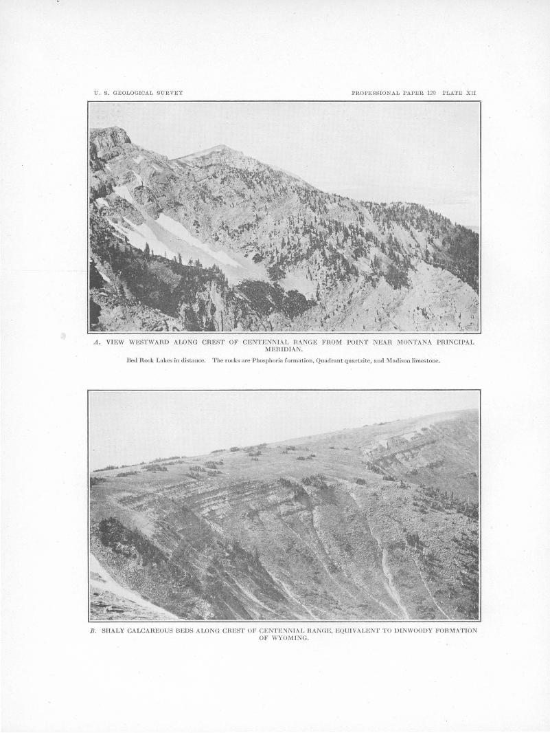
U. S . GEOLOGICAL SURVEY PROFESSIONAL PAPER 120 PLATE XII
A. VIEW WESTWARD ALONG CREST OF CENTENNIAL RANGE FROM POINT NEAR MONTANA PRINCIPAL MERIDIAN.
Bed Rock Lakes in distance. The rocks are Phosphoria formation, Quadrant quartzite, and Madison limestone.
B . SHALY CALCAREOUS BEDS ALONG CREST OF CENTEN IAL RANGE, EQUIVALE OF WYOMING.

PALEOZOIC AND MESOZOIC FORMATIONS OF MONTANA AND WYOMING. 117
probably no n1ore than 200 feet thick, as compared with 900 feet in the Snowcrest locality. The upper sandy beds and m1derlying fossiliferous limestone are present, however, and a fossil collection shows close relation with the fauna of the thick shaly limestone in the Snowcrest section. The red shale usually observed at the base of the Quadrant is absent, and there is only a few feet of ocherous sandy beds resting on the n1assive white saccharoidal Madison limestone.
The Phosphoria formation at this point resembles in lithology the beds exposed on Indian Creek but contains in addition a valuable bed of phosphate rock at the base, nearly 4 feet thick and carrying 70 per cent of tricalcium phosphate. This bed, which is evidently of clastic origin, consists chiefly of fragments of phosphatized shells of the fossil Lingulidiscina. At the base there is a few inches of quartz or 6hert conglomerate 111arking the lower limit of the Phosphoria formation.
QUADRANT MOUNTAIN, YELLOWSTONE PARK.
Quadrant Mountain, a prominent topographic feature in the northwestern part of Yellowstone National Park, presents bold ex,posures of the quartzitic beds which have been named Quadrant quartzite, as explained on pages 111-112. Below is given part of a section measm·ed by Weed 1 at the southeast end of the n1ountain (locality 5, Pl. IX). The portion of the Teton assigned to the Phosphoria under the new classification is indicated.
Section on Qtwdrant Mottntain, Yellowstone National Park.
[:Measured by W. H. Weed.) Teton: Feet.
Sandstone, red and orange-colored, coarsely gra.nular; weathe~·s in blocks. . . . . . . . . . . . . . . . . 15
C'n.lcareous shale, dark slate-colored, fossiliferous. 5 Limestone, bright yellow, fissile, with platy
debris, grading into yellow-and red spotted calcareous sandstones below. . . . . . . . . . . . . . . . . . . . 40
Shales, light greenish drab, changing to red and grading into overlying beds. . . . . . . . . . . . . . . . . . 75
Conglomerate of red and gray quartz pebbles in limestone matrh: ... ,. . . . . . . . . . . . . . . . . . . . . . . . . 10
Cherty sn.ndstone, the lower part withotit chert, is brown; slightly calcareous at base, becoming
·more so n.bove [Phosphoria formation]. . . . . . . . . 100 Quadrant:
Limestone, dense, white, weathering same color.. 10 Sandstone and limestone in alternating bands.... 15 Limestone, light gray and dense and pure....... 12
J U. 8. Geol. Survey Mon. 32, pt. 2, p. 34, 1899.
Quadrant-Continued. Feet. Quartzite, pure white, thin bedded; forms a per-
sistent band along face of mountain. . . . . . . . . . . 6 Quartzite, more thickly bedded, white.......... 65 Limestone, very light gray, somewhat dense, con
taining very small fragments of light-colored chert ................................. _...... 10
Quartzite, white, calcareous, with intercalated bands of limestone carrying quartzite fragments 30
Limestone, light gray, with angular fragments of sandstone. . . . . . . . . . . . . . . . . . . . . . . . . . . . . . . . . . . 5
. Quartzite, white, weathering pink and rust color but appearing black when seen from a distance, owing to the growth of lichens upon it. . . . . . . . 130
Limestone, light gray, dense .. ----------------- 2 Sandstone, well banded, white, saccharoidaL.... 6 Sandstone, very calcareous, saccharoidal, white
and rust color. . . . . . . . . . . . . . . . . . . . . . . . . . . . . . . 10 Talus slope of sandstone blocks; also of cherty
limestone.. . . . . . . . . . . . . . . . . . . . . . . . . . . . . . . . . . . 100
Additional sections , measured at several places on Quadrant Mountain during the present investigation are given below. The Phosphoria exposures were found at the south end of The Pocket, a peculiar natural amphitheater cut into the plateau surface of the mountain top. Complete exposures of the Quadrant quartzite were found about 2 miles to the southwest, on the north face of Bannock Peak. (See Pl. XIII, A.)
Detailed section of Quadrant and higher formations on Quadrant Mountain.
Triassic beds: Ft. in. Limestone, gray, thin bedded; weathers
sepia-brown; grades up into shaly, sandy yellowish beds overlain by red shale; Lingula n. sp. is plentiful in the limestone 60+
Phosphoria formation: Sandstone, dark gray, with scattered chert
nodules .... ·_ . . . . . . . . . . . . . . . . . . . . . . . . . . . . . 15 ± Chert, in ropy masses and wavy layers, with
irregular sandy layers in upper part....... 30 Sandstone, dark gray, with cauda-galli mark
ings on bedding and scattered siliceous nodules and ropy masses; :fishbones plen-tiful. . . . . . . . . . . . . . . . . . . . . . . . . . . . . . . . . . . . 9
Phosphatic rock, gray, with green specks.... 1 2 Sandstone, dark gray, with markings; chert
and fishbones similar to those in 9-foot sandstone above.......... . . . . . . . . . . . . . . . . 23
Quartzite, dark gray. . . . . . . . . . . . . . . . . . . . . . . 16 Phosphate rock, sandy, resinous; has brown
appearance on fresh fracture; contains frag-ments of Lingulidiscina . ............ : . . . . 3 2,
Quartzite, gray, phosphatic in upper part... 18 Quadrant quartzite: . ·
Limestone, dolomitic, white, finely crystal-line. . . . . . . . . . . . . . . . . . . . . . . . . . . . . . . . . . . . 7
Sandstone, gray, cross-bedded. . . . . . . . . . . . . . 16 Limestone, dolomitic, white, finely crystal-
line. . . . . . . . . . . . . . . . . . . . . . . . . . . . . . . . . . . . 23

118 SHORTER CONTRIBUTIONS TO GENERAL GEOLOGY, 1918.
Quadrant quartzite-Continued. Ft. in.
Sandstone, quartzitic, alternating with sandy dolomitic beds; poorly preserved fossils plentiful near base ....................... 350
Shale, red, sandy, slightly calcareous........ 11 Sandstone, conglomeratic, yellow and red,
resting on Madison limestone. . . . . . . . . . . . . 18
The beds above the Quadrant quartzite 1u this section constitute the Teton formation.
FORMATIONS IN WEST-CENTRAL WYOMING.
The sequence of late Paleozoic and early Mesozoic formations in west-central Wyoming is represented in the following table. Their probable equivalence with the section to the northwest in· Yellowstone Park and Montana is indicated in Plate X.
Late Paleozoic and early .Mesozoic formations in westcentral Wyoming.
Feet. Sundance formation (Jurassic), limestone, green
shale, and sandstone ........................ 200- 300 Chugwater formation (Triassic), largely red
sandy shale, with sandstone and more or less gypsum ................................... 800-1,400
Dinwoody formation (Triassic), shaly brownish fossiliferous limestone. . . . . . . . . . . . . . . . . . . . . . 50- 200
Park City formation (Permian and Pennsyl-vanian), fossiliferous limestone and shales ... 150- 225
Tensleep sandstone (Pennsylvanian) .......... 200- 500 Amsden formation (Pennsylvanian and late
Mississippian), sandstone, limestone, and shale. . . . . . . . . . . . . . . . . . . . . . . . . . . . . . . . . . . . . . 200- 300
It has been shown by the writer 1 that although the Chugwater red beds are in large part Triassic, the lower portion in the Big Horn Mountains and elsewhere in central Wyoming is of earlier Triassic, Permian, and Pennsylvanian age and was deposited contemporaneously with the marine Triassic (Dinwoody) and Permian and Pennsylvanian (Park City) beds to the west.
AMSDEN FORMATION AND TENSLEEP SANDSTONE.
The Amsden formation, which rests on the Madison limestone, is somewhat similar in litho logy to the lower portion of the. Quadrant quartzite of Montana, with which it is correlated, but at no place has ~t been found to contain richly fossiliferous beds, such as have been discovered in Montana. In the western part of the Wind River Mountains the Amsden consists of massive white sandstone at the
1 Condit, D. D., Relations of the Embar and Chugwater formations in central Wyoming: U. S. Geol. Survey Prof. Paper 98, pp. 263-270, 1916.
base, overlain by interbedded gray to yellowish shale, sandstone, and thin beds of lin1estone. Some of the shale beds are deep red.
The Tensleep consists almost entirely of sandstone, with a few interbedded dolomitic layers that locally contain marine fossils. The beds correspond so closely in position, thickness, and lithology with the upper portion of the Quadrant quartzite that there is no question as to their correlation. It is suggested also that the Tensleep may be in part equivalent to the Weber quartzite of southeastern Idaho and Utah.
PARK CITY FORMATION.
Above the Tensleep sandstone in the Wind River Mountains is a sequence of prevailingly calcareous beds correlated by Blackwelder 2
with the Park City formation of Utah on the basis of paleontologic and lithologic evidence. The Park City beds, together with overlying calcareous brownish shaly beds of Triassic age, constitute the Embar formation of Darton,!J who applied this name to strata believed to be of ''Permo-Carboniferous" age, lying between the Tensleep sandstone and Chugwater red beds at a locality in the Owl Creek Mountains. This grouping into one formation of beds of Pennsylvanian, Permian, and Triassic age and of widely different lithology is comparable to the grouping of the beds in the Teton formation of Y ellowstohe Park, and the only reason for retaining Embar as a formation name is its convenience as a term for use in areas where the Dinwoody and Park City can not be differentiated.
The portion of the Embar formation equivalent to the Park City beds in the Wind River and Owl Creek mountains (see Pl. XIII, B) consists largely of limestone with calcareous shale and nodular chert. The general sequence is as follows:
Generalized section of Park City formation in Wind River and Owl Creek mountains, Wyo.
Siliceous greenish limestone grading up into gray resist- . ant limestone, with abundant fossils including Derbya, Pseudomonotis, Leioclema, and Spiriferina pulchra.
Nodular greenish phosphatic chert interbedded with many shale laminae.
2 Blackwelder, Eliot, Stratigraphy of the Wind River Mountains, Wyo.: U.S. Geol. Survey Bull.- (in preparation).
a Darton, N. H., Geology of the Bighorn :Mountains: U.S. Geol. Survey Prof. Paper 51, p. 35, 1906.

U. S. GEOLOGICAL SURVEY PROFESSION AL PAPER 120 PLATE Xill
Showing M adison limestone (C m) and Quadrant qu artzite (Cq) at head of cirque val ley.
d
C I '---.A.--..,, I I
I
B. UPTURNED BEDS ON SOUT H SLOPE OF OWL CREEK MOU TArNS, WYO., NEAH SHOTGUN CREEK, T. 7 N., R. 1 E .
a, Tcnsleep sandstone , formiug highest hills ; b, Park City formation, with resistant upper limestone member; c, shale of Din woody formation, mos lly covered by talus ; d, shaJy red beds of Chugwater formation.

PALEOZOIC AND MESOZOIC FORMATIONS OF MONTANA AND WYOMING. 119
Phosphatic shale of sepia-brown color,. with one or more . layers of oolitic phosphate rock and phosphatic limestone at the base.
Limestone with geodes, chert masses, and many fossils, among which are Productus nevadensis, Leioclema, Spiri.ferina pulchra, and Productus subhorridus.
Argillaceous shaly limestone and sandy calcareous shale of yellowish color.
Dolomitic gray fossiliferous limestone, resting with slight unconformity on the 'rensleep sandstone.
Paleontologic data recently presented by Branson 1 support the belief of Girty that the lower portion of the Park City beds is of PennsylYanian age. Branson's conclusions are the result of study of both vertebrate and invertebrate fossils.
DmWOODY FORMATION.
1"~he name Dinwoody formation has been adopted for the upper shaly portion of the Embar on the suggestion of Blackwelder, from Dinwoody Canyon, in the Wind River Mountains, where the formation, about 200 feet thick, consists of pale-green to white clay and shaly limestone that weather brown and contain obscure pelecypod shells. The Park City and Dinwoody beds found at this locality are described by Blackwelder in an unpublished bulletin on the stratigraphy of the Wind UiYer Mountains. The consensus of opinion of seyeral observers is that the Dinwoody beds are to be correlated with the Woodside shale (Lower Triassic) of southeastern Idaho. The beds are lithologically identical with strata in the middle portion of the series of beds in Yellowstone Park designated the Teton formation by Weed.
A complete section of the Embar measured by Blackwelder 2 at Dinwoody Canyon 1s giyen below.
Section in Dinwoody Canyon, Wyo.
Dinwoody formation: Pale-green to white clay, with local sandy
and calcareous beds, overlain conformably by bright-red sandy shale of the Chugwater
Ft. in.
formation ................................ 130 Gray shaly limestone, weathering brown..... 28 Alternate calCareous and sandy shale and
argillaceous sandstone in thin beds. . . . . . . 12 Dark argillaceous limestone with shale part
ings containing many obscure pelecypod shells.................................. 10
1 Brnnson, E. B., The lower Em bar of Wyoming and its fatma: Jour. Ooology, vol. 24, pp. 639-664, 1916.
2 Hlackwoldor, Eliot, A reconnaissance of the phosphate deposits in western Wyoming: U.S. Geol. Survey Bull. 470, pp. 476-477, 1911.
Park City formation: Ft. in. Grayish sandy shale, shaly limestone, and
shaly sandstone, in alternate beds. . . . . . . . 75 Massive gray crystalline lin1estone with fossil
Bryozoa and brachiopods ................ . 16 6 Nodular greenish-gray clay, greenish lime
stone, and chert; Spirijerina pulchra, il'US-tedia meekana, Derbya sp., crinoids, and Bryozoa iri abundance ................... .
Alternating sepia-brown phosphatic and calcareous shale and shaly limestone, with thin beds of chert near the top; abundant
6
Product1.ts nevadensis? near the base ...... . 35 6 Brown shale and soft nodular black and gray
phosphate rock interlaminated (30.5 per cent tricalcium phosphate) ............. . 1 8
Dark greenish-gray oolitic and argillaceous phosphate rock (41 per cent phosphate) ...
Gray to sepia-brown shale, full of oval nodules somewhat more calcareous; abundant Spiri-jer, Producttts, etc. (average 8.5 per cent
1
phosphate) ............................. . 12 5 Hard greenish-bro,vn phosphatic limestone,
with glauconite grains (23. 7 per cent phos-phate) ................................. .
Brown argillaceous limestone and calcareous shale, nodular, as above; abundant Produc-tus nevadensis, "P. cora,. P. Sttbhorridtts, Spinferina pttlchra, P'ttgnai ~ttah, Bryozoa, '
. etc. (8 per cent phosphate) ............. . 6 Dark-drab or brown fetid limestone in mas
sive beds; upper layers crowded with Bryozoa................................ 21
Green clay shale v;rith thin beds of chert • and platy gray limestone................. 43
Gray speckled phosphatic sandstone......... 1 Earthy white sandstone .................... . 2 Greenish-gray speckled phosphatic sand-
stone containing Lingulidisfj,na utahen-sis, etc. (27 .4 per cent tricalcium phos-
7
phate) ................................. . Light-gray earthy limestone ............... . Dark-green shale .......................... .
2 2~
1 9! 1 3~
Pale-gray smoky dolomite with seams of black chert and pores full of black bitu-men .......... :........................... 25
White calcareous sandstone and conglomerate of chert pebbles; lies with obscure unconformity upon the Tensleep sand-stone..................................... 1 7
CHUGWATER FORMATION.
The Chugwater red beds, 800 to 1,450 feet thick in west-central Wyoming, present prohlems in sedimentation that have engaged the attention of a number of workers who are not in agreement as to the origin of these beds. Among their striking features are the uniformity in thickness and texture of individual members .over wide are~; the prevalence of ripple marks on horizontal beds through much

120 SHORTER. CONTRIBUT'IONS TO GENERAL GEOLOGY, 1918.
of the formation; the absence of sun cracks and fossils of land animals except in the upper portion; and the extensive occurrence of gypsum beds near the top. It is not the purpose of this paper to consider in detail the peculiarities of the Chugwater or the different hypotheses concerning its origin. It is evident, however that mature conclusions can be reached
' only after a detailed study of the red beds throughout Wyoming and adjacent areas. The question of age alone illustrates this point. In western Wyoming the lowest red beds overlie marine fossil-bearing brown shales of Triassic age that are regarded by several observers as equivalent to the Lower Triassic Woodside shale of Idaho. Furthermore, it is suspected that the lower Chugwater beds of western Wyoming grade laterally into the marine Thaynes _limestone of Idaho, which are of Lower Triassic ·age, or at least that they represent partial-time equivalents of these beds.
A fossil collection made brDarton 1 in the Big Horn ·River canyon near Thermopolis, Wyo., is of interest in this connection. The fossils obtained in a limesto:Ue 150 feet below the top of the formation were found by G. H. Girty to include Natica lelia, Bakewellia, Pleurophorus, and Aviculipecten, undoubted marine types, constituting a fauna which is referred with considerable confidence to the Triassic. This occurrence is of additional interest as indicating the marine origin of a portion of the Chugwater, as contended by Branson.2
In the Big Horn Mountains, in the central part of the State, the ·lowest red beds of the Chugwater have been shown by the writer 3
to be of late Pennsylvanian age. The age of the uppermost beds of the Chug
water formation is uncertain. Wherever present in Wyoming they are overlain by the Sundance formation, which is Upper Jurassic, but it is "a question whether the deposition of the gypseous shale, cross-bedded sandstone, and nonmarine limestone characteristic of the upper part of the Chugwater may not have been
1 Darton, N. H., Geology of the Bighorn Mountains: U. S. Geol. Survey Prof. Paper 51, p. 40, 1906. .
2 Branson, E. B., Origin of the Red Beds of western Wyoming: Geol. Soc. America Bull., vol. 26, pp. 217-230, 1915.
s Condit, D. D., Relations of the Em bar and Chugwater formations in central Wyoming: U. S. Geol. Survey Prof. Paper 98, pp. ·263-270, 1916.
largely contemporaneous with the early Jurassic base-leveling so plainly recorded. in the truncated beds to the north, in Montana.
SUNDANCE FORMATION.
The Sundance formation of Wyoming is regarded as the equivalent of the Ellis in 1fontana, with which it agrees fairly well in lithology, thickness, and fossil content. The Sundane~ consists largely of greenish calcareous to sandy shale, with a resistant dark-gray limestone near the middle. Both the shale and the limestone are richly fossiliferous, and the most characteristic species are Belemnites densus, Gryphaea calceola, and stem segments of the crinoid P entacrinus asteriscus.
RECORD OF JURASSIC BASE-LEVELING.
The most striking evidence of prolonged erosion in Jurassic tin1e is furnished by the contact of the late Jurassic marine beds (Ellis) with successively older. formations as followed
, northward across :Montana. This feature is graphically shown in figure 14. The substrata along the Idaho-Montana State line near Y el-· lowstone Park are limestone or red beds of Triassic age, and successively lower forn1ations. appear northward to Elkhorn mining camp, about 20 miles south of Helena, where the sub-· strata are beds probably 75 feet below the top of the Phosphoria formation. Fishe~ 4 has stated that in places in the Great Falls region, in northern Montana, the Ellis rests on the, Madison limestone.
Study of the erosion surface from place to· place reveals the presence of peculiar yellowish. earthy sandstone, ferruginous gypseQus shale, and local limestone beds, all making up a mot-· ley aggregate related neither to the overlyingEllis nor to tlie underlying formations. These. heterogeneous materials constitute the sedimentary record of events that preceded or ac-· companied the advance of the sea from the. northwest in late Jurassic time. Their thick-· ness, ranging from a few feet to little more than. 100 feet, is direct evidence of the slight relief of the land surface, the inequalities of which were. leveled to form the floor upon which the marine. Ellis beds ·were deposited.
4 Fisher, C. A., Geology of the Great Falls coal field, M.ont.: U.SGeol. Survey Bull. 356, p. 27, 1909.

PALEOZOIC AND MESOZOIC FORMAT'IONS OF MONTANA AND WYOMING. 121
The thickness of strata r~1noved by Jurassic erosion in northern :Montana n1ay have been 2,000 feet, if the Chugwater red beds once extended over that area. The extent to which the Chugwater was eroded in Wyon1ing is not evident, but it seems probable that in the westcentral part of the State, where the beds are 1,400 feet thick, they remain ahnost intact, and that the upper portion, including the gypseous beds, may be in part a product of Jurassic sedin1entation.
The disposition of the great n1ass of material .stripped fron1 the northern area is a matter of
speculation, but in the writer's op1n1on this erosion n1ay have furnished the sediments of the shale and sandstone series of southeastern Idaho lying between the n1arine Lower Triassic (Thaynes limestone) and marine Upper Jurassic (Twin Creek limestone). It is probable that in the 1neanwhile the Wyoming area, a low, nearly level plain, which was intermittently occupied by small bodies of water and in which neither erosion nor deposition ofo considerable magnitude occurred, furnished the conditions necessary for the formation of extensive but variable gypsum and li1nestone beds .

'

NEW GHAPHIC METI-IOD FOR DETERMINING THE DEPTH AND THICKNESS OF STRATA AND THE PHOJECTION OF DIP.
By HAROLD S. PALMER.
INTRODUCTION.
Geologists, both in the field and in the office, frequently encounter trigonometric problems the solution of which, though sitnple enough, is somewhat laborious by the use c!>f trigonometric and logarithmic tables. Charts, tables, and diagrams of various types for facilitating the computations have been published, and a new method may seem to be a superfluous addition to the literature. IIowever, it is felt that the simplicity and accuracy of diagrams
H
a
I I I I I :n I I
'\
(NOTE.·--Diagram I may be used not only for the problem above stated but also to obtain the difference in elevation between two points by omitting E and letting D equal the difference in elevation, H the horizontal clist~nce, and A the vertical angle.)
II. To find the thickness of a stratum,' given the dip of the stratum, the horizontal distance across its outcrop at right angles to the strike, and the differenee in elevation of the upper and lower boundaries of the stratum. There
FIGURE :15.-Diagram showing three cases in computing depth. . .
such as are presented in this paper warrant the addition. The alinement diagram. is used to a very considerable extent by' engineerfit especially mechanical engineers. The principle of the alinement diagram is explained herein, but rigorous demonstration is not attempted.
Alinement diagrams are given for the following problems, which are numbered to agree with the numbering of the diagrams. The charts published herewith are suitable for use.
I. To find the depth to a stratum, given the dip of the stratum, the horizontal distance from the outcrop, and the difference in elevation between the outcrop and the point at which the depth is desired. (See fig. 15.) The for.mula is
D = H tan A ± E ___________ (1
in which D = depth to stratum, I-I= horizontal distance frorn the outcrop, A= dip, E = difference in elevation.
are three cases, ~pending oo the relation of the dip of the beds to the slope of the ground. (See fig. 16, a, b, and c.)
Case 1, where the ground is level. By inspection of figure 16, a, it is seen that the formula is
T = H sin A ____________ (2)
in which T = thickness, H = horizontal distance from outcrop, and A= dip.
Case 2, where the ground slopes opposite to the dip. In figure 16, b,
but
Now
or, as
T=m-'-l
m=H sin A
. l=E cos A
cos X=sin (90°-X)
l=E sin (90°-A) 123
•
'

0
124 SHORTER CONTRIBUTIONS TO GENERAL GEOLOGY, 1918.
Therefore
T=H sin A+E sin (90° ;_A) _____ (3)
in which T, H, and A have the same values as before, and E is the difference in elevation.
Case 3, where the ground slopes with the dip. In figure 16,c, T=m-l_;making the same substitutions as in case 2, we find
T=H sin A-E sin (90°-A) _____ (4)
in which T, H, A, and E have the same values as before.
~· / T I
a
plane of a supposed structure section, is desired. a· is the desired projection of A. B is the angle between the plane of the section and the strike of the beds, and angle PFS is a right angle. The plane PFS is horizontal and the lines PQ, FG, and SR are normal to it and of equal length, so that the triangle QGR is also horizontal and is equal to PFS.
Now, FS=PS sin B
FS=FG cot A
PS=PQ cot 0
Therefore
FG cot A=PQ cot 0 sin B but
FG=PQ so
cot A=cot 0 sin B
and, as the tangent is the reciprocal of the cotangent,
1 1 . B tan A= tan C sin
tan C = tan A sin B ___ ( 5)
FIGURE 16.-Diagram showing three cases in computing thickness.
in which 0 = dip of the projected angle, A = dip of the bed, B =:= angle between strike and plane of section.
The above formula is strictly tnie only where the dip of the beds is greater than the slope of the ground. (See fig. 16, d.) Where the dip is less than the slope the formula becomes
T=E sin (90° -A) -H sin A _____ (4a)
The difference is algebraic and not arithmetic, so that the formula is practically workable for either subcase.
III. Projection of dips-that is, to find the slope of the trace of an inclined plane upon a vertical plane oblique to the strike. Consider figure 17, a, which is a plan or'map; at A is an inclined plane the strike and dip of which are shown in the conventional way, and along ~-Pis a vertical plane upon which this dip is to be projected. B is the angle between the strike and the section plane. In figure 17, b, A is a dip whose projection on SPQR, the
<!)
USE OF THE ALINEMENT DIAGRAMS.
The alinement diagram is worked in an extremely simple way. The points on the outer scales representing the given quantities are joined by a line, and the unknown q uantity, or result, is read at the intersection with the middle scale. Interpolation between the values marked on the scales is effected just as on a slide rule. It is suggested that the edge of a draftsman's transparent triangle or a piece of slender black thread be used for projecting the cross line.
USE OF THE DEPTH DIAGRAM.
In using the depth diagram (Pl. XIV and problem l), find.the_point on the left-hand scale that represents the distance from the outcrop to the point at which the depth is desired, and join it to the point on t:!J.e right-hand scale that

U. B. Gl<~OLOGICAL SURVEY
900
800
700
600 ..... ..... ..... .....
..... ..... ..... .....
..... 500
.....
' ......
.400
300
200
..... ...... ..... ..... ..........................
PROFESSIONAl, PAPER 120 l'LATE XIY
Depth to bed
10,000-
7,000
3,000
100
70
50
40
30
20
10
I I j
..... ................
.........................................
Dip .89°
ALINEMENT DIAGllAM I, FOR COMPUTING DEPTH.

DETER.MINING DEPTH AND THJ:OKNESS OF STRATA AND PROJECTION OF DIP. 125
represents the dip of the beds. At the intersection of the line determined by these points with the nuddle scale the depth may be read. The dotted line on Plate XIV shows the solution when the distance is 600 feet and the dip 20°. The depth to the stratum is found to be 220 feet.
1'he above rule holds only if the surface is level. If the point at whlch the depth is to be deternuned is higher than the outcrop~ the difference in their elevation is added to the depth as read by the above-described method. If the outcrop is the higher of the two points, the difference of elevation is sub-tracted from the reading.
The diagram may be used for the converse problem, namely, to find the dip of the bed when the depth and distance from the outcrop are given. In this case the given quantities are set on the middle and left scale, and the line joining them is produced till it cuts the right scale, at which the dip is read. Another converse proble1n arises when the distance from the outcrop is unknown but the dip and depth to the stratun1
the point on the left ~cale that represents the difference in elevation of the higher and lower boundaries of the outcrop, and at the intersection of the connecting line ,,r_i th the middle scale read the correction. The correction is added or subtracted as directed above.
In Plate XV the broken line shows the fuet step in solving the problem when the horizontal width of the outcrop is 600 feet and the dip is 20°. The thickness is read on the middle scale as 206 feet. The dashed line shows the correction to be introduced if the differenc~ in elevation between the two edges of the out-
/ /
/
/ /
/ /
/
~~-------Q
s
b
G are known. In this case known . points on the right and middle
FIGURE 17.-Diagram for derivation of formula for projected dip.
scale are joined by a line the extension of which give:s the result at its intersection \\rith the left scale.
USE OF THE THICKNESS DIAGRAM.
In using the thickness diagram (Pl. XV and probletn II), find the point on the left scale that represents the width of the outcrop and join it to the point on the right scale that represents the dip of the beds. At the intersection of the line determined by these points with the middle scale the tluckness may be read.
'I'he above rule holds only if the surface is level. A correction must be added if the ground surface slopes in the opposite direction to the dip, and the same correction must be subtracted if the surface slope and the dip are in the same direction. This is the correction E sin (90° -A) in formulas (3) and (4). Subtract the dip from 90° and ·find the corresponding point on the right scale. Join it to
28288°-19-9
crop. is 50 feet. As there is no 50-foot graduation on the left scale, the decimal point is shifted to the right and the 500-foot graduation is joined by a line to the 70 ° mark on the left scale (90°-20°=70°). The reading is 470 feet, but .the decin1al point must be shifted back, so the true correction is 47 feet. Then if the bed dips "into the hill" the thickness is 206+47=253 feet; if it dips "with the hill" the tluckness is 206-4 7 = 159 feet.
Like the depth diagram, the thlckness diagram has converse uses, but they can be applied only when the ground surface is level. Thus if the width of the outcrop ~nd thickness of the bed are known the dip can be computed, or if the dip and thiclmess are known the width of outcrop can be computed.
USE OF THE PROJECTION DIAGRAM.
In using the projection diagram (Pl. XVI and problem III) fi.J).d the point on the left scale that represents the dip and the point on

126 SHOR,TER. CONTRIBUTIONS TO GENERAL GEOLOGY,- 1918. ·
the right scale that represents the angle between the strike and the plane-upon which the dip is to be projected. Join these points· by a line~ and at its intersection with the middle scale read the projected dip. As this problem involves only one case there are no corrections to be added or subtracted.
In Plate XVI the broken line shows the solution of the problem of projecting a dip of 43° upon a plane at an angle of 35° to the strike. The result, 28°, is read on the middle scale.
As with the other· diagrams, the converse problems may be solved. · Thus, if the trace of a bed along a vertical plane and the angle between the strike and the vertical plane are set on the middle and right scales, respectively,
10
------5
0
good for only one formula, whereas the slide rule is applicable 'to many; formulas ..
Consider figure 18, a, in which ab, cd, and ef are parallel lines cut by two secants, ace and bdf 'Frome· andf drop two ·lines, eg and lif, perpendicular· to- ·ao. By ,inspection of the diagram it is seen that
cd = Y2 ( ab + ef)
This 'equation is equivalent to saying that the space cut off on the middle line is equal to half the sum of the spaces cut on the outer lines.
Now, if, as in figure 18, b, the outer lines are graduated evenly with equal divisions and the middle line is graduated with divisions half as
20 10 10 100 10
50
15 ------ 5 -------10 5 10
5
o· .1 ,1
b c
FIGURE 18.-Diagram showing three stages in derivation of principle of the alinep1ent diagram.
the dip of the plane may be read on the left scale. Again, if the dip of a bed and the slope of its trace on a ·vertical plane are known, and these points are set on the left and middle scales, respectively, the angle between the strike and the vertical plane niay be· read on the right scale ..
PRINCIPLE OF THE ALINEMENT DIAGRAM.
The alinement diagram is a device by means of which certain arithmetic prqcesses (addition, subtraction, multiplication, division, involution, . and evolution) may be mechanically or graphically performed. It is similar in principle to the slide rule in that by means of it distances. proportional to numbers or to logarithms, are mechanically added, subtracted, ·~ultiplied, or divided, but this work is done by a different mechanical ·process. It· differs further from the slide rule in· that each diagram is
great, addition can be graphically performed. The bases of the three scales are put on the same level for convenience only.· The secant line is taken so as to cut off SL"{ divisions on the left scale and eight on the right scale. It must, perforce,. cut 14 divisions on the middle scale, and the addition of 6 and 8 is graphically accomplished.
It will be remembered that logarithms are essentially exponents (to the base 10 in the common system), and that multiplication is accomplished by adding the logarithms. This is by the algebraic law
. xmxn = xCm+n) ______ '" __ .;. ___ ( 6)
which may be verbally stated as follows: The multiplic.ation of powers of the same quantity is effected by using the sum of the exponents a8 the exponen.t for the product. ·
Now ;·jf the m·arkings of the scales are not .equidistant :as in figure 18,.b, b1_1t are laid off as

U. S. GEOLOGICAL SURVEY
Width of outcrop
1,000
900
800
PROFESSIONAL PAPER 120 PLATE XV
Thickness
1,000 900 800 700
600
500
300
600 ________ _:_·--~~:::: _________ . ____ 200- 0
-- ------------- 20
400
300
200.
100
100 90 80 70
60
50
40
30
10 9 8
.7
6'
5
4
3
l ALlNEMENT DlAGll.AM 11, FOH. COMPUTING THICKNESS.
100
so
40
- 30
- 20
- 10

DE'X.ERMINING DEPTH AND ·THICKNESS OF STRATA AND PROJECTION 'OF DIP. 127
in figure 18, c, so that the distances from the base are proportional to the logarithms of muubers, we can in effect add logarithms. But this is equivalent to multiplying the nun1bers. In the figure the multiplication of 4 and 5 is shown, the result being 20. In figure 18, c, the distance on the outer scales proportional to a logarithmic difference equal to 1 is 2 inches; on the nuddle scale it is half as great, or 1 inch.
'rhe scales n1ay be graduated in proportion to logaritluus of trigonometric or othe~ functions as well as in proportion to logarithms of nmnbers. It is therefore possible to manipulate a variety of factors.
Son1etimes it is desirable to compress a scale, as for example a log. sin. scale in which the divisions between 1° and 20° come relatively far apart. In the charts here presented (Pis. XIVXVI) the scales for logarithms of numbers were drawn with a modulus 1 of 10 inches. A log. sin. scale with a modulus of 10 inches would ha,Te to be 17.5 inches long in order to range from 1° to 90°. A log. tan. scale would have to be 35.2 inches long to range from 1° to 89°. vVhen the moduli of the outer scales are not equnl, the 1110dulus of the middle scale is deterJnined by the following formula, in which M3 = rnodulus of middle scale, :M1 =modulus of right Reale, and M2 =modulus of ·left scale:
M3 =1\~~~ ------------- (7) 1 . 2
At the same time, the middle scale must be shifted toward that outer scale which has the smaller modulus. The position of the middle scale is determined by the following equation, in which M1 and M2 have the same values as before, D 1 =distance from middle scale to right scale, and D 2 =distance from middle scale to left scale.
modulus that any two lines which intersect on one of the outer scales and cut off a distance on the middle scale equal to its modulus wiJl also cut off a distance on the third scale equal to its modulus.
·Let :M11 M2 , and :M3 be the moduli and D 1 and D2 the distances of the outer scales from the rniddle scales. Assume the lettering as indicated.
B
AI Gl ,F r-- ---.n2---- -~-·-- -n,-- --"'1 .FIGU~E 19.-Diagram for derivation of the interrelation of M1, M2, M8,
D1, and D2.
Then in the triangles ACG and AEF
M:3 1\11 D~ =D1 +D2
and M3CD1 +D2) =M:tD2
Sitnilarly in the triangles FCG and FBA
and
Therefore
and
M3 M2 Dt Dt +D2
M3CJ?1 +D2) =M2D1
M2Dt =MtD2
D 1 :\11
D2=M2 (q. e. d.)
Taking this proportion by composition and transposing, we have ·
~1·=:1- ------------ --.CS). M:1 D1 2 2
Tlw principles underlying this and the last equation may be deduced from figur~ 19. The principles of the diagram require that the middie scale must be so placed and have such a
1 ~L'ho term "modulus" is used to moan the length on a scale proportional to a mlit dificrc.nco of logarithms. For cxamplo, the outer scales in figure 18 nro said to have a modulus of 2 inches because the distance from tho point representing 1 to tho point representing 10 is 2 inches. 1'ho log1\rithm of 1 is 0.000 and tho logarithm of 10 is 1.000, and tho differonce hotwoon those logarithms is unity.
M1 +M2 D1 +D2
Now, in the triangles FCG and FBA
M3 D1 M2 Dt +D2
Substituting from the previous equation, we have

128 SHOR.TER CONTRIBUTIONS TO GENERAL GEOLOGY, 1918.
and solving for M3, we have
(q. e. d.)
The length of any scale may be determined by the following equation:
L=M (logF1-logF
2) ________ (9)
in which L =the length of the scale, M =its modulus, and F 1 and F 2 =the maximum and minimum values of the variable to be represented on the scale.
This may be explained by an example. Suppose it is desired to fit a log. tan. scale into a space about 12 inches long. Let F 2 = tan 1°, and F 1 = tan 8 9°. Then
log F 2 =log tan 1°=8.2419
log F 1 =log tan 89° = 11.7581 then
log F 1 -log F 2 = 11.7581-8.2419 =3.5162
and
or L=M 3.5162
L M=3.5162
Substitute 12 for L:
:M=12+3.5162=3.41 +
As an engineer's scale is used in drafting the scales and can be conveniently used only for :.noduli of 1, 1%, 2, 2.5, 3}i, or 5 inches or these' lengths multinlied by 10, we choose a modulus of 3 }i inches, which is nearest to the inconvenient irrational decimal 3.41 +. Substitute 3}i for M and we find L=3}i X 3.5162 = 11.72 inches.
ACCURACY AND ADVANTAGES.
The point may be raised that the calculations made by these charts are not accurate, .and in the strictest sense this is undoubtedly true. But there are two facts that should be borne in mind: (1) Measurements made by
pacing or by a hand compass or clinometer are not accurate; (2) the surfaces with which the geologist deals are not true planes. Measurements of angles are seldom accurate within 1°, which is approximately equivalent to a.ri arror of 1 per cent, and pacing under the most favorable conditions can not be trusted closer than to 1 per cent. The undulations of fault or bedding planes will usually introduce an error of the same or greater magnitude. Therefore it is unsound logic to demand that the error in the calculations based upon such measui-ements be less than 1 per cent. If the chart is used with reasonable care, the error is somewhat less than 1 per cent and is therefore negligible. Moreover, the use of the chart gives less opportunity for the introduction of gross errors, such as come from a mistake in multiplication or in the addition of logarithn1s.
The charts, therefore, have the following . advantages over the other methods for solving
these equations: 1. They are more speedy. As a test of the
speed of this method the writer used the first draft of the three charts for a series of test problems. The time required to solve the problems by means of the charts and by logarithms 'in the ordinary way was taken with a stop watch. It was found that the time with the charts ranged from one-sixth to one-fourth of that required by the logarithmic method. The test was fair to the logarithms, as the writer is reasonably proficient in their use.
2. The chances of gross errors are eliminated. In the test mentioned in the preceding paragraph the correctness of the answers was checked, and a mean error of about 0.2 per cent was found, with a maximum of 0.7 per cent. One gross error of about 40 per cent was made in one of the logarithmic solutions and was first dete'cted by the check given by the chart solution.
3. It is unnecessary to keep the formula in inind, as it is incorporated in the construction of the chart.
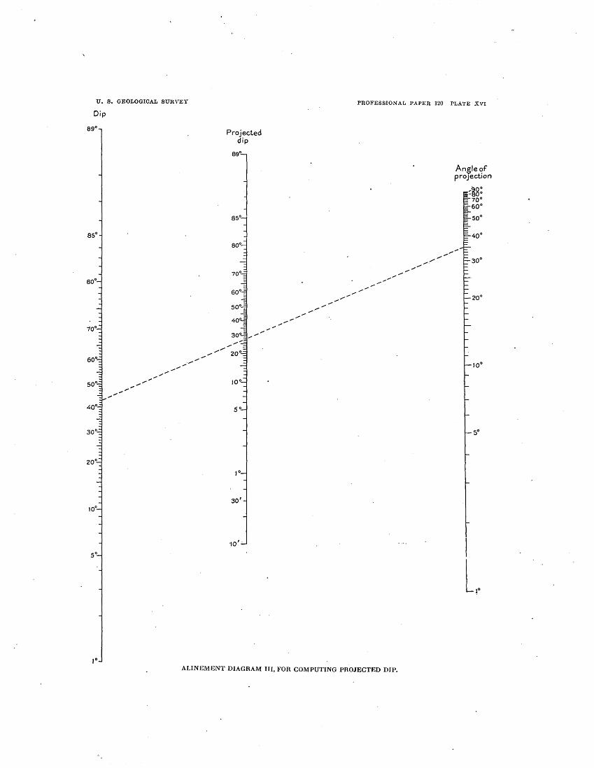
U. S. GEOLOGICAL SURVEY
Dip
Projected dip
PROFESSIONAL l'APEH 120 PLATE XVI
An$le'!f proJeCtion
l,.
ALINEMENT DIAGRAM III, FOR COMPUTING PROJECTED DIP.

A CONTRIBUTION TO THE GEOLOGY OF NORTHEASTERN TEXAS AND SOUTHERN OKLAHOMA.
' By LLOYD WILLIAM STEPHENSON.
PURPOSE AND SCOPE OF THE PAPER.
The region in central and northeastern Texas and southern Oklahoma known as the Black and Grand prairies abounds i~ features of interest to physiographers, geologists, and paleontologists, and the pioneer investiO'ators of this region must have experienced b renewed satisfaction in each day's exploration. The reports of Joseph A. Taff, Robert T. Hill, and others, published chiefly under the auspices of State and Federal surveys, represent with approximate accuracy at most places the general distribution of the outcrops of the formations in this region, and contain detailed descriptions of many sections that constitute a mine of useful information. The reader of the present paper is urged, therefore, to hold as most important 'the general excellence of the earlier reports of these authors and to relegate the inaccuracies and mistakes to which his attention will be called to the relatively unimportant place in which they belong, remembering at the same time 'that a futur~ generation of investigators may find our own shortcomings 11s great as those we now criticize.
rrhe present report treats of the area shown in Plate XVII, which includes Grayson, Fannin, Lamar, Delta, I-Iunt, and Collin counties 'I' d ' ex., an the southern parts of Marshall and Bryan counties, Okla. It is based on the results of studies carried on during several brief field seasons between the years 1911 and 1917 inclusive. The results are by no means final: but enough facts have been obtained to justify IHill,R.T.,GeographyandgeologyoftheBlackandGrandprairies their presentation to those WhO may be inter- Tex.,withdetaileddescriptionsoftheCretaceousformationsandspecial ested in ~he geology of the region. The pur- reference to artesian waters: u.s. Geol. Survey Twenty-first Ann. Rapt.,
pt. 7, pl. 66, 1901. . pose of the paper is therefore to set .forth the 2 Veatch, A. C., Geology and underground water resources of northern present state of knowledge in the areal map- OLouisiana and southern Arkansas: u.s. Geol. Survey Prof. Paper 46,
p. 68, 1906. ping, in the interpretation of structure, and in aTaff,J.A.,TexasGeol.SurveyFourthAnn.Rept.,pp.297-298,1893. COrrelation, and to indicate certain mappable 4 Taff, J. A., Chalk of southwestern Arkansas, with notes on its adapt
ability to the manufacture of hydraulic cements: U. S. Gaol. Survey units and structural features that have not Twenty-second Ann. Rept., pt. 3, pp. 698-700, 1902. heretofore been recognized. 6 Gordon, C. H., Geology and underground waters of northeastern
Texas: U.S. Gaol. Survey Water-Supply Paper 276, pp. 21-25, pl. 1, 1911.
. 129

\
130 SHORTER CONTRIBUTIONS TO GENERAL GEOLOGY, 1918.
and including the Blossom sand, but he erred in correlating the Blossom sand with the Eagle Ford clay, and although he noted the geographic connection of the Annona chalk with the Austin he also failed to recogni~e the upward transgression of the chalk in its north~astward extension.
Enos anticline. The general results obtained by these three men are embodied in the structure contours shown as an overprint in red on the geologic map (Pl. XVII). A more detailed report of their results, with particular ·r~f~rence to the occurrence of oil and gas, will be published later as an economic bulletin.
ACKNOWLEDGMENTS. Indebtedness is gratefully acknowledged to Mr. J. T. Bryant, of Pottsboro, Tex., for infor-
In 1911 the writer was accompanied by T. W. mation and per~onal assistance that enabled Stanton in a brief examination of parts of the writer and his associates quickly and adnortheastern Texas, including the area in the vantageously to find and study numerous longitude of Paris between the North Fork important exposures in northern Grayson of Sulphur River and Red River, the vicinity· County, Tex., and southern Marshall County, of Cooper, Delta County, and the vicinity of Okla. Mr. Bryant also kindly contributed the Sherman, Grayson County. Subsequently he logs of several wells on the Preston anticline. frequently conferred with Mr. Stanton in re- Courtesies were also extended to the writer gard to the interpretation of the physical and and to his associates by Messrs. R. H. Cook, of paleontologic facts ·and has greatly benefited Denison;·M. L. Wilson, of Wolfe City; and J. by his many helpful suggestions. Balch Moor, of Bonham, who furnished well
0. B. I-Iopkins, during a brief visit in 1915, logs and placed facilities for field study at determined the stratigraphic succession and their disposal. attitude· of the Upper Cretaceous rocks ·that appear at the surface in the vicinity of Wolfe. City, Hunt County, and Gober, Fannin County, Tex. He stated his conclusions to the writer and indicated certain favorable
LITERATURE.
The principal publications relating to the area treated in the present paper are listed below in chronologie order:
localities for examining outcrops. The area was subsequently visited by the writer, who Shumard, B. F., Notes upon the Cretaceous strata of traced the several litholog-ic divisions both to Texas: St. :Louis Acad. Sci. Trans., vol. 1, pp. 582-6~0,
'-' 1860. the northeast and southwest of Wolfe City, as Taff, J. A., and Leverett, S., Report on the Cretaceous shown on Plate XVII.· Mr. Hopkins also ob- area north of the Colorado River:· Texas Geol. Survey tained by correspondence the logs of several Fourth Ann. Rept., pp. 239-35'4, · 2 maps, 1 plate, 1893. wells in northeastern Texas and southern Hill, R.T., On theoccurrenceofartesianandotherunder-
ground waters in Texas, eastern New Mexico, and India~ · Oklahoma, which he generously placed at the Territory west of the 97th meridian: 52d Cong., 1st· sess., writer's disposal. s. Ex. Doc. 41, pt. 3, pp. 41-166, 19 pls., 1893. ·
In December, 1917, 0. B. Hopkins and Sid- Hill, R. T., Geology of parts of Texas, Indian Territory, ney Powers accompanied the writer in a sup- and Arkansas adjacent to Red River: Geol. Soc. America plementary field study of the areas in Grayson, Bull., vol. 5, pp. 297-338, pls. 12, 13, 1894.
Hill, R. T., and Vaughan, T. W., The Lower Cretaceous Fannin, and Hunt counties where the Cre- Gryphaeas of the Texas region: u. s. Geol. Survey Bull. taceous formations are involved in the Preston 5 39 35 1 1898 1 1, 1 pp., p s., . anticline and in the Leonard-Celeste mono- Hill, R. T., PhysicalgeographyoftheTexasregion: U.S. clinal nose. The outcrops of key rocks were Geol. Survey Top. Atlas, folio 3, 12 pp., 11 pls., 1900. traced, and altitudes were determined at nu- :am, R. T., Geography and geology of the Black and
Grand prairies, Tex.: U. S. Geol. Survey Twenty-first merous points on them by means of aneroid Ann. Rept., pt. 7, 666 pp., 71 pls., 1901. readings. Messrs. Hopkins and Powers con- Taff, J. A., Chalk of southwestern Arkansas: U.S. Geol. tinued the determination of altitudes during OSurvey Twenty-second Ann. Rept., pt. 3, pp. 687-742, the later part of December and the first half of pls. 47-53, 1902. . January, 1918. H. M. Robinson had in 1917 Taff, J. A., U. S. Geol. Survey Geol..Atlas, Atoka f~ho
d ·. f · 'I I · d d · (No. 79), 8 pp., 4 maps, 2 columnar-sectiOn sheets, 190~. n:a e a series o srmi ar a titu. e . et~rmina- Taff, J. A., u. s. Geol. Survey Geol. Atlas, Tishomingo twns o~ a part of the Preston uplift m southern folio (No. 98), 8 pp., 3 maps, 1 columnar-section sheet, Marshall County, Okla., locally known as .the 1903.

U. S. GEOLOGICAL SURVEY PROFESSIONAL PAPER 120 PLATE XVII
96° 301 96°001
GEOLOGIC MAP OF PARTS OF NORTHEASTERN TEXAS AND SOUTHERN OKLAHOMA
Scale so~poo
sE=c=~~~jo==========sE=========~lo==========llii=========~zco========~25 ~es 1918
Areal geolog\J b\J L. W. Stephenson, supplemented b\J data published by Hill, Taff, and Gordon, and b\j data furnished b\j 0. B. Hopkins, S. Powers, and H. M. Robinson Structure contours showing the altitude above sea level of the top of the Goodland limestone, b\J 0. B. Hopkins, S. Powers, and H. M. Robinson
1!5°30'
Structure contours showing the altitude of the base of the Ector tongue of the Austin chalk and the base and top of the Annona tongue of the Austin chalk, by 0. B. Hopkins and S. Powers
•
EXPLANATION
·§ r. C=:J ~t Midway formation g and part of the Wilcox formation
r:.;) (Sand and clay)
}i
·! "' ~
UNCONFORMITY
Navarro formation (Calcareous clay and sand)
Taylor marl (Calcareous shaly clay)
Pecan Gap chalk member, Ktp Wolfe City sand member, Ktw
[~}-----------------~~~ Austin chalk
~ Brownstown marl
(Calcareous clay)
~ (Includes Ector tongue (a on map) and c.? Annona tongue (bon map). Includes
Clay eqvivalent to part of Austin chalk on the west, and in part to the Blossom sand and Brownstown marl on the east
Blossom sand (Calcareous glauco
nitic sand)
~
~
also, for convenience of mapping, 10 to 35 feet of unnamed nonchalky cla1f. and sand, down to and including ths 'fishbed conglomerate ")
Eagle Ford clay (Dark shaly clay)
[;] Woodbine sand
(Fine to coarse sand and cla11)
UNCONFORMITY?
f--Y.~:-- ] Washita group
(Includes in ascending order Kiamichi clay, Ducic Creek /ormation, Fort Worth limestone, and Denison/ormation.
e, approximate outcrop of top of Fort Worth limestone)
!': Fredericksburg group, c3 which in this area is represented
by the Goodland limestone
c::J Trinity sand
(Fine sand and clay)
The altitude of the tOP of the Goodland limestone where it is involved in ths Preston anticline is represented by ths contours in northsrn Grayson County, Teo:., and southern MarshaU and Bryan counties, Okla.
The altitude of ths base of ths Ector tongue of the A us tin chalk is represented by the contours in ths vicinity of Ector and Ravenna, Fannin County, Teo:.
Ths altitude of the base of ths Annona tongue of the A us tin chalk is represented by the contours within a few miles south, east, and northeast of Bonham, Fannin County, Teo:.
The altitude of the top of the Annona tongue of the Austin chalk is represented by ths contours in ths vicinity of Leonard, Bailey, Gober, and Honey Grove, Fannin County, Teo:.
[::J Locality at which fossils have been obtained from the Blossom sand. The figures indicate
U. S. G. S. collection number
Ul :::J 0 LJ.J u < fLJ.J 0::: u

GEOLOG'Y OF NORTH~~STERN 'r~XAS .t\.ND. ·SOUT:S:ERN OKLAHOMA. 131
Veatch, A. C., Geology and un.derground-water resource~ of northern Louisiana and southern Arkansas: U. S. · Geol. Survey Ptof. Paper 46, 422 pp., 51 pls., 1906. ~
'Gordon, C. H., The chalk formations of northern Texas: Am. Jour. Sci., 4th ser., vol. 27, pp. 369-373, 1909.
Taff, J. A., and Reed, W. J., The Madill oil pool, Okla,: U. S. Geol. SUl'vey Bull. 381, pp. 504-513, 1910.
Gordon, C. H., Geol9gy and undergrou~d 'yat~re of po~theastern 'l'exas: U. S. Geol. Survey Water-Supply Paper 276, 78 pp., 2 pis., 1911. ·
Shannon, C. W., and others, Petroleum and natural gas in Oklahoma: Oklahoma Geol. Survey Bull. 19,· pt. · 2, pp. 316-321, 1917.
TOPOGRAPHY AND DRAINAGE.
The area shown on Pia te XVII lies near the northwestern. border of the Gulf Coastal Plain in northeastern Texas and southern Oklahoma, and is a dissected coastal-plain upland ranging in altitude from about 530 feet in tho southeast to 850 feet in places in the northwest. The highest points in tho area· are between Denison and Pottsboro, Grayson County, Tex., where several hills rise slightly more· than 900 feet above sea level. Rod River, which crosses the area from west to ·east in a sinuous course near the northern margin, has cut a broad valley 200 to 300 foot below tho.genoral upland, the altitude of low-water level whore the river enters tho area being approximately 590 feet and whore it leaves the area not quite 400 feet. A little loss than the northern half of the ar.ea is drained by tributaries of Eod River. In the east, south of the Red River valley, the drainage is carried by tributaries of Sui-. phur River,· which flows eastward .and joins Rod Eivor in Louisiana.. . The southern and southwestern parts of tho area are drained by numerous southward-flowing creeks belonging to tho Trinity River system.
The drainagoways of tho area present many good examples of consequent, subsequent, obsoquent, and perhaps other classes of streams, a detailed description of which is outside the scope of this paper. Attention may be called, however, to the conspicuous development of small tributaries of South Sulphuf River, itself a subsequent stream, which flow down the gentle southward-facing slope of the cuesta formed by the Pecan Gap chalk in Delta County and ·the northeastern part of Hunt County, and the similar tributaries of North Sulphur ·River, also a subsequent stream, which flow southward on the corresp_onding slope of the cuesta formed by the Annona
tongue of the ·Austin chalk in southern Lamar and F~nnin· .counties. (See p. 132 and Pl. XVII.). These ·are not consequent streams, as that term was. originally defined, in that their COJITses are not determined in consequence of • the original slope produced by -the uplift of the area fro~ beneath the sea, but rather in consequence of the southward. slope of the chalk and clay· ~o:rmatio;ns ·down fhose eroded surfaces they flow~· With the excep-tion of some of the smaller str.eams·in the terraced area along Red River .the drainage is almost completely adjusted_ to the structure· of the underlying Cretaceous formations, and in general the area affords an excellent example of maturely·adjusted drainage on ·only partly consolidated, unequally resistant rocks of gentle monoclinal attitude • . r];le area falls chiefly within the four physio
graphic divisions: 1 commonly known as the Black Prairies, tho Eastern Cross Timbers, the Gra:p.q Prairies, and theW estern Cross Timbers. The boupdaries separating these divisions are approx~mately coincident with the boundaries of underlying formations composed of unequally resistant. rocks, but these boundaries are not everywh~re sharply defined. Along Red River is·a belt of alluvial terrace plains of Pleistocene age (see p. 132), which I:anges in width from 2 or 3. miles where the river enters the area, at the ·:west, to 15 miles or more in the northeastern part ~f the area and which may well be classed as a physiographic division. distinct from each of the four just enumerated.
The Black Prairies embrace chi~fly the areas in Collin, Hunt, Delta, Lamar, Fann~n, and Grayson counties underlain by the marine chalks, clays, and marls of the Gulf series. (See geologic map, Pl. XVII.) Topographically these areas are characterize.d in the main by. nearly level to gently rolling surfaces, merging near Red River and the larger creeks into 4ills of moderate relief and smoothly rounded slopes. Cuestas of low relief have been prod11ced by the relatively resistant chalk . members of the series ~s described on a subsequent page.
The Eastern Cross Timbers include the relatively narrow belt underlain by the Woodbine sand of the Gulf series (see Pl. XVII), which extends from the northwestern part of
lllill, R. T., U. S. Geol. Survey Twenty-first Ann. Rept., pt. 7, pp. 6§-75, pl. 10, 1901.

132 SHORTER CONTRffiUTIONS TO GENERAL GEOLOGY, 1918.
Fannin County west by north through Gray- narrow along that ,part of the river bordering son County to th(l vicinity of Gordonville and Grayson County, Tex., but broadens out to 3 thence south along the western border of the or 4 miles in places along the northern border area mapped. The belt is characterized by of Fannin and Lamar counties, Tex., and the
' sandy hills of pronounced relief, supporting .a southern border of Bryan County, Okla. (2) growth of blackjack and post oak trees; a A well-defined river terrace 45 to 75 feet above good example is afforded by the hills within low-water level of Red River is moderately aeveral miles southwest and west of Denison, extensive in places along the river valley; the Grayson County. (S~e Pl. JCX;VI.) As shown village of Preston, in Preston Bend, in the elsewhere in this report, however, the Wood- northern part of Grayson County, is situated bine formation is irregularly bedded, and lo- on an exceedingly flat portion of this plain, 4 cally considerable parts of it are composed of or 5 square miles in extent, and Woodville, clay which has produced a gently rolling sur- about 2t miles north of Preston, in Marshall face similar to that of the Black Prairies; such County, Okla., stands on a somewhat larger an area occurs along the central and southern portion of the plain. (3) A terrace plain 140 parts of the belt of outcrop of this formation to 160 feet above water level is represented for a distance of several miles west-northwest here and there in that part of the valley above from Pottsboro, Grayson County. the mouth of Washita River but occupies ex-
The Grand Prairies include the area along tensive areas in the valley below that river; in the south limb of the Preston anticline in north- the southwestern part of Bryan County, Okla., ern Grayson County, Tex., and small areas along the alluvial deposits of this terrace form a flat the north limb of the anticline in Marshall sandy plain 8 miles or more in width from County, Okla., underlain by the limestones north to south, and large areas of the plain ocand shaly clays and marls of the Comanche cur in the northern parts of Fannin and Lamar series down to but not including the Trinity counties, Tex. (4) Remnants of surficial desand. (See geologic map, Pl. XVII.) This posits were observed at still higher altitudes at belt resembles the Black Prairies in its gently several places in the area and may represent rolling to moderately hilly aspect, but the in- one or more additional terraces. The alluvial durated layers of the Comanche series, includ- deposits on these terrace plains effectually ing in ascending order those of the Goodland, obscure the Cretaceous formations over many Duck Creek; Fort Worth, "Quarry," and Main square miles in the Red River valley, rendering Street limestones, tend to produce numerous it difficult to determine the areal extent and small benches and low cuestas in the other- structure of the formations. wise smooth to moderately rolling surface; Minor features of the topography that have these features are well exhibited· in Grayson an important bearing on the areal mapping County in the northward-facing· slope of the· and the determination of the stratigraphy and Red River valley, north of the belt of outcrop structure are the ridges, benches, and stream of the Woodbine sand. The belt of outcrop of bluffs produced by the more resistant strata of the sandy strata of the Pawpaw member locally both the Comanche and Gulf series. Many of produces a narrow belt of timbered, sat;!dy soil these features take the form of cuestas-that is, within the Grand Prairies, which resembles the broad, low ridges of great linear extent that Eastern Cross Timbers. · trend parallel to the strike of the rocks and
The Western Cross Timbers are represented present long, gentle slopes to the east, southin this area c4iefly by a narrow belt that marks east, or south in the direction of the dip and the crest of the Preston anticline in southern short, steep slopes on the inland side, which Marshall County, Okla .. , west of Preston Bend marks the western edge of the outcrop of the of Red River, where the sandy strata of the harder ridge-forming strata. An example is 'l"rinity sand come to the surface. Topographi- the white rock escarpment of Hill,t which cally the area is hilly and similar to that of the marks the western and northern edge of the Eastern Cross Timbers. Austin chalk in Grayson and Collin counties · The belt of alluvial terrace plains bordering and which makes a relatively steep ·descent
Red River includes plains at . several levels: (1) The present flood plain of Red River is
t Hill, R. T., U.s. Geol. Survey Twenty-first Ann. Rept., pt. 7, p. 68, 1901.
GEOLOGY OF NORTHEASTERN TEXAS AND SOUTHERN OKLAHOMA. 133
from a portion of the Coastal Plain upland that is underlain by the Austin chalk to a belt of the upland that lies 75 to 100 feet or more lower and is underlain by the softer Eagle Ford clay. Similar examples are the relatively steep slopes that mark the northern edges of the Annona tongue of the Austin chalk in Fannin and Lamar counties and of the Pecan Gap chalk in Delta, Fannin, Hunt, and Collin counties. (See g¥ologic map, Pl. XVII.)
GENERAL GEOLOGIC FEATURES.
The Cretaceous deposits ar.e divisible into two great series, a lower, the Comanche series, which appears at the surface about the flanks of the Preston anticline in the northwestern part of the area and has an estimated thickness of 800 to 1,000 feet, and an upper, the Gulf series, which has an estimated thickness of at least 3,000 feet and the outcrop of which covers considerably more than half the area. Each of these series is separable into subordinate divisions, which are discussed on subsequent pages. The Gulf series is unconformably over-
The area shown on the geologic map (Pl. lain by strata of Eocene age which appear at XVII) is underlain throughout its extent by the southeast in a relatively small part of the strata of Cretaceous age, which rest upon. a area under discussion. (See Pl. XVII.) In buried, moderately sn1ooth basement con1posed general the st.rike of the strata is parallel to the of ancient rocks. ~Just to .the north, in the inner margin of the Coastal Plain, and the dip Atoka and Tish01ningo quadrangles, Okla., is coastward from this margin at rates ranging where the basen1ent comes to the surface, it from 30 feet or less to 80 feet or n1ore to the
·includes Paleozoic sedimentary rocks of Cam- mile. A considerable departure from the prebrian, Silurian, Devonian, and Carboniferous vailing regularity in strike and dip occurs in age and pre-Paleozoic granites. The upper the northwestern and central parts of the ar~a, surface of the basement rocks is believed to be a in connection with the Preston anticline, depeneplain for1ned by erosion prior to the de- scribed on pages 159, 160. A less pronounced position of the Cretaceous sediments upon it departure from the ·common monoclinal strucand subsequently tilted slightly coastward. ture is occasioned by the fold which produced
The northern boundary of the Cretaceous the Leonard-Celeste monoclinal nose, described deposits trends about due west 10 to 30 miles on page 161. north of Red River, and the western boundary The Cretaceous deposits consist of sand, trends south by west through Montague, Wise, shaly clay, calcareous shaly clay, limestone, and Parker counties, Tex. Both these bound- and chalk. With the exception of the Trinity daries are outside the area shown on Plate sand (p. 134) and the Woodbine sand (p. 145), XVII. The tilted peneplained surface of the both of which were laid down in deltas and in basen1ent rocks dips t9 the south from the marginal marine waters, all these deposits are northern boundary at rates estimated to range of typical marine origin. in different places from 50 to 70 feet or n1ore to The boundaries of the formations as indithe nlile, and to the southeast fro1n the western cated on Plate XVII" are in part very much boundary at rates probably ranging from 40 to generalized.· Where they are established with 50 feet to the mile. Within the area mapped approximate accuracy for the scale of the map the basement rocks lie nearest to the surface by the personal observations of the writer and beneath the crest of the Preston anticline, in his associates or by published evidence rethe southern part of Marshall County, Okla., garded as sufficiently reliable, the boundaries and the northern part of Grayson County, arc drawn as full lines. Elsewhere the bounclTex., where their depth ranges from 350 to 700 aries have been determined by general confeet; they lie deepest in the southeastern part siderations or by using the unverified boundof the area, where their depth is estimated as · aries indicated on n1aps of IIill, Taff, and . between 4,000 and 5,000 feet. Gordon and are drawn as broken lines. The
The basement rocks are separated from the geologic formations of the northeastern part of overlying Cretaceous deposits by an uncon- Fannin County and the northern part of Lamar formity representing a long interval of geo- County are little known, owing in part to an logic time, including at least the Triassic and extensive covering of Pleistocene all1.1.vial torJurassic periods and probably a considerable race deposits which largely conceal the Orepart of the Lower Cretaceous epoch. taceous formations in a broad area bordering

134 SHORTER CONTRIBUTIONS TO ·GENERAL GEOLOGY, 1918.
Red River on t4e south, and in part •to the in- Comanche ·constitutes a closely related lithoadequacy: of the field work that has been done logic and paleontologic series. in the area. The writer has not examined .the boundary. between the Woodbine and ·E·acrle b
Ford formations anywhere in western Grayson and eastern Denton counties, nor the boundary between the Eagle Ford and Austin south of the Texas Pacific Railroad in Grayson and Collin counties. ·The position assigned to the·Cretaceous-Eocene contact in Hunt and Hopkins counties is based chiefly on the maps of Hill and Gordon.
CRETACEOUS SYSTEM.
COMANCHE SERIES.
GENERAL CHARACTER.
The Comanche series consists of sands, shaly clays, marls, . and limestones having an estinlated. thickness in northeastern Texas of 800 to 1,000 feet. The series. has been subdivided in Texas in ascending order into the Trinity, Fredericksburg, and Washita groups,, all of which are represented in the area treated in this paper. ·(See Pl. XVII.) In this area· the series appears in surface exposures only in .the northern part of Grayson County, Tex., and in an adjacent area north of Red River in the southern parts of Marshall and Bryan counties, Okla., where it has been brought to the surfac~. by the uplift that produced the Preston anticline. (See p. 159.) Were it not for this anti~ cline the series would lie buried beneath the Gulf series in the area mapped, with the possible exception of its extreme northwestern corner. Hill's classification of the· Comanche series in Grayson County is given in c·olumn C in Plate XVIII. .
The Comanche series is of Cretaceous age. Until recently the series has been regarded by American geologists as belonging to the Lower Cretaceous, but for a number of years certain European geologists, notably Douville, 1 have regarded the series as in part Upper Cretaceous. Berry· ·and Knowlton 2 now correlate . the Was.hita, the uppermost group of the series, unquestiOnably with the Cenomanian (Upper Cretaceous). Whatever may be the position. of this series with respect to the standard European section, it is reasonably certain that the
J Douville, H., Sur que!ques rudistes amerlcai~s: Soc.' gaol. France Bull., 3d ser., vol. 28, p. 218, 1900. · .
2 Berry, E. W., T~e. Upper Cretaceous floras of the world: Maryland Geol. Survey, Uppr.r Cretaceous, pp. 222, 223, 1916.
TRINITY SAND.
The Trinity group, which is represented in northeastern Texas chiefly by sand (the ''Ant~ lers sand" of Hill), is the basal division of the Comanche. series. According to well records this sand is 400 to 700 feet thick in the vicinity of Red River in Grayson County, Tex., and Marshall County, Okla. Taff, who studied it in the Tishomingo quadrangle, Okla., a few miles north of Grayson County, states that the formation consists of fine, compact incoherent sand and scattered lentils of sandy clay, with a basal conglomerate a few feet to 50 feet thick, which in the western half of the quadrangle is cemented with chalky white lime.3 Pebbly lenses occur in the sand in places. ·
In the area under consideration the sand is at the .surface in the axial portion of the Preston ant,icline, .in an irregular belt having a maximum width of 7 or 8 miles, extending from a point several miles southeast of Rock Bluff, on Re.d River, to the northwest corner of the a~ea i~ 9klahoma, as shown on the geologic map. (Pl. XVII). Localities where the sand was ·examined are mentioned or briefly described below.
1At Rock Bluff, Red River, 2t miles south of
Preston or 8! miles northwest of Denison, G~ayson .County, ~ex. (s~e Pl. XIX, A), near· the axi.s of the Preston anticline, the upper 150 feet <?f the Trinity is well exposed, as described in the followi~g section:
Section at Rock Bluff, Red River, Grayson County, Tex.
[Altitude at top of section estimated to be 690 feet above sea level.]
Fredericksburg group (Goodland limestone): Feet. Hard massive limestone . . . . . . . . . . . . . . . . . . . . . . 10
~~!t~~a:~--~~~~~~.-~~~~~~~} w~:~tbe:.h. ~- ~ -~{ ~ Trinity sand ("Antlers sand" of Hill):
. Light-gray, mostly fine argillaceous irregularly . bedded compact sand, with subordinate
lenses of fine sandy clay and some pebbly lenses; in the lower 30 feet are interbedded lenses of purplish clay having a maximum . observed thickness of 6 feet........ • • • • • • • . . 150
163
In a bluff of Red River 1! miles above Rock Bluff, 1i miles south by east of Preston, 30 feet
3 Tafl', J. A., U.S. Geol. Survey Geol. Atlas, Tishomingo folio (No. 98), p. 6, 1903.

U. S. OEQT,QOTCAr, SUl~VEY
A Tishomingo qunclrnngle,
Oklahoma Tnff, Tishomt~0o3 folio (No. 98)
BenninRton limestone ___ ••• ----------
Bokchito formot•on
Caddo limestone
Trinity :~and
.
B C Grnysori County, Texas
Stephenson Hill, 21st Ann. Hept., Pt. VII
-
1918 1901
Grayson marl
~ r:t--Pawpaw sandy
member
Trinity sand
Pawpaw beds
Antlers sands
l,ROFESSIONAT, PAPER 120 PLATE XVIII
0 South of Brazos River
in central Texas Hill. 21st Ann. Hept., Pt. VII
1901
Del Rio clay
Edwards limestone
Comanche Peak limestone
Walnut formation
Paluxy sand
Glen Rose formation
(chiefly limestone)
?---------1-------1 ?--------
Basement sands
E Austin quadrangle
A1~!t\~1~1~3<'~~.3~G) 1902
Buda limestone
Del Rio clay
Georgetown limestone
Edwards limestone
Glen Rose formation
(chiefly lirnestone)
-------i-------1
Travis Peak formation
a.. ::> e
\Q.()
'2? ::> .0 V)
u ·c ~ ~
l.1..
Feet 1,100
1,000
900
800,
700
600
500
400
300
200
100
0
COllllELATION TABLE SHOWING THE HELATION Ol<' THE SUBDIVISIONS OF THE COMANCHE SERIES IN GHAYSON COUNTY, TEX., TO THE l"O.HMATIONS OF THE SAME SEHIE~ IN OTHEil PAllTS OF TEXAS AND OKLAHOMA.

GEOLOGY OF NORTHEASTERN "TEXAS AND SOUTHERN OKLAHOMA. . 135
of Trinity sand es~entially like that just described is exposed beneath 30 feet of Pleistocene terrace alluvium.
In the public road 1! miles west of Preston 30 or 35 feet of Trinity sand outcrops in the steep westward-facing slope of the Red River valley, and the Goodland limestone forms' a ledge at the crest of the hill, about 650 feet above sea level. Pebbly lenses were noted in the Trinity at this locality.
At :Henderson Ferry on Red River, 4 n1iles west by south of Rock Bluff, the upper 40 feet of the Trinity is n1oderately well exposed and consists of fine to coarse gray and yellow sand with small mechanically included fragments of clay and slightly indurated sand. The sand is overlain by the Goodland limestone, including the Walnut member at its base, which is poorly exposed.
Good exposures of the Trinity occur in the southern part of Marshall County, Okla., on the headwater branches of Sand Creek, 6 miles south by west of Kingston; in the valley of Buncmnbe Creek, 2~ to 8 miles north by east of W_illis Ferry; and in the valleys of Brier and I-Iouse creeks, 3 to 8 miles north and northwest of Willis Ferry.
The northwesternmost locality where the Trinity was exmnined by the writer is on the northeastward-facing slope of the Red River valley about a n1ilc southeast of Orlena, in the extre:me northwestern part of Grayson County, Tex. . I-Iere the Goodland limestone caps the hill, forn1ing a rocky ledge at its crest at an altitude of about 750 feet, and 75 feet or more of the Trinity appears in the steep slope below the Goodland.
South of the Red River region in Texas the middle portion of the .Trinity becomes calcareous, and south of Brazos River is seiJarable according to I-Iill 1 in ascending order into the base1nent sands, 127 feet; the Glen Rose formation, chiefly limestone, 315 feet; and the Paluxy sand, 190 feet. Still farther south, at Austin, the Paluxy sand is apparently represented 'Qy li1nestone in the upper part of the Glen Rose, so that the Trinity is separable in ascending order into only two parts-the Travis Peak form.ation, consisting of conglomerate, grit, sand, clay, and calcareous beds, 100 feet; and the Glen Rose formation, chiefly llinestone, 450 feet. (See Pl. XVIII.)
1 Hill, R. 'r., U. S. Goo!: Survey Twenty-first Ann. Rcpt., pt. 7, pp. 153-154, 171, 1901.
. FREDERICKSBURG GROtrP.
GOODLAND LIMESTONE (INCLUDING. WALNUT SHALY MEMBER).
The Trinity 8and is overlain by the Fredericksburg group, which in northeastern Texas is represented by the Goodland lin1estone, only 13 to. 20 feet thick. The Goodland outcrops in a narrow area on the flanks of the Preston anticline, surrounding the area of outcrop of the Trinity sand (see· Pl. XVII), in northern Grayson County, Tex.,· and in southern Marshall and Bryan counties, Okla. Along the south side of the anticline the Gpodland dips south by west at rates ranging from 40 to 300 feet or more to the mile. The steepest laiown dip occurs about a mile and a half northeast of Pottsboro. (See structure contours, Pl. XVII.)
The basal 3 to 6 feet of the Goodland lime:stone consists of layers of persistent hard thinbedded coquina-like limestone with interbedded thin layers of dark marly shale, which are in this paper called the Walnut shaly n1en1ber. These beds were not. recognized by I·Iill 2 in the type section ,at Goodland, in Choctaw County, Okla. He says: .
Proceeding westward along the ancient Ouachita shore line fi:om Arkansas into Texas, the Exogyra texana beds (the ·walnut clays and Gryphaea breccia) are missing until the escarpment is reached north of Marietta, in the Chickasaw Nation [Love County, Okla.], where they first appear, thinly represented beneath the Goodland limestone.
In 1894 3 and again in 1901 4 I-Iill restricted the ter1n "Goodland" tq the 1nassive li1nestone between the underlying Walnut clay, which he regarded as forming the upper part of the "Antlers" (Trinity) sand, and the overlying Kian1ichi clay. In the Atoka folio 5 and again in the· Tishon1ingo folio, 6 Taft inciuded the Walnut clay in the Goodland, and this usage has subsequently been followed by Taff. and other authors. Although the United States Geological Survey. has adopted Taff's usage of Goodland, the present writer is of the opinion that future investigations will demonstrate the appropriateness of restricting the application · of the name to the Dlassive limestone above the interbedded shaly clay and coquina-like limestone, here called Walnut shaly me1nber, in accordance with Hill's original usage.
2 Geol. Soc. America Bull., vol. 2, pp. 502-514, 1891. a Geol. Soc. America Bull., vol. 5, pp. 303, 304, 189·1. • U.S. Geol. Survey Twenty-first Ann. Rept., pt. 7, pp. 216-222, 1901. & U.S. Geol. Survey Geol. Atlas, Atoka folio (No. 79), 1902. a Idem, Tishomingo folio (No. 98), 1903.

136 S~ORTER CONTRIBUTIONS TO GENERAL GEOLOGY, 1918.
Southward from Grayson and Cooke counties in Texas the Walnut member becomes thicker, and in Tarrant and Johnson counties it assumes the importance of a fo~mation rather than a member; here it consists of alternating hard and soft thin-bedded limestone and marl and reaches a maximum thickness of 140 or 150 feet. Still farther south, in Hood and Somervell counties, the thickness again decreases to approximately 90 feet, and in the vicinity of Austin, Travis County, it is only 15 feet. (See Pl. XVIII.) The type locality of the Walnut member is at Walnut (or Walnut Springs), in Bosque.County.
Above th'l.. .Walnut member the Goodland consists of 10 to 15 feet of hard massive persistent lime~tone, which weathers white. This limestone form.s conspicuous outcrops and is 'therefore a valuable key rock in determining structure from surface ey...- •sure~. It is easily recognizable in well bc~-~de,d, its position so closely above the Trinity sand preventing its confusion with other limestones in the overlying Washita group. As a .rule, the drillers do not differentiate the few feet of limestone and marl of the Walnut member at the base of the Goodland li1nestone. Characteristi~_, fossils of the Goodland limestone are Gryphaea marco·ui Hill and Vaughan, Exogyra texana Roemer, Remondia robbinsi (White), Oerithium bosquense Shumard, and Schloenbachia acutocarinata (Shumard). The importance of the Goodland as a key rock warrants a fairly full description of its occurrence about the flanks of the Preston anticline.
One of the easternmost outcrops of the Goodland near the crest of the Preston anticline is in the banks of ~ small creek entering Shawnee Creek just below the pumping station at the city lake, 4 miles northwest of Denison. The creek near its mouth is intrenched in the limestone to a depth of 6 to 7 feet, and the limestone is overlain by a few feet of alluvium. Upstream the top of the limestone gradually . becomes lower with respect to water level, and within a few hundred yards it passes beneath the bed of the creek. At Bears Ferry, Red River, 1! miles north by east of the city lake, the top of the Kiamichi formation is about· 25 feet above water level, showing that the Goodland is here 15 or 20 feet below water level. Within a mile west of Bears Ferry the Goodland rises above water level and forms a grad-
ually rising ledge in the northward-facing slope of the Red River valley westward. to Rock Bluff, where the base of the limestone lies a little more than 150 feet above the river. The section at Rock Bluff is described on page 134.
West of Rock Bluff the Goodland appears in both slopes of the Little Mineral Creek valley, but its southward dip carries it below the surface in the bed of the creek at a point approximately 4! miles north of Pottsboro. A fine exposure of the limestone is afforded by a bluff on this creek 4! miles north of Pottsboro. (See Pl. XIX, B.)
Section on Little Mineral Creek ·H miles north of Pottsboro, Grayson County, Tex.
[Altitude at top of section estimated to be 615 feet ahove sea le_vel.]
Fee~.
Soil. . . . . . . • • • . . . . . . . . . . . . . . . . . . . . . . . . . . . • . • • • • • 2 Fredericksburg group (Goodland limestone):
.Massive limestone. . . . . . . . . .. . . . . . . . . . . . . .. .. 13 Walnut shaly member: Hard thin-bedded
coquina-like limestone containing Ostrea sub-ovata Shumard, Gryphaea marcoui Hill and Vaughan, Trigonia sp., and Anomia sp., with interbedded thin layers of dark marly shale.................................... . . 6
21
Both the massive limestone and the underlying Walnut shaly member are well exposed ·in a branch in the eastward-facing slope of Little Mineral Creek, 6 miles north of Pottsboro (3 miles north of Fink), where a thin eart,hy calcareous layer in which cone-in-cone stru.cture was well developed was noted about a foot below the top of the Walnut member. On the divide between Little Mineral Creek and Red River the Goodland extends northward to a point 7 miles· north of Pottsboro, where the altitude of its top is about 720 feet above sea level. The limestone here lacks less than 2 miles of closing to the north over the crest of the Preston anticline, its absence in this interval being due to erosion which has removed the Goodland from the underlying Trinity. (See p. 137 and Pl. XVII.)
At fienderson Ferry, Red River, 6t miles north by west of Pottsboro, the base of the Goodland is only 35 or 40 feet above water level, and upstream from the ferry, within an estimated distance of 1 or 2 miles, it finally comes down to water level and crosses into Oklahoma beneath the Pleistocene and Recent alluvial deposits of the Red River valley.
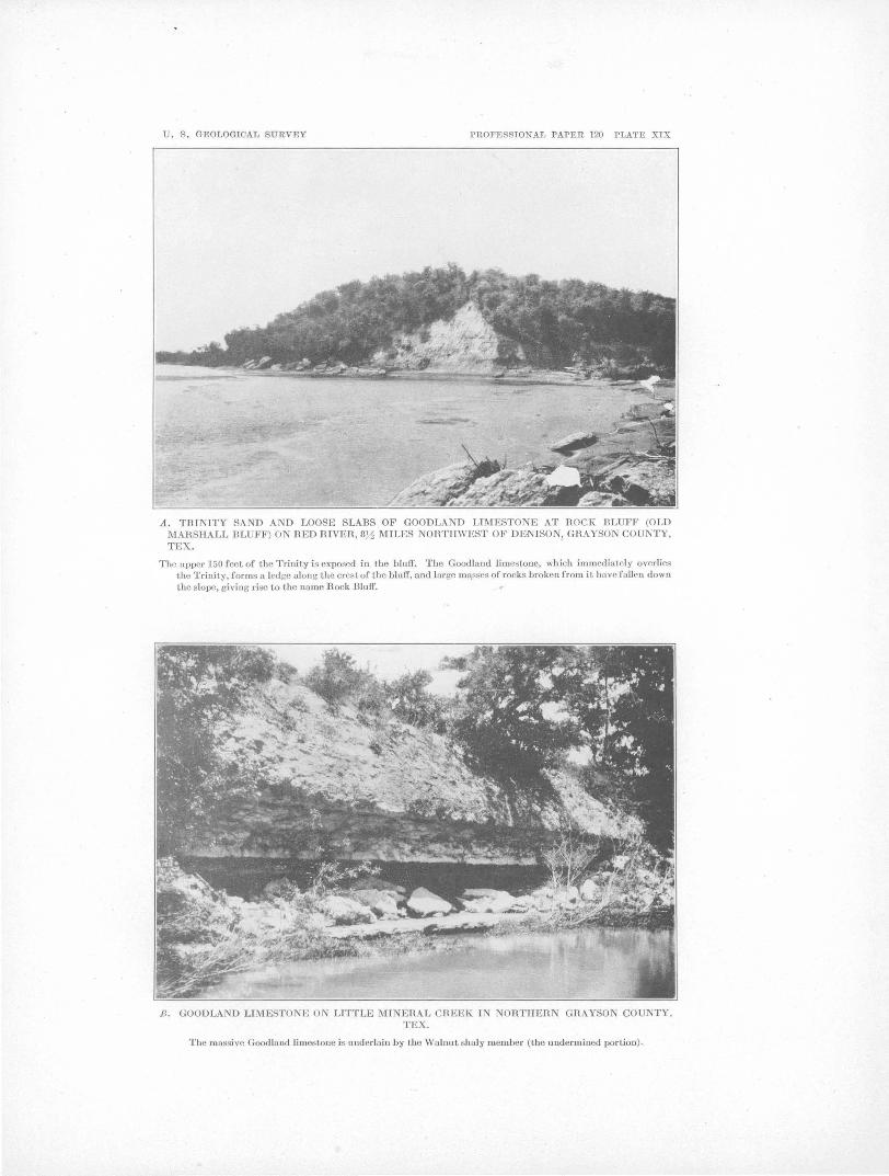
U . S . GEOLOGICAL SURVEY PROFESSIONAL PAPER 120 PLATE XIX
A. TRINITY SAND AND LOOSE SLABS OF GOODLAND LIMESTONE AT ROCK BLUFF (OLD MAilSHALL BLUFF) ON RED RIVER, 8),1 MILES NORTHWEST OF DENISON, GRAYSON COUNTY, TEX.
The upper 150 feet of the Trinity is exposed in the blu!f. The Goodland limestone, which immedialely overlies the Trinity, forms a ledge along the crest of the bluff, and large m[\sses of rocks broken from it have fallen down the slope, giving rise to the name Rock Bluff.
GOODLAND LIMESTONE ON LITTLE MI ERAL CHEEK I TEX.
The massive Good land limestone is underlain by the Walnut sbaly ·member (the underm ined por tion).

GEOLOGY OF NORTHEASTERN 1'EXAS AND SOUTHERN OKLAHOMA. 137
Northwest of Henderson Ferry, in Marshall East of Preston the Goodland again crosses County, the southward-dipping limestone ap- the Red River valley beneath alluvial deposits; pears in the valley slopes of the southward- and although not traced in detail it was examflowing creeks tributary to Red River and was ined in an outcrop at the foot of a terrace especially noted along two small creeks respec- scarp at the edge of the Red River bottom tively 3 and 3t miles east of Willis Ferry. about half a mile north of Bears Ferry, in North of Willis Ferry the Goodland crops out. Bryan County, Okla. Here the top of . the in both the east ttnd west slopes of the ridge limestone is 30 or 35 feet above water le·vel. separating Buncombe and Brier creeks, and South of Red River in Cooke County, Tex., its continuity is interrupted at only one pla~e the Goodland gradually increases in thickness. on the crest of the ridge, where it 4as been It is regarded as the time equivalent of the eroded away. At a point estimated to be Walnut clay, and of the Comanche Peak and about 3t miles west by north of Willis Ferry Edwards limestones of centJ;al· ''rexas, which the Goodland again crosses Red River into south of the Brazos River valley have a comGray.son County, Tex., where, gradually rising bined thickness of over. 250 feet; still farther to the northwest in the northeastward-facing south the Edwards c•ntinues to thicken, being slope of the river valley, it finally forms the 300 feet thick in the vicinity of Austin, Travis crest of the hill overlooking the valley about County (see Pl. XVIII), and .520 feet thick a n1ile southeast of Orlena. The Trinity sand in Uvalde County, whereas the Walnut and appears in the slopes of this hill below the. Comanche Peak become thinner, the former Goodland. being only 15 feet and the latter 40 feet thick
On the north limb of the Preston anticline in the vicinity of Austin. the Goodland crops out in the valley of Rock Creek south of Kingston, in Marshall County, WASHITA GROUP.
0lda., and is especially Well exposed in a LITHOLOGY AND SUBDIVISIONS.
branch about 3-! miles south by we.st of Kings- The Washita group con sis· s ehiefly of marine ton. The section here shows the upper mas- shaly clay, marl, and interbedded subordinate sive limestone, underlain by the Walnut shaly limestone, having a total estimated thickness in menlber, and this in turn by the Trinity sand. northern Grayson County of 415 feet; toward Down the valley of Rock Creek from this the top there is a sandy member, the Pawpaw locality the limestone appears in the south- (seep. 142), which is the only conspicuous exwestward-facing slope, gradually descending ception to the ~onsandy character of the group toward water level until, in· the vicinity of the in this area. The limestone, though subordibig bend a mile or two west of Woodville, it nate in thickness to the clay and marl, forms crosses the Red River valley beneath the several definite bands that have individual Pleistocene and Recent alluvial deposits and physical characteristics and contain index reappears on the Texas side of the river in the fossils which render them readily traceable hills in the northern part. of Preston Bend, th h t th th 1 1 b C \. d f h roug ou e area; ey 1ave a so een Grayson ;Ounty. 1 . goo ex~osure 0 t e approximately correlated by means of the foslinlestone wa.s noted In the pubhc road on the I ·l 'th b d. f d' · 1 . . SIs w1 e s o correspon Ing age In centra westward-faCing slope of the Red River valley cl th t 'I~ Th 1· t . . . . an sou wes ern exas. e 1mes ones are 1! m1les west of Preston, where It IS underlain tl f 1 bl k b d · d t · · tl by 30 or 35 feet of Trinity sand that outcrops lerle ~re vt a uta e feyth eels In .te ·erminmg le . . ~ . . geo ogw s rue ure o e eposi s. m the slope below the hmestone. 'Ihts locahty Th h b bel' 'd d b FI'lll d . . e group as een su IVI e y I an 1s less than 2 miles north of the northernmost T ff 2 Alth h Hill' 1 t 1 t t occurrence of the limestone in the south limb a · . . <:>uallg s no~enc a w·a . rea -f h · 1. h d' 'd. b L' 1 mentis not In respects precise and consistent,
o t e antic me on t e IVI e etween Itt e h · f b d 'b · M' 1 C k d R d R · (S ) t e successiOn o e s descn eel by him has been , mer.a ree ~ an e . Iver. ee P· 136: substantially verified. He recognized the fol-
'Ihe limestone here and In other outcrops In l · d' · · d · · d' d . . . . . OWing IVISIOns, name 1n ascen Ing or er thts v1c1mty clips to the northeast at an angle ( P.l XVIII) ( ) Th p t h d b . · . see . : a e res on e s su -suffiCient to carry It 40 or 50 feet below water ' level at Thomson Ferry, a mile north of Pres-· 1 u.s. Oeoi.Survey Twenty-first Ann. Rept., pt. 7, pp. 240-292,1901.
2 U.S. Geol. Survey Geol. Atlas, Atoka folio (No. 79), 1902; Tisho-ton, Tex. mingo folio (No. 98), 1903. ·

138 SHORTER CONTRIBUTIONS -TO GENERAL GEOLOGY, 1918.
divided into the Kiamitia clay, thickness 40 feet, which rests upon the Goodland limestone, and the· Duck Creek fo~mation (clay, marl, and limestone), thickness 100 feet; (b) the Fort Worth limestone, thickness 35 feet; (c) the Denison beds, subdivided into (1) the Denton subgroup, thickness 45 feet; (2) the W eno subgroup, including the Marietta or Weno formation, thickness 115 feet; the Quarry limestone, thickness 2 feet; and the Pawpaw beds, thickness 45 feet; and (3) the Pottsboro subgroup, including the Main Street limestone, thickness 8 feet; and the -Grayson marl, thickness 25 feet.
The divisions recognized by Taff in the Tishomingo and Atoka quadrangles, Okla., which correspond to the Denison beds of Hill, include in ascending order the Kiamichi formation, equivalent to the "Kiamitia" clay of Hill; the Caddo limestone, equivalent to the Duck Creek formation and the Fort Worth limestone; the Bokchito formation, equivalent to the Denton subgroup and the Weno subgroup (Marietta or W eno fonnation and Pawpaw beds) of Hill; and the Bennington limestone, equivalent to Hill's Pottsboro subgroup (Main Street limestone and Grayson marl). (See Pl. XVIII.)
South of Grayson and Cooke counties, Tex., the Washita group, as a whole, becomes thinner,, at the same time gradually assuming a different lithologic character. In the Austin quadrangle (see Pl. XVIII) the Georgetown limestone, which is only 80 feet thick, appears to represent all of the Washita group of Grayson County up to and including the basal part of the Main Street limestone, a total thickness of at least 385 feet. However, the upper part of the Main Street limestone and the Grayson marl, which, together have a thickne-ss of about 30 feet, become thicker toward the 'south and are represented in the Austin quadrangle by the Del Rio clay and Buda limestone, which have a combined thickness of about 125 feet.
'Hill's classification of the group is given in Plate XVIII (p. 134), which also includes columns showing the correlation with the subdivisions" of the group recognized· by Taff in the Tishomingo quadrangle, Okla., by Hill in the region south of the Brazos River valley, u.nd by Hill and Vaughan in the Austin quadrangle, 'Tex. In the· ··pres~nt report:. Hill's
classification of the group, modified somewhat for the sake of simplicity and greater clearness, ·is adopted, as shown in Plate XVIII, column B. The changes include the dropping of the apparently unnecessary tern1s Preston beds, Weno subgroup, t..nd Pottsboro subgroup.
KIAMICHI CLAY.
The Kiamichi clay is named for Kiamichi River, on which it is typically exposed in Choctaw County, Okla. In Grayson County the Kiamichi clay, which includes all the beds between the Goodland and Duck Creek formations, is 40 or 50 feet thick and consists chiefly 9f dark carbonaceous shaly clay, with thin platy layers of siliceous limestone interbedded with the clay in the lower few feet and with thin layers of gray impure fossiliferous limestone in the upper 10 or 15 feet. The writer has not seen the full thickness of the formation, and the description is based partly on the statements of Taff and Hill. The section at Thomson Ferry, given below, which includes the upper part of the formation, was examined by the writer. (See Pl. XX.) This locality is on the north limb of the Denison anticline. Section at Thomson Ferry, on the right bank of Red River, in
Grayson County, Tex., 2 miles south of Woodville, Okla.
Duck Creek formation: Feet. Layers of limestone interbedded with subor
dinate layers of. dark shaly calcareous clay, the limestone hard and nodular in the upper part, softer and less nodular below, especially in the lower 2 feet. Fossils recognized: Kingena sp., Exogyra plexa Cragin, Plicatula sp., Gryphaea washitaensis Hill, Hamites jremonti Marcou (?), Schloenbachia (two or three species)................................... 15
Kiamichi clay: Layers of gray impure, very fossiliferous ,lime
stone with thin interbedded layers of dark calcareous shaly clay; the limestone layers .contain vast numbers of Gryphaea, chiefly G. navia Hall. . . . . . . . . . . . . . . . . . . . . . . . . . . . . . . . . 3~
Dark shale with layers of Gryphaea-bearing limestone resembling the limestone .in the overlying division but more widely spaced. Fossils recognized: Gryphaea navia Hall, , Trigonia sp., and Plicatula sp.............. 7
The Gryphaea-bearing limestones in the u·pper part of the Kiamichi clay are characteristic and persistent and form excellent key beds in determining the structure of the rocks in this area. They were noted also on t~e ; north

'U. S . GEOLOGICAL SURVEY PROFESSIONAL PAPER 120 PLATE XX
A. TOP OF KIAMICHI CLAY, OVERLAIN BY LIMESTONE MEMBER OF DUCK CREEK FORMATION, IN BLUFF ABOVE THOMSON FERRY, RED RIVER, 11 MILES NORTHWEST OF DENISON, GRAYSON COUNTY, TEX.
B . SLABS OF GRYPHAEA-BEARING IMPURE LIMESTONE FROM THE UPPER PAHT OF THE KIAMICHI CLAY AT TI-lE LOCALITY SHOWN IN A.
The shells belong chiefly to the species Gryphaea navia Hall.

U . S. GEOLOGICAL SURVEY PROFESSIONAL PAPER 120 PLATE XXI
A. EARTHY FACIES OF THE LOWER •PART OF THE FORT WORTH LIMESTONE ON THE OKLAHOMA SIDE OF RED RIVER AT THE MISSOUlU, KANSAS & TEXAS HAlLWAY BRIDGE 5 MILES NORTH OF DENISON, GRAYSON COUNTY, TEX.
B. FOSSIL FUCOIDS (?) ON THE UNDER SIDE OF A SLAB 01" FOHT WOHTH LIMESTONE, AT THE LOCALITY SHOWN I A .

GEOLOG;Y OF NORTHEASTE;RN TEXAS AND SOUTHERN OKLAHOMA. 139
limb of the Preston anticline in a branch of f Section on Duck Creek and in a cut of the St. Louis & San
I:> 1 C k t bl' d 0 1·ng 3 ml'les Francisco Railroad 2i miles north of Denison, Grayson :\.OC \: ree ~ a a pu lC roa cr ss ·. rv , rn · 1: • l\K h ll C t vounty, .~.ex. south by west of .1(1ngston, CJ.ars a oun y,
Olda. On the south limb of the anticline they were examined along the Preston road a short distance south of Rock Bluff (seep. 134); along the road leading down to I-Ienderson Ferry, 5! miles north by west of Pottsboro; and in the be<t of Little Mineral Creek, 3! miles north of Pottsboro.
DUCK CREEK FORMATION.
The Duck Creek formation, which is typical! y exposed on Duck Creek north of Denison, in Grayson County, consists of approximately 100 feet of limestone and gray to greenish-gray shaly calcareous clay, which intervene between the Kiamichi clay below and the Fort Worth limestone above. In the lower 35 or 40 feet the.limestone alternates with the clay in layers 16' to 12 inches thick, in about equal proporthms; in the upper part of the sec.tion ~he clay predominates, the limestone layers being rather sOft and separated by intervals of 2 to 3 feet or n1ore of clay. The limestones in the lower 35 or 40 feet are characterized by keeled and nonkeeled ammonites, many of which reach a diameter of 2 feet or more. One layer of white, chalky limestone 3 or 4 feet thick 35 or 40 feet above the base of the formation and 2 or 3 feet of gray calcareous clay that immediately underlies it contain great numbers of large ammonites and form a zone that has been recognized in outcrops over a large area in Texas and Oklahoma and was used by Messrs. I-Iopkins, Powers, and Robinson as a key ip. the determination of structure. The keeled ammonites ·belong chiefly to the genus Schloenbachia, several species of which have been differentiated. The nonkeeled forms belong chiefly to the species Pachydiscus brazoensis (Shumard). The limestones also contain some of the remains of the problematic organisms (fucoids ~), such . as occur in great numbers and of larger size in the Fort Worth limestone. (See p. 140 and Pl. XXI, B.) The most complete section of the Duck Creek formation examined by the writer is on Duck Creek and in a .cut of the St. Louis & San Francisco Railroad where it comes close to Duck Creek, 2! miles north of Denison. .
Fort \Vorth limestone: Four or five layers of nod·.llar impure argilla
ceous fossififerous limEstone interbedded with gray shaly clay •.................•....
Duck Creek formation: Gray shaly calcareous clay with interbedded
layers of impure non ledge-forming limestone at intervals of 2 or 3 feet .................. .
Concealed .................................. . Greenish-gray calcareous clay from which
weather numerous specimens of Plicatula cf. P. incongrua Conrad and small rusty ammon-ites, probably the young of Pachydiscus and Schloenbachia, also a few specimens of Gry-phaea washitaensis Hill ..................... .
Ledges of limestone with interbedded layers of gray shaly clay, poorly exposed; the lime-stone, especially one layer near the top, con-tains numerous keeled and nonkeeled ammonites, many of which a'I'e of large size (maximum, 2 feet in diameter) ............ .
Alternating beds of ammonite-bearing limestone and gray shaly clay, about half and half,
Feet.
8
22 20
15
20
well exposed in bluff along the creek. . . . . . . 20
Other expos tires of the limes tones forp1ing the lower part of the Duck Creek formation were observed by the writer in a small branch of Little Mineral Creek at the crossing of the road leading to Henderson Ferry, 4! miles north of Pottsboro; in the road leading down to Henderson Ferry about a mile west by north of the locality just mentioned; and at Willis Ferry (Oklahoma side), 13 miles northwest of Pottsboro, Tex. The upper part of the Duck Creek, consisting of calcareous clay, which lacks conspicuous layers of limestone, is well exposed in a bluff on the north side of Red River, about half a mile above Willis Ferry. These localities are on the south limb of the Preston anticline; the section at Thomson Ferry, on the north limb of the anticline described on page 138, reveals the basal 15 feet of the limestone.
FORT WORTH LIMESTONE.
The Fort Worth limestone, named from the city of Fort Worth, Tarrant County, Tex., • consists in the vicinity of Red River north of Denison,. Grayson County, of about 25 feet of gray nodular earthy limestone interbedded with layers of dark shaly clay, followed above by 8 to 10 feet of heavy-l)edded hard cream-

140 SHORTER CbNTR.JBUTIONS TO GENERAL GFOLOGY, 1918.
colored chalkJ limestone. Thi\3 limestone resembles the limestone portion of t~e unde:r;lying Duck Creek formation, from which it may be distinguished by slight lithologic differences, by the more comn1on occurrence of pectens, by the presence of echinoids in greater number
among which are Hemiaster elegans Shumard, Exogyra walkeri White (a large smooth species), Nautilus texanus Shumard, and Schloenbachia leonensis Conrad.
DENISON FORMATION.
and Of larger size, ·and by the greater abun- DENTON CLAY MEMBER (INCLUDING "OSTREA CARINATA
'd BED"). dance and larger size of the problematic fuc01 -like remains described below. The Fort Worth is immediately overlain by the Denison fornlation. A good exposure of the lower 25 feet of the formation is afforded by the bluff of Red River at the north end of· the bridge of the Missouri, Kansas & Texas Railway 5 miles north of Denison, on the north limb of the Preston anticline. (See Pl. XXI, A.) Here the impure nodular limestone layers range in thiclmess from a few inches to 2 feet, and the interbedded shaly clay con1poses half or more of the bulk of the material. The limestone layers are fossiliferous and the most numerous and conspicuous forn1s are keeled ammonites, some of which have a maximum diameter of 18 inches, and echinoids. An interesting and characteristic feature of these limestones is the problematic fucoid 0) remains or casts of borings ( ~) which line the underside of some of the limestone layers. Good examples are shown in Plate XXI, B. The upper part of the formation is well exposed in the bank of a small branch about a third of a mile northeast of the Missouri, Kansas & Texas Railway bridge just east of the railway track; here the Fort Worth is overlain by 15 feet of reddish terr,ace sand.
The upper heavy-bedded cream-colored limestone of the Fort Worth is exposed at many places on the south limb of the Preston anticline in Grayson County and was observed in a cut of the Missouri, Kansas & Texas Railway 2 miles north by east of Denison; on the Bears Ferry road 1 t miles in an air line northwest of the post office at Denison; on the Preston (Rock Bluff) road 31 miles north of the Missouri, Kansas & Texas Railway, near the head of a branch of Little Mineral Creek; on the public road 2! miles in an air line northeast of Pottsbcro; and on the Henderson Ferry road 31 miles north of Pottsboro, an eighth of a mile north of Fink. This upper massive part of the Fort Worth limestone con-
Hill 1 originally applied the name Marietta to beds, chiefly shaly clays, 160 feet thick, between the Fort Worth limestone below and imperfectly defined so-called North Denison sands above. Later he reclassified the Denison formation, as shown in Plate XVIII, column C, introducing the name Denton subgroup, from Denton Creek, Denton County, for the lower 45 feet of the original Marietta, including the "Ostrea car·inata bed" at its top, and applying the name Weno formation to the beds which lie between the Deriton and the· "Quarry" limestone and include most of the upper part ,of the original Marietta. In one of his tables in the same paper 2 he somewhat loosely applied the name Marietta to the beds between the Den~on and Pawpaw divisions. As the name Marietta is preoccupied for sandstone in the Dunkard group of Pennsylvania, West Virginia, and Ohio, its use in the Denison section seems undesirable.
The lower 5 feet of the Denton is a strongly calcareous clay of a decided marly charactel'. This is followed by 35 feet of shaly, less calcareous clay, which in turn is followed by 3 to 5 feet of highly fossiliferous impure limestone, composed largely of the shells of Gryphaea washitaensis Hill but containing also a few large echinoid spines and other foss~ls, among which are considerable numbers of Ostrea carinata Lamarck, a fossil which suggested the name 11 0strea carinata bed." The Denton member appears in imperfect exposures along the St. Louis & San Francisco Railroad 1! to 2 miles north of Denison.
The 11 0strea carinata bed'~ appears in many small exposures along the south limb of the Preston anticline and is an excellent key rock, chiefly because of the presence .of 0. carinata Lamarck, a peculiar and easily recognizable fossil. This stratum is exposed on the St.
. · b d · · ts 1 d 1 Hill, R. T., Geol. Soc. America Bull., vol. 5, p. 303, 1894. stltutes a good key ~ ' OWing t~ I. e ?e- 2 Hill, R. T., U.S. Geal. Survey Twenty-first Ann. Rapt., pt. 7, p. formin(J' character and Its characteristic fossils, lus, 19o1. b

U. S. GEOLOGICAL SURVEY PROFESSIONAL PAPER 120 PLATE XXIl
A. UPPER PART OF THE WENO CLAY IN Tim EAST BANK OF WASHITA RIVER AT THE FRISCO HAILROAD BHIDGE 2}4 MILES WEST OF PLATTER, BRYAN COUNTY, OKLA.
The material exposed in the bank comprises shaly clay and subordinate interbedded layers of sands tone .
B. UPPER PART OF THE WENO CLAY IN A CUT OF THE FRISCO H.AILROAD A MILE NOHTJ! OF THE STATION AT DE ISO , GRAYSON COUNTY, TEX.
A ledge of the "Quarry .. Limcst.one, which overlies the 'Vcno, appears at. the extreme top of the sect.ion.

U . S. GEOLOGICAL SURVEY PROFESSIONAL PAPER 120 PLATE XXIII
A. MAIN STREET LIMESTONE IN A CUT OF THE MISSOURI, KANSAS & TEXAS RAILWAY 3 MILES WEST OF THE STATION AT DENISON, GRAYSON COUNTY, TEX.
B. "QUARHY" LIMESTONE, U DEB.LA!N nY Til l~ WENO CLAY. IN A CUT OF THE FRISCO RAILROAD THREE-QUARTERS OF A MILE OH.TH OF DE !SON, GllAYSO COU TY, TEX.

GEOLOGY OF NORTHEASTERN· TEXAS AND SOUTHERN OKLAHOMA. 141
Louis & San Francisco Railroad 1! miles north of Denison and was seen also on the Missouri, Kanse,s & Texas Railway 1 i miles north of Denioon; on the Hears Ferry road about '1! ntiles in an air line northwest of the post office at Denison; in the headwater branches of Shawnee Creek, 3! miles west by north of the post office at Denisop.; and at Fink post office, 3 miles north of Pottsboro. Messrs. Hopkins and Powers noted outcrops of a stratun1 that carries 0. carinata La;marck and apparently represents the "Ostrea carinata bed" stratigraphically 55 feet above the Fort Worth limestone, at two localities on the north limb of the anticline in Marshall County, Okla., namely, 3! miles southeast of Kingston, in the NE. ! sec. 3, T. 7 S., R. 6 E.; and 2~ miles east of Kingston, in the SE. i sec. 28, T. 6 S., R. 6 E.
WENO CLAY MEMBER.
The Denton clay member is overlain by 115 feet of dark-gray shaly clay with subordinate thin. partings, lenses, and layers of fine gray to yellow sand, some of which are indurated to ledge-forming sandstone. To this material Hill 1 gave the name Weno formation, from the small village of W eno, on Red River 5 miles northeast of Denison, ·Grayson County, which does not appear on recent maps and is apparently abandoned. Jiill in the same paper also used the narp.e Weno in a broader ("subgroup") sense, to include both th9 Weno clay member and the overlying Pawpaw sandy member, a usage not followed in the present paper. Sand layers are numerous, th')ugh subordinate to the clay, in the upper 35 feet of the division in cuts of the St. Louis & San Francisco Railroad about a mile north of the station at Denison (see Pl. XXII, B), where one lens has a maximum thickness of 1! feet. At the same locality the clays contain many small flattish ferruginous concretions, probably derived by oxidation from concretions of iron carbonate, and some small concretions of marcasite. Fossil pelecypods and gastropods in a good state of preservation are numerous in the clays, sands, and ferruginous concretions in these upper beds, among which were recognized Nuc:ula sp., Ostrea quadriplicata Shumard, Protocardia texana (Conrad), Oyprimeria
1 Hill, R. T., U.S. Geol. Survey Twenty-first Ann. Rapt., pt. 7, PP. 121, 27f, 1901.
sp., Oorbula (three species), Oymbophora sp., Turritella sp., Auchura mudgeana White, Engonoceras serpentinum (Cragin).
The Weno clay weathers down to smooth surfaces and is as a rule poorly exposed on the uplands and valley slopes. In addition to the section in the railroad cut just described, a ·good exposure of strata believed to represent a portion of the Weno clay and certainly representing either this clay or the Pawpaw mernber is afforded by Carpenters Bluff, on Reel River below the bridge of the ~1issouri, Oklahoma & Gulf Railway, 7 miles in an air line du.e east of Denison. Hill mapped the area in which this bluff is included as belonging to the Woodbine formation, though Taff had at an earlier date recognized that the outcrop at the bluff be-· longed to the Washita group. This exposure is about on the southeastward-plunging axis of the Preston anticline.
According to Messrs. Hopkins and Powers the Weno clay in the north limb of the Preston anticline in Marshall County,· Okla., is about 135 feet thick, or 20 feet thicker than in the south limb in Grayson County, Tex. A fine exposure of the upper 50 feet of the Weno, overlain by the ''Quarry" limestone, is afforded by a bluff on the 1eft bank of Washita River at the crossing of the St. Louis & Sau Francisco Railroad 2! miles west of Platter, Bryan County, Okla. A view of this bluff, taken at a low stage of water, is shown in Pl. XXII, A. The beds here consist predominantly of greenish shaly calcareous clay, with an interstratified layer of sandstone 5 or 6 feet below the "Quarry" limestone and several layers of thin flaggy sandstone 25 to 40 feet below the ''Quarry.'' Well-preserved fossil shells, many species ·Of which are identical with those colJected in a cut of the St. Louis & San Francisco Railroad a mile north of Denison in Grayson County, Tex., are abundant in some layers of the clay and in some of the indurated layers. Several well-pres~rved fragments of crustaceans were found in the talus. Ab~ut 20 feet of dark shaly clay of the Weno
:q:1ember, containing poorly preserved fossils, is well exposed in the)eft bank of a branch just east of the Missouri, Kansas & Texas Railway, 1! miles south of Colbert, Bryan County, Okla.; this locality also is on the north limb of the Preston anticline.

142 SHORTER CONTR.ffiUTIONS TO GENERAL GEOLOGY, 1918.
PAWPAW sANDY .MEMBER (INCLUDING "QUARRY" way .about 2! miles east of Denison; at a LIMEsTONE). : culvert of the Missouri, Oklahoma & Gulf Rail-
The W eno clay member is overlain by ap- way about 2· miles east of Denison; in a northproximately 50 feet of more or less irregularly south public road 1! miles east by north· of bedded clays and sands, including at the base Pottsboro; in an east-west road at two ·creek a persistent layer of sandy limestone 1 to 4 feet crossings 2 miles north of Pottsboro; in the thick, known as the "Quarry" limestone. Cal- Henderson Ferry road 2! miles north of Potts-
. careous clay predominates in the lower half of boro, a quarter of a mile south of Fink; and in the division above. the "Quarry" limestone, and the public road a quarter of a mile west of sand and interbedded laminated sand and clay Fink. predominate in the upper half. Good expo- On the north limb of the Preston anticline the sures, particularly of the upper part of the "Quarry" limestone outcrops at the crest of the member, occur in the headwater branches of steep part of the bluff on Washita River at the Pawpaw Creek within the corporate limits of crossing of the St. Louis & San Francisco Railthe eastern part of Denison. way in Bryan County, Okla. (seep. 141), where
The "Quarry" limestone is a sandy bluish- it overlies the Weno clay and is overlain in turn gray limestone that weathers yellow and purple by clays and sands of the Pawpaw member. and contains considerable numbers of Ostrea- Poor exposures were also noted near the public quadriplicata Shumard. 08trea subovata Shu- road leading to Kingston, about 3 miles northmard is rather sparingly represented. A good west of Woodville, in Marshall County, Okla. exposure is afforded by a cu·t of the St. Louis Messrs. Hopkins and Powers state that in the & San Francisco Railway three-quarters of a latitude of Kingston and farther north there is mile north of the station at Denison (see Pl. no definitely recognizable "Quarry" limestone, XXII, B), where it is 2 feet thick and the lower but several beds resembling it; 3 miles east of 3 to 12 inches is conglomeratic. The somewhat Kingston they examined a section which inscattered pebbles in the conglomeratic portion eluded four distinct layers of .sandy- limestone consist of waterworn calcareous sandstone, each rese:I:nbling the "Quarry" and- each co.p.sandy limestone, and calcareous and ferrugi- taining Ostrea quadriplicata Shum~:rd. Mr. nous concretions, the largest 3 inches or more Hopkins noted an outcrop of a sandy glauconitic in length. A few borings into the top of the limestone resembling the "Quarry,· 4 miles underlying Weno clay, filled with material char- east of Kingston, Marshall County, in the cenacteristic of the limestone, were noted. As the ter of the west line of sec. 35, T. 6 S., R. 6 E., base of the limestone is sharply separated from from which he obtained a specimen of a bryothe underlying clay and is somewhat undulat- zoan which R. S. Bassler refers to the genus ing, the contact appears to mark an uncon- Domopora. formity, though the time represented by it was The section described below shows the relaprobably short. The limestone in this section tion of the Pa,·vpaw member to the overlying is overlain by 4 feet of clay, above which is an- Main Street limestone member. (See Pl. other layer of similar lin1estone 6 inches to 1 XXIV, B.) foot thick, which shows the lenticular charac- Section in a small headwater branch of Pawpaw Creek .Just ter of the rock and which apparently connects east of the subway under the Missouri, Kansas & Texas the "Quarry" limestone more closely with the Railway south of the station at Denison, Tex.
overlying Pawpaw member than with the un- Main Street limestone member: derlying W eno clay. In this connection it may be mentioned that Messrs. Hopkins and Powers have noted in Marshall County, Okla., several layers of sandy limestone in the Pawpaw member that resemble the "Quarry."
Other outcrops of the limestone were examined in Grayson County in the bed of a small branch of Smith Creek just south of the Missouri, Oklahoma & Gulf Railway, 4! to 5! miles east of Denison; in a ditch and in a field south of the Missouri, Oklahoma & Gulf Rail-
Irregular nodular layers of hard limestone 6 to 18 inches thick, interbedded with soft yellow marl a few inches to 6 inches thick; the under side of the lowest limestone layer is roughly nodular. Exogyra arietina Roemer nccurs abundantly in the upper 2 or 3 feet ........ .
Gray, faintly laminated sandy and calcareous (marly) clay, coarsely sandy in the basal few inches; in the basal 6 inches are numerous small ferruginous concretions and a few flattish, partly oxidized iron carbonate concretions; one apparently water-worn quartzitic sarndstone pebble was noted .....••••••••••..
Feet.
8
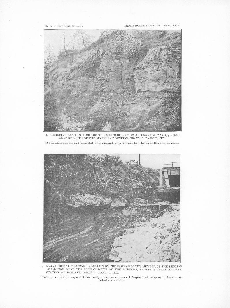
U. S . GEOLOGICAL SURVEY PROFESSIONAL PAPER 120 PLATE XXIV
A . WOODBINE SAND IN A CUT OF THE MISSOURI, KANSAS & TEXAS RAILWAY l .Y:l MILES WEST BY SOUTH OF THE STATION AT DENISON, GRAYSON COUNTY, TEX.
The Woodbine here is a partly indurated ferruginous sand, containing irregularly distributed thin ironstone plates.
B . MAIN STH.EET LIMESTONE UNDEH.LAIN BY THE PAWPAW SANDY MEMBEH. OF THE DENISON FOH.MATIO NEAH. THE SUBWAY SOUTH OF THE MISSOUH.I, KANSAS & TEXAS HAlLWAY STATION AT DENISON, GH.AYSON COUNTY, TEX.
The Pawpaw member, as exposed at this locality in a headwater branch of Pawpaw Creek, comprises laminated crossbedded sand and clay.

U. S . GEOLOGICAL SURVEY PROFESSIONAL PAPER 120 PLATE XXV
A . SAND AND CLAY OF TI-lE WOODBINE FORMATION AT HYATTS BLUFF, ON RED RIVER 5 MILES NORTHWEST OF RAVENNA, FANNIN COUNTY, TEX.
B. FERRUGINOUS SAND OF THE WOODBINE FORMATION IN THE SHERMAN ROAD, 2 MILES SOUTHWEST OF DENISON, GRAYSON COUNTY, TEX.

•
GEOLOGY OF NORTHEASTERN TEXAS AND SOUTHERN OKLA:E(OMA. 143
Unconformity (?). Pawpaw sandy member:
1'hinly laminated, strongly cross-bedded gray clay and sandy clay with thin sand partings and some larger lenses of fine yellow sand;
. numerous thin iron crusts occur in the partings; some comminuted plant fragments
Feet.
were noted................................ 6
'l'he upper 6 feet of the Pawpaw is also well exposed beneath the Main Street limestone on the Missouri, Kansas & Texas Railway at the iron overhead bridge 3 miles west of the station at Denison. (See below and Pl. L~III, A.) I-Iere the Pawpaw consists of current-bedded, lan1inated sand and clay with highly fossiliferous thin lenses of ferruginous oxidized soft sandstone. Among the fossils recognized were. Nucula sp., Protocardia texana (Conrad), Oymbophora sp., OoTbula sp., A nchura mudgeana White, and Engonoceras serpentinum (Cragin).
The Pawpaw member produces a narrow belt of sanely soil between the clay soils of theW eno and those of the overlying :Main Street limestone and the Grayson n1arl. The topography produced by the sandy beds of the Pawpaw is similar to that characteristic of the o:utcrop of the Woodbine fonnation of the Gulf series.
MAIN STREET J,IMESTONE lllEliiBER.
The Main Street limestone, named from ex-
Main Street lim!3~tone member-Continued. Greenish-gray sandy calcareous clay marl with
scattered white clay pebbles and ferruginous concretionary clay nodules along the base, some of which suggest having been mechani-
Feet.
cally included ....•••.•.....•.••••••••••..• lt-12 Unconformity (?). Pawpaw sandy member:
Current-bedded greenish-gray fine sand, with fine clay lamina~ and subordinate lenses of la'llinated clay. Highly fossiliferous thin discontinuous lenses of ferruginous oxidized soft sandstone with many molds and internal casts of fossil mollusks; soft molds and inter-nal casts occur also in the soft sands. (See list, above.) Maximum exposed thickness .. 6
The limestone is poorly exposed on Main Street east of the rai.lroad tracks in the eastern part of Denison and is well exposed in some of the branches and o:q. the slopes about the headwaters of Pawpaw Creek in the san1e vicinity.· One section is described on page 122. (See also Pl. XXIV, B.)
Other exposures of the limestone were noted along the south limb of the Preston anticline in Grayson County, in the bed of a headwater branch of Iron Ore Creek just north , of th£' Missouri, Kansas & Texas Railway, 5! miles west of the station at Denison and a quarter of a mile east of a north-south public road; poor exposures showing dips of 20° or more
posures on Main Street in Denison, consists, in . . In a ~ow strike ridge extending from a point 2 Grayson County, of 8 to 20 feet or more of miles east of Pottsboro northwestward for a heavy-bedded hard limestone, with subordi- distance of 2 mile.s; in the bed of a headnate interbedded layers of unconsolidated cal- water branch of Little Mineral Creek on the careous marl,· and is. characterized by the Hender~on Ferry road 2~ n1iles north of, Pottspresence of Exogyra arietina Roemer, p~rticu- boro, seven-eighths of a mile south of Fink; larly in the tipper part, and of l{ingena waco- poor exposures along the east-west public road ensis (Roemer) in the lower part. One of the three-fourths of a mile to 1 ~ miles west of best exposure~ of t~e limeston~ is afford~d .by Fink; on the same road near the heads of a cut of the Missouri, Kansas & Texas Railway · 21 2J.. 2.a d 3J.. ·1 t f F' k . . D . ravines 4 , 'I' 4 , an g- mi es wes o In , 3 miles west of the statwn at enison. (See 1 · b th G . 1 h' h Pl. L~III A.) ?ver am y e rayson n1a~, w IC appears
' . lin several poor exposures; In the bed of a Section in cut of J.~issouri, K~nsa$ & Texas Railway 3 miles s1nall southward-flowing branch of Mill Creek
west of the statwn at DemsorJ., Grayson County, Tex. about 4 miles west by north of Fink; along a Residuum and creep: Feet. north-south public road 2 miles east by south
Brownish loam containing in places along its of Cedar Mills; on a public road on the west-base a great number of ferruginous sandstone fragments and boulders derived from the ward-facing slope of the Mineral Creek valley Woodbine sand.. . . . . . . . . . . . . . . . . . . . • . • . • . • 2-6 1 ~ miles east . y ·south of Cedar Mills; in a
Main Street limestone member: small branch at the turn of the road just south Irregular layers of limestone 3 to 4. feet thick, of Cedar Mills; on the northward-facing slope
with discontinuous interbedded lenses of soft of the Sandy Creek valley just north of Cedar marl, underlain by 3 to 4! feet of massive · hard limestone having an undulating nodular Mills; at the crossing of a public road over a base; Exogyra arietina Roemer is common in headwater branch of Brier Creek 5 miles north-the upper layers............................ 7! west of Gordonville; and on the southeast
144 SHORTER CONTRIBUTIONS TO GENERAL GEO:J:.OGY, 1918.
crest of Brushy Mound, 9 miles northwest of Gordonville.
The Main Street limestone was not seen in place by the present writer on the north limb of the Preston anticline, but Messrs. Hopkins and Powers state that they have seen it well exposed at the following localities in Oklahema: In Bryan County on the south bank of Rock Creek along the public road, 2 miles northwest of Platter; and in Marshall County a mile west of Washita River; on the south bluff of Washita River at the southeast c·orner of sec. 7, T. 7 S., R. 7 E.; 2 miles northeast of Woodville, in the center of the east line of sec. 19, T. 7 S., R. 7 E.; and 4 miles north of Woodville, in the NW. ! sec. 1, T. 7 S., R. 6 E. According to the geologic map of. the Tisho-, mingo quadrangle, which ·joins the Denison quadrangle on the north, the Bennington limestone of Taff, which includes the Main Street limestone, enters the Denison quadrangle 2 or 3 miles west of its northeast corner.
GRAYSON MARL MEMBER.
GULF SERIES.
GENERAL CHARACTER.
The Gulf series is composed of sands, shdy clays, chalks, and calcareous clays and sands (marls), which have an estimated thickness of approximately 3,000 feet in· the area under consideration. In the southwestern part of the area the succession of formations in the series is, in ascending order, as follows: Woodbine sand, Eagle Ford clay, Austin chalk, Taylor marl (including the Wolfe City and Pecan Gap members; see pp. 155-156), and Navarro formation. Toward the north the lower part of the Austin chalk merges, with some intertonguing, into contemporaneous· nonchalky sands and clays, and the upper part of the Austin transgresses to a higher position in the geologic column, so that in Fannin and IIunt counties the following succession of mappable units is recognizable: Woodbine sand, Eagle Ford clay, unnamed clays and sands beneath the Austin chalk, Ector tongue of Austin chalk, unnamed clay in the vicinity of Bonham, An-
The topmost division of the Denison forma- nona tongue of Austin chalk, Taylor marl tion and of the Washita group, known as the ·(includingWolfeCityandPecanGapmembers), Grayson marl, consists of 15 to 25 feet of light and Navarro formation. Still farther to the grf1enish-gray calcareous clay or marl with northeast, in Lamar, Delta, and I-Iopkins lmnps of white lime and several nodular thin counties, the succession of units is as follows: layers of limestone. The fossils carried by the Woodbine sand (exposed at Arthurs Bluff, on marl include species of Gryphaea, Pecten, Tri- Red River), Eagle Ford formation (largely 9onia, Plicatula, Protocardia, Turrilites, and concealed by terrace deposits), unnamed sands 1-Ioplites, of which Gryphaea mucronata Gabb is and clays (also largely. concealed), Blossom perhaps the most common. sand, Brownstown marl, Annona tongue of
The marl is poorly exposed above the Main Austin chalk, Taylor marl, and Navarro formaStreet lim_estone about the headwater branches tion. The age relations of the units just of Pawpaw Creek, in the eastern part of Deni- named in different parts of the area are diason. The best exposure examined was in a pit grammatically represented in the correlation south of the Missouri, Oklahoma & Gulf Rail- section given in Plate XXX, 0 (p. 155). way about a quarter of a mile east of the sta- The Gulf series is referable in its entirety to tion at Denison, w_here a thickness of 16 feet of J the Upper Cretaceous, though, as indi?ated. on the marl was noted. page 134, it may not include representatives of
Other exposures in Grayson County occur in the lowermost part of the Upper Cretaceous. the banks of headwater bran_ches of Iron Ore The nature of the contact separating the Gulf Creek near the Missouri, Kansas & Texas Rail- series from the underlying Comanche series way 5! to 5~ miles west of Denison;· in the has not been satisfactorily determined in northbank of a headwater branch of Little Mineral eastern Texas. Probably it is that of unconCreek near the crossing of the Henderson Ferry formity, the basal formation of the upper road, 2! miles north of Pottsboro and seven- series, the Woodbine sand, having been deposeighths of a mile south of Fink; and at intervals ited in the shal1ow waters of the transgressing on and near the public road leading west from sea, in the deeper waters of which the succeedFink for a distance of about 4 miles. ing truly marine sediments of the series were
•

U. S. GEOLOGICAL SURVEY PROFESSIONAL PAPER 120 PLATE XXVI
IN THE HILLY AREA U DERLAIN BY THE WOODBINE SOUTHWEST OF DE ISON, GHAYSON COUNTY, TEX.
View looking northeast toward the old waterworks plant.
B. A DETAIL OF TOPOGRAPHY IN A SMALL BRANCH VALLEY UNDERLAIN BY THE WOOD· BINE SAND 1)1 MILES SOUTHWEST OF DE !SON, GHAYSON COUNTY, TEX.
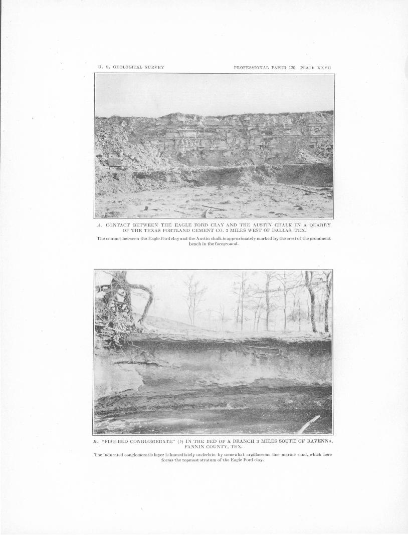
U. S . GEOLOGICAL SURVEY PROFESSIONAL PAPER 120 PLATE XXVII
A. CONTACT BETWEEN THE EAGLE FORD CLAY AND THE AUSTIN CHALK IN A QUARRY OF THE TEXAS PORTLAND CEMENT CO. 3 MILES WEST OF DALLAS, TEX.
The contact between the Eagle Ford clay and the Aus tin chalk is approximately marked by the crest of the prominent bench in the foreground.
B . "FISH-BED CONGLOMERATE" mIN TilE BED OF A BRA CH 3 MILES SOUTH OF RAVEN A, FANNI COU TY, TEX.
The indurated conglomeratic layer is immediat.ely underlai n by somewhat argi llaceous fine marine sand, which here forms the topmost stratum of the Eagle Ford clay.

GEOLOGY OF NORTHEASTER.N TEXAS AND SOUTHERN OKLAHOMA. 145
laid down. Toward the south the Woodbine stone, and argillaceous shelly sandstone which sand hecon1es progressively thinner, finally contains large lenslike calcareous concretions disappearing in :McLennan County, south of and laminated argillaceous sandstones at the which the Eagle Ford clay rests directly upon top." Sand seems to predominate over clay, the Bucla limestone. of the Comanche series. producing a pronounced sand-hill type of The absence of the Woodbine in central and .topography, as in the country immecliat.ely southwestern Texas would therefore seem to southwest and west of Denison; but locally indicate unconformity, unless the age equiva- clay makes up the bulk of the formation, lent of the '\iVoodbine lies in the relatively thin producing a smoothly rolling surface, as in the sediments that compose the Bbda limestone, a belt of country northwest of Pottsboro. (See supposition which seems highly improbable, p. 132.) and which has no basis of known fact. Fossil leaves have been obtained from the
wooDBINE s:\.ND. lower n1en1ber (Hill's J?exter sands) of the ' Woodbine near Denison. The upper member
The Woodbine sand, named from the village (I-Iill's Lewisville beds) yields a peculiar shalof vVooclbine, in Cooke County, is the basal l ow n1arine fauna that differs rnarkeclly fron1 division of the Gulf series in northeastern the Cretaceous faunas either below or above it Texas. It is a highly variable formation, con- in Texas. This fauna is best known from sisting of strongly current-bedded, more or less exposures on Tirnber Creek, 3 or 4 rniles west, ferruginous sand and laminated shaly clay, southwest, and south of Lewisville, Denton with some interbedded layers of lignite ar1d
County, Tex., and though it includes a rela-lignitic clay. On account of the irregularity tively small nun1ber of species is rich in incliof the bedding it is scn,rcely possib1e to determine the thickness of tho formation from surface viclua.ls, which largely make up certain lenses
and layers of the formation. The following are son1e of the species that have been described:
Area (Barbatia) micronema (:~•Ieek), numerous. Ostrea soleniscus Meek, very numerous. Modiolus filisculptus Cragin. Cytherea leveretti Cra3'in. Cerithium tramatensis Cragin. Cerithium intcrlineatum Cragin
outcrops, hut it is rettsonably certain that in Grayson County the thickness is not less than 300 or 400 feet and nHty be as great as 500 feet. A well at Ladonia, in the southeast corner of Fannin County, penetrated between depths of 1,800 and 2,425 feet about 62.5 feet of sand and clay which are interpreted as belonging to the Woodbine. As stated above, the Woodbine becomes progressively thinner toward the The fossiliferous strata of the upper member south, finally disappearing in :McLennan County. are represented in Grayson Cotmty, though The fornuttion is traceable eastward frmn Gru,y- they are not so conspicuously exposed as they son County through Texas and into Arkansas, are on Tin1ber Creek iu Denton County. where it is believed to be represented by a part Fossil plants have also been collected from at least of the Bingen sand. beds regarded as representing the Woodbine
The scope of this paper will not permit a ·formation at Arthurs Bluff, on Reel River 15 detailed account of the many different litho- miles north of Paris, in Lamar County, Tex. logic ~tspects of the formation, for which the The· Woodbine sand outcrops in a belt a few reader is referred to the sections described by Hill miles wide along the south limb of the Preston and Taff in the papers listed on pages 130-131. anticline (see geologic rnap, Pl. XVII) and in a Hill recognized t\vo subdivisions of the Wood- north-south belt along the western border of the bine-a lower member, called by him the Dex- area. mapped. The belt of outcrop wraps ter sands, consisting of an estimated thickness around the southeastward-plunging nose of the of 160 feet df "brown and yellow ferruginous Preston anticline in northwestern Fannin sandstone heavily laden with siliceous iron- County, Tex., and passes northward into Oklastone," and an upper member, called by him homa, where it extends in a broad belt to the the Lewisville beds, consisting of 150 feet or northwest and north, and to the east q.own the more of "laminated 1ignitic sands and sandy Red River valley. Exposures of the Woodbine clays, interstratified with brown sands, fer- at three localities are shown in Plates XXIV, .A, ruginous reddish-brown sandstone, shell sand- and XXV, A and B.

146 SHORTER CONTRIBUTIONS TO GENERAL GEOLOGY, 1918.
The formation may be studied to advantage on sandy hills along the northern margin ·of the belt of outcrop between Pottsboro and Cedar Mills, in Grayson County; in road and railroad cuts and creek beds between Denison and Pottsboro, and for several miles southwest of Denison; in cuts of the Missouri, Kansas &. Texas Railway in the western outskirts of Denison, Grayson County (see Pl. XXIV, A); inroads and stream banks and beds in the hilly country within 6 or 7 miles east-southeast of Denison; on sandy hills · in the northwestern part of Fannin County; and .at Hyatts Bluff, on Red River just above the mouth of Caney Creek, 6 miles northwest of Ravenna, Fannin County (Pl. XXV, A).
Hyatts Bluff, not heretofore described, is half a mile long and 45 feet high and trends N. 28° E. Reddish terrace sand forms the upper 20 feet of the section, beneath which are 25 feet of Woodbine strata consisting of soft cross-bedded glauconitic sandstone; darkgreenish, more massive soft glauconitic sandstone; small lenses of pebbly sand; and dark shaly clay. ·The n1ain bedding planes are fairly persistent and dip perceptibly downstream. One persistent sandstone stratum 2! feet thick, overlain by a lignitic band a foot thick, was traced from a point where it is 20 feet above water lev~l'for 1,800 feet along the face of the bluff· to a point where it passes beneath water level. The dark shaly clay forming the portion of the section that is stratigraphically highest in the Woodbine contains concretions of iron car]:>Onate, some of which are fossiliferous, and there is one layer of darkgreenish glauconitic soft sandstone containing the abundant remains of a poorly preserved molluscan fauna that inhabited a shallow sea. The photograph reproduced in Plate XXV, A, was taken where the lignitic band lies at water level and is overlain by 4 or 5 feet of shaly, easily eroded clay. The conspicuous projecting ledge is highly cross-bedded sandstone along the base of which are discontinuous small lenses of conglomerate.
EAGLE FORD CLAY.
The Woodbine sand is overlain· by the Eagle Ford clay,~ formation named from Eagle Ford, a village · 6 miles west of Dallas, where it is typically exposed. The formation · consists chiefly of dark bluish-gray to nearly black
shaly clay which is as a rule gypsiferous and more or less bituminous; in places crystals of selenite weather from the clay in great numbers. In Grayson and Fannin counties the formation has an estimated thickness bet,,reen 300 and 400 feet. Thin, platy layers of sandstone and sandy limestone, some bearing the imprints of small costate and keeled ammonites, occur in the formation, particularly in the central· portion. Flattish calcareous nodules occur .in the lower part of the formation, and oval to spherical hard limestone septaria are chara~teristic of the upper part. In the upper 20 or '25 feet of the formation in the vicinity of Sherman the dark clays are. interstratified with beds of sand, one of which, 15 to 20 feet below the base of the Austin chalk, carries vast numbers of the small fluted oyster, Ostrea lugubris Conrad. Ten feet below the base of the ·Austin chalk, which in Grayson County overlies the Eagle Ford, is a conglomeratic layer of .gray sandstone, carrying numerous more or less rounded phosphatic pebbles, shells of Ostrea alifera Cragin, and fish . teeth, of which shark teeth are common. This is the "fish-bed conglomerate" of Taff, 1 which in the opinion of the present writer (see p. 149) should not be included in the Eagle Ford but should be regarded as the base of the sediments that have their typical expression in the Austin chalk.
The form'ation outcrops in an east-west belt, through the northern part of Grayson County and the northwestern part of Fannin County, but the belt is sharply deflected to the south in northwestern Fannin County, where it passes around the southeast end of the Preston anticline. In the northern part of Fannin County the formation passes under the Pleistocene terrace deposits of the Red River valley; east of Fannin County the only place where it has been certainly recognized in surface. outcrops is ~arretts Bluff, in the northwestern part of Lamar County. Two localities where the formation can be advantageously studied in northern Fannin County are at Sowells Bluff, on Red River 5 miles northwest of Ivanhoe, and in deep ravines in the we~tward-facing slope of theRed River valley 6 miles north of Ivanhoe. At the last-named locality, where approximately 140 feet of strata are exposed, the upper part of the section exhibits a larger
lTexas Geol. Survey Fourth Ann. Rept., for 1892, pp. 299-304, 1893.

0
GEOLOGY OF NORTHEASTERN TEXAS AND SOUTHER.N OKLAHOMA. 147
proportion of sandstone than is typical of the slope of the Mill Creek valley 2 miles in an air formution, and some beds of. the sand~t.one are line southwest of Bells, where it is underlain cross-bedded, simulating the Woodbine sand. by 15 or 20 feet of fine gray massive marine Below this dominantly sandy portion, 40 or 50 sand. The base of the Austin chalk appears feet below the top of -the section, is a gravel at a higher Jevel in the same road a short dislayer generally less than a foot thick, composed tance east of the outcropping ledge of sandchiefly of dark, smooth pebbles which have not stone, from which it is separated by 10 or 15 yet been critically studied. This may repre- feet of poorly exposed strata, apparently clay. sent the "fish-bed conglomerate," in which From the vicinity of Bells eastward these case both the pebble layer and the beds above upper sandy beds of the Eagle Ford have proit, including the dominantly sandy strata, .duced a narrow belt of country characterized should, in the writer's opinion, be excluded by sandy soil and rougher topography than from the Eagle Ford formation. Character- that exhibited by the adjacent land either to istic Eagle Ford fossils have been obtained the north or to the south. Outcrops of the perfrom wells in northeastern Louisiana.1 sistent "fish-bed conglomerate" occur here and
West of Sherman and Denison the belt of there just above the sand and serve as a check outcrop bends nearly due south and is traceable to the correlation of this sandy member of the through Texas to the Rio Grande, which it Eagle Ford, which crosses the headwaters of intercepts in Kinney and Val verde COU:Jl ties. Caney Creek 2! miles sou the as t of Bells and, a pW ell records show the formation to be 535 feet proximately paralleling this creek, swings thick in the western part of Collin County, around the plunging nose of the Preston antiTex., and 460 to "485 feet in the vicinity of cline and extends to the northeast past Lesleys Dallas; south of Dallas it becon1es thinner, schoolhouse, Ector, and Ravenna, in Fannin reaching a minimum of about 30 feet at Austin; County. The "fish-bed conglomerate" is more southwestward and westward from Austin the fully described on pages 148-149. thickness again increases, being 75 feet or more The upper part of the Eagle Ford formation in the Uvalde quadrangle and about 250 feet in is exposed in a branch west of a north-south the Brackett quadrangle. road and south of an east-west portion of the
The sandy beds at the top of the Eagle Ford same road 3 miles south of Ravenna. !romehave been traced from the vicinity of Sherman diately below the conglomerate at the locality eastward through Grayson County and north- shown in Plate XXVII, B, is 5 feet of fine eastward to about the north-central part of argillaceous marine sand, near the top of Fannin County. Good exposures of the sandy which was observed a large piece of lignite. beds occur in the vicinity of Bells in eastern Within about a quarter of a mile farther down Grayson County. A mile west of Bells the the brancl;J. occur good exposures of typical east-west public road that runs about a quarter dark sh~ly gypsiferous clay of the Eagle Ford of a mile south of the Texas & Pacific Railway formation; interbedded with this clay are ·crosses a layer of ferruginous sandstone at the subordinate layers of fine-grained sandstone head of a northward-flowing branch of Mill and a few layers and lenses of gray calcareous Creek, which probably represents the "fish-bed earthy rock that exhibits finely developed conglomerate." (Seep. 146.) The sandstone cone-in-cone structure. In places thick layers is underlain by 4 or 5 feet of dark greenish-gray of this earthy rock surround apparently conmassive sand, and in succession down the cretionary masses of limestone. Several speciravine follow 35 or 40 feet of more or less argil- mens of Ostrea lugubris Conrad.were f()und loose laceous fine sand, with layers of soft yellow in. the bed of the _9reek below the outcrop of the sandstone at intervals, and about. 40 feet of conglomerate and probably ·came from some dark shaly gypsiferous septaria-bearing clay, bed in the upper part of the Eagle Ford. typical of the Eagle Ford clay. Some of the common fossils of use in recog-
Another good exposure of the sandstone nizing the Eagle Ford formation are Ostrea · layer ("fish-bed conglomerate") occurs in an lugubris Conrad, 0 .. al?fera Cragin, fish. teeth
east-west public road on the westward-facing belonging to the species Ptychodus whipplei . Marcou, Inoceramus labiatus Schlotheim, I.
I Matson, G. c., The DeSoto-Red River oll and gas field, La.: U.S. fi ·z· H ll d M k d ll k 1 d oeol. survey Bull. 661, p. us, 1917. rag~ ~.s a an ee , an sma · ee e arnmo-

148 SHORTER CONTRIBUTIONS TO GENERAL GEOLOGY, 1918.
nites belonging to· Prionotropis or Prionocyclus, or to both. Of these the first three occur only in the upper 40 or 50 feet of the formation.
A US TIN CHALK.
T.YPICAL AREA.
The Austin chalk is typically exposed in the vicinity of Austin, Travis County, Tex., where it rests upon the Eagle Ford clay, is approximately 410 feet thick, and consists of white chalky limestone in beds of varying thickness, with interbedded marly layers in its upper twofifths. Some of the common fossils that are especially ch~racteristic of the formation are the following:
Inoceramus undulato-plicatus Roemer. Ostrea a.ff. 0. diluviana Lamarck (uppermost part). Grypha:a aucella Roemer. Exogyra ponderosa Roemer (upper half). Exogyra laeviuscula Roemer (upper half). Racliolites austinensis Roemer. Mortoniceras texanus CR()emer).
The Austin chalk extends from the Rio Grande in Maverick County, Tex., eastward by way of Uvalde to San Antonio, thence northeastward to Austin, and thence northward by way of Waco and Austin to- Grayson County. From Austin northward the chalk thickens, and its upper surface appears gradually to transgress upward across the geologic column, or, in other words, to become younger, until in the latitude of Sherman the uppern1ost bed of chalk is considerably younger than the top of the chalk at Austin and occupies a position stratigraphically 400 or 500 feet higher. The exact manner in which this upward transgression takes place, whether by a gradual rise or by minor tongues of chalk at successively higher positions, has not been determined, very little detailed field work having been done in the intervening area.
DEVELOPMENT IN NORTHEASTERN TEXAS.
SALIENT FEATURES. \,
In the Sherman-Greenville section the Austin chalk is probably not less than 1,000 feet thick. In the eastern part of Grayson County and the western part of Fannin County, however, the lower two-fifths or more of the chalk becomes impure and gradually passes laterally into nonchalky sands and clays and only slightly chalky clay marls. In a section drawn through Bonham, Fannin County, and Com-
merce, Hunt County, the succession of recog ... nizable and mappable lithologic units is decidedly different from that in the latitude of Austin. In Collin, Hunt, and Delta counties other lithologic changes have taken place in beds above the chalk, representing the upper part of the Taylor marl, and these changes add further contrast to the section. in northeastern Texas as compared to that in the Austin region. These relations are diagrammatically shown in Plate XL~, 0. .
In the Bonham-Comn1erce section the following divisions, named in ascending order, together represent the chalk and its equivalents in this area: A band of basal non chalky clay and sand 10 to 35 feet thick, with the "fishbed conglomerate" described below, at its base,· all mapped with the Ector tongue; the Ector tongue of the Austin chalk; an unnan1ed transitional clay in the vicinity of Bonham (p.150); and the Annona tongue of the Austin chalk. (See Pl. XXX, 0.)
In the longitude of Paris, Lamar County, the chalk and its equivalents include imperfectly known beds, probably clay, sand, and marl, representing the eastward extension of the Ector tongue and part of the clay in. the vicinity of Bonham; the Blossom sand; the Brownstown marl; and the Annona tongue of the Austin chalk. (See Pl. XXX, 0.)
UNNAMED CLAYS AND SANDS CONTEMPORANEOUS WITH
BASAL PART OF TYPICAL AUSTIN CHALK.
Phosphatic pebbles occur in the base of the Austin chalk, immediately above its contact with the underlying Eagle Ford formation, in a quarry of the Texas Portland Cement Co., 3 miles west of Dallas, Tex. (See Pl. XXVII, A.) In Grayson County, Tex., a conglomeratic layer, a few inches to 30 inches thick, called by Taff 1 the "fish-bed conglomerate," occurs 10 feet below the base of the chalk, with beds of shaly clay and sand intervening. From Grayson County the conglomerate extends eastward into Fannin County, where from west to east the interval between the conglomerate and the base of the overlying chalk, which is here the Ector tongue of the Austin, gradually increases until in the vicinity of Ector and R avenna it is not less than 35 feet. Between Ector and Ravenna, in Fannin County, the material in this interval is n1ostly greenish cal-
1 Texas Geol. Survey Fourth Ann. Rept., pp. 303, 304, 1~93.
0

U. S. GEOLOGICAL SURVEY PROFESSIONAL PAPER 120 PLATE XXVIII
A . ANNO A TONGUE OF AUSTIN CHALK IN THE BANK OF A CREEK 5~-2 MILES WEST OF LEONARD, FANNIN COUNTY, TEX.
The beds, which dip perceptibly downstream, comprise massive layers of chalk interbedded with shaly layers 6 inches to 2 feet thick.
B. BUILDING-STONE FACIES AT TOP OF ANNONA TONGUE OF• AUSTIN CHALK IN AN ABANDONED QUARRY 3 MILES SOUTH OF HONEY GROVE, FANNIN COUNTY, TEX.

GEOLOGY OF NORTHEASTERN TEXAS AND SOUTHERN OKLAHOMA. 149
careous shaly clay becoming n1ore or less sandy, be explained as having been mechanically introwith lenses of sand and sandstone in the lower duced from underlying Eagle Ford strata in
0 10 fee11. Li1jhologically the clay is of lighter place. color than the typical clay of the Eagle Ford. ECTOR TONGuE.
The "fish-qed conglomerate" is well exposed in a branch west of a north-south public road The Ector tongue of the Austin chalk, a thin 3 n1iles south of Ravenna, where it forms a tonguelike projection of chalk frorrt the basal ledge across the bed of the stream. (See Pl. beds of ·the 1nain body of the Austin, has been XXVII, B.) At this place it consists of a con- traced, by means of a few outcrops and the glomeratic layer about 10 inches thick com- black soils to which the chalk weathers, from posed of coarse calcareous sand, grayish and western Fannin County northeastward to a brownish phosphatic pebbles, a few pebbles point about a mile and a half southeast of of quartz and chert, and scattered shark teeth. Ravenna. (See Pl. XVII.) Ector, frmn which One specimen of Ostrea alijera Cragin was ob- the tongue is na1ned, is a few hundred yards tained from the conglomerate at another out- west of the belt of outcrop, which is rather crop in an east-west road about a quarter of a strongly deflected where it passes around the mile northwest of this locality, where also a southeastern nose of the Preston anticline. thin interbedded · layer of earthy limestone Only 10 or 15 feet of the chalk was seen in the exhibiting cone-in-cone structure was noted. best exposures, and it probably does not exOne pebble fron1 the conglon1erate was exam- ceed 50 feet in thickness in the vicinity of ined qualitatively by W. B. Hicks in ·the Ector. The Ector tongue is underlain by shaly chemical laboratory of the United States Geo- clay, which apparently grades it~to the chalk logical Survey and found to be composed chiefly through a thickness of only a foot or two of of calcium phosphate. The conglomerate is n1aterial. This clay, together with thin beds here about 35 feet below the base of the Ector of sand and a basal conglmnerat3 ("fish-bed tongue of the Austin chalk (see Pl. XXX, 0)~ conglomerate") associated with it,. are re·· and apparently the intervening strata are· garded as distinct fron1 the Eagle Ford forma·· chiefly greenish shaly clay. tion and as mote closely related in origin to the
A gravel bed that 1nay represent the north- overlying Austin chalk and its equivalents. eastward continuation from the preceding (See above.) These basal beds are. 1napped locality of the "fish-bed conglon1erate" is de- with the Austin chalk and its extension, the scribed on pages 146-147. · Ector tongue. No exposures of the Ector
The significance of the "fish-bed conglom- tongue showing clearly its relation' to the clay erato" in the geologic history of this part of of Austin age that O>verlies it we're seen. Texas has not been definitely determined. The. chalk is poorly exposed in the public :Heretofore the conglon1erate, together with road north of the Texas & Pacific Railway the 10 to 35 feet of clay and sand that intervene about a quarter of a mile east of Ector. between it and the overlying chalk, have been Another exposure appears in an east-west regarded as forming the uppermost part of the public road about 3 miles north by east of Eagle Ford. The conglmnerate, lying in1me- Ector, or 5t miles northwest of Bonham; here diately ttbove sn,ndy beds that are obviously of several feet of the chalk is underlain by clay, shallow-water n1arine origin, strongly suggests the passage fr01n the clay to the chalk appara tmnporary uplift of the sea bottom of this area ently being transitional through a thickness of above sea level, followed soon after by a read- a foot or more of material. vance of thE sea and the formation of the pebble In other exposures revealed by a small branch bed as a basal conglmnerate n1arking the begin- and gullies west of a north-south public road ning of the cycle of deposition that has its typi- 3 miles south of Ravenna the weathered rock cal expression in the Austin chalk. This inter- has the appearance of typical chalk of the pretation, ~f found to be correct, would seem Austin and yielded the characteristic fossils to necessitate the exclusion of the conglom- Gryphaea aucella Roemer and Radiolites auserate and the overlying clay and sand from tinensis Roemer. As noted above, the "fishthe Eagle Forcl. Such Eagle Ford fossils as bed conglomerate" crops out in the bed of the conglon1erate may be found to contain can the branch and in an east-west public road less
•

'
150 . SHORTER CONTRIBUTIONS TO GENERAL GEOLOGY, l!HS.
than a quarter of a mile west of this locality, in a position about 35 feet stratigraphically lower than the base of the chalk.
The belt of chalk of the Ector tongue crosses the old Bonham-Ravenna road about 1! miles southeast of Ravenna, where the chalk was seen in a small, poor exposure in the road ditch. This is the easternmost locality at which this chalk has been recognized, and its identification farther east would· probably be accomplished with difficulty, owing to the extensive covering of Pleistocene alluvial deposits in a broad belt south of Red River in Fannin and Lamar counties. It is assumed for the present that the chalk loses its identity toward the east by merging into contemporaneous nonchalky clays or sands.
The structure contours in the vicinity of Savoy, Ector, and Ravenna shown in Plate XVII indicate the altitude above sea level of the base of the Ector tongue.
TRANSITIONAL CJ,AYS NEAR BONHAM.
and Ostrea plumosa Morton. These fossils, though in themselves not conclusive evidence, combined with the lithologic evidence mentioned above indicate that the glauconitic clay represents the Blossom sand. A layer of impure sandy limestone exposed in a small branch at the crossing of the road to Prospect Church, 3 miles northwest of Dodd City, Fannin County, yielded Aguilaria?, lnocera.mus sp., · Ostrea plurnosa 'Morton, Gryphaea aucella Roemer, Baculites asper Morton, and Prionotropis?. These fossils indicate that this locality also lies within the belt of clay representing the Blossom sand.
The upper part of the clay in the vicinity of Bonham above the glauconitic band is greenish and waxy and contains a few calcareous septaria; it represents the Brownstown marl, which, in the vicinity of Paris, lies above the Blo~som sand and below the Annona tongue of the Austin chalk. (See Pl. XXX, 0.)
In Plate XXX, 0, the clay in the vicinity of Bonham is represented as merging toward the
The Ector tongue of the Austin chalk is over- west through calcareous clay into the Austin lain in the west-central part of Fannin County chalk. That this interpretation is correct, ' by greenish-gray waxy clay, weathering yel- and that the merging takes place gradually lowish green, which in the Bonham region through a considerable linear distance, apappears to occupy the entir~ interval of approx- pears to be confirmed by all the observations imately 400 feet above the Ector tongu.e and that have been made in the area. On the below the Annona tongue of the Austin. Ex- strike of the clay in the area between Bells posures of the clay appear in roads and streets and Whitewright, in eastern Grayson County, both north and south of Bonham and in the the rock underlying the surface is con1posed ditches of the roads leading to the north, north- largely of impure argillaceous chalk and chalky west, west, and southwest. As considerable clay that appear to be transitional, and even as areas bordering Bois d'Arc Creek are covered far west as the vicinity of Luella, in the eastby terrace clay derived chiefly from the under- central part of Grayson County, a considerable lyjng Cretaceous clay, it is in places difficult to thickness of the Austin is a highly argillaceous, determine whether the more or less weathered slightly bituminous shaly chalk or chalky clay. materials are residual from the undisturbed This facies of the Austin is exposed in gullies older clay or from the reworked terrace deposits. in the small branches of Cedar Creek· near
A little above the middle of this body of clay I Luella and in the northward-flowing b~anches is a band of glauconitic clay, of undetermined
1 and northward-facing slopes of Choctaw Creek
thickness, that is lithologically identical with north of Luella. · pockets or lenses of ·glauconitic clay in the ·The lower part of the clay in the vicinity of Blossom sand near Paris, Lamar County. This Bonham has not been traced farther east than band has been recognized in poor exposures in the central part of Fannin County, beyond street ditches south of the railroad in Bonham, which in northeastern Fannin and northern and in somewhat better exposures on the Ran- Lamar counties the strata are largely obscured dolph road 5 and 6! miles by the road south- by an extensive covering of Pleistocene alluwest of Bonham. At the last-mentioned local- vial 'terrace deposits and are therefore imperity the clay is calcareous and strongly glau- fectly known. :However, the distribution and conitic and contains fragments of a large relations of the clay seem to indicate that species of· inoceramus, Ostrea congesta ·conrad, either it or equivalent material that is. litho-
•

GEOLOGY OF NORTHEASTERN TEXAS AND SOUTHERN OKLAHOMA. 151
logically different, such as sand or marl, tends eastwn.rd stratigraphically beneath Blosso1n sand. (See Pl. XXX, 0.)
ex-~ still farther east higher beds successively become chalky the marl, so that within a comparatively short distance only
the upper part of the chalk formation as it occurs farther south is true chalk. In other . words, the white chalk
ANNONA TONGUE. transgresses upward in the series of Cretaceous rocks from
The division to which the n::tme Annon,a is the vicinity of Sherman, Tex., eastward into Arka~sas.
now applied was originally called the "White It is not quite clear from this quotation Cliffs chalk" by Hill/ from White Cliffs village whether Taff regarded the Annona as actual.ly and bluff, on Little River, Little River County, younger than the upper part of the type Austin, Ark. Because "vVhite Cliffs" was preoccu- · or whether the laf3t sentence of the quotation pied ;as a formation name, Hill, in 1901,2 re- refers only to an upward transgression of the nan1ed the chalk Annona,. from the town of base of the chalk. Annona, in Red River County, 'fex. The new Gordon 6 also recognized the continuity of nmne was inappropriate, for Annona is sev- the Austin and Annona but did not detect the eral milea south of the belt of outcrop of upward transgression of the top of the chalk the chalk, but the name has become so com- across the geologic column from Austin northmanly used that it should be retained, with the ward. He therefore combined the Annona understanding, however, that the chalk does chalk and underlying Brownstown marl under not outcrop at Annona-in fact, the section the name Austin group, which he represented at White Cliffs, AI~k., should continue to be as occupying the time interval of the typical regarded as the type locality of the division. Austin of central Texas.
Hills regarded the Annona as stratigraph- The Annona tongue in northeastern Texas ically higher than the Austin as developed in consists of 400 or 450 feet of bluish-gray brittle, its type area, for he says: more or less argillaceous chalk, which breaks
with a conchoidal fracture and weathers to white bald spots such as are typical of the area farther so·uth in Texas underlain by the 1nain body of the Austin chalk. · The chalk is sliO'htlv
It is not known what has become of the Austin chalk in this section [Paris, Tex.], but my hypothesis, backed by some evidence, is that to the southward it has been faulted down. The Anona (White Cliffs) is an entirely distinct and higher bed. for it is underlain by the Taylor (Exogyru ponderosa) marls, which overlie the Austin chalk.
In a later repo~t 2 he says:-
The chalky (Anona) beds (the White Cliffs chalk of the writer's Arkansas section) outcrop at Clarksville and thence via Paxton [Roxton] and Honey Grove nearly to Bonham but are not known south of thesf! points. The writer has considered this chalk· to represent a higher horizon than the Austin chalk, but its exact relationship is subject to future determination.
Outcrops of chalk north of Windom and Honey Grove, in Fannin County, which in reality lie within the belt of outcrop of the Annona, were regarded by Hill • as belonging to the Austin.
Taff 5 recognized tp.e geographic continuity of the Austin and Annona and also· the fact that the lower part of the Austin is represented ·in northeastern Texas by beds that are not typical
0 ~
bituminous, fresh samples from practically any part of it having a decided bituminous odor when struck with the hammer and yielding small quantities of oil by destructive distillation. The Annona has been traced almost continuously from a point north of Annona, in Red River County, through Lamar and Fannin counties to the southwestern part of Fannin County, where it is found to be continuous with the upper part of the main body of the Austin chalk (see Pl. XVII and Pl. XXX, 0), and for that reason it is here regarded as a to.ngue of the Austin formation. No good exposure was found showing the relation of the Annona tongue to the underlying Brownstown marl, into which, however, the chalk probably merges through a vertical transition zone.
The upper 5 to 10 feet of the Annona in parts of northeast Texas consists of soft, tough,
The lowet· part of the thick chalk formation of north uniform chalk, which weathers to a soft cream Texas changes to marl in the vicinity of Sherman, and color and is capable of being readily sawed into
chalk. IIe says:
1 Arlmnsas Gcol. Sun·cy Ann. Rcpt. for 1888, vol. 2, pp. 87-89, 1R88 »U. S. Gcol. Survey 'l'wcnty-flrst Ann. Rept., pt. 7, p, 341, 1901. • a Gcol. Soc. America Bull., vol. 5, p, 308, 1894. • U. S. Gcol. Survey 'l'wenty-first Ann. Rept., pt. 7, pl. 66, 1901. ~ U. S. Gcol. Survey 'l'wenty-socond Ann. Rept., pt. 3, pp. 698-699,
flg. 58, 1902.
building blocks. It has been used locallv in the construction of foundations, chim~eys, dwellings, stores, churches, and courthouses.
e Gordon, C. H., U. S. Geol. Survey Water-Supply Paper 276 ,pp. 21-25, 1911.

152 SHORTER CONTRIBUTIONS TO GENERAL GEOLOGY, 1918.
BLOSSOM SAND. As a building stone, this rock appears to be durable and is of pleasing appearance; in its toughness t1nd lack of brittleness the rock is in The sand to which the name Blossom is ap-strong contrast to the chalk immediately under- plied was first recognized by Veatch 1 in wells lying it and to the ordinary chalks of the Cre- at ·Clarksville, Red River County, where it taceous formations of the Gulf Coastal Plain. con~titutes an important water-bearing forThe building-stone facies appears to be rather matwn; he called it the "sub-Clarksville sand.'' sharply separated from the overlying Taylor Gordon 2 renamed the sand the Blossom sand marl and forms a persistent stratum that has member of the Eagle Ford clay, correlating it been traced from a point south of Atlas, in . especially with the sandy beds that form the Lamar County, to Bailey, in Fannin County. upper part of the Eagle Ford in the vicinity of It was not seen in the vicinity of Leonard, Sherman, in Grayson County, an interpretaFannin County, but rock of apparently iden- tion which, as shown by the abundant evidence tical physical character crops out on the hills presented in this paper, is incorr~ct. 4 miles east of :Mci{inney, in Collin County, The Blosson1 sand, which Gordon described where it has been quarried for building stone, as "brown sandy ferruginous glauconitic beds and similar rock has also been quarried about interlaminated with thin beds of clay, is over-4 miles east of Allen, ColJin County. lain by the Brownstown marl and forms a belt
About 13 miles east of Clarksville the ... t.\nnona of sandy country several miles wide extendpasses under the alluvium of Red River, ing westward through Red River County north beneath which it is concealed to the Arkansas of Clarksville; thence westward through Lamar boundary, but the chalk reappears at Rocky County, where Blossom and Paris are on the Comfort, in the southwestern part of Little outcrop; thence westward into Fannin County, River County, Ark., ~1nd again at White Cliffs, where north of Dodd City it merges into clay on Little River in the same county. It passes (see Pl. XXX, 0), chang1ng its topographic and as a narrow belt through the southeastern part much of its lithologic character. However, of I-Ioward County and thins and disappears in the clay into which it merges toward the west the western part of Hempstead County. retains its characteristic glauconitic content
The set of structure contours on the O'eo- and is traceable psst the south side of Bonha1n logic map (Pl. XVII), extending from the :rea to a point about halfway between Ector and north of I-Ioney Grove southwest by west to Randolph. Some facies of the sand are strongly Randolph, Fannin .County, indicates the alti- calcareous and are chalky in appearance. tude above sea level.of the sloping base of the Fossil evidence indicates that the Blossom Annona tongue of the Austin chalk; the broad sand corresponds i~ age to the upper part, eastward deflection of these lines south of Bon- perhaps the upper half, of the Austin chalk as ham marks the eastward extension of the developed in the type area in Travis County. plunging nose of the Preston anticline. The The fossils listed in the table below have been set of contours extending from the area south collected at a sufficient number of localities of I-Ioney Grove, southwest by west past Gober between Blossom, in Lamar County, and a and Bailey_ to Leonard, Collin County, indi- point southwest of Bonham, in Fannin County, cates the altitude of the top of the Annona to amount to a virtual tracing of the beds tongue; the slight eastward deflection of these throughout this distance of about 50 miles. lines northeast of. Gober probably approxi- At least eleven of the speci~s are common to the mately marks the dying out of the uplift that A~stin chalk of the type area, whereas no Eagle produced the Preston anticline. The some- F.ord species appear in the list. Synchroneity what more pronounced southward deflection with the upper part of the type Austin is espe-of these same contour lines at Leonard marks <tnother structural feature that is described on page 161 as _the Leonard-Celeste monoclinal fold.
1 Veatch, A. C., Geology and. underground water resources of northern Louisiana and southern Arkansas: U. S. Geol. Survey Prof. Paper 46, p. 25, 1905.
2 Gordon, C. H., Geology and underground waters of northeastern Texas: U.S. Geol. Survey Water-Supply Paper 276, p. 19, 1911.

GEOLOGY OF NORTHEASTERN TEXAS AND SOUTHERN OKLAHOMA. 153
cially indicated by the following forms: Inoceramus aff. I. deformis Meek, Ostrea congesta Con1~ad, Ostrea aff. 0. diluviana Linne, Gryphaea aucella Roemer, Exogyra ponderosa Roemer, Liopistha elegantula (Roemer) ~ and Baculites asper :Morton. · 'rhe paleontologic evidence that the Blossoin sand is younger than the Eagle Ford ·is
supplemented by the lithologic evidence, for hand specimens of glauconitic clay collected on the Randolph road 5 to 6! miles southwest of Bonham, Fannin County, in a bed that is stratigraphically well above the top of the· Eagle Ford, are identical in physical aspect with specimens from undoubted Blossom sand near Paris, Lamar County.
Fossil speC'ies from the Blossom sand in .Fannin, Lamar, and Red River counties, Tex.
Blossom sand.
,..!..:S.i ~~ -;~ ~i~- ~~~ 8s::::: p..l:: Oa. p..~::S
~t:l~ »oo p..'""::S Species. ~Jl s alQJ Q)rllo' §?SA !;-gj-i!:~ ~l~
!;-alrll ~ ..... 0 ~~~ ~-'0 ~~~..., wS~ r:n. o§ ~~a r:n. .0 r:FJ.""..., g~~ c;-;!;'5, g ·::-o8 ~ rll. gg. _P. -~~~-~ "b.o~ ~ '6JJ25'0 '6D8'0 ·61g'O b.Ou:>
-a~tn.=: £S;.c £S;.c ~~~ ~,_ ~p.-~§~
0 ...,
0-~ ~~ a>Q::S alQ::S. alQ Q)
~:3g ~:§ g.c o.Qza ..., 'd .".:j g ~~~~ ~~~~ r:FJ.O>, r:n,<:.>>. r:n. 0 >.~
-~.0 -~.0 -~.OP. 0 0 0 0 0
...!.cbQ -;::::~ <5.§~ 8 o...., ~~gj
0~ Q) 0~:::: ~...,-:5. >. ,.Q
> ~ ~~t: >en._. .... ,c ~ ~g . ::s~..., ~j~Q r:n,al .. r:n.r:..ooal Qo -;.; •• t:l ~ ~~ ~ <:.>:>-
a ···a .. 5o;::::~ .S:?bgs ·g,(5 0 -bi:~So i:>tt-:::l ~O>·s .£S;,_ >. £0>,_ >.
0 'Q) g t:l.c·~ 0.§~~~ os-8.15 0:3~~ oot>Q)a .~::J;:tl
~~0'0 ~~6-o .~::~ p 0 0
Sandy I ~ lime- Clay of _ stone of Bios- o
Bios- som ~ ~~~ ago. .g
...!..C 8t: >.8i-t20 Jj"Ej:g ~c<:~o a .. A ..... ll:l~
g§~ 0 o~t;.; a>Qa> O.Q ~
~~~ p
..,!.~ g~ p..O a."' :--gj ~== wSs -~·~ ~·r..c
-61~§ .s:~!l:l oe>-al~o O,Q..., cri~~ .~::
0
:§ fj<E Q)~
,.QQ)
$~
I ------------------1·------------------------Vermes:
Serpula sp. . . . . . . . . . . . . . . . . . . . . . . . . . . . . . . . . . . . . X Mollusca:
X X
~~~~~~~~-~-~--·-:-c>Y\\/\ :y; ~u: Y\F~:: ~~}: ~l> ii~ii ;;~;; ~>~ :_-_-. i/-~~ Inoceramus aff. I. deformis Meek.... .. . . . . . . .. . . . . .. . . .. . .. . X . .. .. . . . .. .. X . . .. . . . .. .. . X
~~~~~~~:~~~::~:~~~::::::::::::::::::: .. X .. :::::::::::::::::::::::: .. X .. ::.:::::::~::--~-- X X Ostrea congesta Conrad......... .. .. .. .. . . . . . .. .. . X X X X X X Ostrea plumosa Morton.......................... X X .. :. .. . .. .. . .. . . .. X X X Ostt·ea aff. 0. diluviana Linne................................ X . . . . . . . ..... . . .. . . . . . . . . .. .. .. X Gryphaea aucella Roemer.............................. . . . . . . X X X X X Exogyra ponderosa Roemer.......... . . . . . . . X X X X . . . . . . . . . . . . . . . . . . . . . . . . . . . . . . X 'frigonia SJ?. . . . . . . . . . . . . . . . . . . . . . . . . . . . • . . . . . . . . . . . . . . . . . . . . X X ....................... . Pecten q mnq uecostatus Sower by... . . ... .. . . .. .. . . . .. .. . X X ... _ ._ ._ ._ ._ ... __ · ._ ._ ._ .. x_ .... _ ._ ._ ._ ._ .. : -.. _ ._._ .. I .. ~ .. Pecten sp .................................. : . . . . . . . . . . . . . . . . X Litna sp. . . . . . . . • . . . . . . . . . . . . . . . . . . . . . . . . . . . . . . . . . . . . . . X X . . . . . . . . . . . . X ................. . Spondylus sp.. .... . .. ... .. .. . . . . . . . . . .. . . . . . . . . . . . . . . . . . . . . . . . . . . . . . . . . . . . . . . . . X ................. . Clavagella sp....................... .. . . . . . . . . . . . . . . . . . . . . . . X ................................... . Liopistha elegantula (Roemer)?...... . . . .. . . .. .. . . .. .. . X . .. . . . . .. .. . . .. . . . .. . . . . .. .. . . . .. .. . X Veniella sp......................... . . . . . . . . . . . . . . . . . . . . . . . . X ................................... . Cardium spillmani Conrad............ X ...... ,.. .. . . .. .. . . . . . . . . . ... .. . .. . . . .. .. . . . .. . .. . .... . X Cardium (Criocardium) sp............ X . .. .. . .. .. . . .. . . . . X ................................... . Cardiun1 sp......................... . . . . . . . . . . . . X X X X ....................... . Cycloristna sp....................... X ...................................................... · · · · · · Xenophora sp. . . . . . . . . . . . . . . . . . . . . . . . . . . . . . . . . . . . . . . . . . . . . . . X X ....................... . Gyrodes sp.. .. . . . . . . . . . . . . . . . . . . . . . . . . . . . . . . . . . . . . . . . . . . . . . . . . . . . . . . . . . . . . . . . . X ................. . Volutoderma sp.... .... .. .. . . .. .. .. . . ... . . . ..... X X X X ................. . Anisotnyon sp. . . . . . . . . . . . . . . . . . . . . . . . . . . . . . . . . . . . . . . . . . . . . . . X ................................•... Nautilus sp......................... . . . . . . . . . . . . . . . . . . X ......................................... . Harnites sp. . . . . . . . . . . . . . . . . . . . . . . . . . . . . . . . . . . . . . . . . . . X X ................................... . Baculites asper Morton. . . . . . . . . . . . . . . . . . . . . . . . . . . ? X X ? X X X Placenticeras sp. . . . . . . . . . . . . . . . . . . . . . . . . . . . . . . . . . . . . . X ......................................... . Prionotropis? ......................................... ~ . . . . . . . . . . . . . . . . . . . . . . . . . . . . . . X ........... .
Vertebrata (fish): Corax falcatus Agassiz ................
1
...... . . . . . . . . . . . . X . . . . . . . . . . . . . . . . . . . . . . . . . . . . . . . . . . . . ? Otodus sp..................... .. . . . . . . . . . . . . . . . X ..............................
1
................. .

154 SHORTER CONTRIBUTIONS TO GENER_AL :GEO.LQGY., 1918.
BROWNSTOWN MARL.. .'I'AYL0R MARL.
The Brownstown marl in its type area in 'TYPICAL AREA.
Arkansas 1 consists of about 600 feet ( ~) of blue The T~ylo~ marl is ~ypically developed in or gray calcareous clay or marl lying above the the vicinity of Tayl9r, Williamson County, Bingen sand and below the Annona tongue of and in Travis County, Tex., where it consists the Austin chalk. In northeastern Texas the of 540 feet or more of "bluish unctuous marly Brownstown overlies the Blossom sand and clay which wea,thers into yellow laminated underlies the Annona tongue, but its thiclaiess subsoil and black surface soil.'' 2 The formaprobably does not exceed 300 or 350 feet. In tion conformably overlies the Austin chalk Texas the marl resembles In a general way that. and is in. turn conformably overlain by the of the type area, though some of it consists of Navarro formation. The most common and gray waxy clay that is only slightly calcare- conspicu.ous fossil in the Taylor is Exogyra ous. Calcareous septaria have been observed ponderosa Roemer, which is particularly abunin the clay in places in Lamar and Fannin dant in the lower part of the. formation but counties. In general the soils produced by the which is also common in places 111 the upper Brownstown are of gray aspect and are in part of the formation. fairly strong contrast to the deep black soils of the Annona chalk on the south. The Brownstown marl extends westward, merging into the
DEVELOPMENT IN NORTHEASTERN TEXAS.
SALIENT FEATURES.
upper part of the clay in the vicinity of Bon- The Taylor marl of northeastern Texas ham, Fannin County, and this clay in turn occupie~ the interval between the underlying merges toward the west into the Austin chalk, Annona tongue of the Austin chalk and the as described on page 150. overlying Navarro formation and has an
The paleontologic character of the Browns- estimated thickness of 500 to 600 feet of strata. town marl has been only superficially studied. The correlation diagram (Pl. XXX, 0) shows Probably the most common fossil species other. that the Taylor of this area represents only than those of microscopic size is Exogyr~ pon- the upper part, perhaps not more than the derosa Roemer, which is very abundant in upper half, of the formation as developed in places in Texas and Arkansas. The following its type area in Williamson and Travis coun-3pecies have been recognized in the formation ties. This difference in the time limits of the in Arkansas: formation is due to the upward transgression
Hamulus major Gabb. of the top of the Austin from Travis County Hamulus onyx Morton. northward. Approximately the lower 475 feet Ostrea plumos1 Morton. of the Taylor as developed in Fannin and Hunt Exogyra ponderosa Ro.emer. counties consists mainly of gray or bluish-gray Anomia argentaria Morton. Paranomia scabra (Morton). calcareous shaly clay or marl, some portions of Liopistha (Cymella) bella (Conrad)? which are finely sandy; these deposits are of Crassatellites conradi (Whitfield)? similar lithologic character to the typical Cyprimeria depnissa (Conrad). Taylor marl of central Texas. Corbula crassiplica Gabb. The basal part of the Marlbrook marl of Turritella quadrilira Johnson. southwestern Arkansas, which rests upon the Haculites asper Morton.
Annona chalk and contains Exogyra ponderosa When the Upper Cretaceous section of Roemer, probably corresponds to at least a
northeastern Texas is compared with that of part of the Taylor marl of northeastern Texas. Colorado River in Travis County near Austin The upper part of the Marlbrook, which carries it appears that the Brownstown marl is the Exogyra cancellata Stephenson, though perequivalent in age of the lower part of the haps continuous with the Taylor, is younger faylor marl. This relation is indicated by than the Taylor and corresponds ih age with red line c in Pia te XXX, 0.
1 U.s. Geol. Survey Prof. Paper 46, p. 25, 1906. 2 U. 8. Geol. Survey Geol. Atlas, Austin folio (No. 76), columnar
section 1, 1902.

•
U. S. GEOLOGICAL SURVEY PROFESSIONAL PAPER 120 PLATE XXIX
A. BASAL BEDS OF TITE PECAN GAP CHALK IN A CUT OF THE GULF, COLORADO & SANTA FE RAILWAY HALF A MILE EAST OF THE STATION AT PECAN GAP, DELTA COUNTY, TEX.
B. FOSSILIFEROUS CONCRETIONARY LAYERS OF CALCAREOUS SANDSTONE IN THE WOLFE CITY SAND IN A CUT OF THE GULF, COLORADO & SANTA FE RAILWAY 1)1 MILES EAST BY NORTH OF WOLFE CITY, HUNT COUNTY, TEX.

•
U. S. GEOLOGICAL SURVEY
.Exogyraponderosa
zone
SW.
"' 50 0
' 0
50 o'
1,0 oO-
1,5 oo'
2,0 oO-
2,5 0
s.
Base of Austin chalk I J
A. STRUCTURE SECTION (A-A, PL. XVll ) ACROSS THE PRESTON ANTICLINE FROM A POINT 3 MILES WEST OF THE NORTHEAST CORNER OF THE DENISON QUADRANGLE, BRYAN COUNTY, OKLA., VIA WOODVILLE, FINK, AND POTTSBORO, TO SHERMAN, GRAYSON COUNTY, TEX.
I .I
of Annona ton~ue of Austin Top chalk
Sea-Zeve~
ToP of woodbine Sand
Estimated top of Comanche series
Estimated to of Good land limestone
. B. STRUCTURE SECTION (B-B, PL. XVII ) ACROSS THE LEONARD-CELESTE MONOCLINAL NOSE FROM LADONIA, FANNIN COUNTY, VIA WOLFE CITY
AND CELESTE, HUNT COUNTY, TO A POINT 2 MILES WEST BY NORTH OF FARMERSVILLE, COLLIN COUNTY, TEX .
PROFESSIONAL PAPER 120 PLATE XXX N.
soc'
NE .
H
soo'
Sea-leveL o'
soc'
I ,ooo'
I ,soc'
2,000'
2,5001
C. GENERALIZED DIAGRAMMATIC SECTION SHOWING THE PHYSICAL AND AGE RELATIONS OF THE FORMATIONS OF THE GULF SERIES IN NORTHEASTERN AND CENTRAL TEXAS
The red lines a, b, c, d, and e connect beds of equal age. The formations are all more or less variable in composition both horizontally and vertically, and the symbols represent only the dominant lithologic character Structural deformations are disregarded
lCEi~~o====~~=i====i===~4C===~5~==~6====~7====8~===9E===310Nliles

GEOLOGY OF NORTHEASTERN TEXAS AND SOUTHERN OKLAHOMA. 155
the base of the Navarro-that is, with the beds containing Exogyra cancellata-that lie above the Pecan Gap chalk member of the Taylor. This age relation is explained by an assmned transgression of the Taylor marl upward in the geologic column from Hunt and Fannin counties, Tex., eastward toward Arkan-sas.
The clay is overlain by the Wolfe City sand me1nber, described in greater detail below, and this in turn is followed by the Pecan Gap chalk member of the Taylor, also described below, the estimated thickness of which is between 25 and 50 feet.
WOLFE CITY SAND MEMBER.
Among the fossils recognized in the indurated layer in the preceding section were the foll.owing:
Inoceramus sp. Pecten sp. Liopistha (Cymella) bella (Conrad). Cardium (Criocardium) sp. Leptosolen biplicatus Conrad. Corbula crassiplica Gabb. Cymbophora sp. Panope sp. Gastrochaena sp. Turritella trilira Conrad. Anchurn.? Pugnellus sp. Morea sp. Schizobasis sp. Baculites asper Morton.
The Wolfe City sand member of the Taylor Scaphites (two or more species).
marl consists of 75 to 100 feet of fine cal- The sand and characteristic included con-careous gray sand or sandy marl with a few cretions are exposed in shallow cuts of the railround, oval, or irregular concretions of cal- road for the next 2 or 3 miles to the east. cureous sandstone. The sand weathers to Good exposures of the sand occur in ditches greenish yellow. Near the middle of the paralleling the Gulf, Colorado & Santa Fe men1ber is a more or less persistent layer of Railway four-fifths of a mile to 1 mile east of highly fossiliferous calcareous sandstone of Pecan Gap, Delta County, where the aggrevarying thickness, which contains a moderately gate thickness revealed is probably 25 or 30 large but as yet only superficially studied feet. The ~ecan Gap chalk is exposed stratimolluscan fauna. (See Pl. XXIX, B.) Some graphically above the sands in a cut about half beds of calcareous clay occur in the upper part a mile east of Pecan Gap. , of the member, between the indurated layer In the public road at Webb flill, on the and the overlying Pecan Gap chalk member. northward-facing slope of the ·South Fork of Several incomplete sections of the sand are Sulphur Creek, 4! or 5 miles south.west of described below. Wolfe City, tlie indurated layer exposed in the
Wolfe City, I-Iunt County, is situated on the section 1! miles east by north of Wolf Cit.v caps sand, but only small, poor exposures were seen the hill and is underlain by about 30 feet of within the town limits. The following section, well-exposed yellowish-green calcareous sand, "' representing about th~ middle portion of the followed below by 40 or 50 feet of similar rnamember, is afforded by a cut of the Gulf, terial poorly exposed. Colorado .. ~ Santa Fe Railway, 1! miles ~ast · Exposures of the Wolfe City sand and the by north of Wolfe City. (See Pl. XXIX, B.) characteristic calcareous concretions were ob-
served in and near the public road 1 to 2 miles Section in cut of Gulf, Colorado & Santa Fe Railway, 1! south of Kingston, Hunt County, in a public
miles east by north of Wolfe City, Tex. Feet. road ditch, 4! or 5 miles north by east of Floyd,
Wolfe City sand member of Taylor mad: Poorly exposed yellowish, highly calcareous
sand from which woother many small irregular gray sandy concretions of calcium carbonate. Contains Exogyra ponderosa Roemer, Anomia argentaria Morton, and Ostrea plumosa Morton
Irregular concretion·ary ln.yer ·of yellowishgreen fine highly fossiliferous sandstone. See list of fossils below .................... .
Fine yellowish-green calcareous sand with poorly preserved fossil prints ...•••••••••••••
Hunt County, and in hill slopes south of the Missouri, Kansas & Texas .Railway, about 2t miles west of Farmersville, Collin County.
The Wolfe City sand member has thus been 8 definitely traced from a point east of Pecan
Gap, in Delta County, to a point southwest of.
1_2, Farmersville, in Collin County, though its boundaries have been only approximately
6 determined.
156 SHORTER CONTRIBUTIONS TO GENERAL GEOLOGY, 1918.
PECAN GAP CHALK MEMBER.
The uppermost member of the Taylor marl in northeastern Texas consists of about 50 feet of bluish-gray, slightly bituminous, more or less argillaceous and sandy chalk, weathering to light gray and white, to which the name Pecan Gap chalk member is here applied. The chalk contains a moderately large fauna, most species of which are poorly preserved. The lower 10 feet of the chalk is typically exposed in a cut of the Gulf, Colorado & Santa Fe Railway half a mile east of Pecan Gap, Delta County, where the section ..is as follows:
Section in cut of Gulf, Colorado & Santa Fe Railway, half a mile east of Pecan Gap, Tex.
Pecan Gap cha.lk·member of Taylor marl: Feet.
Lima sp. Paranomia sp. Pholadomya sp. V enielHt sp. Crassatellites sp. Cardium spillmani Conrad. Gastrochaena sp. Xenophora leprosa Morton? Gyrodes sp. Anchurasp. Pyropsis sp. Volutoderma sp. Actaeon? Nautilus sp. Turrilites? .Baculites asper Morton? Baculites sp.
A thickness of 5 feet of the chalk was examined in the bed of the south fork of Sulphur Creek near Wilsons Crossing, 4! or 5 miles due south of Wolfe City, and poor exposures were noted in public roads 1 to 3 miles west of Wil-
Blue massive chalk, weathering to light gray and white, becoming ~andy, and containing many phosphatic casts of mollusks in the lower 2 or 3 feet (see list below) .....•.••••...
Wolfe City sand member of Taylor marl: 10 sons Crossing in Hunt County. The chalk
outcrops in the vicinity of Whiterock, a village 4 n1iles northeast of Kingston, Hunt County,
2 where it is overlain by yellowish, somewhat sandy clay marl, and poor exposures of argil-
2 laceous chalk were seen in . places along the The fossils obtained from the Pecan Gap public road for 4 or 5 miles south by west of
Fine yellow argillaceous sand with numerous borings filled with chalky material from above .................................... .
Dark to almost black fine sandy clay, poorly exposed .................................. .
chalk at this locality are listed below: Whiterock. The chalk also extends at least 2
Cucullaea sp. Ostrea plumosa Morton. Exogyra .ponderosa Roemer. Anomia argentaria Morton. Crassatellites sp. Cardium sp. Gastrochaena sp. Gyrodes sp. Anchura sp. Volutoderma sp. Actaeon sp. Nautilus sp. Baculites asper Morton? Baculites sp.
Another good exposure of the chalk is in the bed and banks of a small stream on the Cox place, 3 miles east by south of Wolfe City. Here the fresh chalk is bluish gray and slightly bituminous, and weathers light gray and white. The maximum thickness observed at any one place along the branch is 6 feet. Fossils were recognized a~ follows:
Cucullaea sp. Inoceramus sp. Ostrea plumosa Morto11. Gryphaea vesicularis Lamarck, var. Exogyra ponderosa Roemer.
miles north of Whiterock, where cisterns have been dug into a sandy facies of the member at several farmhouses. The chalk belt is crossed by the Missouri, Kansas & Texas Railway (McKinney branch) at Fa.rmersville, Collin County, small exposures appearing on and near the ·railway for a· mile or more both east and west of the station. The belt is also crossed by the St. Louis & Southwestern Railroad about midway between Nevada and Lavon, Collin County, where an outcrop of the chalk was seen in the bank of a small creek.
The largest collection of fossils yet obtained from the Pecan Gap chalk WtlS made by :Mr. and Mrs. D. A. Saunders, of Greenville, Tex., on the Jim Burnett farm, 6 miles northwest of Greenville, 1 mile west of Kellog, Hunt County. This collection was sent to theN ational Museum for identification and was studied, though not critically, by the writer, who recognized the following forms, many of which were too poorly preserved for specific identification:
Hemiaster aff. H. lacunosus Slocum. H emiaster sp. Serpula (two or more species).

GEOLOGY OF NORTHEASTERN TEXAS AND SOUTHERN OKLAHOMA. 157
Cucullaea (two or more species). Pteria sp. Inoceramus sp. Ostrea sp. Gryphaea vesicularis Lamarck, v!tr. Exogyra ponderosa Ro·emer. Exogyr'a ponderosa var. erraticostata Stephenson. Exogyra costata Say (a small, nontypical form). Pecten quinquecostatus Sowerby. Pecten sp. Anomia argentaria Morton.
has not been traced across the interval, although an attempt was 1nade to find it south of Clarksville in Red River County. In view of the adverse evidence afforded by the faunas,. therefore, the assun1ption that the two chalks are identical and continuous is 11ot justified by the present known facts.
NAVARRO FORMATION.
Lima sp. The Navarro formation in northeastern 'l'rigonia sp. Texas consists of marine calcareous shaly Pholadomya sp. clays, sandy clays, fine gray sands, and argil-Modiolus sp. Clavagella armata Morton? 'laceous sands with local indurated portions in Liopistha (Cymella) sp. the form of calcareous septaria or concretionary Liopistha protexta Conrad? sandstone layers.· These deposits are esti-Cuspidaria aff. C. jerseyensis Weller. mated to attain a thickness of not less than 800
. Crassatellites sp. f Th f · · b bl "bl f Radiolites austinensis Roemer. eet. e ormatiOn IS pro a Y suscept1 e o Tenea sp. separation into at least three members but has Cardium sp. not yet been studied in this area in sufficient Cyprimeria alta Conrad? detail, either stratigraphically or paleonto-Legumen. ellipticus Conrad. logically, to admit of mapping the subdivisions, Martesia sp. even approximately. Plemotomaria sp. Gyrodes petrof3a (Morton). The lower 300 or 400 feet of the forn1ation Gyrodes sp. consists of gray calcareous shaly clay or marl 'l'urritella sp. that produces a dark-gray or black soil and Anchura (two species). carries a distinctive fauna, the most significant Pugnellus sp. species of which are Exogyra canceUata Stephen-Pyropsis (two species). Uopeplum sp. son, found at several localities riear Cooper and Volutoderma sp. Greenville, and Anomia tellinoides Morton, Actaeon? found at one locality near the Texas & Midland Nautilus sp. Railroad 2 miles west of Cooper. This is the Baculites (two or three species).· 'l.'mrilites (two species). Exogyra cancellata subzone, which forms the . Scaphites (three or four species). basal part of the E. costata zone and which has Corax falcatus Agassiz (shark teeth). been traced throughout the Atlantic and Gulf Lamna sp. (shark teeth). Coastal Plain fron1 New Jersey to Kaufman
Gordon 1 recognized the chalk member to County, Tex., and has been recognized at which the nmne.Pecan Gap is here applied, but Ciudad del Maiz, San Luis Potosi, Mexico, he regarded it as a part of the Navarro forma- about 440 n1iles south of Eagle Pass, Tex. This tion and correlated ·it with the "Saratoga" subzone is represented in southwestern Arkanchalk member of the Marlbrook n1arl of south- sas by the upper half or more of the Marlbrook western Arkansas. The Pecan Gap fauna, 1narl with the exception of approxi1nately the however, belongs to the upper part of the upper half of the "Saratoga" chalk member, E'xogyra ponderosa zone, whereas that of the which fonns the upper 20 to 25 feet of the "Saratoga" is referable to the upper part of the Marl brook. E. cancellata subzone of the Exogyra costata The basal clays of the Navarro are overlain zone, which is definitely younger and higher .. bY fine gray sands and more or less sandy clays, The possibility is recognized that the Pecan .100 feet or more in thickness, which have been Gap chalk n1ay transgress ~pward in the geo- only s':lperficially studied in northeastern Texas, logic colunm fr01n Delta County, Tex., east- where they have yielded only a few poorly pre-. ward toward Arkansas, being continuous with served fossils. These beds correspond approxthe "Saratoga" chalk in Arkansas; however, it imately to the N acatoch sand of southwestern
1 U.S Geol. Survey Wnter-Supply Paper 276, p. 26, 1911.
28288°-19-11
Arkansas, which carries a moderately lurgn

158 SHORTER CONTRIBUTIONS TO GENERAL GEOLOGY, 1918.
fauna, and to the sandy beds in the vicinity of Kaufman County and near Chatfield and Corsicana, Navarro County, Tex., which have yielded a large and 'incompletely described fauna. The sandy beds are therefore to be correlated approximately with the middle portion of the Exogyra costata zone of the. At-lantic and Gulf Coastal Plain. ~
Farther south in Texas, from the vicinity of Corsicana, Navarro County,t to Mexia and Groesbeck, Limestone County,2 sand that has been correlated with the N acatoch sand of Arkansas is overlain by over 500 feet of shaly clay that probably represents the Arkadelphia clay of Arkansas. This higher clay has not been recognized within the area shown on
. the map accompanying the present report, and there is some evidence that it has been c:ut out by a northwestward overlap of Eocene strata. The boundary between the Navarro formation and the Eocene has, however, not been traced in detail in this area.
TERTIARY SYSTEM.
EOCENE SERIES.
The southeastern part of the area under consideration, including most of Hopkins County and the southeastern part of Hunt County, is underlain by deposits of sand and clay of Eocene age, belonging in part to the Midway formation and in part to the Wilcox formation, which overlies the Midway. The Midway rests upon the Navarro formation of the Upper Cretaceous, from which it is separated by an erosion unconformity representing a long interval of geologic time. This statement is· based not upon observations made in this particular area, .where the contact has not been accurately determined and traced, but upon the known fact that throughout the Atlantic and Gulf Coastal Plain the unconformity separating Upper Cretaceous deposits from the overlying Eocene represents a very long time, during which this vast region was above sea level undergoing erosion, prior to the later marine submergence and deposition of Eocene strata.
1 Matson, G. C., and Hopkins, 0. B., The Corsicana oil and gas field, Tex.: U. S. Geol. Survey Bull. 661, pp. 218-221, pis. 19 and 20, 1917.
2 Matson, G. C., Gas prospects south and southeast of Dallas: U.S. Geol. Survey Bull. 629, pp. 21, 22, pl. 7, 1916.
STRUCTURE.
GENERAL RELATIONS AND ATTITUDE OF THE DEPOSITS.
An examination of a generalized ge0logic map of the south-central United States woulll show that the vast stretch of the Coastal Plain bordering the Gulf of Mexico is underlain by a series of sediments of Cretaceous, Tertiary, and Quaternary age, and that north and west of the Coastal Plain in Arkansas, Oklahoma:, and central Texas rocks of much greater age, formed during Paleozoic and pre-Paleozoic time, appear at the surface. In reality the ancient rocks underlie the entire Gulf region, forming a supporting basement for the younger rocks, which overlap and conceal them as far northward and westward as would be indicated on the generalized geologic map. Along this boundary the upper peneplaned surface of the ancient basement rocks dips beneath the younger deposits, becoming deeper gulfward until along the coast it probably lies too deep. t9 be reached by modern well-drilling methods.
In the area in northeastern Texas now under consideration the basement rocks do not appear at the surface, but tliey outcrop farther north, 10 to 30 miles north of Red River, in the southeastern part of Oklahoma, and farther west, in Montague and Wise counties, Tex. In the northwestern part of the area shown on the geologic map (Pl. XVII) the basement rocks lie in places within 350 feet of the surface, and in the southeast corner of the area, where their depth is greatest, they are estimated to lie between 4,000 and 5,000 feet below the surface.
The dip of the upper surface of the basement rocks ranges from 40 feet or less to the mile in- the western part of the area to 70 feet or more to the mile in places in the east-central part. At Bowie, Montague County, Tex., near the western edge of the outcrop of Cretaceous rocks, the altitude of the surface of the basement rocks is approximately 1,100 f~et above sea level; at Farmersville, Collin County, 90 miles east by south of Bowie, the basement is estimated to lie about 2,800 feet below sea level, making a general dip of 43 feet to the mile in the intervening area. Near Boggy

GEOLOGY OF NORTHEASTERN TEXAS AND SOUTHERN OKLAHOMA.
Depot, in Atoka County, Okla., the contact between the bas~ment rocks and the overlying .Cretaceous strata is about 550 feet above sea level; ne~r Wolfe City, I-Iunt County, Tex., 64 miles south by east of Boggy Depot, the basement rocks are estimated to be 2,800 feet below sea' level, indicating a general dip of 52+ feet ~o the mile. Locally, however, the dip of the basement surface is probably much greater than 52 feet and may reach several hundred. feet to the mile. These figures are based partly on assumed thickllesses, particularly of the formations composing the Comanche series, and are subject .to correction when the facts are known.
The geologic map (PL. XVII) shows that the strike of. the beds composing the Cretaceous formations of northeastern Texas is approximately ~ast in the e,astern parts of Lamar ~nd Delta counties; it swings around toward the south, farther west and southwest, in Fannin and Hunt counties; and becomes south by a few degrees west in the southern parts of Hunt and Collin counties. The dip is gulfward at right angles to the strike except locally, where the normal attitude of the beds has been disturbed by earth movement.s. The general dip is probably somewhat less than the inclination of the surface of the basement rocks on which the Cretaceous beds rest.. The general range of dip is believed to be from 30 feet or less to the mile to 80 f~et or more to the mile, but there is evidence that locally, as along the southern limb of the Preston anticline near Pottsboro, the beds may dip as much as 300 feet to the mile. . 'l"he uniform monoclinal attitude which so generally characterizes the Cretaceous formations of the Gulf Coastal Plain is interrupted in this area by at least two pron.ounced deformations, the Preston anticline and the LeonardCeleste monoclinal nose, which are described below. Other similar deformations, · though probably much smaller, ;may be discov.ered as a result of future more detailed investigations.
Faulting of small magnitude occurred in places in the area.,· probably a.s a result of the movements which produced the folds; positive evidence of small faults was obtained at several localities. The building-stone facies of . .the Annona tongue of the Austin chalk exposed in the quarries and small branch streams at and within a few hundred yards southeast of Gober,
in the southern part of Fannin County, is considerably disturbed by faults of small displacement;, one fault running approximately nor.theast exhibits a displacement of 15 feet. At the.crossing of a public road over Choctaw Creek 3i miles north by east of Luella, Graysqn County, a fault trendi)lg N. 55° E. ~xhibits a displacement of 8 inches. Mes~rs. Hopkins and Powers indicate on their structure map. a fault of relatively small displacement southeast of Bonham, Fannin County, which involves the basal strata of the Annona tongue and the clay that immediately ~nderlies the cha).k. (See Pl. XVII.)
PRESTON ANTICLINE.
The Preston anticline is a plunging upfold of Cretaceous strata that is most conspicuous in the southern parts of Marshall and Bryan counties, Okla., and the northern part of Grayson County, Tex., but is measurably manifested in the direction of its southeastward-trending axis as far as the vicinity of G,ober in Fannin County, Tex. The approximate position of the axis of the anticline is indicated on Plate XVII by a dashed line.
Where the anticline is best developed in the Red River valley, northwest of Denison, the Comanche series of formations, which .would normally be buried beneath the overlapping younger ;strata of th~ Gulf. series, have been warped upward approximately 800 feet, and the beds of the overlying Gulf series have thus been subjected to erosion, which has entirely removed not only the Gulf series but also much of the underlying Qomanche series from a considerable area along the axis of the uplift. Here the outcrops of the formations of the Comanche series parallel the sides of the a,nticline and wrap about its southeastward-plunging nose in typical fashion; the strike of the formations of the area, which would normally range from west to southwest, is distinctly bowed to the southeast where the formations cross the axis of the anticline, and this deflection of the strike is manifested at least as far to the southe.ast as Gqber, Fannin County.
From the vicinity of Preston Bend in northern Grayson County, where the maximum uplift of the Cretaceous strata above the position they would have occupied had there been no folding is approximately 800 feet, the amount of deformation gradually decreases to the south-

160 SHORTER CONTRIBUTIONS TO GENERAL GEOLOGY, 1918.
east along the axis of the fold, and near Gober, deflection to the northwest of the several sets Fannin County, the uplift is very slight. of contours. A structural terrace on and
Section A in Plate XXX is drawn approxi- slightly south of the plunging nose of the antimutely at right angles to the axis of the anti- cline is indicated by the spacing of the contours cline from a point near the northeast corner of 2 to 6 miles northeast of Pottsboro, Grayson the Denison quadrangle, in Bryan County, County. Okla., southwest to a point 3! miles north of The dip of the strata of the Comanche series Fink, Grayson County, Tex., thence south to a away from the axis of the 'Preston anticline point 1 mile north by west of Pottsboro, thence ranges from a few feet to a little more than 300 south-southeast to Sherman. The surface feet to the mile. In general, the south limb profile is based on the data recorded on the is a little steeper than the north limb. The Denison topographic map, and the structure steepest part of the anticline is on the south lines are based partly on outcrops and partly limb in a northwest-southeast stretch about 3 on data afforded by wells. This section is miles long northeast of Pottsboro (see Pl. believed to be approximately accurate where XVII), where, as .indicated by the contours, it crosses the main part of the anticline north. the maximum dip of slightly more than 300 of Pottsboro, the position of the lines there feet to the mile is attained by the Goodland having been checked against the structure con- lim~stone. This relatively strong dip is. also tours established by Messrs. Hopkins and clearly manifested in outcrops of the Main Powers. (See Pl. XVII.) Street limestone, the next to the highest mem-
The structure contours shown on Plate XVII her of the Denison formation, whose strata in are generalized from larger-scale maps prepared conjunction with the ''Quarry" limestone form by Messrs. Hopkins, Powers, and Robinson, as a low strike ·ridge beginning about 2 miles east elsewhere explained. Their method was to de- of Pottsboro and extending in a northwesterly termine the altitude of key rocks at as many direction for about 2 miles. Along this ridge points as possible, by means of aneroid readings the Main Street limestone, though poorly excorrected for changes of atmospheric pressure . posed, obviously dips strongly to the southby barograph records obtained simultaneously west, in places as much as 20° or even more. at the bases from which the field work was The pronounced narrowing in the belt of outdone, and to supplement these surface obser- crop of the Woodbine formation resulting vations with data afforded by all available from the unusually steep inclination of the well records. strata in this belt was perhaps the chief
The contours on the main part of the. Preston basis for the postulation of the so-called anticline in the northern part of Grayson Cook Spring fault by Taff 1 and Leverett and County, Tex., and the southern parts of Mar- by Hill. 2
shall and Bryan counties, Okla., show the The nature of the earth movements that proaltitude above sea level of the top of the Good- duced the Preston anticline is imperfectly land ·limestone. The extension of the anticline known, though the assumption is warranted into Fannin County is indicated by the south- that the movements had tneir origin in the eastward' deflection of the contours showing basement rocks that underlie the overlapping the altitude of the base of the Ector tongue of Cretaceous sediments. As the axis of the antithe Austin chalk in the vicinity of Ector, by a cline trends approximately parallel to m~st of less pronounced deflection of the contours the major faults and folds ·in the Arbuckle showing. the base of the Annona tongue of the Mountains in Oklahoma~ the assumption also Austin chalk between Dodd City and Randolph, seems warranted that this uplift is directly reand by only· a faint bending of the contours lated to the Arbuckle uplift, and that the foldshowing the top of the Annona tongue north- ing of the Cretaceous strata was merely incieast of Gober. The last-mentioned place is dental to the upbowing of these older basement approximately at the point where the anticline rocks. dies out toward the southeast. A shallow syncline parallels the anticline along its northeast side in Fannin County, as indica ted by a
1 Texas Geol. Survey, Fourth Ann. Rept. for 1892, pp. 297, 298, 1893. 2u. S. Geol. Survey Twenty-first Ann. Rept., pt. 7, pp. 384, 385, pi
66, 1901. '

GEOLOGY OF NORTHEASTERN TEXAS AND SOUTHERN OKLAHOMA. 161
LEONARD-CELESTE MONOCLINAL NOSE. of Farmersville, Collin County, shows this upbowinO' of the strata ill the vicinity of Celeste.
The structure contours showing the altitude ·The s~face profile in this section is based in above sea level of the top of the Annona tongue part on railroad elevations and in part on anerin the vicinity of Leonard in southwestern oid barometer readings, and the structure lines Fannin County, Tex., are deflected rather· are based on surface outcr.ops and on data sharply to the south. (See Pl. XVII.) This afforded by the wells at Celeste and Wolfe City deflection is also clearly manifested in the out- previously mentioned and by one well at Lacrop of the Annona, the strike of whose upper- donia. The depth to the Woodbine in these most beds in the vicinity of Leonard shows a three wells, if their logs are properly interpreted, distinct bulge to the south. A similar and even apparently confirms the evidence afforded by stronger southward or southeastward deflec- the chalk. At the southwest end of the section tion is exhibited by the belts of outcrop of the near Farmersville the Annona, as estimated Wolfe City sand and Pecan Gap chalk mem- from surface outcrops and assumed thicknesses, hers of the Taylor marl between Celeste and has again sunk back to a level approximately Greenville, in I-Iunt County. (See Pl. XVII.) the same as near Wolfe City, or a little deeper. These are the surface manifestations of a· fold in the underlying Cretaceous strata of. the kind OIL AND GAS PROSPECTS·.
described by F. G. Olapp 1 as a monochnal nose. Oil and gas have frequently been found in the For convenience this fold is called the Leonard- upbowed or anticlinal portions of strata that Celeste monoclinal nose. The areal distribu- h~ve been subjected to warping or folding by tion of the formations of the Gulf series in earth forces, and although these substances Fannin, Collin, and Hunt counties strongly are not confined exclusively to such structural suggests that this fold is the deflec.te~ south- features, no argument is needed to convince ward extension of the Preston antiChne, and the practical operator that his best chance of this was the interpretation at first placed upon success in untested territory lies where folded the structure. However, the structure con- strata are known to exist. The Preston antitours on the base of the Annona tongue estab- cline and the Leonard-Celeste monoclinal nose, lished by Messrs. fiopkins and Powers (see described above, will therefore not fail to atPl. XVII) indicate that this relationship is only tract the attention of persons interested in the apparent, the Leonard-Celeste fold being sep- discovery of reservoirs of oil and gas. arate from the Preston anticline, though In this paper only the more obvious condoubtless closely related to it both physically elusions in regard to tlie occurrence of oil an~ and in manner and time of origin. The axis gas, which might be readily deduced by any ml of the fold appears to trend south by east geologist or practical oil operator from the facts through Leonard i,tnd a mile or so west of already presented, will be brie~y discussed. Celeste and Kingston, Tex. · A more detailed discussion of the structural
The surface evidence of the existence of this features of this area and an adjoining area on fold appears to be corroborated by the ·records the northwest in Oklahoma, with particular of two wells nearly in line with the general reference to the occurrence of oil and gas in strike of the formations-one near Wolfe City, both the Cret~ceous and underlying basement where the top of the Annona tongue of the rocks, will be given by Messrs. Hopkins, Powers, Austin chalk was struck at a depth of about and Robinson in an economic pttper to be pub-510 feet (160 feet above sea level), and the other lished la.ter. at Celeste, where the Annona was reached at The most conspicuous part of the Preston a depth of only 300 feet (360 feet above sea anticline, in Grayson County, Tex., and level). Section B, in Plate XXX, drawn Marshal] and Bryan.counties, Okla., has already approximately at right angles to the axis of been recognized by oil prospectors, and the fold, from Ladonia, Fannin County, west test wells have been drilled on different parta by south to a point It miles northeast of Wolfe of the up1ift. Gas reported to come from the City, in Fannin County, thence southwest by lower part of the Trinity sand at deptl).s of way of Celeste ton point 2 miles west by north less than 700 feet has already been discovered
1 Oeol. Soc. America Bull., vol. 28, p. 572, fig. 8, 1917. near the axis of the anticline in the southern
162 SH\)RTE~- CON:TRIBUTIONS TO GENERAL GEPLOGY, 1~18.
part of Marshall County, .. where at least a dozen test wells ·have· been dtilled. Of these wells ·six, located in a: group·. i~.,the' southeast corner ofT: 6 S.~ R. 5 E·.-, ·_and the northeast cor~er of ,T. 7 S~; R: '5 E'., ·.a.re classed as pro..: clueing gas wells', and each :of three of them is reported· to yield fron1 1,500,000 to 2;500,000 cubic feet of' gas d'all3t; This pool is known as the Enos gas field. · In June, 1918, an oil welfnear the crest of the ·anticline in sec. 23, T. 7 S.; R. 5 E., was completed in the Trinity sand at n depth' ·of 260 feet and was reported to produce' 20:barrels of oil daily. Showings ·of oil o·r gas,-orboth, have been reported from the Trinity sand in some of the other wells penetrating the strata involved in the anticline. The Madill oil field, 1 farther north in Marshall County, in the southeast corner ofT. 5 S., R. 5 E., which yields small commercial quantities of an ~xceptionally light grade oil from the Trinity sand, 2 is not connected with the Preston anticline but with another distinct though approximately parallel fold, as shown by an unpublished structure contour map prepared by Messrs. Hopkins, Powers, and Robinson.
Of the geologic subdivisions involved in the · Preston anticline and its ·extension to the
southeast in F.annin County, four are composed in part of sandy strata, which exhibit a sufficient degree of porosity, at least in their outcropping portions, to fit the¢ to serve as reservoirs for the storage of oil or gas. . They aret iri ascending order, the Trinity sand, the Pawpaw sandy member :of the Denison formation, the Woodbine sand, and sandy beds in the upper part of the Eagle Ford clay.
The occurrenc~ of gas an'd some oil in the Trinity sand along the axis of th~ fold in the southern part of Marshall County, Okla., has already been demonstrated. The amount of gas and the volatile products of oil that may· once have been contained in the sand and have since escaped where the formation is exposed in the cr~st of the fold cari; of c~urse, only be conjectur.ed. The Trinity dips below the surface oil the plunging nose of the anticline ,in the Red River valley, about 51 miles n'orth by west of D(mison.
a Taff, J. A., and Reed. W . .I • The Madill oil pool, Okla.: U.S. Geol. Survey Bull. 381, pp. 504-513, 1910
2 Oklahoma Geol. Survey Bull. 19, pt. 2, pp. 316-320, 1917.
A travel.~r pa~~ing_to the southeast along the axis. of t~.e ariticJiJ.?.~ would cross successively the out~ropp~ng strata of the sandy fqrmations mentione~ ,above, with intervening bands of nonsandy clay ~nd. chalk, each in turn dipping below t~e surface down the nose of the anticline. After crossing the limestones and clays of .the C<?manche series above the Trinity he would come first to the narrow belt of sand of the Pawpaw sandy member of the Denison formation near the northeast corner of Grayson County, the wider sandy belt of the Woodbine in the :q.orthw~st corn~r of Fannin County,' and the narrow st~ip of sand forming the uppermqst part of the Eagle Ford formation at Ector, in Fannin County.
A well on the axis of the anticline near the northwestern part of .Fanni~ County would. start in th~ Woodbin~ sand, below which it woul~ e_ncounter two of the possible oil or gas bearing sands, the Pawpaw and the Trinity. The top of the Pawpaw would probably be reached at depths of 50 to 500 feet and the top of the Trinity at depths of 500 to 1,000 feet, the depth depending on the exact location of the well. ..
A well at Ector would start in the sand at the top of the Eagle Ford and would penetrate the Woodbine sand at an estimated depth of _490 to 900 feet, the sandy beds of the Pawpaw at an estimated depth of 925 to 975 feet, and the Trinity sand at an estimated depth of 1,300 to 1,800 feet.
A well starting at the top of the Annona chalk northeast of Gober would penetrate the sandy beds at the top of the Eagle Ford at an estimated depth of 800 to 900 feet, the Woodbine sand at an estin1ated depth of 1,300 to 1,850 feet, the sandy beds of the Pawpaw ~tan estimated depth of 1, 900 to 1, 950 feet, and 'the Trinity sand at an estimated depth of 2,300 to 2,800 feet. ·
So far as known to the writer no wells have been drilled that would serve as an adequate test of the occurrence of oil or gas in the Leonard-C~leste monoclinal fold. The deepest well concerning which information has been obtained is the 1,554-foot water well at Celeste, perhaps a ffiile or a mile and a half east of the a.xis of the fold. This well is believed to have reached the uppermost sandy stratum of the

GEOLOGY OF NORTHEASTERN TEXAS AND SOUTHERN OKLAHOMA. 163
Woodbine formation at a depth of 1,535 feet. The sandy beds at the top of the Eagle Ford were not recognized in the well and may here be represented by nonsandy clay. The sandy beds of the Pawpaw would be reached here at an estimated depth of 2,200 feet, and the top of the Trinity sand at an estimated depth of 2,600 feet.
At Greenville, which is probably near the axis of this fold, all the possible oil sands o.f the Cretaceous, except the Nacatoch, would be penett·ated by a well probably less than 3,500 feet deep. 'l'hese would include, in descending order, the Wolfe City sand member of the Taylor 1narl, the sandy 1nember at the top of the Eagle Ford; which would probably be very thin and 1night be represented entirely by clay; the sands of the Woodbine fonnation; the Pawpaw sandy 1nember of the Denison; and, finally, the Trinity sand.
In pointing out the existence of the folds described above the writer does not wish to be understood- as urging the probability of the occurrence of oil and gas in association with the folds, though he feels that the facts warrant an optimistic attitude on the subject.
Four factors are generally regarded as essentin.l to the occurrence of oil and gas-an adequate source of hydrocarbons, such as petroliferous shales or clays; porous beds intimately connected with the source to serve as reservoirs; suitable structure for the concentration of the oil and gas; and suitable hydrostatic conditions. Two of these factors appear to be favorable in this area; porous formations for the retention of the oil are present, and structural folds exist similar to those in which oil and gas are known to have accumulated elsewhere. The factor of source, although less completely known, also appears to be favorable, for the chalks and some of the clays that intervene between the sandy forn1ations are distinctly bituminous. In regard to the fourth factor, there is no known reason why the ground-water conditions in the Cretaceous beds of this area should be essentially different from those of the other oil and gas fields of the Gulf Coastal Plain.
! , \ ..
SUMMARY.
1. Areal geology.-Important revisions in the areal distribution of the formations of both the Comanche and Gulf serie8, as previously mapped in this area, are indicated in Plate XVII, and three new mappable units are recognized, including the Ector tongu~ of the Austin chalk and the YVolfe City sand member and Pecan Gap chalk member of the Taylor marl. .
2. Stratigraphy.-A new interpretation of the stratigraphic and age relations of the formations of the Gulf series based on the following facts is present~d (see Pl. XXX, C): (a) The recognition of the· so-called "fish-bed conglomerate" ·of Taff (seep. 149) as the probable base of the cycle of sedimentation which has its typical expression in the Austin chalk; (b) The recognition of a relatively thin tongue of chalk, the Ector tongue, extending northeastward from the base of the main body of the Austin chalk in the vicinity of Ector, Fannin County; (c) the eastward merging of approximately the basal half of the Austin chalk, with the exception of the Ector tongue, into equivalent nonchalky clay in Fannin County; (d) the correlation of the Blosson1 sand with the upper part of the typical Austin chalk of Travis County, '!'ex., instead of with the upper part of the Eagle Ford formation, as previously correlated (see pp.l52-l53 and Pl. XXX, C); (e) the upward transgression in the geologic column of the upper part of the Austin chalk· from Travis County northward; (j) the recognition of the Ann01ia ("White Cliffs") chalk of Hill as a large tongue connected with the main body of the Austin chalk; (g) the discrimination of the Wolfe City sand and Pecan Gap .chalk as upper mappable members of the Taylor marl.
3. Structure.-The structural feature in the northern part of Grayson County, Tex., and the southern parts of Marshall and Bryan counties, Okla., heretofore regarded as an uplifted fault block w.hich brought the formations of the Comanche series to the surf~~tce, where normally they would lie deeply buried, is shown to be instead an anticlinal uplift, the Preston anticline, with which, so far as known, no major faults are directly associated. A newly recognized structural feature, called the LeonardCeleste monoclinal fold, in southwestem l<'annin and northwestern Hunt counties, is described. St!ucture contours have been established by .Messrs. Hopkins, Powers, and Robinson, sho\ving the altitude above sea level of the top of the Goodland limestone about the flanks of the Preston anticline, and .Messrs. Hopkins and Powers have established contours showing the altitude of the base of the Ector tongue and the base and top of the Annona tongue of the Austin chalk in certain areas ·in Fannin, Grayson, and Hunt counties. (See Pl. XVII.)
4. Oil and gas.-A brief statement of the factors controlling the occurrence of oil and gas with particular reference to this area is given, and the hope is expressed that future. prospecting may result in the discovery of these substances in commercial quantities somewhere in association with the Preston anticline or with the LeonardCeleste monoclinal fold.

,,,,

SOME AMERICAN CRETACEOUS FISH SCALE.S, WITH NOTES ON THE CLASSIFICATION AND DISTRIBUTION OF CRETACEOUS FISHES.
By T. D. A. ·CocKERELL.
PREFACE.
·By T. W. S·rANTON.
scales have been obtained f.rom the Mowry shnJe, fron1 the Aspen shale, and from other beds of about the same age in. the areas where
Fish ren1ains are extre1nely ~bundant in these shales are not characteristically develseveral Cretaceous forn1ations of the Rocky oped, but no attempt has been made to do Mountains and Great Plains, but except in thorough collecting even in these formations, the Niobrara formation of Kalfsas, a fish because no one in the Survey was qualified to skeleton well enough preserved for descrip- identify the scales .. The scales from other tion or identification is the greatest rarity. formations in the same region have been The fishes are represented by separate scales, obtained incidentally in collecting invertebrate in son1e places associated with a few vertebrae fossils and are so few in number that they and other frag1nentary bones or by isolated probably do not fairly represent the fish teeth. In the. original descriptions of both faunas of the seas in which the formations the Mowry and the Aspen shnJes of Wyoming were deposited. Sin1ilarly, the four species the presence of fish scales is mentioned as a based on scales fron1 the Chico group were all characteristic featm·e. Fossils of other classes obtained in the Moreno formation at two are usually very rare in beds containing 1nany neighboring localities on the west side of San fish scales. :Many of the scales are benutifully cJoaquin Valley, Cal., and can only be regarded preserved and show vn.ried forn1s and1nore or as suggestive of the relationship, or lack of less c01nplex sculpture. relationship, between the Cretaceous fish faunas
It had long been regretted that these fish of the Pacific coast and those of the Rocky scnJes had not been st;udied syste1natically, Mountain region. The enormously thick secand when several papers on _the scales of tion referred to the Chico group in this part of living and fossil fishes were published by Prof. California has been .divided by Anderson and Theodore D. A. Cockerell/ of the U~1iversity of Pack 2 into the Pn,noche formation below and Colorado, Boulder, Colo., the hope was again the Mo·reno formation at the top. The Paquickened thn,t these Cretaceous fi~h scal~s noche for1nation is said to have a maximun1 :might prove to be of son1e value. In strati- thickness of 21,000. feet and the Moreno formagraphic identific~1tions 11.11d correlatiOn. Prof. tion 2,500 or 3,000 feet. Fish scales are known Coekerell's offer to study fish_ scales collected to be present in the Cretaceous formations of by the United States Geological. Surv~y was 1 the Coastal Plain, extending fro1n New Jersey therefore welcomed, and early In 1916 the to Texas, but no attempt has yet been made material fron1 the Western States was placed to assemble them for study. The collections in his hands. As a result of its study the ac- here treated are all of Upper Cretaceous ageCOinpanying paper has been prepared. that is they are younger than the C01nanche
In connection with the Survey's stratigraphic and Shasta series. and areal wod< on the coal and oil fields of the A brief statement will show the relative Rocky Mountain region n1any s1nalllots of fish stratigraphic positions. from ·which the fish
1 ~L'ho scales of fresh-water fishes: :Bioi. llull., vol. 20, pp. 367-386, .Hill. Observations on fish scales: U. S. Bur. Fisheries :Bnll., vol. 32, pp. 119-174, 1912. Somo fossil fish scales: Zoo!. Anzeiger, Band 45, pp. 189-192, Hl14. Scales of Panama fishes: Washington Bioi. Soc. Proe., vol. 28, pp. 151-159, 1915.
scales described have been obtained and will explain why beds of approxin1ately the same
2 U.S. Geol. Survey Bull. 603, pp. 34-57, 1915.
165
. I
.i,
~'
166 SHORTER CONTRIBUTIONS TO GENERAL GEOLOGYf 1918.
age are referred to different formations in different areas. The standard marine Upper Cretaceous sectiqn of· the Upper MisE~our.i~ regi9n.is as follows:
Montana group:
Adaville formation. Hilliard shale ..
·Frontier formation. Aspen s:hale .. '
· Be·ar River formation (restricted to western Wyoming).
·. Fox Hills sandstone. Pierre shale. In this section the time equivalent of the
Colorado group: Co'lorado group extends from the top of the Niobrara limestone. Bear River formation to about the middle of Benton shale: the Hilliard shale, and the upper part of the
Dakota sandstone. . :Montana group is probably absent. In west-In Colorado east of the Rocky Mountains ern Colorado the whole of the Colorado group
·aild. over a· considerable part of 'the Great , and the lower part of the Montana group· are ·· Plains a limestone (Greenhorn limestone) . is represented by an· undivided mass of shale
developed in the midst of the Benton shale, so called the Mancos shale, and this is overlain by that the Benton shale interval consists of three the coal-be.aring Mesaverde formation, folformations-th~ Carlile sh~le, Greenhorn lime- lowed by the Lewis shale and in the southstone, and Graneros shale. In parts of the west· by the Pictured Cliffs sandstone. The
· saine area· the Niobrara is also separable into_ Mesaverde formation is also recognized over a 'two formations-~~e · Apishapa shale. above large ·part of Wyoming, and the only fish ~'tnd the ·Tim pas limestone below. . . . . . scnJes found in it were obtained in marine
In the ·eastern luilf ·of.Wyoming atid around and brackish-water beds of the Rock Springs the Black Hills the Mowrfshale is conspicuous field. . . in the lower part of the: ·polorado group as a Another set of names has been used in northhard, .platy, ·ridge~t<;>rmlliif ·shale, :full of fish ern Montann on account of the development s·cales. Tti ·the ·Black Rills, where the Gre~n- , of· different stratigraphic units. There the horn lll;ne.stcnie,is re'c'ognized and the Benton. js great shale mass corresponding to the ·Mancos.
· therefor~·· divisible into three form~tions, the extends only to the top of the Colorado group· 'Mowry shale ·is treated as a member of the and is t~erefore called the Colorado shale. Gran~ros''i'shale. · ln som.e areas· where the . Above it in order come th~ Eagle sandstone,
· Bent~n is not divided. the ·Mowry is. cnJled a the Claggett shale, the Judith River formation, ; member of the Benton; 'iii the Big Horn Basi1~ and .the Bearpaw shale. Locally this succes
.. ' . it .. is' recognized as an independent formation sion is modified by the merging of the Claggett lying between· the Frontier formation above with the ·Eagle and Judith River and the deand the· Thermopolis shale below. ve.lopment of the Horse thief sandst9ne above
The Aspen shale, which certainly includes the Bearpaw.shale. rocks of the same age as the Mowry shale, is The approximate relations of the aboverestricted to west'ern Wyoming, which is also mentioned local subdivisions of the Colorado the typical area of the Frontier formation. and Montana groups ·are shown in the follow-· The section there is as follows: ing table:
~y·. • ., '· .j I. ' ·~ '
.&J;.:j~; t "~ ·q; . :.:J'd '.:: tj ·! '"•
f.!'l.
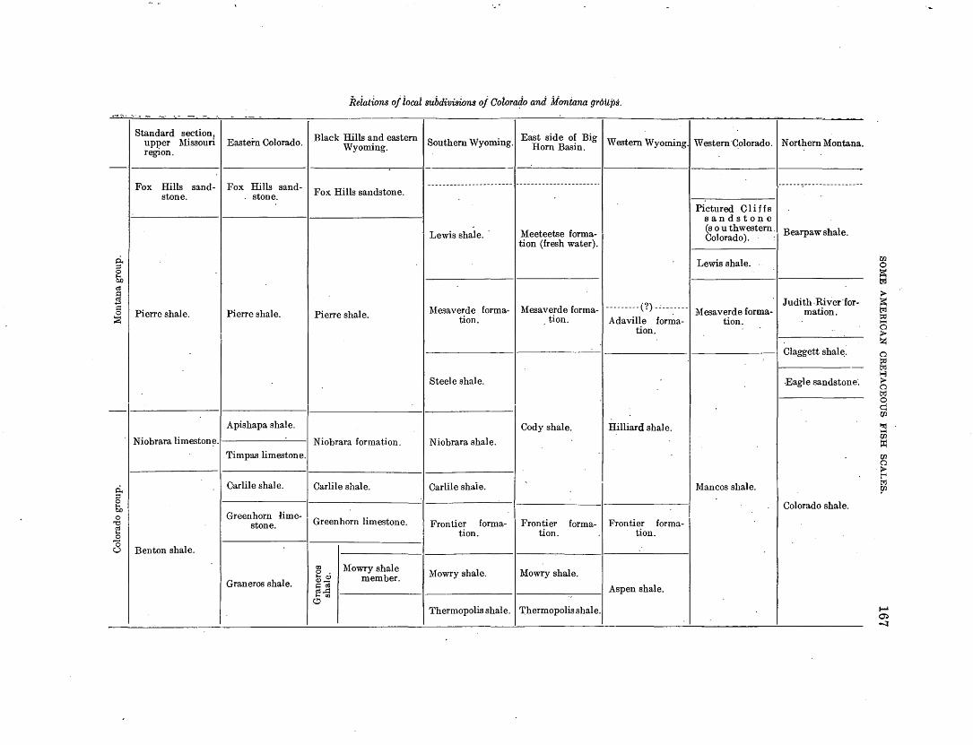
p., g So <:6
fJ "'"" ~ 0
~
ci. ;:::l 0
So 0 '\j
<:6 s 0 0
Standard section, upper :Missouri region.
Fox Hills sandstone.
Pierre shale.
Eastern Colorado.
Fox Hills sandstone.
Pierre shale.
Apishapa shale.
Niobrara limeston~.l 1
Benton shale.
Timpas limestone.
Carlile shale.
Greenhorn limestone.
Graneros shale.
Relations oj iocai suhdi'll'isions oj Coioraljo and Montana groups.
Black Hills a_nd eastern I Southern Wyoming.! East side 0~ Big 1 Western Wyoming.! Western·Colorado. I Northern Montana. Wyommg. Horn Basm.
Fox Hills sandstone.
Pierre shale.
Niobrara formation.
Carlile shale.
Greenhorn limestone.
IZl 0 . '"' Q} Q}-~ <:6 c6,.l:l '"'lll
C!i
Mowry shale member.
Lewis shale.
Mesaverde formation.
Steele shale.
Niobrara shale.
Carlile shaie.
Frontier formation.
Mowry shale.
Meeteetse formation (fresh water).
Pictured Cliffs sandsto~e
(southwestern ·I Bearpaw shale. Colorado). ·'
Lewis shale.
.
1
I Judith .River·for-Mesaverde forma-~---------t ?) _c ___ . ____ Mesaverde forma- mation.
tion. Adaville forma- tion.
Cody shale.
Frontier tion.
forma-
Mowry shale.
tion.
Hilliard shale.
Frontier formation.
Aspen shale.
Claggett shal~:
-Eagle sandstone·.
Mancos shale.
Colorado shale.
Thermopolis shale. I 'l'hermopolis shale.
r:n 0 ~ trJ
> ~ trJ !::0 ..... 0 > z 0
~ 1-3 > 0 trJ 0 q '(fl
l'%j ..... '(fl
tJ:1 '(fl 0 > t-' t:<:l ?2
1-' ~ -::J
·-

168 SHOR~R CONTRIBUTIONS TO GENERAL GEOLOGY, 1918.
INTRODUCTION.
In offering a treatment of Cretaceous fishes, based principally on isolated or detached scales, one runs counter to the practice and prejudice of ichthyologists. The old scale classification of ·~assiz has long been discarded and his terms are now used only in a descriptive sense. Even in that sense they are rather unsatisfactory, for there are many entirely different types· of cycloid, ctenoid, and ganoid scales. Recent studies of the scales of living fishes show that they present excellent diagnostic characters and are highly distinctive of genera .and families, though not
. always of s·pecies. Very closely allied species may have scales which can not be distinguished, the scale characters being more persistent than some of the other more adaptive features on which the species are separated. Some scales, as might be expected, exhibit convergent or parallel evolution, showing similar features in quite different groups of fishes. Facts of this sort are likely to be misleading, but they are in no sense peculiar to lepidology.
In former years a few authors have undertaken to diagnose or recognize Cretaceous fishes from the scales alone. Dr. A. S. Woodward, influenced no doubt by the evident confusion in the application of the names, has set aside these determinations as practically valueless. It was not possible to give a really intelligible account of the fossil teleost scales until those of living fishes had been rather fully investigated. To-day the situation is different, and we feel justified in proceeding on a new basis. The situation is not unlike that found in paleobotany. Students of living plants do not describe species from leaves alone except in the rarest instances. Yet, if paleobotanists had refused to take note of or describe all plant remains that did not include the reproductive parts, our knowledge of the past history of vegetation would to-day be fragmentary indeed. It is true that many of the generic references of fossil leaves are provisional and uncertain, and it is very easy to criticize any paleobotanic work on this basis; yet no careful student of the subject can deny_ that on the whole the study of fossil leaves has been of immense value for the advancement of botanic science as well as for stratigraphy. Mter spending much time in the study of fossil plants as well as fish scales, I can -affirm that
the scales are certainly not less characteristic than the leaves; in fact, the comparison. is decidedly in favor of the scales. It can a~.~o be said that the scales are at least as distinctive as the fragments of jaws, teeth, and fins that for~ the basis of so many desctriptions of Cretaceous fishes. It is not, however, a question of scales versus bones, where both are available. Throughout the greater part of the American Cretaceous strata. distinctive skeletal remains of fishes are extremely scarce; only in the Niobrara can they be said to be at all abundant. On the other hand, scales are plentiful and widespread and may be found in innumerable places where no other fossils are obtainable . Consequently, to refrain f:r:om studying these scales is to set aside a valuable aid to stratigraphy as well as a chance of learning in considerable detail what the teleost fauna of the Cretaceous really was. The Cretaceous ·was a time of extraordinary importance for ichthyology, because it saw the rise and development of the higher fishes, with numerous types clearly pointing toward the modern fauna. For this reason it is especially desirable to note every fact which will throw light upon the Cretaceous history.
The study of fossil scales involves one difficulty. In studying modern fishes the investigator takes the scales from the middle of the side of the fish, where all their characters are fully developed. Scales from other situations may be quite uncharacteristic. Naturally no such selection has taken place in the preservation of the fossils, and consequently the specimens must be regarded with caution and set aside if there is any reason to think that they are not typical. Scales from the region of the caudal peduncle will be comparatively narrow, but their sculpture and markings will be normal. · Latinucleate (regenerated) scales are as common among fossils as in recent fishes, and should not be used as types. They can be distinguished by the confused sculpture 'of the central region, without the fine circuli around the nucleus. . In describing scales the free end. is spoken of as the apex, the attached end as the base. The teleost scale is made up of fine fibrillae, which are in some genera longitudinal, as in Amia and Albula, but more usually concentric. In the trp.e clupeids (herrings) they are transverse. These fibrillae are termed the. circuli and are not grow:th lines. Growth lines

SOME AMERICAN CRETACEOUS FISH SCALES. 169
have often been observed cutting the circuli. In 1nigratory ·fishes, such as the salmon, the growth lines differ in character and density, according to the environment, and consequently it may be possible to detect evidence of migratory habits in fossil fishes. Lines or grooves radiating from the center of the scale or from its direction are called radii. This term was long ago used by Cope .in describing fossil fish scales; and it must be s.aid of Cope that his descriptions of these structures were much better than those of most other authors, though lacking in many desirable details.
As in the case of fossil leaves, descriptions of scales without figures are unsatisfactory, especially if they are to be largely used by stratigraphers who have no intimate lmowledge of lepidology. Consequently it has been· considered necessary to illustrate this paper fully; and the enlarged figures, from photographs, bear testimony alike to the excellent preservation of much of the material and the skill of the photographer, Mr. W. 0. I-Iazard, of the United States Geological Survey. Only those species have been described and figured which it seemed could be clearly recognized. Various others, evidently distinct but represented by poor or uncharacteristic material, have been set aside for the present. Additional collections, now that attention is called to the subject, will undoubtedly greatly increase the number of lmown species.
I am particularly indebted to Mr. T. W. Stanton, of the Survey, for assistance of every kind throughout this investigation. Without his kind help I should have found it very difficult to proceed. I am also greatly indebted to my colleague, Prof. J. Henderson, of the University of Colorado Museum, for advice and assistance. Dr. D. S. Jordan has given me much kind advice, though, of course, he is in no way responsible for my manner of treating the subject. I-Ie has furnished a manuscript list of all the families and higher groups ·Of fishes, representing his most mature opinions. This I have mainly followed in the present paper. Dr. A. S. Woodward, of the British MuBeum, has sent me admirable photograph3 ·Of fossil fish scales, two of which I have reproduced (Pl. XXXVII, figs. 1, 2), and when I was in London he kindly gave me access to the collections of the Museum. Unfortunately at that time I did not know that I
should be specially interested in Cretaceous fishes and did not pay particular attention to their scales, except in the case of a few genera. The authorities of the United States National Museum and the ·American Museum of Natural History very kindly allowed me to examine their materials. I am indebted to the University of Kansas for the photographs of Hypsodon (Portheus), reproduced in Plate XXXIII, figures 1 and 2.
As students of fossil scales will need specimens of recent species, it may be worth while to explain a simple manner of preparing them. Remove a few scales from the middle of the side of the fish, avoiding regenerated scales, and place them, while wet, upon a slide. The. skin covering the exposed part should be removed if it is thick. Cover the scales with a .cover glass or, if th~y are large, with another slide. Hold down with one or more of the metal clamps used in microscopic work. Stick a gummed slide label on each side of the cover glass, overlapping, or, if two slides are used, round the ends of the slides. Remove the clamps when the material is dry, and the scales will remain in place.
STRATIGRAPIDC DISTRIBUTION.
GENERAL FEATURES.
In this discussion we are dealing almost entirely with a marine fauna. Scanty remains from the Judith River beds (see Acipenseridae) are of fresh-water origin, but they do not include any t~ieost scales. It is not until we come to the base of the ~ocene, in the Rocky :Mountain region, that we find scales of freshwater bony fishes/ and the species obtained present all the characters of the highly organized modern group Centrarchidae (Micropteridae). The perchlike fishes are not found in American Cretaceous strata, and it. is a question whether they may not have evoh:ed in fresh water and later taken to the sea. At any rate, it must be said that so far as we know at present the Tertiary fishes mark a considerable advance on or at least change from their Cretaceous predecesSOJ'S. It ought to be possible as a rule to distinguish a Cretaceous from a Tertiary deposit by means of a single well-preserved fish scale. The exceptions will be found in those groups
1 A possible exception is U. S. Geological Survey locality 6603, in the Uinta Basin, Vtah, which con~ains plant remains. Two poorly pre· served scales are figured in Plate X~XVI, figures 16 and 17.

170 SHORTER CONTRIBUTIONS TO GENERAL GEOLOGY, 1918.
which range with little change from the·Creta- 1 Europe and America, and in America between ceous to the present day-the berycoids, clu- the faunas of the Atlantic seaboard, the.inland peids, or hemiramphids. In such groups only sea, and the Pacific coast. All these regions the recognition of the species and its identifi- of course h!:td types in common, and these cation with one .from beds of known age could appear to have been, at least principally, be of any service. Such a scale as that of pelagic or ope!l-sea organisms, such as UintaPomolobus? chicoensis, from the Chico, might crinus among. the echinoderms and various belong anywhere from that time to the present sharks among the fishes. There were, howday. So, also, with Flemilampronites hesperius, everf many differences. Scales of fishes from from the Fox Hills. the Chico, cut off from the inland sea by the
Just as the Tertiary fishes mark an advance western uplands, are all different·from those in on the. Mesozoic, so also the later C:r;etaceous Rocky Mountain deposits. The Chico has a fishes present evidence of evolution and mod'- veritable clupeid, but so far no genuine clupeids ernization. ·This statement applies not only to have been found in the Benton, Niobrara, the Upper as contrasted with the Lower Creta:- Pierre, or Fox Hills. The inland waters seem .ceous, but also, and rather markedly, to the to have lacked berycoids, which are ~o charac-· Montana group as contrasted with the Colo- teristic of the Eur.opean strata. Comparisons. rado group. The scanty materials from the between the Old World ·and the· New World Fox Hills and Pierre now available already in- faunas are hindered by th,e difference in age of' dicate the beginnings of modern groups which some of the abundantly fossiliferous deposits. are absent from the older beds, and unq ues- Not only do the highly differentiated faunas of tionably later discoveries will emphasize the Hakel and Sahel-Alma in Syria (Mount. distinctions observed. Thus· we seem to find Lebanon) differ greatly from one another, but. evidence of a rather slow and gradual n1odern- only about 10 per cent of their genera are ization of the fish fauna, the breaks in the series common to the American Cretaceous. They corresponding with the geologic breaks and not must be referred to a later horizon than our· being attributable to any extraordinary migra- Cretaceous fishes. · The Cretaceous of Westtions or sudden new developments. phalia has more in common with the Syrian.
There were, however, certain environmental deposits than with the English chalk and conditions which must have affected the rate of should be intermediate in age between these. evolution. and diversification. The inland seas two. Nearly half the· genera of the English. of the American Paleozoic were drained by the chalk are represented in the Kansas Niobrara,. Permian uplift, but during later Mesozoic time though perhaps the chalk is for the most part. this country once more possessed a vast med- somewhat older. I have prepared more elab-iterranean sea, comparatively. shallow and orate statistics, but owing to the uncertain warn1, which reached its maximum depth prob- standing o'f a good ·many of the species they· ably during the Niobrara epoch. A modern are not as valuable as they look on· paper. map of North America marked in some way to The tendency of future investigations ·will. indicate the shallow-water areas, even down to doubtless be to emphasize the differences in 100 fathoms,. will show how restricted is the the faunas, especially as studies of scales are. ~istribution of the present littoral and shallow- likely to reveal many of the smaller and more. water faunas. They exist, as it were, in broad sedentary fishes. -rivers running mainly north ap.d south. They Prof. J. Henderson, who has paid much at-.. are circumscribed by climate, by land, and by tention to the Upper Cretaceous Mollusca, the open sea. In comparison the great. Creta- informs me that in his experience all the species. ceous inland sea must have afforded an amazing of the Benton differ from those of the Niobrara, wealth of opportunity for multiplication and and all those of the Niobrara from those of the. development, which may w~ll have been the Pierre. The Pierre and Fox Hills, on the other decisive factor in the evolution of many gr~nips hand, present faunas grading one into the. of 1narine organisms. other. As this did not wholly agree with some.
In .this connection it is interesting, to inq':lire of the published records, I asked Mr. T. W. whether there were radical differences between j Stanton for his opinion. He replies that he is. the supposedly qontemporaneou~ faunas of in perfect accord· with Prof. Henderson. The,

SOME AMERICAN CR:ETACEOUS FISH SCALES. 171
Colorado and Montana faunas had few if any identical species of Mollusca, though of course n1any genera occurred in both. Old records contrary to these opinions ·were based on errors. Thus Inoceramus labiatus, supposed to occur in the Niobrara of Kansas and Nebraska, was Teally from the Greenhorn limestone, well down in the Benton. We have, then, in the Upper Cretaceous two extremely marked faunal breaks. They must represent long periods, during which many things happened,. Where no species of Mollusca persisted, surely no fishes could be expected to remain unaltered. Present information tends to confirm this opinion, and when a Benton fauna is found in beds ascribed to the Niobrara (see under Ilolcolepis pulchellus, p. 174) it is evident that there was an error in stratigraphy.
BENTON SHALE.
The previously recorded teleosts from the Benton are few, as follows: Apsopelix. A genus not known from later rocks. Mr.
Stanton informs me that Cope's locality (in Kansas) is certainly Benton. ·
Pelecorapis varius Cope. Mr. Stanton says almost certu.in~y from the Benton; the Inoceramus referred to by Cope is presumably I. labiatus. Mr. Stanton adds, however, that if the Sibley referred to is the one now on the map there is some mistake, as this would place the locality in the Carboniferous.
Protosphyraena bentoniana Stewart. H.'IJPBOdon lowii (Stewart). This and the last belong to ·
genera common to the Niobrara and Pierre.
There itl also a very dubious record of Anogmius. To these are added in the present paper the following species:
Holcolepis pulchellus 1 n. sp. Holcolepis delicatus n. sp. Holcolepis transversus n. sp. Holcolepis obliquus n. sp. Hypsodon? granulosus n. sp. Ichthyoclectes sp. Leucichthyops vagans n. sp. Erythrinolepis mowriensis n. sp. Halecodon clenticulatus n. sp. Cimolichthys sp.
It is not at present certain that levelc:; in the Ben ton can be distinguished by n1eans of the fishes. Materials ascribed to the Aspen (for exmnple, U. S. G. S. localities 4874, 3870) present a Mowry fauna, as they should, for the Aspen and Mowry are approximately equivalent.
t Tho rocks yielding this species wero referred to tho Niobrara by Bookly (U.S. Geol. Survey Bull. 596, pp. 40, 41, 1915), but the locality is in a faulted area· and may well boon a Benton outcrop.
NIOBRARA FORMATION.
The recorded fish fauna· of the Niobrara is very rich, comprising 23 genera, mostly f~und in Kansas. Several of these are discussed below, but I have no new species to add.
MONTANA GROUP.
The Montana· group includes the Pierre shale and .Fox I-Iills sandstone. The fishes are not sufficiently well known to throw any particular light on the divisions of the group. The following new forms, the last three of which are from the .Fox I-Iills sandstone, are described in this paper:
Petalolepis? fibrillatus n. sp. Cycloides? incertus n. sp. Hypsoclon? radiatulus n. sp. Echidnocephalus? americanus n. sp. Helmintholepis yermiculatus n. sp. Cyclolepis stenoclinus n. sp.
. Hemilampronites hesperius n. sp.
According to previous records about half a dozen Niobrara genera (Ilyposodon, Syllaemus, Protosphyraena, Ichthyodectes, Empo or Oimolichthys, and perhaps Pa.chyrhizodus) survived to the Pierre; but not one of these is recorded from the Fox 1-Iills. This means little, perhaps, as hardly anything has been known of the Fox I-Iills fishes.
CHICO GROUP.
The following species from the Moreno formation of th~ Chico group of California are described below:
Chicolepis punctatus n. sp. Pomolobus? chicoensis n. sp. Erythrinolepis chicoensis n. sp. Echiclnocephalus? pacificus n. sp.
DESCRIPTION AND SYSTEMATIC DISCUSSION OF SPECIES.
PISCES. ·
Subclass CHONDROSTEI.
Family ACIPENSERIDAE.
Scutes of Acipenser (A. toliapicus Woodward) are known from the London clay (lower Eocene) of the Isle of Sheppey. The plates named A. cretaceus Daimeries, from the Senonian of Belgium, are said by Woodward to belong apparently to some fish related to Dercetis or Eurypholis, and therefore are not chondrostean at all. In the Belly River formation (Upper

172 SHORTER CONTRIBUTIONS TO GENERAL GEOLOGY, 1918.
Cretaceous) of Red Deer River, Alberta, Lambe found a scute which he called Acipenser albertensis. In the same deposit he found part of an elongated snout which bore a series of teeth, much like that of the more ancient Saurorhynchus (Belonorhynchus). This he named Diphyodus longirostris, but he did not attempt to indicate its affinities. It was afterward stated by Hatcher 1 that remains similar to both these fossils were common in the Judith. River and Lance formations in certain localities in Montana and Wyoming. The associated fossils indicated fresh-water conditions, so the absence of such remains from the Upper Cretaceous marine beds ·is not surprising. The question naturally arises whether by any possibility the Acipenser, so called, was in fact a toothed sturgeon, Diphyodus representing the jaw of the · same fish. The Saurorhynchidae seem not to have survived to the Cretaceous (Stenoprotome Hay, from Syria, being a very dubious representative), but it is possible that toothed sturgeons more or less intermediate between the Saurorhynchidae and Acipenseridae existed in that period.
Subclass TELEOSTEI.
Order HALECOMORPHI.
Family PROTOSPHYRAENIDAE.
Protosphyraena Leidy (Erisichthe Cope) IS
abundantly represented in the Niobrara of. Kansas and has one species each in the Benton and Pierre. It is known mainly by the rostra and pectoral fins, a:q.d there is in the descriptions no mention of scales. Hypsocormus, considered to be related .to it, has smooth scales, small and deeply imbricating.
Order ISOSPONDYLI.
Family ALBULIDAE.
I have supposed that the Albulidae (Albula and Dixonina) were the only fishes above the I-Ialecomorphi that had longitudinal basal circuli or fibrillae.2 I find, however, that this peculiarity is shared by Alepocephalus agassizi (Alepocephalidae). Benthosphyraena macroptera, also referred to the Alepocephalidae, has small round scales wholly unlike those of Alepocephalus. The Alepocephalus scales, although having longitudinal ba.sal fibrillae, are in other respects entirely different from those of the
1 U. S. Geol. Survey Bull. 257, p. 69, 1905. 2 U. s. Bur. Fish·eries Bull., vol. 32, p. 122, fig. 2, 1912.
Elopidae, being shaped much like the sole of the foot, the nucleus subapical, with coarse concentric circuli above it, the lower margin broader and thin, neither crenulated not with radii. The albulid scale, on the other hand, is subquadrate, with broad crenate lower margin and a few distinct basal radii. The albulid fibrillae are tuberculate, as in the Dipneusti; this ia not true of Alepocephalus.
In view of their primitive characters, the Albulidae must have existed in the Cretaceous. The recorded species which have been assigned to this family, however, do not appear to belong there. Prochanos is to be referred to Chanidae. lstieus goes in Pterothrissidae. Ancylostylos from Croatia may be referred to a distinct family, of which it is the typical genus. Anogmius Cope (Syntegmodus Loomis), from the Niobrara of Kansas, may go in Pterothrissidae, but not in Albulidae or Osteoglossidae, to which it has been referred. Plethod1.ts forms n family, Plethodontidae, to which Hay also refers Anogmius. Apsopelix, to judge from Cope's description of the scales, seema to have some resemblance to the Albulidae, where it is provisionally placed by Hay. Cope states that the circuli are vertical, except in the region of the nucleus. The position of this genus must for the present remain undecided. Finally, Petalolepis divaricat1.ts (Geinitz), based on a scale from tb e Turonian of Saxony, appears to be a genuine albulid. An American scale. IS
provi.~ionally referred to the same genu3.
Genus PETALOLEPIS Steinla.
Petalolepis? fibrillatus Cockerell, n. sp.
Plate XXXI, figure 1.
Scale 8.5 millimeters in diameter, subquadrate, but with obtusely rounded angles, a very little longer than broad; lines of growth evident, concentric, but the very fine fibrillae strictly longitudinal from one end to the other, except that toward the basal margin they curve inward, becoming more or leBs transverse, following the wavy outline of the· margin; the fibrillae are not tu berculate or beaded, as they are in Albnla; as in Petalolepis· divaricatus, on each side of the middle line in the basal region the fibrillae become curved and end by meeting each other at a very acute angle; there is a strong median plica on the basal half of the scale, but no ordinary radii, an~ this agrees with P. divaricatus.

SOME AMERICAN CRETACEOUS FISH SCALES. 173
U. S. G. S. locality 5094. Cretaceoud, Mesa Verde formation, 14 miles north of Rock Springs, Wyo., a little east of center of sec. 26, T. 21 N., R. 104 W. (Collected by V. H. Barnett.)
A similar but much larger scale may represent a related species, but the surface as preserved presents a very fme irregular reticulation, with concentric lines of growth, and it can not be determined whether the fibrillae are longitudinal. So far as the visible characters go, this agrees with Winkler's problematic. Oycloicles, and it ma~v provisionally stand as described below.
Cycloides? incertus Cockerell, n. sp.
Plate XXXI, figure 2.
Scale 16 millimeters in diameter (G. incisus Winlder is 17.5 millimeters in diameter), subquadrate; apical margin broadly rounded, apparently a little crimped; laterobasal angles obtuse but distinct; a very strong median plica on the basal three-fourths, the growth lines turned upward on approaching it, as in Winlder's figure.
U. S. G. S. locality 5177. Cretaceous, Mesaverde :formation, about 5 miles southwest of Sycamore, Wyo., in the NE. i sec. 12, T. 19 N., R. 103 W., ill the Rock Springs region. (Collected by V. H. Barnett.)
In the general form and median plica this scale is suggestive of that of Mugil curema. The same sort of plica and basal margin may be seen in scales of the cyprinid Girrhina jullieni. There is also a conspicuous median basal plica in Ghanos, but it is broad and shallow, not forming a line.
Family LEPTOLEPIDAE.
A family found in the Cretaceous of Europe, surviving from the older Mesozoic. ''Scales thin, cycloidal, and deeply imbricating, usually ganoid in their exposed portion; lateral line not observable." (A. S. Woodward.)
Fami~y ELOPIDAE.
Genus HOLCOLEPIS Von der Marek.
This genus was called Rhabdolepis by Von der Marek in 1863, but Troschel had earlier (1857) used that name for a palaeoniscid fish. Ilolcole1Jis was proposed in 1868. Agassiz, who hnd proposed the name Osmeroides for nn entirely different fish, unfortunately trans-
282880--19----12
ferred it in 1844 to a species of Holcolepis; and in this he has been followed by several authors. The genus Holcolepis is certainly to be referred to the Elopidae, even after the removal of such genera as Pachyrhizodus, which A. S. Woodward places in. that family. The teeth are minute, entirely different from those of Pachyrhizodus. The dorsal fin is less modified than in modern Elopidae. Holcolepis has not hitherto been reported from the North American Cretaceous, our nearest form being Spaniodon simus Cope, a form with smooth scales.
A. S. Woodward 1 described the scales of Holcolepis as "often ornamented in their exposed portion with delicate radiating lines of minute tubercles, marked in their covered portion with a few radiating grooves terminating in notches at the anterior truncated margin; hinder margin riot serrated; course of lateral line indicated by a feeble ridge and a notch in the hinder border of most of the scales" -that is to say, the scales have basal radii; but in a later publication 2 Woodward shows a scale of Osmeroides lewesiensis ( = Holcolepis lewesiensis) without any such radii.
Osmeroides divaricatus Geinitz, 1868, is based on the scales of an albulid fish, and takng up the name Petalolepis Steinla, published by Geinitz as a synonym, the species becomes P etalolepis divaricatus.
Osmeroides Zewesiensis (Mantell) as determined by Geinitz from the Turonian of Saxony consists of a mixture of different things, none of them identical with the English fish. One, the most recognizable, is similar to the living genus Pterothrissus in the character of its scales. This form 3 unfortunately takes the cumbersome name Kymatopetalolepis of Steinla and may stand as K. geinitzi n. sp. It has four to six fanlike basal radii, the circuli between them broken into dots. The nucleus is subapical, and the apical region hyaline.
Osmeroides divaricatus Geinitz as figured by Fritsch 4 is wholly unlike the Geinitz species, having transverse basal circuli. There are three basal radii, and the basal margin is scalloped.
1 Catalogue of fossil fishes in the British Museum, pt. 4, p. 11, 1901. 2 The fossil fishes of the English chalk, pl. 23, fig. 8, 1907. a Geinitz, H. B., Die Fossilen Fischschuppen aus dem Plii.nerkalke in
Strehlen: Gesell. Natur-u. Heilkunde Dresden Donkschr., 1868, pl. 2, figs. 1o-12.
• Fritsch, Anton, Die Reptilian und_Fischo der bOhmischen Kreideformation, fig. 58, 1878.

174 SHORTER CONTRIBUTIONS TO GENERAL GEOLOGY, 1918.
0. lewesiensis (Mantell) of Fritsch is also wrongly named. It is a scale with subapical nucleus and five strong basal radii, the basal margin very strongly scalloped. The scale has a strong resemblance to that of Megalops cyprinoides, and rna y therefore represent a fossil elopid of some unkll.own genus.
Osmeroides belgicus Winkler, 1874, is based on a scale apparently congeneric with the socalled lewesiensis of Fritsch but considerably broader and with more basal radii. It is a large soale~ the transverse diameter being 15 millimeters.
The type of Holcolepis, H. cretaceus Von der Marek, is imperfectly known, and it is possible that the various speCies supposed to be congeneric could be divided into two genera with better materials. For the present I assume that the scale of H. lewesiensis, well figured by Woodward, is typical of the genus. Its most characteristic feature is the pseudoctenoid e;x:posed area, ornamented with radiating lines of pustuliform markings, derived from the circuli. H. latifrons (Woodward), from the chalk of Kent; is similarly orn~mented, but the lines are more broken up, producing, except near the margin, a pitted or malleate effect. The lateral line is very distinct. In H. levis (Woodward), from the chalk of Kent and Sussex, the scales possess "fine radiating ornament" and have distinct basal radii. They are therefore similar to those of the modern Elops, and the fish may not be congeneric with the others.
The modern Elopidae (Elops, Tarpon, Megalops) have very distinct basal radii, 3 in Tarpon, about 5 to 7 in Megalops, and 12 to 18 in Elops. The basal margin is very strongly crenate in Megalops, ·moderately in Tarpon, but feebly in Elops. In Tarpon the apical field- has a radiating sculpture of minute tubercule-like elements, not clearly visible on casual inspection. This is the I-Iolcolepis sculpture, but very much finer and less conspicuous. In Megalops the region above the nucleus shows granulations but not distinct radial line_s; there is some approach to the condition of Holcolepis latifrons. _ Elops, above the nucleus, shows coarse transverse wrinkled lines, but the broad apical field is free from markings derived fro~ - the circuli and presents a num her of parallel radii. Appa~ently, then·, the early elopids (Holcolepis) had the exposed part of
'the scale prominently sculptured with lines or rows of tubercles derived from the circuli, while the covered part was either withollt evident sculpture, except the fine circuli, or had a few distinct radii. The development has been toward the loss of the apical sculpture and the strengthening and increase in number of the basal radii. It see1ns that these changes were in process or even perfected as early as the Cretaceous, but typical Holcolepis, ·as here understood, included the more· primi-tive type. Pachyrhizodus, to judge from the figure of a scale of P. subulidens (Owen)· published by Woodward (reproduced in Pl. XXXII, fig·. 3), had scales of the 1-Iolcolepis type, with strong or coarse sculpture on the exposed portion, and the base rounded and without radii. The scale was parallel-sided, and longer than. broad, the reverse being true of typical Holcolepis. Thus, though we may well place Pachyrhizodus in a distinct family, it may have had a common ancestor with the elopids, possessing the Holcolepis-like scale.
In the American Cretaceous fauna the species described below; based on scales, are referred to Holcolepis, as· understood in a rather broad sense. Outside of the Elopidae the scales show a certain general resemblance to those of· Aulopus (Aulopidae), but in that genus the margin is strongly dentate.
I
Holcolepis pulchellus Cockerell, n. sp.
~iate XXXI, figures 3, 4.
Scale 7 millimeters in diameter, approximately circular, the apical margin obtusely angulate in the middle; nucleus only a little above the middle; lower margin not at all crenate; six or seven basal radii very feebly indicated, not distinctly developed, not definitely eut.ting the circuli; apical field with very numerous parallel raised lines, but toward the nucleus with ·wavy lines as in E'lops.
One mile south of the _Boetcher ranch, in the NE. i SW. t sec. 32, T. 10 N., R. 81 W., North Park, Colo. (Collected by A. L. Beekly and IIa.rvey Ba.ssler.) This is Beekly's locality 37.1
It is referred to the Niobra.ra, but the seales from this ·a.nd several other localities referred by Beekly to the Niobrara resemble those from. the Mowry and · are therefore believed to have come from the Benton shale. All the localities
1 Beekly, A. L., U. S. Geol. Survey Bull. 596, p. 42, 1915.

SOME AMERICAN CRETACEOUS FISH SCALES. 175
thus under suspicion failed to yield any characteristic Niobrara l\1ollusca, and the collection from Beeldy's locality 50, which did include Ostrea congesta Conrad, offered no such scales, ·hut only one of lchthyodectes, the so-called '' Oladocyclus.'' c
H. pulchellus was also found on the northwest shore of Lake Jolm, in theSE. i SW. i sec. 34, T. 10 N., R. 81 W., North Park, Colo., by Beekly and Bassler. This is Beekly·'s locality 35.
Holcolepis delicatus Cockerell, n. sp.
U.S. G. S.locality6713. Cretaceous, Mowry shale, southeast of camp at old ehimney, Sisters .Hill, Buffalo, Wyo. (Collected by 0. B. Hopkins.) Seale 9 millim.eters long and 11 millim.eters wide; another scale 7 millimeters wide.
The two following specimens are about ns broad as long and probably came from the vjcinity of the caudal peduncle.
U.S. G. S. locality 4421. Mowry shale, Casper region, sec. 29, T. 33 N., R. 74 W. sixth principal meridian, Wyoming. (Collected by E. W. Shaw.) Scale 12.5 millimeters in diameter.
U. S. G. S. locality 3417. Lower (Benton) Plate XXXI, figure 5. · part of Mancos . shale, Steamboat Springs,
Seale 10 millimeters in diameter, subcircular; Routt County, Colo., on ridge near mineral simila.r to H. pulchellus, but apical margin springs, just west of town and south of Yampa rounded, nucleus a little below the middle; River. (OollecteJ. July 13, 1905, by T. W. lines of exposed area fi~er and denser, with more Stftnton and H. s~ Gale.) or less evident pits between; only vague indis- Flolcole1Jis transversu8 is closely related to H. tinct suggestions of basal radii. steinlai'(Geinitz), published by Geinitz as Aero-
Big I-Iorn Basin, in the SE. l SE. l sec. 15, · grammatolepis steinlai, the figw·e upside down. T. 43 N., R. 94 W., Wyoming. Near base of The H. steinlai scaleis 7 by 6 n1illimeters and Mowry shale. (Collected by C. T. Lupton.) has the nucleus apparently more basally placed
H. c k 11 than in H. transvers·us. It is from the Turonian olcolepis transversus oc ere , n. sp. of Saxony and may very likely be identical
Plate XXXI, figures 6- 13· with the English H. lewesiensi$ (Mantell), from Scales subquad.rttte, on sides nearly twice as beds of about the same age.
broad. ns long, on other parts often narrow, varying to about as broad as long; laterobasal angles commonly rather prominent; apical margin broad, flattened or depre~:;sed in middle, not angular; no basal radii, but often a single n1edia.n fold, rather indistinct; apieal modified patch V-shaped, ornn,mented with a series of closely set interrupted ridges, without pits between; circuli :fine: the lateral ones directed upWtLrd, 1neeting t.he margin at a Yery acute angle; nudeus approximately central.
Type a scale 9 millimeters in diameter, from U. S. G. S. locality 6682, ShLte Creek, l\1ount Leidy qu~tdrangle, Wyo. (Collected by Eliot Blach\velder.) Mollusks of this locality are Sftid to he not charaeteristic and may belong either in the Montana group OJ;' the upper part of the Colorado group, but the fish scales indicate Colorado (Benton) age. Other seales in the sa·me lot, referred to this species, are 11 millin1eters and 14 millimeters in diameter.
I also refer to this species the following: 1J. S. G. S. locality 6681. Cretaceous, prob
ably Aspen, Slate Creek, Mount Leidy quadrangle, Wyo. (Collected by Eliot Blackwelder.) Scale 10.5 millimeters 'in diameter.
. . ~ . Holcolepis obliquus Cockerell, n. sp.
Plate XXXII, figure 1.
Scales 10 millimeters in diameter, much broader than long, without any trace of basal radii. Similar in most respects to H. transversus, but remarkable for the brevity of the elements in the apical patch and for the lateral circuli being oblique, at the middle of the side reaching the margin at an angle of about 45°, and above this becoming alrriost transverse. . Type collected with H. transversus, in Mowry shale at U. S. G. S. locality 4421. Details. are given above.
Holcolepis? mandible.
Plate XXXII, figure 2.
In confirmation of th~ existence of a typically elopid type of fishes in· the North 'American Cretaceous, I give a figure of a mandibular ramus which seems to belong to Holcolepis or a closely related genus. It differs from that of H. lewesiensis in the straight (not. concave) descending upper margin of the dentary, and in this respect more resembles the modern Elops.

176 SHORTER CONT'RIBUTIONS TO GENERAL GEOLOGY, 1918.
It was collected by A. C. Veatch in the NW. l SW. l sec. 8, T. 19 N., R. 79 W., Carbon County, Wyo., and is ascribed to the Colorado .group. From the associated scales, which include an imperfect specimen of HolcoZepis, either pulchellus or a closely related species, I infer that the material is from the Benton. The mandible and the IIolcolepis scale probably belong to the same species.
Genus RHACO:tEPIS Agassiz.
Dr. D. S. Jordan has kindly sent me material of Rhacolepis buccalis Agassiz, from the Cretaceous of Ceara, Brazil. The scales are broad, with coarse, rather widely spaced circuli, transverse above and below the nucleus, and many of them broken or anastomosing above the nucleus. The apical margin is delicately plicate, with a series of parallel ridges, very much as in Otenothrissa. This marking probably corresponds with the system of apical radii of Elops and h~s nothing to do with the pseudoctenoid sculpture, derived from the circuli, of IIolcolepis. Rhacolepis is therefore entirely distinct from Holcolepis, and the scales can not be confused. It is just possible that the Pachyrhizodus scale, which seems from Woodward's figure (reproduced in Pl. XXXII, :fig. 3) to be of the same general type as that of Holcolepis, is really constructed in the manner of Rhacolepis, but with the shape entirely different and the apical plicae much longer.
Genus NOTELOPS Woodward.
In the Brazilian Cretaceous Notelops brama (Agassiz), also received from Dr. Jordan, the circuli are :finer and denser than in Rhacolepis. I can not make out any ''delicate radiating ridges," mentioned by Woodward, but the material is not very good. Jordan and Branner 1 state that the scales are cycloid and entire. They are, in any event, wholly distinct from those of Rhacolepis.
Genus HELMINTHOLEPIS Cockerell, n. gen.
Scale· cycloid, circular, or slightly longer than wide, about 17 millimeters across in the type; nucleus a little below the middle; circuli :fine, concentric on basal half but longitudinal and very wavy, like minute worms, on apical half; the apical marginal area delicately· longitudinally striate, with about :five
1 Smithsonian Misc. Coil., vol. 52, p. 9, 1908.
circuli between each pair of strire or fine radii. This may not be elopid, but I do not know where better to refer it. The striate margin is like that of Hypsodon, but there are no tubercles, and the microscopic structure is very different. There "are no radii in the basal field, and the lower margin is broadly rounded. Type H. vermiculatus.
Helrnintholepis verrniculatus Cockerell, n. sp.
Plate XXXII, figure 4.
Diameter about 17 millimeters. U. S. G. S. locality 9184, Cretaceous, Fox
Hills sandstone, north side of Thompson River, near top of ridge about 11 miles northeast of Milliken, sec. 1, T. 4 N., R. 67 W., Greeley quadrangle, Colo. (Collected by T. E. Williard.) The type scale partly overlaps a scale of Hemilampronites hesperius.
Family PTEROTHRISSIDAE.
The interesting fan1ily Pterothrissidae is represented to-day by Pterothrissus Hilgendorf (Bathythrissa Guenther) from deep water off Japan. It is related to the albulids, but the scales have the circuli of the median and basal regions (a large inverted V -shaped area) broken up into dots and fine rugae. In the Cretaceous rocks of Westphalia and Syria the family is represented by the genus Istieus, the scales of which are said to be elliptical, not pectinated (A. S. Woodward). Anogmius, from the Niobrara of Kansas, seems to be more or less related. Kymatopetalolepis geinitzi Cockerell, based on scales from the Turonian of Saxony, appears to be· typically pterothrissid. Ohicolepis, a new genus from the Chico, may also be referred to this family.
Genus CHICOLEPIS Cockerell, n. gen.
Scales broad, subquadrate, shaped as in Pterothrissus, with very broadly rounded apical margin; nucleus apical, very near the margin; sides with dense simple longitudinal circuli, passing vertically up to the apical margin; the whole area inclosed by lines drawn from the middle of the apex to the laterobasal corners is covered with minute punctiform dots, the circuli having combined to form an extremely dense honeycomb-like reticulation, the punctures round and often running more or less in transverse series. In the region of the

SOl\fE AMERICAN CRETACEOUS FISH SCALES. 177'
lateral circuli are· here and there streaks of ·punctured surface. · No ordinary radii, but a median line or plica from base ·to apex, most conspicuous on basal half. This superficially resembles Petalolepis? jibrillatus, but its structure is very different. Type, f!~ punctatus.
Chicolepis punctatus Cockerell, n. sp.
Plate XXXIV, figure 1.
Scale 16 millimeters in dimneter; laterobasal c~_rners rectangular.
U. S. G. S. locality 7030. Cretaceous, Chico group, south side of Ortigalito Creek, Cal., in· Moreno formation. (Collected by Robert Anderson . .) For. further description of locality see Pomolobus chicoensis. The absence of the ordinary radii at once distinguishes this species from Pterothrissus and l{ymatopetalolepis.
Family ICHTHYODECTIDAE.
The fishes assigned to the Ichthyodectidae cannot be referred to Chirocentridae; the scales are radically and entirely different from those of the living Ohirocentrus, and·· the teeth are implanted in deep sockets. Stewart also seems fully justified 1n separating the Saurodontidae, especially on account of the remarkable unpaired predentary.
Genus HYPSODON Agassiz.
The type of Hypsodon is H. lewesiensis, but unfortunately Agassiz included under this name fishes that were not even congeneric. Cope, commenting on this fact, remarked that Hypsodon included some fishes with teeth of equal length and others in which they were unequal. He proposed to re3trict the name to the genus having equal teeth, and according to this decision Ilypsodon would take the place of the genus later named Pachyrhizodus by Dixon. I-Iowever, the specific name lewesiensis was adopted from Mantell, who had described the fish with unequal teeth as Megaloclon? lewesiensis. It is this fish which Agassiz figured in" Recherches sur les poissons fossiles," volun1e 5, Plate XXVa, figure 3, and Plate L~Vb,· figures 1-3. This appears to ·fix the type in a contrary sense to Cope's decision, and Hypsodon takes the place of Portheus Cope. Stewart suppressed Portheus in favor of ~Y iphactinus Leidy, which was based on a pectoral fin spine of the same species as Cope's type of Portheus. Ilypsodon is much older, and
the giant fish of the Niobrara rocks will take the name Hypsodon audax (Leidy). Portheus mantelli Newton, from· the English chalk, ·becomes Hypsodon lew~sirmsis· (Mantell}. In America the' genus is well' represented in the Niobrara and has one species, Hypsodon lowii (Portheus lowii Stewart), in the Benton.,· ... ,·
The University of Kansas has rematMt1:>1y well preserved material of I-l. audax/ c· i~:hd through the kindness of Prof. S: J. Huntet I have received photographs of. the scales, ·which are reproduced here.
HypsoJlon audax (Leidy) Cockerell.
Plate XX~II, figure 8; Plate XXXIII, figures ~, 2.
Xiphactinus audax Leidy, Acad. Nat. Sci. Philadelphia Proc., p. 12, 1870; U. S. Geol. Survey Terr. Rept., vol. 1, pp. 290, 348, pl. 17, figs. 9, 10, 1873. .
Cope, U. S. Geol. Survey Terr. Rept., vol: 2, p. 276, 1875.
Hay, Zool. Bull., vol. 2, p. 27, 1898. Stewart, Kansas Univ. Quart., vol. 7, p: 115, 1898;
idem; vol. 8, p. 107, 1899; Kansas Univ. Geol. Survey, vol. 6, p. 267, pis. 33-47, 1900.
Saurocephalus audax (Leidy) Cope, Am. Philos. S~c. Proc.,. vol: 11, p. 553, 1870; U.S. Geol. Survey Terr. Ann. Rept. for 1870, p. 418, 1871.
Portheus? audax (Leidy) Hay, U. S. Geol. Survey Bull. 179, p. 384, 1902. '
Scales extremely broad, the width about twice the length, though on the caudal peduncle they are undoubtedly much narrower. Exposed area densely covered with small tubercles, which in the apical region are arranged in longitudinal series, being in fact situated on longitudinal ridges. The basal region has fine concentric lines of growth, and numerous more or less broken radii, spread out in broad fan shape. The Oladocyclus occidentalis of Leidy, which has page priority over X iphactinus audax, is based on just such scales, but whether of the species H. audax it is not at pr~sent possible to decide. Loomis thought the 0. occidentalis scales belonged to Ichthyodectes (or Gillicus) arcuatus Cope, and wrote lchthyo-· dectes occidentalis (Leidy) for that species .. This assignment certainly can not be maintained. It appears that the type locality of 0. occidentalis is uncertain: On one page Leidy says that the material came from Nebraska; on another he says that it came· from Sage. Creek, Dakota. Leidy suggested that the, scales before him probably belonged to several species.
178 SHORTER CONT'RIBUTIONS TO GENERAL GEOLOGY, 1918.
The name Oladocyclus Agassiz was based on Typical H~ audax scales, about 50 milli-scales from Brazil (0. gardneri Aga~siz), which· meters across, have been found in the Mancos· do not appear to be identical with. any of the shale 1! ~iles northeast of Columbine, Routt North American or European genera, thoi.1gh County, Colo. (Collected by Colorado Geo:. there is close similarity in the branching lateral logical Survey.) line canals. I have material of the Brazilian fish, kindly sent by Dr. D. S. Jordan. Woodward, in his ''Fossil fishes of the English chalk," abandons the use of Oladocyclus for European fishes, remarking that Agassiz referred to this genus scales of the 1chthyodectes type, calling them all Oladocyclus leivesiensis. The scales which Geinitz called Oladocyclus strehlensis were in the main of this same type.
The question · which now arises is whether scales of Hypsodon can be clearly distinguished from those of 1chthyodectes. Woodward figures 1chthyodectes scales, and they differ from those. of Hypsodon only in the strictly. entire basal radii. In 1chthyodectes, as I understand it, the bas~l part of the scale frequently splits along the radii, producing the appearance of a fr.ayed edge of ~epar~ted narrow bands. The
Hypsodon lowii (Stewart) Cockerell.
Plate XXXIy, figure 2.
Portheus lowii Stewart, Kansas Univ. Quart., vol. 7, p. 24, pl. 2, fig. 2, 1898.
Hay, U. S. Geol. Survey Bull. 179, p. 384, 1902. Xiphactinus lowii (Stewart) Hay, Zool. Bull., vol. 2, p.
27, 1898. . Stewart, Kansas UD.iv. Geol_. Survey, vol. 6, p. 293,
pl. 48, fig. 2, 1900.
U. S. G. S. ·locality 7294. Cretaceous, Benton, sec. 20, T. 9 N., R. 77 W., half a mile northwest of Kerr's ranch, North Park, Colo. (Collected by A. L. Beekly and Harvey Bassler.) A large scale, 32 millimeters across, provisionally referred to H. lowii, as it is exactly the sort of scale that species might be expected to have. ·
lateral line canal is branched, more or less Hypsodon? radiatulus Cockerell, n. sp.
Y -like, or rarely in the complex manner of the Plate ~XXII, figures 6, 7. Brazilian Oladocyclus. A photograph of "Oladocyclus lewesiensis,"· received from Dr. Scale 15 millimeters across, with apical A. s. Woodward, shows the fraying-out effect ridges but apparently without the tubercles of very well and should represent 1chthyodectes. H. audax. Another scale, 15.5 millimeters The species of 1-Iypsodon and 1chthyodectes ·re- across, is of the same species but latinucleate corded from the Kansas Niobrara are riurrierous, (renovated). As this species comes from a and it will be difficult or impossible to connect later formation than the Niobrara, it is doubt-them all up with their scales. less distinct from the Kansas fishes described.
A very fine scale, 40·millimeters long and 35 U.S. G. S. locality 5177. Cretaceous, Mesa millimeters broad, comes from the Niobrara of Verde, about 5 miles southwest of Sycamore, New Me:x,ico (U.S. G. S.locality 8354, Meloche Wyo:, in the NE. ! SE. l sec. 12, T. 19 .N., ranch, eastern edge of Raton quadrangle; ·col- R. 103 W., in the Rock Springs regi0.n. (Collected by W. T. Lee). It is not at &ll of the lected by V. H. Barnett.) Oycloicles? incertus same shape as the Kansas University 1-I. audax is from the same locality and horizon. scales, but it presumably comes from the caudal · U. S. G. S. locality 5174. Cretaceous, 'ftfesa region, and is similar to one of the scales Verde, about 2-! miles north of Sycamore,. Wyo., figured by. Leidy as Oladocyclus occidentalis. in theSE. l sec. 17, T. 20 N., R. 102 W. The striae in the apical region are very delicate, and the tubercles are between the ridges instead of upon them; but this is probably a reverse impression. In view of the large size and general ~greement in· characters this scale is referred to H. audax.
A still larger 1-I.- audax scale comes from Wyoming. (10 miles southeast of Glenrock, in the SW. l NE. l sec. 29, T. 33 N., R. 74 W.; co~ected by V. H. Barnett); it is 51 millimeters across.
Hypsodon? granulosus Cockerell, n. sp.
Plate XXXII, figure 5.
Scale nearly circular, slightly broader than long, about 21 millimeters in diameter, basal and apical margins rounded; circuli fine, concentric, except in large exposed area extending to the region of the nucleus in the center of the scale, where the surfu.ce is finely rugose, without the definite tubercles of H. a·uilax; apical margin lon~itudinally striate ·but not tuberculate;

SOME AMERICAN CRETACEOUS FISH SCALES. 179
bnse with about u. dozen imperfect and broken· radii.
U.S. G. S.locality 4874. Cre.taceous, Mowry shale, 100 double paces south of the north quarter corner of sec. 19, T. 28 N., R. 91 W., near North R.awlins, Wyo. (Collected by 0. P. Hopkins.) . .
It is possible that this species and II.? rad~at1tlus belong to elopid fishes, u.nd not to the Ichthyodectidae. With I-I.? granulosus occurred Leucichth?Jops vagans and Ilolcolepis trans·veTsus.
Genus ICHTHYODECTES Cope.
Plate XXX'IV, figures 3, 4.
About eight species of lchthyvdectes u.re known from the Niobrarn of Kn,nsas. Three species occur in the chalk of England. The type species is I. ctenodon Cope from Kansas. At present we can do no more than recognize the o·enus fron the scales; it is doubtful whether b
the scales exhibit specific eharacters. The two following ttre characteristic:
U. S. G. S. locality 2402. Cretaeeous, lmver part of Colorado shale, creek north of Low9r Sherburne Lake, Swift Current Valley, tributary to St. :Marys River, ~1ont., latitude 48° n0-55', longitude 113° 25'·. (Collecte~ by Bn.iley Willis ttnd Stuart Weller.) Scale 6 1nillimeters in dittmeter.
U.S. G. S. locality 7277. Cretaceous, Niobrara, i.n the NE. l SE. l sec. 34, T. 7 N., R. 82. W., east of Cl~ver Valley telephone line, about 3 or 4 miles south of Butler, North Park, Colo., yellow sandy materiaL (A. L. Beekly.) This is Beekly's locality 59.1 Ostrea congest(~ oceurred in the smne ·materiul.
Ichthyodectes scales also oecur in' Benton roek north of Boulder, Colo., where they were collected bv Prof. J. Henderson (Colorado Univ. ~1us." 459). One of these scales, 15 millimeters in transverse diameter and about 11 millimeters long, is fron1 the latern.lline and is remarkable for the con1plex, treelike system of branching canals, quite as complex as in the Brazilian Oladocyclus. This species tends to weaken our conviction that· lchthyodectes and Oladocycltts are really djfferent genera; but the scnles of Oladocycl'l.tS gardneri _differ in the basal
1 U.S. Gool. Survey Bull. 596, p. 42, 1915.
region from those of lchthyorlectes, and in view of the difference of loeality there is no great probability · that the fishes are really congeneric. :Moreover, as A. S. Woodward shows, 0. gardneri differs also from lchthyodectes in the more .anterior position of the dorsal fin.
Ichthyodectes libanicus (Pictet and Humbert), from Syria, which I have examined in the American Museum of Natural History, has very broad scales, smooth and porcelain-like on their exposed parts. Woodward states that the species has the dentition of Ichthyodectes.
Cretaceous fish scales from Turkestan.
Plate XXXIV, figures 6-12.
G. D. Romanowsky 1 has figured certain Cretaceous scales from Turkestan, and the figures are reproduced on Pla~e IV.
Figures 6, 7, 8, referred by Romanowsky to Oladocyclus strehlensis Geinitz, agree with Ilypsodon.
Figure 9, referred· to Osmeroides lewesiensis var., appears to be· immature Hypsodon, the scale probably from the subcaudal region.
Figure 10, referred· to Oladocyclus strehlensis·, agrees with Ichthyodedes.
Figure 11, called Osmeroides pectinolepi~ Romanowsky, is imperfect· and apparently latinucleate (regenerated); it may be Ichthyo-dectes. ·
Figure 12, called Beryx sp., can not be determined. It shows nothing to justify a reference to the genus Beryx.
Family PLETHODONTIDAE.
The scales of Plethodus are unkno'wn; the species are distinguished by the form of the dental plates. Anogmi.us ·Cope, well represented in the Niobrara of Kansas, is placed in. the Plethodontidae by Woodward and Hay. Its former reference to the Osteoglossidae was manifestly incorrect; no Cretaceous Osteoglossidae are known, nor are they likely to be found in marine strata. The scales of Anogmius polymicrodu~ 'Ste~art, as described by A. S. W oodwar<;l, are "moderately thick, showing only lines of growth; they appear to have been deeply overlapping."
1 Materialui dlya geologii Tur.kestanskago kraya, pts. 2, 3, 1884, 1890.

180 SHORTER CONTRIBUTIONS TO 'GENERAL GEOLOGY, 1918.
¥amily CLUPEIDAE.
Genus POMOLOBUS Rafinesque.
Pornolobus? chicoensis Cockerell, n. sp.
Plate XXXIV, figure 5.
Scales 4.2 millimeters broad, considerably broader than long, cycloid,· with the hyaline apical margin at most slightly crimped; covered portion with very fine strictly transverse circuli; a more or less distinct median longitudinal groove or fold on basal half; three transverse radii, the second and third interrupted in middle, the interval a little greater than half the length of either lateral division.
U.S. G. S. locality 7030. Cretaceous, Chico group, south side of Ortigalito Creek, Cal., 1 mile above the mouth of its canyon and 11 miles northeast of Erreca's, in base of gully draining north along west line of the SW. i sec. 28, T. 11 S., R. 10 E., and joining Ortigalito Creek near center of west line of section. In shale of Moreno formation, below the fossil-
of Syllaemus latifrons Cope, the type of the genus, and the circuli are not transverse, as in Clupeidae.2
Family SALMONIDAE.
Genus LEUCICHTHYOPS Cockerell, n. g~n.
Scales sirriilar in type to those of the living Leucichthysnigripinnis (Gill); cycloid, the apical margin broadly rounded, the basal with a broad 1nedian lobe, the margin ~ore or less cone ave between this and the rather prominent laterabasal angles;-· apical radii weak, about as in Le?.tcichthys)· no basal radii; circuli fine, concentric; growth lines very distinct, probably indicating that the fish was migratory. Scales from caudal region are narrower. Lateral line scales have a prominent canal, expanding basally. Type L. vagans.
Leucichthyops vagans Co.ckerell, n. sp.
Plate XXXIV, figure 13; Plate XXXV, figures 1-15.
iferous conglomerate. (Collected by· Robert The type scale is from U. S. G. S. locality Anderson.) 7095 and has a diameter of 9 millin1eters. It
This scale exactly agrees wi~h the living genus is distinctly broader than long. The exact Pomolobus, differing from. P. pseudoharengus locality js the NW. i SW. i sec. 20, T. 11 N., (Wilson), from Lake Ontario, only in the di- R. 79 W., 1 mile southwest of Dean's ranch, rectly transverse, not distinctly oblique broken North Park,. Colo. This is Beekly's locality radii. It is very likely that other parts of the 19, supposed to be Niobrara but to judge fro!fi fish would reveal generic distinctions, but per- ·the fishes apparently Benton. The following haps it is not impossible that Pomolobus dates are also referred to this species, although they from the Upper Cretaceous. It is a singular may represent more than one species, not thing that such a type should be found in the readily if at all separable on scale characters. California Chico but should wholly fail to ap- The scales differ greatly in shape, but only as pear (so,far as my material shows) in the strata might be expected on different parts of the fish. east of the Sierra Nevada, whereas to-day 1. Scales of the same general form as the Pomolobus and its close relative Alosa are found type. only in the north. Atlantic and (Alosa) Medi- Colorado group, in the NW. i SW. i sec. terranean. With reference to the antiquity of S, T. 19 N., -R. 79 W., Carbon County, Wyo .
. the clupeid type, it may be noted that A. S. Scale 12.50 millimeters long and broad. Also ·Woodward 1 describes a fish from the Lower second scale, incomplete. Cretaceous of Bahia, Brazil, as Scombroclupea 1j, S. G. S. locality 3880. Near base of scutata, and remarks that it does not differ :Mancos shale, 4 miles east of Meeker. Colo. much from Olupea itself. Typical Scombro- Scale 1 (millimeters in diameter.
· clupea comes from the much later rocks of Graneros shale, Little Spring Creek, north-Mount Lebanon, in Syria,· and it is very prob- east corner of Sturgis quadrangle, Black Hills, able that the Brazilian fish, when better known, in reddish rock. In addition to normal scales will prove generically distinct. In the North .there is a large latinucieate (regenera:ted) one American Cretaceous we have recorded only 13 millimeters in diameter. one supposed clupeid type, Syllaemus Cope U. S. G. 8. locality 7275. Lower Benton, (Leptichthys Stewart). I have examined scales j north bank of Norris Creek about 200 yards
1 London Geol. Soc. Quart. Jour., vol. 64, p. 360, 1908. 2 Zool. Anzeiger, Band 45, p. 190, 1914.

SOME AMERJCAN CRETACEOUS FISH SCALES. 181
north of Norris house, 12 to 14 miles south of Walden, in the NE. i SW. i sec. 13, T. 8 N., H.. 82 W., North Park, Colo. (Collected by A. L. Reeldy.) This is Beekly's locality 57.1
A ln.rge scale, diametei· 14.5 mjllimeters. 2'. Narrow scales. presurnably fron1 the
caudal pedunele. U. S. G. S. locality 6681. Probably Aspen,
Slate Creek, :Mount Leidy quadrangle, Wyo. (Collected by Eliot Blackwelder.) Scale about 9 millimeters across, distinctly convex. II olcole7,Jis t'ra.ns'versus occurs at the same locality and horizon.
U. S: G. S. locality 7110. Probably Benton, Beeldy's locality 37.2 Scale 8.2 millimeters across. H olcolepis JYu.Zchellus occurs at the sam.e localitv and horizon.
U. S. G.w S. locality 8916. Mowry shale, Big I-IOI·n Basin, Wyo. (Collected by C. T. Lupton.) For extt.ct data see description of Holcolepis delicatus (p. 17 5), which occurred with it: The narrow Le'l.tcichthyops scale is accon1panied by others of the normal type.
3 . .Broad, lateral line scn.les. U. S. G. S. locality 6682. Cretaceous, prob
ably Colorado group, Slate Creek, Wyo. (Collected by Eliot Blackwelder.) Accompanied by a typical scale of the same species and by scales of ll olcolepis transversu.s.
U. S. G. S. locality 7095. Probably Benton, in the NW. i SW. t sec. 20, T. 11 N., H.. 79 W., 1 mile southwest of Dean's ranch, North Park, Colo. This is Beekly's locality 19., the type loculity of L. 1.;agans. Narrow scales also occur. There is also 11. scale of II olcolepis obliq_'IJ..US.
U. S. G. S. locality 7100. In the NW. l SE. l sec. 8, T. 11 N., R. 81 W., northeast of the IIill ranch, North Park, Colo. Beekly's locality 26,2 said to be Niobrara but probably Benton. (Collected by A. L. Beekly and G. J. Finlay.) The scale is 8 millimeters in diameter and is accompanied by a typical scale and one of Ilolcolepis.
U. S. G. S. locality 7110. Beekly's locality 37 (see above).
The scales of Leucichthyops certainly appear to indicate a primitive salmonid fish; the bones were probably delicate and rarely preserved. The scales show a certain resemblance, however, to those of Thymallus, though in that
• U. S. Oool. Survey Dull. 596, p. 38, 1915. ~ ldom, p. 42.
genus tb,e lateral line scales are much narrower and the median basal lobe is very large. It is, of course, possible that in the Cretaceous the Salmonidae and Th ymallidae were not differentiated. None of the European scales figured by Geinitz or Fritsch are of the Leucichthyops type. The scales of .A ulolepis typus Agassiz, as figured by Woodward/ are curiously similar to those of Leucichthyops but wholly lack the radii in the apical field.
Genus CYCLOLEPIS Geinitz.
The name Oyclolepis has been applied to subcircular or oval scales, with concentric circuli, nucleus central or subcentral, and all radii and ctenoid elements wholly ab'sent. This is, of course, the salmonid type of scale,. excellently typified by ·the living Stenodus maclcenziei, from Alaska. Oaranx scales are very similar but have the circuli more or less distinctly angular at the sides. The scale which Fritsch erroneously calls .Aspidolepis steinlai Geinitz, from the Cretaceous of Bohemia, has the shape and moderately eccentric nucleus exactly as in Stenodus. A difficulty in dealing with scales of this simple type is that uncharacteristic scales of qmte different fishes may closely simulate them, as shown by H. F. Taylor 4 in figures of essentially cycloid scales from the head of Oynoscion. Of course, the more characteristic scales of the same fishes would be almost sure to appear also in the deposits.
Cyclolepis stenodinus Cockerell, n. sp. ~
Plate XXXV, figure 16.
Scale oval, its greater d!ameter 12 millimeters; nucleus central (not eccentric as in Stenodus); circuli simple and concentric; rather strong growth lines, indicating possible migratory habits. Another scale, doubtless of the same species, is practically circular.
U. S. G. s.· locality 9190. Fox Hills sandstone, Greeley quadrangle, Colo. (Collected by T. E. Williard.) For details of the locality, see description of Iiemilampronites hesperius (p. 185), which was found with it. The mollusk Oallista nebrascensis Meek and ~ayden was in .the same material.
a Woodward, A. S., The fossil fishes of the English chalk, pl. 19, figs. 3b, 4, 1903. . · • U. S. Bur. Fisheries Dull., vol. 34, pl. 52, 1914.

182 SHORTER CONTRIBUTIONS TO GENERAL GEOLOGY, 1918.
Family ERYTHRINOLEPIDAE Cockerell, n. fam.
Genus ERYTHRINOLEPIS Cockerell, n. gen.
Scales rather small, subtriangular or subcircular, cycloid; basal margin slightly or not crenate; circuli normal and concentric on basal half but excessively fine on apical half; radii apical~ basal and lateral, but very irregular and often broken. The scales closely resemble those of the South American fresh-water Erythrininae but lack the coarse vertical circuli of the apical area. They may also be compared with the Old World Cyprinidae, and more remotely with the Mrican fresh-water genus Phractolaemus. They also show some resemblance to Pantodon.1
While I was puzzling over the scales, I received a paper by Eastman 2 in which it is set forth that. the Cretaceous teeth of the genus Onchosaurus Gervais (Ischyrhiza Leidy; Gigan-· tichthys Dames) agree very closely with those of the living fresh-water Tlydrocyon and floplias, characoid genera.3 It appeared to be a· confirmation of Eastman's results that fish scales so similar to those of the Erythrininae (Iloplias, Ilopl"erythrinus, and Erythrinus) should occur in the Mow-ry shale. I wondered whether the Mowry could be a fresh-water deposit; and this suspicion seemed to receive some confirmation in the collection from U. S. G. S. locality 6603, in the Uinta Basin, Utah, assigned to the Mowry and including poorly preserved remains of land plants. This lot, however, included no Erythrinolepis scales. Mr. Stanton informe~\ me that although Mollusca were rarely found in the Mowry, two localities on the southeastern border of the Big Horn Mountains had yielded ammonoids probably belonging to the genus jjfetoicoceras, and one of them yielded Inoceramus. These are clearly marine. One of these localities (4941) yielded also scales of Erythrinolepis, as well as those of Holcolepis. It must be said' that the Mowry shale contains scales belonging to genera ·also present in undoubtedly· marine
1 Bioi. Bull., vol. 20, pl. 3, fig. 18, 1911. 2 Eastman, C. R., Dentition of Hydrocyon and its supposed fossil allies:
Am. Mus. Nat .. Hist. Bull., vol. 37, pp. 757-760, 1917. a Dr. G. A. Boulanger, of the British Museum, writes me that he has
read Dr. Eastman's paper and thinks his identification of Onchosaurus with the Characinidae highly probable. He adds:' 'I shall be pleased if he is right, as I predicted the discovery of Upper Cretaceous characinids in 1905 (Rept. Brit. Assoc.)." I thought it possible that Phractola~m'us might be found to have similar teeth, but Dr. Boulanger informs me tbat, the teeth of this genus do not show the characteristic base of Onchosaurus and Ilydrocyon.
Benton, and Erythrinolepis or a very closely related form occurs in the Chico. It· can not be held, consequently, that Erythrinolepis is a fresh-water genus. It is also out of the ques.tion to consider Erythri"nolepis to be the .scales of Onchosaurus, for the latter belongs to a very much later period.
The apical field of the Erythrinolepis scale appears ·in most specimens to be without any circuli; but in one good example (locality 4941, Big Horn Mountains) radiating excessively fine apical circuli can be seen, about four or five to one of the basal field. Laterally these circuli· are nearly at right angles to the lateral ones, which are nearly vertical at this point. In the Erythrininae it is the apical series of circuli which is much coarser than the basal, and the lateral apical ones are continuous with the basal. We must suppose that Erythrinolepis represents a distinct family, Erythrinolepidae, though it can not be adequately defined.
Erythrinolepis mowriensis Cockerell, n. sp.
Plate XXXVI, figures 3-6.
Scales obtusely subtriangular, the base gently convex; radii basal, apical and lateral, very irregular, and often incomplete. The type is about 5 millimeters in diameter.
Type from U. S. G. S. locality 6713, southeast of camp at old chimney, Sisters I-Iill, Buffalo, Wyo., in Mowry shale. (Collected by 0. B. Hopkins.) Holcolepis transversus is from the same locality. ,
Some other collections contain this species, as follows:
·u.S. G. S.locality 4896. North of Wolf Creek canyon, Big I-Iorn · Mountains, Wyo. (Collected by T. E. Williard.) Accompanied by Holcolepis and Leucichthyops.
U. S. G. S. locality 4941. About 2! miles west of Klondike, Wyo. (Collected by T. E. Williard.) With Holcolepis. The Erythrinolepis scale figured is 7 millimeters in diameter.
These localities are aH in the Mowry shale.
Erythrinolepis chicoensis Cockerell, n. sp~
Plate XXXVI, figures 1, 2.
Very similar to E. mowriensis but nearly circular, a little broader than long, not subtriangular. The type is 11 millimeters in diameter; another is 10 millimeters. This is a larger species than E. 1nowriensis.

SOME AMERICAN CRETACEOUS FISH SCALES. 183
U. S. G. S. locality 7030. Cretaceous, Chico group, south side of Ortigalito Creek, Cal., in Moreno form.ation. (Collected by Robert Anderson.) For additional particulars see description of Pomolobus chicoensis (p. 180).
Family CTENOTHRISSIDAE.
The remarkable genus Otenothrissa, from the
those of the living berycoid Plectromus lugubris (Gilbert), from Bering Sea, but the latter lack the strong concentric lines on the exposed portion. The large lateral line canal or ridge is . also suggestive of the berycoids.
Order INIOMI.
c- Family ENCHODONTIDAE.
Cretaceous of England and Syria, has the pelvic Stewart recognizes a separate family, Stra-fins enlarged and far forward, and the type todontidae; for Stratodus and Oimolichthys. species was originally described by Pictet as a Be1·yx. Woodward pointed out the numerous differences from the berycoids and placed the fishes in a distinct family among the Isospondyli. It must be stated, however, that the scales of 0. radians (Agassiz), which I am able to figure (Pl. XXXVII, fig. 1) through the kindness of Dr. Woodward, are extraordinnrily like those of the berycoid Hoplopteryx (Pl. L~~VII, fig. 2), though the latter have coarser circuli. The scales also resemble those of MyriJJnstis (I-Iolocentridae), a living berycoid. The lateral circuli are vertical, not transverse, as in the clupeoids. It seems probable, therefore, that Otenothrissa represents a real advance in the direction of the Percomorphi and should stand as the type of a superfamily Ctenothris-
Genus HALECODON Cockerell, n. gen.
A genus of Enchodontidae related to Halec Agassiz is represented by the palatine and ectopterygoid, the suture being between the tenth and eleventh tooth from end in type. The palatine resembles that· of llalec but is more sl>ender, with the teeth, except the two apical ones, smaller. There are no long teeth liks those of Enchodus. The ectopterygoid, compared with that of Halec, is much more elongated basally and bears on its apical half a great number of s1nall teeth. The superior angle is above the basal end of the tooth row. Type H. denticulatus.
Halecodon denticulatus Cockerell, n. sp.
soidea, of equal rank with the Clupeoidea Plate XXXVI, figure 7.
(Clupeoidei) and Salmonoidea (Salmonoidei) · Length of the combined bones about 54 I examined the scales of a 1·adians (Agassiz) millimeters, the palatine slender and pointed and. a.· 1nicrocephala (Agassiz) in the British at end. Teeth at end of palatine about 1. 7 Museum a number of years ago. The latter are millimeters long, sharply pointed; teeth on remarkable for their width and are excellently ectopterygoid about 1 millimeter long. figured by Woodwm·d in his work on the fishes U.S. G. S.locality 3870. Cretaceous, Aspen of the English chalk, Plate XVIII, figure 9. shale, near Spring Valley, Wyo., in the SW. i Figure 8 of the same plate, based on a scale from SW. i sec. 24, T. 15 N., R. 118 W. (Collected Reigate, Surrey, is e\Ticle.ntly quite distinct. It by A. R. Schultz.) With it are various scales, is extremely broad, with about 12 basal·radii including poorly preserved Holcolepis, probarranged fanwise, and the apical margin bears ably transversus. long spinelike teeth. Except for the shape, I-Ialecodon is doubtless without scales but this resembles the scales of the Gonorhynchi- probably with some dermal scutes. A. S. dae.1 It may be designated GonorhynchoJJS Woodward 2 says of Halec: "A regular squa(.n. gen.) woodwardi n. sp., and may be sepa- mation of very sn1all scales, the exposed area rated f•·om the gonorhynchid Oharitosomus by of each quadrangular in shape; no enlarged the shape of the scales·. The latter genus, with scutes." In a later work, however,3 he states· elongate scales, is known from the Cretaceous that no traces of scales have been observed in of Westphalia and S~ia~ · AuloleJJis Aga~si~, ·the species described, but enlarged dermal the other genus ascribed to the Ctenothr1ss1- scutes· occur on the tail. All reference to dae, h~s totally di~erent cycloid scales. It scales is omitted from the generic diagnosis, occurs m the Tt.uon1an of Sussex, Kent, and and thus Flalec iri this respect agrees with the Surrey. The scales resemble in a general way -------'------'-·----------
' Catalogue of fossil fishes in the British l\~useum, pt. 4, p. 212, 1901. s The fossil fishes of the English chalk, p. 55, 1902. 1 Comoare Am. Mus. Nat. Hist. Dull., v.ol. 3, pl. 4, fig. 4, 1890.
184 SHORTER CONTRIBUTIONS TO GENERAL GEOLOGY, 1918.
other Enchodontidae. No doubt llalecodon has similar features.
Genus CIMOLICHTHYS Leidy.
The American forms from the Niobrara of Kansas, described under five names by Cope, are now considered to represent a single species, 0. nepaholica (Cope). A. specimen (Colorado Univ. Mus. 5388) collected by Prof. Mead in the Benton (Cretaceous) west of Laramie, Wyo., represents the top of the .head and agrees excellently with this genus. The skull was a trifle smaller and somewhat narrower than that of 0. lewesiensis Leidy, and also narrower than the A:inerican 0. nepaholica. No doubt a distinct species is indicated, but more material is desirable. It is not certain that Stratodus can be distinguished from Oimolichthys by the parts here preserved.
Genus ENCHODUS Agassiz.
Enchodus sp.
Plate XXXVI, figure 9.
The operculum of a species of Enchodus was discovered in the Colorado shale of the Milk River coal field, Mont. U. S. G. S. locality 6187, in sec. 3, T. 29 N., R. 19 E., in black shale south of Miller's No.1 ranch. (Collected by L. J. Pepperberg.) Numerous species are known from the Niobrara of Kansas.
Family TOMOGNATHIDAE.
The only known representative of the Tomognathidae, Tomognathus mordax Dixon, is founded on fragments from the chalk of Kent, Sussex, anQ Surrey. It is· said to suggest affinity with the deep-sea Stomiatidae. No scales are mentioned in the description, and there presumably were none, as in the living forms supposed to be related.
Family MYCTOPHIDAE.
The family Myctophidae has been made a depositary for miscellaneous more or less obscure genera. Ichthyotringa Cope, from the Niobrara of South Dakota, has been referred to Rhinellus Agassiz, a genus of the Westphalian and Syrian Cretaceous. Hay considers the genus to belong to the Dercetidae (Heteromi), but it has been regarded as the type of a distinct family, Rhinellidae, though Dr. D. S. Jordan (in letter) doubts the validity of this course. Four species of Sardinius or Leptoso-
mus, small fishes with (at least in two of them) cycloid scales, are described from the N~o brara of South Dakota. I can add nothing to Hay's account. Osmeroides illustrans (Woodward), described under Sardinioides, from the chalk of Kent, shows affinity with the Aulopidae.
Family NOTACANTHIDAE.
Pronotacanthus Woodward is from the Cretaceous of Mount Lebanon, Syria. No scales can be distinguished. The modern representatives of the family are described as having very small cycloid scales.
Order APODES.
Family ANGUILLAVIDAE.
Anguillavus Hay, from the Cretaceous of Mount Lebanon, retains the pelvic fins. The scales are said to be rudimentary or absent.
Family URENCHELYIDAE.
Urenchelys Woodward, from the Cretaceous of Mount Lebanon, differs from Tertiary and living eels by having a distinct caudal fin. The scales are described as ''rudimentary." A species provisionally referred· to the same genus occurs in the· Turonian of Sussex and Kent.
Family ENCHELIIDAE.
Enchelion Hay, from Mount Lebanon, has no scales.
Order HETEROMI.
Family HALOSAURIDAE.
Genus ECHIDNOCEPHALUS Von der Marek.
Echidnocephalus? americanus Cockerell, n. sp.
Plate XXXVI, figure 10.
Scale subquadrate, longer than broad, 3 millimeters wide; nucleus subapical; apical margin not ctenoid but ragged and free from circuli (exactly as in living Halosaurus); circuli very distinct, the lateral ones parallel with margin; nine basal radii, very distinct, arranged fanwise; lower margin deeply crenate.
U. S. G. S. locality 5138. Brackish-water beds of Mesaverde formation, about 26 miles northeast of Rock Springs, Wyo., in sec. 15,. T. 21 N., R. 103 W. (Collected by V. H. Barnett.) The character of the fish suggests marine conditions. The scale agrees excel-· lently with the modern Halosauridae, such us Halosaurus and Aldrovandia, differing only in
'•

SOME AMERICAN CRETACEOUS FISH SCALES. 185
the 1nore ordinary rounded nuclear area, which is elongated in the li,-ring fishes.
Echiclnocephalus, from the Upper Cretaceous of Westphalia, is said to be essentially identical witl~ Halosaurus, so I refer the scale provisionally to that genus.
Echidnocephnlus? pacificus Cockerell, n. sp.
Plate XXXVI, figure 11.
Scale 6 millimeters wide, cycloid, subquadrate, rounded apically; sides rather convex; laterobasal corners very obtuse, not salient; nucleus just below the apex; six basal radii, rather widely spaced, arranged fan wise; basal n1m·gin shallowly crenate. This is more like Ilalosaurus, whereas E. ? american us is like Aulrovandia, the very apical· nucleus and absence of deep basal crenation being Ilalosaurus characters.
The extre1nely apical nucleus also occurs in Bathysaurus agassizi, which, however, has subcircular scales without a trace of radii.
U.S. G. S. locality 7027. Cretaceous, Chico group, foothills between Little Panoche and Ortigalito creeks, Cal., in first canyon south of Laguna Seca Creek, in limy layer between lower gray sandstone and fossiliferous grit bed in upper part of Moreno formation. (Collected by Robert J\nderson.)
Family DERCETIDAE.
A. S. Woodward says of the Dercetidae: "Ordinary scales small or wanting, but two or n1ore continuous paired series of enlarged scutes along flanks; no median dorsal or ventral scutes.'' The scales are n1ore or less triangular, the outline resembling that of shark teeth (Isurus). The type of Dercetis is D. scutalus Agassiz, from the Cretaceous of Westphalia. According to Woodward these fishes are apparently allied to the I-InJosauridae and Notacanthidue. If so, they should be placed in the order 1-Ieteromi. Leptotrachelus longipinnis Cope, referred to the Dercetidae, occurs in the Niobrara of South Dakota. Triaenaspis virgulatus Cope, also from the Niobrara of South Dakota, is referred by Woodward to Leptotrachelus, but I-Iay states that the genus Triaenaspis is valid. Leptotrachelus alSo occurs in the Upper Cretaceous of England, Westphalia, and Syria. Boulenger refers the Dercetidae to the Heteromi.
Order HAPLOMI.
Family CROSSOGNATHIDAE.
Orossognathus Pictet, fron1 the N eocomian of Switzerland and Hanover, is said to have the scales large, very deeply overlapping, smooth, and not serrated or crenulated on posterior margin; a simple tube pierces the lateral line scales. Syllaemus Cope was formerly referred to this family, but Woodw:ard now considers it a primitive clupeoid. It has not the transverse circuli of the scales of Clupeidae.
Apsopelix and Pelecorapis of Cope have been listed under Crossognathidae; Hay placed the first doubtfully in Albulidae, the second in Mugillidae.
Apsopelix sauriformis Cope came fron1 Bunker I-Iill station on the Union Pacific Railroad of Kansas. Mr. T. W. Stanton teUs me that this is certainly in the Benton. Cope says that the scales are ''large and cycloid. They do not present a trace of radii but are. marked with fine and close concentric grooves [circuli]; these assume a vertical direction on the exposed surface, and are there more irregular, the more marginal ones terminating above and below. But few · (i. e., the central) grooves are truly circular.''
Order SYNENTOGNATHI.
Family HEMmAMPHIDAE.
Genus HEMILAMPRONITES Steinla.
The generic name Hemilampronites was published by Geinitz from Steinla's manuscript for certain scales found in the Turonian of Saxony. The species was called H. steinlai Geinitz. As a' matter of fact the scales agree well enough with Hyporhamphus and would be referred to that genus without question were they not from the Cretaceous.
Hemilarnpronites hesperius Cockerell, n. sp.
Plate XXXVI, figure 13.
Scale 12 millimeters in diameter, broader than long, cycloid, without radii (Hyporhamphus has a few); circuli of apical field extremely fine and regular, extending across scale; the other circuli much coarser and widely spaced at sides, where they pass transversely and more or less obliquely (especially above) to the margin, the upper nearly at right angles with the fine circuli of the apical field.
186 SHORTER CONTRIBUTIONS TO GENERAL GEOLOGY, 1918.
Differs from II. steinlai by the absence· of basal radii and the oblique upper lateral circuli.
U.S. G. S.locality9190. Cretaceous, Fox Hills sandstone, Greeley quadrangle, Colo., in second large ravine 2! miles south of Milliken and half a mile west of railroad track near Wildcat Mound, in, sec. 23, T. 4 N., R. 67 W. (Collected by T. E. Williard.)
A related fish (Ilemiramphus edwardsi Bassani) has been found in the upper Eocene· near Verona. Regan suggests that Oobitopsisfrom the lower Oligocene of France, referred by Woodward to the Ammodytidae, may belong to the same group as the fishes now discussed, in the immediate vicinity of Ohriodorus, if indeed distinct from that genus. No scales were found on the fossil Oobitopsis. Ammodytid scales 1 ar·e very unlike those of the Hemiran1phidae.
Order PERCOMORPHI.
Suborder BERYCOIDEI.
Family PLATYCORMIDAE Jordan (in letter).
Platycormus Von der Marek, from the Cretaceous of Westphalia, is described by Woodward as having the scales ctenoid, of moderate size, more or less orm~mented with granulations, and extending over the opercular apparatus, head, and base of median fins. There are no enlarged or thickened scales. This genus, along with Omosoma Costa, from Mount Lebanon, and Berycopsis Dixon, has been provisionally regarded as belonging to the Stromateidae. It is also to be noted that the Creta~eous scales figured by Geinitz in the. work already cited (especially his fig. 3; fig. 4 may be latinucleate) as Aspidolepis steinlai agre,e with those of the Stromateidae (Poronotus).
Family BERYCOPSIDAE Jordan (in letter).
Berycopsis Dixon is represented by three species in the English chalk. At the British Museum I examined the large broad scales of B. major Woodward, froni the Middle Chalk of Cuxton, Kent. They are about 25 millimeters broad, with fine grooving toward the apex; they are not strictly ctenoid. These scales are extremely like those of Hoplopteryx lewesiensis. Berycopsis elegans Dixon, the type of the genus, has much smaller scales, and it seemed to me hardly possible that it could be congeneric with B. mqjor. Woodward states,
1 See Gill, Theodore, U.S. Nat. Mus. Proc., vol. 28, p. 162, 1904.
however, that the structural characters of the two are about the same. B. pulchellus (Dixon) is allied to B. major.
Family HOPLOPTERYGIDAE Cockerell, n. fam.
Based on HoplojJteryx Agassiz. Resembling the Trachichthyidae, but anal spines four, as in Berycidae; scales as in Holocentridae. Dorsal fin without the notch or division of the Holocentridae, and its spines much fewer (six). Anal fin very much shorter than in Beryx, but. dorsal longer. Although the scales of Hoplopteryx resemble those of B erycopsis, the fish is very different in a number of characters and can not be very closely related. Both anal and dorsal fins of Berycopsis are extremely long. Beryx insculptus Cope, from. the Cretaceous of · New Jersey, is very imperfectly known, but the scales agree with Hoplopteryx and not with Beryx. It may be· provisionally called Flop-· lopteryx? insculptus.
The berycoid fishes were certainly well developed in Cretaceous time, and to-day we seem to have only remnants of a once more numerous group. The modern families, for· scales of which I am indebted to Dr. D. S. Jordan, the United States National Museum, the United States Bureau of Fisheries, and the, Museum of Comparative Zoology, ~}ave the following scale characters:
. Polymixiidae: Polymixia japonica Stein-· dachner has very broad scales, with strongly crenulated lower margin, and the apical margin strongly, irregularly dentate. It differs from the Holocentridae at once in the broad fanlike basal undulations rather than distinct radii, though it is approached in this by Ostichthys. It differs from Ostichthys by the much smaller, irregular teeth, and radically in the widely· . spaced circuli, the lateral ones oblique and. entering the margin. In. Ostichthys the circuli are excessively fine (though the scale is much. larger), and the lateral ones are vertical. I know of no Cretaceous scale like that of Poly-· m~x~a.
Holocentridae: The holocentrid scale seems. to· be the ancient one of the group, to judge, from the fossils, though the fins of the modern. family are much modified. The very strong, widely spaced apical keels terminating in. teeth, so well shown in the scale figured by· Geinitz and quite wrongly atrtibuted to Mac-· ropoma ma;ntelli, appear (even more widely

SOME AMERICAN CRETACEOUS FISH SCALES. 187
spaced) in the living Ostichthys pillwaxi, from the I-Iawaiian Islands (Pl. L~XVI, fig. 8). Jlfy1-ipristis scales differ from those of Ostichthys by the much closer teeth, about three to one. Flammeo scales are not nearly as broad as those of the genera just mentioned, and the basnJ n1argin has a distinct median prominence, sometin1es broken up i'nto several little ones in F. scythrops. Holocentrus scales are broad, usually with several radii close together in the middle of the base.1 The apical teeth are like those of a coarse comb, not keeled as in Ostichthys and the Geinitz scale. ·
Berycidae: Scales of Beryx splendens Lowe are cycloid, with the broad hyaline marginal area beset with small tubercles or spines. In other species, as B. lineatus, the n1arginal area is beset with long spines, the n1ost apical projecting beyond the margin. Basal radii are feeble or absent.. The structure of the apical field is thus different in the Berycidae from that of the I-Iolocentridae. Jn the former there are spines scattered over a surface, in the latter strong ridges or apical teeth. The true berycid type apparently does not appear an1ong the Cretaceous fossils.
Tracbichthyidae: Trachichthys australis has the broad and very dense scales constructed after the type of the Berycidae, the apical field being densely spinose. Dr. Jordan kindly sends me scales of two other genera, which he for1nerly placed with, the Berycidae but has n1ore recently referred to the Trachichthyidae. They are utterly diverse fron1 each other and frmn the other berycoids here discussed. Plect?'omus lu.gubris (Gilbert), from the vicinity of Bogoslof Island, Bering Sea, has subquadrate cycloid scales, with widely spaced circuli, and three or four basal radii arranged fanwise. Oaulolepis longidens, fron1 deep water off I-Iawaii, has very small roundish scales, with four or :five very widely spaced spinelike marginal projections.
Monocen tridae: M onocent1-is japonicus has the scn.les with a high central keel or crest, but otherwise it is of the Trachichthys type, with spinose apical field.
We n1ust evidently consider that the modern berycoids are vn,riously specialized descendants of the Cretaceous forms, none of them retaining the sarne con1binations of characters. The
I Sco U.S. Dur. l<~isheries Dull. for 1912, pl. 36, fig. 26.
precise arrangement of the Cretaceous genera for the present remains uncertain. Woodward figures the scales of the English Cretaceous llomonotus Dixon and Trachichthyoi(les Woodward. Both have scales of the holocentrid type, not of the berycid-trachichthyid type. The opercular apparatus of Trachichthyoides readily separates it from lloplopteryx. Some of the genera, as Dinopteryx Woodward, from Mount Lebanon, have cycloid scales.
The total. absence of berycoids from the interior region of the United States has seemed. ren1arkable. The Cretaceous scales from the Rocky Mountain region that I have examined do not include any undoubted berycoids, though. a few poorly preserved specimens, which I have not ventured to describe, might conceivably be aberrant berycoids. Cope's genus Pelecorapis is of uncertain affinities. The scales of P. berycinus Cope, as figured by him, closely resemble those of Hoplopteryx? insculptus (Cope). The type of the genus is, however, P. varius Cope, found in Kansas, almost certainly in the Benton. It is said to have abdominal ventral fins, and to be related in a general way to the Scombresocidae, Atherinidae, etc. It can not well belong to the berycoids, nor does Cope's account of the scales suggest such a reference. The second species, P. berycinus, is of very doubtful generic position. It is equally uncertain as to locality and age, and may very well not be from Mon~anr~, as Mr. Stanton informs me. We are thus still left without berycoids in the Cretaceous mediterranean sea of America.
Order ACANTHOPTERI.
It is possible that the Stromateidae existed in Cretaceous time. The scale of Aspidolepis steinlai Geinitz, from the· Turonian of Saxony, certainly resembles that of the living Poronotus. It is cycloid, with the lateral circuli more or less angled. Omosoma Costa, from Mount Lebanon, has been provisionally referred here. Woodward describes the scales as small; smooth, and cycloid, apparently longer than deep, extending over the opercular apparatus, head, and base of anal and dorsal fins. Woodward 2 remarks that the Cretaceous fishes which he provisionally assigned to the Stromateidae are primitive scombroids of uncertain
s The fossil fishes of the English chalk, p. 5, 1902.

188 SHORTER CONTRIBUTIONS TO "GENERAL GEOLOGY, 1918.
affinities. It must be said that the stromateid nitely assignable to a known genus. Type scale of to-day is very similar to that of. the 0. coloradensis. scombroids, and it is thus easy to ·suppose that the Cretaceous :fishes were rather of the latter than the former group.
Centrarchites coloradensis Cockerell, n. sp.
Carangidae are recorded from the Cretaceous Plate XXXVI, figure 12.
of Europe and Syria., the principal genus being Scale subquadrate, transverse diameter 9 Aipichthys Steindachner, with small, thin, ~illimeters; apical margin not distinctly dencyt•loid scales and a series of ventral ridge tate, but apical field with a broadly triangular scales on the short abdominal region before ctenoid patch, as in the young of Ambloplites; the dorsal :fin. Bathysoma lutlteni J!avis, from nucleus far apical of middle, just below lower the Danian of Scandinavia, said by Wood- ·end of ctenoid patch, the surrounding circuli ward 1 to be "very curiously specialized." transversely oval (more so than in modern
Prolates Priem, with "scales small and very genus); basal radii occupying about middle :finely serrated," is from the Upper Cretaceous third (transversely) of scale, about ni:rie, close of France and has been referred to the Perci- together, with very :fine transverse circuli bedae. So far as I know, the typical percoid tween; lateral circuli parallel with margin. scale does not appear in the Cretaceous, but u. s. G. S. locality 7087. Eocene, Coalis :first found near the base of the Tertiary, in mont formation about 1 mile southwest of a fresh-wat~r deposit, as described below. . Walden, Colo.
1
(Collected by A. L. Beekly.)
Family CENTRARCHIDAE.
Genus CENTRARCHITES Cockerell, n. gen.
This is Beekly's locality 1.2 With it is a fragment of a Viviparus and a fragment of a Laurus-like leaf. There is also another species of
Fresh-water :fishes with scales agreeing with :fish scale, nearly· circular, with very fine cirCentrarchidae or Micropteridae but not de:fi- culi, possibly salmonoid.
1 The fossil fishes of the English chalk, p. 253, 1912. s u.S. Geol. Survey Bull. 596, p. 63, 1915.

•
PLATE XXXI.
189

•
•
· PLATE··XXXI.
FIGURE 1. Petalolepis? fibrillatus Cockerell (p.172). Type, X 6. U. S. G. S. locality 5094. U. S. N. M. catalogue No. 8662.
2. Cycloides? incertus Cockerell (p.l73). Type, X 3. U. ~G. S.locality 5177. U.S. N .M. catalogue No. 8663. 3, 4. Holcolepis pulchellus Cockerell (p. 174):
3. Type, X 8. U. S. G. S. locality 7110. U.S.N. M. catalogue No. 8664. 4. Another specimen, X 6. U. S. G,. S. locality 7108 ... U.. S. N. M. catalogue No. 8665.
5. Holcolepis delicatus Cockerell (p.175}: .. 'J_'y_pe, X "4. u.·~. G. S.locality 8916. U.S.N. M. catalogue No. 8666.
6-13. Holcolepis transversus Cockerell (p. 175): 6. Type, X 4. U. S. G. S. locality 6682. U.S.N. M. catalogue No. 8667. 7. X 3. U.S. G. S. locality 6681. U.S.N. M. catalogue No. 8668. 8. X 3. U.S. G. S. locality 6713. U.S.N. M. catalogue No. 8669. 9. X 4. U. S. G. S. locality 6682. U. S. N. M. catalogue No. 8670.
10. X 4. U. S. G. S. locality 6713. U. S. N. M. catalogue No. 8671. 11. X 4. U. s·. ·a: S. locality 3417. ·· U. S; N. M. catalogue No·: 8672. 12. X 4. U.S. G. S. locality 6682. U.S.~· M. catalogue No. 8673. 13. X 3. U.S. G. S. locality 4421. U.S.N. M. catalogue No. 8674.
190 •

U. S. GEOLOGICAL SURVEY PROFESSIONAL PAPER 120 PLATE XXXI
2
5
3 6 7
10
8
11 12 13
CRETACEOUS FISH SCALES

0
'• !
PLATE XXXII.
191
/
•

PLATE XXXII.
F'IGURE.l. Holcolepis obliquus Cockerell (p.l75). Type, X 3. U.S. G. S.locality442l. U. S.N.M.catalogueNq. 8675.
2. Holcolepisf mandible, X 2 (p. 175). Carbon County, Wyo. U.S.N. M. catalogue No. 8676. 3. Pachyrhizodus scale from Cretaceous of England. After Woodward, Geol. Assoc. Proc., vol. iO, pl. I, fig. 8,
1888 (p. 174) .. 4. Helmintholepis vermiculatusCockerell (p. 176). Type, X 3. U.S. G. S.locality 9184. U.S.N. M. catalogue
No. 8677. · 5. Hypsodonf granulosusCockerell (p.l78). Type, X 4. U.S. G. S.locality 4874. U.S. N .M .catalogue No.
8678. , 6, 7. Hyposodonf radiatulus Cockerell (p. 178):
6. Type, X 3. U. S. G. S. locality 5177, U.S.N. M. catalogue No. 8679. 7. Latinucleate scale, X 3. U.S. G. S. locality 5174. U. S. N. M. catalogue No. j680.
8. Hypsodon audax (Leidy). Scale, X 2 (p.177). U.S. G. S.l'Jcality 8354. U.S.N. M. catalogue No. 8681.
192
•
•

U.S. GEOLOGICAL SUHVEY
6
7
PROFESSIONAL PAPER 120 PLATE XXXII
2
8
CRETACEOUS FISH SCALES
3

•
•
PLATE XXXIII. ·
()
193
·"'

•,
,
•
• • PLATE XXXIII.
FIGURES 1, 2. Hypsodon audax (Leidy) (p. 177): 1. Specimen showing several scales and parts of skeleton. University of Kansas collection. 2. Part of same specimen, more enlarged.
194
•

U. S. GEOLOGICAL SURVEY PROFESSIONAL PAPER 120 PLATE XXXIII
2
CRETACEOUS FISH SCALES
· .... , ...
==============================================::== . ~-
PLATE XXXIV~ I •• '
195
•• ; J

0
PLATE XXXIV.
FIGURE 1. Chicolepis punctatus Cockerell (p. 177). Type, X 3. U.S. G. S.locality 7030. U.S.N. M. catalogue No. 8682.
2. Hypsodon lowii (Stewart) Cockerell (p. 178). Scale, X 2. U.S. G. S. locality 7294. U.S.N. M. catalogue No. 8683.
3. Ichthyodectes sp. (p. 179). Lateral line scale, X 4. U. S. G. S. locality 2402. U. S. N. M. catalogue No. 8684.
4. Ichthyodectessp. (p.179). Lateral line scale, X 4. U.S. G. S.locality 7277. U.S.N. M. catalogue No. 8685. 5. Pomolobus? chicoensis Cockerell (p.180). ·Type, X 10. U.S. G. S. locality 7030. U.S.N. M. catalogue
No. 8686. · 6-12. Cretaceous fish scales from Turkestan (p. 179). Copied from G. D. Romanowsky, Materialui dlya geologii
Turkestanskago kraya, pts. 2, 3, 1884, 1890. 6-8. Hypsodon sp. Figured as Cladocyclus st1·ehlensis Geinitz. Op. cit., pt. 3, pl. 17, figs. 6a-c.
9. Hypsodon? sp. Figured as Osmeroides lewesiensis (variety). Idem, pt. 2, pl. 23, fig. 4a. 10. Ichthyodectes sp. Figured as Cladocyclus strehlensis. Idem, pt. 2, pl. 23, fig. 4b. 11. Ichthyodectes? pectinolepis. Figured as Osmeroides pectinolepis Romanowsky. Idem, pt. 3, pl. 17,
fig. 5. 12. Undetermined scale. Figured as Beryx sp. Idem, pt. 3, pl. 17, fig. 4.
13. Fragment of Mowry shale, X 2, showing scales of Erythrinolepis mowriensis, Leucichthyops vagans, and Holcolepis transversus (pp. 182, 180, 175). U. S. G. S. locality 4896; north of Wolf Creek canyon, Big Horn Mountains, Wyo. U. S. N. M. catalogue No. 8687.
196

U. S. GEOLOGICAL SURVEY
3
6
11
12
PROFESSIONAL PAPER 120 PLATE XXXIV
4
7
13
CRETACEOUS FISH SCALES
2
5
9

G
PLATE XXXV. ' . •
197
•
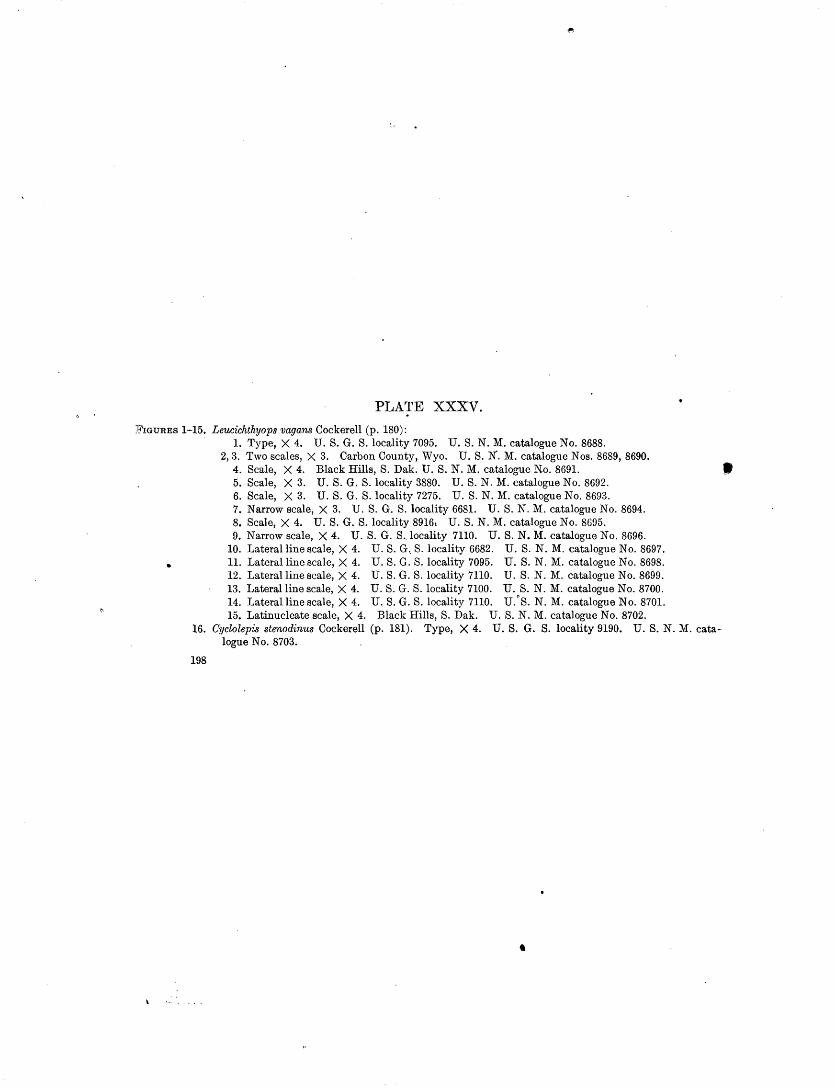
PLATE XXXV.
FIGURES 1-15. Leucichthyops vagans Cockerell (p. 180): 1. Type, X 4. U.S. G. S. locality 7095. U.S.N. M. catalogue No. 8688.
2, 3. Two scales, X 3. Carbon County, Wyo. U.S. N'. M. catalogue Nos. 8689, 8690. 4. Scale, X 4. Black Hills, S. Dak. U.S.N. M. catalogue No. 8691. ' 5. Scale, X 3. U.S. G. S. locality 3880. U.S.N. M. catalogue No. 8692. 6. Scale, X 3. U.S. G. S. locality 7275. U. S. N. M. catalogue No. 8693. 7. Narrow scale, X 3. U. S. G. S. locality 6681. U. S. N. M. catalogue No. 8694. 8. Scale, X 4. U.S. G. S. locality 8916: U.S.N. M. catalogue No. 8695. 9. Narrow scale, X 4. U. S. G. S .. locality 7110. U.S.N. M. catalogue No. 8696.
10. Laterallinescale, X 4. U.S. G .. S. locality 6682. U.S.N. M. catalogue No. 8697. 11. Lateral line scale, X 4. U.S. G. S. locality 7095. U. S. N. M. catalogue No. 8698. 12. Laterallinescale, X 4. U.S. G. S.locality 7110. U.S.N. M. catalogue No. 8699. 13. Laterallinescale, X 4. U.S. G. S.locality 7100. U.S.N. M. catalogue No. 8700. 14. Laterallinescale, X 4. U.S. G. S. locality 7110. U.
0
S. N. M. catalogue No. 8701. 15. Latinucleate scale, X 4. Black Hills, S.Dak. U.S.N. M. catalogue No. 8702.
16. Cyclolepis stenodinus Cockerell (p. 181). Type, X 4. U.S. G. S. locality 9190. U. S. N. M. catalogue No. 8703.
198
•

U.S. GEOLOGICAL SURVEY PROFESSIONAL PAPER 120 PLATE XXXV
2
, 4
6
8
10
7
13
14 15 16
CRETACEOUS FISH SCALES

,.
PLATE XXXVI.
199
•

PLATE XXXVI.
Ti'IGURES 1, 2. Erythrinolepis chicoensis Cockerell (p. 182): 1. Type, X 4. U.S. G. S.locality 7030. U. S. N. M. catalogue No. 8704. 2. Smaller scale, X 4. U. S. G. S. locality 7030. U. S. N. M. catalogue No. 8705.
3-6. Erythrinolepis mowriensis Cockerell (p. 182): 3. Type, X 4. U. S. G. S. locality 6713. 4. Scale, X 4. U .. S. G. S. locality 6713. 5. Scale, X 4. U. S. G. S. locality 6713. 3-5, U. S. N. M. catalogue No. 8706. 6. Scale, X 4. U. S. G. S. locality 4941. U. S. N. M. catalogue No. 8707.
7. Halecodon denticulatus Cockerell (p. 183). Type. Palatine and ectopterygoid, X 1.5. U.S. G. S.loca.lity 3870. U.S.N. M. catalogue No. 8708.
8. Ostichthys pillwaxi (p. 187). Apical region of scale, X 1.85. Honolulu market. 9. Enchodus sp. (p. 184). Operculum, X 2. U. S. G. S. locality 6187. U.S. N. M. catalogue No. 8709.
10. Echidnocephalus? americanus Cockerell (p. 184). Type, X 8. U. S. G. S. locality 5138. U.S.N. M. catalogue No. 8710.
·n. Echidnocephalus? pacificus Cockerell (p. 185). Type, X 4. U.S: G. S. locality 7027. U.S.N. M. cata-logue No. 8711. · ·
12. Centrarchites coloradensis Cockerell (p. 188). Typ,e, X· { Eocene. U. S. G. S. locality 7087. U.S.N. M. catalogue No. 8712.
13. Hemilampronites hesperius Cockerell (p. 185). Type, X 6. U. S. G. S. locality 9190. U. S. N. M. catalogue No. 8713.
14. Latinucleate (regenerated) scale of undescribed species, with marginal teeth resembling· those of the berycoids, X 3. U. S. G. S. locality 4867. Cretaceous, Mowry shale, sec. 1, T. 26 N., R. 88 W., near North Rawlins, Wyo. U. S. N. M. catalogue No. 8714.
15. Scale of undescribed species with marginal teeth suggesting the berycoids, X 10. U. S. G. S. locality 4426. Cretaceous, Mowry shale, SE. i sec. 27, T. 33 N., R. 74 W., about 5 miles southwest of Careyhurst, Wyo. U. S. N. M. catalogue No. 8715.
16. Scale of undescribed species, X 10. U. S. G. S. locality 6603, SE. i sec. 18, T. 1 S., R. 10 W., Uinta special base line, Utah. Said to be Mowry shale. The collection contains plant remains and may be from a fresh-water deposit. U. S. N. M. catalogue No. 8716. •
17. Scale of undescribed species, perhaps clupeid, with fine transverse circuli, X 4. Transverse diameter 12.5 millimeters. From the same station as figure 16. Presumably fresh water. U. S. N. M. cata-logue No. 8717.
. 0
200

U.S. GEOLOGICAL SURV J.;Y
7
t
14
15
PROFESSIONAL PAPER 120 PLATE XXXVl
10 11
16
CRETACEOUS FISH SCALES
6
rrtt1'Mt11111 rtr _1! ,\1\rll! . . J~ r . 8
12
17

PLATE XXXV.II.
201

•
PLATE XXXVII.
FIGURE 1. Ctenothrissa radians (Agassiz) (p. 183). Cretaceous of England. From a specimen in the British Museum. 2. Hoplopteryx lewesiensis (Mantell) (p.' 183). . Cretaceous of England. From a specimen in the British
Museum. ·
202
'\

.., -- ... ~
U. S. GEOLOGICAL SURVEY PROFESSIONAL PAPER 120 PLATE XXXVII
2 CRETACEOUS FISH SCALES
\ \
INDEX.
A. I rage. Ac~nthoptcrl .......... ; ............... , ....................... 187-188 Acipcnseri<lao, possible occurrence of..· ...................... ·.--. 171-17 Acknowledgments for aid .. : ........................... 1,17, C, 130,169 AJnslio, Ga., section cast or....................................... 75. Albany, Ga., section north of.................................... 79 Albulldae, existence of, in Cretaceous time....................... 112 Alden, W. C., ack"llowlodgmont to ................ ,.............. 17 Alinomont diagrams, accuracy and advantage of. .•............. 126-128
usc of. ....................................... ; ......... , .... 123-126 Alluvium, occurrence of, In northcostcrn Montana ............. :. 35-37 American Museum of Natural History, acknowledgment to....... 1li9 Amsden formation, correlation of................................ 118 Angu1llavidao ............... ; .. :. . . . . . . . . . . . . . . . . . . . . . . . . . . . . . . . 184 Annona tongue of tho Austm chalk, nature !llld distribution of. 151-152 Anticline on Gmvlna Island, Aloska, plato sho\v4lg.............. 88 Apodcs.... .. . . . . . . . . . . . . . . . . . . . . . . . . . . . . . . . . . . . . . . . . . . . . . . . . . . . . 184 Austin chalk, Annona tongue of,.naturc and distribution of. ... 151-152
Annona tongue of, plates showing ...................... ·"'·.... 14.C: clays and sands of tho age of ............................... 148-1,19 contact of, with Eagle Ford clay, plato showing· .. :........... Wi distribution or ............... ; ..................... ! • • • • • • • • • • • 148 Fntor tongue or ............................................ 149-150 typical o.roa of •......•........ :.............................. 148
B.
~adltmds near Lismos, Mont., plato showing ......... ·............ 21 Bainbridge, Ga., fossils from ................................... -- 80-81 Baker, H.. J?., work of. ...................... : ....... ·............. . 17 Baldwin County, Ga., exposure of tho Barnwell forn:ution in.... . 71 Bannock Peak, Yellowstone National Park, pluto showing ....... · 118 Barnwell formation, areal distribution of. ............ : ........... 55-56 ' exposures !llld sections of .......................... :. . . . . . . . . . 63-77
nanling of.................................................... . 52 nature and thickness or. .......... : ............... · ......... :. 54-55 stratigraphic relations of .................................... : 52-54 structure of ................................................. :· 56
Bossler, H.. S., acknowledgment to .......... -- .. -- ......... ,..... 42 fossils determined by ............................ : . ........ :. · 45
Boar paw shale, badlands of, plato showing.·: .................. ::. 21 o-ccurronco of, in northeostem Montana ................ : .... , 30
Beaver Creek, Mont., events In history. or........................ 37 Beu:nctt, H. R., work of. .................................. ,..... 17 Benton slialo, Cretaceous fishes from............................. 171 Berry, E. W., o.cknowlodgmont to............................... 42
cited ............................................. :.......... 55 fossils determined by........................................ 75
Borycoidoi. .... : ::: ..... :· .. · ............ : ....................... ·136-187 Bcrycopsidao Jordan ..................................... :....... 186 13ibb County, Ga., exposures of tho Barnwell formation in ....... 74-75 Bidarbom\to, calculation of..--.--.-- .............. ' ......... · ...... · 11-15
use of tol'ln .................... --.-- ... __ .... :................ 3 Big-Muddy Crook, :Mont., bench eost and west of. ......... __ .... 19
events in tho history of. ............................... : ...... 36-37 Big Sandy Crook, Ga., section on................................ 71 l31aok Prairies, ~L'ox.,looation and topography or................. 131 :inecldoy County ,\Ga., exposures of tho Barnwell formati::m in' ... 75-76 Blossom sand,'glauconitic clay representing ............. : .... ,... 150
natme and correlation of ................................... 152-153 "Bonham, Tox., trnnsition.'al clays near .. : ..... .':~· ............... 150-151
Bow'doin domo,l\tout.,structure of. .............................. 37-38 Bmntly, J. E., fossfls colloctod by .. .' .......... · .......... · ........ ·. 66
section meosurod by ........... ,.............................. 59 Brooks, Alfred H., cited .......................................... 8·1,88 Brown, 13nrnum, o.cknowbdgmont to:. :.- .... :· ... ,.:·.-.. • .. ·.; .. : .. .. ·. 17
·Browns Mountain, Ga., sections ncar ...................... : ...... 47-49 . Brownstown hlo.t1; Jiatute and·correlation of:.: ............ : ...... : 154
i.L
Page. Bryant, J. T., acknowledgment to................................ 130 Bucho.D!Ill, J. Y., determinations of carbon diJ:xide in sea water
by ........................................... : ..... 4,14-15 Buffalo Creek, Ga., sections ~ast·or............................... GS B·urke County, Ga., exposures of the Barnwell fon~atiou in...... 63
c. Carbon dioxide, equilibriUDl of, with the atmosphere ............ 5, G-7
determinations of, in watet· of the Gulf of MexicJ............ 1-16 theoretical amount of, In sea water ............... ·............ 5
Carbonate, calculation of. ........................................ 1!-15 use ofterm .................................................. .
Carbonate and bicarbonate, total, in· sea water, determination of.. i-;-9 total, in sea water, discussion of. ........... .'................. !)..11
Cardwell, Mont., section near ....................... ~-............ 115 Centennial Range, Mont., plate showing.......................... 117
shaly calcareou~ beds on, plate showing .............. '\~;..... 117 stratigraphy of.. ........................................ : .. llli-117
Centrarchidro . . • . . . . . . . . . . . . . . . . . . . . . . . . . . . . . . . . . . . . . . . . . . . . . . . . . 188 Centrarchites Cockerell, n. gen.................................... 188 ... coloradensis ~o!}k,erell, n. sp ................................ 1S8, 200 C~alker, Ga., section·'south of. ....................... :............ 70 Chapin, Theodor~, 'I;'he structure and stratigraphy of Gravina and
Revillagigedo islands, Aloska ......... : . ............. 83-100 Cll.Ico group, Cretaceous f1shes from............................... 171 Chicolepis Cockerell, n. gen ..................................... 176-177
pmwtatus Cockerell, n. sp .................................. 177,196 chugwater formation, stratigraphy of. ............... : .......... 119-120 Cimolichtbys Leidy ........ : ........................ :............ 184 Claggett shale, occurrence of. ........................ : ............ 26-27 Claiborne group, in Georgia, formations included in ............... 49-50
stratigraphy of ............................................ 49!-51,59 undilforentiated deposits·or................................... 51
sections of. ............................. : ................. 61"-62 Clay, glauconitic, occmrence of, near Bonham, Te~L ............ 150-151 Clupeidro .............................................. ·.......... 180 Coal, occurrence of, in northern Montana ................. · ..... 29,32, 33 Cochran, Ga., section north of.. .................................. 75-76 Cockerell, T. D. A., Sol¥ American Cretaceous fish scales,· with
notes on the clossification ond distribution of Creta-. ceo us fishes ................... : ..................... 165-202
Collier'· J\.t;tliur J ., Geology of northeastem Montana ............ .'. 17-3:! Colorado group, local subdivisions of ..... : .......... :.: .. ·:· ..... 165-167 Columbia County, Ga., exposures of the Barnwell formation in .• 64-65 Comanche series, age and distribution of.......................... 134
correlation table of..... . . . . . . . . . . . . . . . . . . . . . . . . . . . . . . . . . . . . . . . 134 formations of, in northeostem Texas ...... · .................. 1.34-144
Con!lllt, Edwin T., work of....................................... 17 Concretions in Lance and Fort Union formations, plates showbg. 32,26 Condit, D. Dale, Relations of late Paleozoic q.nd early 1\Iesozoic
formations of westem Montana and adjacent parts of 'Vyoming ...... · . .-.. · ................................ 111-:21
Conglomerate, exposme of, on Gravina Island,_Aloska, plato sh:nv· ing ....•......................... :.................... 88
Cook, R. H., acknowledgment to................................. 130 Cooke, Charles Wythe, and Shearer, Harold Kurtz, Deposits of
Claiborne and Jackson age in Georgia ................ 41-81 Cottonwood Creek, M:oht.; view on, plate showing .......... '>.... 21 Crawford County, Ga., exposmes of the Barnwell formation in.... . 77 Cretaceous .fish scales from Tmkestan. . . . . . . . . . . . . . . . . . . . . . . • . . 179, 196 Cretaceous fishes, evolution of.·· ....... , ............. : . .... : ...... : 170 Cretaceous inl!llld sea, evolution uf fishes favored by ... ,.......... 170 Cross-bedding, eolian, in sandstone, plate showin:5................ 32 Grossognathidae ...................................... :, . . . . . . . . . . 185 Ctenothrissa radians (Agossiz)~ .•. : ........... · ................... 183,202 Ctenothrissidae .....•............................. .'.... .. . . . . . . . . . . 183
''203

204 JiNDEX.
Page. Cushman, Joseph A., acknowledgment tq.. ...... .... .... ... . .... 42 Cuthbert, Ga., sections west of. . . . . . . . . . . . . . . . . . . . . . . . . . . . . . . . . . . 6:! Cycloides? incertus Cockerell, n. sp ............................ 173,190 Cyclolepis Geinitz................................................ 131
stenodinus Cockerell, n. sp ................................. 181,198
D. . Dall, W. H., fossils determined by............................... 99 Daly, R. A., analyse's by......................................... 105 Danville, Ga., exposure of the Barnwell formation northwest of.. U Denison, Tex., section north of................................... 139
section south of ........................................... : 142-143 section west of ............................................... · 143
Denison formation, members of, descriptions of ................. 140-144 Pawpaw member of, plate showing........................... 143
Denton clay member, nature and exposures of.. ............... 140-141 Depth, alinement diagram for computing........................ 124 Dercetidae. ... . . . . . . . . . . . . . . . .. . ... . . . . .. . . .. . . . . . . . . . . . . . . . . . . . . 185 Dinwoody Canyon, Wyo., section in............................. 119 Dinwoody formation, section of.................................. 119 Dip, projected, alinement diagram for computing................. 128 Dittmar, W., analyses by. . . . . . . . . . . . . . . . . . . . . . . . . . . . . . . . . . . . . . . . 1
determinations of carbonat& in surface sea waters by.......... 10 Dole, R. B., determinations of carbon dioxide in sea water by .. 2,4-5 Dooly County, G~~· exposures of the Ocala limestone b .......... 77-78 Dry Branch, Ga., section near .......... :......................... 43 Duck Creek, Tex., section on..................................... 139 Duck Creek formation, limestone member of, plate sh:J\ving .. .. .. 133
nature and exposures of.. . . . . . . . . . . . . . . . . . . . . . . . . . . . . . . . . . . . . 139
:c. Eagle Ford clay, contact of, with Austin chalk, plate sh:>wing.... 145
nature and exposures of............ .. .. .. .. . .. . . . .. .. .. . .. . 146-148 Eagle sandstone, occurrence of, in northeastern Montana......... 26 Eastern Cross Timbers, Tex., location and topography of.. ..... 131-132 Echidnocephalus Von der Marek ............................... 184-185 Echidnocephalus? americanus Cockerell, n. sp ............. 184-185,200
pacificus Cockerell, n. sp ................................... 185,200 Ector tongue of the Austin chalk, nature and exposures of.. .... 149-150 Ellis formation, age and stratigraphy of .... · . .'.................... 114
contacts of. . .. . . . . . .. . . . . . . . .. . . . . . .. .. . . . . . . . . . . . . . . . . . . . . . . 120 exposures of .................................. .' ............. 115,116 occurrence of ............................... : ................. 24-25
Elopidae ........•..................................... :. . . . . . . . 173-176 Encheliidae ................................ :. . . . . . . . . . . . . . . . . . . . . 184 Enchodontidae ................................................. 183-184 Enchodus Agassiz ................ : . .' .......... '................. 184
sp .....•................................................... 184,200 Eocene formations in Georgia, section o·r. . . . . . . . . . . . . . . . . . . . . . . . . 43
in northeastern Texas, evidence of .. · .... ~.. . . . . . . . . . . . . . . . . . 158 Erythrinolepidae Cockerell, 11. fam .. · ........................... 182-183 ErythrinolelJiS Cockerell, n. gen ... : ............................ 182-183
chicoensis Cockerell, n. sp .............................. 182-183,200 mowriens1s Cockerell, n. sp. ~ ................ · .............. 182,200
F.
Farmersville, Tex., structure section from a point near, to Lado-nia, Tex., plate showing.............................. 155
"Fish-bed conglomerate," exposures of.......................... 147 nature of. .................................................. 148-149 plate showing ......... ·....................................... 145
Fish scales, Cretaceous, formations yielding .................... 165-167 Cretaceous, stratigraphic distribution of. ................... 169-171 recent, preparation of........................................ 169 terms used in describing ................................... 168-169. value of, it?- determining species.............................. 168
Fishes, Cretaceous, of Europe and America, differences between.. 170 Flaxville gravel, occurrence of, in northeastern ~ontana.... .. .. . 35 Flint River, Ga., sections on .... · ..................... · ............ 78-79' Fort Gaines, Ga.,sectionsat .•........•....•.. , ................... 61,62 Fort Union formation, concretion in, plate showing.............. 36.
occurrence of. ..................................... , . . . . . . . . . 32-3.'i. Fort Worth limestone,.nature and·exposurcs of., .............. 139-140.
plates showing .... :.·.·.~-.... · •......•.................. ·......... 139 Fredericksburg group, nature and distribution o~, in northeastern
Texas ......................... · ..... ,, ................... 13.3--137 Fucoids(?) in Fort Worth limestQne, plate showing.............. 139
G. Pa~. Gallemore, Ga., section east of. . . . • . .. . . .. . .. . . .. . . .. . . . . . . . . . . . . 74 Georgia, geologic map of part of. . . .. . • . . . . . . . . . . . . . . . . . . . . . . . . . . . 50 Gibson, Ga., sections near ..................................... 46-47,67 Gilmore, C. W., fossils determined by......................... 30, 31, 32 Girty, G. H., fossils determined by. . . . . . . . . . . . . . . . . . . . . . 23-24, 116, 120 G lasoock County, Ga., exposures of the Barnwell formation in. . . . 67 Goodland limestone, nature and distribution of, in northeastern
Texas .............................................. 135-137 plate shoWing. . . . . . .. . . . . . .. . . .. . .. . . .. . .. . . . . . . . . . . . . . . . . . . . 136
Gordon, Ga., section south of. .................................. , 71 Grain field near Scobey, Mont., plate showinrr.................... 20 Grand Prairies, Tex.-Okla., location and topography of. . . . . . . . . ,132
·Gravel pit at Wolf Point, Mont., plate showing.................. 36 Gravina Island, Alaska, Cretaceous rocks on ..................... 97-98
Devonian rocks on ........................................... 87-88 geography of. . . . . . . . . . . . . . . . . . . . . . . . . . . . . . . . . . . . . . . . . . . . . . . . . 83-85 geology of •.................................................. 85-100 intrusive rocks on ........................................... 99-100 Jurassic rocks on.. .. . . . . . . . . . . . . . . . . . . . . . . . . . . . . . . . . . . . . . . . . . 95-98 Quaternary deposits on. . . . . . . . . . . . . . . . . . . . . . . . . . . . . . . . . . . . . . 99 slate on, plate showing....................................... 88 Tertiary rocks on ........................................... : 99 Triassic rocks on ............................................. 89-9i
Grayson marl member, nature and exposures of.................. 144 Graywacke, exposure of, on Gravina Island, Alaska, plato show-
ing ...... ·............................................. 88 Great Plains, development of.................................... 18 Grovetown, Ga., sections and exposures neat ..................... 64-65 Gryphaea"bcaring limestone, nature and exposures of. .......... 138-139 Gulf series, age and dist!'ibution of. ............................ 144-145
formations of, in nvrtheastern Texas ....................... 145-158 generalized section of, plate showing......................... 155
H. Halecodon Cockerell, n. gen .................................... 183-184
denticulatus Cockerell, n. sp. . . . . . . . . . . . . . . . . . . . . . . . . . . 183-184, 200 Halosauridre .... · ............................................... 184-185 Haplomi...... .. . . . . . . . . . . . . .. . . . . . . . . . . . . . . . . . . . . . . . . . . . . . . . . . . . 185 Hazard, W. 0., acknowledgment to.............................. 169 Helmintholepis Cockerell, n. gen.................................. 176
vermiculatus Cockerell, n. sp ............................... 176,192 Hen;tilamlJronitcs Stcinla ....................................... 185-186
hcsperius Cockerell, n. sp ............................... 185,186,200 Hemiramphidre ............................ :. . . . . . . . . . . . . . . . . . . . 185 Henderson, J., acknowledgment to............................... 169 Hetcromi. ..................................................... 184-185 Hill, Robert T., cit:)d .......................................... 135,151
work of, in northeastern Texas............................... 129 Holcolepis Von dcr Marek ...................................... 173-176
delicatus Cockerell, n. sp ................................... 175,190 obliquus Cockerell, n. sp .................................... 175,192 pulchellus Cockerell, n. sp .............................. 174-175,190 transversus Cockerell, n. sp ................................. 175,190
Holcolepis? mandible ....... : .............................. 175-176,192 Hopkins, 0. B., acknowledgment to............................. 13J Roploptcrygidae Cockerell, n. fam .............................. 1SC--187 Hoploptcryx lewcsiensis ........................................ 183, 202 Houston County, Ga., exposures of the Barnwell formation m... 76 Hyatts Bluff, Tex., description of................................ 146 Hypsodon Agassiz ............................................. 177-179
audax (Leidy) CockerelL. .......................... 177-178,192,194 lowii (Stewart) Cockerell ................................... 178,196
Hypsodon? granulosus Cockerell, n. sp ......................... 17~-179 radiatulus Cockerell, n. sp .................................. 178,192
I. Icthyodectes Cope .................................. ; .......... _. 179, 1Sv Ichthyodectidfe .......... ,.......................... ..... 177-179
. Iddings, J. P., analyses by ........................... ·............... 105 Indian Creek, Mont., canyon of, plate showing................... 116
section on .................................................. 115-116 Iniomi ........... · .............................................. 183-184
J
Jackson group, formations included in............................ 51 stratigraphy of ......................... , ................ ···-- 51,59
Jefferson County, Ga., exposures of the ~amwell formation in. ___ 65·67 Jefferson River canyon, Mont., section in......................... 115
.·~
•
INDEX. 205.
Page. Jones County, On., exposures of the Barnwell formatton in ....... 72-73 Jordan, D. S., acknowlcdgmont to............................... 169 Judith River formation, occurronce of ............................ 27-29
K. Keys Mill, Ga., section at ....................................... ·. 63 Klamichi clay, nature and exposures of ..................... : .. 138-139
plates showing............................................... 138 Kinchafoonco Crock, Ga., section on.............................. 79 Kindle, E. :M.., fossils determined by ............................. 88, 89 lGrk, Edwin, fossils determined by .... ,,........................ 93 Knowlton, F. H., fossils determined by .......................... 34-35 Kootenai formation, e:ll:posum of.................................. 115
nature and correlation of .................... .' .............. 114-115 occurrence of. . . . . . . . . . . . . . . . . . . . . . . . . . . . . . . . . . . . . . . . . . . . . . . . . 25
L.
LndonJn, Tox., structure section from, .to a point neat" Farmers-ville, To.--c., plate showing.............................. :155
Lance formation, concretions in, plate showing.................... 32 erosion forms of, plates showing. ... . . . . . . . . . . . . . . . . . . . . . . . . . . . 33 occurrence of. .............................. ~ .............. 30-32,33 .
Page. Montana, southwestern, field work. in .......... :. . . . . ... . . . . . . . . . 111
southwestern, map of, showing distribution of Phosphoria formation .. ..... .. .. .. . .. . .. .. . . . .. . . . .. . .. .. ... . . .. . .. .. .. . ll2
stratigraphic features of. . . . . . . . . . . . . . . . . . . . . . . . . . . . ... . . J.l5-11& Montana group, Cretaceous fishes from........................... 171
local subdivisions of. ........................................ 165-167 'Moor, J. :Balch, acknowledgment to.............................. 130 Moore, .H. F., aclmowledgment to.. . . . . . .. .. .. . .. . .. .. .. .. .. . .. . 1 '1\:lossy Hill, Ga., section on ............ , .......................... 45-'46 1\:lount En on, Ga., section on...................................... 64 Mount Nebo, Utah. See Santaquin, Utah. Mowry shale, occurrence of, in.northeastcrn Montana.. . . . . . . . . . . . 25-26 Myctophidro ........... ·........................................... 184
N.
·Navarro formation, nature and correlation of.. .................. 1.57-158 Niobrara formation, Cretaceous fishes from......................... 171 N otacanthidro...... •.•....... ... . . ... . . . . . . . . . . . ... . . . .. . . . . . . . . . . . . . . . . 184 Notelops 'Voodward............................................. 176
0.
Lnrb Hills, Mont., location of.................................... 19 'Ocala'limestone, areal distribution or...:.' ............ ~.' ..... ~...... 58 Leonard-Celeste monoclinal nose, Tex., description of.. . . . . . . . . . . 161 · exposures and sections of. .................... : ..... 75-76,77-81 Leptolepidro.... ...... .. ..... ..... .. . . . .. .. . .. . . ... . . . ... .. .. .. .. . 173 naming of ................................. ~·······........... ·55 Leucichthyops Cockerell, n. gen ................................ 180-181 nat\lre :md thich."lless of.. ..................................... '57-58
vagans Cockerell, n. sp .' ............................ 180-181, 196, 198 stratigrapliic relations of.. ... .,................................. 57 Lignite. See Coal. structure of. .. .. .. .. .. .. . .. . .. .. .. .. .. .. .. .. .. .. .. .. .. .. .. .. . 58 Little Keg Creek. Ga.,sect10non...... ... ......... ............... 48 ·oconee, Ga., section north of..................................... 68 Little :Mineral Creek, To.x.,section on............................ 136 Oklahoma. See Texas, northeastern, and Oklahoma, southern. Little Rocky Mountains, Mont., camp in foothills of, plate Osmeroides .................................................... 173-174
showing.............................................. 20 · o.~tua carinata bed, exposures of.. .............................. 140-141 description of ............................................. 18,19-20 Owl Creek Mountains, 'Vyo., plate showing..................... 118
Loughlin, G. F., Two lamprophyre dikes ncar Santaquin and Mount Nebo, Utai1 ................................. 101-109
1\{.
M:c:Bcan formation, distribution and structure or................. 51 nature and relations of ....................................... 50-51 sections of .................................................... 59-61
Macon, Ga., sections southeast of. ............................. 47-48,74 Mad.isonlimestone, features of.................................... 111
occurrence of. . .. .. . .. .. .. .. .. .. . .. . . .. . . .. . . . . . . .. .. . . . . .. . . . 23-24 Main Street limestone member, nature and exposures of ....... 143-144
plates showing ............................................. 141, 142 Mp.p, geologic, of northeastern Montana.. . . . . . . . . . . . . . . . . . . . . . . . . IS Map of northwestern Wyoml.ng, showing distribution of Em bar
formation............................................ 112 Map of south western Montana, showing distribution of Phosphoria
formation. . . . . . . . . . . . . . . . . . . . . . . . . . . . . . . . . . . . . . . . . . . . 112 Map showing distributiOn of the Eocene formations of Georgia... 50 Marl brook marl, correlation with ............................... 154-155
"Saratoga" chalk member of. See Pecan Gap chalk member or the Taylor marl.
Milk River, Mont., events in the hls~ory of ................ ·.· ..... 19,36 Mis&ouri River valley, Mont., plate showing...................... 36 Mollusks, Cretaceous, of the Niobrara, Pierre, and Fox Hill forma-
tions, differences between .......................... 170-171 Montana, Jurassic erosion in .................................... 120-121
northeastern, Cambrian formations in........................ 23 Carboniferous formation in ............................... 23-24 Colorado formation in ............................ ·. . . . . . . . 25-26 Cretaceous formations in .... · ............................. 25-30 Devonian rocks of. . . . . . . . . . . . . . . . . . . . . . . . . . . . . . . . . . . . . . . . 23 field work in............................................. 17 geologic map of........................................... 18 glaciation in... . . . . . . . . . . . . . . . . . . . . . . . . . . . . . . . . . . . . . . . . . . . 19 Jurassic formation in ..................................... 24-25 Montana formations in ................................... 26-30 pro-Cambrian rocks in.................................... 23 pre,•ious publieations on. . . . . . . . . . . . . . . . . . . . . . . . . . . . . . . . . 18 Quaternary deposits in ................................... 35-37 settletnent or............................................. 20 Silurian rocks of.......................................... 23 stratigraphy or.. . . . . . . . . . . . . . . . . . . . . . . . . . . . . . . . . . . . . . . . . . 20-37 streams in, adjustment of................................ 39 , structure or. . . . . . . . . . . . . . . . . . . . . . . . . . . . . . . . . . . . . . . . . . . . . . 37-3g surface features of. . . . . . . . . . . . . . . . . . . . . . . . . . . . . . . . . . . . . . . . 18-20 Tertiary formations in .................................... 30-35
P.
Palmer, Harold S., New graphic method for determining tho depth and thielmcss of strata and the projection of dip. 123-128
Park City formation, gcneraliz('d section of. .................... ll8-ll!J Pawpaw Creek, Tex., section on branch of ..................... 142-143 Pawpaw sandy member, nature and exposures of.. ............. 142-143 Pecan Gap, Tex., section east of.................................. lfiG Pecan Gap chalk member of the Taylor marl, basal beds of, plato
sho\ving............................................. 154 nature and exposures of. ................................... 15fr-lfi7
Percomorphl ................................................... 186-187 Perry, Ga., age of exposures south of. ............................ 44-46 Petalolcpis?fLbrillatus Cockerell, n. sp ...................... 172-173,190 Phosphate rock, orcurrencc of. ......................... 113,115,116,117 Phosphoria formation, exposures of.. ....................... 115,116,117
nature of.............................................. . . . . . . . 113 Pikes Peak, Ga., section northwest of. ........................... 73-H Platycormidrc Jordan ........................... _.. . . . . . . . . . . . . . . . 186 Plcthodontidrc ..................................................... li9 Pomolobus Rafincsquc........................... ....... .. . .. .... 1~0 Pomolobus? chlcoensis Cockerell, n. sp ......................... 180,196 .Porphyry laccolith, occurrence of, in northeastern ~fontana....... 23 Pottsboro, Tex., section north of................................. 136 Powers, ~idncy, work of......................................... 130 Preston, Tex., section south or................................... 134 Preston anticline, Okla.-Tex., cause of........................... 160
descriptiOn of .............................................. 159-160 structure section across, plate showing........................ 155
Protosphyraenidm, occurrence of................................. 172 Pterothrissidre ................... · .............................. 176-177
Q.
Quadrll.Ilt Mountain, Yellowstone National Park, section on ..... 117-118 Quadrant quart?.ite, exposures of.. ..................... 115,116,117,118
nature and distribution of.. ................................ 111-112 "Quarry" limestone, nature and exposures of.,................ 142
plateshowing................................................ 141 Queen Charlotte series, age of. . .. .. .. .. .. .. .. .. .. .. .. .. .. .. .. .. .. gg
R.
Red River, Okla.-Tex., course and tributaries of................. 131 section on.................................................... 138 terraces on. .. .. .. .. .. . .. . . . . . . . . . . . . . . . . . . . . . .. . . . . . . . . . . . . .. 132
Reeside, J. B.,jr.,fossilsdctermined by .......................... 24-25 26, 27, 28, 29,30,32, 92,93

206 INDEX.
Page. Revillagigedo Isla.nd, Alaska, Carboiliferous rocks on . . . . . . . . • . . . 88-89
Cretaceous rocks on .......................................... 97-98 geography of .................................................. 83-85 geology of ................................................... 85-100 intrusive rocks on ........................................... 99-100 Jurassicrockson ........... : ................................. 95-98 Triassic rocks on ............................................. 89,97
Rhacolepis Agassiz............................................... 176 Ricciardi, L., analysis by ............... :. . . . . . . . . . . . . . . . . . . . . . . . . 105 Richmond County, Ga., exposure of the Barnwell formation in ... 63-64 Roberta, Ga., sections east of..................................... 77 Roberts, G.a., section northeast of................................ 72 Robinson, H. M., work of........................................ 130 Rock Bluff, Tex., section at...................................... 134 Rock Creek, Mont., gorge of, plate showing....................... 2o Ross Hill, Ga., sections on ....................................... 44-45 Ruppin, E., determinations by, of C03 and HC03 in the North
Sea.................................................. 10
s. Salmonidae. • • . • .. .. . .. .. .. . . . . .. . . . . . . . . . . . . . . . . . . . . . . . . . . . . . . 18Q-181 Sandersville, Ga., sections northwest and south of. ............ 48, 68,69 Santaquin, Utah, dikes near, analyses of rocks similar to ....... 107-108
dikes near, chemical composition of ... : .. : ..... : ........... 104-106 classification of.................................. . . . . . . . . . 107 correlation of ........................................... 108-109 location and age of.. ....................... .-........... 101-102 minerals in ............................................. 103-104
stratigraphy of the vicinity ....... :........................... 101 structure of the vicinity ........................... · ... ~....... 103
Saunders, Mr. and Mrs. D. A., fossils collected by .............. 156-157 Shearer, Harold Kurtz, Cooke, Charles Wythe, and, Deposits of
Claiborne and Jackson age in Georgia ................ 41-81 Shell Blufi, Ga., section at ....................................... 6Q-61 Shellstone Creek, Ga., sections on ................................ 75-76 Stiver Bluff, Ga., section at...................................... 60 Slate, exposure of, on Gravina Island, Alaska, plate showing..... 88 Sloan, Earle, fossils collected by .................................. 5G-51 Smith, PhilipS., cited ....................................... 94,99-100
previous work of, on Gravina Island. . . . . . . . . . . . . . . . . . . . . . . . . 83 Snowcrest Mountains, Mont., principal peak in, plate showing... 116
section of Quadrant quartzite in. . . . . . . . . . . . . . . . . . . . . . . . .. . . . 116 Stanton, T. W., acknowledgments to ........................... 130,169
fossils determined by ....................... 24, 26, 35,92-93,94,96,98 preface by .................................................. 165-167
Steiger, George, analyses by ...................................... I, 105 Stephenson, Lloyd William, A contribution to the geology of
northeastern Texas and southern Oklahoma ........ 129-163 work of, on Eocene formations of Georgia..................... 41 Veatch, Otto, and, cited .................................. 43-44,52
Stevens Pottery, Baldwin County, Ga., section at................ 71 Sundance formation, features of.................................. 120 Sunhill, Ga., section at........................................... 69 Synentognathi ............ ; .............................. ·..... . 185-186
T.
Taff, Joseph A., cited............................................ 151 work of, in northeastern Texas ............................. 129-130
Taylor marl, correlation of. .................................... 154-155 members of ................................................ 155-157 typical area of ................... ,............................ 154
Tensleep sandstone, correlation of. . . . . . . . . . . . . . . . . . . . . . . . . . . . . . . . 118 Teton formation, exposure of..................................... 117
nature and relation of. ..................................... 113-114 Texas, northeastern, and Oklahoma, southern, Cretaceous system
in, formations of. ................................... 134-158
Page. Texas, northeastern, and Oklahoma, southern, faults in.......... 159
general geology of ...................................... 133-134 geologic map of part of. . . • . • . . . . . . . . . . . . . . . . . . . . . . . • . . . . • 130 literature on ........................................... 13Q-131 oil and gas prospects in ................................ 161-163 structure of ............................................ 158-161 summary of report on .................................... · 163 Tertiary system in, evidence of.. . .. . . .. . . . . . . . . . . . . . . . . . . 158 topography of. .......• ~ ..... : .......................... 131-133
Thickness, alinement diagram for computing..................... 126 Thorn, W. T., jr., work of ... .'............................. 17 Tivola, Ga., section south of... . . . . . . . . . . . .. . . .. .. .. . . . . . . . . . . . . . 76 Tivola tongue of the Ocala limestone, distribution of ............. 51,56 Tomognathidae. ................................................. 184 Toomsboro, Ga., section west of.................................. 71 Trinity sand, nature and distribution of. ....••....••..........• 134-135
plate showing ............ , ................................ .-.. 136 Turkestan, Cretaceous fish scales from .......................... 179,196 Twiggs clay member of the Barnwell formation, features of ...••• 52-56 Twiggs County, Ga., exposures of the Barnwell formation in ....• 73-74
u.· United States National Museum, acknowledgment to............ 169 University of Kansas, acknowledgment to....................... 169 Urenchelyidm.. ................................................. 184
v. Vallenar formation, nature and distribution of .................•. 87-88 V ancouver series, correlation with ................................. 94,97 Vaughan, T. Wayland, acknowledgments to..................... 1,42
cited ...................................................... 52,57,60 fossils determined by ...........................••...... 61,66, 72,77
Veatch, Otto, work of; on Eocene formations of Georgia.......... 41 and Stephenson, L. W., cited .................... ~ ......... 43:-44,52
w. Walnut shaly member. See Goodland limestone. Warthen, Ga., section south of................................... 69 Washington County, Ga., exposures of the Barnwell formation in .. 67-70 Washita group, formations of. ................... : . ............ 138, 144
lithology and subdivisions of. .............................. 137, 138 Wave-cut bench, Gravina Island, Alaska, plate showing.. . . . . . . . 88 Wells, Roger C., New determinations of carbon dioxide in water
of the Gulf of Mexico................................. 1-16 Welsh, W. W., samples collected by ............................ . Wcno clay member, nature and exposure of...................... 141
plates showing ............................................. 140, 141 Western Cross Timbers,. Okla., locality and topography of........ 132 "White Cliffs chalk." See Annona tongue. Wllkii:J.Son County, Ga., exposure of the Baniwell formation in ... 7G-71 Wilson, M. L., acknowledgment to........................... . . . . 130 Wolfe City, Tex., section northeast or............................ 155 Wolfe City sand member of the Taylor marl, nature and exposures
of..................................................... 155 calcareous sandstone in, plate showing....................... 154
Woodbine sand, nature and exposures of ....................... 145-146 plates showing ............................................. 142,143 hilly areas underlain by, plates showing ..................... ; 144
Woodville; Okla., section south of................................ 138 Woodward, A. S., acknowledgment to........................... 169 Wrens, Ga., section south of..................................... 66 Wright, F. E. and C. W., cited................................... 88 \Vyoming, northwestern, field workin........................... 111
northwestern, map of, [showing Embar formation............ 112 west-central, stratigraphy of. .............................. liS, 120
Y. Yellowstone National Park, stratigraphic sections in •• ·.•••••••... 114
0