Shallow seismicity and active faults in the Betic Cordillera. A preliminary approach to seismic...
10
ELSEVIER Tectonophysics 248 (1995) 293-302 TECTONOPHYSICS Shallow seismicity and active faults in the Betic Cordillera. A preliminary approach to seismic sources associated with specific faults C. Sanz de Galdeano a,* C. L6pez Casado b j. Delgado c, M.A. Peinado b a Instituto Andaluz de Geologla Mediterr(znea, C.S.LC., Univ. Granada, Facultad de Ciencias,18071 Granada, Spain b Departamento de Fisica Tedrica y del Cosmos, Facultad de Ciencias, 18071 Granada, Spain c Departamento de Ciencias Ambientales y Recursos Naturales, Facultad de Ciencias, Alicante, Spain Received 14 July 1993; accepted 7 April 1994 Abstract Seismicity in the Betic Cordillera is quite active but in general moderate. The maps of I >_ VI or M 1>_ 3.5 show some significant groupings. In turn, the network of Neogene and Quaternary faults in the Cordillera is very dense, with three main sets striking N60-70 ° to east-west, northwest-southeast and northeast-southwest. The fault segments in this network which are active or potentially active from a neotectonic perspective have been marked. We have also compared the fracture network with the epicentral positions of the major seisms, as there is often considerable uncertainty about the location of these positions, and we have indicated the clearest correlations with various fault segments. By using both neotectonic and seismic data, we obtain a series of fault segments considered to be active or potentially active in the Betic Cordillera. These results, while open to future improvements, represent a preliminary step towards establishing the seismic sources associated with segments of specific faults. 1. Introduction The Betic Cordillera, together with the Rif, com- prises the western end of the Eurasian Alpine chains. North of the Betic Cordillera is the Iberian Massif, which forms the nucleus of the Iberian plate, and south of the Rif is the Moroccan Meseta and, farther south and east, the Atlas Cordillera, separating north- western Africa from the more stable part of the African plate. * Corresponding author. The Betic Cordillera (Fig. 1) is made up of two basic zones: the External Zone, which was formerly the southern and southeastern border of the Iberian Massif, submerged during most of the Mesozoic and Tertiary; and the Internal Zone, which was displaced westwards from its original position principally dur- ing the Early Miocene (Andrieux et al., 1971; Du- rand-Delga and Fontbot6, 1980; Sanz de Galdeano, 1990; etc.). The Alborfin Sea lies between the Rif and the Betic Cordillera, and consists of a thinned continental crust. In the Betic Cordillera there is active seismicity, but of moderate magnitudes. Only thirteen earth- 0040-1951/95/$09.50 © 1995 Elsevier Science B.V. All rights reserved SSDI 0040-1951(94)00279-7
-
Upload
independent -
Category
Documents
-
view
0 -
download
0
Transcript of Shallow seismicity and active faults in the Betic Cordillera. A preliminary approach to seismic...

ELSEVIER Tectonophysics 248 (1995) 293-302
TECTONOPHYSICS
Shallow seismicity and active faults in the Betic Cordillera. A preliminary approach to seismic sources associated with specific
faults
C. Sanz de Galdeano a,* C. L6pez Casado b j. Delgado c, M.A. Peinado b a Instituto Andaluz de Geologla Mediterr(znea, C.S.LC., Univ. Granada, Facultad de Ciencias,18071 Granada, Spain
b Departamento de Fisica Tedrica y del Cosmos, Facultad de Ciencias, 18071 Granada, Spain c Departamento de Ciencias Ambientales y Recursos Naturales, Facultad de Ciencias, Alicante, Spain
Received 14 July 1993; accepted 7 April 1994
Abstract
Seismicity in the Betic Cordillera is quite active but in general moderate. The maps of I >_ VI o r M 1 >_ 3.5 show some significant groupings. In turn, the network of Neogene and Quaternary faults in the Cordillera is very dense, with three main sets striking N60-70 ° to east-west, northwest-southeast and northeast-southwest. The fault segments in this network which are active or potentially active from a neotectonic perspective have been marked. We have also compared the fracture network with the epicentral positions of the major seisms, as there is often considerable uncertainty about the location of these positions, and we have indicated the clearest correlations with various fault segments.
By using both neotectonic and seismic data, we obtain a series of fault segments considered to be active or potentially active in the Betic Cordillera. These results, while open to future improvements, represent a preliminary step towards establishing the seismic sources associated with segments of specific faults.
1. Introduction
The Betic Cordillera, together with the Rif, com- prises the western end of the Eurasian Alpine chains. North of the Betic Cordil lera is the Iberian Massif, which forms the nucleus of the Iberian plate, and south of the Rif is the Moroccan Meseta and, farther south and east, the At las Cordillera, separating north- western Africa from the more stable part of the African plate.
* Corresponding author.
The Betic Cordil lera (Fig. 1) is made up of two basic zones: the External Zone, which was formerly the southern and southeastern border of the Iberian Massif, submerged during most of the Mesozoic and Tertiary; and the Internal Zone, which was displaced westwards from its original position principally dur- ing the Early Miocene (Andrieux et al., 1971; Du- rand-Delga and Fontbot6, 1980; Sanz de Galdeano, 1990; etc.). The Alborfin Sea lies between the Rif and the Betic Cordillera, and consists of a thinned continental crust.
In the Betic Cordil lera there is active seismicity, but of moderate magnitudes. Only thirteen earth-
0040-1951/95/$09.50 © 1995 Elsevier Science B.V. All rights reserved SSDI 0040-1951(94)00279-7

294 C. Sanz de Galdeano et al. / Tectonophysics 248 (1995) 293-302
quakes with magnitudes over 5.0 have been recorded this century, and none of these was higher than 5.5. Most of this seismicity involves shallow earthquakes, but in certain zones intermediate seisms occur at depths of 40 to 180 km. In addition, three have been recorded south of Granada at depths of over 600 km. The shallow seismicity and at least part of the inter- mediate seismicity must be related to the dense network of fractures in the region.
In this article we offer a preliminary overview of the fault segments that we consider active in the Betic Cordillera. With this objective, we use correla- tions between neotectonic data and shallow-earth- quake epicentres. Due to the lack of an adequate statistical record with which significant values can be obtained (LApez Casado et al., 1995), these faults (or segments of faults) considered as seismic sources
cannot be characterized by the a and b parameters of the Gutenberg-Richter ratio. In any case, knowl- edge of these active faults and fault segments con- tributes to a better evaluation of seismic hazard in the region.
Correlations are imprecise, due to the scale in which the data are presented, and it has not been possible to justify most of the neotectonic data pre- sented here. In this sense, this paper represents a starting point for more detailed studies in smaller areas.
2. Maps of seismicity in the Betic Cordillera
The data on earthquakes in the Betic Cordillera were taken from the seismic catalogue of the
O 50 IOOKm I I I
I icante
~ ~3Gibrc~tor
Ceuto " J j
L.. j /
/---- f "~Albbro'n Island
Fig. 1. General geological map of the Betic Cordillera.
r - ~ Foreland
~ Neogene basins Volcanism
FS J P'e0e"o 1 ~ Subbetic External
Circles: Olistostrames zones
Rl,,an 1 External zone
~ Flysch UniN
~ Alpujorride ) Mologuide 8, Dorso I | Internal Peridotites ['zone
~ Nevada - Filabride J
Frontal thrusts - - Faults
I
c,q
o~
k~
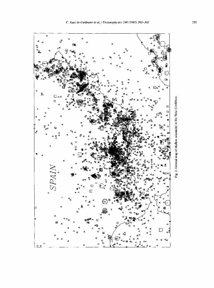
• ~ol[!p~o o o!lo fl oq] u! ,(]!a!tus!os ~Oll~qs jo dem
i~ouoo "E "~kl
~j
(D
;v V
v v
vV
v ~ ~l v
v~v_v~ *" "
~vv
~ -~
v
~ v
v v
V
V
V
~''v
V
~ []
V
VV
Z-I
V
v
m
m
vV
V
~' ~
V
I [] V
V
V
V
V
NV
I~1
v ~ ~
r~
~'¥
[] ,~v~ ]
~ V
~
V~
l
~ v
[]
vV
v ~'
i v
v e
~
v~VV
! ,
. ~v v v v
v (~v
I
V
I, V
vV
V
V
V
V~,
V
V
V V
V
V
V
,~v
v vQ
v ~
"
@
[] v
v
v
Ill v
[] ra m
V~
I V
V
o v
o
¢,9
,°
(D []
V ~
V V
~ m
o
W
~-~
v
v III
V
~ V
V
m v
V
V
mO
V
[]
V
m
V
V
V
V
~ V
V
m
V
V
V
V
V
V
V
[] []
V
V
V
V
V
VV
~,
0
[] []
°"
NI
Vd
S
° °
° []
I []
V
[] m
V
V
o v
~W
v i vv
v~
v~
v
v v
v v
vW

296 C. Sanz de Galdeano et al. / Tectonophysics 248 (1995) 293-302
I N T E N S I T Y S Y M B O L S
1 9 3 0 B E F O R E A F T E R
© v I [5]
(9 vHi [7]
(a) S P A I N
[ ]
mm @ ~9 ® O O © [] [] @
[ ] ©
"~i~" ALBORAN SEA
M A G N I T U D E S Y M B O L S
3 . 5 < [] < 4 . 0
4 . 0 < [ ] < 5 . 0
< ~ < 5 . 0 C.O
e.o <111< < o
[ ]
[] [ ]
% E
[] [ ] [ ] []
[ ]
(b)
[]
[]
S P A I N []
[] []
%
[]
23
[] []
[ ] [] [] []
[]
[]
[] []
% J
[] ©
[] []
[]
[] []
~D []
d~
[] vl~ []
[] m ~
[]
/ [ ] [ ]
[ ] m [] []
[] []
[] [] [] [] []
[] mm, [ ] ~ t ~ ! F r l ~ f-r]f-q m / i i ~ ~ I
Fig. 3. Map of shallow seismicity in the Betic Cordillera. (A) Considerin t values of ! >__ VI. (B) Considering values of M >__ 3,5.

C. Sanz de Galdeano et al. / Tectonophysics 248 (1995) 293-302 297
Iberian-Maghreb region (Mezcua and Martlnez So- lares, 1983) and subsequent revisions up to 1992. After relocation of the earthquakes on 1:200,000 scale maps, these and the information on the known fault network were fed into a computer. Clearly, there are numerous uncertainties and location errors involved with historic earthquakes (pre-1910). More- over, the dates from which the catalogue can be considered complete vary from 1930 to 1960, ac- cording to the sectors considered. In addition, even the locations for epicentres of instrumentally recorded earthquakes are significantly imprecise. Correlations between the earthquakes and the known faults there- fore generally present considerable uncertainty.
An overview of seismicity in the Betic Cordillera according to intensity is shown in Fig. 2. There are obvious significant groupings of earthquakes as well as areas almost free of earthquakes, but the number of events is so large and the degree of seismic noise so high, that reasonably reliable correlations are impossible. Therefore, to make correlations, we use maps showing seismicity above I > VI (MSK) or M l > 3.5 only (Fig. 3).
On the whole, the most important groupings are those of Ubrique, M~laga, Granada, Almerla, Vera, Murcia and Enguera. Only the Santa F6-Albolote, Almerla and Torrevieja groupings are well distin- guished in the instrumental period, although others such as Cehegln and Alcaudete can be detected. In addition, seismicity in the Betic Cordillera tends to concentrate towards the south, whereas earthquakes become less abundant and more disperse towards the Meseta (Iberian Massif). In other words, there is some correlation between the spatial distribution of the earthquakes and the position of the Betic Internal Zone. In fact, the fracture network is denser in the southern part of the Betic Cordillera.
3. The fault network in the Betic Cordillera
The pattern of faults dominating the Betic Cordillera is schematically represented in Figs. 4-6 , in which the faults formed from the Miocene to the present are shown, although it cannot be discounted that some may have formed earlier. Overthrust sur-
t I
S P A I N , , /
., \(Cw.:.,.,. \ ' , ? ;
I !
~ J
/~. / / / \
P / / /
J
A L B O R A N SEA
Fig. 4. Map of the fracture network. The main segments considered active from the neotectonic point of view are marked with thicker lines.

298 C. Sanz de Galdeano et al. / Tectonophysics 248 (1995) 293-302
faces between nappes are not shown, some of which were active before, during and even after the Early Miocene. These surfaces may also have been in- volved in extensional movements, particularly during the Early and Middle Miocene (Comas et al., 1992; Jabaloy et al., 1992). Our lack of information about their exact continuation in depth usually prevents correlation with earthquakes.
The traces of some of the faults shown are par- tially inferred. Traces are well known in some areas, whereas there are other areas in which the faults are hardly discernable. Three main preferential strikes (N70-90 °, northwest-southeast and northeast- southwest) are distinguished in this network (Sanz de Galdeano, 1983,1990; Boccaletti et al., 1987), which have moved differently throughout the Neogene. The N70-90 ° faults were originally dextral strike-slip faults, but these were largely immobilised in the Late Miocene or even became reversed with sinistral and/or vertical movements (locally as reverse faults
in more recent times). The faults striking northwest-southeast and northeast-southwest were active from the Late Miocene on. The former moved as dextral and the latter as sinistral strike-slip faults, but often predominantly or even exclusively as nor- mal faults, depending on the position of the compres- sion that fluctuated between northwest-southeast and north-south during the Late Miocene to the present.
At present the most visible movements throughout the different sets are normal faults, implying some uplift and radial extension of the Betic Cordillera (Sanz de Galdeano and L6pez Garrido, 1991), al- though there are also clear geological features show- ing approximately NNW-SSE-oriented compres- sions (Groupe de Recherche N6otectonique de l 'Arc de Gibraltar, 1977; Est6vez and Sanz de Galdeano, 1983; Ott d'Estevou and Montenat, 1985). Seismic data also reveal the same compression (Buforn and Udlas, 1991; Udlas and Buforn, 1991; Buforn et al., 1995). Most of these faults affected Upper Miocene
I N T E N S I T Y S Y M B O L S
1930 BEFORE AFTER
© VI []
( ~ v i i i [ ]
S P A I N
\ " p - ~
, ' /
j ~ - f J
\ f f
f l
//- / / /
L ORAN SEA \%hS-/
S
Fig. ft. Fracture network of the Betic Cordillera and situation of the epicentres of 1 > VI earthquakes. An initial correlation between these earthquakes and some fault segments is indicated by thicker lines.

C. Sanz de Galdeano et al. / Tectonophysics 248 (1995) 293-302 299
or later sediments, and therefore moved during the neotectonic period "sensu lato" in the Betic Cordillera, i.e., the period extending from the Torto- nian, and especially the late Tortonian, to the pre- sent. It is generally more difficult to consider these as active faults. In many cases they are suspected to present modern movements, but there are no Pleis- tocene or Holocene sediments to demonstrate their displacements. Moreover, where these deposits do exist, dating is difficult, as the sediments involved are mostly continental. To date, fossil remains (mainly rodent teeth) have been found only locally.
There are several definitions of an active fault (Hays, 1989). Given the preliminary nature of this paper, we have chosen one of the broadest concepts generally applied to potentially active faults. In par- ticular we considered the faults affecting Quaternary and even Pliocene sediments to be active. Geomor- phological and other criteria were also taken into account. The result of applying this concept of a
potentially active fault to fault segments over 3 km long is presented in Fig. 4. Thicker lines indicate clearly active segments or those considered at least potentially active from a neotectonic perspective. This length was chosen following Bonilla et al. (1984) and Darragh and Bolt (1987), who consider a rupture length of at least 3 km necessary to reach a magnitude of around 4.5. A similar value is deduced from the formula: log L (km)= -1 .388 + 0.4329 M, determined by Ryall and VanWormer (1980). Many more segments could undoubtedly be marked, but we have chosen a conservative approach at this stage of research.
Three areas of these potentially active segments are particularly noteworthy: Granada, eastern Almerla-Murcia and Alicante. In the Granada area there is a large number of faults which were clearly active during the Quaternary (and earlier) (Sanz de Galdeano, 1978; Santanach et al., 1980; Est6vez and Sanz de Galdeano, 1983,1984; Capote et al., 1983;
I N T E N S I T Y S Y M B O L S
1930 B E F O R E A F T E R
@ VI []
© viii []
S P A I N ! ' 1
, ,/ _ / / :
-Z l''p4 - 7 4 ,
,, "i-5"I./ / /
/ / /
4 / / / -
L ALBoRAN suA _ _ [ ] [ ] [ ]
Fig. 6. Simplified general scheme showing the main fault segments considered to be active (indicated by thicker lines) on the basis of both neotectonic and seismic data.
300 C. Sanz de Galdeano et al. / Tectonophysics 248 (1995) 293-302
Vidal et al., 1984) that is only schematically in- cluded in Fig. 5. In addition, some of the fault segments are less than 3 km long and are therefore not taken into account. To illustrate the importance of the movements in this area, we note that the Pliocene-Pleistocene in the city of Granada under- went 300 m vertical displacement, accommodated by several parallel NW-SE-trending faults.
The eastern Almerla-Murcia area is occupied by the Carboneras, Palomares and Lorca-Alhama de Murcia faults (Bousquet and Philip, 1976; Groupe de Recherche N~otectonique de l 'Arc de Gibraltar, 1977; Bousquet et al., 1978; Ott d'Estevou and Montenat, 1985; Coppier et al., 1989; Montenat and Ott d'Estevou, 1990; Montenat et al., 1990a,b). The movements of these faults took place throughout the Neogene and displacements in some places clearly occurred during the Pliocene and Quaternary. These are mainly sinistral strike-slip faults also presenting normal vertical movements. The latter are more clearly observed in the Lorca-Alhama de Murcia and Murcia fault zones.
The Alicante area is to some extent the northeast- ern continuation of the foregoing sector. Montenat et al. (1990a), Goy et al. (1989), Dabrio et al. (1990) and De Ruig (1992), among others, described Qua- ternary movements of the faults in this area. Monte- nat (1977) presented some relations between earth- quakes and faults in the Torrevieja and Bajo Segura regions. The other segments, not mentioned specifi- cally here, are also supported by different types of geological, and, in some cases, geophysical data, as in the western part, towards the extreme of the Guadalquivir valley (Viguier, 1974; Valenzuela, 1982)
groupings indicated above and the position of certain fractures, especially in areas where several fault sets intersect.
5. Discussion of results, faults considered poten- tial seismic sources
The main segments of the active and potentially active faults in the Betic Cordillera are shown in Fig. 6; however, this figure is only an approximation, as it has several limitations. First, the scale of the figure provides no specific feature in detail and the correla- tions are very general. Other limitations concern the quality of the data used. The location of earthquakes presents difficulties and uncertainties, and thus some correlations involving specific faults are debatable. Moreover, our knowledge of the fault network is incomplete and there may be basement faults not visible on the surface. Some important earthquakes cannot therefore be explained at present, as they were located far from the known faults. Furthermore, the results obtained must be complemented in many sectors with data on microseismicity, geophysical profiles, etc. For this reason the scheme shown in Fig. 6 is incomplete. Nonetheless, we believe that the fault segments marked on Fig. 6 do in fact correspond to true active and potentially active seg- ments. Even so, these should be specified and delim- ited in much greater detail. In addition, other, as yet unknown segments will have to be added. Our map must therefore be steadily improved, but nonetheless represents a basis for calculating seismic hazard, as it allows a real determination of coherent seismic sources linked to specific active faults.
4. Relations between shallow seismicity and the fault network
The known positions of I _> VI and also M l >_ 3.5 earthquakes were mapped onto the fault network. This correlation is presented in Fig. 5 on a reduced scale. In some cases this relationship is clear and we mark the fault segment as seismically active. Other cases are doubtful and in some the earthquakes cannot be related to any known fault. There is partic- ularly good correlation between the main seismic
6. Conclusions
The correlation of I > VI or M~ > 3.5 earthquake epicentres with the known fault pattern in the Betic Cordillera leads to the deduction of a series of active fault segments. The neotectonic data obtained in the field in turn permit the delimitation of a series of active or at least potentially active fault segments. In many cases both sources of data indicate the same fault segments. The highly simplified results are shown in Fig. 6.
C. Sanz de Galdeano et al. / Tectonophysics 248 (1995) 293-302 301
Active fault segments appear throughout the Betic Cordillera, but are especially concentrated in certain specific areas. The most significant of these is the Granada sector, which is primarily controlled by NW-SE-striking faults. In the southeastern part there is a series of faults striking mainly northeast-south- west and extending from Almerla to Alicante. There are also numerous fault segments striking N60-70°E to east-west in the southwestern part of Granada and in the vicinity of Mfilaga, which are considered active from both the neotectonic and seismic stand- points. The map presented, while requiring improve- ment on the basis of microseismicity studies and analyses of geophysical data (seismic profiles, etc.), provides a preliminary approach to the correlation of seismic sources with specific fault segments.
Acknowledgements
This study was made possible by funding ap- proved for projects PB91-0079 (DGICYT), PB92- 0184-C02-01 and Working Group 4085 "Anfilisis y Dinfimica de Cuencas" (Junta de Andalucla).
References
Andrieux, J., FontbotE, J.M. and Mattauer, M., 1971. Sur un module explicatif de l'Arc de Gibraltar. Earth Planet. Sci. Lett., 12: 191-198.
Boccaletti, M., Gelati, R., L6pez Garrido, A.C., Papani, G., Rodrlguez Femfindez, J. and Sanz de Galdeano, C., 1987. Neogene-Quaternary sedimentary-tectonic evolution of the Betic Cordillera. Acta Nat. "L'Ateneo Parmense", 23: 179- 200.
Bonilla, M.G., Mark, R.K. and Lienkaemper, J.J., 1984. Statistical relations among earthquake magnitude, surface rupture length and surface displacement. Bull. Seismol. Soc. Am., 74: 2379- 2411.
Bousquet, J.C. and Philip, H., 1976. Observations microtec- toniques sur la compression nord-sud quatemaire des Cordillbres bEtiques orientales (Espagne m6ridionales-Arc de Gibraltar). Bull. Soc. GEol. Fr., 18: 711-724.
Bousquet, J.C., Montenat, C. and Echallier, J.C., 1978. Ruptures dans des contructions situe6s sur des failles actives du Sud de la Peninsule ibErique. Vie R.A.S.T., Orsay (Soc. GEol. Edit.), p. 64.
Buforn, E. and Udlas, A., 1991. Focal mechanism of earthquake in the Gulf of Cadiz, South Spain and Alboran Sea. In: J. Mezcua and A. Udlas (Editors), Seismicity, Seismotectonics
and Seismic Risk of the lbero-Maghrebian Region. Publ. Inst. Geogr. Nac. Madrid, 8: 30-40.
Buforn, E., Sanz de Galdeano, C. and Udias, A., 1995. Seismotec- tonics of the lbero-Maghrebian region. Tectonophysics, 248: 247-261 (this issue).
Capote, R., Carb6, A., Est6vez, A., G6mez Prieto, J.A., Gonz:ilez de Vallejo, L., Pernia, J.M., Rosales, E., Saint-Aubin, J., Sanz d e Galdeano, C. and Udlas, A., 1983. Mapa sismotect6nico de Espafia. Hoja piloto (Granada), a escala 1:100.000. I.G.M.E. 1, 36 pp.
Comas, M.C., Garcla-Duefias, V. and Jurado, V., 1992. Neogene tectonic evolution of the Alboran Sea from MCS data. Geo- Mar. Lett., 12(2-3): 157-164.
Coppier, G., Griveaud, P., De Larouzi~re, F.D., Montenat, C. and Ott d'Estevou, P., 1989. Example of Neogene tectonic indenta- tion in the Eastern Betic Cordilleras: the Arc of Aguilas (Southeastern Spain). Geodin. Acta 3(1): 37-51.
Dabrio, C.J., Zazo, C., Goy, J.L., Santisteban, C., Bardaji, T. and Somoza, L., 1990. Neogene and Quaternary fan delta deposits in southeastern Spain. II Fan-Delta Workshop, Murcia, Field Guideb., 70 pp.
Darragh, R.B. and Bolt, B.A., 1987. A comment on the statistical regression relation between earthquake magnitude and fault rupture length. Bull. Seismol. Soc. Am., 77: 1479-1484.
De Ruig, M.J., 1992. Tectono-sedimentary evolution of the Pre- betic fold belt of Alicante (SE Spain). Thesis Univ. Amster- dam, 208 pp.
Durand-Delga, M. and FontbotG J.M., 1980. Le cadre structural de la MEditerranEe occidentale. 26 Congr. GEol. Int., Paris, Les Chaines alpines issues de la T6thys. MEm. B.R.G.M., 115: 67-85.
EstEvez, A. and Sanz de Galdeano, C., 1983. NEotectonique du secteur central des Cha~nes B&iques (Basins du Guadix-Baza et de Grenade). Rev. G6ogr. Phys. GEol. Dyn., 21: 23-34.
EstEvez, A. and Sanz de Galdeano, C., 1984. Neotect6nica en la depresi6n de Granada y fireas pr6ximas. MEtodos empleados para el estudio de las deformaciones neotect6nicas. Energ. Nucl., 149-150: 249-257.
Goy, J.L., Zazo, C., Somoza, L. and Dabrio, C.J., 1989. The neotectonic behaviour of the Lower Segura River Basin during the Quaternary. Palaeographical behaviour of the "Con- glomerates of the Segura". Bull. INQUA Neotectonic Comm., 12: 14-17.
Groupe de Recherche NEotectonique de l'Arc de Gibraltar, 1977. L'histoire tectonique rEcente (Tortonien ~ Quaternaire) de l 'Arc de Gibraltar et des bordures de lamer d'Alboran. Bull. Soc. GEol. Fr., 19(3): 575-614.
Hays, W.W., 1989. Aspectos fundamentales de la geologia y de la sismologia para la microzonaci6n slsmica. Fisica de la Tierra. Movimientos fuertes del sueio y riesgo de terremotos. Univ. Complutense, Madrid, 1: 17-250.
Jabaloy, A., Galindo-Zaldlvar, J. and Gonzfilez-Lodeiro, F., 1992. The Mecina extensional system: Its relation with the Post- Aquitanian piggy-back basins and the paleostresses evolution (Betic Cordilleras, Spain). Geo-Marine Lett., 12(2-3): 96-103.
IMpez Casado, C., Sanz de Galdeano, C., Delgado, J. and Peinado, M.A., 1995. The parameter b in the Betic Cordillera, the Rif

302 C. Sanz de Galdeano et al. / Tectonophysics 248 (1995) 293-302
and neighbouring areas. Its relations with the tectonics of the region. Tectonophysics, 248:277-292 (this issue).
Mezcua, J. and Martlnez Solares, J.M., 1983. Sismicidad de area Ibero-Mogrebl. Publ. Inst. Geogr. Nac. Madrid 203, 300 pp.
Montenat, C., 1977. Les bassins n~og~nes du levant d'Alicante et de Murcia (Cordill~res B6tiques Orientales, Espagne). Doc. Lab. GEol. Fac. Sci. Lyon 69, 345 pp.
Montenat, C. and Ott d'Estevou, P., 1990. Eastern betic Neogene basins: a review. Doc. Trav. IGAL, 12-13: 9-15.
Montenat, C., Ott d'Estevou, P. and Coppier, G., 1990a. Les Bassins neog~nes entre Alicante et Cartagena. Doc. Trav. IGAL, 12-13: 313-368.
Montenat, C., Ott d'Estevou, P., Rodrlguez Fernfindez, J. and Sanz de Galdeano, C., 1990b. Geodynamic evolution of the Betic Neogene Intramontane Basins (S and SE Spain). In: Iberian Neogene Basins. IX R.C.M.N.S. Congr., Paleontologia i Evoluci6, Spec. Publ., pp. 7-59.
Ott d'Estevou, P. and Montenat, C., 1985. Evolution structurale de la zone b&ique orientale (Espagne) du Tortonien a l'Holoc~ne. C. R. Acad. Sci. Paris, 300, II, 8: 363-368.
Ryall, A.S. and VanWormer, J.D., 1980. Estimation of maximum magnitude and recommended seismic zone changes in the western Great Basin. Bull. Seismol. Soc. Am., 70(5): 1573- 1581.
Santanach, P., Sanz de Galdeano, C. and Bousquet, J.C., 1980.
Neotect6nica de las regiones mediterrfineas de Espafia (Cata- lufia y Cordilleras B&icas). Bol. Inst. Geol. Min., 91-92: 417-440.
Sanz de Galdeano, C., 1978. Datos sobre las deformaciones ne6genas y cuaternarias del sector del Padul (Granada). In: Geodinfimica de la Cordillera B&ica y mar de Alborfin. Serv. Publ. Univ. Granada, pp. 197-218.
Sanz de Galdeano, C., 1983. Los accidentes y fracturas principales de las Cordilleras B6ticas. Estud. Geol., 39: 157-165.
Sanz de Galdeano, C., 1990. Geologic evolution of the Betic Cordilleras in the Western Mediterranea, Miocene to the pre- sent. Tectonophysics, 172: 107-119.
Sanz de Galdeano, C. and L6pez Garrido, A.C., 1991. Tectonic evolution of the Malaga basin (Betic Cordillera). Regional implications. Geodin. Acta, 5: 173-186.
Udlas, A. and Buforn, E., 1991. Regional stresses along the Eurasia-Africa plate boundary derived from focal mechamism of large earthquakes. Pure Appl. Geophys., 136(4): 433-448.
Valenzuela, J.M., 1982. Paleogeografla de la depresi6n del Guadalquivir durante el Ne6geno. Bol. Geol. Min., 93: 26-32.
Vidal, F., Sanz de Galdeano, C. and De Miguel, F., 1984. Neotect6nica y sismicidad de la depresi6n de Granada. Energ. Nucl., 149-150: 267-275.
Viguier, C., 1974. Le N6og~ne de l'Andalousie Nord Occidentale (Espagne). Thesis Univ. Bordeaux, 462 pp.