SFG2879 V6 - World Bank Documents
105
GOVERNMENT OF ANAMBRA STATE NIGERIA EROSION AND WATERSHED MANAGEMENT PROJECT (NEWMAP) ANAMBRA STATE PROJECT MANAGEMENT UNIT FINAL REPORT ABBREVIATED RESETTLEMENT ACTION PLAN (ARAP) NKPOR FLYOVER GULLY EROSION SITE IDEMILI NORTH LGA, ANAMBRA STATE. NIGERIA September, 2017 SFG2879 V6 Public Disclosure Authorized Public Disclosure Authorized Public Disclosure Authorized Public Disclosure Authorized
-
Upload
khangminh22 -
Category
Documents
-
view
1 -
download
0
Transcript of SFG2879 V6 - World Bank Documents

GOVERNMENT OF ANAMBRA STATE NIGERIA EROSION AND WATERSHED MANAGEMENT PROJECT
(NEWMAP) ANAMBRA STATE PROJECT MANAGEMENT UNIT
FINAL REPORT
ABBREVIATED RESETTLEMENT ACTION PLAN (ARAP)
NKPOR FLYOVER GULLY EROSION SITE
IDEMILI NORTH LGA, ANAMBRA STATE. NIGERIA
September, 2017
SFG2879 V6P
ublic
Dis
clos
ure
Aut
horiz
edP
ublic
Dis
clos
ure
Aut
horiz
edP
ublic
Dis
clos
ure
Aut
horiz
edP
ublic
Dis
clos
ure
Aut
horiz
ed

Page | ii
FINAL REPORT
ABBREVIATED RESETTLEMENT ACTION PLAN (ARAP)
Credit No.: IDA51050
Project ID: P124905
NKPOR FLYOVER GULLY EROSION PROJECT
IDEMILI NORTH LGA, ANAMBRA STATE
Anambra State NEWMAP
Chief Jerome Udoji Secretariat Complex
Awka, Anambra State
Nigeria
September, 2017

Page | iii
TABLE OF CONTENTS
TABLE OF CONTENTS ........................................................................................ iii
LIST OF ABBREVIATIONS .................................................................................. vii
EXECUTIVE SUMMARY ...................................................................................... ix
1.0 INTRODUCTION ..................................................................................... 1
1.1 Purpose ....................................................................................................................................... 1
1.2 Background................................................................................................................................. 1
1.3 Responsible Lead Agencies .................................................................................................... 2
1.4 Nkpor Flyover Gully Description .............................................................................................. 3
2.0 PROJECT DESCRIPTION AND AREAS OF INFLUENCE: .............................. 5
2.1 Project Design ............................................................................................................................ 5
2.2 Project Activities ......................................................................................................................... 5
2.3 Project Rationale: ...................................................................................................................... 6
2.4 Perimeter of Project Influence ................................................................................................. 8
3.0 POLICY, LEGISLATIVE AND ADMINISTRATIVE FRAMEWORK ................... 9
3.1 Overview ..................................................................................................................................... 9
3.2 Nigerian Land Related Legal Issues ....................................................................................... 9
3.2.1 Customary Land Tenure .................................................................................................... 9
3.2.2 Statutory Tenure ................................................................................................................. 9
3.3 World Bank Involuntary Resettlement OP 4.12 .................................................................... 9
3.4 Gaps between Nigeria Laws and WB Policies on Land Acquisition and Resettlement 10
3.5 Resolution of Gaps between Nigerian and OP 4.12 Policies on Resettlement ............. 10
3.6 Analysis of the Provisions of the Land Use Act and OP 4.12 ........................................... 11
4.0 SOCIOECONOMIC AND CULTURAL BASELINE CONDITIONS .................. 12
4.1 Introduction: .............................................................................................................................. 12
4.1.1 Socioeconomic Survey: ................................................................................................... 12
4.1.2 Public Consultation: ......................................................................................................... 12
4.1.3 Use of Maps and GIS: ..................................................................................................... 12

Page | iv
4.2 Cultural Environment ............................................................................................................... 12
4.2.1 Population .......................................................................................................................... 12
4.2.2 Ethnic Groups ................................................................................................................... 13
4.2.3 Religion .............................................................................................................................. 13
4.3 Land Use Pattern ..................................................................................................................... 13
4.3.1 Cultural Resources ........................................................................................................... 14
4.4 Analysis of Socioeconomic Survey ....................................................................................... 14
4.4.1 Objectives of the Socioeconomic Survey ..................................................................... 14
4.4.2 Respondent and Household Distribution in Project Area ........................................... 14
4.4.3 Gender, Age and Household Size Distribution ............................................................ 15
4.4.4 Marital Status of Respondents ....................................................................................... 15
4.4.5 Access to Education ........................................................................................................ 16
4.4.6 Occupational and Income Distribution of Respondents ............................................. 16
4.4.7 Household Waste Disposal ............................................................................................. 17
4.5 Desirability of the Project ........................................................................................................ 17
4.6 Conflict Resolution ................................................................................................................... 17
4.7 Community Participation ......................................................................................................... 17
5.0 SUMMARY OF PUBLIC PARTICIPATION AND CONSULTATIONS WITH STAKEHOLDERS ................................................................................................ 20
5.1 Objective of Community Consultation .................................................................................. 20
5.2 Public Participation Process .................................................................................................. 20
5.2.1 Stakeholders’ Identification ............................................................................................. 20
5.2.2 Community Consultations and Meetings ...................................................................... 22
5.2.3 Summary of Meetings with Stakeholders ..................................................................... 22
5.3 Social Issues/Risks ................................................................................................................. 22
5.4 Guiding Principles .................................................................................................................... 24
6.0 POTENTIAL IMPACTS OF PROPOSED PROJECT ..................................... 26
6.1 Field Findings ........................................................................................................................... 26
6.2 Potential Project Impact Areas .............................................................................................. 26
6.2.1 Rehabilitation of Gully Erosion Corridor ........................................................................ 26

Page | v
6.3. Identified Project Impacts ...................................................................................................... 27
6.3.1 Potential Positive Project Impacts ................................................................................. 27
6.3.2 Potential Negative Impacts and Mitigation Measures ................................................. 27
6.4 Identification of Project Affected Population ........................................................................ 30
6.5 Vulnerable Group ..................................................................................................................... 32
7.0 PROPOSED RESETTLEMENT PLAN ........................................................ 34
7.1 Eligibility .................................................................................................................................... 34
7.1.1 Loss of Assets ................................................................................................................... 34
7.1.2 Loss of Livelihood ............................................................................................................. 34
7.2 Entitlement Matrix .................................................................................................................... 34
7.3 Valuation Procedures .............................................................................................................. 36
7.4 Compensation for Losses and Other Assistance ............................................................... 38
7.4.1 Resettlement Measures .................................................................................................. 38
7.4.2 Compensation for Land Losses ..................................................................................... 38
7.4.3 Compensation for Displacements .................................................................................. 38
7.4.4 Compensation for Loss of Economic Trees/crops ...................................................... 38
7.5 Formation of Grievance Redress Committee ...................................................................... 38
7.6 Resettlement Implementation Committee (RIC) ................................................................. 39
7.7 Compensation Procedures ..................................................................................................... 40
7.7.1 Relocation Times .............................................................................................................. 40
7.7.2 Livelihood Restoration ..................................................................................................... 40
7.8 Dispute Resolution and Grievance Redress Procedure .................................................... 40
7.8.1 Dispute Resolution ........................................................................................................... 40
7.8.2 Dispute Over Land Matters ............................................................................................. 41
7.8.3 Grievance Redress Mechanisms ................................................................................... 41
7.9 Monitoring and Evaluation (M & E) ....................................................................................... 42
7.9.1 Performance Indicators ................................................................................................... 43
7.9.2 Completion Audit .............................................................................................................. 44
8.0 ESTIMATED COST OF ARAP .................................................................. 45
9.0 IMPLEMENTATION SCHEDULE ............................................................. 49

Page | vi
10.0 SUMMARY AND RECOMMENDATION ............................................... 50
DISCLOSURES ................................................................................................... 51
GLOSSARY OF TERMS ....................................................................................... 51
REFERENCES .................................................................................................... 52
ANNEXURE A .................................................................................................... 53
LIST OF CONTACTED STAKEHOLDERS ......................................................................................... 53
ANNEXURE B .................................................................................................... 54
MINUTES OF COMMUNITY SENSITIZATION MEETING WITH SPMU AND CONSULTANT .................. 54
ANNEXURE C .................................................................................................... 75
SAMPLE SOCIOECONOMIC/CENSUS DATA FORM ............................................................................ 75
ANNEXURE D ................................................................................................... 81
LIST OF IDENTIFIED VULNERABLE PERSONS AND PROPOSED SUPPORT .......................................... 81
ANNEXURE E .................................................................................................... 82
LIST OF PROJECT AFFECTED PERSONS (PAPs) AND COMPENSATIONS ............................................. 82
ANNEXURE F .................................................................................................... 86
PHOTO IDENTIFICATION OF IDENTIFIED VULNERABLE PERSONS AND PAPs .................................... 86
PHOTO IDENTIFICATION OF VULNERABLE PERSONS .................................................................... 86
PHOTO IDENTIFICATION OF PROJECT AFFECTED PERSONS (PAPs)............................................... 88
Page | vii
LIST OF ABBREVIATIONS
AIA ARAP Implementation Agent
ANS-NEWMAP Anambra State Nigeria Erosion and Watershed Management Project
ANSG Anambra State Government of Nigeria
ARAP Abbreviated Resettlement Action Plan
CAI Community Administrative Institutions
CBO Community Based Organization
CIP Community Involvement Program
CRMCI Community Resource Management and Conservation Initiative
ESIA Environmental and Social Impact Assessment
ESMF Environmental and Social Management Framework
ESMP Environmental and Social Management Plan
ESO Environmental Safeguard Officer
FBO Faith-Based Organization
FGD Focused Group Discussion
FGN Federal Government of Nigeria
FME Federal Ministry of Environment
GEF Global Environmental Fund
GIS Geographic Information System
GRASS Gully Rapid Action and Slope Stabilization
GPS Global Positioning System
GRM Grievance Redress Mechanism
LGA Local Government Area
MOE Ministry of Environment, Beautification and Ecology
NEWMAP Nigeria Erosion and Watershed Management Project

Page | viii
NGO Non-governmental Organization
OP Operation Procedure of the World Bank
OTG OTG Enviroengineering Nigeria Limited
PAH Project-Affected Household
PAP Project-Affected Person
PC Project Coordinator
PG President General
PRS Government’s Poverty Reduction Strategy (PRS)
RAP Resettlement Action Plan
SCCF Special Climate Change Fund
SLO Social & Livelihood Officer
SMEC SMEC International (Pty) Ltd, West African Region
SPMU State Project Management Unit
ToR Terms of Reference
WB World Bank

Page | ix
EXECUTIVE SUMMARY Introduction The Nigeria Erosion and Watershed Management Project (NEWMAP), initiated by the Federal Government of Nigeria (FGN) and funded by the World Bank (WB) and International Development Fund (IDF), is being implemented in Anambra State, Nigeria and other participating states to help reduce soil erosion vulnerability in the States and to develop the States’ watersheds. Nkpor Flyover is one of the locations in the State acutely being degraded and destroyed by active gully erosion and perennially suffers huge losses resulting from the impacts of the gully erosion. With each passing year, uncontrolled stormwater flow threatens lives and properties as the existing gullies become widened and more menacing. The Anambra State NEWMAP is targeting to remedy and rehabilitate the existing gully and reduce the impacts through the NEWMAP opportunity. The Nkpor Flyover gully erosion control sub-project will address and prevent the perennial exacerbation of existing gully at Nkpor Flyover Community located in Idemili North Local Government Area (LGA) of Anambra state as well as reverse land degradation within the community. The overall objective of this Consultancy is to prepare an Abbreviated Resettlement Action Plan (ARAP) for the Nkpor Flyover gully erosion project in Anambra State. The ARAP Consultancy seeks to specifically identify, evaluate and document the set of mitigation, monitoring and institutional actions to be undertaken at the villages to eliminate identified adverse community or individual social and livelihood impacts before commencing the remedial construction and rehabilitation works. The objective of the WB Resettlement Plans is to restore persons affected by the project to a condition equivalent to or better than the pre-project situation. This ARAP also provides monitoring and institutional actions to be taken before the remedial construction and rehabilitation works to eliminate or reduce to acceptable levels the identified adverse environmental and social impacts. Project Description The Nkpor Flyover gully erosion project consists of remedial structural and non-structural developments that include civil works and vegetative development along the gully corridor. The proposed ground interventions will address, prevent and reverse land degradation for the long-term and will involve rehabilitation and reconstruction of the existing gully corridor. The rehabilitation and reconstruction activities will involve civil works as well as bio-restoration along the gully corridor and will cause involuntary resettlement thereby triggering the World Bank’s OP 4.12 - the World Bank Resettlement Policy. Need for ARAP The Resettlement Policy Framework (RPF) prepared for NEWMAP sub-projects indicated that the number of potentially project affected persons (PAPs) would be less than 200. Accordingly, an Abbreviated Resettlement Action Plan (ARAP) is required in accordance with WB Safeguard policy to guide the intervention process for this gully erosion intervention project under NEWMAP. Additionally, a significantly high level of social impact will result from land acquisition with the implementation of the project. This ARAP has been prepared to conform to the requirements of the WB OP4.12 and the Nigerian national social policies, guidelines and assessment procedures as well as those of Anambra State Government and the Local Agencies. Project Location Anambra State is located in the Southeast geopolitical zone of Nigeria. Nkpor is located within the co-ordinates: latitude 60 91N; longitude 60521E and latitude 60 1501N, longitude 60
8671E and situated in Idemili North LGA in the central part of the Anambra State.

Page | x
Legal Framework for Land Acquisition The Nigeria Land Use Act of 1978, as amended in 2004 provides the legal framework for land acquisition in Nigeria. Under the World Bank, the Operational Policy OP 4.12 addresses land acquisition and involuntary resettlement. The differences between the Land Use Act and the Bank’s OP 4.12 are mostly in the rehabilitation measures, which are neither proscribed nor mandated in the Act. It is noted that in the event of divergence between the two policies, the one that better serves the needs of the PAPs takes precedence. Potential Impacts There are both positive and negative impacts associated with this project. On the positive side, this project will provide a huge emotional and economic relief to residents of Nkpor Flyover Community whose building properties, ancestral lands and livelihoods are under imminent threat of destruction by gully erosion and flood. Additionally, the project will improve flow of traffic in and out of the project area neighborhood upon completion; reduce costs of transport and delays on travelling along the access roads; improve livelihoods for the area residents due to reduced cost of transportation; improve the landscape vista; and provide temporary job opportunities for both skilled and un-skilled labors. The identified major negative impacts of the project include loss of land and economic trees/farm crops, loss of vegetation, dust evolution, noise and vibration generation. Mitigation of these impacts to acceptable levels has been proffered in the ESMP, engineering designs and this ARAP. Evaluations in this ARAP indicate that about 18804m2 of land acquisition is needed for the purpose of stabilizing the gully walls, particularly at the deep sections of the gully corridor and there will be loss of economic trees/farm crops within this area of land to be acquired. The project does not envisage any involuntary displacement of persons due to destruction of existing structures. However, 65 project-affected persons (PAPs) and 14 vulnerable persons whose livelihoods and possibly health may be adversely affected by project activities have been identified. All the identified land and economic trees/crop owners are to be appropriately compensated for their required land and the loss of economic trees/crops in accordance with the WB and Nigeria Policies on land acquisition. Mitigation of Potential Impacts It is important that prior to project implementation, resettlement and livelihood restoration for the PAPs should be effected. Owners of acquired land and economic trees/crops there-on, and other business operators should be compensated. Residents/tenants of building structures with fragile health conditions, such as asthma and age-related issues, who may likely be adversely impacted by project activities should be temporarily relocated during the construction phase and be compensated for the inconveniences of relocation. Public Participation and Consultations Public participation and stakeholders’ consultations were effectively conducted in the course of this ARAP. To ensure that the rights and interests of PAPs are considered seriously, local level consultative forums serve as community voices and these have become part of the entire project process. This ARAP documents those that were consulted, dates, concerns raised and the ARAP response to these concerns. Household census of the people identified as PAPs were conducted to establish their socioeconomic profile including their health related status. Only PAPs who registered and met the cut-off date (February 12, 2017) including necessary date extensions (to allow for full community participation) during the baseline survey are considered to be eligible for any form of compensation or assistance. Extension of the cut-off date was to ensure that non-resident PAPs were also registered. Grievance Redress Mechanism A mechanism through which complaints and disagreements can be smoothly resolved has been devised. Currently, there is a series of customary avenues that exist to deal with dispute resolution in the community and they will be employed as the “court of first appeal”, as necessary. It is anticipated that this will allow unencumbered platform for people to

Page | xi
express their dissatisfaction over compensation as well as avoid unnecessary legal delays and cost overrun of the project. Formation of Grievance Redress Committee and Resettlement Implementation Committee is recommended. The SPMU has also opened toll free lines and a public complaints/suggestion box for Communities to bring up their complaints. This ensures that Communities can forward their grievances at absolutely no cost. The SPMU toll-free and office phone numbers are 081830034431 and 08183034336, respectively. All grievances or complaints must be registered and compiled regularly for project management. The devised mechanisms are fundamental to achieving transparency in the resettlement process. ARAP Coordination and Implementation The State has appointed a focal NGO to provide technical support to SPMU and ensure monitoring & evaluation of the implementation process. The primary responsibility for the project execution is on the SPMU. The SPMU may also appoint consultants to provide necessary awareness, mobilization and facilitation, project appraisal, approval & disbursement, capacity building, monitoring & evaluation reporting to the FPMU and the World Bank. The budget estimate for compensation and resettlement for economic trees/crops under this ARAP, including cost of administration, monitoring and evaluation is N28,801,909.50 (Twenty Eight Million Eight Hundred and One Thousand, Nine Hundred and Nine Naira Fifty Kobo) only. Since these costs must be borne out of counterpart funds, it should be included in the overall project budget. Monitoring and Evaluation In order to successfully complete the resettlement management as per the implementation schedule and compliance, monitoring and evaluation of the ARAP implementation will be a continuous process and will include internal and external monitoring. The Anambra NEWMAP Safeguard/Livelihood Officer will play a key role in reporting the progress of implementation as well as compliance to the SPMU and the World Bank. Review and Disclosure This ARAP is expected to be subjected to public review and it should be disclosed in-the state to the general public for review and comment at designated locations in Anambra State and in World Bank Info Shop. Display centers will include Anambra NEWMAP SPMU office, NEWMAP FPMU office, EA Department of FMEnv., Office of State Commissioner for Environment, LGA NEWMAP Liaison office, Project Community, and Office of the State Commissioner for Local Government matters.

Page | 1
1.0 INTRODUCTION
1.1 Purpose
This Abbreviated Resettlement Action Plan (ARAP) has been prepared in support of the ground intervention in the Nkpor Flyover Gully Erosion project in Idemili North Local Government Area (LGA) of Anambra State under the Nigeria Erosion and Watershed Management Project (NEWMAP). The ARAP Consultancy seeks to specifically identify, evaluate and document the set of mitigation, monitoring and institutional actions to be undertaken at the project areas to eliminate identified adverse community or individual social and livelihood impacts before commencing the remedial construction and rehabilitation works associated with the project. This Report also includes measures needed to implement the identified actions, addressing the adequacy of the monitoring and institutional arrangements and also provides guidelines to stakeholders participating in the mitigation, including rehabilitation/resettlement operations in order to ensure that the project affected persons (PAPs) will not be impoverished by the adverse social impacts of the project.
1.2 Background
NEWMAP was initiated by the Federal Government of Nigeria (FGN) to help reduce soil erosion vulnerability and to develop watersheds in participating States of Nigeria. The project is funded by the International Development Fund (IDF)/World Bank (WB).Anambra State is located in the Southeast geopolitical zone of Nigeria and is known to be under severe flood and erosion impacts. The State has been identified as the epicenter of gully erosion in Nigeria.
Nkpor is located within the co-ordinates: latitude 60 91N and60 1501N, and longitude 60521E and 60 8671E and situated in Idemili North LGA in the central part of the Anambra State. The town is one of the many towns in Anambra State whose communities are perennially devastated by erosion gullies resulting from stormwater flow. With each passing year, uncontrolled stormwater flow creates new gullies that threaten lives and properties while existing gullies are deepened and widened. In an effort to reduce the impacts of erosion on Nkpor town, the Anambra State Government (ANSG) has proposed to rehabilitate and remedy one of the existing gullies – Nkpor Flyover gully erosion corridor through the NEWMAP opportunity. Figure 1-1 shows the location of Anambra State within the Southeast of Nigeria. Figure 1-2 shows the location of Idemili LGA in Anambra State. The project intervention at the Nkpor Flyover erosion corridor is expected to have widespread positive impacts on overall socio-economic status and livelihoods of the residents of the area and identified project-affected persons (PAPs). The project will however, have some negative impacts especially to those who are resident in the immediate vicinity of the
Anambra State
Figure 1-1: Map of Nigeria Showing Anambra State
Page | 2
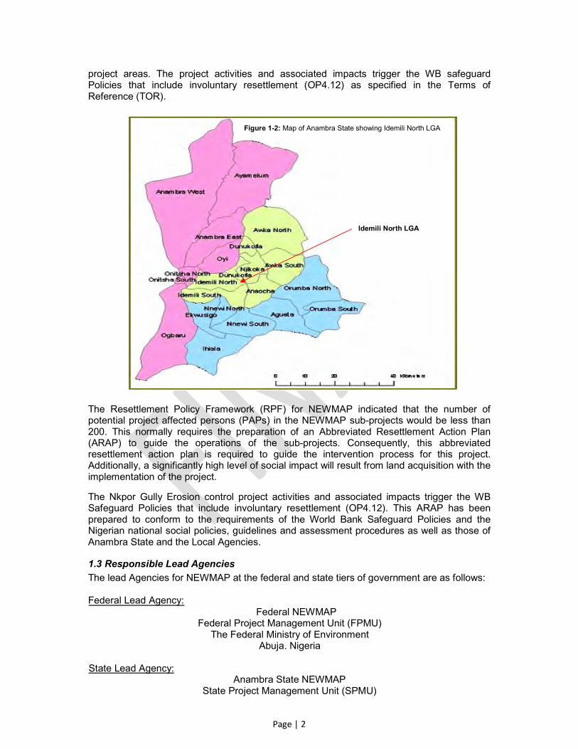
project areas. The project activities and associated impacts trigger the WB safeguard Policies that include involuntary resettlement (OP4.12) as specified in the Terms of Reference (TOR).
The Resettlement Policy Framework (RPF) for NEWMAP indicated that the number of potential project affected persons (PAPs) in the NEWMAP sub-projects would be less than 200. This normally requires the preparation of an Abbreviated Resettlement Action Plan (ARAP) to guide the operations of the sub-projects. Consequently, this abbreviated resettlement action plan is required to guide the intervention process for this project. Additionally, a significantly high level of social impact will result from land acquisition with the implementation of the project.
The Nkpor Gully Erosion control project activities and associated impacts trigger the WB Safeguard Policies that include involuntary resettlement (OP4.12). This ARAP has been prepared to conform to the requirements of the World Bank Safeguard Policies and the Nigerian national social policies, guidelines and assessment procedures as well as those of Anambra State and the Local Agencies.
1.3 Responsible Lead Agencies
The lead Agencies for NEWMAP at the federal and state tiers of government are as follows: Federal Lead Agency: Federal NEWMAP
Federal Project Management Unit (FPMU) The Federal Ministry of Environment
Abuja. Nigeria State Lead Agency:
Anambra State NEWMAP State Project Management Unit (SPMU)
Idemili North LGA
Figure 1-2: Map of Anambra State showing Idemili North LGA
Page | 3
Ministry of Environment, Beautification and Ecology Awka. Anambra State
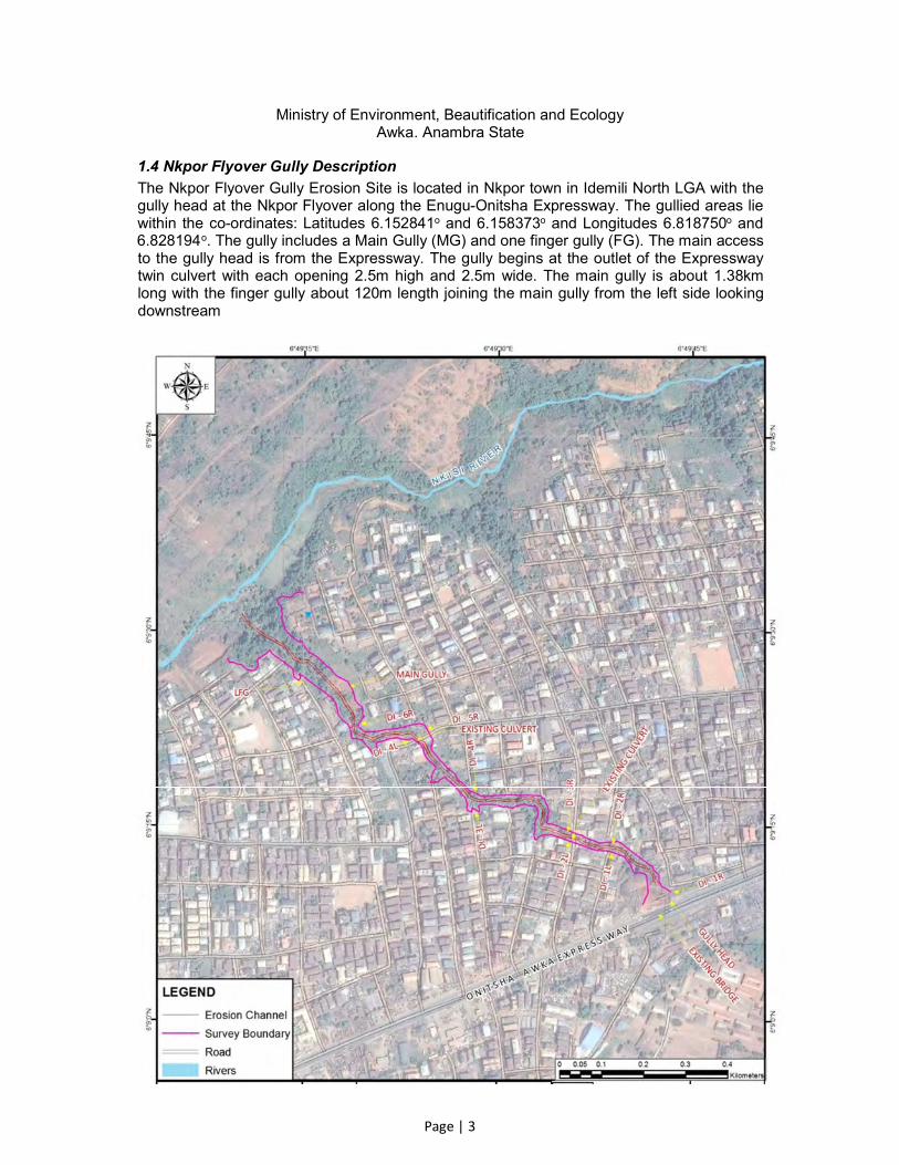
1.4 Nkpor Flyover Gully Description
The Nkpor Flyover Gully Erosion Site is located in Nkpor town in Idemili North LGA with the gully head at the Nkpor Flyover along the Enugu-Onitsha Expressway. The gullied areas lie within the co-ordinates: Latitudes 6.152841o and 6.158373o and Longitudes 6.818750o and 6.828194o. The gully includes a Main Gully (MG) and one finger gully (FG). The main access to the gully head is from the Expressway. The gully begins at the outlet of the Expressway twin culvert with each opening 2.5m high and 2.5m wide. The main gully is about 1.38km long with the finger gully about 120m length joining the main gully from the left side looking downstream

Page | 4
Figure 1-3: Satellite View of Project Area Showing the Nkpor Flyover Gully Corridor The gully site is identified as a geo-hazard area as the upward movement of main gully head is cutting into the Enugu-Onitsha Expressway and causing the collapse of the road embankment. The twin culvert and the road have been under maintenance since the embankment collapsed during the past rainy season. The entire gully corridor is a highly urbanized area and is crossed by a number of urban feeder roads two of which are fitted with box culverts. The two box culverts crossing the gully include one double cell (2.0m x 4.5m) culvert and one triple cell culvert (2.0m x 2.0m). The gully corridor can be seen from the satellite view of the Nkpor Flyover gully area shown in Figure 1.3. The first set of box culvert crossing is located at about 200m from the Flyover along the gully where the area is predominantly used as a waste dump site and interfering with the storm water flow conveyance through the channel. The longitudinal slope of the Main Gully bed varies from 3% to 256%. The steep portions of the gully are located in the middle section of the gully corridor and towards the Nkisi Stream outfall. The width of the gully varies from a minimum of 4m to a maximum of 13m wide. The gully wall bank slope varies from 4.1% to 152.5% on the left side looking downstream and from 8.9% to 271.2% on the right side. The elevation across the gully corridor ranges from a maximum of 107m above sea level at the Flyover end to a minimum of 42m above sea level at the Nkisi outfall. The Finger Gully has a bed level difference of 20m with a well defined existing channel at the gully head while the channel sections downstream have essentially collapsed and/or undefined. The majority of the gully banks have collapsed highlighting the need for armouring this section of the gully to stop further bank erosion. The gully head area of the site is highly populated and residential buildings are situated very close to the gully edges. This can be seen from the satellite view of the Nkpor Flyover gully area shown in Figure 1.3. The culvert outlet wing-walls at the gully head apparently were not properly designed or constructed resulting in embankment failure and land mass slippage. Upstream of the culvert that empties into the gully channel are two road side drainage channels whose outlets do not have proper transition structures. Previous efforts by residents at stone pitching and bamboo planting to checkmate gully processes and minimize gully formation as well as stabilize the banks and safeguard their properties were ineffective and unsuccessful.

Page | 5
2.0 PROJECT DESCRIPTION AND AREAS OF INFLUENCE:
2.1 Project Design
The proposed project consists of remedial structural and non-structural developments that include civil works (channelization) and gabion protection above the concrete channel to prevent erosion and provide aesthetic view along the channel as well as prevent further encroachments of the floodplain.
Based on the design reports prepared by SMEC Engineering for Nkpor Flyover gully erosion project (the Main Gully and the Finger Gully), the proposed erosion control measures include the main structures for the gully bed system and the bank stabilization measures. The designed gully bed system comprise of the following structures:
Drain Inlet Structure; Lined canal for a total length of 1.2km; Chute structure with stilling basins; Drop structures; and, Exit system/outlet structure
The designed bank stabilization measures include: Gabion retaining wall; Slope cutting with geo-textile and Vetiver grass; and, Bio-remediation using Vetiver grass and bamboo planting.
2.2 Project Activities
The principal features of the above remedial measures to be undertaken as part of the Nkpor Flyover gully erosion intervention include:
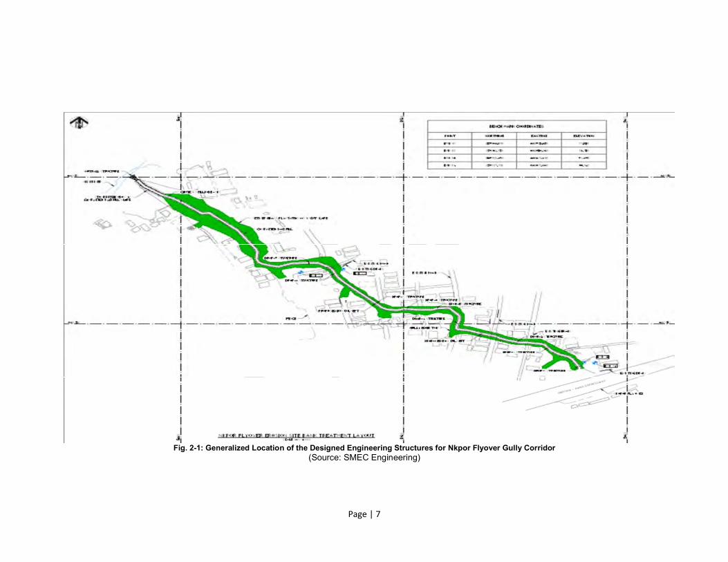
1) The construction of concrete and Reno-mattress drainage canals, gully bank protection works using stone pitching and Vetiver grass, provision of toe protection, provision of box culverts, chutes alignment, energy dissipaters, stilling basin and drop structures for the Main Gully and the Finger Gully. The general locality map including the location of the main and finger gullies are shown in Figure 2-1.
2) Stabilization of the existing components of the Main Gully using reinforced concrete canals, bio-remediation using Vetiver grass; Stabilization of the Finger Gully using reinforced concrete canals, stone pitching and bio-remediation using Vetiver grass;
3) Cutting of the slopes in 1:1.5 on both sides with 3m berms in some areas and bio-remediation measures will be used to stabilize and protect the gully bank walls and prevent erosion. The interlocking bedding, gabion, concrete lined canals and Vetiver grass protection all help to provide important resistance to erosion forces and will be more aesthetic and environmentally friendly than other structures.
Although there are other grasses such as crown grass, lemon grass and economic trees such as rubber plant, bread fruit plant, mango trees, etc. that may be used, Vetiver grass is considered the best option due to its peculiar characteristics that include - wide adaptability, relatively inexpensive, easy to handle, sediment control, low maintenance, as well as effective means of stabilizing and rehabilitating land.
Civil Construction Works: • The key activities in putting up the civil works include:
cutting and filling for percentage recovery concrete casting assembling of structures and, slope stabilization.

Page | 6
• The foundations of the lattice structures and concrete casting may be dug mechanically. The depth will be consistent with the geotechnical study and the engineering designs.
• Vegetation clearing will be done manually. • A number of transport vehicles shall be employed in the project but there will be no on-
site maintenance of vehicles. • Powered equipment is expected to be used in the construction (as required) as well as
earth moving equipment such as excavators, compactors, bulldozers and pay loaders; • Skilled and unskilled labour shall be employed in the project. The gully head areas of the site are highly populated and residential buildings are situated at some gully edges. This can be seen from the satellite view of the Nkpor Flyover gully area shown in Figure 1-3. According to the engineering designs, stone pitching bank protection is to be implemented without terracing on the steeper slopes of the gully corridor to avoid relocation of existing buildings during implementation and to prevent surface erosion because of its impervious character.
2.3 Project Rationale:
Nkpor town is one of the many towns in Anambra State whose communities are perennially devastated by erosion gullies resulting from stormwater flow. With each passing year, uncontrolled stormwater flow creates new gullies that threaten lives and properties while existing gullies are deepened and widened. The gullying and erosion hazards within Nkpor Flyover community have caused untold hardship and loss of properties to the residents and, continue to pose serious threats to lives and properties in the community. Many community members have also lost their ancestral homes, farmlands and properties to the devastating gullies.
It is highly envisaged that the damaging impacts of the gully will increasingly be more devastating with each passing rainy season and as the density of settlements increase in the catchment area. There is perpetual palpable fear of landslides or caving gully banks with attendant property destructions among the residents of the area while economic activities are often disrupted with increased cost of movements. It is known that involuntary resettlement can cause loss of income, assets, and community ties that, especially among the poor, can be essential for survival and well-being. In extreme cases, involuntary resettlement can lead to the dissolution of families, impoverishment and health problems. Urgent intervention is therefore needed at the site to salvage the environment, save lives, property and government infrastructure and to restore the people’s confidence in Government. It is in the effort to reduce the impacts of erosion on the Nkpor Flyover communities that the Anambra State Government (ANSG) has proposed to rehabilitate and remedy the existing gullies at Nkpor Flyover Erosion Site through the NEWMAP opportunity.
The ground interventions along the gully corridor at the Nkpor Flyover project site will address, prevent and expectedly reverse land degradation within the project area, and will involve construction of civil works and rehabilitation of the existing flood plain. These activities trigger the WB Safeguard Policies that include environmental assessment (OP 4.01), Natural Habitats (OP 4.04), cultural property (OP 11.03), involuntary resettlement (OP 4.12), safety of dams (OP 4.37), pest management safeguard policy (OP 4.09), and projects on international waterways (OP 7.50) as specified in the ToR.
Page | 7
Fig. 2-1: Generalized Location of the Designed Engineering Structures for Nkpor Flyover Gully Corridor
(Source: SMEC Engineering)

Page | 8
2.4 Perimeter of Project Influence
Nkpor Flyover Gully corridor is an area that is highly urbanized due to the influence of the urban centers of Onitsha and Nkpor. The continued exacerbation of the soil erosion conditions at Nkpor Flyover gully corridor creates uncertainties and emotional distress for residents of the area. Residents of the gully corridor are mainly business men and women, traders and mid-level entrepreneurs. The entire gully corridor is crossed by a number of urban feeder roads two of which are fitted with box culverts. With these feeder roads majorly impacted by the gully, access and transportation to other parts of the urban centers are principally affected. The effects of this project, on a regional scale, are therefore significantly felt far beyond the boundaries of Nkpor Flyover. At the local level, residents and land users in the immediate vicinity of the gully corridor live in constant fears not knowing whether with the next heavy rainfall, building structures, farm lands, economic trees and crops, and their basic means of sustaining livelihoods will be washed away by collapsing gully walls and heavy stormwater flows. The project is designed to rehabilitate the degraded access roads and restore the associated culverts, and provide a combination of structural channelization and vegetative gabion rehabilitation of the gully corridor. The effective setback according to the engineering design report ranges from 5m to 20m along the gully corridor with an average of about 6 meters of land to be required for the stabilization of gully walls on both sides along the corridor. As a result of these activities, any building structures, farm lands, tree crops or farm produce, and any persons residing within buildings in the required Setback will be at risk with the execution of the project.

Page | 9
3.0 POLICY, LEGISLATIVE AND ADMINISTRATIVE FRAMEWORK
3.1 Overview
In developing this ARAP, the various laws in Nigeria and Anambra State, the WB Safeguard Policies and international conventions which are relevant to land use and resettlements were reviewed. The ARAP has been developed in line with these laws and regulations. It is also a requirement of the World Bank that any Bank assisted project/programme must comply with the provisions of OP 4.12 on involuntary resettlement for impacts associated with land acquisition and displacement. The several statutes that handle the issue of land, infrastructure development and resettlement are summarized below. The sub-sections give a brief description of what constitutes land related legal issues in Nigeria.
3.2 Nigerian Land Related Legal Issues
Interests in land broadly fall into two groups - rights that are held through Nigerian traditional systems and rights that derive from the Nigerian legal system introduced and maintained through laws enacted by Nigerian governments. The former is loosely known as customary tenure bound through traditional rules (customary law). The latter body of law is referred to as statutory tenure, secured and expressed through the Land Use Act of the Federal Republic of Nigeria.
3.2.1 Customary Land Tenure
Customary Land Tenure refers to the unwritten land ownership practices by various communities under customary law. Such tenure still exists in large parts of Southern Nigeria where land has not been adjusted and registered. Its management falls under the respective traditional families and members.
3.2.2 Statutory Tenure
The basic legal framework for the acquisition of land in Nigeria is the Land Use Act under the laws of the Federation of Nigeria, 1990. The Land Use Act 1978 of Nigeria, Chapter 202 vests all land within the urban areas of any Nigerian State in the Executive Governor of that state. Land within the rural areas of the state is vested on the Local Government. The law provides for compensation to the holder of any land title when such land is to be acquired for public purposes. For developed land, the Governor (in the case of urban areas) or Local Government (in the case of rural areas) may, in lieu of compensation, offer resettlement in any other place as a reasonable alternative accommodation and in acceptance of resettlement, the holder’s right to compensation shall be deemed to have been duly satisfied.
3.3 World Bank Involuntary Resettlement OP 4.12
The World Bank’s Involuntary Resettlement Policy (IRP) outlines the conditions under which the World Bank will fund a project if it displaces persons or affects their social and economic well-being. The objective of the Bank’s resettlement policy is to ensure that population displaced by a project receives benefits from it. As a pre-requisite, the WB requires the preparation, in advance of the project implementation, of a Resettlement Action Plan/Abbreviated Resettlement Action Plan (RAP/ARAP) where impacts are known or a Resettlement Policy Framework (RPF) where multiple sub-projects is involved. This ARAP document is based on the best practices and criteria of involuntary resettlement provided in the OP 4.12. The gully rehabilitation project may potentially cause the displacement of some residents of the project area leading to loss of income and other forms of livelihood discomfort. The main objective of this ARAP is to identify any project affected persons (PAPs) and provide guidelines for compensating the PAPs so as to ensure that their livelihoods are improved or are restored as much as possible to the pre-impact level. Housing, infrastructure, and other

Page | 10
compensation should be provided to the adversely affected population and pastoralists who may have customary rights to the land or other resources taken for the project. The absence of legal title of land by such groups should not be a limitation to compensation.
3.4 Gaps between Nigeria Laws and WB Policies on Land Acquisition and Resettlement
There are similarities between key precepts of the WB OP 4.12 and Nigerian legislation. The legislation recognizes the imperative need to offer compensation to those whose land is affected by government activities, such as compulsory acquisition where such land is envisaged to be used for the public good. Despite that, the current Nigerian legislation is however, silent on resettlement. The scope of coverage of Nigerian legislation and the WB OP 4.12 differs as well. The World Bank Safeguards favor a policy of avoidance or minimization of involuntary resettlement and recommends the design of appropriate mitigation provisions in case avoidance or minimization is not possible. Whereas both recognize customary tenure as equivalent to legal title, the WB OP 4.12 extends beyond this principle and recognizes informal occupancy as a form of customary tenure so long as such informal occupancy can be established prior to the project cut-off date. Therefore, in accordance with the legal agreement of the credit for the development of the project, the preparation of this ARAP has been executed in line with the policies and guidelines as set out in the WB OP 4.12 which emphasizes that the affected persons be provided with compensation at replacement cost and supported during the transitional period to improve or at least restore their living standards to pre-displacement levels. Under WB OP 4.12, lack of legal title is no barrier in extending assistance and support to those affected by the project development. To abide by the requirements of the WB OP 4.12, the ANSG/Anambra NEWMAP must take the following into consideration during the resettlement and compensation of the PAPs:
Depending on tenure category, PAPs will be provided transition assistance (such as moving allowances) during relocation; and be offered support after displacement, for a transition period, based on a reasonable estimate of the time likely to be needed to restore their livelihood and standards of living.
In cases where in-kind replacement is not the preferred option of the PAPs, then the cash compensation will be based on the replacement cost.
The PAP without legal land documents should also be given considerations which should include the following:
Notice to vacate land prior to development; Right to harvest crops in case the affected land is agricultural; Tenants are provided with cash compensation in lieu of unexpired lease if
agricultural land is acquired; and, In case of loss of standing trees, owners should be compensated with cash
compensation based on the market value. In case of loss of community property resources the resource should be provided afresh or relocate to new site.
For unidentified impacts, mitigation measures will be proposed based on the Best Practices or Guiding Principle of involuntary resettlement and other regulating laws.
3.5 Resolution of Gaps between Nigerian and OP 4.12 Policies on Resettlement
The resettlement process of PAPs must recognize both provisions of the Nigerian policy on land acquisition as stated in the constitution and its legal provisions and the policy provisions of the World Bank (as provided for in OP 4.12). Where there are gaps between the Bank and Nigerian requirements, Bank policies shall be applied. The provisions of RPF developed for NEWMAP provide necessary guidelines to harmonizing the Nigerian legal requirements and the WB requirements for this project. Under the RPF provisions, any loss of livelihoods or

Page | 11
displacement resulting from this project shall be fully compensated for in accordance with the provisions of WB OP 4.12.
3.6 Analysis of the Provisions of the Land Use Act and OP 4.12
Provisions Nigeria’s Land Use Act World Bank OP/BP4.12
Land Owners: (Statutory Rights)
Recognized by Act with provisions for compensation or resettlement when land is involuntarily acquired
Recognized with mandatory provisions for full compensation at prevailing market rates
Land Owners: (Customary Rights)
Recognized with provisions for limited compensation when land is involuntarily acquired
Recognized with mandatory provisions for full compensation at prevailing market rates
Tenants Not known to the Act Recognized with mandatory provisions for full compensation at prevailing market rates
Agricultural Land Users
Not recognized by Act and no provisions for compensation when land is involuntarily acquired
Recognized with mandatory provisions for full compensation for land, economic trees and agricultural products at prevailing market rates
Owners of Structures Recognized by Act with provisions for limited compensation when involuntarily acquired
Recognized with mandatory provisions for full compensation at prevailing market rates
Losers of Livelihoods (farmers, business people, employees)
Not known to the Act Recognized with mandatory provisions for compensation and business/livelihood support
Grievance Redress Procedure
The Act does not provide for any formalized grievance redress mechanism or dispute resolution
Recognized as legitimate means of correcting perceived wrong-doing associated with involuntarily land acquisition and/or resettlement issues
Rejection of Compensation, etc.
Not recognized by the Act Recognized with mandatory provisions for grievance redress mechanism and dispute resolution

Page | 12
4.0 SOCIOECONOMIC AND CULTURAL BASELINE CONDITIONS
4.1 Introduction:
The cultural/socioeconomic elements and characteristics of Nkpor Flyover project area considered in this Consultancy include population, land use and tenure system, social setups, economic activities, education, vulnerability profile, gender, religion, settlement and migration patterns and health services system. Qualitative and quantitative mixed method of assessment was adopted in this project. This offered an effective means of interacting widely with the stakeholder groups, the Anambra NEWMAP team, as well as individual stakeholders and affected persons. Participatory community meetings, public discussions as well as discussions with key informants (Community elders, Local leadership, and Anambra NEWMAP Officers, among others) were held in the course of the Consultancy.
4.1.1 Socioeconomic Survey:
This involved detailed enumerations/inventories of households/persons resident or doing business within the project area as well as formal and informal discussions with focus groups, including the community traditional and administrative leadership. A comprehensive questionnaire for data collection was used for this purpose. The questionnaire captured the following information:
a) Household bio-data (demographic information); b) Livelihoods; c) Inventory of structural and nonstructural assets including land, common properties,
houses, economic trees and cash crops. Also, census of the PAPs was also conducted to fully characterize the impact on each affected person.
4.1.2 Public Consultation:
This was conducted as part of the participatory approach aimed at gaining good knowledge of the social issues/risks associated with the project as perceived by the communities. Public meetings were held in one location within the project immediate impact areas. The location is the Community Village Square. Minutes of, and attendance to, these meeting are included in Annexure II.
4.1.3 Use of Maps and GIS:
Survey maps as well as high resolution imagery were used to identify and map out the project area identifying any locations of structures relative to the project corridor. The qualitative analysis involved an assessment of information obtained during the stakeholders’ consultations and public participation forums and discussions. The socioeconomic study provided necessary primary quantitative data for the project assessment. This quantitative data included:
Household census of the people identified as PAPs; Establishing the socioeconomic profile of the project area population including health
related status of respondents; Establishing the structural assets to be affected by project; Establishing area of land to be affected;
4.2 Cultural Environment
4.2.1 Population
Based on the 2006 national population census records and the 2.3% annual population growth factor recommended by the national population commission (NPC), Idemili North

Page | 13
LGA has a projected population of 528,887 for 2015 while Nkpor town has a projected population of 86,410.
4.2.2 Ethnic Groups
The people of Nkpor consist of one of Nigeria’s major ethnic groups – the Igbos. The ethnic group has its unique culture, social organization and traditions. The social and cultural aspects in the project area are closely intertwined with the ethic groupings. The Igbos have elaborate cultural practices that include strong kinship linkages with organizations spanning from localized social groups to strong clan relations. The cultural associations and social interactions are epitomized during cultural and religious ceremonies and festivities. The people generally speak and write mainly the Ibo and English languages. Nkpor town and its villages are essentially rural communities whose residents are generally agrarians. The local dwellers rear domestic animals such as goats and sheep, and maintain chicken farms most of which are carried out within their residential compounds. The village traces its origin from genealogical ties. Politics in the village are done within the framework of clanism. Clans are the basic point of cultural and political identity for the citizens. Clanism and kinship are the elemental forces in control of political and cultural institutions as well as service points. The village consists of groups of households whose families are inter-related via marriages. The project area, Nkpor Flyover Community is experiencing significant urbanization influence spilling over from the Onitsha Metropolis and resulting from increasing trading activities. As a result of this, the village is now residential host to many persons from other parts of the country, particularly the Igbo-speaking southeast areas.
4.2.3 Religion
The people of Nkpor are predominantly of Christian religion, mostly Catholics and Anglicans. There are however a few traditionalists in the community.
4.3 Land Use Pattern
There are three major types of customary land tenure system in Igboland – (1) individual land ownership; (2) family land ownership; and. (3) communal land ownership. Individual ownership may be for indigenes or for residents of the community. Family lands (as well as individual lands) are inherited from generational relatives. Communities retain family lands which may never be sold. Such family lands are generally retained for communal development and sometimes are rotationally shared among the members of the community for agricultural purposes but are not for sale. Nkpor Flyover Nkpor can be characterized as a mix of rural and urbanized area with residential and commercial properties occupying a section of the community while the hinterlands are predominantly used for agricultural purposes. Over50% of the community land use is however still committed to agricultural production of food crops. The crops include maize, cassava, yams, plantain, vegetables, etc. A review of the land use pattern within the project areas reveals the following:
i) The frontal land areas in the vicinity of, and along the Enugu-Onitsha Express Road corridor, are predominantly residential and commercial property development areas;
ii) There are several structures (both residential and commercial) in close proximity to a section of the gully corridor. These structures are proposed to be appropriately protected during the remedial construction phase of the project.
iii) The land areas closest to the gully corridor towards the hinterland are essentially dominated by agricultural farmlands and protective bamboo trees.

Page | 14
4.3.1 Cultural Resources
There are no known designated historical, archaeological or cultural resources within the project area.
4.4 Analysis of Socioeconomic Survey
The measurement of precise impacts of the project on persons living or earning their living along the gully corridor cannot be effectively established without appropriate and accurate social and economic baseline data. The socioeconomic study helps to assess the social economic changes that may occur in the living conditions of the project area population as a result of the project impacts.
4.4.1 Objectives of the Socioeconomic Survey
The primary objectives of the socioeconomic survey are as follows: 1. To collect information regarding existing socioeconomic conditions of Nkpor Flyover
Nkpor project area population; 2. To use the collected socioeconomic information to develop baseline data for the
assessment of the social and economic impacts of the project; 3. To analyze the patterns of relationships that exist among various socioeconomic or
demographic components of the project area; 4. To obtain perceived views of respondents on the effects of project on the
environment and their vulnerability to socioeconomic changes due to the project; and,
5. To provide a benchmark for any further information needed to monitor and evaluate improvements in the future.
The respondents to the socioeconomic survey included the following:
(1) Owners of any buildings or structures located within 50 meters from the edges of the Nkpor Flyover gully corridor;
(2) Owners of any buildings or structures located in areas to be used as construction staging areas during the construction phase of the project;
(3) Residents/tenants of the buildings or structures identified in items (1) and (2) above whether the structures are permanent or temporary; residential or commercial;
(4) Land owners along the proposed gully rehabilitation corridor whose lands would be required for the purpose of the project;
(5) Economic trees/crops owners along the gully side Setbacks whose lands would be required for the purpose of stabilizing the gully edges.
The socioeconomic survey was conducted in conjunction with the census of the project affected persons to profile the impacted project area and provide baseline data against which mitigations measures and support will be measured. A sample questionnaire used for this purpose is included as Annex C. The analysis is based on respondents to the questionnaire who are most likely to be impacted by the project. On the basis of the responses obtained in the exercise, the following determinations are made.
4.4.2 Respondent and Household Distribution in Project Area
The following Sections show how the residents of the project area responded to the socioeconomic survey administered to them. A total of 321 questionnaires were administered with a 100% return. The 321 respondents have a total of 1540 household members.
52%48%
Fig. 4.1: Gender Distribution for Nkpor Flyover Households
Male
Female

Page | 15
4.4.3 Gender, Age and Household Size Distribution
The survey data indicated a fairly even male/female distribution for households in the project area. The household data is reflected in Figure 4-1. Women in the project area are mainly involved in petty trading and home-keeping. Some of the women also serve as stores sales persons at the many merchandizing outlets in Onitsha. Generally, men are more mobile than the women as the men are more involved in general pursuits to provide for the family. The age distribution data of the (Figures 4-2) of the respondents’ household members indicated that 51% of the households are 21 years of age and below while only 3%
are in their 60s and above. The survey further showed that 37% of the households are within the youthful ages of between 22 and 45 years. Nine (9%) percent of the household members are between the ages of 46 and 60 years. The low percentage of the number of household members of ages 60 and above is reflective of urbanization effect in the area. There is clearly an increasing trend of youthful persons taking up residency within Nkpor Flyover community as reflected in the percentage of youths in the households (Figure 4-2).
The respondents’ household size distribution from the survey ranged from a minimum of one
person to a maximum of 12 persons. The average size of households is 5 persons for the respondents. On the extreme household size ends, 18% of the respondents have household sizes of one to two members while another 8% have household members of more than 8 persons (Figure 4-3). Majority (29%) of the respondents show household sizes of 5 or 6 persons and 20% showed sizes of 7 or 8 persons. The data showed 74% of respondents have household sizes of between 3 and 8 persons.
4.4.4 Marital Status of Respondents
Figure 4-4 showed the marital status of respondents in the project area. About
thirty four percent (34.1%) of the respondents are married while about 64.1% are single. Approximately two percent (1.7%) of the respondents are widowed.
1-2 3-4 5-6 7-8 >8
18%25%
29%
20%
8%
Fig. 4-3: Household Size Distribution of Respondents
Household Size
51%37%
9% 3%
Fig. 4-2: Age Distribution of Household Members
21yrs & Less
22-45years
46-60years
Above 60years
64.1%
34.1%
1.4% 0.3% 0.0% 0.1%
Fig. 4-4: Marital Status Distribution for Nkpor Flyover Community

Page | 16
4.4.5 Access to Education
The survey responses indicated that only 8% of the population of schooling age never attended school (Figure 4-5). The level of basic education for the surveyed households is relatively high with 92.0% of the surveyed population having attained the basic primary (FSLC) level of education and higher. The data further showed that 15% of the population graduated from universities while 69.0% attended and/or graduated from the primary and secondary education. This high literacy level within the project
affected area is also a reflection of the literacy rate in the Nkpor Flyover community as a whole.
4.4.6 Occupational and Income Distribution of Respondents
The occupational distribution data from the questionnaire indicated that 65% of Nkpor Flyover surveyed households are either unemployed or are students. Only about 1% are engaged in farming, 18% are self-employed while 16% are employed in either the private sector or civil service (Figure 4-6). The main source of income for the households surveyed came from trading/business across the community. About 18% of the respondents reported owning a business or being self-
employed. A significant number of persons (27%) in the community are unemployed. Based on the income data provided by respondents in the survey, 42% of households in Nkpor Flyover earned less than N20,000 monthly with 6% earning up to N30,000 monthly (Figure 4-7). Worthy of note is that over 52% of the households in the community earned more than N30,000 per month. The margin of error in the information provided on incomes may be significant considering that some of the respondents may have grossly inflated data provided with the intent to receive compensations in accordance with incomes indicated in the survey. The data provided could not be
independently verified.
8%
31%38%
7%15%
1%
Fig. 4-5: Educational Distribution of Nkpor Flyover Households
1%
13%3%
18%65%
Fig. 4-6: Occupational Distribution for Nkpor Flyover Households
Farming
Service Provider
Civil Servant
Trading/Business
Other(Student/Jobless)
42%
6% 5%13%
34%
Fig. 4-7: Household Income Distribution for Nkpor Flyover Community

Page | 17
4.4.7 Household Waste Disposal
Most of the respondents indicated that their household wastes are disposed at convenient locations including crevices. In many areas, the wastes were also indiscriminately dumped inside the gullies or at illegal dumpsites created only as a matter of convenience. Solid waste management in the project area posed a considerable hazard to the health of the population and the effective functioning of the storm water drainage systems. The unmanaged refuse caused regular obstruction of the storm water drainage systems.
Most residents disposed their domestic refuse randomly outside their residential compounds and the flood-prone areas are also treated as de facto waste disposal sites. The situation in the project area indeed reflects the poor waste management and waste disposal mechanisms in most part of the state. As with other parts of the country, majority of
households typically disposed their domestic refuse inappropriately outside their residences. During the wet season, solid waste is transported by flowing storm water through unplanned drainage paths leaving a trail of refuse.
4.5 Desirability of the Project
All the respondents in the survey (100%) indicated immense desirability for the project to proceed as shown in Figure 4-8. Many of them expressed a clear wish for the project to proceed before the next round of rainfall.
4.6 Conflict Resolution
All respondents in the survey (100%) preferred and considered it most convenient to have conflicts resolved through informal traditional modes of conflict resolution which existed within the communities. The court system remained an alternative means to resolve issues but no respondent favoured it as a means of resolving conflict. None of the respondents remained indifferent to the preferred approach as shown in Figure 4.9.
4.7 Community Participation
The direct involvement and active participation of relevant stakeholders and the local level people in the planning and management processes of the project assures that any potential disharmonious issues within the community are resolved speedily. There will also be maximization of resource use and increased benefits and expanded opportunities for the communities in the project area.
Community participation improves understanding of the project and communication between the SPMU, the consultants or contractors and the community. The decision-making process for the project will also be enhanced by actively involving relevant stakeholders, especially the project affected persons and organizations with a stake in the project.
100%
0% 0%
Fig. 4-8: Project Desirability
YES NO INDIFFERENT
InformalSystem
CourtSystem
Indifferent
100%
0% 0%
Fig. 4-9: Preference for Conflict Resolution
Page | 18
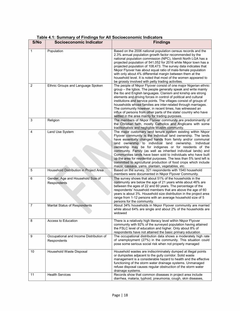
Table 4.1: Summary of Findings for All Socioeconomic Indicators S/No Socioeconomic Indicator Findings
1 Population Based on the 2006 national population census records and the 2.3% annual population growth factor recommended by the national population commission (NPC), Idemili North LGA has a projected population of 541,052 for 2016 while Nkpor town has a projected population of 108,473. The survey data indicates that Nkpor Flyover has about equal ratio of male-female population with only about 4% differential margin between them at the household level. It is noted that most of the women appeared to be grossly involved with petty trading activities.
2 Ethnic Groups and Language Spoken The people of Nkpor Flyover consist of one major Nigerian ethnic group – the Igbos. The people generally speak and write mainly the Ibo and English languages. Clanism and kinship are strong elements and driving forces in control of political and cultural institutions and service points. The villages consist of groups of households whose families are inter-related through marriages. The community however, in recent times, has witnessed an influx of persons from other parts of the state/ country who have settled in the area mainly for trading purposes.
3 Religion The members of Nkpor Flyover community are predominantly of the Christian faith, mostly Catholics and Anglicans with some traditionalists and negligible Muslim community.
4 Land Use System The major customary land tenure system existing within Nkpor Flyover community is the individual land ownership. The lands have essentially changed hands from family and/or communal land ownership to individual land ownership. Individual ownership may be for indigenes or for residents of the community. Family (as well as inherited individual lands) and Communities lands have been sold to individuals who have built up the area for residential purposes. The less than 5% land left is committed to agricultural production of food crops which include maize, cassava, yams, plantain, vegetables, etc.
5 Household Distribution in Project Area Based on the survey, 321 respondents with 1540 household members were documented in Nkpor Flyover Community.
6 Gender, Age and Household Size of Respondents
The survey shows that about 51% of the households in the community are below the age of 21 years while about 46% are between the ages of 22 and 60 years. The percentage of the respondents’ household members that are above the age of 60 years is about 3%. Household size distribution in the project area range from 1-12 persons with an average household size of 5 persons for the community.
7 Marital Status of Respondents About 34% households in Nkpor Flyover community are married while about 64% are single and about 2% of the households are widowed
8 Access to Education There is a relatively high literacy level within Nkpor Flyover community with 92% of the surveyed population having attained the FSLC level of education and higher. Only about 8% of respondents have not attained the basic primary education
9 Occupational and Income Distribution of Respondents
The occupational distribution data shows a moderately high rate of unemployment (27%) in the community. This situation could pose some serious social risk when not properly managed
10 Household Waste Disposal Household wastes are indiscriminately dumped at illegal points or dumpsites adjacent to the gully corridor. Solid waste management is a considerable hazard to health and the effective functioning of the storm water drainage systems. Unmanaged refuse disposal causes regular obstruction of the storm water drainage systems.
11 Health Services Records show that common diseases in project area include diarrhea, malaria, typhoid, pneumonia, cough, skin diseases,

Page | 19
S/No Socioeconomic Indicator Findings
deficiency diseases, eye diseases, ear diseases, and waterborne diseases due to malnutrition and lack of hygiene. The quality of the health services in the project area is generally poor. Most people go to quacks and medicine shops for minor medical treatment. . There was no public health facility in the project area at the time of the study but there were several private health centers (pharmacies and hospitals) located within and in nearby areas to the project corridor.
12 Desirability of Project 100% of survey respondents indicated immense desirability for the project to proceed.
13 Conflict Resolution Mechanism 100% of survey respondents prefer that their conflicts be resolved through informal traditional modes of conflict resolution. No respondent favoured resolution through the court system or expressed indifference.

Page | 20
5.0 SUMMARY OF PUBLIC PARTICIPATION AND CONSULTATIONS WITH STAKEHOLDERS
5.1 Objective of Community Consultation
The aims of the public participation and consultation process are:
1. Solicit inputs, views and concerns from the four affected communities as they relate to the project and obtain local and traditional knowledge that may be useful for decision-making;
2. Facilitate consideration of alternatives, mitigation measures and trade-offs, and ensure that important impacts are not overlooked and that benefits are maximized;
3. Reduce conflict through the early identification of contentious issues; and increase public confidence in the project.
4. Provide opportunity for the public to influence the project designs and implementation in a positive manner and improve transparency and accountability in decision-making;
5.2 Public Participation Process
The potentially project affected individuals and group of persons identified as stakeholders in this project include those who live in close proximity to the gully corridor; those who will hear, smell or see the development; those who may be forced to temporarily relocate because of the project; those who have interest either traditionally or administratively, over developmental activities or policy changes in the project area (they may or may not necessarily live in the proximity of the project); and, those who infrequently use the land on which the project is located. Community consultation was driven in a manner that encouraged active and sustained participation of the Omagba community members, particularly the Nkpor Flyover corridor to Nkisi River through which the active gully traverses. This was to promote community ownership of the project and to enhance sustainability. A pre-defined socio-economic questionnaire at the household level was administered for Nkpor Flyover community. The consultations are expected to remain an ongoing exercise throughout the duration of the project to give the communities the opportunity to make contributions aimed at strengthening the development while avoiding negative impacts as well as reducing possible conflicts. Issues relating to project displacements and compensations, particularly with the project affected persons will continue to be handled to minimize chances of possible conflicts.
5.2.1 Stakeholders’ Identification
Generally, five broad categories of stakeholders were identified by the Consultant for this project based on the degree to which the project activities may affect or involve such persons or group of persons. These stakeholders are grouped as shown in Table 5-1.
The adopted process consists of:
i) Identification of any parties whose line of duties whether officially, socially, economically or culturally have direct or indirect bearing on any aspects of project activities. These parties may include individuals, groups, institutions or organizations that may be affected by the gully remedial activities;
ii) Establishment of the stakeholders list and identification of specific stakeholder interests in relation to the project. The issues considered include: (a) the project's benefit(s) to the stakeholders; (b) potential changes to the routine activities of the stakeholders that may occur due to the project; and, (c) the project activities that may cause damage or conflict for the stakeholder;

Page | 21
Table 5-2 gives an initial list of identified stakeholders including their activities and operational areas in the villages traversed by the project. The list includes government functionaries, NGOs, FBOs and CBOs among others.
Table 5-1: Identified Stakeholder Groups GROUP DESCRIPTION ROLE(S) IN COMMUNITY PROCESS
Group-1 Individuals or group of persons whose day-to-day lives/livelihoods may be directly affected by project activities. These are people who either reside or carry out their day livelihood activities within the gully corridor plus 25meters from the gully edge.
The identified persons or group of persons in this category will ultimately represent the project potentially-affected persons (PAPs) or households (PAHs)
Group-2 Individuals or group of persons whose day-to-day traditional or administrative functions include oversight of developmental activities within the project areas.
This category of persons serves as mobilization points around which the Consultant will reach out to the other members of the community.
Group-3 Individuals or group of persons whose daily activities (including farming) bring them in close proximity to the project area. These are people who either reside or carry out their daily livelihood activities outside the channelization corridor but within the communities in which the project is located.
This category of persons may or may not be affected by the project but may be significant contributors to the long term sustainability of the project.
Group-4 CBOs, FBOs and NGOs who provide frequent interface with the community members who may be directly or indirectly affected by the project activities.
This group of organizations essentially provides on a continuous basis spiritual and physical welfare as well as environmental health of the community.
Group-5 Individuals or group of persons who are political office holders and have significant responsibilities toward community members and developments within the project areas.
This group of individuals is collectively responsible for the political and general socio-economic development of the community, among others within their respective political zones.
Table 5-2: List of Stakeholders and Their Responsibilities
GROUPS IDENTIFIED STAKEHOLDER AREA OF INTEREST IN PROJECT
Group-1 Residents of Nkpor Flyover Community PAPs/PAHs
Group-2 Office of the Nkpor Flyover Community Association Chairman
Development and welfare of Nkpor Flyover Community
Group-3 Residents of Nkpor Flyover Gully Corridor Neighbourhoods Individualized livelihood issues
Group-4
Community-based Organizations Watershed protection and management
Faith-based Organizations in the Community (churches) Community spiritual and physical welfare
Non-governmental Organizations Protection of environmental health of communities
Group-5
Office of the Chairman – Idemili North LGA Development of the Idemili North LGA
Office of the Hon. Member – Anambra State House of Assembly
Development of the Idemili North in the state constituency

Page | 22
GROUPS IDENTIFIED STAKEHOLDER AREA OF INTEREST IN PROJECT
Office of the Hon. Member – Idemili North & South Federal Constituency
Development of Idemili North & South federal constituency
Office of the Distinguished Senator – Anambra Central Senatoral Zone
Development of Anambra Central Senatoral Zone
5.2.2 Community Consultations and Meetings
An initial kick-off meeting was held with the State NEWMAP team on January 31, 2017 at the office of the State NEWMAP Project Coordinator (PC). At the meeting the PC detailed out the scope of the Nkpor Flyover project and the requirements of the SPMU from the ESMP and ARAP Consultant team, OTG Enviroengineering Nigeria Limited. Community consultations began subsequently with separate meetings between the Consultant team and the respective community leaders of Nkpor Flyover Community to discuss the best and most effective approach towards mobilizing the community members as it relates to the proposed project. The several meetings helped to structure effective participation of all other relevant stakeholders and segments of the community including the PAPs in the project process. The community members were actively and enthusiastically engaged in all matters relating to the project and eagerly assisted the Consultant in identifying pertinent socio-cultural issues relevant to the project.
5.2.3 Summary of Meetings with Stakeholders
The community meetings discussed the need for the project and the associated potential impacts to the community members living or farming within the project corridor. The community members’ concerns and general thoughts were solicited and noted, and are included in the minutes of these meetings (see Annex IV). The community members particularly welcomed the project and expressed anxiety that remedial work should commence expeditiously to prevent occurrence of further flooding damages from the next rainy season. Additional meetings are expected to be held prior to the commencement of field construction work. Such meetings will include the project-affected persons and households. Issues pertaining to relocations and compensations for losses (means of livelihoods and properties) should be discussed at such meetings.
5.3 Social Issues/Risks
The evaluation of the social environment and existing environmental conditions that impact on human health and safety indicate the following imminent risks that may be associated with the project. The key social issues that emerged through the above processes include:
1. Community safety – Concerns regarding community safety with the next cycle of the rainy season was keenly expressed. The community is quite apprehensive of the advancement of the gullies particularly in relation to safety risks posed to existing homes, human lives and farmlands;
2. Continued gully erosion and flooding in the area would lead to damages and loss of crops and livestock, personal possessions, spread of diseases such as typhoid, cholera, diarrhea, and malaria, and cause pit latrines to overflow;
3. Livelihoods – loss of access to roadways, crop lands and pasture. 4. Resettlement – impacts and compensation measures for economic and physical
displacement during project implementation. 5. Awareness creation was necessary for the long-term success of the project; and
manpower development should be included in the programme to enhance project sustainability.

Page | 23
Fig. 5-1: Nkpor Flyover Community/Stakeholders’ Meeting
Fig. 5-2: ANS-NEWMAP & Consultant Team at Nkpor Flyover Community/Stakeholders’ Meeting
Fig. 5-6: Community Chairman, Mr Nzelu asking a Question during the Community Meeting
Fig. 5-3: Dr. Odili Ojukwu Discussing the Project with Community Members
Fig. 5-4: The ESO of the SPMU Addressing the Nkpor Flyover Community
Fig. 5-5: The SLO of the SPMU Addressing the Community Stakeholders

Page | 24
5.4 Guiding Principles
In order to ensure that this ARAP complies with the WB OP 4.12 and international best practices regarding resettlement, the Consultant and the Anambra State NEWMAP are guided by the following principles: Principle 1: Resettlement must be avoided or minimized The project civil and biological works have been designed so as to cause the least possible displacement and/or disruption while maximizing the effect of flood and erosion control in the project. Principle 2: Genuine consultation must take place The primary concern of MOE and Anambra NEWMAP is to ensure that the rights and interests of the PAPs are considered seriously as it places focus on resettlement. For this
Fig. 5-7: Nkpor Flyover Community Meeting - Question and Answer Session in Photos

Page | 25
reason, local level consultative forums serve as community voices and become part of the entire project process. Principle 3: Establishment of a pre-resettlement baseline data To support the successful reestablishment of affected property, the following activities will be undertaken prior to displacement.
An inventory of assets (landholdings and economic trees/crops) to determine fair and reasonable levels of compensation or mitigation.
A census detailing household composition and demography, and other relevant socio-economic characteristics.
The asset inventories and census information were used to determine entitlements. The information obtained from the inventories and census was used to facilitate resettlement/relocation planning, implementation and monitoring. Principle 4: Assistance in relocation must be made available ANSG will assure the provision of necessary compensation for people whose lands will be disturbed to ensure appropriate rehabilitation of the gully corridor, or any other disturbances of productive land associated with the project in proportion to their loss.
Principle 5: A fair and equitable set of compensation options must be negotiated Compensation will be paid for land and economic trees/crops that are disturbed in accordance with the World Bank policy and rates derived from market value comparables for trees/crops. Principle 6: Vulnerable social groups must be specifically catered for Members of vulnerable groups will include people who are physically weaker, and may need special help, female-headed households, aged persons and very young children. Account was taken of this group in the consultation and planning processes, as well as in establishing grievance procedures. Principle 7: Resettlement must be seen as an upfront project cost Global experience shows that unless resettlement is built in as an upfront project cost, it tends to be under budgeted, that money gets whittled away from the resettlement budget to ‘more pressing’ project needs, and that it tends to be seen as peripheral to the overall project. Anambra NEWMAP will ensure that compensation costs, as well as those resettlement costs that fall within their scope of commitment, are built into the overall project budget as up-front costs. Principle 8: An independent monitoring and grievance procedure must be in place In addition to internal monitoring that will be provided by Anambra NEWMAP, an independent team comprising local administrators and the community members will undertake monitoring of the resettlement aspect of the project. Grievance procedures will be made fully accessible to all affected parties, with particular concern for the situation of vulnerable groups. Monitoring will specifically take place via measurement against the pre-resettlement database. Principle 9: World Bank’s operational procedure on forced resettlement The World Bank’s operational policy 4.12 on involuntary resettlement will be adhered to. Displaced persons should be meaningfully consulted and should have opportunities to participate in planning and implementing resettlement programmes. Anambra NEWMAP and this ARAP aim to adhere to these standards.

Page | 26
6.0 POTENTIAL IMPACTS OF PROPOSED PROJECT
6.1 Field Findings
The primary project objective is the remediation and rehabilitation of the gully erosion corridor traversing Nkpor Flyover Community within Nkpor and Onitsha towns. Access to the upper and lower segments of the project location is off the Enugu-Onitsha Expressway and through any of the existing feeder roads. The feeder roads may require rehabilitation/upgrade to support heavy duty construction equipment to be used during the construction phase of the project. The rehabilitation of these roads will involve re-grading of the existing paved roadways and the construction of appropriate drainage channels. The intra-community roadways within the Nkpor Flyover gully corridor are currently in fair to poor conditions resulting from existence of the gully and years of soil erosion and roadway potting.
Fig. 6-1: Satellite Imagery Showing Existing Gully Corridor
Based on the project engineering designs and Consultant field observations, several direct and indirect impacts on the environment and on the population groups were identified. The impacts include potential physical, social, economic and social effects. The designs indicate however that no existing buildings along the entire gully corridor will be structurally destroyed by the project since appropriate and necessary steps will be taken to ensure the safety of such buildings.
6.2 Potential Project Impact Areas
6.2.1 Rehabilitation of Gully Erosion Corridor
The remediation and rehabilitation works to be undertaken along the gully corridor involves civil construction and biological works that include: cutting and filling for percentage

Page | 27
recovery; compaction of soils; concrete casting; assembling of structures, gabion-based slope stabilization, terracing; structured vegetation; specific trees planting with known root strength; and, economic trees planting. The identified project impacts are detailed under Section 6.3 below.
6.3. Identified Project Impacts
The proposed project, based on the engineering designs, will potentially create both negative and positive social impacts. This section discusses these impacts and proposes mitigation measures and their management in order to reduce the negative impacts to levels of acceptance as well as enhance the positive impacts.
6.3.1 Potential Positive Project Impacts
The following positive social impacts are identified for this project: • Arresting soil erosion and the degradation of available land; • Emotional and psychological relief from potential damage to, or loss of properties as
well as loss of remaining ancestral lands; • Improved flow of traffic in and out of the project area neighborhood upon completion
of project; • Improved business opportunities along the construction roadways; • Reduced costs of transport and delays on travelling along these access roads; • Improved livelihoods for the area residents due to reduced cost of transportation and
business penetration; • Opening of the affected area to potential investors; • Improved landscape vista is anticipated with a sustained corridor of economic trees
within the project area; • Several temporary employment opportunities will be created by the project. During
the construction phase, both skilled and un-skilled laborers will benefit from job opportunities.
6.3.2 Potential Negative Impacts and Mitigation Measures
Environmental Impacts (WB OP 4.01) Based on the engineering designs for this project (see the Nkpor Flyover Erosion Site Bank Treatment Layout shown in Figure 2-1), between 5m – 20m of land is required on each side of the gully edge for the stabilization of the gully side slopes, particularly at the deep sections of gully corridor. The proposed project will lead to temporary environmental impacts that include loss of vegetation, dust evolution, noise and vibration generation, among others. In addition, the project during implementation may lead to pollution of ground and surface water during rainy seasons. It is recommended that construction works should be carried out in a manner that would avoid or minimize identified negative impacts. These are described as follows: Loss of Vegetation The proposed project will result in the removal and/or destruction of vegetation. Removal of vegetation will result in immediate and long term loss of habitats for land, flora, fauna, and endemic species. The magnitude of this impact is however considered high given the size of land involved (8.498Ha of land). Additionally, the project staging areas will suffer increased vegetation damage during construction phase.
Mitigation Measures: a) All construction areas not part of the gully rehabilitation corridor where vegetation
is destroyed during construction shall be allowed to re-vegetate immediately following the completion of the construction phase.
b) As much as possible appropriate vegetation shall be replanted in all areas to provide effective soil coverage and prevent erosion.

Page | 28
Fugitive Dust The frequent vehicular and equipment movements in the project areas during construction will result in generation of fugitive dust within and along the gully corridor and construction areas. Fugitive dust has a discomforting effect on people and may also create vascular and breathing problems for people, especially for persons living or working within 20meters of the gully corridor and other construction areas.
Mitigation Measures: Dust control shall be achieved through dust suppression using water spray mechanism. It is necessary to ensure that water spray tankers are always available during construction activities. Notwithstanding, it is envisaged that the residents/tenants in the project areas may still experience some inconveniences arising from this project impact. Residents/tenants so affected shall be appropriately compensated.
Socio-cultural Impacts (WB OP 4.12) The proposed project will lead to socio-cultural effects on the community members, including school children in the project area. Dust, Noise and Vibration Generation During project implementation, construction works will cause interference on normal learning and other activities of residents due to the noise and dust generation from the truck movements, soil backfilling and compaction, and excavation works. This is especially so for persons living or working within 20meters of the gully corridor and other construction areas.
Mitigation Measures The same measures applicable to noise and dust control specified above shall also apply here. Vehicle and equipment operators shall be required to be extremely cautious as they operate during the construction phase of the project. Notwithstanding, it is envisaged that the residents/tenants in the project areas may still experience some inconveniences arising from this project impact. Residents/tenants so affected shall be appropriately compensated.
Loss of land On the average, an effective six meters of land is required as Setback on each side of the gully edge for the stabilization of the gully side slopes. The required land Setback shall be permanently acquired for purposes of the slope stabilization and shall therefore be permanently lost to the current owners.
Mitigation Measures: Owners of acquired land shall be compensated for land in accordance with the WB and Nigerian Policies on land acquisition. Where however, there are any improvements to the land, compensations will also be considered for those improvements including any economic trees and farm crops.
Displacement of persons The designs for this project provide for a minimal impact on building structures abutting the gully at all points. This implies that existing building structures abutting the gully will not suffer structural damage but shall first be strengthened to gain structural stability. However, residents/tenants of such building structures and other building structures within 20 meters of the gully edge on both sides with fragile health conditions, such as asthma or advancement in age, etc., may likely be adversely impacted by effects resulting from project activities. Such identified persons will be considered as project affected persons and/or vulnerable persons, and may be required to be temporarily relocated during the construction phase.
Mitigation Measures: Identified health-based or age-based project affected persons shall be temporarily relocated during the construction phase of the project. Such persons shall also be
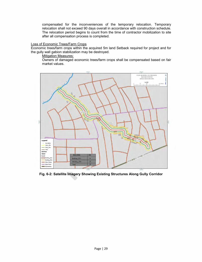
Page | 29
compensated for the inconveniences of the temporary relocation. Temporary relocation shall not exceed 90 days overall in accordance with construction schedule. The relocation period begins to count from the time of contractor mobilization to site after all compensation process is completed.
Loss of Economic Trees/Farm Crops Economic trees/farm crops within the acquired 5m land Setback required for project and for the gully wall gabion stabilization may be destroyed.
Mitigation Measures: Owners of damaged economic trees/farm crops shall be compensated based on fair market values.
Fig. 6-2: Satellite Imagery Showing Existing Structures Along Gully Corridor

Page | 30
Fig. 6-3: Satellite Imagery Showing Project Affected Assets Along Gully Corridor
6.4 Identification of Project Affected Population
According to the engineering design report for this project (see the Nkpor Flyover Erosion Site Bank Treatment Layout shown in Figure 2-1), between 5m – 20m of land is required on each side of the gully edge for the stabilization of the gully side slopes, particularly at the deep sections of gully corridor. The satellite imagery of the project corridor delineating the maximum project setback of 20-meter with a 15-meter buffer (35-meter project influence) areas is shown in Figure 6-1. The existing structures whose occupants may potentially be impacted from a health standpoint are shown in Figure 6-2. For ease of referencing, the existing structures whose occupants may potentially be impacted are given numerical identifiers and are shown in Figure 6-3. The ESMP studies for this project have identified and classified the various environmental and social impacts that may result from the project in relation to occupants of structures within the 20-35 meter distance from the gully edge including those identified as vulnerable persons. Mitigation measures are also proposed in the ESMP for the identified impacts. Temporary relocation of PAPs is therefore not envisaged during project implementation.
The identified project affected assets are summarized in Table 6-1. The maximum land area that may be required for the gully Setback is 18804m2. The identified residential or business premises with the associated households (PAHs) and persons (PAPs) that may be temporarily affected by the project activities based on environmental and health-related issues are summarized in Table 6-2. A total of 65 project affected persons (PAPs) and 14 vulnerable persons have been identified. Of the 65 PAPs, there are 50 persons and 43 persons whose lands and economic trees/crops, respectively, would be affected by project activities along the gully corridor. The identified PAPs represent owners/residents/tenants of land/structures and economic trees and crops located within 6m (for land, economic trees

Page | 31
and crops) of the gully edge. Also included in the PAPs are the identified vulnerable persons living within the project corridor. Table 6-1: Summary of Project Affected Assets
S/No Project
Component
Gully Section Length
Assets Affected by Project
Structures within 35m of
Gully Edge
Structures within 20m of Gully Edges
Land Economic
Trees/Crops
1 Main Gully
Section 1.38 km 29 16 16560 m2 Varied
2 Stormwater Drainage
Outlet Section 0.067 km 0 0 804 m2 Varied
3 Left Finger
Gully Section 0.120 km 0 0 1440 m2 Varied
TOTALS 1.567 km 29 16 18804 m2
Consideration of the project affected population/persons was based on the review of the gully rehabilitation designs, digital satellite imageries, the projected road rehabilitation activities, and the field observations by the ARAP team along the project corridor. The identified population groups which were considered as targets that may be affected by the different project components include the following:
a. Owners of building structures located within the 20 meters of the gully edge on both sides of the gully;
b. Owners of building structures located in areas to be used as construction staging areas during the construction phase of the project;
c. Residents/tenants of the buildings structures identified in items (a) and (b) above whether the structures are permanent or temporary; residential or commercial;
d. Land owners within the five meters of acquired Setback for the gully wall stabilization, particularly at the deep sections of the gully corridor;
e. Residents/tenants of buildings structures located within 20m of the Left finger Gully whether the structures are permanent or temporary residential or commercial; and,
f. Economic trees/crops owners along the six meters Setback for the gully wall slope stabilization;
Table 6-2: Potential Project Affected Households and Persons
S/No. Gully Component
Section
Gully Component
Section Length
Potential Project Affected Structures
No. of Project Affected Persons
1 Main Gully Section 1.38 km 0 65
2 Stormwater Drainage
Outlet Section 0.067 km 0 0
3 Left Finger Gully
Section 0.120 km 0 0
TOTAL 1.567 Km 0 65
In determining the actual number of project affected assets, households and persons, consideration was given to the potential impacts that may result from the activities of the proposed project bearing in mind the actual distance of the household to the gully edge and

Page | 32
the nature of work to be done in the particular area closest to the household. Specifically, for each building structure where the household lives or carries out daily routine activities, the questions considered relating to potential impacts are:
Is asset currently affected by the gully? If so, has asset been subsequently restored? Is asset within 35 meters of the edge of gully? Will asset be impacted by project activities? Are persons associated with asset impacted by project activities?
A “yes” to all the above questions marks the household as a target for potential resettlement, relocation or some form of compensation. Based on the above considerations, the project impact significance and the potential for resettlement was developed. This is summarized in Table 6-3. Table 6-3: Summary of Project Impact Significance and Potential Need for Resettlement
S/No. Population Group Identified Project Impact Impact
Significance Need for
Resettlement
1 Owners of structures within 20m of gully edge
Potential structural damage may occur
Significant but project designed to reduce to less than significant with mitigation measures
None. Compensation not required
2 Owners of buildings located within construction staging areas
• Vibration from heavy equipment
• Noise • Vehicular emissions • Fugitive dust
Significant but reduced to less
than significant with mitigation measures
Compensation may be required
for temporary displacement in accordance with
WB Policy
3 Residents/tenants of buildings identified in (1) & (2) above
• Vibration from heavy equipment
• Noise • Vehicular emissions • Fugitive dust
Significant but reduced to less
than significant with mitigation measures
Compensation may be required
for temporary displacement in accordance with
WB Policy
4 Land owners whose lands are required as Setback for gully side slope stabilization
Loss of land and/or economic trees/crops
Significant Yes.
Compensation is required
5 Residents/tenants of buildings along the two project access roads
• Vibration from heavy equipment
• Noise • Vehicular emissions • Fugitive dust
Significant but reduced to less
than significant with mitigation measures
Compensation may be required
for temporary displacement in accordance with
WB Policy
6 Trees/farm crops owners within the Setback for gully side slope stabilization
Loss of economic trees/farm crops
Significant Yes.
Compensation is required
6.5 Vulnerable Group
Vulnerable group refers to the people who by virtue of gender, age, physical or mental disability, economic disadvantage, or social status may be more adversely affected by resettlement than others and who may be limited in their ability to claim or take advantage of

Page | 33
resettlement assistance and related development benefits. There are 65 persons identified as PAPs; 14 of them are considered vulnerable by virtue of physical disability, age and gender/illness. The 14 persons are:
(1) vulnerable on account of physical disability; and, (2) vulnerable on account of age (elderly person over 70 years old)
In addition to the support to be provided for the PAP group, special provision for the vulnerable group will be made to enhance their livelihood through subsistence support. Such support shall be for a period within which the major aspects of the project intervention works ought to have been completed.

Page | 34
7.0 PROPOSED RESETTLEMENT PLAN
7.1 Eligibility
The only persons who will be considered as qualified for compensation must be pre-identified PAPs. These people will directly or indirectly be subjected to the following losses:
7.1.1 Loss of Assets
Compensation will be for assets on the land, as well as other assistance in order to mitigate the adverse consequences that affect people and communities when they give up property for public good. In this project, there is loss of mainly agricultural lands resulting from the project. The process of mitigating the project impacts on PAPs will involve only cash compensation. There will not be any physical permanent relocation of the PAPs. All persons who are affected regardless of their legal status concerning the affected lands and economic trees/crops are considered eligible for compensation as described in Table 6-3.
7.1.2 Loss of Livelihood
It is noteworthy that some PAPs have grown economic trees and crops within the land required as Setback for gully side slope stabilization, particularly at the deep sections of the gully corridor. Consequently, these PAPs will not only suffer loss of income from the trees and crops but may also suffer permanent loss of livelihood. Thus, the project may consider livelihood compensations to these PAPs.
7.2 Entitlement Matrix
Acquisition of land for the project will adversely affect the livelihood of persons, who live, work or earn their living on the land that will be acquired for the project. Before the commencement of the project, a mechanism for compensation of PAPs should be in place to avoid household economic difficulties that will result due to loss of land and/or economic trees/crops. For the purpose of this report and bearing in mind that land ownership is statutorily vested in government, the entitlement list will include persons appropriately defined as follows:-
Persons who have a right to the needed land; Persons who use and cultivate the needed land on any form of arrangements; or Persons whose standards of living are adversely affected as a consequence of the
project activities. Table 7-1: The Entitlement Matrix for Various Identified Categories of PAPs
Type of Loss Entitled Person Description of Entitlement
1. Permanent loss of land
1.1 Cultivatable/residential/commercial land
1.1 (a)Legal owners of land
(b)Occupancy/Hereditary tenant
1.1 (a) Land for land compensation is neither practicable nor desirable due to nature of project. Cash compensation at replacement value based on market rate plus 10% compulsory acquisition surcharge as second option
(b) Compensation will be paid as a one-time lump sum grant for restoration of livelihood and assistance for relocation. .
2. Damage to land (such as abutting sub-project site)
2.1. By excavation from borrows for earth for
2.1. (a)Legal owner/s
(b) Village/s or clan/s with customary
2.1 (a) & (b) Restoration of land to pre-construction condition or cash compensation at prevailing rates for necessary bulldozer/ tractor hours to restoring level and/or

Page | 35
Type of Loss Entitled Person Description of Entitlement
construction use.
2.2 By severance of agricultural holding
ownership
2.2. No project impact is envisaged
truckloads of earth for fill
3. Loss of income and livelihood
3.1. Temporary loss of access to land for cultivation
3.1 Cultivator occupying land
3.1. Estimated net income for each lost cropping season, based on land record averages of crops and area planted in the previous four years
3.2. Loss of agricultural crops, and fruit and wood trees.
3.3 Loss of income by agricultural tenants because of loss of land they were cultivating
3.2 (a) Owner/s of crops or trees. Includes crops/trees owned by encroachers/squatters
(b) Tenant
3.3 Persons working on the affected lands
3.2 (a) Cash compensation for loss of agricultural crops at current market value of mature crops, based on average production.
Compensation for loss of fruit trees for average fruit production years to be computed at current market value.
Compensation for loss of wood-trees at current market value of wood (timber or firewood, as the case may be).
3.2 (b) Partial compensation to tenants for loss of their crops/trees as per due share or agreement (verbal or written)
3.3 One-time lump sum grant to agricultural tenants (permanent, short-term or long-term agricultural labor (this will be in addition to their shares in crop/tree compensation)
a) Tree/perennial crops: Harvesting of the crops will be given a first priority but where harvesting is not possible, counting of the affected crops will be done in the presence of the owner. Computation of the costs will be done according to market rates b) Annual crops: Crops will be harvested by the owner and therefore no compensation will be paid for crops. Where crops cannot be harvested, compensation at the market rate will be paid
4. Permanent loss of Structures
4.1 Residential and commercial structures
4.1. No project impact is identified or envisaged
Not Applicable
4.2. Cultural, Religious, and community structures /facilities School, church, water channels, pathways, and other community structures/installations
4.2. Persons officially responsible for the up keep of the identified facility
Compensation will be paid as a one-time lump sum grant for restoration of livelihood and assistance for relocation.
5. Special provision for vulnerable APs
5.1 Women headed households, disabled or
5. Needs-based special assistance to be provided either in cash or in kind.

Page | 36
Type of Loss Entitled Person Description of Entitlement
5.1.Re-establishing and/or enhancing livelihood
elderly persons and the landless
5.2 Change in Livelihood for women and other vulnerable APs that need to substitute their income because of adverse impact
5.2. (a) Vulnerable APs, particularly Women enrolled in a vocational training facility
5.2. (b) owner/s whose landholding has been reduced to less than 5 acres
5.2 (a) &(b).Restoration of livelihood (vocational training) and subsistence allowance @ agreed rate per day for a total of 6 months while enrolled in a vocational training facility
Unanticipated adverse impact due to project intervention or associated activity
The Project team will deal with any unanticipated consequences of the Project during and after project implementation in the light and spirit of the principle of the entitlement matrix.
7.3 Valuation Procedures
The valuation process adopted in developing this ARAP complies with the Laws of Nigeria and the World Bank guidelines. The applicable elements of this process are as contained in the “Description of Entitlement” column of Table 7.1 and the general outcomes are summarized in Table 7-2. For land without structure, the replacement cost is considered as the market value of land of equal size and use, in the vicinity of the affected land with similar or improved public facilities and services, plus any associated governmental fees. For agricultural land, the replacement cost is considered as the market value of land of equal productive potential or use located in the vicinity of the affected land, plus the cost of land preparations and any associated governmental fees. In determining the replacement costs, depreciation of the asset and the value of salvage materials are not taken into account, nor is the value of benefits to be derived from the project deducted from the valuation of an affected asset.

Page | 37
Table 7.2: Summary of ARAP Valuation Process
ASSET PROCESS RECOMMENDATIONS
Land with Structures
Steps: There is no land with structures identified that will be affected by the project. No compensation for structures is therefore expected.
a) The required land without
structures needed for project is approximately about 11458m2.
b) Anambra NEWMAP/ANSG will pay compensation for land without structures acquired for project in accordance with the WB and Nigerian land Policies.
c) Anambra NEWMAP/MOE will provide transportation for the PAPs that will be temporarily relocated for health reasons during construction works and back to their residences after completion of works. Cash compensation in lieu of transportation could also be made to the affected persons.
d) The owners of economic
trees/crops on acquired lands will be entitled to safely remove any crops they wish to salvage within one week of notification to do so.
e) Notwithstanding the
provisions in item (d) above, owners of affected economic trees/crops will be entitled to compensation for those trees/crops within acquired land for project. Compensation will be at the prevailing market rates and as outlined in Table 7-1.
Land without structures
a) Inventory: As part of the ARAP, the names and contact details of all persons affected by the project have been documented. b) Compensation: The ARAP data sheet spells out how each person is affected and indicates how much compensation will be paid for crops and trees lost. c) Payment: The project requires about 11458m2 of privately owned land without structures to be used as Setback for gully side slope stabilization. Anambra NEWMAP/ANSG is therefore expected to compensate the PAPs on Land.
Lost business profits and employee earnings
The Nkpor Flyover Community is essentially a mix of commercial and business community. Permanent loss of their land implies permanent loss of the business outlets or their means of livelihood. Compensations for business profit losses or earnings are expected.
Crops/Trees on the fields cultivated by those affected
Economic Trees/Crops: Harvesting of the crops by the owners will be given a first priority. However, to assure safety of the people such trees/crops shall be considered lost to the project. Consequently, compensation will be paid to owners for their trees/crops. Counting of identifiable affected trees will be done by a registered Valuer and ANSG agent in the presence of the owner. Computation of the costs will be done according to market rates and payments thereafter made either at ANSG offices, or through the offices of an appointed NGO.
Vulnerable persons on account of age, incapacitation, widowhood and other induced social conditions
a) Inventory: The names and contact details of all vulnerable persons whose health may be affected by activities of the project have been documented as part of this ARAP. b) Compensation: The ARAP data sheet spells out how each person is affected and indicates how much compensation will be paid for relocation and for what periods of time. c) Payment: The Anambra NEWMAP/ANSG is therefore expected to pay the relocation costs of these PAPs and also provide the transportation means of moving these persons to the new locations and back to their homes when the health risk elements have been completely removed.

Page | 38
7.4 Compensation for Losses and Other Assistance
Cash compensation is adopted as the mitigation measure for the needed agricultural land and the economic trees/crops which will be affected. Necessary assistance will also be provided to PAPs who are vulnerable on account of exposures to potential adverse social conditions arising from the project. To qualify as project affected person (PAP), the individual must be identified as a candidate for any of the following: resettlement, relocation, loss of land, and/or loss of economic trees/crops. Resettlement refers to the involuntary displacement of a person from his/her regular place of residence or business as a result of demolition of a structure to allow for project activities. Relocation refers to the involuntary temporary displacement of a person from his/her regular place of residence or business as a result of an adverse environmental and/or human health condition to allow for project activities. These displacements shall require some compensation in accordance with the provisions of WB OP 4.12 and other statutory requirements. Vulnerable persons for this project are considered to include women, children, persons with disabilities and elderly people suffering from illness. Only PAPs who registered and met the cut-off date during the baseline survey are considered to be eligible for any form of compensation or assistance.
7.4.1 Resettlement Measures
There are no resettlements identified for this project since no structures whether residential or commercial are expected to be impacted by the project.
7.4.2 Compensation for Land Losses
The total land size estimated for acquisition is approximately 11458m2. This is calculated as the sum of the individual areas of land to be acquired from the PAPs as Setback required for gully side slope stabilization. Full compensation at market value is expected for the land acquisition. The WB Policy OP4.12 requires that appropriate compensation be paid to involuntarily displaced persons to a level that improves or at least restores their income and living standards after displacement. In accordance with this policy, all persons whose lands shall be acquired for the purpose of establishing the Setback for gully side slope stabilization in the project shall be compensated according to the Entitlement Matrix for various categories of PAPs (Table 7-1).
7.4.3 Compensation for Displacements
No PAPs are identified in this ARAP for displacements resulting from activities of the project and therefore no compensations are required.
7.4.4 Compensation for Loss of Economic Trees/crops
Harvesting of the crops by the owners will be given a first priority. However, to assure safety of the people, such trees/crops shall be considered lost to the project. Consequently, compensation will be paid to owners for their trees/crops. Compensation will be based on the size of cultivated land by the PAP and the computed unit cost of the cultivated crops. Payments will be made at any venue convenient to the Project Affected Person with the office of the Traditional Ruler and President General of the Nkpor Town serving as facilitators for effectiveness.
7.5 Formation of Grievance Redress Committee
It is recommended that a Grievance Redress Committee (GRC) – be established for the resolution of disputes arising from the implementation of the Nkpor Flyover gully erosion

Page | 39
control project. The GRC shall provide specific necessary support and resolution of the potential PAP related issues in accordance with provisions of this ARAP. The GRC shall consist of the following:
One State NEWMAP officer; Three project affected persons to be nominated by the PAPs (at least one must be a
woman); One representative of Nkpor Flyover Community; and, Two representatives of Project Site Committee.
The State NEWMAP officer shall serve as the Chairperson of the GRC while the Secretary shall be appointed by the SPMU from among the GRC members of the committee. The GRC will provide support and be concerned with the following:
Public Awareness: This includes extensive consultation with the affected people so that they can air out their concerns, interests and grievances. This consultation will ensure that they own up the whole process of resettlement so that they do not oppose the implementation of the overall project; Compensation: Involves participation in the compensation process and also serves as dispute resolution body to negotiate and solve any problem that may arise relating to resettlement process. If it is unable to resolve any such problems, it will channel them through the appropriate grievance procedures laid out in this ARAP report; Monitoring and Evaluation (M&E): Involves developing the monitoring and evaluation protocol for the whole process; Logistics: This involves exploring all mechanisms by which ARAP can be implemented; and, Training and Counseling: This involves setting up protocols in the project for necessary trainings and counseling of the PAPs both socially and economically.
7.6 Resettlement Implementation Committee (RIC)
To reduce conflict and increase participation/cooperation from community members/PAPs, there is need to establish a RIC whose core responsibilities may include but not limited to the following;
Organize meetings with the PAPs. Provide information to the PAPs regarding compensation value and basis for
calculation, time and venue for meetings Negotiate and firm up the final consent price. Ensure the implementation of this ARAP without any conflicts, etc
Membership of this committee should be made up of seasoned and transparent persons drawn from at least;
i) Affected local government area; ii) Ministry of lands/town planning; iii) The affected Community; iv) PAPs’ representative; v) The NEWMAP SPMU; and, vi) Site Committee.
The SPMU has engaged the services of a focal NGO (FNGO) to undertake the sensitization, monitoring and evaluation of the ARAP process and procedures. The roles of the FNGO should also include liaising with the civil works contractor, the PAPs and other key
Page | 40
stakeholders to ensure successful implementation of the resettlement. The FNGO will be expected to:
Deal with the social issues that will emerge during the implementation process; Be present throughout the ARAP implementation process; Be skilled in managing community expectations; Be experienced with Nigerian social issues; Be punctual in meeting deadlines; and Possess project management skills for development as well as construction projects.
7.7 Compensation Procedures
The compensation process will be undertaken by the RIC under the supervision of the SPMU and the FNGO. The PAPs to be compensated will be identified by their representatives in the RIC. The RIC will verify the affected households against the list of eligible persons enumerated at cut-off date to ensure that the correct compensation amount is paid to eligible persons. The RIC will acknowledge the compensation offers in addition to acknowledgement of receipt of compensation by the PAP. The following principles should be followed for payment of compensation for lost assets:
Compensation shall be paid prior to land acquisition or displacement of persons; Compensation will be at replacement cost; The Compensation package will also include cost of moving, such as transport
costs.
7.7.1 Relocation Times
The PAPs to be temporarily relocated will be given a relocation time of at least two weeks and will be assisted in the process. This process and timing will be properly chosen to minimize transfer disturbances.
7.7.2 Livelihood Restoration
The main objective of the ARAP is to develop programmes that aim to improve the livelihoods of PAPs or restore them to the pre-displacement levels. In this project, the impact on land with economic trees/crops is such that sustainability of livelihoods will be affected hence cash-for-land compensation is adopted. This will apply to people who are not necessarily physically displaced but are affected by a land loss. Other factors considered in relation to livelihood restoration include:
Development of capacity building programmes to train PAPs and other community members on self–employment skills and enterprise development
Development of programmes for provision of assistance to the entire community in areas requiring development of soil erosion prevention and control programmes, sustainable watershed management and environmental sustainability programmes.
Adequate compensation to all the PAPs for lost assets, relocation inconveniences and income lost
7.8 Dispute Resolution and Grievance Redress Procedure
7.8.1 Dispute Resolution
It is for the benefit of the State, the project and the PAPs to devise a mechanism through which complaints and disagreements can be smoothly resolved. All disputes arising from implementation of this ARAP shall be handled by the Grievance Redress Committee (GRC) which will take all necessary steps to ensure speedy and effective resolution of any disputes. Currently, there is a series of customary avenues that exist to deal with dispute resolution in the community and they will be employed as the “court of first appeal”, where relevant. The

Page | 41
resettlement and compensation process will ensure that, if necessary, corrective action is taken expeditiously. Such mechanisms are fundamental to achieving transparency in the resettlement process. The GRC will be domiciled within the community and will document and facilitate the dispute resolution process, ensure effective and timely resolution thereby reducing the risk of escalation of conflicts and avoiding unnecessary delays. If and where necessary, the community Traditional Leadership shall be asked to provide recommendations as to how an issue is to be addressed. The Committee shall ensure careful documentation of grievances and remedial actions to enhance accountability and to reduce liability.
7.8.2 Dispute Over Land Matters
The GRC shall ensure that any disputes arising from land matters are amicably resolved. During the community consultation process of this ARAP, it was understood from the community that there are established traditional mechanism by which land ownership disputes are resolved. The GRC may adopt this mechanism if considered effective and timely. This mechanism borders on the community’s historical knowledge of every family within each village and the family’s ancestral land heritage. Consequently, all land ownership disputes are normally resolved along the lines of known family heritage and the well-established and entrenched traditional norms. In the event of multiple land ownership disputes, the matter should be referred to the Community Traditional Leadership which will facilitate a speedy resolution of the matter.
7.8.3 Grievance Redress Mechanisms
Grievance redress mechanisms (GRM) are essential tools for allowing affected persons to express their concerns about the resettlement and compensation process as they may arise and, if necessary, for corrective action to be taken expeditiously. The grievance framework recommended for this ARAP will be followed by the GRC and should be built on already existing structures within the affected Nkpor community. The SPMU has also opened toll free lines and a public complaints/suggestion box for Communities to bring up their complaints. This ensures that community can forward their grievances at absolutely no cost. The SPMU toll-free and office phone numbers are 081830034431 and 08183034336, respectively. The recommended grievance redress procedure is as represented in Figure 7-1.

Page | 42
Figure 7-1: Grievance Redress Procedure
Grievance Resolved
Grievance Resolved Recommendations
The Committees shall have ONE week from submission of any grievance to respond. Information about all dispute and grievance procedures is to be widely disseminated, through consultation forums, the Traditional Leadership, the Site Committee, the Local Government Council and the Media. The RIC Secretary or nominated agent (in the absence of the Secretary) will keep a written record of all disputes/grievances raised and dealt with during the resettlement and compensation process. These records will be monitored regularly by the SPMU, the FNGO and by the independent Monitoring Team. This will be undertaken as part of the on-going monitoring and evaluation process.
If negotiated settlement of grievances cannot be achieved through the normal procedural steps outlined in the mechanism of the committee, the complainant has the right to approach the court. A detailed information booklet on the GRM procedure will be included in the community engagement plan to ensure that all PAPs know and understand the process and are able to access it whenever they feel the need. The effectiveness of the GRM will be one of the crucial monitoring indicators.
7.9 Monitoring and Evaluation (M & E)
One of the potential risks associated with displacement and resettlement is the subtle break up of social cohesion resulting from inordinate and inappropriate spending of compensation money by the head of households, at the detriment of other members of the household. It is necessary that the Safeguard Officers of the SPMU through an appointed focal NGO carry out independent monitoring and evaluation to strengthen implementation consistency and follow-up of the whole project process. The FNGO will work in consultation with the SPMU, RIC and the PCC and report regularly to the SPMU and ANSG. Through the ARAP community consultation process, effective framework has already been established with the local community. This provides an objective sounding board for the PAPs to relate concerns to the SPMU staffers or their appointed M & E Agent(s). The M & E officers will also work closely with the appropriate community organizations, such as the
Grievance Redress
Committee (GRC)
Resettlement Implementation Committee (RIC)
NO FURTHER ACTION
LEGAL ACTION
AFFECTED PARTY
DECLARES A GRIEVANCE
COMMUNITY TRADITIONAL LEADERSHIP

Page | 43
local churches to continuously identify and evaluate any problems and difficulties that may occur after the process of implementation. The SPMU and the M & E officers will also pay special attention to the vulnerable groups, such as the aged and women headed families. Baseline data from socio-economic survey and census of the PAPs will be used as the control data measuring improvements or deterioration of the PAPs temporary relocation after displacement. Monitoring will focus on:
Information about PAPs post compensation and entitlement spending; Relevance of relocation and ARAP implementation timetable to overall project
effectiveness; Content of grievances, efficiency of procedures and accountability in handling the
grievance; Use of compensation money for those who invested it in profit-making enterprises;
and Site conditions and progress in the post construction activities at the site.
7.9.1 Performance Indicators
Monitoring and evaluation will be carried out focusing on the following key performance indicators: (a) Travel time: The implementation of the project will go a long way in reducing the time spent traveling on the roads. (b) Vehicle operating costs Road conditions contribute substantially to higher transport costs, due to higher vehicle operating costs. After the project implementation, mobility efficiency is expected to increase with reduced travel time as well as the fuel consumption for the vehicles using the corridor. The rate of replacement for vehicle spare parts will also reduce, as the vehicles will not be subject to poor road conditions currently being experienced in the corridor. (c) Fares The improved road will allow for more trips for the public transport vehicles but with lower vehicle operating costs resulting to considerably lowering fares. Greater accessibility will also open up other routes which were previously not served by passenger transport operators. (d) Prices of goods A market survey will be carried out to find out the effect of improved road conditions and provision of road side amenities along the corridor. Access to other production areas will increase availability of goods and the effect of this will be reduction in prices of goods. This accessibility will also strengthen competitive trading as there will be greater trade opportunities, locally and outside the corridor. (e) Businesses emerging along the road New businesses will start along the roads, due to increased accessibility. (f) Land use developments It will be expected that more land use development will occur with removal of the potent risk of gully erosion and flooding in the area. (g) Land values Improvement of road conditions indeed increases accessibility to new development areas such as housing development and other activity areas. This will in turn increase the land
Page | 44
development potential along the gully corridor hence increased land values. To determine the effect on land value, interviews will be conducted with land agents and landowners to establish changes in land values. (h) Types of goods in the market. It is expected that a greater variety of goods will be found in markets along the improved corridor sections as a result of improved access to more production areas as well as more markets. Greater variety and quantity of goods found in markets could play a major role in lowering overall cost of produce. This evaluation will be done by use of market survey tools. (i) Earning levels Developments in the form of businesses along the project sections of the corridor are expected to reduce the rate of unemployment in the area. 7.9.2 Completion Audit
SPMU shall commission an external party to undertake an evaluation of ARAP’s physical inputs to ensure and assess whether the outcome of ARAP complies with the involuntary resettlement policy of the World Bank. The completion audit shall be undertaken after ARAP inputs. The audit shall verify that all physical inputs committed in the ARAP have been delivered and all services provided. It shall evaluate whether the mitigation measures prescribed in the ARAP have the desired effect. The completion audit should bring to closure SPMU’s liability for resettlement.

Page | 45
8.0 ESTIMATED COST OF ARAP
The overall cost for compensation and resettlement for land, economic trees/crops and temporary relocations under this ARAP, including cost for, administration, monitoring and evaluation is N28,801,909.50 (Twenty Eight Million Eight Hundred and One Thousand, Nine Hundred and Nine Naira Fifty Kobo) only. A breakdown of the compensation and resettlement costs is shown Table 8-1. The underlying assumptions, consistent with the WB resettlement Policy framework (RPF) developed for NEWMAP sub-projects, upon which the ARAP costs were developed are included in Table 8-2. Details of the cost estimates are shown in Table 8-3.
Table 8-1: Compensation and Resettlement Cost
NO ITEM (BREAK DOWN AND DETAIL AS APPROPRIATE)
US DOLLARS %
A COMPENSATION
A1 LAND ACQUISITION
A2 DESTRUCTION AND DAMAGES TO CROP
A3 STRUCTURES
A4 COMMUNITY INFRASTRUCTURE
A5 DISTURBANCE ALLOWANCE
A6 CONTINGENCIES-OTHER COMPENSATION
TOTAL COMPENSATION
82.04%
B RESETTLEMENT
B1 RESETTLEMENT LAND PURCHASE
B2 RESETTLEMENT LAND DEVELOPMENT
B3 HOUSING CONSTRUCTION
TOTAL RESETTLEMENT
0.00%
C ADDITIONAL MITIGATION
C1 VULNERABLE GROUPS AND LIVELIHOOD RESTORATION MEASURES
C2 COORDINATION OF ADDITIONAL MITIGATIONS
C3 GRIEVANCE MANAGEMENT
TOTAL ADDITIONAL MITIGATIONS
3.99%
D IMPLEMENTATION COSTS

Page | 46
NO ITEM (BREAK DOWN AND DETAIL AS APPROPRIATE)
US DOLLARS %
D1 SURVEYING AND ASSET VALUATION
D2 IMPLEMENTATION COMMITTEE (RIC)
D3 GRIEVANCE MANAGEMENT
D4 LEGAL ADVICE
D5 MONITORING AND EVALUATION
D6 CAPACITY BUILDING
D7 END-OF-PROJECT AUDIT
TOTAL IMPLEMENTATION
9.20%
E CONTINGENCIES (5%)
4.76%
GRAND TOTAL
100%
Table 8-2: Underlying Assumptions for Cost Estimation
S/N ITEM COST (NAIRA) ASSUMPTIONS
1 Compensation for land
acquisition Per hectare
For land acquisition purposes, based on cost realized in projects involving
similar issues in Nigeria
2 Compensation for loss of
crops Per hectare of farm
lost Include cost of labor invested and
average of highest price of staple food
3 Compensation for buildings
and structures N/A N/A
4 Cost of relocation assistance income
N/A N/A
5 Cost of restoration of individual income and vulnerability support
Per individual This cost is to provide additional
support to vulnerable persons and livelihood restoration
6 Cost of training Per participant Depends on the number of
stakeholders selected for training
7 Cost of management Per sub-project site Incurred by MDA stakeholders such as
ministries and local agents
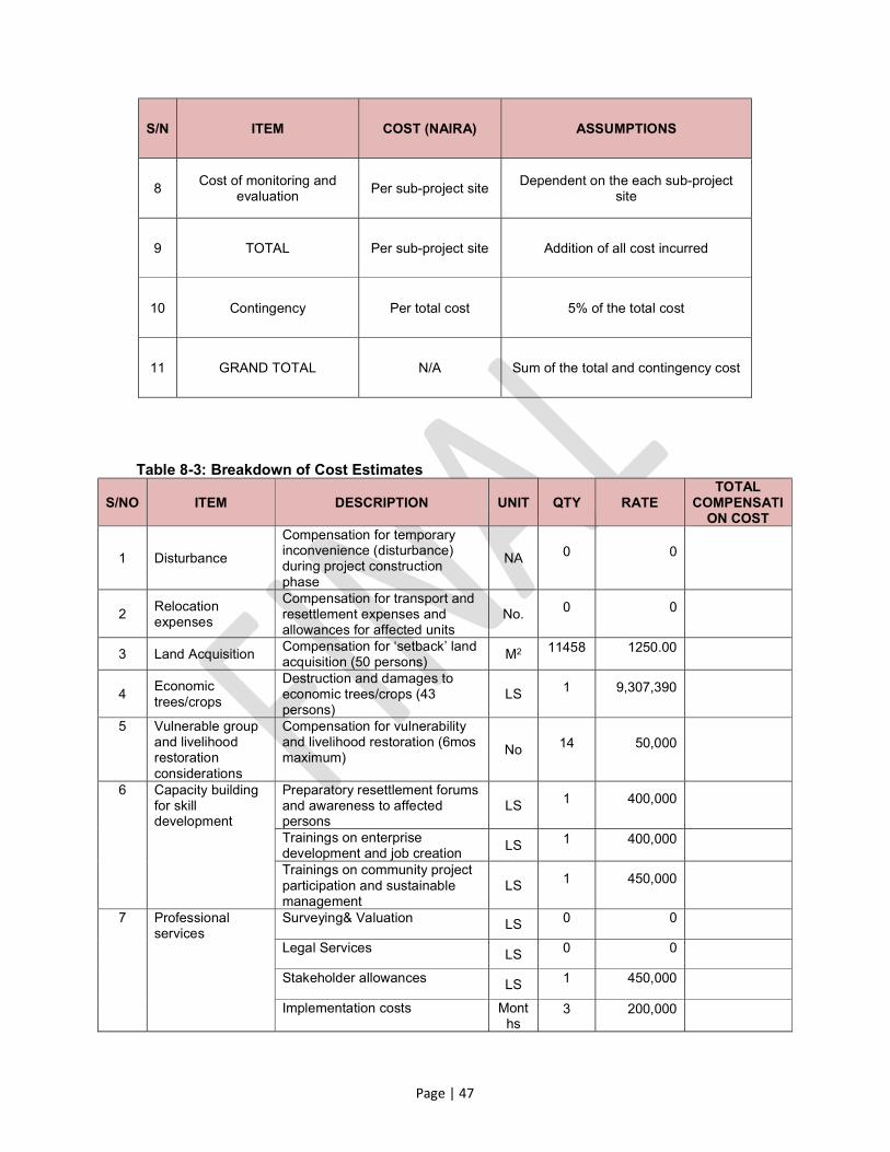
Page | 47
S/N ITEM COST (NAIRA) ASSUMPTIONS
8 Cost of monitoring and
evaluation Per sub-project site
Dependent on the each sub-project site
9 TOTAL Per sub-project site Addition of all cost incurred
10 Contingency Per total cost 5% of the total cost
11 GRAND TOTAL N/A Sum of the total and contingency cost
Table 8-3: Breakdown of Cost Estimates
S/NO ITEM DESCRIPTION UNIT QTY RATE TOTAL
COMPENSATION COST
1 Disturbance
Compensation for temporary inconvenience (disturbance) during project construction phase
NA 0 0
2 Relocation expenses
Compensation for transport and resettlement expenses and allowances for affected units
No. 0 0
3 Land Acquisition Compensation for ‘setback’ land acquisition (50 persons)
M2 11458 1250.00
4 Economic trees/crops
Destruction and damages to economic trees/crops (43 persons)
LS 1 9,307,390
5 Vulnerable group and livelihood restoration considerations
Compensation for vulnerability and livelihood restoration (6mos maximum)
No 14 50,000
6 Capacity building for skill development
Preparatory resettlement forums and awareness to affected persons
LS 1 400,000
Trainings on enterprise development and job creation
LS 1 400,000
Trainings on community project participation and sustainable management
LS 1 450,000
7 Professional services
Surveying& Valuation LS 0 0
Legal Services LS 0 0
Stakeholder allowances LS 1 450,000
Implementation costs Months
3 200,000

Page | 48
S/NO ITEM DESCRIPTION UNIT QTY RATE TOTAL
COMPENSATION COST
Monitoring and evaluation costs Personnel
3 150,000
End of project audit cost LS 1 350,000
Sub-total
8 Contingency % 5 NA
GRAND TOTAL

Page | 49
9.0 IMPLEMENTATION SCHEDULE The implementation and management of the ARAP schedule should be designed to facilitate necessary compensation of PAPs. The ARAP activities also need to be implemented within an agreed timeframe and budget. Appropriate timing should be adhered to in order to avoid false claimants for compensation especially if the situation arises where site clearing is to begin before the resettlement end date. The ARAP activities will be executed in accordance with the schedule shown in Table 9-1 below. The period of the first week will be used to develop and set up all structures necessary to support all aspects of the programmes.
Table 9-1: Implementation Schedule – Development Phase
DESCRIPTION OF ACTIVITY
DURATION
1st Week 2nd Week 3rd Week 4th Week
Formation of Project Complaint Committee (PCC) and Grievance Redress Committee (GRC)
Selection of Resettlement Implementing Committee (RIC)
Hold Stakeholders Meetings and Consultations
Conduct Community and PAP Capacity Building
Compensate All PAPs
Identification of Contractor
Listen to Grievances/ Complaints and Address Them
Conduct Monitoring and Evaluation
Programme Administration

Page | 50
10.0 SUMMARY AND RECOMMENDATION
The proposed intervention work is designed to halt the ongoing gully erosion menace at Nkpor Flyover areas of Nkpor and the neighbourhoods within Omagba Phase II Quarters of Onitsha and to improve erosion and watershed management resulting from storm water flow in the area. This will provide for:
Reduced damage to infrastructure including roads, houses, etc. Reduced loss of agricultural land and productivity from soil loss caused by surface
erosion. Effective control of storm water flow within Nkpor Flyover areas of Nkpor and the
neighbourhoods within Omagba Phase II of Onitsha. Reduced risks of floods (due to reduced siltation). Progressively restore vegetative cover, Improved environmental conditions and more humid local microclimates expected to
result in increased vegetation cover for wildlife and carbon sequestration. Environmental improvements due to land stabilization measures which preserve the
landscape and biodiversity. Multiplier effects such as employment opportunities, poverty reduction, enhanced national reputation and cultural promotion, among others, are expected to be enhanced in the area. On the other hand, there are also several negative social impacts that were identified. The ARAP has revealed that:
The proposed intervention work is most desirable because of the obvious environmental, health and socio-economic benefits. These far out-weigh the negative impacts that could arise in the course of implementation.
Potential impacts of sufficient magnitude that could interrupt the execution of the project were not detected. Although, there were few negative impacts that may potentially occur due to the activities associated with the proposed works but adequate measures have been provided to address them.
Mitigation measures and management planshave been suggested and developed for the negative impacts.
Appropriate institutional framework has been drawn up to implement the mitigation measures and environmental management plan while the proposed monitoring programmes shall be set in motion as soon as possible.
Generally, the study has indicated that the establishment of the proposed project will immensely impact positively on the existing environmental, social, health and safety conditions of Nkpor Flyover people. This inference is further made strong, owing to the fact that the community has thrown her full weight behind the project and is anxiously awaiting its implementation.

Page | 51
DISCLOSURES This Abbreviated Resettlement Action Plan will be disclosed by Anambra NEWMAP and ANSG which will make copies available at its head office in Awka and copies distributed to the leadership of the community (the offices of the Traditional Ruler and President General of Nkpor)prior to implementation of the project. GLOSSARY OF TERMS Involuntary resettlement: Resettlement is involuntary when it occurs without the informed consent of the displaced persons or if they give their consent without having the power to refuse resettlement. Cut–off date: The date the enumeration begins. Persons occupying the project area after the cut- off date are not eligible for compensation and/or resettlement assistance. Similarly, fixed assets (such as built structures, crops and trees) established after the date of completion of the assets inventory or an alternative mutually agreed date will not be compensated Displaced persons: Persons who are affected by the involuntary taking or clearing of land or resulting in:
i. Relocation or loss of shelter ii. Loss of assets or access to assets; or iii. Loss of income sources or means of livelihood whether or not the affected persons must move to another location.
Land expropriation: Process whereby a public authority, usually in return for compensation, requires a person, household, or community to relinquish rights to land that it occupies or otherwise uses. Project-affected person: Any person who, as a result of the implementation of a project, loses the right to own, use, or otherwise benefit from a built structure, land (residential, agricultural, or pasture), annual or perennial crops and trees, or any other fixed or moveable asset, either in full or in part, permanently or temporarily. Abbreviated Resettlement Action Plan (ARAP): The document in which a project sponsor or other responsible entity specifies the procedures that it will follow and the actions that it will take to mitigate adverse effects, compensate losses, and provide development benefits to persons and communities affected by an investment project. Resettlement assistance: Support provided to people who are physically displaced by a project. Assistance may include transportation, food, shelter, and social services that are provided to affected people during their relocation. Assistance may also include cash allowances that compensate affected people for the inconvenience associated with resettlement and defray the expenses of a transition to a new locale, such as moving expenses and lost work days. Structure owner PAPs: Project Affected Persons who own structures within the project area. Tenant PAPs: Project Affected persons who lease either residential or business premises within the project area. Stakeholders: Any and all individuals, groups, organizations, and institutions interested in and potentially affected by a project or having the ability to influence a project. Vulnerable groups: People who by virtue of gender, ethnicity, age, physical or mental disability, economic disadvantage, or social status may be more adversely affected by resettlement than others and who may be limited in their ability to claim or take advantage of resettlement assistance and related development benefits.

Page | 52
REFERENCES ITUA, E.O. (2011). Resettlement Policy Framework (RPF) for the Nigeria Erosion and
Watershed Management Project. Federal Ministry of Environment, Nigeria NEWMAP Project Appraisal Document (PAD) NEWMAP Project Implementation Manual (PIM) World Bank Safeguards Policies Nkpor Flyover Nkpor Gully Erosion Site Intervention Design Darghouth S., Ward C., Gambarelli G., Styger E., and Roux J. (2008): Watershed
Management Approaches, Policies, and Operations: Lessons for Scaling Up, Water Sector Board discussion Paper Series Paper No. 11, The International Bank for Reconstruction and Development/The World Bank
Federal Republic of Nigeria Infrastructure Concession Regulatory Commission (ICRC)
(2009): Resettlement Policy Framework (RPF) for Nigeria Public Private Partnership (PPP) Project, prepared by ERML, December
Government of India, Ministry of Urban Development (2008): Environment and Social
Management Framework for Global Environment Facility Sustainable Urban Transport Project, September
Darghouth S., Ward C., Gambarelli G., Styger E., and Roux J. (2008): Watershed
Management Approaches, Policies, and Operations: Lessons for Scaling Up, Water Sector Board discussion Paper Series Paper No. 11,
Federal Republic of Nigeria, Federal Ministry of Commerce and Industry (2010):
Resettlement Policy Frame Work for Growth and Enterprises and Markets in States (GEMS) Project, Prepared by Earth Guard, March
Environmental and Social Management Framework (ESMF)

Page | 53
ANNEXURE A
LIST OF CONTACTED STAKEHOLDERS The following persons were contacted during the course of the Consultancy: Table AN-1: List of Contacted Stakeholders
GROUPS CONTACTED STAKEHOLDER MODE OF CONTACT
Group-1
Individuals or group of persons whose daily activities (including farming) bring them in close proximity to the project area OR whose day-to-day lives/livelihoods may be directly affected by project activities.
General meetings, phones and personal contacts using a facilitator.
Group-2 Office of the Chairman – Nkpor Flyover Community Association
Phone and personal contacts
Group-3
Faith-Based Organizations Phone and personal contacts
Non-Governmental Organizations Phone and personal contacts
Group-4
Office of the Chairman – Idemili North LGA Phone contacts
Office of the Hon. Member – Anambra State House of Assembly
Phone contacts
Office of the Hon. Member – Idemili North & South Federal Constituency
Phone contacts

Page | 54
ANNEXURE B
MINUTES OF COMMUNITY SENSITIZATION MEETING WITH SPMU AND CONSULTANT
COMMUNITY SENSITIZATION MEETING HELD AT 7 AKPUGOEZE STREET ON SATURDAY 4 FEBRUARY, 2017
Attendance: See list of Attendees
ITEMS DESCRIPTION
1. Project: Anambra NEWMAP: ESMP/ARAP
2. Name of Community: Nkpor–Flyover
3. Date: February, 03 2017
4. Language of Communication:
English and Igbo
5. Introduction and Opening Remarks:
The meeting started at about 10:30am at No. 7 Akpugoeze St, Omagba Phase III, with an opening prayer. This was followed with brief welcome remarks by Mr. Arthur Onweluzo– the secretary of the community association.
6. Remarks of the SPMU: The SPMU delegation was led by Mrs. Blessing Okafor–the social/livelihood officer (SLO), and Mr. Ejike Onuchukwu - the environment safeguard officer (ESO).
They both explained that the meeting was a key activity for the ESMP and ARAP required in dealing with the menace of gully erosion in the community which stretches from the flyover on the Express Way to Nkisi Stream. The consultant firm for these assignments is OTG Enviroengineering (Nig) Ltd.
They urged the community to cooperate with the consultants in their assignments and participate fully in the census of project affected persons (PAPs.) The community should also participate actively in all other implementation activities and ensure transparency and consensus in all their activities.
The community was also advised to refrain from blocking water channels with solid waste and to take care of their environment.
7. Remarks of the Principal Consultants:
Dr. Odili Ojukwu, the principal consultant at OTG spoke on behalf of the consultants. He first introduced the team of specialists and other support staff from OTG.
He informed the attendees that it was the challenges of the gully erosion corridor from the flyover on Onitsha- Enugu Express Way to Nkisi stream, with its consequent displacements of homesteads, businesses, farmlands and other assets that precipitated the meeting.
The ravaging impacts of the gully erosion will be dealt with by the state government under the NEWMAP, with funding

Page | 55
assistance from the World Bank.
The engineering design for the civil works has been completed. The ESMP/RAP consultancy is aimed at finding out and documenting the impacts of the proposed civil engineering works on the elements of the physical, and socio-economic environment of the gully corridor, and to recommend appropriate mitigation and compensation measures in line with the world bank social safeguard policies.
The gully control measures will be both structural and non-structural. The structural component would involve construction of concrete drainage channels. The gully walls will need to be stabilized particularly at the deep sections of the gully along the corridor. This activity may require additional land along each side of the gully edge as setback for the stabilization of the gully walls. People’s land and assets and other elements of the physical environment are therefore most likely to be affected during construction works at the site.
The structural measures will be complemented with land reclamation and bio-remediation which will involve planting trees and grasses along the corridor. This way, the long term sustainability of the control measures is assured.
All lands acquired for the purpose of stabilizing the gully walls or for other erosion control measures at the site shall be permanent acquisition and at the end of construction be maintained by the community. The community shall subsequently maintain ownership of all such land and cannot be claimed by any individual or group.
A seven-day census/documentation of PAPs would start on Monday, February 6, 2017 and end on Sunday, February 12, 2017. The documentation shall stop after the cut–of–date. The census will include residents, non-residents and every other person who may be affected by the remedial measures. This also includes those who would be affected psychologically and health-wise owing to the effects of noise, fugitive dusts and other pollutants during the construction activities.
The community was further advised to take full ownership of their environment and all aspects of the implementation activities. They should participate in all the implementation processes, and avoid unnecessary conflicts and disaffections.
The communities were advised to be honest and truthful in completing the census questionnaire form as all claims will be verified physically and with appropriate technology.
A focus group discussion for elders, women and youths in the community would be held in due course to ascertain their specific perspectives and perceptions about the project.

Page | 56
Those who had suffered losses in the past prior to the project intervention would not be considered for compensation. Only those who are likely to be affected by the proposed civil engineering and bio-remediation works are expected to participate in the exercise.
8. Question and Concerns: The community in their response expressed their joy for the project and pleaded for accelerated implementation process in view of the multiple consequences of the erosion on their environment and their livelihoods as well as their physical and mental health. There was also a request for clarification on who should participate in the census exercise.
9. Response of the Consultants:
The consultant and the SPMU promised that the implementation process would be fast-tracked with the support and cooperation of all stakeholders including the community.
The census exercise shall be socially inclusive involving everybody that might be affected by the civil engineering and bio-remediation works.
10. Perceptions about the Project:
The Chairman of the community association, Chief Anthony Nzelu, articulated the community’s positive sentiments about the project and their readiness to give all necessary support and cooperation. He also gave the vote of thanks.
11. Closing: The meeting ended with a closing prayer at about 1.00pm.
12. Attendees: The meeting was attended by 84 persons including 23 females and 61 males. Also in attendance were representatives of CRIMSSI/ACERDEN the focal NGO for the project in the state.

Page | 57

Page | 58

Page | 59

Page | 60

Page | 61
REPORTS ON THE FOCUS GROUP DISCUSSIONS (FGD) DISCUSSIONS WITH THE WOMEN
ITEMS DESCRIPTION
1. Project: Anambra Newmap: ESMP/RAP
2. Title Women Focus Group Discussion (FGD)
3. Community: Nkpor Flyover/Akpugoeze Street.
4. Date: February 20, 2017.
5. Language of Communication:
Igbo and English
6. Introductions: The meeting commenced at 11:am at No. 7 Akpugoeze Street, Omagba Phase II with an opening prayer. The meeting was a follow-up to the general community sensitization held in the same venue on February 4, 2017.
7. Remarks of the Consultant:
The consultant firm-OTG Enviroengineering Ltd, was represented by Mr. Chudi Mojekwu- the social development specialist.
He explained to the attendees that the proposed remedial works on the gully erosion corridors are likely to have adverse impacts on the elements of the physical environment and socio-economic lives of the community. There is therefore the need to recommend appropriate mitigation and compensatory measures to deal with these impacts; and this is the main purpose of the ESMP/RAP consultancy.
Women-specific perspectives to the study and their perception about the project are considered important. Hence the need for the meeting.
He mentioned the following likely adverse impacts and the corresponding mitigation measures for the knowledge and benefit of the attendees.
Dusts: Spray water to limit dusts Lost of topsoil and vegetation: Limit work areas and operation vehicle
movement routes. Noise: By retrofitting vehicles with sound-proofing materials. Soil/ground water contamination: By creating limit zones and limiting
excavation to desired areas. Traffic disruptions: There will be changes in lanes configuration, and
creation/limiting of operational routes. Disruptions to livelihood: Identify and provide best alternatives to prevent
disruptions. Pay compensations as the need arises. Sexual risks (HIV/AIDs): Provide sexual awareness campaigns.
8. Remarks of the Women:
The women were encouraged to speak their minds on all issues concerning the erosion and remedial works. Their remarks centered on 4 issues, namely, assets they have on the gully corridor, the impacts of gully erosion on their lives expected benefits after the control measures, and the roles they intend to play during the remedial works.
Assets along the corridor: 49 of the women have various built – up structure along the corridor. 5 of them own parcels of land on the corridor while 10 of them have various farming establishments including fish farms, goat and sheep pens, poultry and crops farms on the corridor.
Impacts of the erosion: These include
- Emotional distress especially during the rainy season; - Mosquito infestation and consequent malaria illness;
Page | 62
ITEMS DESCRIPTION
- Invasion with dangerous animals (snakes, centipedes, etc); - Incidents of death; - Menace of thieves and street urchins using the gully corridors as
hideouts and escape routes; - Air pollution; - Loss of farmlands; - Loss/flooding/destruction of homesteads; Expected benefits: These include:
- Improved health and quality of life; - Environmental hygiene; - Recovery of farmlands; - Improved care of the environment; - Peace of mind. Intended roles: The women promised to play the following roles in the remedial works.
- Monitoring and providing implementation progress feedback; - Security of lives and materials; - Engagement as suppliers of construction materials and labour; - Sales of sundry items to construction workers.
9. Questions and Perceptions of the Project:
The women would like to see an accelerated project implementation process and promised to give their full support. There was a question on how the project will deal with sick/elderly people who might be affected by fumes, dust and noise.
10. Response to the Question:
Necessary mitigation measures as shown above will be used to deal with fumes, dust and noise pollution. However if in spite of these measures, there is still need to resettle anybody, the World Bank social safeguards policies will apply.
11. Attendees: The meeting was attended by 71 women and they came from various walks of life including trading, farming, public service, industrial works etc.
12. Closing: The meeting ended with vote of thanks and closing prayers at about 12:15pm.
WOMEN FOCUS GROUP DISCUSSIONS (FGD) LIST OF ATTENDEES
S/NO NAME GENDER COMMUNITY/ VILLAGE/ ORGANIZATION PHONE NO
1 EGWU GLORIA F AKPUGOEZE - OMAGBA 08174517407
2 UMEOBI NGOZI F AKPUGOEZE - OMAGBA 08065314301
3 UDEH CHIDIMMA F AKPUGOEZE - OMAGBA 08036682092
4 IKERIE UJU F AKPUGOEZE - OMAGBA 08060520079
5 OKEKE CHINYERE F AKPUGOEZE - OMAGBA 08136051905
6 NKEMKA NGOZI F AKPUGOEZE - OMAGBA 08038965437
7 ONWUEREZI IFEOMA F AKPUGOEZE - OMAGBA 07065988595
8 NWANKWO BLESSING F AKPUGOEZE - OMAGBA 08100034572
9 ONYEBUEKE OLUCHUKWU F AKPUGOEZE - OMAGBA 08135530473

Page | 63
S/NO NAME GENDER COMMUNITY/ VILLAGE/ ORGANIZATION PHONE NO
10 EDWIN MARY F AKPUGOEZE - OMAGBA 08066920202
11 ANTHONY OLUCHUKWU F AKPUGOEZE - OMAGBA 08036862883
12 CHUKWU ONYINYE C F AKPUGOEZE - OMAGBA 08060189020
13 OBI IFEOMA DORIS F AKPUGOEZE - OMAGBA 08063591541
14 OKAFOR JOSEPHINE F AKPUGOEZE - OMAGBA 07062007685
15 EGEDE CHIDIEBERE F AKPUGOEZE - OMAGBA 07064836533
16 NWASIKE OKWUCHUKWU F AKPUGOEZE - OMAGBA 07066834474
17 ABEL OGADINMA F AKPUGOEZE - OMAGBA 08133658697
18 OGOR CHINENYE F AKPUGOEZE - OMAGBA 07011436990
19 NWIGWE NNEKA F AKPUGOEZE - OMAGBA 08066469066
20 OKOLI OGECHUKWU F AKPUGOEZE - OMAGBA 08030496824
21 NNANYELUGO UCHE F AKPUGOEZE - OMAGBA 09077133118
22 OKONKWO MIRIAM .A F AKPUGOEZE - OMAGBA 08068434332
23 ANUMBA GLORIA O F AKPUGOEZE - OMAGBA 08035058027
24 UGWUEKE UGOCHUKWU F AKPUGOEZE - OMAGBA 07060780741
25 ASUNDUBUISI IFEOMA F AKPUGOEZE - OMAGBA 08032763867
26 ANYIGOR CONFIDENCE F AKPUGOEZE - OMAGBA 09097319956
27 UDEH CHIOMA .R F AKPUGOEZE - OMAGBA 08036215968
28 OBASI COMFORT F AKPUGOEZE - OMAGBA 07068661600
29 OBIECHINA CHIOMA F AKPUGOEZE - OMAGBA 08057852411
30 UDOH JOSEPHINE F AKPUGOEZE - OMAGBA 08065782525
31 UZODIMMA CHINYERE F AKPUGOEZE - OMAGBA 07033703368
32 ALAOKE JUSTINA F AKPUGOEZE - OMAGBA 08034746493
33 EKEH NONYE F AKPUGOEZE - OMAGBA 08033393847
34 OHUKE OGE F AKPUGOEZE - OMAGBA 08033393847
35 ONYIKWA NKIRUKA F AKPUGOEZE - OMAGBA 08169368808
36 OKONKWO OBIAGERI .J F AKPUGOEZE - OMAGBA 08067968787
37 OKEKE CHINAECHEREM F AKPUGOEZE - OMAGBA 07033703368
38 OBIMA CHINYERE F AKPUGOEZE - OMAGBA 08037732758
39 UDEABA IFEOMA F AKPUGOEZE - OMAGBA 0703493430
40 CHUKWUKANNE UZOAMAKA F AKPUGOEZE - OMAGBA 08060584274
41 UMEARUSOBI CHIKA F AKPUGOEZE - OMAGBA 08105885963
42 NZELU AMAKA F AKPUGOEZE - OMAGBA 08033972061
43 EZENWA OGECHUKWU F AKPUGOEZE - OMAGBA 08069250256
44 OKAFOR CHINECHEREM F AKPUGOEZE - OMAGBA 08109127387
45 OKPANUM CHISOM F AKPUGOEZE - OMAGBA 08063776516
46 AMAH GRACE. N F AKPUGOEZE - OMAGBA 08168584555
47 MMADUBUEZE BENITA .A F AKPUGOEZE - OMAGBA 08036259649
48 CHIDOZIE FRANCISCA F AKPUGOEZE - OMAGBA 08063735952
49 OBIEFUNA CHINYERE F AKPUGOEZE - OMAGBA 09070872463
50 OGUIYI NGOZI F AKPUGOEZE - OMAGBA 08062363716
52 EZEONUOGU VIVIAN F AKPUGOEZE - OMAGBA 08062380052
53 NWEKE OGOCHUKWU F AKPUGOEZE - OMAGBA 09067030111
Page | 64
S/NO NAME GENDER COMMUNITY/ VILLAGE/ ORGANIZATION PHONE NO
54 UGWUANYI LEBECHI F AKPUGOEZE - OMAGBA 08165053664
55 CHINEDU MARY F AKPUGOEZE - OMAGBA 07039233715
56 MADUKA ONYINYE .E F AKPUGOEZE - OMAGBA 07064625302
57 AYOGU CHIZOBA. G F AKPUGOEZE - OMAGBA 07060445868
58 EKWUEME PASCHALINE F AKPUGOEZE - OMAGBA 07069427955
59 EMEH EURHEMIA F AKPUGOEZE - OMAGBA 08102580212
60 CHIGOZIE CHIOMA F AKPUGOEZE - OMAGBA 0706758921
61 CHIAHA KOSISOCHUKWU F AKPUGOEZE - OMAGBA 08065883140
62 CHIDILE CHUKWUNONSO F AKPUGOEZE - OMAGBA 07062489110
63 NNAEGBOO UKAMAKA F AKPUGOEZE - OMAGBA 08068865719
64 UZOCHUKWU ONYINYE F AKPUGOEZE - OMAGBA 08039632494
65 OKEFI IFEOMA F AKPUGOEZE - OMAGBA 08166920792
66 ONWELUZO IFEYINWA F AKPUGOEZE - OMAGBA 08060768792
67 ANGIM SUCCESS F AKPUGOEZE 08123203330
68 IJEZIE NWANNEKA F AKPUGOEZE 08033237383
69 OTI CHINAECHEREM F AKPUGOEZE 07013257109
70 AMAECHI CHARITY F AKPUGOEZE 07064948060
71 NWEKE CHINYERE F AKPUGOEZE 08140796488

Page | 65
DISCUSSIONS WITH THE YOUTHS ITEMS DESCRIPTION
1. Project: Anambra Newmap: ESMP/RAP
2. Title: Youths Focus Group Discussion (FGD)
3. Community: Nkpor Flyover
4. Date: February 20, 2017
5. Language of Communication:
English and Igbo
6. Introductions: The meeting commenced at about 12:40 pm with opening prayers. The venue was No. 7 Akpugoeze Street, Omagba Phase II. The aim was to get the specific perspectives of the Youths to the on-going ESMP/RAP consultancy.
7. Remarks of the Consultant:
The consultant firm-OTG Enviroengineering Ltd, was represented by Mr. Chudi Mojekwu- the social development specialist.
He explained to the attendees that the proposed remedial works on the gully erosion corridors are likely to have adverse impacts on the elements of the physical environment and socio-economic lives of the community. There is therefore the need to recommend appropriate mitigation and compensatory measures to deal with these impacts; and this is the main purpose of the ESMP/RAP consultancy.
Youths-specific perspectives to the study and their perception about the project are considered important. Hence the need for the meeting.
He mentioned the following likely adverse impacts and the corresponding mitigation measures for the knowledge and benefit of the attendees.
Dusts: Spray water to limit dusts Loss of topsoil and vegetation: Limit work areas and operation vehicle
movement routes. Noise: By retrofitting vehicles with sound-proofing materials. Soil/ground water contamination: By creating limit zones and limiting
excavation to desired areas. Traffic disruptions: There will be changes in lanes configuration, and
creation/limiting of operational routes. Disruptions to livelihood: Identify and provide best alternatives to prevent
disruptions. Pay compensations as the need arises. Sexual risks (HIV/AIDs): Provide sexual awareness campaigns.
8. Remarks of
the Youths:
The remarks of the youths centred on 4 issues, namely, ownership of assets along the gully corridor, impacts of the erosion on their lives and livelihoods, expected benefits on completion of the remedial works and their roles during the remedial works.
Ownership of Assets: The distribution of the youths by ownership of assets along the corridor is as follows: Built-up structure – 20, farms -2, and land -5.
Impacts of the erosion: The impacts of the erosion on their lives and livelihoods include:

Page | 66
ITEMS DESCRIPTION
- Loss of business premises and homesteads; - Emotional distress; - Mosquitoes infestation/illness(malaria, & typhoid); - Menace of dangerous reptiles; - Air pollution etc;
Expected benefits: The expected benefits on completion of the remedial works are:
- Improved quality of life and health; - Restoration of homesteads and businesses; - Improved environmental hygiene; - Peace of mind.
Roles of the youths: During the remedial works, the youths intend to:
- Ensure peace and security of lives and property; - Monitor implementation progress and give feedback; - Supply labour and construction-materials; - Protect the remedial works and their environment.
9. Perception about the Project and Questions:
The youths are enthusiastic about the project and requested for a fast-track implementation and wider dissemination of information about the project. There was a question on the fate of those who did not participate in the census of PAPs exercise.
10. Response of the Consultant:
It is expected that the project would be implemented without undue delay. The site committee should ensure proper and wider dissemination of project information.
The consultants cannot go beyond the cut-of-date for the census/documentation of PAPs. The 7-day period was sufficient and the turn-out was really huge. Any complaints could be directed to the SPMU.
11. Attendees: The meeting was attended by 92 persons including 17 females and 75 males. They came from various walks of life, namely, trading, farming, public service, artisans and the unemployed.
12. Vote of Thanks:
A vote of thanks was moved by the chairperson of the youth association, Hon. Iyke Oguiyi. The meeting rose with closing prayers at about 1:50pm.
YOUTH FOCUS GROUP DISCUSSIONS (FGD) LIST OF ATTENDEES
S/NO NAME GENDER COMMUNITY/ VILLAGE/ ORGANIZATION PHONE NO
1 EKEH AMECHI .J M AKPUGOEZE 07060985846
2 NDULUE OLUCHUKWU. J M AKPUGOEZE- OMAGBA 07053370850
3 NDULUE ONYINYE . C M AKPUGOEZE- OMAGBA 08035516382
4 OGUIYI IKECHUKWU. J M AKPUGOEZE- OMAGBA 08055382635
5 OKPANUM MICHAEL M AKPUGOEZE- OMAGBA 08036704460

Page | 67
S/NO NAME GENDER COMMUNITY/ VILLAGE/ ORGANIZATION PHONE NO
6 IKEH CHINEDU M AKPUGOEZE- OMAGBA 08033816988
7 MADUBUEZE NNAMDI M AKPUGOEZE 08037464008
8 URAMA CHRISTOPHER M AKPUGOEZE 07030731875
9 NWOKIKE OGECHUKWU F AKPUGOEZE 08139299321
10 NWOKIKE CHRISTIAN M AKPUGOEZE 07069498455
11 IYIEGBU SUNDAY M AKPUGOEZE 08093433007
12 NNAJI CHINENYE F AKPUGOEZE 08066197113
13 OKUMEFUNA IFUNANYA F AKPUGOEZE 09067415831
14 IKELIE MARY .C F AKPUGOEZE 09037866981
15 IKELIE CHIDINMA F AKPUGOEZE 08060520079
16 IKELIE CHINAZA F AKPUGOEZE 08035775051
17 IKELIE CHRISTOPHER M AKPUGOEZE 09037866981
18 IKELIE CHIBUEZE M AKPUGOEZE 09037866981
19 NWANKWO AMECHI. C F AKPUGOEZE 07038884091
20 NNAJI CHINENYE F AKPUGOEZE OMAGBA 08066197113
21 OFUMELU FRANCISCA F AKPUGOEZE OMAGBA 08058421991
22 IFEANYI M AKPANTA 07062946175
23 MGBEOFULIKE CHIDIKE .D M AKPUGOEZE 07035804444
24 HOBIB AUDU M AKPUGOEZE OMAGBA 07034828554
25 UGWUEKE IFEANYI M AKPUGOEZE 08139512437
26 EZE IJEZIE M AKPUGOEZE 07038089399
27 ONYE CHINEDU M AKPUGOEZE 08065995321
28 OKONKWO ARINZE M AKPUGOEZE 08039352192
29 OBIEFUNA JUVENTUS M AKPUGOEZE OMAGBA 08037743546
30 NDULUE OGONNA M AKPUGOEZE OMAGBA 08101230929
31 UMEGHALU NONSO M AKPUGOEZE OMAGBA 08034523535
32 OKORO OBIORA M UFUMA STREET OMAGBA 08037432943
33 NNANYELUGO ANTHONY M AKPUGOEZE/ NAWFIA 08066284110
34 NWEKE NNAMDI M AKPUGOEZE/ NAWFIA 08034360709
35 OKONKWO CHIGOZIE M AKPUGOEZE/ NAWFIA 08037803312
36 OBIEFUNA CHIMEZIE M AKPUGOEZE/ NAWFIA 08037016167
37 NDULUE OBINNA M AKPUGOEZE 08168577673
38 IKE JACHUKWU M AKPUGOEZE 08068479412
39 NDULUE CHUKWUNONYE M AKPUGOEZE 07034388964
40 NDULUE CHUKWUNONYE M AKPUGOEZE 0701664684
41 ILA UDOCHUKWU M AKPUGOEZE 08083539928
42 ONWUEMERE EBUKA. V M AKPUGOEZE 09055485204
43 IYIEGBU OKECHUKWU M AKPUGOEZE 09078052010
44 CHIGERE GODWIN M IGBO UKWU 08036784041
45 OBASI OBIOMA M AKPUGOEZE 07039727536
46 NWOKO NNAMDI M AKPUGOEZE 08033809845
47 UMEOBI OBINNA M AKPUGOEZE 08038713362
48 UMEOBI CHINENYE F AKPUGOEZE 08038713362
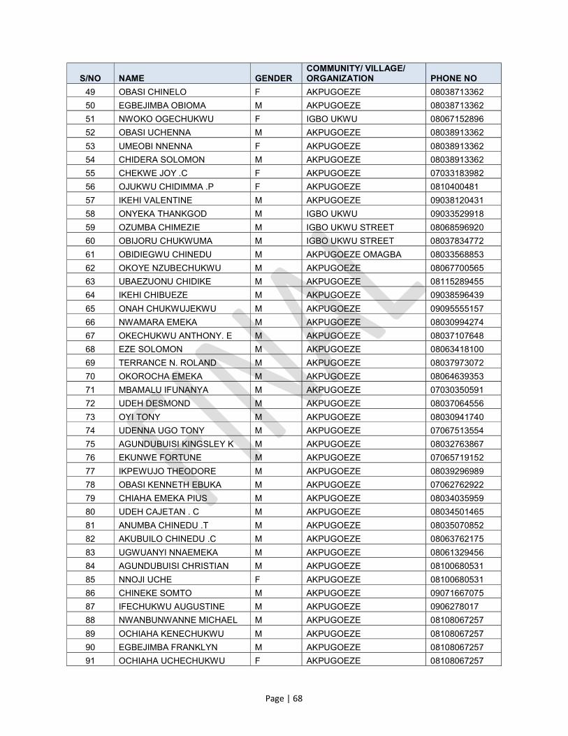
Page | 68
S/NO NAME GENDER COMMUNITY/ VILLAGE/ ORGANIZATION PHONE NO
49 OBASI CHINELO F AKPUGOEZE 08038713362
50 EGBEJIMBA OBIOMA M AKPUGOEZE 08038713362
51 NWOKO OGECHUKWU F IGBO UKWU 08067152896
52 OBASI UCHENNA M AKPUGOEZE 08038913362
53 UMEOBI NNENNA F AKPUGOEZE 08038913362
54 CHIDERA SOLOMON M AKPUGOEZE 08038913362
55 CHEKWE JOY .C F AKPUGOEZE 07033183982
56 OJUKWU CHIDIMMA .P F AKPUGOEZE 0810400481
57 IKEHI VALENTINE M AKPUGOEZE 09038120431
58 ONYEKA THANKGOD M IGBO UKWU 09033529918
59 OZUMBA CHIMEZIE M IGBO UKWU STREET 08068596920
60 OBIJORU CHUKWUMA M IGBO UKWU STREET 08037834772
61 OBIDIEGWU CHINEDU M AKPUGOEZE OMAGBA 08033568853
62 OKOYE NZUBECHUKWU M AKPUGOEZE 08067700565
63 UBAEZUONU CHIDIKE M AKPUGOEZE 08115289455
64 IKEHI CHIBUEZE M AKPUGOEZE 09038596439
65 ONAH CHUKWUJEKWU M AKPUGOEZE 09095555157
66 NWAMARA EMEKA M AKPUGOEZE 08030994274
67 OKECHUKWU ANTHONY. E M AKPUGOEZE 08037107648
68 EZE SOLOMON M AKPUGOEZE 08063418100
69 TERRANCE N. ROLAND M AKPUGOEZE 08037973072
70 OKOROCHA EMEKA M AKPUGOEZE 08064639353
71 MBAMALU IFUNANYA M AKPUGOEZE 07030350591
72 UDEH DESMOND M AKPUGOEZE 08037064556
73 OYI TONY M AKPUGOEZE 08030941740
74 UDENNA UGO TONY M AKPUGOEZE 07067513554
75 AGUNDUBUISI KINGSLEY K M AKPUGOEZE 08032763867
76 EKUNWE FORTUNE M AKPUGOEZE 07065719152
77 IKPEWUJO THEODORE M AKPUGOEZE 08039296989
78 OBASI KENNETH EBUKA M AKPUGOEZE 07062762922
79 CHIAHA EMEKA PIUS M AKPUGOEZE 08034035959
80 UDEH CAJETAN . C M AKPUGOEZE 08034501465
81 ANUMBA CHINEDU .T M AKPUGOEZE 08035070852
82 AKUBUILO CHINEDU .C M AKPUGOEZE 08063762175
83 UGWUANYI NNAEMEKA M AKPUGOEZE 08061329456
84 AGUNDUBUISI CHRISTIAN M AKPUGOEZE 08100680531
85 NNOJI UCHE F AKPUGOEZE 08100680531
86 CHINEKE SOMTO M AKPUGOEZE 09071667075
87 IFECHUKWU AUGUSTINE M AKPUGOEZE 0906278017
88 NWANBUNWANNE MICHAEL M AKPUGOEZE 08108067257
89 OCHIAHA KENECHUKWU M AKPUGOEZE 08108067257
90 EGBEJIMBA FRANKLYN M AKPUGOEZE 08108067257
91 OCHIAHA UCHECHUKWU F AKPUGOEZE 08108067257

Page | 69
S/NO NAME GENDER COMMUNITY/ VILLAGE/ ORGANIZATION PHONE NO
92 UZODIMMA CHINEDU M AKPUGOEZE 08063430979
DISCUSSIONS WITH THE ELDERS
ITEMS DESCRIPTION
1. Project: Anambra Newmap: ESMP/RAP
2. Title Elders Focus Group Discussion (FGD)
3. Community: Nkpor Flyover/Akpugoeze Street.
4. Date: February 20, 2017.
5. Language of Communication:
English and Igbo.
6. Introductions: The discussion started at about 2:30pm. The venue was No. 7 Akpugoeze Street Omagba Phase II. The meeting was facilitated by Hon. Tony Nzelu – the chairperson of the community association.
7. Remarks of the Consultant:
The consultant firm-OTG Enviroengineering Ltd, was represented by Mr. Chudi Mojekwu- the social development specialist.
He explained to the attendees that the proposed remedial works on the gully erosion corridors are likely to have adverse impacts on the elements of the physical environment and socio-economic lives of the community. There is therefore the need to recommend appropriate mitigation and compensatory measures to deal with these impacts; and this is the main purpose of the ESMP/RAP consultancy.
Elders-specific perspectives to the study and their perception about the project are considered important. Hence the need for the meeting.
He mentioned the following likely adverse impacts and the corresponding mitigation measures for the knowledge and benefit of the attendees.
Dusts: Spray water to limit dusts Loss of topsoil and vegetation: Limit work areas and operation vehicle
movement routes. Noise: By retrofitting vehicles with sound-proofing materials. Soil/ground water contamination: By creating limit zones and limiting
excavation to desired areas. Traffic disruptions: There will be changes in lanes configuration, and
creation/limiting of operational routes. Disruptions to livelihood: Identify and provide best alternatives to
prevent disruptions. Pay compensations as the need arises. Sexual risks (HIV/AIDs): Provide sexual awareness campaigns.
8. Remarks of the Elders:
The elders spoke on 4 major issues, namely, assets owned along the gully corridor, impacts of the erosion on their lives and livelihoods, the expected benefits on completion of remedial works and the intended roles during remedial works.
Assets along the corridor: The distribution of the attendees by ownership of assets along the gully corridor is as follows: built –up structure -8, land -7, and crops/economic trees -11.
Impacts of the erosion: These include:

Page | 70
ITEMS DESCRIPTION
- Emotional distress; - Displacement of homesteads and businesses; - Mosquito infestation/illnesses; - Traffic disruptions and restricted commuting. Expected benefits: On completion of the remedial works, the elders expect:
- Improved quality of life; - Peace of mind; - Security of lives and property; - Increased/enhanced commuting in the neighbourhoods. Intended roles: The elders intend to:
- Ensure that the drainages are not blocked again; - Monitor implementation progress and give feed-back; - Ensure security of lives and property; - Stop all manner of abuse of the environment.
9. Perceptions of the Project and Questions:
The elders are well disposed to the project and would like to see accelerated implementation. They pledged their full support and cooperation. Their questions are summarized below:
- When would civil work commence? - What happen to the fingers of the erosion corridor and the head at
Nkpor flyover - How would traffic disruptions be handled
10. Response of the Consultants:
Civil works would start as soon as the ESMP/RAP report is completed, approved and implemented. The consultants would deliver on time.
The erosion head at Nkpor and all the fingers of the corridor are taken care of in the engineering design. There is no half measure.
There might be need for traffic lane reconfiguration to reduce traffic disruptions and damage to property.
11. Attendees: 41 elders from various walks of life (farming, trading, public service, clergy, professional and artisans) attended the meeting.
12. Vote of Thanks and Closing:
Hon. Tony Nzelu the chairperson of the community association, moved the vote of thanks. Rev. Dr. Theophilus N. Madu said the closing prayers at 4:00pm.
ELDERS FOCUS GROUP DISCUSSIONS (FGD) LIST OF ATTENDEES
S/NO NAME GENDER COMMUNITY/ VILLAGE/ ORGANIZATION PHONE NO
1 CHINEKE MICHAEL M 14 AKPUGOEZE STREET 07063833799
2 OBI BONIFACE M 18 AKPUGOEZE STREET 08033125114
3 NZELUE ANTHONY M 18 AKPUGOEZE STREET 08036704964
4 ONWELUZO ARTHUR M 3 ETELE CRESCENT BY AKPUGOEZE 08036767383
5 OKOLO BEN M 22 AKPUGOEZE STREET 08033132472
6 OKOLI UCHENNA M AKPUGOEZE 08187805141

Page | 71
S/NO NAME GENDER COMMUNITY/ VILLAGE/ ORGANIZATION PHONE NO
7 TORTI OBINNA. S M 8 OBIEZE STREET 08030940233
8 CHUKWU MIRACLEMARY M 43 JOHN NWADIOGBU STREET 08039152077
9 MMADUEGBUNA PATRICK M 5 ALOR STREET 08066619221
10 OKPALA ONYEBUCHI M 7 ALOR STREET 08037133204
11 ALOR EBENEZER M NO 4 AKPUGOEZE STREET 08033372390
12 IJEZIE BENJAS .B M AKPUGOEZE 08033007714
13 UMEOBI OLIVER M NO 7 AKPUGOEZE 08038915782
14 EZE ARTHUR .O M 22 AKPUGOEZE STREET 08035839222
15 OWUNNA AUGUSTINE M 1 EMEKA OKEKE CLOSE 07060987791
16 UGWUEKE IFEANYI M AKPUGOEZE 08039512437
17 ONWUKA CHRISTOPHER M CHRIS ONWUKA LANE 08034072070
18 NWEKE ANAYO M 18 AKPUGOEZE 08068378780
19 OKAFOR CHINEDU M AKPUGOEZE OMAFGBA 08109526288
20 STEPHEN OGECHUKWU M AKPUGOEZE 08066193546
21 OKECHUKWU MOSES . O M AKPUGOEZE 07066653413
22 TOCHUKWU BENEDITH M AKPUGOEZE 07013257109
23 ODENIGBO CHRISTIAN .U M AKPUGOEZE 08063208450
24 UKPA SUNDAY M AKPUGOEZE 08033090715
25 AKUNNA CHUKWURAH .F M AKPUGOEZE 07061836250
26 NWANKWO OKECHUKWU M AKPUGOEZE OMAFGBA 08062289593
27 OKECHUKWU EZENNIA M AKPUGOEZE OMAFGBA 08035089036
28 KEKE ALPHONSUS M AKPUGOEZE OMAFGBA 07030725744
29 ANIH MONDAY M AKPUGOEZE OMAFGBA 08032176335
30 OKEFI GEORGE M AKPUGOEZE OMAFGBA 08037747884
31 OBASI EMEKA. K M AKPUGOEZE OMAFGBA 08097040345
32 MMADUBUEZE M AKPUGOEZE ABBA STR. 08037464008
33 NWEKE EMMA M AKPUGOEZE 07030377493
34 OKEKE BASIL .E M 1A EMEKA CLOSE E/SUMP 08061595370
35 THEOPHILUS N.M M AKPUGOEZE 08034059256
36 AGU NDUBUISI.C M AKPUGOEZE 08030914626
37 OBIMA GODWIN .C M AKPUGOEZE 08169300757
38 EGWU TOBIAS M AKPUGOEZE 07038039676
39 ANI KENNETH M AKPUGOEZE 07030616011
40 UMUNNA CHUKWUNONSO M AKPUGOEZE 08038199937
41 NNAMANI BASIL M AKPUGOEZE 08036013936

Page | 72
WOMEN FGDs IN PHOTOS

Page | 73
YOUTH FGDs IN PHOTOS

Page | 74
ELDERS FGDs IN PHOTOS

Page | 75
ANNEXURE C
SAMPLE SOCIOECONOMIC/CENSUS DATA FORM
NKPOR FLYOVER GULLY EROSION PROJECT
DATA COLLECTION CONSENT FORM
Questionnaire Number
CONSENT: We are conducting an assessment for the Anambra State Project Management Unit (SPMU) of Nigeria Erosion and Watershed Management Project (NEWMAP)` under the Ministry of Environment, Anambra State to enable us determine the people and assets that will be affected by the remediation and rehabilitation of Nkpor Flyover erosion gully corridor under NEWMAP. Your consent for this assessment is required.
Respondent Phone Number(s):____________________________________
Name of Property Owner
Village:
Kindred
Residential Address:
Consent (Sign): YES NO
Interviewer: Date:
PLACE PASSPORT-SIZE PHOTO OF
RESPONDENT HERE
QUESTIONAIRE NO.:

QUESTIONAIRE NO.:
ANNEXURE
NKPOR FLYOVER GULLY EROSION INTERVENTION PROJECT SOCIO-ECONOMIC BASELINE SURVEY
GENERAL INFORMATION
Name of Interviewer…………………..……………………………………………………………………………….Date……………………………… Name of Village/Town and Address……………………………………………………………………………………………………………………. What is likely to be affected by the project?........................... Structure-1; Land-2; Structure and Land-3; Cash Crop-4; Others-5 (specify)…………………….. HEAD OF HOUSEHOLD (H.H)……………………………………………………………Years of Occupation of Affected Property………….Years NAME OF RESPONDENT: ………………………………………………………… RELATIONSHIP TO THE H.H...…………………………………………. STATUS OF USER OF PROPERTY: A) Title holder; B) Tenant; C) Non-Title Holder; D) Trust; E) Govt; F) NGO; G) Squatter
AFFECTED PROPERTY INFORMATION Affected Structure Details:
Type of Use Property
User Status Monthly
Rent Utility
Connections
Distance to Gully Edge
(m)
No of Rooms
Floor Level Total Area
(m2)
Type of Construction Structure
Roof Wall Floor Length
(m) Width
(m) Height
(m)
Type of Use = Residence-1; Commercial-2; Residential-cum-Commercial-3; Animal Shed/Poultry-4; Other (specify)-5………………………………. User Status = Own-1, Rent-2, Caretaker-3, Squatter-4, Encroachers-5, Other (specify)-6………………….…………….. Type of Construction: Wall = Mud-1, Thatched-2, Brick-3, Plank-4, Zinc-5 Roof = Zinc/Asbestos-1; RCC-2; Thatched-3; Tiles-4 Floor = Cement-1; Mud-2; Tiles-3 Floor Level = Bungalow-1, Storey Building-2 Utility Connection = Electricity-1; Water-2; Phone-3
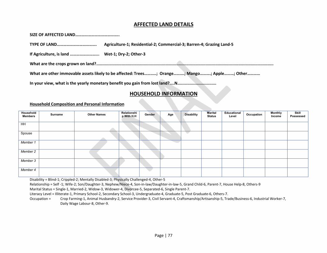
Page | 77
AFFECTED LAND DETAILS
SIZE OF AFFECTED LAND…………………………………..
TYPE OF LAND………………………………. Agriculture-1; Residential-2; Commercial-3; Barren-4; Grazing Land-5
If Agriculture, is land ……………………... Wet-1; Dry-2; Other-3
What are the crops grown on land?..................................................................................................................................................
What are other immovable assets likely to be affected: Trees………..; Orange……….; Mango……….; Apple………; Other…………
In your view, what is the yearly monetary benefit you gain from lost land?....N................................
HOUSEHOLD INFORMATION
Household Composition and Personal Information
Household Members
Surname Other Names Relationship With H.H
Gender Age Disability Marital Status
Educational Level
Occupation Monthly Income
Skill Possessed
HH
Spouse
Member 1
Member 2
Member 3
Member 4
Disability = Blind-1; Crippled-2; Mentally Disabled-3; Physically Challenged-4, Other-5 Relationship = Self -1; Wife-2; Son/Daughter-3, Nephew/Niece-4, Son-in-law/Daughter-in-law-5, Grand Child-6, Parent-7, House Help-8, Others-9 Marital Status = Single-1, Married-2, Widow-3, Widower-4, Divorcee-5, Separated-6, Single Parent-7. Literacy Level = Illiterate-1, Primary School-2, Secondary School-3, Undergraduate-4, Graduate-5, Post Graduate-6, Others-7. Occupation = Crop Farming-1, Animal Husbandry-2, Service Provider-3, Civil Servant-4, Craftsmanship/Artisanship-5, Trade/Business-6, Industrial Worker-7, Daily Wage Labour-8, Other-9.
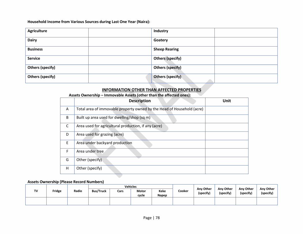
Page | 78
Household Income from Various Sources during Last One Year (Naira):
Agriculture Industry
Dairy Goatery
Business Sheep Rearing
Service Others (specify)
Others (specify) Others (specify)
Others (specify) Others (specify)
INFORMATION OTHER THAN AFFECTED PROPERTIES Assets Ownership – Immovable Assets (other than the affected ones):
Description Unit
A Total area of immovable property owned by the Head of Household (acre)
B Built up area used for dwelling/shop (sq m)
C Area used for agricultural production, if any (acre)
D Area used for grazing (acre)
E Area under backyard production
F Area under tree
G Other (specify)
H Other (specify)
Assets Ownership (Please Record Numbers)
TV Fridge Radio Vehicles
Cooker Any Other (specify)
Any Other (specify)
Any Other (specify)
Any Other (specify) Bus/Truck Cars Motor
cycle Keke
Napep

Page | 79
Live Stock Assets (Please Record Numbers) Classification Cows Goats Poultry Sheep Others Others Others
Give Number
Household Health Status Was any member of your family affected by any major illness in the past one year? Yes-1; No-2 If YES, Indicate the details:
S/No. Type of Disease/Illness No. of Cases
Treatment Taken Type of Treatment Preferred
Distance Travelled for Treatment Yes No
PROJECT RELATED Are you aware of the proposed gully intervention project? Yes-1; No-2 If yes, what is the source?................ TV-1; Newspaper-2; Govt Official-3; Friend/Relative-4; Other-5
What is your opinion about the project?................ Good-1; Bad-2; Can’t Say-3 If good, what positive impacts do you perceive (can have multiple choice)? 1- Increase in employment opportunity; 2- Emotional relief 3- Increase in land price; 4- More value for local product; 5- Better infrastructure facility; 6- Increase in business opportunity.
If bad, what negative impacts do you perceive (can have multiple choice)? 1- Loss of land and income opportunity; 2- Pressure on existing infrastructure; 3- Influx of population; 4- Conflict with outsiders; 5- Increase in antisocial elements

Page | 80
RESETTLEMENT AND REHABILITATION OPTIONS OF THE PAPs
Are you willing to resettle voluntarily?........................ Yes-1; No-2 (Residence getting displaced)
i) How far do you prefer to be relocated? 1- Within the village or town; 2- Outside the village/town ii) If outside the village/town, kindly give the name of the other place………………………………………………… iii) How far is this place from the present location?................................... iv) What is your preferred rehabilitation measure? (only one choice):
Replacement value & Rehabilitation grant Plot on cost basis, Replacement value and Rehabilitation grant Free plot and construction allowance (vulnerable) Others (specify)…………………………………………………………………………………….
v) Infrastructure enjoyed by the household or entrepreneur at present moment………………………………………………………… vi) Infrastructure facilities expected at the relocation site………………………………………………………………………………………
(Commercial Structure is getting displaced) i) How far do you prefer to be relocated? 1- Within the village or town; 2- Outside the village/town ii) If outside the village/town, kindly give the name of the other place………………………………………………… iii) How far is this place from the present location?................................... iv) What is your preferred rehabilitation measure? (only one choice):
Replacement value & Rehabilitation grant Plot on cost basis, Replacement value and Rehabilitation grant Free plot and construction allowance (vulnerable) Others (specify)…………………………………………………………………………………….
TENANT (Residence getting affected)
i) What do you prefer for rehabilitation?............................ Shifting allowance and rental allowance Self relocation Others (specify)
(Commercial structure getting affected) i) What do you prefer for rehabilitation?............................
Shifting allowance and rental allowance and training Others (specify)

Page | 81
ANNEXURE D
LIST OF IDENTIFIED VULNERABLE PERSONS AND PROPOSED SUPPORT
S/NO NAMES GENDER AGE PHONE
NUMBER REF. NO VULNERABILITY
CONDITION
RECOMMENDED VULNERABILITY
SUPPORT (N)
1 ALOR ALPHONSOR M 73 NKF/082 BY AGE
2 EZEDIGBO
NNAEMEKA .T M 75 NKF/245 BY AGE
3 IGWE PATRICK M 70 UDC/337 BY AGE
4 NWOYE PATIENCE F 73 UDC/339 BY AGE
5 OGUEJIOFOR
BRIDGET F 70 NKF/236 BY AGE
6 OKECHUKWU EMMANUEL
M 51 NKF/042 STROKE/
WIDOWER/ HEAD OF HOUSEHOLD
7 OKEKE
CHUKWUEMEKA M 73 NKF/059 BY AGE
8 OKEKE FIDELIS M 75 NKF/240 BY AGE
9 OKORIE EZE JOHN F 74 UDC/412 BY AGE
10 ONAH OLUCHI F 30 UDC/310
MENTALLY DISABLED
11 ONUIGBO ISAAC M 76 UDC/392 BY AGE
12 ONYIGBUO ELIAS.
N M 75 UDC/294 BY AGE
13 ORAKA PATIENCE F 73 UDC/273 BY AGE
14 OWUNNA
AUGUSTINE M 63 NKF/054
PHYSICALLY CHALLENGED
TOTAL VULNERABILITY SUPPORT
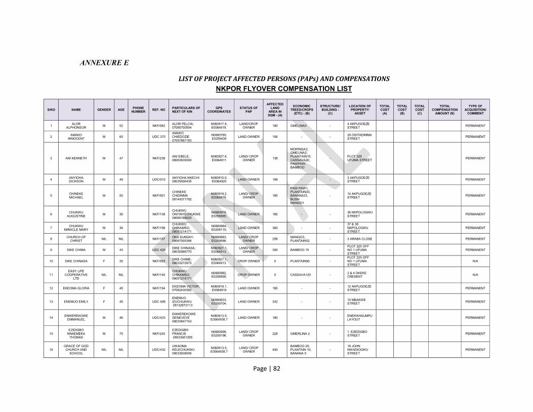
Page | 82
ANNEXURE E
LIST OF PROJECT AFFECTED PERSONS (PAPs) AND COMPENSATIONS NKPOR FLYOVER COMPENSATION LIST
S/NO NAME GENDER AGE PHONE NUMBER
REF. NO PARTICULARS OF NEXT OF KIN
GPS COORDINATES
STATUS OF PAP
AFFECTED LAND
AREA IN SQM - (A)
ECONOMIC TREES/CROPS
(ETC) - (B)
STRUCTURE/ BUILDING -
(C)
LOCATION OF PROPERTY/
ASSET
TOTAL COST
(A)
TOTAL COST
(B)
TOTAL COST
(C)
TOTAL COMPENSATION
AMOUNT (N)
TYPE OF ACQUISITION/
COMMENT
1 ALOR
ALPHONSOR M 52 NKF/082 ALOR FELCIA; 07085700594
N060917.9, E0064919.
LAND/CROP OWNER 180 GMELINA3 -
4 AKPUGOEZE STREET PERMANENT
2 AMAKO INNOCENT
M 65 UDC 375 AMAKO CHIEDOZIE 07057887183
N0680785; E0259438
LAND OWNER 156 - - 29 OSITADIMMA STREET
PERMANENT
3 ANI KENNETH M 47 NKF/238 ANI EBELE; 08063839300
N060927.8, E0064911
LAND/ CROP OWNER
138
MORINGA2; GMELINA2; PLAINTAIN15; CASSAVA20; PAWPAW; BAMBOO
- PLOT 329 UFUMA STREET
PERMANENT
4 ANYIOHA DICKSON M 49 UDC/010 ANYIOHA NKECHI
08035506435 N060915.0, E0064920 LAND OWNER 198 - - 3 AKPUGOEZE
STREET PERMANENT
5 CHINEKE MICHAEL
M 50 NKF/001 CHINEKE CHIDINMA 08144371782
N060919.2, E0064919.
LAND/ CROP OWNER
180
PAW PAW1, PLANTAIN20, BANANA23, BUSH MANGO1
- 14 AKPUGOEZE STREET
PERMANENT
6 CHUKWU
AUGUSTINE M 36 NKF/138
CHUKWU ONYINYECHUKWE 08060189020
N0680978, E0258985;
LAND OWNER 180 - - 36 NKPOLOGWU STREET
PERMANENT
7 CHUKWU
MIRACLE MARY M 36 NKF/198 CHUKWU CHIKAMSO; 08051214171
N0680984, E0259115; LAND OWNER 360 - -
37 & 38 NKPOLOGWU STREET
PERMANENT
8 CHURCH OF CHRIST
NIL NIL NKF/157 OKA SUNDAY; 08067505388
N0680683, E0259586;
LAND/ CROP OWNER
258 MANGO3, PLANTAIN52
- 3 ARABA CLOSE PERMANENT
9 DIKE CHIMA M 43 UDC 429 DIKE CHINASA; 08030966770
N060927.1, E0064913.
LAND/ CROP OWNER 300 BAMBOO 15 -
PLOT 225 OFF NO 1 UFUMA STREET
PERMANENT
10 DIKE CHINASA F 35 NKF/093 DIKE CHIME; 08033272975
N060927.1, E0064913.
CROP OWNER 0 PLANTAIN90 - PLOT 225 OFF NO 1 UFUMA STREET
N/A
11 EASY LIFE
COOPERATIVE LTD
NIL NIL NKF/140 CHUKWU CHIKAMSO; 08051214171
N0680982, E0258995; CROP OWNER 0 CASSAVA120 - 2 & 4 OKEKE
CRESENT N/A
12 EKEOMA GLORIA F 45 NKF/194 EKEOMA VICTOR; 07062430382
N060919.1, E0064919 LAND OWNER 180 - - 12 AKPUGOEZE
STREET PERMANENT
13 ENEMUO EMILY F 45 UDC 408 ENEMUO IZUCHUKWU 08132672113
N0680633, E0259704;
LAND OWNER 342 - - 10 MBAKWE STREET
PERMANENT
14 ENWEREKOWE
EMMANUEL M 46 UDC/433 ENWEREKOWE GENEVEVE 08033847743
N060913.5; E0064938.7 LAND OWNER 180 - -
ENEKWASUMPU LAYOUT PERMANENT
15 EZIDIGBO
NNAEMEKA THOMAS
M 75 NKF/245 EZEDIGBO FRANCIS 08033601295
N0680998, E0259196;
LAND/ CROP OWNER 228 GMERLINA 2 -
1 EZEDIGBO STREET PERMANENT
16 GRACE OF GOD CHURCH AND
SCHOOL NIL NIL UDC/432
UWAOMA KELECHUKWU 08033938056
N060913.5; E0064938.7
LAND/ CROP OWNER
450 BAMBOO 20; PLANTAIN 10; BANANA 5
- 18 JOHN NWADIOGWU STREET
PERMANENT

Page | 83
S/NO NAME GENDER AGE PHONE NUMBER
REF. NO PARTICULARS OF NEXT OF KIN
GPS COORDINATES
STATUS OF PAP
AFFECTED LAND
AREA IN SQM - (A)
ECONOMIC TREES/CROPS
(ETC) - (B)
STRUCTURE/ BUILDING -
(C)
LOCATION OF PROPERTY/
ASSET
TOTAL COST
(A)
TOTAL COST
(B)
TOTAL COST
(C)
TOTAL COMPENSATION
AMOUNT (N)
TYPE OF ACQUISITION/
COMMENT
17 IGWE PATRICK M 70 UDC 337 IGWE AUGUSTINA; 08030549774
N0681179, E0258883;
LAND OWNER 90 - - 15 MBAKWE STREET
PERMANENT
18 IJEZIE BENJAMIN M 55 NKF/285 IJEZIE NWANNEKA; 07064176966
N060922.8, E0064917
LAND/ CROP OWNER
322 BAMBOO 22; GMERLINA 1
- 7 AKPUGOEZE STREET
PERMANENT
19 ILORAH GEORGE M 56 NKF/037 ILORAH CHRISTIANA; 07067587727
N0681249, E0258865;
LAND/ CROP/ RESIDENT 210 GMELINA 8 -
4 CHRIS ONWUKA LANE PERMANENT
20 JIDEANI PETER M 49 NKF/009 JIDEANI ADIME AMAKA 08033565054
N0681200, E0258878;
LAND/ CROP/ RESIDENT
198 GMELINA7 - 2 CHRIS ONWUKA LANE
PERMANENT
21 NDULUE
EBELENNA M 41 NKF/031 NDULUE GINIKA; 08064481591
N060923.3, E0064916.0;
LAND/ CROP OWNER 156 GMELINA1 -
20 -22 AKPUGOEZE STREET
PERMANENT
22 NDULUE JAMES M M 67 NKF/169 NDULUE OBINNA; 08168577673
N060926.3, E0064910
LAND/ CROP OWNER
450 GMELINA10, PLANTAIN30, PAW PAW7
- 10 FABKEZ DRIVE
PERMANENT
23 NDULUE OGONNA M 42 NKF/049 NDULUE CHIOMA; 08035454192
N060923.3, E0064916. LAND OWNER 138 - -
20 -22 AKPUGOEZE STREET
PERMANENT
24 NDULUE OLUCHUKWU M 36 NKF/104 NDULUE JAMES;
07065097784 N0681215, E0258874; LAND OWNER 156 - -
20 - 22 AKPUGOEZE STREET
PERMANENT
25 NDULUE
ONYINYECHUKWU C
M 39 NKF/069 NDULUE UJUNWA; 08035083185
N060923.8, E0064916.
LAND/ CROP OWNER 156 ULI TREE1 -
20 -22 AKPUGOEZE STREET
PERMANENT
26 NNAMANI BASIL M 42 NKF/099 NNAMANI LILIAN; 07065982846
N060926.7, E0064912.4
LAND/ CROP OWNER
342
MAIZE171, COCOYAM109, PLANTAIN38, UGU70, CASSAVA60, PAW PAW2, BAMBOO5
- PLOT 330 UFUMA CLOSE
PERMANENT
27 NNEDUM AZUKA M 54 UDC/073 NNEDUM NGOZI; 08037444011
N060915.9, E0064929.1
LAND/ CROP OWNER
216
PLANTAIN 6; CASSAVA 50; PAWPAW 1; MAIZE 55; BAMBOO 30
- 30 EZINIFITE STREET
PERMANENT
28 NWABUILO
CHIOMA CYNTHIA F 32 UDC 374 NWABUILO FIDELIS; 08033476645
N0680683, E0259586; LAND OWNER 150 - -
7B ARABA CLOSE PERMANENT
29 NWAFOR CHINWE F 56 UDC 376 NWAFOR IKECHUKWU 08036320478
N0606920.0 E0064926.4
LAND/ CROP OWNER
114 PALM TREE(1); BAMBOO(5); PLANTAIN(2)
- 44 EZINIFITE STREET
PERMANENT
30 NWOKIKE AGNES F 66 NKF/053 NWOKIKE NNANNA; 08057200131
N0681288, E0258847;
LAND/ CROP OWNER 60 PLANTAIN10,
GMELINA2 - 8 CHRIS ONWUKA LANE PERMANENT
31 NZELU ANTHONY M 62 NKF/063 NZELU AMAKA; 08033972061
N060924.2, E0064915.
LAND/ CROP/ RESIDENT
696 PAW PAW3, BAMBOO6, GMELINA4
- 18 AKPUGOEZE STREET
PERMANENT
32 OBASI EMEKA. K M 60 UDC/050 OBASI COMFORT; 07068661600
N060917.5, E0064920.1
LAND/CROP OWNER
192 PLANTAIN30 - 7 AKPUGOEZE STREET
PERMANENT
33 OBIECHINA
CHIOMA F 34 NKF/047 OBIECHINA CHEKWUBE 08085545632
N060921.8, E0064918.7 CROP OWNER 0
COCOYAM3, YAM3 -
8 AKPUGOEZE STREET N/A
34 OBIEFUNA CHIZOBA
M 35 UDC 353 OBIEFUNA IFEANYI; 081250190687
N0680982, E0258995;
LAND/ CROP OWNER
120 CASHEW 1 - 2 & 4 OKEKE CRESENT
PERMANENT
35 OBIEFUNA
IFEANYI M 43 UDC 274 OBIEFUNA CHIZOBA; 08125019068
N0680684; E0259491
LAND/ CROP OWNER 156
CASSAVA 70; NEEM 1 -
35 NKPOLOGWU STREET PERMANENT

Page | 84
S/NO NAME GENDER AGE PHONE NUMBER
REF. NO PARTICULARS OF NEXT OF KIN
GPS COORDINATES
STATUS OF PAP
AFFECTED LAND
AREA IN SQM - (A)
ECONOMIC TREES/CROPS
(ETC) - (B)
STRUCTURE/ BUILDING -
(C)
LOCATION OF PROPERTY/
ASSET
TOTAL COST
(A)
TOTAL COST
(B)
TOTAL COST
(C)
TOTAL COMPENSATION
AMOUNT (N)
TYPE OF ACQUISITION/
COMMENT
36 OBIWUNE NKECHI F 43 UDC 377 OBIWUNE CHARLES; 08036657350
N060925.0; E0064903.7
LAND/CROP OWNER
270 PLANTAIN10; COCONUT1; PALM TREE1
- 20 NISE STREET PERMANENT
37 OGUEJIOFOR
BRIDGET F 69 UDC 416 OGUEJIOFOR KAMSI 07062515682
N0681249; E0258865
LAND/ CROP OWNER/
RESIDENT 360
BITTERLEAF 5; PLANTAIN 29; BAMBOO 7
- 20 JOHN NWADIOGWU STREET
PERMANENT
38 OKADIGWE CHRISTOPHER. C
M 62 UDC/043 OKADIGWE STELLA; 08034226812
N060918.0, E0064928.2
LAND/ CROP OWNER
150 PLANTAIN 10; BANANA 5
- 37 EZINIFITE STREET
PERMANENT
39 OKAFOR
TOCHUKWU M 38 UDC 307 OKAFOR CHINYERE; 07033703368
N060918.5; E0064931.1
LAND/ CROP OWNER 360
MAIZE 60; COCOYAM 40; YAM 30; MELON 35; AKIDI 15
- CHRIS ONWUKA LANE PERMANENT
40 OKECHUKWU DANIEL (LATE) M 62 NKF/003
OKECHUKWU JOSEPHINE 07030931253
N0681179, E0258883;
LAND/ CROP/ RESIDENT 90 GMELINA1 -
1 CHRIS ONWUKA LANE PERMANENT
41 OKEKE CHIBUZOR M 52 NKF/163 OKEKE CHARITY; 08023211532
N060926.6, E0064910
LAND/ CROP OWNER
276 PLANTAIN5 - PLOT 328 OFF 1 UFUMA STREET
PERMANENT
42 OKEKE
CHUKWUEMEKA M 70 NKF/059
OKEKE PROMISE; 08030754772
N0680981, E0259130;
LAND/ CROP OWNER
120
ORANGE1, LIME1, PALM TREE1, COCONUT1, AVACADO 1, COCOYAM5, BITTER LEAF2, SOURSOP1,
- 1 CHUKWUEMEKA OKEKE CLOSE
PERMANENT
43 OKEKE FIDELIS M 75 NKF/240 OKEKE PATIENCE; 08036688084
N060918.1 E0064931.0
LAND/ CROP OWNER 72 BITTER LEAF 7 -
3A MBAKWE CLOSE PERMANENT
44 OKEORJI DANIEL M 37 UDC 391 IBEKWE OGECHI; 08037889981
N060919.5; E0064926.7
CROP OWNER 0
MAIZE 35; CASSAVA 40; BAMBOO 20; COCOYAM 20
- 41 IGBOUKWU STREET
N/A
45 OKEYILOH
IFEOMA F 40 UDC/011 ENE DONALD; 08033903346
N060915.0, E0064920 CROP OWNER 0
PLANTAIN6; CASSAVA8; COCOYAM10
- 3 AKPUGOEZE STREET N/A
46 OKOYE BASIL
UCHE M 59 UDC 367 OKOYE JOSHUA; 0803331455
N060916.6; E0064934.3
LAND/ CROP OWNER 312
BAMBOO 30; GMELINA 5; COCONUT 1
- 28 OSITADIMMA STREET PERMANENT
47 OKOYE IGNATIUS M 65 UDC/169 OKOYE FLORENCE 08033171302
N060913.9 E0064921.1
LAND/ CROP OWNER
180 BANANA 20; PLANTAIN 10
- 17 AKPUGOEZE STREET
PERMANENT
48 OKOYE THERESA F 61 NKF/032 MAKUA CHUKWU; 08102995776
N0680684, E0259491;
LAND/ CROP/ RESIDENT 120 PLANTAIN3 -
21A NWADIOGWU STREET
PERMANENT
49 OLI GABRIEL M 55 NKF/071 OLI EUCHARIA; 08065060800
N060917.9, E0064926.
LAND/ CROP OWNER
480
PLANTAIN14; COCOYAM2; SOURSOP1; BAMBOO20
- 43 IGBOUKWU STREET
PERMANENT
50 ONWUKA
CHRISTOPHER M 60 NKF/074 ONWUKA BIBIAN 08034014324
N0681251, E0258860;
LAND/ CROP OWNER 300
PLANTAIN80; GMELINA10; PAWPAW6
- 6& 7 CHRIS ONWUKA LANE PERMANENT
51 ORAKA PATIENCE F 73 UDC 273 ORAKA BENJAMIN; 08033214829
N0680683, E0259586;
LAND/ CROP/ RESIDENT
228 BAMBOO 20 - 1 ARABA STREET
PERMANENT
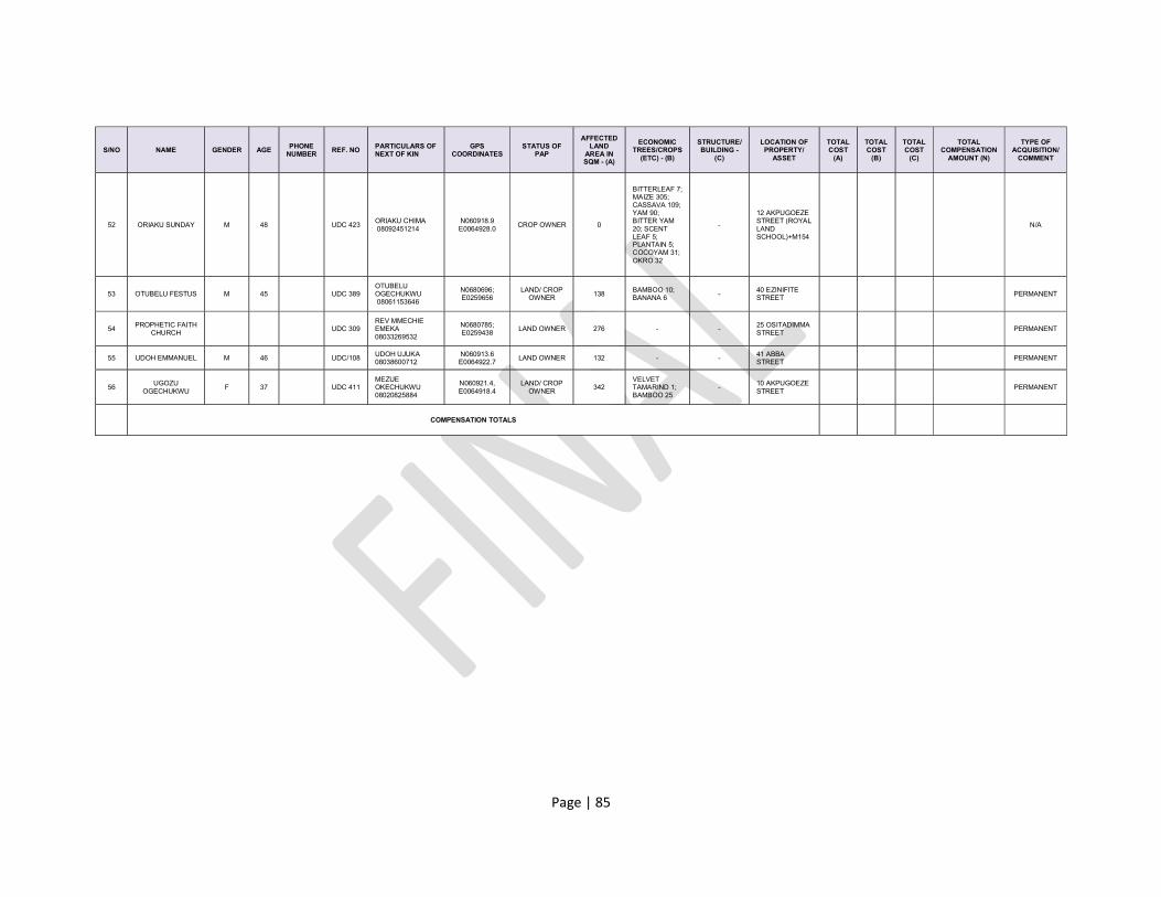
Page | 85
S/NO NAME GENDER AGE PHONE NUMBER
REF. NO PARTICULARS OF NEXT OF KIN
GPS COORDINATES
STATUS OF PAP
AFFECTED LAND
AREA IN SQM - (A)
ECONOMIC TREES/CROPS
(ETC) - (B)
STRUCTURE/ BUILDING -
(C)
LOCATION OF PROPERTY/
ASSET
TOTAL COST
(A)
TOTAL COST
(B)
TOTAL COST
(C)
TOTAL COMPENSATION
AMOUNT (N)
TYPE OF ACQUISITION/
COMMENT
52 ORIAKU SUNDAY M 48 UDC 423 ORIAKU CHIMA 08092451214
N060918.9 E0064928.0
CROP OWNER 0
BITTERLEAF 7; MAIZE 305; CASSAVA 109; YAM 90; BITTER YAM 20; SCENT LEAF 5; PLANTAIN 5; COCOYAM 31; OKRO 32
-
12 AKPUGOEZE STREET (ROYAL LAND SCHOOL)+M154
N/A
53 OTUBELU FESTUS M 45 UDC 389 OTUBELU OGECHUKWU 08061153646
N0680696; E0259656
LAND/ CROP OWNER 138
BAMBOO 10; BANANA 6 -
40 EZINIFITE STREET PERMANENT
54 PROPHETIC FAITH CHURCH
UDC 309 REV MMECHIE EMEKA 08033269532
N0680785; E0259438
LAND OWNER 276 - - 25 OSITADIMMA STREET
PERMANENT
55 UDOH EMMANUEL M 46 UDC/108 UDOH UJUKA 08038600712
N060913.6 E0064922.7
LAND OWNER 132 - - 41 ABBA STREET
PERMANENT
56 UGOZU
OGECHUKWU F 37 UDC 411
MEZUE OKECHUKWU 08020825884
N060921.4, E0064918.4
LAND/ CROP OWNER
342 VELVET TAMARIND 1; BAMBOO 25
- 10 AKPUGOEZE STREET
PERMANENT
COMPENSATION TOTALS
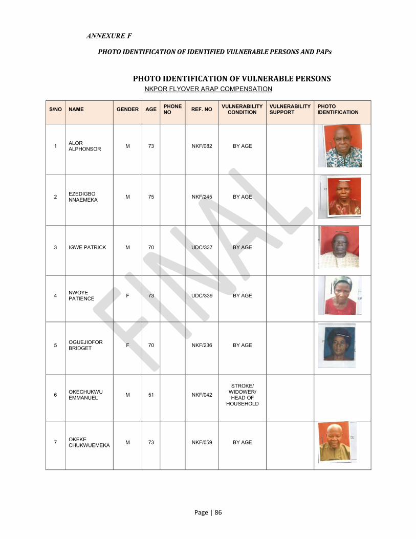
Page | 86
ANNEXURE F
PHOTO IDENTIFICATION OF IDENTIFIED VULNERABLE PERSONS AND PAPs
PHOTO IDENTIFICATION OF VULNERABLE PERSONS NKPOR FLYOVER ARAP COMPENSATION
S/NO NAME GENDER AGE PHONE NO
REF. NO VULNERABILITY
CONDITION VULNERABILITY SUPPORT
PHOTO IDENTIFICATION
1 ALOR ALPHONSOR
M 73 NKF/082 BY AGE
2 EZEDIGBO NNAEMEKA
M 75 NKF/245 BY AGE
3 IGWE PATRICK M 70 UDC/337 BY AGE
4 NWOYE PATIENCE
F 73 UDC/339 BY AGE
5 OGUEJIOFOR BRIDGET
F 70 NKF/236 BY AGE
6 OKECHUKWU EMMANUEL
M 51 NKF/042
STROKE/ WIDOWER/ HEAD OF
HOUSEHOLD
7 OKEKE CHUKWUEMEKA
M 73 NKF/059 BY AGE

Page | 87
S/NO NAME GENDER AGE PHONE NO
REF. NO VULNERABILITY
CONDITION VULNERABILITY SUPPORT
PHOTO IDENTIFICATION
8 OKEKE FIDELIS M 75 NKF/240 BY AGE
9 OKORIE EZE JOHN
F 74 UDC/412 BY AGE
10 ONAH OLUCHI
F 30 UDC/310 MENTALLY DISABLED
11 ONUIGBO ISAAC M 76 UDC/392 BY AGE
12 ONYIGBUO ELIAS. N
M 75 UDC/294 BY AGE
13 ORAKA PATIENCE
F 73 UDC/273 BY AGE
14 OWUNNA AUGUSTINE
M 63 NKF/054 PHYSICALLY
CHALLENGED

Page | 88
PHOTO IDENTIFICATION OF PROJECT AFFECTED PERSONS (PAPs)
NKPOR FLYOVER EROSION PROJECT
S/N NAME GENDER PHONE NO AGE REF. NO TOTAL
COMPENSATION (N)
PHOTO IDENTIFICATION
1 ALOR ALPHONSOR M 52 NKF/082
2 AMAKO INNOCENT M 65 UDC/375
3 ANI KENNETH M 47 NKF/238
4 ANYIOHA DICKSON M 49 UDC/010
5 CHINEKE MICHAEL M 50 NKF/001
6 CHUKWU AUGUSTINE
M 36 NKF/138
7 CHUKWU MIRACLE MARY
M 36 NKF/198

Page | 89
S/N NAME GENDER PHONE NO AGE REF. NO TOTAL
COMPENSATION (N)
PHOTO IDENTIFICATION
8 CHURCH OF CHRIST
NKF/157
9 DIKE CHIMA M 43 UDC/429
10 DIKE CHINASA F 35 NKF/093
11 EASY LIFE COORPERATIVE LTD
NKF/140
12 EKEOMA GLORIA F 45 NKF/194
13 ENEMUO EMILLY F 45 UDC/408
14 ENWEREKOWE EMMANUEL
M 46 UDC/433
15 EZEDIGBO NNAEMEKA THOMAS
M 75 NKF/245
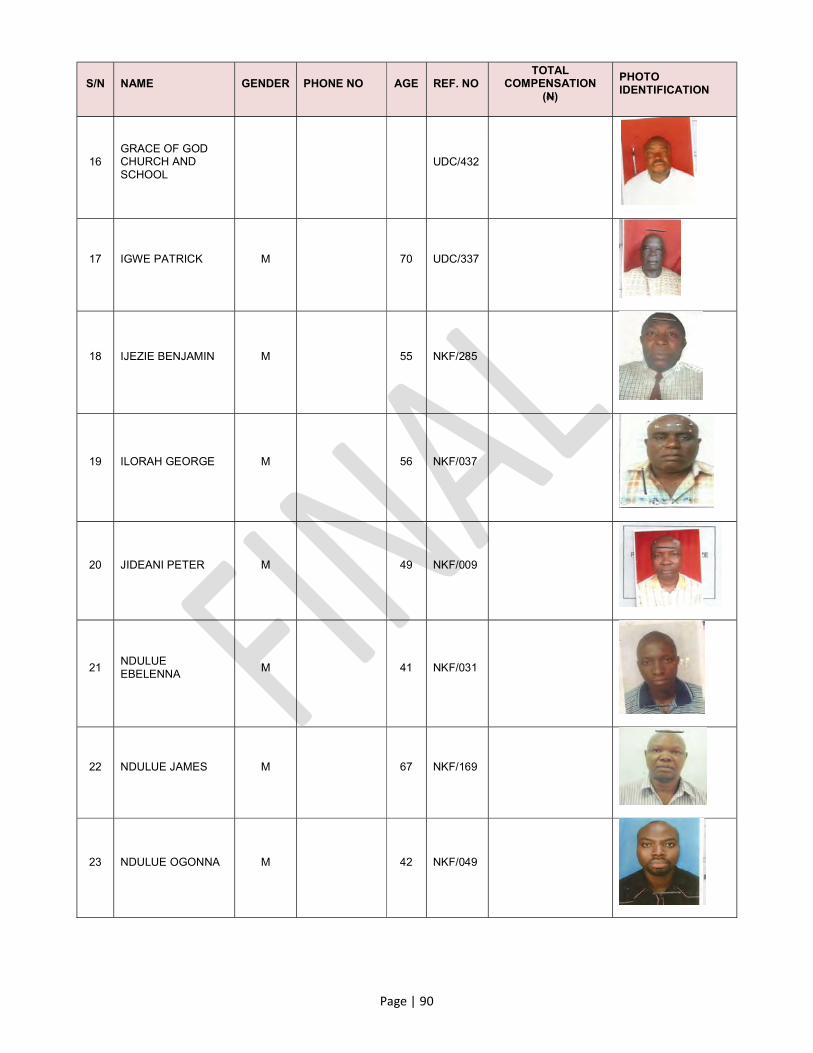
Page | 90
S/N NAME GENDER PHONE NO AGE REF. NO TOTAL
COMPENSATION (N)
PHOTO IDENTIFICATION
16 GRACE OF GOD CHURCH AND SCHOOL
UDC/432
17 IGWE PATRICK M 70 UDC/337
18 IJEZIE BENJAMIN M 55 NKF/285
19 ILORAH GEORGE M 56 NKF/037
20 JIDEANI PETER M 49 NKF/009
21 NDULUE EBELENNA
M 41 NKF/031
22 NDULUE JAMES M 67 NKF/169
23 NDULUE OGONNA M 42 NKF/049

Page | 91
S/N NAME GENDER PHONE NO AGE REF. NO TOTAL
COMPENSATION (N)
PHOTO IDENTIFICATION
24 NDULUE OLUCHUKWU
M 36 NKF/104
25 NDULUE ONYINYE M 39 NKF/069
26 NNAMANI BASIL M 42 NKF/099
27 NNEDUM AZUKA M 54 UDC/073
28 NWABUILO CHIOMA CYNTHIA
F 32 UDC/374
29 NWAFOR CHINWE F 56 UDC/376
30 NWOKIKE AGNES F 66 NKF/053
31 NZELU ANTHONY M 62 NKF/063

Page | 92
S/N NAME GENDER PHONE NO AGE REF. NO TOTAL
COMPENSATION (N)
PHOTO IDENTIFICATION
32 OBASI EMEKA K M 60 UDC/050
33 OBIECHINA CHIOMA
F 34 NKF/047
34 OBIEFUNA CHIZOBA
M 35 UDC/353
35 OBIEFUNA IFEANYI M 43 UDC/274
36 OBINWANNE NKECHI
F 43 UDC/377
37 OGUEJIOFOR BRIDGET
F 70 UDC/416
38 OKADIGWE C. C M 62 UDC/043
39 OKAFOR TOCHUKWU
M 38 UDC/307
40
OKECHUKWU DANIEL (LATE)/
OKECHUKWU JOSEPHINE
M/F 62 NKF/003
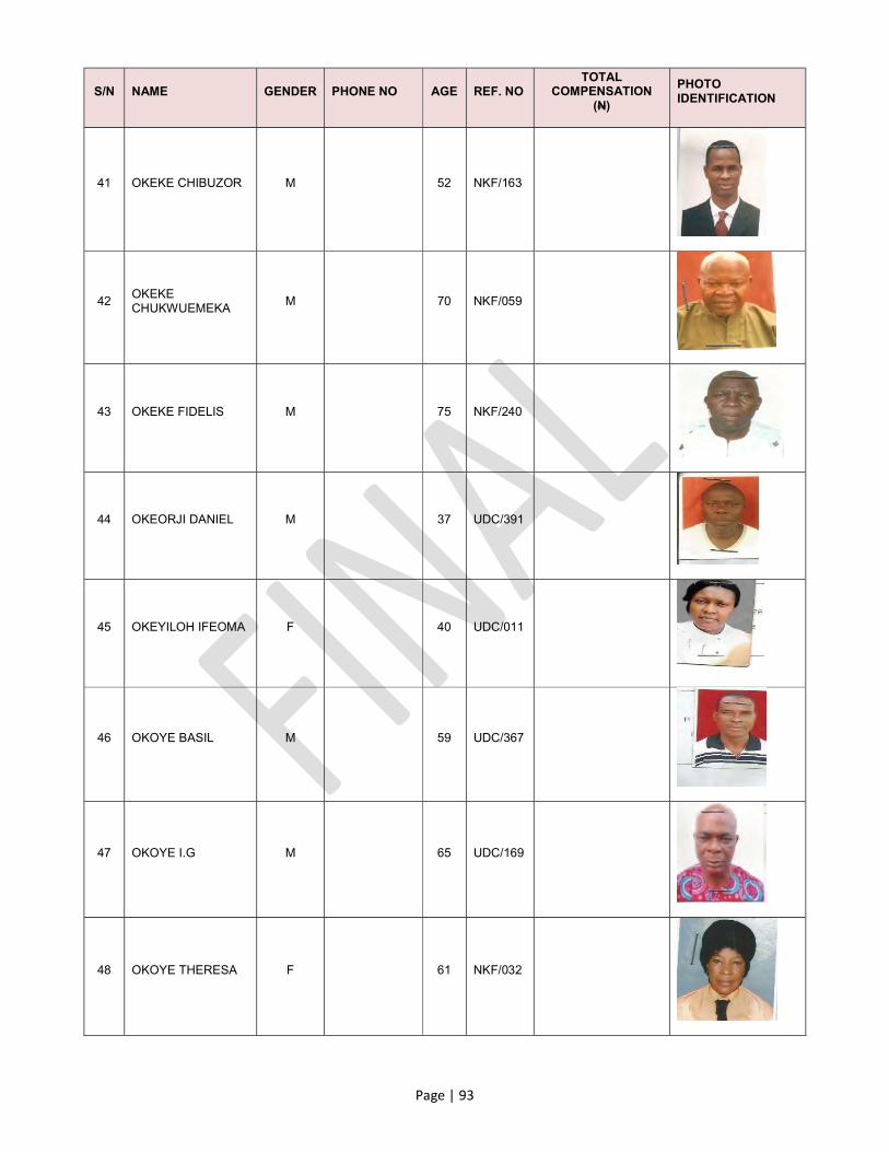
Page | 93
S/N NAME GENDER PHONE NO AGE REF. NO TOTAL
COMPENSATION (N)
PHOTO IDENTIFICATION
41 OKEKE CHIBUZOR M 52 NKF/163
42 OKEKE CHUKWUEMEKA
M 70 NKF/059
43 OKEKE FIDELIS M 75 NKF/240
44 OKEORJI DANIEL M 37 UDC/391
45 OKEYILOH IFEOMA F 40 UDC/011
46 OKOYE BASIL M 59 UDC/367
47 OKOYE I.G M 65 UDC/169
48 OKOYE THERESA F 61 NKF/032

Page | 94
S/N NAME GENDER PHONE NO AGE REF. NO TOTAL
COMPENSATION (N)
PHOTO IDENTIFICATION
49 OLI GABRIEL M 55 NKF/071
50 ONWUKA CHRISTOPHER
M 60 NKF/074
51 ORAKA PATIENCE F 73 UDC/273
52 ORIAKU SUNDAY M 48 UDC/423
53 OTUBELU FESTUS M 45 UDC/389
54 PROPHETIC FAITH CHURCH
UDC/309
55 UDOH EMMANUEL M 46 UDC/108
56 UGOZU OGECHUKWU
F 37 UDC/411