E1073 v6 - World Bank Documents & Reports
258
Manila Water Company, Inc. Manila, Philippines Regional Environmental Assessment (REA) for Manila Third Sewerage Project February 11, 2005 (Revised Draft) Public Disclosure Authorized Public Disclosure Authorized Public Disclosure Authorized Public Disclosure Authorized Public Disclosure Authorized Public Disclosure Authorized Public Disclosure Authorized Public Disclosure Authorized
-
Upload
khangminh22 -
Category
Documents
-
view
1 -
download
0
Transcript of E1073 v6 - World Bank Documents & Reports

Manila Water Company, Inc. Manila, Philippines
Regional Environmental Assessment (REA)
for
Manila Third Sewerage Project
February 11, 2005 (Revised Draft)
Pub
lic D
iscl
osur
e A
utho
rized
Pub
lic D
iscl
osur
e A
utho
rized
Pub
lic D
iscl
osur
e A
utho
rized
Pub
lic D
iscl
osur
e A
utho
rized
Pub
lic D
iscl
osur
e A
utho
rized
Pub
lic D
iscl
osur
e A
utho
rized
Pub
lic D
iscl
osur
e A
utho
rized
Pub
lic D
iscl
osur
e A
utho
rized
Administrator
E1073 v6

Regional Environmental Assessment
Draft i 9:41 AM 02/09/05
1 Introduction.......................................................................................... 1-11.1 Background................................................................................................. 1-11.2 Environment ................................................................................................ 1-11.3 Public Health ............................................................................................... 1-21.4 Fisheries and Ecosystems........................................................................... 1-21.5 Tourism ....................................................................................................... 1-21.6 Economic Impacts ....................................................................................... 1-31.7 Moving Forward........................................................................................... 1-3
2 Background to the Regional Environmental Assessment ............... 2-12.1 Objectives of the REA ................................................................................. 2-1
2.1.1 Steps in the Conduct of a REA............................................................. 2-12.2 Scope of the REA........................................................................................ 2-2
2.2.1 Wastewater Management Component ................................................. 2-22.2.2 Sludge and Septage Management ....................................................... 2-3
2.3 Regional Planning Integration ..................................................................... 2-43 Overview of the Adopted Region ....................................................... 3-1
3.1 Regional Sub-Basins................................................................................... 3-13.2 Topography ................................................................................................. 3-23.3 Vulnerability to Flooding .............................................................................. 3-23.4 Land Use..................................................................................................... 3-33.5 Regional Flow Regimes............................................................................... 3-3
3.5.1 Wet and Dry Season Flow Variation..................................................... 3-33.5.2 Tidal Influence on Laguna Lake ........................................................... 3-4
3.6 Groundwater ............................................................................................... 3-43.6.1 Confined Aquifers................................................................................. 3-43.6.2 Unconfined Aquifers. ............................................................................ 3-5
3.7 Sources of Water Pollution.......................................................................... 3-53.7.1 BOD5 .................................................................................................... 3-53.7.2 Suspended Solids ................................................................................ 3-63.7.3 Pathogens and Indicators..................................................................... 3-73.7.4 Nutrients............................................................................................... 3-73.7.5 Persistent Pollutants............................................................................. 3-83.7.6 Solid Waste.......................................................................................... 3-8
3.8 Population ................................................................................................... 3-84 Baseline Conditions ............................................................................ 4-1
4.1 Terrestrial Environment ............................................................................... 4-14.1.1 Terrestrial Flora.................................................................................... 4-14.1.2 Terrestrial Fauna.................................................................................. 4-34.1.3 Air Quality............................................................................................. 4-34.1.4 Noise.................................................................................................... 4-3
4.2 Water Quality .............................................................................................. 4-34.2.1 Background.......................................................................................... 4-44.2.2 Existing Monitoring Programs............................................................... 4-4
4.3 Review of Water Quality Monitoring Datasets ............................................. 4-64.3.1 Possible Testing Anomalies ................................................................. 4-74.3.2 Possible Data Anomalies...................................................................... 4-7
4.4 Interpretation of Water Quality Data............................................................ 4-84.4.1 Seasonality and Correlation ................................................................. 4-84.4.2 Sampling Frequency ............................................................................ 4-84.4.3 Sampling Time and Tidal State ............................................................ 4-84.4.4 River Flow Data.................................................................................... 4-94.4.5 Replication ........................................................................................... 4-9
4.5 Summary of Water Quality Data.................................................................. 4-94.5.1 Overview .............................................................................................. 4-9
Regional Environmental Assessment
Draft ii 9:41 AM 02/09/05
4.5.2 Utility as a Baseline .............................................................................. 4-94.6 Aquatic Ecology......................................................................................... 4-10
4.6.1 Plankton ............................................................................................. 4-104.6.2 Soft-Bottom Benthos .......................................................................... 4-104.6.3 Fisheries, Types of Aquatic Life and Other Uses................................ 4-12
4.7 Socio-Economics....................................................................................... 4-134.7.1 Population, Density, and Land Area ................................................... 4-134.7.2 Income ............................................................................................... 4-134.7.3 Health................................................................................................. 4-154.7.4 Economy ............................................................................................ 4-16
5 Existing Water, Sewerage and Septage Management Facilities ..... 5-15.1 Water Supply............................................................................................... 5-15.2 Sewerage.................................................................................................... 5-1
5.2.1 Other Systems ..................................................................................... 5-55.2.2 Private Sewerage System in the MWCI Concession Area.................... 5-5
5.3 Sanitation Facilities ..................................................................................... 5-65.4 Regional Issues in Relation to Sewage Management.................................. 5-75.5 Historical Infrastructure Investment Pattern................................................. 5-8
6 Policy and Institutional Framework ................................................... 6-16.1 Overview ..................................................................................................... 6-16.2 Land Use Planning and Zoning ................................................................... 6-16.3 Sewerage and Sanitation ............................................................................ 6-2
6.3.1 Sanitation Code.................................................................................... 6-36.3.2 Clean Water Act ................................................................................... 6-36.3.3 Other Legislation .................................................................................. 6-4
6.4 Mandates in Sewerage Management .......................................................... 6-46.5 Institutional Recommendations.................................................................... 6-5
6.5.1 Relative Priority of Wastewater Services.............................................. 6-56.5.2 Connection to Public Sewerage Systems ............................................. 6-66.5.3 Project Financing ................................................................................. 6-66.5.4 Low Willingness to Pay and the Lack of Sanctions............................... 6-76.5.5 Monitoring of Compliance to Existing Laws .......................................... 6-76.5.6 MTSP Impacts on Existing Private Septage Haulers ............................ 6-86.5.7 IEC on Health Impacts of Wastewater.................................................. 6-8
6.6 Summary..................................................................................................... 6-97 Generic Wastewater Management Alternatives ................................ 7-1
7.1 Background................................................................................................. 7-17.1.1 Total Wastewater Management Schemes............................................ 7-17.1.2 Supplementary Wastewater Management Strategies........................... 7-1
7.2 Disposal to Water........................................................................................ 7-17.2.1 Discharge to Freshwater or Lakes........................................................ 7-17.2.2 Discharge Treated Effluent to Estuaries............................................... 7-27.2.3 Piped Ocean Discharge ....................................................................... 7-3
7.3 Application to Land Options......................................................................... 7-37.3.1 Irrigate Lahar Affected Areas ............................................................... 7-37.3.2 Hinterland Irrigation .............................................................................. 7-4
7.4 Recycling Options ....................................................................................... 7-47.4.1 Indirect Potable Reuse ......................................................................... 7-47.4.2 Direct Potable Reuse ........................................................................... 7-4
7.5 Supplementary Options ............................................................................... 7-47.5.1 Dual Reticulation .................................................................................. 7-57.5.2 Irrigate Parks and Sports Fields with Treated Effluent.......................... 7-57.5.3 Industrial Re-use .................................................................................. 7-57.5.4 Special Uses and Commercial.............................................................. 7-6

Regional Environmental Assessment
Draft iii 9:41 AM 02/09/05
7.5.5 Ground Water Recharge ...................................................................... 7-67.6 On-Site Systems ......................................................................................... 7-6
7.6.1 Treatment Upgrades ............................................................................ 7-67.6.2 On-Site Disposal ................................................................................... 7-7
7.7 Collection System Options ........................................................................... 7-87.7.1 Common Effluent Drainage Systems.................................................... 7-87.7.2 Modified Common Effluent Drainage..................................................... 7-87.7.3 Conventional versus Combined Sewers ................................................ 7-97.7.4 Reticulation Summary ........................................................................... 7-9
7.8 Waste Minimisation Options ........................................................................ 7-97.9 Flood Flow Manipulation............................................................................ 7-107.10 No Project Option ................................................................................. 7-107.11 Comparison of Options .......................................................................... 7-11
8 MTSP Framework ................................................................................ 8-18.1 Introduction ................................................................................................. 8-18.2 Background Summary................................................................................. 8-38.3 Concessionaire Sewerage and Sanitation Obligations ................................ 8-3
8.3.1 JICA Master Plan Study ....................................................................... 8-58.3.2 MWCI First Wastewater Strategy Plan, 2000 ....................................... 8-5
8.4 Experience from Ongoing Projects.............................................................. 8-68.4.1 MSSP Community Sanitation Project (MCSP)...................................... 8-68.4.2 MSSP-4................................................................................................ 8-68.4.3 Pateros Sewer System......................................................................... 8-6
8.5 Specific Implementation Difficulties ............................................................. 8-68.5.1 Land Availability and Cost .................................................................... 8-78.5.2 Community and Traffic Disruptions ...................................................... 8-78.5.3 Enforcing Sewerage Connections ........................................................ 8-78.5.4 Tariffs................................................................................................... 8-78.5.5 External Factors ................................................................................... 8-8
8.6 Rate Rebasing ............................................................................................ 8-88.7 Project Development ................................................................................... 8-9
8.7.1 Land Availability ................................................................................. 8-108.7.2 Applicable Concepts........................................................................... 8-108.7.3 Social Acceptability ............................................................................ 8-10
8.8 Selection Criteria and Methodology........................................................... 8-108.8.1 Availability and Land Criteria .............................................................. 8-108.8.2 Catchment Area Selection.................................................................. 8-118.8.3 Health/Environmental Impact ............................................................. 8-118.8.4 Financial and Economic Considerations............................................. 8-11
8.9 Overview of the Manila Third Sewerage Project ....................................... 8-12

Regional Environmental Assessment
DRAFT iv 9:42 AM 02/09/05
9 MTSP Integration into Other Regional Projects................................ 9-19.1 Existing Projects.......................................................................................... 9-1
9.1.1 Manila Second Sewerage Project (MSSP) ........................................... 9-19.1.2 Pasig River Rehabilitation Project – Sanitation Component ................. 9-1
9.2 MWCI Master Plan ...................................................................................... 9-29.2.1 Reasons for Selection of Alternatives................................................... 9-29.2.2 Description of Variations Between Alternatives .................................... 9-39.2.3 Comparisons Between Specific Alternatives ........................................ 9-39.2.4 Summary of Alternatives Evaluation..................................................... 9-4
10 The Project Components .................................................................. 10-110.1 Component 1: Taguig Sewerage System................................................10-1
10.1.1 Options Background ........................................................................10-110.1.2 Component Summary......................................................................10-1
10.2 Component 2: Riverbanks Sewage Treatment Plants.............................10-310.2.1 Options Background ........................................................................10-310.2.2 Component Summary......................................................................10-4
10.3 Component 3: Septage Treatment Plants...............................................10-410.3.1 Options Background ........................................................................10-410.3.2 Component Summary......................................................................10-5
10.4 Component 4: Low Income Sewerage System .......................................10-610.4.1 Options Background ........................................................................10-610.4.2 Component Summary......................................................................10-7
10.5 Component 5: Quezon City – Marikina Sewerage System......................10-810.5.1 Options Background ........................................................................10-810.5.2 Component Summary......................................................................10-8
10.6 Component 6: Upgrade of Existing Sanitation System............................10-910.6.1 Options Background ........................................................................10-910.6.2 Component Summary....................................................................10-10
10.7 Sludge/Septage Re-use........................................................................10-1010.7.1 Options Background ......................................................................10-1010.7.2 Septage Characteristics.................................................................10-1110.7.3 Sludge Characteristics...................................................................10-1210.7.4 MTSP Septage/Sludge Quantities and Sources.............................10-13
10.8 MTSP Summary and Issues .................................................................10-1511 Public Consultation........................................................................... 11-1
11.1 Introduction.............................................................................................11-111.2 First Level Consultations.........................................................................11-1
11.2.1 Scoping Workshop ..........................................................................11-111.2.2 Focused Group Discussions ............................................................11-2
11.3 Second Level Consultations....................................................................11-311.4 Public Consultation .................................................................................11-4
11.4.1 Scoping Workshop ..........................................................................11-411.4.2 Focused Group Discussions (FGDs) ...............................................11-411.4.3 Summary of Public Consultation ......................................................11-8
12 Cumulative Impact Assessment....................................................... 12-112.1 Introduction.............................................................................................12-1
12.1.1 No Project Options...........................................................................12-112.1.2 MTSP Option ...................................................................................12-1
12.2 General Benefits .....................................................................................12-212.2.1 Water Quality Improvement .............................................................12-212.2.2 Better Health....................................................................................12-212.2.3 Greater Tourism ..............................................................................12-212.2.4 Greater Fishery Production..............................................................12-212.2.5 Property Values ...............................................................................12-2

Regional Environmental Assessment
DRAFT v 9:42 AM 02/09/05
12.2.6 General Aesthetic improvements .....................................................12-312.2.7 Improved Institutional Implementation .............................................12-312.2.8 Septage/Sludge Management .........................................................12-3
12.3 MTSP General Impacts...........................................................................12-312.4 Flow-on Affects.......................................................................................12-412.5 Typical Impacts.......................................................................................12-4
12.5.1 Noise ...............................................................................................12-412.5.2 Air Pollution .....................................................................................12-512.5.3 Water Pollution ................................................................................12-512.5.4 Aesthetics ........................................................................................12-512.5.5 Flora and Fauna ..............................................................................12-5
12.6 Economic Analysis..................................................................................12-612.6.1 Introduction......................................................................................12-612.6.2 Project Economic Cost ....................................................................12-612.6.3 Health Benefits ................................................................................12-612.6.4 Determination of Environmental Benefit...........................................12-712.6.5 Water Quality Improvement .............................................................12-712.6.6 Consumer Surplus ...........................................................................12-712.6.7 Septage/Sludge Application to Land ................................................12-712.6.8 Environmental fee and sewerage charges .......................................12-812.6.9 Summary of Economic Benefits.......................................................12-8
13 Regional Environmental Management System ............................... 13-113.1 Introduction.............................................................................................13-113.2 Institutional Aspects................................................................................13-1
13.2.1 Relative Priority of Wastewater Services .........................................13-213.2.2 Connection to Public Sewerage Systems ........................................13-313.2.3 Project Financing.............................................................................13-313.2.4 Low Willingness to Pay and the Lack of Sanctions ..........................13-313.2.5 Monitoring of Compliance to Existing Laws......................................13-413.2.6 MTSP Impacts on Existing Private Septage Haulers .......................13-413.2.7 IEC on Health Impacts of Wastewater .............................................13-5
13.3 Project Specific Enhancement/ Mitigation Strategies ..............................13-513.4 Air Sector Enhancement/ Mitigation Strategies.......................................13-513.5 Water Enhancement/ Mitigation Strategies.............................................13-613.6 Monitoring Strategies..............................................................................13-6
13.6.1 Environmental Monitoring Plan ........................................................13-613.6.2 Air/Noise Monitoring ........................................................................13-713.6.3 Effluent and Water Quality Monitoring Strategy ...............................13-713.6.4 Groundwater Monitoring ..................................................................13-813.6.5 Surface Water Ambient Monitoring ..................................................13-813.6.6 Socio-Economic Monitoring .............................................................13-813.6.7 Financial Guarantee Mechanisms....................................................13-9
13.7 REMS Summary .....................................................................................13-913.7.1 Components ....................................................................................13-913.7.2 Costs ...............................................................................................13-9
13.8 Background to Water Quality and Ecosystem Monitoring .....................13-1413.8.1 Background ...................................................................................13-1413.8.2 Monitoring Program Aims ..............................................................13-1413.8.3 Level of Acceptable Change ..........................................................13-1413.8.4 Statistical Level Of Confidence ......................................................13-1413.8.5 Adopted Values for Base Monitoring Program ...............................13-1513.8.6 Water Quality and Ecosystem Pilot Monitoring Program................13-1513.8.7 Types of Monitoring Program.........................................................13-1513.8.8 Data Review - Power Analysis .......................................................13-16

Regional Environmental Assessment
DRAFT vi 9:42 AM 02/09/05
13.8.9 Geographical Extent of Survey ......................................................13-1713.8.10 Sampling Frequency......................................................................13-1713.8.11 Ambient Water Quality Data Quality Assurance.............................13-1713.8.12 Control Sites or River System........................................................13-18
13.9 Recommended Water Quality and Ecological Monitoring Program.......13-1813.9.1 Water Quality and Ecological Monitoring Priorities.........................13-1813.9.2 Water Quality and Ecological Pilot Program – Year one................13-1913.9.3 Statistical Review...........................................................................13-2013.9.4 Water Quality Pilot Program – If required to extend beyond Year 113-2113.9.5 Water Quality and Ecological Base Monitoring Program................13-2213.9.6 Criteria Review ..............................................................................13-2313.9.7 Costs .............................................................................................13-2413.9.8 Community Water Quality Monitoring Programs ............................13-24
14 Conclusions and Recommendations............................................... 14-114.1 Conclusions ............................................................................................14-114.2 Recommendations..................................................................................14-6
Appendix A - Baseline Data.......................................................................A-1A.1 Physical Environment .............................................................................. A-1
A.1.2 Topography.......................................................................................... A-1A.1.3 Geology and Natural Hazards .............................................................. A-1A.1.3 Soils ................................................................................................... A-12A.1.4 Land Use............................................................................................ A-13A.1.5 Hydrology........................................................................................... A-17A.1.7 Meteorology and Ambient Air Quality ................................................. A-31A.1.8 Noise Level ........................................................................................ A-39
A.2 BIOLOGICAL ENVIRONMENT.............................................................. A-42A.2.1 Terrestrial Ecology ............................................................................. A-42A.2.2 Aquatic Ecology ................................................................................. A-46
A.3 Socio Economic and Cultural Environment ............................................ A-53Appendix B – Monitoring Sites and Programs .......................................B-1Appendix C – Monitoring Data Graphs and Tables.................................C-1Appendix D – Institutional Framework Details ........................................D-1
D.1 Role of National Agencies in Sewerage Management .............................D-1D.1.2 Department of Health ...........................................................................D-1D.1.3 Department of Environment and Natural Resources ............................D-2D.1.4 Department of Public Works and Highways .........................................D-2D.1.5 Metropolitan Waterworks and Sewerage System .................................D-3D.1.6 The Manila Water Company, Inc. and its Service Area ........................D-4D.1.7 Metro Manila Development Authority....................................................D-5D.1.8 Laguna Lake Development Authority....................................................D-6
D.2 Role of Local Government Units (LGU) in Sewerage Management .........D-7D.3 Role of the Private Sector ......................................................................D-10D.4 National Sewerage Management Policies..............................................D-13
D.4.1 Sanitation Code of the Philippines......................................................D-13D.4.2 Implementing Rules and Regulations (IRR) of the Code on Sanitation.......
...........................................................................................................D-14D.4.3 The Local Government Code .............................................................D-15D.4.4 Provincial Water Utilities Act of 1973..................................................D-16D.4.5 The Plumbing Law and the National Plumbing Code of the Philippines......
...........................................................................................................D-16D.4.6 Complementary Laws.........................................................................D-17D.4.7 The Clean Water Act..........................................................................D-18
Appendix E – Community Consultation Record......................................E-1

Regional Environmental Assessment
Draft 1 9:41 AM 02/09/05
Executive Summary
Metro Manila lies at the western part of the Philippine archipelago. It is the largestamong 16 regions of the country. It has a total land area of 636 square kilometresand, as of year 2000, is home to 9.9 million people. Some other estimates suggestthe population is closer to 12 million people. It is composed of 17 cities and 5municipalities subdivided into 1,692 barangays. Metro Manila is bounded by theprovince of Bulacan in the north, the province of Rizal in the east, Manila Bay in thewest and Laguna Lake, and Cavite and Laguna in the south. The Pasig Rivertraverses through a significant area of the metropolis. It drains towards the LagunaLake in the south or the Manila Bay in the west, depending on base flow and tidalstate. While the city has a sound economy, it faces a multitude of problems. Among itspressing concerns are housing, employment, health, solid waste and wastewatermanagement, traffic, air and water pollution. The national and local governmentsdevelop and implement programs to address these issues. However, bureaucracyand politics often make it difficult to successfully implement programs as they areconceived.
Presently, less than 8% of the Metro Manila population is served by seweragesystems. These systems are localized in Makati, Quezon City and the CentralManila area. Some 85% of the population relies on individual septic tanks, most ofwhich are improperly designed and ill maintained. The sullage usually flows directlyout of the IST into local drains. There is insufficient land to incorporate sullagesoakage trenches. At the moment, there is no facility for proper septage treatmentand disposal. The remainder of the population resorts to pits and latrines while asignificant number has no access to even basic sanitation facilities. The two main rivers in the metropolis – Marikina River and Pasig River, have beenpronounced biologically dead. The Pasig River, once renowned for its pristinewaters and aquatic resources, is now one of the world’s most polluted river systemswith dissolved oxygen levels in the central reaches dropping to near zero for most ofthe year. Faecal coliform levels exceed standards of the Department of Environmentand Natural Resources (DENR) and international standards by several orders ofmagnitude.
The World Bank publication “Philippines Environment Monitor 2003” provides dataon sources of illness for 5 years up to year 2000. The data notes that 31% of allillnesses are water related, or nearly 5 million of the reported illnesses were waterborne in the previous 5 year period throughout the country. These are due to amixture of non-potable standard water supply being ingested and contact withpolluted water in open drains.
The cost of these and other impacts or benefits can be determined by economicassessment as follows: Ø avoidable health costs due to losses in direct income and medical expenses for
both in and out patients are estimated at 3.3 billion pesos a year.Ø the Philippine economy loses 17 billion pesos annually due to degradation of the
marine fishery environment.Ø tourism losses are exceeding 47 billion pesos in 2004.
Regional Environmental Assessment
Draft 2 9:41 AM 02/09/05
This clearly demonstrates that the present socio-environmental status of pollutionhas major negative economic impacts, to the extent of some P67 billion a year.Given that the most polluted region of the country is the NCR, it may be expectedthat a significant portion of the economic losses would impact upon the NCR.
To further increase the need for some interventions, the region’s population isincreasing rapidly, and this will result in increasing pollution load, unless interventionsare initiated. Specifically the population within the MWCI concession area (East zone) is predictedto increase from 5.3 million persons in 2004 to 8.2 million in 2021. There are noindications that the population growth will subside even after this period of sustainedgrowth. As a result, the Manila Third Sewerage Project (MTSP) is being proposed by ManilaWater Company Inc. (MWCI) in response to a range of these forcing functions, suchas socio-environmental pressures and Concession Agreements specifying thesewerage and sanitation targets required under the concession. The MWCI has theconcession for the eastern half on Metro Manila, and Maynilad Water (MWSI) thewestern concession. Because the MWCI concession area is only part of the Metro Manila area, aRegional Environmental Assessment (REA) has been prepared to assess if theinvestment proposed integrates with the MWCI/ MWSI overall investment strategyand environmental management plans. The REA also facilities a strategicassessment of the options available. The REA has been structured to; Ø develop the REA details,Ø lead into an options review,Ø refine the options into a coordinated project (the MTSP),Ø consider the institutional issues,Ø assess the impacts, both negative and positive, of the adopted project, andØ develop an appropriate EMS and recommend institutional improvements. The need for a REA is that the proposed project can have significant environmentalbenefits and impacts that need to be addressed at the regional level. Although theseprojects’ impacts can be addressed through project-specific environmentalassessments, the REA will enable the Land Bank of the Philippines (LBP) as thedrawer of the loan, and the funding agency (World Bank) to assess the cumulativeand interactive impacts of these project components. This larger-scale appreciationwill allow the LBP and the World Bank to better evaluate the MTSP as an investmentand compare this with other alternatives. In terms of baseline conditions, the key issue for which is there are large datasetsare water quality and ecosystems. The water quality data has been reviewed andstatistically analysed. The data also demonstrates high levels of inter-annual variability. This means thatthe present dataset cannot be used for trend interpretations based on just using oneyears data. For example, the BOD levels at some sites decreased significantly from1998 to 1999, but the previous 5 years show a very different trend. This indicatesthat any formal trend conclusions should only be made if at least 5 years data isreviewed. This also means that any proposed monitoring program must be run for anumber of years before making statistical interpretations of the possible trends.

Regional Environmental Assessment
Draft 3 9:41 AM 02/09/05
The overall conclusion is that the existing monitoring programs have some utility butare insufficient to be able to detect trends in water quality and ecosystem recovery ata suitable level of confidence for the adopted level of acceptable change in thefuture. Therefore a more comprehensive monitoring program is still required tostatistically determine present water quality conditions, and allow valid comparisonswith future monitoring to assess improvements or otherwise. This presented in theRegional Environmental Management System. Of the approximately 2.1 million households in the Region, representing 14% of thecountry’s total (2000), over 51% have their own faucet or community water supply,which is almost double the national rate of 28%. If adding “own” and “sharedcommunity” facilities, over 75% of the population of the Region have access to pipedtreated water. However, less than 8% of the Region is sewered according to the1996 Master Plan. This imbalance requires addressing to overcome the resultingenvironmental impacts Only some 30% of sewage generated in the region undergoes some form oftreatment. The rest is either directly discharged in drainage canals (combinedsewers), or simply have no sewers to convey untreated wastewater and it flows inroad table-drains or other common drains. Further, the ADB (2000) estimated that in the Pasig River basin alone there are onemillion Individual Septic Tanks (ISTs) of which only 15% are regularly de-sludged. Itis fair to assume that the majority of the rest are full of sludge. Inappropriatelymaintained septic tanks provide no effective detention time and are therefore unableto capture suspended solids leading to elevated levels of biochemical oxygendemand, suspended solids, and faecal coliform in the sullage discharges. The assessment of the policy, legal, and administrative framework of the sanitationand sewerage management system in Metro Manila yields several issues whichneed to be addressed. This portion of the review carries with it the key managementand policy concerns which have been identified and lists some recommendedactions. Firstly, there is no umbrella agency trying to limit population growth in the Region,either by imposing restrictions on rural migration into the Region or in terms ofgeneric and sustained family planning campaigns. Therefore substantiallyincreasing populations within the Region are a given.
The basic land use planning (CLUPs) and zoning controls (ZOs) are also noteffective. Therefore an approach of planning controls cannot be used to guidedevelopment nor even control the location of ongoing development.
The existing wastewater, environment and health management legislation is toocomplex, overlapping and unclear not just in terms of basic laws, but also in terms ofthe devolution status. A number of obligations have been devolved from one agencyto another and eventually to the LGU in some cases, but without a clear mandate oroperational guidelines.
A series of recommendations have been made on how to improve some of theseissues. However it is critical that an action plan be developed to make thesechanges, and this will require political commitment, community pressure following on

Regional Environmental Assessment
Draft 4 9:41 AM 02/09/05
from extensive environmental and health education, and of course funding andadoption of a time-bound program for implementation.
Therefore, it was recommended that the present strategy on wastewaterdevelopment must take the pragmatic approach where clusters ofcities/municipalities will coalesce to plan, agree on and implement wastewaterprojects for the protection of the health and environment of the areas under theirjurisdiction (“river basin approach”). Projects may not be designed on a per locationbasis but would cover expansive catchment areas. Innovative solutions, such ascombined systems for highly urbanized cities should be seriously considered. Onlywith this approach can the objectives of protecting the water environment beachieved at the right economies of scale. As a result, a range of generic wastewater collection and management options havebeen reviewed. It was confirmed that onsite treatment and disposal or reuse is unsustainablebecause of small lot sizes and use of groundwater as a water supply. Similarly thehigher technology options of indirect and direct potable reuse are unaffordable at thepresent time. Effluent irrigation was also dismissed because of cost reasons. Given the very small percentage of sewerage coverage in Metro Manila, and the highpopulation density, the usual strategy in these circumstances would be to sewer allof the Region as soon as possible. This would be practical in less denselydeveloped urban areas, but only where;Ø a large sinking fund has historically been established to fund the large capital
expenditure required,Ø the infrastructure can be installed with community support and forbearanceØ the population will connect to the sewer system, andØ the households will consistently pay the tariff for wastewater management. However in this case, the present low percentage of sewerage coverage in theEastern Concession Zone, together with the required capital and operating costrequirements, and social issues such as lack of community support and householdaffordability, precludes adoption of an immediate global sewerage and treatmentstrategy. Some less densely populated areas in the Zone can be sewered and havethe wastewater directed to new sewage treatment plants in these catchments, butthis will only account for a small portion of the Zone’s customers. Therefore, in the medium term at least, ISTs will be part of the east zone’swastewater management systems into the future. Septic systems only workefficiently when the tanks are regularly desludged. This prevents excessive solidscarrying over with the sullage. These solids carry large quantities of pathogens(disease causing organisms), have high organic loads and can cause downstreampipework blockages. A priority must therefore be to maintain the operation of theseseptic tanks to minimise both health and environmental impacts. To improve septic tank efficiency, a fleet of tankers is required to allow desludging oftanks approximately every 5 years. There are some other individual operatorsproviding a tank desludging service, but this is only upon request, and usually onlywhen tanks are completely blocked up with solids. There is no programmedmaintenance of the septic tanks that will minimize the present environmentalimpacts.

Regional Environmental Assessment
Draft 5 9:41 AM 02/09/05
Once a fleet of collection vehicles is established, there will be a need for septagetreatment and/or disposal facilities. The present independent tanker operators aremost likely dumping their septage illegally, as no permits have been issued by theDENR for a disposal facility in the Region. A network of septage treatment plants istherefore required. The resulting dewatered or dried septage/sludge will then requiredisposal either at an approved landfill or land applied. In addition, opportunities forproductive reuse of the septage/septage are available, such as applying theorganically rich septage/sludge to poor agricultural soils, especially the lahar affectedareas to the North of the Region. Locally, sullage is usually simply discharged into stormwater drains. Some of theseare open drains, which allows physical contact by the community with the untreatedwastewater, and attendant health risks. Usually it is the children involved in thiscontact and they represent some of the most susceptible members of the communityto such disease risks. This health risk is exacerbated if the septic tank has not beenmaintained and biological solids are carrying over. Morbidity data are presented elsewhere in this report indicating significant waterborne disease events are not uncommon in Manila. A further priority is therefore tolimit the contact possibilities between sullage and the community. This will requiresome drainage repairs and covering of other drains. The present sanitation system generally has septic tanks without the requisitesoakage tranches or evapotranspiration beds. Therefore the sullage (the ongoingliquid outflow from septic tanks) is discharged to a stormwater drainage systemrather than disposed of on site or directed to a dedicated sewer. In most countries, aseptic system is environmentally sustainable only when there is sufficient landassociated with the system to allow either infiltration into the soil orevapotranspiration of sullage. That is, there should be no uncontrolled liquiddischarge off the site into drainage systems to pollute the environment. There is noopportunity locally to provide soakage trenches or evapotranspiration beds becauseof a lack of land space in almost every existing site. These septic tanks can serve either individual dwellings or commercialestablishments, or be a community-based tank system. One priority is therefore toconvert some of the community septic tanks into sewage treatment plants. Even if the septic tanks are appropriately maintained, the sullage eventually reacheslocal watercourses such as the Pasig River. These water bodies are highly pollutedas a result, and the pollution takes many forms, but especially;Ø organics (which deplete the oxygen in the watercourse so higher aquatic life
forms cannot survive), andØ pathogens (disease causing organisms which concentrate in biological solids). Therefore a program is required to either;Ø sewer these areas and direct the sullage to a sewage treatment plant (or convey
raw sewage to a treatment plant if the septic tank is removed), orØ provide an interception system to collect the sullage and other wastewater from
the stormwater drains, and divert the dry weather flows to a sewage treatmentplant
Dedicated sewerage systems are expensive to install, cause disturbance toroadways and access paths, and may not be used unless the community agrees toconnect to the sewer. Finally, the householders must be willing to continue to pay

Regional Environmental Assessment
Draft 6 9:41 AM 02/09/05
their tariffs to fund the operation of the sewerage system. Local experienceindicates that many of these items will not occur. A second alternative is to install drainage modifications within catchments to divertdry weather flows in stormwater drains and esteros into purpose-built sewagetreatment plants. This then limits the dry weather discharge of sullage into the localmajor watercourses. This may apply for both small drainage systems and also largerdrains associated with flood control networks. These are termed combined sewersand are now allowed under the revised Concession Agreement (CA), but were notallowed under the original CA. Most environmental impact occurs in the dry seasonwhen there is little diluting flow in the local water bodies, so treating the dry weatherflows of sewage/sullage is still very beneficial environmentally. Septage/sludges from the septage treatment plants and also the sewage treatmentplants as well as some raw septage will require disposal. The ocean dumping trialswere curtailed and so a new disposal option is required. Appropriate application ofthese sludges to poor agricultural soils would improve the soil organic content, waterholding capacity, general fertility and increase the Cation Exchange Capacity.Suitable environmental studies would be required to demonstrate the sustainability ofsuch applications supported by management plans for ongoing applications. In addition to the physical and financial aspects of the sewerage and sanitationimprovements, the up-grades will only be sustainable if the community is educatedabout the benefits, and importantly, the requisite need to fund these benefits.Therefore a project component providing an Information and Education Campaign isa high priority. The overall MTSP being proposed has four proposed components:Ø Sewerage System and Treatment - Involved the expansion of sewer network and
treatment plants at strategic locations within the East-concession areaØ Septage Management – large scale septic tank de-sludging program on the
western section of the service area, namely: Mandaluyong, part of Makati andQuezon City, Pasig, San Juan, Taguig, Marikina, and Pateros
Ø Technical Assistance – will cater to the need for information and education on thegood practices, infrastructure, and benefits from proper sewage management
However this REA predominantly deals with the first two components of the MTSP;sewerage systems and treatment, and septage management. These twocomponents will be implemented through six projects listed below:
(1) Taguig Sewerage System
This project is in line with the flood control project of the Department of Public Worksand Highways (DPWH) covering Taguig, Pateros and parts of Rizal. The DPWH willconstruct four (4) drainage/flood retention ponds adjacent to the Laguna de Bay.
The proposed sewerage project will involve the development of the retention pondsas part of a wastewater treatment system to treat the sewage before discharge toLaguna de Bay during the dry season.
(2) Riverbanks Sewage Treatment Plants
This project will involve the construction of at least three (3) underground STPsalong the riverbanks of Pasig River, located in Makati, Mandaluyong, and Pasig.
Regional Environmental Assessment
Draft 7 9:41 AM 02/09/05
Sewage will be intercepted and collected from existing drainage lines in these areasfor treatment before discharge to Pasig River. If necessary, rehabilitation of thedrainage outfalls and lines will be included in the project.
(3) Septage Treatment Plants
This project is essential in providing sanitation services, septage treatment andproper septage/sludge disposal. An initial plan is to construct SPTPs in the southernand northern portion of the East Zone.
(4) Sanitation for Low-Income Communities
This project will involve the construction of Communal Septic Tanks or STPs, asappropriate, and shallow, small-diameter sewer lines to serve low-incomecommunities in the East Zone which have inadequate sanitation facilities.
(5) Quezon City-Marikina Sewerage System
This project will utilize portions of the legal easement for Marikina River. Maindrainage collector pipes which collect combined sewage and drainage fromcommunities in Quezon City and Marikina will be connected to a STP to beconstructed to treat the dry weather drainage/sewage flow.
(6) Upgrade of Existing Sanitation Systems
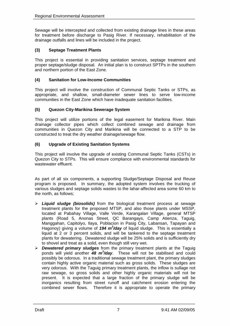
This project will involve the upgrade of existing Communal Septic Tanks (CSTs) inQuezon City to STPs. This will ensure compliance with environmental standards forwastewater effluent. As part of all six components, a supporting Sludge/Septage Disposal and Reuseprogram is proposed. In summary, the adopted system involves the trucking ofvarious sludges and septage solids wastes to the lahar-affected area some 60 km tothe north, as follows;
Ø Liquid sludge (biosolids) from the biological treatment process at sewagetreatment plants for the proposed MTSP, and also those plants under MSSP,located at Pabahay Village, Valle Verde, Karangalan Village, general MTSPplants (Road 5, Anonas Street, QC Barangays, Camp Atienza, Taguig,Manggahan, Capitolyo, Ilaya, Poblacion in Pasig City, Labansan, Tapayan andHagonoy) giving a volume of 194 m3/day of liquid sludge. This is essentially aliquid at 2 or 3 percent solids, and will be tankered to the septage treatmentplants for dewatering. Dewatered sludge will be 25% solids and is sufficiently dryto shovel and treat as a solid, even though still very wet.
Ø Dewatered primary sludges from the primary treatment plants at the Taguigponds will yield another 48 m3/day. These will not be stabilised and couldpossibly be odorous. In a traditional sewage treatment plant, the primary sludgescontain highly active organic material such as gross solids. These sludges arevery odorous. With the Taguig primary treatment plants, the inflow is sullage notraw sewage, so gross solids and other highly organic materials will not bepresent. It is expected that a large fraction of the primary sludge will beinorganics resulting from street runoff and catchment erosion entering thecombined sewer flows. Therefore it is appropriate to operate the primary

Regional Environmental Assessment
Draft 8 9:41 AM 02/09/05
treatment facilities as proposed, and monitor the biological activity of the primarysludge to assess if additional treatment is required such as lime stabilisation.
Ø Dewatered secondary (biological) sludges from the MSSP and MTSP STPstotalling 127 m3/day. This sludge will be about 25% solids, and is sufficiently dryto shovel and treat as a solid, even though still very wet. It is not stabilised andas such can only be used under certain restrictions, such as burial within 8 hoursand not for certain food crops, such as those consumed raw unless there iscertain period between sludge application and harvesting the food.
Ø Dewatered unstabilised septage/sludge volume of 177 m3/day from the twoMTSP SPTPs, at 25% dry weight. This dewatered septage/sludge is actually amixture of the raw solids entering the SPTP which are settled and thendewatered, and the biological secondary sludge from the liquid treatment plantfor the liquor following on from the septage solids removal. The septage/sludgeis therefore a mixture of septage solids and biosolids or biological sludge. It isnot going to be stabilised, but there will be some chemicals added to assist in thedewatering process. These will be at very small doses, just sufficient to ensurethat the dewatering targets are achieved. The chemicals will be standardpolyelectrolytes used globally for such processes.
Ø Dewatered stabilised septage/sludge volume of 90 m3/day from the PRRCSPTP at Antipolo, at 25% dry weight. This dewatered septage/sludge is also amixture of the raw solids entering the SPTP which are settled and thendewatered, and the biological secondary sludge from the liquid treatment plantfor the liquor following on from the solids removal. The septage/sludge istherefore a mixture of septage solids and biosolids or secondary sludge. It isgoing to be stabilised by lime addition, at high dose rates of up to 0.5 kilogramsof lime per kilogram of solids. The lime increases the pH and also increases thetemperature to inactivate the pathogens. The resulting septage sludge will meetthe Class A requirements of the US EPA and as such is acceptable for almostunrestricted reuse applications. The PRRC is investigating possible sludgereuse locations on farms close to Antipolo, but the backstop will be blending thePRRC material with the other sludges to transport to the Pampanga areas.
Ø Dried biological sludges (biosolids) amounting to approximately 5 m3/dayfrom the existing Magallanes STPs. These sludges have been dried on sludgedrying beds and can be even drier than the 25% dewatered solids achievedmechanically. They are stabilised by virtue of the open exposure over a longerterm of weeks to months.
The total sludge volume to be managed locally every day is therefore 194 m3/day ofliquid sludge to be transported from the STPs to the SPTPs for dewatering. This is alocal transport issue only.
The septage/sludge quantity to be transported to the Pampanga region isapproximately 450 m3/day. Because it is a solid, the only option is trucking notpumping. The septage/sludges will be combined apart from the PRRCseptage/sludge and dried sludges which are stabilised. A comprehensive public consultation program has been undertaken.
A key issue to note is that only three families require resettlement in the entire MTSPproject. MWCI already has a standard resettlement framework, and a specificresettlement action plan will be developed for the 3 families prior to resettlementbeing required. The very small number of resettlement involved is a direct result ofthe component sites being selected which minimise social dislocation. This numbermay change if the mooted San Mateo SPTP site is adopted instead of the Payatas

Regional Environmental Assessment
Draft 9 9:41 AM 02/09/05
SPTP site. However negotiations are underway to assess the variousresponsibilities for resettling the 11 families informally settling on the San Mateo site.
Consultation has been completed on all components with the exception of the twosites for SPTP component. Consultation with the adjacent property owners andresidents for the proposed Payatas Septage Treatment is to be conducted afteragreement has been reached with the property owner on the sale of the land. Thismay now not proceed if the site is abandoned in favour of the San Mateo SPTP site.In the case of the FTI site, discussion has been had with the Management of theComplex (FTI) on the use of a portion near the existing treatment facility of thecomplex. Consultation is not deemed necessary in the case of the FTI site.
The key issues were typical for a wastewater management strategy relating to costs,odour, lack of knowledge of the environmental and health impacts of poor sanitationor sewerage, traffic impacts and disruption during construction, flooding impacts orbenefits and so on. In assessing the cumulative impacts, the No Project option has been considered. Inthis option, there would be no interventions in the present state of sanitation,sewerage and wastewater management. However the present socio-environmentalconditions in the Region are already very poor, with demonstrated economicimpacts.
The population in the east zone Concession Area is predicted to increase from 5.3million persons to 8.2 million in 2021. This 60% increase without any improvementsin the standard of sanitation, sewerage and wastewater management will result ineven greater socio-environmental impacts. The impact quantum cannot be predictedbut it would safe to project that, for example, the presently limited periods ofadequate DO in the major river systems would be even further reduced, perhapseven eliminated. The ecological implications are that the present intermittentbiological activity and higher life forms residing or transitting through thesewaterways would cease almost entirely.
The health impacts of greater population and population density can only exacerbatethe present health impacts in terms of water borne diseases and associatedenvironmental costs.
The No Project option cannot reasonably be considered any further as an option,based on these expected consequences.
By comparison, the MTSP will have net benefits on the Region. Overall benefitsinclude the following;Ø reducing the pollution of key Metro Manila waterwaysØ reducing the health hazards associated with human exposure to sewage by drain
covering and effluent disinfectionØ improved property values along watercoursesØ improved aesthetics as the water quality improvesØ improved fish catchesØ improved tourismØ improved soil condition and crop yields in lahar affected areasØ providing design and implementation feedback on the combined sewer systems
efficacy and the STP/SPTP designs, in effect a pilot scheme for the manyinnovations proposed under MTSP

Regional Environmental Assessment
Draft 10 9:41 AM 02/09/05
Ø cessation of uncontrolled dumping of septage from privately owned and operatedtankers
Ø provides a viable alternative to sea dumping of septage/sludgeØ cessation of the hauling of liquid septage to the lahar affected areas north of the
Region. It is environmentally and financially unsustainable to be hauling so muchwater in the non-dewatered septage such a distance and with the attendantenvironmental risks associated with accidents and attendant spillages of theliquid septage
Ø improved institutional implementation of sanitation and sewerage services,including more clearly defined roles and responsibilities and enforcement, and
Ø elevating the commitment and political will required to improving sanitation,sewerage and wastewater treatment in the minds of politicians, governmentagencies, NGOs, civil society and the general public.
As always there will be some short term localised construction impacts such noise,dust and traffic interruptions, but these are short term and are very minor comparedwith the longer-term benefits. Essentially the Present Value of economic benefits over the life of MTSP until 2025is estimated to be P2.7 billion, with Health Benefits and Environment Benefits eachproviding some P1.2 billion of this total. A Regional Environmental Management System has been prepared for the MTSP.The actual management and monitoring required for the REMS is as follows;
Ø Primary ambient water quality and ecological monitoring. This is by far thebiggest component and is described in Attachment 4.
Ø Review and economic interpretation of secondary data on health, fisheries,property valuation, etc. The actual monitoring is to be done by others as part oftheir ongoing charter
Ø Driving the institutional structural and implementation changes required
There are no site-specific monitoring or management plans as these items arepresented in the EIS as component specific requirements, not Regional.
The pilot water quality and ecological monitoring study would cost approximatelyP2.5M if undertaken by an agency such as DENR, and the ongoing baseline wouldcost about P0.75M a year. This cost includes an allowance for hiring staff on amonthly basis but not for a profit component if undertaken by a private consultant ororganisation.
The cost of the institutional management components is as follows;
Ø Relative Priority of Wastewater Services - IEC costing P5MØ Connection to Public Sewerage Systems - no direct costØ Project Financing - TA grant of P10MØ Low Willingness to Pay and the Lack of Sanctions - no direct costØ Monitoring of Compliance to Existing Laws - Institutional study P10MØ MTSP Impacts on Existing Private Septage Haulers - GEF fundedØ IEC on Health Impacts of Wastewater - IEC costing P5M

Regional Environmental Assessment
Draft 1-1 9:41 AM 02/09/05
1 Introduction
1.1 Background
Metro Manila lies at the western part of the Philippine archipelago. It is the largestamong 16 regions of the country. It has a total land area of 636 square kilometresand, as of year 2000, is home to 9.9 million people. Some other estimates suggestthe population is closer to 12 million people. It is composed of 17 cities and 5municipalities subdivided into 1,692 barangays. Metro Manila is bounded by theprovince of Bulacan in the north, the province of Rizal in the east, Manila Bay in thewest and Laguna Lake, and Cavite and Laguna in the south. The Pasig Rivertraverses through a significant area of the metropolis. It drains towards the LagunaLake in the south or the Manila Bay in the west, depending on base flow and tidalstate. As the capital of the Philippines, Metro Manila is the centre of commerce, science,technology and political governance. The city’s economy is primarily commercial withcommercial establishments or services taking up 63% of the market. Industriesmake up 37% of the local economy. While the city has a sound economy, it faces a multitude of problems. Among itspressing concerns are housing, employment, health, solid waste and wastewatermanagement, traffic, air and water pollution. The national and local governmentsdevelop and implement programs to address these issues. However, bureaucracyand politics often make it difficult to successfully implement programs as they areconceived.
1.2 Environment
Presently, less than 8% of the Metro Manila population is served by seweragesystems. These systems are localized in Makati, Quezon City and the CentralManila area. Some 85% of the population relies on individual septic tanks, most ofwhich are improperly designed and ill maintained. The sullage usually flows directlyout of the IST into local drains. There is insufficient land to incorporate sullagesoakage trenches. At the moment, there is no facility for proper septage treatmentand disposal. The remainder of the population resorts to pits and latrines while asignificant number has no access to even basic sanitation facilities. (Feasibility Studyfor the Manila Third Sewerage Project – Final Report by Nippon Jogesuido SekkeiCo., Ltd in association with CEST, INC. and Mott MacDonald Co., Ltd, 2004). By contrast, of the approximately 2.1 million households in Metro Manila, over 51%have their own faucet or community water supply, which is almost double thenational rate of 28%. If considering “shared community” facilities, over 75% of thepopulation of the Region have access to piped treated water. (NJS, 2004) The two main rivers in the metropolis – Marikina River and Pasig River, have beenpronounced biologically dead. The Pasig River, once renowned for its pristinewaters and aquatic resources, is now one of the world’s most polluted river systemswith dissolved oxygen levels dropping to near zero for most of the year. Faecalcoliform levels exceed standards of the Department of Environment and NaturalResources (DENR) and international standards by several orders of magnitude. Findings of the DANIDA study confirm domestic wastewater as the primary source ofwater pollution. (Pasig River BOD Load Assessment and Water Quality Projections

Regional Environmental Assessment
Draft 1-2 9:41 AM 02/09/05
Report, funded by DANIDA, by Carl Bro International, Danish Hydraulic Institute andInstitute for the Water Environment, 1999) According to the DENR, 75% of thepollution loading into the Pasig River comes from domestic wastewater. Industrialand commercial effluent contributes only 25% to the pollution of the Pasig River. Given the amount of pollution contributed by domestic wastewater, the state of thewater resources in Metro Manila can be directly correlated to the dearth offunctioning sanitation systems and low sewerage coverage.
1.3 Public Health
The World Bank publication “Philippines Environment Monitor 2003” provides dataon sources of illness for 5 years up to year 2000. The data notes that 31% of allillnesses are water related, or nearly 5million of the reported illnesses were waterborne in the previous 5 year period throughout the country. These are due to amixture of non-potable standard water supply being ingested and contact withpolluted water in open drains. When combining the 1995 and 2000 data, it is obvious that water pollution isresulting in major morbidity issues in the community. Given that the most pollutedwaterways and densest population areas are within the National Capital Region(NCR), then any improvements to water quality or isolation of the community frompolluted water by drain covering will have social and health benefits. It is likely that the water borne disease impacts have been under-estimated in anycase. The most common waterborne disease is caused by the Norwalk Type Avirus. This usually results in a 24 hour GI infection (Diarrhoea). This morbidity isoften confused with minor food poisoning so the water borne health data is probablyunderstated, because it is interpreted as being derived from non-water relatedsources. This would then underestimate the potential benefits of improving sewagemanagement by either installing sewerage systems or drain improvements, andimproving water quality and treated effluent disinfection.
1.4 Fisheries and Ecosystems
The paucity of commercial fish in the main rivers within the NCR is a direct result ofthe level of pollution in these waterways. Most of the year there is insufficientoxygen within the waterways to support anything but the coarsest fish species. Inthe wet season, there is substantial diluting runoff which improves the river waterquality to such an extent that some fish can survive. The fish are not breeding incommercial quantities in the river, but are just motile species moving from thecleaner upper reaches of the Marikina River and Laguna Lake towards Manila Bay. Residents living along the Pasig and Marikina Rivers catch some of these fish. Thehealth impacts of eating these fish has not been established by specificepidemiological studies, but may be expected to have some chronic impacts giventhe presence of persistent chemicals within the river systems.
1.5 Tourism
Tourists are obviously not attracted to polluted environments. This has the result ofreduced capital inflow, reduced income receipts, reduced job opportunities and othernegative impacts.

Regional Environmental Assessment
Draft 1-3 9:41 AM 02/09/05
1.6 Economic Impacts
The cost of these and other impacts or benefits can be determined by economicassessment, and are taken from the World Bank Environment Monitor, 2003. For example, avoidable health costs due to losses in direct income and medicalexpenses for both in and out patients are estimated at 3.3 billion pesos a year. Similarly the Philippine economy loses 17 billion pesos annually due to degradationof the marine fishery environment. Tourism losses are exceeding 47 billion pesos in 2004. This clearly demonstrates that the present socio-environmental status of pollutionhas major negative economic impacts, to the extent of some P67 billion a year.Given that the most polluted region of the country is the NCR, it may be expectedthat a significant portion of the economic losses would impact upon the NCR.
1.7 Moving Forward
The Manila Third Sewerage Project (MTSP) is being proposed by Manila WaterCompany Inc. (MWCI) in response to a range of these forcing functions, such associo-environmental pressures and Concession Agreements specifying thesewerage and sanitation targets required under the concession. The MWCI has theconcession for the eastern half on Metro Manila, and Maynilad Water (MWSI) thewestern concession. Because the MWCI concession area (the eastern part of Metro Manila) is only partof the Metro Manila area, a Regional Environmental Assessment (REA) has beenprepared to assess if the investment proposed integrates with the MWCI/ MWSIoverall investment strategy and environmental management plans. The REA alsofacilities a strategic assessment of the options available. The above impacts clearly demonstrate that there is a raft of problems with the localNCR environment, largely due to the paucity of wastewater management systems.Prior to committing to a specific strategy to improve the problems, a RegionalEnvironmental Assessment (REA) has been requested by the World Bank. Based on this,the REA has been structured to include;Ø develop the REA details,Ø lead into an options review,Ø refine the options into a coordinated project (the MTSP),Ø consider the institutional issues,Ø assess the impacts, both negative and positive, of the adopted project, andØ develop an appropriate EMS and recommend institutional improvements.

Regional Environmental Assessment
Draft 2-1 9:41 AM 02/09/05
2 Background to the Regional Environmental Assessment A Regional Environmental Assessment or REA is a socio-environmental assessmentwhose main objective is to enhance the environmental sustainability of investmentstrategies, programs and projects in a given region by influencing their design earlyin the planning stage. This enhancement is accomplished by identifyingenvironmental opportunities and constraints early in the regional developmentplanning stage and ensuring these aspects are considered in the decision making. The extent of the Region has to be sensibly linked to the area of interest, the localhydro-dynamics, political boundaries and land development boundaries. Theselection of the adopted Region is developed below.
2.1 Objectives of the REA
The need to conduct a REA is that the proposed project can have significantenvironmental benefits and impacts that need to be addressed at the regional level.The REA also allows the impacts of other projects in the Region to be assessed.Although these projects’ impacts can be addressed through project-specificenvironmental assessments, the REA will enable the Land Bank of the Philippines(LBP) as the drawer of the loan, and the funding agency (World Bank) to assess thecumulative and interactive impacts of these project components. This larger-scaleappreciation will allow the LBP and the World Bank to better evaluate the MTSP asan investment and compare this with other alternatives. Other potential benefits ofthe REA, based on its application in other countries include: Ø Provide a baseline overview on the regional sewerage management conditions
where traditional impact assessment and environmental monitoring can beinstituted
Ø Assist stakeholders develop long-term development plans that recognize andavoid aspects that are potentially harmful to the environment
In summary, the need for the REA is based on the following: Ø The Bank has and continues to support sewage management investment
programs and projects in the Metro Manila area, and it recognizes that theseinterventions pose both on- and off-site interrelated environmental problems andbenefits, and
Ø These environmental impacts are regional in scale and a regional assessment isneeded in addition to the site and project component specific assessments.
The value of the REA in this case is enhanced since the LBP and the MWCI are stillin the feasibility study stage of the Manila Third Sewerage Project (MTSP).
2.1.1 Steps in the Conduct of a REA
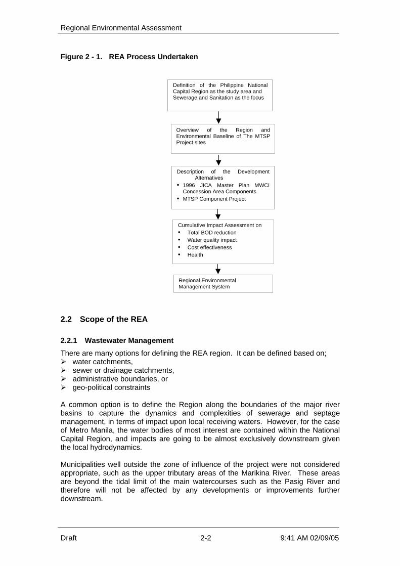
This assessment was guided by the World Bank Environmental AssessmentSourcebook Update on Regional Environmental Assessment, Number 15, June 1996(WB Operational Directive 4.01). Figure 2-1 illustrates the process undertaken:
Regional Environmental Assessment
Draft 2-2 9:41 AM 02/09/05
Figure 2 - 1. REA Process Undertaken
2.2 Scope of the REA
2.2.1 Wastewater Management
There are many options for defining the REA region. It can be defined based on;Ø water catchments,Ø sewer or drainage catchments,Ø administrative boundaries, orØ geo-political constraints A common option is to define the Region along the boundaries of the major riverbasins to capture the dynamics and complexities of sewerage and septagemanagement, in terms of impact upon local receiving waters. However, for the caseof Metro Manila, the water bodies of most interest are contained within the NationalCapital Region, and impacts are going to be almost exclusively downstream giventhe local hydrodynamics. Municipalities well outside the zone of influence of the project were not consideredappropriate, such as the upper tributary areas of the Marikina River. These areasare beyond the tidal limit of the main watercourses such as the Pasig River andtherefore will not be affected by any developments or improvements furtherdownstream.
Overview of the Region andEnvironmental Baseline of The MTSPProject sites
Cumulative Impact Assessment on• Total BOD reduction• Water quality impact• Cost effectiveness• Health
Regional EnvironmentalManagement System
Definition of the Philippine NationalCapital Region as the study area andSewerage and Sanitation as the focus
Description of the DevelopmentAlternatives
• 1996 JICA Master Plan MWCIConcession Area Components
• MTSP Component Project

Regional Environmental Assessment
Draft 2-3 9:41 AM 02/09/05
The other dimension would be to Include Manila Bay in the region. However thebeneficial water quality and health impacts expected due to implementing the MTSPwill not be of such a magnitude so as to be able to positively correlate theseimprovements with any changes in Manila Bay. The causal relationships could notbe established with any statistical confidence with the proposed improvementsupstream. For this REA, the Philippine National Capital Region (NCR) has been adopted as theRegion. The Region’s spatial boundaries are defined as the cities and towns withinthe political boundaries of Metro Manila being drained by the following: Ø Pasig-Marikina River,Ø Malabon-Tullahan River, andØ Paranaque-Zapote Rivers which flow into Manila Bay and Laguna Lake. This region is more commonly called the National Capital Region or NCR. The studyarea is composed of 13 cities (Mandaluyong, Manila, Marikina, Pasig, Kalookan, LasPinas, Makati, Malabon, Muntinlupa, Paranaque, Pasay, Quezon, Valenzuela) andfour municipalities (Navotas, Pateros, San Juan, and Taguig). This boundary also sensibly interfaces with the regional institutions eg Pasig RiverRehabilitation Commission (PRRC), MMDA, MWSS, LLDA/DENR, MWCI andMWSI, and as such simplifies the management aspects for the REA. The PRRC presently has an overview role as a “regional” coordinator forenvironmental and development issues within the Pasig River basin, which includesthe Laguna Lake and major catchments such as Marikina and San Juan Rivers. TheCommission does not have any executive powers, but has been tasked to coordinatethe various River rehabilitation programs. As such, the PRRC has developedvarious Action Plans, such as water quality monitoring and implementingenvironmental user fees, for implementation by the line agencies such as DENR. Assuch, the PRRC could be compared a typical river basin committee/commission inmany international situations. This further confirms that the Region for the REAneeds to extend beyond that of the MWCI concession area for consistency of projectimplementation. The Region to be adopted will therefore be the NCR, based on;Ø Major river systemsØ Hydrodynamics in these river systems, particularly the tidal limitsØ Political and land development boundaries extending beyond the MWCI
concession area, andØ Institutional factors, such as the coverage of MWSS and DENR regions. Therefore, the REA will concern itself with studying the impacts of developmentalternatives on sewerage and septage management within the NCR boundaries, anddeveloping a suitable environmental management strategy to support this strategy.
2.2.2 Sludge and Septage Management
Some components of the MTSP involve the development of Septage TreatmentPlants (SPTP) and Sewage Treatment Plants (STP). These facilities generateseptage solids and sludges respectively, which have to be managed as part of theMTSP. Both private contractors and MWCI tankers haul the septage.

Regional Environmental Assessment
Draft 2-4 9:41 AM 02/09/05
Previously, untreated septage collected by the Concessionaire was disposed offunder ocean dumping agreements.
At present some septage is being transported to the lahar affected areas north of theNCR, and to extensive agricultural areas including Pampanga, Tarlac and adjacentprovinces. A series of pilot trials are ongoing for liquid septage land application, torejuvenate deep lahar soils and on sugarcane plots to improve yields and reduce theneed for artificial fertilisers. The biosolids and septage application sites are over 80kilometres north of the REA Region, and in a predominantly rural area. The area isonly lightly developed as it is a rural enclave.
The benefits and potential impacts of these activities, in relation to septage/sludgeland application, will be addressed in this REA. Any impacts or benefits will bemonitored as part of the EMP for the MTSP.
However these septage/sludge application activities are peripheral to the main MTSPcomponents and as such, the REA Region will only be defined as the NCR. Therewill not be any significant infrastructure development outside the NCR in these laharand extensive agricultural areas.
The septage disposal location/s used by the private contractors is unknown atpresent, as there are no approved disposal locations or septage treatment plantsavailable to the private contractors at present. Following commissioning of theSPTPs, the private contractors will use these facilities as well as the MWCI tankers.
2.3 Regional Planning Integration
Regional planning in this region is somewhat disjointed with various agencies havingroles at a number of institutional levels. Therefore the REA will have to develop itsown regional approach to ensure sustainability. For example, the MWSS is presentlyconsidering developing a new Water, Sewerage and Sanitation Master Plan for theregion. This could impact upon the present project coincidentally. Similarly, the Western Concessionaire has developed a master plan which is now inabeyance. The western concessionaire is not operating in full compliance with theConcession Agreement and the future of the developments in the western area areuncertain. This means that the REA is even more important as it needs to addressthe possible issues associated with the western part of the Region as well as theeastern zone where the MTSP will be located. Therefore the approach to integration with other regional plans can only be to reviewthem and ensure that there are no major developmental or institutional conflicts intothe future.

Regional Environmental Assessment
Draft 3-1 9:41 AM 02/09/05
3 Overview of the Adopted Region This section presents the key parameters and issues that describe the Region. The Region’s spatial boundaries are defined as the cities and towns within thepolitical boundaries of Metro Manila being drained by the Pasig-Marikina River, theMalabon-Tullahan River and the Paranaque-Zapote Rivers which flow into ManilaBay and Laguna Lake. This region is more commonly called the National CapitalRegion or NCR. The study area is composed of 13 cities (Mandaluyong, Manila,Marikina, Pasig, Kalookan, Las Pinas, Makati, Malabon, Muntinlupa, Paranaque,Pasay, Quezon, Valenzuela) and four municipalities (Navotas, Pateros, San Juan,and Taguig).
3.1 Regional Sub-Basins
The NCR region is dissected by numerous rivers and streams that finally emptyeither to the Laguna Lake or Manila Bay. There are six major water bodies andbasins in and downstream of the region; The Laguna Lake, Marikina-Pasig,Meycauayan, Manila Bay, San Juan and Tullahan River. Key issues associated withthese are discussed below The Malabon-Tullahan River system is in the West concession region, but is themost polluted river system in the Philippines. The pollution is estimated to be about58 percent domestic waste (both liquid and solid waste) and 42 percent fromindustrial waste. There are about 1,000 industries along the riverbanks and about11,000 squatter families within its watershed. This is a good example that any socio-environmental developments within the East zone cannot be assessed in isolation ofconsidering the regional context. The Pasig River Basin (9,000 km2) and the Pampanga River Basin (3,900 km2) makeup more than 75% of the watershed of Manila Bay. The Pampanga Rivercontributes approximately 49% of the net freshwater influx into Manila Bay, while thePasig River contributes about 21%. The other river systems make up 26% of thefreshwater source and the remaining 4% comes from precipitation onto the bay. TheBay is therefore the ultimate recipient of domestic and industrial waste discharges,agricultural runoff and oil spills. The Pasig River System is a complex of network of waterways the includes Marikina,San Juan, Esteros, and canals, which have the following characteristics: Ø It is the main outlet of the Laguna Lake with a total surface area of 850 km2 and
a drainage area of 2,750 km2. Waters coming from the Laguna Lake meandersthrough 27 kilometres of relatively flat coastal and highly urbanized plains ofMetro Manila
Ø There are over 300 industrial firms along the banks of the Pasig River system,about one-half have been found to be polluting the water in varying degrees.River pollution is further aggravated by oil spills, from about 300 gasolinestations, several oil depots, and barges, tanks and boats docking in the area.
Ø Marikina River, with its headwaters in the Sierra Madre mountains, joins thePasig River 19 kilometres upstream of Manila Bay with an estimated catchmentat the junction of 515 km2
Ø San Juan River which drains most parts of Quezon City and San Juan, uniteswith the Pasig River about 9 kilometres upstream has a catchment area of about

Regional Environmental Assessment
Draft 3-2 9:41 AM 02/09/05
86 km2. The San Juan River is the most polluted major water body in the PasigRiver system
Ø The Pasig River is tidal, and the freshwater baseflow varies substantiallyaccording to season. High flows of as much as 275 m3/sec usually occurbetween the rainy season of June to October, while low flows of about 12 m3/soccur between April and May. Even smaller baseflows are possible during whichperiods the water quality deteriorates even further. Also during the low flowseason, the Pasig River reverses its flow direction caused by the high tides atManila Bay and polluted waters can return into Laguna Lake.
The Pasig River catchment area is the most densely populated area in the region.The River system is classified as Class C under AO 34, which means that it shouldbe maintained suitable for propagation of fish, aquatic resources, recreational use fornon-contact recreation, and industrial water supply. For many years, this standardhas not been met. During the dry season for example, the river is effectively devoidof oxygen, while the total coliform count exceeds the local standards by severalthousand times. With respect to Laguna Lake, the increase in direct discharges of domestic andindustrial wastes, and agricultural runoff, plus pollution carried in by tributary rivers,has degraded the water quality over the years. In the last 20 years, the watershedarea of the lake has become one of the most heavily urbanized and industrializedareas in the region. Most of the pollutants in the Region eventually end up in Manila Bay.
3.2 Topography
The region is generally flat, with 67.5% of its territory having level to nearly levelslope, while 24.5% of the total land area has a slope between 3-8%.
3.3 Vulnerability to Flooding
Many areas within the region are vulnerable to flooding. This vulnerability is a resultof a combination of several factors which include its location within the tropicalmonsoon region, being a flood plain of generally low elevation, intensive urbanizationwhich increases runoff intensity, and inadequate drainage. About 20% of the more than 20 typhoons frequenting the country each year passthough the Region. Associated heavy downpour during typhoons inundate about 20percent of the region particularly in the eastern, south-eastern, and southern parts,particularly those areas bounded by the Laguna Lake which includes Taguig andMuntinlupa. There is a positive correlation between the extent of flood prone areasand the cities and municipalities with larger proportions of low-income residents. The following has aggravated flooding:Ø Ground level subsidence due to over extraction of ground waterØ Rapid increase in population, particularly the informal housing sector, which finds
refuge along the river banks, canals, esteros, and waterways This blocks accessof maintenance personnel and equipment, accelerates accretion in waterwayswhich reduces the conveyance capacity.
Ø Disposal of solid wastes to waterways, estimated at 25% of the total solid wastegeneration of 8,000 tons per day in the Region which clog drainage canals,poses health risk, and increase the likelihood of flooding

Regional Environmental Assessment
Draft 3-3 9:41 AM 02/09/05
As early as 1952, a Master Plan for the Drainage in the Manila Area had beenprepared. But it was only after the severe floods of 1972 that major flood mitigationmeasures were undertaken. These resulted in the establishment and operation ofseven pumping stations, and the construction of two floodgates and four drainagemains between 1974 and 1978. By 1980, construction of the 10-kilometerManggahan Floodway was initiated, linking Marikina River to Laguna Lake to use thelatter as temporary flood storage and ensuring the controlled release of floodwatersthrough the Napindan Hydraulic Control Structure. In summary, the majority of the Region is low lying and floods frequently.
3.4 Land Use
About 70 % of the total land area of the Region is built-up, followed by open landwhich accounts for 15% of the territory. Most of the open lands are located inValenzuela, South Caloocan, Taguig, and Paranaque. The remaining grassland andwoodland orchard areas are found in Taguig and Muntinlupa, respectively. SeeFigure 4-2 for details. This indicates that the Non-Point Source (NPS) pollution caused by runoff fromagricultural lands will not be a critical factor in determining the pollution improvementstrategy. Point source discharges from the Individual Septic Tanks and urban NPSpollution should be the focus of the improvements.
3.5 Regional Flow Regimes
3.5.1 Wet and Dry Season Flow Variation
Of specific relevance is the hydrology of the Region, as the wet/day seasonvariations have major impacts on local water quality and ecosystems. The Regionalwater systems are effectively bi-phasic, with very poor water quality and ecosystemdiversity in the dry season but with marginally better ecological conditions in the wetseasons. This is because the variation in freshwater base flow is critical in determining waterquality in tidal systems such as the main watercourses in the Region. Advection, orwater movement due to the freshwater base flow, is far more effective in movingpollutants out if the rivers than tidal mixing/dispersion in the tidal reaches. The abilityof advective forces to move pollutants out of the Region is many tens of timesgreater than longitudinal tidal mixing and dispersion due to tidal mixing activity alone. The main (lowest) hydrology measuring station on the Marikina River indicates flowsapproaching zero in the driest years (0.8 m3/s in January 1990), but with a typicaldry-weather low flow of approximately 10 m3/s. The 80 percentile guaranteed flow(instantaneous) is only 0.8 m3/s. The peak flow was recorded at 1,358 m3/s inSeptember 1989. The DANIDA report (1999) notes that the average river flow is approximately 200m3/s over a full year, with wet season flows consistently approaching 600 m3/s. Therefore any pollution or health management strategy must take account of thewide variation in water quality and health risks on a seasonal basis.

Regional Environmental Assessment
Draft 3-4 9:41 AM 02/09/05
3.5.2 Tidal Influence on Laguna Lake
In the later part of dry seasons when advecting (fresh water) flows are minimal, thetidal influence on higher tides is sufficient to generate flow reversal in the Pasig Riverestuary. This means that the polluted water within the lower reaches of the river iscarried back up the estuary to the Pasig River and Taguig Rivers. Depending uponthe flood control gates at Napindan, flow reversal can occur into Laguna Lake. This is actually encouraged at present as the salinity in the estuarine water facilitatescoagulation of the turbidity in Laguna Lake. The additional water clarity as well asthe nutrients in the river water then causes algal blooms. This is not desirable from awater quality viewpoint, but the algal bloom is encouraged as supplementary fishfood for the fish farming activities within the lake. In terms of protecting water qualityin Laguna Lake, this should not be allowed to occur. If the water quality or ecologyof the Lake is permanently altered by this management intervention to cause algalblooms, then the water quality of the Pasig River will also suffer. Water from theLake presently is of much higher quality than the Pasig River and drains into thePasig River for the majority of the year.
3.6 Groundwater
The groundwater system of Metro-Manila consists of alluvial sediments (found incoastal areas of Manila Bay, Laguna Lake and Marikina Valley) and pyroclasticsedimentary formations underlying most of the remaining areas of the region. Theaquifer system covers about 1400 to 1800 sq km. In general, the region’s aquifersystem consists of an upper water table aquifer of up to 30-m depth and the lowerartesian (pressurized) aquifer of more than 500-m thickness. Semi-confining layersseparate these two strata with thickness of up to 45 m. A simpler way of classifying the aquifer system is to divide it into confined andunconfined formations, as the dynamics of water abstraction and leakage(movement of water) between the two formations influence the way watercontaminants can enter the systems.
3.6.1 Confined Aquifers
The main productive aquifers of Metro-Manila are the pressurized, confined aquifersfound underneath the region’s north to south axis. Specifically, these are locatedbeneath the Guadalupe and the Antipolo Plateaus. The main system, formed by theGuadalupe formation, covers some 470 square km. It is also believed to extendbeneath the bed of Laguna Lake. Groundwater is stored and transmitted in thismain aquifer by openings and fractures in the tuffaceous formation. The aquifer isunder pressure (thus the term artesian). It is separated from the overlying materialby a semi-permeable layer, called an aquitard, whose thickness varies from 15 to 45m. The aquitard helps prevent rapid movement of contaminated water into theconfined aquifer from the upper formations. In some parts of Metro-Manila where drawdowns of more than 50 m have beencaused by overpumping, the main aquifer has been converted to a water tableaquifer (i.e, the aquifer is no longer pressurized). In losing its pressurized condition,the aquifer has become more vulnerable to contamination from downward leakage ofpolluted water. This drawdown confirms that groundwater is a major water source.

Regional Environmental Assessment
Draft 3-5 9:41 AM 02/09/05
3.6.2 Unconfined Aquifers
Above the confined aquifers are water-bearing formations that are not in pressurizedcondition. They are also called water table aquifers or shallow aquifers. Thisgroundwater occurs in a non-pressurized state. Alluvial sediments derived fromerosion of the Guadalupe formation provide the medium or material for the region’swater table aquifers. Such alluvial sediments occur in three areas within the region: the Manila Bay deltaicplain, the Marikina Valley, and the alluvial deposits found at both the periphery andbottom of Laguna Lake. The alluvial sediments occur as irregular lenses varying inthickness from about 50 m along the Manila Bay shore to about 100 m near andunderneath Laguna Lake. The hydrogeological and water supply data confirms that protecting the groundwaterresource is critical. This means that pollutants should not be allowed tounnecessarily enter the local water table and possibly leach into the confined aquiferat depth. Given this background, and the size of the population of the Region, theusual option of requiring leach fields for sullage flowing from the ISTs would beinappropriate. Leach fields or infiltration trenches are appropriate where;Ø the population density is low,Ø the soil type is a heavy loam,Ø the water table is at depth, andØ the groundwater is not heavily used for a water supply. This is not the case in the Region. Therefore any strategy could not recommendretrofitting leach fields to the more than one million ISTs in Metro Manila, even ifthere was sufficient land for this disposal option. Based on these data, the sullage should therefore be conveyed for treatment andnot encouraged to infiltrate into the soil profile.
3.7 Sources of Water Pollution
Water pollution and the attendant ecological causes may be assessed based on avariety of parameters. The most common of concern in highly polluted waters aremeasures of oxygen demanding substances, such as BOD5 and COD. Secondly aresuspended solid materials which limit light penetration, cause sedimentation andsmothering of the benthic organisms, and abrade fish gills. Other groups include nutrients, oils, heavy metals such mercury and persistentchemicals, such as pesticides.
3.7.1 BOD5
There have been many estimates of water pollution sources in the National CapitalRegion. In 1995, the Environment and Natural Resources Accounting Project of theDENR estimated that the services and households sectors are the major contributorof Biochemical Oxygen Demand (BOD5) to the region’s surface waters accountingfor 99% of the total BOD5 load. Domestic wastewater contributes over 70% of thetotal BOD5 in the Region.
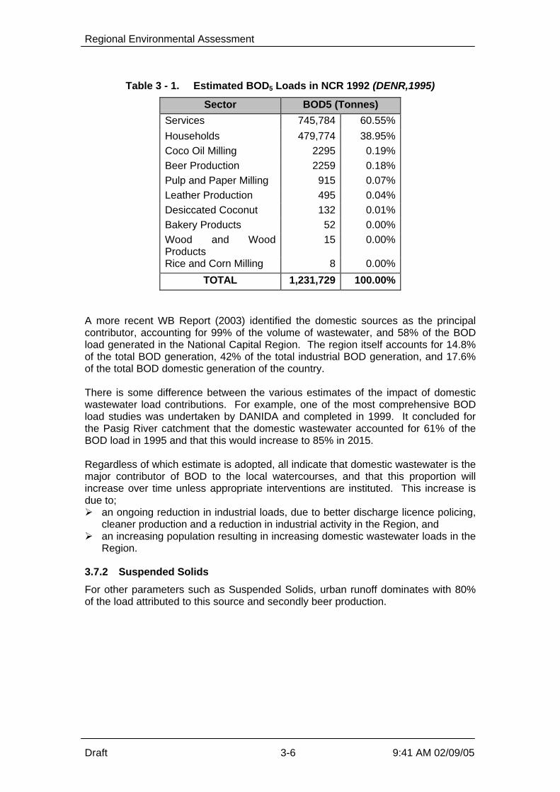
Regional Environmental Assessment
Draft 3-6 9:41 AM 02/09/05
Table 3 - 1. Estimated BOD5 Loads in NCR 1992 (DENR,1995)
Sector BOD5 (Tonnes)
Services 745,784 60.55% Households 479,774 38.95% Coco Oil Milling 2295 0.19% Beer Production 2259 0.18% Pulp and Paper Milling 915 0.07% Leather Production 495 0.04% Desiccated Coconut 132 0.01% Bakery Products 52 0.00% Wood and WoodProducts
15 0.00%
Rice and Corn Milling 8 0.00%
TOTAL 1,231,729 100.00%
A more recent WB Report (2003) identified the domestic sources as the principalcontributor, accounting for 99% of the volume of wastewater, and 58% of the BODload generated in the National Capital Region. The region itself accounts for 14.8%of the total BOD generation, 42% of the total industrial BOD generation, and 17.6%of the total BOD domestic generation of the country. There is some difference between the various estimates of the impact of domesticwastewater load contributions. For example, one of the most comprehensive BODload studies was undertaken by DANIDA and completed in 1999. It concluded forthe Pasig River catchment that the domestic wastewater accounted for 61% of theBOD load in 1995 and that this would increase to 85% in 2015. Regardless of which estimate is adopted, all indicate that domestic wastewater is themajor contributor of BOD to the local watercourses, and that this proportion willincrease over time unless appropriate interventions are instituted. This increase isdue to;Ø an ongoing reduction in industrial loads, due to better discharge licence policing,
cleaner production and a reduction in industrial activity in the Region, andØ an increasing population resulting in increasing domestic wastewater loads in the
Region.
3.7.2 Suspended Solids
For other parameters such as Suspended Solids, urban runoff dominates with 80%of the load attributed to this source and secondly beer production.

Regional Environmental Assessment
Draft 3-7 9:41 AM 02/09/05
Table 3 - 2. Estimated Suspended Solid Load in NCR 1992 (DENR,1995)
Sector SS Load % Share Urban Runoff 45,614 80.5% Beer Production 5,792 10.2% Coconut Oil Milling 3,402 6.0% Pulp and Paper Milling 1,089 1.9% Leather Production 767 1.4% Rice and Corn Milling 12 0.0% Wood and WoodProducts
8 0.0%
TOTAL 56,684 100.0% The monitoring of urban drains for this and other projects confirms that theSuspended Solids levels are low from domestic sources. Suspended Solids is acritical parameter as it smothers any benthic organisms (bottom dwelling life) andalso abrades the gills of fish. Finally it reduces the clarity of the water which reducesprimary productivity in the waterway as light penetration is reduced, and also there isreduced aesthetic attraction with turbid waters.
3.7.3 Pathogens and Indicators
Other key parameters are health related, such as E.coli bacteria or Faecal Coliforms.These are indicator species that have been statistically correlated to water bornedisease risk. These indicators, as well as the pathogens that they mimic, areprimarily sourced from human waste. There are other warm blooded mammals thatcan yield these indicators but more detailed analysis of ratios of Faecal Coliforms toFaecal Streptococci, and other specific methods, can refine the source. In any case, it is well documented that the elevated pathogen and indicator counts inthe Region’s waterways are predominantly sourced from untreated and non-disinfected human waste products. As the population further increases, theconcentration of these indicators and the pathogens themselves will increase unlessthe wastewater is treated and disinfected. The disease risk is also compounded by the general morbidity of the population. Asinfected individuals release waste which is not treated, the possibility of epidemics isheightened. A circle of increased community morbidity results in higher pathogencounts in untreated wastewater, which increases the disease risk to otherunprotected members of the community.
3.7.4 Nutrients
Nitrogen and phosphorus are two main components of domestic wastewater,including sullage flowing from ISTs. Nutrients act as fertilisers on the land,encouraging plant growth. They do the same in the water environment, and areessential to balanced primary productivity. However when present in excessivelevels they can result in excessive algal growth which may manifest itself as simplealgal blooms, blue-green algal blooms in the estuary or red tide events in the Bay. Inany case, the excessive algal content imbalances the aquatic ecosystem, and canresult in toxins entering the food chain.
Regional Environmental Assessment
Draft 3-8 9:41 AM 02/09/05
There is no real data collated for nutrient loads into the local waterways. This is notcritical when the Dissolved Oxygen levels are so low that life is essentially eliminatedfrom waterways. However as the DO levels improve, there will be a need to managenutrient levels to prevent uncontrolled algal blooms in Regional rivers and Lakes, andescalated red tide events in Manila Bay.
3.7.5 Persistent Pollutants
This category includes pesticides, weedicides and other organics such as solvents,oils and grease and aromatics. Inorganics would include heavy metals such ascadmium and copper, and asbestos. Industrial processes and non-point source runoff are the most common source ofthese chemicals. In the Region, there is relatively little agriculture and so this wouldonly be minor source. The industrial facilities would be the main source of thesepersistent pollutants. The European Union (1997) estimated these pollutants are being introduced into theriver systems in the Region at over 80,000 tons per year.
3.7.6 Solid Waste
Solid waste is also a pollution source. Only 6,000 tonnes of solid waste generated inthe Region is collected out of the 8,000 tonnes produced daily. The 2,000 tonnedifference is illegally dumped, burnt or thrown into drains or esteros. (ADB, TheGarbage Book – Solid Waste Management in Metro Manila, ADB, 2004). The solidwaste is then flushed into the local watercourses in wet weather. In terms of BODand SS, solid waste is only a minor contributor however. The main issue is thestable residuals such as plastics in the solid waste that ;Ø block drains escalating the possibility of flooding,Ø enter the local waterways causing visual pollution, andØ become a health risk for larger marine species, which can choke or strangle on
these plastics.
3.8 Population
The region’s population is increasing rapidly, and this will result in increasingpollution load, unless interventions are initiated. Specifically the population within the MWCI concession area (East zone) is predictedto increase from 5.3 million persons in 2004 to 8.2 million in 2021. There are noindications that the population growth will subside even after this period of sustainedgrowth. The increase is due to a mixture of rural population drift into the city, as well asoverall population growth in the country. With respect to population drift, there areno real provisions to prevent this population drift in terms of land use planning anddevelopment controls restricting land development for housing. There is somelimited NGO support for general family planning initiatives, but these efforts aregenerally ineffective on any measurable scale to date.

Regional Environmental Assessment
Draft 4-1 9:41 AM 02/09/05
4 Baseline Conditions The baseline details are presented in full in Appendix A – Baseline Data. All baselinefigures are also contained in this appendix. The Appendix includes some esoteric itemssuch as detailed topography that do not have a direct impact on the proposeddevelopment but are included for the purposes of completeness.
4.1 Terrestrial Environment
Civil works in the NCR under the MTSP will specifically be undertaken in the cities ofQuezon, Mandaluyong, Makati, Pasig, Marikina and the town of Taguig. As a highlyurbanized region, the landscape or terrestrial environment consists mainly of densehuman settlement areas, industrial sites, financial and commercial establishments and anetwork of roads and bridges. The vegetation cover is restricted to man-made settings (memorial and home gardens,city parks, trees and ornamental lining and hedging streets) and a few remaining openareas (both private and government properties). These include natural successional anddisturbed habitats, and patches of cultivated lands, which are rapidly being reduced inarea due to population and urbanization pressures. In a decade or so, most of theprivately owned natural areas will be transformed into housing, commercial and industrialsites. The government lands may soon be taken over by the region’s homeless families unlessprograms are formulated to prevent such an eventuality.
4.1.1 Terrestrial Flora
The key conclusion from the terrestrial surveys is that none of the proposed STP sitescontain any rare or endangered plant species. At the Taguig Sewerage System, the vegetation cover of the floodplains adjacent to thepumping stations and retention ponds are dominated by grasses, herbs and sedges inassociation with a few shrubs that characterize open, waste and generally damphabitats. A majority of the herbaceous growth forms belong to the Gramineae,Leguminosae and Compositae Families. Their ecological importance rests mainly in theirrole as primary producers in the ecosystem and as soil cover to prevent erosion. Theherbaceous cover may also provide habitats for insects and other small field fauna. Atthe Tapayan pump station, the flood plains are currently cultivated for rice culture.According to some long-time residents in the communities along the Hagonoy andTaguig Rivers, they used to plant vegetable crops in the floodplains during the summermonths before the DPWH Flood Control Program in the area was implemented. All three catchments located alongside the Pasig River, situated in the cities of Pasig(Barangay Pineda), Mandaluyong (Barangka Ilaya) and Makati (Barangay Poblacion) aredensely populated with very little and limited open space. The proposed site for theconstruction of a STP for Barangay Pineda is devoid of any vegetation cover except fora few weeds at the edge of the riverbank. These include: Cenchrus echinatus, Chlorisbarbata, Eleusine indica (Gramineae), Cyperus difformis, Cyperus distans (Cyperaceae),Centrosema pubesceus (Leguminosae) and Alternanthera sessiles (Amaranthaceae). Within the proposed STP site in Barangka Ilaya is a mini-riverside sitting park boundedby a few (4) young Polyalthia longifolia (Annonaceae) trees and an Ixora chinensis

Regional Environmental Assessment
Draft 4-2 9:41 AM 02/09/05
(Rubiaceae) or santan hedge with some Bougainvillea spectabilis (Nyctaginaceae)plants. At the edges of this mini-park are a few weeds. The lift station will beconstructed in a concrete space adjacent to an existing basketball court. The site isdevoid of any vegetation. The site of the proposed STP for Barangay Poblacion in Makati City is a narrow strip ofopen space between J.P. Rizal St. and the riverbank. Standing within this strip are twoCocos nucifera (Palmae) and two Acacia auriculiformis (Leguminosae) trees. On theground layer which is hard and sandy are a few stunted Ricinus communis(Euphorbiaceae) seedlings and weeds. The site selected for the establishment of the Septage Treatment Plant (SPTP) facility toservice the northern sub-area was to be located near the Payatas open dumpsite inQuezon City. The Payatas site is basically open grassland dominated by extensivestands of cogon (Imperata cylindrical) and talahib (Saccharum spontaneum) inassociation with ruderal herbs (characteristic of open wastelands). The area does nothave threatened or endangered plant species. The new site in San Mateo has not beenformally assessed as yet but is a completely disturbed site with only regrowth present onthe site, and is surrounded by pig farms and metal works. A detailed EIA will becompleted as required. For the southern sub-area, the selected site for the SPTP is a vacant lot of about athousand square meters within the Food Terminal, Inc. (FTI) Complex in Taguig, MetroManila. The area is essentially an open wasteland, with a few large trees along theedges and a stand of ipil-ipil shrubs at its entrance. The area does not contain anyendangered or threatened plant species. Only a few small white and yellow butterflieswere observed to be fluttering over the Amaranthus stand. The proposed STP site in the Manggahan Floodway East Bank area is an openwasteland. Most of the 66 herbaceous species recorded in the actual site for the STPand adjacent areas are the very common grasses, herbs and vines that usually colonizeopen areas. The presence of a few species providing edible fruits (Cucurbita andMomordica), roots (Manihot and Colocasia) indicates that nearby residents may be usingthe area to grow these and perhaps other plants during the year. The STP site at Signal Village (Ipil-Ipil Street) covers an open area within a denselypopulated community beside the creek. Because of the sparse vegetation and the sizeof the area, a ground inventory of the extant plants was conducted across the proposedSTP. The list does not include any threatened or endangered plant species. The CST 33 at East Avenue, to be upgraded into a mini regional STP, sits underneath asmall woodland area within the (National Ecology Centre) compound of the ForestManagement Bureau along East Ave. Most of the trees are mature and since they wereplanted close to one another, they are quite tall with high canopies. A majority of theseare Swietenia (mahogany) and Bauhinia species. One mature fig tree is worthy ofretention. The site where the trees are growing above the CST had no vegetation coveror undergrowth because apparently this was being used as a mini-sitting park. Around CST 20 at Road 5, Project 6 are ornamental shrubs and small trees whichinclude golden shower, buenavista, bougainvillea, papaya and neem tree. The othertrees in the list are growing in adjacent or neighbouring houses behind concrete fences,which will not be affected by the project.

Regional Environmental Assessment
Draft 4-3 9:41 AM 02/09/05
In summary, none of the proposed development sites contain any rare or endangeredplant species.
4.1.2 Terrestrial Fauna
There is no wildlife fauna in the project area. The animals present in the area are mostlydomesticated species of dogs, cats, fowls, birds, etc. Water buffaloes were observed inthe Laguna lake area (Taguig Sewerage System). The bird population in the area is notsignificant except for those that habitats the lake and rice field areas at Taguig andTaytay. It is expected that there are no rare, threatened or endangered species of animals in theproject area due to its urban setting.
4.1.3 Air Quality
Air quality is generally poor throughout the Region, depending upon wind, rain andatmospheric stability class. This applies to suspended particles, odour and haze/clarity. For example, based on the EMB/DENR air monitoring results from 2003, the meanmonthly TSP levels are approximately twice the local standard of 90 ug/Nm3. The development will have no measurable impact, either positive or negative, uponRegional air quality. All treatment plants will either be enclosed or located underground.Therefore more details on air quality is unimportant for the REA.
4.1.4 Noise
Noise studies were undertaken. The proposed developments are within a megalopolisand the noise readings simply reflect the noisy background. Results were a minimum of 3 dB(A) above the DENR standards, and as much as 30dB(A) at some sites.
4.2 Water Quality
The main watercourses of interest to the REA are the Pasig – Marikina system includingthe San Juan River, as well as Laguna Lake. However an overview of other waterquality monitoring data for other water systems in the Region indicated the same generalwater quality status. Very poor water quality in the middle reaches of the estuaries, withmarginally better water quality closer to the better water quality in Manila Bay and anyfreshwater inflows from catchments above the higher density urban areas. The ongoing DENR monitoring results for the Region were supplemented by somespecific monitoring for the MTSP. The project specific water quality monitoring results included in Appendix A need to beput in context. It was only one sampling run and was generally concentrated on theimmediate receiving water (discharge tributaries) not the main receiving water bodies,namely the Pasig River and Laguna Lake. Therefore the project water quality data morereflects the quality of the effluent to be treated rather than the water quality of the mainreceiving water. Each site was only sampled once, mainly in November and December,
Regional Environmental Assessment
Draft 4-4 9:41 AM 02/09/05
which is outside the main wet season. Hence most local flows in smaller tributarieswould be dominated by wastewater rather than stormwater runoff. Therefore there is a need to review other longer-term datasets to supplement thespecific baseline survey undertaken for this REA
4.2.1 Background
The dry/wet season change substantially impacts on water quality in the Pasig River andMarikina Rivers, and to a lesser extent Laguna Lake. Traditionally Non Point Source(due to stormwater runoff) impacts usually deteriorate the water quality. This becausecatchment pollutants pollute the NPS which are mobilised by the stormwater runoff,resulting in additional pollutant loads on the receiving water. This results in poorer waterquality until the runoff flows or is tidally flushed out of the receiving water system. In this Region, the opposite applies. The runoff waters are still contaminated bycatchment pollutants, but the runoff quality is far superior to the dry weather flow qualityof the Region’s Rivers and main lower tributaries. As a result there are two verydifferent water quality states in the Region. The dry weather (poor) water qualityscenario and the wet weather (improved water quality) scenario define the two states.As a result, any water quality monitoring data must be calibrated against the river flow atthe time of sampling. The first few millimetres of rain is usually the most polluted as it flushes out thepollutants resident in depressions and ponds, or as a dry residue within the catchment.Therefore in protracted wet weather, the runoff quality improves over time.
4.2.2 Existing Monitoring Programs
DENR is the main department with programs being implemented by EMB Central, EMBNCR and LLDA. The location of the monitoring sites used by these three agencies is presented inAppendix B – Water Quality Monitoring Sites and Programs.
EMB Central This group has undertaken most monitoring over the last decade. A summary of theirrecent monitoring is presented in Appendix B – Water Quality Monitoring Sites andPrograms. The monitoring locations are shown in the following figure, along with the sites of EMB,NCR and LLDA. The current program is as follows, on an every second month basis: Ø On-site measurement - DO, Temp, salinity, conductivity, pH, secchi depth, water
depthØ Laboratory Analysis - BOD, NH4-N, NO2-N, NO3-N, PO4-P Earlier monitoring was more frequent, and included Heavy Metals in sediments plus inwater. A number of diurnal sampling programs were also undertaken at selectedstations for in-situ parameters to assist with model calibration.

Regional Environmental Assessment
Draft 4-5 9:41 AM 02/09/05
The monitoring was initiated by DANIDA in 1990, to assist calibrating their model, butthese funds were phased out in 1999. EMB Central is continuing with the monitoring ata reduced frequency using internal funds. The aim of the on going monitoring is to provide data to support policy decisions on thePasig River and as input to the 5 yearly Philippines Environmental Quality Report. The data is reviewed by basic ANOVA techniques and trends estimated.
EMB NCR EMB NCR monitors monthly at 12 sites as shown in the figure. Many of the sites areidentical or close to the Central sites. The parameters are shown in Appendix B – Water Quality Monitoring Sites andPrograms. The parameters include the usual in-situ and basic laboratory parameters,similar to the EMB Central program. The data is given to Central for review as part of the policy formulation and also used byNCR in the role of assessing the trends in water quality as a result of the NCR anti-pollution effectiveness. This trend analysis is done superficially based on a rudimentaryreview. It is doubtful whether this type of monitoring program could reliably detect achange in water quality due solely to the anti-pollution efforts of NCR as most of thepollutant load is due to domestic wastewater, not industrial effluents. The only time that this general monitoring could detect such a change would be if theindustry or industrial group had a specific contaminant unique to the industry that couldbe isolated during the data interpretation. This does not seem to be the case. The policies developed by Central using this data are work-shopped with NCR andagreed at Director level. However Central has the lead in developing the policies basedon the data.
LLDA LLDA monitors four stations in the Pasig River during the wet season on a monthlybasis. An additional five stations are monitored during the dry season, more frequentlythan monthly usually. In all, 17 parameters are analyzed, and they are enumerated bywet chemistry back in the laboratory. Little use is made of in-situ probes and meters. The parameters are shown in Appendix B – Water Quality Monitoring Sites andPrograms. LLDA also monitors a number of stations within the Lake proper. The main purpose of the monitoring is to understand the quality of water likely to beintroduced into the lake during tidal flows during the dry summer periods. The summermonitoring aims to follow the salinity recovery back up the estuary. Bureau of Fisheries and Aquatic Resources (BFAR) Fisheries Department produced a working document for the Pasig River rehabilitationproject in April 1991. It was only a literature review of studies done in the 1980s andsome in the early part of 1990s. There was no data on catch tonnage or ease ofcatching, since fish presence was primarily due to migration from Laguna Lake to Manila

Regional Environmental Assessment
Draft 4-6 9:41 AM 02/09/05
Bay via Pasig River, rather than local breeding within the River itself. This migration isanecdotally reported to have started to decline as early as the 1930s. The Departmentis now concentrating monitoring efforts on seven lakes throughout the Philippines andhas no programs planned for the Pasig River. The BFAR does not conduct any water quality monitoring activity in the Region.Monitoring of fish quality, particularly following “red tide” occurrence, is concentrated inManila Bay. DPWH DPWH's monitoring activities on the Pasig River is brought about by the dredgingactivities of the Project Management Office - Flood Control of the DPWH. Parameters monitored on the water quality surveys are turbidity and suspended solids,using a portable test meter. Volume of silt is also measured but there are no heavymetal analyses. Samples are taken on a weekly basis. Analysis is done using a fieldtesting kit owned by the project contractor. Monitoring stations are as follows: Ø Dredging area (between Jones Bridge to the mouth of the river)Ø Upstream 100 meters away from the dredging area towards Jones BridgeØ Upstream 300 meters away from the dredging area towards Jones BridgeØ Downstream 300 meters away from the dredging area going to the mouth of the riverØ Downstream 600 meters away from the dredging area going to the mouth of the river The water quality monitoring activity is a condition of the Environmental ComplianceCertificate (ECC) which was issued for the dredging works by the DENR-NCR lastAugust 2001. The monitoring activities will terminate after the dredging activity, hence,is not part of a regular program. The DPWH said that the contractor submits the results of the tests to the DENR, but theNCR-EIA Division has not received DPWH's monitoring report as at November 2001. Coastguard The monitoring is events based relating to oil spills. MWSS, MWSI and MWCI No regular monitoring program for ambient water quality is undertaken on an ongoingbasis. Some project-specific short term baseline studies have been completed. Department of Health No ambient monitoring program is undertaken, but some discharge monitoring isongoing.
4.3 Review of Water Quality Monitoring Datasets
A number of reports have been reviewed, such as the Pasig River Rehabilitation Project– Feasibility Study 1991. These data indicated that the heavy metals levels in sedimentswere all below Dutch B (Investigation Threshold) levels for potentially contaminatedsites. The metals levels in water were also below the AO34 criteria.

Regional Environmental Assessment
Draft 4-7 9:41 AM 02/09/05
There is ongoing debate about the relevance of these criteria but they still provide abasis for the first cut consideration of exotics in sediments. The actual bioavailability andmobility of these metals requires detailed site specific studies to investigate the driverssuch as pH, carbonate content, organic content and complexing agencies within thesediments. This would involve significant efforts to refine the data specifically for thePasig River and cannot really be justified at this stage given the gross contaminationalready present in the water column. This indicates that heavy metal levels in the river sediments are not critical. With the DENR data sets, the data had a very large number of extreme outliers. Theseoutliers markedly reduce the utility of the data set, and some of the possible causes arelisted below. Preventing the inclusion of obviously incorrect data is a fundamental issuethat will have to be addressed in future monitoring programs.
4.3.1 Possible Testing Anomalies
The COD test uses dichromate in boiling sulphuric acid making a very strong oxidant.So strong in fact that it oxidizes chloride to chlorine. The COD test adds mercury salts toprecipitate the chloride as mercury chloride and remove the chloride from the solution. The standard method for COD adds sufficient mercury to complex up chlorideconcentrations in water samples containing up to a few hundred milligrams per litre ofchloride. To do CODs on marine or other saline waters, more mercury salt must beadded. It is usually necessary to experiment by adding mercury salt and repeating theCOD till the results become independent of the increasing mercury additions. Theproblem is referenced in the Standard Methods. If only the standard amount of mercuryis added then erroneous readings will result in saline samples. Discussion with various analysts suggested that the COD procedure may not havealways been followed precisely for any high saline samples. Similarly, BOD is determined by diluting a sample over a suitable range, and then addinga biological seed to start consuming the oxygen in the diluted water sample. A problem can occur if the dilutions are low and the water sample is saline. This salinitymay not allow the seed to acclimate sufficiently quickly, thereby reducing the seed’sbiological activity and an artificially low BOD result is obtained. The analysts were aware of the problem but could not be definitive as to whether therewas always sufficient dilution to ensure good seed acclimation. Based on these, there may be some doubt over the validity of some COD and BODresults during the critical summer period when water salinities are higher within theestuary.
4.3.2 Possible Data Anomalies
An inspection of the existing datasets and review of field techniques suggest that theremay be other sources of data errors, such as. Ø The DO data for the Bottom and Surface locations at some sites appears to have
been reversed occasionally. For example, the May 24,2000 survey results for Jones
Regional Environmental Assessment
Draft 4-8 9:41 AM 02/09/05
Bridge has the DO at the Bottom site recorded as 6.3mg/L and the Surface DO atthe same site recorded as 1.8mg/L. This would be most unusual as the surface DOlevels are usually much higher than the bottom results, unless there is a verysignificant salt wedge effect.
Ø The June 24, 2000 results for Lambigan Bridge indicate high D.O. levels associatedwith high ammonia and low Nitrate and Phosphate levels. This is unusual as thehigh DO levels would usually allow the ammonia to rapidly oxidise to nitrate.
These apparent anomalies demonstrate that both field and laboratory results must bereviewed before the data is entered into the main data set. The data may in fact becorrect, but the anomalies should be investigated as part of a regular QA procedure. Such data irregularities restricted the statistical interpretation of the existing data set asthere are simply too many extreme outliers.
4.4 Interpretation of Water Quality Data
Of the datasets available, the DENR (EMB Central) data is the most comprehensive andwas the only set reviewed in detail. Based on inspection of the other data sets, thecomments relating the Central monitoring data would equally apply to the NCR andLLDA data. The plots and tables of selected Central data are presented in Appendix C –Monitoring Data Graphs and Tables. Only DO and BOD were reviewed as these werethe largest data sets available. The results of the review are presented below.
4.4.1 Seasonality and Correlation
There is obvious seasonality in the data, and therefore the data will have to be brokeninto seasonal subsets prior to any detailed trend analysis in future. There is a valid negative correlation between BOD and DO as would be expected.
4.4.2 Sampling Frequency
The datasets are based on monthly sampling. The data indicates that this frequencyshould be adequate to allow inter-year trend analysis, once replication is introduced.
4.4.3 Sampling Time and Tidal State
Data is presently collected at the same time of the day without correlation to the tidalstate. This is acceptable if the data is used primarily as model input, as the model takesaccount of tidal state when interpreting the data. However general ecological and waterquality data should not have to be interpreted in such a way as this adds anothervariability factor to the data set. In future all data should be collected at the same tidalstate, usually high water. This is done by starting the survey at the estuary mouth athigh water slack and then following high tide up the estuary. This will limit the tidal stateas another factor in data variability. If additional diurnal data is required for the model, then a special survey should beundertaken.
Regional Environmental Assessment
Draft 4-9 9:41 AM 02/09/05
4.4.4 River Flow Data
The data is clearly seasonal, primarily due to wet weather flows of some 200 cubicmeters per second reducing to only a few percent of this in the dry season. Therefore the river flow must be obtained from DPWH and input as one parameter in theconsolidated dataset. The flow data may not be obtained at the same time but can beadded to the consolidated data set later. Incorporating the flow data into the trend analysis will be essential for the futurequantitative statistical reviews.
4.4.5 Replication
The present datasets do not contain replicate samples. Replicate samples are where anumber of samples for the same parameter are taken a few minutes apart at the samesite or quickly after one another at a number of locations within a short distance of thenominal monitoring location. This applies to both collecting samples and in-siturecording of results in real time. When the data is reviewed statistically, the amount of within site variability isenumerated in terms of a reduced ability to detect the adopted level of acceptablechange at the specified level of confidence.
4.5 Summary of Water Quality Data
4.5.1 Overview
The water quality data presented in Appendix A was obtained specifically for this REAbut more reflects the wastewater strengths than the ambient conditions. This is becausethe sampling locations were very close to the discharge locations and were sometimeslocated in small drains that had minimal diluting flows. These drain flows are going to beintercepted in some cases for diversion into STPs, so the monitoring results may notalways be appropriate for future comparisons. Only undertaking one survey also meansthat the data cannot be used for future comparisons with any statistically significant levelof confidence.
The DENR data confirms that the majority of the Region has very polluted water in thedry season, with the key parameter, namely DO, approaching zero. This precludes anyeffective ecosystem development apart from opportunistic algal blooms and motile fishspecies. The water quality is generally better in the upper freshwater reaches andLaguna Lake, and the mouth of the watercourses where the better water in Manila Bayimproves the water quality. The poorest water quality is in the lower estuaries.
In the wet season, the catchment runoff dilutes the polluted water in the estuaries andesteros, and water quality improves. However the DO levels still do not consistentlyachieve the criteria of 5mg/L.
4.5.2 Utility as a Baseline
The dataset had to be manipulated to such an extent that a quantitative statistical reviewof the Level of Confidence for predicting trends is inappropriate.

Regional Environmental Assessment
Draft 4-10 9:41 AM 02/09/05
The basis for this conclusion is that only grossly obvious data errors can and have beenretrospectively deleted from the data set. It is very likely there will be a significantnumber of data points which are in error are still within the data set, so undertakingquantitative statistics would be inappropriate on what is expected to be a fundamentallyflawed data set. The data also demonstrates high levels of inter-annual variability. This means that thepresent dataset cannot be used for trend interpretations based on just using one yearsdata. For example, the BOD levels at Site 6 decreased significantly from 1998 to 1999,but the previous 5 years show a very different trend. This indicates that any formal trendconclusions should only be made if at least 5 years data is reviewed. This also meansthat any proposed monitoring program must be run for a number of years before makingstatistical interpretations of the possible trends. The overall conclusion is that the existing monitoring programs have some utility but areinsufficient to be able to detect trends in water quality and ecosystem recovery at asuitable level of confidence for the adopted level of acceptable change in the future. Therefore a more comprehensive monitoring program is still required to statisticallydetermine present water quality conditions, and allow valid comparisons with futuremonitoring to assess improvements or otherwise.
4.6 Aquatic Ecology
An Aquatic Ecology Survey was undertaken for this REA to determine the presentecological state of the river systems and other water bodies which may be affected bythe proposed sewage treatment plants (STPs), and the upgrading of existing communalseptic tanks (CST) to sewage treatment plants. Samples were collected from near thelocations of the proposed developments. The locations and a full description of thesurvey is provided in Appendix
4.6.1 Plankton
The phytoplankton communities of all areas studied were characterized by a scarcity ofdiatoms and were generally dominated by the abundance of blue-green algae, primarilyPolycystis (the most numerous) that are considered to be characteristic of eutrophic(“nutrient-rich”) water body. This is a condition that represents one of the more seriousand extensive forms of water pollution. The present findings are identical with thegeneralized conclusion that in eutrophic water or those with high pH, blue-green algaeare more abundant and in clear waters of neutral pH diatoms are the more abundant. The animal plankton communities studied were dominated by ciliate Paramecium andphytoflagellate Euglena (most common micro-zooplankton organisms although notpresent in all sampling stations) that form a part of the food supply for minute aquaticanimals. The presence of these protozoans in the plankton samples indicates that thefreshwater bodies surveyed are very rich in decaying vegetation and/or organic matter. The plankton therefore indicates very polluted, especially eutrophic, waters in theRegion.
4.6.2 Soft-Bottom Benthos
The nature of the waterway bed (the substratum) is the most important factor influencingthe distribution of benthic organisms. Many other factors such as DO levels above the

Regional Environmental Assessment
Draft 4-11 9:41 AM 02/09/05
bed, light intensity, nutrients, water movements, stability of the substrata and waterdepth also affect the distribution and biological diversity of the benthos. In Quezon City, no study on benthos was done due to the hard bottom conditions of thesampling sites. Similarly, hard bottom was observed in all the outfall stations along PasigRiver. Thus, sampling for benthos in these stations was also not possible. However, only 2 major taxonomic groups, namely, oligochaeta and insecta (diptera),represented the soft-bottom benthic communities along the upstream and downstreamareas of the Pasig River. The observed presence of this benthic organism at these twostations would be partly due to the kind of sediment, namely sandy-muddy with gravel. The colour of these bottom sediments in Pasig River was black with a smell of hydrogensulphide, consistent with the highly polluted nature of the water column above. Thebenthos of the areas surveyed in Pasig River was relatively poor. The highly pollutedbottom substratum, due to the accumulation of large amount of waste materials, doesnot afford an environment suitable for soft-bottom benthic organisms. The bottom in Marikina River was characterized by muddy with sand and debris type ofsediment while at the outfall was muddy with debris. The colors of these bottomsediment types were black. The only soft-bottom benthic fauna that were observed inthese stations were polychaeta (solely represented by nereid Namalycastis sp.),oligochaeta and insecta (solely represented by dipteran larva Chironomus sp.). All the samples taken from the upstream areas in Taguig were characterized by the totalabsence of benthic organisms, except in the Taguig River upstream where only anematode was present. The type of substrates at these stations consisted of mud full ofdebris. These sediments probably enabled the benthos dwellers to thrive. TapayanRiver upstream was not sampled because of the nature of its bottom which is full of solidwastes. The soft-bottom benthic communities in the downstream area can be characterized asan oligochaete population. The type of substrates at these stations consisted of mudwith debris. Available information based on monthly monitoring surveys conducted inLaguna Lake showed that oligochaetes in Laguna Lake were represented byLimnodrilus, Branchriura and Naididae. Among the midges or chironomid larvaepopulation, only Chironomus sp., was present in the samples but only in one location atLabasan River downstream. In Pinagsama Village Creek, collection of sediment samples was not attempted becausethe water body was full of floating solid wastes dumped in the area. On the other hand,several attempts failed to collect bottom sediment samples during the survey in EastManggahan Floodway (Taytay). It was observed that the bottom of the floodway was fullof submerged solid wastes such as plastic, rubber, clothes, rice sacks, cans, bottles, etc.Thus, no benthos samples were taken at this station for soft-bottom benthos analysis. In summary, the benthos is poor in the Region, with only moderate species diversity andcounts recorded in the better ecosystems of Laguna Lake. This correlates well with thewater quality data for these watercourses.

Regional Environmental Assessment
Draft 4-12 9:41 AM 02/09/05
4.6.3 Fisheries, Types of Aquatic Life and Other Uses
No fishing activity of any type occurs in the water bodies surveyed in Quezon City.However, in the process of conducting plankton study at Station 3 (East Avenue),researchers observed numerous small fishes, probably gambuasia or mosquito fish(locally known as kataba). Of the kinds of fishes present in Pasig River, janitor fish (scientifically known asHypostomus plecostomus) is apparently the most abundant. The other fish stocksreportedly present in Pasig River include Tilapia (Oreochromis sp.), Manila catfish orkanduli (Arius manilensis), Common carp or karpa (Cyprinus carpio), Goby or biya(Glossogobius guirus), Snakehead or dalag (Ophicephalus striatus), Gourami or gurami(Trichogaster sp.). Common crustaceans include shrimps or hipon and crabs or talangka(Orapsus sp.). These aquatic resources are pollution-tolerant species flushed down from Laguna Lakeor Marikina River. Therefore it is critical to note that these are motile species, and areonly transient in the more polluted reaches of the main waterways in the Region. Fishing with the use of pole and line or kawil was observed in the Pasig River almosteveryday. Along the riverbanks of Barangay Pineda alone, there are about 30 fishersoperating. The fish caught are not just only for recreation but also for local consumption.Another form of fishing is the use of fish net or lambat. The gear is operated only inNovember and December mainly to catch shrimps or hipon. Fishing with the use of castnet or dala on board a small non-motorized banca was also observed below theGuadalupe Bridge. Janitor fish is also the most common and abundant aquatic life found in all parts of theMarikina River. Their presence in the area is much more abundant and widespread thanthose observed in Pasig River. The Marikina River system supports sustenance fishing.However, the river ecosystem and the harvestable fish community which is supported,are highly dependent upon seasonal rainfall. Such fisheries, therefore, are onlyproduced mainly for family consumption. The important fishes caught in the river were Tilapia (Oreochromis sp.), Bighead carp(Aristichthys nobilis), Goby or biya (Glossogobius guirus), Snakehead or dalag(Ophicephalus striatus), Native catfish or hito (Arias macrocephalus) and Gourami orgurami (Trichogaster sp.). Kangkong is being grown on both sides of the Marikina River.The harvest of kangkong is sold in public markets all over Metro Manila. In the upstream areas of Taguig, fishing is practically non-existent. It was observedduring the survey that Taguig River system is mainly used for boating (navigational)purposes, such as the transport of local farmers/fishers and the agriculture/fisheryproducts. Fishing and gathering of other aquatic products are extremely heavy along the shoreareas of Taguig River systems in Laguna Lake. The commercially important fishescaught in the lake were Tilapia (Oreochromis sp.), Silvery therapon or ayungin(Therapon plumbeus), Manila catfish or kanduli (Arius manilensis), Goby or biya(Glossogobious guirus), Bighead carp or bighead (Aristichthys nobilis), Milkfish orbangus (Chanos chanos), Snakehead or dalag (Ophiocephalus striatus), Common carpor karpa (Cyprinus carpio), Gouramy or gurami (Trichogaster sp.) Catfish or hito (Clariassp.) and Lacustrine goby or dulong (Mirogobius lacustris).

Regional Environmental Assessment
Draft 4-13 9:41 AM 02/09/05
Generally, the quality of fish obtained in the lake is quite poor due to the small size of thefish caught. The lake’s estimated annual fishery production varies. Fish productiondeclined from 82,881 in 1963 to 20,398 mt in 1980. Snail production decreased from153,880 to 66,132 mt in the same period. Fish pens and fish cages are also placed along the shores of the project site. LagunaLake Development Authority (LLDA) regulates the construction of the fish pens and fishcages in the lake. The revised Fishery Zoning and Management Plan (ZOMAP) allotted10,000 hectares of fish pens and 5,000 hectares for fish cages. There used to be 13 kinds of aquatic plant life in the Laguna Lake; now, only two—thekangkong and the water lily--are left. Growing of kangkong was observed in LabasanRiver downstream. A total of about 5 kangkong gatherers were noted in the area duringthe survey. Fish habitation is non-existent in Pinagsama Village Creek. Likewise, no aquatic plantlife was observed in the area during the survey. Janitor fish was also present at the East Manggahan Floodway. Fishing for recreationand/or for local consumption by some local residents was reported to exist in the area.Hook-and-line or kawil is the most common fishing gear used to catch Tilapia(Oreochromis sp.), Bighead carp (Aristichthys nobilis), Snakehead or dalag(Ophicephalus striatus), Native catfish or hito (Arias macrocephalus) and Gourami orgurami (Trichogaster sp.) and Climbing perch or martiniko (Anabas testudineus). Shrimpor hipon also enter the catches of the sustenance fishers in the area. Kangkong wasalso observed along the floodway and is used as food by some local residents. The fish data confirms what the water quality and benthos data indicates, namely thatthe ecosystem improves from the lower Pasig River, to Upper Pasig River, to MarikinaRiver and to Laguna Lake. However, none of the areas could possibly be considered tobe in good ecological condition.
4.7 Socio-Economics
4.7.1 Population, Density, and Land Area
The NCR is the hub of political, economic, and institutional activities of the country. TheRegion accounts for 13% of the country’s total population. Between 1990-2000, theregion’s population increased from 5.9 million to 9.9 million persons. (National StatisticsOffice, 2002). The cities of Manila and Quezon, with populations of 1.5 million and 2.1million, account for 16% and 22% of the Region’s year 2000 population. In contrast, theMunicipality of Pateros is the least populated local government unit (LGU) with 57,407 orabout 0.6% of the region’s population. The City of Manila is the most densely populatedLGU with 63,290 persons for each square kilometre, and this is followed byMandaluyong and Navotas with 29,976 and 25,772 persons per square kilometrerespectively.
4.7.2 Income
Data from the 1991, 1994, 1997, and 2000 censuses reveal that the region supportsabout 14% of the total number of households in the country and continues to enjoyhigher than average income and savings, albeit in a decreasing trend.

Regional Environmental Assessment
Draft 4-14 9:41 AM 02/09/05
The NCR Household average income increased from PhP65,186 to PhP303,304 a year.However, compared to the country’s average income, it decreased from 112% to 108%higher than the national average. The faster increase in the cost of living in the regionwas more evident in the annual average family savings, which was 146% higher in 1991,and in 2000 this was down to 115% higher than the nation’s average.
Table 4 – 1. Average Annual Income and Expenditure. 1991, 1994, 1997, 2000
Region
Total Number
of Families
Average Income (Pesos)
Average Expenditure
(Pesos)
Savings (Pesos)
1991 Philippines 11,975,441 65,186 51,991 13,195 NCR National CapitalRegion
1,644,390 138,256 105,731 32,525
% of or higher thanPhilippines
13.7% 112% 103% 146%
1994 Philippines 12,754,944 83,161 67,661 15,500 NCR National CapitalRegion
1,765,644 173,599 138,427 35,172
% higher than Philippines 13.8% 109% 105% 127%
1997 Philippines 14,192,462 123,168 99,537 23,631 NCR National CapitalRegion
1,991,987 270,993 217,840 53,153
% higher than Philippines 120% 119% 125% 2000 Philippines 15,269,655 144,039 118,002 26,037 NCR National CapitalRegion
2,188,675 300,304 244,240 56,064
% higher than Philippines 14.33% 108% 107% 115%
The poverty incidence or the proportion of families (or population) with per capita incomeless than the per capita poverty threshold to the total number of families (population) inthe Region is still much lower than the nation average, but also is deteriorating. From1997 to 2000, the poverty incidence in the country decreased by 0.3%. By contrast, thepoverty incidence in the region increased by 0.9%. While in other regions of the countryit decreased by 5.1%. In terms of incidence of poor population, the region and thecountry increased at almost the same rate of 1% during the same period.

Regional Environmental Assessment
Draft 4-15 9:41 AM 02/09/05
Table 4 -2. Incidence of Poverty. 1997-2000
Area/Region Year 1997 2000
Philippines 28.1 28.4 NCR 4.8 5.7 Other Regions 35.0 29.9
This indicates that households in the NCR should have the funds to pay for additionaltariffs associated with improved services sanitation or sewerage charges.
4.7.3 Health
As the nation’s capital, the Region has the best health care services in the country with12% of the nation’s private and 8% of government hospitals. This is reflected in thecitizen’s vital statistics. The live birth rate was 31% higher than the nation’s average in2000. Infant, child, and maternal mortalities are also lower by 35%, 63%, and 42%,respectively.
Table 4 - 3. Vital Health and Nutrition - 1995 and 2000
Item Philippines NCR 1995 2000 1995 2000
Live Birth Rate 24.1 23.4 33.1 30.6
Death Rate 4.8 4.9 5.8 5.7 Infant Mortality (Infant under one year ofage per 1,000 live births)
49
32
Child Mortality (Children 1-4 of age per 1,000 live births)
19
7
Under 5 Mortality (Children under age 5 Per 1,000 live births)
67
39
Maternal Mortality (Death of women from Pregnancy-related causes per 1,000 livebirths)
180
119
No. of Hospitals 1,700 1,712 168 179 Government 589 623 42 49 Private 1,111 1,089 126 130
The Table below presents the leading water and sanitation related diseases in the regionin 1995. Of the total 270,000 cases, pneumonia and diarrhoea accounts for 79% of thetotal. These two diseases inflict 1,184 and 1,094 cases per 100,000 population.

Regional Environmental Assessment
Draft 4-16 9:41 AM 02/09/05
Table 4 - 4. Leading Water and Sanitation Related Diseases (1995)
Causes ReportedCases
Rate per 100,000population
Pneumonia 110,348 1,184 Diarrhoea 101,947 1,094 Tuberculosis 32,546 349 Influenza 18,378 197 Dengue Fever 5,884 63 TOTAL 269,103
The World Bank publication “Philippines Environment Monitor 2003” provides more dataon sources of illness for the 5 years up to year 2000. The data indicates that 31% of allillness is water related, or nearly 5million of the reported illnesses were water borne inthe 5-year period throughout the country. When combining the 1995 and 2000 datasets, it is obvious that water pollution isresulting in major morbidity within the community. Given that the most pollutedwaterways and densest population areas are within the NCR, then any improvements towater quality or isolation of the community from polluted water by drain covering willhave great economic and social benefits. Further, it is likely that the water borne disease impacts have been under-estimated.The virus that causes the most common waterborne disease is the Norwalk Type A.This virus results in a 24 hour GI infection (Diarrhoea) that is morbidity is often confusedwith minor food poisoning. Therefore the water borne health data is often understated,or is interpreted as being derived from non-water related sources. This would thenunderestimate the potential benefits of improving sewage management by eitherinstalling sewerage systems or drain improvements, improving water quality anddisinfecting the treated effluent.
4.7.4 Economy
The Region continues to dominate the gross regional domestic product and gross value-added numbers, accounting for 35.2% and 43% of the nation’s total respectively. This is reflected in the higher household incomes in the NCR compared with thePhilippines overall.

Regional Environmental Assessment
Draft 5-1 9:41 AM 02/09/05
5 Existing Water, Sewerage and Septage Management Facilities
5.1 Water Supply
Of the approximately 2.1 million households in the Region, representing 14% of the country’stotal (2000), over 51% have their own faucet or community water supply, which is almost doublethe national rate of 28%. If adding “own” and “shared community” facilities, over 75% of thepopulation of the Region have access to piped treated water.
Table 5 -1. Main Source of Water Supply for Drinking and/or Cooking. Philippines andNCR. 2000
Own Use SharedRegion Total Faucet, Faucet, Own Use Shared Tubed/Piped Spring, Bottled
Number of Community Community Tubed/Piped Tubed/Piped Shallow Dug Well Lake, River, Peddler Water OthersHouseholds Water System Water System Deep Well Deep Well Well Rain, etc.
Philippines 15,278,808 4,177,722 2,950,891 1,389,768 2,406,228 1,098,552 1,209,319 1,350,735 348,636 55,226 291,731NCR National Capital Region 2,132,989 1,083,072 518,091 84,776 206,709 13,057 13,049 3,629 135,205 27,603 47,798% of Philippines 14% 26% 18% 6% 9% 1% 1% 0% 39% 50% 16%
In terms of quality and availability, the water table has dropped over 50 metres in parts of theRegion. This means that groundwater quality will deteriorate as the saline waters intrude fromthe ocean, and polluted surface water has a better chance of percolating into the depressurisedartesian aquifers. This means that additional stress will be put on other water resources, suchas surface water resources. This has a flow-on effect as the spare run-of-river flows may now have to be stored or diverted,and will not be available to dilute the polluted waters in the main river systems as at present.This will be further exacerbated as there is expected to be a water supply deficit in the region by2025.
5.2 Sewerage
Less than 8% of the Region is sewered according to the 1996 Master Plan. Only some 30% of sewage generated in the region undergoes some form of treatment. The restis either directly discharged in drainage canals (combined sewers), or simply have no sewers toconvey untreated wastewater and it flows in road table-drains or other common drains.

Regional Environmental Assessment
Draft 5-2 9:41 AM 02/09/05
Description Area
Hectares % ofTotal
With Treatment Collection and Treatment (Ayala) 650 1% Collection and Outfall 2,453 5% (Central System)
Separate Systems (Quezon City) 1,300 3% Community Septic Tank
Tondo, Dagat-Dagatan Systems 1,002 2% Private Systems 10,317 20% (Individual Septic Tanks)
Sub-Total (With Treatment) 15,722 30% No Treatment
Combined Sewers (No SepticTank)
3,730 7%
Unsewerable 1,425 3% Non-sewered 30,832 60% Sub-Total (No Treatment) 35,987 70% TOTAL 51,709 100%
Source: 1996 Master Plan There are four main sewerage systems in the region:Ø the Central System,Ø the Ayala System,Ø the Dagat-Dagatan System, andØ the Quezon City Separate System. Details are presented in the Table below.

Regional Environmental Assessment
Draft 5-3 9:41 AM 02/09/05
Table 5 - 2. Sewerage Systems in the Region as of 1995
Central System Ayala System Dagat-Dagatan System Quezon City Separate System
Location City of Manila Ayala, Makati Part of the City of Manila,Navotas, Malabon, CaloocanCity
Quezon City
CatchmentArea
2617 hectares [68% of Manila] [85,000 households/690,000 pers.]
600 hectares [of 1,000 has.area] Residential: 24,000 persons Commercial: 85,000 persons
333 hectares [50,000 persons, but thesystem can serve up to104,000 persons]
41 separate communalsystem covering 1,300has. [23,295 hhs./190,000pers.]
Description No treatment Activated Sludge Method Aerated Lagoon Method Influent Data Flow: 299 L/cap/day x Population
= 206,016 m3/day (1994) BOD-100 COD-298 SS-48 DO-0.54 DS-2036 E.coli-4.1E+8
Flow: 183 L/cap/day xPopulation = 20,490 m3/day(1994) BOD-196 COD-346 SS-75 DO-0.00 DS-414 E.coli-2.3E+8
Flow: 138 L/cap/day xPopulation = 6,894 m3/day (1994) BOD-62 COD-217 SS-78
Unknown/Notmeasured
Sewer Pipe 305-km long mostly of vitrified clay;200 to 1800 mm in diameter
73-km sanitary sewer pipe;200 to 1050 mm in diameter
18-km sewer length 114-km total sewerlength
TransferMode
Has 7 lift stations, each having 3-5submersible pumps; and 1 TondoPumping Station (total max. capacityof 5m3/s)
Gravity flow to the treatmentplant
Discharge Discharge point is 3.5 km off ManilaBay
Creeks
Effluent Data Negligible treatment Efficiency is low andineffective due todeteriorated facilities. BOD-72 COD-168 SS-44
Aeration may be insufficientbut relatively good effluentquality. BOD-9 COD-109 SS-19
41 separate communaltreatment facilities,most of which areseptic tanks
Status Under MWSS since 1979. Now withMaynilad Water
Turned over to MWSS in1991. Now with Manila
Operation turned over toMWSS. Now with Maynilad
Now with Manila Water.

Regional Environmental Assessment
Draft 5-4 9:41 AM 02/09/05
Water. Water ProblemsEncountered
Social: >500,000 squatters occupy30% of Manila; >20,000 householdswithin the service area are notconnected. Households refuse to payfor connection and the monthlywastewater tariff. Technical: Since constructed in 1907,no repair was done; old outfall wasabandoned.
Technical: Clogging of sewerpipes due to illegallyconnected drainage pipes.
Social: Only one out of twomodules is in operations dueto the unwillingness ofhouseholds to connect to thesanitary pipes. Technical: Sewer pipedefects.
Technical: Somefacilities becameinaccessible due toblockades of illegalbuildings. Desludgingis not regularlyundertaken due to lackof appropriateequipment.
Past Plans METROSS-I implemented since 1982 System upgrade as acomponent of the MSSP.
Results Under METROSS-I, large-scale repairand expansion completed in 1990.Still, many system defects remainunchecked. In 1995, systemoperation and management werereviewed, under the MSSP.

Regional Environmental Assessment
Draft 5-5 9:41 AM 02/09/05
The operation of the sewerage facilities is hindered by social problems that includethe incidence of informal settlements, the high number of households that are notconnected to the sewer lines, and the refusal of many to pay for the monthlywastewater tariff. Among some of the technical issues include deterioratedfacilities, poor maintenance, sewer pipe defects, inaccessibility due to blockades ofillegal buildings, and lack of desludging equipment. Many of these issues areproposed to be addressed by the MTSP.
5.2.1 Other Systems
The MWSS also inherited other sewerage systems associated with the completed NHAhousing projects. This includes the following:Ø Karangalan Sewerage System – Cainta, RizalØ Martin de Porres Sewerage System – Cubao, Quezon CityØ Tangos Sewerage System – Tangos, NavotasØ Capri Sewerage System – Novaliches, Quezon CityØ Maricaban Sewerage System – Pasay CityØ Maharlika Village Sewerage System – TaguigØ Leveriza Sewerage System – ManilaØ Juan Luna Sewerage System – ManilaØ Bagong-Nayon Sewerage System – Antipolo, Rizal In addition to the above systems, the 1979 Sewerage Master Plan indicated thatsome subdivisions and military facilities have and manage their own separatesewerage systems, although these are very small compared with the population ofthe Region.
5.2.2 Private Sewerage System in the MWCI Concession Area
Although the Region experienced no coordinated expansion of the sewerage systemsince the MWSS privatization in 1997, anecdotal evidence indicate that the privatesector has slowly but systematically expanded the sewerage system as part ofresidential subdivision amenities or to comply with Building and Plumbing Codes. Inthe MWCI concession area alone, 631 hectares were sewered by the private sector.The following table provides an inventory of these private sewer system.
MWCI Service Area Area (ha.) Remarks Pasig Business Area* 124.8 Mostly HVDCC and NHA housing projects
in Manggahan and Ugong. Also includedis the Greenwood Executive Village ofSta. Lucia Realty
Cubao Business Area 133.6 UP Compound, NHA Project 6, San Martinde Porres, and the MWSS Compound
Taguig/Pateros BusinessArea
70.9 BCDA Western Bicutan and NHAMaharlika Village
Makati Business Area 226.3 Global City, Fort Bonifacio San Juan/MandaluyongBusiness Area
75.8 Mandaluyong, Flexihomes and BLISSProjects, ADB Sewage Treatment Plant,and SM Megamall
TOTAL 631.4 * Does not include Greenwood Executive Village, Chilems Residential Estate, De la
Rosa Subdivision, Dividend Homes Extension, Eastridge Heights Subdivision, FirstAikka Dev. Inc., Marivic Village and Meadowood Executive Village.

Regional Environmental Assessment
Draft 5-6 9:41 AM 02/09/05
5.3 Sanitation Facilities
In areas where the public sewerage system is not available, the provision ofIndividual Septic Tanks (IST) are mandatory as a sanitary facility in keeping with theprovisions of PD 856 or the ‘Sanitation Code of the Philippines’ and the ‘NationalBuilding Code of the Philippines’. The Sanitation Code also regulates the materialsof construction, installation, and sizing of septic tanks. The ADB (2000) estimated that in the Pasig River basin alone there are 1 millionISTs of which only 15% are regularly de-sludged. It is fair to assume that themajority of the rest are full of sludge. Inappropriately maintained septic tanksprovide no effective detention time and are therefore unable to capture suspendedsolids leading to elevated levels of biochemical oxygen demand, suspended solids,and faecal coliform in the sullage discharges. The prevailing practice in septic tank construction is a rectangular-two compartmenttank able to reduce BOD, COD, suspended, and settleable solids by approximately58%, 65%, 70%, and 79%, respectively. According to an ADB feasibility study,gross septic tank volume (including leaching pit) is estimated 6m3 while the effectiveseptage volume is 1.8m3. With an assumption of 32L/capita/year of septage solidsproduction, the ADB study calculated a desirable desludging period of every 6.9years. Of the total number of septic tanks that are desludged by private contractors, it isdubious the collected private septage will also not end up discharged to drainageand natural bodies of water since no contractor has a septage treatment facility. The present drainage system is practically a “combined sewer system” because theseptic tank usually receives wastewater from flush toilet and kitchen activities, whilethe remaining sources from shower water and laundry goes directly into the drainagesystem. In the typical septic tank design, a subsurface absorption field (leach field)is usually omitted due to space and financial constraints. This is another reason whyseptic tank overflow leads directly to the drainage facility. The MWSS has attempted on its own, and now through its concessionaires, toaddress the sanitation issue by implementing several projects and this include:Ø a desludging program was operated under the METROSS-I project and an inter-
agency project ‘The Navotas-Malabon-Tullahan-Tenejeros (NMTT) River RevivalProgram’, the results were not satisfactory due to economic and institutionalconstraints. One problem was the difficulty in finding septage disposal sites andsecuring an ECC from the EMB.
Ø MSSP de-sludging of septic tanks and, on a trial basis, ocean dumping of thecollected septage until 2003, and the rehabilitation and upgrading of the AyalaSewerage System. From May 2001 to June 2002, collected septage from 5,000septic tanks were disposed into the sea. This practice was abruptly discontinueddue to strong opposition from local government, and non-governmentalorganizations.
Ø The concession agreement required the Manila Water Company, Inc. (MWCI) inthe east and Maynilad Water Services Inc. (MWSI) in the west to meet thefollowing water supply, sanitation, and sewerage services:

Regional Environmental Assessment
Draft 5-7 9:41 AM 02/09/05
Table 5 - 3. MWSS 1997 Concession Agreement (% Coverage)
TotalArea
Targets
2001 2006 2011 2016 2021
West East West East West East West East West East WaterSupply
87.4 77.1 97.1 94.1 97.4 94.1 97.7 94.1 98.4 94.6
Sanitation 43.0 38.0 46.0 32.0 43.0 27.0 39.0 24.0 27.0 19.0 Sewerage 16 3.0 20.0 16.0 21.0 51.0 31.0 52.0 66.0 55.0
Source: ADB (2002) Since 2002, the MWCI has conducted pilot testing of applying collected septage onlahar-laden areas in Pampanga, at an average rate of 160 m3/day at present and isincreasing. The MWCI commitment to MWSS is to cart 200 m3/day.
In addition, the Pasig River Environmental Management and Rehabilitation SectorDevelopment Program is also addressing the septage management requirement ofan estimated 185,000 households. The catchment for the service area is within theMWCI Concession Agreement area. The Pasig River Rehabilitation Commission iscurrently in the process of procuring 36 vacuum trucks for septic tank managementand will construct a septage treatment plant in Antipolo to handle collected septage.
5.4 Regional Issues in Relation to Sewage Management
There have been numerous studies and policy papers that analyzed the problems ofsewage management in the National Capital Region. Some of the key studiesfindings are presented in the succeeding discussions, but the key issues arepresented below.
Table 5 - 4. Major Issues in Relation to Sewage Management in the Region
Social Legal/Political Technical Financial- Informal settlers- Households aresatisfied with simpleseptic tank system
- Low understanding ofthe health risk ofdisposing ofinadequately treatedseptage and sullage(septic tank effluent)
- Households notconnected to sewerlines
- Refusal to connect andpay monthly seweragetariffs
- Community oppositionto road pavementdisturbance during pipeinstallation
- Low understanding ofenvironmental impacts
- Design of septic tanksnot strictly enforcedunder the BuildingCode
- Difficulty of findingseptage disposal siteand securing an ECC
- Conflicting land usepolicies
- Conflicting and hard toimplement laws forwater, sanitation andsewerage, with manymissing institutionallinks, such as DoH forsanitation standards,DENR for effluentstandards, and theLGU for buildingapprovals andinspections. DoH hasthe mandate but thereis uncertainty as towho is responsible forenforcement, whatpenalties to apply andhow to apply them
- deteriorated facilities - sewer pipe defects - inaccessibility of sewerlines, drains, andwaterways due toblockades of illegalbuildings - lack of de-sludgingequipment - failure to operate theNHCS based on agreedrule to control pollutedwaters flowing back toLaguna Lake - lack of space, legal tenureto construct septic tanksand most also lacks thewater to flush wastes
- urban sanitation isusually integrated withwater supply andsanitation services arenot popular topoliticians and alwayslose out in competitionfor funding - urban households areunwilling to pay whenthere seems to benothing wrong withtheir private septictanks - high cost of a city-wide sewer system

Regional Environmental Assessment
Draft 5-8 9:41 AM 02/09/05
5.5 Historical Infrastructure Investment Pattern
The World Bank (2000) determined that the ratio of annual average investment inwater supply compared with Sewerage and Sanitation (combined) was 97% to 3%respectively. This confirms the anecdotal evidence that;Ø there is insufficient political support for sewerage and sanitation at political levels
such as Congress for sewerage/sanitation fundingØ there is little support at LGU level for traditional sewerage installation works that
will necessarily interfere with local commerce and traffic for a period,Ø the environment is not really a priority for most of the Region’s population,Ø it is very difficult to even get the householders to connect to the sewer, even
though it is explicitly required in the local statutes and penalties can be applied,and
Ø it is very difficult for the concessionaires to collect tariffs for the sewerageservice.

Regional Environmental Assessment
Draft 6-1 9:41 AM 02/09/05
6 Policy and Institutional Framework
6.1 Overview
The framework of direct interest relates to water pollution management and theattendant sewerage and sanitation elements. In addition, the higher order issue ismanaging land use planning and development, together with the associated zoningordinances. The planning issue is longer-term and more complex than the basicinfrastructure institutional management. With the passage of the “Philippine Clean Water Act of 2004”, there are now three(3) national agencies that have direct involvement in sewerage management:Department of Health (DOH) and Department of Environment and NaturalResources (DENR) and the Department of Public Works and Highways (DPWH). The Clean Water Act will have an effect in the management of water quality in thesewerage service area if the NCR is designated a water quality management area.A governing board composed of representatives of LGU, national governmentagencies, NGO, water utility sector and business sector will formulate strategies tocoordinate policies to implement the Clean Water Act. Even if the sewerage serviceareas in Metro Manila are designated as a distinct management area, the governingboard is not expected to make drastic changes in the existing plans because theseare based on firm legal and technical grounds. The Clean Water Act maintains thestatus quo for areas under the LLDA. However, the designation of areas may affect the policy strata that has beenpromulgated before this REA and will be promulgated because of this REA. While itis expected that this REA will be respected by any Board convened under the CleanWater Act, the water quality management area would most probably include suchareas outside of the REA designated areas which “have similar hydrological,hydrogeological, meteorological or geographic conditions which affect thephysicochemical, biological and bacteriological reactions and diffusions of pollutantsin the water bodies.” The water quality management area and the attendant planwould then most probably include areas within the drainage basins of the rivers inthe area.
6.2 Land Use Planning and Zoning
With respect to planning, the implementation of the revised Local Government Code(LGC) in 1991 triggered a process of political and administrative decentralization thathas brought major changes to the governance structure of the Philippines. The LGCdevolved powers and responsibilities from the central government to LocalGovernment Units (LGUs), allowing them to operate with far greater autonomy.Moreover, the municipalities are given the mandate to discharge the functions andresponsibilities of national agencies and offices devolved to them. In the NCR, theMMDA has a coordinating role for inter-LGU planning but the final power stilleffectively resided with the individual LGU. Therefore the preparation andimplementation of Consolidated Land Use Plans and Zoning Ordinances isessentially a LGU responsibility. The effectiveness of the CLUP and ZO controls are somewhat limited in reality, asdemonstrated by illegal settlers occupying the available STP sites since 1997.Therefore the actual ability of LGUs to direct longer term planning to better managethe local environment has not been clearly demonstrated to date. This is in terms of
Regional Environmental Assessment
Draft 6-2 9:41 AM 02/09/05
trying to limit developments on sites that do not have adequate sanitation orsewerage services, or provision therefor. Similarly the sensible development ofindustrial precincts and hazardous waste generating activities away from majorwatercourses cannot be relied upon. A revision has now been completed of the CLUP and Zoning Ordinances, and wasapproved by the HLURB Board in September. The revision includes powers toaddress the present land use guidelines, to better manage development in thecatchment. PRRC has coordinated meetings with the various City Planning andDevelopment Coordinators and elected officials. There are no apparentcontradictions with the proposed MTSP components, but will have to await thepublication of the revised CLUP/ZO’s. The Pasig River Rehabilitation Commission has been attempting to influence CLUPand ZO activities in an environmentally sensitive manner, but the PRRC is aCommission and does not have executive powers. The MMDA coordinating role hasnot been overt to date in environmental issues, and has focused more on floodingand traffic in terms of planning and management issues. A Memo of Agreement on Regulations and Programs for water quality improvementof the Pasig River was signed between DOH, DENR, PCG, MWSS, HLURB, LLDAand MMDA in August 2003. A series of implementation activities is nowprogrammed, for example, a workshop was held in October 2004 on Action Planpreparation for MWSS/SI/CI for sewerage rollout. In summary, the planning and ordinance aspects have been sensibly devolved to theimplementation level within the various LGUs. However the planning successes todate have been limited, and are somewhat thwarted by the legislated rights ofinformal settlers and the fact that the LGUs in the Region are already substantiallydeveloped. The only positive planning or ordinance changes likely to limit waterpollution will be as part of urban renewal programs, to date these have been mainlydriven by the PRRC in recent times. Therefore planning activities are unlikely to yield substantial improvements in waterquality issues in the short to medium term.
6.3 Sewerage and Sanitation
This partial planning and land use vacuum means that environmental managementwill have to be more direct, in terms of direct control over sewerage and sanitationissues in this case. Water pollution control has become one of the constituent duties of the PhilippineState in its promotion of general welfare, a rising standard of living, and an improvedquality of life for all. This is enunciated in several acts and administrative andexecutive issuances which implement the water pollution policy of government.Among these are the Clean Water Act, the Sanitation Code, the Water Code, theEnvironment Code, and several Executive orders. The Local Government Code mandates local governments, either singly or togetherwith other political units and private entities, to deliver services to their constituents.It also emphasizes the importance of establishing a mechanism for dialogue andconsensus building between national and local governments, private business, andcivil society. Except where special agencies have been established by law to take

Regional Environmental Assessment
Draft 6-3 9:41 AM 02/09/05
over this role, the Local Government Units are thus primarily responsible for theprovision of water supply, sewerage and sanitation services within their jurisdictions, The detailed legislation descriptions and selected excerpts are provided in AppendixD – Institutional Framework.
6.3.1 Sanitation Code
However of primary importance is the Sanitation Code of the Philippines(Presidential Decree-PD 856) decrees the use and design of septic tanks for typicalhouseholds. It also mandates that households must connect to an existing sewersystem if located within 60 metres of the sewer. PD 856 gave the DOH the powers toenforce the law on mandatory sewer connections. However this has been partlydevolved to the LGUs, and a disconnect remains with respect to enforcingconnection to sewer and also applying penalties for refusing to disconnect. There isno legal provision to disconnect the water supply to a dwelling if the occupier refusesto connect to sewer. The alternative is a lengthy legal process that must be broughtagainst the offenders. It cannot be part of a class action against offenders.
6.3.2 Clean Water Act
Equally important is the new Clean Water Act. The CWA supports the efficient useof water, long-term resource protection, river-basin management, safe drinking waterdevelopment and proper handling and rehabilitation of toxic and contaminatedgroundwater. The new law provides for a comprehensive water managementprogram to protect the country’s water bodies from land-based sources of pollutionsuch as industries, mining, agricultural operations, and community or householdactivities. It aims for the provision of the necessary infrastructure input for economicdevelopment as well as the protection and preservation of the Philippine waterenvironment.
The bill also aims to strengthen government efforts and coordination with non-governmental organizations toward the formulation of a water resource data andinformation network that would play a vital role in addressing the current waterissues.
Provisions of the CWA that have direct impacts on sewerage infrastructures andoperation include:
Ø creation of a National Sewerage and Septage Management Program (NSSMP)(Sec. 7)
Ø domestic sewage collection, treatment and disposal (Sec. 8)Ø wastewater permitting and charge system (Sec. 13, 14)Ø rewards and incentives (Sec. 25, 26)Ø penalties and sanctions (Sec. 28,29)
A review of the CWA at a multi-partite workshop in November 2004 indicated thefollowing specific gaps:
Ø The Act is unclear on the responsibilities of agencies with regards to the creationof an NSSMP within a very narrow timeframe of 12 months. Major responsibilitieswere assigned to the DPWH and the LGUs. While the DPWH has extensiveexperience in infrastructure, its current technical and manpower capacity isdeemed insufficient for the tasks given the agency. This is also true for the LGUs

Regional Environmental Assessment
Draft 6-4 9:41 AM 02/09/05
who, at the same time, have varying degrees of limitations in terms of land andfinancing.
Ø The Act is weak on mandates which should have defined the agency(cies)directly responsible for providing wastewater infrastructures.
Ø The Act does not clearly define the mechanisms on how funding may be madeavailable for the required infrastructure.
Ø There appears to be a bias for the case of Metro Manila and a lack of particularattention to other areas.
Ø The Act states that prohibited acts will be sanctioned, however, the nature/detailsof the sanctions are vague and not completely laid out. The mechanism for somesanctions is beyond the scope of the CWA and will have to be addressed byother promulgation.
Overall, the CWA contains loopholes that will continue to make implementationdifficult. To achieve its objectives, the Act has to look beyond the specifics towardsholistic, long-term development and impacts.
6.3.3 Other Legislation
By virtue of the Local Government Code, each city or municipality is responsible forproviding water, sewerage and sanitation services. The LWUA can administer theprovision of water supply to the provinces; sanitation services are secondary.Although the LWUA may carry out the duties of the LGU in terms of providing waterservices, the engineering department of each LGU could prescribe the appropriatesanitation facility of any residential, commercial or industrial development as itapproves electrical and plumbing layouts. Similarly, the DENR may impose the installation of appropriate sanitation facilities asa condition in any Environmental Compliance Certificate (ECC) it releases. TheDENR also monitors the discharges to water bodies. It has the authority to penalizenon-compliance to effluent quality standards. This authority has been given to asubsidiary agency, the LLDA, in the case of the LLDA catchment. The LLDA andequivalent head agency section, the EMB, have historically promulgated differentmechanisms for dealing with non-compliance of dischargers. The case of Metro Manila is unique. For the metropolis, the Metropolitan Waterworksand Sewerage System (MWSS) is responsible for providing water supply, sewerageand sanitation services. These obligations were transferred to two privateconcessionaires, namely Manila Water Company, Inc. (MWCI) for the East Zone,and Maynilad Water Services Inc. (MWSI) for the West Zone, when the MWSS wasprivatized in 1997. In summary, there is still confusion at the implementation phase as to the agencyresponsible for providing sewerage and sanitation services in the Region. The LocalGovernment Units (LGUs), Local Water Utilities Administration (LWUA), Departmentof Health (DOH), DENR, Laguna Lake Development Authority (LLDA), MetropolitanManila Development Authority (MMDA) and the MWSS and its concessionaires allhave authority or obligation to perform components of these services.
6.4 Mandates in Sewerage Management
In order to more clearly depict the Philippine and Metro Manila situation, it is best todivide the water pollution control sub-sector into four functions that are relativelydistinct and that require specific expertise:

Regional Environmental Assessment
Draft 6-5 9:41 AM 02/09/05
Ø Water quality management of water resources such as rivers, lakes andwetlands. This involves setting of operational quality standards for the receivingwater as well as for the waste discharged, and integrated planning in order toachieve water quality levels that allow appropriate water use.
Ø Regulation of general quality standards for health, water and the environment.Regulation and setting of standards for industrial sewage treatment andstimulation of waste minimization and pollution prevention instead of conventional"end-of-pipe" approaches.
Ø Organization, construction, and management of on-site sanitation in urban,rural and peri-urban areas.
Ø Collection and off-site treatment of domestic sewage, including its planning,construction and management.
The first two functions listed above are of a regulatory nature and performed by anumber of agencies in the Philippine Government. Such institutions include theDENR, the DOH, and the MWSS. The last two functions are more executory, which proves more difficult to achieve.Not only are such programs in cities capital intensive, the wastewater infrastructureis difficult and expensive to operate and maintain. On-site sanitation, on the otherhand, comprises a set of distinct activities. Some of the work is carried out byhouse-owners that have to invest in the construction of septic tanks. Themaintenance, mainly desludging and disposal and treatment of the sludge, is usuallycarried out by private contractors. Thus, the executory role of the last two functions isfulfilled mainly by private corporations and entities, which service mostly customerswhich can afford the high fees. It becomes the duty of government, therefore, toinsure that such services are available for the benefit of the majority of thepopulation. In this case, the local governments in collaboration with the MWSS andutility corporations have to take the lead.
6.5 Institutional Recommendations
6.5.1 Relative Priority of Wastewater Services
The basic principle governing the regulatory environment in the Philippines on waterservices is that water is owned by the state and the government has the sole powerto determine its development and distribution. Hence several agencies and utilityorganizations and corporations have been tasked with specific roles in providingwater in the country such as water districts, the local government units in specialcases, and private corporations. However, this principle does not apply to sewerageand wastewater. Sewerage development is much less organized than water supply and sanitationbecause of limited investments to date in sewerage. This imbalance exists for goodreasons, and this includes the high cost of constructing sewer networks, poortechnical capacity, and low demand or willingness-to-pay for sanitation services andcompared to water supply. Among the government water utility firms, only MWSShas clear mandate for the construction, operation, and maintenance of sanitarysewers and sewage treatment facilities for its service area, as water districts dealonly with water supply. The DPWH constructs and maintains storm sewers anddrains in Metro Manila. The Local Water Utilities Administration through its Water Districts is given theauthority to develop water supply and wastewater disposal systems outside Metro

Regional Environmental Assessment
Draft 6-6 9:41 AM 02/09/05
Manila, but the past experience have shown these districts are more interested indeveloping water supply- to date almost 200 districts exists without any provision forsanitation services. By default, the LGUs have take responsibility for the constructionand maintenance of such facilities, albeit with their internal revenue allotments arenot sufficient to provide these facilities. Private concessionaires in the former MWSS service areas have taken over MWSSmandates in the provision of wastewater services. Most government departmentsand agencies are concerned with planning, regulations, and other macro-levelactivities in the wastewater sector. Action The sewerage sand wastewater management systems will only be developed oncethere is community and political support for proper funding of these systems. An IECis essential to refocus the community and political opinions that water supply is by farthe most important issue in the water management cycle. A campaign is required to alert the community to the health and economic benefits ofimproved wastewater management. A champion must be identified in a seniorgovernment position to bring the IEC aims forward. The aim will be to makewastewater management a key political issue and thence become an election issue.This will be very difficult unfortunately with the numerous demands on capital in thePhilippines. However this is the only sustainable path, otherwise the best efforts of those chargedwith implementing the wastewater management systems will fail in the long term.
6.5.2 Connection to Public Sewerage Systems
The Plumbing Law and the National Plumbing Code are very clear. Except in caseswhen it may prove oppressive or excessively burdensome to those without sufficientmeans, all buildings should be connected with available sewers. This has not beendone nor its execution been regulated by the proper agencies concerning sewageinfrastructure. More so, the power of water districts to disconnect services tobuildings that refuse to connect with existing sewer lines should likewise be given toother entities which build and operate such sewer systems, such as those in MetroManila. This will give the provisions in the Plumbing Law and the Plumbing Codemore power, facilitating universal connection with available sewage lines. Action. The Concessionaires must be given power to disconnect water supply tothose users who refuse to connect to sewers, and also for those who then fail to payfor this sewerage service. This is not available at present.
6.5.3 Project Financing
It costs approximately five times to amount to develop sewerage and sanitationfacilities than water supply for the same number of households, yet on the Nationallevel the annual investment on sewerage is 3% of the total investments in the watersupply and sanitation sector. Although there are several sources of financingavailable to fund sewerage and sanitation projects, most of these are relatively newto the local government units as well as government agencies and corporations andwill need focused technical assistance to maximize their application. These sourcesinclude:Ø Privatization.Ø Internal revenue allotment.

Regional Environmental Assessment
Draft 6-7 9:41 AM 02/09/05
Ø Special leviesØ Development feesØ Surplus fundsØ Sewerage surchargesØ Property taxØ CreditØ Private sector finance (e.g. contributions)Ø Water quality management fund Action. A technical assistance grant is required to advise on how to better use thevarious funding options listed above.
6.5.4 Low Willingness to Pay and the Lack of Sanctions
Several studies have pointed out the low willingness to pay of households for bettersewerage and sanitation service, and has been recently estimated atPhP30/month/capita or PhP5,700 per capita. At this rate it will take 16 years torecover capital investments in sewerage and sanitation. It may be argued that thelow willingness to pay could be addressed by cross-subsidies, or mandating theconnection to sewers by households with a threat of sanction for non-complianceremoves the assumption that households have a choice as implied by theproponents of willingness-to-pay scheme. The existing laws do not provide sanctions for households not connecting to sewers.Although the Sanitation Code promotes the establishment and connection to sewersand sanitation facilities, there is no threat of sanction for non-compliance. Similarly isthe Clean Water Act, which requires LGUs to earmarked an area to locate treatmentplants, non-connection is still an option for households to take. Action. The Concessionaires must be given power to disconnect water supply tothose users who refuse to connect to sewers, and also for those who then fail to payfor this sewerage service. This is not available at present.
6.5.5 Monitoring of Compliance to Existing Laws
As the population of Metro Manila rises and congestion increases, environmental problemsrelated to sewerage and sanitation are likely to become worse. The Sanitation Codeprovides broad regulation against most improper sanitation practices, including thedischarge of untreated septic tank effluent and untreated sewage to water bodies.Unfortunately, there is little monitoring or enforcement of these regulations and theagencies responsible have few powers or incentives to follow-up wrongdoers. The reality is that most households, businesses and local authorities in the Philippines arein breach of the national sanitation code. Industrial consumers can be monitored by theDENR but the sheer number of these industries from small partnerships to largerconglomerates necessitate that only the larger companies are dealt with. For the individual households, the mandate in the Sanitation Code and in the Clean WaterAct clearly states that DOH approval is needed prior to the discharge of untreated effluentof septic tanks and/or sewage treatment plants to bodies of water. Again the staffingrequirements would preclude any effective enforcement of this provision in the millions ofhouseholds in Metro Manila. By virtue of the Local Government Code, it should be the localgovernments themselves that should pass ordinances regarding their sanitary facilities andshould provide manpower to enforce such ordinances. Examples of these are the following:Ø Baguio City ordinance No. 098-95 compels buildings within the service area to be
connected to the sewer network

Regional Environmental Assessment
Draft 6-8 9:41 AM 02/09/05
Ø Baguio City ordinance that payment of sewerage fees is a condition for issuance ofannual business permits to commercial properties with sewer connections
Ø Vigan City ordinance that all new buildings must construct their own on-site sanitationfacilities as a condition for issuance of the building permit (to prevent furtheroverloading of the sewerage system)
Ø Zamboanga City water district will disconnect the water supply of any consumer thatdoes not pay their sewerage fees (which are included in the water bill)
Within the cities and municipalities a more comprehensive study of the various ordinancesand issuances in relation to their policies which affect the sector should be initiated. Again,however, the prohibitive costs of employing a centralized sanitation service for Metro Manilabecomes the issue. Until treatment plants and combined systems becomes cheap enough tobuild and to operate, the user fees shall be above what ordinary consumers are be willing topay. The indiscriminate discharge of sewerage, septic tank and toilet effluent is likely tocontinue until either public sentiments change, or stronger regulation andenforcement is introduced. Action. The only solution is to undertake a study involving all the agencies todemonstrate that continuing as at present is simply not an option. This study willalso demonstrate and delineate the responsibilities and the obligations of the variousagencies and determine a funding and resourcing plan to ensure enforcementactivities do result.
6.5.6 MTSP Impacts on Existing Private Septage Haulers
The MTSP intends to de-sludge an estimated 115,000 individual septic tanksannually by year 2025. Supported by cheaper loans and government approval todispose collected septage on lahar areas may be construed as unfair competitionbetween the MWCI and private haulers. These desludging contractors have providedlimited but necessary services for decades due to the limitation in MWSS capability,and have made investments particularly in haulage trucks. Although not a singleoperator has been granted a permit by the DENR to operate a septage treatmentplant, the MWCI should foster a cooperative partnership with these contractorsrather than compete with them. The MWCI and the DENR should craft guidelines and accreditation schemes that willallow these contractors to operate within the MWCI concession area particularly ondensely populated, space-congested areas in the concession which will be difficult toaccess by the larger MWCI tankers . Collected septage can be disposed in the laharareas, and later on will be required to be treated in the MWCI septage treatmentplants. Action. The proposed GEF study for the Region will address the institutional issuesof the private operators. It is acknowledged that only approximately 80% of the ISTscan be desludged by the MWCI fleet for various reasons. Therefore the remaining20% will be available to the private contractors for desludging services.
6.5.7 IEC on Health Impacts of Wastewater
The limited understanding of households on the health impacts of the existing septictanks that are inadequately managed has generated multiple problems like lowwillingness-to-pay for improvement in facilities and services, and willingness-to-connect even if sewer systems are already available. The strong bias of politiciansto support expansion in water supply without corresponding sewerage and sanitation

Regional Environmental Assessment
Draft 6-9 9:41 AM 02/09/05
facilities has resulted to dismal public investments on the latter, a problem that canbe addressed by properly informing these policy makers. In year 2000 alone, according to the DOH, 871,446 cases of diarrhoea wererecorded with an estimated economic losses based on medical expenses and cost ofhospitalization reached PhP1 billion. The World Health Organization contends thatthe single most effective intervention to address diarrhoea is the provision of asewerage system. Action. The DOH should transform and expand its activities from simply monitoringwater-borne related diseases to conducting active promotion on the need to haveadequate sewerage and sanitation facilities.
6.6 Summary
The assessment of the policy, legal, and administrative framework of the seweragemanagement system in Metro Manila yields several issues which need to beaddressed. This portion of the review carries it with it the key management andpolicy concerns which have been identified and lists some recommended actions. Firstly, there is no umbrella agency trying to limit population growth in the Region,either by imposing restrictions on rural migration into the Region or nationally interms of population control for the nation. Therefore substantially increasingpopulations within the Region are a given.
The basic land use planning (CLUPs) and zoning controls (ZOs) are also noteffective. Therefor an approach of planning controls cannot be used to guidedevelopment nor even control the location of ongoing development.
The existing wastewater, environment and health management legislation is toocomplex, overlapping and unclear not just in terms of basic laws, but also in terms ofthe devolution status. A number of obligations have been devolved from one agencyto another and eventually to the LGU in some cases, but without a clear mandate oroperational guidelines.
A series if recommendations have been made on how to improve some of theseissues. However it is critical that an action plan be developed to make thesechanges, and this will require political commitment, community pressure following onfrom extensive environmental and health education, and of course funding andadoption of a time-bound program for implementation.
Therefore, it is recommended that the present strategy on wastewater developmentmust take the pragmatic approach where clusters of cities/municipalities willcoalesce to plan, agree on and implement wastewater projects for the protection ofthe health and environment of the areas under their jurisdiction (“river basinapproach”). Projects may not be designed on a per location basis but would coverexpansive catchment areas. Innovative solutions, such as combined systems forhighly urbanized cities should be seriously considered. Only with this approach canthe objectives of protecting the water environment be achieved at the righteconomies of scale.

Regional Environmental Assessment
DRAFT 7-1 9:41 AM 02/09/05
7 Generic Wastewater Management Alternatives
7.1 Background
This section presents alternatives in response to the demonstrated socio-ecologicalshortcomings on a number of levels in the Region. This section does not addressthe options associated with the MTSP components, but rather are the genericstrategic options for unsewered catchments such as the Region under review. Options on a strategic level would include the following examples:Ø The No Project optionØ Different options for waste minimisation or waste avoidanceØ Wastewater collection optionsØ Wastewater reuse or disposal optionsØ Partial or supplementary schemes for wastewater management The options may be grouped as follows;
7.1.1 Total Wastewater Management Schemes
These schemes are capable of managing the total wastewater flow in the Region;
Disposal to Water:Ø Fresh Water Streams or LakesØ Estuarine DischargesØ Ocean Outfalls Application to LandØ Hinterland IrrigationØ Northern Irrigation (Lahar areas) Recycling OptionsØ Indirect Potable ReuseØ Direct Potable Reuse
7.1.2 Supplementary Wastewater Management Strategies
These schemes will only ever be capable of managing a portion of the totalwastewater flow. A number of these may be used in conjunction to increase theportion of the total wastewater flow that is then managed;
Ø Dual ReticulationØ Irrigation of Parks, Gardens and Sporting fieldsØ Industrial ReuseØ On-site Systems
7.2 Disposal to Water
Discharging effluent to water generally requires adequate treatment standards toreduce the environmental impact on receiving waters to meet Class C standards.
7.2.1 Discharge to Freshwater or Lakes
The only possibility in the Region would be discharging to Laguna Lake.
Regional Environmental Assessment
DRAFT 7-2 9:41 AM 02/09/05
Laguna Lake has only limited mixing with the local river systems such as the PasigRiver, so any discharge of treated effluent will remain resident in the Bay for aprotracted period. Given the relatively high clarity of water in the Lake, the shallowdepth and low interchange with the Pasig River, the probability of excessive algalblooms is very high. The Lake is already experiencing algal blooms in the dryseason when nutrient rich waster in the Pasig River in tidally introduced into theLake. Therefore major effluent discharges into the Lake should be discouraged. A veryhigh standard of treatment would be required to sufficiently reduce the nutrientcontent of the treated effluent to avoid eutrophication in this Lake. This would beprohibitively costly.
7.2.2 Discharge Treated Effluent to Estuaries
To discharge into estuaries the effluent will need to be treated to reduce BOD loadsinitially, with a view to improving dissolved oxygen levels in the rivers. Later it willmost likely be necessary to remove nutrients, preferably by biological processesalone. The preferred location of outfalls and required effluent standards can only bedetermined following extensive water quality monitoring and modelling of the estuaryin a normal environment, or based on available locations for a treatment plant. If a centralised scheme is adopted with only a few large STPs discharging into thelocal estuaries, then more attention must be paid to discharge standards toovercome problems within the immediate vicinity of the discharge. For a dispersed STP system, the quality is less critical as the load remains small atany point discharge location. The potential environmental benefits are reduction in BOD loads and a relatedincrease in Dissolved Oxygen. If the effluent is disinfected, then the health aspectsare also improved. The health implications of the collection system are addressed specificallyelsewhere. The DANIDA (1999) modelling indicated that even secondary treated effluent beingdischarged to the Pasig River will still not achieve Class C standards at all times.However the Class C standard is very onerous for a river flowing through amegalopolis like the Region under assessment. For example, a more appropriateset of criteria would use percent saturation for dissolved oxygen measurement,rather than absolute values in terms of mg/L. Absolute DO levels are lower in suchwarm waters as in the Region because of the lower oxygen saturation in warmerwaters. So the DANIDA modelling is technically correct but the target criteria (ClassC) or water quality objectives are considered too onerous. Therefore this is a suitable strategy only for the interim to allow a phased inapproach to sewering the Region, if Class C is to be adopted as is. However, if a more pragmatic set of water quality criteria is adopted, then longerterm estuarine discharges will remain acceptable, especially if nutrient removalcapability is retrofitted in the future.

Regional Environmental Assessment
DRAFT 7-3 9:41 AM 02/09/05
7.2.3 Piped Ocean Discharge
Under this option, the outfall locations would need to be investigated to ensureeffective disbursement of effluent and minimising impacts on the benthic ecosystemand water column outside the mixing zone. There is no obvious deep ocean drop-off close to Metro Manila which would allow anocean outfall to safely convey screened but otherwise untreated sewage fordisposal. Therefore wastewater would have to be treated prior to discharge. Nutrient reduction treatment would also be preferred for outfall discharges given thered tide events already happening in Manila Bay. This option could be considered as a second stage to having estuarine based STPs,by having their discharges diverted out of the estuaries and then piped to ManilaBay. This may be required if water quality or ecosystem monitoring subsequentlydetermined that this was necessary to protect the estuary. This system has similar environmental, ecological, health and economic benefits asthe estuarine discharge option. However the cost of an ocean outfall is large andgenerally is not provided as a first stage for discharging into embayments such asManila Bay.
7.3 Application to Land Options
7.3.1 Irrigate Lahar Affected Areas
This involves irrigating a large forested, pasture or sugar cane area with treatedeffluent. Secondary treated effluent would be the minimum required. The treatmentplants could be located within the Region or on less costly land along the pipelineroute top the irrigation area. Advanced treatment to reduce nutrients may be required to limit nutrients leachinginto the ground water and consequently into water bodies, and also limit receivingwater impacts during releases from balancing / wet weather storages. The irrigation area required would be extremely large so supplementary continuousdischarges to water may also be required. Based on a conservative 10ML/ha/yrapplication rate, and area of nearly 100,000 hectares would be required for theirrigation area, exclusive of balancing storage space requirements. Sugarcane would be the best crop for the coastal flats and lahar areas. Some areasin the lahar region already have irrigation systems and so the proponent would nothave to fund the full irrigation scheme costs. The costs for developing the irrigation areas where irrigation systems are not alreadyinstalled by farmers, internal reticulation and the 80 km delivery main would beprohibitive while a discharge of treated effluent to a local estuary was suitable.However there is an increasing trend to reuse treated effluent, and it is economicallyjustifiable where high value crops are irrigated. Irrigation could be retained as a backup in case of ecological damage caused by thedischarge of treated effluent to the Region’s estuaries.

Regional Environmental Assessment
DRAFT 7-4 9:41 AM 02/09/05
7.3.2 Hinterland Irrigation
The climate and topography to the east of Antipolo is not conducive to broad acreirrigation schemes in any case. This option would involve extensive pipelines and multiple pump stations. The staticpumping head alone would be at least 200m. To irrigate effluent to the East of therange surrounding the Region, nutrient reduction treatment would also be required inaddition to secondary treatment to minimise environmental impacts of overflows fromthe storage lagoons in the upper catchment areas where there is little diluting flow. A site would have to be selected which had extensive areas of land already underirrigated crop which required large irrigant applications to justify the scheme. This isbecause there is not the same broad acre crops on flat topography such as is foundin the lahar area. The obvious capital costs would rule out this scheme, as the proponent would haveto fund the development of the entire irrigation area.
7.4 Recycling Options
7.4.1 Indirect Potable Reuse
Indirect potable reuse involves recharging raw water supply dams with effluent. Itwould be possible to safely discharge into Laguna Lake or Mesa Dam if advancedtreatment were adopted. This includes chemical dosing, filtration, ozonation,biologically activated carbon and final disinfection. The additional treatment facilitieswould be located at the sewage treatment plant sites or closer to the dams or lakes. This process would provide an adequately treated effluent for indirect potable reusein terms of guarding against health risk from pathogens and toxins. It can also stallthe need for more water supply dams. This is used internationally but has very high capital costs and requires very goodstandards of operation and maintenance to protect the health of the community. Thecapital costs would make this prohibitively expensive initially, but could be retrofittedlater if desired.
7.4.2 Direct Potable Reuse
Following the general process stream described for indirect potable reuse, a reverseosmosis or similar fine filtration unit could be installed. This would allow the effluentto be returned directly to the treated water supply reservoirs. Direct potable reuse has the advantage of stalling the need for additional watertreatment plants and raw water storages. It is used in very dry areas such as parts of Southern Africa but is too complex forManila at this time. It could be retrofitted in the future however if desired, if the localwaterways become too polluted from the treated effluent discharges.
7.5 Supplementary Options
Supplementary schemes are those schemes which will reuse a portion of the totalvolume of sewage effluent. They are therefore used in conjunction with one of the`Total’ options outlined above or a number of other supplementary options.

Regional Environmental Assessment
DRAFT 7-5 9:41 AM 02/09/05
7.5.1 Dual Reticulation
This is a method of providing non-potable water (highly treated wastewater) to alarge number of residential customers. The non-potable water can be used forgarden irrigation, toilet flushing and so on. It requires the construction of an advanced wastewater treatment plant, and adistribution network dedicated exclusively to supplying non potable water with aservice connection at each individual home to supply the non potable water. Thisnetwork of pipes would be parallel to but separated from the potable distributionsystem. Dual reticulation to private residences will only ever be a supplementary reusescheme. It is unlikely to result in more than 10 to 20% of the total sewage flow beingreused in this manner. It requires greenfield sites to be affordable, and therefore will not be appropriate forthe majority of the Region.
7.5.2 Irrigate Parks and Sports Fields with Treated Effluent
Urban irrigation refers to the irrigation of areas used for recreational or aestheticpurposes such as sporting ovals, public reserves and parks and median strips. Themain crop in these situations is usually some form of turf species or landscaping. Irrigating the parks and sports fields is a secondary opportunity. The reliance on thisform of effluent reuse would require very large balancing storages, extensivereticulation in the parks and sports fields and a high level of operation andmaintenance to ensure the system both operated effectively and provides irrigationat an optimal amount. That is, not too much resulting in waterlogging of soil andrunoff and insufficient water resulting in plant stress or die off. For irrigation of parks and sporting fields, secondary treated disinfected effluentwould be adequate provided that the public is excluded from the area duringirrigation. This is often achieved by irrigating at night, and ensuring that effluentdoes not pond. The areas available in the Region would be minimal and could only ever offer a smallopportunity for effluent management.
7.5.3 Industrial Re-use
Use of treated effluent for industrial purposes has been practised on a worldwidebasis for many years. Many heavy industries use large volumes of potable water forcooling, quenching, dust control, washdown and other processes which do notrequire potable quality water. These industries are the prime targets for potentialwater reuse. Industries using large volumes of potable water tend to use this water at acontinuous steady rate with little seasonal or diurnal variation in demand. Treated effluent is ideal for steady flow application because the flow is notdependent upon the weather and will not diminish during rainfall periods therebyrequiring alternative methods of effluent disposal.

Regional Environmental Assessment
DRAFT 7-6 9:41 AM 02/09/05
However, the potential industrial reuse market within the study area is limited sinceheavy industrial activity is limited. The present trend in light to medium industry is to recycle effluent and reuse in-house. This avoids the penalty of waste charges for ongoing discharge of 'used'effluent. A major study in Sydney concluded that less than 7% of Sydney Water Board’seffluents could be reused by industry, even if treated to secondary standard. There would not be sufficient heavy industry to use a major portion of the effluentgenerated, but may be a suitable supplementary use worthy of investigation once theSTP is operating.
7.5.4 Special Uses and Commercial
This market covers water used in both public and private institutions - such aseducational centres, airports, hospitals, shopping centres etc. Many of thesecustomers use water for industrial type processes such as cooling, boiler feed orlandscape irrigation. Because of the intensive patronage of these venues thepredominant use is usually internal amenities such as toilet flushing. The high cost of retrofitting plumbing restricts this application to greenfield sites, inline with dual reticulation restrictions. Therefore the applicability in the Region isminimal.
7.5.5 Ground Water Recharge
Groundwater recharge is a method of replenishing the groundwater aquifers byinjection or surface percolation of treated wastewater into a groundwater basin. Thisrepresents a traditional historical method of reclaiming large amounts of wastewater.Properly treated wastewater can be used to replenish groundwater basins bypercolating through the upper soil strata into the water-bearing zone. This migration of the water through the soil adds an additional treatment processwhich polishes the wastewater and causes it to lose its identity. Subsequentpumping of the groundwater can provide water of potable quality, unrecognisable astreatment plant effluent. However the local soils are generally unsuitable because of either high water tables,low permeability or both, in addition to the heavy use of groundwater by householdsin the Region.
7.6 On-Site Systems
7.6.1 Treatment Upgrades
A range of improved treatment systems is now available to supersede or supplementthe conventional Individual Septic Tank. These include aerobic sand filters, effluentfilter units, and two-stage septic tanks. Aerated wastewater treatment systems haveapplication in some circumstances, although passive systems remain the preferredoption where appropriate. The techniques which are available to respond to the limitations outlined above canalso be viewed as opportunities for upgrading and retaining on-site treatment and

Regional Environmental Assessment
DRAFT 7-7 9:41 AM 02/09/05
disposal systems for long-term servicing of established settlements. These indeedmay prove fully cost effective, and at the same time achieve appropriate levels ofpublic health and environmental management effectiveness. Given the number ofISTs in the region, this could be an attractive option. The conventional IST can be improved by the addition of simple measures such asclip-on gas baffles to the outlet tee and an upflow rock filter. These simple additionswill provide further control of potential solids carryover. Proprietary brand effluent filterunits can also be added to a septic tank to control solids carryover and also reduce thebiochemical oxygen demand. Two stage septic tank configurations of standard precast tank units are becomingincreasingly utilised internationally as a means of achieving more reliable effluentquality. The first-stage tank baffles hydraulic surge from household discharges andcaptures the bulk of the sludge and scum; the second stage provides a quieter settlingenvironment for fine sludge particles carried over from the first stage, and thus protectsthe disposal field from solids accumulation. This provides for more reliable long-termoperation of the disposal area, if one exists. Aerated wastewater treatment systems provide primary and secondary treatment usingaerated bacterial growths to remove organic waste from the flow and convert this to asettleable biological sludge. The treatment processes mimic those in conventionalwastewater treatment plants. The addition of chlorine controls faecal bacteria thusrendering the effluent suitable for surface irrigation, although subsurface irrigation isrecommended to minimise public health risk. The main problems with such smallmechanised treatment units is performance reliability and maintenance requirements.The biological treatment process is relatively sensitive to the fluctuating hydraulic andorganic loadings from single dwellings. Aerobic sand filters following a septic tank provide an alternative secondary treatmentmethodology. Sand filters are becoming popular because of their generally excellentperformance, reliability and relatively low operational cost. Primary treated effluent isevenly dosed over a bed of sand and purification is achieved as effluent filters throughthe sand. The purified effluent may be collected and irrigated under lawns andlandscaped areas. For enhanced removal of nitrogen, septic tanks with integral trickling filters containinghighly porous plastic elements have been developed. This system is followed by asand filter to further purify the effluent. The above demonstrates that there are a number of options to improve the treatmentefficiency of ISTs. However even with improved treatment as per the abovealternatives, there remains a need to dispose of or reuse the effluent.
7.6.2 On-Site Disposal
An IST can only be considered as a dedicated household system if the sullage canbe sustainably disposed off or reused on the household site. The area required for a leach pit or absorption trench is highly dependant upon thesoil type, number of residents living in the house, depth to water table and so on. Asa minimum an allotment size of 1500 square metres would be required, but forregional sustainability, lot sizes of 2500 or 3000 square metres are commonlyrequired internationally in rural residential developments.

Regional Environmental Assessment
DRAFT 7-8 9:41 AM 02/09/05
If an household sewage treatment plant with effluent irrigation is used to replace theIST, then even larger areas are often required. The allotment size in the Region for almost all households is well below 1500 squaremetres, which is the absolute minimum required for stable leach fields. In any case, given the reliance of the Region’s disadvantaged population on shallowbores, there would be a large health risk issue with contamination of the upper watertable by sullage. This is the case at present, so a large social health issue wouldremain. Based on the above, there is no real opportunity for on-site disposal of either IST orhousehold STP effluent in the Region. Wastewater must be collected from thehouseholds and conveyed to an offsite location for treatment and effluent disposal orreuse. Therefore there is little point in treating wastewater on-site using highertechnology, individual household treatment plants.
7.7 Collection System Options
Because on-site disposal of sullage is impractical, sullage must be collected fromeach household and conveyed to a treatment plant.
7.7.1 Common Effluent Drainage Systems
Common effluent drainage (CED) schemes can be either a full gravity system or a fullypumped system, or a combination of both. Effluent is collected from the outlet ofexisting ISTs for conveyance to off-site treatment. Retention of the septic tank on eachproperty may require replacement of substandard tanks during construction, whichoffsets to some extent the potential economics of such a servicing approach. Furthermore, factoring in the costs of regular desludging of septic tanks can mean thatwhen operation and maintenance costs are capitalised, the scheme costs for CED maynot in some cases give significant cost advantages over reticulated sewerage.
7.7.2 Modified Common Effluent Drainage
This sewerage servicing approach is based on the “variable grade sewer” systemdeveloped in the USA during the 1980’s. Septic tank effluent can be collected by 30-mm diameter on-property lines for discharge to 50-mm diameter public sewer lines.The 50-mm lines can be laid by continuous trenching machines at constant depthfollowing the natural topography, thus reducing construction costs. Main sewer linescan flow uphill as required, as long as properties in the vicinity of uphill sections arelocated above the hydraulic grade-line. The main problem experienced has been with longer term pipe blockages. Solidscarried over from poorly performing ISTs have blocked small-bore pipes. Given thatthese schemes also have a reduced number of manholes, then pipe clearing is difficultand involved exposing long pipe lengths leading to significant disruption of thecommunity. The CED and modified CED schemes are not being installed very much internationallybecause the whole of life costs are high due to extensive maintenance costs, makingconventional sewerage competitive.

Regional Environmental Assessment
DRAFT 7-9 9:41 AM 02/09/05
7.7.3 Conventional versus Combined Sewers
Conventional sewers are simply a system of pipes and conduits that separatestormwater from sewage/sullage/wastewater. This is a more expensive option thanallowing one set of pipes to convey the combination of stormwater and wastewater,but has improved environmental benefits as the two different flows can be managedseparately. However there are many combined sewer systems internationally that functionadequately. There are obviously pollution incidents during wet weather when thesewage flows are diluted and have to bypass, either partially or totally, the treatmentplants provided to handle the dry weather flows. In non-critical receiving waterenvironments, this deterioration in treatment efficiency can be accepted as a trade-off against the additional cost of providing two separate pipe systems. A counter-balancing argument for combined systems is that drainage systems areoften installed in urban areas at the time of development, while sewers are notinstalled contemporaneously. The retrofitting of separate sewers in moderatedensity urban areas is possible, but at significant financial cost and some externaleconomic costs, such as business disturbance. The retrofitting of separate sewers in highly urbanised areas is also possible, but atsignificantly greater financial cost and with other socio-economic costs. Theseexternal economic costs again include loss of business for the nearby commercialactivities, but of course there are a larger number being affected. Further in thehighly urbanised environment, the traffic implications are significant. In Manila, thereis not a simple grid of public access streets that allows ready rerouting of traffic forexample.
7.7.4 Reticulation Summary
Based on the above, there is little merit in trying to reduce reticulation pipe sizesusing CED schemes. Conventional sized pipe-work is more appropriate. Regarding septic tanks, if it is easier to connect into the household plumbing systemdownstream of the IST then that is acceptable provided that sufficiently large boresewers or combined drains are still used. In some cases, a combined sewer/drain approach can be used to minimisedisruption and also cost, provided that the health issues of residents possiblycontacting the sullage are addressed. This is provided that the receiving waters arenot overly sensitive to intermittent loads associated with some portion of the wetweather flows of combined stormwater and wastewater necessarily bypassing thetreatment flow.
7.8 Waste Minimization Options
These are non-structural options that are partial schemes only and should be viewedas a supplement to some other full option, such as conventional sewerage. An Information and Education Campaign would be required to minimise thewastewater volume and strength generated. Wastewater volume is directly relatedto water efficiency within the household. This does not have a great impact on thereceiving water environment as the waste pollutants are simply less diluted. Thereduced water use has other external benefits such as less demand on water supplyinfrastructure.

Regional Environmental Assessment
DRAFT 7-10 9:41 AM 02/09/05
Reduced waste mass can only be achieved by minimising food scraps being washedinto the wastewater flow, or flow diversion due to system such as grey water reuse orcomposting toilets.
7.9 Flood Flow Manipulation
In addition to conventional sewerage and waste management systems, there areother options within the Region to achieve improved water quality and ecologicalconditions. For example, a portion of the flood flows in the Marikina River is diverted into LagunaLake via the Manggahan Floodway to reduce flood impacts on developments alongthe lower reaches of the Pasig River. Usually the impounded floodwaters are thenfully released once the flood has receded. One alternative raised by DANIDA (1999) is to increase this quantum of floodwaterdiverted into Laguna Lake. The impounded floodwater would then not be releasedimmediately once the flood had passed, but retained for slow release during the dryseason. This then allows a more substantial fresh water baseflow to be sustained inthe Pasig River system, and therefore a marked improvement in water quality statusand ecosystem diversity would be achieved. However, there are conflicting land use problems with the option. Presently there issubstantial farming around the perimeter of the Laguna Lake in the dry season,which would be impacted if using the lake more extensively as a controlled flood-release basin. The peripheral area farmers have already presented their case to theLLDA noting that the extended period of water retention and associated inundationwill prevent the planting of their crops. There will not be sufficient growing time if theLake is used for the additional retention of flood flows for water quality managementvia controlled releases, as opposed to solely for flood retention purposes as atpresent. The DANIDA modelling report (1999) notes that this is probably the best way ofproviding a significant improvement in Regional water quality in the critical dryseason. However until the social farming issues are overcome, this option will not bepossible.
7.10 No Project Option
This is a fundamental option that provides the base case against which other optionsmay be compared. The present state of the local water environment, with the exception of Laguna Lake,is parlous. The Pasig River for example has protracted periods of near zeroDissolved Oxygen, especially in the dry summer months. The better results areupstream of the confluence with the Laguna Lake outflow and for the stations withinManila Bay. The middle reaches exhibit very poor water quality. The water quality data has been reviewed statistically (PRRC Water QualityMonitoring – Action Plan, 2002) and there are apparent trends of improvement, butat such a low level of statistical confidence that the data cannot be used for trendanalysis. There are many extreme outliers in the data which suggests that someresults are incorrect. This could be due to many factors such as:Ø inaccurate or poor equipment calibration

Regional Environmental Assessment
DRAFT 7-11 9:41 AM 02/09/05
Ø field or laboratory equipment faultsØ reporting or recording errors, such as transcription errorsØ sampling errors, such as disturbing the sediment when taking water samples or
readings, andØ general data QA issues. Further, there is no explicit allowance in the data for tidal state at the time ofcollection or river flow. The river flow varies greatly from wet to dry season and thewater quality is directly related to river flow diluting the pollutants. Also there is noreplication of samples, thereby further reducing data utility for trend analysis. In conclusion the water quality data sets are extensive but cannot be used for validstatistical comparisons. However the data clearly shows that for many months, themiddle reaches of the main watercourses are capable of supporting only the lowestforms of aquatic life, and not a viable ecosystem including a commercial fishpopulation. Adopting the No Project option would exacerbate this already grossly stressedecosystem. Additional pollutant loads due to increasing populations would furtherextend the period during which the main watercourses are not supporting a stableecosystem. Specifically the population within the MWCI concession area (Eastzone) is predicted to increase from 5.3 million persons in 2004 to 8.2 million in 2021.There are no indications that the population growth will subside even after thisperiod. Laguna Lake presently has fair water quality, but is becoming more stressed. Thefrequency of occurrences of algal blooms is increasing, as are the apparent trends innutrient levels and primary productivity. Siltation is also accelerating. Noted elsewhere is the present state of population morbidity, with over 30% due towater borne diseases. Additional sullage and wastewater will be generated overtime as both the population increases and more people obtain access to reticulatedwater and therefore install sanitation facilities. This combination of increasing population and additional water supplies beingprovided will increase the pollution load and the attendant environmental damage,morbidity, aesthetic degradation and roll up into elevated economic dis-benefits. In summary, allowing increasing pollutant loads to continue unchecked isunacceptable on many socio-environmental fronts. The No Project option cannot besupported in reality.
7.11 Comparison of Options
The general conclusions on strategic alternatives are that: Ø There are options for reducing the volume and strength of wastewater requiring
treatment and disposal from households in the Region. Waste minimisation andpartial effluent reuse schemes on site are possible, but will never use a largeportion of the total wastewater load. Such schemes may be used locally asappropriate but will never be a complete scheme option.
Ø There is no sustainable options for complete on-site disposal, so wastewatereither from the ISTs or raw sewage has to be taken off-site
Ø STPs located along the estuary are acceptable provided that the plants can beretrofitted for a higher treatment standard in the future if required, or they can be

Regional Environmental Assessment
DRAFT 7-12 9:41 AM 02/09/05
converted to pump stations serving a much larger catchment to pump sewage toa smaller number of larger capacity STPs if required.
Ø The cost of reusing the total effluent volume is too high at present to be a viablealternative.
Ø Partial reuse or supplementary schemes may be considered such as park andsports field irrigation, but this will only use a small fraction of the total effluentflow.
Ø These larger STPs that may be required in the future may be located closer tothe Bay or an effluent reuse site
Ø Flood flow manipulation by diverting greater volumes of floodwater into LagunaLake would be effective in improving water quality in the critical dry season, butthere are presently a number of blocking political and social factors to overcomeprior to implementing this scheme
Ø The No Project option is unacceptable as the present ecological and economicimpacts are too high at present, and the Regional population continues toincrease rapidly.
The key options are summarised below.
Option Cost/ Household
Remarks
WasteMinimisation
No cost, as only an educationissue
Only will reduce the flow and load , but a totalwastewater collection and treatment scheme isstill required.
Improved on-site treatment
In the order of USD4,000/HHfor an aerobic household STP
Improved on-site treatment will still not allow on-site disposal and a sewerage system andtreatment plant is still required.
On-site disposal USD2,000/HH for an irrigationscheme to dispose of treated
effluent
Most households do not have sufficient vacantland area for an engineered infiltration scheme oreffluent irrigation scheme, including the wetweather balancing storage required. A seweragesystem and treatment plant is still required.
Dual reticulationwith high qualityeffluentreturned to thehousehold fornon-potablereuse
USD4,500/HH for centralisedtertiary treatment and dual
reticulation for treated effluentreturn
Will only allow a relatively small fraction (say 30%)of the total wastewater flow to be reused and avoiddischarge to the local watercourses. This is morea pollution prevention supplement than a completewaste management system
Effluentirrigation
USD 2,500/HH. This is thecost over and above the cost
of sewerage and fulltreatment, and applies only to
the irrigation scheme
This is only an environmental addition to minimisewater quality impacts of discharging the treatedeffluent. A sewerage system and treatment plant isstill required
Indirect potablereuse
USD 1,500/HH. This is thecost over and above the cost
of sewerage and fulltreatment, and applies only to
the supplementary tertiarytreatment required
This is only an environmental addition to minimisewater quality impacts of discharging the treatedeffluent. A sewerage system and treatment plant isstill required
Direct potablereuse
USD 2,500/HH. This is thecost over and above the cost
of sewerage and fulltreatment, and applies only tothe supplementary quaternary
treatment required
This is only an environmental addition to minimisewater quality impacts of discharging the treatedeffluent. A sewerage system and treatment plant isstill required
No ProjectOption
No direct cost, but largeeconomic costs
The present socio-economic impacts aredemonstrably large, and will increase as thepopulation and unhindered development continuein the Region

Regional Environmental Assessment
DRAFT 7-13 9:41 AM 02/09/05
The collection mechanism is not critical to the overall wastewater managementstrategy, apart from affordability and implementability. It is not critical if separatesewers or combined sewers are used from an environmental perspective, providedthat the health risk issues of the open drains in some locations are addressed. Thissection has investigated CED sewerage scheme options, and they offer no real long-term benefit over conventional or combined sewer sewerage systems.
Regional Environmental Assessment
DRAFT 8-1 9:41 AM 02/09/05
8 MTSP Framework
8.1 Introduction
As described above, the present situation is resulting in environmental, ecological,health, fishery and tourism impacts, with major attendant economic losses. Thepresent situation cannot be allowed to continue, and therefore requires improvement. Given the very small percentage of sewerage coverage in Metro Manila, and the highpopulation density, the usual strategy in these circumstances would be to sewer allof the Region as soon as possible. This would be practical in less denselydeveloped urban areas, but only where;Ø a large sinking fund has historically been established to fund the large capital
expenditure required,Ø the infrastructure can be installed with community support and forbearanceØ the population will connect to the sewer system, andØ the householders will consistntly pay the tariff for wastewater management. However in this case, the present low percentage of sewerage in the Zone, togetherwith the required capital and operating cost requirements, and social issues such aslack of community support and household affordability, precludes adoption of animmediate global sewerage and treatment strategy. Some less densely populatedareas in the zone can be sewered and have the wastewater directed to new sewagetreatment plants in these catchments, but this will only account for a small portion ofthe zone’s customers. Therefore, in the medium term at least, ISTs will be part of the east zone’swastewater management systems into the future. Septic systems only workefficiently when the tanks are regularly desludged. This prevents excessive solidscarrying over with the sullage. These solids carry large quantities of pathogens(disease causing organisms), have high organic loads and can cause downstreampipework blockages. A priority must therefore be to maintain the operation of theseseptic tanks to minimise both health and environmental impacts. Septic tanks in the concession areas are desludged very infrequently at present.This reduces the efficiency of the septic tanks as noted above and has attendantenvironmental and health impacts. To improve septic tank efficiency, a fleet of tankers is required to allow desludging oftanks approximately every 5 years. There are some other individual operatorsproviding a tank desludging service, but this is only upon request, and usually onlywhen tanks are completely blocked up with solids. There is no programmedmaintenance of the septic tanks that will minimise the present environmentalimpacts. Once a fleet of collection vehicles is established, there will be a need for septagetreatment and/or disposal facilities. The present independent tanker operators aremost likely dumping their septage illegally for example. A network of septagetreatment plants is therefore required as a minimum. The resulting sludge will thenrequire disposal either at an approved landfill or land applied. In addition,opportunities for productive reuse of the raw septage are available, such as applyingthe organically rich septage to poor agricultural soils, especially the lahar affectedareas to the North of the Region.

Regional Environmental Assessment
DRAFT 8-2 9:41 AM 02/09/05
Locally, sullage is usually simply discharged into stormwater drains. Some of theseare open drains, which allows physical contact by the community with the untreatedwastewater, with attendant health risks. Usually it is the children involved in thiscontact and they represent some of the most susceptible members of the communityto such disease risks. This health risk is exacerbated if the septic tank has not beenmaintained and biological solids are carrying over. Morbidity data are presented elsewhere in this report indicating significant waterborne disease events are not uncommon in Manila. A further priority is therefore tolimit the contact possibilities between sullage and the community. This will requiresome drainage repairs and covering of other drains. The present sanitation system generally has septic tanks without the requisitesoakage tranches or evapotranspiration beds. Therefore the sullage (the ongoingliquid outflow from septic tanks) is discharged to a stormwater drainage systemrather than disposed of on site or directed to a dedicated sewer. In most countries, aseptic system is environmentally sustainable only when there is sufficient landassociated with the system to allow either infiltration into the soil orevapotranspiration of sullage. That is, there is no uncontrolled liquid discharge offthe site into drainage systems to pollute the environment. There is no opportunitylocally to provide soakage trenches or evapotranspiration beds because of a lack ofland space in almost every existing site. These septic tanks can serve either individual dwellings or commercialestablishments, or be a community-based tank system. One priority is therefore toconvert some of the community septic tanks into sewage treatment plants. Even if the septic tanks are appropriately maintained, the sullage eventually reacheslocal watercourses such as the Pasig River. These water bodies are highly pollutedas a result, and the pollution takes many forms, but especially;Ø organics (which deplete the oxygen in the watercourse so higher aquatic life
forms cannot survive), andØ pathogens (disease causing organisms which concentrate in biological solids). Therefore a program is required to either;Ø sewer these areas and direct the sullage to a sewage treatment plant (or convey
raw sewage to a treatment plant if the septic tank is removed), orØ provide an interception system to collect the sullage and other wastewater from
the stormwater drains, and divert the dry weather flows to a sewage treatmentplant
Dedicated sewerage systems are expensive to install, cause disturbance toroadways and access paths, and may not be used unless the community agrees toconnect to the sewer. Finally, the householders must be willing to continue to paytheir tariffs to fund the operation of the sewerage system. Local experienceindicates that many of these items will not occur. A second alternative is to install drainage modifications within catchments to divertdry weather flows in stormwater drains and esteros into purpose-built sewagetreatment plants. This then limits the dry weather discharge of sullage into the localmajor watercourses. This may apply for both small drainage systems and also largerdrains associated with flood control networks. Most environmental impact occurs in

Regional Environmental Assessment
DRAFT 8-3 9:41 AM 02/09/05
the dry season when there is little diluting flow in the local water bodies, so treatingthe dry weather flows of sewage/sullage is still very beneficial environmentally. Sludges from the septage treatment plants and also the sewage treatment plants aswell as some raw septage will require disposal. The ocean dumping trials werecurtailed and so a new disposal option is required. Appropriate application of thesesludges to poor agricultural soils would improve the soil organic content, waterholding capacity, general fertility and increase the Cation Exchange Capacity.Suitable environmental studies would be required to demonstrate the sustainability ofsuch applications supported by management plans for ongoing applications. In addition to the physical and financial aspects of the sewerage and sanitationimprovements, the up-grades will only be sustainable if the community is educatedabout the benefits, and importantly, the requisite need to fund these benefits.Therefore a project component providing an Information and Education Campaign isa high priority.
8.2 Background Summary
The present sewerage and sanitation system in Manila has a number ofshortcomings as noted above. In response to these, the Manila Water Company,Inc. (MWCI) continues to roll out a large range of improvements in water, sewerageand sanitation services and associated infrastructure, as part of their ConcessionAgreement with the MWSS. MWCI holds the concession for the eastern part ofMetro Manila. These deficiencies are to be addressed in part by the proposed project, namely theManila Third Sewerage Project for the eastern zone. The historical planning andjustification that lead to the decision to pursue MTSP are provided later in thisdocument. Some components are funded by the World Bank, and as such, the financial, socialand environmental issues have to be addressed to WB standards. The WB hasrequested that a Regional Environmental Assessment be undertaken for the presentproject. Intended to meet or exceed their sewerage and sanitation commitments aspart of the concession agreement, the MTSP aims to:Ø improve sewerage and sanitationØ reduce environmental pollution, andØ lessen health hazards from wastewater in the East Zone concession area. MWCI is fully committed to ensuring that the socio-environmental impacts andbenefits are fully assessed, in support of the WB requirements.
8.3 Concessionaire Sewerage and Sanitation Obligations
When the MWCI took over the MWSS operations for the East Zone in August 1997,the sewerage and sanitation programs of MWSS were limited. The areas withsewerage service represented less than 5% of the total MWSS service area. Theseare the areas served by the Central Collection System, the Dagat-Dagatan system,the Magallanes System, and isolated systems in Quezon City. The majority of theMWSS service area is served by individual septic tanks.
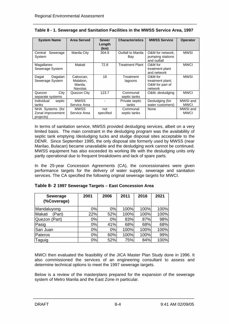
Regional Environmental Assessment
DRAFT 8-4 9:41 AM 02/09/05
Table 8 - 1. Sewerage and Sanitation Facilities in the MWSS Service Area, 1997
System Name Area Served SewerLength
(km)
Characteristics MWSS Service Operator
Central SewerageSystem
Manila City 304.9 Outfall to ManilaBay
O&M for network,pumping stationsand outfall
MWSI
MagallanesSewerage System
Makati 72.8 Treatment Plant O&M fortreatment plantand network
MWCI
Dagat DagatanSewerage System
Caloocan,Malabon,Manila,Navotas
18 Treatmentlagoons
O&M fortreatment plant;O&M for part ofnetwork
MWSI
Quezon Cityseparate systems
Quezon City 123.7 Communalseptic tanks
O&M, desludging MWCI
Individual septictanks
MWSSService Area
- Private septictanks
Desludging (forwater customers)
MWSI andMWCI
NHA Systems (forZonal improvementprojects)
MWSSService Area
notspecified
Communalseptic tanks
None MWSI andMWCI
In terms of sanitation service, MWSS provided desludging services, albeit on a verylimited basis. The main constraint in the desludging program was the availability ofseptic tank emptying /desludging tucks and sludge disposal sites acceptable to theDENR. Since September 1995, the only disposal site formerly used by MWSS (nearMarilao, Bulacan) became unavailable and the desludging work cannot be continued.MWSS equipment has also exceeded its working life with the desludging units onlypartly operational due to frequent breakdowns and lack of spare parts. In the 25-year Concession Agreements (CA), the concessionaires were givenperformance targets for the delivery of water supply, sewerage and sanitationservices. The CA specified the following original sewerage targets for MWCI. Table 8- 2 1997 Sewerage Targets – East Concession Area
Sewerage(%Coverage)
2001 2006 2011 2016 2021
Mandaluyong 0% 0% 100% 100% 100% Makati (Part) 22% 52% 100% 100% 100% Quezon (Part) 0% 0% 83% 87% 98% Pasig 0% 41% 68% 68% 68% San Juan 0% 0% 100% 100% 100% Pateros 0% 60% 100% 100% 99% Taguig 0% 52% 75% 84% 100% MWCI then evaluated the feasibility of the JICA Master Plan Study done in 1996. Italso commissioned the services of an engineering consultant to assess anddetermine technical options to meet the 1997 sewerage targets. Below is a review of the masterplans prepared for the expansion of the seweragesystem of Metro Manila and the East Zone in particular.

Regional Environmental Assessment
DRAFT 8-5 9:41 AM 02/09/05
8.3.1 JICA Master Plan Study
In 1996, the Japan International Cooperation Agency (JICA) completed a MasterPlan Study that reviewed and analyzed the problems of MWSS (high NRW, delay inexpansion, lack of groundwater supply, delay of water source augmentation, delayedprogress of the sewerage system, shortage of necessary staff, among others). TheJICA Master Plan is a comprehensive guideline to meet specific targets. It is basedon the policies of utilizing existing facilities, partnership with private sectors or BOTand the balanced and cooperative development of water supply, sewerage andsanitation services. In the area of wastewater, it envisioned 30% sewer coverage by 2015. Facilitieswere planned so that effluent quality was set at 30 mg/L Biochemical OxygenDemand (BOD). Sanitation services were supposed to be delivered, with a regularfrequency of desludging of individual septic tanks every 5-10 years. The JICA study proposed to provide wastewater services for domestic andcommercial developments. Focus was on septage management with oceandumping as the interim means of septage disposal until 2015. Septage treatmentplants (SPTP) were outlined for construction in and out of Metro Manila from 2008-2015. Installation of communal septic tanks was also recommended. The sewerage plan favored a phased approach using the principle of combinedsystems with emphasis on low construction cost. As to the treatment system, lowconstruction/maintenance treatment methods were recommended. Medium-scaleinland treatment systems (10 STPs with capacities of 48-515 MLD) were endorsedconsidering the availability of potential STP sites as well as its flexibility andinvestment savings. JICA demarcated a total of 50,692 hectares for off-sitetreatment and designated these as sewerage framework plan areas. The completion of the JICA Master Plan was closely followed by the privatization ofthe MWSS in August 1997. The action plans it proposed and the framework itsuggested were not realized since new sewerage targets were set for eachconcession area through the Concession Agreement. The CA essentially divided theMWSS service area into two distinct and independent areas, each with its own water,sewer and sanitation service requirements. Planning for expansion of the services ineach area was devolved to each concessionaire.
8.3.2 MWCI First Wastewater Strategy Plan, 2000
In the original MWSS-MWCI CA, MWCI was obliged to provide sewer services fromless than 5% in 1997 to 55% of the East Zone by the end of the concession in 2022. The CA envisioned an increase in sanitation services, followed by a decreasing trendas sewerage services were expanded. In order to formulate a plan to meet the original sewerage and sanitation targets,MWCI engaged a consultant to devise a methodical, systematic approach to ensurethat the contractual targets of the CA can be achieved. This study was concluded inJanuary 2000. The Plan identified a long-term strategy of a decentralized approach with a provisionof many small/medium treatment works in Quezon City, Pasig, Makati andMandaluyong. Isolated areas will be dealt with by using small package plants.Sewer routes will normally be under highways and almost all streets will contain asewer line. Combined sewer systems were also contemplated for dense areas where

Regional Environmental Assessment
DRAFT 8-6 9:41 AM 02/09/05
land for STPs was not available. The concept of septage and wastewater co-treatment was also presented for STPs with capacities greater than 10 MLD. The Plan also identified major issues that need to be resolved for projectimplementation. The biggest issue was the need to secure a total area of 50hectares for the STPs. Finally, implementing the Centralised Plan would result in a PhP10 increase of thewater tariff in the 2003 rate rebasing, which is simply unaffordable for thecommunity. Therefore it was essential to reassess alternatives to the JICA masterplan which wasthe basis of the original CA targets set in 1997. A review of the other ongoingprojects in the Region was therefor required.
8.4 Experience from Ongoing Projects
8.4.1 MSSP Community Sanitation Project (MCSP)
The MCSP originally involved the construction of twenty-seven (27) on-site STPs.The present facilities in the communities are unable to meet the DENR effluentquality standards and directly contribute to the pollution of inland rivers andwaterways. During project conceptualization, the communities were properly consulted andprovided project details. Memoranda of Agreement (MOA) were executed foreasements on the lots for the STPs as well as sewer charging. However, even withconsultation imminent, six out of twenty-one projects were cancelled. At the timewhen construction was about to commence, the communities reneged on the MOAsdue to the issue of sewer charging.
8.4.2 MSSP-4
One of MWSI’s commitments under MSSP is the installation of about 10,000 newsewer service connections, the cost of which would be chargeable to the loan.Within the period of October 5, 2001 to present, MWSI was able to implement 1000stub-outs for connections only. Again, sewer charges coupled with absence ofdirect benefits are the people’s main contention for not connecting.
8.4.3 Pateros Sewer System
In 2001, MWCI proposed to install a separate sewer system for the municipality ofPateros and portions of Taguig. The majority of its population belong to the low-middle income classes. The proposal was in connection with the original CA sewer targets. The proposalwas rejected by the LGU due to non-availability of land, possible traffic disruptionsand issues on capacity to pay. The LGU instead suggested that MWCI focus on theimprovement and provision of low-cost sanitation services for pocket areas in themunicipality which has little or no access to sanitation facilities.
8.5 Specific Implementation Difficulties
In past sewerage studies and project implementation, four major factors haveconsistently been identified as inhibiting the implementation of sewerage andsanitation projects, especially centralised schemes. These are:

Regional Environmental Assessment
DRAFT 8-7 9:41 AM 02/09/05
Ø lack of available and affordable land,Ø disruption during construction,Ø tariff affordability and willingness-to-pay, andØ problems in encouraging sewer connections.
8.5.1 Land Availability and Cost
The availability of land for centralised STPs is the primary limiting factor toimplementing a traditional centralised scheme. The parcels of land previouslyidentified for sewerage purposes are now occupied and/or developed or otherwiseallocated for specific purposes, such as occupied by both informal settlers andrecent government housing projects, such as NHA developments. Therefore thecritical land areas required for large STPs is now unavailable in the short to mediumterm for a centralised scheme. Depending upon the exact location, the cost for land acquisition could take up asmuch as 40% of the total project cost. The current average population density of15,617 persons/square kilometre in Metro Manila reinforces land as a limiting factorin any project. Therefore the land availability is a primary factor both in terms of actually locatingand gaining access to large tracts of lands, and then the associated financialimplications of purchasing such large blocks for such a low value use.
8.5.2 Community and Traffic Disruptions
If land for STPs were available, disruption in terms of social and economic practicesis still a major concern with centralised schemes. From experience, a water serviceconnection is forthcoming only 2 weeks after payment of a connection fee. Thistimetable includes permits processing and civil works on minor roads. The civil works required to install centralized sewerage networks would involve theexcavation of both major and minor thoroughfares. Traffic impacts, disruption andpermit processing for large sewerage systems could result in years ofimplementation and disruption. Prior experience has indicates that the LGUs willsimply not support such lengthy disruptions
8.5.3 Enforcing Sewerage Connections
Landholders located with 60 metres of a sewer are legally obliged to connect ontothat sewer. However many households simply refuse to connect.
The institutional system does not allow MWCI to force them to connect even thoughthe legislation so requires. Similarly, MWCI cannot disconnect their water as anincentive to connect or pay for the sewerage service once connected.
8.5.4 Tariffs
Another challenge will set in once a sewer system is operational. By law,households/establishments connected to a sewer system are required to pay asewer charge equivalent to 50% of the basic water tariff. Even with these charges,the cost for water and sewerage amounts to less than 5% of an average household’smonthly income. The investment cost for projects will be recovered through the tariff as provided for inthe CA. The effective tariff, in addition to the sewer charge, will however be at

Regional Environmental Assessment
DRAFT 8-8 9:41 AM 02/09/05
socially unacceptable level. Collection of fees for sewer connection will also presentproblems.
8.5.5 External Factors
External changes have also influenced the evolution of the MTSP strategy, such asthe following:Ø Tondo outfall is now not being extendedØ Forced cessation of sea dumping of septage, even after the barge loading
terminals were constructed. This DENR approved dumping was essentiallystopped by NGO and LGU pressure, rather than demonstrated environmentalimpacts
The most direct beneficiary of sewerage projects is the environment, with communityhealth a less appreciated benefit. Unlike water supply projects from whichimmediate benefits are felt directly by consumers, the advantages of sewerage andsanitation projects to the populace are unseen and indirect. Hence, convincingpeople to connect with corresponding additional sewer charges is difficult. This hasbeen the common experience of both MWCI & MWSI in implementing sewerageprojects. This also applies to the proposed implementation of extensive land application of thedewatered and dried septage/sludge into the lahar affected areas to the north of theRegion. This is positive benefit with improved soil properties resulting and highercrop yields, compared with the potential environmental impacts of ongoing seadumping. Communities have been organised to participate in the planning and design stagesto ensure that the project cost is both within their ability-to-pay and willingness-to-pay. Initial successes adopting the decentralized approach have been demonstratedin the following projects:Ø Cabanatuan City Storm Drainage ProjectØ Palawan Province Barangay Sanitation Project These strategy changes demonstrate MWCI’s commitment to reflecting socialexpectations and wants.
8.6 Rate Rebasing
Based on the socially unacceptably high charges and other factors listed above, arevised approach to the CA Targets had to be developed. In summary, based on thedifficulties discussed above, MWCI found it prudent to implement a decentralizedapproach towards providing sewerage and sanitation services. The JICA Masterplanhinted at this approach while the First Wastewater Strategy plan madedecentralization its framework. Considering the difficulties associated with implementing large centralised sewersystems, MWCI presented an alternative decentralized approach in its 2003 raterebasing submission. The new sewerage targets are as follows.

Regional Environmental Assessment
DRAFT 8-9 9:41 AM 02/09/05
Table 8 - 4. Revised Sewer and Sanitation Targets (2003)
Sewerage(%Coverage)
2001(Actual)
2006 2011 2016 2021
Mandaluyong 0% 0.5% 4% 10% 15% Makati (Part) 22% 40% 38% 28% 23% Quezon (Part) 0% 13% 20% 16% 17% Pasig 0% 9% 10% 12% 14% San Juan 0% 0% 0% 18% 41% Taguig 0% 5% 25% 26% 20%
Sanitation(%Coverage)
2006 2011 2016 2021
Quezon City 87% 80% 84% 83%Marikina 100% 100% 100% 100%Pasig 91% 90% 88% 86%Angono 100% 100% 100% 100%Antipolo 100% 100% 100% 100%Binangonan 0% 0% 100% 100%Cainta 100% 100% 100% 100%Cardona 0% 0% 100% 100%San Mateo 100% 100% 100% 100%Taytay 100% 100% 100% 100%Teresa 0% 0% 100% 100%
Another major change in the 2003 rate rebasing was the acceptance of combinedsewers. The original CA only allowed separate sewer and drainage systems. Thischange has resulted in a fundamental change in approach to wastewatermanagement in the east zone.
8.7 Project Development
The project adopts an incremental decentralized approach to improving sewerageand sanitation services. This approach recognizes that a traditional conventionalsewerage network leading to a small number of centralised STPs cannot becompleted immediately, mainly due to land limitations and the associated high cost,and the social impacts. The incremental decentralized approach adaptsconventional sewerage and sanitation projects based on the communities’ populationdistribution, existing infrastructure and the willingness to have and importantly fundthe system. In line with the objective of MSSP to assist MWSS in the development of follow-upsewerage projects, MWSS and MWCI proposed the Manila Third Sewerage Project(MTSP) for World Bank funding. The MTSP is a follow-up to the MSSP and has theultimate objective of improving sewerage and sanitation conditions in the East Zoneconcession area. Conceptualization of the MTSP components took into account the limitations andlessons learned from implementing past projects on sewerage and sanitation. Suchlimitations and lessons ruled the selection of the project area and the nature of theproject to be executed.

Regional Environmental Assessment
DRAFT 8-10 9:41 AM 02/09/05
8.7.1 Land Availability
Recognizing land as a major limitation in project implementation, MWSS and MWCIclosely investigated land availability in the areas where the MWSS set new seweragetargets. The elected representatives of the LGUs, as administrators of cities andmunicipalities, played a large role in identifying possible sites for sewerage facilities.Possible linkages with existing and future projects of different agencies such as theNational Housing Authority, the Department of Public Works and Highways, theLLDA and the PRRP were also explored.
8.7.2 Applicable Concepts
The two previous master plans pointed to the use of combined sewerage systems asthe means to expand sewer coverage at the least cost and minimum disruption. Thiswas heavily considered in conceptualizing the MTSP.
Programs to address the sanitation requirements of low-income groups and theportion of the population that has no access to basic sanitation facilities were alsoexplored.
8.7.3 Social Acceptability
Technical and financially feasible projects do not get implemented if they are sociallyunacceptable. Hence, social indicators will be obtained prior to implementation ofprojects conceived for MTSP.
8.8 Selection Criteria and Methodology
The following describes in detail how the components of MTSP were finalized.
8.8.1 Availability and Land Criteria
Both sewage and septage treatment plants require land that is preferably located farfrom residential communities to avoid nuisance that may be caused by the plant’sodour or noise emissions. This criteria should be considered without prejudice to therequirement of accessibility to tankers, for septage treatment plants. Distance andaccessibility has to be weighed against cost for transport or pumping of septage andwastewater, respectively.
The ideal site for either SPTPs or STPs should be close to main drainage channelsor receiving water bodies. It should also be free from informal settlers. It should notbe the subject of any pending legal case on ownership or jurisdiction. Precluding the above criteria, the availability of land for STPs dictates project areaselection. Aerial photographs of Metro Manila, the latest of which was taken in 1996,provides an overview of the city’s landscape. These indicate that vacant tracts withsizes ranging from 1 to 5 hectares are concentrated in Taguig.
An investigation of the present status of the identified vacant spaces reveal that theparcels have now been developed into commercial or industrial complexes. Somehave been encroached upon by informal settlers or developed into housing projectsby the LGU or the National Housing Authority (NHA).
In view of these developments, the MWSS-MWCI Project Development Teamconsulted with the administration of each LGU in the East Zone to determine projectsand locations that could be relevant to the improvement of sewerage and sanitationservices. From these consultations, MWSS-MWCI learned of the DPWH Flood

Regional Environmental Assessment
DRAFT 8-11 9:41 AM 02/09/05
Control Project in Taguig and the EPA component of the PRRP. Part of PRRP’sactivities is the conversion of the EPAs into riverparks. The management of theriverparks, from pre- to post-construction phase is in the hands of the LGUs.
The proponents also made consultations with agencies tasked to develop housingprojects (NHA, Bases Conversion Development Authority, Housing and UrbanDevelopment Coordinating Council, Home Guaranty Corporation) to determine therequired water and wastewater services for their existing and planned projects. Thisopened up the concept of sewerage projects for low- to middle-income communitiesassisted by the housing agencies. In this case, the housing authorities are willing toallocate land for sewerage purposes.
8.8.2 Catchment Area Selection
The types of sewage collection networks that will be installed through MTSP will besite specific. Combined sewer systems are proposed for highly built-up or denselypopulated areas where major or minor excavations will be socially and economicallyunacceptable. Separate sewer systems are planned for relatively undeveloped low-to middle-income areas where health impacts from sewerage or drainage projectsare at a premium.
The scope of the catchment area of each MTSP component is influenced by the sizeof available land for STP/SPTP, topography and the layout and status of existingdrainage channels.
A survey of the drainage outfalls along the stretches of the Pasig River and theMarikina River was conducted by the MWSS-MWCI Project Team in 2001 and 2004,respectively. This was plotted and superimposed on a map showing previouslyidentified vacant, feasible STP locations. The survey showed that some maindrainage outfalls are near the intended PRRP riverparks which are possible locationsof underground STPs. An in-depth analysis of the drainage systems leading to themain drainage outfalls assisted in delineating the boundaries for the Riverbanks STPcomponent.
Allowable treatment capacity per a given land area also delimits a catchment area.This, along with consideration of disruptions due to major excavation, is a significantfactor in determining the catchment areas for each of the communal septic tanksconsidered for upgrade in the Upgrade of Existing Sanitation Systems component.
The catchment area for the Taguig Sewerage System is largely influenced by thescope of the DPWH Flood Control Project whose major consideration are the riverchannels, existing drainage systems and the seasonal variation in elevations of theLaguna Lake.
8.8.3 Health/Environmental Impact
MTSP was initially formulated to arrest direct discharges of untreated wastewater towater bodies. Hence, an immediate response was the survey of drainage outfalls tothe Pasig and Marikina Rivers. However, the results of a survey conducted late2003 on some MTSP project areas show that designing the components shouldconsider prioritizing human benefits over environmental benefits, in some cases.
8.8.4 Financial and Economic Considerations
MTSP affected communities are in the low- to middle-income brackets. The impactof the sewer charges which the sewered communities will pay once the STPs

Regional Environmental Assessment
DRAFT 8-12 9:41 AM 02/09/05
operate is considered in finalizing the list of project components especially for theSanitation for Low-Income Communities component. The list has been narroweddown to two from more than twenty communities originally considered in lieu ofissues on willingness and capacity to pay for water and sewer charges.
8.9 Overview of the Manila Third Sewerage Project
The Manila Third Sewerage Project (MTSP) is a follow-up to the Manila SecondSewerage Project (MSSP) which focused on the provision of a septage managementprogram and the rehabilitation and upgrading of existing sewerage systems inMetropolitan Manila. Similar to MSSP, the objectives of the MTSP are to:Ø improve sewerage and sanitation services,Ø reduce environmental pollution, andØ lessen health hazards from wastewater in the East Zone concession area. The MTSP addresses the sewerage and sanitation sector holistically, addressing theinfrastructure requirements, information and education campaign on theirimportance, and the enhancement of the MWCI’s organizational capability to performtheir water supply, sewerage and sanitation functions. The overall MTSP has four proposed components:Ø Sewerage System and Treatment - Involved the expansion of sewer network and
treatment plants at strategic locations within the East-concession areaØ Septage Management – large scale septic tank de-sludging program on the
western section of the service area, namely: Mandaluyong, part of Makati andQuezon City, Pasig, San Juan, Taguig, Marikina, and Pateros
Ø Technical Assistance – will cater to the need for information and education on thegood practices, infrastructure, and benefits from proper sewage management
However this REA predominantly deals with the first two components of the MTSP;sewerage systems and treatment, and septage management. These twocomponents will be implemented through six projects listed below:Ø Taguig Sewerage System;Ø Riverbanks Sewage Treatment Plants;Ø Septage Treatment Plants;Ø Sanitation for Low Income Communities;Ø Quezon City - Marikina Sewerage System; andØ Upgrade of Existing Sanitation System
As part of all six components, a supporting Sludge/Septage disposal and reuseprogram is proposed.

Regional Environmental Assessment
DRAFT 9-1 9:42 AM 02/09/05
9 MTSP Integration into Other Regional Projects
9.1 Existing Projects
9.1.1 Manila Second Sewerage Project (MSSP)
In 1980, the World Bank financed the Manila Sewerage and Sanitation Project along withthe Asian Development Bank. The start of the project coincided with the onset ofeconomic difficulties in the Philippines so that some components were not completed andothers failed to have the anticipated impact. In 1996, with the improved economic situation in the Philippines, the World Bankresumed its assistance to the MWSS for the improvement of the general environmentalconditions in Metro Manila. The US$57 million Manila Second Sewerage Project (MSSP)was finalized in June 1996. The MSSP has the ultimate objectives of:Ø reducing the pollution of Metro Manila waterways and Manila Bay,Ø reducing the health hazards associated with human exposure to sewage in Metro
Manila, andØ establishing a gradual low-cost improvement of sewerage services in Metro Manila by
expanding MWSS’ septage management program. The MSSP focuses on theprovision of a septage management program and a rehabilitation/upgrading ofexisting sewerage systems.
Notable project components include the construction of package STPs. These components relate directly to the proposed MTSP components.
9.1.2 Pasig River Rehabilitation Project – Sanitation Component
The Sanitation Component of the Pasig River Rehabilitation Project (PRRP) is part of aUS$175 million ADB policy and investment loan aimed at promoting policy reforms andphysical improvements to enhance the water quality of the Pasig River, its tributaries andesteros, to Class C (define) standards by 2014. Project components include:Ø establishment and development of 10-meter wide environmental preservation areas
(EPA) along the riverbanks,Ø upgrade of infrastructure and the provision of municipal services and facilities in
urban renewal areas (URA) adjacent to the EPAs,Ø elimination of illegal dumping of municipal solid waste into the river system andØ the Sanitation Component. The Sanitation Component will involve the provision of septic tank maintenance servicesthrough the procurement of thirty-six (36) vacuum tankers and the construction of a 600-m3 septage treatment plant (SPTP) to reduce the volume of untreated sewage beingdischarged into the Pasig River. With this project, approximately 37,000 septic tanks will be emptied annually. Thisamounts to a reduction in BOD loading of 16 tons per day. The SPTP is expected to operate in 2006. Bidding for the vacuum tankers is ongoing.The SPTP will serve the eastern areas of the East Zone.

Regional Environmental Assessment
DRAFT 9-2 9:42 AM 02/09/05
These projects are both supporting the theme of improving sanitation and decentralisedSTP systems, as per the proposed MTSP strategy.
9.2 MWCI Master Plan
It is important that the proposed MTSP integrates sensibly into the Master Plan. The Master Plan investigates the development of sewerage (combined and/or separate)for 11 catchments in the East zone. The catchments were defined based on existingdrainage systems and hydraulics. There will be a mix of combined sewers whereappropriate, leading into separate trunk sewers where required. Catchments may be grouped to achieve improved economies of scale. Each catchmentwill eventually have an STP treating the catchment flows for discharge. The present MTSP satisfies the revised Concession Agreement targets for seweragecoverage, but the Master Plan looks at the ultimate scheme, and thereby demonstratesthat the MTSP integrates sensibly into this longer term overall strategy. If the ecological and water quality improvements are not achieved ultimately, then the 11STPs can be partially phased out and converted to pump stations delivering thecatchment wastewater to a smaller number of STPs. These larger STPs would producea higher quality effluent, such as nutrient removal plants, to ensure compliance with theappropriate AO and water quality criteria of the rime. A total of five sewerage alternatives were developed, three for separate seweragesystems and two for combined sewerage systems. These alternatives are listed below:
1) Alternative 1 – 1977 Concession Agreement Target Service Levels andImplementation Schedule (Separate Sewerage Systems in Eleven Catchment Areas)
2) Alternative 2 – 1977 Concession Agreement Target Service Levels with ExtendedImplementation Schedule (Separate Sewerage Systems in Eleven Catchment Areas)
3) Alternative 3 – 1997 Concession Agreement Target Service Levels with ExtendedImplementation Schedule (Separate Sewerage Systems in Seven Catchment Areas)
4) Alternative 4 – 1997 Concession Agreement Service Area with ExtendedImplementation Schedule (Combined Sewerage Systems in Eleven CatchmentAreas)
5) Alternative 5 – 1997 Concession Areement Service Area with ExtendedImplementation Schedule (Combined Sewerage Systems in Seven CatchmentAreas)
9.2.1 Reasons for Selection of Alternatives
The five alternatives were selected to allow comparisons of different systems to assessthe effect of variations on cost, tariff impact/affordability, technical constraints andbenefits. The comparisons that can be made include:
1) extended implementation schedule and deferred capital investments, to reduce theNPV and tariff impact.
2) comparison of implementation of separate sewerage systems versus combinedsewerage systems, to reduce the NPV, tariff impact and technical constraints.

Regional Environmental Assessment
DRAFT 9-3 9:42 AM 02/09/05
3) reduced number of STPs by joining adjacent catchment areas in cases where STPsites are located relatively close together, sewage can be transferred from onecatchment area to another relatively easily, limited space is available for constructionof an STP, or the cost of land is relatively high; to reduce the NPV, tariff impact andtechnical constraints.
9.2.2 Description of Variations Between Alternatives
The first alternative is based on the system requirements and implementation schedule tomeet the 1997 Concession Agreement service targets, utilizing eleven catchment areaswith separate sewer systems and eleven STPs.
The second alternative is the same system as that for the first alternative, but with anextended implementation schedule that allows completion of construction to occur in2025, whereas the implementation schedule has most of the construction completed by2015 and all of the construction completed by 2020 with the exception of the final houseconnections.
In the third alternative, the number of catchment areas is reduced from eleven to sevenwith separate sewer systems and seven STPs. In this alternative two adjacent catchmentareas were joined together, with the sewage from one catchment area transferred to anadjacent catchment area. QC East was joined with QC North, QC South was joined withQC Central, and Makati was joined with Taguig West because the STP sites for theseadjacent catchment areas are located relatively closely together, or the sewage could beeasily transferred from one catchment area to the other. Pasig South was combined withPasig North, mainly because of the relatively high cost of the system that would servePasig North, due mainly to the high cost of land and low population density in PasigNorth. The implementation schedule for the third alternative allows for completion ofconstruction to occur in 2025.
The fourth alternative is based on the system requirements for combined seweragesystems covering the same service area as the first three alternatives, utilizing elevencatchments areas and eleven STPs. The implementation schedule for the fourthalternative allows for completion of construction to occur in 2025.
The fifth alternative is similar to the third alternative in that the number of catchmentareas and STPs are reduced from eleven to seven. However, the fifth alternative utilizescombined sewers, rather than separate sewers that are utilized in the third alternative.The implementation schedule for the fifth alternative also allows for completion ofconstruction to occur in 2025.
9.2.3 Comparisons Between Specific Alternatives
To evaluate the effects of differences between the alternatives on cost, tariffimpact/affordability, technical constraints and benefits; comparisons can be madebetween specific alternatives. The comparisons between specific alternatives are listedbelow:
1) Alternatives 1 and 2 allow comparison of same separate sewerage systems (11separate sewer systems, 11 STPs) with an extended implementation schedule.
2) Alternatives 2 and 4 allow comparison of separate and combined sewerage systems(11 separate or combined sewer systems, 11 STPs).
3) Alternatives 3 and 5 allow comparison of separate and combined sewerage systems(7 separate or combined sewer systems, 7 STPs).

Regional Environmental Assessment
DRAFT 9-4 9:42 AM 02/09/05
4) Alternatives 2 and 3 allow comparison of reduced number of STPs for separatesewerage systems (11 separate sewer systems, 11 STPs; versus 7 separate sewersystems, 7 STPs).
5) Alternatives 4 and 5 allow comparison of reduced number of STPs for combinedsewerage systems (11 combined sewer systems, 11 STPs; versus 7 combinedsewer systems, 7 STPs).
9.2.4 Summary of Alternatives Evaluation
The five alternatives were evaluated by identification of technical issues and constraints;and by comparing the relative costs, implementability and benefits that would be realizedby implementation. In addition, integration of the proposed MTSP components into theexpanded sewerage system was considered. The economic and financial viability of thealternatives were analyzed. A summary of the comparison of alternatives and the resultsof the analysis of financial and economic viability of the alternatives is presented below.
The water quality in the major rivers will be the same regardless of whether separatesewer systems or combined sewer systems are developed. Separate sewers willsignificantly improve the water quality in creeks and drains, while combined sewers willprovide little improvement in the creeks and drains.
Water quality projections show that if either the combined or separate sewerage systemsare implemented in the area covered by all 11 catchment areas, BODs in Marikina Riverand Pasig River will be in the 10-20 mg/L range, more than the Class C target of 10mg/L, but still less than the projected 20-30 mg/L BOD in parts of Pasig River if nointerventions are made. The San Juan River will remain more polluted than the twoaforementioned rivers, as the projected BOD is in the range 20-30 mg/L.
It is noted however that the water quality model assumes no sewerage interventions inthe west concession area, part of which drains to the San Juan River basin. It is alsobetter than the projected 40-50 mg/L BOD in a no intervention scenario.
The following conclusions are based on the comparative evaluation of the five seweragesystem alternatives:
Ø Combined sewer systems can be implemented for a significantly lower capital costthan separate sewer systems, due to elimination of laterals and house connections.
Ø Combined sewer systems are relatively easier to implement than separate sewersystems, due to elimination of laterals and house connections.
Ø Combined sewer systems can be constructed in a shorter time period than separatesewer systems, due to elimination of laterals and house connections.
Ø Combined sewer systems would, during construction, reduce traffic congestion,business financial losses, air pollution and unnecessary fuel consumption due toidling in traffic; compared to separate sewer systems.
Ø The required tariff increment for combined sewer systems is less than half that forseparate sewer systems.
Ø Improvements in water quality in the major rivers would be the same with eithercombined or separate sewer systems.

Regional Environmental Assessment
DRAFT 9-5 9:42 AM 02/09/05
Table 9.1 Comparison of Alternatives
Service Targets Alternative 1 Alternative 2 Alternative 3 Alternative 4 Alternative 5
Projected 2025 SewerageService Population 3,238,096 3,238,096
3,238,096 3,210,672 3,210,672
Projected 2025 Sanitation(Septage Collection &Treatment) Service Population
4,436,402 4,436,402 4,436,402 7,642,597 7,642,597
Projected 2025 Volume ofSewage Collection, in m3/day 1,050,077 1,050,077 1,050,077 1,110,897 1,110,897
Projected 2025 Volume ofSeptage Collection, in m3/day 1,800 1,800 1,800 3,095 3095
Additional InvestmentRequirements
Investment Requirements(Ps million) 80,812 80,812 77,985 29,448 29,089
Required New STPs 11 11 7 11 7
EIRR (Ps million) - 0.83 % - 2.05 % - 1.78 % 9.97 % 11.79 %
EIRR (21,531) (9,807) (8,420) (1,265) (726)
Tariff Impact (Ps/m3) 15.64 9.77 9.16 4.32 4.06

Regional Environmental Assessment
DRAFT 9-6 9:42 AM 02/09/05
Ø The calculated Economic Internal Rate of Return (EIRR) values for combinedsewer alternatives range from 10 – 12%, while those for separate sewersystems are negative; indicating that separate sewer systems are noteconomically viable.
Ø Implementation of separate sewer systems is not feasible; due to the high tariffimpact which is considered to be unaffordable and the unacceptable disruptionof traffic and potential for construction delays, given the large quantities ofsewers (approximately 2,100 km of sewers) that would be required.
Ø Sewer systems in catchment areas can be implemented for a significantly lowercapital cost than sewer systems in eleven catchment areas, due to elimination offour STPs.
Ø Sewer systems in seven catchment areas would be relatively easier toimplement and would reduce land availability constraint, compared to sewersystems in eleven catchment areas.
Ø The required tariff increment for sewer systems in seven catchment areas is lessthan that for sewer systems in eleven catchment areas.
Ø The sewer systems in seven catchment areas or eleven catchment areas can beimplemented independently in sequential phases.
Ø Alternative 5 with combined sewers in seven catchment areas has the lowestNPV, the lowest tariff impact, the highest EIRR, and is the relatively easiestalternative to implement.
Ø The EIRR for Alternative 5 is 11.79%, which is slightly less than the 15% socialdiscount rate adopted by NEDA.
Ø The incremental tariff increase for Alternative 5 for implementation in 2008,considering costs expressed in 2004 prices, is estimated to be 4.06 Ps/m3. Withthis increment the all-inclusive tariff would be increased from 18.85 Ps/m3 to24.17 Ps/m3, including cost recovery for MTSP components and the Master Planfacilities. This represents a 28% in the tariff.
Ø With the tariff increase to 24.17 Ps/m3, the average monthly water bill would bePs 725.25/month, which is an increase of approximately Ps 160/month.
Ø With the increased tariff, the average monthly water bill would representapproximately 2.5% of the average monthly income for the NCR and 3.82% ofthe median monthly income for the NCR. These percentages are less than themaximum of 5% of the average monthly income that is used to determineaffordability.
Ø Following careful consideration of the alternatives, as well as the technical andfinancial constraints, Alternative 5 is the most feasible alternative.
This indicates that the proposed MTSP will sensibly integrate with the recommendedMaster Plan strategy, and can be considered as the first phase of implementing thismaster plan into the future.

Regional Environmental Assessment
DRAFT 10-1 9:42 AM 02/09/05
10 The Project Components The following section describes the project development plans of the MTSP. Projectdetails were taken from the Feasibility Study Report of the Manila Third SewerageProject (March, 2004) prepared by Nipon Jogesuido Sekkei Co. Lts (NJS) inassociation with CEST Inc. of the Philippines and Mott Macdonald Ltd of the UnitedKingdom (UK). Figure 10.1 shows the location of the six components.
10.1 Component 1: Taguig Sewerage System
10.1.1 Options Background
Taguig is a low- to middle-income municipality with an area of 47.88 km2 and apopulation of about 467,000 as of 2000. It is traversed by 4 creeks that lead to theLaguna de Bay on the municipality’s southeastern boundary. The municipality’sgeneral topography slopes towards the lake. Available parcels of land are alsoconcentrated near the lakeshore. Designs for sewerage projects draws on thesecharacteristics.
Taguig experiences floods lasting for at least three months when the Laguna de Bayswells during rainy season. In 1988, the Department of Public Works and Highwayswith the assistance of JICA conducted a study for the control of flooding in themunicipality and nearby affected areas. The study led to the proposed LagunaLakeshore Dike Project which consists of the construction of four (4) drainage/floodretention ponds adjacent to the Laguna de Bay and an 10 kilometre earth dike.Floodwater will be retained and then continuously pumped out of the ponds duringheavy storm events. The feasibility study involved a scheme where the ponds maybe used for wastewater treatment during dry season.
Originally, this component considered using the ponds as oxidation ponds for sixmonths of the year. Off line STPs were intended in 2014 to coincide with increaseddevelopment in the area. This option involves risks on sludge accumulation,compliance to effluent quality standards and major dependencies on the operation ofthe pumping stations and floodgates. The feasibility study for this component alsoevaluated combined and separate sewer systems for the service area. A combinedsystem with drainage upgrading evolved as the more feasible option.
To reduce the risks associated with the use of the ponds as on line treatment, off lineprimary treatment and the use of the ponds for polishing was explored. Although thisoption would entail acquisition of significant tracts of land, an in-depth analysis oftechnical and financial factors shows this to be the more practicable alternative torealize the benefits intended by this component.
10.1.2 Component Summary
This component is designed to reduce the organic load currently discharged toLaguna Lake from the Hagonoy, Taguig, Labasan, and Tapayan Rivers that drainthe Taguig and Taytay Municipalities. The reduction of pollution will be achievedthrough regional treatment facilities constructed within the flood retention pondsserving each of the four drainage basins.

Regional Environmental Assessment
DRAFT 10-2 9:42 AM 02/09/05
The Taguig Sewerage System component involves the development of four (4)drainage/flood retention ponds being constructed by the Department of Public Worksand Highways (DPWH) into Sewage Treatment Plants that will treat combinedsewerage before discharging into the Laguna Lake. The population in the catchments will increase from 198,000 now to 420,000 by2015, and 730,000 by 2025. DPWH supports to the use of the ponds for sewage treatment, provided that thepond operation remains the responsibility of the DPWH tasked with flood control (tobe transferred to the Metro Manila Development Authority in the future). Themaintenance of the pond water level and the timing of the opening of the floodgateswill be DPWH authority and not by MWCI. Operation and maintenance of thesewage treatment equipment would be the responsibility of the MWCI, subject to theover-riding instructions of the DPWH on the need to revert the use of the ponds forflood control. This arrangement implies that during the wet season the ponds cannot be efficientlyused for sewage treatment because they will need to be emptied to contain futurerunoff during storm events. The operational decision will be made by the DPWHwhen sewage treatment will cease and when it can recommence. To safeguard both parties, it is an essential to develop and agree on an operatingprocedure that will establish each party’s responsibilities, identify potential problemsand risks, and develop solutions or strategies. This will be initiated by the MWCI.Issues such as retaining a set volume of water/sewage within the ponds whenlowered for flood purposes will allow the requisite bacterial and algal populationseeds to more rapidly repopulate the ponds when operating as STP ponds again. The retention ponds will be operated as single stage stabilization ponds (facultative)with no compartmentalization or deepening of the original flood retention basins.The proposed facility will remove on average 75% of the organic load present in thefeed wastewater at the time of commissioning, dropping to 60% to 73% in 2015. Forthe four systems, this would amount to about 2,822 t BOD/y in 2015, over a periodof about six months during the dry period when the system operates as a treatmentplant. The reduced treatment efficiency in the wet season is not critical as there arehigh diluting and advecting flows in the main receiving water bodies such as LagunaLake and the Pasig River in the wet season. It is proposed to include a primary treatment stage for the combined flows prior toentering the lagoon system. The primary treatment plants will consist of grit removalprior to a convention primary treatment or settling tank. Following the primarysettling tank, effluent will flow into the flood lagoons for passive treatment. Thelagoon effluent will then be disinfected with liquid chlorine prior to release into theinflow channel leading to Laguna Lake. The chlorine may not be required to meetthe specified Coliform levels at all times, and the dosage rate will be minimised tolimit the formation of Trihalomethanes from the reaction of chlorine on the algae thatwill form in the treatment lagoons. Because of the forced intermittent operation and the low solids content of theincoming combined flow, no permanent measures are considered necessary to dealwith the possibility of sludge build-up in the lagoons. Monitoring of the treatmentefficiency in the initial years will validate these conditions.

Regional Environmental Assessment
DRAFT 10-3 9:42 AM 02/09/05
Community surveys conducted under previous projects indicated that the majorcomplaint of the residents was related to blocked drains. This issue resurfacedduring the public consultations. Converting the street drains to a combinedsewerage system by covering open drains and replacing those that needed repairswould reduce the risk of contact with sewage and would improve the localenvironment. It is acknowledged that this concept may not consistently achieve the requiredeffluent standard in later years, but it can be argued that in any case intermittenttreatment of wastewater from a population that is expected to grow from 197,000 inyear 2000 to some 732,000 people by the end of the planning period is not a validsolution. Alternative option of continuous year-round treatment should be seriouslyconsidered from year 2015 onwards, preferably in conjunction with the stand-alonetreatment facilities planned to serve the new developments behind the lakeshoredike. The opportunity should then also be taken to improve the drainage system byintercepting the sewage before it enters the rivers and creeks along the base of thehill, thereby reducing the infiltration.
10.2 Component 2: Riverbanks Sewage Treatment Plants
10.2.1 Options Background
The base case scenario for massive sewer coverage in the East Zone looks atseparate sewer systems as the mode for expansion. Huge costs and the constraintspreviously discussed discourages implementation of networks of separate sewersand directs attention to the development of combined systems, taking advantage ofexisting drainage networks.
In Metro Manila, jurisdiction over drainage systems varies depending on size,location and ownership, if installed as sponsored projects. There is no masterdrainage layout plan that catalogues the existing drainage systems. Physicalinspection is the only way to determine catchment boundaries and volumes. Hence,the project proponents undertook intensive surveys on land and via river systems toidentify drainage outfalls of significant flows, determine catchment boundaries andrelate available land to the location of major outfalls.
Finally, this component was packaged to involve the construction of three (3)underground STPs along the riverbanks of Pasig River, located in Makati,Mandaluyong, and Pasig. Sewage will be intercepted and collected from existingdrainage lines in these areas for treatment before discharge to Pasig River.Rehabilitation and upgrade of the drainage outfalls and lines will be included in theproject.
The original coverage area of this component spans an area of 0.296 km2. Throughtime and with the goals of cost efficiency and maximizing coverage, the proponentshave expanded the coverage area to 1.81 km2.
Recent developments and major changes involve the Makati (Poblacion) system forwhich the STP will no longer be co-located beneath an existing park. The Poblacionsystem will involve the construction of a STP over a portion of the flood retentionpond of the Metropolitan Manila Development Authority (MMDA) adjacent to thePasig River. This, along with flows from the original catchment of the Poblacionsystem which will be pumped to pond, will be treated at the elevated STP beforedischarge to the Pasig River.

Regional Environmental Assessment
DRAFT 10-4 9:42 AM 02/09/05
10.2.2 Component Summary
The Riverbanks Sewage Treatment Plants (STPs) component will establish threeSTPs in Pasig City, Makati City and Mandaluyong City to intercept combinedwastewater and storm water in existing drainage outlets and treat the collectedcombined flow in underground sewage treatment plants prior to discharge to thePasig River. The Makati City STP (Poblacion STP) will now be located within aDPWH flood control pond and constructed as an elevated facility. The totalpopulation served will be some 30,700 persons in 2025. Virtually all the collection drains in the three catchments are covered. So there willbe only limited health benefit in this component associated with disinfecting thetreated effluent which presently enters the Pasig River with elevated coliform counts. A series of interception sewers will be constructed to collect the flow in the variousexisting drains prior to entering the Pasig River. The interception sewer will thenconvey the combined flow from the drains into the three STPs. If open space is ultimately determined to be too limited at any of the treatmentfacilities, the STPs will be constructed underground, beneath local recreation areascurrently occupied by basketball courts and sitting-out areas alongside the riverbank.The proposed treatment process at all three (3) sites is based on the SequencingBatch Reactor (SBR) process. The process includes the following process stages,excluding the usual pumping and lift stations:Ø screening and grit removal,Ø flow balancing,Ø SBR reactor tanks,Ø disinfection contact tanks andØ sludge thickening. These STPs are projected to reduce the BOD load discharged to the (Pasig) river bya combined total of about 440 t/y. Since space is restricted at all riverbank STP sites, biological sludge will not bedewatered on site unless adjacent private properties can be acquired. Therefore itwill be necessary to remove the biological sludge by vacuum tanker. The accessroads are narrow in these locations except the Makati Poblacion site, and will becumbersome for large vacuum tanker to approach the STP sites. A small-capacitytanker (5 m3) would be needed to service the Pasig and Mandaluyong sites but willhave to make a total of six visits a day. The Makati Poblacion site has good accessand a 10 cubic metre tank can easily access the site. Final dewatering of the sludgecan be done at the proposed southern Septage Treatment Plant in Taguig beforetransporting to lahar-affected areas in Pampanga.
10.3 Component 3: Septage Treatment Plants
10.3.1 Options Background
This project is essential in providing sanitation services and proper septage disposal.In 2002, MWCI proposed the construction of the following SPTPs to serve areas onRizal on the assumption that the SPTP under the ADB-assisted Pasig RiverRehabilitation Project (PRRP) will be located in Taguig to serve majority of MetroManila.
Table 10- 4. Originally Planned SPTPs

Regional Environmental Assessment
DRAFT 10-5 9:42 AM 02/09/05
Location Service Area
San Mateo, Rizal Quezon City, San Mateo, Marikina and Rodriguez
Taytay, Rizal Taytay, Cainta, Antipolo and Teresa
Binangonan, Rizal Angono, Binangonan, Cardona, Morong, and Baras
This proposal was rendered useless when it was agreed that the PRRP STP belocated in Antipolo to serve Rizal and portions of Metro Manila. Metro Manila’sdemand for sanitation services was projected to grow from 1019 m3/day in 2006 to1400 m3/day in 2021. This dictated the need for STP(s) to augment the PRRP STPtreatment capacity. Location, in terms of cost and strategic operation, directed theeventual plan to construct two STPs with capacities of 586 m3/day and 815 m3/day inPayatas, Quezon City (North STP) and FTI Complex in Taguig (South STP),respectively. A recent change to the land availability at the Payatas site has meantan alternative site in San Mateo is now the subject of negotiation.
The North STP will be located mixed-use area of piggeries, metal works andresidential developments; the South STP will be located in a mixed-use industrialcomplex.
10.3.2 Component Summary
The objective of this component is to collect and treat septage from household septictanks in the more westerly parts of the East Concession Zone which includes:Mandaluyong, part of Makati, part of Quezon City, Pasig, San Juan, Taguig,Marikina, and Pateros. Septage will be collected and transported using vacuum ordesludging tankers. In order to optimize haulage distances, more than one SeptageTreatment Plant (SPTP) will be developed. Using the year 2025 population projections in the service area and assuming thatabout 80% of the 783,000 Individual Septic Tanks will be desludged at an averagevolume of 6 m3 per IST, it is estimated that 1,681 m3/day of septage will be collectedand require treatment. The SPTP sites are at Payatas in Quezon City (North) andthe Industrial Area of the Food Terminal Inc. (FTI) Complex in Taguig (South). Landrequirements for the North and South SPTPs are 7,000 m2 and 10,000 m2
respectively. The Payatas SPTP in Quezon City will serve the northern sub-area, covering thecities of Quezon and Marikina, and the town of San Juan. The capacity is 586 m3 /day. The SPTP at the FTI Complex will serve both the central and south sub-areas,covering the cities of Pasig, Mandaluyong, and Makati, and the towns of Pateros andTaguig. The capacity is 814 m3 / day. The eastern cities will be serviced by the PRRC SPTP at Antipolo. The disposal options for stabilized and dewatered septage will dictate the level oftreatment required at the septage treatment plant. The disposal options are:Ø reclamation of non-productive lahar-affected areas presently fallow,Ø disposal to solid waste (garbage) controlled dumps and landfills, and

Regional Environmental Assessment
DRAFT 10-6 9:42 AM 02/09/05
Ø agricultural use as a soil conditioner/fertilizer for active agricultural land The third option is different from the first two options in that the discharge standardsare more severe (the septage will be applied to land currently used for farming) andsome degree of septage stabilization will be necessary before disposal. Thereforethe SPTPs will be designed on the basis of the first two disposal options, since bothdisposal pathways are readily available. There is a demonstrated demand forreclamation of the lahar areas and since additional septage stabilization is notrequired, there will be savings in septage treatment costs. If at some future time thedemand for dewatered septage as an agricultural land conditioner increase, limestabilization facilities could easily be provided within the septage treatment plants. The treatment capacity of the proposed SPTPs account for the capacities of twoSPTPs currently being developed in Metro Manila – the 250 m3/day capacity plant inDagat-Dagatan being implemented by Maynilad Water Services Inc. (MWSI) underthe Manila Second Sewerage Project (MSSP) and the 600 m3/day pilot septagetreatment plant being tendered by PRRC. The SPTPs will have the following components:Ø Screening and degrittingØ Septage storageØ Dewatering system
- Screw press equipment- Coagulant conditioning tank- Coagulant dosing/mixing equipment- Filtrate return pumps
Ø Filtrate Treatment Plant Substantial environmental and health benefits (health benefits alone of about PhP34.5 million a year) will accrue as a result of the following:Ø a reduction in the frequency of overflowing septic tanksØ reduced health risk to the community from contact with sullage in any open
drains, as the sullage will present a lower health risk when discharging fromregularly desludged ISTs,
Ø the elimination of the indiscriminate dumping of raw septage by privatecontractors, and
Ø the pollution load on the environment will be reduced by about 2378 t BOD/y.
10.4 Component 4: Low Income Sewerage System
10.4.1 Options Background
This component originally involved the construction of Communal Septic Tanks orWwTPs, as appropriate, and shallow, small-diameter sewer lines to serve some 24low-income communities in the East Zone which have inadequate sanitationfacilities.
The list has been narrowed down to two (Pinagsama, Taguig and East Bank, Taytay)reflecting local issues on willingness and capacity to pay for water and sewercharges. STPs will be constructed for these communities using combined systemswith drainage upgrading. The feasibility of separate sewer systems was alsoconsidered and found impractical and expensive.

Regional Environmental Assessment
DRAFT 10-7 9:42 AM 02/09/05
10.4.2 Component Summary
This component aims to improve the inadequate sanitation facilities in low-incomecommunities through the provision of shallow, small-diameter sewers and communalseptic tanks (CST). The low-income communities identified for the upgrade ofsanitation facilities include a cluster of communities in Taguig bordering the heavilypolluted Pinagsama Creek and the Manggahan Floodway East Bank community The Taguig low-income scheme is planned for five contiguous communitiesalongside the Pinagsama Creek, which is heavily polluted with sewage. Thesecommunities are the Pinagsama Village Phases 1, 2A, 2B, and the AFP/PNP VillagePhase 2, all located in Barangay Western Bicutan, and parts of Signal Village,Barangay Signal. With a population of 41,554 and an area of 67.8 hectares, theaverage population density can be classed as medium to high at 613 persons/ha.The projected 2025 population is about 46,000 persons. The older Pinagsama Village Phase 1 catchment is drained by line open channelsconstructed along sides of the streets, whereas the other more recent developmentsare served predominantly by buried concrete pipes. As such, the street drains of thePinagsama Village Phase 1 needs upgrading and it is estimated that about 7.5 kmopen drain needs new concrete covers. Treatment will be provided in an SBR facility to be constructed on National HousingAuthority land, the sewage being intercepted from the existing outfalls to the creekand pumped to the plant site. Because the site is sufficiently large, the STP willinclude sludge dewatering. Otherwise the process is the same as described for theRiverbank STPs. The treatment plant will require 2,000 m2. The operation of the facility will remove from 464 t/y BOD on commissioning in year2008, to 565 t/y BOD in 2015, and to 648 t/y BOD in 2025. The Manggahan Floodway East Bank low-income area lies along a narrow strip ofland, 120 to 150 meters wide, bordering the East Bank Road. It consists of sevenNational Housing Authority (NHA) communities, namely: PFCI, Kabisig, SanFrancisco, Anak-Pawis, Exodus, Samagta/Dimagta and Genesis. With a populationof almost 55,000, the communities cover an area that stretches some 4.5 kilometresfrom the boundary of Pasig City and Cainta in the north to Bangiad Road in thesouth. The land slopes down towards an unnamed creek at the back that runsparallel to the communities before discharging into Laguna Lake. Wastewater fromthe area flow through street drains that discharge to this creek. This Component also includes the following drainage rehabilitation works:Ø Provision of new covers 41,320 mØ Relining and covering existing drains 11,640 mØ Construction of new street drains 7,760 m The scheme will then intercept the flows by means of sewer and lift stationsalongside the creek and treat the wastewater in an oxidation ditch facility to belocated on vacant land on the east bank of the creek at the downstream end close toLaguna Lake. The STP will include sludge dewatering because of sufficient landavailability. The land requirement for the STP is 2,500 m2 for the combinedsewerage option. The STP will include the following elements:Ø Screening and grit removal,

Regional Environmental Assessment
DRAFT 10-8 9:42 AM 02/09/05
Ø Oxidation ditch format biological reactorsØ Secondary clarifiers (no primary clarifier is required)Ø DisinfectionØ Sludge thickening and dewatering The operation of the facility will remove 1073 t/y BOD on commissioning in year2008, 1307 t/y BOD in 2015, and 1499 t/y BOD in 2025, from the design populationof 60,270 persons. In addition there are substantial health benefits to be achieved by isolating thecommunity from sullage presently flowing in open drains.
10.5 Component 5: Quezon City – Marikina Sewerage System
10.5.1 Options Background
The development of this component used the same principles as the RiverbanksSTPs component.
This component will utilize portions of the legal easement for Marikina River. Maindrainage collector pipes which collect combined sewage and drainage fromcommunities in Quezon City and Marikina will be connected to a STP to beconstructed to treat the dry weather drainage/sewage flow.
Initially this component considered serving only the Sitio Olandes and Blue Ridgecommunities. The coverage area of this component has also been improved overtime.
10.5.2 Component Summary
This component is located on the west bank of the Marikina River and coverssections of Quezon City and Marikina City. The total catchment area under thiscomponent comprises five distinct drainage basins with an aggregate area of 132.3hectares. The catchment slopes towards the Marikina River in the east fromKatipunan Avenue, the elevation falling from about 49 m to 10 m above mean sealevel. The south Camp Atienza catchment covers an area of 28.5 ha and comprises partsof St. Ignatius, Blue Ridge A and Blue Ridge B subdivisions, part of Barangay Libisand Camp Atienza. The central catchment area covers 23.9 ha that includes themajor part of Barangays Blueridge A and B while the north influence area comprisespart of Barangays Blueridge A and B and part of Cinco Hermanos Subdivision withinBarangay Industrial Valley, Marikina City. The Industrial Valley catchment comprises the Industrial Valley, Don Juan and MonteVista subdivisions in Marikina City and the Alta Vista subdivision in Quezon City andcovers a total area of 60.2 ha. The area is located east of the Camp Atienza andSitio Olandes catchments, bounded on the north by the C-5 Highway and on the eastby the Marcos Highway. The Sitio Olandes low-income community within Barangay Industrial Valley inMarikina City is bounded by the Marikina River to the east, the Quezon Cityboundary to the south and west, and the intersection of Marikina Diversion Road andA. Bonifacio Avenue to the north.

Regional Environmental Assessment
DRAFT 10-9 9:42 AM 02/09/05
Dry weather sewage flows will be intercepted from the existing combined sullage andstormwater drains by means of interceptor sewers adjacent to the river bank. Theexisting outfalls from the Camp Atienza catchment discharging to the Marikina Riverwill be intercepted and conveyed to the STP through force mains parallel to the river.Sewage from the Industrial Valley will be pumped by means of a low lift station intothe head of a 710-m long interceptor sewer which will also collect the dry weatherflows from the four existing outfalls currently discharging sewage from Sitio Olandesdirect to the Marikina River. The proposed STP will be located in a grassed area between Sitio Olandes and theMarikina River. The total STP site area is about 3,280 m2. The recommended treatment process is the Sequencing Batch Reactor (SBR),which can be configured to fit the available area at the site. The process includes thefollowing process stages, excluding the usual pumping and lift stations:Ø screening and grit removal,Ø flow balancing,Ø SBR reactor tanks,Ø disinfection contact tanks,Ø sludge thickening andØ sludge dewatering The STP may possibly be covered for aesthetic reasons but not constructedunderground. The STP will be designed for an average dry weather flow of 10,358m3/day. The STP is estimated to remove 407 t/y of BOD on commissioning in 2007,increasing to 498 t/y BOD in 2015, and to 630 t/y in 2025.
10.6 Component 6: Upgrade of Existing Sanitation System
10.6.1 Options Background
Quezon City has the biggest land area among the cities and municipalities in MetroManila. Aside from the cities of Manila and Makati, parts of Quezon City has existingsewerage systems consisting of sewer lines connected to communal septic tanks(CST). These 30 septic tanks were constructed in the 1950’s and turned over toMWSS for operation and maintenance. These facilities do not meet regulatorystandards on effluent quality.
The original intent of this component was to upgrade the CSTs to STPs. Ten of the30 CSTs are already being upgraded under the MSSP. This will ensure compliancewith environmental standards for wastewater effluent.
Only five CSTs were originally identified for upgrading under MTSP in view ofaccessibility and ownership issues. Some of the lots on which the CSTs are locatedare occupied by informal settlers or are now privately owned owing to circumstancesbeyond MWSS control.
As a result of the discussions with the World Bank representatives and technicalexperts, this component has been improved and will now adopt a regional schemewhere a number of CSTs will be linked and directed to one WwTP. Additional sewerlines is planned for installation in areas that could be connected to the existing sewernetworks. From 5 CSTs, this component will now include treatment for thewastewater from 7 CSTs and adjacent areas corresponding to an increase in servicearea from 3.12 km2 to 3.89 km2.

Regional Environmental Assessment
DRAFT 10-10 9:42 AM 02/09/05
10.6.2 Component Summary
The aim of this component is to upgrade existing Communal Septic Tanks (CST) inQuezon City to sewage treatment plants (STP) designed to meet the Nationaleffluent standards. Seven sewerage schemes served by CSTs have been identifiedfor upgrading, namely Rimas (CST-14), Anonas (CST-15), Road 5 (CST-20), ScoutSantiago (CST-24), Matiwasay (CST-31), Mapagmahal (CST-32) and East Avenue(CST-33). In addition to these CSTs, an unsewered area in East and West Kamiaswith a resident population of about 73,851 is also included in the componentcoverage. The evaluation of individual CST sites indicates that there are serious limitations onland availability in some locations. This constraint negates the possibility ofconstructing an SBR facility without securing additional land, such as by relocatingsquatters and by demolishing informal dwellings. In order to avoid this difficulty, theapproach is as follows;Ø construct one treatment facility at Road 5Ø group the flows from Rimas, Anonas, Mapagmahal, and East Avenue in a mini-
regional facility at East AvenueØ transfer the sewage from Scout Santiago and Matiwasay CST to treatment
schemes to be constructed under MSSP at Heroes’ Hill in Barangay Santa Cruzand University of the Philippines (UP) Campus, respectively.
It is proposed to use the SBR process with on-site sludge dewatering at East Avenuewhere land is not a constraint. Approximately 3,000 m2 land area is needed for thisscheme. The STP at Road 5 will require about 412 m2, and will be underground.Because of space limitations, thickened sludge will be transported from the Road 5STP to the nearest SPTP for dewatering. The East Avenue (with Anonas) will remove 731 t/y BOD for a serviced population of50,105 in 2025. The stand-alone STP at Road 5 will remove 156 t/y BOD for aserviced population of 10,714 in 2025. The STPs in Heroes’ Hill and UP may beexpanded to accommodate the additional flows.
10.7 Sludge/Septage Re-use
All six components will generate either dewatered septage or biological sludge, orboth. A variety of options for managing this by-product are discussed below. These are described more fully in the Biosolids Management Strategy – OptionsStudy by GHD, 2004 and the Environmental Assessment for Sludge/Septage Use asSoil Conditioner for Sugar Cane Growth in Lahar-Laden Areas by EDCOP, LichelTechnologies and ISSI in 2004.
10.7.1 Options Background
There are a number of possible alternatives to this scheme, and which have beeninvestigated as follows:Ø Sea Disposal Option. Sea dumping of septage has been cancelled based on
objections by NGOs and LGUs principally citing environmental grounds. It isconsidered that this disposal option will most likely not be adopted again in thefuture.
Ø Septage/Sludge Transport Option. An alternative to the transport of untreatedand non-dewatered septage by tankers would be to pump the septage to the

Regional Environmental Assessment
DRAFT 10-11 9:42 AM 02/09/05
lahar areas through a high-pressure pipeline. The length of the pipeline would beabout 80 km with a diameter of 200 mm. A receiving/pump station would have tobe constructed at the start of the pipeline, including provision for septagestorage, screening and degritting equipment. Along the pipeline route, severalbooster pump stations would be required at approximately 10-km intervals. At theend of the pipeline, a loading facility would transfer the septage to tankers, whichin turn would transport the septage to the lahar areas. The revised MTSP nowincorporates dewatering of all sludges and septage solids, so pumping is nolonger an option.
Ø Septage/Sludge Treatment Option. As an alternative to the disposal of untreatedseptage, it could be stabilised and transported to the lahar areas by truck. Thestabilising of septage prior to final disposal would also open up other alternatives,such as more opportunities for application onto agricultural areas as a soilconditioner as the liming process will inactive most pathogens. The PRRC SPTPdoes incorporate stabilisation so this plant can be monitored to determine ifstabilisation will be adopted for all sludges and septage solids in the future.However there is a demonstrated sustainable reuse opportunity for theunstabilised sludge/septage on extensive agricultural areas and the lahar areas.
10.7.2 Septage Characteristics
Septage, in 40 CFR Part 501 of the Environmental Protection Agency (EPA) of theUnited States, is defined as the liquid or solid material pumped from a septic tank,cesspool, or similar domestic sewage treatment system, or a holding tank, when thesystem is cleaned or maintained. Septage consists of liquid and solid materials andis normally characterized by large quantities of grit and grease, a highly offensiveodor, great capacity to foam upon agitation, poor settling and dewateringcharacteristics, and high solids and organic content. The chemical characteristics ofseptage can vary from place to place and will depend on cooking and water usehabits; tank size and design; climatic conditions; pumping frequency; and the use oftributary appliances such as garbage grinders, water softeners, and washingmachines, etc. The physical, chemical and bacteriological characteristics of septage in Metro Manilahave been reported by the following:Ø Montgomery, 1991;Ø University of the Philippines National Engineering Center (UP-NEC), 1998;Ø MWCI, 1998-99Ø Sinclair Knight Merz (Phils.) PREMRSDP - PIA, 2002; From results of the laboratory analysis it was found that in general, the pH of thesludge is about neutral. The COD to BOD ratio in domestic wastewater typicallyranges from 1.8 to 2.2. A COD to BOD ratio of from 4 to 9 indicates the presence ofa significant non-biodegradable/inorganic component. This is apparent in the UP-NEC samples. The sludge samples were stable based from the fairly low ratio oftotal volatile solids to total solids (48-76%). This means that odour-forming potentialis greatly reduced, as there is less biologically active material in the septage togenerate the biochemical reactions necessary to liberate odours. The range of concentration of heavy metals in the septage samples is shown below.The UP-NEC (1998) study on these data indicated that the probability of phytotoxicityand potential hazards posed on humans and animals is low.

Regional Environmental Assessment
DRAFT 10-12 9:42 AM 02/09/05
Table 10 –2. Metal Concentrations in Metro Manila Septage (UP-NEC, 1998)
Parameter Unit Range of Values Pb mg/Kg 3.15 – 7.05 Zn mg/Kg 102.32 – 103.22 Cu mg/Kg 1.57 – 7.82 Cd mg/Kg 0.0 – 0.51 Cr mg/Kg 0.76 –0.79
10.7.3 Sludge Characteristics
Sewage sludge, in 40 CFR Part 503 of the EPA, is defined as solid, semi-solid, orliquid residue generated during the treatment of domestic sewage in a treatmentworks. Sewage sludge includes, but is not limited to, domestic septage, scum, andsolids removed during primary, secondary, or advanced wastewater treatmentprocesses. The definition of sewage sludge also includes a material derived fromsewage sludge (i.e., sewage sludge whose quality is changed either through furthertreatment or through mixing with other materials). Samples of local sludges have been analysed for the usual suite of parameters. Theonly elevated levels were for Cu and Zn, but these are within permissible limits of theEPA standards for sewage sludge. Review of completed experiments and studies Experiments at the Sugar Regulatory Administration (SRA) Farm at Floridablanca,Florida as well as on-farm trials on the use of septage/sludge as soil conditionerstarted in 2000. The experiments, financed by MWCI, involved either the useseptage/sludge as soil conditioner alone or as a major component in the productionof compost. The compost also included sugar mill wastes, namely bagasse and filtercake. Results of the studies showed that: Ø Raw septage has practically lower nutrient content and zero organic matter
compared to sewage sludge which has several folds higher nutrient content.Ø The yield of plant cane (TC/ha) was significantly higher in the plots that were
applied with sewage sludge in the absence of inorganic nitrogen over theunfertilized untreated control.
Ø After two croppings in the same field, the soil pH was only slightly improved,available P & K was increased but organic matter remained low.
Ø Mean plant height, number of tillers, millable stalk production and sugar yield,regardless of inorganic nitrogen application, were significantly improved withapplication of sewage sludge in some studies.
The application of raw septage to poor quality agricultural land, such as sugar canefarms, or to fallow lahar areas to allow future farming is a sound approachenvironmentally, and from a sustainability viewpoint. Otherwise the nutrient and soilconditioning benefits of these materials will be lost in a sanitary landfill or a controlleddump. Ongoing studies are required to quantify the sustainable application ratessuch as protection of the local groundwater table from nutrients and heavy metals.The application rate for nutrients has been determined based on the nutrient uptakerequirements of the crop.

Regional Environmental Assessment
DRAFT 10-13 9:42 AM 02/09/05
One of the present benefits with liquid septage is the water application in these dryareas. This will be reduced when dewatered septage/sludge is applied. Howeverthe application of the septage/sludge will increase the moisture retention capabilitiesof the soil which will allow more rainwater to be retained in the crop root zone in thefuture. Application of stabilised sludges may not be as immediately beneficial if lime hasbeen used as this often forms attachment sites for the nutrients, thereby limiting theshort-term bioavailability of the nutrients. This is beneficial in some aspects as thenutrients then are released slowly in better coordination with the crop requirements.The other benefit is that heavy metals are also very strongly bound to the lime andtherefore will be much less likely to percolate into the groundwater. The PRRCAntipolo SPTP is the only facility that will be using lime to provide an “A Class”sludge that can be reused with very few restrictions. With both septage and sludge, the ease of movement of the heavy metals decreasesover time as more attachment sites are formed in the lahar soil. These attachmentor bonding sites will be in the form of increased Cation Exchange Capacity, organicsand carbonates, and eventually more stable iron sesquioxides. Provided that theapplication rates are managed initially then the retention capacity of the augmentedsoil will increase without excessive metals migration. In addition, the soil permeability will decrease as the pores in the sandy lahar arefilled with organics. This further reduces metal and organics mobility. The exact environmental impact cannot be quantified as per the STP or SPTPcomponents. The benefits are more generic in terms of increased crop yields,facilitating productive reuse of MTSP by-products and improved agricultural potentialon presently fallow lahar areas. The stabilised sludges can be used closer to developed areas from health riskperspective, and can also be applied to food crops with few restrictions. The otherunstabilised sludges will still be reused productively on less sensitive crops such assugar cane which is processed before consumption. Also the unstabilised sludgeswill require additional management such as covering within 6 hours in accordancewith the USEPA requirements.
The primary areas will be the lahar area application and the extensive agriculturalareas, especially those supporting sugar cane crops. The two areas will bemanaged to allow for ongoing sludge disposal in all stages of cropping cycles andweather conditions. For example, during the crop-growing phase of sugar cane,sludge cannot be applied. Therefore the sludge will be applied to the lahar areasduring this period for example. In the longer term, there will be a program of investigating technologies to providestabilised sludge and also application to intensive agricultural areas which require ahigher quality sludge ion terms of stabilisation.
10.7.4 MTSP Septage/Sludge Quantities and Sources
This component offers septage/sludge generated from its eastern concession zonein Metro Manila to farmers in a beneficial form for the lahar covered agricultural andfallow areas in Pampanga and Tarlac provinces.

Regional Environmental Assessment
DRAFT 10-14 9:42 AM 02/09/05
The sites are located in the Central Luzon provinces of Pampanga and Tarlac, about60 kilometres north of Metro Manila. The application sites, presently totalling 15, arewithin two cities and four municipalities of the provinces. Seven of the 15 sites havebeen identified as future potential sites for sludge/septage application while theremaining eight are already being utilized since 2002. Among the sixmunicipalities/cities involved in the project, the town of Concepcion, Tarlac coveredthe largest area (300 hectares) capable for accepting sludge/septage of the 800 hapresently being trialed, with a further 350 ha already identified. The lahar-affected areas are very extensive and the current investigations havefocused on those areas which are closest to Manila to minimise transport costs.There is demonstrated demand as local farmers are very receptive to the soilconditioning and fertiliser benefits of the sludge/septage. There is ample landavailable for the application of the septage/sludge to be sustainable. A range of management procedures are being developed in relation to sitingseptage/sludge application areas, separations from water well (potable) andagriculture wells (commercial water use), application rates, and will be incorporatedinto a detailed EMP. In the longer term, other treatment and disposal/reuse options will be developed overthe medium term, such as composting with other agricultural and domestic wastes toallow reuse within the Region and avoid the need for long transport hauls to the laharand extensive agricultural lands in the north. In summary, the adopted system involves the trucking of various sludges andseptage wastes to the Pamapanga area as follows;
Ø Liquid sludge (biosolids) from the biological treatment process at sewagetreatment plants for the proposed MTSP, and also those plants under MSSP,located at Pabahay Village, Valle Verde, Karangalan Village, general MTSPplants (Road 5, Anonas Street, QC Barangays, Camp Atienza, Taguig,Manggahan, Capitolyo, Ilaya, Poblacion in Pasig City, Labansan, Tapayan andHagonoy) giving a volume of 194 m3/day of liquid sludge. This is essentially aliquid at 2 or 3 percent solids, and will be tankered to the septage treatmentplants for dewatering. Dewatered sludge will be 25% solids and is sufficiently dryto shovel and treat as a solid, even though still very wet.
Ø Dewatered primary sludges from the primary treatment plants at the Taguigponds will yield another 48 m3/day. These will not be stabilised and couldpossibly be odorous. In a traditional sewage treatment plant, the primary sludgescontain highly active organic material such as gross solids. These sludges arevery odorous. With the Taguig primary treatment plants, the inflow is sullage notraw sewage, so gross solids and other highly organic materials will not bepresent. It is expected that a large fraction of the primary sludge will beinorganics resulting from street runoff and catchment erosion entering thecombined sewer flows. Therefore it is appropriate to operate the primarytreatment facilities as proposed, and monitor the biological activity of the primarysludge to assess if additional treatment is required such as lime stabilisation.
Ø Dewatered secondary (biological) sludges from the MSSP and MTSP STPstotalling 127 m3/day. This sludge will be about 25% solids, and is sufficiently dryto shovel and treat as a solid, even though still very wet. It is not stabilised andas such can only be used under certain restrictions, such as burial within 8 hours

Regional Environmental Assessment
DRAFT 10-15 9:42 AM 02/09/05
and not for certain food crops, such as those consumed raw unless there iscertain period between sludge application and harvesting the food.
Ø Dewatered unstabilised septage/sludge volume of 177 m3/day from the twoMTSP SPTPs, at 25% dry weight. This dewatered septage/sludge is actually amixture of the raw solids entering the SPTP which are settled and thendewatered, and the biological secondary sludge from the liquid treatment plantfor the liquor following on from the septage solids removal. The septage/sludgeis therefore a mixture of septage solids and biosolids or biological sludge. It isnot going to be stabilised, but there will be some chemicals added to assist in thedewatering process. These will be at very small doses, just sufficient to ensurethat the dewatering targets are achieved. The chemicals will be standardpolyelectrolytes used globally for such processes.
Ø Dewatered stabilised septage/sludge volume of 90 m3/day from the PRRCSPTP at Antipolo, at 25% dry weight. This dewatered septage/sludge is also amixture of the raw solids entering the SPTP which are settled and thendewatered, and the biological secondary sludge from the liquid treatment plantfor the liquor following on from the solids removal. The septage/sludge istherefore a mixture of septage solids and biosolids or secondary sludge. It isgoing to be stabilised by lime addition, at high dose rates of up to 0.5 kilogramsof lime per kilogram of solids. The lime increases the pH and also increases thetemperature to inactivate the pathogens. The resulting septage sludge will meetthe Class A requirements of the US EPA and as such is acceptable for almostunrestricted reuse applications. The PRRC is investigating possible sludgereuse locations on farms close to Antipolo, but the backstop will be blending thePRRC material with the other sludges to transport to the Pampanga areas.
Ø Dried biological sludges (biosolids) amounting to approximately 5 m3/dayfrom the existing Magallanes STPs. These sludges have been dried on sludgedrying beds and can be even drier than the 25% dewatered solids achievedmechanically. They are stabilised by virtue of the open exposure over a longerterm of weeks to months.
The total sludge volume to be managed locally every day is therefore 194 m3/day ofliquid sludge to be transported from the STPs to the SPTPs for dewatering. This is alocal transport issue only.
The septage/sludge quantity to be transported to the Pampanga region isapproximately 450 m3/day. Because it is a solid, the only option is trucking notpumping. The various septage/sludge sources will be combined, apart from thePRRC septage/sludge and dried sludges which are stabilised.
If each truck carries 10 cubic metres, this means that there will be an additional 45return trip per day on the North Luzon Expressway. This is less than 0.1% of thepresent daily traffic counts and therefore insignificant.
None of the sludge is really dry in the normal sense apart from the 5 cubic metres aday of so of material from the drying beds, and this will be mixed with otherdewatered sludges, so transport will not be a dust issue.
10.8 MTSP Summary and Issues
MTSP has six project components, as well as a sludge/septage management part,which are summarized below. The target number of beneficiaries per year,indicative BOD reductions and associated CAPEX are indicated together with theservice area involved:

Regional Environmental Assessment
DRAFT 10-16 9:42 AM 02/09/05
Table 10 - 3. MTSP Summary
Component Project Target Number ofBeneficiaries/year
Target BOD5 LoadReduction
(TPY)
EstimatedCapital Cost
(Million)
Service Area
1.Taguig SewerageSystem
420,000 (2015)
2,811 (2015)
172.68 Hagonoy, Taguig, Labasan,Tapayan
2.Riverbanks SewageTreatment Plants
22,300 (2025)
440 203.4 Capitolyo (Pasig City, Ilaya(Mandaluyong City),Poblacion (Makati City)
3.Septage TreatmentPlants
526,680 (2025)
10,534 2,181.7 Mandaluyong, Makati,Quezon, Pasig, San Juan,Taguig, Marikina, Pateros
4.Low IncomeSewerage System
106,185 (2025)
2,147 352.42 Manggahan Floodway EastBank Road, TaguigCommunity
5.Quezon City-Marikina SewerageSystem
43,285 (2025)
498 233.85 West Bank of Marikina River
6.Upgrade of ExistingSanitation Systems
49,755 887 370.12 Quezon City
Sludge/Septage Useas Soil Conditionerfor Sugar CaneGrowth in LaharLaden Areas
- Notional as thematerial would
otherwise be treatedif liquid phase, or
landfilled if in solidphase
113.5 Payatas, Taguig, PRRCSewage Treatment Plants,Magallanes, PabahayVillage, Valle Verde,Karangalan Village, MSSP,MTSP, WastewaterTreatment Plants
The total BOD reduction per year in 2015 is 17,300tpy. Complete details on each of the components are provided in the above mentionedFeasibility Study Report and Addendum. All sewage treatment plants proposed in the MTSP, as well as the decision to usecombined sewers in many locations, may be considered as pilot-projects and shouldnot be construed as the final and complete treatment facilities that the MWCI willestablish in their concession area. This are still large facilities in their own right butwill provide valuable real-world data on issues such as;Ø Connection success ratesØ Community acceptance of tariffsØ STP process suitability and flexibility, including upgradeability to any future higher
effluent standards such as nutrient removalØ Effectiveness of combined sewer systems The limitation of available areas to construct the STPs principally dictated thenumber, sizes, and capacities of these STPs. However, other factors influence theproject mix that includes:Ø adoption of combined sewerage system where such designs were appropriateØ demonstrated social acceptability, based on the consultations conducted by the
MWCIØ presence of similar or complementing projects like the DPWH Flood Control
Project which will provide dual role of treatment ponds during dry season,environmental preservation areas of the Pasig River Rehabilitation Project toserve as potential treatment plant sites,
Ø capital and operations costs of STPs.

Regional Environmental Assessment
DRAFT 10-17 9:42 AM 02/09/05
Through these pilot STPs and use of combined sewers, valuable lessons will bedistilled by MWCI to be used on other sites. It will be critical to monitor how theMTSP STPs perform and modify the rollout of future stages based on theperformance of MTSP elements. These projects will attain the MTSP objectives by:Ø Upgrading existing treatment facilities in sewered areas (Component 6)Ø Providing secondary treatment facilities for specific catchments currently served
by combined sewerage systems or CSTs (Components 1, 2, and 5)Ø Improving sanitation conditions (generally) in low-income areas (Components 4
and 7)Ø Providing treatment facilities for the septage from individual property septic tanks
or ISTs (Component 3) Figure 10-1 is a vicinity map showing the proposed MTSP project components.

Regional Environmental Assessment
DRAFT 11-1 9:42 AM 02/09/05
11 Public Consultation
11.1 Introduction
A comprehensive public consultation program has been undertaken. The full report is in theEnvironmental Impact Statement (EIS) document written for the purpose of obtaining anEnvironmental Compliance Certificate from the Department of Environment and NaturalResources.
The key meetings and attendees are listed in Appendix E - Public Consultation Status.
A key issue to note are that only three families require resettlement in the entire MTSP project.MWCI already has a standard resettlement framework, and a specific resettlement action planwill be developed for the 3 families prior to resettlement being required. The very small numberof resettlement involved is a direct result of the component sites being selected which minimisesocial dislocation.
Consultation has been completed on all components with the exception of the two sites forSPTP component. Consultation with the adjacent property owners and residents for theproposed Payatas Septage Treatment is to be conducted after agreement has been reachedwith the property owner on the sale of the land. In the case of the FTI site, discussion has beenhad with the Management of the Complex (FTI) on the use of a portion near the existingtreatment facility of the complex. Consultation is not deemed necessary in the case of the FTIsite.
The key issues were typical for a wastewater management strategy relating to costs, odour, lackof knowledge of the environmental and health impacts of poor sanitation or sewerage, trafficimpacts and disruption during construction, flooding impacts or benefits and so on.
11.2 First Level Consultations
First level consultations with community representatives were performed in two ways: scopingworkshop, and focused group discussions
11.2.1 Scoping Workshop
Pre-Scoping Workshop Activities
Based on the project information given in the initial draft of the MTSP Feasibility Study (FS),pre-scoping activities were undertaken which involved the following:
Ø identification through site visit of the impact barangay communities and its representativesfor familiarization of the sociocultural environment. Seventeen (17) barangays wereidentified within the MTSP coverage areas; and
Ø distribution of Invitation Letters for the Scoping Workshop including a brief projectdescription to barangay representatives and officials of the different communityorganization.

Regional Environmental Assessment
DRAFT 11-2 9:42 AM 02/09/05
Scoping Workshop ProperThe scoping workshop was held on November 15, 2003. The workshop started with thepresentation and clarification of the workshop objectives, as follows:Ø present and understand the components and scope of MTSP;Ø present and appreciate the Environment Impact Assessment (EIA) Process under the
Philippine Environmental Impact Statement (EIS) System;Ø consult the affected barangays regarding issues and concerns about the project; andØ recommend measures to be undertaken during project implementation
The discussion of the EIA process included the scope of each project activity. Likewise, theenvironmental baseline data gathering was emphasized pointing out that this shall be the basisfor recommending activities and processes that will mitigate the negative impact of the projectvis-à-vis enhance the positive effects of the project. The participants were made to understandthat this project is a tripartite undertaking between the barangay (LGU) where the proposedproject will be constructed, the MWCI as the project proponent, and the Department ofEnvironment and Natural Resources (DENR) as the concerned government agency.
MWCI presented and discussed the MTSP Project according to the following topics:
Ø Background of WastewaterØ Sanitation in Metro ManilaØ Existing Sanitation and Sewerage Facilities in Metro ManilaØ Completed and Ongoing Sewerage and Sanitation ProjectsØ The MTSPØ Issues Confronting the MTSP
After the MTSP presentation, an open forum followed to allow the participants to ask questionsand clarify aspects of the presentation that were not clear to them.
11.2.2 Focused Group Discussions
The Bank’s review of the FS in February 2004 recommended the expansion of MTSP coverageto make the service areas more contiguous. This expansion resulted in the addition of fourteen(14) barangays in the service coverage and thereby necessitated the inclusion of thesebarangays in the consultative process. In addition to the new barangays, there was also a needto consult barangay representatives that were not able to participate in the scoping workshopheld last November 2003.
Courtesy visits of the consultants to the barangay offices were done from April 12 to 14, 2004.The visits aimed to meet barangay officials, to inform them of the proposed project, and to askfor a formal discussion with the barangay council to present the project.
The Focused Group Discussions (FGDs) with barangay officials were conducted from April 15to 26, 2004 at the barangay offices. The discussions of the meeting included an overseer of thesituation of sewerage systems in the area and the presentation of the MSTP concept and itscomponents. Group discussion ensued after the presentation where queries, issues andconcerns in relation to the sewerage system, proposals and recommendations for theimprovement of the sewerage system were gathered.

Regional Environmental Assessment
DRAFT 11-3 9:42 AM 02/09/05
11.3 Second Level Consultations
In accordance with the Bank’s requirement, Second Level Consultations were held from June15 – 23, 2004. Twelve (12) public consultations were conducted among the concernedbarangays and communities. Table 12-1 shows the schedule and venues of the consultations.
Table 11 - 1. Schedule and Venues of the Second Level Consultations
Date Time Venue Barangay / Community Invited15 June2004 8:00 – 11:00 AM Covered Court, Barangay
Signal, TaguigBarangay Signal and WesternBicutan
16 June2004 1:00 – 4:00 PM Villa Salud, Lower Bicutan,
TaguigBarangay Calzada, Wawa, Hagonoy,and Ibayo Tipas
17 June2004 9:00 – 11:30 AM Barangay Hall, Blue Ridge B,
Libis, Quezon CityBarangay Blue Ridge B, Blue RidgeA, and St. Ignatius
18 June2004 8:30 – 11:00 AM
Headquarters SpecialBarangay Force, BarangayPineda, Pasig City
Barangay Pineda and Capitolyo
1:30 – 4:00 PM Poblacion Sports Complex,Makati City
Barangay Poblacion ( Makati City)Barangay Barangka Ilaya, Itaas,Ibaba (Mandaluyong City)
19 June2004 9:00 – 11:00 AM
Olandes Health Center, SitioOlandes, Barangay IndustrialVillage Complex (IVC),Marikina City
Sitio Olandes, Barangay IVC, andMonte Vista Subdivision
2:00 – 5:00 PMFishport Training Center,Taguig National High SchoolAnnex, Taytay Rizal
Barangay San Juan, Taytay, Rizal
21 June2004 8:30 – 11:00 AM Daycare Center, Barangay
East Kamias, Quezon CityBarangay East Kamias and WestKamias
1:00 – 4:00 PM Barangay Hall, BarangayLaging Handa, Quezon City
Barangay Laging Handa, SacredHeart, and South Triangle
22 June2004 1:30 – 4:00 PM Covered Court, Barangay
Quirino 2A, Quezon CityBarangay 2A, 2B, 2C, 3A, 3B, andDuyan-Duyan
23 June2004 9:00 – 11:00 AM Barangay Hall, Barangay
Central, Quezon City Barangay Central and Old Capitol
2:00 – 4:00 PM Covered Court, BarangayProject 6, Quezon City Barangay Project 6
The consultations were participated by barangay/community officials and residents as well asrepresentatives from government and non-government organizations. On hand to facilitate theconsultations were the consultants led by its community relations specialist, Mr. RolandoSoncuya. Representatives from the MWSS and the MWCI also participated in the consultationswhile a representative from the Environmental Management Bureau (EMB) of the DENRobserved the proceedings. The format of consultations is as follows:
Ø Introduction of participants and purpose of the consultation;Ø Presentation of the Philippine EIS System;Ø Presentation of the MTSP including background of present sanitation conditions;Ø Presentation of project plans;Ø Presentation of the highlights and results of the EA; andØ Open Forum

Regional Environmental Assessment
DRAFT 11-4 9:42 AM 02/09/05
The Philippine EIS System and the MTSP concept were previously presented during the firstlevel consultations. However, these presentations were purposely repeated in the program forthe benefit of new participants and those who were not able to participate during the first levelconsultations.The project details refer to the proposed plans and layouts of specific project component inrelation to the concerned communities. This includes the location and size of the proposeddevelopment, nature of construction, and coverage area.
After the project plans were explained, the consultants presented the highlights of the EA studyas follows:
Ø baseline environmental conditions with emphasis to water and wastewater quality and thesurvey results regarding the perception of the communities about the proposed project;
Ø major environmental impacts (adverse and beneficial) and proposed mitigations; andØ the Environmental Management Plan
The EA presentation was followed by an open forum where the concerned community wasallowed to voice out their queries, issues and opinions. Responses to their queries wereaddressed either by the MWCI or by the consultants.
11.4 Public Consultation
11.4.1 Scoping Workshop
Table 12-2 summarizes the issues, concerns and recommendations gathered from theworkshop participants classified into socioeconomic, biophysical and infrastructural aspects.Some of the issues may not be valid; nevertheless, they are perceptions of the participants thatneed responses.
11.4.2 Focused Group Discussions (FGDs)
Similar sentiments were raised during the FGDs. The issues and concerns identified and therecommendations suggested by participants during the FGDs are given in Table 12-2.
For the MTSP to succeed in its implementation and operation, several recommendations wereforwarded such as the conduct of a series of public consultations to orient the communityresidents about the projects. This can be done through general assembly of communityresidents and organizations. To add force and effect to the project, barangay resolutions canbe issued and disseminated to the community residents. Some community organizations canbe mobilized relative to some activities that the project requires. To further convince orpersuade the community residents, the proposed sewerage fee with detailed computation canbe presented to the public for scrutiny and discussion. However, a caution was expressed thatany new and increase in sewerage fees must be fully justified.

Regional Environmental Assessment
DRAFT 11-5 9:42 AM 02/09/05
Table 11-2. Summary of Issues, Concerns and Recommendations from the Scoping Workshop
MTSP Component EnvironmentalAspect Issues / Concerns Suggested / Recommendations Proposed Activities
Greater project participation ofbarangay constituents
Action planning must involve barangay. Public consultations
Educational program, cleanliness,health, unemployment
Educate the people of proper sewage disposaland its negative effect if sewage disposal is notdone properlyPrioritize residents in the hiring of workersduring the project implementation.
Information, Educationand CommunicationProgram
Give full information of the advantagesof MTSP
Full information of the MTSP and the results ofthe environmental assessment will bepresented to the communities.
Public consultations
Socio-economic
Cooperation from all agencies involvedin the project
Adherence to the vision of the project Coordination withconcerned agencies
Air and water pollution Strict implementation of the environmentallaws.
Environmental monitoringprogram
Clogging of drainage causes flooding Rehabilitation of drainage. Included in the MWCIservices; quick responsethrough area managers
Unpleasant odor during the STPoperation
STPs should have odor control device. Environmental monitoringprogram
Riverbanks SewageTreatment Plants
Sanitation for Low-Income Communities
Upgrade of ExistingSanitation System
Biophysical
Presence of informal settlers alongcreeks cause severe polluted due torampant disposal of waste.
Proper construction of septic tanks.
Installation of a sewer line along the banks thatwill collect sewage from the households alongcreeks.
Coordination withconcerned agencies toensure properconstruction of septictanks;Included in the MWCIservices; quick responsethrough area managers
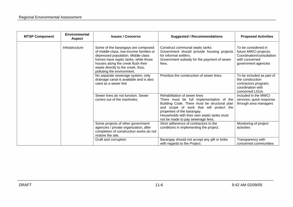
Regional Environmental Assessment
DRAFT 11-6 9:42 AM 02/09/05
MTSP Component EnvironmentalAspect Issues / Concerns Suggested / Recommendations Proposed Activities
Some of the barangays are composedof middle-class, low-income families ordepressed population. Middle classhomes have septic tanks, while thosehouses along the creek flush theirwaste directly to the creek, thus,polluting the environment.
Construct communal septic tanksGovernment should provide housing projectsfor informal settlers.Government subsidy for the payment of sewerfees.
To be considered infuture MWCI projects;Coordination/consultationwith concernedgovernment agencies
No separate sewerage system; onlydrainage canal is available and is alsoused as a sewer line
Prioritize the construction of sewer lines. To be included as part ofthe constructioncontractors program;coordination withconcerned LGUs
Sewer lines do not function. Sewercomes out of the manholes.
Rehabilitation of sewer linesThere must be full implementation of theBuilding Code. There must be structural planand scope of work that will protect theproperties of the barangay.Households with their own septic tanks mustnot be made to pay sewerage fees.
Included in the MWCIservices; quick responsethrough area managers
Some projects of other governmentagencies / private organization, aftercompletion of construction works do notrestore the site.
Strict adherence of contractors to theconditions in implementing the project.
Monitoring of projectactivities
Infrastructure
Graft and corruption Barangay should not accept any gift or bribewith regards to the Project.
Transparency withconcerned communities

Regional Environmental Assessment
DRAFT 11-7 9:42 AM 02/09/05
Table 11-3. Summary of Issues, Concerns and Recommendations RaisedDuring the FGDs.
ISSUES AND CONCERNS RECOMMENDATIONS
Sewerage SystemAbsence of sewer lines or no functionalsewer lines; only drainage canalavailable but also used as sewer line
Overflowing of wastewater from septic tanks
Clogged sewer lines; sewage comes out of themanhole; backflows were observed in some sewerlines.
Some households direct wastewater to the river;Sewer lines used as toilets and septic tanks inblighted areas.
Lack of complete knowledge about seweragecondition; indiscriminate dumping of garbage indrainage system.
Prioritize the construction of sewer lines along thestreet.
Regular desludging of septic tanks
Rehabilitation or upgrade of sewer lines
Strict implementation of sanitation and building code;sanitation inspection needed.Households along the creek must be connected to thesewer lines.
Information, education and communication programon proper sanitation and waste management
Project ImplementationSome projects take considerable time to complete;there are instances that construction sites are notproperly restored.
Lack or absence of coordination among governmentagencies (DPWH, MMDA) and private utility providers(MWCI, Meralco, PLDT)
Traffic disturbance during roadworks/excavations.
Projects should be completed on time to avoidprolonged inconvenience
Contractors should fully adhere to project conditions;strict monitoring should be performed to ensure thatprojects are done according to plans.
Government and private entities should sit togetherand discuss project plans.
Traffic re-routing during construction of sewer lines;mobilization of community or barangay residents astraffic control officers
Sewerage Charge
High sewerage fees
Payment of sewerage fees but without correspondingimprovement of sewerage services
Affordable sewerage fees and commendable services.
Transparency in computation of sewerage fees
Information on cost-benefit feature of the project
Households with their own septic tanks must not bemade to pay Sewerage Fees
Justification of increased sewerage fees; consultationwith affected communities before any additional ornew sewerage fee is implemented.

Regional Environmental Assessment
DRAFT 11-8 9:42 AM 02/09/05
11.4.3 Summary of Public Consultation
Results of the perception surveys conducted on November 2003 and April 2004indicated a low project awareness of about 32%. The public consultations, whichincluded the presentation of the key project activities and the results of the EIAgreatly increased the community knowledge regarding sanitation, seweragetreatment, environmental impacts and project benefits.
The consultations also validated and updated the results of the EA. One of themajor issues raised during the meetings was regarding sewerage fee. Thecommunities felt that the present sewerage tariff equivalent to 50% of the basicwater charge is excessive. This issue was even emphasized by communities thatare covered by existing sewerage system. They felt that the sewerage fee they payare not commensurate with the services they received. The existing systems, whichwere constructed during the 1950s, now experience clogs, leaks and backflows andshould be rehabilitated or replaced entirely by new systems.
Overall, the response of the communities regarding the project is favorable. Theyrealize the value of the benefits the project would offer to their health and to theenvironment. Should the project materializes, there should be continuing dialogueswith the stakeholders so that they are promptly informed of the projectdevelopments. This approach will promote transparency and sincerity on the part ofthe proponent.
Table 11-4 summarizes the issues and questions raised and the correspondingresponses during the public consultations.
Table 11-4. Issues and Responses Raised during Public Consultations
Issues / Questions/ Comments Responses / Recommendations
Sewerage and Sanitation
Some of the drainage systems are notfunctioning (clogged) or even missing. Thiscauses local flooding.
Project includes drainage construction andrehabilitation
It is suggested that barangay officials andconstituents start cleaning their waterways
Flooding due to poor drainage system Part of the project includesimprovement/rehabilitation of drainage systemwhich could reduce flooding in the area
Additional services MWCI offers free desludging if scheduled;emergency desludging is also offered at areasonable cost.
Use of Individual Septic Tanks (ISTs) MWCI emphasized that with the combinedsewerage system, the residents will continue touse their ISTs as primary treatment. MWCIprovides free desludging of ISTs if scheduled.
Responsibility of MWCI in terms of sewer lines MWCI is responsible for sewer lines from theirsystem to the property lines of the households.Lines inside the properties are the responsibilityof the homeowners
Clogged sewer lines MWCI have the technology to pinpoint defectivesewer lines (Close Circuit Television) anddeclogged blocked sewers
What about those who do not want to connect Under the Sanitation Code and the recently

Regional Environmental Assessment
DRAFT 11-9 9:42 AM 02/09/05
Issues / Questions/ Comments Responses / Recommendations
to the sewerage system? passed clean water act, households arerequired to connect to the sewerage system ifthe system is available.
Some of the sewer lines are in very poorconditions because of age and newdevelopments in the area. It is suggested toconstruct new sewer lines altogether.
New sewer lines will entail huge cost; MWCIhave the technology to pinpoint defective sewerlines and declogged blocked sewers
Illegal water connections is one of the causesof water contamination
MWCI is coordinating with local officials topinpoint illegal connections.
Project Coverage and Operation
Closing of floodgates by the operation of thetreatment plants during dry season will removedirect access of fisherfolk to the lake
DPWH will construct mooring stations along thelakeshore for fishermen boats and access roadsthat will allow them to bring their supplies andharvests to and from the lake.
Responsibilities of DPWH and MWCI. This willenable residents to pinpoint which party will beresponsible if ever adverse effects areproduced by the project
This will be agreed upon in a Memorandum ofagreement between the parties involved
Project coverage; other communities wantedtheir areas to be included in the proposedproject:
• Why is Nepa Q-Mart not included inthe coverage; the market generatessolid and liquid wastes
• The rest of Barangay Laging Handa,Sacred Heart and Barangay Signal
The ultimate plan of MWCI is to cover the entirearea with sewerage system. At the moment,MWCI has to prioritize areas for development
Project coverage is limited due to financial andtechnical constraints (land availability,topography, etc)
Other areas not covered by the proposedproject will be considered in future projects;
Areas not covered by the sanitation system willstill be entitled to other MWCI services such asregular desludging of individual septic tanks.
Project Details Technical aspects will be finalized in thedetailed engineering stage. Full disclosure ofthe details will be made in future consultations
Traffic during construction and operation(desludging of STPs, SPTPs)
Proper scheduling of trips (trips to be conductedduring lull hours); coordination with concernedofficials;
Available parking space within the facility fordesludging
Health and safety MWCI to require contractors to implementContractors Construction Program that willinclude health and safety procedures.
Monitoring will be perform to ensure all healthand safety measures are observed
Bad odor from STP STP will be below ground and equipped withodor detector and suppressant
Noise from STP Pumps/aerators will be powered by electricitywhich produce minimal noise; STP is located atsafe distance from the community
Monitoring will be conducted to ensure that allmitigations are in place
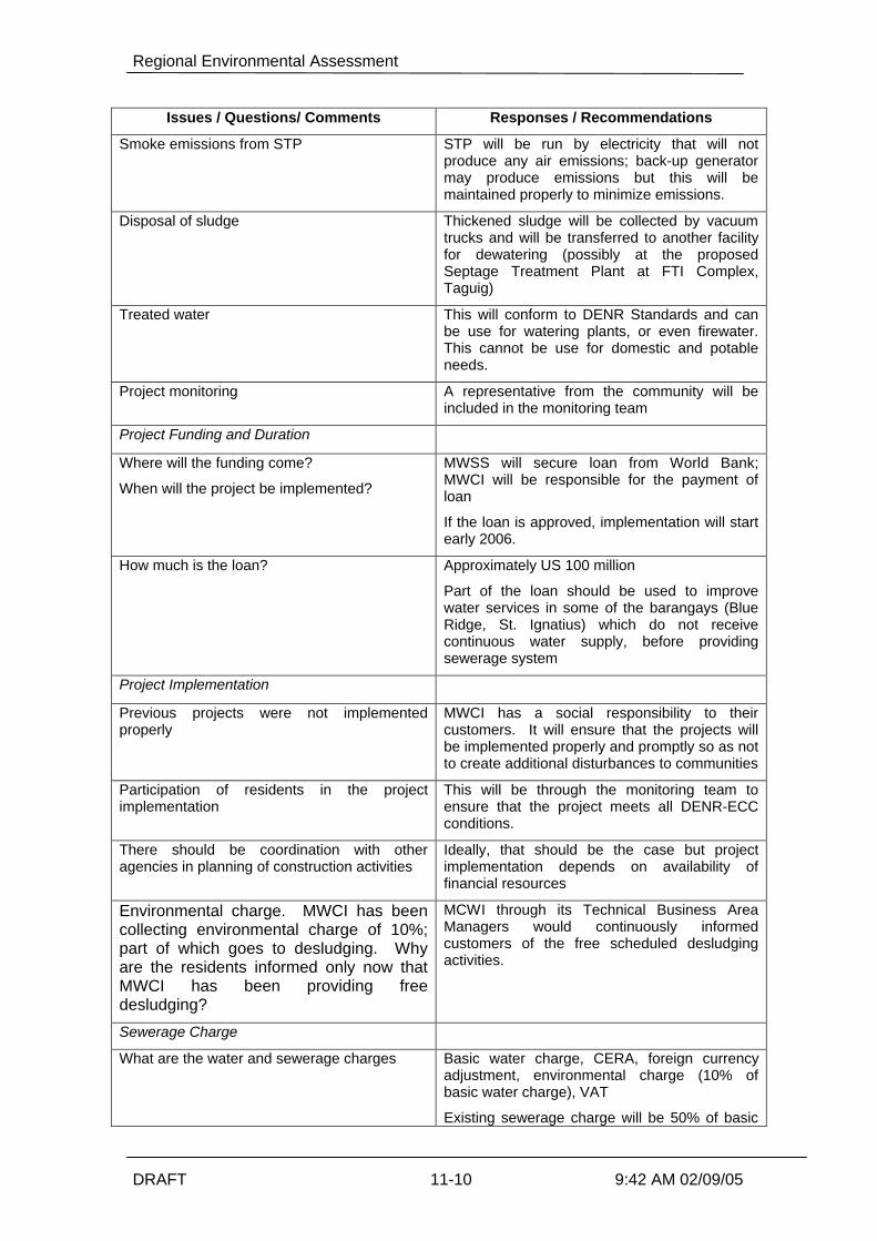
Regional Environmental Assessment
DRAFT 11-10 9:42 AM 02/09/05
Issues / Questions/ Comments Responses / Recommendations
Smoke emissions from STP STP will be run by electricity that will notproduce any air emissions; back-up generatormay produce emissions but this will bemaintained properly to minimize emissions.
Disposal of sludge Thickened sludge will be collected by vacuumtrucks and will be transferred to another facilityfor dewatering (possibly at the proposedSeptage Treatment Plant at FTI Complex,Taguig)
Treated water This will conform to DENR Standards and canbe use for watering plants, or even firewater.This cannot be use for domestic and potableneeds.
Project monitoring A representative from the community will beincluded in the monitoring team
Project Funding and Duration
Where will the funding come?
When will the project be implemented?
MWSS will secure loan from World Bank;MWCI will be responsible for the payment ofloan
If the loan is approved, implementation will startearly 2006.
How much is the loan? Approximately US 100 million
Part of the loan should be used to improvewater services in some of the barangays (BlueRidge, St. Ignatius) which do not receivecontinuous water supply, before providingsewerage system
Project Implementation
Previous projects were not implementedproperly
MWCI has a social responsibility to theircustomers. It will ensure that the projects willbe implemented properly and promptly so as notto create additional disturbances to communities
Participation of residents in the projectimplementation
This will be through the monitoring team toensure that the project meets all DENR-ECCconditions.
There should be coordination with otheragencies in planning of construction activities
Ideally, that should be the case but projectimplementation depends on availability offinancial resources
Environmental charge. MWCI has beencollecting environmental charge of 10%;part of which goes to desludging. Whyare the residents informed only now thatMWCI has been providing freedesludging?
MCWI through its Technical Business AreaManagers would continuously informedcustomers of the free scheduled desludgingactivities.
Sewerage Charge
What are the water and sewerage charges Basic water charge, CERA, foreign currencyadjustment, environmental charge (10% ofbasic water charge), VAT
Existing sewerage charge will be 50% of basic
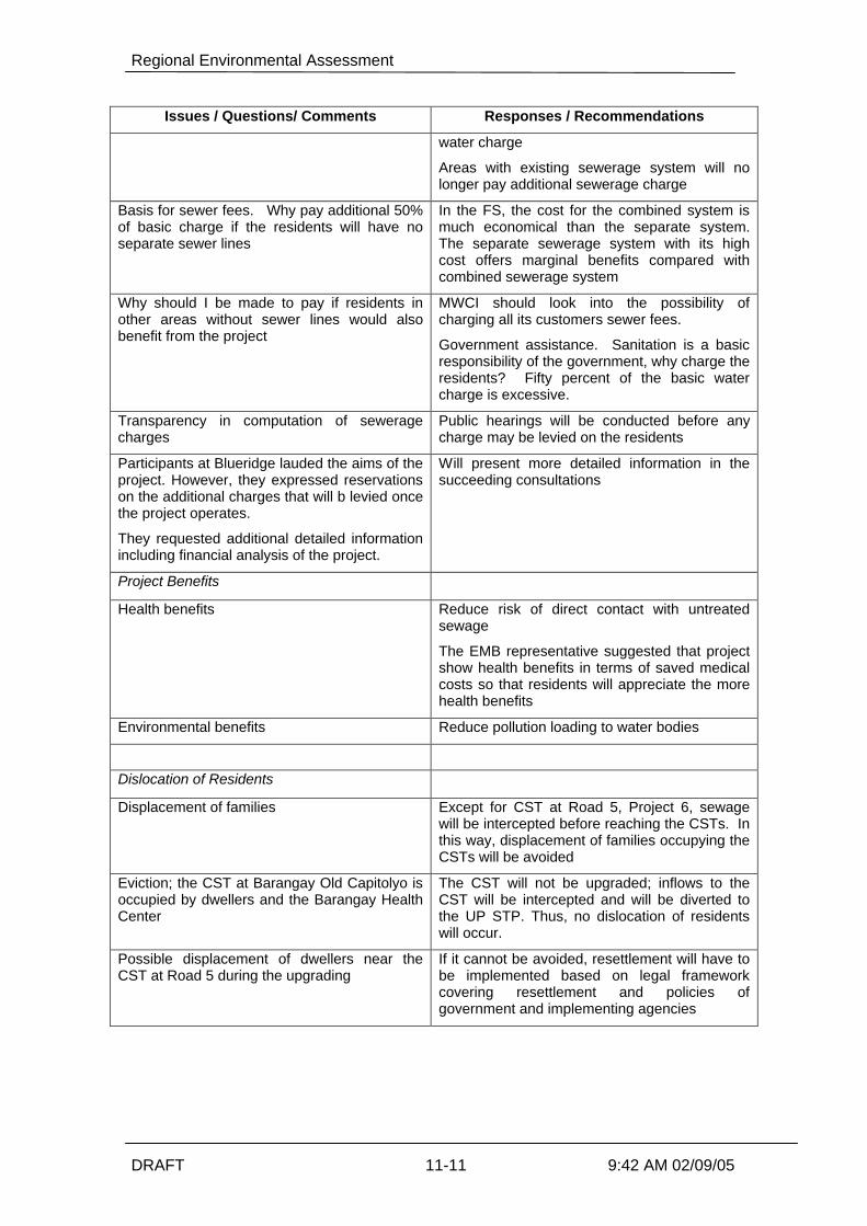
Regional Environmental Assessment
DRAFT 11-11 9:42 AM 02/09/05
Issues / Questions/ Comments Responses / Recommendations
water charge
Areas with existing sewerage system will nolonger pay additional sewerage charge
Basis for sewer fees. Why pay additional 50%of basic charge if the residents will have noseparate sewer lines
In the FS, the cost for the combined system ismuch economical than the separate system.The separate sewerage system with its highcost offers marginal benefits compared withcombined sewerage system
Why should I be made to pay if residents inother areas without sewer lines would alsobenefit from the project
MWCI should look into the possibility ofcharging all its customers sewer fees.
Government assistance. Sanitation is a basicresponsibility of the government, why charge theresidents? Fifty percent of the basic watercharge is excessive.
Transparency in computation of seweragecharges
Public hearings will be conducted before anycharge may be levied on the residents
Participants at Blueridge lauded the aims of theproject. However, they expressed reservationson the additional charges that will b levied oncethe project operates.
They requested additional detailed informationincluding financial analysis of the project.
Will present more detailed information in thesucceeding consultations
Project Benefits
Health benefits Reduce risk of direct contact with untreatedsewage
The EMB representative suggested that projectshow health benefits in terms of saved medicalcosts so that residents will appreciate the morehealth benefits
Environmental benefits Reduce pollution loading to water bodies
Dislocation of Residents
Displacement of families Except for CST at Road 5, Project 6, sewagewill be intercepted before reaching the CSTs. Inthis way, displacement of families occupying theCSTs will be avoided
Eviction; the CST at Barangay Old Capitolyo isoccupied by dwellers and the Barangay HealthCenter
The CST will not be upgraded; inflows to theCST will be intercepted and will be diverted tothe UP STP. Thus, no dislocation of residentswill occur.
Possible displacement of dwellers near theCST at Road 5 during the upgrading
If it cannot be avoided, resettlement will have tobe implemented based on legal frameworkcovering resettlement and policies ofgovernment and implementing agencies

Regional Environmental Assessment
DRAFT 12-1 9:42 AM 02/09/05
12 Cumulative Impact Assessment
12.1 Introduction
12.1.1 No Project Options
Under this option, there would be no interventions in the present state of sanitation,sewerage and wastewater management. The present socio-environmental conditions in theRegion are very poor, with demonstrated economic impacts as discussed in Section 5 –Baseline Conditions.
The population in the east zone Concession Area is predicted to increase from 5.3 millionpersons to 8.2 million in 2021. This 60% increase without any improvements in the standardof sanitation, sewerage and wastewater management will result in even greater socio-environmental impacts. The impact quantum cannot be predicted but it would safe to projectthat, for example, the presently limited periods of adequate DO in the major river systemswould be even further reduced, perhaps even eliminated.
The health impacts of greater population and population density can only exacerbate thepresent health impacts in terms of water borne diseases and associated environmentalcosts.
The No Project option cannot really be considered an option.
12.1.2 MTSP Option
The MTSP will have net benefits on the Region.
Overall benefits include the following;Ø reducing the pollution of key Metro Manila waterwaysØ reducing the health hazards associated with human exposure to sewage by drain
covering and effluent disinfectionØ improved property values along watercoursesØ improved aesthetics as the water quality improvesØ improved fish catchesØ improved tourismØ improved soil condition and crop yields in lahar affected areasØ providing design and implementation feedback on the combined sewer systems efficacy
and the STP/SPTP designs, in effect a pilot scheme for the many innovations proposedunder MTSP
Ø cessation of uncontrolled dumping of septage from privately owned and operatedtankers
Ø provides a viable alternative to sea dumping of septage/sludgeØ cessation of the hauling of liquid septage to the lahar affected areas north of the Region.
It is environmentally and financially unsustainable to be hauling so much water in thenon-dewatered septage such a distance and with the attendant environmental risksassociated with accidents and attendant spillages of the liquid septage
Ø improved institutional implementation of sanitation and sewerage services, includingmore clearly defined roles and responsibilities and enforcement, and

Regional Environmental Assessment
DRAFT 12-2 9:42 AM 02/09/05
Ø elevating the commitment and political will required to improving sanitation, sewerageand wastewater treatment in the minds of politicians, government agencies, NGOs, civilsociety and the general public.
As always there will be some short term localised construction impacts such noise, dust andtraffic interruptions, but these are short term and are very minor compared with the longer-term benefits.
12.2 General Benefits
Just because the regional water quality improvements may not be quantifiable does notnegate the benefits of the MTSP. It is the first step in a major program to provide seweragefor the Region eventually, and will provide good on-the-ground feedback to refinesubsequent designs for the ongoing infrastructure roll-out program.
The MTSP will also provide educational opportunities and demonstration projects allowingthe general public to see the benefits of improved sanitation and sewerage. This will makesubsequent stages socially easier to implement.
Some specific examples are listed below.
12.2.1 Water Quality Improvement
Some of these benefits will be difficult to measure explicitly immediately, such as improvedDissolved Oxygen levels and reduced Coliform levels in Regional watercourses. This isbecause the watercourses are so polluted at present that it will require the subsequentimplementation of additional stages beyond MTSP to provide consistently measurable waterquality improvements. However the MTSP will start the recovery of some the watercoursesfrom the almost biologically dead status of present times.
12.2.2 Better Health
There will be health improvements due to drain improvements and treatedeffluent/disinfection. These benefits will outweigh any minor risks associated with versuspotential aerosols from aeration equipment at the treatment plants.
12.2.3 Greater Tourism
Improved tourist visitations will result from the improved regional environmentalimprovements.
12.2.4 Greater Fishery Production
Extending the period of measurable DO in the main river systems will increase ecosystemstability. This will improve fish stocks and mobility from the cleaner upper waters of theMarakina and Laguna Lake system to connect with the Manila Bay ecosystems.
12.2.5 Property Values
Improved water quality and aesthetics will lead to greater use of riverbank property whichwill result in greater property valuations. This will lead to greater taxation revenues for theLGUs with positive flow-on affects, and also possibly trigger some localised urban renewal. The taxation increases can then be used to fund further sanitation/sewerage improvements.

Regional Environmental Assessment
DRAFT 12-3 9:42 AM 02/09/05
12.2.6 General Aesthetic improvements
There will be reduced odour from the presently open and damaged drains.
Ultimately, there will be improved aesthetic appreciation from the resulting water qualityimprovement in major waterways
12.2.7 Improved Institutional Implementation
As noted in the section on Policy and Institutional Issues, a number of key recommendationshave been made on how to improve sanitation and sewerage services in the Region.
This will provide benefits beyond the scope of the MTSP areas of influence.
12.2.8 Septage/Sludge Management
The land application of the dewatered/dried material will have major impacts on the unfertilelahar affected soils north of the Region. There will general soil conditioning, such as organiccontent, moisture retention capability and ability to retain nutrients (CEC amongst othermeasures). More directly there will be crop yield improvements and/or the ability to reducethe application rate of artificial fertilisers. The field trials referenced in the LaharEnvironmental Study (2004, attached to the EIS) noted that mean plant height, number oftillers, millable stalk production and sugar yield, regardless of inorganic nitrogen application,were significantly improved with application of sewage sludge and septage.
12.3 MTSP General Impacts
In a traditional REA, the component impacts are determined individually firstly. The secondstep is to then combine the impacts from the scheme components
As noted previously, the MTSP component projects are all relatively small in a regionalcontext. For example, the individual projects are all discharging into polluted water wherethe Dissolved Oxygen levels are often at the level of detection, about 0.5mg/L. This meansthat there is a need for major reductions in BOD load before the improvements would bemanifest as measurably higher DO levels.
The direct water quality impacts from all components will reduce the regional BOD load by17,300tpy. The present Regional BOD load has been variously reported as 330,000tpy bythe World Bank (2003), and 359,00tpy as the adopted load in the DANIDA 1999 modellingstudy for 2015. The percentage reduction in BOD due to MTSP is therefore expected to bein the order of 5%. This also is too small a reduction to be reliably detected regionally.However this improvement scenario must be compared with the ongoing deterioration thatwould occur over the next decade as the Regional population increased, if no project was tobe initiated.
The DANIDA (1999) modelling determined that a 85% to 90% reduction in regional BODload would be required before DO levels of more than 1 mg/L would be regularly achieved inthe Pasig system. This is the lowest possible DO level to allow some ecosystem stability tobe achieved. Therefore the expected reductions in BOD from the MTSP will not result in aproportional improvement in DO.
Therefore the water quality impacts and benefits must be considered qualitatively andcollectively.

Regional Environmental Assessment
DRAFT 12-4 9:42 AM 02/09/05
An EMP is included in the EIA document which addresses how the MTSP components willbe monitored, especially for septage/sludge land application as there a number ofenvironmental unknowns with this activity.
12.4 Flow-on Affects
There are numerous beneficial flow-on affects from implementing the MTSP, with thedefinition of flow-on affect derived from World Bank, 2003.
One discrete benefit is the increased crop yields resulting from septage/sludge applicationson the lahar-affected soils and extensive agricultural areas.
Similarly, integration with the PRRC Environmental Preservation Areas or linear parks alongthe Pasig River demonstrates the mutual benefits of the two projects, such as:Ø The STPs require substantial land areas that have proven very difficult to obtain for
reasons of site development and therefore elevated cost. By incorporating the STPdevelopment plan into the EPA construction the plants can be constructed underground.This has the benefits of reduced visual aesthetic impact, reduced vandalism andpilferage of equipment and also reduced odour emissions and any aerosol drift from themixed liquor aeration systems and attendant potential health impacts
Ø The STPs will improve the local water quality contiguous to the park developments. Thisapplies to the local drains whose dry weather flows will be intercepted for treatment, andto a lesser extent, to the Pasig River itself. The main beneficial impact on the River willbe that any solid waste (garbage) will also be trapped by the dry-weather flow-diversionsystem in the drain. The improved water quality will encourage greater passiverecreation such as aesthetic appreciation from the linear park areas and other river frontareas in the short term.
Ø In the longer term as the MTSP matures and other sewerage and sanitation programsfollow, then the water quality will improve further and allow greater aesthetic appreciationand a return to river based transport. River based transport would be a great benefit toroad based traffic congestion in Metro Manila. This will also encourage greater emphasison illegal dumping of solid waste which presently prevents much river transport due tofloating garbage blocking motor cooling inlets and wrapping around propellers.
Improving water quality and associated great public access to the local watercourses willhave these and other synergistic benefits.
12.5 Typical Impacts
The typical impacts associated with the component infrastructure will include the followingissues. These are discussed for individual components in the EIA in detail, and summarisedbelow. In general, the proposed components will have minimal environmental impact.
12.5.1 Noise
The construction noise will not be regionally cumulative as the sites are well apart and willnot be constructed at the same time in any case. Impacts will be minimal and covered byadopting suitable working hours, having functioning silencers on equipment and so on.
Operational noise will also be minimal. The SPTPs and STPs will have aeration systems butthese noise sources are small, as any compressors will be in a sound proofed room, orfloating aerators are not noisy in any case. Most treatment plants will either be covered orfully underground, which further reduces the potential noise impacts.

Regional Environmental Assessment
DRAFT 12-5 9:42 AM 02/09/05
12.5.2 Air Pollution
Construction dust would be managed by the usual wetting down of dry constructionmaterials.
Air pollution during the operational phase would only odour or aerosols transmission. Odourwill be minimal as the treatment plants with either be covered or located underground, andare treating less volatile sullage, not traditional raw sewage. The Regional septage qualityhas been monitored, and determined to have minimal volatile organics so the SPTPs will notsuffer odour problems.
There may be some dust from land application of septage/sludge but this is typical of normalagricultural activity, such as simply plowing-in the unstabilised material.
12.5.3 Water Pollution
The STPs and PSTPs will actually reduce water pollution by reducing the organic load in theRegion and allowing the effluent to be disinfected. The later reduces the pathogen counts inlocal waterways.
The collection, treatment removal of septage for productive reuse reduces the amountpresently being pumped and then illegally dumped by private desludging contractors. Thenew institutional arrangements also mean that the private operators will be allowed tocontinue operating, but by using the proposed SPTPs and not to dump illegally into Regionalwaterways.
The land application of septage/sludge has the potential to cause contaminated runoff andalso groundwater pollution. Surface water contamination will be minimal as mostseptage/sludge is unstabilised and therefore has to be buried within 6 hours of placement. Itis not to be placed in wet weather according to the USEPA guidelines but this is impracticallocally. There will be some unavoidable washoff in wet weather but vehicle accessdifficulties will prevent sludge/septage applications in very wet weather. In these periods,the sludge/septage will have to be stockpiled for later application in drier weather.
Groundwater contamination is also possible. However a monitoring program (EMP) hasbeen prepared as part of the EIA which addresses this aspect. Essentially the groundwaterwill be monitored in local water wells and in purpose0built sampling bores to assess anyimpacts. If the groundwater is contaminated, then sludge/septage applications will becurtailed or application rates reduced to ensure that groundwater integrity is not violated forthe local users.
12.5.4 Aesthetics
Most treatment plants will be covered or underground, causing only little aesthetic impact.
12.5.5 Flora and Fauna
There is no rare or threatened fauna or flora at the sites to be developed for MTSP. Thelarge fig trees will be retained at the East Avenue Site if at all possible.

Regional Environmental Assessment
DRAFT 12-6 9:42 AM 02/09/05
12.6 Economic Analysis
12.6.1 Introduction
This economics subsection is essentially taken from the Master Plan, 2004. The economicanalysis for the Manila Third Sewerage Project was undertaken in accordance with NationalEconomic Development Authority (NEDA) guidelines, which stipulate that an overall cost-benefit analysis of the total project be carried out, comprising individual economic analysesof each of the project components as presented in the previous sections. The analysiscompares the calculated economic internal rate of return (EIRR) for the project to theeconomic opportunity cost of capital (EOCC), which is assumed to be 12% in accordancewith the guidelines, and also calculates the net present value (NPV) of the project.
A risk analysis comprising additional sensitivity scenarios over and above the standardsensitivity tests has also been undertaken. This analysis considers changes to theassumptions on unit health benefits, environmental benefits and the potential economicbenefit from the reuse of sludge in lieu of urea and inorganic fertilizer, resulting to costsavings to farmers in the lahar area (Estanislau et al). This agricultural benefit has beenapplied to a percentage of the incremental volume of dewatered sludge resulting from theseptage treatment component.
12.6.2 Project Economic Cost
The financial costs for the overall project have been converted to economic costs to reflectthe true cost and value to the economy of goods and services after adjustment for theeffects of government intervention and distortions in the market structure through shadowpricing of the project inputs. In estimating the economic costs, some items in the financialcosts have been excluded while others that are not part of the financial costs have beenincluded. Items such as taxes and duties, VAT of 10%, price contingencies anddepreciation, for example, have been excluded.
Costs have been broken down into tradable and non-tradable elements that reflect theforeign exchange and local currency components, respectively. The tradable componentshave been valued at their border price equivalent and then re-valued to the domestic pricelevel by multiplying by the shadow exchange rate factor of 1.2. Non-tradable componentshave been valued at their supply price using the conversion factors set out below. All costsare based on constant 2004 prices.
12.6.3 Health Benefits
Health benefit is taken as the value of improvement of public health due to improveddrainage systems. The opportunity for the public to come into direct contact with sewagecontaminated runoff is lessened, if not totally eliminated, in the MTSP components. Asdiscussed in Section 4 of the Feasibility Study (April 2004), this can amount to aboutPh300,000 per 1,000 population per year. This is applicable to those components withdrainage upgrading namely: (1) Taguig Sewerage System and Sanitation for Low-IncomeCommunities, (2) Quezon City - Marikina Sewerage System and (3) Manggahan East BankSanitation for Low-Income Communities.
An increase in unit health benefit of Ps 300,000/1000 population to Ps 400,000/1000population as a result of improving wastewater collection systems is also appropriate. Theincrease is based on the benefit range of Ps 300,000 to Ps 1 million/1000 population ofcombined approaches discussed in detail in Section 4. The figure of Ps 400,000/1000

Regional Environmental Assessment
DRAFT 12-7 9:42 AM 02/09/05
population is still within the lower limit considering that the sanitation facilities in the sub-project areas are not grossly inadequate.
Another health benefit that can be considered is the reduced risk of people coming intocontact with untreated sewage from overflowing tanks. It is estimated to correspond to anannual health benefit of Ph150,000 per 1,000 population per year. In the case of theseptage treatment component and in the provision of separate sewerage over and abovethe upgrading of existing drainage (combined sewerage) system, the health benefit of Ps150,000/1000 population is increased to Ps 200,000/1,000 population.
12.6.4 Determination of Environmental Benefit
Environmental benefit is taken as the gradual improvement in the receiving environment thatwill occur as a result of the provision of sewage treatment and sewerage upgrading,particularly the reduction of visual pollution in the early years. It shall be equated to the 50%sewerage charge as a surrogate for the actual monetary value that might be placed on theenvironmental improvement in the community.
12.6.5 Water Quality Improvement
The MTSP will reduce the total BOD load discharged to the water environment in the NCRby some 17,300 tpy in year 2015. The reduction will be of the order of 5% of the total BODbeing discharged.
No economic benefit has been allocated to this BOD reduction on the grounds that theresulting improvement in receiving water quality, although being a step in the right direction,is too small to produce a benefit that is measurable in monetary terms.
The option of equating the benefit of BOD reduction to the cost of removing the BOD (interms of electricity use for example) has not been adopted since this is not considered to bea relevant measure of environmental quality improvement.
12.6.6 Consumer Surplus
Consumer surplus is determined on the basis of the willingness of households to pay forimproved sanitation and wastewater management services which will result in a reduction inthe BOD load discharged to the environment. The willingness to pay for the services hasbeen assumed to be equivalent to the 10% sanitation charge levied by MWCI plus the 50%sewerage fee as a surrogate for the actual monetary value that might be placed by thecommunity on the environmental improvement. The environmental charge is estimated to bePs 10.5 million in 2006, increasing to Ps 310.0 million in 2015 and then increasing further toPs 360.6 million in 2025. The sewerage fee is calculated to be Ps 52.7 million in 2006,increasing to Ps 302.5 million in 2015, reaching Ps 555.6 million in 2025. Although the 10%sanitation charge has been taken for all project components, it has been reduced to 5% forTaguig Sewerage Option 1 (and Option 3 up to year 2014) on the grounds that thetreatment facilities will only operate during the dry season. In a similar manner only half thesewerage fee has been allocated to the Taguig Sewerage component, and no sewerage feehas been applied to the Septage Treatment Plant component since this is essentiallyrepresents an improved septic tank desludging operation and not sewage treatment.
12.6.7 Septage/Sludge Application to Land
Dewatered septage (and dewatered sewage sludge) will be applied on lahar-affected soils inPampanga in order to take advantage of the organic and nutrient content of theseptage/sludge in reclaiming agricultural land. The studies referred to earlier have shown

Regional Environmental Assessment
DRAFT 12-8 9:42 AM 02/09/05
that because of its high concentrations of essential elements and organic matter, as well thepresence of micronutrients and the low levels of heavy metals, the use of domestic sewagederived sludge is an excellent material for increasing the cultivation potential of agriculturalland in the Philippines. The regeneration of the land will result in an increase in land value.An area of about 65 ha will be treated each year with an estimated annual benefit of Ps 5.5million as a result of the increase in land value.
Cost savings to farmers in terms of a reduction in the use of urea and inorganic fertilizer asa result of the use of dewatered septage and sludge to fertilize existing land underproduction. At present, sludge is applied in the lahar area at an average rate of up to 160 m3
per day, which it is assumed has already positively benefited the lahar area.
Under the MTSP, the total volume of dewatered septage/sludge hauled to the lahar areaswould amount to about 450 m3 a day in 2015. The benefit of using this septage/sludge inlieu of urea and inorganic fertilizer can be computed on the basis of the incremental volumeof sludge resulting from the project. The cost savings is taken as the difference in the costof inorganic fertilizer use at 2004 prices at Ps 10/kg less the estimated application cost ofsludge. The actual nutrient content of this septage/sludge combination cannot be determined as yetas the STP and SPTP facilities have not been constructed. However the field trials withsome of the separate components confirms significant agronomic and yield benefits. Theeconomic quantification will have top await the actual application of the combined productand associated monitoring.
12.6.8 Environmental fee and sewerage charges
There is also an increase in unit environmental benefits measured in terms of theenvironmental fee and sewerage charges. Values used in the evaluation model of Ps 1.37/m3 water use and Ps 6.86/ m3 respectively, to increased amounts of Ps 1.39/ m3 and Ps6.96/ m3 to include the FCDA (foreign currency differential adjustment) of Ps 0.19/ m3.
12.6.9 Summary of Economic Benefits
Table 13.1 sets out the overall MTSP economic benefits. Essentially the Present Value ofeconomic benefits over the life of MTSP until 2025 is estimated to be P2.7 billion, withHealth Benefits and Environment Benefits each providing some P1.2 billion of this total.

Regional Environmental Assessment
DRAFT 12-9 9:42 AM 02/09/05
Overall Economic Analysis (in thousand pesos)
Sensitivity AnalysisYear Capital
CostO&MCost
TotalCost
HealthBenefits
EnvironmentalBenefits
LaharReclamation
TotalBenefits
Net BenefitsBase Case
10%Increase in
Cost
10%Decrease in
Benefits
CombinedCase
2004 - - - - - - - -2005 392,025 - 392,025 0 - - - (392,025)
(431,228) (392,025)
(431,228)2006 1,445,485 57,510 1,502,995 34,500
-5,500
40,000 (1,462,995)
(1,613,294) (1,466,995)
(1,617,294)2007 1,467,180 118,370 1,585,550 132,485
149,2685,500
287,253 (1,252,301)
(1,410,856) (1,285,626)
(1,444,181)2008 22,643 145,070
167,713157,544
170,2045,500
333,249 182,790
166,018 147,739
130,9682009 22,643 147,725 170,369 166,306
178,6965,500
350,503 197,388
180,351 160,612
143,5752010 64,193 150,391 214,585 175,068
187,1885,500
367,756 170,426
148,967 131,925
110,4662011 41,550 154,646
196,196183,830
195,6805,500
385,010 206,069
186,449 165,842
146,2232012 69,200 162,376 231,576 192,592
204,1725,500
402,264 187,942
164,785 145,990
122,8332013 41,550 166,816 208,366 201,354
212,6645,500
419,518 228,407 207,570 184,729
163,8932014 41,550 171,285 212,835 210,116
221,1565,500
436,772 237,236
215,953 192,229
170,9462015 41,550 175,769
217,319218,878
225,6935,500
450,071 249,622 227,890 202,928
181,1962016 3,270 179,353 182,623 227,628
233,8145,500
466,941 301,189 282,926 252,808
234,5452017 375,440 182,971
558,411236,377
241,9345,500
483,811 (57,730)
(113,571) (107,798)
(163,639)2018 41,550 186,610 228,160 245,126
250,0555,500
500,681 289,392 266,576 237,637
214,8212019 3,270 190,252 193,522 253,876
258,1765,500
517,552 324,030 304,677 272,275
252,9222020 41,550 184,732 226,282 262,625
266,2965,500
534,422 308,139
285,511 254,697
232,069

Regional Environmental Assessment
DRAFT 12-10 9:42 AM 02/09/05
Sensitivity AnalysisYear Capital
CostO&MCost
TotalCost
HealthBenefits
EnvironmentalBenefits
LaharReclamation
TotalBenefits
Net BenefitsBase Case
10%Increase in
Cost
10%Decrease in
Benefits
CombinedCase
2021 41,550 188,320 229,870 271,375274,417
5,500551,292
321,422 298,435 266,292243,305
2022 61,200 191,929 253,129 280,124282,538
5,500568,162
315,032 289,720 258,216232,903
2023 49,550 195,560245,110
288,873290,658
5,500585,032
339,922315,411
281,418256,907
2024 41,550 199,214 240,764 297,623298,779
5,500601,902 361,138
337,062 300,948276,872
2025 41,550 193,707 235,257 297,817310,819
5,500614,136
378,878 355,353 317,465293,939
PV2,824,149
1,107,004 3,812,5451,189,001 1,221,830 36,680 2,741,213
EIRR 3.5% 1.6% 1.4% -0.6%NPV (1,261,023)
(1,642,277) (1,516,175)
(1,897,429)
Regional Environmental Assessment
DRAFT 13-1 9:42 AM 02/09/05
13 Regional Environmental Management System
13.1 Introduction
This section presents recommended strategies to strengthen environmentalmanagement within the area. The strategies include: (a) measures to ensure thatpositive environmental impacts of proposed projects are adequately enhanced; (b)measures to ensure that negative impacts are adequately mitigated; (c) generalguidelines for short-term and long-term ambient monitoring; and (c) a plan forinstitutional strengthening.
The REMS is not supposed to monitor the individual MTSP components, as that iscovered in the EMP and EMoP presented in the EIS document. The REMS is just toassess the general Regional response to implementing the MTSP overall. Thereforethe REMS focuses on regional ambient monitoring not component specificmonitoring.
Based on the feasibility studies for each component, the MTSP in general canreduce the total BOD load to the natural waters by as much as 17,300 tpy (2015).This only represents approximately 5% of the total regional BOD load. It is thereforeunjustified to expect the MTSP to demonstrate substantial improvements inenvironmental quality alone. Such small changes in load would be too small tomodel sensibly in the DANIDA water quality model developed for the Region, andparticularly the Pasig River and tributary systems. In any case, a statistically validmonitoring program is still required to provide a valid baseline dataset, and facilitatea trend analysis over time as the PTSP components are implemented. The basis forsuch a program is described below.
However, there are other areas for improvement resulting from the MTSPcomponent mix. These issues include health, general aesthetics, tourism, fisheryimprovements and propery value escalation.
However the key factor is that the MTSP interventions are a significant andappropriate first step in the sewerage and sanitation strategy for the Region, andshould be implemented as soon as possible.
13.2 Institutional Aspects
The institutional changes are critical to the success of the MTSP and other regionalsocio-environmental improvements.
These can be developed as below, based on the provisions of the CWA as shown inthe table below;

Regional Environmental Assessment
DRAFT 13-2 9:42 AM 02/09/05
Table 13-1 - Summary of the Proposed Clean Water Act of 2002
PROVISION LEAD OFFICE AND OTHERSTAKEHOLDERS
National Water Quality Status Report Lead: DENROthers: NWRB, PCG and other appropriate agencies &entities
Integrated Water Quality Improvement Framework Lead: DENROthers: LGUs, concerned government agencies
Water Quality Management Area Action Plan Lead: DENR Regional OfficesOthers: NWRB, member LGUs, civil society, otherconcerned stakeholder sectors
Local Government Unit Water QualityCompliance Scheme
Lead: LGUs in consultation with concerned stakeholder
Water Quality Management Area Lead: DENROthers: NWRB in consultation with key stakeholders
Management of Non-attainment Areas Lead: DENROthers: NWRB , DOH, DAO, Governing Board, otherconcerned agencies, private sector, LGUs
National Groundwater Vulnerability Mapping Lead: DENR - MGBWater Pollution Management Practices and Technologies Lead: DOST
Others: DENR, other concerned agencies or organizationsGuidelines for Test Procedures Lead: DENR
Others: DOST, DOH, and other concerned agenciesWater Quality Monitoring and Surveillance Lead: DENR with multi-sectoral groupNational Sewerage and Septage Management Program Lead: DENR
Others: DOH, LWUA, NWRB, MWSS, other concernedagencies
Domestic Sewage Collection, Treatment and Disposal Lead: LGUs and/or agency vested to provide water supplyand sewerage facilities, concessionairesOthers: DENR, DOH, DPWH, other concerned agencies
National Water Quality Management Fund Lead: DENROthers: DOST and PCG
Area Water Quality Management Fund Lead: Water Quality Management Board in each waterquality management area
Water Quality and Effluent Standards and Regulations Lead: DENROthers: DOH, DA, private sectors, other governmentagencies
Water Pollution Permits and Charges Lead: DENROthers: Project Proponents, other government agencies,LGUs
Institutional Mechanism Lead: DENROthers: LGUs (ENRO), Governing Board, concernedstakeholders, NWRB, PAB, LLDA, PCG,DA, MWSS, LWUA, BFAR, DOH
Incentives and Rewards (Rewards, Incentives Scheme)Civil Liability/Penal Provisions Lead: PAB Lead: DENR, affected persons, CourtsActions (Administrative, Citizen’s Suit, Legal ActionsAgainst Public Participation and Enforcement of this Act,Lien Upon Personal and Immovable Properties
13.2.1 Relative Priority of Wastewater Services
The basic principle governing the regulatory environment in the Philippines on waterservices is that water is owned by the state and the government has the sole powerto determine its development and distribution. Hence several agencies and utilityorganizations and corporations have been tasked with specific roles in providingwater in the country such as water districts, the local government units in specialcases, and private corporations. However, this principle does not apply to sewerageand wastewater. Action. The sewerage sand wastewater management systems will only bedeveloped once there is community and political support for proper funding of these

Regional Environmental Assessment
DRAFT 13-3 9:42 AM 02/09/05
systems. An IEC is essential to refocus the community and political opinions thatwater supply is by far the most important issue in the water management cycle. A campaign is required to alert the community to the health and economic benefits ofimproved wastewater management. A champion must be identified in a seniorgovernment position to bring the IEC aims forward. The aim will be to makewastewater management a key political issue and thence become an election issue.This will be very difficult unfortunately with the numerous demands on capital in thePhilippines. However this is the only sustainable path, otherwise the best efforts of those chargedwith implementing the wastewater management systems will fail in the long term.
13.2.2 Connection to Public Sewerage Systems
The Plumbing Law and the National Plumbing Code are very clear. Except in caseswhen it may prove oppressive or excessively burdensome to those without sufficientmeans, all buildings should be connected with available sewers. This has not beendone nor its execution been regulated by the proper agencies concerning sewageinfrastructure. More so, the power of water districts to disconnect services tobuildings that refuse to connect with existing sewer lines should likewise be given toother entities which build and operate such sewer systems, such as those in MetroManila. This will give the provisions in the Plumbing Law and the Plumbing Codemore power, facilitating universal connection with available sewage lines. Action. The Concessionaires must be given power to disconnect water supply tothose users who refuse to connect to sewers, and also for those who then fail to payfor this sewerage service. This is not available at present.
13.2.3 Project Financing
It costs approximately five times to amount to develop sewerage and sanitationfacilities than water supply for the same number of households, yet on the Nationallevel the annual investment on sewerage is 3% of the total investments in the watersupply and sanitation sector. Although there are several sources of financingavailable to fund sewerage and sanitation projects, most of these are relatively newto the local government units as well as government agencies and corporations andwill need focused technical assistance to maximize their application. Action. A technical assistance grant is required to advise on how to better use thevarious funding options listed above.
13.2.4 Low Willingness to Pay and the Lack of Sanctions
Several studies have pointed out the low willingness to pay of households for bettersewerage and sanitation service, and has been recently estimated atPhP30/month/capita or PhP5,700 per capita. At this rate it will take 16 years torecover capital investments in sewerage and sanitation. It may be argued that thelow willingness to pay could be addressed by cross-subsidies, or mandating theconnection to sewers by households with a threat of sanction for non-complianceremoves the assumption that households have a choice as implied by theproponents of willingness-to-pay scheme. The existing laws do not provide sanctions for households not connecting to sewers.Although the Sanitation Code promotes the establishment and connection to sewers
Regional Environmental Assessment
DRAFT 13-4 9:42 AM 02/09/05
and sanitation facilities, there is no threat of sanction for non-compliance. Similarly isthe Clean Water Act, which requires LGUs to earmarked an area to locate treatmentplants, non-connection is still an option for households to take. Action. The Concessionaires must be given power to disconnect water supply tothose users who refuse to connect to sewers, and also for those who then fail to payfor this sewerage service. This is not available at present.
13.2.5 Monitoring of Compliance to Existing Laws
As the population of Metro Manila rises and congestion increases, environmental problemsrelated to sewerage and sanitation are likely to become worse. The Sanitation Codeprovides broad regulation against most improper sanitation practices, including thedischarge of untreated septic tank effluent and untreated sewage to water bodies.Unfortunately, there is little monitoring or enforcement of these regulations and theagencies responsible have few powers or incentives to follow-up wrongdoers. The reality is that most households, businesses and local authorities in the Philippines arein breach of the national sanitation code. Industrial consumers can be monitored by theDENR but the sheer number of these industries from small partnerships to largerconglomerates necessitate that only the larger companies are dealt with. For the individual households, the mandate in the Sanitation Code and in the Clean WaterAct clearly states that DOH approval is needed prior to the discharge of untreated effluentof septic tanks and/or sewage treatment plants to bodies of water. Within the cities and municipalities a more comprehensive study of the various ordinancesand issuances in relation to their policies which affect the sector should be initiated. Again,however, the prohibitive costs of employing a centralized sanitation service for Metro Manilabecomes the issue. Until treatment plants and combined systems becomes cheap enough tobuild and to operate, the user fees shall be above what ordinary consumers are be willing topay. The indiscriminate discharge of sewerage, septic tank and toilet effluent is likely tocontinue until either public sentiments change, or stronger regulation andenforcement is introduced. Action. The only solution is to undertake a study involving all the agencies todemonstrate that continuing as at present is simply not an option. This study willalso demonstrate and delineate the responsibilities and the obligations of the variousagencies and determine a funding and resourcing plan to ensure enforcementactivities do result.
13.2.6 MTSP Impacts on Existing Private Septage Haulers
The MTSP intends to de-sludge an estimated 115,000 individual septic tanksannually by year 2025. Supported by cheaper loans and government approval todispose collected septage on lahar areas may be construed as unfair competitionbetween the MWCI and private haulers. These desludging contractors have providedlimited but necessary services for decades due to the limitation in MWSS capability,and have made investments particularly in haulage trucks. Although not a singleoperator has been granted a permit by the DENR to operate a septage treatmentplant, the MWCI should foster a cooperative partnership with these contractorsrather than compete with them.
Regional Environmental Assessment
DRAFT 13-5 9:42 AM 02/09/05
The MWCI and the DENR should craft guidelines and accreditation schemes that willallow these contractors to operate within the MWCI concession area particularly ondensely populated, space-congested areas in the concession which will be difficult toaccess by the larger MWCI tankers . Collected septage can be disposed in the laharareas, and later on will be required to be treated in the MWCI septage treatmentplants. Action. The proposed GEF study for the Region will address the institutional issuesof the private operators. It is acknowledged that only approximately 80% of the ISTscan be desludged by the MWCI fleet for various reasons. Therefore the remaining20% will utilise the private contractors’ desludging services.
13.2.7 IEC on Health Impacts of Wastewater
The limited understanding of households on the health impacts of the existing septictanks that are inadequately managed has generated multiple problems like lowwillingness-to-pay for improvement in facilities and services, and willingness-to-connect even if sewer systems are already available. The strong bias of politiciansto support expansion in water supply without corresponding sewerage and sanitationfacilities has resulted to dismal public investments on the latter, a problem that canbe addressed by properly informing these policy makers. In year 2000 alone, according to the DOH, 871,446 cases of diarrhoea wererecorded with an estimated economic losses based on medical expenses and cost ofhospitalization reached PhP1 billion. The World Health Organization contends thatthe single most effective intervention to address diarrhoea is the provision of asewerage system. Action. The DOH should transform and expand its activities from simply monitoringwater-borne related diseases to conducting active promotion on the need to haveadequate sewerage and sanitation facilities.
13.3 Project Specific Enhancement/ Mitigation Strategies
Enhancement/mitigation plans provide detailed activities aimed at eliminating,reducing or controlling the adverse environmental impacts of proposed projects anddetail the proposed measures to enhance the positive impacts.
These are all project specific and are included in the EMP and EMoP in the EIS.They do not relate to regional management.
13.4 Air Sector Enhancement/ Mitigation Strategies
Most areas in Metro Manila have ambient concentrations that exceed the allowablelimits set by the DENR.
Septage collection is not likely to produce impact on air quality. The odor that may beproduced during the collection process will only be temporary and for a short periodand considered insignificant. The projected suspended solids and nitrogen oxidesconsidering the baseline conditions will be insignificant.
Strategies recommended to address these problems are the following:

Regional Environmental Assessment
DRAFT 13-6 9:42 AM 02/09/05
Ø Implementation of Construction Contractor’s Program (Attachment 1)enumerating contractor’s commitment to environmental management duringproject construction.
Ø The reduction of risk to the human population can come not only by reducingemissions but by establishing residential areas away from risk zones.
13.5 Water Enhancement/ Mitigation Strategies
Based on results of sampling, most of the Regional surface water bodies are heavilypolluted. Since septage collection is made by specific vacuum tankers, spillageduring collection is not likely to occur. Spillage of some septage from the suctionhose when dipped into the septic tank is negligible, and will not cause negativeenvironmental impacts on a regional basis. About 50 vacuum trucks per day forseptage collection will travel to the septage treatment plant but will result tonegligible impact to the environment in terms of NOx and COx. However, on someareas pollution load from domestic and industrial sources still have to be properlymanaged.
Enhancement/mitigating strategies for water management are the following:Ø Install embankments to minimize if not prevent soil erosion. Attachment 2
presents the Septage Management Plan that project proponents may useØ Establish vegetated buffer zones should surround areas of high risks of runoff to
allow infiltration and to trap suspended particles.Ø During construction to minimize if not prevent noise, temporary soundproof
structures may be installed around the work area and schedule the use of largemachines that produce noise during daytime.
Ø Employ best management practices such as spill prevention, require vacuumcars to be used be equipped with special cleaning devices, proper materialshandling to be incorporated in the orientation given to contractors emphasizingsafe driving and training drivers and car personnel on how to address accidentalspills of septage. Attachment 3 presents the Contingency Response Plan forproject proponents.
Ø Establish monitoring program and team that will periodically monitor surfacewater quality as specified in the Environmental Monitoring Plan.
Residential areas located next to industrial facilities pose serious threat to publichealth and safety. LGUs should issue policies on zoning classification, developmentguidelines and identify roles and accountability of local officials and industries.
13.6 Monitoring Strategies
13.6.1 Environmental Monitoring Plan
An integral part of environmental protection is the continuous monitoring of theconditions of the receiving environment to determine if any changes, either beneficialor negative, are occurring as a result of the project. Since the effects on livingreceptors are received mainly through the surface water, air, and surrounding soil,environmental monitoring principally requires quantitative measurements of theamount of pollutants present in these environmental media.
Project specific monitoring measures for the MTSP include:

Regional Environmental Assessment
DRAFT 13-7 9:42 AM 02/09/05
Component 1:Ø Preparation and implementation of operating procedures for MWCI and MMDA
on the conjunctive use of the drainage and flood control retention pondsØ Sludge build-up monitoring and reporting procedure
Component 2:Ø Sludge hauling procedures (including monitoring) considering that there will be
no on-site dewatering facility and risk of spillage of collected septage is high
Septage/Sludge Management :Ø Groundwater and surface water quality monitoring to be undertaken on a regular
basis by the MWCIØ human health and vegetation monitoring
The environmental monitoring plan presented in Table 13-2 provides generalguidelines for long-term environmental monitoring to ensure adequateimplementation of the regional program or projects and evaluate progress. The planshould detail the monitoring activities to be undertaken during the different phases ofthe project, the parameters to be monitored, with a description of the samplingstations, frequency of monitoring, analysis procedures, and applicable standards aspresented below:
13.6.2 Air/Noise Monitoring
The impact of the MTSP components on air/noise during both construction andoperation is immeasurable on a regional basis. Therefore no monitoring is required.Again, site specific monitoring is covered in the EIS.
13.6.3 Effluent and Water Quality Monitoring Strategy
Construction Phase
During construction, impact on the water occurs mainly through runoff, leaks andaccidental spillage. REMS monitoring will only focus on the general condition of theambient waters that may be affected by the construction.
Because Suspended Solids is one of the recommended monitoring parameters,these construction impacts will be monitored on a regional and ambient basis bydefault. The impacts are expected to be immeasurable on a regional scale.
Again, this site specific monitoring is covered in the EIS.
Operation Phase
• Sludge/Septage Monitoring
Sludge and septage produced from each treatment plant shall be tested for heavymetals. Samples have to be taken at least once a week at septic tanks.
During operations, all wastewater from the Sewage and Septage Treatment Plantswill be monitored before discharge. Discharge points such as a settling pond are also

Regional Environmental Assessment
DRAFT 13-8 9:42 AM 02/09/05
known at this stage. The operating condition of the outfall discharge system isdesigned to be inspected and maintained regularly.
Again, this site specific monitoring is covered in the EIS and is not part of REMS.
13.6.4 Groundwater Monitoring
This aims to observe the short- and long-term impacts on the groundwater. Wells forsampling will be identified and monitored. The main purpose is to prevent adverseimpacts to the water supply of the community. This program shall be carried out atleast once every quarter by MWCI.
The parameters to be monitored are presented in the EmoP in the EIS as the lahar-affected areas are outside the defined Region for this REA.
13.6.5 Surface Water Ambient Monitoring
This is the key aspect of the REMS and is addressed at the end of this section inAttachment 4
As background, the present water quality and ecological monitoring data for the mainriver systems in the Region has been reviewed, and demonstrated to have lowstatistical validity. Therefore any future monitoring program must be modified to aimfor a valid data set. Otherwise there will not be any statistically valid data for trendanalysis, that is, a scientifically valid comparison of data to demonstrate a statisticallysignificant trend in improving water quality and ecosystems.
Without this statistically valid data set, there is no way to determine the directenvironmental benefits of the MTSP.
13.6.6 Socio-Economic Monitoring
Health Issues.The remediation of drains which are combined sewers in terms of covers or sealingwill reduce community morbidity. Determining the community health improvementson a quantitative basis would require a major epidemiological survey. The causallink between covering and repairing combined sewers and health improvementswould be very difficult, unless there is a specific waterborne disease outbreak.
Therefore the health improvements will have to be determined qualitatively throughthe community health centres, LGU staff and DoH. No specific monitoring isrequired for the REA, just interpretation of the data already being collated by otherson an ongoing basis.
TourismThe Department of Tourism, as per their mandate will monitor any increase intourism activities in the Region. Again it will be difficult to quantify any causal linkbetween improved ecological status in the Region and tourism numbers andexpenditure. However it is well known that polluted environments discouragetourism and any regional ecological improvements will result in tourism increases.
The DoT is charged with monitoring the tourism impacts of such improvements.

Regional Environmental Assessment
DRAFT 13-9 9:42 AM 02/09/05
No specific monitoring is required for the REA, just interpretation of the data alreadybeing collated by others on an ongoing basis.
Fishery ProductionThe Bureau of Fisheries and Aquatic Resources is responsible for monitoring thecommercial fish yields in the Region. Any improvements in water quality will result inimproved fish yields and the attendant economic improvements.
No specific monitoring is required for the REA, just interpretation of the data alreadybeing collated by others on an ongoing basis.
Property ValuesThe LGUs will assess the improved property values as part of their tax collection andrating system. These details will allow a comparison with the previous propertyvalues prior to the MTSP improvements.
No specific monitoring is required for the REA, just interpretation of the data alreadybeing collated by others on an ongoing basis.
13.6.7 Financial Guarantee Mechanisms
As part of the environmental management strategy, project proponents shall put upfinancial guarantee mechanisms to finance the needs to conduct monitoring,emergency response, clean-up or rehabilitation of areas that may be damagedduring the actual project implementation.
No specific monitoring is required for the REA, just interpretation of the data alreadybeing collated by others on an ongoing basis.
Again this is covered in the EIS.
13.7 REMS Summary
13.7.1 Components
The actual management and monitoring required for the REMS is as follows;
• Primary ambient water quality and ecological monitoring. This is by far thebiggest component and is described in Attachment 4.
• Review and economic interpretation of secondary data on health, fisheries,property valuation, etc. The actual monitoring is to be done by others aspart of their ongoing charter
• Driving the institutional structural and implementation changes required
There is no site-specific monitoring or management plans as these are presented inthe EIS as component-specific requirements, not Regional.
13.7.2 Costs
The pilot water quality and ecological monitoring study would cost approximatelyP2.5M if undertaken by an agency such as DENR, and the ongoing baseline wouldcost about P0.75M a year. This cost includes an allowance for hiring staff on amonthly basis but not for a profit component if undertaken by a private consultant ororganisation.

Regional Environmental Assessment
DRAFT 13-10 9:42 AM 02/09/05
The cost of the institutional management components is as follows;
Ø Relative Priority of Wastewater Services - IEC costing P5MØ Connection to Public Sewerage Systems - no direct costØ Project Financing - TA grant of P10MØ Low Willingness to Pay and the Lack of Sanctions - no direct costØ Monitoring of Compliance to Existing Laws - Institutional study P10MØ MTSP Impacts on Existing Private Septage Haulers - GEF fundedØ IEC on Health Impacts of Wastewater - IEC costing P5M
Regional Environmental Assessment
DRAFT 13-11 9:42 AM 02/09/05
Attachment 1
Construction Contractor’s Program
The management of the MTSP commits to environmental enhancement andincorporates environmental policies particularly on health and safety aspects into themanagement practices of the project. A memorandum of agreement between theproponent and its contractor will be executed indicating the contractor’s commitmentin mitigating the negative impacts during the construction. The agreement willclearly define the different responsibilities but are not limited to the following:
Provision of construction markers and signages. During the construction phasewhen earth-moving activities are undertaken, markers aimed at warning peopleagainst going into or near the construction site should be installed. The markersshould prevent accidents caused by moving machines and altered terrain.
Disposal of construction spoils. Unused materials should be disposed off in adesignated area where there is no chance of being carried away by surfacerunoff either into the low-lying areas of the project site or into the drainagesystem.
Daily watering of all exposed areas. The contractor should sprinkle all exposedareas as deemed necessary to minimize fugitive dust
Covering of hauling trucks. During construction, all trucks hauling gravel, sandand other loose materials must be covered with tarpaulin or canvas to preventaccidental spills or dust dispersion during transport.
Proper waste disposal in workers campsite. The contractor will be responsiblefor the safe and regular disposal of all solid and liquid wastes at the temporaryworkers camp site.
Implementation of erosion control measures. The contractor should initiateerosion control measures before major earthmoving begins.
Adherence to company guidelines. The contractor should strictly follow thecompany guidelines during the construction period. Project proponent shouldconduct an orientation and discussed the environmental and safety policy of thecompany.
Demobilization. Upon the completion of the project, the contractor will take careof the disposal of all debris and waste materials into a designated area Thecontractor should ensure that the temporary campsite be restored to its originalenvironmental condition.
Ensure all machineries are in good running condition. Well-maintained enginesproduce lesser fumes and emissions. Machines that generate excessive noiseshould be fitted with silencers.
Construction workers should be equipped with proper clothing and protectivedevices (hard hats, steel-toe shoes, hand gloves, etc.)
Regional Environmental Assessment
DRAFT 13-12 9:42 AM 02/09/05
Attachment 2
SEPTAGE MANAGEMENT PLAN
MWCI in the implementation of each project component shall adopt a septagemanagement program to prevent, if not, minimize the environment impactsassociated with the collection and disposal of septage. The septage managementprogram at least, includes the following health and safety practices and measures:
The design of the collection vehicles should conform to approved specifications(including that required by the RA 6969 for the transport permit) that would eliminatespills and odor emissions during the collection and transport of septage.
Any spills resulting from the removal of septage from septic tanks must be cleanedimmediately with clean water and disinfectant.
Collection vehicles should be checked periodically for any leaks. The engine shouldbe maintained regularly to ensure perfect running conditions. Well-kept engines willhave efficient fuel consumption, lesser fume emissions and will last its life span.Major breakdowns while on the road can also be prevented through propermaintenance.
Collection workers of garbage should be provided with Personal ProtectiveEquipment (PPEs).
Proper scheduling of trips to and from the treatment plant should be implemented toavoid traffic congestion. Access roads to the treatment plant should accommodatethe collection vehicles.
Water from the septage dewatering equipment will be treated in aerated lagoons andstabilization ponds. The effluent wastewater from the stabilization ponds will meetthe standards set by the DENR. The sludge produced from the dewatering processwill be disposed to the lahar-covered areas as soil conditioner or to an identifiedlandfill.

Regional Environmental Assessment
DRAFT 13-13 9:42 AM 02/09/05
Attachment 3
CONTINGENCY RESPONSE PLAN
A Contingency Plan shall be established by the proponent in order to define whatactions are to be made in preventing the occurrence of accidents or what emergencyprocedure are to be followed in case accidents, fire and natural hazards occur. Themost common risks associated with the operation of the treatment plant are asfollows:
Ø Injury during machine operationØ FireØ FallingØ Exposure to pathogens
A contingency plan such as, but not limited to the following shall be considered:
Ø Provision of emergency shower/wash stationØ Availability of certified emergency personnelØ Working emergency policies/procedures
The proponent through its vision shall subscribe to an active program of pursuing ahealthy, safe and environment-friendly operation.
Company guidelines on health and safety will be made clear to contractors and allemployees during construction and operations. An orientation briefing for contractorsmay be implemented.

Regional Environmental Assessment
DRAFT 13-14 9:42 AM 02/09/05
Attachment 4
Water Quality and Ecosystem Monitoring
13.8 Background to Water Quality and Ecosystem Monitoring
13.8.1 Background
The present water quality and ecological monitoring data for the main river systemshas been demonstrated to have low statistical validity. Therefore any futuremonitoring program must be modified to aim for a valid data set. Otherwise therewill not be any statistically valid data for trend analysis, that is, a scientifically validcomparison of data to demonstrate a statistically significant trend in improving waterquality and ecosystems.
Without this statistically valid data set, there is no way to determine the directenvironmental benefits of the MTSP.
13.8.2 Monitoring Program Aims
There are two critical questions that must then be addressed when establishing anew water quality or ecological monitoring program, as follows.Ø what level of acceptable change will the water quality managers be willing to
adopt for each parameterØ what level of confidence do the managers want for the monitoring program
results to be capable of detecting the adopted level of change
13.8.3 Level of Acceptable Change
The first question is what level of change will the water quality managers be willing toaccept. This means that if the results of the most recent survey are compared withthe historical data for a water body, what percentage change will the water qualitymanagers be willing to accept? Traditionally an acceptable level of change is often20%. For example, this can be either a 20% decrease in Dissolved Oxygen or a20% increase in primary productivity.
This is a significant level of change for some parameters such as total nitrogen but isa very conservative level of change for other parameters such as salinity. Forexample, a 10% increase in total nitrogen can have major ecological impacts oncoral reef systems in terms of elevated algal activity smothering and possiblydestroying the coral reef. However a 50% change in salinity will have little impact onestuarine motile species, which are adapted to change in salinity associated withtidal events and also run off events. Therefore each parameter may have differentLevels of Acceptable Change. The LOAC may be regularly revised as a betterunderstanding of the ecological sensitivities to various parameters is derived.
13.8.4 Statistical Level Of Confidence
The second question is what level of confidence does the system managers wish tohave in the data set that it can detect the adopted level of change.
Regional Environmental Assessment
DRAFT 13-15 9:42 AM 02/09/05
In a perfect system, the aim would be for 100% confidence but this is statisticallyimpossible given the natural variation of water and ecological systems. A morecommon level of confidence is 80% for large data sets and as low as 60% forsmaller data sets or pilot monitoring programs. The LOC may also be regularlyrevised as a better understanding of the ecological sensitivities to variousparameters is derived.
13.8.5 Adopted Values for Base Monitoring Program
A typical default setting for new monitoring programs would be 20% LOAC and 60%for LOC.
The monitoring program must therefore be reviewed at least annually to see if itachieves these statistical targets.
Once the program is well established, then the LOAC’s for individual parametersmay be varied as well as the LOC requirements. This fine-tuning is inappropriate atthis stage however.
13.8.6 Water Quality and Ecosystem Pilot Monitoring Program
A pilot-monitoring program will be required to determine issues such as:System variability. If the selected site has too much variability to allow a
reasonable level of statistical confidence to be derived without excessivesampling costs, then this is a trigger to try a different site or monitoringprocedure, such as a long-term bioassay rather than individual grab samples.
Most representative sites. It may be better to concentrate on specific highlysensitivity areas rather than allocate precious monitoring resources to less criticalreaches of the Pasig River system. The sections of similar water and ecosystemintegrity may be represented by only one or two sampling locations that willprovide a long-term trend data on the entire reach. If this site indicates that awater quality or ecosystem change is occurring in this reach, then more intensivesampling would be implemented.
Once the pilot monitoring program has run for some months, then the data should bestatistically reviewed and the full monitoring program finalised and implemented.
Results from the full monitoring program must also be reviewed regularly to allow thedata set validity to be enumerated and allow any fine tuning of the program overall.
There will be a need for some pilot replication work in this case, as the present datadoes not contain replication to assess within site variability and duplication ofsampling sites.
13.8.7 Types of Monitoring Program
Allocation of sampling effort, duration of sampling techniques and types of analysiswill be affected by the type of study desired, as described below.
Ø Reconnaissance - to identify what issues are of concern in a particular area orthe scope or extent of existing problems or to collect sufficient data to allow thedesign of further studies; generally diverse in the indicators chosen andintensive in sampling frequency; serves to elucidate local processes, whichhelps in interpretation of subsequent results. This is considered appropriate

Regional Environmental Assessment
DRAFT 13-16 9:42 AM 02/09/05
just for determining replication requirements and the possibility ofreducing the number of sampling sites, as a pilot program.
Ø Impact studies - to determine a particular land use had adversely affectedwater quality. Impacts may be inferred from changes over time, from changeover space (upstream versus downstream) or from a combination of both. Thisis the type of survey that assesses if the MTSP actions are reducing theimpact of specific pollution sources.
Ø Short-term operational study - to examine the effect of a particular accidentalrelease or other specific problem. Indicators set specifically according to thenature of the problems and sites may move with pollutants, particularly iftracking a slug release downstream. May lead to long term monitoring if impactsare suspected.
Ø Compliance Study - to ensure that emissions meet license requirements.Indicators chosen to reflect license or permit requirements. This is anothertype of survey that MWCI or the RO of MWSS will implement
Ø Long Term/ Trend Study - to detect trends over time. Techniques must beconsistent or overlapping, calibration study must be done if techniques are to bechanged. This should be the fundamental basis of the base survey.
13.8.8 Data Review - Power Analysis
After the first 12 months of the Pilot program, the data must be reviewed. This alsoapplies to all monitoring programs, which must be reviewed statistically at least eachyear to:
Ø Assess whether the Level of Acceptable Change (LOAC) and Level ofConfidence (LOC) aims are being achieved
Ø Assess whether some sites are redundantØ Assess whether replication levels need adjustmentØ Assess whether some criteria need revision as the knowledge base on the river
and the ecological responses improves over time
A series of statistical reviews could firstly be undertaken on the data sets available.It is common if accessing a lot of data sets to use a notched box analysis firstly thena more detailed analysis for any datasets that looked promising.
One possible detailed method is a power analysis. “Power analysis” is the term usedto describe statistics that examine monitoring program efficiency rather than theactual findings of a program. While not being a new field of statistics, power analysishas only come into common use in the last few years. Most environmental managershave not encountered it, many texts do not address it adequately and most computeranalysis packages do not offer power analysis as standard features.
Given the large levels of effort and resources now committed to this water quality-monitoring program, it is imperative that power analysis and/or other complementarystatistical reviews are regularly implemented.

Regional Environmental Assessment
DRAFT 13-17 9:42 AM 02/09/05
13.8.9 Geographical Extent of Survey
Patterns of land use practice, environmental gradients and catchment propertiesvarying over larger geographic areas will necessitate changes to sample collectionand study design.
At its simplest, characterization of gross water quality in a particular catchment wouldbe best accomplished by a single monitoring station located at a downstream site inthe catchment/s. If the monitoring program aims to detect impacts to water quality,then it is appropriate to replicate these sites according to the desired degree ofspatial change to be detected. If pollutant sources within the catchment weresuspected, then it would be appropriate to establish multiple sites upstream anddownstream of suspected efficient discharge point. Location of these sites woulddepend upon the confluence points of various tributaries as well as mixing processeslikely to occur in the water column downstream of discharge points.
With a large number of identified and unknown emission sites into the river, thensampling sites should be located at the control locations, namely;Ø upstream control/sØ downstream controlØ near confluences of major tributaries
Based on this, the DENR Central’s nine sites represent a sensible starting grid forthe pilot program.
Pilot (reconnaissance) data on water quality at these sites over a representativeperiod (could be as much as several years in the case of these seasonally varyingparameters) allow validation of site selection, and level of replication required. Sitesare tested for similarities and removed if they result in unnecessary duplication.Further sites should be added in areas not well represented.
13.8.10 Sampling Frequency
The frequency must be planned to enable detection of anticipated periodically in theenvironment. Cyclical changes should be sampled at least twice (if maxima andminima are known) in every cycle. Occasional or unpredictable discharges mayneed to be sampled regularly or continuously if they are to be detected.
Based on this, monthly sampling would be appropriate for the key parameters forlong-term trend analysis.
Quarterly sampling (2 in dry season, 2 in wet season) for selected parameters, suchas toxins and TPH (initially) in sediments.
The saline recovery in the estuary will require more intensive monitoring but this maybe best accomplished by LLDA or the use of in-situ probes which are semi-permanently installed and connected to data loggers.
13.8.11 Ambient Water Quality Data Quality Assurance
Appropriate systems must be put in place to ensure that data is subject to analysis toensure validity, prior to incorporating the field and laboratory results into the maindatabase.
This would include issues such as;

Regional Environmental Assessment
DRAFT 13-18 9:42 AM 02/09/05
1) regular calibration of field and laboratory equipment,2) training of field staff,3) field and laboratory note-taking procedures,4) transcription error minimization,5) data entry validation,6) laboratory accreditation7) use of split, blank and spiked samples, and8) ongoing exploratory statistical tests of the raw data.
13.8.12 Control Sites or River System
Measures of change are typically made against control sites and in order to detectchange selection of control sites is critical. In one sense, the samples collected inthe pilot study and used to determine the optimum number of samples at eachstation, can also form the “before” samples. These are the benchmarks againstwhich we wish to measure change, either for the better or worse, over subsequentsampling periods.
However, as natural variations in many parameters also have some impact upon theparameters that are being used as indicators, then the ideal study design includesbefore and after controls on the system of interest, and a similar suite of controlstations on another similar system.
The ideal control system is one which is similar in all respects to the Pasig River andtributaries such as Laguna Lake, San Juan River, etc, but in a much healthier state,allowing comparisons with a healthy system.
On the other hand, if such a system cannot be found, then one as equally degradedas the Pasig can be used to determine whether the Pasig improves, deteriorates, orremains the same in terms of the adopted parameters.
The proposed program will work in situations where there are no controls – but thatis to detect impact. The aim in this program is to detect impact, and then monitor todetect change.
Therefore consideration should be given to selecting a comparison or control river(either relatively pristine or equally heavily polluted as the Pasig River), but this willbe contingent upon budgetary constraints. Once the pilot program data is analysed,it may be possible to reduce the number of sites being monitored within the Regionand allocate some of the funds saved to monitoring a control river system. The useof the Marakina site for a control is a possibility but the decision will have to await theresults of the pilot monitoring program.
13.9 Recommended Water Quality and Ecological Monitoring Program
13.9.1 Water Quality and Ecological Monitoring Priorities
The fundable extent of the monitoring program is obviously finite. However therecommendations below are for a program that will provide a good understanding ofthe water quality and ecology of the Pasig River and tributary systems. Fundinglimitations may mean that some elements of the recommended program have to bestalled, but the priority elements are identified below. However, when the budget isdeveloped, it should be recognised that there will be substantial savings resulting

Regional Environmental Assessment
DRAFT 13-19 9:42 AM 02/09/05
from the aggregation of the three present programs. These savings will allow thebasic requirements of the following program recommendations to be implemented,such as gathering the in-situ data and funding laboratory tests for the water columnsamples.
If additional funding is available, then the additional work recommended, especiallyfor the pilot monitoring program, should be implemented. The pilot program will notonly provide essential data to focus the ongoing base monitoring program, but alsoallows some ecological and health risk aspects to be identified prior to the fullimplementation of the MTSP programs. In other words, the pilot program will alsosupply essential baseline data for parameters that will only require reassessmentevery 5 years or so. Survey components relating to sediments, macro-biota andpossibly benthos studies may come under this category.
The parameters are listed in order of reducing priority as follows;Ø In-situsØ Laboratory tests - water columnØ Laboratory tests – sedimentsØ BenthosØ Macro-biota
There may be a need to reduce the nutrient data gathering (Laboratory tests - watercolumn) and possibly other parameters for the ongoing monitoring program but thefull suite as recommended should be undertaken for the pilot program.
Once the river exhibits general water quality improvement, then the ecological orbioassay parameters should commence, such as primary productivity and nutrientlimitation tests.
There is also a recommendation for a control river to be monitored as well, which willallow the global ecological drivers to be identified and partitioned from the changesdue to DENR management efforts on the Region. The parallel monitoring of acontrol river is desirable, but the implementation of such a control program willclearly be sensitive to budget limitations.
13.9.2 Water Quality and Ecological Pilot Program – Year one
13.9.2.1 In-SitusØ Adopt the 9 DENR Central sitesØ Monthly samplingØ Three (3) replicates of all in-situ testsØ In-situs to be done at 0.5m from the top and bottom in the water column, except
Secchi Disc;- Depth- Temp- DO % sat’n- Conductivity/salinity- pH- ORP/Redox- Turbidity- Secchi Disc

Regional Environmental Assessment
DRAFT 13-20 9:42 AM 02/09/05
13.9.2.2 Laboratory Tests – Water ColumnØ Quarterly – 2 in wet season, 2 in dry seasonØ 3 replicatesØ 5 sites only (1,4,6,7,8)Ø Total N, Total P, DIN, DIP , CHL-aØ TSS,Ø Faecal Coliforms
13.9.2.3 Laboratory Tests – SedimentsØ Quarterly – 2 in wet season, 2 in dry seasonØ 3 replicatesØ 5 sites only (1,4,6,7,8)Ø TPHØ HMs (Cd, Cr, Cu, Ni, Pb, Zn, Hg)Ø Organochlorine pesticidesØ Organophosphate pesticides
13.9.2.4 BenthosØ Sampling: twice per year.Ø Two locations – one in lower estuary, one in upper estuary. Actual sites will
depend upon the substrate at the time of sampling.Ø At each location –two stationsØ At each station 10 replicates. Each replicate is a 0.010m Van Veen grab, sieved
through 1mm mesh, and all fauna is identified to family level.
If a control river is adopted, the for the Control RiverØ Sampling: twice per year.Ø Two locations – one in lower estuary, one in upper estuary.Ø At each location –two stationsØ At each station 10 replicates
Each replicate is a 0.010m Van Veen grab, sieved through 1mm mesh, and all faunais identified to family level.
13.9.2.5 Macro-BiotaØ Quarterly – 2 in wet season, 2 in dry seasonØ 5 sites only (1,4,6,7,8)Ø Fish and Bivalve - tissue analysis for pathogens and toxins
13.9.3 Statistical Review
Ø Undertake Power Analysis and/or other tests as appropriate to assess- Replication requirements- Site redundancy or relocation if data is still too variable- LOC achieved for the adopted LOAC
Ø Modify program, and assess if further Pilot program work is requiredØ Assess if a control site/river is required.

Regional Environmental Assessment
DRAFT 13-21 9:42 AM 02/09/05
13.9.4 Water Quality Pilot Program – If required to extend beyond Year 1
13.9.4.1 In-SitusØ Adopt the number of sites based on the statistical reviewØ Monthly sampling, unless the statistical review recommends otherwiseØ Replicates as per statistical reviewØ In-situs to be done at top and bottom in the water column, except Secchi Disc;
- Depth- Temp- DO % sat’n- Conductivity/salinity- pH- ORP/Redox- Turbidity- Secchi Disc
13.9.4.2 Laboratory Tests – Water ColumnØ All are subject to the results of the statistical reviewØ Quarterly – 2 in wet season, 2 in dry seasonØ 3 replicatesØ 5 sites only (1,4,6,7,8)Ø Total N, Total P, DIN, DIP , CHL-a
13.9.4.3 Laboratory Tests – SedimentsØ All are subject to the results of the statistical review and comparison with agreed
criteria, such as the Dutch B Investigation Thresholds for Contaminated Sites.Most likely that these test can be discontinued and repeated in say 5 years
Ø Quarterly – 2 in wet season, 2 in dry seasonØ 3 replicatesØ 5 sites only (1,4,6,7,8)Ø TPHØ HMs (Cd, Cr, Cu, Ni, Pb, Zn, Hg)Ø Organochlorine pesticidesØ Organophosphate pesticides
13.9.4.4 BenthosØ All are subject to the results of the statistical review. Most likely that these tests
can be discontinued and repeated in say 5 yearsØ Parameters as per the pilot program
13.9.4.5 Macro-BiotaØ All are subject to the results of the statistical review. Most likely that these tests
can be discontinued and repeated in say 5 yearsØ Quarterly – 2 in wet season, 2 in dry seasonØ 5 sites only (1,4,6,7,8)Ø Fish and Bivalve - tissue analysis for pathogens and toxins

Regional Environmental Assessment
DRAFT 13-22 9:42 AM 02/09/05
13.9.4.6 Statistical ReviewØ Undertake Power Analysis and/or other tests as appropriate to assess
- Replication requirements- Site redundancy or replacement/amendment- LOC achieved for the adopted LOAC
Ø Modify program, and assess if further Pilot program work is required or Baseprogram can commence
Ø Reassess the need for a control river system.
13.9.5 Water Quality and Ecological Base Monitoring Program
13.9.5.1 In-SitusØ Adopt the number of sites based on the previous statistical reviewØ Monthly sampling, unless the statistical review recommends otherwiseØ Number of Replicates as per statistical reviewØ In-situs to be done at the top and bottom in the water column, except Secchi
Disc;- Depth- Temp- DO % sat’n- Conductivity/salinity- pH- ORP/Redox- Turbidity- Secchi Disc
13.9.5.2 Laboratory Tests – Water ColumnØ All recommendations are nominal and are subject to modification following
review of the results of the statistical reviewØ Quarterly – 2 in wet season, 2 in dry seasonØ 3 replicatesØ 5 sites only (1,4,6,7,8)Ø Total N, Total P, DIN, DIP , CHL-aØ Start quarterly bioassay work on Primary Productivity, nutrient limitation and
perhaps Nitrogen profiling once the ecosystem is exhibiting recovery signs.
13.9.5.3 Laboratory Tests – SedimentsØ All are subject to the results of the statistical review. Most likely that these tests
can be discontinued and repeated say every 5 yearsØ Quarterly – 2 in wet season, 2 in dry seasonØ 3 replicatesØ 5 sites only (1,4,6,7,8)Ø TPHØ HMs (Cd, Cr, Cu, Ni, Pb, Zn, Hg)Ø Organochlorine pesticidesØ Organophosphate pesticides

Regional Environmental Assessment
DRAFT 13-23 9:42 AM 02/09/05
13.9.5.4 BenthosØ All are subject to the results of the statistical review, including the number of
replicates. Most likely that these test can be discontinued and repeated sayevery 5 years
Ø Sampling: twice per year.Ø Two locations – one in lower estuary, one in upper estuary. Actual sites will
depend upon the substrate at the time of sampling.Ø At each location –two stationsØ At each station 10 replicates. Each replicate is a 0.010m Van Veen grab, sieved
through 1mm mesh, and all fauna is identified to family level.
If a control river is adopted, the for the Control RiverØ Sampling: twice per year.Ø Two locations – one in lower estuary, one in upper estuary.Ø At each location –two stationsØ At each station 10 replicates. Each replicate is a 0.010m Van Veen grab, sieved
through 1mm mesh, and all fauna is identified to family level.
13.9.5.5 Macro-BiotaØ All are subject to the results of the statistical review. Most likely that these tests
can be discontinued and repeated say every 5 yearsØ Quarterly – 2 in wet season, 2 in dry seasonØ 5 sites only (1,4,6,7,8)Ø Fish and Bivalve - tissue analysis for pathogens and toxins
13.9.5.6 Data Review and Additional SurveysØ Undertake Power Analysis and/or other tests as appropriate at least annually to
assess- Replication requirements- Site redundancy or relocation/amendment- LOC for adopted LOAC- Need for additional or different parameters, such as bioassays or more
complete benthos surveys to species levels. This will require specialist inputand support from a number of sources such as commercial laboratories,other DENR labs and possibly universities or museums.
Ø Modify program, and assess if either a Pilot or Operational Monitoring programis required. Options may include;
- diurnal in-situ program for modelling reasons- salinity recovery along the estuary, using moored in-situ meters
Ø Reassess the need for a control river or site
13.9.6 Criteria Review
As part of the data review, the various parameters would be examined to assesswhether the adopted criteria required adjustment.
For example, the adopted Nitrogen levels may allow a level of primary productivitythat is ecologically unsustainable. Part of the annual review must involve not onlystatistics but also inter-criteria comparisons to detect if any criteria requireamendment. This is a common outcome of ongoing monitoring programs where

Regional Environmental Assessment
DRAFT 13-24 9:42 AM 02/09/05
locally specific criteria are developed over time to reflect local ecological conditionsrather than generic criteria adopted for a region or even a country.
This review may also extend to adding new criteria such as quantitative primaryproductivity levels or setting criteria for heavy metals in river sediment.
13.9.7 Costs
The pilot study would cost approximately P2.5M if undertaken by a non-profit agencysuch as DENR, and the ongoing baseline would cost about P0.75 a year.
13.9.8 Community Water Quality Monitoring Programs
Once sufficient base data has been obtained and a clear improvement in regionalecological status has been confirmed, it may be appropriate to introduce monitoringprograms into the curricula of schools and colleges.
This is common internationally, with a theme of “Adopt a Section of a River”.Students would use school equipment to record basic parameters, generally just in-situ parameters. The data cannot be QA/QC verified, so it should not be used fortrend analysis but can be afforded qualitative importance. The DENR would arrangeto meet the classes and collect the data, discuss what it means and how it correlateswith the main monitoring results or the data from neighbouring schools. The mainaim is community support for the DENR ideals rather than quantitative datacollection.
However as the quality improves further, some bioassay work can be completed bycommunity groups such as sea grass depth range if the seagrass meadows actuallyreturn.

Regional Environmental Assessment
DRAFT 14-1 9:42 AM 02/09/05
14 Conclusions and Recommendations
14.1 Conclusions
Presently, less than 8% of the Metro Manila population is served by seweragesystems. These systems are localized in Makati, Quezon City and the CentralManila area. Some 85% of the population relies on individual septic tanks, most ofwhich are improperly designed and ill maintained. The sullage usually flows directlyout of the IST into local drains. There is insufficient land to incorporate sullagesoakage trenches. At the moment, there is no facility for proper septage treatmentand disposal. The remainder of the population resorts to pits and latrines while asignificant number has no access to even basic sanitation facilities. The two main rivers in the metropolis – Marikina River and Pasig River, have beenpronounced biologically dead. The Pasig River, once renowned for its pristinewaters and aquatic resources, is now one of the world’s most polluted river systemswith dissolved oxygen levels in the central reaches dropping to near zero for most ofthe year. Faecal coliform levels exceed standards of the Department of Environmentand Natural Resources (DENR) and international standards by several orders ofmagnitude.
This demonstrates that the present socio-environmental status of pollution has majornegative economic impacts, to the extent of some P67 billion a year. Given that themost polluted region of the country is the NCR, it may be expected that a significantportion of the economic losses would impact upon the NCR.
To further increase the need for some interventions, the region’s population isincreasing rapidly, and this will result in increasing pollution load, unless interventionsare initiated. As a result, the Manila Third Sewerage Project (MTSP) is being proposed by ManilaWater Company Inc. (MWCI) in response to a range of these forcing functions, suchas socio-environmental pressures and Concessionaire Agreements specifying thesewerage and sanitation targets required under the concession. The MWCI has theconcession for the eastern half on Metro Manila, and Maynilad Water (MWSI) thewestern concession. Because the MWCI concession area is only part of the Metro Manila area, aRegional Environmental Assessment (REA) has been prepared to assess if theinvestment proposed integrates with the MWCI/ MWSI overall investment strategyand environmental management plans. The REA also facilities a strategicassessment of the options available. The REA has been structured to; Ø develop the REA details,Ø lead into an options review,Ø refine the options into a coordinated project (the MTSP),Ø consider the institutional issues,Ø assess the impacts, both negative and positive, of the adopted project, andØ develop an appropriate EMS and recommend institutional improvements.

Regional Environmental Assessment
DRAFT 14-2 9:42 AM 02/09/05
In terms of baseline conditions, the key issue for which is there are large datasetsare water quality and ecosystems. The water quality data has been reviewed andstatistically analysed. The data also demonstrates high levels of inter-annual variability. This means thatthe present dataset cannot be used for trend interpretations based on just using oneyears data. This also means that any proposed monitoring program must be run fora number of years before making statistical interpretations of the possible trends. The overall conclusion is that the existing monitoring programs have some utility butare insufficient to be able to detect trends in water quality and ecosystem recovery ata suitable level of confidence for the adopted level of acceptable change in thefuture. Therefore a more comprehensive monitoring program is still required tostatistically determine present water quality conditions, and allow valid comparisonswith future monitoring to assess improvements or otherwise. This presented in theRegional Environmental Management System. The assessment of the policy, legal, and administrative framework of the sanitationand sewerage management system in Metro Manila yields several issues whichneed to be addressed. The existing wastewater, environment and health management legislation is toocomplex, overlapping and unclear not just in terms of basic laws, but also in terms ofthe devolution status. A number of obligations have been devolved from one agencyto another and eventually to the LGU in some cases, but without a clear mandate oroperational guidelines.
A range of generic wastewater collection and management options have beenreviewed. It was confirmed that onsite treatment and disposal or reuse isunsustainable because of small lot sizes and use of groundwater as a water supply.Similarly the higher technology options of indirect and direct potable reuse areunaffordable at the present time. Effluent irrigation was also dismissed because ofcost reasons. Given the very small percentage of sewerage coverage in Metro Manila, and the highpopulation density, the usual strategy in these circumstances would be to sewer allof the Region as soon as possible. This would be practical in less denselydeveloped urban areas, but only where;Ø a large sinking fund has historically been established to fund the large capital
expenditure required,Ø the infrastructure can be installed with community support and forbearanceØ the population will connect to the sewer system, andØ the householders will consistntly pay the tariff for wastewater management. However in this case, the present low percentage of sewerage coverage in the Zone,together with the required capital and operating cost requirements, and social issuessuch as lack of community support and household affordability, precludes adoptionof an immediate global sewerage and treatment strategy. Some less denselypopulated areas in the zone can be sewered and have the wastewater directed tonew sewage treatment plants in these catchments, but this will only account for asmall portion of the zone’s customers. Therefore, in the medium term at least, ISTs will be part of the east zone’swastewater management systems into the future. Septic systems only work

Regional Environmental Assessment
DRAFT 14-3 9:42 AM 02/09/05
efficiently when the tanks are regularly desludged. This prevents excessive solidscarrying over with the sullage. These solids carry large quantities of pathogens(disease causing organisms), have high organic loads and can cause downstreampipework blockages. A priority must therefore be to maintain the operation of theseseptic tanks to minimise both health and environmental impacts. Once a fleet of collection vehicles is established, there will be a need for septagetreatment and/or disposal facilities. The present independent tanker operators aremost likely dumping their septage illegally for example. A network of septagetreatment plants is therefore required as a minimum. The resulting sludge will thenrequire disposal either at an approved landfill or land applied. In addition,opportunities for productive reuse of the raw septage are available, such as applyingthe organically rich septage to poor agricultural soils, especially the lahar affectedareas to the North of the Region. Locally, sullage is usually simply discharged into stormwater drains. Some of theseare open drains, which allows physical contact by the community with the untreatedwastewater, with attendant health risks. Usually it is the children involved in thiscontact and they represent some of the most susceptible members of the communityto such disease risks. This health risk is exacerbated if the septic tank has not beenmaintained and biological solids are carrying over. Morbidity data are presented elsewhere in this report indicating significant waterborne disease events are not uncommon in Manila. A further priority is therefore tolimit the contact possibilities between sullage and the community. This will requiresome drainage repairs and covering of other drains. The present sanitation system generally has septic tanks without the requisitesoakage tranches or evapotranspiration beds. Therefore the sullage (the ongoingliquid outflow from septic tanks) is discharged to a stormwater drainage systemrather than disposed of on site or directed to a dedicated sewer. In most countries, aseptic system is environmentally sustainable only when there is sufficient landassociated with the system to allow either infiltration into the soil orevapotranspiration of sullage. That is, there is no uncontrolled liquid discharge offthe site into drainage systems to pollute the environment. There is no opportunitylocally to provide soakage trenches or evapotranspiration beds because of a lack ofland space in almost every existing site. Therefore a program is required to either;Ø sewer these areas and direct the sullage to a sewage treatment plant (or convey
raw sewage to a treatment plant if the septic tank is removed), orØ provide an interception system to collect the sullage and other wastewater from
the stormwater drains, and divert the dry weather flows to a sewage treatmentplant
Dedicated sewerage systems are expensive to install, cause disturbance toroadways and access paths, and may not be used unless the community agrees toconnect to the sewer. Finally, the householders must be willing to continue to paytheir tariffs to fund the operation of the sewerage system. Local experienceindicates that many of these items will not occur. A second alternative is to install drainage modifications within catchments to divertdry weather flows in stormwater drains and esteros into purpose-built sewagetreatment plants. This then limits the dry weather discharge of sullage into the local

Regional Environmental Assessment
DRAFT 14-4 9:42 AM 02/09/05
major watercourses. This may apply for both small drainage systems and also largerdrains associated with flood control networks. These are termed combined sewersand are now allowed under the revised Concession Agreement, but were not allowedunder the original CA. Most environmental impact occurs in the dry season whenthere is little diluting flow in the local water bodies, so treating the dry weather flowsof sewage/sullage is still very beneficial environmentally. Sludges from the septage treatment plants and also the sewage treatment plants aswell as some raw septage will require disposal. The ocean dumping trials werecurtailed and so a new disposal option is required. Appropriate application of thesesludges to poor agricultural soils would improve the soil organic content, waterholding capacity, general fertility and increase the Cation Exchange Capacity.Suitable environmental studies would be required to demonstrate the sustainability ofsuch applications supported by management plans for ongoing applications. In addition to the physical and financial aspects of the sewerage and sanitationimprovements, the up-grades will only be sustainable if the community is educatedabout the benefits, and importantly, the requisite need to fund these benefits.Therefore a project component providing an Information and Education Campaign isa high priority. The overall MTSP being proposed has four proposed components:Ø Sewerage System and Treatment - Involved the expansion of sewer network and
treatment plants at strategic locations within the East-concession areaØ Septage Management – large scale septic tank de-sludging program on the
western section of the service area, namely: Mandaluyong, part of Makati andQuezon City, Pasig, San Juan, Taguig, Marikina, and Pateros
Ø Technical Assistance – will cater to the need for information and education on thegood practices, infrastructure, and benefits from proper sewage management
However this REA predominantly deals with the first two components of the MTSP;sewerage systems and treatment, and septage management. These twocomponents will be implemented through six projects listed below:
1) Taguig Sewerage System2) Riverbanks Sewage Treatment Plants3) Septage Treatment Plants4) Sanitation for Low-Income Communities5) Quezon City-Marikina Sewerage System6) Upgrade of Existing Sanitation Systems
As part of all six components, a supporting Sludge/Septage disposal and reuseprogram is proposed. In summary, the adopted system involves the trucking ofvarious sludges and septage wastes to the lahar-affected area some 60 km to thenorth, as follows;
Ø Liquid sludge from the biological treatment process at treatment plants giving avolume of 194 m3/day of liquid sludge. This is essentially a liquid at 2 or 3percent solids.
Ø Dewatered primary sludges from the primary treatment plants at the Taguigponds will yield another 48 m3/day.
Ø Dewatered secondary (biological) sludges from the MSSP and MTSP STPstotalling 127 m3/day.
Regional Environmental Assessment
DRAFT 14-5 9:42 AM 02/09/05
Ø Dewatered unstabilised septage sludge volume of 177 m3/day from the twoMTSP SPTPs, at 25% dry weight.
Ø Dewatered stabilised septage sludge volume of 90 m3/day from the PRRCSPTP at Antipolo, at 25% dry weight. It is going to be stabilised by lime addition,at high dose rates of up to 0.5 kilograms of lime per kilogram of solids.
Ø Dried biological sludges amounting to approximately 5 m3/day from theexisting Magallanes STPs.
The total sludge volume to be managed locally every day is therefore 194 m3/day ofliquid sludge to be transported from the STPs to the SPTPs for dewatering. This is alocal transport issue only.
The sludge quantity to be transported to the Pampanga region is approximately 450m3/day. Because it is a solid, the only option is trucking not pumping. The sludgeswill be combined apart from the PRRC sludge and dried sludges which arestabilised. A comprehensive public consultation program has been undertaken.
A key issue to note are that only three families require resettlement in the entireMTSP project. MWCI already has a standard resettlement framework, and a specificresettlement action plan will be developed for the 3 families prior to resettlementbeing required. The very small number of resettlement involved is a direct result ofthe component sites being selected which minimise social dislocation.
Consultation has been completed on all components with the exception of the twosites for SPTP component. Consultation with the adjacent property owners andresidents for the proposed San Mateo Septage Treatment Plant is to be conductedafter agreement has been reached with the property owner on the sale of the land.In the case of the FTI site, discussion has been had with the Management of theComplex (FTI) on the use of a portion near the existing treatment facility of thecomplex. Consultation is not deemed necessary in the case of the FTI site.
The key issues were typical for a wastewater management strategy relating to costs,odour, lack of knowledge of the environmental and health impacts of poor sanitationor sewerage, traffic impacts and disruption during construction, flooding impacts orbenefits and so on. In assessing the cumulative impacts, the No Project options has been considered. Inthis option, there would be no interventions in the present state of sanitation,sewerage and wastewater management. The present socio-environmentalconditions in the Region are very poor, with demonstrated economic impacts.
The population in the east zone Concession Area is predicted to increase from 5.3million persons to 8.2 million in 2021. This 60% increase without any improvementsin the standard of sanitation, sewerage and wastewater management will result ineven greater socio-environmental impacts. The impact quantum cannot be predictedbut it would safe to project that, for example, the presently limited periods ofadequate DO in the major river systems would be even further reduced, perhapseven eliminated.
The health impacts of greater population and population density can only exacerbatethe present health impacts in terms of water borne diseases and associatedenvironmental costs.

Regional Environmental Assessment
DRAFT 14-6 9:42 AM 02/09/05
The No Project option cannot really be considered as an option, as the presentparlous state of local waterways and associated health and social-economic impactsare already onerous and will deteriorate even further with the likely 60% populationincrease in the Region over the next 16 years.
The MTSP will have net benefits on the Region. Overall benefits include thefollowing;Ø reducing the pollution of key Metro Manila waterwaysØ reducing the health hazards associated with human exposure to sewage by drain
covering and effluent disinfectionØ improved property values along watercoursesØ improved aesthetics as the water quality improvesØ improved fish catchesØ improved tourismØ improved soil condition and crop yields in lahar affected areasØ providing design and implementation feedback on the combined sewer systems
efficacy and the STP/SPTP designs, in effect a pilot scheme for the manyinnovations proposed under MTSP
Ø cessation of uncontrolled dumping of septage from privately owned and operatedtankers
Ø provides a viable alternative to sea dumping of septage/sludgeØ cessation of the hauling of liquid septage to the lahar affected areas north of the
Region. It is environmentally and financially unsustainable to be hauling so muchwater in the non-dewatered septage such a distance and with the attendantenvironmental risks associated with accidents and attendant spillages of theliquid septage
Ø improved institutional implementation of sanitation and sewerage services,including more clearly defined roles and responsibilities and enforcement, and
Ø elevating the commitment and political will required to improving sanitation,sewerage and wastewater treatment in the minds of politicians, governmentagencies, NGOs, civil society and the general public.
As always there will be some short term localised construction impacts such noise,dust and traffic interruptions, but these are short term and are very minor comparedwith the longer-term benefits. Essentially the Present Value of economic benefits over the life of MTSP until 2025is estimated to be P2.7 billion, with Health Benefits and Environment Benefits eachproviding some P1.2 billion of this total. The East Concession Area Master Plan Update (NJS, 2004) has recommended astrategy of combined sewers and dispersed treatment plants. The MTSP integratessensibly with this approach and could be considered as pilot for the implementationof the Master Plan.
14.2 Recommendations
The key recommendation is that the MTSP components be supported
The second recommendation relates to implementing the Regional EnvironmentalManagement System (REMS) and the institutional components. A REMS has beenprepared for the MTSP. The recommended management and monitoring required forthe REMS is as follows;

Regional Environmental Assessment
DRAFT 14-7 9:42 AM 02/09/05
Ø Primary ambient water quality and ecological monitoring. This is by far thebiggest component and is described in Attachment 4.
Ø Review and economic interpretation of secondary data on health, fisheries,property valuation, etc. The actual monitoring is to be done by others as part oftheir ongoing charter
Ø Driving the institutional structural and implementation changes required
There are no site-specific monitoring or management plans as these items arepresented in the EIS as component specific requirements, not Regional.
The pilot water quality and ecological monitoring study would cost approximatelyP2.5M if undertaken by an agency such as DENR, and the ongoing baseline wouldcost about P0.75M a year. This cost includes an allowance for hiring staff on amonthly basis but not for a profit component if undertaken by a private consultant ororganisation.
The cost of the institutional management components is as follows, and should befunded;
Ø Relative Priority of Wastewater Services - IEC costing P5MØ Connection to Public Sewerage Systems - no direct costØ Project Financing - TA grant of P10MØ Low Willingness to Pay and the Lack of Sanctions - no direct costØ Monitoring of Compliance to Existing Laws - Institutional study P10MØ MTSP Impacts on Existing Private Septage Haulers - GEF fundedØ IEC on Health Impacts of Wastewater - IEC costing P5M

Regional Environmental Assessment
DRAFT A - 1 9:42 AM 02/09/05
Appendix A - Baseline DataThis section presents the results of the baseline studies conducted from October toDecember 2003 on the physical, biological and socio-economic environmentalconditions of the Manila Water Company, Inc. concession area (from hereon is calledthe PROJECT AREA) where the projects enumerated in section __ will beimplemented.
This baseline environmental environmental condition will allow the identification ofenvironmental issues that can be addressed by the MTSP and serve as the platformwhere individual and cumulative impacts will be evaluated.
This section is divided into three sub-sections: i) physical, ii) biological, and the iii)socio economic condictions that currently exist in the project area.
A.1 Physical Environment
A.1.2 Topography
Figure 6-1 shows the general topography of the area based on 1:50,000 scaleNAMRIA Map. The topography at the project area is generally flat with slopes from <1% to 3%. Elevation ranges from 5 to 10 meters above mean sea level (masl) alongthe Marikina Valley towards Taguig area including Cainta and Taytay and from 10 to50 masl on the western Guadalupe Plateau (Quezon City, Pasig City, MandaluyongCity, Makati City). The proposed Northern Septage Treatment Plant at Payatas,Quezon City lies at about 80 masl.
A.1.3 Geology and Natural Hazards
Geological information was taken from published and unpublished reports includingmaps by individuals, government and academic institutions. These are the Mines andGeosciences Bureau (MGB), the Philippine Institute of Volcanology and Seismology(PHIVOLCS), and the Department of Public Works and Highways (DPWH) -Manggahan Floodway Project Office. Topographic maps of scale 1:50,000 from theNational Mapping and Research Information Agency (NAMRIA) were used as basemaps.

Topographic and Drainage Map of the Project
FIGURE NO.
6-1
FIGURE TITLE:
Source: NAMRIA
EDCOPLichel Technologies, Inc. and
ISSI
The Associated Firm:
14°35’
121°05’00”
14°30’
121°00’00”
14°40’
NORTH
Graphical Scale01 1 2 3 Km.
Legend:
REA Boundary -
CAINTA RIVER
MARIKINA RIVER
TAGUIG RIVER
PASIG RIVER
SAN JUAN RIVER
MANGGAHAN FLOODWAY

Regional Environmental Assessment
DRAFT A - 3 9:42 AM 02/09/05
Table 6-1 presents the underlying stratigraphic unit for each project component basedon the location of the treatment facility. Descriptions of the stratigraphic units arediscussed in the following section.
Table 6 - 1. Stratigraphic Unit Underlying the MTSP Project Components
Project Component Location Underlying StratigraphyTaguig Sewerage System Taguig Metro Manila
Taytay, RizalCainta, Rizal
Quaternary Alluvium
Riverbanks Sewerage TreatmentPlants
Pasig CityMandaluyong CityMakati City
Guadalupe Formation
Septage Treatment Plants FTI, Taguig, Metro ManilaPayatas, Quezon City
Guadalupe Formation
Low Income Sewerage System East Manggahan Floodway,Taytay and Cainta, Rizal
Pinagsama Village, Taguig, MetroManila
Quaternary Alluvium
Quezon City – MarikinaSewerage System
Marikina City Quaternary Alluvium
Upgrade of Existing SanitationStructure
Quezon City Guadalupe Formation
Stratigraphy
Figure 6-2 is the Geological Map of Manila and Quezon City Quadrangle (BMG, 1983).The following describes the stratigraphic units of the project area:
Guadalupe Formation
The name Guadalupe was used by Smith (in Gonzales et al) to denote the tuffsequence typically exposed along Pasig River in Guadalupe, Metro Manila. Alvir(1929) in describing the same tuff sequence in the Angat-Novaliches region referred tothe section as Guadalupe Tuff Formation. Teves and Gonzales (1950) in their work inthe Balara area, Quezon City, included in their Guadalupe Formation, two members:the lower Alat Conglomerate and the upper Diliman Tuff. The Diliman Tuff iscomposed of an almost flat-lying sequence of vitric tuffs and welded volcanic brecciaswith subordinate amounts of tuffaceous, fine- to medium-grained sandstone. TheGuadalupe Formation is of Pleistocene Age.
The Guadalupe Formation is exposed in Quezon City, Mandaluyong City, Pasig Cityand Makati City (partly). This pyroclastic rock consists of boulders of volcanic rockswhose interstices are filled up with fine volcanic ash. Thin layers of tuffaceoussandstone or sandy tuff provide the only reservoir of groundwater.
The Mines and Geosciences Bureau (MGB) (1977) classified this unit as having localand less productive aquifers with well yields mostly about 2 liters per second (lps) butas high as 20 lps in some sites. This unit has very low to moderate permeability.

Regional Environmental Assessment
DRAFT A - 4 9:42 AM 02/09/05
Quaternary Alluvium
The Quaternary Alluvium covers the broad flood plain of the Marikina and Pasig rivers.It consists of silts, sands and unconsolidated or poorly consolidated or unsortedpebbles, cobbles, and small boulders. The thickness of the alluvial deposits vary from15 meters or more in Marikina, to 30-40 meters in Pasig, and to more than 130 metersfarther south (Gervacio, 1968).
Recent Alluvium is deposited along the Marikina Valley at Marikina City, Pasig City, themunicipalities of Taguig and Pateros, and the municipalities of Taytay and Cainta,Rizal. MGB (1997) classified these unit as having fairly extensive and productiveAquifer with average annual potential recharge of 0.3 to 0.8 meter; greater nearinfluent rivers; with known production well yields mostly about 20 lps but as high as 60lps in some sites. This unit has moderate to high permeability.
Geologic Structure
The prominent geologic structure in the project area is the Valley Fault System (VFS),which consist of the West Valley Fault (WVF) and the East Valley Fault (EVF). TheVFS is a northeast trending graben structure that bounds the Marikina Valley. Thewhole valley is a downthrown block displaced by movements along the West and EastValley Faults.
Natural Hazards
As a consequence of the country’s geographic and geologic location, it is prone tonatural hazards which have to be considered and integrated in on-going and futuredevelopment plans. On the basis of geomorphic and geologic study, the project areais susceptible to seismic and hydrologic hazards.
Seismic Hazards
The hazards directly associated with earthquakes at the project area consist of intenseground shaking, liquefaction, and liquefaction-induced lateral spreading.
Intense Ground Shaking
In general, the intensity of ground shaking is magnitude-dependent, and graduallydecreases with distance from the source. Difference in ground conditions, however,may cause deviations from this expected norm, particularly in areas underlain byrecent alluvium.
It has been established that seismic waves are amplified by thicker, poorlyconsolidated sediments that translate into greater amount of shaking. Previousstudies and data obtained from borings show that the thickest accumulations of thesefine sediments, exceeding 20 m. and reaching up to 100 m. or more in places,coincide with the depositional zones of the Pasig River delta plain and the Marikinaalluvial plain. These are particularly true along the coastal areas of Manila, adjacent tothe confluence of the Marikina and Pasig rivers, and the areas north and west ofLaguna de Bay. Thick accumulations of alluvial sediments were also noted along thepresent course of the Pasig and Marikina Rivers (PHIVOLCS, 1993).
Regional Environmental Assessment
DRAFT A - 5 9:42 AM 02/09/05
Of the known major tectonic structures in the region, the nearest earthquake generatorto the project area is the West Valley Fault (see Geologic Map, Figure 6-2). Apaleoseismic study (Nelson and others, 2000) suggests that the fault is capable ofgenerating earthquakes with magnitudes greater than Ms 6.
Applying the classification scheme of Fukushima and Tanaka (1990), ground conditionat the project area approximate that of soft soils for areas underlain by alluvial deposits(Quaternary Alluvium), and medium soils for areas underlain by pyroclastics(Guadalupe Formation).

Geologic Map of the MTSP AreaFIGURE NO.
6-2EDCOP
Lichel Technologies, Inc.ISSI
FIGURE TITLE:
Source: Bureau of Mines and Geo-Sciences, Geologic Map of Manila and Quezon City Quadrangle
The Associated Firm:
WES
T VA
LLEY
FAU
LT
EAST
VAL
LEY
FAUL
T
KF
KF
KF
GF
GF
GF
GF
Qal
Qal
Qal
Qal
Qal
Guadalupe Formation. Thin to medium bedded, fine grained vitric tuff and welded volcanic brecciawith subordinate tuffaceous fine to medium grainedsandstone. (Pliestocene)
KF
Qal
Kinabuan Formation. Mainly altered spilliticbasalt flows with intercalatd highly induratedsandstone, shale and chert beds. (Cretaceous)
Quaternary Alluvium. Detrital deposits mostly silt, sand and gravel. (Recent)
GF
Taguig Sewerage System
Riverbanks STPs
Septage Treatment Plant
Low Income Sewerage System
Camp Atienza Sitio Olanday
Upgrade of Existing Sanitation System
Legend:

Regional Environmental Assessment
DRAFT A - 7 9:42 AM 02/09/05
Regional probabilistic estimate of ground shaking intensities were calculated byThenhaus and others (1994) based on a hypothetical earthquake with Ms 8.2 and with10 percent probability of exceedance in 50 years. For any of the possible earthquakesources in the region, the estimated peak horizontal ground acceleration amplituderanges for 0.39g (medium soils) to 0.60g (medium) where g is the acceleration due togravity (Figures 6-3 and 6-4).
Liquefaction of Soils
Torres and others (1990) cited at least three sedimentary environments favorable forliquefaction to take place. These are (1) deltaic, (2) alluvial plain, and (3) sandspitenvironment. These conclusions were derived from historical records of liquefactionincluding the 1990 earthquake wherein liquefaction occurred in Metro Manila asidefrom that in Dagupan City. In all historical cases, the main determinants that influencean area's susceptibility to liquefaction are mainly (1) grain size, (2) depth of watertable, and (3) thickness of the deposit. It was found that in all cases, the soils werecomposed mainly of fine to coarse sand with some clay component. Where the claycontent of the soil was in significant amounts, this was found to inhibit liquefaction.Similarly, the studies revealed that the critical depth of the water table at whichliquefaction may reach the surface is 2-3 meters in areas where the saturated sandlayer were 2-10 meters thick. Hence, from these data and together with historical andgeological data, a generalized liquefaction hazard map for the Philippines wasgenerated. Figure 6-5 presents the potential liquefaction-prone areas in Luzon.
In view of the above, the area may possibly experience any one or combinations of thefollowing liquefaction-related hazards in the event of an earthquake with magnitudegreater than 5.
a) Flow slides or large translational or rotational site failures mobilized by existingstatic stresses.
b) Limited lateral spreads of the order of a few centimeters triggered and sustainedby the earthquake ground shaking.
c) Ground settlement and surface manifestation of underlying liquefaction, such assand boils.
Liquefaction-induced Lateral Spreading
Liquefaction-induced lateral spreading is defined as the finite, lateral displacement ofgently sloping ground as a result of pore pressure built-up or liquefaction in a shallowunderlying deposit during an earthquake (Raunch, 1997).
As described by Bartlett and Youd (1992), liquefaction-induced lateral spreadingoccurs on mild slopes of 0.3 to 5% underlain by loose sands and shallow water table.Such soil deposits are prone to pore pressure generation, softening, and liquefactionduring large earthquakes. If liquefaction occurs, the unsaturated overburden soil canslide as intact blocks over the lower, liquefied deposit.
Hydrologic Hazard
One of the most serious problems in the project area is frequent flooding which isusually brought about by overbanking of rivers and drainage channels, and low

Regional Environmental Assessment
DRAFT A - 8 9:42 AM 02/09/05
elevation of coastal areas compared to high water level of Manila Bay and the LagunaLake specifically during rainfall events. Although adequately sized drainage canalsand culverts will be constructed to receive surface runoff, these channels might beineffective against floods, which cover a vast area. This, however, does not solve thepersistent flooding that requires a much broader approach. The following discussionsrelating to flood control will cover the entire lower Marikina Valley.

Regional Environmental Assessment
DRAFT A - 9 9:42 AM 02/09/05
Figure 6 - 3. Peak Ground Acceleration for Medium Soil

Regional Environmental Assessment
DRAFT A - 10 9:42 AM 02/09/05
Figure 6 - 4. Peak Ground Acceleration for Soft Soil

Liquefaction-prone areas in the Philippines
FIGURE NO.
6-5
FIGURE TITLE:
Project Site
EDCOPLichel Technologies, Inc. and
ISSI
The Associated Firm:

Regional Environmental Assessment
DRAFT A - 12 9:42 AM 02/09/05
The existing flood control systems in the lower Marikina Valley consist of theManggahan Floodway and the Napindan River Spillway and Floodway Systems. TheManggahan Floodway is designed to divert floodwaters from the Marikina River toLaguna de Bay. The Napindan River on the other hand controls flow of water fromLaguna de Bay, which serves as a large detention basin, to Manila Bay. There areinstances, however, that water level in Manila Bay is higher than that in Laguna Lakecausing backflow if the floodgates are kept open. In cases like this, coupled withextreme rainfall event, the floodwater in Napindan Channel is not readily dischargedto Manila Bay causing inundation of some 39 square kilometers of area around theManggahan Floodway and Napindan Channel.
Long period of inundation brought about by high water level of Laguna Lake couldbring destructive damages to properties. For the past four (4) years, the moredeveloped eastern and western sides of Manggahan Floodway are incurring seriousdamages from floodwaters.
A.1.3 Soils
Soil Classification
The National Water Resources Council (NWRC, 1983) classified soils according toorigin, profile, texture, relief, and drainage characteristics. Table 6-2 describes themajor groups of soils that are present.
Table 6 - 2. Major Groups of soils in the Project Area (NWRC, 1983)
Class DescriptionA Soils under this class were developed from recent alluvial
deposits. They have medium to coarse texture from A down to Chorizon. The relief is generally level or nearly so. Drainagecondition is good to partly excessive. Permeability is very rapid tomoderately rapid
B Soils under this class were developed from older alluvial fans orterraces having fine to very fine texture. It is generally flat withwhole plains in a zero (0) to three (3) per cent slope which favorsvery easily external drainage. Internal drainage is poor andpermeability is very slow.
C Soils under this class belong to older terraces or upland areasdeveloped from products of volcanic ejecta. The soils developedare loose, very friable, sandy loam to sand. Permeability is veryrapid. They occur in flat to rolling relief.
Figure 6-6 shows the distribution of the major group of soils in the projectarea.
Erosion
Figure 6-7 is a map showing the soil erosion susceptibility at the project area. Theelevated areas (Quezon City, Mandaluyong City, Makati City) have experienced

Regional Environmental Assessment
DRAFT A - 13 9:42 AM 02/09/05
sheet erosion while the Marikina floodplain areas (Marikina valley, Taguig, Cainta,Taytay) are not susceptible to erosion.
A.1.4 Land Use
Except for the Labasan Retention Pond and the East Manggahan Low-incomeCommunities, which are located in Taytay and Cainta, Rizal, all other projectcomponents are located within the National Capital Region (NCR). The NCR is abuilt-up area of residential, commercial and industrial districts. Although thesouthern Taguig bay area were the Taguig Sewerage System is located (includingsome parts of Taytay) still has open spaces devoted to agricultural use, the area willbe a residential area in the future.
Regional Environmental Assessment
DRAFT A - 14 9:42 AM 02/09/05
Figure 6 - 6. Soil Classification Map of the Project Area

Regional Environmental Assessment
DRAFT A - 15 9:42 AM 02/09/05
Figure 6 - 7. Erosion Map of the Project Area

Regional Environmental Assessment
DRAFT A - 16 9:42 AM 02/09/05
Table 6-3 presents the existing land use of the MTSP components. The QuezonCity Comprehensive Land Use Plan (QCCLUP) 2000 is shown in Figure 6-8.
Table 6 - 3. Existing Land Use of the Project Components
ProjectComponent
Project Sub-Component Location Existing Project
Site Land Use Remarks
Hagonoy Brgy. Hagonoy,Taguig
Agricultural,shoreland
Generalresidential areabased on theTaguigComprehensiveLand Use Plan,2003
Taguig (Wawa) Brgy. Wawa,Taguig
Agricultural,shoreland
Generalresidential areabased on theTaguigComprehensiveLand Use Plan,2003
Tapayan Brgy. Calzada,Taguig
Agricultural,shoreland
Generalresidential areabased on theTaguigComprehensiveLand Use Plan,2003
Taguig SewerageSystem
Labasan Bryg. San Juan,Taytay
Agricultural,shoreland
Generalresidential areabased on theTaguigComprehensiveLand Use Plan,2003
BarangayBarangka Ilaya
Mandaluyong City Open Space, minipark
Consistent withthe Makati CLUP2000
BarangayPoblacion
Makati city Commercial/MixedUse
Consistent withthe 2000 MakatiCity Land UseMap
RiverbanksSewage TreatmentPlant
BarangayCapitolyo andPineda
Pasig City Residential Consistent withthe ProposedLand Use Map(2002)
Food TerminalComplex
Taguig Industrial Generalresidential areabased on theTaguigComprehensiveLand Use Plan,2003
Septage TreatmentPlant
Payatas Quezon City Open space,grassland
Consistent withthe Quezon City2003

Regional Environmental Assessment
DRAFT A - 17 9:42 AM 02/09/05
ProjectComponent
Project Sub-Component Location Existing Project
Site Land Use Remarks
Sitio Olandes Brgy. IndustrialValley, MarikinaCity
Residential Consistent withthe Marikina CityComprehensiveLand Use Plan,2000
East ManggahanFloodway
Taytay and Cainta Residential Consistent withthe Land Use Mapof Cainta, 2000;Land Use Map ofTaytay, 1987
Sanitation of Low-incomeCommunities
Taguig Brgy. Signal,Taguig
Residential
Quezon City -Marikina SewerageSystem
Blue Ridge, St.Ignatius, CampAtienza
Quezon City Residential; MilitaryReservation (Camp
Atienza)
Consistent withthe Quezon CityComprehensiveLand Use Plan(QCCLUP), 2000
Anonas Quezon City Residential Consistent withthe (QCCLUP),2000
Road 5, Project6
Quezon City Residential Consistent withthe (QCCLUP),2000
Scout Santiago Quezon City Commercial Consistent withthe (QCCLUP),2000
Mapagmahal Quezon City Residential Consistent withthe (QCCLUP),2000
Upgrade of ExistingCSTs
East Avenue Quezon City Institutional Consistent withthe (QCCLUP),2000
A.1.5 Hydrology
Secondary information was used in describing surface and groundwater regimes.The information consists of published and unpublished reports including maps andfigures from government and water agencies, and private consultants. Governmentagencies include the Bureau of Research and Standards (BRS) and the NationalWater Resources Board (NWRB) formerly known as the NWRC. Topographic mapsof scale 1:50,000 from the NAMRIA were used as drainage map.
Surface Hydrology
Pasig–Laguna Bay River Basin
The project area is within the Pasig-Laguna Bay River Basin. The Pasig-Laguna BayRiver Basin is located in the northern portion of the Water Resources Region 4between coordinates 14° 10’ and 14° 55’ north latitude and 120° 50’ and 121° 50’east longitude (NWRC, 1976). The basin has an area of 4,678 square kilometers(km2) and uniquely drains three distinct sub-basins, namely the Marikina River basin,the Laguna Lake basin, and the urban watershed basin, which includes the cities of

Regional Environmental Assessment
DRAFT A - 18 9:42 AM 02/09/05
Manila, Pasay, Caloocan, Quezon, Makati, Mandaluyong, Pasig and Parañaque andthe municipalities of San Juan, Taguig and Pateros.
Surface Drainage
The Pasig River, which flows east to west through central Manila, is about 17kilometers (km) in length from the confluence of the Marikina and Napindan channelto Manila Bay. The river has a fairly direct course towards the Bay, except for itsdouble meander in the Santa Ana-Punta area. One of the main tributaries of thePasig River is the San Juan River where it enters the main river about 6 kmupstream of the mouth at the lower meander. The Pasig River discharge dependsupon the elevation of the water surface at the Pasig-Napindan junction, the lakestage of Laguna Lake, the tide elevation in Manila Bay, and the discharge from SanJuan River. The Pasig River reverses its flow at certain periods of high tide in theManila Bay and low water stage of Laguna Lake during the dry season. During hightide conditions and high flows from the San Juan River, a backwater effect slowsdown the flow of the Pasig River and causes overbanking.

Quezon City Comprehensive Land Use Plan, 2000
FIGURE NO.
6-8
FIGURE TITLE:EDCOP
Lichel Technologies, Inc. andISSI
The Associated Firm:
QUEZON CITYQUEZON CITY
LEGEND :LEGEND :RESIDENTIAL SOCIALIZED HOUSINGCOMMERCIAL
INDUSTRIAL INSTITUTIONALUTILITYPARKS/RECREATIONCEMETERY
SPECIAL DEVELOPMENT
N
1000 0 1000 2000 3000 4000
Meters
PROPOSED AMENDEDCOMPREHENSIVE LAND USE MAPPROPOSED AMENDEDCOMPREHENSIVE LAND USE MAP

Regional Environmental Assessment
DRAFT A - 20 9:42 AM 02/09/05
The Marikina River, a main tributary of the Pasig River, originates from the westernside of the Sierra Madre Cordillera some 35 km northeast of Metro Manila. The riveremerges from the foothills of the mountain range at the town of Rodriguez (formerlyMontalban) and flows southward through the Marikina Valley until it joins the PasigRiver.
The Laguna Lake, sometimes referred to as Laguna de Bay, is the largest inlandbody of water in the Philippines. Located immediately inland from Metro Manila, thelake has a surface area of some 90,000 hectares (ha) when it is at its averagehighest elevation of 12.5 m, and around 76,000 ha when it is at its average lowestelevation of 10.5 m (LLDA). It serves as a natural detention reservoir for dischargesfrom the surrounding tributary streams (Pila-Santa Cruz, San Juan, San Cristobal,Pagsanjan and Romero-Sta. Maria Rivers). The lake’s only outlet is via theNapindan channel and Pasig River.
The hydrology of the lake has a natural stage regime which in the dry season resultsin a minimum lake elevation of about 10.5 m. controlled by mean level in ManilaBay. At the end of the dry season, the lake level may drop below the level of hightide in Manila Bay, resulting in the intrusion of seawater up the Pasig River. With thisdiurnal reversal, the highly polluted waters of the Pasig river system are carried inthe lake. The tidal influx is also the primary cause of elevated salinity in the lakeduring this part of the year (LLDA).
During the wet season, precipitation results in an annual mean high water elevationof 12.5m. and a peak elevation which may reach as high as 14.6m for a 100-yearrecurrence interval. During extremely wet years, widespread flood damage occursalong the lakeshores because the land is relatively flat for several kilometers inlandin most areas. Also during this period, the Marikina River floods the Pasig River andoverflows into the Laguna de Bay via the Napindan Channel because the MarikinaRiver can generate floodflows of about 200 m3/s to 4000 m3/s, and because thePasig River bank full channel capacity varies from as little as 50 m3 to about 750m3/s. Depending upon the tide and local inflow, the Marikina River causes floodingonly in and around Metropolitan Manila. The major bodies of water in the projectregion are also shown in Figure 6-9.
Streamflow Data
As early as the 1950’s, the Department of Public Works and Highways (DPWH)started streamflow observations on ten (10) gauging stations at Pasig River andMarikina River. To date, only four stations are operational and are maintained by theBRS. Only one gauging station remains operational along Pasig River. This stationis located at Guadalupe, Makati City. For Marikina River, streamflow observationsare located at Sto. Niño and San Jose, Marikina City and at Wawa, Rodriguez, Rizal.
Table 6-4 presents the historical data of the mean gage height of Pasig River atBarangka Ilaya, Mandaluyong City. Discharge characteristics for Pasig River werenot determined since the river is influenced by tidal fluctuations. For the period 1988to 2003, the highest gage height of Pasig River recorded at the Barangka IlayaStation was 13.06 m recorded on 08 November 1988, while the lowest gage heightwas at 10.17 m recorded on 23 February 1990.
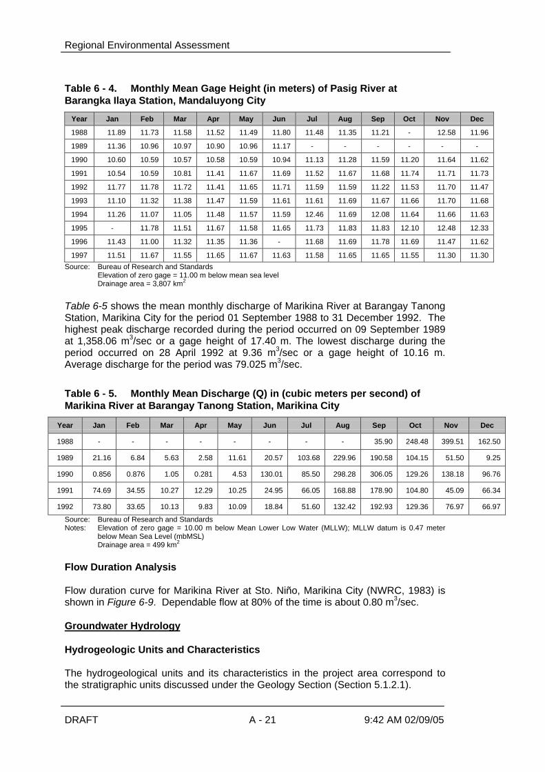
Regional Environmental Assessment
DRAFT A - 21 9:42 AM 02/09/05
Table 6 - 4. Monthly Mean Gage Height (in meters) of Pasig River atBarangka Ilaya Station, Mandaluyong City
Year Jan Feb Mar Apr May Jun Jul Aug Sep Oct Nov Dec
1988 11.89 11.73 11.58 11.52 11.49 11.80 11.48 11.35 11.21 - 12.58 11.96
1989 11.36 10.96 10.97 10.90 10.96 11.17 - - - - - -
1990 10.60 10.59 10.57 10.58 10.59 10.94 11.13 11.28 11.59 11.20 11.64 11.62
1991 10.54 10.59 10.81 11.41 11.67 11.69 11.52 11.67 11.68 11.74 11.71 11.73
1992 11.77 11.78 11.72 11.41 11.65 11.71 11.59 11.59 11.22 11.53 11.70 11.47
1993 11.10 11.32 11.38 11.47 11.59 11.61 11.61 11.69 11.67 11.66 11.70 11.68
1994 11.26 11.07 11.05 11.48 11.57 11.59 12.46 11.69 12.08 11.64 11.66 11.63
1995 - 11.78 11.51 11.67 11.58 11.65 11.73 11.83 11.83 12.10 12.48 12.33
1996 11.43 11.00 11.32 11.35 11.36 - 11.68 11.69 11.78 11.69 11.47 11.62
1997 11.51 11.67 11.55 11.65 11.67 11.63 11.58 11.65 11.65 11.55 11.30 11.30
Source: Bureau of Research and StandardsElevation of zero gage = 11.00 m below mean sea levelDrainage area = 3,807 km2
Table 6-5 shows the mean monthly discharge of Marikina River at Barangay TanongStation, Marikina City for the period 01 September 1988 to 31 December 1992. Thehighest peak discharge recorded during the period occurred on 09 September 1989at 1,358.06 m3/sec or a gage height of 17.40 m. The lowest discharge during theperiod occurred on 28 April 1992 at 9.36 m3/sec or a gage height of 10.16 m.Average discharge for the period was 79.025 m3/sec.
Table 6 - 5. Monthly Mean Discharge (Q) in (cubic meters per second) ofMarikina River at Barangay Tanong Station, Marikina City
Year Jan Feb Mar Apr May Jun Jul Aug Sep Oct Nov Dec
1988 - - - - - - - - 35.90 248.48 399.51 162.50
1989 21.16 6.84 5.63 2.58 11.61 20.57 103.68 229.96 190.58 104.15 51.50 9.25
1990 0.856 0.876 1.05 0.281 4.53 130.01 85.50 298.28 306.05 129.26 138.18 96.76
1991 74.69 34.55 10.27 12.29 10.25 24.95 66.05 168.88 178.90 104.80 45.09 66.34
1992 73.80 33.65 10.13 9.83 10.09 18.84 51.60 132.42 192.93 129.36 76.97 66.97
Source: Bureau of Research and StandardsNotes: Elevation of zero gage = 10.00 m below Mean Lower Low Water (MLLW); MLLW datum is 0.47 meter
below Mean Sea Level (mbMSL)Drainage area = 499 km2
Flow Duration Analysis
Flow duration curve for Marikina River at Sto. Niño, Marikina City (NWRC, 1983) isshown in Figure 6-9. Dependable flow at 80% of the time is about 0.80 m3/sec.
Groundwater Hydrology
Hydrogeologic Units and Characteristics
The hydrogeological units and its characteristics in the project area correspond tothe stratigraphic units discussed under the Geology Section (Section 5.1.2.1).

Flow Duration Curve of Marikina River
FIGURE NO.
6-9
FIGURE TITLE:EDCOP
Lichel Technologies, Inc. andISSI
The Associated Firm:
MARIKINA RIVER (1958-71-72-76)STO. NINO MARIKINA RIZALD.A. = 499 SQ.KM.
Source: National Water Resources Council, Framework Plan (1983)

Regional Environmental Assessment
DRAFT A - 23 9:42 AM 02/09/05
A.1.6 Water Quality
Sampling Stations
Water samples were collected from 33 stations within the Project area namely:
Ø Stations (1a1, 1a2, 1b1, 1b2, 1c1, 1c2, 1d1, and 1d2) at the Taguig SewerageSystem component located along Hagonoy creek, Taguig River, Labasan Riverand Tapayan River adjacent to Laguna de Bay;
Ø Stations (2a1, 2a2, 2a3, 2b1, 2b2, 2b3, 2c1, 2c2, 2c3, 2c4) at the RiverbanksSewage Treatment Plants along the riverbanks of Pasig River, located in Makati,Mandaluyong and Pasig;
Ø Station (3a) at the proposed north sector Septage Treatment Plant at the FTIComplex, Taguig, Rizal
Ø Stations (4a, 4b, 4c) for the Low-Income Sewerage System, located inPinagsama Village and Signal Village (Taguig) and Manggahan Floodway EastBank Community (Taytay);
Ø Stations (5a, 5b, 5c) in the proposed Existing Sanitation Systems in QuezonCity.
Stations (6a1, 6a2, 6b, 6c, 6d1, 6d2, 6e, 6f) for the Quezon City – MarikinaSewerage System along the riverbank of Marikina River;
The description, location and coordinates of the sampling stations are given in Table6-6 and are shown in Figure 6-10.
Gullies at the proposed Payatas Septage Treatment Plant were dry during the visit;hence, no water samples were taken.
The Taguig Sewerage System has four catchment areas. The Hagonoy River withan upstream sampling site (1a1) 10 m away from the entrance gate of the DPWHfloodgate and a downstream site (1a2), 150 m away from the DPWH floodgate, inthe Laguna Lake. The Taguig River had two sampling sites: upstream (1b1) 100 maway from the DPWH floodgate and downstream (1b2) 50 m off the mouth of TaguigRiver in Laguna Lake. Labasan River on the other hand had two sampling sites, oneupstream (1c1), 150 m away from DPWH floodgate and downstream (1c2) 150 maway from DPWH floodgate, in Laguna Lake. Tapayan River also had two samplingsites, one upstream (1d1) below the Ilog Tapayan bridge and downstream (1d2) offthe mouth of Tapayan River in Laguna Lake.
At the proposed Riverbanks Sewage Treatment Plants, the Poblacion catchment inMakati City near J.P. Rizal had sample collections in the upstream (2a1), outfall(2a2) and downstream (2a3). The Ilaya catchment in Mandaluyong City on the otherhand had three sampling sites namely: upstream (2b1), outfall (2b2) anddownstream (2b3). The Capitolyo catchment in Pasig City (Pineda) had two outfallsamples (2c1 and 2c2), one upstream (2c3) and one downstream (2c4).
Only one sampling station (3a) was identified and is located at the proposed NorthSeptage Treatment Plant, FTI Complex, Taguig. Water sample, originating from theFTI Complex, was collected from the concrete box culvert that discharges into acreek some 75 m downslope of the existing FTI Sewage Treatment Plant.

Regional Environmental Assessment
DRAFT A - 24 9:42 AM 02/09/05
The low-income community areas comprise of three sampling sites: two sites alongthe Pinagsama Creek and one at the East Manggahan Floodway. The samplingstations along Pinagsama Creek are located at Signal Village (4a) and at thedownstream portion at Pinagsama Village below a bridge (4b). The sampling stationat the Manggahan Floodway East Bank community (4c) is located at the southern,downstream end of a creek near the proposed STP at Genesis community.
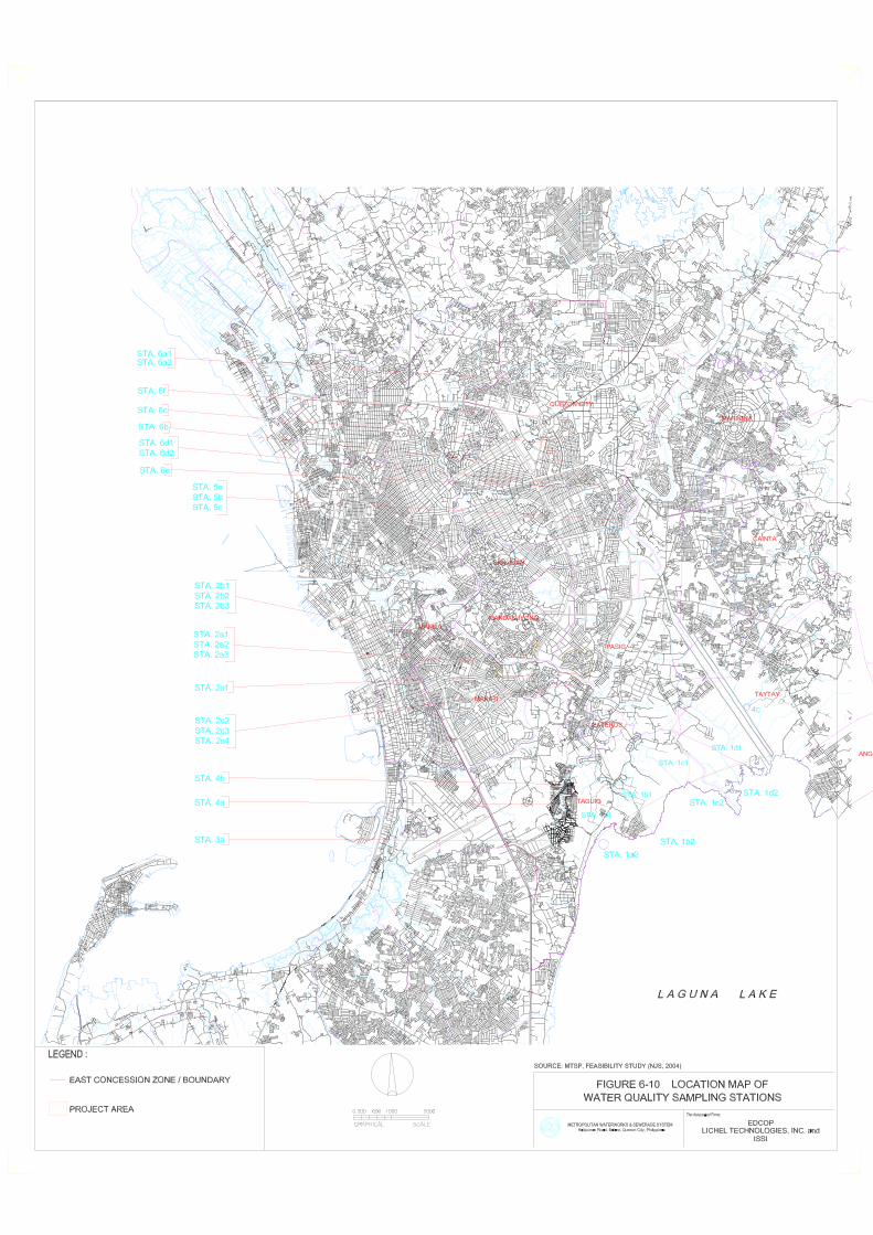
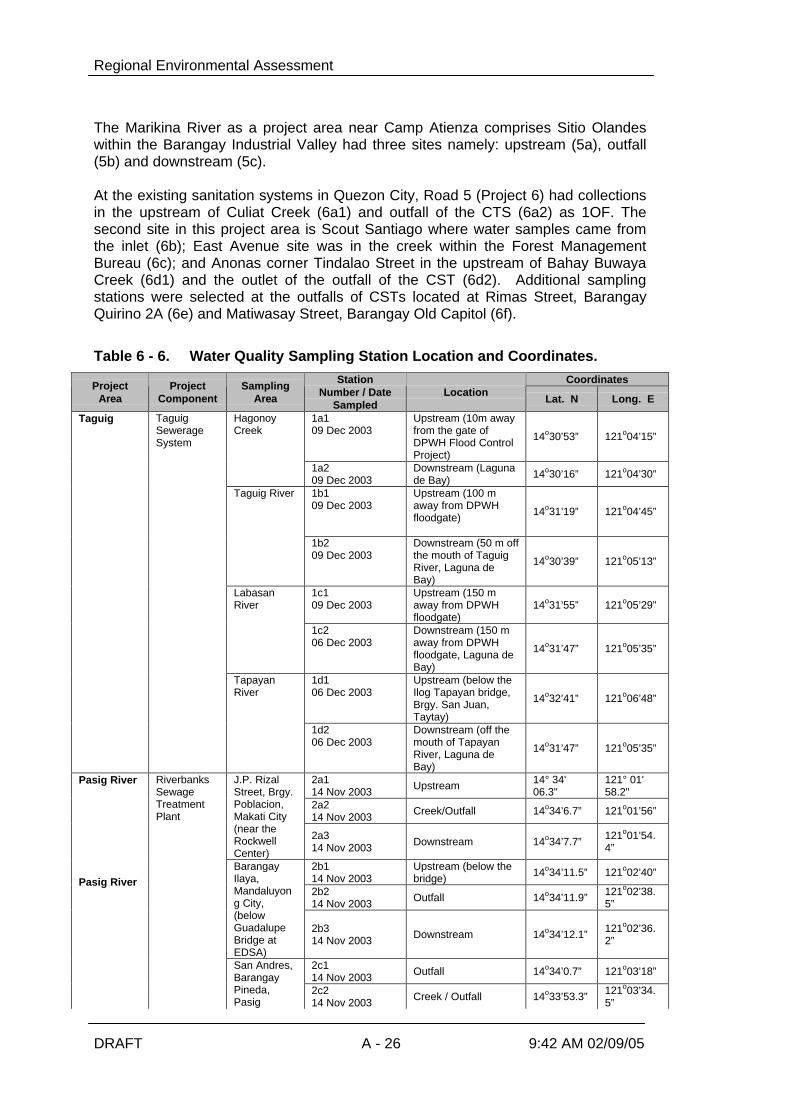
Regional Environmental Assessment
DRAFT A - 26 9:42 AM 02/09/05
The Marikina River as a project area near Camp Atienza comprises Sitio Olandeswithin the Barangay Industrial Valley had three sites namely: upstream (5a), outfall(5b) and downstream (5c).
At the existing sanitation systems in Quezon City, Road 5 (Project 6) had collectionsin the upstream of Culiat Creek (6a1) and outfall of the CTS (6a2) as 1OF. Thesecond site in this project area is Scout Santiago where water samples came fromthe inlet (6b); East Avenue site was in the creek within the Forest ManagementBureau (6c); and Anonas corner Tindalao Street in the upstream of Bahay BuwayaCreek (6d1) and the outlet of the outfall of the CST (6d2). Additional samplingstations were selected at the outfalls of CSTs located at Rimas Street, BarangayQuirino 2A (6e) and Matiwasay Street, Barangay Old Capitol (6f).
Table 6 - 6. Water Quality Sampling Station Location and Coordinates.CoordinatesProject
AreaProject
ComponentSampling
Area
StationNumber / Date
SampledLocation
Lat. N Long. E
1a109 Dec 2003
Upstream (10m awayfrom the gate ofDPWH Flood ControlProject)
14o30’53” 121o04’15”
HagonoyCreek
1a209 Dec 2003
Downstream (Lagunade Bay) 14o30’16” 121o04’30”
1b109 Dec 2003
Upstream (100 maway from DPWHfloodgate) 14o31’19” 121o04’45”
Taguig River
1b209 Dec 2003
Downstream (50 m offthe mouth of TaguigRiver, Laguna deBay)
14o30’39” 121o05’13”
1c109 Dec 2003
Upstream (150 maway from DPWHfloodgate)
14o31’55” 121o05’29”LabasanRiver
1c206 Dec 2003
Downstream (150 maway from DPWHfloodgate, Laguna deBay)
14o31’47” 121o05’35”
1d106 Dec 2003
Upstream (below theIlog Tapayan bridge,Brgy. San Juan,Taytay)
14o32’41” 121o06’48”
Taguig TaguigSewerageSystem
TapayanRiver
1d206 Dec 2003
Downstream (off themouth of TapayanRiver, Laguna deBay)
14o31’47” 121o05’35”
2a114 Nov 2003 Upstream 14° 34'
06.3"121° 01'58.2"
2a214 Nov 2003 Creek/Outfall 14o34’6.7” 121o01’56”
J.P. RizalStreet, Brgy.Poblacion,Makati City(near theRockwellCenter)
2a314 Nov 2003 Downstream 14o34’7.7” 121o01’54.
4”
2b114 Nov 2003
Upstream (below thebridge) 14o34’11.5” 121o02’40”
2b214 Nov 2003 Outfall 14o34’11.9” 121o02’38.
5”
BarangayIlaya,Mandaluyong City,(belowGuadalupeBridge atEDSA)
2b314 Nov 2003 Downstream 14o34’12.1” 121o02’36.
2”
2c114 Nov 2003 Outfall 14o34’0.7” 121o03’18”
Pasig River
Pasig River
RiverbanksSewageTreatmentPlant
San Andres,BarangayPineda,Pasig
2c214 Nov 2003 Creek / Outfall 14o33’53.3” 121o03’34.
5”
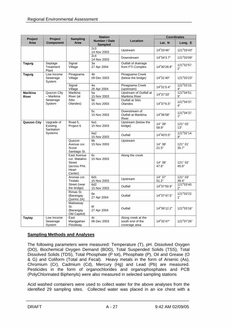
Regional Environmental Assessment
DRAFT A - 27 9:42 AM 02/09/05
CoordinatesProjectArea
ProjectComponent
SamplingArea
StationNumber / Date
SampledLocation
Lat. N Long. E
2c314 Nov 2003 Upstream 14o33’46” 121o03’43”
2c414 Nov 2003 Downstream 14o34’3.7” 121o03’09”
Taguig SeptageTreatmentPlant
SignalVillage
3a27 Apr 2004
Outfall of drainagefrom FTI Complex 14o30’28.8” 121o02’57.
2”
Taguig Low IncomeSewerageSystem
PinagsamaVillage
4b09 Dec 2003
Pinagsama Creek(below the bridge) 14o31’40” 121o03’23”
SignalVillage
4a26 Apr 2004
Pinagsama Creek(upstream) 14o31’0.4” 121o03’15.
4”5a15 Nov 2003
Upstream of Outfall atMarikina River 14o37’33” 121o04’51.
5”5b15 Nov 2003
Outfall at SitioOlandes 14o37’6.5” 121o04’37.
4”
MarikinaRiver
Quezon City– MarikinaSewerageSystem
MarikinaRiver (atSitioOlandes)
5c15 Nov 2003
Downstream ofOutfall at MarikinaRiver
14o36’58” 121o04’37.7”
6a115 Nov 2003
Upstream (below thebridge) 14° 39'
59.9"121° 02'13"
Road 5,Project 6
6a215 Nov 2003 Outfall 14o40’0.5” 121o02’14.
9”QuezonAvenue cor.ScoutSantiago St.
6b15 Nov 2003
Upstream14° 38'21.5"
121° 01'35.7"
East Avenuecor. MatalinoStreet(across Phil.HeartCenter)
6c15 Nov 2003
Along the creek
14° 38'47.6"
121° 02'45.6"
6d115 Nov 2003 Upstream 14° 37'
51.2"121° 03'39.4"
Anonas cor.TindaloStreet (nearthe bridge)
6d215 Nov 2003 Outfall 14o37’50.9” 121o03’40.
2”Rimas St.(BarangayQuirino 2A)
6e27 Apr 2004 Outfall 14o37’47.5” 121o03’22.
1”
Quezon City Upgrade ofExistingSanitationSystems
MatiwasaySt.(BarangayOld Capitol)
6f27 Apr 2004 Outfall 14o39’12.2” 121o03’16”
Taytay Low IncomeSewerageSystem
EastManggahanFloodway
4c06 Dec 2003
Along creek at thesouth end of thecoverage area
14o32’47” 121o07’26”
Sampling Methods and Analyses
The following parameters were measured: Temperature (T), pH. Dissolved Oxygen(DO), Biochemical Oxygen Demand (BOD), Total Suspended Solids (TSS), TotalDissolved Solids (TDS), Total Phosphate (P tot), Phosphate (P), Oil and Grease (O& G) and Coliform (Total and Fecal). Heavy metals in the form of Arsenic (As),Chromium (Cr), Cadmium (Cd), Mercury (Hg) and Lead (Pb) are measured.Pesticides in the form of organochlorides and organophosphates and PCB(PolyChlorinated Biphenyls) were also measured in selected sampling stations
Acid washed containers were used to collect water for the above analyses from theidentified 29 sampling sites. Collected water was placed in an ice chest with a
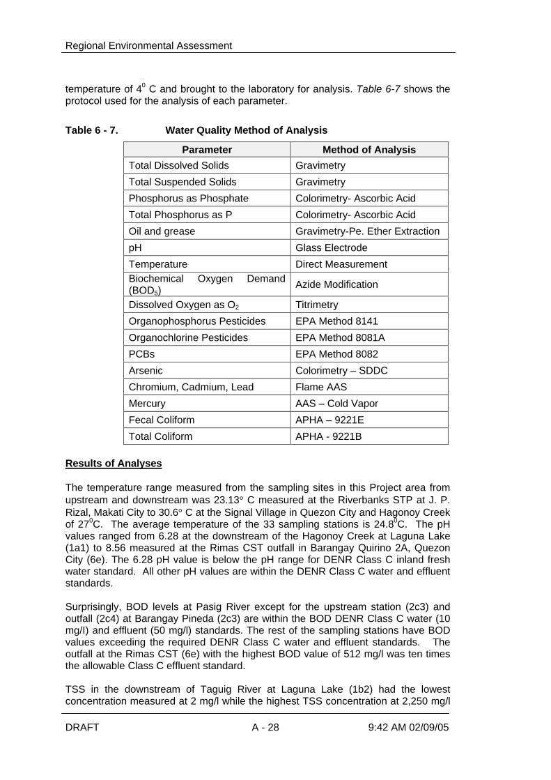
Regional Environmental Assessment
DRAFT A - 28 9:42 AM 02/09/05
temperature of 40 C and brought to the laboratory for analysis. Table 6-7 shows theprotocol used for the analysis of each parameter.
Table 6 - 7. Water Quality Method of Analysis
Parameter Method of Analysis
Total Dissolved Solids Gravimetry
Total Suspended Solids Gravimetry
Phosphorus as Phosphate Colorimetry- Ascorbic Acid
Total Phosphorus as P Colorimetry- Ascorbic Acid
Oil and grease Gravimetry-Pe. Ether Extraction
pH Glass Electrode
Temperature Direct MeasurementBiochemical Oxygen Demand(BOD5)
Azide Modification
Dissolved Oxygen as O2 Titrimetry
Organophosphorus Pesticides EPA Method 8141
Organochlorine Pesticides EPA Method 8081A
PCBs EPA Method 8082
Arsenic Colorimetry – SDDC
Chromium, Cadmium, Lead Flame AAS
Mercury AAS – Cold Vapor
Fecal Coliform APHA – 9221E
Total Coliform APHA - 9221B
Results of Analyses
The temperature range measured from the sampling sites in this Project area fromupstream and downstream was 23.13° C measured at the Riverbanks STP at J. P.Rizal, Makati City to 30.6° C at the Signal Village in Quezon City and Hagonoy Creekof 270C. The average temperature of the 33 sampling stations is 24.80C. The pHvalues ranged from 6.28 at the downstream of the Hagonoy Creek at Laguna Lake(1a1) to 8.56 measured at the Rimas CST outfall in Barangay Quirino 2A, QuezonCity (6e). The 6.28 pH value is below the pH range for DENR Class C inland freshwater standard. All other pH values are within the DENR Class C water and effluentstandards.
Surprisingly, BOD levels at Pasig River except for the upstream station (2c3) andoutfall (2c4) at Barangay Pineda (2c3) are within the BOD DENR Class C water (10mg/I) and effluent (50 mg/l) standards. The rest of the sampling stations have BODvalues exceeding the required DENR Class C water and effluent standards. Theoutfall at the Rimas CST (6e) with the highest BOD value of 512 mg/l was ten timesthe allowable Class C effluent standard.
TSS in the downstream of Taguig River at Laguna Lake (1b2) had the lowestconcentration measured at 2 mg/l while the highest TSS concentration at 2,250 mg/l
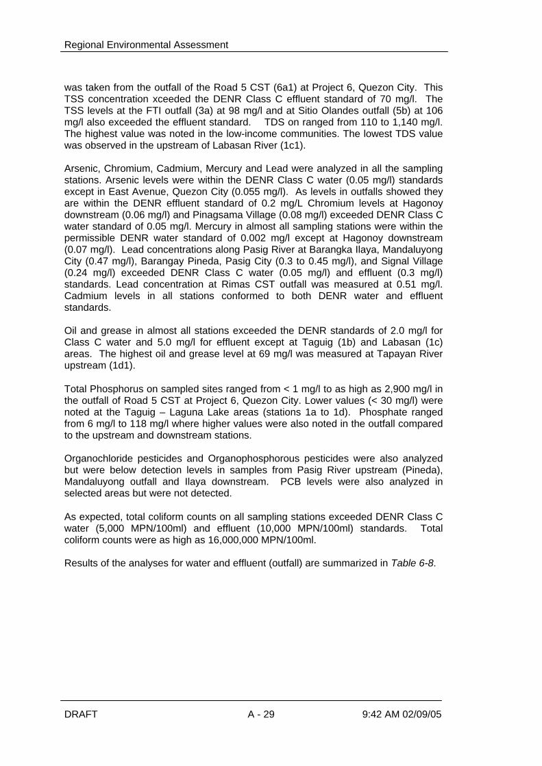
Regional Environmental Assessment
DRAFT A - 29 9:42 AM 02/09/05
was taken from the outfall of the Road 5 CST (6a1) at Project 6, Quezon City. ThisTSS concentration xceeded the DENR Class C effluent standard of 70 mg/l. TheTSS levels at the FTI outfall (3a) at 98 mg/l and at Sitio Olandes outfall (5b) at 106mg/l also exceeded the effluent standard. TDS on ranged from 110 to 1,140 mg/l.The highest value was noted in the low-income communities. The lowest TDS valuewas observed in the upstream of Labasan River (1c1).
Arsenic, Chromium, Cadmium, Mercury and Lead were analyzed in all the samplingstations. Arsenic levels were within the DENR Class C water (0.05 mg/l) standardsexcept in East Avenue, Quezon City (0.055 mg/l). As levels in outfalls showed theyare within the DENR effluent standard of 0.2 mg/L Chromium levels at Hagonoydownstream (0.06 mg/l) and Pinagsama Village (0.08 mg/l) exceeded DENR Class Cwater standard of 0.05 mg/l. Mercury in almost all sampling stations were within thepermissible DENR water standard of 0.002 mg/l except at Hagonoy downstream(0.07 mg/l). Lead concentrations along Pasig River at Barangka Ilaya, MandaluyongCity (0.47 mg/l), Barangay Pineda, Pasig City (0.3 to 0.45 mg/l), and Signal Village(0.24 mg/l) exceeded DENR Class C water (0.05 mg/l) and effluent (0.3 mg/l)standards. Lead concentration at Rimas CST outfall was measured at 0.51 mg/l.Cadmium levels in all stations conformed to both DENR water and effluentstandards.
Oil and grease in almost all stations exceeded the DENR standards of 2.0 mg/l forClass C water and 5.0 mg/l for effluent except at Taguig (1b) and Labasan (1c)areas. The highest oil and grease level at 69 mg/l was measured at Tapayan Riverupstream (1d1).
Total Phosphorus on sampled sites ranged from < 1 mg/l to as high as 2,900 mg/l inthe outfall of Road 5 CST at Project 6, Quezon City. Lower values (< 30 mg/l) werenoted at the Taguig – Laguna Lake areas (stations 1a to 1d). Phosphate rangedfrom 6 mg/l to 118 mg/l where higher values were also noted in the outfall comparedto the upstream and downstream stations.
Organochloride pesticides and Organophosphorous pesticides were also analyzedbut were below detection levels in samples from Pasig River upstream (Pineda),Mandaluyong outfall and Ilaya downstream. PCB levels were also analyzed inselected areas but were not detected.
As expected, total coliform counts on all sampling stations exceeded DENR Class Cwater (5,000 MPN/100ml) and effluent (10,000 MPN/100ml) standards. Totalcoliform counts were as high as 16,000,000 MPN/100ml.
Results of the analyses for water and effluent (outfall) are summarized in Table 6-8.

Quezon City Comprehensive Land Use Plan, 2000
FIGURE NO.
6-8
FIGURE TITLE:EDCOP
Lichel Technologies, Inc. andISSI
The Associated Firm:
QUEZON CITYQUEZON CITY
LEGEND :LEGEND :RESIDENTIAL SOCIALIZED HOUSINGCOMMERCIAL
INDUSTRIAL INSTITUTIONALUTILITYPARKS/RECREATIONCEMETERY
SPECIAL DEVELOPMENT
N
1000 0 1000 2000 3000 4000
Meters
PROPOSED AMENDEDCOMPREHENSIVE LAND USE MAPPROPOSED AMENDEDCOMPREHENSIVE LAND USE MAP

Regional Environmental Assessment
DRAFT A - 31 9:42 AM 02/09/05
A.1.7 Meteorology and Ambient Air Quality
Meteorology
Meteorology is the science that deals with the earth’s atmosphere and its phenomena;specifically that of weather and climate and its effects on the earth’s surface, oceans,and life in general. In Metro Manila, the meteorological stations established by thePhilippine Atmospheric, Geophysical and Astronomical Services Administration(PAGASA) are located in the Science Garden in Diliman, Quezon City, Port Area inManila and at the Ninoy Aquino International Airport (NAIA), Pasay City. These threestations are situated at the central, western, and southern part of the Metro Manila(Table 6-9). The composite meteorological data from these stations represents theexpected weather and climate condition of the National Capital Region (NCR) allthroughout the year. This will also cover the description of the meteorological conditionin the Taytay and Cainta areas where several components of the MTSP are situated.The following subsections present the climate, ambient temperature, humidity, rainfall,and wind profile of the each of the aforesaid stations as based on the 34-yearclimatological normals and extremes data (1961-1995) of PAGASA.
Table 6 - 9. Three Metro Manila Meteorological Stations Considered in thisStudy
No. Station Coordinates Elevation430 Science Garden
Quezon CityN 14° 39’E 121° 03’
43 meters
425 Port Area, Manila N 14° 35’E 120° 59’
16 meters
429 NAIA TerminalPasay City
N 14° 31’E 121° 01’
21 meters
Climate
The climate of the Philippines is tropical and maritime. It is characterized by relativelyhigh temperature, high humidity and abundant rainfall. It is similar in many respects tothe climate of the countries of Central America. Temperature, humidity, and rainfall,which are discussed hereunder, are the most important elements of the country'sweather and climate. The climate map of the Philippines is presented in (Figure 6-11).
Metro Manila belongs to Type I of the Modified Coronas classification of Philippineclimate. It is characterized by the existence of two pronounced seasons, dry fromNovember to April and wet during the rest of the year. The months of May andNovember are considered the transition months.
Rainfall
Rainfall is the most important climatic element in the Philippines. Rainfall distributionthroughout the country varies from one region to another, depending upon thedirection of the moisture-bearing winds and the location of the mountain systems.
The mean annual rainfall of the Philippines varies from 965 to 4,064 millimetersannually. In Metro Manila, the annual average rainfall is 2,128.8 mm with an annual
Regional Environmental Assessment
DRAFT A - 32 9:42 AM 02/09/05
average of 133 rainy days (Table 6-10). The dry months are from December to Maywhile the rainy months are from June to November. The wettest months are July toSeptember. August is the peak of the rainy season with an average of 22 rainy daysper month. The highest daily rainfall as of 1995 is 472.4 mm which was recorded at theNAIA station in July 20, 1972 (See Annex 2 of EIS – Volume 2).

Climate Map of the Philippines
FIGURE NO.
6-11
FIGURE TITLE:
SOURCE: PAGASA
PROJECT SITE
EDCOPLichel Technologies, Inc.
ISSI
The Associated Firm:

Regional Environmental Assessment
DRAFT A - 34 9:42 AM 02/09/05
Table 6 - 10. Climatological Normals for Metro Manila Derived from theComposite Meteorological Data from the Science Garden, NAIA Terminal andPort Area Stations of PAGASA, 1961-1995
Temperature, °C WindMonth Rainfall
(mm)No of
rainy days Max Min MeanVP
(mbs)
Rel.Hum.(%) Dir. Speed,
M/sJanuary 14.5 3 30.3 21.3 25.7 24.0 74 NE 3February 5.3 2 31.0 21.5 26.3 23.5 69 NE, E, SE 3March 10.8 2 32.6 22.8 27.7 24.5 66 SE 3April 19.4 3 34.2 24.2 29.2 26.2 65 SE 3May 125.3 9 34.0 25.1 29.6 28.7 70 SE 3June 292.7 17 32.4 24.8 28.6 30.0 78 SW 3July 416.1 21 31.2 24.4 27.8 29.8 81 SW 3August 464.9 22 30.7 24.2 27.5 29.9 83 SW 3September 354.9 20 30.9 24.2 27.6 29.9 83 SW 2October 240.8 16 31.0 23.8 27.4 28.8 80 N, E, W 2November 131.0 11 30.8 23.1 26.9 27.2 78 N, E, NE 2December 53.2 7 30.1 22.1 26.1 25.4 77 NE 3Annual 2128.8 133 31.6 23.5 27.5 27.3 75 SW 3
Temperature
Based on the average of all weather stations in the Philippines, excluding Baguio, themean annual temperature is 26.6o C. The coolest months fall in January with a meantemperature of 25.5o C while the warmest month occurs in May with a meantemperature of 28.3o C. Latitude is an insignificant factor in the variation oftemperature while altitude shows greater contrast in temperature.
Using the composite data in Table 5-10, the average mean annual temperature inMetro Manila is 27.5 °C while the average annual maximum and minimumtemperatures recorded for the day are 31.6 °C and 23.5 °C, respectively. The warmestmonth is May with an average mean monthly temperature of 29.6 °C while the coolestis January at 25.7 °C.
The warmest and coldest temperature was recorded at the Port Area station with 38.6°C observed on May 17, 1915 and 14.5 °C recorded on January 11, 1914 (see Annex2of EIS – Volume 2).
Relative Humidity
Humidity refers to the moisture content of the atmosphere. Due to high temperatureand the surrounding bodies of water, the Philippines has a high relative humidity. Theaverage monthly relative humidity varies between 71 percent in March and 85 percentin September. The combination of warm temperature and high relative and absolutehumidities give rise to high sensible temperature throughout the archipelago. It isespecially uncomfortable during March to May, when temperature and humidity attaintheir maximum levels. Relative humidity (RH) is expressed as percentage of water vaporin air.
In Metro Manila, the mean monthly relative humidity varies from a low of 65 percent inApril to a high of 83 percent in August and September. The annual average relativehumidity is 75 percent with August and September as the most humid months of theyear with an average RH of 83 percent while April is the least humid with RH of 65percent.

Regional Environmental Assessment
DRAFT A - 35 9:42 AM 02/09/05
Prevailing Wind
Metro Manila is exposed to both monsoons. The mountainous terrain modifies theNortheast monsoon into an easterly direction and the Southwest Monsoon is deflectedto a westerly direction. The annual average wind speed is 3 meters per second (mps)with mean monthly values varying from 2 to 3 mps. Average monthly wind speed of 3mps occurs in December to August while minimum wind speed prevails in Septemberto November.
The strongest wind that occurred in Metro Manila was recorded at both NAIA and PortArea stations in November 19, 1970 (see Annex 2 of EIS – Volume 2). Its speed was56 mps from the W (NAIA as reference).
Tropical Cyclone Frequency
The Philippines, in general, is located in one of the most tropical cyclone-prone regionsof the world. About 20 tropical cyclones of varying intensities affect the country everyyear. Metro Manila is located in a zone where the probability of typhoon passage is 2to 3 cyclones every five years. The frequency distribution map of tropical cyclones inthe Philippines is shown in Figure 6-12.
Ambient Air Quality
Sampling Stations
Seventeen sampling stations listed in Table 6-11 and presented in Figure 6-13 wereconsidered in this study. These stations were mostly situated in the east zone of MetroManila. Except for the Taytay and Taguig stations, these are regular monitoringstations of the Environmental Management Bureau (EMB). Monthly monitoring is beingconducted by the EMB personnel at these stations to monitor levels of dustparticulates in the area. Majority of the sampling stations are located in commercialand institutional areas.
Table 6 - 11. Location of the Metro Manila Air Quality Sampling Stations
Station No. Location
A1 Congressional Avenue, Project 8, Quezon City
A2 BFD Compound East Avenue, Quezon City
A3 NPO Compound EDSA, Quezon City
A4 Ateneo University Katipunan Road, Diliman, Quezon City
A5 Gumamela St. Viejo, Makati City
A6 EDSA, Guadalupe, Makati City
A7 LLDA Compound, Pasig City
A8 Mandaluyong City Hall, Mandaluyong City
A9 EDSA Shrine, Mandaluyong
A10 City Hall F.B. Harrison St., Pasay City
A11 MRT South Station, Pasay City
A12 Department of Health, San Lazaro Rizal Avenue, Manila
A13 EDSA, MCU Caloocan City
A14 Valenzuela Municipal Hall, Valenzuela

Regional Environmental Assessment
DRAFT A - 36 9:42 AM 02/09/05
A15 Las Piñas
A16 Blk 15, Lot 1, Anak Pawis, Manggahan East Bank Floodway, Taytay, Rizal
A17 Zone 5, Brgy. Outpost Pinagsama Village, Phase I&II Extension, Taguig

Tropical Cyclone Map of the Philippines
FIGURE NO.
6-12
FIGURE TITLE:
PROJECT SITE
SOURCE: PAGASA
EDCOPLichel Technologies, Inc. and
ISSI
The Associated Firm:

Ambient Air and Noise Level Sampling Stations
FIGURE NO.
6-13
FIGURE TITLE:
Source: NAMRIA
EDCOPLichel Technologies, Inc. and
ISSI
The Associated Firm:
14°35’
121°05’00”
14°30’
121°00’00”
14°40’
NORTH
Graphical Scale01 1 2 3 Km.
Legend:
REA Boundary -
N7
A1N5
A4N6 N8
N9
N10
A9
A8
N12N11N13
A5
A6
A17
N2 N1
N3
N4
N14
A16

Regional Environmental Assessment
DRAFT A - 39 9:42 AM 02/09/05
Methodology
Latest results of monthly monitoring conducted by EMB in the Metro Manila area wasgathered and examined to become part of this study. Twenty-four hour sampling wasconducted by the EMB personnel at stations (A1 to A15) to determine concentration ofTotal Suspended particulates (TSP) in Metro Manila. Additional monitoring stationswere established in the Taytay and Taguig areas where some components of theManila Third Sewerage Project (MTSP) will be implemented. Two one-hour samplingof TSP (morning and afternoon) were conducted at these two stations (A16 and A17).The method employed for sampling TSP is the high volume-gravimetric method usingthe Staplex High Volume Sampler. Air is drawn through a moisture free glass-fiberfilter paper and desiccated for 24 hours after sampling. The concentration of TSP inambient air is calculated by the total particulates collected divided by the total normalvolume of air sampled.
A.1.8 Noise Level
Sampling Station
To characterize the noise level quality in Metro Manila, fifteen stations located indifferent areas in Metro Manila are considered in this study. These stations aresituated in areas where the major components of the MTSP will be implemented. Thedescription, geographical coordinates and locations of these stations are presented inTable 6-13 and in Figure 6-14.
Methodology
The noise levels at the 17 aforementioned sampling stations are measured using theExtech Digital Sound Level Meter. It is in accordance with the provision of the NationalPollution Control Commission’s (NPCC) Memorandum Circular 002, Series of 1980,which sets the median of seven maximum readings to be compared to the standardand the sampling procedure outlined by Wilson (1989). A total of fifty readings wererecorded per station wherein the median of the seven maximum-recorded noise levelsgives the noise level for comparison to the standard.
Results and Discussion
Results and Discussion
The premier metropolis of the Philippines, The need to characterize air quality withinthe project component sites is to assess if the attributable impacts during constructionwill deteriorate quality beyond the ambient standards. Metro Manila, is still saddledwith air quality problems. While there had been gains, due to the passing of the CleanAir Act which gave way to the prohibition of utilizing leaded gasoline for vehicles, signsof air quality deterioration are still apparent. The highest average TSP level recordedwas in the Congressional Ave. (380 ug/Nm3) during the September 2003 sampling(Table 6-12). Based on the mean TSP concentration of the 17 stations, Valenzuelaemerged to have the highest average TSP concentration (255.54 ug/Nm3). Thedetected level of TSP could probably be partly attributed to the growing number ofdiesel-fueled vehicles and industries.

Regional Environmental Assessment
DRAFT A - 40 9:42 AM 02/09/05
Table 6 - 12. Recorded Total Suspended Particulates Concentration in Selected Areas in Metro Manila (ug/Nm3)
No. Station January February March April May June July AugustSeptember OctoberNovember December Station
AverageA1 Congressional 303.20 261.00 251.75 193.60 180.00 151.40 217.75 276.20 380.00 264.25 282.67 266.33 252.35A2 East Ave. 207.50 201.20 231.00 185.80 213.80 169.00 151.60 150.00 169.80 171.56 190.40 217.00 188.22A3 EDSA, QC 157.00 146.60 186.00 178.00 164.60 137.25 170.25 154.50 193.50 199.25 122.00 103.33 159.36A4 Ateneo 94.5 87.67 64.00 89.00 66.50 81.00 80.25 121.00 80.25 85.50 84.97A5 Makati City 217.2 230.00 221.00 219.00 223.00 173.00 140.75 134.67 266.00 202.74A6 EDSA, Guadalupe 163.00 163.00A7 Pasig 91.20 84.40 114.00 145.40 147.75 85.00 87.40 76.80 45.00 144.33 99.75 113.00 102.84A8 Mandaluyong 171.00 198.60 173.60 121.33 125.50 114.60 115.60 103.40 163.40 115.50 140.25A9 EDSA Shrine,
Mandaluyong 243.67 243.67A10 Pasay 168.00 282.67 149.00 133.50 276.00 264.50 253.00 95.00 180.00 130.67 176.00 191.67A11 MRT South Sta.,
Pasay 222.33 222.33A12 Manila 221.33 158.00 186.67 240.50 115.00 197.25 118.50 227.00 177.75 164.50 180.65A13 EDSA, MCU 240.00 240.00A14 Valenzuela 264.80 307.40 306.40 300.50 267.40 188.40 236.40 279.33 177.80 227.00 255.54A15 L.P. 23.00 34.67 51.67 26.00 51.00 37.27A16* Taytay 56.75 56.75A17* Taguig 118.05 118.05
AnnualAverage 191.64 204.70 193.21 177.04 192.34 131.02 148.79 141.79 166.68 180.11 164.28 152.75 167.04
Source: Monthly Monitoring by the Environmental Management Bureau* - Ambient Monitoring Conducted by Berkman Systems, Inc.

Regional Environmental Assessment
DRAFT A - 41 9:42 AM 02/09/05
The mean monthly 24-hour TSP monitoring results for Metro Manila for 2003 arepresented in Figure 6-14. Metro Manila has an annual average TSP level of 167.04ug/Nm3. This is outside the National Ambient Air Quality Guideline (NAAQG) of 90ug/Nm3. The month of February appeared to have the highest TSP level of 204.70ug/Nm3. If compared with NAAQG for 24-hour monitoring (230 ug/Nm3), all monthsof 2003 appeared to have a normal level of TSP concentration.
0.00
50.00
100.00
150.00
200.00
250.00
Jan Feb Mar Apr May Jun Jul Aug Sep Oct Nov Dec
Months of 2003
TS
P C
on
cen
trat
ion
(in
ug
/Ncm
)
DENR Std for 24-hour sampling=230 ug/Ncm
Figure 6 - 14. Graphical Presentation of the TSP Concentration Level in MetroManila, 2003
Metro Manila is known to be the busiest area in the Philippines. This statementproved to be true considering the results of the recently conducted noise levelmonitoring in selected areas in Metro Manila (Table 6-13). The monitoring wasconducted on December 03 and 22, 2003 at daytime period, 10:35am to 4:10pm.Results of monitoring revealed that all stations failed to meet the DENR standard of55 decibel (dBA) for residential areas and 65 dBA for commercial areas. Theseexceedances could be attributed to the volume of vehicles passing along themonitoring stations. Other sources of noise in the area were the Metro Rail TransitLine 3 (for stations near EDSA), tricycles, street vendors, and other human activities(for stations in residential areas), which significantly contributed to the detected noiselevels. The station in Tindalo corner Anonas St. (N9) recorded the highest noise levelreading with 86.5 dBA while residential community in San Juan, Taytay (N2)appeared to be the most tranquil station during the monitoring period.
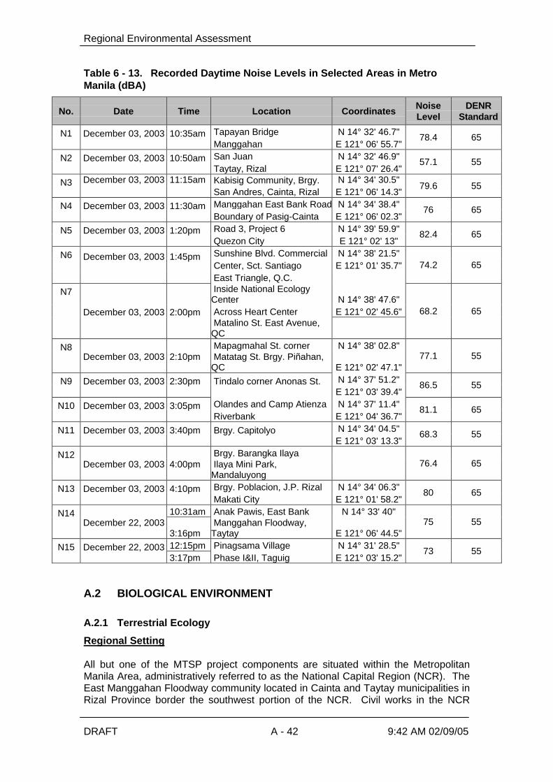
Regional Environmental Assessment
DRAFT A - 42 9:42 AM 02/09/05
Table 6 - 13. Recorded Daytime Noise Levels in Selected Areas in MetroManila (dBA)
No. Date Time Location Coordinates NoiseLevel
DENRStandard
Tapayan Bridge N 14° 32' 46.7"N1 December 03, 2003
10:35am Manggahan E 121° 06' 55.7"
78.4 65
San Juan N 14° 32' 46.9"N2 December 03, 2003
10:50am Taytay, Rizal E 121° 07' 26.4"
57.1 55
Kabisig Community, Brgy. N 14° 34' 30.5"N3 December 03, 2003
11:15am San Andres, Cainta, Rizal E 121° 06' 14.3"
79.6 55
Manggahan East Bank Road N 14° 34' 38.4"N4 December 03, 2003
11:30am Boundary of Pasig-Cainta E 121° 06' 02.3"
76 65
Road 3, Project 6 N 14° 39' 59.9"N5 December 03, 2003
1:20pm Quezon City E 121° 02' 13"
82.4 65
Sunshine Blvd. Commercial N 14° 38' 21.5" Center, Sct. Santiago E 121° 01' 35.7"
N6 December 03, 2003
1:45pm East Triangle, Q.C.
74.2 65
Inside National EcologyCenter N 14° 38' 47.6" Across Heart Center E 121° 02' 45.6"
N7
December 03, 2003
2:00pm
Matalino St. East Avenue,QC
68.2 65
Mapagmahal St. corner N 14° 38' 02.8"N8 December 03, 2003
2:10pm
Matatag St. Brgy. Piñahan,QC E 121° 02' 47.1"
77.1 55
N 14° 37' 51.2"N9 December 03, 2003
2:30pm
Tindalo corner Anonas St. E 121° 03' 39.4"
86.5 55
Olandes and Camp Atienza N 14° 37' 11.4"N10 December 03, 2003
3:05pm Riverbank E 121° 04' 36.7"
81.1 65
N 14° 34' 04.5"N11 December 03, 2003
3:40pm
Brgy. Capitolyo E 121° 03' 13.3"
68.3 55
Brgy. Barangka IlayaN12 December 03, 2003
4:00pm
Ilaya Mini Park,Mandaluyong
76.4 65
Brgy. Poblacion, J.P. Rizal N 14° 34' 06.3"N13 December 03, 2003
4:10pm Makati City E 121° 01' 58.2"
80 65
10:31am Anak Pawis, East Bank N 14° 33' 40"N14 December 22, 2003 3:16pm
Manggahan Floodway,Taytay E 121° 06' 44.5"
75 55
12:15pm Pinagsama Village N 14° 31' 28.5"N15 December 22, 2003 3:17pm Phase I&II, Taguig E 121° 03' 15.2"
73 55
A.2 BIOLOGICAL ENVIRONMENT
A.2.1 Terrestrial Ecology
Regional Setting
All but one of the MTSP project components are situated within the MetropolitanManila Area, administratively referred to as the National Capital Region (NCR). TheEast Manggahan Floodway community located in Cainta and Taytay municipalities inRizal Province border the southwest portion of the NCR. Civil works in the NCR

Regional Environmental Assessment
DRAFT A - 43 9:42 AM 02/09/05
under the MTSP will specifically be undertaken in the cities of Quezon,Mandaluyong, Makati, Pasig, Marikina and the town of Taguig. As a highlyurbanized region, the landscape or terrestrial environment consists mainly of densehuman settlement areas, industrial sites, financial and commercial establishmentsand a network of roads and bridges – a concrete jungle, so to speak. The vegetationcover is constricted to man-made settings (memorial and home gardens, city parks,trees and ornamental lining and hedging streets) and a few remaining open areas(both private and government properties) that include natural successional anddisturbed habitats and patches of cultivated lands which are rapidly being reduced inhectarage due to population and urbanization pressures. In a decade or so, most ofthe privately owned natural areas will be transformed into housing, commercial andindustrial sites. The government lands may soon be taken over by the region’shomeless families unless programs are formulated to prevent such an eventuality. Itis, however, enlightening to note that the University of the Philippines already has aplan to develop a part of its Diliman (Quezon City) idle land into a botanical gardenwhich will house exotic and rare tropical plant species. The garden will partly servethe needs of Metropolitan Manila residents for the enjoyment and appreciation ofnatural green sceneries.
Terrestrial Flora
At the Taguig Sewerage System, the vegetation cover of the floodplains adjacent tothe pumping stations and retention ponds are dominated by grasses, herbs andsedges in association with a few shrubs that characterize open, waste and generallydamp habitats. A majority of the herbaceous growth forms belong to the Gramineae,Leguminosae and Compositae Families. Their ecological importance rests mainly intheir role as primary producers in the ecosystem and as soil cover to preventerosion. The herbaceous cover may also provide habitats for insects and other smallfield fauna. At the Tapayan pump station, the flood plains are currently cultivated forrice culture. According to some long-time residents in the communities along theHagonoy and Taguig Rivers, they used to plant vegetable crops in the floodplainsduring the summer months before the DPWH Flood Control Program in the area wasimplemented.
All three catchments located alongside the Pasig River, situated in the cities of Pasig(Barangay Pineda), Mandaluyong (Barangka Ilaya) and Makati (Barangay Poblacion)are densely populated with very little and limited open space. The proposed site forthe construction of a STP for Barangay Pineda is devoid of any vegetation coverexcept for a few weeds at the edge of the riverbank. These include: Cenchrusechinatus, Chloris barbata, Eleusine indica (Gramineae), Cyperus difformis, Cyperusdistans (Cyperaceae), Centrosema pubesceus (Leguminosae) and Alternantherasessiles (Amaranthaceae).
Within the proposed STP site in Barangka Ilaya is a mini-riverside sitting parkbounded by a few (4) young Polyalthia longifolia (Annonaceae) trees and an Ixorachinensis (Rubiaceae) or santan hedge with some Bougainvillea spectabilis(Nyctaginaceae) plants. At the edges of this mini-park are a few weeds:Alternanthera sessilis (Amaranthaceae), Malvastrum coromandelinum and SidaAcuta (Malvaceae), Mimosa pudica (Leguminosae), Eleusine indica, Axonopuscompresus, Cenchrus echinatus, Chloris barbata (Graminae). The lift station will beconstructed in a concrete space adjacent to an existing basketball court. The site isdevoid of any vegetation.

Regional Environmental Assessment
DRAFT A - 44 9:42 AM 02/09/05
The site of the proposed STP for Barangay Poblacion in Makati City is a narrow stripof open space between J.P. Rizal St. and the riverbank. Standing within this strip aretwo Cocos nucifera (Palmae) and two Acacia auriculiformis (Leguminosae) trees.On the ground layer which is hard and sandy are a few stunted Ricinus communis(Euphorbiaceae) seedlings and tufts of the following cosmopolitan weeds: Chlorisbarbata, Cynodon dactylon and Eleusine indica (Gramineae), Cyperus rotundus andFimbristylis barbata (Cyperaceae), Mollugo oppositifolia (Aizoaceae) and Malachracapitata (Malvaceae).
The site selected for the establishment of the Septage Treatment Plant (SPTP)facility to service the northern sub-area is located near the Payatas open dumpsite inQuezon City. The Payatas site is basically an open grassland dominated byextensive stands of cogon (Imperata cylindrical) and talahib (Saccharumspontaneum) in association with ruderal herbs (characteristic of open wastelands).Within the site is a narrow dry creek lined with a few trees and shrubs. Patches ofburned areas with newly sprouted cogon and talahib blades were noted during thesurvey. The area does not have threatened or endangered plant species.
For the southern sub-area, the selected site for the SPTP is a vacant lot of about athousand square meters within the Food Terminal, Inc. (FTI) Complex in Taguig,Metro Manila. The area is essentially an open wasteland, with a few large treesalong the edges and a stand of ipil-ipil shrubs at its entrance. An aggregate of 47species under 20 Families was recorded during the survey of the FTI site (Table __).Occupying the central portion of the lot is a dense stand of Amaranthus spinosusand A. viridis together with herbaceous legumes Crotolaria verrucosa andCentrosema pubesceus. At the fringes of the stand are herbs that are usuallypresent in open wastelands. These herbaceous species serve mainly as groundcover to minimize erosion and as producers of organic matter in the habitat. At theedge of this proposed site are four large and tall Enterolobium saman trees and atthe entrance is a dense strip of Leucaena leucocephala and Ricinus communisshrubs. The presence of eggplant, kamote, ampalaya, kamoteng kahoy and papayaplants may indicate that there is some planting activity in the area. The area doesnot contain any endangered or threatened plant species. Only a few small white andyellow butterflies were observed to be fluttering over the Amaranthus stand.
The proposed STP site in the Manggahan Floodway East Bank area is an openwasteland. An aggregate of 77 species under 29 Families was recorded. Most ofthe eight tree species in the list were sighted at the backyards of the denselypopulated communities along the opposite bank of the man-made creek. These weremostly fruit-bearing trees. Most of the 66 herbaceous species recorded in the actualsite for the STP and adjacent areas are the very common grasses, herbs and vinesthat usually colonize open areas. A majority of these are grasses (Gramiveae) andcomposites (Compositae). Their ecological importance is mainly attributed to theirroles as ground cover to prevent soil erosion and food as well as habitat for insectsand other small field fauna. The presence of a few species providing edible fruits(Cucurbita and Momordica), roots (Manihot and Colocasia) indicates that nearbyresidents may be using the area to grow these and perhaps other plants during theyear.
The STP site at Signal Village (Ipil-Ipil street) covers an open area within a denselypopulated community beside the creek. Because of the sparse vegetation and thesize of the area, a ground inventory of the extant plants was conducted across theproposed STP. Beside the creek and fronting a residential house is a hedge of a fewMoringa (malunggay), young ipil-ipil and mango trees, a stunted santol sapling and a

Regional Environmental Assessment
DRAFT A - 45 9:42 AM 02/09/05
patch ofkamote plants. Adjacent to the basketball court are two patches of stuntedbamboo thicket, bananas, ornamental Ipomoeas and sugar cane plants. The vacantlot vegetation cover includes a tall and six young katuray trees, ipil-ipil, cassava,banana, and ornamental Ipomoea plants hedging an open waste place covered withcomposite, grass and leguminous weeds. There are fifty-seven (57) plant speciesbelonging to twenty-five (25) Families present in the area. Most of the trees arecultivated for their fruits. Except for the few species cultivated as vegetables sources,the herbs in the floristic list are characteristics colonizers of open waste places andserve as producers (through photosynthesis) in the ecosystem and as ground coverto minimize soil erosion. Incidentally, the list does not include any threatened orendangered plant species.
Scattered along the Marikina riverbanks are cultivated plots planted with vegetablecrops such as the common beans Phaseolus vulgaris, Phaseolus radiatus and Vignasesquipedalis, tomato (Lycopersicum esculentum), peanut (Arachis hypogea), andpechay (Brassica juncea). According to the caretaker or planter, corn (Zea mays) isusually grown during the summer. Aside from the cultivated plants, 70 speciesbelonging to 20 Families were recorded. A majority of these are herbaceous speciesunder Families Compositae, Cyperaceae, Graminae and Leguminosae and areusually found in open waste places. The few trees lining the road cut are relativelyyoung and small since this thoroughfare was constructed only a few years ago.
The CST 33 at East Avenue, to be upgraded into a mini regional STP, sitsunderneath a small woodland area within the (National Ecology Center) compound ofthe Forest Management Bureau along East Ave. Most of the trees are mature andsince they were planted close to one another, they are quite tall with high canopies.A majority of these are Swietenia (mahogany) and Bauhinia species. Adjacent to thiswooded area is a narrow strip of an open wasteland beside the concrete fence of theMinting Plant of the Bangko Sentral ng Pilipinas. An aggregate of 81 speciesbelonging to 37 Families was observed. The site where the trees are growing abovethe CST had no vegetation cover or undergrowth because apparently this was beingused as a mini-sitting park. Hence, the herbaceous plants in the list wereencountered in the strip of open waste area beside the boundary of the BangkoSentral ng Pilipinas (Central Bank) minting plant. These herbs, grasses and sedgesserve as a cover to minimize soil erosion and mainly as primary producers in thisopen habitat.
Around CST 20 at Road 5, Project 6 are ornamental shrubs and small trees whichinclude golden shower, buenavista, bougainvillea, papaya and neem tree. The othertrees in the list are growing in adjacent or neighboring houses behind concretefences, which will not be affected by the project.
All the proposed STP sites do not contain any rare or endangered plant species.The list of plant species for each project component can be found in Annex 3 of theEIS (Volume2).
Terrestrial Fauna
There are no wildlife fauna in the project area. The animals present in the area aremostly domesticated species of dogs, cats, fowls, birds, etc. Water buffaloes wereobserved in the Laguna lake area (Taguig Sewerage System). The bird populationin the area is not significant except for those that habitates the lake and rice fieldareas at Taguig and Taytay. It is expected that there are no rare, threatened orendangered species of animals in the project area due to its urban setting.

Regional Environmental Assessment
DRAFT A - 46 9:42 AM 02/09/05
A.2.2 Aquatic Ecology
The main goal of the Aquatic Ecology Survey is to determine the presentenvironmental state of the river systems and other water bodies which may beaffected by the proposed sewage treatment plants (STPs), and the upgrading ofexisting communal septic tanks (CST) to sewage treatment plants. This report aimsto present the results of sampling effort:
Ø to analyze and interpret the plankton and soft-bottom benthic communities of theriver systems and other water bodies;
Ø to obtain information on the freshwater fishes and other aquatic life; andØ to determine the other uses of the aquatic systems.
Sampling Methods and Analyses
Sampling Stations
Plankton and soft-bottom benthos samples from 29 sampling stations within the 5project areas were collected on 14 - 15 November and 6 and 9 December 2003distributed as follows: 6 stations at the proposed STPs in Quezon City; 10 stationsat the proposed STPs on the riverbanks of Pasig River, located in Makati,Mandaluyong and Pasig; 3 stations at the proposed STP along the riverbank ofMarikina River, located near Camp Atienza; 8 stations at the proposed Taguig STPsproject, located along Hagonoy Creek, Taguig River, Labasan River and TapayanRiver, adjacent to the Laguna de Bay; and 2 stations at the proposed construction ofCST for low-income communities located in Pinagsama Village (Taguig) and EastManggahan Floodway (Taytay).
Since the sampling program was conducted simultaneously with the water qualitysampling, the station locations are the same as shown in Figure 6-10. Theapproximate depth, types of bottom sediment and coordinates of each samplingstation are indicated in Table 6-14.
Table 6 - 14. Sampling Station Location, Approximate Depth and Types ofSubstrate.
ProjectArea
SamplingArea
StationNumber Location
ApproxDepth
(m)
Typesof Bottom Sediment
(Color)
1a109 Dec2003
Upstream (10m awayfrom the gate ofDPWH Flood ControlProject)
>0.5 Muddyfull of debris(black)
Hagonoy Creek
1a209 Dec2003
Downstream (Lagunade Bay)
0.5 Sandy-muddy withdebris (black)
Taguig(TaguigSewerageSystem)
Taguig River 1b109 Dec2003
Upstream (100 maway from DPWHfloodgate)
0.5 Muddy full of debris(black)

Regional Environmental Assessment
DRAFT A - 47 9:42 AM 02/09/05
ProjectArea
SamplingArea
StationNumber Location
ApproxDepth
(m)
Typesof Bottom Sediment
(Color)
1b209 Dec2003
Downstream (50 moff the mouth ofTaguig River, Lagunade Bay)
0.5 Sandy-muddywith debris(black)
1c109 Dec2003
Upstream (150 maway from DPWHfloodgate)
>0.5 Muddy (brown)Labasan River
1c206 Dec2003
Downstream (150 maway from DPWHfloodgate, Laguna deBay)
0.5 Sandy-muddy withdebris(black)
Tapayan River 1d106 Dec2003
Upstream (below theIlog Tapayan bridge,Brgy. San Juan,Taytay)
> 0.5 Bottom full of solidwastes(black)
1d206 Dec2003
Downstream (off themouth of TapayanRiver, Laguna deBay)
0.5 Muddy(black)
2a114 Nov2003
Upstream 1.0 Sandy-muddy withgravel (black)
2a214 Nov2003
Creek/Outfall 0.5 Hard bottom
Makati, J.P. Rizal Street(near the bridge)
2a314 Nov2003
Downstream 1.0 Hard bottom
2b114 Nov2003
Upstream (below thebridge)
>0.5 Sandy-muddy withdebris (black)
2b214 Nov2003
Outfall >0.5 Hard bottom
Mandaluyong,Barangka Ibaba,Guadalupe Bridge
2b314 Nov2003
Downstream 0.5 Sandy-muddy withgravel (black)
2c114 Nov2003
Outfall >0.5 Hard bottom
2c214 Nov2003
Creek/Outfall >0.5 Hard bottom
2c314 Nov2003
Upstream 0.5 Muddy with debris(black)
Pasig River(RiverbankSTPs)
San Andres, BarangayPineda, Pasig
2c414 Nov2003
Downstream 0.5 Sandy gravelly (black)
Taguig Pinagsama Village (lowincome communities)
4b09 Dec2003
Below the bridge 0.5 Creek full of floatingsolid wastes(black)
5a15 Nov2003
Upstream 0.5 Muddy with sand &debris (black)
MarikinaRiver(Quezon City– MarikinaSTP)
Near Camp Atienza
5b15 Nov2003
Outfall 1.0 Muddy with debris(black)

Regional Environmental Assessment
DRAFT A - 48 9:42 AM 02/09/05
ProjectArea
SamplingArea
StationNumber Location
ApproxDepth
(m)
Typesof Bottom Sediment
(Color)
5c15 Nov2003
Downstream (alongCamp Atienza)
0.5 Muddy with sand &debris (black)
6a115 Nov2003
Upstream(below the bridge)
0.5 Hard bottomRoad 5, Project 6
6a215 Nov2003
Outfall 0.5 Hard bottom
Quezon Avenue cor.Scout Santiago
6b15 Nov2003
Upstream <0.5 Hard bottom
East Avenue cor.Matalino Street (acrossPhil. Heart Center)
6c15 Nov2003
Along the creek <0.5 Hard bottom
6d115 Nov2003
Upstream 0.5 Hard bottom
Quezon City(Upgrade ofCSTs)
Anonas cor. TindaloStreet (near the bridge)
6d215 Nov2003
Outfall 0.5 Hard bottom
Taytay (LowIncome STP)
East ManggahanFloodway (low incomecommunities)
4c06 Dec2003
Along the floodway0.5
Bottom full of solidwastes(black)
Plankton
Duplicate 1-liter water samples were collected at each station for phytoplankton andzooplankton analyses. Plankton samples were preserved in 10% formalin while inthe field. The samples were made to stand undisturbed for one week to alloworganisms to settle at the bottom of the container. The supernatant liquid wassiphoned off and an aliquot was taken as subsample of the plankton catches foranalysis.
All samples were, at first, examined microscopically to determine the identity of thecomponents represented and were, later, counted for organisms. For analysis,phytoplankton and zooplankton were grouped according to the following majorcomponents:
The phytoplanktonØ Cyanophyceae (blue-green algae)Ø Chorophyceae (green algae)Ø Bacillariophyceae (diatoms)
The zooplanktonØ CiliatesØ PhytoflagellatesØ RotifersØ CladoceransØ Copepods
Regional Environmental Assessment
DRAFT A - 49 9:42 AM 02/09/05
The samples in aliquot were then examined and counted using the usual Sedgwick-Rafter cell (1 ml in capacity and 20mm x 50mm x 1 mm in dimensions), and the totalnumbers of organisms were determined. The counts of individuals in eachphytoplankton and zooplankton groups of the sample were transformed to a numberof cells (no. cells/L) or individual organisms per liter of water (no. of indv/L).
Soft-Bottom Benthos
Duplicate soft-bottom benthos samples were taken from selected stations using theEkman bottom grab. The bottom sediments were placed on the labeled plastic bags,stained with Rose Bengal and fixed in 10% formalin solution.
In the laboratory, samples were sieved into a 0.5-mm wire mesh and washed withtap water to get rid of excess formalin. A stereozoom microscope was used to sortand identify benthos specimens. Identified organisms were placed in vials containing70% alcohol and classified to family level if possible. Sorted specimens werecounted to calculate their density, expressed in number of individuals per squaremeter (no. of indv/m2).
Fisheries, Types of Aquatic Life and Other Uses
Field observations and informal interviews with local residents, particularly theguides, boat operators and local barangay officials, and persons who wereencountered during the survey at each sampling site were conducted to obtaincurrent information on the local fishery conditions, types of aquatic life, and otherbeneficial uses of the aquatic habitats.
Summary of Results and Discussion
The results and discussion on the aquatic survey are summarized below. Details ofthe aquatic survey for each component including tables are given in the EIS (SeeAnnex 11).
Plankton
The phytoplankton communities of all areas studied were characterized by a scarcityof diatoms and were generally dominated by the abundance of blue-green algae,primarily Polycystis (the most numerous) that are considered to be characteristic ofeutrophic (“nutrient-rich”) water body. This is probably caused by culturaleutrophication, which is most frequently caused by the fertilization of water withnutrients in sewage that contains detergents, human wastes, and animal wastes – acondition that represents one of the more serious and extensive forms of waterpollution besetting mankind today (Owen, 1975). This contrasts with oligotrophic(“nutrient-poor”) water body, which is unproductive because of the restrictedavailability of nutrients. The present findings are identical with the generalizedconclusion that in eutrophicated water or those with high pH blue-green algae aremore abundant and in clear waters of neutral pH diatoms are the more abundant(Welcomme, 1985). We may therefore assume that the phytoplankton condition ofthe river systems and other water bodies surveyed is of the so-called eutrophicplankton type because the blue-green algae are the more abundant.
The animal plankton communities studied were dominated by ciliate Parameciumand phytoflagellate Euglena (most common micro-zooplankton organisms although

Regional Environmental Assessment
DRAFT A - 50 9:42 AM 02/09/05
not present in all sampling stations) that form a part of the food supply for minuteaquatic animals. The presence of these protozoans in the plankton samplesindicates that the freshwater bodies surveyed are very rich in decaying vegetationand/or organic matter.
Soft-Bottom Benthos
The substratum is the most important factor influencing the distribution of benthicorganisms. Therefore, hard and soft bottoms characterize the benthic communitiesin the water bodies surveyed. Many other factors such as, light intensity, nutrients,water movements, stability of the substrata and water depth also affect thedistribution and biological diversity of the benthos.
In Quezon City, no study on benthos was done due to the hard bottom conditions ofthe sampling sites. Similarly, hard bottom was observed in all the outfall stationsalong Pasig River. Thus, sampling for benthos in these stations was also notpossible. However, only 2 major taxonomic groups, namely, oligochaeta and insecta(diptera), represented the soft-bottom benthic communities along the upstream anddownstream areas of the Pasig River. Oligochaeta was the most dominant. Thedipteran larva or chironomid larva [Chironomus sp. (Family Chironomidae)] wasrecorded from only 2 locations along J.P. Rizal upstream and Barangay Pinedadownstream. The observed presence of this benthic organism at these two stationswas may be partly due to the kind of sediment with sandy-muddy with gravel. On theother hand, the type of substrates of all the other sampling stations consisted ofeither sandy-muddy with debris, muddy with debris or sandy gravelly. The color ofthese bottom sediments in Pasig River was black with a smell of hydrogen sulphide.The benthos of the areas surveyed in Pasig River was relatively poor. The highlypolluted bottom substratum, due to the accumulation of large amount of wastematerials, does not afford an environment suitable for soft-bottom benthicorganisms. Further, this area has unstable mud bottoms and heavy siltation, which isnot a normal environment and is probably even detrimental for infaunal organisms.
The bottom in Marikina River was characterized by muddy with sand and debris typeof sediment while at the outfall was muddy with debris. The colors of these bottomsediment types were black. The only soft-bottom benthic fauna that were observed inthese stations were polychaeta (solely represented by nereid Namalycastis sp.),oligochaeta and insecta (solely represented by dipteran larva Chironomus sp.). Thepolychaete Namalycastis sp. was absent in the outfall area but common along theriverbanks particularly in the downstream area. At this particular area of the riversystem kangkong is being propagated. Submersed vegetation, where present, alsoacts as a center of concentration for benthic invertebrates (Welcomme, 1983).
All the samples taken from the upstream areas in Taguig were characterized by thetotal absence of benthic organisms, except in the Taguig River upstream where onlya nematode was present. The type of substrates at these stations was consisted ofmud full of debris. These sediments probably enabled the benthos dwellers to thrive.Tapayan River upstream was not sampled because of the nature of its bottom whichis full of solid wastes.
Benthos is one of the important links in the food chain of the fishes in Laguna deBay. This group of organisms plays a very important role in the overall productivity ofthe area. The soft-bottom benthic communities in the downstream area (off therivermouths in Laguna de Bay) can be characterized as an oligochaete population.The type of substrates at these stations was consisted of mud with debris. Available

Regional Environmental Assessment
DRAFT A - 51 9:42 AM 02/09/05
information based on monthly monitoring surveys conducted in Laguna de Bayshowed that oligochaetes in Laguna de Bay were represented by Limnodrilus,Branchriura and Naididae (LLDA-DENR, 1998). Among the midges or chironomidlarvae population, only Chironomus sp., was present in the samples but only in onelocation at Labasan River downstream.
In Pinagsama Village Creek, soft-bottom benthos study was never attempted tocollect sediment samples because the water body was full of floating solid wastesdumped on the area. The field survey indicates that the creek needs most attentionfor solid waste collection. On the other hand, several attempts failed to collect bottomsediment samples during the survey in East Manggahan Floodway (Taytay). It wasobserved that the bottom of the floodway was full of submerged solid wastes such asplastic, rubber, clothes, rice sacks, cans, bottles, etc. Thus, no benthos sampleswere taken at this station for soft-bottom benthos analysis.
Fisheries, Types of Aquatic Life and Other Uses
No fishing activity of any type occurs in the water bodies surveyed in Quezon City.However, in the process of conducting plankton study at Station 3 (East Avenue),researchers have observed numerous small fishes, probably gambuasia or mosquitofish (locally known as kataba). The gambusias Gambusia affinis or Poecilia formosa(Family Pocfillidae) are used to exterminate mosquito larvae in lakes, ponds, andstreams. Gambusia feed on other small fish as well as on mosquito larvae. Thepresence of this small fish in this station suggests that this fish is also common in allother stations surveyed.
Of the kinds of fishes present in Pasig River, janitor fish (scientifically known asHypostomus plecostomus) is apparently the most abundant. The other fish stocksreportedly present in Pasig River include Tilapia (Oreochromis sp.), Manila catfish orkanduli (Arius manilensis), Common carp or karpa (Cyprinus carpio), Goby or biya(Glossogobius guirus), Snakehead or dalag (Ophicephalus striatus), Gourami orgurami (Trichogaster sp.). Common crustaceans include shrimps or hipon and crabsor talangka (Orapsus sp.). These aquatic resources are pollution-tolerant speciesflush down from Laguna de Bay or Marikina River.
Fishing with the use of pole and line or kawil was observed in the Pasig River almosteveryday, one in the morning usually starts at 6 am and also one in the afternoonusually starts at 3 pm. Along the riverbanks of Barangay Pineda alone, there areabout 30 fishers operating. The fish caught are not just only for recreation but alsofor local consumption. Another form of fishing is the use of fish net or lambat. Thegear is operated only in November and December mainly to catch shrimps or hipon.Fishing with the use of cast net or dala on board a small non-motorized banca wasalso observed below the Guadalupe bridge. Experimental fishing was conductedduring the survey using a simple scoop net in the outfall area at Barangay Pineda.The catch included mostly juvenile Tilapia and some Janitor fish.
Janitor fish is also the most common and abundant aquatic life found in all parts ofthe Marikina River. Their presence in the area is much more abundant andwidespread than those observed in Pasig River. The river system supportsustenance fishing. However, the river ecosystem and the harvestable fishcommunity which is supported, are dependent upon seasonal rainfall. Such fisheries,therefore, are only produced mainly for family consumption. The important fishescaught in the river were Tilapia (Oreochromis sp.), Bighead carp (Aristichthysnobilis), Goby or biya (Glossogobius guirus), Snakehead or dalag (Ophicephalus

Regional Environmental Assessment
DRAFT A - 52 9:42 AM 02/09/05
striatus), Native catfish or hito (Arias macrocephalus) and Gourami or gurami(Trichogaster sp.). Kangkong is being grown on both sides of the Marikina River. Theharvest of kangkong is sold in public markets all over Metro Manila. Local residentsuse the river for human transport, from the side of Camp Atienza to the communitylocated across the river, using non-motorized boat. Some local folks also use theriver for the collection of recycable plastic materials.
In the upstream areas of Taguig, fishing is practically non-existent. It was observedduring the survey that Taguig River system is mainly used for boating (navigational)purposes, such as the transport of local farmers/fishers and the agriculture/fisheryproducts.
Fishing and gathering of other aquatic products are extremely heavy along the shoreareas of Taguig River systems in Laguna de Bay. Fishing operation take placeround the clock. The fishing gears operating in the area are the gill nets (pante), fishcorral (baklad), motorized push nets (suro), longline (kitang), enclosing net (takibo ordayakos/pukot), and fish traps (skylab, roborat, and bukatot) (Nasino, 1994). Themajor gears used for catching shrimps in the lake are motorized push nets (suro),manual push nets (sakag), shrimp pot (bubo), and shrimp brush shelter (bunbon)(Mercene and Nasino, 1991).
The commercially important fishes caught in the lake were Tilapia (Oreochromis sp.),Silvery therapon or ayungin (Therapon plumbeus), Manila catfish or kanduli (Ariusmanilensis), Goby or biya (Glossogobious guirus), Bighead carp or bighead(Aristichthys nobilis), Milkfish or bangus (Chanos chanos), Snakehead or dalag(Ophiocephalus striatus), Common carp or karpa (Cyprinus carpio), Gouramy orgurami (Trichogaster sp.) Catfish or hito (Clarias sp.) and Lacustrine goby or dulong(Mirogobius lacustris).
There are eight endemic fish species in the lake (Mercene, 1990). These are Gobyor biya (Glossogobious guirus), Silvery therapon or ayungin (Therapon plumbeus),Snakehead or dalag (Ophiocephalus striatus), Ornate sleeper (Ophiocara aporos),Lacustrine goby or dulong (Mirogobius lacustris), Climbing perch or martiniko(Anabas testudineus), Native catfish or hito (Arias macrocephalus), and Manilacatfish or kanduli (Arius manilensis).
Generally, the quality of fish obtained in the lake is quite poor due to the small size ofthe fish caught (Delmendo, 1977). The lake’s estimated annual fishery productionvaries. Fish production declined from 82,881 in 1963 to 20,398 mt in 1980. Snailproduction decreased from 153,880 to 66,132 mt in the same period (Mercene,1986). Aggregate annual fish production (1978-1980) yielded 25,678.14 mt caughtby four major gears such as gill net, fish corral, motorized push nets and long line(Mercene, 1987). Actual survey of all snail (melanid) dredgers in 1982 reported tohave an average catch of 364 kg per day. The annual production was estimated at64,154 mt (Mercene, 1987). The aggregate annual production of goby(Glossogobius guirus) and dulong (Mirogobius lacustris) in the period 1989-1990 was1,139,190 mt and 206 mt, respectively (Mercene and Nasino, 1991). The aggregateshrimp production based on landed catch in the period 1987- 1988 was 12,066 mt(Mercene and Nasino, 1991). Goby production had increased from 612.4 mt (1989)to 1,167.4 mt (1990) (Mercene and Nasino, 1994). The total annual production of thecommercially important fishes from February 1994- January 1995 was 4,384 mt(Nasino, 1995).

Regional Environmental Assessment
DRAFT A - 53 9:42 AM 02/09/05
Fish pens and fish cages are also placed along the shores of the project site.Laguna Lake Development Authority (LLDA) regulates the construction of the fishpens and fish cages in the lake. The revised Fishery Zoning and Management Plan(ZOMAP) allotted 10,000 hectares of fish pens and 5,000 hectares for fish cages.The total hectarage is based on the carrying capacity of the lake. The zoning for fishpen and fish cage areas is subdivided into seven clusters or zones covering andfronting lakeshore communities. Among the fish species being cultured includeMilkfish, Tilapia and Bighead carp. The present fishery industry of the Laguna deBay can be divided into 2 sectors: fish capture and fish culture (fish pens and fishcages). Fish capture operations in the area is mainly for sustenance purposes ratherthan for commercial endeavors (Delmendo, 1977).There used to be 13 kinds of aquatic plant life in the Laguna de Bay; now, only two—the kangkong and the water lily--are left (PRRP-RRS, undated). Growing ofkangkong was observed in Labasan River downstream. A total of about 5 kangkonggatherers were noted in the area during the survey.
Fish habitation is non-existent in Pinagsama Village Creek. Likewise, no aquaticplant life was observed in the area during the survey.
Janitor fish was also present at the East Manggahan Floodway. Fishing forrecreation and/or for local consumption by some local residents was reported to existin the area. Hook-and-line or kawil is the most common fishing gear used to catchTilapia (Oreochromis sp.), Bighead carp (Aristichthys nobilis), Snakehead or dalag(Ophicephalus striatus), Native catfish or hito (Arias macrocephalus) and Gourami orgurami (Trichogaster sp.) and Climbing perch or martiniko (Anabas testudineus).Shrimp or hipon also enter the catches of the sustenance fishers in the area.Kangkong was also observed along the floodway and is used as food by some localresidents.
A.3 Socio Economic and Cultural Environment
14.2.1.1.1 To characterize the socio-economic and cultural environment of the project area, thestudy team utilize secondary statistical information and strengthened by the use ofsurvey. The survey sed a 60-item questionnaire covering 12 areas: respondent’sprofile and Demographic profile, Migration/ settlement history, Perception, Housingand Utilities, Household Income and Employment, Household Expenditures andAssets, Community, Environmental Situation, Health Situation, Sanitation,Assessment of willingness to pay for improved sewerage/sanitation/septagetreatment system. A copy of the questionnaire is presented in Annex 5.
Results and Discussion
Demography
Totaling 485 respondents, majority (53.3%) are females while only 46.7% are male.Four hundred one or 82.76% were born in Luzon. About seventy-five percent (75%)of the respondents are in between the productive ages of 30 – 34. Many of them(62.3%) have had college education. Almost all (83.33%) are married having morefemale children than males. Almost all are Catholic by religion.

Regional Environmental Assessment
DRAFT A - 54 9:42 AM 02/09/05
Migration and Settlement
Many (37.16%) have stayed in their respective barangays from 1 to 20 years, almosthalf of them (49.4%) had stayed in another barangay before.
Perception
Two hundred thirty-eight or 49.17% have knowledge about the project, knowing itfrom the enumerators, barangay officials and neighbors. More than half (65.1%) arein favor of the project, reasoning that it will reduce flooding, improve the cleanlinessof the environment and improve the sewerage system. They recommend that prior toproject implementation information, education and communication campaign shouldbe done to fully inform and prepare the people.
Housing Utilities
Four hundred twenty-seven or 88% have G.I. sheets for roof; most (79.17%) havecement for wall. Three hundred seventy-four (71.77%) own their houses while only74.96% own their lots with a great majority are in the husband’s name. The size oftheir lots per square ranges from 15 to 500 square meters.
Three hundred eighty-five or 79.33% use LPG for cooking and almost all useelectricity for lighting. Electric bill usually range from Ph 400.00 to Ph 2,000.00.Almost half (56.37%) has water sealed toilets.
Community
They cited pollution, garbage disposal, floods, robbery, criminal acts, traffic, drugs,poor drainage, overpopulation and no jobs as problems of their community. Theyrecommend that the barangay officials and communities should be active inresponding to community problems. Likewise, Barangay San Juan, Taytay requestMWSS to give them water connection. They suggested a job placement agencyshould be established, livelihood program emplaced and strict implementation of thelaw.
Environment
They perceived the environment to have degraded because of the congestioncreated by overpopulation, indiscriminate disposal of garbage, abuse of theenvironment, illegal logging, neglect of barangay officials, building of new buildingsand no discipline of the residents as the culprits for the degradation of theirenvironment.
They suggest that to bring back the beauty of the environment proper wastemanagement, planting of trees, pollution controls and etc. should be implemented.They emphasize that the barangay officials should impose the law with thecooperation of the residents as solutions to the problem
Health Situation
In the last year 57.42% of the respondents indicated that someone in their family gotsick. The sickness mentioned is flu, diarrhea, UTI asthma, colds, fever, and dengue.

Regional Environmental Assessment
DRAFT A - 55 9:42 AM 02/09/05
Of those who got sick 27.25 % went to private clinics or hospitals for medicalattention.
Sources of Information
The common source of information they usually access from are T.V., radio andnewspaper respectively.
Household or Family Income
The National Statistics Office prepared a “2000 Family Income and ExpendituresSurvey”. This report presents information on family income and expenditures forregions and selected urban areas in the Philippines. Taguig was one of the selectedmunicipalities covered in the 2000 survey. Tanay, Rizal was classified under RegionIV. The information collected provides one indication of the ability of the householdsto pay for the services of the proposed sanitation and sewerage project.
Table 6-15 shows average and median annual incomes for Taguig, Tanay, Rizal,Makati City, Mandaluyong City, Pasig City, Marikina City, and Taytay compared withother regions in the Philippines for 2000. Compared to other municipalities in thecountry, Taguig and Tanay, Rizal have more high-income families. The averageincome of households in both locations is lower than the NCR average, though. Thesame is true for the median income.
Compared to other cities in the Philippines, Makati City has a very high concentrationof higher income families. The average income of households in Makati City andPasig City is over the national average as well as the NCR average. The medianincome of the NCR is way above that of the Philippine data.
Marikina City has a high concentration of low-income families as compared to othercities in the Philippines. The average income of households in Marikina City andTaytay is below the NCR average.
Table 6 - 15. Average and Median Annual Income in Stations Compared withOther Areas in the Philippines
Family Income in Stations asa Percent of Other Regions
AreaAverageFamilyIncome
MedianFamily
Income*
Median asAverage
% AverageIncome
MedianIncome
TaguigTanay, Rizal
230,719246,286
193,092193,092
8478
100100
100100
Makati CityMandaluyong CityPasig City
534,058275,361317,105
193,092193,092193,092
347061
100100100
100100100
Marikina CityTaytay
234,820317,105
193,092193,092
8261
100100
100100
All Philippines 144,039 88,782 62 166 217NCR 300,304 193,092 64 79 100
Source: National Statistics Office, Family Income and Expenditures SurveyOnly data per region is available
Family Income Expenditures for Water
The NSO 2000 survey of family expenditures for water was the primary source ofinformation of this section. This section estimated the historical and current ability to

Regional Environmental Assessment
DRAFT A - 56 9:42 AM 02/09/05
pay for water, for the purpose of estimating future ability and willingness to pay forwater and wastewater services.
The NSO Survey showed that in the year 2000, the average annual expenditures forwater in the Taguig and Tanay, Rizal was PhP 2,504 and PhP 2,064, respectively.The same survey revealed that fuel, light and water comprised 6.3 % of the familyexpenditures. Most previous studies have worked on this aggregate figure andassumed that water rates represent approximately one-third of the total.
On the average families living in other areas of the Philippines reported earning lessincome but paying more for water than did the average family in Taguig and Tanay,Rizal in 2000. These communities spent a higher proportion of their income forwater: 1.27 % in Taguig and 0.84 % in Tanay, Rizal as compared to the NCR(0.52%). However, the national average is higher at 1.34 %. This is due to the highaverage annual income received by households in Taguig, Tanay and in the NCR.Water consumption is not responsive to income changes (Table 6-16).
Table 6 - 16. Comparison of Average Annual Family Income and Expendituresfor Water, 2000
Average Family Livingin
Average AnnualIncome (P)
AnnualExpenditure for
Water (P)
Percent of IncomeSpent of Water
(%)TaguigTanay, Rizal
230,719246,286
2,5042,064
1.090.84
Riverbank Communities 375,508 2,504 0.67Low IncomeCommunities
275,962 2,504 0.91
NCR 300,304 2,504 0.83All Philippine Families 144,039 1,936 1.34
Source: NSO Family Income and Expenditure Survey, 2000.
The NSO Survey showed that in the year 2000, the average annual expenditures forwater in the cities of Makati, Mandaluyong and Pasig was PhP 2,504. The samesurvey revealed that fuel, light and water comprised 6.3 % of the familyexpenditures. Most previous studies have worked on this aggregate figure andassumed that water rates represent approximately one-third of the total.
On the average families living in other areas of the Philippines reported earning lessincome but paying more for water than did the average family in RiverbankCommunities in 2000. Riverbanks communities spent a higher proportion of theirincome for water (1.27 %) as compared to the NCR (0.52%). This is due to the highaverage annual income received by households in the NCR. Water consumption isnot responsive to income changes. The national average is higher at 1.34 % (Table6-16).

Regional Environmental Assessment
DRAFT B - 1 9:42 AM 02/09/05
Appendix B – Monitoring Sites and Programs
Description of EMB Central Monitoring Stations
Station No. 1 Bonifacio Bridge, Marikina
This station is located under Bonifacio bridge which is situated upstream of Marikina River.This station will represent the quality of water at the upstream section of Pasig River.Substrate is sandy-gravelly.
Station No. 2 Vargas Bridge, Pasig City
This station is located below Vargas Bridge situated downstream of Marikina River. Thisstation will provide information on immediate change of water quality in comparison withStation 1. General bottom characteristics are muddy, sandy and clayish.
Station No. 3 – Laguna de bay
This station is located about 1.5 – 2.0 kilometres lakeward from the mouth of PasigRiver. This station will represent the quality of water from the Laguna Lake as itenters the Pasig River. Substrate are sandy and muddy.
Station 4 – Bambang Bridge, Pasig City
This station is located below Bambang Bridge. This station will provide informationon the immediate change in water quality in comparison with Station 3. Bottomcharacteristics are sandy, gravelly, and rocky with empty shells of tulya.
Station 5 – Guadalupe Bridge, Makati City
This station is below Guadalupe Bridge and will represent conditions that altered thewater quality from the condition in Station 4. The substrate is sandy-gravelly androcky.
Station 6 – Lambingan Bridge, Sta. Ana, Manila
The station is below Lambingan Bridge. Results of analysis will indicate furtheraddition to the deterioration of the river water as it meanders from Station 5. Thesubstrate is sandy-muddy-gravelly.
Station No. 7 – Sanchez Bridge, boundary of Mandaluyong City and Sta. MesaManila
The station is downstream of the San Juan River. The quality of water represents theload and condition of the sub-basin of this river. Substrate is silty.
Station No. 8 – Jones Bridge, Manila
The station landmark is Jones bridge, Binondo, Manila and is downstream of PasigRiver, henceforth, will provide the quality and quantity of discharge from Pasig Riverto Manila Bay. Bottom characteristic is sandy/muddy.
Station No. 9 – Manila Bay

Regional Environmental Assessment
DRAFT B - 2 9:42 AM 02/09/05
The station is about 1km from the downstream mouth of Pasig River and the ManilaInternational Container Port Terminal. It represents the Manila Bay waters asinfluenced by Pasig River discharge. Substratum is muddy and sandy.
EMB NCR Monitoring Sites – Pasig River
Within the Pasig River, the EMB-NCR has twelve monitoring stations, as follows:
Station No. 1 – Delpan, Manila
This station is located approximately 1.5 km near the mouth of the Manila Bay.Basically, water at this section is highly influenced by the Manila Bay. The area ischaracterized by shipping ports, commercial establishments and residential houses.
Station No. 2 - Jones Bridge, Manila
This station coincides with Station No. 8 of the EMB monitoring station and is lessthan 1 kilometre from the Delpan Station. The vicinity is characterized ascommercial and institutional establishments where the “Chinatown” is situated. Thearea is also heavily populated.
Station No. 3 - Palanca Bridge, Manila
This station is located approximately less than 1 km. from the Jones Bridge station.The section of the river does not greatly differ from the situation at furtherdownstream at Jones Bridge since the land use in the vicinity is also a mixture ofresidential-commercial and institutional. The Malacanang Palace is just about 200meters upstream from the bridge.
Station No. 4 – Ayala Bridge, Manila
The Ayala Bridge is less than 1 km. from the Palanca Bridge. The condition in thearea is considerably similar to that of Palanca Bridge. There are also some industrialplants which operate in the area.
Station No. 5 - Nagtahan Bridge, Manila
The Nagtahan Bridge station is approximately 1 km from the Ayala Bridge station.There is no immediate change in the water quality in comparison with Station 4.
Station No. 6 - Beata
Station No. 7 - Lambingan
This station coincides with Station No. 6 of EMB.
Station No. 8 - Guadalupe Bridge, Makati City
The station corresponds to Station 5 of the EMB.
Station No. 9 – West Rembo, Makati

Regional Environmental Assessment
DRAFT B - 3 9:42 AM 02/09/05
Station No. 10 – Bambang, Makati
The station is considered as Station 4 of EMB.
Station No. 11 – Buting
The area is highly populated and is characterized by a number of industrialestablishments.
Station No. 12 – Kalawaan
Upstream station towards the Laguna Lake.
EMB NCR Monitoring Sites – Other
The EMB-NCR also monitors six stations at the San Juan River and five stations atthe Marikina River. Along the San Juan River, the Sanchez Bridge Station which islocated less than 1 km from the junction of the Pasig River coincides with EMBStation No. 7. Meanwhile, at the Marikina River, Bonifacio Bridge and Vargas Bridgeare monitoring stations No. 1 and No. 2 of the EMB Central for Pasig River,respectively.
LLDA Monitoring Sites
Being a tributary river of the Laguna Lake, the LLDA monitors the Pasig River in fourregular monitoring stations on a monthly basis. There are five additional stationswhich are being monitored during the months (April to July) to monitor impact ofPasig River backflow into the Laguna Lake.
Monitoring Stations;
The four regular monitoring stations are:
Station 1 – Del Pan BridgeStation 2 – Nagtahan BridgeStation 3 – Guadalupe BridgeStation 4 – Near Napindan Channel from the mouth of Marikina River
The five additions stations being monitored during summer are:
1. Napindan Channel (along Pasig River)2. Bambang Bridge3. Checkpoint4. Lighthouse5. Mouth of Laguna Lake
Within the Laguna Lake, the LLDA has four primary productivity stations and sevenfish disease monitoring stations.

Regional Environmental Assessment
DRAFT B - 4 9:42 AM 02/09/05
Water Quality Monitoring Activity in Pasig River
Year Frequency Parameters MonitoredWeekly On-site measurement
DO, Temp, salinity, conductivity, pH,secchi depth, water depth
Twice a month Laboratory AnalysisBOD, NH4-N, NO2-N, NO3-N, PO4-P
Once a month Bacteriological analysis (Total Coliform)24-hr periodonce during the dry and 5times during wet season
DO, salinity, temperature, pH, secchi depthat stations 1,3,4,6 and 8
1990 –1992
Quarterly On-site measurementDO, Temp, salinity, conductivity, pH,secchi depth, water depthLaboratory AnalysisBOD, NH4-N, NO2-N, NO3-N, PO4-P
Heavy metals ( Cd, Cr, Cu, Ni, Pb, Zn, Hg) at stations 1,3,4,5,9 in water andsedimentsSediment and benthos
Once a month On-site measurementDO, Temp, salinity, conductivity, pH,secchi depth, water depth
Laboratory AnalysisBOD, NH4-N, NO2-N, NO3-N, PO4-P
1993 –1998
Quarterly (water) On-site measurementDO, Temp, salinity, conductivity, pH,secchi depth, water depth
Laboratory AnalysisBOD, NH4-N, NO2-N, NO3-N, PO4-P
Heavy metals (Cu, Zn) at stations 1,3,4,5,6and 9 at two depths
1999 –present
Every other month On-site measurementDO, Temp, salinity, conductivity, pH,secchi depth, water depth
Laboratory AnalysisBOD, NH4-N, NO2-N, NO3-N, PO4-P
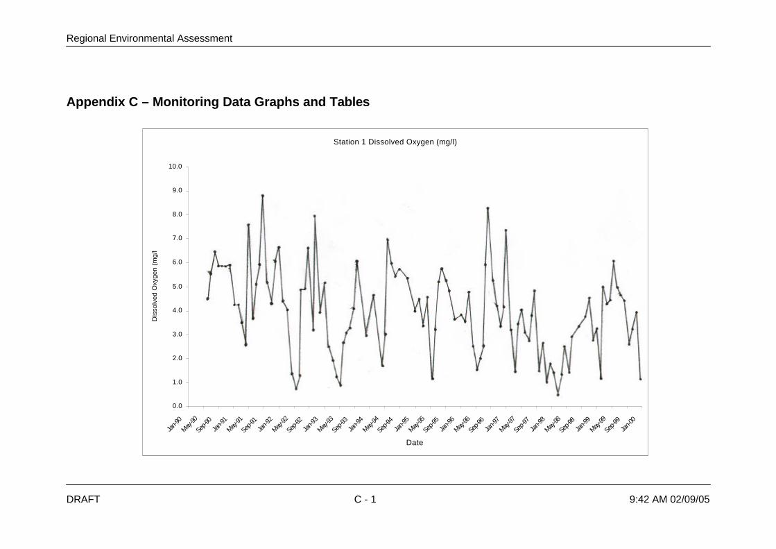
Regional Environmental Assessment
DRAFT C - 1 9:42 AM 02/09/05
Appendix C – Monitoring Data Graphs and Tables
Station 1 Dissolved Oxygen (mg/l)
0.0
1.0
2.0
3.0
4.0
5.0
6.0
7.0
8.0
9.0
10.0
Jan-9
0
May-90
Sep-90
Jan-9
1
May-91
Sep-91
Jan-9
2
May-92
Sep-92
Jan-9
3
May-93
Sep-93
Jan-9
4
May-94
Sep-94
Jan-9
5
May-95
Sep-95
Jan-9
6
May-96
Sep-9
6Ja
n-97
May-97
Sep-97
Jan-9
8
May-98
Sep-9
8Ja
n-99
May-99
Sep-99
Jan-0
0
Date
Dis
solv
ed O
xyge
n (m
g/l)
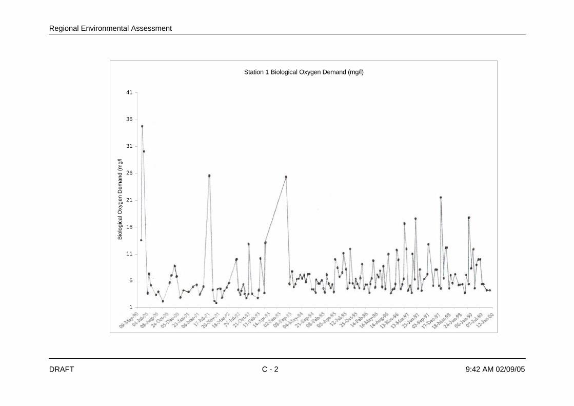
Regional Environmental Assessment
DRAFT C - 2 9:42 AM 02/09/05
Station 1 Biological Oxygen Demand (mg/l)
1
6
11
16
21
26
31
36
41
Date
Bio
logi
cal O
xyge
n D
eman
d (m
g/l)

Regional Environmental Assessment
DRAFT C - 3 9:42 AM 02/09/05
Station 5 Dissolved Oxygen (mg/l)
0.0
2.0
4.0
6.0
8.0
10.0
12.0
Apr-90
Aug-9
0
Dec-90
Apr-91
Aug-91
Dec-91
Apr-92
Aug-92
Dec-92
Apr-93
Aug-9
3
Dec-93
Apr-94
Aug-9
4
Dec-94
Apr-95
Aug-95
Dec-95
Apr-96
Aug-9
6
Dec-96
Apr-97
Aug-9
7
Dec-97
Apr-98
Aug-9
8
Dec-98
Apr-99
Aug-99
Dec-99
Apr-00
Aug-0
0
Dec-00
Date
Dis
solv
ed O
xyge
n (m
g/l)

Regional Environmental Assessment
DRAFT C - 4 9:42 AM 02/09/05
Station 5 Biological Oxygen Demand (mg/l)
1
11
21
31
41
51
61
71
81
Date
Bio
logi
cal O
xyge
n D
eman
d (m
g/l)

Regional Environmental Assessment
DRAFT C - 5 9:42 AM 02/09/05
Station 7 Dissolved Oxygen (mg/l)
0.0
1.0
2.0
3.0
4.0
5.0
6.0
7.0
8.0
Apr-90
Aug-9
0
Dec-90
Apr-91
Aug-91
Dec-91
Apr-92
Aug-9
2
Dec-92
Apr-93
Aug-93
Dec-93
Apr-94
Aug-94
Dec-94
Apr-95
Aug-95
Dec-95
Apr-96
Aug-9
6
Dec-96
Apr-97
Aug-9
7
Dec-97
Apr-98
Aug-98
Dec-98
Apr-99
Aug-9
9
Dec-99
Apr-00
Aug-00
Dec-00
Date
Dis
solv
ed O
xyge
n (m
g/l)

Regional Environmental Assessment
DRAFT C - 6 9:42 AM 02/09/05
Station 7 Biological Oxygen Demand (mg/l)
1
21
41
61
81
101
121
141
Date
Bio
logi
cal O
xyge
n D
eman
d (m
g/l)

Regional Environmental Assessment
DRAFT C - 7 9:42 AM 02/09/05
Station 9 Dissolved Oxygen (mg/l)
0.0
2.0
4.0
6.0
8.0
10.0
12.0
Apr-90
Aug-90
Dec-90
Apr-91
Aug-9
1
Dec-91
Apr-92
Aug-92
Dec-92
Apr-93
Aug-9
3
Dec-93
Apr-94
Aug-94
Dec-94
Apr-95
Aug-9
5
Dec-95
Apr-96
Aug-96
Dec-96
Apr-97
Aug-9
7
Dec-97
Apr-98
Aug-98
Dec-98
Apr-99
Aug-9
9
Dec-99
Date
Dis
solv
ed O
xyge
n (m
g/l)

Regional Environmental Assessment
DRAFT C - 8 9:42 AM 02/09/05
Station 9 Biological Oxygen Demand (mg/l)
1
6
11
16
21
26
Date
Bio
logi
cal O
xyge
n D
eman
d (m
g/l)

Regional Environmental Assessment
DRAFT D - 1 9:42 AM 02/09/05
Appendix D – Institutional Framework Details
D.1 Role of National Agencies in Sewerage Management
D.1.2 Department of Health
The law that gives mandate to the primary agency to protect citizens’ health isExecutive Order No. 119 (Reorganizing the Ministry of Health, Its Attached Agenciesand For Other Purposes) issued in 1987, and states.
….shall be primarily responsible for the formulation, planning,implementation and coordination in the field of health. Theprimary function … is the promotion, protection,preservation or restoration of the health of the peoplethrough the provision and delivery of health services andthrough the regulation and encouragement of providers ofhealth goods and services (Section 3)
This mandate is consistent with the functions that the Sanitation Code of thePhilippines assigns to the DOH. Among the functions listed in Section 3, three havedirect bearing to sewerage management. These functions are the following: Ø undertake the promotion and preservation of the health of the people and raise
the health standards of individuals and communities;Ø develop, administer and coordinate various health activities and services which
shall include public health; andØ assist local health services and programs to assure the people of better health
services The duty of the DOH to set the requirements for sewerage facilities and enforcecompliance is derived from these functions. The DOH unit in charged to perform thisduty is found in its structure as defined in Executive Order No. 119. Part of itsstructure is the Office of Public Health Services. It is involved in policy formulation,standard setting, program development and program monitoring of disease controland service delivery programs implemented by field offices. Under such office is theEnvironmental Health Service. It is the unit that covers sanitation services includingsewerage management. Its tasks are stated as follows:
…..formulate plans, policies, programs, standards and techniquesrelative to environmental health and sanitation; provideconsultative, training and advisory services to implementingagencies; and conduct studies and research related toenvironmental health (Section 11).
Like all national departments, the DOH operates in the field through its RegionalHealth Offices. It carries out its mandate through its field operations aimed atproviding efficient and effective health and medical services. One aspect of its fieldoperation is to ensure compliance with sanitation standards specified in SanitationCode of the Philippines.
Regional Environmental Assessment
DRAFT D - 2 9:42 AM 02/09/05
D.1.3 Department of Environment and Natural Resources
The DENR presently operates under Executive Order 192 promulgated in 1987. Thislaw consolidates some 24 agencies with functions that either wholly or partly coverenvironmental management. Its mandate is stated below:
…. the primary government agency responsible for theconservation, management, development and proper use ofthe country’s environment and natural resources… as wellas licensing and regulation of all natural resources (Section4).
Although it is the primary environmental management agency of the government, itstill shares with the other government units some functions. This can be seen in themanagement of water resources. The DOH and the National Water ResourcesCouncil (NWRC) among others perform functions aimed at protecting the country’swater resources. Within the DENR, the responsibility to protect the environmentagainst all forms of pollution largely falls on the Environmental Management Bureau(EMB). The Bureau has three functions directly relevant to sewerage. In Section 16of Executive Order No 192, these functions are expressed as follows:Ø recommend possible legislations, policies and programs for environmental
management and pollution control;Ø formulate environmental quality standards for water; andØ formulate rules and regulations for the proper disposition of toxic and hazardous
substances. The management of sewerage must comply with the standards as well as rules andregulations that the Bureau enforces. Among the standards that must be maintainedare contained in DENR Administrative Order No 34 (Revised Water Usage andClassification Water Quality Criteria) and DENR Administrative Order 35 (RevisedEffluent Regulations of 1990). These national standards can be modified for localareas by declaring a Water Quality Management Area and then adopting modifiedcriteria to better suit local conditions. This has been recommended by the PasigRiver Rehabilitation Commission but is now somewhat superseded by thepromulgation of the Clean Waters Act. The extent the DENR perform its functions in ensuring that sewerage managementwill not undermine environmental quality largely rests on the capability of the regionaloffices. In summary, the DOH regulates the management of sewage before and during itstreatment, and the DENR regulates its disposal to ensure that it does not adverselyaffect environmental quality.
D.1.4 Department of Public Works and Highways
Section 7 of the “Philippine Clean Water Act of 2004” states that:
“The Department of Public Works and Highways (DPWH), throughits relevant attached agencies, in coordination with theDepartment of Environment and Natural Resources, localgovernment units (LGUs) and other concerned agencies,shall as soon as possible, but in no case exceeding a periodof twelve (12) months from the effectivity of this Act, preparea national program on sewerage and septage managementin connection with Section 8 hereof.
Regional Environmental Assessment
DRAFT D - 3 9:42 AM 02/09/05
The program is to include a priority listing of sewerage, septage and combinedsewerage-septage projects for LGUs based on population density and growth,degradation of water resources, topography, geology, vegetation, programs/projectsfor the rehabilitation of existing facilities and such other factors that the Secretarymay deem relevant to the protection of water quality. On the basis of such nationallisting, the national government may allot, on an annual basis, funds for theconstruction and rehabilitation of required facilities. Section 8 of the same Act states that:
“Within five (5) years following the effectivity of this Act, the agencyvested to provide water supply and sewerage facilitiesand/or concessionaires in Metro Manila and other highlyurbanized cities (HUCs) as defined in Republic Act No.7160, in coordination with LGUs, shall be required toconnect the existing sewage line found in all subdivisions,condominiums, commercial centers, hotels, sports andrecreational facilities, hospitals, market places, publicbuildings, industrial complex and other similarestablishments including households to available seweragesystem: Provided, That the said connection shall be subjectto sewerage service charge/fees in accordance with existinglaws, rules or regulations unless the sources had alreadyutilized their own sewerage system.
In areas not considered as HUCs, the DPWH in coordination with the DOH and otherconcerned agencies, shall employ septage or combined sewerage-septagemanagement system.
. . . ., the DOH, in coordination with other government agencies,shall formulate guidelines and standards for the collection,treatment and disposal including guidelines for theestablishment and operation of centralized sewagetreatment system”.
Section 22 of the Act provides that DPWH through its attached agencies such as theMWSS, LWUA, and including other urban water utilities for the provision of sewerageand sanitation facilities and the efficient and safe collection, treatment and disposalof sewage within their area of jurisdiction. Similar requirements have been included in many other pieces of local legislation,such as RA9003 Ecological Solid Waste Management Act, requiring governmentdepartments to prepare various comprehensive plans. Sadly these plans are rarelyprepared in the designated timeframe and in many cases, never done at all.Therefore the status quo on sewerage and sanitation institutional management islikely to remain in place.
D.1.5 Metropolitan Waterworks and Sewerage System
MWSS is a subordinate agency reporting to the DPWH. MWSS presently operates under its Republic Act 6234 promulgated in 1971. The actdissolves its predecessor, the National Waterworks and Sewerage Authority(NAWASA) and creates the MWSS in its place. The mandate of MWSS is as follows:
The proper operation and maintenance of waterworks systems toensure an uninterrupted and adequate supply anddistribution of potable water …..and proper operation andmaintenance of sewerage systems are essential publicservices because they are vital to public health and safety.

Regional Environmental Assessment
DRAFT D - 4 9:42 AM 02/09/05
The MWSS is the principal agency responsible for the provision of sewerage andsanitation services in the Region. It can directly provide sewerage services or assistother providers that may be a private or public entity. It means that it may share theprovision of sewerage services to other providers. In the case of subdivisions, theMWSS has to regulate the operation of their sewerage system. The MWSS can alsoissue rules and regulations for protection of water supply lines and sanitary sewers,the preservation of and protection of water and sewerage service as soon asestablished and for proper procedures in applying for approval of and connection towater and sewerage services.
D.1.6 The Manila Water Company, Inc. and its Service Area
The responsibility of providing water supply, sewerage and sanitation services inMetro Manila was directed to MWSS since its promulgation in 1971. However,MWSS was inadequate to provide efficient service to the populace of Metro Manila.By international standards, MWSS had too many personnel relative to the number ofcustomers, too little investment in maintenance works and facilities, too much non-revenue-water, inefficient technology and operating procedures and unreliableservices. Its record in sewerage management is described as having only providedonly a rudimentary collection system to less than 10% of the area of control at best. To address the demand for improved water services, the Philippine governmentopted to transfer MWSS’ water-related services to the private sector. It wasanticipated that improvement would be achieved without need for capitalexpenditure. Thus, in August 1997, the Ayala-led Manila Water Company took over the East Zoneof Metro Manila from the government-owned Metropolitan Waterworks andSewerage System through a 25-year Concession Agreement (CA), while the Lopez-led Maynilad Water Services took over the West Zone. The agreement provides a set of concessionaires’ obligations, which includes thefollowing:Ø To supply sewerage services to all customers in the service area who have
existing sewerage connections for domestic sewage and industrial effluentscompatible with available treatment processes;
Ø To meet the coverage target percentages of the total population in a targetmunicipality connected to the concessionaire’s water system as per schedule setin the agreement;
Ø To respond as soon as reasonably practicable to a request for a connection to apublic sewer from the owner or occupant of premises located in the service area;
Ø To comply with all national and local environmental laws and standards relatingto treated wastewater in the service area and in accordance with the schedule ofcompliance provided by the Regulatory Office;
Ø To offer septic and sanitation cleaning services in the service area, and to meetthe coverage target percentages of the total population in the target municipality.
The East Zone is home to about 5 million people comprising a 1,400 squarekilometer area that covers 24 cities and municipalities in Metro Manila and Rizal.These include Mandaluyong, Marikina, Pasig, Pateros, San Juan, Taguig, Makatiand parts of Quezon City and Manila. The towns of Angono, Antipolo, Baras,Binangonan, Cainta, Cardona, Jala-Jala, Morong, Pililla, Rodriguez and San Mateoin the province of Rizal are also part of the East Zone.
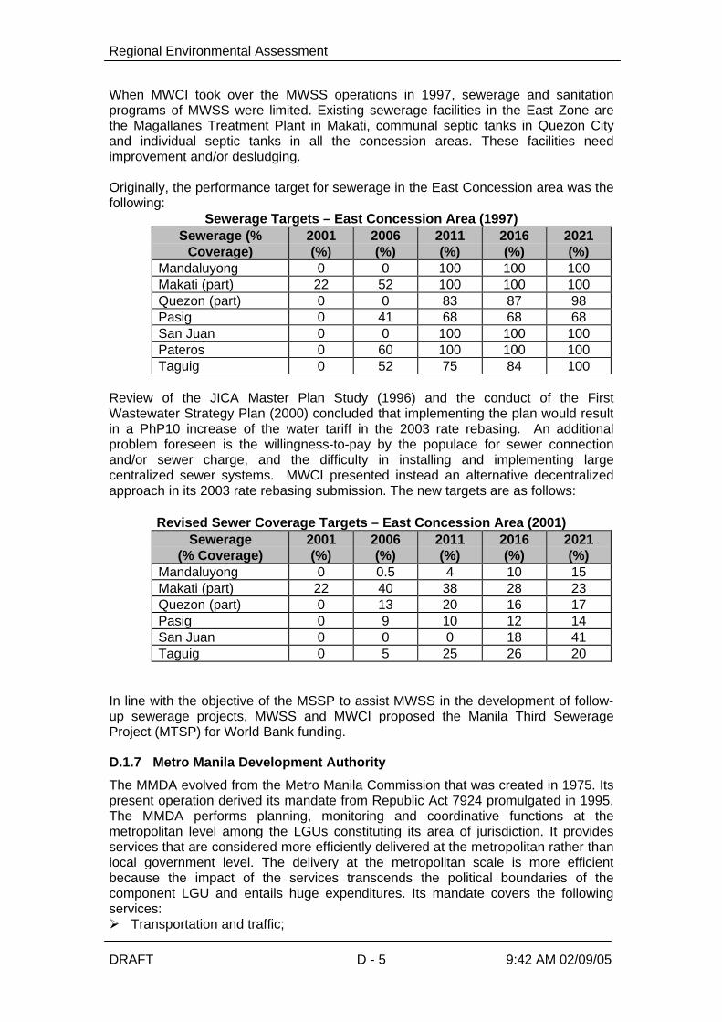
Regional Environmental Assessment
DRAFT D - 5 9:42 AM 02/09/05
When MWCI took over the MWSS operations in 1997, sewerage and sanitationprograms of MWSS were limited. Existing sewerage facilities in the East Zone arethe Magallanes Treatment Plant in Makati, communal septic tanks in Quezon Cityand individual septic tanks in all the concession areas. These facilities needimprovement and/or desludging. Originally, the performance target for sewerage in the East Concession area was thefollowing:
Sewerage Targets – East Concession Area (1997) Sewerage (%
Coverage) 2001 (%)
2006 (%)
2011 (%)
2016 (%)
2021 (%)
Mandaluyong 0 0 100 100 100 Makati (part) 22 52 100 100 100 Quezon (part) 0 0 83 87 98 Pasig 0 41 68 68 68 San Juan 0 0 100 100 100 Pateros 0 60 100 100 100 Taguig 0 52 75 84 100
Review of the JICA Master Plan Study (1996) and the conduct of the FirstWastewater Strategy Plan (2000) concluded that implementing the plan would resultin a PhP10 increase of the water tariff in the 2003 rate rebasing. An additionalproblem foreseen is the willingness-to-pay by the populace for sewer connectionand/or sewer charge, and the difficulty in installing and implementing largecentralized sewer systems. MWCI presented instead an alternative decentralizedapproach in its 2003 rate rebasing submission. The new targets are as follows:
Revised Sewer Coverage Targets – East Concession Area (2001)
Sewerage (% Coverage)
2001 (%)
2006 (%)
2011 (%)
2016 (%)
2021 (%)
Mandaluyong 0 0.5 4 10 15 Makati (part) 22 40 38 28 23 Quezon (part) 0 13 20 16 17 Pasig 0 9 10 12 14 San Juan 0 0 0 18 41 Taguig 0 5 25 26 20
In line with the objective of the MSSP to assist MWSS in the development of follow-up sewerage projects, MWSS and MWCI proposed the Manila Third SewerageProject (MTSP) for World Bank funding.
D.1.7 Metro Manila Development Authority
The MMDA evolved from the Metro Manila Commission that was created in 1975. Itspresent operation derived its mandate from Republic Act 7924 promulgated in 1995.The MMDA performs planning, monitoring and coordinative functions at themetropolitan level among the LGUs constituting its area of jurisdiction. It providesservices that are considered more efficiently delivered at the metropolitan rather thanlocal government level. The delivery at the metropolitan scale is more efficientbecause the impact of the services transcends the political boundaries of thecomponent LGU and entails huge expenditures. Its mandate covers the followingservices:Ø Transportation and traffic;

Regional Environmental Assessment
DRAFT D - 6 9:42 AM 02/09/05
Ø Solid waste disposal and management,Ø Flood control and sewerage management.Ø Urban renewal, zoning land use planning and shelter services;Ø Health and sanitation;Ø Urban protection, pollution control and public safety. Although sewerage management as well as sanitation is within its ambit authority,the role of MMDA is confined more on macro planning rather than projectimplementation. In this manner its functions do not overlap with those of the MWSS.The MMDA is, for instance, involved in the formulation of the National CapitalRegion- Medium Term Development Plan and the Philippine National UrbanSewerage and Sanitation Strategy Plan. The formulation of a metropolitan-wide planis part of its coordination function. Metro Manila Council manages MMDA. It is a policy-making body composed ofmayors of all cities and municipalities within the metropolis, President of MetroManila Vice-Mayor Leagues and President of Metro Manila Councilors Leagues. ThePresident of the Philippines appoints the chairman of MMDA who also heads thecouncil. The chairman has a cabinet rank. The financial support of the operation ofMMDA is from its share of Internal Revenue Allotment, national subsidy, 5 percentcontribution from LGU and fines and fees.
D.1.8 Laguna Lake Development Authority
The LLDA was created in 1966 under Republic Act No. 4850. It was initially a quasi-government agency with regulatory and proprietary functions. Presidential Decree813 (1975) and Executive Order 927 (1983) strengthen its power by includingenvironmental protection and jurisdiction on surface water of the lake. Its presentoverarching mandate is as follows:
Provide and accelerate the development and balanced growth ofLaguna Lake area and the surrounding provinces, cities andtowns…. within the context of the national and regionalplans and policies for social and economic development andto carry out the development the development of the LagunaLake region with adequate provisions for environmentalmanagement and ….the prevention of undue ecologicaldisturbances, deterioration and pollution (Section 1).
Under Presidential Decree 813 (Amending Certain Sections of RA 4850 known asthe Laguna lake Development Authority of 1966), its functions are defined. Thefunctions are mainly macro planning, program implementation and permitting. Someof its functions are stated in various sections as follows: Ø To make a comprehensive survey and … draft a comprehensive and detailed
plan designed to conserve and utilize optimally the resources within theregion particularly Laguna Lake;
Ø To pass upon and approve and disapprove all plans, programs and projectsproposed by local government offices within the region, public corporationand private persons or enterprises where such plans, programs and orprojects are related to those of the authority for the development of theregion;
Ø To plan, program and undertake infrastructure projects such as rivers, floodor tidal control works, waste water and sewerage works when so requiredwithin the context of its development plans and programs.

Regional Environmental Assessment
DRAFT D - 7 9:42 AM 02/09/05
Ø To collect annual fees as provided … for the use of the lake water and itstributaries for all beneficial purposes including recreation, municipal,industrial, agricultural, fisheries, navigational and waste disposal purposes.
The LLDA shares with the MMDA the same functions in the sense that both agenciesare involve in macro planning. On the part of the LLDA, its planning function isapplicable only in the lake region. But in areas that are part of the lake region andthe Metro Manila, the two agencies have to coordinate their plans. The LLDA canalso plan and undertake infrastructure projects on wastewater and sewerage works.However, it can only do so when its development plans and programs requires. Themain function of providing sewerage facilities still firmly rests with the MWSS. Executive Order No. 149 (1993) put the LLDA under the administrative supervision ofDENR. Its function to make a comprehensive survey of the lake region and approveall plans, programs and projects duplicates the monitoring and permitting functions ofthe DENR National Capital Regional Office. The duplication is removed by restrictingthe performance of such functions by the DENR National Capital Regional Office toareas outside the lake region.
D.2 Role of Local Government Units (LGU) in Sewerage Management
As all other services, those that pursue the right of the people to health and healthyenvironment are better catered at the lowest possible level of government becauseits operation is closest to the recipients. At such level, the access of the recipients tothe services is easier and the services can be more responsive to their requirements.This is one rationale behind local autonomy provided in the Philippine Constitutionthat aims to make the LGU self-sufficient in service provision. Toward such end, theLocal Government Code (Republic Act No 7160) has been promulgated. The codearticulates the commitment to make the LGU a capable service provider in thefollowing manner: As stated above, one provision that put this principle in concrete terms is onenvironmental management in general and sewerage management in particular. Themunicipal and city governments gain the responsibility to manage sanitation facilitiesincluding those of sewerage. The code sets the scope of the municipal or citygovernment’s responsibility over these facilities in the following section:
Local government units shall … exercise powers and dischargesuch other functions and responsibilities as are necessary,appropriate or incidental to efficient and effective provisionof basic services and facilities enumerated herein. Suchbasic services and facilities include but not limited to thefollowing:
… environmental management system and services or facilities
related to general hygiene and sanitation..
Infrastructure facilities intended to service the needs of theresidents of the municipality and which are funded out ofmunicipal funds including but not limited to …water supplysystems … drainage and sewerage…(Section 17)
The provision of sewerage services is a task given to the municipal and citygovernment together with the other services. One of these services is water supplyprovision. There is no provision in the code that these two types of services have tobe jointly provided. But they are interrelated because the provision of one requiresthe need for the other. Sewerage is an automatic result of water use.

Regional Environmental Assessment
DRAFT D - 8 9:42 AM 02/09/05
The responsibility over sewerage management is under the five offices of themunicipal and city government: Municipal or City Environment and NaturalResources Officer, Municipal or City Administrator, Municipal or City Engineer,Municipal or City Health Officer and Municipal Planning and DevelopmentCoordinator The Municipal or City Environment and Natural Resources Officer is themain arm in delivering services on environment and natural resources. However, thecreation of this position is optional and in his absence, the Municipal or CityAdministrator may take the task. Part of his mandate is to implement programs andprojects on management and administration. The Municipal or City Engineer will beinvolved in the construction and maintenance of the physical facility. The Municipal or City Health Officer will make and implement the guidelines inconsistent the national laws since public health is within its mandate. These includethe standards, rules and regulations expressed in the Sanitation Code of thePhilippines and its Implementing Rules and Regulations. The role of the Municipal orCity Planning and Development Coordinator will be in planning as well as monitoringand evaluation of the implementation of sewerage facilities. The Municipal or CityDevelopment Council will have a part in developing the plan. Its will appraise andprioritize the project and conduct coordination activities in the implementation.
Mandates of Offices of the Municipal and City Government in SewerageManagement and Their Legal Basis
Office Mandate Legal Basis Municipal ofCityEnvironmentand naturalResourcesOfficer
Formulate measures for consideration of theSanggunian and provide technical assistance andsupport the mayor in carrying out measures to ensurethe delivery of basic services and provision ofadequate facilities on environment and naturalresources services.. be in the forefront of the deliveryof services on environment and natural resources
Republic Act 7160 Section 484
Municipal orCityAdministrator
Develop plans and strategies and upon approval ofthe mayor implement the same particularly those onmanagement and administration-related programsand projects
Republic Act 7160 Section 480
Municipal orCity HealthOffice
Takes charge of the office on health services,supervise the personnel and staff of said office,formulate program implementation guidelines andrules and regulations for the operation of the saidoffice for the approval of the mayor…. assist him inthe efficient, effective and economical implementationof a health services program geared toimplementation of health related projects andactivities .. execute and enforce all laws, ordinancesand regulations relating to public health
Republic Act 7160 (Section 478b1)
Municipal orCity Engineer’sOffice
Administer, coordinate, supervise and control theconstruction, maintenance, improvement and repair ofroads, bridges and other engineering designs,feasibility studies and project management.
Republic Act 7160(Section 477)
Municipal orCity PlanningandDevelopmentOffice
Formulate integrated development plans and policiesfor consideration of the LDC; Conduct continuingstudies, researches and training programs necessaryto evolve plans and programs; Integrate andcoordinate all sectoral plans and studies undertakenby the different functional groups or agencies; Monitorand evaluate the implementation of the differentdevelopment programs and projects and activities
Republic Act 7160(Section 476)
Municipal or Formulate socio-economic development plans and Republic Act 7160

Regional Environmental Assessment
DRAFT D - 9 9:42 AM 02/09/05
Office Mandate Legal BasisCityDevelopmentCouncil
programs; Appraise and prioritize socio-economicprograms and projects; Coordinate, monitor andevaluate the implementation of programs and projects
(Section 109)
Private Sector Participate in the delivery of basic services Republic Act 7160(Section 2)
The Department of Interior and Local Government (DILG) will assist the municipalityand city in sewerage management. Part of its mandate as expressed in ExecutiveOrder No 262 (Reorganizing the Department Interior and Local Government) isestablish programs and projects to strengthen the administrative, technical and fiscalcapabilities of LGU. The leading role of the DILG in assisting the LGU oninfrastructure projects is affirmed in NEDA Board Resolution No. 6 Series of 1996.The resolution states that the DILG will provide the LGU assistance in theimplementation of devolved infrastructure programs and projects in institution andcapacity building. If the municipality or city will opt not to provide the sewerage services on it own, itcan create and operate an economic enterprise to do it. The code grants the LGUcorporate power (Section 22). Included in the power is the exercise of its proprietaryfunctions where the LGU can engage in the business of providing sewerage servicesthrough an enterprise. This is the second option for the municipality or city to fulfill itsmandate to provide sewerage services. A well-managed enterprise can earn for themunicipality or city additional revenues. The Philippine BOT Law (R.A. 6957, asamended by R.A. 7718) and the Local Government Code of 1991 (R.A. 7160)provide the legal basis for Local Government Units to enter into PSP/BOT contractsand/or joint venture agreements with the private sector. The third option is to lease by ordinance the operation of the sewerage facilities to aprivate sector group as provided in Section 17j of the code. Under the samecorporate powers of the municipality or city can exercise the fourth option. It willtransfer the management of water utility including sewerage management to a WaterDistrict. A Water District is a non-profit, quasi-public, independently administeredenterprise. It is created to operate water supply and distribution systems and toprovide wastewater collection, treatment and disposal facilities. It is clear that themandate of the Water District is to manage both water and sewerage provision. A water district has a geographic jurisdiction in terms of service area but it is notconsidered part of political subdivision. Under the law (Presidential Decree No. 198),it has all the powers and privileges of a corporation. But the water district relies muchon the LGU for smooth operation. For instance, the LGU must assist the WaterDistrict in enforcing its rules and regulations since it has no coercive power of thegovernment. The LGU has also the right to appoint the members of the board of theWater District. The Water District can obtain financial, technical and managementassistance from the Local Water Utilities Administration (LWUA). It is a governmentcorporation created to develop and promote local water utilities. The DENR and DOH affirms the role of the municipalities and cities in seweragemanagement. In DENR Administrative Order No. 30 Series of 1992 (Guidelines forthe Transfer and Implementation of DENR Functions Devolved to the LocalGovernment Units), the DENR delineates the functions it retains and those devolvedto the LGU. It accedes that environmental management systems and servicesrelated to general hygiene and sanitation such as sewage belongs to the LGU. Forits part, the DOH requires the LGU to provide and maintain a satisfactory system ofdrainage in all inhabited areas where wastewater could empty. This requirement is in

Regional Environmental Assessment
DRAFT D - 10 9:42 AM 02/09/05
of Implementing Rules and Regulations of Sewage Collection and Disposal, ExcretaDisposal and Drainage (Chapter 17) of the Code on Sanitation of the Philippines.
D.3 Role of the Private Sector
The constitutional provision recognizing the indispensable role of the private sector inservice provision is translated into laws that encourage its participation. The privatesector certainly is one option in sewerage management in Metro Manila. The lawsthat give incentives to the private sector investments include the following: ExecutiveOrder No 226 (Omnibus Investment Code of 1987; Republic Act No 7042 (ForeignInvestment Act of 1991) and Republic Act No 7718 (Build-Operate-Transfer Law). Astudy on water supply and sewerage privatization (Price Waterhouse, 1996) offer thefollowing advantages if water-related services are privatized through BOT orconcession: Ø Management and staff will be allowed to operate using private sector
practices and procedures;
Ø The most advance and economic technologies can be imported through astrategic partner skilled in the management and operation of large waterutilities;
Ø Management and staff would have the opportunity for improved workingconditions and compensation through increased efficiency in operations andparticipation in skills-enhancement; and
Ø The provision of investment capital by the private sector will relieve thegovernment from the burden of borrowing funds on public account.
The study uses the MWSS being a government owned and controlled corporation(GOCC) as an argument for the transfer of water-related services to the privatesector. By international standards, MWSS had too many personnel relative to thenumber of customers, too little investment in maintenance works and facilities, toomuch non-revenue-water, too inefficient technology and operating procedures andtoo unreliable services. Its record in sewerage management is even less rosy beingdescribed as having only rudimentary collection system at best. But the enabling law of MWSS has enough legal powers to privatize its water-relatedservices. Two laws further strengthen such power. Executive Order No 286 (6December 1995) directs the reorganization of MWSS to prepare for eventualprivatization where feasible. Executive Order No 311 (30 march 1996) opens the anyor all segments of MWSS operation to private sector participation. The options forsuch participation are enumerated as follows: Ø Franchising, concession, management or other arrangement;Ø Privatization;
Contracts for projects to be implemented under build-operate-transfer (BOT) or otherrelated scheme for the financing, construction, repair, rehabilitation, improvementand operation of water facilities and projects related to consumers. The MWSS select the grant of concession where the private concessionaire isresponsible for the operation and maintenance of assets and investment. Theownership of assets remains with MWSS and the rights to their use including thoseacquired during the concession period will revert to the MWSS at the end of theconcession agreement. The concession is granted to Manila Water Company

Regional Environmental Assessment
DRAFT D - 11 9:42 AM 02/09/05
(MWCI) for the west zone of the service area and Maynilad Water Services Inc.(MWSI) for the east zone. The MWCI is composed of Ayala Corporation, UnitedUtilities and Bechel while MWSI is a partnership of Benpres Holding Corporation andSuez Lyonnaise de Eaux. The agreement signed on 21 February 1997 provides for a25-year concession period unless earlier terminated. It was considered the world’slargest water privatization at that time. The provisions of the agreement contain a set of concessionaires’ obligations.Included in these obligations are on sewerage management. These obligations areas follows: Ø To supply sewerage services to all customers in the service area who have
existing sewerage connections for domestic sewage and industrial effluentscompatible with available treatment processes;
Ø To meet the coverage target percentages of the total population in a targetmunicipality connected to the concessionaire’s water system as per scheduleset in the agreement;
Ø To respond as soon as reasonably practicable to a request for a connectionto a public sewer from the owner or occupant of premises located in theservice area;
Ø To comply with all national and local environmental laws and standardsrelating to treated wastewater in the service area and in accordance with theschedule of compliance provided by the Regulatory Office;
Ø To offer septic and sanitation cleaning services in the service area, and tomeet the coverage target percentages of the total population in the targetmunicipality
The target for sewerage and sanitation coverage varies between the two zones. TheEast Zone must have already covered a total of 41% of the population who areconnected to the concessionaire’s water system by 2001 (Table 3-7). Thispercentage will rise to 74% in 2021. In the East Zone, the target is a total coverageof 59% of the population who are connected to the concessionaire’s water system by2001. The target will be 82% by 2021.
Sewer Coverage and Sanitation Targets Set in the MWSS ConcessionAgreement with MWCI and MWSI.
Zone 2001 2006 2011 2016 2021 East Sewer 3% 16% 51% 52% 55%
Sanitation 38% 32% 27% 24% 19%
Total 41% 48% 78% 76% 74%
West Sewer 16% 20% 21% 31% 65%
Sanitation 43% 46% 43% 39% 27%
Total 59% 66% 64% 70% 82%
However by 2001 or four years since the concession took effect, the sewer coveragein the West Zone is only 14% of 2% lower than the target. No data are available forthe sanitation coverage in the West Zone. In the East Zone, no data are available for

Regional Environmental Assessment
DRAFT D - 12 9:42 AM 02/09/05
sewer and sanitation coverage. Neither are there data available that will indicate thecompliance of the concessionaires to its obligations in the agreement on seweragemanagement. Due to the absence of data, the performance of the concessionaires inparticular and private sector participation in sewerage provision in general cannot befairly assessed. But some have observed that their performance in sewerageprovision is severely wanting. The absence of data speaks of the capability of the Regulatory Office (RO). Thisoffice is created in response to the demand to protect the interest of the governmentand the consumers by regulating the operation of the concessionaires. Because ofthe time required to legislate its establishment, it was fast-tracked by providing for itscreation in the Concession Agreement. The MWSS Board was to organize the ROwithin its agency. Among the functions given to the RO that are directly relevant tosewerage management are as follows: Ø monitoring of the awarded concession agreements;Ø reviewing and monitoring of water supply and sewerage rates;
Ø monitoring contracts between the concessionaires and customers for theprovision of water and sewerage services;
Ø monitoring and enforcing standards of service to customers and any agreedimprovement in these standards or extensions in the coverage customers forthe provision of water and sewerage services;
Ø arranging for the regular, independent technical and financial audit of theactivities of the concessionaires and the public dissemination of suchinformation; and
Ø monitoring the reported audited condition of water and sewerage serviceinfrastructure assets and enforcement of the Concession Agreement withrespect to these.
Some observers note that the main constraints behind the failure of the RO todutifully perform these functions are result of the weakness of its legal identity. First,being a creation of a contract between the government and private sector, it does nothave legal personality of a government agency that is created by law. The absenceof such personality deprives it the power to make independent decision and enforceit. Second, its decisions are subject to the approval of the MWSS Board making it anextension of the board rather than an independent arbiter. Third, the concessionairesfinance its operation making it a dependent. Because of these constraints, it cannotperform the role of a regulator as envisioned by those who saw the need for itscreation. Apart from legal aspects, the RO has organizational constraints that hinder it toperform its functions well. It apparently still has to organize the standards and thesystems to monitor and measure the performance of the concessionaires against thestandards. It has to train its personnel in interpreting the standards and operating thesystems. It has to provide the logistical support appropriate to the systems. The ROhas to invest on these organizational requirements because it has no experience tolean on and it is the country’s first venture into regulation of water servicesconcessionaires. The experience of the other countries (e.g., Sydney WaterCorporation) in similar situation shows that private sector participation in waterservices provision does not automatically result to efficiency. It needs a strongregulatory office to ensure that it can strike a good balance between public andcorporate interests.
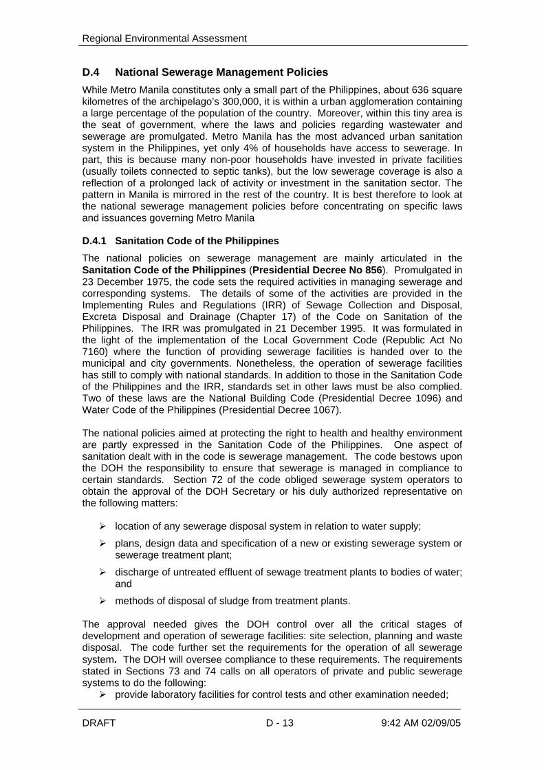
Regional Environmental Assessment
DRAFT D - 13 9:42 AM 02/09/05
D.4 National Sewerage Management Policies
While Metro Manila constitutes only a small part of the Philippines, about 636 squarekilometres of the archipelago’s 300,000, it is within a urban agglomeration containinga large percentage of the population of the country. Moreover, within this tiny area isthe seat of government, where the laws and policies regarding wastewater andsewerage are promulgated. Metro Manila has the most advanced urban sanitationsystem in the Philippines, yet only 4% of households have access to sewerage. Inpart, this is because many non-poor households have invested in private facilities(usually toilets connected to septic tanks), but the low sewerage coverage is also areflection of a prolonged lack of activity or investment in the sanitation sector. Thepattern in Manila is mirrored in the rest of the country. It is best therefore to look atthe national sewerage management policies before concentrating on specific lawsand issuances governing Metro Manila
D.4.1 Sanitation Code of the Philippines
The national policies on sewerage management are mainly articulated in theSanitation Code of the Philippines (Presidential Decree No 856). Promulgated in23 December 1975, the code sets the required activities in managing sewerage andcorresponding systems. The details of some of the activities are provided in theImplementing Rules and Regulations (IRR) of Sewage Collection and Disposal,Excreta Disposal and Drainage (Chapter 17) of the Code on Sanitation of thePhilippines. The IRR was promulgated in 21 December 1995. It was formulated inthe light of the implementation of the Local Government Code (Republic Act No7160) where the function of providing sewerage facilities is handed over to themunicipal and city governments. Nonetheless, the operation of sewerage facilitieshas still to comply with national standards. In addition to those in the Sanitation Codeof the Philippines and the IRR, standards set in other laws must be also complied.Two of these laws are the National Building Code (Presidential Decree 1096) andWater Code of the Philippines (Presidential Decree 1067). The national policies aimed at protecting the right to health and healthy environmentare partly expressed in the Sanitation Code of the Philippines. One aspect ofsanitation dealt with in the code is sewerage management. The code bestows uponthe DOH the responsibility to ensure that sewerage is managed in compliance tocertain standards. Section 72 of the code obliged sewerage system operators toobtain the approval of the DOH Secretary or his duly authorized representative onthe following matters: Ø location of any sewerage disposal system in relation to water supply;
Ø plans, design data and specification of a new or existing sewerage system orsewerage treatment plant;
Ø discharge of untreated effluent of sewage treatment plants to bodies of water;and
Ø methods of disposal of sludge from treatment plants. The approval needed gives the DOH control over all the critical stages ofdevelopment and operation of sewerage facilities: site selection, planning and wastedisposal. The code further set the requirements for the operation of all seweragesystem. The DOH will oversee compliance to these requirements. The requirementsstated in Sections 73 and 74 calls on all operators of private and public seweragesystems to do the following:Ø provide laboratory facilities for control tests and other examination needed;

Regional Environmental Assessment
DRAFT D - 14 9:42 AM 02/09/05
Ø forward to the local health authority operating data, control tests and otherrecords and information as maybe required;
Ø inform the local health authority in case of breakdown or improper functioningof the sewage treatment works;
Ø provide treatment of all sewerage entering the treatment plant;
Ø connect all houses covered by the system to the sewer in areas where asewage system is available;
Ø ensure that outfalls discharging effluents from treatment plant shall be carriedto the channel of the stream or to deep water where the outlet is discharged;
Ø discharge storm water to a storm sewer and sanitary sewerage to asewerage system carrying sanitary sewage only although this will not preventthe installation of combined system; and
Ø provide properly designed grease traps for sewers from restaurants or otherestablishments where the sewage carries a large amount of grease.
Two requirements will enable the DOH to closely monitor the operation of thesewerage facilities. One is the forwarding to the local health authority operating data,control tests and other records and information as maybe required. Another isinforming the local health authority in case of breakdown or improper functioning ofthe sewage treatment works. Nonetheless, included in the responsibility of the DOHis to see to it that sewerage operators comply with all of the other requirements. The disposal of wastewater through the sewerage system is required not only fromhouseholds but also from industrial establishments. Section 45d of the code requiresall industrial establishments to dispose their sewage by means of a municipal or citysewage system when ever possible. The code specifies the methods of disposal if nomunicipal or city sewerage exists.
D.4.2 Implementing Rules and Regulations (IRR) of the Code on Sanitation
The code gives the DOH Secretary the power to promulgate the rules andregulations to better implement its provisions. It is in the exercise of this power that itcame up with the Implementing Rules and Regulations (IRR) of Sewage Collectionand Disposal, Excreta Disposal and Drainage (Chapter 17) of the Code on Sanitationof the Philippines. While the IRR reiterates the requirements for the operation of thesewerage facilities, it adds specifications to some requirements (Table 2-1). First, the code requires that the operator must connect all houses covered by thesystem to the sewer in areas where a sewage system is available. The IRR clarifiesthat this requirement entails that the sewage plant must have the capability oftreating the flow of sewage discharged by the community in the area. Second, thecode has two requirements for discharge of effluents. One is the approval of DOH todischarge untreated effluent of sewage treatment plants to bodies of water. Anotheris to ensure that outfalls discharging effluents from treatment plant shall be carried tothe channel of the stream or to deep water where the outlet is discharged. But theIRR further requires that effluent from treatment plants should meet the DENRstandards.

Regional Environmental Assessment
DRAFT D - 15 9:42 AM 02/09/05
Table D - 1. Requirements for the Operation of Sewage Treatment Plants*
The sewage plant shall be capable of treating the flow of sewage discharged bythe community in the area; The type of sewage treatment plant shall be approved by the secretary or his dulyauthorized representative and the effluent from such treatment plants shall meet thestandards formulated by the DENR;
The sewage treatment plant shall provide laboratory facilities for control tests and otherexamination needed;
Operating data, control tests and such other records as may be required shall beforwarded to the local health authority.
The local health authority shall be informed in case of breakdown or improperfunctioning of the treatment works;
Where sewage treatment is provided, no sewage shall be allowed to by-pass the plant;
The sewage treatment plant shall be managed by a registered Sanitary Engineer.
*According to Section 5.2.2 of Implementing Rules and Regulations of Sewage Collection andDisposal, Excreta Disposal and Drainage (Chapter 17) of the Code on Sanitation of the Philippines.
The IRR further emphasizes the necessary function of the treatment plant inprotecting the environments by requiring that no sewage shall be allowed to by-passthe plant where it is available. It also explicitly provides that a registered sanitaryengineer should manage the sewage treatment plant. This provision guarantees thattrained professionals run the treatment plant. The Sanitary Engineering Law(Republic Act No 1364) provides that only persons who pass the technicalexamination and granted a certificate of registration by the Board of Examiners canpractice as a sanitary engineer. Among the activities included in such practice arethe following:
“Sanitary surveys, reports, design, direction, management,consultation and investigation of ….. sewer systems,sewerage treatment plants… sewage disposal tanks andother structures for public health and welfare (Section 2)”
The requirement for a sanitary engineer to manage the plant tightens thegovernment supervision over its operation. An act of omission or commission cancost not only the operating license of the plant but also the manager. The license ofthe sanitary engineer to practice can be suspended or revoked.
D.4.3 The Local Government Code
Traditionally, water supply development and distribution is a national government-controlled function. In 1991, the implementation of the revised Local GovernmentCode (LGC) triggered a process of political and administrative decentralization thathas brought major changes to the governance structure of the Philippines. The LGCdevolved powers and responsibilities from the central government to LocalGovernment Units (LGUs), allowing them to operate with far greater autonomy.Section 17 of the LGC also allocates primary responsibility for guiding, financing, andmanaging water supply and sanitation development to the local governments, thusplacing them at the center of the water supply and sanitation development process.Moreover, the municipalities are given the mandate to discharge the functions andresponsibilities of national agencies and offices devolved to them, specifically that of[developing]
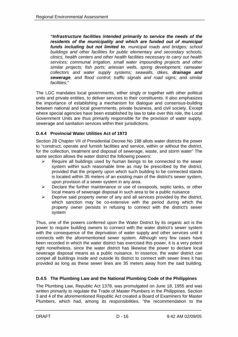
Regional Environmental Assessment
DRAFT D - 16 9:42 AM 02/09/05
“Infrastructure facilities intended primarily to service the needs of theresidents of the municipality and which are funded out of municipalfunds including but not limited to, municipal roads and bridges; schoolbuildings and other facilities for public elementary and secondary schools;clinics, health centers and other health facilities necessary to carry out healthservices; communal irrigation, small water impounding projects and othersimilar projects; fish ports; artesian wells, spring development, rainwatercollectors and water supply systems; seawalls, dikes, drainage andsewerage, and flood control; traffic signals and road signs; and similarfacilities;”
The LGC mandates local governments, either singly or together with other politicalunits and private entities, to deliver services to their constituents. It also emphasizesthe importance of establishing a mechanism for dialogue and consensus-buildingbetween national and local governments, private business, and civil society. Exceptwhere special agencies have been established by law to take over this role, the LocalGovernment Units are thus primarily responsible for the provision of water supply,sewerage and sanitation services within their jurisdictions.
D.4.4 Provincial Water Utilities Act of 1973
Section 28 Chapter VII of Presidential Decree No 198 allots water districts the powerto “construct, operate and furnish facilities and service, within or without the district,for the collection, treatment and disposal of sewerage, waste, and storm water” Thesame section allows the water district the following powers:Ø Require all buildings used by human beings to be connected to the sewer
system within such reasonable time as may be prescribed by the district,provided that the property upon which such building to be connected standsis located within 35 meters of an existing main of the district's sewer system,upon provision of a sewer system in any area.
Ø Declare the further maintenance or use of cesspools, septic tanks, or otherlocal means of sewerage disposal in such area to be a public nuisance
Ø Deprive said property owner of any and all services provided by the district,which sanction may be co-extensive with the period during which theproperty owner persists in refusing to connect with the district's sewersystem
Thus, one of the powers conferred upon the Water District by its organic act is thepower to require building owners to connect with the water district’s sewer systemwith the consequence of the deprivation of water supply and other services until itconnects with the aforementioned sewer system. Although very few cases havebeen recorded in which the water district has exercised this power, it is a very potentright nonetheless, since the water district has likewise the power to declare localsewerage disposal means as a public nuisance. In essence, the water district cancompel all buildings inside and outside its district to connect with sewer lines it hasprovided as long as these sewer lines are 35 meters away from the said building.
D.4.5 The Plumbing Law and the National Plumbing Code of the Philippines
The Plumbing Law, Republic Act 1378, was promulgated on June 18, 1955 and waswritten primarily to regulate the Trade of Master Plumbers in the Philippines. Section3 and 4 of the aforementioned Republic Act created a Board of Examiners for MasterPlumbers, which had, among its responsibilities, “the recommendation to the

Regional Environmental Assessment
DRAFT D - 17 9:42 AM 02/09/05
President the adoption of rules and regulations as may be deemed proper for themaintenance of good ethics and standards in the trade”. The Revised NationalPlumbing Code of the Philippines was thus signed and approved by President Estrada in 1999. Section 5 of the Plumbing Law contained a number of basic principles which were tobe followed in the practice of master plumbing and in the writing of the plumbingcode except in cases when it may prove oppressive or excessively burdensome tothose without sufficient means and to such buildings, structures, or constructionsvalued at five thousand pesos or less. Among its principles, the following are key insewerage management: e) Every building having plumbing fixtures installed and intended for human
habitation, occupancy, or use on premises abutting on a street, alley, oreasement in which there is a public sewer shall have a connection with thesewer
q) If water closets or other plumbing fixtures are installed in buildings wherethere is no sewer within a reasonable distance, suitable provision shall bemade for disposing of the building sewage by some accepted method ofsewage treatment and disposal.
v) Sewage or other waste from a plumbing system which may be deleteriousto surface or subsurface waters shall not be discharged into the ground orinto any water way unless it has been first rendered innocuous throughsubjection to some acceptable form of treatment
The Revised National Plumbing Code of the Philippines section on House Drains andHouse Sewers requires sewer connection. the pertinent provisions are: 1201.1 Every building in which plumbing are installed and every premises
have drainage piping thereon, shall have a connection to a public or privateexcreta sewerage system except as provided in 1201.2 and 1201.4
1201.2 When no public sewer intended to serve any lot or premises isavailable in any thoroughfare or right-of-way abutting such lot within thepremises, drainage piping from any building shall be connected to anapproved private sewage disposal system
1201.4 The public sewer may be considered as not being available whensuch public sewer or any exterior drainage facility connected thereto is morethan 61 meters from any proposed building or exterior drainage facility on anylot or premises thereat.
1201.5 No permit shall be issued for the installation, alteration, or repair ofany private sewage disposal system or part thereof for any lot which canconnect with an existing public sewer fronting the lot
1201.6 On every lot or premises hereafter connected to public sewer, allplumbing and drainage system or parts thereof on such lot or premises shallbe connected with such a public sewer
What mainly this discussion explains is that, except in cases when it may proveoppressive or excessively burdensome to those without sufficient means, all buildingshould connect with available public sewage systems, available meaning within 61meters from the building or drainage facility.
D.4.6 Complementary Laws
Other laws complement and even reinforce the requirements stated in the code. Forinstance, the National Building Code (Presidential Decree No.1096) provides for theway buildings must dispose their wastewater. The provision is stated below:

Regional Environmental Assessment
DRAFT D - 18 9:42 AM 02/09/05
…. sanitary sewage from buildings and neutralized or pretreatedindustrial waste water should be discharge directly into thenearest street sanitary sewer main of existing municipal orcity sanitary sewerage in accordance with the criteria set bythe Code on Sanitation and National Pollution and ControlCommission (Section 903)
The Water Code of the Philippines (Presidential Decree 1067) similarly provides forany activities that may contaminate water sources. It requires the permission ofNational Pollution Control Commission (NPCC) for such activities that will in turnrequire the measures so that the water quality standards can be maintained. Theprovision is expressed as follows:
No person shall, without permission from the National PollutionControl Commission build any works that may produce … orperform any act which may result in the introduction ofsewage .. into any source of water supply.
Water pollution is the impairment of the quality of water beyond a
certain standard. The standard may vary according to theuse of the water and shall be set by the National PollutionControl Commission (Article 75).
DENR Administrative Order No. 34 series of 1990, specifically Section 69 providesfor the minimum criteria for surface waters. Table 2-2 provides the water qualitycriteria (Class C) that shall be met by the domestic discharges to Pasig River, theLaguna Lake and the Manila Bay. The effluent standards for domestic dischargesare provided for in Table 2-3 (Class C) of DENR Administrative Order No. 35, seriesof 1990 also known as the Revised Effluent Regulations of 1990.
D.4.7 The Clean Water Act
What the Clean Water Act provides for is the integration of the management andcontrol of wastewater and water quality policies that were previously fragmentedamong the different laws mentioned above. One of its central policies is “to formulatea holistic national program of water quality management that recognizes that waterquality management issues cannot be separated from concerns about water sourcesand ecological protection, water supply, public health and quality of life” and “toprovide for a comprehensive management program for water pollution focusing onpollution prevention” Realizing that water pollution occurs within spatial scales wherethe interplay of uses and ecological processes play a part in the degradation orpreservation of water supplies, the Clean Water Act separates the country into waterquality management areas which “have similar hydrological, hydrogeological,meteorological or geographic conditions which affect the physicochemical, biologicaland bacteriological reactions and diffusions of pollutants in the water bodies, orotherwise share common interest or face similar development programs, prospects,or problems” In respect of the devolution of the authority of national government agencies to theLocal Government Units provided for in the Local Government Code, themanagement of such water quality management areas would include representativesfrom the relevant national agencies mentioned above, the LGUs, water districts,NGOs and the business sector. Hence, the management of water pollution evolvesfrom a fragmented, multi-agency approach to a joint management effort where theroles of each group is delineated. These are discussed below. The salient features of the recently passed Republic Act No. 9275, otherwise knownas the “Philippine Clean Water Act of 2004, are the following:

Regional Environmental Assessment
DRAFT D - 19 9:42 AM 02/09/05
Ø The DENR together with the NWRB shall designate water quality management areas andchair the governing board that shall be set up to formulate strategies to coordinatepolicies necessary for the implementation of water quality policies and monitorcompliance with the action plan
Ø The DENR, in coordination with the NWRB, the Department of Health, the Department ofAgriculture, the governing board and other government agencies shall take suchmeasures as may be necessary to upgrade the quality of water in non-attainment areas
Ø The DPWH through MWSS in coordination with the DENR, LGUs and other concernedagencies shall within a period of 12 months from its effectivity, prepare a nationalprogram on sewerage and septage management that shall include priority listing ofsewerage, septage and combined sewerage-septage project for LGUs. On the basis ofsuch listing, the national government may allot on an annual basis funds for theconstruction and rehabilitation of required facilities (Section 7);
Ø Within 5 years from the effectivity of the Act, the agency vested to provide water supplyand sewerage facilities and/or concessionaires in Metro Manila and other highlyurbanized cities in coordination with LGUs shall be required to connect the existingsewage line found in all subdivisions, condominiums, commercial centers, hotels, sportsand recreational facilities, hospitals, market places, public buildings, industrials complexand other similar establishments including households to available sewerage system. Itwas further provided that said connection shall be subject to sewerage charges/fees inaccordance with existing laws or regulations (Section 8);
Ø The DOH in coordination with other government agencies shall formulate guidelines andstandards for the collection, treatment and disposal of sewage including guidelines for theestablishment and operation of centralized sewage treatment system (Section 8)
Ø DPWH through its attached agencies such as MWSS and LWUA and including otherurban water utilities shall be responsible for the provision of sewerage and sanitationfacilities and the efficient and safe collection, treatment and disposal of sewage withintheir area of jurisdiction.
Ø DOST, in coordination with the DENR and other concerned agencies, shall prepare aprogram for the evaluation, verification, development and public dissemination of pollutionprevention and cleaner production technologies
Ø Department of Education (DepEd), Commission on Higher Education (CHED),Department of the Interior and Local Government (DILG) and Philippine InformationAgency (PIA) shall assist and coordinate with the DENR in the preparation andimplementation of a comprehensive and continuing public education and informationprogram.
Ø DA, shall coordinate with the DENR, in the formulation of guidelines for the re-use ofwastewater for irrigation and other agricultural uses and for the prevention, control andabatement of pollution from agricultural and aquaculture activities
Ø LGUs shall share the responsibility in the management and improvement of water qualitywithin their territorial jurisdictions and shall, prepare a compliance scheme in accordancethereof, subject to review and approval of the governing board. The Environment andNatural Resources Office (ENRO) of each LGU shall have the following powers andfunctions:
Ø Monitoring of water quality;
Ø Emergency response;
Ø Compliance with the framework of the Water Quality Management Action Plan;
Ø To take active participation in all efforts concerning water quality protection andrehabilitation; and
Ø To coordinate with other government agencies and civil society and the concernedsectors in the implementation of measures to prevent and control water pollution:

Regional Environmental Assessment
DRAFT D - 20 9:42 AM 02/09/05
In essence, the Clean Water Act concretizes the tasks of each department providedfor in the previous laws and institutionalizes the creation of management boards thatwill insure that separate jurisdictions come together to formulate a comprehensiveand responsive plan to manage water within their management areas.

Regional Environmental Assessment
DRAFT D - 24 9:42 AM 02/09/05
Clean Water Act Draft/Proposed IRR
SEC. 7. National Sewerage and Septage Management Program. – TheDPWH, through its relevant attached agencies, in coordination with theDENR, LGUs and other concerned agencies, shall, as soon as possible,but in no case exceeding a period of 12 months from the effectivity of thisAct, prepare a national program on sewerage and septage managementin connection with Section 8 hereof. Such program shall include a priority listing of sewerage, septage andcombined sewerage-septage projects for LGUs based on populationdensity and growth, degradation of water resources, topography,geology, vegetation, programs/projects for the rehabilitation of existingfacilities and such other factors that the Secretary may deem relevant tothe protection of water quality. On the basis of such national listing, thenational government may allot on an annual basis, funds for theconstruction and rehabilitation of required facilities. Each LGU shall appropriate the necessary land, including the requiredrights-of way/road access to the land for the construction of the sewageand/or septage treatment facilities. Each LGU may raise funds to subsidize necessary expenses for theoperation and maintenance of sewerage treatment or septage facilityservicing their area of jurisdiction through local property taxes andenforcement of a service fee system.
Rule 7. National Sewerage and Septage Management Program. TheDENR shall cooperate with the DPWH in complying with Sec. 7 of theClean Water Act, contributing specific environmental criteria and datafor the prioritization of sewerage and septage projects. It shalllikewise, draw up options for LGUs such as constructed wetlands,project, building or residence-based gray and black water recyclingsystems and other innovative means to reduce sewerage andseptage as a complement to other sewerage infrastructure whichDPWH may prescribe. For effluents that go through existingsewerage treatment systems, the DENR may impose eitherpretreatment standards for existing sources (PSES) and/orPretreatment Standards for New Sources (PSNS).Rule 7.2. Involvement of Other Agencies. In compliance with therequirements of Section 7 of this Act, the DOH, MWSS, LWUA, DILG,DepEd, CHED, PIA and other concerned agencies shall assist theDPWH and DENR on the formulation and implementation of theNational Sewerage and Septage Management Program.Rule 7.3 Content of the National Sewerage and Septage ManagementProgram. The NSSMP shall be a framework plan which will beformulated to address various national issues on water quality andmanagement focusing on, among others, objectives, strategies,targets, institutional mechanism, technology implementationprogramming, monitoring and evaluation and other key nationalconcerns.
SEC. 8. Domestic Sewage Collection, Treatment and Disposal. – Within5 years following the effectivity of this Act, the agency vested to providewater supply and sewerage facilities and/or concessionaires in MetroManila and other highly urbanized cities (HUCs) as defined in RepublicAct # 7160, in coordination with LGUs, shall be required to connect theexisting sewage line found in all subdivisions, condominiums,commercial centers, hotels, sports and recreational facilities, hospitals,
Rule 8. Actions against non-connection to available sewerage system.The DENR shall withhold permits or refuse issuance of ECC forexpansion for establishments that fail to connect their sewage lines toavailable sewerage system as required herein. Also, the DENR shallrequest water districts and other appropriate agencies, in writing, tosanction persons who refuse connection of sewage lines to availablesewerage systems.

Regional Environmental Assessment
DRAFT D - 25 9:42 AM 02/09/05
Clean Water Act Draft/Proposed IRR
market places, public buildings, industrial complex and other similarestablishments including households to available sewerage system:Provided that the said connection shall be subject to sewerage servicescharge/fees in accordance with existing laws, rules or regulations unlessthe sources had already utilized their own sewerage system: Provided,further, that all sources of sewage and septage shall comply with therequirements herein. In areas not considered as HUCs, the DPWH in coordination with theDENR, DOH and other concerned agencies, shall employ septage orcombined sewerage-septage management system. For the purpose of this section, the DOH, in coordination with othergovernment agencies, shall formulate guidelines and standards for thecollection, treatment and disposal of sewage including guidelines for theestablishment and operation of centralized sewage treatment system.
Rule 8.2 Role of MWSS and Water Concessionaires in Metro Manila.In the case of MM and other MWSS franchise areas being servicedby the water concessionaires, sewerage facilities and main sewagelines shall be provided by the water concessionaires in coordinationwith the LGUs. Prior to connection to the main sewage line,secondary line should already be in place coming from pre-treatmentfacilities or directly from sources. The secondary lines shall be theresponsibility of the developer or operator of all thesubdivisions,condominium, commercial centers, hotels, sports andrecreational facilities, hospitals, market places, public buildings,industrial complex and other similar establishment includinghouseholds.Rule 8.3 Role of Water Supply Utilities. In the case of HUCs andLGUs where water districts, Water corporations and LGU water workshave already been constituted and operational the water supply utilityprovider shall be responsible for the sewerage facilities and the mainlines. Pursuant to Rule 7.2 of this IRR, the secondary lines shall bethe responsibility of the developer or operator of the establishment,including the household.
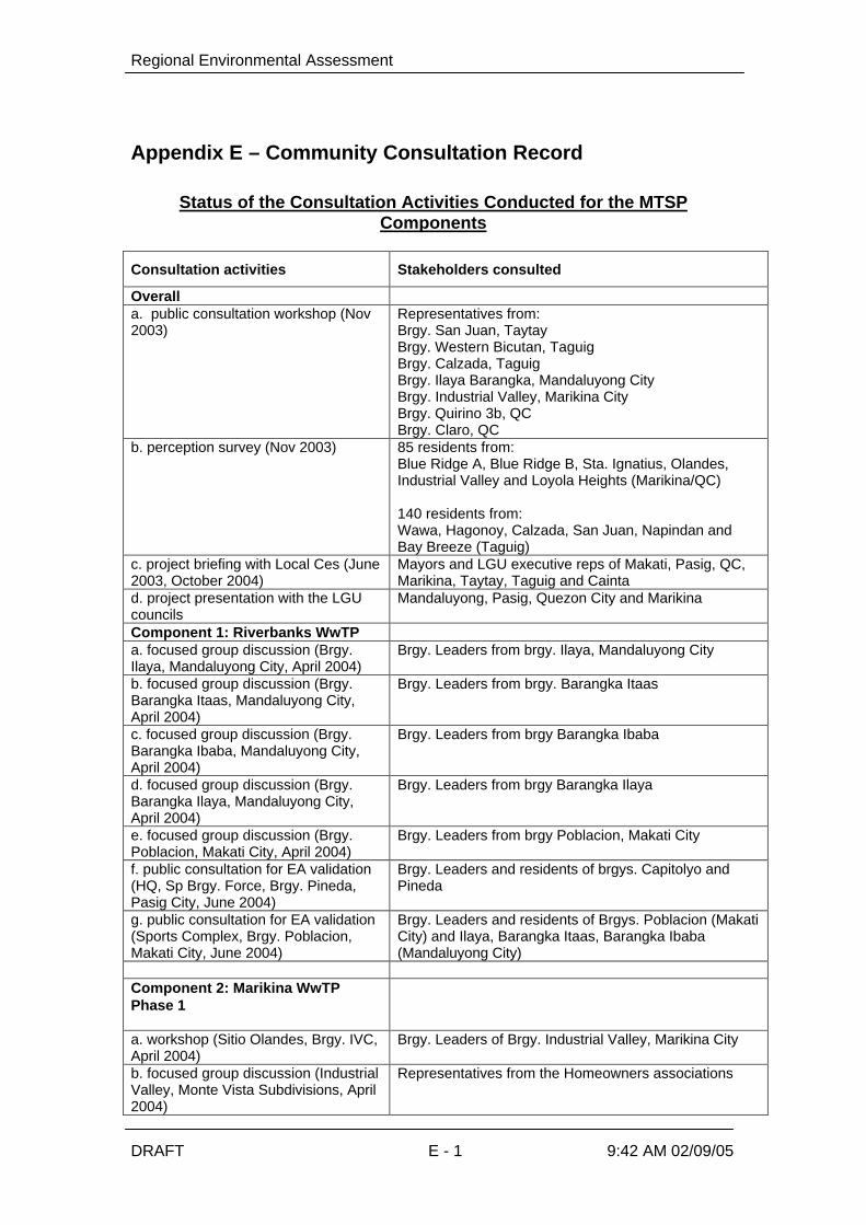
Regional Environmental Assessment
DRAFT E - 1 9:42 AM 02/09/05
Appendix E – Community Consultation Record
Status of the Consultation Activities Conducted for the MTSPComponents
Consultation activities Stakeholders consulted
Overalla. public consultation workshop (Nov2003)
Representatives from:Brgy. San Juan, TaytayBrgy. Western Bicutan, TaguigBrgy. Calzada, TaguigBrgy. Ilaya Barangka, Mandaluyong CityBrgy. Industrial Valley, Marikina CityBrgy. Quirino 3b, QCBrgy. Claro, QC
b. perception survey (Nov 2003) 85 residents from:Blue Ridge A, Blue Ridge B, Sta. Ignatius, Olandes,Industrial Valley and Loyola Heights (Marikina/QC)
140 residents from:Wawa, Hagonoy, Calzada, San Juan, Napindan andBay Breeze (Taguig)
c. project briefing with Local Ces (June2003, October 2004)
Mayors and LGU executive reps of Makati, Pasig, QC,Marikina, Taytay, Taguig and Cainta
d. project presentation with the LGUcouncils
Mandaluyong, Pasig, Quezon City and Marikina
Component 1: Riverbanks WwTPa. focused group discussion (Brgy.Ilaya, Mandaluyong City, April 2004)
Brgy. Leaders from brgy. Ilaya, Mandaluyong City
b. focused group discussion (Brgy.Barangka Itaas, Mandaluyong City,April 2004)
Brgy. Leaders from brgy. Barangka Itaas
c. focused group discussion (Brgy.Barangka Ibaba, Mandaluyong City,April 2004)
Brgy. Leaders from brgy Barangka Ibaba
d. focused group discussion (Brgy.Barangka Ilaya, Mandaluyong City,April 2004)
Brgy. Leaders from brgy Barangka Ilaya
e. focused group discussion (Brgy.Poblacion, Makati City, April 2004)
Brgy. Leaders from brgy Poblacion, Makati City
f. public consultation for EA validation(HQ, Sp Brgy. Force, Brgy. Pineda,Pasig City, June 2004)
Brgy. Leaders and residents of brgys. Capitolyo andPineda
g. public consultation for EA validation(Sports Complex, Brgy. Poblacion,Makati City, June 2004)
Brgy. Leaders and residents of Brgys. Poblacion (MakatiCity) and Ilaya, Barangka Itaas, Barangka Ibaba(Mandaluyong City)
Component 2: Marikina WwTPPhase 1
a. workshop (Sitio Olandes, Brgy. IVC,April 2004)
Brgy. Leaders of Brgy. Industrial Valley, Marikina City
b. focused group discussion (IndustrialValley, Monte Vista Subdivisions, April2004)
Representatives from the Homeowners associations
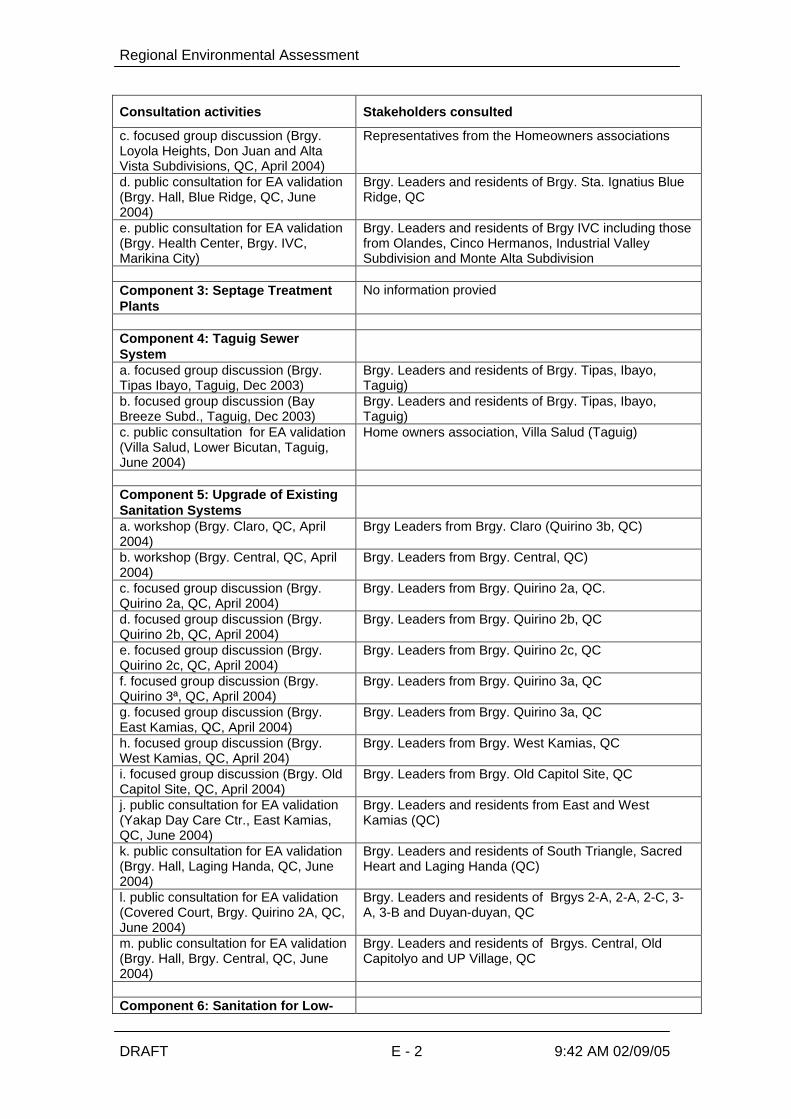
Regional Environmental Assessment
DRAFT E - 2 9:42 AM 02/09/05
Consultation activities Stakeholders consulted
c. focused group discussion (Brgy.Loyola Heights, Don Juan and AltaVista Subdivisions, QC, April 2004)
Representatives from the Homeowners associations
d. public consultation for EA validation(Brgy. Hall, Blue Ridge, QC, June2004)
Brgy. Leaders and residents of Brgy. Sta. Ignatius BlueRidge, QC
e. public consultation for EA validation(Brgy. Health Center, Brgy. IVC,Marikina City)
Brgy. Leaders and residents of Brgy IVC including thosefrom Olandes, Cinco Hermanos, Industrial ValleySubdivision and Monte Alta Subdivision
Component 3: Septage TreatmentPlants
No information provied
Component 4: Taguig SewerSystema. focused group discussion (Brgy.Tipas Ibayo, Taguig, Dec 2003)
Brgy. Leaders and residents of Brgy. Tipas, Ibayo,Taguig)
b. focused group discussion (BayBreeze Subd., Taguig, Dec 2003)
Brgy. Leaders and residents of Brgy. Tipas, Ibayo,Taguig)
c. public consultation for EA validation(Villa Salud, Lower Bicutan, Taguig,June 2004)
Home owners association, Villa Salud (Taguig)
Component 5: Upgrade of ExistingSanitation Systemsa. workshop (Brgy. Claro, QC, April2004)
Brgy Leaders from Brgy. Claro (Quirino 3b, QC)
b. workshop (Brgy. Central, QC, April2004)
Brgy. Leaders from Brgy. Central, QC)
c. focused group discussion (Brgy.Quirino 2a, QC, April 2004)
Brgy. Leaders from Brgy. Quirino 2a, QC.
d. focused group discussion (Brgy.Quirino 2b, QC, April 2004)
Brgy. Leaders from Brgy. Quirino 2b, QC
e. focused group discussion (Brgy.Quirino 2c, QC, April 2004)
Brgy. Leaders from Brgy. Quirino 2c, QC
f. focused group discussion (Brgy.Quirino 3ª, QC, April 2004)
Brgy. Leaders from Brgy. Quirino 3a, QC
g. focused group discussion (Brgy.East Kamias, QC, April 2004)
Brgy. Leaders from Brgy. Quirino 3a, QC
h. focused group discussion (Brgy.West Kamias, QC, April 204)
Brgy. Leaders from Brgy. West Kamias, QC
i. focused group discussion (Brgy. OldCapitol Site, QC, April 2004)
Brgy. Leaders from Brgy. Old Capitol Site, QC
j. public consultation for EA validation(Yakap Day Care Ctr., East Kamias,QC, June 2004)
Brgy. Leaders and residents from East and WestKamias (QC)
k. public consultation for EA validation(Brgy. Hall, Laging Handa, QC, June2004)
Brgy. Leaders and residents of South Triangle, SacredHeart and Laging Handa (QC)
l. public consultation for EA validation(Covered Court, Brgy. Quirino 2A, QC,June 2004)
Brgy. Leaders and residents of Brgys 2-A, 2-A, 2-C, 3-A, 3-B and Duyan-duyan, QC
m. public consultation for EA validation(Brgy. Hall, Brgy. Central, QC, June2004)
Brgy. Leaders and residents of Brgys. Central, OldCapitolyo and UP Village, QC
Component 6: Sanitation for Low-

Regional Environmental Assessment
DRAFT E - 3 9:42 AM 02/09/05
Consultation activities Stakeholders consulted
income Communitiesa. focused group discussion (Brgy.Signal Village, Taguig, April 2004)
Brgy. Leaders of Brgy. Signal Village, Taguig
b. public consultation for EAvalidation(Covered Court, SignalVillage, Taguig, June 2004)
Brgy. Leaders and residents from Brgys Signal Villageand Western Bicutan (Taguig)
c. public consultation for EA validation(Fishport Trng Ctr, Brgy. San Juan,Taytay, Rizal)
Brgy. Leaders and residents from Pawis, Exodus,Diimagta/Sumagta, Genesis (of Brgy. San Juan)
Component 7: Septage Disposal inLahar Areasa. individual visits/orientation to brgy.Officials (March 2004)
Brgy Leaders from:Brgys. Panipuan, Malino and Baliti (San Fernando)Brgy. Mining (Angeles)Brgys. Ganduz, Eden, Suclaban, Culubasa, Akli, San Jose Malino and Panipuan (Mexico)Brgy. Carmencita (Floridablanca)
a. perception survey (coveringsettlement clusters adjacent toproposed project areas, April-May2004)
239 households from Angeles City , Floridablanca,Mexico, and San Fernando
b. consultations(Greenfields Tennis and Country Club,San Fernando, Pampanga, June 15,2004)(LAREC, Floridablanca, Pampanga,June 22, 2004)
Farmers and farm lot owners, LGUs (brgy. Andmunicipal level), Sugar Regulatory Agency, NGOs(Pagkain ng Bayan Foundation and Porac Federation ofCooperatives)
Note: Consultation with the adjacent property owners and residents for the proposed PayatasSeptage Treatment is to be conducted after agreement has been reached with the propertyowner on the sale of the land. In the case of the FTI site, discussion has been made with theManagement of the Complex (FTI) on the use of a portion near the existing treatment facility ofthe complex. Consultation is not deemed necessary in the case of the FTI site.