E895 - World Bank Documents & Reports
326
E895 Volume7 rrnnmental Impact Assessment EAST - WEST CORRIDOR onsultancy Services for Independent Review and Consolidation of Environmental and Social Assessment July 2004 F" Submitted by Operations Research Group in association with Spatial Decisions Submitted to 4<4 i*t.* - National Highway Authority of India r v~ h W~~~~~~~~~~~~~~~~~~~~~~~~~~~~~~~~~~~~~~~~~~~~~~~~~~~~~~~~~~ Public Disclosure Authorized Public Disclosure Authorized Public Disclosure Authorized Public Disclosure Authorized Public Disclosure Authorized Public Disclosure Authorized Public Disclosure Authorized Public Disclosure Authorized
-
Upload
khangminh22 -
Category
Documents
-
view
0 -
download
0
Transcript of E895 - World Bank Documents & Reports

E895Volume7
rrnnmental Impact Assessment
EAST - WEST CORRIDORonsultancy Services for Independent Review and
Consolidation of Environmental and
Social Assessment
July 2004
F" Submitted byOperations Research Group
in association withSpatial Decisions
Submitted to
4<4 i*t.* - National Highway Authority of India
r v~ h W~~~~~~~~~~~~~~~~~~~~~~~~~~~~~~~~~~~~~~~~~~~~~~~~~~~~~~~~~~~~~~~~~~~
Pub
lic D
iscl
osur
e A
utho
rized
Pub
lic D
iscl
osur
e A
utho
rized
Pub
lic D
iscl
osur
e A
utho
rized
Pub
lic D
iscl
osur
e A
utho
rized
Pub
lic D
iscl
osur
e A
utho
rized
Pub
lic D
iscl
osur
e A
utho
rized
Pub
lic D
iscl
osur
e A
utho
rized
Pub
lic D
iscl
osur
e A
utho
rized


INDEPENDENT REVIEW OF ENVIRONMENTAL & SOCIAL ASSESSMENT PROCESS AND CONSOLIDATION OFEIA, EMP AND RAP REPORTS FOR AYODHYA TO MUZAFFARPUR SECTION OF EAST WEST CORRIDOR FINAL CONSOLIDATED EIA
Final Consolidated Environmental Impact AssessmentAyodhya to Muzaffarpur section of East West Corridor
Table of Contents
1.INTRODUCTION .............................................. 1-11.1 Background of the Project .............................................. 1-1
1.1.1 The National Highway Development Project .............................................. 1-11.1.2 Lucknow Muzaffarpur National Highway Project .............................................. 1-4
1.2 The Study Project: Ayodhya-Muzaffarpur Section .............................................. 1-51.2.1 Scope of Study Project .............................................. 1-5
1.3 DPR Consultants .............................................. 1-61.4 Independent Review of Environmental & Social Assessments .............................................. 1-61.5 Environmental Impact Assessment Process Adopted .............................................. 1-71.6 EIA Methodology .............................................. 1-81.7 Independent Review and Consolidation of EA .............................................. 1-91.8 Report Structure ................................................... 1-10
2. PROJECT DESCRIPTION ................................................... 2-12.1 Introduction ................................................... 2-12.2 Benefits of the Project ................................................... 2-2
2.2.1 Macro-Economic benefits ................................................... 2-22.2.2 Local Level Benefits ................................................... 2-2
2.3 Project Details ................................................... 2-42.3.1 Proposed Carriageway Details ................................................... 2-42.3.2 Traffic Projections ................................................... 2-62.3.3 Right of Way ................................................... 2-62.3.4 Land Acquisition ................................................... 2-72.3.5 Road Inventory ................................................... 2-72.3.6 General Features of the Alignment ................................................... 2-82.3.7 Salient Improvements ................................................... 2-92.3.8 Project Cost ................................................... 2-11
3. POLICY, LEGAL AND ADMINISTRATIVE FRAMEWORK ................................................... 3-13.1 Introduction ................................................... 3-13.2 Institutional Setting for the Project ................................................... 3-1
3.2.1 The National Highways Authority of India (NHAI) ................................................... 3-13.2.2 Project Implementation Unit (PIU) ................................................... 3-23.2.3 Environmental and Social Development Unit at the NHAI Corporate ...................... 3-2
3.3 Institutional Setting in the Environmental Context ................................................... 3-23.3.1 Ministry of Environment and Forests (MOEF), Government of India ....................... 3-33.3.2 MoEF Regional Offices ................................................... 3-33.3.3 Central Pollution Control Board (CPCB) ................................................... 3-33.3.4 State Pollution Control Board (SPCB) ................................................... 3-33.3.5 Department of Forests (DoF) ................................................... 3-4
3.4 Environmental Clearance Requirements ................................................... 3-43.4.1 Gol Requirements ................................................... 3-43.4.2 State Level Clearance Requirements ................................................... 3-53.4.3 World Bank Requirements ................................................... 3-6
3.5 The Legal Framework ................................................... 3-63.5.1 The Environment (Protection) Act, 1986 and the Environmental Impact AssessmentNotification, 1994 .................................................... 3-7
Operations Research Group in association with Spatial Decisions

INDEPENDENT REVIEW OF ENVIRONMENTAL & SOCIAL ASSESSMENT PROCESS AND CONSOLIDATION OFEIA, EMP AND RAP REPORTS FOR AYODHYA TO MUZAFFARPUR SECTION OF EAST WEST CORRIDOR FINAL CONSOLIDATED EIA
3.5.2 The Water and Air (Prevention and Control of Pollution) Acts ................................ 3-73.5.3 The Forest (Conservation) Act, 1980 ....................................................... 3-73.5.4 The Wildlife (Protection) Act, 1972 ....................................................... 3-83.5.5 The Motor Vehicles Act, 1988 ....................................................... 3-83.5.6 The Ancient Monuments and Archaeological Sites and Remains Act, 1958 ........... 3-93.5.7 State Level Legislation and Other Acts ....................................................... 3-9
3.6 Summary of Clearances Required ....................................................... 3-93.7 The Status of Obtaining Clearances for the Project ....................................................... 3-10
4. ENVIRONMENTAL ASSESSMENT METHODOLOGY ......................................... 4-14.1 Study Methodology for Individual EA ....................................................... 4-1
4.1.1 Assembly, Literature Survey and Analysis of Data .................................................. 4-14.1.2 Incorporation of Environmental considerations Into the Feasibility study ................ 4-14.1.3 Reconnaissance Surveys ....................................................... 4-24.1.4 Preliminary Environmental Screening ....................................................... 4-24.1.5 Documentation of Baseline Conditions ....................................................... 4-24.1.6 Assessment of Potential Impacts ....................................................... 4-24.1.7 Assessment of Alternatives ....................................................... 4-24.1.8 Identified Mitigation & Environmental Enhancement Measures .............................. 4-34.1.9 Community Consultations ....................................................... 4-34.1.10 Preparation of the Environmental Management Plan (EMP) ................................. 4-3
4.2 Independent Review and Consolidation ....................................................... 4-34.2.1 Step 1: Review of individual EIA and EMP ....................................................... 4-34.2.2 Step 2: Gaps and Recommendations ....................................................... 4-34.2.3 Step 3: Consolidation of Reports ....................................................... 4-4
5. BASELINE ENVIRONMENTAL STATUS OF THE PROJECT . .................................. 5-15.1 Introduction ....................................................... 5-1
5.1.1 Project Location ....................................................... 5-15.1.2 Directly Impacted Areas ....................................................... 5-25.1.3 Environmentally Sensitive Areas ....................................................... 5-25.1.4 Meteorology ....................................................... 5-35.1.5 Natural and Biophysical Environment ....................................................... 5-65.1.6 Biological Environment ....................................................... 5-24
6. STAKEHOLDER CONSULTATION ....................................................... 6-16.1 Introduction ........................................................ 6-16.2 Objective of Public Consultation ....................................................... 6-16.3 Stakeholder Consultation Methodology . . ................................... 6-2
6.3.1 LocalNillage level Consultations ....................................................... 6-26.3.2 District level Consultations . . .................................... 6-26.3.3 State Level Consultations . ...................................... 6-26.3.4 Focused Group Discussion . . .................................... 6-3
6.4 Community Consultation Results ....................................................... 6-46.5 Key Environmental Issues and Response Received . ...................................................... 6-116.6 Project Workshops ........................................................ 6-12
6.6.1 Key Discussion at the Workshop ....................................................... 6-136.6.2 Outcome of Workshop . ...................................................... 6-14
6.7 General opinion of the People regarding Project . ...................................................... 6-146.8 Continued Consultations and Participations ........................................................ 6-15
6.8.1 Plan for Continued Participation ....................................................... 6-156.8.2 Followup Consultation . ....................................................... 6-166.8.3 Community Participation . ...................................... 6-16
Operations Research Group in association with Spatial Decisions 2

INDEPENDENT REVIEW OF ENVIRONMENTAL & SOCIAL ASSESSMENT PROCESS AND CONSOLIDATION OFEIA, EMP AND RAP REPORTS FOR AYODHYA TO MUZAFFARPUR SECTION OF EAST WEST CORRIDOR FINAL CONSOLIDATED EIA
7. ASSESSMENT OF ENVIRONMENTAL IMPACTS . . ............................... 7-17.1 Introduction ............................................ .. 7-17.2 Project Benefits ............................................. 7-27.3 Approach and Methodology ............................................ 7-2
7.3.1 Impact Identification and Prediction ............................................ 7-27.4 Assessment of Impacts ............................................. 7-3
7.4.1 Meteorology ............................................ 7-37.5 Natural and Biophysical Environment ............................................ . 7-4
7.5.1 Land Resources ............................................ 7-47.5.2 Ambient Air Quality . . ....................................... 7-117.5.3 Impact on Water Resources ............................................ . 7-157.5.4 Impact on Noise Environment ............................................ . 7-22
7.6 Biological Environment ............................................ 7-377.6.1 Impact on Flora ............................................ 7-377.6.2 Impact on Social Environment ............................................ . 7-40
7.7 Project Impact Matrix ............................................. 7-457.7.1 The RIAM ............................................ 7-467.7.2 Description of RIAM . . ....................................... 7-467.7.3 Discussion of Results ............................................ . 7-51
8. ANALYSIS OF ALTERNATIVES ............................................ 8-18.1 Criteria for Analysis of Alternatives ............................................ 8-18.2 Consideration of Alternatives ............................................ 8-2
8.2.1 The "No - Change" Alternative ............................................ 8-28.2.2 The 'With Project' Alternative ............................................ 8-48.2.3 Analysis of Cross-section alternatives ............................................ 8-8
9. ENVIRONMENTAL MITIGATION AND ENHANCEMENT MEASURES . ...................................... 9-19.1 Introduction ............................................ .. 9-19.2 Basic Approach ............................................. 9-1
9.2.1 Mitigation ............................................ 9-19.2.2 Environmental Enhancements ............................................ . 9-2
9.3 Mitigation Measures Proposed ............................................ 9-29.3.1 Meteorology ............................................ 9-29.3.2 Natural and Biophysical Environment . . ............................... 9-39.3.3 Biological Environment ............................................ . 9-149.3.4 Fauna ............................................. 9-189.3.5 Social Environment . . ....................................... 9-18
9.4 Environmental Enhancement Measures ............................................. 9-309.4.1 Objectives ............................................ 9-30
10. INSTITUTIONAU IMPLEMENTATION ARRANGEMENTS AND ENVIRONMENTAL CAPACITYBUILDING .10-110.1 Introduction.10-110.2 Roles and Responsibilities .10-210.3 Existing Organisational Structure at NHAI .10-2
10.3.1 Corporate Level .10-210.4 Proposed Institutional Arrangement at NHAI .10-7
10.4.1 Need for additional capacity .10-710.4.2 Environmental Manager at NHAI Headquarters . .10-710.4.3 Monitoring Consultants .. 10-8
10.5 Reporting System .10-1010.6 Training. 10-16
Operations Research Group in association with Spatial Decisions 3

INDEPENDENT REVIEW OF ENVIRONMENTAL & SOCIAL ASSESSMENT PROCESS AND CONSOLIDATION OFEIA, EMP AND RAP REPORTS FOR AYODHYA TO MUZAFFARPUR SECTION OF EAST WEST CORRIDOR FINAL CONSOLIDATED EIA
List of TablesTable 1.1: Contract Packages of East-West Corridor currently under implementation ................... 1-2Table-1.2: Consultancy and Contract Packages under LMNHP: World Bank aided ProjectsUnder Phase-IlIl Program of East -West Corridor ......................................................... 1-4Table-1.3: Distribution of Contract Package forming part of the consultancy packages ................. 1-5Table-1.4: Scope of Environmental Analysis, Design, and Environmental ManagementAction Plan ......................................................... 1-7Table 2.1: Distribution of Contract Package forming part of the consultancy packages ................. 2-1Table 2.2: Specifications for Typical Cross-Sections proposed ...................................................... 2-5Table 2.3: Proposed Pavement Specifications ......................................................... 2-5Table 2.4: Traffic Projections (PCUs), 2002-2032 ......................................................... 2-6Table 2.5: Distribution of Right of Way ......................................................... 2-6Table 2.6: Package wise details of Land Acquisition ......................................................... 2-7Table 2.7: Road Inventory ......................................................... 2-7Table 2.8: Community structures along LMNHP ......................................................... 2-8Table 2.9: Proposed truck parking and rest areas in project stretch ............................................... 2-9Table 2.10: Package wise detail of proposed flyovers ......................................................... 2-9Table 2.11: Package wise details of proposed Underpasses ....................................................... 2-10Table 2.12: Total Project Cost, Environmental Management and R&R cost (in Rs. Million) ......... 2-12Table 5.1: Maximum and Minimum Temperatures in Major Districts within the Project Stretch ..... 5-4Table 5.2: Maximum and Minimum Rainfall in Major Districts ........................................................ 5-5Table 5.3: Maximum Relative Humidity (%age) in Project Districts ................................................ 5-6Table 5.4: Summary details of Borrow Areas (For Embankment & Sub-grade Construction) ........ 5-8Table 5.5: Fly-ash characteristics based on material testing report .............................................. 5-11Table 5.6: Air Pollution Receptors Types identified along the Project Road ................................. 5-12Table 5.7: National Ambient Air Quality Standards: India .......................................................... 5-13Table 5.8: Major Traffic Bottlenecks within the Project Stretch ..................................................... 5-13Table 5.9: AAQ monitoring results in Contract Package I ......................................................... 5-14Table 5.10: AAQ monitoring results in Contract Package II ......................................................... 5-14Table 5.11: AAQ monitoring results in Contract Package Ill ......................................................... 5-15Table 5.12: AAQ monitoring results in Contract Package VII ....................................................... 5-15Table 5.13: AAQ monitoring results in Contract Package VIII ...................................................... 5-15Table 5.14: AAQ monitoring results in Contract Package IX ........................................................ 5-16Table 5.15: AAQ monitoring results in Contract Package X ......................................................... 5-16Table 5.16: AAQ monitoring results in Contract Package Xl ........................................................ 5-16Table 5.17: AAQ monitoring results in Contract Package XII ....................................................... 5-17Table 5.18: Ground water resources in Direct Impact Zone of the project ................................... 5-19Table 5.19 A: Water Quality Standards ........................................................... 5-19Table 5.19 B: Water Quality Standards ........................................................... 5-20Table 5.20: Cross-Drainage Structures on the Project Highway .................................................. 5-21Table 5.21: Flood Over-topped locations Section C-Ill/5 ........................................................... 5-22Table 5.22: National ambient noise level standards (as per CPCB, India) ................................... 5-22Table 5.23: Noise Level in the Project Area ........................................................... 5-23Table 5.24: Construction Package Wise Distribution of Trees within right of way ........................ 5-25Table 5.25: List of Schools and Hospitals ........................................................... 5-29Table 5.26: Details of Markets Location ........................................................... 5-33Table 5.27: Package wise Traffic projections ........................................................... 5-35Table 5.28: Road Accident Data ........................................................... 5-36Table 6.1: Location of Focussed Group Discussions ........................................................... 6-3Table 6.2: Consultation Results ........................................................... 6-5Table 6.3: General Public Response to Environmental Issues ..................................................... 6-11Table 6.4: Location of Workshops ........................................................... 6-12Table 6.5: Core Rapid Appraisal: Mechanism for Continued Participation ................................... 6-16Table 7.1: Earthwork and fly-ash requirements ........................................................... 7-5
Operations Research Group in association with Spatial Decisions 4

INDEPENDENT REVIEW OF ENVIRONMENTAL & SOCIAL ASSESSMENT PROCESS AND CONSOLIDATION OFEIA, EMP AND RAP REPORTS FOR AYODHYA TO MUZAFFARPUR SECTION OF EAST WEST CORRIDOR FINAL CONSOLIDATED EIA
Table 7.2: Quarry material and Sand requirements ........................................................ 7-10Table 7.3: CO Emission Factors used for Prediction Modelling .................................................... 7-13Table 7.4: Package wise requirement of water for construction activities .................................... 7-15Table 7.5: Ground water resources impacted by the Proposed Project ....................................... 7-18Table 7.6: Likely impacts of the project on the Surface Water Bodies .......................................... 7-18Table 7.7: Typical noise levels of principal construction equipments (Noise Level in db (A)at 50 Feet) ........................................................ 7-23Table 7.8: Speed Corrected Noise Levels for Different Vehicle Types ......................................... 7-25Table 7.9: Operative Speeds ........................................................ 7-26Table 7.10: Predicted Noise Levels on Noise Sensitive Receptors During Design Life ofLMNHP ........................................................ 7-31Table 7.11: Impact of Project on Trees ........................................................ 7-38Table 7.12: No of Religious Structures within 30 m by Consultancy Packages ............................ 7-40Table 7.13: Major Built-up Zones in Project Stretch ........................................................ 7-43Table 7.14: Ranges Bands used for RIAM ........................................................ 7-50Table 7.15: Summary of Scores for Without Project Scenario ...................................................... 7-52Table 7.16: Summary of Scores for With Project (without mitigation measures) scenario ........... 7-52Table 7.17: summary of scores for With Project (With Mitigation Measures) ............................... 7-52Table 8.1: Criteria for Analysis of Alternatives ........................................................ 8-1Table 8.2: Comparison of "With and Without" Project Scenarios .................................................... 8-2Table 8.3: Realignments vis-a-vis Road widening ........................................................ 8-4Table 8.4: Evaluation of Bypass versus upgrading existing alignment - Ayodhya ......................... 8-5Table 8.5: Evaluation of Bypass options - Ayodhya ........................................................ 8-5Table 8.6: Evaluation of options - Jagdishpur, Sonbarsa and Sukhrauli ........................................ 8-7Table 8.7: Consideration of cross section alternatives ........................................................ 8-8Table 9.1: Avoidance / Mitigation Measures for air pollution at critical locations ............................ 9-8Table 9.2: Proposed noise barriers types for different location types ........................................... 9-14Table 9.3: Location of different types of barriers by chainage .................................................... 9-14Table 9.4:Trees to be cut and saved by package ........................................................ 9-15Table 9.5: Compensatory Afforestation along the Project Packages ............................................ 9-15Table 9.6: Chainage wise list of proposed underpasses ........................................................ 9-20Table 9.7: List of Specific Ponds to be enhanced ........................................................ 9-31
Operations Research Group in association with Spatial Decisions 5

INDEPENDENT REVIEW OF ENVIRONMENTAL & SOCIAL ASSESSMENT PROCESS AND CONSOLIDATION OFEIA, EMP AND RAP REPORTS FOR AYODHYA TO MUZAFFARPUR SECTION OF EAST WEST CORRIDOR FINAL CONSOLIDATED EIA
List of Figures
Fig 1.1: Golden Quadrilateral and North-South & East-West Corridors .......................................... 1 -2Fig 1.2: Traffic Bottlenecks in the Project Stretch ...................................................... 1-4Fig 5.1: Location of Project States ...................................................... 5-1Fig 5.2: Map showing Annual Average Temperature ...................................................... 5-3Fig 5.3: Annual Average Rainfall in the Project Region ...................................................... 5-4Fig 5.4 A: Thick Vegetation along pavement edge ...................................................... 5-7Fig 5.4 B: Soil erosion at isolated stretches ...................................................... 5-7Fig 5.5: Wetland Vegetation in Water Logged Areas ...................................................... 5-8Fig 5.6: Temporary Religious Structure Near Ponds made during the 'Chhat Puja' ...................... 5-18Fig 5.7: Water Logged Areas supporting Wetland Vegetation ...................................................... 5-18Fig 5.8: Archaeological Monument at Kushinagar ...................................................... 5-27Fig 5.9: Buddhist stupa at fazil nagar ...................................................... 5-27Fig 5.10: Archaeological Site details in the Project Stretch ...................................................... 5-28Fig 5.11: Road Accident involving heavy goods traffic on NH-28 ................................................. 5-35Fig 7.1: Agricultural area lost due to flooding ...................................................... 7-6Fig 7.2: Noise Levels, (Leq (Day) and Leq (Night)) Variation (Ayodhya - Gorakhpur,Year 2005) ...................................................... 7-26Fig 7.3: Noise Levels, (Leq (Day) and Leq (Night)) Variation (Ayodhya - Gorakhpur,Year2020 ) ...................................................... 7-27Fig 7.4: Noise Levels, (Leq (Day) and Leq (Night)) Variation (Ayodhya - Gorakhpur,Year2030 ) ...................................................... 7-27Fig 7.5: Noise Levels, (Leq (Day) and Leq (Night)) Variation (Gorakhpur - Gopalganj,Year 2005) ...................................................... 7-28Fig 7.6: Noise Levels, (Leq (Day) and Leq (Night)) Variation (Gorakhpur - Gopalganj,Year2020 ) ...................................................... 7-28Fig 7.7: Noise Levels, (Leq (Day) and Leq (Night)) Variation (Gorakhpur - Gopalganj,Year2030 ) ...................................................... 7-29Fig 7.8: Noise Levels, (Leq (Day) and Leq (Night)) Variation (Gopalganj - Muzaffarpur,Year 2005) ...................................................... 7-29Fig 7.9: Noise Levels, (Leq (Day) and Leq (Night)) Variation (Gopalganj - Muzaffarpur,Year2020 ) ...................................................... 7-30Fig 7.10: Noise Levels, (Leq (Day) and Leq (Night)) Variation (Gopalganj - Muzaffarpur,Year2030 ) ...................................................... 7-30Fig 7.11: The Archaeological Site at Kushinagar ...................................................... 7-41Fig 7.12: Buddhist Stupa at Fazilnagar ...................................................... 7-41Fig 7.13: Guard rails to be dismantled ...................................................... 7-42Fig 9.1:Typical drawings of soil erosion protection measures at slopes a) Stone pitching;and b) Brick pitching ...................................................... 9-6Fig 9.2: Silt Fencing along water Course ...................................................... 9-11Fig 10.1: Complete organisational structure at NHAI ...................................................... 10-4Fig 10.2: Suggested EMP Implementation and Compliance monitoring verificationarrangement ...................................................... 10-9
Operations Research Group in association with Spatial Decisions 6

INDEPENDENT REVIEW OF ENVIRONMENTAL & SOCIAL ASSESSMENT PROCESS AND CONSOLIDATION OFEIA, EMP AND RAP REPORTS FOR AYODHYA TO MUZAFFARPUR SECTION OF EAST WEST CORRIDOR FINAL CONSOLIDATED EIA
Annexures
Annexure I: Package wise Status of Environmental Clearances
Annexure II: Details of Borrow Areas
Annexure III: Details of Ponds within the Direct Impact Zone
Annexure IV: Status of Surface Water Quality of Major Rivers, Ponds and Channels
Annexure V: Characteristics of Ground Water
Annexure VI: Summary of Trees within RoW
Annexure VlI: Details of Dhabas (On either side of existing Road under Direct Impact Zone)
Annexure VIII: Details of Telephone Poles (30 m. from centre of the road on either side)
Annexure IX a: Details of Electric Poles with wire (30 m. from centre of the road on either side)
Annexure IX b: Details of Electric Poles without wire (30 m. from centre of the road on either side)
Annexure X: Details of Electric Transformers
Annexure XI: Traffic Survey Details
Annexure XII: Suggested Scope of Services for the Monitoring consultant for the Implementation ofEMPs
Operations Research Group in association with Spatial Decisions 7


INDEPENDENT REVIEW OF ENVIRONMENTAL & SOCIAL ASSESSMENT PROCESS AND CONSOLIDATION OFEIA, EMP AND RAP REPORTS FOR AYODHYA TO MUZAFFARPUR SECTION OF EAST WEST CORRIDOR FINAL CONSOLIDATED EIA
Chapter 1
Operations Research Group in association with Spatial Decisions


INDEPENDENT REVIEW OF ENVIRONMENTAL & SOCIAL ASSESSMENT PROCESS AND CONSOLIDATION OFEIA, EMP AND RAP REPORTS FOR AYODHYA TO MUZAFFARPUR SECTION OF EAST WEST CORRIDOR FINAL CONSOLIDATED EIA
. INTRODUCTION ......................................... . 111.1 Background of the Project .......................................... 1-1
1.1.1 The National Highway Development Project ......................................... 1-11.1.2 Lucknow Muzaffarpur National Highway Project . ............................ 1-4
1.2 The Study Project: Ayodhya-Muzaffarpur Section ................. ........................ 1-51.2.1 Scope of Study Project ......................................... 1-5
1.3 DPR Consultants ......................................... . 1-61.4 Independent Review of Environmental & Social Assessments . ......................... 1-61.5 Environmental Impact Assessment Process Adopted ......................................... 1-71.6 EIA Methodology ......................................... . 1-81.7 Independent Review and Consolidation of EA ....................................... 1-91.8 Report Structure ......................................... . 1-10
Operations Research Group in association with Spatial Decisions 1-12

IiiI
IiiiI

INDEPENDENT REVIEW OF ENVIRONMENTAL & SOCIAL ASSESSMENT PROCESS AND CONSOLIDATION OFEIA, EMP AND RAP REPORTS FOR AYODHYA TO MUZAFFARPUR SECTION OF EAST WEST CORRIDOR FINAL CONSOLIDATED EIA
1. INTRODUCTION
1.1 Background of the Project
India has embarked on a 10-year highway transportation improvement program as part of its NationalPolicy for globalization of its economy. One of the objectives of this program is to increase efficiency intrade & business. It is a mega initiative considering that the National Highways comprise only about 2%of total road length in the country and yet they carry over 40% of total road traffic.
In order to develop, maintain and manage all National Highways in the country and for dealing with allmatters incidental thereto, National Highways Authority of India (NHAI) was constituted by an act ofParliament in 1988. One of the foremost tasks mandated to NHAI is the implementation of the NationalHighways Development Project (NHDP) that consists of the Golden Quadrilateral and the North-Southand East-West corridors. NHDP is the largest ever project formulated to equip India with world-classhighways with uninterrupted traffic flow. Over 14,000 km of highway length is currently under thejurisdiction of NHAI: i) NHDP- 13,146 km; and ii) spur roads linking Highways with National Seaports-1,000 km.
1.1.1 The National Highway Development Project
NHDP consists of the Golden Quadrilateral (GQ), North-South corridor and the East-West corridor asshown in Figure 1.1. GQ is formed by the existing highway corridors between the four metropolitancities of Delhi, Kolkata, Chennai and Mumbai, as under:
NH 2 Delhi - Kolkata: 1,453 km
NH 4,7 & 46 Chennai - Mumbai: 1,290 km
NH 5 & 6 Kolkata - Chennai: 1,684 km
* NH8 Delhi - Mumbai: 1,419 km
The North-South corridor links Srinagar to Kanyakumari and includes the spur from Salem to Kochi. Itstretches over a length of 4,000 km. The East-West corridor on the other hand is from Silchar toPorbandar and stretches over a length of 3,300 km.
The roads under NHDP are being up-graded /strengthened to 4-lane/6-lane carriageways to facilitatehigh speed uninterrupted vehicular traffic. Several detours for bypassing major cities/towns en-route arealso included in this up-gradation program.
Operations Research Group in association with Spatial Decisions i-

INDEPENDENT REVIEW OF ENVIRONMENTAL & SOCIAL ASSESSMENT PROCESS AND CONSOLIDATION OFEIA, EMP AND RAP REPORTS FOR AYODHYA TO MUZAFFARPUR SECTION OF EAST WEST CORRIDOR FINAL CONSOLIDATED EIA
FIG 1.1: GOLDEN QUADRILATERAL AND NORTH-SOUTH & EAST-WEST CORRIDORS
SRINAOAR
*.,r.n.,L.cwrJ,d Gkp -- Jrmitjh,1r ru Awawd
'it-Ul# ' -- . \'\. nJiout
P., CHAR~,L.rkht. I~i
R~~~~~~~~~~~~
C hilt nr~~~,it I, h ~~ - UI -ATIPGf?IIA14D'II '1 i
PQ1?I1AND~R P.aikril LitkN,do.r
MUMSBA11-. 11
- t Sliandsire Gi,.kFhp,., r.4 -. h.1
Hyderab d BAi.htiL.lt AY OF BFINOAL
ARABIAN SEAI OtH dA
ContracDt rilr ? knao t
TABE .1 CNTAC PCKGE O yEAST-WES CORIO CURETL UNDE IMPEMETATIN
( Legt:urnoo 3 KDA."'A1.01RA ,
Package~~ ~, Legt Dat DateY^ of ofCmlto oslat
(kin) Cmltoolla -ted)
Guwahati Bypass tw
Km. 163.895- o37 7.895 nal -20 ,., CE td
Contract packages currently under implementation for widening/strengthening of East-West Corridorare presented in Table 1.1.
TABLE 1.1: CONTRACT PACKAGES OF EAST-WEST CORRIDOR CURRENTLY UNDER IMPLEMENTATION*
EAST - WEST CORRIDOR(Total Length: 3300 Km.)
Construction Total SatScheduled Revised Date SupervisionContrckage N H Length SDtatre Date of of Completion ConsulItants
ac age ~~(km) Completion (Estimated)
Guwahati Bypass(Assam)-EW/7 JSe-
Km. 163856 37 7.895 20u00 Jun-2002 Dec-2003 CES Ltd
Assam
Guwahati Bypass
Km.156.50- 37 10.50 2001 Sep-2003 Mar-2004 SultantsKm.146.00 Assam 2
N HAl
Operations Research Group in association with Spatial Decisions 1-2

INDEPENDENT REVIEW OF ENVIRONMENTAL & SOCIAL ASSESSMENT PROCESS AND CONSOLIDATION OFEIA, EMP AND RAP REPORTS FOR AYODHYA TO MUZAFFARPUR SECTION OF EAST WEST CORRIDOR FINAL CONSOLIDATED EIA
Dalkhola-
Islampore Sub- Ar E tsection 2-EW/6 31 23.85 2A0p0r0 Jul-2002 Mar-2004 CES Ltd
Km.500-Km.476.15West Bengal
Purnea-Gayakota-EW/4
(Km419-410) 31 15.15 Dec- Mar-2002 Mar-2004 CES LtdBiharNHAI
Dalkhola-Islampore-EW/5 DKm.470-Km.447 31 23.00 19e9c9 Jun-2002 Dec-2003 CES Ltd
West Bengal 19NHAI
Purnea-Gayakotasection of
EWI1 2IBRSe-Sowln Km.447.00- 31 28.00 2S0e0p1 Sep-2004 Sep-2004 Kirkpatri kKm.419.00 20 ikar
BiharNHAI
Lucknow bypass -EW/1 5
Connecting NH-25
56 NH-2ing Nhrouh 28,6A 23.00 Sep- Aug-2004 Aug-2004 CES Ltd56 passing through & 56 2001Lucknow cityUttarPradesh
NHAI
Lucknow-Kanpursection -EWI81UP
Km.21.80- 25 22.20 Sep- Nov-2003 Mar-2004 Archtech ConKm.44.00 2001
UttarPradeshNHAI
Lucknow-Kanpursection -EWI9/UP
Km .44.00- 25 15.50 Sep- Apr-2003 Mar-2004 Archtech ConKm.59.50 2001
UttarPradeshNHAI
Lucknow Kanpur - Contracts
IEWI3 Dec- Terminatedkm 59.5- km 75.5 25 16 1999 Dec-2001 Dec-2004 (Bids to be
UttarPradesh 199reinvited)N HAl
t In order, from east to west.
Operations Research Group in association with Spatial Decisions 1-3

INDEPENDENT REVIEW OF ENVIRONMENTAL & SOCIAL ASSESSMENT PROCESS AND CONSOLIDATION OFEIA, EMP AND RAP REPORTS FOR AYODHYA TO MUZAFFARPUR SECTION OF EAST WEST CORRIDOR FINAL CONSOLIDATED EIA
1.1.2 Lucknow Muzaffarpur National Highway Project
Lucknow Muzaffarpur National Highway Project (LMNHP) is along NH- 28 on the East-West corridor.NH- 28 originates at Lucknow and passes through several important centres like Ayodhya, Basti,Gorakhpur, Kushi Nagar, Gopalganj, Muzaffarpur and Barauni. Lucknow- Barauni stretch is 628 km inlength.
NH- 28 presently has a 2-lane carriageway with an average traffic of 20,500 PCUs1. Of this, 52-55% isestimated to be freight traffic. This traffic is estimated to grow nearly 7-fold to 150,000-159,000 PCUsduring the next 30 years. The existing traffic flow is characterized by a large number of bottlenecks,importantly at Ayodhya, and Tamkuhi (Figure 1.2).
The existing carriageway & pavement conditions of LMNH are not adequate for meeting the abovenoted traffic projections. NHAI has therefore decided to widen its carriageway to 4-lanes now, and to 6-lanes in later years. This 4-laning [system design life- 30 years] will be undertaken under Phase-lIlProgram for the East - West Corridor that is being aided by the World Bank. Details of Consultancy andContract Packages under this Phase-lIl Program are shown in Table 1.2.
FIG 1.2: TRAFFIC BOTTLENECKS IN THE PROJECT STRETCH
Packages Contract Packages No. Total Length In Km.
(Consultancy)
C-Ill/1 (Muzaffarpur -Gopalganj Section) IX '-, X, xi, XII 134.00Km. 386.000 to 520.000 of NH-28
C-111/2 (Ayodhya - Gorakhpur Section) 1,11,111 116.913Km. 135.000 to 251 .700 (DesignChainage 253.363) of NH-28
C-111/3 (Lucknow - Ayodhya Section) Km. 1,11, III 129.79.000 to 135.000 of NH-28
C-Ill/5 (Gorakhpur -Gopalganj Section) VII, ViIl, IX* 106.20Km. 279.800 to 386.000 of NH-28
Gorakhpur Bypass 1,132.469
1Based on the daily traffic survey conducted in the year 2002
Operations Research Group in association with Spatial Decisions 1-4

INDEPENDENT REVIEW OF ENVIRONMENTAL & SOCIAL ASSESSMENT PROCESS AND CONSOLIDATION OFEIA, EMP AND RAP REPORTS FOR AYODHYA TO MUZAFFARPUR SECTION OF EAST WEST CORRIDOR FINAL CONSOLIDATED EIA
* Partly in both the Sections C-l1l/1 and C-Ill/5
1.2 The Study Project: Ayodhya-MuzaffarpurSection
The Study Project relates to Ayodhya-Muzaffarpur Section of LMNHP. This stretch is approximately 357km long and includes the Basti bypass (Figure 1.1). This Project is covered under consultancypackages C-1ll/i, C-111/2 and C-111/5 and 9 contract packages as shown in Table 1.2. Further breakdownof these contract packages is given in Table 1.3.
TABLE-1.3: DISTRIBUTION OF CONTRACT PACKAGE FORMING PART OF THE CONSULTANCY PACKAGES
Consultancy Contract Package No. Chainage TotalPackages Length in
Km.
C-111/2 (Ayodhya - Ayodhya bypass and Km. 27.500Gorakhpur Section) 142.500 to Km. 164.000Km. 135.000 to251.700 of NH-28 11 Km. 164.000 to Km. 208.00 44.000
III Km. 208.00 to Km. 251.700 45.363(Design Chainage 253.363)
C-Ill/5 (Gorakhpur - VII Km. 279.800 to Km. 40.000Gopalganj Section) 319.800Km. 279.800 to386.000 of NH-28 Vill Km. 319.800 to Km. 41.115
360.915
IX Part Length: Km. 41.085360.915 to Km. 386.000
IX Part Length: Km.386.000 to Km. 402.000
C-l1l/1 (Muzaffarpur- X Km. 402.000 to Km. 38.000Gopalganj Section) 440.000Km. 386.000 to Xi Km. 440.000 to Km. 40.000520.000 of NH-28 480.000
xi] Km. 480.000 to Km. 40.000520.000
1.2.1 Scope of Study Project
The existing 2-lane carriageway between Ayodhya and Muzaffarpur will be widened to 4 lanes in orderto meet the traffic needs for the next 20-30 years2. Provision has been made for widening it to 6 lanesin later years. Design process of the Project has entailed detailed analysis of the present & future trafficprofiles, pavement & soil conditions, availability of construction materials, cross-drainage structures,environmental and social/resettlement features, etc. The proposed widening to four lanes will be
2 The design life of a rigid pavement is 30 years, for flexible pavement it is 20 years.
Operations Research Group in association with Spatial Decisions 1-5

INDEPENDENT REVIEW OF ENVIRONMENTAL & SOCIAL ASSESSMENT PROCESS AND CONSOLIDATION OFEIA, EMP AND RAP REPORTS FOR AYODHYA TO MUZAFFARPUR SECTION OF EAST WEST CORRIDOR FINAL CONSOLIDATED EIA
confined to within the existing Right of Way (RoW), avoiding land acquisition as far as possible, exceptfor locations where it is absolutely essential and where a diversion from the existing alignment isabsolutely necessary (see Box 1.1).
Box 1.1: TERMS OF REFERENCES FOR FEASIBILITY STUDIES AND DETAILED ENGINEERING CONSULTANCY SERVICES 3
"...The project stretch is proposed to be widened to four lane within the existing ROW avoiding land acquisitionas far possible, except for locations where provisions of short bypasses, service roads, alignment corrections,improvement of junctions including provision of grade separators, etc., are considered practicable and cost-effective."...The scope will consist mainly widening of the existing two lane to four lane within the RoW, inter alia including
fixation of alignment, alignments of the proposed widening work, improvements, if any, required to the existingalignment, identification and fixation of alignments of short bypasses, identification of locations of service roads,identification, location and design of toll plazas etc."...The Consultant shall undertake a detailed environmental study in accordance with the standards prescribed byGol and World Bank and will make suitable recommendations and prepare appropriate, mitigation plan andresettlement action plans. The Engineering design of the project will absorb all acceptable recommendationsemerging out of the environmental studies.. Scope of consultancy services will include testing of locally available materials like aggregates, sand, gravel,
fly ash etc. to determine their suitability for use in construction of the proposed road works.
1.3 DPR Consultants
NHAI had retained the following consultants for preparation of Detailed Project Reports (DPR) ofAyodhya-Muzaffarpur stretch:
* C-111/2: Ayodhya to Gorakhpur Section & Basti Bypass: ICT Limited
* C-111/5: Gorakhpur to Gopalganj Section: CPCS Upham Corp & Technopoint Consultants
* C-ll/1: Gopalganj to Muzaffarpur Section: CPCS Upham Corp & Technopoint Consultants
Detailed Environmental Assessment (EA) and Social Assessment (SA) of each Section were includedin the respective DPR.
1.4 Independent Review of Environmental & SocialAssessments
To ensure that Environmental and Social Assessments (EA & SA) prepared by DPR Consultants areadequate and that the various concerns have been suitably addressed in the project design, anIndependent Review thereof was carried out by the joint venture of M/s ORG Pvt. Ltd. and SpatialDecisions in accordance with World Bank guidelines. This review included: i) review of entire EA & SAprocesses adopted by DPR consultants; ii) identification of gaps; iii) collection of missing data; iv)recommendations for remedial measures; and v) consolidation of EA & SA (EIA, EMP, RAP) for
3 NHAI, GoTi
Operations Research Group in association with Spatial Decisions 1-6

INDEPENDENT REVIEW OF ENVIRONMENTAL & SOCIAL ASSESSMENT PROCESS AND CONSOLIDATION OFEIA, EMP AND RAP REPORTS FOR AYODHYA TO MUZAFFARPUR SECTION OF EAST WEST CORRIDOR FINAL CONSOLIDATED EIA
different sections into a single document for Ayodhya-Muzaffarpur stretch. This work was performed asfollows:
* Review the process and the outputs of the Environmental and Social Assessment, andrelated reports in order to confirm that all the applicable Government of India/State Governmentlaws and regulations and the World Bank Operational Policies have been complied with.
* Study the various outputs of the EA and SA to determine whether the coverage iscomprehensive, the analysis is adequate in its depth and the various outputs are consistent witheach other.
Review the environmental and social baseline data identify gaps and update accordingly, ifrequired.
Confirm that the EA and SA is closely integrated with the project's economic, financial,institutional, and technical analyses to ensure that environmental and social considerations aregiven weight and influence design decisions.
. Verify that outputs of EA and SA have been adequately addressed in the project'sengineering design and in its implementation plans.
- Review the approach adopted in selecting the bypasses and other smaller realignments in acomprehensive manner that minimizes adverse impacts on natural and social environment. Theconsultants need to confirm whether bypasses are the best option.
* Consolidate the reports generated through the EA and SA process and submit consolidatedEIA and RAP for the project, incorporating the review findings.
. Finalize the EMPs for individual contract packages, incorporating the review findings.
This report is a consolidation of the various EIA Reports prepared for the individual packages. Thegaps identified have been addressed, and wherever required, field surveys have been carried out tosupplement and validate the findings.
1.5 Environmental Impact Assessment ProcessAdopted
Right from the Feasibility Study stage, the DPR Consultants have carried out a detailed EnvironmentalAssessment of their portions of the highway in accordance with the relevant World Bank (OP 4.01),Government of India and IRC requirements/guidelines. An environmental screening exercise was firstundertaken by them to identify the critical environmental aspects associated with the Project. Theseaspects then formed the basis for building the detailed Environmental Assessment (EA) of therespective highway section. The scope of this EA is given in the Table 1.4.
TABLE- 1.4: SCOPE OF ENVIRONMENTAL ANALYSIS, DESIGN, AND ENVIRONMENTAL MANAGEMENT ACTION PLAN4
Environmental Analysis . To carry out a preliminary environmental screening of the highwayalignment to determine the magnitude of actual and potentialimpacts and ensure that environmental considerations are givenadequate weightage in the selection and design of the proposed
4 Individual EIA Reports by the DPR Consultants
Operations Research Group in association with Spatial Decisions 1-7

INDEPENDENT REVIEW OF ENVIRONMENTAL & SOCIAL ASSESSMENT PROCESS AND CONSOLIDATION OFEIA, EMP AND RAP REPORTS FOR AYODHYA TO MUZAFFARPUR SECTION OF EAST WEST CORRIDOR FINAL CONSOLIDATED EIA
highway improvement;
. To collect information on existing environmental baseline
conditions and undertake a preliminary evaluation of the highwayalignment selected for improvement in order to define the focus ofthe environmental assessment, design and management studies
. To identify positive and negative impacts of upgrading the highwayand to propose cost-effective measures to enhance positiveimpacts and to avoid and / or mitigate negative impacts;
. To complete the relevant Environmental Assessmentdocumentation for the respective State level, Central Governmentof India and World Bank Environmental Reviews and clearances;
and
. To carry out Public Consultations with affected groups and NGOs
Environmental Design . From Environment Assessment, to identify adverse impacts such
as soil erosion, flooding, loss of tree cover etc. and prevent themthrough judicious design changes by adopting appropriatemitigation measures such as plantation of trees, installation of
proper drainage system etc.
. Prepare cost - effective proposals to implement appropriatemitigation and remedial measures to upgrade and enhance theenvironmental quality along the highway in a sustainable manner;
and
. Selecting stretches along the highway, which provide opportunityfor environmental enhancement and the development of cost-effective sustainable environmental assets.
Environmental Management . To prepare an implementation schedule and supervision Program
Action Plan with associated costs and contracting procedures for the executionof environmental mitigation and design works;
. To develop a program for monitoring environmental impactsduring construction and operational phases;
. To spell out specific requirements for institutional strengthening
and training; and
. To recommend further studies on environmental aspects, which
are required to be undertaken during project implementation.
1.6 EIA Methodology
The EA process for the LMNHP project has been conducted in line with the World Bank policyguidelines OP 4.01 and the MoEF/MoST guidelines for roads and highway projects. EnvironmentalAssessment has been integrated into the project design and incorporation & consideration of theenvironmental and social issues have been taken up at an early stage of the project. The EA for theproject included preparation of:
Environmental Screening Report: The Environmental Screening Study was carried out at theFeasibility Study stage of the project. It was used to prioritize the environmental aspects of theproject and assess the feasible project alternatives including the highway alignment, based onthe Analysis of Alternatives addressed as part of the study.
Operations Research Group in associotion with Spatial Decisions 1-8

INDEPENDENT REVIEW OF ENVIRONMENTAL & SOCIAL ASSESSMENT PROCESS AND CONSOLIDATION OFEIA, EMP AND RAP REPORTS FOR AYODHYA TO MUZAFFARPUR SECTION OF EAST WEST CORRIDOR FINAL CONSOLIDATED EIA
* Environmental Impact Assessment and Environmental Management Plans: EIA was carriedout during the PPR stage of the project by the individual DPR consultants, The EnvironmentalManagement Plan for the different consultancy packages were prepared during the DPR stage toincorporate the environmental concerns identified in the EIA. Contract specific EnvironmentalManagement Plans have been prepared for all the nine contract packages falling under theproject.
The following formed the basis of the EIA process adopted for the LMNHP are given below:
Assembly, Literature Survey and Analysis of Data
Published and other recorded data e.g. on wildlife, flora, pollution etc. pertaining to the project werestudied and reviewed. World Bank Operational Procedures and MOEF/MoST guidelines were alsoreviewed prior to carrying out EIA studies.
Incorporation of Environmental considerations Into the Feasibility study
Scoping process was used to determine the anticipated range of issues to be addressed and an in-depth study required for environmental analysis during project Design, Construction and Operationalphases. Potential impacts due to widening to four lanes of the existing highway were determined byconducting physical visit to the project site and environmental screening. The aim was to addressadequately the potential impacts into the design so as to determine the best alternative alignment.
Major steps in the EIA process were as follows:
Reconnaissance SurveysPreliminary Environmental ScreeningDocumentation of Baseline ConditionsAssessment of Potential ImpactsAssessment of AlternativesIdentified Mitigation & Environmental Enhancement MeasuresCommunity ConsultationsPreparation of the Environmental Management Plan (EMP)
The EMPs have been prepared to specify the steps to ensure that the necessary measures have beenand will be taken. A General EMP has been prepared for the entire project stretch and 9 specific EMPshave been prepared for each of the contract packages. This includes the monitoring plan and givesdetails of the resources budgeted and the implementation arrangements.
1.7 Independent Review and Consolidation of EA
As discussed in the previous sections, the individual consultants have carried out the Environmentaland Social Assessments. The Environmental Assessments under the World Bank projects used to bepreviously carried out in accordance to the World Bank Operational Directive 4.01. Now, under therevised World Bank Operational Policy (OP) 4.01, the project requires an independent review of theEnvironmental Assessments to be carried out.
The scope of work for the present assignment (Independent Review of Environmental Assessmentsand Consolidation of EIA/EMP/RAPs) include:
Operations Research Group in association with Spatial Decisions 1-9

INDEPENDENT REVIEW OF ENVIRONMENTAL & SOCIAL ASSESSMENT PROCESS AND CONSOLIDATION OFEIA, EMP AND RAP REPORTS FOR AYODHYA TO MUZAFFARPUR SECTION OF EAST WEST CORRIDOR FINAL CONSOLIDATED EIA
. To review the process and the outputs of the Environmental and Social Assessment, andrelated reports in order to confirm that all the applicable Government of India/State Governmentlaws and regulations; and the World Bank Operational Policies have been completed with.
. To study the various outputs of the EA and SA to determine whether the coverage iscomprehensive, the analysis is adequate in its depth and the various outputs are consistent witheach other.
a To review the environmental and social baseline data identify gaps and update accordingly, ifrequired.
* To confirm that the EA and SA is closely integrated with the project's economic, financial,institutional, and technical analyses to ensure that environmental and social considerations aregiven weight and influence design decisions.
* To verify that outputs of EA and SA have been adequately addressed in the project'sengineering design and in its implementation plans.
* To review the approach adopted in selecting the bypasses and other smaller realignments ina comprehensive manner that minimizes adverse impacts on natural and social environment.The consultants need to confirm whether bypasses are the best option.
. To consolidate the reports generated through the EA and SA process and submitconsolidated EIA and RAP for the project, incorporating the review findings.
. To finalize the EMPs for individual contract packages, incorporating the review findings.
This report is a consolidation of the various EIA Reports prepared for the individual packages. Thegaps identified have been addressed, and wherever required, field surveys have been carried out tosupplement and validate the findings.
1.8 Report Structure
The present consolidated EIA report, besides this introductory Chapter 1, has been further sub-dividedinto the following chapters:
Chapter 2: Project Description discusses the various improvement programmes proposed along thecorridor.
Chapter 3: Policy, Legal and Administrative Frame Work reviews the existing institutional andlegislative setup relevant to the project at the National and State levels.
Chapter 4: Environmental Assessment Methodology gives us the steps undertaken for individualElAs and discusses the steps and the methodology for the consolidation of these.
Chapter 5: Baseline Environmental Status of the Project presents a consolidated picture of theexisting baseline and environmental setting of the project.
Chapter 6: Stakeholder Consultation summaries consultations/discussions held with the public andother stakeholders at different levels during the project preparation stage and people's perceptions ofthe project benefits and the potential impacts.
Operations Research Group in association with Spatial Decisions 1-10

INDEPENDENT REVIEW OF ENVIRONMENTAL & SOCIAL ASSESSMENT PROCESS AND CONSOLIDATION OFEIA, EMP AND RAP REPORTS FOR AYODHYA TO MUZAFFARPUR SECTION OF EAST WEST CORRIDOR FINAL CONSOLIDATED EIA
Chapter 7: Assessment of Environmental Impacts identifies the potential impacts on theenvironment due to the proposed project development based on analysis of secondary and primarydata.
Chapter 8: Analysis of Alternatives discusses the criteria for identification and analysis ofalternatives, description and evaluation of various alternatives including "No Change" alternative.
Chapter 9: Mitigation and Enhancement Measures gives brief description of the mitigation andenhancement measures opted for the environmental components.
Chapter 10: Institutionall Implementation Arrangements and Environmental Capacity Buildingreviews the existing implementation and institutional arrangements for the environment and prescribesfurther strengthening of institutional set up and training programme for the growth of the organisationwith commitment to the preservation and enhancement of the environment.
Operations Research Group in association with Spatial Decisions 1-

I1I
I
Iit

INDEPENDENT REVIEW OF ENVIRONMENTAL & SOCIAL ASSESSMENT PROCESS AND CONSOLIDATION OFEIA, EMP AND RAP REPORTS FOR AYODHYA TO MUZAFFARPUR SECTION OF EAST WEST CORRIDOR FINAL CONSOLIDATED EIA
Chapter 2
Operations Research Group in association with Spatial Decisions


INDEPENDENT REVIEW OF ENVIRONMENTAL & SOCIAL ASSESSMENT PROCESS AND CONSOLIDATION OFEIA, EMP AND RAP REPORTS FOR AYODHYA TO MUZAFFARPUR SECTION OF EAST WEST CORRIDOR FINAL CONSOLIDATED EIA
2. PROJECT DESCRIPTION ................................ 212.1 Introduction ................................ 2-12.2 Benefits of the Project ............................... 2-2
2.2.1 Macro-Economic benefits .............................. 2-22.2.2 Local Level Benefits .............................. 2-2
2.3 Project Details ............................... 2-42.3.1 Proposed Carriageway Details .............................. 2-42.3.2 Traffic Projections ..... ........................... 2-62.3.3 Right of Way .............................. . . . 2-62.3.4 Land Acquisition ................................ . 2-72.3.5 Road Inventory .............................. . . . 2-72.3.6 General Features of the Alignment ....... ....................... 2-82.3.7 Salient Improvements . . . ........................... 2-92.3.8 Project Cost. . . . 2-11
Operations Research Group in association with Spatial Decisions 2-13


INDEPENDENT REVIEW OF ENVIRONMENTAL & SOCIAL ASSESSMENT PROCESS AND CONSOLIDATION OFEIA, EMP AND RAP REPORTS FOR AYODHYA TO MUZAFFARPUR SECTION OF EAST WEST CORRIDOR FINAL CONSOLIDATED EIA
2. PROJECT DESCRIPTION
2.1 Introduction
The total length of the highway stretch from Ayodhya to Muzaffarpur that is proposed for wideningunder the current project is around 357 km. The complete stretch has been divided into threeconsultancy packages C-111/1, C-111/2 and C-111/5. It has been designed for a 4-lane carriageway for thepresent and provision of 6-lanning for future. Based on traffic projections the design life of the project is30 years. A 45 m to 60 m Right of Way (RoW) is generally available for the project corridor andwherever there is inadequate RoW, additional land acquisition has been proposed. The design hasbeen prepared to minimise land acquisition. The three consultancy packages have been further dividedinto 9 construction packages.
TABLE 2.1: DISTRIBUTION OF CONTRACT PACKAGE FORMING PART OF THE CONSULTANCY PACKAGES
Packages Contract Package No. Chainage Total Length InKm.
(Consultancy)
C-111/2 (Ayodhya - I Ayodhya bypass and Km. 27.500Gorakhpur Section) 142.500 to Km. 164.000Km. 135.000 to251.700 of NH-28 Km. 164.000 to Km. 208.00 44.000
III Km. 208.00 to Km. 251.700 45.363(Design Chainage 253.363)
C-Ill/5 (Gorakhpur- VIl Km. 279.800 to Km. 319.800 40.000Gopalganj Section)Km. 279.800 to Vill Km. 319.800 to Km. 360.915 41.115
386.000 of NH-28 IX Part Length: Km. 360.915 to 41.085
Km. 386.000
IX Part Length: Km. 386.000 toKm. 402.000
C-l1l/1 (Muzaffarpur-Gopalganj Section) X Km. 402.000 to Km. 440.000 38.000Km. 386.000 to520.000 of NH-28 xi Km. 440.000 to Km. 480.000 40.000
XII Km. 480.000 to Km. 520.000 40.000
The scope of the project includes widening to 4-lane of existing 2-lane NH-28 from Ayodhya toMuzaffarpur within the existing right of way (ROW) so as to avoid the land acquisition as far aspossible, except for locations where it is essential from traffic, engineering, environmental and socialaspects. The proposed improvement aims at improving the geometric deficiencies at variousintersections, riding quality, journey speed and reducing congestion of traffic on the highway. It isproposed to add service roads, adequate drainage system, under-passes, road furniture, utilities and
Operations Research Group in association with Spatial Decisions 2-1

INDEPENDENT REVIEW OF ENVIRONMENTAL & SOCIAL ASSESSMENT PROCESS AND CONSOLIDATION OFEIA, EMP AND RAP REPORTS FOR AYODHYA TO MUZAFFARPUR SECTION OF EAST WEST CORRIDOR FINAL CONSOLIDATED EIA
amenities wherever required. Due attention has been paid through out the design to minimiseresettlement problems, cutting of trees, shifting of cultural properties, etc., as far as possible throughengineering design. At the congested/built - up areas, it has been proposed to provide service roadsalong with footpath and drains on both sides to segregate the through and local traffic, besidesimproving the drainage problems. Wherever State Highways, District roads with substantial traffic arecrossing the National Highway, an underpass along with ramps in 1:40 gradient has been proposed. Allthe junctions have been improved with proper junction design connections. All these measures aregoing to substantially improve the environmental and traffic safety aspects.
2.2 Benefits of the Project
The LMNHP is expected to bring forward positive impacts (while causing some negative social impacts,which are proposed to be mitigated to the maximum extent possible) for the road-users andcommunities along the whole stretch of the project corridor.
2.2.1 Macro-Economic benefits
The project is seen as a major generator of economic momentum, and shall benefit the economicallybackward states of Uttar Pradesh and Bihar in a very significant way. The project is expected toremove industrial development bottlenecks, reduce transportation cost, and thereby benefit all sectionsof the society.
The project will further open up the vast hinterlands of UP and Bihar. The investment in rigid pavementis expected to boost the cement industry and further trickle down to other sectors of economy.
2.2.2 Local Level Benefits
The foremost benefit for the local communities would be the increased level of road safety. Most of theaccidents now involve single vehicles, and the fatality among the pedestrians and the slow-movingtraffic is significantly more than the automobile-users. Due to the project, a 5m wide median willsegregate the vehicles travelling in the opposite direction, and chances of collision would be reduced.Also, the through traffic will be segregated from the local traffic and the pedestrian traffic, and thepropensity of fatal accidents involving pedestrians and slow-moving traffic would be reduced.
2.2.2.1 Accident Reduction Benefits
The existing NH-28 stretches selected for LMNHP are known to have high rates of accidents. The trafficlevels are high for the existing 2-lane carriageways. The traffic is a composition of heavy goods traffic(dominant, around 55%), passenger vehicular traffic, and slow moving vehicles. The slow movingvehicles are mainly animal-driven. There is no segregation between the fast and slow moving traffic.
Operations Research Group in association with Spatial Decisions 2-2

INDEPENDENT REVIEW OF ENVIRONMENTAL & SOCIAL ASSESSMENT PROCESS AND CONSOLIDATION OFEIA, EMP AND RAP REPORTS FOR AYODHYA TO MUZAFFARPUR SECTION OF EAST WEST CORRIDOR FINAL CONSOLIDATED EIA
A very substantial amount of local traffic occurs at each of the built-up stretches. Except for a fewcities, the roads through the built-up areas have no median-divided carriageway, no space for the localtraffic and for on-street parking. The provision for pedestrian traffic is also inadequate.
The heterogeneity of the traffic, smaller carriageway, geometric deficiencies, absence of adequate sightdistance (in many places), hazardous exposure of the pedestrians to the heavy highway traffic - allthese contribute to the occurrence of accidents. Absence of any median divider and the smallcarriageway width are the most important factors. Other inadequacies contributing to the accident risksinclude, railway crossings (unmanned), further reduction of carriageway due to unorganised on-street(on-pavement) parking, high (pavement) edge-drops, and unrestricted access of the stray animals onthe highway.
The LMNHP solves all these accident-hastening issues. Divided, 4-lane carriageways are beingprovided, reducing the risks of head-on collision between vehicular traffic moving in the oppositedirections. Separate service lanes are being provided at built-up areas. Geometric deficiencies will becorrected in the LMNHP. Pedestrian facilities, organised bus stops, footpaths, and adequate signagesare being provided. New rail-over bridges will be constructed over the existing railway crossings.Parking lay-byes for trucks, and other heavy vehicles will all be provided. Access control (for both menand animals), even if not a total system to start with, shall also reduce the current number of accidents.
Due to LMNHP, provisions will be made for the local traffic, especially the non-motorised ones such asthe bullock-carts, the handcarts, cycle rickshaws, etc. Passenger friendly amenities like bus stops,passenger sheds, underpasses for safe movement of local people from one side of the highway to theother, organised parking lots and lay-byes will be added. Common property resources, and communityassets will be conserved and enhanced.
2.2.2.2 Employment opportunities for local community
Proportionate to the investment in the project, large employment opportunities will be generated as aresult of the project implementation. The employment opportunities will be created for skilled, semi-skilled and unskilled labourers. While most of the skilled labourers may come from other parts of thecountry, the opportunities for semi-skilled and unskilled sections of the workforce will be mainlyavailable to the local communities. There are two reasons, why such employment opportunities willmainly accrue to the local communities: first, that bringing semi-skilled or unskilled labourers fromoutside is an uneconomical proposition; and second, that in construction projects all over the country,semi-skilled workforce come mainly from Bihar and UP.
2.2.2.3 Improved access to amenities
By and large, for communities in the project influence area, indirect social benefits of the project arelikely to include: (i) speedy access to employment, better health and education opportunities in urbancentres along NH-28; (ii) increased opportunity for intensified informal economic activities linked toservices/ facilities for road users; and (iii) reduction in transportation costs and improved market accessfor agricultural produce of the area.
2.2.2.4 Compensation and mitigation of the negative impacts
The negative impacts of the project, mostly environmental and social impacts will be mitigatedadequately. In addition to the provision of replacement value of the property lost due to or in theconsequence of the project, the project-affected persons (PAPs) will receive additional supports and
Operations Research Group in association with Spatial Decisions 2-3

INDEPENDENT REVIEW OF ENVIRONMENTAL & SOCIAL ASSESSMENT PROCESS AND CONSOLIDATION OFEIA, EMP AND RAP REPORTS FOR AYODHYA TO MUZAFFARPUR SECTION OF EAST WEST CORRIDOR FINAL CONSOLIDATED EIA
assistance from the project to improve their livelihood and the quality of life. The project provides forskill development and vocational training to all socially vulnerable sections of the PAPs.
2.2.2.5 Equitable distribution of benefits
Given the wide variations in socio-economic characteristics and social development levels of varioussections of the population, the magnitude of accrued benefits is likely to vary across social classes.
2.3 Project Details
2.3.1 Proposed Carriageway Details
2.3.1.1 Proposed Cross Section of Highway
Based on analysis of alternatives, five types of typical cross sections have been developed for theupgrading of NH-28 in under consideration project stretch. Four of these are for the existing projectstretch, while the fifth one is for the Ayodhya bypass. The details of these cross-sections are as follows:
Type 1This cross section is applicable on most of the rural sections of the Project, where the additional(second) carriageway is proposed eccentrically, typically on left side of the existing carriageway.
Type 2This cross section is applicable in built up / urban zones having Proposed ROW 45 m. withconsiderable local traffic where the additional (second) carriageway is proposed eccentrically. In thissection 5.50 m. wide service road has been proposed on either side. Footpath and drain are alsoproposed to be provided for effective drainage of water.
Type 3This cross section is applicable where the widening of Highway is proposed eccentrically. In this section7.00 m. wide service road has been proposed on either side. Footpath and drain are also proposed tobe provided on either side for effective drainage of water.
Type 4This cross section is applicable in built up / urban zones having Proposed ROW 45 m. withconsiderable local traffic where the widening of Highway is proposed concentrically. In this section 5.50m. wide service road has been proposed on either side. Footpath and drain are also proposed to beprovided on either side for effective drainage of water.
Type 5This cross section is applicable for the Ayodhya Bypass where the proposed ROW is 60m. While thecarriageway width remains the same, the median width has been kept as 12m. The four laneconfiguration is concentric with proposed ROW.
The major components of the above five typical cross sections are summarized for comparisonpurposes in the table 2.2:
Operations Research Group in association with Spatial Decisions 2-4

INDEPENDENT REVIEW OF ENVIRONMENTAL & SOCIAL ASSESSMENT PROCESS AND CONSOLIOATION OFEIA, EMP AND RAP REPORTS FOR AYODHYA TO MUZAFFARPUR SECTION OF EAST WEST CORRIDOR FINAL CONSOLIDATED EIA
TABLE 2.2: SPECIFICATIONS FOR TYPICAL CROSS-SECTIONS PROPOSED
CIS Type Widening Carriage Median Shoulder Separator Sorvice ProposedScheme Width Width Width (m) oad ROW
wayWidth (mn) (m) (m) Wi th (m) (m)
1 Eccentric 7.25 4.50 1.50 paved, -none- -none- 45.001.00unpaved
2 Eccentric 7.25 1.50 2.50 m. 1.00 m. 5.50 on 45.00paved either side
3 Eccentric 7.25 1.50 1.50 m. 1.00 m. 7.00 on 60.00paved either side
4 Concentric 7.25 1.50 2.50 m. 1.00 m. 5.50 on 45.00paved either side
5 Concentric 7.25 12.00 1.50 paved, -none- -none- 60.001.00unpaved
2.3.1.2 Proposed Pavement Specification
Full rigid pavement has been considered for main carriageway. However, service roadswill have flexible pavement.
Based on the design, the proposed pavement specification with layer thickness shall be as follows:
TABLE 2.3: PROPOSED PAVEMENT SPECIFICATIONS
On additional two lane new Pavement: Overlay on Existing Pavement
Bituminous Concrete 50mm Bituminous Concrete 50 mm
Dense Bituminous Macadam 160mm Dense Bituminous Macadam 120 mm
Wet Mix Macadam (Two Layer) 250mm Bituminous Macadam 75 mm
Granular Sub- base (Two Layers) 300mm (for unidirectional camber cum Strengthening layer)
On Service Road (5.50 m. & 7.00 m. wide) For improvement of Minor Connecting Roadas well as junction of other roads meeting
NH - 28Semi Dense Carpet 25 mm
Semi Dense Carpet 25 mmBituminous Macadam 50 mm
Bituminous Macadam 75 mmWet Mix Macadam (Two Layer) 150 mm
Wet Mix Macadam (Two Layer) 250mmGranular Sub- base (Two Layer) 150 mm
Granular Sub- base 150mm
Operations Research Group in association with Spatial Decisions 2-5

INDEPENDENT REVIEW OF ENVIRONMENTAL & SOCIAL ASSESSMENT PROCESS AND CONSOLIDATION OFEIA, EMP AND RAP REPORTS FOR AYODHYA TO MUZAFFARPUR SECTION OF EAST WEST CORRIDOR FINAL CONSOLIDATED EIA
2.3.2 Traffic Projections
Table 2.4 provides traffic projections for all the consultancy packages under the LMNHP.
TABLE 2.4: TRAFFIC PROJECTIONS (PCUs), 2002-2032
Consultancy PackagesYear
I L11 1 I l VI VI Ix x xi xiI
2002 10054 13532 13178 18966 15509 16465 17126 17126 21087
2010 17570 23258 22912 32899 26766 28530 29168 29168 35916
2015 25385 33445 33112 46593 37857 40442 40983 40983 50263
2020 35959 47255 46918 65130 52890 56594 56933 56933 69448
2025 50390 66129 65795 91554 74350 79645 79591 79591 96393
2030 70877 93033 92694 129373 105107 112650 111888 111888 134316
2032 81314 106765 106433 148772 120898 129581 128404 128404 153531
2.3.3 Right of Way
The Package wise details of the available RoW are presented in the table below.
TABLE 2.5: DISTRIBUTION OF RIGHT OF WAY
Length InPackage (km)
I 1I III VIl Vill IX X Xi XIIRight of Way(RoW)
Less than 20m 1.4 0.6
20m to 30 m 27.1 1.9
30m to 40m 2.5 23 6.9 6.4
40m to 50m 19 20.6 21 0.3 19.1 38.085 34.6 40 40
50m to 60m 0.2 7.6
60m or more 1.4 22.7 4.1 5.515 3 3.4
Total (km) 21.5 45 43.7 40 41.115 41.085 38 40 40
Operations Research Group in association with Spatlal Decisions 2-6

INDEPENDENT REVIEW OF ENVIRONMENTAL & SOCIAL ASSESSMENT PROCESS AND CONSOLIDATION OFEIA, EMP AND RAP REPORTS FOR AYODHYA TO MUZAFFARPUR SECTION OF EAST WEST CORRIDOR FINAL CONSOLIDATED EIA
2.3.4 Land Acquisition
The package wise details of land acquisition required for various project activities is given in the tablebelow. A total of 233.952 ha of land is required to be acquired.
TABLE 2.6: PACKAGE WISE DETAILS OF LAND ACQUISITION
Consultancy Land required for Land required for Land to be Roquired (hectares)Package widening bypass govt. departments
Ayodhya - 97.750 3.600 0 101.35Gorakhpur
Gorakhpur - 105.820 0 5.957 111.777Gopalganj
Gopalganj - 15.745 0 5.080 20.825Muzaffarpur
Total 219.315 3.6 11.037 233.952
2.3.5 Road Inventory
The total number of minor intersections in the project is 15 and the number of majsr intersections is 23.Further, there exist a total of 10 major bridges and 63 minor bridges within the proj ct stretch.
TABLE 2.7: ROAD INVENTORY
Major Minor No. of No. of major No. of minor brldgiisPackage junctions junctions culverts bridges (>60m or ((60 - >6 and
span length >30 m) Individual Span <30} m)
I 1 -27 - 5
1I 4 -82 1 5
III 3 - 87 2 2
VII 3 5 56 3 13
Vill 2 2 79 2 9
IX 3 4 42 - 9
X 4 - 48 1 12
xi 2 2 46 1 5
II 1 2 31 - 3
Operations Research Group in associationl with Spatial Decisions 2-7

INDEPENDENT REVIEW OF ENVIRONMENTAL & SOCIAL ASSESSMENT PROCESS AND CONSOLIDATION OFEIA EMP AND RAP REPORTS FOR AYODHYA TO MUZAFFARPUR SECTION OF EAST WEST CORRIDOR FINAL CONSOLIDATED EIA
2.3.6 General Features of the Alignment
2.3.6.1 Natural Features
The existing highway alignment passes through plain terrain, which is a typical flood prone zone ofnorth-eastern part of Uttar Pradesh and north-western part of Bihar. The topography of the entiresection of the project road alignment is open, plain and rolling. Project area is mainly alluvial plain. Thearea is densely populated in pockets and in most parts highly cultivated though the level is only brokenby the shallow valleys of the rivers. The average slope of the terrain is around less than 5 cm per Kmand the fall of the slope is generally towards Southeast direction.
2.3.6.2 Community Facilities
Although NH-28 carries interstate, mostly long distance and heavy traffic, it has its own share ofcommunity facilities spread along its length. Along the entire length of the project packages betweenAyodhya and Muzaffarpur, there are about 278 religious structures, which demand sensitive treatment.In addition, there are about 45 ponds as well as tubewells and handpumps/wells, which need attention.Table 2.8 summarises these structures and amenities along different packages of the LMNHP.
TABLE 2.8: COMMUNITY STRUCTURES ALONG LMNHP
Packages
Ayodhaya - Gorakhpur - Gopalganj -Community Properties Gorakhpur Gopalganj Muzaffarpur Total
Hand pumps 1180 1053 407 2640
Wells 13 14 9 36
Tubewells 52 21 6 79
Water bodies (including communityponds) 10 17 18 45
Educational Institutions 57 43 23 123
Health Facilities 4 4 6 14
Graveyards 2 0 0 2
Cremation grounds 0 1 0 1
CPR and Govt. Buildings 42 53 71 166
Temples 79 51 70 200
Hindu Shrines 10 21 28 59
Mazar/Mosques 8 4 7 19
Total 1457 1282 645 3384
Operations Research Group in association with Spatial Decisions 2-8

INDEPENDENT REVIEW OF ENVIRONMENTAL & SOCIAL ASSESSMENT PROCESS AND CONSOLIDATION OFEIA, EMP AND RAP REPORTS FOR AYODHYA TO MUZAFFARPUR SECTION OF EAST WEST CORRIDOR FINAL CONSOLIDATED EIA
2.3.7 Salient Improvements
2.3.7.1 Truck Parking and Rest Areas
A number of Truck parking including associated amenities like Rest areas, toilets, avorkshops etc havebeen proposed in the entire project stretch. A total of 10 number of truck parking a eas have beenproposed in the project. Package wise detail of truck parking areas and rest areas is provided in thetable below:
TABLE 2.9: PROPOSED TRUCK PARKING AND REST AREAS IN PROJECT STRETCH
Package TruckParkings and
Rest Areas
VIl 1
Vill 2
Ix-
X 2
xi 2
XII -
2.3.7.2 Flyovers
Flyovers have been proposed at heavily trafficked intersections in the project stretc h to smoothen theflow of traffic. A total of four flyovers have been proposed in the entire project stret h. Package wisedetail of the flyovers is provided in the table below.
TABLE 2.10: PACKAGE WISE DETAIL OF PROPOSED FLYOVERS
S.No. Package Total Flyovers
1 I -
2 11 1
3 III 1
4 VII -
5 Vill
6 IX
7 X-
8 xi 1
9 XII 1
Operations Research Group in association with Spatial Decisions 2-9

INDEPENDENT REVIEW OF ENVIRONMENTAL & SOCIAL ASSESSMENT PROCESS AND CONSOLIDATION OFEIA, EMP AND RAP REPORTS FOR AYODHYA TO MUZAFFARPUR SECTION OF EAST WEST CORRIDOR FINAL CONSOLIDATED EIA
2.3.7.3 Underpasses
Slow Moving Vehicular underpasses have been proposed in the Built-up zones for smooth movementand crossing of local traffic. Table 2.11 gives a package wise listing of the proposed underpasses in theproject stretch.
TABLE 2.11: PACKAGE WISE DETAILS OF PROPOSED UNDERPASSES
S.No. Package Total Underpasses
1 4
2 II 9
3 III 7
4 Vii 6
5 Vill 5
6 IX 5
7 X 3
8 Xi 3
9 XII 5
2.3.7.4 Slopes and Protection
Slopes need to be provided at high embankment stretches and locations of bridges. Provision of 2:1(H:V) slopes has been made for high embankments. This slope ratio has been arrived based on angleof repose of soil to ensure stability of slopes and embankments. The detail of justification of slopes andslope protection measures and covered in further chapters. Various slope protection measures liketurfing, brick pitching, stone pitching etc have been proposed.
2.3.7.5 Toll Plaza
The highway will be a toll road. It is proposed to have three number of toll plaza in the project road.These are located at Basti Bypass between km. 0.75 to km. 1.40 (South end), km. 357 betweenSalemgarh and Tamkuhi, and km. 468 near Bara - Chakia.
2.3.7.6 Roadway Equipment
Highway IlluminationLighting of road at urban/semi urban areas, intersection and junctions, parking and rest areas, lay-byesand bus stops shall be provided as per approved IRC standard.
For the project it is proposed to provide high power sodium vapor lamp mounting height of 9 m, overhang 2.25m, spacing 35m in straight reach and 30 m. on curves having radius less than 500 m. Atintersections, the height may be 6m with spacing 30m with one lantern alternately on each side of minorroad. All the masts and poles should be provided with base plate bolted on concrete foundation so thatthey can be replaced as and when required. Arrangement of lighting and switching on / off should haveautomatic control with photoelectric cell and timer. Transformer sub - station should be provided
Operations Research Group in association with Spaflal Decisions 2-10

INDEPENDENT REVIEW OF ENVIRONMENTAL & SOCIAL ASSESSMENT PROCESS AND CONSOLIDATION OFEIA, EMP AND RAP REPORTS FOR AYODHYA TO MUZAFFARPUR SECTION OF EAST WEST CORRIDOR FINAL CONSOLIDATED EIA
exclusively at those places. For the purpose of lighting at construction stage, underground cablesfeeding the lighting system shall be laid in ducts.
Crash BarrierW-Beam Metal Crash Barrier have been proposed on approaches to Bridges unde high embankmentZone where height of embankment us more than 3 m and in sharp curve locations. Further W-BeamMetal Crash Barriers have been proposed in Approaches to ROB in Km. 369.
Guard PostsStandard Guard posts made of M 20 grade concrete resting on M 15 Grade concr te foundation havebeen proposed on approaches to Minor Bridges. These guard stones shall be pain ed with alternateblack and white stripes and placed at intervals of 1 .5m with and offset of 2m from carriageway edge.
5th kilometer, 200m & ROW PillarsThese have been proposed as per the required provision in IRC 8 and 26 and as p r standard practicein the country. These should be made of precast concrete and lettering/numbering shall be as per IRCcodes mentioned above.
Pedestrian Guard RailingsThese will be made of structural steel angles squares. These are proposed for hea vily trafficked urbanareas to safeguard against stray pedestrians moving into heavily trafficked areas. I hese will beprovided at all the built-up location at inner edge of footpath connected with servicE road.
Traffic SignsTraffic signs throughout the whole project stretch along with intersections with other roads and otherfacility location will be provided for giving proper direction and warning to the driver, as well as directthem the route they want to follow. The traffic signs will be as per IRC Standard as will be of "RetroReflection Type"
Road Markings and DelineatorsRoad markings and delineators will be provided with thermo-plastic as per IRC sta dard.
Anti-Glare MeasuresAt location where due to blinding effect, the driver feels uncomfortable at right, for i istance at locationwith short distances between opposite traffic in curve zone, it is proposed to plant t ick bushes inmedian portion to obstruct high light beam from opposing traffic.
Landscaping and PlantationPlantation and arboriculture will be planted in the median, outer verge at rest areas and visit pointswhere irrigation for the same will be possible. Transportation of trees to replenish out trees fromenvironmental considerations will be made at the outer 5m strip within ROW.
UtilitiesProvision will be made for ducts to cross the road at every 500m or where felt nece ssary for crossing ofunderground utilities. In urban / semi - urban area ducts will be provided at closer i itervals and atsuitable locations.
2.3.8 Project Cost
The total project cost is estimated around Rs. 28576.78 million and the estimated environmentalmanagement cost is Rs. 307.70 million. The package wise distribution of total cos of the project alongwith the Environmental Management and R&R cost is given in the table 2.12.
Operations Research Group in association with Spatial Decisions 2-11

INDEPENDENT REVIEW OF ENVIRONMENTAL & SOCIAL ASSESSMENT PROCESS AND CONSOLIDATION OFEIA, EMP AND RAP REPORTS FOR AYODHYA TO MUZAFFARPUR SECTION OF EAST WEST CORRIDOR FINAL CONSOLIDATED EIA
TABLE 2.12: TOTAL PROJECT COST, ENVIRONMENTAL MANAGEMENT AND R&R COST (IN Rs. MILLION)
Item Package
ii III Vil Vil IX X Xi Xii
Mitigation Cost 21 06 37 03 34 57 37 41 42 18 29 62 26 23 28 16 31 52
Enhancement 1 05 0 -0 1 05 1 05 1 40 1 0-15 0" 70 1 05 C' 70Cost
Environmental 0 55 0 55 0 59 0 82 080 0o 80 I" 74 0 80 0 90Monitoring Cost
Institutional 0 57 0 49 0 4 49 I 49 r, 49 0 49 1 40149 0 59Capacity
StrengtheningCost
Total 23.24 38.78 36.70 39.77 44.88 31.97 28.16 30.50 33.71EnvironmentalManagement
Cost
Project Cost 251144 2689 46 267710 4529 48 3404 1 9 3674 57 29 11 38 2907 83 3271 33
R&R Cost 1143 52
Operations Research Group in association with Spatial Decisions 2-12

I
INDEPENDENT REVIEW OF ENVIRONMENTAL & SOCIAL ASSESSMENT PROCESS AND CONSOLIDATION OFEIA, EMP AND RAP REPORTS FOR AYODHYA TO MUZAFFARPUR SECTION OF EAST WEST CORRIDOR FINAL CONSOLIDATED EIA
Chapter 3
Operations Research Group in association with Spatial Decisions

- -

INDEPENDENT REVIEW OF ENVIRONMENTAL & SOCIAL ASSESSMENT PROCESS AND CONSOLIDATION OFEIA, EMP AND RAP REPORTS FOR AYODHYA TO MUZAFFARPUR SECTION OF EAST WEST CORRIDOR FINAL CONSOLIDATED EIA
3. POLICY, LEGAL AND ADMINISTRATIVE FRAMEWORK ... 3-13.1 Introduction ..................................................................... ...... 3-13.2 Institutional Setting for the Project ............................................... 3...................... ...... 3-1
3.2.1 The National Highways Authority of India (NHAI) .................. ..................... 3-13.2.2 Project Implementation Unit (PIU) . .......................................... ..................... 3-23.2.3 Environmental and Social Development Unit at the NHAI Co rporate ... 3-2
3.3 Institutional Setting in the Environmental Context . . .... ..................... 3-23.3.1 Ministry of Environment and Forests (MOEF), Government cf India . 3-33.3.2 MoEF Regional Offices . .............................................. 3...................... ...... 3-33.3.3 Central Pollution Control Board (CPCB) . ................................ ..................... 3-33.3.4 State Pollution Control Board (SPCB) . ................................... ..................... 3-33.3.5 Department of Forests (DoF) . .............................................. 3......................... 3-4
3.4 Environmental Clearance Requirements . .............................................. 3....................... 3-43.4.1 Gol Requirements ............................................... 4........... ...... 3-43.4.2 State Level Clearance Requirements . .................................... ..................... 3-53.4.3 World Bank Requirements . .............................................. 3........................... 3-6
3.5 The Legal Framework ........................................................................... 3-63.5.1 The Environment (Protection) Act, 1986 and the Environmer tal ImpactAssessment Notification, 1994 . .............................................. 37........................... 3-73.5.2 The Water and Air (Prevention and Control of Pollution) Acts ... ... 3-73.5.3 The Forest (Conservation) Act, 1980 . ........................................................... 3-73.5.4 The Wildlife (Protection) Act, 1972 . ............................................................... 3-83.5.5 The Motor Vehicles Act, 1988 . ...................................................................... 3-83.5.6 The Ancient Monuments and Archaeological Sites and Rem ins Act, 19583-93.5.7 State Level Legislation and Other Acts ................................... ..................... 3-9
3.6 Summary of Clearances Required ............................................... 3...................... ...... 3-93.7 The Status of Obtaining Clearances for the Project ................................ ................... 3-10
Operations Research Group in association with Spatial Decisions 3-11

...

INDEPENDENT REVIEW OF ENVIRONMENTAL & SOCIAL ASSESSMENT PROCESS AND CONSOLIDATION OFEIA, EMP AND RAP REPORTS FOR AYODHYA TO MUZAFFARPUR SECTION OF EAST WEST CORRIDOR FINAL CONSOLIDATED EIA
3. POLICY, LEGAL NDADMINISTRATIVFRAMEWORK
3.1 Introduction
The four-laning of NH-28 Project has been initiated and is being carried out by the NHAI under WorldBank Assistance, Phase-lIl program for improvement of North-South & East-West vorridor. NHAI isestablished as an authority under Ministry of Road Transport and Highways (MoR H), Government ofIndia. Though the primary responsibility of the project rests with the NHAI, a brief discussion on thevarious institutions involved and their level of responsibilities in the project implem nntation along withthe legal framework that directs actions of concerned institutions is presented in the following sections.
3.2 Institutional Setting for the Project
3.2.1 The National Highways Authority of I idia (NHAI)
The mandate for the planning, design, implementation and maintenance of the pre sent 50,000 kmNational Highway network in India rests with the "Ministry of Road Transport and Highways (MoRTH),Government of India. The MoRTH carries out its duties of improvement and mainte ining thesehighways through the State PWDs.
The National Highway Authority of India was constituted by an act of Parliament, "tlational HighwayAuthority of India", Act 1988. It is responsible for the development, maintenance ar d management ofNational Highways entrusted to it and for matters connected thereof. At present thE NHAI has beenentrusted with National Highway Development Program (NHDP), which the Hon. P rime Ministerannounced on October 24, 1998, comprising Golden Quadrilateral (5846 km connE cting Delhi-Kolkata,Chennai and Mumbai), North South - East West Corridor - 7300 km connecting K shmir toKanyakumari and Silchar (Assam) to Saurashtra (Porbandar), and providing road Connectivity to 12major ports.
With an ambitious plan of the improvement of this 13,252 km National Highway str tch by 2011, NHAIhas initiated several highway development projects in various parts of the country on a war footing, withfunding from World Bank, Asian Development Bank etc. apart from its own sources of fund.
Operations Research Group in association with Spatial Decisions 3-1

INDEPENDENT REVIEW OF ENVIRONMENTAL & SOCIAL ASSESSMENT PROCESS AND CONSOLIDATION OFEIA, EMP AND RAP REPORTS FOR AYODHYA TO MUZAFFARPUR SECTION OF EAST WEST CORRIDOR FINAL CONSOLIDATED EIA
The NHAI, through the Member (World Bank) is responsible for the effective implementation of theproject activities. The Member is assisted by a General Manager (WB) and the Project Directors of thevarious project packages.
3.2.2 Project Implementation Unit (PIU)
Project Implementation Units are NHAI units established at the project locations. Each ProjectImplementation Unit is headed by a Project director, generally of the level of DGM /GM. He is assistedby one or two engineers of the level of Manager/DGM and supporting staff for Accounts/Secretariatfunctions
For the present project, Project Implementation Unit (PIU) with Project Director as its head has beenestablished at Gorakhpur (UP) and Muzaffarpur (Bihar) by the NHAI.
The PIU plays a key role in project implementation including the overall control of construction activitiesand implementation of contracts. The PIU will ensure that most of the environmental impact mitigationmeasures are achieved by incorporation of appropriate bid documents and construction contractprovisions and that the project preparation, the designs and the estimates have duly incorporated therelevant environmental concerns in the bid document. On the basis of project documents, EIA and EMPdocuments, provisions for environmental mitigation will be enforced by the PIU and the ConstructionSupervision Consultants working under the direction of the NHAI. For the implementation of theproject, the NHAI will undertake the project activities themselves, and may call upon the State PublicWorks Department as and when required.
3.2.3 Environmental and Social Development Unit atthe NHAI Corporate
To assess, advise and monitor the environmental performance of the various projects being planned,designed and implemented by the NHAI, an Environmental and Social Development Unit (ESDU) hasbeen established at the Corporate Office of the NHAI. The Environmental Unit is headed by the GeneralManager (Environment), and is assisted by one Deputy General Manager (DGM) and one Manager.
The ESDU is responsible for the co-ordination of the environmental and social issues of the variousproject packages and works in close coordination with Environmental Managers at various PlU's.
3.3 Institutional Setting in the EnvironmentalContext
The environmental regulations, legislation, policy guidelines and control that may impact this project,are the responsibility of a variety of government bodies. In all, as discussed in the subsequent sections,the following agencies would play important roles in this project.
Operations Research Group in association with Spatial Decisions 3-2

INDEPENDENT REVIEW OF ENVIRONMENTAL & SOCIAL ASSESSMENT PROCESS AND CONSOLIDATION OFEIA, EMP AND RAP REPORTS FOR AYODHYA TO MUZAFFARPUR SECTION OF EAST WEST CORRIDOR FINAL CONSOLIDATED EIA
3.3.1 Ministry of Environment and Forests (MOEF),Government of India
The primary responsibility for administration and implementation of the Governme t of India's policywith respect to environmental management, conservation, ecologically sustainable development andpollution control rests with the Ministry of Environment and Forests (MoEF). Estab ished in 1985, MoEFis the primary agency responsible for the review and approval of ElAs pursuant to (ol legislation.
3.3.2 MoEF Regional Offices
The Ministry of Environment and Forests has set up regional offices in six regions f the country. Theregional offices for the present project are located at Lucknow for the highway stret ch falling in the stateof U.P. and Bhubaneswar for the highway stretch in the state of Bihar. These office s are responsible forcollection and furnishing of information relating to EIA of projects, pollution control ineasures,methodology and status, legal and enforcement measures and environmental prot ction in specialconservation areas such as wetlands, mangroves and biological reserves.
3.3.3 Central Pollution Control Board (CPC B)
CPCB is a statutory authority attached to the MOEF and is located in New Delhi wi h several regionaloffices. The main responsibilities of CPCB include inter-alia the following:
* Plan and implement water and air pollution monitoring programs
* Advise the Central Government on water and air pollution monitoring prc grams
* Set air and water standards, and
* Co-ordinate with the State Pollution Control Boards.
3.3.4 State Pollution Control Board (SPCB)
The SPCBs play the role of environmental management at the state level, with emF hasis on air andwater qualities. They are responsible for:
* Planning and executing state-level air and water quality initiatives
* Advising state governments on air, water and industry issues
* Establishing standards based on National Minimum Standards
* Enforcing monitoring of all activities within the State under the Air Act, the Water act and theCess Act, etc.
* Conducting and organizing public hearings for projects as defined by the various Acts and asstipulated by subsequent Amendments to the EIA Notification and,
* Issuing No-objection Certificates (NOC) for various development project
Operations Research Group in association with Spatial Decisions 3-3

INDEPENDENT REVIEW OF ENVIRONMENTAL & SOCIAL ASSESSMENT PROCESS AND CONSOLIDATION OFEIA, EMP AND RAP REPORTS FOR AYODHYA TO MUZAFFARPUR SECTION OF EAST WEST CORRIDOR FINAL CONSOLIDATED EIA
State Pollution Control Boards for the present project are Uttar Pradesh Pollution Control Board and theBihar State Pollution Control Board.
3.3.5 Department of Forests (DoF)
The State Department of Forests is responsible for the management and administration of forestresources in the state. A District Forest Officer (DFO) is appointed at the District level to perform theduties of the Department of Forests. Usually a DFO is appointed for each district, but there can be oneDFO for more than one District.
3.4 Environmental Clearance Requirements
3.4.1 Gol Requirements
The MoEF is responsible to enforce the regulations established pursuant to the National ConservationStrategy, National Forest Policy and the Policy for Abatement of Pollution (1992)
As per the provisions of the EIA Notification of 27th January 1994 and as amended on 1 0th April 1997,environmental clearance is required for highway projects except projects relating to improvement workincluding widening and strengthening of roads with marginal land acquisition along the existingalignments provided they do not pass through ecologically sensitive areas such as national parks,sanctuaries, tiger reserves, reserve forests etc. It is hereby clarified that marginal land acquisitionmeans land acquisition not exceeding a total width of 20 meters on either side of the existingalignment put together. Further, it is also clarified that bypasses would be treated as stand-aloneprojects and would require environmental clearance only if the cost of the projects exceed Rs. 100crores each.'
The project does not require any clearances under the acts regulating sensitive areas thatinclude Forest Conservation Act and Wildlife Protection Act as described in the followingsections. The present project is limited to improvement work only. The project includeswidening and strengthening of the highway along the existing alignment with marginal landacquisition for Parking Areas, Toll Plaza etc. The land acquisition in most of the projectstretch is less than 20 m except for some stretches where land acquisition exceeds 20 m (forROB construction). However, the land acquisition in these stretches is of temporary naturefor construction of embankments. Therefore, MoEF clearance is not required.
Environmental Clearance is required from MoEF for the Ayodhya Bypass section, as the costof the bypass exceeds the limit of 100 crores.
MoEF Circular No. 2101Z126-99-IA-M dated 13 October 1999, MoEF Circular No. Z-12013/4/89-IA. I (Part) dated 13 June 2002
Operations Research Group in association with Spaflal Decisions 3-4

INDEPENDENT REVIEW OF ENVIRONMENTAL & SOCIAL ASSESSMENT PROCESS AND CONSOLIDATION OFEIA, EMP AND RAP REPORTS FOR AYODHYA TO MUZAFFARPUR SECTION OF EAST WEST CORRIDOR FINAL CONSOLIDATED EIA
The guidelines/ comprehensive format for EIA preparation has been prescribed in he handbooks andother literatures2.
3.4.2 State Level Clearance Requirements
Besides the Gol environmental clearance requirements, the project also requires c earance from someof the state level agencies as outlined below:
3.4.2.1 Forest Clearances
Linear stretches of roadside plantation along many of the Highways including in Ut ar Pradesh) havebeen declared as protected forest. Due to the protected status, clearance from the Central Government,through State Department of Forests is required to cut trees that are part of the ro dside plantation.
Applicability of the provisions of Forest (Conservation) Act, 1980 to the linear (roa side) plantations wasmodified by a notification from the Gol, MoEF dated 18th February, 1998. Now, in he case of the"notified to be protected" roadside plantations, the clearance may be obtained fron concerned RegionalOffices of MoEF, irrespective of the area of plantation lost. While issuing the appro val, in place ofnormal provisions of compensatory afforestation, the Regional Offices will stipulate a condition that forevery tree cut at least two trees should be planted. If the concerned Regional Offic does not accordthe decision within 30 days of the receipt of fully completed application, the propon ent agency mayproceed with the widening/expansion under intimation to the State Forest Departm ent and MoEF.Lands not yet notified as protected forests will not attract the provisions of Forest ( onservation) Act,1980 for the purposes of widening or expansion or re-alignment. However, the Pro )onent will seekpermission under local laws, if any, from the appropriate authority.
To obtain such clearance, the project proponent is required to submit a proposal in the prescribedformat to the Regional Office of the Ministry through the State Forest Department. The Regional Officeof the Ministry evaluates the proposal and grants clearance for cutting of trees on Government landsubject to certain conditions that it may suggest.
Uttar PradeshThe road side plantations in the state of Uttar Pradesh have been declared as Noti fied Protect Forests.Thus permission from the MoEF Regional Office, through the DFO has to be taken for cutting trees asper the Forest (Conservation) Act, 1980.
However, the trees in Ayodhya bypass area are not 'Notified Protected' forests. Sti I, clearance for treecutting needs to be obtained from the State Department of Forest .
Bihar
The road side plantations in Bihar have not been declared as Notified Protect Fore sts. Hence, nopermission from the MoEF Regional Office, through the DFO is required.
However, clearance for tree cutting needs to be obtained from the State Departme it of Forest.
2 The Guidance for the preparation of ElAs within the overall framework for environmental clearance or new developmentproposals are detailed in Gol (1994) Handbook of Environmental Procedures and Guidelines. Additioi ial guidelines for roadprojects are provided in MoST (1989) Environmental Guidelines for Rail /Road and Highway Projects.
Operations Research Group in association with spatial Decisions 3-5

INDEPENDENT REVIEW OF ENVIRONMENTAL & SOCIAL ASSESSMENT PROCESS AND CONSOLIDATION OFEIA, EMP AND RAP REPORTS FOR AYODHYA TO MUZAFFARPUR SECTION OF EAST WEST CORRIDOR FINAL CONSOLIDATED EIA
3.4.2.2 State Pollution Control Board (SPCB) Requirements
Projects need to obtain 'No Objection Certificate' (NOC) from both the Bihar Pollution Control Boardand the Uttar Pradesh State Pollution Control Board in pursuant to The Water (Prevention and Controlof Pollution) Act 1974, The Cess Act 1977 and The Air (prevention and Control of Pollution) Act 1981.
3.4.2.3 Public Hearings and Public Consultations
For the project stretch that includes widening and strengthening only, no Public Hearing is required aspart of this project to obtain clearance from the respective State Pollution Control Boards as the currentproject is limited to widening and highway improvement.
However, for the Ayodhya Bypass section, in order to obtain a No Objection Certificate (NOC) fromUPPCB, and ultimately environmental clearance from MoEF, public hearings have to be organised inco-ordination with UPPCB. Necessary advertisements should be given in local newspaper one month inadvance, and people should be reminded by announcement on loud speakers a day before publichearing.
The Environmental and Social Assessment for the project has ensured a process for detailed publicconsultation and dialogue at different levels to incorporate people's concerns and mitigate socialimpacts due to the project as well as enhance the project benefits.
3.4.3 World Bank Requirements
The World Bank environmental assessment (EA) requirements vary based on classification systemsuch as Category A, Category B and Category C as defined by the World Bank OP 4.01. A projectdesignated as Category A, requires a full environmental assessment (EA) Category B projects require alesser level of environmental investigation. Category C projects require no environmental analysisbeyond that determination.
The conformance of the WB operational policies has been verified and the EA and EMPs have beenconsolidated as accordingly. The emphasis of WB is on integration of the mitigation measures into theproject design and mainstreaming environment in all stages of planning, implementation and operation.
3.5 The Legal Framework
The Indian Constitution makes environmental protection an explicit duty for every citizen by theinclusion of the following in the fundamental duties of Indian citizens.
"It shall be duty of every citizen of India to protect and improve the environment including forests, lakes,rivers, wild life and to have compassion for living creatures".
In addition, Government of India has laid out various policy guidelines, acts and regulations aimed atthe sustenance of environment. The legal framework for the project is summarized in following sections.
Operations Research Group in association with Spatial Decisions 3-6

INDEPENDENT REVIEW OF ENVIRONMENTAL & SOCIAL ASSESSMENT PROCESS AND CONSOLIDATION OFEIA, EMP AND RAP REPORTS FOR AYODHYA TO MUZAFFARPUR SECTION OF EAST WEST CORRIDOR FINAL CONSOLIDATED EIA
3.5.1 The Environment (Protection) Act, 19 6 and theEnvironmental Impact Assessment Notificat on, 1994
The Environmental (Protection) Act, 1986 is the umbrella legislation providing fortt e protection ofenvironment in the country. The Act provides the Environment (Protection) Rules, M hich wereformulated in 1986, The Environmental Impact Assessment Notification, 1994 and the variousAmendments thereto.
As per the EIA amendments, formal environmental clearance from the ministry is r aquired for highwaywidening and strengthening projects if they involve land acquisition of more than 21) m, on either sideput together or pass through environmentally sensitive areas as reserved forests, vildlife sanctuaries,biosphere reserves etc. Also, the bypasses are to be treated as separate projects nd require an EIAonly if each one costs more than Rs. 100 crores.
3.5.2 The Water and Air (Prevention and C ntrol ofPollution) Acts
The Water (Prevention and Control of Pollution) Act, 1974 resulted in the establish -nent of the Centraland State level Pollution Control Boards whose responsibilities include managing water quality andeffluent standards, as well as monitoring water quality, prosecuting offenders and i 3suing licenses forconstruction and operation of certain facilities. The State Pollution Control Board (' BPCB) is empoweredto set air quality standards and monitor and prosecute offenders under The Air (Pr vention and Controlof Pollution) Act, 1981.
The project requires 'No Objection Certificate' from the SPCB pursuant to the The Nater (Preventionand Control of Pollution) Act 1974, The Cess Act, 1977 and The Air (Prevention and Control ofPollution) Act 1981.
Box 3.1: STATE POLLUTION CONTROL BOARD REQUIREMENTS
The project requires the obtaining of clearance from the State Pollution Control Boards of Uttar Pra Jesh and Bihar pursuantto the Water (Prevention and Control of Pollution) Act of 1974, the Cess Act of 1977 and Air (Preve ition and Control ofPollution) Act of 1981. The State PCB establishes a review panel and circulates the application for )ublic review andcomment in each affected district. A state level hearing is also required, taking all comments receiv Ld from the districts intoaccount. The State Pollution Control Board issues a No-objection Certificate (NOC) after accepting the application for theproject.
3.5.3 The Forest (Conservation) Act, 1980
The Forest (Conservation) Act, 1980 (amended in 1988) pertains to the cases of di version of forestarea and felling of roadside plantation. Depending on the size of the tract to be cle red and status ofthe forestland, process of obtaining forest clearance varies as follows:
In case of Reserved Forest:
If the area of forests to be cleared or diverted exceeds 20ha (or, 10ha in hilly area) then priorpermission of MoEF, Gol, New Delhi is required
Operations Research Group in association with spatial Decisions 3-7

INDEPENDENT REVIEW OF ENVIRONMENTAL & SOCIAL ASSESSMENT PROCESS AND CONSOLIDATION OFEIA, EMP AND RAP REPORTS FOR AYODHYA TO MUZAFFARPUR SECTION OF EAST WEST CORRIDOR FINAL CONSOLIDATED EIA
* If the area of forest to be cleared or diverted is between 5 to 20ha, the Regional Office ofChief Conservator of Forests is empowered to approve
* If the area of forest to be cleared or diverted is below or equal to 5ha, then MoEF RegionalOffice is empowered to give the approval
* If the area to be clear-felled has a forest density of more than 40%, permission to undertakeany work is needed from the Central Government, irrespective of the area to be cleared.
In case of Protected Forest MoEF Regional Office is empowered to accord Forest Clearanceirrespective of area to be cleared.
Box 3.2: ROADSIDE STRIP PLANTATION
In 1986, when MoEF enacted the Environment Protection Act, the entire linear stretches of roadside plantations along thehighways were declared as protected forest in certain States. Although the land is under the control of the highwaysdepartment, due to its protected status, clearance is required to cut roadside trees. Applicability of the provisions of theForest (Conservation) Act, 1980 to the linear (road or canal side) plantations was modified by a notification from the Gol,MoEF, dated 18 February 1998. The new notification recognizes that the spirit behind the Forest (Conservation) Act wasconservation of natural forests, and not strip plantations. In the case of the notified to be protected roadside plantations, theclearance now may be given by the concemed Regional Offices of the MoEF, irrespective of the area of plantation lost.While issuing the approval, in place of normal provision for compensatory afforestation, the Regional Offices will stipulate acondition that for every tree cut at least two trees should be planted. If the concemed Regional Office does not accord thedecision within 30 days of the receipt of fully completed application, the proponent agency may proceed with thewidening/expansion under intimation to the State Forest Department, and MoEF. Forest Land: Restrictions and clearanceprocedure proposed in the Forest (Conservation) Act applies wholly to the natural forest areas, even in case theprotected/designated forest area does not have any vegetation cover.
The stretch does not include clearing of any reserved forest area. However, roadside plantations asincluded under protected forest category along the stretches in Uttar Pradesh need Forest Clearancefrom MoEF Regional Office
3.5.4 The Wildlife (Protection) Act, 1972
The Wildlife Protection Act has allowed the government to establish a number of National Parks andSanctuaries over the past 25 years, to protect and conserve the flora and fauna of the state.
The act is not applicable for the proposed alignment, as it does not pass through any National Park orSanctuary.
3.5.5 The Motor Vehicles Act, 1988
In 1988, the Indian Motor Vehicles Act empowered the State Transport Authority to enforce standardsfor vehicular pollution and prevention control. The authority also checks emission standards ofregistered vehicles, collects road taxes, and issues licenses. In August 1997, the Pollution UnderControl Certificate (PUC) programme was launched in an attempt to crackdown on the vehicularemissions in the States.
Since the Act is applicable for all states, it shall be applicable for this project as well.
Operations Research Group in association with Spatial Decisions 3-8

INDEPENDENT REVIEW OF ENVIRONMENTAL & SOCIAL ASSESSMENT PROCESS AND CONSOLIDATION OFEIA, EMP AND RAP REPORTS FOR AYODHYA TO MUZAFFARPUR SECTION OF EAST WEST CORRIDOR FINAL CONSOLIDATED EIA
3.5.6 The Ancient Monuments and ArchaeologicalSites and Remains Act, 1958
According to this Act, area within the radii of 100m and 300m from the "protected p roperty" aredesignated as "protected area" and "controlled area" respectively. No developmenl activity (includingbuilding, mining, excavating, blasting) is permitted in the "protected area" and deve lopment activitieslikely to damage the protected property are not permitted in the "controlled area" w thout priorpermission of the Archaeological Survey of India (ASI) if the site/remains/ monume nts are protected byASI or the State Department of Archaeology if these are protected by the State.
The proposed alignment is within 200 m of a Buddha Stupa located at Km. 334, w lich has beendesignated as 'Protected' by the ASI. Hence clearance is necessary before start of any constructionactivity at this site. The clearance needs to be obtained from Patna Circle office of .SI in their (ASI)prescribed format.
3.5.7 State Level Legislation and Other Act s
Forest Clearance is required by NHAI from the State Forest Department for cutting the trees under theamendments made to the Forest (Conservation) Act, 1980.
Clearance will be required for setting up hot-mix plants, batching plants, etc., unde -the Air (Preventionand Control of Pollution) Act of 1981 and the Water (Prevention and Control of Pollution) Act of 1974from SPCB. Clearance from the State Department of Mining is required for establis hing new quarries.Clearance from the State Ground Water Boards/Authorities is required for establist iment of new tube-wells/bore-holes, etc.
In addition, with respect to hygiene and health, during the construction period, the rovisions as laiddown in the Factories Act, 1948 and the Building and Other Construction Workers iRegulation ofEmployment and Conditions of Service) Act, 1996 would apply.
With limited possibility, the provisions of the Hazardous Wastes (Management and Handling) Rules,1989 and the Chemical Accidents (Emergency Planning, Preparedness and Respc nse) Rules, 1996would also apply during the construction and the operation periods.
3.6 Summary of Clearances Required
The project would need the following environmental clearances from Gol:
. Environmental Clearance from the MoEF for Ayodhya Bypass section.
. Forest Clearances for UP state are required from MoEF Regional Office
. Clearance from Archaeological Survey of India (ASI) under 'The Ancient Monuments andArchaeological Sites and Remains Act, 1958' for construction activities v ithin "Controlledarea" of Buddha Stupa at km 334.
The project would need the following environmental clearances from UP and Bihar
Operations Research Group in association with Spatial Decisions 3-9

INDEPENDENT REVIEW OF ENVIRONMENTAL & SOCIAL ASSESSMENT PROCESS AND CONSOLIDATION OFEIA, EMP AND RAP REPORTS FOR AYODHYA TO MUZAFFARPUR SECTION OF EAST WEST CORRIDOR FINAL CONSOLIDATED EIA
* No Objection Certificate (NOC) from the Uttar Pradesh State Pollution Control Board andBihar Pollution Control Board.
* Clearance from the State Pollution Control Boards (of Uttar Pradesh and Bihar) under the AirAct, the Water Act and the Cess Act, if stipulated by the State Pollution Control Boards whilegiving the NOC.
* Consent from State Pollution Control Boards for setting up of hot mix plants, batching plants,construction workers' camps etc.
* Permission from State Forest Department for tree cuKting
* Clearance from Ground Water Board for withdrawal of ground water for construction.
3.7 The Status of Obtaining Clearances for theProject
The process of obtaining the clearances that are required to be obtained by the project proponent fromvarious agencies has been initiated by the DPR consultants and the PIU on behalf of NHAI. The currentstatus of various clearances is given in the Annexure I at the end of the report.
In addition to these, the contractors would need clearance from the State Pollution Control Boards forsetting up hot-mix plants, batching plants etc. They would require clearance from the State ForestryDepartment to use the forestland, if any, for the purposes such as setting up temporary constructioncamps etc. Establishment of new quarries, if any, would require clearance from the State Department ofMining. Similarly, establishment of new tube-wells/ bore holes would require clearance from the StateGround Water Boards.
The contractors would ensure that all such clearances are obtained. They would also ensure that anyconditions imposed by various authorities, while granting clearances, on NHAI will be adhered to asmuch as these conditions apply to them.
Operations Research Group in association with Spatial Decisions 3-10

I
INDEPENDENT REVIEW OF ENVIRONMENTAL & SOCIAL ASSESSMENT PROCESS AND CONSOLIDATION OFEiA, EMP AND RAP REPORTS FOR AYODHYA TO MUZAFFARPUR SECTION OF EAST WEST CORRIDOR FINAL CONSOLIDATED EIA
Chapter 4
Operations Research Group in association with Spatial Decisions

iiI

INDEPENDENT REVIEW OF ENVIRONMENTAL & SOCIAL ASSESSMENT PROCESS AND CONSOLIDATION OFEIA, EMP AND RAP REPORTS FOR AYODHYA TO MUZAFFARPUR SECTION OF EAST WEST CORRIDOR FINAL CONSOLIDATED EIA
4. Environmental Assessment Methodology ......................................... ....... 4-14.1 Study Methodology for Individual EA ........................................ . . ...... 4-1
4.1.1 Assembly, Literature Survey and Analysis of Data ................ ..................... 4-14.1.2 Incorporation of Environmental considerations Into the Feas bility study ... 4-14.1.3 Reconnaissance Surveys ........................................ 4....................... ...... 4-24.1.4 Preliminary Environmental Screening ..................................... ..................... 4-24.1.5 Documentation of Baseline Conditions ................................... ..................... 4-24.1.6 Assessment of Potential Impacts ........................................ ..................... 4-24.1.7 Assessment of Alternatives ........................................ 4............. ............ 4-24.1.8 Identified Mitigation & Environmental Enhancement Measures ...... 4-34.1.9 Community Consultations ............................................... ..................... 4-34.1.10 Preparation of the Environmental Management Plan (EMP . 4-3
4.2 Independent Review and Consolidation ............................................... ..................... 4-34.2.1 Step 1: Review of individual EIA and EMP .................. ........... ..................... 4-34.2.2 Step 2: Gaps and Recommendations ..................................... ..................... 4-34.2.3 Step 3: Consolidation of Reports . 4-4
Operations Research Group in association with Spatial Decisions 4-7

ii
i
iI
1I
I
i

INDEPENDENT REVIEW OF ENVIRONMENTAL & SOCIAL ASSESSMENT PROCESS AND CONSOLIDATION OFEIA, EMP AND RAP REPORTS FOR AYODHYA TO MUZAFFARPUR SECTION OF EAST WEST CORRIDOR FINAL CONSOLIDATED EIA
4. ENVIRONMENTALASSESSMENTMETHODOLOGY
The environmental assessment in this project has employed a reiterative approach in which potentialenvironmental issues have been examined in successive levels of detail and speci Ficity at each step inthe process. This chapter presents the methodology adopted for the preparation ol the EnvironmentalAssessment for the project.
4.1 Study Methodology for Individual EA
The EA process for the Individual EIA reports for the LMHP project has been cond icted as per theWorld Bank policy guidelines OP 4.01 and the MoEF/MoST guidelines for roads ar Id highway projects.The major steps in the EIA process adopted for the LMHP are given below:
4.1.1 Assembly, Literature Survey and Analysis ofData
As the first step in the Environmental Assessment process, assembly, literature su vey1 and analysis ofpublished data and other recorded data e.g. on wildlife, flora, pollution etc. pertaini ig to the projectwere studied and reviewed. World Bank Operational Procedures and MOEF guide ines were alsoreviewed prior to carry out EIA studies.
4.1.2 Incorporation of Environmental considerationsInto the Feasibility study
Scoping process was used to determine the anticipated range of issues to be addr ssed and an in-depth study required for environmental analysis during project design phase of the project. Potentialimpacts due to widening to four lanes of the existing highway were determined by c onducting physicalvisit to the project site and environmental screening. The aim was to address ade uately the potential
l
1 The literature survey included survey of relevant EIA guidelines including WB, Gol; accepted EA st dies; and other studiesincluding Sol survey reports, publications of NAI MO, Forest Atlas of India etc.for various information r quired for EnvironmentalAssessment.
Operations Research Group in association with Spatial Decisions 4-1

INDEPENDENT REVIEW OF ENVIRONMENTAL & SOCIAL ASSESSMENT PROCESS AND CONSOLIDATION OFEIA, EMP AND RAP REPORTS FOR AYODHYA TO MUZAFFARPUR SECTION OF EAST WEST CORRIDOR FINAL CONSOLIDATED EIA
impacts into the design so as to determine the best alternative alignment. Major steps in the EIAprocess were as follows
4.1.3 Reconnaissance Surveys
These were undertaken by all members of the study teams initiating with a joint reconnaissance withthe members of the NHAI, the World Bank and those responsible for the documentation of theenvironmental investigations and issues.
4.1.4 Preliminary Environmental Screening
The objective behind the environmental screening was to delineate affected environmental features /issues e.g. waterways, forest areas, plantations / trees, cultural heritage areas, market places / humansettlements, agricultural land, air, water, land, natural resources, noise etc. in the project area in orderto define impacts and to minimize the adverse environmental impacts by suggesting best engineeringsolutions / options at optimal costs and further to categorize and define the scope of EnvironmentalImpact Assessment (EIA) study to be conducted.
4.1.5 Documentation of Baseline Conditions
The area of influence of the project was defined considering MoEF requirements and other statutoryrequirements. Baseline conditions within the defined area were documented As per MoEF guidelinesfor conducting EIA; the geographical scope of the EIA study will be of 7 km radius for new highwayprojects. However realistically speaking, as the project relates to widening of existing highway, thedirect influence of the project is restricted to Right of way (ROW) only. Therefore the baseline statushas been documented at the ROW level.
4.1.6 Assessment of Potential Impacts
Potential significant impacts were identified on the basis of: analytical review of baseline data; review ofland uses and environmental factors; analytical review of socio-economic conditions and review ofassessment of potential impacts identified previous highway projects.
4.1.7 Assessment of Alternatives
Alternatives were continuously assessed throughout the process. A more formal assessment was alsoundertaken as a part of the environmental assessment process, including the assessment of the "NoAction" Alternative as is customarily included as a part of the formal assessment methodologies toensure that it has been given proper consideration.
Operations Research Group in association with Spatial Decisions 4-2

INDEPENDENT REVIEW OF ENVIRONMENTAL & SOCIAL ASSESSMENT PROCESS AND CONSOLIDATION OFEIA, EMP AND RAP REPORTS FOR AYODHYA TO MUZAFFARPUR SECTION OF EAST WEST CORRIDOR FINAL CONSOLIDATED EIA
4.1.8 Identified Mitigation & EnvironmentalEnhancement Measures
Positive actions to not only avoid adverse impacts, but to capitalize on opportunities to correctenvironmental degradation or improve environmental conditions were determined.
4.1.9 Community Consultations
Consultations with concerned officials, agencies and potentially affected persons c ontinued through theprocess and will continue as the project proceeds. The issues raised by the comm nity and the variousstakeholders were incorporated in the design and construction/operation plan of th project highway.
4.1.10 Preparation of the Environmental Mc inagementPlan (EMP)
An EMP will be prepared to specify the steps necessary to ensure that the necess ry measures havebeen and will be taken. This includes the monitoring plan and gives details of the re sources budgetedand the implementation arrangements.
4.2 Independent Review and Consolidation
The following discussion states the methodology adopted for the independent revi w and consolidationof the Environmental and Social Assessment Process for the LMHP.
The process of independent review and consolidation has been carried out in thre1 steps:
4.2.1 Step 1: Review of individual EIA and EMP
The first step in the independent review process included a review of the individual EIA/EMP reports forthe various projectcontract packages prepared by the consultants to identify the g ps and deficienciesthat need to be addressed in the consolidated report. A preliminary reconnaissance survey wasconducted to facilitate the review process.
4.2.2 Step 2: Gaps and Recommendations
This step focussed on the shortcomings found in the individual EIA reports. The crt cial deficiencies,which may directly impede decision-making were separated from less important ones.
Operations Research Group in association with Spatial Decisions 4-3

INDEPENDENT REVIEW OF ENVIRONMENTAL & SOCIAL ASSESSMENT PROCESS AND CONSOLIDATION OFEIA, EMP AND RAP REPORTS FOR AYOOHYA TO MUZAFFARPUR SECTION OF EAST WEST CORRIDOR FINAL CONSOLIDATED EIA
4.2.3 Step 3: Consolidation of Reports
Based on the Gaps and Recommendations, the process of consolidation of individual EIA reports wasconducted. The following steps were undertaken as part of the consolidation process:
4.2.3.1 Field Survey for Verification/ Ground Truthing
A detailed ground survey was conducted after the review of individual EIA reports. The field survey wasconducted as part of the on-site validation exercise of the environmental issues within the Direct ImpactZone of the project. This involved the site verification of the various environmental issues (say waterbodies, tree plantations, cultural properties, road safety, borrow areas, quarries etc), their locationalcontext, nature and significance to the project and project influence area. Besides ground truthing, thesite visit also served the purpose of missing data collection that included both primary and secondarydata to consolidate the Environmental Assessment process.
As part of the assignment, a baseline monitoring of the missing environmental components alongvarious locations identified along the corridor was carried out. The baseline concentrations establishedfacilitated the modelling of the various air pollutant parameters and the noise levels due to the proposedproject.
Field surveysThe ground surveys that were carried as part of the review and consolidation process at variouslocations along the project corridor included.
* Environmental Monitoring Surveys;
* Location specific site surveys for environmental enhancement;
These surveys have been carried out with the following objectives:
* To carry out verification of the findings of EIA /EMP reports;
* To verify and fill up the gaps identified from the Individual EA Reports;
* To establish the baseline environmental status and fill any data gaps in the primaryenvironmental data;
* To work out the details of locations identified for environmental enhancement;
* To identify the candidates for the transplantation of valuable trees along the highway.
Environmental Monitoring SurveysThe pollution monitoring surveys for environmental components that were inadequately covered in theindividual EIA reports at the various locations were based on the review of the individual EA reports andthe initial site visits.
Specific Surveys for Environmental Enhancement LocationsEnvironmental Enhancement locations have been identified based on the review of the EA Reports ofthe individual packages, supplemented by field visits. The surveys were carried out to cover thefollowing:
Enhancement of highway side water bodies (ponds);
Wells falling within RoW
Operations Research Group in association with Spaflal Decisions 4-4

INDEPENDENT REVIEW OF ENVIRONMENTAL & SOCIAL ASSESSMENT PROCESS AND CONSOLIDATION OFEIA, EMP AND RAP REPORTS FOR AYODHYA TO MUZAFFARPUR SECTION OF EAST WEST CORRIDOR FINAL CONSOLIDATED EIA
To ensure homogeneity in data collection and to maintain consistency in terms of data collected for thevarious contract packages, specific guidelines were formulated for the various conmponents as busstops, shrines, borrow areas etc.
4.2.3.2 Assessment of Potential Impacts
On the basis of the data presented in the individual EIA reports and the data collected in the fieldverification/ground truthing, significant impacts needing addressal were identified and a review of theassessment of the environmental impacts carried out by the individual consultants was carried out tomake sure that the direct and indirect impacts likely to be induced due to the project have beenadequately identified and addressed.
4.2.3.3 Impact Minimisation and Mitigation Measures
Based on the impacts identified in the 'identification of impacts', impact minimisation and mitigationmeasures will be formulated. Predictive modelling of the environmental quality of air, noise etc due tothe project, was conducted to facilitate the formulation of location-specific mitigatiop and managementmeasures. The detailing of the various mitigation measures to be proposed has been completedincluding the Bill of Quantities (BoQ) and technical specifications. As regards the Water and soilcomponents, critical locations needing mitigation have been identified based on the environmentalmonitoring, and mitigation measures worked out.
4.2.3.4 Environmental Enhancement Measures
Along with mitigation measures for minimisation of impacts, environmental enhancement measureshave been delineated for maximizing the benefits of the project on the receiving environment. Tofacilitate the development of enhancement measures, site surveys were carried out along the projectcorridor and the specific elements (roadside water bodies/ponds) for enhancement have beenidentified. The potential for enhancement of the features have been established based on importanceand relationship with the road.
The environmental enhancements have been schematically designed on the site for each identifiedelements with specific reference to its location. To ensure homogeneity throughout the corridor andacross the contract packages, the enhancements have been carried out under a common guideline forenhancement, to be worked out to ensure appropriate design solutions, including the use of appropriatelocal materials and technology. For each of these enhancement locations, designs have beencompleted with working drawings, specifications and bill of quantities.
4.2.3.5 Performance Indicators and Monitoring Mechanisms
The performance indicators of environmental components that have been worked out as part of theEnvironmental Assessments have been reviewed, and additional inputs on the performance indicatorsworked out. Based on the evaluation of the various monitoring mechanisms worked out for the variouspackages, a suitable monitoring mechanism of the Environmental Management Plans has been workedout in consultation with NHAI.
Operations Research Group in association with Spatial Decisions 4-5

INDEPENDENT REVIEW OF ENVIRONMENTAL & SOCIAL ASSESSMENT PROCESS AND CONSOLIDATION OFEIA, EMP AND RAP REPORTS FOR AYODHYA TO MUZAFFARPUR SECTION OF EAST WEST CORRIDOR FINAL CONSOLIDATED EIA
4.2.3.6 Institutional Setting and Capacity Building
A review of the institutional set up recommended for the implementation of the EMPs of the variousprojects/contract packages was carried out. Based on a careful review and interactions with the NHAIand the WB, the institutional set up and the capacity building required for the effective implementationof the project have been worked out. The detailed financial requirements for these capacity buildingmeasures have been identified and presented in the General EMP.
Operations Research Group in association with Spatial Decisions 4-6

INDEPENDENT REVIEW OF ENVIRONMENTAL & SOCIAL ASSESSMENT PROCESS AND CONSOLIDATION OFEIA, EMP AND RAP REPORTS FOR AYODHYATO MUZAFFARPUR SECTION OF EAST WEST CORRIDOR FINAL CONSOLIDATED EIA
Chapter 5
Operations Research Group in association with Spatial Decisions


INDEPENDENT REVIEW OF ENVIRONMENTAL & SOCIAL ASSESSMENT PROCESS AND CONSOLIDATION OFEIA, EMP AND RAP REPORTS FOR AYODHYA TO MUZAFFARPUR SECTION OF EAST WEST CORRIDOR FINAL CONSOLIDATED EIA
5. BASELINE ENVIRONMENTAL STATUS OF THE PROJECT . ...................................... 5-15.1 Introduction ....................................... 5-1
5.1.1 Project Location ....................................... 5-15.1.2 Directly Impacted Areas ....................................... 5-25.1.3 Environmentally Sensitive Areas ....................................... 5-25.1.4 Meteorology ....................................... 5-35.1.5 Natural and Biophysical Environment ....................................... 5-65.1.6 Biological Environment ....................................... 5-24
Operations Research Group in association with Spatial Decisions 5-37


INDEPENDENT REVIEW OF ENVIRONMENTAL & SOCIAL ASSESSMENT PROCESS AND CONSOLIDATION OFEIA, EMP AND RAP REPORTS FOR AYODHYA TO MUZAFFARPUR SECTION OF EAST WEST CORRIDOR FINAL CONSOLIDATED EIA
5. BASELINE ENVIRONMENTALSTATUS OF THE PROJECT
5.1 Introduction
This chapter assesses the nature, type and dimensions of the study area and describes the relevantphysical and biological environmental components along the project corridor. The database on theenvironmental components relevant to decisions about project location, design and operation havebeen assembled from various secondary sources and primary surveys conducted for the individualpackages. Detailed socio-economic baseline for the project area has been given in the ResettlementAction Plan carried out for the project. Only a summary of the social baseline is provided in thefollowing discussion.
The baseline information furnished in the Individual Environmental Assessment (EA) Reports has beensupplemented by the field visits and the primary surveys of the various environmental componentscarried out during this independent review.
5.1.1 Project Location
The project packages on NH-28, falls under the states of Uttar Pradesh and Bihar. The location of thestates within India is shown in the figure 5.11.
FIG 5.1: LOCATION OF PROJECT STATES
PAKISA
*~~~~~~~~-. <
1 www.mapsofindia.com
Operations Research Group in association with Spatial Decisions 5-1

INDEPENDENT REVIEW OF ENVIRONMENTAL & SOCIAL ASSESSMENT PROCESS AND CONSOLIDATION OFEIA, EMP AND RAP REPORTS FOR AYODHYA TO MUZAFFARPUR SECTION OF EAST WEST CORRIDOR FINAL CONSOLIDATED EIA
5.1.2 Directly Impacted Areas
The existing NH-28 starts at Lucknow (0 km) and ends at Barauni in Bihar with a total length of 628 km.This project stretch (C-Ill/I, C-111/2 and C-111/5) selected for widening starts at Km. 142.500 at Ayodhyaand ends at Km. 520 at Muzaffarpur in Bihar.
The project road passes mainly through seven districts in UP namely
. Faizabad
. Gonda
. Basti
* Sant Kabir Nagar
. Gorakhpur
. Deoria
. Kushinagar
The project stretch passes through three districts in Bihar namely
. Gopalganj
* Purbi Champaran
. Muzaffarpur
5.1.3 Environmentally Sensitive Areas
Ecologically sensitive areas include such areas as national parks, sanctuaries, tiger reserves or reserveforests, etc. Any road project passing through such environmentally sensitive areas is expected to havesome impacts on the area and is thus required to get clearances from the concerned Governmentalagency.
The secondary data collected from various agencies reveal that the project does not pass through anyEnvironmentally Sensitive Area, as notified/declared by the Government.
The existing Highway (NH-28) passes through Ramgarh Reserved Forests starting at Km. 272 andending at Km. 275.5 near Gorakhpur. The Gorakhpur Bypass was proposed in the project pre-feasibilityto avoid any significant environmental impacts on the Ramgarh Reserved Forests. The current scope ofproject that includes widening and improvement of the highway does not include the stretch betweenkm. 272 and km.275.5. The Ramgarh Reserved Forests ends at a distance of 2.3 km before the start ofstretch C-l1l/5.
Operations Research Group in association with Spafial Decisions 5-2

INDEPENDENT REVIEW OF ENVIRONMENTAL & SOCIAL ASSESSMENT PROCESS AND CONSOLIDATION OFEIA, EMP AND RAP REPORTS FOR AYODHYA TO MUZAFFARPUR SECTION OF EAST WEST CORRIDOR FINAL CONSOLIDATED EIA
5.1.4 Meteorology
5.1.4.1 Climate
The Project corridor (NH - 28) is located in Humid Sub-tropical region with marked monsoon effects.The climate is distinguished by three district seasons.
Hot Summer (From April to June)
* Warm Humid Rainy Season (July to September)
* Cold Winter (November to February)
The periods from September end to the beginning of November, and February end to the beginning ofApril represent the transitional seasons of Autumn, and Spring respectively.
5.1.4.2 Temperature
The annual average temperature in the region ranges between 250C to 27.50C as shown in the figure5.2 and the summer season is usually dry with high temperature ranging between 40 to 44 OC.
FIG 5.2: MAP SHOWING ANNUAL AVERAGE TEMPERATURE
N!,,t4 ,h S..*k> ( AVERACE ANNUAL
JTtIPERAIURE
L -.K.. >.rL~~.u... '-1
GhpW I J Alov. 27E 5)} 6Qv z~~~~~~ 25 0- ?A5
, i % . i_, n Z2.S-~?R.5 -75.
@ .d. . ., ,.. '
' Br opJI _- -- - . f
The winters are cold during the months of December and January with minimum temperatures of 3.0 to4.0°C usually recorded in the project districts.
Towards the west i.e. in Section C-111/2, the mean minimum and maximum temperature observed duringwinter is 9 and 23 OC. Similarly, the mean minimum and maximum temperature during summer is 25and 44 OC. The minimum and maximum temperatures in the major districts lying in the project stretchare shown in the table 5.1.
Operations Research Group in association with Spatial Decisions 5-3

INDEPENDENT REVIEW OF ENVIRONMENTAL & SOCIAL ASSESSMENT PROCESS AND CONSOLIDATION OF
EIA, EMP AND RAP REPORTS FOR AYODHYA TO MUZAFFARPUR SECTION OF EAST WEST CORRIDOR FINAL CONSOLIDATED EIA
TABLE 5.1: MAXIMUM AND MINIMUM TEMPERATURES IN MAJOR DISTRICTS WITHIN THE PROJECT STRETCH 2
Consultancy Mean Maximum Temperature Mean Minimum TemperaturePackages str ct Month Temperature (° C) Month Temperature (0 C)
C-111/1,5 Gopalganj May 44.0 January 4.0
C-ll/1 East May 43.0 January 3.0Champaran
C-l1l/1 Muzaffarpur May 45.0 January 3.0
C-111/2,5 Gorakhpur May 44 December 3.5
C-l1l/5 Dewaria May 43 December 3.0
C-1I1/5 Kushinagar May 44 December 3.0
5.1.4.3 Wind
Seasonal and diurnal variations in the wind direction and speed determine the manner in which airpollutants from different sources are dispersed. High wind velocities may also cause soil erosion duringdry seasons. Along the project stretch, winds are in general very light but blow with force during latesummer and monsoon seasons. In all the stretches, the predominant wind direction is easterly &westerly throughout from October to June and shifts easterly or south-easterly from July to Sep. Theaverage wind velocity is 5 Km/hr and ranges between 2 to 7.1 kmlhr.
5.1.4.4 Rainfall
The project area receives most of its FIG 5.3: ANNUAL AVERAGE RAINFALL IN THE PROJECT REGION
rainfall from the Bay of Bengal currentof the south-western monsoon. Around85-90 percent of the total rainfall is 100 L. - X,
Y--' 30
received during the monsoon season c,> s.during mid of June to end of E
September during which it receivesabout 100 cm of rain (shown in the 6 10 0,
rainfall contours3). The remaining 3 to 2i3'$" )
6 percent rainfall occurs in the monthof October & end of December to mid , - .1of January. Overall rainfall (annual) ! f / W . (I
varies between 1200 mm to 1300 mm i )JPR L 2D
out of which around 5-6 cm of rain , 57 s
occurs in January to February and 5-6 p 116 AGV
cm of rain in October to December. '20
Figure 5.3 shows the annual averagerainfall in the region. .J-' ( , .,
The maximum and minimum rainfall usually recorded in the major project districts during the months ofJune to September are shown in the table 5.2.
2 Compiled from Individual EIA Reports3 www.imd.ernet.in
Operations Research Group in association with Spatial Decisions 5-4

INDEPENDENT REVIEW OF ENVIRONMENTAL & SOCIAL ASSESSMENT PROCESS AND CONSOLIDATION OFEIA, EMP AND RAP REPORTS FOR AYODHYA TO MUZAFFARPUR SECTION OF EAST WEST CORRIDOR FINAL CONSOLIDATED EIA
TABLE 5.2: MAXIMUM AND MINIMUM RAINFALL IN MAJOR DISTRICTS
District Rainfall in mm
Month Maximum Month Minimum
une 215 June 60
Gorakhpur uly 340 July 157
ug. 450 Aug. 260
Sep. 420 Sep. 240
Month Maximum Month Minimum
June 220 June 65
Dewaria July 330 July 165
Aug. 470 Aug. 265
Sep. 427 Sep. 230
Month Maximum Month Minimum
June 220 June 70
Kushinagar July 335 July 175
Aug. 455 Aug. 275
Sep. 440 Sep. 240
Month Maximum Month Minimum
June 255 June 80
Gopalganj July 360 July 190
Aug. 515 Aug. 310
Sep. 430 Sep. 255
Month Maximum Month Minimum
June 230 June 65
East Champaran July 375 July 175
Aug. 490 Aug. 290
Sep. 445 Sep. 265
Month Maximum Month Minimum
June 260 June 75
Muzaffarpur July 360 July 180
Aug. 510 Aug. 75
Sep. 450 Sep. 240
5.1.4.5 Relative Humidity
The region on an average records a relative humidity of 74 %. The highest relative humidity of 88 % isobserved in the month of August. During summer season as the air is very dry the relative humidity
Operations Research Group in association with Spatial Decisions 5-5

INDEPENDENT REVIEW OF ENVIRONMENTAL & SOCIAL ASSESSMENT PROCESS AND CONSOLIDATION OFEIA, EMP AND RAP REPORTS FOR AYODHYA TO MUZAFFARPUR SECTION OF EAST WEST CORRIDOR FINAL CONSOLIDATED EIA
decreases. The Table 5.3 below presents the recorded month wise maximum relative humidity in all thedistricts falling in the entire project stretch.
TABLE 5.3: MAXIMUM RELATIVE HUMIDITY (%AGE) IN PROJECT DISTRICTS
Month Maximum humidity In %
Gopalganj East Champaran Muzaffarpur Gorakhpur Dewaria Kushinagar
January 61 65 58 67 63 64
February 55 58 53 62 54 55
March. 47 49 49 54 48 47
April. 42 41 43 46 41 42
May 37 39 36 41 38 36
June 64 67 62 68 64 63
July 76 78 76 79 77 75
Aug. 84 87 85 84 83 82
Sep. 89 88 88 89 88 89
October 74 76 74 82 76 77
November 65 64 66 73 67 65
December 62 61 61 69 65 63
5.1.5 Natural and Biophysical Environment
5.1.5.1 Land Environment
PhysiographyThe existing highway alignment passes through plain terrain, which is a typical flood prone zone ofnorth-eastern part of Uttar Pradesh and north-western part of Bihar. The topography of the entiresection of the project stretch is open, plain and rolling. Area is mainly alluvial plain densely populatedand in most parts highly cultivated though the level is only broken by the shallow valleys of the rivers.The average slope of the terrain is around less than 5 cm per Km and the fall of the slope is generallytowards Southeast direction.
Geology and SoilThe region through which the project highway passes is structurally a part of the Indo-Gangetic Plain.This has been formed by the in filling of the Indo-Ganga trough during the Pleistocene period. Thelayers of earth in the project area comprise of quaternary alluvium (deposit of flood) and of variousgrades e.g. gravel, kankar, and clay. It has an alluvial cover 400-1500mm deep. The alluvium has beenclassified into two groups, one is of middle Pleistocene age which occupies high ground and is notaffected by floods during rainy season. The other belongs to the upper Pleistocene to recent age and isconfined to the flood plains along river channels.
The alluvium consists of Silty Loam, Silty Clay Loam, sandy clay loam, sandy loam to loamy sand. Thesub-soil profile also appears to be fine to medium sand with silt on normal look.
Operations Research Group in association with Spatial Decisions 5-6

INDEPENDENT REVIEW OF ENVIRONMENTAL & SOCIAL ASSESSMENT PROCESS AND CONSOLIDATION OFEIA, EMP AND RAP REPORTS FOR AYODHYA TO MUZAFFARPUR SECTION OF EAST WEST CORRIDOR FINAL CONSOLIDATED EIA
The two major classes of soils include Younger Alluvial Soils (Udifluvents under the class Entisols) andthe Calcareous Alluvial Soils (Ustochrepts and Haplaquepts under the class Inceptisols). The soilsoccurring in the entire project have wide variations especially in drainage and texture. Dominantly, thesoils are very deep, imperfectly to poorly drained, fine-loamy to fine in texture. The soils are neutral toslightly alkaline.4
Soil Erosion PotentialAs the project corridor forms part of the Indo-Gangetic Plain, whose surface sedimentation has resultedfrom the erosion of the Himalayas as well as the northern portion of the Deccan shield. As the majorportion of the road runs in the Indo-Gangetic plains with practically no gradient, susceptibility to erosionin the project stretch is low. The basic nature of soils in the Bihar stretch of the project is that they arepoorly drained that causes inundation and water-logging.
The majority of the project stretch has thick vegetation along the pavement edge especially in theproject stretch in U.P and the starting portion in Bihar that has helped in preventing erosion of soil.However, highly eroded stretches (see figure 5.4) were observed at some isolated places characterisedby low vegetative cover and high embankments. Erosion is likely at high embankment areas of thecorridor, especially at bridge-approaches At design gradients of 1:2, the slopes of the embankments areperceived to be stable for all stretches of road. Also, under proposed widening scheme, highembankment zones and steep slopes shall be duly protected by pitching and turfing to avoid anyerosion.
FIG 5.4 A: THICK VEGETATION ALONG PAVEMENT EDGE FIG 5.4 B: SOIL EROSION AT ISOLATED STRETCHES
D ~ ~ ~ ~~ ~~' __C__________________
The entire project corridor falls within Type-IV seismic zone with moderate to high Seismic Coefficient.
Land use Pattern
The predominant land use in the area is agriculture. Most of the area along the project stretch belong tothe unirrigated cropland category with small parts of grass lands used as grazing lands. Mainly threecrops are produced in a year viz Rabi, Kharif & Jayad. Paddy, wheat, sugarcane, potato and maize arethe main crops. The arable land comprises around 80 percent.
A significant portion of available agricultural land is rendered barren and uncultivable due to waterlogging that occurs after monsoons.The portion of project stretch in the State of Bihar in the Districts ofMuzaffarpur and East Champaran is especially characterized by severe water logging for a largeportion of the year due to flooding and heavy rainfall. These water logged areas, especially along theroad are characterized by growth of wetland species like Tall Reed Grass (Phragmites). The water
4 Soils of Bihar for Optimising Land Use, national Bureau of Soil Survey and Land Use Planning
Operations Research Group in associotion with Spatial Decisions 5-7

INDEPENDENT REVIEW OF ENVIRONMENTAL & SOCIAL ASSESSMENT PROCESS AND CONSOLIDATION OFEIA, EMP AND RAP REPORTS FOR AYODHYA TO MUZAFFARPUR SECTION OF EAST WEST CORRIDOR FINAL CONSOLIDATED EIA
logged areas near settlements and built-up areas were observed to have greater occurrence of WaterHyacinths (Eichhornia Crassipes) due to the nutrient load.
FIG 5.5: WETLAND VEGETATION IN WATER LOGGED AREAS
A) TALL REED GRAss; B) WATER HYACINTH
.;S
Borrow Areas
For widening to 4-lane of existing 2-lane highway, widening of highway embankment is required. Forproposed widening of highway embankment, soil/earth is required as embankment, sub-grade, selectedsub-grade and shoulder. The required soil shall be hauled from designated borrow areas identifiedalong side the existing highway. Based on the total requirements and availability of each soil type,estimates of soil quantity to be obtained from each of the borrow areas were worked out in accordancewith the IRC Standards, recommended by the l.S. soil classification system. The borrow areas havebeen identified on the both side of existing highway with an average lead of around 3 Km.
In the selection of the borrow areas, care was taken to ensure that:
* Sufficient quantity of suitable soil is available from the borrow pit;
* To avoid extra haulage, the borrow areas has been selected as close as possible to theproject highway;
* The loss of fertile and productive agricultural soil as well as loss of vegetation is minimum;
* There is minimum loss of vegetation;
* The topsoil from the borrow pit will be striped and set aside with microbial preservationmethods.
The details of the borrow area are given in Annexure 11. A summary of the borrow areas with eachpackage is provided in the table 5.4
TABLE 5.4: SUMMARY DETAILS OF BORROW AREAS (FOR EMBANKMENT & SUB-GRADE CONSTRUCTION)
S. No. Package No. No of Borrow Borrow Borrow AreasAreas Areas on on Right Side
Identified Left Side
1 I ~~~ ~ ~~4 3 1
2 1i 6 6 1
-3 III 3 3
Operations Research Group in association with Spatial Decisions 5-8

INDEPENDENT REVIEW OF ENVIRONMENTAL & SOCIAL ASSESSMENT PROCESS AND CONSOLIDATION OFEIA, EMP AND RAP REPORTS FOR AYODHYA TO MUZAFFARPUR SECTION OF EAST WEST CORRIDOR FINAL CONSOLIDATED EIA
S. No. Package No. No of Borrow Borrow Borrow AreasAreas Areas on on Right Side
Identified Left Side
4 VIl 11 9 2
5 Vil 13 5 8
6 IX 22 12 10
7 X 19 2 17
8 xi 16 9 7
9 XII 14 10 4
Total 108 59 59
Fly Ash
The proposed widening of NH-28, involves requirement of substantial amount of earthwork and largequantities of fill material. Over the past decade, it has been gradually realised that in India fly ash isaccumulating at all thermal plants across the country at a rate of 80 million tonnes annually. Only 5 to10% of this material is being utilised at present.
Coinciding with the beginning of fly ash mission, highly successful examples of bulk use of fly ash inprojects was demonstrated. These projects are Okhla fly over, Hanuman Setu fly over and the 2ndNizamuddin Bridge eastern approaches, respectively. All the projects are on heavily trafficked roads inDelhi Urban area on NH2, Ring Road and NH24 respectively. It is noteworthy that the performance ofall these embankments has been excellent, with no settlements or other signs of distress. Pavementson these embankments have also shown better performance than those on compacted soil fills. Thiscan be attributed to the higher shear strength and deformation modulus of compacted fly ash,compared to that of compacted soil.
In the context of the use of fly ash for highway fills, the ministry's notification of 14 September 1999,which was later amended on 5th November 2002 has to be kept in view. The essential aspects are:
* Thermal plants shall make fly ash available without any payment for a period of ten yearsfrom Sept. 1999, for use in highway embankments, and other applications.
. Public works departments, NHAI and such other construction agencies shall prescribe theuse of ash and ash based products in their schedule of specifications and constructionapplications.
As per the notification of Government of India relating to restriction of excavation of top soil formanufacture of bricks and promoting the utilization of fly ash in the manufacture of building materialsand in construction activity, the following amendments were made.
" 'No agency, person or organization shall, within a radius of 100 kilometres of a thermalpower plant undertake construction or approve design for construction of roads or flyoverembankments in contravention of the guidelines/ specifications issued by the Indian RoadCongress (IRC) as contained in IRC specification No. SP: 58 of 2001. Any deviation from thisdirection can only be agreed to on technical reasons if the same is approved by ChiefEngineer (Design) or Engineer-in-Chief of the concerned agency or organization or onproduction of a certificate of "Pond ash not available" from the thermal power plant(s) (TPPs)
Operations Research Group in association with Spatial Decisions 5-9

INDEPENDENT REVIEW OF ENVIRONMENTAL & SOCIAL ASSESSMENT PROCESS AND CONSOLIDATION OFEIA, EMP AND RAP REPORTS FOR AYODHYA TO MUZAFFARPUR SECTION OF EAST WEST CORRIDOR FINAL CONSOLIDATED EIA
located within 100 kilometres of the site of construction. This certificate shall be provided bythe TPP within two working days from the date of making a request for ash."
"Soil required for top or side covers of embankments of roads or flyovers shall be excavatedfrom the embankment site and if it is not possible to do so, only the minimum quantity of soilrequired for the purpose shall be excavated from soil borrow area, and this soil borrow areashall be filled up with pond ash with proper compaction as required for structural fill. Thiswould be done as an integral part of embankment project within the time schedule of theproject."
"No agency, person or organization shall within a radius of 100 kilometres of a coal or lignitebased thermal power plant allow reclamation of low-lying areas with any material other thanpond ash. They shall also ensure that such reclamation is done in accordance with the bye-laws, regulations and specifications laid down by the authorities mentioned in sub- paragraph(3) of paragraph 3."
As per the legal requirements, use of fly ash is necessary for road projects if a Thermal Power Plantexists within a radius of 100 km of the project area. Considering the environmental benefits that can beaccrued by use of fly ash and also the legal requirements, it has been proposed to use fly ash as fillmaterial in place of fresh earth wherever possible.
1. For Stretch C-111/2, Fly Ash has been proposed to be utilized in Embankment Construction fromthermal power plant at Tanda situated at a distance of about 35 kilometers south of Basti andabout 50 kilometers from Ayodhya. The transportation link between Basti and Tanda is notavailable for trucks as there is no permanent bridge on River Saryu on this road. At present thereis a Pontoon Bridge, which only works for about six months and is suitable for lighter vehicles.However, it is worth considering making use of fly ash from the plant even if the transportation offly ash is considered through Ayodhya, which would be about 100 kilometers (since distancebetween Tanda and Ayodhya is about 50 kilometers and between Ayodhya and Basti is about 60kilometers).
2. In Stretch C-ll/1, a Thermal Power Plant is located at Kanti in 510 Km. of NH-28. Fly Ash isdispersed through water slurry in a pond located at Ch. 510.950 at a distance of about 500 m fromthe road project. Natural borrow sources are scarce, expensive or in accessible near Muzaffarpurtown (i.e. from Km. 505 to 520). The environmental degradation caused due to use of topsoil forembankment construction shall be very high near Muzaffarpur town. Fly Ash from Kanti ThermalPower Station has been proposed be used to an appreciable stretch of the road project right fromKm. 520.000. The authorities at the Thermal Power Station will provide ash free of cost but thecost of transportation of Fly Ash to project site will not be borne by the Thermal PowerCorporation. Therefore, the extra haulage cost shall limit its use. Fly Ash samples have beencollected for determination of properties like Specific Gravity, Plasticity Index, Modified Proctor'sM.D.D. & O.M.C., Shear Parameters, Particle Size Distribution, Compressibility Index, Coefficientof consolidation.
3. There is no source of fly ash in the Stretch C-Ill/5 from where fly ash can be obtained for use inconstruction.
Operations Research Group in association with Spatial Decisions 5-10

INDEPENDENT REVIEW OF ENVIRONMENTAL & SOCIAL ASSESSMENT PROCESS AND CONSOLIDATION OFEIA, EMP AND RAP REPORTS FOR AYODHYA TO MUZAFFARPUR SECTION OF EAST WEST CORRIDOR FINAL CONSOLIDATED EIA
TABLE 5.5: FLY-ASH CHARACTERISTICS BASED ON MATERIAL TESTING REPORT
Laboratory Test Result of Fly-Ash Sample collected from Kanti Thermal Power Plant (Dumped In Flay-Ash Pond In Km. 510.950)
Sand Specific ShearSize Gravity Atterberg Strength
S.No. Seive Analysis % Passing Particles Limit M. Proctor Test Parameter
O.M.C. M.D.D.4.75mm 2.36mm 0.425mm 0.075mm LL PL PI (In %) (in c
gm/cc)
C 100.00 100.00 72.33 22.88 77.12 2.06 N _ 34.12 1.136 0.037 36.50
2L 100.00 97.67 65.46 26.44 72.56 2.08 N P 32.87 1.128 0.045 34.50
Stone Quarries and Sources of Sand
Identification of suitable soil for embankment; and aggregates, in the form of rocks for base coarse arevery essential ingredients for the economy of Highway design. The assessment of environmentalconcerns for the quarries site from where the materials are to be procured is critical.
Extensive survey was conducted to locate the availability of some stone metal near the project site. Asa result of local enquires and discussion with the P.W.D. officials, it revealed that no stone metal quarryis available near the vicinity of site.
1. In case of Stretch C-l1l/2, the nearest stone metal quarries are located at Mirzapur, Kaberi, and LalKaun (Haldwani), which are about 370 km from the project site. On testing it was found that thestone from these quarries satisfy the requirements of concrete work as per guidelines of MinistryOf Road Transport and Highways.
For sand availability, four sites were identified. The sites are Patna, Basesar Ganj, Sarju Ghagraand Hamirpur. On testing it was found that with the exception of Patna, sand from the other threesites is suitable for use in the bituminous and cement concrete works.
2. For stretches C-IlIl/ 1 and C-Ill/5 (Gorakhpur to Muzaffarpur), stone boulders / stone metal/ stonechips quarries are available at Pakur, Tinpahar, Mirzachawkin in the State of Jharkhand;Jamalpur, Sheikhpura, Domchanch & Karwandia in the State of Bihar; and Billy & Dalla in theState of UKtar Pradesh. Broken shingles are available in Bhikhnathori near Nepal boarder in Biharand in Nautanwa near Nepal border in Uttar Pradesh. Mirzachawki & Domchanch are the nearestStone quarries recommended for bituminous and concrete works. Being nearer to the stretch C-111/5 (Avg. lead of 363 Km.), Dalla quarry has been recommended for stone metal & chips forbituminous & concrete work. However, the singles available at Nautanwa near Nepal boarder inUP with avg. Lead of 147 Km. is recommended for base & cub-base course.
Average lead of these quarries for the stretch C-l1l/1 is 377 Km. Stone boulders from Jamalpur /Sheikhpura quarries can be used. Sheikhpura being nearest, Sheikhpura quarry is recommendedfor stone boulders for slope pitching. Road distance upto Muzaffarpur is 175 Km.
Coarse sand for stretch C-Ill/5 is available in Sone River (Koilwar) dumped at Doriganj in Biharand Kota river and Nautanwa in Uttar-Pradesh. Doriganj is located at Km. 161 of NH-19. Averagelead of Dorigang to mid of project stretch is 165 Km. Kota is at an average distance of 340 Km.Nautanwa is at a distance of about 120 Km. The Kota river sand and Nautanwa sand are of
Operations Research Group in qssociation with Spatial Decisions 5-11

INDEPENDENT REVIEW OF ENVIRONMENTAL & SOCIAL ASSESSMENT PROCESS AND CONSOLIDATION OFEIA, EMP AND RAP REPORTS FOR AYODHYA TO MUZAFFARPUR SECTION OF EAST WEST CORRIDOR FINAL CONSOLIDATED EIA
inferior quality as such, it is not recommended for concrete work. Doriganj sand meets thetechnical requirement and is recommended for the entire stretch.
Coarse sand for stretch C-l1l/1 is available in Kiul River (Near Luckeesarai) and Sone River(Koilwar) Fineness Modulus of sand from both the rivers have been determined and found suitablefor all types of road and bridge works. Muzaffarpur (Km. 520) is at a distance of 150 Km. fromLuckeesarai and Koilwar is at a distance of about 125 Km. from Muzaffarpur. However, Sonesand is dumped at Doriganj after carriage by means of water transport from Koilwar. Doriganj isthe nearest place for carriage of sand to the entire stretch of Gopalganj - Muzaffarpur section. It islocated in 161 Km. of NH-19 and is at a distance of 89 Km. from Muzaffarpur (Km. 520) viaChapra - Rewaghat road and 80 Km. from Mohammadpur (Km. 418 of NH-28). As such averagelead of 110 Km. of Doriganj sand to the entire stretch shall be taken.
5.1.5.2 Air
Ambient Air Quality
A systematic study has been conducted for prediction of impacts on air quality due to the vehiculartraffic. Establishment of existing air quality condition has been facilitated by monitoring Ambient AirQuality along numerous points along the highway stretch. The AAQ monitoring was carried out by theindividual DPR consultants.
Selection of Monitoring LocationsAir Pollution Monitoring Stations were selected by the DPR consultants while benchmarking thepollution levels along the road. The methodology for the monitoring instruments and techniques hasbeen in accordance to the guidelines laid by the Central Pollution Control Board (CPCB), India. Themonitoring locations were broadly identified to establish correlation between pollution levels and landuse along the road. The purpose is also to establish a benchmark, which can form the reference formonitoring in the construction and operation period.
The Ambient air was monitored for parameters of SPM, RSPM, NOx, SO2 CO, HC and Pb. Table 5.6gives the criteria for selection of the monitoring stations.
TABLE 5.6: AIR POLLUTION RECEPTORS TYPES IDENTIFIED ALONG THE PROJECT ROAD
S.No Location of Receptor Criteria for Selection
Near sensitive areas viz., schools, To obtain baseline concentrations at sensitive receptors andhospitals etc. to benchmark existing pollution levels
2 Within urban areas and congested As a representative for concentrations in urban areas andstretches, not being bypassed also to check the available concentrations and to benchmark
existing pollution levels
3 In rural areas that present a pristine A representative sample for obtaining the concentrations inenvironment rural areas and to benchmark existing pollution levels
4 At major road intersections. To obtain the baseline concentrations at the junctions andalso to check the values presented earlier, which were very
high.
Ambient Air Quality StandardsThe permissible air quality standards for particulate and gaseous pollutants are presented in Table 5.7as laid down by the CPCB.
Operations Research Group in association with Spatial Decisions 5-12

INDEPENDENT REVIEW OF ENVIRONMENTAL & SOCIAL ASSESSMENT PROCESS AND CONSOLIDATION OFEIA, EMP AND RAP REPORTS FOR AYODHYA TO MUZAFFARPUR SECTION OF EAST WEST CORRIDOR FINAL CONSOLIDATED EIA
TABLE 5.7: NATIONAL AMBIENT AIR QUALITY STANDARDS: INDIA
I Concentrations In Ambient Air
Pollutant Time Sensitive areas Industrial areas Residential, rural andweighted other areasaverage (AgIm) (g/m3
) (Ag/M)
Sulphur dioxide Annual* 15 80 60(S 02)
24 Hours- 30 120 80
Oxides of Annual* 15 80 60nitrogen as N02
24 Hours-* 30 120 80
Suspended Annual* 70 360 140particulate matter(SPM) 24 Hours** 100 500 200
Respirable Annual* 50 120 60particulate matter(RPM) smaller 24 Hours* 75 150 100than 10 gtm
Lead (Pb) Annual* 0.5 1.0 0.75
24 Hours** 0.75 1.5 1.0
Carbon 8 hours 1000 5000 2000monoxide (CO)
1 hour 2000 10000 4000
* Annual Arithmetic mean of minimum 104 measurement in a year taken for a week 24 hourly at uniform interval.
** 24 hourly/8 hourly values should meet 98 percent of the time in a year
Interpretation of ResultsThe following discussion has been based on the results of the AAQ monitoring conducted by the DPRconsultants. The verification/strengthening of the AAQ establishment by the Independent ReviewConsultants is currently in progress and will be duly incorporated.
The monitoring conducted by the DPR consultants has primarily included commercial & residentialareas and traffic intersections. The project stretch as a whole is characterized by large stretches ofpristine areas interrupted by built-up locations and traffic bottlenecks like Tamkuhi Checkpost and someother major intersections. The AAQ at pristine locations has been assessed to be very good ascompared to the built-up locations, traffic intersections and bottlenecks. The results of the monitoringindicate that most of the parameters are within the NAAQS at these buit-up locations & junctions exceptfor RSPM and SPM that can be attributed to traffic bottlenecks along with many other factors apart fromvehicular traffic. The results also show that the SO2 levels have been observed to be quite highespecially at major traffic bottlenecks characterized by heavy goods traffic running on diesel fuel.
The major traffic bottlenecks in the entire project stretch are given in the table below:
TABLE 5.8: MAJOR TRAFFIC BOTTLENECKS WITHIN THE PROJECT STRETCH
S.No. Location Chainage
1 Katra Km. 139(Gonda)
2 Maharajganj Km. 178(Basti)
Operations Research Group in association with Spatial Decislons 5-13

INDEPENDENT REVIEW OF ENVIRONMENTAL & SOCIAL ASSESSMENT PROCESS AND CONSOLIDATION OFEIA, EMP AND RAP REPORTS FOR AYODHYA TO MUZAFFARPUR SECTION OF EAST WEST CORRIDOR FINAL CONSOLIDATED EIA
S.No. Location Chainage
3 Jagdishpur Km. 282Bazar
4 Sukrauli Km. 286Market
5 Hata Chowk Km. 301Market
6 Tamkuhi Km. 350Checkpost
7 Sasamusa Km. 374
8 Kaptanganj Km. 182
9 Sant Kabir Km.NagarJn. 233.731
Construction Package I
The ambient air quality monitoring was conducted at four locations in package 1. Except CO whichexceeds at two locations, all other parameters monitored including SPM, SO2, NO2 and RSPM arewithin the NAAQS promulgated by CPCB. The AAQ monitoring was not conducted for Lead.
TABLE 5.9: AAQ MONITORING RESULTS IN CONTRACT PACKAGE I
S.No. Location Chainage SPM S02 NO2 CO RSPMgLg/M
1 pg/M3 ig/M 3 .Lg/M 3 jig/M,
1 Ramghat * Km. 15 of 158.0 24.0 18.0 2200 76.0existingBypass
2 Near Saryu 169.0 18.0 14.0 600 78.0River*
3 Katra (Gonda) Km. 139 170.08 7.98 15.24 - -
4 Ismailpur Km. 142.5 179.0 21.0 16.0 2000 92.0
* Ambient Air Quality monitoring in the proposed Ayodhya Bypass alignment.
Construction Package II
The ambient air quality monitoring conducted at two locations in package 11, indicates that the all theparameters monitored including SPM, S02 and NO2 are within the NAAQS promulgated by CPCB. TheAAQ monitoring was not conducted for CO, RSPM and Lead.
TABLE 5.10: AAQ MONITORING RESULTS IN CONTRACT PACKAGE II
S.No. Location Chainage SPM S02 NO2j±g/M3 pg/M3 j±gIM3
1 Harraiya (Basti) Km. 169 162.24 6.24 13.52
2 Maharajganj Km. 178 142.66 5.8 9.44
(Basti)
Operations Research Group in association with Spatial Decisions 5-14

INDEPENDENT REVIEW OF ENVIRONMENTAL & SOCIAL ASSESSMENT PROCESS AND CONSOLIDATION OFEIA, EMP AND RAP REPORTS FOR AYODHYA TO MUZAFFARPUR SECTION OF EAST WEST CORRIDOR FINAL CONSOLIDATED EIA
Construction Package III
The ambient air quality monitoring conducted at one location in package 111, indicates that the all theparameters monitored including SPM, S02 and NO2 are within the NAAQS promulgated by CPCB. TheAAQ monitoring was not conducted for CO, RSPM and Lead.
TABLE 5.11: AAQ MONITORING RESULTS IN CONTRACT PACKAGE III
S.No. Location Chainage SPM S02 NO2i&giM3 jg/M3 jg/M3
Khalilabad Km. 233 184.26 8.42 17.64(Santkabirnagar)
Construction Package VlI
The ambient air quality monitoring was conducted at six locations in package VII, mostly atintersections and built-up locations with land use criteria as commercial & residential. The AAQmonitoring was conducted for SPM, RSPM, NO2, S02, CO, RSPM and Lead. The results indicate thatthe all the parameters monitored except SPM and RSPM are within the NAAQS promulgated by CPCB.The high levels of RSPM can be attributed to heavy activity at these intersections combined with trafficbottlenecks.
TABLE 5.12: AAQ MONITORING RESULTS IN CONTRACT PACKAGE VIl
S.No. Location Chainage SPM S02 NO2 CO RSPM LeadlAg/M 3 pg/M 3 Ag/M 3 PgIM3 ;Lg/M 3 Ag/M 3
1 Jagdishpur Km. 282 342.62 38.45 33.05 930.88 132.46 BDLBazar
2 Sukrauli Market Km. 286 316.83 31.62 29.42 836.5 138.62 BDL
3 Hata Chowk Km. 301 288.64 26.83 30.44 485.5 125.84 0.08Market
4 Hetim pur Km. 310 387.6 28.65 30.24 906.7 108.24 BDL
5 Kushinagar Km. 316 342.6 46.3 33.22 765.7 128.45 0.14
6 Kasiya Chowk Km. 319 436.7 52.4 36.35 1224.8 138.6 0.14
Construction Package VIII
The ambient air quality monitoring was conducted at two locations in package VI]I, one at anintersection and the other at Tamkuhi Check Post, which is a major traffic bottleneck. The AAQmonitoring was conducted for SPM, RSPM, NO2, S02, CO, RSPM and Lead. The results indicate thatthe most of the parameters monitored including SPM, RSPM and CO are exceeding the limits stipulatedby NAAQS promulgated by CPCB at both the locations, while even NO2concentration has been foundto exceed at Tamkuhi Checkpost. The high levels of SPM, RSPM, CO and NO2 can be attributed toheavy traffic activity at these locations.
TABLE 5.13: AAQ MONITORING RESULTS IN CONTRACT PACKAGE ViII
S.No. Location Chainage SPM S02 NO2 CO RSPM LeadAg/M 3 j.g/M3 gg/M3 jg/M3 AgIM3 l±gIM3
1 Fazil Nagar Km. 335 402.3 60.79 33.28 2184.6 118.2 BDL
2 Tamkuhi Km. 350 582.6 82.6 41.75 4686 145.38 0.2Checkpost
Operations Research Group in association with Spatial Decisions 5-15

INDEPENDENT REVIEW OF ENVIRONMENTAL & SOCIAL ASSESSMENT PROCESS AND CONSOLIDATION OFEIA, EMP AND RAP REPORTS FOR AYODHYA TO MUZAFFARPUR SECTION OF EAST WEST CORRIDOR FINAL CONSOLIDATED EIA
Construction Package IX
The ambient air quality monitoring was conducted at four locations in package IX, mostly atintersections and built-up locations with land use criteria as commercial & residential. The AAQmonitoring was conducted for SPM, RSPM, NO2, SO2, CO, RSPM and Lead. The results indicate thatthe all the parameters monitored except RSPM, SPM are within the NAAQS promulgated by CPCB.
TABLE 5.14: AAQ MONITORING RESULTS IN CONTRACT PACKAGE IX
S.No. Location Chalnage SPM SO2 NO2 CO RSPM Leadig/M3 pg/M3 11gIM3 Ag/M 3 pg/M 3 ig/M
1 Kuchaikot Km.362 308.6 29.4 30.16 802.6 116.8 BDL
2 Sasamusa Km. 374 408.26 38.66 30.24 690.68 132.4 BDL
3 Banjari Chowk Km. 386 370.6 68.42 35.55 1130 135.68 0.14Gopalganj
4 Gopalganj Km. 387 328.64 26.8 22.36 788.4 122.3 0.08Bypass
Construction Package X
The ambient air quality monitoring was conducted at one intersection in package X for SPM, RSPM,NOx, SO 2, CO, and Lead. The results indicate that the all the parameters monitored except SPM andRSPM are within the NAAQS promulgated by CPCB.
TABLE 5.15: AAQ MONITORING RESULTS IN CONTRACT PACKAGE X
S.No. Location Chainage SPM S02 NO2 CO RSPM Lead&gIM/ AgIMs gIg/Ms igiM3 1ig/M3 pg/M 3
Khajuria Chowk Km. 426 286.35 24.14 22.37 416.8 112.85 BDL
Construction Package Xi
The ambient air quality monitoring was conducted at three locations in package Xl. One of the locationsis an intersection, second location represents a commercial area and the third location is a sensitivearea (Nursing Home). At the first two locations, the parameters except SPM and RSPM are within limitsfor residential and other areas as given in NAAQS. The SPM and RSPM levels near the nursing homeexceed those stipulated by NAAQS for Sensitive Areas.
TABLE 5.16: AAQ MONITORING RESULTS IN CONTRACT PACKAGE Xi
S.No. Locaton Chainage SPM SO2 NO2 CO RSPM Leadpag/M
1 pgIM 3 1±gIMS igiM3 1±g/M 3 pg/M 3
1 Kotwa Market Km. 444 312.6 28.64 30.18 530.6 116.3 BDL
2 Piprakothi Jn. KM. 454 516.83 54.3 32.66 828.7 140.62 0.14
3 In front of Sufia Km. 474 316.87 24.83 22.74 288.4 102.6 BDLNursing Home
Construction Package XII
The ambient air quality monitoring was conducted at four locations in package XII. One of the locationsis an intersection, two locations represents commercial area and the one location is a Bus Stand. Theresults indicate that the all the parameters monitored except SPM and RSPM are within the NAAQSpromulgated by CPCB. The SO2 concentration also exceeds the limit at the intersection due to trafficbottleneck.
Operations Research Group in association with Spatial Decisions 5-16

INDEPENDENT REVIEW OF ENVIRONMENTAL & SOCIAL ASSESSMENT PROCESS AND CONSOLIDATION OFEIA, EMP AND RAP REPORTS FOR AYOOHYA TO MUZAFFARPUR SECTION OF EAST WEST CORRIDOR FINAL CONSOLIDATED EIA
TABLE 5.17: AAQ MONITORING RESULTS IN CONTRACT PACKAGE XIl
S.No. Location Chainage SPM SO 2 NO 2 CO RSPM Lead_ I _g/M
3 AgIM 3 jig/M3 ig/M 3 g/M3 Jg/M3
1 Mehasi Market Km. 482 385.75 28.4 30.24 308.25 104.45 BDL
2 Kanti Bus Stand Km. 509 406.3 41.25 34.08 580.6 116.82 BDL
3 In front of Muzaffarpur Dairy Km. 518 348.6 34.26 31.45 730.6 130.46 0.04
4 Chandani Chowk Km. 520 524.6 86.4 38.45 1116.8 166.3 0.14Muzaffarpur
5.1.5.3 Water Resources and Drainage
A highway project can significantly alter the hydrological setting of the project area by acting as animpediment to the natural drainage system of the region. It is therefore essential that all surface waterresources and ground water resources and their characteristics be identified and examined along theproject road. The impacts are much more significant when new highway is developed in a region. Asthis project involves widening and strengthening of the existing highway, significant impact is notenvisaged. All water resources and their characteristic were identified and critically examined along theproject corridor.
Surface Water
Surface Water sources include flowing surface water drainage channels (rivers, streams, and canals)and static water bodies (lakes, ponds, tanks and other impounded water bodies).
Flowing Surface Water BodiesA number of surface water sources exist along the project highway, which includes natural drainagechannels (rivers, stream and canals) and static water bodies.
The major flowing surface water bodies intersecting the project highway include rivers Saryu and Tehriat proposed Ayodhya bypass, Mayderma river at Ch. 168.2, Kwano at Km 194, Katnaiya at Km 213.2,Ami at Km 240.4, Little Gandak at Km. 311, Herawati at Km. 317.3, Gaghi at Km. 328, Jarahi Nalla atKm. 346, Daha at Km. 374, Gandak at Km. 423, Big Gandak canal at km. 443, and Danda (Tributary ofBurhi Gandak River at Km. 489) respectively. Besides these, a large number of irrigation channels ofGandak Project intersect the highway stretch.
Static Surface Water BodiesThe NH-28 is flanked by numerous natural depressions on either sides, which accumulate waterseasonally as well as perennially. These water sources are located in and adjacent to the RoW and arelikely to be impacted in varying degrees. The baseline survey conducted along the road brought out adistinct typology of these stagnant water resources, namely:
. Fresh water ponds and tanks used for drinking, fishing, cultivation, bathing etc by thecommunity;
. Stagnant /Waterlogged Areas such as low lying areas acting as receptors for local areawaste water drainage; and
Operations Research Group in association with Spatial Decisions 5-17

INDEPENDENT REVIEW OF ENVIRONMENTAL & SOCIAL ASSESSMENT PROCESS AND CONSOLIDATION OFEIA, EMP AND RAP REPORTS FOR AYODHYA TO MUZAFFARPUR SECTION OF EAST WEST CORRIDOR FINAL CONSOLIDATED EIA
Fresh Water Ponds/Tanks
The static water bodies located along the FIG 5.6: TEMPORARY RELIGIOUS STRUCTURE NEAR PONDS MADE
corridor constitute perennial ponds along DURING THE 'CHHAT PUJA'
the road. There are 45 such ponds in theinfluence area of the entire project stretch.The details of ponds existing within the Ldirect Impact Zone are presented asAnnexure 111 at the end of this Report.
Some of these water bodies/tanks are tcommunity ponds being used by the local -
community for washing /bathing purposeand have been lined to enhance use and _storage capacity. Many of these ponds __H
and water logged areas are used for -
religious purposes especially aftermonsoons. The religious event is known as'Chhat Puja' and is observed mostly in the states of U.P and Bihar.
Water Logged areas
The project highway, which traverses through the flood plains is prone to water logging and localflooding along certain stretches. While many of these water bodies are natural depressions, quite a fewof them were initially low-lying areas created as a result of borrowing operations. On both sides of theroad, there exist irregular and discontinuous ditches without any ouffall. Rainwater stagnates thereduring the end of monsoon. In the urban areas, surface run off along the road often inundate the roadleading to ditches on the road surface. Certain areas get water logged due to inadequate slope of theterrain. These water logged areas are especially prominent in the stretches C-Ill/i and C-111/5. Thesewater logged areas support wetland vegetation like Tall Reed Grass that can be see in vast stretches ofunutilized lands after finishing of monsoon season.
FIG 5.7: WATER LOGGED AREAS SUPPORTING WETLAND VEGETATION
Ground Water
Some parts of the project region are prone to flooding (as shown before), which have resulted in a highGroundwater Table in the project region. The quality of groundwater is also good and if often the sourceof drinking water.
Operations Research Group in association with Spatial Decisions 5-18

INDEPENDENT REVIEW OF ENVIRONMENTAL & SOCIAL ASSESSMENT PROCESS AND CONSOLIDATION OFEIA, EMP AND RAP REPORTS FOR AYODHYA TO MUZAFFARPUR SECTION OF EAST WEST CORRIDOR FINAL CONSOLIDATED EIA
The ground water potential in the project influence area especially in Bihar is high with average yield of30 liter per second. Ground water is one of the main sources of water in the region for domestic,irrigation and other commercial use, and hence the rate of extraction of ground water is at a massivescale.
The hand pumps and wells in the project stretch are likely to be impacted during the construction. Sincethese provide safe drinking water source to the adjoining habitats, proper plans shall be prepared forrelocating them. Table 5.18 summarizes the ground water resources within the Direct Impact Zone ofthe project.
TABLE 5.18: GROUND WATER RESOURCES IN DIRECT IMPACT ZONE OF THE PROJECT
Consultancy package Hand pump Well
C-111/2 1180 13
C-Ill/5 1053 14
C-l1l/1 407 9
Total 2640 36
Water Quality
Water Quality StandardsTwo standards have been used to establish the baseline status for water quality. BIS: 10500 have beenused to evaluate the fitness of water for drinking purposes, while National River Quality MonitoringStandards have been used to establish the water quality status of river bodies.
TABLE 5.19 A: WATER QUALITY STANDARDS 5
Class of Criteria UseWater
A Total Coliform Organism MPN / 100 ml shall be 50 or less. Drinking WaterDissolved Oxygen 6 mg/lit or mores BOD, 5 days - 20 °C should be 2mg/lit
B Total Coliforms Organism MPN/100 ml shall be 500 or less Outdoor bathing & ClothpH between 6.5 and 8.5 WashingDissolved Oxygen 5 mg/l or more
Biochemical Oxygen Demand 5 days 20o C 3 mg/l or less
C Total Coliforms Organism MPN/100 ml shall be 5000 or less. pH Drinking water sourcebetween 6 to 9 after conventionalDissolved Oxygen 4 mg/l or more treatment andBiochemical Oxygen Demand 5 days 20c C 2 mg/l or less disinfection
D pH between 6.5 to 8.5 Propagation of Wild lifeDissolved Oxygen 4 mg/l or more. Free ammonia (as N) 1.2 mg/l or and Fisheriesless
E PH between 6.90 to 8.5 Irrigation, IndustrialElectrical Conductivity at 25oC micro mhos/cm Max. 2250. Sodium Cooling, Controlledabsorption Ratio Max. 26. Boron Max. 2 mg/l Waste disposal
5 National River Water Quality Monitoring Standard, MoEF, Gol)
Operations Research Group in association with Spatial Decisions 5-19

INDEPENDENT REVIEW OF ENVIRONMENTAL & SOCIAL ASSESSMENT PROCESS AND CONSOLIDATION OF
EIA, EMP AND RAP REPORTS FOR AYODHYA TO MUZAFFARPUR SECTION OF EAST WEST CORRIDOR FINAL CONSOLIDATED EIA
TABLE 5.19 B: WATER QUALITY STANDARDS 6
Si. No. Water Quality Parameter Indian Standard Drinking WaterSpecifications IS 10500,1991
1 PH 6.5 to 8.5
2 Conductivity 2250 /,umho/cm'*
3 ToAl DisleAoid 00m
4 Total Hardness as (CaCo 3) 600 mg/i
5 Calcium (as Ca") 200 mg/i
6 Chlorides ( as Cl-) 1000 mg/i
7 Nitrate as NO2- 100 mg/i*
10 Sulphate (as S04--) 400 mg/1*
11 Alkalinity (as CaCo3 ) 200 mg/i
12 Total Coliform (MPN/100ml) Shall be 50 or less **
13 Fecal Colifirn (MPN/100mi) '0' for all type of water*
14 Oil and Grease 1OMG/1***
15 Dissolved Oxygen 4 mg/i or more **
BDL = Below Detectable Limit' W.H.O Standards
CPCB Standards''' ISI Standards Tolerance Limit for disposal of Industrial Waste Water in Inland Surface Water (IS: 2490- 1974)
Surface Water BodiesWater quality monitoring was carried out at 35 locations along the various contract packages of theproject corridor by the DPR consultants. The monitoring has been carried out with the followingobjectives:
* To establish the baseline water quality at critical locations to be impacted; and
* To work out the extent of enhancement of water resources along the corridor in terms ofimprovement of water quality.
The locations selected for surface water quality sampling and the sampling results are presented inAnnexure IV.
The water quality monitoring survey reveals a satisfactory water quality through the corridor. Theconcentrations of major physio-chemical parameters are within limits set by the Bureau of IndianStandards for drinking water and surface water quality for bathing. Microbiological characteristics ofwater are, however, of concern. All surface water bodies show bacterial presence thereby indicatingcontamination by human discharges. This makes water from these sources unsuitable for use withouttreatment.
Ground WaterThe groundwater quality is satisfactory and all parameters stated by Indian drinking water standardsexcept coliform are within the specified limits. The presence of coliform indicates bacterialcontamination. The quality of ground water has been found to be fit for most domestic purposes except
6 Indian Standard Drinking Water Specifications IS 10500,1991
Operations Research Group in association with Spatial Decisions 5-20

INDEPENDENT REVIEW OF ENVIRONMENTAL & SOCIAL ASSESSMENT PROCESS AND CONSOLIDATION OFEIA, EMP AND RAP REPORTS FOR AYODHYA TO MUZAFFARPUR SECTION OF EAST WEST CORRIDOR FINAL CONSOLIDATED EIA
for drinking in majority of the project stretch. However, Ground water quality is very good in Biharstretch and is the primary source of drinking water as well.
Annexure V shows the quality of ground water at various locations where samples were collected toestablish the baseline on water quality.
Cross Drainage
Various rivers, streams and canals at different locations intersect the project highway. Some of thestreams crossing the project road are seasonal i.e. there is water only during the rainy season. Inaddition, there exist large numbers of culverts for balancing purpose. To facilitate the cross-drainage atthese water crossings and cross-drainage structures are located. Table 5.20 shows the distribution bytype of existing cross drainage structures on the project highway.
TABLE 5.20: CROSS-DRAINAGE STRUCTURES ON THE PROJECT HIGHWAY
Contract Package Major Minor Bridges Culverts (no.)Bridges (no.) (no.)
- ~~~5 27
1 5 82
III 2 2 87
VIl 3 13 56
Vill 2 9 79
IX 9 42
X 1 12 48
xi 1 5 46
XII 3 31
Total 10 63 498
Source: Individual EIA Reports - Packages C-Ill/1,2 and 5
Inundation
Highway drainage has basically two aspects, namely cross drainage and surface & sub-surfacedrainage. To overcome the problem of inundation adequate provision for surface and sub-surfacedrainage is essential in addition to using cross-drainage. The cross-drainage works have been found tobe inadequate at many places and is seen by the water logging near these structures.
The problem of inundation and water-logging was found to be severe, especially in the project stretch inBihar. The soilscape characteristics7 in this region are: very gently sloping and imperfectly to poorlydrained, resulting in inundation and water-logging. The stretch between Muzaffarpur and Gopalganj ischaracterized by poor drainage and large inundated areas, which occur due to flooding and heavyrainfall after the monsoons.
Flood Over-topped Locations in the Project Stretch C-111/5Flood overtopping has been reported at three locations in the project stretch. The details regardingflood-overtopping location, Length, depth, and Period are outlined below:
7 Soils of Bihar for optimizing Land Use, national Bureau of Soil Survey and land Use Planning
Operations Research Group in association with Spafial Decisions 5-21

INDEPENDENT REVIEW OF ENVIRONMENTAL & SCIAL ASSESSMENT PROCESS AND CONSOLIDATION OFEIA, EMP AND RAP REPORTS FOR AYODHYA TO MUZAFFARPUR SECTION OF EAST WEST CORRIDOR FINAL CONSOLIDATED EIA
TABLE 5.21: FLOOD OVER-TOPPED LOCATIONS SECTION C-11115
Si. No. Location Affected Depth of Reasons of Yearlength Overtopping Over-topping
1 281.150 to 100 m. 0.25 m Water of Majhana Nalla 2000 - 2001281.250 & Bodarwar- Barrhara
Tal
2 288.440 to 160 m. 0.25 m. Low Embankment 2001-2002288.600 Height
3 301.800 to 400 m. 0.35 m. Lack of Drainage in Since Last Six302.200 Built-up Zone years
Flood Overtopping in the project Stretch C-Ill/1 (Km. 389.850 to 402.000)The Saran Flood Protection Embankment along river Gandak runs nearly parallel to the existinghighway at a distance of 1 Km. to 4 Km. on north side of project stretch from Gopalganj to Dumeriaghat.Between Km. 398 & 399 the distance of this Flood Protection Embankment is hardly around 1.00 km.from existing highway near Dewapur village.
Since last four consecutive years, this embankment is breaching every year in its length falling parallelto the highway chainage of Km. 389.750 to Km. 402. Due to breaches in the flood embankment, theflood water not only overtopped the road embankment at several places in this zone, but also causedbreach in the road embankment at certain locations. The cross drainage structures (Bridges & Culverts)provided in the flood-overtopped stretch appear to be completely inadequate. During inspection it waslearnt from the local authorities, local public consultation and flood marks on nearby structures thataround 0.3 m to 0.50 m depth of flood water was flowing over the existing highway in partial length ofKm 390, 392, 396, 397 & 402; 0.50 to 1.00 meter depth of flood water in full length of Km 391, 398,401; and 1.00 to 1.20 meter depth of flood water in full length of Km 399 & 400. The project stretch washeavily breached between Km. 398 - 399 during last flood. Further during local inquiry it has also cometo notice that the project stretch was also heavily breached between Km. 390.500 to 392.000 during theflood of year 2001.
5.1.5.4 Noise Quality
Noise attributed to roads depends on factors such as traffic intensity, the type and condition of thevehicles plying on the road, acceleration/deceleration/gear changes by the vehicles depending on thelevel of congestion and smoothness of road surface (IRC: 104-1988). Excessively high noise levels area concern for sensitive receptors, i.e., hospitals, educational institutions, wildlife, etc.
National Noise StandardsCPCB India has specified ambient noise levels for different land uses for day and night times. Table5.22 gives the noise standards promulgated by CPCB.
TABLE 5.22: NATIONAL AMBIENT NOISE LEVEL STANDARDS (AS PER CPCB, INDIA)
Limits in Decibels (dBA)Area Code Category
Day Time Night Time
A Industrial 75 70
Operations Research Group in association with Spatlal Decisions 5-22

INDEPENDENT REVIEW OF ENVIRONMENTAL & SOCIAL ASSESSMENT PROCESS AND CONSOLIDATION OFEIA, EMP AND RAP REPORTS FOR AYODHYA TO MUZAFFARPUR SECTION OF EAST WEST CORRIDOR FINAL CONSOLIDATED EIA
1 LImits In Decibels (dBA)
B Commercial 65 55
C Residential 55 45
D Silence Zones 50 40
Note: (1) Daytime: 6 AM to 9 P.M., Night-time 9 PM to 6 AM; (2) Silence zone is an area up to 100 m aroundpremises as hospitals, educational institutions and courts.
Noise Level Survey
Noise level survey was conducted by the DPR consultants to establish the baseline conditions. Thecurrent results and analyses are based on the noise survey conducted by DPR consultants.
Selection of Sampling LocationLocations for noise monitoring along the corridor are identified based on the criteria same as thoseused for air monitoring but the relative importance of each criteria carries a weightage in arriving at thefinal set of locations. In case of noise monitoring locations, sensitive landuse such as schools, hospitalsand religious places gains more importance due to ill effects of noise.
Results of Noise MonitoringThe noise measurements were taken in October 2002 in Section C-111/2 at four locations along thehighway; at eleven locations in April-May 2003 in Section C-111/5 and in March 2003 at nine locations inSection C-Ill/1, using a handset noise meter. The monitoring results of analysis are presented in Table5.23 below:
TABLE 5.23: NOISE LEVEL IN THE PROJECT AREA
Noise Level Noise LevelS.No. Package No. Location Chainage Day Time Night Time
dB(A) dB(A)
1 Katra Trimohani Junction, near railway crossing Km. 139 65 NA**(Gonda)
Km. iS of2 I Ramghat * existing 65.7 NA
bypass
3 I Near Saryu River * - 52.6 NA
4 I lsmailpur* Km. 142.5 72.3 NA
5 11 Harraiya (Basti) Km. 169 63 NA
6 11 Maharajganj (Basti) Km. 178 57 NA
7 Ill Khalilabad Crossing (Junction) Santkabirnagar Km. 233 72 NA
8 VII Jagdishpur Bazar Km. 282 78 40
9 VII Sukrauli Market Km. 286 78 45
10 VIl Hata Chowk Market Km. 301 77.5 45
11 VIl Hetim pur Km. 310 70 45
12 VII Kushinagar Km. 316 70 40
13 VI] Kasiya Chowk Km. 319 75 45
Operations Research Group in association with Spatial Decisions 5-23

INDEPENDENT REVIEW OF ENVIRONMENTAL & SOCIAL ASSESSMENT PROCESS AND CONSOLIDATION OFEIA, EMP AND RAP REPORTS FOR AYODHYA TO MUZAFFARPUR SECTION OF EAST WEST CORRIDOR FINAL CONSOLIDATED EIA
Noise Level Noise LevelS.No. Package No. Location Chainage Day Time Night Time
dB(A) dB(A)
14 VilI Fazil Nagar Km. 335 70 40
15 Vill Tamkuhi Checkpost Km. 350 80 45
16 IX Kuchaikot Km.362 75 45
17 IX Sasamusa Km. 374 75 45
18 IX Banjari Chowk Gopalganj Km. 386 70 40
19 X Khajuria Chowk Km. 426 70 40
20 Xl Kotwa Market Km. 444 75 40
21 Xi Piprakothi Jn. KM. 454 78 45
22 Xl In front of Sufia Nursing Home Km. 474 68 40
23 XII Mehasi Market Km. 482 70 40
24 XII Gopalganj Bypass Km. 487 75 45
25 XII Kanti Bus Stand Km. 509 65 40
26 XII In front of Muzaffarpur Dairy Km. 518 70 40
27 XII Chandani Chowk Muzaffarpur Km. 520 78.5 45.5
* Noise monitoring in three locations in proposed Ayodhya bypass alignment conducted later.
** Not Available
Source: Individual EIA Reports - Packages C-Ill/1,2 and 5
Interpretation of ResultsThe results of the monitoring indicate that the noise existing levels at the commercial locations,junctions and built-up areas mostly exceed the day-time noise standards. Whereas, the night timestandards are mostly met at all the locations. The high noise levels during the day time can beattributed to the traffic bottlenecks created by inadequate carriageway width of the existing highway. Avariation of as much as 25 dB (A) and more was observed at the monitoring locations between the dayand nighttime noise levels.
5.1.6 Biological Environment
5.1.6.1 Flora
The existing National Highway-28 passes through Ramgarh Forests. The Ramgarh forest area starts atKm. 272 and ends at Km. 275.50. The project design has ensured that the forest is not impacted andthe Gorakhpur Bypass has been proposed to avoid the impact. The widening of the highway will not beundertaken. in the project along the forest. Though Ramgarh Reserve Forests falls under the boundaryof Project Influence Zone of 7 km radius of Section C-111/5, which starts at Km 279.80, it does not lie inthe Direct Impact Zone of the project.
However, a significant amount of roadside vegetation is likely to be impacted due to road widening. Theroad stretch has multiple rows of various species on either side such as Eucalyptus, Sheesham, Neem,
Operations Research Group in association with Spatial Decisions 5-24

INDEPENDENT REVIEW OF ENVIRONMENTAL & SOCIAL ASSESSMENT PROCESS AND CONSOLIDATION OFEIA, EMP AND RAP REPORTS FOR AYODHYA TO MUZAFFARPUR SECTION OF EAST WEST CORRIDOR FINAL CONSOLIDATED EIA
Ashok, Peepal, Mango, Arjun, Cassia, Bargad, Gulmohar, Mahua. The summary of trees within ROW isgiven in Annexure VI at the end of this Report.
A total number of 1,02,091 trees exists within right of way of the entire project stretch, out of which57,532 trees are expected to be impacted and removed. The number of trees affected has beencalculated as per the best alternative decided for widening the taking into account the following:
. Minimum land acquisition
. Minimum disturbance to utility services and Road side ponds
. Least impact on the environment
The table below gives the roadside plantation that will be impacted in each of the contract package.
TABLE 5.24: CONSTRUCTION PACKAGE WISE DISTRIBUTION OF TREES WITHIN RIGHT OF WAY
Construction Package No of Trees in the Right of Way
6,725
11 22,100
III 18,283
VIl 8,848
Vill 13,253
IX 7,654
X 7,439
xi 7,755
XII 10,034
A total 13,284 trees within the ROW in consultancy package C-Ill/i have been found on the left side(north side) whereas 14,406 trees found on the right side of the project stretch. Around 17357 trees(63%) are likely to be affected due to the project. To minimise the cutting of trees eccentric widening(left side i.e., on North side) has been proposed throughout the project stretch except for the built-up,partially built-up zone & Via-ducVROB locations.
The total number of trees existing within the Right of Way (ROW) in the consultancy package C-111/2 is47,108 and about 23,097 trees have to be felled. Construction of Ayodhya Bypass would involve fellingof another 70 trees.
In consultancy package C-l1l/5, a total of 12,914 nos. of trees within the ROW have been found on theleft side (north side) whereas 14,379 trees found on the right side of the project stretch. Around 17,008trees within the ROW are likely to be affected due to the project.
Social Forestry
State Government Forest Departments have planted a variety of trees under the social forestry and theplantation forestry projects since 1983/84 all along the road on both the sides. Social forestryplantations in Uttar Pradesh are mainly comprised of Dalbergia sissoo (Shisham), Eucalyptus hybrid(Safeda), Cassia siamea (Kala siris) and Delonix regia (Gulmohar). Plantation in Bihar mainlycomprises of Acacia arabica (Kateri Babul), Prosopis juliflora (Vilayati Babul), Albizzia lebbeck (Siris),
Operations Research Group in associotion with Spatial Decisions 5-25

INDEPENDENT REVIEW OF ENVIRONMENTAL & SOCIAL ASSESSMENT PROCESS AND CONSOLIDATION OFEIA, EMP AND RAP REPORTS FOR AYODHYA TO MUZAFFARPUR SECTION OF EAST WEST CORRIDOR FINAL CONSOLIDATED EIA
Cassia siamea (Kalasiris), Dalbergia sissoo (Shisham) Parkinsonia aculeta (Kikar), Tectona grandis(Saguan) and Eucalyptus hybrid (Safeda).
5.1.6.2 Fauna
There is no protected wild - life area within the project influence zone. The wild animals, which arefound in this area, include the nilgai (Boselaphus tragocamelus), antelop (Anelop cervicapra), pig (Susscrofa), wolf (Canis lupus), jackal (Conis aureus), fox (Vulpes bengalensis), hare (Lepus ruficandatus),monkey (Macaca mulatta), wild cat (felis bengalensis) and the porcupine (Hystric leucura). Jackal andwild pigs are found on the roadside in the open & barren area. Different varieties of Snakes are alsofound on roadside passing through rural areas.
The most common varieties of birds found in the project corridors & nearby area are Quail, Jungle fowl,Parrot, Kite, Crow, Vulture, Bulbul, Mynah, Baya, Sparrow, and Egrets. The game - birds of the areainclude the usual varieties found through out the plains. Among them mention may be made of thepeafowl(pavo cristatus), the black partridge (frencolinus francolinus) and the gray partridge (francalinuspondicervanus).The area is famous for the number and variety of water fowls which visit it during thewinter season. The goose (Anser anser), comon teal (Anas crecca), red-cristed pochard duck(nettarufina), white-eyed pochard (aythya rufa) and widgeon (mareca penelope) visit the area only in winterand inhabit the fringes of rivers, lakes and swamps.
Aquatic Fauna
Snakes are common in the area especially in the rural areas, the chief being the Cobra (Naja Naja),karait (Bungarus caeruleus), and rat-snake (ptyas mucosus). Indian crocodile or naka (Crocodiluspulustris), and the ghariyal (gavialis gangeticus) are also found in the river Ghaghra. Fish of almost allthe varieties that occur elsewhere in the state are found in the rivers, lakes and ponds of this area, thecommon species being rohu etc. The species of Fish fauna commonly found in river, pond and Canalare Rohu (lebeo rohita), bhakur (Catla catla), nain (Cirrhina mrigala), parhin (Wallagonia attu), krunch(lebeo calbasu), tengan (Mystus seenghla), Bata, Raiya, Darhi, Putia, Tengra, Cheagna, Girai, Moi,Mangur, Singhi and Chelwa.
5.1.6.3 Cultural and Social Environment
Cultural PropertiesArchaeological PropertiesUnder the Project Influence Zone, one of the principal centres of Buddhist pilgrimage, at Kushinagar, issituated at a distance of 400 m at Km. 317. The Site is protected under the Archaeological Survey ofIndia and the State Archaeological Department. This is the place where Lord Buddha left his corporealself and attained Nirvana. Lots of tourists visit this place from different parts of the country as well asfrom abroad, throughout the year.
At Fazilnagar (km 334), one ancient Buddhist mount (Stupa) is located within 300 m of the road. Thissite seems to have been missed out from the list of archeologically important sites identified in theDetailed Project Report. This site is 'protected' (since 1920) and ASI has recently completed fencing ofthe entire site. Construction of a boundary wall (by CPWD) will also start soon. These steps were feltnecessary for conservation and protection of this national monument. As the site is located within 300m of the proposed road, clearance from ASI, as per " the Ancient Monuments and Archeological Sitesand Remains Act, 1958 (amended in 1992)" would be necessary before any construction activity starts.
Operations Research Group in association with Spatial Decisions 5-26

INDEPENDENT REVIEW OF ENVIRONMENTAL & SOCIAL ASSESSMENT PROCESS AND CONSOLIDATION OFEIA, EMP AND RAP REPORTS FOR AYODHYA TO MUZAFFARPUR SECTION OF EAST WEST CORRIDOR FINAL CONSOLIDATED EIA
FIG 5.8: ARCHAEOLOGICAL MONUMENT AT KUSHINAGAR FIG 5.9: BUDDHIST STUPA AT FAZIL NAGAR
~~~~~~~ -
_U m E, A -, .
Other sites protected under the Archaeological Survey of India and the State ArchaeologicalDepartment near the project stretch are shown (schematic diagram) on next page. As such all thesesites are situated at more than 300 m. from existing highway, the ASI clearance is not required. Thesame has also been confirmed by Mr. A.C. Tripathi, Conservator, Archaeological Survey Department,Kushinagar.
An old Temple of Goddess Durga is located in village Thawe about 8 Km. south of Gopalganj J. in Km.385. This village is famous for having remains of an old fort. A big fair is annually held in month March-April.
At Dighwa-Dubauli village, around 25 km. South East of Gopalganj, two extraordinary pyramidal shapedmounds exist. A historical Copperplate known as Dighwa-Dubauli plate dating back to 761-2 A.D wasfound in this village.
Roadside Religious StructuresThere are a total of 200 temples, 59 Hindu shrines and 19 Mazar/Mosques built up in the entire stretchof the project highway located within 30 m of central line of the existing road on either side. Thelocations of cultural properties are given in Resettlement Action Plan (RAP).
These cultural properties require shifting and relocation. Public consultation in details has been carriedout for relocation & shifting of these cultural properties outside the ROW. However, efforts have beenmade to protect the sensitive cultural properties by shifting the highway alignment on other side as faras technically feasible.
Operations Research Group in association with Spatial Decisions 5-27

INDEPENDENT REVIEW OF ENVIRONMENTAL & SOCIAL ASSESSMENT PROCESS AND CONSOLIDATION OFEIA, EMP AND RAP REPORTS FOR AYODHYA TO MUZAFFARPUR SECTION OF EAST WEST CORRIDOR FINAL CONSOLIDATED EIA
FIG 5.10: ARCHAEOLOGICAL SITE DETAILS IN THE PROJECT STRETCH
RHS Gorakhpur LHS
Anurudhwa Village,Kushinagar 400 m
O Km. 316.100
Usmanpurvillage Chation village
r ~~5500 m 1500 mKm. 333.526
0,
200m Buddha StupaKm. 334.236 * C
Jharmatia Stupa3000 m
Km. 339.721 4 * (
Gopalganj
Operations Research Group in association with Spaflal Decisions 5-28

INDEPENDENT REVIEW OF ENVIRONMENTAL & SOCIAL ASSESSMENT PROCESS AND CONSOLIDATION OFEIA, EMP AND RAP REPORTS FOR AYODHYA TO MUZAFFARPUR SECTION OF EAST WEST CORRIDOR FINAL CONSOLIDATED EIA
Schools and Hospitals:
There are a number of schools, colleges and hospitals that lie in the vicinity of the highway and arelikely to be impacted. The exact nature and extent of the impact has been studied under the SA andalso the mitigation measures are given by the SA. The schools and hospitals in this project stretchinclude:
TABLE 5.25: LIsT OF SCHOOLS AND HOSPITALS
S. No. Chainage Name Direction Distance from theedge (in)
1. 150.99 Madrasa Arabia Ahisunnat Faizal uloom RHS 13.4
2. 151 City Hospital * LHS 13.4
3. 154.2 SD Children Academy Public School LHS 15.5
4. 155.4 Indrasen Singh Swatantra Senani Rajkiya Degree LHS 26.35college
5. 155.65 Junior High School, Panchwas, Indoli LHS 19.7
6. 156.55 Swantantrata Sangram Senani Smark Intermediate RHS 21.2college
7. 157.6 Shashkiya Prathmik Pathshala LHS 23.15
8. 160.2 Rajkiya Kanya uchchattam Madhyamik Vidyalaya, LHS 5.9Son barsa
9. 160.23 Saraswati Shishu Mandir LHS 12.8
10. 164.1 Vedmata Gayatri Shishu Mandir LHS 10.6
11. 165.1 KRS Lovely Flower Co-ed Junior High School LHS 16
12. 168.56 Gajadhar Singh Angad Singh Academy LHS 18.8
13. 168.6 Calvary Ideal School and Hostel LHS 15.9
14. 168.95 Siddharth Shiskh Sansthan LHS 19.75
15. 170.5 Poova Madhyamik Vidyalaya LHS 10.6
16. 170.85 Shri RS ChoudharyVani Vidya Mandir LHS 18.85
17. 172.2 Surendra Bal Vidya Mandir RHS 18
18. 172.35 Saraswati Bal Vidya Mandir LHS 25.75
19. 173.1 Saraswati Gyan Mandir LHS 18.1
20. 174.6 SD Children Academy LHS 26
21. 178.2 Junior High School LHS 9.15
22 181 Prathmik Swasthya Kendra (Hospital) * RHS 10.3
23 181.4 Swargiya SuryaduttTripathi Indira Gandhi Inter LHS 19.2college
24 181.55 Public Convent School RHS 10.65
25 181.6 Public Convent School (2nd Branch) LHS 15.30
26 181.6 Public Convent School (3rd Branch) RHS 15.50
Operations Research Group in association with Spatial Decisions 5-29

INDEPENDENT REVIEW OF ENVIRONMENTAL & SOCIAL ASSESSMENT PROCESS AND CONSOLIDATION OFEIA, EMP AND RAP REPORTS FOR AYODHYA TO MUZAFFARPUR SECTION OF EAST WEST CORRIDOR FINAL CONSOLIDATED EIA
S. No. Chainage Name Direction D estance from the
27 181.9 Larsa Public School RHS 19.9
28 184.2 Srimati Ramrati Devi Garhmukh Vishvavidyalaya RHS 18
29 184.35 Sanskrit MadhyamikVidyalaya LHS 14.3
30 184.6 Janta Inter college LHS 8.55
31 184.7 Ideal Children Academy LHS 19.4
32 184.8 Ramdhani singh Nehra Devi Rajkiya LHS 14.1Mahavidyalaya
33 187.76 Swatibala Vidya Mandir RHS 3.75
34 188 Royal Convent School RHS 14.4
35. 188.3 Kissan Inter College LHS 11.25
36. 188.5 GPM Convent School LHS 18.15
37. 190.5 Captain SD singh Uchcha Madhymik Vidyalaya RHS 14.75
38. 190.85 Siddharth Shanti Niketan LHS 14.2
39. 202.8 Vinay Shiksha Niketan LHS 8.55
40. 206.7 Montessori School RHS 19.9
41. 208.95 Buddha Modern School LHS 16.9
42. 211.5 Montessori School LHS 20.5
43. 211.5 Arabic Madrasa RHS 19.65
44. 215.01 Prasuti Sewa Kendra (Maternity Hospital) * LHS 22.1
45. 220.5 Chatrapati Shahji Maharaj Vidyalaya LHS 9.75
46. 221.2 Patel Hospital * RHS 16
47. 221.45 Satyawrata Sharma Shishu Vidyalaya RHS 22.4
48. 221.65 Prathmik Vidyalaya RHS 17.7
49. 223.3 Ideal Modern Public School LHS 19.75
50 225.1 Adarsh Saraswati Shishu Gyan Mandir LHS 22
51. 226.2 Kissan Laghu Madhyamik Vidyalaya LHS 24.45
52. 230.5 Tulsipur Ambedkar Shishu Vidyalaya RHS 24.55
53. 232.74 Sant Kabir Public School LHS 26
54. 235.2 Prathmik Vidyalaya RHS 21.5
55. 235.95 Sant Kabir Public Junior High School RHS 19.75
56 Sant Kabir Ayurvedic Medical college and237.1 Chikitsalaya RHS 15.8
57. 243.1 Gyanodaya Saraswati Shishu Mandir 20
58. 246.27 Prathmik Vidyalaya RHS 10.65
Operations Research Group in association with Spatial Decisions 5-30

INDEPENDENT REVIEW OF ENVIRONMENTAL & SOCIAL ASSESSMENT PROCESS AND CONSOLIDATION OFEIA, EMP AND RAP REPORTS FOR AYODHYA TO MUZAFFARPUR SECTION OF EAST WEST CORRIDOR FINAL CONSOLIDATED EIA
S. No. Chainage Name Direction Distance from theedge (in)
59. 247.1 Lord Gautam Buddha Higher Secondary School LHS 12.2
60. Mangal Akshyawar Uchhattam Madhyamik250.6 Vidyalaya RHS 24.95
61 251.3 Shashkiya Prathmik Vidalaya LHS 20.7
62. 280.5 City Academy Junior high school RHS 16.35
63. 280.9 Kiddies Central school LHS 11.85
64. 282.1 Saraswati Shishu Mandir, Siswa urf chankapur RHS 14.35
65. 284.2 Saraswati Shishu Mandir, Sonbarsa bazaar, LHS 14.35Gorakhpur
66. 288.2 Saraswati Gyan mandir, Subhudia khurd village LHS 12.39
67. 290 Kanhaiyalal Saraswati Shishu Mandir Vidya RHS 18.00Mandir, Piprapati, Sukhrauli
68 292.85 Uchha PrathmikVidyalaya LHS 10.5
69. 293.05 Adarsh Shishu Shiksha niketan, Thuthi Chauraha RHS 15.4
70 299.4 Navjivan Mission Academy RHS 15.05
71. 300.4 Lifeline Hospital and research centre * LHS 15.1
72. 302 Shishu Sadan Poorva Madhyamik Vidyalaya, Hata RHS 25.2
73. 302.5 Indian Public School RHS 13.05
74. 303.55 Adarsh Prathmik Vidyalay, Paikoli RHS 17.25
75. 304.45 Chatrapati Shivaji Saraswati Shishu Mandir, Pagra LHS 14.7Villahe
76. 305.47 Prathmik Vidyalaya, Chaknarayanpur LHS 26.9
77. 308.25 Prathmik Vidyalaya, Bhujauli village LHS 24.9
78. 308.3 Baburam Intermediate college, Bhujauli LHS 17.5
79. 312.3 Saraswati Shishu Mandir RHS 29.5
80. 314.2 Babu Ramraj Central Public Academy RHS 15.85
81. 314.35 Srimati Marjadi Devi Motessori Junior High School, LHS 21.7Pakwa inar dumri chauraha
82. 316.15 Buddha Inter college RHS 11.7
83. 316.25 Buddha PG college RHS 13.3
84. 320.25 Sri Narayan Shishu Shiksha Niketan LHS 21.85
85. 324.5 Prathmik Pathshala LHS 15
86. 324.5 New Children Care Academy RHS 20.2
87. 325.2 Chotu memorial Shiksha Sansthan LHS 18.7
88. 325.7 Kisan Inter college RHS 15.4
89. 326.4 Sri Durgaji Vidya mandir Public School RHS 18.2
Operations Research Group in association with Spatial Decisions 5-31

INDEPENDENT REVIEW OF ENVIRONMENTAL & SOCIAL ASSESSMENT PROCESS AND CONSOLIDATION OFEIA, EMP AND RAP REPORTS FOR AYODHYA TO MUZAFFARPUR SECTION OF EAST WEST CORRIDOR FINAL CONSOLIDATED EIA
S. No. Chainage Name Direction Distance from theedge (in)
90. 329.3 Sri Chandrashekhar Shastri Inter college LHS 25.5
91. 332.6 Madrasa Misbahulolum LHS 20.4
92. 333.3 Gyanodaya Junior High School RHS 17.2
93. 334.05 Navjivan Nursing Home * RHS 17.4
94. 339.25 Bhagwan Buddha Junior High School RHS 20.35
95. 341.2 Gyan Punj Bal Vidya Mandir LHS 7.5
96. 343.1 Prathmik Vidyalaya RHS 4.85
97. 343.15 Unique Education Academy LHS 15.7
98. 343.8 Gyanodaya Public School RHS 22
99. 343.9 Srimati Rajla Devi Ambedkar Public Higher RHS 4.6Secondary School
100. 347.1 Gyandeep Academy LHS 19.6
101. 347.37 Anurag Baal Chikitsalaya * LHS 20.45
102. 347.4 Awasiya KSB Sainik School LHS 7.8
103. 354.2 Tiwari Clinic * LHS 24.3
104. 355.9 Primary Pathshala, Latwa Murlidhar LHS 30
105. 375.35 Ramraji Vikas Vidyalaya RHS 9.5
106. 378.85 Indian Public School RHS 20.55
107. 382.5 Prathmik Vidyalaya RHS 14.6
108. 384.5 Shishu Sharda Mandir LHS 25.9
109. 386.851 St. Loyola Public School RHS 20.9
110. 389.670 Rajkiya Prathmik Chawahi Vidyalaya LHS 20
111. 389.844 New Rashtriya Vikas Vidyalaya RHS 23.65
112. 392.547 HI Public School RHS 21.6
113. 394.0 Rashtriya Prathmik Shala LHS 18.2
114. 399.45 Dewapur Middle School RHS 21.7
115. 400.398 Rajkiya Madhyamik Vidyalaya LHS 25.9
116. 400.922 Apna Shishu Niketan LHS 21.7
117. 417.249 Nathuni Rai Children Academy LHS 19.0
118. 426.464 Jagnathana Medical Center, Khajuria Chowk * RHS 25.6
119. 438.000 Swami Vivekanand Public School LHS 20.7
120. 443.550 Rajendra Phuleshwari Nursing Home, Kotwa * RHS 19.65
121. 453.479 Prathamic Vidayalaya, Urdu LHS 20.40
122. 454.509 Navodaya Vidayalaya (Under Construction) LHS 23.50
Operations Research Group in association with Spatial Decisions 5-32

INDEPENDENT REVIEW OF ENVIRONMENTAL & SOCIAL ASSESSMENT PROCESS AND CONSOLIDATION OFEIA, EMP AND RAP REPORTS FOR AYODHYA TO MUZAFFARPUR SECTION OF EAST WEST CORRIDOR FINAL CONSOLIDATED EIA
S. No. Chalnage Name Direction Distance from theedge (in)
123. 470.873 Shivedeni Ram Ayodhaya Prasad Maha RHS 16.00Vidayalaya
124. 475.398 Sufia Nursing Home RHS 3.50
125. 483.424 Rajkiya Prathmic Vidyalaya Bathana Govt. School LHS 22.00
126. 487.474 Sr Krishna Nithralaya Clinic * LHS 6.25
127. 491.422 Jeewas College RHS 14.95
128. 501.892 Modern St. Xaviers Academy School LHS 20.25
129. 504.471 Rajkiya Madhya Vidyalaya Govt. School LHS 17.40
130. 504.967 Pakanaka Sri Rampur School RHS 25.00
131. 507.500 Aavasiya North Bihar School RHS 20.20
132. 507.600 Aashirwad Nursing Home, Kanti Naya Chowk * RHS 20.70
133. 510.536 Site for Indian Public School (Kanti), boundary wall LHS 20.25under construction
134. 510.722 Sushila Nursing Home, Sharda Swasthya Mission * RHS 3.75
135. 512.298 Network Public School RHS 20.60
136. 513.522 Shakespeare School RHS 12.70
137. 513.596 Shri Hari Singh High School RHS 20.50
NOTE: * - Hospitals (14 Nos.)
Market Places
During the strip plan survey the data on markets location were collected and is given in Table below.
TABLE 5.26: DETAILS OF MARKETS LOCATION
Si. No. Package Location Km Name of market
1 VII 282-283 Jagdishpur
2 VII 284-286 Sonbarsa
3 VII 292-294 Sukarauli
4 VII 301-303 Hata
5 VII 311 Hetimpur
6 VII 317 Kushi Nagar
7 Vill 319-320 Kaseya
8 Vill 331 Jokwa Bazar
9 Vill 335-336 Fazil Nagar
10 Vill 340-341 Patherwa Bazar
11 Vill 346-349 Tumkuhi
12 Vill 355 Latwa Bazar
Operations Research Group in association with Spatial Decisions 5-33

INDEPENDENT REVIEW OF ENVIRONMENTAL & SOCIAL ASSESSMENT PROCESS AND CONSOLIDATION OFEIA, EMP AND RAP REPORTS FOR AYODHYA TO MUZAFFARPUR SECTION OF EAST WEST CORRIDOR FINAL CONSOLIDATED EIA
Si. No. Package Location Km Name of market
13 IX 375-376 Sasamusa
14 IX 383-386 Gopalganj Town
15 IX 385-386 Gopalganj
16 IX 395-396 Koini
17 X 405 Badhaiya
18 X 410 Barahima
19 X 417 -418 Mohammadpur
20 X 427 -428 Khajuria
21 Xi 443 -444 Kotwa
22 xi 453 -454 Pipra Kothi
23 Xi 473 -474 Chakia
24 XII 481 -482 Mehsi
25 XII 494 -495 Motipur
26 XII 508 -509 Kanti
27 XII 512 -513 Narsanda
28 XII 519-520 Muzaffarpur
Roadside Eating Places (Dhabas)
There are a number of Dhabas located within and outside the ROW on either side of the road. Theseare likely to be impacted during the construction. Dhabas are an important place of socio-economicinteraction. During the strip plan survey the data on Dhabas has been collected and is attached inAnnexure VII at the end of this Report.
Public Utilities Services
Telephone PolesThere are large numbers of telephone poles erected on the entire stretch of the project Highway. Duringthe survey the data on telephone poles has been collected and is listed. The total nos. of Telephonepoles in Section C-l1l/5 is around 400 and in Section C-ll/i are 575 (174 on Left side 174 and 401 onRight side). These telephone poles are required to be shifted beyond the ROW and steps for theshifting have already been taken up. The list of Telephone poles in table form is attached in AnnexureVIII at the end of this Report.
Electric PolesThere are a number of electric poles (with or without wire) located within 30 m on either side of thecentre of the existing road.
These Electric poles are required to be shifted beyond the ROW and steps for the shifting have alreadybeen taken up. The data on electric poles has been listed in table attached in Annexure IX at the end ofthis Report.
TransformersThere are a number of electric transformers (with or without wire) located within 30 m on either side ofthe centre of the existing road. These Electric transformers are required to be shifted beyond the ROW
Operations Research Group in association with Spaflal Decisions 5-34
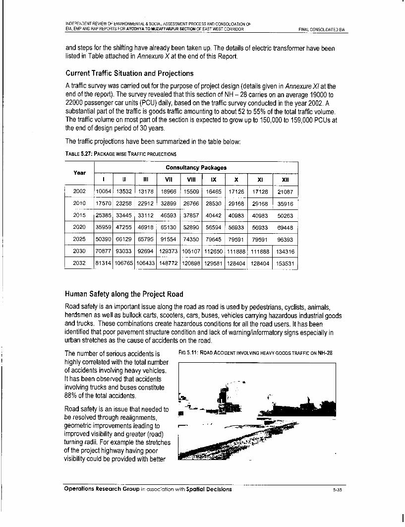
INDEPENDENT REVIEW OF ENVIRONMENTAL & SOCIAL ASSESSMENT PROCESS AND CONSOLIDATION OFEIA, EMP AND RAP REPORTS FOR AYODHYA TO MUZAFFARPUR SECTION OF EAST WEST CORRIDOR FINAL CONSOLIDATED EIA
and steps for the shifting have already been taken up. The details of electric transformer have beenlisted in Table attached in Annexure X at the end of this Report.
Current Traffic Situation and Projections
A traffic survey was carried out for the purpose of project design (details given in Annexure XI at theend of the report). The survey revealed that this section of NH - 28 carries on an average 19000 to22000 passenger car units (PCU) daily, based on the traffic survey conducted in the year 2002. Asubstantial part of the traffic is goods traffic amounting to about 52 to 55% of the total traffic volume.The traffic volume on most part of the section is expected to grow up to 150,000 to 159,000 PCUs atthe end of design period of 30 years.
The traffic projections have been summarized in the table below:
TABLE 5.27: PACKAGE WISE TRAFFIC PROJECTIONS
Consultancy PackagesYear__ _ _
I Ya III VIl Vil IX X XI XII
2002 10054 13532 13178 18966 15509 16465 17126 17126 21087
2010 17570 23258 22912 32899 26766 28530 29168 29168 35916
2015 25385 33445 33112 46593 37857 40442 40983 40983 50263
2020 35959 47255 46918 65130 52890 56594 56933 56933 69448
2025 50390 66129 65795 91554 74350 79645 79591 79591 96393
2030 70877 93033 92694 129373 105107 112650 111888 111888 134316
2032 81314 106765 106433 148772 120898 129581 128404 128404 153531
Human Safety along the Project Road
Road safety is an important issue along the road as road is used by pedestrians, cyclists, animals,herdsmen as well as bullock carts, scooters, cars, buses, vehicles carrying hazardous industrial goodsand trucks. These combinations create hazardous conditions for all the road users. It has beenidentified that poor pavement structure condition and lack of warning/informatory signs especially inurban stretches as the cause of accidents on the road.
The number of serious accidents is FIG 5.11: ROAD ACCIDENT INVOLVING HEAVY GOODS TRAFFIC ON NH-28highly correlated with the total numberof accidents involving heavy vehicles.It has been observed that accidents ,involving trucks and buses constitute88% of the total accidents.
Road safety is an issue that needed to ' -be resolved through realignments,geometric improvements leading to 'improved visibility and greater (road) iturning radii. For example the stretchesof the project highway having poorvisibility could be provided with better
Operations Research Group in association with Spatial Decisions 5-35

INDEPENDENT REVIEW OF ENVIRONMENTAL & SOCIAL ASSESSMENT PROCESS AND CONSOLIDATION OFEIA, EMP AND RAP REPORTS FOR AYODHYA TO MUZAFFARPUR SECTION OF EAST WEST CORRIDOR FINAL CONSOLIDATED EIA
illumination, and by putting up signals at appropriate chainages.
Pedestrian guardrail shall be designed to control and guide pedestrian road crossing movement safelyat the service road intersections. Concrete guard posts may be used at less hazardous locations.These shall have 2.5 m offset at 2 m spacing.
Concrete Crash Barriers of New Jersey type and / or steel beam guardrails shall be installed mainly atmajor hazardous locations and shall be constructed at the outer edge of both the shoulders of the roadwith an offset of 2.5 m from the edge of the driving pavement. These will generally be installed onsections of the road where (a) embankment height is more than 6 m, (b) bridge approaches, (c) theproject road passes through large ponds. Both Concrete Crash Barriers and / or Steel Beam Guardrails(W-Shaped) installation shall have short transition flared section at the approach ends. The safetybarriers shall conform to the safety norms as prescribed by Ministry of Road Transport and Highways.
Road Accidents StatisticsRoad accident statistics were collected for stretch C-111/5 and are presented in table below. Theaccident data for the project stretch has been obtained from different police stations along the projectstretch for the year 2000-2002. These data have been presented in tabular form on the approvedformats in this Report. From the accident data obtained it is quite clear that the majority of accidentsoccurred due to speeding and negligence of drivers. Most accidents occur during overtaking.
TABLE 5.28: ROAD ACCIDENT DATA
ROAD ACCIDENT DATA
(Location wise)
Location Km. Or Injury-Year 2000 Injury Year-2001 Injury Year-2002Place__ _ _ __ _ _ _
Fatal Serious Minor Fatal Serious Minor Fatal Serious Minor
Jagdishpur 5 8 10 9 5 21 7 5 28
Sonbarsa 13 5 27 4 6 34 11 15 19
Sukrauli 16 12 23 18 8 36 8 9 29
Hata 10 26 13 23 18 27 12 17 37
Kushinagar 8 17 28 5 12 32 5 6 25
Kaseya 12 10 32 10 9 41 9 36 15
Fazil Nagar 15 23 18 21 2 17 13 16 33
Patherwa 7 24 22 11 4 14 6 23 27
Tamkuhi 6 13 36 13 28 33 12 29 32
Sasamusa 9 16 24 11 21 28 10 27 25
Operations Research Group in association with Spatial Decisions 5-36

INDEPENDENT REVIEW OF ENVIRONMENTAL & SOCIAL ASSESSMENT PROCESS AND CONSOLIDATION OFEIA, EMP AND RAP REPORTS FOR AYODHYA TO MUZAFFARPUR SECTION OF EAST WEST CORRIDOR FINAL CONSOLIDATED EIA
Chapter 6
Operations Research Group in association with Spatial Decisions

i

INDEPENDENT REVIEW OF ENVIRONMENTAL & SOCIAL ASSESSMENT PROCESS AND CONSOLIDATION OFEIA, EMP AND RAP REPORTS FOR AYODHYA TO MUZAFFARPUR SECTION OF EAST WEST CORRIDOR FINAL CONSOLIDATED EIA
6. Stakeholder Consultation .................................. 6-16.1 Introduction ................................... 6-16.2 Objective of Public Consultation .................................. 6-16.3 Stakeholder Consultation Methodology . . ............................... 6-2
6.3.1 Local/Village level Consultations .................................. 6-26.3.2 District level Consultations .................. ... ............. 6-26.3.3 State Level Consultations .................................. 6-26.3.4 Focused Group Discussion .................. ... ............. 6-3
6.4 Community Consultation Results . . ................................ 6-46.5 Key Environmental Issues and Response Received .................................. 6-116.6 Project Workshops ... ............................... 6-12
6.6.1 Key Discussion at the Workshop .................................. 6-136.6.2 Outcome of Workshop .................. ... ............. 6-14
6.7 General opinion of the People regarding Project . . .......................... 6-146.8 Continued Consultations and Participations . . ............................ 6-15
6.8.1 Plan for Continued Participation .................................. 6-156.8.2 Followup Consultation . . ................................ 6-166.8.3 Community Participation . . .................. .6-16
Operations Research Group in associotion with Spatial Decisions 6-18

zi
iI
it
Ii
i
i
I
I
iI
Ii
ii

INDEPENDENT REVIEW OF ENVIRONMENTAL & SOCIAL ASSESSMENT PROCESS AND CONSOLIDATION OFEIA, EMP AND RAP REPORTS FOR AYODHYA TO MUZAFFARPUR SECTION OF EAST WEST CORRIDOR FINAL CONSOLIDATED EIA
6. STAKEHOLDERCONSULTATION
6.1 Introduction
In order to consider the views and aspirations of all the stakeholders of the project, include their usefulsuggestions in the project design, minimise adverse social impacts of the project, and ensure greateracceptability of the project, the project planning and designing is required to be done through aparticipatory process involving all stakeholders. Public participation and community consultation hasbeen taken up as an integral part of environmental and social assessment process of the NHAI Project.Carried out at various stages of project preparation, public participation has been viewed as acontinuous two way process, involving promotion of public understanding of the process andmechanisms through which developmental problems and needs are investigated and solved. Opinionsof local communities and the likely PAPs, public representatives, government authorities of variouslevels need to be taken into account at different stages of conceiving and planning the project withrespect to environmental and social parameters likely to be impacted. Formal and informalconsultations with these stakeholders provide the means by which public concerns, needs and valuescan be identified prior to decision-making, so that views of the affected and concerned people areincorporated in the project. Besides helping in arriving at the best acceptable design, this ensuresminimal resistance and maximum support for the project.
During the screening process it has been ensured that the affected population and other stakeholdersare informed, consulted and encouraged to participate actively in the preparations for the project.
6.2 Objective of Public Consultation
Public Consultation has been taken up as an integral part of social and environmental screeningprocess in accordance with the Terms of Reference (TOR) and as per World Bank requirements.
The consultation process was carried out with the following objectives in forefront:
. To educate the general public specially potentially impacted communities / individuals andstakeholders about the proposed course of action and the project alternatives;
. To familiarize the people with technical, environmental, social and economic issues of theproject for better understanding;
. To solicit the opinion of the affected communities / individuals on environmental issues andthe significance of impacts due to the proposed development;
Operations Research Group in association with Spatial Decisions 6-1

INDEPENDENT REVIEW OF ENVIRONMENTAL & SOCIAL ASSESSMENT PROCESS AND CONSOLIDATION OFEIA, EMP AND RAP REPORTS FOR AYODHYA TO MUZAFFARPUR SECTION OF EAST WEST CORRIDOR FINAL CONSOLIDATED EIA
* To foster co-operation among the team members of the project i.e. the officers of the NHAI,the officers of PIU, the community and the stakeholders to achieve a cordial workingrelationship for smooth implementation of the project;
* To serve as an important tool for collecting information on the natural and humanenvironment;
* To deduce information from the local people about their socio-economic status and theresources they depend upon for their livelihood;
* To secure people's inputs into crucial decisions of project design, compensation packages,selection of mitigation measures and monitoring strategies;
* To explain to the communities the importance of their role in supporting/facilitating theimplementation of the Environmental Management Plan in the project; and
* To ensure lessening of 'public resistance to change' by providing them a platform in thedecision making process.
6.3 Stakeholder Consultation Methodology
The consultation process established for the project has employed a range of formal and informalconsultative tools including interviews, Focused Group Discussions (FGDs), Meetings and Workshops.The enactment of the participation and consultations with the stakeholders, was done at three levelsthroughout the project preparation stage.
6.3.1 Local/Village level Consultations
These consultations were held in rural, suburban and urban areas along the corridor of impact and theproject road to inform people about the purpose and preliminary design of the project in order to getpeoples opinion and issues of concern. Village/local level consultations were held at location havingsubstantial number of likely project affected people.
6.3.2 District level Consultations
The second phase of public consultation was carried out at the district levels, which involved the NHAI,District Magistrates, other district level officials, public representatives, local NGOs and PAPs.
6.3.3 State Level Consultations
State level consultations shall be carried out subsequently as the last level of consultation, involving theconcerned state organizations such as State Pollution Control Boards, NHAI and other developmentagencies of the Government, public representatives, and local NGOs etc.
Operations Research Group in association with Spatial Decisions 6-2
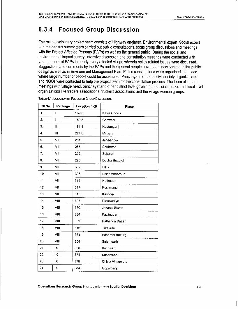
INDEPENDENT REVIEW OF ENVIRONMENTAL & SOCIAL ASSESSMENT PROCESS AND CONSOLIDATION OFEIA, EMP AND RAP REPORTS FOR AYODHYA TO MUZAFFARPUR SECTION OF EAST WEST CORRIDOR FINAL CONSOLIDATED EIA
6.3.4 Focused Group Discussion
The multi-disciplinary project team consists of Highway engineer, Environmental expert, Social expertand the census survey team carried out public consultations, focus group discussions and meetingswith the Project Affected Persons (PAPs) as well as the general public. During the social andenvironmental impact survey, intensive discussion and consultation meetings were conducted withlarge number of PAPs in nearly every affected village wherein policy related issues were discussed.Suggestions and comments by the PAPs and the general people have been incorporated in the publicdesign as well as in Environment Management Plan. Public consultations were organised in a placewhere large number of people could be assembled. Panchayat members, civil society organizationsand NGOs were contacted to help the project team for the consultation process. The team also hadmeetings with village head, panchayat and other district level government officials, leaders of local levelorganizations like traders associations, truckers associations and the village women groups.
TABLE 6.1: LOCATION OF FocUSSED GROUP DISCUSSIONS
SI.No Package Location 1 KM Place
1. I 139.5 Katra Chowk
2. I 159.8 Chawani
3. II 181.4 Kaptanganj
4. III 224.6 Mirganj
5. VIl 281 Jagsishpur
6. VIl 285 Sonbersa
7. VII 292 Sukaroli
8. VIl 296 Dadha Buzurgh
9. VIl 302 Hata
10. VIl 306 Bishambharpur
11. VIl 312 Hetimpur
12. VIl 317 Kushinagar
13. VII 318 Kashiya
14. Vill 325 Pramwaliya
15. Vill 330 Jokawa Bazar
16. Vill 334 Fazilnagar
17. Vill 339 Patherwa Bazar
18. Vill 346 Tamkuhi
19. Vil 354 Pashroni Buzurg
20. Vill 358 Salemgarh
21. IX 368 Kuchaikot
22. IX 374 Sasamusa
23. IX 378 Chivia Village Jn.
24. IX 384 Gopalganj
Operations Research Group in association with Spatial Decisions 6-3

INDEPENDENT REVIEW OF ENVIRONMENTAL & SOCIAL ASSESSMENT PROCESS AND CONSOLIDATION OFEIA, EMP AND RAP REPORTS FOR AYODHYA TO MUZAFFARPUR SECTION OF EAST WEST CORRIDOR FINAL CONSOLIDATED EIA
SI.No Package Location / KM Place
25 IX 386-387 Gopalganj
26 IX 396 Koinee Village
27 X 403-406 Badheya Jn. and Built-up Zone
28 X 411-412 Brahima Built-up
29 X 416-418 Mohammadpur
30 X 426-428 Khajuria Junction and Built-up Zone
31 Xl 442-444 Kotwa
32 Xi 454 Piprakothi
33 Xi 462 Pipra
34 Xi 474 Chakia
35 XII 482 Mehsi
36 XII 492 Motipur
37 XII 509 Kanti
38 XII 520 Muzaffarpur
6.4 Community Consultation Results
During the entire planning process, the issues raised in the community consultation have been one ofthe most important criteria to arrive at design solutions that are appropriate and conducive to the needsfelt by the local people. The local residents have responded to a number of environmental issues andconcerns. Some of the concerns were applicable to the entire project area, whereas at certain locationsthere were specific issues raised. An account of major issues emerged during the consultations isreproduced below.
The key environmental issues raised by the participants in the entire project stretch that include localresidents, focus groups and government officials include:
* Air and Noise Pollution
* Traffic Congestion
* Road Safety
* Displacement of People
* Cultural Properties
* Water bodies
Roadside Amenities
Operations Research Group in association with Spaflal Decisions 64

INDEPENDENT REVIEW OF ENVIRONMENTAL & SOCIAL ASSESSMENT PROCESS AND CONSOLIDATION OFEIA, EMP AND RAP REPORTS FOR AYODHYA TO MUZAFFARPUR SECTION OF EAST WEST CORRIDOR FINAL CONSOLIDATED EIA
TABLE 6.2: CONSULTATION RESULTS
Location Number Stakeholders Issues discussed Suggestions I Outcomesof
Consultation
Katra * Traffic congestion at railway * Construction of a flyover at thecrossing railway crossing if going for
(Km. widening proposal shall be139.5) * Traffic congestion due to undertaken.
Religious mela.* Realignment (Bypass) will be a
* Resettlement of people long-term solution for trafficproblems.
* Alternative Alignment. The bypass option will minimize the
adverse impacts on the market.
Safety measures for pedestrians,cyclists and school going children
Jagdishpur Three 120 Project * How the roadside plantation will * Local species of trees which haveAffected be regenerated? faster growth and are more
8.03.03, People local environment friendly shall be be15.05.03, Panchayat, * How the safe guard will be planted as is being described in the
15.05.03, Manab Vikas taken against air and noise tree plantation strategy.28.07.03 Sanstha pollution as well as traffic
(NGO), local management during the * Adequate protection measures shalldoctor, construction period? be taken for solving the noiselawyer. pollution as described in the Specific
* In the post project scenario, EMP.there may be air and noisepollution- how this will be * Provision of service road and undersafeguarded in the project passes will reduce the trafficdesign? congestion, which finally minimise
the air as well as noise pollutionalong the local traffic safety. Alsoregular maintenance of the plantedtrees will sufficiently help incontrolling air as well as noisepollution along the corridor.Measures such as pollutionchecking stations and increasedpolicing for vehicular pollutioncontrol shall be undertaken in thepost project scenario.
Sonvarsa Three 75 PAPs, * Awareness about the project. * Around 99% people are aware ofLocal NGO, the project.
30.03.03, Public * Whether the noise pollution will16.05.03, representativ have significant impact during * Noise pollution will have less29.07.03 es, local the construction and post significant Impact as the traffic
doctor, project scenario. signs; service road in settlementlawyer, zone and plantation of trees as wellpanchayat . Whether the new road will have as median plantation will help tomember, any significant impact on air take care of the aspects.MLA, pollution.Tehsildar, * Separate service roads for localschool traffic will be provided. All theseteachers, aspect will help to reduce the
congestion and thus less pollution.Improvement of highwayintersections is also suggested.
Sukhroli Three 62 PAPs, * How the roadside plantation will * The public suggested thatLocal NGO be regenerated? eucalyptus trees should not be27.03.03, Saraswati considered since they cause a lot of
16.05.03,
Operations Research Group in association with Spatial Decisions 6-5

INDEPENDENT REVIEW OF ENVIRONMENTAL & SOCIAL ASSESSMENT PROCESS AND CONSOLIDATION OF
EIA, EMP AND RAP REPORTS FOR AYODHYA TO MUZAFFARPUR SECTION OF EAST WEST CORRIDOR FINAL CONSOLIDATED EIA
Location Number Stakeholders Issues discussed Suggestions / Outcomesof
ConsultatIon
27 05 03 Devi Siksha damage and insteao fruit bearingSamiti, and shade trees should be planted.Piprauli Species of the same will beBazar, Distt. considered in accordance to TreeGorakhpur, Plantation Strategy. Further it waspublic suggested that new plants berepresentativ planted before older trees arees, local removed.doctor,lawyer, * The community will provide the landpanchayat and accordingly the CPR will bemembers, a How the temple, community hall relocated.MLA, and other common propertyTehsildar. resources will be relocated? u Road signage, road marking and
underpass/ overpass shall be
- In busy and congested constructed in such locations asintersections how the road suggested by the people.safety measures will be takencare off?
Fazil Four 60 PAPs, * In the medium and long term * Proposal for via duct option,Nagar local traders due to increased traffic, and intersection improvement and
association, congestion, urban areas will plantation of trees will solve the24.03.03, truckers face the hazards of increased problem in the long term.15.05.03, public levels of air and noise pollution.17.07.03, representativ * Adequate road safety safeguard and19.08.03 es, SMV reduction of congestion measures
operators, will be taken through engineeringYuva Chetna solutions like intersectionKendra improvements etc.(NGO), Sagar Beautification of water bodies in andMarket, * Any special environment around the corridor of impact shallMotilal road, improvement programme to be ta e Trader sDeoria. improve the surrounding be taken up. The Traders
environment of the corridor. Association and local NGOs hasassured that all co-operation andhelp will be provided by them forsuch programme.
Tamkuhi Three 65 PAPs, * How the safeguard will be taken * Adequate protection and safetytruckers, against air and noise pollution measures shall be taken for solving
27.03.03, public as well as traffic management the air and noise pollution. These21,05.03, representativ during the construction period? include provision of noise barriers at19.08.03 es, traders three sensitive locations as detailed
association, * In the post project scenario in the Specific EMP's and fixing timeChairman there may be air and noise schedules for usage of relatedTown pollution -how this will be construction equipment.Committee, safeguarded in the projectMember design? . Provision of service road throughoutPanchayat. the Tamkuhi built up zone and
* As the current sale tax check underpasses at Tamkuhi junctionpost creates lot of air and noise will reduce the traffic congestion,pollution what measures are which finally minimise the air as wellbeing taken to safeguard the as noise pollution along with localenvironment. traffic safety.
. Provision of parking area inTamkuhi will facilitate the heavyvehicles to park thus eliminating thechances of roadside parking whichfinally minimise the air as well asnoise pollution near check post.
Operations Research Group in association with Spatial Decisions 6-6

INDEPENDENT REVIEW OF ENVIRONMENTAL & SOCIAL ASSESSMENT PROCESS AND CONSOLIDATION OFEIA, EMP AND RAP REPORTS FOR AYODHYA TO MUZAFFARPUR SECTION OF EAST WEST CORRIDOR FINAL CONSOLIDATED EIA
Location Number Stakeholders Issues discussed Suggestions I Outcomesof
Consultation
Kushi Five Maha-Pandit . The junction at Kushinagar . In general local people, MahaNagar Sant requires development from pandit, ASI officials appreciated the
Gyaneshwar, aesthetic point of view. During proposed development plan of02.03.03, Manav Sewa the tourist season lot of traffic Highway in view of tourist centre01.04.03, Sanstha congestion takes place. Kushinagar.18.07.03, (NGO)19.08.03, Kaptangan, . In the current junction a small . It was suggested that to protect the12.09.03 distt- park with a Buddhist statue is statue of Buddha at Junction Island,
Kushinagar, located which has important the highway alignment should be70 PAPs, aesthetic value- whether the shifted eccentric to left side withPrinciple and road improvement will take care provision of service road.teachers of of retaining the aesthetic value.Buddhist * People suggested the measures forcollege, Ward improvement with service road andcouncillor, footpath so that the local slowKushinagar moving traffic need not to negotiatetown the main traffic of highways.panchayat * It was resolved that the junction willofficials of be improved keeping in mind the
Kushinagar. road safety, reduction in congestionand keeping the aesthetic value inproper place.
Gopalganj Three 12 PAPs local * How the roadside plantation will . Local species of trees which have(Km. 386- panchayat, be regenerated? faster growth and more environment387) Manab Vikas friendly shall be planted as is being
Sanastha described in Tree plantation18.04.03, (NGO), local strategy.17.05.03, doctor,28.06.03 lawyer. Due to proposed 4-laning, the Proposal of three nos. of 4-lane
.nDeoi prsedlevel willncrease due t underpasses will add to the safety ofnoise level wsil Increase due to local traffic and will reduce the traffictraffic congestion between congestion, which will finally reduceexisting and NH-traffic. the air and noise pollution. Further
provision of service road inGopalganj town zone will provideadequate safety measures as wellas solve the air and noise pollutionproblems.
Noise pollution will be minimisedbecause the corridor management
During construction phase air aspect will take care of this. Alsoand noise pollution will be very specific noise mitigation measureshigh-how will this be at two sensitive locations insafeguarded. Gopalganj will be taken as specified
in the Specific EMP.
Koinee Three 56 local * The major part of the village . Underpass shall be provided for theVillage villagers, settlement is located on the slow moving vehicles along with a(Km. 395 - public LHS of the highway whereas service road on both sides for about396) representativ the agricultural fields of the 500m covering the stretch of
e panchayat villagers are located on the settlement as well as the ground18.04.03, pradhen, RHS and there is a very high being used for the purpose of17.05.03, panchayat pedestrian movement across animal fair.28.06.03 members. the highway. The settlement
also caters to market needs ofabout 30-40 villages in thesurrounding area through arural link road that meets the
Operations Research Group in association with Spatial Decisions 6-7

INDEPENDENT REVIEW OF ENVIRONMENTAL & SOCIAL ASSESSMENT PROCESS AND CONSOLIDATION OFEIA, EMP AND RAP REPORTS FOR AYODHYA TO MUZAFFARPUR SECTION OF EAST WEST CORRIDOR FINAL CONSOLIDATED EIA
Location Number Stakeholders Issues discussed Suggestions / Outcomesof
ConsultatIon
highway In addilion, Ihere is aweekly animal fair on everyTuesday on the RHS of thesettlement, which attracts alarge movement of animals(over 2500) and the people.Sugarcane is an important cropin the region and lot of SMVscross the highway during theseason for selling thesugarcane at Sugar factory inGopalganj.
Badheya Three 50 PAPs, * Whether the noise pollution will * Provision of vehicular underpass atJn. and local NGO, have significant impact during junction location will reduce theBuilt-up public the construction and post noise pollution as well as airZone representativ project situation. pollution after 4-laning of existing(Km.403- es, local road.406) doctor, * Whether the new road will have
lawyer, any significant impact on air . Noise pollution will have less22.04.03, Panchayat pollution? significant impact during22.05.03, Member, construction as proper signage and28.06.03 MLA, barriers during construction near
Tehsildar, settlements will help to take care ofSchool the aspects. In addition, separateteachers. service road for local traffic will be
provided. All these aspects will helpto reduce congestion and finally thepollution. They also suggested theimprovement of highwayintersections.
Mohamma Four 50 PAPs, . The major part of the settlement . Eccentric widening with service roaddpur (Km. local NGO, is located on the RHS of the s facility has been proposed at this416-418) public highway and there is a small location.
representativ portion of the town on the LHS.24.03.03, es, local It is also an important junction15.05.03, doctor, point where there is lot of17.07.03, lawyer, movement of local vehicles as19.08.03 panchayat well as pedestrians across the
member, highway. There is a petrolMLA, pump on LHS at the starting oftehsildar. the settlement. The settlement
spreads across nearly one anda half Km length of road withdhabas, vegetable market, andstands for local jeeps. It is oneof the critical junctions withrespect to the number of PAPs,estimated to be about 80,concentrated near the junctionalong the highway. It is junctionpoint of NH 101 and NH 28.
One big temple is located at the * To save the temple at junctionjunction. Local people insisted location as well as to avoid anyto save the temple from any traffic conflict, a vehicular underpassrelocation, has been proposed for the
movement of through vehicles sothat the local traffic is not affectedand risked. The service road will betaken from the backside of thetemple near junction location on
Operations Research Group in association with Spaflal Decisions 6-8

INDEPENDENT REVIEW OF ENVIRONMENTAL & SOCIAL ASSESSMENT PROCESS AND CONSOLIDATION OFEIA, EMP AND RAP REPORTS FOR AYODHYA TO MUZAFFARPUR SECTION OF EAST WEST CORRIDOR FINAL CONSOLIDATED EIA
Location Number Stakeholders Issues discussed Suggestions / Outcomesof
ConsultatIon
right side.
. How the current air pollution * Provision of vehicular underpass willproblem will be solved? further reduce the air pollution as
well as noise pollution problems.* After 4- laning of highway due
to increased speed and traffic, * Service road is proposed on bothwill face the hazards of the sides throughout the length ofincreased levels of air and the settlement. This will help innoise pollution. Additionally mitigating accident risk.they run the risk of more * Parking area for the jeeps cateringlaccidents occurng In urban to the regional traffic has beenlimits, proposed.
* People felt that introducingproper signage nearsettlements introducing speedlimits could reduce noise levels.
Khajuria Four 55 PAPs, * Majority of the people desired * Proposed widening is concentricJunction local traders' that the widening and only in major built up zone. Theand Built- association, strengthening of the project proposed alignment transitions toup Zone truckers, road in the market areas should left at Ch. 427.300 while major built(Km. 426- public be on both side of the road so up zone extends from 426.100 -428) representativ that one side people do not feel 427.300
es, SMV discriminated.24.03.03, operators. * The only major noise sensitive15.05.03, * Due to proposed 4-laning, the receptor is a medical center at Ch.17.07.03, noise level will increase due to 426.464 at Khajuria chowk. Type C19.08.03 traffic congestion between noise barrier has been proposed in
existing and NH-traffic. specific EMP for the same. Noiseproblem in entire stretch shall behandled during construction stage
* After the 4-laning of existing as described in specific EMP.highway there will be trafficconflict between local and high-speed NH traffic resulting in * Proposal of via duct option andaccidents. service road with intersection
improvement will solve the problem.
* Adequate road safety safeguard andreduction of congestion measureswill be taken through engineeringsolutions like intersectionimprovement etc.
Kotwa Two 65 local * The people wanted to know(Km.442- villagers, whether the road development444) truckers, would provide any development
public opportunities for the local area.12.04.03, representativ After hearing the details on22.05.03, es, traders environmental improvement18.08.03 association, programme proposed under the
panchayat project, they proposed thepradhen, following:panchayatmembers. * In moth Banwara Chowk, they
are ready to provide one acre ofland and financial contributionfor environmental improvement.
Operations Research Group in association with Spatial Decisions 6-9

INDEPENDENT REVIEW OF ENVIRONMENTAL & SOCIAL ASSESSMENT PROCESS AND CONSOLIDATION OFEIA, EMP AND RAP REPORTS FOR AYODHYA TO MUZAFFARPUR SECTION OF EAST WEST CORRIDOR FINAL CONSOLIDATED EIA
Location Number Stakeholders Issues discussed Suggestions / Outcomesof
ConsultatIon
* The present highway alignmentis eccentric with respect toexisting ROW. After 442/2 no.Bridge on left side the ROWavailable is hardly 1Om from thecentre line of existing highway. * Considering the available ROW isOn right side around 35m land more on right side, the proposedis available. Concentric alignment shifted as eccentric towidening will require huge LA in right. However, 1Om wide strip ofthis built up zone. extra land is required for acquisition
.A local mandir, which has in view of proposal of service road inhistorical significance, may be this built up zone.developed. They would also like * SMV underpass has been proposedto contribute financially. for crossing of local traffic.
* For environmental improvement * The Kotwa Environmentmeasures they have formed a Improvement Committee willcommittee called Kotwa prepare and submit EnvironmentalEnvironment Improvement Management Plan for Kotwa.Committee comprising of themembers - Birender Singh,Rambhajan Singh, RamayanSingh, Narendra Pandey,Narendra Singh, RamchandraSingh.
Chandni Four 60 PAPs, * Chandni Chowk is very . Proposal for 2-laning unidirectionalChowk Mayor important T-Jn. and is end point fly over at junction location has beenMuzzaffar Muzzaffarpur of the project stretch, from this made to reduce the traffic conflict aspur Municipal point NH-57 starts in well as the noise and air pollution.
Corporation, Muzaffarpur town. The major5.04.03, local NGO, settlement is located on both . 7m wide service road has been30.07.03, ward sides of the highway. It is an proposed for local traffic in the19.08.03, councillor, important junction where there stretch passing through Muzaffarpur2.09.03 Muzzafarpur is lot of movement of local town. This will help in reducing local
Municipal vehicles as well as pedestrians traffic conflict.Corporation, across the highway. TheRepresentativ settlement spreads across * 2-lane proposed fly-over alongwith 7es of print nearly one and a half km length m wide service road will helpmedia and of the road with Dhabas, address issues of road safety aselectronic vehicle workshops, stands for well as anticipated high air andmedia. local jeeps. So, traffic noise pollution levels.
congestion is an importantissue of concern.
* How the current air pollutionproblem will be solved?
. After 4-laning of highway due toincreased speed and traffic, willface the hazards of increased . Air pollution problem will belevels of air and noise pollution; handled as documented in thethey run the risk of more specific EMP.accidents in urban limits.
acdnsiu i. . The big temple is located at theOne big temple is located at junction island, shall be relocated atJunction Island, local people a place suggested by localinsisted to relocate the temple. communities.
People felt that introducing propersignage near settlementsintroducing speed limits could
Operations Research Group in association with Spatial Decisions 6-10

INDEPENDENT REVIEW OF ENVIRONMENTAL & SOCIAL ASSESSMENT PROCESS AND CONSOLIDATION OFEIA, EMP AND RAP REPORTS FOR AYODHYA TO MUZAFFARPUR SECTION OF EAST WEST CORRIDOR FINAL CONSOLIDATED EIA
Location Number Stakeholders Issues discussed Suggestions I Outcomesof
Consultation
reduce noise levels. * The Muzzaffarpur Nagar Nigam and
The Mayor and the NGO the local NGO will formulate arepresentative requested to proposal and will provide the sameprovide some option for to the design team.environmental improvement.
6.5 Key Environmental Issues and ResponseReceived
In the process of public consultations, a number of people were interviewed and various environmentalissues concerned to the PAPs and the general public were identified. The issues identified and theresponse received from them is summarised in the table below:
TABLE 6.3: GENERAL PUBLIC RESPONSE TO ENVIRONMENTAL ISSUES
Environmental Issues Response Received
Awareness about the Project. About 85% people were aware about the Project
Quality of Water from ponds, wells, rivers The quality of water is good in the area. There is no pollution in theor canals water
And if poor then why?
Noise level in the area and if high then People who have their shops along the road were of the opinion thatwhy? the level of noise is high which is mainly due to vehicular traffic.
How can the noise level be improved? People felt that noise levels can be reduced by introducing propersignage near settlements, introducing speed limits, newer buses andby improvement of intersections.
They are insisting for separate service road for local traffic to avoidcongestion.
Quality of air in the area? 75% of the people felt that the air quality is generally good. Howeversome peoples have raised the issues of poor quality of air in built-upzones due to dust & vehicular pollution.
How the quality of air will improve? People felt that the air quality can improve by reducing the trafficcongestion in built-up zone as well as plantation of trees.
Occurrence of natural disaster People said that to their knowledge no natural disasters likeearthquakes or floods have occurred.
People in UP (Stretch C-111/2), however felt that 2002 was a droughtyear. Whereas people in Bihar have faced several floods occurredearlier.
Is there any site used for fairs or There is no such site in the project stretch.seasonal markets which might beeffected by this project?
Suggestions to improve the environment Use of alternative fuels and plantation of trees. People wanted trees toof the area be planted before felling of old trees.
Operations Research Group in association with Spatial Decisions 6-11

INDEPENDENT REVIEW OF ENVIRONMENTAL & SOCIAL ASSESSMENT PROCESS AND CONSOLIDATION OFEIA, EMP AND RAP REPORTS FOR AYOOHYA TO MUZAFFARPUR SECTION OF EAST WEST CORRIDOR FINAL CONSOLIDATED EIA
6.6 Project Workshops
Workshops have been organized in all packages to ensure people's participation in the planning phaseof the project. Beside local state government officials, the representatives of PAPs of the marketlocations and villages falling along the road, local NGOs, journalists from local newspapers, localleaders and other influential persons were invited to the workshop. The aim of organizing the workshopwas:
Expand awareness of the project among the public, local leaders and state governmentofficials in areas impacted by the project.
Identify social and environmental sensitivities and other concerns in affected areas thatshould be considered in project design and planning.
Review potential impacts of the project identified in social and environmental assessments todate; measures taken to avoid, reduce or mitigate adverse impacts and minimizedisplacement and provisions of the entitlement framework.
Reassessment of the alignment proposals to further minimization of adverse impacts.
Explain principles and procedures proposed for land acquisition, resettlement and relocation;and the compensation and assistance that will be provided to Project Affected Persons,households and groups who may lose land or assets and suffer other losses.
Increase co-operation among local governments and District officials in project planning andimplementation, including follow-on village and local level consultations along project road.
Introduce house-to-house surveys, asset verification, videography, village-level consultationsand other activities about to begin along project roads.
* Assure that local level inputs are considered in project preparation
The workshops were organised on the following dates in the project stretch:
TABLE 6.4: LOcATION OF WORKSHOPS
Date Consultancy Location District Key ParticipantsPackage
13th November 2002 C-111/2 Basti Basti PD, Team Leader (PCC), DistrictMagistrate, local NGO, PAPs, President(Gram Pradhan Union, Nawabganj)
9th May 2003 C-111/5 Kushinagar Kushinaar PD, Project Design Consultants,Representatives of District Magistrate
16th May 2003 C-lI1/5,1 Gopalganj Gopalganj PD, Project Design Consultants,Representatives of District Magistrate
19th May 2003 C-l1l/1 Muzaffarpur Muzaffarpur PD, Project Design Consultants,Representatives of District Magistrate
Operations Research Group in association with Spatial Decisions 6-12

INDEPENDENT REVIEW OF ENVIRONMENTAL & SOCIAL ASSESSMENT PROCESS AND CONSOLIDATION OFEIA, EMP AND RAP REPORTS FOR AYODHYA TO MUZAFFARPUR SECTION OF EAST WEST CORRIDOR FINAL CONSOLIDATED EIA
6.6.1 Key Discussion at the Workshop
6.6.1.1 General Discussion
Project Director and Design Consultants (Highway, Environmental and Social Expert) initiated thediscussion briefly focusing on various aspects of the concerned project. The pointed out the objectivesof this workshop and invited full cooperation and involvement of the participants. On the projectprospect and standard widening policy of the NHAI the Project Director mentioned that 45-meter Rightof Way is required to accommodate the four lane divided carriageway with service roads as perrequirements. He further clarified that all the adversely affected families / households will becompensated and assisted as per policy of the World Bank and Government.
On widening proposal they discussed the basic widening criteria is left side widening except concentricwidening in the built up and market areas. Service road and underpass will be provided in the built-upmarket location for smooth movement and crossing of local traffic. Vehicular under-passes areproposed for important National and state highway crossing and ROB at railway crossing to ease thesmooth flow of traffic. The provisions of truck parking are integrated in road designing to avoid trafficcongestion along road. The width of median will be 5 meters in rural areas and 1.5 meters in built upmarket areas. Adequate road safety measures are provided for the road users. At high embankmentsGuard Post and Guard-rails will be provided. On additional land requirement Participants were assuredthat unnecessary land acquisition will not be take place and all possible engineering solution would beexplored to avoid any adverse impact on the people living along the road. In this regard he invitedsuggestions from the PAPs in project designing and planning.
Representative of District Magistrate, Basti, Kushinagar, Gopalganj and Muzaffarpur discussed aboutthe alignment proposal and assured for their full co-operation throughout during planning andimplementation stage.
Representative of PAPs suggested that one-month notice be published in the local newspaper inrespect to vacating the occupied places. Participants also raised the issue of dust generation and wereinformed that dust generation may occur during construction and appropriate mitigation measureswould be taken to minimize dust generation.
6.6.1.2 Specific Issues
Section C-11112:
• A member form an NGO emphasized that tree culting should be done in such a way so as tominimize deterioration to the local environmental system.
* Some PAPs wanted to know about the privately owned trees and whether they would becompensated for them.
* The issue of the temple and mosque at Chawni arose. Participants stressed that the landacquisition in Chawni town should be on both sides of the project road with uniform widthand the widening of the road should be in such a way which may not affect these religiousproperties.
President, Gram Pradhan Union, Nawabganj was of the opinion that all the properties/assetsand land may be compensated at the market price of the land /structure.
Operations Research Group in association with Spatial Decisions 6-13

INDEPENDENT REVIEW OF ENVIRONMENTAL & SOCIAL ASSESSMENT PROCESS AND CONSOLIDATION OFEIA, EMP AND RAP REPORTS FOR AYODHYA TO MUZAFFARPUR SECTION OF EAST WEST CORRIDOR FINAL CONSOLIDATED EIA
Section C-111/5:
* Representative of PAPs along with Local MLA and Gorakhpur, MP, insisted that instead ofacquiring the land up-to 45 m., the Land acquisition in Jagdishpur, Sonbersa and Sukarolimust be limited to the required width of proposed 4-laning and service Road.
* PAPs also insisted that after their compensation, two months notice should be given tovacate their occupied places.
6.6.2 Outcome of Workshop
The workshops were successfully completed and all the participants were assured that their viewswould be considered. As far as feasible their suggestions would be taken into account during thedesign and minimum land acquisition would be done to the extent possible.
6.7 General opinion of the People regarding Project
The villagers, PAPs and other stakeholders in general seemed to be in favour of the proposed projectand expressed their willingness to support the project. In general the participants are aware of thewidening to four lane of the highway. PAPs were of the opinion that the project implementation wouldlead to overall development of commerce and trade and hence bring about an enhancement in thestandard of living.
Majority of the people desired that the widening and strengthening of the project road in the marketareas should be on both side of the road so that one side people do not feel discriminated, and lossessuffered by the affected people are reduced.
The communities in general were of the view that they should be consulted at various stages of theproject, from inception to implementation. Public representatives and Gram Pradhans assured that theywill assist in removing encroachments. They suggested that notices should be put along the highway toprevent further encroachments.
Most of the people requested that the affected households should be informed in advance about theneed to vacate or move away from their present location. The people were of the view that hot-mixplant and labour camps should be located away from the local settlements.
Few People suggested that the new road should be provided with safety measures and devices at allsensitive locations ensuring protection for road users mainly for pedestrians, cyclists, school goingchildren and women.
People seemed more to be bothered about the issues of compensation and entitlements. However,Environmental concerns did figure out during the consultations, particularly with regard to fear ofincreased pollution, and loss of old trees. The Public suggested that eucalyptus trees should beremoved, since they cause a lot of damage. The Public suggested that fruit bearing and shade treesshould be planted. Further it was suggested that new plants should be planted before older trees arecut.
Operations Research Group in association with Spatial Decisions 6-14

INDEPENDENT REVIEW OF ENVIRONMENTAL & SOCIAL ASSESSMENT PROCESS AND CONSOLIDATION OFEIA EMP AND RAP REPORTS FOR AYODHYA TO MUZAFFARPUR SECTION OF EAST WEST CORRIDOR FINAL CONSOLIDATED EIA
6.8 Continued Consultations and Participations
The effectiveness of the R&R program is directly related to the degree of continuing involvement ofthose affected by the project. Participation of PAPs has been emphasised in the development of RAPto assure that its components are suited to the needs of the impacted and resettled population. Theircontinued involvement and participation during RAP implementation will both increase the probability oftheir successful resettlement and rehabilitation and contribute to the overall project success.
During the preparation stage, consultations were held at local, district and state level as documentedabove. Several additional rounds of consultations with PAPs have been planned in the action planthrough partnering NGO during RAP implementation. Consultations during RAP implementation willinvolve agreements on compensation and assistance options and entitlements with PAPs andcompletion of a PAP identity card indicating the accepted entitlement). The other round of consultationswill occur when compensation and assistance are provided and actual resettlement begins.
6.8.1 Plan for Continued Participation
The following set of activities is required for effective implementation of RAP. This will also help intimely execution of RAP.
6.8.1.1 Information Disclosure
For the benefit of the community in general and PAPs in particular. RAP and R&R policy will betranslated in Hindi and kept at
Public Libraries of the districts
Office of Collector / District Magistrate and Chief Development Officer, and
Libraries of various colleges in the district.
Project Implementation Units
* Any other public place along the highway
The report will also be available at World Bank Info shop Washington DC and New Delhi Office as perWorld Bank disclosure policy.
6.8.1.2 Public Information Dissemination
NHAI offices located along the four Project Corridors will provide actual information and policies andother rehabilitation actionplan to the people in continous manner. For this, following are proposed:
The NGOs involved in the implementation of RAP will organise Public meetings, and will appraise thecommunities about the progress in the implementation of limited works.
Operations Research Group in association with Spatial Decisions 6-15

INDEPENDENT REVIEW OF ENVIRONMENTAL & SOCIAL ASSESSMENT PROCESS AND CONSOLIDATION OFEIA, EMP AND RAP REPORTS FOR AYODHYA TO MUZAFFARPUR SECTION OF EAST WEST CORRIDOR FINAL CONSOLIDATED EIA
The NGO will organise public meetings to inform the community about the payment and assistancepaid to the community. Regular update of the program of resettlement component of the project will be
palced for public display at the NHAI office.
6.8.2 Followup Consultation
Followup consultation will be carried out after the finalisation of RAP and freezing of drawings. Theconsultations will be carried out at local levels along with the highway engineer and environmental
expert. Location for will be finalized in consultation with NHAI. Tentatively consultations will take place
in the month of March 2004.
6.8.3 Community Participation
For effective implementation of RAP, it is essential to provide scope of involving communities and PAPs
in the process. The mechanism of involving communities is suggested below:
TABLE 6.5: CORE RAPID APPRAISAL: MECHANISM FOR CONTINUED PARTICIPATION
Project Stage PAPs NGOs Hosts Project & LocalProJect Stage PAPs NGOs HostsOfficials
Planning Participate in public Assist in impact Provide information Provide information onmeetings assessment or various aspects of PAP skills etc.
host communitiesIdentify alternatives to avoid Assist in census and Suggest ways toor minimise displacement SE survey Assist in data minimise impacts
collection and design Idct oa tf nAssist in developing and Participate in Indicate local staff and
chosing alterantive options coordination Provide inputs to site budget capacity forfor relocation and income committee selection relocation.eneration
Participate in group Identify possible Assist NGO inHelp to choose resettlement meetings conflict areas with information disseminationsites. PAPs
Design and Participate inParticipate in survey implement an Identify social and consultations
information cultural faclitiesParticipate in meeting with campaign needed at Examine the feasibility ofhost population resettlement sites IG schemes and discuss
Support group with PAPs.Provide inputs to entitlement formation, problem Assist inprovisions identification and identification of IG Help document and
sis in preparation of planning forPAPs schemes consultations.Assist In preparation of and hosts,action plan , Provide inputs for
Suggest mechanism for Design and design of IG
gnevance redressal conflict Participatory process chemesresoultion and participate in Suggest mechanism Help develop a
rievance redressal for grievance process ofredressal of conflict consultation between
Participate in coordination resoultion. hosts and PAPs.committees
Assist in preparation Suggst mechanismof action Plan for grievance
redressal and conflictresolution.
Operations Research Group in association with Spatial Decisions 6-16

INDEPENDENT REVIEW OF ENVIRONMENTAL & SOCIAL ASSESSMENT PROCESS AND CONSOLIDATION OFEIA, EMP AND RAP REPORTS FOR AYODHYA TO MUZAFFARPUR SECTION OF EAST WEST CORRIDOR FINAL CONSOLIDATED EIA
Project Stage PAPs NGOs Hosts POjeicials
Implementation Participate in Provide ongoing Assist APO in Process IG proposalsimplementation support information for PAPs relocationctivitives and hosts Participate in grievance
Manage common redressalParticipation in local Provide support in property at sitedecision making activities. group management Provide assistance under
Participate in local local schemes.Decide on management of Monitor entitlement committees.ommon properties provision by Participate as member of
implementation of IG Assist PAPs in I mplementationParticipate in grieviance schemes. integration with committee.redressal mechanism. Hosts.
Assist implementingMonitor provision of live deptts. Assist PAPs in useofntitlements new production
Provide support to systerm.Labour and other inputs of RAP implementtion .site Use established
Training to eligible mechanisms forLabour and other inputs at PAPs grievance redressal.site
Support toCredit and other group vulnerable groupsscheme management
Evaluate communityO&M of sites and project process and socialinputs preparation
Members of implementation Provide advice oncommittee grievance redressal.
M&E Participate in grievance Provide information Provide inputs to Ongoing interaction withtribunals o project staff on M&E of R&R PAPs to identify
vulnerable groups problems in IGReport to project on IG programme.schemes Act as M&E agency
for project Participants inReport on service quality of correctional strategies.sites Act as external
monitors for project(where not previouslyinvolved)
Operations Research Group in association with Spatial Decisions 6-17

I
i
I

INDEPENDENT REVIEW OF ENVIRONMENTAL & SOCIAL ASSESSMENT PROCESS AND CONSOLIDATION OFEIA, EMP AND RAP REPORTS FOR AYODHYA TO MUZAFFARPUR SECTION OF EAST WEST CORRIDOR FINAL CONSOLIDATED EIA
Chapter 7
Operations Research Group in association with Spatial Decisions

f
i

INDEPENDENT REVIEW OF ENVIRONMENTAL & SOCIAL ASSESSMENT PROCESS AND CONSOLIDATION OFEIA, EMP AND RAP REPORTS FOR AYODHYA TO MUZAFFARPUR SECTION OF EAST WEST CORRIDOR FINAL CONSOLIDATED EIA
7. ASSESSMENT OFENVIRONMENTALIMPACTS
7.1 Introduction
Infrastructure projects like development of highways, in general, have beneficial as well as the adverseimpact on environmental and social status of the project influence zone and vary both spatially andtemporally. The extent and level of impact of road construction on surrounding natural environment alsovary depending on factors such as the terrain (plain, rolling or hilly), the type of area(Urban and Rural)the land use pattern of the area (residential, educational, industrial etc).
This chapter assesses the nature, type and magnitude of the potential impacts likely on the variousrelevant physical, biological and cultural environmental components along the project corridor.
Since the project involves widening of the existing two - lane highway, the impacts are expected to bemostly direct and confined to the Right of Way (RoW). Only at critical locations where the engineering,environmental and social aspects have warranted, a shift from the existing alignment, realignmentshave been proposed, which have been examined in greater detail.
The assessment of environmental impacts consists of comparing the expected changes in theenvironment due to the project with respect to the changes that would have occurred naturally in the'without-project' scenario. The analysis predicts the nature and significance of the expected adverseimpacts in accordance with the intensity of construction works involved and the future scenarioenvisaged during the operation stage. The impacts on the various environmental components canoccur at any of the following stages of the project planning and implementation.
. Pre-construction
* Construction stage; and
* Operation stage.
The detailed analysis of the impacts during pre-construction, construction and operation stage has beensummarized in the Impact Assessment Matrix for the project. Most of the impacts of the project duringthe pre-construction stage of the project are expected to be minimal and are only presented in theImpact Assessment Matrix. Environmental Impacts of the construction and operation stage have beenexplored in details in the following section.
The extent and magnitude of impacts for the various environmental components as visualized leads tothe observations stated below.
Operations Research Group in association with Spatial Decisions 7-1

INDEPENDENT REVIEW OF ENVIRONMENTAL & SOCIAL ASSESSMENT PROCESS AND CONSOLIDATION OFEIA, EMP AND RAP REPORTS FOR AYODHYA TO MUZAFFARPUR SECTION OF EAST WEST CORRIDOR FINAL CONSOLIDATED EIA
7.2 Project Benefits
The potential positive environmental impacts due to project apart from its economic importance includethe following:
Improved accessibility
Reduced vehicle operating and maintenance cost
Savings in fuel consumption
Reduced chances of accidents
Improved facilities to road users e.g. bus bay, truck parking bays, rest areas
Improved highway aesthetics.
Reduced noise and air pollution, due to improved road surface and landscaping/treeplanting.
7.3 Approach and Methodology
The environmental impact of a project depends both on the project and on the backgroundenvironmental setting. This section presents the evaluation of impacts under various scenarios. Thisenvironmental impact assessment process involves the following basic steps:
Identification of Impact
. Evaluation
. Interpretation
. Communication
7.3.1 Impact Identification and Prediction
For the purpose of impact identification, the project has been divided into three stages, viz., pre-construction, construction and operation stage. The different project stages, the activities and theirpotential for generating an impact on each of the environmental components (Valued EcosysyemComponents) were considered. Seven categories of impacts with their impact description have beentaken into consideration. These categories have been defined to quantify the degree of impact, whichhave been used to prepare a consolidated Rapid Impact Assessment Matrix for both with and withoutproject scenario. These categories are corresponding to Group A2 (Magnitude of Change/Effect) in theMatrix. The description of the various categories of impacts and corresponding magnitude of impactassigned is outlined below.
Operations Research Group in association with Spaftal Decisions 7-2

INDEPENDENT REVIEW OF ENVIRONMENTAL & SOCIAL ASSESSMENT PROCESS AND CONSOLIDATION OFEIA, EMP AND RAP REPORTS FOR AYODHYA TO MUZAFFARPUR SECTION OF EAST WEST CORRIDOR FINAL CONSOLIDATED EIA
High Adverse (Category HA)
This category comprises of the Impacts that are irreversible and unacceptable. No effective mitigationpossible except major re-alignment or major changes to the nature and scope of the project. Themagnitude of High Adverse impact has been quantified as - 3.
Moderate Adverse (Category MA)
This category considers the Impacts, which are undesirable and unacceptable. Impact mitigation ispossible without major change to nature of project but mitigation measures may only be partiallyeffective in reducing impact. The magnitude of impact in Moderate Adverse category has beenquantified as - 2.
Low Adverse (Category LA)
This category considers the Impacts that are undesirable but can be effectively reduced with mitigationmeasures. The magnitude of Low Adverse impact has been quantified as - 1.
Non -Significant Impact (Category NS)
This category considers the Impacts, which are not very significant, and/or can be effectively eliminatedwith mitigation measures. They have been assigned a value of zero
High Beneficial (Category HB)
This category of Impacts comprise of those impacts that are going to significantly benefit theenvironment and/or the local and regional community as well as the helps in overall development of theregion, state and the country. The magnitude of High Beneficial impact has been quantified as + 3.
Moderate Beneficial (Category MB)
This category of Environmental Impacts comprise of benefits which are desired and welcomed but canbe done without even in the 'No-Project Alternative'. The magnitude of Moderate Beneficial impact hasbeen quantified as + 2.
Low Beneficial (Category LB)
These types of impacts have only some benefits on the environment and/or community development.The magnitude of these impacts has been quantified as + 1.
7.4 Assessment of Impacts
7.4.1 Meteorology
The project is likely to have a slight impact on the microclimate of the project area due to the cutting oftrees, addition of pavement surface, use of heavy machinery and possible decrease in surface water inthe area. The changes in microclimate may include localized rise in daytime temperatures on the roadsurface and soils due to loss of shade from trees felled as part of the project. The loss of trees would
Operations Research Group in association with Spatial Decisions 7-3

INDEPENDENT REVIEW OF ENVIRONMENTAL & SOCIAL ASSESSMENT PROCESS AND CONSOLIDATION OFEIA, EMP AND RAP REPORTS FOR AYODHYA TO MUZAFFARPUR SECTION OF EAST WEST CORRIDOR FINAL CONSOLIDATED EIA
also result in higher dusVSPM levels. The amount of sunlight reaching the road surface will increasewith consequent increase in the road surface temperatures especially in the 'green tunnels' andcanopies. The increase in temperatures is likely to be felt by the slow-moving vehicles and pedestriansand more in built up areas especially during summers when the region experiences high temperatures.The problem of increase in temperatures near the road surface is expected to more in the stretch C-111/2(Ayodhya to Gorakhpur) as the present highway stretch is characterised by a large number of trees onboth sides of the road that form green tunnels.
Though there is likely to be a slight change in the micrometeorology, which is unavoidable and longterm in nature, this would be curtailed through avenue planting along the sides of the highway whereverspace permits. These impacts have been categorized as Low Adverse.
The project is not likely to have any changes in macro-meteorological conditions of the area (includingrain, temperature, wind etc.)
7.5 Natural and Biophysical Environment
7.5.1 Land Resources
7.5.1.1 Physiography
Pre-construction and Construction Stage
Road construction activities involve alterations in the local physiography and drainage patterns. Cut-and-fills will be designed as required for improvement to the road geometry. However, there are nosignificant cut and fill operations in the project stretch to have any major impacts on the physiography ofthe region. Parallel cross drainage structures will be added to improve drainage. Borrow areas willcause some depressions that may cause ponding.
As the highway traverses the generally flat (average slope of 0.05%) Indo Gangetic Plains, with slopesgenerally from the west-northwest to the south-southeast, there are no major impacts likely on the localphysiography. The impact has been categorised as Non-Significant.
7.5.1.2 Geology and Seismology
The project area falls under the Seismic Zone IV, which is considered moderate to high in terms ofseismic activity. The project is not expected to have any impact on the seismic stability of the areaduring pre-construction, construction and operation stage of the project even though it is in Seismiczone IV. The extraction of materials (stone aggregates etc) will be from the existing quarries with therequisite licenses. The impact on general geology of the region is insignificant and falls under thecategory Non-Significant.
Operations Research Group in association with Spafial Decisions 74

INDEPENDENT REVIEW OF ENVIRONMENTAL & SOCIAL ASSESSMENT PROCESS AND CONSOLIDATION OFEIA, EMP AND RAP REPORTS FOR AYODHYA TO MUZAFFARPUR SECTION OF EAST WEST CORRIDOR FINAL CONSOLIDATED EIA
7.5.1.3 Loss of productive soils
Pre-construction StageDuring the pre-construction stage of the project, labour camps, stock yards, storage godowns etc, willbe set up for facilitating the construction process. These activities might lead to a loss of productivesoils during the pre-construction stage if these activities are located on fertile/productive soils used foragriculture. The impact due to these activities can be mitigated by ensuring that such activities are notlocated on fertile/productive soils. Also provision for stacking of fertile topsoil will be made whereverthese are located on fertile land. As far as possible, provisions for the same have been made in theEnvironmental Management Plan. The impacts are expected to be Non-Significant with theimplementation of mitigation measures.
Construction stageThe project falls under the Indo-Gangetic plain covering part of River Gandak and River Ghagra sub-basin. As the soils are of alluvial nature, deposited by the rivers, these are highly productive soils thatare liable to be lost during the construction stage of the project due to excavation from quarries andborrow pits for earth required for road construction, which may cause direct and indirect long-termadverse impacts on the environment.
Borrowing of earth is a huge requirement for the project as soil is required as embankment, sub-grade,selected sub-grade and shoulder for widening of highway. It is estimated that a total of 11501482 m3 ofearth will be required for the purpose of the project. This is after the availability of fly-ash (a total of1360837 m3 ), which has lessened the requirement to a certain extent. The extent of usage of fly-ashvaries in different packages. In Package I, fly-ash fulfils about 43% of the total requirement (i.e.earthwork + fly-ash), while in packages Xl and XII, it fulfills about 22% and 26% respectively.
TABLE 7.1: EARTHWORK AND FLY-ASH REQUIREMENTS
Package I II III VIl Vill IX X Xl XII
Earthwork 751780 13(X9110 1442490 1285675 146627 2210613 1848290 1142897 1365000In M3
Fly-ash in 565837 ) 0 0 0 0 0 320000 475000
Based on the total requirements and availability of each soil type, estimates of soil quantity to beobtained from each of the borrow areas were worked out in accordance with the IRC Standards,recommended by the I.S. soil classification system. Borrowing of soil can have a long-term impact onthe environment, there.fore, in the selection of the borrow areas, care was taken to ensure that:
* Sufficient quantity of suitable soil is available from the borrow pit;
* To avoid extra haulage, the borrow areas has been selected as close as possible to theproject highway;
* The loss of fertile and productive agricultural soil as well as loss of vegetation is minimum;
* The topsoil from the borrow pit will be stripped and set aside with proper preservationmethods as per the guidelines provided in the Environmental Management Plan.
Most of the borrow areas have been identified to avoid continuous excavation areas and have beenselected with the consent of the local farmers from among the agricultural fields. Prior to
Operations Research Group in association with Spatial Decisions 7-5

INDEPENDENT REVIEW OF ENVIRONMENTAL & SOCIAL ASSESSMENT PROCESS AND CONSOLIDATION OFEIA, EMP AND RAP REPORTS FOR AYODHYA TO MUZAFFARPUR SECTION OF EAST WEST CORRIDOR FINAL CONSOLIDATED EIA
commencement of construction, the contractor will ensure that written agreements are made withfarmers and that they are also informed about the options of redevelopment of borrow pits. Theproductive agricultural lands identified for the use as borrow pits and quarries will be lost due toacquisition for the project purpose but the efforts will however, be made to minimise the acquiring ofproductive area and redevelopment of these quarries for future use. The Environmental ManagementPlan should ensure that mitigation measures for preservation of topsoil be visualised beforehand andshall be undertaken diligently to prevent loss of fertile topsoil. Measures such as stacking the productivetopsoil and replacing it after the borrowing activities are envisioned to prevent the most fertile topsoilshall be undertaken as part of the EMP. Stripped topsoil along the RoW shall be used in medians, roadjunctions, redevelopment of borrow areas and additional landscaping works in the project. However, theproject shall enforce measures to avoid and/or minimise the use of topsoil from other locations such asborrow areas, stockyards, lands for diversions etc.
Other impacts on soil productivity during construction includes the loss of the fertile plough layer atcampsites and asphalt plants, and a drop in the elevation of borrow areas that will decrease landproductivity.
The project stretch in Bihar and in the FIG 7.1: AGRICULTURAL AREA LOST DUE TO FLOODING
eastern part of UP is prone to flooding,which makes a sizeable portion of landalong the highway stretch either barren orrender them unusable due to water-logging. Borrowing of earth is liable togenerate more of such water-loggedareas during the monsoon season and fora sizeable portion of time after rains.
The impact on productive soil has beencategorised under category MediumAdverse as the impact is adverse andunacceptable but can be partiallymitigated by undertaking mitigationmeasures.
Operation stage
No losses of productive soils are envisaged during the operation stage of the project, and are henceidentified as Non-Significant.
7.5.1.4 Soil Erosion
Pre-construction Stage
During the pre-construction stage of the project, clearing of roadside vegetation and felling of trees islikely to cause erosion of fertile productive soil due to uncontrolled runoff that will be generated due tothe loss of vegetation and the loss of soil binding by the roots of the trees. Loss of soil from theembankment is a direct and immediate impact of the erosion but is restricted to the RoW and in theareas where there are embankments. This might lead to reduction in stability of the road itself over alonger period of time. As the construction activities are expected to start very soon after the clearing ofvegetation, the loss in stability of the embankments is not considered a significant impact.
Operations Research Group in association with Spatial Decisions 7-6

INDEPENDENT REVIEW OF ENVIRONMENTAL & SOCIAL ASSESSMENT PROCESS AND CONSOLIDATION OFEIA, EMP AND RAP REPORTS FOR AYODHYA TO MUZAFFARPUR SECTION OF EAST WEST CORRIDOR FINAL CONSOLIDATED EIA
As the soils are of alluvial nature with medium to low plasticity, as such, soil erosion is not considered tobe an major issue as the highway runs in the Indo-Gangetic plains with practically very low cross slope.The impact has been categorised as Non-Significant.
Construction Stage
During the construction stage of the project, clearance of the roadside ground cover, especially alongthe raised sections exposes the soil and destabilizes slopes resulting in erosion of fertile topsoil. Soilerosion may also occur in construction yards as a result of unmanaged runoff from equipment washing-yards.
Soil erosion would be especially prominent in the raised sections of the highway including highembankments along the bridges, ROBs and the bridge approaches. Also the excavation of riverbedsand banks during the construction of bridges may result in an increase in the sediment loaddownstream of the bridge site if the residual soil is not properly disposed off.
The project would improve the drainage characteristics of the area by its improved design andadditional capacity imparted to the drainage control elements like cross-drainage structures, which maylead to soil erosion and siltation downstream of such changes in drainage pattern. These effects wouldbe more pronounced in the areas, which are characterised by embankments and slopes likeembankment slopes, over-steep banks and bridge end fills. High embankments will also be subjected toerosion due to wind apart from water. Increased soil erosion will be prominent till the timecompensatory planting has been fully established and shall not be a factor afterwards.
Impact of the project on soil erosion can be controlled effectively by identifying critical areas for soilerosion and implementing mitigation measures specific to these areas. Measures to prevent soilerosion by turfing, slope-control, prevention of silt entering watercourses etc. are envisaged in theGeneral EMP to ensure that the impacts are mitigated effectively. This impact has been placed undercategory Medium Adverse.
Operation Stage
The engineering design of the project shall ensure all the vulnerable areas for soil erosion like slopesand embankments are stabilised through sound engineering measures to proactively preclude anypotential soil erosion liable due to increased runoff from the pavement surface. Other measures likelandscaping and control measures before the receiving points have been envisaged in the EMP tominimise soil erosion. Measures that are envisaged in the EMP include, ensuring that theembankments are maintained and covered by vegetation and rip-rap; any gullying shall be quicklyaddressed by preventive maintenance, which should be the focal activity during the monsoon season.The impacts are considered Non-Significant during the operation stage.
7.5.1.5 Contamination of Soils
Pre-construction Stage
The preparation for the construction stage would involve setting up of construction camps, stockyardsand hot-mix plants. Solid waste generated by the construction camps and the oil-spills etc. generatedby the hot-mix plants will lead to contamination of soil at the areas exposed to such activities. These areshort-term impacts and can be only partially mitigated by taking remedial measures and are consideredLow Adverse in these localised areas.
Operations Research Group in association with Spatial Decisions 7-7

INDEPENDENT REVIEW OF ENVIRONMENTAL & SOCIAL ASSESSMENT PROCESS AND CONSOLIDATION OFEIA, EMP AND RAP REPORTS FOR AYODHYA TO MUZAFFARPUR SECTION OF EAST WEST CORRIDOR FINAL CONSOLIDATED EIA
Construction Stage
Soil contamination can occur during the construction stage of the project. These impacts occur due to:
* Scarified/scraped asphalt and concrete materials, if not disposed of properly, maycontaminate soil resources.
* The possible contamination of soil by oils and chemicals at asphalt plant sites, constructionvehicles parking sites, workshop areas, and equipment washing-yards may limit the futureuse of land for agricultural purposes.
* Solid wastes generated by the construction camps set up for the road construction.
* Improper disposal of spoils and debris arising out of the construction process could lead tocontamination of soils
The contamination of soils is a long-term impact that can also affect the quality of water resources, asthe contaminants are likely to be carried over to the water bodies with runoff. The impacts are likely tobe greater in the Ayodhya Bypass stretch of the project due to the nearness of the source of thecontamination to the rivers Saryu and Tehri. The impacts on soil contamination can be mitigated tosome extent by taking appropriate mitigation measures during construction through implementation ofthe Environmental Management Plan and are thus placed in Low Adverse category.
Operation Stage
The impacts of the highway operation on the contamination of soils are envisaged to be negligible.However, there is a low probability that soil pollution may occur due to accidental spillages andleakages from vehicles. To ensure the extent and nature of such accidental spillages, proper planshave been formulated in case of such unforeseen disasters. The impact has been categorised as Non-Significant.
7.5.1.6 Compaction of Soils
Pre-construction Stage
The pre-construction activities like site clearance, movement of heavy machinery and setting up ofconstruction camps and stockyards would result in compaction of soil at the exposed areas.Compaction of soils is a short duration impact and can be minimised by taking measure as part of theEnvironmental Management Plan. This impact is considered Non-Significant.
Construction StageDuring the construction stage, movement of heavy machinery and other factors may cause compactionof fertile soil beyond the RoW. The compaction of fertile soil may hinder growth of vegetation, crops andinfiltration of water into soil. Compaction is an essential component of the road construction but itshould be ensured that the compaction is limited to the RoW of the highway and shall not betransmitted to the adjoining agricultural area. As the project areas is characterised by high ground watertable and water logging, the impact of compaction on infiltration is insignificant. However, the EMP shallensure that plans for access roads and vehicle movement areas shall be located on non-productivesoils and the RoW. This impact is considered to be Non-Significant on implementation of mitigationmeasures.
Operations Research Group in association with Spatial Decisions 7-8

INDEPENDENT REVIEW OF ENVIRONMENTAL & SOCIAL ASSESSMENT PROCESS AND CONSOLIDATION OFEIA, EMP AND RAP REPORTS FOR AYODHYA TO MUZAFFARPUR SECTION OF EAST WEST CORRIDOR FINAL CONSOLIDATED EIA
Operation Stage
No compaction of fertile soil is envisaged due to the operation of the highway as the compaction (ifany), would be restricted to the carriageway itself. This impact is considered Non-Significant.
7.5.1.7 Changes in Land-use Pattern
The project will entail temporary acquisition of privately owned land for various purposes. The landacquisition will lead to a change in the land-use pattern for these acquired areas.
The contractors will require land for:
Contractors' camps and facilities, i.e., storage, equipment parking and washing areas
* Sources of borrow material/earth-fill
* Aggregate quarries
* Asphalt plants
* Access roads for haulage
Disposal sites and procedures for the safe disposal of surplus construction and wastematerial.
The changes in land-use patterns is a temporary impact of the project and has been categorized asLow Adverse, given that adequate mitigation measures are taken to rehabilitate these areas andminimise pollution impacts during the pre-construction as well as construction stage.
Land use changes such as proliferation of restaurants/dhabas, hotels, or even industries and shops inthe project area will be induced due to improved accessibility, thus diverting the land presently undervegetation and agricultural use for other usage. In this normal process of expecting growth catalysed byhighways such development is expected. It can only be addressed through more effective growthmanagement action through the institutions such as village Panchayats, municipal authorities andDistrict Collectors/Magistrates. Thus, the changes in land use during the operation stage arecategorised as Low Adverse.
7.5.1.8 Borrowing of Earth, Quarrying and Stone Crushing Operations
The project necessitates borrowing of material from quarries and use of crushers for obtaining soil,rocks and aggregates. The excavation and transportation of material from existing and new quarriesand borrow pits can cause long-term direct and negative impact on the environment. Quarrying hasmulti-fold impacts including loss of fertile soil, deterioration of air quality, health of workers and aestheticdevaluation of the area.
Pre-Construction Stage
A large amount of quarry material (Table 7.2) is required for the project. However the total requirementof quarry material, estimated to be 6476107 m3, is expected to be fulfilled from existing quarries thatare already in operation, and no new quarries have been proposed. As these quarries are already inoperation with the requisite environmental clearances and redevelopment plans, no major impacts,which arise in making new quarries operational, are likely. The impacts have been considered Non-Significant.
Operations Research Group in association with Spatial Decisions 7-9

INDEPENDENT REVIEW OF ENVIRONMENTAL & SOCIAL ASSESSMENT PROCESS AND CONSOLIDATION OFEIA, EMP AND RAP REPORTS FOR AYODHYA TO MUZAFFARPUR SECTION OF EAST WEST CORRIDOR FINAL CONSOLIDATED EIA
TABLE 7;2: QUARRY MATERIAL AND SAND REQUIREMENTS
Package I II III VIl Vill IX X Xi XII
Quarry material 444187 785584 613980 877087 786972 871585 706317 788920 601475In m3
Sand In m3 288000 316800 316800 323187 268711 328487 276937 270150 323050
Construction Stage
Quarrying and Stone Crushing OperationsQuarrying operation for stones and aggregates involve use of stone crushers and the vibrating screenthat are source of generation of dust. This impact is especially felt downwind of the stone-crushingoperations. This dust can reduce the visibility and can be harmful for the workers. Also, dust isgenerated in the transit of these materials over long distances as no new quarries are being openednear the project site. It is imperative to ensure that the EMP is followed very closely to mitigate theimpacts of stone quarrying. The measures would involve improvement in working condition for theworkers, and dust suppression measures as given in the EMP. The impact is placed under LowAdverse category on implementation of mitigation measures.
Borrowing of EarthThe haulage of soil from the borrow pits using dumper trucks and excavation of soil using heavymachinery causes compaction and generation of dust that is a temporary negative impact. However, allthe approach roads being permanent in nature, no impact on the approach-road pavement, other thanspillage and dust pollution due to transportation, is envisaged. It has been observed that the spillage ofsoil can be nuisance and shall be taken care of by suitable measures as per the EnvironmentalManagement Plan. The impact can be placed under the Low Adverse category.
A huge quantity of sand would be required for the cement concrete rigid pavement and/or cross-drainage structures proposed. The total sand requirement has been estimated as 2712122 m3 (Table7.2). Sufficient quantity of suitable sand is available at a number of locations. These are alreadyoperational and would not experience any additional adverse impact, except those resulting fromtransportation.
Operation Stage/Post construction stage
The borrow area pits, if not treated properly after the borrowing is complete, can form stagnant poolsand pose health hazards to prevent which redevelopment of borrow areas need to be worked out.Additionally, they can also act as breeding ground for vectors like mosquitoes just after monsoon.
Rehabilitation of borrow areas from which earth has been excavated can be a major potential problem.In addition to visual blight, the other problems more down-to-earth are the safety issues. At borrowarea locations where the owners are willing to create ponds for fisheries etc, proper protectionmeasures for the drainage of the surrounding land and slope protection measures need to be workedout.
It is expected that the implementation of the mitigation measures for borrow area redevelopment willreduce these impacts to acceptable levels.
Operations Research Group in association with SpatNal Decisions 7-10

INDEPENDENT REVIEW OF ENVIRONMENTAL & SOCIAL ASSESSMENT PROCESS AND CONSOLIDATION OFEIA, EMP AND RAP REPORTS FOR AYODHYA TO MUZAFFARPUR SECTION OF EAST WEST CORRIDOR FINAL CONSOLIDATED EIA
7.5.1.9 Use of Fly-ash in road construction
Fly-ash, a total of 1360837 m3, is being used in three construction packages (I, Xl and XII) as given in
Table 7.1. The use of fly-ash as fill material will be very beneficial for the environment as it saves onnatural borrow resources and use of topsoil. Therefore, use of fly-ash is categorised as ModerateBeneficial, as use of fly-ash serves dual purpose of ash disposal along with fill material for construction.
However, the negative impacts of use of fly-ash, which are primarily due to transportation, are,discussed below.
Construction Stage
During the construction stage, fly-ash, which will be delivered as pond ash by the Thermal Power Plantwill be transported to the site in trucks. Fly-ash being a very fine material, is liable to be air-borne duringtransit and has adverse impacts on health. Extreme care must be taken to ensure that handling of fly-ash is done properly and the fly-ash is kept moist during the transit. The trucks for transportation shallbe covered with tarpaulin and the fly-ash should be transported in gunny bags to avoid pollution due tofly-ash.
The stocking of fly-ash at the site is also liable to have negative impacts like dispersion of fly-ash in theair environment in absence of proper handling. The handling of fly-ash shall be minimised. Properstacking and frequent spraying of water to keep the ash moist will diminish negative impacts. Thestockpiles shall be kept covered using tarpaulins or other non-dust generating material and the trafficmovements shall be restricted to areas where fly-ash is dumped till a layer of soil is covered over it.Care shall be taken, however through periodic inspections that the ash is not kept excessively moist tocreate seepages of water containing fly-ash. With proper implementation of mitigation measures, thisimpact is considered as Low Adverse.
Operation Stage
The water passing through the fly-ash in embankments may get contaminated by heavy metals thatmay be present in the fly-ash due to its origin. The contaminated water may also diminish the groundwater into which it is finally getting mixed. The chemical quality of the fly-ash is being ascertained andthe results of the same will be incorporated. In case of fly-ash containing heavy metals, use of fly-ashmay be reconsidered.
If the chemical quality of fly-ash is acceptable then no negative impacts are envisaged due to use of fly-ash in embankments during the operation stage as the fly-ash will be compacted and covered with alayer of soil. Further, adequate turfing shall prevent any release of fly ash in the environment.
7.5.2 Ambient Air Quality
This section discusses the impact of construction on the ambient air quality in and around the projectarea.
Ambient Air quality of the area will be affected by project activities during construction and postconstruction including site clearing and grubbing, ground levelling, cutting and clearing of trees,construction of highway embankment, laying of different pavement layers including bituminous layer,construction of bridges, excavation operations at borrow area, mobile crushing units, Hot-mix & Batchmix plant emissions and emissions of heavy vehicles used in construction and operation of vehiclesafter commissioning of the highway. Construction stage impacts will of short term and have adverse
Operations Research Group in association with Spatial Decisions 7-11

INDEPENDENT REVIEW OF ENVIRONMENTAL & SOCIAL ASSESSMENT PROCESS AND CONSOLIDATION OFEIA, EMP AND RAP REPORTS FOR AYODHYA TO MUZAFFARPUR SECTION OF EAST WEST CORRIDOR FINAL CONSOLIDATED EIA
impacts on the construction workers as well as the settlements adjacent to the road, especially those inthe down wind direction. Emissions may be carried over long distances, depending on wind speed anddirection, the temperature of the surrounding air, and atmospheric stability. Operation stage impacts willnot be as severe as the construction stage impacts and will be confined generally a width of about 50 to1 00m from the edge of the carriageway. However, these would be more of significance in the built upareas. Both the construction and operation stage impacts can be effectively mitigated if the impactshave been assessed with reasonable accuracy in the design stage.
Pre-construction Stage
The two main areas of concern for air pollution during the pre-construction stage are dust generationand exhaust gases.
Generation of DustDust is generated in the pre-construction stage due to activities including site clearance, use of heavyvehicles and machinery, and procurement & transport of raw material like soils, rocks and fly-ash fromquarries to the project site. These impacts can be minimised by sprinkling of water to suppress dust andair pollutants on haul roads and around clearing sites, and covering the trucks carrying the rawmaterials. The impact would be most prominent in the RoW and the areas downwind of such activities.The impact can be placed in Low Adverse category on implementation of mitigation measures.
Generation of Exhaust GasesThe movement of heavy vehicles and machinery for activities such as site clearances is likely togenerate impacts due to emission of exhaust gases. With appropriate fittings and maintenance, thisshould not be an issue. The impacts are considered Non-Significant in the pre-construction stage.
Construction Stage
The air impacts of the project are expected to be most significant during the construction stage of theproject as the project stretch passes through a number of densely populated areas, where theconstruction stage air impacts can be significant during traffic hold-ups due to construction.
Generation of DustThe construction process involving large amount of earthwork is likely to result in dust generation fromsite activities including handling of soil, rock aggregates & fly-ash; stone crushing operations; handlingand storage of aggregates in the asphalt plants; operation of concrete plants; mixing of bitumen andaggregates in asphalt mix plants etc. The effect of these activities is felt locally as well as downwind ofthese operations especially during the dry season when moisture content will be less. Traffic-diversionroutes marked along dirt tracks would also generate fugitive dust when in use by vehicular traffic andwould create short-term localised impacts due to dust generation. The effect of dust generation as partof project activities is most likely to be felt by the workers operating at the project site who shall beprovided with pollution masks during the entire construction period. This shall be properly enforced bythe PIU and the Engineer. Other mitigation measures would include dust suppression by sprinkling ofwater on exposed soil surface.
Generation of Exhaust GasesDuring construction phase Hot Mix and Batch Mix Plant, emissions of heavy vehicles used inconstruction, generation of odour from construction activities as well as from construction camps willcontribute substantially to the short-term deterioration of air quality due to emission of oxides of sulphurand nitrogen, hydrocarbons and particulate matter. Also traffic-diversions will contribute to thegeneration of excess exhaust gases during the construction stage.
The critical sources of generation of exhaust gases during the construction phase are listed below:
Operations Research Group in association with Spatial Decisions 7-12

INDEPENDENT REVIEW OF ENVIRONMENTAL & SOCIAL ASSESSMENT PROCESS AND CONSOLIDATION OFEIA, EMP AND RAP REPORTS FOR AYODHYA TO MUZAFFARPUR SECTION OF EAST WEST CORRIDOR FINAL CONSOLIDATED EIA
Asphalt plants that generate toxic emissions containing un-burnt carbon particulates, sulphurcompounds, and dust from aggregate preparation
Movement of heavy vehicles and machinery during construction operation.
Increased emissions from vehicular traffic on the highway due to traffic bottlenecks createdas a result of construction activities.
The impacts on the Ambient Air Quality due to construction are localised and most prominent on theconstruction workers and have been categorized as Moderate Adverse. Adequate measures asprovision of pollution masks to the workers, proper diversions of traffic and proper siting of asphaltplants (away from residential areas) and timely furnishing of 'No Pollution Certificate' by the contractorshall be enforced as part of the Environmental Management Plan.
Operation Stage
The operation of the highway would entail increase in traffic volumes and speeds, with consequentincrease in vehicular emissions. Enforcement of standards to meet better vehicle performance inemissions and the improvement of fuel constituents can assist in improving regional air quality. Theeffect of the increased vehicular movement has been predicted for the purpose of assessment ofimpacts using the CALINE-4 air dispersion model developed by the California TransportationDepartment. The model based on the Gaussian dispersion equation is an upgradation over theCALINE-3 model developed by the same agency. The emissions due to the vehicles depend on manyfactors that include vehicle maintenance, quality of fuel, quality of road pavement, vehicle speed amongother factors. The prediction exercise has been carried out for the year 2013, 2023 and 2033 (10, 20and 30 years respectively). The parameters required as input to the model have been described below:
Meteorological ParametersThe meteorological parameters required by the model include wind direction, wind speed, mixing heightand stability class. These parameters were obtained from the Indian Meteorological Department for theState of Bihar.
Projected TrafficThe projections for traffic have been used based on the survey conducted for the purpose of theproject.
Emission FactorsEmission factors used for the purpose of prediction of air quality have been obtained based onpredicted emission factors by MoEF and CPCB 1. The table below gives the emission factors used forthe prediction of air pollution.
TABLE 7.3: CO EMISSION FACTORS USED FOR PREDICTION MODELLING
CO (2001-05) CO (2005-10)
Vehicle Type (gmikm) (gm/km)
2W, 2T (a,b) 2.2 1.4
2W, 4T (a,c) 2.2 1.4
3W, 2T (a,c) 4.3 2.45
PCG (f,g) 1.98 1.39
1 Transport fuel quality for year 2005. Central pollution control board, Ministry of Environment and Forests,Government of India
Operations Research Group in association with Spatial Decisions 7-13

INDEPENDENT REVIEW OF ENVIRONMENTAL & SOCIAL ASSESSMENT PROCESS AND CONSOLIDATION OFEIA, EMP AND RAP REPORTS FOR AYODHYA TO MUZAFFARPUR SECTION OF EAST WEST CORRIDOR FINAL CONSOLIDATED EIA
PCD (h) 0.9 0.58
LCV (f) 5.1 0.72
Truck (j) 3.5 3.2
Bus (k) 3.6 3.2
Abbreviations Used: 2W: Two Wheelers3W: Three Wheelers2T: Two Stroke4T: Four StrokePCG: Passenger Car (Gasoline)PCD: Passenger Car (Diesel)
Receptor LocationsThe receptors for the air pollution prediction impact have been considered at 15 m from the centreline(first row of receptors) and 30 m from the centreline (second row of receptors) along with the sensitivereceptors identified along the highway. Some Locations at a distance of 100 m were also considered toassess the impacts at certain villages/households that existed at such locations. Sensitive receptors atimportant locations like markets, schools, hospitals etc were also considered as part of the assessment.
Results of ModelingThe modelling of air pollution was done for two scenarios: a) 'without project' in which, the trafficvolumes increase without increase in road width and b) 'with project' scenario, in which, the effects ofthe project will be modelled. The modelling was done for CO. The two scenarios were modelled for theyears 2013, 2023 and 2033. The modeling exercise resulted in prediction of pollution on the either sideof the carriageway at distances of 15 m and 30 m. The model takes into account vehicle volumes,carriageway widths, and emission factors in two scenarios. It has been assumed that the traffic volumewill increase at the same rate in both with project and without project scenario.
The emission factors used in the pollution modelling exercise have been taken from CPCB and MoEFreports and different emission factors have been taken for two periods i.e. 2001 to 2005 and 2005 to2010. For predictions after 2010, same levels have been used as for the 2005 - 2010 period due touncertainty in the limits that will be prescribed for the period after 2010.
The modelling has been carried out for Section C-l1l/1 (due to the constraint of data in AutoCADformat). Ambient CO levels have been predicted for the worst case scenario.
Some of the locations where the model predicted higher levels of CO have been briefly discussedbelow.
• The modelling results for CO shows that for location Chandni Chowk at Muzaffarpur, nearMuzaffarpur dairy, near Kanti Bus Stand, near Piprakothi junction and at Gopalganj Bypassare relatively more polluted and expected CO values are near 1 ppm for the year 2033 in the'with project' scenario.
* The CO value at temple at Chandni Chowk, Muzaffarpur Ch. 520 is expected to reach 2 ppmfor in the year 2033 in the 'without project' scenario.
* The point at chainage 519/749.698 near the above location, at 15m towards a cluster ofshops also has CO value of 1.7 ppm 'without project' and 1.3 ppm 'with project'.
In general, the results of modelling indicate that the expected CO levels are likely to be within theprescribed standard limits in the 'with project' scenario. It has also been observed that at some places,
Operations Research Group in association with Spatial Decisions 7-14

INDEPENDENT REVIEW OF ENVIRONMENTAL & SOCIAL ASSESSMENT PROCESS AND CONSOLIDATION OFEIA, EMP AND RAP REPORTS FOR AYODHYA TO MUZAFFARPUR SECTION OF EAST WEST CORRIDOR FINAL CONSOLIDATED EIA
the pollution concentration levels will be greater for the 'without project' scenario than 'with project'scenario.
Most of the project stretch is characterised by rural and pristine locations with very good AAQ levelsand the impact of vehicular transport on these areas will be limited. The AAQ is expected to be aproblem in built-up locations and crossings that are characterised by heavy traffic and bottlenecks. Theproject will reduce these traffic bottlenecks and increase vehicular speeds. Therefore, it is concludedthat the air quality will not be significantly affected by the project as in the without project scenario,traffic bottlenecks and reduced speeds will contribute heavily to air pollution. The air quality levels forCO will be within the stipulated levels at most of the places for the entire design life of the project andthe condition may improve at many places with respect to current conditions due to project intervention.
Hence, the impacts of the project as compared to the 'without project' scenario have been consideredas Low Adverse.
7.5.3 Impact on Water Resources
This section explains the impacts of the project on water resource of the affected area including waterresource use, water body contamination, and alterations in drainage pattern.
7.5.3.1 Tapping of Water Resources for project activities
Pre-construction and Construction Stage
The project will entail tapping of groundwater and surface water resources to meet campsite andconstruction requirements, bringing its use into competition with local use. The total water requirementfor use in construction activities during the project is 3814311 kilolitres. Water demand for constructionactivities such as compaction, suppression, concrete and formwork may place a demand upon localwater supplies, which would be met from ground water sources using tube wells. As groundwater is themain source for use of people in the project area, most of the water requirements are likely to be met bythe groundwater reserves. Since the project stretch passes through flood-affected zone, the groundwater table is high, no significant adverse/ depleting impact on the ground water are expected. Also,due to abundance of water resources in the project area, no loss of water bodies and adverse impacton the community water supply is envisaged.
TABLE 7.4: PACKAGE WISE REQUIREMENT OF WATER FOR CONSTRUCTION ACTIVITIES
Package I I III VIli Vil IX X Xl XII
Requirementof 533024 9427011 73F775 255384 10)5120j 366842 3057 14 26340:5 31:15346water (in KL)
Municipal water supply will be used only for drinking purposes (for construction camps), if available andif permitted by the local municipal authority. No local/municipal water supply would be used forconstruction purpose. The impact category is Non-Significant and the impact is a temporary one likelyto be present only during the pre-construction and construction stage of the project.
Operations Research Group in association with spatial Decisions 7-15

INDEPENDENT REVIEW OF ENVIRONMENTAL & SOCIAL ASSESSMENT PROCESS AND CONSOLIDATION OFEIA, EMP AND RAP REPORTS FOR AYODHYA TO MUZAFFARPUR SECTION OF EAST WEST CORRIDOR FINAL CONSOLIDATED EIA
Operation Stage
The operation stage of the project is not likely to have any impact on the water resource availability, asthere is no water demand from the road operations. Small water demands may need to be satisfied formaintenance of trees and compensatory planting, but the expected demand is very less as thegroundwater table is quite high in the region and the drainage conditions along the sides of the roadwould satisfy most of the water demand from this vegetation. The impact during the operation stage iscategorised as Non-Significant.
7.5.3.2 Contamination of Water Resources
Implementation of project activities would result in some contamination of surface and groundwaterresources. The impacts on quality of water resources can be long-term and short-term depending onthe nature and extent of the pollution, which, in turn depends on the degree of adherence to theEnvironmental Management Plan.
Pre-construction Stage
Pre-construction stage activities that are likely to contaminate water resources include selting up ofconstruction camps near water sources and transportation of construction material like soil, rocks andfly-ash without adequate handling precautions. Surface and subsurface water resources in the selectedsections may be contaminated by fuel and chemical spills, or by solid waste and effluents generated bythe kitchens and toilets at construction campsites, thereby contaminating the water resources in theproject area.
Removal of trees and vegetation during the pre-construction stage could result in the washing away ofsediments into the water resources thereby increasing the sediment load in the receiving bodies. Theshort-term impact of increased sediment loads may affect the ecosystem of the receiving body andtherefore, requires provision of silt fencing measures to prevent contamination of water resources bythe silt. The soils contaminated by the project activities may also contribute to the pollution load of theproject including oil spills and solid wastes from construction sites.
Groundwater contamination may also occur as the soils in the project area are of alluvial type, whichenable high percolation of contaminants through the soil layer. Contamination of the groundwaterresources due to the project is likely at the following locations:
* Along construction sites, camps involving moving of construction equipments and machinery.
* At the various community water bodies and sources of water supply as hand pumps etc.
* Along the entire length of the corridor especially around urban areas and productive lands.
As the groundwater table is quite high, contamination is more likely to happen if proper mitigationmeasures are not adopted as envisioned in the Environmental Management Plan. Compaction of soilsas a result of movement of heavy vehicles could reduce the amount of groundwater recharge but isexpected to be minimum as the compaction would be localised and the GWT in the area is quite high.
The overall impact of pre-construction activities on the environment have been categorised as LowAdverse after implementation of the EMP.
Construction Stage
During construction phase, the disposal of solid and liquid waste from construction camps, fuel andlubricant spills or leaks from construction vehicles, pollution from fuel storage & distribution sites and
Operations Research Group in association with Spatial Decisions 7-16

INDEPENDENT REVIEW OF ENVIRONMENTAL & SOCIAL ASSESSMENT PROCESS AND CONSOLIDATION OFEIA, EMP AND RAP REPORTS FOR AYODHYA TO MUZAFFARPUR SECTION OF EAST WEST CORRIDOR FINAL CONSOLIDATED EIA
that from hot-mix plants is likely to affect quality of surface and sub-surface water resources. As in mostof the stretches, rigid pavements have been proposed both in new two lanes and in the existing lanes,impact from hot-mix plants are very minimum. The sources of contamination of water resources include:
. Increased sediment loads due to construction activities like site clearances.
. Modification of surface water flow leading to damage of the natural surface water bodies andcreation of new water bodies due to borrowing of earth etc.
. Increase in water pollution due to sanitary and other wastes from construction camp.
. Change in water quality due to construction wastes and oil spills.
. Spillages of residues from the crusher plants and borrow areas into water bodies.
Natural streams and irrigation channels may become silted by borrow material earth in the runoff fromthe construction area, workshops and equipment washing-yards resulting in decreased wateravailability. This is the major impact likely as a result of the construction activities. The spoil heapsplaced along the construction area are also likely to contribute sediment load to the water resourcesdue to erosion of soil.
Oil spills, leaks from fuel storage and distribution sites and from bitumen or asphalt storage at hot mixplants along with the disposal of solid and liquid wastes at the construction sites placed near the waterresources may result in contamination of water resources. These are short-term impacts and arelocalised in nature. Oil and grease entering the water bodies create a thin layer of film on the watersurface that can affect the oxygen transfer capability between air and water. Heavy metals may alsoleak into the water resources but they are likely to be in very minute concentrations and are likely to bediluted further on entering the water resources, therefore, the problem of heavy metals in the waterbodies is not significant.
The construction camps would entail wastewater discharges that need to be treated to preventcontamination of water resources. Care should be taken that these construction camps are not locatednear water bodies and the extent of affected areas is limited to the vicinity of the construction sites.Percolation of untreated/polluted water into the groundwater should be checked. However, asconstruction activities in a significant portion of Ayodhya Bypass section will be carried within rivers'floodplains, the impacts are likely to be greater.
Overall the impacts have been categorised as Low Adverse, given the adequate implementation ofmitigation measures during construction activity.
Operation Stage
The operation stage of the project may result in contamination of water resources by washing away ofoil spills and other contaminants by the road runoff and especially from rest-stops and truck lay-byes.Ponds along the highway that include highway runoff in their catchment areas would be the mostaffected water bodies in this stage of the project. This impact can, however, be adequately mitigated byproviding grease traps along the roads and providing vegetative buffer strips along the ponds to preventingress of pollutants into the pond. This impact has been categorised as Non-Significant onimplementation of mitigation measures.
Operations Research Group in association with Spatial Decisions 7-17

INDEPENDENT REVIEW OF ENVIRONMENTAL & SOCIAL ASSESSMENT PROCESS AND CONSOLIDATION OFEIA, EMP AND RAP REPORTS FOR AYODHYA TO MUWAFFARPUR SECTION OF EAST WEST CORRIDOR FINAL CONSOLIDATED EIA
7.5.3.3 Community and Private Water Resources
Pre-construction StagePre-construction stage of the project entails acquiring of land for the RoW. Construction activitiesrequire dismantling of wells and hand-pumps that are located in the Corridor of Impact of the project.Some water bodies like community ponds will also be affected by the project. In all there are a total of45 ponds located within the Direct Impact Zone of the project between Ayodhya and Muzaffarpur.
Often, such community ponds are used for various purposes like cleaning and washing, cattle bathing,fishing, recreation, and even for drinking in some cases by the local community. These ponds also actas natural drainage controllers and are generally the receptors of sullage from the villages. Increasingthe depths of these ponds or increasing their surface area can adequately mitigate the loss of capacityof these ponds. However, as part of enhancement measures, such ponds can be converted towastewater treatment systems using natural treatment technologies like constructed wetlands andduckweed systems.
The project may result in loss of these ponds and lakes, as portions of these may be lost because ofearth moving activities during construction. Construction may result in filling up of these water bodies,which will lead to direct long-term impacts since this will cause drainage disturbance in the area.However, these impacts are reversible since most of the water bodies in the project corridors arenatural low lying drainage areas with no significant aquatic flora and fauna and the capacity lost can beaugmented by taking mitigation measures.
A number of ground water sources namely wells and tube wells shall be relocated due to the proposedfour laning. Relocation of these water resources have been worked out in consultation with thecommunity, and all community resources impacted due to the project will be relocated at suitablelocations. The typical designs and details of the relocation of the hand pumps and the protectionmeasures for the various categories of wells need to be worked out to minimise the impacts during boththe construction and operation stages of the project.
TABLE 7.5: GROUND WATER RESOURCES IMPACTED BY THE PROPOSED PROJECT
Consultancy package Hand pump Well
C-111/2 1180 13
C-111/5 1053 14
C-l1l/1 407 9
Total 2640 36
The impact has been categorized as Low Adverse, but can be converted to Moderate Beneficial, if theenvisioned enhancement measures are taken to improve the landscape of these ponds. The surfacewater bodies that will be affected and the extent of impacts have been given in the table below:
TABLE 7.6: LIKELY IMPACTS OF THE PROJECT ON THE SURFACE WATER BODIES
Si. Chainage with Location Distance Likely ImpactsNo. respect to from
Existing Km. pavementPost edge (m)
1. 160.8 RHS 17.5 The pond is envisaged to be impacted and filled upduring construction leading to loss of storage capacitydue to acquisition of land within RoW at RHS
Operations Research Group in association with Spatial Decisions 7-18

INDEPENDENT REVIEW OF ENVIRONMENTAL & SOCIAL ASSESSMENT PROCESS AND CONSOLIDATION OFEIA, EMP AND RAP REPORTS FOR AYOOHYA TO MUZAFFARPUR SECTION OF EAST WEST CORRIDOR FINAL CONSOLIDATED EIA
Si. Chainage with Location Distance Likely ImpactsNo. respect to from
Existing Km. pavementPost edge (m)
2. 151.57 RHS 10 The pond is envisaged to be impacted and filled upduring construction leading to loss of storage capacitydue to acquisition of land within RoW at RHS
3. 146.9 LHS 15 No impact envisaged on the pond.
4. 149.3 RHS 20.9 The pond is envisaged to be impacted and filled upduring construction leading to loss of storage capacitydue to acquisition of land within RoW at RHS
5. Km 3.410, Basti The pond is envisaged to be impacted and filled up.bKmy3.410,Bass LHS 3.25 during construction leading to loss of storage capacitybypass due to acquisition of land for the Bypass
6. The pond is envisaged to be impacted and filled up225.600 LHS 11.80 during construction leading to loss of storage capacity
due to acquisition of land within RoW at LHS
7. 244.800 RHS 6.25 The pond is envisaged to be impacted and filled upduring construction leading to loss of storage capacity.
8. 245.200 RHS 11.90 The pond is envisaged to be impacted and filled upduring construction leading to loss of storage capacity.
9. 245800 RHS 8.4 The pond is envisaged to be impacted and filled upduring construction leading to loss of storage capacity.
10. 251.400 LHS 7.0 No impact envisaged on the pond.
11. 282.225 LHS 6.5 The pond is envisaged to be impacted and filled upduring construction leading to loss of storage capacitydue to concentric widening
12. 284.650 RHS 9.9 No impact envisaged on the pond.
13. 287.025 RHS 28 No impact envisaged on the pond.
14. 290.900 LHS 7.0 The pond is envisaged to be impacted and filled upduring construction leading to loss of storage capacitydue to concentric widening
15. 295.870 LHS 15.9 The pond is envisaged to be impacted and filled upduring construction leading to loss of storage capacitydue to concentric widening
16. 313.200 LHS 1.75 The pond is envisaged to be impacted and filled upduring construction leading to loss of storage capacitydue to widening on the left side
17. 324.315 LHS 28 The pond is envisaged to be impacted and filled upduring construction leading to loss of storage capacitydue to acquisition of land within RoW at LHS
18. 332.65 RHS 2.5 The pond is envisaged to be impacted and filled upduring construction leading to loss of storage capacitydue to concentric widening
19. 337.5 RHS 13 No impact envisaged due to widening on LHS
20. 342.870 LHS 2 The pond is envisaged to be impacted and filled upduring construction leading to loss of storage capacitydue to widening on LHS
21. 351.1 LHS 9.4 The pond is envisaged to be impacted and filled upi______ _______________ ___________ ___________ during construction leading to loss of storage capacity
Operations Research Group in association with Spatial Decisions 7-19

INDEPENDENT REVIEW OF ENVIRONMENTAL & SOCIAL ASSESSMENT PROCESS AND CONSOLIDATION OFEIA, EMP AND RAP REPORTS FOR AYODHYA TO MUZAFFARPUR SECTION OF EAST WEST CORRIDOR FINAL CONSOLIDATED EIA
Si. Chalnage with Location Distance Likely ImpactsNo. respect to from
Existing Km. pavementPost edge (m)
due to widening on LHS
22. 351.25 LHS 20 The pond is envisaged to be impacted and filled upduring construction leading to loss of storage capacitydue to widening on LHS
23. 353.39 LHS 24.5 No impact envisaged due to widening on LHS
24. 355.375 LHS 9.2 The pond is envisaged to be impacted and filled upduring construction leading to loss of storage capacitydue to acquisition of land within RoW at LHS
25. 363.525 LHS 11.5 The pond is envisaged to be impacted and filled upduring construction leading to loss of storage capacitydue to widening on LHS
26. 369.8 LHS 12.0 The pond is envisaged to be impacted and filled upduring construction leading to loss of storage capacitydue to acquisition of land within RoW at LHS
27. 382.530 RHS 8.9 No impact envisaged due to widening on LHS
28. 396.9 LHS 12.5 The pond is envisaged to be impacted and filled upduring construction leading to loss of storage capacitydue to widening on LHS
29. 398.8 RHS 6.0 No impact envisaged due to widening on LHS
30. 399.460 RHS 3.0 No impact envisaged due to widening on LHS
31. 420.100 RHS 14 No impact envisaged due to eccentric widening on LHS
32. 433.800 RHS 10 No impact envisaged due to eccentric widening on LHS
33. 437.500 RHS 8.75 No impact envisaged due to eccentric widening on LHS
34. 440.700 LHS 6.75 The pond is envisaged to be impacted and filled upduring construction leading to loss of storage capacitydue to eccentric widening on LHS
35. 446.100 LHS 7.80 The pond is envisaged to be impacted and filled upduring construction leading to loss of storage capacitydue to eccentric widening on LHS
36. 453.223 RHS 4.90 The pond is envisaged to be impacted and filled upduring construction leading to loss of storage capacitydue to concentric widening
37. 459.230 LHS 20.00 The pond is envisaged to be impacted and filled upduring construction leading to loss of storage capacitydue to widening on LHS
38. 461.800 LHS 8.00 The pond is envisaged to be impacted and filled upduring construction leading to loss of storage capacitydue to widening on LHS
39. 462.850 LHS 22.00 The pond is envisaged to be impacted and filled upduring construction leading to loss of storage capacitydue to widening on LHS
40. 463.500 LHS 18.00 The pond is envisaged to be impacted and filled upduring construction leading to loss of storage capacitydue to widening on LHS
41. 472.625 RHS 18.00 No impact envisaged due to widening on LHS
Operations Research Group in association with Spatial Decisions 7-20

INDEPENDENT REVIEW OF ENVIRONMENTAL & SOCIAL ASSESSMENT PROCESS AND CONSOLIDATION OFEIA, EMP AND RAP REPORTS FOR AYODHYA TO MUZAFFARPUR SECTION OF EAST WEST CORRIDOR FINAL CONSOLIDATED EIA
Si. Chainage with Location Distance Likely ImpactsNo. respect to from
Existing Km. pavementPost edge (m)
42. 476.522 RHS 18.00 No impact envisaged due to widening on LHS
43. 483.420 LHS 20.0 The pond is envisaged to be impacted and filled upduring construction leading to loss of storage capacitydue to widening on LHS
44. 487.700 RHS 6.0 No impact envisaged due to widening on LHS
45. 499.000 LHS 17.0 The pond is envisaged to be impacted and filled upduring construction leading to loss of storage capacitydue to widening on LHS
7.5.3.4 Flood Hazard
The project area falls under the flood prone zone of the Indo-Gangetic Plain and has been known for itsfrequent flooding. The implementation of project would result in better drainage characteristics as theyare considered adequately in the Engineering design of the project.
The project stretch from Km. 386 to Km. 422 runs roughly parallel to the River Gandak having old floodprotective embankment at around 2 to 5 Km. on up-stream side of existing highway alignment.Breaches occurs during high flood this bund since last four consecutive years, which results inovertopping of existing NH-28 from KM. 389.800 to Km. 402.000 with depth of flow varying from 0.50 m.to 1.50 m.
To avoid such overtopping, it is proposed to raise the existing highway embankment at least 1 m abovethe maximum flood water level from Km. 389.750 to Km. 402 by of at-least 1.50 to 2.50 m. withprovision of extra waterways in terms of Balancing Bridges (around 18 nos. total waterway 400 m.) &culverts wherever required. It has also been proposed to protect the highway embankment by boulderpitching & boulder apron at toe location.
Also, the road is proposed to be raised at least 1 m above the maximum flood water level and adequateprovisions are being taken in the engineering design itself to prevent any overtopping of road, therefore,this impact is considered to be Non-Significant.
7.5.3.5 Alteration of drainage/impact on hydrology/increased Runoff
Road widening and construction at culvert or bridge locations would require river or gully training duringthe construction period which would cause alteration of drainage. This would further lead to soil erosion,disturbing of local vegetation and in case of longer duration would effect the biological environment ofthe area. However, as mostly bridge works are done in summers when the water levels are low in therivers, the impacts due to alteration of drainage can be minimized effectively with adequate mitigationmeasures and pre planned construction schedules.
Pre Construction Stage
No drainage modification of surface flow of rivers/streams is envisaged during pre-construction period.The impact during Pre-construction stage has been identified as Non-Significant.
Operations Research Group in association with Spatial Decisions 7-21

INDEPENDENT REVIEW OF ENVIRONMENTAL & SOCIAL ASSESSMENT PROCESS AND CONSOLIDATION OFEIA, EMP AND RAP REPORTS FOR AYOOHYA TO MUZAFFARPUR SECTION OF EAST WEST CORRIDOR FINAL CONSOLIDATED EIA
Construction Stage
The diversion of waterways at the bridge and culvert locations would be one of the activities duringconstruction along waterways. This diversion of flow can significantly harm the aquatic habitat, if any.There are a number of bridges that will be upgraded and constructed as part of the project including a1200 m long major bridge over river Saryu and 120m long bridge over river Tehri. The waterways willalso be constricted, increasing velocity downstream of the bridge. The increased velocity of waterdownstream of the bridge due to narrowing of channel during construction would increase the sedimentload, thereby allowing less sunlight to penetrate into the water and reducing growth of micro flora.Hence, aquatic fauna may also be affected in this way. The impact shall be direct but short term innature and shall last till the construction period. Short-term increase in runoff during construction mayoccur due to the removal of trees, vegetative cover and compaction of the surrounding soil during pre-construction.
Design proposes the raising of the embankments by a minimum of 1.0m from the existing levels toensure that the finished pavement is above the Maximum flood level so as to prevent any impacts dueto any water seepage in the pavement. No significant impacts in the drainage pattern due to the raisingof the road profile are likely, as the road design itself takes care of the cross-pavement drainage. Theimpact has been identified as 'Medium Adverse' without the implementation of mitigation measures.The same can be changed to 'Low Adverse' by implementation of the mitigation measures.
Operation Stage
One of the unavoidable aftermaths of road construction is the increased surface run off. The additionaltwo lanes, which is essentially a paved impervious surface, will cause increased surface runoff alongthe roadsides. Increase in surface run-off is due to the creation of impervious surfaces that prevent theflow of water into the ground. The project involves the construction of an additional two lanes of width7.0 m to the existing pavement, with addition of paved shoulders on either side.
Impacts due to surface runoff include increased soil erosion and local flooding or water logging.However, the issue of increased runoff and its impacts have been considered in the design stage. Localflooding due to the proposed increased in runoff shall be taken care of effectively. Surface runoff shallbe drained to the nearest cross drainage structure. The engineering design includes design of crossdrainage structures, which shall take care of the extra flow.
7.5.4 Impact on Noise Environment
In general, it is evident that the impact on road-related noise is maximum when the road passesthrough densely populated areas, town ships and markets, and when there is a traffic bottleneck (or ahigh mix of slow and fast moving vehicles) or when the speed of traffic stream is low and idling ofvehicles.
7.5.4.1 Pre-construction stage
During the pre-construction stage, increased noise levels are expected in activities such as siteclearance, setting of construction camps, transportation of raw materials and setting up of stockyardsetc. The pre-construction stage is expected to last for a short duration. Also, care has been taken tolocate these sites away from the settlement locations. Hence, the increased noise impact can beconsidered as non-significant if the construction camps and stockyards are specifically identified to belocated away from the urban areas.
Operations Research Group in association with Spatial Decisions 7-22

INDEPENDENT REVIEW OF ENVIRONMENTAL & SOCIAL ASSESSMENT PROCESS AND CONSOLIDATION OFEIA, EMP AND RAP REPORTS FOR AYODHYA TO MUZAFFARPUR SECTION OF EAST WEST CORRIDOR FINAL CONSOLIDATED EIA
7.5.4.2 Construction Phase
The effect of noise depends upon its intensity, frequency and duration. During construction there wouldbe intermittent and temporary increase in sound levels along the project corridor due to:
Use of heavy equipment & the hauling of construction material
Use of heavy Plants, generators & compressors etc
* Traffic congestion during construction
* Cutting of trees will reduce the buffering of noise of vehicle
The expected noise levels due to operation of construction machinery at site are summarised in thetable below. However, the noise levels drop sharply with increasing distance from the source of noisegeneration.
TABLE 7.7: TYPICAL NOISE LEVELS OF PRINCIPAL CONSTRUCTION EQUIPMENTS (NOISE LEVEL IN DB (A) AT 50 FEET) 2
Clearing Structure construction
Bulldozer 80 Crane 75-77
Front end loader 72-84 Welding generator 71-82
Jack hammer 81-98 Concrete mixer 74-88
Crane with ball 75-87 Concrete pump 81-84
Concrete vibrator 76
Excavation and Earth Moving Air compressor 74-87
Bulldozer 80 Pneumatic tools 81-98
Backhoe 72-93 Bulldozer 80
Front end loader 72-84 Cement and dump trucks 83-94
Dump truck 83-94 Front end loader 72-84
Jack hammer 81-98 Dump truck 83-94
Scraper 80-93 Paver 86-88
Grading and Compaction Landscaping and clean-up
Grader 80-93 Bulldozer 80
Roller 73-75 Backhoe 72-93
Truck 83-94
Paving Front and end loader 72-84
Paver 86-88 Dump truck 83-94
Truck 83-94 Paver 86-88
Tamper 74-77 Dump truck 83-94
2 Source: U.S. Environmental Protection Agency, noise from Construction Equipment and Operations. Building Equipment andHome Appliance. NJID. 300. 1.Decemember 31, 1971
Operations Research Group in association with Spatial Decisions 7-23

INDEPENDENT REVIEW OF ENVIRONMENTAL & SOCIAL ASSESSMENT PROCESS AND CONSOLIDATION OFEIA, EMP AND RAP REPORTS FOR AYODHYA TO MUZAFFARPUR SECTION OF EAST WEST CORRIDOR FINAL CONSOLIDATED EIA
The impacts of construction on noise environment are temporary and lasts as long as the duration ofconstruction activity and hence are considered Moderate Adverse. Also, the construction activity nearthe settlements will be restricted to daytime only and proper noise mitigation measures will beemployed as given in the EMP.
7.5.4.3 Operation Phase
The most significant phase of impacts on the noise environment is the operation phase of highway i.e.due to high-speeding vehicles. Reduction of vehicular engine noise (as a result of reduced congestion,smoother flow of traffic), vehicular body noise (as a result of reduced development roughness) andreduction of blowing of horns would tend to bring the noise levels down whereas, increase in trafficwould contribute to a general raising of the noise levels.
It is very important to predict the noise levels due to the operation of highway with the expected typeand volume of traffic. The predicted noise levels forms the basis over which, type and extent of noisemitigation measures is to be provided.
The noise level survey in Stretches C-ll/i and C-111/5 shows that the daytime noise levels at almost allthe locations exceeded the prescribed EPA limit of 65 dBA for commercial and 55 dBA for residentialareas. However, the noise levels during the night have been found to be generally within the prescribedlimits.
In Stretch C-111/2, at one place i.e. Khalilabad (crossing junction), Sant Kabir Nagar, the observed noiselevels are reportedly high. The Khalilabad junction has other sources of noise due to anthropogenicactivities, apart from vehicles traffic. It may be noted that higher noise levels reported at Khalilabad(crossing junction), Santkabirnagar are also partly due to field observation taken near the carriagewayrather near the building lines. The building lines encountered are not residential area but extension ofmarket places (as encroachments along the highway) where relatively higher noise levels arepermissible (permissible limit of noise level is 65 dBA for commercial areas). However, the observednoise levels at other three places viz: Maharajganj (Basti), Harraiya (Basti) and Katra junction (Gonda)are within the standards as prescribed by CPCB.
To assess the noise levels at the various sensitive receptor locations along the project road, theprediction of noise levels3 (assumptions at foot note) has been made for the years 2005, 2020 and2030, using the FHWA Transport Noise Model.
Modelling ProcedureThe Sound Pressure Levels or SPL generated by a noise source at a particular point is dependent onthe source of the noise, the distance between the observer and the source of noise and theenvironmental conditions. The noise levels at the receptor location decreases sharply with the distancedue to wave divergence of large wavelength sound waves and also due to the atmospheric effect andthe interaction of sound waves with objects in transmission path.
3 Operational noise for the highway are predicted through the model developed by Federal Highway Administration,Department of Transportation of the U.S. Likely noise levels at various receptor locations predicted through FHWA noise modelin present study. The various assumptions predicting the noise levels along the corridor through the FHWA model were:No significant change in the vehicle characteristics is anticipated during the projected period;There are no major grade differences in the project area as it is generally a plain terrain and gentle slopes of 1% to 3%., and nosignificant effect of grade on the noise levels is anticipated;The traffic along the proposed section is assumed to flow simultaneously in both the lanes and in both directions;Noise from other sources apart from the highway is not being accounted for in the modelling; andThe receptor is considered to be independent of the noise emitted from the adjacent stretches.
Operations Research Group in association with Spatial Decisions 7-24

INDEPENDENT REVIEW OF ENVIRONMENTAL & SOCIAL ASSESSMENT PROCESS AND CONSOLIDATION OFEIA, EMP AND RAP REPORTS FOR AYODHYA TO MUZAFFARPUR SECTION OF EAST WEST CORRIDOR FINAL CONSOLIDATED EIA
The Highway Noise Model presented below is based upon calculating the hourly Leq for all category-wise vehicles separately and then adding these logarithmically to obtain the overall hourly Leq asfollows:
Leq (hi) = Loei + 1Olog Ni_+ 101og 15 1+C - 13 .+6sSiT D
Where,Lq (hi) Equivalent noise level at the hour (hi) for vehicle type (i)Loei Reference mean energy level for (ith) vehicle typeNi Number of vehicles of (ith) class passing in time (T) one Hour (1
hour)Si Average Speed of vehicles of (ith) class (kmph)T Time duration corresponding to Ni, one hourD Perpendicular distance in (m) from centreline of the traffic lane to observer(x Factor relating to absorption characteristics of the ground cover between roadway andobserver (to be conservative, this is taken as 0 in actual modelling, but considered qualitatively in thefinal analysis)6s: Shielding factor for barrier (to be conservative, this is taken as 0 in actual modelling, butconsidered qualitatively in the final analysis)The combined effect of all the vehicle categories can be determined at the receptor by adding theindividual values using the following equation.
Leq(h,total) = loglw x 10 Leq(hi/10)
h=i
Reference Noise Levels
The vehicular noise emission levels significantly vary with vehicle speed. It is therefore necessary thatspeed dependency of noise emissions for various categories of vehicles is taken into account whileusing the model for noise prediction due to the roadway. In this work the speed-noise relationspresented by National Environmental Engineering Research Institute (NEERI) in their report onEnvironmental and Social Assessment Delhi - NOIDA Bridge Project have been adopted (Table 7.8).
TABLE 7.8: SPEED CORRECTED NOISE LEVELS FOR DIFFERENT VEHICLE TYPES
Speed (km/hr) Vehicle Type (Expected Noise levels at 15 m distance)
Cars/LCV Trucks/MAV Buses 2/3 Wheelers
40 59.0 76.0 76.0 61.0
50 63.0 80.0 80.0 66.0
60 65.0 81.0 81.0 68.0
70 68.0 81.5 81.5 70.0
80 65.0 82.0 82.0 65.0
90 72.0 83.0 83.0 74.0
100 74.0 83.5 83.5 76.0
Traffic Volumes and Speeds
To arrive at the hourly distribution of the category-wise traffic over a day for the horizon years the ratioof category-wise hourly traffic to the daily traffic based on the 2003 survey data of various sections was
Operations Research Group in association with Spatial Decisions 7-25

INDEPENDENT REVIEW OF ENVIRONMENTAL & SOCIAL ASSESSMENT PROCESS AND CONSOLIDATION OFEIA, EMP AND RAP REPORTS FOR AYODHYA TO MUZAFFARPUR SECTION OF EAST WEST CORRIDOR FINAL CONSOLIDATED EIA
used. Category wise hourly surveyed projected traffic data have been given in Annexure Xl. The majorassumptions for converting projected ADT traffic to hourly traffic are as given below:
The diesel vehicles with gross weight below 3.5 tonnes i.e. LCVs assumed to be half thestandard trucks;
Each multi axle vehicle is assumed to be equivalent to two trucks;
Mini bus number is assumed to be half the standard bus;
All two wheelers have been assumed to be petrol driven; and
* Trucks, buses and tempo are assumed to be diesel driven.
Different operative speeds have been used for various horizon years in the design life of the project toget a realistic picture of the noise levels. The operative speeds during various horizon years of projectare given in Table 7.9 below:
TABLE 7.9: OPERATIVE SPEEDS
Operative Speeds (kmph)Si. No. Year
Cars Two Wheelers Buses Trucks
1 2005 80 50 80 80
2 2020 60 40 60 60
3 2030 50 30 50 50
Predicted Noise LevelsThe noise level predictions have been done and these have been presented graphically in Figures 7.2to 7.10
FIG 7.2: NOISE LEVELS, (LEQ (DAY) AND LEQ (NIGHT)) VARIATION (AYODHYA - GORAKHPUR, YEAR 2005)
Noise Levels, (Leq (Day) and Leq (Night)) Vadation (Ayodhya -Gorakhpur, Year 2005)
80
60 _ _ __ = __-_
2 50-0 = Ldght
20 - _ _
10
0 100 200 300 400 500 600 700 800
Distance (m
Operations Research Group in association with Spatial Decisions 7-26

INDEPENDENT REVIEW OF ENVIRONMENTAL & SOCIAL ASSESSMENT PROCESS AND CONSOLIDATION OFEIA, EMP AND RAP REPORTS FOR AYODHYA TO MUZAFFARPUR SECTION OF EAST WEST CORRIDOR FINAL CONSOLIDATED EIA
FIG 7.3: NOISE LEVELS, (LEQ (DAY) AND LEQ (NIGHT)) VARIATION (AYODHYA - GORAKHPUR, YEAR 2020)
Noise Levels, (Leq (Day) and Leq (Night))i Variation (Ayodhya -Gorakhpor, Year 2020)
900
*oE l < g r 50____________
7 0
30 -X
20 50 _
z 30 -
0'0 100 200 300 400 500 600 700 800
Distance (I)
FIG 7.4: NOISE LEVELS, (LEQ (DAY) AND LEQ (NIGHT)) VARIATION (AYODHYA - GORAKHPUR, YEAR 2030)
Noise Levls, (Leq (Day) and Leq (Night)) Variation /Ayodhya -Gorakhpur, Year 2030)
900
80 __
70 _ _ _ _ _ _ _ _ _ _
60 __ _ _ _ _ _ __ _ _ _ _ _
_ 50__ _ _ _ _ _ _ _
X C, ff . - =LLnigoht40 -
z30 ______________
20 -- _ _ _ _ _ _ _ _ _ _
10
0~0 100 200 300 400 500 600 700 800
Distance (m)
Operations Research Group in association with Spatial Decisions 7-27

INDEPENDENT REVIEW OF ENVIRONMENTAL & SOCIAL ASSESSMENT PROCESS AND CONSOLIDATION OFEIA, EMP AND RAP REPORTS FOR AYODHYA TO MUZAFFARPUR SECTION OF EAST WEST CORRIDOR FINAL CONSOLIDATED EIA
FIG 7.5: NOISE LEVELS, (LEQ (DAY) AND LEQ (NIGHT)) VARIATION (GORAKHPUR- GOPALGANJ, YEAR 2005)
Noise Levels, (Leq (Dayl end Leq INightIl Variation (Gorakhpur -Gopaigani, Year 2005)
80
70 _______________
60
ID 40 Lday40 ____ ~~~~~~~~~~~~~~~~~~~~~~-A-1--night
.8z 30
20 -- _ _ _ _ __ _ _ _
10 - - _ _ _ _ _ _ _ _ _
0~0 100 200 300 400 500 600 700 800
Distance Im)
FIG 7.6: NOISE LEVELS, (LEQ (DAY) AND LEQ (NIGHT)) VARIATION (GORAKHPUR -GOPALGANJ, YEAR 2020)
Noise Levels, (Leq (Day) and Leq (Night}) Variation (Gorakhpur -Gopaiganj, Year 20201
00
50-U-Lday
a40 ____
z
30 -_ __-
20 - ____ ___
10
0 100 200 300 400 500 600 700 800
Distance (m)
Operations Research Group in association with Spatial Decisions 7-28

INDEPENDENT REVIEW OF ENVIRONMENTAL & SOCIAL ASSESSMENT PROCESS AND CONSOLIDATION OFEIA, EMP AND RAP REPORTS FOR AYODHYA TO MUZAFFARPUR SECTION OF EAST WEST CORRIDOR FINAL CONSOLIDATED EIA
FIG 7.7: NOISE LEVELS, (LEQ (DAY) AND LEQ (NIGHT)) VARIATION (GORAKHPUR - GOPALGANJ, YEAR 2030)
Noise Levels, (Leq (Day) and Leq (Night)) Variation (Gorakhpur-Gopaiganj, Year 2030)
90
80 ____
70
60
*U50v J~~~~~~~~~~~~~~~~~~~~~~~~~~~-0-1--dayI
-a-Lnig ht' 40 ------
C
Z 30
20
10 - _ _ _ _ _
00 100 200 300 400 500 600 700 800
Distance (m)
FIG 7.8: NOISE LEVELS, (LEQ (DAY) AND LEQ (NIGHT)) VARIATION (GOPALGANJ - MUZAFFARPUR, YEAR 2005)
Noise Levels, (Leq (Day) and Leq (Night)) Variation (Gopaiganj M uzaffarpur, Year 2005)
80
70 _
50 ----- _ __ __ _
40 __ U-LdayeX=Ln-Uig ht
' 30
20
10 _ . . .
00 100 200 300 400 500 600 700 800
Distance (m)
Operations Research Group in association with Spatial Decisions 7-29

INDEPENDENT REVIEW OF ENVIRONMENTAL & SOCIAL ASSESSMENT PROCESS AND CONSOLIDATION OFEIA, EMP AND RAP REPORTS FOR AYODHYA TO MUZAFFARPUR SECTION OF EAST WEST CORRIDOR FINAL CONSOLIDATED EIA
FIG 7.9: NOISE LEVELS, (LEQ (DAY) AND LEQ (NIGHT)) VARIATION (GOPALGANJ - MUZAFFARPUR, YEAR 2020)
Noise Levels, (Leq (Day) and Leq (Night)) Variation (GopaiganJ - M uzaftarpur, Year 2020)
90
'Z ~ ~ ~ ~ ~ ~ ~ ~ ~ ~ ~ ~ ~ ~ ~ ~ ~ ~~~~~~~4-Lday
20 ___
0 130 200 300 400 500 600 700 800
Distance (m)
FIG 7.10: NOISE LEVELS, (LEQ (DAY) AND LEQ (NIGHT)) VARIATION (GOPALGANJ - MUZAFFARPUR, YEAR 2030)
Noi.. Levels, (Leq (Day) and Leq (Nlght)) Varlation (Gopalganj-Monaffarpur, Yea, 2030)
6~~~~~~~~~~~~~~~~~~~~~~~~~~~~~~- - =Lnlgyht
90
0 100 200 300 400 s00 600 700 800
Distance (m)1
The predicted noise levels on identified noise sensitive receptors have been presented in Table 7.10.
Operations Research Group in association with Spatial Decsisons 7-30

INDEPENDENT REVIEW OF ENVIRONMENTAL & SOCIAL ASSESSMENT PROCESS AND CONSOLIDATION OFEIA, EMP AND RAP REPORTS FOR AYODHYA TO MUZAFFARPUR SECTION OF EAST WEST CORRIDOR FINAL CONSOLIDATED EIA
TABLE 7.10: PREDICTED NOISE LEVELS ON NOISE SENSITIVE RECEPTORS DURING DESIGN LIFE OF LMNHP
Chalnage Predicted noise Predicted PrdcdnosType of Receptor (km)' level dB(A) noise level Predicted noise(Distance)k 2005 dB(A) 2020 level dB(A) 2030
(in)
Day Night Day Night Day Night
1. Adarsh Vidya Mandir 137.5 / 10.50 70.9 60.90 75.7 73.9 79.2 76.9
2. Junior High School 139.8 / 30.50 68.5 67.0 73.4 71.6 6.9 74.6
3. Shri Nursing Home 139.8 / 12.20 70.0 69.0 75.0 74.0 79.0 76.0
4. Saraswati Shishu Mandir. 140.1 / 10.90 73.3 71.80 78.2 76.3 81.6 79.4Katra
5. Prathmik Vidyalaya, 140.4 /21.85 70.0 69.4 75.0 72.9 79.0 76.0Lakramandi, Katra
6. Junior High School 141.3 / 13.95 73.3 71.80 78.2 76.3 81.6 79.40
7. Prathmik Vidyalaya, Lalpur 142.25 / 27.90 68.9 68.4 74.7 72.9 78.2 75.9
8. Prathmik Vidyalaya 146.4/48.50 68.5 67.0 73.4 71.6 76.9 74.6
9. Sri Balmiki Inter college 150.8 / 27.00 68.9 68.4 74.7 72.9 78.2 75.9
10. Madrasa Arabia Ahlsunnat 150.99 / 11.90 3.3 71.80 78.2 76.2 81.6 79.4Faizal uloom
11. City Hospital 151 / 11.40 73.3 71.80 78.2 76.2 81.6 79.4
12. SD Children Academy / 14.50 70.9 69.4 5.7 73.9 79.2 76.91. Public School 142 45
Indrasen Singh Swatantra 9.9 8.4 74.7 72.9 78.2 75.913. Senani Rajkiya Degree 155.4 / 25.35
college
14. Junior High School, 155.65 / 18.70 8.5 67.0 73.4 71.6 76.9 74.6Panchwas, IndoliI
15. Prathmik Vidyalaya, 155.7 / 33.00 67.5 66.0 2.4 70.6 75.9 73.6Panchwas, Indoli
Swantantrata Sangram 70.9 69.4 75.7 72.9 79.2 75.916. Senani Smark Intermediate 156.55 / 20.20
college
17. Shashkiya Prathmik 157.6 / 22015 70.9 69.4 75.7 72.9 79.2 75.9Pathshala
18. Sri Ram Public School 157.9 / 42.7 68.5 67.0 73.4 71.6 76.9 74.6
19. Jamia Latifia Junior 159.9 /38.00 68.5 67.0 73.4 71.6 78.9 74.6School, Chawni
Rajkiya Kanya uchchattam 73.3 71.8 78.2 76.3 81.6 79.420. Madhyamik Vidyalaya, 160.2 / 4.40
Sonbarsa
21. Saraswati Shishu Mandir 160.23 / 11.30 73.3 71.8 78.2 76.3 81.6 79.40
22. Vedmata Gayatri Shishu 164.1 / 9.90 72.3 70.3 77.2 75.3 80.6 78.4Mandir
Operations Research Group in association with Spatial Decisions 7-31

INDEPENDENT REVIEW OF ENVIRONMENTAL & SOCIAL ASSESSMENT PROCESS AND CONSOLIDATION OFEIA, EMP AND RAP REPORTS FOR AYODHYA TO MUZAFFARPUR SECTION OF EAST WEST CORRIDOR FINAL CONSOLIDATED EIA
23. KRS Lovely Flower Co-ed 165.1 /14.50 73.3 71.3 78.2 76.3 81.6 79.4Junior High School
24. Gajadhar Singh Angad 168.56 /17.3 70.9 69.4 75.7 73.9 9.2 76.9Singh Academy
25. Calvary Ideal School and 168.6/ 14.4 70.9 69.4 75.2 73.9 79.2 76.9Hostel
26. Siddharth Shiskh Sansthan 168.95 / 18.25 69.9 68.4 74.2 72.9 78.2 75.9
27. Poova Madhyamik 170.5 /9.10 73.3 71.3 78.2 76.3 81.6 79.40Vidyalaya
28. Shri RS ChoudharyVani 170.85/ 17.35 70.9 69.4 75.7 73.9 79.2 76.9Vidya Mandir
29. Surendra Bal Vidya Mandir 172.2 / 17.00 70.9 69.4 75.7 73.9 79.2 76.9
30. Saraswati Bal Vidya Mandir 172.35 / 24.55 69.8 68.2 74.6 72.6 77.2 75.9
31. Saraswati Gyan Mandir 173.1 / 16.60 70.9 69.4 75.7 73.9 79.2 76.9
32. SD Children Academy 174.6 / 24.80 68.9 67.4 73.7 71.9 77.2 74.9
33. Junior High School 178.2 / 7.65 74.3 72.8 79.2 72.3 83.6 80.4
34. Prathmik Swasthya Kendra 181 /8.8 71.9 70.4 76.2 74.9 80.2 77.9(Hospital)
35. Swargiya Suryadutt Tripathi 181.4 / 17.70 71.9 70.4 76.2 74.9 80.2 77.9Indira Gandhi Inter college
36. Public Convent School 181.55/9.15 74.3 72.8 79.2 77.3 83.6 80.4
37. Public Convent School (2nd 181.6 / 13.80 71.9 70.4 74.0 72.0 78.0 75.9Branch)
38. Public Convent School (3rd 181.6 / 14.00 71.9 70.4 74.0 72.0 78.0 75.9Branch)
39. Larsa Public School 181.9 / 18.40 70.9 69.4 75.7 73.7 79.2 76.9
40. Srimati Ramrati Devi 184.2 / 16.50 70.9 69.5 75.0 73.9 79.3 76.9Garhmukh Vishvavidyalaya
41. Sanskrit Madhyamik 184.35 / 12.80 71.9 70.4 74.0 72.0 78.0 75.9Vidyalaya
42. Janta Inter college 184.6 / 7.05 74.3 72.8 79.2 77.3 83.6 80.4
43. Ideal Children Academy 184.7 / 17.90 70.9 69.4 75.7 73.7 79.2 76.9
44. Ramdhani singh Nehra Devi 184.8 / 12.60 71.9 70.4 74.0 72.0 78.0 75.9Rajkiya Mahavidyalaya
45. Swatibala Vidya Mandir 187.76 / 2.25 75.3 73.8 80.2 78.3 83.6 81.4
46. Royal Convent School 188 / 12.90 73.3 71.8 78.2 76.2 81.6 79.4
47. Kissan Inter College 188.3 / 9.75 71.9 70.4 76.2 74.9 80.2 77.9
48. GPM Convent School 188.5 / 16.65 70.9 69.4 75.7 73.9 79.2 76.9
49. Captain SD singh Uchcha 190.5 / 13.25 73.3 71.8 78.2 76.3 81.6 79.4
Madhymik Vidyalaya
50. Siddharth Shanti Niketan 190.85 / 12.70173.3 71.8 78.2 76.3 81.6 79.4
Operations Research Group in association with Spatial Decisions 7-32

INDEPENDENT REVIEW OF ENVIRONMENTAL & SOCIAL ASSESSMENT PROCESS AND CONSOLIDATION OFEIA, EMP AND RAP REPORTS FOR AYODHYA TO MUZAFFARPUR SECTION OF EAST WEST CORRIDOR FINAL CONSOLIDATED EIA
51. Vinay Shiksha Niketan 202.8 /7.55 74.3 72.8 79.2 77.3 82.6 81.40
52. Montessori School 206.7 / 1 8.8 71.9 70.4 76.7 74.9 0.2 77.9
53. Buddha Modern School 208.95 / 15.4 70.9 69.4 75.7 73.9 79.2 76.9
54. Montessori School 211.5 /19.50 70.0 68.7 74.9 72.9 78.2 75.9
55. Arabic Madrasa 211.5 / 18.65 70.9 69.4 75.7 73.9 79.2 76.9
56. Prasuti Sewa Kendra 215.01 /21.10 70.9 69.4 75.7 73.9 79.2 76.9(Maternity Hospital)
57. Chatrapati Shahji Maharaj 74.3 72.8 79.2 77.3 2.6 0.4Vidyalaya 220.5 / 8.25
58. Patel Hospital 221.2 / 14.50 71.9 70.4 76.7 74.9 80.2 77.9
59. Satyawrata Sharma Shishu 70.9 69.4 75.7 73.9 9.2 6.9Vidyalaya 221.45 / 20.90
60. Prathmik Vidyalaya 221.65 / 16.20 71.9 70.4 76.7 74.9 80.2 77.9
61 Ideal Modern Public School 223.3 / 18.25 70.9 69.4 75.0 74.0 79.2 76.9
62. Adarsh Saraswati Shishu 70.9 69.4 75.7 73.9 9.2 6.9Gyan Mandir 225.1 / 20.50 _
63. Kissan Laghu Madhyamik 69.9 68.4 74.7 72.9 8.2 5.9Vidyalaya 226.2 / 23.45
64. Tulsipur Ambedkar Shishu 69.9 68.4 74.7 72.9 8.2 5.9Vidyalaya 230.5 / 23.45
65. Sant Kabir Public School 232.74 /25.00 70.9 69.4 75.0 74.0 79.2 76.9
66. Prathmik Vidyalaya 235.2 / 20.50 70.9 69.4 75.0 74.0 9.2 76.9
67. Sant Kabir Public Junior 70.9 69.4 75.0 74.0 9.2 6.9High School 235.95 / 18.75
68. Sant Kabir Ayurvedic 71.0 70.0 6.0 74.3 79.8 76.9Medical college andChikitsalaya 237.1 / 14.80
69. Gyanodaya Saraswati 70.9 69.4 75.0 74.0 79.2 6.9Shishu Mandir 243.1 / 19.00
70. Prathmik Vidyalaya 73.0 70.8 79.0 76.0 82.9 80.6
246.27 / 9.65
71. Lord Gautam Buddha Higher 73.0 70.80 79.0 76.0 82.9 80.6Secondary School 247.1 / 11.20
72. Mangal Akshyawar 70.6 68.4 76.6 74.3 0.5 8.2Uchhattam MadhyamikVidyalaya 250.6 / 23.95
73. Shashkiya Prathmik 70.6 68.4 76.6 74.3 80.5 8.2Vidalaya 251.3 / 19.70
74. City Academy Junior high 280.5 / 14.85 71.6 69.4 77.6 75.3 9.5 7.2school
75. Kiddies Central school 280.9 / 10.35 73.0 70.8 79.1 76.8 82.9 80.6
76. Saraswati Shishu Mandir, 82.1 / 11.85 70.6 68.4 76.6 74.3 0.5 78.2Siswa urt chankapur
Operations Research Group in association with Spatial Decisions 7-33

INDEPENDENT REVIEW OF ENVIRONMENTAL & SOCIAL ASSESSMENT PROCESS AND CONSOLIDATION OFEIA, EMP AND RAP REPORTS FOR AYODHYA TO MUZAFFARPUR SECTION OF EAST WEST CORRIDOR FINAL CONSOLIDATED EIA
77. Saraswati Shishu Mandir, 284.2 / 12.72 71.5 69.0 77.0 75.0 b1.0 79.0Sonbarsa bazaar,Gorakhpur
78. Saraswati Gyan mandir, 288.2 / 10.89 70.6 68.4 76.6 74.3 80.5 78.2
Subhudia khurd village
79. Kanhaiyalal Saraswati 290 / 16.50 70.6 68.4 76.6 74.3 80.5 78.2Shishu Mandir Vidya Mandir,Piprapati, Sukhrauli
80. Uchha Prathmik Vidyalaya 292.85 /9.00 73.0 70.8 79.1 76.8 82.9 80.6
81. Adarsh Shishu Shiksha 293.05 / 13.90 70.6 68.4 76.6 74.3 80.5 78.2niketan, Thuthi Chauraha
82. Navjivan Mission Academy 299.4 / 12.80 70.6 68.4 76.6 74.3 80.5 78.2
83. Lifeline Hospital and 300.4 / 13.60 70.6 68.4 76.6 74.3 80.5 78.2
research centre
84. Shishu Sadan Poorva 302 / 13.70 69.6 69.4 75.6 73.3 79.5 77.2Madhyamik Vidyalaya, Hata
85. Indian Public School 302.5 /11.55 73.0 70.8 79.1 76.8 82.9 80.6
86. Adarsh Prathmik Vidyalay, 303.55 / 15.75 70.6 68.4 76.6 74.3 80.5 78.2
Paikoli
87. Chatrapati Shivaji Saraswati 304.45/ 11.95 72.0 69.8 78.1 75.8 81.9 79.6
Shishu Mandir, PagraVillahe
88. Prathmik Vidyalaya, 305.47 / 24.40 70.6 68.4 76.6 74.3 80.5 78.2
Chaknarayanpur
89. Prathmik Vidyalaya, Bhujauli 308.25 / 23.40 70.6 68.4 76.6 74.3 80.5 78.2
village
90. Baburam Intermediate 308.3 / 16.00 70.6 68.4 76.6 74.3 80.5 78.2
college, Bhujauli
91. Saraswati Shishu Mandir 312.3 /28.00 68.2 66.0 74.3 72.0 78.1 75.8
92. Babu Ramraj Central Public 314.2 / 13.85 73.0 70.8 79.1 76.8 82.9 80.6
Academy
93. Srimati Marjadi Devi 314.35 / 19.70 70.6 68.4 76.6 74.3 80.5 78.2
Motessori Junior HighSchool, Pakwa inar dumrichauraha
94. Buddha Inter college 316.15 / 9.70 73.0 70.8 79.1 76.8 82.9 80.6
95. Buddha PG college 316.25 / 11.30 73.0 70.8 79.1 76.8 82.9 80.6
96. Sri Narayan Shishu Shiksha 320.25 / 20.29 70.6 68.4 76.6 74.3 80.5 78.2
Niketan
97. Prathmik Pathshala 324.5 / 13.50 72.0 69.8 78.1 75.8 81.9 79.6
98. New Children Care 324.5 /28.70 72.0 69.8 78.1 75.8 81.9 79.6
Academy
99. Chotu memorial Shiksha 325.2 / 17.20 70.6 68.4 76.6 74.3 80.5 78.2
Sansthan
100. Kisan Inter college 25.7 / 13.65 71.6 69.2 77.6 74.9 81.5 79.2
Operations Research Group in association with Spatial Decisions 7-34

INDEPENDENT REVIEW OF ENVIRONMENTAL & SOCIAL ASSESSMENT PROCESS AND CONSOLIDATION OFEIA, EMP AND RAP REPORTS FOR AYODHYA TO MUZAFFARPUR SECTION OF EAST WEST CORRIDOR FINAL CONSOLIDATED EIA
101. Sri Durgaji Vidya mandir 326.4 / 16.70 71.6 69.2 77.6 74.9 81.5 79.2Public School
102. Sri Chandrashekhar Shastri 329.3 / 23.50 68.0 66.0 74.0 72.0 78.0 75.0Inter college
103. Madrasa Misbahulolum 332.6 / 18.40 70.6 68.4 76.6 74.3 80.5 78.2
104. Gyanodaya Junior High 333.3 / 15.20 71.6 69.4 77.6 75.3 81.5 79.2School
105. Navjivan Nursing Home 334.05 / 15.40 71.6 69.4 77.6 75.3 81.5 79.2
106. Bhagwan Buddha Junior 339.25 / 18.35 70.6 68.4 76.6 74.3 80.5 78.2High School
107. Gyan Punj Bal Vidya Mandir 341.2 /5.50 74.0 71.8 80.1 77.8 83.9 81.6
108. PrathmikVidyalaya 343.1 /2.85 74.0 71.80 80.1 77.8 83.9 81.6
109. Unique Education Academy 343.15 / 13.70 71.6 69.4 77.6 75.3 81.5 79.2
110. Gyanodaya Public School 343.8 /20.00 70.6 68.4 76.6 74.3 80.5 78.2
111. Srimati Rajla Devi Ambedkar343.9 / 2.60 74.0 71.8 80.1 77.8 83.9 81.6Public Higher SecondarySchool
112. Gyandeep Academy 347.1 / 18.10 71.6 69.4 77.6 75.3 81.5 79.2
113. Anurag Baal Chikitsalaya 347.37 / 18.95 74.0 69.4 77.6 7.53 81.5 79.2
114. Awasiya KSB Sainik School 347.4 / 6.30 70.6 71.8 80.1 77.8 83.9 81.6
115. Tiwari Clinic 354.2 / 22.30 68.2 68.4 76.6 74.3 80.5 78.2
116. Primary Pathshala, Latwa 355.9 / 28.00 73.0 66.0 74.3 72.0 78.1 75.8Murlidhar
117. Ramraji Vikas Vidyalaya 375.35 / 7.50 70.6 70.8 79.1 76.6 82.9 80.6
118. Indian Public School 378.85 / 18.55 73.0 68.4 76.6 74.3 80.5 78.2
119. Prathmik Vidyalaya 382.5 / 12.60 70.6 70.8 79.1 76.8 82.9 80.6
120. Shishu Sharda Mandir 384.5 / 23.90 70.7 68.4 76.6 74.3 80.5 78.2
121. St. Loyola Public School 386.851 / 70.7 68.5 76.7 74.5 0.7 78.418.90
122. Rajkiya Prathmik Chawahi 389.670 / 69.7 68.5 76.7 74.5 80.7 78.4Vidyalaya 18.50
123. New Rashtriya Vikas 389.844 / 9.2 67.0 77.6 75.3 81.5 79.2Vidyalaya 22.15
124. HI Public School 392.547 / 70.5 67.0 77.6 75.3 81.5 79.219.60
125. Rashtriya Prathmik Shala 394.0 / 16.20 70.6 70.3 76.3 76.1 80.1 79.8
126. Dewapur Middle School 399.45 / 19.70 71.5 70.4 76.5 76.3 80.3 79.9
127. Rajkiya Madhyamik 400.398 / 71.5 69.9 75.3 75.1 78.1 78.8Vidyalaya 23.90
128. Apna Shishu Niketan 400.922 / 70.5 69.9 75.3 75.1 78.1 78.8
19.70
Operations Research Group in association with Spatial Decisions 7-35

INDEPENDENT REVIEW OF ENVIRONMENTAL & SOCIAL ASSESSMENT PROCESS AND CONSOLIDATION OFEIA, EMP AND RAP REPORTS FOR AYODHYA TO MUZAFFARPUR SECTION OF EAST WEST CORRIDOR FINAL CONSOLIDATED EIA
129. Nathuni Rai Children 417.249 / 69.5 70.3 76.3 76.1 80.1 79.8Academy 17.00
130. Jagnathana Medical Center, 426.464 / 69.6 69.3 75.3 75.1 79.1 78.8Khajuria Chowk 23.60
131. Swami Vivekanand Public 438.000 / 69.6 69.5 75.4 75.2 79.3 78.9School 18.70
132. Rajendra Phuleshwari 443.550 / 69.6 69.5 75.4 75.2 79.3 78.9Nursing Home, Kotwa 17.90
133. Prathamic Vidayalaya, Urdu 53.479 / 69.6 69.5 75.4 75.2 79.3 78.918.65
134. Navodaya Vidayalaya 454.509 / 70.5 70.3 76.3 76.1 80.1 79.8(Under Construction) 22.00
135. Shivedeni Ram Ayodhaya 470.873 / 71.9 71.7 77.7 77.5 81.5 81.3Prasad Maha Vidayalaya 14.50
136. Sufia Nursing Home 475.398 /2.12 73.9 73.7 79.7 79.5 83.5 83.3
137. Rajkiya Prathmic Vidyalaya 483.424 / 70.5 70.3 76.3 76.1 80.1 79.8Bathana Govt. School 19.62
138. Sri Krishna Nithralaya Clinic 487.474 / 3.50 71.9 71.7 77.7 77.5 81.5 81.3
139. Jeewas College 491.422/ 71.9 71.7 77.5 77.3 80.1 81.313.07
140. Modern St. Xaviers 501.892 / 70.5 70.3 76.3 76.6 81.1 79.8Academy School 18.00
141. Rajkiya Madhya Vidyalaya 504.471 / 71.5 71.3 77.3 77.1 79.5 80.8Govt. School 15.90
142. Pakanaka Sri Rampur 504.967 / 70.0 69.9 76.1 75.9 80.1 79.6School 23.25
143 Aavasiya North Bihar School 507.500 / 70.5 70.3 76.3 76.0 80.1 79.818.57
144. Aashirwad Nursing Home, 507.600 / 70.5 70.3 76.3 76.0 80.1 79.7Kanti Naya Chowk 19.07
145. Site for Indian Public School 510.536 / 70.5 70.3 6.3 76.0 82.8 79.7(Kanti), boundary wall under 17.75construction
146. Sushila Nursing Home, 510.722 / 2.50 73.2 72.9 79.9 78.8 80.1 82.5Sharda Swasthya Mission
147. Network Public School 512.298 / 70.5 70.3 76.3 76.0 81.4 79.718.72
148. Shakespeare School 513.522 / 71.0 72.0 0.78 77.9 79.8 81.011.00
149. Shri Hari Singh High School 513.596 / 70.5 70.3 76.3 76.0 80.1 79.719.00
* Distance from Earthem Shoulder
It is clear from these results the noise levels at these receptors are exceeding the specified limits rightfrom the start of project life. Out of all the receptors identified most of these comprise of schools. Someof the schools are very close to the edge of road say within 5 m. Since these receptors are located in
Operations Research Group in association with Spatial Decisions 7-36

INDEPENDENT REVIEW OF ENVIRONMENTAL & SOCIAL ASSESSMENT PROCESS AND CONSOLIDATION OFEIA, EMP AND RAP REPORTS FOR AYODHYA TO MUZAFFARPUR SECTION OF EAST WEST CORRIDOR FINAL CONSOLIDATED EIA
built up portions the pupils studying will be exposed to community as well as traffic noise. Most of theeducational institutes do not have hostels, therefore exposure to noise levels will be limited during thestay of students and teachers in day time only. It is further expected that exposure time to noise will notexceed 8 hours a day. There is need to provide noise mitigatory measures in the project design. Thesemitigatory measures may be in the form of noise barriers and / or double glazing of windows. In casedouble glazing is planned there is need to have consultation with the property owners in the pre-construction stage. The Monitoring and Evaluation Consultant and NGO responsible for RAPimplementation may assist in the consultation. During the consultation with property owners it may beinformed to them that construction of noise barriers will be at the project cost. The details of cost ofthese mitigatory measures have been covered in the respective EMP document of various constructionpackages.
7.6 Biological Environment
7.6.1 Impact on Flora
The highway does not pass through any sensitive area or any reserved forests and the constructionactivities are not expected to significantly affect the vegetation in the region. The main impact on florainvolves the removal of the roadside plantations including trees and grubbing of vegetative cover forconstruction and a clear zone within the Right of Way (RoW). The felling of trees and clearing ofvegetation is necessitated by the project for many purposes including clearance of the RoW; clearanceof space for facilitating movements of heavy vehicles and machinery for the construction purpose; toease construction of the embankment for the widened road formation and, to permit construction ofadequate roadside drainage structure; clearance of space for creating detours for vehicular trafficduring the construction period; and prevention/avoidance of accidents and safety hazards that arecreated by trees very close to the paved surface (reduced visibility and accidental felling of trees bynatural factors like wind).
Pre-construction Stage
The impacts of the project during the pre-construction stage include clearance for trees for sitepreparation and acquiring the RoW for construction. The types of impacts on flora can be from any ofthe following:
Loss of trees
* Loss canopies
Loss of green tunnels
Compaction of vegetation
* Pollution and dust accumulation on vegetation
A total number of 1,02,091 trees exists within right of way of the entire project stretch, out of which57,532 trees are expected to be impacted and removed. The trees consist of species such asEucalyptus, Sheesham, Neem, Ashok, Peepal, Mango, Arjun, Cassia, Bargad, Gulmohar, Mahua. The
Operations Research Group in association with Spatial Decisions 7-37

INDEPENDENT REVIEW OF ENVIRONMENTAL & SOCIAL ASSESSMENT PROCESS AND CONSOLIDATION OFEIA, EMP AND RAP REPORTS FOR AYODHYA TO MUZAFFARPUR SECTION OF EAST WEST CORRIDOR FINAL CONSOLIDATED EIA
number of trees affected has been calculated as per the best alternative decided for widening thetaking into account the following:
* Minimum land acquisition
• Minimum disturbance to utility services and Road side ponds
* Least impact on the environment
The table below gives the roadside plantation that will be impacted in each of the contract package.
TABLE 7.11: IMPACT OF PROJECT ON TREES
Package No of Trees In the Right of Way No of Trees to be Cut
I 6,725 70 (Ayodhya Bypass)
4,262
11 22,100 8,812
III 18,283 10,023
VIl 8,848 6,932
Vill 13,253 7,378
IX 7,654 4,145
X 7,439 4,112
Xi 7,755 4,693
XII 10,034 7,105
As per the best alternative in the Analysis of Alternatives a number of tress were saved by adoptingeccentric widening and concentric widening between different stretches of the project.
The most significant impact of the proposed project will be the removal of some old trees of Bargad,Neem, Peepal, Imli, Shisham and Arjun. However, some of these trees have already lived their life andare showing signs of decay. Further, some of the trees are situated at the edge of the carriageway andare hazardous to the traffic. Marginal impact may arise with respect to air quality and ambient noise, astrees attenuate air pollutants and noise at varying degrees. The project highway does not pass throughforest area and no endangered or threatened species of flora has been recorded on the roadside andtherefore none of these would be impacted.
The indirect impacts of tree felling can be manifold like:
Increased penetration of sunlight onto the highway pavement resulting in increasedtemperatures and consequent discomfort for slow-moving vehicles and pedestrians.
Loss of fuel and other products that have been traditionally used by the local community.Clearance of vegetative cover would also reduce the available grazing area for the cattlereared by the local community.
Loss of ecosystem supported by the roadside vegetation and avifauna habitat as a result ofclearing of trees. Micro-ecosystems that exist in the roadside plantation will significantlyaffected by the clearing of vegetation.
It shall be ensured through Environmental Management Plan that the effects of tree felling and clearingof vegetation be adequately mitigated by doing compensatory planting as quickly and effectively as
Operations Research Group in association with Spatial Decisions 7-38

INDEPENDENT REVIEW OF ENVIRONMENTAL & SOCIAL ASSESSMENT PROCESS AND CONSOLIDATION OFEIA, EMP AND RAP REPORTS FOR AYODHYA TO MUZAFFARPUR SECTION OF EAST WEST CORRIDOR FINAL CONSOLIDATED EIA
possible and the trees be maintained for at lease a period of two years from the time of planting.Wherever possible, the options of transplantation of significant trees need to be worked out andadequate provisions for the monitoring of the same need to be worked out. For each tree felled as partof the project at least four trees shall be planted and the planting plan shall ensure diversification of treespecies and avoidance of monocultures. Co-operation of locals to ensure that local cattle do notvandalize the saplings during the early stages of growth will be required.
The overall impact of the construction on the flora has been categorized as Moderate Adverse, but is amid-term impact that can be adequately mitigated in a period of two to three years and can even resultin enhancement of the environment with proper landscaping.
7.6.1.2 Impact on Fauna
The fauna found in the project area is dominated by domesticated animals including cattle, goat, dogsetc. that are found in villages. There are no wildlife sanctuaries or reserved forests that can be found inthe projects stretches and also, there are no reports of any endangered species present in the project-affected area. As the area around the project road does not support wild life, the loss of wild life due tocollision with vehicles is only a remote possibility.
Pre-construction StagePre-construction stage activities that could have negative impacts on the fauna include felling of trees,clearing of vegetative cover and movement of heavy vehicles and machinery for site clearanceactivities. Loss of grazing grounds for cattle with clearance of vegetation is the most prominent impacton fauna among the above impacts. Movement of heavy vehicles may also impact the domesticatedanimals, as they may become liable to accidents. Also, there will be migration of Avifauna due to cuttingof trees and construction activity. The impact can be categorised as Low Adverse.
Construction StageTraffic bottlenecks and detours created during the construction period can increase the probability ofdomesticated animals being involved in accidents and creating traffic bottlenecks in a bid to cross theroad.
Since there are many rivers and streams crossing the project highway at different locations, theproposed project would have potential for negative impact on aquatic systems. There are a number ofbridges that will be constructed/ upgraded in the entire project stretch leading to constriction of waterflow and increased sediment load. Increased load of fine sediment through runoff will make the watermore turbid. If the concentrations are exceptionally high, smaller fish can be harmed. Heavier sedimentmay smother the algae growing in the lower strata and would completely alter the substratum of thewatercourse. Excessive sediment loads may also mean disruption to areas where fish lay their eggs.The water quality of surface drainage channels is likely to be impaired due to leakages and oil spills aslong as the construction period continues. However, measures to divert the passage of pollutants intothe river such as silt fencing can be adopted to minimize the impact. The impact is significant and canbe categorised as Low Adverse.
Operation StageIncreased vehicular traffic and speeds can have adverse impacts on the domesticated animals thatbecome more prone to accidents during crossing of roads and intersections. Also, the cattle can beattracted to the grazing opportunities from the roadside vegetation and the vegetation in the medianthat may result in increased possibility of them facing accidents. It shall be ensured in the landscaping
Operations Research Group in association with Spatial Decisions 7-39

INDEPENDENT REVIEW OF ENVIRONMENTAL & SOCIAL ASSESSMENT PROCESS AND CONSOLIDATION OFEIA, EMP AND RAP REPORTS FOR AYODHYA TO MUZAFFARPUR SECTION OF EAST WEST CORRIDOR FINAL CONSOLIDATED EIA
plan that the vegetation selected for the medians should not be attractive for cattle as grazingvegetation. The impact is considered to be as Non-Significant.
7.6.2 Impact on Social Environment
Any new development in an area is likely to be accompanied by consequent changes in the socialenvironment of the area that includes changes in socio-economic and cultural situation of the localcommunities directly and indirectly affected by the project. The impacts of the project on the socio-economic and cultural environment of the area are discussed in the following section.
7.6.2.1 Acquisition of Land
One of the most significant impacts on the social environment is the acquisition of land for the purposeof the project. As the width of RoW required for a standard National Highway is 60 m, which can beoptimised to approx. 45 m, the required width exceeds the available RoW at many places, thusnecessitating land acquisition. As has often been seen along the National Highways in India,encroachment of land in the RoW is very common, these properties will also be affected by the projectimplementation. Land acquisition shall mean loss of productive land, loss of community space along theexisting road, loss of private and public properties along the road. A total of 233.952 ha of land willneed to be acquired for the purpose of the project. Land acquisition is a sensitive issue and has beendealt exhaustively in the Social Assessment study. Adequate plans have been developed for relocationof PAPs in the Resettlement Action Plan developed for such purpose.
7.6.2.2 Impact on Public Properties
Many public properties serving the community including schools, hospitals, market places andreligious/cultural properties that are located along the RoW or abutting the highway would be impacted.The impacts can be either beneficial or adverse depending upon the interaction between the culturalproperty and the project corridor. The extent of impact on such public properties has been dealt in theSocial Impact Assessment, which also gives the relocation plan for such facilities, especially thesensitive facilities like temples and mosques that are affected. There are a total of 200 temples, 59Hindu shrines and 19 Mazar/Mosques built up in the entire stretch of the project highway located within30 m of central line of the existing road on either side. The nature and magnitude of impacts on thesecultural properties may vary depending upon its location such as displacement or loss of part thereof,vibration, noise pollution, damage from air pollution, dust accumulation, vehicular collision etc. Most ofthese cultural properties have been proposed for shifting and relocation. Public consultation in detailshas been carried out for relocation & shifting of these cultural properties outside the ROW. However,efforts have been made to protect the sensitive cultural properties by shifting the highway alignment onother side as far as technically feasible.
The table below summarises the religious structures that will be affected by the project implementation.
TABLE 7.12: No OF RELIGIOUS STRUCTURES WITHIN 30 M BY CONSULTANCY PACKAGES
Religious Structures Packages
Ayodhaya - Gorakhpur - Gopalgani -Gorakhpur Gopalgani Muzaffarpur Total
Temples 79 51 70 200
Operations Research Group in association with Spatial Decisions 7-40

INDEPENDENT REVIEW OF ENVIRONMENTAL & SOCIAL ASSESSMENT PROCESS AND CONSOLIDATION OFEIA, EMP AND RAP REPORTS FOR AYODHYA TO MUZAFFARPUR SECTION OF EAST WEST CORRIDOR FINAL CONSOLIDATED EIA
Religious Structures Packages
Ayodhaya - Gorakhpur - Gopalganj -Gorakhpur Gopalganj Muzaffarpur Total
Hindu Shrines 10 21 28 59
Mazar/Mosques 8 4 7 19
Total 97 76 105 278
Details of Dhabas, Telephone Poles, and Electric Poles have been provided in Annexure. Mitigationmeasures for such properties have been adequately discussed in the SA report. The overall impact ofthe project after mitigation measures is categorised as Low Adverse.
7.6.2.3 Impact on Archaeological Properties
According to "the Ancient Monuments and Archaeological Sites and Remains Act, 1958", the areawithin the radii of 100m and 300m from the "protected property" are designated as "protected area" and"controlled area" respectively. No development activity (including building, mining, excavating, blasting)is permitted in the "protected area".Development activities likely to damage the protected property arenot permitted in the "controlled area" without prior permission of the Archaeological Survey of India(ASI) or the State Department of Archaeology depending upon whether the site/remains/ monumentsare protected by ASI or by the State.
The first stage of Environmental Assessment for cultural heritage was carried out by getting secondaryinformation about any ASI protected site in the project stretch that revealed the presence of an ancientBuddhist structure and other structures at Kushinagar.
FIG 7.11: THE ARCHAEOLOGICAL SITE AT KUSHINAGAR FIG 7.12: BUDDHIST STUPA AT FAZILNAGAR
As the project does not entail and construction activity in this protected area at Kushinagar, noclearance from ASI is required and the same has been corroborated by the ASI officials.
At Fazilnagar (km 334), one ancient Buddhist mount (Stupa) is located at 200 m of the road. This site,however, does not attract too many tourists. This site seems to have been missed out from the list ofarcheologically important sites identified in the Detailed Project Report as located within the ProjectInfluence Zone. As the site is located within 300 m of the proposed road, clearance from ASI, as per"the Ancient Monuments and Archeological Sites and Remains Act, 1958 (amended in 1992)" would benecessary before any construction activity starts at this site. The Project Authority would requireapplying to the Patna Circle office of ASI in their (ASI) prescribed format.
Operations Research Group in association with Spatial Decisions 7-41

INDEPENDENT REVIEW OF ENVIRONMENTAL & SOCIAL ASSESSMENT PROCESS AND CONSOLIDATION OFEIA, EMP AND RAP REPORTS FOR AYODHYA TO MUZAFFARPUR SECTION OF EAST WEST CORRIDOR FINAL CONSOLIDATED EIA
At Kushinagar, it is recommended that the FIG 7.13: GUARD RAILS TO BE DISMANTLED
construction activity will be restricted to within 100 mfrom the road CL, which leaves a buffer of 300 mbetween the structure and the construction activity.The project will involve direct impact on one of the F -
structures, which is a guide rail near a gate at the - - ;Kushinagar Junction. The rail surrounds a statuebuilt at the highway junction. The project will requiredismantling of the Guard Rail, but the enhancementmeasures will adequately mitigate this impact.However, ASI and the local community have beenconsulted regarding the dismantling of the guide :rails.
There are no direct impacts likely on the heritage structures because of any project activity and theEnvironmental Management Plan shall ensure that no construction activity is allowed to be taken withina radius of 100 m from the boundary of the heritage site. However, dust, noise generation andvibrations due to the construction activity will have a temporary negative impact on the environment ofthe structures.
Indirect impacts of the project that may include cutting-off of the access, changes in tourist patterns andinduced developments. It was ensured by the design that there is no cutting of access to the sites dueto the project activity and proper access shall be provided/ enhanced by the project. The landscapingand other enhancement measures are likely to improve the visual aesthetics of the place and mayresult in increased tourist activity, which may result in economic upliftment of the people around thearea. However, increase tourism may bring in induced developments that need to be subjected topreventive management towards sustainable development of the area. Hence, the overall impacts ofthe project may be considered to be slightly positive or Low Beneficial.
Other sites protected under the Archaeological Survey of India and the State ArchaeologicalDepartment are situated at more than 300 m from existing highway, and the ASI clearance is notrequired in these cases. The same has also been confirmed by Mr. A.C. Tripathi, Conservator,Archaeological Survey Department, Kushinagar.
7.6.2.4 Induced Development
Development of infrastructure brings with itself growth and development of population /communitiesalong the development. Development of highways invariably brings with them the induced developmentalong the highways, known as "induced development". The reasons for this induced developmentinclude better access and new business opportunities, which lure people to these areas. But this oftenmeans extension of urban areas especially at the ends of cities along the highway.
The impacts of induced development are expected to be Low Adverse but can be converted tobeneficial by proactive planning.
7.6.2.5 Impact on Land Prices
Increased connectivity of the areas affected by the project with the commercial areas nearby wouldresult in significant inflation of land prices. Improvement in access facilities would also result in moreencroachment of land along the highway, which is very difficult to control and requires proactivemeasures for capacity building on the part of NHAI and local Government. New business opportunities
Operations Research Group in association with Spatial Decisions 7-42

INDEPENDENT REVIEW OF ENVIRONMENTAL & SOCIAL ASSESSMENT PROCESS AND CONSOLIDATION OFEIA, EMP AND RAP REPORTS FOR AYODHYA TO MUZAFFARPUR SECTION OF EAST WEST CORRIDOR FINAL CONSOLIDATED EIA
related to services for highway commuters would come up with enhancement of highway facilitiesleading to encroachment of land along the highway. Encroachment will mean that the futureexpansion/widening of the road scheme will be problematic and the issues related with easement andeviction will become a real challenge for the NHAI that is already stretched to the limit. Increase in landprices would result in betterment of economic conditions of the landholders, which is a positive impact.This has been categorised as Low Beneficial. However, encroachment of land is a negative impact andshall be controlled by taking adequate capacity building measures.
7.6.2.6 Loss of Access
Widening of highway from two lanes to four lane and the introduction of median along with considerableincrease in the vehicular speeds will result in loss of access and disruption in movement corridors forlocal people, slow moving vehicles and the cattle. The disruption in the movement corridors can besubstantial in the absence of adequate provisions for facilitating the movement. A number of built-upareas and communities lie along the entire project stretch that will be affected by the project.
TABLE 7.13: MAJOR BUILT-UP ZONES IN PROJECT STRETCH
S. No. Package Major Built-up zones
1. I Khatam Nagar(146.860-147.820), Vikramjot(150.150-151.045), Shankarpur(150.975-151.045), Khesua(157.840-158.140), Shrawli Babu(158.810-159.415),
Chhawni(159.480-160.470), Baburahwa(162.220-162.500), Duhwa(163.800-164.500)
2. 11 Duhwa(163.800 - 164.500), Mahudhhar (166.370 -168.012), Harraiya (168.310 -
170.995), Tenuva (173.040 - 172.190), Bhadaval (173.040 - 174.110), Sansaripur
(174.350 -174.390), Khariojha (174.400 - 175.310), Vehard Jhalihwa (177.040 -
177.110), Maharaj Ganj (177.990 - 178.740), Pikawra Sany (179.200 - 180.300), Kaptan
Ganj (180.670 - 182.230), Gowra (182.240 -184.660), Dudhawra (185.310 - 186.920),
Gotwa (187.650 - 189.130), Purayna (189.240 - 189.610), Bashawa (190.460 - 190.700),
Bagahi (190.725 -191.060), Dubakhra (191.790 - 191.860), Patwa Nagar (194.975 -
195.220), Patwa Nagar (194.975 - 195.220), Karta (195.235 - 195.800), Badeban
(196.680 - 196.750), Marvetiya (201.600 - 201.710), Karhi (203.745 - 203.790)
3. III Nariyav (209.030 -209.400), Mujhaina (210.280 - 210.820), Bhujaini (221.735 -
221.990), Churab (223.110 - 223.780), Mirganj (224.350 - 225.170), Maniyara (226.580 -
228.230), Madava (230.300 - 230.570), Nedula Chourah (231.200 - 231.575), Sant Kabir
Nagar (232.500 - 236.780), Maghar (238.170 - 238.700), Seehapar Halt (242.600 -
242.985), Bheeti Chakiya (243.200 - 244.050), Bheeti Rawat (244.100 - 245.540),
Rahimabad (245.550 - 245.620), Saraiyya (246.190 - 246.425), Shahbaz Ganj(246.615 - 247.060), Sahajnawa (247.070 - 248.040), Peepra (248.425 - 248.800),
Judiyan (250.010 - 250.170), Geeda (250.180 - 250.240), Bokta (250.245 - 250.410),
Kalesar (251.300 - 251.465)
4. VI] Jagdishpur (Km. 281-282), Sonbarsa (284-286), Sukrauli & Dadha Bujurg (Km. 292-
297), Hata (km301-305), Hetimpur (Km.311), Kushinagar (km316-317) (a historical &
tourist place, Nirvan Sthal of Lard Buddha), Kaseya (Km. 319-320)
5. Vill Kaseya (km. 321), Pramwalliya (km. 326-327), Jokawa (km.331-332), Fazil Nagar (km.
334-336), Patherwa (km. 339-341), Tumkuhi (km. 347-349), Latwajit-Basdiha (km. 355-
356), Salemgarh (km. 359)
6. IX Kuchaikot (km. 367-369), Sasamusa (km 373-376), Goppoalganj (km 382-389), Koini
(km 395), Dewapur (km 399-401)
7. X Badheya (km 404-405), Barahima (km 411), Mohammadpur (km 417-418) and Khajuria
(km 426-427)
8. Xi Kotwa (km 443-444), Piprakothi (km 453-455), Pipra (km 462), Barachakia (km 470-471)
and Chakia (km 473-476)
9. XII Mehsi (Ch. 480.500 - 481.900), Motipur (Ch. 493.150 - 494.550), Panapur (Ch. 501.340
- 502.350), Paknaka (Ch. 504.080 - 504.700) and Kanti to Muzaffarpur (Ch. 507.950 -
Operations Research Group in association with Spatial Decisions 7-43

INDEPENDENT REVIEW OF ENVIRONMENTAL & SOCIAL ASSESSMENT PROCESS AND CONSOLIDATION OFEIA, EMP AND RAP REPORTS FOR AYODHYA TO MUZAFFARPUR SECTION OF EAST WEST CORRIDOR FINAL CONSOLIDATED EIA
S. No. Package Major Built-up zones519 620)
Adequate provisions have been made in the design itself by providing adequate number of pedestrianand vehicular movement in the entire stretch.
7.6.2.7 Opening of Industries
With better connectivity provided by the highways for transport of raw material and increased access tomarkets for finished goods may result in burgeoning of industrial facilities near the highway. This wouldresult in the change in land-use pattern of the area, which is mostly restricted to agriculture in thepresent scenario. Cheap labour availability due to better connectivity would also contribute to theopening of industrial units along the highway.
Setting up industries is likely to be accompanied with increase in waste generation in the area, whichwill have a negative impact on the environment and shall be controlled by at the time of planning andimplementation stage for such industrial estates/parks. Opening of industries would also provideincome generation opportunities for the local community and can be considered as a positive impact.Proper planning and proactive control measures for prevention of environmental pollution would changethe impact from adverse to beneficial due to setting up of new industries. This impact can becategorised as Moderate Beneficial if adequate measures are taken for planning of such outcomes dueto the project.
7.6.2.8 Impact on Agriculture
Increase in prices of land due to the better connectivity provided by the project would result in selling ofland by the farmers. This would result in change of land-use from agriculture to commercial or industrialand is likely to decrease the production of crops. However, better connectivity would also result inopening of access to new markets with consequent improvement in compensation for their product.This is a positive impact and has been categorised as Low Beneficial.
7.6.2.9 Exploitation of Resources
Though improvement in access is likely to induce economic growth in the area; opening of industries,development of new businesses and increase in population along the highway would result in anincrease in exploitation of natural resources. Over exploitation of groundwater, disposal of solid wastesand wastewater from these developmental activities is a negative impact of the project and is a long-term effect that would be visible only after a few years of development. Proper planning and mitigationcan, however, result in sustainable development of these areas, thereby, resulting in general prosperityof the area.
7.6.2.10 Human Health and Safety
Pre-construction StagePre-construction stage activities including site clearances and movement of heavy vehicles &machinery along with transport of earth in trucks is likely to have negative impacts on the health of thepeople coming in contact with dust and exhausts generated by such activities. Concerns regarding the
Operations Research Group in association with Spatlal Decisions 7-44

INDEPENDENT REVIEW OF ENVIRONMENTAL & SOCIAL ASSESSMENT PROCESS AND CONSOLIDATION OFEIA, EMP AND RAP REPORTS FOR AYODHYA TO MUZAFFARPUR SECTION OF EAST WEST CORRIDOR FINAL CONSOLIDATED EIA
safety of people due to accidents also arise but are limited and as such the impact has beencategorised as Low Adverse.
Construction Stage
The area's surrounding communities will be affected during the construction phase as follows:
The general mobility of both local residents and their livestock in and around the constructionarea is likely to be hindered
Unmonitored construction activities like dismantling of structures, cutting of trees, haulagematerial obstructing vision, spillages of lubricants on road making it slippery may create anaccident risk for local residents, particularly the children
Traffic detours are also likely to have an impact on the safety of the vehicular traffic asimproper signage during night time may result in accidents, especially for fast movingvehicles
Impact on these settlements mentioned above could be categorised under Minor Impact category(Category Low Adverse) as the Impacts can be effectively eliminated with mitigation measures.
Operation Stage
Improvements in geometric design and increase in sight distances would result in increase of allowabletraffic speeds. High speeding vehicles are a cause for concern and the impact is likely to increase dueto the project, especially for the children, domesticated animals, market commuters along the highwayfringe and people visiting the temples and religious places along the highway fringe. The EnvironmentalManagement Plan should ensure that proper signage and speed restrictions have been put in placeduring the highway implementation to avoid/mitigate these negative impacts.
Increase in air pollution and noise pollution from the operation of highways is another area of concernfor the human health due to the project implementation. It therefore, becomes imperative to ensure thatadequate measures for mitigation of air pollution through compensatory tree planting or any othermethod envisaged in the EMP along with mitigation for noise pollution have been considered and areimplemented completely. The impact category is Low Adverse on implementation of mitigationmeasures.
7.7 Project Impact Matrix
A project impact matrix helps identify the potential areas of impact and screens the project forenvironmental and social soundness. Rapid Impact Assessment Matrix software developed by DHI andVKI, Netherlands has been used to assess and develop the matrix for the project. The matrix has beenconstructed to quantify and evaluate the expected changes in the project stretch due to the projectconstruction as well as the likely changes in the receiving environment in the absence of any projectintervention. Impacts due to the project intervention have been divided into two categories- 'impactswith mitigation measures' and impacts without mitigation measures', as it has been found in theEnvironmental Assessment study that most of the impacts are mitigable and it is important to ensureproper execution of mitigation and enhancement measures during the project implementation. Thequantification of both positive and negative impacts help in evaluating both the environmental costs and
Operations Research Group in association with Spatial Decisions 7-45

INDEPENDENT REVIEW OF ENVIRONMENTAL & SOCIAL ASSESSMENT PROCESS AND CONSOLIDATION OFEIA, EMP AND RAP REPORTS FOR AYODHYA TO MUZAFFARPUR SECTION OF EAST WEST CORRIDOR FINAL CONSOLIDATED EIA
the benefits of the project activity and helps in eliminating a bias against large-scale developmentalactivities.
7.7.1 The RIAM4
The impact assessment matrix using RIAM is a holistic way to provide an assessment of possibleenvironmental impacts. The system has been created to provide a means by which qualitative analysiscan be expressed in a semi-quantitative manner, and so provide a record of the analysis which is bothtransparent and permanent. Such a system overcomes the problems of the traditional approach toqualitative assessments, which rely on the expertise and experience of the assessor and the quality ofthe record left behind. This new method is highly flexible, and useful in cases where the database ispoor (for whatever reason), so permitting EIA records to be developed to assess specific project issues,and be re-assessed with time. Because of the open nature of this rapid impact assessment matrix(RIAM) even subjective judgements can be recorded, and full transparency of the EIA is guaranteed.
The system is based on scoring impact components against pre-defined criteria, and transposingscores into ranges describing the degree of positive or negative impacts. The system does not requiremajor changes to the methods used by assessors in present impact assessments; but adds an analysisand presentation component to any existing methods. Each component is evaluated against eachcriteria and the value recorded in the matrix. Using the RIAM formula, the score for each component isthen derived. The matrix thus provides a transparent record of the judgement process.
The RIAM is ideally suited to EIA where a multi-disciplinary team approach is used, as it allows for datafrom different sectors to be analyzed against common important criteria within a common matrix, thusproviding a rapid, clear assessment of the major impacts. The system provides a means by which aprofile of an impact condition can be developed, allowing rapid comparisons of development options tobe made.
The system has been tested in studies on river and coastal developments, and was found to provide arapid and reproducible basis for assessment of the conditions by highlighting changes, and incomparing impacts from different planning options.
In the matrix, each project componenVactivity is screened separately with regard to its construction andoperation phase, and according to various physical, biological and human parameters. Potential areasof impacts measures have already been discussed in the previous sections.
7.7.2 Description of RIAM
The system is based on the definition of the important assessment criteria and environmentalcomponents within the project area; as well as a means by which values for each of these criteria canbe collated to provide an accurate and independent score for each condition. The impacts of projectactivities are evaluated against the environmental components, on a withoutwith project basis. Foreach component a score (using the defined criteria) is determined, which provides a measure of thebenefiVdis-benefit of the activity on the component.
4 A rapid assessment matrix for use in water related projects. By Christopher M.R. Pastakia and Kristian N. Madsen, Water
Quality Institute (VKI), 11 Agern Alle, DK 2970 - Hersholm, Denmark
Operations Research Group in association with Spatial Decisions 746

INDEPENDENT REVIEW OF ENVIRONMENTAL & SOCIAL ASSESSMENT PROCESS AND CONSOLIDATION OFEIA, EMP AND RAP REPORTS FOR AYOOHYA TO MUZAFFARPUR SECTION OF EAST WEST CORRIDOR FINAL CONSOLIDATED EIA
The important assessment criteria fall into two groups:
(A) criteria that are of importance to the condition, and which can individually change the score obtained
(B) criteria that are of value to the situation, but individually should not be capable of changing thescore obtained
The scoring system requires simple multiplication of the scores given to each of the criteria in group (A).The use of multiplier for group (A) is important for it immediately ensures that the weight of each scoreis expressed, whereas simple summation of scores could provide identical results for differentconditions.
Scores for the value criteria (group (B)) are added together to provide a single sum. This ensures thatthe individual value scores cannot influence the overall score, but that the collective importance of allvalues (group (B)) are fully taken into account.
The sum of the group (B) scores are then multiplied by the result of the group (A) scores to provide afinal assessment score (ES) for the condition. The process can be expressed:
1. (al)x(a2)x(a3)x.. (aN) = aT
2. (b1)+(b2)+(b3)+...(bN) = bT
3. (aT)x(bT) = ES
Where:
(al)...(aN) are the individual criteria scores for group (A)
(bl)...(bN) are the individual criteria scores for group (B)
aT is the result of multiplication of all (A) scores
bT is the result of summation of all (B) scores
ES is the assessment score for the condition
Benefit and dis-benefit can be obtained by using scales that pass from negative to positive valuesthrough zero for the group (A) criteria. Zero thus becomes the 'no-change' or 'no-importance' value. Theuse of zero in this way in group (A) criteria, allows a single criterion to isolate conditions which show nochange or are unimportant to the analysis.
Zero is a value avoided in the group (B) criteria. If all group (b) criteria score zero, the final result of theES will also be zero. This condition may occur even where the group (A) criteria shows a condition ofimportance that should be recognised. To avoid this, scales for group (B) criteria use '1' as the 'no-change/no-importance' score.
The criteria should be defined for both groups, and should be based on fundamental conditions thatmay be affected by change, rather than be related to individual projects. Initial criteria identified for usein this assessment system are
GROUP (A)
Importance of Condition (Al)A measure of the importance of the condition, which is assessed against the spatial boundaries orhuman interests it will affect. The scales are defined:
4 = important to national/international interests
Operations Research Group in association with Spatial Decisions 7-47

INDEPENDENT REVIEW OF ENVIRONMENTAL & SOCIAL ASSESSMENT PROCESS AND CONSOLIDATION OFEIA, EMP AND RAP REPORTS FOR AYODHYA TO MUZAFFARPUR SECTION OF EAST WEST CORRIDOR FINAL CONSOLIDATED EIA
3 = important to regional/national interests
2 = important to areas immediately outside the local condition
1 = important only to the local condition
O = no importance
Magnitude of Change/Effect (A2)Magnitude is defined as a measure of the scale of benefiVdis-benefit of an impact or a condition:
+3 major positive benefit
+2 = significant improvement in status quo
+1 improvement in status quo
O = no change/status quo
-1 = negative change to status quo
-2 = significant negative dis-benefit or change
-3 = major dis-benefit or change
Group (B)
Permanence (Bl)This defines whether a condition is temporary or permanent, and should be seen only as a measure ofthe temporal status of the condition.(e.g.: an embankment is a permanent condition even if it may oneday be breached or abandoned; whilst a coffer dam is a temporary condition, as it will be removed).
1 = no change/not applicable
2 = temporary
3 = permanent
Reversibility (B2)This defines whether the condition can be changed and is a measure of the control over the effect ofthe condition. It should not be confused or equated with permanence. (e.g.: (i) an accidental toxicspillage into a river is a temporary condition (B1i) but its effect (death of fish) is irreversible (B2); atown's sewage treatment works is a permanent condition (BI), the effect of its effluent can be changed(reversible condition)(B2)).
1 = no change/not applicable
2 = reversible
3 = irreversible
Cumulative (B3)This is a measure of whether the effect will have a single direct impact or whether there will be acumulative effect over time, or a synergistic effect with other conditions. The cumulative criterion is ameans of judging the sustain ability of a condition, and is not to be confused with apermanenVirreversible situation. For instance, the death of an old animal is both permanent andirreversible, but noncumulative as the animal can be considered to have already passed its breedingcapabilities. The loss of post-larval shrimp in the wild, is also permanent and irreversible, but in this
Operations Research Group in association with Spatial Decisions 7-48

INDEPENDENT REVIEW OF ENVIRONMENTAL & SOCIAL ASSESSMENT PROCESS AND CONSOLIDATION OFEIA, EMP AND RAP REPORTS FOR AYODHYA TO MUZAFFARPUR SECTION OF EAST WEST CORRIDOR FINAL CONSOLIDATED EIA
case cumulative, as all subsequent generations that the larvae (as adults) may have initiated will alsohave been lost.
1 = no change/not applicable
2 = non-cumulative/single
3 = cumulative/synergistic
The system then requires specific assessment components to be defined through a process of scoping.This process is a major requirement in any EIA, defining as it does the components against which theEIA will be assessed, and hence be capable of re-assessment in the future.
The environmental components used can be considered as four primary elements, which are definedas follows:
Physical/ChemicalCovering all physical and chemical aspects of the environment, including finite (non-biological)natural resources, and degradation of the physical environment by pollution.
Biological/EcologicalCovering all biological aspects of the environment, including renewable natural resources,conservation of bio-diversity, species inter-actions, and pollution of the bio-sphere.
Sociological/CulturalCovering all human aspects of the environment, including social issues affecting individualsand communities; together with cultural aspects, including conservation of heritage, and humandevelopment.
Economic/OperationalTo qualitatively identify the economic consequences of environmental change, both temporaryand permanent, as well as the complexities of project management within the context of theproject activities.
The use of these four primary elements is in itself a competent tool, particularly if set against thedetailed activities of project engineering, from pre- to post- project implementation, and including theconstruction phases.
However, each primary element can be further refined to identify specific environmental componentsthat better demonstrate the possible impacts of each primary element. Such further detailed sub-division will require careful consideration of the nature of the impacts in individual projects. The degreeof sensitivity and detail of the system can thus be controlled by the selection and definition process forthese environmental components.
To use the evaluation system described, a matrix is produced for each project option. The matrixcomprises of cells showing the criteria used, set against each defined component. Within each cell theindividual criteria scores are set down. From the formulae given above each ES number is calculatedand recorded.
No claim is made for the sensitivity of any ES value, and to provide a more certain system ofassessment, the individual ES scores are banded together into ranges where they can be compared.Ranges are defined by conditions that act as markers for the change in bands. These conditions wouldnormally reflect the changes in group (A) scores, combined with the upper or lower scores possible withthe group (B) criteria.
Operations Research Group in association with Spatial Decisions 749

INDEPENDENT REVIEW OF ENVIRONMENTAL & SOCIAL ASSESSMENT PROCESS AND CONSOLIDATION OFEIA, EMP AND RAP REPORTS FOR AYODHYA TO MUZAFFARPUR SECTION OF EAST WEST CORRIDOR FINAL CONSOLIDATED EIA
Conditions have been defined to produce a range covering +/- 5, and the limits of the bands in thisrange can be defined as follows:
1. Conditions that have neither importance or magnitude will score a zero, and can be bandedtogether. Any condition in this band is either of no importance, or represents the status quo, or ano change situation.
2. A condition that is local in importance (A1= 1), and a slight change from the status quo (A2 =1), yetis permanent (B1 =3), irreversible (B2=3) and cumulative (83=3), represents the upper limit of the'slight change' condition.
3. A condition of 'change' will occur up to a condition of local importance (Al=1) with significantmagnitude (A2=2), that is permanent (Bl =3), irreversible (B2=3) and cumulative (B3=3).
4. A condition of moderate change will lie between the limits of change' and 'significant change'.
5. The lower limits of 'significant change' can be taken as the point when a condition is outside localboundaries (A1=2) but is of major importance (A2=3), yet is temporary (B1=2), reversible (B2=2)and non-cumulative (83=2).
6. A 'major change' will occur at a point when the condition extends to a regional/national boundary(A1=3) and is of major importance (A2=3). Such a change would also be permanent (B1=3),irreversible (B2=3), though it could be non-cumulative (B3=2).
Once the ES score is set into a range band, these can be shown individually or grouped according tocomponent type and presented in whatever graphical or numeric form that the presentation requires.The full EIA report will detail the criteria used, the components derived after scoping, the RIAM matrix,and the presentation of the RIAM results; together with the normal baseline information, conclusionsand suggested mitigation.
The range bands used for the assessment of matrix are given in the table below:
TABLE 7.14: RANGES BANDS USED FOR RIAM
RIAM Range Value (RS) Range Value Description of Range BandEnvironmental (Alphabetic) (RS)
Score (ES) (Numeric)
108 to 72 ] E 5 F Major Positive Change/impact
71 to 36 ] D 4 ||Significant Positive Change/Impact
35 to 19 ] C 3 Moderate Positive Change/impact
l10 to 18 ] B 2 Positive Change/impact
1 to 9 A 1 [SlihtPositive Change/Impact
0 IF N | 0 No Change/Status quo/Not Applicable
-1to -9 ] -A -1 Slight Negative Change/Impact
Operations Research Group in association with Spatial Decisions 7-50

INDEPENDENT REVIEW OF ENVIRONMENTAL & SOCIAL ASSESSMENT PROCESS AND CONSOLIDATION OFEIA, EMP AND RAP REPORTS FOR AYODHYA TO MUZAFFARPUR SECTION OF EAST WEST CORRIDOR FINAL CONSOLIDATED EIA
RIAM Range Value (RS) Range Value Description of Range BandEnvironmental (Alphabetic) (RS)
Score (ES) (Numeric)
-10 to -18 | -B -2 Negative Change/Impact
-19 to -35 -C -3 Moderate Negative Change/impact
-36 to -71 -D -4 Significant Negative Change/impact
-72 to -108 -E -5 Major Negative Change/Impact
7.7.3 Discussion of Results
By setting up a matrix with defined components, it is possible to compare the with- and without- projectsituation along with the scenario 'project with mitigation measures'.
The without project situation does not have a zero value for all components, therefore, three matriceshave been prepared. Multiple matrices have been set up to compare alternative strategies anddevelopment options, isolate the major positive/negative impacts, define the temporary and permanentimpacts, and have been used to assess where mitigation is essential and mitigation can be effective inreducing negative impacts. Except for the 'without project' scenario, the detailed analysis have beenbased on matrices that were set up of identical (or grouped sets of) environmental components.
Once the criteria and components were selected and the matrix was developed, assessment of theproject as a whole as well as the overall options and strategies were evaluated providing data fordesign modifications (within multidisciplinary team) as well meeting the EIA requirements for theproject. Objectivity was ensured by means of the defined criteria set on scales which provided a figureon the judgement made. The impacts assessed have been indicated in front of each impact as well asthe summary table for options.
The sensitivity of the ranges, though adequate for use in engineering interventions, are still based onsubjective definition of range bands. This does not permit more sensitive bands to be easily formed,and the present system may not be sensitive enough for use in marginal or fragile environments.
A practical limitation of the RIAM is that it is described on a theoretical basis, though it has been hasbeen tested in a number of different projects, in Denmark, Vietnam, and Bangladesh. All projects so farare water-related, although it is hoped that the software will produce reproducible results for other typesof projects including the highway. The system was found to provide a rapid and reproducible basis forassessment of the conditions by highlighting changes between a without- and with- project situation(with and without mitigation measures).
Operations Research Group in association with Spatial Decisions 7-51

INDEPENDENT REVIEW OF ENVIRONMENTAL & SOCIAL ASSESSMENT PROCESS AND CONSOLIDATION OFEIA, EMP AND RAP REPORTS FOR AYODHYA TO MUZAFFARPUR SECTION OF EAST WEST CORRIDOR FINAL CONSOLIDATED EIA
7.7.3.1 Results
The results of the assessment have been summarised in the tables below.
TABLE 7.15: SUMMARY OF SCORES FOR WITHOUT PROJECT SCENARIO
Range -108 -71 -35 -18 -9 0 1 10 19 36 72
-72 -36 -19 -10 -1 0 9 18 35 71 108
(zI.-ins -E -D -C -B -A N A B C D E
PC 0 1 3 1 2 10 0 0 0 0 0
BE 0 0 0 0 1 1 0 0 0 0 0
SC 0 0 0 0 2 1 0 0 0 0 0
EO 0 0 2 1 1 1 0 0 0 0 0
Total 0 1 5 2 6 13 0 0 0 0 0
TABLE 7.16: SUMMARY OF SCORES FOR WITH PROJECT (WITHOUT MITIGATION MEASURES) SCENARIO
Range -108 -71 -35 -18 -9 0 1 10 19 36 72-72 -36 -19 -10 -1 0 9 18 35 71 108
Class -E -D -C -B -A N A B C D E
PC 0 0 2 14 9 8 0 0 0 1 0
BE 0 0 0 1 1 2 0 0 0 0 0
SC 0 0 0 2 0 1 0 0 0 0 0
EO 0 0 1 1 2 0 0 2 1 0 0
Total 0 0 3 18 12 11 0 2 1 1 0
TABLE 7.17: SUMMARY OF SCORES FOR WITH PROJECT (WITH MITIGATION MEASURES)
Rangil -108 -71 -35 -18 -9 0 1 1 0 1 9 36 72-72 -36 -19 -10 -1 0 9 18 35 71 108
Class -E -D -C -B -A N A B C D E
PC 0 0 0 3 11 19 0 0 0 1 0
BE 0 0 0 0 2 2 0 0 0 0 0
SC 0 0 0 1 1 1 0 0 0 0 0
EO 0 0 0 0 3 0 1 1 1 1 0
Total 0 0 0 4 17 22 1 1 1 2 0
As evident in the tables above, there are 5 scores that lie in the class -C and 1 score lies in the class-D. Without project scenario does not involve any positive outcomes over the existing situation as
Operations Research Group in association with Spatial Decisions 7-52

INDEPENDENT REVIEW OF ENVIRONMENTAL & SOCIAL ASSESSMENT PROCESS AND CONSOLIDATION OFEIA, EMP AND RAP REPORTS FOR AYODHYA TO MUZAFFARPUR SECTION OF EAST WEST CORRIDOR FINAL CONSOLIDATED EIA
indicated by the fact that no scores that lie in the positive impact classes A to E. The scores for 'withproject' scenario reflect that there are no scores in the class -D and there are only 3 scores within theclass -C. However, there are 18 scores that lie in the slightly negative class -B. With theimplementation of mitigation and enhancement measures, the positive benefits that are more than thewithout mitigation measures scenario. A number of scores lie in the positive and there are some scoresthat lie in the significant positive benefits category D.
Therefore, it can be concluded that the project has an overall positive impact with slight negativeimpacts that are mostly during the construction stage of the project. However, it is found that theimpacts become more negative if the mitigation measures are not taken properly along with theenvironmental enhancement measures as proposed and recommended.
Operations Research Group in association with Spatial Decisions 7-53

II
II
i
Ii

INDEPENDENT REVIEW OF ENVIRONMENTAL & SOCIAL ASSESSMENT PROCESS AND CONSOLIDATION OFEIA, EMP AND RAP REPORTS FOR AYODHYA TO MUZAFFARPUR SECTION OF EAST WEST CORRIDOR FINAL CONSOLIDATED EIA
Chapter 8
Operations Research Group in association with Spatial Decisions

II
I
I

INDEPENDENT REVIEW OF ENVIRONMENTAL & SOCIAL ASSESSMENT PROCESS AND CONSOLIDATION OFEIA, EMP AND RAP REPORTS FOR AYODHYA TO MUZAFFARPUR SECTION OF EAST WEST CORRIDOR FINAL CONSOLIDATED EIA
8. Analysis of Alternatives ................................. 8-18.1 Criteria for Analysis of Alternatives ................................. 8-18.2 Consideration of Alternatives ................................. 8-2
8.2.1 The "No - Change" Alternative ................................. 8-28.2.2 The 'With Project' Alternative ................................. 8-48.2.3 Analysis of Cross-section alternatives ...... ........................... 8-8
Operations Research Group in association with Spatial Decisions 8-11

i
Ii
I
i
I

INDEPENDENT REVIEW OF ENVIRONMENTAL & SOCIAL ASSESSMENT PROCESS AND CONSOLIDATION OFEIA, EMP AND RAP REPORTS FOR AYODHYA TO MUZAFFARPUR SECTION OF EAST WEST CORRIDOR FINAL CONSOLIDATED EIA
8. ANALYSIS OFALTERNATIVES
This chapter refers to the alternatives considered on the basis of the feasibility study and environmentaland social screening. It includes the "Without Project" situation in terms of potential environmentalimpacts and the feasibility of mitigating these impacts. Consideration of environmental issues has beenan integral part of the project and has been undertaken to ensure early identification of adverse impactsand appropriate corrective measures. Based on these considerations the widening and strengthening ofproject highway have been decided.
8.1 Criteria for Analysis of Alternatives
Minimisation of tree loss, maintenance of design speed for through traffic, segregation of through trafficfrom local traffic and ensuring road safety were the major criteria for analysing alternatives. Further,conservation of water resources along the highway, air and noise pollution, displacement of localpopulation and religious structures, and direct impact on adjoining settlements are some other criteria,which have been considered. Table 8.1 provides a comparative analysis of all the criteria along with asample set of means to deal with them.
TABLE 8.1: CRITERIA FOR ANALYSIS OF ALTERNATIVES
S. No. Criteria Means
1 Minimisation of Trees Loss Aligning on one side of the corridor;varying alignment and width of the median
2 Maintenance of Design Speed for Raised Carragewaythrough traffic
3 Segregation of through traffic from Raised Carriageway; Accommodationlocal traffic service roads by reduced medians
4 Improvement of Road Safety Intersection improvements; geometricImprovements at curves; Gradeseparation
5 Protection of Ponding and Stagnant Providing drains and high embankmentwater areas
6 Reduction of Air and Noise Pollution Intersection Improvements
7 Displacement of Local Population Provision of short Bypass; RaisedCarriageway; Alignment shift, Reducedmedian width
8 Minimisation of direct impact on Reduction in corridor of Impact; Reducedadjoining settlements width of the median
9 Displacement of important religious Alignment shift
Operations Research Group in association with Spatial Decisions 8-1

INDEPENDENT REVIEW OF ENVIRONMENTAL & SOCIAL ASSESSMENT PROCESS AND CONSOLIDATION OFEIA, EMP AND RAP REPORTS FOR AYODHYA TO MUZAFFARPUR SECTION OF EAST WEST CORRIDOR FINAL CONSOLIDATED EIA
S. No. Criteria Means
structures
10 Conservation of Water Bodies Alignment shift
11 Displacement of Commercial Central wideningProperties
12 Minimisation of Land Acquisition Use existing RoW, where feasible
13 Minimisation of Direct Impact on Provision of Bypass; Good EMP measuresSensitive Receptors
14 Minimisation of Loss of Utility Lines Centre line alternatives
15 Minimisation of Flood Loss and Turfing/Pitchingstablisation of slope
8.2 Consideration of Alternatives
The examination of possible alternatives to the proposed improvement is a logical and necessary stepin the Environmental Assessment (EA), undertaken with a view to reaffirming that the activitiesproposed under the project are justified and that the final configuration reflects the best techno-economic and environmentally compatible option. The following alternatives can be considered:
* "No - Change" alternative
* Alternative Cross-section
The evaluation of the different options have been made on the basis of the negative and positiveenvironmental and social impacts that are likely to occur in respect of each of the alternatives when theoption is exercised. In respect of the environmental impacts the fact whether the potential adverseimpact is reversible or irreversible has been taken into consideration. Finally, the feasibility ofimplementing a cost-effective mitigation strategy will be a crucial factor in the choice of the alternative.
8.2.1 The "No - Change" Alternative
The 'No-change' alternative or 'Without Project' Scenario assumes a static situation. In view of theincrease in traffic that is expected to take place, it will not be adequate to preserve to current quality ofthe road over a period of 20 years.
A comparative assessment of the "With and Without" Project Scenarios are presented in Table 8.2.
TABLE 8.2: COMPARISON OF "WITH AND WITHOUT" PROJECT SCENARIOS
'Without Project' Scenario I 'With ProJect' Scenario
Traffic Consequences
* Road safety levels will deteriorate as . Road safety issues will be addressedtraffic increases on the substandard through grade separators androad. intersection improvements.
* Travel times and vehicle-operating costs * The project intends to decrease travel
Operations Research Group in association with Spatial Decisions 8-2

INDEPENDENT REVIEW OF ENVIRONMENTAL & SOCIAL ASSESSMENT PROCESS AND CONSOLIDATION OFEIA, EMP AND RAP REPORTS FOR AYODHYA TO MUZAFFARPUR SECTION OF EAST WEST CORRIDOR FINAL CONSOLIDATED EIA
will increase. times and vehicle-operating costs.
* Bridges, culverts, causeways and road . The project takes care of thepavement start to deteriorate exposing improvement of bridges, culverts,them to risk of getting breached in a causeways, road pavement etc.period of heavy rainfall or cyclone.
* Segregation of local and through traffic. Increased congestion through towns due by the provision of service roads and
to increased traffic. grade separators will greatly relievecongestion.
Planning consequences
* Stagnation, if not lower rates of . Project implementation will lead toeconomic and social improvements due overall development of commerce andto diminished local and regional trade and hence bring about anaccessibility. enhancement in the standard of living.
. The conditions in the urban areas will * Higher potential for development due todeteriorate, as increased traffic will be improvement in access and consequentpassing through and thus minimizing increase in connectivity.opportunities for investment in theseareas. * Improved facilities to road users
through bus bays, truck parking bays,* Increased levels of frustration due to rest areas etc.
growing hazard and inconvenience,which has the potential of generating * Communication with neighbouringsocial unrest and violence. villages and urban areas will be
facilitated.
* Another benefit to local populationwould be better accessibility to themarkets.
Engineering Consequences
. Demand for funds for routine * Certain inherent problems will be takenmaintenance will increase substantially care of such as drainage and waterto cope with the backlog; logging which will be improved due to
reconstruction of culverts / bridges with* Some structures are likely to collapse, adequate hydraulics.
requiring far higher expenditure toreplace them. "A-stitch-in-time" . As mentioned earlier the project wouldsyndrome. take care in the condition of bridges,
culverts, etc.
Environmental Consequences
* In the short term there will be no * There will be short term and mediumenvironmental impacts other than the term negative impacts on the existingones that are already present; environment due to construction
activities, trees cutting, etc.* In the medium and longer term due to
increased traffic, and congestion, urban . In the long term the environmentalareas, will face the hazards of increased quality within the will be improvedlevels of air and noise pollution; urban areas due to lowered pollutionAdditionally they run the risk of more levels and relieving of congestion.accidents occurring in urban limits.
The no-action alternative is, thus, neither a reasonable nor a prudent course of action in the projectarea, which will impede economic development.
Operations Research Group in association with Spatial Decisions 8-3

INDEPENDENT REVIEW OF ENVIRONMENTAL & SOCIAL ASSESSMENT PROCESS AND CONSOLIDATION OFEIA, EMP AND RAP REPORTS FOR AYODHYA TO MUZAFFARPUR SECTION OF EAST WEST CORRIDOR FINAL CONSOLIDATED EIA
8.2.2 The 'With Project' Alternative
8.2.2.1 Analysis of Corridor Alternatives
Two alternatives, viz. creating a new two lane road parallel to the existing one and adding two morelanes within existing ROW have been analysed. The latter, in general, has been selected based onlong-term negative environmental impacts and higher costs of the former.
TABLE 8.3: REALIGNMENTS vis-A-vis ROAD WIDENING
S.No. Altemative Features
1. Creating a new two lane road Large scale acquisition of productive landparallel to the existing oneentailing Increase in noise and air pollution in the new area
Loss of water bodies
Severance effect on communities
2. Adding two more lanes within Marginal land acquisition requirementsexisting ROW
Increase in pollution levels along the existing alignmentis high in urban areas and low in rural areas. Any furtherincrease can be mitigated.
No ponds/water bodies to be impacted
No community severance
Alternatives 1 will have long-term negative environmental impacts and higher costs which lead to theselection of Alternatives 2.
8.2.2.2 Alternatives Considered for Impact Minimisation
Due importance was given to both environmental and social issues while road designing. Thecoordination between social and design team helped in reducing the number of PAPs from 85,567 tojust 67,653 and affected families from 21,090 to 17,356. In the design phase, mitigation measuresincorporated include:
Bypasses
Section C-111/2 - Ayodhya to GorakhpurOnly one bypass has been suggested in the project stretch. This is at Ayodhya. The bypass consideredcommences from about Km.15 of the present Faizabad bypass and goes across Ramghat,Mirapurdwar, Majha and after crossing the Saryu River and Tehri river again joins NH-28 at Ismailpurkm. 142.500. The length of this bypass is about 6.0 km.
The consideration of bypass is based on the necessity of avoiding the local traffic and congestion.There are four vast religious festivals and a number of religious gatherings are performed at Ayodhyamany times in a year. Besides this 31 bathing festivals are organized in the same year. These religiousfair and festivals make traffic jam on the project road, thereby highway traffic gets blocked for longerperiod during religious gatherings resulting in the vehicles specially trucks are parked within three tofour kilometers in both directions along highway.
Operations Research Group in association with Spatial Decisions 8-4

INDEPENDENT REVIEW OF ENVIRONMENTAL & SOCIAL ASSESSMENT PROCESS AND CONSOLIDATION OFEIA, EMP AND RAP REPORTS FOR AYODHYA TO MUZAFFARPUR SECTION OF EAST WEST CORRIDOR FINAL CONSOLIDATED EIA
Evaluation of Alternatives
The bypasses will certainly make smooth flow of traffic. The bypass survey reveals that no settlement isfalling within the alignment area. There are only three thatched structures belonging to Sadhus. Theland use pattern of the new bypass alignment shows that most of the land comprises of sandy riverbasin and rest is agricultural land.
TABLE 8.4: EVALUATION OF BYPASS VERSUS UPGRADING EXISTING ALIGNMENT -AYODHYA
Criteria Upgrade existing Bpsalignment Bypass
Minimize resettlement and relocation (Number of 1738 368PAPs)
Minimize impact on cultural properties (Numbers) 12 Nil
Reduce conflicts between through traffic and Poor Excellentlocal activities (Poor, Good, Excellent)
Minimize loss of arable land (in ha.) No minimization 10.65
Minimize trees to be cut (Numbers) 1146 70
Minimize vehicle operating costs and travel time Poor Excellent(Poor, Good, Excellent)
Minimize construction cost (Poor, Good, Poor ExcellentExcellent)
Improve route continuity (Poor, Good, Excellent) Poor Excellent
No ponds, reserved forests, natural habitats, wildlife sanctuary, national park, wetlands, breeding /spawning grounds or nesting sites exist in the project area. Also, no acquisition of houses / property orshifting of hutments, shops etc. is involved as no settlements and encroachments exist in the area. Theproject area also does not have any Temples, Mosques, Shrines, Archaeological or HistoricalMonuments.
Two different bypass alignments were considered, which are evaluated below:
TABLE 8.5: EVALUATION OF BYPASS OPTIONS- AYODHYA
Feature J Option - I Option - Il
Description In this alternative alignment, the One railway bridge of 19 spans ofproposed Ayodhya Bypass would 64m each i.e. a total length of aboutstart from about km 13 of Faizabad 1216 m across river Saryu andbypass i.e. about 4 kms before the another bridge over river Tehri ofexisting bridge over river Saryu and about 126m length are underwill end at km 151 of the existing construction and are likely to beNH-28. The length of this bypass commissioned in a few months'would be about 8 kms. This time. The railway bridge acrossalignment is about 7 to 8 kms river Saryu is about a kmdownstream of the existing Saryu downstream of the existing roadBridge. The entire alignment bridge. It is therefore proposed topasses through the Khadar of river take off the alignment from about kmSaryu and river Tehri. 15.00 of Faizabad bypass (about 2.0
kms before the existing road bridge)and join it with the existing NationalHighway at about km 142.50 nearIsmailpur village. In this alignmentthe new road bridge over river Saryuwould be approx. 500 metresdownstream of the railway bridge,(under construction). Another newbridge over river Tehri would also be
Operations Research Group in association with Spatial Decisions 8-5

INDEPENDENT REVIEW OF ENVIRONMENTAL & SOCIAL ASSESSMENT PROCESS AND CONSOLIDATION OFEIA, EMP AND RAP REPORTS FOR AYODHYA TO MUZAFFARPUR SECTION OF EAST WEST CORRIDOR FINAL CONSOLIDATED EIA
Feature Option - I Option - IIrequired of about 120m length onthis alignment.
Bridge/ It will involve construction of a very The length of the bridge over riverflyover long bridge of about 4 km in length Saryu would be about 1200 m, i.e.construction combined over river Saryu and river same as that of the Railway Bridge
Tehri. and another bridge over river Tehrwould be required of about 120mlength, because the Railway Bridgejust upstream is of the same length.
Due to Railway Bridge on theupstream side, we will have theadvantage of smooth flow of theriver through the proposed newbridge.
Slope The approaches will need extensive The length of the high embankmentProtection slope protection works and is much less than the length inworks approaches will be on high Option - I.
embankment and would needconstant vigil and maintenance The approaches, being high, wouldduring flood season. require heavy protection works, as in
case of Option - I, but in a shorterlength.
Bunds Full scale Guide Bunds would be The length of Guide Bunds, both onrequired both on upstream and upstream and down stream woulddown stream of the bridge. be short.
Further It would require time consuming and No model studies would be requiredstudies expensive model studies for proper due to the railway bridge about 500
sitting of bridge and thus would m on upstream side.delay the project.
Cost Cost wise, it would cost Cost wise it would cost about Rs.approximately Rs. 237.20 crores 103 crores and will be economical.and thus it will be an expensiveproposal.
Environmental and social considerations being almost identical, Option 11 has been selected on accountof its economy.
Section C-111/5 - Goprakhpur to GopalganjIn Gorakhpur - Gopalganj section there are three contiguous settlements namely Jagdishpur, Sonbarsaand Sukroli. About six hundred commercial cum residential structure are located within the existingROW. Through public consultations it has been learnt that some people are settled in the gram sabhaland from last 50 to 60 years (from the zamindari period). The detailed and series of public consultationhave been conducted to minimise the impact of the project .Two option have been proposed by thepeople of these three settlements.
Option-l- A bye pass that will avoid the existing three settlements.
Option-Il- 4 laning and improvement of existing highway within 38 mts of ROW
Option-lIl - 4 laning and improvement of existing highway within 45 mts of ROW.
Operations Research Group in association with Spaflal Decisions 8-6

INDEPENDENT REVIEW OF ENVIRONMENTAL & SOCIAL ASSESSMENT PROCESS AND CONSOLIDATION OFEIA, EMP AND RAP REPORTS FOR AYODHYA TO MUZAFfARPUR SECTION OF EAST WEST CORRIDOR FINAL CONSOLIDATED EIA
TABLE 8.6: EVALUATION OF OPTIONS - JAGDISHPUR, SONBARSA AND SUKHRAULI
Parameter Option-I By Option-2 ROW 38 Option-3 ROW 45Pass Mts. Mts.
PAH 1200 360 600
Impact on other Properties:
Borewell 125 NIL NIL
Mango Orchards 25 NIL NIL
Loss of Agricultural Land 20 ha NIL NIL
Loss of Structure 125 360 642
Loss of No of Tress 12275 39 156
Improve Road Safety Yes Yes Yes
Improve Travel Speed Yes Yes Yes
Loss of Livelihood* 100% 40 % 80 %
Note * Calculated through Indexing Method
The most suitable option will be restricting the ROW within 38 mts. The engineering team has alsoendorsed the view that it is possible for them to accommodate the facilities as per standard highwaydesign within the 38 mts ROW.
Section C-Ill/1 -Gopalganj to MuzaffarpurThe project road alignment does not pass through any major urbanized areas or other very highlycongested areas that would justify a study to ascertain the need for a by-pass, or even minor highwayrealignment except for the Kanti-Muzaffarpur stretch.
Vehicular underpasses have been proposed at Kanti Chowk (Km. 508.850) and Narsanda Chowk (Km.511.969). The improvements designed under this project have been proposed within the existing right-of-way as far as possible, and thus, the need for land acquisition has been minimized. However, theviability of the bypass could be explored in the next phase of the road development projects.
Reduced Design Speed
The project roads have been designed for a speed of 100 km per hour. However, near settlements thedesign speed has been reduced to 80 km per hour in built up areas.
Upgrading Existing Bypass
Some existing bypasses have been upgraded such as Maghar, Basti, Harraiya and Sant Kabir Nagar inSection C-111/2 and Hata in Section C-Ill/5. This has resulted in avoiding fresh land acquisition.
Safety Aspects in Designing of Highways
In assessment of the impacts of the project, safety of the road users and the roadside communities hadbeen found to be a major concern. A number of measures have been proposed to reduce the risk oftraffic accidents. In some places, these safety measures are co-terminus with the project's impactminimisation measures. Horizontal profile correction and intersection improvement has been suggestedfor all the project corridors. Other safety measures taken are:
Reduced design speeds near settlements;
Operations Research Group in association with Spatial Decisions 8-7
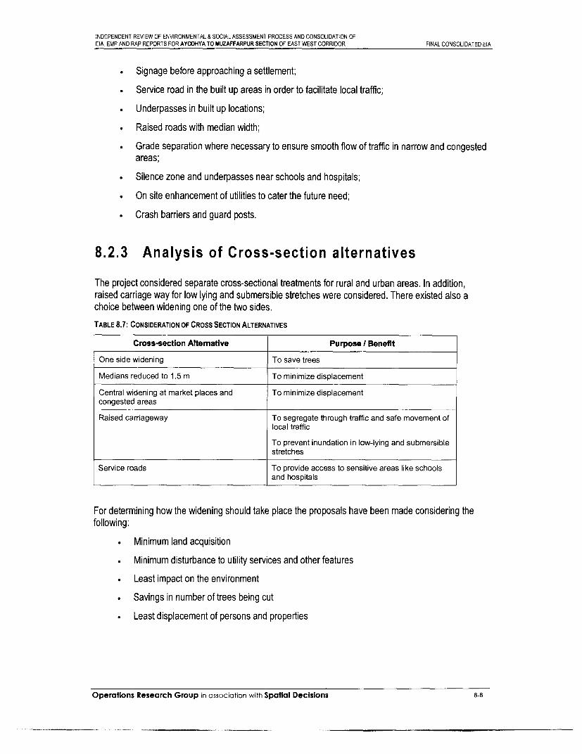
INDEPENDENT REVIEW OF ENVIRONMENTAL & SOCIAL ASSESSMENT PROCESS AND CONSOLIDATION OFEIA, EMP AND RAP REPORTS FOR AYODHYA TO MUZAFFARPUR SECTION OF EAST WEST CORRIDOR FINAL CONSOLIDATED EIA
* Signage before approaching a settlement;
* Service road in the built up areas in order to facilitate local traffic;
* Underpasses in built up locations;
Raised roads with median width;
* Grade separation where necessary to ensure smooth flow of traffic in narrow and congestedareas;
* Silence zone and underpasses near schools and hospitals;
• On site enhancement of utilities to cater the future need;
* Crash barriers and guard posts.
8.2.3 Analysis of Cross-section alternatives
The project considered separate cross-sectional treatments for rural and urban areas. In addition,raised carriage way for low lying and submersible stretches were considered. There existed also achoice between widening one of the two sides.
TABLE 8.7: CONSIDERATION OF CROSS SECTION ALTERNATIVES
Cross-section Altemative Purpose / Benefit
One side widening To save trees
Medians reduced to 1.5 m To minimize displacement
Central widening at market places and To minimize displacementcongested areas
Raised carriageway To segregate through traffic and safe movement oflocal traffic
To prevent inundation in low-lying and submersiblestretches
Service roads To provide access to sensitive areas like schoolsand hospitals
For determining how the widening should take place the proposals have been made considering thefollowing:
Minimum land acquisition
Minimum disturbance to utility services and other features
* Least impact on the environment
* Savings in number of trees being cut
Least displacement of persons and properties
Operations Research Group in association with Spatial Decisions 8-8

INDEPENDENT REVIEW OF ENVIRONMENTAL & SOCIAL ASSESSMENT PROCESS AND CONSOLIDATION OFEIA, EMP AND RAP REPORTS FOR AYODHYA TO MUZAFFARPUR SECTION OF EAST WEST CORRIDOR FINAL CONSOLIDATED EIA
Section C-111/2 - Ayodhya to Gorakhpur
Proposal I (Partial access control)* Widening on right side with 5 m median in rural area and with / without service roads on both
sides.
* Concentric widening in built up area with 1.5 m median and service road on both sides.
Proposal 2Widening on right side with 5 m median in rural area and without service roads on bothsides.
* Concentric widening in built up areas with 1.5 m median and service road on both sides.
Proposal 3* Widening in rural area on right side with 5 m median where ROW is more than 48 m, and
median is adjusted to 4 m where ROW is more than 40 m and concentric widening with 3 mmedian width in rural area where ROW is not more than 33m. However width of median willbe kept uniform in rural area if the ROW permits.
* Concentric widening in built up areas with 1.5 m median and service road on both sides.
Proposal 3 has been recommended due to the following reasons:
Least land acquisition involved
Maximum number of Optical Fibre Cable (OFC) cable/pillars are on left side
* Utility services will be disturbed only on one side
Section C-1115 - Gorakhpur to Gopalganj
Proposal lWidening on left side with 4.5 m median in rural area.
Concentric widening in built up area with 1.5 m median and service road, 5.5 m to 7 m wideon both sides.
Proposal 2Widening on left side with 4.5 m median in rural area and without service roads on bothsides.
* Concentric widening in built up areas with 1.5 m median without service road.
Proposal 1 has been recommended due to the following reasons:
Least land acquisition involved
Huge saving in cutting of trees (10285 trees to be saved by proposed alignment)
Displacement of properties and persons will be minimised
* Utility services will be disturbed only on one side
Section C-Ill/1 - Gopalganj to MuzaffarpurProposal l
. Widening on left side with 5 m median in rural area.
Operations Research Group in association with Spatial Decisions 8-9

INDEPENDENT REVIEW OF ENVIRONMENTAL & SOCIAL ASSESSMENT PROCESS AND CONSOLIDATION OFEIA, EMP AND RAP REPORTS FOR AYODHYA TO MUZAFFARPUR SECTION OF EAST WEST CORRIDOR FINAL CONSOLIDATED EIA
Concentric widening in built up area with 1.5 m median and service road, 5.5 m to 7 m wideon both sides.
Proposal 2* Widening on left side with 5 m median in rural area and without service roads on both sides.
* Concentric widening in built up areas with 1.5 m median without service road.
Although Proposal 2 is economical, it does not include safety provisions in built-up locations tosegregate the local traffic from the through traffic. Proposal 1 has been recommended due to followingreasons:
Least land acquisition involved
Local traffic safety in built up zone due to provision of service road
* Huge saving in culting of trees (10333 trees to be saved by proposed alignment)
* Losses to roadside ponds will be minimum (with left side widening)
Displacement of properties and persons will be minimised
* Utility services will be disturbed only on one side (left side in totality, the numbers are less)
In accordance with the traffic volume count survey and traffic forecast Project highway needs fourlaning in 2003-2004 and six laning in 2018-2020. It has been proposed to carry out four laning for theentire stretch from km 142.5 to km 520 immediately. The existing horizontal alignment is good andneeds only improvement of some sub-standard curves within the ROW. Due consideration has beengiven to the bypass at congested locations and one bypass has been proposed at Ayodhya at the startof the stretch.
Operations Research Group in association with Spatial Decisions 8-10

INDEPENDENT REVIEW OF ENVIRONMENTAL & SOCIAL ASSESSMENT PROCESS AND CONSOLIDATION OFEIA, EMP AND RAP REPORTS FOR AYODHYA TO MUZAFFARPUR SECTION OF EAST WEST CORRIDOR FINAL CONSOLIDATED EIA
Chapter 9
Operations Research Group in association with Spatial Decisions

I
IIi

INDEPENDENT REVIEW OF ENVIRONMENTAL & SOCIAL ASSESSMENT PROCESS AND CONSOLIDATION OFEIA, EMP AND RAP REPORTS FOR AYODHYA TO MUZAFFARPUR SECTION OF EAST WEST CORRIDOR FINAL CONSOLIDATED EIA
9. Environmental Mitigation and Enhancement Measures .................................... 9-19.1 Introduction ..................................... 9-19.2 Basic Approach ..................................... 9-1
9.2.1 Mitigation .................................... 9-19.2.2 Environmental Enhancements ................... ... .............. 9-2
9.3 Mitigation Measures Proposed ..................................... . 9-29.3.1 Meteorology .................................... 9-29.3.2 Natural and Biophysical Environment . . .......................... 9-39.3.3 Biological Environment . . .................................. 9-149.3.4 Fauna .................................... .. 9-189.3.5 Social Environment ..................................... . 9-18
9.4 Environmental Enhancement Measures . . .............................. 9-309.4.1 Objectives .................................... 9-30
Operations Research Group in association with Spatial Decisions 9-32

ii
i
ii
I

INDEPENDENT REVIEW OF ENVIRONMENTAL & SOCIAL ASSESSMENT PROCESS AND CONSOLIDATION OFEIA, EMP AND RAP REPORTS FOR AYODHYA TO MUZAFFARPUR SECTION OF EAST WEST CORRIDOR FINAL CONSOLIDATED EIA
9. ENVIRONMENTALMITIGATION ANDENHANCEMENTMEASURES
9.1 Introduction
The purpose of this chapter is to list out the appropriate mitigation and management measures tominimise or eliminate the adverse environmental impacts due to proposed road development project.The chapter also lists out the measures undertaken in the design stage itself to avoid impacts due toseveral categories. This chapter has been structured based on the impacts identified in the Chapter 7:"Assessment of Environmental Impacts". The chapter also refers to the enhancement measures thatwill be undertaken as part of the project execution for the benefit of the road users and the surroundingcommunities. However, several other enhancements that occur inherently because of the nature of theproject such as junction improvement, improved drainage, pedestrian facilities, illumination in urbanstretches, prevention of existing erosion, overtopping and flooding have been discussed and outlined inthe highway design chapters of the respective DPRs.
9.2 Basic Approach
9.2.1 Mitigation
As discussed in Chapter 7, the broad environmental categories that are likely to be impacted include:Physical Environment, Biological Environment and Social Environment.
To minimize the adverse impacts of the project, mitigation measures have been formulated and shall beimplemented during the project implementation phase. The mitigation measures would be directedtowards the restoration of the dynamic balance of nature. The mitigation of negative impacts involvereduction in magnitude of the assessed adverse impacts during various stages of the project through:
Alterations in project design based on public consultations, site clearance, Construction andOperation phases of the road project to avoid adverse impacts, and
Operations Research Group in association with Spatial Decisions 9-1

INDEPENDENT REVIEW OF ENVIRONMENTAL & SOCIAL ASSESSMENT PROCESS AND CONSOLIDATION OFEIA, EMP AND RAP REPORTS FOR AYODHYA TO MUZAFFARPUR SECTION OF EAST WEST CORRIDOR FINAL CONSOLIDATED EIA
Additional mitigation measures for unavoidable negative impacts on the environmentalcomponents.
9.2.2 Environmental Enhancements
In accordance to the World Bank Operational Policies 4.01, additional positive actions need to be takenup as part of the EA process apart from the remedial/mitigation measures that are being proposed toaddress the negative impacts due to the project.
Environmental enhancements refer to the positive actions to be taken up during the implementation ofthe project for the benefit of the local community and environmental features along NH-28. Theenhancements have been carried out with the following objectives:
* To enhance the appeal and environmental quality of the project corridor to its users,
* To enhance visual quality along the highway, and
* To preserve community interests by enhancement of common property resources.
9.2.2.1 Elements for enhancement
The following elements have been identified for enhancement of natural and social environment:
* Community ponds within the RoW
* Wells within the RoW
9.3 Mitigation Measures Proposed
The following section gives the environmental mitigation measures proposed for the project as goodengineering practices.
9.3.1 Meteorology
Pre-construction StageIt is expected that there will be a small change in the microclimate of the area due to felling of the tressnecessitated by the project and the addition of increased pavement surface, though there is no impactlikely on the macroclimate of the area due to the project. Avoidance measures for minimisation of fellingof trees were undertaken during the design stage itself and the Environmental Screening Study butsubstantial tree felling has been found unavoidable. Taking approval from State Forest Department andmarking trees prior to felling of trees will help in unnecessary felling of trees.
Construction Stage
Operations Research Group in association with Spatial Decisions 9-2

INDEPENDENT REVIEW OF ENVIRONMENTAL & SOCIAL ASSESSMENT PROCESS AND CONSOLIDATION OFEIA, EMP AND RAP REPORTS FOR AYODHYA TO MUZAFFARPUR SECTION OF EAST WEST CORRIDOR FINAL CONSOLIDATED EIA
Compensatory planting is an integral part of the project activities to mitigate the impacts onmicrometeorology. Trees will be planted @ 1:2 (for every tree felled, two trees to be planted) by StateForest Department as part of Compensatory Afforestation. Further, avenue plantation will beundertaken by NHAI as per the guidelines provided in General EMP. Shrub plantation along the medianby contractor will help in improving road aesthetics besides providing cooling effect of green cover onroad and as a measure to prevent bright glares while travelling during night along the highway. All theplantation will be done as per the Planting Scheme provided in Annexure IV (General EMP). Plantationalong the highway shall help restore green cover along the corridor.
All the tree felling and planting activities will be supervised by Environmental Expert of SC and PIU.
9.3.2 Natural and Biophysical Environment
9.3.2.1 Land Resources
Loss of productive soilsPre-construction StageThe project design has been formulated so as to:
Minimise the acquiring of productive agricultural land for uses such as locating constructioncamps, stockyards and storage godowns for materials before the start of construction.
Construction stageThe Environmental Management Plan has been designed to ensure the conservation of productivetopsoil from the borrowing operations. To conserve the productive topsoil the following measures havebeen proposed:
* The topsoil from all areas of cutting and all areas to be permanently covered shall bestripped to a specified depth of 150mm and stored in stockpiles. At least 10% of thetemporarily acquired area shall be earmarked for storing top soil.
* The stockpile shall be designed such that the slope does not exceed 1:2 (vertical tohorizontal), and the height of the pile be restricted to 2m. To retain soil and to allowpercolation of water, silt fencing shall protect the edges of the pile.
* Stockpiles will not be surcharged or otherwise loaded and multiple handling will be kept to aminimum to ensure that no compaction will occur. The stockpiles shall be completely coveredwith gunny bags or tarpaulin.
* Construction on the cleared soils shall begin as soon as possible to avoid soil erosion. Topsoil shall not be unnecessarily trafficked either before stopping or when in stockpiles. Slopestabilisation shall be done by turfing and planting bush grass
. It shall be ensured by the contractor that the topsoil will not be unnecessarily trafficked eitherbefore stripping or when in stockpiles.
. The topsoil shall be reused to the maximum possible extent and the potential uses mayinclude returning to cover the cut area, reuse in barren/rocky areas and redevelopment ofborrow areas. Stockpiled topsoil can be returned to cover the disturbed area and cut slopes.Residual topsoil can be distributed on adjoining/proximate barren/rocky areas as identified by
Operations Research Group in association with Spatial Decisions 9-3

INDEPENDENT REVIEW OF ENVIRONMENTAL & SOCIAL ASSESSMENT PROCESS AND CONSOLIDATION OFEIA. EMP AND RAP REPORTS FOR AYODHYA TO MUZAFFARPUR SECTION OF EAST WEST CORRIDOR FINAL CONSOLIDATED EIA
the SC in a layer of thickness of 75mm - 150mm. Top soil can also be utilized forredevelopment of borrow areas, landscaping along slopes, medians, incidental spaces etc.The most appropriate use of the stockpiled topsoil shall be decided upon by the SupervisionConsultant and advised to the contractor before initiation of borrowing of earth on thespecified borrow pit.
Borrow pits
Pre-Construction Stage
Borrow areas for soil/earth* Borrowing of soil can have a long-term impact on the environment, therefore, in the selection
of the borrow areas care was taken during the design stage itself to ensure that the loss offertile and productive agricultural soil as well as loss of vegetation is minimum.
* The identification of borrowing areas was done so that the selected area shall conform to therequirements of the criteria formulated for borrowing sites. The criteria for selection ofborrowing sites include: a) as far as possible the borrowing area should be found on non-cultivable land; b) borrowing sites can also be selected where there is elevated land and theowner is willing for the site to be levelled; c) locations where the owner (private orcommunity) wants to create a fish pond in the excavated land; d) in case of unavoidablecircumstances that none of the above conditions are satisfied, the borrow areas wereselected on productive lands with provision for preserving the topsoil; e) the minimumdistance of a borrow area shall be at least 800 m from the nearest village or the settlementbut if unavoidable, the depth of dig shall not be more than 1 feet and shall be drained. Thelocations where the private owner desires to create a fishpond are preferred during selection.
* Opening of borrow pits by the Contractor, other than those identified during the design stageshall be done only in case of unavoidable reason, or in case of a more suitable area or othervalid reason but only after getting approval from the SC. If new borrow areas are selected, itwill be ensured by the contractor that, there will be no loss of productive soil, the requisiteenvironmental considerations are met with and that no earth will be borrowed from within theRoW.
Construction StageTo ensure the implementation of environmental mitigation measures for loss of productive topsoil, thefollowing precautionary measures have been recommended during construction.
* No borrow areas to be opened without permission of the Environmental Expert ofSupervision Consultant.
* The borrowing shall not be carried out in cultivable lands, unless and until, it shall be agreedupon by the Supervision Consultant that there is no suitable barrenluncultivable land in thevicinity for borrowing, or there are private land owners willing to allow borrowing on theirfields.
* Written agreements with the land owner must be completed prior to the start of borrowing.
* Borrow pits shall not be dug continuously in a stretch. The location, shape and size of thedesignated borrow areas shall be as approved by the Engineer and in accordance to theIRC-10-1961 recommended practice for borrow pits for road embankments.
Operations Research Group in association with Spaflal Decisions 9-4

INDEPENDENT REVIEW OF ENVIRONMENTAL & SOCIAL ASSESSMENT PROCESS AND CONSOLIDATION OFEIA, EMP AND RAP REPORTS FOR AYODHYA TO MUZAFFARPUR SECTION OF EAST WEST CORRIDOR FINAL CONSOLIDATED EIA
* Location of source of supply of material for embankment or sub-grade and the procedure forexcavation or transport of material shall be in compliance with the environmentalrequirements of the MoEF, MoST and as specified in IRC-10-1961.
* Precautionary measures as the covering of vehicles will be taken to avoid spillage duringtransport of borrow materials. To ensure that the spills, which might result from the transportof borrow and quarry materials do not impact the settlements, it will be ensured that theexcavation and carrying of earth will be done during day-time only. The unpaved surfacesused for the haulage of borrow materials will be maintained properly.
The selection of borrow areas, if required during the construction stage shall be carried out as per theselection criteria used at the design stage and given above.
Redevelopment of Borrow Areas
The Environmental Management Plan envisages redevelopment of borrow areas after excavation tominimise the impacts on the surrounding environment. Excavated borrow areas leave large pits thathave to be redeveloped to avoid health hazards.
. The excavated Borrow Pits can be redeveloped into a garbage-dumping site by clearingextraneous matter and then levelling. Redevelopment of borrow areas into garbage dumpingsite require protection measures to avoid contamination of soil and groundwater by leachatesthat will be generated by water falling into these garbage dumps. An impermeable layer of150mm P.C.C shall be laid to prepare the bed of the area. Construction waste shall be filledup to a depth of 1350 mm and it shall be covered with a layer of rammed earth of thickness1500mm. This layer shall be covered with gunny bags soaked in coal tar to act as D.P.C.Over the D.P.C layer, another layer of rammed earth of thickness 1500mm shall be laid and itwill be cover with a 300mm of topsoil. The site can be developed in modules of size 50 m.Top layers of rammed earth shall be laid in slopes of 1 in 20 to drain into a side drains laid inslope of 1 in 100.
* Borrow pits can also be redeveloped as a fishponds for use as commercial fishery by thelocal community Panchayat (in case of Govt. land) or by the owner (in case of private ands).These ponds shall be provided with brick pitching along the banks whose slope shall not bemore than 1 in 2 and turfing shall be done around the brick pitched area.
The recommended actions as above, for the redevelopment of borrow areas is dependent on theownership of the land. The actual measure to be taken will depend on the owner of the land, as in thecase of private lands. Redevelopment will be incidental to project work. However, the SupervisionConsultant shall inform and educate the owner about the recommended actions, with the final decisionto rest on the owner.
Soil Erosion
Construction StageIncorporating appropriate type of treatments of slopes has reduced the potential for erosion of highembankments and bridge fills. Slope protection is normally required only for slopes steeper than 1V:2H.The side slopes gentler than this will be turfed with shrubs and grasses as per recommendations for thetreatment of embankment slopes for erosion control, IRC: 56-1974. The proposed measures forprevention of soil erosion include:
. Slope protection shall be provided on embankments abutting water bodies by providingstone pitching. Such measures will be required on the edges and embankments of ponds,
Operations Research Group in associotion with Spatial Decisions 9-5

INDEPENDENT REVIEW OF ENVIRONMENTAL & SOCIAL ASSESSMENT PROCESS AND CONSOLIDATION OFEIA, EMP AND RAP REPORTS FOR AYODHYA TO MUZAFFARPUR SECTION OF EAST WEST CORRIDOR FINAL CONSOLIDATED EIA
lakes or river bodies. Edges of the community ponds can also be protected by vegetativebuffers.
* For slopes steeper than 1:2 (V:H) in the embankments, stone pitching shall be providedby giving a P.C.C. anchor and gently hammering the stones into the anchor.
* Brick pitching shall be provided for all the slopes milder than 1:2 (V:H) with voids to allowvegetation to grow in these voids. The pitching shall be done with second-class bricks laidflat without mortar.
* The longitudinal drains are proposed for all major / minor bridges approaches on both sidesas well as approaches to proposed underpass, fly-over and ROBs in the project stretch.
* Soil erosion checking measures as the formation of sediment basins, slope drains, etc., willbe carried out at construction sites.
* Provision for longitudinal drains has been made at the edges of the roadway. Water shall bechannelised in these side drains and shall be led down the slopes by means of laid chutes atabout 10 m interval and ultimately discharging into side channel at the bottom preventingpooling of water near toe line of the road and erosion of soil due to rainfall.
FIG 9.1 :TYPICAL DRAWINGS OF SOIL EROSION PROECTION MEASURES AT SLOPES A) STONE PITCHING; AND B) BRICK PITCHING
A) STONE PITCHING B) BRICK PITCHING
ROUGH CUBIC STONES OF 25 CM NOMINAL SIZE HAND PITCHED ON THE SLOPES
INTERSTICES FILLED UP WITH SPALLS AND SOIL.GRASS PLANOED IN THE INTERSTICES
THIS S TAC. TA NEL
;(/ L1 [ t1 s ~~~~~~~~~~FACIMITATE FEROT OLPA
STN PICHN OFSOElJE II lII II I I Il I I AILTATgN O L
E v- ~ ~ ~ ~ ~ ~ ~ ~ ~ ~~~~~~~~GB _.
* In borrow pits, the depth of the pits shall be so regulated that the sides of the excavationshall not have a slope steeper than 1:4 (V:H), from the edge of the final section of bank.
* Retaining wall shall be provided for retaining land or water so as to minimize area acquisitionor area reduction (community ponds, private property etc. very near to the road), which provedifficult to reduce with providing slope embankments with slope of 1:2 (V:H). Retaining wallmay also be provided to prevent erosion of soil along the banks of the ponds, which may beincreased due to increased catchment runoff.
Contamination of Soils
Construction StageContamination of soil due to oil and grease leakages finding way into surface runoff invehicle parking areas shall be minimised by providing impervious floor-beds (under theparking area) made of brick P.C.C. layer placed over a layer of rammed brickbats of depth0.15 m. The P.C.C. floor-bed shall be provided a slope of at least 1: 50 towards one edge toensure proper drainage of water (containing oil/grease spills) to an oil-intercepting chamber
Operations Research Group in association with Spatial Decisions 9-6

INDEPENDENT REVIEW OF ENVIRONMENTAL & SOCIAL ASSESSMENT PROCESS AND CONSOLIDATION OFEIA, EMP AND RAP REPORTS FOR AYODHYA TO MUZAFFARPUR SECTION OF EAST WEST CORRIDOR FINAL CONSOLIDATED EIA
through an intercepting chamber of size 0.3 m X 0.3m. Typical design of oil interceptor hasbeen provided in the specific EMPs.
* Spoils generated during construction activities shall be properly disposed off in low-lyingareas or soil quarries with additional capacity.
* Maximum reuse of constructional wastes (dismantled pavement debris etc.) shall beconsidered as applicable with due approval of the SC regarding the suitability andapplicability of the concerned material. Recycling options with contractor include usingdismantled embankment material in new embankments, dismantled sub-grade material as fillmaterial for embankments, recycling existing base and sub-base as sub-base for new road,reuse of existing bitumen surface in for paving of cross-roads, access roads, paving worksetc. in constructional amenities like camps, traffic detours, haulage routes.
* Unusable and hazardous wastes shall be properly disposed as identified locations fordumping duly approved by the SC. Dumping can be done in borrow-pits but care shall betaken to cover the waste with preserved topsoil. For disposal of hazardous wastes likeresidual bituminous wastes, secured landfills prepared by providing impervious lining in thearea identified for filling with a layer (at least 20" thick) of compacted clay shall be carried outbefore disposal as well as covering the area with a layer of top soil.
Compaction of Soils
Construction Stage* To prevent the compaction of soil and the trampling of the vegetation around the construction
sites and temporary access roads, it will be ensured that the construction machinery andequipment will move, or be stationed in the designated area.
* To minimize compaction of soil, all the vehicles will as far as possible, follow per-designatedroutes.
* Heavy, wide and slow moving vehicles should be kept away from the sensitive routes. Use ofheavy machinery on productive land to be minimized to prevent compaction of fertile soil.
* Limitation on the axle load shall be identified such that topsoil is protected from compaction.
Quarrying and Stone Crushing Operations
Pre-construction Stage
If the contractors decide to use quarries other than the ones mentioned, they would berequired to obtain material from licensed quarries only and only after getting approval fromthe SC.
Construction Stage* Redevelopment plan for the borrow areas shall be prepared and followed by the Contractor.
Transportation of Soil
Care shall be taken during the transport of the soil/earth by covering the haulage vehicleswith tarpaulin or any other good quality covering material. The unpaved surfaces used for thehaulage of borrow materials will be maintained properly.
Excavation and transport of earth shall be done during the daytime only to minimize risks ofthe spills etc. from the earthwork on the community.
Operations Research Group in association with Spafial Decisions 9-7

INDEPENDENT REVIEW OF ENVIRONMENTAL & SOCIAL ASSESSMENT PROCESS AND CONSOLIDATION OFEIA, EMP AND RAP REPORTS FOR AYODHYA TO MUZAFFARPUR SECTION OF EAST WEST CORRIDOR FINAL CONSOLIDATED EIA
Frequent washing of roads being used during transport of soil shall be done throughsprinklers.
Stones and Aggregates
* Care shall be taken to ensure that the working conditions for the workers in stone quarries isup to the required standards.
* Dust suppression measures be carried out like sprinkling of water at the construction sitewhere these are stored and used.
Use of Fly-ash in road construction
Construction Stage
Handling of Fly-ash
* Extreme care must be taken to ensure proper handling of fly-ash and made sure that the fly-ash is kept moist during the transit without making it too wet so as to avoid leaching andincrease in weight.
* The trucks for transportation shall be covered with tarpaulin and the fly-ash should betransported in gunny bags to avoid pollution due to fly-ash.
* Fly ash shall not be stock piled but dumped directly on the embankment.
Constructional PracticesFly-ash shall be compacted in layers of 1.5 m to 2 m and these layers shall be separated by0.3 m to 0.4 m thick layer of compacted soil. The final layer shall be of compacted soil and nofly-ash shall be left exposed to environment.
A lining of compacted coarse sand shall be made in areas with high groundwater table where fly-ashhas been proposed as fill material.
9.3.2.2 Ambient Air Quality
Design Stage
The proposed highway widening and strengthening project will improve ambient air quality by removingtraffic bottlenecks due to increased vehicle density on the road. This will ease out traffic situation,increasing vehicular speed and thus, lowering vehicular emissions resulting in better air quality. Thedesign stage has taken into account adequate measures to improve road geometry, provideunderpasses, flyovers, ROBs at required locations for smooth flow of traffic. Besides, proposed busstops, lay byes etc. will add to regulation of high speed traffic, helping in keeping pollution levels undercheck. The following urban stretches, major intersections and sensitive receptors, with already highpollutant concentrations have been avoided by provision of suitable realignments, bypasses andflyovers.
TABLE 9.1: AVOIDANCE / MITIGATION MEASURES FOR AIR POLLUTION AT CRITICAL LOCATIONS
Package Chainage (Km.) Suggested Avoidance/ Mitigation measure
I Bridge on River Ayodhya Bypass has been proposed that will ameliorate the peak traffic, whichSaryu and Katra occurs during the festival season. This will significantly improve the air quality ofJn. at 139.000 the area by segregating the slow traffic, hordes and pedestrians from Ayodhya
town from the highway traffic on NH-28.
Operations Research Group in association with Spatial Decisions 9-8

INDEPENDENT REVIEW OF ENVIRONMENTAL & SOCIAL ASSESSMENT PROCESS AND CONSOLIDATION OFEIA, EMP AND RAP REPORTS FOR AYODHYA TO MUZAFFARPUR SECTION OF EAST WEST CORRIDOR FINAL CONSOLIDATED EIA
Package Chainage (Km.) Suggested Avoidance/ Mitigation measure
1I Maharajganj Jn. at Underpass has been provided to avoid potential traffic bottleneck and improve178.025 the air quality in the built-up zone.
11 Kaptanganj at km. Underpass has been provided to avoid potential traffic bottleneck and improve181.485 the air quality in the built-up zone.
11 196.600 Flyover for grade separation of traffic on SH-5 from the highway traffic therebyreducing traffic bottleneck and subsequent improvement in air quality
III 233.000 Flyover for grade separation of traffic on SH-88 from the highway traffic therebyreducing traffic bottleneck and subsequent improvement in air quality
VII Jagdishpur Bazar Underpass has been provided to avoid potential traffic bottleneck and improveat km.281 .683 the air quality in the built-up zone.
VII Sukrauli Bazar at Underpass has been provided to avoid potential traffic bottleneck and improvekm. 292.019 the air quality in the built-up zone.
VII Hata Chowk at km. Vehicular Underpass Type-2 has been provided to avoid potential traffic300.995 bottleneck and improve the air quality in the built-up zone.
Vill Tamkuhi built-up Vehicular Underpass Type-2 has been provided to avoid potential trafficarea at km. bottleneck and improve the air quality in the built-up zone.347.420
IX Sasamusa built up SMV Underpass Type-2 has been provided to avoid potential traffic bottleneckzone and junction and improve the air quality in the built-up zone.at km. 374.085
xi Piprakothi Jn. at Flyover at Piprakothi Junction to segregate traffic on NH-28 A going towardskm. 453 Nepal border
XII Chandni Chowk at Flyover at Chandni Chowk to segregate traffic on NH-57 (Muzaffarpur-km 520 Darbhanga-Farbishganj) intersecting NH-28 at this point.
Construction StageThe two main areas of concern for air pollution during the pre-construction stage are dust generationand exhaust gases. The impact mitigation measures to be taken during the construction stage include:Generation of Dust
* To ensure minimum generation of dust during the construction, all crushers identified to beused in construction shall conform to relevant dust emission control legislation of therespective SPCB. It shall also be ensured that the dust emissions from vibrating screen fromthe stone quarries do not exceed the standard.
* To prevent the impact of dust on human settlements, all the construction plants, asphaltmixing plants and batching plants shall be situated at least 1 km in the downwind directionfrom the nearest human settlement.
* All Hot mix plants shall be fitted with dust extraction systems.
* Vehicles delivering loose and fine materials like sand and fine aggregates shall be coveredto reduce spills on existing roads.
* Water shall be sprayed on the lime I cement and earth mixing sites, asphalt mixing site andtemporary service and access roads. After compacting the earthwork, water will be sprayedregularly to prevent dust.
* Clearance for siting of roadside crushers shall be obtained from the respective SPCB.Alternatively, only those crushers that are already licensed by the SPCB shall be used.
Operations Research Group in association with Spatial Decisions 9-9

INDEPENDENT REVIEW OF ENVIRONMENTAL & SOCIAL ASSESSMENT PROCESS AND CONSOLIDATION OFEIA, EMP AND RAP REPORTS FOR AYODHYA TO MUZAFFARPUR SECTION OF EAST WEST CORRIDOR FINAL CONSOLIDATED EIA
* Traffic detours shall not be located on areas with loose soils. Temporary pavement shall bemade by using dismantled pavement material from existing roads.
* All construction workers shall be provided with pollution masks to mitigate the effect of dustgeneration on the health of workers.
Generation of Exhaust Gases* All vehicles, plants and machinery used during construction shall conform to the emission
standards promulgated under the Environment (Protection) Act, 1986.
* Regular maintenance and pollution control measures shall be taken for all the vehicles,equipment and machinery used during construction. It shall be ensured that pollutantemission levels comply with the relevant requirements of the respective SPCB and the SC.The Contractor shall be required to furnish 'No Pollution Certificate' from time to time to theSC.
* A vehicle management schedule prepared by the contractor and approved by the Engineershall be adhered to.
* Traffic detours and diversions shall be designed so as to minimize bottlenecks and ensuresmooth traffic. As far as possible, construction work shall be carried out at night to reducetraffic bottlenecks.
* Air pollution monitoring shall be carried out on quarterly basis to verify that air pollutionnorms are being followed by the contractor and the air quality at the construction site doesnot exceed the permissible AAQ limits.
* An adequate cyclone/scrubber to control emissions from the stack of hot mix plants will needto be provided in the event of the emissions exceeding the SPCB norms.
Operation Stage
CALINE 4 modeling of ambient CO concentration along the project stretch for 'with project' and 'withoutproject' scenarios indicate that air quality will be within the permissible level in 'with project' scenario.However, 'without project' scenario indicates that air quality will deteriorate at certain locations due totraffic bottlenecks. To ensure that air pollution levels do not exceed during operation phase, a fewenvironmental measures have been proposed that include:
* Regular monitoring of tree and shrub plantations along the highway as part of compensatoryafforestation, avenue plantation and median plantation to ensure their survival. The greencover will help in absorbing pollutants and in providing cooling effect along the highwaystretch.
* Stakeholder consultation meeting will be held for the proposed Ayodhya Bypass. Thestakeholders will include civic bodies, NGOs etc. that will take care of any encroachmentalong the said stretch.
9.3.2.3 Water Resources
Direct impact on water bodies has been avoided usually by aligning the road on side opposite to thelocation of existing pond/lake/water body. Wherever the impact on the water body is inevitable, it hasbeen proposed to minimize the same to the extent possible by providing enhancement measures.
Tapping of Water Resources for project activities
Operations Research Group in association with Spatial Decisions 9-10

INDEPENDENT REVIEW OF ENVIRONMENTAL & SOCIAL ASSESSMENT PROCESS AND CONSOLIDATION OFEIA, EMP AND RAP REPORTS FOR AYODHYA TO MUZAFFARPUR SECTION OF EAST WEST CORRIDOR FINAL CONSOLIDATED EIA
Pre-construction StageThe contractor will arrange for water required for construction in such a way that the wateravailability and supply to nearby communities remain unaffected. If a new tube-well is to bebored, due to the non-availability of water required for construction, prior sanction andapproval by the Ground Water Department will be obtained. Wastage of water during theconstruction will be minimized.
Construction Stage* While working across or close to perennial water bodies, the Contractor will not impede or
block any flow of water. If for any bridgework, containment of flow is required, the Contractorwill seek approval of the Supervision Consultant (SC). The SC will have the right to ask theContractor to serve notice on all downstream users in advance of any closure.
* Construction over and close to any non-perennial streams shall be carried out in the dryseason. Construction over irrigation canals should be carried out so as to minimize anydisruption to the flows and to ensure that a high quality of water is maintained. Suchconstruction will be undertaken with permission from the Department of Irrigation.
* The Contractor may use the natural sources of water subject to the provision that any claimarising out of conflicts with other users of the said natural sources will be his responsibility.
Contamination of Water ResourcesFIG 9.2: SILT FENCING ALONG WATER COURSE
Pre-construction Stage* Care shall be taken before starting of SLOTS
construction activities to site the SUPPORTING AGLE
construction camps at least 200 m away M FRAME
from any sensitive water resources likesurface water bodies to avoid discharge MIRAFI 140 N OR
of sewage into the water body. APPROVED MAKE
* Transportation of soils, fly-ash etc. G LX
during the pre-construction stage shallensure proper handling of the rawmaterial so as not to result anycontaminated runoff into waterresources.
Construction StageImpact of project activities during construction can have a significant impact if proper mitigationmeasures are not undertaken. However, proper adherence to the following mitigation/precautionarymeasures shall make these impacts less adverse.
* To avoid contamination of the various water bodies and drainage channels, constructionwork close to the streams or other water bodies will be avoided, especially during monsoonperiod.
* Where a river or a water body exists along the highway section under construction, siltfencing will be provided to prevent sediments of extremely small size from the constructionsite to enter the watercourses. The silt fencing consists of geo-textile supported by wire-meshmounted on a panel made up of angle frame. The slit fencing shall be used duringconstruction along the road at all water bodies. Depending on the length of the water body,the number of units of slit fencing to be installed is decided.
Operations Research Group in association with Spatial Decisions 9-11

INDEPENDENT REVIEW OF ENVIRONMENTAL & SOCIAL ASSESSMENT PROCESS AND CONSOLIDATION OFEIA, EMP AND RAP REPORTS FOR AYODHYA TO MUZAFFARPUR SECTION OF EAST WEST CORRIDOR FINAL CONSOLIDATED EIA
* Increase in sediment loads into water resources due to tree felling & vegetation clearanceand increased runoff shall be reduced by preparing temporary drains to dispose off theeroded sediments and to prevent them from entering the surface water bodies.
* It shall be ensured by the contractor that any construction work near wells and groundwatersources should be carried out only after properly covering them, as restoration ofgroundwater quality is a very slow process.
* To prevent contamination of water resources due to contaminants from construction camps,water-incepting ditches and drains shall be constructed to collect surface runoff and disposeit off away from the areas vulnerable to contamination. Provision of Sedimentation/SepticTanks to reduce pollution can also be undertaken in case of unavoidable circumstanceswhen it is difficult to dispose off discharge to any non-sensitive water resource.
* Contaminated discharges containing oil/grease contributed by vehicle parking/repair areasand workshops shall not be allowed to discharge into any water body without adequatetreatment. Provision of oil-interceptors shall be made along with impervious bed underneaththe parking area draining the runoff into the oil interceptors. All the construction vehicleparking area, vehicle repair area and the workshops will be provided with a smaller version ofthe oil interceptor. The slope of the prepared and paved site (1:40) shall be made to ensurethat all the wastewater flows into the interceptor before discharge. This device has a singlechamber for separation of oil and water and can handle 200 L/hr of water from the area. Thepacked bed has been removed but the retention time has been increased to 20 minutes.Periodic cleaning (once in a week) will be done from the outside by skimming off the oil filmover the surface.
Operation StageNHAI will ensure that all drains are periodically cleared especially before monsoon tofacilitate quick passage of rainwater so as to avoid flooding. Monitoring for the same will bedone for a period of during the operation phase as per the monitoring plan provided inGeneral EMP.
Community and Private Water Resources
Pre-construction Stage* During the design stage of the project, maximum efforts were made to reduce the number of
community and private water sources to be affected by the project by varying the alignmentof the highway.
* Before dismantling of any hand-pumps or wells, relocation/opening of new water sourcesshall be carried out as per the consultations held with the village communities.
Construction Stage. Ponds for community purpose will be enhanced at select locations as mentioned in specificEMPs with provisions for stepped access, stone pitching for slope stabilisation, treeplantation for soil stabilisation and for aesthetics etc.
* Road side wells will be enhanced by providing flat aprons and putting grass and trees aroundthe wells so as to prevent contamination of the same.
* Further, recharge pits for ground water recharge have been proposed in areas with low watertable. The proposed action will reduce stress on ground water resources, thus preventingdeterioration in the quality.
Operations Research Group in association with Spaflal Decisions 9-12

INDEPENDENT REVIEW OF ENVIRONMENTAL & SOCIAL ASSESSMENT PROCESS AND CONSOLIDATION OFEIA, EMP AND RAP REPORTS FOR AYODHYA TO MUZAFFARPUR SECTION OF EAST WEST CORRIDOR FINAL CONSOLIDATED EIA
Flood Hazard
The design of the highway has been made so as to ensure that the existent highway embankment beraised at least 1 m above the maximum flood level to prevent overtopping of the embankment. It is alsoproposed to provide adequate number of balancing bridges & culverts at suitable locations in the floodovertopped zones after raising the highway embankment.
Water logging in areas with high water table will be prevented by connecting RCC covered urban drainswith proximal culverts.
9.3.2.4 Noise Environment
Construction Stage
Noise and vibration during construction is a significant impact especially around settlements andinhabited areas. The following mitigation measures need to be implemented out by the contractor forthe noise impacts associated with various construction activities:
. Vehicles, equipment and construction machinery shall be monitored regularly with properattention to silencers and mufflers to maintain noise levels to minimum.
. All plants and equipments to be used for construction shall strictly confirm to CentralPollution Control Board (CPCB) noise standards.
. Blasting operations shall be undertaken so as to produce minimum vibrations in sensitiveareas. Blasting shall be restricted to daytime hours.
. No construction activity shall be permitted between 10 PM to 6 AM where the villages andresidences are located within 150 m from construction sites.
. Effective traffic management is required during construction activities especially in built upareas.
. Workers in the vicinity of high noise levels must wear ear plugs, helmets and should beengaged in diversified activities to prevent prolonged exposure to noise levels of more than90 dB (A).
• No batching and hot mix plants shall be located within 200 m of sensitive land uses likeschools, hospitals etc.
No noisy construction activity will be allowed up to a distance of 100 m from sensitivereceptor locations between 9 A.M. and 6 P.M.
Operation Stage
Noise barriers will be put up in the form of a raised 3.0 m high plastered brick wall at select sensitivereceptor locations falling within the right of way. Wherever, such receptor location has an existing gatefacing the highway, the same will be shifted to sideways to achieve noise reduction to the desiredextent. Detailed drawings of the proposed noise barrier is being provided in General EMP. Besides,trees to be planted to address loss of flora along the highway stretch will also produce a noisemitigating effect. Double glazing at window panes as noise barrier is also proposed to be adopted bythe individual units at locations where contractor can not provide any noise barrier owing to non-availability of space within the RoW. However, cost for the same is not budgeted in the EMP and can
Operations Research Group in association with Spatial Decisions 9-13

INDEPENDENT REVIEW OF ENVIRONMENTAL & SOCIAL ASSESSMENT PROCESS AND CONSOLIDATION OFEIA, EMP AND RAP REPORTS FOR AYODHYA TO MUZAFFARPUR SECTION OF EAST WEST CORRIDOR FINAL CONSOLIDATED EIA
be later worked out by the contractor, depending on his agreement with the owner of the unit gettingadversely affected by noise.
Noise barriersThe proposed noise barrier types with respect to the conditions at specific locations as per thesuggested noise mitigation strategies are given in the table 9.2.
TABLE 9.2: PROPOSED NOISE BARRIERS TYPES FOR DIFFERENT LOCATION TYPES
Noise Barrier Type Criteria of Selection Proposed Action Suggested Location
Type A No space availability within Double-glazing of window Sensitive receptorRoW panes.
Type B Boundary wall gets impacted Noise barrier as 3.0 m Sensitive receptorwithin the RoW high plastered brick wall.
Gate entry, if facinghighway to be shiftedsideways
Type C Space availability within the Noise barrier as 3.0 m Sensitive receptorRow but boundary wall does high plastered brick wall.not get impacted This would also serve as
boundary wall. Gate entryif facing the highway to beshifted.
The details of the proposed noise barrier locations with the type of noise barriers as described aboveare given in the specific EMPs for each construction package:
TABLE 9.3: LOCATION OF DIFFERENT TYPES OF BARRIERS BY CHAINAGE
S. No. Type of Noise Barrier Chainage
1. Type A
2. Type B 150.99, 168.56, 178.2, 184.2, 190.5, 237.1, 302, 308.25, 312.3,316.15, 316.25, 320.25, 324.5, 325.2, 326.4, 329.3, 332.6,343.1, 343.15, 343.9, 347.4, 378.85, 384.5, 386.851, 389.670,389.844, 392.547, 399.45, 400.398, 400.922, 417.249, 443.550,475.398, 487.474, 510.722, 513.522
3. Type C 151.0, 154.2, 160.2, 160.23, 165.1, 168.95, 170.85, 172.2,173.1, 181.6, 181.6, 184.8, 188.3, 188.5, 190.85, 202.8, 208.95,220.5, 221.65, 230.5, 232.74, 235.2, 235.95, 339.25, 343.8,347.1, 347.37, 426.464, 438.000, 491.422, 504.471
9.3.3 Biological Environment
9.3.3.1 Flora
The major adverse impacts on flora shall involve the removal of trees, shrubs and ground cover fromwithin the Corridor of Impact. Various options for highway alignment were considered so as toreduce/minimize the loss of trees due to project implementation during design stage. The table belowgives the number of trees saved by adopting the best design alternative:
TABLE 9.4:TREES TO BE CUT AND SAVED BY PACKAGE
Operations Research Group in association with Spatial Decisions 9-14

INDEPENDENT REVIEW OF ENVIRONMENTAL & SOCIAL ASSESSMENT PROCESS AND CONSOLIDATION OFEIA, EMP AND RAP REPORTS FOR AYODHYA TO MUZAFFARPUR SECTION OF EAST WEST CORRIDOR FINAL CONSOLIDATED EIA
Package Existing Number of Proposed Number of Trees SavedTrees Trees to be Cut
Left Right Left I Right
1. Ayodhya 70Bypass
I 3274 3451 555 3707 2463
2. 11 10674 11426 2999 5813 13288
3. III 8675 9608 1178 8845 8260
4. VIl 4573 4275 4451 2481 1916
5. Vill 5809 7444 6275 1103 5875
6. IX 3766 3888 3766 379 3509
7. X 3205 4234 3205 907 3327
8. Xl 3987 3768 3987 706 3062
9. XII 4858 5176 4858 2247 2929
Pre-construction stage
. As part of the project preparation, to minimize the loss of trees, clearance of only those treesidentified in the design will be given.
* Trees to be cut will be clearly marked prior to felling.
Construction stage
Compensatory planting has been proposed as per the NHAl's strategy for tree planting along thehighway. It has been proposed to plant two trees for every tree felled as per the Forest ConservationAct, 1980. The responsibility of planting these trees will lie with the State Forest Department as per theForest Conservation Act, 1980. Adequate provisions have been kept in the Environmental Managementbudget for compensatory planting. The State Forest Department will be responsible for maintenance ofplanted trees for three years of construction. Later, NHAI will be responsible for regular monitoring ofthe survival rate of such trees. The provisions for tree maintenance have also been made into theenvironmental management budget.
The total number of trees to be planted as per the adopted compensatory planting policy is given in thetable 9.5.
TABLE 9.5: COMPENSATORY AFFORESTATION ALONG THE PROJECT PACKAGES
S.No Package No of Trees to be planted as part ofCompensatory afforestation
1 I 140 (Ayodhya Bypass)
8524
2 II 17624
3 III 20046
4 VII 13864
5 Vill 14756
Operations Research Group in association with Spatial Decisions 9-15

INDEPENDENT REVIEW OF ENVIRONMENTAL & SOCIAL ASSESSMENT PROCESS AND CONSOLIDATION OF
EIA, EMP AND RAP REPORTS FOR AYODHYA TO MUZAFFARPUR SECTION OF EAST WEST CORRIDOR FINAL CONSOLIDATED EIA
S.No Package No of Trees to be planted as part ofCompensatory afforestatlon
6 IX 8290
7 X 8224
8 Xi 9386
9 XII 14210
Further, avenue plantation will be done by the NHAI along the project stretch @ 750 saplings per Km,either side taken together. This will help in avoiding encroachment along the road besides alleviatingadverse effects of loss of flora.
Shrub plantation will be undertaken by the contractor along the proposed highway median as per theprovisions of General EMP. This will add to enhancement of road aesthetics, provide green cover andmitigate blinding effects especially during night travelling.
Tree plantation criteria
The planting type was decided based on their requirement and feasibility at various sites along theproject corridors. Physical growth characteristics of trees, like form and shape, foliage and rootingcharacteristics, growth rate, canopy type and branching pattern were the major criteria in the selectionof plantation type and density. From climatological point of view, elimination of solar glare during lowelevations of the sun was considered in the design decisions. Water table depths helped in the choiceof plant material from the point of their survival rate after plantation. In a tropical country like India,where the temperature during summer months may rise up to a maximum of 460C or more, the 'shade'is of greatest value to the travelers. Following are criteria for selection of species to be planted alongthe road at different locations.
* In stretches where the soil is largely alkaline, some salt-resistant varieties like Shisham,Babul, Neem, Casuanna and Siris have been selected.
* In stretches where water logging occurs, on both sides of the road, the selection of treespecies should be from amongst the moisture loving trees, for example, Lagerestroemia flos-reginae, Arjuna (Terminalia arjuna), species of Cassia like C.marginata, C. nodosa, C.siamea, and a variety of jamun, Syzygium operculala (the fruits are small and not edible),Eucalyptus, Tanarix, Salix etc. These would be applicable in the Bihar where waterloggingcan be seen in almost all of the stretch.
* The tree species to be grown near the ponds and other water bodies include Kadamba(Anthocephalus Cadamba), Sita Ashok (Saraca Indica), different varieties of Kachnar(Bauhinia Purpurea. B. Variegata. B. Racemosa), Lagerestroemia Flos-Reginae,Peltophorum Ferrugineum Temple tree (Pumaria Alba and P Acutitolia) etc.
* Some of the trees like Neem-Chameli (Milingtonia Hortensis), Gular (Ficus Glomerata),Jamun (Syzygium Jambolana) have very weak wood and break easily in a windstorm. As aresult, after the storm, roads become blocked and traffic is stopped for a long time. Suchtrees are unsuitable for roadside avenues and should only be planted in outer rows.
* Near market places and congested areas, the trees known for behaving as 'pollution sink'have been proposed. Though, trees in general absorb the pollutants, filter the air frompollutants, and act as noise barrier, trees that are more effective are Neem (AzadirachtaIndica), Mango (Mangifera Indica), Ashok (Polyalthia Longifolia), Putranjiva Roxburghii,
Operations Research Group in association with Spatial Decisions 9-16

INDEPENDENT REVIEW OF ENVIRONMENTAL & SOCIAL ASSESSMENT PROCESS AND CONSOLIDATION OFEIA, EMP AND RAP REPORTS FOR AYODHYA TO MUZAFFARPUR SECTION OF EAST WEST CORRIDOR FINAL CONSOLIDATED EIA
Moulshree (Mimusops Elengi), Ficus Retura, Pakur (Ficus Infectoria), Shisham (DalbergiaSisso), Imli (Lamarindus Indica), Mahua (Bassia Latifolia).
Near sensitive areas like schools and hospitals, tall trees with thick canopies can create awind screen through which the air can be filtered and the noise levels be considerablyreduced. Some such trees are Ashok (Polyalthia Longifolia), Putranjiva Roxburghii andAlstonia Scholaris.
* Thorny trees like Acacia Arabica and Ber (Zizyphusjujuba) should be avoided since theirthorns are a nuisance for the pneumatic tyres of motor vehicles.
* In order to prevent glare from the headlights of incoming vehicles, various kinds of shrubsare proposed in the median. The objective is to prevent glare without blocking vision. Somerecommended species are: Bougainvillia (Bougainvillia sps.), Kaner (Nerium oleander),Yallow Kaner (Thevetia nerifolia), Bauhinia alba, Bauhinia acuminate, Tecoma stans, Cassiabiflora, Cassia alata, Callianadra, Hamelia, etc.
The tree plantation strategy gives recommendations for the type of tree plantation to be carried outbased on the available area for plantation.
Tree Plantation Scheme
The proposed plantation scheme has been broadly classified into 2 categories, which are as follows:
* Tree plantation along the Highway
* Shrub/Herb plantation on medians
Tree Plantation Along the Highways:The technical specification for planting along the highway is as follows:
(i) Ornamental plants except last row
. Distance from embankment - 1.0 m away from the toe of the embankment
. Space between plant to plant - 3 m
. Space between rows - 3 m
* Size of pits - 60*60*60 cm
. Water logged areas - mounds with height varying depending on the water level
. Number of plants per km - 333
* Height of the plant - 1.5 m to 2 m
(ii) Shade plants (Last row)
. Distance from preceding row - 3 m
. Spacing between plant to plant - 12 m
. Size of pits - 60*60*60 cm
. Water logged areas - mounds
. Number of plants per km - 84
Operations Research Group in association with Spatial Decisions 9-17

INDEPENDENT REVIEW OF ENVIRONMENTAL & SOCIAL ASSESSMENT PROCESS AND CONSOLIDATION OFEIA, EMP AND RAP REPORTS FOR AYODHYA TO MUZAFFARPUR SECTION OF EAST WEST CORRIDOR FINAL CONSOLIDATED EIA
. Height of plants - more than 2 m
Median Plantation
* Distance from preceding row - 3 m
* Spacing between plant to plant - 3 m
* Size of pits - 45*45*45 cm
* Number of shrubs per km - 333 (for single row), 666 (for double row)
Automated irrigation systemIt is proposed to include automated piped irrigation system on a model basis for two packages(Package VII & Vil) for median plantation with median width of 4.5 m. The objective is to ensure regularsupply of water for survival of shrubs along the median with minimum loss of water. The system willinclude PVC pipe work, sprinklers with variable arc nozzles, valves to regulate flow of water, filtrationunit and an automation unit. The drawing for the system (for 3 Km stretch and 4.5 m wide median) isgiven in the General EMP. Select model locations are shown in 'Schematic 3: Median Plantation' of therespective Specific EMPs. Provisions have been made in the budget for the same in specific packages.The budgets do not include structural/civil work of any kind, except trenching and back filling.
9.3.4 Fauna
9.3.4.1 Construction stage
It shall be the duty of the contractor to ensure that all works carried out as part of the projectimplementation during the construction stage shall not cause any damage or disruption to thefauna.
* Strict rules regarding unauthorized poaching of animals and fishing shall be enforced amongthe construction to ensure that these activities do not occur.
* In case any rare/endangered animal species are found during construction, the contractorshall be responsible to intimate the wild life protection authorities in the area.
9.3.5 Social Environment
9.3.5.1 Acquisition of land
Proper avoidance measures will be taken during the design and environmental screening study of theproject to minimize the acquisition of land for the purpose of the project. All the displaced property shallbe relocated as per the measures and entitlements as described in the RAP before the start ofconstruction.
Operations Research Group in association with Spatial Decisions 9-18

INDEPENDENT REVIEW OF ENVIRONMENTAL & SOCIAL ASSESSMENT PROCESS AND CONSOLIDATION OFEIA, EMP AND RAP REPORTS FOR AYODHYA TO MUZAFFARPUR SECTION OF EAST WEST CORRIDOR FINAL CONSOLIDATED EIA
9.3.5.2 Impact on Archaeological Properties
The measures for mitigation of impact on public properties have been dealt with in the social impactassessment study carried out for the project.
* All fossils, coins, articles of value of antiquity and structures and other remains or things ofgeological or archaeological interest discovered on the site shall be the property of thegovernment, and shall be dealt with as per provisions of the relevant legislation.
* The contractor shall take reasonable precaution to prevent his workmen or any otherpersons from removing and damaging any such article or thing and shall immediately upondiscovery thereof and before removal acquaint the Engineer of such discovery and carry outthe Engineer's instructions for dealing with the same, awaiting which all work shall bestopped 1 OOm all directions from the site of discovery.
* The Engineer shall seek direction from the Archaeological Society of India (ASI) beforeinstructing the contractor to recommence work on site.
* NHAI will be responsible to obtain ASI clearance for Buddhist Stupa at Fazilnagar at Km 334prior to start of any construction activity.
9.3.5.3 Induced Development
Development of infrastructure brings with itself growth and development of population /communitiesalong the development. Development of highways invariably brings with them the induced developmentalong the highways, known as "induced development". The reasons for this induced developmentinclude better access and new business opportunities, which lure people to these areas. But this oftenmeans extension of urban areas especially at the ends of cities along the highway.
A separate governing body may be formed with the representation of NHAI, Revenue Dept., DistrictAuthority with the power of taking necessary action, if required to remove un-authorised developmentalong the road. This special body will meet periodically for once every year for five years afterconstruction is over and for thrice every year during construction phase. It will monitor the developmentalong the road.
Necessary hoarding will be erected including the availability of RoW and legal charges forencroachment of RoW.
Existing policies regarding growth and development shall be strengthened and additional capacitybuilding measures shall be taken by the concerned development authority to check indiscriminatedevelopment along the highway corridor and ensure sustainable development.
The development authority in the area shall take responsibility to prepare policies for checkingindiscriminate industrial growth and/or ensuring sustainable growth by proper environmental planningfor development. The policies shall give strict rules and regulations as pre-conditions to setting upindustries near the highway and shall ensure that proper waste treatment; disposal and minimizationmeasures are in place before setting up in the area.
9.3.5.4 Traffic Control during construction
Detailed Traffic Control Plans will be prepared prior to commencement of works on any section of road.The traffic control plans will contain details of temporary diversions, details of arrangements forconstruction under traffic and details of traffic arrangement after cessation of work each day.
Operations Research Group in association with Spatial Decisions 9-19

INDEPENDENT REVIEW OF ENVIRONMENTAL & SOCIAL ASSESSMENT PROCESS AND CONSOLIDATION OFEIA, EMP AND RAP REPORTS FOR AYODHYA TO MUZAFFARPUR SECTION OF EAST WEST CORRIDOR FINAL CONSOLIDATED EIA
Temporary diversion (including scheme of temporary and acquisition) will be constructed with theapproval of the Engineer and the Environmental Expert of SC. Special consideration will be given in thepreparation of the traffic control plan to the safety of pedestrians and workers at night.
The Contractor will ensure that the running surface is always properly maintained, particularly duringthe monsoon so that no disruption to the traffic flow occurs. The temporary traffic detours will be keptfree of dust by frequent application of water, if necessary.
The Contractor will take all necessary measures for the safety of traffic during construction and provide,erect and maintain such barricades, including signs, markings, flags, lights and flagmen as may berequired by the Engineer for the information and protection of traffic approaching or passing through thesection of highway under improvement.
9.3.5.5 Loss of access
Construction Stage
The contractor shall provide safe and convenient passage for vehicles, pedestrians and livestock to andfrom side roads and property accesses connecting the project road. The construction activities thatshall affect the use of side roads and existing access to individual properties shall not be undertakenwithout providing adequate provisions.
The construction works will not interfere with the convenience of the public or the access to, use andoccupation of public or private roads, railways and any other access footpaths to or of properties,whether public or private.
Operation Stage
During the operation stage of the highway, free movement of people and livestock will be ensured bythe underpasses that have been proposed as part of the project design. Both Vehicular Underpassesand Pedestrian Underpasses have been proposed in the entire stretch of the project.
TABLE 9.6: CHAINAGE WISE LIST OF PROPOSED UNDERPASSES
Si. No. Chainage Place Type of Under-pass Proposed Proposed SpanArrangement of
Under-pass
1. 145.075 Ramnagar Pedestrian Underpass 7.5m x 2.5m
2. 150.300 Vikramjot Pedestrian Underpass 7.5m x 2.5m
3. 155.53 Pachvas Pedestrian Underpass 7.5m x 2.5m
4. 158.460 Chhawni Pedestrian Underpass 7.5m x 2.5m
5. 170.120 Harraiya Pedestrian Underpass 7.5m x 2.5m
6. 171.888 Harraiya Pedestrian Underpass 7.5m x 2.5m
7. 178.025 Maharajganj Pedestrian Underpass 7.5m x 2.5m
8. 181.485 Kaptanganj Pedestrian Underpass 7.5m x 2.5m
9. 187.685 Gotwa Pedestrian Underpass 7.5m x 2.5m
10. 188.040 Gotwa Rithia Pedestrian Underpass 7.5m x 2.5m
11. 192.250 Rithia Pedestrian Underpass 7.5m x 2.5m
Operations Research Group in association with Spatial Decisions 9-20

INDEPENDENT REVIEW OF ENVIRONMENTAL & SOCIAL ASSESSMENT PROCESS AND CONSOLIDATION OFEIA, EMP AND RAP REPORTS FOR AYODHYA TO MUZAFFARPUR SECTION OF EAST WEST CORRIDOR FINAL CONSOLIDATED EIA
SI. No. Chalnage Place Type of Under-pass Proposed Proposed SpanArrangement of
Under-pass
12. 195.187 Basti Pedestrian Underpass 7.5m x 2.5m
13. 201.061 Rudholi Pedestrian Underpass 10m X 5m
14. 215.485 Tema Rehmat Vehicular Underpass 7.5m x 2.5m
15. 219.425 Budhha Kala Pedestrian Underpass 7.5m x 2.5m
16. 224.490 Bhujaini Pedestrian Underpass 7.5m x 2.5m
17. 225.620 Chureb Pedestrian Underpass 7.5m x 2.5m
18. 235.390 Khalilabad Pedestrian Underpass 7.5m x 2.5m
19. 247.419 Sahjanwa Pedestrian Underpass 7.5m x 2.5m
20. 248.440 Shawazganj Pedestrian Underpass 7.5m x 2.5m
S. No. Chainage Place Type of Proposed Proposed Vertical Total LengthUnderpass Span Clearance including
Arrangement Approachof Under-pass (In m) (in m)
21. 281.683 Jagdishpur Bazar SMV Underpass 1 x10.76 3.50 630.00
22. 284.930 Sonbarsa Bazar SMV Underpass 1 x 10.76 3.50 630.00
23. 292.019 Sukrauli Bazar SMV Underpass 1 x 10.76 3.50 630.00
24. 296.475 Dadha Bujurg SMV Underpass 1 x 10.76 3.50 630.00Builtup Zone
25. 300.995 Hata Jn. With State Vehicular Underpass 2 x 12.56 5.00 1100.00Highway Type-2
26. 318.790 Kaseya Jn. With Vehicular Underpass 2 x 12.56 5.00 1100.00State Highway Type-2
27. 325.780 Paramwalia built up SMV Underpass 1 x10.76 3.50 630.00zone
28. 330.500 Jokwa built up zone SMV Underpass 1 x 10.76 3.50 630.00
29. 334.625 Fazil Nagar built up SMV Underpass 1 x 10.76 3.50 630.00zone
30. 339.350 Patherwa built up SMV Underpass 1 x 10.76 3.50 630.00zone
Operations Research Group in association with Spatial Decisions 9-21

INDEPENDENT REVIEW OF ENVIRONMENTAL & SOCIAL ASSESSMENT PROCESS AND CONSOLIDATION OFEIA, EMP AND RAP REPORTS FOR AYODHYA TO MUZAFFARPUR SECTION OF EAST WEST CORRIDOR FINAL CONSOLIDATED EIA
S. No. Chainage Place Type of Proposed Proposed Vertical Total LengthUnderpass Span Clearance Including
Arrangement Approachof Under-pass (in m)
31. 347.420 Tumkuhi built up Vehicular Underpass 2 x 12.56 5.00 1100.00zone Type-2
32. 374.085 Sasamusa built up SMV Underpass 1 x10.76 3.50 650.00zone and junction
33. 384.150 Gopalganj built up Vehicular Underpass 4 x 12.56 5.00 1150.00zone and major Type-1junction
34. 386.030 Gopalganj built up SMV Underpass 1 x 10.76 3.50 650.00zone
35. 387.375 Gopalganj built up Vehicular Underpass 4 x 12.56 5.00 1150.00zone and major Type-1junction
36. 395.260 Koini SMV Underpass 1 x 10.76 3.50 650.00
37 404.182 Badheya S.H. Jn. & 4-Lane Vehicular 2 x12.56 5.00 1150Built-Up Zone Underpass Type-2
38. 417.000 Mohammadpur NH 4-Lane Vehicular 4 x 12.56 5.00 1150Jn. & Built-Up Zone Underpass Type-1
39. 426.616 Khajura SH Jn. & 4-Lane Vehicular 2 x12.56 5.00 1150Built-Up Zone Underpass Type-2
40. 443.692 Kotwa Built-up 4-Lane SMV 1 x10.56 3.50 650Zone Underpass
41. 461.692 Pipra Village 4-Lane SMV 1 x 10.56 3.50 650Underpass
42. 472.990 Chakia Village 4-Lane SMV 1 x 10.56 3.50 650Underpass
43. 481.270 Mehsi Reo Jn. and 4-Lane SMV 1 x10.40 3.50 650Built-Up Zone Underpass
44. 493.954 Motipur Chowk and 4- Lane Vehicular 2 x 12.56 5.00 1150Built-Up Zone Underpass Type-2
45. 501.817 Nayabazar- 4- Lane SMV 1 x 10.40 3.50 650Panapur Crossing UnderpassBuilt-Up Zone
46. 508.660 Kanti Chowk and 4- Lane Vehicular 2 x 12.56 5.00 1150Built-Up Zone Underpass Type-2
47. 511.969 Narsanda Chowk 4- Lane SMV 1 x 10.40 3.50 650and Built-Up Zone Underpass
Operations Research Group in association with Spatial Decisions 9-22

INDEPENDENT REVIEW OF ENVIRONMENTAL & SOCIAL ASSESSMENT PROCESS AND CONSOLIDATION OFEIA, EMP AND RAP REPORTS FOR AYODHYA TO MUZAFFARPUR SECTION OF EAST WEST CORRIDOR FINAL CONSOLIDATED EIA
S. No. Chainage Place Type of Proposed Proposed Vertical Total LengthUnderpass Span Clearance Including
Arrangement Approachof Under-pass (in m) (in m)
9.3.5.6 Human Health and safety
For the safety and local traffic in built up zones, vehicular as well as pedestrian Under-Pass have beenproposed for crossing and safe movement of local traffic as well as smooth movement of through heavycommercial traffic on National Highway. Traffic signs will be provided on all intersections and throughout the project stretch. Service roads will be provided in highly built up and congested zones. Properlydesigned bus stops will be provided in built up zones. Also adequate parking and rest areas at aminimum distance of 50 Km have been proposed to avoid roadside parking of heavy vehicles.Protection of high embankment slopes and provision of crash barriers in high embankment zones havebeen proposed. Crash barrier made up of reinforced cement concrete (M-35 grade) shall be provided inthe high embankment zones (embankment height more than 3.50) in accordance with IRC guidelinesand standards. Lighting of road at urban/semi urban areas, intersection and junctions, parking and restareas, lay-byes and bus stops have been proposed as per approved IRC standards.
Construction Phase
During both maintenance and construction work it is important to ensure as safe an operatingenvironment as possible for both workers and road users.
Highway construction activities require traffic to be moved through restricted areas or diversions duringconstruction operations. Detours and temporary control measures often create serious traffic hazardswith resultant accidents. Specifications covering temporary traffic control measures need to prescribe inconsiderable detail the respective responsibilities of the client and the contractor for road safetymeasures. During the construction of roads, workers should follow the safety procedures relating to theplant they are operating, and during rehabilitation work or maintenance, where the road is still open totraffic, greater care is needed.
The objective of preparing the safety plan is to provide a safe travel to the road users all the time of theday throughout the year and provide protection to the Project Workers when they are on the work.Obviously, it involves different situations on the highway including construction zones, lane closure,traffic diversions, construction activity etc. This document incorporates requirements for such situations.The guiding principles for safety measures shall include:
* Warning to the drivers unambiguously and sufficiently in advance of the situation on thehighway;
* Providing clear demarcation for movement of vehicles;
* Providing devices to guide the drivers and their movements through construction zones/laneclosures/traffic diversions etc.
* Protection to Project Workers on work site.
Safety of the Road Users and Project Workers is of paramount importance on the Project Highway andwill be the responsibility of the contractor during the construction period including extension thereof, ifany.
Operations Research Group in association with Spatial Decisions 9-23

INDEPENDENT REVIEW OF ENVIRONMENTAL & SOCIAL ASSESSMENT PROCESS AND CONSOLIDATION OFEIA, EMP AND RAP REPORTS FOR AYODHYA TO MUZAFFARPUR SECTION OF EAST WEST CORRIDOR FINAL CONSOLIDATED EIA
Detailed traffic control plans shall be prepared prior to commencement of works on any section of road.The traffic control plans will contain details of temporary diversions, details of arrangements forconstruction under traffic and details arrangement after cessation of work each day. Temporarydiversion shall be constructed with the approval of Engineer and the Environmental Expert of SC.Special consideration shall be given in the preparation of the traffic control plan to the safety ofpedestrians and workers at night. The contractor shall ensure that the running surface is alwaysproperly maintained, particularly during the monsoon so that no disruption to the traffic flow occurs. Thetemporary traffic detours shall be kept free of dust by frequent application of water, if necessary. Thecontractor shall take all necessary measures for the safety of traffic during construction and provide,erect and maintain such barricades, including signs, markings, flags, lights and flagmen as may berequired by the engineer for the information and protection of traffic approaching or passing through thesection of the highway under improvement. At locations where due to blinding effect, the driver feelsuncomfortable at right, for instance at location with short distances between opposite traffic in curvezone, it is proposed to plant thick bushes in median portion to obstruct high light beam from opposingtraffic.
9.3.5.7 Highway Aesthetics
Enhancement measures have been proposed for road side wells and select ponds having communityinterest. Plantation will also be done in the highway median with aesthetically pleasing shrubs. Properroad marking and delineators have been proposed with thermoplastic as per IRC standard. Painting ofbridge kerbs, railings, and remaining trees left will be done. In addition to the proposed medianplantation, planting of at least double the number of trees against each felled tree will be done.Additionally, avenue plantation will be undertaken by the NHAI.
9.3.5.8 Interaction between local communities
The presence of migrant construction workers inevitably causes some degree of social unease andeven active disputes with local community as a result of cultural differences.
The siting of construction camps shall be done away from existing habitations to avoid and prevent anyundue interactions between construction workers and local inhabitants that may result in clashes due todifference in cultures.
9.3.5.9 Safety of Workers during construction
Risk from operationsThe Contractor is required to comply with all the precautions as required for the safety of the workmenas per the International Labour Organisation (ILO) Convention No. 62 as far as those are applicable tothis contract. The contractor will supply all necessary safety appliances such as safety goggles,helmets, masks, etc., to the workers and staff. The contractor has to comply with all regulationregarding safe scaffolding, ladders, working platforms, gangway, stairwells, excavations, trenches andsafe means of entry and egress.
Risk from electrical equipmentAdequate precautions will be taken to prevent danger from electrical equipment. No material or any ofthe sites will be so stacked or placed as to cause danger or inconvenience to any person or the public.All necessary fencing and lights will be provided to protect the public. All machines to be used in the
Operations Research Group in association with Spatial Decisions 9-24

INDEPENDENT REVIEW OF ENVIRONMENTAL & SOCIAL ASSESSMENT PROCESS AND CONSOLIDATION OFEIA, EMP AND RAP REPORTS FOR AYODHYA TO MUZAFFARPUR SECTION OF EAST WEST CORRIDOR FINAL CONSOLIDATED EIA
construction will conform to the relevant Indian Standards (IS) codes, will be free from patent defect, willbe kept in good working order, will be regularly inspected and properly maintained as per IS provisionsand to the satisfaction of the Engineer.
Risk at Hazardous Activity
All workers employed on mixing asphaltic material, cement, lime mortars, concrete etc., will be providedwith protective footwear and protective goggles. Workers, who are engaged in welding works, would beprovided with welder's protective eye-shields. Stonebreakers will be provided with protective gogglesand clothing and will be seated at sufficiently safe intervals.
The use of any herbicide or other toxic chemical will be strictly in accordance with the manufacturer'sinstructions. The Engineer will be given at least 6 working days notice of the proposed use of anyherbicide or toxic chemical. A register of all herbicides and other toxic chemicals delivered to the sitewill be kept and maintained up to date by the Contractor. The register will include the information ontrade name, physical properties and characteristics, chemical ingredients, health and safety hazardinformation, safe handling and storage procedures, and emergency & first aid procedures for theproduct.
Risk of Lead Pollution
No man below the age of 18 years and no woman will be employed on the work of painting withproducts containing lead in any form. No paint containing lead or lead products will be used except inthe form of paste or readymade paint. Face masks will be supplied for use by the workers when paint isapplied in the form of spray or a surface having lead paint dry rubbed and scrapped.
Risk caused by Force de Majure
All reasonable precaution will be taken to prevent danger of the workers and the public from fire, flood,drowning, etc. All necessary steps will be taken for prompt first aid treatment of all injuries likely to besustained during the course of work.
Risk from explosives
Except as may be provided in the contract or ordered or authorized by the Engineer, the Contractor willnot use explosives. Where the use of explosives is so provided or ordered or authorized, the Contractorwill comply with the requirements of the following Sub-Clauses of this Clause besides the law of theland as applicable:
* The Contractor will at all times take every possible precaution and will comply withappropriate laws and regulations relating to the importation, handling, transportation, storageand use of explosives and will, at all times when engaged in blasting operations, postsufficient warning flagmen, to the full satisfaction of the Engineer.
* The Contractor will at all times make full liaison with and inform well in advance and obtainsuch permission as is required from all Government Authorities, public bodies and privateparties whatsoever concerned or affected or likely to be concerned or affected by blastingoperations.
Malarial risk
The Contractor will, at his own expense, conform to all anti-malarial instructions given to him by theEngineer, including filling up any borrow pits which may have been dug by him. Gravid, blood-ladenmosquitoes cannot fly very far, so they generally bite within a kilometre or so of their breeding place.
Operations Research Group in association with Spatial Decisions 9-25

INDEPENDENT REVIEW OF ENVIRONMENTAL & SOCIAL ASSESSMENT PROCESS AND CONSOLIDATION OFEIA, EMP AND RAP REPORTS FOR AYODHYA TO MUZAFFARPUR SECTION OF EAST WEST CORRIDOR FINAL CONSOLIDATED EIA
Thus borrow pits and any other water bodies created during the construction process will be situated 1to 2km away from the human settlements. Pits dug up closer than these will be adequately drained toprevent water logging.
Similarly compensatory measures for filling up part of the water bodies situated adjacent to the projectcorridors will be directed towards deepening of the water bodies concerned. This way the capacity ofthe water body remains the same, while water surface available for breeding of mosquitoes is reduced.This will have an additional advantage of decreased evaporation losses.
First aid
At every workplace, a readily available first aid unit including an adequate supply of sterilized dressingmaterial and appliances will be provided as per the Factory Rules of Uttar Pradesh and Bihar.Workplaces remote and far away from regular hospitals will have indoor heath units with one bed forevery 250 workers. Suitable transport will be provided to facilitate take injured or ill person(s) to thenearest applicable hospital. At every workplace an ambulance room containing the prescribedequipment and nursing staff will be provided as prescribed.
Potable water
In every workplace at suitable and easily accessible places a sufficient supply of cold potable water (asper IS) will be provided and maintained. If the drinking water is obtained from an intermittent publicwater supply then, storage tanks will be provided. All water supply storage will be at a distance of notless than 15 m from any latrine, drain or other source of pollution.
Where water has to be drawn from an existing well, which is within such proximity of any latrine, drainor any other source of pollution, the well will be properly chlorinated before water is drawn from it fordrinking water. All such wells will be entirely closed in and be provided with a trap door, which will bedust proof and waterproof. A reliable pump will be fitted to each covered well. The trap door will be keptlocked and opened only for cleaning or inspection, which will be done at least once a month.
Sanitation Facilities
There will be provided within the precincts of every workplace, latrines and urinals in an accessibleplace, and the accommodation, separately for each for these, as per standards set by the Building andother Construction Workers (regulation of Employment and Conditions of Service) Act, 1996. Except inworkplaces provided with water-flushed latrines connected with a water borne sewage system, alllatrines will be provided with dry-earth system (receptacles) which will be cleaned at least four timesdaily and at least twice during working hours and kept in a strict sanitary condition. Receptacles will betarred inside and outside at least once a year. If women are employed, separate latrines and urinals,screened from those for men and marked in the vernacular language will provided. There will beadequate supply of water, close to latrines and urinals.
Unless otherwise arranged for by the local sanitary authority, arrangement for proper disposal ofexcreta by incineration at the workplace will be made by means of a suitable incinerator approved bythe local medical health or municipal authorities. Alternatively, excreta may be disposed off by putting alayer of night soils at the bottom of a permanent tank prepared for the purpose and covering it with 15cm layer of waste or refuse and then covering it with a layer of earth for a fortnight (by then it will turninto manure).
Operations Research Group in association with Spatial Decisions 9-26

INDEPENDENT REVIEW OF ENVIRONMENTAL & SOCIAL ASSESSMENT PROCESS AND CONSOLIDATION OFEIA, EMP AND RAP REPORTS FOR AYODHYA TO MUZAFFARPUR SECTION OF EAST WEST CORRIDOR FINAL CONSOLIDATED EIA
9.3.5.10 Construction workers Camp
Layout of Construction CampThe contractor based on the following guidelines shall identify the location of the construction site. Theconstruction site shall be located -
* A minimum of 1 km away from any major settlement or village.
* A minimum of 300m of any major surface water course or body
* On non agricultural lands, as far as possible
A conceptual layout of a construction camp is provided in DWG NO. 6 & 6 A of General EMP.
Facilities at Workers Camps
LocationThe Contractor during the progress of work will provide, erect and maintain necessary (temporary)living accommodation and ancillary facilities for labour to standards and scales approved by theengineer. The workers camp shall be located at a maximum distance of half a kilometre from theconstruction site.
* All temporary accommodation must be constructed and maintained in such a fashion thatuncontaminated water is available for drinking, cooking and washing.
* Safe drinking water should be provided to the dwellers of the construction camps.
* Construction camps are to be sited away from vulnerable people and adequate health care isto be provided for the work force.
* Adequate washing and bathing places shall be provided, and kept in clean and drainedcondition.
Sanitation FacilitiesConstruction camps shall be provided sanitary latrines and urinals. Sewerage drains should beprovided for the flow of used water outside the camp. Drains and ditches should be treated withbleaching powder on a regular basis.
The sewage system for the camp must be properly designed, built and operated so that no healthhazard occurs and no pollution to the air, ground or adjacent watercourses takes place. Compliancewith the relevant legislation must be strictly adhered to. Garbage bins must be provided in the campand regularly emptied and the garbage disposed off in a hygienic manner.
Shelter at WorkplaceAt every workplace, there shall be provided free of cost, four suitable shelters, two for meals and twoothers for rest, separately for use of men and women labourers. The height of shelter shall not be lessthan 3m from floor level to lowest part of the roof. Sheds shall be kept clean and the space providedshall be on the basis of at least 0.5m2 per head.
Canteen FacilitiesA cooked food canteen on a moderate scale shall be provided for the benefit of workers wherever it isconsidered necessary. The contractor shall conform generally to sanitary requirements of local medical,health and municipal authorities and at all times adopt such precautions as may be necessary toprevent soil pollution of the site.
Operations Research Group in association with Spatial Decisions 9-27

INDEPENDENT REVIEW OF ENVIRONMENTAL & SOCIAL ASSESSMENT PROCESS AND CONSOLIDATION OFEIA. EMP AND RAP REPORTS FOR AYOOHYA TO MUZAFFARPUR SECTION OF EAST WEST CORRIDOR FINAL CONSOLIDATED EIA
Health Care FacilitiesHealth problems of the workers should be taken care of by providing basic health care facilities throughhealth centres temporarily set up for the construction camp. The health centre should have at least adoctor, nurses, duty staff, medicines and minimum medical facilities to tackle first-aid requirements orminor accidental cases, linkage with nearest higher order hospital to refer patients of major illnesses orcritical cases.
The health centre should have MCW (Mother and Child Welfare) units for treating mothers and childrenin the camp. Apart from this, the health centre should provide with regular vaccinations required forchildren.
Day Creche FacilitiesAt every construction site, provision of a day crbche shall be worked out so as to enable women toleave behind their children.
At construction sites where 20 or more women are ordinarily employed, there shall be provided at leasta hut for use of children under the age of 6 years belonging to such women. Huts shall not beconstructed to a standard lower than that of thatched roof, mud walls and floor with wooden planksspread over mud floor and covered with matting. Huts shall be provided with suitable and sufficientopenings for light and ventilation. There shall be adequate provision of sweepers to keep the placesclean. There shall be two maidservants (or aayas) in the satisfaction of local medical, health, municipalor cantonment authorities.
Where the number of women workers is more than 25 but less than 50, the contractor shall provide withat least one hut and one maidservant to look after the children of women workers. Size of creches shallvary according to the number of women workers employed. Creches shall be properly maintained andnecessary equipments like toys, etc. provided.
The creche should be provided with at least a trained ICDS (Integrated Child Development Scheme)worker with 'aayas' to look after the children. The ICDS worker, preferably woman, may take care of thechildren in a better way and can manage to provide nutritional food (as prescribed in ICDS andprovided free of cost by the government) to them. In cases of emergency she, being trained, can tacklethe health problems of the children and can organise treatment linking the nearest health centre. If theconstruction work involves women in its day-night schedules then the provision of such a creche shouldbe made available on a 24-hour basis.
On completion of the works, the whole of such temporary structures will be cleared away, all rubbishburnt, excreta or other disposal pits or trenches filled in and effectively sealed off and the whole of thesite left clean and tidy, at the Contractor's expense, to the entire satisfaction of the Engineer.
9.3.5.11 Additional Specifications
In addition to and in supplementation of the EMAP and RAP provisions, specific clauses as per the'Specifications for Road and Bridge Works' published by the Ministry of Road Transport and Highwayswill apply. Significant clauses in this regard are listed below:
* Clause 80.1: Noise Pollution: All works shall be carried out without unreasonable noise anddisturbance.
* Clause 80.2: Pollution: The contractor shall take all reasonable precautions to prevent silting,erosion of beds and banks, pollution of surface as well as underground water, etc. inconnection with water bodies.
Operations Research Group in association with Spatial Decisions 9-28

INDEPENDENT REVIEW OF ENVIRONMENTAL & SOCIAL ASSESSMENT PROCESS AND CONSOLIDATION OFEIA, EMP AND RAP REPORTS FOR AYODHYA TO MUZAFFARPUR SECTION OF EAST WEST CORRIDOR FINAL CONSOLIDATED EIA
Clause tt1.1: Conservation of Vegetation: The contractor shall preserve existing vegetationthat are to remain within or adjacent to the works and shall take all necessary precautions toprevent damage thereto. After completion of works the contractors shall restore all the areasdisturbed by them for the works.
* Clause 111.4: Drainage: The contractor shall ensure good drainage at all construction areas.
* Clause 111.5: Pollution from Hot Mix Plants and Batching Plants (HMP): Wherever possiblethe HMP shall be located at least at a distance of 500m from the nearest habitation. Alloperations are to be carried out as per existing rules and regulations protecting theenvironment.
* Clause 111.6: Substances Hazardous to Health: The use of any herbicide or other toxicchemical shall be strictly in accordance with the manufacturer's instructions.
* Clause 111.9: Spillage: Vehicles delivering materials to the site shall be covered to avoidspillage of materials on public roads.
* Clause 111.13: Discharge of wastes: The discharge standards promulgated under theEnvironment Protection Act, 1986, shall be adhered to strictly.
* Clause 111.14: Sanitation and contamination: All temporary accommodation must beconstructed and maintained in such a way that uncontaminated water is available fordrinking, cooking and washing.
* Clause 111 .15: Conservation of flora and fauna: All works are to be carried out in such afashion that the damage or disruption is reduced to a minimum wherever possible.
* Clause 112.1: Public safety: Special consideration shall be given in the preparation of theTraffic Control Plan to the safety of pedestrians and workers at night.
* Clause 112.7: Side roads and property accesses: At all times, the contractor shall providewith safe and convenient passage for vehicles, pedestrians and livestock to and from sideroads and property accesses connecting to the roadway.
• Clause 112.8: Plant and equipment: Plant and equipment, within 6m of the normal path ofvehicles, shall be lit up sufficiently at each end of the obstruction on the side farthest awayfrom the traffic lane.
* Clause 305.2: Borrow materials: Borrow materials should be procured following all existingregulations of the MoEF, Gol.
* Clause 306.4: Soil erosion and sedimentation control: All temporary sedimentation andpollution control works shall be deemed as incidental to the earthwork and other items ofwork and as such no separate payment shall be made for the same.
* Clause 111.12: Cost of environmental conservation and compliance: The costs ofcompliance with Clause 111 shall be deemed to be included in the rates for items included inthe BoQ in reference to Clause 114.2 (XV) of MoST Specification.
* Clause 111.1: Environmental training: If required, the contractor shall within two weeksnotice, make available site staff of foremen level and above for training in the environmentalaspects of road construction. The cost of providing personnel for environmental training isdeemed to be included in the rates generally.
Operations Research Group in association with Spatial Decisions 9-29

INDEPENDENT REVIEW OF ENVIRONMENTAL & SOCIAL ASSESSMENT PROCESS AND CONSOLIDATION OFEIA, EMP AND RAP REPORTS FOR AYODHYA TO MUZAFFARPUR SECTION OF EAST WEST CORRIDOR FINAL CONSOLIDATED EIA
9.4 Environmental Enhancement Measures
9.4.1 Objectives
In accordance with the World Bank Operational Policies 4.01, additional positive actions need to betaken up as part of the Environmental Assessment process apart from the mitigation measuressuggested to minimise/eliminate the negative impacts due to the project. These positive actions are inaddition to several other enhancements that occur inherently because of the very nature of the projectsuch as improved drainage, pedestrian facilities, illumination in urban stretches, prevention of erosion,overtopping and flooding etc. as these improvements are in-built with the highway design as part ofgood engineering practices.
Following are the objectives of the environmental enhancement measures:
* To enhance the appeal and environmental quality of the project corridor to its users,
* To enhance visual quality along the highway, and
* To preserve community interests by enhancement of common property resources.
The various enhancement measures proposed for the project highway include:
Community ponds within the RoW
* Wells within the RoW
* Management of existing problems (lack of shade to the slow moving traffic);
The proposed enhancement measures are described in the following sections.
9.4.1.1 Natural Environment
Enhancement of Water Bodies
Village PondsThere are several water-bodies, drainage channels and canals along and across the project corridor.Depending upon their location and nature, they are used by different groups. In order to make thesewater bodies more accessible and to enhance the water-front, enhancement measures have beenproposed and inducted in the General Environmental Management Plan (EMP).
Pond enhancement measures will include provision of stepped access to the edge of water, providingflat boulders for washing and stone pitching for slope stabilization of roadside banks,. Further plantingof shade trees around the activity areas and shrub plantation for stabilization of the water pond edges.Such ponds could be used as fish ponds by the local community.
Details of the ponds to be enhanced in the project stretch along with the enhancement drawings aregiven in the specific Environmental Management Plans prepared for each contract package.
TABLE 9.7: LIST OF SPECIFIC PONDS TO BE ENHANCED
Oprt. No. ReChainage with respectSto Location 3
| Existing Km. Post ll
Operations Research Group in association with Spatial Decisions 9-30

INDEPENDENT REVIEW OF ENVIRONMENTAL & SOCIAL ASSESSMENT PROCESS AND CONSOLIDATION OFEIA, EMP AND RAP REPORTS FOR AYODHYA TO MUZAFFARPUR SECTION OF EAST WEST CORRIDOR FINAL CONSOLIDATED EIA
Si. No. Chainage with respect to LocationExisting Km. Post
1. 146.900 LHS
2. 160.800 RHS
3. Km 3.410, Basti bypass LHS
4. 225.600 LHS
5. 251.400 LHS
6. 284.650 RHS
7. 313.200 LHS
8. 332.65 RHS
9. 351.100 LHS
10. 353.390 LHS
11. 363.525 LHS
12. 399.460 RHS
13. 433.800 RHS
14. 459.230 LHS
15. 462.850 LHS
16. 487.700 RHS
Community Ground Water ResourcesFor the community resources along the highway on right side (falls within ROW), enhancementmeasures have been proposed as described below.
Hand pumps in the ROW
For hand pumps located within the ROW, flat apron with pucca drain connected with roadside ditchhave been proposed.
Wells within the ROW
The access from the side other than the highway will be improved with an apron draining into the ditchon either side of the shaft. A retaining wall will be provided to retain the changed section of the ditch.For the wells with shafts within the embankment, a retaining wall will be provided on the embankmentside. The water retained on the pavement side of the Retaining wall will be drained into the road sideditch
Operations Research Group in association with Spatial Decisions 9-31

i
I
iiI
ii
i

INDEPENDENT REVIEW OF ENVIRONMENTAL & SOCIAL ASSESSMENT PROCESS AND CONSOLIDATION OFEIA, EMP AND RAP REPORTS FOR AYODHYA TO MUZAFFARPUR SECTION OF EAST WEST CORRIDOR FINAL CONSOLIDATED EIA
Chapter 1 0
Operations Research Group in association with Spatial Decisions

iI
iiI

INDEPENDENT REVIEW OF ENVIRONMENTAL & SOCIAL ASSESSMENT PROCESS AND CONSOLIDATION OFEIA, EMP AND RAP REPORTS FOR AYODHYA TO MUZAFFARPUR SECTION OF EAST WEST CORRIDOR FINAL CONSOLIDATED EIA
1 0. Institutional/ Implementation Arrangements and Environmental CapacityBuilding 10-1
10.1 Introduction ....................................... 10-110.2 Roles and Responsibilities ....................................... 10-210.3 Existing Organisational Structure at NHAI ....................................... 10-2
10.3.1 Corporate Level ....................................... 10-210.4 Proposed Institutional Arrangement at NHAI ................ ....................... 10-7
10.4.1 Need for additional capacity ....................................... 10-710.4.2 Environmental Manager at NHAI Headquarters . .......................... 10-710.4.3 Monitoring Consultants .. ..................................... 10-8
10.5 Reporting System ....................................... . 10-1010.6 Training ........................................ 10-16
Operations Research Group in association with Spatial Decisions 10-20

i
I
i
I
I
iiII
t

INDEPENDENT REVIEW OF ENVIRONMENTAL & SOCIAL ASSESSMENT PROCESS AND CONSOLIDATION OFEIA, EMP AND RAP REPORTS FOR AYODHYA TO MUZAFFARPUR SECTION OF EAST WEST CORRIDOR FINAL CONSOLIDATED EIA
10. INSTITUTIONAL/IMPLEMENTATIONARRANGEMENTS ANDENVIRONMENTAL CAPACITYBUILDING
10.1 Introduction
National Highways Authority of India (NHAI) has been assigned the task of executing National HighwayDevelopment Project (NHDP) by Govt. of India. The improvement of National Highways under NHDPmarks the beginning of a new era. The NHDP includes the Golden Quadrilateral (GQ) under which fourmetropolitan cities of Delhi, Kolkata, Mumbai and Chennai, which are the hub of the economy for theCountry, are being linked by four / six lane state of art modern roads; and the North - South and East -West Corridors linking Srinagar to Kanya Kumari and Silchar to Porbandar. The total length of thisproject is about 13,252 Km. In addition, NHAI is also taking up port connectivity of about 1000 Km.
Development of highways may result in negative impacts on the environment due to the implementationof project activities at pre-construction and construction stage as well as the operation stage of theproject. With the intent of minimising these negative impacts as well as enhancing the positive impacts,this Environmental Impact Study has been carried out, which has resulted in the preparation of anEnvironmental Management Plan that would ensure the fulfillment of aforementioned objectives.
NHAI has an Environmental Cell of its own called the Environmental and Social Development Unit(EDSU), which has been set up to ensure that the Environmental aspects are duly covered in theproject design and are diligently implemented during construction. The magnitude of work entrusted toNHAI for development of highways in India necessitates building up of the capacity of theEnvironmental Cell at NHAI to successfully implement its mandate to protect environmental concerns inits projects. Environmental capacity building is important for the NHAI, not only for successfulimplementation of the present project, but also to ensure mainstreaming environmental components inall the upcoming projects.
An Environmental Manager will work along with the Project Director of the NHAI to ensure that theenvironmental issues are taken care of during construction and operational phases. The contractor andthe construction supervision consultants will be the primarily agencies during the construction period toensure that the EMP is properly implemented.
Operations Research Group in association with Spatial Decisions 10-1

INDEPENDENT REVIEW OF ENVIRONMENTAL & SOCIAL ASSESSMENT PROCESS AND CONSOLIDATION OF
EIA, EMP AND RAP REPORTS FOR AYODHYA TO MUZAFFARPUR SECTION OF EAST WEST CORRIDOR FINAL CONSOLIDATED EIA
10.2 Roles and Responsibilities
The NHAI is responsible for 13000 km of National Highways in India, which includes developing theNational Highways and their maintenance & management. The responsibility of NHAI for this project isto ensure that the East-West Corridor project under the National Highway Development Program(NHDP) is completed within the stipulated time and with such workmanship that the subsequentmaintenance and management can be carried out as per design and without any additional expenditureas envisaged during the design.
NHAI is also responsible to ensure that project has minimum environmental impacts and the contractorbesides actual construction activity diligently follows the avoidance/mitigation/enhancement measuresenvisaged by the EMP and RAP during the implementation of the project. For the purpose of theproject, the contractors will be selected by International Competitive Bidding (ICB) procedure and aSupervision Consultant (SC) will also be hired through ICB to ensure the implementation ofenvironmental measures by the contractor along with various provisions for construction as per thecontract document. The Supervision Consultant will report the extent of compliance with the conditionslaid down to the NHAI. In addition, the SC will be responsible for drawing up environmentalmanagement plan for unforeseen environmental impacts that are encountered during construction.
10.3 Existing Organisational Structure at NHAI
The existing organization structure of NHAI and other stakeholders is summarized in the followingsection. NHAI has an organization structure at the corporate and project level. Roles andResponsibilities of key players responsible for carrying out the Environmental aspect of the project aregiven in the following discussion.
10.3.1 Corporate Level
The NHAI, through the Member (WB) is responsible for the effective implementation of the projectactivities. The Member is assisted by a General Manager (WB) and the Project Directors of the variousproject packages. Separate NHAI units, Project Implementation Unit (PIU) with a Project Director as itshead have been established for each of these packages. Consultants have been appointed for carryingout the feasibility study and preparation of the Detailed Project Reports and designs for four-laning, ofthe project packages.
10.3.1.1 Project Implementation Units
These are separate NHAI units established at the project locations for each of the project packages,with a Project Director (PD) as its head. The Project Director is assisted on all technical issues relatedto environment and R&R by a Manager (Environment) and Manager (R & R) respectively. The variousProject Directors, in turn report to the General Manager (WB), who is responsible for the co-ordinationof the project preparation activities of the various project packages.
Operations Research Group in association with Spatial Decisions 10-2

INDEPENDENT REVIEW OF ENVIRONMENTAL & SOCIAL ASSESSMENT PROCESS AND CONSOLIDATION OFEIA, EMP AND RAP REPORTS FOR AYODHYA TO MUZAFFARPUR SECTION OF EAST WEST CORRIDOR FINAL CONSOLIDATED EIA
The PlUs for this Sections C-111/1 and C-111/5 are in Muzaffarpur (Bihar) whereas for the Section C-111/2is in Gorakhpur (UP).
The review of the preparation of the Environmental and Social assessments for the project andensuring effective implementation of the Environmental Management Plan / Resettlement Action Planwill be carried out by the GM (Environment) at Corporate office in due consultation with the manager(environment) and manager (R&R) at PIU.
10.3.1.2 Environmental Unit at the NHAI Corporate
There is an Environmental and Social Development Unit at the corporate office of the NHAI. Theenvironmental unit is headed by the General Manager (Environment) who is assisted by one DeputyGeneral Manager and one Manager. The GM (Environment) is responsible to address theenvironmental issues during implementation of the project. He coordinates the environmental activitiesand is responsible to co-ordinate and to integrate issues on physical as well as socio-economicenvironment. He further interacts with Manager (Environment) and Manager (R&R) at various PlUs.
The main duties and responsibilities of GM (Environment) include:
. Ensure that the project design and specification adequately reflect the Environmentalmanagement Plan (EMP).
. Ensure that the Construction Contractors develop and implement EnvironmentalImplementation Plans, which are in line with the EMP.
- Liaise with the Contractors, Supervision Consultants and the Project Director on theimplementation aspects pertaining to environmental matters.
. Liaise with the relevant Gol agencies such as Forest Department and SPCB and MoEF onenvironmental and other regulatory matters.
. Establish an on going dialogue with the NGOs and Community Groups impacted due to theproject and ensure that their legitimate concerns and suggestions are incorporated in theproject.
. Review environmental performance of the project through an assessment of periodicenvironmental monitoring reports (air, water, tree plantation / survival, enhancementmeasures, etc) submitted by the Supervision Consultants'; provide a summary of ongoingenvironmental issues to the Chief General Manager and initiate necessary follow-up actions.
. Provided support and assistance to the Government Agencies and World Bank to supervisethe implementation of the Environmental management Plan during the construction andoperational phases of the project.
. Collate and prepare good practice/guidance notes on integrating environmental issues intoengineering design and on implementation environmental measures in the road constructionand maintenance programs. Disseminate the same to other NHAI staff, PWD/Consultantsand Contractors.
. Assist the PIU staff and Supervising Consultants with environmental issues associated withthe project.
Coordinate with the Manager (Social) on an ongoing basis.
Operations Research Group in association with Spatial Decisions 10-3

INDEPENDENT REVIEW OF ENVIRONMENTAL & SOCIAL ASSESSMENT PROCESS AND CONSOLIDATION OFEIA, EMP AND RAP REPORTS FOR AYODHYA TO MUZAFFARPUR SECTION OF EAST WEST CORRIDOR FINAL CONSOLIDATED EIA
FIGURE 10.1: COMPLETE ORGANISATIONAL STRUCTURE AT NHAI
(C IAIRN1A N
1 ,3~~~~~~~~~~~~~~~~~~I1e I I- I 11-ho
(I A WAlIhn-x A
'hii D. H 1AI N. Ic l I _ii _kdi I lim
I.Mc eh i11 (Milget Fwcnatc clDr Ie. I (M~Ixi:rlvrs
I I.chl (Allc i hlI F I |a,IeritAI MI ki (LM l\sJ i Te M1ch i Ixhc i IeIU., , j, tiXM L Accint, O. icer Managr irFcr hk IMc DiMI_ -
fcml \Il . L.rl EJ, , , :,,, {t Nlianager ,11llA 1r , _ ,''
W1 3 a S . t _ 7 E < t ~~~~~~ ~ ~~IeC h I TeeCC III N A _ E
| II. j IId a12.( IPC, I l Ia,
_ S | | 4 NIsIl-.lt~~~~Pirad | . V krlia |[ E Sklli.l'111 4 M,ci,iclil,ad Xiea', I'llmall VIrI,,.AIlIahlcad1 NeIIiIc
4 KElilr I.Jali.nldhjla I G.cckii . ( , 11
I I ipiM;I 911 | V i I 1 2.S,ciccrar I | 2KIi..ect\, i:c | 1
I kcIiaiieac |c | o rich, | | l. iel r I i(.iiAs.htl 4 Il:icalcir,cl c'.EIlI II.lbrr-ulII 4.11hdeerihcd | G 4 lir | c 4hIcedJl.idI cI6cII Ijir,iec ,hakccc~~~~~~~~~~~~~~~~~~~~~~~~~~~~~~~~~~~~~~~~~~~~~4 1h:)c.lL11
C \!lad BerlmI 2.N1ahUr;i II.S;cICl 'L|Ericrhcccur
I. Airrr.,. c I sElt.tlIuti.i:i•| |
I|I IKlhmia p
I I llr-,I,fllj 11.iir,,il
PIt-11-roiv ect Iniplenwnutation 1ltnit Env-Flii rc'nmieli Aidmiti -Ad.9,n,e ratio,n((.'1- C hied (,eneral Manager F Isnalwcc CM-trrmd.r Nlanatenient
| .I -i (wcnial Manage r 'WBl-Wmid HiauL C. '-(ScrrcdcrManiagennenti 1ii| I 'ilrDG\-Ovpi-iDu (cctal a,n ca r 1.nO-ChcI Vi gilantc Officer 2.1)hmadu
TrE II e echniccl (CF-Corpoiae [ina;nec l Clci,lilmill
PI-iNr-vte le.ri,ie i i. -I. -.- a, .. I I c.irna.i,cNWCl.-ihil'tI ii )p Tlzri,al i, I .. . I - I r 1. IL,.. 1. .. .1 hc jcel i1D M CM lI ,I .teh | A He ;. Icesca
| iceI tl r L I tei-lincer ol Ibe lcc Ircii NfMaiege L(AM rid -upporting ,tu fin Xcculn tScrewia I-II tions
10.3.1.3 Other Stakeholders
Other stakeholders who assist NHAI include DPR consultants, independent reviewers, supervisionconsultants, NGOs and contractors.
DPR Consultants
The DPR Consultants provide assistance to the PIU for project preparation. The Environmental andSocial experts of the DPR consultants have been responsible for the preparation of EA as per the TORapproved by the World Bank. The major inputs of the DPR consultants end with submission of draftdocuments. However, their technical inputs continue for the entire project duration on a limited scale.
Independent Reviewers
Independent reviewers have been appointed for these packages on the East-West Corridor. Thereviewers will review the environmental and social assessments carried out by the DPR consultantsand will identify missing gaps along with consolidation of the EIA, SIA, EMP and RAP for all thepackages.
Operations Research Group in association with Spatial Decisions 10-4

INDEPENDENT REVIEW OF ENVIRONMENTAL & SOCIAL ASSESSMENT PROCESS AND CONSOLIDATION OFEIA, EMP AND RAP REPORTS FOR AYODHYA TO MUZAFFARPUR SECTION OF EAST WEST CORRIDOR FINAL CONSOLIDATED EIA
Supervision Consultants (SC)
The project envisages the use of Supervision Consultants for the implementation stage to assist PIUduring construction stage. The SC will assume the role of the Engineers and will have the powers andresponsibility for the approval of bills, etc. normally vested with the client. These consultants will beselected through International Competitive Bidding (ICB) and it is expected that they will havesubstantial capability to supervise the implementation of the environmental component of the project aspart of their assignment. Implicitly, the construction supervision consultants are expected to havespecialists to advice and co-ordinate implementation of the measures developed as part of theEnvironmental Management Plans for various construction packages of the East West Corridor fallingunder the current project.
Roles and Responsibilities of the Supervision ConsultantsIn addition to the NHAI Headquarters and the PIU, the construction activities will be directly supervisedby Construction Supervision Consultants, selected through International Competitive Bidding (ICB). Theconstruction supervision consultants are expected to supervise implementation of the environmentalcomponents of the project.
The primary duty of the Supervision Consultant (Environment) is to supervise the implementation of theEMP by the Contractor and to ensure that the day-to-day construction activities are carried out in anenvironmentally sound and sustainable basis.
The main duties of Supervision Consultants will include:
. Hold regular consultation meetings with the Managers of the Environmental and Social unitsin the PIU, NHAI.
. Review the contractor's Environmental Implementation Plans to ensure compliance with theEnvironmental Management Plan (EMP).
. Supervise implementation of the EMP by the Contractors.
. Organize periodic environmental training programmes and working for the staff of theContractors, Construction Supervision Consultants and other relevant persons.
. Develop good practices construction guidelines to assist the contractors in implementation ofthe EMP.
Monitor tree plantation programmes and the periodic environmental monitoring (air, noise,water etc.) programmes to ensure compliance with the State requirements and the EMP.
* Prepare and submit regular environmental monitoring and implementation progress reports.
Non-Governmental Organisations
The provisions envisaged in the RAP shall be implemented by Non-Governmental Organisationscontracted for the purpose by the PIU. Their mandate is to monitor the progress and implementation ofthe proposed measures. A representative of the NGO will also be a part of the District Level Committee,which will decide the replacement value of land and properties to be acquired. One representative ofthe NGO will also be a part of the Grievance Redresser Committee for each district. This committee willmake the ultimate decisions on matters related to acquired land and property and other grievances ofPAPs.
Operations Research Group in association with Spatial Decisions 10-5

INDEPENDENT REVIEW OF ENVIRONMENTAL & SOCIAL ASSESSMENT PROCESS AND CONSOLIDATION OFEIA, EMP AND RAP REPORTS FOR AYODHYA TO MUZAFFARPUR SECTION OF EAST WEST CORRIDOR FINAL CONSOLIDATED EIA
Contractors
The execution of the works will be responsibility of the contractor. International Competitive Bids (ICB)will appoint contractors for all the packages of this project. It is expected that the same contractors whowill execute the road and bridgework will also implement the environmental measures. It will be ensuredthat each contractor will have enough environmental/social expertise to incorporate environmentallysensitised construction practices. Though each contractor will have a set-up for executing worksspecified in the EMP, it is expected that staff will be appointed to implement EMP for the successfulcompletion of the works entrusted.
Roles and Responsibilities of the ContractorThe execution of the work will be the responsibility of the contractor. The contractor for this project, whowould be selected through ICB are expected to have substantial environmental capacity. This willensure that the construction of the road and mitigation/enhancement designs will progress smoothlyand efficiently. As executioners of the EMP the contractor is expected to follow the specification in letterand spirit.
The contractor too will have to employ an Environmental Engineer. An ideal situation would be toemploy Civil Engineers with relevant implementation experience of highway projects and with anunderstanding of the environmental issues. The role and responsibilities that shall be entrusted to theEnvironmental Engineer shall be as follows:
Develop and detail out an implementation plan for the Environmental Provisions asenvisaged in the EMP, and get it approved by the SC;
Continuously interact with the Environmental Specialist of the SC and the Environmental Cellof the NHAI regarding the implementation of the environmental provisions;
Identify suitable locations for siting of labour camps, construction waste disposal locations,construction and vehicle parking/maintenance sites and obtain the approval of theEnvironmental Specialist of the SC for the same;
Ensure the implementation of the various mitigation measures proposed prior to thecommencement of construction activities at that particular sub-section of the project road;
Ensure that proper environmental safeguards are being maintained at borrow sites andquarries from which the contractor procures material for construction;
Supervise and ensure adequate facilities including provision for the safety and health of theworkers and their families for construction as well as for the maintenance labour camps;
Ensure that proper facilities are available for the monitoring of ambient air quality andcollection of water and soil samples as provided for in the environmental monitoring plan;
* Liaise with the various Government Agencies (including the State Pollution Control Board)during the construction period and obtain the requisite clearances; and
* Carryout the measurement of quantities of environmental enhancement, prepare the bills ofquantities for the work carried out for enhancement.
Operations Research Group in association with Spatial Decisions 10-6

INDEPENDENT REVIEW OF ENVIRONMENTAL & SOCIAL ASSESSMENT PROCESS AND CONSOLIDATION OFEIA, EMP AND RAP REPORTS FOR AYODHYA TO MUZAFFARPUR SECTION OF EAST WEST CORRIDOR FINAL CONSOLIDATED EIA
10.4 Proposed Institutional Arrangement at NHAI
It has been assessed that there is a need for institutional strengthening for the project implementationagency i.e. NHAI. There is a need for a stronger team of technical professionals to address concernslike the environmental impacts of the project and the implementation of Environmental managementand Enhancement measures. Since the NHAI set-up has developed using manpower from variousPWDs, it becomes imperative that in-house capacity be developed for implementing the huge NHDPand PMBJP scheme. With the concern for environmental and social issues gaining prominence, a road-user sensitive NHAI will be expected to address these with compassion and competence. Professionalswho understand the process of road construction and are simultaneously sensitized to the importanceof environmental issues in development projects in general and road transportation in particular, willbest address the environmental concerns associated with roads.
10.4.1 Need for additional capacity
Several issues have been identified during the implementation of environmental measures duringvarious NHAI projects that are in different stages of implementation, which requires resolution. Theseissues concern the tough targets and schedules for completion of the environmental management andenhancement components. The other issues are of proper documentation of the EIA process; ofsustainability of the capacity created.
10.4.2 Environmental Manager at NHAI Headquarters
The corporate headquarters of the NHAI environmental staff has been proposed to be augmented byan Environmental Manager in addition to existing GM (Environment) and DGM (Environment). Thismove will evolve in creating a systematic 'environmental' cadre in the NHAI that will act as a channel forinculcating environmentally sensitive technical professionals
Responsibilities
The Manager will be responsible for coordinating all projects of NHAI to ensure timely conduction ofEnvironmental Assessments and incorporation of Environmental concerns into the project design duringthe DPR stage. In co-ordination with the DGM (Environment), s/he will also take care of all the reportingrequirements as per the Environmental Management Plans for different projects in their zones. S/hewould also interact with the state authorities, if required. The Environmental Manager will report to DGM(Environment) and update the progress of implementation of Environmental Management measures.The primary focus would be on the issue of Environmental Management during pre-design stage,design & DPR stage and the project implementation stage of the project.
The responsibilities will also include periodic monitoring, contingency/improved design, providing inputsinto the draft budget plans of the Environmental Cell, checking progress and setting targets for lineagency works.
Qualification
The Environmental Manager may be appointed through deputation, or secondment. It would beadvisable to depute a sufficiently senior officer (with about 7 years experience as a Gazetted Officer, in
Operations Research Group in association with Spatial Decisions 10-7

INDEPENDENT REVIEW OF ENVIRONMENTAL & SOCIAL ASSESSMENT PROCESS AND CONSOLIDATION OFEIA, EMP AND RAP REPORTS FOR AYODHYA TO MUZAFFARPUR SECTION OF EAST WEST CORRIDOR FINAL CONSOLIDATED EIA
Environmental/Forest Management, and associated procedural requirements) from the Forest Services,Pollution Control or Surface Transportation departments of any of the states. It would be desirable thatthe appointed person has some background in Environmental Engineering/Sciences or CivilEngineering with specialization in Environmental Engineering. Previous experience of environmentalmonitoring would be highly desirable.
Period of appointment
The appointment or deputation, as the case may be, may be initially for a limited period of time as perthe current procedure at NHAI. The post shall be permanent and may be filled for a limited period ondeputation. However, judging from the large targets in place for NHAI for implementation of the fast-track projects and the relatively scarce availability of environmental managers, it is possible that thisposition might be turned permanent in near future.
10.4.3 Monitoring Consultants
It is also suggested that Independent Monitoring consultants be appointed (part time) during the courseof the project to oversee the implementation of EMPs and RAP. The Monitoring consultant(Environmental) would verify compliance monitoring and submit the quarterly as well as annualmonitoring reports till the completion of construction activities, which would be about 36 months.Besides this, the consultant would also look into any new critical issues that may come up and suggestactions for various agencies i.e. NHAI, SC or contractor, in the reports.
Suggested scope of services for the consultant including responsibilities, essential qualifications andtime frame for services are given in Annexure XII. The suggested EMP implementation arrangement isgiven in Figure 10.2.
Operations Research Group in association with Spatial Decisions 10-8

INDEPENDENT REVIEW OF ENVIRONMENTAL & SOCIAL ASSESSMENT PROCESS AND CONSOLIDATION OFEIA, EMP AND RAP REPORTS FOR AYODHYA TO MUZAFFARPUR SECTION OF EAST WEST CORRIDOR FINAL CONSOLIDATED EIA
FIGURE 10.2: SUGGESTED EMP IMPLEMENTATION AND COMPLIANCE MONITORING VERIFICATION ARRANGEMENT
I0 NHAI II HQ I
A
Environmental ---- NHAI Project ImplementationMonitoring Consultant Unit (PIU)A ,A
i Supervision Consultant (SC)I Environmental Officer
ContractorEnvironmental Officer .
- * Direct Reporting of EMP implementation arrangements
---------E Indirect reporting / Inquiry
Operations Research Group in association with Spatial Decisions 10-9

INDEPENDENT REVIEW OF ENVIRONMENTAL & SOCIAL ASSESSMENT PROCESS AND CONSOLIDATION OFEIA, EMP AND RAP REPORTS FOR AYODHYA TO MUZAFFARPUR SECTION OF EAST WEST CORRIDOR FINAL CONSOLIDATED EIA
10.5 Reporting System
An essential component of any project involving multi-tiered organisational structure and coordination ofa number of different agencies working on the same project, the reporting system provides thenecessary feedback for project management to ensure quality of the works and timeliness in projectexecution. The rationale for a reporting system is based on bringing accountability to each party andensuring that all the components of the project, especially the Environmental and Social ImplementationPlans are implemented with due diligence and true to their spirit.
10.5.1.1 Existing Reporting System
The reporting system followed in the past projects has been a linear and hierarchical reporting systemwith the contractor reporting to the Supervision Consultants, who in turn reported to the ProjectDirector's Office. All reporting by the contractor and the Supervision Consultant was done on a quarterlybasis.
10.5.1.2 Proposed Reporting Management System - A Concept
As part of the capacity building for effective monitoring and evaluation of the work performance, a newreporting system is proposed. This new reporting system is based on the use of latest technology tomake reporting easier and to be carried out at a greater frequency, thereby ensuring prompt decisionmaking on matters of immediate importance such as inability of the contractor to comply with the EMPor in case of any situation of environmental emergency created at the project site. The proposedReporting System should be taken up as part of long term planning for management of the largenumber of projects that are under simultaneous implementation. Should this be developed and testedbefore timeline of implementation of this project, it would be brought to use as per NHAI directions. Inthe case of this reporting system not being implemented before the start of the project, the reportingformats as given in the General EMP shall be used.
The proposed reporting system is an intranet (WAN) or an internet (Web) based computer applicationfor reporting of project activities. The system would be a Highway Information Management System(HIMS) based on the MIS concept integrating environmental, social and overall project information on acommon plafform. The application would provide multi-functionality ability to different levels of user-groups depending on the responsibility endowed to that user group. Different user groups that would becreated through the project would essentially be the stakeholders discussed earlier along with the top-management of NHAI and the general public.
It is also recommended to bring in use of GIS as a tool for information monitoring and reporting andproject management. It is proposed to build a Web-GIS component into the Highway InformationManagement System that would provide ease in information dissemination and greater understandingof project components to the uninitiated user along with making better and more informed decision-making for the management level staff.
The modules of the proposed computer application are discussed below:
Application Database
- Centralised database for all project components including design, EIA, SIA andproject progress
Operations Research Group in association with Spatial Decisions 10-10

INDEPENDENT REVIEW OF ENVIRONMENTAL & SOCIAL ASSESSMENT PROCESS AND CONSOLIDATION OFEIA, EMP AND RAP REPORTS FOR AYODHYA TO MUZAFFARPUR SECTION OF EAST WEST CORRIDOR FINAL CONSOLIDATED EIA
- High-end Oracle based database for better data management and security
Data Entry Module for entering project information
- Pre-set formats for data entry
- Data entry by local field staff
- Data entry by staff at NHAI HQ or different project offices
- Data entry by consultants for DPR, EIA, SC etc.
- Data entry by the contractor
- Submission of project reports (DPR, EIA, SIA) in text formats (MS Word, PDF etc)
User-level access control
- Different rights to different user groups
- Security of confidential information
* GIS Component (non web-based component)
- GIS engine
- GIS data generation (digitisation, attribute entering etc)
- Connectivity between different data layers
- Project design
- Environmental information
- Social Information
* Web-GIS module (based on ArcIMS Web-GIS engine) for
- Data entry
- Data viewing
- Data Analysis
- Decision Support
. Reporting System
- Pre-set reporting formats
- Customisable reporting formats
- GIS based reporting
Internal Decision Support System
Operations Research Group in association with Spatial Decisions 10-11

INDEPENDENT REVIEW OF ENVIRONMENTAL & SOCIAL ASSESSMENT PROCESS AND CONSOLIDATION OFEIA, EMP AND RAP REPORTS FOR AYODHYA TO MUZAFFARPUR SECTION OF EAST WEST CORRIDOR FINAL CONSOLIDATED EIA
- Facilitate conversion of paper files to electronic filing system
- Facilitate movement of files over the internet
- Facilitate decision-making (approvals, suggestions and comments) electronicallyon the project
Public Interface
- Website for information dissemination on project progress/activities
- Web-GIS for greater comprehensibility/appreciation of project by general public
- Disclosure of EIA, SIA and other documents for general public and the ProjectAffected People (PAP)
- Platform for PAP and general public to voice their suggestions and concerns
The computer application would be a client-server based application using latest web-technologies. Thesuggested deployment plan for the application has been depicted in the box below.
Operations Research Group in association with Spatial Decisions 10-12

INDEPENDENT REVIEW OF ENVIRONMENTAL & SOCIAL ASSESSMENT PROCESS AND CONSOLIDATION OFEIA, EMP AND RAP REPORTS FOR AYODHYA TO MUZAFFARPUR SECTION OF EAST WEST CORRIDOR FINAL CONSOLIDATED EIA
Suggested Deployment Plan
A~~~~~~~~Aic
1 L-0 Jnw- (VtbI -K
I 'I
~~~~~~~v I 0
o-*-
I -
The suggested rights, duties and functionalities of different user groups regarding usage of HighwayInformation Management System have been discussed in the following section.
NHAI Senior Management
The Highway Information Management System would facilitate more frequent review of projectprogress for the senior management. It will also facilitate prompt decision-making.
Project Implementation UnitThe PIU would use the HIMS as project management tool for coordinating different project activitiesunder the project. The PIU would have complete access rights on the application but would primarilyuse the application for review and analysis of information.
Operations Research Group in association with SpatHal Decisions 10-13

INDEPENDENT REVIEW OF ENVIRONMENTAL & SOCIAL ASSESSMENT PROCESS AND CONSOLIDATION OFEIA, EMP AND RAP REPORTS FOR AYODHYA TO MUZAFFARPUR SECTION OF EAST WEST CORRIDOR FINAL CONSOLIDATED EIA
Environmental Unit at NHAI
The Environmental cell will use the HIMS for reporting, analysis and compliance monitoring by the dataprovided by contractor, SC or any other consultant.
DPR Consultant
The DPR consultant would use the application for reporting progress on the project design process andsubmission of technical reports, clarifications or any other data as required or asked for by the PIU.
Supervision Consultant
The SC will use the application as a tool for reporting the project progress through the web-interfacefacilitating frequent project reporting and progress tracking by the PIU. The progress tracking system ofthe application would provide tracking of minute details on the status of project activities includingdesign, environmental and social aspects to be filled in by the SC.
Contractor
The contractor will use the application for furnishing information on project progress that will first go tothe SC, who will then validate the information by verifying onto the ground and then send it to the PIUthough the HIMS.
General Public
The website for NHAI will incorporate the web module of the application and provide access toinformation on the project to the general public. The information that would be accessible to the generalpublic include project information (including design), project implementation progress, project reports(EIA, SIA, EMP). Information dissemination would also be done by GIS based reporting that would beable to pinpoint the project activities and mitigation/enhancement measures onto a map for greatercomprehensibility/appreciation to a common man. The GIS engine would facilitate functions likezooming in/out, preset query analysis, other Web-GIS functionality. A section of the application wouldbe devoted to invite comments, suggestions and concerns of the general public, which shall be directlyaccessible to the senior officials for different concerns (Environmental, Social, equity in benefitdistribution to the PAPs etc.) voiced by the public.
10.5.1.3 Reporting Requirements
The two main requirements of reporting on different aspects of the project includes:
* Progress Reporting
* Compliance Reporting
Progress Reporting
NHAI is responsible for managing different components of the project that include DPR preparation,Environmental and Social Assessment, contract preparation and evaluation, Construction Supervision(through SC) among other components that usually go with a project. The HIMS would provide acommon plafform for tracking of project progress at different stages of the project. The system designedwith preset reporting formats, would allow progress tracking based on tasks completed and tasks inprogress. The dynamic progress reporting system helps in identifying the lacunae in project progressand project execution.
Operations Research Group in association with Spatial Decisions 10-14

INDEPENDENT REVIEW OF ENVIRONMENTAL & SOCIAL ASSESSMENT PROCESS AND CONSOLIDATION OFEIA, EMP AND RAP REPORTS FOR AYODHYA TO MUZAFFARPUR SECTION OF EAST WEST CORRIDOR FINAL CONSOLIDATED EIA
Compliance ReportingAll the sub-contractors for NHAI including DPR consultants, Environmental and Social Assessmentconsultants, Supervision consultants and the Contractors would be liable to fill out weekly/monthly (oras desired) forms for compliance reporting provided on the web-application. In case of the Contractor,compliance reporting form would be first submitted to the Supervision Consultant who will then approvethe form based on his evaluation of work progress. These forms will be customised at the start of theproject depending on the project requirements and the TOR. The SC and the Contractor will berequired to add photographic evidence to the compliance report and geo-reference them through thebase maps using Web-GIS engine.
10.5.1.4 Reporting Formats
For the purpose of LMNHP, standard reporting formats have been proposed in the General andSpecific EMPs. The proposed reporting formats are currently in use at the NHAI and have beensuggested considering the low probability of implementation of the proposed system before the start ofthe implementation of LMNHP. The reporting formats described here shall be a part of the InformationManagement System as a part of the long term strategy of NHAI and may not be used for the currentproject.
Depending on the project component, different reporting formats for progress reporting and compliancereporting will be created at the start if each activity. Few examples are provided below, but the actualforms would be customised each time with the start of a new project component.
Reporting by DPR consultant
Project Progress
Project Deliverables
Survey and monitoring results
Reporting by Environmental and Social Assessment consultant
Environmental and Social monitoring reports
Reports on community mobilisation exercises, PRAs, discussions held etc.
Project deliverables (Inception report, EIA, SIA etc.)
Reporting by Supervision Consultant
Weekly/monthly progress tracking reports
Construction Progress
Environmental mitigation measures
RAP measures
Compliance reporting
Compliance of constructional practices with EMP
Compliance of constructional practices with project design and quality
Reporting by the Contractor
Operations Research Group in association with Spatial Decisions 10-15

INDEPENDENT REVIEW OF ENVIRONMENTAL & SOCIAL ASSESSMENT PROCESS AND CONSOLIDATION OFEIA, EMP AND RAP REPORTS FOR AYODHYA TO MUZAFFARPUR SECTION OF EAST WEST CORRIDOR FINAL CONSOLIDATED EIA
Progress tracking report to the SC, which will be verified and forwarded to PIU by the SC
* Compliance reporting submitted to the SC, who will verify compliance status andapprove/reject the compliance report and forward it to the PIU
* Environmental monitoring reports during construction and post construction includingpollution monitoring, survival and working of environmental mitigation and enhancementmeasures undertaken during construction
10.6 Training
Training is an essential requirement for building up the capacity for better environmental managementunder the proposed setup. The environmental manager, the Managers (Technical), the personnel of theconstruction Supervision consultants and the Contractor, who would be responsible for theimplementation of the EMP, need to be trained on the environmental issues of road developmentproject. To ensure the success of the implementation setup proposed, there is a requirement of trainingand skill up gradation.
10.6.1.1 Environmental Capacity Building Training
Training ComponentsThe environmental training should encompass the following:
* Understanding of the relevant environmental regulations and their applications to the project.
* Main impacts of the project on environment.
* Mitigation measures as given in the EMP and their implementation.
* Duties and responsibilities of the contractors, Supervision Consultants and the staff of NHAIinvolved in the project.
* Public /community consultation and its role during the implementation of the project.
* Liaison with the other departments and relevant agencies (such as Forest Department)
Supervision of the implementation of the EMP and environmental issues during constructionand operation. Resolution of environmental and social issues and their reporting.
* Monitoring during construction and operation;
* Weekly, monthly and quarterly report preparations and submission.
The training programs are detailed as below:
Classroom Based Training ProgramsCluster 1: Training on EIA/ EMP and Public Consultation (for the staff of NHAI involved in theproject, staff of construction supervision consultant, contractor and collaborating Governmentagencies). Outlines of training programs as per TP - 1, TP- 11, TP- 111, and TP - IV, as givenbelow.
Operations Research Group in association with Spatial Decisions 10-16

INDEPENDENT REVIEW OF ENVIRONMENTAL & SOCIAL ASSESSMENT PROCESS AND CONSOLIDATION OFEIA, EMP AND RAP REPORTS FOR AYODHYA TO MUZAFFARPUR SECTION OF EAST WEST CORRIDOR FINAL CONSOLIDATED EIA
Cluster 2: Information Communication Technology Training for information capture for projectmanagement activities using integrated GIS and PERT-chart systems (for the staff of NHAIinvolved in the project, staff of construction supervision consultant, contractor andcollaborating Government agencies). Outline of training program as per TP -V, as givenbelow.
Field based Training Programs
* Cluster 3: Developing contracts with land owners for borrow areas and reuse options (for thestaff of NHAI involved in the project, staff of construction supervision consultant, contractorand collaborating Government agencies). Outline of training program as per TP -VI, as givenbelow.
. Cluster 4: Development of borrow areas as demonstration projects emphasizing any incomegeneration opportunities (for the staff of NHAI involved in the project, staff of constructionsupervision consultant, contractor and collaborating Government agencies and the privateland owners). Outline of training program as per TP -VII, as given below.
TRAINING PROGRAMS (TP)
. Training program - 1: Training on environmental issues related to highway, publicconsultations and environmental regulations and acts, Environmental Impact Assessment,natural resource management, green tunnels and roadside vegetation, selection of species,wildlife protection, protection of water bodies, protection and replacement of trees,wastewater disposal and soil conservation.
. Training program - 11: Training on basic features of an EMP, planning and designing ofenvironmental mitigation measures, environmental monitoring, evaluation and reviewtechniques, construction stages environmental concerns and mitigation, environmentaldesign and implementation plans in highway projects.
* Training program - Ill: Training on legal and institutional aspects, WB operational guidelines,introductions to designs and implementation schedule for the project, laws and other statutesassociated with highway project such as the labour laws, various pollution control acts,Environmental Act, Forest Act, Land Acquisition Act, importance of community consultations.
* Training program - IV: Training in controlling pollution in highway operation, cross agencyresponsibilities and co-ordination, Monitoring requirements and techniques, environmentalevaluation techniques, performance indicators, reporting requirements and mechanisms forthe project.
* Training program - V: Training of environmental surveys including ambient air, noise,biological and water quality surveys, data storage and analysis, contract documents andincorporation of environmental clauses, community consultation and participatory technologygeneration methods (Basic use of GIS systems and Project Management Software/ FieldBased Information Capture using GPS/ Operational Use of GIS and PM Software),contingency planning and management.
* Training program - VI: Contract documentation for use of borrow areas(written consent ofland owners) and developing understanding of reuse of borrow areas as fish ponds,wetlands, sanitary landfills etc. (Linked to redevelopment of borrow areas for Governmentowned/ Community lands)
Operations Research Group in association with Spatial Decisions 10-17

INDEPENDENT REVIEW OF ENVIRONMENTAL & SOCIAL ASSESSMENT PROCESS AND CONSOLIDATION OFEIA, EMP AND RAP REPORTS FOR AYODHYA TO MUZAFFARPUR SECTION OF EAST WEST CORRIDOR FINAL CONSOLIDATED EIA
Training program - VII: Understanding and developing demonstration projects on the reuseof borrow areas as fish ponds, wetlands, sanitary landfills etc. (Linked to redevelopment ofborrow areas for Government owned/ Community lands)
10.6.1.2 Use of Technology for Project / Environmental Management
It is felt that there is a significant room for capacity building of NHAI staff in terms of use of latesttechnologies that can help in better management of large number of projects currently beingundertaken by the National Highways Authority of India. There is an urgent need to induct InformationTechnology in NHAI that includes GIS and Information Management System as described above.
GIS TrainingGeographic Information System (GIS) and Remote Sensing (RS) have become inseparable tools inroads and highway projects worldwide, The training needs identified for NHAI includes use of GIS andRS technology along with use of GPS technology in project management and decision-making. Thebroad components of such training have been identified in the following section:
Module 1 lI
GIS ORIENTATION
Module 2
I) GIS LECTURES/PRESENTATIONS
Section 1. Remote Sensing - Technology and Application
Section 2. Satellite and Sensors
Section 3. Introduction to Aerial Photography
Section 4. Visual Image Interpretation
Section 5. GIS Technology - Fundamentals
Section 6. Digitizing, Editing and Topology
Section 7. GIS Based Information Analysis & Decision Making
Section 8. Geo Data Source
Section 9. Global Positioning System and Applications
Section 10. eb Based GIS
II) COMPUTER SYSTEM HANDLING
III) GIS SOFTWARE FAMILIARIZATION
IV) GIS PRACTICAL
V) GIS PROJECT WORK
Operations Research Group in association with Spatial Decisions 10-18

INDEPENDENT REVIEW OF ENVIRONMENTAL & SOCIAL ASSESSMENT PROCESS AND CONSOLIDATION OFEIA, EMP AND RAP REPORTS FOR AYODHYA TO MUZAFFARPUR SECTION OF EAST WEST CORRIDOR FINAL CONSOLIDATED EIA
WORKSHOPS |
A) GIS Analysis Work Shop
B) Query Shell Workshop
C) Participatory Application Development Workshop
Module 3
I) DATA BASE MANAGEMENT SYSTEM
Section 1. Data Base Management System
Section 2. Environmental Information Management System
WORKSHOPS
Advance Decision Modeling and Analysis Workshop
Module 4
I) GIS IMPLEMENTATION AT NHAI
III) YOUR ROLE IN GIS IMPLEMENTATION AND GIS ADMINISTRATION
Training for Highway Information Management System
The implementation of the proposed Highway Information Management System will need to be followedby training of NHAI staff regarding the use of information management system. The training shallencompass all the staff of NHAI in its corporate office and other office through specific training modulesdesigned for the intended user group based on the responsibilities of each user group.
The training to be conducted in groups shall consist of dissemination of complete information regardingthe use of the system specific to the concerned use group. The training shall cover aspects on projectmanagement and environmental management as well as reporting and analysis. The training programshall be carried out before the deployment of the HIMS to ensure smooth operation and easieracceptance of the new system within the organisation.
Operations Research Group in association with Spatial Decisions 10-19

Ii
I
i

INDEPENDENT REVIEW OF ENVIRONMENTAL & SOCIAL ASSESSMENT PROCESS AND CONSOLIDATION OFEIA, EMP AND RAP REPORTS FOR AYODHYA TO MUZAFFARPUR SECTION OF EAST WEST CORRIDOR FINAL CONSOLIDATED EIA
Annexures
Operations Research Group in association with Spatial Decisions

fi
i
I

INDEPENDENT REVIEW OF ENVIRONMENTAL & SOCIAL ASSESSMENT PROCESS AND CONSOLIDATION OFEIA EMP AND RAP REPORTS FOR AYODHYA TO MUZAFFARPUR SECTION OF EAST WEST CORRIDOR FINAL CONSOLIDATED EIA
Annexure IPackage wise Status of Environmental Clearances
S.No Contract Stretch State MOEF Forest State Forest SPCBPackage Environment Clearance Dept.
al Clearance from MoEF clearanceRegional for trees
office cutting
1. I Km 142.500 to UP Not Required Applied Applied164.000
And Ayodhya Applied Not Required Applied AppliedBypass
2. 11 Km 164.000 to UP Not Required Applied Applied208.000
3. III Km 208.000 to UP Not Required Applied Applied251.700(DesignChainage253.363)
4. Vl Km. 279.800 to UP Not Required Applied AppliedKm. 319.800
5. Vil Km. 319.800 to UP Not Required Applied AppliedKm. 360.915
6. IX Part Length: Bihar Not Required Not Required Applied AppliedKm. 360.915 to386.000
7. IX Part Length: Bihar Not Required Not Required Applied AppliedKm. 386.000 to402.000
8. X Km. 402.000 to Bihar Not Required Not Required Applied AppliedKm. 440.000
9. Xl Km. 440.000 to Bihar Not Required Not Required Applied AppliedKm. 480.000
10. XII Km. 480.000 to Bihar Not Required Not Required Applied AppliedKm. 520.000
* Clearance from Archaeological Survey of India (ASI) under 'The Ancient Monuments andArchaeological Sites and Remains Act, 1958' for construction activities within "Controlled area"is also required for Buddha Stupa at Km. 334 (Package VIII). NHAI PIU (Muzaffarpur) is in theprocess of applying for this clearance.
Operations Research Group in association with Spatlal Decisions

INDEPENDENT REVIEW OF ENVIRONMENTAL & SOCIAL ASSESSMENT PROCESS AND CONSOLIDATION OFEIA, EMP AND RAP REPORTS FOR AYODHYA TO MUZAFFARPUR SECTION OF EAST WEST CORRIDOR FINAL CONSOLIDATED EIA
* Compliance to Conditional Clearances from the State Pollution Control Boards
Any clearance requirements, during the course of the project implementation will be compliedwith by the NHAI as and when needed.
Operations Research Group in association with Spatial Decisions 2

INDEPENDENT REVIEW OF ENVIRONMENTAL & SOCIAL ASSESSMENT PROCESS AND CONSOLIDATION OFEIA, EMP AND RAP REPORTS FOR AYODHYA TO MUZAFFARPUR SECTION OF EAST WEST CORRIDOR FINAL CONSOLIDATED EIA
Annexure 11Details of Borrow Areas
S. No. Package No. Location Distance Name of Village Private / Quantityfrom NH (In Govt Land Available (In
Km.) cum.)
1 I 144.000 (L) 0.200 Viil. Lolpur Private 25,000
2 I 149.000 (R) 1.000 Vill. Ptwa Pur Private 40,000
3 I 153.000 (L) 0.200 Near Vikramjot Private 35,000
4 I 160.800 (L) 0.200 Vill. Sirolli Babu Private 120,000
5 1i 170.000 (L) 1.000 Thana Vill. Private 65,000
6 11 178.000 (L) 1.500 Maharaj Ganj Private 20,000
7 11 191.300 (L) 1.500 Vill. Basawa Private 250,000
8 11 192.100 (L) 0.200 Private 45,000
9 11 199.500 (L) 2.000 Vill. Madhak Pur Private 175,000
10 11 206.500 (L) 1.500 Vill. Parsa Jagar Private 105,000
11 III 219.800 (L) 0.300 Near Kantay Vill. Private 60,000
12 III 230.000 (L) 0.150 Vill. Khalilabad Private 75,000
13 III 239.600 (L) 0.250 Vill. Rasulabad Private 40,000
14 VII 279.550 (L) 0.300 Malapar/ Koni Govt. 70000
15 VIl 284.675 (L) 2.000 Barharia/ Islampur Private 400000(Dhus)
16 VII 287.850 (L) 1.500 Rampur Bujurg Private 150000
17 VII 290.300 (L) 0.300 Pirpanti Private 70000
18 VI] 296.000 (L) 0.150 Baidiha Private 50000
19 Vil 296.500 (L) 3.000 Ghortap, Private 300000Madwapur, Bishwa
20 Vil 300.990 (L) 3.000 Jhanga dhus Private 150000(Bakhrabad)
21 Vii 304.350 (R) 0.100 Chapra Bhegu Govt. 30000
22 Vil 310.200 to 3.000 Mahuadih - Govt. 70000311.000 (L) Hetimpur
23 Vil 310.200 to 1.000 Sagartola - Private 70000311.000 (L) Hetimpur
24 Vil 317.200 to 0.200 Bihpura Govt. / 150000318.500 (R) Private
25 Vill 322.100 (R) 0.500 Abhinayakpur Private 50000
26 Vill 327.200 to 0.200 Malludih dhus Private 100000328.800 (R)
Operations Research Group in association with Spatial Decisions

INDEPENDENT REVIEW OF ENVIRONMENTAL & SOCIAL ASSESSMENT PROCESS AND CONSOLIDATION OFEIA, EMP AND RAP REPORTS FOR AYODHYA TO MUZAFFARPUR SECTION OF EAST WEST CORRIDOR FINAL CONSOLIDATED EIA
S. No. Package No. Location Distance Name of Village Private I Quantityfrom NH (in Govt. Land Available (in
Km.) cum.)
27 Vill 333.500 (L) 1.000 Bhalui Private 150000
28 Vill 335. 100 (R) 0.200 Fazilnagar Private 30000
29 Vill 335.655 (L) 0.200 Matluk Chhapar Private 100000(Bishnupura)
30 ViII 339.900 to 0.500 Rajwatia, Patherwa Private 350000340.800 (R)
31 Vill 345.350 (L) 0.300 Hariharpur Private 150000(Tamkuhi, Laskartola)
32 Vill 345.300 (R) 0.300 Hariharpur Private 50000
33 Vill 347.750 (R) 2.500 Gajiya (Tamkuhi Private 200000State)
34 Vill 351.525 (R) 2.000 Banwaria - Private 60000Parsauni Bujurg
35 Vill 353.730 (L) 1.000 Madhopur Bujurg Private 60000(Tola Manjhauria)
36 Vill 355.750 (R) 2.000 Bus - dihla Bujurg, Private 25000Pathergawa
37 Vill 355.750 (L) 1.000 Goraita Sri Ram Private 50000(land shall beavailable duringMarch-May)
38 IX 361.500 (L) 1.000 Hapua - Balram Private 50000
39 IX 362.005 to 1.000 Bathna - Kutir Private 200000363.000 (R) Dhandaulia
40 IX 367.150 (L) 0.500 Paharpur Diyar Private 40000
41 IX 367.300 (R) 1.000 Chhangur Road Private 50000
42 IX 369.350 (L) 0.500 Bhatwa Private 50000
43 IX 370.725 to 0.500 Bhatwa Private 60000371.000 (R)
44 IX 371.950 (L) 0.200 Balwanwa Private 30000
45 IX 369.800 (L) 4.000 Sapahiya Private 200000Agricultural Farm
46 IX 373.325 to 0.500 Pokhar Binda Private 70000374.000 (L)
47 IX 376.950 (R) 0.200 Sirsiya Private 50000
48 Ix 376.950 (L) 0.200 Belwan Private 50000
49 IX 378.575 (L) 0.200 Madho Math Private 30000
50 IX 379.200 (L + R) 0.200 Konhwa Private 70000
51 IX 381.325 (L + R) 0.200 Naya Tola Private 70000
Operations Research Group in association with Spatial Decisions 2

INDEPENDENT REVIEW OF ENVIRONMENTAL & SOCIAL ASSESSMENT PROCESS AND CONSOLIDATION OFEIA, EMP AND RAP REPORTS FOR AYODHYA TO MUZAFFARPUR SECTION OF EAST WEST CORRIDOR FINAL CONSOLIDATED EIA
S. No. Package No. Location Distance Name of Village Private / Quantityfrom NH (In Govt Land Available (In
Km.) cum.)
52 IX 382.500 (L + R) 0.200 Chainpatty Private 20000
53 IX 385.240 (L) 2.000 Bhit Bhairwa Private 70000
54 IX 387.350 (L) 2.000 Haziapur Private 100000
55 IX 388.575 (R) 0.200 Arar Private 80000
56 IX 389.725 (L + R) 0.300 L - Bhojpurwa R - Private 200000Chhawai
57 IX 392.675 (L) 0.500 Danapur Govt. 30000 50000(Manjhigarh PrivateThana)
58 IX 396.525 (R) 0.300 Koyni Bathra Private 50000
59 IX 400.425 (L) 0.500 Pyarepur Private 100000
60 X 402.985 (R) 1.000 Sonebersa Private 100000(Barauli)
61 X 404.975 (L) 0.200 Sarafra / Batarde Private 40000
62 X 405.525 (R) 0.200 Bankath (Barauli Private 50000P.S.)
63 X 407.325 to 0.200 Rampur Private 80000407.725 (R)
64 X 409.950 (R) 0.500 Kalyanpur Private 160000Madhuban
65 X 412.825 (R) 0.500 Dheha (Supaul) Private 50000
66 X 413.500 to 0.300 Karas ghat Private 250000414.200 (R)
67 X 415.475 (L + R) 0.200 Pakri Private 100000
68 X 418.840 (L + R) 0.200 Har-Gopalpur Private 100000
69 X 421.350 (L) 1.000 Herpur Tengrahi Private 40000
70 X 422.000 to 0.500 In between guide Govt. 60000422.085 (L + R) bund & Protection
bund
71 X 423.475 (R) 0.200 Piprakothi end Govt. 50000
72 X 425.750 (R) 1.000 Bishrampur, Private 70000Dabauli (Jamuniatola)
73 X 427.625 (L +R) 0.200 Mauza Rampur Private 50000khajuria
74 X 429.100 (L + R) 0.300 Samuahpur Govt. 400000Private
75 X 430.625 (R) 0.200 Samuahpur Govt. 30000
Operations Research Group in association with Spatial Decisions 3

INDEPENDENT REVIEW OF ENVIRONMENTAL & SOCIAL ASSESSMENT PROCESS AND CONSOLIDATION OFEIA, EMP AND RAP REPORTS FOR AYODHYA TO MUZAFFARPUR SECTION OF EAST WEST CORRIDOR FINAL CONSOLIDATED EIA
S. No. Package No. Location Distance Name of Village Private I Quantityfrom NH (In Govt. Land Available (in
Km.) cum.)
76 X 435.410 to 0.300 Belwan Private 60000435.450 (L + R)
77 X 436.400 to 0.500 Belwan - Madhav Private 400000437.100 Bangra (Mauza
Jasauli)
78 X 439.650 (R) 0.500 Bangra Jamuria Private 50000tola
79 Xl 441.500 (L) 0.300 Rajapur Mathia Private 50000
80 Xl 442.640 (L) 3.500 Kotwa Chowk Private 50000 10000Govt.
81 Xi 444.580 (L + R) 0.100 Kotwa Bazar tola Private 50000
82 Xi 446.575 to 0.150 Kotwa Bathna Private 30000447.000 (L + R) (Mauza tola)
83 Xi 449.050 to 0.150 Math Banwari Private 50000449.250 (L + R) Chowk
84 Xl 450.625 (R) 0.200 Ratanpur Private 50000
85 Xl 452.410 (L) 1.000 Veer Chhapra Private 80000
86 Xi 454.050 to 0.200 Piprakothi more to Govt. 280000455.100 (L) Nav Vidyalay
87 Xl 457.125 (R) 0.500 Kuarpur (Near Hot Private 50000Mix Plant Site)
88 Xi 458.400 to 0.200 Private 50000459.800 (R)
89 Xi 461.900 to 0.600 Naya Chowk Pipra Govt. 15000465.800 (L) (From Canal
deposit)
90 Xi 464.600 to 0.300 Mahuawa Chakia Private 100000465.800 (L) Sugar Cane
Factory Land
91 Xi 466.950 to 0.200 Pakhri (Chakia Private 120000468.000 (L) Sugar Mill)
92 Xi 471.500 (R) 0.500 Bara Chakia Private 80000(Chakia SugarFactory Land)
93 Xi 474.525 (L) 1.000 Ojha Tola (Near Private 15000Burhi GandakiRiver)
94 Xl 477.925 (L) 0.200 Harpur - Nagar Private 20000
95 XII 480.500 (L) 0.100 Private 30000
96 XII 486.550 (L) 0.100 Near Baishali Line Private 30000Hotel
Operations Research Group in association with Spatial Decisions 4

INDEPENDENT REVIEW OF ENVIRONMENTAL & SOCIAL ASSESSMENT PROCESS AND CONSOLIDATION OFEIA, EMP AND RAP REPORTS FOR AYODHYA TO MUZAFFARPUR SECTION OF EAST WEST CORRIDOR FINAL CONSOLIDATED EIA
S. No. Package No. Location Distance Name of Village Private / Quantityfrom NH (in Govt. Land Available (in
Km.) cum.)
97 XII 487.350 (L) 0.150 Chak Fatula Private 10000
98 XII 487.350 (L) 1.000 Chak Fatula More Govt. 10000
99 Xii 489.000 (L + R) 0.200 Mahuani (Motipur Private 100000Sugar Factory)
100 XII 491.500 (L) 0.200 Mohammadpur Private 50000(Motipur SugarFactory)
101 XII 492.600 (L) 0.300 (Mond.) Govt. 20000Panchrukhi
102 XII 495.600 (R) 0.200 Near Motipur Private 30000Sugar Factory)
103 XII 498.100 (L) 0.200 Pansalwa Private 10000
104 XII 501.625 (L) 0.200 Nariyarpur Private 20000Panapur
105 Xii 504.200 (L) 0.200 Kharica, Pakhroha Private 20000
106 XII 507.525 (R) 0.200 Kishun Nagar Private 15000
107 XII 511.520 (L) 0.200 Narsandha Kotha Private 15000
108 XII 516.650 (R) 0.500 Sahdatpur Private 25000
Operations Research Group in associotion with Spatial Decisions 5


INDEPENDENT REVIEW OF ENVIRONMENTAL & SOCIAL ASSESSMENT PROCESS AND CONSOLIDATION OFEIA, EMP AND RAP REPORTS FOR AYODHYA TO MUZAFFARPUR SECTION OF EAST WEST CORRIDOR FINAL CONSOLIDATED EIA
Annexure IIIDetails of Ponds within the Direct Impact Zone
Si. No. Chainage with respect to Existing Km. Post Location Distance from pavementedge (m)
1. 149.3 RHS 20.9
2. 146.9 LHS 15
3. 151.57 RHS 10
4. 160.8 RHS 17.5
5. Km 3.410, Basti bypass LHS 3.25
6. 225.600 LHS 11.80
7. 244.800 RHS 6.25
8. 245.200 RHS 11.90
9. 245.800 RHS 8.4
10. 251.400 LHS 7.0
11. 282.225 LHS 6.5
12. 284.650 RHS 9.9
13. 287.025 RHS 28
14. 290.900 LHS 7.0
15. 295.870 LHS 15.9
16. 313.200 LHS 1.75
17. 324.315 LHS 28
18. 332.65 RHS 2.5
19. 337.5 RHS 13
20. 342.870 LHS 2
21. 351.1 LHS 9.4
22. 351.25 LHS 20
23. 353.39 LHS 24.5
24. 355.375 LHS 9.2
25. 363.525 LHS 11.5
26. 369.8 LHS 12.0
27. 382.530 RHS 8.9
28. 396.9 LHS 12.5
29. 398.8 RHS 6.0
30. 399.460 RHS 3.0
31. 420.100 RHS 14
32. 433.800 RHS 10
Operations Research Group in association with Spatial Decisions

INDEPENDENT REVIEW OF ENVIRONMENTAL & SOCIAL ASSESSMENT PROCESS AND CONSOLIDATION OFEIA, EMP AND RAP REPORTS FOR AYODHYA TO MUZAFFARPUR SECTION OF EAST WEST CORRIDOR FINAL CONSOLIDATED EIA
SI. No. Chainage with respect to Existing Km. Post Location Distance from pavementedge (m)
33. 437.500 RHS 8.75
34. 440.700 LHS 6.75
35. 446.100 LHS 7.80
36. 453.223 RHS 4.90
37. 459.230 LHS 20.00
38. 461.800 LHS 8.00
39. 462.850 LHS 22.00
40. 463.500 LHS 18.00
41. 472.625 RHS 18.00
42. 476.522 RHS 18.00
43. 483.420 LHS 20.0
44. 487.700 RHS 6.0
45. 499.000 LHS 17.0
Operations Research Group in association with Spatial Decisions 2

INDEPENDENT REVIEW OF ENVIRONMENTAL & SOCIAL ASSESSMENT PROCESS AND CONSOLIDATION OFEIA, EMP AND RAP REPORTS FOR AYODHYA TO MUZAFFARPUR SECTION OF EAST WEST CORRIDOR FINAL CONSOLIDATED EIA
Annexure IVStatus of Surface Water Quality of Major Rivers, Ponds and Channels
S. No. Package Location Chainage PH Total Total Alkalinity Chloride CalciumNo. Dissolved Hardness as as 'Cl', as 'Ca'.
Solids, as CaCO3, CaCO3, mg/I. mg/I.mg/I. mg/I. mg/I.
Section C-l1l/2
1 I Saryu River Km. 8.22 142 140 124 9 33.66(Ayodhya) 135.00
2 I Tehri River Km. 7.88 158 204 186 10 45.69(Katra) 138.00
3 11 Kwano Km. 7.64 162 222 226 19 40.08River(Basti) 194.40
4 III Ami Km. 7.89 288 248 320 19 42.48River(Khalilabad) 240.40
Section C-l1l/5
5 VIl Majhua Nallah Km. 7.27 302.6 144.6 152.6 12.4 36289.00
6 VII Rampur Pond Km. 7.54 436.7 180.42 238.66 32.6 45.77291.00
7 VIli Darha Pond Km. 7.14 488.6 216.83 244.84 64.83 64.86296.00
8 VII Hetimpur Little Km. 7.24 318.46 156.4 166.8 16.82 42.4Gandak 311.00
9 VII Gaghi River Km. 7.08 300.05 136.46 156.7 12.68 30.5Kushinagar 328.00
10 Vill Deola Pond Km. 7.36 386.42 208.4 234.68 42.8 48.62351.00
11 Vill Big Gandak Km. 7.3 288.66 134.4 140.5 10.5 31.23Canal 355.00
Kushinagar
12 IX Gandak Canal Km. 7.6 310.64 128.6 186.3 8.63 29.6Gopalganj 362.00
13 IX Daha River Km. 7.61 316.82 140.6 212.6 14.86 32.6Gopalganj 374.00
Section C-l1l/1
14 IX DewapurPond Km. 398 7.48 488.64 134.46 168.4 28.3 42.6
15 X Gandak River Km. 423 7.38 308.6 124.6 144.8 6.84 38.62
Operations Research Group in association with Spatial Decisions 1

INDEPENDENT REVIEW OF ENVIRONMENTAL & SOCIAL ASSESSMENT PROCESS AND CONSOLIDATION OFEIA, EMP AND RAP REPORTS FOR AYODHYA TO MUZAFFARPUR SECTION OF EAST WEST CORRIDOR FINAL CONSOLIDATED EIA
S. No. Package Location Chalnage PH Total Total Alkalinity Chloride CalciumNo. Dissolved Hardness as as 'Cl, as 'Ca',
Solids, as CaCO3, CaCO3, mg/I. mg/I.mg/I. mg/I. mg/I.
16 XII Village Pond Km. 492 7.54 436.7 180.42 238.66 32.6 45.77Motipur Munj
17 XII Burhi Gandak Km. 517 7.6 615 217.52 177.6 13.55 41.36near Muzaffarpur
18 XII Muzaffarpur Km. 518 7.4 1250 560 830.4 482 132.6Diary Pond
TABLE CONTD.
S. No. Package Location Chalnage Sulphate Nitrate as Dissolved BOD, COD, Total E.coli perNo. as S04, N03, Oxygen, mg/I. mg/I. Coliform 100 ml.
mg/I. mg/I. mg/I. (MPN/100ml)
Section C-l1l/2
Saryu River 7.2 0.24 8 I 12 801 I (Ayodhya) Km. 135.00
Tehri River 8.4 0.28 7.8 1.4 16 1002 (Katra) Km. 138.00
Kwano 5.8 0.18 7.9 1 10 603 II River(Basti) Km. 194.40
Ami 8.4 0.65 4.1 8.2 76 340River(Khalilab
4 III ad) Km. 240.40
Section C-Ill/5
|VII Majhua Nallah Km. 289.00 14.82 12.84 6.9 33 114 1100 Absent
VII Rampur Pond Km. 44.3 15.86 7.04 16.72 40.64 135 Absent6 291.00
7 VII Darha Pond Km. 296.00 82.88 18.64 7.12 18.82 58.5 144 Absent
VII Hetimpur Km. 311.00 18.36 21.4 6.12 103.6 213.8 4582 12Little Gandak
8
VIII Gaghi River Km. 328.00|11.82 12.8 6.38 82.5 212.4 2560 3.29 Kushinagar
10 VIII Deola Pond Km. 351.00 62.4 22.36 7.09 22.66 60.3 865 Absent
VIII Big Gandak Km. 355.00 18.62 16.84 6.49 20.66 48.3 12488 AbsentCanal
11 Kushinagar
IX Gandak Canal Km. 362.00 12.64 20.3 6.4 22 130 16360 Absent
12 Gopalganj
Operations Research Group in association with Spatlal Decisions 2

INDEPENDENT REVIEW OF ENVIRONMENTAL & SOCIAL ASSESSMENT PROCESS AND CONSOLIDATION OFEIA, EMP AND RAP REPORTS FOR AYODHYA TO MUZAFFARPUR SECTION OF EAST WEST CORRIDOR FINAL CONSOLIDATED EIA
S. No. Package Location Chainage Sulphate Nitrate as Dissolved BOD, COD, Total E.coll perNo. as S04, N03, Oxygen, mg/I. mg/I. Coliform 100 ml.
mg/I. mg/I. mg/I. (MPN/100mi)
IX Daha River Km. 374.00 24.4 24.3 7.3 20.5 132.6 18460 Absent
13 Gopalganj
Section C-l1l/1
IX Dewapur Km. 398 34.7 18.6 7.12 12.6 26.7 1680 Absent14 Pond
15 X Gandak River Km. 423 18.66 16.5 7.08 8.64 16.3 3750 Absent
XII Village Pond Km.492 44.3 15.86 7.04 16.72 40.64 135 Absent
16 Motipur Munj
XII Burhi Gandak Km. 517 26.54 17.3 7.14 11.24 24.8 12860 Absentnear
17 Muzaffarpur
XII Muzaffarpur Km. 518 516.8 62.6 3.86 216.84 484.7 12860 Absent
18 Diary Pond
Operations Research Group in association with Spatial Decisions 3

I

INDEPENDENT REVIEW OF ENVIRONMENTAL & SOCIAL ASSESSMENT PROCESS AND CONSOLIDATION OFEIA, EMP AND RAP REPORTS FOR AYODHYA TO MUZAFFARPUR SECTION OF EAST WEST CORRIDOR FINAL CONSOLIDATED EIA
Annexure VCharacteristics of Ground Water
S. No. Package Location Chainage PH Total Total Alkalinity Calcium ChlorideNo. Dissolved Hardness as CaCO3, as 'Ca', as 'Cl',
Solids, as CaCO3 mg/I. mg/I. mg/l.mg/I. , mg/I.
Section C-111/2
1 | Katra (Gonda) Km. 139 7.82 410 344 340 108.2 54
2 11 Harraiya (Basti) Km. 169 7.88 265 270 230 59 33
3 11 Mahrajganj Km. 178 7.69 160 248 250 52.1 20(Basti)
4 III Khalilabad(Sant Km. 233 7.52 196 306 278 60.12 15Kabirnagar)
Section C-111/5
5 VI[ Jagdishpur Km. 7.14 416.8 220.4 232.7 61.67 20.4Police Station 281.50
Handpump
6 VIl Sonbarsa Bazar Km. 7.8 436.5 272.5 288 96.11 28Handpump 284.60
7 VII Sukaroli Market Km. 7.2 670.5 414.6 398.4 89.7 134Handpump 292.50
8 VIl Darha Buzurg Km. 7.18 603.8 405 246.8 104.13 114.4Handpump 296.80
9 VIl Bhajauli Km. 7.22 920.4 471.2 448 100.52 22.6Handpump 308.40
10 VIl Hata Market Km. 7.22 870.6 449.6 388.6 82.9 86.4Handpump 301.35
11 VIl Tap Water from Km. 7.24 486.66 202.4 262.8 39 12.4Borewell 316.40
Kushinagar
12 VIl Handpump Km. 7.18 644.74 348 280.64 54.47 50.24Kushinagar 319.00
13 Vill Malludih Kasia Km. 7.24 516.38 316.8 308.22 52.8 56.3Handpump
14 Vill Fazil Nagar Km. 7.78 690.48 490.2 396.4 157.79 46.6Handpump 335.00
15 Vill Tamkuni Km. 7.15 736.8 532 416.8 75.69 72.4handpump 347.00
Operations Research Group in association with Spatial Decisions 1

INDEPENDENT REVIEW OF ENVIRONMENTAL & SOCIAL ASSESSMENT PROCESS AND CONSOLIDATION OFEIA, EMP AND RAP REPORTS FOR AYODHYA TO MUZAFFARPUR SECTION OF EAST WEST CORRIDOR FINAL CONSOLIDATED EIA
S. No. Package Location Chainage PH Total Total Alkalinity Calcium ChlorideNo. Dissolved Hardness as CaCOs, as 'Ca', as 'Cil',
Solids, as CaCO3 mg/I. mg/I. mg/I.mg/I. , mg/I.
16 Vill Madhavpur Km. 7.8 785.84 480.6 432.66 68.4 54.4Burz Dug Well 352.00
17 VIII Banbaria Open Km. 7.65 768.3 460.5 422.34 62.75 62.8dug Well 353.00
18 IX Sasamusa Km. 7.8 605.8 366 370.5 80.9 22.4Market 375.00
Handpump
19 IX Banzari Km. 7.48 544.6 344.6 368.4 80.65 28.6Opendug Well 383.00
20 IX Banzari Chowk Km. 7.76 596.8 364.5 384.8 101.72 26.8Handpump 384.45
Section C-l1l/1
21 X Barhima Market Km. 411 7.36 486.42 208.4 234.68 48.62 42.8Open Dugwell
22 X Khajuria Chowk Km. 426 7.38 460 298.6 304.62 78.62 18.42Hand Pump
23 Xi Kotwa Market Km. 444 7.4 806.42 322.6 308.62 92.34 20.46Hand Pump
24 Xi Pipra-kothi Km. 462 7.26 728.6 312.4 324.82 86.42 18.6Hand Pump
25 Xi Chakia near Km. 474 7.14 488.6 216.83 244.84 64.86 64.83P.S. OpenDugwell
26 Xi Nursing Home Km. 474 7.4 655.4 298.4 308.44 80.26 24.36Hand Pump
27 XII Mahesi Hand Km. 482 7.35 708.24 312.82 332.8 94.3 22.83Pump
28 XII Mirjapur Market Km. 492 7.27 302.6 144.6 152.6 36 12.4Open Dugwell
29 XII Kanti Bus Km. 508 7.36 586.42 288.64 294.62 88.64 48.64Stand Hand
pump
30 XII Koini Hat Hand Km.512 7.28 632.4 306.42 316.84 116.82 32.82pump
Operations Research Group in association with Spatial Decisions 2

INDEPENDENT REVIEW OF ENVIRONMENTAL & SOCIAL ASSESSMENT PROCESS AND CONSOLIDATION OFEIA, EMP AND RAP REPORTS FOR AYODHYA TO MUZAFFARPUR SECTION OF EAST WEST CORRIDOR FINAL CONSOLIDATED EIA
TABLE CONTD.
S. No. Package Location Chainage Sulphate Nitrate B.O.D. C.O.D. Total FecalNo. as SO4, as NO 3, mg/l mg/l Coliform Coliform
mg/l. mg/I. (MPN/100mi) (MPN/100mi)
Section C-111/2
1 I Katra (Gonda) Km. 139 26 3.3 4 28 40 20
2 il Harraiya (Basti) Km. 169 16 2.6 3.2 20 30 10
3 11 Mahrajganj Km. 178 8.2 0.20 1 11 4 NIL(Basti)
4 III Khalilabad(Sant Km. 233 13.4 0.46 1 14 8 NILKabirnagar)
Section C-111/5
5 VIl Jagdishpur Km. 24.82 8.6 8 AbsentPolice Station 281.50
Handpump
6 VIl Sonbarsa Bazar Km. 36 4.83 6 AbsentHandpump 284.60
7 VIl Sukaroli Market Km. 66.82 5 12 AbsentHandpump 292.50
8 VIl Darha Buzurg Km. 48.4 BDL 5 AbsentHandpump 296.80
9 VIl Bhajauli Km. 32.1 BDL 0 AbsentHandpump 308.40
10 VIl Hata Market Km. 68.34 1.82 24 AbsentHandpump 301.35
11 VIl Tap Water from Km. 20.83 BDL 12 AbsentBorewell 316.40
Kushinagar
12 VIl Handpump Km. 56.04 BDL 8 AbsentKushinagar 319.00
13 Vil Malludih Kasia Km. 62.3 BDL 10 AbsentHandpump
14 Vil Fazil Nagar Km. 62 4.5 6 AbsentHandpump 335.00
15 Vil Tamkuni Km. 48.94 3.86 8 Absenthandpump 347.00
16 Vil Madhavpur Km. 82.46 10.4 48.62 6.82Burz Dug Well 352.00
17 Vil Banbaria Open Km. 74.67 8.86 24.83 7.12dug Well 353.00
Operations Research Group in association with Spatial Decisions 3

INDEPENDENT REVIEW OF ENVIRONMENTAL & SOCIAL ASSESSMENT PROCESS AND CONSOLIDATION OFEIA, EMP AND RAP REPORTS FOR AYODHYA TO MUZAFFARPUR SECTION OF EAST WEST CORRIDOR FINAL CONSOLIDATED EIA
S. No. Package Location Chainage Sulphate Nitrate B.O.D. C.O.D. Total FecalNo. as S04, as NOs, mg/I mg/I Coliform Coliform
mg/l. mg/I. (MPN/100ml) (MPN/100ml)
18 IX Sasamusa Km. 35.2 6.88 10 AbsentMarket 375.00
Handpump
19 IX Banzari Km. 34.66 9.74 28.66 6.98Opendug Well 383.00
20 IX Banzari Chowk Km. 34 8.2 6 AbsentHandpump 384.45
Section C-l1l/1
21 X Barhima Market Km. 411 62.4 22.36 865 AbsentOpen Dugwell
22 X Khajuria Chowk Km. 426 24.62 10.34 700 AbsentHand Pump
23 Xi Kotwa Market Km. 444 32.82 12 480 AbsentHand Pump
24 Xi Pipra-kothi Km. 462 28.6 10.4 600 AbsentHand Pump
25 Xi Chakia near Km. 474 82.88 18.64 144 AbsentP.S. OpenDugwell
26 Xi Nursing Home Km. 474 32.42 5.44 580 AbsentHand Pump
27 XII Mahesi Hand Km. 482 34.3 8.42 840 AbsentPump
28 XII Mirjapur Market Km. 492 14.82 12.84 1100 AbsentOpen Dugwell
29 XII Kanti Bus Km. 508 62.42 Nil 680 AbsentStand Hand
pump
30 XII Koini Hat Hand Km.512 42.36 4.86 724 Absentpump
Operations Research Group in association with Spafial Decisions 4

INDEPENDENT REVIEW OF ENVIRONMENTAL & SOCIAL ASSESSMENT PROCESS AND CONSOLIDATION OFEIA, EMP AND RAP REPORTS FOR AYODHYA TO MUZAFFARPUR SECTION OF EAST WEST CORRIDOR FINAL CONSOLIDATED EIA
Annexure VISummary of Trees within RoWSECTION C-111/2
Trees Left Side within the RoW
Km GI G2 G3 G4 G5 G6 G7 Total
142.5 To 145.0 24 50 55 20 9 56 7 221
145.0To 160.0 244 607 688 291 71 277 176 2354
160.0 To 164.0 134 237 169 45 11 51 52 699
164.0 To 165.0 11 50 44 22 5 12 12 156
165.0 To 170.0 219 332 148 87 40 67 46 939
170.0 To 192.0 287 485 399 290 156 216 267 2100
192.0To 195.0 62 57 25 18 13 24 3 202
195.0 To 197.0 10 4 9 11 2 3 1 40
Basti Bypass - 0.0 4 9 7 5 5 4 34To 3.6 3
Basti Bypass - 36 6 82To 5.0 8 9 8 29
201.0 To 208.0 1243 2172 2062 905 207 390 195 7174
208.0 To 229.0 784 1373 1464 600 133 238 174 4766
229.0 To 242.65 436 582 837 350 175 137 34 2551
242.65 To 245.0 98 164 184 85 25 55 30 641
245.0 To 251.7 67 93 149 106 53 157 92 717
Total 22623
Gl: 30-60cm, G2: 60 - 90cm, G3: 90 - 120 cm, G4: 120 -150 cm, G5: 150 - 180cm,G6: 180 - 270cm
Trees Right Side within the RoW
Km GI G2 G3 G4 G5 G6 G7 Total
142.5.0 To 145.0 27 23 21 10 15 10 5 111
145.0To 160.0 276 443 416 214 162 247 150 1908
160.0 To 164.0 406 613 205 86 40 27 55 1432
164.0To 165.0 14 23 15 5 11 7 75
165.0To 170.0 115 180 163 74 14 50 51 647
170.0 To 192.0 363 462 764 395 110 317 234 2645
192.0 To 195.0 69 109 21 24 6 30 20 279
Operations Research Group in association with Spatial Decisions

INDEPENDENT REVIEW OF ENVIRONMENTAL & SOCIAL ASSESSMENT PROCESS AND CONSOLIDATION OFEIA, EMP AND RAP REPORTS FOR AYODHYA TO MUZAFFARPUR SECTION OF EAST WEST CORRIDOR FINAL CONSOLIDATED EIA
Trees Right Side within the RoW
Km GI G2 G3 G4 GS G6 G7 Total
195.0 To 197.0 13 3 10 9 4 2 41
Basti Bypass - 0.0 1 1 2To 3.61 12
Basti Bypass - 3.6 3 6 4 4 2 3 6 28To 5.0
201.0 To 208.0 2261 2497 1466 639 335 251 260 7709
208.0 To 229.0 1241 1792 1161 539 290 220 229 5472
229.0 To 242.65 424 795 649 402 234 130 33 2667
242.65 To 245.0 96 126 76 37 21 21 14 391
245.0 To 251.7 142 242 244 158 117 140 35 1078
Total 24485
GRAND TOTAL (Left + Right) 47108
G1: 30-60cm, G2: 60 - 90cm, G3: 90 - 120 cm, G4: 120 -150 cm, G5: 150 - 180cm,G6: 180 - 270cm
Operations Research Group in association with Spatial Decisions 2

INDEPENDENT REVIEW OF ENVIRONMENTAL & SOCIAL ASSESSMENT PROCESS AND CONSOLIDATION OFEIA, EMP AND RAP REPORTS FOR AYODHYA TO MUZAFFARPUR SECTION OF EAST WEST CORRIDOR FINAL CONSOLIDATED EIA
SECTION C-11115
S. No Chainage Number of Existing Trees
From To Left Right
1. 279.800 287.620 625 663
2. 287.620 290.500 455 494
3. 290.500 297.300 855 840
4. 297.300 299.100 218 142
5. 299.100 304.600 493 612
6. 304.600 306.100 307 186
7. 306.100 306.630 153 87
8. 306.630 309.970 519 478
9. 309.970 310.575 122 31
10. 310.575 311.500 28 31
11. 311.500 314.000 186 149
12. 314.000 315.850 109 73
13. 315.850 318.100 369 345
14. 318.100 319.350 134 144
15. 319.800 332.850 1141 1352
16. 332.850 336.000 303 390
17. 336.000 338.500 587 911
18. 338.500 340.000 77 111
19. 340.000 346.350 1226 1469
20. 346.350 350.000 495 602
21. 350.000 360.915 1980 2609
22. 360.517 3670750 408 485
23. 367.750 369.720 14 13
24. 369.720 373.625 894 957
25. 373.625 376.000 209 153
26. 376.000 386.000 1007 1052
Total 12914 14379
GRAND TOTAL 27293
SECTION C-111/1
S. No Chainage Number of Existing Trees
From To Left Right
1. 385.690 387.000 113 136
Operations Research Group in association with Spatial Decisions 3

INDEPENDENT REVIEW OF ENVIRONMENTAL & SOCIAL ASSESSMENT PROCESS AND CONSOLIDATION OFEIA, EMP AND RAP REPORTS FOR AYODHYA TO MUZAFFARPUR SECTION OF EAST WEST CORRIDOR FINAL CONSOLIDATED EIA
S. No Chainage Number of Existing Trees
From To Left Right
2. 387.700 388.900 74 71
3. 388.900 394.715 580 520
4. 394.715 395.560 107 96
5. 395.560 402.000 360 405
6. 402.000 403.085 85 64
7. 403.085 405.580 300 308
8. 405.580 425.940 2099 3122
9. 425.940 427.200 49 77
10. 427.200 440.000 672 663
11. 440.000 442.480 88 121
12. 442.480 444.250 79 70
13. 444.250 451.175 503 370
14. 451.175 454.700 292 301
15. 454.700 461.100 441 650
16. 461.100 462.250 177 123
17. 462.250 469.875 997 1205
18. 469.875 470.750 21 55
19. 470.750 472.450 172 117
20. 472.450 475.500 115 157
21. 475.500 480.000 1102 599
22. 480.000 480.400 37 40
23. 480.400 482.070 195 238
24. 482.070 493.250 1791 1906
25. 493.250 494.750 217 300
26. 494.750 501.420 527 526
27. 501.420 502.550 251 228
28. 502.550 504.160 221 209
29. 504.160 504.915 107 94
30. 504.915 508.000 415 394
31. 508.000 520.000 1097 1241
Total 13284 14406
GRAND TOTAL 27690
Operations Research Group in association with Spatial Decisions 4

INDEPENDENT REVIEW OF ENVIRONMENTAL & SOCIAL ASSESSMENT PROCESS AND CONSOLIDATION OFEIA, EMP AND RAP REPORTS FOR AYODHYA TO MUZAFFARPUR SECTION OF EAST WEST CORRIDOR FINAL CONSOLIDATED EIA
Annexure VIlDetails of Dhabas (On either side of existing Road under Direct Impact Zone)
Si. Chalnage Left Side Numbers Right Side Number No.
No. l l S
Section C-1i115
1. 283.695 ...... 1
2. 283.813 ...... 1
3. 295.550 ...... 1
4. 295.685 1 ......
5. 295.955 1 ......
6. 296.160 1 ......
7. 296.300 1 ......
8. 296.415 ...... 1
9. 296.450 1 ......
10. 296.865 1 ......
11. 302.945 ...... 1
12. 310.400 1 ......
13. 311.187 ...... 1
14. 311.825 1 ......
15. 312.300 ...... 1
16. 319.820 1 ......
17. 348.440 ...... 1
18. 353.300 1 ......
19. 366.400 ...... 1
20. 383.672 ...... 1
Total Nos.: 10 10
Section C-l11/1
1. 388.400 1......
2. 402.700 1 ......
3. 404.725 ...... 1
4. 406.225 ...... 1
5. 407.500 1 ......
6. 411.740 ...... 1
7. 443.160 ...... 1
Operations Research Group in association with Spatial Decisions

INDEPENDENT REVIEW OF ENVIRONMENTAL & SOCIAL ASSESSMENT PROCESS AND CONSOLIDATION OFEIA, EMP AND RAP REPORTS FOR AYODHYA TO MUZAFFARPUR SECTION OF EAST WEST CORRIDOR FINAL CONSOLIDATED EIA
Si. Chainage Left Side Numbers Right Slde Number No.
No.
8. 444.413 ...... 1
9. 454.750 ...... 1
10. 456.700 ...... 1
11. 456.988 ...... 1
12. 457.100 ...... 1
13. 457.203 1 ......
14. 457.389 1 ......
15. 457.843 1 ......
16. 463.450 1 ......
17. 463.555 ...... 1
18. 468.600 ...... 1
19. 470.750 1 ......
20. 470.150 ...... 1
21. 470.220 ...... 1
22. 470.642 1 ......
23. 470.673 1 ......
24. 475.832 1 ......
25. 475.955 ...... 1
26. 477.553 1 ......
27. 490.650 ...... 1
28. 490.700 ...... 1
29. 496.975 1 ......
30. 497.915 ...... 1
31. 500.75 1 ......
32. 500.100 1 ......
33. 503.225 1 ......
34. 504.275 ...... 1
35. 504.480 1 ......
36. 505.370 ...... 1
37. 515.575 1 ......
38. 515:590 ...... 1
39. 517.10 ..... 1
Total Nos.: 18 21
Operations Research Group in association with Spatial Decisions 2

INDEPENDENT REVIEW OF ENVIRONMENTAL & SOCIAL ASSESSMENT PROCESS AND CONSOLIDATION OFEIA, EMP AND RAP REPORTS FOR AYODHYA TO MUZAFFARPUR SECTION OF EAST WEST CORRIDOR FINAL CONSOLIDATED EIA
Annexure VilIDetails of Telephone Poles (30 m. from centre of the road on either side)
Si. ISi.No. | K.M. No. No. No. K.M. No. No.
Section C-iil/5 31 309 - 310 Nil Nil
1 279 - 280 Nil Nil 32 310 - 311 Nil Nil
2 280 - 281 Nil 1 33 311 - 312 Nil Nil
3 281 - 282 8 34 312 - 313 1 Nil
4 282 - 283 3 3 35 313 - 314 Nil Nil
5 283 - 284 1 36 314 - 315 3 Nil
6 284 - 285 7 37 315 - 316 Nil Nil
7 285 - 286 6 9 38 16 - 317 2 Nil
8 286 - 287 Nil Nil 39 17 - 318 Nil Nil
9 287 - 288 1 1 40 18 - 319 3 3
10 288 - 289 Nil Nil 41 319 - 320 1 Nil
11 289 - 290 Nil Nil 42 320 - 321 Nil Nil
12 290 - 291 Nil Nil 43 321 - 322 Nil Nil
13 291 - 292 44 22 - 323 Nil Nil
14 292 - 293 8 45 23 - 324 Nil Nil
15 293 - 294 3 3 46 324 - 325 Nil Nil
16 294 - 295 3 1 47 325 - 326 Nil Nil
17 295 - 296 Nil 1 48 326 - 327 Nil Nil
18 296 - 297 Nil 1 49 327 - 328 Nil Nil
1 9 297 - 298 1 1 50 328 - 329 Nil Nil
20 298 - 299 Nil 1 51 329 - 330 Nil Nil
21 299 - 300 Nil 6 52 330 - 331 3 6
22 300 - 301 7 53 331 - 332 Nil Nil
23 301 - 302 13 654 32 - 333 Nil 1
24 302 - 303 3 55 33334
25 303 -304 1 Nil 56 334 -335 1 5 1 6
26 304 -5305 Nil 157 335 - 336 4 6
27 305 - 306 1 158 36 - 337 Nil Nil
28 306 - 307 159 337 - 338 1 Nil
29 307 -308 1 Nil60 338 - 339 Nil Nil
30 308-309 9 Nil
Operations Research Group in associotion with Spatial Decisions

INDEPENDENT REVIEW OF ENVIRONMENTAL & SOCIAL ASSESSMENT PROCESS AND CONSOLIDATION OFEIA, EMP AND RAP REPORTS FOR AYODHYA TO MUZAFFARPUR SECTION OF EAST WEST CORRIDOR FINAL CONSOLIDATED EIA
Si. Si.Left Side Right Side Left Side Right Side
No. K.M. No. No. No. K.M. No. No.
61 339 - 340 6 12 95 373 - 374 4
62 340 - 341 10 2 96 374 - 375 1 9
63 341 - 342 Nil 97 375 - 376 1 3
98 376 - 377 1 164 342 - 343 Nil Nil _
99 377 - 378 Nil 165 343 - 344 Nil Nil
100 378 - 379 Nil Nil66 344 - 345 Nil Nil
101 379 -380 1 4 467 345 - 346 Nil Nil
102 380 - 381 Nil Nil
68 346 - 347 1 Nil 103 381 - 382 Nil 6
69 347 - 348 8 2 104 382 - 383 2 5
70 348 - 349 4 Nil 105 383 - 384 2 10
71 349 - 350 1 Nil 106 384 - 385 8 10
72 350 - 351 Nil Nil 107 85 - 386 12 13
73 351 - 352 Nil Nil Total Nos. 200 200
74 352 - 353 Nil Nil Grand Total = 400
75 353 - 354 Nil Nil
76 354 - 355 Nil Nil Section C-l1ll1
77 355 - 356 1 Nil 1. 386- 387 4 6
78 356 - 357 Nil Nil 2. 387 - 388 ......... 8
79 357 - 358 Nil Nil 3. 388 - 389 ......... 2
80 358 - 359 Nil Nil 4. 389 - 390 ......... .........
81 359 - 360 1 Nil 5. 390 - 391 ......... .........
82 360 - 361 Nil Nil 6. 391 - 392 ......... .........
83 361 - 362 Nil Nil 7. 392 - 393 ......... .........
84 362 - 363 Nil Nil 8. 393 - 394 ......... 3
85 363 - 364 Nil Nil 9. 394 - 395 .. 8
86 364 - 365 Nil Nil 10. 395 - 396 ......... .........
87 365 - 366 9 3 11. 396 - 397 ......... .........
88 366 - 367 1 Nil 12. 397 - 398 ......... .........
89 367 - 368 Nil Nil 13. 398 - 399 ......... .........
90 368 - 369 Nil 1 14. 399 - 400 ......... 3
91 369 - 370 1 1 15. 400 - 401 ......... .........
92 370 - 371 Nil Nil 16. 401 - 402 ......... .........
93 371 - 372 Nil Nil 17. 402 - 403 ......... .........
94 372 - 373 Nil Nil 18. 403 - 404 ......... .........
Operations Research Group in association with Spatial Decisions 2

INDEPENDENT REVIEW OF ENVIRONMENTAL & SOCIAL ASSESSMENT PROCESS AND CONSOLIDATION OFEIA, EMP AND RAP REPORTS FOR AYODHYA TO MUZAFFARPUR SECTION OF EAST WEST CORRIDOR FINAL CONSOLIDATED EIA
Si. 1Si.Left Side Right Side Left Side Right Side
No. K.M. No. No. No. K.M. No. No.
19. 404 -405 ......... ......... 54. 439 -440 ......... .........
20. 405 -406 ......... ......... 55. 440 -441 ......... .........
21. 406 -407 ......... ......... 56. 441 -442 ......... .........
22. 407 - 408 ......... ........ I 57. 442 - 443 1 4
23. 408 -409 ......... ......... 58. 443 -444 5 7
24. 409 - 410 ......... ......... 59. 444 - 445 4 6
25. 410-411 ......... ......... 60. 445-446 2 2
26. 411 - 412 ......... ......... 61. 446 - 447 ......... .........
27. 412-413 ......... ......... 62. 447 -448 ......... .........
28. 413-414 ......... ......... 63. 448-449 1 7
29. 414 - 415 ......... ......... 64. 449 -450 1 6
30. 415 -416 ......... ......... 65. 450 -451 1 2
31. 416-417 ......... ......... 66. 451 -452 1 1
32. 417 -418 1 3 67. 452-453 1 2
33. 418 -419 ......... ......... 68. 453 -454 ......... 8
34. 419 -420 ......... ......... 69. 454 -455 1 5
35. 420 - 421 ......... ......... 70. 455 - 456 ......... .........
36. 421 - 422 ......... ......... 71. 456 - 457 1 3
37. 422 -423 ......... ......... 72. 457-458 6 1
38. 423 -424 ......... ......... 73. 458 -459 5 .........
39. 424 -425 ......... ......... 74. 459 -460 ......... 1
40. 425 - 426 ......... ......... 75. 460 - 461 1 1
41. 426 -427 1 6 76. 461 -462 1 .........
42. 427 - 428 6 6 77. 462 - 463 ......... 2
43. 428 -429 ......... 1 78. 463 -464 ......... .........
44. 429 -430 ......... ......... 79. 464 -465 ......... .........
45. 430 -431 1 1 80. 465-466 ......... .........
46. 431 -432 ......... ......... 81. 466-467 ......... 1
47. 432 -433 ......... ......... 82. 467-468 ......... .........
48. 433 - 434 ......... ......... 83. 468 - 469 ......... .........
49. 434 - 435 ......... ......... 84. 469 - 470 ......... .........
50. 435-436 1 5 85. 470-471 6 9
51. 436-437 1 17 86. 471 -472 ......... ...... ;
52. 437 - 438 1 5 87. 472 - 473 3 2
53. 438 -439 ......... ......... 88. 473 -474 6 1
Operations Research Group in association with Spatial Decisions 3

INDEPENDENT REVIEW OF ENVIRONMENTAL & SOCIAL ASSESSMENT PROCESS AND CONSOLIDATION OFEIA, EMP AND RAP REPORTS FOR AYODHYA TO MUZAFFARPUR SECTION OF EAST WEST CORRIDOR FINAL CONSOLIDATED EIA
Si. Si.Left Side Right Side Left Side Right Side
No. K.M. No. No. No. K.M. No. No.
89. 474 - 475 1 2 126. 511 - 512 2 16
90. 475 - 476 9 5 127. 512 - 513 2 12
91. 476 - 477 ......... 14 128. 513 - 514 ......... 17
92. 477 - 478 ......... 8 129. 514 - 515 ......... 20
93. 478 - 479 ......... 3 130. 515 - 516 5 3
94. 479 - 480 4 2 131. 516 - 517 ......... 10
95. 480 - 481 ......... 2 132. 517 - 518 4 2
96. 481 - 482 5 4 133. 518 - 519 9 15
97. 482 - 483 ......... ......... 134. 519 - 520 18 23
98. 483 -484 1 1 135. 520 3 3
99. 484 -485 ......... I Total Nos. 174 401
100. 485 -486 1 1 Grand Total= 575
101. 486 -487 3 5
102. 487 -488 ......... 2
103. 488 -489 ......... .........
104. 489 -490 ......... 1
105. 490 -491 . ......... 3
106. 491 -492 ......... .........
107. 492 -493 1 1
108. 493 -494 4 3
109. 494 -495 5 2
110. 495 -496 ......... .........
111. 496 -497 ......... 1
112. 497 -498 3 1
113. 498 -499 ......... .........
114. 499 -500 ......... .........
115. 500 -501 ......... .........
116. 501 -502 ......... .........
117. 502 -503 11 16
118. 503 -504 1 19
119. 504 -505 6 12
120. 505 - 506 ......... .........
123. 508 -509 4 3
124. 509 -510 3 9
125. 510 -511 4 8
Operations Research Group in association with Spatial Decisions 4

INDEPENDENT REVIEW OF ENVIRONMENTAL & SOCIAL ASSESSMENT PROCESS AND CONSOLIDATION OFEIA, EMP AND RAP REPORTS FOR AYODHYA TO MUZAFFARPUR SECTION OF EAST WEST CORRIDOR FINAL CONSOLIDATED EIA
Annexure IX aDetails of Electric Poles with wire (30 m. from centre of the road on either side)
Si. No. K.M Left Side No. I Right Side No.
Section C-111/5
1 279-280 2 Nil
2 1280-281 6 6
3 281-282 5 11
4 282-283 2 3
5 283-284 Nil Nil
6 284-285 8 6
7 285-286 11
8 286-287 Nil Nil
9 287-288 7
10 288-289 Nil 4
11 289-290 Nil Nil
12 290-291 1
13 291-292 4 1
14 292-293 17 10
15 293-294 1 7
16 294-295 Nil 10
17 295-296 Nil Nil
18 296-297 1 1
19 297-298 2 2
20 298-299 Nil 1
21 299-300 4 8
22 300-301 15 8
23 301-302 16 14
24 302-303 18 14
25 303-304 Nil 16
26 304-305 Nil 7
27 305-306 Nil 1
28 306-307 2 7
29 307-308 1 1
Operations Research Group in association with Spaflal Decisions

INDEPENDENT REVIEW OF ENVIRONMENTAL & SOCIAL ASSESSMENT PROCESS AND CONSOLIDATION OFEIA, EMP AND RAP REPORTS FOR AYODHYA TO MUZAFFARPUR SECTION OF EAST WEST CORRIDOR FINAL CONSOLIDATED EIA
Si. No. K.M Left Side No. Right Side No.
30 308-309 2
31 309-310 Nil Nil
32 310-311 4
33 311-312 3
34 312-313 3 3
35 313-314 Nil
36 314-315 3 1
37 315-316 13
38 316-317 3 32
39 317-318 4
40 318-319 10 2
41 319-320 5 12
42 320-321 1
43 321-322 Nil Nil
44 322-323 1 1
45 323-324 4 4
46 324-325 1 1
47 325-326 Nil4
48 326-327 2 2
49 327-328 Nil Nil
50 328-329 Nil Nil
51 329-330 Nil Nil
52 330-331 7 8
53 331-332 1 1
54 332-333 4 1
55 333-334 5 7
56 334-335 6 2
57 335-336 5 7
58 336-337 Nil Nil
59 337-338 1 1
60 338-339 Nil Nil
61 339-340 17 7
62 340-341 3 3
Operations Research Group in associotion with Spotial Decisions 2

INDEPENDENT REVIEW OF ENVIRONMENTAL & SOCIAL ASSESSMENT PROCESS AND CONSOLIDATION OFEIA, EMP AND RAP REPORTS FOR AYODHYA TO MUZAFFARPUR SECTION OF EAST WEST CORRIDOR FINAL CONSOLIDATED EIA
Si. No. K.M Left Side No. Right Side No.
63 341-342 3 1
64 342-343 2 4
65 343-344 1 1
66 344-345 1 1
67 345-346 Nil Nil
68 346-347 14
69 347-348 10
70 348-349 Nil 5
71 349-350 7
72 350-351 Nil Nil
73 351-352 Nil Nil
74 352-353 Nil Nil
75 353-354 1 1
76 354-355 Nil
77 355-356 10 3
78 356-357 52
79 357-358 Nil Nil
80 358-359 3 4
81 359-360 1 1
82 360-361 Nil Nil
83 361-362 1 2
84 362-363 2 3
85 363-364 Nil Nil
86 364-365 3 13
87 365-366 2 2
88 366-367 1 16
89 367-368 2 2
90 368-369 10 8
91 369-370 Nil 2
92 370-371 5 1
93 371-372 13 2
94 372-373 2 2
95 373-374 Nil
96 374-375 6 8
97 375-376 1
Operations Research Group in association with Spatial Decisions 3

INDEPENDENT REVIEW OF ENVIRONMENTAL & SOCIAL ASSESSMENT PROCESS AND CONSOLIDATION OFEIA, EMP AND RAP REPORTS FOR AYODHYA TO MUZAFFARPUR SECTION OF EAST WEST CORRIDOR FINAL CONSOLIDATED EIA
Si. No. K.M Left Side No. Right Side No.
98 376-377 8 1
99 377-378 3 6
100 378-379 Nil 13
101 379-380 18
102 380-381 7 15
103 381-382 20 8
104 382-383 23 7
105 383-384 1 Nil
106 384-385 24 14
107 385-386 9 9
Total Nos. 453 540
Grand Total = 993
Section C-ii/1
1. 386 -387 48 34
2. 387 - 388 20 13
3. 388 -389 02 06
4. 389 -390 Nil 09
5. 390 -391 Nil Nil
6. 391 - 392 Nil Nil
7. 392 -393 1 04
8. 393 -394 8 10
9. 394 -395 8 1
10. 395- 396 3 Nil
11. 396- 397 3 1
12. 397- 398 10 Nil
13. 398- 399 1 4
14. 399- 400 12 2
15. 400 -401 13 3
16. 401- 402 9 1
17. 402- 403 Nil Nil
18. 403 -404 8 6
19. 404 -405 13. 11
20. 405 - 406 4 Nil
21. 406- 407 9 3
Operations Research Group in association with Spatial Decisions 4

INDEPENDENT REVIEW OF ENVIRONMENTAL & SOCIAL ASSESSMENT PROCESS AND CONSOLIDATION OFEIA, EMP AND RAP REPORTS FOR AYODHYA TO MUZAFFARPUR SECTION OF EAST WEST CORRIDOR FINAL CONSOLIDATED EIA
Si. No. K.M Left Side No. Right Side No.
22. 407 - 408 8 Nil
23. 408 - 409 7 Nil
24. 409 - 410 6 Nil
25. 410 - 411 10 Nil
26. 411 - 412 7 1
27. 412 - 413 9 2
28. 413 - 414 10 Nil
29. 414 - 415 1 Nil
30. 415 - 416 9 7
31. 416 - 417 6 12
32. 417 - 418 10 4
33. 418 - 419 10 Nil
34. 419 - 420 5 3
35. 420 - 421 6 Nil
36. 421 - 422 13 Nil
37. 422 - 423 3 1
38. 423 - 424 Nil Nil
39. 424 - 425 Nil Nil
40. 425 - 426 1 Nil
41. 426 - 427 8 2
42. 427 - 428 5 11
43. 428 - 429 1 10
44. 429 - 430 Nil 1
45. 430 - 431 Nil 13
46. 431 - 432 Nil 7
47. 432 - 433 Nil Nil
48. 433 - 434 Nil Nil
49. 434 - 435 Nil 9
50. 435 - 436 Nil 11
51. 436 - 437 Nil 8
52. 437 - 438 Nil Nil
53. 438 - 439 Nil Nil
54. 439 - 440 ...... ......
55. 440 - 441 ...... ......
56. 441 -442 ...... ......
Operations Research Group in association with Spatial Decisions 5

INDEPENDENT REVIEW OF ENVIRONMENTAL & SOCIAL ASSESSMENT PROCESS AND CONSOLIDATION OFEIA, EMP AND RAP REPORTS FOR AYODHYA TO MUZAFFARPUR SECTION OF EAST WEST CORRIDOR FINAL CONSOLIDATED EIA
SI. No. K.M Left Side No. Right Side No.
57. 442 - 443 2 1
58. 443 - 444 4 4
59. 444 -445 5 3
60. 445 - 446 Nil Nil
61. 446 -447 2 Nil
62. 447 - 448 2 Nil
63. 448 - 449 Nil Nil
64. 449 - 450 Nil Nil
65. 450 - 451 Nil Nil
66. 451 - 452 Nil Nil
67. 452 - 453 Nil Nil
68. 453 - 454 6 Nil
69. 454 - 455 1 2
70. 455 -456 2 5
71. 456 - 457 1 Nil
72. 457 - 458 Nil Nil
73. 458 - 459 Nil Nil
74. 459 - 460 Nil Nil
75. 460 - 461 1 Nil
76. 461 - 462 1 3
77. 462 - 463 3 5
78. 463 - 464 1 1
79. 464 - 465 Nil Nil
80. 465 - 466 3 2
81. 466 - 467 2 3
82. 467 - 468 Nil Nil
83. 468 - 469 Nil Nil
84. 469 - 470 Nil Nil
85. 470 - 471 6 3
86. 471 - 472 2 1
87. 472 - 473 5 3
88. 473 - 474 7 6
89. 474 - 475 4 3
90. 475 -476 4 10
91. 476 - 477 2 Nil
Operations Research Group in association with Spatlal Decisions 6

INDEPENDENT REVIEW OF ENVIRONMENTAL & SOCIAL ASSESSMENT PROCESS AND CONSOLIDATION OFEIA, EMP AND RAP REPORTS FOR AYODHYA TO MUZAFFARPUR SECTION OF EAST WEST CORRIDOR FINAL CONSOLIDATED EIA
Si. No. K.M Left Side No. Right Side No.
92. 477 - 478 2 Nil
93. 478 - 479 3 1
94. 479 - 480 7 3
95. 480 - 481 Nil 4
96. 481 - 482 7 Nil
97. 482 - 483 1 Nil
98. 483 - 484 1 Nil
99. 484 - 485 1 1
100. 485 - 486 1 1
101. 486 - 487 1 2
102. 487 - 488 Nil Nil
103. 488 - 489 Nil Nil
104. 489 - 490 1 2
105. 490 - 491 4 5
106. 491 - 492 3 Nil
107. 492 - 493 9 2
108. 493 - 494 12 11
109. 494 - 495 9 4
110. 495 - 496 7 5
111. 496 - 497 7 Nil
112. 497 - 498 9 4
113. 498 - 499 Nil 2
114. 499 - 500 2 8
115. 500 - 501 2 6
116. 501 - 502 1 3
117. 502 - 503 5 5
118. 503 - 504 1 7
119. 504 - 505 9 16
120. 505 - 506 9 9
121. 506 - 507 1 3
122. 507 - 508 Nil 3
123. 508 - 509 5 1
124. 509 - 510 21 33
125. 510-511 9 15
126. 511 -512 17 8
Operations Research Group in association with Spatial Decisions 7

INDEPENDENT REVIEW OF ENVIRONMENTAL & SOCIAL ASSESSMENT PROCESS AND CONSOLIDATION OFEIA, EMP AND RAP REPORTS FOR AYODHYA TO MUZAFFARPUR SECTION OF EAST WEST CORRIDOR FINAL CONSOLIDATED EIA
SI. No. K.M Left Side No. Right Side No.
127. 512 - 513 3 4
128. 513 - 514 4 16
129. 514 - 515 Nil 3
130. 515 - 516 3 7
131. 516 - 517 11 9
132. 517 - 518 11 1
133. 518 - 519 17 Nil
134. 519 - 520 25 13
135. 520 - 4 7
Operations Research Group in association with Spatial Decisions 8

INDEPENDENT REVIEW OF ENVIRONMENTAL & SOCIAL ASSESSMENT PROCESS AND CONSOLIDATION OFEIA, EMP AND RAP REPORTS FOR AYODHYA TO MUZAFFARPUR SECTION OF EAST WEST CORRIDOR FINAL CONSOLIDATED EIA
Annexure IX bDetails of Electric Poles without wire (30 m. from centre of the road on either side)
Sl. No. K.M Left Side Numbers Right Side Numbers
1. 429 - 430 Nil 10
2. 444 - 445 3 6
3. 445 -446 4 2
4. 449 - 450 1 1
5. 450 - 451 2 Nil
6. 451 - 452 1 Nil
7. 453-454 5 4
8. 498 - 499 Nil 1
9. 503 - 504 Nil 4
Total Nos. 16 28
Grand Total = 44
Operations Research Group in association with Spatial Decisions 9

iI
i
i
t
i
i
I

INDEPENDENT REVIEW OF ENVIRONMENTAL & SOCIAL ASSESSMENT PROCESS AND CONSOLIDATION OFEIA, EMP AND RAP REPORTS FOR AYODHYA TO MUZAFFARPUR SECTION OF EAST WEST CORRIDOR FINAL CONSOLIDATED EIA
Annexure XDetails of Electric Transformers
Si. No. K.M Left Side Numbers Right Side Numbers
Section C-111/5
1. 280 - 281 Nil 2
2. 281 - 282 Nil 1
3. 284 - 285 Nil 1
4. 285 - 286 Nil 1
5. 292 - 293 1 Nil
6. 298 - 299 1 Nil
7. 300 - 301 Nil 2
8. 301 - 302 2 Nil
9. 302 - 303 Nil 1
10. 310 - 311 Nil 1
11. 316 - 317 1 1
12. 317 - 318 Nil 1
13. 319 - 320 Nil 1
14. 332 - 333 Nil 1
15. 333 - 334 1 Nil
16. 334 - 335 Nil 2
17. 335 - 336 Nil 1
18. 339 - 340 4 Nil
19. 347 - 348 1 1
20. 359 - 360 1 Nil
21. 364 - 365 Nil 1
22. 366 - 367 Nil 1
23. 367 - 368 2 Nil
24. 371 - 372 1 Nil
25. 375 - 376 1 Nil
26. 382 - 383 Nil 1
27. 384 - 385 1 Nil
28. 385 - 386 Nil 2
Total Nos. 17 22
Grand Total= 39
Operations Research Group in association with Spatial Decisions

INDEPENDENT REVIEW OF ENVIRONMENTAL & SOCIAL ASSESSMENT PROCESS AND CONSOLIDATION OFEIA, EMP AND RAP REPORTS FOR AYODHYA TO MUZAFFARPUR SECTION OF EAST WEST CORRIDOR FINAL CONSOLIDATED EIA
Si. No. K.M Left Side Numbers Right Side Numbers
Section C-ii/1
1. 386 - 387 Nil 3
2. 392 - 393 1 Nil
3. 395 - 396 Nil 1
4. 396 - 397 1
5. 401 - 402 1 Nil
6. 404 - 405 1 Nil
7. 416 - 417 1 Nil
8. 427 - 428 Nil 2
9. 456 - 457 Nil 1
10. 490 - 491 Nil 1
11. 500 - 501 Nil 1
12. 502 - 503 Nil 1
13. 508 - 509 1 Nil
14. 509 - 510 1 Nil
15. 511 - 512 Nil 1
16. 512 - 513 Nil 2
17. 513 - 514 Nil 1
18. 515 - 516 Nil 1
19. 517 - 518 1 Nil
20. 518 - 519 2 Nil
21. 519 - 520 3 Nil
22. 520 - 1 Nil
Total Nos. 14 15
Grand Total= 29
Operations Research Group in association with Spatial Decisions 2

INDEPENDENT REVIEW OF ENVIRONMENTAL & SOCIAL ASSESSMENT PROCESS AND CONSOLIDATION OFEIA, EMP AND RAP REPORTS FOR AYODHYA TO MUZAFFARPUR SECTION OF EAST WEST CORRIDOR FINAL CONSOLIDATED EIA
Annexure XiTraffic Survey Details
SUMMARY OF CLASSIFIED MID BLOCK COUNT AT KM.-280
A) CLASSIFIED ADT IN NUMBERS
Count Car Bus Truck Motor Agri. Total SMVTrac.
Station Mini 2-Axle Multi- Cycle TrailerAxle
1831 385 239 2044 1257 1451 392 2251
B) PERCENTAGE OF TRUCKS& SMV
Count % of % of % of ADT FMVStation Trucks Trucks SMV
w.r.t. w.r.t.F w.r.t.Total MV Total
Traffic Traffic
Numbe PCU Numb PCUr er
35.94 46.58 22.85 9849 18650 7598 17032
C) PERCENTAGE CLASSIFICATION OF TRUCKS & PASSENGER VEHICLES
Count Trucks % w.r.t. FMV
Station Total % w.r.t. Total Trucks Bus Car MotorVolume
Mini 2-Axle Mul- CycleAxle
= 3540 6.76 57.74 35.50 5.07 24.09 19.10
D) ADT AT COUNT STATION
FAST MOVING VEHICLE ADT = 17032 (IN PCU) 7598 (IN NUMBERS)
SLOW MOVING VEHICLE ADT = 1618 (IN PCU) 2251 (IN NUMBERS)
FAST MOVING VEHICLE SLOW MOVINGVEHICLE
CAR BUS MINI 2 MUL. Motor Ag.Trac. CYCLE Cycle CARTRUCK AXLE AXLE Cycle & Trailor Ricksh T
TRUC TRUCK awK
NUMBE 1831 385 239 2044 1257 1451 392 2170 16 64R
PCU 1831 1155 359 6131 5655 726 1175 1085 25 508
PERCE 18.59 3.91 2.43 20.75 12.76 14.73 3.98 22.03 0.17 0.65NT
Operations Research Group in association with Spatial Decisions

INDEPENDENT REVIEW OF ENVIRONMENTAL & SOCIAL ASSESSMENT PROCESS AND CONSOLIDATION OFEIA, EMP AND RAP REPORTS FOR AYODHYA TO MUZAFFARPUR SECTION OF EAST WEST CORRIDOR FINAL CONSOLIDATED EIA
E) ANNUAL AVERAGE DAILY TRAFFIC (AADT) AT COUNT STATION
FAST MOVING VEHICLE SLOW MOVINGVEHICLE
CAR BUS MINI 2 MUL. MOTO Ag.Trac. CYCLE Ricksh CARTRUCK AXLE AXLE RCYC & Trailor aw T
TRUC TRUCK LEK
NUMBE 2063 434 270 2303 1416 1635 441 2446 19 72R
PCU 2063 1302 404 6910 6373 818 1324 1223 28 573
FAST MOVING VEHICLE ADT = 19195 (IN PCU) 8563 (IN NUMBERS)
SLOW MOVING VEHICLE ADT = 1823 (IN PCU) 2536 (IN NUMBERS)
SUMMARY DETAILS OF CLASSIFIED MID BLOCK COUNT AT KM.-390
(A) CLASSIFIED ADT IN NUMBERS
Count Car Bus Truck Motor Agri. Trac. TotalSMV
Station Mini 2-Axle Multi-Axle Cycle Trailer
1161 423 318 2855 1656 1010 163 1684
(B) PERCENTAGE OF TRUCKS & SMV
Count % of Trucks w.r.t. % of % of ADT FMVStation Total Traffic Trucks SMV
w.r.t.FMV w.r.t.TotalTraffic
Number PCU Number PCU
52.08 63.64 18.17 9270 21718 7586 19918
(C) PERCENTAGE CLASSIFICATION OF TRUCKS & PASSENGER VEHICLES
Count Trucks % w.r.t. Total Trucks % w.r.t. FMV
Station Total Volume Bus Car Motor
Mini 2-Axle Mul- CycleAxle
4828 6.59 59.12 34.29 5.58 15.31 13.31
(D) ADT AT COUNT STATION
FAST MOVING VEHICLE ADT = 19918 (IN PCU) 7586 (IN NUMBERS)
SLOW MOVING VEHICLE ADT = 1800 (IN PCU) 1684 (IN NUMBERS)
Operations Research Group in association with Spatial Decisions 2

INDEPENDENT REVIEW OF ENVIRONMENTAL & SOCIAL ASSESSMENT PROCESS AND CONSOLIDATION OFEIA, EMP AND RAP REPORTS FOR AYODHYA TO MUZAFFARPUR SECTION OF EAST WEST CORRIDOR FINAL CONSOLIDATED EIA
FAST MOVING VEHICLE SLOW MOVINGVEHICLE
CAR BUS MINI 2 AXLE MUL. Motor Ag.Trac. CYCLE Cycle CARTTRUCK TRUCK AXLE Cycle & Trailor Ricksh
TRUCK aw
NUMBER 1161 423 318 2855 1656 1010 163 1494 61 129
PCU 1161 1270 477 8564 7451 505 490 747 92 961
PERCENT 12.53 4.57 3.43 30.79 17.86 10.89 1.76 16.11 0.66 1.39
(E) ANNUAL AVERAGE DAILY TRAFFIC (AADT) AT COUNT STATION
FAST MOVING VEHICLE SLOW MOVINGVEHICLE
CAR BUS MINI 2 AXLE MUL. MOTOR Ag.Trac. & CYCL Ricksh CARTTRUCK TRUCK AXLE CYCLE Trailor E aw
TRUCK
NUMBE 1309 477 358 3217 1866 1138 184 1683 69 146R
PCU 1309 1431 538 9651 8397 569 553 842 104 1083
FAST MOVING VEHICLE ADT = 22447 (IN PCU) 8550 (IN NUMBERS)
SLOW MOVING VEHICLE ADT = 2029 (IN PCU) 1898 (IN NUMBERS)
Operations Research Group in association with Spatial Decisions 3

I
I
i
i
i
I
ii

INDEPENDENT REVIEW OF ENVIRONMENTAL & SOCIAL ASSESSMENT PROCESS AND CONSOLIDATION OFEIA, EMP AND RAP REPORTS FOR AYODHYA TO MUZAFFARPUR SECTION OF EAST WEST CORRIDOR FINAL CONSOLIDATED EIA
Annexure XIISuggested Scope of Services for the Monitoring consultant for theImplementation of EMPs
1. The consultant shall conduct quarterly monitoring of the implementation of the EMP till thecompletion of the civil works.
2. The consultant will examine the provisions given in the EMP, along with the relevant drawing/designs and monitoring parameters.
3. The consultant shall computerise the available data to monitor the progress of theenvironmental management activities against the targeted performance indicators.
4. The quarterly monitoring of the implementation of the RAP for the project shall include but notlimited to monitoring the following:
* Appointment of the required staff by the contractor;
* Training and workshops on environmental management;
Results of the Environmental (air, water, noise, soil) monitoring done by the contractor;
Pollution control measures;
Follow up of the specifications listed in the EMPs;
Road Safety and accessibility;
* Traffic diversions;
* Cautionary signages;
Health and hygiene of the workers;
* Borrow area management;
* Quarry site management;
* Top soil management;
Solid waste management;
Hazardous waste management;
. Maintenance of haul roads;
C Construction Camp and labour camp management;
i Handling of flyash;
. Handling of pollutants like oils, grease, wastewater, exhausts, dust etc;
C Construction scheduling with respect to environmental impacts;
. Tree culting;
. Plantation programme;
Operations Research Group in association with Spatial Decisions

INDEPENDENT REVIEW OF ENVIRONMENTAL & SOCIAL ASSESSMENT PROCESS AND CONSOLIDATION OFEIA, EMP AND RAP REPORTS FOR AYODHYA TO MUZAFFARPUR SECTION OF EAST WEST CORRIDOR FINAL CONSOLIDATED EIA
Environmental enhancement measures;
* Any deviation from the EMP;
* The process of implementation of the EMP;
. Transparency;
* The institutional arrangement and capacity to implement the EMP.
Reporting
The consultant shall submit the Draft Quarterly Monitoring Reports & Final Quarterly Monitoring Reportstill the completion of construction activities.
Along with the monitoring reports, the consultant will submit a brief note on the critical issues andsuggest actions required from various partners, i.e., NHAI, contractor. The consultant will submit all thereports and the accompanying notes in properly bound hard copies, along with the soft copies on CD.
Time Frame
The consultancy services are required for about 36 months, which is the period overlapping with thetime frame for the civil contractors.
Essential Qualifications
The consultant should hold either a bachelor degree in Environmental Engineering; or in civil/chemicalengineering with specialization in Environmental engineering. The consultant should also have at least5 yr experience of working in the field of Environmental Management in Highway projects.
Operations Research Group in association with Spatial Decisions 2

Option summaryOPI 3P2 PC
21 21 BE
18- 18 SC
15- 15 E
12 U 12-
19 9
6- 6-
3_ 31
-E -D -C -B -A N AB A C D
0P3
21-
18-
15 p12
9-
6-
3-
-E -D -C -B -A N A B C D E

I
i
I

RIAM -Rapid Impact Assesment Method
Without Project ScenarioPhysical and chemical components (PC)
Components ES RB Al A2 Bi B2 B3
PC1 Meteorology 0 N 1 0 1 1 1
PC2 Physiography 0 N 1 0 1 1 1
PC3 Geology and Seismology 0 N 0 0 1 1 1
PC5 Loss of Fertile Soil 0 N 1 0 1 1 3
PC7 Soil Erosion -36 -D 2 -2 3 3 3
PC10 Contamination of Soils -8 -A 1 -1 2 3 3
PC13 Compaction of Soils 0 N 1 0 1 1 1
PC15 Changes in Land-use Pattern -27 -C 3 -1 3 3 3
PC16 Borrowing of Earth, Quarries and Stone 0 N 1 0 2 1 2Crushing Operations
PC19 Use of Fly-ash in road construction -21 -C 3 -1 3 3 1
PC23 Ambient Air Quality -32 -C 2 -2 3 2 3
PC26 Tapping of Water Resources for project 0 N 2 0 1 1 1activities (Construction Stage)
PC27 Contamination of Water Resources 0 N 1 0 3 3 3
PC30 Community and Private Water Resources 0 N 1 0 1 1 1(Pre-Construction Stage)
PC31 Flood Hazard -14 -B 1 -2 3 2 2
PC32 Alteration of drainage/Impact on 0 N 1 0 1 1 3hydrology/Increased Runoff
PC34 Impact on Noise Environment -8 -A 1 -1 3 2 3
Biological and ecological components (BE)Components ES RB Al A2 B1 B2 B3
BEl Impact on Flora 0 N 1 0 3 1 3
BE2 Impact on Fauna -8 -A 1 -1 3 2 3
Sociological and cultural components (SC)Components ES RB Al A2 BI B2 B3
SCi Acquisition of Land -3 -A 1 -1 1 1 1
SC2 Impact on Public Properties 0 N 1 0 1 2 1
SC3 Impact on Archaeological Properties -8 -A 1 -1 3 2 3
Economical and operational components (EO)Components ES RB Al A2 B1 B2 B3
EO1 Impact on Land Prices -7 -A 1 -1 3 3 1
E02 Opening of Industries -24 -C 3 -1 3 2 3
E03 Impact on Agriculture -21 -C 3 -1 2 2 3
E04 Exploitation of Resources 0 N 2 0 3 3 3
E05 Human Health and Safety -16 -B 1 -2 3 3 2
19-1-2004 C:Oocuments And Settngs\Adminis@ator\Desktop\RIAM Try\ER NHAI revnvm

RIAM -Rapid Impact Assesment Method
Summary of scoresRange -108 -71 -35 -18 -9 0 1 10 19 36 72
-72 -36 -19 -10 -1 0 9 18 35 71 108
Class -E -D -C -B -A N A B C D E
PC 0 1 3 1 2 10 0 0 0 0 0
BE 0 0 0 0 1 1 0 0 0 0 0
SC 0 0 0 0 2 1 0 0 0 0 0
EO 0 0 2 1 1 1 0 0 0 0 0
Total 0 1 5 2 6 13 0 0 0 0 0
19-1-2004 C:\Documents and Setlings\Administrator\Desktop\RIAM Try\iER NHAI rev.rim

RIAM -Rapid ImpactAssesment Method
With Project Scenario (Without Mitigation Measures)Physical and chemical components (PC)
Components ES RB Al A2 B1 B2 B3
PC1 Meteorology -5 -A 1 -1 2 2 1
PC2 Physiography 0 N 1 0 3 2 3
PC3 Geology and Seismology 0 N 0 0 3 1 1
PC5 Loss of Fertile Soil (Pre-Construction) -7 -A 1 -1 3 2 2
PC6 Loss of Fertile Soil (Construction Stage) -16 -B 1 -2 3 3 2
PC7 Soil Erosion (Pre Construction) 0 N 2 0 3 3 2
PC8 Soil Erosion (Construction Stage) -28 -C 2 -2 2 3 2
PC9 Soil Erosion (Operation Stage) -18 -B 2 -1 3 3 3
PClO Contamination of Soils (Pre-Construction) -6 -A 1 -1 2 2 2
PC11 Contamination of Soils (Construction Stage) -12 -B 1 -2 2 2 2
PC12 Contamination of Soils (Operation Stage) 0 N 1 0 2 2 3
PC13 Compaction of Soils (Pre-Construction) 0 N 1 0 2 2 2
PC14 Compaction of Soils (Construction Stage) -6 -A 1 -1 2 2 2
PC15 Changes in Land-use Pattern -28 -C 2 -2 2 2 3
PC16 Borrowing of Earth, Quarries and Stone 0 N 1 0 2 3 2Crushing Operations (Pre-Construction)
PC17 Borrowing of Earth, Quarries and Stone -12 -B 1 -2 2 2 2Crushing Operations (Construction Stage)
PC18 Borrowing of Earth, Quarries and Stone -7 -A 1 -1 2 2 3Crushing Operations (Operation Stage)
PC19 Use of Fly-ash in road construction 36 D 3 2 3 1 2
PC20 Use of Fly-ash in road construction -7 -A 1 -1 3 2 2(Construction Stage)
PC21 Use of Fly-ash in road construction -8 -A 1 -1 3 3 2(Operation Stage)
PC23 Ambient Air Quality (Pre-construction Stage) -12 -B 1 -2 2 2 2
PC24 Ambient Air Quality (Construction Stage) -12 -B 1 -2 2 2 2
PC25 Ambient Air Quality (Operation Stage) -18 -B 2 -1 3 3 3
PC26 Tapping of Water Resources for project 0 N 1 0 2 2 2activities (Construction Stage)
PC27 Contamination of Water Resources -12 -B 2 -1 2 2 2(Pre-Construction Stage)
PC28 Contamination of Water Resources -12 -B 1 -2 2 2 2(Construction Stage)
PC29 COntamination of Water Resourecs -14 -B 2 -1 2 2 3(Operation Stage)
PC30 Community and Private Water Resources -6 -A 1 -1 2 2 2(Pre-Construction Stage)
PC31 Flood Hazard -8 -A 1 -1 3 2 3
19-1-2004 C: Documents and Settings Administrator Desktop\RIAM TryUiER NHAI rev.nm

RIAM -Rapid Impact Assesment Method
Physical and chemical components (PC)
Components ES RB Al A2 B1 B2 B3
PC32 Alteration of drainage/Impact on -16 -B 1 -2 3 2 3hydrology/Increased Runoff (ConstructionStage)
PC33 Alteration of drainage/Impact on -18 -B 2 -1 3 3 3hydrology/increased Runoff (Operation Stage)
PC34 Impact on Noise Environment 0 N 1 0 2 2 2(Pre-Construction Stage)
PC35 Impact on Noise Environment (Construction -12 -B 1 -2 2 2 2Stage)
PC36 Impact On Noise Environment (Operation -18 -B 1 -2 3 3 3Stage)
Biological and ecological components (BE)Components ES RB Al A2 B1 B2 B3
BEl Impact on Flora -12 -B 1 -2 2 2 2
BE2 Impact on Fauna (Construction Stage) -6 -A 1 -1 2 2 2
BE3 Impact on Fauna (Pre-Construction Stage) 0 N 1 0 2 2 2
BE4 Impact on Fauna (Operation Stage) 0 N 1 0 3 2 3
Sociological and cultural components (SC)Components ES RB Al A2 B1 B2 B3
SCi Acquisition of Land -16 -B 1 -2 3 3 2
SC2 Impact on Public Properties -14 -B 1 -2 3 2 2
SC3 Impact on Archaeological Properties 0 N 1 0 3 2 3
Economical and operational components (EO)Components ES RB Al A2 B1 B2 B3
E01 Impact on Land Prices 16 B 2 1 3 2 3
E02 Opening of Industries 16 B 2 1 3 2 3
E03 Impact on Agriculture 24 C 3 1 3 2 3
E04 Exploitation of Resources -27 -C 3 -1 3 3 3
E05 Human Health and Safety (Pre-Construction -12 -B 2 -1 2 2 2Stage)
E06 Human Health and Safety (Construction -6 -A 1 -1 2 2 2Stage)
E07 Human Health and Safety (Operation Stage) -7 -A 1 -1 3 2 2
19-1-2004 CA\Documents and Settings\Administrator\Desktop\RIAM Try\IER NHAI rev.rim

RIAM -Rapid Impact Assesment Method
Summary of scoresRange -108 -71 -35 -18 -9 0 1 10 19 36 72
-72 -36 -19 -10 -1 0 9 18 35 71 108
Class -E -D -C -B -A N A B C D E
PC 0 0 2 14 9 8 0 0 0 1 0
BE 0 0 0 1 1 2 0 0 0 0 0
SC 0 0 0 2 0 1 0 0 0 0 0
EO 0 0 1 1 2 0 0 2 1 0 0
Total 0 0 3 18 12 11 0 2 1 1 0
19-1-2004 C:\Documents and Settings\AdministratoWDesktop\RIAM TryUIER NHAI rev.rim

RIAM -Rapid Impact Assesment Method
With Project Scenrio (With Mitigation Measures)Physical and chemical components (PC)
Components ES RB Al A2 Bi B2 B3
PC1 Meteorology -5 -A 1 -1 2 2 1
PC2 Physiography 0 N 1 0 3 3 3
PC3 Geology and Seismology 0 N 0 0 3 3 3
PC5 Loss of Fertile Soil (Pre-Construction) 0 N 1 0 3 3 2
PC6 Loss of Fertile Soil (Construction Stage) -8 -A 1 -1 3 3 2
PC7 Soil Erosion (Pre Construction) 0 N 2 0 2 3 3
PC8 Soil Erosion (Construction Stage) -16 -B 2 -1 3 3 2
PC9 Soil Erosion (Operation Stage) 0 N 2 0 3 2 3
PClO Contamination of Soils (Pre-Construction) 0 N 1 0 2 2 2
PC1 1 Contamination of Soils (Construction Stage) -6 -A 1 -1 2 2 2
PC12 Contamination of Soils (Operation Stage) 0 N 1 0 2 2 3
PC13 Compaction of Soils (Pre-Construction) 0 N 1 0 2 2 2
PC14 Compaction of Soils (Construction Stage) 0 N 1 0 2 2 2
PC15 Changes in Land-use Pattern -8 -A 1 -1 3 2 3
PC16 Borrowing of Earth, Quarnies and Stone 0 N 1 0 3 3 2Crushing Operations (Pre-Construction)
PC17 Borrowing of Earth, QuarTies and Stone -8 -A 1 -1 3 3 2Crushing Operations (Construction Stage)
PC18 Borrowing of Earth, Quarries and Stone 0 N 1 0 2 2 3Crushing Operations (Operation Stage)
PC19 Use of Fly-ash in road construction 48 D 3 2 3 3 2
PC20 Use of Fly-ash in road construction -6 -A 1 -1 2 2 2(Construction Stage)
PC21 Use of Fly-ash in road construction 0 N 1 0 3 3 3(Operation Stage)
PC23 Ambient Air Quality (Pre-construction Stage) 0 N 1 0 2 2 2
PC24 Ambient Air Quality (Construction Stage) -12 -B 1 -2 2 2 2
PC25 Ambient Air Quality (Operation Stage) -18 -B 2 -1 3 3 3
PC26 Tapping of Water Resources for project 0 N 1 0 2 2 2activities (Construction Stage)
PC27 Contamination of Water Resources 0 N 2 0 2 2 2(Pre-Construction Stage)
PC28 Contamination of Water Resources -6 -A 1 -1 2 2 2(Construction Stage)
PC29 COntamination of Water Resourecs 0 N 1 0 2 2 3(Operation Stage)
PC30 Community and Private Water Resources -6 -A 1 -1 2 2 2(Pre-Construction Stage)
PC31 Flood Hazard 0 N 1 0 3 2 3
19-1-2004 C:\Documents and Settings\Administratoc\Desktop\RIAM TryUER NHAI rev.rim

RIAM -Rapid Impact AssesmentMethod
Physical and chemical components (PC)Components ES RB Al A2 B1 B2 B3
PC32 Alteration of drainage/impact on 0 N 1 0 3 3 3hydrology/Increased Runoff (ConstructionStage)
PC33 Alteration of drainage/Impact on -9 -A 1 -1 3 3 3hydrology/Increased Runoff (Operation Stage)
PC34 Impact on Noise Environment 0 N 1 0 2 2 2(Pre-Construction Stage)
PC35 Impact on Noise Environment (Construction -6 -A 1 -1 2 2 2Stage)
PC36 Impact On Noise Environment (Operation -9 -A 1 -1 3 3 3Stage)
Biological and ecological components (BE)Components ES RB Al A2 B1 B2 B3
BEl Impact on Flora -6 -A 1 -1 2 2 2
BE2 Impact on Fauna (Construction Stage) -6 -A 1 -1 2 2 2
BE3 Impact on Fauna (Pre-Construction Stage) 0 N 1 0 2 2 2
BE4 Impact on Fauna (Operation Stage) 0 N 1 0 3 2 3
Sociological and cultural components (SC)
Components ES RB Al A2 B1 82 B3
SCi Acquisition of Land -16 -B 1 -2 3 3 2
SC2 Impact on Public Properties -7 -A 1 -1 3 2 2
SC3 Impact on Archaeological Properties 0 N 1 0 3 2 3
Economical and operational components (EO)Components ES RB Al A2 Bl B2 B3
E01 Impact on Land Prices 8 A 1 1 3 2 3
E02 Opening of Industries 48 D 3 2 3 2 3
E03 Impact on Agriculture 24 C 3 1 3 2 3
E04 Exploitation of Resources 16 B 2 1 3 2 3
E05 Human Health and Safety (Pre-Construction -6 -A 1 -1 2 2 2Stage)
E06 Human Health and Safety (Construction -6 -A 1 -1 2 2 2Stage)
E07 Human Health and Safety (Operation Stage) -7 -A 1 -1 3 2 2
19-1-2004 C:\Documents and Settings\Administrator\Desktop\RIAM Try\lER NHAI rev.rim

RIAM -Rapid Impact Assesment Method
Summay of scoresRange -108 -71 -35 -18 -9 0 1 10 19 36 72
-72 -36 -19 -10 -1 0 9 18 35 71 108
Class -E -D -C -B -A N A B C D E
PC 0 0 0 3 11 19 0 0 0 1 0
BE 0 0 0 0 2 2 0 0 0 0 0
SC 0 0 0 1 1 1 0 0 0 0 0
EO 0 0 0 0 3 0 1 1 1 1 0
Total 0 0 0 4 17 22 1 1 1 2 0
19-1-2004 CADocuments and Settingsv\dministrator\Desktop\RIAM Try\IER NHAI revrim

With Project Scenrio (With Mitigation Measures)
21
18
15 512
9
6
3
-E -D -C -B -A N A B C D E
PC BE
18- 18-
16- 16-
14- 14-
12- 12
10- 10-
8 8
6. 6
4- 4
2 2 !
-E-D-C-B-AN A B E-A N A B C D E
SC EO
18. 18-
16- 16-
14 -14-
12 -12-
10- 10
8- 8-
6- 6-
4- 4-
-E -D-C-B AN ABOCDE -E -D -C-BANAB D

I
Ii
I
i
i
I

With Project Scenario (Without Mitigation Measures)
18 _16
14
12
10
8
6
4
2
-E -D -C -B -A N A B C D E
PC BE14 14
12 12
10 10 -
8 8
6 6
4 4
2 2 - I I
-E-D -C -B -A NABC D E -E -D-C- N A B CD E
SC EO14 14-
12 12-
10 10
8- 8-
6- 6-
4- 4-
2 I I I I I I 2
-E-D--B -A NABD-E -D -C-B ANA~BCD

I
i
I
I
ii
i
i
i
Ii

Without Project Scenario
12 U10
8
6 -
4
2
-E -D -C -B -A N A B C D E
PC BE10 10
9 9
8 87- 7-
6- 6-
5 54 43 32 2 ,
1 1~~~~~~~~~~~~~~-
-E -D -C -B -A N ABCDE -E-D-C-B-ANAB C D E
SC EQ10- 10-
9- 9-
8- 8-
7- 7-6- 6-
5 5-
4 4-
3 3-
2 2
-- D-CB-N A BC-ED-C -B ANB CD E

...

-:~~~~~~~~~~1
Spatial Decis sSCAL 6
SailDecisions |0 -Am a Kl. 0 | O 25 sKee

I

I~~~~~~~~~~~~~~~~~~~~~~~~~~~~~~~~~~~~~~~~~~~~~~~~~~~~~~~~~~~~~~~~~~~~~~~
81000 8t0WE 83008 84 008 88 00~~~~~~~~~~~~~~~~~~~~~~~~~~~~~~~~~~~~~~~~~~~~~~~~~~~~~~~So1 Rlnit'
| * rs \ _ t;; * V _ I~~~~~~~~~~~~~~~~~~~~~~~~~~~~~~~~~~~~~~~~~B,sok ~ 8,ld0 ,06 TrpesBadae
G R UAFFAPUR
R ______ ~~~~~~~~~~~~~LANDUSE MAP * ow c,81e -"R0 SEeRieren Terop2eo Conw2
O . ProJect 01,0100 NH 2E inEushf_ Sh=bs C ;|Thom F2asttSonof Nhodherr
~~~~~~Independent Review & Consolidation o f EIA,EM P ***' ProoosedBopaesSo,_aOporOeA0883 F.......... t. N09peAS olNe OT88,nS8to8 0.5.0083
Na and RAP Reports for Ayodhya to Muzaffarpur Section NorRoataos EyWoadend OOeSOands TOEOa 00068IL
_ ~ ~ ~ ~ ~ ~ ~ ~ ~ ~ ~ ~ ~ ~~ N I eo l y a n H G h w y o f E a st W est C o r ri d o r | r eo Ini r nc Z. o . = M o atd In e S a A 1 0 S pa s aeg 550, 00 - _ r oa Mes De d|l
26-OO'N-.~~~~~~~~~~~~~A ho26 of ndN
Le~~~~~~~~~~~~~~~~~~~~~~~~~~~~~~~~~~~~~~~~~~~~~p.Gasad u lt preag On Tp, etoe e
4-00-id - 5-90-~~~~~~~~~~~~~~~~~~~~~~~~~~~~~~~~~~~~~~~~OpnM aoa P anG a se dsSbrpoa s eroW e 0 s

I
I�9 I
1
ii
iii
ti
iiI
i