storal - World Bank Documents & Reports
258
E499 rT A Volume 3 STORAL ENVIRONMENTAL AS SESSMENT Of the KERALA STATE TRANSPORT PROJECT - ROAD COMPONENT -~~~~~~~~~~~~~~~~~~~~~~~~~~~~- Government of Kerala Public Works Department Volume - I Prepared by Main Report Louis Berger International, Inc., Sheladia Associates. CES & ICT Muthoot Chambers, Thyeaud Thiruvananthapuram, Kerala, India - 695014 October 2001 F1iE COPDY- Public Disclosure Authorized Public Disclosure Authorized Public Disclosure Authorized Public Disclosure Authorized Public Disclosure Authorized Public Disclosure Authorized Public Disclosure Authorized Public Disclosure Authorized
-
Upload
khangminh22 -
Category
Documents
-
view
0 -
download
0
Transcript of storal - World Bank Documents & Reports

E499 rT AVolume 3 STORAL
ENVIRONMENTALAS SES SMENT
Of theKERALA STATE TRANSPORT PROJECT - ROAD COMPONENT
-~~~~~~~~~~~~~~~~~~~~~~~~~~~~-
Government of KeralaPublic Works Department
Volume - I Prepared by
Main Report Louis Berger International, Inc.,Sheladia Associates. CES & ICT
Muthoot Chambers, ThyeaudThiruvananthapuram,Kerala, India - 695014
October 2001
F1iE COPDY-
Pub
lic D
iscl
osur
e A
utho
rized
Pub
lic D
iscl
osur
e A
utho
rized
Pub
lic D
iscl
osur
e A
utho
rized
Pub
lic D
iscl
osur
e A
utho
rized
Pub
lic D
iscl
osur
e A
utho
rized
Pub
lic D
iscl
osur
e A
utho
rized
Pub
lic D
iscl
osur
e A
utho
rized
Pub
lic D
iscl
osur
e A
utho
rized

l
l| SECTORAL ENVIRONMENTAL ASSESSMENT
Of The| KERALA STATE TRANSPORT PROJECT
Kerala Public Works Department
October 2001
TABLE OF CONTENTS
EXECUTIVE SUMNIARYLIST OF ACRONYMS
| 1 INTRODUCTION 1.11.1 THE PROJECT 1.11.2 EARLIER STUDIES 1.2I 1,2.1 Strategic Option Study (SOS) 1.21.2.2 Feasibilitv Study 1.'1.2.3 Additional Feasibility Study 1.,I 1.2.4 Reconnaissance Work For Additional Feasibility Studies 1.31.2.5 KSTP road Safety Audit Report 1,1.2.6 Environmental and Social Audit Report 1.31.3 ORGANIZATION OF THE DOCUMEN'T I 3
2 PROJECT POLICY, LEGAL AND REGULATORY 2.1FRAMEWORK
2.1 INSTITUTIONAL SETTING FOR ENVIRONMENTAL 2.IANALYSIS
2.1.1 Ministry of Environment and Forest (MOEF) 2.I2.1.2 Central Pollution Control Board (CPCB) 2.12.1.3 MOEF Regional Office 2.'2.1.4 State Forest Department 2.I 2.1.5 Kerala State Pollution Control Board 2.22.1.6 Municipalities and Panchayats2.1.7 Other Entities with Environmental Responsibilities 2.32.2 NEW STATE LEGISLATION 2.42.3 ENVIRONMENTAL CLEARENCE 2.42.3.1 World Bank Procedural And Regulatory Requirements 2. 52.3.2 Indian National and Kerala State Policies. Legal and Administrati e 2.,2*2. EnviFrame naork2.3.2.1 Environmental rek ulatioils2.3.2.2 GOI Social Impact Regulations 2.10I 2.4 INDIAN NATIONAL REQUIREMENTS FOR 2.1 1
ENVIRONMENTAL IMPACT REVIEW
I.I _ _ _ _ __~~~~~~~~~~~~~~~~~~~~~~
I~~~~~~~~~, l
| \'.rto ]n t0port Prmic.t Sectotal F[in ire'mqmt?h Et .... l ]2n
3 PROJECT DESCRIPTION 3.13.1 PROJECT LOCATION *.I3.2 UNIQUE CHARACTERISTICS OF PROJECT LOCATIONT- .1
I KERALA3.3. HIGH PRIORITY ROADS AND PHASING 3.13.4 PHIYSICAL DETAILS OF THE PRIORITY PROJEC T ROADS
| 3.4.] Definitions of Terms used in the Project.5 [IMPROVEMENT ALTERNATIVES CONSIDERED -3.6
3.6 PROPOSED PROJECT IMPROVEMENTS 3.6| 3.7 OBJECTIVES ! BENEFITS 3.83.8 COST OF THE PROJECT 3.83.9 CONTRACT I'ACKAGES 3.X
SECTORAL ENVIRONMENTAL ASSESAIENT-APPROACII 4.1AND M,IETHODOLOGYI. 4.1 ASSESSMIENT METHODOLOGY 4.1
4.2 - MAIN CONCERNS DURING THE EA PROCESS 4.14.3 THE SEA PROCESS 4.1
BASELINE ENVIRONMENT 5.1.1 THE NATURAL ENVIRONMENT (METEOROLOGY) 5.!
5.1.1 Climate S.1
3 >.1 .' Temperature 5.11.1.3 Rainfall 5.1
'.1.4 Winds 5.1q 5.i.: Humidity:5 >.2 PHYSICAL SETTING5.2.! Phvsiography 5.3,5'.2.2 l Geological Characteristics -.45 .2-3 Seismic characteristics 5.4'._.4 Soils .i 5.'.5 EExisting and Potential Erosion
3I5.'.6 Quarries and Crushing Operations5. 3 WATER RESOURCES 5.
I.3.1 Surface Hydrology| 'i.3.' Draina-e .'5.3.3 Water Quality 5.'
n ~~~~5. 3. 4 WVater Quality; Stanidards5.l*.3.E Groundwater 5.1 I5 >.3.6 Floods During Monsoon Season 5.1'. 7 Cross Draina-e Structures 5.125.4 A.MBIENT AIR QUALITY 5.125.4.1 Primarv Data
NOISE 5.16|.3.1 Project Specilic Issues 5.175.6 FLORA. FAUNA AND ECOSYSTEMS 5.205.6.1 Flora '.(5.6.2 Fauna 5.2]I 5.6. N National Parks. \Vildlife Sanctuaries and Forest Reserx es 5.215.6.4 Road side (A%enue plantation)
_IL\1f \MN I IEA LTI I A ND SA FE TYI UI

Keral:a State Trans n Pr. oiect Sectoral Fm in r-I' I \ essmcer
5.7.1 Human Health 5,235.7.2 Highway Safety 5.245.8 CULTURAL RESOURCES 5.235.8.1 Archaeological and Cultural Sites and Festivals 5.23I 5.9 GENERAL ECONOMIC ENVIRONMENT 5.295.9.1 Socio-economic Conditions 5.295.10 GENERAL SOCIAL ENVIRONMENT 5.33I 5.10.1 Education 5. 335.10.2 Population Including Tribal People 5.345.10.3 Agriculture 5,355.10.4 Tourism 5.365.10.5 Public Services -5,75.10.6 Irrigation and Hydro Power Projects 5.385.11 LAND USE 5.'s5.1 1.1 Project Specific land use characteristics and Issues: 5.385.12 TRANSPORT NETWORK 5.395.13 Major Data Gaps and Limitations if Any 5.47
6 ENVIRONMENTAL ISSUES, POTENTIAL IMPACTS AND 6.1MivIITIGATION
* 6.1 NATURAL ENVIRONMENT (METEOROLOGYiCLIMATIC 6.2CHANGES)
6.2 PHYSICAL SETTING 6.'I 6.2.1 Physiography and Drainage 6.'6.2.2 Geology/Seismology 6.36.2.3 Soils 6.46.2.4 Existing and Potential Erosion 6.56.2.5 Quarries and Crushers 6.56.2.6 Borrow Pits 6.66.3 WATER RESOURCES 6.7
* 6.3.1 Surface Water and Water Quality 6.76.3.2 Groundwater 6,,i6.3 .3 Cross Drainage Structures 6.86.4 AIR QUALITY 6.86.4.1 Construction Phase 6.S6.4.2 Operational Phase 6.9I 6.5 NOISE 6.106.5.1 Construction-Related Noise 6.106.5.2 Operational Noise 6.12I 6.6 FLORA, FAUNA AND ECOSYSTEMS 6.136.6.1 Flora 6.136.6.2 Fauna 6.14
| 6.6.3 Reserved Forests in the study area 6. 156.6.4 Social Forestry and Plantations 6.166.6.5 Tree Plantation in the ROW 6.166.6.6 Private owned trees 6.166.7 CULTURAL RESOURCES 6,,176.8 GENERAL ECONOMIC ENVIRONMENT 6.1,6.8.1 Impacts on CommuLnities and Their Econiomiiic Activities 6. i,
*, 6.8.2 Emlploymnent Patterns 6.196. S.3 Industrial Scenario 6. i 916.9 GENERAL SOCIAL EN\VIRONM\ENT I
I

| .K rj Ia Stlate lansq)ort P6tiec Scctoral FE5 r,in% ym. -lrmel<n rt
6.9.1 Land Acquisition and Resettlement 6.19
6.9.2 Indigenous Peoples 6.2 06.10 HLMAN HEALTH AND SAFETY 6.206.11 LAND USE 6.26
* 6.11.1 Potential Construction-Related Land Use Impacts 6.276.1 1.2 Potential Impacts upon Regional.Land Use Patterns 6.2 76.1 1.3 Impacts to Parks and Sanctuaries 6.2 SI 6.12 TRANSPORT NETWORKS 6.- S6.12.1 Phase I -Design Alternative Efforts and Project Specific Mitigation 6.296.12.2 Sectoral Environmental Issues and Impacts 6.29U 6.12.3 Verification of Results obtained 6.296.13 SECONDARY INDUCED IMPACTS OF THE KERALA STATE 6.30
TRANSPORT PROJECT| 6.13. I Current Scenario 6.30
6.13.2 Overall Project Impacts 6.30
7 SOCIAL IMPACTS, ISSUES AND MITIGATION 7.1I 7.1 SOCIAL INIPACYTS OBJECTIVE OF THE PROJECTS 7.17.2 THE SOCIAL IMPACT SURVEY FINDINGS 7/. 17.3 EFFORTS FOR MINIMIZING MfNIMISUING NEGATIVE 7.13 SOCIAL IMPACTS7.3.1 Design considerations 7.17.4 RESULTS OF MINIMSING INEGATIVE IMPACTS 7.7.4.1 Impacts to compound walls, 7.4.2 Minimizing resettlement 7.4
LAND ACQUISITION AND ASSETS AFFECTED 7. -.5.1 Extent of Land vo be acquiredI 7.5.2 Assets affected7.5.3 The extent of land take 7.67.5.4 Loss of other private affected properties 7.6I 7. 5.5 Loss of other Common property Rcsources 7.67.5.6 Resettlement sites 7.,7.5.7 Displaced properties 7.87.5.8 Eligible families for resettlement 7.8
8 ANALYSIS OF ALTERNATIV'ES 8.18.1 NNTEGRATION OF ENVIRONMENTAL CONSIDERATIONS IN 8. i
THE ANALYSIS OF ALTERNATIVESJS.2 "\\'WITH" AND "WITHOUT" SCENARIOS (s. I
(NO ACTION ALTERNATIVE)8.3 DESIGN DECISION CONSTRAINTS FOR VARIOUSI AALTERNATIVES
8.4 ENGI-NEERING ALTERNATIVES CONSIDERED 8.3
8.4.1 Alignment and Widening Alternatives 8.3I . S8.4.2 Bypass Alternatives Considered In The Project 8.58.4.3 Realigrnment Alternative Considered 8.68.4.4 Jtlnction Alternatives 8Y.7I 8Y.4.5 Pavement Alternatives 8.7
8.4.6 Co-relation with Engineering Studies 8.7
9 PUBLIC PARTICIPATION AND CONSULTATIONS 9.19.1 I'ROCEDURES FOLLOWED 9.1'). I . I Consultatio-s in G\ len-eLl ').1
|~ ~ ~~~2 ') '- FFICI.\L IIlEV EL ( ONSU'LT..TIONS 'J2
U
l| EKerala Slate Transport Proiect Sectoral Fm ironm.r!a! \;^esrmenr
9.3 REGIONAL SCOPING WORKSHOPS 9.29.3.1 Scoping Workshop At Thiruvananthapuram 9.39.3.2 Scoping Workshop At Emakulam 9.59.3.3 Scoping Workshop At Kozhikode 9.59.3.4 Scoping of EA Based On the Scoping Sessions 9.69.4 PROJECT SPECIFIC CONSULTATIONS 9.69.5 Future Consultations 9.7
10 ENVIRONMENTAL MANAGEMENT PLAN 9.13 10.1 MITIGATION MEASURES 9.1
10.2 ENVIZAGED ENVIRONMENTAL IMPLEMENTATION 9.1ARRANGEMENTS
10.2.1 ENVISAGED INSTITUTIONAL ORGANISATION 9.110.2 .2 Environmental Training 9.210.2.3 Monitoring and Reporting Procedures 9.3
* 10.2.4 Environmental Enhancements 9.310.2.5 Environmental Documentation 9.410.3 ENVIRONMENTAL COSTS 9.410.3.1 Overall Environmental Costs 9.410.3.2 Environmental Monitoring and Training Costs 9.510.3.3 Construction-Related Environmental Mitigation Costs 9.510.3.4 Accounting and Budget Allocation Categories 9.610.4 MPLEMENTATION SCHEDULE 9.6
1I ENVIRONMENTAL SAFEGUARDS FOR PROPOSED RPAD 10.1I MAINTENANCE ACTIVITIES11.1 MAINTENANCE ACTIVITIES - DEFINITION 10.111.1.1 Routine Maintenance 10.1
| 11 .1.2 Recurrent Maintenance 10.111 .1.3 Periodic Maintenance 10.211.1.4 Special Maintenance 10o.11.2 MAINTENANCE PRACTICES IN KERALA 0. 211.2.1 Maintenance study Recommendations 10.311.3 MAINTENANCE PROGRAMME U1N\DER KERALA STATE 10.3
TRANSPORT PROJECT11.4 ENVIRONMENTAL SAFEGUARDS FOR MAINTENANCE 10.3
ACTIVITIES11.4.1 Drainage Issues, Impacts and Mitigation 10.611.4.2 Ambient Water Quality Issues. Impacts and Mitigatin 10.611.4.3 Tree Removal and Tree Planting Issues. Impacts and Mitigation 10.611.4.4 Maintenance Roads Near Ecologically Sensitive Areas 10. 711.4.5 Road Safety Issues, Impacts and Mitigation 10.911.4.6 Traffic Management During Construction Issues, Impacts and 10.10
Mitigation1 111.4.7 Material Rcsources Issues. Impacts and Mfitigation 10.1011.4.8 Ambient Air Qualitv Issues. Impacts and M itigation 10.1011.4.9 Ambient Noise Quality Issues, Impacts and Mitigation 10.11I. 11.4.10 Flooditig Problem During Mlonsoon Issues. Impacts and Mitigation 10.1111.5 SOCIAL ENVIRONMIENT 10.1111 .5.1 Social Issues ConcernmiLs Maintenance Activities I() 12
If ] 5 P2I'roject Ait'ccted Pet-sonis (I'Al./ts) Issies. Impacts and M iigation I 12
I

Kerala State Trnrsporn Proiect Seclorari Fn, ronT-rral \-e,srenI
I 1 .5.3 Tourism and Social Activities in the Available Corridor 10.1311.5.4 Cultural Properties Issues, Impacts and Mitigation 10.1411.5.5 Unemployment Due to Stoppage of Use of River Sand in Road 10.14
Construction Activities11.5.6 Access Problems 10.1511.5.7 PaddyField 10.1511.5.8 Tribal Settlements 10.15
| 111.6 ENVIRONMENTAL MANAGEMENT PLAN FOR 10.15MAINTENANCE ACTIVITES
LIST OF REFERENCESI LIST OF PREPARERSTABLE OF CONTENTS-LIST OF EXHIBITS
Chapter 2| Exhibit 2. 1 GOI Environmental Management Organisation
Exhibit 2.2 Applicability of World Bank Safe Guard Policies to KSTPExhibit 2.3 Flow Chart for Environment ClearanceExhibit 2.4 Forest Clearance Procedure as per Forcst Conservation ActExhibit 2.5 Simplified MOEF - Government of India Clearance & Land Acquisition Procedure
Chapter 3Exhibit 3. 1 Project Roads in Relation to Administrative Divisions of KeralaExhibit 3.2 Locational Environmental Aspects wvhich may influence Highwvav Desigrn in KeralaExhibit 3.3 A South Section Phase I and 1I Project RoadsExhibit 3.3 B North Section Phase I and II Project RoadsI Exhibit 3.4 Phase I Roads: Kerala State Highways ProjectExhibit 3.5 Phase 2 Roads: Kerala State Highways ProjectExhibit 3.6 Physical Details of Phase 1 and Phase 2 Links
i Exhibit 3.7 Typical Cross Section For Two Lane Plus Slow Land And Drain Uinder FootpatlExhibit 3.8 Tvpical Cross Section For Two Lane And Drain Under FootpathExhibit 3.9 Typical Cross Section For Two Lane Plus Slowv Land With Sealed Shoulder and Co\ er
* DrainExhibit 3.10 Typical Cross Section For Two Lane Sealed Shoulder and Cover DrainExhiibit 3.11 Tvpical Cross Section For Two Lane Plus Slow Lane With Sealed Shoulder3 Exhibit 3.12 Tvpical Cross Section For Two Lane Plus Slow Lane with Sealed ShoulderExhibit 3.13 Typical Cross Section For Two Lane Plus Slow Lane With Sealed ShoulderExhibit 3.14 Typical Cross Section For Two Lane With Sealed ShouldersExhibit 3.15 Different Contract Packages Under Contract I - 3 (Phase I) and Contracts 4 - 6
(phase 2)
Cliapter 5Exhibit 5.1 Project Roads in relation to Isohyetal of KeralaExhibit 5.2 Project Roads in relation to Mean Annual Rainy Days of Kerala
Exhibit 5.3 Average Rainfall by District* 'Exhibit 5.4 South - West Monsoon (June - September)
Exhibit 5.5 Wind Speed and DirectionExhibit 5.6 Project Roads in relation to Physiouraphic Divisions of Kerala
* Exhibit 5.7 Project Roads in relation to Geology of KeralaExhibit 5.S Project Roads in relation to Soil Types of KeralaExhibit 5.9 Project Roads in relation to slope characteristics of KeralaI Exhibit 5.10 Location of Material SOLirces (Southi Section) - AExhibit 5. 1 0 Location of Material Sources (Central Sectioni) - 13ENhibit 5.I 0 Location or.Material S()UICCs (North Section) - C
I.
Kerala State Transport Proiect SecioralEn\ ronmormal .\,sessmCnt
* Exhibit 5.11 Rock Material Available in the StateExhibit 5.12 Project Roads in relation to River Basins of KeralaExhibit 5.13 A Air, Water and Noise Quality Monitoring Locations - South SectionExhibit 5.13 B Air, Water and Noise Quality Monitoring Locations - North SectionExhibit 5.14 Details of Water Quality Data AnalysisExhibit 5.15 The Indian Tolerance Limit Values for Different Water Quality Parameters for
Different Uses* Exhibit 5.16 Project Roads in Relation to Hydroveology Kerala
Exhibit 5.17 Project Roads in relation to Ground Water Provinces of Kerala-Exhibit 5.18 Kerala Ambient Air Quality StandardsI Exhibit 5.19 Ambient Air Quality At 34 LocationsExhibit 5.20 A Ambient Air Quality at Various Monitoring Stations (August - November 2000)Exhibit 5.20 B Ambient Air Quality at Various Monitoring Stations (August - November 2000)I Exhibit 5.20 C Ambient Air Qualitv at Various Monitoring Stations (August - November 2000)Exhibit 5.20 D Ambient Air Quality at Various Mlonitoring Stations (August - November 2000)Exhibit 5.20 E Ambient Air Quality at Various Monitoring Stations (August - November 2000)Exhibit 5.21 A Ambient Air Quality in Residential Area for the years 1992, 1994 & 1996Exhibit 5.21 B Ambient Air Quality in Cochin Industrial Area for the years 1992. 1994 & 1996Exhibit 5.22 Monthly Variation of Ambient Air Quality for the year 1996Exhibit 5.23 Estimates of the Annual Health Incidences in Three Cities in Kerala Due to Ambient
i Air Pollution Levels Exceeding Who GuidelinesExhibit 5.24 National and Kerala Ambient Noise Level StandardsExhibit 5.25 Comparative Leq and L% Noise StandardsI Exhibit 5.26 A Hourly Variation of Noise Level at Various Monitoring StationsExhibit 5.26 B Hourly Variation of Noise Level at Various Monitoring StationsExhibit 5.26 C Hourly Variation of Noise Level at Various Monitoring StationsI Exhibit 5.27 Analysis of Monitored Noise DataExhibit 5.28 Various Types of Vegetation in KeralaExhibit 5.29 Project Roads in relation to Vegetation of KeralaI Exhibit 5.30 Designated Forest by Division and Areas (Ha)Exhibit 5.31 Designated Wildlife Reserves By Division and Areas (Ha)Exhibit 5.32 Wildlife Sanctuaries, National Parks and Biosphere Reserve in KeralaExhibit 5.33 Project Roads in Relation to Sanctuaries & National Parks of KeralaExhibit 5.34 Sensitivity Analysis of High Priority Roads based on the Ecologically Sensitive
ZonesExhibit 5.35 Birth, Death and Infant Mortality Rates in KeralaI Exhibit 5.36 Accident Rates, Kerala 1995-98Exhibit 5.37 Motor Vehicle Accidents by Time of Day during 1997-98Exhibit 5.38 Proportion of Accidents by Vehicle TypesU Exhibit 5.39 Physiographic Factors Influencing Road Safety in the Coastal Belt. \Iid Land and
HighlandExhibit 5.40 Cultural Properties Affected by the Proposed Phase I Road Improv ementsExhibit 5.41 Growth Rate in the Different Districts'Exhibit 5.42 Districts Recording Higher Annual Growth RateExhibit 5.43 District Analysis of Medium and Large Scale Industries in Kerala as on 31.03.1998Exhibit 5.44 Trends in Literacy - India and KeralaExhibit 5.45 Population Statistics of Kerala Compared to IndiaExhibit 5.46 Kerala: Area. Population. Tribal Population and Density per SQ Kmits by District-
1991Exhibit 5.47 Project Roads in relation to Population Density - 1981 of KeralaExhiibit 5.48 Details of ToLirist Arrivalc in KeralaExlhibit 5.49 A Project Road in rclatioll to Iourist (Cictr-es ol Souithi Kerala

I|c'rala State Tr3nspon Proiect Sectnral PIr cii ta ,I()TI 'I\n' c snHCP
Exhibit 5.49 B Project Road in relation to Tourist Centres of North KeralaU Exhibit 5.50 Project Roads in relation to Major / Medium Irrigation Projects ana their CommandAreas of Kerala
Exhibit 5.51 Land UseI Exhibit 5.52 Project Roads in relation to Land Use of KeralaExhibit 5.53 Roads under State PWDExhibit 5.54 Density of Total Road Network in KeralaExhibit 5.55 KSRTC: Sources of Capital Expenditure in 1997-98Exhibit 5.56 Freight Rate VariationsExhibit 5.57 Consultation with Transport OperatorsExhibit 5.58 Railway Goods Traffic in KeralaExhibit 5.59 Mitigation Route of West Coast CanalExhibit 5.60 Details of Air TransportExhibit 5.61 Details of Cargo handled in three Airports
Chapter 6Exhibit 6.1 Typical Noise Levels associated with Highway ConstructionExhibit 6.2 Typical Noise Levels of Principal Construction EquipmentExhibit 6.3 Rural Oxbow Land as Community SpaceExhibit 6.4 The Common Avenue Trees to he planted within the Puramboke Land m-nd Oxbow-
I LandsExhibit 6.5 Shrubs to be planted within the Puramboke Land and Oxbow LandsExhibit 6.6 Distribution of Phase I Affected PopulationI Exhibit 6.7 Typical Layout of Partial Bus Bay in Urban AreaExhibit 6.8 Government Warning on Sensitive Land UseExhibit 6.9 Environmental Aspects Considered and their WeightinesExhibit 6.10 Sectoral Environmental Impact Assessment Matrix
Chapter 7Exhibit 7.1 Phase I -Affected Project Roads PopulationExhibit 7.2 Effect's of minimizing negative social impacts through design modificationisExgibit 7.3 Project affected and displaced familiesExhibit 7.4 Minimizing negative social impactsExhibit 7.5 Affected Compotind wallsExhibit 7.6 Number of Assets affectedExhibit 7.7 The Extend of land takeExhibit 7.8 Other properties affected
* Exhibit 7.9 Loss f Common Property resourcesExhibit 7.10 Project displaced areaExhibit 7.1 1 Summary od Available vacant land3 Exhibit 7.12 Eligzible families for resettlement
Chapter 8Exhibit 7.13 EExhibit S. I Bypass Alternatives Considered
Chapter 9Exhibit 9.1 Environmental and Social ScopingV WorkshopsI EExhibit 9.2 Project Specific ConsultationExhibit 9.3 Constiltations with Persons ,' GrotIps. Subjects DisctIssed and Action Takeni on Social3 Impact Issues
Chapter 103 Ex.hibit I(). I Ln\ itotiicnial \ltia;aCmcn1t Plan11
ll

3 Kerala State Transport Peciect Sectoral E nircvnme,Ital \ssessment
Exihibit 10.2 Environmental Management Unit (EMU)I Exhibit 10.3 Accounting and Budget Allocation CategoriesExhibit 10.4 Implementation Schedule for EMP and Monitoring Plan
Chapter 11Exhibit 11.1 First Year Programme of MaintenanceExhibit 11.2 Second Year Programme of Maintenance of KeralaI Exhibit 11.3 Third Year Programme of Maintenance of KeralaExhibit 11.4 A South Section Prioritised Roads for Road MaintenanceExhibit 11.4 B North Section Prioritised Roads for Road MaintenanceExhibit 11.5 Trees and Utilities Falling Within 1.5 m Shoulders First Year Maintenance (August
2001)Exhibit 11.6 Roads Which are Close to the Ecologically Sensitive AreasExhibit 11.7 The Total Flood Sections in the First Year CorridorExhibit 11.8 Environmental Management Plan (EMAP) (For Maintenance Contracts Onlv)
| TABLE OF CONTENTS-LIST OF BOXES
Chapter 33 Box 3.1 Need of the Kerala State Transport Project
Chapter 5Box 5.1 Archaeological Significancc of Quarrying
3 Box 5.2 The Prevailing Sand Mining Issue In KeralaBox 5.3 Degradation of Idukki Wild Life Sanctuary Due To An Existing Road Selected For
Phase I ImprovementI Box 5.4 Summarv of the KSTP Road Safcty Audit Report
Chapter 6Box 6.1 Kerala Specific Air Quality and Recent Trends in Roads and Vehicles in India
l
l
l

Kerala State Transport Project Sectoral Environmental Assessment- August 2001
EXECUTIVE SUMMARY| THE PROJECT
The Government of Kerala (GOK), through the Public Works Department (PWD), hasinitiated a programme to upgrade the critical sections of the State's road network under theKerala State Highways Project (referred to hereinafter as the KSTP or "the Project"). TheProject is supported by the International Bank for Reconstruction and Development (theWorld Bank) and, assuming the GOK's loan application is approved, construction of roadimprovements proposed under the Project will commence in late 2001. Approximately 87potential road links were identified for study. In addition to the roads study an Inland WaterTransport Pilot scheme forms part of the contract with its preparation and reporting carriedout separately. The Project requires World Bank, Government of India (GOI) and GOKenvironmental clearances and approvals before construction can proceed.
PURPOSE OF THE SEA
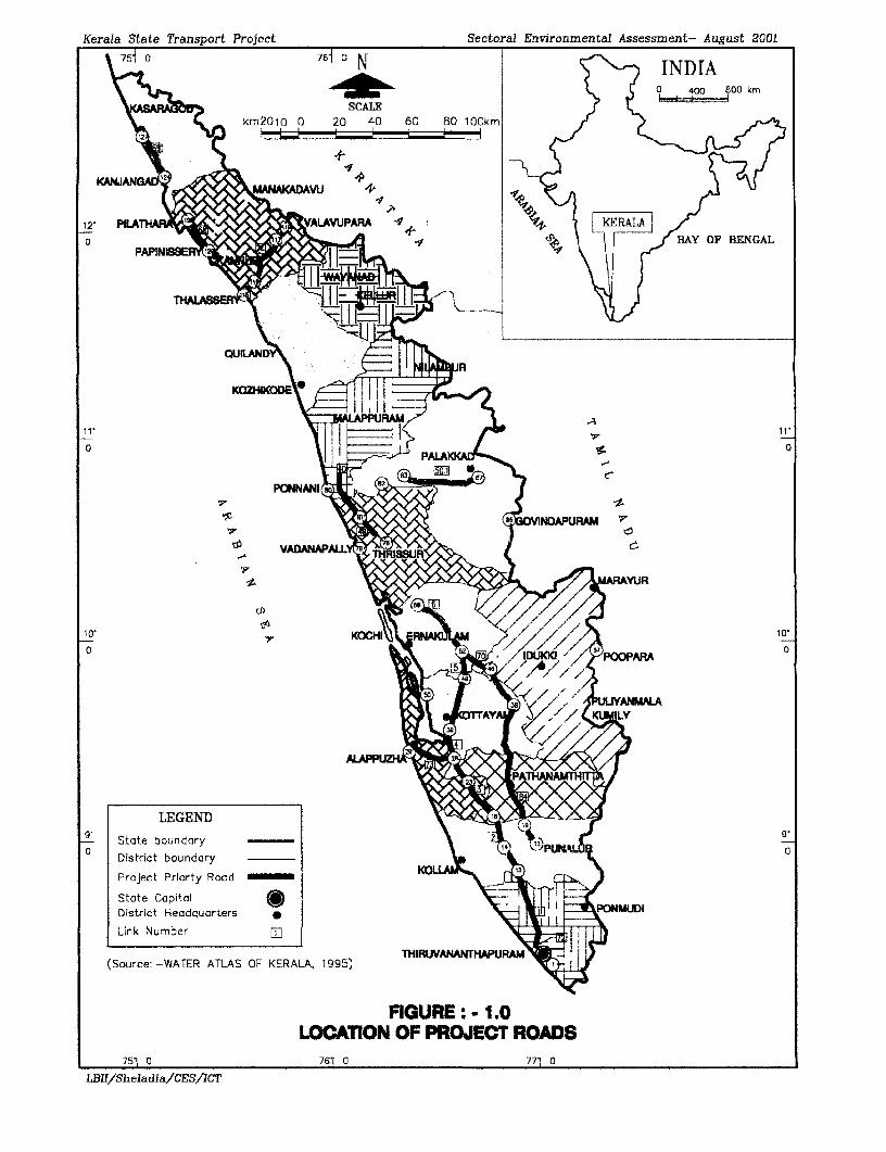
This document provides the Sectoral Environmental Assessment (SEA) for the roadcomponent of the Kerala State Transport Project for approximately 612 km of high priorityroads (Figure 1.0). This has been prepared to meet the requirements of the World Bank. Itspurpose is to present an evaluation of potential impacts due to the proposed upgrading andrealignment of the existing high priority roads selected under the KSTP.
Sectoral Environmental Assessment (SEA): The Sectoral Environmental Analysis for theI roads component precedes the determination of investment priorities: It is the first step in theEnvironmental Approval process and supports integration of environmental concerns into the3 long-term development and investment planning.
PROJECT LOCATION
The State of Kerala is located in the South-Western part of the Union of India. The State hasa total area of 38,864 Sq.km, 1.2 percent of the total area of India, and the populationrepresents approximately 3.4 % of the countrywide population. Its small area results in a veryhigh population density being, of 749 per sq.km. The State is bordered by the Arabian Sea onthe West and Tamil Nadu and Karnataka States to the East. Complete descriptions of theexisting conditions are provided.
I PROPOSED PROJECT IMPROVEMENTS
The road improvement and reconstruction aspects of the KSTP includes:
I - Widening to 7 or 10 m wide carriageway from the existing intermediate two lanewidths with an additional slow lane of 1.5 m throughout the more heavily traffickedroutes
- Pavement-strengthening,- Raising of the formnation level,- Drainage improvement with lined drains in all areas- Ducts of standard size on either side to take the utilities in urban areas and- Drains under foot path in the narrow sections of built-up areas- Footpaths will be provided in heavily built-up areas and adjacent to schools, hospitals
etc- 2.5 m wide sealed shoulders are planned but are required to accommodate the 1.5 m
| slow lane on some roads
I LBII/ SheladiaiCES/ICT F -S1
l
Kerala State Transport Project Sectoral Environmental Assessment- August 2001
\<0 ~761 N INDIA
\ > %> 5 0_48-if h.-00 kmSCALE
km20tO 0 20 40 60 80 100km
12' Pi l A VAL WP FU f , %
KOZHI
0
10 10
91 State boundary
0 PDistrict boundary
Project Priorty Rood
State CapitalDistrict Headquarters *Link Number
@ YADANAP^LL@THRUVAAN AP
(Source: -WATER ATLAS OF KERALA, 1995)
FIGURE: - 1.0LOCATION OF PROJECT ROADS
71s 0 761 0 771 0
Ll3IT/Sheladia/CES/ICT
Kerala State Transport Project Sectoral Enivironimiental Assessment- AuLusI 2001
Construction of bypasses - Proposal should be considered for Kattappana, Perumbavoor,| Thiruvalla, and Changanaserry.
Widening of the carriageway and associated land acquisition to expand the highway to twolanes with the exception of the areas designated for the construction of realignments.
APPROACH AND METHODOLOGY
The various steps followed for the Sectoral Environmental Assessment (SEA) have beenprovided in detail. The steps involved Reconnaissance studies, Feasibility screening studies,Strip mapping, Model studying, Assembly and Analysis of previously collected data,Identifying of primary data collection needs, Link Specific Environmental Data Analysis,
Determination of Potential Impact Area, Integration of Environmental Concerns into theDesign process, Public Participation and Consultations, Assessment of Alternatives andfinally the preparation of the Environmental Management Plans.
Further Sensitive and Critical Environmental issues have been isolated to create a SectoralEnvironmental Impact Assessment Matrix. In which all factors have been assignedweightings ranging from 0 to 3. A weighting of three represents a very high impact.
3 BASELINE CONDITION, POTENTIAL IMPACTS, AND MITIGATION EFFORTS
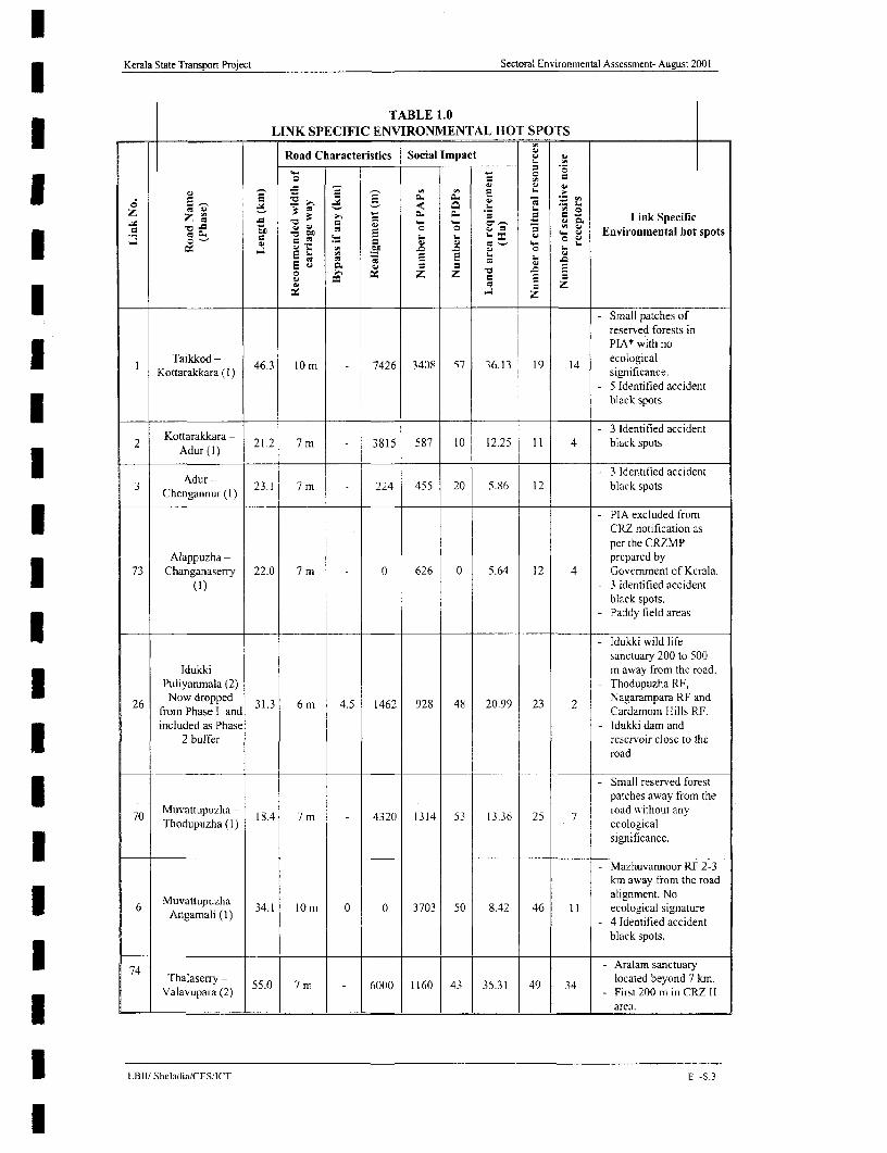
An abstract of the Project specific environmental hot spots are shown in Table 1.0. The SEAidentifies existing conditions, Potential Impacts and mitigation measures as follows
THE NATURAL ENVIRONMENT (METEOROLOGY)
Climate: The climate of Kerala can be broadly grouped into the following seasons:
SW Monsoon months - June, July, August and September, NE Moonsoon - October,November and December, Non Monsoon - January, February, March, April and May
I Potential Impacts: No "significant to area" climatic conditions or micro climatic conditionsare anticipated as a result of the proposed project improvements.
3 Mitigation: No mitigation actions specifically related to meteorological conditions arewarranted. Mitigation actions required by the climatic conditions (i.e. to address potentialdrainage problems, flooding, air quality impacts, etc.) are discussed under the appropriateheadings.
PHYSICAL SETTING
* Existing conditions: Kerala lies along the shores of the Arabian Sea, covering an area of38,863 sq km and is approximately 600 km long and 75 km wide at its widest point. Basedon physical features, it is divided into three geographical regions i.e. Lowland or sandycoastal region (< 7m), Midland region (7 to 76 m) and Highland or hilly region (>76 m).
The Southern and Western Ghats form the eastern boundary of Kerala and are divided by theI Palakkad Gap, a lowland area reaching into Tamil Nadu. The coastal areas are largely madeup of alluvial deposits whereas upland areas are made up of lower pre-cambrian rocksdivided in some areas by lateritic deposits. The coastal areas are dominated by alluvial soilsI whereas most of the mid-land region is covered by lateritic soils and much of the hilly areasby forest loam.
I L.BIIP SheladiadCES/ICT F -S _
Kerala State Transpori Project Sectoral Environmental Assessment- August 2001
TABLE 1.0LINK SPECIFIC ENVIRONMENTAL HOT SPOTS
- -~ Road Characteristics Social Impact L i
E-. 2 2 ~~~~~~~~a - Lin Secfio~ ~ I I - o .
O. DC _ to E _ _ - Environrnental hot spots
* a _ _ ; e ,< ._ es E _ =_ o v
o w X z z 2
S - Small patches ofreserved forests inPIA* with no
I Taikkod ( 46.3 lOn - 7426 3408 57 36.13 19 14 sejcolce.
- 5 Identified accidentblack spots
Kottaralckara - - 3 Identified accident2 Kotarakara 21.2 7m 3815 587 10 12.25 11 4 blackspots
; ~~~~~~~Adur (1I) .H - 3 Identified accident3 eAdur - 23.1 7 m 224 455 20 5.86 12 black spots
Chengannur*l) - PIA excluded fromI CRZ notification asper the CRZMP
Alappuzha- prepared by73 Changanaserry 22.0 7 m 0 626 0 5.64 12 4 Govemment of Kerala.
(1) - 3 identified accidentblack spots.
- Paddy field areasII- dukki wild lifesanctuary 200 to 500
Idukki - m away from the road.Puliyanmala (2) - Thodupuzha RF,
26 Now dropped 31.3 6 m 4.5 1462 928 48 20.99 23 2 Nagarampara RF andfrom Phase I and Cardamom Hills RF.included as Phase - Idukki dam and
2 buffer reservoir close to the
- Small reserved forestpatches away from the
70 Muvattupuzha - 18.4 7 m 4320 1314 53 13.36 25 7 road e ithout anyThodupuzha(I) eooia
significance.
- Mazhuvannoor RE 2-3km away from the road
Muvattupuzha alignment. No6 Muvattupuzha 34.1 10nm 0 0 3703 50 8.42 46 11 ecological signature
Angamahi (1) - 4 Identified accident
black spots.
* 74 - Aralam sanctuaryThalasenry - 55.0 7 m - 6000 1160 43 35.31 49 34 located beyond 7 km.
Valavupara (2) -First 200 min CRZI* - - - _ _ _ _ _ _ - - ~~~~~~~~~~~~~~~~~~~~~~~~~~area.
U LBII/ Sheladia/CES/IC T E -5.3
I

Kerala State Transport Project Sectoral Environmental Assessment- August 2001
lI_ _ _- - Very smallThonnakkal RF NW of
72 SH1-NH47 (1) 13.0 7 m 3545 1129 114 1.19 24 11 this road with noecologicalsignificance.
- Vedagiri RF near end4 ChengannLr- 47.0 l0im 2.0 2495 4227 NA 137 33 15 of the road.
Ettumannoor (2) 3 Identified accidentblack spots.
- Vedagiri RF,
Kuriyankunnu RF,Ettumanoor - Nedumala Rf.No
5 Muvattupuzha 43.0 7 m - 740 601 NA 71 35 14 ecological significance(2) identified
- 5 Identified accidentX _ black spots
- Piravanthur RF,Chethalvatti RF,Kadakaman RFENeramala RF,Karikulam RF (teak
84 Puna]ur- 134.0 7 m 7519 6927 NA 1090 139 51 plantation), KankkatturThodupuzha (2) RF, Kuriankunnu RF
and many otherreserved forests mainlyin the eastem side.I I Identified black
- Chenat Neyar RF,
50.1 Pa d 45.0 7 m 423 857 26 0.04 18 21 patches and NedumpuraRF No ecologicalsignature.
- Canals of ThrissurKolkrushi (paddy)Development Field
40 Thrissur- 33.0 10 m 1065 1408 35 0.13 15 19 crisscross areato theKuttipuratn (1) west of the road near
Punkunnam-5 Identified accidentblack spotsRoad in the CRZ IIII~~~~~~~~Plta area for about 3 km
68 Pappinlsshry (2) 21.0 7 m 530 949 NA NA 15 19 north of ChirukunnuPappinissery (2) - and located close to the
* ___ sea.
- Within 500 m of thehigh tide line for about5 km between Bekaland Kikana. But it is
69 Kasargode - 24.0 10 m 910 437 NA 23.2 32 8 situated beyond theKanhanghad (2) riwyln o bu
1.5 km. Bakel fort,situated very close tothe road is categorizedas CRZ7 1.
* PIA is the Project Influenced Area according to the MOEF requirement of 7 km on both sides (i.e., 14 km perpendicular with road asthe centre)Link 68, Link 69 and Link 84 phase 2 corridors and buffer link 26 require NIOFF clearance due to proximity to sensitive areas as per GOIgazette notification dated 10 April 1997.
LBIt/ Sheladia/CES/ICT E -SA

Kerala State Transport Project Sectoral Environmental Assessment- August 2001
Geology: Geologically the region of Kerala is occupied by four major rock formations.Chamockites are the most prominent rock types among the crystalline rocks. The rocksschist's and gneisses also cover large areas of the State. In addition to Crystalline rocks ofArchaean age Sedimentary Rocks of Tertiary age laterite capping the crystalline and
* sedimentary rocks. Recent to sub-recent sediments within the low-lying areas and rivervalleys are also widely seen. Laterite covers wide areas in Kerala. All along the midlandregions, it forms a residual deposit due to weathering of either crystalline or sedimentaryrocks.
The project roads that are exclusively located in the recent alluvial formations include
Alappuzha - Changanaserry - Link 73, Pilathara-Pappinssery- Link 68.0, Kasaragod -Kanhangad - Link 69.1.
I Soils: Broadly the soils most commonly found in the State are: - River alluvium, Brownhydromorphic soil and Lateritic soil. River alluvium type of soil developed along rivervalleys and occurs throughout the State cutting across extensive lateritic soils. The soil isvery deep with surface texture ranging from sandy loam to clay. It is very fertile having highwater retention capacity and containing plant nutrients which arc regularly replenished duringfloods. It supports cultivation of paddy, arecanut, pepper, tapioca and a wide variety ofvegetables. Brown hydromorphic soil is most commonly found in areas of wetlands and ismoderately rich in organic matter, nitrogen and potash but deficient in lime and phosphates.
Laterite is a typical weathering product under humid tropical conditions and occursthroughout the State. In general this soil is acidic in nature and poor in available nitrogen,poiash, phosphorous and organic matter. It is well drained and widely cultivated with aI variety of crops like coconut, tapioca, rubber, arecanut, pepper, cashew etc which can begrown successfully. Gravely soil of lateritic origin is generally available in the district forconstruction purposes.
I Existing and Potential Erosion: During the monsoon months all rivers and streams carryconsiderable amounts of sediment load to the sea. The higher level of precipitation in the3 State leads to erosion, landslides and landslips.
Quarries and Crushing Operations: The construction material survey carried out for thefeasibility study included the evaluation of material requirements for road pavement/shoulderI works, cross drainage and other structures, material specifications, identification of materialsources, stone quarries, extraction sites for sand and the testing and evaluation of materialsfor use in the works.
I Areas suitable for borrow pits (i.e. sources of material for the construction of embankmentsand use as fill) have been located in accordance with the Indian Road Congress Specifications.
I Potential Impacts. Physiography impacts could occur due to altered road embankments,borrow pit excavations and erosion. Drainage impacts include increased runoff due towidening of the roadway, but will be statistically negligible. Water quality in roadside pondsI adjacent to the Right of Way (ROW) may show slight improvements after road upgradingdue to reduced erosion. Storm drainage provisions will be upgraded to accommodate 50-yearfloods in the case of culverts and small bridges.
Mitigation. All necessary KSTP improvement actions will be taken to ensure embankmentstabilisation, including the selection of less erodable material, placing of gabions and riprapI and good compaction, particularly around bridges and culverts. Contract documents willspecify final forming and re-vegetation requirements. Trenching has been required where
LBIU/ Sheladia/CES/ICT E -S.5
Kerala State Transport Project Sectoral Environmental Assessment- August 2001
necessary to ensure successful establishment of vegetation. Monitoring and constructionI supervision pursuant to the terms of the contract will be undertaken by the ConstructionSupervision Consultant (CSC) to ensure that regeneration efforts are successful.
| WATER RESOURCES
Environmentally Sensitive Coastal belt: The CRZ regulations of the Government of Indiaare descnrbed in Chapter 2 and are applicable to a few project roads which require moredetailed environmental investigations as well as State and Central Government approvals.
Following the directive of the Government of India, the State Government prepared aManagement Plan, which classified the coastal belt into CRZ-I CRZ -II and CRZ-III for thesensitive coastal area in 1995.
CRZ I - The entire area between the low tide line and high tide throughout the Kerala coastexcept the CRZ-1I and CRZ-III comes under this category.
The project roads that are located in this area are Kasargod - Kanhangad and Pilathara -
I Pappinssery.CRZ II - All of the developed areas within the municipalities / corporations or other legallydesignated urban areas which have been substantially built upon and other infrastructurefacilities come under this category: Thalasery - Valavupara.
CRZ III - Areas that are relatively undisturbed and those, which do not belong to eitherCategory I or II. These areas are basically rural areas. In Kerala all areas falling in gramPanchayat (other than CRZ-1 areas) are demarcated as CRZ-ILL. Both the seacoast and thebackwater coast come under this category.
* Floods During Monsoon Season: Approximately 90 % of the rainfall is precipitated duringthe six monsoon months, the high intensity storms during the monsoon months result inheavy discharges in all rivers. The rivers consequently swell and the heavy discharges rapidlyreach the midland and coastal regions spreading over lagoons and backwaters raising thegeneral water level and submerging vast stretches of low-lying land.
| The monsoons cause the frequent flooding of road sections for many hours at a time.With this factor in mind, the design engineers have raised the formation level in appropriatesections. The flooding results in traffic disruption and damage to the road fabric. The raisingof formation levels will be required in these sections. The Alappuzha - Changanaserry Link73 section is the worst affected. In this section all bridges are at a higher level compared withthe road. Although large-scale improvement is required to avoid flooding the embankmentI height cannot be raised, as the available sub grade is very poor. This will be raised up to alevel of 100 - 300 cm only. The phase I design for this was completed in March 2001.
Cross Drainage Structures: The number of cross drainage structures required is naturallyvery high due to high rainfall and physiography. This is even more for a road with a northsouth alignment especially when located in the midlands. The number of cross drainagestructures and their locations with respect to road chainage are given in the EnvironmentalStrip Maps. The density of cross drainage structures is generally high in the order of three perkilometre. The designs for culvert widening are adjusted to one-side widening and both-sidewidening. There will be reconstruction were ever the existing structure is in a poor conditionand there will be new construction along the new alignments (realignments and bypasses).
Potential Impacts. No impacts to groundwater resources or aquifer conditions areanticipated as a result of the road improvements. Wells in urban and semi urban areas will
LBIAR Sbeladia/CESfICT E -S.6

Kerala State Transport Project Sectoral Environmental Assessment- August 2001
require replacement. There will be no net loss of water access points. In the event that wellsmust be relocated, temporary alternative water sources (e.g. new wells, trucked potable water)will be provided to ensure that local residents have daily access to clean water. No impacts onwater quality or availability of water for domestic or agricultural use will occur. Waterquality in roadside ponds adjacent to the ROW may show slight improvements after roadupgrading due to reduced erosion. Existing cross drainage structures will be replaced as anintegral part of the project road improvement. The project will meet complete constructionwater requirements from surface water sources such as rivers, streams, ponds and lakes.
Mitigation. New or replacement hand pumps will be provided as specified by theResettlement Action Plan and Environmental Management Plan. Care has been taken indesign to ensure that the road drainage provisions and the new embankments do not alter thecurrent status of natural water bodies and irrigation structures adjacent to the road. Contractprovisions have been incorporated in the bid documents to ensure that construction campsand other potential sources of secondary impacts are properly sited and provided withdrainage and wastewater facilities. No ground water is required for construction purposes.
Ambient Air Quality
Permissible air quality pollution levels have been established by the Central Pollution ControlBoard (CPCB) for six air pollutants. These are Suspended Particulate Matter (SPM).Respirable Particulate Matter (RPM) Sulphur Dioxide (SO2) Nitrogen Oxide (NO 2). CarbonMonoxide (CO) and Lead (Pb).
Kerala State Pollution Control Board has produced primary data on air quality under anagreement with the Project Implementation Unit of the PWD. The results are incorporated inthe report. The most significant observation is "the pollution low" observed every day in thenight when the traffic is very low. This also indicates that the pollution levels are not carriedover or accumulated because of the positive influence of very high biomass of the State.Except few black spots observed throughout Kerala the ambient air quality is observed to befair. Results of the detailed analysis are provided.
Potential Impacts. Potential air quality impacts during the construction phase of the projectcan be anticipated due to temporary dust generation in and around construction sites andrelated activities such as crushers and asphalt plants. The net air quality impacts during theoperational phase of the Project are expected to be beneficial when measured against a basecase that takes growth and related factors into account. Improvements in road surfacecondition and traffic capacity will reduce local congestion and improve traffic flow, therebyreducing engine idling and the contribution it makes to local air quality degradation. Nosignificant generated traffic (i.e. traffic that would not have existed if the improvements hadnot occurred) is anticipated as a result of the improvements. Except in the case of Link 72 nosignificant diversion of traffic from other roadways, other than incidental local traffic, isanticipated.
Mitigation. Construction-related air quality impacts will be mitigated by actions andrequirements specified in the contract documents. Asphalt plants are required to be located atleast 150 metres away from the nearest sensitive receptor (e.g. school, hospital) and properlyoperated. Contractors are required to install emission controls. Road surfaces, excavation andconstruction sites will be sprayed for dust control. Trucks carrying earth, sand or stone willbe covered with tarpaulin to avoid spilling. Sites will be watered to prevent dust generation,particularly at crushing plants. Machinery and equipments are required to be fitted withpollution control devices, and checked at regular intervals to ensure that they are in working
LBII/ Sheladia'CESACT F -S.7
l
KeTala State Transport Project Sectoral Environmental Assessment- August 2001
order. Traffic-related air quality impacts during the operational phase will be reduced by thealleviation of traffic congestion, thereby lessening air quality impacts. The road surfaceshould be cleaned and cleared by truck-mounded vacuum cleaners to avoid large scale dustformation while manual labour and brooms is used.
Noise
Existing Conditions: A noise impact is considered to have occurred if predicted noise levelsI approach or exceed the standards presented by the table or when the predicted traffic noiselevels substantially exceed the existing noise levels (usually at least 10 decibels aboveexisting levels). The Pollution Control Board has produced noise data under an agreementI with Project Implementation Init (PIU). The noise levels in general are high in the heavytraffic areas especially urban and semi urban localities. The maximum hourly variation ofnoise level is 70-100 dB for all urban and semi urban pockets while for typical rural areas and
* forest areas this is much less, i.e. 50-70 dB only. In all the locations where there is a highnoise levels there is an active nighttime vehicular movement and commercial activities didnot exhibit the low noise level in the night.
Potential Impacts. Temporary impacts in the immediate vicinity of the Project Corridor willoccur due to construction activities. Tabulations indicating Typical Noise Levels AssociatedI with Highway Construction, and Typical Noise Levels of Principal Construction Equipmentare provided. Following construction, the noise levels in the Project area are expected todecrease due to the lessening of congestion and the traffic noise it generates. In spite of thegeneral reduction in noise levels, some sensitive receptors are located in such close proximityto the roadway that the widening may result in adverse noise impacts unless mitigated.Mitigation measures are only usually applied when traffic is brought closer to the receptionby the proposed works.
Mitigation. Construction activities will be confined to social working hours and the| employing of noise controlled construction equipment will reduce noise impacts during the
construction phase. Public notification of construction operations will incorporate noiseconsiderations. Actions to mitigate impacts upon sensitive receptors may include the sound
3 insulating walls (a stone or brick wall to act as a sound barrier); green barriers for silencezones (a thick layer of green plantation with small leaves acting as noise attenuation) andincreasing the height of existing walls around hospitals/schools. Typical design drawingsI provided. Definitive noise levels will be determnined empirically at each site and selection ofthe mitigation technique will be made on a site-specific basis in consultation with propertyowners. Co-ordination and implementation will be the responsibility of the ProjectEnvironmental Officer.
Flora, Fauna and Ecosystems
Existing Conditions
Flora: The forests of Kerala are rich in terns of species diversity and economic value. Thereare over 500 species of identified medicinal plants. Other plants of economic value such ascoconut, arecanut palms, wild cashew, bamboos and pure reeds also occur.
Fauna: The physiographic, climatic and vegetation diversities support a range of habitatsI suitable for a variety of fauna. Important wild life species recorded are elephant, gaur, sambar,spotted deer, barking deer, wild boar, tiger, panther and bear. Nilgiri tahr, niliginri langurand lion-tailed macaque are some of the rare species found. Special measures are needed fortheir preservation. In order to improve the population of wildlife, ten wildlife sanctuaries, one
I LBII/ Sheladia/CESAICT E -S.8
l

Kerala State Transport Project Sectoral Environmental Assessment- August 2001
tiger reserve and one national park have been established in the State. In addition SilentValley, a unique patch of wet evergreen forest with rare faunal species has been declared as aNational Park recently.
National Parks, Wildlife Sanctuaries and Forest Reserves: The State's ecology is rich inits diversity and about 25 percent of its total area, i.e., 1,081,509 hectares, is forested. Thisincludes 915,115 hectares of reserve forests, 18,479 hectares of proposed reserve forests and189,087 hectares of vested forests. Wildlife sanctuaries form 204,247 hectares of these.Major forest products are timber, firewood, cardamom, honey, reeds, bamboo, sandalwoodetc.
More than 500 species of trees have been identified and the wildlife sanctuaries containmammals, such as elephants, tigers, leopards, lion-tailed macaque monkeys, and ibexincluding rare and endangered species. There are a number of National Parks and many of thewildlife sanctuaries are situated within them.
The Project road Idukki - Puliyanmala passes very near (500 to lOOOm) to the Idukki Wildlifesanctuary. Now the road has been dropped from further consideration in Phase I and includedas a buffer corridor in Phase 2.
Roadside (Avenue) plantation: In general there is an absence of planned roadside (avenue)plantations along the Project roads. However there are a few trees, which are either naturalgrowth or part of the earlier land use. The species commonly encountered on the roadsidesinclude Tamarind, Jackfruit tree, Jamun and Mangoes as well as occasional Banyan trees.
Potential Impacts: No impacts upon other protected lands in the area are anticipated. TheProject road improvements will require removal of 1-2 trees per kilometre on an average.Most of the trees are not planted but are natural growth or were planted in the very earlystages of the road.
Mitigation: A programme of compensatory trees planting has been prepared forimplementation to replace those removed as a result of the project. Adjustments have beenmade to save trees wherever possible by making suitable changes. Under current regulations,trees must be re-planted at a rate of two for each one removed depending upon the location.
Cultural Resources
Existing Conditions: Kerala has a rich cultural history with a long-standing presence of themain religious groups of India. Many temples, churches and mosques, as well as shrines,cemeteries and other sacred places of all three religions are located in close proximity to theproject roads and must be used necessary to protect them.
Details of the shrines, churches, temples and mosques in the immediate vicinity of the Rightof Way and needing to be protected were identified during the study.
Potential Impacts: Except for temporary structure (Kutcha) in some cases (if sociallyacceptable) no other cultural resources will be affected by the KSTP road improvements.
Mitigation: Road designs have avoided almost all religious structures by making suitablechanges in the alignment. The project has prepared a cultural property rehabilitation policy toaddress all related issues.
General Economic Environment
Socio-economic Conditions2 : The annual per capita net State domestic product in 1994-95was Rs. 8,007 as compared to Rs. 8,403 for India as a whole. 31.4 percent of the population
I LB11! Sheladia/CES!ICT E -S.9
Kerala State Transport Project Sectoral Environmental Assessment- August 2001
are in the main or marginal work force including 47.6 percent of males and 15.8 percent offemales. In 1991 there were 5,459,474 occupied residential units in Kerala, 4,076,775 (74.7percent) in rural areas and 1,382,699 (25.3 percent) in urban areas. Of these 56.0 percent arepucca (high construction standard), 19.1 percent semi-pucca (moderate construction standard)and 24.9 percent kutcha (mud and thatch). 92.4 percent of residences use wood for cooking,48.4 percent are connected to electricity, 18.9 percent have a safe drinking water supply and51.3 percent have toilets.
Agriculture: The economy of the project influence area is largely agriculture oriented.The resource potential for the development of agriculture and its importance to the areaeconomy varies from district to district. The importance of agriculture and allied activitiescould be assessed in terms of the main work force by sector and sectoral contribution todistrict income. The resource potential, apart from the land-use pattern, depends on the sizeof holding, irrigation facilities, soil condition and farming technique.
Minerals: Kerala has rich deposits of clay and beach placers (Ilmenite, Monozite, RutileGarnet and Sillimanite), which have earned the State an important position in the mineralmap of India. The State is not well endowed with other mineral resources although there aredeposits of Clay (fire clay, ball clay, china clay and tile clay), Glass sand, Graphite, Bauxite,Iron ore and lime shell etc.
Project Specific Significance: The KSTP will positively help the mineral industry in Kerala.
Livestock and Poultry: The livestock and poultry population is widely dispersed in the State,with major concentrations in rural areas.
Industry
Registered Factories: The registered factories are widespread over Kerala districts. Thenumber of factories, in 1997-98, varied greatly amongst districts from one percent to over 15percent of the State total.
Medium and Large Scale Industries: At the end of March 1998, there were 474 mediumand large-scale industries in the State.
The most common industries in Kerala are: Vegetable and foodstuffs (eg: alcohol), Fruit(Canned fruit and Juice), Beverages (Tea, Coffee), Cocoa (Chocolates), Industrial Crops(rubber to tyre Vegetable fibres; Vegetable oils, coconut oil etc.)
Marine Life (frozen, dried, pickled and canned fish), Forest products (wood, plywood,decorative veneer etc.)
Building materials and related, items include china clay, lime-stone, lime shell etc. Non-metallic minerals (Graphite), Metallic minerals (e.g. Iron, Aluminium, Gold), Beach sands(Titanium, Silica sand etc), Power intensive industries (Caustic soda, Ferro silicon, Siliconetc), Medicinal herbs (Phyto chemicals, Vitamin C, Beta lonone), Intermediate Products(Toilet soap, Tooth paste, Knitted good, Textiles, Nylon Filament yam, printing and writingpaper, Ayurvedic preparations, Chemicals, paints and varnishes, Industries based on phenolindustry Formaldehyde etc.)
Impacts: The project road has many paddy fields as indicated in the Environmental Stripmaps. Some are kept idle for many years while others are being used for other AgriculturalCrops.
Mitigation: The project takes paddy field areas only at those places, which are regarded asabsolutely essential on account of road safety.
LBI/ ShehdiadnCES/ACT E -S.lO
l
Kerala State Transport Project Sectoral Environmental Assessment- August 2001
Tourism: With favourable weather and natural beauty, tourism is projected to forrn animportant part of the State's economy. The major tourist attractions in the State are theKovalam Beach resort, houseboats on the canals and backwaters, and wildlife sanctuaries atThekkady, Parambikulum (Palakkad district), Sultan Bathery, Wayanad and Mananthavady.I Thrissur is the cultural centre of the State and the famous Kathakali centre. Kalamandalam, isa place of interest for art lovers. The Sabarimala temple of Lord Ayappan is a famouspilgrim-tourist centre. It is estimated that over eight million people visit the shrine annuallyduring November to January period. The pilgrims use many roads in Kerala to reachSabarimala. The most used would be Punalur - Thodupuzha. This road will be developed toits full potential within the limitations of the Kerala State Transport Project in phase 2.
Public Services: The Social development of Kerala has attained commendable success.Kerala is the land of high literacy and health care where enrolment in primary schools isI nearly as high as in Western Europe and infant mortality rates are as low as in New York.
Irrigation And Hydro Power: Until recently the State has only hydroelectric projects for| Power generation. The total installed capacity of the State is 1401 MW.
All of the completed major/medium irrigation projects were intended originally for irrigatingpaddy alone mainly to stabilise the second crop and create the possibility to raise a third. It isI estimated that the 10 completed projects cater for 77,085 ha (net) or 150,000 ha (gross).Eleven major/medium projects have been partially commissioned. These projects address theirrigation needs of 78,670 ha.
Potential Impacts: The general economic impacts as a result of the proposed action will bebeneficial and enhance the efficiency of the economy.
I Mitigation. None required
General Social Environment
I Kerala has the distinction of being the only State with the sex ratio favourable to women. In1991, there were 1036 women for every 1000 men as against the all - India figure of 927. Theliteracy rate of over 90 percent is the highest amongst Indian States and compares with 52.2
* percent average for the country as a whole. The other prominent social feature is thecontinuously inhabited areas (settlements) along the roadside throughout the length andbreadth of the State. The State is accessible by road, rail, sea and air from the rest of thecountry.
Education; In the education sector Kerala's achievement is unique in that it attained thehighest literacy rate in India of 89.01 percent in 1991 whereas the all India level was 52.21percent. The female literacy rate was as high as 86.17 percent in Kerala, compared to 39.20percent at the national level. The literacy rate among scheduled castes was 79.66 percent andI their female literacy was 74.31 percent.
Population Including Tribal People: According to the 1991 census, the population ofKerala was 29.098 million in an area of 38,863 sq.km. The population density is 749 personsper sq. kin, with 73.61 percent of the total population living in villages. It must be noted,however, that the dividing line between urban and rural areas in Kerala, as it is understood inanthropological literatutre, is very thin. What is officially noted as a town in the census isbased on whether it has a municipality, which again is determined on the basis of the censusoperations.
LBIL' Sheladia/CES/[CT E -S 11

Kerala State Transport Project Sectoral Environmental Assessment- August 2001
There is a small tribal population in Kerala, about one percent of its total population.
Agriculture: In the absence of an effective industrial base, agriculture forms the mainoccupation for half of the people of the State. Within agriculture, there is a predominance ofcash crops, such as, cashew nuts, tea, coffee, coconut, and rubber. Rice and tapioca areimportant food crops. The State is not self-sufficient in food crop production.
Paddy Fields: Paddy fields are treated as a sensitive land use in Kerala. The StateGovernment has been trying for many years to prevent the conversion of these areas into non-agricultural uses. There have been a number of measures introduced over many years, the lastof which was the development of a Paddy Development Board in 2000. The main controllinglegislation is still the Land Utilisation Order of 1967. The reasons for conversion of Paddyfield include Non profitability, Labour intensive with associated high costs, Labour shortage,and the population pressure due to proliferation of nuclear families for small residential plots.
The KSTP roads have many paddy fields adjacent as Indicated in the Environmental stripmaps. Some land is kept idle for many years while some paddies are already used for otherAgricultural Crops. The project takes paddy field areas only at those places, which areregarded as essential on account of road safety.
Project Specific Scenario: The households bordering the high priority road network aresimilar to those described above. The Environmental strip maps show the observedcharacteristics along the corridors.
Potential Impact:. The Phase I KSTP road improvements will necessitate land acquisition of42.29 ha including realigned sections. This figure includes both Government and privatelyowned land. The primary community impact of concern has been identified as the impact onrealigned/bypassed communities due to the fact that the existing ROW within the bypassedcommunity may revert to Local Government control. Local Government bodies are notequipped to deal with any environmnental degradation they may "inherit". Mitigation actionsrelated to social impacts are addressed by the RAP.
Mitigation: Actions to mitigate potentially adverse impacts upon realigned/bypassedcommunities will include the provision of assistance to local Governments to seek fundingfor the alleviation of environmental degradation along any of the existing ROW, which mayrevert to them. The RAP addresses mitigation actions related to other social impacts.
Project Specific Land Use Characteristics And Issues:
Land use in lowland: Coconut trees are present all over the coastal belt. Occasionally thereare paddy fields, backwaters, streams, canals and river mouths. Normally every householdhas a garden attached, often separated by a boundary wall or fencing. The garden is usuallymixed in character with Coconut, Plantain, Vegetables, Jackfruit trees, Mango trees,Tamarind etc.
The paddy fields are situated in the valley fill areas, which are fast decreasing in extent.
Land use in midland: In the midlands coconut and paddies are the main cultivation. There israrely any house in Kerala, especially in non-urban areas, without Coconut trees. The coconuttrees are usually mixed with other crops like plantains, Tapioca, Pepper, Arecanut, Pineappleand vegetable crops. In the coastal areas coconut plantations are very common. Normallyevery household has a garden attached to it exact by as in low land. The paddy fields occur inthe valley fill areas, which are fast decreasing in extent.
I LB1II Sheladia/CES/lcT E -S. 12

Kerala State Transport PToject Sectoral Environmental Assessment- August 2001
Land use in highlands: In the highlands other plantations are found, like rubber, Tea, Coffee,Cardamom, Pepper, Cashew etc. Normally every household has a garden attached to itusually without any boundary wall. The garden is usually mixed in character with Plantain,Vegetables, Jackfruit trees, Mango trees, Tamarind etc. The Reserved forests, sanctuaries andnational parks are mostly located in the highland region.
The paddy fields are the valley fill areas, which are fast decreasing in extent. In the highlands,paddy fields are few except in the Wayanad and Palakkad districts. The project roads areusually bordered by the land use characteristics mentioned above.
TRANSPORT NETWORK
Transport Sector: Transport development plays a crucial role in improving the Stateseconomic performance and the well being of its population. In this regard, the provision ofefficient, safe and economical services is an important feature of any transport system.
The road network in Kerala, on 31 March 1998, maintained by different agencies totalledover 219,805 km in length. Of this, Panchayat roads were 181,251 km and accounted for82.5 percent of the total road network in the State. These are low-order gravel country roads(hardly 2 percent are black topped) providing links to rural settlements. National Highwaysand PWD-maintained roads are the most important and accounted for 10.6 percent of the totalroad network. National Highways 47, 17 and 49 with a total length of 1,011 km traverse theState and provide inter-state linkages. These are the most heavily trafficked roads in the State.
Potential Impacts: The primary impact of the project road improvements will be to improvethe performance of the transport sector and facilitate improved flow of traffic, goods andtravellers. The project road improvement is also expected to benefit the economic growth ofthe area. No significant adverse impact to the area transport systems is anticipated.
Mitigation: Other than the features incorporated in the highway improvement project, noadditional mitigation related to impacts on the area transport net work is warranted.
Human Health and Safety
Existing Conditions: Human health and safety issues include the transmission of diseasesalong previously undeveloped corridors; contamination of local water supplies; air and noisepollution; and issues related to road safety and accidents. Of these, road safety causes thegreatest concern.
Environmental Aspects of Road Safety and Road Traffic Accidents: This section focuseson the most important problem of Road Safety, especially pedestrian safety on Kerala roads.A detailed review of some aspects of road safety is furnished in this section.
Potential Impacts. Road safety factors will be substantially improved by the proposedimprovements.
Mitigation. Strengthening of police enforcement will be encouraged and accommodated.Provisions have been incorporated in the project to alleviate areas of congestion. Road safetyissues are being addressed by the introduction of a Road Safety Specialist into theConsultants team. The project has provision for parking areas, bus bays and otherenhancement facilities that will positively contribute to road safety.
LBIJ/ Sheladia,CESllCT I -S.t3
l

Kerala State Transport Project Sectoral Environmental Assessment- August 2001
Social Impacts and Mitigation Plan
Social Issues The Government of Kerala has approved R and R Principles and Policy framework in August 2000. The project has prepared a Resettlement Action Plan for Phase 1 roadsto effect land acquisition and also to address direct social impacts and issues. The projectneed widening at three types of locations mainly 1) congested market areas with denseplacement of structures, including legal titleholders of land plots and structures, and legal orI illegal squatters, 2) Built up residential areas along the road where there is a requirement foracquisition of land from existing walls and parts of the compound and/or structures and 3)Roadside agricultural/plantation land.
Impacts The RAP records that 13,487 individuals are project-affected persons (PAPs), ofwhich 7,130 are project-affected families (PAFs), 1,070 are project displaced persons (PDPs)and 799 are project-displaced families (PDFs). The encroachers and squatters are aninsignificant minority, holding respectively 26 and 39 small properties among the totalaffected properties of 3816. Tenants occupy 857 (22%) of the affected properties. Theimprovement of the Phase I - project roads requires 42.29 ha of land.
Mitigation As a result of mainstreaming participation of beneficiaries and potentiallyX affected persons and a socially responsive design process, the project incorporates measures
that significantly avoid, reduce, or otherwise mitigate many adverse social impacts associatedwith highways improvements. The impact on the total population has been reduced byapproximately 50%. The number of project displaced persons has been reduced byapproximately 75%. The impact on the buildings has been considerably reduced byapproximately 66% and 74% for residential and commercial, respectively.
ANALYSIS OF ALTERNATIVES
"With" And "Without" Scenarios (No Action Alternative): In the case of the KeralaState Transport Project, consideration of this alternative must be cognisant of the fact that thecapacity of the project roads is insufficient for the volume of traffic. Traffic flow is impairedI by severe conflicts between local and through traffic, mixed with pedestrian movements andby continuous ribbon development and inadequate and / or inappropriate roadside facilitiesalong the narrow corridors. These dangerous conditions and the environmental consequences
X (air and noise pollution and degraded environmental conditions) will continue and worsen.Population growth and traffic increases will continue and exacerbate an already criticalsituation. The "No Action" Alternative would amount to a failure to initiate highwayI improvements, thereby impeding economic development. The "with" scenario, on the otherhand, has been determined to be economically viable and would alleviate these conditions toa considerably degree. It would, thereby, contribute to the development goals of the State,
c improve road safety conditions, enhance economic efficiency and growth potential of the area,and improve the well-being and livelihood of those within the potentially affected area.Potential negative environmental impacts associated with the "with" scenario can be avoidedI through good engineering practice and, where warranted, appropriate mitigation actions asspecified herein. Accordingly, it has been determined that the "No Action" alternative is nota reasonable or prudent course of action.
Design Decision Constraints For Various Alternatives: Because of the unique nature ofKerala, the team of Engineers, Economists, Sociologists and Environmentalists of PCC and3 PWD initially had conflicting ideas on the most appropriate designs most suited to the Keralasituation. This solution needed to be practical with a minimum of social and environmental
* LB]I/ SheladiaCES/ICT E -S. 14
l
Kerala State Transport Project Sectoral Environmental Assessment- August 2001
disturbances and with an optimum economic return. Besides large scale environmental andsocial field investigations, discussions, debates and workshops were also held to crystallisethe issues so as to arrive at the best design decision. These meetings were held at Government,Department and Consultants level and also with Public Participation at various stagesinvolving experts from related fields individually and sometimes collectively. Thesedeliberations were also held in the field on the project roads for better understanding amongthe specialists involved. A number of design decision constraints were discussed.
Site observations quickly revealed the need for much greater attention to road safety and theprovision of footpaths, policy areas and bus bays along many of the roadsides, which weresubject to ribbon development, village shopping and school servicing.
The widening of the pavement with the provision of footpaths in built up areas as necessarywould result in a seven-metre width pavement and 2.5-metre wide footpaths/shoulders. Thisstandard could only be accommodated within a 12 metre physical Right of Way, with somenarrowing if necessary, to avoid the costly acquisition of roadside property.
The costs of land and accommodation works are very high and the designs need to avoid evensmall areas of land acquisition wherever possible.
The improvement alternatives considered by the Consultants have generally been (1).Improve to a 7.0 m wide carriage way with sealed shoulders and lined drain (2). Improve to a7.0 m main carriageway with two 1.5 m wide auxiliary lanes and 1.0 m sealed shoulders(total 15 m) and (3). Improve to dual two lane carriageways (later abantdoned)
Bypass alternatives: There were nine bypasses considered for urban / semi urban area inorder to avoid potential social impacts, to reduce accident rates and also to accommodate theever increasing traffic. Also along these sections pollution level would be considerably easeddue to the free flow of traffic. The bypasses considered were at Perumbavoor, Kattapana,Nilambur, Manjeri, Thrissur, Thiruvalla, Kottayam, Changanaserry, Chengannur urban andsemi-urban areas. Many of these have been dropped from further consideration. At presentonly Thiruvalla and Changanaserry are being considered for further follow up.
Junction Alternatives: The standard IRC layout for junctions of major routes provides forlong visibility splays and large turning radii, where land areas on the present road geometryallows, this solution has been sought in the junction designs. Many of the major junctions inKerala occur in town centres or at least in heavily built-up areas. If the full IRC treatmentwere to be used in these locations the new junction layout would result in the demolition ofmajor areas of the centre. The alternative to a modified IRC standard is the provision ofsignal-controlled intersections or the use of mini roundabouts.
PUBLIC CONSULTATIONS
The official level consultations started with the project environmental investigations in April1999. These consultations where conducted for the Preliminary Environmental ScreeningStudy for feasibility studies reported in April 2000. Three regional scoping workshops wereheld during January-February 2000 at Thiruvananthapuram, Kochi and Kozhikode. Thedetails of the key participants, venue, subjects discussed and other aspects are documented.Most of the discussions focussed on the road safety aspects. A number of project specificconsultations were also held along the project roads.
At the generic level, stakeholders voiced concern with:
- Potential maintenance inadequacies;- Insufficient participation;
L1311/ Sheladia/CES/ICT E -S. 15

Kerala State Transport Project Sectoral Environmental Assessment- August 2001
- Lack of transparency;U - Insensitivity to social and environmental dimensions;- Non-adherence to environmental requirements and regulations;- Lack of coordination among Government Agencies; andI - Potential resettlement and rehabilitation failures.- Roads Safety issues
All these aspects were considered during the Phase I design as provided in the report.
Environmental Enhancements: Being a very densely populated State with extensive ribbondevelopment, market areas and pedestrians, a variety of environmental enhancements3 measures have been considered. For environmental enhancements tree and shrub plantingalong 'OXBOW LANDS' is recommend to protect the land from environmental degradation.Typical designs are provided.
The other important measures are
* Bus bays, Bus waiting sheds to be provided in the Project designs| * Parking areas for cars, auto-rickshaws, jeeps, tempos and mini lorries
* Service roads when realignment/bypass is proposed and implemented in theurban and semi urban pocketsI * Safe road junctions
- Proposal for the development of 'OXBOW LANDS' into rest areas in ruralareas
* 0OXBOW LANDS could provide sites for toilet facilities, and eating places* Trees shrub planting and parking along the OXBOW LANDS* Cultural property rehabilitation and enhancement* Borrow and quarry are development and rehabilitation plan
Project Specific Impact Mitigation Measures During ConstructionI The impact mitigation measures for the following impacts have been addressed by the Project.
Construction waste disposal: Adequate environmental cost has been budgeted forconstruction waste disposal. Adequate budget have been proposed for sewerage and wastedisposal during construction period. Necessary contractual clauses are also included.
Operation of construction equipments: The contractors need to use only equipments ofinternational standard. Necessary contractual clauses have been included in the EMAP.
Sewerage and solid waste from Construction Company: Adequate environmentalmitigation costs are provided to minimise the dust and noise nuisance to public duringconstruction.
ENVIRONMENTAL MANAGEMENT PLAN (EMP)
The Environmental Management Plan (EMP) summarises the mitigation measuresincorporated within the design process and the measures identified for action in the3 construction and operational phases. The EMP specifies the nature of the potentialenvironmental impacts, the measures, which have or will be taken, the timeframe in whichthey are taken, the implementing agency and responsible organisation, and, where appropriate,the Specification for Construction for enforcement of the measure. Institutional arrangementsfor Project consist of the appointment of an experienced Environmental Officcr. Details ofthe organisation and staffing; environmental training; monitoring, reporting; and recordkeeping are provided.
| LBtl Sheladia/CES/ICT E -S.16

Kerala State Transport Project Sectoral Environmental Assessment- August 2001
These are under three sub headings.
Environmental Monitoring and Training. This includes the cost of staff assigned to theoversight of air, noise and water quality monitoring including the cost of necessary training andinstitutional strengthening.
* Tree and Shrub Planting. Detailed breakdowns indicating the derivation of these costs for theProject.
3 Construction-Related Environmental Mitigation Costs. This includes the costs of
- Water Spray For Dust Suppression- Proper Sewage Disposal During Construction
* - Proper Waste Disposal At Service Centres- Noise Mitigation- Maintenance Cost In Soil Conservation
Construction/Replacement Hand Pumps Subject To Impact- Tree and shrub along 'OXBOW LANDS'
ENVIRONMENTAL SAFEGUARDS FOR PROPOSED ROAD MAINTENANCEACTIVITIES
The project identified approximately 612 km as high priority roads from the 3000 km offeasibility study roads. The remainder have been subjected to further studies including HDManalysis to prioritise approximately 1000 km roads for periodic maintenance in three phases.
The environmental problems associated with maintenance activities are mainly constructionrelated. The impacts and mitigation activities are provided.
Maintenance Activities include: -
* Road Inspection * Overlaying and provision of shoulders
* Vegetation Control * Pothole filling
3 . Cleaning of drains * Patching
* Bridge, culvert and retaining wall repair * Shoulder repairs
* Crack sealing * Resealing* Pavement markings
All proposed maintenance activities were examined to develop a generic Environmental ManagementI Plan. The maintenance activities will be taken up without any tree cutting. In the case of squattersand Encroachers the Highway authority will follow 'Status Quo'. Without any widening or lanecorrection.
I ENVIRONMENTAL CLEARENCES AND APPROVALS
The SEA analysis clearly brought out the various environmental approvals required for fourI links. None of the phase I corridor qualifies for GOI environmental clearances.
LINK NAME OF PROJECT REASON FOR CLEARANCE REMARKSROAD REQUIREMENTI 26 Idukki - Puliyanmala Proximity to Idukki Wildlife Dropped from phase
sanctuary I an included asphase 2 buffer.
84 Punlur- Thodupuzha Proximity to Forests Phase 2 corridor
68 Pilathara - Pappinisserry Costal Regulation Zone (CRZ) Phase 2 corridor69 Kasarkode - Kanjagad Costal Regulation Zone (CRZ) Phase 2 corridor
LBII/ Sheladia/CES/ICT E -S.17
l

Kerala State Transport Project Sectoral Environmental Assessment - August 2001
1 INTRODUCTION
1.1 THE PROJECT
The Government of Kerala (GOK), through the Public Works Department (PWD), hasinitiated a programme to upgrade critical sections of the State's road network under theKerala State Transport Project (referred to hereinafter as the KSTP or "the Project"). TheProject is supported by the International Bank for Reconstruction and Development (theWorld Bank) and, assuming the GOK's loan application is approved, construction of theproposed road improvements will commence in late 2001. Approximately 87 potential Roadsections had been identified for study. The Project requires World Bank, Government ofIndia (GOI) and GOK environmental clearances and approvals before construction canproceed.
In addition to the roads study, an Inland Water Transport Pilot Scheme forms part of thecontract with the original Kerala project title as 'Kerala State Highways Project with InlandI Water Transport Pilot Project'. Although this study is administered under the same contract,its preparation and reporting was carried out separately. The Interim Report for that work wassubmitted in October 1999. The other submissions included the preliminary engineeringI report in March 2000, Environmental Assessment report in April 2000 and the SocialAssessment report in May 2000.
3 SECTORAL ENVIRONMENTAL ASSESSMENT (SEA): The Sectoral EnvironmentalAnalysis for the roads component precedes the determination of investment pnrorities. It is thesubject of a Sectoral Environmental Assessment (SEA) and is the first step in theI Environmental Approval process. The SEA also supports integration of environmentalconcerns into the long-term development and investment planning. The following advantagesof SEAs, some of which are specific to Kerala State Transport Project (KSTP) are noted: -
* SEAs can prevent serious environmental impacts by analysing sector policies andinvestment strategies in the planning process before major decisions are made.
* SEAs can assist governments in forrning a long-term view of the Sector and canincrease the transparency of the sectoral planning process (to show the reasoningI behind the development plans) thereby decreasing the need for purely politicaldecisions which might be environmentally ill informed or harmful.
* SEAs can help to alter or eliminate environmentally unsound investment alternativesat an early stage, thus reducing overall negative environmental impacts in inopportuneor wasteful preparation activities and also eliminating the need for project specificEIA's of these alternatives.
* SEAs can valuable for collecting and organising environmental data and inidentifying data gaps at an early stage; also for outlining methods, schedules andI responsibilities for data collection and management during the programme or projectimplementation.
PROJECT STATUS: The Corridor specific EIA's for Phase 1 roads have been prepared. At atime when World Bank funding was likely to be two years distant, the State Governmentdecided to proceed with the detailed design of four high priority roads. Accordingly the
* Consultants were instructed to prepare Project specific EIA reports for these project roads.The Consultants suspended the preparation of the SEA for a few months as there was only
IIBIL'Sheladia/CES/ICTLBii!Shcladia/'CES/ICT 1. 1

Kerala State Transport Project Sectoral Environmental Assessment - August 2001
one Environmental Engineer engaged in this work. The main purpose was to use Stateresources immediately and to apply for retroactive World Bank financing. The draft EIAreports for the following links prepared and submitted to the PIU in July 2000.
1. Link 1, Taikkod - Kottarakkara
2. Link 70, Muvattupuzha - Thodupuzha and
3. Link 6, Muvattupuzha - Angamaly
SEA OBJECTIVES: The objective of the SEA is to examine which corridor-specific ELAswould be prepared only for those road sections deemed to warrant such action in accordancewith all appropriate GOI regulations and World Bank operational procedures.
This Sectoral Environmental Assessment (SEA) has been prepared to meet the requirementsI of the World Bank. Its purpose is to present an evaluation of potential impacts and issuesgenerated by the proposed upgrading and realignment of the road links identified fordevelopment.
Further the Sectoral analysis will also reveal the cumulative impact of widening andimprovement of all road components of the Kerala State Transport Project (KSTP) including
* maintenance component.
1.2 EARLIER STUDIES
U 1.2.1 Strategic Option Study (SOS)
The current project developed from the Strategic Option Study report of April 1997. ItSI recommended 2810 km for detailed studies following the investigation of the State road
network in terms of traffic flows and road capacities. Selection was made as those roadsdemanding the highest priority for investigation based upon the volume of traffic using each
J road, future traffic projections and the existing width and hence capacity of the existingcarriageway at that time. Except the Sabarimala pilgrimage season, no other environmentaland social aspect was considered for the study.
1.2.2 Feasibility Study
A fcasibility study was carried out for the 2810 km (68 Links) idcntified by the SOS studyexcept for the 330 km that were later declared National Highways. At the time of theirupgrading to National Highways a number of surveys including environmental and socialI impact surveys had been carried out. These roads were later dropped from further study andthe data generated were passed to the Project Implementation Unit (PIU) for use by the1 National Highways Division of the PWD.
The preliminary environmental and social impact analysis and screening undertaken duringthe feasibility study was one of the keys to decision making. The environmental screeningI study identified and listed those road segments, which passes through ecologically sensitiveareas (Feasibility report April 2000).
| 1.2.3 Additional Feasibility Study
Following the submission of the initial feasibility study report, the Govemment of Kerala| proposed an additional 707 km of roads for investigation. As a result the Consultants carried
out reconnaissance surveys and further studies for the additional roads. Since the SOS study
LBlISheladia/CESICT 1.2

Kerala State Transport Project Sectoral Environmental Assessment -August 2001
report of 1997 the socio-economic scenario of Kerala had undergone major changes relativeto other parts of India. The most notable being the establishment of a world-classinternational airport in Kochi (officially declared in June 2000) and the declaration thatKerala is the first 100 % literate State in India.
1.2.4 Reconnaissance Work For Additional Feasibility Studies
The Consultants undertook further reconnaissance studies on an additional 19 road sections,some of which could not be pursued, as they required many kilometres of new roads alongdense forests and sanctuaries.
1.2.5 KSTP Road Safety Audit Report
This Road Safety Audit was carried out at the request of the Government of Kerala and withthe support of the World Bank and the PCC. There is no Road Safety Audit Manual for Indiaor Kerala but Road Safety Audit is described in the Manual for Safety' in Road Design,published by the Ministry of Surface Transport. The Road Safety Audit report wasspecifically aimed at improving the 23 sections of highway in the Phase I and Phase 2 of theKerala State Transport Project. The recommendations are being addressed by the Project.
1.2.6 Independent EA Review Report
Being a Category A project, the World Bank requires an Environmrental and Social Review ofall EA and Social documents including RAP by an Independent Consultant. TheEnvironmental and Social Review of KSTP was completed by SMEC in early August 2001.This has created some additional work with regard to EA documents. These are beingcurrently addressed. The SEA has addressed the important recommendations of theIndependent Review Consultants.
1.3 ORGANIZATION OF THE DOCUMENT
Based on the procedural and regulatory requirements, the SEA is organized in accordancewith the World Bank Guidelines for the preparation of Sectoral Environmental Assessment asgiven in the Environmental Assessment Source Book Update Number 4 of October 1993.Additional information in the form of World Bank guidelines is also incorporated. WorldBank Operational Policy 4.01 and the recommendations of World Bank Technical PaperNumber 376: Roads and the Environment: A Handbook. The entire document is organised inTwo Volumes:
Volume I Main Report and
Volume II Appendices
The volume I document is therefore organized as follows:
* Section 2.0 - Project Policy Legal and Administrative framework - Presents thelegal and administrative requirements of the World Bank, Government of India andGovernment of Kerala, PWD.
* Section 3.0 - Project Description - A brief description of the KSTP, the componentsof the Project, the manner in which the priority road links were identified and detailsof the proposed actions.
* Section 4.0 - SEA - Approach and Methodology - Presents the methodologyfollowed, different steps in the Sectoral Environmental Assessment process, initial
LBII/Sheladia/CES/ICT 1.3
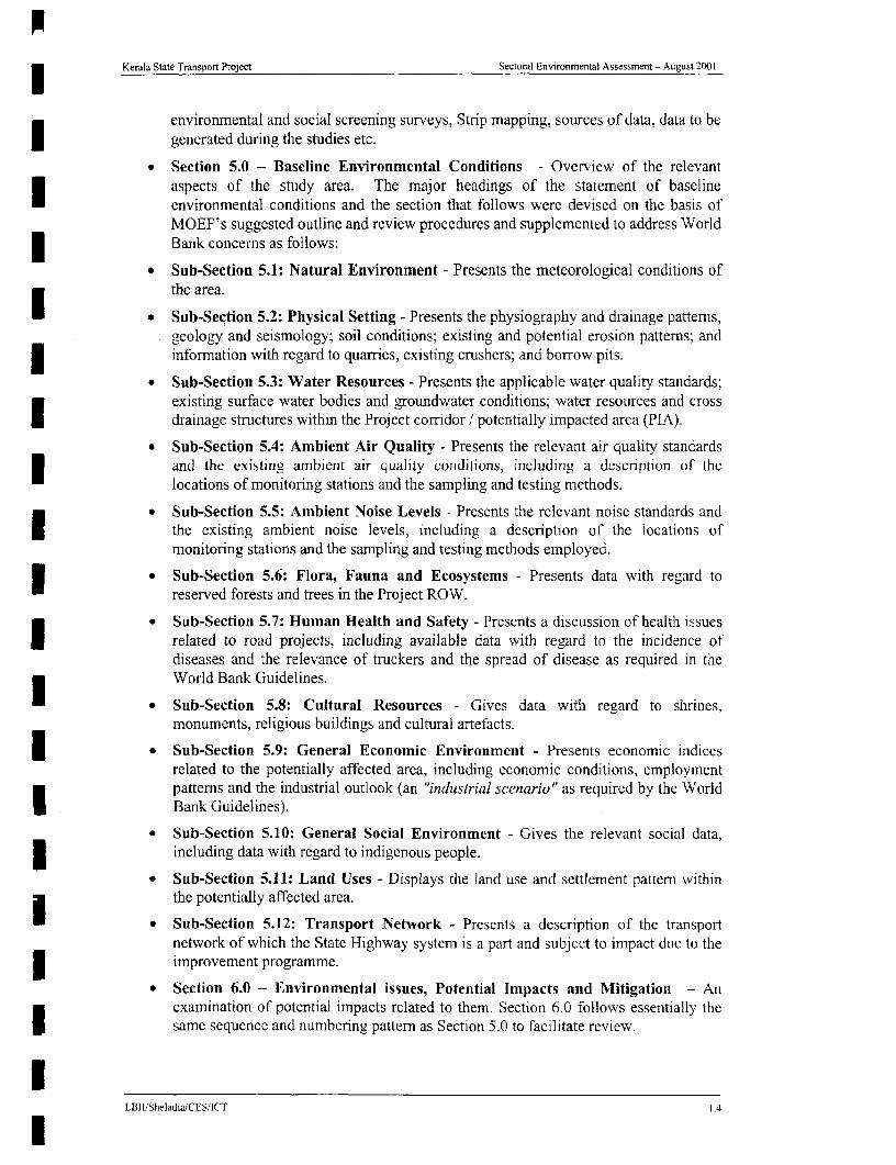
Kerala State Transport Project Sectoral Environmental Assessment - August 2001
environmental and social screening surveys, Strip mapping, sources of data, data to begenerated during the studies etc.
* Section 5.0 - Baseline Environmental Conditions - Overview of the relevantaspects of the study area. The major headings of the statement of baselineenvironmental conditions and the section that follows were devised on the basis ofMOEF's suggested outline and review procedures and supplemented to address WorldBank concerns as follows:
* Sub-Section 5.1: Natural Environment - Presents the meteorological conditions ofthe area.
* * Sub-Section 5.2: Physical Setting - Presents the physiography and drainage patterns;geology and seismology; soil conditions; existing and potential erosion patterns; andinformation with regard to quarries, existing crushers; and borrow pits.
* Sub-Section 5.3: Water Resources - Presents the applicable water quality standards;existing surface water bodies and groundwater conditions; water resources and crossdrainage structures within the Project corridor / potentially impacted area (PIA).
- Sub-Section 5.4: Ambient Air Quality - Presents the relevant air quality standardsand the existing ambient air quality conditions, including a description of thelocations of monitoring stations and the sampling and testing methods.
* Sub-Section 5.5: Ambient Noise Levels - Presents the relevant noise standards andthe existing ambient noise levels, including a description of the locations ofmonitoring stations and the sampling and testing methods employed.
* Sub-Section 5.6: Flora, Fauna and Ecosystems - Presents data with regard toreserved forests and trees in the Project ROW.
* Sub-Section 5.7: Human Health and Safety - Presents a discussion of health issuesI related to road projects, including available data with regard to the incidence ofdiseases and the relevance of truckers and the spread of disease as required in theWorld Bank Guidelines.
* Sub-Section 5.8: Cultural Resources - Gives data with regard to shrines,monuments, religious buildings and cultural artefacts.
* Sub-Section 5.9: General Economic Environment - Presents economic indicesrelated to the potentially affected area, including economic conditions, employmentpatterns and the industrial outlook (an "industrial scenario" as required by the WorldI Bank Guidelines).
* Sub-Section 5.10: General Social Environment - Gives the relevant social data,including data with regard to indigenous people.
* Sub-Section 5.11: Land Uses - Displays the land use and settlement pattern withinthe potentially affected area.
* * Sub-Section 5.12: Transport Network - Presents a description of the transportnetwork of which the State Highway system is a part and subject to impact due to theimprovement programme.
* Section 6.0 - Environmental issues, Potential Impacts and Mitigation - Ancxamination of potential impacts related to them. Section 6.0 follows essentially thesame sequence and numbering pattern as Section 5.0 to facilitate review.
LBII/SheladiaiCES/ICT 1.4

lKerala State Transport Project Sectoral Environmental Assessment - August 2001
* Section 7.0 - Analysis of Alternatives - An examination of alignment, design andtechnical alternatives considered in the evolution of the Project.
* Section 8.0 - Public Consultations - A description of coordination activities in thepreparation of the SEA, including coordination with Government Agencies, actionsI undertaken to obtain the views of local non-government organizations (NGOs) andaffected groups, and records of meetings and other activities, communications andcomments.
* Section 9.0 - Environmental Management and Monitoring - Specificenvironmental management activities to be incorporated in both the construction andI operational phases for each component of the Project are presented, together with aMonitoring Plan specifying the type of monitoring proposed, the activities and/orconditions warranting environmental monitoring, the responsible agency orI organization, the estimated costs and related factors.
* Section 10.0 -Environmental Safeguards For Proposed Road MaintenanceActivities- Maintenance Specific Environmental impact mitigation activities to beincorporated during the construction is provided. An EMAP developed specificallyfor the project included.
Volume II Appendices To Main Report Contain:
Appendix A.4.1 Environmental And Social Impact Screening Model (EASISM)
Appendix A.4.2 Link Specific Environmental Analysis- An account of Link SpecificEnvironmental Details
3 Appendix A.4.3 Environmental Strip Maps- Strip Maps for Phase I Detailed Survey andPhase II from screening surveys
Appendix A.5.1 CRZ - 1 Areas of Importance According to GOI Regulations
3 Appendix A.5.2 Ambient Air, Water and Noise Quality Monitoring - Stations, Periodof Monitoring
U Appendix A.5.3 IUCN Document on Sensitive Ecological Areas.
Appendix A.6.1 Typical Environmental Enhancement Design Drawings
Appendix A.6.2 Landscapes, Tree Planting and Environmental Enhancement Plan
Appendix A.8. 1 Short listed NGOs for Project Consultation and Participation
Appendix A.8.2 Official Consultations
Appendix A.8.3 Minutes of Scoping Workshops
Appendix A.9. 1 Environmental Monitoring Formats
l
l
II BlliSheladiaiCES/1CT I.5
l

Kerala Stale Transpori Project Sectoral En6ironmental Assessment -August 2001
2 PROJECT POLICY, LEGAL AND REGULATORYFRAMEWORK
2.1 INSTITUTIONAL SETTING FOR ENVIRONiMIENTAL ANALYSIS
2.1.1 Ministry of Environment and Forest (MOEF)
The Ministry of Environment and Forest (MOEF) is the responsible organisation forenvironmental matters in India. Exhibit 2.1 indicates the organisational structure of India'senvironmental management system. The current framework has evolved largely since thecreation of the MOEF in 1985. Many States already had State Pollution Control Boards
| (SPCBs) perform functions as outlined in India's Water and Air Acts.
l | CENTE | j ST ATE DIS TR
1,~ ~~~~~~~~~Rt on roi
| | i CA Offcm | Poilulicn | l | l S~~~offic
neonl [ Po:!unon ofth C~~onco u6-
C?CB Booed
EXHIBIT z. GOI ENVIRONIENTAL MANAGEMENT ORGANISATtON=do S.. 'd B. Rpo rT-os erS . 990
The MOEF is the agencv primarily responsible for the review and approval of ElAs pursuantto GOI legislation. As a part of its ETA review procedures. MOEF requires the submission ofan application, the EIA and accompanying Resettlement Action Plan (RAP) for review by anEnvironmental Appraisal Committee. Before approval can be granted, a No ObjectionCertificate (NOC) from the State Pollution Control Board (PCB) and State Forest Department
| (both discussed below) must also be obtained.
2.1.2 Central Pollution Control Board (CPCB)
The CPCB is a statutory authority attached to the MOEF and located in New Delhi. It wasconstituted in 1974 (and thus predates MOEF). Its major functions are to:
- Advise the Central Government with regard to water and air pollution matters;I - Plan and implement water and air pollution programmes;- Co-ordinate activities of the State Pollution Control Boards,- Organise popular air and water campaigns;I - Increase Public awareness;- Compile air and water data and provide guidelines:5 - Set air and water standards.
l I~~~~~~~~~~~~~~~~~~~~~~~~~~~~~~~~~~~~~~~~~~~~~~~~~~~~~~~~~~~~~~~~~~~~~~~~~~~~~~~~~ L1311I Slwladia ii. (FS 1(1
l

Kerala State Transport Project Sectoral En% ,ronmentai Assessment -AuLu,t 2(YJ I
| 2.1.3 MOEF Regional Office
Kerala is located in the Southern Region, which includes Kerala, Tamil Nadu and Karnataka.The office for the Southem Region is located in Bangalore. Its responsibilities include:
- Evaluate proposals for diversion of forestlands;- Assist in the preparation of the National Forestry Action Plan (NFAP):I - Assist Paryavaran Vahinis ;
- Provide technical and scientific consultations on biological diversity;- Monitoring of conditions following environmental clearance;I - Pursuing pollution control measures by industries and local bodies;- Collecting and fumishing information in relation to environmental impact assessmentof projects, pollution control measures, methodology and status, legal and enforcement
* measures, environmental protection in special conservation areas such as wetlands.mangroves and biological reserves; and- Co-ordination functions.
2.1.4 State Forest Department
The State Forest Department is responsible for the protection of designated land and forestresources. Its responsibilities include the protection and management of trees located withinpublic ROWs such as the National and State Highways, consistent with the other zoals and
| policies of the GOI. In Kerala, the trees at the sides of the PWD land are the property of theForest Department. With the Contractors opinion prior to the removal the trees, the trees thatare actually affected should be clearly marked. A wn'tten pernission needs to be obtained
i from the Divisional Forest Officer (DFO) or Assistant Conservator of Forest (ACF)indicating the details of the trees that will have to be felled prior to the actual removal of the
* trees.
2.1.5 Kerala State Pollution Control Board
The State Pollution Control Board (SPCB) plays a major role in environmental managementat the state level, particularly with regard to air and water issues. The main functions are to:
- Plan and execute state-level air and water initiatives;I - Advise State Governments on air, water and industry issues;- Establish emission standards based on National Standards:- Issue consent orders (permits) for industrial air and water discharges:
* - Issue "No Objection Certificates" for "industrial development" (defined in such a wayas to include road projects);
- Publish statistics and disseminate information; and| - Take legal action against defaulters.
Action by the Kerala State PCB requires the submission of a questionnaire / applicationpursuant to the Water (Prevention and Control of Pollution) Act of 1974. the Cess Act of1977 and Air (Prevention and Control of Pollution) Act of 1981 together with the prescribedPublic hearing fee. The State PCB generally establishes a review panel and circulates theI application for public review and comment in each affected district. At least one publichearing must be held in each district following a minimum of 30 days notice issued in localand national newspapers. In the case of KSTP, hearings in each of the affected districts willbe required. A state-level hearing is also necessary, to consider all comments received from
| 1 Paryavaran Vahini Programme - an adjunct to the NEAC (National Environmental Auareness Campaign) launched in1992/93 to involve community members in reporting and monitoring as well as awareness programmes.
ILtRtI Shetatia (iS ICT--

Kerala State Transport PTojeCt Sctrora! En, ironmcntal Asscssencrt -August 20(
the districts. Assuming- acceptability, the PCB issues a No Objection Cerfificate (NOC).Both the NOC of PCB, and the Forest Department NOC (for forest land acquisition onlv) are
required before MOEF action on the EIA can be considered as complete.
2.1.6 Municipalities and Panchavats
3 ~~~Municipalities and panchayats are expected to play an increasing role in environmentalmnanagement at the district level and States may delegiate fuinctions. U nder cer-tainamendments municipalities may be involved in:I - ~~~~~Urban and tlown planning;
- Water supplies;- Solid waste management and sanitation,
- Urban forestry;- Protection of the environment; and- Promotion of the ecologaical aspects of urban development.
2.1.7 Other Entities with Environmiental Responsibilities
I ~~~~Other entities and their environmental tasks include the following.
Ministry of Agriculture Prevention and control of desertificationConservation and regeneration of watershedsProtection of irrigation command areasConservation and regeneration of forest3 ~~~~~~~~~~~~~~Prevention and control of polluti-on
Ministry of Water Resources Prevention and control of floods3 ~~~~~~~~~~~~~Conservation and regeneration of wvetlandsConser-vation and regeneration of coral reefsProtection of irrigation command areas3 ~~~~~~~~~~~~~Monitoring water quality
Ministr of Rural Development Conservation and management of land and soilPrevention and control of droughtConservation and regeneration of for-estPrevention and control of pollution
Ministry of Power Prevention and control of pollutionI ~ ~~~~~~~~~~~~Recycling, of resourcesConservation and managen; ent of energy
Ministry of Petroleum Protection of mining and oil extraction areasRecycling of resourcesPrevention and control of pollutionI ~ ~~~~~~~~~~~Conservation and management of energy
Department of Ocean Development Conservation of coral reefs and coastal regions3 ~~~~~~~~~~~~~Conservation and realisation of island resources
Ministry of Urban Development Prevention and control of pollution
State Committee on Science Technology and Environment (STEC) This is basically aI ~ ~~fuinding agency for various R&D projects for a number of State Govemment organisations.These organisations include, CWRDM, CESS, LAND USE BOARD, KFRI, NATPAC andKerala State Remnote sensing Agency. According to the 10 April 1997 MOEF notification on
puiblic hearings STEC will be involved in the Public hearing and suibsequient State levelEnvironmental approvals associated with National Environmental Approvals.
1,3;SheIndia CES ICT

Kerala State Transport Preiect Sectoral Environmcriii Asscssmcnt -Auzusi 2(X1I
Kerala State Public Works Department A designated Minister and Secretaries of IAS rankin the State administrative machinery generally manage the Kerala State Public WorksDepartment as in other States. There are Chief Engineers separately for buildings and roadsectors. In the road sector there are a Chief Engineer (National Highways) and a Chief
a Engineer (State Roads). The project roads fall under the responsibility of the Chief Engineer(State Roads).
Project Implementation Unit: The PWD has established a Project Implementation Unit(PIU) with a Project Director and a Deputy Project Director with support staff for theimplementation of the project. Recently PWD appointed a Joint Director, a Deputy DirectorI and an Environmental Engineer to support the Environmental and Social activities of theProject. The Joint Director is responsible for the Social Impact Mitigation Measures and
* implementation of RAP. The Sociologist and the Environmental Engineer will undergo* training to ensure the implementation of RAP and EMP. The PWD is committed to provide
all available training arrangements for the appropriate specialist input to the Project duringX and after the start of the construction work.
Other than this, there is no institutional capacity within these agencies to implement theEnvironmental and Social Impact mitigation measures and the Environmental Management
| Plan during or after construction.
PWVD Requirements. The PWD currently has no formal environmental internal reviewprocedures. The PWD will, however is in the process of establishing an EnvironmentalI Management Unit (EMU) to develop an in-house capacity to implement and manageenvironmental issues related to the highways as a part of the KSTP. The EMU will be
| responsible for the mitigation measures adopted during and following construction.
2.2 NEW STATE LEGISLATION - The Highwav Protection Act, 1999
The recently introduced Highway Protection Bill approved by the State Government is apositive step towards achieving better roads in the State. The highlights of this bill are:
• Prevention and control of encroachmentsa . Control of ribbon development
* Setting up of Highway Authorities for notified highways with powers to executedevelopmental schemes, control ribbon development and prevent encroachment. AnI, officer not below the rank of an Executive Engineer of the Public Works Departmentvill be in charge of each Highwvay Development Authority.
5 The bill has been passed by the State Legislative Assembly and has also received the assentof the Governor on 20 January 2001 making it a legal notification.
| 2.3 ENVIRONMIENTAL CLEARANCE
Environmental Clearances are required for the project both from the Government of India andalso from the multi lateral donor agency, i.e. The World Bank, who are being requested toprovide loan assistance to the Project.
The World Bank is most likely to be a major source of ftnding for the Kerala State Transport3 Project in conjunction with State level investments, wvhich arc required for Projectpreparation, land acquisition and counterpart funding. Government of India (GOI) clearanceis also required based on the existing national regulatory requirements for four phase 2 roads.I None of the phase I road corridor r equires GOI clearances.These are explained in the followin- sections.
1 2~~~~~~~~~~~~~~~~~~~~~~~~~~~~~~~~~~~~~~~~~~-4LBI3I Shelrdia CES IC I
l

lKerala State Transport Project Sectoral Enviriinmental Assessment --August 2)01
2.3.1 World Bank Procedural and Regulatory Requirements
ENVIRONMENTAL: Environmental requirements of the World Bank are specified indetail in its Operational Policy (OP) 4.01 and other related OPs. In instances in which theprocedural and regulatory requirements differ, the more stringent applies. The procedural andregulatory aspects of those requirements and those of the Ministry of Environment andForests (MOEF), Ministry of Surface Transport (MOST) and the State Public WorksDepartment (PWD) can be summarized as follows:
| The World Bank environmental requirements are based on a three-part classification systemin which a project designated as Category A requires a full environmental assessment (EA) asthat term is defined by the World Bank Operational Policy 4.01. Category B projects require
* a lesser level of environmental investigation. Category C projects require no environmentalanalysis beyond that determination. The Bank classifies the KSTP as Category A, largely; itis understood based on the large number of project-affected people and the biodiversity ofKerala. In other words, the Bank classification is based on the anticipated cumulative socialand environmental impacts due to the construction and operation of the Project.
| In recognition of the needs of large, multi-year lending programmes likely to involve anumber of projects or sub-projects such as the KSTP, the Bank's procedures also provide forthe preparation of a Sectoral Environmental Assessment (SEA) as that term is defined by itsI OP 4.01dated October 1991. A SEA is designed to accommodate a number of circumstances,particularly "the Bank's increasing use of programmatic, sector-oriented and time-slice3 investment programs which) have served to create a demandfor a Sectoral EA approach"'
Within this approach, the sections of road upgrading projects not involving significantadditional ROW acquisition, affecting sensitive areas or large numbers of PAPs are generallyI considered Category B projects, provided that the potential environmental concerns areaddressed within the SEA and that the mitigation actions incorporated in the SEA (ifapplicable) are implemented. The SEA can hasten environmental clearance of projects or
M sub-projects, in that, they do not warrant such intensive investigation. It can thereforesimplify and expedite the implementation process and reduce potential risks anduncertainties. If sensitive areas are within the potentially affected environment of a project orsub-project, if significant socio-economic impacts are anticipated or if otherwise warranted,Category A environmental documentation is required at the project-level. Clearance for theoverall Programme is obtained, however, provided that:
* The SEA is found to conform to the cited guidelines.
* The SEA is accompanied or followed by detailed design and project-level environmentaldocumentation when necessary and provides assurance that the environmental issues willbe properly addressed in the subsequent phases of the program. And
* All other feasibility, design, mitigation plans and financial responsibility requirements areacceptable.
* The World Bank determined that the KSTP required an SEA to "develop simple, standardand practical recommendations to be included in the design and construction of the project"including:
Proper use of existing borrow areas and quarries;Landscaping of borrow areas and spoil tips;Development of proper storage areas specifically for diesel fuel and bituLImenC;
LBII SIcladia/CES CT

Kerala State Transport Project Secioral Envionmental Assessment -August 2001
I Rehabilitation of the ROWs through replanting;Minimizing soil erosion;Protection, enhancement and proper management of sensitive habitats, andEstablishment of an environmental management unit within the PWD.
3 The required SEA for the Project will be formally submitted to the PWD together with allother Project documents. In addition to the documentation and commitments in the SEA,World Bank approval is also contingent upon the completion of detailed designs for 25percent of the total Project, the securing of all necessary environmental approvals for theseactions from MOEF and other GOI agencies and the completion of project-level EAs wherewarranted. There are 9 Road Links comprising Phase I KSTP construction activities and 13
| in Phase II.
SOCIAL IMPACT: The World Bank has set out certain mandatory social impact mitigationI requirements for loan projects. The Operational Policy 4.303' describes the Bank's policyand procedures for projects that involve involuntary resettlement. This policy aims toimprove, or at a minimum, sustain the same standard of living for the people who will beI displaced because of a development project. The policy also requires that projects minimizethe need for involuntary resettlement. Where displacement is unavoidable, resettlement plans3 should pay particular attention to the vulnerable groups.
In addition, the World Bank has special guidelines for addressing impacts upon theindigenous communities due to infrastructure projects. This document specifically requires
3 the project authorities to include consultation with and informed participation of the tribalpopulation. Hlowever, the reconnaissance survey has indicated that there are no tribalhabitations along the corridor.
The Applicabilitv of various World Bank Safe Guard Policies
I The World Bank has 10 safe guard policies. The details of the safe guard policies and theapplicability of these safe guard policies to the Project are provided in the Exhibit 2.2.
EXHIBIT 2.2APPLICABILITY OF WORLD BANK SAFE GUARD POLICIES TO KSTP
WORLDI BANK'S SUBJECT TRIGGERED REASON FOR ITS MITIGATIONGUARD CATEGORY OR NOT APPLICABILITY MEASURES DOCUMENTATIONPOLICY
* All necessary EiA and EnvironmentalTnggered for al mitigation measures Management Plan
OP 4.01 Essment Phase 1 and Umbrella policy incorporated after prepared and reviewedAssessment Phase 2 Roads several reviews by by a Independent
the Bank Review Consultant
Link 26 Environmental| (Phase 2 Presence of ldukki wild clearance will be EIA and Environmental
OP 4,04 Natural Habitats buf(er) Not Life Sanctuary about obtained after Management Plan andtriggered as 200 to 500 m away from incorporating a well Habitat Managementof Now the Project defined mitigation plan prepared
lmoluntary Rcsetllicnent. The World Bank Operational Policy 4 '0JUIlc 19)0.
L BII Sl ,It,t (I VS 1( t'
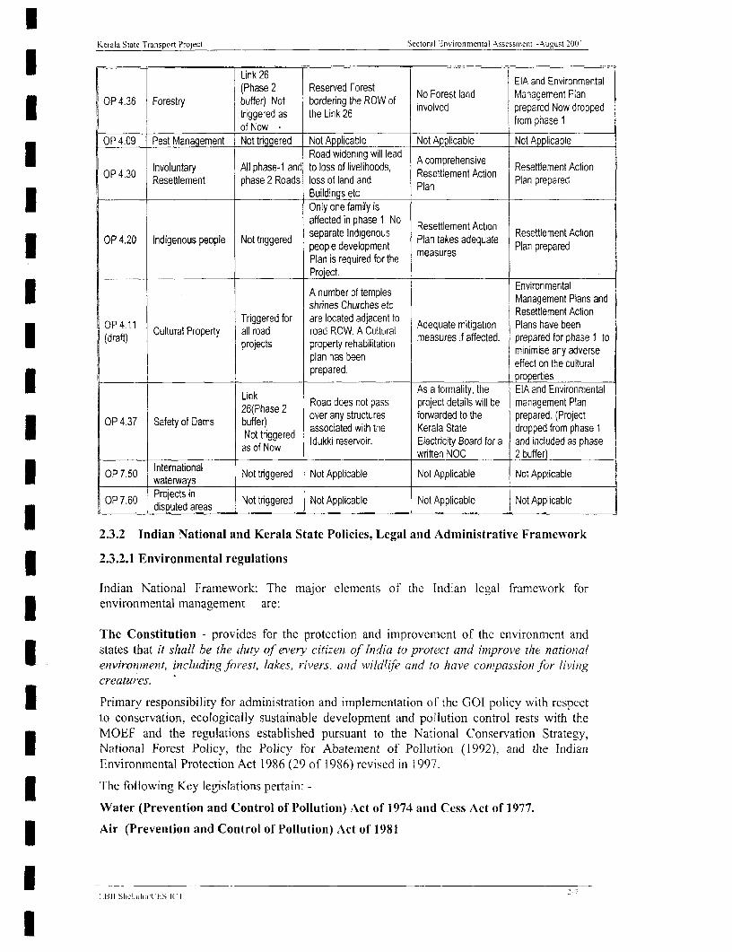
Kerala State Transport Project Sectoral Environmental Assessment -August 2001)
I| Link 26 = 1 EIA and Environmental(Phase 2 Reserved Forest No Forest land Managemnent Plan
OP 4.36 Forestry buffer) Not bordering the ROW of involved prepared Now droppedtriggered as the Link 26 premphared No rpe
_______ __ _________ 'of Now No r m h s OP 4.09 Pest Management Not tAggered Not Applicable Not Applicable
lP3 Iotylh -a Road widening will lead A comprehensiveInvoluntary All phase-i and to loss of livelihoods, RstlmnAcin Resettlement Action
OP 4.30 PlantteprepareioResettlement phase 2 Roads loss of land and Plan Plan prepared
________ l______________ _ _Buildings etcOnly one family isaffected in phase 1, No Resettlement Action Resettlement Action
OP4.20 Indigenous people Not triggered separate Indigenous Pa ae dqae RsneetAtol OP 4.20 Indigenous people Not triggered people development Plan takes adequate Plan prepared
Plan is required for theProject.A number of temples EnvironmentalshrnesChurches etc Management Plans and
OP 4.11 Cultural ~Triggered for are located adjacent to Adqaemtiain Pashae bementAioOP 411 ultralProperty all road road ROW. A Cultural Adqaemtgio Plnhvebn
(draft) 1rCults Property redi fon measures if affected. prepared for phase 1 toplan has been ~~~~~minimise any adversepplanrhabeen effect on the cultural
1 prepared . properties
Link As a formality, the EIA and Environmental26(Phase 2 Road does not pass project details will be management Plan
OP 4.37 Safety of Dams buffer) over any structures forwarded to the prepared. (Project= .gY associated with the Kerala State dropped from phase 1
_ Not trggered Idukki reservoir. Electricity Board for a and included as phaseas of Now written NOC 2 buffer)
; OP 7.50 waterwnas Not triggered Not Applicable Not Applicable Not Applicable
OP 7.60 Projects in Not trggered Not Applicable Not Applicable Not Applicable3 ~~~~~~~~~~disputed areas I __ _
2.3.2 Indian National and Kerala State Policies, Legal and Administrative Framework
2.3.2.1 Environmental regulations
Indian National Framework: The major elements of the Indian legal framework forenvironmental management are:
The Constitution - provides for the protection and improvement of the environment andstates that it shall be the duty of every citizent of India to protect and improve the nationalenvironment, including forest, lakes, rivers, and wildlife and to have compassion for livinigcreatures.
Primary responsibility for administration and implementation of the GOI policy with respectto conservation, ecologically sustainable development and pollution control rests with theMOEF and the regulations established pursuant to the National Conservation Strategy,
a National Forest Policy, the Policy for Abatement of Pollution (1992). and the IndianEnvironmental Protection Act 1986 (29 of 1986) revised in 1997.
The following Key legislations pertain: -
Water (Prevention and Control of Pollution) Act of 1974 and Cess Act of 1977.
Air (Prevention and Control of Pollution) Act of 1981
ii311 Stelia,ia ( ES Ci I-
I
Kerala State Transport Project Secoral Environmental Assessment -A iusi 2h 01
Environment (Protection) Act of 1986 - enacted in the wake of the Bhopal gas tragedy, theAct is an "umbrella legislation" that provides a framework for Central and State Authoritiesestablished under previous laws. ft provides a single focus for the protection of theenvironment and sought to "plug" several loopholes.
Forest (Conservation) Act 1980 as amended
Under this law the PWD must obtain administrative approval from the Forest Department to* clear over 20 hectares of designated forestland and in 1986 when the MOEF enacted the
Environmental Protection Act, the entire linear stretches of road side plantations along theState highways were declared as protected forests. According to this although the land isunder the control of State Government, due to its protected Status, approval of Central,Regional or State Government for using the land for widening and rehabilitation must be
* granted.
At the State level, Government was empowered to declare reserves and protected forest andwas also given the authority to acquire land for extension and preservation of forests. InDecember 1996, a Supreme Court judgement further defined the types of forests to beprotected. Depending on the size of the tract to be cleared, clearances are required from thefollowing levels of Government.
1. If the forest exceeds 20 hectares in area then prior permission of Central Governmentis required.
2. If the forest is between 5 to 20 hectares the regional Office of the Chief Conservator isempowered;3 3. If the forest is below or equal to five hectares the State Government may givepermission; and,
4. If the construction area is more than 40 % forcst, permission to undertake any work isrequired from the Central Government, irrespective of the size of the area.
In the case of Kerala the entire State enjoys green vegetation cover and this makes the stripand linear plantations less significant for a development project like the KSTP.
I 18 February 1998 MOEF circular on linear plantations on roadsides, Canal antd railway linesmodified the applicability of the provisions of the Forest (Conservation) Act, 1980 to linearplantations. The new modification recognises that the spirit behind the Forest (Conservation)Act was conservation of natural forests and not strip plantations. In the case of the "notifiedto be protected" roadside plantations, the clearance may now be given by the concerned
| regional office of the MOEF, irrespective of the area of plantation lost. While issuing theapproval, in place of the normal provisions for compensatory aforestation, the regionaloffices will stipulate a condition that for every tree cut at least two trees should be planted. If3 the concerned Regional office does not issue the decision within thirty days of the receipt ofthe fully completed application, the project proponent may proceed with widening/expansionunder intimation to the State Forest Department, and the MOEF.
* Wildlife (Protection) Act of 1972, This Act allowed the Government to establish a numberof national parks and sanctuaries over recent years. This stipulates requirement of a Noobjection from Principal Chief Conservator of Forest (PCCF) in case a road passes through awildlife sanctuary, National Pass, Wildlife reserves.
Policy Statement on Abatement of Pollutioni of 1992 Affirmed the Government's intentionI to integrate environmental and economic aspects in clevelopment planning wvith an emphasison the preventive aspects of pollution and the "polluter pays" principle.
1L1311 Shlduia (t-S 1( 1 '-S

Kerali State Transport Project Sectoral Environmental Assessment -AISLtSt 2001
The Environmental Impact Assessment (EIA) of Development Projects Notification of1994 Until January 1994, obtaining environmental clearance from the MOEF was only anadministrative requirement intended for large projects undertaken by the Government orpublic sector undertakings. The EIA Notification issued in January 1994 and amended inMay 1994 makes EIAs a statutory requirement for 29 Identified activities including transportprojects. All development projects, whether under Schedule I or not, are required to haveclearance from MOEF if they are in certain notified ecologically sensitive or "fragile" areas.
10 April 1997 MOEF Gazette Notification On EIA For Road Improvement ProjectsAccording to this notification road improvement projects are generally exempt from theenvironmental clearance. This exemption is for
"Highway Projects except projects relating to improvement work including widening aldstrengthening of roads with marginal land acquisition along the existing alignments providedit does not pass through ecologically sensitive areas such as National Parks, Sanctuaries,Tiger reserve, Reserve forests ".
Accordingly, an EIA addressing specific actions and, circumstances within the corridor mustbe prepared, and approvals received. MOEF application is also required. As part of its review,the Kerala State Pollution Control Board (SPCB) establishes a review panel and circulates theMOEF application for public review and comment in each affected district. After the Projectreceives Forestry Department and SPCB No Objection Certificate (NOC), the MOEFapplication will proceed to MOEF for review and action. MOEF establishes a ReviewCommittee and the Committee may attach conditions to the NOC.
15 October 1999 MOEF Circular On Marginal Land Acquisition And BvpassesAccording to the provision of EIA Notification of 27th January, 1994 and as amended on 10th
April 1997, environment clearance is required for highway projects except projects relating toimprovement work including widening and strengthening of roads with marginal landacquisition along the existing alignments provided they do not pass through ecologicallysensitive areas such as national parks, sanctuaries, tiger reserves or, reserve forests. It isclarified that marginal land acquisition means land acquisition not exceeding a total width of20 metres on either side of the existing alignment in total. Further, it is also clarified thatbypasses would be treated as stand-alone projects and would require environmental clearanceonly if the cost exceeds Rs. 50 crores each.
According to this the now dropped phase I link 26, Idukki - Puliyanmala. Link 84 Punlur -Thodupuzha the require Government of India clearances.
Coastal Regulation Zone Notification of 1991
According to the notification the Coastal areas of Kerala are classified into three zones basedon the sensitivity as identified by the CRZ Management plan prepared by the StateGovernment.
CRZ-1: This constitutes the areas that are ecologically sensitive such as mangroves,sanctuaries, areas of outstanding natural beauty etc. No new construction shall be permittedwithin 500 meters.
CRZ-2: This constitutes the areas that are already fully devcloped up to or close to theshoreline. This area is usually substantially built up. Construction activities are permittedfollowing all appropriate approvals.
CRZ-3: These areas are relatively undisturbed and those that are not included in CRZ-l andCRZ-2 areas along the Kerala Coast. There are several restrictions and these are declared on
E f311'SIwch,1 £ ES 1£

lKerala State Transport Project Secloral Environmental Assessment - Nuuust 200 1
| development zones also.
Following this, the State Government prepared a Coastal Zone Regulation Management Plan| (CZRMP) in December 1995, and submitted it to the Central Government. MOEF Approval
was received on 27 September 1996. This is the basic document for all CRZ related activitiesin Kerala.
I Further amendments where made to the original notification following representation fromthe affected people of the State. Theses amendments are dated as follows
18 August 1994 MOEF notification9 July 1997 MOEF CRZ gazette notification as amendments to 1991 notification5th August 1999 amendments of MOEF to CRZ notification
* Although they will be examined in detail in the relevant sections of the project these threeamendments are not significant to this project.
3 The two phase 2 link 68 Pilathara - Pappinissery, links 69, Kasarkode - Kanjangad requireGovernment of India clearance based on this regulations.
3 The Public Liability Insurance Act of 1991
Under the heading of land use, the following are also noted to be of potential relevance:
- The Urban Land (Ceiling and Regulation) Act of 1976.- The Model Regional and Town Planning and Development Law of 1985.- Provisions in State Acts on Town and Country Planning.- The Industries (Development and Regulation) Act and Amendment of 1951 and
1987.- The Mines & Minerals (Regulation & Development) Act and Amendments of 1957I and 1984.- The Coal Mines (Conservation and Development) Amendment Act of 1985.
Noise Pollution (Regulation and Control) Rules 2000
As a result of considering the deleterious and psychological effects of noise pollution on thehuman well being, MOEF has drawn up the above rules, which have come into effect from
1 4 th February 2000. According to the provisions of the rules notified, a person may make acomplaint to the designated 'Authority' in the event that the actual noise levels exceed theambient noise standards by 10 dB (A) or more as compared to the prescribed standards. Thedesignated authority will take action against the violator in accordance with the provisions ofthose rules or other law in force.
| 2.3.2.2 GOI Social Impact Regulations
The most relevant Indian regulations for social impact mitigation are:
I The Land Acquisition Act, 1894 (amended 1984) on compensation at market price
The Environmental Guide lines for Rail/Road/Highway Projects, Ministry ofEnvironment & Forest, Government of India, 1989, on relocation of project affectedpersons.
The Environmenital Impact Assessmenit Notification, 1994. on the comprelhenisive
l rehabilitation planThis notification includes Higlhway Projects in the list of projects covered under the
| Notification.
L BII Shelkiia'(ES IC1-

Kerala State Transporl Proiect Sectoral Environmental Assessment --Au2ust 2001
The social impact requirement of the Indian Government refers to the Relocation section inU the GOI Environmental Guidelines for Rail/Road/Highway Projects (1989). The Guidelinesrecommend the following mitigation measures for social impacts:
(a) Advance notification of enough (say, two years) time must be given to enable therelocatees to find a suitable place. At the same time, the project authorities could arrangefor public relations through television, radio, and the press on the need for the project and3 how land acquisition and compensation will be effected.
(b) Advance realistic payment should be available in some form for the relocatees to secure anew unit
* (c) The estimation of compensation for land and property should be based on the fair marketvalue. The term fair market value is defined as being the amount at which the property3 would exchange between a willing buyer and a willing seller with both parties havingreasonable knowledge of all relevant facts.
(d) The choice of replacement of a living unit organized by the project authority may be madeavailable for the relocatees who are not satisfied with only the compensation amount orwho cannot find a suitable house.
(e) Re-establishment cost must be carefully considered to offset the loss in income. increasein expenditure resulting from disconnection of public utility services and moving cost.Special attention must be paid to the possible loss of job or business that cannot be re-established.
(f) In case of any squatters, a special programme for construction of low cost housing units(the labour provided by relocatees) may be effected.
(g) A social work subsection should be established to follow up and monitor the problemsfaced by the relocatees. This sub-section should also be entrusted with the responsibility
3 of ensuring that individual households relocated receive sufficient compensation withenough lead-time to secure a new living unit.
i 2.3.2.3. Other Regulations
Ancient Monuments and Archaeological and remains Act, 1958
| The objective of this is the conservation of cultural and historical remains found in India. Theagency responsible for art and cultural heritage is (INTACH)
Indian Road Congress (IRC)
IRC standards are Indian standards equivalent to international standards like ASTM or BS fordifferent activities associated with highway construction. There are many such standards forEnvironmental managemenit aspects of Highways construction and operation. These are beingused in the Environmental Management Action Plan of highways both for new andrehabilitation projects.
Gaps in the regulations
Road Safety legislation: Since road safety is such an important issue in the Kerala StateTransport Project, there is an absence of a suitable National legal framework to deal with roadrelated emergency situations. There is no legal cover for certain kind of activities such as3 accidental spills and groundwater and surface water pollution during transportation ofhazardous substances. Road safety legislation, if framed, should consider all existing issues.
[.BII SIli.Idiia (UES CT - 1
Kerala State Transport Project Sectoral Ens ironmental Assessment -August 2001
The IRC has a Highway safety code for Indian situations and there are several publications related to| s road safety as follows: -
* The road safety code, Publication No 44* Report containing recommendations of the [RC regional workshops, a highways safetyI publication No 27, 1984* Guideline for Pedestrian safety IRC 103-1998* Road accident forms.IRC.53: 1982| The manual for safety in road design, MOST, India, 1998
All of these and any new legislation should be compatible with the Motor Vehicle Act 1988
| 2.4 INDIAN NATIONAL REQUIREMENTS FOR ENVIRONMENTAL IMPACTREVIEW
The GOI Environmental Protection Act of 1986 requires the preparation and clearance ofI Environmental Impact Assessments (ETAs) for projects meeting certain requirements, includinghighway projects. The Ministry of Environment and Forest (MOEF) promulgated environmentalGuidelines for Rail/Road Highway Projects in conjunction with the Ministry of Surface Transport(MOST) in 1989. Detailed requirements for the preparation of EfAs are also outlined in the GOI'sHandbook of Environmental Procedures and Guidelines of 1994.
MOEF environmental clearance procedure
The entire procedure is depicted in Exhibit 2.3. The procedure for Forest clearance is depicted in theExhibit 2.4. The simplified relation of land acquisition and MOEF clearance is presented in Exhibit 2.5.
Guidance for the preparation of Environmental Impact Assessments (EIAs) within this overallframework for environmental clearance for new development proposals is provided in the GOl's
| Handbook of Environmental Procedures and Guidelines (1994).
Additional guidelines for road projects are provided by the MOST in its publication entitledEnvironmental Guidelines for Rail/Road and Highway Projects. The guidelines include a summaryquestionnaire to be submitted to the MOEF for the preparation of EIAs for domestic road projects.
Environmental clearance for the Project: Since the draft EIA reports for Phase -I are alreadyprepared, the Project has submitted the State level Clearance application for Phase I roads to the Kerala
C State Pollution Control Board. For Phase 2 roads, this will take place after the EIA documentation iscomplete as desired by the Bank for a Category A project incorporating the Independent ReviewConsultants suggestions for improvement.I No clearances are require for phase I roads.
The Pollution Control Board upon receipt of the application will hold public hearings in the affecteddistricts according to the 10 April 1997 notification as a part of GOI clearances in all applicable cases(Link 26 buffer, Link 84, Link 68 and Link 69). The whole procedure will be complete withinapproximately two months with the State level clearance. In deserving cases, the application willproceed to the Ministry of Environment and Forests, Govemment of India. The MOEF will consider theproject within a minimum period of 90 days as shown in the Exhibit 2.3.
Forestry clearance: At the same time, the forest clearance application will be submitted with the Statelevel clearance application if any forestland acquisition is necessary for the Project. The joint siteverification of PWD and Forest officials recently carried out established the involvement of noforestland for widening for Phase I roads. The actual forestland requirement for phase 2 will bedetermined subsequently.
The procedure is shown in the flow chart Exhibit 2.4. The final environmental clearance will beobtained only after the forestry clearance for the land acquisition is complete.
3. The World Bank, EnN ironmental Assessment Sotircebook t pdate! Sectoral En% ironmenital Assessment. October 1993. page I
I LB]J/Shcladia,&CES/lCT 2-12
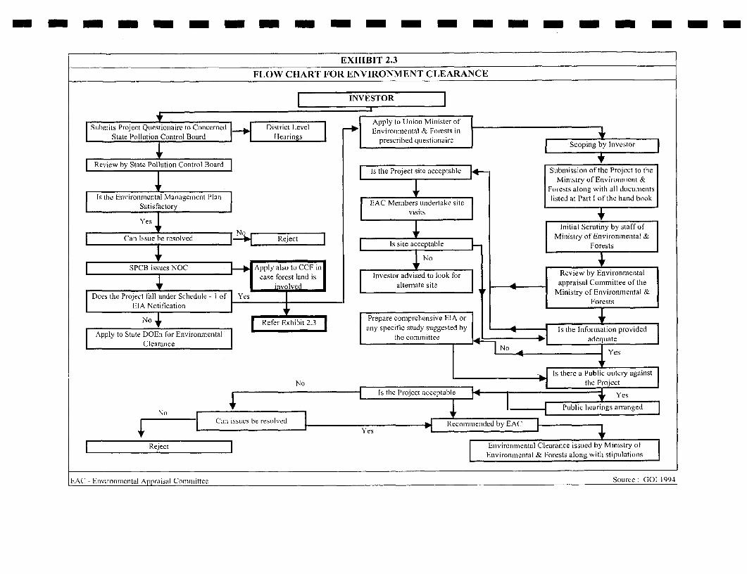
- -- - - - - - - - - - -- - -- - -- -
EXHIBIT 2.3
FLOW CHART FOR ENVIRONMENT CLEARANCE
l ~INVESTOR
ncernedvDistri t Level Apply to Ulnioni Ml ylister ofSubnits Project Questionaire to Cold R _ Environmental & Forests i
State Pollution Control Board Ilearingzs.. .prescitecd qcestioalre F est
1t ~ ~ ~ ~ ~~es forest lanyi InvestoradietolkfrRvewb nrnmtl
| Review by State Poliution Control Board | s. . | 15~~~~~~~~~~~~~~~~~~~~~i the Project site acceptable Submission of the Project to the
Does the Project fall under Schedule - I of Yes Ministry of Environment &s r s ~~~~~~~~~~~~~~~~~~~~~~~~~~~~~~~~~FoFests atonig witlh all dlociliileiits
IsIe nvir-oiimeiital Managenmciit I'lani) listed at Il'art I of the liatid bookSatisfactory ~ ~~ ~~~~~[EAC Memlbers uindertake sit
SaNtisfcatony Fvisits rt
s R Initial Scrutivy by staff of
A y Can Issue be resolved pply Ministry of Environmental &. - . IE site acceptable Forests s
AG EnvironmentaSPCB issuesNOC CApply also toGCCF in| . ~~~~~~~~~~~~~case forest land is | Investor advis ed to look for |Review by Environmental
+ ~~~~~~~ ~ ~~involved Ialtennate site | appraisal Committee of therDoes the Project fall under Schedule - I of IYes F iityofEvrest nts
l ~~~EIA Notification 1Foet
No Jr|Refer Exhiibit 2.3 | |Prepare comprehensive EIA or| | . I ~~~~~~~~~~~~~~~~~~~~~~any specific study suggested by I IIs the InforTnatioii provided I
IApply to State DOEn for Environmental th comte adequat
Clearance~ ~ ~~ 4! No |Yes
l ~~~~~~- |FIs thlere a Public ouitcry agailst|No the l'rojectl
l | Is the l'rqi~~~~~~~~~ect acceptable |<4 Yes
No~~~ c |.| u lhearings arr-anged l
+ ~~~ ~ ~~~ ~ ~~~~~~YesE
E - Reject ll Enivironmcintal Clearance issLued by Miniistry of llEnvironmiental & Forests along witlh stipuilatioiisl
EAC -Enviromniental Appraisal Com-mittee Source - GOI 1994

- m - - - - - - - - - - - - - - - - - - -
EXHIBIT 2.4FOREST CLEARANCE PROCEDURE AS PER FOIREST CONSERVATION ACT
r | ~~~~~~FOREST OFFICER|
v ~~~~~~~~~~~~~CollectorScrutiny of application preparation of Identification of non-forest land
formal proposal
Conscrvator of orests (CF)
M t , , ~~~~~~~~~~~~~~~~R C C F (MOEF) |Site mispection for proposals above 40 ha of
Scrutiny, recommendation forest land
. ~ ~~ IOEF (Proposals ab ove lNodal fficer 20 hectares) _Aivisory Conmmittee.
|Scmtiny, remarks, recommendation Examination & final decision for casesof Principle Chief Conservator of upto S ha forest land except those of Rccommendations of Ad_visoryCo_mmittee|
Forests (PCCF - State) mining and encroachmenlt
State Govern"' orest Deptartment)
Examination & putting before StateAdvisory Group for proposals other M O E F
Scrutiniy, remar-ks, recommendationAthan those mentioned above
RCCF-MOEF(Proposals upto 20hec ares-
Meeting recommendations M 0 E F Final decision issue of first stage approval
Stat Government
Issue of orders by State Government MONITORING |State Government's compliance report
State Govcrinment R-p FORMAL APPROVAL ORDER 4M E F
RCCC - Regional Chief Conservator of Fnrests (MOEF)MOEF - Ministry of Environment and Forest Source: MOEF
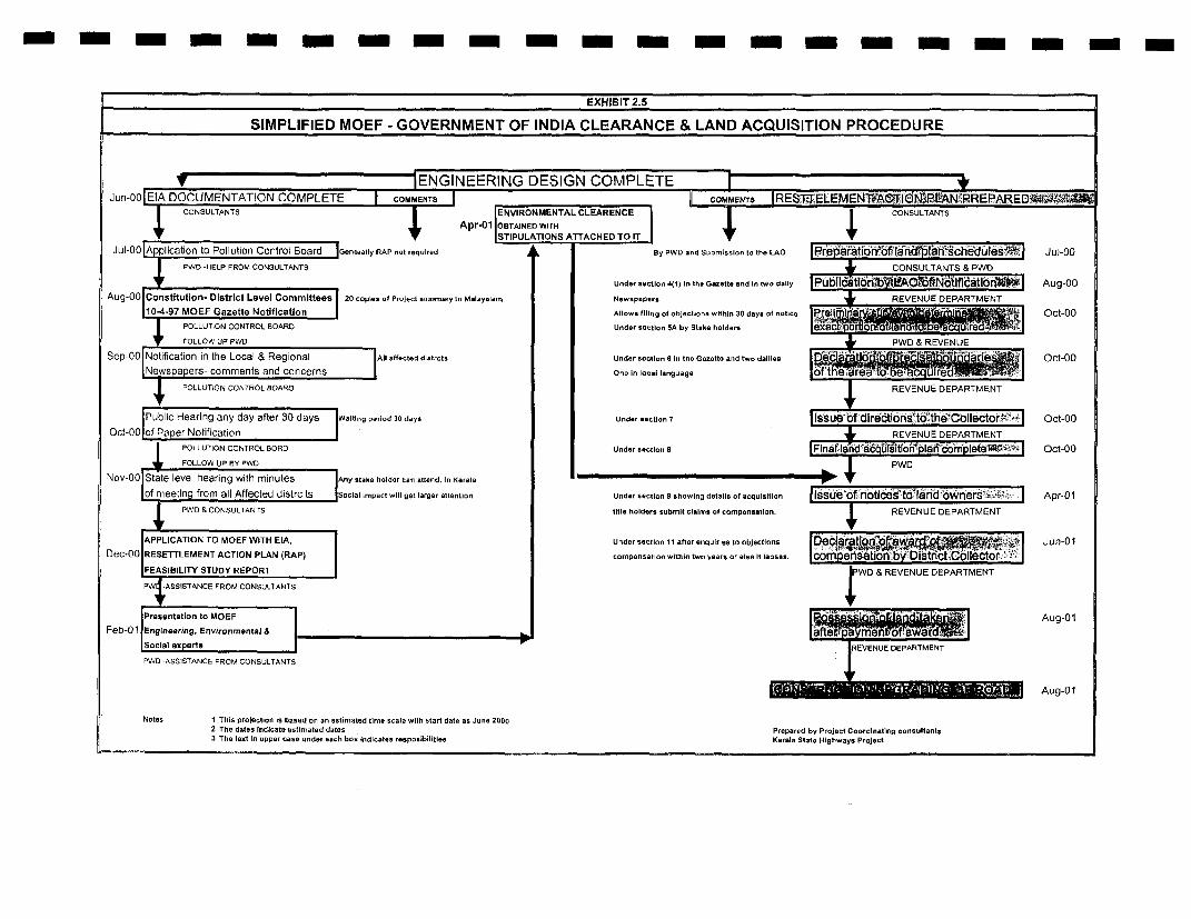
- -- - - - - - - m - - -- - - -- -
EXHIBIT 2.5
SIMPLIFIED MOEF - GOVERNMENT OF INDIA CLEARANCE & LAND ACQUISITION PROCEDURE
t | ~~~~ENGINEERING DESIGN COMPLETE -Jun-GO XE DOCUMENTATION COMPLETE COMENTS
CONSULTANTS ENVIRONMENTAL CLE-ARENCE CONSULTANTS
l . _ . ~~~~~~~~~~~~~~Apr-01 OBTAINED WITH " li,r IlSTIPULATIONS ATTACHED TO IT r
Jul-00 Aplication to Pollution Control Board |Genorally RAP not required A L By PWD and SubmIslon to the LAO 1re ar8Ctiori of tIanran iChteduiles Jul-00
PWD -HELP FROM CONSULTANTS CONSULTANTS & PWD
Under section 4(1) 1n the Ga..tt. and In two dtlty |PubI1datloii.b ,Oti NbtlfldatIbn Aug-00
Aug-00 Constituton- DlstrIct Level Committees 20 copies of Project suereary In Melay.l.m Newopapers REVENUE EPARTMENT
10-4-97 MOEF Gazette Notification Allows filing of objectIons wIthin 30 days of notle Pr li Oct-00
POLLUTION CONTROL BOARD Under ectlion 5A by Stake holders e
FOLLOW UP PWO PWD & REVENUE
Sep-00 Notification in the Local & Regional All affected distrct. Under section 6 In the G..etto and two daillee o_ct-00
Newspapers- comments and concerns On. In local language theweawlwaPOLLUTJON CONTROL BOARD REVENUE DEPARTMENT
Public Hearing any day after 30 days Waiting perIod 30 days Under *ectlon 7 Issue-of dIrectlonsr:tethd CoIectorr°i4.> Oct-00Oct-00|of Paper Notification REVENUE DEPARTMENT
POLLUTION CONTROL BORD Under sectlon 8 rFlnatlatida Iid sitlon plati obmplet te - Oct-00
FOLLOW UP BY PVVD PW
Nov-00 State level hearing with minutes Any stake holder can attend. In Kerala a
of nneetin from all Affected distrcits SocIal impact will get larger atteontlon Under section showing details of acqualstton Ilssue ofh6notices1tO7rIiad oWIners6 -l'| Apr-01&PWD CONSULTANTS tItle holders submit claims of compensation. REVENUE DEPARTMENT
(APPLICATI ON TO MOEF WITH EIA, Under section 11 after enquiries to objections Jun-010ec-00 RESETTLEMENT ACTION PLAN (RAP) compensation witiln two years or else It lapses, corn en6son.by District Collector
jFEASIBILITY STUDY REPORT PWD & REVENUE DEPARTMENT
-PW A55ISTANCE FROM CONSULTANTS 4[Presentation to MOEF Aug-01
Feb-01 Engineering, Environmental & wLSoclal exoerts REVENUE DEPARTMENT
PWD -ASSISTANCE FROM CONSULTANTS
| _ - ~~~~~~~~~Aug-01
Notes 1 This projection is based on an estimated time scale with start date as June 20002 The datns Indicate estimated dates Prepared by Project Coordinating consultants3 The teat In apper case under each boo Indicates resposibillitlee Kerala State Highways Project
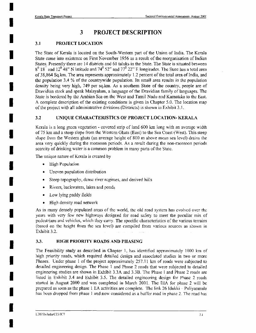
Kerala State Transport Project Sectoral Environmental Assessment- August 2001
3 PROJECT DESCRIPTION
3.1 PROJECT LOCATION
The State of Kerala is located on the South-Western part of the Union of India. The KeralaState came into existence on First November 1956 as a result of the reorganisation of IndianStates. Presently there are 14 districts and 61 taluks in the State. The State is situated between80 18" and 120 48" N latitude and 740 52" and 770 22" E longitudes. The State has a total areaof 38,864 Sq.km. The area represents approximately 1.2 percent of the total area of India, andthe population 3.4 % of the countrywide population. Its small area results in the populationdensity being very high, 749 per sq.km. As a southern State of the country, people are ofDravidian stock and speak Malayalam, a language of the Dravidian family of languages. TheState is bordered by the Arabian Sea on the West and Tamil Nadu and Karnataka to the East.
| A complete description of the existing conditions is given in Chapter 5.0. The location mapof the project with all administrative divisions (Districts) is shown in Exhibit 3.1.
3.2 UNIQUE CHARACTERISTICS OF PROJECT LOCATION- KERALA
Kerala is a long green vegetation - covered strip of land 600 km long with an average widthof 75 km and a steep slope from the Western Ghats (East) to the Sea Coast (West). This steepslope from the Western ghats (an average height of 800 m above mean sea level) drains thearea very quickly during the monsoon periods. As a result during the non-monsoon periodsscarcity of drinking water is a common problem in many parts of the State.
The unique nature of Kerala is created by
* * High Population
* Uneven population distribution
* Steep topography, dense river regimes, and derived hills
* Rivers, backwaters, lakes and ponds
* * Low lying paddy fields
* High density road network
As in many densely populated areas of the world, the old road system has evolved over theI years with very few new highways designed for road safety to meet the peculiar mix ofpedestrians and vehicles, which they carry. The specific characteristics of the various terrains(based on the height from the sea level) are compiled from various sources as shown inExhibit 3.2.
3.3. HIGH PRIORITY ROADS AND PHASING
The Feasibility study as described in Chapter 1, has identified approximately 1000 km ofhigh priority roads, which required detailed design and associated studies in two or moreI Phases. Under phase 1 of the project approximately 257.11 km of roads were subjected todetailed engineering design. The Phase 1 and Phase 2 roads that were subjected to detailedengineering studies are shown in Exhibit 3.3A and 3.3B. The Phase I and Phase 2 roads areI listed in Exhibit 3.4 and Exhibit 3.5. The detailed engineering design for Phase 2 roadsstarted in August 2000 and was completed in March 2001. The EIA for phase 2 will beprepared as soon as the phase 1 EA activities are complete. The link 26 Idukki - Puliyanmalahas been dropped from phase 1 and now considered as a buffer road in phase 2. The road has
LBII/Sheladia/CES'ICT 3.1
l

| Kerala State Transport Project Sectoral Environmsental Assessment- August 2001
been dropped due to a comparatively low prionrty among the selected phase I and phase 2roads to keep within the fixed budgetary provisions from the World Bank.
EXHIBIT 3.2I LOCATIONAL ENVIRONMENTAL ASPECTS WHICH MAY INFLUENCEHIGHWAY DESIGN IN KERALA
ENVIRONMENTAL PHYSIOGRAPHIC CHARACTERISTICSPARAMETERS l
Low land Mid land Highland3 _____________________ <7m (a.m.s.) 7-76m (a.m.s.) >76m (a.m.s)
opographic Plain Hills and valleys HillsLagoons Elas3 l Back waters Laterite capped
Geologic Bed rock Alluvium Charnockites neissGneiss harnockites
Land Slides Nil Occasionallv rone AreaSoil Sandy soil Lateritic soil Loamy soilHydrologic Rainfall 900in south 1400 in south 500 in south
(Mm) 3500 in north 4000 in north 5000 in northDrainage Poor Good ery goodFlooding Very common Common ot Common
emperature 20-37 0 C 20-370 C 17-35 ° CLand Use Coconut oconut ea
Paddy RubberPepper Coffee
Paddy Ginger Cardamom-Tapioca3 Public Trees/ Vegetation cry Few arge ew
(Non forest trees)Forest Nil Negligible Very high,Population 2000 /Sq.km 1500/SqKm <500/sq km
(Source: compiled from various sources and field study)
e EXHIBIT 3.4PHASE 1 ROADS: KERALA STATE TRANSPORT PROJECT
SL. LINK RODAELENGTH / PROPOSEDNOi; LINO. ROAD_NAME _ (km) CARRIAGEWAY WIDTH
I 1.0 aikkod - Kottarakkara 46.01 lOm2 2.0 ottarakkara- Adur 21.20 7m3 3.0 dur- Chengannur 23.20 7 m4 72.0 Taikkod - NH47 13.00 lOm5 73.0 Alappuzha - Changanaserry 24.10 7 m6 26.0 Idukki - Puliyanmala26 (30.70 km) - 7 mLnk 26
7 70.0 Muvattupuzha- Thodupuzha 17.80 7 m8 6.0 Muvattupuzha - Angamali 33.80 10 m
* 9 50.1 Palakkad - Shomur 45.00 7 m10 40.0 Thrissur - Kuttipuram 33.00 10 m
I Total 257.11
26 This is now dropped from phase I and included as a buffer road in phase 2Link 26 At present design is available for 7m but with less shoulder widths
13.BI I/SheladiaXCMS/ICT 3.2

Kerala State Highways Project Sectoral Environmental Assessment-November 2000
\751O °761 ° N INDIA;~~~~~~~~~-f h 0V8~~ 00 kmn
SCALEkrn20JQ 0 20 4-0 60 80 100krf
12- Pil LWM 9 STL o^ z OF nYn BENGALJ
PONNANI
VADNAPAU,Kc
9' State boundary
0 District boundary
Project Pr°orty Road
State CapitalDistrict Headquarters *Link Numnber I
(Source:-WATER ATLAS OF KERALA, 1995)
EXHISIT:-3.1PROJECT ROADS IN REIATION TO ADMINISTRATIVE DMSIONS OF KERALA751 0 761 71 C
LBII/Sheladia/CES/ICT

Kerala State Transport Project Sectoral Envlronmnental Assessment- August 2001
N
D.Okrfl 5 10 15 20 25k-
MATCH LINE FOR HJITI 313B
A gamo a\E3 Mo vottpE!lDtt/ Iafl str ton
~~-Ublp u 2 7t rnao12i 42 6uI
prJ!liPHASE- RHA9aja Uontp2a cirrttyyStctro BLder
- RAULA STAT_ NDAR IDUK AA |tw\0\ER N:s};UL, 4io t p I c nio1S t
S ? it~~~~~~~~~~~~~~ubrnmet u
S hra CE TRE
+ AL,~~hfrr, W TA_ Y AI
PHASE-I AN PASEilPROJEC\Ts ROADS - ERA LA' STT RNPR RJC
LBJI/Sheladia/CES/ICTTAYM 2 a -he iV-
~~~~~~~~~~~~~~~~~nnP f son 'Kry rriA;
% tB3,- 1s; riKorini
is ttR v t AAM`jiT\
LEGE,ND:- _ Y HA4SE- 1 ROADX}w\NAt <PHASE-ii ROAiD cir
^^rJ"r ~~BUFFER ROAD ururr,ng ga
c ~NATiONAL H.GHFWAY \ l v 0J11--lf-R ROA'L.JS c a sttkweoM aKERALA STATE 90UNDARY roRwri anncr,n,cmoo&
,NH17 NAIlON,AL H.GhWAY NlJ'MdER rankvQrh
m LINK NUV9,ER sr ai
ig NODE NUMBE1R
) NTr RNAT'ONAL A!'R PORT
i'. GUR4ST CEN TRE
REL§GOInS G£N-RE
EXHITl 3.3A SOlrrH SECr1ONPHASE,I AND PHAS13 E PROJr ROADS - KEAASTATE TASPORT PROJr
L1R1VSheladia/CES/lCf

Kerala State Transport Project Sectoral Environmental Assessment- August 2001
N+un r A&b
n ksh
ws ~ ~ ~ ~~~~~~~~~~~~~~~~~~0~ 5 7 0 5 1.5 20 2.5kre
~~~~~~~~ ~~~~~~~~~~~~~~~r~~~~~~
KIRAS
Ci, S:erkc5 *;g Hi KASARAGGOD A
SA~~~~~KA
\QKa.ghoraaa
7S W^ M >~~~~~~~ite Mur.b ar>nrr
7
NA NL l@ WAY [Z
ld ue ,_!edSnpol
0 S,.;RG~AD Sr
N 17 NA' ONAL H-iGHWAY aNL)a BR
rll,X.w. \S wJa r Per',kksllrlr _~~~~~~~~~~~~Oye
tX ,S. rK r raKERALA SuW-S 3 0r"N' DA - # t
YSE 1 i hntntrrurtsery y e~~~~~~~~~~~~~~~~~~~~~~ro71
IN` ENAYI'0NA-' A)IR P'OR ~g7L1!RIS'~ kCFNTRE TRSU
'LGOSC-ENTfRE ~' ~ ~~ MATCH TIfNE FORi WEXIB7F 3.3
EXHIIT 3.3B NORTH SECTIONPHASE-I AND PHASE-i PROJECT ROADS - KERALA STATE TRANSPORT PROJECr
LBIJSbeladla./CES,4CT
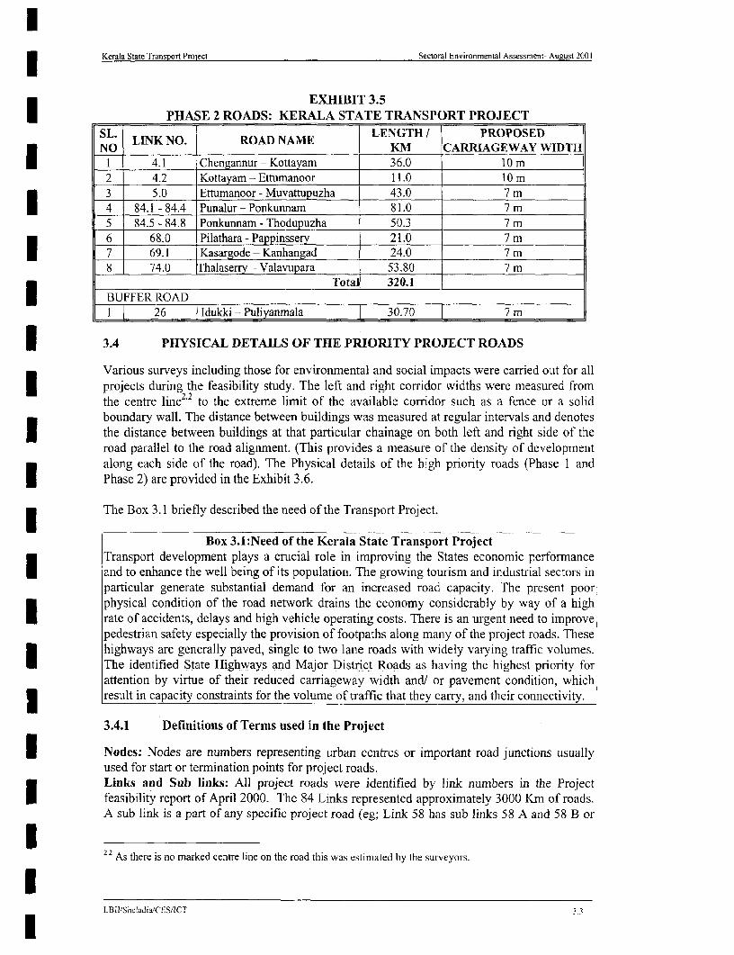
Kerala State Transport Project Sectoral Environmental Assessment- August 2001
EXHIBIT 3.5PHASE 2 ROADS: KERALA STATE TRANSPORT PROJECT
SL. LINK NO. ROAD NAME LENGTH / PROPOSEDNO KM CARRIAGEWAY WIDTH1 4.1 Chengannur - Kottayam 36.0 10m2 4.2 Kottayam - Ettumanoor 11.0 10 m3 5.0 Ettumanoor - Muvattupuzha 43.0 7 m4 84.1 - 84.4 Punalur- Ponkunnam 81.0 7m5 84.5 - 84.8 Ponkunnam - Thodupuzha 50.3 7 m6 68.0 Pilathara - Pappinssery 21.0 7 m7 69.1 Kasargode - Kanhangad 24.0 7 m8 74.0 Ialaserry - Valavupara 53.80 7 m
Total 320.1BUFFER ROADI 26 Idukki - Puliyanmala 30.70 7 m
| 3.4 PHYSICAL DETAILS OF THE PRIORITY PROJECT ROADS
Various surveys including those for environmental and social impacts were carried out for allI projects during the feasibility study. The left and right corridor widths were measured fromthe centre line22 to the extreme limit of the available corridor such as a fence or a solidboundary wall. The distance between buildings was measured at regular intervals and denotesI the distance between buildings at that particular chainage on both left and right side of theroad parallel to the road alignment. (This provides a measure of the density of developmentalong each side of the road). The Physical details of the high priority roads (Phase 1 andPhase 2) are provided in the Exhibit 3.6.
The Box 3.1 briefly described the need of the Transport Project.
Box 3.1:Need of the Kerala State Transport ProjectTransport development plays a crucial role in improving the States economic performanceI and to enhance the well being of its population. The growing tourism and industrial sectors inparticular generate substantial demand for an increased road capacity. The present poorphysical condition of the road network drains the economy considerably by way of a high
* rate of accidents, delays and high vehicle operating costs. There is an urgent need to improvepedestrian safety especially the provision of footpaths along many of the project roads. Thesehighways are generally paved, single to two lane roads with widely varying traffic volumes.
fI The identified State Highways and Major District Roads as having the highest priority forlattention by virtue of their reduced carriageway width and/ or pavement condition, which3 result in capacity constraints for the volume of traffic that they carry, and their connectivity.
3.4.1 Definitions of Terms used in the Project
I Nodes: Nodes are numbers representing urban centres or important road junctions usuallyused for start or termination points for project roads.Links and Sub links: All project roads were identified by link numbers in the ProjectI feasibility report of April 2000. The 84 Links represented approximately 3000 Krn of roads.A sub link is a part of any specific project road (eg; Link 58 has sub links 58 A and 58 B or
I2.2 As there is no marked centre line on the road this was estimated by the surveyors.
LBII/Sheladia'CES/ICT 3.3
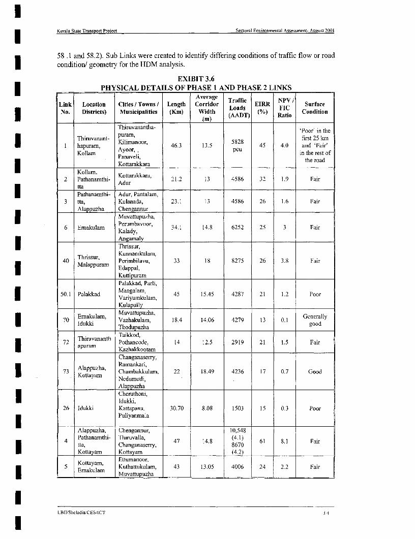
Kerala State Transport Project Sectoral Environmental Assessment- Aueust 2001
58 .1 and 58.2). Sub Links were created to identify diffenrng conditions of traffic flow or roadI condition/ geometry for the HDM analysis.
EXIBIT 3.6PHYSICAL DETAILS OF PHASE 1 AND PHASE 2 LINKS
Average Traffic NPVILink Location Cities I Towns / Length Corridor Loads EIRR FIC SurfaceNo. Districts) Municipalities (Krm) Width (AADT) (%) Ratio Condition
Thiruvanantha- 'Poor' in the
Thiruvanant- puram, first 25 kmI hapuram, Kimanoor, 46.3 13.5 5828 45 4.0 and 'Fair'
Kollam Ayo,,puin the rest ofPanaveli, the road
Kollam KottarakkaraI Kollam, ~~~~~Kottarakkara,2 Pathanamthi- Adur 21.2 13 4586 32 1.9 Fair
tta AdurPathanamthi- Adur, Pantalam,
3 tta, Kulanada, 23.1 13 4586 26 1.6 FairI Alappuzha Chengannur
Muvattupuzha,
6 Emakulam Perumbavoor, 34.1 14.8 6252 25 3 FairKalady,AngamalyThrissur,
40 Thrissur, Kunnamnculam,40 Marippuram Perimbilavu, 33 18 8275 26 3.8 Fair
Edappal,Kuttipuram ______._
Palakkad, Parli,
50.1 Palakkad Mangalam, 45 15.45 4287 21 1.2 PoorVariyumkulam,Kulapully
Emakulam, Muvattupuzha, Generally70 IdVazhakulam, 18.4 14.06 4279 13 0.1 good
Idukki Thodupuzha______
T'hiruvananth Taikkod,72 apuram Pothancode, 14 12.5 2919 21 1.5 Fair
apuram KazhakkootamChanganaserry,
Alappuzha, Ramankari,73 AlKtuzha Chambakkulam, 22 18.49 4236 17 0.7 Good
NedumudiAlappuzha
Cheruthoni,Idukki,
26 Idukki Kattapana. 30.70 8.08 1503 15 0.3 PoorPuliyanmala
Alappuzha, Chengannur, 10,5484 Pathanamthi- Thiruvalla, 4148 (4.1) 61 8 Fi
tta, Changanaserry, 47 14.8 8670 61 8.1 FairKottayam Kottayam (4.2)
Kottayam, Ettumanoor,5 Emakulam Kuthattukulam, 43 13.05 4006 24 2.2 Fair
*naklam Muvattupuzha
LBII/SheladiaiCES/ICT 3.4

TYPE-10 b
(b~~~~~~~~~~~~~~~~~~~~~~~~~~~~~~~~~~~~~~~~~~~~~~~~~~~~~~~~~~~~~~~~~~~~~~~~~~~~~~~~~~~~~~~~~(
CO I ~~~~~~~~~~~~~~~~~~~~~~5000 5000 t
2500* 1500 3500 3500 1500 _200 _
SLOW LANE WIDENED C RRIAGEWAY SLOW LANE
,UTILITl JIUCT UTILTY DUCT
FOOT/ PATH I j FOOT P
tol
EXISflNG GROUND LINE t
NOTES:-A. ALL DICENSCS AM IN t
2. ROC COVNO SLAWS TO BE PROMADED AT ACCESS ROADSI PCLES TO K PROIADED AT DRAIAGE LAVE AT AN INTERVAL OF 2 =
4, ACROSS ROAD SERVCE DUJCT TO BE PRMOVIE AS RECUIRED& * VARItS DURaNG CONSRUC1ON
EXHIBIT-3.7 TYPICAL CROSS SECTION FOR TWO LANE PLUS SLOW LANE AND DRAIN UNDER FOOTPATH(1O.Om CARRIAGE WAY )

TYPE-1 0'
* rI-~~~~~~~~~~~~~~~~~~~~~~~~~~~~~~~~~~~~~~~~~~~~~~~~~~~~~~~~~~~~~~~~~~~~~~~~~~~~~~~~r
'N 2500* _ 3500 3500 Q 2500*
La i WIDENED CARRIAGEWAY
PROPERTY LINE ' PRtOPERTY UNE t
, v ~~~~UTILITY DUCT UTILI1 .DUCT
,FOOT PATH / FOOT PATH
7EXISTING GROUND LINE
CD
NOTES *-
32WE Ha-E MON SiBE PROV1DED AT DRAINAGE LAYER AT AN INll_RVAL OF 2m C
PO AERT YAD WERC CT TO BE PROPDED AS REQURE
EXHIBIT-3.8 TYPICAL CROSS SECTION FOR TWO LANE AND DRAIN UNDER FOOT PATH G
(7.0m CARRIAGE WAY)

TYPE-30
e. ,
1' ~~~5000 , 5000 ,b
CD~~~~~~~~~~~~~~~~~~~~~~~~~~~~~~~~~~~~~~~~~~~~~~~~~~~~~~~~~~~~~~~~~~~~~~~~~~~~~~~~~~~~~~~~~~~~C
CD~ ~ ~ ~~~~~~~~~SO IACDMND AJGWY LWLN
E (S
CD
EXISTING GROUND LINE
| . ALL OIIIENSONS ARE PlmITNK SROO
|4e A>ORS ROAD SERV<E DUCT TO Kt PROVO AS ROOESDl
EXHIBIT- 3.9 TYPICAL CROSS SECTION FOR TWO LANE PLUS SLOW LANE WITH SEALED SHOULDER AND COVER DRAIN (10.Om CARRIAGE WAY)

TYPE-30
92 0
Q _ ~~~~~~~~~900 __ 2500 ,3500 ,_3500 _ 2500 _900 _t
0 ~~~SVAZ WMNI CARAEW:AY SV LE
LEXISTING GROUND LINE
(7.0m WEEP WAY M c
Cl)~~~~~~~~~~~~~~~~~~~~~~~~~~~~~~~~~~~~~~~~~~~~~~~~~~~~~~~~~~~~~~~~~~~~~~~~~~~~~~~~~~~~~~~~~~~~~~~~~~~~~~~~~~~~~~~~~~~~~~~~~~~~~~~~~~~~~~~~~~~~~~~~~~~~~~~~~~~~cC
EXHBIT 310 YPIALCR2500CTON3500WOLA 3500 LE 2500DE 900OVRDRI
SEALED WIDE~~~~7.O CARRIAGE WAY SHUDE2

TYPE-43
C'
fD
X t
0 ~~~~~~~~~~~~~~~~~~~~~~~~~~~~~~~~~~~~~~~~~~~0
5000 5000 _ b
10
VARIES 100 1500 3500 3500 10 j0 VARIES
SLOW IANX NMWIMDEN CAIUAGUKWAY BWIN
LxiGX 4
///Xs\\ //X \ ./4/ EXISTING GROUND LEVEL
CDor
NOTES:-1. AU. DIM&MS AM R2. EBAWMNrT UD SLEOPE YCH - 1:2 BE FLL H4ET 4
VH- 2.5,1 FOR OJT HEIGHT
1 AOSS ROAD SERYCE DUCT e BE PRO1OD AS NTHBCAJR4. IASNA.E TURS§CS AR PRCP OSM E VH 13ANKBIENT
HEIGHT IS LESS THPAN Im. L
EXHIBIT- 3.11 TYPICAL CROSS SECTION FOR TWO LANE PLUS SLOW LANE WITH SEALED SHOULDER
(1O.Om CARRIAGE WAY )

TYPE-43
C >~~~~~~~~~~~~~~~~~~~~~~~~~~~~~~~~~~~~~~~~~~~~~~~~~~~~~~~~~~~~~~~~~~~~~~~~~~~~~~~~~~~~~~~~~C
VARIES IOOQ 35003500 1QQQ VARIES
CD~~~~~~~~~~~~~~~~~~WE CACG.A
///X\\\ //C\\\ /DDROUND LE ELGL
-. CD~~~~~~~~~~~~~~~~~~~~~~~~~~~~~~~~~~~~~~~~~~~~~~~~~~~~~~~~~~~~~~~~~~~~~~~~~~~~~~~~~~~~~~~~~~~~~~~~~~~~~~~~~~~~~~~~~~~~~~~~~~~~~~~~1 L IO 5M:b n
Cb
SD
2. EWANKMENT SDE SLOPE : VMH - f2 FOR FIL HEIGHTM.H -2.5:1 FOR aur HEIGHTe
4, NAGE TRtHS AKPOOS O DENT eAI GHT I3 L500 3500 IMI. Va
EXHIBIT- 3.12 TYPICAL CROSS SECTION FOR TMWO LANE PLUS SLOW LANE WITH SEALED SHOULDERX(7. Im CARRIAGE WAY 2

TYPE-40
ti2
Cb
Ci2~~~~~~~~~~~~~~~~~~~~~~~~~~~~~~~~~~~~~~~~~~~~~~~~~~~~~~~~~~~~~~~~~~~~~~~~~~~~~~~~~~~~~~C
U t~~~~~~~~~~~~~~~~~~~~~~~~~~~~~~~~~~~~~~~~~~~~~~~~~~~~~~~~~~~~~~~~~~~~~~~~~~~~~~~~~~~~~~~~~t
0 0
_ VARIES , 1000 Z 1500 _ S 3500 , _ 3500 _ _ 1500 100 0NN VARIES -L E
Z EU9ANKMENT SDE SLOPE:* V:H - 1:2 FOR RFIL HEIGHTM
4, DHRAINAGE TRENCHS ARE PROPOSED WEPROUED EMANKMENTRE
Ii Ii~~~~~~~~~~~~~~~~~~~~~~~~~~~~~~HIH S ESTA m
EXHIBIT- 3.13 TYPICAL CROSS SECTION FOR TWO IANE PLUS SLOW LANE WITH SEALED SHOULDER G
AND EARTHERN DRAIN (10.Om CARRIAGE WAY )

TYPE-40
CD~~~~~~~~~~~~~~~~~~~~~~~~~~~~~~~~~~~~~~~~~~~~~~~~~~~~~~~~~~~~~~~~~~~~~~~~~~~~~~~~~~~~~~~C
CD~~~~~~~~~~~~~~~~~~~~~~~~~~~~~~~~~~~~~~~~~~~~~~~~~~~~~~~~~~~~~~~~~~~~~~~~~~~~~~~~~~~~~~~C
tix
VARIES J1 -0 3500 3500 1000 VARIES 0
WDEE CARtIAGlWAY
EXISTING GROUND LEVEL
|//X\\\ I7AL111_ME mm l
CD
NOTES:-|. ALL DIENS A _ X RE UIRNl2. EkeANQKENT SDOE SLOE A - 1:2 FOR FLL HE3DHT
MH- 2.5&1 FORl CUT HEOIGT
3. ACROSS ROAD) SER'CE DUJCT TO BE PRO'.4OE AS REQUMFa&. DRAINAGE 1MENCHS ARtE MPRoAOS WIHERE EMBiRMNIOET
HEGHT IS LESS THMN lm.
EXHIBIT- 3.14 TYPICAL CROSS SECTION FOR TWO LANE WITH SEALED SHOULDERAND EARTHERN DRAIN (7.Om CARRIAGE WAY )

lKerala State Transport Project Sectoral Environmental Assessment- August 2001
4 SECTORAL ENVIRONMENTAL ASSESSMENT-APPROACH AND METHODOLOGY
4.1 ASSESSMENT METHODOLOGY
The Environmental Assessment (EA) process started from the early stages of the projectwork. The methodology followed in the Sectoral Environmental Assessment process iscontinuous. The potential environmental aspects have been examined in detail at differentstages in the process. The incorporation of observations and assessments of those likely to bedirectly affected by the proposed project is an essential feature and becomes increasinglyimportant as the process develops. The various consultations carried out during the processare discussed in detail in Chapter 9.0.
4.1.1. ENVIRONMENTAL ASSESSMENT TEAM
The team consisting of Environmentalists, Social impact specialists, Highway Engineers andothers carried out the various surveys required for the Environmental Assessment. Therewere joint visits by World Bank Environmental Specialists and PWD engineers together withthe Consultants team. Besides vehicle 'wind shield' surveys, there were Environmental andSocial Impact Surveys that noted the various physical characteristics of the road and prepareddetailed environmental strip maps. The environmental monitoring of Air, Water and Noisewas carried out by the Kerala State Pollution Control Board, which was completed at the endof November 2000 using modern electronic equipment, and reported in April 2001.Major influences in the Sectoral Environmental Assessment and Environmental ImpactAssessment process follow.
4.2 MAIN CONCERNS DURING THE EA PROCESS
The main concerns that have influenced the methodology were: -
| Very high magnitude of Social impact which would be caused by the widening of theexisting narrow corridors to the full IRC standards
* Determination of the optimum level of widening to a "compromise" width to cater forpredicted traffic within the design life.
* High number of accidents especially those involving pedestrians
* High rainfall and associated flooding during monsoon
4.3 THE SEA PROCESS
| Reconnaissance Survey report. Reconnaissance surveys were undertaken by theenvironmental team for documentation of the environmental issues in April 1999. In additionto field investigations and observations, consultations were held with local officials, andavailable environmental documentation was assembled for review.
Scoping. Scoping is the process used to detennine the anticipated range of issues to beaddressed in the detailed environmental analysis. Guidelines issued projects by the WorldBank for road identify screening and scoping activities as " an early determination of thepotential magnitude of impacts and hence the depth of study required (for a given project).This should be the first stage to incorporate environmental considerations into a roaddevelopment project. As a part of this, three regional level scoping workshops werecarried out at Thiruvanathapuram, Kochi and Kozhikode in order to involve a number ofNGOS and stakeholders from all districts. The details of these scoping sessions furtherstreamlined the EA Process.
LLB] iSheladiaICES/ICT 4 1

lKerala State Transport Project Sectoral Environmental Assessment- Aucust 2001
Environmental and Social Impact screening study. A comprehensive survey wasconducted with four teams of three Environmental surveyors in each team for the purposeof environmental and social impact screening. A data sheet was designed to collectquantitative and qualitative social and environmental data in addition to holding the localproject specific consultations. These data provided the basis for decision maker onalignment options. A spreadsheet based model (EASISM) was devised to compute theProject Affected People, land required and the cost for resettlement and rehabilitation.The details of this model are described in the Appendix-A 4.1 in Volume II and whichwere also presented in the feasibility study report submitted in April 2000.
* Link specific Environmental data analysis; this presents an account of Link specificenvironmental aspects (Appendix A 4.2 Volume II) briefly for a quick review ofenvironmental aspects.
* Environmental Strip Mapping: Environmental strip maps for Phase I, are available forthose Links for which EIA reports have been prepared. For Phase 2 a generalenvironmental Strip map is attached as Appendix A4.3 Volume II.
I Assembly and Analysis of Previously Collected Data. This included both publishedand unpublished environmental data. Literature searches were undertaken and relevantagencies (e.g., the Department of Forest, the State Pollution Control Board,Archaeological Survey of India, etc.) were contacted and appraised of the project.Sources of data collected included:
- Socio- Economic data from the Census Department
- Air, water (surface and groundwater) and noise quality data from the CentralPollution Control Board
- Flora and fauna from various sources, including the World Wildlife Foundation(WWF) and State Forest Department
- Baseline aspects from District Gazetteers
- Survey of India (SOI) maps for the potentially affected districts.
- District Planning Series Maps from SOI (these maps are prepared by the Departmentof Science and TechnologylDST)
- Kuttanad Water Balance Study project office of Irrigation Department
- Inland Waterways Authority of India
- Kerala State Pollution Control Board
- Centre for Earth Science Studies
- State Committee on Science Technology and Environment
- State Gazetteers
- Cambridge World Conservation Monitoring Centre
The Review of available data, combined with the initial reconnaissance investigations,determined the need for primary data collection in some instances,
Identification of Primary Data Collection Needs. Instances in which the collection ofprimary data was considered necessary were identified early in the process. The seriousdata gaps on Air, Water and Noise quality along the project Road have been established.This data has been produced by the KSPCB and is included in this report (refer AppendixA5.2).
LBtIISheladia/CES/ICT 4.2
l

Kerala State Transport Proiect Sectoral Environmental Assessment- August 2001
Visual Inspections and Photographs
| During the course of the project in addition to the Environmental and Social Assessmentteam, Engineers, Economists and World Bank experts also visited road sections to inspectvarious aspects of the required works. A large number of photographs were taken forreference. Some of the most relevant photographs are exhibited in Chapter 6.0.
* Preparation of feasibility and Sectoral Environmental Assessment report
| The following aspects were considered in preparing the feasibility report.
- population distribution,
- concentrations of tribal and cultural groups,
- concentrations of low income communities,
3 - sensitive and/or critical natural habitats (e.g., national parks, wildlife reserves,sanctuaries, sacred groves, protected areas, forest, wetlands, etc.),
- major rivers and waterways,
- recorded cultural heritage sites,
- any potentially sensitive areas, based on recent GOI census, official data andinformation from NGOs and
- site visits.
The results were plotted on maps and tabulated to identify any conflicts andrecommendations were made on how to resolve them. The analysis of altematives and/ormitigation was made as a precursor to engineering design and before undertaking the socialimpact and environmental assessment studies.
* Determination of the Potential Impact Area (PIA) for SEA and EA Purposes. TheMinistry of Environment and Forest (MOEF) Schedule I of MOEF notification includesI Highways projects and suggests the adoption of seven Kilometres as the potentiallyaffected area for highway projects. The EIA therefore needed to address the 14 KilometreImpact corridors, seven kilometres on either side of the proposed right-of-way (ROW). At
I the same time it is recognised that the exact limits of the "potentially affected area" mayrequire expansion in accordance with the circumstances under consideration. It may beargued, for example, that the improvements of highways will, to some degree, have aI State level impact due to their contribution as a critical element in transport planning,especially with regard to the industrial development and tourism sectors.On a more immediate level, increased storm water runoff from the proposed highways,I for example, will affect hydrological conditions downstream. Any increased runoff due tohighway development and the additional development that it attracts (referred to it as an"induced impact") may, therefore, warrant investigations in larger areas than theimmediate ROWs. The immediate project influence areas of approximately 500m oneach side were taken for Environmental Assessment and for strip mapping 100 m on both
| sides were examined. The area of influence of the project also included all ancillary siteslike borrow/quarry areas, workforce camps, and material storage and disposal areas.
* Documentation of Baseline Conditions. Chapter 5.0 presents Sector specific baselineI conditions within the area defined. Data is drawn from all sources as noted above.
* Assessment of Potential Impacts. 'Potential' may be direct, indirect or cumulative.Identification of potential impacts for Highway improvements is facilitated by theextensive documentation of similar projects in both India and elsewhere. Screening forsignificant adverse impacts and identification of environmental enhancement
LBIf/She1adia/CES!/CT 4-3

Kerala State Transport Project Sectoral Environmental Assessment- August 2001
opportunities consisted of:
- Analytical Review of Baseline Data.
Information with regard to sensitive area, issues, land uses and sites.
5 - Review of Land Use and Environmental Factors Sensitive land use and environmentalconditions within the Project influenced districts were surveyed through the use ofavailable data sources and interviews with concerned agencies.
- Analytical Review of the Underlying Socio-Economic Conditions with the ProjectInfluence Area.
| - Assessment of Potential Impacts as Identified by Previous Highway Projects. Thereview was based on previous experience with the guidelines and recommendationsproposed by MOEF and the World Bank as indicated earlier and used as acomprehensive checklist to ensure consideration of all impacts, positive and negative.
* Integration of Environmental Concerns in the Design Process The consideration ofenvironmental issues was an integral part of Highways Project preparation- a process
x generally referred to by the World Bank as "mainstreaming the environment". The designand decision-making process was undertaken so that environmental and resettlement andrehabilitation issues prompted appropriate actions. Such actions included a shift in
* alignment or a curve improvement based on road safety considerations. To reduce localimpacts, bypasses were also considered. Such adjustments were weighed against benefitsderived from reductions in village congestion, and improvements in road safety, and wereI incorporated in the designs. It was also necessary to ensure the maximum practicalavoidance of sensitive areas (e.g.: shrines hospitals and sanctuaries) and adverse impactsupon all of the project affected persons.
* Assessment of Alternatives. Although alternatives were considered continuouslythroughout the process, a more formal assessment was undertaken as a part of theenvironmental assessment process as documented in Section 7.0 Examination of the "NoAction" Alternative is customarily included as a part of the formal assessmentmethodology to ensure that it has been given proper consideration.
* Final Alignment Determinations. Physical verification of the alignment in terms of thenumber of trees along the Highway and the presence of schools, hospitals and shrines wasundertaken. The presence of built-up areas along most of the roadside made this thesingle largest influence upon alignment options. This was independently analysed toestablish the viable design options. Most of the alignmcnts were based on this criterion.
* Identification of Mitigation and Environmental Enhancement Measures."Mainstreaming" of environmental concerns, means that the measures necessary to avoidor otherwise mitigate potential impacts were recognised in the design stage asdocumented in Section 6.0. Others will require appropriate actions in the constructionand operational phases. Positive actions, not only avoid adverse impacts, but alsocapitalise on opportunities to correct environmental degradation or improveenvironmental conditions and were determined as documented in Chapter 9.0.
* As an environmental safe guard, chapter 10 on the maintenance activities is alsoincluded. The impacts would be mostly construction related. A separate environmentalManagement Action Plan is devised describing the implementing organisation,responsible organisation, Contractual clauses etc.
* Continuous Public Consultations. Consultations with concerned officials, agencies andpotentially affected persons continued throughout the design process and will continue as
LBIU/Sheladia/CES/ICT 4.4

Kerala State Transport Project Sectoral Environmental Assessment- August 2001
the project proceeds. This is the subject of Chapter 8.0.
The most important consultations were
1. Regional scoping workshops at three centres
* 2. Official consultations
3. Project specific consultations.
Preparation of the Environmental Management Plan (EMP). Recognition of theI necessary mitigation measures is a necessity, but by itself is often insufficient. Stepsnecessary to ensure that the adequate measures have been and will be taken werespecified in the form of an Environmental Management Plan (EMP) as documented insections 9.0 and for maintenance activities in section 10.0.
l
lI
Il
I ~ BISeaiJEIC .
Kerala State Transport Project Sectoral Environmental Assessment-August 2001
5 BASELINE ENVIRONMENT
This section of the SEA presents a statement of the existing Sectoral environmental issuesand analyses the baseline environmental conditions. Relevant aspects of the physical, socio-economic and biological environments are presented in various sub-sections.
Baseline data and the existing conditions in the potentially impacted area are providedaccording to the World Bank and the GOI guidelines. The discussions of potential impactsand mitigation measures that follow in Chapter 6.0 also follow the same sequence andnumbering pattern.
5.1 THE NATURAL ENVIRONMENT (METEOROLOGY)
5.1.1 Climate
The climate of Kerala can be broadly grouped into the following seasons:
(i) SWMonsoon months - June, July, August and September
(ii) NE Monsoon-October, November and December
(iii)Non Monsoon- January, February, March, April and May
This classification is adopted in the Environmental Assessment process; since the dynamicsof the two monsoon seasons are different, they cannot be treated together. For generalpurposes usually the classification; pre-monsoon, monsoon and post- monsoon seasons areconsidered.
5.1.2 Temperature:
Kerala has a humid tropical climate with relatively little temperature variation. It is neithervery cold in winter nor very hot in summer. Kerala is subject to both the southwest andnortheast monsoons. The monthly average temperatures at Kovalam (Thiruvananthapuram)vary from 28°C to 33°C. The overall temperature variation is between 17° C and 380 C. Thehot season is from March to May.
5.1.3 Rainfall:
Kerala is subject to both the South-West and North-East monsoons. The southwest monsoonlasts from the end of May until September, with peak average rainfall in June of 330 mm atKovalam (Thiruvananthapuram). The isohyetal map is shown in Exhibit 5.1. The Projectroads in relation to the mean annual rainy days of Kerala are shown in Exhibit 5.2. The meanannual rainy days vary from 50 to 145. The northeast monsoon is in October and Novemberwith a peak average rainfall in October of 280 mm at Kovalam (Thiruvananthapuram).Minimum average monthly rainfall of 20 mm occurs in January. The average annual rainfallof various districts in Kerala varies from 2002 mm in Thiruvananthapuram District to 3594mm in Wayanad. The rainfall data for the districts is presented in Exhibit 5.3. Theprecipitation pattern in relation to the Project roads for the southwest monsoon is shown inExhibit 5.4.
5.1.4 Winds
The maximum wind speed of more than 20 krn/hr has been recorded for many days inAlappuzha, Kochi and Thiruvananthapuram. The wind speed is highest during the south -west monsoon, the direction being from the northwest. In general, the wind speed decreases
,LBIU1Sheladia/CESllCT
I 5.1

Kerala State Transport Project Sectoral Environmental Assessment - August 2001
\ 75-o 076-10 77-1
N
380 8°C o SCALEK^SM400x_ ) %] km2O 10 0 20 40 60 80 lOOkm
12' ~~~~~~~~~~~~~~~~~~~~~~~~~~~~~~~~~~~~~~~~~~~~~~~~~~~~~~~~~~~~~~~~~12,
11*300 11. *
0 PiPAPI\
0 0~~~~~~~~~~~~~~~~~~~~~~~~~~0
3000 KUMILY
trIsohyet in mm 1
Isohyet invterva1 mOONt
State boundary 3000
Project Priorty Road _ 21o 0)
Lake/Backwater 7 0
(Source:-WATER ATLAS OF KERALA, 1995) TH 600°
160 1 00
EXHIBIT 1 5.1PROJECT RODS IN RETIOTU TO ISOTETUAL OF KERLA
715° j D76-10 71'10
LRII/Sheladia/CES/ICT

Kerala State Tranport Project Sectoral Environmental Assessment - August 2001
7S- 0 76-10 77-10
N
SCALEkm20 10 0 20 40 s0 E0 100km
KASARAGOO I I
HOSOUR
12' IP lLATHMlA7R Ai° 12'
0~~~PPNIS\I i K A R N A T A K A j PAPINISSERY J
IiND 120
KOZHNOM
0 0
0 0~~~~~~~~~~~~~~~~~~~~2MADANNPALLY NUA RIYY A
12\03> 20 ,3 F4
10' LEGEND KOCHIBrF0 t.2
Selected Raingauge Stations aO) 2C> 0t poopARA
Projecf Road \0>tL 2 §,,6MEAN ANNUAL RAINY DAYS O KERALA
-LL-- 145 K40L/q L)Y
1 4 0 ALAPPUZH^0^} ALAPP ZO
9. 120o 92.
L____5-- 00 1 3
ISource;-WATER ATLAS OF KERALA, 19951THIR AR
EXHIBIT: d-.2PROJECT ROADS IN RELA71ON TO MEAN ANNUAL RAINY DAYS OF KCERALA
i5't 0 76' 10 77' I0
LBlr/She1adia/CES/1CT
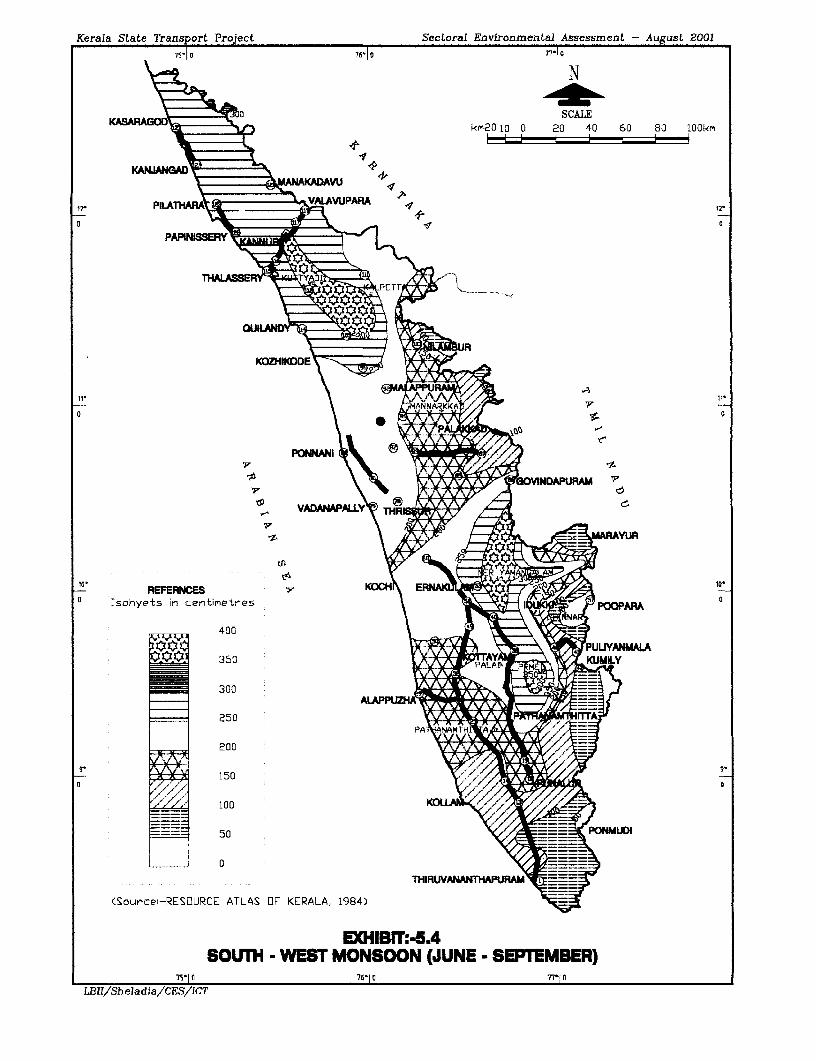
Kerala State Transport Project Sectoral Environmental Assessment - August 20017s- o 76-10 77-10
N
KASARAD SCALEkm20 K0 0 20 40 60 80 lOOkm
KA NGA
o~~~~~~~~ X
12 Ischyets Pi c t
NA~~~~~~~~~~~~~~~~~~~~~~~~a(S~llWRSIUC ATLASOKRLA 194
\ A t~~~~~~~~~~~~~~-
VA4PALLY5 HI
10, KOCH P 0 7610
,- REFEaIa/CES;ICT
, Ischyets in centirmetres \IzPOOPAM
1 ~~~~~~400 0\
X X E 3S0 m hPT^LAYtK50 KULY
_ ~~300 0{>
0 = ~~~250 P m
9 W ~~~~~150 o
__ ~~100 ,
: ____ ~~50 .~-ON U
(Sourcei-RESOURCE ATLAS OF KERALA, 1984)
EXHIBIT: -5ASOUTH WEST MONSOON (JUNE - SEPTEMBER)
7S'10 716-10 7r[ 0
LBlIISheladialCESIICT
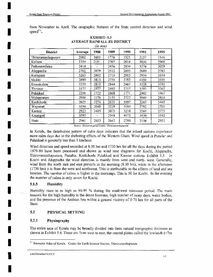
Kerala State Transport Project Sectoral Environmental Assessment-August 2001
from November to April. The orographic features of the State control direction and windspeed5 '.
EXHIBIT- 5.3AVERAGE RAINFALL BY DISTRICT
(in mm).
District Average 1988 1989 1990 1991 1995Thiruvananthapuram 2002 1683 1776 1521 2137 1546Kollam 3739 2181 2767 2018 3036 2968Pathanamthitta 2414 - 2456 2834 3374 3029Alappuzha 2702 3079 2512 2693 2680 2783Kottayam 3263 2802 2711 2913 2954 3354Idukki 2889 3813 2731 3782 4104 3555Eranakulam 3529 2810 2844 2467 3328 3593Thrissur 3177 2577 2492 2757 3393 3262Palakkad 2398 1722 1868 1771 2402 1967Malappuram 2900 2176 2151 2722 3000 2814Kozhikode 2625 3274 2831 3007 3265 3442Wayanad 3594 2040 2228 3180 2792 2703Kannur 2923 3419 3075 3214 3569 2775Kasargod 3593 - 3548 4075 3430 3542State 2961 2653 2642 2780 3106 29523 Source: Meteorological Centre, Thiruvananthapuram
In Kerala, the distribution pattern of calm days indicates that the inland stations experiencemore calm days due to the sheltering effects of the Western Ghats. Wind speed in Punalur andPalakkad is generally less than 5 km/hour.
Wind direction and speed recorded at 8.30 hrs and 1730 hrs for all the days during the period1979-80 have been processed and shown as wind rose diagrams for Kochi, Alappuzha,Thiruvananthapuram, Punalur, Kozhikode Palakkad and Kannur stations Exhibit 5.5. InKochi and Alappuzha the wind direction is mainly from west and north- west. Generally,wind from the north east and east prevails in the morning (8.30 hrs), while in the afternoon(1730 hrs) it is from the west and northwest. This is attributable to the effects of land and seabreezes. The number of calms is higher in the mornings. This is 50 for Kochi. In the eveningthe number of calms is only seven for Kochi.
5.1.5 Humiditv
| Humidity rises to as high as 90-95 % during the southwest monsoon period. The mainreasons for the high humidity is the dense biomass, high number of rainy days, water bodies,and the presence of the Arabian Sea within a general vicinity of 0-70 km for all parts of the
State.
5.2 PHYSICAL SETTING
5.2.1 Physiography
The entire area of Kerala may be broadly divided into three natural topographic divisions asshown in Exhibit 5.6. These are from west to east, the coastal plains called the lowlands (<7m
3 5 1 Resource Atlas of Kerala - Center for Earth Science Studies, Thiruvananthapuram
LBII/Sheladia/CES/ICT
l 5.2

Sectoral Environmnental Assmn
uut20
Krla State Transport Project -l G1°
| \ K~~~~~~~~~~~~~~~~~~~~~~~~CL
sr=ok 10 l)\ e~~~~~~~~~~~~KADIAVU
f 51,2.
~~~PILAl/1
1
I 5-
PU r
vs I~~~~~~~~~DAUR
l"'~~~~~~~~~~
VAAA\ * WB <
i ~~~~~~~~~I
W~ ~~~~C1 orL
z EAL)
I
(Sourcel RESURC
ATLA 76

Kerala State Transport Project Sectoral Environmental Assessment - August 2001
75-1| 0 76- 1 G 77O 1 n
N
KASA AO SCALEkm2r2 10 0 20 40 60 80 1O0km
KANMNzGD-
12' PiLVLAIAVPARA # 12
82 \;9 - - ~~~~~~~K A R N A T A K A / 1
0 PAPINI 0
IY ,] Q i ~WAYANAD;
OUILANY;t8 BUJ
0~ 0
VACMPALL.* R N
10, K010POPR
0 LEGEN0
PROJECT ROAD - - - r PUN^ MLA
HIGHLAND . . . 76m
MIDLAND %g7.6ml - 76m ALAPPUJZHA w;
LOWLAND 76m
s State Capital 3i..W9
0 District Headquarters
Rivers and Streams KOllM
Water Bodies
ISource:-WATER ATLAS OF KERALA, 19951
THIRUAATR
EXHIBIT:-5.6PROJECT ROADS IN RELATION TO PHYSIOGRAPHICAL DMSIONS OF KERALA
1S'10 76-10 77'10
LBII/Sheladia/CES/ICT

Kerala State Transport Project Sectoral Environmental Assessment-August 2001
lamsl), central undulating terrain called midlands (7m-76m), and the forest clad high ranges(forming part of Western Ghats) called the highlands (>76m) 52. The topography is highlyundulating with hills and valleys. The alluvial valleys cutting across the lateritic soil, supportpaddy cultivation and together constitute a rolling plain.
Kerala lies along the shores of the Arabian Sea. Covering an area of 38,863 sq km it isapproximately 600 km long and 75 km wide at its widest point. Based on physical features, itis divided into three geographical regions i.e. Lowland or sandy coastal region, Midland
* region and Highland or hilly region.
Lowland: This is a narrow strip of low-lying land, interspersed with extensive backwaters.This strip makes up approximately 10 percent of the total area and supports 26 percent of thepopulation. The project roads that are partly or wholly in the lowland are
* Alappuzha - Changanaserry Link 73
* Pilathara- Pappinissery Link 68
* Kasargode- Kanhangad Link 69.1
Midland: This is an undulating region to the east of the coastal sandy belt having clusteringhills and numerous valleys watered by many streams. This area covers approximately 42percent of the total area and supports 59 percent of the population. It grows diversity ofseasonal, annual and perennial crops such as rice, sugarcane, tapioca, banana, coconut, arecanut, pepper, cashew, rubber etc. The Project roads that are partly or wholly in the midlandsare
* Thiruvananthapuram- Kottarakkara Link I
* Kottarakkara-Adur Link 2
- Adur Chenganur Link 3
3 Thrissur-Kuttippuram Link 40
- Chenganur -Kottayam Link 4.13 . Kottayam -Ettumanoor Link 4.2
* Ettumanoor - Muvattupuzha Link 5
. Muvattupuzha- Angamaly Link 6
Highland: This is a region with extensive ridges and ravines of the Southern and Western3 Ghats, much of it is forested, covering about 48% of the total area and the supportsapproximately 15% of the population. The Highlands support extensive plantations of tea,coffee, cardamom, sandalwood, rubber and spices.
The Southern and Western Ghats form the eastern boundary of Kerala and are divided by thePalakkad Gap, a lowland area reaching into Tamil Nadu. The coastal areas are largely madeup of alluvial deposits whereas upland areas are made up of lower pre-Cambrian rocksdivided in some areas by lateritic deposits. The coastal areas are dominated by alluvial soilswhereas most of the mid-land region is covered by lateritic soils and much of the hilly areas
* by forest loam.
| 2Locally available materials in Kerala- Thiruvananthapuram district by Kerala Highway Research Institute
_LBII/SbeladiaXCES/ICT5.3

Kerala State Transport Project Sectoral Environmental Assessment-August 2001
lThe links that are exclusively located in the Highlands are
| Idukki- Puliyanmala-Link 26.0 (Now dropped from phase 1 considered as buffer inphase 2.
* Ponkunnam- Thodupuzha- Link 84.5-84.7
Links crossing Lowland and Midland:
* SHI-NH 47 link road Link 72.0Links crossing Midland and Highland:
* Palakkad- Shomur- Link 50.1
* Muvattupuzha- Thodupuzha Link 70.0Links crossing Lowland Midland and Highland:3 . Thalaserry - Valavupara only Link 74.0
5.2.2 Geological Characteristics
U Geologically, Kerala is occupied by four major rock formations as shown in Exhibit 5.7.Chamockites are the most prominent rock types among the crystalline rocks. The rocksSchist's and gneisses also cover large areas of the State.
- Crystalline rocks of Archaean age
- Sedimentary Rocks of Tertiary age
- Laterite capping the crystalline and sedimentary rocks
- Recent to sub-recent sediments within the low-lying areas and river valleys
* The main rock types are Chamockites, Cordierite Gneisses, Hornblende biotite gneiss andother unclassified crystallines. Laterite covers wide areas; along the midland regions, it formsa residual deposit due to weathering of either crystalline or sedimentary rocks.
An understanding of the geological characteristics helps in the assessment of Seismicconditions, foundation requirements, groundwater characteristics, quarries and mineralresources in addition to Archaeological resources within the PIA as required by the MOEFguidelines.
The project roads that are exclusively located in the recent alluvial formations include
* Alapuzha-Changanassery-Link73
* Pilathara-Pappinssery- Link 68
* Kasaragod-Kanhangad- Link 69
* Thrissur - Kuttipuram- Link 40
5.2.3 Seismic characteristics
The entire State is within Seismic Zone III as defined by the Indian Standard (IS) 1893-1984Seismic Zoning Classification. The classification ranks potential seismic risk on a scale fromI to V in which Zone I is the most stable and Zone V with basic horizontal seismic coefficient(a.) of 0.08 is considered to be the least stable. The basic horizontal seismic coefficient (a,)for Zone III is 0.04.
ILBII/SheladiaCESICT
I~~~~~~~~~~~~~~~~~~~~~~~~~~~~~~~~~~~~~~~~~-
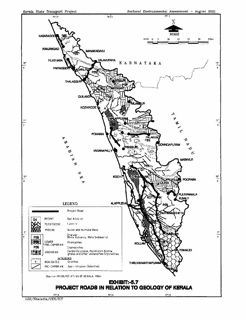
Kerala State Transport Project Sectoral Environmental Assessment - August 2001761 a 771 O
N
P^StR^ -u SCALEkm2o la 0 20 40 60 H0 100km
KANJAWGAD r A AV
PIIATARA+t'--F VAYVWPARA12e V \ , 8>) , K A R N A T A K A / 12
0 PAPIN / c
>rz 0 E~~~~~~~~~~~~~~~~~~~~~~~~~~~~~~~~~~~~~~
PON14M~~~~~~~~~~~~~~~~~~
PAM
7 MARAYUR~~~~~~~~~~~~~~~~~~~~ 1
tp~~~~~~~~~~~~~~1
10, ~ ~ ~ KOCHI F.
ProjectE Roadzt
o \ sXu>~~~~~~- PUY@Ai
RECENT Soil AtiLiviumn
PLEISTOCENE Laterite
MIOCENE auiten and Warkatai Beds
r 1 I~~~~~~~Meta Votcanics, Meta Sed1ments) 0
LOWER KhoricalitesPRE-CAMBRIAN
Po Charnci[kifes f
ARCHAEAN Cordierite gneiess Hornblende Brstite PONMUDIgneiss and other unclassified Crystaltines
IN TRU SIVyESfar 7 NON-OATED Granites TH IRINANFR
PRE-CAMBRIAN Basic intrusive lDoterites)
(Source:-RESOURCE ATLAS OF KERALA, 198.10
EXHIBF:-5.7PROJECT ROADS IN RELATION TO GEOLOGY OF KERALA
75-10 76-10 77-10
LBII/Sheladia/CES/ICT
Kerala State Transport Project Sectoral Environmental Assessment-August 2001
5.2.4 Soils
The Project roads in relation to the detailed Soil types identified in Kerala are shown inExhibit 5.8
Broadly the soils most commonly found in the State are: -
- River alluvium
- Brown hydromorphic soil and
- Lateritic soil
River alluvium- This type of soil layed down along river valleys occurs throughout the Statecutting across extensive lateritic soils. The soil is very deep with surface texture ranging fromsandy loam to clay. It is very fertile having a high water holding capacity and containingplant nutrients, which are regularly replenished during floods. It supports cultivation of paddy,areca nut, pepper, tapioca and a wide variety of vegetables.
Brown hydromorphic soil: This is most commonly found in areas of wetlands and isI moderately rich in organic matter, nitrogen and potash but deficient in lime and phosphates.
Laterite. This is a typical weathering product under humid tropical conditions and occursthroughout the State. In general it is acidic in nature and poor in available nitrogen, potash,phosphorous and organic matter. It is well drained and widely cultivated with a variety ofcrops like coconut, tapioca, rubber, arecanut, pepper, cashew etc. Gravely soil of laten'ticorigin is generally available in the district for construction purposes.
5.2.5 Existing and Potential Erosion
During the Monsoon months all rivers and streams carry considerable amounts of sedimentload to the Sea. The high level of precipitation in the State leads to erosion, landslides andlandslips. The landslides and landslips further aggravate the rate of erosion and are especiallyvigorous during the monsoon months. Coupled with Monsoon precipitation, almost all-development activity, including road improvement works result in higher rates of erosion.
The project roads in relation to slope characteristics of Kerala are shown in Exhibit 5.9. Theproject roads that are more liable to be subjected to soil erosion are
* Link 50.1-Palakkad-Shornur
* Link 26-Idukki-Pulayanmala (Now it has been dropped from phase 1 consideration)
* Link 74 -Thalassery-Valavupara
* Link 84 -Punalur- Thodupuzha
5.2.6 Quarries and Crushing Operations
A construction material survey has been carried out as a part of the Feasibility Study. Sincethe available published information is very old, many of the sources mentioned are notpresently active. It was therefore necessary for the investigation team to identify new sourcesfor materials near the project roads through physical survey and local inquiry (public and
| departmental officials).
The survey included the evaluation of material requirements for the works, materialspecifications, identification of material sources, and the testing of materials for use in theworks. The main material sources have been identified using information collected from the
LBII/Sheladia/CES/ICT
5.

Kerala State Highways Project Seetoral Environmental Assessment- August 2001
75-1 0 7601 o 77-1 0
N
SCALEkn20 20 0 20 40 60 80 lOOkr
12 12'
0 PI0ATHA VALAVUPMARA
git ~~~K A R N A T A K APAPINISSER
QUIANDY, RR8S
KO ZHI DE _
JI:
PONNANI
LEGENDMAJOR GROUPS COMMON NAME MARAYtR
10 THIROPDSAMMENTS- COSTAL ALLUVIUM ao. TRUP[lFLUVENTS - / *
0 ~~~~~~~~~~~~~~~~~~~~~~~~~~~~~~~~~~~~~~~~~~~~~~~~~0TROPUDALFS-EUTROPEPTS RED LOAM POOPAF
TROPOFLUVENTS-EQUTROPEPTS F RIVERINE ALLUVIUMDYSTROPEPTS Li
HAPLUDOLLS-TROPUDALFS 7FORE ST LOAM KMLTROPEPTIC-EUTROTHOX ElTROPORTHENTS fH5 GREY ISH ONATTUKARA
TROPAQUEPTS-FLUVA5UENTS ACID SALINE
9'
0 TROPAQUALFS-TROPAQUEPTS BROWN HYDROMORPHIC SOIL * 0
CHROMUDERTS BLACK SOIL
TROPAQUALFS HYDROMORPHIC SALINE SOIL
EUTRORTHOX HAPLORTHOX LATERITIC SOILDYSTROPEIPTS
PROJECT ROAD THIRUVNATHPLR
(Sourcel-WATER ATLAS OF KERALA, 1995)
EXHIBIT:-5.8PROJECT ROADS IN RELATION TO SOIL TYPES OF KERALA
75'1 0 76-1 0 77'1 0
LBII/Sheladia/CES/ICT

Kerala State Transport Project Sectoral Environmental Assessment - August 2001
7510 76t1 o 77 O
\ ~~~~~~~~~Nr4:
(C~VmQ c//SCALEl 7o a 20 40 40 8 100lk
12- '>.{,,1agA' 5 +,3 12'
THA_ASSER A 1'~~~~~~~~~~~~~~~~~ -
QUILANDt i
KOZHIKODE
o LaALAPP
V~~~ a
PO:NNANI ,_
s) hv<>-o VIWANDPURAM^
VADANPLY* G
LEGENDD%
Steep to very steep hill rangens x g AN_ A
Moderately to steeply sloping ridgese '
v ^ . ~~~~~~~~ALAPPUZHr/' % % AW Nearly levesl to very gently sloping coastat plain t
9- ~~~Gently to moderaetdy sloping spuris ri ( -
o | X ~~Lagoons and Reseroirs
I Gently to moderately sloping Inter-hilly baks1n
- Sand dunes
Project Priorty 'Road THIRUVANANTHA U
<Sourcei-RESOURCE ATLAS LF KERALA, 1984)
EXHIBeTP5.9PROJECT ROADS IN RELATION TO SLOPE CHARACTERISTICS OF KERL
75- 1 0 76-10 77-10
LBII/Sheladia/CES/ICT

Kerala State Transport Project Sectorai Environmental Assessment-August 2001
Kerala Highway Research Institute of the State PWD, which has been supplemented byidentifying other potential sources and a checking of their suitability. The locations of thesesources are indicated graphically in Exhibit 5.10 for South section, Central section and Northsection in_Sheets A, B and C and the district wise availability is tabulated in Exhibit 5.11.The details of referenced locations have been included in the Consultants Geotechnical report.None of the identified quarries are located in the reserved forests and sanctuary areas and inany event mining for construction materials is not permitted in the sensitive ecological areasof reserved forests and sanctuaries. The Mining Geology Department indicated that not allquarries operating in the State are licensed and registered. If licensed quarries are notavailable the contractor should develop other environmentally acceptable sources for the3 construction materials. An example of Archaeological significance of quarrying is shown inBox 5.1.
The borrow pits identified are located in small barren areas. None of the borrow areas arelocated in the paddy fields or other agricultural areas. The Consultants Geotechnical study
Box 5.1: Archaeological Significance of QuarryingRecently in Kerala, a major licensed quarry operating for many years giving employment tohundreds of local people was suddenly subjected to a State-wide debate and controversiesbecause of some Archaeological discovery in caves of prehistoric man located at Edakkal, inAmbalavayal Panchayat of Wayanad District. This is now accessible as a tourist attraction.Later, part of the quarry operation had to stop to protect this valuable feature amid protest
l from the quarry workers and trade unions.
report states the quantity of materials available from each of these locations. They range from3000 to 3 0,0000 Cubic metres.
Availability of Construction Materials
Earth / Soil: Suitable granular soils for the construction of embankments and sub grades areavailable within a reasonable distance of the project roads. For most of the project roads inplain / rolling country, soil will need to be obtained from private sources since there are nodepartmental borrow areas available. The details of all borrow sources identified and theI characteristic properties of soils from these sources were ascertained through laboratorytesting of samples
EXHIBIT 5.11ROCK MATERIAL AVAILABLE IN THE STATE
ROCK TYPE AVAILABILITY
Chamockites Occupy about half of the area of the State (GSI, Geological andmineral map of Kerala 1995) Kannur, Kozhikode, Palakkad, Thrissur,Kottayam. luka, Pathanamthitta, Emakulam, Kollam Malappuram andlimited areas of KasargodeI Khondalites Kozhikode, Palakkad, Emakulam, Kottayam Kollam, Thiruvananthapuram
Schists, Granites and Wayanad, Kannur, Kasaragod, Emakulam, Kollam, ThiruvananthapuramGneisses
* Laterite Midlands of Thiruvananthapuram, Kollam Pathanamthitta, Kottayam,Emakulam and Malappuram.
(Source: Geological Survey of India (GSI) 1976)I Sub-base material: Naturally occurring murrum / gravel is rarely available for direct use assub-base material to satisfy the specifications. Suitable sub base material can, however, bewon locally by blending soil, aggregate / shingles and sand in suitable proportions to satisfythe requirements.
LBII/SheladiafCES/ICT
I 5.6
l

Kerala State Transport Project Sectoral Environmental Assessment-August 2001
Base course material: Stone of suitable quality for use as aggregates for pavement coursesand concreting is available along the project roads within reasonable haul distances. Thereare a number of private crusher operators who supply aggregates of different grades. Fromlaboratory tests it is seen that aggregates available from local stone crushers generally satisfythe specification requirements.
Fine Aggregate: River sand of suitable quality may not be available for use in the projectroads. This is one of the many active environmental issues in Kerala (Box 5.2). The sandU requirements are usually met from the riverbeds. The mining of the river beds are eitherbanned or under severe control in all the 44 rivers beds of the Kerala. Therefore it isnecessary to confirm that, the source of sand is from legitimate areas. Stone dust is availableI from private stone crusher owners, and this can also be used as fine aggregate for bituminousmixes. Details of locations of material sources are also identified in the study as shown inExhibit 5.10 (A, B and C).
Box 5.2 The Prevailing Sand Mining Issue In KeralaThe consequences of extensive uncontrolled sand mining from the riverbeds were an
* environmental issue in Kerala for quite some time. The uncontrolled sand mining isbelieved to be draining the groundwater from the riverbanks as a result, the open handdug well in the nearby areas are reported to be drying up leading to severe shortage of
* water. More recently the road bridges and the railway bridges are under threat due tothe extensive sand mining. It was also reported that the bridge at Ranni collapsed somefive years ago due to sand mining. At least 15 bridges in Central Kerala over the rivers
* Pamba, Manimala, and Achankovil rivers are reportedly facing danger of collapse dueto negligence in monitoring the indiscriminate quarrying of sand over many years (TheHindu, 7 August 2000). The report further states that according to the experts thequarrying of sand from these rivers has lowered the riverbed by an average 2.5 metres.
Borrow Pits: Areas suitable for borrow pits (i.e., sources of material for the construction ofembankments and use as fill) have been located in accordance with the Indian Road CongressSpecifications. The Exhibit 5.10 (A, B and C) also shows all borrow pit locations identified.
5.3 WATER RESOURCES
5.3.1 Surface Hydrology
Surface water: Forty-one rivers originate from the Western Ghats and flow into the ArabianSea while three others are originating from the Western Ghats flow eastwards into the Bay ofI Bengal. Lengths of these rivers are small and vary from 10 km to a maximum of 250 km.During the monsoon, the larger rivers flow with turbulent force frequently rising four or fivemetres above their original level sweeping away habitations and crops. The flood diminishesI as the monsoon draws to an end and the rivers gradually subside to a shallow thin streamoften outlining their sand beds. Owing to the heavy monsoon rainfall, all of the rivers carrysizable flows during the monsoon months. During the non-monsoon months many of therivers go dry.
Due to their drop, many form a significant resource of hydroelectric power and many havebeen developed for this purpose. Other power projects have been delayed or abandonedbecause of environmental concerns. The project roads in relation to 44 river basins of Keralaare shown in Exhibit 5.12.
LBHI/Sheladia/CES/ICT5.7
l

Kerala State Transport Project Sectoral Environmental Assessment - August 2001
N
SCALE
kmlO 5 0 10 20 30 40 50krm
ERNAKMAM
Shert\30 ) eaj ~menc ID1JKKI
131 3 9 o qr j 9
ALAYM'~ ~ ~ ~ ~ ~ ~ ~ ~ ~
PATTHANATMTTA|\ w* S24 j 14a1S/Pt;ANAblTNr1AI
ALAPPZUAC RAZ
2D 12Kl3runogopX~~~~~~~~~~~ e Bordtr
LOCAllN OF MTERIA SOtURCESNT(SOUTh SECIN LBII/Sheladia/CEtingSonIuT
\ ) edumNeurramped
Poect Roads os tKki da
TH3tW.~~NANA~~ Pan ancsham asdu
u;= ,runkadav~~~~~~~~~~~~~~~~~~~~~~~~ukaailc
NAr.ONAi HIG^HWAYS )Prrerac3
r1ROJ;ECT ROADS_ -1
OTHER ROADS -
AvGGREGA7E A 47
SANiD 1157
ROAD1 NODE (DIJNK NUMBSER E
SOUh'CE -(ornsuitcmt's et eo&edn!Tcc StLury Reper,r iApri! 2000
EXHIBIT NO. 5.10LOCATION OF MATERIAL SOURCES (SOUT SECTON) -A
LBII/Sheladia/CES/IC:T

Kerala State Transport Project Sectoral Environmental Assessment - August 2001
NWAYAN9AD /| h
SCALEknlD 5 0 10 20 30 40 50km
KOZfIXODE 1 21 1
21 1X 7
D s 3 9 C o pt5'G p ur G m~~~~~~~~0 t
Pro Jc a 136
P a 0 11 PTI-A0 43HT
TSiprO:e L .201 n rpur7t, Slet j~~~~~~ong
ROAD NOOf V Qnaof
10~ ~~~XIBTN.51
LBII/Sheladi Cr 80rderE-RNAK'J AtEr _SDUKK(I ~
Project Roads u :nburm.etluJ
NiSVONAL HiGHW#AIS KOTrAYAMy
PIROJE--. ROADS 0rY LW7di7Sotuy
A7GG,REGA,TE 47
SANDC I* 2 17 PAF NM THKNfHIT'7TAS
S) L m 201s
LiNk tiUMs.ER El:t
SOURCFi:--0ar,rtitnr.t'R Get aigwhmrcai Stsudy ReprJrt ,Apr7, 2s0s0.
E,HBIT NO. 5.10OLOCATION OF MATERIAL SOURCES (CENEA SECMON) - B
LBII/Sheladia/CESIICT
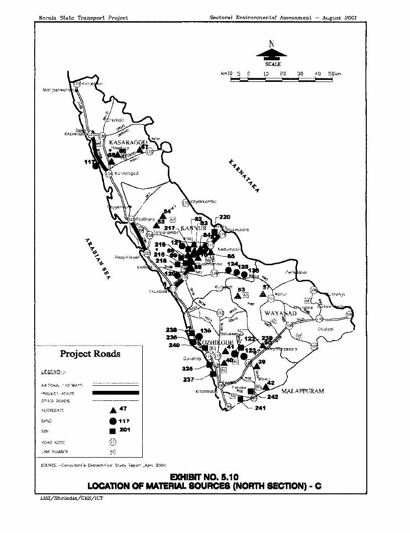
Kerala State Transport Project Sectoral Environmental Assessment - August 2001
N
SCALE
kr¶10 5 0 10 20 30 40 50km
\ R g~~erkahsi
KASARA .,
~~Th ~ 5|Ci KfOSAlLS - O ,<
@11 7.201~~~K4
\ rhangrad +S
\ \\\ / aVr.~~ynkkrlnb"
P=S10t' ur A! t
NU~~~~~~~~~~~~~~~~~~
thc Sa wpOt hArQ 2OOi
-?appirni s _
hiAlLOCATION OFRHayY MATERIA SORE NRHBClN
rDLBII/Eladia/ES/CA Ku T
07Hect ROASads .tPEAro i Qj;~a 4y
OT~Rf RADS*OD
ROAD N0qFE r6B
S'.lRf i -Conswitant's Gerotechl,;ccl Stuidy Report ,A.pil 20,00,J
EXHIBIT NO. S.10LOGAIION OF MATERIAL SOURCES (NORTH SECTION) C
LBHl/Sheladia/CES/ICT

Kerala State Transport Project Sectoral Environmental Assessment - August ZOOI
7510 7610 enI e
N
SCALE
5SAFUbGOD km2O 10 0 20 40 60 10 100km
G MANJE5WAR
®) UPPALA KANJANMANAKADAVU
12- 5HIRIYA KA RNA T A KA
0 ( MOGRAL P ILATH 13 VL PARA
)CHANDRAGIRI i .''''i
® CHITTARI PAPINISSER
ONILESWARo KARIANGODE THALASSERY 17
KAVVAYI-i9 PERUVAMBA
j RAMAPURAM QUILANDDY
@WKUPPAM R,,6O VALAPATTANAM KQZHIKOD
ANJARAKANDY
~i~TELLICHERRY06 MAHE
@ KUTTIYADI
t9KORAPUZHA 8 jPONNANS
6i KALLAI "A
C EHALIYAR GOVINDAPURAM
6 KADALUNDI VADANAPAL
0 TIRUR
(j BHARATHAPUZHA R10* KEECHERI
0 * PUZHAKKAL KO0-
C CHALAKUDY
PERIYAR 57UIA M L*MUVATTUPUZHAPUIAMA
MEENACHIL M , _IY6 MANIMALA
@ PAMBA ALAPPUZ
ACHENCOIL \,A) 0PALLIKKAL LEGEND \
9 KALLADA Project ROad BX ITHIKKARA RiVers and StreamS £ -
0AYROOR BaSin Boun1dry .-.------- X6tVAMANAPURAM Riverv Code Number )
6MAMOM District Headquarters 3KARAMANAA lSource:-WATER ATLAS OF KERALA, 1995i PONM UDI
0KABBINI \ U,
9 BHAVANI THIRUVANANTHAPURi 0PAMBAR <i
EXHIBIT:-5.12 PROJECT ROADS IN RELATION TO RIVER BASINS OF KERALA
LB.f/Sheladia,/CES/1CT 607-e

Kerala State Transport Project Sectoral Environmental Assessment-Asigust 2001
Lakes and Backwaters: A series of lagoons were formed by the natural interaction of thesea and the rivers and are known as backwaters. Some rivers are used for water supplies andare therefore sensitive to contamination. A spill of phenol in the catchment area of the PeechiReservoir supplying drinking water to the City of Thrissur and surrounding communitiesrequired an expensive cleanup using activated carbon powder. They provide an extensiveresource for irrigation and many of the lagoons have been poldered for the cultivation of riceat below the water level. The backwaters were also the major means of storm-freetransportation until the advent of road and rail transport. The links that cross backwaters are
* Alappuzha - Changanaserry crosses Vembanad Lake (Link 73) only
One of the striking features of the State is the continuous chain of lagoons or backwaters,along the coastal region. yembanad is the main backwater in the State located in theErnakulam and Alappuzha districts.
Canals and Link canals: Both natural and artificial canals form an extensive network.The lagoons or backwaters are connected to the sea through small openings called azhis.
Ponds and Chira's: Ponds are small water bodies usually artificial while Chiras are naturalwater bodies of many hectares in extent of a semi perennial nature. Chiras are the low-lyingarea of a paddy field.
Much of the area of a Chira is cultivable during the summer season (January to May) and thecore area, which is normally a small pond size, remains perennial. During the summer seasona rich harvest of fresh water fish is very common. Rice farrning also produces high yieldscompared to the nornal field cultivation because of the concentration of nutrients.
Saline water intrusion: Saline water intrusion takes place along the rivers and other waterbodies close to the coast during the summer season due to an ever-decreasing base flow in thestreams. The large-scale deforestation in the upper catchments -leads to the drying up ofsprings in the region. The increased exploitation of groundwater and surface water are themain reasons for the decrease in the base flow. Most of the coastal belt especially urbancentres like Kozhikode experience this problem.
Environmentally Sensitive Coastal belt: The CRZ regulations of the Government of Indiadescribed in Chapter 2 apply to some project roads which require more detailedenvironmental investigations and State and Central Government approvals.
Coastal Zone Management Plan (CRZMP): Following the directive of the Government ofIndia the State Government prepared a Management Plan for the sensitive coastal area in1995.
CRZ I - The entire area between the low tide and high tide lines stretching along the Keralacoast comes under this category. In addition there are ecologically sensitive and otherimportant notified areas within this category. The following are relevant for Kerala.Mangroves, areas close to breeding and spawning grounds of fish and other marine life; areasof outstanding natural beauty, historical and other heritage areas; areas rich in biodiversity;areas likely to be inundated due to rise in sea level due to global warming and any other areasas may be declared by the State and Central Governments from time to time. The Appendix-5.1 is the list of CRZ areas of importance.
The project roads that are located in this area are
. Kasargode -Kanhangad
* Pilathara- Pappinissery
LBII/Sheladia/CESllCT5.8

Kerala State Transport Project Sectoral Environmental Assessment-August 2001
CRZ II - All of the developed areas within the municipalities/ corporations or other legallydesignated urban areas which have been substantially built upon and which have beenprovided with drainage, approach roads and other infrastructure facilities such as watersupply and sewerage mains come under this category eg:
3 . Thalassery - Valavupara
CRZ III - Areas that are relatively undisturbed and those, which do not belong to eitherCategory I or II. Theses areas are basically rural areas. In Kerala, all areas falling in gramPanchayat (other than CRZ-1 areas) are demarcated as CRZ-II. Both the sea coast and theback water coast come under this category
X Project roads that are excluded from the CRZ regulations for detailed investigationsinclude:
3 * Alappuzha - Changanaserry - excluded from consideration due to theThannirmukkom bund and Thottapally spillway, which allows no tidal effects in thewhole of Vembanad Kayal.
* 5.3.2 Drainage
The mountain ranges of the Western Ghats, which form the eastern boundary of the State and3 the Arabian Sea, which forms the western boundary, are not far apart, the maximum distanceis barely 75 km. The terrain is mostly undulating and generally sloping from east to west.
Additional problems of drainage are indicated in the Environmental Strip Maps (Appendix AI 4.3) and link specific Environmental Analysis (Appendix A 4.2). Flooding during the rainyseason is a problem. Observations indicate that the Water bodies/Wetlands likely to bewithin the area of potential impacts are unlikely to be of particular significance or offer anyunique habitat characteristics. The cross drainage structures are generally more than three perKilometre all over Kerala.
There are no official PWD records regarding sections liable to flooding along the projectroads. Some of the local Engineers are aware of the flood sections in their areas however andin general, it can be assumed that the low-lying paddy field areas are often subjected to3 flooding in the midlands and lowlands along the following sections.
* Link 1,2,3 and 4. (SH-1)
1 * Link 73 Alappuzha - Changanaserry
* Link 70 Muvattupuzha- Thodupuzha
| * Link 74 Thalaserry- Valavupara
5.3.3 Water Quality
Since Kerala is one of the highly rain fed regions with 100 to 140 rainy days per year manyrivers and streams are being naturally cleaned many times during the monsoon seasons.The very high population density of the State generally reduces the flushing effect and as aI result many rivers are polluted. Industries when located close to rivers pose serious waterpollution problems eg: Mavoor Gwalior rayon's factory close to the Chaliyar river is a bad casescenario known for the mercury and other heavy metal pollutants; resulting in the highmortality of the fish population'. The air and water pollution from the factory also createserious human health hazards in the area.
T 'The Hindu survey of the Environment 99
* LBIJ/SheladmaJCES/ICT* ss
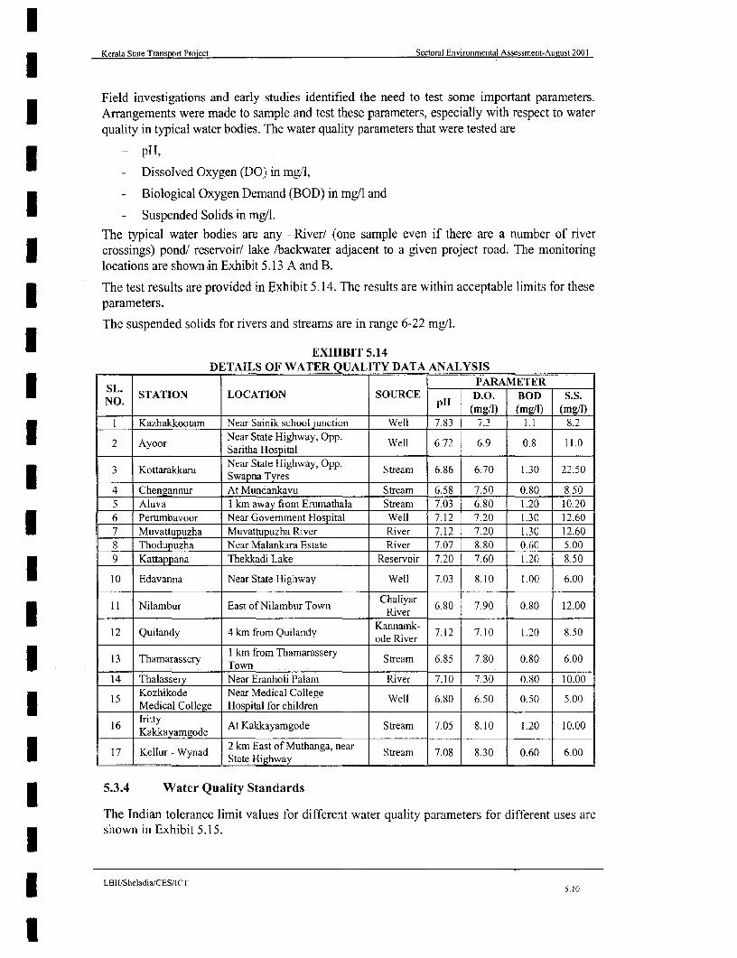
lKerala State Transport Project Sectoral Environmental Assessment-August 2001
Field investigations and early studies identified the need to test some important parameters.| Arrangements were made to sample and test these parameters, especially with respect to water
qualitv in typical water bodies. The water quality parameters that were tested are
- pH,
- Dissolved Oxygen (DO) in mg/l,
- Biological Oxygen Demand (BOD) in mg/l and
- Suspended Solids in mg/l.The typical water bodies are any -River/ (one sample even if there are a number of river3 crossings) pond! reservoir/ lake /backwater adjacent to a given project road. The monitoringlocations are shown in Exhibit 5.13 A and B.
The test results are provided in Exhibit 5.14. The results are within acceptable limits for theseparameters.
The suspended solids for rivers and streams are in range 6-22 mg/l.
EXHIBIT 5.14DETAILS OF WATER QUALITY DATA ANALYSIS
| L. PARAMETER* NO STATION LOCATION SOURCE D.O. BOD S.S.
.__ __________ (mg/') (mg/I) (mg/1)
I Kazhakkootam Near Sainik school junction Well 7.83 7.3 1.1 8.2
2 Ayoor Near State Highway, Opp Well 6.72 6.9 0.8 11.0_____ _____ _____ ____ Saritha Hospital
3 Kottarakkara Near State Highway, Opp0 Stream 6.86 6.70 1.30 22.50a Swapna Tyres
4 Chengannur At Mundankavu Stream 6.58 7.50 0.80 8.505 Aluva I km away from Erumathala Stream 7.03 6.80 1 .20 10.206 Perumbavoor Near Government Hospital Well 7.12 7.20 1.30 12.607 Muvattupuzha Muvattupuzha River River 7.12 7.20 1.30 12.608 Thodupuzha Near Malankara Estate River 7.07 8.80 0.60 5.009 Kattappana Thekkadi Lake Reservoir 7.20 7.60 1.20 8.50
10 Edavanna Near State Highway Well 7.03 8.10 1.00 6.00
11 Nilambur East of Nilambur Town Chaliyar 6.80 7.90 0.80 12.00River
12 Quilandy 4 km from Quilandy Katinaive 7.12 7.10 1.20 8.50ode River
13 Thamarassery 1 km from Thamarassery Stream 6.85 7.80 0.80 6.0014 Thaassery Town
14 Thalassery Near Eranholi Palam River 7.10 7.30 0.80 10.00
Kozhikode Near Medical College Well 6.80 6.50 0.50 5.00Medical College Hospital for children____16 kIritty - At Kakkayamgode Stream 7.05 8.10 1.20 10.00Kakkay am god e
17 Kellur - Wynad 2 km East of Muthanga, near Stream 7.08 8.30 0.60 6.00__I_ .I._. State Highway . .
5.3.4 Water Quality Standards
The Indian tolerance limit values for different water quality parameters for different uses areU shown in Exhibit 5.15.
LBmIISheladia/CES/ICTX 5.10
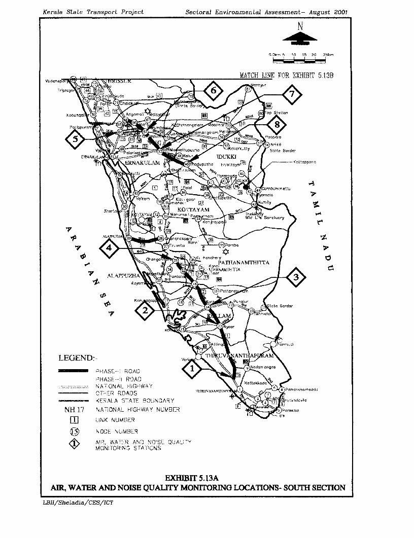
Kerala State Transport Project Sectoral Environmental Assessment- August 2001
N
G.Om5 1G 15 20 25km
MATCH LINE FOR E'TXiIH 5.13BVodrnapo
1 IprcY~ 54 9
KQDLInaQI1tAS~~~~ 041 IJpL\X 0 Ert fot- I1tn
PnjipptirQumbhemers711rr 8 >hoppo
7p 4
V yP _fitvtupuz!wI / icvty,Statee Borde,
E <ERAKULA KAM UMUNR/
NH 17 \A \N_ H'hA NU fIfr. Po'l -
P UK PU ABe Atta
¢e F rrmu~~~~~~~~~~~~~~la
EXHIBI T- 5.13She TI/YAMdKOCTAYA
Kattnn\ rAp[1n NAlTFnT
tEGDDe_ t/ctUR>eVSe*XX~k-ANAMK17- - AIeASPP-^-!R{AI > S<n l gct
PhASE-- ! yROA /
- --- NAT h AI ;G1WAY\ ettkc4r w>^TtIER ROA3S X,'lRlAtSK9D;+ < <Panat.fhu3olur
- EA SAEBiuDR tar>7idvl
NH 17 NA SiONA.t_ rl5&RWAY NUMBER ' perarSala~4
MhAl TIOiNALHGHWSAYi
AIR, WAT ARRANDNOISER N QUASLIT Q OlTRNGLCAINSi7YSCIO
LBII/Sheladia/CES/ICT
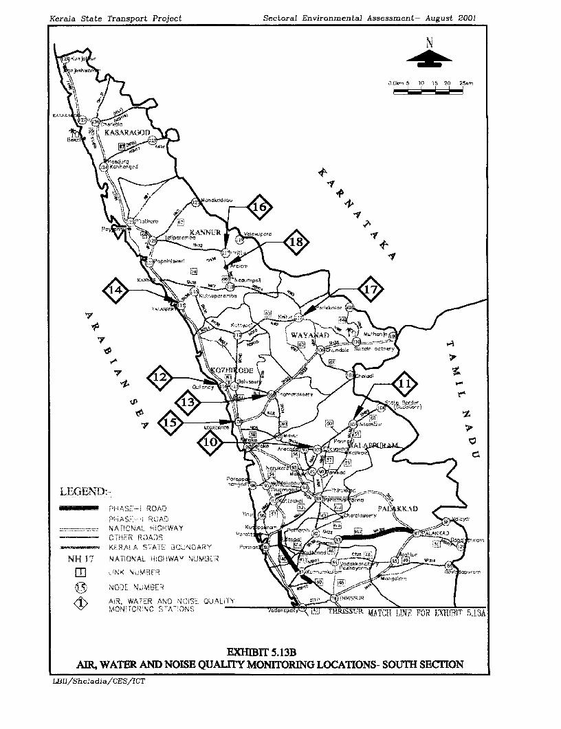
Kerala State Transport Project Sectoral Environmental Assessment- August 2001
N
kr i 7 3.~~~~~~~~~~~~~~~~~~)Cikrm 5 10 1S 20) 29
XS~~~~ t orce:
I KASARAKIOD
7 A
NAk NAHVkWY-up
NH I \NA NA I'neiaV A][O a
AIR,TET) WAE- N OS ULT OIORN OAIN-Si ETO
LBId)Sh&ad2a/CES/ICT
KEAASTAT BOEUNDR ,Nronri an
to~~~~~~~~~~~~~~~n I"
N OIDEE ig ; VInJVf3 E
XR WAE AND NlC.Al AE
LB1/Shlada/S ' GA /1CT' Xgepirsry <a

Kerala State Transport Project Sectoral Environmental Assessment-August 2001
5.3.5 Groundwater
I Kerala is the only State in India to have an independent water supply to almost all households.In this context both the hydrogeology of Kerala (Exhibit 5.16) and groundwater sources ofKerala (Exhibit 5.17) are extremely important. Landless and shelter less people are rare in theState. Many families on their own land, hold a traditional large diameter shallow (1-10 mdeep) open hand dug well to meet the family requirements. Even today this is true all overKerala except in the coastal regions and major urban centres.
There are extensive groundwater resources in the coastal alluvial plains but much is saline.The links that are crossing the coastal aquifer regions are
I * Pilathara - Pappinssery (Link 68) and
* Kasaragod- Kanhangad ( Link 69.1)
* Alappuzha- Changanaserry (Link 73)
EXHIBIT 5.15THE INDIAN TOLERANCE LIMIT VALUES FOR DIFFERENT WATER
QUALITY PARAMETERS FOR DIFFERENT USES
A B C D EDRINKING OUTDOOR DRINKING FISH IRRIGA
PARAMETERS WATER ONLY BATHING WATER CULTURE TIONDISINFECTION COMPLETE WILDLIFE3 TREATMENT
pH 6.5-8.5 6.5-8.5 6.5-8.5 6.5-8.5 6.0-8.5
DO >6 >5 >4 .4
BOD <2 <3 <3
Total Coliforn <50 <500 <5000 -
(N/ 100mi)
Total hardness <300 - -CaCo3 (mg/1)Calcium hardness <200 -
(CaCo3)(Mg/l)Chlorides <250 - 600Ml/
l Phosphates <400 <400 < 1000mg/'
Nitrates < 20 < 50 -
* Ammonia <1.2
(Source: Kuttanad Water Balance Study)
Groundwater in the sedimentary rocks occurs in both water table and confined conditions.The water table in the Cenozoic sediments of Ernakulam District extend to 30-50 m below3 ground level. The water obtained from the Cenozoic aquifers is generally potable.
Coastal region The groundwater in the coastal region occurs predominantly under watertable conditions within the alluvial deposits of recent age and these aquifers are normally a
* few metres in thickness. Open wells of approximately two-metre diameter are the commongroundwater extraction structures. In some places the sandy aquifer may extend to depths oftens of metres. Part of the Emakulam district falls under this region. The over exploitation ofcoastal groundwater resources has led to seawater intrusion into the Coastal Aquifers.
LB I iSheladialCES/ICT
5.11
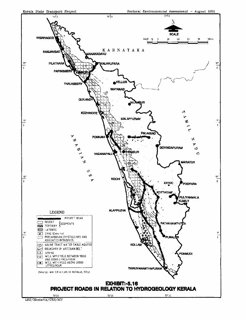
Kerala State Transport Project Sectoral Environmental Assessment - August 2001
75-1 o 761 10 ?77° o
N\<1 2 N~~~~~~~-ft.
SCALEKASAFAOD krm2O 10 0 20 40 60 Oa 106km
KSJANS3ADt S^K A R N A T A K A
120 PARA 12-
THALASSERY X *KE--
\ 9< N WAYANAD / < - -
QUILI6NDLLL
R ~ ~ ~
KOZHIKDt AAPrUPAM V.
w ~~PONNANI}t; o~~~~ \0F
k \ii-U R GOVINDAPURAM
-) VADANAPs\.h
t S : UAR~~~~ADRAU
10- 104
0 LU IDLJKKh ~~~~~~~~~~~~~~POOPARA0
l. E H , , ,w, tPUYANMALA
LEGEND P PROJECT ROAD .t
FIRECENT SDMNSPTAAT~TERTIARY
E LATERITEI EEi1 DYKE (Daterite) 9.O C PRECAMBRIAN CRYSTALLINES AND PU1LL
ASOCIATED INTRUSIVES
SALINE TRACT WATER TABLE AQUIFER KOLLAM3 BOUNDARY OF ARTESIAN BELT
ELD SPRING UDIWELL WITH YIELD BETWEEN 10000AND 20000 LITRES/HOUR
FV WELL WITH YIELD ABOVE 20000LITRES/HOUR
THIRUIVANANTHAPUIAt¢ (Source:-WATER ATLAS OF KERALA, 1995)
EXHIBIT:-5.16PROJECT ROADS IN RELATION TO HYDROGEOLOGY KERALA
75-10 76-10 77-10
LRII/Sheladia/CF-S/ICT

Kerala State Transport Project Sectoral Environjmental Assessment - August Z001
7s |e 76n1~~7f-I0 7rle0
N
SCALE
KASARAGOO km2o 10 0 20 40 60 B0 100km
KANU 1MANIAKADAVU K A R N A T A K A
12 PILAHARA VA PARA iT,
PAPINISSER
THALASSERY - - S
OUIAND A RKOZHIKODE
to 0
fi PONNANI +f .!71j f ASEB SGOVI~~~~~NDAPURAM e,
VADANAPALLYTHISR4i AK (ARAY~~~ARAUR
10* KC*
; LEGEND KOCHI t )IDU~~~~~~~IDKKI, POOPARAPROJECT ROAD
AREA SUITABLE FOR FILTER POINT WELLS YULIYANMALA
AREA SUITABLE FOR DUG/BORE WELLS
:1 AREA SUITABLE FOR HEAVY DUTY TUBE WELLS ALAPPI'll N PA AJ
AREA SUITABLE FOR MEDIUM CAPACITY TUBE WELLS
AREA SUITABLE FOR DOMESTIC WELLS ONLY
AREA SUITABLE FOR LARGE DIAMETER DUG WELLS
COASTAL SURFACE WATER BODIES
THIRUVANANrrHAPU4 (Source:-WATER ATLAS OF KERALA, 19951
EXHIBIT:.5.17PROJECT ROADS IN RELATION TO GROUND WATER PROVINCES OF KERALA
75'10 76-10 77.10
LBII/Sheladia/CES/ICT

Kerala State Transport Project Sectoral Environmental Assessment-August 2001
Midland region In this region, groundwater is often encountered under water table3 conditions in the lateritic aquifers of 10 to 20 m thickness. Wells of relatively large diameterof 4 to 6m are the common groundwater extraction structures in the midlands.
The over exploitation of groundwater in hard rock aquifers has generally resulted in thei lowering of water tables and hence the drying up of traditional open large diameter hand dug
wells. This has also led to the lowering of water levels of bore wells and tube wells in theregion.
* Highland region The fissured hard rocks and highly weathered zone form the aquifers in thisregion. Groundwater occurs under water table conditions and can be exploited through dug
| wells.
The community drinking water sources are mainly groundwater through bore wells /tubewells and many are located in the road corridors.
The project roads that are falling in the Highland, Midland and Lowland have already beendiscussed.
1 5.3.6 Floods During Monsoon Season
As mentioned earlier Kerala State has an average annual precipitation of 3085mm.Approximately 90 % of the rain falls during the six monsoon months, and the high intensitystorms during the monsoon months result in heavy discharges in all rivers. The riverconsequently swell and the heavy discharge rapidly reaches the midland and coastal regionsspreading over lagoons and backwaters raising the general water level and submerging vastareas of low lying land.
The monsoons cause the frequcnt flooding of road sections for many hours at a time.This result in traffic disruption and damage to the road fabric. The raising of fornation levelswill be required in these sections. The Alappuzha - Changanaserrv Link 73 section is theI most affected. In this section all bridges are at a higher level compared to the road. Large-scale improvement would be required to avoid all flooding. The design for this wascompleted in August 2000 and the embankment height will be raised in the current proposal.
5.3.7 Cross Drainage Structures
The number of cross drainage structures required is naturally very high (approximately threeper kilometre. This is even more for a road with a more or less north south alignmentespecially when located in the midlands. The number of cross drainage structures and theirlocations with respect to road chainage are given in the Environmental Strip Maps.
5.4 Ambient Air Quality
Permissible air quality pollution levels have been established by the Central Pollution ControlBoard (CPCB) for six air pollutants. These are Suspended Particulate Matter (SPM) SulphurDioxide (SO2) Nitrogen Oxide (NO2). Carbon Monoxide (CO) and Lead (Pb). Thepermissible concentrations of these pollutants are shown in Exhibit 5. 18.
5.4.1 Primary data
I Kerala State Pollution Control Board has generated primary data on air quality under anagreement with the Project Implementation Unit of the PWD. The monitoring started in midAugust 2000 was completed in late November and analysis and reporting in April 2001 usinga vehicle mounted electronic equipments attached to computer system.
-LBIJ/SheJadia/CES./CT
5.12

Kerala State Transport Proiect SectoTal Environmental Assessment-Aungst 2001
EXHIBIT 5.18NATIONAL AMBIENT AIR QUALITY STANDARDS
TIME- PERMISSIBLE POLLUTANT LEVELS FORPARAMETERS WEIGHTED INDICATED LAND USE
AVERAGE In microgram per cubic meter (pTg1m')
Industrial Residential, Sensitive AreasRural
Sulphur Dioxie .Annual Average* 80 60 15O24-Hour** 120 80 30
Nitrgen xideAnnual Average* 80 60 1 5Nitrogen Oxide24-Hour** 120 80 30
Suspended Particulate Annual Average* 360 140 70Matter 24-Hour** 500 200 100Respirable Particulate Annual Average* 120 60 50Matter 24-Hour** 150 100 75
Annual Average* 1.0 0.75 0.50Lead 24-Hour** 1.5 1.00 0.75
Carbon Monox.dc 8-Hour* 5.0 2.0 1.0_ | Carbon Monoxide I-Hour** 10.0 4.0 2.0
I Source: CentralPollution Control Board. NewDelhi. Nolfication dated Ij .4pril 1994.Note: * Indicates annual arithmetic mean oJfminimum 104 measurements in a year measured twice a week. 24 hourlv at uniform intervals.
: 24-hourly and 8-hourlv values should be mer 98% oldhe time in vear: howvever 2% of the time ir mayexceed but not on hvo consecutive days.
Ambient air quality variations at 34 different identified Monitoring Stations (Refer Exhibit5.13 A&B) are tabulated and provided in the Exhibit 5.19.
The most important observation is that there is a distinct "low trough" in the evening with thelow values of various monitored parameters in almost all the locations. This is due to theinfluence of very high biomass in Kerala.
Air quality parameters monitored at selected 17 locations along the project roads are shownin Exhibit 5.20 A, B, C, D and E. The Appendix A.5.2 provides the details of the monitoringstations including the Location map of all monitored air quality stations. Hourly monitoringof four parameters (NO5, S02, HCT and CO) was carried out while levels of Lead, SPM andRSPM were recorded for possibly same reasons three times daily. The results were tabulatedI and analysed graphically by plotting the levels of pollutants in micro gram per cubic metre(tg/m 3) against time in hours.
Consistently high values of NOx (exceeding the permissible level) were recorded atMuvattupuzha and NH junction near Kazhakkootam. Both these places are busy towns andimportant junctions with heavy traffic throughout the day. The contribution (even minorcontribution on long term basis) of industrial emissions to the traffic emissions could be thespecial reason for its higher values at these specific locations. Higher values were alsorecorded at Aralam farm, Ayur, Medical College - Kozhikode, Perumbavoor and Quilandy.
SO2 values were generally very low except for some of the readings at Ayur and Kellur. Boththese locations are residential areas. Ayur is an important junction in MC road (SH 1).
* At Ayur, the SO2 values exceed the limits during the evening (about 5 pm to 9 pm) and atKellur the value exceed the limits from 6 am to 9 am.
LBII!Sheladia/C EStICTI 5 13
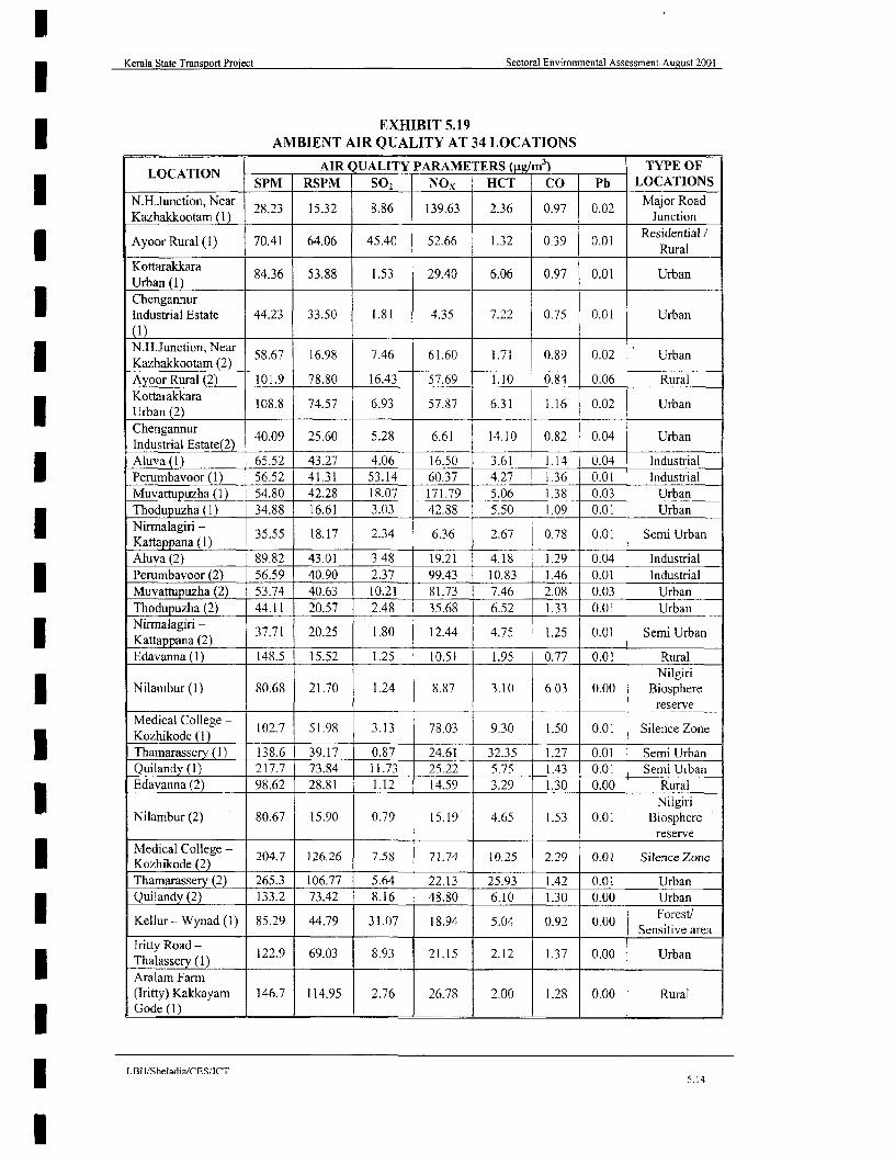
Kerala State Transport Project Sectoral Environmental Assessment-August 2001
EXHIBIT 5.19I AMBIENT AIR QUALITY AT 34 LOCATIONS
LOCIATION AIR QUALITY PARAMETERS (g/m3 ) TYPE OFLPM RSPM 502 NOx HCT CO Pb LOCATIONS
N-H.Junction, Near 28.23 15.32 8.86 139.63 2.36 0.97 0.02 Major RoadKazhakkootam (1) Junction
Ayoor Rural (1) 70.41 64.06 45.40 52.66 1.32 0-39 0.01 Residential* Rural
Kottarakkara 84.36 53.88 1.53 29.40 6.06 0.97 0.01 UrbanUrban (1)ChengannurIndustrial Estate 44.23 33.50 1.81 4.35 7.22 0.75 0.01 Urban
N.H.Junction, Near 58.67 16.98 7.46 61.60 1.71 0.89 0.02 Urban* Kazhakkootam (2)
Ayoor Rural (2) 101.9 78.80 16.43 57.69 1.10 0.84 0.06 Rural
Kottarakkara 108.8 74.57 6.93 57.87 6.31 1.16 0.02 UrbanUrban (2) __
Chengannur 40.09 25.60 5.28 6.61 14.10 0.82 0.04 UrbanIndustnial Estate(2)Aluva (1) 65.52 43.27 4.06 16.50 3.61 1.14 0.04 IndustrialPerumbavoor (1) 56.52 41.31 53.14 60.37 4.27 1.36 0.01 IndustrialMuvattupuzha (1) 54.80 42.28 18.07 171.79 5.06 1.38 0.03 UrbanThodupuzha(1) 34.88 16.61 3.03 42.88 5.50 1.09 0.01 UrbanNirmalagiri - 35.55 18.17 2.34 6.36 2.67 0.78 0.01 Semi UrbanKattappana () I Aluva (2) 89.82 43.01 3.48 19.21 4.18 1.29 0.04 IndustrialPerumbavoor (2) 56.59 40.90 2.37 99.43 10.83 1.46 0.01 IndustrialMuvattupuzha (2) 53.74 40.63 10.21 81.73 7.46 2.08 0.03 UrbanThodupuzha (2) 44.11 20.57 2.48 35.68 6.52 1.33 0.01 Urban
aNiralagiri - 37.71 20.25 1.80 12.44 4.75 1.25 0.01 Semi Urbanl Kattappana (2)
Edavanna (1) 148.5 15.52 1.25 10.51 1.95 0.77 0.01 RuralNilgiri
Nilambur (1) 80.68 21.70 1.24 8.87 3.10 6.03 0.00 Biospherereserve
Medical College - 102.7 51.98 3.13 78.03 9.30 1.50 0.01 Silence Zone
Thamarassery (1) 138.6 39.17 0.87 24.61 32.35 1.27 0.01 Semi UrbanQuilandy (1) 21 7.7 73.84 11.73 25.22 5.75 1.43 0.01 Semi UrbanEdavanna (2) 98.62 28.81 1.12 14.59 3.29 1.30 0.00 Rural
* NilgiriNilambur (2) 80.67 15.90 0.79 15.19 4.65 1.53 0.01 Biosphcrc
resmerMedical College - 204.7 126.26 7.58 71.74 10.25 2.29 0.01 Silence ZoneKozhikode (2)__
Thamarassery (2) 265.3 106.77 5.64 22.13 25.93 1.42 0.01 UrbanQuilandy (2) 133.2 73.42 8.16 48.80 6.10 1.30 0.00 Urban
Kellur - Wynad (1) 85.29 44.79 31.07 18.94 5.04 0.92 0.00 Sensitive area
Iritlty Road - 122.9 69.03 8.93 21.15 2.12 1.37 0.00 Urban
Aralam Farm(Iritty) Kakkayam 146.7 114.95 2.76 26.78 2.00 1.28 0.00 RuralGode (1)
LBII/Sheladia/CESlCTI 5.14
I

Kerala State Transport Project Sectoral Environmental Assessment-August 2001
EXHIBIT 5.19 (CONTINUED)AMBIENT AIR QUALITY AT 34 LOCATIONS
* ~~~~LOCATION -AIR Q UALITY PARAM TERS (Plg m3) -- TYPE OFSPM RSPM SO, NOx HCT CO Pb LOCATIONS
Kellur - Wynad (2) 80361 37.79 1.35 26.39 3.48 0.96 000 Sensitive areaIritty Road -~~~~~~~~~~~~~~~~~Snitv ae
Iritty Road(- 410.2 159.03 8.43 15.51 2.62 1.33 0.00 Urban
Aralam Farn(Iritty) Kakkayam 179.3 137.30 1.23 24.55 2.70 1.19 0.00 RuralGode (2) .__III I I
(Source: Primary data monitored by SPCB)
Standards for (Hydro Carbon Traces) HCT levels are not available. Both HCT and CarbonMonoxide (CO) show very low values at all monitoring locations. CO values are withinpermissible levels at all stations except for some readings at Perumbavur, Medical College -Kozhikode and Quilandy. Even at these places, the values exceed the limits only slightlyduring some short intervals of time.I Average values of SPM levels exceed the standards at Edavanna, Thamarassery, Quilandyand Aralam. The highest value was recorded at Quilandy. This is a town located at theintersection of two important roads (NH 17 and Quilandy - Thamarassery road).
3 Average levels of RSPM are high only at Kottarakkara and Aralam. Highest value wasrecorded at Aralam. Kottarakkara is an urban area while Aralam can be considered as a rural
| location.
Recorded levels of Pb did not exceed the permissible limits at any of the monitoring stations.
Secondary data on Air quality for various monitoring stations located in cities around Keralais available from 1988 to 1995. All monitoring was at roof top stations and are indicative ofoverall air quality. The results do not represent the air quality at roadsides for whichmonitoring with mobile equipment was used.
The data pertaining to residential and Industrial areas (for Kochi industrial belt) have beenplotted and shown in Exhibit 5.21- A for residential areas and 5.21-B for the Industrial townof Kochi region.Only SPM is found to exceed the standards. Exhibit 5.22 shows the monthlyvariation of SPM, S02 and NO for the latest year for which data is available 1996. It can beseen that only SPM exceeds the prescribed limits except at Emakulam. All of these can beprojected as the worst-case scenario for Kerala since these towns represent the major urbancentres of the State.
The pollutants of greatest concern from vehicular traffic are particulate matter, lead andI carbon monoxide. The smaller particulates of less than 10 microns in size, known as PM 1O,are the greatest problems; they pass the filtering system of the human nose and lungs andcontain carcinogens. The major sources of these from vehicular traffic are diesel engines andthe two-stroke petrol engines fitted to small motorcycles and auto-rickshaws. The WorldBank has studied the impacts upon human health of air pollution in some Indian cities5 and itsfindings for three cities in Kerala are summarized in Exhibit 5.23.
Air quality data is available for all major cities (worst case) Viz., Kochi, Kozhikode.Kottayam, and Thiruvanathapuram. Kochi is the only industrial town of Kerala in which alarge number of industries are concentrated at one location. However for Kochi region thePollution level is still within the limits as prescribed by the PCB. The annual average data
s Carter 1995.
* LBl!SheladialCES/ICT
I 5.15

Kerala State Transport Project Sectoral Enviommental Assessment - August 2001
50 ALUVA (1 130 ARALAM FARM (IRIT(TY)
120 KAKKAYAM GODE (1)
55^IAOO UA 1)20. HNANO NUTILETT
s0 110
0 ~~~~~~~~~~~~~~~~~~~004. 45
I- ~ MOIORN STAION (AGS- OEBE00
40 o o~~~~~~~~~~~~~~~~~~~~~~~~~~9
35 0,
tu30 Id
<25 <)- 50
20~~~~~~~~~~~~~~~~~~~~~~~~0
0 ~~~~~~~~~~~~~~~~~~~3
10 2
5
01 ? ~~2 0 o a 0 a 0 0 0 0 a 0~~~~~~~~~~~~~~~~~~~~~a 0
TIME (hr) TIME (hr)
1600 20 AYOOR RURAL (1) CHENGANNOOR INDUSTRIAL ESTATE
140 -~~~~~~~~~~~~~~~~~1
140~~~~~~~~~~~~~~~~~~~1
~~~~~ 120~ ~ ~ ~ ~~~~~~~~~A10
I Ui
20 2
0I (I,~~~~~~~TIE(r)TME~r
80 ;~NO o CTc ORC:EVORMNA MNTRNGB C
I-~ ~ ~ ~ ~~EXII .0
AMBENTAIRQULIT ATVAROU
MONITORING STATIONS AUGS-NVME 00
LBII/Sheladia/CES/ICT8 *

Kerala State Transport Project Sectoral Enviornmental Assessment - August 2001
50 50EDAVANNA (1) IRITTYROAD -THALASSER (1)
45 45
O0 540
0 LI(435 ,35
a ~~~~~~~~~~~~030 430
w25 - ' 25
1 0 1 0~
15~~~~~~~~~~~~~~~~~~~~~~
0101
250-~~~~~~~~~~~~~~~~~~~~~~~~~~~~~~~~~~~~~~~~-
0~~ ~~~~~~~~~~~~~~~~~9C220 0 0 0
21 C N N C C N C N C N N
190. 75~~~~~~~~~~~~~~~~9
170,
X . 65.0160. 3o 0-60E140 zOO
ft 140- W 55
W120-
110.4
100 4
< 30IX70.
60 25
500 20
40 15
3010
20
10
0 ~~~~~ 00 0 -~~~~~~~~~~ ~~~~ ~~~ A
TIME (PIt) TIME (hr)
NO, 0 HCT co SORE NVIORNMENTAL MONITORING BY PCC
EXHIBIT 5.20. BAMBIENT AIR QUALITY AT VARIOUS
MONITORING STATIONS (AUGUST- NOVEMBER 2000)
LBII/SheladialCES]LCT
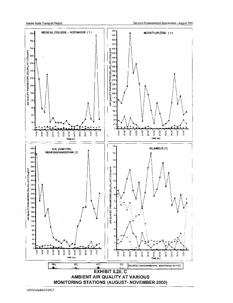
Kerala State Transport Project Sectoral Enviommental Assessment - August 2001
390 MEDICAL COLLEGE - KOZHIKODE (1)55 MUVATTUPUZHA (1)
360 w
475
330 '- 450
E300 ~~~~~~~~~~~~~~~~~425
o q0400-
I-, 375 u 270 z
z z2240 6 (325
0 ~ ~ ~ ~ ~ ~ ~~~~~~~~~ ~~~~300210-
ul ~~~~~~~~~~~~~~~~~~~~U 275
160 ~~~~~~~~~~~~~~~~2504 ~ ~ ~ ~~~~~~~~~~~~~0~~~~ 225 fL i~~~~~~~~~~~L
1500 200 M
175O 120 -10
90 ~~~~~~~~~~~~~~~~~~125-100
60 7
30 25
o ~~~ ~~ ~~ ~~ ~~ ~~~ ~~ ~~ ~~ ~~ 0 0 0 0'a 0 0 0 W 0 0 0 N C N 0 0 0 0 N - - - N N ~~~~~~~~~~~~~~~~~~0 0 0 0 0 -
n1ME thr) Ti ME thri
15-
440 N.H. JUNCTION, NILAMBUR (1)420 NEAR KAZHAKOOTAM. (1) 14-
40013-
380
360 12
340
0320 61
~300 10L
Ci' 280 0
O5 260 o
240
o220
200 *,'
180
160C, ~~~~~~~~~~~~5 --Cy140-
120
100-
60 p 60- ~ ~~~~~~~~~~~~~2 i-
40 A
20 - -
0~~~~~~~~~~
TIME (hr) TIME thr)
NO, so, HCT co SOURCE: ENVIORNMENTAL MONIOIGS O
EXHIBIT 5.20. CAMBIENT AIR QUALITY AT VARIOUS
MONITORING STATIONS (AUGUST- NOVEMBER 2000)
LB I lSheladia/CES/ICT
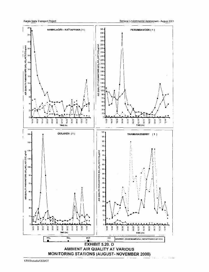
Kerala State Transport Project Sectoral Enviornmental Assessment -August 2001
26, NIRMALAGIRI .- KATTAPPANA (1)35 PERUMBAVOOR (l)
330 24
315
22 300 285
20 270
0 ~~~~~~~~~~~0255 u240
1 6 z2 2i A~~~~~~~~~~~~~~~~4210
65 0__ -. 195
CO 14 COcc CO 1 80
IL.
12 ~~~~~~~~~~~~~~~~~~~~~~~1205
< w~~~~~~~~90.
4~~~~~~~~~~~~~5 7~~~~~~~~~~~~~~~~~~5
30~~~~~~~/2
0 4 0r N 0 0 -0 v D0 0 0 0 0 0 0 8 0
0 9 0 0 0 0 0 0 9~~~~~~~~~~~~~~~~~
TIME (hr) TIME (hr)
165 QUILANDY (1) 0 THAMARASSERRY (195
855C
135 o 80.
~75 0 120L)7
965 ''
90~~~~~~~~~~~~~~~~~~~~~~~~~~~~~~~~~~~~~~~~~~~~~~~~~~~~~~~~~~~~~~~~~
105 < 4C5
60 m~~~~~~~~~~~~~~~~~~~~~~~~~~~~~~~~~~~~~~~~~~~~~~~~~40CC C
4- Cc C
75~~~~~~~~~~~~~~~~~~~~~~
0. . . .4 . . . . .C 0. 40 C C~~~~~~~~~~4 C C 6 C
TIME (hr) TIME (hr)~~~~~~~~~~~~~~~~~~~~~~~~~~~~~~~~~~~~~~~~~~~~~~~~~~~~~~~~~~~~~~~C
NO. HCT co SOURCE: ENVIORNMENTAL MO~~~~~~~~~~~~~~~~~~~~~~~~~~~~~~~~~~~~~~~~~~~~~~~~~~~~~C C ~~~~~60 ~ 14 =-- -EXIBT5.20.C D
AMBIENT AIR QUALITY AT VARIOUS~~~~~~~~~~~~~~~~~~~ C CC
0 C CITRNGSATOS CGUT NVMBR200
LB1113heladia/CES/ICT~~~~~~~~~~~~~~~~~~~~~~~~~~~~~~~~~~~~~~~~~~~~~~~~~~~~~~~~~~0 0
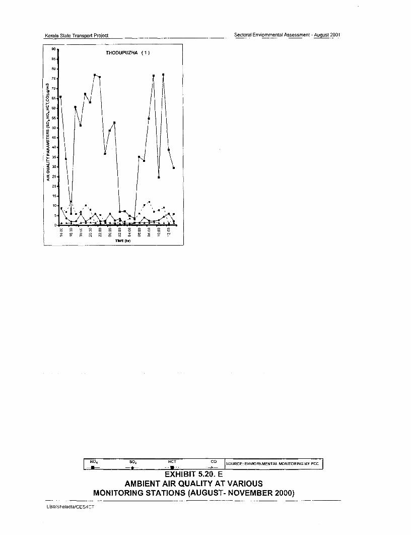
Kerala State Transport Project Sectoral Enviommental Assessment - August 2001
THODUPUZHA (1)85
80
75
705
I-I
z 6O
L~~~~ OooC>:) O N
2z 55
0 5046
40
IL3-5
0.
235
20
15,
10 5
5
TIME (hr)
NO,, SO% HCT co SOURCE: ENVIORNMENTAL MONIONGYPC
EXHIBIT 5.20. EAMBIENT AIR QUALITY AT VARIOUS
MONITORING STATIONS (AUGUST- NOVEMBER 2000)
LBII/SheIadia/CES'ICT

Kerala State Transport Project Sectoral Environmental Assessment - August 2001
200
190180150
140
130120 1104
100
90 018070
30
20
180
0
Thinuvananthapunam Ko Haayam Kozhikode
F1 1994170160150
130120110
180-170 160 150 140.-130 120:110
90
180170160150
130
01102W C 1P S 2 &NO tadr(Sorce Nainlabetarqaiymntoigsre,CC)3MSadr
go.~~~~~~EHBT:52 BO ABET I ULTYI EIENILAE
70 - ~FRTE ER 99,194&19
LB 60hldi/EIC
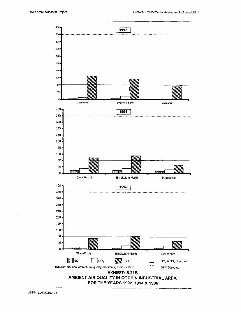
Kerala State Transport Project Sectoral Environmental Assessment - August 20D0
400 |1992
360 . ... ...... .. .... ... ............................... .................... ..... ..-............................... ..................... ...............
320
280
240
200n
160
120
800
40
0Eloor-Kochi Emakulam North Injmpanam
400 -4|1994
360 ................... ....................................... ..............................................................
320
280
240
200
160
120
80
40
0Eloor-Kochi Ernakulam North Irumpanam
400 | 1996
360 . ........ ..... ....... .. ... .. .. .. ......................... .. ............. .... ..................... .. .
320
280
240
200
160
120
80 1 ] _
Eloor-Kochi Ernakulam North Irumpanam
IIIISf2 llNO 2, SPM SO2 & NO2 Standard
(Source: National ambient air quality monitoring series, CPCB) SPM Standard
EXHIBIT:-5.21 BAMBIENT AIR QUALITY IN COCHIN INDUSTRIAL AREA
FOR THE YEARS 1992,1994 & 1996
LBII/SheladialCES/ICT

Kerala State Transport Pnject Sectoral Envirnomental Assessment -August2001
TIRUVANANTHAPURAM 2(Residential Areal A,-
/ ~ ~ ~~4 F.l U- A0. Ur 0. 04 04 4 0p h rr Oec
ELOOR-KOCHI(Industral Area)
vJ...~~~~~~~~~~~~~~~~~~~~~..............
ERNAKULAM-NORTHa F~ 222 A2 34 22F 4S oo 0 (Industrial Area)
KOTTAYAM(Residential Area)
320 .............................................. .. ... ..... ... ......... ...... ... ...... .. .. ..... .. ...... ... .... .. .. .. ..
... .. .... ... .... .. .. .. ........... . .Z.. ....
zo .r_ ~~~~~ X, _ = 1.A_ wt /\o:KOZHIKODE IRUMPANAM
(Residential Area) (Indostrial Areal
SO2 & NO2 Standard
(Source: National ambient air quality monitorrqg seres. CPCB) ..... SPM Standard - . SPM _ 5 NO2 , SO
EXHIBIT:- 5.22MONTHLY VARIATION OF AMBIENT AIR QUALITY FOR THE YEAR 1996
L BilSheladiafCESIICT
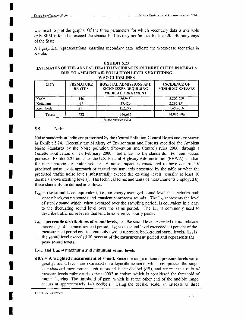
Kerala State Transport Project Sectoral Environmental Assessment-Aueust 2001
was used to plot the graphs. Of the three parameters for which secondary data is availableonly SPM is found to exceed the standards. This may not be true for the 120-140 rainy daysof the State.
All graphical representations regarding secondary data indicate the worst-case scenarios in
Kerala.
EXHIBIT 5.23ESTIMATES OF THE ANNUAL HEALTH INCIDENCES IN THREE CITIES IN KERALA
DUE TO AMBIENT AIR POLLUTION LEVELS EXCEEDINGWHO GUIDELINES
CITY PREMATURE HOSPITAL ADMISSIONS AND INCIDENCE OFDEATHS SICKNESSES REQUIRING MINOR SICKiNESSES
MEDICAL TREATMENTKochi 146 86,946 5,202,229Kottayam 65 37,420 2,292,851Kozhikode 211 122,249 7.490,616
3 Totals 422 246,615 14,985,696
(Source: Brandon 1995)
5.5 Noise
Noise standards in India are prescribed by the Central Pollution Control Board and are shownin Exhibit 5.24. Recently the Ministry of Environment and Forests specified the AmbientNoise Standards by the Noise pollution (Prevention and Control) rules 2000, through aGazette notification on 14 February 2000. India has no L% standards. For comparisonpurposes, Exhibit-5.25 indicates the U.S. Federal Highway Administration (FHWA) standardfor noise criteria for motor vehicles. A noise impact is considered to have occurred ifpredicted noise levels approach or exceed the standards presented by the table or when thepredicted traffic noise levels substantially exceed the existing levels (usually at least 10decibels above existing levels). The technical terms and units of measurements employed bythese standards are defined as follows:
I Leq = the sound level equivalent, i.e., an energy-averaged sound level that includes bothsteady background sounds and transient short-term sounds. The Leq represents the levelof steady sound which, when averaged over the sampling period, is equivalent in energyto the fluctuating sound level over the same period. The Leq is commonly used todescribe traffic noise levels that tend to experience hourly peaks.
| L% = percentile distributions of sound levels, i.e., the sound level exceeded for an indicatedpercentage of the measurement period. L90 is the sound level exceeded 90 percent of themeasurement period and is commonly used to represent background sound levels. L1 o isI the sound level exceeded 10 percent of the measurement period and represents thepeak sound levels.
LMax and LMin = maximum and minimum sound levels
dBA = A weighted measurement of sound. Since the range of sound pressure levels variesgreatly, sound levels are expressed on a logarithmic scale, which compresses the range.I The standard measurement unit of sound is the decibel (dB), and represents a ratio ofpressure levels referenced to the 0.0002 microbar, which is considered the threshold ofhuman hearing. The threshold of pain, which is at the other end of the audible range,occurs at approximately 140 decibels. Using the decibel scale, an increase of three
LBII/Sheladia/CES/1CI5.16
l
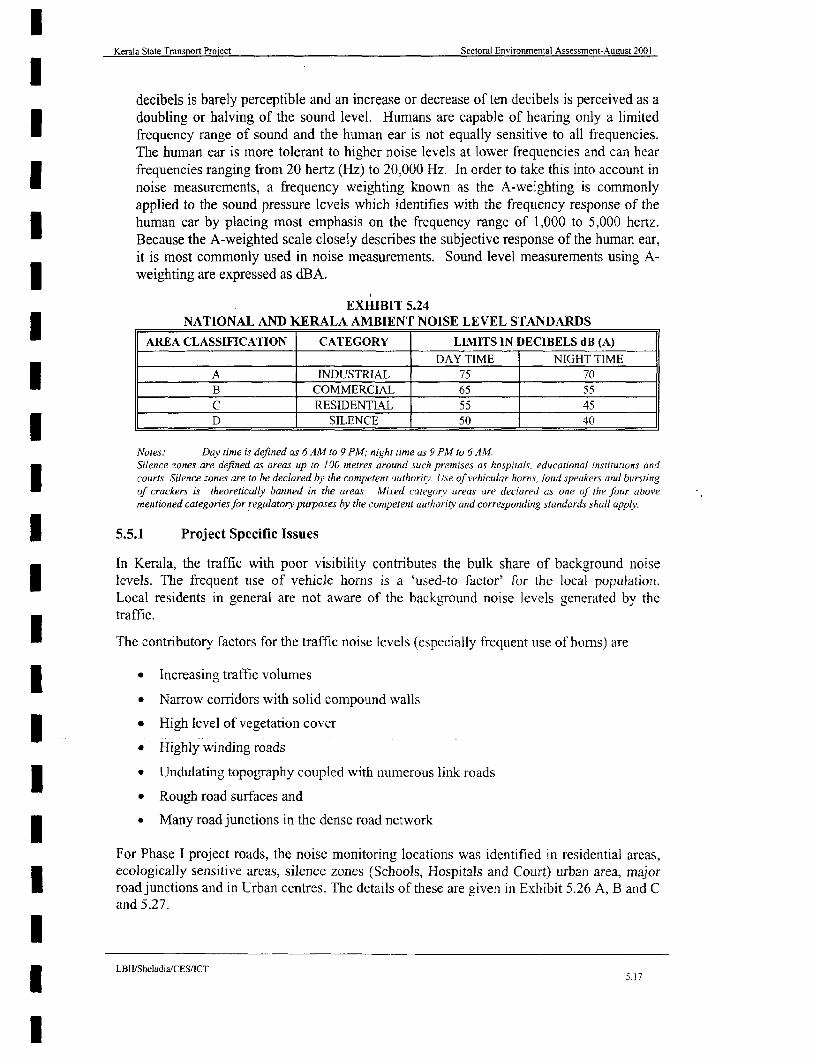
Kerala State Transport Project Sectoral Environmental Assessment-August 2001
decibels is barely perceptible and an increase or decrease of ten decibels is perceived as adoubling or halving of the sound level. Humans are capable of hearing only a limitedfrequency range of sound and the human ear is not equally sensitive to all frequencies.The human ear is more tolerant to higher noise levels at lower frequencies and can hearfrequencies ranging from 20 hertz (Hz) to 20,000 Hz. In order to take this into account innoise measurements, a frequency weighting known as the A-weighting is commonlyapplied to the sound pressure levels which identifies with the frequency response of thehuman ear by placing most emphasis on the frequency range of 1,000 to 5,000 hertz.Because the A-weighted scale closely describes the subjective response of the human ear,it is most commonly used in noise measurements. Sound level measurements using A-1 weighting are expressed as dBA.
EXHIBIT 5.243 NATIONAL AND KERALA AMBIENT NOISE LEVEL STANDARDSAREA CLASSIFICATION CATEGORY LIMIITS IN DECIBELS dB (A)r________________ ____________ DAY TIME NIGHT TIME
A INDUSTRIAL 75 70B COMMERCIAL 65 55C RESIDENTIAL 55 45r D SILENCE 50 40
Notes: Day time is defined as 6 AM to 9 PM, night time as 9 PM to 6 AM.Silence zones are defined as areas up to 100 metres around such premises as hospitals, educational institutions andcourts. Silence zones are to be declared hy the competent authoritv. Use of vehicular horns, loud speakers and burstingt f crackers is theoretically banned in the areas. MLred category areas are declared as one of the four abovementioned categoriesfor regulatory purposes by the competent auithority and corresponding standards shall apply.
I 5.5.1 Project Specific Issues
In Kerala, the traffic with poor visibility contributes the bulk share of background noise; levels. The frequent use of vehicle horns is a 'used-to factor' for the local population.
Local residents in general are not aware of the background noise levels generated by thetraffic.
I4 The contributory factors for the traffic noise levels (especially frequent use of horns) are
* * Increasing traffic volumes
* Narrow corridors with solid compound walls3 * High level of vegetation cover
* Highly winding roads
* * Undulating topography coupled with numerous link roads
* Rough road surfaces and
* Many road junctions in the dense road network
For Phase I project roads, the noise monitoring locations was identified in residential areas,ecologically sensitive areas, silence zones (Schools, Hospitals and Court) urban area, majorI road junctions and in Urban centres. The details of these are given in Exhibit 5.26 A, B and Cand 5.27.
LBII/Sheladia/CES/ICT5.17
l

Kerala State Transport Project Sectorai Environmental Assessment-August 2001
EXHIBIT 5.253 COMPARATIVE Leq AND L% NOISE STANDARDSActivity Leq (h) Lio (h) Description of Activity CategoryCate2orv
Lands for which serenity and quiet are of high significance and which1 serve an important public need, and where preservation of thoseA 57 60 qualities is essential if the area is to continue to serve its intended
purpose. (Outdoor sound level)3 Picnic areas, recreational parks, playgrounds, active sport areas, andB 67 70 parks, residences, motels, hotels, schools, churches, libraries, and
hospitals. (Outdoor sound level)
l C 72 75 Developed lands, properties, or activities not included in Categories Aor B above. (Outdoor sound level)
3lD Undeveloped lands.
Recommended indoor sound level for residences, motels, hotels,E 52 55 public meeting rooms, schools, churches, libraries, hospitals, and3 _______ _______ auditoriums.
Source: Based on standards of the U.S. Federal Highway Administration, 23 CFR 772 (4-1-90 Edition).'Either L, (I-hour) or LI0 (I-hour) may be used, but not both.
EXHIBIT 5.27ANALYSIS OF MONITORED NOISE DATA
PERCENTAGE DISTRIBUTION OF NOISE LEVELSI SL. THROUGHOUT KERALA IN 34 LOCATIONS FALLING
_ NO. LOCATION ALONG THE KSTP ROADSDate LIO L0 L0 ENAK
(Year 2000) (Max) L50 L90 REMARKSN.H.Junction, Near 8 - 9 Aug 81.00 71.00 52.50 Major RoadKazhakkootam (1) Junction
2 Ayoor Rural (1) 20 - 21 Aug 63.50 57.50 53.00 Rural
3 Kottarakkara Urban (1) 22 - 23 Aug 67.50 61.50 54.50 Urban4 Chengannur Industrial Estate 24 - 25 Aug 51.50 44.50 38.50 Urban
(1)5 N.H.Junction, Near I - 2 Sep 73.50 67.50 55.50 Urban
Kazhakkootam (2)6 Ayoor Rural (2) 3 - 4 Sep 62.50 57.50 53.50 Rural7 Kottarakkara Urban (2) 5 - 6 Sep 68.00 62.00 56.00 Urban8 Chengannur Industrial Estate 7 - 8 Sep 57.00 52.00 45.50 Urban
(2)9 Aluva (1) 28 - 29 Sep 66.50 62.50 54.00 Industrial10 Perumbavoor(l) 30- 1 Oct 65.50 57.50 44.00 Industrial11 Muvaltupuzha (1) 2 - 3 Oct 61.50 54.00 53.50 Urban
12 Thodupuzha (1) 4 - 5 Oct 57.00 47.50 37.50 Urban13 Nirnalagiri - Kattappana (1) 6 - 7 Oct 47.00 43.00 36.50 Semi Urban14 Aluva (2) 9 - 10 Oct 64.50 60.00 53.50 Industrial
l 15 Perumbavoor (2) 11 - 12 Oct 61.0 53.50 41.00 Industrial16 Muvattupuzha (2) 13 - 14 Oct 60.50 55.50 54.50 Urban17 Thodupuzha (2) 15 - 16 Oct 56.50 48.50 39.50 Urban3 18 Nirnalagiri - Kattappana (2) 17 - 18 Oct 48.50 44.50 37.00 Semi Urban
Min/sackground Noise Level
LBII/SheladiaICES/ICT
l 5. 8

Kerala State Transport Proiect Sectoral Environmental Assessment-August 2001
EXHIBIT 5.27 (CONTINUED)ANALYSIS OF MONITORED NOISE DATAI PERCENTAGE DISTRIBUTION OF NOISE LEVELS
THROUGHOUT KERALA IN 34 LOCATIONS FALLING*NSL. LOCATION ALONG THE KSTP ROADS
Date L1O L50 L90 REMARKS(Year 2DOO) (Max)
19 Edavanna(I) 21 - 22 Oct 61.00 57.00 44.00 RuralNilgiri
20 Nilambur (1) 23 - 24 Oct 51.50 47.50 43.50 Biosphere
21 Medical College - 26 - 27 Oct 65.00 59.50 65.00 Silence Zone*______ Kozhikode (1)
22 Thamarassery (1) 28 - 29 Oct 62.00 55.00 43.50 Semi Urban23 Quilandy (1) 30 - 31 Oct 65.50 52.50 42.00 Semi Urban24 Edavanna (2) 1 - 2 Nov 59.00 48.00 43.50 Rural
Nilgiri25 Nilambur (2) 3 - 4 Nov 53.50 49.50 44.50 Biosphere
Medical College - reserve
26 MedicalCollege - 5 - 6 Nov 65.50 61.50 45.50 Silence ZoneKozhikode (2).______ ___
27 Thamarassery (2) 7- 8 Nov 58.00 53.00 45.50 UrbanI 28 Quilandy (2) 9 - 10 Nov 55.50 48.50 40.00 Urban
29 Kellur - Wynad (1) 11 - 12 Nov 45.50 42.50 38.50 Forest/Sensitive area
30 Iritty Road - Thalassery (1) 13 - 14 Nov 54.00 47.50 36.00 Urban
* 31 Aralam Farm (Intty) 15- 16 Nov 56.00 48.00 43.00 RurlKakkayam Gode (1)
32 Kellur- Wynad (2) 19 - 20 Nov 51.00 40.00 38.00 Foresit* ~~~~~~~~~~~~~~~~~~~~~~~~~~~~Sensitive area33 Iritty Road - Thalassery (2) 21 - 22 Nov 58.50 49.50 33.00 Urban
X|34 |Aralam Farm (Inrtty) 23 -24 Nov 56.00 49.00 44.00 Rural____Kakkayam Gode (2)
(Souirce. Pritmeary data monitored by SPCBJ
Noise levels have been recorded at all stations for a period of 12 hours starting from 1400 hrstol2.00 hrs. The Kerala State Pollution Control Board carried out monitoring using IntegratedNoise level Metre after an agreement with the Public Works Department. The monitoringstarted in August 2000 was completed at the end of April 2001 together with the air andwater quality monitoring. The noise data for 17 locations have been plotted with time (hrs)versus sound level dB variations. The findings are as follows:
1. The variation of maximum noise level is 70-100 dB for all urban and semi urbanU pockets while for typical rural areas and forest areas this is much less ie.,50-70 dBonly
1 2. The recorded noise levels were used to establish equivalent noise levels (Leq), L10,L50, and L90 as shown in Exhibit 5. 27 for 34 locations.
3. The Stations at Nilambur, Quilandy, Thamarassery and Iritty shows a much-reducedI noise level during nighttime. This is attributed to the very low commercial activitiesand the vehicular movements. In Nilambur town, for example is located in thehighlands surrounded by rural areas, forests and plantations. The only noise that couldbe expected is the occasional nighttime vehicular movements.
N Min/Background Noise Level
LB3II/Sheladia/CES/ICT 5.19I~~~~~~~~~~~~~~~~~~~~~~~~~~~~~~~~~~~~~~51

SOUND LEVEL dB (A) (HRLY.MAX, MJh,L9q) SOUND LEVEL 88B(A) (HRLY.MAX. MIN,Laq) SOUND LEVEL dB (A) (HRLY,MAX, MIN,Leq)
(0 ~~~~~~~~~14:00 14:00 P 14:00 Era p~~~~~~~~~~~~~~~~~~~~~~~~~~~~~~~~~~a0'C
(0 18 00 W 18.00.....16:00.p . -.
p ~~~~~~~~~~~~~~~~~~~~~~0)20:00 ~~~~~ ~ ~~~~ ~~~~~~~~~~20:00 p 20:00'-
22:00 Ik22.0 c 2:0
00:00 4 rn 00 00' a -oo
3_ E02:00 S .0 0 20 m > 020 '
C z ~~~04:00 2 04 0 04:00
> ~~~~~06:00 6 &0 06:00 '
00:00 . -08.00O' 08:00 ,V0)<
> 12: 00 1000 10:00,
i2:00 12 00 ~~~~~~~ ~~~~~~~~~~~~~~~~~~~~~~~~~~~~12:00' =~~~~~~~~~~
SOUND LEVEL dIB (A) (HRLY,MAX, MIN,Leq) SOUND LEVEL dB (A) (HRLY.MAkX, MIN,Leq) SOUND LEVEL dB (A) (HRLY,MAX,MNLq
-n 14:00 14:00 p14:00
G) >80 16:00'p10 C0 ~~~~~~~~~~~~~~*m0c 18:00' 18:00 *-018:00
0< ~ 22:00 22:00 p 2 22:00pm
o 20 0 '2 2 :0 0 . 0 0 .0 0 a
Vzp Mf
mr 0 2 0201q -- 4 3~~~~~~~~- .> ~02:00' WC t -02:00W 020 C
04:00~~~~~~~~~~~~~i 40=1 cn~~~~~~~~~~~~~~~~~~~~~~~~~~~~( c0 >
31 06:00' 06:00 - 06:00 a p Iz I~ ~ ~~~~~~~~~~~~~~~~~~~~~n *-4
Ca 0:0 08:00 CD 0) 0800. 08:00
10 ~~~~~~~~~~~~~~~~~0:00 1:0 pC10:00 C~~~~~~~~~~~~~~~~~~~~~~~~~~~~~~~~~~~~~~00
12:00~~~~~~~~~~~~~~~~2:0p C
12:00 'p -'C. ~~~~~ ~ ~~~~~~~~~~~~~~~~~~~~~~~~~~~~~12:00 pC
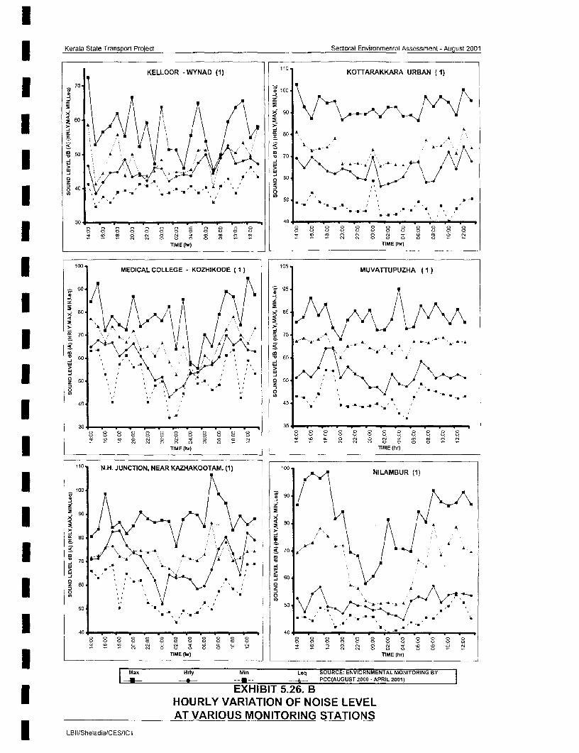
Kerala State Transport Project Sertoral Environmental Assessment - August 2001
KELLOOR -WYNAD (1) 110 KOTTARAKKARA URBAN (1)
70 - 100 -
9 10060
3 A-7U <w \' S ; 4 S f iSX
* ~~40 @ .@ u . 45g o
u~~~~~~~~~~~~~~~ ., N,
3~~~~~~~~~~~~0 N 0 tOOO E._..Ng8 S8.
so 70 A~~~~~~~~~~04 0 0
ui [ iE(h),T E(r
10 N.H MJUNCALON COLEGE KAZHAKOOTAM (1) 1 05 MUVNIATTUPUH (1)
I ~~~~~~~~~~~~~~~~~~~~~~~~~~~C
:) 40 w)_TE(r
0-
30 4 0 O N
m N.~~~~~~~~~~~~~~
* A~~~~~~~~~~~~~~~~~~~~~~~~~~~~
- 0 9 0 0 ~~~~~~~ 9 9 0 0 0~~~~~ 0 o
TIME tlrt TIME (hrI
10 MEDIUCAN NLEGAR VAKORIOA E (1)RN t MVNLATUP (1)
|90 - ga
80 8*Ihi
70 7~~~~~~~~~50--A --A-AN
03 co~~~~~~~~~~~~~~~~~~~4
60 N 0 - 0 005
z ~~~~~~EHBT526 I~~~~~ 0 7)~HUL VRAIN FNIS EEAT ARIUS ONTORNG TATONLBII/Sheladia/CESIICT~~~~~~~~~~~~~~~~t
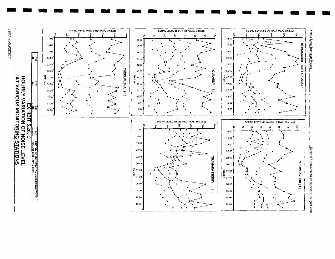
I-w ~~~~~~~~~~~~SOUND LEVEL dB (A) (HRLY,MAX, MIN,L.q) SOUND LEVEL CIS (A) (HRLY,MAX, MIN,Loq) SOUND LEVEL dB (A) (H4RLY.MAX, MIN,Laq)
14:00 p p ~~~~~~~~~~~~~~~~~~~~~~~~~~~~~~~~~~~~~~ 1:0(014:00' ~~~~~~~~~~~~~~14:00 .p'1'
186:00 1o:00-100
m ~~~~~1 8:00 p- 18:00 -W ~ 18:00'
r 20:00 --- P20:00 *i 20:00
220 p p. 22:00 p'-p:2200C
00:00 - '000 00.00 00:00 -* 2"~~~~~~~~~q 0:
> ~ ~~~~02:00 m 9 020 z 20
00:00 01 0:00 - .00:00
MO:0 a p 08:00 ~ .08:00
cn IT 00 1:0--10:00 0~ X 12:0 p p. 2:00 0
0 12.00 120
0 ~~~~~~~~~~~~~~~~~~~~~~~~SOUND LEVEL CIE (A) (HRLY.MAX, MIN,Laq) SOUND LEVEL dB (A) IHRLY,MAAX, MIN,Leq)
~0
__ 16:00 P ~ P 40
CJr 18:00 p18:00 .
cn - 0~~~~~~~~~~~~~~~~~~~~~~~~~~~~~~p ):0
M m CO~~~~~~~~~~~~~~~~~~~~~~~~~~~~~~~~~~~~~~~~~~-
20.00 20:00 u gM gz a)0 < 0~~~< 22:00 -422:00 m ._
(f1.. M 00:00 -00:00 ~Pm >~~~~~~~~~~~~~~~~~~~p2
~02:00 ~02:00 p0W om >l
0, - I- w~~~~~~~~~~~~~~i <
O 2.~~~~~~~~~~~~~~~~~~~~~~a04:00 ~j .04:00 0-0,0
M ;o~~~~~
~~~~-. <08:00 'p:0
060 12 p00 0
CC -~~~~~~~~~~~~~~~~~~~~~~~~~~~~~~~~~~~~~~~~~~~~~~~~~~~~~~~~~~~~~~~~CCD 08:00 p. p. 08:00 0)~~~~~~~~~~~~~:O

Kerala State Transport Project Sectoral Environmental Assessment-August 2001
4. In all the locations where there is a high noise levels there is an active nighttimevehicular movement and commercial activities did not exhibit the low noise level inthe night.
5. Sensitive noise receptors along the Project roads are indicated in the link specific| environmental analysis in Appendix A 4.2.
6. Kellur in Wynad shows the lowest noise levels where there is absolutely low level ofcommercial activities, very few buildings and vehicular movements. Hence themaximum noise levels are within the 30-65 dB.
5.6 FLORA, FAUNA AND ECOSYSTEMS
5.6.1 FloraFt:
The forests of Kerala are rich in terms of species diversity and economic value (Exhibit 5.28).There are over 500 species of identified medicinal plants. Other plants of economic value likecoconut and arecanut palms, wild cashew, bamboos and pure reeds also form part of thevegetation.
EXHIBIT 5.28______- VARIOUS TYPES OF VEGETATION IN KERALASL. NO. VEGETATION T YPE - AREA IN % OF TOTAL FOREST LAND
1 J Wet evergreen and Semi ever green j50.52 Moist deciduous 33.4
3 Dry deciduous 1
4 Montane sub tropical and temperate 1.7
l 5 Plantations and others 12.6
(Source: Forest Wealth of Kerala 1991)
A typical vegetation scenario from evergreen Forests in Kerala is illustrated as follows. Thle treesI in the evergreen forests are seen usually in many storeys (i.e. tall medium and small size levels).Some of the important species encountered are: -
First Storev includes: payini (Vateria indica), pali (Palaquitum ellipticumll). Kalpain(Diptorocorpus indicus), vellakil (Dysoavlum mnalabaricumn), churuli (Mesua ferrea), kambakam( Hopia parviflora), and vedipla (Cullenia excelsa)
| Mid Storev includes: Cheru (Holi garna arnotiana), Chorapali (Alliristica baddomli), Vzhana(Cinnamomum selvianica), Vatta (Makkarango chelttattai), Nedunar (Poliv althia Fragrance).Kanala or Nashagam (Ivodia lununkanda), Karamavu (lliyo corpus ceratus), Puvam (Slichiraoliyatus), cinthoorum (Malottu s philipinensis)
Bottom Storev include: Manipperundi (Lia Indica), Cardamom (Eliratia cardanmoml), Karimkurinji (Strobilanthus Sp.), Koova (Kurkumla Sp.)
Common Creepers: Chooral (Kalamus Sp.) Ramadanthi (Smilacus sailanicus). Wildpepper(Pepper sp.)
In addition Ferns, Mosses, Orchids etc. also occur.
Similarly other forests types have specific groups of flora. The other forest types are* Tropical wet forest* Tropical dry forest* Alpine scrub etc
I Fl Forest wealth of Kerala 1991
LB[IiSheladia,CES/ICI
I 5.'(5

Kerala State Transpon Project Sectoral Environmental Assessment-Aiigust 2001
The project roads are shown in relation to the vegetation of Kerala in Exhibit 5.29.
5.6.2 FaunaF2 :
The physiographic, climatic and vegetation diversities support a range of habitats suitable fora variety of fauna. Important wild life species recorded are elephant, gaur, sambar, spotteddeer, barking deer, wild boar, tiger, panther and bear. Nilgiri tahr, Nilgiri langur and liontailed macaque are some of the rare species found. Special measures are needed for theirpreservation. In order to improve the population of wildlife, ten wildlife sanctuaries, one tigerreserve and one national park have been established in the State. In addition Silent Valley aunique patch of wet evergreen forest with rare faunal species has been declared as a NationalPark recently.
5.6.3 National Parks, Wildlife Sanctuaries and Forest Reserves
The State's ecology is rich in its diversity and about 25 percent of its total area, i.e., 1,081,509hectares, is forested. This includes 915,115 hectares of reserve forests, 18,479 hectares ofproposed reserve forests and 189,087 hectares of vested forests. Wildlife sanctuaries formabout 204,247 hectares of these. Increasing civic consciousness and the protective measuresof the Forest Department in conservation of the forest eco-system in Kerala has resulted in agradual but steady improvement in regenerating the degraded forests. Major forest productsare timber, firewood, cardamom, honey, reeds, bamboo, sandalwood etc. Forest areas andwildlife reserves are shown in Exhibit 5.30. The designated wildlife reserves by division areshown in Exhibit 5.31. The Appendix A 5.3 shows the IUCN document on the flora andfauna in the wildlife sanctuaries of Kerala obtained from Cambridge (UK) (refer box 5.3.)
Box 5.3 Degradation Of Idukki Wild Life Sanctuary Due To AnExisting Road Selected For Phase 2 (Buffer Road) Improvement
The sanctuary lies within an ecosystem that has been subjected to heavy disturbance since the1950s. The Idukki Hydroelectric Project started in the 1960s involved the construction ofthree dams, namely Idukki, Cheruthoni and Kulamavu. As a result of the increased access tothe area, tiger Panthera tigris (E), gaur Bos gaurus (V), and sloth bear Melursus ursinus (I)became locally extinct by the early 1970s. Many of the dam workers settled in the area andencroach on the forests. The proposed construction of additional dams at Prattayar andKallar is likely to further add to the disturbance. Poaching of wildlife has been a seriousproblem. In the case of elephant, it has resulted in a skewed population withdisproportionately small numbers of sub-adults, juveniles and calves and high numbers ofadult females. Other problems include encroachment, cattle grazing, firewood collection andannual burning (resulting in grasslands dominated by unpalatable fire-hardy species such asThemeda sp. and Cymbopogon sp.) Wild dogs prey on cattle, due to shortage of prey, andwild boar and bonnet macaque raid crops. The little protection afforded to the sanctuarylargely reflects the lack of adequately trained staff.
Source: IUCN document on the Sanctuary
More than 500 species of trees have been identified and the wildlife sanctuaries containmammals, such as elephants, tigers, leopards, lion-tailed macaque monkeys, and ibex andinclude rare and endangered species. There are a number of national parks in addition towildlife sanctuaries. Many of the wildlife sanctuaries are contained within the National Parks.Details are given in the Exhibit 5.32.
F2 Resource Atlas 1984
s LBII.'SIhladia'(ES:ICj1| :::::::::::::::::::::::::::::::::::::::::::::::::::::::::::::::::::::::::::::::::::::::::::::::::::::::::::::::::::::::::::::::::::::::::::::::::::::::::::::::::::::::::::::::::::::.21 r_
I

Kerala State Transport Project Sectoral Environmental Assessment - August 2001
1s I0 761 0 77-10
N
SCALEKASARAGOD ~~~~~~~~~~~~~ ~~~ ~~~~~~~~km2O 10 0 20 40 00 Ho 100km
0+ ?
0 ~~~~~~~~~~~~~~~~~~~~~~~~~~~~~~~~~~~~~~~~~~~~~~~~~~~~~~~0
WEK EVRGREN AORET VADKANAA
0
U D~~RYODECIDUOUSDAUF
- PURAHE EEDGREA
PURINISSE BA O ARSRASS LAND FOREST
MOIST ECIDUOUS FOREST PLANTA
r ,, ~~~~DRY DECIDUOUS XKCIS bP°^q
0... TEMPERATE SHOLA PUIA
PURE REED AREA + P U
| * : 2 ~~PURE BAMBOO AR EA |EE3
o UNCLASSIFIEDo
FOREST PLANTATiONS KI A
OTHER PLANTATIONS
THIRUVNIANT UR M ;-.
ISource -WATER AI LAS OF KERALA, 1995)
EXHIBIT:-5.29PROJECT ROADS IN RELATION TO VEGETATION OF KERALA
75-1 D 761 0 77 l0
LBII/Sheladia/CES/rCT

Kerala State Transport Project Sectoral Environmental Assessment-August 2001
EXHIBIT 5.30DESIGNATED FOREST BY DIVISION & AREAS (Ha)
* DIVISION RESERVE LAND VESTED TOTALNO ________ _____ PROPOSED FOREST
1. Thiruvananthapuram 36,007.90 582.53 397.50 36987.932. Tenmalai 29,432.07 - 1,216.54 30,648.613. Punalur 28,005.07 - 16.90 28,021.974. Konni 32,064.30 1,102.10 __ 33,166.405. Ranni 105,028.94 716.70 161.10 105,906.746. Achancovil 26,879.40 - 20.60 26,900.007. Munnar 66,275.02 4,725.60 583.49 71584.118. Kottayam 65,548.60 525.70 3,140.90 69,215.209. Kothamangalam 31,686.50 -1523 31701i7310. Malayattur 61,724.11 52.48 61776.59l1 Vazhachal 41,394.38 -41394.3812. Chalakkudy 35,470.98 - - 35470.9813. Thrissur 33,101.81 - 634.30 33,736.1114. Nenmara 20,551.73 - 13,450.62 34,002.355. Palakkad 7341 - 16630.52 23971.526. Manarcad 20,998.00 - 45,677.31 66,675.3117. Nilambur South 26751.1 - 9,817.26 36568.3618. Nilambur North 5,791.96 1.71 33,602.19 39395.8619. Kozhikode - 8,613.88 20,508.46 29122.3420. Waynad South 6,760.05 530.30 25,244.00 32534.3521. WaynadNorth 13,390.31 1,506.44 6,697.17 21593.9222. Kannur 20,651.27 - 8,008.92 28660.19
Total (1) 714,854.50 18,357.44 185,823.01 919034.95
EXHIBIT 5.31DESIGNATED WILDLIFE RESERVES BY DIVISION & AREAS (Ha)
Si NO DIVISION RESERVE LAND VESTED TOTAL____ ~~~~~~~~~ ~~~~~PROPOSED FOREST TOA
Wildlife Divisions
1. Thiruvananthapuram 18,100.00 o 181002. Agasthyavanam 3,044.70 67.30 - 31123. Idukki 28,960.20 - 28960.2
4. Thekkady 77,700.00 54.38 - 77754.385. Parambikulum 27,414.08 - 27414.086. Silent Valley 8,951.65 - 8951.65
7. Waynad 36,690.74 3,264.28 39955.02______ Total (2) 200 861.37 121.68 3.264.28 20424733
Total (1) + Total (2) 915,115.87 18,479.12 189,087.29 1123282.28
(Source: Kerala Forest Research Institute, Kerala Forest Department).
EXHIBIT 5.32WILDLIFE SANCTUARIES, NATIONAL PARKS AND BIOSPHERE RESERVES IN
KERALASI NAME OF DISTRICTI AREA IN REPORTED FAUNA
NO SANCTUARIESIPARKS LOCATION HA
I E Neyyar Sanctuary Thiruvananthapur 12800 Elephant. Tiger, Leopard, wild cat,am wild dog, bear
2. Peppara wildlife sanctuary Thiruvananthapur 5300 Tfiger, Leopard, wild cat, wild dog,
.Shenduruny Sanctuary Kollam 10032 Sloth bear, Eehant Wild oar etc
*-LBII/SheladiaCES/ICT5.22
l
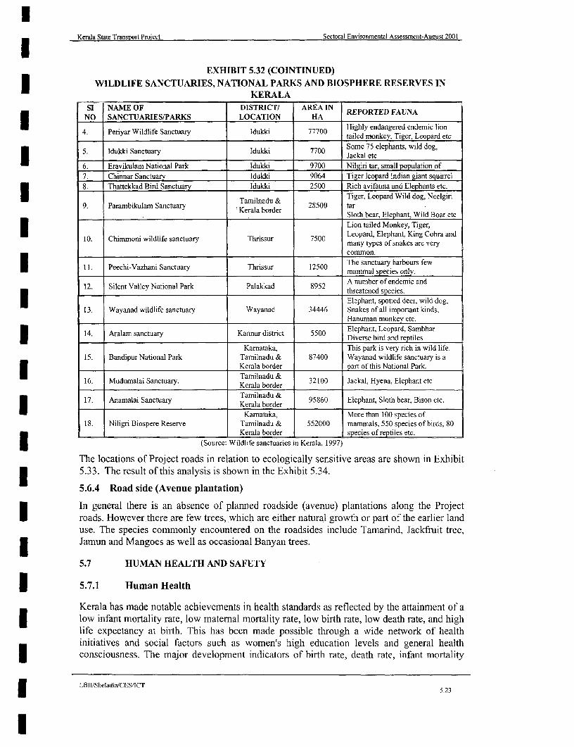
Kerala State Transport Project Sectoral Environmental Assessment-Aueust 2001
EXHIBIT 5.32 (COINTINUED)3 WILDLIFE SANCTUARIES, NATIONAL PARKS AND BIOSPHERE RESERVES INKERALA
SI NAME OF DISTRICT/ AREA IN REPORTED FAUNANO SANCTUARIESIPARKS LOCATION HA Highly FAN A
4. Penyar Wildlife Sanctuary Idukki 77700 Highly endangered endemic lion
3 5. Idukki Sanctuary Idukki 7700 Some 75 elephantst wild dog,
6. Eravikulam National Park Idukki 9700 Nilgiri tar, small population of7. Chinnar Sanctuary Idukki 9064 Tiger leopard Indian giant squirrel8. Thattekkad Bird Sanctuary Idukki 2500 Rich avifauna and Elephants etc.
Tamilnadu & Tiger. Leopard Wild dog, Neelgiri9. Parambtkulam Sanctuary 'Kerala border 28500 tar
_________________ ____________ Sloth bear, Elephant, Wild Boar etc
Lion tailed Monkey, Tiger,
10. Chimmoni wildlife sanctuary Thrissur 7500 Leopard, Elephant, King Cobra andmany types of snakes are very
* ~~~~~~~~~~~~~~~~~~~~common.II. Peechi-Vazhani Sanctuary Thrissur 12500 The sanctuary harbours few
12. Silent Valley National Park Palakkad 8952 A number of endemic andh ~~~~~~~~~~~~~~~~~~~~~~~~~~threatened species.| ~~~~~~~~~~~~~~~~~~~~~~~~~~Elephant, spotted deer, wild dog,
13. Wayanad wildlife sanctuary Wayanad 34446 Snakes of all important kinds,Hanuman monikev etc.
| 14. Aralam sanctuary Kannur district 5500 Elephant, Leopard. Sambhar14. Aralam sanctuary Kannur Diverse bird and reptiles
Karnataka, This park is very rich in wild life.15. Bandipur National Park Tamilnadu & 87400 Wayanad wildlife sanctuary is a
Kerala border part of this National Park.
16. Mudumalai Sanctuary. Kerala border 32100 Jackal, Hyena. Elephant etc
17. Anamalai Sanctuary Tamilnadu & 95860 Elephant, Sloth bear, Bison etc.Kerala border
Kamataka, More than 100 species of18. Niligri Biospere Reserve Tamilnadu & 552000 mammals, 550 species of birds. 80
Kerala border species of reptiles etc.
(Source: Wildlife sanctuaries in Kerala, 1997)
The locations of Project roads in relation to ecologically sensitive areas are shown in Exhibit3 5.33. The result of this analysis is shown in the Exhibit 5.34.
5.6.4 Road side (Avenue plantation)
In general there is an absence of planned roadside (avenue) plantations along the ProjectI roads. However there are few trees, which are either natural growth or part of the earlier landuse. The species commonly encountered on the roadsides include Tamarind, Jackfruit tree,Jamun and Mangoes as well as occasional Banyan trees.
5.7 HU1MAN HEALTH AND SAFETY
5.7.1 Human Health
Kerala has made notable achievements in health standards as reflected by the attainment of a| low infant mortality rate, low maternal mortality rate, low birth rate, low death rate, and high
life expectancy at birth. This has been made possible through a wide network of healthinitiatives and social factors such as women's high education levels and general health3 consciousness. The major development indicators of birth rate, death rate, infant mortality
LBII/Sheladia/CES/ICTI 5.23
l

KeraJa Rtate Tranapw,t PIrqlat -eot8ral XMhonmetal A.wimat WAImt 150
N
SCALE
Jelsoor e km" la 0 N am a
13. WAYANAD VW#DUF; SANCTUARY
10. CHI*OA WNLLUIS SANCTUARY
THALASSERY ~ ~ ~ ~ ~ ~ ~ ~ ~~AnMKUA WLUr - T h N-TUA--<
-~ Stat bondr
-\ 'EA LN NANEA
- --- TRE UNN1NANS
7 Rivr
X~~~~ ~~~~~~~~~~~ CHNNA TUW^LDUFE
t4 l\ /
LEGEND v
State boundary rl z o JMILY
AR ONE MANIA C
S * _ _ * TWO MAlNIEANCES e r !
Railway Line 4 Er(RTOF EEV
Cistrict boundary
Lake/ResevoirWldlife Sanctuary
L2.J National Park Boundry IU- A vw A,
Forest Area
(Source -KERALA FOREST DEPARTMENT)
THIRUVANk4TWU AMU ,i; SACTAR
EMG43BrI- 5.33PROJECT ROADS IN RELATION TO SANCTUARIES & NAToNALpARKS O FKE
LBVBIaIcBSC

Kerala State Transport Project Sectoral Environmental Assessment-August 2001
rate and expectation of life at birth are presented in Exhibit 5.35.
3 EXHIBIT 5.34SENSITIVITY ANALYSIS OF HIGH PRIORITY ROADS BASED ON THE
ECOLOGICALLY SENSITIVE ZONES
| PHASE ECOLOGICALLY SENSITIVE AREA LINKS WHICHSLNO ROAD NAME LINK I OR 2 (Ref: 10 April 1997 MOEF notification and CRZ DETAILED EA
*OR2 notification and WB Operational Policies) PREPARATION3 Except few Kilometres in the beginning Detailed
I Punalur - 84 2 there are numerous reserved forests mainly investigationThodupuzha on the eastem side within seven Kilometre required
of the road corridor.I 2 Thalaserry- 74 Aralam sanctuary is located beyond seven Further investigationValavupara Kilometres. not requiredMuvattupuzha- Small patches of reserved forests and mostly Further investigation
3 Thodupuzha 70 1 plantations without any ecological not requiredX Thodupuzha si nificance
Taikkod- Small patches of reserved forests and mostly Funher investigation4 Kottarakkara I I plantations without any ecological not required
significance
Idu*ki- Sanctuary and reserved forests Detailed5 Idukkiyanmaa 26 1 investigation
Puliyanmala required
Taikkod - Small Reserved forest of two sq km away Further investigation6 Kazhakkootam 72 2 from the ROW not required
EXHIBIT-5.35BIRTH, DEATH AND INFANT MORTALITY RATES IN KERALA
Birth Rate per Death rate per 1,000 Infant mortality Expectation of life atYear 1,000 Population Population 1,000 rate Population birth of Kerala
m__________ Kerala All India Kerala All India Kerala All India Males Females
1970 32.3 36.8 9,2 15.7 61 129 56.7 60.01980 26.8 33.7 7.0 12.6 42 117 64.7 69.01981 25.6 33.0 6.6 12.5 37 110 - -
1985 22.9 32.9 6.9 11.8 33 97 65.7 72.51986 22.4 32.6 6.7 11.1 27 96 66.9 72.81987 21.0 32.2 6.0 10.9 26 95 -
1988 19.9 31.3 6.0 10.0 24 941989 20.3 30.5 6.1 10.2 21 93 67.5 72.91990 20.3 30.5 6.1 14.2 21 93 69.0 72.01991 19.8 30.5 5.8 10.2 17 91 69.0 72.51992 18.1 29.0 6.0 10.0 16 79 69.0 73.51993 17.3 29.3 6.0 9.8 13 - - -
1994 17.1 28.6 6.0 9.2 13. 731995 17.0 N.A 6.0 N.A 13 N.A.
(Soutrce; Census report)
5.7.2 Highway Safety
This is one of the most important considerations for the Highway Authority and roaddesigners.
5.7.2.1 Road Accidents In Kerala:
With 23.9 fatalities per 10,000 vehicles in 1996 as compared to less than five in NorthI~~~~~~~~~~~~~~~~~~~~~~~~~~~~~~~~~~~America and Western Europe, India has a high accident rate'2. The number of road accidents
I 12 Isaac 1999
LBII/Sheladia/CES/ICT 5.24
l~~~~~~~~~~~~~~~~~~~~~~~~~~~~~~~~~~~~~~~52

lKerala State 1'ransport Project Sectoral Environmental Assessment-August 2001
in Kerala is 24.16 per 1,000 vehicles versus the national average of 12.0'3. Exhibit 5.36shows the accident rate in Kerala during 1995-98. As in other parts of Tndia, the mixture ofbuses, lorries, cars, motorized rickshaws, motorcycles, bicycles and pedestrians travelling atvery different speeds contribute to unsafe road conditions. Exhibits 5.37 and 5.38 show
| Motor vehicle accidents by time of the day during 1997-98 and Proportion of accidents byvehicle types respectively.
EXHIBIT-5.363 ACCIDENT RATES, KERALA, 1995-2000ACCID 1995- 96- 97-98 98-99 99- INCREASE/DECREASE
ENT 96 97 2000 95/96- 96/97-97/98 97/98 98/99-RATES 96/97 - 99/2000
98/99
Reported 37123 34702 33820 33296 37,072 -7-0% -2.6% -1.55 % 11.4%
Accidents
Injurnes 53475 51168 47668 46397 49.399 -4.5% -2.67% 6.47%
Fatalities 2707 2707 2,668 2668 2711 0.0% -1.5% N 0.0% 1.61%
(Sources: Director-General of Policefor the trafJic accidents, and Motor Vehicle Departmentfor vehicle statistics
There is a conspicuous absence of footpaths along most busy roads; the physical separation of* vehicles and pedestrians is an essential feature of modem road design wherever there is any
likelihood of conflict. Road junctions have few safety refuges for pedestrians and there is atotal disregard by nearly all drivers in observing rules relating to pedestrian crossings underthe noses "of police officers. The project will address the road safety issues in all road design.
5.7.2.2 Environmental Aspects Influencing Highway Design In Kerala
The analysis of some Kerala specific parameters is used in design decision-making and istabulated in Chapter 2, Exhibit 2.2. The designers have a clear understanding of the physicalconditions of Kerala.
I There has been considerable research carried out to achieve this in the form of site surveys,scoping workshops and Client/ WB participation. Those directly responsible for the road3 design have considered these factors in the final output.
5.7.2.3 Important Road Safety Factors In Kerala
In Kerala the following key factors make the pedestrian/vehicle movement along the roadU unsafe.
* Rolling terrain, and Sharp bends
| High density of population,
* Narrow corridor widths.
3 . Lack of provision of road lining and signing
* Poor intersection layouts and absence of any priority systems.
* High rate of localised pedestrian movement, and lack of dedicated footpaths
* Lesser visibility for drivers especially due to roadside vegetation' and poor enforcement oflegislation against encroachers
I . Private property -compound walls and thick growth of trees etc
I3 Elangovan 1999I In Munnar, the tea gardens provide excellent visibility over long distances because of the very low height of
the plants.
LBII/Sheladia/CES/ICT5.25
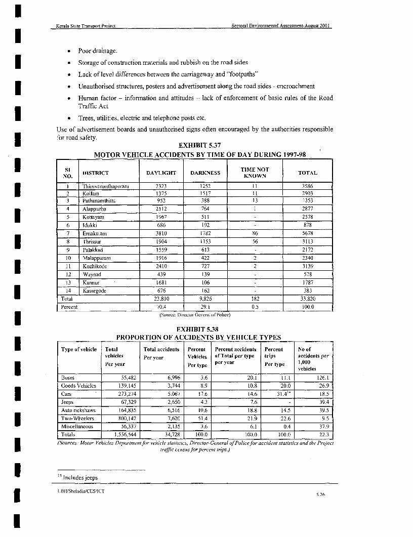
Kerala State Transport PToject Sectoral Environmental Assessment-August 2001
* Poor drainage.
a Storage of construction materials and rubbish on the road sides
v Lack of level differences between the carriageway and "footpaths"
* Unauthorised structures, posters and advertisement along the road sides - encroachment
* 'Human factor - information and attitudes - lack of enforcement of basic rules of the RoadTraffic Act
. Trees, utilities, electric and telephone posts etc.
Use of advertisement boards and unauthorised signs often encouraged by the authorities responsiblefor road safety.
* ~~~~~~~~~~~EXHIBIT 5.37MOTOR VEHICLE ACCIDENTS BY TIME OF DAY DURING 1997-98
NO. DISTRICT DAYLIGHT DARKNESS KNOWN TOTAL
I Thiruvananthapuram 2323 1252 I t 3586
Kollam 1375 1517 11 29033 Pathanamthitta 952 388 13 1353
4 Alappuzha 2112 764 1 2877
| 5 Kottayam 1967 511 2578
6 Idukki 686 192 - 878
7 Emakulam 3810 1782 86 5678
8 Thrissur 1904 1153 56 3113
9 Palakkad 1559 613 2172
10 Malappuram 1916 422 2 2340
11 Kozhikode 2410 727 2 3139
12 Waynad 439 139 - 578
13 Kannur 1681 106 1787
14 Kasargode 676 162 - 383
Total 23,810 9,826 182 33,820
Percent 70.4 29.1 0.5 100.0
(Source: Direclor Gcneral of Police)
EXHIBIT 5.38_________ PROPORTION OF ACCIDENTS BY VEHICLE TYPES
Type of vehicle Total Total accidents Percent Percent accidents Percent No ofvehicles Per vear Vehicles of Total per type trips accidents per
per vear Pe ye 1,000Per year Per type Pertyicles
Buses 55,482 6,996 3.6 20.1 11.1 126.1
Goods Vehicles 139,145 3,744 8.9 10.8 20.0 26.9
Cars 273,274 5,067 17.6 14.6 31.4'4 18.5
Jeeps 67,329 2,650 4.3 7.6 - 39.4
Auto rickshaws 164,835 6,516 10.6 18.8 14.5 39.5
Two-Wheelers 800,142 7,620 51.4 21.9 22.6 9.5
Miscellaneous 56,337 2,135 3.6 6.1 0.4 37.9
Totals 1,556,544 34,728 100.0 100.0 100.0 22.3
(Sources. Motor Velhicles Departmentfor rvehicle statistics, Director-General of Policefor accident statistics and the Project
traffic census for percent trips.)
14 Includes jeeps
LBllIShedadia/CES,1CT5.26
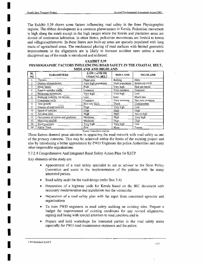
Kerala State TranspoTt Proiect Sectoral Environmental Assessment-August 2001
The Exhibit 5.39 shows some factors influencing road safety in the three Physiographicregions. The ribbon development is a common phenomenon in Kerala. Pedestrian movementis high along the roads except in the high ranges where the forests and plantation areas aredevoid of continuous habitation. In other States, pedestrian movements are limited to townsand villages/settlements. In these States non built-up areas are sparsely populated with longtracts of agricultural areas. The mechanical placing of road surfaces with limited geometricimprovements to the alignments are is likely to increase accident rates unless a moredisciplined use of the roads is introduced and enforced.
EXHIBIT 5.39PHYSIOGRAPHIC FACTORS INFLUENCING ROAD SAFETY IN THE COASTAL BELT,
* MIDLAND AND HIGHLANDSL PARAMETERS COASTAL BELT MID LAND HIGHLAND
I Terrain, Plane area Rolling Hilly2 Density of population, Very high population High population Relatively FEW3 Sharp bends, High Very high Hair pin bends4 Narrow coridor width, Common Very common Common5 Pedestrian movement, Very high Very high Low6 Reduced visibility for drivers Less Less Much less7 Compound walls Common Very common Noe m8 Tree growth Not very thick Thick Considerable9 Density of road network High Very high Low;O Speed of vehicles High High High11 Accident rates High High Not so high12 Occurrence of curves and gradients Moderate High Very high13 Monsoon rainfall Moderate High High14 Road junctions Very high Very high Few14 Public Trees Few More Forests
Source: Consultanit analysis
These factors demand great attention in upgrading the road network with road safety as oneof the primary concerns. This may be achieved within the limits of the existing project andalso by introducing a better appreciation by PWD Engineers the police Authorities and manyother responsible organisations.
5.7.2.4 Comprehensive And Integrated Road Safety Action Plan for KSTP
Key elements of the study are:
* Appointment of a road safety specialist to act as advisor to the State PolicyCommittee and assist in the implementation of the policies with the manyinterested parties.
* Road safety audit for the road design (refer Box 5.4)
* Preparation of a highway code for Kerala based on the IRC document withnecessary modernization and translation into the vernacular
1 * Preparation of a road safety plan with the input from concerned agencies andorganizations
* To train PWD engineers in road safety auditing on existing sites. Prepare abudget for improvement of existing conditions for any revised alignments,signing and lining with special attention to road junctions and to
| * Prepare and hold workshops for interested parties in the road safety arenaespecially for PWD road maintenance engineers and the police.
ILBII/Sheladia/CES/ICT
5.27
I
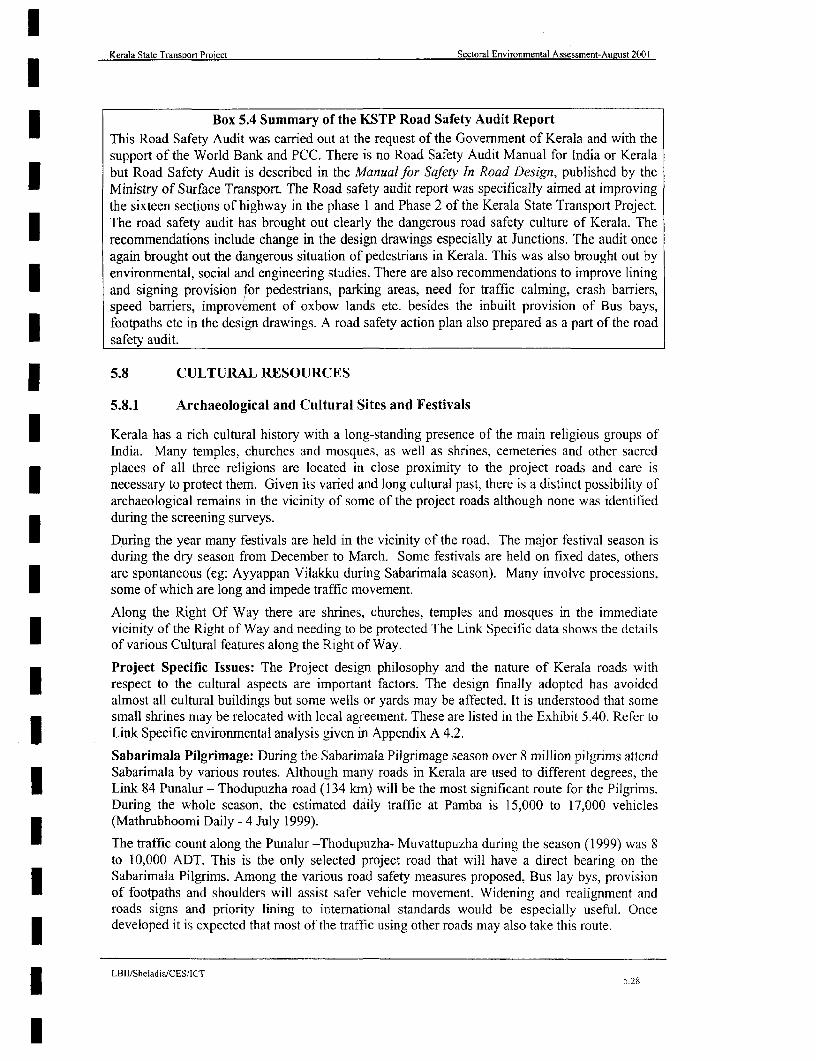
Kerala State Transport Project Sectoral Environmental Assessment-August 2001
Box 5.4 Summary of the KSTP Road Safety Audit ReportThis Road Safety Audit was carried out at the request of the Government of Kerala and with thesupport of the World Bank and PCC. There is no Road Safety Audit Manual for India or Keralabut Road Safety Audit is described in the Mfanual for Safety In Road Design, published by theMinistry of Surface Transport. The Road safety audit report was specifically aimed at improvingthe sixteen sections of highway in the phase 1 and Phase 2 of the Kerala State Transport Project.The road safety audit has brought out clearly the dangerous road safety culture of Kerala. Therecommendations include change in the design drawings especially at Junctions. The audit onceagain brought out the dangerous situation of pedestrians in Kerala. This was also brought out byenvironmental, social and engineering studies. There are also recommendations to improve liningand signing provision for pedestrians, parking areas, need for traffic calming, crash barriers,speed barriers, improvement of oxbow lands etc. besides the inbuilt provision of Bus bays,footpaths etc in the design drawings. A road safety action plan also prepared as a part of the roadsafety audit.
5.8 CULTURAL RESOURCES
5.8.1 Archaeological and Cultural Sites and Festivals
| Kerala has a rich cultural history with a long-standing presence of the main religious groups ofIndia. Many temples, churches and mosques, as well as shrines, cemeteries and other sacredplaces of all three religions are located in close proximity to the project roads and care isI necessary to protect them. Given its varied and long cultural past, there is a distinct possibility ofarchaeological remains in the vicinity of some of the project roads although none was identifiedduring the screening surveys.
* During the year many festivals are held in the vicinity of the road. The major festival season isduring the dry season from December to March. Some festivals are held on fixed dates, othersare spontaneous (eg: Ayyappan Vilakku during Sabarimala season). Many involve processions,some of which are long and impede traffic movement.
Along the Right Of Way there are shrines, churches, temples and mosques in the immediatevicinity of the Right of Way and needing to be protected The Link Specific data shows the detailsof various Cultural features along the Right of Way.
Project Specific Issues: The Project design philosophy and the nature of Kerala roads withI respect to the cultural aspects are important factors. The design finally adopted has avoidedalmost all cultural buildings but some wells or yards may be affected. It is understood that somesmall shrines may be relocated with local agreement. These are listed in the Exhibit 5.40. Refer toLink Specific environmental analysis given in Appendix A 4.2.
Sabarimala Pilgrimage: During the Sabarimala Pilgrimage season over 8 million pilgrims attendSabarimala by various routes. Although many roads in Kerala are used to different degrees, theI Link 84 Punalur - Thodupuzha road (134 kmn) will be the most significant route for the Pilgrims.During the whole season, the estimated daily traffic at Pamba is 15,000 to 17,000 vehicles(Mathrubhoomi Daily - 4 July 1999).I The traffic count along the Punalur -Thodupuzha- Muvattupuzha during the season (1999) was 8to 10,000 ADT. This is the only selected project road that will have a direct bearing on theSabarimala Pilgrims. Among the various road safety measures proposed, Bus lay bys, provisionI of footpaths and shoulders will assist safer vehicle movement. Widening and realignment androads signs and priority lining to international standards would be especially useful. Oncedeveloped it is expected that most of the traffic using other roads may also take this route.
LBII/Sheladia/CESlICT| ~~~~~~~~~~~~~~~~~~~~~~~~~~~528
I
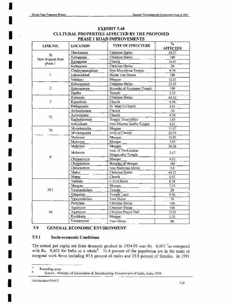
Kerala State Transport Project Sectoral Environmental Assessment-August 2001
EXHIBIT 5.40CULTURAL PROPERTIES AFFECTED BY THE PROPOSED
*__________ PHASE 1 ROAD IMPROVEMENTS
LINK NO. LOCATION TYPE OF STRUCTURE A________________ _______________-AFFECTED
l 26 Thankamani Christian Shrine 28.57
Now dropped from Kattappana Christian Shrine 100| ~~~~~~phase I Kattappana Church 16.67
_I Kattappana Christian Shrine 20Chadayamangalam Sree Mavadevar Temple 9.79
I Edamulakkal Hindu Tree Shrine 100____________________ Valakam Mosque 12.31
Kalayapuram Christian Shrine 53.332 Kalayapuram Hyundai of Ayyappan Temple 100
Enathu Temple 3.33Kulanada Christian Shrine 64.52
3 Kurambala Church 6.94Peringanadu St. Mary's Church 3.91
*Andoorkonam Church 2072 Ayirooppara Church 4.38
Kazhakkootam Temple Trust Office 1.83____________________ Koliyakode Sree Dharma Sastha Temple 4.81
70 Muvattupuzha Mosque 11.67Muvattupuzha Arch of Church 20.59Mulavoor Mosque 18.97I Mulavoor Mosque 7.05Mulavoor Mosque 36.36
Mulavoor Gate of Thrikalathur 3.67| 6 Mulavoor Bhagavathy Temple
Chelamattom Mosque 4.92Chelamattom Hyundai of Mosque 100Chelamattom Sree Narayana Shrine 3.8Mattur Christian Shrine 44.23Mattur Church 0.87l Yalckara C.S.I.Church 0.38Mangara Mosque 7.25
50.1 Vaniyamkulam Temple 20Ottapalam Temple Land 9.56Vaniyamkulam Tree Shrine 70Porkulam Christian Shrine 100Agathyoor Christian Shrine 100
40 Agathyoor Christian Prayer Hall 13.33Karikkadu Mosque 1.56Kanippayoor Tree Shrine 90
5.9 GENERAL ECONOMICENVIRONMENT
5.9.1 Socio-economicConditions
The annual per capita net State domestic product in 1994-95 was Rs. 8,007 7as comparedawith Rs. 8,403 for India as a whole'. 31.4 percent of the population are in the main or
dImarginal work force including 47.6 percent of males and 15.8 percent of females. In 1991
7 Rounding error8 Source - Ministry of Infornation & Broadcasting, Government of India, India 1999
1 ,1II/Sheladia/CES/ICT 5.29
l~~~~~~~~~~~~~~~~~~~~~~~~~~~~2
Kerala State Transport Project Sectoral Environmental Assessment-Aueust 2001
there were 5,459,474 occupied residential units in Kerala, 4,076,775 (74.7 percent) in ruralareas and 1,382,699 (25.3 percent) in urban areas. Of these 56.0 percent are pucca (highconstruction standard), 19.1 percent semi-pucca (moderate construction standard) and 24.9percent kutcha (mud and thatch). 92.4 percent of residences use wood for cooking, 48.4percent are connected to electricity, 18.9 percent have a safe drinking water supply and 51.3percent have toilets9.
Agriculture: The economy of the project influence area is largely agriculture oriented.The resource potential for the development of agriculture and its importance to the areaeconomy varies from district to district. The importance of agriculture and allied activities3 could be assessed in terms of the main work force by sector and sectoral contribution todistrict income. The resource potential, apart from the land-use pattern, depends on the sizeof holding, irrigation facilities, soil condition and farming technique. In Kerala, Palakkad is
| the granary of the State, producing 34 percent of the States rice, 98 percent of cereals, 30percent of pulses and 45 percent of sugar. The other major rice producing districts in the Stateare Ernakulam, Thrissur and Alappuzha. These account for over 33 percent of the riceI produced in the State. Apart from Palakkad the largest producers of pulses are Kollam,Ernakulam and Kannur districts. The productivity of rice at 2,291 kg/ha was the highest (inthe State) in Palakkad, followed by 2,199 kg/ha in Wayanad and 2,165 kg/ha at KottayamI with the State average of 2,023 kg/ha.
Sugar Production is mainly confined to Idukki and Palakkad districts. Kollam and Kasaragoddistricts are the major producers of fruits and vegetables and together contributed over 30percent of the State production. Other large producers of fruit and vegetables areThiruvananthapuram, Kottayam, Malappuram and Palakkad.
| The major producers of non-food crops (in total) are Kannur, Wayanad, Kasaragod andKozhikode. These jointly, account for about 72 percent of the total production in the State.Among these, rubber is grown in all districts, but Kottayam is the largest producer accounting
l for 25 percent of the State production, followed by Emakulam, Pathanamthitta, Kollam andIdukki.
Minerals; Kerala has large deposits of clay and beach placers (Ilmenite, Monozite, Rutile GarnetI and Sillimanite), which have earned the State an important position in the mineral map of India.
The State is not well endowed with other mineral resources although. other mineral deposits ofClay (fire clay, ball clay, china clay and tile clay), Glass sand, Graphite, Bauxite, Iron ore andlime shell are found.
Project Specific Significance: The project will in affording improved communications help themineral industry in Kerala. Livestock and Poultry; The Livestock and poultry population iswidely dispersed in the State, with major concentrations in rural areas. Palakkad has the largest.number of livestock and poultry amongst all districts, contributing about 11 percent to the Statetotal. In cattle and buffalo population, the share of the Palakkad district in the State is 10.7percent and 21.6 percent respectively. Malappuram has the largest number of goats with over Ilpercent of the State total. The major concentration of sheep population is in Idukki, Waynad,Kannur and Malappuram districts. These together account for about 65 percent of the total sheeppopulation in the State. Pigs are mainly reared in Idukki and Kottayam districts and two districtsaccount for over 57 percent of the pigs in the State. The cattle population has declined in most ofthe districts with the exception of Idukki, Palakkad, Malappuram and Kasargode. These districtshad recorded low growth rates, varying from 3 percent to 0.5 percent per annum. The buffalopopulation has also declined in all districts of which, Kozhikode and Kannur are the worst
* affected.
9 Source - Jagrani's "Kerala al a Glance 1998"
| LBII/Sheladia/CESilCT 5.30
I~~~~~~~~~~~~~~~~~~~~~~~~~~~~~~~~~~~~5S

Kerala State Transport Project Sectoral Environmental Assessment-August 260I
Fisheries
| Marine Fisheries; Emakulam is the major centre of inland fishing. In 1996, Ernakulam hadthe highest landings totalling over 20,000 tonnes, accounting for over 40 percent of the totalState production followed by Alappuzha with over 10,000 tonnes of inland fish productionI and Kollam with over 5,600 tonnes.
The districts with low level of fish production recorded higher annual growth rates than themajor production centres. Pathanamthitta, Palakkad and Malappuram with 1.3 percent, 4.6percent and 1.0 percent shares in State production recorded 9.7 percent, 9.6 percent and 8.0percent annual growth rates respectively. Ernakulam and Alappuzha with over 40 percentand 20 percent share of State production registered 4.6 percent and 4.8 percent growth ratesannually.
Industry
* Registered Factories; Registered factories are widespread throughout Kerala districts. Thenumber of factorie in 1997-98, however varied amongst districts from 1 percent to over 15percent of the State total. Emrakulam recorded the highest number 2,570 factories accountingfor 15.6 percent of the State total. The other districts, following Emakulam, in ranking order,were Thrissur, Palakkad, Kannur, Kollam and Kozhikode.
| The districts with a low level of factories were Waynad, Kasargod, Idukki and Pathanamthittaeach with less than a three percent share in the States total. Of these, Wayanad was at thebottom with a one percent contribution.
* Over the long-term, 1985-98 period, the average annual growth rate registered in the Statewas about 16 percent. Pathanamthitta, which had a low base (in number of units) in 1985,experienced the highest growth rate of about 24 percent per annum, maintaining a continuousincrease in the number of units throughout this period. Similarly, Idukki and Wayanad withlow bases in 1985 registered 20.6 percent and 19.6 percent annual growth rate respectively.
3 The growth rate in the number of SSI units in each district over different periods arepresented in Exhibit 5.41
The districts recording 15 percent and above annual growth rates during this period, as* against the state average of 13.4 percent, are listed in Exhibit 5.42.
EXHIBIT 5.41GROWTH RATES IN THE DIFFERENT DISTRICTS
AVERAGE ANNUAL AVERAGE ANNUALDISTRICTS GROWTH RATE. (%) DISTRICTS GROWTH RATE. (%)
1985/1998 19985/1998Pathanamthitta 23.8. Kasaragod 18.8Idukki 20.6 Alappuzha 18.5Wayanad 19.6 Palakkad 16.9
Thiruvananthapuram 18.9 Kottayam 16.5
Of these districts, Idukki, Wynad and Kasargode had low bases in 1985, 1990 and 1998I respectively.
In the Industrial Sector, SSI units are the largest source of employment in the State as well asin each district. In 1997-98, SSI units in Kollam provided employment for over 140,000I workers accounting for about 15.5 percent of the total work force in SSI Units in the State.Emakulam, at the same time, provided employment for about 122,000 workers and in3 Alappuzha over 87,000 workers were engaged in SSI units.
IBIhli/SheladiaCES/ICTI 5.31

Kerala State TranspoTt Project Sectoral Environmental Assessment-August 2001
IEXHIBIT 5.42
DISTRICTS RECORDING HIGHER ANNUAL GROWTH RATE
DISTRICTS AVERAGE ANNUAL NUMBER OF UNITS AS % OF THE STATE TOTAL.DISTRICTS GROWTH 1998-95 ( %) 1990 1998
Idukki 19.9 2.50 2.82Wayanad 19.5 1.18 1.73Kozhikode 16.8 8.47 4.70Alappuzha 15.9 7.90 9.20Kasaragod 15.9 2.10 2.40Palakkad 15.0 7.20 7.70
Medium and Large Sale Industries: At the end of March 1998, there were 474 medium andlarge-scale industries in the State. The distribution of these industries under each district isshown in Exhibit 5.43.
Emakulam is the major centre of industrial activity with 145 units. In 1996-97, 75 companiesgross investment totalled Rs. 8,333 million and provided employment to 13,268 people.Kasargode, Wynad, Pathanamthitta and Idukki districts have only a few industries each,I consequently, the size of investment and employment generated in these districts are at arelatively low level.
The most common industries in Kerala are:
* Vegetables and foodstuffs* Fruit (Canned fruit and Juice)
| Beverages (Tea, Coffee)* Cocoa (Chocolates)* Industrial Crops (rubber to tyre, vegetable fibres, vegetable oils, coconut oil etc)
EXHIBIT 5.43.DISTRICT ANALYSIS OF MEDIUM AND LARGE SCALE INDUSTR1ES IN KERALA AS3 ON 31.03.1998
SECTORDISTRICTS Central State Co-operative Joint Private TOTAL
Thiruvananthapuram 2 13 1 4 26 46
Kollam 3 7 2 15 27Alappuzha 1 6 3 21 31-Kottayam 2 2 17 21Pathanamthitta 1 I 1 5 8Idukki I I 9 I ]Emakulam 8 8 1 4 124 145Thrissur 2 7 1 7 29 46Palakkad 2 2 2 6 51 63Malappuram 5 1 2 16 24Wayanad 3 3Kannur I 6 2 11 20*Kasaragod I I 1 2Total 19 61 15 29 350 474
(Source: Economic Review 1998, State Planning Board, Kerala)
* Marine Life (Frozen, dried, pickled and canned fish)
* Forest products (wood, plywood, decorative veneers etc)3 * Building materials and Kindred items (China clay, lime stone, lime shell etc)* Non-metallic minerals (eg: Graphite)
Proceedings of Resource Potential of Kerala 1981
1L,Il/Sheladia/CES/lCT5 32

Kerala State Transport Proiect Sectoral Environmental Assessment-August 2001
* Metallic minerals( eg; Iron, Aluminium, Gold)* Beach sands (Titanium, Silica sand etc)* Power intensive industries (Caustic soda, Ferro silicon, Silicon etc)* Medicinal herbs (Phyto chemicals, Vitamin C, Beta lonone)
| * Internediate Products (Toilet soap, Tooth paste, Knitted goods, Textiles, Nylon Filament yarn,printing and writing paper, Ayurvedic preparations, Chemicals, paints and varnishes,Industries based on phenol industry Formaldehyde etc)
5.10 GENERAL SOCIAL ENVIRONMENT
| Kerala has the distinction of being the only State with the sex ratio favorable to women. In1991, there were 1036 women for every 1000 men as against the all - India figure of 927. TheLiteracy rate of nearly 90 percent is the highest amongst Indian States and compares with a52.2 percent average for the whole country. The other prominent social feature is thecontinuously inhabited settlements along the roadside throughout the State. The State isaccessible by road, rail, sea and by air from the rest of the country.
5.10.1 Education
In the education sector, Kerala's achievement is unique in that it attained the highest literacyrate in India of 89.01 percent in 1991 whereas the all India level was 52.21 percent. Thefemale literacy rate was as high as 86.17 percent in Kerala, compared to 39.20 percent at thenational level. The literacy rate among scheduled castes was 79.66 percent and their femaleliteracy was 74.31 percent in Kerala. The trend in literacy levels for India and Kerala isshown in Exhibit 5.44.3 The education facilities in the State in 1996-97 consisted of 6726 lower primary schools,2968 upper primary schools and 2588 high schools. There are 186-degree colleges with atotal of 332,043 students." '
EXHIBIT 5.44TRENDS IN LITERACY- INDIA AND KERALA
YEAR INDIA - Rate of Literacy KERALA- Rate of Literacy PercentTotal Male Female Total Male Female
1901 5.35 9.83 0.60 11.14 19.15 3.151911 5.92 10.56 1.05 13.31 22.25 4.431921 7.16 12.21 1.81 19.02 27.88 10.261931 9.50 15.59 2.93 21.34 30.89 11.001941 16.10 24.90 7.30 - -
1951 16.67 24.95 7.93 40.47 49.79 31.411961 24.02 34.44 12.95 56.85 54.97 38.901971 29.45 39.45 18.68 60.42 66.62 54.311981 36.03 46.62 27.73 70.42 87.74 75.651991 52.21 64.13 39.29 89.91 93.62 86.17
Source: Census of India and Kerala
5.10.2 Population Including Tribal People
According to the 1991 census, the population of Kerala was 29.098 million in an area of38,863 sq.km. The population density is 749 per sq. kin, with 73.61 percent of the living invillages. As a southern State of the country, the people here are of Dravidian stock and speak
U Source - Jagran's "Kerala at a Glance 1998"
| LnLBISheladia/CESCICT 533
l
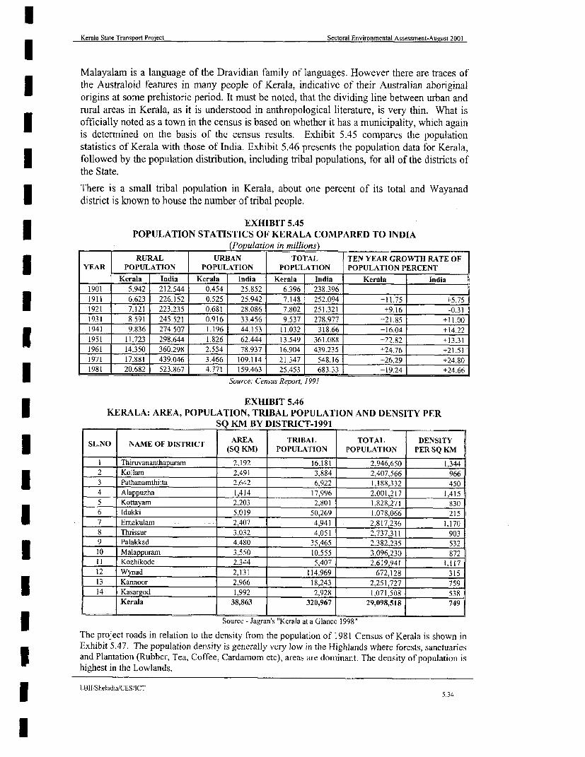
Kerala State Transport Proiect Sectoral Environmental Assessment-August 2001
Malayalam is a language of the Dravidian family of languages. However there are traces of3 the Australoid features in many people of Kerala, indicative of their Australian aboriginalongins at some prehistoric period. It must be noted, that the dividing line between urban andrural areas in Kerala, as it is understood in anthropological literature, is very thin. What isofficially noted as a town in the census is based on whether it has a municipality, which againis determined on the basis of the census results. Exhibit 5.45 compares the populationstatistics of Kerala with those of India. Exhibit 5.46 presents the population data for Kerala,followed by the population distribution, including tribal populations, for all of the districts ofthe State.
There is a small tnrbal population in Kerala, about one percent of its total and Wayanaddistrict is known to house the number of tribal people.
EXHIBIT 5.45POPULATION STATISTICS OF KERALA COMPARED TO INDIA
(Population in millions)RURAL URBAN TOTAL TEN YEAR GROWTH RATE OF
YEAR POPULATION POPULATION POPULATION POPULATION PERCENT
Kerala India Kerala India Kerala India Kerala India1901 5.942 212.544 0.454 25.852 6.396 238.396
1911 6.623 226.152 0.525 25.942 7.148 252.094 +11.75 +5.75
1921 7.121 223.235 0.681 28.086 7.802 251.321 +9.16 -0.31
1931 8.591 245.521 0.916 33.456 9.537 278.977 -21.85 +11.00
1941 9.836 274.507 1.196 44.153 11.032 318.66 --16.04 +14.22
1951 11.723 298.644 1.826 62.444 13.549 361.088 -22,82 +13.311961 14.350 360.298 2.554 78.937 16.904 439.235 -24.76 +21.51
1971 17.881 439.046 3466 109.114 21.347 548.16 +26.29 +24.80
1981 20.682 523.867 4771 159.463 25.453 683.33 +19.24 +24.66
Source: Census Report, 1991
EXHIBIT 5.46KERALA: AREA, POPULATION, TRIBAL POPULATION AND DENSITY PER
SQ KM BY DISTRICT-1991
SL.N NAM OFDISTICT AREA TRIBAL TOTAL DENSITYSL.N O NAME OF DISTRICT (SQ KM) POPULATION POPULATION PER SQ KM
I Thiruvananthapuram 2,192 16.181 2.946,650 1,344
2 Kollam 2,491 3,884 2,407,566 966
3 Pathanamthitta 2,642 6,922 1.188,332 450
4 Alappuzha 1,414 17,996 2.001,217 1.415
5 Kottayam 2,203 2,801 1,828,271 830
6 Idukki 5,019 50,269 1,078,066 215
7 Ernakulam 2,407 4,941 2,817,236 1.170
8 Thrissur 3,032 4,051 2,7373 11 903
9 Palakkad 4.480 35,465 2.382,235 532
10 Malappuram 3,550 10.555 3,096,230 872II Kozhikode 2,344 5,407 2,619,941 1,117
12 Wynad 2,131 114,969 672,128 315
13 Kannoor 2.966 18,243 2.251,727 759
14 Kasargod 1,992 2,928 1,071,508 538
Kerala 38,863 320,967 29,098,518 749
Sourcc - Jagran's "Kerala at a Glance 1998"
The project roads in relation to the density from the population of 1981 Census of Kerala is shown inExhibit 5.47. The population density is generally very low in the Highlands where forests, sanctuaries3 and Plantation (Rubber, Tea, Coffee, Cardamom etc), areas are dominant. The density of population ishighest in the Lowlands.
LBlJlSheladja/CESICT.
lI5.34

Kerala State Transport Project Sectoral Environmental Assessment - August 2001
750 |0 761| 0 77 Nlo
SCALEk\2O 10 0 20 40 60 80 10Dkm
KASARAGOD
12A 12-
/ ~ ~ ITPAPINISSERYz <> OVN
KE~ ~ ~ ~~~~~~~~~'
THALASS L
UIANA
0 POiil NNANI /)
00
- KOZHIKODEYb1 >EGENDKUMI-
otate Average 654 50-1 o000
(S012e - CEL
7610 0~~~~~~~~~~~~~~~~~~~~~~~~~~~~~~~~~
srI /S dQOVINDATTPURMI
tO-ce-ESUC ATA OF0 KERLA 190°
KOCHIB T.POOP4
75-1~~~~~~~~ D 76- 0 77-1
LB PrheadajeofRcadTL H A /

Kerala State Transport Project Sectoral Environmental Assessment-August 2001
5.10.3 Agriculture
| In the absence of an effective industrial base, agriculture forms the main occupation of 50%of the people of the State. Within agriculture, there is a dominance of cash crops, such as,cashew nuts, tea, coffee, coconut, and rubber. Rice and tapioca are important food crops.The State is not self-sufficient in food production.
Kerala is unique in its cropping pattern, being controlled by the limited availability of land,the social system, and the pattern of land holdings. This has led to an agricultural strategy forthe optimum utilisation, by improved agricultural methods, growing multiple crops,intercrops, mixed crops and rotating crops and by integrating crop production with animal
| husbandry and fisheries. The scenario is changing however with paddy cultivation beingrendered non profitable by the shortage and cost of labour.
House Garden: It is a common feature that the households form a continuous chainI throughout the lowlands and midlands of Kerala, Each house hold is made up of a house treesand herbs of food value including Mango and Jackfruits trees, Coconut, Areca nut and an3 assortment of other perennial or seasonal food crops.
Paddy Fields Paddy fields in Kerala are treated as a sensitive land use. The Govemment ofKerala has been trying for many years to prevent the conversion of these areas into non-agricultural uses. There have been a number of measures introduced over many years, the lastof which is the development of a Paddy Development Board in 2000. The objective of theBoard is to improve the paddy production in the State.
| The main controlling legislation is still the Land Utilisation Order of 1967. This states that noholder of any land who cultivates any land with any food crop for a continuous period ofthree years at any time after the commencement of this order shall not, after the said period of
* three years, convert or attempt to convert or utilise such land for the cultivation of any otherfood crop or for any other purpose except under and in accordance with the terms of a written
* permission given by the Collector.
This order further states that the land under cultivation of paddy should not be converted orattempts to be converted or utilised or attempted to bc utilised for fish culture permanently
| (only seasonally).
The reasons for conversion of Paddy field include
* * Non profitability (Labour intensive with associated high costs)
a Labour shortage and
| Population pressure for small residential plots due to proliferation of nuclear families.
Paddy field areas are typical valley fill areas and serve as the ponding area of a watershed.There could be ecological problems due to further human intervention in the form ofconstruction of houses and other development.
Food security of the entire State will be adversely affected by the large-scale change of thepaddy fields into non-agricultural purposes. Experts suggest that a certain level of food grain
* production needs to be preserved at any cost to avoid major food security problems for theState in the future. A commission of Enquiry recently addressed the concept of food secun'tyfor the State. According to this concept a certain minimum level of paddy field areas should
* be preserved at any cost. These areas can be Kuttanad, Palakkad and similar vast areas of ricebelts (Press report).
LBI3ISheladia/CES/ICT5.35

Kerala State Transport Project Sectoral Environmental Assessment-August 2001
The project roads have many paddy fields adjoining as indicated in the Environmental stripmaps. Some land is kept idle for many years while others are already used for otherAgricultural Crops. The project takes paddy field areas only at those places, which areregarded as essential on account of road safety.
Project Specific Scenario: The households bordering the road network are similar to thosedescribed above. The Environmental strip map (Appendix A 4.3) shows the observedcharacteristics along the available corridor.
510.4 TOURISM
With its moderate temperature, no winter season, and an abundance of greenery everywhere,the State may be described as a tourist's paradise. It rains heavily twice a year, during May-August and October-December and the water, after filling the rivers, canals, lagoons, etc.falls into the Arabian Sea. The palm lined beaches and the houseboats, which are convertedrice boats, on the backwaters are major tourist attractions. Kerala is occasionally affected byflooding and water stagnation is a serious problem in the coastal area of Alappuzha andEmakulam districts. Malaria has been largely eradicated in the State and is a reportabledisease.
With excellent weather and natural beauty, tourism is projected to form an important part ofthe State's economy. The major tourist attractions in the State are the Kovalam beach seasideresort, the houseboats in the canals and backwaters, and wildlife sanctuaries at Thekkady,Parambikulum (Palakkad district), Sultan Bathery, Wayanad and Mananthavady.The Sabarimala temple of Lord Ayappan is a famous pilgrim-tourist center. The Bekkal fortat Kasaragod district. Thrissur is the cultural centre of the State and the famous Kathakalicentre, Kalamandalam, is a place of interest for art lovers.
Tourist arrivals in Kerala during 1997 totalled approximately 5.1 million of which about 4.9million were domestic and 0.2 million foreign. Kerala accounted for a 7.7 percent share ofthe total foreign tourist arrivals in India in 1997. The details of tourist arrivals in Kerala arepresented in Exhibit 5.48.
EXHIBIT 5.48DETAILS OF TOURIST ARRIVALS IN KERALA
Year FOREIGN TOURISTS DOMESTIC_____________ India ('000) Kerala ('000) Percent share in India TOURIST ('000)
1990 1.329 66 5.0 8661991 1,236 69 5.6 9481992 1,434 90 6.3 9941993 1,442 95 6.6 1,0271994 1,532 104 6.7 1,2841995 2,123 142 6.7 3,9151996 2,287 176 7.7 4,4031997 2,374 182 7.7 4,953
The foreign tourist traffic in the period 1990-97 increased by 15.3 percent per annum asagainst 8.7 percent growth in all-India. The domestic visitors at the same time increased at arate of 28.3 percent per annum. The growth rate of tourism in recent years has reduced to 13percent for foreign tourists and 12.5 percent for domestic.
The decline in tourism is a reflection on the general reduction in the country. The foreigntourist arrivals in India registered a 5.7 percent growth in the 1995-97 periods. The SouthEast Asian crisis, political instability and competitive pricing on airfares and hotel packagetours are some of the major factors influencing the decline in foreign tourists.
LBl/Sheladia/CES/ICT5.36
l
Kerala State Transport Project Sectoral Environmental Assessment-August 2001
In view of the tourist potential, there is a need to develop the tourist policy in the State andsizeable investments are required to develop the tourist facilities.
The State Department for Tourism Development invested over Rs. 568 million during theEighth Five-Year Plan in the thrust area of infrastructure development. In addition,U Rs 76 million was spent on promotion and publicity. In spite of these investments, the TaskForce on Tourism Development has observed that the problem of lack of infrastructurefacilities, marketing and publicity still inhibit tourism development in the State.
* Consultants enquiries reveal that road safety and public health also influence the visitors inrecommending Kerala as holiday destination.
| In view of the vast potential of this sector in terms of employment and income generation,budget of Rs. 1,400 million (outlay) has been placed in the Ninth Plan. The mainprogrammes envisaged in the - Plan include:
i. Creation of infrastructure facilities;
ii. Development of information systems;
iii. Strengthening of marketing efforts; and
iv. Assistance in public sector and other undertakings closely associated with tourism* development.
Tourist map: A tourist map of the adjacent areas is shown as Exhibit 5.49 A and B. Thetourist arrivals in Kochi are expected to rise in the coming years due to the development ofI the new international Airport at Nedumbaserri. Rich wildlife reserves of the State will be amajor attraction together with backwater tourism at Vembanad Kayal. The tourist arrivals inThiruvananthapuram (about 250 km from Kochi) district are comparatively high being the
i State Capital with easy access to Kovalam beach, Varkala beach etc. easy air connectivity,and proximity to Kanyakumanr. Kollam also receives large numbers of tourists for backwatertourism. In addition, there are South Indian architectural marvels like the Padmanabha SwamiI Temple in Thiruvananthapuram. The Capital city abounds in temples, mosques and churches.Valley lagoons, Neyyar dam and Ponmudi, hill station are other tourist centres in and around3 Thiruvananthapuram.
Project specific issues: Although tourism is projected to be an important part of the StateEconomy, the required infrastructure facilities are currently either lacking or inadequate. The
| improvement of the priority roads and road safety would be a big boost towards tourismpromotion. The Idukki - Puliyanmala road is particularly significant for tourism close totourist areas. The Main Central Road (MC Road or SH-lwould be an excellent corridor for3 north south tourist movements as it connects the centre to South Kerala. The project roadsinvolved are Linkl- starting from Thiruvananthapuram to Link 2, Link 3, Link 4, Link 5 andLink 6 to Angamali is a continuous route. This road will connect the majority of the tourist1 areas like Kanyakumari, Kovalam and Thiruvananthapuram in the south to Kuttanad,Alappuzha and Kochi areas in central Kerala.
5.10.5 Public Services
Social development of Kerala has attained commendable success. Kerala is the land of highliteracy and health care where enrolment in primary schools is nearly as high as in WesternEurope and infant mortality rates are as low as in New York. Apart from historical factors,the successive Governments of the State have followed a development strategy by3 consciously investing in social development sectors like education, medical services and
IEBIIShcladiaTCES/ICT~~~~~~~~~~~~~~~~~~~~~~~~~~~~~~~~~~~~~~5-37

Kerala State Transport Project Sectoral Environmental Assessment - August 2001
N
Vadanapally MATCH LINE FOR EXHIBI 5.49-B
Trip. Adsspor
\ i5E1rlnpwudc - U stotz 80rdera)lrkutty Stat\Borde
Kod u R i 9 vlla 3 amba
p ^ lngulam 101066z'
NA~PllpuONAL1 _'IGHt:ZWAY.
U \ %,,4 ixt16 NMEH49VX >; o~~~~~~~~~~~~cllorkutty ,Sthh sorder
CSTAT HEAD IQAUTIE IfT(' @ NA :l <> p zhc ErrNttoyal y
bumm ~~~~~~~~~~~~~~~~~~b m ittu
Shwt. Mono
IOTANT PLCaPCmSo 0
LEG2D angn ch6ry A Ph t
PROJECTr ROAD AMTUu ;) AN H HITTA|
KERALA STATE BOUNDARY nt aS
NATICNAL HIGHWAY KatR b
LINK NUMBER U 1/ 7 n p ram/
TOURIST CENTRE sr Al Of K I 4 EX II I St 9orderSTATE HEAD QUATERS onm a8X i !
DUMICROJETHRODDINOELATONRT
IMPORTANT PLACES* ll#
TTOURIT HUNGALOW C T OF mudl
SCULUITURE VIA a/rkCE
zoo ); \ £ Nedumongoa
PORT +<w
TEMPLE TEZ W q Pnnnnchumoodu
WILD LIFE SANCTUART nk@ r ndqow lo
AiRPrJRT +; o a
HILL STATiONS ljlSr
CHURCH @
FOREST -g
BEACH
ARCHEL0GICAL STRUCTURES PR
(SOURCE:-Resource Atlas Of Kerala,19H4) EX M ITD 5.4 A-:PROJECT ROAD IN RELATION TO
TOURIST CENTRES OF SOUTH KERALALRn/ShelacdiasCESI/ICT

Kerala State Transport Project Sectoral Environmental Assessment - August 2001
NwKunja ur
jashehe
\llinJ"hw ~ ~ ~ ~~ca ai
NAlOA HIHA ______s___
7vl Nor p
,Kanhungr d t *thuorc
LEGETD77 PS u a
PR.C RODdl
KERALA STATE BOUNDARYO
NAPIONJ C HINHWAY o liO YT dl
LINK NUilBER FI7 Qullnnd emr _
TOURIST CENTRE OF N KERALA
STATE HEAD QiATERSE@T
OISTRCT HEAD QUATERS 15-r E
IMPRTANT PLACES *t
TOUJRIST SUINGALOW @;t<
SCUULTURE a u a _l
ZOO @ ~~~~~~~~~~~~Purgpp ir/ :
PORT tMOSQUE §Trr / < o y A D <aao
WIHLD UFE SANCTLIARY Po br r z Vnb
AIRPORT 4q, 4,: ! on t b
CHURCH 'r9K uu
FOREST nge \ d anoam
ARCHELOGICAL STRUCTURES Vaoaaly., 14Qv515R \ (Vadnaplly B HRISURZLSHIDE FOR EMITll 5.49-A
(SOURCE:-Resource Aticis Of Ka ruila1984) EXHI IT 5.49-BPROJECT ROAD IN RELATION TO
TOURIST CENTRES OF NORTH KERALALBII/Sheladia/CES/ICT

Kerala State Transport Project Sectoral Environmental Assessment-August 2001
public health. Literacy, life expectancy and income are the three indicators used in measuringthe human development index. Kerala's pioneering re-distributive policy, measures like landreforms, introduction of housing schemes for economically weaker sections and thecomprehensive coverage of a public distribution system deserve special mention.The institutional and non-institutional social security measures introduced by the successiveGovernments in Kerala were largely directed at attaining the goal of reducing incomeinsecurity and deprivations among weaker sectors in the State.
5.10.6 Irrigation and Hydro Power Projects
As mentioned earlier the numerous rivers in the State form a significant source ofhydroelectric power and many have been developed for this purpose. Other power projectshave been delayed or abandoned because of environmental concerns.
A series of lagoons were formed by the natural interaction of the ocean and the rivers and areknown as backwaters. These provide an extensive resource for irrigation and many of thelagoons have been poldered for the cultivation of rice below the general water level. Untilrecently the State was limited to hydroelectric projects for Power generation. The totalinstalled capacity of the State is 1401.55 M (Water Atlas, 1995).
All of the completed major and medium irrigation projects were intended originally toirrigate paddy alone, mainly to stabilise the second crop and possibly to raise the third.It is estimated that the 10 completed projects cater for 77,085 ha (net) or 150,000 ha (gross).Eleven major / medium projects have been partially commissioned. These projects cater forthe irrigation needs of 78,670 ha (net) (State Planning Board, 1984)
Exhibit 5. 50 show the Irrigation projects and Command areas of the projects in relation tothe project roads.
5.11 LAND USE
Land use in the State in 1994-95 is shown in Exhibit-5.51.6 A "windshield" survey of theState would indicate that much more than eight percent (land under miscellaneous tree crops)of the land is given over to palm, rubber, and teak plantations. It is therefore concluded thatthese are included under the category "net area sown". A land use map of Kerala in relation toProject roads is shown in Exhibit 5.52.
5.11.1 Project Specific land use characteristics and Issues:
Land use in lowland: Coconut trees are present throughout the coastal belt. Occasionallythere are paddy fields, backwaters, streams, canals and river mouths. Normally everyhousehold has a garden attached, often separated by a boundary wall or fencing. The gardenis usually mixed in character (Refer section 5.9.3) with Coconut, Plantain, Vegetables,Jackfruit trees, and Mango trees, Tamarind etc.
The paddy fields are situated in the valley fill areas, which are fast decreasing in extent.
6 Source. Jagaran's "Kerala at a glance 1998"
LBII/SheladialCES/ICT
I~~~~~~~~~~~~~~~~~~~~~~~~~~~~~~~~~~~~~53

Kerala State Transport Project Sectoral Environmental Assessment - August 20015- l0 76-10 77-1D
N
K < < ~~~~~~~~~~~~~~~~~SCALEkm2m 10 0 20 40 S0 ea 10Okm
12 Pi1 VALAVPARA 12-
0 PUZHA0PAPINISSE
THALASSE ' g .J
GUILANAl'r< >* UR~~~~~~
KOZHIKOOE <=
v ~PONNMNI r8 A
eA fflP ,LP NDAPURAM
< VIADANAPALLY
10 JPOOPARA 10D0 ~~~~~~~~~~~~~~~~~~~~~~~~~~~~~~~~~~~~~~~~~~ ~~~~~~~~~~~~~0
LEGEND \w s>
PROJECT ROAD
STATE BOUNDRY ALAPPLOiA >
(Source-WATER AL ODIES OF EA
COMMAND AREA E C AO R
-| | |-ad /CE PROJECT COMPLEEDT
_ _ ~~PROJECT UNDER EXECUTION UA )
X r x PONMU~~DI(Source:-WATER ATLAS OF KERALA, 1,995) l
1THIRUVNANTWuH UR
EXHIBIT:.-5.50PROJECT ROADS IN RELA;TION TO MAJOR/MEDIUM IRRIGATION PROJECTS
AND THEIR COMMAND AREAS OF KERALA7s-1 76I l0 77' ac
LBI}/Sheladia/CESIICT

Kerala State Transport Project Sectoral Environmental Assessment-Auieust 2001
lEXHIBIT-5.51
LAND USELAND USE HECTARES PERCENTForest 1,081,509 27.8Land put to non-agricultural use 322,835 8.3
Barren and uncultivable land 48,434 1.2Permanent pastures and other grazing land 1,455 0Land under miscellaneous tree crops 32,385 0.8
Cultivable waste 82,441 2.1Fallow other than current fallow 29,147 0.7Current fallow 47,801 1.2Net area sown 2,239,490 57.6Totals 3,885,497 99.72Area sown more than once 808,820 20.8
Land use in the midlands In the midlands coconut and paddies are the main cultivation.There is hardly any house in Kerala especially in non-urban areas without Coconut trees. Thecoconut trees are usually mixed with other crops like plantains, tapioca, pepper, arecanut,pineapple and other vegetable crops. In the coastal areas coconut plantations are verycommon. Normally every household has a garden attached, usually mixed in character withCoconut, Plantain, Vegetables, Jackfruit trees, Mango trees, Tamarind etc
The paddy fields are the valley fill areas, which are fast decreasing in extent.
Land use in the highlands In the highlands other plantations like rubber, tea, coffee,I cardamom, pepper, cashew etc are developed. Normally every household has a gardenattached to it, mixed in character with coconut, plantain, vegetables, jackfruit trees, mangotrees, tamarind etc. The reserved forests, sanctuaries and national parks are mostly located inthis region.
The paddy fields are the valley fill areas, which are fast decreasing in extent. In the highlands,paddy fields are few except in the Wayanad and Palakkad districts.
The project roads are usually bordered by the land use characteristics mentioned above.
1 5.12 TRANSPORT NETWORK
Transport Sector; Transport development plays a crucial role in improving the Stateseconomic performance and the well being of its population. In this regard, the provision ofefficient, safe and economical services is an important feature of any transport system. Thiscan effect rural and urban productive activities and promote regional development, theI functioning of markets, development of trade and commerce, export promotion and personalwelfare. The availability of an adequate infrastructure is an essential pre-requisite for thedevelopment of a cost-effective transport system. Infrastructure interventions are in manycases more important than prices in achieving supply response.
The road network in Kerala, as of maintained by different agencies totalled over 219,805 kmin length. Of this, Panchayat roads were 181,251 km and accounted for 82.5 percent of thetotal road network in the State. These are low order gravel country roads (hardly 2 percentare black topped) providing links to rural settlements. National Highways and PWDmaintained roads are the most important and accounted for 10.6 percent of the total road
LBII/SheladialCES/ICT
5.39

Kerala State Transport Project Sectoral Envirornmental Assessment - August 2001
\ 7S-| 0 7610 o 771 0
N
SCALEKASAW W1km20 10 20 40 60 00 lOOkm
KANJVNARK
11, 12'
c s,fxU ~~~~~~~~K A R N A T A K A c
CKUILANN
KOZDrIKOE S
0 m
10,
0 0
LEGEND w
Project Raad
Forest Land
GrassLandr
Arabie Land
Ptantat'an XtH T t
Waste Land -%nkp
Rivers And Streams 9
0 Water Bodies 0
(Source-WATER ATLAS OF KERALA, 1995)
TFIIRUNANAArH*
EXHIBIT-5.52PROJECT ROADS IN RELATlON TO LAND USE OF KERALA
7S-10 76-10 T7-)0
LBII/Sheladia/CES/ICT

Kerala State Transpon Project Sectora! Environmental Assessment-August 2001
network. National Highways 47, 17 and 49 with a total length of 1,011 km traverse the Stateand provide inter-state linkages. These are the most heavily trafficked roads in the State.
* Roads under the State PWD include 4,169 km of State Highways, 6,887 km Major DistrictRoads (MDR), 8,707 km of Other Roads and 2,494 km Village Roads, Of the total roadnetwork maintained by the State PWD (R&B) in 1997-98, 19,928 km (89.5 percent) wereblack topped, 10 kmn cement concrete, and 315 km water bound macadam as shown inExhibit 5.53.
EXHIBIT 5.53ROADS UNDER STATE PWD (1998)
(Figures rounded off to full numbers) (kn )
STATE MAJOR OTHER VILLAGEROAD TYPE HIGHWAYS DISTRICT DISTRICT ROAD TOTAL
HIGHWAYS ~ROAD ROADS
Cement Concrete 8 I - I 10Black Topped 3,869 6,574 l 8,326 979 19,928
Water Bound Macadam 40 24 89 162 3 315Other 252 108 292 1,353 2,005TOTAL 4,169 6,887 8,707 2,495 22,258
Source: Feasibility Report 2000
In 1956-57, black topped and water bound macadam roads were 2,132 km and 4,285 km inlength respectively and other roads totalled 3,425 km. Since then a large number (and length)
* of water bound macadam and other roads have been improved and blacktopped. Over 70percent of the State highways are single lane with carriageway widths of 3.75 m with 1 munpaved shoulders on either side. Hardly 30 percent of State highways are double lane with7 m carriageway width. MDR, ODR and village roads are essentially single lane, but are notof uniform o 3.5 m width.
The density of the total road network and PWD roads (including National Highways) inrelation to area, population and motor vehicle numbers is shown in Exhibit 5.54.
EXHIBIT 5.54DENSITY OF TOTAL ROAD NET WORK IN KERALA
IN RELATION TO AREA TREGISTERED NUMBER OFROAD LENGTH POPULATION (KM/SQK1M)I VEHICLE FLEET (VEHICLE/KNI)1
Total road Length- 219,805 km 7.55 5.65 6-133 | PWD road length (23,269 Km) 0.79 | 0.59 57.9
The total road length in the State has increased from 66,158 km in 1980 to 96,951 km in 1990and to 219,805 km in 1998. The total registered road network has thus increased by 153,647I km over this period (18 years). The PWD road network in the State has increased from17,408 km in 1980 to 19,836 km in 1990 and further to 22,258 km in 1998. During theperiod 1980-98, 4,850 km road length was added to the PWD network, of this 2,428 km wereI added during 1980-90 and 2,432 km during 1990-98. As a result the density of PWD roadsper sq.km of area increased from 0.45 in 1980 to 0.59 in 1998.
The Motor Vehicle Department is one of the major revenue earning departments of the State.The revenue collected by the Department in 1996-97 totalled Rs. 2,476 million and in 1997-98 Rs. 3,016 million, showing a 22 percent increase over one year.
ROAD TRANSPORT
Fleet Size And Composition: The motor vehicle fleet registered with the State TransportAuthority (STA), in Kerala totalled 1.5 million in 1998. Of this, 2 and 3 wheelers made up
LBII/Sheladia/CESIICT540

lKerala State Transpont Project Sectoral Environmental Assessment-August 2001
l64 percent, and cars 22 percent. The bus and goods truck fleets accounted for 3.7 percent and9.3 percent respectively. An almost complete absence of Non Motorised Transport (NMT) inI Kerala is particularity noticeable.
A further detailed comparison of the fleet by functional groups based on the 1997 fleet sizerevealed that the personal modes, passenger vehicles (non-transport) dominated with about a70 percent share (Feasibility Report 2000). Passenger transport vehicles (including autos,taxi cars and buses) accounted for over 19 percent, and goods vehicles, including 3 wheelers,
| 9.7 percent. All other vehicle types accounted for 1.3 percent of the total fleet.
Passenger Transport Vehicles Passenger transport vehicles in the State include autos (3 & 4)wheelers, cars / jeep cabs (taxis) and buses - contract carriages, stage carriages, and privateI buses (including ornni and school buses). Of the passenger transport vehicle fleet, 3 & 4-wheeled autos formed a major group accounting for over 58 percent, tourist and other cabsrepresented 19 percent and jeeps 6.5 percent. For buses, contract carriers were 25 percent,I stage carriages 60 percent and private carriages about 15 percent. The contract carriage busesare small, with a carrying capacity varying from 12 to 30 passengers.
Goods Vehicles "Three wheelers" (goods carriers) made up over 14 percent of the goodsvehicles, light motor vehicles with 4 tonne and 6 tonne load capacities accounted for 48percent (24 percent each). Medium and heavy vehicles accounted for 38 percent.
Growth By Vehicle Type The total vehicle fleet in the State has recorded an excess of a 4-fold increase during the 1986-1998 period. The increase in the total fleet during this periodwas 354,458 to 1,508,038 with an average annual growth rate of 12.8 percent (excluding 2wheelers where the growth rate was 10 percent per annum), while 2-wheelers and autosrecorded over 17 percent annual growth rate. Growth rates for car, bus and goods vehicleswere about 9 percent, 5.4 percent and 7.8 percent respectively. During the recent period,1995-1998, bus and goods vehicle growth rates experienced a phenomenal increase of 17.7percent and 11.5 percent per annum. This is regarded as a boom in the growth of the busfleet in the State. (Average for two years 16 percent).
Transport Operations
Bus Services The passenger transport services in the State are provided bv hoth the publicand private bus operators through "Stage" and "Contract" carriage operations. Thescheduled route services on designated routes are provided by stage carriages and othernon-scheduled services by contract carriage. In 1998, the bus fleet had a valid registrationof 55,482 vehicles, comprising 21,572 stage carriages and 33,910 as contract carriages andOmni buses.
Inter-State routes with neighbouring States are operated under reciprocal agreements. In 1997,(March) Kerala STA had issued 441 (390 regular and 51 temporary) inter-state perinits to stagecarriages and 44 (34 regular and 10 temporary) to contract carriages for operating on inter-state routes.
Stage carriages provide scheduled bus services on predetermined bus routes. Thesecomprised intra-urban routes, upcountry routes, inter-city routes (all within the state) andinter-state routes of varying length. The fares charged on these routes are prescribed by theState Transport Authority.
Over 61 percent of the bus fleet in the State is being operated by contract carriages. Contractcarriages provide services to pre-booked passengers, individually or in groups, between givenpoints on a contractual basis. These services are generally patronised by excursion parties,pilgrim groups and marriage parties. Tour operators patronise contract carriages onestablished routes. The number of contract carriage buses has increased appreciably over
LBII/Sheladia/CES/ICT5.41

Kerala State Transport Project Sectoral Environmental Assessment-August 2001
1996-97, due to the Government policy of providing self-employment to educated youngpeople in the transport sector. In one year 1997-98, the number of contract carriagesincreased from 18,661 to 33,910, resulting in on 82 percent increase in a single year.
(i) KSRTC Operation: The scheduled bus services are provided by Kerala State Road3 Transport Corporation (KSRTC), a State Government undertaking and a large number ofprivate operators. KSRTC is managed by a Board of Directors, consisting of the Chairman,and 10 Members. One of the Board Members is the Managing Director.
The financial requirements of the corporation were met from contributions by the State andCentral Governments. The investment of State and Central Governments as equity was aboutRs. 840 million and Rs. 232 million respectively. T the time the development funds forKSRTC are being made available mainly through Kerala Transport Development FinanceCorporation in the form of loans.3 KSRTC provided passenger transport Operations State- wide through its 29 Depots, 28 Sub-Depots and 12 operating centres throughout the State. In 1997-98, KSRTC had a fleet of3,783 buses and provided scheduled operations on 4,136 routes involving a total route lengthI of 216,720 kin, with an average route distance of 52.4 km. In view of the size of the Stateand spatial distribution of population, bus routes in Kerala are comparatively short-haul. In1997, over 67 percent of the routes were below 40 km in length, about 22 percent with routeI length between 40 to 80 km and the remaining 11 percent with route length above 80 km.
The sources of funds to meet the capital expenditure in 1997-98 are shown in Exhibit 5. 55.
EXHIBIT 5.55KSRTC: SOURCES OF CAPITAL EXPENDITURE IN 1997-98 (Rs. In million)
CAPITAL CONTRIBUTION CAPITALSOURCE / CAPITAL CONTRIBUTION DURING THE CONTRIBUTION
(APRIL 1997) YEARState Government (Equity) 780-0 60.0 840.0
Central Government (Equity) 232.0 - 232.0
Intemal resources & loans from financial 1,172 214.0 1,386.0institutions and State Government
Loan (Debenture Bond) 94.5 _ 94.5
(Source: KSRTC, Administrative Report, 1997-98)
KSRTC bus fleet over the same period performed a gross operational distance of 362.2million km and carried 1,003.3 million passenger journeys. The fleet registered 80.8 percentutilisation and the average daily performance, in terms of km-run, were reported at 331.3 kmand bus occupancy averaged 46.5 passengers. The Corporation provides intra-city and inter-
| city services both in the State and on inter-state routes.The bus fleet of KSRTC has increased from 3,100 in 1987-88 to 3,708 in 1997-98. 608 buseswere added to the fleet in the last 10 years. However, the number of buses on the road, overI the same period, has increased by only 450, showing that the average utilisation of the busesin the recent years has decreased. This must be due to an increasing number of over aged3 buses in the fleet.
The growth of KSRTC is constrained by its financial situation. The Government, with itspresent state of finances, is not in a position to make further investment and the undertakingis not in a position to create internal resources for its expansion. The annual loss incurredover the last three years has increased from Rs.166.6 million in 1995-96 to Rs. 280 million in1996-97 and to Rs. 510 million in 1997-98.
I LBII/SheladiaICES/ICT5.42

Kerala State Transport Project Sectoral Environmental Assessment-August 2001
(ii) Private Bus operations: Private bus operators provided a fleet of 17,789 stage carriagebuses, in 1996-97 operated on 1,771 city and 11,721 inter-city and upcountry routes. Most ofthe city routes, (about 90 percent), are short haul up to 40 km in length. Of the inter-cityroutes operated by private operators, 44 percent are short haul (up to 40 km), less than 44percent are medium haul routes (40 to 80 km) and 12 percent are long haul routes (above 80km). It is estimated that the private bus fleet operated over 5.4 million vehicle-km in 1996-97.Private bus operators had thus a slight advantage over KSRTC in its fleet utilisation with the3 average daily performance at 85 percent and 350 km. The occupancy ratio was over 85percent with the number of passengers averaging 47.2. The contract carriage bus fleet size in1997 was over 12,000 (inclusive of 1155 school buses). Of these 60 percent were mini buses(with seating capacity below 20 persons) and 20 percent, medium size buses (with seatingcapacity above 20 persons).
There has been a mushrooming in the growth of contract carriages in the State. This hasI resulted in stiff competition amongst operators. It is concluded that the supply of services, inthis category, is generally more than the demand. Consequently the vehicle utilisation is lowat 80,000 km per year averaging to 230 km per day. The average occupancy for this group ofvehicles was recorded as 20.3 passengers.
Goods Transport: Goods transport vehicles in the State are mainly registered in the names ofindividual owners (over 90 percent). According to registration records of the Motor VehiclesDepartment, these are largely single vehicle owners. Almost all the newly registered vehiclesare hypothecated as the vehicle purchases which have been financed by private/public
| (institutional) financiers, usually for a period ranging from three to five years.
The trucking operations in the State are almost entirely in the private sector. Individualtruckers - single vehicle owner drivers - predominate, accounting for over 70 percent in LTV(Light Transport Vehicles) operations and 40 percent in inter city and inter state operations.
In inter city and inter state transport operations, the vast majority of truckers, depend on thetransport companies for obtaining business, acting as booking agencies and transport brokers(middleman) or transport contractors. Field enquiries revealed that on intcr-city operationsover 40 percent of goods vehicles are associated with transport companies while theI remaining 60 percent operate through transport brokers or transport contractors. Thesetransport companies maintain close liaison with shippers and truckers.
The freight market in Kerala is divided into four distinct sectors; (a) intra-urban (essentiallylocal haulage) (b) upcountry (essentially short haul intra-taluk) (c) inter-city (intra-state) and(d) inter-state operations. The vehicle and carrying capacity (by type) deployment lead andload in these market segments vary widely. Consequently the vehicle utilisation and freightrates differ. In intra-urban local haulage 3-wheelers with 0.5 tonne capacity are used for smallloads.
| These vehicles have replaced the (NMT) handcarts and bullock carts to a large extent. LMVsconcentrate largely on upcountry short haul routes operating on intra-taluks routes, mainlyfrom the plantation / farmhouses I forest areas to the nearest market place carrying localI produce, including rubber, bananas, coconuts, fish, etc as well as for carriage of buildingmaterials like bricks, sand and stone to construction sites. In addition LMVs also cater forinter-city operations on short to medium hauls carrying goods in small loads up to six tonnes.I The average utilisation of the vehicles has been estimated at about 220 km per day. Mediumand heavy goods vehicles are operated largely on inter-city and inter-state routes. Thesevehicles operate with full truckloads as well as parcels. The average utilization of thesevehicles has been reported to be about 400 km per day, for 300 days a year operation,
3 LBII/Sheladia/CES/lCT5.43

Kerala State Transport Project Sectoral Environmental Assessment-August 2001
totalling 120,000 km per annum. The Number of National permits in force by March 1997was 7,916 as opposed to 1,709 in March 1990.
Freight Rates: The freight market for transportation of general cargo goods (with the3 exception of over dimensioned cargo like heavy machinery, large size girders, steel andspecialized cargo like LPG, motor vehicles, etc.) is highly competitive. Freight rates for eachO-D pair are determined by a number of factors, e.g.
a. Market forces depending upon demand and supply of vehicles between given 0 and Dstations;
b. Type of road surface, road condition, terrain and topography;
c. Route length;
d. Availability of the return load and waiting time;
e. Seasonal variation in movement pattern;
| f. Time required for loading / unloading of goods; and
g. En-route expenses
Among these factors, the availability of a return load is most important in determining thefreight rate direction-wise. The operators consider the total freight earning on the return tripand therefore a lot of variation appears in the freight rates in "Up" and "Down" direction asshown in Exhibit 5.56.
w ~~~~~~~~~~~EXHIBIT 5.56FREIGHT RATE VARIATIONS
[ STATION DISTANCE (KM) FREIGHT RATE (RS.)Per One wav Trip
Cochin-Salem 350 2000S alem-Cochin 350 4500Cochin - Bangalore 600 3600Bangalore - Cochin 600 6000
I It may be noted that empty haulage in goods transportation by road in the State on an averageis 34 percent for LCVs and 28 percent for HCVs. Further the payload for loaded HCV is 7.6tonnes, 3-axle rigid 11-6 tonnes and MAV 13.9 tonnes. HCVs on an average carry loads 25percent below the permissible payload limit.
This could be attributed to a number of factors including commodity, imposition of traffic,| terrain (gradient), road conditions, vehicle conditions and body type (half bodied trucks
usually operate in south India)
Interviews with the shippers and transporters show that the variation in freight rate because of* the seasonal factor is up to 30 percent of the basic freight rates. Further, the freight rates do
not vary with commodity composition and the type of packaging except for the hazardous3 group and over dimensional cargo (ODC). I
The charges for full truckloads are for nine tonnes payload generally quoted. Broadly thebasic freight rates per tonne km are as follows
I - LCV for local haulage-where empty haulage is considerable at Rs. 3 per tkm on hillyterrain and Rs. 2.50 per tkm on plain terrain.
_LBll/Shcladia/CES/ICT5.44
3 Kerala State Transport Proiect Sectoral Environmental Assessment-August 2001
- HCV for local haulage Rs. 1.50 per tkm on plain terrain and Rs. 1.75 per tkm on
I hilly terrain.
- HCV for long hauls a minimum of Rs. 1.50 per tkm depending on the availability of areturn load.
Inhibiting Factors: Further interviews have identified the following practical problems3 expressed by operators in the field as shown in Exhibit 5.57
EXHIBIT 5.57_______ CONSULTATION WITH TRANSPORT OPERATORS
* SL. NO. PRACTICAL PROBLEMS VOICED BY OPERATORS IN THE FIELD
1 The presence of the high volumes of 2 wheel vehicles and the questionable responsibility ofsome younger riders especially with respect to the use of alcohol.
* 2 The restriction on loading /unloading labour whereby only local workers may perform thesetasks (Union intervention)
3 Freight movement is inhibited by the apparent lack of a central distribution system.
4 The long monsoon periods inhibit their performance as does the restrictions on direct routingimposed by the backwater lakes and other geographic features of the State.
5 The presence of a large number of vcry old and inefficient vehicles plying the road system.____________ especially with respect to the KSRTC.
Railways: Kerala has a total railway route length of 1,050 km, comprising 933 km of BroadI Gauge (BG) and 117 km of Metres Gauge (MG). The total route length in the State is servedby 13 BG railway sections and 4 MG sections. The railway operations on these sections arecontrolled by three divisions of Southern Railways, namely Thiruvananthapuram, Palakkadand Madurai. The metre gauge sections traversing the State are under the jurisdiction ofMadurai Division.
Podanur-Palakkad and Palakkad-Shomur sections in Palakkad Division and Shomur-CochinHarbour Yard Kayamkulam-Kollam and Kollam-Varkala sections in ThiruvananthapuramDivision are double line; Kayamkulam to Thiruvananthapuram is now double lined whileI other sections are single line. Until recently only the Podanur-Palakkad section waselectrified. The Emakulam- Shornur line is now electrified and was formnally opened in July2000. This new section will make the entire Kochi-Chennai route electrified. The trafficdensity in terms of net tonne-(nt) km per route km per day on these sections varies widely.Double line-electrified sections have higher traffic density than other sections. The highesttraffic density around 22,000 nt-km per day was recorded on the double line section Podanur-I Palakkad-Shomur, followed by Shomur-Kochi harbour section of over 14,000 nt-km. Thetraffic intensity on single line sections varied from as low as 25 nt km on Trichur-Guruvayoorsection to nearly 800 nt-km on the Shomur section.
I The goods traffic by rail in Kerala during 1997-98 was about 8.4 million tonnes as against 7.8million tonnes in 1996-97 as shown in Exhibit 5.58.
EXHIBIT 5.58RAILWAY COODS TRAFFIC IN KERALA
(MILLION TONNES)Type 1996-97 1997-98 Annual Growth rate (%)
| Originating 3.8 4.0 5.3*1'erminating 4.0 4.4 10.0Total 7.8 8.4 7.7
LBII/Sheladiii!CES/ICT 5.45
I .4

I3 lKera State Transport Project Sectoral Environmental Assessment-Aunusl 2001
In 1998, the Thiruvananthapuram Division handled 47.8 million passengers and carried3 nearly 4 million tonnes of goods traffic. In the commodity composition, petroleum productsdominated with 69 percent, followed by fertilizers with 17 percent. Both commodities therefore accounted for 86 percent of the originating goods traffic (tonnes).
I Petrol Oil and Lubricants (POL)
Fertilizers and Coal traffic originated from Kochi. The average lead of POL has been3 estimated at over 500 km, fertilizers 100 km and coal over 650 km to Mettor Dam. The bulkof goods traffic by rail involves inter-state movement. There is hardly any movement ofintra-state cargo, except imported goods from Kochi port.
Inland Water Transport; The State enjoys a vast network of inland waterways, which havebeen for transport from ancient times. The rapid development of land transport has resultedin negligence of development and maintenance of waterways and other infrastrucrure as wellas the floating assets.
The inland waterways are divided into the National Waterways and State Waterways. TheI Inland Waterways Authority of India is responsible for development, maintenance andregulation of National Waterways for shipping and Navigation and also to advise the Centraland State Governments on matters related to development of the sector. As for StateI Waterways, the Government of Kerala is responsible for the development, maintenance andregulation of the waterways and water resources. These are discussed further in a separatereport on the Inland Water Transport Pilot Project (Consultants, April 2000).
At present, the main navigation route in Kerala is the West Coast Canal having a length of558 km divided into nine sections as showns in Exhibit 5.59
I The State Water Transport Department and Kerala Shipping and Inland NavigationCorporation render transport services in the waterway areas of Alappuzha. Kollam,Kottayam, Kasargode and Kannur Districts. The State Water Transport Department rendersI service in the movement of passenger traffic while Kerala Shipping and Inland NavigationCorporation, is mainly engaged in the business of transportation of cargo and passengers.I NAVIGATION EXHIBIT 5.59
NAVIGATION ROUTE OF WEST COAST CANALSECTION LENGTH KM
Thiruvananthapuram-Kollam 62Alappuzha-Ponnani 80Kollam-Alappuzha 75Ponnani-Kedalam 61I - - Alappuzha-Kochi 71
--Kedalam-Bedagra 72Kochi-Alappuzha 33Bedagra-Azhikal 47Azhikal-Hosdurg 55
Air Transport; There are three airports (all international) in the State at present, atThiruvananthapuram, Cochin and Kozhikode. In 1997-98, several airlines operated 18,437flights from these airports of which 9,123 were domestic and 9,314 international. The total3 number of passengers handled was over 2 million, consisting of 1.1 million internationalpassengers (55 percent) and over 0.9 million domestic (45 percent).Details are shown in Exhibit 5.60.
LBIVSheladiaJCES/ICT>~~~~~~~~~~~~~~~~~~~~~~~~~~~~~~~~~~~~~~~~~.46
Kerala State Transport Project Sectoral Environmental Assessment-August 2001
The major portion of air traffic is handled at Thiruvananthapuram as the airport accounts forover 52 percent of the total number of flights and over 56 percent of the total passengertraffic. The international traffic handled at the airport greatly exceeds the domestic traffic(nearly 2.8 times).
EXHIBIT 5.60*_____________ DETAILS OF AIR TRANSPORT (1997-98)
Number of Flights ('000) Percentage Distribution3 Mrpofl Domestic International Total Domestic International TotalThiruvananthapuram 2.8 6.8 9.6 30.8 73.1 52.2
Kochi 2.6 2.6 28.5 14.1
Kozhikode 3.7 2.5 6.2 40.7 26.9 33.7
Total 9.1 93 18.4 100.0 100.0 100.0(1997-98)
Airport Number of Passenger ('000) Percentage Distribution3 Airport Domestic International Total Domestic International I Total
Thiruvananthapuram 303 842 1,145 33.1 74.8 56.1
Kochi 400 400 43.7 19.6
Kozhikode 213 283 496 23.2 25.2 24.3
Total 916 1,125 2,041 100.0 100.0 100.0
I Kerala State Industrial Enterprises Ltd. (KSIE) is the agency handling cargo in all threeairports in the State. The details of cargo handled in the three airports are furnished in3 Exhibit 5.61
EXHIBIT 5.61THE DETAILS OF CARGO HANDLED IN THREE AIRPORTS1 1995-96 1996-97 1997-98
Name of Airport Export Import Export I Import Export Import
Thiruvananthapuram 15,628 5,483 13,901 5,945 14,756 6,704
Cochin 341 484 425 384 384 304Kozhikode Nil 641 Nil 748 Nil 1,148
Total 15,969 6,608 14,326 7,077 15,140 8,156I The total cargo handled has increased from 22,577 tonnes in 1995-96 to 23,296 in 1997-98
5.13 Major Data Gaps And Limitations If any
I All roads considered are generally small segments of 20 -40 krm length demanding a lot oftravelling and link specific data collection for each link separately. Further all roads aresubjected to large-scale ribbon development. This has made relatively difficult projectpreparation including Environmental Consultations.
The State did not prepare a proper scientific database for the Endangered flora and Fauna.This is a very important requirement for the Environmental Assessment.
I
I LOll1SheladianCES!ICT5.47

Kerala State Transport Project Sectoral Environmental Assessment- August 2001
6 ENVIRONMENTAL ISSUES, POTENTIAL IMPACTS
I AND MITIGATIONImpacts are identified by environmental criteria following the same sequence and numberingI pattern as the earlier presentation of baseline conditions according to the outline and sectionheadings. Mitigations related to these potential impacts are also presented in this sectionunder the respective headings. All typical Environmental issues of KSTP are also discussedI with the action required to minimise or nullify the effect. Section 6.10 Human Health andsafety has been expanded to accommodate a more complete dimension of the road safetyissue. The prioritised key issues are:
* Land acquisition and R and R* Road safety. Bio-diversity* Soil erosion and sedimentationa Traffic NoiseI * Quarry and borrow operation* Drainage* Religious/cultural Resources* Air quality* Land use (Conversion of paddy field)
| * Water Resources. Submergence. Slope stability (Link 26,84)* Blasting (Link 26)* Coastal Zone
Prevailing environmental influences, which are mostly road safety issues and not project-I induced impacts in the road sector are:
* Lack Of Parking Spaces For Auto Rickshaws7 -2 And JeepsI * Lack Of Sufficient Space For Bus Stops and (Bus Lay-Bys)
* Dumping And Storing Of Road Construction Materials* Unplanned, Illegal Digging on Roadsides* Vehicle Overloading* Partly covered/unevenly covered/open drains and drainage| Inadequate Embankment Height In Flooding Areas* Encroachments Of Various Types* Parking Of Vehicles On Both Sides Of The RoadI * Income Generating Activities Like Stone Crushing on ROW* Trees/ForestlVegetation/Wildlife* Utilities* Effects Of Monsoon On Accidents* Numerous Road Intersections - lack of priority lining and signing* Over taking Of Vehicles- lack of driver disciplineI * Disposal Of Solid Wastes/Municipal Wastes In Market Areas* Temporary Fish, Vegetable Market and Automobile workshopsa Lack of Speed Limits In Urban Areas
'2 Three wheelers of2X2 size with a seatinig capacity of three
I LBII/ Sheladia /CES/ICT 6.i
l

Kerala State Transport Project Sectoral Environmental Assessment- August 2001
I Pedestrian safety| * River sand mining
All these issues are discussed in the Section 6.10 Human health and safety. Compared toother parts of India the near absence of non-motorised traffic in Kerala is particularlyI noticeable.
Most of the potential KSTP negative impacts were found to be relatively short term, provided3 attention is given to resettlement and rehabilitation. The land acquisition, resettlement,compensation and other potential social impacts are dealt with in the projects ResettlementAction Plan (RAP).
Both Potential impacts and the mitigating actions related to them to avoid or compensate foradverse impacts are presented. Within such discussions it is useful to note that responsibilityfor environmental protection rests with all parties- including the local Non GovemmentalI Organisations (NGOs) and individuals. If ecologically sustainable development is to occur, itis imperative that all individuals and responsible parties recognise their roles andopportunities. PWD has an overall obligation to meet GOI policy. The Contractor's
* requirements will be specified in the contract documents. The World Bank, MOEF andPollution Control Board (PCB) have obligations under their enabling legislation.The PWD and the Consultants also have opportunities and obligations, which have beenI identified and carried out in the preparation of the SEA. It is in this context that all formalresponsibilities for addressing the required mitigation actions are indicated in theEnvironmental Management Action Plan (EMAP) in Chapter 10. Environmental concerns
* and mitigating actions have been an important consideration in the design process. The KSTPtherefore includes contract provisions to establish the scope of, and conditions under whichwork is to proceed with an adequate environmental budget to accommodate theimplementation of environmentally sound activities.
The project will use: -0 MOST specification for Road and bridge works (1998)- ASHTO specification for relevant cases* FIDIC general conditions of contract for construction contract purposesI * IRC special publications on various aspects (eg: Road safety code, Land scaping etc)* Project specific conditions for environmentally sound construction methods
6.1 NATURAL ENVIRONMENT (METEOROLOGY/CLIMATIC CHANGES)
Impacts: Meteorological conditions of the area are presented under this heading as describedin similar World Bank projects. Other aspects of the natural environment are presented underI the subsequent headings. No significant impact to area climatic conditions or micro-climaticconditions is anticipated as a result of the proposed KSTP Implementation. Potential impactsas a result of, or likely to be exacerbated by, climatic conditions (i.e., potential drainage
* problems, flooding, air quality impacts, etc.) are discussed under the appropriate headingsbelow.
3 Mitigation: No mitigation actions are required
6.2 PHYSICAL SETTING
6.2.1 Phvsiography and Drainage
Physiographv Impacts. Physiographic impacts could occur due to:
| * Altered Road Embankments. The KSTP road improvements will require alteration ofexisting embankments and an expansion of the ROW. A small strip of land may be
3 LB113 Sheladia /'CES/ICT6.2
Kerala State Transport Project Sectoral Environmental Assessment- August 2001
added on either side of the existing roadway for considerable lengths. In manyinstances the additional land added would be raised especially in the paddy field and
* other low lying agricultural areas and significant embankments will be constructed.Such changes will be more evident in paddy field areas and along new alignments(Realignments and bypass). In flooding areas for example in the Kuttanad regionrising of embankment is not at all possible to an acceptable level as the sub grade isvery weak. The replacement of sub grade in the Kuttanad area will cost heavily for thegovernment. The main activities that will be undertaken in the KSTP are;
1. Raising of paddy field areas2. Cuttings through hilly areasI 3. Raising and realignments and bypass sections4. Flooding areas like Kuttanad (E.g.: Link 73 Alappuzha -
Changanaserry)I KSTP Embankment Protection works These are provided for the adequate stability to theslope by preventing erosion and collapse. In the final design, the embankment side slopes are
| provided as follows;
* Upto one metre height, the fill slope is V: H =1:1
3 Above one metre height, the fill slope is V: H=1:2
if the height of the embankment height is more, then the length of the side slopes are alsoneed to be higher which requires more land and also creates unsightly scars. To minimisethese scars, designs has incorporated retaining walls and gabions. Retaining walls areprovided up to 3m height and gabions are provided for heights more than 3m. The chainagewise specific locations are provided in stand alone Environmental Management Plans.
I} * Erosion Potential. Potential erosion impacts are discussed in Item 6.2.4,
* Borrow Pit Excavations. The Potential impacts of borrow pits, including their5 potential topographic impacts, are discussed in Item 6.2.6.
Potential Drainage Impacts The proposed KSTP improvements to drainage structures willfacilitate the passage of higher flows and reduce scouring and bank erosion in the vicinity ofI the road, thus ensuring the integrity of the road fabric even during peak monsoon rainfalls.No impacts on water quality or availability of water for domestic or agricultural use willoccur. Cross drainage provisions will be upgraded where necessary to accommodate the 25-I year floods in the case of culverts. In addition to the existing culverts, new culverts will beconstructed wherever necessary. A number of improvement measures are proposed forbridges.
The increased mnoff due to widening of the roadway will be statistically negligible. Waterquality in roadside ponds adjacent to the ROW may show slight improvements after road3 upgrading due to reduced erosion from improved roadside berms and embankment slopesstabilised or protected by rip-rap or other materials including planting to prevent soil erosion.New road construction has been stated as causing floodwater retention and water logging ofadjacent soils. Common practice may have been to raise the road formation level in floodprone areas without installing culverts or other cross drainage structures which would allowflood waters to settle or pass over. This practice aggravates local flooding conditions both byI prolonging the flood period and by raising the flood level on the upstream side of the roads.This aspect has been addressed in the KSTP project designs.
Potential Water Resources Impacts Potential wetland impacts are discussed as part ofWater Resources, Section 6.3.
I LBIII Sheladia !CESI[CT 6.3
I~~~~~~~~~~~~~~~~~~~~~~~~~~~~~~~~~~~~~~~~~.

Kerala State Transport Project Sectoral Environmental Assessment- August 21 I
Mitigation actions required: Due to heavy precipitation during monsoon periods the crossdrainage structures provided for the existing roads in Kerala are naturally high, usually two orthree per Kilometre. In addition to the existing, a number of additional structures will beprovided in new alignment areas (realignments and bypasses). Existing structures in poorcondition or of inadequate size will be reconstructed. The widening of the structures may beon one side or on both sides depending upon the road alignment.
6.2.2 Geology/Seismology
Geological Impacts. Substantial quantities of crushed rock and sand will be required forconcrete and the macadam-based pavements. As mentioned earlier in the Baseline Conditions,
* commercial quarries are found in most of the districts of Kerala. These are likely to be thesource of rock aggregates. Additional information with regard to quarries is provided in, Item6.2.5. Most of the rivers in Kerala provide high quality sand required for construction.Construction works on the project road may increase the rate at which they are consumed.
The river sand mining issue is a major environmental issue in Kerala (see Box 5.2 Chapter 5).
The sand mining is banned in many river systems this year and in other rivers it is allowed ina 'controlled' manner. The control is being carried out by
-Imposing mining time frame and license fees,
-Limiting to only certain hours of the day time (Government office hours) and also
I -Imposing a total ban on the entry of trucks to the riverbed
In spite of all theses restrictions illegal mining activities are being carried out in manyriverbeds in a clandestine atmosphere at much reduced scale.
Seismic Impacts. The Project construction activities are anticipated to have no impact on thearea's seismic conditions. Designs of all structures consider the area's seismic characteristics.I Mitigation actions required: The project in general not to depend 'river sand 'for any ofthe construction activities. The quarry dust will be available in sufficient qtuantitv and quality(refer Geotechnical report prepared by the Consultants-April 2001). Alternative sources ofI mineral "fines from crushes" are actually the by-product in the crushers. The crushers will beable to produce crushed material of different grades and size to meet all constructionrequirements. This will be available to the Contractors as necessary. The quantity surveysrevealed that sufficient quantities would be available for construction activities. If theavailable quantity of quarry dust is not sufficient the Contractor will have to generateadditional quantities for the project work. The Geotechnical report has now incorporated thequarry dust requirements for the Project.
6.2.3 Soils
I Impacts: The impacts on soils will be confined to the existing ROW, the immediate areasand the sites of borrow pits and cut sections. No significant loss of prime soils or otheradverse impacts arc anticipated. Areas requiring soil stabilisation have been identified duringthe surveys and have been taken into account in the design. The creation of new habitats forinsects acting as disease vectors needs to be avoided.
The cut sections are usually the areas of erosion in Kerala. The development activities alongmany hill slopes have modified the slope stability conditions (The Hindu, 16 September1999). This has sometimes led to landslides and other slope failures when combined with therigorous rainfall in the highland and midland regions.
LBIF Sheladia ICES/ICT 6.4
I~~~~~~~~~~~~~~~~~~~~~~~~~~~~~~~~~~~~~~~.

Kerala State Transport Project Sectoral Environmental Assessment- August 2001
All formations of soil and soft rock are expected to be rippable by conventional rippingequipment, but hard, unweathered formations requiring drilling and blasting may beencountered at deep cuts. The cut slopes along the existing roads are commonly sloping atapproximately V: H = 4:1. These slopes are generally stable.
For the Idukki -Puliyanmala phase buffer road, as per the final design, blasting is likely to berequired along the cut sections on minor scale to attain the planned road width of 8m(7+0.5+0.5). The material removed will be used for filling, with an intention of balancing theI cut and fill sections. For any additional materials the Contractor may need to resort to borrowpits.
The perrnanent loss of fertile agricultural soils in the paddy field areas will be one of theimpacts during the construction stage especially for realignments, bypasses, opening borrowpits, and also for widening of the existing road.
Mitigation action required: Adequate Geotechnical precaution should be taken during thedesign construction and operational period to take care of the slope stability to avoidlandslides, and other slope failures. The same slopes of existing roads are recommended forI new cut slopes. A recent cut section by PWD is shown in Plate 6.1. However a carefulinspection must be carried out during construction to locate possible failure zones, looseblocks, percolating water etc and to assess whether any alternative provisions are required toensure stable conditions (Refer Consultants Geotechnical And, Material And Pavement StudyReport).
The topsoil needs to be removed and collected separately to avoid loss of fertile soil layer inthe paddy field and other areas occurring along realignments, bypasses, widening areas andalso in the newly identified borrow pit locations. The collected topsoil can be brought back tothe top portion of embankment sides as provided in the contractual requirements in theEnvironmental Management plan.
The Project had dropped the earlier considered and designed Perumbavoor bypass of Link 6I from further follow up due to the potential threat to the paddy field areas besides other socialimpacts. The project will take paddy filed areas only if it cannot be avoided due to the localwidening situations.I Similarly retaining walls are also proposed in those erosion prone areas (Link 26). This willalso helps to reduce land take. The 'stone pitching' is proposed in all the approach roads ofbridges. There will be reduced erosion from improved roadside berms and embankmentslopes stabilised or protected by rip-rap or other material including planting to prevent soilerosion (refer Environmental Management Action Plan).
I 6.2.4 Existing and Potential Erosion
Potential Impacts: As noted in the description of existing conditions, riverbanks as well asthe riverbeds are suffering from erosion. A riverbed is shown in Plate 6.2. The erosion-susceptible areas present environmental issues, not induced by the project constuction
* activities.
Other than the proposed realignments, the improvements in the Project Corridor will occurwithin or adjacent to the existing ROW and will present little potential for significant impactsdue to erosion. Raised berms will, when necessary, be stabilised by rip rapping, fibre mats,sodding, and/or replanting. General road drainage will be upgraded to accommodate the 25-year floods. All drainage ways will be of suitable size and alignment to minimise anypotential erosion. The longitudinal drains are accommodated through out the project roads.
I LBILU Sheladia XCES/ICT 6.5
I~~~~~~~~~~~~~~~~~~~~~~~~~~~~~~~~~~~~~~~~~~.
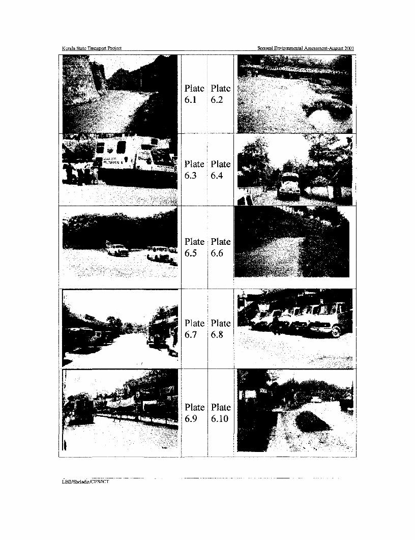
Kerala State Transpoit Proiect Scotoml Enmironmcntal Assessment-ALtgust 2001
AW ~~Plate Plate6.1 6.2
Plat-e Plate1> 61lve 612tc L Zffl.3 6.
Plate Plate'-"4 - 4t 6.5 6.6
i~~~~~~~~~~~~~___ _____
Plate Plate -
6.7 6.8
i - Plate Plate~~~~ ~~~~~ ~~6.9 6.10
_ _ __be_ad_aI ._ _ _f1C
LBtIISheladiaICFSIICT

Kerala State Transrt Proi e Secto2al Environmmta1 Assessment-Aupust 2001
!_l~~~~~~~~lt I P_at
Plate Plate
\ sj j ~~~~~~~~6.11 6.12
Plate Plate
Plate Plate6.14 6.15
l~~~_ j _ _ [____ __ _ _
LBRISheladia/CES.'ICI

Kerala State Transport Project Sectoral Environmental Assessment- August 2001
Mitigation: Although not cost effective, retaining walls may be constructed in areas of paddyfields where the expected erosion rates would be high. The retaining walls are primarily toreduce the land take. Retaining walls and other appropriate structures will be constructed inthe approach roads to all new bridges also.
6.2.5 Quarries and Crushers
Impacts; Many commercial quarries are found in almost all district of Kerala. The specificsources used for road making materials will depend upon the location of the link beingupgraded. Rock materials will probably be obtained from commercial suppliers and hauledby road to the project road being upgraded as needed. Contractors may, however, selected toI use other supply options provided they arc cost effective and provide rock meeting the qualitystandards in an environmentally sound manner. The specific locations of quarries likely to beused in the development of the project are provided in Section 5.2.6. No significant adverseimpacts due to the use of these quarries are anticipated.
Impact on Source of Sand: Refer Section 6.2.2
| Mitigation: Quarrying shall be carried out at approved and licensed quarries. If licensedquarries are not suitable contractors should select other supply options provided they areproduced in an environmentally sound manner (Refer EMAP). The State Pollution ControlI Board introduced new regulations No PCB/TI/17/80 dated 30/4/1998 on crushers to mitigateor minimise adverse impacts. Although the owners of crushers did not accept theseregulations the contractor may need to check with the Pollution Control Board for the latestdevelopments, as these regulations are subject to change.
Quarry operations are outside the purview of the project proponent. It is, nonetheless,appropriate to give consideration to the environmental implications in the selection of quarrysources since poorly run operations create dust problems, contribute to noise pollution, oftenignore the safety of their employees, or cause the loss of natural resources. To ensureadequate mitigation of potential adverse impacts, only licensed quarrying operations are to beused for material sources. If licensed quarries arc not available the Contractors will beresponsible for setting up dedicated crusher plants at approved sites.
I Impact Mitigation for Sand source: Refer Section 6.2.2
6.2.6 Borrow Pits
Embankments and other requirements for fill will necessitate the use of borrow pits and maycause drainage and visual problems as well as presenting a potential for increased vectorI activity (e.g., mosquitoes or water contamination). When water-filled, they also attractlivestock to the roadway thereby slowing traffic flow and creating safety hazards. Borrow pitshave been identified within a few Kilometres along both sides of the road. In most of theI cases the distance from the road to the borrow pit locations is expected to be 5-10 km. Thedense network of roads will facilitate the material transport.
The specific locations of borrow pits identified for potential development of the Project roadsare provided by Section 5.2.6. There should be no significant adverse impacts due to thecreation of borrow pits in these areas provided that the mitigation actions specified are
* followed.
Mitigation: Borrow areas will be located outside the ROWs and restoration of the pits willfollow the completion of works in compliance with the new Indian Roads Congress (IRC)specifications. Although locations of the borrow areas are negotiated between the Contractorand landowners, contractual arrangements for opening and use of material borrow pits for the
* LB II/ Sheladia /CESIICT 6.6
_I.

Kerala State Transport Project Sectoral Environmental Assessment- August 2001
KSTP are required to adhere to the local laws. The opening of the borrow pits in the paddyfield areas shall be strictly avoided except in the case of development for some communityfacilities such as creation of a new pond if required for the people. The excavation andrestoration of the borrow areas and their surroundings, in an environmentally sound manner isto be to the satisfaction of the Engineer before final acceptance and payment under the termsof the contract. Areas will be graded to ensure drainage and visual uniformity, or to createpermanent tanks/dams. Topsoil from the opening of borrow pits should be saved and reusedin re-vegetating the pits to the satisfaction of the Engineer. Additional borrow pits will not beopened without the restoration of those areas no longer in use.
6.3 WATER RESOURCES
6.3.1 Surface Water and Water Quality
Impacts: The construction will require an estimated 320 m3 of water per km. This will becompletely met from surface water resources such as rivers, streams, canals, lakes and ponds.No adverse impacts upon surface water or water quality are anticipated. The proposed KSTPimprovements to the drainage structures will facilitate the passage of greater flows andreduce scouring and bank erosion in the vicinity of the road, thus ensuring the integrity of theroad fabric even during the peak monsoon rainfalls. No impact on water quality oravailability of water for domestic or agricultural use will occur. Storm drainage provisionswill be upgraded to accommodate 25-year floods.
The increased runoff due to widening of the roadway will be statistically negligible. Waterquality in roadside ponds adjacent to the ROW may show slight improvements after roadupgrading due to reduced erosion from improved roadside berms and embankment slopesstabilised or protected by riprap or other material including planting to prevent soil erosion.
Mitigation: The KSTP road upgrading will reduce erosion from the roadway and result inminor improvements in water quality (i.e. reduced silt loads). As a terrain of very highprecipitation care has been taken in the design stage to provide side drainage in villages andtowns. Improvements in side drainage will result in significant improvements in humanhealth conditions in virtually every conimunity along the alignment by reducing humancontact with pollutants and other sources of disease.
Wherever practical and consistent with other environmental concerns (e.g., tree preservation),widening of the roads has been planned to avoid water bodies. Where this is not possibleslope protection is required to be installed until embankment surfaces are stabilised. Care hasbeen taken in the design to ensure that the road drainage provisions and the newembankments do not alter the current status of natural water bodies and irrigation structuresadjacent to the roads. Co-ordination with local land use planning authorities arerecommended to ensure that any future developments along the existing ROW in the vicinityof all sensitive areas are well planned. Provisions have been incorporated in the biddocuments and the cost included in BOQ to ensure that construction camps and otherpotential sources of secondary impacts are properly sited and provided with drainage andwastewater facilities.
Based on the rainfall and drainage characteristics it can be explained that the Project roadsthat are East -West or near East west (Eg ldukki - Puliyanmala) orientation are more stablethat those in the North -South or Near North south plan (SH-1). In other words it is possibleto explain that the CD requirements for the latter are to be considerably higher than for theformner. This aspect was specifically raised at the scoping workshop (Chapter 9.0) and alsoduring official level discussions.
3LBII/ Sheladia /CES/ICT 6.7

Kerala State Transport Project Sectoral Environmental Assessment- Aueust 2001
6.3.2 Groundwater
Impacts: Since groundwater is the main source of drinking water no significant impacts togroundwater resources are anticipated as a result of the proposed actions in the Corridor. The
| accidental chemical spills on the roads especially hazardous substances may require specialmitigation measures. The Environrmental _Management Action Plan (EMAP) explains thehandling of such accidental spills. The PWD Environmental Officer (EO) will be responsiblefor this work. Accidental spills reach groundwater sources very quickly because of themonsoon and the land gradient. No ground water will be required for any constructionactivities other than a very small quantity of drinking water at the construction and labourcamps.
A number of Wells and Water taps of Public supplies are located along the project roads.Wells will be replaced if located within the corridor as indicated in the Environmental stripplan and there will be no net loss of water access points as a result of the proposed work.Many hand pumps (mostly bore wells and occasionally tube wells) are located along theavailable corridors.
Mitigation: Other than drinking water needs of the construction camps no impacts upongroundwater resources or aquifer conditions are anticipated as a result of the proposed actionsin the corridor.
The affected wells/hand pumps and PWS within the proposed construction zones have beenidentified in the Environmental Strip Plan. There will be no net loss of water access points. InI the event that wells must be relocated, temporary alternative water sources (e.g., new wells,trucked potable water) will be provided to ensure that local residents have daily access to
l clean water.
All private wells and hand pumps will be provided as specified by the Resettlement ActionPlan (RAP). In the Project corridor almost all public wells and hand pumps will have to beremoved because of improvement in the available corridor width. All public water sourceswill be replaced as a part of Environmental Management Plan (EMP). This is included in theproject Bill of Quantities (BOQ). The additional wells if required as a result of therehabilitation, that are not included in the RAP will also be included as Environmental Costs.The Environmental Officer will be responsible for the implementation of this work.
6.3.3 Cross Drainage Structures
Impacts: Existing cross drainage structures will be widened/replaced as an integral part ofthe KSTP Project road upgrading. A number of new culverts are proposed as necessary,especially along realignments.
Mitigation: Cross drainage structures will be replaced in accordance with the standards ofthe Indian Road Congress (IRC) pursuant to surveys carried out as per IRC SP35-1990.
6.4 AIR QUALITY
The base line section discussed the worst-case scenario of Air Pollution in Kerala i.e., thePollution levels at Kochi, Thiruvananthapuram, Kottayam and Kozhikode. These are the mostpopulated and industrialised urban pockets of the State. Compared to this worst case, the Airpollution during the operational stage would improve due to better road surfaces andalignments. However the project air quality mitigation strategy should take care of the highpopulation density of Kerala and it is in many' cases difficult to locate sites for hot mix plantsetc during construction. In such cases the siting should be at places of least population and
LB311, Sheladia iCES/T6.8
3 Kerala State Transport Project Sectoral Environmental Assessment- August 2001
the'people should be informed about the construction activities. This is very important,| especially during family functions (Marriages, festivals etc), which could be seriously
affected and lead to antagonism in the local population.
Air, water and noise pollution level monitoring is an integral part of the Project. The StateI Pollution Control Board has taken up the work, which was completed in November 2000.The monitoring work of KSPCB at SH- 1-NH link at Kazhakuttam with the mobile equipmentis shown in Plate 6.3. This produced an opportunity to establish benchmarks.
Air quality issues are addressed in two phases: the construction phase and operational phases.Potential impacts and mitigation actions related to them (if any) are identified in each phaseI as provided in sections 6.4.1 and 6.4.2.
6.4.1 Construction Phase3 Impacts: The potential air quality impacts during the construction can be anticipated due tofugitive dust during the non-monsoon season around the construction activities and relatedfacilities such as crushers and hot-mix plants.
* Hot-mix plants will require careful siting particularly in relation to sensitive receptor areas(e.g., schools and hospitals). The extent of potential impacts during the construction periodwill vary according to the types of emission controls imposed, requirements to cover truckstransporting fill material, the types of pollution control devices used, and the degree ofsupervision exercised over the project.
1 6.4.2 Operational Phase
Operational impacts will require a determination of pollution levels within two scenarios:
- "Baseline conditions", i.e., anticipated future conditions assuming the project roadupgrading does not go forward. Transport demands will continue to increase andthese baseline conditions are the benchmark against which potential project impactsshould be evaluated.
- A future air quality condition assuming the Project does go forward.
I The net air quality impacts during the operational phase of the KSTP Project are expected tobe beneficial when measured against a base case that takes vehicle growth and related factorsinto account. Improvements in road surface condition and traffic capacity will alleviate localN congestion and improve traffic flow, thereby reducing engine idling and the contribution itmakes to local air quality degradation. No significant generated traffic (i.e., traffic that wouldnot have existed if the improvements had not occurred) is anticipated as a result of theI inmprovements. No significant diversion of traffic from other roadways (except in the caseLink 72) other than incidental local traffic is anticipated. In the case of Link 72 the traffic isexpected to increase considerably. With improved vehicle performance on a better, andwider, road surface, the air pollution should be reduced. Paving and provision of adequateside drainage in rural areas will significantly reduce human exposure to air pollution, both
| from vehicular emissions and roadside dust.
No significant changes are anticipated in current emission characteristics due to fuelcombustion (sulphur content of diesel fuel, lead, etc.) levels of engine maintenance, averageI vehicle age, etc. Such changes as might occur are likely to have a beneficial impact. Gradechanges within the Project Corridor are not significant and would have no adverse impact onvehicular emissions. Traffic composition (i.e., the types of vehicles in the traffic flow) will be
ffI unaffected by the proposed improvements. The average speed of traffic can be expected toincrease, thereby lessening air quality impacts. The majority of vehicles operate most
LBII/ Shetadia /CES/ICT6.9

Kerala State Transport Project Sectoral Environmental Assessment- August 2001
efficiently at constant cruising speeds rather than the "stop-and-go" patterns that are nowoccurring.
Mitigation: The Box 6.1 provides a detailed account of Kerala Specific Air quality and5 Recent Trends in Roads and Vehicles in India.
Air quality issues are addressed in two phases: the construction phase and operational phases.
Construction Phase: Ideally asphalt and hot-mix plants are required to be located at leastI 500 metres (150m in the case of Kerala) from the nearest sensitive receptor (e.g., school,hospital). Operators are required to install emission controls. Blasting (if any) will be carriedout using small charges, and dust generating items will be conveyed under cover. Roadsurfaces, excavation and construction sites will be sprayed to keep them moist for dust control.Trucks carrying earth, sand or stone will be covered with tarpaulin sheets to avoid spilling.
Potential significant adverse impacts upon adjacent residents or site employees duringconstruction will be mitigated by either discontinuing until favourable conditions are restored,or, if warranted, sites will be watered to prevent dust generation, particularly at crushing
| plants. Machinery and equipment are required to be fitted with pollution control devices,which will be checked at regular intervals to ensure that they are effective. The best availablepollution control technologies are required.
i Box 6.1 Kerala Specific Air quality and Recent Trends in Roads and Vehicles in India
The effect of vegetation with its inherent biodiversity is a very important positive factor forclean air as seen in Kerala. The presence of lush green vegetation as observed in Kerala isactually the mitigation measures proposed for air quality degradation by environmentalists inthe form of green belt, avenue planting etc in all developmental projects. The highI precipitation in Kerala is another positive factor in controlling the air quality. The rainfall inKerala is three times that of the national average. This will reduce adverse impacts to a largeextent especially in the case of Suspended Particulate Matter (SPM) and Respirable
J Particulate Matter-PM1O (RPM) levels.
On the other side, the recent trend of high quality fuels (like Pb free) is also a promising trendto keep good air quality in the future. The improved vehicle perfornance due to improvedvehicles will further reduce the over all air quality impact. The improved cars with lesspollution labelled as Euro I, Euro II and India 2001 etc is now in the market. AlthoughPollution Under Control Certificate (PUC) is a recent trend to control pollution, today it hasbecome part of the Social needs.
In order to avoid large-scale dust generation, the Contractor should use lorry-mountedI vacuum cleaners to clean the road surface as against the manual labour using brooms.
Operational Phase; As noted in the foregoing discussion of potential impacts, the net airquality impacts during the operational phase of the Project is expected to be beneficial whenmeasured against a base case that takes growth and related factors into account.Improvements in road surface condition and traffic capacity will alleviate local congestionand improve traffic flow, thereby reducing engine idling and the contribution it makes tolocal air quality degradation. With improved vehicle performance on a better, and wider,road surface, the air pollution should actually be reduced. Paving and provision of adequateside drainage in villages will significantly reduce human exposure to air pollution, bothvehicular emissions and roadside dust.
LBlt/ Sheladia /CES/IC I6.10
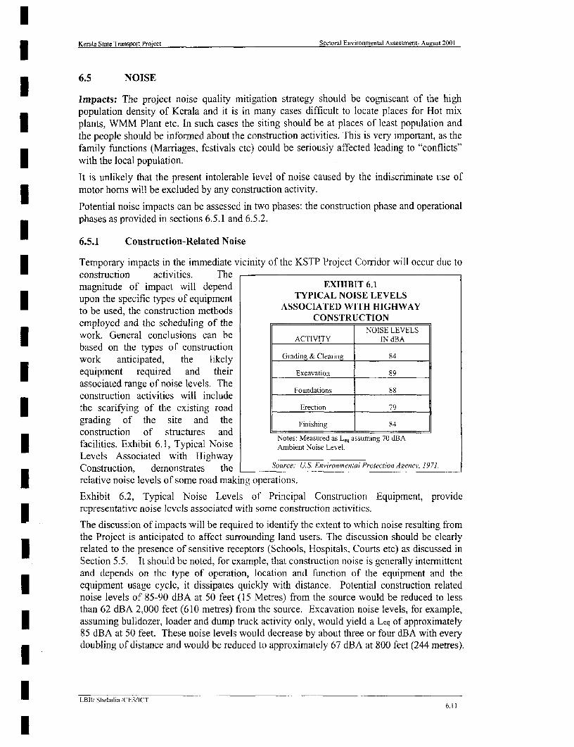
Kerala State Transport Project Sectoral Environmental Assessment- Aueust 2001
6.5 NOISE
Impacts: The project noise quality mitigation strategy should be cogniscant of the highpopulation density of Kerala and it is in many cases difficult to locate places for Hot mixplants, WMM Plant etc. In such cases the siting should be at places of least population andthe people should be informed about the construction activities. This is very important, as thefamily functions (Marriages, festivals etc) could be seriously affected leading to "conflicts"with the local population.
It is unlikely that the present intolerable level of noise caused by the indiscriminate use ofmotor horns will be excluded by any construction activity.
Potential noise impacts can be assessed in two phases: the construction phase and operationalphases as provided in sections 6.5.1 and 6.5.2.
6.5.1 Construction-Related Noise
Temporary impacts in the immediate vicinity of the KSTP Project Corridor will occur due toconstruction activities. Themagnitude of impact will depend EXHIBIT 6.1upon the specific types of equipment TYPICAL NOISE LEVELSto be used, the construction methods ASSOCIATED WITH HIGHWAYemployed and the scheduling of the CONSTRUCTIONwork. General conclusions can be ACIVITY NOISE LEVELS
based on the types of constructionwork anticipated, the likely Grading & Clearing 84
equipment required and their Excavation 89
associated range of noise levels. The l
construction activities will include Foundations 8S
the scarifying of the existing road Erection 79
grading of the site and the Finisliilg 84construction of structures and insng8
facilities. Exhibit 6.1, Typical Noise Notes: Measured as L, assuming 70 dBAfacilities. Exhibit 6.1, Typical Noise Ambient Noise Level.
Levels Associated with HighwayConstruction, demonstrates the Source: U.S. Environmental Protection Azencv. 1971.
relative noise levels of some road making operations.
Exhibit 6.2, Typical Noise Levels of Principal Construction Equipment, providerepresentative noise levels associated with some construction activities.
The discussion of impacts will be required to identify the extent to which noise resulting fromthe Project is anticipated to affect surrounding land users. The discussion should be clearlyrelated to the presence of sensitive receptors (Schools, Hospitals, Courts etc) as discussed inSection 5.5. It should be noted, for example, that construction noise is generally intermittentand depends on the type of operation, location and function of the equipment and theequipment usage cycle, it dissipates quickly with distance. Potential construction relatednoise levels of 85-90 dBA at 50 feet (15 Metres) from the source would be reduced to lessthan 62 dBA 2,000 feet (610 metres) from the source. Excavation noise levels, for example,assuming bulldozer, loader and dump truck activity only, would yield a Leq of approximately85 dBA at 50 feet. These noise levels would decrease by about three or four dBA with everydoubling of distance and would be reduced to approximately 67 dBA at 800 feet (244 metres).
_LB1li Sheladia iCESilCT6.11
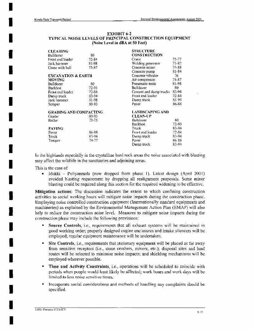
| Kerala State Transport Project Sectoral Environmental Assessment- August 2001
EXHIBIT 6-2TYPICAL NOISE LEVELS OF PRINCIPAL CONSTRUCTION EQUIPMENT
(Noise Level in dBA at 50 Feet)
CLEARING STRUCTUREBulldozer 80 CONSTRUCTIONFront end loader 72-84 Crane 75-77Jack hammer 81-98 Welding generator 71-82Crane with ball 75-87 Concrete mixer 74-88I Concrete pump 81-84EXCAVATION & EARTH Concrete vibrator 76MOVING Air compressor 74-87Bulldozer 80 Pneumatic tools 81-98
* Backhoe 72-93 Bulldozer 80Front end loader 72-84 Cement and dump trucks 83-94Dump truck 83-94 Front end loadcr 72-84Jack hammer 81-98 Dump truck 83-94Scraper 80-93 Paver 86-88
GRADING AND COMPACTING LANDSCAPING ANDCGrader 80-93 CLEAN-UPRoller 73-75 Bulldozer 80
Backhoe 72-93PAVING Truck 83-94Paver 86-88 Front end loader 72-84Truck 83-94 Dump truck 83-94Tamper 74-77 Paver 86-88
Dump truck 83-94
In the highlands especially in the crystalline hard rock areas the noise associated with blastingmay affect the wildlife in the sanctuaries and adjoining areas.
This is the case ofldukki - Puliyanmala (now dropped from phase 1). Latest design (April 2001)
i avoided blasting requirement by dropping all realignment proposals. Some minorblasting could be required along this section for the required widening to be effective.
Mitigation actions: The discussion indicates the extent to which confining constructionI activities to social working hours will mitigate noise impacts during the construction phase.Employing noise controlled construction equipment (Internationally standard equipments andmachineries) as explained by the Environmental Management Action Plan (EMAP) will also
X help to reduce the construction noise level. Measures to mitigate noise impacts during theconstruction phase may include the following provisions:
| Source Controls, i.e., requirements that all exhaust systems will be maintained ingood working order; properly designed engine enclosures and intake silencers will beemployed; regular equipment maintenance will be undertaken.
0 Site Controls, i.e., requirements that stationary equipment will be placed as far awayfrom sensitive receptors (i.e., stone crushers, mixers, etc.); disposal sites and haulroutes will be selected to minimise noise impacts; and shielding mechanisms will beemployed wherever possible.
* Time and Activitv Constraints, i.e., operations will be scheduled to coincide withperiods when people would least likely be affected; work hours and work days will belimited to less noise sensitive times.
* Incorporate social considerations and methods of handling any complaints should be| specified.
LBII/ Sheladia /CES,ICT6.12

lKerala State Transporl Project Sectoral Environmental Assessment- August 2001
Impact of blasting of rocks on the wildlife: There could be serious impact onwildlife. This effect was further confirrned from the Wild life warden and also fromthe Principal Chief Conservator of Forests (Ref: Appendix A 8.2 Official LevelConsultation). In the latest design for Link 26 Idukki Puliyanmala Project road theI blasting requirement has been reduced to a minimum by avoiding all realignmentsfrom further consideration.
| 6.5.2 Operational Noise
Potential Sources. Potential sources of road noise during the operational phase of the3 Project road include:
• Vehicle Noise - In some instances, the amount of vehicle noise will be increased e.g.,the introduction of traffic within the vicinity of the bypass ROWs. In other cases itI may be reduced as a result of the Project (e.g., the alleviation of congested trafficconditions).
* Road Noise - Frictional noise from the contact between tyres and pavementcontributes to overall traffic noise. The level depends on the type and condition of thepavement. Frictional noise is generally greatest at high speeds and during quickbraking and acceleration. Indiscriminate use of motor homs greatly exceeds anynuisance created by " "road noise".
* Driver Behaviour. The drivers in Kerala in general contribute to road noise by the* abuse of vehicle horns, the playing of loud music, shouting and causing tyres to
squeal as a result of sudden breaking or acceleration. Driver education should aim atthe use of horns for potential emergencies only (Road safety Action Plan is part of theKSTP).
* Construction and Maintenance. Road surface maintenance generally requires theuse of heavy machinery, although these activities may be intermittent and localised,they contribute large amounts of sustained noise to the areas in which they occur.
3j Potential Impacts. Potential impacts to the following could occur:
• Human Welfare. Although it may not be recognised, chronic exposure to noise canaffect human welfare in varying degrees, both physiologically and psychologically.I Chronic noise exposure can be a source of annoyance, creating communicationproblems, leading to elevated stress levels, and associated behavioural and healtheffects. It can cause auditory fatigue, temporary and pernanent lessening of hearingI ability, sleep disorders and contribute to childhood learning problems. It is likely thatimproved road conditions will result in less congestion and together with improvededucation lead to a greatly reduced use of vehicle horns. This is regarded as the singlemost disturbing cause of noise nuisance.
* Vibration. The vibration induced by the resonance of traffic noise can have adetrimental effect on structures and can be a particular concern in the case of culturalheritage sites or lightly constructed buildings not designed to withstand such vibrations.
Mitigation:| Strict procedures for issuing and controlling driving licenses* Noise Pollution legislation should be properly enforced. Road signboards indicating no horn zones near Courts, Hospitals and Schools.I * Green noise barrier (Many rows of trees with small leaves planted like a wall)* Solid noise barrier ( A stone wall of eight feet height)
I LBII' Sheladia/CES/CT6.13
Kerala State Transport Project Sectoral Environmental Assessment- August 2001
The Project has the provision for Noise barriers (design drawings will be provided to thecontractor) near Schools, Courts and Hospitals. The Appendix -A 6.1 is the design andother details of the Noise barrier and other typical designs for environmental enhancementconsidered in the Project.
6.6 FLORA, FAUNA AND ECOSYSTEMS
6.6.1 Flora
Impacts: No rare, threatened or endangered plant species or habitats are known to be withinthe available corridor of the project roads. Plant species within the ROW are eitherintroduced species or ubiquitous native varieties. The trees within the private properties areprotected by the individuals by solid boundary walls (Plate 6.4), fencing etc. The Plate 6.4shows the typical narrow wall on both sides protecting the private property commonly seenall over Kerala. The construction activities will impact upon vegetation adjacent to theexisting highway.
Biodiversity issues: There would not be any biodiversity problem as the private landownersusually plant the same useful plants, trees (Coconut, Mango, and other fruit bearing trees)Plantain etc and herbs (refer section 5.9.3 paragraph-3 on house gardens), which they loseduring the road improvement. These plants will usually be replanted (Compensatory planting)elsewhere in the remaining property itself or where ever they resettle as this is an integral partof the social life. The project roads that are located close to ecologically sensitive areas havebeen further studied in detail to evolve simple and cost effective mitigation measures. Theseroads are:
The roads in Phase 2 are* Punalur-Thodupuzha* Kasargode-Kanhangad* Pilathara -Pappinissery
* Idukki - Puliyanmala (phase 2 buffer)
The Idukki-Puliyanmala (refer Box 5.3 of Chapter 5.0) and Punalur- Thodupuzha roads aresensitive due to the proximity to sanctuary and forest reserves while the two other roads inPhase 2 are sensitive due to its location in the CRZ area.
While formulating the species selection for replanting, the compensatory replanting willaddress the biodiversity factor. The compensatory tree planting will be mostly along theabandoned sections of the realignments or in the available Puramboke land.
The implementation of the Kerala State Transport Project provides for substantialrealignments resulting in the formation of many small sections of road more or less similar to'meandering and oxbow lake formation during the evolution of rivers'. The difference is that,in the case of rivers it is a natural process, but in the case of roads it is human intervention.Because of this it is referred to as 'OXBOW LAND' to show that this is an inevitable resultof road improvement projects in Kerala. An 'oxbow land' formed after PWD realignmentalong Link-I Taikkod-Kottarakkara is seen in Plate 6.5. In this Plate, the car parking is at theentry point to the oxbow land. A typical case of tree planting and parking space is shown inExhibit 6.3. The length of these OXBOW LANDS varies from fifty metres to a fewKilometres. The width is variable from 10 to 50 m. The Appendix A.6. 1 is the typical designdrawings.
I LLBII/ Sheladia /CES/IC I6.14
TREE
DESIGN PROTOTYPE BY CONSULTANTS(KERALA STATE HIGHWAYS PROJECT) -
0 (NOTE:- WIOUTr ACCESS CONMOL)
yam vAm -- ME I
Lii III t SECTION X-X
CD1- VU>BtZ~~~~~~~~~~~~~~~~~~~~~~~~~~~~~~~~~~~~~~~~~~~~~~~~~~~~~~~~~~~~~~~~~~~~~~~~... .. .
. . _ _ s - - -~~N33IAGNMENT----1_ o
~~~~~~~~~~~~~~~~~~~~~~~~~~~~~~~~~~~~~~~0S
WITH TOILETSX T - _r,< < - OOL BARES/SHUBS OILE CD
PL ANTING / -SHRUB PLANTING SHRUB PLANTING PLANTINGAREA | A;G|AREA 00r
PAR NG
EXHIBIT 6.3: RURAL "OXBOW LAND" AS COMMUNITY SPACE
Kerala State Transport Proiect Sectoral Environmental Assessment- August 2001
Mitigation:
* The public trees within the available corridor of impact will be replaced at a ratio of1:2 along the 'OXBOW LANDS' (For every tree removed two trees will be planted).Since the available corridors are too narrow, the planting of new trees will be alongthe abandoned sections of the realignments and other puramboke land. The speciesmostly indigenous, recommended for replanting are described in section 6.6.5. Theabandoned sections of the realigned roads may revert to local government.
* The private tree owners will be suitably compensated according the ResettlementAction Plan. In addition to this project will plant twice the number of plants that willbe removed from the private properties as a compensation strategy. Details withregard to potential public trees along the highways are provided in Item 6.6.5. InKerala, the cost of the property is always valued together with Trees and othervegetation exist at the time of evaluation hence there will not be any separateprovision to compensate private trees.
* The project tree planting strategy has considered private trees also for compensatoryI tree planting.
6.6.2 Fauna
No rare, threatened or endangered wildlife species or habitats for such species are known tobe within the immediate potentially impacted area except in the case of three phase 2 roads,3 which are located close to ecologically sensitive areas.
This assessment has been made with due consideration given to potential direct impacts toi wildlife under the following headings:
* Habitat Loss. Improvements within the KSTP Project Corridors will occur within theexisting ROW or previously disturbed areas with no loss of habitat. Realignments arelocated only in areas previously disturbed by agriculture or other uses. Borrow pitsand quarries used for the purpose of the improvements will be restricted to licensedareas. Except for the ecologically sensitive project road the reserved forest patches3 within the COI are located away from the existing corridor. The Improvementconsiderations already proposed for the ecologically sensitive project roads will besubject to the MOEF clearance when all mitigating actions will be addressed.
3 * Aquatic Habitat Damage. Road development may have serious and far-reachingimpacts on aquatic ecosystems. Erosion can lead to downstream silting, thus ruiningspawning grounds for fish. Construction at crossings can change the current affectingI some species. In this instance, the fact that the road already exists and crossesmonsoon fed perennial streams should not introduce any new situation of impact tothe project area. The phase 2 buffer project road Idukki - Puliyanmala in particular is
* located close to the Idukki reservoir, part of the Idukki Sanctuary. The variousconstruction activities including the blasting required along this corridor could leadI to downstream silting in the Idukki reservoir, which is part of the Sanctuary.
* Forest reserves: (Refer 6.6.3)
Consideration has also been given to potential indirect wildlife impacts under theI following headings:
* Accessibility. Penetration of previously inaccessible areas and upgrading of existingroads generally facilitates an increase in the number of people having access and isaccompanied by an increase in the likelihood of adverse impacts. In this instance, the
LBII/ Sheladia /CES/ICT6.15
| Kerala State Transport Project Sectoral Environmental Assessment- August 2001
road already exists and although movement along it will be improved, the proposedI upgrading will not result in any significant increase in accessibility.
* Ecological Dis-equilibrium. The importation of new plant and animal species along3 a ROW can upset the dynamic balance in the ecosystem. Native species facecompetition for resources from new arrivals. Predator-prey relationships can bealtered, often to the detriment of the native species. In this instance, the fact that the3 road already exists minimises any potential for creating any ecological imbalance.
* Contamination. The increased presence of motor vehicles introduces a potential forcontamination of the soil, air and water adjacent to the road. In this instance, the roadalready exists and no significant increase in the number of motor vehicles isanticipated as a result of the proposed Project.
1 6.6.3 Reserved Forests in the study area
Impacts: The small forest reserves within the COI of many corridors have no wildlife ofparticular significance. These forest reserves are mostly of small (of the order of 1-2 sq.kmarea) plantations of cashew, rubber, eucalyptus etc. Since most of the these small patches aremono-crop plantations this will not lead to any biodiversity issues even if it is within the area
| of land acquisition for road improvement.
If ecologically sensitive areas were located within the seven-kilometre impact zone therecould be some impact. These aspects have been investigated during the project preparationand need approvals from the State and Central Government (Refer section 6.6.1 for theecologically sensitive roads).
3 Mitigation: The natural forests and sanctuaries in the respective project roads will besubjected to detailed investigation within the vicinity and will be subjected to detailedEnvironmental Impact Assessment (EIA) studies. For Phase 1, this study is more or less
l completed.
In the case of Link 26 Idukki -Puliyanmala (phase 2 buffer) as a mitigation measure, theproject has dropped all realignments and the designed Kattappana bypass option is beingreviewed. There will not be any blasting except some small-scale un avoidable requirements.The project will not affect any forestland and hence no forest application and clearance isrequired. Further all concerned officials including the Chief Wildlife Warden of the State andthe wild life warden of the Sanctuary were consulted. Recently joint site verification exercisewas also completed by the PWD and the Forest Department (refcr Chapter on Consultation).
| 6.6.4 Social Forestry and Plantations
Impacts: No impacts upon social forestry are anticipated. The trees planted within the projectI roads are very old and are not planted under social forestry schemes. The land take fromplantation areas will lead to the removal of many trees. This would not result in any majorimpact. The trees and the land to be acquired will be subject to compensation in accordanceI with the RAP.
Mitigation: None required
3 6.6.5 Tree Plantation in the ROW
Impacts: The issue of tree removal is one of particular importance to any road project. Trees3 provide shade for travellers in an otherwise hot and humid country and planting has anaesthetic appeal. All publicly owned trees along the ROW are within the purview of the StateForest Department and considered as being part of the State Forest Reserve. The Forest
LBII/ Sheladia /CES!ICT6.16

Kerala State Transport Project Sectoral Environmental Assessment- August 2001
Department indicated that the trees along this road are naturally grown trees and the State| PWD usually numbers them. The State Forest Department must approve their removal and
they must be replaced by planting at least twice the number removed. Any use of ForestReserve areas requires Forestry Department and Central Government clearance and will beI subject to compensation according to GOI policy.
The project improvements will require the removal of an average 1-2 trees per kilometre| located within the available corridor.
Mitigation: The Species that are found to be good in absorbing dust and other suspendedparticles from the atmosphere are devadaru, peepal, kanikonna, teak, gulmohar, mango,tamarind and banyan tree (Mathrubhoomi, 28 May 2000). These plants also absorb poisonousmetals like Lead, Cadmium, Arsenic and Aluminium from the Air (Refer Exhibit 6.4 and 6.5).
EXHIBIT 6.4THE COMMON AVENUE TREESTITO BE PLANTED WITHIN
THE PURAMBOKE LAND AND 'OXBOW LANDS'SL NO MAIN SPECIES SCIENTIFIC NAMEI I Arayal or the Peepul Ficus religosa
2 Plavu or Jackfruit tree A-Integrifolia3 Anjili or Ayani Artocarpus hirsutaI _____4 Naval or Jamun Svzigium Jambolana5 Peral or Almaram F.bengalensis6 Pulirnaram or Tamarind Tamarindus indica7 Chilanthi or Puvarasu Thespesia populinaI ____8 Vaka Albizzea lebeck9 Maruthu Lagerstroemia indica10 Orakkanm Thungi Maram or The Rair tree Enterolobium saman11 Veppu AZadarichta indica
(Source: Gazetteer of India, Kottayam District, and Kerala, 1975)
6.6.6 Private owned trees
Impacts: Throughout the road length there are trees in private ownership. Any widening willlead to the removal of a few trees. In the Highlands there are continuous tea and coffeeplantations. Plate 6.6 shows a typical section bordered by tea plantations on both sides.
Mitigation: Those trees, which are required to be removed for the purpose of this project,I will be subject to compensation where applicable. The Projects tree planting strategyencourages the people immediately adjacent to the road to plant high canopy trees like mango,tamarind, jack fruit etc. (Appendix A 6.2- Landscaping, tree planting, environmental
* enhancement plan. Moreover the lost trees usually. are very useful plants, trees and herbs.The rehabilitated or affected people will immediately replant these trees, as they are an
* integral part of their life.
In addition to the compensation, private trees will be planted at a rate of 2 to 1.
3 6.7 CULTURAL RESOURCES
Impacts: Potential impacts to cultural heritage sites include:
I Damage caused by road construction, related works such as quarries and borrow pits, andunregulated access to cultural heritage sites. Provisions to avoid such damage are3 incorporated in the Project contract documents.
Tt Gazetteers of India, Kerala Kottayam district 1975
I LBII/ Sheladia /CESIICT6 17

Kerala State Transport Project Sectoral Environmental Assessment- August 2001
Positive impacts could occur on the amenity value arising from improved access toand signing of sites recognised for their cultural value.
The Phase 1 road improvement will impact 38 cultural properties as listed in Chapter 5,Exhibit 5.38. Only seven shrines will be completely affected (100 %) and need to beI relocated as per the Cultural property rehabilitation plan. The structures that will be affectedinclude Hindu 12, Christian 17 and Muslim 9 Cultural Properties. Most of these are Hyundai3 (money collection boxes of cultural properties of all religions.)
EXHIBIT 6.5SHRUBS TO BE PLANTED WITHIN THE
PJRAMBOKE LAND AND 'OXBOW LANDS'
SL NO SCIENTIFIC NAME OF SHRUBSI Aerva javanica2 Aerva pseudotomentosa3 Cassia auriculata4 1 Clerodendron phloemoides5 |Crotolariaburhia6 Capparis aphylla7 | Calotropis procera8 Calligonum polvgonoides9 Euphoria bivula10 Grewia tenex11 Indigifera argentina12 Laptadenia pyrotechnieaI Mitigation: AlternatIv 1 3 /Zizehusspp.
Mitigation: Alterative alignments and bypasses were fully considered as a means ofavoiding adverse environmental impacts to cultural facilities. A Cultural PropertyRehabilitation Policy has been developed exclusively for the Kerala State Transport ProjectI to address all cultural property related issues including those affected by the proposed roadimprovements. The policy has set guidelines to resolve the various issues arising out of thereligious properties. Environmental Strip mapping has facilitated avoidance of direct impactsupon most cultural resources.
6.8 GENERAL ECONOMIC ENVIRONMENT
* 6.8.1 Impacts on Communities and Their Economic Activities
Impacts: This section focuses on the potentially affected communities as economic andI social entities. Closely related impacts which may have community-wide implications, butwhich tend to acquire their significance from their effects on individuals, are addressedprimarily in Subsection 6.9.1 (Land Acquisition and Resettlement) and the subsections whichU follow. Potential impacts to be considered under the heading of Communities and theirEconomic Activities include:
Split Communities. Altemative routes for local movements and/or road crossing and* access restrictions sometimes result in longer joumeys, directly affecting businesses and
pedestrians. In rural areas, new road alignments or increased traffic sometimes cut thenormal links between villagers and their livelihood. The fact that most of the ROW isalready in use as a State Highway lessens any potential for significant additional impactsof this type. Minor realignments have avoided impacts of this type as far as possible.
_LBII Shcladia iCES/ICT6.18

Kerala State Transport Project Sectoral Environmental Assessment- August 2001
Loss of Roadside Community Business and Social Activities. The Project will, to some| degree, affect both business and social activities within or adjacent to the existing ROWs,
particularly at intersections. The impacts to the individual businesses are discussed aspart of the Project Resettlement Action Plan. Such businesses are likely to relocate in the
X same community and impacts to communities, per se, are likely to be slight. Theimproved facilities for pedestrians are likely to result in considerable benefits to thepublic road users and businesses alike.
* * Impacts on Realigned (bypassed) Communities. Road realignments to bypass problemareas such as those incorporated in the KSTP will have the positive benefit of reducingthe immediate impact of the traffic on the community and local commercial activitiesI, should flourish as a result. The KSTP project roads are very winding and accident-prone.On the negative side, however, some communities may suffer a loss of business from thediversion of traffic. Migration to the new route may occur, potentially changing land usepattems. Impacts of this nature as a result of the Project road improvements are unlikely.Voluntary relocation and development along revised routes should be carefully
| controlled.
* Impacts on Current Modes of Transport. Experience with other road projectsindicates that measures which impede road crossings, control bus stops, restrict parking ofI informal public transport vehicles may reduce the attractiveness of current transportmodes. No impacts of this type are anticipated in this instance. The KSTP on the otherhand proposes bus lay-bys and parking areas off the main carriageway built into thedesign when ever possible so that this will not impede the free flow of traffic.
v Impacts on Tourism and Pilgrimage Locations. The Project road can be expected tohave a predominantly positive impact on the tourism potential of the areas served by theproposed roadways. The project road improvements are likely to enhance accessibility totourist features as well as improving road safety; hence it has a very a positive impact.
I * Gentrification Impacts. "Gentrification" is a term applied to situations in which thevalue of land in a particular area is increased by infrastructure improvements leading tohigher rental values, occupancy turnover and a replacement of previous tenants andI residents by those who can afford higher rents. The term may apply to higher costcommercial land as well as residential areas. Impacts of this type are likely in the KSTPespecially along new alignments like bypasses, realignments and Link Roads (Link 72).
Mitigation: Potential community impacts related to economic growth are closely related toland acquisition, aesthetic and landscape considerations, noise, air quality, etc. Other than themitigation noted in these areas, no further actions are warranted.
6.8.2 Employment Patterns
I Impacts: No significant changes to area employment pattems are anticipated. The projectroad improvements will, however, increase the economic efficiency and attractiveness forinvestment in the areas. It will be possible to move goods to market and finished productsmore economically and enhance the employment potential in the area. The short-termcontract activities should provide some local employment opportunities and improvedmaintenance services on the capital investment should also create long-term employment forroutine maintenance contractors. The lengths person routine maintenance contract system isfrequently viewed as a very positive economic boost to poorer rural communities, whichbenefit from the expenditure of part of the road fund along the road line.
I LBI1/ Sheladia TESACT6.19
Kerala State Transport Project Sectoral Environmental Assessment- August 2001
Mitigation: Potential community impacts related to employment patterns and opportunities| are closely related to impacts related to land acquisition, aesthetic and landscape
considerations, noise, air quality, etc. Other than the mitigation noted in these areas, nofurther actions are warranted.
6.8.3 Industrial Scenario
Impacts: Project road improvements will enhance the likelihood of attaining the industrialI development goals for the area. The high density of population usually conflicts withindustrial growth as the latter causes air, water and noise pollution. Some of such activecommunity conflicts include
* Mavoor Gwalior Rayons at Kozhikode (Air and Water Pollution),* Travancore Titanium Products Limited (Water pollution) and very recently inI * Adur town in Pathanamthitta district- recently an industry producing bone meal (Air
pollution) was burnt to ashes by the local population after prolonged conflicts with theindustry.
* Bio-fertiliser factory at Vilappilshala in Thiruvanathapuram District (Air and Waterpollution)
Labour problems and the pollution are the main factors impeding Industrial development inKerala.
Mitigation: Potential community impacts related to industrial scenarios are closelyI associated with impacts related to land acquisition, aesthetic and landscape considerations;noise, air quality, etc. Other than the mitigation as noted in these areas, no additionalmitigation actions are warranted.
6.9 GENERAL SOCIAL ENVIRONMENT
6.9.1 Land Acquisition and Resettlement
IImpacts: A Resettlement Action Plan (RAP) has been prepared and based on definitivesurveys of the area documents the potential impacts due to land acquisition and resettlement.The RAP is incorporated herein by reference. As a part of the detailed design, theResettlement Action Plan (RAP) has been prepared. The details of social impacts, issues andmitigation plan are provided in chapter 7.
Mitigation: The Resettlement Action Plan (RAP) and the Social Impact Assessment andplanning have avoided all negative impacts to the extent possible for the selected road design.
The final design decision has avoided all major social impacts. Actions to mitigate potentiallyadverse impacts to realignment / bypassed communities due to the fact that the abandonedROW may revert to Local Government shall be undertaken as specified by the EnvironmentalManagement Plan, Chapter 10.0. A number of environmental designs have been prepared forthese sections for development; Cost for the improvement is also prepared and included in theBill of Quantities (BOQ). There must not be any access problems due to the management ofrealigned sections.
6.9.2 Indigenous Peoples
Impacts: No indigenous people have been identified in the project corridor.
Mitigation: Mitigation related to land acquisition and resettlement will be undertaken asI specified by the Resettlement Action Plan (RAP) and the Environmental Management Plan,Chapter 10.0.
LBII/ Sheladia /CESYICT6.20
Kerala State Transport Proiect Sectoral Environmental Assessment- Aueust 2001
6.10 HUMAN HEALTH AND SAFETY
Impacts: No significant negative human health impacts are anticipated due to:
• Increased Potential for Transmission of diseases. It is recognised that theI transmission of diseases along previously undeveloped corridors has been identifiedas a major unplanned environmental consequence of road developments in Africa andelsewhere. In this instance, the proposed improvements will occur within an existingI transport corridor and no significant potential for increased transmission of diseases isanticipated.
* Contamination of Local Water Supplies. Due consideration has been given to thepossibility of temporary labour camps and the water supply and wastewater disposalassociated with them during the construction period. This will ensure that thepotential for adverse impacts are avoided. Appropriate provisions have beenincorporated in the contract documents as outlined in Chapter 10.0.
* Air Pollution. Increased air pollution during the construction stage will occur butI will be avoided as far as possible by the provisions incorporated in the bid documentsand described in detail in Chapter 10.0. Qualitative assessments of the operationalphase suggest that projected ambient air pollution with the proposed roadimprovements is likely to be less than a base case that takes population and economicgrowth into account. There are two areas of potential air quality "black spots". TheMavoor and Vazhakkad region of Kozhikode district is an established black spot dueI to the emissions from Grasim industries at Mavoor (The Hindu Survey of TheEnvironment, 1999) and the Industrial belts of Kochi are also frequently in the news.
* Noise Levels. Assessments also suggest that projected ambient noise levels with theproposed road improvements are likely to be less than the "no action" alternative dueto reduced traffic congestion. The urban and semi-urban pockets of the entire corridorare already noise impacted. The project noise monitoring was carried out in thetypical sensitive areas. This is to establish certain bench marks. Improvements to theroadway and traffic flow will help to alleviate the situation.
Road Safety Impacts: The safety considerations may include the increased risk of roadaccidents and the severity of such accidents due to higher speeds and related factors. Areasof conflict between local and through traffic and between road users and neighbouring land
* users are noted by the accompanying Environmental Strip Maps and the link specificenvironmental sheets. These assist the incorporation of appropriate safety features into theproject. A number of accident black spots65 are also identified in the Environmental stripI plan (Link 70, Link 1 and Link 6). A number of realignment and bypass candidates have beenincluded in the project. This will avoid the highly congested town areas and straightens acutecurves. The prevailing environmental issues, which are also road safety issues are discussedbelow:
The State Governrnent recently introduced the Kerala Highway Protection Act, 1999 that islargely aimed at the protection of the ROW from encroachment etc. The following aspectsbasically the keeping of as much space as possible for pedestrians and traffic by design and,which do not require large investments.
6.5 NATPAC, 1999
IBIl/ Sheladlia /CESICT6.21
lU Kerala State Transport Project Sectoral Environmental Assessment- August 2001
Lack Of Parking Spaces For Auto Rickshaws7 -2 And Jeeps
In small towns and cities separate well-defined disciplined parking spaces for auto nrckshaw,jeeps, and lorries are not available of the highway (Plate 6.7 and 6.8). This creates aconflicting situation with through traffic, local traffic and pedestrians, which result incongestion and accidents. In the SH-I Project road those areas are clearly marked on the StripPlan.
Mitigation Action required: There should be space provided for parking off the roadswithout interfering with the smooth Auto-flow of traffic. In Kerala, almost in all rural areasthe populace is heavily dependant on rickshaws and jeep services. The Highway AuthorityI should not be responsible for providing parking facilities on the highway; this is usually thefunction of the local authority and off road areas can usually be secured at much lower cost tothe community than using expensive highway space. In spite of this the project has providedI parking areas in most congested areas.
Lack Of Sufficient Space For Bus Stops and (Bus Lay-Bys)
| The prevailing road conditions and location of Bus stops are affecting the smooth flow oftraffic (Plate 6.9), often traffic congestion is due to a bus setting down or taking uppassengers and drivers choose not to pull off the main traffic stream due to the difficulty of
m re-entry.Mitigation Action required: Bus stops should not obstruct the free flow of traffic. Thelocation of bus stops should have sufficient space so that the commuters especially the largeI numbers of school children are safe. The Pedestrians using the bus stops should be safe fromboth approaches. In this project there is an inbuilt (included in the design) provision for Busstops as shown in Exhibit 6.6.
The introduction of some courtesy on the roads as a result of driver education should enablebuses to rejoin the traffic stream without any belligerence or danger.
Dumping And Storing Of Road Construction Materials
Road corridors are often used to dump road construction materials prior to resurfacing (Plate6.10 and 11), a very dangerous practice seen all over Kerala. This practice will cease asmachine surfacing is introduced throughout the State. Engineers must be far more vigorous inprotecting the rights of the road users.
Unplanned, Illegal Digging on Roadsides
These are regular occurrences in Kerala. The entire State population suffers from theseactivities (Plate 6.12), which are often perpetrated by the Statutory Utilities as well asI Municipal Authorities. Electricity cable rolls, pipefittings and rubbish dumping are the mainproblems causing obstruction.
|Mitigation Action required: The State PWD is responsible for the Right of Way (ROW) ofall main roads in Kerala. Any activity by any other department, on the road Right of Wayshall be seen as illegal unless carried out with the permission of the Highway Authority (HA).Any digging for laying of pipes, cables etc should be subject to clearances and approvalsfrom the HA. Regular HA Co-ordinating meetings are an essential part of managing any roadnetwork with police participation.
| This should start from the very early stage of any project proposal e.g. an internationallyfunded water supply project which requires considerable digging for laying of pipes allinformation on such projects shall be collected with care and cooperation of all departments
7-2 Three wheelers of 2X2 size with a seating capacity of three
I LBIi Sheladia iCES!]CT6.22

e-- 2 5 0 O0 j 25 0 0 _ _+_ ___ ___ VARI ES ___ _ , q2500q
I FOOTPATHI BUS BAY I CARRIAGEWAY FOOTPATH|
~~~~~~~~~~~~~~~~~~~~~e%-
SECTION B-BSCALE 1:75
15000 ,_ 24000 _+ _5000 24000
Q FOOTPATH i! i- | EDGE . F PNE//;^\\\~ ~ ~ ~ ~ r I =lcm WIDE (WHITE DOTTED) IJNE
o~~~~~~~~~~~~~~~7 M 2 mtFOOTPATH
CARRIAGEWAY
2.5m FOOTPATH
15000 iPEDESTRIAN CROSSING 100 WIDE SOLID LINE
WDTH SCALE 1:125LENGTH SCALE 1:250
NOTE:-ALL DIMENSIONS ARE IN mm UNLESS OTHERWISE SPECIFIED
TYPICAL LAYOUT OF PARTIAL BUS BAY IN URBAN AREA

lKerala State Transport Project Sectoral Environmental Assessment- August 2001
concerned. This type of planning and implementation can save a considerable amount ofmoney, save a number of people from accidents, and reduce inconvenience to the public.
Vehicle Overloading
Vehicle overloading (Plate 6.13) is a very common problem all over the State. Nearly allpassenger vehicle operators are guilty of overloading to maximise the profit per trip. Drivereducation will assist in combating this problem together with a disciplined system ofenforcing the Rules of the Road Regulations. Many fatalities are reported each year due tothis problem. Not only is driver freedom of movement reduced but also of course the reducedbraking capacity and man over ability of the vehicle contributes to the likelihood of anaccident. When such accidents occur they are usually more serious due to the sheer numberof people involved.
Partly covered/unevenly covered/open drains and drainage
Kerala experiences a high rainfall; drainage is important for all development activities. Arecent accident in Kozhikode area (a traffic policemen on duty died accidentally falling into apartly opened drain) clearly indicated that the drains are death traps for pedestrians (TheIndian Express 19/10/99). There are open drains, partly covered drains, and unevenly covereddrains (Plate 6.14 and 6.15). All of these are very dangerous for pedestrians. Unwarypedestrians falling into open ditches, inflicting serious injuries to their limbs is a commonoccurrence in the city (Press).
Mitigation Action required: A formal disciplined system of drainage improvement needs tobe developed to permanently cover the drains so that these drains will become safe footpathsat least in all urban and semi urban areas. The Highway Authority needs to fund the operationand improve Engineer awareness.
Inadequate Embankment Height In Flooding Areas
Being an area of high rainfall, some roads become partly flooded during the monsoon seasonsometimes for hours (Plate 6.16). This can cause accidents and traffic delays.
Mitigation Action required: The Highway Authority should have some signing programmeto warn of flood sections of all roads in their respective divisions. In all flood prone sectionsthe road should be raised to the extent that such flooding shall not affect the smooth flow oftraffic during monsoon seasons. Borrow pits opened for this purpose must be controlled withproper licensing/ approvals/ agreements etc.
Encroachments Of Various Types
The legal Right of Way of almost all roads is not available to the road users. It is observedthat there is considerable encroachment along the road corridors.
Mitigation Action required: The recently introduced Highway Protection Act 1999 is apositive step in this direction. Local Engineers must become more familiar with the legallimits of the ROW and encroachments should be addressed severely and quickly. Narrowcorridors with little visibility and provision for pedestrians due to various factors cannotafford to accommodate encroachers.
Parking Of Vehicles On Both Sides Of The Road
The parking of Vehicles on any road is a matter of concern in Kerala and appears to occurwithout any system of regulation.
Mitigation Action required: Parking of vehicles on both sides (Plate 6.17) should not beallowed at any given location. One side parking may allow free flow of traffic. This could beaddressed in each town and should be enforced. For example in Kottarakkara town the
I LBI!/ Sheladia /C6ES.3CT6.23

lKerala State Transport Project Sectoral Environmental Assessment- August 2001
parking area could be only on the west side from 08.30 hrs to 21.30 Hrs. The new buildingshall not be allowed close to the road corridor. The licensing of the new building shouldmaker sure adequate parking facilities especially in Urban and Semi urban areas.
Trees/Forest/Vegetation/Wildlife
In Kerala, barren lands constitute only a small percentage of the total geographical area.Forests cover more than 20 %. These forests are rich in wildlife. In non-forest areas alsowildlife exists especially avifauna. Non-forest areas are also covered by thick vegetationmainly coconut/Rubber/Plantation/Arecanut and a number of fruit trees. The paddycultivating land is fast decreasing in extent and is a sensitive land issue in Kerala (Exhibit 6.7and Plate 6.18). The only dry and drought prone area in Kerala is the Attapady area ofPalakkad district. This is actually a rain shadow region with a fragile ecosystem.
Unlike other states, Kerala has a very high biomass associated with precipitation. This hasfurther increased in the last 10-20 years with large-scale conversion of paddy fields into builtup areas and tree gardens. When the paddy fields are converted to built up areas a smallpercentage of the total area (of the order of I to 5 %) is actually converted to a built up area,the remaining area evolves into permanent vegetation area (Mangoes, Coconut, Banana etc.)from seasonal vegetation (Paddy field).
Mitigation Action required: For road safety purposes, it is necessary to remove some treesalong the corridor width to assist the free flow of traffic and improve safety and visibility.Road frontagers must also be required to trim overhanging growth to prevent the obstructionof roads and footpaths.
EXIBIT 6.7GOVERNMENT WARNING ON SENSITIVE LAND USE
THIRUVANTHAPURAM, SEPT18, 2000. The Government today clarified that the useof paddy fields for other purposes was an offence under the land Utilisation order of1967. There was provision for taking legal action against the landowner if he filled thepaddy fields or left it fallow. Stringer action would be taken against farmers and theagricultural officers concerned if the former filled paddy field without prior permission.The Government also had the authority to auction paddy fields without prior permission.The government also had the authority to auction paddy fields left fallow to thoseinterested in cultivating paddy there. The government has asked the Agriculturalofficers to find out the Survey number, area and name of the Owner of fields left fallowfrom the village officers and pass the information on to the Principal Agricultural
l Officer.
Source: The Hindiu, 19 September 2000
3 Utilities
The narrow corridors accommodate utilities such as electricity posts, telephone line andtelephone cables, water pipes etc. As described Illegal/negligent digging of roadsides is verycommon in Kerala. "Illegal" applies to those cases, which did not have permission from thelIA even if it is another Department of the same Government, The word "negligent' appliesto the behaviour of the perpetrators who do not restore the road surface to its initial condition5 or observe safe practice during the conduct of the work. This kind of irresponsible diggingleads to accidents and loss of life because of non-compliance with sensible safety precautions.
lLBII! Sheladia /CES/ICT
6,24

l| Kerala State Transpon Promject Sectoral Environmental Assessment- August 2001
Mitigation Action required: Illegal digging must be stopped by the H.A. New works maymake provisions for Utilities to avoid unnecessary digging along the road corridors especiallyalong narrow sections. Road openings should be controlled by the HA which needs to recover3 the cost of reinstatement or installation of safety aids from the perpetrators.
Effects Of Monsoon On Accidents
Accidents are also caused due to Monsoon Precipitation. Reportedly the incidence ofI accidents is much higher during the monsoon season. The following problems have beenreported
1. Skidding of vehiclesI 2. Speeding Of Vehicles just before a downpour to reach destination more quickly3. Risk taking pedestrians just before a heavy rainfall.4. Landslides5. Mud fall And Rock Fall from the hills6. Erosion7. Collapse Of Structures and trees
Mitigation Action required Engineering designs with suitable signing and pedestrianfacilities can assist in avoiding many dangers.
| Numerous Road Intersections: The high density of the road network creates numerous roadintersections. It is a common practice for drivers to enter onto a main road at high speedwithout any regard for any other road users causing accidents or great danger to pedestriansI and others.
Mitigation Action required: The Rules of the Road Regulations are very clear on priority atjunctions (No.9). The HA must sign and line the appropriate priorities and they must then beenforced by police action with support from the Courts.
Over Taking Of Vehicles
| The present "anarchy" on the roads, the total ignoring of any priority system, beyond the sizeof the vehicle taking precedence, leads to a totally unacceptable behaviour by Westernstandards. The application of modern road design standards is not appropriate without majorI reforms to introduce responsible traffic management and driver behaviour.
Mitigation Action required: The drivers of Government owned vehicles including the Staterun KSRTC, are most easily targeted for driver education programmes in the short term.
Driver education, proper law enforcement and strict penalties by the Courts must be used tocurb dangerous driving practices.
Disposal Of Solid Wastes/Nlunicipal Wastes In Market Areas
The dumping of solid waste on the roadsides meant for pedestrians, and slow movingvehicles is a common occurrence all over Kerala. This practice is not only dangerous forcingpedestrians into the path of vehicles; it obstructs drainage and is also a serious hazard topublic health.
I Mitigation Action required: The State Government should encourage the local MunicipalAuthorities to acquire additional separate land for solid waste disposal and adopt a revisedsystem of collection and disposal. In the short-term liaison with the HA to control the placingof skips to more appropriate sites would be beneficial.
Temporary Fish, Vegetable Market and Automobile workshops
| It is commonly seen in Kerala to have Fish and vegetable markets actually on the ROW(Vehicles and pedestrian). Automobile workshops often encroach onto the ROW inhibitingthe free flow of traffic and pedestrians. (The Hindu, March 13, 2000)
LBI1/ Sheladia /CES/ICT6 25
Kerala State Transport Project Sectoral Environmental Assessment- August 2001
Mitigation Action required: This cannot be allowed to continue for safety reasons. TheLocal Authorities should provide additional space for Fish and Vegetable markets. Thereshould be stringent conditions for setting up automobile workshops E.g.: License only afterfulfilling all requirements. The HA needs to protect the ROW from such uses.
Speed Limits In Urban Areas
Although there are declared speed limits in most of the urban areas these are rarely observedby drivers or enforced by police.
Mitigation Action required: The project carried out a Road safety Audit for the Phase I andPhase 2 Design. A Road safety Action Plan has been prepared. A summary of therecommendations is given in the Box 5.4 of Chapter 5. Strict control and enforcement ofspeed limits in urban areas. Speed limits of 40 km/Hr through all heavily built up areas andadjacent to schools and other institutions are essential. The use of lower limits, which aredifficult to enforce, should not be encouraged. Proper signing and enforcement is essentialand requires more police training and more effective Court action. The use of speed bumps inrestricted areas may be considered.
Pedestrian safety: Highway safety must be considered as a paramount concern. All throughKerala, pedestrian safety is ignored resulting in high accident rates involving pedestrians.School children are common victims of accidents and in a vehicle / pedestrian impact it isalways the pedestrian who suffers most.
Driver education schemes must be launched with a view to increasing the general awarenessamong all drivers on various aspects of safe driving. Driving licences should only be issuedafter passing a more demanding test and (including simple eyesight test taken from driverswith a poor record by the Courts.The capital investment anticipated to carry out this project is aimed not only at improving theinfrastructure to service state development but also to bring major improvements in theefficiency of the existing roads. The anticipated improvements should result in improvedefficiency and a reduction in traffic accidents with greater travel enjoyment to all road users.This will be dependent upon implementing the recommended safety measures.
Road Safety During Construction: This is a requirement during construction. TheContractor should maintain the traffic flow by providing diversions and all other standardsignage. This aspect was also covered in the Road safety Studies carried out. The road safetymanual prepared for MOST by the Traffic Research Laboratory is also a guiding referencefor Construction safety requirements.
6.11 LAND USE
Impacts: Potential land use impacts are discussed under three sub-headings: Construction-Related Land Use Impacts, Regional Land Use Patterns, and Impacts toland use Parks and Sanctuaries. The loss of paddy fields areas has been considered as a verysensitive issue.
Mitigation: Mitigation actions related to land use impacts are discussed under three sub-headings: Construction-Related Land Use Impacts, Regional Land Use Patterns, and Impactsto Parks and Sanctuaries.
6.11.1 Potential Construction-Related Land Use ImpactsConstruction activities present potential impacts to land use that could have long-term effectsin certain circumstances. Construction workers camps, for example, constitute a temporaryland use change and raise issues such as:
a Unauthorised tree felling to obtain fuel even when alternative fuel is made available,b Poaching of animals and birds of the locality in spite of prohibition,
LBII/ Sheladia /CES/ICT6.26
lKerala State Transport Project Sectoral Environmental Assessmcnt- August 2001
I Poor sanitation arrangements and improper methods used for disposal of solid wastesand effluent,
* Indigenous people invasion by migrant construction labour-force, due to lack offamiliarity and discipline in a new environment.
X * Transmission of communicable diseases to the local people by the constructionworkers due to inappropriate discipline and health monitoring facilities, and
I Mitigation: Construction contracts for the project activities will require Contractors toaddress the health and safety of their workers, to maintain and clean up campsites and respectthe rights of local landowners. If located outside of the ROW, written agreements with locallandowners for the temporary use of property will be required and it will also be necessary torestore sites to a level acceptable to the owner within a predetermined time period.
6.11.2 Potential Impacts upon Regional Land Use Patterns
The total land take for the Phase I KSTP project roads is estimated to be 59.08 (as on June2001) Ha including the bypassed and realigned section. These estimates include both publicand private lands. The total land requirement for bypasses alone has been estimated as 8.37Ha. The Perumbavoor bypass considered earlier have been dropped from furtherconsideration in July 200.
Although localised land use changes will occur, no significant changes to the existingI regional land use pattems are expected as a result of upgrading the existing highway. Thelocalised changes are likely to be significant in the vicinity of the bypasses. The details forthe following bypasses are available.
Kattapana bypass: The corresponding Link No. 26 has dropped from phase 1. Length 4.426km, land required for bypass is 9.94 Ha. Due to the potential impacts a new alignment(Partially) is being considered for the bypass after a recent visit to the Kattappana town inJune 2001(Ref: Consultation).
I Perumbavoor bypass: This bypass has been dropped from further consideration due to thepotential enviromnental and social impacts after a field visit and Consultation. Length 4.6km, Total land required is 6.855 Ha, Paddy field 2.705 ha, Built up area 1.575 Ha), otherAgricultural area 0.930 Ha, Water bodies 0.085 ha, open area 0.525 Ha, Jungle area 0.570Ha.
I The land required for Phase- 2 bypasses is to be determined after detailed surveys of longer-term location works.
I Local market activities along the roadway may also be displaced. The majority of the land isdevoted to urban/commercial activities and agricultural production. These land use impacts,however, are localised and are unlikely to change the regional land use patterns.
The highway upgrading will facilitate better economic conditions for local residents who areable to transport their goods and produce to and from markets more efficiently but is unlikelyto result in substantial changes in the overall population inhabiting the region. No influx ofemigrants from other areas is likely to occur or are there anticipated to be development of3 industrial zones, strip developments or other commercial endeavours that might result insubstantial changes in the demography of the region.
3LBIU/ Sheladia /CESIICT6.27
Kerala State Transport Project Sectoral Environmental Assessment- August 2001
Mitigation: Other than actions to enhance the economic benefits of the improvedinfrastructure provided by the project improvements, no mitigation action related to regionalland use pattems are warranted.
1 6.11.3 Impacts to Parks and Sanctuaries
The Project roads may require the transfer of forestland only in the case ofXI* Punalur -Thodupuzha Project road of Phase 2
The Project road Idukki-Puliyanmala included in Phase 1 is located close to the Idukkisanctuary. The recently held joint site verification with Forest officials had confirmed that noforestland would be required during the road widening and improvement. The effect of rockblasting and associated noise and air pollution on the Fauna is minimum due to the changed3 design considerations.
Mitigation: Mitigation actions related to this issue are required for the construction andoperation of the project. The mitigation actions will be studied further during the detailedinvestigations for the preparation of the Environmental Impact Assessment. The processeshave been completed for the Phase 1. This will be taken up for Phase 2 very shortly.
1 6.12 TRANSPORT NETWORKS
The primary impact of the KSTP will be to improve the performnance of the transport sectorand greatly improve the flow of traffic, goods, and people. The project is also expected tobenefit the economic growth of Kerala substantially by way of Tourism, Industries etc. Nosignificant adverse impacts to the area's transport systems are anticipated.
The Economic Internal Rate of Return (EIRR) is the basis by which the High priority roadswere selected for implementation. A 13% Internal Rate of Return is the lowest selected rate.I The Net Present Value (NPV) incorporates the total benefits discounted to the base Year. Theminimum NPV/ cost ratio considered for the selection criteria is 1. Economic internal rate ofreturn (EIRR) is a criterion used for economic evaluation of projects such as the KSTP and isI defined as the annual rate of return generated by the investment. It is calculated in terms of abase case and is a means of evaluating the economic benefits. The calculations depend onestimated costs net of taxes, duties and royalties. The economic benefits that are normallyconsidered in evaluating EIRR are:
* Savings in vehicle operating costs;I X Time savings for passengers and goods; and* Savings in road maintenance cost.
| The EIRR depends on various factors including:
a Traffic volumes;* Road geometry* Roughness values that indicate the state of the road surface* Presence or lack of shoulders that can carry traffic; and* Side friction and percentage of slow traffic.
Anticipated improvements in these variables after upgrading of the highway are used in thecalculation of the economic benefits.
LBIII Sheladia /CES/ICT6.28

Kerala State Transport Project Sectoral Environmental Assessment- August 2001
6.12.1 Phase I -Design Alternative Efforts and Project Specific Mitigation
The mitigation efforts that have been incorporated into the designs focused aroundminimising the need for resettlement and implementing safety measures. Safety issues haveI been addressed in all urban and rural areas. Accident-prone areas are identified as part ofengineering design and wherever feasible all possible corrective measures like realignments,culverts, bridges, signing, bus lay-bys etc. were selected as appropriate.
As part of the detailed engineering studies all accident-prone areas like urban areas and thevicinity of schools and hospitals were identified and illustrated in the Environmental Stripmaps and provided with pedestrian facilities like raised footpaths as well as beingrecommended for the imposition of speed limits.
6.12.2 Sectoral Environmental Issues and Impacts
Based on the analysis of the proposed KSTP action, its impacts and the mitigation that maybe required to minimise or nullify the effects have been discussed in detail in the baseline andthe Impact chapter. However a proper tool is required to summarise the various aspects of theabove analysis. With this objective in mind all environmental aspects and issues have beencritically examined to arrive at the 'Sensitive and Critical Sectoral Environmental issues'.Many environmental aspects were dropped for the reasons mentioned as follows:
With 600 Km road length as the 'Universe' each environmental factor is considered forselection of 'Sensitive and Critical Sectoral Environmental issues'. If the impactcharacteristics are uniform for all priority roads irrespective of positive or negative impactthen that particular environmental factor is not considered for evaluation. For example, roadI sector development in general boosts the State tourism and the development of State tourismcannot be carried out by the improvement of a particular road.
The Environmental aspects like Erosion, Temperature, Rainfall, Wind, Humidity, Geology,I Earthquakes, Soils, Water resources (groundwater and surface water), Water quality,Flooding, Air quality, Noise, Archacology and Cultural Resources and Festivals, Agriculture(except paddy fields), Minerals, Industries, Education, Tourism, Public services, Irrigationand Transport have been critically examined and found more or less similar Sectoralcharacteristics and hence were dropped from the Sectoral Environmental Impact AssessmentMatrix. If necessary a detailed study of these issues will be undertaken during theComprehensive Environmental Impact Assessment.
The various environmental aspects considered and their weightings are given in Exhibit 6.8.
The assigned weightings are 0,1,2 and 3 with Zero being no impact and 3 being highestimpact. The Sectoral Environmental Impact Matrix developed is shown in Exhibit 6.9.
3 6.12.3 Verification of Results obtained
The matrix presents a visual reference for the possible impacts due to the proposedimprovements.
The matrix presents the least impact for Link 73 Alappuzha- Changanaserry- This is not inthe CRZ zone, no bypasses and no realignments and PAPs and PDPs are few.
| The maximum Impact is presented by Link 26 Idukki - Puliyanmala- close to Sanctuary andOther reserved forests and a bypass considered. In April 200 l, all the realignments for link 26were dropped from further consideration because of the draft Environmental Assessment.There will not be any forestland take hence no forest clearance application will be filed.
L.BII! Sheladia ,CES/ICT6.29
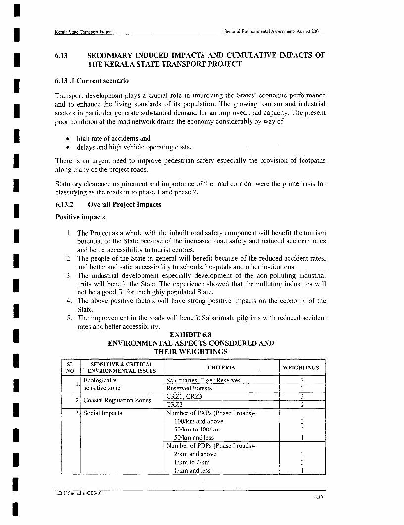
Kerala State Transport Project Sectoral Environmental Assessment- August 2001
6.13 SECONDARY INDUCED IMlPACTS AND CUMULATIVE IMPACTS OF* THE KERALA STATE TRANSPORT PROJECT
6.13 .1 Current scenario
Transport development plays a crucial role in improving the States' economic performanceand to enhance the living standards of its population. The growing tourism and industrialI sectors in particular generate substantial demand for an improved road capacity. The presentpoor condition of the road network drains the economy considerably by way of
| a high rate of accidents anda delays and high vehicle operating costs.
There is an urgent need to improve pedestrian safety especially the provision of footpathsalong many of the project roads.
Statutory clearance requirement and importance of the road corridor were the prime basis forclassifying as the roads in to phase 1 and phase 2.
6.13.2 Overall Project Impacts
Positive impacts
1. The Project as a whole with the inbuilt road safety component will benefit the tourismpotential of the State because of the increased road safety and reduced accident ratesand better accessibility to tourist centres.
2. The people of the State in general will benefit because of the reduced accident rates,and better and safer accessibility to schools, hospitals and other institutions
3. The industrial development especially development of the non-polluting industrialunits will benefit the State. The experience showed that the polluting industries willnot be a good fit for the highly populated State.
4. The above positive factors will have strong positive impacts on the economy of theState.
5. The improvement in the roads will benefit Sabarimala pilgrims with reduced accidentrates and better accessibility.
EXHIBIT 6.8ENVIRONMENTAL ASPECTS CONSIDERED AND
THEIR WEIGHTINGS
I SL. SENSITIVE & CRITICAL WEIGHTINGSNO. ENVIRONMENTAL ISSUES CRITERIA WEIGHTINGS
Ecologically Sanctuaries, Tiger Reserves 3sensitive zone Reserved Forests 2
2 Coastal Regulation Zones CRZ1, CRZ3 3____ ~~~~~~~~CRZ2 2
l 3 Social Impacts Number of PAPs (Phase I roads)-100/km and above 350/km to 100/km 250/km and less I
Number of PDPs (Phase I roads)-2/km and above 31/km to 2/km 2
__________________________ 1/km and less I
LOllI Sheladia /CESIICT
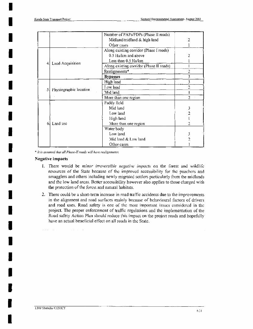
Kerala State Transport Project Sectoral Environmental Assessment- August 2001
Number of PAPs/PDPs (Phase II roads)Midland/midland & high land 2Other cases I
Along existing corridor (Phase I roads)0.5 Ha/km and above 2
4 Land Acquisition Less than 0.5 Ha/kml IAlong existing corridor (Phase ll roads) I
Realignments* 2Bypasses 3High land 3
5 Physiographic location Low land 2
More than one region 2I Paddy fieldMid land 3Low land 2U High land 1
6 Land use More than one region 2Water body
Low land 3Mid land & Low land 2Other cases I
* It is assumed ihat all Phase-Il roads will have realignments.
Negative impacts
1. There would be minor irreversiblie negative impacts on the forest and wildliferesources of the State because of the improved accessibility for the poachers andsmugglers and others including newly migrated settlers particularly from the midlandsand the low land areas. Better accessibility however also applies to those charged withthe protection of the forest and natural habitats.
2. There could be a short-term increase in road traffic accidents due to the improvementsin the alignment and road surfaces mainly because of behavioural factors of driversand road uses. Road safety is one of the most important issues considered in theproject. The proper enforcement of traffic regulations and the implementation of theRoad safety Action Plan should reduce this impact on the project roads and hopefullyhave an actLal beneficial effect on all roads in the State.
I
U L/Bllt Sheladia /CES/ICT6.31

KerMa1 ~S-tIc _at,rI,Seoa Envroermensl A-SmSIOCe August 2001
EXHIBIT 6.9SECTORAL ENVIRONMENTAL IMIPACT ASSESSMENT MATRIX
NU[MBERS RELATE TO FAcTO0RS OF WEIIIITING AS LDETAILEFD IN 6.8
Sensitive and Critical Environmsental lssuts
EcolOgicoiiy Stnsitive Zones (10 April 1991 Zn oilIpcsLn cnsio lyigahcLcto odUe.
Links Phase I Lengtlh Rcesesmendc NIOEF Nolitlcotios) Coastal Zn oilliat adAt.sto hsnrpi oainLn s
or 2 (kns) d Treatmsent - . .Alonig Losw land Mid land Lows land,
Reserved Tir AlS PPLo 1d Md"gSanct-are, Tit e l'APS PD' ling Realigmusents Dvases loan an Mid Mind & Higt Migh loand & Paddy WVnter
Forests Reooevc factor factor passes landCorridor ~~~~~~~~~laned land HIgIs land
1.0 i 46.3 lOin 0 2 0 0 0 0 2 2 2 2 0 0 0 1 0 0 I 3 1 16
2.0 1 21.2 ?mt 0 0 0 0 0 0 I I i 2 0 0 0 1 0 0 0 3 i 10
3.0 1 231 lm n 0 0 0 0 0 I I I 2 3 0 2 0 0 0 0 2 2 14
4 0 2 47.0 lGm 0 0 0 0 0- 0 I 1 1 2 3 0 2 0 0 0 0 2 2 14
5.0 2 430 7 n 0 2 0 I) 0 0 2 2 I 2 0 (1 0 i 0 0 0 3 i 14
6.0 I 34.1 (Gm 0 2 1) 0 0 0 2 2 I 0 3 0 0 1 0 0 3 I 1 5
26.0 1 31.3 1)321 223000I I I 20
40.0 2 33.0 ]Om 0 0 (I 0 0 0 2 2 i 2 3 (I0 I (1 0 0 3 I IS5
5(1.1 2 45~( 7 m 0 2 0 0 0 0 2 2 I 2 0 (10 0 2 00 2 I 1 4
6800 2 21.0 7 m 0 0 0 0 0 3 I ( 1 2 0 0 2 0 0 0 0 2 2 ( 4
69.1 2 24.0 (Gm 00 0 3 0 0 2 2 I 2 0 0 0 I 0 i( 0 3 I IS5
70.0 I 18.4 l m 0 2 0 0 (I 2 3 I 2 0 0 1)0 2 0 0 2 I (5
72.0 2 (4.0 7m n 2 0 0 0 0 I I 1 2 0 2 110 0 0 0 2 I 1 2
73.0 1 22.0 m00 0 0 0 0 I I I 0 0 2 0 0 0 0 0 2 3 1 0
74.0 1 55.0 7 rni 0 0 0 0 1) 2 0 I I I 2 0 (1 0 0 0 2 2 I (2
84.0T 2 1341[ 7m ( 2 (1 1 1 C 1 2 0 0 i0 0 3 (1I I 1 2

lKerala State Transport Project Sectoral Environmental Assessment - Aueust 2001
7 SOCIAL IMPACTS, ISSUES AND MITIGATION
7.1 SOCIAL IMPACT OBJECTIVE OF THE PROJECT
The Government of Kerala has approved R and R Principles and Policy frame work inAugust 2000. This document has been prepared in accordance with the Government ofKerala and World Bank Principles and policies on R and R. The project has prepared aResettlement Action Plan for phase I to effect land acquisition and also to address socialimpacts and issues. The social impact objective of the project is to ensure the improvementof the former living standards, income earning capacities and production levels of the projectaffected persons, or at least to help maintain their previous standards of living, as well as toreduce the high road accident rates in the State. The chapter is written based on the RAPprepared for phase I roads. The same trend and pattern is expected for phase 2 also.
7.2. THE SOCIAL IMPACT SURVEY FINDINGS
The RAP records that 13,487 individuals are project-affected persons (PAPs), of which 7,130are project-affected families (PAFs), 1,070 are project displaced persons (PDPs) and 799 areproject-displaced families (PDFs). The encroachers and squatters are an insignificantminority, holding respectively 26 and 39 small properties among the total affected propertiesof 3816. Tenants occupy 857 (22%) of the affected properties. The Exhibit 7.1 shows thelink-wise number of project-affected population.
EXHIBIT 7.1PHASE I - AFFECTED PROJECT ROADS POPULATION
LINKS LINK NAME POPULATION MALE FEMALE
I l Taikkod - Kottarakara 3408 2572 8362 Kottarakara - Adur 587 427 1603 Adur - Chengannur 455 347 108
_ __ _ _ _ _ _ _ _
6 Muvattupuzha - Angamali 3703 2606 109740 Thrissur - Kuttipuram 1408 971 43750.1 Palakkad - Shornur 857 587 27070 Muvattupuzha - Thodupuzha 1314 762 55272 SH-1 - NH-47 Link 1129 687 44273 Changanassery - Alappuzha 626 398 228
Total 13487 9357 4130
The residential structures surveyed accounted for 38% of the total number of structures. Inaddition, family details were not taken when only a boundary wall of a property wasproposed to be taken. There are 1093 affected walls or 41% of the total residential andcommercial structures of 2970.
7.3. EFFORTS FOR MINIMISING NEGATIVE SOCIAL IMPACTS
7.3.1. DESIGN CONSIDERATIONS
The project area on each Link was divided into three broad categories for the assessment ofland take, which has implications upon costs and budgeting:
0 Congested market areas with dense placement of structures, including legal titleholders of land plots and structures, and legal' or illegal squatters;
Squatting is by definition illegal, but "legal" squatters are those who are authorized by the civic authorities, such as themunicipality or the panchayath, to set up small businesses on small structures, usually measuring 4 square metres and
LBll\Sheladaia\CES \1CT 7-1
l

Kerala State Transport Project Sectorai Environmental Assessment - August 2001
* Built up residential areas along the road where there is a requirement for acquisitionof land from existing walls and parts of the compound and/or structures;
* Roadside agricultural/plantation land.
According to the three broad categories mentioned above, a joint decision among theengineering, environmental and social impact teams was taken to avoid land take fromreligious structures, such as, churches, mosques, temples, graves, sacred groves, etc.,congested market areas (which would save both displacement and livelihoods as well asexcessive costs), and avoid splitting agricultural fields as far as possible.
The proposed realignment sections pass through virgin agricultural or plantation lands, whichthe PWD needs to purchase from the owners. Depending on the topography of a given area,even for a road black top width of 7 metres, the average total required width for every 100metres length could vary from a minimum of 15 metres to a maximum of 30 metres. In suchcases, the efforts mentioned in guidelines do not apply.
The extent to which impacts have been minimised in project design is illustrated in theExhibit 7.2. As this Exhibit illustrates, adopting a 30m-road width parameter would havecreated a major R and R problem, considering the number of affected persons, buildings to becdemolished and the magnitude of land take involved. A corridor width varying between 1 2mand 15m has moderately affected the R and R aspects of the project. In this way, the projecthas made a maximum effort to minimisc negative social impacts. As a result of integratingsocial issues in project preparation, displacement and the need to resettle and/or rehabilitateaffected households and persons has been considerably reduced.
The widening has been strictly limited to the existing corridor width and where this has notbeen possible and compound walls and/or buildings have been affected, considerations weremade on the number of affected compound walls and/or buildings on either side of the road ina given area. The side having the less number of affected properties was chosen for thewidening side as a measure of minimising impacts. This information is evident in the stripmaps and the road design maps. Design of footpaths over drains also helped minimise thenegative social impact with regard to both land take and road safety.
7.4. RESULTS OF MINIMISING NEGATIVE IMPACTS
As a result of rmainstreaming participation of beneficiaries and potentially affected personsand a socially responsive design process, the project incorporates measures that significantlyavoid, reduce, or otherwise mitigate many adverse social impacts associated with highwaysimprovements. Exhibit 7.3 and 7.4 respectively show the number of project affected anddisplaced families and the results of minimising negative social impacts.
Exhibit 7.4 indicates that after integrating the social concerns there has been a considerablereduction in the negative social impacts. The impact on the total population has been reducedby approximately 50%. The number of project displaced persons has been reduced byapproximately 75%. The impact on the buildings has been considerably reduced byapproximately 66% and 74% for residential and commercial, respectively. Agricultural landis not included in this comparison because the agricultural land was required and included asa result of the final engineering design.
raised on a platfonn, on public lands for a license fee. Locally called butnk, these are usually wooden stntctures with tinroof.
LB3\Sheladaia\CES \ICT 7-2

3 Kerala State Transport Project Sectoral Environmental Assessment - August 2001
EXHIBIT 7.2EFFECTS OF MINIMISING NEGATIVE SOCIAL IMPACTS
THROUGH DESIGN MODIFICATIONS
LINK 30M 15M 12M IOMNO ROAD LINKS CORRIDOR CORRIDOR CORRIDOR CORRIDOR
WIDTH WIDTH WIDTH WIDTH
I Number of affected PAPs 6571 2329 1405 0-Number of buildings to be demolished 896 552 333 0Volume of land take (ha) 78.94 10.59 6.36 1.10
2 Number of affected PAPs 1354 646 187 0Number of buildings to be demolished 767 153 44 0I Volume of land take (ha) 32.38 4.00 1.78 0
3 Number of affected PAPs 1502 709 0 0Number of buildings to be demolished 1190 367 0 0
_____ Volume of land take (ha) 35.73 4.24 1.34 06 Number of affected PAPs 5865 863 351 0
Number of buildings to be demolished 1608 205 83 0l____ Volume of land take (ha) 52.49 3.63 1.35 0
40 Number of affected PAPs 2105 1350 219 0Number of buildings to be demolished 499 52 52 0Volume of land take (ha) 51.62 4.93 3.64 2.54
* 50 Number of affected PAPs 3551 925 0 0Number of buildings to be demolished 842 0 0 0Volume of land take (ha) 64.42 2.51 0.70 0I 70 Number of affected PAPs 1955 1402 0 0Number of buildings to be demolished 1364 513 0 0Volume of land take (ha) 30.70 2.56 0.75 0
_ 72 Number of affected PAPs 2300 1150 38 0| ~~~~~~~Number of buildings to be demolished 217 27 9 0
Volume of land take (ha) 24.99 4.62 4.28 2.3873 Number of affected PAPs 1291 705 0 0
-Number of buildings to be demolished 71 0 0 0Volume of land take (ha) 36.04 3.36 2.98 1.81
EXHIBIT 7.3PROJECT AFFECTED AND DISPLACED FAMILIES
LINK AGRICULT OTHER TOTALU LINK LINK NAME RESIDENTIAL COMMERCIAL URAL PAFNo. PAF PDF PAF PDF PAF PDF PAF PDF
I Taikkod - Kottarakara 436 34 1521 290 175 18 110 2242 3422 Kottarakara - Adur 170 22 140 57 39 2 19 368 813 Adur - Chengannur 155 8 112 19 5 0 22 294 276 Muvattupuzha - Angamali 556 6 813 53 13 0 33 1415 59
40 Thissur - Kuttipuram 389 6 351 29 16 0 29 785 3550.1 Palakkad - Shomur 188 1 259 25 7 0 24 478 2670 \Iuvattupuzha - Thodupuzha 261 34 211 68 163 2 15 650 10472 SH-I - NH-47 Link Road 375 30 265 74 134 10 34 808 11473 Changanassery - Alappuzha 31 0 48 11 4 0 6 89 11
Total 2561 141 3720 626 556 32 292 7129 799
Notes: 1. "Commercial" includes both commercial and residential-cum-commercial; 2. "Other"includes families that did not fall within the three main classifications.
7.4.1. IMPACT TO COMPOUND WALLS
| Data obtained through the field surveys indicate that of the 3003 residential and commercialaffected properties, 1068 or 36% comprise properties where only the compound wall or the
LB11\Shetadaia\CES IJCT 7-3

3 Kerala State Transport Project Sectoral Environmental Assessment - August 2001
compound wall and part of the compound have been affected. The number of affectedI compound walls along the project road links is shown in Exhibit 7.5.
EXHIBIT 7.4MINIMISING NEGATIVE SOCIAL IMPACT
NROAD NO OF PAP NO OF PDP NO. OF AFFECTED BUILDINGSILINKS . . RESIDENTIAL COMMERCIAL **
BEFORE* AFrER# BEFORE* AFTER# BEFORE* AFTER# BEFORE* AFTER#
Link I 6571 3408 1146 383 601 254 1452 504Link 2 1354 587 156 76 432 124 277 73Link 3 1502 455 185 25 667 138 654 68Link 6 5865 3703 1116 67 817 287 1001 322Link 40 2105 1408 299 36 436 221 499 132Link 50.1 3551 857 573 87 253 103 842 123Link 70 1955 1314 270 181 392 118 467 98Link72 2300 1129 436 201 437 247 322 151Link 73 1291 626 144 14 452 16 317 24
Total 26494 13487 4325 1070 1 4487 1508 5831 1495* Before integrating social aspects # After integrating social aspects
** Residential-cum-conmnercial structures are included in the commercial structure category
EXHIBIT 7.5AFFECTED COMPOUND WALLSI TOTAL NUMBER OF NO. OF AFFECTED
LINK NO AFFECTED RES. AND PROPERTIES WITH PERCENTAGECOMM. PROPERTIES COMPOUND WALLS
Link 1 758 121 16Link 2 197 78 40Link 3 206 117 57Link 6 609 224 1 37Link 40 353 133 38
Link 50.1 226 101 45
Link 70 216 76 35Link 72 398 191 48Link 73 40 27 67
Total 3003 1068 36%
3 7.4.2. MINIMISING RESETTLEMENT
All the roadside land beyond the right of way or the available corridor width is under private
ownership. Exceptions occur when some land is under the Revenue Department, known asI the Puramboku land. This necessitates affecting the large number of landowners for the
improvement of the roads. Fortunately, the number of project displaced families is much
smaller compared to those which are affected, approximately 12%. Therefore, the less
intensity of the resettlement activity in the project.
Another area of relief is that encroaching and/or squatting on public land is not common on
the project roads, although almost all the links have been identified as having a small number
of encroached and squatting properties. Otherwise, the non-titleholders are usually tenants,
both residential and commercial. The RAP adequately addresses the issues of rehabilitatingthe non-title holders according to the Project's R and R Principles and Policy.
LB11\Sheladaia\CES ICT 7-4
l
3 Kerala State Transport Project Sectoral Environmental Assessment - August 2001
7.5.LAND ACQUISITION AND ASSETS AFFECTED
7.5.1. EXTENT OF LAND TO BE ACQUIRED
The extent of land to be acquired by the project is an indicator of impact on the socialI environment. In the urbanized environment of Kerala, on the other hand, the affectedproperties are mostly pucca buildings (permanent structures) although, in terms of themagnitude of land take, the agricultural land dominates. Unlike the affected peopleI elsewhere who are mostly agriculturalists or otherwise poor people, in Kerala the affectedpeople are middle class and educated.
| In Kerala a total of 3816 properties are affected by various degrees by the Phase I roads of theproject, which include 1508 residential properties, 1493 commercial and mixed properties,420 agricultural plots, 63 Government properties and 332 not belonging to any of thesecategories as provided in Exhibit 7.6.
The project needs a total of 99.05 ha (including the existing roads area) of land for theimprovement works for approximately 257 km of Phase I roads. Of this, 35.15 ha (35%) arerequired for approximately 20 km of realignment sections, and 63.90 ha (65%) are requiredfor the regular road improvement works.
The social impact surveys have established that the total additional area of land required is42.29 ha, of which private land is 41.15 ha Therefore, it is assumed that the remainder of thetotal required land (57.9 ha) constitute Government land (PWD land and RevenueDepartment land). The only government properties that were identified during the surveyswere buildings that were fully or partially affected on land totalling an area of 1.14 ha.
7.5.2. ASSETS AFFECTED
The Exhibit 7.6 shows the number and percentages of affected properties by their use.
I Of the total 3816 affected properties, both the residential structures and commercial unitscomprise 39% each. Some of these structures, even if affected by 25% of their total area,would be severely damaged and the persons running them would be dispossessed, at leasttemporarily, of their livelihoods. Similarly, residential structures without a compound area,even if affected by 25% of their total area, would be severely damaged and the PAPs would
| be displaced.
Based on field data, Exhibit 7.6 summarises the number of displaced properties, families anddisplaced area. The Resettlement Action Plan, provides details of the affected persons and
* properties. The details of properties include information on total property area, affectedcompound area or agricultural plot area, percentage of affected compound/plot area, totalstructure area within the total compound area, affected structure area and percentage of theaffected structure area.
Based on the tables in the Resettlement Action Plan, it is estimated that on average, 12.86%I of the total compound areas of private properties have been affected. In the case ofcommercial structures, 19.47% of the total compound areas have been affected and foragricultural plots, approximately 25% of the total areas have been affected. Individually, theI properties have been affected ranging from less than 1% of their total areas to 100%. It issuggested that at the time of the project implementation, many of the properties losing verysmall percentages of their area could be saved by excluding them from the, project with aslight but acceptable compromise of design standards, e.g., footpath width.
LBIt\Shcladaia\CES \ICT 7-5

U CKerala State Transport Project Sectoral Environmental Assessment - August 2001
EXHIBIT 7.6|___ NUMBER OF ASSETS AFFECTED
LINK TOTAL mix 0OT TH AGRINO. PRO RES. % COMM % MIX OFFICE/ % ER 9 PLOT %
PERTY ED AND
1 \ 994 254 25.55% 487 48_99% 16 1.61% _ 5 1.51% 75 7.55% 147 14.79%
2 263 124 47.15% 69 26.24% 3 1.140/o 4 1.52% 28 10.65% 35 13.31%
3 257 138 53.70%, 66 25.68% 2 0.78%, 5 1.95% 41 15.95% 5 1.95%6 677 287 44.94% 292 40.52% 30 4.60% 5 0.92% 50 7.37% 13 1.66%
40 403 221 54.84% 123 30.52% 9 2.23% 12 2.98% 25 6.20% 13 3.23%
l 50.1 272 103 37.87% 105 38.60% 18 6.62% 3 1.10% 36 13.24% 7 2.57%70 324 118 36.42% 87 26.85% 11 3.40% 14 4.32% 22 6.79% 72 22.22%72 564 247 43.79% 117 20.74% 34 6.03% 3 0.53% 39 6.91% 124 21.99%73 62 16 25.81% 20 32.26% 4 6.45% 2 3.23% 16 25.81% 4 6.45%
Total 3816 1508 39% 1366 36% 127 3% 63 2% 332 9% 420 11%
1 7.5.3. THE EXTENT OF LAND TAKE
Private land will be acquired and/or Government land will be transferred for specific| purposes, such as widening the road, bus stops and lay bys, improvement of junctions, tree
planting, bypass, etc. The major extent of land will be acquired for road widening andrealignments. Roadside amenities like footpaths, bus stops and auto-rickshaw stands,3 suggested by the people during the social impact surveys have been incorporated in theengineering design and the required area for these amenities has been built into the total arearequired for the road widening. Based on the social impact surveys, the Exhibit 7.7 shows3 the extent of land take from all categories of properties.
Government land includes roadside revenue land and Government buildings. No forestlandhas been identified as affected by the project. The category "other" includes properties thatdo not fall within the strictly defined categories, such as a religious property, hospital, school,vacant land, etc. Link 1 shows huge land take for its 21 realignment sections, totalling
* approximately 6 km.
7.5.4. LOSS OF "OTHER" PRIVATE AFFECTED PROPERTIES
3 Along with the frontage of their properties, many PAPs will also be losing other properties ontheir frontages due to the project. These include trees, wells, water tanks, private ponds, etc.The Exhibit No. 7.8 lists these properties link-wise.
The wells affected by the project, as listed in Exhibit 7.8, have been accounted forcompensation, as also trees and other assets, such as water tanks. The ponds have beenconsidered as regular land areas for compensation.
7.5.5. LOSS OF COMMON PROPERTY RESOURCES
Ribbon development along the roads is a part of the habitation pattern in Kerala; hence, theloss of most common, common property resources (CPR) are the roadside wells, hand pumps,water taps, large trees, and bus stops/shelters owned by the municipalities and theI panchayaths and public institutions like schools and hospitals, which may be replaced by theproject authorities or civic authorities. The EMP discusses these CPRs and their replacementcosts have been included in the general project BOQ. Link-wise losses of these items areshown in Exhibit 7.9.
LB]i\Sheladaia\CES \ICT 7-6
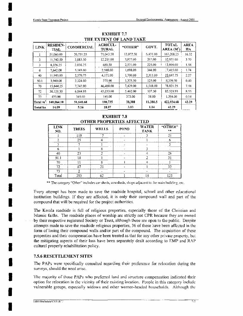
3 Kerala State Transpor Project Sectoral Environmental Assessment - August 2001
EXHIBIT 7.7THE EXTENT OF LAND TAKE
LINK RESIDEN- COMMERCIAL AGRICUL- "OTHER" GOVT. TOTAL AREATIAIL TURAL_AREA () HA
1 51,060.00 20,751.25 71,043.50 13,922.50 6,431.00 163,208.25 16.32
2 11,742.50 3,883.50 12,251.00 3,877.00 267.00 32,021.00 3.20
3 8,336.25 2,036.25 680.50 2,531.00 225.00 13,809.00 1.38_ I _ ,_ _ ,_ _ _,
7,642.00 5,143.00 2,588.00 1,698.00 344.00 17,415.00 1.74
40 11,945.00 2,570.75 4,171.00 1,700.00 2,311.00 22,697.75 2.273 1 50.1 3,940.00 2,324.00 275.00 1,375.50 125.00 8,039.50 0.80
70 15,644.25 7,742.00 46,488.00 7,429.00 1,518.00 78,821.25 7.88
72 30,121.50 6,844.93 43,053.00 5,402.00 107.50 85,528.93 8.553 1 73 433.00 345.00 185.00 373.00 58.00 1,394.00 0.14
Total m2 140,864.10 51,640.68 180,735 38,308 11,386.5 422,934.68 42.29
Total ha 14.09 5.16 18.07 3.83 1.14 42.29
EXHIBIT 7.8OTHER PROPERTIES AFFECTED
LINK WATER "OTHER"_LNO. TREES WELLS POND TANK
1 119 17 3 21
2 25 4 l 1 6
3 7 1 -- 36 1 8 - 3
40 23 2 4 28
50.1 i 18 1 - 2 31
70 l 11 8 1 4 1
72 87 21 - 1 33
Total 293 62 1 18 123
** The category "Other" includes car sheds, cowsheds, shops adjacent to the main building, etc.
* Every attempt has been made to save the roadside hospital, school and other educationalinstitution buildings. If they are affected, it is only their compound wall and part of thecompound that will be required for the project authorities.
The Kerala roadside is full of religious properties, especially those of the Christian andIslamic faiths. The roadside places of worship are strictly not CPR because they are ownedby their respective registered Society or Trust, although these are open to the public. Despiteattempts made to save the roadside religious properties, 36 of these have been affected in theform of losing their compound walls and/or part of the compound. The acquisition of theseproperties and their compensation have been treated as that for any other private property, butthe mitigating aspects of their loss have been separately dealt according to EMP and RAPcultural properly rehabilitation policy.
7.5.6 RESETTLEMENT SITES
3 The PAPs were specifically consulted regarding their preference for relocation during thesurveys, should the need arise.
3 The majority of those PAPs who preferred land and structure compensation indicated theiroption for relocation in the vicinity of their existing location. People in this categoly includevulnerable groups, especially widows and other women-headed households. Although the
LB]I\Sheladaia\CES uCT 7-7

l3 Kerala State Transport Project Sectoral Environmental Assessment - August 2001
project's R and R Policy document has proposed plots for houses/shops at the new| resettlement sites, this is a rather difficult proposition in the context of Kerala. Nevertheless,
the strip mapping exercise identified apparently vacant plots of land at several places andattempts would be made to acquire these plots to relocate at least some of the displacedhouseholds.
EXHIBIT 7.9:_____ LOSS OF COMMON PROPERTY RESOURCES
LINK NO HOSPITALS SCHOOLS WELLS WATER HAND BUS_________ ~~TAPS PUMPS STOPS
1 4 11 3 14 5 9
2 4 5 2 2 1 133 3 10 0 1 0 86 5 6 1 0 4 940 7 11 5 24 3 21
50.1 12 20 1 42 1 1770 1 5 2 17 0 _ 472 1 5 21 5 3 X 973 6 1 0 38 0 27
Total 47 76 38 143 22 £ 142
U 7.5.7. DISPLACED PROPERTIES
The Resettlement Action Plan, lists in detail the profile of the project displaced families andI the area lost, grouped according to residential structures, commercial structures, andagricultural land. The total displaced area of 5.43 ha is summarised in the Exhibit 7.10,which is also the area required to resettle the people.
The R and R Principles and Policy Framework of the project proposes moving people as agroup and establishing a resettlement site or a shopping complex, if 25 or more displaced3 families or shop owners in a cluster so wish.
A local saying is reiterated that every habitable place has been inhabited and every cultivable
land has been cultivated in Kerala. The social impact survey identified vacant plots of land in* some of the road links, totalling an approximate area of 6.24 ha. Approximate, because the
width of a plot was often based on estimates. The link-wise detailed information with
chainage and left/right location from the road centreline is presented in Resettlement Action
Plan. The summary of such land availability is shown in the Exhibit 7.11.
On this identified land, ideally, all the displaced families should be able to be resettled,
including the rehabilitation of agricultural land. IHowever, the relative small size of the
available apparently vacant land may not be acceptable to the displaced families. Moreover,the owners of the vacant plots have to be willing to sell off their land for resettling theI affected people. The project will make an effort to this end.
7.5.8. ELIGIBLE FAMILIES FOR RESETTLEMENT
I Based on the detailed information contained in the tables of the Resettlement Action Plan,
and applying exclusion criteria for squatters, encroachers, tenants and all other non-title
holders as outlined in the R and R Policy document of the KSTP, the phase I project has* prepared tables for families eligible for resettlement. These are contained in the Resettlement
Action Plan, Eligible Families for Commercial Plots. The list of eligible agricultural families
and the lost area are derived from the Agricultural Project Displaced Families, appended inthe Resettlement Action Plan, who are all landowners. All this information is summarised in
the Exhibit 7.12.
lLBII'\She]adaia\CE5 UICT 7-8
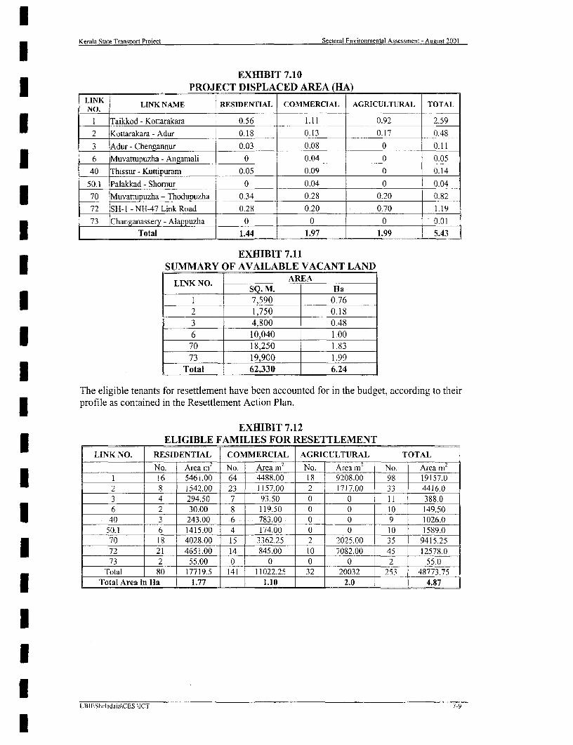
Kerala State Transport Project Sectoral Environmental Assessment - Aueust 2001
EXHIBIT 7.103 ___ PROJECT DISPLACED AREA (HA)LINK LINK NAME RESIDENTIAL COMMERCIAL AGRICULTURAL TOTALNO. __ _ _ _ _ _ _ _ _3 1 Taikkod - Kottarakara ! 0.56 1.11 0.92 2.59
2 Kottarakara-Adur 0.18 0.13 0.17 0.48
3 Adur - Chengannur 0.03 0.08 0 0.113 | 6 Muvattupuzha - Angamali 0 0.04 0 0.0540 Thissur- Kuttipuram 0.05 0.09 0 0.14
50.1 Palakkad - Shornur 0 0.04 0 0.04
70 Muvattupuzha - Thodupuzha 0.34 0.28 0.20 0.82
72 SH-I - NH-47 Link Road 0.28 0.20 0.70 1.19
73 Changanassery - Alappuzha 0 0 0 0.01
Total 1.44 1.97 1.99 5.43
EXHIBIT 7.113 SUMMARY OF AVAILABLE VACANT LAND
LlNK NO. AREASQ. M. Ha
1 7,590 0.762 1,750 0.183 4,800 0.483 6 10,040 1.0070 18,250 1.83
73 19,900 1.993 Total 62,330 6.24
The eligible tenants for resettlement have been accounted for in the budget, according to theirprofile as contained in the Resettlement Action Plan.
EXHIBIT 7.12- ELIGIBLE FAMILIES FOR RESETTLEMENT
LINK NO. RESIDENTIAL COMMERCIAL AGRICULTURAL TOTAL
No. Area m2 No. Area m2
No. |Area m No. Area m2
1 16 5461.00 64 4488.00 18 9208.00 98 19157.0
2 8 1542.00 23 1157.00 2 1717.00 33 4416.0
3 4 294.50 7 93.50 0 0 11 388.0
6 2 30.00 8 119.50 0 0 10 149.50
40 3 243.00 6 783.00 0 0 9 1026.0
50.1 6 1415.00 4 174.00 0 0 10 1589.0
70 18 4028.00 15 3362.25 2 2025.00 35 9415.25
72 21 4651.00 14 845.00 10 7082.00 45 12578.0
73 2 55.00 0 0 0 0 2 55.0
Total 80 17719.5 141 11022.25 32 20032 253 48773.753 Total Area in Ha 1.77 1.10 2.0 4.87
LBI]\Sheladaja\CES \ICT 7-9

3 Kerala State Transport Project Sectoral Environmental Assessment-August 2001
8. ANALYSIS OF ALTERNATIVES
Environmental considerations were an integral part of the analysis of Alternatives throughoutthe project. Many project roads, which are, located close to the Ecologically sensitive regionsI were avoided from further considerations. These include the project roads Kumili to Poopara,Kuttiyadi to Kellur, Vypin to Pallipuram etc. The originally proposed Link 60 Narukara toSate border for example because of the I I km forest section passing through the Nilgiribiosphere reserve has been dropped due to environmental social and economicconsiderations. This section passes through I I km of reserved forest area (also part of thefirst biosphere reserve of India) in the Nilambur region of North Kerala.
8.1 INTEGRATION OF ENVIRONMENTAL CONSIDERATIONS IN THEANALYSIS OF ALTER1NATIVES
The potential environmental impacts of KSTP project roads are comparable with one anotherin the respective Physiography division's viz., Lowland, Midland and Highland. For exampleall project roads located in the midland have similar kinds of impacts.
In the lowland, the social impacts and the coastal regions included in the CRZ regulations arethe sensitive environmental areas. In the midland social impacts are the main concerns whilein the highlands ecological considerations are also very important.
The analysis of alternatives has been prepared in accordance with the requirements of theWorld Bank and GOI guidelines.
8.2 "WITH" AND "WITHOUT" SCENARIOS (NO ACTION ALTERNATIVE)
In the case of the project roads comprising KSTP, consideration of 'No Action ' must becognisant of the fact that
1. The capacity of the Project roads, as well as that of other roads is insufficient to caterfor the volume of traffic.3 2. Traffic flow is impaired by severe conflicts between local, and through traffic, mixedwith pedestrian movements and by continuous ribbon development and inadequateand/or inappropriate roadside facilities along the narrow corridors.
3. These unsafe conditions and the environmental consequences (air and noise pollutionand degraded environmental conditions) will continue and worsen.
4. Population and traffic growth will continue and exacerbate an already criticalsituation.
The "No Action" Alternative would amount to a failure to initiate highway improvements,thereby impeding economic development. The no action would result in no improvementsbeyond limited routine maintenance and rehabilitation of roads without any taking of land orbuildings, removal of trees or other disturbance to the environment. There would be noimprovements to drainage systems beyond their restoration to existing levels of service, noremoval of impediments to pedestrians or construction of facilities for pedestrians and othcrslow moving traffic.
This would leave the state highway system in its current appalling condition and in the longterm be a serious impediment to the development of the State economy and thus to theI improvement of conditions for the poorest section of the population.
-LBII/ Sheladia/CES/ICT
Kerala State Transort Project Sectoral Environmental Assessment-August 2001
3 The "with" scenario, on the other hand, has been determined to be
1. Economically viable and would alleviate these conditions to a large degree. It would,thereby, contribute to the development goals of the Kerala State, improve road safetyconditions, enhance economic efficiency and growth potential of the area, andimprove the well being and livelihood of those within the potentially affected area.
2. Potential negative environmental impacts associated with the "with" scenario can bereduced through good engineering practice and, where warranted, appropriatemitigation and enhancement actions as specified herein.
| Accordingly, it has been determnined that the "No Action" Alternative is not a reasonable orprudent course of action.
This alternative "do nothing" is not acceptable and has already been rejected by the StateU Govemment as demonstrated by the implementation of the SOS and the current work. TheChapter 2.0 Project descriptions and the road safety aspects outlined in the baseline sectionemphasis that the 'No Action Alternative' is not a sensible possibility under presentcircumstances.
8.3. DESIGN DECISION CONSTRAINTS FOR VARIOUS ALTERNATIVES
Because of the unique nature of Kerala, the team of Engineers, Economists, Sociologists andEnvironmentalists of PCC and PWD initially had conflicting ideas on the most appropriateI design decisions most suited to the Kerala situation. The solution needed to be practical witha minimum of social and environmental disturbance and with a better economic return interms of actual construction works including the cost of land acquisition. Discussions,I debates and workshops were also held to crystallise the issues so as to arrive at the bestdesign decision. These meetings were held at Government, Department and Consultants leveland also with Public Participation at various stages involving experts from related fieldsI individually and sometimes collectively. These deliberations were also held in the field on theproject roads for easier understanding among the specialists involved.
The following decision constraints were considered in particular.* The legal right of way (ROW) could not be established.* Severe limitations were found with respect to the available corridor width and the
existing geometry in particular* Highly built up areas with ribbon development on both sides of the roads* Higher number of Project Affected Persons (PAPs) per unit length of road comparedI with other States.* For smaller widening very few Project Displaced Persons and the severity of
environmental and social impact increases with increased width.I * For developing to full standard highway a very large number of projects displacedpeople compared to PAPs. (Number of PAPs increases with increased scope ofwidening up to the full IRC standard)
* * A rigid adherence to a particular design standard would necessitate substantialrealignments, in a large number of locations, which are linked to substantial landacquisition, environmental impacts and social hardships to the population.I * Decision to widen on any one side was difficult except in the case of curveimprovements. One side widening was generally selected on the grounds of least cost
| and inconvenience to the frontagers.
LBIII*Sheladia/CESllCT 8.2LBII/'Sheladia/CES/ICT
Kerala State Transport Project Sectoral Environmental Assessment-August 2001
I The present rate of accidents, road indiscipline, vehicular speed against present roadcondition and road safety, particularly pedestrian safety was matters of seriousconcern and influenced every decision that was taken.
* Compared to the interior areas the land close to the road is very expensive and aresistance of PAPS to land acquisition was anticipated
Site observations quickly revealed the need for much greater attention to road safety and theprovision of footpaths along many of the roadsides, which were subject to ribbondevelopment, village shopping and school servicing.
The widening of the pavement with the provision of footpaths in built up areas as necessaryI would result in a seven-metre width pavement and 2.5 metre wide footpaths/shoulders. Thisstandard could only be accommodated within a 12 metre physical Right -of- Way, with somenarrowing if necessary, to avoid the costly acquisition of roadside property.
The costs of land and accommodation works are very high and the designs need to avoid even* small areas of land acquisition wherever possible.
8.4 ENGINEERING ALTERNATIVES CONSIDERED
The term "altematives considered" in this context refers to reasonable and potentially viablealternatives considered in the development of the Project road section and warrantingdocumented consideration, including those that warrant only a brief description of the reasons
| for their elimination and those which require more detailed investigations and analysis.
The design and decision-making process was undertaken so envirojnmental; resettlement andrehabilitation issues prompted the early identification of appropriate actions. Such actionsI included, for example, shifts in alignments/bypasses based on an awareness of the locationsof cultural resources, and biological resources such as areas of roadside trees and the earlyidentification of severa1 short realignments to reduce local impacts. Such adjustments were
J weighed against benefits derived from reductions in congestion in built up areas, andimprovement of road safety, and were incorporated in the design process to ensure themaximum practical avoidance of sensitive areas (e.g. shrines, hospitals, sanctuaries) andadverse impacts to the project affected persons, etc. The alternatives found to warrantdocumented consideration in the process are as follows.
U 8.4.1 Alignment and Widening Alternatives
The term alternative alignment refers to a relocation of the ROW. A bypass /realignment hasI been planned as a part of the KSTP. Relatively minor shifts of the ROW to one side or theother (or both) in the same area and incorporating the existing ROW are, however, asignificant detail in the context of the Project and such shifts have avoided adverse impacts inI many instances.
Three types of widening alternatives have been devised. Two of the three alternatives havebeen employed in various sections along the ROW. The third alternative has been dropped inorder to reduce the effective land take for road improvement. The two sets of alternative crosssections provide a "menu" from which the cross-section most appropriate to a particularcircumstance can be and has been employcd. (e.g, for rural areas, for urban areas etc)
The widening and strengthening of the pavement will take place along its existing alignmentwith only minor changes in the position of the centre line horizontally and vertically. TheI newly improved road may not adhere totally to any design standard as such, but will improveupon the service provided by the existing routes. In urban areas improvements of the roadway
*BIIX ShSladia/CES/l(>T 8.3LB11/ Sheladia/CES/ICT

lKerala State Transport Project Sectoral Environmental Assessment-August 2001
slightly to either side of the centreline of the ROW, is dictated by circumstance andminimises environmental and social impacts.
Other Engineering Alternatives considered avoiding major social impacts there are shifting ofcentre line to right side, left side and concentric widening (i.e. towards both sides) because ofthe urban character of the "rural areas". Opting to widen to either the right or left of theroadway facilitates the preservation of various environmental and social resources on the sideavoided. The qualitative aspects of various resources to be avoided in each section wereconsidered as a part of the analysis. Alternatives were analysed for all possible sections of theroad based on the information and analysis supplied by the initial screening and feasibilityanalysis followed by field checks with the least adverse environmental consequences.
Road cross-section Alternatives: The Project employed a menu of four cross sections (referChapter 3) specifically tailored to the conditions along the individual segments of thehighway. Resolution of environmental and social considerations within the design andselection of the various cross sections was an essential element of "mainstreaming" theenvironmental concerns within the design process.
Alternative I* Improve to a 7.0 m wide pavement with 1.5m sealed shoulders
In particular the adverse impact on the realigned community resulting from Alternative 1 canlbe addressed by appropriate mitigation to assist environmental mitigation measures.
Alternative 2* Alternative 2 is to improve to a 7.0 m main carriageway with two 1.5m wide auxiliary
lanes and sealed shoulders and
The potential impacts on the physical and social impacts of the environment are judged to behigher in Alternative 2
This combined with the fact that Alternative 2 usually yielded a higher EIRR and NPV and isthus rated more economically viable, as well as the preferred altemative from a capacity andsafety perspective, has often led to the selection of Alternative 2.
The provision of kerbs and footpaths must be sympathetic also to creating bus lay bys andparking areas wherever land areas permit, especially in village locations but cognisant of thedetrimental effect of parking on visibility especially near pedestrian crossings and road
junctions.The absence of a design standard will not generally inhibit speeds below 50 Km/fHr as isdemonstrated by the present road alignment. It must be remembered that with smoothmachine placed pavements and even slightly improved alignments drivers will tend to drivefaster; this makes need of driver education and the imposition of speed limits even moreimportant.
Alternative 3
* Alternative three is to improve to a dual two-lane carriageway.
The early economic and traffic projections revealed the exhaustion of some two lane roadcapacities within 10 to 15 years for some of the project routes pointing to the need to considerdual two lane carriageways.
The separation of pedestrians from vehicles can be achieved by the provision of footpathswherever needed. There is an almost similar dilemma in trying to separate the large numberof two wheeled and slower moving vehicles from the faster larger vehicles on the roads astraffic volumes increase.
LBII/ SheladiaiCES/ICT

lKerala State Transport Project Sectoral Environmental Assessment-August 2001
Drivers will need education in the use of these roads but the effective removal of slowmoving vehicles increases the efficiency of the main traffic lanes. In effect, it reduces thenumber of vehicles using them in such a way that within the project life, no roads wouldrequire dual two lane carriageways.
The very positive advantages of this option must still be offset against the need to widen mostof the existing road corridors which generally offer only 10 or 12 metres and many sectionsas little as nine metre widths. The need for small land acquisition at a few "pinch point"locations for option two can be substantiated on grounds of road safety in specific areas butwith Option Three there would be a need for considerable areas of land acquisition withnegative social and environmental impacts. It also adds considerable to the costs to theHighway Authority for the land, accommodation works and any resettlement, all "negativecosts" in terms of building and maintaining roads.
Where land purchase is required on the scale anticipated it must be substantiated by roadlines designed to accepted engineering standards and the adherence to these standards willincur the need for even greater land requirements dictated by the use of minimum radii ofcurvature and minimum vertical and horizontal sight distances. The use of alternative threewas subsequently discounted.
8.4.2 Bypass Alternatives Considered In The Project
The selection of bypasses was mainly due to the congestion and consequent demand from thelocal population and institutions (e.g local Municipality) to ease the difficult traffic in theurban areas.
There are six bypasses (Exhibit 8.1) for urban! semi urban areas in order to avoid potentialsocial impacts, reduce accidents and also to accommodate the ever-increasing traffic. Thepollution level may be eased due to the free flow of the divided traffic and less congestion inthe town areas.
Details of consultations carried out for bypasses are provided in Chapter 9.0.
The PWD understood the extensive location work required to prepare a string of four bypasses along the SHI link number 4. It requires the obtaining of good up to do date mappingand extensive research. There is no satisfactory quick solution. The PWD did not favour the"local" bypass sections identified by their local Engineers as postulated in the feasibilitystudy. Design of the four by pass routes of the SH I has been deferred in favour of seeking alonger-term permanent solution.
Phase 1 Bypass alternatives
Perumbavoor Bypass For Perumbavoor bypass the original alignment proposed waschanged due to public pressure. The local people suggested two alternative alignments. Allalignments proposed have serious social and environmental impacts (Public Consultations).A further field evaluation of the final designed bypass alignment in July 2001, led to thedropping of this bypass from further consideration. During this visit, the existing alignmentwas closely examined and found suitable with much less social and environmentalconsequences. The road width is sufficient for improvement considering the road safetyaction plan and the Road safety audit of the project.
Nilambur bypass The road itself was dropped from further consideration due to theanticipated high level of social impacts.
8.5LBI1/ Sheladia/CES/ICT

Kerala State Transport Project Sectoral Environmental Assessment-August 2001
Kattappana bypass (of link 26 - phase 2 buffer) The Kattappana bypass proposed by PWI)is much longer than the existing route as also has serious social and environmental problems.The local people further suggested an alternative shorter alignment. This is being surveyed.3 The improvement of the road through town in this location is rather difficult if not impossible.
EXHIBIT 8.1BYPASS ALTERNATIVES CONSIDERED
I SL. LINK PHASE 1 URBAN/SEMI STATUS OF THE (KM)NO No OR URBAN AREA BYPASS AS ON To(1 yp)| NO NO PHASE 2 OR TOWN JULY 2001 Town BypassI ~~~~~~~~~~~~~~~~~~~route route
4 2 Kottayam Under consideration 7 82 4 2 Changanaserry Under consideration 4.5 4.23 4 2 Thiruvalla Under consideration 2.03 2.1
4 6 1 Perumbavoor Dropped from further 4.5consideration
7 3/4 2 Chengannur Under consideration 2.4 3.0
8 60 1 Nilambur The project road itself 4.05 5.96________ dropped
2 A shorter alignment9 26 (buffer) Kattapana altemative is being - 4.42
_ _ _ _ _ - ____ __ _ _ _ _ _ _ _ _ - _ ____ ____ ___ stud ied _ _ _ _ _ _ _ _
Phase 2 bypass alternatives
Thiruvalla bypass Except in a section of 200m, the local people are willing to provide theirI land free of cost for bypass construction. But the avoidance of 200m social impacts is a mostdifficult situation as the buildings are pucca new superior buildings. The local resistance willbe very high. A church will also be affected. The situation is being evaluated by detailedground surveys.
8.4.3 Realignment Alternative Considered
The winding roads in Kerala require considerable straightening to improve the road safety andalso design speed. The realignments avoid considerable social impacts but some of theserealignments pass through paddy fields (Refer Exhibit 6.8 Government waming on use of paddyfields: The Hindu, September 18, 2000), which are sensitive in Kerala owing to the fastdecreasing nature of the land use. Cost wise Paddy fields are the least expensive to acquire and
| hence preferable by the State PWD.
The project will take paddy field areas only if found absolutely necessary. The land acquisition ofpaddy fields for road widening is generally acceptable to the public as these are for the public useI and also there would not be any serious social impacts.
Some of the roads with many bends have one realignment per kilometre (Link 70 Muvattupuzha-Thodupuzha has a maximum of 19 realignments in 18.4 Kilometre length). There are also projectroads in which no realignments are considered.
Eg. Link 6, Muvattupuzha- Angamaly and Link 73 Alappuzha- Changanaserry.
| Although realignments are an important requirement of improvement of the meandering roads ofKerala the project from Muvattupuzha- Angamaly road does not requtire any realignment. Theproposed bypass proposal for the Perumbavoor town area is also dropped from furtherI consideration. In the case of Alappuzha -Changanaserry, the project road is located in theKuttanad (Coastal plains). This road is straight and no realignments and bypasses are actuallyrequired.
LBtti Sheladia/CES ICT

lKerala State Transpon Project Sectoral Environmental Assessment-August 2001
8.4.4 Junction Alternatives
The standard IRC layout for junctions of major routes provides for long visibility splays andlarge turning radii. Where land areas and present road geometry allows, this solution hasbeen sought in the junction designs.
Many of the major junctions in Kerala occur in town centres or at least in heavily built upareas. If the full IRC treatment were to be used in these locations the new junction layoutwould result in the demolition of major areas of the centre.
The alternative to the IRC design was the use of
* Sequence-controlled traffic signals or
* The use of mini roundabouts.
The latter solution has been used extensively in the UK and has been subject to considerableattention by the Transport Research Laboratory of the UK for use in developing Countries.The Manual for Safety in Road Design of September 1998 by Ross Silcock and the TRLadapted from the similar document for Developing Countries and prepared for and distributedby MOST recognizes the use of mini roundabouts and these have been considered for somelocations.
Roundabout designs should channel traffic and create the geometry to reduce vehicle speedsat the approaches. Designs rely on driver discipline and experimental layouts are used toenable modifications before placing the permanent kerbs, islands and footpaths. The rule ofgive way to traffic from the right must be observed at all roundabouts and give way signs andpriority lining are an essential part of the layout.
8.4.5 Pavement Alternatives
The project has considered using rubberized bitumen initially in one or two sections on anexperimental basis. If the results are promising the project has plan to use it widely in the restof the project implementation. The natural rubber is available plenty in Kerala. Thetechnology is available with the Cochin refineries and the Rubber Research Institute of Indiaat Kottayam. Although rubberized bitumen is slightly expensive it give more life to thepavement.
8.4.6 Co-relation with Engineering Studies
Co-relation of engineering studies and the analysis underlying the Environmental Assessmentwas continuous throughout the design process. There were many filed visits jointly carriedout by the engineers, environmentalist and the project sociologist to take design decisionswhich were finally accepted as the phase 1 design. The social issues were always dominant inthe decisions because of the high level of the ribbon developments.
lI
8.7LBIII Sheladia'CES/ICT

Kerala State Transport Project Sectoral Environmental Assessment- August 2001
9 PUBLIC PARTICIPATION AND CONSULTATIONS
9.1 PROCEDURES FOLLOWED
This section of the SEA is provided to document the consultations undertaken to facilitateassessment of the project. The PWD is engaged in consultation at PIU level, and at local level(E.g.: Kattapana and Perumbavoor bypass) with stakeholders on a day-to-day basis. The
* major events are
* Three regional scoping workshops at Thiruvanathapuram, Kochi and Kozhikode
| * A number of local level consultations
* Technical discussions at project level
A number of Stakeholders, Experts, NGOs and State and Central Government officersparticipated in the consultations. For useful and effective participation among a list of severalNGOs, a short list has been prepared (Appendix- A9.1) by the consultants and circulated tothe PWD, These NGO's were later considered for Scoping workshops and will be consideredfor all future consultation and NGO participation in Social and Environmental aspects.
9.1,1 Consultations in General
Since the inception of the Highways project, consultations at various levels have been carriedout on all aspects of the project. The nature of these consultations included official andproject levels. The official level consultations included consultations with GovernmentOfficers who are directly or indirectly related to the project (e.g.: Forest officials). Projectlevel consultations are those that are with the affected persons families, institutions andpublic in general along the project influenced area. These consultations were in addition tothose of the engineering team regarding many aspects of the project design (e.g. frequency offlooding). The environrnental and social teams worked together continuously for projectlevel consultations.
In the public consultations at towns and villages through which the project road passes, therewere people from all walks of life, farmers, labourers, teachers, politicians, shopkeepers,encroaches, squatter's etc who participated. In addition, the detailed socio-economic surveyto prepare the Resettlement Action Plan (RAP) was also carried out. This is submitted as a1 separate volume.
The purpose of the consultations and the people participation was to:
| * Expand awareness of the project among the public and local government leaders inareas impacted by proposed improvements;
* Identify social and environmental sensitivities and other concerns in affected districtsI that should be considered in project design and planning;
* Review potential impacts of the project identified in social and environmentalassessments to date; measures taken to avoid, reduce or mitigate adverse impacts andminimise displacement; and potential provisions of the projects EnvironmentalManagement Action plan and Resettlement Action Plan
1 * Explain principles and procedures proposed for land acquisition, resettlement andrelocation, should these be necessary; and the compensation and assistance that willbe provided to Project-Affected Persons, house holds and groups who may loose landor assets or suffer other losses;
9.l| ~~~~LBII! Sheladia ICE5/ICTr

Kerala State Transport Project Sectoral Environmental Assessment- August 2001
I Increase cooperation among local government and district officials in project planningI and implementation;
* Introduce house to house surveys, asset verification etc
| * Assure that local level inputs are considered in project preparation.
At the generic level, stakeholders voiced concern with:
* * Potential maintenance inadequacies;
* Insufficient participation;
l * Lack of transparency;
* Insensitivity to social and environmental dimensions;
* Non-adherence to environmental requirements and regulations;
* Lack of coordination among Government Agencies; and
| a Potential resettlement and rehabilitation failures
* Roads Safety issues
a 9.2 OFFICIAL LEVEL CONSULTATIONS
3 The official level consultations started with the Kerala State Transport Project (KSTP)environmental investigations at the beginning of the project. These consultations whereconsidered for the Environmental Screening Study carried out together with the Feasibility3 Study reported in April 2000. The details of the key participants, venue, subjects discussedand other aspects are tabulated and presented in the Appendix A 9.2
As tabulated, these consultations have considered the latest requirements of variousX Government Agencies for clearing the project from environmental and forestry interests at
District, State and National level. The clearances required are basically from the ForestDepartment and Environmental Agencies. Depending upon the magnitude of impact, therequirements vary. During the Environmental screening, the magnitude of these requirementswas established. Accordingly further Environmental Assessment has been streamlined.
After submission of the Feasibility Report a number of consultations were carried out withthe State Pollution Control Board, the Forest Department, Archaeological Department etc.The outcome of these consultations has been considered in the preparation of varioussubmissions and for the preparations of this Sectoral Environmental Assessment Report.
A joint site verification of the extent of involvement of forestland along the Link 26 [dukki-Puliyanmala Project of Phase 1 project road was carried out on 20 June 2001 with the
i officials of the forest department. As per the design of April 2001, Divisional Forest Officer(DFO) indicated that no forestland is involved for widening of the Project road. This is also
* recorded in the Appendix on official level consultation.
9.3 REGIONAL SCOPING WORKSHOPS
| The details of Environmental and social scoping workshops are given in the Exhibit 9.1.There were three workshops instead of one at State level to maximise the participation, atThiruvananthapuram, Kochi and Kozhikode. All concerned parties were formally invited forall project level meetings. The total invitees were 80, 60 and 60 for Thiruvananthapuram,
9.2LB[1/ Slheladia /CESIlCT
l

Kerala State Transport Project Sectoral Environmental Assessment- August 2001
Kochi and Kozhikode (Total 200). The Plate 9.1 and 9.2 shows the scoping workshop sessionat Kochi.
Plate 9.1 Regional Scoping Session: Project proponents invited NGO, government agenciesand other stakeholders to identify social and environmental concerns and issues that should
X be addressed in project preparation and provided information about the project enablinginformed participation.
Plate 9-2 Scoping Session Participants: Several dozen participants attended the regionalscoping sessions and stakeholder workshops. Inputs from these events influenced designdecisions and subsequent assessment activities
3 The project authorities explained that at present highways are neglected and there is amplescope if it is properly developed. The minutes of meeting of all three scoping workshops arepresented in Appendix A 8.3.I EXHIBIT 9.1
ENVIRONMENTAL AND SOCIAL SCOPING WORKSHOPS
| SL SCOPING NUMBER OFNO WORKSHOP DATE DISTRICTS COVERED PEOPLE
NO WORKSHOP PARTICIPATEDI Thiruvanathapura !8/01/00 Thiruvanathapuram, Kollam, 57U I lm Alappuzha, Pathanamthitta
2 Kochi 25/01/00 Emakulam, Kottayam Thrissur, 47_____ _______________Palakkad and Idukki _ _ _ _ _ _ _ _ _I
Malappuram, Kozhikode,3 Kozhikode 2/02/00 Kannur, Kasarakode and 51
______________________________ Wayanad155
The objective of the workshops was to gather observations and concerns from the public,NGOs, and experts for the scoping of the environmental and social aspects of the project.
Apart from the organizers, the various NGOs and officials who attended the workshop areincluded in the minutes as appended. Appendix A 9.3
9.3.1 Scoping Workshop At Thiruvananthapuram
I Main Issues;
1. Water logging on roads (flooding sections) recurs during the monsoons due to inappropriate3 design for the soil conditions and poor drainage.
2. Strict laws and regulations should facilitate land acquisition.3 . 3. Importance of heritage tourism and the need for creating a cultural awareness in Kerala.
Main Concerns;
1. There is a land degradation problem in Kerala due to the varying terrain and the fact thatapproximately 40% of the landmass of the State is prone to landslides and slope instability.
l
9.3LBII/ Sheladia TCES ICT
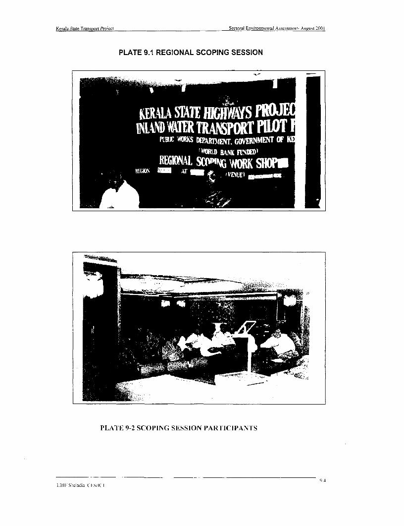
Kerala State Transport Project Sectoral Environmental Assessment- August 2001
PLATE 9.1 REGIONAL SCOPING SESSION
L SC4TEHJt'WS !Q!KIJC' #ICS o %M j GOJNMENT OF W
t'#MRD RANK FN.M)BEGWNAL %(XbPNG WORK SlU
RGiEGA AT t I wwww t
PLATE 9-2 SCOPING SESSION PARTICIPANTS
LB11 Sheladia CESKII
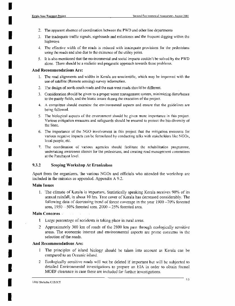
Kerala State Transport Project Sectoral Environmental Assessment- August 2001
2. The apparent absence of coordination between the PWD and other line departments
3. The inadequate traffic signals, signboards and milestones and the frequent digging within thehighways
4. The effective width of the roads is reduced with inadequate provisions for the pedestrians* using the roads and also due to the existence of the utility poles.
5. It is also mentioned that the environmental and social impacts couldn't be solved by the PWDalone. There should be a realistic and pragmatic approach towards these problems.
And Recommendations Are:
1. The road alignments and widths in Kerala are unscientific, which may be improved with theI use of satellite (Remote sensing) survey information.
2. The design of north-south roads and the east-west roads should be different.
3. Consideration should be given to a proper water management system, minimizing disturbanceto the paddy fields, and the biotic issues during the execution of the project.
4. A committee should examine the environmental aspects and ensure that the guidelines areI being followed.
5. The biological aspects of the environment should be given more importance in this project.Various mitigation measures and safeguards should be ensured to protect the bio-diversity ofthe State.
6. The importance of the NGO involvement in this project that the mitigation measures forvanous negative impacts can be formulated by conducting talks with stakeholders like NGOs,local people, etc.
7. The coordination of various agencies should facilitate the rehabilitation programme,undertaking awareness classes for the pedestrians, and creating road management committeesat the Panchayat level.
9.3.2 Scoping Workshop At Ernakulam
Apart from the organizers, the various NGOs and officials who attended the workshop areincluded in the minutes as appended. Appendix A 9.2.
Main Issues
1. The climate of Kerala is important. Statistically speaking Kerala receives 90% of itsannual rainfall, in about 10 hrs. Tree cover of Kerala has decreased considerably. Thefollowing data of decreasing trend of forest coverage in the year 1900 -70% forestedarea, 1950 - 50% forested area. 2000 - 25% forested area.
Main Concerns
I Large percentage of accidents is taking place in rural areas.
I 2 Approximately 300 km of roads of the 2800 km pass through ecologically sensitiveareas. The economic interest and environmental aspects are prime concerns in the
* selection of the roads.
And Recommendations Are:
I The principles of island biology should be taken into account as Kerala can beI compared to an Oceanic island.
2 Ecologically sensitive roads will not be deleted if important but will be subjected todetailed Environmental investigations to prepare an EIA in order to obtain formalMOEF clearance in case these are included for further investigations.
9.5L-BIII Sheladia ,CES/ICT

Kerala State Transport Project Sectoral EnviTonmental Assessment- August 2001
9.3.3 Scoping Workshop At Kozhikode
Main Issues
1. The Telecom and Kerala Water Authority works are affecting the road traffic. SpaceX is required out side the road formation for separation of the utilities and drainage
facility.
2. All roads will become drains during the monsoon season and there are sewerageoutlets to the road. Surface water is entering the roads.
3. In Kerala there is very little budget for road improvements. The facility of roads is1 limited and there are no proper traffic regulations. Providing standard width isimpractical.
4. It is time to prevent the garbage being thrown into the drains
Main Concerns
| 1. Overloading of vehicles is a serious concern as this causes accidents and damage tothe road as well. Hence he explained the need for controlling these aspects.
2. The past history of the road development should be evaluated. Ribbon development isI everywhere.
3. There are about 103 SCs and STs in Kerala. Most of these weaker sections live alongthe roadsides. In the case of low-income groups, rehabilitation will be very difficult asthe culture is linked with the land they hold.
4. The encroachers should be classified and given compensation. In the case of SC andST rehabilitation, it is always better to be spread and mixed with all othercommunities but they usually don't like the idea preferring a colony.
* And Recommendations Are:
1. A new proposal for Nilambur Bypass. This bypass alignment is identified and is abouttwo km in length mainly passing through paddy fields.
2. Suggestions for putting Utility ducts as being good. Suggested to have removableslabs along footpaths so that the telephone cables can be taken through the ductsprovided below the slabs.
3. There should be better facilities for road crossings.
4. There should be economic assistance from the concerned departments and the presentI cables, which are already laid, cannot be removed.
5. Suggested to have Parallel roads and bypass roads to get away from the presentnarrow roads.
6. Capillary effect on the roads should be considered and also the topography andclimate.
I 7. Access roads are the main problem for PWD Roads. These should be included in theproject.
|8 There is an urgent need for controlling of visual pollution effectively.
9. Road markings should be considered. In the case of bypasses it is possible to collectbetterment revenue. It would be very useful to every one if the already approvedalignments were considered.
9I6I LBII' Sheladia /CES/ICT
I

lKerala State Transport Proiect Sectoral Environmental Assessment- August 2001
10. In the case of provision of water supply pipes along the roadsides, the departmentI could pay the expenses. Widening will in fact shift the existing pipeline towards thecenter so provision for the relaying of pipes should be made.
11. The cost of relaying of pipes should be included in the project budget. Theenvironmental and social concerns of this pipe laying should be taken into account.
12. Ecologically sensitive areas should be avoided.
I 13. Rehabilitation of the people should be given more importance. The impact on low-income groups is high although the cost of land acquisition is very low.
| 14. There should be some way out for the storm water drains.
15. In all project related matters there should be 100 % transparency. If this is done therewill not be any difficulty in convincing the people.
16. Social and environmental impact should be considered seriously.
17. The roads arc very important for social advancement. People should be made awareabout the various positive aspects of the project.
9.3.4 SCOPING OF EA BASED ON THE SCOPING SESSIONS
A change in the original Terms Of Reference (TOR) was not required after the scopingsessions. All issues and the public conceens were considered in the EA process without anyU- change in the original TOR with all issues and public concerns positively considered for thedesign as well as Environmental Assessment.
* 9.4 PROJECT SPECIFIC CONSULTATIONS
A number of project specific consultations were carried out along the road alignment. Thesummary of consultation with local informed people and issues raised by them is shown inExhibit 9.2.
The Social Impact survey team carried out a number of other project specific consultations.Few consultations with (1) Individuals and (2) Groups is fully documented and presented inthe Exhibit 9.3. This Appendix presents the details of the group, subjects discussed,suggestions and the action taken.
EXHIBIT 9.2PROJECT SPECIFIC CONSULTATIONS
CONCERNS RAISED
I Link Road People Road Road Road Drainage Protection AccidenLink Road Peoshuldnotprolem,Roopady ts and
l # Code Inter- congested- should be be water ofpadds roadviewed footpath widened biene loggin slopes signing
necessary widened logging slope needed
I SH-I 8 2 5 4
2 SH- 1 3 1 31 1
3 SH-l1 4 3__ _ _ _ _ _ _ _ _ _ _
4 SH-1 5 l 1
5 SH-1 6 4 1
| ~~~~~6 SH-1 4 4 122
15 NSH-1 4 2 4 2 4
26 NSH-4 I 1
I9.9LBI1I Sheladia !CES/ICT
l
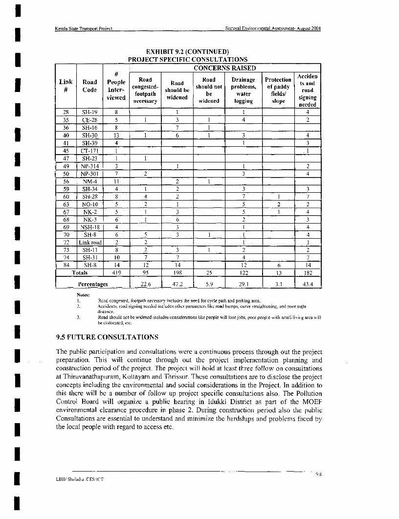
3 Kerala State Transport Project Sectoral Environmental Assessment- August 2001
EXHIBIT 9.2 (CONTINUED)* PROJECT SPECIFIC CONSULTATIONS
CONCERNS RAISED
Link Road People Road Road Road Drainage Protection AccidenCode Inter- congested- shou'lld be should not problems, of paddy roand
l # Code I~~~~~~~~inewed footpath shouded be sol o water fields/ sirgnaing
*necessary widened logging slope needed
28 SH-19 8 1 1 4
35 CE-28 5 13 14 2
36 SH-16 8 7 1
l _ _40 SH-30 13 1 6 1 3 441 SH-39 4 1 3
45 CT- 71_ _ . i
47 SH-23 I 1* ~~~~~~49 NP-314 3 1 2
50 NP-301 7 2 3 4
56 NM_ I1 2 12
* 59 SH-3 4 1 2 3 3
60 SH-28 8 4 2 7 1 763 NO-10 5 2 1 5 2 2
67 NK-2 5 1 3 _ 5 _ I 4 l
68 NK-3 6 1 6 2 369 NSH- 18 4 3 1 4
- ~~~~~~70 SH-8 6 5 3 1 l 4
72 Link road 2 2 1 173 SH-1 1 8 2 3 1 2 2
l 74 SH-31 10 7 7 4 784 SH-8 14 12 14 12 6 14
Totals 419 95 198 25 122 13 182
3 Percentages 22.6 47.2 5.9 29.1 3.1 43.4
Notes:I Road congested, footpath necessary includes the need for cycle path and parking area.2. Accidents, road signing needed includes other parametcrs like road bumps, curve straightcning, and poor sight
e distance.3. Road should not be widened includes considerations like people will lose jobs, poor people with small living area will
be dislocated, etc.
e 9.5 FUTURE CONSULTATIONS
The public participation and consultations were a continuous process through out the projectpreparation. This will continue through out the project implementation planning andconstruction period of the project. The project will hold at least three follow on consultationsat Thiruvanathapuram, Kottayam and Thrissur. These consultations are to disclose the project
* concepts including the environmental and social considerations in the Project. In addition tothis there will be a number of follow up project specific consultations also. The PollutionControl Board will organize a public hearing in Idukki District as part of the MOEFI environmental clearance procedure in phase 2. During construction period also the publicConsultations are essential to understand and minimize the hardships and problems faced by
| the local people with regard to access etc.
I9.I
LBII/ Sheladia TCESICT
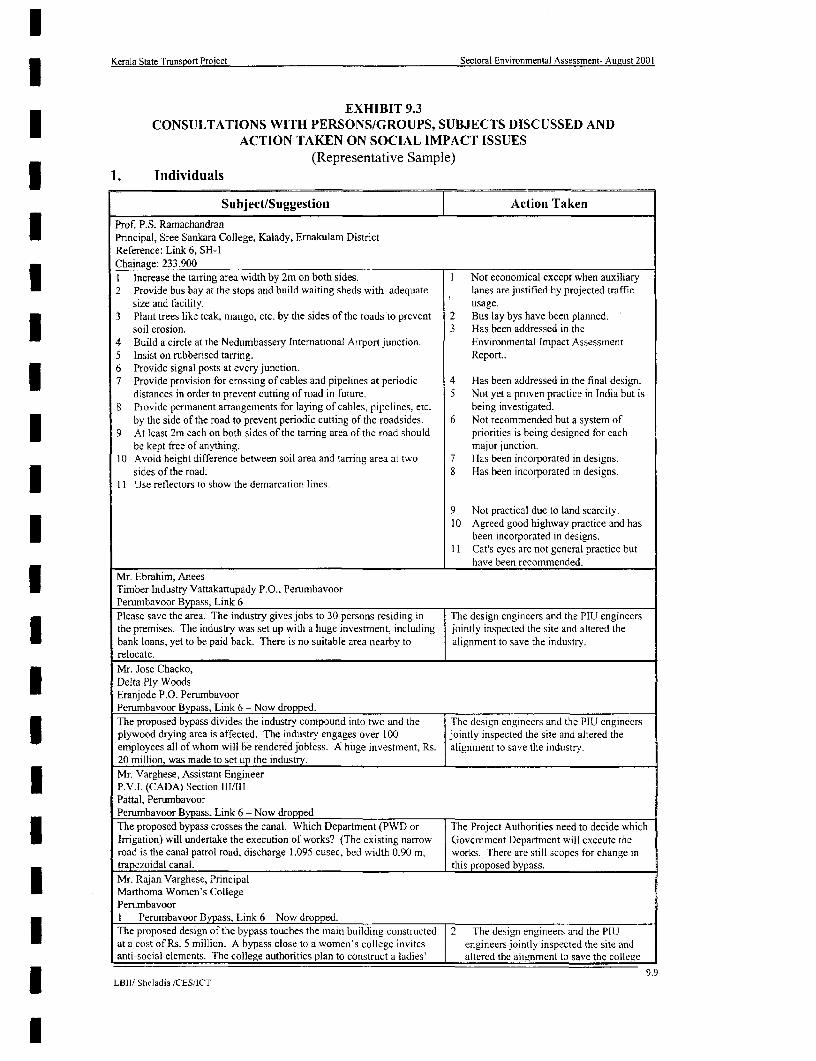
Kerala State Transport Project Sectoral Environmental Assessment- August 2001
EXHIBIT 9.3| CONSULTATIONS WITH PERSONS/GROUPS, SUBJECTS DISCUSSED AND
ACTION TAKEN ON SOCIAL IMPACT ISSUES(Representative Sample)3 1. Individuals
Subject/Suggestion Action Taken
Prof. P.S. Ramachandran* Principal, Sree Sankara College, Kalady, Emakulam District
Reference: Link 6, SH-1Chainage: 233.900I Increase the tarring area width by 2m on both sides. I Not economical except when auxiliary2 Provide bus bay at the stops and build waiting sheds with adequate lanes are justified by projected traffic
size and facility. usage.3 Plant trees like teak, mango, etc. by the sides of the roads to prevent 2 Bus lay bys have been planned.
soil erosion. 3 Has been addressed in the4 Build a circle at the Nedumbassery International Airport junction. Environmental Impact Assessment5 Insist on rubbensed tarring. Report..6 Provide signal posts at every junction.7 Provide provision for crossing of cables and pipelines at periodic 4 Has been addressed in the final design.
distances in order to prevent cutting of road in future. 5 Not yet a proven practice in India but is8 Provide permranient anrangerments for laying of cables, pipelines, etc. being investigated.
by the side of the road to prevent periodic cutting of the roadsides. 6 Not recommended but a system of* 9 At least 2m each on both sidcs of the tarring area of the road should priorities is being designed for each
be kept free of anything. major junction.10 Avoid height difference between soil area and tarring area at two 7 Has been incorporated in designs.
sides of the road. 8 Has been incorporated in designs.11 Use reflectors to show the demarcation lines.
9 Not practical due to land scarcity.10 Agreed good highway practice and has
* been incorporated in designs.11 Cat's eyes are not general practice but
have been recommended.Mr. Ebrahim, AneesTimber Industry Vattakattupady P.O., PerumbavoorPerumbavoor Bypass, Link 6Please save the area. The industry gives jobs to 30 persons residing in The design engineers and the PIU engineersthe premises. The industry was set up with a huge investment, including jointly inspected the site and altered thebank loans, yet to be paid back. There is no suitable area nearby to alignment to save the industry.relocate.Mr. Jose Chacko,Delta Ply WoodsEranjode P.O. PerumbavoorPerumbavoor Bypass, Link 6 - Now dropped.
The proposed bypass divides the industry compound into two and the The design engineers and the PIU engineersJ plywood drying area is affected. The industry engages over 100 jointly inspected the site and altered the
employees all of whom will be rendered jobless. A huge investment, Rs. alignment to save the industry.20 million, was made to set up the industry.
Mr. Varghese, Assistant Engineerv P.V.I. (CADA) Section 111/111
Pattal, PerumbavoorPerumbavoor Bypass, Link 6 - Now dropped
The proposed bypass crosses the canal. Which Department (PWD or The Project Authorities need to decide whichI Irrigation) will undertake the execution of works? (The existing narrow Government Department will execute theroad is the canal patrol road, discharge 1.095 cusec, bed width 0.90 m, works. There are still scopes for change intrapezoidal canal. this proposed bypass.Mr. Rajan Varghese, PrincipalMarthoma Women's CollegePerumbavoorI Perumbavoor Bypass, Link 6 - Now dropped.
The proposed design of the bypass touches the main building constructed 2 The design engineers and the PIUat a cost of Rs. 5 million. A bypass close to a women's college invites engineers jointly inspected the site andanti-social elements. The college authorities plan to construct a ladies' altered the alignment to save the college
9.9LBIJ/ Sheladia /CESItCT

Kerala State Transport Project Sectoral Environmental Assessment- August 2001
I l ~~~~~~~~~~Subject/Suggestion Action Takenl
hostel also on the top floor of the main building which will be facing the building.new bypass. 3 It was pointed out that the bypass would
be constructed on the existing road.Hence, the argument about the anti-socials is not valid.
Prasannam Stationery ShopOpposite Petrol Pump, Pattal P.O.Perumbavoor Bypass, Link 6
The Vattakattupadi-Pattal road can be widened and the alignment could The design engineers and the PIU engineersbe made through the back side of a temple and away from the college and jointly inspected the site and altered theschool. alignment to save the temple, school and the
*___________________________________________________________________ college.Mrs. Mriamma, Deputy Tehsildar, Muvattupuzha, District ErnakulamReference: Link 6, SH- IChainage: 207.200Land survey maps. Land survey maps of the area last prepared in
1918. Attempt to procure them abandoned.
Mr. Sivaraman Nair- ~~~Ward Member, Ward No. 7
Rayamangalam, Emakulam DistrictReference: Link 6, SH-1The local Ward officials have strictly instructed the residents to build Does not require actions on the part of the
* new structures 3 m beyond the edge of the existihg road. PluLMrs. Eliamma PauloseMahuvannur PanchayathWard No. 9, Kazhur-MannurErnakulam DistrictReference: Link 6, SH-1.
Discussion regarding the various levels ot compensation. The social impact survcyors clarified thevanous compensation levels, as contained inthe R&R policy framework.
Mr. Saithu KunjuOpp. Payipra Panchayath OfficePuthusseri, PezhakkapallyEmrakulam DistrictReference: Link 6, SH-1
He was concemed about the demolition of his compound wall. The survey personnel explained to him thatI land take would be determinied by the finalroad design and the acceptance of the designby the project authorities. They also
*______________________________________________________________ explained to him the compensation levels.I Mr. Francis George, MPIdukki ConstituencyKalampathurparampil*VII421, Vazhappilly, Emakulam3 Discussion regarding the anticipated speed of the implementation of the No action required.project.Mrs. Radhamani AmmaExecutive Magistrate and TahsildarI Reference: Link 36. SH-16Discussed the availability of land resurvey maps of the area, which she To be used for the verification of the data bymentioned was available. the PIU.Smt. Ambika, Village AssistantRayamangalam Village OfficeEmakulam DistrictDiscussed the availability of land resurvey report, which is apparently To be used by the PIU for the verification ofI available with the Taluk Surveyor. the survey data.Mr. M.V. BennyWard No. II, Koovapady PanchayathChelarnattom Village, EmakUlamAvailabilityof land for rehabilitation. It is said that hind is available near Information utilised in the RAP.the left side of the Thannipuzha bridge, towards Perumbavoor.
9.10* LB1I1 Sheladia /CES/ICT
l

3 Kerala State Transport Project Sectoral Environmental Assessment- August 2001
Subject/Suggestion Action TakenMr. Raveendran, Deputy Tahsildar
Aluva, Ernakulam DistrictReference: Link 35, CE-28
Encroachment identification and demarcation Information passed on to the PIU for action.
Mrs. Mary K.P., DraftswomanOffice of the Deputy Director (Survey), District Collectorate
EmakulamI Suggests BTR number and Field Survey Maps should be consulted and Suggestion well taken.compared before field investigation for identifying encroachment.
Mrs. Laiba Sebastian, President
Kizhumudu Panchayath, Ernakulam* Reference: Link 35, CE-28
Suggested that 4 acres of govermnent land is available for resettlement of Information utilised in the RAP.
people in Ward No. 3.
Mr. Nazeer, Assistant Engineer
(Roads), PWD, Aluva, EmakulamReference: Link 35, CE-28
Encroachment and PWD land identification: it takes four months to No action needed.venfy encroachments on 20 km of roads.
Mr. Mohammad Ali, SecretaryVazhakculam Grama Panchayath
* ~~~~Emalculam District
Reference: Link 35, CE-28
Identification of encroached land Informnation utilised in the RAP.
Mr. T.P. Hassan, Chairman
Perumbavoor Municipality
Emakulam DistrictReference: Link 35, CE-28
I. Unauthorised building extensions (charthu) on public lands from 1. The matter has been referred to the PWD.
Puthenkurisu Junction to Muvattupuzha Junction should be* demolished.
2. There are a number of encroachments betwveen Sanpo Hospital 2. The matter has been referred to the PWDJunction and Govemment Hospital Junction. and incorporated in the final design of the
3. Bus bays should be developed. roads.3. Already part of the design parameter.
Mrs. Leela Mani AmmaAssistant Head Mistress
Kuttamassery Govt. High SchoolReference: Link 35, CE-28
Chainage: 3.640
I. A hump with signing is required in front of each school gate at 1. Design engineers have taken note of this.I Chowara and Kizhumadu. 2. Road signing for speed limits and presenec2. There are 80 blind students in the school. Traffic control required for of traffic personnel recommended.
their safe passage. 3. A matter for the civic authorities to reduce3 3. Sand loaded trucks are seriously damaging the road top, the number of licenses for this activityv
2. Groups
Subject/Suggestion Action Taken
1. Affected Residential Clusters at a proposed realignment site on Link ]: Taikkod - Kottarakara,Chainage 40.900 to 41.220Left side.Persons attended= 14
Date: 3d' August, 2000
Focus group discussion with residents ot0 a proposed realignment site. 1. Surveyors informed them of the extent ofQueries included: affected properties and the level of1. The extent to which their properties would be affected and the compensation, which would be given at
level of compensation. the market price.2. They suggested a footpath from Kuravankuzhy to Nilaniel for the 2. The Consultants have already planned the
safety of pedestrians, especially school children of the area who go footpath in the area.to a nearby school. 3. Because of the straightening effort.
3. If properties on the right side are also affected. properties on the right side are not4. If produce could be harvested and trees cut before the acquisition. affected.
I LBII! Sheladia /CESIICT
l

3 Kerala State Transport Proiect Sectoral Environmental Assessment- August 2001
SubjectlSuggestion Action Taken
5. An affected widow with a child will be losing her entire property 4. They were informed that they would beof 5 cents (200 sq. m). She should be given at least an equal size allowed to harvest their produce.of land and a house to live in nearby. 5. The RAP deals with this situation.
6. The road should be rubberised and speed limit reduced. 6. Not yet a proven practice in India but will7. The gathered affected people examined the strip plan and wanted be investigated. A recent news item
to know why a sharp curve between chainage 52.500 and 52.600 reported that the State Govemmentafter Chadayamangalam is not being straightened. They remarked proposes to use rubber-modified bitumenthat this particular curve is a frequent accident spot. The situation for tarring one-third of the PWD roads inhas been aggravated by a recent encroachment on the left side of the State. About speed reduction: thethe curve by a mosque-like structure. project authorities wish to facilitate a 65
8. The affected persons suggested that they being from socially and km per hour design speed on this road linkI financially backward groups, a rehabilitation plan should be in although the Consultants recommended 40place before the actual roadwork started. They assured the km /h limit in built up areas.surveyors of their full support to the road upgrading process if 7. Straightening at this particular spot wassuch a pro-active scenario prevails. not found technically feasible.
Encroachment recommended to be clearedby the project authorities.
8. The Resettlement & RehabilitationPrinciples and Policy Framework alreadyis in place and the RAP is a pro-active toolto mitigate the PAP's problems.
2. Affected residential clusters and agncultural landholders at a site on the proposed Kattappana Bypass on Link 26:Idukki - Pulivanmala - Now this link has been dropped for further consideration
* Chainage 40.900 to 41.220Persons attended= 26Date: 22nd August. 2000Focus group discussion with residents and agricultural landholders on a I. It was found that the available
* proposed bypass site. A local NGO. Valiyakandamn Padaseklharu Govemment land width is of 1.5 metresSamiti, attended the meeting. They handed a memorandum to the width, which is necessary to retain forsurveyors. Their suggestions included: ispection track. In addition, land will beI . By making appropriate changes in the design, the road may be required for building a retaining wall to
constructed along the left side of the paddy field, as this side prevent sloping of land. The suggestion iscontains Government land of 3 metres width on both sides of the not technically feasible.canal. 2. There are many acute curves on the
2. There is already a road of 40 ft width from Vcllayamkudy Junction existing 40 R wide road and many(chainage 82.200) to Jnattuvettappadi. It is better to widen this buildings along it will have to beroad rather than make a bypass, which may cause economic loss to demolished if this road is to be improvedthe Govemment. as a bypass. The suggestion is not
3. In the present design, the road deviates from chainage 3.000 to technically, socially and economicallyreach chainage 3.200, which is a paddy field. Due to this viable.deviation, about 6 families and their agricultural lands will be 3. This suggestion, if accepted, will actuallyaffected. The road can be aligned straight from chainage 2.800 cause more properties to be affected.along the land boundaries of St. George Ferona Church to reachthe paddv field mentioned above.
3. Affected residential clusters at a site on the proposed Perumbavoor Bypass on Link 6: Muvattupuzha-Angamali,Chainage 2.600 to 3.600Persons attended = 30, including housewives.Datc: 915 August, 2000Focus group discussion with residents on a proposed bypass site. | 1. The PIU have been requested to addressIssues raised included: this issue.
* I1. The local people voiced concern at the lack of available 2. These buildings will need to beinformation about the project. demolished, unless a further variation can
2. Approximately 10 brand new buildings will be demolished be made in the design, which is presentlybetween chainage 2.200 and 3.200; being investigated.
3. Compensation level, land value; 3. The social impact surveyors explained to4. The proposed bypass affects a school, a college and a temple and a the people the compensation levels and
canal. Canal irrigation was started in the area some 35 years ago how land value is to be calculated fromand it is important to retain tlsis. The alignment needs to be the R&R policy document.
* rcvised. 4. The design engineers along with the PIU5. A suggested option: The bypass should be realigned through the engineers jointly inspected the site and
side of a pond and paddy field between Chira and the bridge altered the design to save these propertiescrossing Poopari Road. and the canal.
5. As in 4 above.
9.12LBII" Sheladia 'CES/ICT

Kerala State Transport Project Sectoral Environmental Assessment- August 2001
SubjectVSuggestion Action Taken
4. Affected residential clusters at a site on the proposed Perumbavoor Bypass on Link 6: Muvattupuzha-Angamali,Chainage 3.600 to 4.600Persons attended = 50. including housewives and the local Municipal Council.Date: I Olh August, 2000
* Focus group discussion with residents on a proposed bypass site. I. The PIU have been requested to addressIssues raised included: this issue.I. The local people voiced concern at the lack of available
information about the project.2. While the people are not against the idea of the bypass, they are 2. This option suggested by the proposed
concerned about the large-scale loss of properties. They offered a affected people involving a longer routepossible option: the bypass could be started two furlongs away was not found technically andfrom Vallam Junction through the paddy field at economically feasible. It is true that manyCheenkukugarapadam, parallel to Poopani Thodu. It could persons and properties at the entry and thecontinue straight through the Poopani bridge. It is not clear why exit of the bypass, touching the M.C. Roadthe bypass is proposed to turn right from Malamuri. It could make will be adversely affected and the projecta left turn from Malamuri and bypass the town. will compensate them according to the
3. The proposed affected people suggested that this meeting should principles laid down in the R&R policyhave been held before the topographic survey. A survey for a new document.road is like a sudden natural calamity and people get mental 3. The project is sensitive to these issues andproblems, leading to suicides. Even prospective marriages in the has taken note of the people's legitimatearea have been called off. concems.
5. Affected residential clusters at a site on the proposed Nilambur Bypass on Link 60: Narukara - State Border RoadPersons attended = 22 - This road has been removed from the sclected high prionty roadsI Date: 4' September. 2000Focus group discussion with residents on a proposed bypass site, I. The social impact surveyors explained tomostly agricultural landholders. A local NGO, Padasekhara Samiti. the gathered affected people that the R&Rattended the meeting. They handed a memorandum to the surveyors. Policy Framework specifically addressesIssues raised included: this issue in clause No. 7.2, which statesI . When a piece of agricultural land is acquired for the project, small that if PAP!PDP loses >75% of his land,
plots will be halved with small pieces on either side of the he has a right to seek acquisition of hisacquired land. These small pieces will not be viable to the remaining contiguous property that may
* landholder. The Government should buy the remaining land also. become unviable for him.2. The paddy field at chainage 2.300 gets submerged by 3 metres 2. The engineering design has provided a slab
during the rainy season. If the field is filled up this water will culvert at this location to prevent theenter the nearby plots. problem raised by the local people.
3. Culverts should be provided at proper locations for proper 3. The project has provided for culvertsdrainage. The "proper location" should be discussed with the wherever necessary and the design plan islocal people. flexible. T he "proper location," as
4. Some amount of money should be given in advance to the persons suggested by the people, could be* to be resettled for finding and constructing suitable houses before accommodated at the time of the
they are displaced. implementation of the project.5. If the bypass is aligned along Areacode (Court Junction)- 4. The people were informed that the R&R
Kulakkamdam -Chakkalakuthu-Mukatta, the new road can be policy framework has provisions toI constructed by widening the existing road. address this concern.5. The existing road is very narrow and it will
not be cost effective to follow this3 . suggestion.
l
I9
9.13LBII)t Shciadia /CESICT
l

Kerala State Transport Project Sectoral Environmental Assessment- August 2001
10 ENVIRONMENTAL MANAGEMENT PLAN
10.1 MITIGATION MEASURES
Environmental mitigation measures will have to be incorporated within the design process,including the avoidance of potential impacts through alignment shifts and other means.Appropriate measures will have to be identified for action in the construction and operationalphases. Exhibit 10.1 Environmental Management Plan (EMP) tabulates the measuresidentified for all three phases i.e., Design, Construction and Operational phases. The EMPidentifies the nature of the potential environmental impact, the measures, which have, or willbe taken, the timeframe in which they are taken, the implementing agency and responsibleorganisation, and, where appropriate, the contractual clause for enforcement of the measure.
10.2 ENVIZAGED ENVIRONMENTAL IMPLEMENTATION ARRANGEMENTS
Institutional strengthening will be undertaken to achieve the goals of the Kerala StateHighway Authority. Steps to be taken are discussed under the following sub-headings:
Envisaged Institutional Organisation* Environmental Training;. Monitoring and Reporting; and
Environmental Documentation.
10.2.1 ENVISAGED INSTITUTIONAL ORGANISATION
The envisaged institutional organisation is shown in the Exhibit 10.2. Being a category Aproject the PIU should have elaborate arrangements for the Environmental Monitoring Unit.The proposed strategy is a flexible proposal for the PIU. In addition, there will be a SocialDevelopment Officer also. The approval of the proposed task force will be required for theimplementation of environmental mitigation measures. However it is always recommended tohave all environmental manpower in house rather than to take on contract basis based onrequirement. This has been integrated into the Institutional Development Study (IDS) thatwas separately carried out under a different contract. The implementation of mitigatingmeasures requires supervision from adequately trained staff within the PWD. The PWD hasmade a commitment to strengthen its institutional capacity with regard to the environmentaland social aspects not only for the implementation of its own projects, but also to cater for theneeds of the State and local levels.
As a first step towards establishing mechanisms to formally address environmental issues ona routine basis, in the short term an Environmental Officer (EO) was recruited to the PWDProject Implementation Unit (PIU). The Environmental officer is assisting the ProjectDirector (PD) in the overseeing of environmental aspects of the construction contracts forKSTP, including the observance of all monitoring provisions. Before the commencement ofconstruction, the Project Director will receive training in the environmental issues associatedwith road construction and maintenance projects. The Environmental officer(s) will organisethe training. Being a Category A project, a much elaborate arrangements would be necessaryaccording to the World Bank and Independent Review Consultants. To meet the variousrequirements the Consultants prepared a flexible plan as shown in the Exhibit 10.2 in case theorganisation is not able to find a second suitable position, the PWD can appoint suitablepersonnel or NGOs on contract basis as and when required.
L LBIII Sheladia !CES/ICT 10.I
l
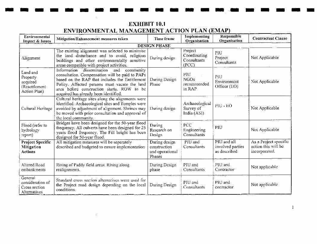
- - - m - - - - m - - - - - -
EXHIBIT 10.1ENVIRONMENTAL MANAGEMENT ACTION PLAN (EMAP)
Environmental Mitigation/Enhancement measures taken 1 Time frame Implementing Responsible Contractual ClauseImpact & IssueIs Org astin Organisation
DESIGN PHASEThe existing alignment was selected to minimise Project PIU
Alignment the land disturbance and to avoid, religious During desigin Coordinating Project Not ApplicableAlignment buildings and other environmentally sensitive Consultants Consultants
areas compatible with project activities. (PCC)Information dissemination and communityLand and consultation. Compensation will be paid to PAPs PIU PTU
acquired based on the RAP that includes the Entitlement During Design NGOs Environment Not Applicable(Resettlement Policy. Affected persons must vacate the land Phase recommended Officer (EO)
.Resettlemei area before construction starts. ROW to be in RAPAction Plan) acquired has already been identified.
Cultural heritage sites along the alignments wereidentified. Archaeological sites and Temples were Archaeological PIU - EO
Cultural Heritage avoided by adjustment of alignment. Shrines may During design Survey of Not Applicablebe moved with prior consultation and approval of India (ASI)the local community.
Flood (refer to Bridges have been designed for the 50-year flood During PCChydrology frequency. All culverts have been designed for 25 Research on Engineering PTU Not Applicablereport) years flood frequency. The Fill height has been Design Consultants
desi gned for 50-year flood.Project Specific All mitigation measures will be separately During design PIU and PIU and all As a Project specificMitigation described and budgeted to ensure implementation construction Consultants involved parties action this will beActions and operational as described incorporated.
Phases
Altered Road Rising of Paddy field areas. Rising along During Dcsign PIU and PIU and Not applicableembankments realignments. phase Consultants Contractor
coneral Standard cross sectioXn alternatives were used foracronssdrainfthe Project road design depending on the local Duiring Design ConUltants PI contractorliabl
Cossection conditions. Cnutns cnrcoAlternatives

m - - - - m - m- --- - m m -
EXHIBIT 10.1ENVIRONMENTAL MANAGEMENT ACTION PLAN (EMAP)
Environmental Mitigation/Enhancement measures taken Timle frame Imlementing Responsible Contractual ClauseImpact & Issues MiiainEhneetmaue ae iefae Organisation Oreanisation ___________
Issues from The various issues raised were examined andIssues from suitably incorporated based on merit. These During Design PIU and Contractor. Not applicable
Consultations include parking areas and other road safety Consultants___ ___ ___ ___ __ m easures.__ _ _ _ _ _ ___ _ _ _ _ _ _ _ _ _ _
Road safety issue During design Designdue to an Acute - Road realignments stage team PIU and PWD Not ApplicableCurve stage
Loss of drinking Drinking water source will be replaced During design Design PIU and PWD Not Applicablewater source according to RAIP and EMAI'. stage team Action Plan (RAP)
Loss of existing Not Applicablebus stops and Bus stops will be suitably relocated During design Design PIU and PWD Refer ResettlementWaiting shed stage. team Action Plan (RAP)facilities
Improved road surface with iniproved roadAccident black geometry, Pedestrian facilities, Bus bays planned. D design PIU and PWD Not Applicablespot Lining and signing is given a high priority for all Stage s Design team PWD & Traffic
road junctions. Safety Audits are being carried . Policeout on the "final" design drawings.
CONSTRUCT[ON PHASEDuring.ad PIlU EO, SPCB
Environmental This will include institutional requirements, During and and As a Project specificManagement training, environmental management and after EO of PIU Construction' action this will haveAnd Monitoring monitoring. construction supervision to be incorporated.
(Five Years) consultants
Facility Equip - EQ of PIU andFacility Equip - ~~~~~~~Immediately EofPUad As a Project specificment for EM P Provision for purchasing required equipment. after Const- EO of PIU Construction action this will needMeters, Vehicles rucon supervision to be incorporated.and Buildings) ruction consultants to_be_incorporated.
Engineer
2
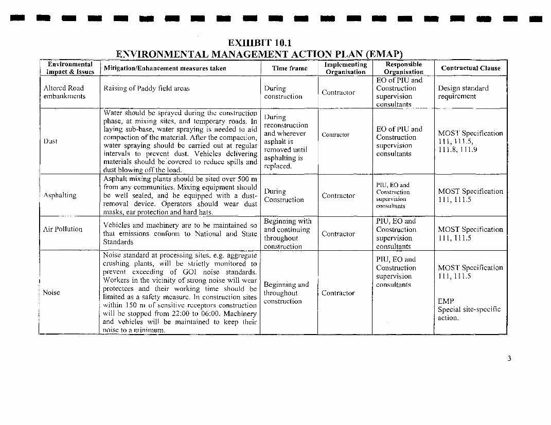
m m m - m m - - - m m - - m m -
EXHIBIT 10.1ENVIRONMENTAL MANAGEMENT ACTION PLAN (EMAP)
Environmental Mitigation/Enhancement measures taken Time frame Implementing Responsible Contractual ClauseImpact & Issues M Organisation Organisation
EO of PIU andAltered Road Raising of Paddy field areas During Contractor Construction Design standardembankments construiction supervision requirement
____________________ _consultantsWater should be sprayed during the constructionphase, at mixing sites, and temporary roads. In reconstructionlaying sub-base, water spraying is needed to aid and wherever Contractor EO of PIU and MOST Specification
Dust compaction of the material. After the compaction, asphalt is Construction 111, 111.5,water spraying should be carried out at regular removed unti s supervision 111.8 111.9intervals to prevent dust. Vehicles delivering asphalting is consultantsmaterials should be covered to reduce spills and replaced.dust blowing off the load. P_.
Asphalt mixing plants should be sited over 500 mfrom any communities. Mixing equipment should During PIU, EO and
Asphalting be well sealed, and be equipped with a dust- Construction Contractor Construction MOST Specificationremoval device. Operators should wear dust consultants
masks, ear protection and hard hats.
Vehicles and machinery are to be maintained so Beginning with PIU, EO andAir Pollution * * r * and continuing Construction MOST Specification
that emissions conformn to National and State hroughoutontractor supervision 111, 111.5
Standards construction consultants
Noise standard at processing sites, e.g. aggregate PIU, EO andcrushing plants, will be strictly monitored to Construction MOST Specificationprevent exceeding of GOI noise standards. supervision 111, 111.5Workers in the vicinity of strong noise will wear consultants
Noise protectors and their working time should be Beginning and Connsactnlimited as a safety measure. In construction sites cotrstruction EMPwithin 150 m of sensitive receptors construction r Special site-specificwill be stopped from 22:00 to 06:00. Machinery action.and vehicles will be maintained to keep theirnoise to a minimum.
3
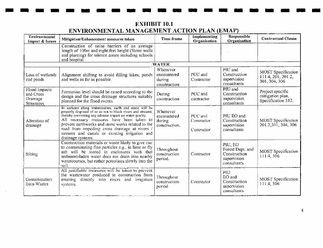
- - - -- - m - - - m - -- -- -- m -
EXHIBIT 10.1ENVIRONMENTAL MANAGEMENT ACTION PLAN (EMAP)
Environmental Mitigation/Enhancepent measures taken Time frame Implementing Responsible Contractual ClauseImpact & Issues MiiainEhneetmaue ae iefae Organisation Organisation ___________
Construction of noise barriers of an averagelength of I 00m and eight feet height (Stone wallsand planting) for silence zones including schoolsand hospital.
Whenever PIU and MOST SpecificationLoss of wetlands Alignment shifting to avoid filling lakes, ponds encountered PCC and Construction 111.4, 201, 201.2,and ponds and wells as far as possible. during Contractor supervision 301;304,306
_______ ______ _______ _______ _______ _______ _______ construction consultants30 , 04 3 6Flood Impacts Fato lvlsolberieacodntohePIU andand Cross FnainlvlsolberieacodntoheDuring PCC and Construction Project specificDrainage design and the cross drainage structures suitably construction contractor supervision mitigation plan.Structures planned for the flood events. conisultants Specification 312.
In sections along watercourses, earth and stone will beproperly disposed of so as not to block rivers and streams, Wheneverthereby preventing any adverse impact on water quality. encounitered PCC and PIU EO and
Alteration of All necessary measures have been taken to during Contractor Construction MOST Specificationdrainage prevent earthworks and stone works related to the construction. supervision 201.2,301, 304, 306
road from impeding cross drainage at rivers / Contractor consultantsstreams and canals or existing irrigation anddrainage systems.Construction materials or waste likely to give rise PIU, EQto contaminating fine particles e.g., in lime or fly PIUi Eoash will be stored in enclosures such that Throughout Forest Dept. and MOST Specification
Silting sediment-laden water does not drain into nearby construction Contractor Construction 111.4, 306watercourses, but rather percolates slowly into the consultapitssoil.All justifiable measures will be taken to prevent PUthe wastewater produced in construction from TQp
Contamination entering directly into rivers and irrigation construction Contractor EO and 111 4 306from Wastes systems. period supervision
consultants
4

- - - -- m m - m m - m - m - m m - m - -
EXHIBIT 10.1ENVIRONMENTAL MANAGEMENT ACTION PLAN (EMAP)
Environmental Mitigation/Enhancement measures taken Time frame Implementing Responsible Contractual ClauseImpact & Issues MiiainEhneetmaue ae iefae Organisation Organisation ___________
Sewerage PIUDisposal during A minimum distance of any sewage or toilet Throughout EO and MOST Specification
construction Contractor Construction 111.9Construction at facility from water sources should be 200 metres. period. supervisionServices Centres consultants
Vehicle maintenance and refuelling will be PIU
Contamination confined to areas in construction camps designed Throughout EO MOST Specificationfrom fuel and to contain spilled lubricants and fuels. Waste cntuio Cnraor SPCB and MOST13 Specificationlubricantslpetroleum and lubricants must be collected and od Contractor Construction 111.13, 201.2 201.4,lubricants taken to approve disposal sites, according to GOI period. supervision ... 1 .3.3
laws. consultants
* Sufficient measures will be taken in theconstruction camps, i.e. provision of rubbish
Sanitation and receptacles and sanitation facilities. Waste inWaste Disposal septic tanks will be cleared periodically asin Construction PIUCamps necessary. SPCB and
* Drinking water will meet Indian National Before and Constrductio MOST SpecificationStandards. duiring building Contractor supervision 111 .1, 122, 201.2,
of constructionicnutat 0* Rubbish will be collected and disposed of camps. consultants 306
frequently.* Special attention shall be paid to the sanitary
condition of camps.* Camps will be located at a minimum distance
of 200 m from water sources.Borrow pits have been identified outside the IRC: 10 1961
Borrow pits ROW. Before opening additional borrow pits During Contractor PIU MOST Specificationoperating pits shall be closed according to construction EO 111.2, 305.2.2Specification.
5

- - - - - m m - - - - - - - - - - - -
EXHIBIT 10.1ENVIRONMENTAL MANAGEMENT ACTION PLAN (EMAP)
Environniental MiiainEhneetmaue ae iefae Implementing Respoinsible Contractual ClauiseImpact & Issues taken Time frame Organisation Organisation
Construction plant and equipment will meet PIU MOST SpecificationEquipment recognised international standards for emissions EO and 106, IRC: 72- 1978;
Selection a and will be maintained and operated in a manner construction Contractor Construction IRC: 90-1985,111.1,mopiration that ensures that relevant air, noise, and discharge supervision 111.5, 111.9,oPeration regulations are met. consultants 111.10, 201.3
1) Quarrying 1) Quarrying will bc carried out at approved and PIUlicensed quarries only. During o Cons MOST Specification
2) Material 2) Material sources are shown in Exhibit 5.10 A, construction Contractor Construction 111.3, 302, 305.2.2sources B and C in Chapter 5. csupltn
SOIL _ ~~~~~~consultantsSOILOn slopes and other suitable places along the
Soil Erosion and roadside, trees and grass should be planted. On Upon Contractor and MOST SpecificationSoil sections with filling (>3 m) and deep cutting their completion of Construction 306, 307, 308Conservation slopes should be covered by sod, or planted with construction supervision
grass, etc. If existing irrigation and drainage activities at stelssystem ponds are damaged, they will be suitably these sites. consultantsrepaired.
Loss of Arable land should not be used for topsoil PlU andagricultural borrowing. The topsoil will be kept and reused During Contractor Construction MOST Specificationtopsoil after excavation is over. Any surplus to be used construction t supervision 301.3.2, 305.3.3.topsol on productive land consultantsCompaction of Construction vehicles should operate within the During MOST SpecificationSoil. Corridor of Impact avoiding damaging soil and construction Contractor PIU 201.2
vegetation. conr___________ ~~~~FLORA__ _ _ _ __ _ _ _ _ _ _ _ _ _ _ _
Areas of trees cleared will be replaced according PIUto Compensatory Afforestation Policy under the After Forest
Loss of trees and Forest Conservation Act - 1980. The private trees completion of Forest Department and MOST SpecificationAvenue Planting will be compensated in line with the provisions of construction Department Construction 201, 308
RAP. Two trees will be planted for each tree cut activities supervisiondown. consultants
6
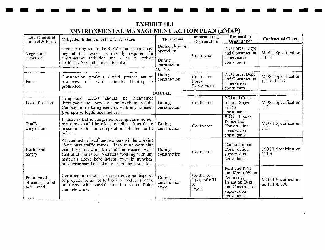
- - --- -- -- - -- -- - - - - -
EXHIBIT 10.1ENVIRONMENTAL MANAGEMENT ACTION PLAN (EMAP)
Empact & Issnes Mitigation/Enhancement measures taken Time frame Organisation Responsible Contractual Clause
Tree clearing within the ROW should be avoided During cleaning PlU Forest DeptVegetation beyond that which is directly required for operations and Construction MOST Specificationclearance construction activities and / or to reduce During supervision 201.2
accidents. See soil compaction also. constrLction consultants
FAUNA
Construction workers should protect natural During Contractor Pan Forest Dept MOST SpecificationFauna resources and wild animals. Hunting is Forest supervision 111.1, 111.6.
prohibited. Department consultantsion
SOCIALTemporary access should be maintained PIU and Const-
Loss of Access throughout the course of the work unless the During Contractor ruction Super - MOST SpecificationContractors make agreements with any affected construction vision 112frontages or legitimate road user. consultants
If there is traffic congestion during construction, PIU and StateTraffic measures should be taken to relieve it as far as During Contractor Police and MOST Specificationcongestion possible with the co-operation of the traffic construction Construction 112
police. supervisionl_____________ consultants
All contractors' staff and workers will be workingalong busy traffic routes. They must wear high Contractor and
Health and visibility purpose made overalls or trousers/ waist During Contractor Construction MOST SpecificationSafety coat at all times All operators working with any construction supervision 111.6
materials above head height (even in trenches) consultantsmust wear hard hats all at times on the xvorksite. _
PCB and PWD
'ollution of Construction material / waste should be disposed Contractor, and Kerala WaterPolluton of of properly so as not to block or pollute streams Durinlg EMU of PI13 Auth6rity, MOST SpecificationStrems aralelor iver wih secil atenton o cnfiingconstruiction & Irrigation Dept. no 11 1.4, 306.
to the road saeand ConstructionStre.amsprle or rivers wth special attention to confininlg stg PWDsuprvsionec] concrete work. PWD
consultants__ _ _ _ _ _ _ _ _ _
7
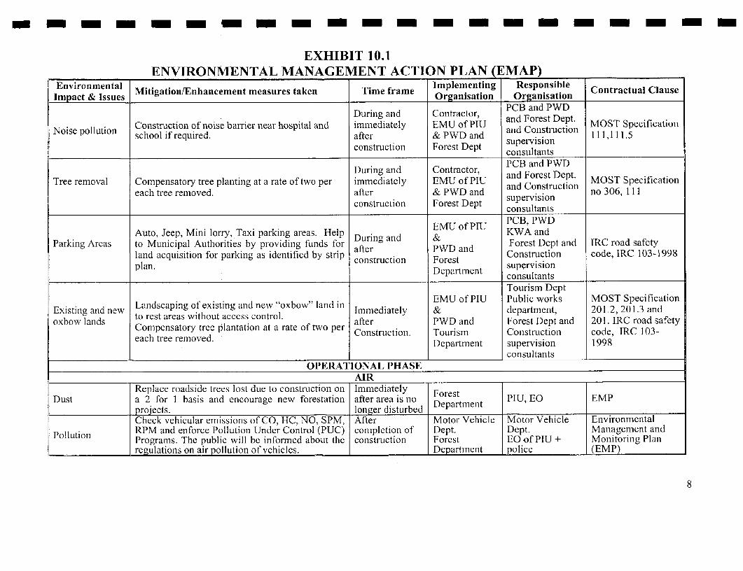
- - - - -- - - - - --- -- l- - -
EXHIBIT 10.1ENVIRONMENTAL MANAGEMENT ACTION PLAN (EMAP)
Environmental Mitigation/Enhancement measures taken Time frame Implementing Responsible Contractual ClauseEnIronm& sentalniato Organisation CnrculCas
During and Contractor, PCB and PWD
Noise pollution SCConstruction of noise barrier near hospital and immediately EMU of PIU and Forest Dept. MOST SpecificationNoie plluion school if required. after & PWD and and Construction 111,111.5construction Forest Dept supervisionconsultants
During and Contractor, PCB and PWDTree removal Compensatory tree planting at a rate of two per immediately EMU of PIU and Forest Dept. MOST Specification
each tree removed. after & PWD and and Constructio no 306, 111construction Forest Dept supervision
consultantsEMU o PIU PCB, PWD
Auto, Jeep, Mini lorry, Taxi parking areas. Help .rEMU of PIU KWA andParking Areas to Municipal Authorities by providing funds for Durng and & nd Forest Dept and IRC road safety
land acquisition for parking as identified by strip afer a Construction code, IRC 103-1998plan. construction Forestplan. supervisionDepartment consultants
Tourism DeptLa.idscapin of existing a.id new "oxbow" land in EMU of PIU Public works MOST Specification
Existing and new Landscaping of existing and new "oxbow" land i Immediately & department, 201.2, 201.3 andoxbow lands to rest areas without access control. after PWD and Forest Dept and 201. IRC road safety
Compensatory tree plantation at a rate of two per Construction. Tourism Construction code, IRC 103-each tree renoved. Department supervision 1998
consultantsOPERATIONAI, PHASE
__________ ~ ~~~~~~AIR__ _ _ _ _ _ _ _ _ _ _ _ _ _ _ _
Replace roadside trees lost due to construction on Immediately ForestDust a 2 for 1 basis and encourage new forestation after area is no Forest PIU EO EMP
projects. longer disturbed DepartmentCheck vehicular emissions of CO, HC, NO, SPM, After Motor Vehicle Motor Vehicle Environmental
Pollution RPM and enforce Pollution Under Control (PUC) completion of Dept. Dept. Management andPollution Programs. The public will be informed about the construction Forest EO-of PIU + Monitoring Plan
regulations on air pollution of vehicles. Departmnent police (EMP)
8

- m- - - - - - - --- -- - - - -
EXHIBIT 10.1ENVIRONMENTAL MANAGEMENT ACTION PLAN ( MAP) _
Envim onmental Mitigation/Enhancement measures taken Time frame Organisation Responsible Contractual Clause
Monitoring air pollution at critical pointsAforestation programs - Tree Plantations.The use of sound barriers or other mcasuresshould be considered where warranted. The After Motor Vehicle PIU EO
Noise public will be informed about the regulations on completion of Dept. Motor Vehicle EMPnoise of vehicles The PIU should carry out construction Police Dept.consultations with school and hospital authorities. I _
WATERContaminationiI o xsig PD ttfrom spills due to Contingency plans for clean up of spills of oil, If not existing PWD, State PWD and State EMP
I traffic movement fuel, and toxic chemicals. shulod beoice Policeand accidents developed Station
Maintenance of TeubnEspecially at Highway PWD and anyStormn Water The urban drainage systems will be maintained to the Beginning Authority municipal Corps EMPDrainage System accommodate storn water flow. and end of PWD under agency.
monsoon __________
Erosion of Stabilisation (refer construction phase- Soil) of Immediately S tAltere Road Raised Paddy field areas by rip rap after PWD EQ of PIU Specification 306,
embankmnents Iy Y P p construction 307, 308l __________ FAUNA
l ~~~PIUCollision with Post warning signis for Wild Life Crossing. At end of T Forest Dept. F ret EMPwildlife jggeisii.Construction EQ of PWD DeFortest ntM
SOCIALCOMPLIANCE with "Rules" as defined inEnvironmental (Protection) Act, 1986, including:For delivery of hazardous substances, three PIU, PWD
Accident with certificates issued by transportation department During Motor Vehicle EMPhazardous are required permit license, driving license, and Construction DMpt. Statehimaterials guarding licence. Vehicles delivering hazardous and Operational KSISB police and Fire
substances will be printed with standard signs. stages. Se rv csPublic security, transportation and fire fighting erviedepartments will designate a special route forthese vehicles. These vehicles can only be parked _
9

- - - - - - - - - - - -m - - m -mm
EXHIBIT 10.1ENVIRONMENTAL MANAGEMENT ACTION PLAN (EMAP)
Environmental Mitigation/Enhancement measures taken Time frame Implementing Responsible Contractual ClauseImpact & Issues MiiainEhneetmaue ae iefae Organisation Organisation
at designated parking lots. In case of spill ofhazardous materials, relevant departments will beinformed at once and deal with it in accordancewith the spill contingency planNew buildings are prohibited within 50 m of the Throughout and IRC 35-1971
Safety and noise edge of carriageway. No new schools and after project Planning PIU IRC 79- 1981disturbance hospitals are allowed within 200 m of development Department IRC 93- 1995
carriageway. period IRC_93__1995EMU of PIU
Solid waste Should rclocatc solid waste disposal site away During In association PCB, Localdisposal along from the carriageway in the same location in operational With the Local bodies MOST Specificationthe ROW consultation with local Panchayath and Municipal Stage Municipal And PWD 201.4
authorities Refer Appendix-1.0 Authorities Tourism Dept.and PCBs.
EMU of PIU PCB, PWDLoss of driniking ConlStruLCtionl &PWD KWA Local granmwater source Drinking water sources will be replaced as and Operational a&ld Local Panclayath, MOST Specification(Bore well) discussed in the RAP stage MLinicipal KWA and 201.2, 111
authorlsagite Tourismauthorities department
Road safety EMU of PIU PCB, PIU andissue- Land - Development of rest area without access control. During & PWD and PWD,scaping of Landscaping of oxbow lanid. The EO in ODrational &orest Dept. Local body, Refer RescttlementOxbow land. consultation with various authorities will agree on tper Local KWA and Action PlanFacilities for the Ox bow land requiriing attention stage. municipal Tourismtravelling public authorities Department
Noise barriers near sensitive noise receptors may PCB, PWD,
Noise pollution - be required. Public will be informed about the Construction EMU of PIU Tourism Dept. MOST SpecificationHospital regulations on noise of vehicles. Proper and Operational & PWD and Forest Dept. M 11.o
HosPital signboards should be erected at hospital stage Forest Dept. and local Gram 111, 1 1approaches. Panchayat_i
10

- ---- --- ---- --- - - - -
EXHIBIT 10.1ENVIRONMENTAL MANAGEMENT ACTION PLAN (EMAP)
Environmental Implementing Responsible ContractualImpact & Issues Mitigation/Enhancement measures taken' Time frame Organisation Organisation Clause2
EMU of PIU
Bus shelters and Bus shelters should be constructed near location During and local Local Gram Refer Resettlementbus bays. of Bus Bays. operational Panchayath Panchayath Action Plan (RAP)
stage. and Muniicipal Pnhyt cinPa RPauthorities
Accident black Improved road surface with improved road During EMU of PIU,spot e ac geometry. Bus Bays will be shifted. Safety Operational PWD, Traffic PIU and PWD EMP
spot _ Audits to be conducted stage. Police
Note: An Environmental Management Plan is required prior to the commencement of construction indicating how the Contractorplans to implement environmental requirements as Stated in the General Conditions of Contract clause 19 titled "Safety, Security andProtection of the Environment".
Some of the mitigationi measures are preventive in nature while some others include additional measures in terms of environmental conservation and involve physical and constructionwork.
The contract Documents refer revised MOST Specification as discussed.a) Ministry of Surface Transport Roads Winig (MOST), Governmenit of India. Specifications for Road and Bridge Works (Third Revision, 1995. Reprinted 2000)b) MOST documenits are amended to suit the needs of the Kerala State Highways Project, particular-ly the requireeilniits of the Environimental Management Plan (EMP)
11

- - - - - - - - - - - -
Kerala State Transport Project Sectoral Environmental Assessment - August 2001
PUBLIC WORKS DEPARTMENT
Integration with Ministry of MOEF, RevenueEnvironmental PCRS, Departments NGO's ctc.Environmental Departments PIU, KSTPetc NGO's
PROJECT DIRECTOR
ENVIRONMENTAL OFFICER SOCIOLOGIST
t< t
PROJECT DESIGN PHASE _ __ i
liipeiitto fImplementation ofvEMAPImlmnaino I CONSTRUCTION PHASE
__ OPERATIONAL PHASE
FIGURE 10.2 ENVIZAGED INSTITUITONAL ORGANISATION FOR KSTP EMP IMPLEMENTATION
lt3I/Shcladia!CES/ICT

Kerala State Transport Project Sectoral Environmental Assessment- August 2001
The Environmental officer will be familiar with the Indian environmental legislation and beI experienced in monitoring and co-ordinating large road construction or similar projects. Ifsuch personnel are not available as is the case now the in-house personnel with suitablebackground shall undergo all training as necessary. The main duties of the EnvironmentalOfficer will include:
* Review of Project design and specifications during preparation to ensure theiradequacy and suitability with respect to the recommendation of the EnvironmentalManagement Plan (EMP) as presented by the EMP/EIA.
* Collection and dissemination of relevant environmental documents includingamendments to Environmental Protection Acts issued by the Government and variousagencies such as the World Bank, Asian Development Bank (ADB) and otherorganisations.
* Co-ordination with non-government organisations (NGOs), community groups,Government Departments, etc. on environmental issues and obtaining the necessaryclearances from the regulatory authorities.
* Monitoring the environmental aspects of the Project during construction to ensure thatthe environmental requirements of the contract and the mitigation measures proposedin the EMP are implemented.
* Advising the Engineer and preparing the environmental input to the quarterly progressreports.
X * Development of guidelines or a code of good practice on low-cost environmentalmeasures that can be implemented in the road construction and maintenanceprogrammes for Public Works Department.I * Development of environmental training activities for contractors and supervisoryconsultants staff.
* Assistance to local Governments in the restoration of the environmentally degradedI portions of the existing Project Right-of-Way, which may revert to their control due tothe realignments.
* Promotion of the policies adopted for the development of roadside amenities asrecommended by the project specific Environmental Management Plan
* Co-ordination of the road safety components of the proposed PWD InstitutionalDevelopment Plan and issues related to the effect of roadside environment on roadI safety and non-motorised traffic.
* Coordination of the Environmental Officers activities with other State and Centraldepartments for obtaining/exchanging infornation on low cost environmental impactmitigation methods, environmental enhancements, local legislative measures, legalprocedures and experience for environmental protection and training needs.
3 10.2.2 Environmental Training
The training institutions in India, the World Bank's Economic Development Institute| (Environment and Natural Resources Division), the Central Pollution Control Board, and the
State Pollution Control Board conduct regular training sessions and access to these resourceswill be sought.
* The need for additional and specialised training will be examined and appropriate trainingwill be undertaken as required. The proposed training requirements include
I * Immediate short-term training for the Project Director to raise the level ofenvironmental awareness.
LBIt/ Sheladia /CESfICT 102
Kerala State Transport Project Sectoral Environmental Assessment- August 2001
• Training on the implementation of the Environmental Management Plan is requiredI for the Project Director, PWD Technical Managers, Environmental officer andrepresentatives of the construction contractors and supervision Consultants
* General environmental management awareness will also be required for the PWDI Executive Engineers and their staff within the PWD.
For all training programmes the contents will have to be developed, training modules plannedand imparted.
In addition to the capacity to quantitatively monitor Water and Noise quality using suitableequipments as specified for this specific project it will primarily involve ensuring that actionsI taken are in accordance with the contract, and specified mitigation measures.
Responsibility of the Contractor: Some awareness training may be provided to theContractor's personnel to ensure that all required measures would be taken. This will help thecontractor to devise a practical management plan to implement various mitigation measuresproposed in the Environmental Management Plan. The Engineer should approve the practical
| Environmental Management Plan prepared by the Contractor after verification by theEnvironmental Officer of EMU.
10.2.3 Monitoring and Reporting Procedures
Statutory Govemment Agencies may assess contractor practices and, if high pollutant levelsare suspected, will require measurement by the PWD, SPCB or private sector laboratories toverify measurements on a routine basis. Photographic records will be established to provideenvironmental monitoring tools. A full record will be kept as part of normal contractmonitoring.3 The Project Director and Environmental Officer will enforce all applicable regulations.Under the Environment (Protection) Second Amendment Rules 1993, for example, waterquality discharge standards have been established for inland surface waters courses and land
| for irrigation. It is a legal obligation of the Contractor that any discharges from the work sitemeet these standards. The PD and Environmental Officer will take steps for regularmonitoring of pH, suspended solids, BOD, COD etc. All contractor liaisons must beI conducted through the Engineer.
Additional monitoring for soil erosion, landslides in the highlands, flooding and accidentsand air quality is also required. The progress of project specific environmental Enhancement/mitigation measures are to be monitored and recorded. The effectiveness of the road safetyaction plan should be monitored on a monthly basis in order to improve/upgrade the various
| provisions of the action plan.
10.2.4 Environmental Enhancements
Being a very densely populated State with much ribbon development, many market areas andintense pedestrians besides the vehicular traffic, dictate that a variety of environmentalenhancement measures be considered in the Project. The Appendix A 6.1 provided typicaldesigns for various types environmental enhancement.These are
* Bus bays originally built into the design* Parking areas for Cars, Auto rickshaws, Jeeps, Tempos and mini lorries where
possible- provision for parking areas. The land cost included as Environmental costs* Service roads including parking areas when realignment is proposed and implementedI in the urban and semi urban pockets* Safer and aesthetically appealing road junctions (Considered in the original design)
LB111 Sheladia ,CESIICT 10.3
Kerala State Transport Project Sectoral Environmental Assessment- Aueust 2001
* Proposal for the development of 'Oxbow lands' into rest areas in rural areas| * Oxbow lands may provide toilet facilities eating places and restaurants
• Tree and shrub planting along the Oxbow lands (Appendix A 6.2)
* 10.2.5 Environmental Documentation
Kerala State Transport Project will devise suitable sample monitoring formats for use.Mitigation and enhancement measures adopted in the final design have been explicitlyI identified in the Contract Documents so that performance and completion is effective. Dailyproject diaries and the Accident Book (Rcfer JRC: 53-1982) will record environmentalproblems (spills, dust, noise, etc.) as well as road safety incidents and will be retained as part
* of accepted modem contract management records and surnmarised in QuarterlyEnvironmental Reports provided to the World Bank.
| 10.3 ENVIRONMENTAL COSTS
10.3.1 Overall Environmental Costs
Environmental costs include:* Environmental Monitoring and Training. This includes the cost of staff assigned
to the overseeing of air, noise and water quality monitoring as specified by the EIA,including the cost of necessary training and institutional strengthening. This will beapproaximately Rs 10 Lakhs per Link.
* Tree and Shrub Planting. The cost of tree and shrub planting in the ratios approvedand using the species specified by the EMPI EIA. This will be as per the Treeplanting strategy.
* Construction-Related Environmental Mitigation Costs. The Construction relatedenvironmental costs9 would be of the order of 1-2 % of the total construction costs.This will includes the costs of
- Land acquisition for parking areas for road safety (to be developed by localAuthorities)
- Bus lay- by/Bus bay (included in the RAP)-Contract cost3 - Noise Mitigation costs (Contract costs)- Water Spray For Dust Suppression during non monsoon/dry season (Contract cost)- Proper Sewage Disposal During Construction (Contract cost)- Proper Waste Disposal At Service Centres- Maintenance Cost In Soil Conservation- Retaining walls (contract costs)- Construction/Replacement Hand Pumps Subject To Impact- Re-forestation / Habitat Improvement For Reserved Forest Areas.
Road safety measures (included in the contract and project costs)
3 Anticipated costs in these areas arc tabulated for the project based on the followingconsiderations.
| 10.3.2 Environmental Monitoring and Training Costs
The necessary budget should include for the overseeing of environmental monitoring during| construction and five-year monitoring periods commencing upon the first day of construction
activity.
9 Roads and The Environment -A Handbook
LBI1/ Sheladia /CES/tCT 10.4
I

Kerala State Transport Project Sectoral Environmental Assessment- August 2001
In addition a budget will be required for the facility equipment, etc. These budgets includelocal environmental training activities, site visits and contingencies for the ProjectEnvironmental Officer. The necessary budget for the Project has been included for a five-yearmonitoring period commencing immediately after construction.
10.3.3 Construction-Related Environmental Mitigation Costs
Construction-related environmental mitigation costs have been defined as the following andwill have to be tabulated to account for the additional costs incurred for the environmentalmitigation measures specified. In several instances, these costs are small; the mitigationactions are part of good engineering practice and project management. Construction-relatedenvironmental mitigation includes the following.
a Water Sprayer/Watering. This is the cost towards watering the constructionI surfaces during construction period to suppress excessive dust. This excludes the costof watering for compaction. It also considers that watering during the rainy seasonmay not be required.
* Solid and Liquid (sewage) Disposal During Construction. This is the cost towardsthe waste removal from construction camps. (Contract cost)
U * Waste Disposal At Service Centres. The vehicles and other machinery will beserviced at service centres during the construction period. The usual local practice isto leave all waste materials lying scattered. This includes grease, cotton and otherwaste materials. This will be disposed of in shallow pits constructed for the purpose(contract cost)
| Noise Mitigation. Noise mitigation techniques to be applied along the Project roadare stipulated in Section 8.5, i.e., the use of sound insulating, green walls and raisingwalls as appropriate to the individual circumstances. A typical; design will beI provided in the corridor specific Environmental Management plans and ElAs. Inaddition to schools and other educational institutions a number of hospitals were alsoidentified adjacent to the road corridor. The details of schools, hospitals etc will beI furnished in the project specific EIAs. The Environmental Officer will be responsiblefor the implementation of this work. Where the traffic is brought closer to thebuilding and noise levels exceed the recommended standards.
U * Maintenance Cost in Soil Conservation. Trees and grass will be planted on Slopesand othcr suitable places along the roadside. On sections with filling (>3 m) and deepcutting slopes may be covered by stonewalls, sod, or planted with grass, etc. Ifexisting irrigation and drainage system ponds are damaged, they will be repaired.This is also applicable to paddy field areas where the roads may be supported by the3 retaining walls or other protection measures. This will also decrease the effective landtake. This cost will be included in the contract costs. In the highlands specialprotective measures would be required in the form of retaining walls in unstablesections. This will also be included in the contract costs.
* Hand Pumps. The loss of existing hand pumps and wells (drinking water sources) isincluded in the RAP and they will be replaced as a rehabilitation measure. There maybe additional hand pumps, which may be required for the ultimate arrangements ofrehabilitation measures. The Environmental Officer will be responsible for theimplementation of this work if such a need arises.
3 LBll/ Sheladia ICES!ACT
10.

Kerala State Transport Project Sectoral Environmental Assessment- August 2001
x Placement of Lost Communal Space The Kerala Sate Transport project in factcreates communal space near realigned sections in the form of 'oxbow lands'.
10.3.4 Accounting and Budget Allocation Categories
3 Accounting and budget allocation categories for the estimated environmental costs areindicated in Exhibit 10.3.
EXHIBIT 10.33 ____ ACCOUNTING AND BUDGET ALLOCATION CATEGORIES
SI.No Accounting Categories Budget Allocation Categories
I Monitoring PIU budget, in addition to supervision consultant costs.
2 Land cost for parking (other than Bus lay bys) Project costs.
3 Cost of land for Bus lay bys F R and R cost4 Project-level mitigation measures Contract/project costs.5 Project-level environmental enhancement Contract costs.6 Road safety measures Contract/project costs.
7 Environrnental training PIU budget, and Institutional Development Plan7 Environmental training Consultant's conttract.
10.4 IMPLEMENTATION SCHEDULE
* The most important aspects of the implementation are the appointment of the EnvironmentalOfficer to oversee the implementation of the environmental mitigation measures incorporatedin the Project design and contract specifications. Dcvelopment and delivery of anenvironmental training programme for selected PWD staff and the Engineers Staffresponsible for overseeing the construction contracts can commence immediately thereafter.This will be an ongoing process. Contracts will be awarded over a period of many months.
I Exhibit 10.4 indicates the implementation schedule.
EXHIBIT 10.4IMPLEMENTATION SCHEDULEI ENVIRONMENTAL MANAGEMENT AND MONITORING PLAN
FREQUENCY ANDIORACTIVITY IMPLEMENTATION DATE
Appoint Environmental Officer Completed in April 2001Initiate First Training Program 24 August 2001Ongoing Training As requiredCheck Monitoring QuarterlyI Prepare Environmental Reports QuarterlyConstruction Supervision During ConstructionRoadside environment safety and Long-termTransport policy developmentDevelopment of compensatory habitats policy Long-termSet up an Environmental Unit Long-term
l
l
lg ~~~~LBII/ Shcladja /CES/tCT tO) 6
l

Kerala State Transport Project Sectoral Environmental Assessment-August 21)()1
11 ENVIRONMENTAL SAFEGUARDS FOR PROPOSEDROAD MAINTENANCE ACTIVITIES
This chapter provides a general description of various maintenance activities that will betaken up in the KSTP. A separate stand-alone document titled 'Environmenltal and SocialManagement Plan (ESMP)' was also prepared as a Contractors document. The ESMPdocument provides a much-detailed account of the First Year maintenance activities,Environmental and Social Impacts and Management based on the designs prepared byConsultants.
| This section is typically based on due to three factors 1). The high density of population 2) thebiodiversity issues and finally 3) the road safety issues in Kerala. Although in roadmaintenance the first two factors are less significant the third deserves the high priority due toI the prevailing road sector environmental issues influenced by the first two factors. In thiscontext for road maintenance adequate environmental safeguards coupled with goodengineering practices assume high profile.
It is useful to define the road maintenance terninology used, as there is often confusion evenat international level.
11.1 MAINTENANCE ACTIVITIES- DEFINITIONS
Road Maintenance is the name given to that grouip of activities which are required to ensuirethat the roads provide the service to road users in as near to their "as constructed " conditionas possible and to preserve the fabric of the road as a major public asset. Maintenanceactivities should be carried out in the most cost effective manner to ensure the best value formoney to the road users.
Maintenance activities are after sub divided into budget categories according to their purpose.* Routine Maintenance* Recurrent Maintenancei Periodic Maintenance= Special maintenance
11.1.1 Routine Maintenance
* Routine Maintenance centres -around the regular inspection of the road, preservation of thedrainage system including bridges and culverts and their outfall drains, removal of rubbishfrom the pavement and whole ROW and the control of vegetation. In times of limited fundingroutine maintenance is regarded as the highest priority work since effective drain2age systemsare essential in protecting the roadfabric fromn saturation and washouts. Vegetation controlmakes an important contribution to maintaining visibility and hence road safety standards.Routine maintenance is not suited to machine based technology and the labour intensive workcontracts often result in distributing part of the road maintenance fund into the local
| communities through which the road passes.
11.1.2 Recurrent Maintenance
I Recurrent Maintenance is the name given to those activities carried out specifically on thepavement structure. The work usually requires the use of specialised equipment, a vehicle,and trained personnel. It is made uip of local crack sealing, pothole filling, and full depth baseor partial depth bituminous layer patching. It also covers road line renewal and replacement
L1311 Shcijdij CtIS 1CT 1

Kerala State Transport Project Sectoral Environmental Assessment-August 2001
of reflective road studs. Because of its somewhat specialist nature in terms of training andequipment this work is usually conducted by specialised contract teams whose payment isusually made on a measured work system. Each team would need a bitumen boiler andsprayer, pedestrian controlled roller, road breaker and hand tools and capable of maintainingapproximately 300 km of paved and sealed roads in average condition.
11.1.3 Periodic Maintenance
Periodic Maintenance is usually larger scale works over longer lengths of road, bituminoussealing where the surface is cleaned, edges cut back and the surface sprayed with bitumen,usually at about 1 litre/sq metre and thence covered with crushed rock chippings thoroughlyrolled in by pneumatic tyred rollers. This is a machine-based operation utilizing bitumensprayers, chipping distributors and road rollers and is best suited to contract works. It dependson a supply of raw materials and clean well-graded single size stone is essential. This isusually the result of quarry operations, activities that have been addressed under theconstruction operations. Surface dressing is intended to seal the small cracks, which oftendevelop in a bituminous pavement when the bitumen oxidisers, and becomes brittle overtime.
The other main formn of periodic maintenance is the overlay, which may be a carpet coat-wearing course or accompanied by an underlying strengthening or regulating layer. Pavementoverlays utilize large quantities of crushed rock and mixing plants usually located at acentralized quarry location. These create similar negative impacts to the crushers and mixingplants already addressed under the construction topic.
11.1.4 Special Maintenance
Special maintenance is a budget heading often used for local traffic engineering projectsaimed at reducing road traffic accidents. They include the provision of footpaths and otherpedestrian facilities, Junction realignment, provision of bus lay-bys, or even drainageimprovements.
11.2 MAINTENANCE PRACTICES IN KERALA
Maintenance Policy and Practice; The Kerala PWD carries out four types of maintenanceactivities. These are
* Ordinary maintenance* Periodic maintenance* Special maintenance and* Flood damage repairs.
Ordinary maintenance: repairs such as drainage clearance, patching, road markings androad furniture works are usually referred to in this maintenance category. The actual amountof work carried out depends on the amount of funds allocated and is usually very small.
Periodic maintenance; (Periodic renewal) an overlay of 40mm Pre Mix Carpet (PMC) forState Highways and 20mm of PMC for Major District Roads (MDR) is laid on the existingsurface, after pothole patching with single sized crushed rock as required. Unlike other States,Kerala PWD policy is to target "overlays" at 4 to 5 year intervals.
Routine maintenance activities such as
- the regular inspection of road,
- Clearing of ditch and shoulders,
- Cutting back vegetation, etc are not executed on a regular basis.
LBII Shelirdia ( IES II I

Kerala State Transport Project Sectoral Environmental Assessment-August 201)1
Kerala was a forerunner in the move to contract maintenance but at the time there was norecognized system of contracting routine maintenance put into practice. Instead a system,which could be better, described as annual maintenance was instituted whereby the engineerundertakes an annual inspection of the roads and draws up a list of minor works that are thenI put out to contract. Not surprisingly, this system has to be supplemented by emergencymaintenance- much of which would be avoided if drains where kept clear and pavementswere repaired when signs of distress first appear.
* Shortage of funds, force Kerala PWD to adopt a frequency of periodic maintenance wellbelow the target norms. What work is done, is done using a technology, which althoughcheap, is unsuitable for this wet climate. The surfacing used is porous and of poor durability.This fault is exacerbated by the lack of routine maintenance such as drain clearance. As aresult there is a significant and growing backlog of work.
3 11.2.1 Maintenance Study and Recommendations
The Objective and scope of the maintenance studies were
To identify priorities for pavement maintenance and prepare multi-Year rolling programmefor the same.
To review the present system of road maintenance management and develop guide lines for* an appropriate new model or a logical modification of the existing road maintenance and
management system. Recommendations on procedures for data collection should includemeans of ensuring that the procedures are user friendly and sustainable by the PWD.
The principal outputs of the maintenance component are thus:
A multi year rolling programme for maintenance of high priority corridors, totalling to alength of 1000 km under World Bank loan assistance.
Recommendations on policy development and actions in the short term to address the3 pressing maintenance crisis; and
Recommendations for a long-term strategy for the management of the road asset.
The Environmental and Social Management Plan (ESMP) document is based on the study ofthe following reports.
a. Maintenance Planning- Volume -1 Main report - January 2001
| b. Maintenance Planning - Volume II, Corridor Inspection Report - January - 2001
c. The chapter on maintenance in the Sectoral Environmental Assessment (SEA)3 d. First Year Maintenance Programme - Main Rcport -- September 2001
e. First Year maintenance Programme - Design report -September 2001
The revised versions of September 2001 are also referred. The study of the maintenancereport revealed the necessity of minimum environmental and social Impact mitigationmeasures to address the possible and probable impacts due to the implementation of themaintenance project. The reports clearly indicated the problems of adopting the maintenancework without addressing all associated environmental and social impacts. The earlier ESMPversion of August 2001 exposed the need for revision of Maintenance strategy. This ESMPreport is based on the revised Maintenance strategy.
The maintenance Consultants suggests that investment in a programme of overlays usingmodem methods would gen&rate significant user benefits, and actually reduce the long term
* road maintenance cost, enabling a more timely intervention policy to be adopted andgenerating a marked improvement in the quality of the road service level.
LO1ll Sheladi,(a rsir I m3

Kerala State Transport Project Sectoral Envirotimental Assessment-August 2001
11.3 MAINTENANCE PROGRAMME UNDER KERALA STATE TRANSPORTPROJECT
The project identified approximately 1000 km as high priority roads from the 3000 km of| feasibility study roads. This was further reduced to 612 km. The remainder have been
subjected to further studies including HDM analysis to prioritise approximately 1000 km ofmaintenance roads in three phases. The selected roads for each of the three successive year
| programmes are shown in the Exhibit 11.1 to 11.3 (August 2001) and pictorially representedin Exhibit 11.4.
Maintenance activities thereafter should include: -
* Road Inspection * Pothole filling
| Vegetation Control * Patching
* Cleaning of drains Shoulder repairs* Braidge culvert andretainingiwallnrepr * Resealing* Bridge, culvert and retaining wall repair . Overlaying and provision of shoulders and
* Crack sealing * Pavement markings
I 11.4 ENVIRONMENTAL SAFEGUARDS FOR MAINTENANCE ACTIVITIES
One of the impediments to the adoption of modem pavement technology is the perceived3 social implication of abandoning manual construction methods. This must be implemented
sympathetically. There are two recommendations to ameliorate this effect,
* First to reintroduce routine maintenance -routine maintenance is by nature labourintensive,
* Second is to provide footpaths along the roads wherever possible.
-i Will enhance road safety and capacity while their construction and upkeep will provide localemployment.
Maintenance work generates positive impacts by eliminating or reducing environmentalproblems caused by the deterioration of road surfaces, drains and shoulders.
Recurrent and Periodic Maintenance reduces the rate of road deterioration and maintains the* ride quality of a road. The reduction of poor surfaces and potholes reduces the risk of
accidents by drivers circumnavigating bad areas and improved surfaces reduce fuelconsumption and the overall running costs.
Road maintenance may therefore be regarded as a very positive environmental activity inreducing erosion and contributing greatly to road safety. Similar to road construction androad widening/improvement projects, road maintenance also demands "good engineerinlgpractices' which provide environmental safeguards. In spite of this the construction activitiesis expected to result in some impacts. This will necessitate some impact mitigation in the
| following identified areas.
Eco-sensitive zones Tree removal issuesDrainage Air qualityNoise quality Water qualityMaterial resources FloodingSquatters EncroachersRoad safety and accidents
I.B3I Shclktid6 ( ES CT I 1 4
l

| Kerala State Transport Project Sectoral Environmental Assessment- August 2001
EXHIBIT 11.1___ FIRST YEAR PROGRAMME OF MAINTENANCE
ISELECTED PAVCENlENT TRAFFIC PROPOSEDSL LINK ROAD NAME LENTH CHAINAGE WIT CONIIERCIAI LRNATENO No. RANMLEGHWDH VEHICLESALENTI ~~~~~ ~~~~~~~~~~~~~(KM) (NI) ONLY & REMARKS
____ ~~~~~~~FROMITTO _____
I I Kottaruvananthapurami - 19.30 5.70 25.00 7.32 2015 Alt-3_~~~~~~~~Ktaakr (Ta o)I Thiruvananthapuram -
2 80 Ponmudi (Peroorkada 12.00 0.00 1100 6.95 1114 Alt-2_____ to Nedumangad) _
3 29 Thodupuzha - Kalur - 20.00 0.00 20.00 4.73 186 Alt-2Onnukal
Aluva -4 34 Kothamangalam 17,00 0.00 17.00 7.55 1797 Alt-2
5 39 Thrissur - Kodungallur 33.90 0.00 33.90 6.24 1584 Alt-3
6 42 Potta - Moonupedika 20.90 0.00 20.90 5.38 1668 Alt-3
7 44 Cherpu - Tripayar 14.20 0.00 14.20 5.76 1161 Alt-2
| 8 58 Kozhikode - Mavoor 10.50 0.00 10.50 6.26 6210 Alt-3
9 64 Sultan Bathery - 35.00 0.00 35.00 5.24 475 Alt-36 Pulpally
10 121 Thaliparamba - Intty 46.00 0.00 46.00 5.49 1829 Alt-2
I1 60 Narukara - State 40.00 0.00 52.70 6.63 3621 Alt-3Border
12 59 Quilandy - 29.30 0.00 29.30 6.53 2346 Alt-2Thamarassery I _ _
13 129 Cherkala - Jelsoor 41.00 0.00 41.00 5.55 680 Alt-3
3 Total 339.1 _ _
EXHIBIT 11.2SECOND YEAR PROGRAMME OF MAINTENANCE OF KERALA
SL LINK SELECTED CHAINAGE PAVEMWI T TRAFFIC ALTERNO NO ROAD NAME LENGTH WDHVEHICLES NATE
(mv M) (ml)FROM TO
1 215 Karuarakundu - Kizhakkethara 5.00 0.00 5.00 3.50 2794 Alt - 3
2 010 Kollam - Ayur 31.00 0.00 31.00 5.20 1731 Alt - 2
3 027 Vandanmedu - Cumbumbettu 11.00 0.00 11.00 4.0 1503 Alt - 2
4 234 Kallambalam- Varkala 11.00 0.00 11.00 6.17 2683 Alt - 2
5 009 Vizhinjam -Kattakkada 18.70 0.00 18.70 5.50 1990 Alt-2
6 63 Kuttiyadi-Kellur 21.0 0 21.0 4.5 1368 Alt-2
* 7 108 Kayamkulam- Pathanapuram 26.40 0.00 26.40 6.65 2204 Alt - 2(part)
8 055 Perumbilavu- Nilambur 65.30 0.00 65.30 5.50 1582 Alt - 2
9 036 Vypin- Pallipuram 25.50 0.00 25.50 7.0 3509 Alt - 3
10 236 Chenganasserry -Vazhoor 24.50 0.00 24.50 6.10 2278 Alt- 3
11 037 Ponjassery-Chithrappuzha 18.80 0,00 18.80 5.50 2113 Alt-3
* ~~~~~12 132 Thodupuzha -Mulamattom 39.00 39.00 0.00 6,12 | 1339 Alt- 3* ~~~~~~~~Paramnada I___I_.1
13 205 Kulathupuzha - Anchal - 30.00 0.00 30.00 5.76 1050 Alt-3Punalur
14 17 Ettumanoor - Erattupetta 28.90 0.00 28.90 6.75 1727 Alt-3
15 123 Kozhikode Mini By-pass 8.70 1.00 8.70 10.87 3528 Alt-3
Total 364.8
L_1311 SheladiaCES.ICT 11.5

3 Kerala State Transporn Project Sectoral Envirunmental Assessmrent-Aueust 20() 1
Most of the maintenance issues except Squatters, Encroachers and Flooding etc areI construction related. All necessary mitigation measures are incorporated in the ESMP forContractors. The Environmental Management Activity Table provided in this chapter is aI generic EMP. The first year project Specific EvIP is part of the ESMP.
EXHIBIT 11.3THIRD YEAR PROGRAMME OF MAINTENANCE OF KERALA
SL LINK SELECTED CHAINAGE PAVEMENT TRAFFIC ALTERNNO NO RA ANE LNT IT VEHICLES ATE
tinnamang larnM) FROM TO (M
l 125 Athiamuzhi 13.00 1 0.00 1300 5.51 2070 Alt- 3Ags hiauh_
2 066 Iritty - Nedumpoil 20.20 0.00 20,20 5.5 1651 Alt - 2
h 235 Nedumbassery- 42.80 0.00 42.80 4.43 618 Alt- 2Kodaikanal _ 11
4 061 Kozhikode - Balussery 20.40 4.20 24.60 5.79 1906 Alt --3
| 5 062 Vvthiri -Tharuvana 30.10 0.00 30.10 4.15 947 Alt - 3
6 109 Kayamkulam- 30.6 0 30.6 6.48 2979 Alt-2Thiruvalla __
7 14 Mavelikkara- 28.8 0 28.8 5.7 1865 Alt-2Kozhenchery_
8 107 Kidangara- 7.0 0 7 3.80 1469 Alt-3. ~~~~~~~~~~Neerettipuram38016Al3_ ~~~~~~~~~~Thiruvananthapurarn - 4.0 1.05.0 48
9 080 Ponmudi (till 40.00 2.00 5200 485 1902 At -Vithtira Jin.)
10 28 Poopara - Kumili 74.00 0.00 74.00 4.56 394 A At-2
Total 306.9
11.4.1 Drainage Issues, Impacts And Mitigation
Being one of the highly rain-fed regions of the country, the importance of drainage need to beover emphasised. The drainage is one of the most important considerations that the roads inI Kerala should receive. Both the longitudinal drains as well as the cross drains should beproper to accommodate monsoons of flood years (Rainfall more than the average rainfall).Even in drought years (Rain fall less than the average) the lack of proper cleaning often cratesserious drainage problems leading to accidents, traffic jam etc. Ponding on the availablecorridor just out side the bituminous coating is mainly due to the activities of otherdepartments like Telecom, Kerala Water Authority (KWA) on the road Right of Way. Withinthe tarred portion (Paved black top) ponding is due to the very poor quality of the roadmaintenance works.
The drainage facilities of the first year maintenance corridors range from medium to poor. Inalmost all corridors stagnation of water (ponding) and erosion of earth has been reported.
* Mitigation A number of culverts need cleaning. Provisions of a few additional pipe/boxculverts may be necessary in some corridors at specific locations to drain off the water andthereby to avoid further damages to the pavement. These locations are already identified bythe maintenance Consultants.
lLUtII SIrela1ii. CES It. I 11
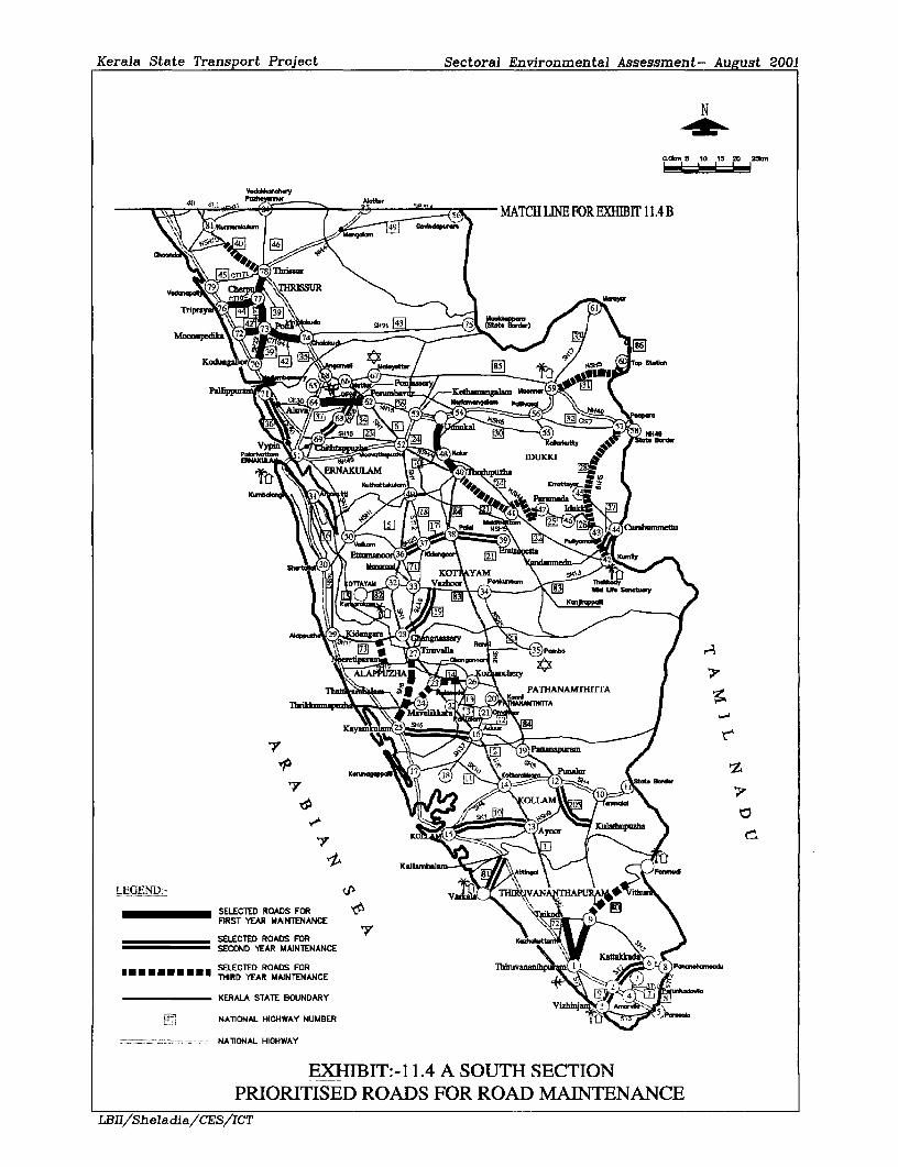
Kerala State Transport Project Sectoral Environmental Assessment- August 2001
N
0.fi, S 10 1S 20 Uk,,m
40P -, ~ MATCH LINE FOR EXHIB1T 11.4 B\R 1 4910s*~dpTbri
Thpi~ ~ 8TflS
~~~~~~~~~~~~~~~~~~~~~~F85
VdN\~~~~~~~~~~~~~~~~~~~~KPld
NATiONAL HIGHWAYK.d ATHNAn=
PNI^~~~~~~~I
LEGENDEXIBT:114 SUT SCTO
SELECTED~~~~~ RAS FO 7
PECONYERMINTSEDNOASFONOACAITNA C
XHhBT:114E SC SECTION
_ SELECTRMED ROADS FOR ROA MAINTENANCE LBIlheada FEIICTYERANTNNE 9\

Kerala State Transport Project Sectoral Environmental Assessment- August 2001
N
0.0I.. 5 tD 15 20 25N.
SECRAOND YA ANEAC)~~ ~KRL STAT BOUDAR
~~~~~~~~~~~~~~~~~~~~~~~~~~ty
v lE\ MACHINFOEXIirrI.A
IBTKOZH B N" R F R
II /efaa/dy
7g St dId!I
SELECTEDZ ROADE\S FO
nRS YEAR MAINTENLNC
FSELECTED ROADS TFONRAC\ g 1 =
SECEOtND YEAR MAINTENANCE _ /><<
| *-" "" "s |THIRED YEEARM^ADINTFENRANCE P
KERALA STATE BOUNDARY c- g
NATIONAL HIGHWAY NUMBERP{it.i q
'- ~~~~~MATCH L1N FOR EXIBIT 11.4 A t::=_-: =-. ;=NATIONAL HIGHWAY
EXHIBIT:- 11.4 B NORTH SECTIONPRIORMTSED ROADS FOR ROAD MAINTENANCE
r,3SIrSh el adi a/CES/ICT

Kerala State Transpori Project Sectoral EnN ironmental Assessment-Aucust 2001
11.4.2 Ambient Water Quality Issues, Impacts And Mitigation
Pollution of water sources; The watercourses should not he used as tip areas andconstruction wastes including wastes. Petrol, Oil and Lubricants must be disposed of at3 approved sites.
11.4.3 Tree removal and Tree Planting Issues, Impacts And Mitigation
* There could be tree removal from the shoulders due to safety reasons. Two trees shall beplanted for every tree removed. The contractor shall plant trees in the locations agreed with3 the Engineer
A' Thte Landscaping, Tree Plantinig and Environmental Enhtancement Plani' is beingprepared for the Kerala State Transport Project with assistance from the Kerala ForestDevelopment Corporation.
Exhibit 11.5 also shows an idea of the Utilities that will have to be shifted away from theI construction corridor. This is given only to identiifr and correlate the tree removal issue iviththe two closely linked issues in terms of the location. The plhysical locationl is sanme within1.5m offfrom the edge of the pavement. A decision to avoid the tree removal alone will notprovide the desired level of service along the maintenance roads as the issue is closely linkedto other utilities.
A number of trees may have to felled along the roads, which falls with in the 1.5m off fromI the edge of the existing pavement.
Mitigation PWD will remove only those trees, which arc extremely necessary falling withinI 0.60 m off the edge of the pavement. The tree removal will be strictly monitored by the PIU.At least two trees will be planted for every tree removed. In all corridors the trees that will becut and removed should be identified and marked prior to the tree cutting. This can be carriedI out just before the start of the construction work as the total number of trees involved will bevery few in any given link. There may be roads or specific locations where slight change inthe alignment may be required without any land acquisition to save several valuable old trees.
3 The contractor shall plant trees in the locations agreed with the Engineer. The entire activitywill be linked to the KSTP Tree Planting Strategy. The compensatory Tree Planting KSTPand the associated tree planting will take care of most of the compensatory tree planting. TreeI cutting will be carried out under a separate Contract. The Contractor will not be allowed tocut trees indiscriminately.3 Vegetation clearance Excessive vegetation is a safety hazard. Grass cutting, Drain clearingetc needs to be carried out. Some vegetation is necessary to prevent soil erosion grass andother roadside vegetation provides erosion protection by slowing flow and trapping3 suspended matter. The vegetation can be a fire hazard. Restricted usability along roadmargins reduces sight distances for drivers both of approaching vehicles and pedestrians andanimals along the roadsides.
11.4.4 Maintenance Roads near Ecologically Sensitive Areas
There are a number of corridors, which passes through the ecologically sensitive areas. Theeco-sensitive areas usually include reserved forests, sanctuaries, national parks, biospherereserves, CRZ areas etc.
1L BII She~idia ( BS Ic-r 11,
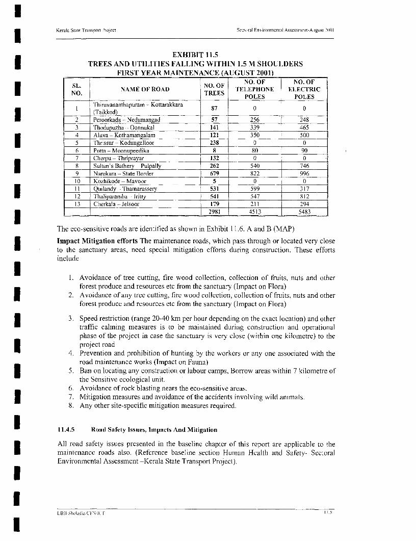
Kerala State Transpon Project Sectoral Fnvironmental Assessment-A igustt 21)01
EXHIBIT 11.5TREES AND UTILITIES FALLING WITHIN 1.5 M SHOULDERS
FIRST YEAR MAINTENANCE (AUGUST 2001)
SL. 1NO. OF NO. OF NO. OFNO. NAME OF ROAD NO. TELEPHONE ELECTRIC
POLES POLES
I Thiruvananthapuram - Kottarakkara 87 0 0
2 Peroorkada - Nedumangad 57 256 2483 Thodupuzha - Oonnukal 141 339 4654 Aluva - Kothamangalam 121 350 5005 Thrissur - Kodungalloor 238 0 06 Potta - Moonupeedika 8 _ 80 907 Cherpu - Thriprayar 132 0 0l 8 Sultan's Bathery - Pulpally 262 540 7469 Narukara - State Border 679 822 99610 Kozhikode - Mavoor 5 0 011 Quilandy - Thamarassery 531 599 3 1712 Thalivaramba - Iritty 541 547 81213 Cherkala - Jelsoor 179 211 2941 l 2981 4513 5483
The eco-sensitive roads are identified as shown in Exhibit 11.6. A and B (MAP)
Impact Mitigation efforts The maintenance roads, which pass through or located very closeto the sanctuary areas, need special mitigation efforts during construction. These effortsinclude
U 1. Avoidance of tree cutting, fire wood collection, collection of fruits, nuts and otherforest produce and resources etc from the sanctuary (Impact on Flora)I 2. Avoidance of any tree cutting, fire wood collection, collection of fruits, nuts and otherforest produce and resources etc from the sanctuary (Impact on Flora)
3. Speed restriction (range 20-40 km per hour depending on the exact location) and othertraffic calming measures is to be maintained during construction and operationalphase of the project in case the sanctuary is very close (within one kilometre) to theproject road
4. Prevention and prohibition of hunting by the workers or any one associated with theroad maintenance works (Impact on Fauna)
| 5. Ban on locating any construction or labour camps, Borrow areas within 7 kilometre ofthe Sensitive ecological unit.
6. Avoidance of rock blasting nears the eco-sensitive areas.* 7. Mitigation measures and avoidance of the accidents involving wild animals.
8. Any other site-specific mitigation measures required.
U 11.4.5 Road Safety Issues, Impacts And Mitigation
All road safety issues presented in the baseline chapter of this report are applicable to theI maintenance roads also. (Reference baseline section Human Health and Safety- SectoralEnvironmental Assessment -Kerala State Transport Project).
Utl.BI SIwladi;;'l (S;l 1- I !
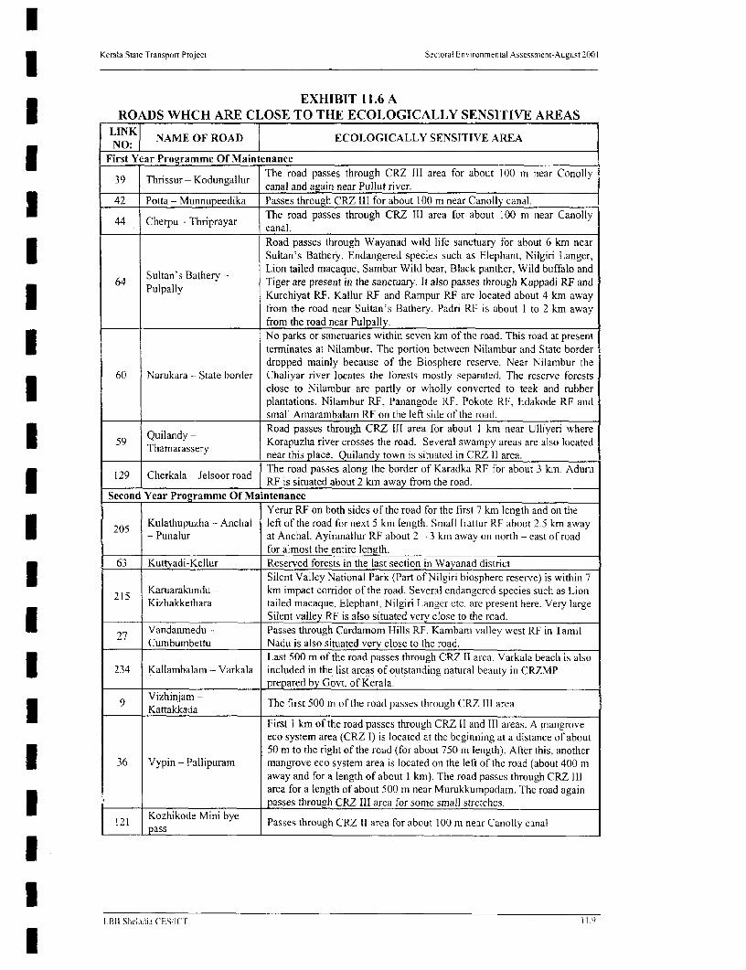
3 Kerala Stale Transport Project Sectoral Enm ronmental Assessment-August 2001
EXHIBIT 11.6 AROADS WHCH ARE CLOSE TO THE ECOLOGICALLY SENSITIVE AREAS
LINKI NAME OF ROAD ECOLOGICALLY SENSITIVE AREANO:
First Year Programme Of Maintenance
39 Tbrissur - Kodungallur The road passes through CRZ Ill area for about 100 m near Conolly39 Thrissur - odungallur canal and again near Pullut river.
42 _Potta - Munnupeedika Passes through CRZ III for about 100 m near Canolly canal.44 Cherpu - Thriprayar The road passes through CRZ III area for about 100 mn near Canolly44 Cherpu - Thriprayar canal.
Road passes through Wayanad wild life sanctuary for about 6 km nearSultan's Bathery. Endangered species such as Elephant, Nilgiri Langer,
Sultan's Bathery - Lion tailed macaque, Sambar Wild bear, Black panther, Wild buffalo and64 Pulpall; Tiger are present in the sanctuary. It also passes through Kuppadi RF and
P y YKurchiyat RF. Kallur RF and Rampur RF are located about 4 km awayfrom the road near Sultan's Bathery. Padri RE is about I to 2 km awayfrom the road near Pulpally.No parks or sanctuaries within seven km of the road. This road at presentI terminates at Nilambur. The portion betwveen Nilambur and State borderdropped mainly because of the Biosphere reserve. Near Nilambur the
60 Narukara - State border Chaliyar river locates the forests mostly separated. The reserve forcstsclose to Nilambur arc partly or wholly converted to teak and rubberplantations. Nilambur RF, Panangode RF, Pokote RF, Edakode RF andsmall Amarambalam RE on the left side of the road.
Quila*dy - Road passes through CRZ liI area for about I km near Ulliveri where59 Thana y Korapuzha river crosses the road. Several swampy areas are also located
Tharnarassery near this place. Quilandy town is situated in CRZ 11 area.
The road passes along the border of Karadka RF for about 3 km. Aduru2 C RF is situated about 2 km away from the road.
Second Year Programme Of MaintenanceYerur RF on both sides of the road for the first 7 km length and on the
205 Kulathupuzha - Anchal left of the road for next 5 km length. Small Irattur RF about 2.5 km awayl - Punalur at Anchal. Ayiranallur RF about 2 - 3 km away on north - east of road
for almost the entire length.63 Kuttvadi-Kellur Reserved forests in the last section in Wayanad district
Silent Valley National Park (Part of Nilgiri biosphere reserve) is within 715 Karuarakundu - km impact corridor of the road. Several endangered species such as Lion
_ Kizlakketliara tailed macaque, Elephant, Nilgiri Langer etc. are present here. Very largeSilent valley RF is also situated very close to the road.I 97 Vandanmedu - Passes through Cardamom Hills RF. Kambam valley west RF in Tamil
Cumbumbettu Nadu is also situated very close to the road.Last 500 m of the road passes through CRZ 11 area. Varkala beach is also
234 Kallanibalam - Varkala included in the list areas of outstanding natural beauty in CRZMPprepared by Govt. of Kerala.
9 Vizhinjam - The first 500 m of the road passes through CRZ III area.Kattakkada____________________________________
First I km of the road passes through CRZ 11 and III areas. A mangroveeco system area (CRZ I) is located at the beginning at a distance of about50 m to the right of the road (for about 750 m length). After this, anotherI 36 Vypin - Pallipuram mangrove eco system area is located on the left of the road (about 400 maway and for a length of about I kni). The road passes through CRZ II]area for a length of about 500 m near Murukkumpadam. The road again
*_____ __Kozhikode_Mini_bye passes through CRZ IlI area for some small stretches.
121 Kozhikode Mini bye Passes through CRZ 11 area for about 100 m near Canolly canal
I RII ShChdi;j CESI 1 r

Kerala State Transport Project Sectoral Environmental Assessment-Autust 2001
EXHIBIT 11.6A (CONTINUED)ROADS WHCH ARE CLOSE TO THE ECOLOGICALLY SENSITIVE AREAS
Third Year Programme Of MaintenanceThe road passes along the border of small Lady Smith RF near Tariyod.
62 Vythiri - Tharuvana Dense mixed jungle is present on the left of the road through out itslength.Idukki wild life sanctuary is very close to the road Endangered species
l 132 Thodupuzha- such as Elephant, Nilgiri Langer, Lion tailed macaque, Sambar WildParamada bear, Black panther. Bear Wild buffalo and Tiger are present in the
sanctuary. Last 6km of the road pass through Thodupuzha RF.Periyar and tiger reserve is very close to the start of the road. Highlyendangered species such as lion tailed monkey, tiger, leopard, Gaur;
28 Kumili - Poopara Elephant etc. are present in the tiger reserve. Periyar Lake RF,Cardamom hill RF (Cardamom), Rattendon valley annexe RF andKambam valley west RF (Tamil Nadu) are also present inside the 7 km
I impact corridor.(Source: Survey of India maps, Forest Department and ESMP)
Many Road Traffic Accidents (RTA) occurring in Kerala could be avoided by a concertedeffort by interested authorities. Better use must be made of basic traffic engineeringtechniques such as lining and signing of priorities at junction and roundabouts as well asmore sophisticated junction redesigns and one way systems. Improved driver education andissuing of licences. Better vehicle roadworthiness inspection and enforcement. Introductionof a Kerala State Highway Code in the vernacular is required. Following driver education andassistance the Police and Courts need to start applying the Motor Vehicles Act and otherlegislation without fear or favour.
The Highway Protection Act recently introduced gives the Highway Authority the necessarypowers to protect the ROW from encroachment; it will need revision to confer furtherauthority and responsibility on the Highway Authority. Improved standards of road safetyI reflect on the quality of life of all road safety reflect on the quality of life of all road users andrepresents a major environmental enhancement.These issues have been addressed formally, by the road safety audit carried out recently. TheI details of the Safety Audit are provided in the Box 5.4 of Chapter 5. A road safety action planwas also be prepared. A road safety code for Kerala is being prepared. As a first yearconstruction a traffic management scheme was providcd in the Design report for maintenanceprepared in June 2001.
Road Safety Impact Mitigation Maintenance work generates positive impacts byU eliminating or reducing environmental problems caused by the deterioration of road surfaces,drains and shoulders. The reduction of poor surfaces and potholes reduces the risk ofaccidents by drivers circumnavigating bad areas and improved surfaces reduce fuelconsumption and the overall running costs.
A formal Traffic Management Plan will be agreed between the Contractor and the Engineerto International Standard before commencing the work on any link. The environmentalaspects of the road safety and accidents prepared for the road improvement and widening partof the project can also be applicable for the maintenance project. The diversion of trafficthrough other roads will minimize the traffic congestion, Further a segregation of LMV andHMV shall be carried at distance from the construction site. The light vehicles can takealternate route. The contractor should clearly give the direction the traffic should take.
LB11I Slihi.i (' 1ES (I C I1)

waala State Funapart ProJeot S&ctoa l,frmmantW Aaaat - Agut 8001
N
SCALE
Jdaoor Ibltk l0 e 20 40 60 o l1OO
\ 14 ARALAM WUXISANA MF 8 w ,
I&WAVANADW&DLI7 RAVKUEABNATONALPAY
s~~~~~ ~~ ~ ~~~~ .. P,CIVZA WCF SACUR
QUILANW~~~~~~~~~l CHMB oVLUF ACUR
YEAR ONE MMNTENAMCE ~ ~ ~ ~ ~ ~ L ARMBQJAMWLLF
- -- - ffAR ThREE MAIN1ENANCMARAYU
-i--u----.-tX3 Raiway LinL NATONA PAtK
River~~~~~~~~~~~~~~~~~i
LEGEND
District boundary ~ ~ ~ ~ ~ ~ ~ anania
a> at bouna ar y
orce A THOREST PANTMENTNCE
ThIRUVANANTHAPURAM' I NE4VYARWIYOEAROTA RESRV
RailwayVg Linez y 30.,^ s
EXIBT 16- B5
Dstrite boundary .ljiL
Lake/Reseveir " '.^ Wildlife anctuary 7 uzh
*_,Naltiona Park goeundry 40]A ;
Forest Area PPMWaF
(Source!-KERALA FOREST DEPARTMENTI)@; @
THIRUVANATHAPUM N W lM E
EXHIBIT:- I 1.6i BMMNNENANCE ROADS IN RELATiON TO ECOLOGICALLY SENSMVE AREAS OF KERALA
LIIS.Jdats/cT

Kerala State Transport Project Sectoral Environmental Assessment-Augtist 2001
11.4.6 Traffic Management During Construction Issues, Impacts And Mitigation
There can be severe traffic disruption during the construction period. It is necessary not todisrupt the traffic along the routes. During the construction period if necessary trafficsegregation in order to utilize the high density of road works need to be worked out. This willallow some traffic for example cars and two wheelers to take a diversion with the heavyvehicles following the existing route.
| During certain times the opposite arrangements will have to arrange depending up on the typeof work and the Characteristics of the deviation available. This needs sufficient labour forceduring construction period.
Traffic Disruption: It is expected that there will be severe traffic disruption duringConstruction.
Mitigation A formal traffic management plan will be agreed between the Contractor and theEngineer to International Standard before commencing the work on any link.I It is most essential to use the standard signs in all the construction works. Addition of locallanguage to these signs will be required to help the common man.
| 11.4.7 Material Resources Issues, Impacts And Mitigation
The environmental aspects related to material sources have been addressed in the baselinechapter. The Engineer will ensure proper utilisation, by the contractor of the quarries and pitswith the aim of minimising any adverse impacts.
Storage or Disposal of Surplus Material: Debris shall be dumped away from watercoursesI at a sufficient distance from the roadside.
Sand: the sand requirements are usually met from the riverbeds. Being an environmental3 issue in Kerala, it is necessary to confirm that source of sand from legitimate areas.
Borrow pits: The selection and operation of Borrow pit areas should conform to the IRCrequirements as specified in the Environmental Management Activity Table.
11.4.8 Ambient Air qualitv Issues, Impacts And Mitigation
Dust nuisance: Nuisance during the work will be addressed. The movement of constructionequipment and machinery may lead to dust nuisance in the dry season. The Contractor willundertake frequent watering of the road surface to reduce the potential nuisance.I Bitumen boilers generate harnful fumes if overheating is allowed and spillage and poorspraying could be harmful to passes by. Training in their use is the best mitigating factor andtheir operation should be limited to experienced road workers. New bitumen work shouldalso be 'dusted down' to prevent nuisance to the public.
11.4.9 Ambient Noise quality Issues, Impacts And Mitigation
Noise from road breakers/compressors can be harmful, operators should always wear earprotectors and all equipment should be properly silenced with breakers fitted with mufflers.I Drain clearance; Excessive plant growth and deposits of rubbish on the margins encroachesover shoulders drains and footpaths in many roads. The neglect of the drainage system leadsto increased occurrence of workouts and serious erosion. Ponding on the surface is a hazard
* to pedestrian and causes great discomfort in frequent splashing from moving vehicles inaddition to the saturation of the road fabric and accelerated deteriorationi.
LiBli Shcladij7 I C FS r l

I Kerala State Transport Project Sectoral Environmental Assessment-Aueust 2001
Soil erosion, landslides, land slips etc; Poorly controlled road drainage leads to unnecessaryerosion of the road fabric as well as to some section of the hinterland in areas of outfalls. Thepresent lack of maintenance allows the various sand anid silt deposit to remain on the road
X surface restricting the passage of pedestrian and vehicles and the blocking of drains.
11.4.10 Flooding Problem during Monsoon, Issues, Impacts and Mitigation
| There are many precautions that should be taken with regard to the heavy precipitation inKerala. Flooding is one of the issues, which require a raise in embankment height. Exceptfour corridors all other first year maintenance corridors there are flooding, which damages the3 road fabric within a very short period of time. Most of the flooding is due to the very lowembankiment heights. The exhibit 11.7 shows the total flood sections in the first year comrdor.The frequency of flooding is not available from the Maintenance study reports.
* Mitigation recommendation The flood sections are also accident-prone areas during themonsoon season. The road condition in flood sections deteriorates rapidly making economic3 losses. The raising of all these sections may be considered as a physical requirement of themaintenance part of the same KSTP maintenance project. The work will remain incompletewithout the rising of the flood sections.
11.5 SOCIAL ENVIRONMENT
Although land acquisition is not part of the road maintenance, due to the planned designrequirements there will be social impacts because of the likely eviction of encroachers andsquatters present on the project corridors. According to the World Bank Operational PolicyOP 4.30 on involuntary resettlement. The project needs to take care of the issues of theencroachers and squatters also. It is the highway authorities responsibility to protect the roadROW, failing of which will result in encroaching and squatting of the Public land. Since theyhave made their living in the encroached land for many years the likely eviction and removalwill result in loss of income, loss of property, loss of business etc. This will also result insome sort of shock and agony in their settled life.
* Road maintenance with pedestrian and all other facilities with minimum investment willenhance road safety and capacity while their construction and upkeep will provide local
| employment.
THE EXHIBIT 11.7THE TOTAL FLOOD SECTIONS IN THE FIRST YEAR CORRIDOR
TOTAL FLOOD DEPTH OF DURATION RAISING RAISINGSL LINK SECTION FLOODING OF OF EOBANKh
NO NO.in (n)FLOODING EMBANKMIENT EMAKN
I 1 2550 0715 to One day Included in| __ ~~~~~~~~~~~~~~~~~0.20m _the project
* ~~~~~~~~~~~~~~~~~~~~~~~~~~~~~~Not Included2 S0 150 0.50 1.' hrs May be considered in the
l 3 29 0 0 0 _ . p r o _ramm_I _~~~~4 _ 34 0 0 0 _ _ _
5 39 350 0.3 to I hr to May be considered Partly____ 1.0~~~~~~~~~~L 2 davs icue
6 42 1000 0153to I hr Included
7 44 400 0.2 to I hr NMay bc conisidered Not included
1 It31 Sl rI.ijvli (AES [C 1t 1 11

| Kerala State Transport Project Sectoral Environmental Assessment-August 2001
F ~~~~~~~~0.3l_X 64 0 0.3 0
9 60 1875 0.2 to I day to 4 days May be considered Partly_____________ 1.2 _ _ _ _ _ _ _ _ incIluded
10 58 1100 0.15 to Once a year May be considered PartlyI ____ _________ ~~~~~~~~~~~~0.2 inicluded
1 5s9 1250 0.6 to Fvice a year May be considered Partly
12 121 1800 0.15 to I day to May be considered Not included1.65 One week
Only at Cherkala Not13 129 Junction o - may be considered AvailableI | _ ~~~~~~Total 10475 metre
(Source: Maintenance study Main Report Junie 2001)
| Road maintenance may therefore be regarded as a very positive Social and Environmentalactivity. Similar to road construction and road widening/improvement projects, roadmaintenance also demands "good engineering practices' which provide environmental
| safeguards.
11.5.1 Social issues Concerning Maintenance Activities
One of the impediments to the adoption of modem pavement technology is the perceivedsocial implication of abandoning manual construction methods. This must be implementedsympathetically. There are two recommendations to ameliorate this effect;
* First to reintroduce routine maintenance -routine maintenance is by nature labourintensive;
* Second is to provide footpaths along the roads wherever possible.
| 11.5.2 Project Affected Persons (PAPs) Issues, Impacts And Mitigation
Since there will not be any need for additional land acquisition for maintenanceconsiderations there will not be any Project Displaced Persons (PDP). However there will bea number of Project Affected Persons, mostly encroachers and squatters.
Encroachers Many developmental Projects affects persons lacking full legal title to the landor structures they occupy. These persons are known as encroachers if they have illegallyextended their legally held property on to the public or other private land,
Squatters The persons are known as squatters if they illegally grab and settle on public orI private land for either livelihoods or living therein.The encroachers and squatters can be classified into three broad categories:
3 1. Those with longstanding and sometimes even ancestral claims to the lands theyoccupy.
2. Those who have occupied land more recently.I 3. Those who move into an announced project area or other zone, opportunisticallyseeking to receive benefits under a resettlement programme.
It is the second category of encroachers and squatters who become most adversely affectedI by a development project. For the first category Indian law permits them ownership rights ifthe possession exceeds 10 years. For the third category, Indian laws such as the eviction Actof 1977 and the Public Premises (Eviction of Unauthorised Occupants) Act of 1991 affirmthat loss of structurc on encroached land but do not entitle the occupant or owner of thestructure to compensation.
L stILShchadi; Cl-S 1T 1.13
3 Kerala State Transpor1 Project Sectoral Environmental Assessment-August 2P00
Identifying people as Encroachers or Squatters on public land is a difficult task unless theI matter is obvious or the people themselves claim to be such. The absence of proper ROW inthe State Highways or the district roads complicates the matter.
3 Mitigation. PWD will maintain a 'status quo' in all the areas including critical areas with animproved road safety measures such as lining signing etc. There will be warning signs andspeed control provisions (bumps, rumble strips etc) as a part of the proposed road safetyI measures. Hence there will not be any Squatters and Encroachers due to the implementationof the project. If required, all issues associated with the identified Squatters and Encroacherscan be dealt with the same principles of the Resettlement and Rehabilitation policyI framework. The State Government for the implementation of Kerala State Transport Projectadopted this policy. The status quo will not make it necessary to identify the Squatters and3 Encroachers even in the critical stretches.
11.5.3. Tourism and Social Activities in the available corridor
3 There are considerable public activities on the sides of the roads. There are daily or weeklymarkets. The social activity is due to the lack of any other open areas. Rural corridors aremost affected. The roads are also closely linked to the Tourism.
The following links have higher Tourism Potential
Link 80 Ponmudi roads leading to the Ponmudi tourist location
Link 205 Famous fresh water Lake at Shastham Kottai
Link 28 Periyar lake and tiger reserve and wild life sanctuary
Mitigation The 'lining and signing of road' and other traffic controls will minimise all socialactivities within the maintenance corridors. The improvement of these roads will bring asmall but a steady positive boost to the economy of the State. The maintenance work withadequate safety measures will help the tourism sector positively.
3 11.5.4 Cultural Properties Issues, Impacts And Mitigation
There are a number of cultural properties by the side of the maintenance roads. These culturalproperties are shrines, churches, mosques, temples, tree shrine etc. The project is in the
* process of developing a Cuiltural Property Rehabilitation Polic)y. This policy has laid out thegeneral guidelines to deal with the problem and also some environmental enhancement plan
| The Most Important Religious Properties That Attracts Large Scale Pilgrims OfImportance Are:
Link 205 Lord Ayyappa temples at Shasthamkonam
Link 27 Ettumanoor Mahadeva temple also important place enroute to Sabarimala
| Link 34 Famous pilgrim centre at Aluva. Periyar River: a very important place forShivarathri festival
Link 39 Kodungalloor is a town of immense historical importance and an ancient centreof trade and commerce with the Jews, Phoenicians, Greeks, Roman and thieArabs. The thriller city was earlier known as Muziris to the Greeks and Romansand was the major natural Port in the western coast till 13th century when a
X cataclysm silted its mouth and opened the Port at Cochin, resulting in the shift ofcommerce. It had been the first settlement for the Jews. Christians and Muslims
lL BB SIttCkIJ;1 CES IC1 1 t
Kerala State Transport Project Sectoral Environmental Assessment-August (100 I
in India. The town is famous for its Cheraman Juma Masjid built in 625 A.D.| Dilapidated synagogue, Portuguese fort, Saint Thomas Memorial church and
Kurumba Bhagavathi temple of the Bharani Festival fame.
Link 42 the corridor traverses through pre-eminently residential and commercial areas.* No cultural property, historical monument or places of religious importance are
located along the corridor in the ROW. Potta (Muringoor) is a newly emergedChristian Divine Retreat Centre, frequented by large number of pilgrims duringall days of the year. Irinjalakuda Koodalmanikya Temple dedicated to Bharatha,the brother of Lord Rama is another attraction.
Link 44 Thriprayar is famous for its Hindu Temple.
An improvement in the road condition may bring more traffic to these corridors because, of its3 location close to the religious places.
11.5.5 Unemployment Due to Stoppage of Use of River Sand In Road ConstructionActivities
The sand requirements are usually met from the riverbeds. The total ban of river sand miningin fact, lead to unemployment to those who were actively involved in the job. This was aflourishing job until recently till the banning of sand mining. Although banning is not directlyrelated to the KSTP, the road construction and maintenance activities were solely dependingon the river sand for maintenance as well as for new road construction activities. It is alsoE noticed that there is Illegal mining in almost all the riverbeds in a clandestine nature but atmuch reduced level. People once involved will be tempted to do it, as it is a highly profitablebusiness. Until recently the taxes, duties and other controls were not present which incurredhigh losses to the government.
11.5.6 Access problems
In all activities associated with road works in Kerala access problems could be a seriousSocial issue because of the ribbon development. This is more important due to the fact thatalong narrow road corridors numerous schools, hospitals, markets etc are also located. This is3 more important due to the fact that along narrow road corridors numerous schools, hospitals,markets etc are also located.
Mitigation This necessitates good public relations and there should be trained local* (language) people to deal with such issues. There should be consultation prior to the
maintenance activities and also towards the middle of the maintenance activities.
11.5.7 Paddy field
Being a sensitive land use (hence social issue) the conversion of paddy fields needs to beavoided. Since there will not be any land take for the maintenance of roads, this aspect hasvery less significance.
Mitigation. The construction of retaining walls in these sections may be considered. This3 will enable the optimum use of the available corridor, thus providing greater road safety.
11.5.8 Tribal settlements
Link 64 passes through Wayanad wildlife sanctuary and also very close to many tribalsettlements. A major temple located near the corridor is the Pulpally Sita Devi Temple. Thecorridor passes through the tribal areas and villages; Sulthans Bathery, Chethalayamn,3 Pulpally, Mullankolly, Pathanikuppu, Perikallur. The corridor is important from the socialpoint of view as it offers connectivity to the native, indigenous tribes. Native tribes mainly
LB311 SIslidadLi CESICT 1.
Kerala State Transport Project Sectoral Environmental Assessmcnt-August 2001
consists of various sects like Paniyas, Kurumas, diyars. Kurichyas. Ooralis, Kattunaikkans,etc. The corridor falls under the Nilgiri biosphere reserve.
Mitigation This particular road will be largely useful to the development of the tribal areas.The road improvements will positively benefits the tribal settlements in the region.
11.6 ENVIRONMENTAL MANAGEMENT PLAN FOR MAINTENANCE| ACTIVITIES
The Contractor should recognise this part of the Sectoral Environmental Assessment (SEA)and refer to the Generic Environmental Management Activity Table shown in Exhibit 11.8I for Contract clauses, Responsible organisation, and time frame and implementingorganisation. The project Specific requirerments are shown in the ESMP for First YearMaintenance Programme.
Contractor's responsibility: The Contractor will be requested to* Preserve trees as far as possibleI * To ground mold land and allow for regeneration of indigenous plant life by spreading
of seeded soils.* Restore the natural flow of water
* Maintain camps and depot areas as described for construction contractors.
Construction Machinery Standards: A list of equipment and machinery required for theI maintenance works in Kerala State highways project is attached for reference. The contractorshould make use of the environmental friendly equipment of high-energy efficiency, lownoise and emissions.
i The typical machinery requirements are:* Hot mix plant
* * Paver
- Tipper Trucks. Rollers-Pneumatic Tyred and Tandem with/without vibrations
i * Pressure Distributors Truck- Front end loaders
* * Air Compressors
Il
l
LB3II 5hlkltil.t.:E S IC 1F 11I (
l

- --- - -- - - m - - m - m m - m
EXHIBIT 11.8 ENVIRONMENTAL MANAGEMENT PLAN (EMAP)(FOR MAINTENANCE CONTRACTS ONLY)
Exnvironmental Irnpact Mitigation; Measures taken or to be taken Time frame Implementing Responsible ContractualEnvironmentallImpact Mitigation Measures taken or to be taken Organisation Organisation* Clause
Dust Water should be sprayed as required during the construction During Contractor The Engineer Specification Ill1,works. reconstruction At present no 111.5, 111.8,Vehicles delivering materials should be covered to reduce and Construction in-house 111 9spills and dust blowing off the load work environmental
capacity isformalised inPIU Eng. fromnSPCB formonitoring
Asphalting Asphalt mixing sites should be sited over 500 m from any During Contractor PIU Specification I I 1,communities. Construction EO 111.5Mixing equipment should be well confined, and be equippedwith a dust-removal device. Operators should wear dustmasks and ear protection l
Air Pollution Vehicles and machinery are to bc regularly maintained in Throughout Contractor PIU Specification 111,
order that emissions conform to National and State Standards construction EO 111.5Noise Noise standard at processing sites, e.g. aggregate crushing Throughout Contractor PIU Specification 111,
plants, will be strictly monitored to prevent exceeding of construction EO 111.5GOT noise standards. Workers in the vicinity will wearprotectors and their working time should be limited as asafety measure.In construction sites within 150 in of sensitive receptorsconstruction will be stopped fi-om 22:00 to 06:00. PIIJ EMPMachinery and vehicles will be maintained to keep their EO Special site-noise to a minimum. specific action.
__ _ __ _ _W ATER I__ _ _ _ _ _ _ _ _ _ _ _ _
Alterationi of drainage In sections along watercourses, earth and stone will be Whenever Design Unit and PIU Specificationand flooding properly disposed of so as not to block rivers and streams, encountered during Contractor EO 201,301, 304,
thereby preventing adverse impact on water quality. All constructioni. 30)6, 309necessary measures have been taken to prevent earthworks Contractorand stone works related to the road from impeding drainage atrivers, streams and canals or existing irrigation and drainagesystems. Drainage to reduce retention time of flood water,
* The Engineer is responsible for the administration of the contract on behalf of the Employer. The following orgatnisationis may assist in the monitoring of thework.

- - - - - m m - - - - m - - - -- m
EXHIBIT 11.8 ENVIRONMENTAL MANAGEMENT PLAN (EMAP)(FOR MAINTENANCE CONTRACTS ONLY)
Environmental Impact Mitigation Measures taken or to be taken Time frame Implementing Responsible ContractualOrganisation Organisation Clause
Silting Construction materials or waste likely to give rise to Throughout Contractor PIU Specification 306,contaminated containing fine particles e.g., in lime or fly ash construction EO 305.3.7will be stored in an enclosure such that sediment-laden water period. Forest Dept.does not drain into nearby walercourses, but rather percolatesslowly into the soil. l
Contamination from All justifiable measures will be taken to prevent the Throughout Contractor PIU Specification 306Wastes wastewater produced in construction from entering directly construction period EO
into rivers and irrigation systems lSewerage Disposal A minimum distance of any sewage or toilet facility from Throughout Contractor PIU Specificationduring Construction at water sources should be 200 metres. construsction EO 111.9Services Centres period.Contamination from fuel Vehicle maintenance and refuelling will be confined to areas Specif.icatioand lubricants in construction camps designed to contain spilled lubricants Throughout PIU 201.2 201.4,
and fuels. Waste petroleum and lubricants must be collected construction Contractor EO 301.1.3.10,stored and taken to approve disposal sites, according to GOI period. SPCB 304.3.3laws.
Sanitation and Waste * Sufficient measures will be taken in the constructionDisposal in Construction camps, i.e. provision of garbage tanks and sanitationCamps facilities. Waste in septic tanks will be cleared
periodically as necessary. Before and during Specification* Drinking water will meet Indian National Standards, building o0 Contractor PIU 122, 201.2, 201.4,* Garbage will bc collected and disposed of daily. construction SPCB 306* Special attention shall be paid to the sanitary condition of camps.
camps.* Camps will be located at a minimum distance of 200 m
from water sources.Contamination from fuel Vehicle maintenance and refuelling will be confined to areas Throughout Contractor PIU Specificationand lubricants in construction camps designed to contain spilled lubricants construction EO 201.2 201.4,
and fuels. Waste petroleum and lubricants must be collected period. SPCB 301.1.3.10,stored and taken to approve disposal sites, according to GOI 304.3.3laws.
Borrow pits Borrow pits have been identitied outside the ROW Before During Contractor PIU IRC:10 1961opening additional borrow pits operating pits shall be closed construction EO Specification
I as per the IRC Specification 111.2, 305.2.2
2
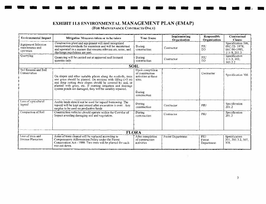
m-=- - - -- - - -m - -= -m m -
EXHIBIT 11.8 ENVIRONMENTAL MANAGEMENT PLAN (EMAP)(FOR MAINTENANCE CON'I1RACTS ONLY)
Environmental Impact Mitigation Measures taken or to be taken Time frame Implementing Responsible ContractualOrganisation Organisation Clause
} Equipment Selection Construction plant and equipment will meet recognised Specification 106,qmaintenance and international standards for emissions and will be maintained During Contractor PIU IRC:72- 1978;maIntenance and and operated in a manner that ensures relevant air, noise, and construction EO IRC:90- 1985,operation discharge regulations are met. 111.9, 201.3
Quarrying Quarrying will be carried out at approved and licensed During PIU Specificationqufisonly. cosrcinContractor EO111.3, 302,
l quarries only. construction EO 305.2.2I ___________ SO ILSoil Erosion and Soil Upon completionConservation of construction Contractor Specification 306
On slopes and other suitable places along the roadside, trees activities at theseand grass should be planted. On sections with filling (>3 m) sites.and deep cutting their slopes should be covered by sod, orplanted with grass, etc. If existing irrigation and drainagesystem ponds are damaged, they will be suitably repaired.
Duringconstruction
Loss of agricultural Arable lands should not be used for topsoil borrowing. The Stopsoil topsoil will be kept and reused after excavation is over. Any During Coiitractor PIU 201.2
surplus to be used on productive lands constr-uction 1.Compaction of Soil Construction vehicles should operate within the Corridor of During Contractor PIU Specification
Impact avoiding damaging soil and vegetation. construction 201.2
FLORALoss of trees and Areas of trees cleared will be replaced according to After completion Forest Department PIU SpecificationAvenue Plantation Compensatory Afforestation Policy under the Forest of construction Forest 201, 301.3.2, 307,
Conservation Act - 1980. Two trees will be planted for each activities Department 308,tree cut down.
3

- - - - - - - - - - - - - -- - -- m
EXHIBIT 11.8 ENVIRONMENTAL MANAGEMENT PLAN (EMAP)(FOR MAINTENANCE CONTRACTS ONLY)
Environmental Impact Mitigation Measures taken or to be taken Time frame Implementing Responsible Contractual____________________________ _____.______ Organisation Organisation Clause
Compaction of Tree clearing within thc ROW should be avoided beyond that During cleaning Contractor PIU Specificationvegetation which is directly required for construction activities and / or operations Forest 201.2
to reduce accidents. During DepartmentSee soil compaction also. construction
FAUNA I
During PIU SpecificationCompensatory Construction workers should be told to protect natural construction Contractor Forest 201.2, 201.3,Afforestation resources and wild animals. Hunting is prohibited. Forest Department Dopatthient 201.4.
Environmental Impact Mitigation Measures taken or to be taken Time frame riplementing Responsible Contractual___ ___ ___ __ ___ ___ __ ___ ___ __ ___ ___ ___ __ ___ ___ __ ___ ____I Organisation Organisation Clause
SOCIALLoss of Access Temporary access should be maintained throughout the
course of the work unless the Contractors makes joint During Contractor PIU Specificationagreement with any affected frontagers or legitimate road construction 112,user, l
Traffic congestion and During PIU andcongestion If there is traffic congestion during construction, measures construction Contractor State Police Specihication
should be taken to relieve it as far as possible with the co- 112, 119, 201.2operation of the traffic police.
Healtl and Safety All contractors' staff and workers will be working along busy During _ l
traffic routes. They must wear high visibility purpose made construction Contractor Contractor Specificationoveralls or trousers/a waist coat at all times All operators 111.6working with any materials above head height (even intrenches) must wear hard hats all the time. l
An Environmental Management Plan prior to the connnencement of construction, indicating how the Contractor plans to implement environmental requirements as
stated in the General Conditions of Contract clause 19 titled " Safety, Security and Protection of the Environmenlt" is also required.
4
Kerala State Transport Project Sectoral Environmental Assessment August 2001
REFERENCES
I Brandon Carter, Kristen Hommann; October 17, 1995- The Cost of Inaction: Valuing theEconomy-Wide Cost of Environmental Degradation in India, Asia Environment Division,World Bank.
Census Department; 1981- District Census Handbook Kottayam District, Village and Townwise Primary Census Abstract.
Census Department; 1991- District Census Handbook, Alappuzzha District, Village and TownDirectory, Village, Panchayat and Town wise Primary Census Abstract.
Central Pollution Control Board; 1991- National Ambient Air Quality Status And Statistics ofIndia.
Central Pollution Control Board; 1992- National Ambient Air Quality Status And Statistics of3 India.
Central Pollution Control Board; 1993- National Ambient Air Quality Status And Statistics ofIndia.
Central Pollution Control Board; 1994- National Ambient Air Quality Status And Statistics ofIndia.
Central Pollution Control Board; 1995- National Ambient Air Quality Status And Statistics ofIndia.
Central Pollution Control Board; 1996- National Ambient Air Quality Status And Statistics ofIndia.
Central Pollution Control Board; June 1999- Parivesh Letter Vol 6 (1), Ministry ofEnvironment and Forests, Government of India, New Delhi.
* Centre for Earth Science Studies (CESS); 1984- Resource Atlas of Kerala.
Centre for Earth Science Studies (CESS); 1995, Coastal Zone Managemcnt Plan of KeralaPrepared for Department of Science And Technology, Government of Kerala.
Centre for Earth Science Studies- Coastal Zone Management Plan of Kerala, Department ofscience Technology and Environment, Government of Kerala.
Centre for Water Resources and Development (CWRDM) Government of Kerala; 1995-I Water Atlas of Kerala.
Dainik Jgaran Hindi Daily; 1998- Jagaran 's Kerala At a Glance, District-wise StatisticalReview.
Department of Economics and Statistics; 1996- Panchayat Level Statistics, Kottayama District.
Elangovan, T.; August 17,1999- Road Accidents in Kerala; Regional Workshop on RoadAccidents in Kerala.
LBI/Sheladia/CES/ICT

Kerala State Transport Project Sectoral Environmental Assessment August 2001
Irrigation Department, Government of Kerala; April 2000- Kerala State Highways Projectwith Inland Water Transport Pilot Scheme, Final Engineering Report on the Inland waterTransport Pilot component.
Irrigation Department, Government of Kerala; April 2000- Kerala State Highways Projectwith Inland WEater Transport Pilot Scheme, Final Feasibility Report on the Inland waterTransport Pilot component.
Isaac, Dr. Kuncheria P.; August 17,1999- Road Safety Auditing; Regional Workshop on RoadAccidents in Kerala.
Kerala Gazattiers; 1975- Gazettier of India, Kottayam District.
Kerala Gazettiers; 1975- Gazettier of India, Alleppey District.
Kerala Highway Research Institute, Public Works Department, Kerala- Technical Report onSurvey and Evaluation of Locally Available Materials in Kerala, Report onThiruvanathapuram District.
Kerala Public Works Department, Government of Kerala, Lea International Ltd., Canada inassociation with Lea Associates South Asia Pvt. Ltd., prepared for Draft Final Report,Maintenance Planning, Volume I, Main Report, November 2000.
Kerala State Pollution Control Board (KSPCB) Thiruvananthapuram; 1997- Environment,Effluent, Emission and Noise Standards & Guidelines.
Krishna, J.; 1984- Indian Standard Criteria for Earthquake Resistant Design of Structures.(Forth Revision), Indian Standard: 1893-1984, 77p.
NATPAC Draft Report; 1998- Techno-Economic Feasibility Study of Kollam-Kovalunm andI~~~~~~~~~~ Kottapuram -Kasargord sections of West Coast Canal (WCC) in Kerala.
NATPAC; August 1999- Scientific Investigation of Accident-prone Locations on StateHighwavs in Kerala State Study Report, Vol -1.
Public Works Department, Government of Kerala (GOK), Design Report, First YearMaintenance Programme of Kerala State Transport Project, June 2001.
Public Works Department, Government of Kerala (GOK), Main Report, First YearMaintenance Programme of Kerala State Transport Project, June 2001.
Public Works Department, Government of Kerala (GOK). Phase I Design Report, April 2000Kerala State Transport Project.
Public Works Department, Government of Kerala, Environmental and Social ManagementPlan (ESMP) for Maintenance, August 2001, Project Coordinating Consultants, Prepared forKerala State Transport Project,
Public Works Department, Government of Kerala, Resettlement Action Plan (RAP), Preparedfor Kerala State Transport Project, February 2001.
Public Works Department, Government of Kerala; April 2000- Kerala State TranisportProject, Final Feasibility Reports on the Highways Component.
LBl/Sheladia/CES/ICT

Kerala State Transport Project Sectoral Environmental Assessment August 2001
Specifications for Road and Bnrdge works, Ministry of Surface Transport (Road wing) IndianRoads Congress (IRC), New Delhi 2000.
Survey of India (SOI); 1967- Survey of India Maps, Government of India.
| The World Bank Operational Directive 4.30; June 1990- Involuntary Resettlement.
The World Bank Report TWU 13; September 1994- Roads and The Environment: AE Handbook, Chapter 17 -Road Safety, Page 117.
Transport And Road Research Laboratory- Towards Safer Roads in Developing Countries.
TRRL UK; 1991- A guidefor Planners and Engineers.
Tsunokawa, K. And C. Hoban; 1997- Roads and The Environment: A Handbook, WorldBank Technical Paper No. 376. 225p.
U.S. Environmental Protection Agency; December 31, 1971- Noise From ConstructionEquipment and Operations, Building Equipment and Home Appliances, NJID, 300. 1.
World Bank; 1991- Environmental Assessment Sourcebook, World Bank Technical PaperNumber 139.
1
LBI/Sheladia/CES/ICT
IL