Selection and validation of reference sites in small river basins
22
Primary Research Paper Selection and validation of reference sites in small river basins M.L. Chaves 1, *, J.L. Costa 1 , P. Chainho 1 , M.J. Costa 1,2 & N. Prat 3 1 Instituto de Oceanografia, Faculdade de Cie ˆncias da Universidade de Lisboa, Campo Grande, 1749-016 Lisbon, Portugal 2 Departamento de Biologia Animal, Faculdade de Cieˆncias da Universidade de Lisboa, Campo Grande, 1749-016 Lisbon, Portugal 3 Departament d’Ecologia, Universitat de Barcelona, Diagonal 645, 08028 Barcelona, Spain (*Author for correspondence: E-mail: [email protected]) Received 15 November 2005; in revised form 23 May 2006; accepted 4 June 2006; published online 6 September 2006 Key words: Water Framework Directive, hydromorphological criteria, physico-chemical criteria, biological criteria, ecological status, Mondego River basin Abstract Type-specific reference conditions that describe sites with no or only very minor anthropogenic disturbances are a basic requirement of the European Water Framework Directive. The reference condition approach implies a previous determination of criteria acceptable for the definition of near-natural stretches. In this paper, a methodology based on selection and validation procedures is applied to a Portuguese watershed to guide the identification of reference sites. The methodology consisted of three phases: (1) a preliminary site inspection through the use of maps, available data and an extensive screening field cam- paign that resulted in the selection of 52 potentially undisturbed small- and medium-sized rivers stretches, ranging from 43 to 1069 m in altitude, with catchment areas between 4 and 641 km 2 and representing siliceous and calcareous riverbeds; (2) a detailed site selection based on ten pre-defined criteria involving physical/social/biological attributes that indicated catchment land use changes and alien vegetal riparian species as major human impacts; (3) a site validation procedure involving detailed investigation of benthic macroinvertebrate communities, riparian vegetation, in-stream habitat quality and chemical parameters that showed riparian wood-related problems as a major restriction to validate a stretch as a near-natural site. Only about 12% of all investigated river sites, accounting for 600 m of all 5200 m studied, could be considered as near-reference stretches or sites retaining essential natural functions. Selection and validation procedures can identify different sites as reference, which reinforces the need for applying both procedures. The results presented can help to accomplish the requirements of the EU – Water Framework Directive by selecting reference sites as the first step to establish biological reference conditions and, simultaneously, to form a basis for nature conservation strategies. Introduction The Water Framework Directive (WFD – European Commission, 2000) replaces or complements most of the earlier European water legislation (Holland, 2002; Irvine, 2004). One of the main objectives of this new water policy requires that all European bodies of surface water have to achieve good sur- face water status by 2015. Until the early 1990s, water quality monitoring in most European Union state members was based mainly on chemical and physical parameters (Hering et al., 2003). The WFD promoted a major change in environmental assessment criteria since it requires the evaluation of the ecological status of all water bodies using predominantly biological criteria based on four biological indicator groups for rivers: phyto- plankton, macrophytes and benthic invertebrate Hydrobiologia (2006) 573:133–154 ȑ Springer 2006 DOI 10.1007/s10750-006-0270-5
Transcript of Selection and validation of reference sites in small river basins
Primary Research Paper
Selection and validation of reference sites in small river basins
M.L. Chaves1,*, J.L. Costa1, P. Chainho1, M.J. Costa1,2 & N. Prat31Instituto de Oceanografia, Faculdade de Ciencias da Universidade de Lisboa, Campo Grande, 1749-016 Lisbon, Portugal2Departamento de Biologia Animal, Faculdade de Ciencias da Universidade de Lisboa, Campo Grande, 1749-016 Lisbon,Portugal3Departament d’Ecologia, Universitat de Barcelona, Diagonal 645, 08028 Barcelona, Spain(*Author for correspondence: E-mail: [email protected])
Received 15 November 2005; in revised form 23 May 2006; accepted 4 June 2006; published online 6 September 2006
Key words: Water Framework Directive, hydromorphological criteria, physico-chemical criteria, biological criteria,
ecological status, Mondego River basin
Abstract
Type-specific reference conditions that describe sites with no or only very minor anthropogenicdisturbances are a basic requirement of the European Water Framework Directive. The reference conditionapproach implies a previous determination of criteria acceptable for the definition of near-natural stretches.In this paper, a methodology based on selection and validation procedures is applied to a Portuguesewatershed to guide the identification of reference sites. The methodology consisted of three phases: (1) apreliminary site inspection through the use of maps, available data and an extensive screening field cam-paign that resulted in the selection of 52 potentially undisturbed small- and medium-sized rivers stretches,ranging from 43 to 1069 m in altitude, with catchment areas between 4 and 641 km2 and representingsiliceous and calcareous riverbeds; (2) a detailed site selection based on ten pre-defined criteria involvingphysical/social/biological attributes that indicated catchment land use changes and alien vegetal riparianspecies as major human impacts; (3) a site validation procedure involving detailed investigation of benthicmacroinvertebrate communities, riparian vegetation, in-stream habitat quality and chemical parametersthat showed riparian wood-related problems as a major restriction to validate a stretch as a near-naturalsite. Only about 12% of all investigated river sites, accounting for 600 m of all 5200 m studied, could beconsidered as near-reference stretches or sites retaining essential natural functions. Selection and validationprocedures can identify different sites as reference, which reinforces the need for applying both procedures.The results presented can help to accomplish the requirements of the EU – Water Framework Directive byselecting reference sites as the first step to establish biological reference conditions and, simultaneously, toform a basis for nature conservation strategies.
Introduction
TheWaterFrameworkDirective (WFD–EuropeanCommission, 2000) replaces or complements mostof the earlier European water legislation (Holland,2002; Irvine, 2004). One of the main objectives ofthis new water policy requires that all Europeanbodies of surface water have to achieve good sur-face water status by 2015. Until the early 1990s,
water quality monitoring in most European Unionstate members was based mainly on chemical andphysical parameters (Hering et al., 2003). TheWFD promoted a major change in environmentalassessment criteria since it requires the evaluationof the ecological status of all water bodies usingpredominantly biological criteria based on fourbiological indicator groups for rivers: phyto-plankton, macrophytes and benthic invertebrate
Hydrobiologia (2006) 573:133–154 � Springer 2006DOI 10.1007/s10750-006-0270-5

and fish faunas. Also, the WFD requires ecologicalclassification to be based on deviation from theexpected natural condition, but without clearadvice on how to perform this task (Wallin et al.,2003). However, it is necessary to first define andcharacterize the natural status of each water bodytype, usually designated as reference condition(RC). RC will consequently provide the baselineagainst which to measure anthropogenic impacts,describe the biological community potential anddefine spatial and temporal natural variability(Reynoldson et al., 1997; Economou, 2002; Wallinet al., 2003; Bailey et al., 2004). Nevertheless, RCdo not necessarily equate to totally undisturbedpristine conditions. They might include very minordisturbances. Human pressure is allowed to bepresent in a RC as long as high ecological status isstill achieved. (Economou, 2002; Wallin et al.,2003; Bailey et al., 2004). A RC represents infor-mation from numerous similar sites (e.g. Rey-noldson et al., 1997; Wallin et al., 2003; Bailey etal., 2004). Establishing type-specific RC andaccordingly setting type-specific ecological classboundaries allows an accurate ecological evalua-tion of each site by comparison with very similarplaces presenting no or only very minor anthro-pogenic disturbance (Wallin et al., 2003; Bailey etal., 2004). Hydromorphological and physical–chemical attributes for RC should meet criteria ofminimal disturbances to support reference bio-logical communities (Reynoldson et al., 1997;European Commission, 2000). Five different ap-proaches and/or combinations are currently sug-gested for determining a RC for biological criteria(e.g. Barbour et al., 1996; European Commission,2000; Economou, 2002; Wallin et al., 2003): (1)extensive spatial surveys, (2) predictive modelling,(3) historical data, (4) paleo-reconstruction and (5)expert judgment, the last being implicit to all fourformer procedures. In order to establish a RCbased on an extensive survey, it is necessary to findsites that are thought to have been minimally ornever exposed to the stressor(s), but also to berepresentative of each water body type. In rela-tively unperturbed areas, if undisturbed or mini-mally disturbed sites are available and numbersare adequate for determining a reliable measure ofmean, median or mode and distribution of values(percentiles, confidence limits), then the use ofsurvey data is one of the most straightforward
methods available for establishing RC (Barbour etal., 1996; Wallin et al., 2003; Bailey et al., 2004;Nijboer et al., 2004).
If reference sites were easily distinguished fromdisturbed sites, impairment could be assessedwithout any measurement (Resh et al., 1995).However, the assessment of aquatic ecosystemsintegrity should no longer be based on subjectivecriteria but reference sites must fulfil specificoperational criteria that easily indicate the absenceof exposure to stressors (Bailey et al., 2004). Pre-classification, using clearly defined a priori criteriafor human-generated disturbance based on severalphysical/social/biotic features, is becoming com-monly used in order to preliminarily assign asampling site to a degradation class (Economou,2002; Hering et al., 2003) and thus distinguish areference from a stressor exposed site. SinceEuropean rivers have been affected by multiplepressures such as organic pollution (Hering et al.,2004), identification of reference sites requiressuitable methods and biological assessment is of-ten needed to validate the preliminary selection ofa site, since some forms of disturbance are neitherreadily visible, nor detectable with the commonscreening methods used (Hering et al., 2003;Nijboer et al., 2004). Despite allowing biologicalpotential or best attainable conditions to bereadily described (Nijboer et al., 2004) and inher-ent natural variability to be included (Barbouret al., 1992), spatially extensive datasets are highlyexpensive (Economou, 2002).
Although historical data has been suggested asan additional essential source to describe referencecommunities (Ehlert et al., 2002; Nijboer et al.,2004), in Portugal as well as in other Mediterra-nean countries, that approach would be difficult toimplement since studies concerning biotic com-munities covering large catchment areas are veryrecent (e.g. AMBIO et al., 1999, Aguiar et al.,2002; Graca et al., 2002; Pinto et al., 2004) andformer investigations, even spatially and tempo-rally confined, are nearly non-existent (e.g. Gracaet al., 1989; Cortes & Monzon, 1991). Predictionof expected reference conditions using models andpaleo-reconstruction are particularly useful whenhuman impacts are so intense and widespread thatreference sites satisfying the criteria for minimaldisturbance do not exist. However, similarlyto the historical approach, predictive modelling
134

requires adequate and suitable local data for thedevelopment of functional relationships betweenhuman impacts and ecosystems response andpaleo-reconstruction is more applicable to lakesthan rivers (Reynoldson et al., 1997; Economou,2002; Wallin et al., 2003).
The main objective of this study was to estab-lish a methodological approach for selecting andvalidating reference sites and concurrently assessthe importance of validating hypothetical refer-ence sites with a biotic/abiotic data survey (vali-dation) when compared with pre-establishedcriteria (selection) in a country were few studies onrivers and streams are available. Given the aboveconsiderations, the selection of reference sites wasbased on an extensive field approach. Proceduresdeveloped by Bonada et al. (2002), Hering et al.(2003) and Bailey et al. (2004) were tested in aPortuguese basin.
Methodology
Study area
This study took place in the Mondego River basin(Fig. 1) that drains an area of 6645 km2 into the
Atlantic Ocean (Loureiro et al., 1986). It is locatedin the central region of Portugal, within ecoregion1 according to Illies (1978). This river basin has anelongated shape with the longest axis NE–SWorientated. Altitude of the drainage basin rangesfrom nearly 2000 m to sea level. The Mondegoitself is the largest entirely Portuguese river with alength of 234 km, beginning at an altitude of1547 m (Loureiro et al., 1986).
This basin is located in a region of Mediterra-nean climate, strongly influenced by the AtlanticOcean. The average annual temperature (a.a.t.) isapproximately 13 �C, with the warmest tempera-tures registered near the coast (a.a.t. 16 �C) andthe lowest recorded in Estrela and CaramuloMountains (a.a.t. 10 �C). In general, the hottestmonths are July and August and the coldest areDecember and January. The average annual pre-cipitation is 1130 mm, with a humid semester be-tween October and March and the driest monthsbeing July and August (Lima & Lima, 2002).Hydrogeological features determine two majorareas in the Mondego River basin, an essentiallysiliceous area in the upper and middle regions ofthe basin and a mainly calcareous karstic area inits lower section (AMBIO et al., 1999).
20 40km
Mondego River BasinN
AT
LA
NT
IC O
CE
AN
Po
rtu
gal
8º 397º
40º
20 40km
Mondego River BasinN
AT
LA
NT
IC O
CE
AN
Po
rtu
gal
AT
LA
NT
OC
EA
N
Po
rtu
gal
ATL
AN
TIC
OC
EA
N
Po
rtu
gal
Prt
ug
alP
rtu
gal
8º52’W 39º46’N7º14’W1
40º48’N
Figure 1. Location of sampling sites (�) in the Mondego River basin.
135
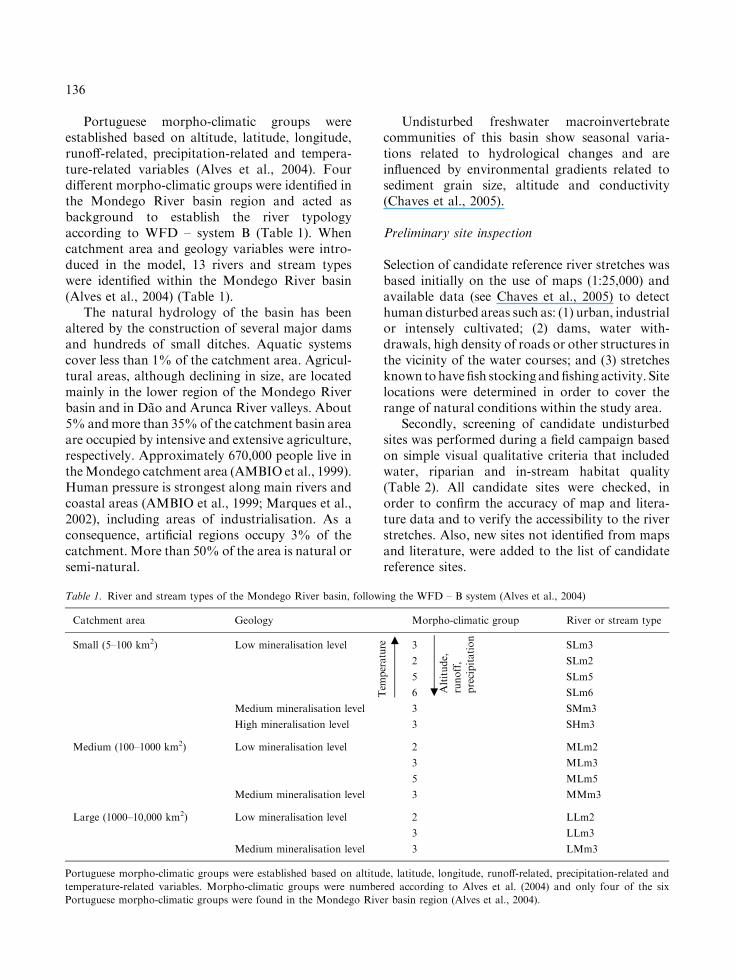
Portuguese morpho-climatic groups wereestablished based on altitude, latitude, longitude,runoff-related, precipitation-related and tempera-ture-related variables (Alves et al., 2004). Fourdifferent morpho-climatic groups were identified inthe Mondego River basin region and acted asbackground to establish the river typologyaccording to WFD – system B (Table 1). Whencatchment area and geology variables were intro-duced in the model, 13 rivers and stream typeswere identified within the Mondego River basin(Alves et al., 2004) (Table 1).
The natural hydrology of the basin has beenaltered by the construction of several major damsand hundreds of small ditches. Aquatic systemscover less than 1% of the catchment area. Agricul-tural areas, although declining in size, are locatedmainly in the lower region of the Mondego Riverbasin and in Dao and Arunca River valleys. About5%andmore than 35%of the catchment basin areaare occupied by intensive and extensive agriculture,respectively. Approximately 670,000 people live intheMondego catchment area (AMBIO et al., 1999).Human pressure is strongest along main rivers andcoastal areas (AMBIO et al., 1999; Marques et al.,2002), including areas of industrialisation. As aconsequence, artificial regions occupy 3% of thecatchment. More than 50% of the area is natural orsemi-natural.
Undisturbed freshwater macroinvertebratecommunities of this basin show seasonal varia-tions related to hydrological changes and areinfluenced by environmental gradients related tosediment grain size, altitude and conductivity(Chaves et al., 2005).
Preliminary site inspection
Selection of candidate reference river stretches wasbased initially on the use of maps (1:25,000) andavailable data (see Chaves et al., 2005) to detecthuman disturbed areas such as: (1) urban, industrialor intensely cultivated; (2) dams, water with-drawals, high density of roads or other structures inthe vicinity of the water courses; and (3) stretchesknown tohave fish stocking andfishing activity. Sitelocations were determined in order to cover therange of natural conditions within the study area.
Secondly, screening of candidate undisturbedsites was performed during a field campaign basedon simple visual qualitative criteria that includedwater, riparian and in-stream habitat quality(Table 2). All candidate sites were checked, inorder to confirm the accuracy of map and litera-ture data and to verify the accessibility to the riverstretches. Also, new sites not identified from mapsand literature, were added to the list of candidatereference sites.
Table 1. River and stream types of the Mondego River basin, following the WFD – B system (Alves et al., 2004)
Catchment area Geology Morpho-climatic group River or stream type
Small (5–100 km2) Low mineralisation level 3 SLm3
2 SLm2
5 SLm5
6 SLm6
Medium mineralisation level 3 SMm3
High mineralisation level 3 SHm3
Medium (100–1000 km2) Low mineralisation level 2 MLm2
3 MLm3
5 MLm5
Medium mineralisation level 3 MMm3
Large (1000–10,000 km2) Low mineralisation level 2 LLm2
3 LLm3
Medium mineralisation level 3 LMm3
Portuguese morpho-climatic groups were established based on altitude, latitude, longitude, runoff-related, precipitation-related and
temperature-related variables. Morpho-climatic groups were numbered according to Alves et al. (2004) and only four of the six
Portuguese morpho-climatic groups were found in the Mondego River basin region (Alves et al., 2004).
Altitude,
runoff,
precipitation
.Tem
perature m
136

Table
2.Criteriausedin
theinspectionandselectionofundisturbed
sitesin
theMondegoRiver
basin
Criteria
Abbreviations
Scale
Parameters
considered
in:
Description
Bibliography
Site
inspection
Site
selection
1.Goodapparent
waterquality
Water
quality
Site�
�Toassessthewaterquality
level
basedonavisual
inspectionofcolour,transparency,odourandfilm
s
Hughes
(1995),Barbouret
al.(1996)
2.Nooronly
minorevidences
ofhuman
disturbance
Human
disturbance
Site�
�Toassessthepresence
ofgarbage,
sewagepipes,
industrialeffl
uents
pipes
andlivestock
grazing
(tem
poraldisturbance)
CEPA
(1994),Hughes
(1995),Barbouret
al.(1996),
Heringet
al.(2003),Nijboer
etal.(2004),
Sanchez-M
ontoyaet
al.(2005)
3.Nosignificant
modificationsof
thedischarge
regim
ea
Natural
discharge
Basin
�Toassessthepresence
ofdamsheadwaters;dams
higher
than20m
wereconsidered
todisturb
thenaturaldischargeregim
eindependentlyofthe
distance
tothesamplingsite
CEPA
(1994),Hughes
(1995),Barbouret
al.(1996),
Muharet
al.(2000),Bonadaet
al.(2002),Ehlert
etal.(2002),Heringet
al.(2003),Nijboer
etal.
(2004),Sanchez-M
ontoyaet
al.(2005)
4.Nosignificant
changes
inthe
use
ofthe
drainageareaa
Natural
area
Basin
�Toassessthelevel
ofnaturaluse
ofthesite’s
drainagearea;thedegreeofusageshould
beas
lowaspossibleforthereference
site:<10%
ofurban
andindustrialuse
and<30%
ofagriculturaluse
CEPA
(1994),Barbouret
al.(1996),Bonadaet
al.
(2002),Heringet
al.,(2003),Sanchez-M
ontoyaet
al.
(2005)
5.Nosignificant
changes
inthe
river
channela
Natural
channel
Site
�Toassessthepresence
ofbankandbed
fixation
andsm
alltransversalditches
CEPA
(1994),Hughes
(1995),Barbouret
al.(1996),
Bonadaet
al.(2002),Ehlert
etal.(2002),Hering
etal.(2003),Nijboer
etal.(2004),Sanchez-M
ontoya
etal.(2005)
6.Nosignificant
waterdiversions
Water
diversion
Site
�Toassessthepresence
ofhydropeaking,irrigation
canalsandwaterwithdrawalforreservoirsupplying
Hughes
(1995),Muharet
al.(2000),Heringet
al.
(2003),Nijboer
etal.(2004),Sanchez-M
ontoyaet
al.
(2005)
7.Presence
of
expectedriparian
vegetation
Expected
vegetation
Site�
�Toassessthecover
level
bytheriparianwood;in
near-naturalsituationsmost
river
types
should
have
totalcover
andpresence
oftreesin
thepristine
situation;however
temporary
orveryhigh-altitude
streamscanhavedifferentcover
levels.
Bonadaet
al.(2002),Ehlert
etal.(2002),
Sanchez-M
ontoyaet
al.(2005)
137

Table
2.(C
ontinued)
Criteria
Abbreviations
Scale
Parameters
considered
in:
Description
Bibliography
Site
inspection
Site
selection
8.Riparian
woodarea
without
significant
alterations
Riparianarea
alterations
Site
�Toassessthepresence
ofpublicbeaches,industries
orother
buildingssuch
aswarehouses,croplandsand
asphaltways(spatialdisturbances);itshould
be
covered
withnaturalunmanaged
vegetation
Hughes
(1995),Muharet
al.(2000),Bonadaet
al.
(2002),Heringet
al.(2003),Nijboer
etal.(2004),
Sanchez-M
ontoyaet
al.(2005)
9.Autochthonous
riparian
wood
Autochthonous
vegetation
Site
�Toassessthepresence
ofallochtonousspeciesin
the
riparianwood;onesingle
individualwasnot
considered
toexcludethesite,withexceptionofthe
Acaciadealbata
dueto
itshighlevel
ofdispersion
andinvasivecharacter
Bonadaet
al.(2002),Heringet
al.(2003),Nijboer
etal.(2004),Sanchez-M
ontoyaet
al.(2005)
10.Goodapparent
in-stream
habitatquality
Habitat
quality
Site�
�Toassessthepresence
ofsnags,roots,logjamsand
deadoverhangingvegetation;to
assesssubstrate
classes
proportions;generallyitisexpectedboulders
andstones
inhigher
stretches,cobble
andpebbles
inmedium
stretches
andsand,clayandlimein
lower
regions;to
assessthesedim
entretentionlevel
based
onavisualinspection
Hughes
(1995),Barbouret
al.(1996),Bonadaet
al.
(2002),Ehlert
etal.(2002),Heringet
al.(2003),
Nijboer
etal.(2004),Sanchez-M
ontoyaet
al.(2005)
Abbreviation,spatialscale,descriptionandbibliographic
sourceofsimilarcriterionorcriterionelem
ents
are
indicated.Restrictiveselectioncriteria
are
indicatedin
thefirst
column(a)
138

Sites chosen during this preliminary visualinspection were retained for selection and valida-tion procedures. The typology work of Alves et al.(2004) was used to allocate each studied site intothe correspondent river or stream type.
Site selection
Each site chosen was evaluated according to sev-eral earlier defined exclusion criteria to identify itspressure status (Table 2). These criteria wereestablished without regard to the fauna. Theyincluded some visual characteristics used previ-ously in the site inspection, but also specific fea-tures describing the character of the riparian zoneand river channel, the discharge regime, and landuse. These last three criteria (criteria 3, 4 and 5 inTable 2) were considered as Restrictive SelectionCriteria (RSC) since they are permanent, not easilyrestorable and their effects can not be avoidedsimply by changing the location of the samplingsite up or downstream (see criteria description inTable 2). However, for numerous rivers in Portu-gal (particularly in their middle and lower regions)it is nearly impossible to find sites not affected bydams, with less than 30% of their catchment areaused for agriculture and/or without signs of can-alisation. These sites should still be identified, asthey may be good candidates to Best AttainableEcological Potential, when presenting good bio-logical status. Best Attainable Ecological Potentialis a figure comparable to the Maximum EcologicalPotential (MEP) of the WFD. MEP is used toestablish the environmental objectives for man-made modified rivers, i.e. for systems that presentsubstantial hydromorphological changes (highlymodified water bodies, in the WFD). In the pres-ent study man-made modified stretches wereexcluded. However, stretches influenced by thesedisturbed systems were considered when accom-plishing most of the selection criteria and highbiological status. Since only Good Ecological Po-tential and not Good Ecological Status (GES) willbe defined for a MEP site, it will be difficult toachieve GES in systems under the influence of aMEP site. Therefore, this new concept, BestAttainable Ecological Potential, was created todefine a stretch with high biological status that isunder the indirect influence of major alterationseither hydromorphological and/or others, for
which the achievement of environmental objectiveswould be infeasible without injuring vital humanuses or incurring disproportionate expenses.
Most of the criteria used to select sites requiredan inspection field campaign in order to comparesite characteristics with the predefined exclusioncriteria. Natural area and Natural discharge wereexceptions, since they were determined using ageographic information system (ArcView 3.x),maps and information available at the PortugueseWater Institute web-site (Instituto da Agua,www.inag.pt, during June 2004). Exclusion criteriainvolve different spatial levels of selection, fromcatchment to site scale, in order to guarantee thatanthropogenic disturbances occurring at differentdistances can be detected (Table 2). Biologicalcriteria related to the quality elements of the WFDwere not considered in the selection procedure toavoid circularity in the definition of referenceconditions (Barbour et al., 1999; Economou, 2002;Wallin et al., 2003). Most of these criteria,although presenting some additional contributionsto the original form, have already been appliedin similar studies (see bibliography in Table 2)and/or their use is suggested by the WFD (AnnexII 1.4).
Site validation
Site validation is the next important step since itprovides quantitative measurements of severalbiotic and abiotic variables that characterize ariver stretch (Table 3) and confirms and refines thea priori selection (Barbour et al., 1996). A detailedinvestigation of benthic macroinvertebrates,riparian vegetation, habitat quality and chemicalwater parameters was performed at this stage.Data collected at each site was used to confirm ifthey had a near-natural status according to pre-defined thresholds established for the validationparameters. Biological condition was measuredusing two indices developed for Mediterraneanareas: the Riparian Habitat Ecological Qualityindex (Qualidade do Bosque de Ribeira – QBR;Munne et al., 1998, 2003) that evaluates theriparian area condition; and the Iberian Bio-Monitoring Working Party index (IBMWP;Jaimez-Cuellar et al., 2002) that uses macroinver-tebrates as indicators of in-stream biologicalhealth.
139
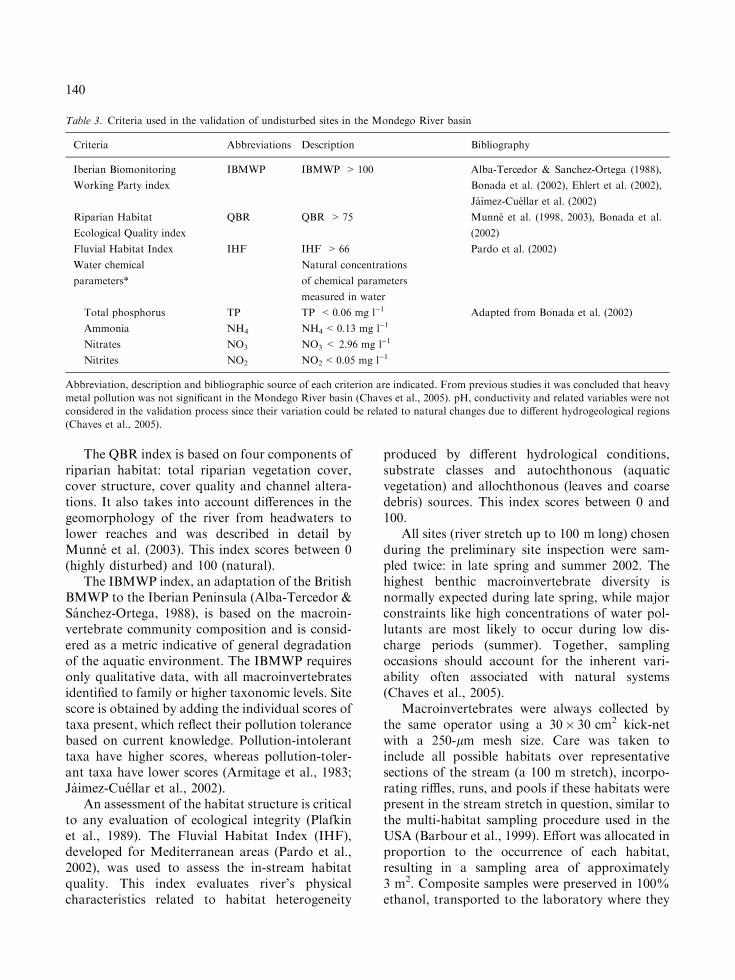
The QBR index is based on four components ofriparian habitat: total riparian vegetation cover,cover structure, cover quality and channel altera-tions. It also takes into account differences in thegeomorphology of the river from headwaters tolower reaches and was described in detail byMunne et al. (2003). This index scores between 0(highly disturbed) and 100 (natural).
The IBMWP index, an adaptation of the BritishBMWP to the Iberian Peninsula (Alba-Tercedor &Sanchez-Ortega, 1988), is based on the macroin-vertebrate community composition and is consid-ered as a metric indicative of general degradationof the aquatic environment. The IBMWP requiresonly qualitative data, with all macroinvertebratesidentified to family or higher taxonomic levels. Sitescore is obtained by adding the individual scores oftaxa present, which reflect their pollution tolerancebased on current knowledge. Pollution-intoleranttaxa have higher scores, whereas pollution-toler-ant taxa have lower scores (Armitage et al., 1983;Jaimez-Cuellar et al., 2002).
An assessment of the habitat structure is criticalto any evaluation of ecological integrity (Plafkinet al., 1989). The Fluvial Habitat Index (IHF),developed for Mediterranean areas (Pardo et al.,2002), was used to assess the in-stream habitatquality. This index evaluates river’s physicalcharacteristics related to habitat heterogeneity
produced by different hydrological conditions,substrate classes and autochthonous (aquaticvegetation) and allochthonous (leaves and coarsedebris) sources. This index scores between 0 and100.
All sites (river stretch up to 100 m long) chosenduring the preliminary site inspection were sam-pled twice: in late spring and summer 2002. Thehighest benthic macroinvertebrate diversity isnormally expected during late spring, while majorconstraints like high concentrations of water pol-lutants are most likely to occur during low dis-charge periods (summer). Together, samplingoccasions should account for the inherent vari-ability often associated with natural systems(Chaves et al., 2005).
Macroinvertebrates were always collected bythe same operator using a 30� 30 cm2 kick-netwith a 250-lm mesh size. Care was taken toinclude all possible habitats over representativesections of the stream (a 100 m stretch), incorpo-rating riffles, runs, and pools if these habitats werepresent in the stream stretch in question, similar tothe multi-habitat sampling procedure used in theUSA (Barbour et al., 1999). Effort was allocated inproportion to the occurrence of each habitat,resulting in a sampling area of approximately3 m2. Composite samples were preserved in 100%ethanol, transported to the laboratory where they
Table 3. Criteria used in the validation of undisturbed sites in the Mondego River basin
Criteria Abbreviations Description Bibliography
Iberian Biomonitoring
Working Party index
IBMWP IBMWP >100 Alba-Tercedor & Sanchez-Ortega (1988),
Bonada et al. (2002), Ehlert et al. (2002),
Jaimez-Cuellar et al. (2002)
Riparian Habitat
Ecological Quality index
QBR QBR >75 Munne et al. (1998, 2003), Bonada et al.
(2002)
Fluvial Habitat Index IHF IHF >66 Pardo et al. (2002)
Water chemical
parameters*
Natural concentrations
of chemical parameters
measured in water
Total phosphorus TP TP <0.06 mg l)1 Adapted from Bonada et al. (2002)
Ammonia NH4 NH4<0.13 mg l)1
Nitrates NO3 NO3 < 2.96 mg l)1
Nitrites NO2 NO2<0.05 mg l)1
Abbreviation, description and bibliographic source of each criterion are indicated. From previous studies it was concluded that heavy
metal pollution was not significant in the Mondego River basin (Chaves et al., 2005). pH, conductivity and related variables were not
considered in the validation process since their variation could be related to natural changes due to different hydrogeological regions
(Chaves et al., 2005).
140

were rinsed using a 250-lm mesh sized sieve, sor-ted under magnification and preserved in 70%ethanol.
The sorting process of a biological sampleinvolved removing large, common and rareorganisms during three sequential steps: first, allspecimens larger than 1000 lm were sorted; sec-ond, at least 250 specimens (<1000 lm) wereremoved according to an area based method toallow an extrapolation of macroinvertebrate totalabundance; finally, all the sample was screened,looking only for non-abundant specimens, whichhad not been sorted into the 250-specimens group,in order to guarantee that all taxa present weredetected. Macroinvertebrates were identified to thefamily or higher taxonomical levels (e.g. Oligo-chaeta) according to Tachet et al. (2000).
On each sampling occasion, physical andchemical variables were measured at each site priorto invertebrate fauna sampling. Water tempera-ture (�C), dissolved oxygen (mg l)1) and salinitywere measured in field with a Data Sonde Sur-veyor 4 portable probe. Water samples were col-lected below the water surface in the central regionof each watercourse, frozen, transported to Insti-tuto do Ambiente and analysed to determine con-centrations of nitrates (NO3
) mg l)1), nitrites(NO2
2) mg l)1), total phosphorus (P mg l)1) andammonia (NH4
+ mg l)1). The current knowledgeabout biota reactions to environmental parameterschanges, indicate stressor levels that are probablyharmful to aquatic communities, so these fieldmeasurements can be valuable when suggestingpotential problems and eliminating candidate ref-erence sites (Hughes, 1995). In order to charac-terize the sampling sites, flow discharge (m3 s)1)was determined in the narrowest section of thestretch by dividing the total channel width in, atleast, seven equal parts and measuring the channeldepth and current velocity (Hydro-Bios – RHCM)at each one of these points; discharge was calcu-lated by integrating medium depth, total widthand current velocity. Sediment grain size wasestimated visually into four different groups: siltand clay (<0.06 mm), sand (0.06–2 mm); pebblesand gravel (2–64 mm); cobble, boulders and stones(>64 mm). Altitude (m), latitude and longitude(degrees� minutes¢ seconds¢¢) were registered with aGPS system at each site. Strahler’s (1952) streamorders and sites’ catchment area were determined
using a geographic information system (ArcView3.x software, 1:75,000).
Final site selection and congruence of selectionand validation measures
Selection (SC) and validation criteria (VC) resultswere compared, using the number of sites chosenduring the preliminary field inspection as a back-ground. If selected candidate reference sites’ status(selection process) were reflected in biological,chemical and hydromorphological data (validationprocess), then SC and VC results should be con-sistent (Nijboer et al., 2004).
Therefore, a site was validated as a:
1. Reference (REF): if accomplishing all SC, andVC values were optimal in all samplingoccasions (Tables 2 and 3);
2. Potential reference (PREF): if failing up to 3SC (7/10), although not the restrictive ones(criteria 3, 4 and 5 in Table 2), and VC valueswere optimal in all sampling occasions. Fail-ure in one reference nutrient concentrationwas considered acceptable since nutrientconcentrations are instantaneous measuresthat naturally fluctuate with intra- and inter-annual climate changes (Holloway et al.,1998) and thus, less reliable than other VC.
3. Best Attainable Ecological Potential (BAEP):if failing up to 3 SC, including the restrictiveones, but VC values were optimal in allsampling occasions. Failure in one refer-ence nutrient concentration was consideredacceptable.
Kruskall–Wallis tests (Siegel & Castellan, 1988)were used to independently compare the values ofeach one of the seven validation criteria among thegroups defined according to the results of theselection processes (four groups: accomplishing allSC, missing up to 3 SC, including and excludingRSC, and failing more than 3 SC).
A Friedman two-way analysis of variance byranks test, followed by multiple comparisonsbetween groups (Siegel & Castellan, 1988), wasused to test for significant differences between thefour groups resulting from the selection processconsidering each one of the seven validationcriteria as a replicate and the respective medianvalues of each group as objects of comparison.
141

Results
Field site selection
During field inspection, 52 sites (Fig. 1) located in41 different watercourses of the Mondego Riverbasin, were chosen. Sites placed in the same riverwere separated longitudinally by a minimum of1.6 km. None of these 52 stretches was located inlarge-sized rivers mainly due to severe regulationand urban proximity. All sites’ catchment areaswere smaller than 640 km2, hence potential refer-ence sites with Strahler’s (1952) stream ordersgreater than three were not found (Fig. 2, seeElectronic Supplementary Material1). Most ofthese sites were placed at mid-height (200–800 m),and 35% and 6% of them were positioned at lowerand higher altitudes, respectively. Most of the siteswere located in siliceous river-beds (85%), whilethe remaining sites were predominantly calcareous(Fig. 2, see Electronic Supplementary Material).Only 10% of the stretches were entirely dry duringsummer but around 30% presented stagnatedwater or pools (see Electronic SupplementaryMaterial). Silt and clay classes were never domi-
nant (Fig. 2, see Electronic supplementary mate-rial). As expected, sites showing the highest meandischarges or stream orders tended to be thosewith largest catchment areas (see Electronicsupplementary material). Only 9 of the 13 river orstream types identified in the Mondego River ba-sin were represented by the studied sites. Onestream type was represented by 21 sites and eightstream types included five or less sites (seeElectronic Supplementary Material, Table 1, for asmall description of stream and river types).
Site selection
The most restraining SC were related to land useof the drainage area (a restrictive classificationcriterion – RSC) and to the origin (native vs.exotic) of riparian vegetation (Fig. 3); each oneexcluding more than half of the initial 52 sites. Thethird most limiting criterion, also an RSC,excluded sites with channel alterations (Fig. 3).Only seven sites accomplished all three criteriaconsidered as RSC (Fig. 4), although all studiedsites fulfilled at least one RSC. All other selectioncriteria eliminated less than 20% of the 52 previ-ously selected sites and substrate classes’ propor-tions were always assessed as a near-naturalsituation (Habitat quality – Fig. 3). Only four sitesfulfilled all SC (Figs. 3 and 4), and these are the
100%
75%
50%
25%
0%Altitude Geology Catch. area Mean disch. Substrate Order
H
M
L
sSil
mCal
Lvs
H
M
Sc/PgSc/Cb
Pg/Cb
Sd/Cb
Cb
Sd/Pg
Sd
Pg
3
2
1
H
M
L
sSil
mCal
Lvs
H
M
Sc/PgSc/Cb
Pg/Cb
Sd/Cb
Cb
Sd/Pg
Sd
Pg
3
2
1
Figure 2. Major characteristics of sites sampled in the Mondego River basin. Altitude – low (L): <200 m; mid (M): 200–800 m; high
(H): >800 m; Streambed geology – siliceous (Sil); calcareous (Cal); Catchment area (Catch. area) – very small (vs): <10 km2; small (s):
10–100 km2; medium (m): 100–1000 km2; Mean discharge (Mean disch.) – low (L): <0.05 m3 s)1; mid (M): 0.05–1.00 m3 s)1; high
(H): 1.00–5.00 m3 s)1; Predominant substrate size – silt and clay (Sc): <0.06 mm; sand (Sd): 0.06–2 mm; pebbles and gravel (Pg): 2–
64 mm; cobble, boulders and stones (Cb): >64 mm; Strahler’s (1952) stream order.
1 Electronic supplementary material is available for
this article at http://dx.doi.org/10.1007/s10750-006-0270-5 and accessible for authorised users.
142

only ones hypothetically considered as referencesites (Fig. 4). Forty-two sites missed up to 3 SC,seven of which did not fail any RSC, and 39 failingat least one RSC.
Site validation
The ecological integrity at each site was testedbased on chemical, physical and biological mea-surements. No major deviations from potentialnear-natural conditions were observed for thefollowing parameters since: (1) dissolved oxygenlevels were greater than 8 mg l)1 in 60% of the
measurements and higher than 6 mg l)1 in 80% ofthe measurements; exceptions were found in tem-porary streams during the summer campaign dueto the formation of pools or presence of stagnatedwater; (2) temperature measurements, althoughhighly variable, did not show any outlier valuesand were, as expected, slightly higher duringsummer; (3) salinity values were never higher than0.5 and more than 80% of the measured valueswere below 0.1; 4) pH, total dissolved solidsand conductivity were not considered restrainingcriteria as their values seemed to reflect riverbed features (siliceous vs. calcareous) instead ofpollution (Chaves et al., 2005).
Independent of the season, combined biologicalcriteria (QBR + IBMWP) were always morerestraining than physical (IHF) or chemical(Nutrients) criteria (Table 4). The riparian condi-tion (QBR index values) was the most limitingvalidation criteria, when considering each criterionindividually. Poor biological water quality (lowIBMWP values) was found at only eight and tensites during spring and summer campaigns,respectively (Table 4), four of which were commonbetween both seasons. All sites not validated bythe IBMWP criterion were at mid and low alti-tudes (Table 5). Within the 13 stretches consideredimpaired by the IBMWP index, all lowland cal-careous sites (four sites) and five of the midand lowland siliceous sites had abundances ofChironomidae plus Oligochaeta over 50% of totalcaptures. In the other four mid and lowland sili-ceous sites, abundances of Chironomidae and anadditional tolerant taxon (e.g. Hydrobiidae,Baetidae) accounted for more than 50% of totalcaptures, which confirmed their degradation. Noclear relationship was found between level of waterpollution and the catchment area (Table 5).
Total phosphorus and nitrate concentrationswere always the most restraining criteria regardingnutrient concentrations, which were, in general,slightly higher during spring than summer(Table 4). Nutrients and riparian vegetation resultsare most likely related to extensive agriculturelandscape use in the Mondego catchment area.There was concordance of most sites not validatedas having high ecological status between spring andsummer. Therefore, the number of selected sites didnot decrease substantially when taking the resultsfor both seasons into consideration (Table 4).
0 10 20 30 40 50 60
Total
Habitat quality
Autochthonous vegetation
Riparian area alterations
Expected Vegetation
Water diversion
Natural channel
Natural area
Natural discharge
Human disturbance
Water quality
Preliminary field inspection
Number of sites
52
RSC
RSC
RSC
4
Figure 3. Number of sites chosen during the preliminary
inspection (first bar), that fulfil each of the selection criteria
(following bars) and all selection criteria simultaneously (final
bar); restrictive selection criteria (RSC) are signed.
0 10 20 30 40 50 60
7 SC missing 2 RSC
7 SC missing SC not RSC
7 SC missing 1 RSC
10 SC
Preliminary field inspection
Number of sites
52
Figure 4. Number of sites chosen during the preliminary
inspection (first bar), that fulfilled all the selection criteria (SC)
or failed up to 3 SC both non-restrictive or restrictive criteria
(RSC).
143

Congruence of selection and validation measures
Only four sites accomplished all SC, whereas ninefulfilled all VC, suggesting that accomplishing allSC was more demanding than fulfilling all the VC(Table 6). Of those four stretches, two sitesaccomplished all VC and one site exceeded anutrient concentration (Table 6). The three sitesthat failed up to 3 SC, excluding RSC, presentedgood validation results and, from the 39 sites thatfailed up to 3 SC, including RSC, only 10 showedgood validation results (Table 6). Six of the initial52 sites failed more than 3 SC and revealed a badvalidation result (Table 6).
These results show no obvious relation betweenthe accomplishment of SC and VC in each siteemphasising the need for fulfilling both SC and VCin the definition of reference sites (REF), potentialreference sites (PREF) or best attainable ecologicalpotential sites (BAEP). Only 2 of the 52 initiallyselected sites were considered a REF, while foursites fulfilled the criteria defined for a PREF(accomplished all VC and failed in some SC butnot in RSC) and ten sites fulfilled those requiredfor BAEP (accomplished all VC but failed in someRSC) (Table 6). The fact that there was one sitewhich did not accomplish all VC but fulfilled all
SC (site 9), reinforces the need to perform a vali-dation process. Considering the relationshipbetween each group of sites obtained with theselection procedure [four groups: accomplishingall SC, missing up to 3 SC including RSC, missingup to 3 SC excluding RSC and failing in more than3 SC] and the values of the VC parameters at eachsite (Fig. 5), it is clear that sites excluded by theselection process generally present median valuesof validation parameters closer to the suggestednear-natural limit (e.g. IHF) or exceeding thatlimit (e.g. IBMWP, QBR, NO3). These resultsshow some consistency between validation andselection methods. According to Kruskall–Wallistest results, significant differences among the fourgroups were found for the IBMWP and QBRindices and nitrate concentrations. For theseparameters, the group of sites excluded by theselection process (failing in more than 3 SC) pre-sents always the highest difference when comparedwith all other groups (Fig. 5). Considering allvalidation parameters simultaneously, the Fried-man test also suggested high consistency betweenvalidation and selection methods (Fig. 5): groupsof sites accomplishing all SC and missing up to 3SC, including and excluding RSC, present no dif-ferences between them, and groups of sites missing
Table 4. Number of sites fulfilling each validation criteria considering spring and summer campaigns individually and both sampling
occasions simultaneously
Field campaigns Field
selection
Sites with
water
IBMWP QBR QBR + IBMWP IHF NO2 NO3 NH4 TP All
nutrients
Total
Spring 52 51 43 27 23 48 43 32 45 33 26 12
Summer 52 47 37 26 19 34 42 36 38 37 28 12
Spring + Summer 52 47 34 26 18 32 42 29 37 29 21 9
Table 5. Percentages of sites included in each of the altitudinal, geological and catchment area classes (see legend of Fig. 2 for
abbreviations) according to IBMWP results during spring (Sp) and summer (Sm) sampling occasions
IBMWP water quality classes Altitude Geology Catchment area
H M L Sil Cal vs s m
Sp/Sm Sp/Sm Sp/Sm Sp/Sm Sp/Sm Sp/Sm Sp/Sm Sp/Sm
Very good (>100) 100.0/100.0 93.3/81.5 66.6/70.6 93.0/81.4 44.5/77.8 66.7/66.7 87.9/78.8 90.0/90.0
Moderately polluted (61–100) 0.0/0.0 6.7/14.8 11.1/11.8 4.7/14.0 22.2/0.0 11.1/11.1 9.1/9.1 0.0/10.0
Polluted (36–60) 0.0/0.0 0.0/3.7 16.7/5.9 2.3/4.6 22.2/0.0 22.2/22.1 0.0/6.1 10.0/0.0
Very polluted (16–35) 0.0/0.0 0.0/0.0 0.0/5.9 0.0/0.0 0.0/11.1 0.0/0.0 0.0/3.0 0.0/0.0
Extremely polluted (<15) 0.0/0.0 0.0/0.0 5.6/5.9 0.0/0.0 11.1/11.1 0.0/0.0 3.0/3.0 0.0/0.0
144

Table 6. Overview of sites accomplishing all selection criteria (SC), failing up to 3 SC, including and excluding restrictive selection
criteria (RSC), accomplishing all validation criteria (VC) and failing in just one nutrient concentration
Site inspection Site selection Site validation Final
selectionRivers All SC
fulfilled
Failed up
to 3 SC,
not RSC
Failed up
to 3 SC,
with RSC
Failed
RSC
All VC
fulfilled
Failed
one nutrient
1. Mondego (C. Sta Maria) � � REF
2. Quecere � � REF
3. Caldeirao � nc � BAEP
4. Mondego (Trinta) � � PREF
5. Tamanhos � na
6. Coja � � PREF
7. Carapito � nc
8. Dao � nc
9. Muxagata �10. Gouveia � na
11. Ludares � na, nc
12. Santos Evos � na, nc
13. Coja � nc
14. Tourais � na
15. Alva (Sabugueiro) � nd
16. Canica � nd � BAEP
17. Alva (S. Giao) � nd, nc
18. Alvoco � � PREF
19. Louriga � nd
20. Mortagua (Mortagua) na, nc
21. Falheiros na, nc
22. Mortagua (Vila Boa) � na � BAEP
23. Criz (Pva do Lobo) na, nd
24. Criz (Cpo Besteiros) � nc
25. Asnes � na
26. Dinha � na, nc � BAEP
27. Beijos � na
28. Cabanas (Cabanas) � na
29. Cabanas (Carregal Sal) � na
30. Cavalos (Tabua) � na
31. Covelo � na � BAEP
32. Cavalos (S. Geraldo) � na
33. Ribelas � na, nc
34. Seia � na
35. Mata � nc
36. Alva (Arganil) � nd
37. Folques � nc � BAEP
38. Ceira (Casal Novo) � nd
39. Ceira (Colmeal) � nd � BAEP
40. Sotao (Casal Ribeira) � nc
41. Sotao (Penedo) � � PREF
Continued on next page
145

up to 3 SC, including RSC, and failing in morethan 3 SC are also similar between them (seeFriedman test statistics box in Fig. 5). The groupof sites missing up to 3 SC, including RSC, is notdifferent from any other groups of sites, showingan intermediate condition between non-disturbedand disturbed sites.
Discussion
General appraisal
According to the WFD (European Commission,2000) the main environmental objectives foraquatic ecosystems are to achieve ‘good’ surfacewater and groundwater status by 2015, preventingfurther deterioration and protecting and enhanc-ing the status of aquatic ecosystems. However, theestablishment of quality class boundaries and cri-teria for ecological classification will only be pos-sible when reliable reference conditions have beendefined (Economou, 2002). The initial stage ofselecting reference sites is crucial since all sub-sequent ecological evaluation is based on theresultant reference conditions. Reference sitesmust be selected carefully because they will be usedas sources for the benchmarks against which other
sites will be compared (Barbour et al., 1996).Nevertheless, given the long lasting anthropogenicimpact in Europe, and further confirmed with thepresent study, it is very difficult to find rivers withno or only minimal anthropogenic disturbances,i.e. reference stretches (Economou, 2002; Ehlertet al., 2002; Nijboer et al., 2004).
Screening and selection criteria
In consistence with several authors (Barbour etal., 1996; Economou, 2002; Bailey et al., 2004),the established criteria included a certain level ofhuman disturbance or minimal exposure to thestress of concern. For instance, the old age andhigh complexity of the riparian wood (Hughes,1995), a commonly used strict criterion, wouldhave never been fulfilled, although it would cor-rectly address the idea that pristine riparianwoods no longer exist in the Mondego Riverbasin. Even though, like all over Europe(Economou, 2002; Hering et al., 2003; Nijboer etal., 2004), the unnatural land use of the catchmentareas, channel alterations and riparian vegetationrelated problems were highly limiting factorswhen applying our selection criteria. These wide-spread problems are connected since the Mond-ego River basin has been submitted to the
Table 6. (Continued)
Site inspection Site selection Site validation Final
selectionRivers All SC
fulfilled
Failed up
to 3 SC,
not RSC
Failed up
to 3 SC,
with RSC
Failed
RSC
All VC
fulfilled
Failed
one nutrient
42. Alva (Moura Morta) � nd
43. Moinhos � na � BAEP
44. Alcabideque na, nc
45. Mouros � na
46. Dueca � na, nc
47. Corvo � na � BAEP
48. Ancos na, nc
49. Venda Nova � na
50. Sto Amaro (Headwaters) � na
51. Sto Amaro (Lourical) � na � BAEP
52. Crespos na, nc
Unfulfilled RSC are signed: natural area (na), natural channel (nc) and natural discharge (nd). Final selection was performed according
to previous definitions (see Final site selection and congruence of selection and validation measures in the methodology section): reference
site (REF), potential reference site (PREF), best attainable ecological potential site (BAEP).
146

NO
3
0246810
NO
2
0.00
0
0.02
5
0.05
0
0.07
5
0.10
0
QB
R
0255075100
0306090
0.00
= 2
.66;
df =
3;p
= 0
.446
IHF
2 =
7.4
8; d
f = 3
;p =
0.0
58
= 1
4.25
; df=
3;p
= 0
.030
Exc
lude
dF
aile
d up
to 3
S
C, w
ith R
SC
Fri
edm
an t
est
stat
isti
cs
= 1
7.61
; df =
3;p
= 0
.001
; N =
7
2 =
19.
94; d
f= 3
;p =
0.0
00
Fai
led
up to
3
SC
, not
RS
CA
ll S
C
fulfi
lled
0. 0. 0. 0.
NH
4
0.00
0.25
0.50
0.75
1.00
All
SC
fulfi
lled
Fai
led
up t
oS
C,
not
RS
CS
C, w
ithR
SC
Exc
lude
d
TP
05101520
IBM
WP
050100
150
200
250
All
SC
ful
fille
d F
aile
d up
to
3 F
aile
d up
to
3 E
xclu
ded
SC
, no
t R
SC
SC
, with
RS
C
All
SC
ful
fille
d F
aile
d up
to
3 F
aile
d up
to
3 E
xclu
ded
SC
, no
t R
SC
SC
, with
RS
C
All
SC
ful
fille
d F
aile
d up
to
3 F
aile
d up
to
3 E
xclu
ded
SC
, no
t R
SC
SC
, with
RS
C
All
SC
ful
fille
d F
aile
d up
to
3 F
aile
d up
to
3 E
xclu
ded
SC
, no
t R
SC
SC
, with
RS
C
All
SC
ful
fille
d F
aile
d up
to
3 F
aile
d up
to
3 E
xclu
ded
SC
, no
t R
SC
SC
, with
RS
C
All
SC
ful
fille
d F
aile
d up
to
3 F
aile
d up
to
3 E
xclu
ded
SC
, no
t R
SC
SC
, with
RS
C
= 2
.01;
df =
3;p
= 0
.571
= 1
.83;
df =
3;p
= 0
.608
= 8
.24;
df =
3;p
= 0
.041
Fai
led
up t
o 3
3
χ2 χ
χ
χ2 χ2
χ2
χ2
χ2
Figure
5.Whisker
plots(m
edianandinter-quartilerange25%–75%)ofvalues
ofvalidationcriteria,consideringboth
springandsummer
measurements,foreach
groupofsites
resultingfrom
theselectionprocess
[fourgroups:accomplishingallselectioncriteria
(SC),missingupto
3SC,includingandexcludingrestrictiveselectioncriteria
(RSC),and
failingin
more
than3SC
(excluded)].N
=100fortheQBR
index
andN
=96forallother
validationcriteria.Dashed
lines
indicate
near-naturalthresholds.
Resultsof
Kruskall–Wallistestsperform
edto
compare
thefourgroupsresultingfrom
theselectionprocess
foreach
validationcriterionare
given
ineach
plot.TheresultoftheFriedman
testforanoverallcomparisonamongtheselectiongroupsusingeach
oneoftheseven
validationcriteria
asareplicate
isgiven:groupsunderlined
werenotsignificantlydifferent.
147

elimination of riparian wood and to bank fixationin order to expand intensive/extensive agriculturalareas or forestry plantations (Eucalyptus spp.),while on the other hand, these areas are thesource of alien plants found in the ripariancorridor.
The application of the selection criteria led tothe assessment of a high number of sites failing inparameters with low restoration potential like thepresence of dams, bank and bed fixation andunnatural use of the catchment area. This maycompromise the achievement of good surfacewater status in many areas of the Mondego Riverbasin until 2015, as well as in overall Portuguesewaters.
Validation criteria
Following the WFD recommendations (EuropeanCommission, 2000), biological criteria were con-sidered decisive factors in the validation processsince variations in the aquatic community struc-ture are known to be indicative of: (1) changes inwater chemical quality caused by eutrophication,organic pollution and hazardous substances; (2)changes in habitats caused by physical disturbancethrough damming, canalisation and dredgingactivities, etc.; and (3) biological pressures onpopulations, such as the introduction of alienspecies (e.g. Nixon et al., 2003). However, differentregions are subject to different human impacts. InSouthern Europe, agriculture run-off, lack ofadequate urban and industrial sewage treatmentand illegal or accidental spills are major director indirect causes of freshwater ecosystemsdisturbance (Nixon et al., 2003). Consequently,nutrient enrichment and organic pollution havebeen considered main local stressors (Hering et al.,2004). Included in this region, the Mondego Riverbasin is largely influenced by these same pressures(Marques et al., 2002). A decrease in macroinver-tebrate diversity and an increase in tolerant taxaare expected under the presence of this kind ofstress, easily indicated by the IBMWP index(Alba-Tercedor & Sanchez-Ortega, 1988; Jaimez-Cuellar et al., 2002). Thus, it is very important thatreference sites meet criteria of minimal disturbancefor pressures that are known to exist in the area ofinterest. The absence of a criterion can be asequally problematic as selecting the wrong one.
For example, additional information, such as thepresence/absence of exotic species could have beenconsidered as a validation criterion. Previousstudies have shown that alien invertebrate speciessuch as Procambarus clarkii (Crustacean), anintroduced crayfish (Anastacio & Marques, 2002),and exotic fish like Gambusia holbrooki and Lep-omis gibbosus (Cabral et al., 2002; Domingos et al.,2002), are widely distributed in the MondegoRiver basin and can, therefore, introduce unnat-ural pressures in natural populations (e.g. Moyle& Light, 1996). However, an accurate assessmentof these species’ presence would require specificfield sampling procedures beyond the possibilitiesof this study. Some of the sites selected as near-natural during the present study could have notbeen chosen if this criterion had been applied.Nonetheless, all sites where alien species wereknown to exist (visual detection during the fieldcampaigns and historical data by AMBIO et al.,1999 and Chaves et al., 2005) were excluded by thevalidation process and sometimes by both selec-tion and validation processes, indicating someefficiency of the methodology in detecting coexis-ting impacts, even when some pressures are notdirectly assessed. So, selection and validation cri-teria must be chosen carefully in order to take intoaccount different pressure types and to detect realdisturbance problems in the region of interest. Asexpected from the selection criteria results andprevious studies (e.g. Economou, 2002), theRiparian Habitat Ecological Quality index was themost limiting validation criterion since thisindex embraces features related to land use ofadjoining areas and riparian vegetation andchannel alterations, which had been identified asmajor selection problems in the Mondego Riverbasin.
Selection and validation
As suggested by Barbour et al. (1999) and Nijboeret al. (2004), the methodology used in this studyavoids circularity since distinct criteria were usedwhen screening for potential reference sites (i.e.field screening and selection criteria) and theirvalidation. The selection and validation proce-dures gave similar results, as illustrated by theFriedman test. However, none of these proceduresis self-sufficient as they chose different sites.
148

Although at a smaller spatial scale, our resultswere similar to those obtained by Nijboer et al.(2004), since a number of sites that were selectedas having high potential ecological status wereconsidered to be of low ecological quality aftervalidation (e.g. site 9, see Table 6) and sites thatfailed in some selection criteria presented highecological quality after measuring the validationparameters (e.g. sites 3, 16, 22). This kind ofobservations led to the conclusion that there weresome human impacts not considered or detectedusing the selection criteria and, simultaneously,there were some disturbances with negligible effecton the biota. This last aspect could be the mainreason for such good results obtained with theIBMWP index and reinforces the need and sig-nificance of validating selected sites (Nijboer et al.,2004). An important aspect, common betweenselection and validation results, is that criteriameasured outside rivers and streams, such as theland use of the catchment area (SC) and theriparian wood cover and structure (QBR index –VC) were harder to fulfil. On the other hand,variables measured within watercourses like thesediment grain size (SC), water nutrient concen-trations (VC) or the IBMWP index (VC) wereeasily accomplished. However, artificial land covercan explain a high percentage (29–38%) of thevariation in some macroinvertebrate indices (e.g.Roy et al., 2003). Therefore, alterations outside themain channel can significantly change the aquaticecosystem and should always be taken into con-sideration.
Nor the expert judgement, equivalent to theselection process, nor the extensive spatial survey,comparable to the validation process, seem to beautonomous methodologies and both are indis-pensable (Nijboer et al., 2004). Sites classified asREF and PREF by selection and validation pro-cedures may be considered as undisturbed stret-ches, whereas BAEP sites presented similaritieswith more or less disturbed sites and, as expected,should not be used as baseline for comparisons.Nonetheless, sites better than BAEP could not befound for some river or stream types. Following anapproach comparable to the one suggested forheavily modified water bodies (European Com-mission, 2003), a condition equivalent to GoodEcological Status, such as Good Ecological Poten-tial, could be established based on these BAEP
sites. Together, selection and validation proce-dures allow the identification of sites with highecological status, including hydromorphological,physico-chemical and biological quality elementsin rivers (Annex V 1.2.1 of the WFD).
Spatial analysis
Since the Mondego River basin was chosen for thisstudy its complete catchment area was the logicalgeographical boundary for accomplishing theobjectives. The final selection showed that onlyabout 600 m of the initial 5200 m of rivers couldbe considered as near-natural stretches, retainingessential natural functions. As requested by theWFD, the reference level was set very high andconsequently very few rivers and streams were ableto meet the requirements. Priority should be givento protecting these near-natural river and streamstretches as these areas can also function as refugesfor species which habitats have been changed ordestroyed, and provide a source of organisms forrecolonisation of adjoining, formerly impactedhabitats that have been improved by remediationor mitigation (Muhar et al., 2000; Ehlert et al.,2002). Similarly, only a small percentage of theinvestigated stretches were selected as near-naturalsites during other European studies enclosing dif-ferent regions and river types, suggesting wide-spread degradation (e.g. Muhar et al., 2000;Economou, 2002; Hering et al., 2003; Nijboer etal., 2004). As expected (e.g. Economou, 2002),reference sites were found only in small head-streams located at high altitudes, and their smallnumber was mainly due to the low percentage ofthe Mondego River basin located at high altitude.Candidate reference sites were never located inlarge-sized rivers, even during the screeningcampaign, due to very high levels of human-disturbance.
Considering that different river and streamtypes are present in the Mondego River basin, asingle reference condition should not be expectedto be representative of all stream and river typesbelonging to the area of interest (e.g. Barbour et al.1996; Bailey et al., 2004). Spatial representative-ness is usually hard to achieve, but as typologyworks as a generalisation tool, helping to reducethe natural variability of existing biological con-ditions, not every river or stream needs to be
149

studied. In this study, near-natural stretches (REFand PREF) were found for only 3 of the 13 river orstream types defined for the Mondego River basinaccording to the WFD – system B (Alves et al.,2004) (Table 7). Additionally four types wererepresented by BAEP stretches. As expected, thesix missing reference situations correspond to thelarger-sized river types. Before establishing accu-rate type-specific reference conditions, it is neces-sary to find more type-specific reference sites, sincethe WFD requires a sufficient number of sites ofhigh status (reference network) to provide a suffi-cient level of confidence about the values for thereference conditions (European Commission,2000). Theoretically, this could be achieved byscreening other near by catchment areas (Baileyet al., 2004). However, this would have implied aharmonisation process during the type definitionprocedure, which was not contemplated by theWFDbeyond the obligatory use of some previouslydefined variables (systems A or B) by all MemberStates. Although a single type definition approachwas used at a national level (e.g. Portugal), differenttypology approaches were used across countries,almost certainly resulting in slightly different riversand stream types. For intercalibration purposes,Member States sharing the same ecoregion have toagree on common types. Therefore, the use type-specific reference sites and consequently referenceconditions that were established outside the regionof interest will be possible at least for some river andstream types.
Using a single natural threshold for each vali-dation criteria might raise some problems con-cerning different river types enclosed in theMondego River basin. Regarding the IBMWPcriterion, most of the sites discarded were atmid and low altitudes and presented calcareous
riverbeds. This could suggest that a value of 100 istoo demanding as a natural-limit class boundarybetween very good and good status for theseregions. However, values of the IBMWP indexabove 100 were easily achieved (sites 11, 29, 31)even in temporary siliceous streams that couldnaturally be less diverse (Alba-Tercedor et al.,2002). Discarded sites could, in fact, indicateagriculture pollution, and related problems mostcommon in these areas (AMBIO et al., 1999). Onthe other hand, the existence of several river typesin the Mondego River basin also raises the ques-tion: was the IBMWP value 100 too low as a limitfor high status for some of the Mondego Riverbasin types, therefore allowing disturbed sitesto be chosen as reference ones? This is unlikelysince a recent study covering 12 basins ofthe Iberian Peninsula showed that only karsticregions demanded an IBMWP natural-limit muchhigher than 100 (approximately 123) in order toaccurately detect undisturbed environments (Alba-Tercedor et al., 2002). Type-specific limits for highstatus biological conditions concerning macroin-vertebrates have not yet been established in Por-tugal, and therefore further studies should beconducted. The use of the IBMWP index as well asother criteria should go along with a carefulexamination of macroinvertebrate data and phys-ico-chemical parameters, in order to assure thatlow values of an index or measurement are relatedto a poor ecological status of the site and not to ahealthy stretch with natural low diversity.
In this study, the habitat scale was mainlyconsidered during the macroinvertebrate samplingprocedure when the option between a multi and asingle habitat sampling strategy was taken. Sincethe occurrence of different habitats at differentsites might be either natural or an effect of
Table 7. Number of reference (REF), potential reference (PREF) and best attainable ecological potential (BAEP) sites found in each
river and stream type of the Mondego River basin, following the WFD – B system (Alves et al., 2004); see Table 1 for a brief
description of stream types
River or stream type
SLm3 SLm2 SLm5 SLm6 SMm3 SHm3 MLm2 MLm3 MLm5
Number of sites 5 21 5 2 5 4 5 3 2
REF – – 2 – – – – – –
PREF – 2 – – – – 2 – –
BAEP 1 3 1 1 1 1 2 – –
150

environmental stress, the best way to include theeffects of habitat alteration in bioassessmentstudies is to use a multiple habitat sampling design(Hiner, 2002). The use of a single habitat samplingstrategy would have required a preliminary test onhow accurately that single habitat represents aMediterranean stream condition subject to majorseasonal changes.
Temporal analysis
Seasonality should always be considered (Bailey etal., 2004), and in the Mondego River basin that isparticularly important because macroinvertebratecommunities have shown different seasonal struc-tural patterns (Chaves et al., 2005). As sitevalidation is an expensive procedure (time, costsand efforts), late spring is considered as the bestseason for a single sampling campaign. Contrarilyto what would be expected, nutrient criteria weremore restraining during late spring than summer.This might be due to the agriculture use in theMondego River basin catchment area and conse-quent agriculture chemicals runoff into aquaticsystems during the rainy season. Unless clearlimitation by other nutrients has been demon-strated in a particular system, N and P should beassumed as dominant nutrients controlling thetrophic state of streams and rivers (Dodds &Welch, 2000). Thus, besides presenting the waterphysico-chemical most limiting condition, latespring is also a biologically optimal samplingseason since initial recruitments already occurred(Barbour et al., 1996, 1999) and communities areno longer under high flow or water depletionconditions (Chaves et al., 2005). Furthermore, iffor any reason, the sampling period has to beslightly extended to summer, that should not be amajor problem since the results of this study didnot differ substantially, either qualitatively (whichsites) or quantitatively (how many sites) betweenspring and summer.
Conclusions
When little data is available, this methodologycould be relatively simple and quick to apply inorder to select reference sites, and especiallyhelpful in small river basins since it requires a good
spatial knowledge of the area of interest. The useof the proposed selection and validation criteriaadds valuable information to the WFD approach,since it considers the integrity of riparian vegeta-tion that plays a major role in protecting theaquatic system. The selection process providedqualitative information while the validation gavequantitative information on different ecologicalfeatures and these should therefore be usedtogether. Furthermore, pressures not visualisedduring the selection process could be detectedduring the very simple process of validation byanalysing different chemical and biologicalresponses of the aquatic system. Macroinverte-brate communities were the only biological ele-ment considered in the methodology, which mighthave to be refined using other biological elementssince the WFD approach determines the use of the‘‘one out, all out’’ criteria for accomplishment ofthe environmental objectives. A single naturalthreshold was used for each validation criteria,which in the future, should be improved by usingaccurate type-specific natural thresholds valueswhenever new studies allow it. This method shouldprovide an overall view of type and dimension ofhuman disturbances in the area of interest sincethe criteria used relate to major pressures knownin this European region. Nevertheless, the inclu-sion of additional criteria, such as the presence ofalien animal species and the influence of halieuticresources exploitation, is recommended and will beeasier when considering more than one biologicalelement. The importance of river stretches thatmight be affected by pressures not easily remov-able but still showing a high biological status(BAEP) was strongly emphasised. The use of amulti-seasonal approach that integrates informa-tion collected under different hydrological char-acteristics is suggested, or late spring surveys ifonly one sampling season can be performed. Thismethod can help to accomplish the requirementsof the EU – WFD and simultaneously be used as abaseline to select protected areas with conservationpurposes.
Acknowledgements
We wish to thank Ana Rego, Joana Marques andTiago Marques for technical assistance in the
151

collection of field data. We are also grateful to thePortuguese Water Institute (INAG) for providingthe WFD – B system typology maps. Comments oftwo anonymous reviewers and the help of studentsand professors of the ECOBILL group fromthe Department of Ecology of the University ofBarcelona are deeply acknowledged. This workwas financially supported by two grants to M.L.C(SFRH/BD/6365/2001) and P.M.C. (SFRH/BD/5144/2001) from FCT and ESF in the aim of theIII European Community Support Framework.
References
Aguiar, F. C., M. T. Ferreira & P. Pinto, 2002. Relative influ-
ence of environmental variables on macroinvertebrate
assemblage from an Iberian basin. Journal of the North
American Benthological Society 21: 45–53.
Alba-Tercedor, J., P. Jaimez-Cuellar, M. Alvarez, J. Aviles,
N. Bonada, J. Casas, A. Mellado, M. Ortega, I. Pardo,
N. Prat, M. Rieradevall, S. Robles, C. E. Sainz-Cantero,
A. Sanchez-Ortega, M. L. Suarez, M. Toro, M. R. Vidal-
Abarca, S. Vivas &C. Zamora-Munoz, 2002. Caracterizacion
del estado ecologico de rıosmediterraneos ibericosmediante el
ındice IBMWP (antes BMWP’). Limnetica 21: 175–185.
Alba-Tercedor, J.&A. Sanchez-Ortega, 1988.Unmetodo rapido
y simple para evaluar la calidad biologica de las aguas corri-
entes basado en el de Hellawell (1978). Limnetica 4: 51–56.
Alves, M. H., J. M. Bernardo, H. D. Figueiredo, J. Padua,
P. Pinto & M. T. Rafael, 2004. Aplicacao do sistema B da
Directiva-Quadro da agua na identificacao de tipos de rios
em Portugal continental. Actas do 7� Congreso da Agua:
Agua – Qualidade de toda a Vida. Associacao Portuguesa
dos Recursos Hıdricos, Lisboa .
AMBIO, CHI, AGRIPRO, DRENA, HLC & FBO, 1999.
Plano de bacia hidrografica do Mondego. INAG, Lisboa.
Anastacio, P. & J. C. Marques, 2002. Crayfish Procambarus
clarkii (Girard) in the Lower Mondego River valley. In
Pardal, M. A., J. C. Marques & M. A. S. Graca (eds),
Aquatic Ecology of the Mondego River Basin: Global
Importance of Local Experience. Imprensa da Universidade
de Coimbra, Coimbra, Portugal, 347–362.
Armitage, P. D., D. Moss, J. F. Wright & M. T. Furse, 1983.
The performance of a new biological water quality system
based on macroinvertebrates over a wide range of unpol-
luted running-water sites. Water Research 17: 383–387.
Bailey, R. C., R. H. Norris & T. B. Reynoldson, 2004. Bioas-
sessment of freshwater ecosystems using the reference con-
dition approach. Kluwer Academic Publishers, Boston.
Barbour, M. T., J. Gerritsen, B. D. Snyder & J. B. Stribling,
1999. Rapid bioassessment protocols for use in streams and
wadeable rivers: Peryphiton, benthic macroinvertebrates and
fish. Second Edition. EPA/841-B-99-002. US Environmental
Protection Agency, Office of Water, Washington, DC.
Barbour, M. T., J. L. Plafkin, B. P. Bradley, C. G. Graves &
R. W. Wisseman, 1992. Evaluation of EPA’s rapid bioas-
sessment benthic metrics: Metric redundancy and variability
among reference stream sites. Environmental Toxicology
and Chemistry 11: 437–449.
Barbour, M. T., J. B. Stribling, J. Gerritsen & J. R. Karr, 1996.
Biological criteria: Technical guidance for streams and riv-
ers. EPA/822-B-96-001. US Environmental Protection
Agency, Office of Science and Technology, Washington, DC.
Bonada, N., N. Prat, A. Munne, M. Rieradevall, J. Alba-
Tercedor, M. Alvarez, J. Aviles, J. Casas, P. Jaimez-Cuellar,
A. Mellado, G. Moya, I. Pardo, S. Robles, G. Ramon, M. L.
Suarez, M. Toro, M. R. Vidal-Abarca, D. Vivas & C. Za-
mora-Munoz, 2002. Criterios para la seleccion de condici-
ones de referencia en los rıos mediterraneos. Resultados del
proyecto GUADALMED. Limnetica 21: 99–114.
Cabral, J. A., C. Mieiro & J. C. Marques, 2002. Role assess-
ment of an exotic fish on rice fields of the Lower Mondego
River valley: Life history, population dynamics, production
and diet of eastern mosquitofish, Gambusia holbrooki (Pices,
Poeciliidae). In Pardal, M. A., J. C. Marques & M. A. S.
Graca (eds), Aquatic Ecology of the Mondego River Basin:
Global Importance of Local Experience. Imprensa da
Universidade de Coimbra, Coimbra, Portugal, 363–380.
CEPA, 1994. National River and Management Program
Monitoring River Health Initiative: River Bio-assessment
Manual. Commonwealth Environmental Protection Agency,
Canberra.
Chaves, M. L., P. M. Chainho, J. L. Costa, N. Prat & M. J.
Costa, 2005. Regional and local environmental factors
structuring undisturbed benthic macroinvertebrate commu-
nities in the Mondego River basin, Portugal. Archiv fur
Hydrobiologie 163: 497–523.
Cortes, R. M. & A. Monzon, 1991. Biological assessment of
water quality in Northern Portugal using a method com-
bining species tolerance and diversity along the longitudinal
axis. Limnetica 7: 123–132.
Dodds, W. K. & E. B. Welch, 2000. Establishing nutrient cri-
teria in streams. Journal of the North American Bentho-
logical Society 19: 186–196.
Domingos, I., P. Chainho, J. L. Costa, P. R. Almeida & M. J.
Costa, 2002. Factors affecting the distribution of fish com-
munities in the river Mondego and main tributaries. In
Pardal, M. A., J. C. Marques & M. A. S. Graca (eds),
Aquatic Ecology of the Mondego River Basin: Global
Importance of Local Experience. Imprensa da Universidade
de Coimbra, Coimbra, Portugal, 125–134.
Economou, A. N., 2002. Defining Reference Conditions (D3).
Development, Evaluation & Implementation of a Standar-
dised Fish-based Assessment Method for the Ecological
Status of European Rivers – A Contribution to the Water
Framework Directive. Institute for Hydrobiology and
Aquatic Ecosystem Management, University of Natural
Resources and Applied Life Sciences, Vienna.
Ehlert, T., D. Hering, U. Koenzen, T. Pottgiesser, H. Schu-
hmacher & G. Friedrich, 2002. Typology and type specific
reference conditions for medium sized and large rivers in
Northrhine-Westphalia: Methodological and biological
aspects. International Review of Hydrobiology 87: 151–163.
152

European Commission, 2000. Directive 2000/60/EC of the
European Parliament and of the Council – Establishing a
Framework for Community Action in the Field of Water
Policy. European Commission, Brussels.
European Commission, 2003. Guidance Document on Identi-
fication and Designation of Heavily Modified and Artificial
Water Bodies. Final Report Produced by Working Group
2.2. European Commission, Brussels.
Graca, M. A., N. Coimbra, M. J. Carvalho, R. Oliveira & M.
Abelho, 2002. Freshwater macroinvertebrates in the Mond-
ego river basin. In Pardal, M. A., J. C. Marques & M. A. S.
Graca (eds), Aquatic Ecology of the Mondego River Basin:
Global Importance of Local Experience. Imprensa da
Universidade de Coimbra, Coimbra, Portugal, 115–124.
Graca, M. A. S., D. M. Fonseca & S. T. Castro, 1989. The
distribution of macroinvertebrate communities in two Por-
tuguese rivers. Freshwater Biology 22: 297–308.
Hering, D., A. Buffagni, O. Moog, L. Sandin, M. Sommerha-
user, I. Stubauer, C. Feld, R. Johnson, P. Pinto, N. Skou-
likidis, P. F. M. Verdonschot & S. Zahradkova, 2003. The
development of a system to assess the ecological quality of
streams based on macroinvertebrates – design of the sam-
pling programme within the AQEM project. International
Review of Hydrobiology 88: 345–361.
Hering, D., O. Moog, L. Sandin & P. F. M. Verdonschot, 2004.
Overview and application of the AQEM assessment system.
Hydrobiologia 516: 1–20.
Hiner, S. W., 2002. Analyses of two aspects of study design for
bioassessment with benthic macroinvertebrates: Single ver-
sus multiple habitat sampling and taxonomic identification
level. Masters Thesis, Virginia Polytechnic and State Uni-
versity Blacksburg, Virginia.
Holland, P. G., 2002. The Water Framework Directive. Flow
Measurement and Instrumentation 13: 277–279.
Holloway, J. M., R. A. Dahlgren, B. Hansen & W. H. Casey,
1998. Contribution of bedrock nitrogen to high nitrate
concentrations in stream water. Nature 395: 785–788.
Hughes, R. M., 1995. Defining acceptable biological status by
comparing with reference conditions. In Davies, W. S. &
T. P. Simon (eds), Biological Assessment and Criteria. Tools
for Water Resource Planning and Decision Making. Lewis
Publishers, Boca Raton, FL, 31–48.
Illies J. (ed.) (1978) Limnofauna Europaea. Gustav Fischer
Verlag, Stuttgart.
Irvine, K., 2004. Classifying ecological status under the Euro-
pean Water Framework Directive: The need for monitoring
to account for natural variability. Aquatic Conservation:
Marine and Freshwater Systems 14: 107–112.
Jaimez-Cuellar, P., S. Vivas, N. Bonada, S. Robles, A. Mellado,
M. Alvarez, J. Aviles, J. Casas, M. Ortega, I. Pardo, N. Prat,
M. Rieradevall, C. Sainz-Cantero, A. Sanchez-Ortega, M. L.
Suarez, M. Toro, M. R. Vidal-Abarca, C. Zamora-Munoz &
J. Alba-Tercedor, 2002. Protocolo Guadalmed (PRECE).
Limnetica 21: 187–204.
Lima, M. I. & J. L. Lima, 2002. Precipitation and the hydrology
of the Mondego catchment: A scale – invariant study. In
Pardal, M. A., J. C. Marques & M. A. S. Graca (eds),
Aquatic Ecology of the Mondego River Basin: Global
Importance of Local Experience. Imprensa da Universidade
de Coimbra, Coimbra, Portugal, 13–28.
Loureiro, J. J., M. C. Almeida, M. L. Machado & E. Teixeira,
1986. Bacia hidrografica do rio Mondego. In DGRAH
(ed.), Monografias Hidrologicas dos principais cursos de
agua de Portugal continental. DGRAH, Lisboa, Portugal,
240–278.
Marques, J. C., M. A. Graca &M. A. Pardal, 2002. Introducing
the Mondego River basin. In Pardal, M. A., J. C. Marques &
M. A. S. Graca (eds), Aquatic Ecology of theMondego River
Basin: Global Importance of Local Experience. Imprensa da
Universidade de Coimbra, Coimbra, Portugal, 7–12.
Moyle, P. B. & T. Light, 1996. Biological invasions of fresh
water: Empirical rules and assembly theory. Biological
Conservation 78: 149–161.
Muhar, S., M. Schwarz, S. Schmutz & M. Jungwirth, 2000.
Identification of rivers with high and good habitat quality:
Methodological approach and applications in Austria.
Hydrobiologia 422/423: 343–358.
Munne, A., N. Prat, C. Sola, N. Bonada & M. Rieradevall,
2003. A simple field method for assessing the ecological
quality of riparian habitat in rivers and streams: QBR index.
Aquatic Conservation: Marine and Freshwater Ecosystems
13: 147–163.
Munne, A., C. Sola & N. Prat, 1998. QBR: Un Indice rapido
para la evaluacion de la calidad de los ecosistemas de ribera.
Tecnologia del Agua 175: 20–37.
Nijboer, R. C., R. K. Johnson, P. F. M. Verdonschot,
M. Sommerhauser & A. Buffagni, 2004. Establishing refer-
ence conditions for European streams. Hydrobiologia 516:
91–105.
Nixon, S., Z. Trent, C. Marcuello & C. Lallana, 2003. Europe’s
water: An indicator-based assessment. EEA /92-9167-581-4.
Topic report 1/2003. European Environment Agency,
Copenhagen.
Pardo, I., M. Alvarez, J. Casas, J. L. Moreno, S. Vivas,
N. Bonada, J. Alba-Tercedor, P. Jaimez-Cuellar, G. Moya,
N. Prat, S. Robles, M. L. Suarez, M. Toro & M. R. Vidal-
Abarca, 2002. El habitat de los rıos mediterraneos. Diseno
de un ındice de diversidad de habitat. Limnetica 21: 115–133.
Pinto, P., J. Rosado, M. Morais & I. Antunes, 2004. Assess-
ment methodology for southern siliceous basins in Portugal.
Hydrobiologia 516: 191–214.
Plafkin, J. L., M. T. Barbour, K. D. Porter, S. K. Gross & R.M.
Hughes (1989) Rapid bioassessment protocols for use in
streams and rivers: Benthicmacroinvertebrates andfish. EPA/
440/4-89-001. Assessment andWater Protection Division, US
Environmental Protection Agency, Washington, DC.
Resh, V. H., R. H. Norris & M. T. Barbour, 1995. Design and
implementation of rapid assessment approaches for water
resource monitoring using benthic macroinvertebrates.
Australian Journal of Ecology 20: 108–121.
Reynoldson, T. B., R. H. Norris, V. H. Resh, K. E. Day &
D. M. Rosenberg, 1997. The reference condition: A com-
parison of multimetric and multivariate approaches to assess
water-quality impairment using benthic macroinvertebrates.
Journal of the North American Benthological Society 16:
833–852.
153

Roy, A. H., A. D. Rosemond, M. J. Paul, D. S. Leigh & J. B.
Wallace, 2003. Stream macroinvertebrate response to
catchment urbanisation (Georgia, U.S.A.). Freshwater
Biology 48: 329–346.
Sanchez-Montoya, M., M. L. Suarez & M. R. Vidal-Abarca,
2005. Propuesta de criterios para la seleccion de estaciones
de referencia en rıos mediterraneos en el contexto de la Di-
rectiva Marco del Agua. Tecnologıa del Agua 266: 42–52.
Siegel, S. & N. J. Castellan Jr., 1988. Nonparametric Statistics
for the Behavioral Sciences (2nd edn.). McGraw-Hill Inter-
national Editions, New York.
Strahler, A. N., 1952. Dynamic basis of geomorphology. Geo-
logical Society of America Bulletin 63: 923–938.
Tachet, H., P. Richoux, M. Bournard & P. Usseglio-Polatera,
2000. Invertebres d’eaux douce – Systematique, biologie,
ecologie. CNRS EDITIONS, Paris.
Wallin, M., T. Wiederholm & R. K. Johnson, 2003. Guidance
on establishing reference conditions and ecological status
class boundaries for inland surface waters. Final Report
to the European Commission from CIS Working Group
2.3 – REFCOND.
154