Sectional Map Amendment (SMA) H-142 - SUBJECT ...
26
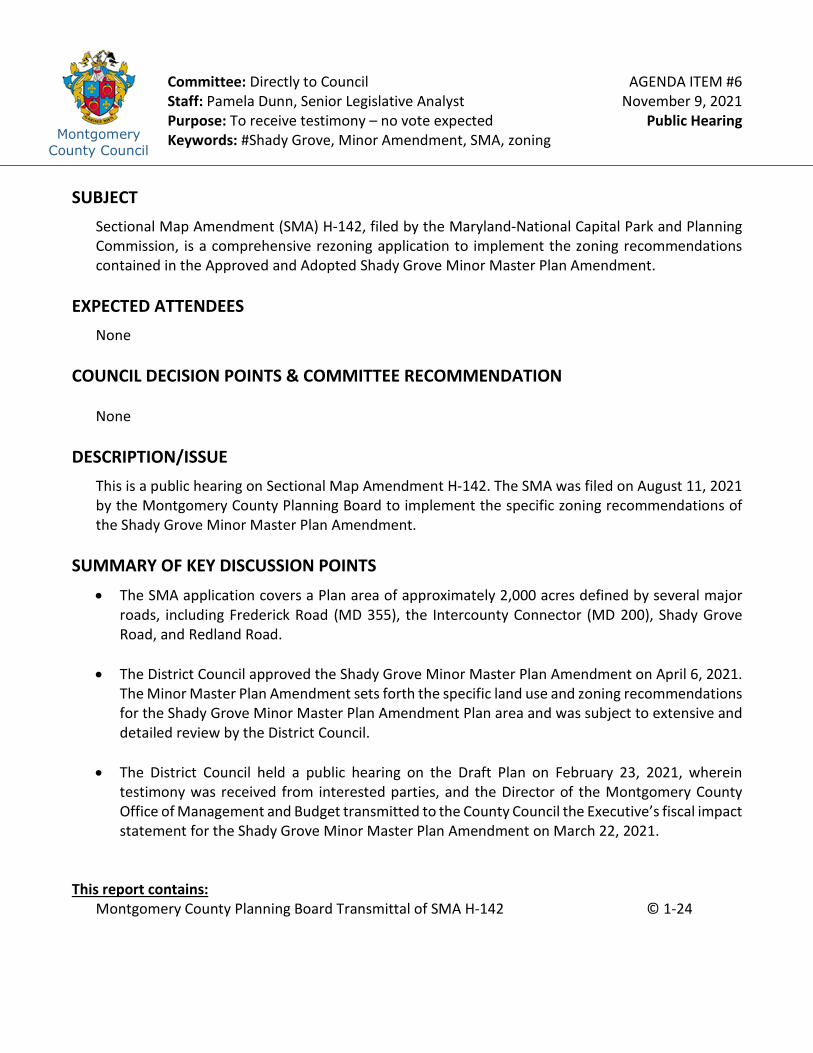
Montgomery County Council Committee: Directly to Council Staff: Pamela Dunn, Senior Legislative Analyst Purpose: To receive testimony – no vote expected Keywords: #Shady Grove, Minor Amendment, SMA, zoning AGENDA ITEM #6 November 9, 2021 Public Hearing SUBJECT Sectional Map Amendment (SMA) H-142, filed by the Maryland-National Capital Park and Planning Commission, is a comprehensive rezoning application to implement the zoning recommendations contained in the Approved and Adopted Shady Grove Minor Master Plan Amendment. EXPECTED ATTENDEES None COUNCIL DECISION POINTS & COMMITTEE RECOMMENDATION None DESCRIPTION/ISSUE This is a public hearing on Sectional Map Amendment H-142. The SMA was filed on August 11, 2021 by the Montgomery County Planning Board to implement the specific zoning recommendations of the Shady Grove Minor Master Plan Amendment. SUMMARY OF KEY DISCUSSION POINTS • The SMA application covers a Plan area of approximately 2,000 acres defined by several major roads, including Frederick Road (MD 355), the Intercounty Connector (MD 200), Shady Grove Road, and Redland Road. • The District Council approved the Shady Grove Minor Master Plan Amendment on April 6, 2021. The Minor Master Plan Amendment sets forth the specific land use and zoning recommendations for the Shady Grove Minor Master Plan Amendment Plan area and was subject to extensive and detailed review by the District Council. • The District Council held a public hearing on the Draft Plan on February 23, 2021, wherein testimony was received from interested parties, and the Director of the Montgomery County Office of Management and Budget transmitted to the County Council the Executive’s fiscal impact statement for the Shady Grove Minor Master Plan Amendment on March 22, 2021. This report contains: Montgomery County Planning Board Transmittal of SMA H-142 © 1-24
-
Upload
khangminh22 -
Category
Documents
-
view
0 -
download
0
Transcript of Sectional Map Amendment (SMA) H-142 - SUBJECT ...
Montgomery County Council
Committee: Directly to Council Staff: Pamela Dunn, Senior Legislative Analyst Purpose: To receive testimony – no vote expected Keywords: #Shady Grove, Minor Amendment, SMA, zoning
AGENDA ITEM #6 November 9, 2021
Public Hearing
SUBJECT
Sectional Map Amendment (SMA) H-142, filed by the Maryland-National Capital Park and Planning Commission, is a comprehensive rezoning application to implement the zoning recommendations contained in the Approved and Adopted Shady Grove Minor Master Plan Amendment.
EXPECTED ATTENDEES None COUNCIL DECISION POINTS & COMMITTEE RECOMMENDATION
None
DESCRIPTION/ISSUE
This is a public hearing on Sectional Map Amendment H-142. The SMA was filed on August 11, 2021 by the Montgomery County Planning Board to implement the specific zoning recommendations of the Shady Grove Minor Master Plan Amendment.
SUMMARY OF KEY DISCUSSION POINTS
• The SMA application covers a Plan area of approximately 2,000 acres defined by several major roads, including Frederick Road (MD 355), the Intercounty Connector (MD 200), Shady Grove Road, and Redland Road.
• The District Council approved the Shady Grove Minor Master Plan Amendment on April 6, 2021.
The Minor Master Plan Amendment sets forth the specific land use and zoning recommendations for the Shady Grove Minor Master Plan Amendment Plan area and was subject to extensive and detailed review by the District Council.
• The District Council held a public hearing on the Draft Plan on February 23, 2021, wherein testimony was received from interested parties, and the Director of the Montgomery County Office of Management and Budget transmitted to the County Council the Executive’s fiscal impact statement for the Shady Grove Minor Master Plan Amendment on March 22, 2021.
This report contains:
Montgomery County Planning Board Transmittal of SMA H-142 © 1-24

Alternative format requests for people with disabilities. If you need assistance accessing this report you may submit alternative format requests to the ADA Compliance Manager. The ADA Compliance Manager can also be reached at 240-777-6197 (TTY 240-777-6196) or at [email protected]
MONTGOMERY COUNTY PLAN~G BOARD THE MARYLAND-NATIO AL CAPITAL PARK AND P~G CO!v1MlSSION
The Honorable Tom Hucker President, Montgomery County Council Stella B. Werner Council Office Building 100 Maryland A venue Rockville, Maryland 20850
Dear Council President Hucker:
,0 ::.0 rr,C: c-::,0 rr, (,0
<=i Ju~ flf, 2021
0 ..... oi 0
Enclosed please find materials for Sectional Map Amendment H-142 for the approved and adopted 2021 Shady Grove Sector Plan Minor Master Plan Amendment. The County Council approved the Shady Grove Sector Plan Minor Master Plan Amendment on April 6, 202 I via Resolution No. 19-779. On April 29, 2021, the Montgomery County Planning Board approved the Resolution of Adoption, Resolution Number 21-036, and transmitted it to the Full Commission of the Maryland-National Capital Park and Planning Commission (MNCPPC). On May 19, 2021, the Maryland-National Capital Park and Planning Commission adopted the approved plan by Resolution Number 21-05.
At its regular meeting on July 8, 2021 the Montgomery County Planning Board approved filing the Sectional Map Amendment (SMA) and approved the content of the SMA, which will implement the zoning recommendations in the approved and adopted Shady Grove Sector Plan Minor Master Plan Amendment. Enclosed is the Application to File the SMA, the Certification, and maps that show the existing zoning and proposed zoning reclassifications, with parcel acreages. The SMA can also be viewed online at https://mcatlas.org/sma/sgmmpa/.
We look forward to working with the County Council to complete thi s project.
Sincerely,
~ Casey Anderson Chair
CA:ny:ha
Enclosures
cc: Pam Dunn
2425 Reedie Drive, 14th Floor, Wheaton, Maryland 20902 Phone: 301.495.4605 www.momgomeryplanningboard.org E -Mail: mcp-chair(a mncppc-mc.org
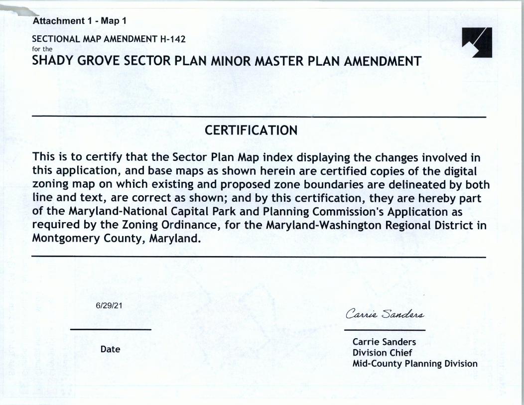
Attachment 1 - Map 1
SECTIONAL MAP AMENDMENT H-142 for the
SHADY GROVE SECTOR PLAN MINOR MASTER PLAN AMENDMENT • CERTIFICATION
This is to certify that the Sector Plan Map index displaying the changes involved in this application, and base maps as shown herein are certified copies of the digital zoning map on which existing and proposed zone boundaries are delineated by both line and text, are correct as shown; and by this certification, they are hereby part of the Maryland-National Capital Park and Planning Commission's Application as required by the Zoning Ordinance, for the Maryland-Washington Regional District in Montgomery County, Maryland.
6/29/21
Date
~:s~
Carrie Sanders Division Chief Mid-County Planning Division
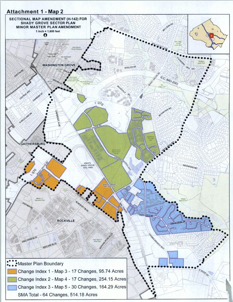
Attachment 1 - Ma 2 SECTIONAL MAP AMENDMENT (H-142) FOR
SHADY GROVE SECTOR PLAN MINOR MASTER PLAN AMENDMENT
•••• ••. :Master Plan Boundary
IIIIChange l~dex 1 - Map 3 - 17 Changes, 95.74 Acres
Change Index 2 - Map 4 - 17 Changes, 254.15 Acres
r::::J Change Index 3 - Map 5 - 30 Changes, 164.29 Acres
SMA Total - 64 Changes, 514.18 Acres
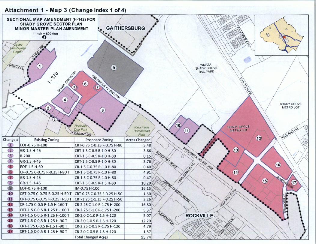
Attachment 1 - Map 3 (Change Index 1 of 4)
SECTIONAL MAP AMENDMENT (H-142) FOR SHADY GROVE SECTOR PLAN
MINOR MASTER PLAN AMENDMENT ~. GAITHERSBUR 1 inch= 600 feet
0
A(:) <{? i>:, \. ,::,,«, . ,, ~o
,J... (j
~ 0~
Change# I Existing Zonin_g
EOF-0.75 H-100
GR-1.5 H-45
R-200
GR-1.5 H-45
EOF-1.5 H-60
CR-0.75 C-0.75 R-0.25 H-80 T
GR-1.5 H-45
GR-1.5 H-45
EOF-0.75 H-100
® l I .. ,-. '
•• • I· -, •• Proposed Zonin_g
CRT-0.75 C-0.25 R-0.75 H-80
CRT-1.5 C-0.5 R-1.0 H-80
CRT-1.5 C-0.5 R-1.0 H-80
CRT-1.5 C-0.5 R-1.0 H-80
CR-1.5 C-0.75 R-1.0 H-80
CR-1.5 C-0.75 R-1.0 H-80
CR-1.5 C-0.75 R-1.0 H-80
CRT-1.5 C-0.5 R-1.5 H-80
IM-0.75 H-100
CRT-0.75 C-0.75 R-0.25 H-50 T ICRT-0.75 C-0.75 R-0.25 H-50
CRT-0.75 C-0.75 R-0.25 H-50 T ICRT-1.25 C-1.25 R-0.25 H-50
CR-1.75 C-0.5 R-1.5 H-160 T ICR-2.25 C-1.0 R-1.75 H-200
CRT-1.5 C-0.5 R-1.25 H-100 T ICR-2.25 C-1.0 R-1.75 H-200
CRT-1.5 C-0.5 R-1.25 H-100 T ICR-2.0 C-1.0 R-1.5 H-120
CRT-1.5 C-0.5 R-1.25 H-90 T ICR-2.0 C-0.5 R-1.5 H-120
CRT-1.75 C-0.5 R-1.5 H-90 T CR-2.25 C-0.5 R-1.75 H-120
CRT-1.5 C-0.5 R-1.25 H-90 T CR-2.0 C-0.5 R-1.5 H-120
Total Changed AEres
5.07
12.20
4 .79
1.57
95.74
WMATA SHADY GROVE
RAIL YARD
SHADY GROVE METRO LOT
SHADY GROVE METRO LOT
\

Attachment 1 - Ma 4 SECTIONAL MAP AMENDMENT (H-142) FOR
SHADY GROVE SECTOR PLAN MINOR MASTER PLAN AMENDMENT
1 inch = 700 feet
0
WMATA SHADY GROVE
RAIL YARD
SHADY GROVE METRO LOT
CRT-1.0 C-0.25 R-0.75 H-90T
CRT-0.75 C-0.25 R-0.5 H-60 T
CRT-1.0 C-0.25 R-0.75 H-70 T
EOF-0. 75 H-60 15.08
EOF-0. 75 H-60 1.75
CR-1.5 C-0.5 R-1.0 H-80 21.42
CRT-1.0 C-0.25 R-0.75 H-90 45.06
CRT-0.75 C-0.25 R-0.5 H-80 55.55
CR-1.5 C-0.25 R-1.0 H-100 41.60
CRN-1.0 C-0.0 R-1.0 H-60 5.02
CRN-1.0 C-0.0 R-1.0 H-60 2.23
TMD 8.75
TMD 10.63
TMD 13.51
R-90 .78
R-90 1.56
R-90 4.17
R-200 i.36
R-90 17.10
Total Chan ed Acres 254.15
Attachment 1 - Ma 5 SECTIONAL MAP AMENDMENT (H-142) FOR
SHADY GROVE SECTOR PLAN MINOR MASTER PLAN AMENDMENT
SHADY GROVE METRO LOT
Change# Existing Zoning
R-90
PD-35
PD-35
R-200
R-200
R-200
R-200
R-200
R-200
R-200
R-200
PD-2
PD-2
PD-2
PD-2
PD-2
PD-2
PD-2
PD-2
PD-2
PD-2
PD-2
® PD-2
PD-2
PD-2
PD-2
PD-2
IM-2.5 H-50
IM-2.5 H-50
IM-2.5 H-50
Proposed Zoning
CRN-1.0 C-0.0 R-1.0 H-65
CRN-1.0 C-0.0 R-1.0 H-65
CRN-1.0 C-0.0 R-1.0 H-65
CRT-1.0 C-0.25 R-1.0 H-50
R-90
R-90
R-90
R-60 0.67
R-90 1.33
R-90 1.38
R-60 0.33
R-90 0.82
R-90 0.22
TLD 6.22 R-200 4.19
CRN-0.5 C-0.0 R-0.5 H-65 6.06
CRN-0 .5 C-0.0 R-0.5 H-50 6.63
TLD 17.72
R-90 25.10
R-90 13.36
R-90 3.40
R-90 8.60
R-90 17.46
R-90 5.10
R-90 10.03
R-90 2.19
R-90 3.37
CRT-2.5 C-2.0 R-0.5 H-80 4.60
IM-2.5 H-70 5.25
IM-2.5 H-70 8.27
Total Changed Acres 164.29
@) STANDISH Pl
@
Crabbs Branch SVP
CALHOUN PL.
@
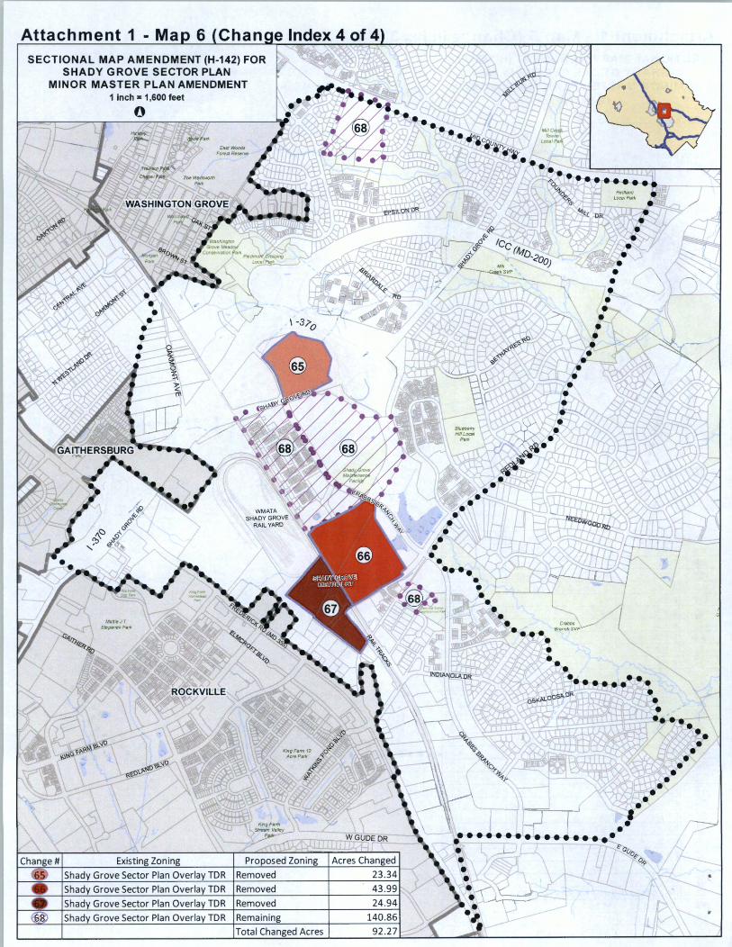
Attachment 1 - Ma 6 Chan e Index 4 of 4 SECTIONAL MAP AMENDMENT (H-142) FOR
SHADY GROVE SECTOR PLAN MINOR MASTER PLAN AMENDMENT
1 inch = 1,600 feet
Existing Zoning Proposed Zoning
Shady Grove Sector Plan Overlay TDR Removed
Shady Grove Sector Plan Overlay TDR Removed
Shady Grove Sector Plan Overlay TDR Removed
Shady Grove Sector Plan Overlay TDR Remaining
Total Changed Acres
WGUDEDR
Acres Changed
23.34
43.99
24.94
140.86 92.27
••••• '1-o
"'-1>.i,
4'/(( OR
.:.w ...... , ......... l-"\t7M.._Y._rJ)"h:,,,. V
• •• • • ••••• ., l! Ou.
~(; 0-1>
Attachment 1 - Map 7
N738
j cl
~ <::::,
~°J
P940
/::-. i?~<'.)
~~lc'-1-~o
N881
i i'•:,~ '"-o . ,.,. " . ........ ,.,
••
EOF-0.75 H-100
.... "
E:370 - SHA.Dy GRovE: RA.Mp
(I) ;q
0
<§> ~¼
(}:-0 ,,,
:-l-0 .p
0~
if ' -~ ~GR-1.5 ~
''" ~I::>" H-45~ r' :t.~"
~~ ,I'. '
'lo"'
'' :.</~ • "' , N23 ~15'-1,i;' #,
Is ... ' (c\ I-'.! Ir, ·, \VI P31 "<) '-" "-- " '-, ,..._ P79 V-.....
R-200'
CR-0.75 C-0.75 R-0;•25 H-80 T
P108
- - -PLEASANT OR
Map Grids: 221 NW08, 221 NW09, 222NW08, 222NW09
Proposed Zoning
N667
N738
N881
'j i'•:,~ '"-o . ,.., " • '"41;, .. ,.,
•• •
P940
CRT-0.75 C-0.25 R-0.75
H-80
,;,•
"
t:370 - SHA.Dy GRovE: RA.Mp
•••• •••• Master Plan Boundary
j cl ~
£ (I)
;q 0
<§> ~¼
(}:-0 :-l-0
~.p 0
~ <::::,
~°J
/::-. i?~o
~~/,
o-1-~o
CR-1.5 C-0.75 R-1 .0 H-80
F-tl
P108
-PLEASANT DR
1 in = 300 ft
Attachment 1 - Map 8
'
' ~.
(\<::) O;:, , f::>
~~ ) &f (:)~ P761
9_;_ ~ ef\, ".( ; , ·,;r "- ~""' . # r'--0'
EOF-0.75 H-100
P819
~-~~/, CR-0.75 /,'~~Of-
-0 .7 80 T ', •• ,. ,, ",, ~ H- , ,,, ,.,.,,, .,
/ , /
,,
< GR-1.5 H-45
PARCELS A & C ,, '-.,, . / . '~ P108
P170
ROCKVILLE
Map Grid's: 221 NW08, 221 NW09, 222NW08, 222NW09
I IM-2.5 H-50
0
PARCEL
Proposed Zoning_
(\<::) O;:, ,, <f>
;{v :<J:-0
4..0
~.p 0 ~"'" ., .
,,, ~
"Q
CR-1.5 r,J..,,n
C-0.75 R-1 .0. H-80
••• :. •• Master Plan Boundary
CRT-1 .5 CJ C-0.5 R-1.5
H-80 PARCELS A &C
P170
LOT 1
IM-0.75 H-100
P819
ROCKVILLE
IM-2.5 H-50
0
PARCEL
1 in = 330 ft
Attachment 1 - Map 9
WMATA SHADY @>~VE
RAIL YARD
IM-2:s H-50
RT-0.75 .75iR-0 .. H-50
P31
Map Grids: 221 NW08, 222NW08
/\,~V'GI 71>\ ~~7.t: ~ M· RQ .
<0. , , ·:-;·' <1. .
~ RT-11.~ C-0:5,R~,1.25
H-100 T
0
.n,~ ?-51
-n.s
Proposed Zoning
WMATA SHADY <B'~ GVE
RAIL YARD
IM-2:s H-50
P31
✓
✓ ✓
✓ ✓
✓
-)(5) ✓ '
P800
CR-1 .5 C-0.25 R-1.0
H-100
✓ ' ✓ ' , ..
✓ \
/ SHAQX7GROVE ✓, METRO LOT
C
0 ~-- ~~/~ •••• Master Plan Boundary -V ✓~ TOR Overlay 1 in= 440 ft

Attachment 1 - Map 10
CRTl1 C-0.5 R-
'-H<100
.RCEL L
'ARCEL K
PARCEL J
CRT-1.5 PARCEL C-0.5 R-1.25
H-90 T,
">°' ' * / ,<'--'?~/\ ,"a
v~~ ', 'file '
,t---?o -~PAR E
fllto
PARCEL H·2
PARCEL G
0 J>s. ' ~ ' , ~ ; ~ - • A--119fl.B
' N607
PARCEL X
ROCKVILLE
Map Grief. 221 NW08
~ ;o
~ I 0 1
1cl
z -i 0 :;:o
PT. PARCEL F
R-90
PARCEL 0
Proposed Zoning
l CR!'' C-,1,0
H-1 ,RCEL L
0
PT PARCEL Q
CR-2.25 C-1.0 R-1. 75
H-200
PARCEL J
CR-2.Q, c-0:~~-1.s
H-120
PARCEL X
PT PARCEL N
CR-2.25 C-0.5 R-1. 75
H-120
PARCEL H-2
~·· ~~/, •••• Master Plan Boundary y ,,,,; TOR Overlay
PT. PARCEL F
PARCEL 0
1 in = 250 ft
Attachment 1 - Map 11
Existin
PARCEL C
-------/
EOF-o"'·-. H-
~r::::, ~<":)
EOF-0.75 H-60T
P131
---~~-sr\~ • ,,. "' • !/,~ // --~ .--IM-0.5,H-7-
Map Grids: 222NW08, 223NW08
Chan
r:::,~ ~~
0~ ~
I - 370
1,370
, __ ,.s· / / , 5/R-0.5 !sc{
Proposed Zoning
PARCEL C
(\r::::, ~<":)
PARCEL 8
PARCEL D
EOF-0.75 H-100
EOF-0.75 .,., H-60
P131
~r::::,, ~~ ~
~0
I - 370
I , 370
P968
a.i,, ~ .. , '"'~" 0-111
CR-1.5 C-0.5 R-1 .0
H-80
N55
~ TOR Overlay 1 in= 400 ft
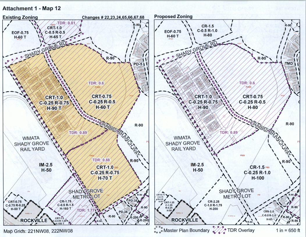
Attachment 1 - Map 12
EOF-0.75 H-60 T
Pd,
WMATA SHADY GROVE
RAIL YARD
IM-2.5 H-50
Map Gri~: 221 NW08, 222NW08
R-90
p·
EOF-0.75 H-60 T
P131
WMATA SHADY GROVE
RAIL YARD
IM-2.5 H-50
PBOO
/ CR-1.5 P89
>,.. \ C-0.25 R-1.0 / \ / H-100 , . , \
,' SHA0\6ROVE , METRO\LQT ..
✓ CR-2.25 \ . ✓ C-1 .0R-1.75 I'---\
H-200 / \ \ \
~·· ~~/~ •••• Master Plan Boundary 9'/ ✓/t TOR Overlay
R-90
p·
1 in= 650 ft
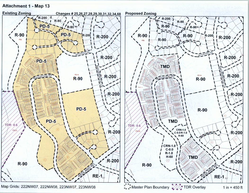
Attachment 1 - Map 13
Proposed Zoning
' P89
R-90 ' P89
~
P214
R-90
RD-5 R-90
R-90 R-90
Map Grids: 222NW07, 222NW08, 223NW07, 223NW08 ~·· ~~/~ •••• Master Plan Boundary y .(~ TOR Overlay 1 in = 450 ft
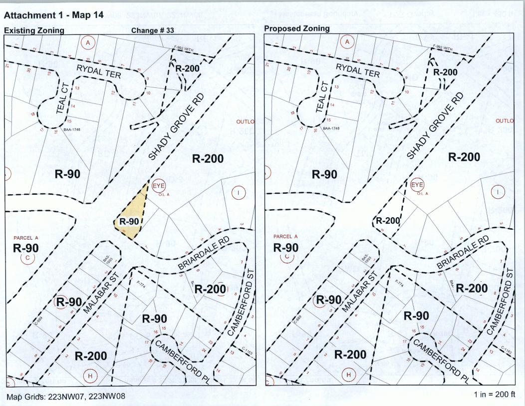
Attachment 1 - Map 14
PARCEL A
R-90 ~
Map Griefs: 223NW07, 223NW08
o,
I <P
~~ rf>
~0
~ ef R-200
OUTL1
PARCEL A
R-90 ~
00 I <f>
~~ ~
~0
~ ef / R-200
OUTU
1 in= 200 ft
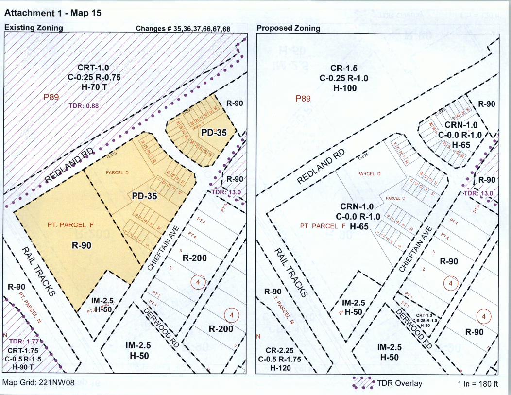
Attachment 1 - Map 15
PT. PARCEL F
~ ~ 1
~ ~ <.P
c~cf:s/R{1 / / , H:-90,T,
R-90
Map Grid: 221 NW08
PARCEL D
/
\ , FlD-35
~~-
IM-2.5 H-50
Proposed Zoning
P89
N
CR-2.25 C-0.5 R-1.75
H-120
CR-1.5 C-0.25 R-1.0
H-100
IM-2.5 H-50
~ TDR Overlay 1 in= 180 ft
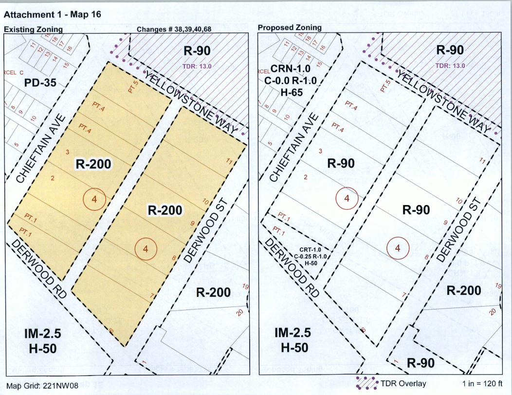
Attachment 1 - Map 16
/:) ' ..,._<{
I--.~ Q
"' ~:/ ~~~
0~;:~R~/ ~ .l ~ '
/:)1' .J
R-200 ~ /:)1'
·l
A,, ~ ~Ii
" 0 " OC?N( ~
:?A ~
IM-2.5 H-50
Map Grict. 221 NW08
"' '~
R-200 191
~
IM-2.5 H-50
~ TOR Overlay
R-200 191
~
1 in = 120 ft
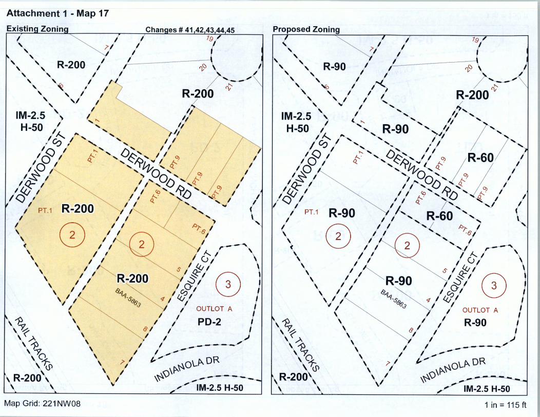
Attachment 1 - Map 17
Chanaes # 41.42.43,44.45 79
R-200
R-200 "/4J/ 0 s "----"'½,s:
~~~8 OUTLOT A
~ p:_J '~
.A
.~
% ~OLp..OR (,5) ,~Q\~ R-200\.
IM-2.5 H-50
Map Grid: 221 NW08
Proposed Zoning
R-90
PT.1 R-90
0
\ ~
% (,5)
R-200
79
0 OUTLOT A
R-90
<"\\~~oLP.. OR ,~v ---------------1 M-2. 5 H-50
1 in = 115 ft
Attachment 1 - Map 18
<<1
PARCEL B
~ ~ I
0
11 10----I ·g· 8
7
P297
[ m o~ N N (")(") (")
..
0
PD-2
z ....J
<{ I
~ ~ I
1PD--2
I C C Ci
& ,~ P463 /
OJ]]] .__,___
INDIANOLA DR ---- - -·
Map Grid': 221 NW08
>--~ I u z <{ 0:: co Cf) co co
~ u
Pi
Proposed Zoning <<f
0
CX) N
(") '<t ltn ~ ~ ~
12 ~ 11 10 9 8
7
R-200
P297
O> o~ N N (") (") (")
0
<O r--~ ~
D
z ....J <{ I
i I
>--~ I u z ~ co Cf) co co <{
OillIJ 0:: u
INDIANOLA DR
P!
1 in = 150 ft
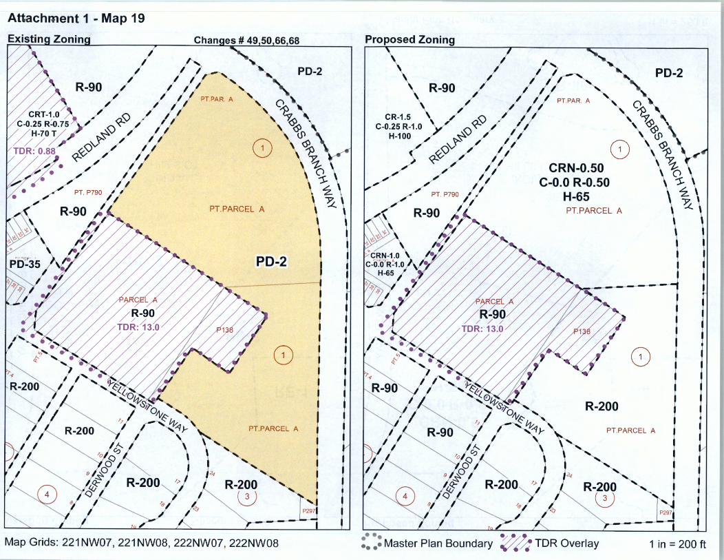
Attachment 1 - Map 19
PD-2
0
PT.PARCEL A
PD-2
0
PT.PARCEL A
<<t
R-200 8
P297I
Map Grids: 221 NW07, 221 NW08, 222NW07, 222NW08
Proposed Zoning
0 CRN-0.50
C-0.0 R-0.50 H-65 PT.PARCEL A
R-200
PD-2
0
PT.PARCEL A
R-200 8
P297,
•••• ~~/J: •••• Master Plan Boundary v ✓~ TOR Overlay 1 in = 200 ft

Attachment 1 - Map 20
Existin
0 PARCEL A
PTPARCEL B
>-<( ~
s ~r1~1llr1 I ,.i"_T __ _ P,D-2 0 ~ MOCCASIN 0:: LN ClJ CJ)
ffi f ~ ( 2) PD-. c?. ! PARCEL C 0
. -~-- PARCELD?2
~ ~• 8 - i fl 2 ~ 8 \:..J ·,,
"' ,,. J I i ~ .. , A•·,~ r:;\ 99 "
v 3 - : I DIAN'' 1101 5 :~H~LSCT ~
~ ~93 ~&" ~\~. --. - n ~ '~""-...J - v,Q> S
>- ~ ~~ ~ ~~
Map Grid': 221 NW07
PARCEL
RE-1
PARCEL
Proposed Zoning
>-~ I 0 z <( 0:: ClJ CJ) ClJ ClJ <( 0:: 0
CRN-0.~) C-0.0 R-0.5
H-50-8
107
108 109 110 111 112 113
114
z ~ : ...J : Z 95
0 ~ ::> >-
•••• •• •• Master Plan Boundary
PARCEL A PARCEL
RE-1
PD-2
1 in= 250 ft

Attachment 1 - Map 21
INoiA: ,c:-- --
PARCEL V
~ Reaw
"' IM-2.5 H-50
Map Grid: 221 NW07
Chanoes # 53,56,59,60,61
PD-2 ~ \J \ ~
~ TLD ~. ~~·· . fflffifi1 \ (2 .. ' Wlllll ~ _ ~
(2)
i
fYE IM-2.5 H-50
•••• •••• Master Plan Boundary
PD-2
1 in = 440 ft
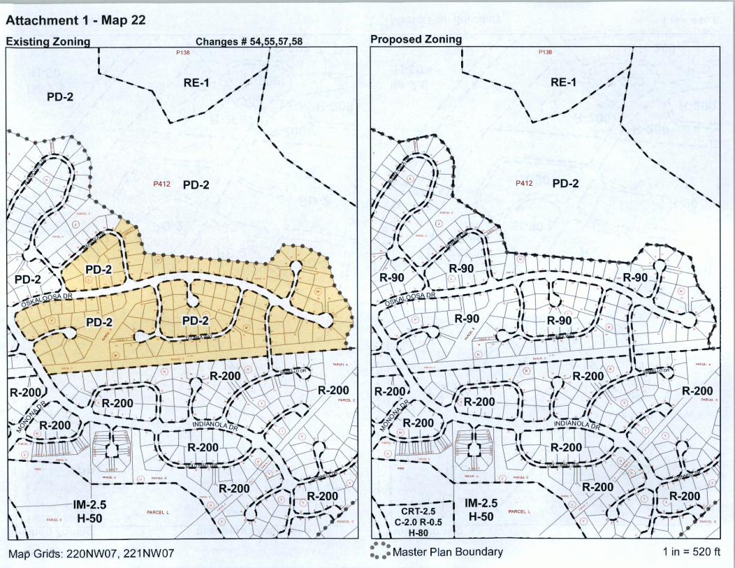
Attachment 1 - Map 22
P138
RE-1 PD-2
P412 PD-2
PARCEL l
l'l !ICfl e
Map Grids: 220NW07, 221 NW07
Proposed Zoning P138
RE-1
P41 2 PD-2
~ Q;2~ ,\R! ';=Y U--~, I 'i \11:~ , , . :1 11 -r r 1 11 - ~ • ' i I -
- --- ,.·R
CRT-2.5 C-2.0 R-0.5
H-80
IM-2.5 H-50
•••• •••• Master Plan Boundary
PARCEL L
1 in = 520 ft

Attacha,ent 1 - Map 23
EL A
!PARCEL D IM-2.5 H-50
STANDISH PL
PARCEL K
~
P960
PARCEL C
PARCEL B
PARCEL Y
PARCa C
IM-2.5 I
H-50
PARCEL E
a:: a z ::> 0 J: ...J <( u
, ... .., .- .---.. .... -◄--+-1 .. •' -.-................ .._. ...... .__ G-131 WITH
E GUDE DRo,,..,,,.. G-230WITH
IM-2!5 ~'"" P316
I
H-50 ,
Map Grids: 220NW07, 221 NW07
BAS-2211
IM-2.5 H-50
EL A
!PARCEL D IM-2.5 H-50
STANDISH PL
?316
IM-2.5 H-70
PARCEL K
C.231 wtTH
IM-2~5~,.,, I
H-50 ,
~ ~
1'960
'~
PARCEL C
CRT-2.5 C-2.0 R-0.5
H-80
PARCEL B IM-2.5 H-70
PARCa. C
IM-2.5 H-50
PARCEL E
IM-2.5 PAt-'' .... , ..
H:so
a:: a z ::> 0 J: ...J <( u ,
.. .. J . j I I -e • • e I e .. ... ~ ....... . E GUDE DRo,,ow,n,
G-2'JOW/TH BA.S-2291
IM-2.5 H-50
•••• •••• Master Plan Boundary 1 in= 300 ft