Individual variations in habitat use and morphology in brook charr
Upload
independentCategory
view
5download
0
Sawmill Brook: An Example of Rapid Geomorphic Change Related to UrbanizationAuthor(s): Chester L. Arnold, Paul J. Boison and Peter C. PattonSource: The Journal of Geology, Vol. 90, No. 2 (Mar., 1982), pp. 155-166Published by: The University of Chicago PressStable URL: http://www.jstor.org/stable/30070754 .
Accessed: 29/05/2014 10:11
Your use of the JSTOR archive indicates your acceptance of the Terms & Conditions of Use, available at .http://www.jstor.org/page/info/about/policies/terms.jsp
.JSTOR is a not-for-profit service that helps scholars, researchers, and students discover, use, and build upon a wide range ofcontent in a trusted digital archive. We use information technology and tools to increase productivity and facilitate new formsof scholarship. For more information about JSTOR, please contact [email protected].
.
The University of Chicago Press is collaborating with JSTOR to digitize, preserve and extend access to TheJournal of Geology.
http://www.jstor.org
This content downloaded from 137.99.58.221 on Thu, 29 May 2014 10:11:10 AMAll use subject to JSTOR Terms and Conditions

SAWMILL BROOK: AN EXAMPLE OF RAPID GEOMORPHIC CHANGE RELATED TO URBANIZATION1
CHESTER L. ARNOLD,2 PAUL J. BOISON3 AND PETER C. PATTON Department of Earth and Environmental Sciences, Wesleyan University, Middletown, CT 06457
ABSTRACT
The watershed of Sawmill Brook is undergoing urbanization that has increased the frequency of bankfull discharge. The increased runoff is causing extensive bank erosion in the main channel that has increased the size of the bed material and the rate of bedload discharge. The increased frequency of moderate floods, the channel widening, and the change in the sediment transport regime is causing a change from a meandering to a braided channel pattern. With continued urbanization of the basin the present disequilibrium of the chan- nel will be enhanced resulting in an unstable channel pattern for Sawmill Brook.
INTRODUCTION
Urbanization, including highway construc- tion, industrial plant development, and the creation of residential subdivisions is known to have significant effects on the surface water hydrology of drainage basins. Disrup- tion and reduction of natural vegetative cover, the creation of large areas of impervi- ous or at best slightly permeable surfaces, the installation of storm sewers, and the creation of channelized stream segments all serve to drastically alter the preconstruction hydro- logic regime of the basin. These activities typically change the sediment yields of the basin (Wolman 1967; Wolman and Schick 1967; Vice et al. 1969) and alter the time dis- tribution and magnitude of the runoff pro- cesses (Leopold 1968).
The generally accepted hydrologic trends that accompany urbanization include the fol- lowing. Urbanization decreases the lag time of the stream hydrograph because of the re- duced roughness, infiltration capacity, and poor interception and detention storage qual- ities of man-made surfaces (Espey et al. 1966). This trend is exacerbated by the in- creased density of drainage channels created
1 Manuscript received October 20, 1980; revised September 17, 1981. 2 Present address: Dept. of Marine Sciences, State University of New York, Stony Brook, N.Y.
3 Present address: Board of Earth Sciences, University of California Santa Cruz, CA.
[JOURNAL OF GEOLOGY, 1982, vol. 90, p. 155-166] © 1982 by The University of Chicago. All rights reserved. 0022-1376/82/9001-007$1.00
by storm sewering (Leopold 1968; Graf 1977) and by the increased hydraulic efficiency of channelized stream segments (Keller 1975, 1976). Numerous case studies indicate the approximate magnitude of these changes; for example, see Charter (1961), Crippen (1969), or Anderson (1970).
The increase in impervious area and the more efficient drainage network also cause an increase in the hydrograph peak and in the total volume of runoff for a given rainfall (Espey et al. 1966; Graf 1977). These hy- drologic changes increase the frequency of large flows which, in turn, can cause acceler- ated erosion of channel cross-sections (Wol- man and Schick 1967; Hammer 1972; Fox 1976). In addition, the more frequent and greater flood peaks effectively enlarge the flood plain downstream (Graf 1975). Finally, urbanization causes increases in sediment yields during construction activities when sites are devoid of vegetation, but can actu- ally cause a reduction in basin-wide sediment yields during the post-construction period (Wolman 1967).
Although other investigators have consid- ered the effect of urbanization on the cross- section morphology of streams, there is little evidence of the long term evolution of stream patterns under these conditions. The purpose of this paper is to document the effects that urbanization can have on stream pattern morphology. These observations also lend in- sight into the complex-response that can occur in the sediment transport regime as basin-wide sediment yields decline and stream runoff increases.
155
This content downloaded from 137.99.58.221 on Thu, 29 May 2014 10:11:10 AMAll use subject to JSTOR Terms and Conditions
C. L. ARNOLD, P. J. BOISON, AND P. C. PATTON
STUDY AREA
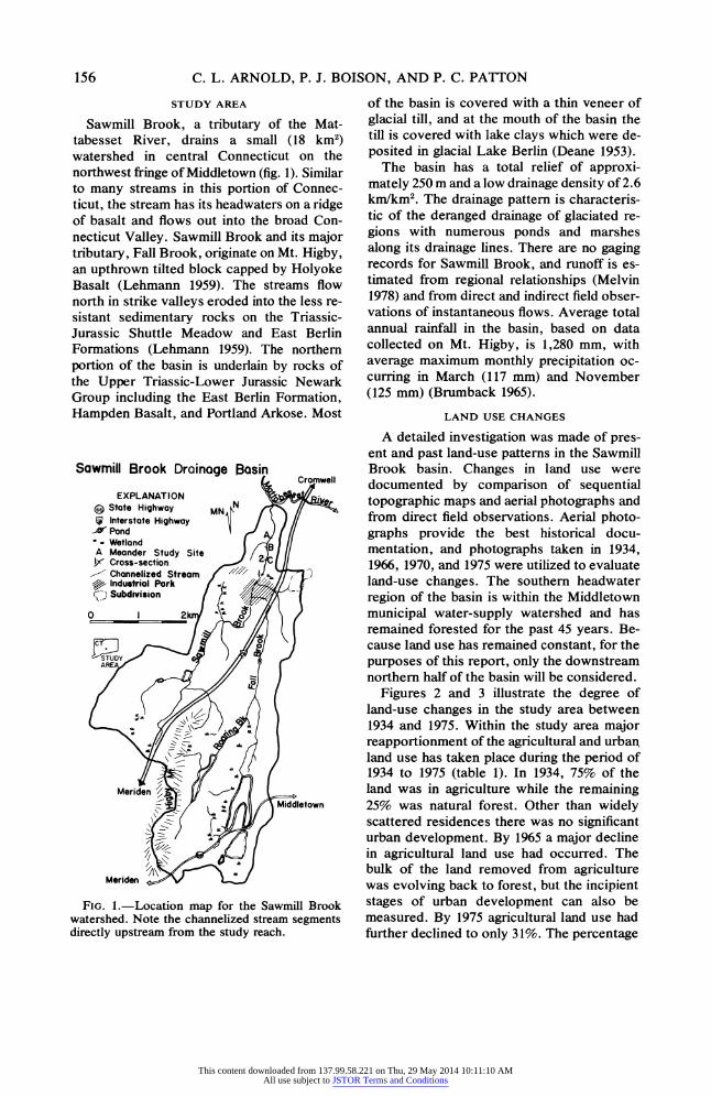
Sawmill Brook, a tributary of the Mat- tabesset River, drains a small (18 km2) watershed in central Connecticut on the northwest fringe of Middletown (fig. 1). Similar to many streams in this portion of Connec- ticut, the stream has its headwaters on a ridge of basalt and flows out into the broad Con- necticut Valley. Sawmill Brook and its major tributary, Fall Brook, originate on Mt. Higby, an upthrown tilted block capped by Holyoke Basalt (Lehmann 1959). The streams flow north in strike valleys eroded into the less re- sistant sedimentary rocks on the Triassic- Jurassic Shuttle Meadow and East Berlin Formations (Lehmann 1959). The northern portion of the basin is underlain by rocks of the Upper Triassic-Lower Jurassic Newark Group including the East Berlin Formation, Hampden Basalt, and Portland Arkose. Most
Sawmill Brook Drainage
FIG. 1.-Location map for the Sawmill Brook watershed. Note the channelized stream segments directly upstream from the study reach.
of the basin is covered with a thin veneer of glacial till, and at the mouth of the basin the till is covered with lake clays which were de- posited in glacial Lake Berlin (Deane 1953).
The basin has a total relief of approxi- mately 250 m and a low drainage density of 2.6 km/km2. The drainage pattern is characteris- tic of the deranged drainage of glaciated re- gions with numerous ponds and marshes along its drainage lines. There are no gaging records for Sawmill Brook, and runoff is es- timated from regional relationships (Melvin 1978) and from direct and indirect field obser- vations of instantaneous flows. Average total annual rainfall in the basin, based on data collected on Mt. Higby, is 1,280 mm, with average maximum monthly precipitation oc- curring in March (117 mm) and November (125 mm) (Brumback 1965).
LAND USE CHANGES
A detailed investigation was made of pres- ent and past land-use patterns in the Sawmill Brook basin. Changes in land use were documented by comparison of sequential topographic maps and aerial photographs and from direct field observations. Aerial photo- graphs provide the best historical docu- mentation, and photographs taken in 1934, 1966, 1970, and 1975 were utilized to evaluate land-use changes. The southern headwater region of the basin is within the Middletown municipal water-supply watershed and has remained forested for the past 45 years. Be- cause land use has remained constant, for the purposes of this report, only the downstream northern half of the basin will be considered.
Figures 2 and 3 illustrate the degree of land-use changes in the study area between 1934 and 1975. Within the study area major reapportionment of the agricultural and urban land use has taken place during the period of 1934 to 1975 (table 1). In 1934, 75% of the land was in agriculture while the remaining 25% was natural forest. Other than widely scattered residences there was no significant urban development. By 1965 a major decline in agricultural land use had occurred. The bulk of the land removed from agriculture was evolving back to forest, but the incipient stages of urban development can also be measured. By 1975 agricultural land use had further declined to only 31%. The percentage
156
This content downloaded from 137.99.58.221 on Thu, 29 May 2014 10:11:10 AMAll use subject to JSTOR Terms and Conditions

RAPID GEOMORPHIC CHANGE RELATED TO URBANIZATION
Sawmill Brook
1934 Land Use
EXPLANATION
FIG. 2.-Land-use map of the entire basin made from aerial photographs taken in 1934.
of land in natural forest remained nearly con- stant and the decrease in agricultural land use was mirrored by an abrupt increase in urbani- zation. Urban development included a large industrial park, several residential subdivi- sions, and the construction of an interstate highway through the basin. Total urban de- velopment constituted about 30% of the study area or about 15% of the entire watershed.
CHANGES IN SURFACE WATER HYDROLOGY
Associated with this development has been the major alteration of the drainage system in the lower portion of the basin. Storm sewering of both a residential subdivision and indus- trial park has probably resulted in increased discharge from these properties. In the case of the subdivision on the eastern divide, the sewer system has also slightly increased the drainage area of the basin. Runoff from this system has caused degradation of the natural stream channel downstream from the point
where the sewer enters the stream. Based on the height of recently scoured banks and the vertical thickness of till that has been eroded to its bedrock contact, erosion along this reach of channel has averaged about 0.5 m. Prior to the development of the industrial park, this tributary flowed into a wetland ad- jacent to Sawmill Brook. A portion of this wetland has been filled in and the tributary has been channelized to its confluence with Sawmill Brook (fig. 1).
Runoff from the interstate highway and a portion of the industrial park has been fun- neled into Fall Brook, which has also been channelized to its confluence with Sawmill Brook (fig. 1). The channelized reach of Fall Brook is a concrete lined rectangular and semicircular conduit which is 610 m long. There is no bedload sediment in this section of Fall Brook, which indicates that little bed- load sediment is passing through this reach into the lower segment of Sawmill Brook. Immediately below the confluence with Fall Brook, the main channel of Sawmill Brook is also channelized. This channelized segment, 595 m long, has a roughly trapezoidal cross- section with earthen banks several times higher than the natural channel (fig. 4). Por- tions of the bank are rip-rapped. The long profile of this channel is quite smooth, unlike the more hydraulically rough pool and riffle sequence in the natural downstream channel (fig. 5). Bedload sediment moving through this channelized segment is sandy pebble gravel, unlike the cobble and boulder gravel typical of the bed material of the natural stream. In short, as Keller (1975, 1976) has noted, these particular channelized segments have the worst characteristics of artificial channels in that they have hydraulically smoother cross-sections and longitudinal profiles than the natural channel which they replaced.
Where the artificial channel of Sawmill Brook connects with the natural channel a concrete drop structure has been installed. This structure acts as a broad-crested weir, and flow is nearly critical over the crest. Water depths measured at this point were converted to discharge measurements using the formula for critical flow over a trapezoidal broad-crested weir (Chow 1959, p. 81). A di- rect discharge measurement with a Price cur-
157
This content downloaded from 137.99.58.221 on Thu, 29 May 2014 10:11:10 AMAll use subject to JSTOR Terms and Conditions

C. L. ARNOLD, P. J. BOISON, AND P. C. PATTON
Sawmill Brook 1975 Land use
EXPLANATION
Natural Vegetation N
Agricultural Land
Industrial \ Urban Landkm
O akm
FIG. 3.-Land-use map of the northern half of the basin made from aerial photographs taken in 1975.
TABLE 1
SUMMARY OF LAND-USE CHANGES WITHIN THE STUDY AREA, SAWMILL BROOK WATERSHED
Year of Percent Natural Percent Agricultural Percent Urban Aerial Photographs Land Area Land Area Land Area
1934 25.0 75.0 .0 1966 40.6 50.2 9.2 1970 38.9 43.2 17.9 1975 38.3 31.2 30.5
158
This content downloaded from 137.99.58.221 on Thu, 29 May 2014 10:11:10 AMAll use subject to JSTOR Terms and Conditions

RAPID GEOMORPHIC CHANGE RELATED TO URBANIZATION 159
FIG. 4.-Downstream view of channelized reach of Sawmill Brook. Compare this trapezoidal channel with the natural channel shown in figures 6 and 7.
rent meter during low flow conditions verified the accuracy of this equation for this struc- ture. At greater flow depths the effect of the weir probably changes, but direct mea- surements could not be made at these stages. Rather, flow depths were estimated im- mediately after the floods from trash lines, and the weir formula was used to calculate discharges. In spite of the shortcomings of this method, the calculated values are proba- bly good approximations of peak discharges. No major tributaries enter Sawmill Brook
FIG. 5.-Longitudinal profile of channelized reach and a reach of natural stream. Vertical exaggeration is 10 x. Compare the smooth artificial channel with the irregular pool-riffle profile of the natural stream channel.
downstream from this structure, and the dis- charge measurements can be considered ap- proximate values for the natural channel downstream. Weekly observations of flow conditions were made for the five month pe- riod between January and May 1977. During this time period bankfull discharge, about 8 m3/sec, was exceeded five times in the lower reach of the channel below the channelization projects. Two of these flows exceeded the magnitude of the mean annual flood, 9 m3/sec, determined from a regional relationship for small streams in Connecticut (Melvin 1978).
There are unfortunately no long-term hy- drologic records for Sawmill Brook. There- fore, the increased frequency of flooding might be considered the result of short-term climatic fluctuations producing a change in precipitation. An analysis of rainfall data re- corded at Mt. Higby in the headwaters of the watershed indicate that since 1962 there has been only a slight shift in the magnitude and frequency of rainfalls of 24 hours duration (Whiteman 1981). The shift has been to slightly lower magnitude rainfalls for a given frequency of occurrence, but the magnitude of the shift, a few millimeters, is too small to be physically significant. Therefore, it seems
This content downloaded from 137.99.58.221 on Thu, 29 May 2014 10:11:10 AMAll use subject to JSTOR Terms and Conditions
C. L. ARNOLD, P. J. BOISON, AND P. C. PATTON
probable that the increased impervious cover in the basin and the storm sewer systems and channelization projects have all served to de- crease the lag time of the basin and increase the magnitude of peak discharges for frequent runoff events. The filling in of the wetland has also removed a large amount of detention storage from the surface runoff system. In addition to these direct observations of in- creased flooding there is indirect geomorphic and botanic evidence to indicate that the in- crease in flooding is a recurring recent phenomena that is upsetting the established long-term equilibrium of the natural channel.
CHANGES IN CHANNEL MORPHOLOGY
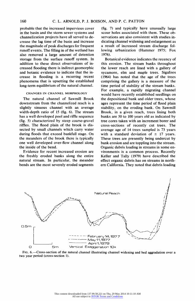
The natural channel of Sawmill Brook downstream from the channelized reach is a slightly sinuous channel with an average width-depth ratio of 15 (fig. 6). The stream has a well developed pool and riffle sequence (fig. 5) characterized by steep coarse-gravel riffles. The flood plain of the brook is dis- sected by small channels which carry water during floods that exceed bankfull stage. On the meanders of the brook there is typically one well developed over-flow channel along the inside of the bend.
Evidence for recent increased erosion are the freshly eroded banks along the entire natural stream. In particular, the meander bends are the most severely eroded segments
(fig. 7) and typically have unusually large scour holes associated with them. These ob- servations are also consistent with studies in- dicating channel widening and enlargement as a result of increased stream discharge fol- lowing urbanization (Hammer 1975; Fox 1976).
Botanical evidence indicates the recency of this erosion. The stream banks throughout the lower reach are lined with a gallery of sycamore, elm and maple trees. Sigafoos (1964) has noted that the age of the trees comprising the gallery is a measure of the time period of stability of the stream banks. For example, a rapidly migrating channel would have recently established seedlings on the depositional bank and older trees, whose ages represent the time period of flood plain stability, on the eroding bank. On Sawmill Brook, in a given reach, trees lining both banks are 50 to 100 years old as indicated by tree cores taken with an increment borer and cross-sections of recently cut trees. The average age of 14 trees sampled is 73 years with a standard deviation of ±+ 17 years. These trees are presently being undercut by bank erosion and are toppling into the stream. Organic debris loading in streams in some en- vironments is a common process. Recently Keller and Tally (1979) have described the effect organic debris has on streams in north- ern California. They noted that debris loading
Natural Reach
FIG. 6.-Cross-section of the natural channel illustrating channel widening and bed aggradation over a two year period (cross-section 1).
160
This content downloaded from 137.99.58.221 on Thu, 29 May 2014 10:11:10 AMAll use subject to JSTOR Terms and Conditions

RAPID GEOMORPHIC CHANGE RELATED TO URBANIZATION
FIG. 7.-Eroded meander bend immediately downstream from the channelized reach of Sawmill Brook. Bank erosion and channel migration have been extremely rapid on this bend. Gravel point bar has formed between 1976 and 1979 and is an approximate measure of channel migration.
was most significant in controlling the chan- nel morphology in high gradient headwater reaches where the debris cannot be floated downstream. Investigations on southern New England streams also indicates that organic debris can control the bed morphology of small high gradient streams (Patton 1981), but that debris loading is insignificant on natural stream reaches in larger basins (Whiteman 1981). In the Sawmill Brook basin no sig- nificant accumulation of organic debris can be found in reaches upstream from the ur- banized and channelized portion of the basin. The old age of the trees being undercut indi- cates that the recent period of bank instability follows a relatively long time period of bank stability. Therefore it appears that the debris loading in the lower basin is a result of the increased rate of bank erosion. This increase in bank erosion corresponds to the present period of rapid urbanization which has upset the hydrologic regime of the basin.
The increased frequency of high flows and the decreased sediment discharge into the lower reach is having a measurable impact on the channel pattern. Repeat surveys of chan-
nel cross-sections and geomorphic maps of meander bends provide insight into the pro- cesses transforming the natural channel.
Cross-section no. 1 (fig. 6) is located at the head of a straight reach of Sawmill Brook (fig. 1) immediately downstream from the end of the artificial channel and around the bend from the reach pictured in figure 7. The cross-section has been monitored for slightly more than two years. In this time interval the main channel has widened by 1 m and has aggraded about 0.25 m while the overflow channel has been scoured and enlarged. The deposition in the main channel is the result of the influx of bedload sediment from the se- verely eroded bend upstream. Upstream of section 1 a mid-channel bar has formed which creates a braided channel at low flow. Therefore it appears that the bank erosion process is increasing bedload sediment dis- charge. This local increase in bedload causes downstream reaches to aggrade and form mid- channel bars. The aggradation and bar build- ing processes further deflect flow against the banks and accelerate bank erosion. These processes could continue until a true braided
161
This content downloaded from 137.99.58.221 on Thu, 29 May 2014 10:11:10 AMAll use subject to JSTOR Terms and Conditions

C. L. ARNOLD, P. J. BOISON, AND P. C. PATTON
channel pattern is established. The process of braid formation is identical to the local in- competence model proposed by Leopold and Wolman (1957), and the channel widening process also enlarges the existing alternate bars. These bars also direct the flow into the banks, which also intensifies the erosion pro- cess. Once established, these processes of bank erosion and bar building appear to be self-enhancing.
A more obvious braiding mechanism is the result of increased flow and erosion in the natural overflow channels on the flood plain. With increased frequency of erosion the overflow channels enlarge and become per- manent channels. This process is further ag- gravated by the collapse of large numbers of trees into the channel that create debris dams and help to divert flow into the overflow channels.
Geomorphic maps of three meander bends were made (figs. 8, 9, 10) to illustrate this process of braid formation. The bends show less effect of increased runoff in a down- stream direction. This may be the result of runoff attenuation in the natural channel, or downstream channel evolution may be closely tied to the morphology of the reach immediately upstream. In either case the distance downstream from the artificial chan- nel can be inversely related to the stage of channel transformation.
Figure 8 is a map of meander site A, the farthest downstream bend surveyed. This bend displays the incipient stages of meander cutoff and channel braiding. Almost continu- ous bank erosion was noted along the right bank. But, in contrast with reaches upstream, there were no large alternate gravel bars present in the channel and channel width averaged about 7.5 m. Severe erosion has increased the degree of curvature of the downstream apex of the meander bend which may be eroded and connected with the downstream overflow channel, thereby creating a braided reach. Field observations over a three year period indicate that the long straight overflow channel along the eastern valley margin has enlarged. This channel rep- resents a possible new course as increased overbank flooding continues.
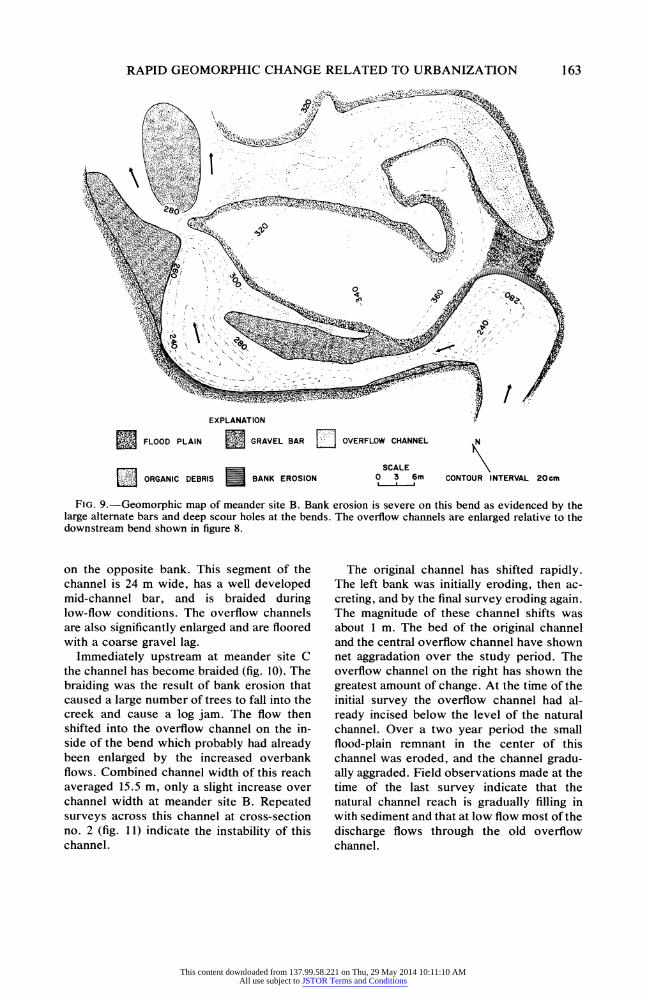
Further upstream at meander site B, chan- nel enlargement and flood plain scour are more extensive (fig. 9). Large scour holes are prominent features at both bends, and large alternate bars, consisting of coarse gravel 5 to 8 m wide, have developed within the chan- nel. The width of these alternate bars is an approximate measure of the degree of chan- nel widening. Channel width averages 14.5 m wide, nearly twice the width of downstream reaches. Channel widening is most pro- nounced where the overflow channel re- enters the main stem, causing increased scour
SFLOOD PLAIN BANK EROSION
B GRAVEL BAR t1OVERFLOW CHANNEL
0 10mn
CONTOUR INTERVAL 30cm
FIG. 8.-Geomorphic map of meander site A. Bank erosion is relatively slight on this bend and is con- centrated on the outside of the meander bend. Note the overflow channel across the floodplain on the inside of the bend.
162
This content downloaded from 137.99.58.221 on Thu, 29 May 2014 10:11:10 AMAll use subject to JSTOR Terms and Conditions
RAPID GEOMORPHIC CHANGE RELATED TO URBANIZATION
EXPLANATION
SFLOOD PLAIN GRAVEL BAR OVERFLOW CHANNEL N
SCALE LI ORGANIC DEBRIS BANK EROSION 0 3 6m CONTOUR INTERVAL 20cm
FIG. 9.-Geomorphic map of meander site B. Bank erosion is severe on this bend as evidenced by the large alternate bars and deep scour holes at the bends. The overflow channels are enlarged relative to the downstream bend shown in figure 8.
on the opposite bank. This segment of the channel is 24 m wide, has a well developed mid-channel bar, and is braided during low-flow conditions. The overflow channels are also significantly enlarged and are floored with a coarse gravel lag.
Immediately upstream at meander site C the channel has become braided (fig. 10). The braiding was the result of bank erosion that caused a large number of trees to fall into the creek and cause a log jam. The flow then shifted into the overflow channel on the in- side of the bend which probably had already been enlarged by the increased overbank flows. Combined channel width of this reach averaged 15.5 m, only a slight increase over channel width at meander site B. Repeated surveys across this channel at cross-section no. 2 (fig. 11) indicate the instability of this channel.
The original channel has shifted rapidly. The left bank was initially eroding, then ac- creting, and by the final survey eroding again. The magnitude of these channel shifts was about 1 m. The bed of the original channel and the central overflow channel have shown net aggradation over the study period. The overflow channel on the right has shown the greatest amount of change. At the time of the initial survey the overflow channel had al- ready incised below the level of the natural channel. Over a two year period the small flood-plain remnant in the center of this channel was eroded, and the channel gradu- ally aggraded. Field observations made at the time of the last survey indicate that the natural channel reach is gradually filling in with sediment and that at low flow most of the discharge flows through the old overflow channel.
163
This content downloaded from 137.99.58.221 on Thu, 29 May 2014 10:11:10 AMAll use subject to JSTOR Terms and Conditions

C. L. ARNOLD, P. J. BOISON, AND P. C. PATTON
EXPLANATION
SFLOOD PLAIN
BANK EROSION
0 3 6m
CONTOUR INTERVAL IOcm
GRAVEL BAR
ORGANIC DEBRIS
SOVERFLOW CHANNEL
FIG. 10.-Geomorphic map of meander site C. The overflow channel on the eastern valley margin is now an active channel creating a braided reach. Diversion into the overflow channel was facilitated by the debris dam in the main channel. Cross-section 2 (fig. 11) illustrates the rapid rate of change of this unstable chan- nel.
Braided Reach
A IA'
I1I April 1,1979 0 Sm Vertical Exaggeration 10x
FIG. 11.-Cross-section through meander site C illustrating the rapid evolution of this cross-section. The natural channel is rapidly aggrading because of the debris dam.
310
z
164
This content downloaded from 137.99.58.221 on Thu, 29 May 2014 10:11:10 AMAll use subject to JSTOR Terms and Conditions
RAPID GEOMORPHIC CHANGE RELATED TO URBANIZATION
DISCUSSION
The channel evolution on lower Sawmill Brook is probably typical of channel changes on New England streams subjected to ur- banization. The channel changes outlined here are the result of the interaction of de- creased bedload sediment discharge into the stream coupled with an increased frequency of moderate floods. Basins similar to Sawmill Brook have probably undergone other sub- stantial hydrologic changes as a result of changing land-use conditions over the past century. The gradual reduction of agricultural land use in the northeast with the steady con- version of this land back into natural forest has probably caused a reduction in the sedi- ment and water discharge in these streams (Wolman 1967). This land-use trend probably accounts for the channel stability indicated by the old age of the gallery forest and the previous condition of bank stability on Saw- mill Brook. During the recent period of rapid land development both sediment and water discharge have most likely increased. Chan- nel widening may have begun at this time, and the increased sediment discharge may have contributed to overbank and in-stream deposition. However, once construction was completed, basin-wide sediment yields de- clined, but water discharge remained high. This imbalance is obvious on Sawmill Brook where no coarse bedload can be observed moving into the lower reach. This imbalance has led to high rates of bank erosion, which has increased the bedload sediment discharge in the lower reach.
The channel morphology evolution con- forms to the predicted relationships for in- creased water and sediment discharge (Schumm 1977). Channel width has increased and depth has decreased as a result of bank erosion and bed aggradation. Sinuosity has
REFERENCES CITED
ANDERSON, D. G., 1970, Effects of urban de- velopment on floods in northern Virginia: U.S. Geol. Survey Water Supply Paper 2001-C, 22 p.
BRUMBACH, J. J., 1965, The climate of Connec- ticut: State Geol. and Natural History Survey of Conn., Bull. 99, 215 p.
CARTER, R. W., 1961, Magnitude and frequency of floods in suburban areas: U.S. Geol. Survey Prof. Paper 424-B, p. B9-B11.
decreased and slope has increased through the meander cutoff processes. As a reach of channel adapts its cross-section and pattern to the increased bedload discharge, reaches downstream evolve because of the influx of sediment. In this respect the braiding process can be described as a channel pattern change reacting to a wave of increased bedload sedi- ment discharge through the stream system.
Sawmill Brook illustrates the radical change in sediment discharge regime and channel pattern that can occur as urbaniza- tion alters the hydrology of small watersheds. Clearly, urban streams that are evolving as rapidly as Sawmill Brook are in disequilib- rium. Furthermore, it does not appear that the channel pattern evolution described is one which will quickly achieve an equilibrium form. Instead, as urbanization proceeds, water discharge into the lower basin will in- crease but basin-wide sediment production should continue to decline. This will continue to produce a greater imbalance between sediment and water discharge in the study reach which can only be compensated for by increased erosion. The increased sediment production from bank erosion will cause con- stant and rapid changes in the channel mor- phology. The case study of Sawmill Brook identifies the need for additional research on the adjustment of channel pattern brought about by the unique hydrologic conditions imposed by urbanization.
ACKNOWLEDGMENTS.-Research support was provided by the Department of Earth and Environmental Sciences, Wesleyan Univer- sity, and by the Midstate Regional Planning Agency, Middletown, Connecticut. F. P. Tuerk, V. Erickson, and E. W. Phillips as- sisted in the field. G. S. Homrne, G. L. Cole- grove, J. Dunn, and W. Graf provided con- structive reviews of the manuscript.
CHOW, V. T., 1959, Open Channel Hydraulics: New York, McGraw-Hill, 680 p.
CRIPPEN, J. R., 1969, Hydrologic effects of subur- ban development near Palo Alto, California: U.S. Geol. Survey open-file report, 122 p.
DEANE, R., 1953, Unpublished map of the surficial geology of the Middletown Quadrangle, Con- necticut: Wesleyan University Map Collection.
ESPEY, W. H.; MORGAN, C. W.; and MASCH,
165
This content downloaded from 137.99.58.221 on Thu, 29 May 2014 10:11:10 AMAll use subject to JSTOR Terms and Conditions

C. L. ARNOLD, P. J. BOISON, AND P. C. PATTON
F. D., 1966, A study of some effects of urbaniza- tion on storm runoff from a small watershed: Texas Water Dev. Board Report 23, 110 p.
Fox, H. L., 1976, The urbanizing river: a case study in the Maryland Piedmont, in COATES, D. R., ed., Geomorphology and Engineering: Stroudsburg, Dowden, Hutchinson and Ross, p. 245-271.
GRAF, W. L., 1975, The impact of suburbanization on fluvial geomorphology: Water Resources Res., v. 11, p. 690-692.
- 1977, Network characteristics in subur- banizing streams: Water Resources Res., v. 13, p. 459-463.
HAMMER, T., 1972, Stream channel enlargement due to urbanization: Water Resources Res., v. 8, p. 1530-1540.
KELLER, E. A., 1975, Channelization: a search for a better way: Geology, v. 3, p. 246-248.
- , and TALLY, T., 1979, Effects of large or- ganic debris on channel form and fluvial pro- cesses in the coastal redwood environments, in RHODES, D. D., and WILLIAMS, G. P., eds., Adjustments of the Fluvial System: Dubuque, Iowa, Kendall/Hunt, p. 169-197.
LEHMANN, E. P., 1959, The bedrock geology of the Middletown Quadrangle: State Geol. and Nat. History Survey of Conn., Quadrangle Rep. 8, 40 p.
LEOPOLD, L. B., 1968, Hydrology for urban plan- ning, a guidebook on the hydrologic effects of urban land use: U.S. Geol. Survey Circular 554, 18 p.
, and WOLMAN, M. G., 1957, River channel
patterns: braided, meandering, and straight: U.S. Geol. Survey Prof. Paper 282-B, p. 39-85.
MELVIN, R. L., 1978, Use of drainage-area maps in evaluating waste disposal conditions, assessing impact of highway salting, and designing bridges and culverts, in ROBINSON, G. D., and SPEI- KER, A. M., eds., Nature to be commanded: U.S. Geol. Survey Prof. Paper 950, p. 52-54.
PATTON, P. C., 1981, Geomorphic-hydrologic methods for assessing flood potential in southern New England: Inst. of Water Resources Techni- cal Completion Report A-078-CONN, 25 p.
SCHUMM, S. A., 1977, The Fluvial System: New York, Wiley, 338 p.
SIGAFOOS, R. S., 1969, Botanical evidence of floods and floodplain deposition: U.S. Geol. Survey Prof. Paper 485-A, 35 p.
VICE, R. B.; GuY, H. P.; and FERGUSON, G. E., 1969, Sediment movement in an area of highway construction, Scott Run Basin, Fairfax County, Virginia 1961-1964: U.S. Geol. Survey Water Supply Paper 1591-E, 41 p.
WHITEMAN, L. M., 1981, The fluvial geomorphol- ogy of the Coginchaug River: Unpub. B.A. hon- ors thesis, Wesleyan University, Middletown, CT, 118 p.
WOLMAN, M. G., 1967, A cycle of sedimentation and erosion in urban river channels: Geografiska Annaler, v. 49A, p. 385-395.
- , and SCHICK, A. P., 1967, Effects of con- struction of fluvial sediment, urban and suburban areas of Maryland: Water Resources Res., v. 3, p. 451-467.
166
This content downloaded from 137.99.58.221 on Thu, 29 May 2014 10:11:10 AMAll use subject to JSTOR Terms and Conditions
Copyright © 2022 FDOKUMEN