SATELLITE COMMUNICATION
31
SATELLITE COMMUNICATION Assignment ABSTRACT Satellite has become popular as a media of communication. In this paper some terminology, methodology how it works and uses of satellites are described in a very easy and effective way. Name: Aklima Zaman ID: 122400011 Wireless Network Date of submission: SUBMIT TO ASIF IMRAN Eastern University Dhaka
-
Upload
easternuni -
Category
Documents
-
view
8 -
download
0
Transcript of SATELLITE COMMUNICATION

SATELLITE
COMMUNICATION Assignment
ABSTRACT Satellite has become popular as a media of
communication. In this paper some
terminology, methodology how it works
and uses of satellites are described in a very
easy and effective way.
Name: Aklima Zaman ID: 122400011 Wireless Network
Date of submission:
SUBMIT TO
ASIF IMRAN
Eastern University Dhaka
Satellite Communications
Page | 1
Contents What is a Satellite? ....................................................................................................................................... 3
How do Satellites Work? .............................................................................................................................. 4
Some Terminology ....................................................................................................................................... 4
Uplink .................................................................................................................................................... 4
Transponder ......................................................................................................................................... 5
Downlink ............................................................................................................................................... 5
Advantages of Satellites ............................................................................................................................... 5
Disadvantages of Satellites .......................................................................................................................... 6
Basics: Factors in satellite communication ................................................................................................. 7
Azimuth angle ...................................................................................................................................... 7
Elevation Angle ................................................................................................................................... 7
Coverage Angle ..................................................................................................................................... 8
Free space loss ...................................................................................................................................... 9
Satellite Footprint ................................................................................................................................ 9
Atmospheric Absorption Loss .............................................................................................................. 9
What Are Satellites Used For ....................................................................................................................... 9
Television ................................................................................................................................................ 10
Telephones ............................................................................................................................................. 10
Navigation .............................................................................................................................................. 11
Business & Finance ................................................................................................................................. 11
Weather .................................................................................................................................................. 12
Climate and Environmental Monitoring ............................................................................................ 12
Safety ...................................................................................................................................................... 12
Land Stewardship ................................................................................................................................. 13
Development .......................................................................................................................................... 13
Space Science ......................................................................................................................................... 13
Satellites service types ............................................................................................................................... 14
1. Fixed Service Satellites (FSS) .......................................................................................................... 14
How Fixed Satellite Service Works .................................................................................................... 14
Applications of Fixed Satellite Service ............................................................................................... 14
Advantages of Fixed Satellite Service ................................................................................................ 14
2. Broadcast Service Satellites (BSS) or Direct Broadcast Service (DBS) .......................................... 15

Satellite Communications
Page | 2
How BSS or DBS works ....................................................................................................................... 15
Advantages of Broadcast Service Satellites ....................................................................................... 16
3. Mobile Service Satellites (MSS) ..................................................................................................... 17
Applications of MSS............................................................................................................................ 17
Satellites Orbits .......................................................................................................................................... 17
Geostationary Earth Orbit (GEO) ........................................................................................................... 18
Advantages ......................................................................................................................................... 18
Limitations .......................................................................................................................................... 18
Low Earth Orbit (LEO) ............................................................................................................................. 19
How a Satellite Reaches LEO – Requirements ................................................................................... 20
Advantages of Low Earth Orbit .......................................................................................................... 20
Disadvantages of Low Earth Orbit ..................................................................................................... 20
Medium Earth Orbit (MEO) .................................................................................................................... 21
Advantage of Medium Earth Orbit .................................................................................................... 22
Disadvantage of Medium Earth Orbit ................................................................................................ 22
Molniya Orbit Satellites ......................................................................................................................... 22
Advantages ......................................................................................................................................... 23
Disadvantages .................................................................................................................................... 23
High Altitude Platform (HAP) ................................................................................................................. 23
HAP APPLICATIONS ............................................................................................................................ 23
Types of HAP ....................................................................................................................................... 23
Frequency Bands ........................................................................................................................................ 25
Capacity Allocation ..................................................................................................................................... 25
Frequency Division Multiple Access (FDMA) ......................................................................................... 25
Time Division Multiple Access (TDMA) ............................................................................................ 28
REFERENCES ................................................................................................................................................ 30
Satellite Communications
Page | 3
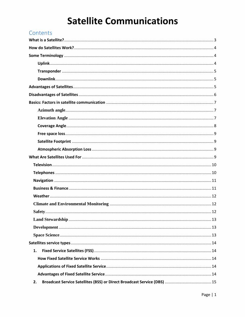
What is a Satellite? A satellite is a moon, planet or machine that orbits a planet or star. For example, Earth is
a satellite because it orbits the sun. Likewise, the moon is a satellite because it orbits
Earth. Usually, the word "satellite" refers to a machine that is launched into space and
moves around Earth or another body in space.
Earth and the moon are examples of natural satellites. Thousands of artificial, or man-
made, satellites orbit Earth. Some take pictures of the planet that help meteorologists
predict weather and track hurricanes. Some take pictures of other planets, the sun,
black holes, dark matter or faraway galaxies. These pictures help scientists better
understand the solar system and universe.
Still other satellites are used mainly for communications, such as beaming TV signals and
phone calls around the world. A group of more than 20 satellites make up the Global
Positioning System, or GPS. If you have a GPS receiver, these satellites can help figure
out your exact location. [1]
Figure 1: A satellite

Satellite Communications
Page | 4
How do Satellites Work?
Figure 2: How Satellite Works
Two earth stations wants to communicate with each other by wireless. But the range is
too long as the cant communicate. In that situation those station use satellite to
transferring data from each other. Satellite is an intermediate device which receives
data from earth stations and just relay the data to another earth station.
Some Terminology
Uplink
Figure 3: Uplink

Satellite Communications
Page | 5
Uplink is a transmission path by which radio or other signals are sent to a
communications satellite. This portion of a communications link used for the
transmission of signals from an Earth terminal to a satellite. An uplink is the converse of
a downlink. An uplink or downlink is distinguished from reverse link or forward link.
https://www.wordnik.com/words/Uplink
Transponder Transponder is an electrical device designed to receive a specific signal and
automatically transmit a specific reply. The satellite Transponder converts the signal
which it get from the earth station and sends it to the second earth station. [2]
Downlink
Figure 4: Downlink
Downlink is a transmission path for the communication of signals and data from a
communications satellite to the earth station. [3]
Advantages of Satellites If two stations can’t communicate in wireless medium than we have to use satellite. It
helps those stations to transfer data. It saves the cost of intercontinental cable laying and
the maintenance that would otherwise be necessary.
A satellite communications system is relatively inexpensive because there are no cable
laying costs and one satellite covers a large area. Transmission cost of a satellite is
independent of the distance from the center of the coverage area.
Users can enjoy mobile communication anywhere within the satellite coverage area.
Satellite networks have simpler topology, which results in more manageable network
performance.
A satellite system will not suffer from disasters such as floods, fire, and earthquakes and
will, therefore, be available as an emergency service should terrestrial services be
knocked out.

Satellite Communications
Page | 6
Because of the line-of-sight communication problem, the terrestrial or ground based
wireless requires many hops between a series of communication towers in order for the
signal to travel even I 00 km. Satellite communication requires only one hop from the
base station to the satellite and back down to the signal destination. Therefore, satellite
communication is a form of wireless communication.
With wireless technology, information is transferred between two antennas. Information
is encoded into radio signals at one end and decoded into data at the other.
Satellites provide seamless service. Broadcasting of a signal over a wide area makes the.
Simultaneous distribution of band width intensive information to thousands of locations.
Terrestrial microwave communications operate in low-GHz range, which limits all
communications to line- f-sight [13).The terrestrial microwave equipment such as
telephone relay towers are placed every few miles to relay telephone signals. The
coverage area of a satellite greatly exceeds that of a terrestrial system. Satellite
communications are available almost everywhere. A small constellation of three satellites
can cover the entire earth's surface as shown in Fig.
Figure 5: A Sample Satellite Network
Satellite communication can support all recently invented data like audio, video and all
type of data. Also broadband Internet satellites services are available to domestic and
business use.
Satellites can cover a much larger geographical area than traditional ground-based
systems. Satellites have the unique ability to cover the globe. For example TV, Fax,
Internet etc.
Satellite to Satellite communication is very precise.
Disadvantages of Satellites The parts of satellites are very costly ad to set it in the orbit a rock is needed. So, it costs
huge to build a rocket. That’s why lunching satellite is too expensive.
When a satellite starts its duty, people try to use that frequently. So day by day a lot more
users used that satellite so its bandwidth is fill up soon.

Satellite Communications
Page | 7
As satellites are far from the earth base station and there are many obstacle (Clouds, High
storied building, etc.) between them the propagation delay increases for many reason. So
real time system faces many problems to use satellite.
Figure 6: Terrestrial Com. in Earth
Basics: Factors in satellite communication The coordinates to which the earth station antennas must be pointed to communicate with
satellite is called look angles. There are two types of Look angles.
Azimuth angle
Measured eastward from geographic north to the projection of satellite path on
the local horizontal plane at the earth station.
Elevation Angle
Measured upward from local horizontal plane at the earth station to the satellite
path. Coverage area of a satellite depends on Elevation Angle. The standard
condition is to keep Elevation Angle in 0 degree. So that so the transmission ray
spreads the skyline visible to the satellite in all directions. Due to earth
environmental factors like obstacle the transmission, atmospheric attenuation, and
the earth electrical background noise, the earth station should maintain a
minimum elevation angle.

Satellite Communications
Page | 8
Figure 7: Elevation Angle
Coverage Angle Coverage Angle of satellite is the measure of the portion of the earth surface visible to a
satellite taking the minimum elevation angle into account.
R/(R+h) = sin(π/2 - β - θ)/sin(θ + π/2)= cos(β + θ)/cos(θ)
o R = 6370 km (earth’s radius)
o h = satellite orbit height
o β = coverage angle
o θ = minimum elevation angle
Figure 8: Coverage Angle

Satellite Communications
Page | 9
Free space loss The space between the earth station and satellite is known as free space loss. In satellite
communications, free-space loss is the major loss suffered by signals in travelling over
the Earth-satellite path. The loss is inversely proportional to the square of the distance
travelled and inversely proportional to the square of the frequency used. That is, as the
distance is doubled the received power is reduced by a factor of four. Similarly, as the
frequency is doubled the received power is reduced by a factor of four. Free-space loss
for geostationary satellite communications satellites varies between 190 to 210 dB
depending on the frequency used. [4]
Satellite Footprint The area of the Earth covered by the radiation from a satellite is called its footprint. The
size of the footprint depends on the location of the satellite in its orbit and the shape and
size of beam produced by its antennas. But the highest strength is in the center of
footprint and signal becomes weaker as long as far from center. [5]
Figure 9: Satellite Footprint
Atmospheric Absorption Loss In satellite communications, atmospheric Absorption loss results from the absorption of
the Earth-satellite signals as they pass through the Earth's atmosphere. The value of the
atmospheric loss is strongly dependent on frequency. And also it is caused by air and fog.
The transmission will so bad during rain, fog or air.
What Are Satellites Used For Satellites are manmade objects put into orbit. They often affect our lives without our
realizing it: they make us safer, provide modern conveniences, and broadcast
entertainment. Here are some of the jobs satellites do:

Satellite Communications
Page | 10
Television
Figure 10: Dish TV
Satellites send television signals directly to homes, but they also are the backbone of
cable and network TV. These satellites send signals from a central station that generates
programming to smaller stations that send the signals locally via cables or the airwaves.
"At the scene" news broadcasts, whether live reporting on a vote at the Capitol or from
the scene of a traffic accident, are sent from the field to the studio via satellite, too.
Telephones
Figure 11: Flight phone communications on airplanes

Satellite Communications
Page | 11
Satellites provide in-flight phone communications on airplanes, and are often the main
conduit of voice communication for rural areas and areas where phone lines are
damaged after a disaster. Satellites also provide the primary timing source for cell
phones and pagers. In 1998, a satellite failure demonstrated this dependence; it
temporarily silenced 80 percent of the pagers in the United States, National Public Radio
was not able to distribute its broadcasts to affiliates and broadcasted only via its
website, and on the CBS Evening News, the image of Dan Rather froze while the audio
continued.
Navigation
Figure 12: GPS Satellite
Satellite-based navigation systems like the Navistar Global Positioning Systems (known
colloquially as GPS) enable anyone with a handheld receiver to determine her location to
within a few meters. GPS locators are increasingly included in in-car direction services
and allow car-share services like Zip car to locate their cars. GPS-based systems are used
by civilians and the military for navigation on land, sea, and air, and are crucial in
situations like a ship making a difficult course in a harbor in bad weather or troops lost in
unfamiliar territory, where other navigation tools may not exist.
Business & Finance Communications satellites have the ability to rapidly communicate between a numbers of
widely dispersed locations. This is an important tool, allowing big manufacturing
companies and department stores to perform inventory management, provide instant
credit card authorization and automated teller banking services to even small towns, pay-
at-the-pump gas at freeway gas stations, and video conferencing for international
corporations.

Satellite Communications
Page | 12
Weather
Figure 13: Satellite Winds marker
Satellites provide meteorologists with the ability to see weather on a global scale,
allowing them to follow the effects of phenomena like volcanic eruptions and burning gas
and oil fields, to the development of large systems like hurricanes and El Niño.
Climate and Environmental Monitoring
Satellites are some of the best sources of data for climate change research. Satellites
monitor ocean temperatures and prevailing currents; data acquired by satellite-borne
radars were able to show sea levels have been rising by three mm a year over the last
decade. Imaging satellites can measure the changing sizes of glaciers, which is difficult to
do from the ground due to the remoteness and darkness of the Polar Regions. Satellites
can determine long-term patterns of rainfall, vegetation cover, and emissions of
greenhouse gases.
Safety
Earth observation satellites can monitor ocean and wind currents as well as the extent of
forest fires, oil spills, and airborne pollution; together this information helps organize
emergency responders and environmental cleanup. Satellites can take the "search" out of
"search and rescue" for people in distress in remote regions. Distress radio beacons
directly linked to a search and rescue satellite can lead rescuers quickly and accurately to
a land, sea, or air emergency location.

Satellite Communications
Page | 13
Land Stewardship
Satellites can detect underground water and mineral sources; monitor the transfer of
nutrients and contaminants from land into waterways; and measure land and water
temperatures, the growth of algae in seas, and the erosion of topsoil from land. They can
efficiently monitor large-scale infrastructure, for example fuel pipelines that need to be
checked for leaks, which would require enormous hours of land- or air-based inspection.
Imaging satellites produce high-resolution data of almost the entire landmass on earth;
such data used to be a closely guarded military capability, but now, nearly anyone with
an internet connection can find his house using Google Earth.
Development
Satellites are increasingly important to the developing world. For a country like India,
with populations separated by rough terrain and different languages, communications
satellites provides remote populations access to education and to medical expertise that
would otherwise not reach them. Earth observation satellites also allow developing
countries to practice informed resource management and relief agencies to follow refugee
population migrations.
Space Science
Before the Space Age, astrophysicists were limited to studying the universe via ground-
based telescopes, and so could only use information from the parts of the electromagnetic
spectrum that penetrated the Earth's atmosphere. Many of the most interesting
phenomena are best studied at frequencies that are best or only accessible from space—
satellite telescopes have been critical to understanding phenomena like pulsars and black
holes as well as measuring the age of the universe. The Hubble Space Telescope is
arguably the most valuable astronomical tool ever built! [6]

Satellite Communications
Page | 14
Satellites service types
1. Fixed Service Satellites (FSS)
Figure 14: 1. Fixed Service Satellites
Fixed Satellite Service (FSS) is a type of mobile telephone service that allows
users in a specific area to make and receive cell phone calls. FSS systems or cell
phone towers are placed in strategic, fixed locations and provide service to
thousands of individual users simultaneously. Generally, FSS systems provide
reception for several square miles around them, which borders another FSS
system’s reception area. This allows users to communicate with multiple FSS
systems as they travel without losing reception.
How Fixed Satellite Service Works
FSS systems are essentially large transceivers that are able to both broadcast and
receive cell phone signals across large distances. FSS systems differ from MSS
(Mobile Satellite Service) systems as they are permanently placed in a specific
area, while MSS systems can be moved from one location to another or mounted
on a mobile vehicle. FSS systems are the most commonly used devices for
handling mobile cell phone communications and make up the majority of the
global telephony infrastructure.
Applications of Fixed Satellite Service
FSS systems handle communications for thousands of individual cell phones in a
specific area. FSS systems are capable of handling cell phone calls, text
messages, images, videos, and any other type of file that can be sent or received
via standard GSM signals.
Advantages of Fixed Satellite Service
FSS systems are advantageous because they provide guaranteed reception in the
area that they are placed. Since FSS systems are permanently installed, they
collectively provide users with reliable cell phone reception across the majority

Satellite Communications
Page | 15
of a country. As the user gets closer to an FSS unit, his/her signal becomes
stronger. Likewise, as a user gets further away from an FSS unit, his/her signal
becomes weaker. However, when a user gets far enough away from one FSS
unit, his/her cell phone will automatically begin communicating with the next
FSS unit closest to it. [7]
2. Broadcast Service Satellites (BSS) or Direct Broadcast Service (DBS) Direct broadcast satellite (DBS) refers to satellite television (TV) systems in which
the subscribers, or end users, receive signals directly from geostationary
satellites. Signals are broadcast in digital format at microwave frequencies. DBS
is the descendant of direct-to-home (DTH) satellite services.
A DBS subscriber installation consists of a dish antenna two to three feet (60 to
90 centimeters) in diameter, a conventional TV set, a signal converter placed
next to the TV set, and a length of coaxial cable between the dish and the
converter. The dish intercepts microwave signals directly from the satellite. The
converter produces output that can be viewed on the TV receiver.
How BSS or DBS works
Satellite TV works as a simple triangular scheme. The uplink station collects
signals from various content providers (HBO, ESPN, Discovery, local providers,
etc.), transforms it into high-frequency signal and emits to TV satellites orbiting
the Earth. The satellites then send downlink signal back to Earth through
electronic devices at the satellite called transponders. Single satellite can have
up to four dozen transponders, each capable of transmitting up to a dozen TV
channels. It adds up to a few hundreds of channels transmission capacity per
single satellite possible.
Due to the very high altitude - 22.236 miles - TV satellite can cover much larger
ground area - so called footprint -than a ground based antenna. Signal from the
satellite is picked up by a small satellite dish antenna mounted at the
subscriber's residence. Filtered and amplified, the signal is then sent to the
satellite TV receiver, where it gets decoded, transformed radio-wave to a
"usable" electrical form, and fed to the TV set, becoming a video/audio stream.
Originally, DBS frequency of choice was the high-powered Ku-band. However,
the need for expanded programming resulted in use of other frequencies: the
lower-power Ku-band's FSS frequencies, as well as lower-power C-band FSS
frequency, and higher-frequency Ka-band. Use of lower-powered emissions
resulted in the increase of the minimum dish size needed for efficient reception.

Satellite Communications
Page | 16
Good signal reception requires no obstruction between the satellite and dish
receptor: the dish must have clear "view" of the satellite. Quality of reception
also depends on the receiver position within the "footprint" (the signal is
strongest in the center and weakens toward the periphery), position of the
satellite (the higher it is in the sky, the better) and weather conditions (heavy
rains or snow can affect signal quality). [8]
Advantages of Broadcast Service Satellites More choice: DBS offers one very important element in the world of paid
television service: Competition! Until recently, your only choice was your
local cable company, and their monopoly on television service provided no
incentive for additions or improvements outside of federal regulation. Today,
you have at least two options for satellite television service in lieu of cable,
and both are reasonably customizable to your tastes.
More channels per dollar: The receiver components which interface the
satellite signal to your television also serve as decoders. Therefore, the DBS
providers are able to use digital compression techniques to carry up to ten
times as many channels on the satellite transponders as would otherwise be
possible. As a general rule, you will get many more channels per dollar spent
with a satellite service than with cable TV.
Rural availability: For some people in remote rural areas, the cable vs. DBS
argument is moot because cable is simply not available. Satellite service, on
the other hand, is available anywhere in the contiguous 48 states (with more
limited availability in Alaska and Hawaii) as long as there is a clear line of
sight to the position of the satellite in the sky.
Reliable service: The cable infrastructure is always at the mercy of accidents
resulting in downed lines or severed cables. The only anamolies that typically
affect satellite broadcasts (aside from accidents involving your own dish
antenna) are extremely severe weather, or solar interferences during the
equinoxes, and these are rare.
Digital picture/sound: The analog signals sent over standard cable lines are
subject to degradation, interference, and other factors that can result in a
less than stellar picture. Satellite signals are digital, and like a compact disc,
are not subject to depreciation in picture or sound quality. Satellite TV
generally looks and sounds far superior to cable transmissions.
Interactive channel guides: Some cable systems include a channel which
shows program listings. These usually scroll along at an unbearably slow pace
and cannot be advanced to show more than a couple of hours of upcoming
shows. DirecTV and EchoStar include highly interactive program guides that
can be manually advanced, or can display additional program information,

Satellite Communications
Page | 17
and sometimes can provide one-touch timed VCR recording. Certain
programming can also be locked out based upon content ratings. [9]
3. Mobile Service Satellites (MSS) Mobile satellite services (MSS) refers to networks of communications satellites
intended for use with mobile and portable wireless telephones. There are three
major types: AMSS (aeronautical MSS), LMSS (land MSS), and MMSS (maritime
MSS).
A telephone connection using MSS is similar to a cellular telephone link, except
the repeaters are in orbit around the earth, rather than on the surface. MSS
repeaters can be placed on geostationary, medium earth orbit (MEO), or low
earth orbit (LEO) satellites. Provided there are enough satellites in the system,
and provided they are properly spaced around the globe, an MSS can link any
two wireless telephone sets at any time, no matter where in the world they are
located. MSS systems are interconnected with land-based cellular networks.
Applications of MSS
As an example of how MSS can work, consider telephones in commercial
airliners. These sets usually link into the standard cellular system. This allows
communication as long as the aircraft is on a line of sight with at least one land-
based cellular repeater. Coverage is essentially continuous over most developed
countries. But coverage is spotty over less well-developed regions, and is
nonexistent at most points over the oceans. Using an MSS network, the aircraft
can establish a connection from any location, no matter how remote. [10]
Satellites Orbits
Figure 15: Satellite Coverage
There are some orbits where satellites are set and different orbits has different issues.
The orbits with advantages and disadvantages are given bellow.

Satellite Communications
Page | 18
Geostationary Earth Orbit (GEO)
Figure 16: GEO Ring
A geostationary satellite is an earth-orbiting satellite, placed at an altitude of
approximately 35,800 kilometers (22,300 miles) directly over the equator, that
revolves in the same direction the earth rotates (west to east). At this altitude, one
orbit takes 24 hours, the same length of time as the earth requires to rotate once on
its axis. The term geostationary comes from the fact that such a satellite appears
nearly stationary in the sky as seen by a ground-based observer. BGAN, the new
global mobile communications network, uses geostationary satellites.
Advantages
A single geostationary satellite is on a line of sight with about 40 percent of the
earth's surface. Three such satellites, each separated by 120 degrees of longitude,
can provide coverage of the entire planet, with the exception of small circular
regions centered at the north and south geographic poles. A geostationary satellite
can be accessed using a directional antenna, usually a small dish, aimed at the spot
in the sky where the satellite appears to hover. The principal advantage of this type
of satellite is the fact that an earthbound directional antenna can be aimed and then
left in position without further adjustment. Another advantage is the fact that
because highly directional antennas can be used, interference from surface-based
sources, and from other satellites, is minimized.
Limitations
Geostationary satellites have two major limitations. First, because the orbital zone is
an extremely narrow ring in the plane of the equator, the number of satellites that

Satellite Communications
Page | 19
can be maintained in geostationary orbits without mutual conflict (or even collision)
is limited. Second, the distance that an electromagnetic (EM) signal must travel to
and from a geostationary satellite is a minimum of 71,600 kilometers or 44,600
miles. Thus, a latency of at least 240 milliseconds is introduced when an EM signal,
traveling at 300,000 kilometers per second (186,000 miles per second), makes a
round trip from the surface to the satellite and back.
There are two other, less serious, problems with geostationary satellites. First, the
exact position of a geostationary satellite, relative to the surface, varies slightly over
the course of each 24-hour period because of gravitational interaction among the
satellite, the earth, the sun, the moon, and the non-terrestrial planets. As observed
from the surface, the satellite wanders within a rectangular region in the sky called
the box. The box is small, but it limits the sharpness of the directional pattern, and
therefore the power gain, that earth-based antennas can be designed to have.
Second, there is a dramatic increase in background EM noise when the satellite
comes near the sun as observed from a receiving station on the surface, because the
sun is a powerful source of EM energy. This effect, known as solar fade, is a problem
only within a few days of the equinoxes in late March and late September. Even
then, episodes last for only a few minutes and take place only once a day. [11]
Low Earth Orbit (LEO)
Figure 17: LEO And GEO Orbits
Most commonly, Low Earth Orbit or LEO is defined as the orbit that extends 160
- 2,000 km (100 - 1250 miles) above the Earth's surface. There are also other
definitions that make low Earth orbits extend to up to 3,000 km. Some human
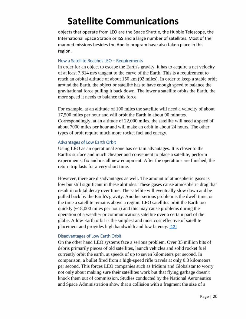
Satellite Communications
Page | 20
objects that operate from LEO are the Space Shuttle, the Hubble Telescope, the
International Space Station or ISS and a large number of satellites. Most of the
manned missions besides the Apollo program have also taken place in this
region.
How a Satellite Reaches LEO – Requirements
In order for an object to escape the Earth's gravity, it has to acquire a net velocity
of at least 7,814 m/s tangent to the curve of the Earth. This is a requirement to
reach an orbital altitude of about 150 km (92 miles). In order to keep a stable orbit
around the Earth, the object or satellite has to have enough speed to balance the
gravitational force pulling it back down. The lower a satellite orbits the Earth, the
more speed it needs to balance this force.
For example, at an altitude of 100 miles the satellite will need a velocity of about
17,500 miles per hour and will orbit the Earth in about 90 minutes.
Correspondingly, at an altitude of 22,000 miles, the satellite will need a speed of
about 7000 miles per hour and will make an orbit in about 24 hours. The other
types of orbit require much more rocket fuel and energy.
Advantages of Low Earth Orbit
Using LEO as an operational zone has certain advantages. It is closer to the
Earth's surface and much cheaper and convenient to place a satellite, perform
experiments, fix and install new equipment. After the operations are finished, the
return trip lasts for a very short time.
However, there are disadvantages as well. The amount of atmospheric gases is
low but still significant in these altitudes. These gases cause atmospheric drag that
result in orbital decay over time. The satellite will eventually slow down and be
pulled back by the Earth's gravity. Another serious problem is the dwell time, or
the time a satellite remains above a region. LEO satellites orbit the Earth too
quickly (~18,000 miles per hour) and this may cause problems during the
operation of a weather or communications satellite over a certain part of the
globe. A low Earth orbit is the simplest and most cost effective of satellite
placement and provides high bandwidth and low latency. [12]
Disadvantages of Low Earth Orbit
On the other hand LEO systems face a serious problem. Over 35 million bits of
debris primarily pieces of old satellites, launch vehicles and solid rocket fuel
currently orbit the earth, at speeds of up to seven kilometers per second. In
comparison, a bullet fired from a high-speed rifle travels at only 0.8 kilometers
per second. This forces LEO companies such as Iridium and Globalstar to worry
not only about making sure their satellites work but that flying garbage doesn't
knock them out of commission. Studies conducted by the National Aeronautics
and Space Administration show that a collision with a fragment the size of a

Satellite Communications
Page | 21
marble would do serious damage to a satellite. A 10-centimeter piece would be
enough to permanently put the satellite out of order.
Collisions with such debris are not rare events; space shuttles, for example,
regularly return to earth with cracked windows and pockmarks presumed to have
been caused by encounters with space junk. In July 1996, a French military
satellite was destroyed by a fragment from the Pegasus rocket that had carried it
into space. The problem is particularly acute for LEO satellites. Lower orbits must
pass through the debris from the rockets that carry higher-orbiting satellites
farther into space. The lower altitudes are also strewn with pieces of other
satellites 130 of which have broken up in space. To make matters worse, as the
numbers of satellites taken to the skies increases, the probability of collisions
increases, which in turn creates more junk to threaten increasingly crowded orbit
paths. Already high insurance premiums for these enterprises will get worse.
Figuring out ways to protect satellites and space vehicles from space junk is not
an easy task. Shields and insulation material are standard parts of satellites in low
earth orbit. Furthermore companies such as Iridium and Globalstar have factored
in the risk of space junk by launching extra satellites that can replace disabled
ones. This raises the multibillion-dollar price tag of network deployment, but it
also protects against downtime, and thus lost revenue. [13]
Medium Earth Orbit (MEO)
Figure 18: Medium Earth Orbit (MEO)
A medium earth orbit satellite (MEO) is a satellite that orbits the earth in between
Low Earth Orbit Satellites (LEO), which orbit the earth at a distance from the
earth of about 200-930 miles (321.87-1496.69 km) and those satellites which orbit
the earth at geostationary orbit, about 22,300 miles (35,888.71 km) above earth.
Each type of satellite can provide a different type of coverage for communications
and wireless devices. Like LEOs, these satellites don’t maintain a stationary

Satellite Communications
Page | 22
distance from the earth. This is in contrast to the geostationary orbit, where
satellites are always approximately 22,300 miles from the earth.
Any satellite that orbits the earth between about 1000-22,000 miles (1609.34-
35,405.57 km) above earth is an MEO. Typically the orbit of a medium earth orbit
satellite is about 10,000 miles (16,093.44 km) above earth. In various patterns,
these satellites make the trip around earth in anywhere from 2-12 hours, which
provides better coverage to wider areas than that provided by LEOs.
Advantage of Medium Earth Orbit A MEO satellite’s longer duration of visibility and wider footprint means fewer
satellites are needed in a MEO network than a LEO network.
Disadvantage of Medium Earth Orbit A MEO satellite’s distance gives it a longer time delay and weaker signal than a
LEO satellite, though not as bad as a GEO satellite.
Molniya Orbit Satellites
Figure 19: Molniya Orbit
Molniya orbit is a highly elliptical orbit with an inclination of 63.4 degrees, an argument
of perigee of -90 degrees and an orbital period of one half of a sidereal day. Molniya
orbits are named after a series of Soviet/Russian Molniya communications satellites
which have been using this type of orbit since the mid-1960s.

Satellite Communications
Page | 23
Advantages
Figure 20: Molniya - 1
Molniya orbits required less rocket power to achieve than a geosynchronous orbit, and
were better suited to communications with northern latitudes. Since satellites in such
an orbit move very slowly at apogee, they appear to 'hover' for hours at a time over
northern latitudes. A series of three Molniya satellites can act like a GEO satellite.
Disadvantages The disadvantage was that the sending/receiving dish must track the satellite, whereas
for a geosynchronous satellite a fixed dish could be used.
High Altitude Platform (HAP) In current era demand for wireless communication is notoriously increases. A terrestrial
and satellite system provides wireless communication services. Terrestrial systems are
used in mobile applications while satellite systems are used where terrestrial system not
reached. HAPs are airship or airplanes which altitudes at 17-22km above earth surface.
HAPs have been proposed mobile services in stratosphere. It have advantages of both
terrestrial as well as satellite. It also provides services like 3G, emergency services and
Wi-MAX. HAP networks are provides different services like military application, earth
monitoring, traffic monitoring and control. In terms of services, HAP offering low cost
and high facility services.
HAP APPLICATIONS
Broadband Fixed Wireless Access Applications 2G/3G and 4G applications
Emergency and disaster scenarios
Military Communications
Earth monitoring and positioning
Types of HAP
A terrestrial-HAP-satellite system

Satellite Communications
Page | 24
Figure 21: A terrestrial-HAP-satellite system
It is a mixed infrastructure, includes a HAPs network using a satellite as a
link to the terrestrial networks to the final users. It provides best features
of both HAPs and satellite communications. It can support high QOS
(Quality Of services). First, the capability of the satellites of broadcasting
and multicasting are used to transmit information from fiber networks to
the HAP network deployed below the satellite. Second, HAPs are used to
improve the satellite performance over the earth.
A integrated terrestrial – HAP system
This system works without the satellite-HAP link. Haps are considered to
project one or more macro cells Here HAP network can be connected to
terrestrial network through gateway.
Figure 22: An integrated terrestrial – HAP system
A standalone HAP system
This system is used in many applications. For example broadband for all.
In rural or remote area, it is expensive to deploy terrestrial systems.
Satellite system is costly to be launched if traffic demand is small. This
system may be deployed economically and efficiently. [14]

Satellite Communications
Page | 25
Frequency Bands
Figure 23: Different kinds of satellites use different frequency bands
Capacity Allocation Capacity of satellite data transfer is allocated via two techniques. They are
FDMA
o FAMA-FDMA
o DAMA-FDMA
TDMA
o Advantages over FDMA
Frequency Division Multiple Access (FDMA) The FDMA technique is traditional in radio communications, since it relies on frequency
separation between carriers. All that is required is that the Earth stations transmit their
traffic on different microwave frequencies and that the modulation not cause the carrier
bandwidths to overlap. Three such independent transmissions are indicated at the left of
Figure 5.17 by long rectangles extending along the same "time" dimension but on
different frequencies (indicated by different shading). A constraint in PDMA is that the
sum of the bandwidths of the individual carriers cannot exceed the satellite's available
bandwidth. Consequently, all three carriers in the uplink pass cleanly through the satellite
repeater and are radiated toward the area of coverage on the ground.
The principle behind FDMA is that each Earth station or user terminal is assigned a
separate frequency on which to transmit. That assignment can be fixed for time

Satellite Communications
Page | 26
(permanently assigned), possibly changeable only by a manual command at either the
uplink or the downlink or from a central control point. Alternatively, the assignment of
the frequency can be dynamic (demand assigned, or demand assignment multiple access,
DAMA ), responding to user requests for service .Permanently assigned FDMA channels
are useful for dedicated bandwidth services, which also are known as leased lines.
Demand assigned channels are suitable for circuit switched services, notably for
telephony. Special signaling channels, also provided on an FDMA basis, are added to
allow stations to request connections and to alert stations to incoming calls. In either case,
the bandwidth of the channel must match the information bandwidth of the signal and
allow for some guard band to prevent adjacent channel interference. The guard band may
be as small as 5% or 10% of the channel signal (occupied) bandwidth, to allow for proper
channel filtering and frequency errors.
An example of FDMA for a transponder with several carriers is presented in Figure 5.18.
Each carrier is transmitted by a single Earth station, and thus there are a total of four such
stations involved in this FDMA network. Indicated are the station location, frequency,
and satellite EIRP. There are also smaller FDMA carriers used for narrowband data. This
is a real spectrum representation for a C-band transponder used for distance learning,
where each carrier and associated Earth station originates two classes at the same time.
The lumps at the bottom are intermodulation distortion (IMD) produced by the active
carriers in the transponder, which is being operated within 3 dB of multicarrier saturation.
The overall efficiency of FDMA is affected by intermodulation distortion (IMD), which
results from multiple carriers in a common nonlinear amplifier like a TWTA or an SSPA.
Figure 24 offers an example of how C/N varies, depending on the total input power of a
common spacecraft TWT power amplifier. The X-axis displays the TWT input power
with respect to saturation. The Y-axis represents carrier to noise ratio, broken down into
uplink, downlink, combined uplink and downlink, intermodulation ion, and total link
C/N. We see that there is an optimum operating point in terms of TWT input, for which
the total C/N is maximized. As discussed at the end of this chapter, that type of analysis
requires knowledge of the particular signal characteristics and a detailed link budget.

Satellite Communications
Page | 27
Figure 24: FDMA service optimization of the TWTA operating point for maximum C/N total (all curves are representative but not accurate).
Figure 25: FDMA carriers within a C-band transponder with a total bandwidth of 36 MHz. Each large carrier provides 3 Mbps of data for video conferencing and the smaller carriers are for voice and data return channels

Satellite Communications
Page | 28
Over the years, FDMA became viewed as antiquated compared to TDMA and CDMA.
However, the fact that FDMA carriers can be transmitted without coordination or
synchronization gives it longevity in telecommunications in general and satellite
communications in particular. Many mesh network applications still rely on the
simplicity and the efficiency of FDMA. Due to a variety of practical limitations on
equipment power and cost, FDMA often is combined with the other multiple access
methods to provide smaller networks that can operate more or less independently of one
another. The basic principle of the channelized repeater and the transponder itself reflect
the principle of FDMA.
There are some possible constraints to the effective use of FDMA, so satellite
communication engineers have to do their homework before making a selection (that is
true when doing the tradeoffs, because there are so many factors to consider in that type
of decision). Some applications use a very low data rate per user, such as 4-kbps speech
or text transfer. Using the SCPC FDMA technique, the RF bandwidth per carrier is
comparable to those data rates. At only 4 kHz of band width, the carrier is subject to two
sources of carrier frequency error: LO drift, and Doppler frequency shift. Both could
cause carriers to run over each other if not controlled. LO drift can be improved through
the use of accurate and stable frequency sources, something that gradually is being
introduced both in space and on the ground. Doppler shift depends on the relative motion
of the satellite and the user. Therefore, systems in which both are in motion (e.g., non -
GEO MSS) tend not to use narrowband FDMA.
Time Division Multiple Access (TDMA) Earth station transmissions in a common TDMA network are all on the same frequency,
and each employs the full bandwidth of the RF channel, which may consist of an entire
transponder (full transponder TOMA) or a segment of band width within a transponder
(narrowband TDMA). In the center of Figure 26, the wide rectangles represent full-
bandwidth transmissions from Earth stations within the same satellite coverage beam.
Interference between transmissions, which are on the same frequency, is prevented by
synchronizing the transmission so they do not overlap in time. That is a much more
complex process than FDMA because a common system of timing and control must be
employed by the Earth stations sharing the same satellite channel. Individual Earth
stations, therefore, transmit their traffic in the form of bursts of information, necessitating
compression of the traffic in time at the transmitting end and the complementary
expansion at the receiving end. A similar technique is used in PC-based LANs, allowing
several PCs to "talk" to one another on a common cable loop. In TDMA, the most
appropriate modulation is digital i n nature, typically QPSK, since that is compatible with
the compression and timing requirements of burst transmission.

Satellite Communications
Page | 29
Figure 26: An example of a typical TOMA timeframe.
An example of a TDMA frame assignment is provided in Figure 5.20. The only
inefficiencies are due to the need for guard times between bursts, analogous to the guard
bands used in FDMA, "preamble" frame overhead bits used for synchronization and
network control data. Full transponder saturated operation allows the bit rate to be run up
to the theoretical maximum, with no significant loss due to IMD. (The latter decreases
FDMA channel capacity by 50% or more.) There are a few degradations that apply to full
transponder TDMA. The first is that the bursts themselves produce pulses of de current
demand by the transponder output amplifier; some form of compensation typically is
needed in the spacecraft power subsystem to prevent the pulses from affecting operation
of other equipment on the same power line. Another concern is sidebands that can be
generated in the transponder, potentially causing adjacent transponder interference.
However, both factors can be dealt with effectively in the design of the modulation
structure and the repeater itself, or by backing off the output amplifier.
Full-transponder TDMA networks were first introduced in the INTELSAT system and
provided a maximum throughput of about 60 Mbps (based on a transponder bandwidth of
36 MHz, QPSK modulation), and no FEC. In a current system, link performance can be
improved with FEC at the expense of some throughput. Moving to BEM will offset such
a loss.

Satellite Communications
Page | 30
Full-transponder TDMA networks were first introduced in the INTELSAT system and
provided a maximum throughput of about 60 Mbps (based on a transponder bandwidth of
36 MHz, QPSK modulation), and no FEC. In a current system, link performance can be
improved with FEC at the expense of some through put. Moving to BEM will offset such
a loss.
The alternative of narrowband TDMA has found wide application in satellite networks as
well as the popular GSM mobile radio system. It is a blend of TDMA and FDMA,
designed to reduce the power and bandwidth requirements for the Earth stations and user
terminals. That is because the power required is directly proportional to the data rate;
narrowband TDMA is much less demanding on the user terminal, which can be designed
for very low power operation. That being the case, why not simply use FDMA and forget
about having to provide accurate timing and synchronization? Even without considering
the throughput efficiency of TDMA, there are a number of benefits to using the hybrid
technique. First, the bandwidth of each carrier is proportional to the number of station s
that share the same channel multiplied by the average data rate that each station is
afforded. The wider bandwidth, which can still be well under 100 kHz for mobile voice
applications, reduces the demand for maintaining a precise frequency; that saves guard
band. Also, user terminals can frequency-hop to grab unused time slots, thereby
increasing the total throughput. Frequency hopping has the additional advantage of
decreasing access delay and setup time. Thus, new applications (e.g., mobile data) and
addition al user scan be inserted into what would have been a wasted resource.
REFERENCES [1] http://www.nasa.gov/audience/forstudents/5-8/features/what-is-a-satellite-
58.html
[2] https://www.wordnik.com/words/transponder
[3] https://www.wordnik.com/words/downlink
[4] http://www.argospress.com/Resources/satellite/frespaclos.htm
[5] http://www.argospress.com/Resources/satellite/footpr.htm
[6] http://www.ucsusa.org/nuclear_weapons_and_global_security/solutions/space-
weapons/what-are-satellites-used-for.html
[7] http://www.tech-faq.com/fixed-satellite-service.html
[8] http://dish-cable.com/DBS.htm
[9] http://www.maplenet.net/~trowbridge/DBSintro.htm
[10] http://searchmobilecomputing.techtarget.com/definition/mobile-satellite-
services
[11] http://searchmobilecomputing.techtarget.com/definition/geostationary-satellite
[12] http://www.brighthub.com/science/space/articles/114687.aspx#imgn_0
[13] http://www.123helpme.com/view.asp?id=132309
[14] http://www.ijetae.com/files/Volume3Issue4/IJETAE_0413_38.pdf