Forest Park Newsletter - Forest Park Home Owners Association
Upload
khangminh22Category
view
0download
0

Prepared for
Maricopa County Parks and Recreation Department
Prepared by
4350 E. Camelback Road, Suite G200 Phoenix, Arizona 85018
T 602-956-4370 F 602-956-4374
December 2004
San Tan Mountains Regional Park
Master Plan

San Tan Mountains Regional Park December 2004 Master Plan
i
ACKNOWLEDGEMENTS
The development and preparation of this master plan represents a collaborative effort and partnership between multiple jurisdictions and individuals. Listed below are the key individuals who helped guide and direct the master planning process.
Maricopa County Board of Supervisors Andrew Kunasek, Chairman, District 3
Fulton Brock, District 1 Don Stapley, District 2 Max Wilson, District 4
Mary Rose Wilcox, District 5
Pinal County Board of Supervisors Lionel Ruiz, Chairman, District 1
Sandie Smith, District 2 Jimmie Kerr, District 3
Maricopa County Parks and Recreation Department
Bill Scalzo, Director Ken Mouw, Engineering Manager
Roxana Rojo, Project Manager Bob Ingram, Park Supervisor
Fareed Abou-Haidar, Park Designer
Maricopa County Parks and Recreation Commission Jack Stapley
Randy Virden Laurel Arndt
Marcus Dell’Artino Celeste Hamilton
Anne Lynch Raul Chayrez
City of Chandler Mayor Boyd Dunn Dave McDowell
Town of Gilbert
Mayor Steven Berman Tami Ryall
City of Mesa
Mayor Keno Hawker Jerry Dillehay
Town of Queen Creek
Mayor Wendy Feldman-Kerr Bill Heath
Joe La Fortune

San Tan Mountains Regional Park December 2004 Master Plan
ii
Stakeholder Advisory Group Rich Hanson, Bureau of Land Management
Elaine Blackwater (alternate for Fred Ringlero), Gila River Indian Community Joan Scarborough, Johnson Ranch (Sunbelt Holdings)
Jason Barney (alternate for Dennis Barney), Circle G Development Tom Culp, Arizona Mountain Bike Association
Silvia Centoz, Equestrian Interests Mary Hauser, Equestrian Interests
Frank Welsh, Sierra Club Ros Rosbrook, San Tan Mountain Pride
Gordon Brown, San Tan Historical Society Regina Whitman, Desert Cry Wildlife Rescue
Tom Walsh, Boy Scouts of America Mark Schnepf, Schnepf Farms
Toni Valenzuela, Rudy’s Restaurant Pete Landon, Citizen
Bernadette Heath, Citizen Mike Urton, Citizen
Lead Consultants Environmental Planning Group, Inc.
Sub Consultants Ten Eyck Landscape Architects
Dibble & Associates

San Tan Mountains Regional Park December 2004 Master Plan
iii
TABLE OF CONTENTS Acknowledgements.................................................................................................. i Preface ..................................................................................................................... 1 Executive Summary................................................................................................. ES-1 Chapter 1 - Introduction........................................................................................... 1- 1 Chapter 2 – Master Plan Process ............................................................................. 2- 1 Chapter 3 – Resource Analysis................................................................................ 3- 1 Chapter 4 – Conceptual Master Plans...................................................................... 4- 1 Chapter 5 – Final Master Plan ................................................................................. 5- 1 List of Preparers References Appendices A Public Involvement B Resource Maps and Tables C Intergovernmental Agreements D Scenic Quality Rating Forms

San Tan Mountains Regional Park December 2004 Master Plan
iv
List of Figures 1 Planning Process ............................................................................................... 1- 4 2 Regional Context............................................................................................... 1- 5 3 Land Ownership Map........................................................................................ 1- 6 4 Issues Map......................................................................................................... 2- 5 5 Recreation Activity Evaluation ......................................................................... 2- 9 6 Alternative Development Process ..................................................................... 4- 3 7 Constraint Analysis Map................................................................................... 4- 4 8 Constraint Analysis/Siting Opportunity Matrix ................................................ 4- 5 9 Major Units of San Tan Mountains Regional Park ........................................... 4- 6 10 Conceptual Master Plan Alternatives ................................................................ 4-12 11 Preliminary Preferred Master Plan.................................................................... 4-13 12 Final Master Plan and Landscape Units ............................................................ 5- 3 13 Final Master Plan .............................................................................................. 5- 4
List of Tables
1 Average Temperature and Precipitation............................................................ 3- 2 2 100-Year Discharges ......................................................................................... 3- 3 3 Birds Likely to Breed in the Project Area Vicinity ........................................... 3- 8 4 Mammals Likely to be Found in the Project Area Vicinity .............................. 3- 9 5 Reptile and Amphibians Species Likely to be Found in the Project Area Vicinity 3-10 6 Special Status Wildlife/Vegetation that have the Potential to Occur in the Project Area Vicinity............................................................................... 3-11 7 Land Ownership Within the Study Area ........................................................... 3-15 8 Prior Projects Within the San Tan Mountains Regional Park ........................... 3-29 9 Previously Recorded Cultural Resources .......................................................... 3-30 10 Criteria Applied to Sites Located Within the Park and Adjacent County Parcels 3-33 11 Summary of Trail Standards and Specifications ............................................... 5-12
San Tan Mountains Regional Park December 2004 Master Plan
v
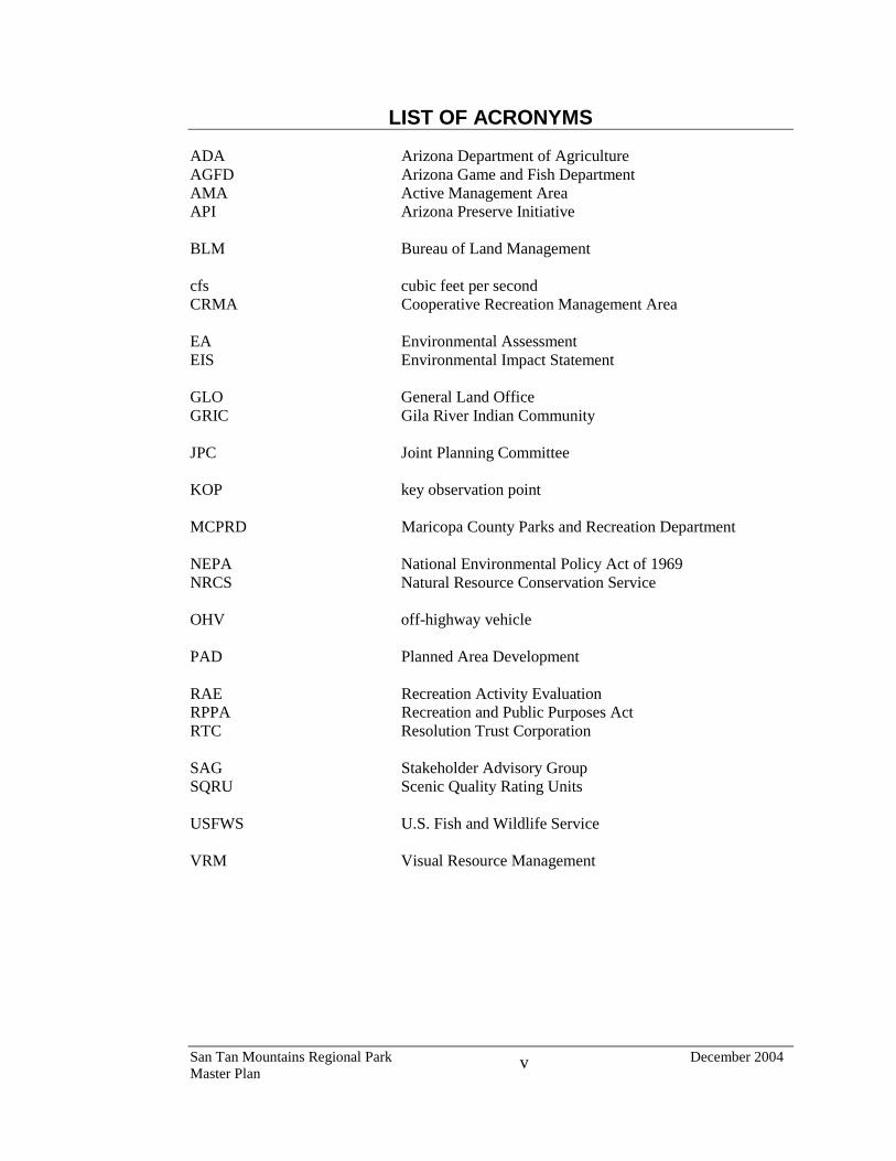
LIST OF ACRONYMS ADA Arizona Department of Agriculture AGFD Arizona Game and Fish Department AMA Active Management Area API Arizona Preserve Initiative BLM Bureau of Land Management cfs cubic feet per second CRMA Cooperative Recreation Management Area EA Environmental Assessment EIS Environmental Impact Statement GLO General Land Office GRIC Gila River Indian Community JPC Joint Planning Committee KOP key observation point MCPRD Maricopa County Parks and Recreation Department NEPA National Environmental Policy Act of 1969 NRCS Natural Resource Conservation Service OHV off-highway vehicle PAD Planned Area Development RAE Recreation Activity Evaluation RPPA Recreation and Public Purposes Act RTC Resolution Trust Corporation SAG Stakeholder Advisory Group SQRU Scenic Quality Rating Units USFWS U.S. Fish and Wildlife Service VRM Visual Resource Management

APPENDIX A PUBLIC INVOLVEMENT

JOINT PLANNING COMMITTEE

SAN TAN MOUNTAINS REGIONAL PARK MASTER PLAN
JOINT PLANNING COMMITTEE
ROSTER OF MEMBERS
Maricopa County
�� Roxana Rojo, Parks and Recreation Dept. �� Bob Ingram, Parks and Recreation Dept. �� Fareed Abou-Haidar, Parks and Recreation Dept.
Pinal County
�� Supervisor Sandie Smith, District 2 City of Chandler
�� Dave McDowell, Community Services Dept. Town of Gilbert
�� Tami Ryall, Town Manager’s Office City of Mesa
�� Jerry Dillehay, City Manager’s Office Town of Queen Creek
�� Bill Heath, past councilman �� Joe LaFortune, Public Works Department (current member)

Chandler + ArizonaWbe1t! JQ/ues Make 11Je Difference
November 17, 2003
Mr. William C. Scalzo, DirectorMaricopa County Parks and Recreation Department411 N. Central Avenue, Suite 470Phoenix, Arizona 85004
RE: San Tan Mountain Regional Park (STMRP) Master Plan
Dear Mr. Scalzo:
The City of Chandler was involved in the San Tan Mountain Regional Park Master Planprocess and we support the final draft master plan.
The master plan is a product of hard work and a lot of public input. It meets the visionstatement of the San Tan Mountains Regional Park, which is to provide recreational andeducational opportunities appropriate for a Sonoran Desert mountain park setting whilerehabilitating, protecting and responding to the unique natural and cultural resources ofthe park. The master plan also meets the goals and objectives of recreation, education,protection, and rehabilitation.
The STMRP through the guidance of the master plan will provide a great opportunity andmeet the regional needs of East Valley cities like Chandler as well as those of Maricopa,and Pinal County residents.
C~~:~~~~:~~J!.(.. -Dave McDowell, Assistant Community Services DirectorCity of Chandler member on the Joint Planning Committee for the STMRP Master Plan
Location:125 East Common,vealth Avenue
Chandler, Arizona 85225
Community Services Department~. ..' "'" Telephone (480) 782-2727 tFa:..o (480) 782-2713. . 1998 Gold Medal Winner
"- ~;' for Excellence in Parks and Recreation". ..,
Mailing Address:Mail Stop 501PO Box 4008Chandler, Arizona 85244-4008

Office of the City Manag8f'
Great Prople, Quality Seroice!
www.cityofmesa.org
November 17, 2003
Mr. William C. Scalzo, DirectorMaricopa County Parks and Recreation Department411 N. Central Avenue, Suite 470Phoenix, Arizona 85004
RE: San Tan Mountain Regional Park (STMRP) Master Plan
Dear Mr. Scalzo:
The City of Mesa was strongly involved in the San Tan Mountain Regional Park MasterPlan process and we support the final draft master plan.
The master plan is a product of hard work and endless public input. It meets the visionstatement of the San Tan Mountains Regional Park, which is to provide recreational andeducational opportunities appropriate for a Sonoran Desert mountain park setting whilerehabilitating, protecting and responding to the unique natural and cultural resources ofthe park. The master plan also meets the goals and objectives of recreation, education,protection, and rehabilitation.
The STMRP through the guidance of the master plan will provide a great opportunity andmeet the regional needs of East Valley. Maricopa. and Pinal County residents.
~Grants Coordinator
City of Mesa member on the Joint Planning Committee for the STh1RP Master Plan
20 East Main Street Suite 750
P;O. Box 1466
Mesa Arizona 85211-1466
480.644.3333 Tel
480.644.2175 Fax
.

From the Office of
MayorSteven M. BermanTown of Gilbert, Arizona
A Community of ExcellenceMunicipal Center
50 East Civic Center DriveGilbert, Arizona 85296
~~... A.,,< ~~ °1-
.,.... ~I> .,.: ~~ ~
\" ~ ...0:0" ..q
~O.ATf.'O
HMost Livable CityH
u.s. Conf. of MAyors
November 17, 2003
Mr. William C. Scalzo, DirectorMaricopa County Parks and Recreation Department,411 N. Central Avenue, Suite 470Phoenix, Arizona 85004
RE: San Tan Mountain Regional Park Master Plan
Dear Mr. Scalzo:
Thank you for the opportunity to provide comments on the San Tan Mountain RegionalPark Final Draft Master Plan. The Town of Gilbert has been extensively involved in thedevelopment of the San Tan Mountain Regional Park Master Plan, including serving on .
the Joint Planning Committee. The Town of Gilbert supports the Final Draft of the SanTan Mountain Regional Park Master Plan, which is the product of hard work and
considerable public input.
I believe this plan will preserve and protect the natural resources of the Park as well asprovide appropriate outdoor recreational space for all types of users. It meets the visionstatement of the San Tan Mountain Regional Park, which is to provide recreational andeducational opportunities appropriate for a Sonoran Desert mountain park setting whi}erehabilitating, protecting and responding to the unique natural and cultural resources of
the Park.
The San Tan Mountain Regional Park, through the guidance of the Plan, will provide agreat recreational opportunity for residents from Gilbert, the East Valley and Maricopaand Pinal Counties.
Sincerely,
&Steven M. BennanMayor of the Town of Gilbert
Area Code (480) 503-6860 Fax (480)497-4943 roD (480) 503-6080 www.ci.gilberi.az.us

TOWN OF
QUEEN CREEK
November 17 t 2003
Mr. William C. Scalzo, DirectorMaricopa CO\U1ty Parks and Recreation Department411 N. Central Avenue, Suite 470Phoenix, Arizona 85004
RE: San Tan Mountain RegioilalPark (STMRP) Master Plan
Dear Mr. Scalzo:
The Town of Queen Creek was strongly involved in the San Tali Mountain Regional ParkMaster Plan process and we support the final draft master plan.
The master plan is a product of hard work and endless public input. It meets the visionstatement of the San Tan Mountains Regional Park, which is to provide recreational andeducational opportimities appropriate for a Sonoran Desert mountain park setting whilerehabilitating, protecting and responding to the unique natural and cultural resources ofthe park. The master plan also meets the goals and objectives of recreation, education,
protection, and rehabilitation.
The STMRP through the guidance of the master plan will provide a great opportunity andmeet the regional needs of East Valley, Maricopa, and Pinal County residents.
The Town of Queen Creek would strongly encourage that additional public hearings beheld ifnew ideas for additions to the San Tan Mountains Regional Park Master Plan aresubniitted for consideration to the Maricopa County Parks and Recreation Commission or
the Board of Supervisors.
Sincerely,-" ~~.2~-:~~::;:~~Joe- --a FortunePublic Works CoordinatorTown of Queen Creek member on the Joint Planning Committee for the STMRP Master
Plan

San Tan Mountains Regional Master Plan Joint Planning Committee Meeting #1
Southeast Regional Library, 1:30 pm December 5, 2002
Meeting Summary
ATTENDEES: Maricopa County - Roxana Rojo, Bob Ingram, Fareed Abou-Haidar Town of Queen Creek - Bill Heath City of Chandler - Dave McDowell City of Mesa - Jerry Dillehay Town of Gilbert - Tami Ryall Randy Palmer, EPG Lauren Weinstein, EPG Scott Peters, EPG Lyndy Long, EPG Michael Doyle, EPG Greg Bernosky, EPG Dave Wilson, Ten Eyck NOT IN ATTENDANCE:
Pinal County – Sandie Smith Project Organization/Roles & Responsibilities R. Rojo introduced the meeting and stated the role of JPC is to assist the consultant, provide
mailing list and SAG recommendations, review documents, and provide comments back to consultants (10 days for big docs, 5 for smaller). R. Rojo received a phone call from someone who really wanted to be at the JPC meeting. She
expressed the belief that the JPC are the people who will be making management decisions and funding the project and feels these meetings should be limited to the core team. T. Ryall and B. Heath expressed concern about the public being dissuaded too strongly, which
could cause feelings of distrust. The team concluded that in the event of similar inquiry on public attendance at JPC meetings, it
should be emphasized that the public does have other opportunities for participating (open houses, SAG), and at those forums they will be reviewing the same material as the JPC. People can attend, but the different forums are available to them. If they do attend, it will be as observers and not as participants.
Update on Bureau of Land Management/Scoping R. Palmer explained that the BLM would be responsible for signing the Decision Notice for the
Environmental Assessment (EA). M. Doyle explained that currently the park is managed under a CRMA (Cooperative Recreation
Management Agreement) and the County plans to continue under that agreement. The BLM has recommended a scoping meeting be held; the first open house will be combined
with a scoping meeting. This is no change to the original scope of work for this effort. B. Heath questioned the difference between a scoping meeting and the open houses that had
already been planned. M. Doyle explained that scoping is used to identify issues and concerns, which are then addressed in the EA. It is a specific terminology that federal agencies use. The
1

scoping designation of the meeting will be incorporated into the notification. L. Weinstein added that there are different ways to do scoping meetings (formal vs. informal) and the BLM is satisfied with the planned format. T. Ryall suggested utilizing available town publications for public notice. Gilbert and other towns
have publications that go to every household. Using these publications will emphasize the commitment to the public involvement in this process. Gilbert would need 3 weeks notice to include the information. The fliers/inserts go every month. B. Heath stated that Queen Creek has a quarterly newsletter that the town puts together. He did
not remember what the lead-time is, but it goes to everyone in community. He also mentioned the San Tan Monthly (goes to everyone in the Higley and Queen Creek zip codes), and The Johnson Ranch Hotshot (goes to everyone east of the park). R. Palmer asked that each jurisdiction identify which publications are available for use. T. Ryall
said it would be fine to just provide the materials to the towns and they will do their best to distribute it. The Town of Queen Creek mailing list is the town zip code. R. Rojo asked if there is a legal notice requirement for the scoping meeting. EPG will verify with
the BLM what they want for legal notice. R. Rojo stated that there is a county requirement for legal notices. M. Doyle continued his summary of conversations with the BLM, and stated there is another
avenue (beside the CRMA) that could be pursued, which is transfer of land from BLM to the County for recreation purposes under the R&PP Act. BLM is preparing a new Resource Management Plan (RMP) for their whole region. It is in 2 areas (north/south). They will complete the southern half in three to five years. If this option is pursued it would require more effort from BLM as far as notice and a plan amendment to the current RMP. The BLM did recommend the County pursue the R&PP avenue; however, the County has decided to stay with the CRMA option. T. Ryall questioned the difference between the CRMA and R&PP regarding long-term impacts
with the park. M. Doyle explained the County would have to resubmit the R&PP application. The County can perform improvements to the land under the CRMA, but it has to be approved through the master plan. A master plan would be prepared under either the CRMA or R&PP. Also, the BLM did not review or approve the 1990 plan. B. Heath asked if a scoping meeting would have to be closer to the site. The team did not feel
that would be a problem. J. Dillehay asked if the approval process for BLM will slow down the project or if that was built into
the schedule. EPG thinks the year time frame should be fine. The BLM will review drafts as the document comes together. A priority should be the formation of a solid project description. BLM will need a month internal review time for the draft. EPG will provide milestone dates and a table of contents to the BLM. EPG will also coordinate with their resource people to identify expectations. B. Heath asked if the EA process is strictly for BLM land. The whole park has to be considered for
consistency on level of detail. Public Meetings/Comments B. Heath asked for more information on the number and purpose of the open houses (gather
input, etc.). R. Palmer reviewed the schedule and noted that for each task an open house will be held to present the information to date. B. Heath asked if each open house will be held in a different city, and if that could present a
problem for people having to drive. D. McDowell stated there are also SAG meetings, and Chandler has no preference on an open
house being held in that municipality. Gilbert agreed that they aren’t particular about location. B. Heath asked about methods for providing comment. Methods of public involvement and input
(comment forms, newsletter, web) were described by EPG.
2

Schedule/Municipal Budgeting J. Dillehay expressed disappointment about the 12-month schedule, which makes it difficult to
budget for the following year. The BLM review process adds time to the schedule, and it is unlikely to have a municipal budget approved without the master plan completed. The County budget this year must be submitted in March, not January. R. Rojo cannot take any preliminary documents to the Board for approval, it must be the final. The team discussed other options, such as budgeting earlier based on the preferred master plan
(not the final), which will be available in August. However, M. Doyle emphasized that the final open house will be in August and we will need to incorporate that information into the final plan and document still. However, at this stage it would be unlikely to change the preferred alternative much. He also stated that although there will be two separate documents, the same information will be provided within each. R. Palmer added there is a need to have a final master plan in order to complete the final NEPA evaluation, and the BLM wants to make decisions that are consistent with municipalities so that is something to consider during preliminary budgeting. The team’s final decision was to approach the BLM about an accelerated project schedule (9
months). R. Rojo emphasized that this is not an option if it requires an increase to the scope of work, the budget is already very tight.
Public Involvement Summary The key short-term issue is to gather stakeholder contacts. EPG also needs mailing list
information, (either postal service or email addresses). The County has already provided their mailing list, per slips received at the park grand opening. L. Weinstein and L. Long described the public participation plan, which outlines how the team will
get feedback from public to identify issues and recreation needs. They also described the general composition of stakeholder group (types of representation needed and key qualities). The SAG will play an important role. They become advocates for the project because they are usually active in the community. SAG members are encouraged to be at the open houses. D. McDowell asked about the time commitment required from stakeholders. It was explained that
the group is asked what time works best. Mornings and evenings are both options. L. Long inquired about any sensitivity from the JPC about releasing contact information. J.
Dillehay, D. McDowell, B. Ingram, and R. Rojo have already been contacted by the media, and are concerned about misinformation in the papers. B. Heath asked if all questions go to EPG. R. Palmer explained that the project proponent usually
likes to have the right message coming out regarding policy, finances, etc., and that there is a time usually involved with coordinating with the media. R. Rojo added that the County and EPG are discussing that role and will incorporate the resolution into the public participation plan. The team agreed that one point of contact typically works the best, and County approval on any key message or conversation is going to be important. T. Ryall stated that regardless of internal policy on media relations, elected officials could be
asked for comment. J. Dillehay felt that press releases for all types of situations could help disseminate information and reduce direct media phone calls. T. Ryall and B. Heath agreed, information should be prepared for the media — easily condensed information that could also be provided to the municipalities. Refer the press back to process, not opinions, and keep positive information circulated to reduce potential for printing negative or controversial stories. D. McDowell felt a news release out about today’s JPC meeting should be provided. L. Long explained the newsletter mailing two weeks before the open house and advised the JPC
a draft of the first newsletter will be coming shortly after the holidays. One week prior to the open house the press releases are sent to the papers. L. Long noted the team had decided to use Queen Creek for the first open house since it is
closest to the site. EPG had planned to rotate future open houses in other communities. EPG had planned to use schools, but wanted to give the JPC members a chance to “host” a facility or open house if they wanted. The municipalities had no specific preference, but D. McDowell did
3

state he did not prefer the library. EPG clarified that they are looking for big facilities (like school gyms), the library will be used for JPC and SAG. J. Dillehay thought that where current and future park users will come from when selecting a
facility should be considered. B. Heath noticed that park visitors during the open house tended to be from south Chandler (geographically close to the park). He noted that if Chandler, Gilbert, and Mesa do not each need a meeting, it might be good to go back to a geographically closer location. Suggested Johnson Ranch Elementary School (may be in Florence School District), or many large adjacent high school districts (Higley). There are no adequate facilities to hold a meeting on the GRIC. The team agrees Queen Creek for the first meeting, future locations to be determined. T. Ryall expressed concern about Pinal County representation on the JPC. Also feels GRIC
should be involved. R. Palmer explained that at a minimum the GRIC will be contacted during the stakeholder meetings
Purpose and Need Statement, Group Suggestions, and Potential Issues R. Palmer explained the purpose and need statement, which is very important for the EA. He
provided the county park mission statement as an example. R. Rojo feels the park mission statement should include the need to protect wildlife, visual
resources. She thinks Pinal County has already started buffering the park, which helps protect the views, by increasing the size of the lots next to the park and not allowing people to subdivide them. R. Palmer noted that lot development is an example of what would be included under land use
issues. One part of the mission statement might have to deal with the coexistence of surrounding land uses. J. Dillehay noted the mission statement is missing “residents current and future”; a master plan
should look to the future. That would get into the protection of resources. This would also apply to development pressures around it. B. Heath noted a decision needs to be made now on if there will be open space. His suggestions
for mission statement are protect, public, open space, recreation (protection of existing resource against encroachment, wildlife, open habitat, cultural). This park offers areas that should be protected and do not offer a lot of recreation (Malapai Hills area). There is another area on the east side that has already been trashed so many things could be done to it, make it heavy recreation use. T. Ryall is concerned about that need to include restoration. D. McDowell says there is a need to
start by providing an interpretation of what is already there. The group discussed this and felt the word “balance” was necessary to capture intent to both protect and provide recreation. There is also a need to define a boundary of what can be restored. M. Doyle provided an example of the Sonoran Preserve. Phoenix is working on development guidelines they will recommend to developers. EPG will review available documents and see if it is applicable to this situation. D. McDowell stated that the mission statement needs to be objective enough to be fair, and
needs to be defensible in public. It cannot be formed based solely on the objectives of the JPC. This is the closest regional park Chandler and Gilbert will ever have, so priorities are hiking and wildlife viewing. Also thinks youth groups are very important, since there are not very many places people can go to camp. S. Peters stated it is important to find out how each community envisions this fitting into their park
system, how the County sees this park fitting in with their other parks (i.e., is it unique, similar). J. Dillehay expressed concerns on M&O costs. The County requires parks to be low maintenance
and low manpower, it must contribute to its own budget. B. Heath believes County policy is a park has to contribute 50-75% to its upkeep. B. Ingram states they are 80% self-sufficient and the push is to get off the general fund. R. Palmer noted that it could be incorporated into the planning criteria, and requested specific operating costs. Also stated there would be a phasing plan for the park, and it should decided if the park will be “static” or “dynamic” (static plan may not be
4

appropriate in 10 years, dynamic plan would evolve with park). Team stated a dynamic plan would be most appropriate. B. Ingram explained RV parks have a 2-week stay limit. They fill up first part of January until
March. D. McDowell is concerned that sometimes the campground is placed in the nicest park of the park to generate money, says there are other ways to offset the cost besides admission. S. Peters mentioned concession jeeps as money generators, but B. Ingram says it is hard to work
with them. His experience is either to have OHV or non-OHV, they do not get along. S. Peters noted mountain bikes really tear up trails, a condition could be the jeep tours have to maintain trails. S. Peters summarized team discussion/priorities with 1. preservation and restoration 2.
development that is self-sustaining or revenue generating. 3. high need for hiking, biking, equestrian. R. Rojo states that current users may be very sensitive about the word “preserve” since they have
been using the land for years. D. Wilson noted to define the word. R. Rojo says the word “conservation” was also a concern. B. Heath thinks Johnson Ranch may have funding available if there is a joint effort between
developers and HOAs in the area. Access/Perimeter D. Wilson discussed the need to be careful about the treatment of perimeter, that it is not
enforceable through the park master plan. F. Abou-Haidar noted that Phoenix seems to be doing a lot about that, but it is clarified that they control the land use. The plan could only provide guidelines. The team agrees access is going to be a big issue. Chandler can only access through GRIC, and
there is no continuous way to get from the north to the south end. Park is also surrounded by private land. R. Rojo says the Queen Creek general plan shows several access points. For the county, that
access will be hard to control. County preference is one ingress and egress. People also feel strongly about trail connections.
Suggestions/potential issues identified by JPC include:
1. Access (see discussion above) 2. Day use (less impact) vs. evening use (high impact) and which terminology to use (level of
impact or time of use) 3. Picnicking 4. RV campground (high impact) 5. Regular campgrounds (and individual vs. group use only). B. Ingram has had many requests
for group camping. Also have requests for equestrian campgrounds. 6. Educational use 7. Locational definition of users (no major highways near this park), so users likely still regional
(East Valley) 8. Combination of day/evening use based on region of park (landscape may make it difficult to
access some areas, which could be classified as day use, but separating areas could be difficult and create management issues. Placing campgrounds on fringe may offset that a little).
9. Park objectives on a local scale, if it will fill a specific need for particular communities 10. Current uses for park 11. Regional trail tie-ins (Queen Creek and Gilbert intended the San Tan Park to tie into their bike
and equestrian trail system as a destination. Mesa performed a recreation assessment and trails showed as the highest priority)
12. Current resource degradation ( J. Dillehay would like the master plan to include an overlay of bringing resources back to a sustainable level, not just protecting them).
13. Income generating uses (equestrian arena, RV park). Team believes an equestrian arena is undesirable because it is not only high impact, there are other arenas in the area. B. Ingram
5

also states that in his experience arenas aren’t big money generators and often are unused. D. Wilson suggested looking at the area to see if current arenas are at capacity. RV park is also high impact and the park is far from the freeway so may not draw users.
14. OHV – county has policy against it which helps defensibility 16. Community need for facilities. East Valley has large, extended families, ramadas are always
filled. However, these communities do have ballfields and play areas so these aren’t seen as a need in the San Tan Park. County doesn’t think their commission would approve uses like that.
17. Interpretive center – could be revenue generating and provide needed facilities for places like Johnson Ranch, which is expected to be high-density. B. Heath noted South Mountain as an example, says it is always booked.
18. Management Issues – access, M&O costs Action Items
JPC to provide SAG recommendations to EPG. (The JPC does not need to contact their recommendations, EPG will do that.)
JPC to provide mailing list to EPG. JPC to advise EPG if they do not want their contact info released to public or media. JPC to continue thinking on park objectives and mission statement. County and EPG to resolve media contact strategy. EPG to incorporate key messages and project objectives into public participation plan.
6

San Tan Mountains Regional Master Plan Joint Planning Committee Meeting #2
Southeast Regional Library, 1:30 pm March 6, 2003
Meeting Summary
ATTENDEES: Maricopa County - Roxana Rojo, Bob Ingram, Fareed Abou-Haidar Pinal County – Supervisor Sandie Smith Town of Queen Creek - Bill Heath City of Chandler - Dave McDowell City of Mesa - Jerry Dillehay Town of Gilbert - Tami Ryall Randy Palmer, EPG Lauren Weinstein, EPG Scott Peters, EPG Lyndy Long, EPG Michael Doyle, EPG Dave Wilson, Ten Eyck Stakeholder Advisory Group (SAG) Composition, Selection Process R. Rojo introduced the meeting and welcomed the members. R. Palmer reviewed the agenda and
purpose of the meeting. R. Palmer and M. Doyle discussed the current members of the SAG and how they were selected
based on JPC suggestions and group representation. Two members were added following the first open house, and one member resigned after the first SAG meeting. Since that time, several more SAG membership suggestions have been received. The group was asked to discuss the current composition of the group and if any other members should be added. S. Smith thinks an addition from 4H, the Queen Creek Chamber of Commerce, and the
Florence/Coolidge area would be good (to draw those communities into the process). Mike Urton would be a good representative for this area. However, she is comfortable with the current group representation if more members were not added and indicated that she could represent the Coolidge/Florence area. B. Ingram thinks the business interests are covered with the current group, and suggested that
Sylvia Centoz could relay information to the 4H. B. Heath would like to include someone from the Florence/Coolidge area, also thinks 4H is good
because it is a younger group. He agrees that businesses are covered by the current representation. If a developer was needed from another side of the park he suggested the Jorde family. However, EPG has already contacted Jim Jorde, who indicated he will participate in other ways. R. Rojo clarified that EPG has used all funds allocated for SAG interviews. S. Smith thought if we
are unable to complete more interviews then we should at least include the suggestions on the mailing list. R. Palmer stated we could probably add a couple more, but anything more than that would make the group difficult to correspond with and the meetings would likely have to be longer to obtain everyone’s input. T. Ryall also agreed that we have other ways of public input and maybe the JPC members could
reach out to those who were suggested to obtain their input. B. Heath suggested the JPC members might be able to conduct the SAG interviews to reduce consultant time.
S:\projects\Maricopa County\San Tan\Public Involvement\JPC\Meeting2\JPCsummary2.doc 1

J. Dillehay is more interested in including a youth-oriented group and suggested the Boy Scouts might be more appropriate than the 4H. B. Ingram sees Boy Scouts in the area regularly but isn’t aware of a specific troop that uses the park. The group agreed that ecological interests are represented by Frank Welsh and an additional
member from the Audobon Society is unnecessary. In summary, the direction from the JPC is to talk to Mike Urton from the Coolidge/Florence area
and a youth group representative as final additions to the SAG. If Mike Urton is unavailable to participate on the group, S. Smith could represent interests in that area.
Open House Summary/Key Issues R. Palmer summarized the first open house (information presented, number of attendees).
Discussed issues that were identified through public comment. B. Ingram discussed fencing activities. The access at the end of Ellsworth Rd. has been blocked.
There is another access near Ron Hunkler’s property that he hasn’t blocked yet because people use it to visit the graves. R. Rojo mentioned increased equestrian use of the park is a new concern. Use has greatly
increased since the park grand opening in November 2002 and the horses are not staying on the trails, causing a great deal of resource damage. M. Doyle mentioned that the theme of most comments has been to keep the park pristine, but a
few people have suggested commercial development. S. Smith asked if anyone had mentioned establishing a park district to raise maintenance funds.
M. Doyle stated the public had not brought that up specifically. S. Smith also added that developers have asked to see how much certain items cost (ramadas, picnic benches) so they can purchase and donate those items. R. Rojo stated the County is trying to establish a 501c3 – Non profit designation so they can
accept donations for the park. The group also reviewed the draft Issues Map, including points of current access and certain
biological features. J. Dillehay would like to see the cholla field noted on the map (near Brenner Pass and Judd Road).
Park Vision and Mission Statement R. Palmer presented a draft of the San Tan Park mission statement and goals and objectives for
group discussion. D. Wilson stated that it is important to view these items in the context as a set of criteria that we will measure alternatives against. B. Heath stated that the goals and objectives seem to capture all of the comments he has heard
from people. J. Dillehay expressed concern that timing or implementation doesn’t seem to be captured in the
statement or goals. Many of the features will likely have to be phased in. Also suggested the term “rehabilitation” be added to the mission statement (team agreed).
Recreation Needs Assessment D. Wilson summarized the draft recreation evaluation matrix. The range of recreation uses does
not include items such as ballfields and courts because those are more typical of urban or flatlands parks. D. Wilson also requested the group review this chart in detail and send him comments. The chart will be revised and refined as necessary. B. Heath asked for clarification on a competitive track (group explained it is, for example, a
challenging, set-aside area for mountain bike competitions, but is still a natural environment and not paved or scraped).
S:\projects\Maricopa County\San Tan\Public Involvement\JPC\Meeting2\JPCsummary2.doc 2

J. Dillehay was concerned that a group camping area was showing as not being carried further. He has heard many comments form the public that this amenity is needed for large family activities, corporate picnics, etc. R. Rojo explained that a group camping area is a large, scraped area with infrastructure needs. S. Smith suggested we keep it in and see how it rates in further evaluation before it is eliminated. B. Ingram stated he has also heard a great deal of requests for places to hold reunions. He stated the impact may look high, but overall may actually be less than a number of scattered sites. D. Wilson suggested it might be helpful to quantify the number of people the site would serve to get a better idea of potential impact. B. Heath also added that the east end of the southern finger is already disturbed so it may lend itself to something of this nature. S. Smith also suggested that the people who have commented to date are probably adjacent
residents who want recreation opportunities they can ride or walk to, but regionally a group picnic site may be needed. The group agreed to consider this option further. R. Palmer discussed the potential for commercial development. Displayed conceptual plans that
have been brought to EPG by an interested party who would like to lease about 300 acres on the southern finger for a tourist/western-themed commercial development. The group agreed that none of the existing roads could handle the amount of traffic generated by
the proposal, and the plan would likely be met with great opposition by local residents. B. Ingram doubted a development of that nature would be successful in such a remote location. D. McDowell questioned the difference between this development and other vendor activities
listed on the chart, such as riding stables. Wanted to know why some complied with County policy but others did not. R. Rojo explained that some vendor or commercial activities can not be conducted on BLM land.
T. Ryall added that the way the revenue is generated and the use of land is also different for a vendor versus someone who wants a large piece of land. Other parks with commercial features were discussed, such as Adobe Dam. R. Rojo indicated that the commercial development at Adobe Dam is possible because it is on Flood Control District land. The JPC did not support the conceptual commercial development. B. Heath mentioned that South Mountain has an interpretive center that is very popular and it is
rented all the time. It is small and would not require much land. S. Smith mentioned that RV parks will be brought up by the public. She also mentioned that the
group needs to consider where the funds for maintenance will come from. B. Ingram stated that the fencing and other features currently being installed in the park cost
about $250,000, which is entirely revenue from other parks. The County Parks Dept. operates on 80% of the revenue they generate.
Data Inventory M. Doyle displayed the resource maps produced to date and reviewed the results. B. Ingram discussed the pygmy-owl surveys they are conducting and where those surveys are
occurring. Opportunities and Constraints R. Palmer explained the opportunities and constraints analysis that is being conducted based on
the results of the data inventory.
Group Discussion B. Heath would like all JPC members to work on ideas for revenue generation. He has been
speaking to people about RV parks and they seem to be a big expense. R. Rojo stated they can cost about $4 million. In addition, there can be complications with the septic tank and field. B. Heath re-emphasized that the JPC needs to know what revenue generating activities are available and acceptable.
S:\projects\Maricopa County\San Tan\Public Involvement\JPC\Meeting2\JPCsummary2.doc 3

T. Ryall would like to see the budgets from other parks so the group could get an idea of what certain features cost and what revenue they bring in. B. Ingram noted that the County budget is currently integrated so it is difficult to pull numbers from specific parks, but they would try. J. Dillehay suggested that with phased development some options might be feasible later in the
process. For example, a revenue generating facility in Phase I might enable another feature to be built in Phase II. T. Ryall clarified that we probably wouldn’t be able to discontinue activities after they had already been implemented. B. Heath mentioned that this is currently a rural area, but it will eventually be urbanized. The plan
will have to consider the impacts on park neighbors as well as additional sources of park users. J. Dillehay asked if anything in the recreation needs assessment would accommodate “wrangler
camps”, camps that would accommodate horses and trailers. D. Wilson explained that this is covered under camping but a more specific category could be added. R. Rojo provided the date and location of the next public open house and SAG meeting. J.
Dillehay mentioned that he liked the format of the public open house. Thought it was more productive and comfortable than a presentation setting.
Action Items
EPG to contact two additional people for SAG membership (Mike Urton, youth representative from Boy Scouts or 4H).
EPG/Ten Eyck to retain group camp sites in recreation needs assessment. JPC to review recreation needs assessment chart in detail and provide comments within 10 business days. EPG to add Gilbert Independent to press release list, forward information to T. Ryall for inclusion in the Gilbert Town paper. EPG to add “rehabilitation” to the park vision statement. County to develop an estimate of park revenue generating and operating costs for JPC review.
S:\projects\Maricopa County\San Tan\Public Involvement\JPC\Meeting2\JPCsummary2.doc 4

San Tan Mountains Regional Master Plan Joint Planning Committee Meeting #3
Southeast Regional Library, 1:30 pm May 6, 2003
Meeting Summary
ATTENDEES: Maricopa County - Roxana Rojo, Bob Ingram, Fareed Abou-Haidar Pinal County - Joe Pyritz (for Supervisor Sandie Smith) Town of Queen Creek - Bill Heath City of Chandler - Dave McDowell City of Mesa - Jerry Dillehay Town of Gilbert - Tami Ryall Joe LaFortune, Town of Queen (observer) Eric Latto, Maricopa County (observer)
Randy Palmer, EPG Lauren Weinstein, EPG Scott Peters, EPG Lyndy Long, EPG Michael Doyle, EPG Dave Wilson, Ten Eyck Project Update R. Rojo introduced the meeting and welcomed the members. Due to the presence of observers,
all members of the team introduced themselves. R. Palmer reviewed the agenda and purpose of the meeting. L. Weinstein discussed the current composition of the SAG. Two members were added following
the last JPC meeting per JPC suggestions. The new members are Tom Walsh of the Boy Scouts and Mike Urton from the Coolidge/Florence area. L. Weinstein stated that 52 people attended the last open house. The biggest issue heard by the
team was regarding access. The third open house will be June 19 at the Red Mountain Multigenerational Center in Mesa, from 5:30 to 7:30 p.m. R. Palmer reviewed the planning process, tasks completed, and current task. The team is
currently developing master plan alternatives, at the next meeting the preliminary preferred alternative will be presented. R. Palmer reviewed the vision statement and underlying goals and objectives for the park. The
public reviewed this information at the open house and supported the vision statement and goals. R. Palmer mentioned that Fred Ringlero, a SAG member representing the Gila River Indian
Community (GRIC) had discussed the concept of telling social stories of the landscape. The team considered this and has divided the park into units. This meeting will discuss the identification of those areas, how they meet the objectives of the park, and preliminary alternatives.
Recreation Evaluation Update D. Wilson reviewed the Recreation Activity Evaluation Table. It has been updated based on
feedback from the JPC, SAG, and comments from the public open house. The categories in the table are still not finalized; they will be refined as the team gets further in the evaluation of
S:\projects\Maricopa County\San Tan\Public Involvement\JPC\Meeting3\JPCsummary3.doc 1

alternatives. However, some items have been defined for clarity (camping was previously noted at 1-2 acres, it is now 1-5 acres). D. Wilson mentioned a new category that had been considered. The team received a request for
a downhill track for mountain biking. It has been eliminated from further consideration due to reasons such as liability and site impact issues. B. Heath asked if the downhill track differed from the competitive track. It was clarified that it is different, and that the competitive track will be carried through the process. J. Dillehay asked if there was a difference between the education center/museum and the
interpretive/visitors center. There was a concern that some ideas would not be considered if those facility categories are separated and some are eliminated. D. Wilson explained that the team has been using the facility at South Mountain as an example of a visitor center that can have displays of artifacts, wildlife resources, prehistoric/historic elements, etc. The definition of an education center is closer to the facility at Lake Pleasant — a larger building with full-time staff, very large meeting facilities. Additionally, one of the SAG members requested/suggested a large, regional museum with exhibits by all participating communities. R. Rojo asked the group to discuss the inclusion of concessions in the evaluation. Concessions
had previously been eliminated but County Parks and Recreation Dept. directors have noted it would limit opportunities to generate revenue if concessions are eliminated. R. Rojo suggested changing the category name to “compatible concession” to clarify the intent of the category. D. Wilson indicated that some of the categories will be more specifically defined later in the process as specific uses are planned and sited for the park. R. Palmer added that the team has received requests for equestrian facilities as concessions,
which fit within the context of the park and are being considered. B. Ingram stated that the Town of Queen Creek is considering a large equestrian arena with about 240 stables, 5 arenas, etc. If that facility is built the park would not need a comparable facility. R. Palmer clarified that trail riding is popular in the park and the concessions (a horse stable) could be geared towards that activity. D. Wilson added that the stables at Cave Creek are a good example, they keep about 30-40 horses for rental. S. Peters asked the JPC about their thoughts on opening concessions back up for consideration.
B. Heath expressed concern that concessions could generate a high volume of traffic that the area is not set up to handle. D. McDowell stated that concessions are different than commercial development. The team still
needs to protect the park, so concessions with a low impact would be acceptable. R. Rojo asked if “compatible concessions” as a label captures that intent. J. Dillehay stated that he doesn’t see concessions as a recreation activity and wanted clarification
as to why it is included in the matrix. R. Rojo explained that the concessions being considered are recreation oriented, and provided examples such as riding stables, mountain bike rentals, local art vendors. B. Ingram mentioned that another use would be to allow vendors who rent horses outside of the park to conduct trail rides. J. Pyritz clarified that the County could simply build a building and rent it out, and would not
actually be conducting the concession. B. Heath emphasized his concern over traffic. He also stated that multiple buildings will detract from the vision for the park, and if concessions are allow they need to be limited. S. Peters asked the group to determine if they are considering all concessions or strictly those
that provide recreation opportunities. J. Dillehay stated that perhaps the more appropriate way to handle the issue is to include
management guidelines in the master plan rather than specific concessions. The team needs to provide criteria and goals for concessions because it is impossible to identify all the potential proposals at this time. Guidelines could guide managers in the future without excluding a particular activity now. R. Palmer agreed with the idea that concessions could be treated as a management issue rather
than a recreation activity. The team could develop guidelines, allowing concession proposals to be evaluated on a case-by-case basis.
S:\projects\Maricopa County\San Tan\Public Involvement\JPC\Meeting3\JPCsummary3.doc 2

D. Wilson clarified that the concession category was to be noted as on a “case-by-case” basis. B. Ingram agreed, with the exception of those concessions that are purely recreational (i.e. riding stables). R. Palmer stated that the commercial development would also stay on the matrix as it was a specific request by a member of the public and was regarding a specific use of the land. R. Palmer emphasized that turning concessions into a management issue rather than a
recreational one would allow flexibility over time and would be good for the park. B. Ingram agreed that it would enable the county to evaluate an activity in 5-10 years that they had never even heard of. R. Rojo asked the group if large group camping (5-10 acres) should be carried forward for
evaluation. B. Ingram said the County doesn’t need a large facility like that, there is not enough room in the park. Usery can accommodate 78 motor homes, Cave Creek is about 3-4 acres. No one else in the group had comments on removing this category.
Sensitivity Analysis and Landscape Units R. Palmer presented a map showing the sensitivity levels of the park. The team collected
baseline data on various resources (slope, vegetation, wildlife, etc.). The layers were compiled onto a single map to show the overall sensitivity of the site based on the resources. R. Palmer reviewed the issues map, which shows access points people have pointed out. The
map also shows areas the team has identified as being more pristine or disturbed, and areas identified by local residents as being of interest (wildflower locations). The team has also identified neighborhood issues. For example, residents to the north of the park have different issues from those on the south. R. Palmer discussed how the team has evaluated recreation uses against different resources to
see if the activities are compatible with the park, if they present constraints, and if those constraints can be mitigated. The team has also conducted another site visit to review the park and resources again with specific recreation activities in mind. J. Dillehay asked why the gravesites weren’t shown in red on the sensitivity map. R. Palmer
explained that the coloring comes from the area being previously disturbed, but the team would not lose sight of particular features (such as the gravesites) within an area. S. Peters clarified that the sensitivity map is developed by assigning values to each resource and overlaying those values onto a single map. It takes many resources at a high sensitivity level to generate a red color on the map. M. Doyle added that the team is tracking specific archaeological sites, but for public presentation purposes they are left off the map to protect the sites. R. Palmer discussed how the park is a continuous landscape, although there are areas within the
park that are unique. The team has identified these areas as landscape units and developed a map that shows each unit and how the park goals and objectives could be met in each unit. M. Doyle showed a slide presentation of park photos to characterize how the landscape units
were identified. B. Heath asked how many homes had been approved by Pinal County for the Circle G property.
S. Peters responded that Circle G owns 300+ acres planned for 1 ¼-acre lots for custom homes. It is planned to be a low density development but there would still be many homes on the property. R. Palmer reviewed the suitability analysis map, which shows potential locations for facilities
based on if they are suitable for the landscape in that area. Trails and access fit well in many places of the park.
Review of Conceptual Master Plan Alternatives D. Wilson reviewed the three master plan alternatives for the park. Alternative A is a more passive/minimal development alternative. Many public comments have
been received requesting the park remain as/is. This alternative has one access point, which
S:\projects\Maricopa County\San Tan\Public Involvement\JPC\Meeting3\JPCsummary3.doc 3

meets County preference. It also has a family picnic area of about 25 sites. The number of picnic sites is low because the County has stated that although the facilities do get used, their use is limited. The central area of the park by the entrance is the most developable, but facilities here would have a high visual impact to the park. In this alternative, trails use existing roads (the ultimate design of trails would be conducted by the County). The team is suggesting on all alternatives that Brenner Pass Road be closed. The traffic cuts through the park, creates two more entrances, and causes dust. It is about 2.2 miles to drive around without using that road. The road would have to stay in the southern finger because there is no other options for the residents near Olberg Rd. However, the road could be moved onto a section line. There are no trails planned for the Malapais because there are not many existing trails that go there. R. Palmer mentioned that these conceptual alternatives do not show all the layers of resources
and landscape units. However, all alternatives would meet the goals and objectives for the park. J. Dillehay asked about the planned water tank. D. Wilson stated it is listed as a possible storage
tank in the northern finger. The County is currently in discussions with the water company. R. Rojo added that part of the agreement would stipulate that the company provide water to the main entrance. Alternative B would be a passive/moderate development alternative. This alternative has added
the group picnic area, a potential visitor center which would be a center point for interpretive and barrier free trails. The central location for the visitor center could also serve as a parking area and trailhead, and would be slightly elevated to provide panoramic views. A staging area for horse trailers, unimproved walk-in camping, and youth camping are also added to the north finger. The north finger is large enough that the youth camp would be secluded and buffered from the surrounding neighbors. A second entry and trailhead on Brenner Pass Road and a third entry on the north finder (at Wagon Wheel) for the grave sites is provided. B. Heath stated that the water tank is not “possible”, it is a definite feature. He asked if the
Johnson Water Co. would bring in sewer also. R. Rojo stated no, sewer is not part of their plan. B. Heath wanted to know if the higher use group picnic area could go in the northern finger to use
the water. D. Wilson advised that the team could look at that. The current placement of the site takes into consideration the views and consolidation of trails. S. Peters added that there is also value to keeping the group site by the main entrance. Otherwise, it would not be recognized and used as a main entrance. B. Heath asked if the picnic area could be placed next to the road leading to the visitor center. R.
Palmer responded that there is a 100-year floodplain in that area and views of facilities from off-site to on-site also need to be considered. D. Wilson added that there would be a lot of traffic from the main entrance. The visitors can use
the picnic facilities, but the facilities were moved a little off the road so they aren’t impacted by traffic into the park or visitor center. J. Dillehay stated that from a management perspective, the park would need less staff and
monitoring on the north finger when no youth camping is scheduled. If there are other facilities there that wouldn’t be possible. D. Wilson added that a road would be needed to put picnic facilities on the north finger and there would be difficulty providing that because of the adjacent state land. S. Peters said the team is also considering the views from the drive to the visitor center. B. Heath asked why the staging area is in the center of the park if this is such a visible area. R.
Palmer explained that the central valley is interconnected to the rest of the park, it provides the ability for users to “fan out” to other areas. B. Ingram added that placing the staging area here is a control issue, as equestrian is the heaviest use in the park. R. Palmer stated that depending on the type of use in the fingers, they could be closed off at
certain times of the year. This would help the traffic issues that B. Heath mentioned earlier. B. Heath stated that as heard at the last open house, park access is the biggest issue. S. Peters
stated that the County and the team has worked hard to include an entrance at the north side of the park, which is unique to County policy. R. Palmer added that the team is also considering a regional trail system to connect the park to others in the region. The team has also spoke to the
S:\projects\Maricopa County\San Tan\Public Involvement\JPC\Meeting3\JPCsummary3.doc 4

McDOT regional trail planner about the connection potential. An entrance on the north side also makes sense because the area is previously disturbed and people like to visit the gravesites. Alternative C is the most active and developed alternative, but it still is responsive to the site and
meets the park goals and objectives. In addition to the trailhead, the northern entrance would also have a comfort station and perhaps more picnic areas. A riding stable has been added at the equestrian staging area. An entry at the north finger has also been added, along with group and wrangler camping with electric and water hook-ups for 80-100 campsites, a host site, and a maintenance compound. The southern finger would have an entry and trailhead, youth camping, and a staging area for a competitive track. B. Ingram stated that the fencing and other features currently being installed in the park cost
about $250,000, which is entirely revenue from other parks. The County Parks Dept. operates on 80% of the revenue they generate.
Group Discussion R. Palmer reviewed the visibility map, which shows sensitive views in the park. J. Dillehay mentioned that smell is a concern with heavy equestrian use. B. Ingram doesn’t like unimproved walk-in camping. He says that if people don’t have restrooms
they do a poor job of safely disposing of waste. D. Wilson mentioned that the team had also considered placing the visitor center further south
(near the Gap) into a bowl area that has great views. The debate with this placement is whether or not the views should be protected, or should people be allowed to look through a picture window at the saguaro forest. B. Heath stated that his concern with that placement would be the impact of the parking lot and the road that would be needed. Those features would cause too much damage to the site. B. Ingram suggested an ADA trail with a stopping point near the Gap would allow more people to
enjoy the area. S. Peters stated the team needs to consider how available the Gap and Broken Lands should be to people, or if it should only be available to the people who are willing to hike there. J. Dillehay stated that the team has an opportunity to make this park unique. There are plenty of drive-in picnic sites in the valley. This park should entice people to get out of their cars if they want to see something interesting. B. Heath asked if the visitor center would be placed in a previously damaged area. B. Ingram
responded that there has been some damage to the site, but it is removed from the area of major damage (shown during the photo slide presentation). B. Heath asked if it would make more sense to place the center in the damaged area instead. S. Peters responded that there is a ridgeline in that location that would isolate the visitor center from the rest of the park and expose it to the future development to the west. R. Palmer added that the visitor center should provide people with an impression of a good area, especially those people who can’t hike and may visit only the center. B. Heath asked if the three alternatives could be intermixed. R. Palmer said that they will be
combined into a preferred alternative, the team needs to prioritize the various features. Phasing and management objectives will be very important. R. Rojo suggested that the different alternatives could provide a phasing plan for the team.
Alternative C doesn’t need to all be built now, but developed in the future. B. Ingram stated that Alternative A would be very restrictive, the County may want a campground in 10 years but if A is selected that wouldn’t be possible. S. Peters mentioned that there is a difficulty providing infrastructure to the southern finger that
should be considered (i.e., water). B. Ingram emphasized that if anything is placed in the northern finger, Brenner Pass Road must
be closed. He feels it makes the finger worthless and generates a lot of garbage. He stated that if the road is not closed his preference would be to sell the whole finger. He prefers the southern finger because it is prettier, but it is hard to get to. B. Ingram feels the narrow strip at the east end of the southern finger should also be sold.
S:\projects\Maricopa County\San Tan\Public Involvement\JPC\Meeting3\JPCsummary3.doc 5

B. Heath said that the need for Brenner Pass Road is less now that other roads are available to residents. T. Ryall asked what the process would be for determining the preferred master plan alternative.
R. Rojo responded that these three alternatives have to receive input from the SAG and the public at the next open house. Then we will compile the features and comments into a preferred alternative. B. Heath asked if he could have copies of the alternatives. R. Rojo said that at this time the
County would prefer not to duplicate or provide copies because people can misinterpret the plans, and it could cause misunderstandings from the public. The alternatives need to be presented in the appropriate forum with staff available to discuss them and get feedback. Meeting adjourned at 3:45 p.m.
S:\projects\Maricopa County\San Tan\Public Involvement\JPC\Meeting3\JPCsummary3.doc 6

San Tan Mountains Regional Master Plan Joint Planning Committee Meeting #4
Southeast Regional Library, 1:30 pm July 10, 2003
Meeting Summary
ATTENDEES: Maricopa County - Roxana Rojo, Fareed Abou-Haidar Pinal County - Supervisor Sandie Smith Town of Queen Creek - Bill Heath City of Mesa - Jerry Dillehay Town of Gilbert - Tami Ryall Creighton Wright, Town of Queen (observer) Gordon Brown, Stakeholder Advisory Group member (observer)
Randy Palmer, EPG Scott Peters, EPG Lyndy Long, EPG Michael Doyle, EPG Nancy Favour, EPG Dave Wilson, Ten Eyck NOT IN ATTENDENCE: Bob Ingram, Maricopa County Dave McDowell, City of Chandler Project Update R. Rojo introduced the meeting and welcomed the members. R. Palmer reviewed the agenda and
purpose of the meeting. R. Palmer provided a summary of the last SAG meeting. Most of the discussion during this
meeting focused on the use of the fingers of the park, as the SAG members agreed with the overall concepts for the main park area. R. Palmer added that the SAG was also concerned with the potential closure of Brenner Pass
Road. S. Smith stated that Pinal County owns the right-of-way so there should be no further discussion on closing the road. R. Palmer added that the majority of public comment was opposed to closing the road. S. Peters stated that a corral had been added to the alternatives due to SAG member suggestion.
L. Long added that there was also lengthy discussion on the competitive track. R. Palmer added that the mountain bike community would like a track that has the length required to host regional/national events. R. Palmer reviewed the open house. Copies of the open house comment form and handouts
were provided to the JPC. R. Palmer reviewed the questions on the comment form, including how people ranked the park goals and objectives in order of importance. The questionnaire also asked if one of the three plans was preferred, if Brenner Pass should remain open, what specifically they preferred or disliked about each plan, and what the park development priorities should be. R. Palmer stated that protection was the most important goal, and Alternative C was the most
preferred alternative. However, the alternative preference seemed to be driven by the presence of the competitive track. People strongly opposed the closure of Brenner Pass because they like the scenery of the drive, and are concerned with the extra mileage and emergency response time. EPG did speak with two battalion chiefs at Rural Metro. The chiefs were not asked if the road
S:\projects\Maricopa County\San Tan\Public Involvement\JPC\Meeting4\JPCsummary4.doc 1

should be closed, it was requested that they attend the open house to review the plans and then provide a specific stance. EPG called Rural Metro, but has not received comments since the open house. S. Smith stated that she has spoken to Rural Metro and they have expressed opposition to the
closure of Brenner Pass. She speculated that the formal opinion may have been somewhat driven by public pressure. R. Palmer advised that the original SAG representative for the Gila River Indian Community
(GRIC) had quit, but his replacement, Elaine Blackwater, did attend the last SAG meeting. Elaine discussed the traditional importance of the area. R. Palmer stated that an EA process involves sending an informational consultation letter to tribes and often, responses are not received. However, the GRIC views the entire San Tan Mountains area as important. There are pathways there that were established over time as people traveled to water sources north of the reservation. The GRIC sees the area as a traditional landscape and does not want to see it developed. M. Doyle added that the GRIC has used the area for many centuries, and still uses the mountains
for traditional purposes. R. Palmer added that the GRIC is very concerned with any development on the Malapai Hills.
Alternatives Review and Discussion R. Palmer stated that the team would like JPC comments on the alternatives. He reviewed the
process chart and discussed the steps involved with the development of the preferred master plan. R. Palmer stated that it is important to review the alternatives with the landscape units map to see
how the alternatives meet the goals and objectives for each specific location. R. Palmer explained that the team reviewed the compatibility chart and compared the 10 landscape units with the proposed activities for each alternative, and evaluated how those activities met the goals and objectives for each landscape unit. If an alternative or activity had low compatibility, mitigation was considered. If the location for a feature was not the best in terms of compatibility, the team tried to meet the criteria by using mitigation. D. Wilson reviewed Alternative A, the passive/minimal use alternative. All three alternatives keep
facilities out of the Malapai Hills. The main entrance would lead to picnic areas, trailhead, and equestrian staging area. There would also be a trailhead to the north. If Brenner Pass Road remained open, only a single trail and water tank would be present in the north finger. In the southern finger would be a loop trail system. D. Wilson summarized Alternative B, the mixed use/moderate alternative. This alternative adds a
group picnic area, along with the potential to expand the family picnic area. A visitor center, barrier free and interpretive trails, youth camping (in the north finger) was also added. J. Dillehay asked if there were any factors that would preclude a development plan that would
allow Alternative A to be phase 1, and Alternative B to be phase 2. D. Wilson responded that design and location would need to be considered but the team did recognize one plan could build upon another in terms of development. S. Smith asked if Alternative C could also be a phase, and D. Wilson responded that yes, it could. He also mentioned that features indicated still need to be detailed and programmed (e.g., size of visitor center, etc.). R. Palmer added that the team needs to carefully consider how those elements are being
addressed and whether issues can be mitigated. For instance, should overnight use (camping) be allowed in the park, because the plans should not be too intrusive to neighboring residents. D. Wilson summarized Alternative C, the most active/developed alternative. This alternative
includes a comfort station at the north entry, perhaps an expanded visitor center, and riding stables. In the north finger, group and family camping with water and electric hookups have been added, but D. Wilson noted that the road and nearby cholla forest limits accessible areas. He also noted that the competitive track added in this alternative is only 5 miles, and the mountain bike community has stated they want at least a 7-mile track. The team may be able to address this
S:\projects\Maricopa County\San Tan\Public Involvement\JPC\Meeting4\JPCsummary4.doc 2

through design. Youth camping was moved from the north finger to the south, with an entry for the competitive track and camping area. R. Palmer clarified that the alternatives are sensitive to pristine areas of the park and the
associated resources. For example, the northern flank of the mountains in the southern finger are visible, so the competitive track would be on the south side of the hills. R. Palmer stated that feedback had been received on the use of the Mineral Butte area. People
stated that they don’t want that land sold, and G. Brown from the SAG has requested an entrance into that area. Residents near the fingers are concerned with the close proximity of some of the activities. However, many people want to protect the central area of the park, which is why activities have been sited in the fingers. D. Wilson added that the public thought minimal uses in the Malapai Hills was acceptable. R. Palmer stated that working interpretation and education into these areas could be important.
There are historic patterns regarding travel, which the GRIC confirmed at the last SAG meeting. The team has been considering the importance of emphasizing the concept of “pathways in the landscape.” Past, present, future, local, and regional networks of trails could be discussed. This is still a preliminary concept and has not been detailed as a planning element. B. Heath prefers Alternative A because it leaves the central valley the most natural of the
alternatives. If Brenner Pass stays open he feels the public facilities should be moved out of the valley and into the northern finger for easy access. R. Palmer stated that the team is still discussing with the County what facilities would be acceptable in the northern finger with the road open. He also stated that if many facilities are put in the north area, it doesn’t allow the public to interact with the rest of the park. Also, Phillips Road is the main entry, and facilities are needed near that entry to identify them with the park. B. Heath asked how the team would accomplish the goals of both Recreation and Protection,
which he feels are the two most important goals. R. Palmer agreed that this had been a challenge. T. Ryall stated that public comment seems to indicate the public prefers Alternative A with the
competitive track, and that they don’t want camping. Most visitor centers have good meeting space but it isn’t used much. R. Palmer agreed, and stated that the team needs to consider what overnight camping means to the park. There is a safety concern (fire), but the County also has a concern with revenue generation. T. Ryall asked why the competitive track was placed in the southern finger. R. Palmer explained it
was partly due to isolation from the other users. S. Peters added that topography was also a factor, as there is a natural buffer provided by the foothills, which reduces impacts to surrounding areas and provided the necessary topographic relief. R. Palmer also stated that infrastructure and access control should be considered. S. Smith expressed the concern that if no activities are placed in the fingers they will lose their
identity as part of the park and may be easier to sell. She suggested the visitor center could involve a partnership with the local historical society; they could help run it to reduce costs. R. Palmer restated that we have heard comments regarding the use of the fingers, such as the
request for access into the Mineral Butte area. B. Heath stated that is the most disturbed area, so access would make sense. R. Rojo stated that she does not believe the fingers would be sold, as the idea has been met with much opposition. S. Smith stated that Pinal County will pave Gary Road to Judd Road this year. However, she
does not want all traffic going down Gary Road; it is not designed to accommodate that many vehicles. B. Heath thinks the visitor center will be for people who just want to look at the park, perhaps take
a small hike, then leave. R. Palmer does not think that people will just leave the visitor center and that it needs to be in the center of the park so a relationship is established between the center and the surrounding amenities. It would have a negative impact on the park for people to be going back and forth from a visitor center in the northern finger to amenities in other areas of the park. D. Wilson added that if the visitor center is in the central area, people will feel close to the park setting without impacting sensitive areas like the Gap.
S:\projects\Maricopa County\San Tan\Public Involvement\JPC\Meeting4\JPCsummary4.doc 3

S. Smith expressed concern with forcing people to travel farther to get to the center if it is located too far into the park. R. Palmer reiterated that for a visitor to have a true park experience, the center should be associated with the main entry. R. Rojo added that a facility of that nature would be difficult to maintain if it wasn’t near the main entrance. J. Dillehay emphasized that although the team needs to listen to the public, it is also important to
consider the future. He feels the plan should focus on light recreation that does not divert from the goals of education and rehabilitation. The history of the area is important and could disappear, the viewshed of the area is already disappearing. The visitor center is an important part of the park and there needs to be a place for school buses to go. R. Rojo stated that she agrees, and the visitor center would include barrier-free and interpretive trails to meet the goal of education. S. Smith stated that there are no funds for the park, and wants to know if contributions are going
to be taken. She has suggested a park district with Maricopa and Pinal counties. However, it needs to be determined if people and developers are willing to accept this cost. R. Rojo stated that Maricopa County is willing to do that but it is very hard to implement. R. Rojo stated that the JPC needs to consider assessment and impact fees (Maricopa County
does not have those). The group also needs to consider camping fees. Usery has 80 campsites (10-15 acres) and a 3.5 acre area for group car/RV camping. The park gets $165,000 per year for camping and about the same for entry fees. This pays for the park personnel, maintenance and operation, and some goes into the general fund. Usery doesn’t have a visitor center but there is archery, which has a separate entrance fee. S. Peters clarified that the picnic and trails bring in half the revenue, but the rest comes from
camping. R. Rojo agreed. J. Dillehay asked if the operational costs were subtracted from the profit. R. Rojo stated that it costs $250,000 to run the park, the $165,000 is profit after operation. J. Dillehay asked if there was no camping if there would be reduced ranger hours. R. Rojo stated
that the ranger would still have to be there 40 hours per week but there would be fewer tasks to perform. The other parks in the system bring in about the same profits. S. Smith asked if a camping and interpretive center would cost $250-$300,000 to run. R. Rojo
said yes, but that is just yearly maintenance and operation and does not account for development and construction. Park staff would be comparable with and without camping because Maricopa County has a volunteer host program for camping (volunteer can stay in park but has to work 20 hours per week). Maricopa County does not have a stewards program. S. Peters asked what it would mean to place parks staff in the north versus the southern finger.
R. Rojo said it isn’t as efficient, there would be more driving for them. Amenities closer to the main area of the park helps if there is only a small staff. R. Palmer asked R. Rojo for a summary of how the County feels about the alternatives. R. Rojo
stated that the trails shown are really corridors, they are not yet designed. The County wants camping for revenue, interpretive and barrier free trails on slopes in the Central Valley to add interest, don’t want a corral because it is high maintenance (people are cleaning out their trailers in the parking lot but not cleaning the park), wants Pinal County to pave Brenner Pass and put up speed signs, also wants Brenner Pass to be brought to some sort of road standard. Maricopa County also wants clarification and help on policing. For example, someone dumped tiles on the road in the park last week and it took three staff members all day to clean up. It isn’t clear if Maricopa or Pinal county would be responsible for ticketing the person. D. Wilson asked how wide the right-of-way for Brenner Pass was. S. Smith said she could look it
up. R. Rojo stated is has become wider with use. D. Wilson also mentioned that there are dangerous turns on the road. R. Rojo stated the County hopes those curves are taken out. The County also wants the competitive track staging area moved back to the west, and no access
point through Mineral Butte as it would be difficult to maintain. S. Peters asked how the County felt about limited access for events. R. Rojo stated that needs management review but sounds better than unlimited access. F. Abou-Haidar likes the visitor center. It can give a “face” to the park and provide a place for
interaction. He feels it shouldn’t be standard, like a big tin shed. He suggested perhaps it be closer to the picnic area. Perhaps the visitor center could bring in revenue instead of
S:\projects\Maricopa County\San Tan\Public Involvement\JPC\Meeting4\JPCsummary4.doc 4

campgrounds, especially if something like a gift shop was included. He also feels that the picnic area in Alternative A is adequate and the expansion shown in Alternative B not necessary. He also asked where the maintenance shed is planned. D. Wilson advised the maintenance shed is shown on Alternative C near the water storage tank
for access to the camping areas. R. Rojo stated the maintenance area could also be located at the back of the visitor center. F. Abou-Haidar said that would be fine as long as it was not an eyesore and does not intrude with the activities of the center. D. Wilson stated that if placed by the water tank, the maintenance building would be half-way to both the central valley and southern finger. R. Palmer asked what S. Smith had heard from her constituents regarding the plans. She has
heard mostly on the closure of Brenner Pass, but now that Pinal County has claimed ownership there is not as much concern. She also stated that the road is hard to grade and reverts quickly. R. Rojo mentioned she has heard there are dust problems also. S. Smith said Pinal county can only put gravel on some portions of the road as they do not own all of it. R. Rojo asked if Pinal County could pave Brenner Pass through the park. S. Smith said yes, but it
is not in their 5-year plan. R. Rojo suggested maybe the counties could share the costs. S. Smith clarified that Pinal County does not own the whole road because in some sections private citizens have prescriptive rights. R. Rojo suggested maybe a priority could be fixing the curves and laying gravel. S. Smith advised she would have an engineer look at the road. S. Peters asked the group if they had any thoughts on camping or where it should be. J. Dillehay
said there should be no camping for this park. There could be something done for this park that is better than providing a place for people to try out their new RVs. R. Rojo said that snowbirds use the parks and there is a 15-day limit. S. Smith said these people often move from campground to campground. R. Palmer suggested the group consider who the users of the park will be, and what the
communities need. S. Smith stated that camping has a serious impact. The group needs to justify the balance between the benefits and impacts. If a park district contributes funds there may not be a need for a campground and there could be free entry to the park because people already paid for it with their taxes. S. Smith stated she had received numerous requests for an open house in Pinal County. R. Rojo
said she was working on the details with EPG. The open house is scheduled for Sept. 2 in Gilbert and the Pinal County meeting could be a week or two later. S. Smith emphasized that the residents of Johnson Ranch want an opportunity to provide input. The team discussed the possibility that an open house on Sept. 2 could conflict with Labor Day, and agreed to try and find another facility available on Sept. 4. B. Heath stated that he agrees with J. Dillehay, and camping in an urban environment doesn’t
seem appropriate. Usery is a different park. In the San Tans you would be camping across the street from residents. B. Heath also stated that most of the equestrian use would or should be day use. The landfill park in Queen Creek would be mostly equestrian, with rodeo potential, and would provide larger regional amenities. D. Wilson added that the team did consider that facility. The corral at San Tan would be smaller
and was added per specific request. B. Heath added that 2 miles north of the park would be another facility for Johnson Ranch. T. Ryall added that Gilbert has an arena. She would refer to facility criteria, which indicates there
is regional availability for that type of activity within 2 miles, so it should have a lower priority than features like trails. The citizens of Gilbert want hiking, mountain biking, and restrooms. She hasn’t heard anything about a visitor center. J. Dillehay wanted to know if the group would brainstorm on possible funding sources and said
the County should consider non-traditional funding sources rather than limiting options to the campsite. R. Palmer said that is important and may be part of our next meeting. D. Wilson said yes, that discussion occurs after the selection of a preferred alternative. S. Peters discussed the next steps in the process. The team will take comments, incorporate
them into the preferred alternative, meet with the SAG and have the next open houses. He
S:\projects\Maricopa County\San Tan\Public Involvement\JPC\Meeting4\JPCsummary4.doc 5

summarized group comments by indicating the competitive track is important, the visitor center is important but can wait until the second phase, and overall there is little support for camping. S. Smith said she needed to look at funding before she could entirely rule out camping. R. Rojo
emphasized that the County supports camping. T. Ryall added that funding sources can be difficult to obtain and are often met with political opposition. She added that the group needs to know what is in the Maricopa County general fund. R. Rojo responded that the County uses 20 percent of the general fund, but they are trying to get
San Tan away from using the general fund. The parks staff salary is paid from the enhancement fund (entrance fees). The general fund pays for capital improvements. The County supervisors just released $500,000 for an entry station, and $200,000 is expected from Pinal County. S. Smith stated she can not obtain general fund money. J. Dillehay stated that camping is not the only source of revenue, other ideas need to be
explored. S. Peters added that the team has looked at other recreation activities and not many generate money. R. Rojo stated that the competitive track and events generate only about $2000 per event, and that most of the most money for the park comes from camping and entrance fees. D. Wilson asked if the visitor center could be an attraction, but there is no facility like that to
compare it to for revenue purposes. S. Peters suggested renting out the visitor center could also bring in revenue. R. Rojo stated that running AC at night and things like that add cost, the event would just break even. J. Dillehay suggested other sponsors for the center, like ASU. R. Rojo said that would not work because they expect things in return. B. Heath said when he spoke about camping it was from his perspective, but if it is good income
and does not impact the neighbors then he would not be opposed. He said the visitor center is important but again emphasized his concern with the location in the central valley. He said if people climb the mountains they will see it and it will impact the views. R. Palmer said the team tried to consider the spatial relationship to the park. R. Rojo added it
would allow the County to collect fees easier. Visual or location concerns should be evaluated through mitigation and design. R. Palmer said the center could be part of the park rather than obtrusive. S. Smith suggested perhaps the concern is that it be closer to the entrance rather than the Gap.
S. Peters stated that the team is trying to provide views from the center while keeping it out of sensitive areas. R. Rojo added that infrastructure is also being considered.
The group adjourned at 3:30 p.m.
S:\projects\Maricopa County\San Tan\Public Involvement\JPC\Meeting4\JPCsummary4.doc 6

San Tan Mountains Regional Master Plan Joint Planning Committee Meeting #5
Southeast Regional Library, 2:30 pm October 9, 2003
Meeting Summary
ATTENDEES: Maricopa County - Roxana Rojo, Fareed Abou-Haidar, Bob Ingram Pinal County - Supervisor Sandie Smith Town of Queen Creek – Joe LaFortune, Creighton Wright City of Mesa - Jerry Dillehay Town of Gilbert - Tami Ryall
City of Chandler – Mickey Ohland (for Dave McDowell)
Town of Gilbert – Brian Townsend (observer)
Randy Palmer, EPG Scott Peters, EPG Lyndy Long, EPG Lauren Weinstein, EPG Greg Bernosky, EPG Dave Wilson, Ten Eyck Project Update R. Rojo introduced the meeting and welcomed the members. R. Palmer reviewed the agenda and
purpose of the meeting. D. Wilson reviewed the preferred master plan that was presented to the public in Newsletter #4
and at the last open house. J. Dillehay asked for clarification on the equestrian staging area. D. Wilson explained it is a place to park a horse trailer, unload, and saddle horses. L. Long summarized public comments to date. Overall, the SAG and public supported the
preferred master plan and felt that it meets the goals and objectives for the park. Very few people support the scout camp, and many expressed concern that it would displace the competitive track. In particular, residents near Olberg Road (south of the southern finger) do not want any activities planned for that area. They are concerned with traffic, views, and security from park visitors using Brenner Pass Road. They would prefer an entrance off Gary Road in this regard. R. Rojo explained that the entrance has been placed off of Brenner Pass Road instead of Gary
Road for more effective operation and maintenance, and reduced development costs. B. Ingram summarized the County’s conversations with the GRIC. The County will be making a
presentation to the tribal council, but the initial date had been delayed. They are interested in park plans and appreciate that the County wants to incorporate their input and culture into the park and planning process. The County conducted a field visit with members of the tribe. R. Palmer added that members of the GRIC were at the last open house and want to continue to
be part of the process as the trail network is defined. In particular, they are interested in trail use along the wash on the north side of the Malapais Hills. S. Smith stated that there is mounting opposition regarding the competitive track from residents
near the southern finger. She feels they may not understand that it is a non-motorized course. B. Ingram added that they probably do not realize it is also a multiuse trail, not exclusively for mountain bikers. L. Long added that it appears most of the opposition has resulted from the efforts of one couple in the neighborhood who have been contacting neighbors and urging them to oppose the plans. Apparently, their realtor told them that nothing would ever be built in that
S:\projects\Maricopa County\San Tan\Public Involvement\JPC\Meeting5\JPCsummary5.doc 1

finger. Another problem is that there is misinformation on the plans, perpetuated by neighbors so the concern is growing.
Master Plan Review and Discussion D.Wilson explained and summarized each element of the draft final master plan. The elements
include a visitor center in the Central Valley, entry station near the main Phillips Road entry, family picnic area near the main entrance, family camping in the northern finger, a trailhead with comfort station on the north end of the park off Wagon Wheel Road, and an entry off of Brenner Pass Road in the southern finger to access the competitive track and associate parking/staging area. Also included is a trail network including a barrier-free/interpretive trail near the main entrance. R. Palmer reviewed the planning process, including a review of how the preferred master plan
was identified and how mitigation measures will be address in the EA. T. Ryall asked if there would be enough camping spots to generate revenue. R. Rojo responded
that 80-100 spaces are needed to generate revenue, and that 80 spaces are currently proposed. R. Rojo clarified that the initial funds for the campsite will come from the Board of Supervisors, and then it will generate revenue for maintenance and operation. S. Peters added that there are three revenue generation activities planned for the park: camping,
entrance fees, and $2,000-$4,000 annually from track events (per event). S. Smith asked if there had been any discussion on the formation of a park district. R. Rojo stated
that those discussions are taking place at a higher administrative level involving B. Scalzo and Supervisor Stapley. S. Smith stated that before she can ask the assessor to start working on the effort she needs to know if Maricopa County has an interest. T. Ryall asked if there was a cost estimate for the facilities outlined in the master plan. R. Rojo
stated a previous initial estimate was $9 million, exclusive of the visitor center. R. Palmer introduced discussion on the phasing of facilities. R. Rojo stated that ASU surveys
indicate that trails, restrooms, and parking are wanted first. J. Dillehay stated that he and B. Heath had expressed concern over impacts to the viewshed in
the central valley from placement of a visitor center there. If the center is placed there he wondered if we could incorporate a stipulation that any buildings should be tucked into the base of a hill, or the use of methods to make it unobtrusive. R. Palmer stated that design, color choice, and materials could help in reducing contrast of the
facility. The EA will list prescriptive mitigation measures to reduce effects. R. Rojo mentioned that an education center is being proposed for Spur Cross, and building is planned into the mountain and out of rammed earth so it is unobtrusive. S. Peters added that the visitor center would also serve as a trailhead. S. Smith mentioned that would also be a good place for the rangers. J. Dillehay stated that another concern is that if many people are going to the visitor center it
needs to have a veranda or something to provide a vista of the park from the center. R. Palmer said that would be considered, as well as things like hours of operation. S. Peters added that vegetation around the facility would add a buffer, and that some areas of the
park may need more than the standard 300 feet to buffer them from surrounding land uses. R. Palmer provided the competitive track staging and parking areas as an example of facilities that should be set back into the park to the degree possible. D. Wilson stated that the park entry monument would set the theme for other facilities, so we will
need to review that first to guide us in the design of the other features. R. Palmer stated that the group would have a chance to review the Master Plan document. J.
Dillehay stated he is also concerned about any comments or changes to the plan that may come from the County Parks Board. S. Smith thinks the central valley was well done, particularly if the visitor center is well sited and if
passive use is emphasized. She likes the trails, and knows there are volunteers who want to help build and maintain them. Brenner Pass Road was a challenge for Pinal County but they have the right-of-way paperwork now.
S:\projects\Maricopa County\San Tan\Public Involvement\JPC\Meeting5\JPCsummary5.doc 2

S. Smith would like to see the track parking and staging area set back. She has spoken to residents upset about the issue and tried to explain the lease situation to them. She was glad an open house was held in Pinal County; the citizens appreciated it. T. Ryall stated that the Town of Gilbert supports the plan. For their residents, the mixture of
mountain bike opportunities and trails is what they want. She also asked what would be done with the master plan if the scouts choose to lease that area and wanted to know if the JPC would be notified of the outcome of that issue. R. Rojo stated that it would be noticed in the paper. This is possibly a MCPRD land disposal
policy and public input would be required and an amendment to the master plan would be required. R. Palmer then asked for clarification on support of the master plan. The group was in agreement
in the preference of the plan as currently identified. T. Ryall added that the proposal really supports the public process we took it through and that we obtained a general public consensus on an initially contentious project. T. Ryall asked what is being done with the mining claims they had read about in the paper. She
asked if a land trade would be done to address those claims. B. Ingram explained that the mine developer does not own the land, so he cannot trade it. In addition, the land that he wants is not BLM land. T. Ryall asked if it would impact the master plan process because the paper said the issue could
take up to 10 years to resolve. B. Ingram stated that that might be the time it would take for him to fulfill all the legal requirements but the process could still move forward. T. Ryall asked for clarification on what those requirements are. R. Rojo mentioned bonding, access, permits, etc. G. Bernosky clarified that although the mining claim predates 1955 and is therefore
“grandfathered” in, the miners still have to demonstrate that the proposed extraction and presence of minerals outweighs the current use and context of the park. It is a very lengthy process. B. Ingram added that the County could request a validity exam to see if there are minerals there. If a BLM mineral examiner decides there is nothing there, the miner could appeal, then the County could appeal again, etc. D. Wilson asked what site disturbance could be caused by the validity exam. B. Ingram stated he
does not know, but the miner wants to do trenching explorations and that the miner would be responsible for rehabilitation of the site disturbance. R. Palmer stated that the team would be completing the EA, the BLM would review, and the BLM
would issue a decision notice for the project. The BLM contact has been part of the SAG so he has been active and informed throughout the process. R. Palmer discussed that the plan also goes to the Park Commission for review. If the
Commission makes large changes to the plan, then the team needs to understand how that may impact the BLM’s decision. We are currently working on moving the plan through both the BLM and the Park Commission. R. Rojo added that the plan would go to the BLM, then the Park Commission in January and the
Board of Supervisors in February. (Note: the review process has since changed. The plan is going to the Park Commission in November, then the BLM, and to the Board of Supervisors in early 2004 if no major changes are made.) T. Ryall asked if the JPC would be receiving both the master plan and the EA, and how similar
the two documents would be. R. Palmer said the group would receive both documents and they would be similar. However, the EA has more detailed information on impact assessment, purpose and need, identification of alternatives, affected environment, and environmental consequences. R. Rojo clarified that each document could stand alone without the other. J. LaFortune stated that the Town of Queen Creek had received positive feedback on the plan.
The big issue now is what is done with the southern finger because some of their council members are bike enthusiasts and are concerned that the track remains in the park plans. S. Peters added that the team evaluated the entire park and the southern finger is the best
location for a track. If it cannot be located there, it will be eliminated. S. Smith stated that the
S:\projects\Maricopa County\San Tan\Public Involvement\JPC\Meeting5\JPCsummary5.doc 3

definition of the track may need to be clarified (non-motorized), but she is still concerned with traffic coming off of Brenner Pass Road because the right-of-way is not acquired all the way through and it is not on her 5-year plan. L. Long added that residents had also voiced other concerns regarding the track, such as noise
and crime from outsiders being brought into the neighborhood. J. Dillehay stated that we need to use the term “non-motorized” to help people understand what the track is. M. Ohland stated that D. McDowell and the City of Chandler supports the plan. F. Abou-Haidar stated the staging areas look big but they are just schematic at this point. He
does not want a huge clearing and suggests vegetation be used to screen the staging areas. R. Palmer said this would be addressed with design. S. Peters added siting and buffering for the campsites is also going to be important (Circle G). S. Smith says Pinal County may have addressed the screening concern with design requirements on the development. The developers made their plans after reviewing aerial photography and planning around the topography rather than trying to change it. C. Wright asked what would happen with the master plan if the adjacent state land becomes
private land, because that is near the equestrian staging area. S. Peters responded that the team still looked at that area as potential development and facilities were sited with a buffer to the degree possible. D. Wilson added that the equestrian staging area does not include stables so the smell to
adjacent areas should be limited. In addition, most development in that area is for horse property. L. Weinstein added that the master plan will become a document that jurisdictions and developers will review as they are making their own plans. S. Peters added that some facilities were moved due to agency or public concern (stables). F. Abou-Haidar likes the concept of making the visitor center unobtrusive through the use of
materials, such as stone or wood, use rounded corners instead of square. Shade should be provided for picnic areas. R. Palmer responded that the team would speak to the County regarding minimum height requirements and coloring to reduce building visibility. F. Abou-Haidar added that roads should be as narrow as possible and the asphalt should be
colored to blend. He also asked if the maintenance yard had been considered in the plans. D. Wilson responded that the maintenance yard had been discussed generally and the location would likely be near the water tower for management reasons. The team still needs to discuss size requirements with B. Ingram. R. Rojo stated the facility could also be near the entry station or visitor center. D. Wilson would like to see the plans for the entry station so the team can consider that facility when theming others in the park. B. Ingram stated that in the southern area of the park where the iron ranger will be, it needs to be
considered that Pinal County has the right-of-way for Brenner Pass Road but not Donneloy Road. S. Peters stated that circulation will also be considered during the design. S. Peters asked what the County is currently developing in the park for JPC understanding. R.
Rojo stated they had received $500,000 from the Board of Supervisors for the development of a 2,000-square-foot building with three employee offices, a counter/customer service area, conference room, public parking with 10 spaces, restrooms, and employee parking. Construction should be complete next year. D. Wilson asked what they were using as design guidelines. R. Rojo stated they are using other
county buildings as examples. The Board of Supervisors felt strongly about these facilities so they are moving forward with construction. R. Rojo asked S. Peters if he had a list of design guidelines and mitigation to suggest for the entry station. R. Palmer advised those materials could be provided. R. Rojo stated the construction would be done in accordance with park goals and objectives. D.
Wilson asked if they could provide a list of materials to the master planning team for consideration during the design phase. J. Dillehay asked why $500,000 was spent on an entry station and not trails or the visitor center.
R. Rojo stated that is what the supervisors wanted because of public demand and it is what the
S:\projects\Maricopa County\San Tan\Public Involvement\JPC\Meeting5\JPCsummary5.doc 4

money was designated for. S. Smith stated that a developer has contributed money towards the entry station and Pinal County wants to contribute those funds. F. Abou-Haidar asked how the entry station would fit with the visitor center. R. Rojo stated that
the visitor center may take years to construct so the entry station would likely be the only building on site in the near term. J. Dillehay asked if once the entry station construction was complete, if entry fees would start
being applied to park development. R. Rojo stated the next work would be on the parking area and trails. R. Palmer added that some of the trails should be reclaimed.
The group adjourned at 4:30 p.m.
S:\projects\Maricopa County\San Tan\Public Involvement\JPC\Meeting5\JPCsummary5.doc 5

STAKEHOLDER ADVISORY GROUP

SAN TAN MOUNTAINS REGIONAL PARK MASTER PLAN STAKEHOLDER ADVISORY GROUP
ROSTER OF MEMBERS
The Stakeholder Advisory Group (SAG) includes members representing government, developers, recreation interests, special interest groups and organizations, business, and citizens. The SAG members are:
�� Rich Hanson – Bureau of Land Management
�� Elaine Blackwater/Fred Ringlero – Gila River Indian Community
�� Joan Scarborough – Johnson Ranch (Sunbelt Holdings)
�� Dennis Barney/Jason Barney – Circle G Development
�� Tom Culp – Arizona Mountain Bike Association
�� Silvia Centoz – equestrian interests
�� Mary Hauser – equestrian interests
�� Frank Welsh – Sierra Club
�� Ros Rosbrook – San Tan Mountain Pride
�� Gordon Brown – San Tan Historical Society
�� Regina Whitman – Desert Cry Wildlife Rescue
�� Tom Walsh – Boy Scouts of America
�� Mark Schnepf – Schnepf Farms
�� Toni Valenzuela – Rudy’s Restaurant
�� Pete Landon – citizen
�� Bernadette Heath – citizen
�� Mike Urton – citizen

San Tan Mountains Regional Master Plan Stakeholder Advisory Group (SAG) Meeting #1
Southeast Regional Library, 4-6 pm February 6, 2003
Meeting Summary
ATTENDEES: Jim Andersen, BLM (not a member) Pete Landon, citizen at large Dennis Barney, Circle G John Miller, Arizona ATV Riders Gordon Brown, San Tan Historical Society Fred Ringlero, GRIC Silvia Centoz, equestrian interests Ros Rosbrook, San Tan Mountain Pride Tom Culp, Arizona Mountain Bike Association Joan Scarbrough, Johnson Ranch Rich Hanson, BLM Toni Valenzuela , Rudy’s Restaurant Roxana Rojo, Maricopa County Parks and Recreation Dept. Randy Palmer, EPG Lauren Weinstein, EPG Scott Peters, EPG Lyndy Long, EPG Michael Doyle, EPG Dave Wilson, Ten Eyck NOT IN ATTENDENCE: Bernadette Heath, citizen at large Mark Schnepf, Schnepf Farms Frank Welsh, Sierra Club/Audubon Society Introductions/Roles & Responsibilities R. Rojo introduced the meeting and introductions were made around the room. R. Palmer
introduced the project team and agenda. D. Barney asked who would be responsible for putting together the master plan and EA. It was explained that the products would be the result of a team effort between EPG and Ten Eyck. D. Barney asked for a team listing of everyone involved and their phone numbers. All
communications will go through L. Long at EPG (602-956-4370), and she will disseminate information to the appropriate team members. P. Landon asked if there was anyone on the SAG from Pinal County. Pinal County is represented
on the Joint Planning Committee by Supervisor Sandie Smith. L. Weinstein reviewed the roles and responsibilities of the SAG. It was suggested that everyone
read through the roles and responsibilities section in detail. Planning Process and Alternatives R. Palmer explained the process used to define alternatives (Planning Process and Schedule
Chart). He explained that project process allows for identification of issues and concerns, development of alternatives, and assessment of impacts as required under the National Environmental Policy Act (NEPA). BLM is the reviewing agency on the Environmental Assessment (EA). The project team is currently reviewing available information and reports and identifying potential
issues.
1

R. Hanson explained some background history on the project. In 1988 the BLM and Maricopa County signed an agreement allowing the County to manage the land. The BLM is still responsible for enforcing the Endangered Species Act (desert tortoise, pygmy owl), fire management, and mining claims, among others. Due to budget constraints since the late ‘80s there has been no development of facilities in the park. The previous 1990 master plan did not go through the NEPA process. For this plan, the BLM
stated that they would approve and support a plan that the public prefers. S. Centoz asked if the group would be provided a copy of the original 1990 plan for a baseline
evaluation. R. Rojo advised that master plan posters are available but the documents are limited. The posters show most of what was planned as part of that previous effort. R. Palmer discussed how the old plan relates to the new plan. He explained that EPG would look
at a spectrum of alternatives that will range from more active uses to more passive uses. Passive uses could be conservation/rehabilitation oriented. D. Wilson asked for an explanation of a “no action” alternative. The BLM responded that for this
project it would need to be defined. No-action can mean different things: does the park operate as it does today with County management, or do we not touch the park at all, etc. The BLM explained that aside from natural resources, they also look at the human environment
when evaluating an EA (communities, residents, environmental justice) S. Centoz asked if the studies would include geotechnical studies. R. Palmer explained that
general soils and geologic issues would be reviewed, but detailed geotechnical studies would not be conducted at this time. The type of development the master plan might contain would not warrant detailed study. S. Centoz mentioned concerns over fissures and mines. The BLM stated that they and the County have good information on the mines. G. Brown asked if the active/passive/no action designations could be applied to different areas of
the park rather than the entire park. Yes, there can be a mixture of those designations and the SAG would be helpful in identifying options in certain areas. F. Ringlero asked if an environmental impact statement (EIS) was a possibility or required for this
project because there are sensitive habitats and species. J. Andersen said it is always a possibility if the BLM cannot sign a Finding of No Significant Impact (FONSI). However, if the process works and the plan stays out of sensitive areas, an EA should be sufficient. An EIS can be triggered by significant impact to a resource or high public controversy. R. Rosbrook asked if part of the process would be addressing budget funding and
implementation. R. Palmer advised that we would need an understanding of funding and phasing to identify reasonable and feasible options. R. Hanson stated this part of the analysis would be more for the master plan than the EA.
Public Involvement L. Long reviewed the public involvement opportunities available during the project. T. Valenzuela suggested we advertise the open house with fliers at businesses and schools in
Queen Creek. The group suggested Rudy’s, Queen Creek Café, Russ’ True Value, Town Hall, the water company, and the Town of Queen Creek mailer. S. Centoz suggested additional copies of the comment forms could be supplied to the SAG
members for distribution. G. Brown stated that the open house format was good. He suggested we could obtain better
public comment from one-on-one conversations than through formal comments or a presentation. F. Ringlero suggested a site visit would be helpful to the group. The County will consider the
request. The group discussed the release of SAG names and contact information. The group was fine with
releasing information (names and phone numbers only) but agreed all media contact should go through EPG first. It was discussed by SAG members that a united effort should be pursued for
2

the project, as opposed to individuals advancing their own agenda through the media. The group was advised, however, that the media at times would insist on speaking with them directly and it was up to them on how they handled those calls.
Project Issues and Goals (Group Discussion) D. Barney asked what the goal of the park development would be. How does the group judge
what we can do with the money/funds available? Will the development be phased? R. Rojo stated that currently there are no funds allocated for capital improvements. D. Barney asked if the plan would look towards the future as funds became available. D. Wilson
responded that this situation is typical of most park projects. R. Rojo mentioned that the County has already created a parking lot and a mini mobile is scheduled for delivery in February. J. Andersen discussed how the County is serving as a “torch-bearer” for the project. They are
taking the lead in providing some preliminary amenities (parking lot) so the other involved municipalities and communities can follow suit and also contribute. G. Brown stated that Pinal County already has a fund available and local developers have
contributed funds also. G. Brown discussed how he likes the concept of a vision statement for the park. The vision
statement should come first so we can develop the concepts around the vision. R. Palmer stated that is the intent with the process and the vision statement can be more clearly defined after this first set of public meetings. The vision statement will define the purpose and need for the project. G. Brown discussed the concept of a historic building that the San Tan Historical Society has
been trying to obtain. It could be donated and moved to the park, where it could replace the modular building, become an interpretive center, a regional museum, or something similar. D. Barney asked how trails would be planned. Are areas of interest identified and trails planned
around those features? D. Barney would like to see a visual overlay of existing resources and what features could be planned around those resources. R. Palmer explained that maps would be used to identify features (resources), and then
determine their sensitivity. D. Barney would like cost estimates for identified alternatives. R. Rosbrook suggested we create a “catalogue” of items that people could pay for and get a
plaque stating they have donated the item (corporate/personal sponsorship). S. Centoz suggested that we investigate sources of ADA funding. Contractors sometimes donate
things to meet ADA needs. D. Barney expressed the need for educational information in the park. Specifically mentioned
information available at the park entrance that explains park rules and how to treat the natural environment with respect (for children). R. Rojo explained County trail designations (interpretive, primary, secondary). J. Scarbrough would like to see a map with all trails noted. P. Landon asked if the team was
familiar enough with the area to identify all trails and where they go. R. Palmer responded with yes, we have been to the site and we will visit it again. We are in the process of identifying all the information and will be able to map those trails. D. Barney asked where the hieroglyphics are located. F. Ringlero discussed how the mountains
in southwest corner of the park are considered very culturally significant to the GRIC. The GRIC has many “social stories” about the mountains, including Yellow Peak and the Seven Sisters. They have medicine men buried in the mountains. G. Brown asked F. Ringlero if he could relate some of those stories for use in the park interpretive program. P. Landon suggested we post the historical information in the park as interpretive signage to
teach people about it. Stated that those features should be accessible but also protected (possibly by fencing). R. Rojo clarified that we cannot tell people where all of those features are located due to sensitivities, but we could share the stories.
3

P. Landon asked if the park would be fenced. R. Rojo explained there is a fence between the park and the GRIC, the County is currently working on fencing the rest of the park. D. Barney asked if the group could be provided with B. Ingram’s number in case they want to
contact him to review park features. R. Rojo advised that a phone number could be supplied but clarified that B. Ingram’s time is very limited. P. Landon asked if there were plans to put water in the park. D. Barney explained his company is
assisting with the placement of a water pipeline to the trailhead at Phillips Road. The group discussed future meeting times and dates. They agreed that Thursday evenings at the
same time (4-6 p.m.) and location are good for them. Action Items
Project team to discuss potential for site visit for SAG.
EPG to provide map showing all trails (when available). EPG to distribute open house fliers at suggested Queen Creek location. SAG members to consider “Goals and Objectives” and “Potential Issues” worksheets and provide any additions or suggestions to EPG via email or mail.
4

San Tan Mountains Regional Park Master Plan Stakeholder Advisory Group (SAG) Meeting #2
Southeast Regional Library, 4-6 pm April 3, 2003
Meeting Summary
ATTENDEES: Jason Barney, Circle G Ros Rosbrook, San Tan Mountain Pride Gordon Brown, San Tan Historical Society Mark Schnepf, Schnepf Farms Silvia Centoz, equestrian interests Mike Urton, citizen Rich Hanson, BLM Tom Walsh, Boy Scouts Mary Hauser, equestrian interests Frank Welsh, Sierra Club Bernadette Heath, citizen Regina Whitman, Desert Cry Wildlife Rescue
Roxana Rojo, Maricopa County Parks and Recreation Dept. Randy Palmer, EPG Lauren Weinstein, EPG Scott Peters, EPG Lyndy Long, EPG Michael Doyle, EPG Dave Wilson, Ten Eyck Joe Lafortune, Town of Queen Creek (observer) NOT IN ATTENDENCE: Tom Culp, Arizona Mountain Bike Association Joan Scarbrough, Johnson Ranch
Pete Landon, citizen Toni Valenzuela , Rudy’s Restaurant Fred Ringlero, GRIC Introductions/Project Update R. Rojo welcomed everyone to the meeting. Each attendee introduced themselves. R. Palmer reviewed the agenda and purpose of the meeting. L. Weinstein discussed the addition of new SAG members. After the first public open house,
group representation was reviewed. As a result of public comment and suggestions received by the Joint Planning Committee (JPC) additional members were added per the direction of the JPC and Maricopa County. Roles and responsibilities of the SAG were reviewed for the members not present at the first meeting. L. Weinstein summarized the first open house. More than 210 total comments have been
received to date; 26 comments were received directly from the open house. Key Issues R. Palmer summarized the key issues heard from the public to date. He also reviewed the issues
map, which has been created to geographically demonstrate areas of concern. F. Welsh asked what was meant by “reclassified state land” on the Issues Map legend. R. Palmer
stated that people have expressed concern over the relationship of the project to surrounding land, so surrounding land has been included on the map. B. Heath clarified that an application has been filed for 320 acres (of the 640 acres) of state land to be set aside for preserve purposes. The State Land Department would not set aside the entire acreage until Maricopa County specifies their plans for the northern portion of County-owned land. M. Doyle discussed the process for preserving state land under the Arizona Preserve Initiative
(API). After an application is filed, there is a five-year period in which no development can occur. At the end of that time period a decision has to be made on whether the land will be preserved or sold.
1

R. Palmer reviewed the draft vision statement for the San Tan Park, and the goals and objectives that will support the vision statement. He advised the group that this vision statement is important because alternatives will be measured against the goals for the park. Comments on the vision statement and goals by SAG members were encouraged.
Data Inventory M. Doyle reviewed the data inventory and resource maps produced for the project. R. Whitman asked if any wildlife species aside from the pygmy-owl were studied. M. Doyle
clarified that many documents and sources were studied to identify potential important habitat and species. R. Whitman also asked if large predators had been identified. M. Doyle responded that the project
team had not identified anything larger than a coyote at this time. The group discussed other predators potentially in the project area, including personal sightings of mountain lions, bobcats, and coatamundi. B. Heath mentioned that the javelinas are very large, and stated that the larger predators have been moving towards the park due to increased development to the south and east. F. Welsh asked if groundwater withdrawal was the cause of the fissures in the area, and if there
was a large amount of groundwater withdrawal in the area. S. Centoz mentioned several different reports that had been completed on fissures and subsidence in the area. S. Centoz asked if the fissure map was available to the group. F. Welsh requested the data
inventory maps. J. Barney suggested the maps be put on the website. R. Rojo stated a County requisition form would have to be submitted to obtain the maps. R. Palmer clarified that many of the maps were drafts, and that the project team will continue to update them as additional information for the project is obtained. F. Welsh asked if the vegetation map had been used as a layer in conjunction with the visual
resources map, or if vegetation was considered during the visual classification. He stated that he visited the site and expected more wildflowers. S. Centoz stated that previous fires had changed the landscape. B. Heath added that the rain was too late this year for wildflower growth, but when they do grow
they are on the Goldmine Mountains (white railbrush and Mexican poppy were specifically mentioned). B. Heath also added that Dixie Dramrel has completed a study of plant species in the park and concluded there are 236 different plant species. She will provide a list to EPG. She also stated that she has seen a crested saguaro and a gnarled saguaro, which she says is very rare. R. Palmer clarified that the visual classification is based on diversity, and indicated that the park
has areas that are more scenic than others. J. Barney requested a map of the cultural sites. R. Palmer says the team is legally unable to
provide that map because of site sensitivity and potential for vandalism. J. Barney clarified that he is interested in the maps for educational purposes. R. Palmer stated the project team will consider that in the planning efforts. R. Rojo added that when infrastructure comes into the park the County will be required to conduct detailed cultural surveys.
Recreation Activity Evaluation Table D. Wilson introduced the Recreation Activity Evaluation Table and asked for group comments no
later than the following Thursday, April 10, so that comments can be considered prior to the open house on April 17. F. Welsh asked for an explanation of the trail categories. R. Rojo explained that these are County
trail designations and explained each type. F. Welsh mentioned that for steeper slopes the trail needs to be wider. R. Rojo stated that the County has an excellent trail staff and they consider those factors. B. Heath asked how long a competitive track is. R. Rojo responded that the length can vary. F. Welsh asked if the County provided trails that allow for only hikers and equestrian use. R. Rojo
said that the County provides multi-use trails only (hikers, mountain bikers, equestrian).
2

F. Welsh asked what the “site protection” column meant, specifically under the arena category, which is listed as a “no”. D. Wilson explained that an arena requires a very large, scraped and leveled area that may impact the land based on the potential for disturbances (rather than protecting it). B. Heath asked if restrooms are provided in the “unimproved camping” category. D. Wilson
responded that the County typically does provide restrooms, but restrooms would not be included with wrangler or walk-in camping. R. Rojo mentioned that the County also places restrooms at trailheads. R. Whitman asked which category of camping would be conducive to scout troop use. D. Wilson
said they could use any category. R. Whitman asked if the camping labels could be changed to clarify what group camping would be, which category includes RV camping. R. Rojo explained these are County designated terms. J. Barney clarified that if group camping is not considered, then scout troops would have to use
another type of campsite. D. Wilson said yes. T. Walsh mentioned that an average troop is 15-20 boys, a regional group on a camping trip could be up to 800 individuals. R. Rojo stated that the San Tan Park is not large enough to support a gathering of 800 troop
members, and further explained why group camping is not being considered. It results in a very large, scraped area. B. Heath asked why camping was being considered at all. She said she can walk from one end of
the park to the other by noon. R. Rojo explained that the park is to meet regional needs, and people from other parts of Maricopa and Pinal County may want to camp there, whereas a local resident may not. F. Welsh and S. Centoz both mentioned people they have met who want to camp there (for bird watching, etc.). F. Welsh asked if there was a time limit. Camping in Maricopa County is limited to 15 days, after which you must apply for a special use permit. R. Palmer discussed a proposal for a commercial development for the southern finger of the park.
R. Rojo clarified that commercial development is not being considered for the park because it is inconsistent with County policy and the goals and objectives. In addition, the JPC was not supportive of the idea. G. Brown asked if the infrastructure and operations/maintenance costs for the museum were the
factors in not considering the option. R. Rojo said yes. M. Schnepf asked if exceptions had been made in other County parks for facilities or activities not
typically allowed. For example, if something came out in this planning process for a particular feature, would the County consider it? R. Rojo could not think of an example where an exception had been made, and stated that the County tries to stay consistent with their policies so a precedent is not set for other parks. R. Rosbrook asked how much flatland is available in the park for buildings and other features.
The group reviewed the elevation map and estimated that roughly 20% of the park was flatland. EPG agreed to determine a more accurate figure. B. Heath asked if there would be a timeline incorporated into the master plan that would outline
phases for implementing features and infrastructure. R. Rojo specified that there would be a timeline, but that it would also be contingent on funding availability. F. Welsh asked if there had been any discussion for swapping land (“fingers” for more pristine
land). The group responded that many people have tried to accomplish that but the developers/land owners are not interested. G. Brown asked if the museum would still be considered or why the County was opposed to it. R.
Rojo responded that the County is not opposed to a museum, the main concern is impacting the land with another building footprint. The County feels that an interpretive center would be adequate. G. Brown clarified that the museum could help foster a sense of community spirit and ownership
of the park. All communities could contribute items or displays for the museum. R. Palmer added that perhaps features of that nature could be included in the interpretive center.
3

F. Welsh asked about the unauthorized access points noted at many locations on the issues map. He asked if there would only be one access point and how the fence would look. R. Rojo explained that it is County policy to allow only one access point. The fence will be a four-wire fence with all barbed except for the bottom wire (to allow wildlife movement). She said the fencing has decreased illegal dumping and protects park resources. R. Whitman added that there has been problems with jeep tours illegally accessing the land
through private property by cutting the fence (she thinks from the Jorde property). The Jordes have advised her they are unaware of jeep tours using their property. B. Heath believes that three entrances are needed and should be allowed: by the graves, on the
southern finger to eliminate fence cutting, and the current entrance with the parking lot. If there are a few entrances people will use them and not cut the fence or complain about having to drive to a single entrance. R. Whitman agreed with the suggestion, but added that at the beginning of the process more control is needed, maybe the entrances could be added later. S. Centoz suggested an entrance is needed on the northern side of the park area where many
residents have been accessing the park for up to 30 years. R. Rosbrook asked if the fencing was user fee related. R. Rojo said the fencing is needed for a
variety of reasons, including preventing trespassing on private property. F. Welsh asked if residents adjacent to the park are expected to drive all the way around to the
main entrance and what road that entrance is on (the entrance is on Phillips Road.) R. Hanson added that the park is being fenced for protection. Once the master plan has been
developed alternatives will be identified. Community suggestions will be incorporated into those alternatives. It is good (for the park) to be surrounded by friends. If fees are an issue for the County then seasonal passes could be used. He advised that the fencing is an interim solution to protect, but there will be a plan developed to address access concerns. F. Welsh advised that he has spoken to residents in the area and understands that the residents
on Olberg Road monitor and protect the park, and it would be best not to alienate them. Opportunities and Constraints
L. Long advised that at the suggestion of the SAG, the project team distributed open house fliers the day after the first SAG meeting. Because there is more time now before the open house, fliers are available for SAG members to take home and distribute. She also advised that the newsletter is posted on the website and was mailed today.
R. Palmer explained the opportunities and constraints analysis and matrix, how issues could be addressed to incorporate recreation features and opportunities through consideration of siting, design, and operation practices. B. Heath asked if the team was considering using trails already in the park. R. Palmer advised yes, because this helps reduce new impacts. G. Brown asked if any more thought had been put into obtaining funding for the park. R. Palmer said this was also a topic the JPC has also expressed interest in. R. Rojo advised she has met with a non-profit advisor who is in the process of setting up a mechanism for the County to accept donations for the park. This effort should be complete by the end of 2003 or early 2004. R. Rojo also added that she spoke to the County accountant, and it is preferred that people donate money instead of volunteer time or items.
Action Items
SAG members to distribute open house fliers (volunteer basis). SAG members to provide comments on Recreation Activity Evaluation Table and draft vision statement no later than Thursday, April 10, 2003 (so the project team has time to incorporate comments before the April 17 open house). EPG to determine exact figure for percentage of developable land in the park. EPG to contact suggested people to update resource maps (specifically fissures and biology).
4

San Tan Mountains Regional Park Master Plan Stakeholder Advisory Group (SAG) Meeting #3
Southeast Regional Library, 4-6 pm June 5, 2003
Meeting Summary
ATTENDEES: Jason Barney, Circle G Ros Rosbrook, San Tan Mountain Pride Gordon Brown, San Tan Historical Society Toni Valenzuela , Rudy’s Restaurant Silvia Centoz, equestrian interests Mike Urton, citizen Rich Hanson, BLM Tom Walsh, Boy Scouts Mary Hauser, equestrian interests Frank Welsh, Sierra Club Elaine Blackwater, GRIC Regina Whitman, Desert Cry Wildlife Rescue Tom Culp, Arizona Mountain Bike Association Joan Scarborough, Johnson Ranch
Pete Landon, citizen
Bob Ingram, Maricopa County Parks and Recreation Dept. (for R. Rojo) Randy Palmer, EPG Lauren Weinstein, EPG Scott Peters, EPG Lyndy Long, EPG Michael Doyle, EPG Nancy Favour, EPG Dave Wilson, Ten Eyck NOT IN ATTENDENCE: Mark Schnepf, Schnepf Farms Bernadette Heath, citizen Roxana Rojo, Maricopa County Parks and Recreation Dept. Introductions/Project Update B. Ingram welcomed everyone to the meeting. R. Rojo was unable to attend. Each attendee
introduced themselves. L. Weinstein summarized the second open house, which was attended by 52 people. The biggest
issue heard at the open house was access and the preference for multiple park entrances. The next open house will be held two weeks from today. The newsletters were mailed today. About 400 comments have been received to date. R. Palmer reviewed the planning process, tasks completed, and current task. The team is
currently developing master plan alternatives, at the next meeting the preliminary preferred alternative will be presented. R. Palmer reviewed the vision statement and underlying goals and objectives for the park. The
public reviewed this information at the open house and supported the vision statement and goals. Since that meeting, rehabilitation has been identified as a separate goal. The goals are the foundation as alternatives are developed, along with the issues that the SAG and the public have helped to identify. R. Palmer reviewed the Alternatives Flow Chart to show how the alternatives are developed. R. Palmer mentioned that as the team spent time in the park, it seemed that the park had distinct
areas with certain characteristics (Goldmine Mountains, “fingers” of park). The team considered this and has divided the park into units.
1

Recreation Activity Evaluation Update D. Wilson reviewed the recreation activity evaluation table, a listing of activities and facilities
compared to criteria that they are evaluated against. These evaluation categories include items such as County policy, park goals and objectives, public interest or opposition, regional availability or need, site disturbance, infrastructure requirements, etc. F. Welsh asked if there had been any major changes to the chart since the SAG reviewed it at the
last meeting. D. Wilson responded that a downhill mountain bike track had been added for consideration, which is different from the competitive track. Although the competitive track is still being evaluated, the downhill track was eliminated for reasons including County policy, liability, and site disturbance. T. Culp asked for an explanation of the evaluation on the competitive track, and stated that the
reason for the track is to generate revenue for the park. D. Wilson explained that the different notations in the evaluation chart indicate the competitive track partially meets the goals for the park, and it is still being considered. B. Ingram added that another reason for the track is to keep the mountain bikers off of the more generally used trails if they want to ride aggressively. S. Centoz asked why the arena is not being considered further. She said the arena would be
needed to evaluate if people are competent enough to ride on the trails, it could generate revenue for the park, and could also provide a place for ADA people to ride. She thought that this could also be a potential opportunity to obtain ADA funding for the facility. G. Brown asked if the arena fit into the category of commercial development. He stated that if
people really knew what type of commercial development was being considered, the numbers would be different and people wouldn’t be as opposed. B. Ingram stated that in the County’s experience, the arenas break even but do not really
generate a profit. S. Centoz suggested it could be a management issue that prevents the facilities from generating revenue. She also stated that the facility wouldn’t need to be large, it could be more of a containment area. M. Hauser stated that she visits the park 5-7 days a week for endurance rides and has been in
the horse business for 25 years. She feels that people who visit the park are aware of the type of surroundings they will be riding in and do not need an arena to test themselves or the animals. P. Landon disagreed and said he sees people in the park all the time who don’t seem like they
know how to ride. S. Centoz added that the horse could be very tame, but has never been around mountain bikers and might get startled. The horse needs somewhere to acclimate to the surroundings. R. Whitman asked why, if Gilbert has an arena and Queen Creek is planning a large equestrian
complex, would the park need one. The people who want an arena experience could go somewhere else. D. Wilson stated that site disturbance and public opinion had been factors in eliminating the
arena. He clarified that perhaps a fenced staging area would meet the needs S. Centoz had outlined. He stated that that is a design detail and the process is not yet at that phase. S. Centoz said that a survey should be put in one of the horse magazines like Bridle and Bit so
people who use equestrian facilities could specifically comment. She expressed concern that horse owners she had spoken to are reluctant to provide comments because they do not believe those comments will be incorporated. She also suggested that perhaps daytime use only would eliminate adjacent resident’s concerns over lights, noise, and the need for large parking areas. P. Landon added that there are a lot of organizations who would rent the facility for events,
perhaps they could be partially responsible for the maintenance and upkeep. S. Centoz added that some of the nation’s major equestrian events are held in Scottsdale and are huge revenue generators. B. Ingram stated that the County is currently renegotiating the contract for the arena at Cave
Creek. The County will likely have to take over management of the facility like they had to do at Paradise Valley. He said that they have also been in and out of contracts at Estrella. Finding a suitable vendor is very difficult. The County has to issue an RFP and screen the respondents.
2

P. Landon suggested that the facility needs to be promoted, perhaps the vendor could do that too. B. Ingram responded that because the contract did not work at Cave Creek, the County will have to provide the staff to do everything. He emphasized the difficulty of finding suitable vendors. J. Barney asked if S. Centoz was suggesting holding major events at the arena similar to those
held in Scottsdale, which require a great deal of infrastructure and parking. B. Ingram added that the team also needs to consider the Town of Queen Creek facility proposal, which would be a large arena just a few miles from the park. S. Centoz stated that the IGA is not yet signed for that project and the project will cost so much money that she does not believe it will ever be completed. R. Rosbrook asked if the team had identified the usable acreage of the park yet. R. Palmer
responded that the information was not easily definable but could be obtained, and the team had considered that in the development of alternatives. G. Brown stated that it seems the size of the footprint is the issue. He asked if the park is going to
serve everyone or if just a trailer that provides directions to the bathroom would be provided. He feels that would not be the kind of facility that would draw users to the park. He believed that his idea for a commercial development would be presented by the consultant and it has not, so he will present his idea to the public himself. It is not a Disneyland or Rawhide and the public does not understand that. R. Palmer responded that the commercial development has not been characterized in those
terms and that the commercial development concept presented by G. Brown and P. Landon has been presented to the County, JPC, SAG, and public. The general opinion of those entities is that commercial uses are not desirable in the park. General public opinion has not identified commercial use as an element for the plan. P. Landon asked if a strategy for park funding had been developed yet. B. Ingram responded that
that had not yet been resolved. R. Palmer added that the team needs to look at where the park is today and where it could be in the future. There is a potential for features to be phased into the park, and funding for development of the entire master plan could occur over time. G. Brown stated that the people who live by the park are Pinal County residents, and do not vote
for the Maricopa County supervisors who are making the decisions. He also stated that the “iron ranger” at the park would not help the funding issue, it will only irritate people. An improvement district might help, but people need to feel connected to what they are paying for. He believes there is a way to obtain revenue for the park while meeting the mission of the park at the same time. G. Brown also stated that many people in the area hike and ride, but many do not. The park
needs to meet those people’s needs through education, a place to take their kids and grandkids. L. Weinstein added that funding does need to be considered, and that there is a process for that.
D. Wilson emphasized that the plan will be phased, the activities recommended will be implemented over 10-20 years, which allows time for funding to be obtained. S. Peters added that the political climate today is different than it was 13 years ago when the first master plan was produced. He also reminded the team that there was limited time available to complete the rest of the agenda items.
Landscape Units, Opportunities and Constraints Analysis R. Palmer reviewed the landscape units identified in the park. These units were identified by
certain “patterns” in the land regarding topography, cultural resources, and historical use. R. Palmer reviewed the Opportunities and Constraints analysis matrix and process, which is how
the team began to identify activities that could take place in certain areas of the park, and how constraints or challenges to implementing those activities could be addressed by design or placement. R. Palmer reviewed the 10 different landscape units identified in the park. G. Brown asked why
the Mineral Butte unit is listed as potential for sale if it is disturbed, yet the park needs 5 acres for
3

parking which would cause more disturbed area. He also noted that one of the Pinal County trail connections enters into that finger. R. Palmer responded that the area is being accessed illegally, it is difficult to manage due to it’s
narrow shape, and existing and future development borders the area immediately adjacent on both sides. G. Brown believes that the finger should be maintained as a buffer to those residential areas. He
stated he had spoken to Mr. Sullivan, the man developing in that area, and Mr. Sullivan is supportive of keeping the land in the park. R. Whitman added that if the land was sold to developers, it is likely the land would be sold again. She also mentioned that she has worked with Mr. Sullivan in the past, and feels that he has previously abused park resources. G. Brown asked why a commercial venture was not welcome in the southern finger, yet part of it
is being considered for sale, which would likely lead to development on that land. S. Peters responded that the public has consistently not supported commercial development in the park. G. Brown responded that he was waiting for the consultant to present commercial development to the public but that hasn’t happened. R. Palmer clarified that commercial development was presented to the JPC, who opposed it. The idea was also presented at the last SAG meeting. J. Barney added that as a developer, if he were contemplating this type of investment he would
suggest evaluating both scenarios – the revenue gained from selling the land, and the revenue gained from a commercial venture on the land. P. Landon responded that the commercial development could be anything by anyone as long as it
funds the park. F. Welch asked if a land trade could be considered, perhaps trading the Mineral Butte unit or the
entire southern finger for a better piece of land around the park. He also asked if the land was sold, where the funds would go. B. Ingram responded that the County has previously tried to work on a trade, but the developers
were not interested. The County has also discussed selling the fingers. It was determined that the sale of both fingers would net between $18-20 million. About half of that would go for the development of the park, the other half would go to maintenance and operations for the park. A couple of million from the sale would go to the general fund and be used for other County parks. The money could not be reserved solely for land acquisition. G. Brown stated that the land there would never be sold. R. Whitman clarified that it could be
sold; however, Pinal County has instituted strong development restrictions in the area, so even if it was sold, a development would likely not be approved because it would require an amendment to the comprehensive plan. B. Ingram added that the County also has a land disposal policy that the process would be
subject to. R. Whitman added that she feels the County cannot be trusted. She feels the group cannot
assume that the funds from the land sale would be distributed for what they wanted; the funds would likely benefit other parks and not the San Tan Park. J. Barney stated that currently the group is just discussing a blanket term for commercial
development, which is not very meaningful. No developer would be interested in a commercial venture if it was not clearly defined and all the studies had been performed. They would do a market analysis, traffic studies, look at infrastructure requirements. The group needs to have a better idea of what is being proposed. J. Scarborough asked what would be built there if Pinal County has restrictions on zoning. G.
Brown says the area is currently designated as park. J. Barney added that a special use permit or something of that nature would still be required. S. Centoz asked if there was a master list of concessionaires in the County park system that
would show the cost of operation and the revenue generated. Perhaps an idea could be borrowed from another park.
4

B. Ingram responded that the most profitable commercial venture is golf courses. The group responded that that wouldn’t be a good option and the water use is too high. B. Ingram added that the Waterworld facility is also profitable, but that it is located in a floodplain.
Conceptual Master Plan Alternatives D. Wilson reviewed Alternative A, the more passive alternative. This alternative would have two
access points, the main entrance at Phillips Road and a second entrance at Wagon Wheel on the north side of the park. This plan also has picnic areas and an equestrian staging at the main entrance. A network of multi-use trails is located throughout the park. In all alternatives there was an attempt made to provide a 300-foot buffer between the border of the park and any trails or facilities. All three alternatives considered closing Brenner Pass Road between Thompson Road and Judd Road. The Brenner Pass Road extension to Olberg Road would remain open on all alternatives as this is the only ingress/egress for residents in that area. G. Brown stated that closing Brenner Pass Road will affect 1,500 people. In addition, Gary Road
washes out so that is not a good alternate route. There is also a concern with emergency response. R. Palmer responded that EPG had heard that concern and had contacted Rural Metro. EPG spoke with the captain of Rural Metro, who was not overly concerned with the closure of Brenner Pass Road and stated that a new Rural Metro facility was scheduled to open in Johnson Ranch in July, improving response time. S. Centoz asked how long, historically, Brenner Pass Road had been used. B. Ingram did not
have a date, but stated that it has no legal access through the park. S. Centoz believes that “prescriptive easements” would make the road legal. D. Wilson continued with a description of Alternative B, which adds family picnic areas, group
picnic area, and visitor center to all the facilities proposed in Alternative A. The visitor center hasn’t been clearly defined as to the size of the facility or exact amenities it would include, but it would be a building that visitors could drive to. From the visitor center, barrier free and interpretive trails could be accessed. There would also be a secondary access point on Brenner Pass Road in the northern finger with a youth camping area. There would be three trailheads (one for each entrance). D. Wilson described Alternative C, which would add a comfort station to the northern entrance,
and includes a trailhead/entrance along with a competitive track and youth camping in the southern finger; group camping, wrangler camping, and family camping with hookups in the northern finger; a riding stable at the main park entrance; along with all of the facilities proposed in Alternatives A and B. G. Brown mentioned that residents will not want traffic going by the south to access the park near
Gary and Judd roads. E. Blackwater made a statement regarding the Native American consultations required by the
presence of BLM land in the park. The members of the Gila River Indian Community (GRIC) used to live in those lands. They do not recreate in certain areas because they are considered to be culturally sensitive and traditional areas. The interface with the GRIC lands is also a concern because the park is bordered by the GRIC on two sides. The GRIC will have comments on the plans. Some of the trails through the mountains have a spiritual significance. R. Palmer noted that EPG has been in conversations with Fred Ringlero regarding the culturally
sensitive areas and have taken that into consideration in development of the alternatives. The plans leave many areas undisturbed, and attempts will be made to utilize existing rather than new trails where possible. E. Blackwater also wanted to emphasize the importance of open space. People moving into
heavily developed areas want open space, and often hope to recreate on the GRIC but they are not allowed. She suggested that she can assist with expediting the consultation. R. Hanson of the BLM indicated the consultation has been initiated through a notice sent to all
potentially affected tribes. He suggested the County and BLM can meet with tribal leaders when there is more specific information to show. The BLM archaeologist, Cheryl Blanchard, has been in
5

contact with several people, but perhaps a briefing with the tribal council would also be appropriate. R. Palmer mentioned that the EPG archaeologists have also been in contact with BLM staff. L.
Weinstein asked E. Blackwater if there was an alternative of particular preference or concern. E. Blackwater indicated she would need to review the plans more closely before that comment could be provided, but she hoped the plans were not developed to a point where specific trails had been designated and would have to be redone if the GRIC expressed concern. R. Palmer explained the next step in the process, including the public meeting and further review
and evaluation of the alternatives. Hand-outs of the alternatives will be provided at the open house and posted on the project website after the open house. Hand-outs have not been prepared for the SAG because the team plans to revise them based on group comments prior to the public meeting, and does not want the plans in general circulation until the team has had the opportunity to present and explain the alternatives at the meeting.
Action Items
EPG to determine percentage of developable land in the park.
County to develop a “master list” or list of examples of current County vendors, the costs associated with those, and the revenue generated.
6

San Tan Mountains Regional Park Master Plan Stakeholder Advisory Group (SAG) Meeting #3 (Makeup)
EPG Office, 11 a.m. – 1 p.m. June 17, 2003
Meeting Summary
ATTENDEES: Gordon Brown, San Tan Historical Society Silvia Centoz, equestrian interests Tom Culp, Arizona Mountain Bike Association
Roxana Rojo, Maricopa County Parks and Recreation Dept. Randy Palmer, EPG Lyndy Long, EPG Michael Doyle, EPG Greg Bernosky, EPG Dave Wilson, Ten Eyck Introductions/Project Update R. Palmer welcomed everyone to the meeting and asked if there were particular issues or topics
the group would like to discuss today, in addition to reviewing the alternatives. The team is aware that one item of interest is the potential closure of Brenner Pass Road, which has been the topic of several emails and was mentioned in an East Valley Tribune article that printed on June 16. G. Brown added that Pinal County believes they have documents indicating the BLM conveyed right-of-way for Brenner Pass Road to Pinal County. R. Rojo stated that Maricopa County has requested a copy of those documents for review by their legal counsel.
R. Palmer reviewed the issues with the two “fingers” of the park. The fingers extend into the communities and access to those fingers is an issue, but local residents are also concerned with funneling traffic into adjacent areas and neighborhoods. G. Brown believes that closing Brenner Pass Road would double the traffic in the residential areas. He agrees that the fingers are important and that the Mineral Butte unit should not be sold. He also stated that the Pinal County Trails Association plans a trail connection into that finger. M. Doyle added that EPG had spoken with Bonnie Bariola at Pinal County, and had received a letter from Kent Taylor, President of the Pinal County Trails Association. The trail connections are very conceptual and EPG will work with Pinal County on the connections, but they may not necessarily enter the park at that point. G. Brown also expressed concern that the road closure would increase emergency response time for Rural Metro, and indicated that someone from Rural Metro would be attending the open house. EPG has spoken to Rural Metro, who indicated that a facility should be opening in Johnson Ranch soon, which may address local residents’ concerns about response time. T. Culp expressed concern with the southern entrance near Olberg Road. He believes that adjacent residents will likely access the park illegally because this entrance would be a trail only and not allow vehicles. M. Doyle responded that the entrance on Brenner Pass Road is partly to address this problem and provide a more local access point. T. Culp is concerned with the competitive track. He feels that more parking should be provided because it will generate revenue for the park with events and trail runs. A potential location for parking could be the Mineral Butte area that is already noted as disturbed. He feels parking would be a better alternative to selling the land for home development. He provided the McDowell Mountain parking area as an example. R. Rojo mentioned that McDowell Mountain has overflow parking in addition to a main parking lot. G. Brown stated that the competitive track is similar to a commercial venture. He has spoken to residents in that area and they do not mind traffic and parking associated with uses of that nature. R. Palmer stated that those people need to contact EPG to provide their comments.
1

S. Centoz stated that an open house needs to be held in Pinal County. If no project funds are available the displays should be provided to Supervisor Sandie Smith so she can hold her own meeting. G. Brown agreed, and said those people need to be contacted. Maricopa County has informed Pinal County of the costs associated with an additional meeting.
R. Rojo stated that the team could not release displays and complex project information without the consultants present to explain the studies. R. Palmer agreed that planning for and allowing access is difficult. Local residents want to access the park, but uncontrolled access causes problems such as those conditions that currently exist in the park (creating new trails, harm to natural resources). S. Centoz believes that blocking access to the southern finger and other areas of the park will alienate local residents. T. Culp asked how the park would be funded without the competitive track. R. Rojo stated that the competitive track could still not fund the park entirely. G. Brown added that Pinal County has an impact fee they are working on. Funds would be entirely allocated to the park, but would not be channeled through Maricopa County because there is a concern that the funds would be spent on other parks in the system. D. Wilson reviewed Alternative A, which is the passive use/minimal development alternative. This alternative has the main entry at Phillips Road and a second entry at Wagon Wheel. This plan also includes multi-use trails, picnic areas and an equestrian staging area at the main entrance. T. Culp asked why the competitive track is only showing on Alternative C; he believes it should be shown on all three alternatives. R. Rojo explained the track is part of the active use plan. The plans become progressively more active from Alternative A to C. S. Centoz stated that equestrian and mountain bike groups have the training, mechanisms, and desire to build and maintain trails. She suggested that Maricopa County use that available labor to save funds that could be spent on other aspects of the park. T. Culp reiterated his belief that the track should be on all three plans. He is concerned that if the track is only shown on C, it will not be implemented in the earlier phases of the park. R. Palmer explained that the team is obligated to evaluate a range of alternatives. The alternatives are designed to progress from active to passive. D. Wilson added that there have been numerous comments expressing the desire to protect the park; the passive alternative (A) is in response to those comments. L. Long added that the comment form for the open house has been formatted in a way to allow people to pick and choose elements that they like or don’t like from each alternative. There is also a question on the comment form that specifically asks what features people think should be implemented sooner or later, which may address concerns on the development of the competitive track. R. Palmer read through the questions on the comment form. D. Wilson reviewed Alternative B, the moderately developed alterative, which has a trailhead at Wagon Wheel, and has added a group picnic area and visitor center (size and type not yet defined) with parking and a trailhead to interpretive and barrier free trails. This alternative has a third access point at the northern finger on Brenner Pass Road, and a youth camping area that is somewhat isolated from the other park uses. G. Brown stated that he and other members of the San Tan PRIDE group have identified nine access points. He also feels that the “iron ranger” to collect fees is irritating and should be removed. He says if it only collects about $6,000 a year it isn’t valuable enough to keep anyway. M. Doyle responded that this is a County park, and access and fee policies are different than they would be for a city or federal park. The team has been responsive to the public in providing additional access points, but nine would be difficult to manage. He asked G. Brown to show the team where the nine access points were. R. Rojo emphasized that nine access points would most likely not be implemented. D. Wilson described Alternative C, the active/most developed alternative. He noted that this alternative is still not “fully” developed and responds to the goals and objectives for the park. A comfort station was added to the Wagon Wheel entrance. The interpretive trail from the visitor center could be expanded from that shown in Alternative B. A riding stable and small corral has been added, as well as group and family camping with hook-ups (water/power) in the northern finger, and a fourth entrance off of Brenner Pass Road in the southern finger. There is also a
2

competitive track with a series of loops and staging area and a youth camping area in the southern finger. R. Palmer added that the team is exploring the addition of some sort of facility (i.e., a corral) to the riding stable to address S. Centoz’s safety concerns. R. Rojo stated that the County does not support an arena because the proposed Queen Creek facility provides regional availability for an arena. The group decided that “corral” would be a better description, as the facility would not have lighting, judge stand, bleachers, etc. and would just be a circular enclosure. S. Centoz mentioned a 120-foot by 220-foot fenced area as an example, but said it may not need to be that big and her suggested dimension was an estimate.
S. Centoz added that the IGA is not in place for the Queen Creek facility (Horseshoe Park) and she doesn’t think it will ever be built. T. Culp is concerned with the design of the competitive track. He doesn’t think it is big enough and wants to ensure it is designed appropriately. R. Rojo stated that the County trails department would design it and have designed other competitive tracks in the parks system. However, this track may not be as extensive as the one in McDowell as there isn’t enough room. S. Centoz suggested switching group camping and youth camping between the northern and southern fingers to provide more room for the track. R. Palmer responded that is would be difficult to get infrastructure into the southern finger for the group camping. D. Wilson added that the team is trying to achieve a balance between activities that different groups have expressed a desire for. G. Brown suggested putting another loop for the track in the Mineral Butte area to provide more distance. T. Culp was concerned that other activities had been expanded in Alternative C, yet there was not enough room for a competitive track. R. Palmer reiterated that there has to be a balance between activities that the public wants. Because Alternative C is the more active alternative, a variety of features are more developed. The comments from the next open house will help the team to identify which of those activities are more important to them. R. Rojo added that the youth camping will probably not be eliminated because there has been much interest expressed in that activity. T. Culp said the youth camping should not be eliminated, but he does feel it should be moved. He is concerned with the track proximity to the youth camping and the camping proximity to the road and residences. M. Doyle stated that the road is needed for ingress/egress to the area. S. Centoz suggested putting the competitive track with the equestrian facilities and moving the camping to where the stable is. She suggested this could facilitate a partnership between biking and horse riding groups for trail building/maintenance. R. Rojo stated the County is working on a way to facilitate those partnerships. T. Culp is still concerned with placement of the competitive track. He says events can draw up to 800 people. G. Brown said other features could also be placed in the southern finger with the competitive track, such as a building that could discuss the mining history of the area and provide a panoramic view of the competitive track so people could sit and watch the bike riders. T. Culp mentioned that he worked on the McDowell and White Tanks tracks and would like to contact the trail designers at the County who will be working on the San Tan track. S. Centoz wants a map so she can take it to other people for review. She says many of the horse people she knows do not access websites and don’t hold meetings in the summer. M. Doyle responded that maps of the alternatives will be handed out at the open house and placed on the website. D. Wilson presented an alternative of the northern finger with Brenner Pass Road open rather than closed, as it is on the current alternatives. R. Rojo added that if Brenner Pass Road remains open, the County would consider it dangerous to place recreation activities there and only trails would be planned in the northern finger. G. Brown says the trails in the finger could stay, depending on placement. He doesn’t think they would need to cross the road. T. Culp asked if the road would need to be brought to standards. M. Doyle responded that would be the responsibility of Pinal County if they do own the right-of-way. S. Centoz suggested that Supervisor Smith should do a traffic study to see if the road is adequate.
3

S. Centoz said that rotations are one concern with the emergency response time for Rural Metro. If one facility (i.e., Johnson Ranch) is on a call, another facility would be called and may need to use Brenner Pass Road. G. Brown added that when developing new facilities, Rural Metro considers how far apart the stations are, how many people they serve, and the traffic congestion that could be encountered.
S. Centoz is also concerned with the potential for another fire in the park and losing access from Brenner Pass. She suggested if the road is closed, a “crash gate” that Rural Metro could use should be installed. R. Rojo responded that the County would need a maintenance road for the campground. It would be gated and Rural Metro would have access. She emphasized that if the road remains, the County could not sustain recreation activities in the northern finger. M. Doyle added that there would be space limitations and design restrictions to any features that would be in the northern finger with Brenner Pass open. T. Culp emphasized his concern with placing youth camping near the competitive track and suggested moving the camping area to the Broken Lands/Gap area of the park. M. Doyle responded that the team has tried to keep the camping and other intensive activities out of the unique and sensitive areas of the park. R. Rojo added that the youth camping would be a 1- to 5-acre graded area so it should be in a previously disturbed area like the southern finger. S. Centoz discussed other areas of cultural resources interest that had been found outside the park. R. Palmer explained the next step in the process: the project team will review the alternatives, public comments, operation and maintenance issues, and environmental constraints to develop a preferred master plan. The preferred plan may combine elements of all three alternatives to create a new plan.
The group adjourned at 1 p.m.
4

San Tan Mountains Regional Park Master Plan Stakeholder Advisory Group (SAG) Meeting #4
Southeast Regional Library, 4-6 pm July 31, 2003
Meeting Summary
ATTENDEES: Gordon Brown, San Tan Historical Society Joan Scarbrough, Johnson Ranch Silvia Centoz, equestrian interests Tom Culp, Arizona Mountain Bike Association Rich Hanson, BLM Bernadette Heath, citizen Mary Hauser, equestrian interests
Roxana Rojo, Maricopa County Parks and Recreation Dept. Bob Ingram, Maricopa County Parks and Recreation Dept. Randy Palmer, EPG Scott Peters, EPG Lyndy Long, EPG Michael Doyle, EPG Nancy Favour, EPG Dave Wilson, Ten Eyck NOT IN ATTENDENCE: Mark Schnepf, Schnepf Farms Pete Landon, citizen Elaine Blackwater, GRIC Tom Walsh, Boy Scouts
Regina Whitman, Desert Cry Wildlife Rescue Frank Welsh, Sierra Club Jason Barney, Circle G Ros Rosbrook, San Tan Mountain Pride
Toni Valenzuela , Rudy’s Restaurant Mike Urton, citizen
Introductions/Review of Agenda R. Palmer welcomed everyone to the meeting and reviewed the agenda. He clarified that the
team is not presenting a preferred master plan at this meeting. Comments from the SAG and the public (from the open houses on Sept. 4 and 18) will be taken before the plan is finalized. Today’s meeting will allow time for input on the three conceptual alternatives, and provide a summary of open house #3, JPC meeting #4, and the input received to date.
Summary of Open House No. 3 and JPC No. 4 R. Palmer summarized the results of the third open house. Included with the SAG meeting
handouts is the comment form used at the last open house. The team sought comments in a few major areas, including ranking goals for the park, alternative preference, and development priority. The comment form allowed people to choose specific features they liked from each plan or to list features they wanted on a plan. The questions helped the team to identify public preference when the master plan development is phased. M. Doyle stated that protection and recreation were the first and second ranked goals, followed
by education and rehabilitation. Alternative C was the most preferred, but actual comments reflected a preference for certain features in Alternative C, rather than the entire plan. Most people seemed to prefer Alternative A with the addition of the competitive track. M. Doyle stated that the comment form included a question on the closure of Brenner Pass Road,
which most people did not want closed. However, there was concern expressed about the safety of the road. For development priorities, people wanted trails, restrooms, and the competitive track first.
1

R. Palmer stated that the information from the open house was taken to the JPC for review at their fourth meeting. The team then asked the JPC to respond to the same questions asked of the public. The JPC generally agreed with the input received from the public. J. Dillehay emphasized the importance of a visitor center and stated that people need to be educated to understand the need to protect the park. S. Smith stated that Brenner Pass Road would remain open. The team is currently working under the assumption the road will not close. The JPC also generally wanted a passive use park. They discussed the implications of future
development in the area, and the fact that the park will soon be surrounded by development and neighborhoods. They discussed that some amenities in the park could negatively affect those neighbors. In 5-10 years the area will likely be built out, so the placement of facilities needs to consider the future character of the area. The group agreed with J. Dillehay that a visitor center was important. The JPC discussed phasing of development. Rehabilitation and a trail plan were noted to be
important. Rehabilitation of trails could also have an educational component; there are many studies locally on how land is rehabilitated. From an EA perspective, this could actually reflect a positive impact, as all trails not officially designated could be restored to their native state. The JPC was also very interested in potential funding for the park. Much of this discussion
focused on overnight camping. If Brenner Pass Road remains open, the County does not want to place a campsite there due to concerns over access, safety, etc. If the camping is not in the northern finger the team needs to decide where it would go, if it is included in the park at all. The team has also been discussing the relationship of the park to the GRIC. This may be a
potential opportunity for theming the park, or incorporating Native American history into some of the amenities. B. Ingram summarized discussions the County has had with the GRIC. The County has spoken
with the tribal archaeologist and the tribal police. They are very concerned with the presence of cultural sites in the park. Only 30 percent of the park has been surveyed for cultural resources. B. Ingram relayed an interest to the GRIC in incorporating some of their traditional place names into the park. For example, the GRIC has a different name for the Malpais Hills. The GRIC is also concerned with traditional “pathways”. Olberg Road appears on maps dating back to 1867. The team needs to consider if they should do something with that road and other sensitive areas or leave them alone. Right now the team has left many areas near the GRIC (e.g., Malpais Hills) alone because the presence of cultural sites is unknown. However, the GRIC understands that the area will be very developed, and in the future people will eventually try to access it. They are concerned, but want to work with the County.
Alternative Summary D. Wilson reviewed the conceptual master plan alternatives presented at the last open house.
Alternative A is the passive/minimal alternative. It has two access points – one at the north side of the park with a trailhead, and the main entrance at Phillips Road. Trail corridors shown on the plan are only corridors, and will be refined by the County trails planner. The Phillips Road entrance would have a picnic area and equestrian staging area. If Brenner Pass Road remains open, a trail may or may not cross the road; that is still undecided. R. Palmer reminded the group that the alternatives have also been evaluated from an
environmental standpoint. As the team identified alternatives, they were considered in the context of the landscape units and the goals and objectives for the park. D. Wilson reviewed Alternative B, which has added a group picnic area and visitor center with
close access to the main entry. The visitor center is in an attractive area but still avoids sensitive areas such as The Gap. It could serve as a starting point for barrier free and interpretive trails. A multi-use trail has been added to the southern finger. Uses are limited in the Malpais Hills due to cultural sensitivity and rugged terrain.
2

R. Palmer referred the group to the constraints charts produced for each alternative, and showed the group that the different colors on the chart indicate that in Alternative B, elements are being introduced that have higher impacts that would need to be mitigated. D. Wilson reviewed Alternative C, which has increased development and a broader recreation
potential. There is a comfort station at the northern entrance, potential for a bigger group picnic area or visitor center, and a riding stable. In the southern finger is a youth camping area, a competitive track and associated staging area, and an entrance for those facilities. R. Palmer reviewed the constraints chart for Alternative C and demonstrated that again, with
more facilities comes more impacts. Initially, a loop for the competitive track was placed at higher elevations, but due to the visible nature of the track it was determined that the track should stay south of the foothills. The park is a very open area and does not have the vegetation to screen facilities that other parks do. Placement of the camping area would also have to be done carefully due to visibility. R. Palmer asked each individual in the group to respond to the questions asked of the public at
the open house and of the JPC (rank goals, alternative preference, Brenner Pass Road, development priority). R. Hanson stated the BLM wants more legal background information and documentation on
Brenner Pass Road and if it is a RS2477 route (meaning ownership and responsibility had been conveyed to Pinal County). If the BLM determines that ownership has not been conveyed, they want the County to assume ownership. They will be reviewing the history and right-of-way of the route; if it has already been conveyed to the County then it will be outside of the master plan because they already have ownership. D. Wilson added that S. Smith says Pinal County has already found the documentation but the
team has yet to receive copy for review. R. Hanson stated that if the County has the documents, the BLM would have them also. He will speak to the lands department tomorrow and have them start looking for the information. R. Hanson stated that the BLM is working on two other plans now, and consistently what they are
finding through public comment is that there is a high importance placed on open space preservation and passive use. The BLM would strongly support the passive plan. He thinks that mountain biking is an underserved recreation activity and would present a good recreation opportunity in the East Valley area. It would be good to bring in the support of the mountain bikers and diversity the activities in the park with the track. The BLM is concerned with Environmental Justice and Native American concerns, they are also
looking at the biological consultation with the USFWS. Impact of park development on the community and natural resources is very important. The Section 7 consultation (with the USFWS) should be fine. The BLM archaeologist had a good meeting with the GRIC and discussed sacred sites. He emphasized that there is no end point to consultations, and it is important to keep the GRIC involved. Sometimes a tribe will want a 100 percent survey, but often a 30-40 percent survey is all that can be obtained. R. Hanson encouraged meeting with the GRIC and facilitating their involvement; obtain their ideas and incorporate them into the day-to-day management and development of the park. He liked the idea of incorporating the traditional names and uses into the theme of the park. He also liked the visitor center as an environmental education facility that would also incorporate Native American involvement and information. Goal priorities are protection, recreation, rehabilitation, education. B. Heath’s goal priorities are protection, education, recreation, rehabilitation. She prefers
Alternative A with the addition of the more extensive trail system in Alternative C. She thinks the park is too small for many of the amenities in C. She believes that most of the users will be the local neighbors of the park, and they won’t need camping. She feels the park is too small for camping. She stated Brenner Pass Road should be closed to make that finger more useable. R. Palmer added the team had evaluated the closure from that perspective, in terms of the whole
park and the fact that it is close to neighbors and could be sensitive to development around it. B. Heath asked if Olberg Road was going to remain closed. The GRIC people use it but the tribe
tries to keep it closed by boulders. She wants a trail in that area because it is very pretty. B.
3

Ingram stated the tribe is very concerned with any activity in the area; so for now, because 100 percent surveys had not been completed to identify all sites in the area, the area was to remain closed. R. Palmer said that features should only be planned there with consent from GRIC. B. Heath asked if potential uses needed to be included in the plan, even if they were far in the
future, or if they would be completely disallowed if not identified. R. Palmer said yes, it would need to be listed as a potential use. R. Hanson added that consultation would need to be reopened with the GRIC if anything was planned there. B. Ingram expressed the concern that if listed, even as a future use, people would start clamoring to have the area opened immediately. R. Hanson added that the proposed action could generally state that additional trails will be considered in the future based on community need, etc. A site-specific EA could be completed for those uses, but that is a much quicker process than the larger one currently ongoing. He also emphasized that including it now could cause great concern with the GRIC and strain the current consultation. He suggested it be addressed in the future. M. Hauser agrees with B. Heath’s comments. She is very interested in the interactions with the
GRIC. Her goal preferences are protection and recreation, education and rehabilitation tie for third. She prefers Alternative A with the addition of the trail system in Alternative C. She likes the competitive track, but does not feel a visitor center is necessary because she feels that use will be by primarily local residents. She says the money for the visitor center could be used elsewhere and it is not a high priority. She says it would be good for the park to close Brenner Pass Road, but feels it will probably remain open. R. Rojo added that most of the comments placed development priority on trails, restrooms, and
signage. T. Culp goal priorities are recreation, and rehabilitation, which is important in closing the “finger”
trails that people create by straying from the main trails. He did not have a preference on Brenner Pass Road, and said it sounded like a “done deal” anyway. He does not like the youth camping by the competitive track. The kids will not understand how it is used and thinks they are also too close to homes. He suggested using Mineral Butte for parking and traffic to keep it away from the homes and in the disturbed area. R. Rojo added that the County is leaning towards moving the youth camping out of the southern finger because the public and park neighbors had made similar comments. T. Culp said trails need to be developed first, and then the County needs to consider what events
or amenities will bring in money to fund further development. G. Brown asked if the GRIC could help with security for the park and interpretation. He suggested
they be partners in the visitor center. He also suggested that a program similar to the SHPO site steward program be used to protect sensitive sites. He also wants parking and the entrance to the competitive track (off Gary Road) in Mineral Butte, and the people who live in that area agree. He also wants visual mitigation for the water tank. He likes the competitive track and wanted to know what kind of revenue it would generate. R. Rojo stated it costs $315,000 to build 7 miles of track, and each “Dust Devil” series (about 2
per year) brings in $1600 a piece. B. Ingram agreed that the tracks don’t generate that much revenue. T. Culp wanted to know why the cost seemed so high and why the County does not use the
biking community to help build trails and reduce costs. B. Ingram responded that they do use volunteers for trail building. R. Rojo clarified that the County never recovers the construction costs, but it is the operation and maintenance (O&M) costs they are concerned about. T. Culp wanted to know what the yearly O&M cost was and felt the County was not providing an accurate number for construction cost. G. Brown does not feel that Brenner Pass Road being open will cause a problem. It does not
matter if the finger is somewhat separated from the park, because people can visit separate areas of the park on different days. He feels all the goals are interrelated and cannot be separately ranked. He prefers Alternative A with the visitor center and competitive track. He wants the visitor center, entrance, and parking in Mineral Butte.
4

R. Palmer explained that from a planning/design perspective, facilities tend to be grouped in one consolidated area, from which trails and activities emanate. This is difficult in this park because of the fingers, but the team still wants to bring people into the park to obtain the full experience of the surroundings. D. Wilson added that trying to keep intense use in disturbed areas has value, but this is a regional park and users will want to see the areas of the park that have interest and value. J. Scarbrough’s goal priorities are protection, recreation and rehabilitation (tied), then education.
She prefers Alternative A with elements from B and C. The competitive track is needed and she feels it will be well used in this part of the Valley. She does not see a need for overnight camping unless it is under special permit for a group such as the Boy Scouts. She likes the idea of access to the southern finger via Gary Road. Gary Road will soon be paved and using it will reduce traffic through the neighborhood. She has no preference on Brenner Pass Road as long as it does not impact residents. She also liked the addition of the interpretive center for education. S. Centoz’s goal priorities are recreation, education, protection, and rehabilitation. She stated that
many homes will be built soon and people will want to recreate. She feels the visitor center will be needed to teach people why the park is important and then they will not destroy the park. She also thinks a facility like this would have daily use. She prefers Alternative C due to the many people moving to the area. She thinks more emphasis should be placed on the use of Mineral Butte, including placing the visitor center and riding stable there. She feels camping should be provided only with a special permit for schools or Boy Scouts, and that it could generate revenue. Do not close Brenner Pass Road, it is not fair to divert the traffic through the rest of the neighborhood. She suggested using radar to ticket speeders along Brenner Pass and use that for park revenue. B. Ingram stated that was not possible due to legalities, plus the park does not have the staff available. S. Centoz also feels more uses should be considered in Mineral Butte since using a disturbed
area would have less environmental impact. She feels if people better understood that consideration they would have responded differently on some activities and recreation preferences. R. Palmer responded that the team is trying to care for the park while maintaining a relationship with the park. In Mineral Butte there are homes less than a ¼ mile away, so intensive uses would not be appropriate there. S. Centoz said that is typical of every County Park so she does not see how that point is relevant. R. Palmer responded that that area is just not appropriate for an interpretive center. It is isolated and does not have a relationship with the rest of the park. It would also be difficult to maintain and people would be constantly moving through adjacent areas to get to other parts of the park; the visitor center needs to be centrally located. S. Centoz feels that protection of the park has not always been achieved, and provided the
parking lot made for the grand opening as an example. She wants to limit the random placement of facilities from happening again. Put an additional parking lot in Mineral Butte and protect the rest of the park.
Potential Funding Sources R. Palmer reviewed the potential funding sources that had been identified for the park, which
include: - Pinal County contributing O&M funds - JPC members contributing money in an agreement similar to what took place for Spur
Cross Ranch between Maricopa County and the Town of Cave Creek - MCPRD impact fees - Park tax district - Bond money (next bond potentially in 2005) - Non-profit organization to facilitate donations that could be tax-deductible (may attract
larger donations from developers, etc.) - Private donation or exchange with utility companies (e.g., water tank) - Lease or sale of fingers (not likely to occur according to R. Rojo) - Federal or state grant money - Entrance fees
5

- Partnership with educational facilities (ASU) – for example study of reclamation efforts of the study of urban interface (development and open space)
M. Doyle distributed a capital improvement chart prepared by Maricopa County and explained the value of considering a partnership such as what occurred at Spur Cross Ranch. That agreement allowed the Town of Cave Creek to institute a ½-cent sales tax to go towards the park.
T. Culp wanted to know what the cost of the competitive track was based on; he feels it is much too high. R. Rojo explained there are personnel, equipment, and materials included in that fee. The County does use volunteers and that is reflected in the cost. This chart was based on examples from Usery Park. T. Culp said he would be monitoring the development of the track very closely. B. Ingram added that the competitive track number also includes a restroom, which are $175,000. M. Doyle suggested that volunteers be added to the list of potential sources of revenue; the group agreed. D. Wilson added that it is important to remember that volunteers still need to be supervised, so there is still a personnel cost associated with that. B. Ingram also stated that the County is working on setting up an official volunteer program to address potential lawsuits of someone is injured while volunteering. S. Centoz reminded the group she has been requesting a list of all County park activities, the cost, and the revenue generated by each. R. Rojo explained that the County accounting system cannot accommodate that request. Revenue is coded by day use or night use and it is impossible to pull out all the activities and what revenue each brings in. The chart provided for today’s meeting is all the information available.
Next Steps in the Project
M. Doyle summarized the next steps in the project, which include the last open house (Sept. 4 in Gilbert and Sept. 18 in Johnson Ranch), an additional meeting with the JPC to finalize the preferred master plan, presentation of the plan to the Maricopa County Park Commission, and production of the master plan and EA for the BLM. M. Doyle encouraged the group to call or email any additional comments, or to talk to the team at the next open house. He also explained that the open houses would present the same information so it was not necessary to attend both.
6

PROJECT NEWSLETTERS, WEBSITE, COMMENT FORMS, AND OPEN HOUSE SUMMARIES

Reck
er R
d.
Pow
er R
d.
Soss
aman
Rd.
Haw
es R
d.
Ells
wor
thRd
.
Cri
smon
Rd.
Sig
nal
But
te R
d.
Moe
urRd
.
Hash Knife Draw Rd.
Skyline Rd.
Phillips Rd.
Bella Vista Rd.
Judd Rd.
Gila River IndianCommunity
Hunt Highway
L A N D OW N E RS H I P
San Tan Park BoundaryMaricopa County PropertyCounty LineGila River IndianCommunity
GENERAL REFERENCE FEATURES
BLMMaricopa CountyGila River IndianCommunityPrivate State
LEGEND
I N T R O D U C T I O N
Maricopa County Parks and Recreation Department isbeginning the process of updating the San TanMountains Regional Park master plan. This 10,198-acre
park is located south of Hunt Highway and Ellsworth Roadnear the Town of Queen Creek in Pinal County. The park ismanaged by Maricopa County under a cooperativeagreement with Pinal County and the Bureau of LandManagement (BLM). This newsletter is the first in a series ofnewsletters designed to keep the community informed aboutthe project and important public participation opportunities.
A B O U T T H E P R O J E C TThe San Tan Mountains Regional Park is currently undevelopedwith no existing built facilities. The original park master planwas developed in 1990, and as a result of growth in theSoutheast Valley, the plan is considered outdated for the needsof the region. An updated master plan must be prepared toguide future policies and potential recreation opportunities inthe park. This updated master plan will identify a long-termand flexible approach to providing these recreationalopportunities in the park along with protecting park resources.Since a majority of the land in the park is owned by the BLM,
an Environmental Assessment (EA) will be prepared inconjunction with the master plan. The EA will be preparedaccording to the BLM’s guidelines for compliance with theNational Environmental Policy Act (NEPA), and will be availablefor public review and comment later in the project.
More information on the planning process for the master planand EA is provided on page 2 of this newsletter.
P R O J E C T T E A MThe master plan is being updated by a joint effort betweenMaricopa County, Pinal County, the Cities of Chandler andMesa, and the Towns of Queen Creek and Gilbert. Thisinteragency cooperation will help to address the regional needsand concerns of the various interested park users.Representatives from these municipalities have formed a JointPlanning Committee for the purpose of defining the scope of themaster plan, selecting the consultant to develop the master plan,and reviewing project information during the planning process.
EPG, Inc., a local multidisciplinary environmental planning anddesign firm, will be the primary consultant on the project,along with assistance from Ten Eyck Landscape Architects, Inc.
Newsletter #1Januar y 2003
Gila River Indian Community
SAN TAN
MOUNTAINS
REGIONAL
PARK

The chart on this page illustrates the process forcompleting the master plan and EA. Currently, the projectteam is collecting and analyzing inventory data, which
includes reviewing park resources such as hydrology,vegetation, wildlife, soils, land use, existing recreation uses,cultural resources, and transportation issues, as well as parkmanagement and operations issues. The identification ofissues and concerns is an important first step in the planningprocess. The public can help identify these issues byresponding to this newsletter and attending the first publicopen house scheduled for February 11, 2003 in Queen Creek(see side bar on page 3). The comments received from this
newsletter and the first open house will assist the team toidentify issues and recreation preferences, and guide themaster planning of the park.
The EA will be developed in conjunction with the masterplan. An EA is required because the majority of the parkcontains lands owned by the BLM. In response to NEPA, theBLM will consider potential environmental impacts of theproposed master plan on the human, natural, and culturalresources of the park. The development of the EA and thepark master plan will occur simultaneously.
T H E P L A N N I N G P R O C E S S
2
• SAG Meeting #2
• Newsletter #2
• Public Open House #2
• SAG Meeting #3
• Newsletter #3
• Public Open House #3
• SAG Meeting #4
• Newsletter #4
• Public Open House #4
• Stakeholder Advisory Group(SAG) Meeting #1
• Newsletter #1
• Public Open House #1
TA S K 2DATA I N V E N T O RY A N D A NA LYS I S
TA S K 3M A ST E R P L A N D E V E LO P M E N T
TA S K 4P R E F E R R E D M A ST E R P L A N
TA S K 1P R OJ EC T STA R T- U P A N D S CO P I N G
• Newsletter #5
• 30-day public review period for EA
• Presentation of Master Plan toParks and Recreation Commission
DEC 02–APR 03
MAR 03–JUN 03
MAY 03–AUG 03
NOV 02–FEB 03
AUG 03–NOV 03TA S K S 5
F I NA L M A ST E R P L A N A N D E A
TA S K PUBLIC PARTICIPATIONACTIVITIES S C H E D U L E

3
O P P O R T U N I T I E S F O R P U B L I C PA R T I C I PA T I O N
Please attend theupcoming
PUBLIC INFORMATIONOPEN HOUSE/
SCOPING MEETING*
Tuesday, February 11, 2003
Queen Creek Elementary
School–Cafeteria
23636 S. 204th Street
Queen Creek, AZ 85242
(located just south of
Chandler Heights Rd.,
between Hawes and
Ellsworth roads)
5p.m. — 7p.m.
There will be short intro-
duction of the project and
project team at 5:30p.m.
*The open house will be informal,
with displays available for review
and team members present to
answer questions. Comments will be
taken on comment forms available
at the sign-in table.
Public participation is an important component of the master plan process. Commentsreceived from the public will be integrated into the alternatives developed for themaster plan, and assist the project team in their evaluation of alternatives andrecreation needs. There are several ways for the public to obtain project informationand relay comments including the following efforts.
P U B L I C O P E N H O U S E SFour public open houses are scheduled to occur during the project (see chart on page2), with the first meeting scheduled for February 11, 2003. The open houses areplanned to occur at key milestones in the project, allowing the public to review the mostcurrent project information and provide input. Dates, times, and locations of the publicmeetings will be posted on the project website as they are scheduled.
PROJECT MAILING LIST AND NEWSLETTERSThroughout the project, updates and open house announcements will be sent to thoseon the mailing list. PLEASE NOTE, ONLY THOSE WHO EXPRESS AN INTEREST INRECEIVING PROJECT INFORMATION WILL REMAIN ON THE MAILING LIST. If youwant to receive future correspondence, please return the enclosed comment form, orcontact us through the project phone line or website. We will also be maintaining anemail contact list, so please indicate the list you would prefer to remain on: email orU.S. mail.
STAKEHOLDER ADVISORY GROUPA Stakeholder Advisory Group has been formed and consists of several communitymembers representing a variety of interests associated with the Park. Similar to theJoint Planning Committee, the Stakeholder Advisory Group will review projectinformation and provide input throughout the planning process.
COMMENT FORMSAvailable through newsletters and open houses, these forms allow you to submitwritten comments or questions on the project, as well as requests to be on theproject mailing list. Comments can also be submitted through the project phone lineand website.
PROJECT WEBSITEwww.santanpark.net
PROJECT PHONE LINE(602) 383-2594

Please attend the upcoming
P U B L I C I N FO R M AT I O N O P E N H O U S E / S CO P I N G M E E T I N G F O R T H E
Tuesday, February 11, 2003Queen Creek Elementary School–Cafeteria
23636 S. 204th Street Queen Creek, AZ 85242
5p.m. — 7p.m. There will be short introduction of the project and project team at 5:30p.m.
(located just south of Chandler Heights Road, between Hawes and Ellsworth roads)
EPGLyndy Long, Public Involvement Specialist4350 E. Camelback Road, Suite G200Phoenix, Arizona 85018
www.santanpark.net(602) 383-2594
I N T R O D U C T I O N
Maricopa County Parks and Recreation Department hasstarted the process of updating the master plan for theSan Tan Mountains Regional Park. The 10,198-acre
study area for the master plan includes the 7,938-acre parkand 2,260 acres of adjacent Maricopa County land. The parkis managed by Maricopa County under a cooperativerecreation management agreement with Pinal County andthe Bureau of Land Management (BLM).
This is the second in a series of newsletters designed toupdate the public on the San Tan Mountains Regional ParkMaster Plan Project. The first newsletter was distributed inJanuary 2003 and is available for viewing on the projectwebsite www.santanpark.net. You may also request a copyby calling (602) 383-2594.
F I R S T P U B L I C O P E N H O U S EThe first of four public open houses for theproject was held on February 11, 2003 atthe Queen Creek Elementary School. Sixty-five people attended this open house toreview informational displays, speak to
project team members, and submit comments on the project.Attendees also had the opportunity to note on park maps areasof special interest or concern. A summary of the commentsreceived from the open house is included on page 3.
The next public openhouse will be held onThursday, April 17,2003. The open housewill again be informal,with displays availablefor review and projectteam members presentto answer questions. Information on the results of the datainventory, opportunities and constraints analysis, andpreliminary recreation activities evaluation will be presentedat this meeting. See page 3 of this newsletter for the timeand location for this open house.
T H E N E X T S T E P S I N T H E P R O J E C TAs shown on the diagram on page 2, the project is currentlyin Task 2 – Data Inventory and Analysis. The project team hasbeen reviewing existing plans, reports, maps, aerialphotography and conducting field visits to determine theexisting condition of resources in the project area. This datainventory will serve as the basis to determine theopportunities for and constraints associated with variousrecreation activities. For example, cultural or biologicalfeatures that may be determined sensitive would potentiallybe avoided. A discussion of some of the park resources studiedduring the data inventory is included below.
During Task 2, the project team will conduct an evaluation ofrecreation activities to identify various recreationopportunities appropriate for consideration in the park. Therecommendations will be evaluated in relation to a numberof criteria such as public interest, potential site disturbance,and operation and maintenance issues. Comments from thepublic have been key in identifying potential recreationuses and you are encouraged to submit comments via theproject website or phone line to help the team furtherrefine the evaluation.
PA R K R E S O U R C E SThe following is an overview of the preliminary identificationof existing park resources. This information will continue tobe refined as more data is gathered and reviewed.
Biological Resources (plants and wildlife) – A variety ofspecies of plants and wildlife potentially present in the parkhave been identified. Of these, 5 plant species and 10 wildlifespecies are considered sensitive. Sensitive species potentiallyin the project area include the Cactus Ferruginous pygmy-owl, several types of bats, and Sonoran desert tortoise. Thesespecies are all protected by state and/or federal law.
Cultural Resources – Of those previously surveyed areas inthe project area, a total of 26 prehistoric and historic siteshave been previously recorded; nine of these sites havealready been recommended eligible or potentially eligible for
Newsletter #2April 2003
The vision for the San Tan Mountains Regional Park is to providerecreational and educational outdoor opportunities in a desertmountain park setting, while rehabilitating, protecting, andresponding to the unique natural and cultural resources of the park.
The project team, including the Joint Planning Committee, has identified a preliminary visionstatement for the park.

listing on the State and National Register of Historic Places. Some of thesites will be protected due to sensitivities, some are not unique enoughto warrant further investigation, and some would lend themselves to in-place interpretive/education exhibits. These recommendations will berefined as the master plan process progresses.
Land Use and Visual – Many of the unofficial trails used in the park havebeen identified. General plans for neighboring communities are alsobeing reviewed. Municipalities such as Maricopa County and the townsof Gilbert and Queen Creek have identified the San Tan Park as apotential link within their existing trail systems. In addition, previous usesin the park are being examined. For example, portions of the park havehistorically been used for mining. In fact, a survey conducted in 2001identified 93 mining features in the project area; however, many of themining features have since been closed or covered for visitor safety. This
survey was part of a series of documents, including the 1990master plan, that have been produced on the park and arebeing reviewed by the project team. In addition, the existingvisual conditions of the Park have been identified.
Hydrology and Geology – Hydrological resources in the parkhave been identified, in particular, major drainages, washes, andwatersheds. The major geologic units and soil classifications forthe park have also been reviewed, and areas in proximity to thepark known to have earth fissures have been identified.
2
TA S K 2DATA I N V E N T O RY A N D A NA LYS I S
DEC 02–APR 03
TA S K 3M A ST E R P L A N D E V E LO P M E N T
MAR 03–JUN 03
TA S K 4P R E F E R R E D M A ST E R P L A N
MAY 03–AUG 03
TA S K 1P R OJ EC T STA R T- U P A N D S CO P I N G
NOV 02–FEB 03
TA S K S 5F I NA L M A ST E R P L A N A N D E A
AUG 03–NOV 03
TA S K 2DATA I N V E N T O RY A N D A NA LYS I S
DEC 02–APR 03
TA S K 3M A ST E R P L A N D E V E LO P M E N T
MAR 03–JUN 03
TA S K 4P R E F E R R E D M A ST E R P L A N
MAY 03–AUG 03
TA S K 1P R OJ EC T STA R T- U P A N D S CO P I N G
NOV 02–FEB 03
TA S K 5F I NA L M A ST E R P L A N A N D E A
AUG 03–NOV 03
PARK RESOURCES (continued)

3
C O M M E N T S and I S S U E S H E A R D F R O M T H E P U B L I CThe following is an overview of the comments and issues identified by the Joint PlanningCommittee, Stakeholder Advisory Group, and the public.
R E C R E A T I O NAccess
• Issue of single versus multiple park access points• Additional park signage needed along park perimeter• Need for additional parking area to accommodate increased park use and horse trailers• OHV use should be prohibited in the park (prohibited by Maricopa County Park Rule 107)• Fencing has decreased dumping and resource damage
Park Facilities• Provide amenities such as restrooms, park ramadas, group picnic site, barbeque grills,
and a water source at trailheads • Suggestions both for and against a shooting range within the park• Requests for and against an equestrian arena• Suggestions both for and against some form of commercial development within
the park• Questions regarding the possibility of overnight camping
Trails• Provide trails for multiple use types and users at a variety of difficulty levels• Review trails to ensure they are appropriate and meet design guidelines and user needs• Provide trails that cover the entire length of the park and accommodate both short
and long duration trail rides• Interest in mountain bike trails on the south side of the Goldmine Mountains
E D U C A T I O N• Provide interpretive signage along trails• Provide trail maps• Suggestions for an indoor facility such as an educational center, a visitor/interpretive
center, or indoor recreation facility
P R O T E C T I O N O F PA R K R E S O U R C E SOverall Development
• Preserve the pristine and undeveloped character of the park• Concern was expressed over the proximity of neighborhoods and
planned developments• Park boundaries are difficult to identify
Resources• Protect the petroglyphs and other cultural/historical features• Protect the plants and wildlife• Protect the sound resources of the park by prohibiting OHV and remote
controlled planes • Prohibit fire in the park as a safety measure• Mark or close unsafe trails
Operation/Maintenance• Concern over jurisdiction responsible for response to emergency situations in the park• Provide volunteer opportunities for trail building, maintenance, and park monitoring• Provide opportunities for an annual park pass to supplement a park entry pay station
Please attend thenext upcoming
PUBLIC INFORMATIONOPEN HOUSE*
Thursday, April 17, 2003
Hull Elementary School
Multipurpose Room
2424 E. Maren Drive
Chandler, AZ 85249
(located about 1/2 mile south
of Riggs Road and 1/2 mile east
of Cooper Road, near
La Paloma Park in the
Cooper Commons subdivision)
5p.m. — 7p.m.
*The open house will be informal,
with displays available for review and
project team members present to
answer questions. Comment forms
will be available at the sign-in table.

Please attend the next upcoming
P U B L I C I N FO R M AT I O N O P E N H O U S E F O R T H E
Thursday, April 17, 2003Hull Elementary School — Multipurpose Room
2424 E. Maren Drive Chandler, AZ 85249
5p.m. — 7p.m.
(located about 1/2 mile south of Riggs Road and 1/2 mile east of Cooper Road, near La Paloma Park in the Cooper Commons subdivision)
EPGLyndy Long, Public Involvement Specialist4350 E. Camelback Road, Suite G200Phoenix, Arizona 85018
www.santanpark.net(602) 383-2594

Thursday, June 19, 2003Red Mountain Multigenerational Center
7550 E. Adobe RoadMesa, Arizona 85207
5:30 p.m. — 7:30 p.m.
(located near Red Mountain Park, the nearest major crossroads are
University Drive and Power Road)
Please attend the next upcoming
P U B L I C I N FO R M AT I O N O P E N H O U S E F O R T H E
EPGLyndy Long, Public Involvement Specialist4350 E. Camelback Road, Suite G200Phoenix, Arizona 85018
www.santanpark.net(602) 383-2594
Newsletter #3J une 2 003
I f you have questions or comments or would like to be added to the project
mailing list, please contact us through the website www.santanpark.net or
project phone line 602-383-2594.
I N T R O D U C T I O N
Maricopa County Parks and Recreation Department is in theprocess of updating the master plan for the San TanMountains Regional Park. The 10,198-acre study area for
the master plan includes the 7,938-acre park and 2,260 acresof adjacent Maricopa County land. The park is managed byMaricopa County under a cooperative recreation managementagreement with Pinal County and the Bureau of LandManagement (BLM).
This newsletter is the third in a series designed to update thepublic on the San Tan Mountains Regional Park Master PlanProject. The first two newsletters can be viewed on the projectwebsite www.santanpark.net.
S E C O N D P U B L I C O P E N H O U S EThe second public openhouse for the project washeld on April 17, 2003 atthe Hull Elementary Schoolin Chandler, with 52 peoplein attendance. The projectteam presented an overviewof the study process, apreliminary vision statement,
goals and objectives for the park, key project issues identifiedto date, and information on park environmental resources(biology, cultural resources, geology/soils, etc.). The projectteam asked for comments on the San Tan Park visionstatement, goals and objectives, and recommendationsregarding appropriate recreational activities. Attendeesreviewed an evaluation of the recreational activities such aspicnic areas, camping, riding stables that are either to beeliminated or recommended for further consideration in themaster plan. A majority of the comments received supportedthe goals for the park (listed on this page) and generally agreedwith the recommendations for recreation activities to beconsidered for the park.
The next public open house will be held on Thursday, June19, 2003. See the back of this newsletter for the time andlocation of this open house. The open house will be informal,with displays available for review and project team memberspresent to answer questions. Three conceptual master planalternatives based on the studies completed to datewill be presented at this open house. The public isencouraged to attend and provide comments on these
conceptual plans for the San Tan Park. Commentsreceived at this open house will help the project team to identifya single preferred master plan alternative.
PA R K V I S I O N S T A T E M E N TA vision statement and a list of goals and objectives have beendeveloped for the park. The vision statement and goals andobjectives are based on comments received from the JointPlanning Committee, Stakeholder Advisory Group, and public,as well as consideration of the resources, character, and historyof the park. The park vision statement and goals and objectivesare being used to evaluate potential recreation opportunitiesfor the park. The proposed master plan should meet the visionas well as the goals and objectives for recreation, education,protection, and rehabilitation as listed below.
The vision for the San Tan Mountains Regional Park is toprovide recreational and educational opportunitiesappropriate for a Sonoran Desert mountain park setting,while rehabilitating, protecting, and responding to theunique natural and cultural resources of the park.
G O A L S a n d O B J E C T I V E SR E C R E A T I O N :1. Provide opportunities for a variety of users 2. Accommodate regional needs that surpass what is
provided locally3. Connect to regional and local trail systems and parks4. Support self-sufficiency of park development, operation,
and maintenance over time to the extent possible
E D U C A T I O N :5. Celebrate unique features of the park6. Provide interpretation of natural and cultural resources
P R O T E C T I O N :7. Provide opportunities for continued community
stewardship of park8. Minimize habitat fragmentation and provide wildlife
corridor linkages9. Preserve the archaeological, historical, and traditional
cultural areas10. Preserve the visual character and setting of the park
R E H A B I L I T A T I O N11. Identify disturbed areas for reclamation12. Utilize disturbed areas to the extent possible for new facilities


Thursday, September 4, 2003Gilbert Community Center
100 N. OakGilbert, Arizona 85234
5:30 p.m. — 7:30 p.m.
(located in Page Park, the nearest major crossroads are
Elliot and Gilbert roads)
OR Thursday, September 18, 2003Walker Butte Junior High School – Multipurpose Room
29697 N. Desert Willow Blvd.Queen Creek, Arizona 85242
4:00 p.m. — 6:00 p.m.
(green building southwest of Hunt Highway,
east of the Johnson Ranch entrance at Bella Vista)
Please attend the next upcoming
P U B L I C I N FO R M AT I O N O P E N H O U S E F O R T H E
EPGLyndy Long, Public Involvement Specialist4350 E. Camelback Road, Suite G200Phoenix, Arizona 85018
www.santanpark.net(602) 383-2594
Newsletter #4August 2003
T he project team would like to thank all members of the public who have providedcomments to date. These comments have been key in identifying recreation needs
and ideas for the park. If you have questions or comments, or would like to be added to theproject mailing list, please contact us through the website www.santanpark.net or project phoneline 602-383-2594.
I N T R O D U C T I O N
Maricopa County Parks and Recreation Department is updatingthe master plan for the San Tan Mountains Regional Park. The10,198-acre study area for the master plan includes the 7,938-
acre park and 2,260 acres of adjacent Maricopa County land. Thepark is managed by Maricopa County under a cooperative recreationmanagement agreement with Pinal County and the Bureau of LandManagement (BLM).
This newsletter is the fourth in a series (of five) designed to updatethe public on the project. The first three newsletters can be viewedon the project website www.santanpark.net.
T H I R D P U B L I C O P E N H O U S EThe third public open housefor the project was held onThursday, June 19, 2003 atthe Red MountainMultigenerational Center inMesa. About 90 peopleattended this open house toreview and comment onproject information. Inparticular, three conceptual
master plan alternatives were shown for public review andcomment. These alternatives differ based on varying levels ofdevelopment. Alternative A is the passive/minimal developmentalternative and includes a trail system, family picnic area, andequestrian staging area. Alternative B is the moderate developmentalternative and in addition to the features in Alternative A, alsoincludes a group picnic area, visitor center, and youth campingarea. Alternative C, the most active use/ developed alternative,includes riding stables, group camping, family camping, andcompetitive track. The conceptual alternatives are posted onthe project website so people who did not have theopportunity to attend the open house can review theplans and provide comments to the project team.
C O M M E N T S R E C E I V E DAt the June open house, the public was asked to comment onspecific topics including those noted below.
Goals and Objectives – The public was asked to rank, in order ofimportance, the goals and objectives identified for the park. Overall,protection and recreation were identified by those responding asthe first and second most important goals, respectively. Althougheducation ranked slightly higher than rehabilitation, both were alsorecognized as important goals for the park. The Joint PlanningCommittee (JPC) and Stakeholder Advisory Group (SAG) were alsoasked to rank the goals, and generally agreed with the rankingexpressed in the public comments.
Alternative Preference – While most respondents indicated apreference for Alternative C, many expressed a preference for aless developed alternative as presented in Alternative A with theaddition of one or two features or amenities from Alternative C.For example, while respondents liked the minimal development inAlternative A, they requested the addition of the more extensivetrail network, picnic areas, comfort stations, and a competitivetrack as presented in Alternative C.
Other Comments – The majority of respondents stated that theydo not want to close Brenner Pass Road through the northern“finger” of the park, north of Judd Road. The road is to remainopen and vehicle traffic will continue; however, activities in thisarea of the park will likely be limited.
The project team also requested suggestions for which parkfacilities should be developed first, in order to assist in thedevelopment of phasing options for the park. Comments indicatedthat facilities such as comfort stations, trails, water, staging areas,and the competitive track should be developed in the earlier stages.
F I N A L P U B L I C O P E N H O U S E SA final set of open houses for the project will be held onSeptember 4, 2003 in Gilbert, with an additional meetinghosted by Maricopa County Parks and Recreation Department onSeptember 18 in Johnson Ranch. See the back of this newsletterfor the time and location of these open houses. The meetings willbe informal, with displays available for review and project teammembers present to answer questions. Attendees will have anopportunity to review and comment on the preferredmaster plan. The project team would like to receive commentson the preferred master plan to determine whether or not it meetsthe vision and goals and objectives for the park, and best providesfor the regional recreation needs of Maricopa and Pinal counties.
N E X T S T E P S I N T H E P R O J E C TFollowing the final set of open houses, a final newsletter detailingthe comments received on the preferred master plan will bemailed to the public. This newsletter will also announce theavailability of the Environmental Assessment (EA) for public review.The EA is a federal document required due to the presence of BLMlands in the park, and includes all of the information that will be inthe master plan, with the addition of more detailed discussion onenvironmental resources in the park and studies conducted for theproject. After it becomes available for public review, comments onthe EA will be taken for 30 days. The final step in the master planprocess will be presenting the final, preferred master plan to theMaricopa County Parks and Recreation Commission for approval.The EA and final master plan are scheduled to be completed bythe end of the year.

3
As shown on the Preliminary Preferred Master Planmap, the master plan may include features such as amulti-use trail network, an equestrian staging area,
an entry station with public restrooms, a trailhead withcomfort station at the Phillips Road entrance, and atrailhead at Wagon Wheel Road. Other features couldinclude the addition of family picnic areas, barrier-freeand interpretive trails, family camping area, and a visitorcenter with public restrooms. In the southern area of thepark a trailhead has been identified, as well as a com-petitive track with a staging area. The master plan andthe features identified for inclusion in the park may bedeveloped in phases as funding becomes available.Based on discussions with the JPC, SAG, and the public,multi-use trails and trailheads are of high priority.
The public is invited to comment on the preferred masterplan through the project website, phone line, and at thefinal set of public open houses, to be held onSeptember 4 and September 18. These comments willhelp the team to further refine the preferred masterplan before submittal for review to the MaricopaCounty Parks and Recreation Commission and the BLM.
2
Park BoundaryCounty BoundaryGila River IndianCommunity
GENERAL REFERENCE FEATURES
P R E L I M I N A R Y P R E F E R R E D M A S T E R P L A N
PHILLIPS ROAD
• EQUESTRIAN STAGING AREA
• VISITOR CENTER W/ RESTROOMS, SERVES AS TRAILHEAD, PARKING
• ENTRY STATION W/ RESTROOMS, MONUMENT SIGN
• FAMILY PICNIC AREA, ±25 SPACES W/COMFORT STATION
• BARRIER-FREE INTERPRETIVE TRAIL
• MULTI-USE TRAIL CORRIDORS
• 300' BUFFER
• PEDESTRIAN / EQUESTRIAN CULVERT (BELOW GRADE)
• FAMILY CAMPGROUND
• WATER STORAGE TANK
• PEDESTRIAN / EQUESTRIAN CULVERT (BELOW GRADE)
• TRACK STAGING AREA
• COMPETITIVE TRACK
• BRENNER PASS EXTENSION (OPEN)
• TRAILHEAD–IRON RANGER, PARKING ONLY
• TRAILHEAD W/ COMFORT STATION, IRON RANGER, PARKING ONLY
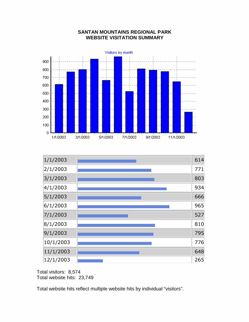
SANTAN MOUNTAINS REGIONAL PARK WEBSITE VISITATION SUMMARY
��������� � ����
��������� � ��
��������� � ���
��������� � ����
��������� � ����
��������� � ����
�������� � ���
�������� � ���
��������� � ���
���������� � ��
���������� � ���
���������� � ���� Total visitors: 8,574 Total website hits: 23,749 Total website hits reflect multiple website hits by individual “visitors”.

Page 1 of 5
Welcome to the San Tan Mountains Regional Park Master Plan website. This website has beendeveloped to inform the community of the master planning process and receive feedback on the
project.
Maricopa County Parks and Recreation Department is updating the master plan for the San TanMountains Regional Park. This 1O, 198-acre park is located south of Hunt Highway and EllsworthRoad near the Town of Queen Creek in Pinal County. The park is managed by Maricopa Countyunder a cooperative agreement with Pinal County and the U.S Department of Interior - Bureau of
land Management (BlM).
The master plan is being updated through a joint effort between Maricopa County, Pinal County,the Cities of Chandler and Mesa, and the Towns of Queen Creek and Gilbert. This interagencycooperation will help to address the needs and concerns of all interested park users.
The links below will take you to the participating agencies' websites:
. MaricQQa Coun~ Parks andRecreation_O~P~D_ment
. .Eio~I.QoYn.t¥
. Q~M~§g
. Ci~ of Chandler
. IQwn_of Gilbe_tl
. I Q~n of Queen Creek
The public will be informed of current activities in the planning process through this website, publicopen houses, newsletters, and news releases in local newspapers.
The project team, including the Joint Planning Committee, Stakeholder Advisory Group,and the public has identified a vision statement for the park.
The vision for the San Tan Mountains Regional Park is to provide recreational and educationalopportunities appropriate for a Sonoran Desert mountain park setting, while rehabilitating,protecting, and responding to the unique natural and cultural resources of the park.
Goals and Objectives
Recreation:1.Provide opportunities for a variety of users2.Accommodate regional needs that surpass what is provided locally3.Connect to regional and local trail systems and parks4.Support self-sufficiency of park development, operation, and maintenance over time, to theextent possible
Education:5.Celebrate unique features of the park6.Provide interpretation of natural and cultural resources
Protection:
1'}jll/03http://www.santanpark.net/main.htm

Page 2 of 5San Tan Mountains Regional Park Master Plan
7. Provide opportunities for continued community stewardship of park8. Minimize habitat fragmentation and provide wildlife corridor linkages9. Preserve the archaeological, historical, and traditional cultural areas10. Preserve the visual character and setting of the park
Rehabilitation:11. Identify disturbed areas for reclamation12. Utilize disturbed areas to the extent possible for new facilities
Newsletters and Maps
NEW!
The trail planning team for Maricopa County Parks and Recreation Department has begun theprocess of developing a specific trail plan for the San Tan Mountains Regional Park. The trailsshown in the master plan will be conceptual corridors only. The County needs your help todetermine where specific trails should be. Please take a few moments to review the "Trail Packerdocument, which includes a summary of the trail planning effort, a definition of County traildesignations, a comment form, and a list of example topics to comment on. The trail plan map hasbeen provided to assist you with making comments. It is very helpful to the trail planning team ifyou mark trail suggestions or concerns on the map and return it with your comment form.
I!_aj!~I§!J Pagk~tand Qommeol£Qrm (pdf215kb)Trail Plan Mag (pdt 455kb)
Project Ne~~1~4-1_~-YgY$tgQQ3 (pdf 533kb)CoDceptu~_Master Plan Alt~rnatives__M§P1-JuDe 2003 (pdf 1892kb)
Comment Form for Conceptual Master..f?@o Alternatives Map. June 20~~(pdf366kb)
Er.Qject NewsletterJrJJ_Yne:~QQ$ (pdf 2397kb)
Project Newslettert2...8prjl~Q3 (pdf1152kb)
Project Newsletter#j,-_.L~nu§!y 2003 (pdf2529kb)
Newsletter--.tt1 Comment Form (pdf 9O7kb)
1"._~nd~e:_r~_hjpJ.!laQ (pdf 2102kb)
Aerial View M.aQ (pdf 1688kb)
(If you are unable to open these documents, you can download free software by clicking on the following link: ~Adobe Acrobat Reader)
Planning Process and Schedule
12111/03http://www.santanpark.net/main.htm

San Tan Mountains Regional Park Master Plan Page 3 of 5
The project was initiated in late November 2002 and is anticipated to be completed by early 2004.Since a majority of the land in the park is owned by the BLM, a comprehensive environmentalassessment (EA) will be prepared in conjunction with the master plan. The EA will be preparedaccording to the National Environmental Policy Act (NEPA) regulations and guidelines, and will beavailable for public review and comment later in the process.
Currently, the project team is completing the master plan document for the park. The preferredmaster plan was developed by considering public comment on the three conceptual alternativesthat were presented at the June public open house and was further refined following theSeptember open houses. The preferred master plan has also been evaluated in relation to othercriteria such as potential site disturbance, operation and maintenance issues, and whether thealternative meets the vision and goals and objectives for the park. The following is an overview ofthe major project milestones with the current project task highlighted. The planning processincludes opportunities for public review and comment at each major step of the project.
late November 2002February 2003April 2003June 2003August 2003Jan/Feb 2004
Project Start-UpScopingData Inventory and AnalysisMaster Plan DevelopmentPreferred Master PlanFinal Master Plan and EA
Open House Meetings
Five open house meetings were conducted during the project. The first open house was held onFebruary 11 , 2003 at the Queen Creek Elementary School. Sixty-five people attended this openhouse to review informational displays, speak to project team members, and submit comments onthe project. Attendees also had the opportunity to note on park maps areas of special interest orconcern. The second open house was held on April 17, 2003 at the Hull Elementary School inChandler. Fifty-two people attended this open house to review information on park resources(biology, cultural resources, geology/soils, etc.) and recreation activities or features (such as picnicareas, camping, riding stables) that were recommended for further study or elimination from themaster plan. The project team asked for comments on the San Tan Park vision statement, goalsand objectives, and recreation activities. Most of the comments received supported the goals forthe park, which are listed above.
The third open house meeting was held June 19, 2003 at the Red Mountain MultigenerationalCenter in Mesa and was attended by 90 people. Three conceptual master plan alternatives werepresented at this open house for public comment. The public also provided comments on whichgoals they felt were most important for the park, which amenities they felt should be developedfirst, and if Brenner Pass Road (north of Judd Road) should be closed through the park.
The fourth and fifth open houses were held on September 4, 2003 in Gilbert and September 18 inQueen Creek. The topic of these open houses was the preferred master plan alternative.Comments received at these open houses generally supported the preferred master plan, andhelped the project team to refine the preferred master plan alternative before presenting it to the
http:!!www.santanpark.netlmain.htrn 1'1111/03

Page 4 of 5San Tan Mountains Regional Park Master Plan
Maricopa County Parks and Recreation Commission on November 18.
Comments/Mailing List
We welcome your comments on the project and encourage you to sign up on the project mailinglist. Please indicate whether you would like to receive project information via US mail or email.Please fill out the form below and hit submit to send.
I ,.;;.L :ZJHow would you like to receive project information?
Name:
Email address:
Street Address:
~
State:
I " c.l
Comment:
Contact Information
For more information on the project please contact us:
Lyndy Long, Public Involvement Specialist
12/11/03

Page 5 of 5San Tan Mountains Regional Park Master Plan
EPG, Inc.4350 E. Camelback RoadSuite G200Phoenix, Arizona 85018Phone: (602) 383-2594Email: [email protected]
Website administrator: EPG, Inc.
12/11/03http://www.santanpark.netlmain.htrn

Do you wish to remain on the project mailing list to receive project updates and open houseannouncements? If so, please complete the following information and mail this commentform to: EPG c/o Lyndy Long, 4350 E. Camelback Road, Suite G200, Phoenix, AZ, 85018, orsubmit your request through the project website, www.santanpark.net, or our phone line,(602) 383-2594. Please indicate which mailing list you prefer: email or U.S. mail. Only thosewho return this form or contact us will remain on the project mailing list.
I want to receive project updates through the: ___ US Postal Service ___ Email
Name _ _ _ _ _ _ _ _ _ _ _ _ _ _ _ _ _ _ _ _ _ _ _ _ _ _ _ _ _ _ _ _ _ _ _ _ _ _ _ _ _ _ _ _ _ _ _ _ _ _ _ _ _ _ _ _ _ _ _ _ _ _ _ _ _ _ _ _ _ _ _ _ _ _ _ _ _ _ _ _ _ _ _ _ _ _ _ _ _ _ _ _ _ _ _ _ _ _ _ _ _ _ _ _ _ _ _ _ _ _ _ _ _ _ _ _ _ _ _ _ _ _ _ _ _ _ _ _ _ _ _ _ _ _ _ _ _ _ _ _ _ _ _ _ _ _ _ _ _ _ _ _ _ _ _ _ _ _ _ _ _ _ _ _ _ _ _ _ _ _ _ _ _ _ _ _ _ _ _ _ _ _ _ _ _ _ _ _ _ _ _ _ _ _ _ _ _ _ _ _ _ _ _ _ _ _ _ _ _ _ _ _ _ _ _ _ _ _ _ _ _ _ _ _ _ _ _ _ _ _ _ _ _ _ _ _ _ _ _ _ _ _ _ _ _ _ _ _ _ _ _ _ _ _ _ _ _ _ _ _ _ _ _ _ _ _ _ _ _ _ _ _ _ _ _ _ _ _ _ _ _ _ _ _ _ _ _ _ _ _ _ _ _ _ _ _ _ _ _ _ _ _ _ _ _ _ _ _ _ _ _ _ _ _ _ _ _ _ _ _ _ _ _ _ _ _ _ _ _ _ _ _ _ _ _ _ _ _ _ _ _ _ _ _ _ _ _ _ _ _ _ _ _ _ _ _ _ _ _ _ _ _ _ _ _ _ _ _ _ _ _ _ _ _ _ _ _ _ _ _ _ _ _ _ _ _ _ _ _ _ _ _ _ _ _ _ _
Address _ _ _ _ _ _ _ _ _ _ _ _ _ _ _ _ _ _ _ _ _ _ _ _ _ _ _ _ _ _ _ _ _ _ _ _ _ _ _ _ _ _ _ _ _ _ _ _ _ _ _ _ _ _ _ _ _ _ _ _ _ _ _ _ _ _ _ _ _ _ _ _ _ _ _ _ _ _ _ _ _ _ _ _ _ _ _ _ _ _ _ _ _ _ _ _ _ _ _ _ _ _ _ _ _ _ _ _ _ _ _ _ _ _ _ _ _ _ _ _ _ _ _ _ _ _ _ _ _ _ _ _ _ _ _ _ _ _ _ _ _ _ _ _ _ _ _ _ _ _ _ _ _ _ _ _ _ _ _ _ _ _ _ _ _ _ _ _ _ _ _ _ _ _ _ _ _ _ _ _ _ _ _ _ _ _ _ _ _ _ _ _ _ _ _ _ _ _ _ _ _ _ _ _ _ _ _ _ _ _ _ _ _ _ _ _ _ _ _ _ _ _ _ _ _ _ _ _ _ _ _ _ _ _ _ _ _ _ _ _ _ _ _ _ _ _ _ _ _ _ _ _ _ _ _ _ _ _ _ _ _ _ _ _ _ _ _ _ _ _ _ _ _ _ _ _ _ _ _ _ _ _ _ _ _ _ _ _ _ _ _ _ _ _ _ _ _ _ _ _ _ _ _ _ _ _ _ _ _ _ _ _ _ _ _ _ _ _ _ _ _ _ _ _ _ _ _ _ _ _ _ _ _ _ _ _ _ _ _ _ _ _ _ _ _ _ _ _ _ _ _ _ _ _ _ _ _ _ _ _ _ _ _ _ _ _ _ _ _ _ _ _ _ _ _ _ _ _ _ _ _ _ _ _ _ _ _ _ _ _ _
City, Zip _ _ _ _ _ _ _ _ _ _ _ _ _ _ _ _ _ _ _ _ _ _ _ _ _ _ _ _ _ _ _ _ _ _ _ _ _ _ _ _ _ _ _ _ _ _ _ _ _ _ _ _ _ _ _ _ _ _ _ _ _ _ _ _ _ _ _ _ _ _ _ _ _ _ _ _ _ _ _ _ _ _ _ _ _ _ _ _ _ _ _ _ _ _ _ _ _ _ _ _ _ _ _ _ _ _ _ _ _ _ _ _ _ _ _ _ _ _ _ _ _ _ _ _ _ _ _ _ _ _ _ _ _ _ _ _ _ _ _ _ _ _ _ _ _ _ _ _ _ _ _ _ _ _ _ _ _ _ _ _ _ _ _ _ _ _ _ _ _ _ _ _ _ _ _ _ _ _ _ _ _ _ _ _ _ _ _ _ _ _ _ _ _ _ _ _ _ _ _ _ _ _ _ _ _ _ _ _ _ _ _ _ _ _ _ _ _ _ _ _ _ _ _ _ _ _ _ _ _ _ _ _ _ _ _ _ _ _ _ _ _ _ _ _ _ _ _ _ _ _ _ _ _ _ _ _ _ _ _ _ _ _ _ _ _ _ _ _ _ _ _ _ _ _ _ _ _ _ _ _ _ _ _ _ _ _ _ _ _ _ _ _ _ _ _ _ _ _ _ _ _ _ _ _ _ _ _ _ _ _ _ _ _ _ _ _ _ _ _ _ _ _ _ _ _ _ _ _ _ _ _ _ _ _ _ _ _ _ _ _ _ _ _ _ _ _ _ _ _ _ _ _ _ _ _ _ _ _ _ _ _ _ _ _ _ _ _ _ _ _ _ _ _ _ _ _ _ _ _ _ _ _ _ _ _ _
Email _ _ _ _ _ _ _ _ _ _ _ _ _ _ _ _ _ _ _ _ _ _ _ _ _ _ _ _ _ _ _ _ _ _ _ _ _ _ _ _ _ _ _ _ _ _ _ _ _ _ _ _ _ _ _ _ _ _ _ _ _ _ _ _ _ _ _ _ _ _ _ _ _ _ _ _ _ _ _ _ _ _ _ _ _ _ _ _ _ _ _ _ _ _ _ _ _ _ _ _ _ _ _ _ _ _ _ _ _ _ _ _ _ _ _ _ _ _ _ _ _ _ _ _ _ _ _ _ _ _ _ _ _ _ _ _ _ _ _ _ _ _ _ _ _ _ _ _ _ _ _ _ _ _ _ _ _ _ _ _ _ _ _ _ _ _ _ _ _ _ _ _ _ _ _ _ _ _ _ _ _ _ _ _ _ _ _ _ _ _ _ _ _ _ _ _ _ _ _ _ _ _ _ _ _ _ _ _ _ _ _ _ _ _ _ _ _ _ _ _ _ _ _ _ _ _ _ _ _ _ _ _ _ _ _ _ _ _ _ _ _ _ _ _ _ _ _ _ _ _ _ _ _ _ _ _ _ _ _ _ _ _ _ _ _ _ _ _ _ _ _ _ _ _ _ _ _ _ _ _ _ _ _ _ _ _ _ _ _ _ _ _ _ _ _ _ _ _ _ _ _ _ _ _ _ _ _ _ _ _ _ _ _ _ _ _ _ _ _ _ _ _ _ _ _ _ _ _ _ _ _ _ _ _ _ _ _ _ _ _ _ _ _ _ _ _ _ _ _ _ _ _ _ _ _ _ _ _ _ _ _ _ _ _ _ _ _ _ _ _ _ _ _ _ _ _ _ _ _ _ _ _ _ _ _ _ _ _ _ _ _ _ _ _ _ _ _ _ _ _(Note, please write clearly so we can record your information accurately. Thank you!)
We want to know what you think about the future development of the San Tan Mountains Regional Park. Please take afew moments to respond to these questions and return the form. Don’t forget to complete the mailing list informationabove if you wish to receive future project information.
What recreation opportunities do you think the San Tan Mountains Regional Park should provide and why?
_ _ _ _ _ _ _ _ _ _ _ _ _ _ _ _ _ _ _ _ _ _ _ _ _ _ _ _ _ _ _ _ _ _ _ _ _ _ _ _ _ _ _ _ _ _ _ _ _ _ _ _ _ _ _ _ _ _ _ _ _ _ _ _ _ _ _ _ _ _ _ _ _ _ _ _ _ _ _ _ _ _ _ _ _ _ _ _ _ _ _ _ _ _ _ _ _ _ _ _ _ _ _ _ _ _ _ _ _ _ _ _ _ _ _ _ _ _ _ _ _ _ _ _ _ _ _ _ _ _ _ _ _ _ _ _ _ _ _ _ _ _ _ _ _ _ _ _ _ _ _ _ _ _ _ _ _ _ _ _ _ _ _ _ _ _ _ _ _ _ _ _ _ _ _ _ _ _ _ _ _ _ _ _ _ _ _ _ _ _ _ _ _ _ _ _ _ _ _ _ _ _ _ _ _ _ _ _ _ _ _ _ _ _ _ _ _ _ _ _ _ _ _ _ _ _ _ _ _ _ _ _ _ _ _ _ _ _ _ _ _ _ _ _ _ _ _ _ _ _ _ _ _ _ _ _ _ _ _ _ _ _ _ _ _ _ _ _ _ _ _ _ _ _ _ _ _ _ _ _ _ _ _ _ _ _ _ _ _ _ _ _ _ _ _ _ _ _ _ _ _ _ _ _ _ _ _ _ _ _ _ _ _ _ _ _ _ _ _ _ _ _ _ _ _ _ _ _ _ _ _ _ _ _ _ _ _ _ _ _ _ _ _ _ _ _ _ _ _ _ _ _ _ _ _ _ _ _ _ _ _ _ _ _ _ _ _ _ _ _ _ _ _ _ _ _ _ _ _ _ _ _ _ _ _ _ _ _ _ _ _ _ _ _ _ _ _ _ _ _ _ _ _ _ _ _ _ _ _ _ _ _ _ _ _ _ _ _ _ _ _
_ _ _ _ _ _ _ _ _ _ _ _ _ _ _ _ _ _ _ _ _ _ _ _ _ _ _ _ _ _ _ _ _ _ _ _ _ _ _ _ _ _ _ _ _ _ _ _ _ _ _ _ _ _ _ _ _ _ _ _ _ _ _ _ _ _ _ _ _ _ _ _ _ _ _ _ _ _ _ _ _ _ _ _ _ _ _ _ _ _ _ _ _ _ _ _ _ _ _ _ _ _ _ _ _ _ _ _ _ _ _ _ _ _ _ _ _ _ _ _ _ _ _ _ _ _ _ _ _ _ _ _ _ _ _ _ _ _ _ _ _ _ _ _ _ _ _ _ _ _ _ _ _ _ _ _ _ _ _ _ _ _ _ _ _ _ _ _ _ _ _ _ _ _ _ _ _ _ _ _ _ _ _ _ _ _ _ _ _ _ _ _ _ _ _ _ _ _ _ _ _ _ _ _ _ _ _ _ _ _ _ _ _ _ _ _ _ _ _ _ _ _ _ _ _ _ _ _ _ _ _ _ _ _ _ _ _ _ _ _ _ _ _ _ _ _ _ _ _ _ _ _ _ _ _ _ _ _ _ _ _ _ _ _ _ _ _ _ _ _ _ _ _ _ _ _ _ _ _ _ _ _ _ _ _ _ _ _ _ _ _ _ _ _ _ _ _ _ _ _ _ _ _ _ _ _ _ _ _ _ _ _ _ _ _ _ _ _ _ _ _ _ _ _ _ _ _ _ _ _ _ _ _ _ _ _ _ _ _ _ _ _ _ _ _ _ _ _ _ _ _ _ _ _ _ _ _ _ _ _ _ _ _ _ _ _ _ _ _ _ _ _ _ _ _ _ _ _ _ _ _ _ _ _ _ _ _ _ _ _ _ _ _ _ _ _ _ _ _ _ _ _ _ _ _ _ _ _ _ _ _ _ _ _ _ _ _ _ _ _ _
_ _ _ _ _ _ _ _ _ _ _ _ _ _ _ _ _ _ _ _ _ _ _ _ _ _ _ _ _ _ _ _ _ _ _ _ _ _ _ _ _ _ _ _ _ _ _ _ _ _ _ _ _ _ _ _ _ _ _ _ _ _ _ _ _ _ _ _ _ _ _ _ _ _ _ _ _ _ _ _ _ _ _ _ _ _ _ _ _ _ _ _ _ _ _ _ _ _ _ _ _ _ _ _ _ _ _ _ _ _ _ _ _ _ _ _ _ _ _ _ _ _ _ _ _ _ _ _ _ _ _ _ _ _ _ _ _ _ _ _ _ _ _ _ _ _ _ _ _ _ _ _ _ _ _ _ _ _ _ _ _ _ _ _ _ _ _ _ _ _ _ _ _ _ _ _ _ _ _ _ _ _ _ _ _ _ _ _ _ _ _ _ _ _ _ _ _ _ _ _ _ _ _ _ _ _ _ _ _ _ _ _ _ _ _ _ _ _ _ _ _ _ _ _ _ _ _ _ _ _ _ _ _ _ _ _ _ _ _ _ _ _ _ _ _ _ _ _ _ _ _ _ _ _ _ _ _ _ _ _ _ _ _ _ _ _ _ _ _ _ _ _ _ _ _ _ _ _ _ _ _ _ _ _ _ _ _ _ _ _ _ _ _ _ _ _ _ _ _ _ _ _ _ _ _ _ _ _ _ _ _ _ _ _ _ _ _ _ _ _ _ _ _ _ _ _ _ _ _ _ _ _ _ _ _ _ _ _ _ _ _ _ _ _ _ _ _ _ _ _ _ _ _ _ _ _ _ _ _ _ _ _ _ _ _ _ _ _ _ _ _ _ _ _ _ _ _ _ _ _ _ _ _ _ _ _ _ _ _ _ _ _ _ _ _ _ _ _ _ _ _ _ _ _ _ _ _ _ _ _ _ _ _ _ _ _ _ _ _ _ _
_ _ _ _ _ _ _ _ _ _ _ _ _ _ _ _ _ _ _ _ _ _ _ _ _ _ _ _ _ _ _ _ _ _ _ _ _ _ _ _ _ _ _ _ _ _ _ _ _ _ _ _ _ _ _ _ _ _ _ _ _ _ _ _ _ _ _ _ _ _ _ _ _ _ _ _ _ _ _ _ _ _ _ _ _ _ _ _ _ _ _ _ _ _ _ _ _ _ _ _ _ _ _ _ _ _ _ _ _ _ _ _ _ _ _ _ _ _ _ _ _ _ _ _ _ _ _ _ _ _ _ _ _ _ _ _ _ _ _ _ _ _ _ _ _ _ _ _ _ _ _ _ _ _ _ _ _ _ _ _ _ _ _ _ _ _ _ _ _ _ _ _ _ _ _ _ _ _ _ _ _ _ _ _ _ _ _ _ _ _ _ _ _ _ _ _ _ _ _ _ _ _ _ _ _ _ _ _ _ _ _ _ _ _ _ _ _ _ _ _ _ _ _ _ _ _ _ _ _ _ _ _ _ _ _ _ _ _ _ _ _ _ _ _ _ _ _ _ _ _ _ _ _ _ _ _ _ _ _ _ _ _ _ _ _ _ _ _ _ _ _ _ _ _ _ _ _ _ _ _ _ _ _ _ _ _ _ _ _ _ _ _ _ _ _ _ _ _ _ _ _ _ _ _ _ _ _ _ _ _ _ _ _ _ _ _ _ _ _ _ _ _ _ _ _ _ _ _ _ _ _ _ _ _ _ _ _ _ _ _ _ _ _ _ _ _ _ _ _ _ _ _ _ _ _ _ _ _ _ _ _ _ _ _ _ _ _ _ _ _ _ _ _ _ _ _ _ _ _ _ _ _ _ _ _ _ _ _ _ _ _ _ _ _ _ _ _ _ _ _ _ _ _ _ _ _ _ _ _ _ _ _ _ _ _ _ _ _ _ _ _
What recreation opportunities do you feel should NOT BE allowed in the San Tan Mountains Regional Park and why?
_ _ _ _ _ _ _ _ _ _ _ _ _ _ _ _ _ _ _ _ _ _ _ _ _ _ _ _ _ _ _ _ _ _ _ _ _ _ _ _ _ _ _ _ _ _ _ _ _ _ _ _ _ _ _ _ _ _ _ _ _ _ _ _ _ _ _ _ _ _ _ _ _ _ _ _ _ _ _ _ _ _ _ _ _ _ _ _ _ _ _ _ _ _ _ _ _ _ _ _ _ _ _ _ _ _ _ _ _ _ _ _ _ _ _ _ _ _ _ _ _ _ _ _ _ _ _ _ _ _ _ _ _ _ _ _ _ _ _ _ _ _ _ _ _ _ _ _ _ _ _ _ _ _ _ _ _ _ _ _ _ _ _ _ _ _ _ _ _ _ _ _ _ _ _ _ _ _ _ _ _ _ _ _ _ _ _ _ _ _ _ _ _ _ _ _ _ _ _ _ _ _ _ _ _ _ _ _ _ _ _ _ _ _ _ _ _ _ _ _ _ _ _ _ _ _ _ _ _ _ _ _ _ _ _ _ _ _ _ _ _ _ _ _ _ _ _ _ _ _ _ _ _ _ _ _ _ _ _ _ _ _ _ _ _ _ _ _ _ _ _ _ _ _ _ _ _ _ _ _ _ _ _ _ _ _ _ _ _ _ _ _ _ _ _ _ _ _ _ _ _ _ _ _ _ _ _ _ _ _ _ _ _ _ _ _ _ _ _ _ _ _ _ _ _ _ _ _ _ _ _ _ _ _ _ _ _ _ _ _ _ _ _ _ _ _ _ _ _ _ _ _ _ _ _ _ _ _ _ _ _ _ _ _ _ _ _ _ _ _ _ _ _ _ _ _ _ _ _ _ _ _ _ _ _ _ _ _ _ _ _ _ _ _ _ _ _ _ _ _ _ _ _ _ _ _ _ _ _ _ _ _ _ _ _ _ _ _ _ _ _
_ _ _ _ _ _ _ _ _ _ _ _ _ _ _ _ _ _ _ _ _ _ _ _ _ _ _ _ _ _ _ _ _ _ _ _ _ _ _ _ _ _ _ _ _ _ _ _ _ _ _ _ _ _ _ _ _ _ _ _ _ _ _ _ _ _ _ _ _ _ _ _ _ _ _ _ _ _ _ _ _ _ _ _ _ _ _ _ _ _ _ _ _ _ _ _ _ _ _ _ _ _ _ _ _ _ _ _ _ _ _ _ _ _ _ _ _ _ _ _ _ _ _ _ _ _ _ _ _ _ _ _ _ _ _ _ _ _ _ _ _ _ _ _ _ _ _ _ _ _ _ _ _ _ _ _ _ _ _ _ _ _ _ _ _ _ _ _ _ _ _ _ _ _ _ _ _ _ _ _ _ _ _ _ _ _ _ _ _ _ _ _ _ _ _ _ _ _ _ _ _ _ _ _ _ _ _ _ _ _ _ _ _ _ _ _ _ _ _ _ _ _ _ _ _ _ _ _ _ _ _ _ _ _ _ _ _ _ _ _ _ _ _ _ _ _ _ _ _ _ _ _ _ _ _ _ _ _ _ _ _ _ _ _ _ _ _ _ _ _ _ _ _ _ _ _ _ _ _ _ _ _ _ _ _ _ _ _ _ _ _ _ _ _ _ _ _ _ _ _ _ _ _ _ _ _ _ _ _ _ _ _ _ _ _ _ _ _ _ _ _ _ _ _ _ _ _ _ _ _ _ _ _ _ _ _ _ _ _ _ _ _ _ _ _ _ _ _ _ _ _ _ _ _ _ _ _ _ _ _ _ _ _ _ _ _ _ _ _ _ _ _ _ _ _ _ _ _ _ _ _ _ _ _ _ _ _ _ _ _ _ _ _ _ _ _ _ _ _ _ _ _ _ _ _ _ _ _ _ _ _ _ _ _ _ _ _ _ _ _ _
_ _ _ _ _ _ _ _ _ _ _ _ _ _ _ _ _ _ _ _ _ _ _ _ _ _ _ _ _ _ _ _ _ _ _ _ _ _ _ _ _ _ _ _ _ _ _ _ _ _ _ _ _ _ _ _ _ _ _ _ _ _ _ _ _ _ _ _ _ _ _ _ _ _ _ _ _ _ _ _ _ _ _ _ _ _ _ _ _ _ _ _ _ _ _ _ _ _ _ _ _ _ _ _ _ _ _ _ _ _ _ _ _ _ _ _ _ _ _ _ _ _ _ _ _ _ _ _ _ _ _ _ _ _ _ _ _ _ _ _ _ _ _ _ _ _ _ _ _ _ _ _ _ _ _ _ _ _ _ _ _ _ _ _ _ _ _ _ _ _ _ _ _ _ _ _ _ _ _ _ _ _ _ _ _ _ _ _ _ _ _ _ _ _ _ _ _ _ _ _ _ _ _ _ _ _ _ _ _ _ _ _ _ _ _ _ _ _ _ _ _ _ _ _ _ _ _ _ _ _ _ _ _ _ _ _ _ _ _ _ _ _ _ _ _ _ _ _ _ _ _ _ _ _ _ _ _ _ _ _ _ _ _ _ _ _ _ _ _ _ _ _ _ _ _ _ _ _ _ _ _ _ _ _ _ _ _ _ _ _ _ _ _ _ _ _ _ _ _ _ _ _ _ _ _ _ _ _ _ _ _ _ _ _ _ _ _ _ _ _ _ _ _ _ _ _ _ _ _ _ _ _ _ _ _ _ _ _ _ _ _ _ _ _ _ _ _ _ _ _ _ _ _ _ _ _ _ _ _ _ _ _ _ _ _ _ _ _ _ _ _ _ _ _ _ _ _ _ _ _ _ _ _ _ _ _ _ _ _ _ _ _ _ _ _ _ _ _ _ _ _ _ _ _ _ _ _ _ _ _ _ _ _ _ _ _ _ _ _ _ _
_ _ _ _ _ _ _ _ _ _ _ _ _ _ _ _ _ _ _ _ _ _ _ _ _ _ _ _ _ _ _ _ _ _ _ _ _ _ _ _ _ _ _ _ _ _ _ _ _ _ _ _ _ _ _ _ _ _ _ _ _ _ _ _ _ _ _ _ _ _ _ _ _ _ _ _ _ _ _ _ _ _ _ _ _ _ _ _ _ _ _ _ _ _ _ _ _ _ _ _ _ _ _ _ _ _ _ _ _ _ _ _ _ _ _ _ _ _ _ _ _ _ _ _ _ _ _ _ _ _ _ _ _ _ _ _ _ _ _ _ _ _ _ _ _ _ _ _ _ _ _ _ _ _ _ _ _ _ _ _ _ _ _ _ _ _ _ _ _ _ _ _ _ _ _ _ _ _ _ _ _ _ _ _ _ _ _ _ _ _ _ _ _ _ _ _ _ _ _ _ _ _ _ _ _ _ _ _ _ _ _ _ _ _ _ _ _ _ _ _ _ _ _ _ _ _ _ _ _ _ _ _ _ _ _ _ _ _ _ _ _ _ _ _ _ _ _ _ _ _ _ _ _ _ _ _ _ _ _ _ _ _ _ _ _ _ _ _ _ _ _ _ _ _ _ _ _ _ _ _ _ _ _ _ _ _ _ _ _ _ _ _ _ _ _ _ _ _ _ _ _ _ _ _ _ _ _ _ _ _ _ _ _ _ _ _ _ _ _ _ _ _ _ _ _ _ _ _ _ _ _ _ _ _ _ _ _ _ _ _ _ _ _ _ _ _ _ _ _ _ _ _ _ _ _ _ _ _ _ _ _ _ _ _ _ _ _ _ _ _ _ _ _ _ _ _ _ _ _ _ _ _ _ _ _ _ _ _ _ _ _ _ _ _ _ _ _ _ _ _ _ _ _ _ _ _ _ _ _ _ _ _ _ _ _ _ _ _ _ _ _
What do you think are the key issues associated with the San Tan Mountains Regional Park, and what should be the overall
goal for the master plan?
_ _ _ _ _ _ _ _ _ _ _ _ _ _ _ _ _ _ _ _ _ _ _ _ _ _ _ _ _ _ _ _ _ _ _ _ _ _ _ _ _ _ _ _ _ _ _ _ _ _ _ _ _ _ _ _ _ _ _ _ _ _ _ _ _ _ _ _ _ _ _ _ _ _ _ _ _ _ _ _ _ _ _ _ _ _ _ _ _ _ _ _ _ _ _ _ _ _ _ _ _ _ _ _ _ _ _ _ _ _ _ _ _ _ _ _ _ _ _ _ _ _ _ _ _ _ _ _ _ _ _ _ _ _ _ _ _ _ _ _ _ _ _ _ _ _ _ _ _ _ _ _ _ _ _ _ _ _ _ _ _ _ _ _ _ _ _ _ _ _ _ _ _ _ _ _ _ _ _ _ _ _ _ _ _ _ _ _ _ _ _ _ _ _ _ _ _ _ _ _ _ _ _ _ _ _ _ _ _ _ _ _ _ _ _ _ _ _ _ _ _ _ _ _ _ _ _ _ _ _ _ _ _ _ _ _ _ _ _ _ _ _ _ _ _ _ _ _ _ _ _ _ _ _ _ _ _ _ _ _ _ _ _ _ _ _ _ _ _ _ _ _ _ _ _ _ _ _ _ _ _ _ _ _ _ _ _ _ _ _ _ _ _ _ _ _ _ _ _ _ _ _ _ _ _ _ _ _ _ _ _ _ _ _ _ _ _ _ _ _ _ _ _ _ _ _ _ _ _ _ _ _ _ _ _ _ _ _ _ _ _ _ _ _ _ _ _ _ _ _ _ _ _ _ _ _ _ _ _ _ _ _ _ _ _ _ _ _ _ _ _ _ _ _ _ _ _ _ _ _ _ _ _ _ _ _ _ _ _ _ _ _ _ _ _ _ _ _ _ _ _ _ _ _ _ _ _ _ _ _ _ _ _ _ _ _ _ _ _ _ _
_ _ _ _ _ _ _ _ _ _ _ _ _ _ _ _ _ _ _ _ _ _ _ _ _ _ _ _ _ _ _ _ _ _ _ _ _ _ _ _ _ _ _ _ _ _ _ _ _ _ _ _ _ _ _ _ _ _ _ _ _ _ _ _ _ _ _ _ _ _ _ _ _ _ _ _ _ _ _ _ _ _ _ _ _ _ _ _ _ _ _ _ _ _ _ _ _ _ _ _ _ _ _ _ _ _ _ _ _ _ _ _ _ _ _ _ _ _ _ _ _ _ _ _ _ _ _ _ _ _ _ _ _ _ _ _ _ _ _ _ _ _ _ _ _ _ _ _ _ _ _ _ _ _ _ _ _ _ _ _ _ _ _ _ _ _ _ _ _ _ _ _ _ _ _ _ _ _ _ _ _ _ _ _ _ _ _ _ _ _ _ _ _ _ _ _ _ _ _ _ _ _ _ _ _ _ _ _ _ _ _ _ _ _ _ _ _ _ _ _ _ _ _ _ _ _ _ _ _ _ _ _ _ _ _ _ _ _ _ _ _ _ _ _ _ _ _ _ _ _ _ _ _ _ _ _ _ _ _ _ _ _ _ _ _ _ _ _ _ _ _ _ _ _ _ _ _ _ _ _ _ _ _ _ _ _ _ _ _ _ _ _ _ _ _ _ _ _ _ _ _ _ _ _ _ _ _ _ _ _ _ _ _ _ _ _ _ _ _ _ _ _ _ _ _ _ _ _ _ _ _ _ _ _ _ _ _ _ _ _ _ _ _ _ _ _ _ _ _ _ _ _ _ _ _ _ _ _ _ _ _ _ _ _ _ _ _ _ _ _ _ _ _ _ _ _ _ _ _ _ _ _ _ _ _ _ _ _ _ _ _ _ _ _ _ _ _ _ _ _ _ _ _ _ _ _ _ _ _ _ _ _ _ _ _ _ _ _ _ _ _
_ _ _ _ _ _ _ _ _ _ _ _ _ _ _ _ _ _ _ _ _ _ _ _ _ _ _ _ _ _ _ _ _ _ _ _ _ _ _ _ _ _ _ _ _ _ _ _ _ _ _ _ _ _ _ _ _ _ _ _ _ _ _ _ _ _ _ _ _ _ _ _ _ _ _ _ _ _ _ _ _ _ _ _ _ _ _ _ _ _ _ _ _ _ _ _ _ _ _ _ _ _ _ _ _ _ _ _ _ _ _ _ _ _ _ _ _ _ _ _ _ _ _ _ _ _ _ _ _ _ _ _ _ _ _ _ _ _ _ _ _ _ _ _ _ _ _ _ _ _ _ _ _ _ _ _ _ _ _ _ _ _ _ _ _ _ _ _ _ _ _ _ _ _ _ _ _ _ _ _ _ _ _ _ _ _ _ _ _ _ _ _ _ _ _ _ _ _ _ _ _ _ _ _ _ _ _ _ _ _ _ _ _ _ _ _ _ _ _ _ _ _ _ _ _ _ _ _ _ _ _ _ _ _ _ _ _ _ _ _ _ _ _ _ _ _ _ _ _ _ _ _ _ _ _ _ _ _ _ _ _ _ _ _ _ _ _ _ _ _ _ _ _ _ _ _ _ _ _ _ _ _ _ _ _ _ _ _ _ _ _ _ _ _ _ _ _ _ _ _ _ _ _ _ _ _ _ _ _ _ _ _ _ _ _ _ _ _ _ _ _ _ _ _ _ _ _ _ _ _ _ _ _ _ _ _ _ _ _ _ _ _ _ _ _ _ _ _ _ _ _ _ _ _ _ _ _ _ _ _ _ _ _ _ _ _ _ _ _ _ _ _ _ _ _ _ _ _ _ _ _ _ _ _ _ _ _ _ _ _ _ _ _ _ _ _ _ _ _ _ _ _ _ _ _ _ _ _ _ _ _ _ _ _ _ _ _ _ _ _ _
_ _ _ _ _ _ _ _ _ _ _ _ _ _ _ _ _ _ _ _ _ _ _ _ _ _ _ _ _ _ _ _ _ _ _ _ _ _ _ _ _ _ _ _ _ _ _ _ _ _ _ _ _ _ _ _ _ _ _ _ _ _ _ _ _ _ _ _ _ _ _ _ _ _ _ _ _ _ _ _ _ _ _ _ _ _ _ _ _ _ _ _ _ _ _ _ _ _ _ _ _ _ _ _ _ _ _ _ _ _ _ _ _ _ _ _ _ _ _ _ _ _ _ _ _ _ _ _ _ _ _ _ _ _ _ _ _ _ _ _ _ _ _ _ _ _ _ _ _ _ _ _ _ _ _ _ _ _ _ _ _ _ _ _ _ _ _ _ _ _ _ _ _ _ _ _ _ _ _ _ _ _ _ _ _ _ _ _ _ _ _ _ _ _ _ _ _ _ _ _ _ _ _ _ _ _ _ _ _ _ _ _ _ _ _ _ _ _ _ _ _ _ _ _ _ _ _ _ _ _ _ _ _ _ _ _ _ _ _ _ _ _ _ _ _ _ _ _ _ _ _ _ _ _ _ _ _ _ _ _ _ _ _ _ _ _ _ _ _ _ _ _ _ _ _ _ _ _ _ _ _ _ _ _ _ _ _ _ _ _ _ _ _ _ _ _ _ _ _ _ _ _ _ _ _ _ _ _ _ _ _ _ _ _ _ _ _ _ _ _ _ _ _ _ _ _ _ _ _ _ _ _ _ _ _ _ _ _ _ _ _ _ _ _ _ _ _ _ _ _ _ _ _ _ _ _ _ _ _ _ _ _ _ _ _ _ _ _ _ _ _ _ _ _ _ _ _ _ _ _ _ _ _ _ _ _ _ _ _ _ _ _ _ _ _ _ _ _ _ _ _ _ _ _ _ _ _ _ _ _ _ _ _ _ _ _ _ _ _ _ _
Have you (or a family member) visited San Tan Mountains Regional Park? If so, please tell us about the experience.
_ _ _ _ _ _ _ _ _ _ _ _ _ _ _ _ _ _ _ _ _ _ _ _ _ _ _ _ _ _ _ _ _ _ _ _ _ _ _ _ _ _ _ _ _ _ _ _ _ _ _ _ _ _ _ _ _ _ _ _ _ _ _ _ _ _ _ _ _ _ _ _ _ _ _ _ _ _ _ _ _ _ _ _ _ _ _ _ _ _ _ _ _ _ _ _ _ _ _ _ _ _ _ _ _ _ _ _ _ _ _ _ _ _ _ _ _ _ _ _ _ _ _ _ _ _ _ _ _ _ _ _ _ _ _ _ _ _ _ _ _ _ _ _ _ _ _ _ _ _ _ _ _ _ _ _ _ _ _ _ _ _ _ _ _ _ _ _ _ _ _ _ _ _ _ _ _ _ _ _ _ _ _ _ _ _ _ _ _ _ _ _ _ _ _ _ _ _ _ _ _ _ _ _ _ _ _ _ _ _ _ _ _ _ _ _ _ _ _ _ _ _ _ _ _ _ _ _ _ _ _ _ _ _ _ _ _ _ _ _ _ _ _ _ _ _ _ _ _ _ _ _ _ _ _ _ _ _ _ _ _ _ _ _ _ _ _ _ _ _ _ _ _ _ _ _ _ _ _ _ _ _ _ _ _ _ _ _ _ _ _ _ _ _ _ _ _ _ _ _ _ _ _ _ _ _ _ _ _ _ _ _ _ _ _ _ _ _ _ _ _ _ _ _ _ _ _ _ _ _ _ _ _ _ _ _ _ _ _ _ _ _ _ _ _ _ _ _ _ _ _ _ _ _ _ _ _ _ _ _ _ _ _ _ _ _ _ _ _ _ _ _ _ _ _ _ _ _ _ _ _ _ _ _ _ _ _ _ _ _ _ _ _ _ _ _ _ _ _ _ _ _ _ _ _ _ _ _ _ _ _ _ _ _ _ _ _ _ _ _ _
_ _ _ _ _ _ _ _ _ _ _ _ _ _ _ _ _ _ _ _ _ _ _ _ _ _ _ _ _ _ _ _ _ _ _ _ _ _ _ _ _ _ _ _ _ _ _ _ _ _ _ _ _ _ _ _ _ _ _ _ _ _ _ _ _ _ _ _ _ _ _ _ _ _ _ _ _ _ _ _ _ _ _ _ _ _ _ _ _ _ _ _ _ _ _ _ _ _ _ _ _ _ _ _ _ _ _ _ _ _ _ _ _ _ _ _ _ _ _ _ _ _ _ _ _ _ _ _ _ _ _ _ _ _ _ _ _ _ _ _ _ _ _ _ _ _ _ _ _ _ _ _ _ _ _ _ _ _ _ _ _ _ _ _ _ _ _ _ _ _ _ _ _ _ _ _ _ _ _ _ _ _ _ _ _ _ _ _ _ _ _ _ _ _ _ _ _ _ _ _ _ _ _ _ _ _ _ _ _ _ _ _ _ _ _ _ _ _ _ _ _ _ _ _ _ _ _ _ _ _ _ _ _ _ _ _ _ _ _ _ _ _ _ _ _ _ _ _ _ _ _ _ _ _ _ _ _ _ _ _ _ _ _ _ _ _ _ _ _ _ _ _ _ _ _ _ _ _ _ _ _ _ _ _ _ _ _ _ _ _ _ _ _ _ _ _ _ _ _ _ _ _ _ _ _ _ _ _ _ _ _ _ _ _ _ _ _ _ _ _ _ _ _ _ _ _ _ _ _ _ _ _ _ _ _ _ _ _ _ _ _ _ _ _ _ _ _ _ _ _ _ _ _ _ _ _ _ _ _ _ _ _ _ _ _ _ _ _ _ _ _ _ _ _ _ _ _ _ _ _ _ _ _ _ _ _ _ _ _ _ _ _ _ _ _ _ _ _ _ _ _ _ _ _ _ _ _ _ _ _ _ _ _ _ _ _ _ _ _ _ _
_ _ _ _ _ _ _ _ _ _ _ _ _ _ _ _ _ _ _ _ _ _ _ _ _ _ _ _ _ _ _ _ _ _ _ _ _ _ _ _ _ _ _ _ _ _ _ _ _ _ _ _ _ _ _ _ _ _ _ _ _ _ _ _ _ _ _ _ _ _ _ _ _ _ _ _ _ _ _ _ _ _ _ _ _ _ _ _ _ _ _ _ _ _ _ _ _ _ _ _ _ _ _ _ _ _ _ _ _ _ _ _ _ _ _ _ _ _ _ _ _ _ _ _ _ _ _ _ _ _ _ _ _ _ _ _ _ _ _ _ _ _ _ _ _ _ _ _ _ _ _ _ _ _ _ _ _ _ _ _ _ _ _ _ _ _ _ _ _ _ _ _ _ _ _ _ _ _ _ _ _ _ _ _ _ _ _ _ _ _ _ _ _ _ _ _ _ _ _ _ _ _ _ _ _ _ _ _ _ _ _ _ _ _ _ _ _ _ _ _ _ _ _ _ _ _ _ _ _ _ _ _ _ _ _ _ _ _ _ _ _ _ _ _ _ _ _ _ _ _ _ _ _ _ _ _ _ _ _ _ _ _ _ _ _ _ _ _ _ _ _ _ _ _ _ _ _ _ _ _ _ _ _ _ _ _ _ _ _ _ _ _ _ _ _ _ _ _ _ _ _ _ _ _ _ _ _ _ _ _ _ _ _ _ _ _ _ _ _ _ _ _ _ _ _ _ _ _ _ _ _ _ _ _ _ _ _ _ _ _ _ _ _ _ _ _ _ _ _ _ _ _ _ _ _ _ _ _ _ _ _ _ _ _ _ _ _ _ _ _ _ _ _ _ _ _ _ _ _ _ _ _ _ _ _ _ _ _ _ _ _ _ _ _ _ _ _ _ _ _ _ _ _ _ _ _ _ _ _ _ _ _ _ _ _ _ _ _ _ _ _
_ _ _ _ _ _ _ _ _ _ _ _ _ _ _ _ _ _ _ _ _ _ _ _ _ _ _ _ _ _ _ _ _ _ _ _ _ _ _ _ _ _ _ _ _ _ _ _ _ _ _ _ _ _ _ _ _ _ _ _ _ _ _ _ _ _ _ _ _ _ _ _ _ _ _ _ _ _ _ _ _ _ _ _ _ _ _ _ _ _ _ _ _ _ _ _ _ _ _ _ _ _ _ _ _ _ _ _ _ _ _ _ _ _ _ _ _ _ _ _ _ _ _ _ _ _ _ _ _ _ _ _ _ _ _ _ _ _ _ _ _ _ _ _ _ _ _ _ _ _ _ _ _ _ _ _ _ _ _ _ _ _ _ _ _ _ _ _ _ _ _ _ _ _ _ _ _ _ _ _ _ _ _ _ _ _ _ _ _ _ _ _ _ _ _ _ _ _ _ _ _ _ _ _ _ _ _ _ _ _ _ _ _ _ _ _ _ _ _ _ _ _ _ _ _ _ _ _ _ _ _ _ _ _ _ _ _ _ _ _ _ _ _ _ _ _ _ _ _ _ _ _ _ _ _ _ _ _ _ _ _ _ _ _ _ _ _ _ _ _ _ _ _ _ _ _ _ _ _ _ _ _ _ _ _ _ _ _ _ _ _ _ _ _ _ _ _ _ _ _ _ _ _ _ _ _ _ _ _ _ _ _ _ _ _ _ _ _ _ _ _ _ _ _ _ _ _ _ _ _ _ _ _ _ _ _ _ _ _ _ _ _ _ _ _ _ _ _ _ _ _ _ _ _ _ _ _ _ _ _ _ _ _ _ _ _ _ _ _ _ _ _ _ _ _ _ _ _ _ _ _ _ _ _ _ _ _ _ _ _ _ _ _ _ _ _ _ _ _ _ _ _ _ _ _ _ _ _ _ _ _ _ _ _ _ _ _ _ _ _ _

O P E N H O U S E # 2 – C O M M E N T F O R MPlease return this comment form to the sign-in table or mail it to: EPG c/o Lyndy Long,4350 E. Camelback Rd., Suite G200, Phoenix, AZ, 85018.
If you are not already on the project mailing list and would like to receive project updates, please fill out the information below:
I want to receive project updates through the: ___ US Postal Service ___ Email
Name _ _ _ _ _ _ _ _ _ _ _ _ _ _ _ _ _ _ _ _ _ _ _ _ _ _ _ _ _ _ _ _ _ _ _ _ _ _ _ _ _ _ _ _ _ _ _ _ _ _ _ _ _ _ _ _ _ _ _ _ _ _ _ _ _ _ _ _ _ _ _ _ _ _ _ _ _ _ _ _ _ _ _ _ _ _ _ _ _ _ _ _ _ _ _ _ _ _ _ _ _ _ _ _ _ _ _ _ _ _ _ _ _ _ _ _ _ _ _ _ _ _ _ _ _ _ _ _ _ _ _ _ _ _ _ _ _ _ _ _ _ _ _ _ _ _ _ _ _ _ _ _ _ _ _ _ _ _ _ _ _ _ _ _ _ _ _ _ _ _ _ _ _ _ _ _ _ _ _ _ _ _ _ _ _ _ _ _ _ _ _ _ _ _ _ _ _ _ _ _ _ _ _ _ _ _ _ _ _ _ _ _ _ _ _ _ _ _ _ _ _ _ _ _ _ _ _ _ _ _ _ _ _ _ _ _ _ _ _ _ _ _ _ _ _ _ _ _ _ _ _ _ _ _ _ _ _ _ _ _ _ _ _ _ _ _ _ _ _ _ _ _ _ _ _ _ _ _ _ _ _ _ _ _ _ _ _ _ _ _ _ _ _ _ _ _ _ _ _ _ _ _ _ _ _ _ _ _ _ _ _ _ _ _ _ _ _ _ _ _ _ _ _ _ _ _ _ _ _ _ _ _ _ _ _ _ _ _ _ _ _ _ _ _ _ _ _ _ _ _ _ _ _ _ _ _ _ _ _ _ _ _ _ _ _ _ _ _ _ _ _ _ _ _ _ _ _ _ _ _ _ _ _ _ _ _ _ _ _ _ _ _ _ _ _ _ _
Address _ _ _ _ _ _ _ _ _ _ _ _ _ _ _ _ _ _ _ _ _ _ _ _ _ _ _ _ _ _ _ _ _ _ _ _ _ _ _ _ _ _ _ _ _ _ _ _ _ _ _ _ _ _ _ _ _ _ _ _ _ _ _ _ _ _ _ _ _ _ _ _ _ _ _ _ _ _ _ _ _ _ _ _ _ _ _ _ _ _ _ _ _ _ _ _ _ _ _ _ _ _ _ _ _ _ _ _ _ _ _ _ _ _ _ _ _ _ _ _ _ _ _ _ _ _ _ _ _ _ _ _ _ _ _ _ _ _ _ _ _ _ _ _ _ _ _ _ _ _ _ _ _ _ _ _ _ _ _ _ _ _ _ _ _ _ _ _ _ _ _ _ _ _ _ _ _ _ _ _ _ _ _ _ _ _ _ _ _ _ _ _ _ _ _ _ _ _ _ _ _ _ _ _ _ _ _ _ _ _ _ _ _ _ _ _ _ _ _ _ _ _ _ _ _ _ _ _ _ _ _ _ _ _ _ _ _ _ _ _ _ _ _ _ _ _ _ _ _ _ _ _ _ _ _ _ _ _ _ _ _ _ _ _ _ _ _ _ _ _ _ _ _ _ _ _ _ _ _ _ _ _ _ _ _ _ _ _ _ _ _ _ _ _ _ _ _ _ _ _ _ _ _ _ _ _ _ _ _ _ _ _ _ _ _ _ _ _ _ _ _ _ _ _ _ _ _ _ _ _ _ _ _ _ _ _ _ _ _ _ _ _ _ _ _ _ _ _ _ _ _ _ _ _ _ _ _ _ _ _ _ _ _ _ _ _ _ _ _ _ _ _ _ _ _ _ _ _ _ _ _ _ _ _ _ _ _ _ _ _ _
City, Zip _ _ _ _ _ _ _ _ _ _ _ _ _ _ _ _ _ _ _ _ _ _ _ _ _ _ _ _ _ _ _ _ _ _ _ _ _ _ _ _ _ _ _ _ _ _ _ _ _ _ _ _ _ _ _ _ _ _ _ _ _ _ _ _ _ _ _ _ _ _ _ _ _ _ _ _ _ _ _ _ _ _ _ _ _ _ _ _ _ _ _ _ _ _ _ _ _ _ _ _ _ _ _ _ _ _ _ _ _ _ _ _ _ _ _ _ _ _ _ _ _ _ _ _ _ _ _ _ _ _ _ _ _ _ _ _ _ _ _ _ _ _ _ _ _ _ _ _ _ _ _ _ _ _ _ _ _ _ _ _ _ _ _ _ _ _ _ _ _ _ _ _ _ _ _ _ _ _ _ _ _ _ _ _ _ _ _ _ _ _ _ _ _ _ _ _ _ _ _ _ _ _ _ _ _ _ _ _ _ _ _ _ _ _ _ _ _ _ _ _ _ _ _ _ _ _ _ _ _ _ _ _ _ _ _ _ _ _ _ _ _ _ _ _ _ _ _ _ _ _ _ _ _ _ _ _ _ _ _ _ _ _ _ _ _ _ _ _ _ _ _ _ _ _ _ _ _ _ _ _ _ _ _ _ _ _ _ _ _ _ _ _ _ _ _ _ _ _ _ _ _ _ _ _ _ _ _ _ _ _ _ _ _ _ _ _ _ _ _ _ _ _ _ _ _ _ _ _ _ _ _ _ _ _ _ _ _ _ _ _ _ _ _ _ _ _ _ _ _ _ _ _ _ _ _ _ _ _ _ _ _ _ _ _ _ _ _ _ _ _ _ _ _ _ _ _ _ _ _ _ _ _ _ _ _ _
Email _ _ _ _ _ _ _ _ _ _ _ _ _ _ _ _ _ _ _ _ _ _ _ _ _ _ _ _ _ _ _ _ _ _ _ _ _ _ _ _ _ _ _ _ _ _ _ _ _ _ _ _ _ _ _ _ _ _ _ _ _ _ _ _ _ _ _ _ _ _ _ _ _ _ _ _ _ _ _ _ _ _ _ _ _ _ _ _ _ _ _ _ _ _ _ _ _ _ _ _ _ _ _ _ _ _ _ _ _ _ _ _ _ _ _ _ _ _ _ _ _ _ _ _ _ _ _ _ _ _ _ _ _ _ _ _ _ _ _ _ _ _ _ _ _ _ _ _ _ _ _ _ _ _ _ _ _ _ _ _ _ _ _ _ _ _ _ _ _ _ _ _ _ _ _ _ _ _ _ _ _ _ _ _ _ _ _ _ _ _ _ _ _ _ _ _ _ _ _ _ _ _ _ _ _ _ _ _ _ _ _ _ _ _ _ _ _ _ _ _ _ _ _ _ _ _ _ _ _ _ _ _ _ _ _ _ _ _ _ _ _ _ _ _ _ _ _ _ _ _ _ _ _ _ _ _ _ _ _ _ _ _ _ _ _ _ _ _ _ _ _ _ _ _ _ _ _ _ _ _ _ _ _ _ _ _ _ _ _ _ _ _ _ _ _ _ _ _ _ _ _ _ _ _ _ _ _ _ _ _ _ _ _ _ _ _ _ _ _ _ _ _ _ _ _ _ _ _ _ _ _ _ _ _ _ _ _ _ _ _ _ _ _ _ _ _ _ _ _ _ _ _ _ _ _ _ _ _ _ _ _ _ _ _ _ _ _ _ _ _ _ _ _ _ _ _ _ _ _ _ _ _ _ _ _ _ _ _ _ _ _ _ _ _ _ _ _ _ _ _(Note, please write clearly so we can record your information accurately. Thank you!)
We want to know what you think about the future development of the San Tan Mountains Regional Park. Please take afew moments to review the project displays and respond to these questions. These comments are important becauserecreation activities identified during this stage of the project will be carried forward and identified aspotential alternatives in the master plan.
1. Vision Statement, Park Goals and ObjectivesA draft vision statement and a set of goals and objectives have been developed for the San Tan Park. Do you think the vision statement meets the needs of the park?
_ _ _ _ _ _ _ _ _ _ _ _ _ _ _ _ _ _ _ _ _ _ _ _ _ _ _ _ _ _ _ _ _ _ _ _ _ _ _ _ _ _ _ _ _ _ _ _ _ _ _ _ _ _ _ _ _ _ _ _ _ _ _ _ _ _ _ _ _ _ _ _ _ _ _ _ _ _ _ _ _ _ _ _ _ _ _ _ _ _ _ _ _ _ _ _ _ _ _ _ _ _ _ _ _ _ _ _ _ _ _ _ _ _ _ _ _ _ _ _ _ _ _ _ _ _ _ _ _ _ _ _ _ _ _ _ _ _ _ _ _ _ _ _ _ _ _ _ _ _ _ _ _ _ _ _ _ _ _ _ _ _ _ _ _ _ _ _ _ _ _ _ _ _ _ _ _ _ _ _ _ _ _ _ _ _ _ _ _ _ _ _ _ _ _ _ _ _ _ _ _ _ _ _ _ _ _ _ _ _ _ _ _ _ _ _ _ _ _ _ _ _ _ _ _ _ _ _ _ _ _ _ _ _ _ _ _ _ _ _ _ _ _ _ _ _ _ _ _ _ _ _ _ _ _ _ _ _ _ _ _ _ _ _ _ _ _ _ _ _ _ _ _ _ _ _ _ _ _ _ _ _ _ _ _ _ _ _ _ _ _ _ _ _ _ _ _ _ _ _ _ _ _ _ _ _ _ _ _ _ _ _ _ _ _ _ _ _ _ _ _ _ _ _ _ _ _ _ _ _ _ _ _ _ _ _ _ _ _ _ _ _ _ _ _ _ _ _ _ _ _ _ _ _ _ _ _ _ _ _ _ _ _ _ _ _ _ _ _ _ _ _ _ _ _ _ _ _ _ _ _ _ _ _ _ _ _ _ _ _ _ _ _ _ _ _ _ _ _ _ _ _ _ _ _ _ _ _ _ _ _ _ _ _ _ _ _ _ _ _ _
_ _ _ _ _ _ _ _ _ _ _ _ _ _ _ _ _ _ _ _ _ _ _ _ _ _ _ _ _ _ _ _ _ _ _ _ _ _ _ _ _ _ _ _ _ _ _ _ _ _ _ _ _ _ _ _ _ _ _ _ _ _ _ _ _ _ _ _ _ _ _ _ _ _ _ _ _ _ _ _ _ _ _ _ _ _ _ _ _ _ _ _ _ _ _ _ _ _ _ _ _ _ _ _ _ _ _ _ _ _ _ _ _ _ _ _ _ _ _ _ _ _ _ _ _ _ _ _ _ _ _ _ _ _ _ _ _ _ _ _ _ _ _ _ _ _ _ _ _ _ _ _ _ _ _ _ _ _ _ _ _ _ _ _ _ _ _ _ _ _ _ _ _ _ _ _ _ _ _ _ _ _ _ _ _ _ _ _ _ _ _ _ _ _ _ _ _ _ _ _ _ _ _ _ _ _ _ _ _ _ _ _ _ _ _ _ _ _ _ _ _ _ _ _ _ _ _ _ _ _ _ _ _ _ _ _ _ _ _ _ _ _ _ _ _ _ _ _ _ _ _ _ _ _ _ _ _ _ _ _ _ _ _ _ _ _ _ _ _ _ _ _ _ _ _ _ _ _ _ _ _ _ _ _ _ _ _ _ _ _ _ _ _ _ _ _ _ _ _ _ _ _ _ _ _ _ _ _ _ _ _ _ _ _ _ _ _ _ _ _ _ _ _ _ _ _ _ _ _ _ _ _ _ _ _ _ _ _ _ _ _ _ _ _ _ _ _ _ _ _ _ _ _ _ _ _ _ _ _ _ _ _ _ _ _ _ _ _ _ _ _ _ _ _ _ _ _ _ _ _ _ _ _ _ _ _ _ _ _ _ _ _ _ _ _ _ _ _ _ _ _ _ _ _ _ _ _ _ _ _ _ _ _ _ _ _ _ _ _ _ _
_ _ _ _ _ _ _ _ _ _ _ _ _ _ _ _ _ _ _ _ _ _ _ _ _ _ _ _ _ _ _ _ _ _ _ _ _ _ _ _ _ _ _ _ _ _ _ _ _ _ _ _ _ _ _ _ _ _ _ _ _ _ _ _ _ _ _ _ _ _ _ _ _ _ _ _ _ _ _ _ _ _ _ _ _ _ _ _ _ _ _ _ _ _ _ _ _ _ _ _ _ _ _ _ _ _ _ _ _ _ _ _ _ _ _ _ _ _ _ _ _ _ _ _ _ _ _ _ _ _ _ _ _ _ _ _ _ _ _ _ _ _ _ _ _ _ _ _ _ _ _ _ _ _ _ _ _ _ _ _ _ _ _ _ _ _ _ _ _ _ _ _ _ _ _ _ _ _ _ _ _ _ _ _ _ _ _ _ _ _ _ _ _ _ _ _ _ _ _ _ _ _ _ _ _ _ _ _ _ _ _ _ _ _ _ _ _ _ _ _ _ _ _ _ _ _ _ _ _ _ _ _ _ _ _ _ _ _ _ _ _ _ _ _ _ _ _ _ _ _ _ _ _ _ _ _ _ _ _ _ _ _ _ _ _ _ _ _ _ _ _ _ _ _ _ _ _ _ _ _ _ _ _ _ _ _ _ _ _ _ _ _ _ _ _ _ _ _ _ _ _ _ _ _ _ _ _ _ _ _ _ _ _ _ _ _ _ _ _ _ _ _ _ _ _ _ _ _ _ _ _ _ _ _ _ _ _ _ _ _ _ _ _ _ _ _ _ _ _ _ _ _ _ _ _ _ _ _ _ _ _ _ _ _ _ _ _ _ _ _ _ _ _ _ _ _ _ _ _ _ _ _ _ _ _ _ _ _ _ _ _ _ _ _ _ _ _ _ _ _ _ _ _ _ _ _ _ _ _ _ _ _ _ _ _ _ _ _ _ _ _
Are there additional goals and objectives that should be considered? Is there a goal that you feel is more important than theothers (Recreation, Education, Protection)?
_ _ _ _ _ _ _ _ _ _ _ _ _ _ _ _ _ _ _ _ _ _ _ _ _ _ _ _ _ _ _ _ _ _ _ _ _ _ _ _ _ _ _ _ _ _ _ _ _ _ _ _ _ _ _ _ _ _ _ _ _ _ _ _ _ _ _ _ _ _ _ _ _ _ _ _ _ _ _ _ _ _ _ _ _ _ _ _ _ _ _ _ _ _ _ _ _ _ _ _ _ _ _ _ _ _ _ _ _ _ _ _ _ _ _ _ _ _ _ _ _ _ _ _ _ _ _ _ _ _ _ _ _ _ _ _ _ _ _ _ _ _ _ _ _ _ _ _ _ _ _ _ _ _ _ _ _ _ _ _ _ _ _ _ _ _ _ _ _ _ _ _ _ _ _ _ _ _ _ _ _ _ _ _ _ _ _ _ _ _ _ _ _ _ _ _ _ _ _ _ _ _ _ _ _ _ _ _ _ _ _ _ _ _ _ _ _ _ _ _ _ _ _ _ _ _ _ _ _ _ _ _ _ _ _ _ _ _ _ _ _ _ _ _ _ _ _ _ _ _ _ _ _ _ _ _ _ _ _ _ _ _ _ _ _ _ _ _ _ _ _ _ _ _ _ _ _ _ _ _ _ _ _ _ _ _ _ _ _ _ _ _ _ _ _ _ _ _ _ _ _ _ _ _ _ _ _ _ _ _ _ _ _ _ _ _ _ _ _ _ _ _ _ _ _ _ _ _ _ _ _ _ _ _ _ _ _ _ _ _ _ _ _ _ _ _ _ _ _ _ _ _ _ _ _ _ _ _ _ _ _ _ _ _ _ _ _ _ _ _ _ _ _ _ _ _ _ _ _ _ _ _ _ _ _ _ _ _ _ _ _ _ _ _ _ _ _ _ _ _ _ _ _ _ _ _ _ _ _ _ _ _ _ _ _ _ _ _ _ _ _
_ _ _ _ _ _ _ _ _ _ _ _ _ _ _ _ _ _ _ _ _ _ _ _ _ _ _ _ _ _ _ _ _ _ _ _ _ _ _ _ _ _ _ _ _ _ _ _ _ _ _ _ _ _ _ _ _ _ _ _ _ _ _ _ _ _ _ _ _ _ _ _ _ _ _ _ _ _ _ _ _ _ _ _ _ _ _ _ _ _ _ _ _ _ _ _ _ _ _ _ _ _ _ _ _ _ _ _ _ _ _ _ _ _ _ _ _ _ _ _ _ _ _ _ _ _ _ _ _ _ _ _ _ _ _ _ _ _ _ _ _ _ _ _ _ _ _ _ _ _ _ _ _ _ _ _ _ _ _ _ _ _ _ _ _ _ _ _ _ _ _ _ _ _ _ _ _ _ _ _ _ _ _ _ _ _ _ _ _ _ _ _ _ _ _ _ _ _ _ _ _ _ _ _ _ _ _ _ _ _ _ _ _ _ _ _ _ _ _ _ _ _ _ _ _ _ _ _ _ _ _ _ _ _ _ _ _ _ _ _ _ _ _ _ _ _ _ _ _ _ _ _ _ _ _ _ _ _ _ _ _ _ _ _ _ _ _ _ _ _ _ _ _ _ _ _ _ _ _ _ _ _ _ _ _ _ _ _ _ _ _ _ _ _ _ _ _ _ _ _ _ _ _ _ _ _ _ _ _ _ _ _ _ _ _ _ _ _ _ _ _ _ _ _ _ _ _ _ _ _ _ _ _ _ _ _ _ _ _ _ _ _ _ _ _ _ _ _ _ _ _ _ _ _ _ _ _ _ _ _ _ _ _ _ _ _ _ _ _ _ _ _ _ _ _ _ _ _ _ _ _ _ _ _ _ _ _ _ _ _ _ _ _ _ _ _ _ _ _ _ _ _ _ _ _ _ _ _ _ _ _ _ _ _ _ _ _ _ _ _ _
_ _ _ _ _ _ _ _ _ _ _ _ _ _ _ _ _ _ _ _ _ _ _ _ _ _ _ _ _ _ _ _ _ _ _ _ _ _ _ _ _ _ _ _ _ _ _ _ _ _ _ _ _ _ _ _ _ _ _ _ _ _ _ _ _ _ _ _ _ _ _ _ _ _ _ _ _ _ _ _ _ _ _ _ _ _ _ _ _ _ _ _ _ _ _ _ _ _ _ _ _ _ _ _ _ _ _ _ _ _ _ _ _ _ _ _ _ _ _ _ _ _ _ _ _ _ _ _ _ _ _ _ _ _ _ _ _ _ _ _ _ _ _ _ _ _ _ _ _ _ _ _ _ _ _ _ _ _ _ _ _ _ _ _ _ _ _ _ _ _ _ _ _ _ _ _ _ _ _ _ _ _ _ _ _ _ _ _ _ _ _ _ _ _ _ _ _ _ _ _ _ _ _ _ _ _ _ _ _ _ _ _ _ _ _ _ _ _ _ _ _ _ _ _ _ _ _ _ _ _ _ _ _ _ _ _ _ _ _ _ _ _ _ _ _ _ _ _ _ _ _ _ _ _ _ _ _ _ _ _ _ _ _ _ _ _ _ _ _ _ _ _ _ _ _ _ _ _ _ _ _ _ _ _ _ _ _ _ _ _ _ _ _ _ _ _ _ _ _ _ _ _ _ _ _ _ _ _ _ _ _ _ _ _ _ _ _ _ _ _ _ _ _ _ _ _ _ _ _ _ _ _ _ _ _ _ _ _ _ _ _ _ _ _ _ _ _ _ _ _ _ _ _ _ _ _ _ _ _ _ _ _ _ _ _ _ _ _ _ _ _ _ _ _ _ _ _ _ _ _ _ _ _ _ _ _ _ _ _ _ _ _ _ _ _ _ _ _ _ _ _ _ _ _ _ _ _ _ _ _ _ _ _ _ _ _ _ _ _ _ _
2. Park ResourcesThe project team has identified and mapped the natural resources (biological, cultural, visual, geological, etc.) of the park. Are there other sensitive features or resources in the park (not reflected on the maps) that the project team should be aware of? (Please identify these areas, if possible, on the maps provided at the comment tables.)
_ _ _ _ _ _ _ _ _ _ _ _ _ _ _ _ _ _ _ _ _ _ _ _ _ _ _ _ _ _ _ _ _ _ _ _ _ _ _ _ _ _ _ _ _ _ _ _ _ _ _ _ _ _ _ _ _ _ _ _ _ _ _ _ _ _ _ _ _ _ _ _ _ _ _ _ _ _ _ _ _ _ _ _ _ _ _ _ _ _ _ _ _ _ _ _ _ _ _ _ _ _ _ _ _ _ _ _ _ _ _ _ _ _ _ _ _ _ _ _ _ _ _ _ _ _ _ _ _ _ _ _ _ _ _ _ _ _ _ _ _ _ _ _ _ _ _ _ _ _ _ _ _ _ _ _ _ _ _ _ _ _ _ _ _ _ _ _ _ _ _ _ _ _ _ _ _ _ _ _ _ _ _ _ _ _ _ _ _ _ _ _ _ _ _ _ _ _ _ _ _ _ _ _ _ _ _ _ _ _ _ _ _ _ _ _ _ _ _ _ _ _ _ _ _ _ _ _ _ _ _ _ _ _ _ _ _ _ _ _ _ _ _ _ _ _ _ _ _ _ _ _ _ _ _ _ _ _ _ _ _ _ _ _ _ _ _ _ _ _ _ _ _ _ _ _ _ _ _ _ _ _ _ _ _ _ _ _ _ _ _ _ _ _ _ _ _ _ _ _ _ _ _ _ _ _ _ _ _ _ _ _ _ _ _ _ _ _ _ _ _ _ _ _ _ _ _ _ _ _ _ _ _ _ _ _ _ _ _ _ _ _ _ _ _ _ _ _ _ _ _ _ _ _ _ _ _ _ _ _ _ _ _ _ _ _ _ _ _ _ _ _ _ _ _ _ _ _ _ _ _ _ _ _ _ _ _ _ _ _ _ _ _ _ _ _ _ _ _ _ _ _ _ _ _ _ _ _ _ _ _ _ _ _ _ _ _ _ _ _ _
_ _ _ _ _ _ _ _ _ _ _ _ _ _ _ _ _ _ _ _ _ _ _ _ _ _ _ _ _ _ _ _ _ _ _ _ _ _ _ _ _ _ _ _ _ _ _ _ _ _ _ _ _ _ _ _ _ _ _ _ _ _ _ _ _ _ _ _ _ _ _ _ _ _ _ _ _ _ _ _ _ _ _ _ _ _ _ _ _ _ _ _ _ _ _ _ _ _ _ _ _ _ _ _ _ _ _ _ _ _ _ _ _ _ _ _ _ _ _ _ _ _ _ _ _ _ _ _ _ _ _ _ _ _ _ _ _ _ _ _ _ _ _ _ _ _ _ _ _ _ _ _ _ _ _ _ _ _ _ _ _ _ _ _ _ _ _ _ _ _ _ _ _ _ _ _ _ _ _ _ _ _ _ _ _ _ _ _ _ _ _ _ _ _ _ _ _ _ _ _ _ _ _ _ _ _ _ _ _ _ _ _ _ _ _ _ _ _ _ _ _ _ _ _ _ _ _ _ _ _ _ _ _ _ _ _ _ _ _ _ _ _ _ _ _ _ _ _ _ _ _ _ _ _ _ _ _ _ _ _ _ _ _ _ _ _ _ _ _ _ _ _ _ _ _ _ _ _ _ _ _ _ _ _ _ _ _ _ _ _ _ _ _ _ _ _ _ _ _ _ _ _ _ _ _ _ _ _ _ _ _ _ _ _ _ _ _ _ _ _ _ _ _ _ _ _ _ _ _ _ _ _ _ _ _ _ _ _ _ _ _ _ _ _ _ _ _ _ _ _ _ _ _ _ _ _ _ _ _ _ _ _ _ _ _ _ _ _ _ _ _ _ _ _ _ _ _ _ _ _ _ _ _ _ _ _ _ _ _ _ _ _ _ _ _ _ _ _ _ _ _ _ _ _ _ _ _ _ _ _ _ _ _ _ _ _ _ _ _ _ _
_ _ _ _ _ _ _ _ _ _ _ _ _ _ _ _ _ _ _ _ _ _ _ _ _ _ _ _ _ _ _ _ _ _ _ _ _ _ _ _ _ _ _ _ _ _ _ _ _ _ _ _ _ _ _ _ _ _ _ _ _ _ _ _ _ _ _ _ _ _ _ _ _ _ _ _ _ _ _ _ _ _ _ _ _ _ _ _ _ _ _ _ _ _ _ _ _ _ _ _ _ _ _ _ _ _ _ _ _ _ _ _ _ _ _ _ _ _ _ _ _ _ _ _ _ _ _ _ _ _ _ _ _ _ _ _ _ _ _ _ _ _ _ _ _ _ _ _ _ _ _ _ _ _ _ _ _ _ _ _ _ _ _ _ _ _ _ _ _ _ _ _ _ _ _ _ _ _ _ _ _ _ _ _ _ _ _ _ _ _ _ _ _ _ _ _ _ _ _ _ _ _ _ _ _ _ _ _ _ _ _ _ _ _ _ _ _ _ _ _ _ _ _ _ _ _ _ _ _ _ _ _ _ _ _ _ _ _ _ _ _ _ _ _ _ _ _ _ _ _ _ _ _ _ _ _ _ _ _ _ _ _ _ _ _ _ _ _ _ _ _ _ _ _ _ _ _ _ _ _ _ _ _ _ _ _ _ _ _ _ _ _ _ _ _ _ _ _ _ _ _ _ _ _ _ _ _ _ _ _ _ _ _ _ _ _ _ _ _ _ _ _ _ _ _ _ _ _ _ _ _ _ _ _ _ _ _ _ _ _ _ _ _ _ _ _ _ _ _ _ _ _ _ _ _ _ _ _ _ _ _ _ _ _ _ _ _ _ _ _ _ _ _ _ _ _ _ _ _ _ _ _ _ _ _ _ _ _ _ _ _ _ _ _ _ _ _ _ _ _ _ _ _ _ _ _ _ _ _ _ _ _ _ _ _ _ _ _ _ _ _
_ _ _ _ _ _ _ _ _ _ _ _ _ _ _ _ _ _ _ _ _ _ _ _ _ _ _ _ _ _ _ _ _ _ _ _ _ _ _ _ _ _ _ _ _ _ _ _ _ _ _ _ _ _ _ _ _ _ _ _ _ _ _ _ _ _ _ _ _ _ _ _ _ _ _ _ _ _ _ _ _ _ _ _ _ _ _ _ _ _ _ _ _ _ _ _ _ _ _ _ _ _ _ _ _ _ _ _ _ _ _ _ _ _ _ _ _ _ _ _ _ _ _ _ _ _ _ _ _ _ _ _ _ _ _ _ _ _ _ _ _ _ _ _ _ _ _ _ _ _ _ _ _ _ _ _ _ _ _ _ _ _ _ _ _ _ _ _ _ _ _ _ _ _ _ _ _ _ _ _ _ _ _ _ _ _ _ _ _ _ _ _ _ _ _ _ _ _ _ _ _ _ _ _ _ _ _ _ _ _ _ _ _ _ _ _ _ _ _ _ _ _ _ _ _ _ _ _ _ _ _ _ _ _ _ _ _ _ _ _ _ _ _ _ _ _ _ _ _ _ _ _ _ _ _ _ _ _ _ _ _ _ _ _ _ _ _ _ _ _ _ _ _ _ _ _ _ _ _ _ _ _ _ _ _ _ _ _ _ _ _ _ _ _ _ _ _ _ _ _ _ _ _ _ _ _ _ _ _ _ _ _ _ _ _ _ _ _ _ _ _ _ _ _ _ _ _ _ _ _ _ _ _ _ _ _ _ _ _ _ _ _ _ _ _ _ _ _ _ _ _ _ _ _ _ _ _ _ _ _ _ _ _ _ _ _ _ _ _ _ _ _ _ _ _ _ _ _ _ _ _ _ _ _ _ _ _ _ _ _ _ _ _ _ _ _ _ _ _ _ _ _ _ _ _ _ _ _ _ _ _ _ _ _ _ _ _ _ _ _ _
_ _ _ _ _ _ _ _ _ _ _ _ _ _ _ _ _ _ _ _ _ _ _ _ _ _ _ _ _ _ _ _ _ _ _ _ _ _ _ _ _ _ _ _ _ _ _ _ _ _ _ _ _ _ _ _ _ _ _ _ _ _ _ _ _ _ _ _ _ _ _ _ _ _ _ _ _ _ _ _ _ _ _ _ _ _ _ _ _ _ _ _ _ _ _ _ _ _ _ _ _ _ _ _ _ _ _ _ _ _ _ _ _ _ _ _ _ _ _ _ _ _ _ _ _ _ _ _ _ _ _ _ _ _ _ _ _ _ _ _ _ _ _ _ _ _ _ _ _ _ _ _ _ _ _ _ _ _ _ _ _ _ _ _ _ _ _ _ _ _ _ _ _ _ _ _ _ _ _ _ _ _ _ _ _ _ _ _ _ _ _ _ _ _ _ _ _ _ _ _ _ _ _ _ _ _ _ _ _ _ _ _ _ _ _ _ _ _ _ _ _ _ _ _ _ _ _ _ _ _ _ _ _ _ _ _ _ _ _ _ _ _ _ _ _ _ _ _ _ _ _ _ _ _ _ _ _ _ _ _ _ _ _ _ _ _ _ _ _ _ _ _ _ _ _ _ _ _ _ _ _ _ _ _ _ _ _ _ _ _ _ _ _ _ _ _ _ _ _ _ _ _ _ _ _ _ _ _ _ _ _ _ _ _ _ _ _ _ _ _ _ _ _ _ _ _ _ _ _ _ _ _ _ _ _ _ _ _ _ _ _ _ _ _ _ _ _ _ _ _ _ _ _ _ _ _ _ _ _ _ _ _ _ _ _ _ _ _ _ _ _ _ _ _ _ _ _ _ _ _ _ _ _ _ _ _ _ _ _ _ _ _ _ _ _ _ _ _ _ _ _ _ _ _ _ _ _ _ _ _ _ _ _ _ _ _ _ _ _ _ _

www.santanpark.net(602) 383-2594
S A N TA N M O U N TA I N S R EG I O NA L PA R K M A ST E R P L A N
Of these resources, which do you consider to be the most important or sensitive?
_ _ _ _ _ _ _ _ _ _ _ _ _ _ _ _ _ _ _ _ _ _ _ _ _ _ _ _ _ _ _ _ _ _ _ _ _ _ _ _ _ _ _ _ _ _ _ _ _ _ _ _ _ _ _ _ _ _ _ _ _ _ _ _ _ _ _ _ _ _ _ _ _ _ _ _ _ _ _ _ _ _ _ _ _ _ _ _ _ _ _ _ _ _ _ _ _ _ _ _ _ _ _ _ _ _ _ _ _ _ _ _ _ _ _ _ _ _ _ _ _ _ _ _ _ _ _ _ _ _ _ _ _ _ _ _ _ _ _ _ _ _ _ _ _ _ _ _ _ _ _ _ _ _ _ _ _ _ _ _ _ _ _ _ _ _ _ _ _ _ _ _ _ _ _ _ _ _ _ _ _ _ _ _ _ _ _ _ _ _ _ _ _ _ _ _ _ _ _ _ _ _ _ _ _ _ _ _ _ _ _ _ _ _ _ _ _ _ _ _ _ _ _ _ _ _ _ _ _ _ _ _ _ _ _ _ _ _ _ _ _ _ _ _ _ _ _ _ _ _ _ _ _ _ _ _ _ _ _ _ _ _ _ _ _ _ _ _ _ _ _ _ _ _ _ _ _ _ _ _ _ _ _ _ _ _ _ _ _ _ _ _ _ _ _ _ _ _ _ _ _ _ _ _ _ _ _ _ _ _ _ _ _ _ _ _ _ _ _ _ _ _ _ _ _ _ _ _ _ _ _ _ _ _ _ _ _ _ _ _ _ _ _ _ _ _ _ _ _ _ _ _ _ _ _ _ _ _ _ _ _ _ _ _ _ _ _ _ _ _ _ _ _ _ _ _ _ _ _ _ _ _ _ _ _ _ _ _ _ _ _ _ _ _ _ _ _ _ _ _ _ _ _ _ _ _ _ _ _ _ _ _ _ _ _ _ _ _ _ _ _
_ _ _ _ _ _ _ _ _ _ _ _ _ _ _ _ _ _ _ _ _ _ _ _ _ _ _ _ _ _ _ _ _ _ _ _ _ _ _ _ _ _ _ _ _ _ _ _ _ _ _ _ _ _ _ _ _ _ _ _ _ _ _ _ _ _ _ _ _ _ _ _ _ _ _ _ _ _ _ _ _ _ _ _ _ _ _ _ _ _ _ _ _ _ _ _ _ _ _ _ _ _ _ _ _ _ _ _ _ _ _ _ _ _ _ _ _ _ _ _ _ _ _ _ _ _ _ _ _ _ _ _ _ _ _ _ _ _ _ _ _ _ _ _ _ _ _ _ _ _ _ _ _ _ _ _ _ _ _ _ _ _ _ _ _ _ _ _ _ _ _ _ _ _ _ _ _ _ _ _ _ _ _ _ _ _ _ _ _ _ _ _ _ _ _ _ _ _ _ _ _ _ _ _ _ _ _ _ _ _ _ _ _ _ _ _ _ _ _ _ _ _ _ _ _ _ _ _ _ _ _ _ _ _ _ _ _ _ _ _ _ _ _ _ _ _ _ _ _ _ _ _ _ _ _ _ _ _ _ _ _ _ _ _ _ _ _ _ _ _ _ _ _ _ _ _ _ _ _ _ _ _ _ _ _ _ _ _ _ _ _ _ _ _ _ _ _ _ _ _ _ _ _ _ _ _ _ _ _ _ _ _ _ _ _ _ _ _ _ _ _ _ _ _ _ _ _ _ _ _ _ _ _ _ _ _ _ _ _ _ _ _ _ _ _ _ _ _ _ _ _ _ _ _ _ _ _ _ _ _ _ _ _ _ _ _ _ _ _ _ _ _ _ _ _ _ _ _ _ _ _ _ _ _ _ _ _ _ _ _ _ _ _ _ _ _ _ _ _ _ _ _ _ _ _ _ _ _ _ _ _ _ _ _ _ _ _ _ _ _ _
_ _ _ _ _ _ _ _ _ _ _ _ _ _ _ _ _ _ _ _ _ _ _ _ _ _ _ _ _ _ _ _ _ _ _ _ _ _ _ _ _ _ _ _ _ _ _ _ _ _ _ _ _ _ _ _ _ _ _ _ _ _ _ _ _ _ _ _ _ _ _ _ _ _ _ _ _ _ _ _ _ _ _ _ _ _ _ _ _ _ _ _ _ _ _ _ _ _ _ _ _ _ _ _ _ _ _ _ _ _ _ _ _ _ _ _ _ _ _ _ _ _ _ _ _ _ _ _ _ _ _ _ _ _ _ _ _ _ _ _ _ _ _ _ _ _ _ _ _ _ _ _ _ _ _ _ _ _ _ _ _ _ _ _ _ _ _ _ _ _ _ _ _ _ _ _ _ _ _ _ _ _ _ _ _ _ _ _ _ _ _ _ _ _ _ _ _ _ _ _ _ _ _ _ _ _ _ _ _ _ _ _ _ _ _ _ _ _ _ _ _ _ _ _ _ _ _ _ _ _ _ _ _ _ _ _ _ _ _ _ _ _ _ _ _ _ _ _ _ _ _ _ _ _ _ _ _ _ _ _ _ _ _ _ _ _ _ _ _ _ _ _ _ _ _ _ _ _ _ _ _ _ _ _ _ _ _ _ _ _ _ _ _ _ _ _ _ _ _ _ _ _ _ _ _ _ _ _ _ _ _ _ _ _ _ _ _ _ _ _ _ _ _ _ _ _ _ _ _ _ _ _ _ _ _ _ _ _ _ _ _ _ _ _ _ _ _ _ _ _ _ _ _ _ _ _ _ _ _ _ _ _ _ _ _ _ _ _ _ _ _ _ _ _ _ _ _ _ _ _ _ _ _ _ _ _ _ _ _ _ _ _ _ _ _ _ _ _ _ _ _ _ _ _ _ _ _ _ _ _ _ _ _ _ _ _ _ _ _ _ _
_ _ _ _ _ _ _ _ _ _ _ _ _ _ _ _ _ _ _ _ _ _ _ _ _ _ _ _ _ _ _ _ _ _ _ _ _ _ _ _ _ _ _ _ _ _ _ _ _ _ _ _ _ _ _ _ _ _ _ _ _ _ _ _ _ _ _ _ _ _ _ _ _ _ _ _ _ _ _ _ _ _ _ _ _ _ _ _ _ _ _ _ _ _ _ _ _ _ _ _ _ _ _ _ _ _ _ _ _ _ _ _ _ _ _ _ _ _ _ _ _ _ _ _ _ _ _ _ _ _ _ _ _ _ _ _ _ _ _ _ _ _ _ _ _ _ _ _ _ _ _ _ _ _ _ _ _ _ _ _ _ _ _ _ _ _ _ _ _ _ _ _ _ _ _ _ _ _ _ _ _ _ _ _ _ _ _ _ _ _ _ _ _ _ _ _ _ _ _ _ _ _ _ _ _ _ _ _ _ _ _ _ _ _ _ _ _ _ _ _ _ _ _ _ _ _ _ _ _ _ _ _ _ _ _ _ _ _ _ _ _ _ _ _ _ _ _ _ _ _ _ _ _ _ _ _ _ _ _ _ _ _ _ _ _ _ _ _ _ _ _ _ _ _ _ _ _ _ _ _ _ _ _ _ _ _ _ _ _ _ _ _ _ _ _ _ _ _ _ _ _ _ _ _ _ _ _ _ _ _ _ _ _ _ _ _ _ _ _ _ _ _ _ _ _ _ _ _ _ _ _ _ _ _ _ _ _ _ _ _ _ _ _ _ _ _ _ _ _ _ _ _ _ _ _ _ _ _ _ _ _ _ _ _ _ _ _ _ _ _ _ _ _ _ _ _ _ _ _ _ _ _ _ _ _ _ _ _ _ _ _ _ _ _ _ _ _ _ _ _ _ _ _ _ _ _ _ _ _ _ _ _ _ _ _ _ _ _ _ _ _
_ _ _ _ _ _ _ _ _ _ _ _ _ _ _ _ _ _ _ _ _ _ _ _ _ _ _ _ _ _ _ _ _ _ _ _ _ _ _ _ _ _ _ _ _ _ _ _ _ _ _ _ _ _ _ _ _ _ _ _ _ _ _ _ _ _ _ _ _ _ _ _ _ _ _ _ _ _ _ _ _ _ _ _ _ _ _ _ _ _ _ _ _ _ _ _ _ _ _ _ _ _ _ _ _ _ _ _ _ _ _ _ _ _ _ _ _ _ _ _ _ _ _ _ _ _ _ _ _ _ _ _ _ _ _ _ _ _ _ _ _ _ _ _ _ _ _ _ _ _ _ _ _ _ _ _ _ _ _ _ _ _ _ _ _ _ _ _ _ _ _ _ _ _ _ _ _ _ _ _ _ _ _ _ _ _ _ _ _ _ _ _ _ _ _ _ _ _ _ _ _ _ _ _ _ _ _ _ _ _ _ _ _ _ _ _ _ _ _ _ _ _ _ _ _ _ _ _ _ _ _ _ _ _ _ _ _ _ _ _ _ _ _ _ _ _ _ _ _ _ _ _ _ _ _ _ _ _ _ _ _ _ _ _ _ _ _ _ _ _ _ _ _ _ _ _ _ _ _ _ _ _ _ _ _ _ _ _ _ _ _ _ _ _ _ _ _ _ _ _ _ _ _ _ _ _ _ _ _ _ _ _ _ _ _ _ _ _ _ _ _ _ _ _ _ _ _ _ _ _ _ _ _ _ _ _ _ _ _ _ _ _ _ _ _ _ _ _ _ _ _ _ _ _ _ _ _ _ _ _ _ _ _ _ _ _ _ _ _ _ _ _ _ _ _ _ _ _ _ _ _ _ _ _ _ _ _ _ _ _ _ _ _ _ _ _ _ _ _ _ _ _ _ _ _ _ _ _ _ _ _ _ _ _ _ _ _ _ _ _ _
3. Recreation ActivitiesThe project team has compiled a list of potential recreation activities for the San Tan Park. Some activities have beenidentified for further study, while others have been recommended for elimination.Do you agree or disagree with the activities recommended for further study? (Are there any activities being considered for furtherstudy that you feel should be eliminated now, and why? Are there any activities that have been eliminated that you feel should beincluded, and why?)
_ _ _ _ _ _ _ _ _ _ _ _ _ _ _ _ _ _ _ _ _ _ _ _ _ _ _ _ _ _ _ _ _ _ _ _ _ _ _ _ _ _ _ _ _ _ _ _ _ _ _ _ _ _ _ _ _ _ _ _ _ _ _ _ _ _ _ _ _ _ _ _ _ _ _ _ _ _ _ _ _ _ _ _ _ _ _ _ _ _ _ _ _ _ _ _ _ _ _ _ _ _ _ _ _ _ _ _ _ _ _ _ _ _ _ _ _ _ _ _ _ _ _ _ _ _ _ _ _ _ _ _ _ _ _ _ _ _ _ _ _ _ _ _ _ _ _ _ _ _ _ _ _ _ _ _ _ _ _ _ _ _ _ _ _ _ _ _ _ _ _ _ _ _ _ _ _ _ _ _ _ _ _ _ _ _ _ _ _ _ _ _ _ _ _ _ _ _ _ _ _ _ _ _ _ _ _ _ _ _ _ _ _ _ _ _ _ _ _ _ _ _ _ _ _ _ _ _ _ _ _ _ _ _ _ _ _ _ _ _ _ _ _ _ _ _ _ _ _ _ _ _ _ _ _ _ _ _ _ _ _ _ _ _ _ _ _ _ _ _ _ _ _ _ _ _ _ _ _ _ _ _ _ _ _ _ _ _ _ _ _ _ _ _ _ _ _ _ _ _ _ _ _ _ _ _ _ _ _ _ _ _ _ _ _ _ _ _ _ _ _ _ _ _ _ _ _ _ _ _ _ _ _ _ _ _ _ _ _ _ _ _ _ _ _ _ _ _ _ _ _ _ _ _ _ _ _ _ _ _ _ _ _ _ _ _ _ _ _ _ _ _ _ _ _ _ _ _ _ _ _ _ _ _ _ _ _ _ _ _ _ _ _ _ _ _ _ _ _ _ _ _ _ _ _ _ _ _ _ _ _ _ _ _ _ _ _ _ _ _ _
_ _ _ _ _ _ _ _ _ _ _ _ _ _ _ _ _ _ _ _ _ _ _ _ _ _ _ _ _ _ _ _ _ _ _ _ _ _ _ _ _ _ _ _ _ _ _ _ _ _ _ _ _ _ _ _ _ _ _ _ _ _ _ _ _ _ _ _ _ _ _ _ _ _ _ _ _ _ _ _ _ _ _ _ _ _ _ _ _ _ _ _ _ _ _ _ _ _ _ _ _ _ _ _ _ _ _ _ _ _ _ _ _ _ _ _ _ _ _ _ _ _ _ _ _ _ _ _ _ _ _ _ _ _ _ _ _ _ _ _ _ _ _ _ _ _ _ _ _ _ _ _ _ _ _ _ _ _ _ _ _ _ _ _ _ _ _ _ _ _ _ _ _ _ _ _ _ _ _ _ _ _ _ _ _ _ _ _ _ _ _ _ _ _ _ _ _ _ _ _ _ _ _ _ _ _ _ _ _ _ _ _ _ _ _ _ _ _ _ _ _ _ _ _ _ _ _ _ _ _ _ _ _ _ _ _ _ _ _ _ _ _ _ _ _ _ _ _ _ _ _ _ _ _ _ _ _ _ _ _ _ _ _ _ _ _ _ _ _ _ _ _ _ _ _ _ _ _ _ _ _ _ _ _ _ _ _ _ _ _ _ _ _ _ _ _ _ _ _ _ _ _ _ _ _ _ _ _ _ _ _ _ _ _ _ _ _ _ _ _ _ _ _ _ _ _ _ _ _ _ _ _ _ _ _ _ _ _ _ _ _ _ _ _ _ _ _ _ _ _ _ _ _ _ _ _ _ _ _ _ _ _ _ _ _ _ _ _ _ _ _ _ _ _ _ _ _ _ _ _ _ _ _ _ _ _ _ _ _ _ _ _ _ _ _ _ _ _ _ _ _ _ _ _ _ _ _ _ _ _ _ _ _ _ _ _ _ _ _ _ _
_ _ _ _ _ _ _ _ _ _ _ _ _ _ _ _ _ _ _ _ _ _ _ _ _ _ _ _ _ _ _ _ _ _ _ _ _ _ _ _ _ _ _ _ _ _ _ _ _ _ _ _ _ _ _ _ _ _ _ _ _ _ _ _ _ _ _ _ _ _ _ _ _ _ _ _ _ _ _ _ _ _ _ _ _ _ _ _ _ _ _ _ _ _ _ _ _ _ _ _ _ _ _ _ _ _ _ _ _ _ _ _ _ _ _ _ _ _ _ _ _ _ _ _ _ _ _ _ _ _ _ _ _ _ _ _ _ _ _ _ _ _ _ _ _ _ _ _ _ _ _ _ _ _ _ _ _ _ _ _ _ _ _ _ _ _ _ _ _ _ _ _ _ _ _ _ _ _ _ _ _ _ _ _ _ _ _ _ _ _ _ _ _ _ _ _ _ _ _ _ _ _ _ _ _ _ _ _ _ _ _ _ _ _ _ _ _ _ _ _ _ _ _ _ _ _ _ _ _ _ _ _ _ _ _ _ _ _ _ _ _ _ _ _ _ _ _ _ _ _ _ _ _ _ _ _ _ _ _ _ _ _ _ _ _ _ _ _ _ _ _ _ _ _ _ _ _ _ _ _ _ _ _ _ _ _ _ _ _ _ _ _ _ _ _ _ _ _ _ _ _ _ _ _ _ _ _ _ _ _ _ _ _ _ _ _ _ _ _ _ _ _ _ _ _ _ _ _ _ _ _ _ _ _ _ _ _ _ _ _ _ _ _ _ _ _ _ _ _ _ _ _ _ _ _ _ _ _ _ _ _ _ _ _ _ _ _ _ _ _ _ _ _ _ _ _ _ _ _ _ _ _ _ _ _ _ _ _ _ _ _ _ _ _ _ _ _ _ _ _ _ _ _ _ _ _ _ _ _ _ _ _ _ _ _ _ _ _ _ _ _
_ _ _ _ _ _ _ _ _ _ _ _ _ _ _ _ _ _ _ _ _ _ _ _ _ _ _ _ _ _ _ _ _ _ _ _ _ _ _ _ _ _ _ _ _ _ _ _ _ _ _ _ _ _ _ _ _ _ _ _ _ _ _ _ _ _ _ _ _ _ _ _ _ _ _ _ _ _ _ _ _ _ _ _ _ _ _ _ _ _ _ _ _ _ _ _ _ _ _ _ _ _ _ _ _ _ _ _ _ _ _ _ _ _ _ _ _ _ _ _ _ _ _ _ _ _ _ _ _ _ _ _ _ _ _ _ _ _ _ _ _ _ _ _ _ _ _ _ _ _ _ _ _ _ _ _ _ _ _ _ _ _ _ _ _ _ _ _ _ _ _ _ _ _ _ _ _ _ _ _ _ _ _ _ _ _ _ _ _ _ _ _ _ _ _ _ _ _ _ _ _ _ _ _ _ _ _ _ _ _ _ _ _ _ _ _ _ _ _ _ _ _ _ _ _ _ _ _ _ _ _ _ _ _ _ _ _ _ _ _ _ _ _ _ _ _ _ _ _ _ _ _ _ _ _ _ _ _ _ _ _ _ _ _ _ _ _ _ _ _ _ _ _ _ _ _ _ _ _ _ _ _ _ _ _ _ _ _ _ _ _ _ _ _ _ _ _ _ _ _ _ _ _ _ _ _ _ _ _ _ _ _ _ _ _ _ _ _ _ _ _ _ _ _ _ _ _ _ _ _ _ _ _ _ _ _ _ _ _ _ _ _ _ _ _ _ _ _ _ _ _ _ _ _ _ _ _ _ _ _ _ _ _ _ _ _ _ _ _ _ _ _ _ _ _ _ _ _ _ _ _ _ _ _ _ _ _ _ _ _ _ _ _ _ _ _ _ _ _ _ _ _ _ _ _ _ _ _ _ _ _ _ _ _ _ _ _ _ _ _ _
_ _ _ _ _ _ _ _ _ _ _ _ _ _ _ _ _ _ _ _ _ _ _ _ _ _ _ _ _ _ _ _ _ _ _ _ _ _ _ _ _ _ _ _ _ _ _ _ _ _ _ _ _ _ _ _ _ _ _ _ _ _ _ _ _ _ _ _ _ _ _ _ _ _ _ _ _ _ _ _ _ _ _ _ _ _ _ _ _ _ _ _ _ _ _ _ _ _ _ _ _ _ _ _ _ _ _ _ _ _ _ _ _ _ _ _ _ _ _ _ _ _ _ _ _ _ _ _ _ _ _ _ _ _ _ _ _ _ _ _ _ _ _ _ _ _ _ _ _ _ _ _ _ _ _ _ _ _ _ _ _ _ _ _ _ _ _ _ _ _ _ _ _ _ _ _ _ _ _ _ _ _ _ _ _ _ _ _ _ _ _ _ _ _ _ _ _ _ _ _ _ _ _ _ _ _ _ _ _ _ _ _ _ _ _ _ _ _ _ _ _ _ _ _ _ _ _ _ _ _ _ _ _ _ _ _ _ _ _ _ _ _ _ _ _ _ _ _ _ _ _ _ _ _ _ _ _ _ _ _ _ _ _ _ _ _ _ _ _ _ _ _ _ _ _ _ _ _ _ _ _ _ _ _ _ _ _ _ _ _ _ _ _ _ _ _ _ _ _ _ _ _ _ _ _ _ _ _ _ _ _ _ _ _ _ _ _ _ _ _ _ _ _ _ _ _ _ _ _ _ _ _ _ _ _ _ _ _ _ _ _ _ _ _ _ _ _ _ _ _ _ _ _ _ _ _ _ _ _ _ _ _ _ _ _ _ _ _ _ _ _ _ _ _ _ _ _ _ _ _ _ _ _ _ _ _ _ _ _ _ _ _ _ _ _ _ _ _ _ _ _ _ _ _ _ _ _ _ _ _ _ _ _ _ _ _ _ _ _ _ _
Which recreation activities do you feel are most appropriate or important for the San Tan Park, and why?
_ _ _ _ _ _ _ _ _ _ _ _ _ _ _ _ _ _ _ _ _ _ _ _ _ _ _ _ _ _ _ _ _ _ _ _ _ _ _ _ _ _ _ _ _ _ _ _ _ _ _ _ _ _ _ _ _ _ _ _ _ _ _ _ _ _ _ _ _ _ _ _ _ _ _ _ _ _ _ _ _ _ _ _ _ _ _ _ _ _ _ _ _ _ _ _ _ _ _ _ _ _ _ _ _ _ _ _ _ _ _ _ _ _ _ _ _ _ _ _ _ _ _ _ _ _ _ _ _ _ _ _ _ _ _ _ _ _ _ _ _ _ _ _ _ _ _ _ _ _ _ _ _ _ _ _ _ _ _ _ _ _ _ _ _ _ _ _ _ _ _ _ _ _ _ _ _ _ _ _ _ _ _ _ _ _ _ _ _ _ _ _ _ _ _ _ _ _ _ _ _ _ _ _ _ _ _ _ _ _ _ _ _ _ _ _ _ _ _ _ _ _ _ _ _ _ _ _ _ _ _ _ _ _ _ _ _ _ _ _ _ _ _ _ _ _ _ _ _ _ _ _ _ _ _ _ _ _ _ _ _ _ _ _ _ _ _ _ _ _ _ _ _ _ _ _ _ _ _ _ _ _ _ _ _ _ _ _ _ _ _ _ _ _ _ _ _ _ _ _ _ _ _ _ _ _ _ _ _ _ _ _ _ _ _ _ _ _ _ _ _ _ _ _ _ _ _ _ _ _ _ _ _ _ _ _ _ _ _ _ _ _ _ _ _ _ _ _ _ _ _ _ _ _ _ _ _ _ _ _ _ _ _ _ _ _ _ _ _ _ _ _ _ _ _ _ _ _ _ _ _ _ _ _ _ _ _ _ _ _ _ _ _ _ _ _ _ _ _ _ _ _ _ _ _ _ _ _ _ _ _ _ _ _ _ _ _ _ _ _ _
_ _ _ _ _ _ _ _ _ _ _ _ _ _ _ _ _ _ _ _ _ _ _ _ _ _ _ _ _ _ _ _ _ _ _ _ _ _ _ _ _ _ _ _ _ _ _ _ _ _ _ _ _ _ _ _ _ _ _ _ _ _ _ _ _ _ _ _ _ _ _ _ _ _ _ _ _ _ _ _ _ _ _ _ _ _ _ _ _ _ _ _ _ _ _ _ _ _ _ _ _ _ _ _ _ _ _ _ _ _ _ _ _ _ _ _ _ _ _ _ _ _ _ _ _ _ _ _ _ _ _ _ _ _ _ _ _ _ _ _ _ _ _ _ _ _ _ _ _ _ _ _ _ _ _ _ _ _ _ _ _ _ _ _ _ _ _ _ _ _ _ _ _ _ _ _ _ _ _ _ _ _ _ _ _ _ _ _ _ _ _ _ _ _ _ _ _ _ _ _ _ _ _ _ _ _ _ _ _ _ _ _ _ _ _ _ _ _ _ _ _ _ _ _ _ _ _ _ _ _ _ _ _ _ _ _ _ _ _ _ _ _ _ _ _ _ _ _ _ _ _ _ _ _ _ _ _ _ _ _ _ _ _ _ _ _ _ _ _ _ _ _ _ _ _ _ _ _ _ _ _ _ _ _ _ _ _ _ _ _ _ _ _ _ _ _ _ _ _ _ _ _ _ _ _ _ _ _ _ _ _ _ _ _ _ _ _ _ _ _ _ _ _ _ _ _ _ _ _ _ _ _ _ _ _ _ _ _ _ _ _ _ _ _ _ _ _ _ _ _ _ _ _ _ _ _ _ _ _ _ _ _ _ _ _ _ _ _ _ _ _ _ _ _ _ _ _ _ _ _ _ _ _ _ _ _ _ _ _ _ _ _ _ _ _ _ _ _ _ _ _ _ _ _ _ _ _ _ _ _ _ _ _ _ _ _ _ _ _ _ _
_ _ _ _ _ _ _ _ _ _ _ _ _ _ _ _ _ _ _ _ _ _ _ _ _ _ _ _ _ _ _ _ _ _ _ _ _ _ _ _ _ _ _ _ _ _ _ _ _ _ _ _ _ _ _ _ _ _ _ _ _ _ _ _ _ _ _ _ _ _ _ _ _ _ _ _ _ _ _ _ _ _ _ _ _ _ _ _ _ _ _ _ _ _ _ _ _ _ _ _ _ _ _ _ _ _ _ _ _ _ _ _ _ _ _ _ _ _ _ _ _ _ _ _ _ _ _ _ _ _ _ _ _ _ _ _ _ _ _ _ _ _ _ _ _ _ _ _ _ _ _ _ _ _ _ _ _ _ _ _ _ _ _ _ _ _ _ _ _ _ _ _ _ _ _ _ _ _ _ _ _ _ _ _ _ _ _ _ _ _ _ _ _ _ _ _ _ _ _ _ _ _ _ _ _ _ _ _ _ _ _ _ _ _ _ _ _ _ _ _ _ _ _ _ _ _ _ _ _ _ _ _ _ _ _ _ _ _ _ _ _ _ _ _ _ _ _ _ _ _ _ _ _ _ _ _ _ _ _ _ _ _ _ _ _ _ _ _ _ _ _ _ _ _ _ _ _ _ _ _ _ _ _ _ _ _ _ _ _ _ _ _ _ _ _ _ _ _ _ _ _ _ _ _ _ _ _ _ _ _ _ _ _ _ _ _ _ _ _ _ _ _ _ _ _ _ _ _ _ _ _ _ _ _ _ _ _ _ _ _ _ _ _ _ _ _ _ _ _ _ _ _ _ _ _ _ _ _ _ _ _ _ _ _ _ _ _ _ _ _ _ _ _ _ _ _ _ _ _ _ _ _ _ _ _ _ _ _ _ _ _ _ _ _ _ _ _ _ _ _ _ _ _ _ _ _ _ _ _ _ _ _ _ _ _ _ _ _ _ _ _
_ _ _ _ _ _ _ _ _ _ _ _ _ _ _ _ _ _ _ _ _ _ _ _ _ _ _ _ _ _ _ _ _ _ _ _ _ _ _ _ _ _ _ _ _ _ _ _ _ _ _ _ _ _ _ _ _ _ _ _ _ _ _ _ _ _ _ _ _ _ _ _ _ _ _ _ _ _ _ _ _ _ _ _ _ _ _ _ _ _ _ _ _ _ _ _ _ _ _ _ _ _ _ _ _ _ _ _ _ _ _ _ _ _ _ _ _ _ _ _ _ _ _ _ _ _ _ _ _ _ _ _ _ _ _ _ _ _ _ _ _ _ _ _ _ _ _ _ _ _ _ _ _ _ _ _ _ _ _ _ _ _ _ _ _ _ _ _ _ _ _ _ _ _ _ _ _ _ _ _ _ _ _ _ _ _ _ _ _ _ _ _ _ _ _ _ _ _ _ _ _ _ _ _ _ _ _ _ _ _ _ _ _ _ _ _ _ _ _ _ _ _ _ _ _ _ _ _ _ _ _ _ _ _ _ _ _ _ _ _ _ _ _ _ _ _ _ _ _ _ _ _ _ _ _ _ _ _ _ _ _ _ _ _ _ _ _ _ _ _ _ _ _ _ _ _ _ _ _ _ _ _ _ _ _ _ _ _ _ _ _ _ _ _ _ _ _ _ _ _ _ _ _ _ _ _ _ _ _ _ _ _ _ _ _ _ _ _ _ _ _ _ _ _ _ _ _ _ _ _ _ _ _ _ _ _ _ _ _ _ _ _ _ _ _ _ _ _ _ _ _ _ _ _ _ _ _ _ _ _ _ _ _ _ _ _ _ _ _ _ _ _ _ _ _ _ _ _ _ _ _ _ _ _ _ _ _ _ _ _ _ _ _ _ _ _ _ _ _ _ _ _ _ _ _ _ _ _ _ _ _ _ _ _ _ _ _ _ _ _ _
_ _ _ _ _ _ _ _ _ _ _ _ _ _ _ _ _ _ _ _ _ _ _ _ _ _ _ _ _ _ _ _ _ _ _ _ _ _ _ _ _ _ _ _ _ _ _ _ _ _ _ _ _ _ _ _ _ _ _ _ _ _ _ _ _ _ _ _ _ _ _ _ _ _ _ _ _ _ _ _ _ _ _ _ _ _ _ _ _ _ _ _ _ _ _ _ _ _ _ _ _ _ _ _ _ _ _ _ _ _ _ _ _ _ _ _ _ _ _ _ _ _ _ _ _ _ _ _ _ _ _ _ _ _ _ _ _ _ _ _ _ _ _ _ _ _ _ _ _ _ _ _ _ _ _ _ _ _ _ _ _ _ _ _ _ _ _ _ _ _ _ _ _ _ _ _ _ _ _ _ _ _ _ _ _ _ _ _ _ _ _ _ _ _ _ _ _ _ _ _ _ _ _ _ _ _ _ _ _ _ _ _ _ _ _ _ _ _ _ _ _ _ _ _ _ _ _ _ _ _ _ _ _ _ _ _ _ _ _ _ _ _ _ _ _ _ _ _ _ _ _ _ _ _ _ _ _ _ _ _ _ _ _ _ _ _ _ _ _ _ _ _ _ _ _ _ _ _ _ _ _ _ _ _ _ _ _ _ _ _ _ _ _ _ _ _ _ _ _ _ _ _ _ _ _ _ _ _ _ _ _ _ _ _ _ _ _ _ _ _ _ _ _ _ _ _ _ _ _ _ _ _ _ _ _ _ _ _ _ _ _ _ _ _ _ _ _ _ _ _ _ _ _ _ _ _ _ _ _ _ _ _ _ _ _ _ _ _ _ _ _ _ _ _ _ _ _ _ _ _ _ _ _ _ _ _ _ _ _ _ _ _ _ _ _ _ _ _ _ _ _ _ _ _ _ _ _ _ _ _ _ _ _ _ _ _ _ _ _ _ _

O P E N H O U S E # 3 – C O M M E N T F O R MPlease return this comment form to the sign-in table or mail it to: EPG c/o Lyndy Long,4350 E. Camelback Rd., Suite G200, Phoenix, AZ, 85018.
If you are not already on the project mailing list and would like to receive project updates, please fill out the information below.You may also contact us through the project website, www.santanpark.net or phone line (602) 383-2594.
I want to receive project updates through the: ___ US Postal Service ___ Email
Name _ _ _ _ _ _ _ _ _ _ _ _ _ _ _ _ _ _ _ _ _ _ _ _ _ _ _ _ _ _ _ _ _ _ _ _ _ _ _ _ _ _ _ _ _ _ _ _ _ _ _ _ _ _ _ _ _ _ _ _ _ _ _ _ _ _ _ _ _ _ _ _ _ _ _ _ _ _ _ _ _ _ _ _ _ _ _ _ _ _ _ _ _ _ _ _ _ _ _ _ _ _ _ _ _ _ _ _ _ _ _ _ _ _ _ _ _ _ _ _ _ _ _ _ _ _ _ _ _ _ _ _ _ _ _ _ _ _ _ _ _ _ _ _ _ _ _ _ _ _ _ _ _ _ _ _ _ _ _ _ _ _ _ _ _ _ _ _ _ _ _ _ _ _ _ _ _ _ _ _ _ _ _ _ _ _ _ _ _ _ _ _ _ _ _ _ _ _ _ _ _ _ _ _ _ _ _ _ _ _ _ _ _ _ _ _ _ _ _ _ _ _ _ _ _ _ _ _ _ _ _ _ _ _ _ _ _ _ _ _ _ _ _ _ _ _ _ _ _ _ _ _ _ _ _ _ _ _ _ _ _ _ _ _ _ _ _ _ _ _ _ _ _ _ _ _ _ _ _ _ _ _ _ _ _ _ _ _ _ _ _ _ _ _ _ _ _ _ _ _ _ _ _ _ _ _ _ _ _ _ _ _ _ _ _ _ _ _ _ _ _ _ _ _ _ _ _ _ _ _ _ _ _ _ _ _ _ _ _ _ _ _ _ _ _ _ _ _ _ _ _ _ _ _ _ _ _ _ _ _ _ _ _ _ _ _ _ _ _ _ _ _ _ _ _ _ _ _ _ _ _ _ _ _ _ _ _ _ _ _ _ _ _ _ _ _ _
Address _ _ _ _ _ _ _ _ _ _ _ _ _ _ _ _ _ _ _ _ _ _ _ _ _ _ _ _ _ _ _ _ _ _ _ _ _ _ _ _ _ _ _ _ _ _ _ _ _ _ _ _ _ _ _ _ _ _ _ _ _ _ _ _ _ _ _ _ _ _ _ _ _ _ _ _ _ _ _ _ _ _ _ _ _ _ _ _ _ _ _ _ _ _ _ _ _ _ _ _ _ _ _ _ _ _ _ _ _ _ _ _ _ _ _ _ _ _ _ _ _ _ _ _ _ _ _ _ _ _ _ _ _ _ _ _ _ _ _ _ _ _ _ _ _ _ _ _ _ _ _ _ _ _ _ _ _ _ _ _ _ _ _ _ _ _ _ _ _ _ _ _ _ _ _ _ _ _ _ _ _ _ _ _ _ _ _ _ _ _ _ _ _ _ _ _ _ _ _ _ _ _ _ _ _ _ _ _ _ _ _ _ _ _ _ _ _ _ _ _ _ _ _ _ _ _ _ _ _ _ _ _ _ _ _ _ _ _ _ _ _ _ _ _ _ _ _ _ _ _ _ _ _ _ _ _ _ _ _ _ _ _ _ _ _ _ _ _ _ _ _ _ _ _ _ _ _ _ _ _ _ _ _ _ _ _ _ _ _ _ _ _ _ _ _ _ _ _ _ _ _ _ _ _ _ _ _ _ _ _ _ _ _ _ _ _ _ _ _ _ _ _ _ _ _ _ _ _ _ _ _ _ _ _ _ _ _ _ _ _ _ _ _ _ _ _ _ _ _ _ _ _ _ _ _ _ _ _ _ _ _ _ _ _ _ _ _ _ _ _ _ _ _ _ _ _ _ _ _ _ _ _ _ _ _ _ _ _ _ _ _
City, Zip _ _ _ _ _ _ _ _ _ _ _ _ _ _ _ _ _ _ _ _ _ _ _ _ _ _ _ _ _ _ _ _ _ _ _ _ _ _ _ _ _ _ _ _ _ _ _ _ _ _ _ _ _ _ _ _ _ _ _ _ _ _ _ _ _ _ _ _ _ _ _ _ _ _ _ _ _ _ _ _ _ _ _ _ _ _ _ _ _ _ _ _ _ _ _ _ _ _ _ _ _ _ _ _ _ _ _ _ _ _ _ _ _ _ _ _ _ _ _ _ _ _ _ _ _ _ _ _ _ _ _ _ _ _ _ _ _ _ _ _ _ _ _ _ _ _ _ _ _ _ _ _ _ _ _ _ _ _ _ _ _ _ _ _ _ _ _ _ _ _ _ _ _ _ _ _ _ _ _ _ _ _ _ _ _ _ _ _ _ _ _ _ _ _ _ _ _ _ _ _ _ _ _ _ _ _ _ _ _ _ _ _ _ _ _ _ _ _ _ _ _ _ _ _ _ _ _ _ _ _ _ _ _ _ _ _ _ _ _ _ _ _ _ _ _ _ _ _ _ _ _ _ _ _ _ _ _ _ _ _ _ _ _ _ _ _ _ _ _ _ _ _ _ _ _ _ _ _ _ _ _ _ _ _ _ _ _ _ _ _ _ _ _ _ _ _ _ _ _ _ _ _ _ _ _ _ _ _ _ _ _ _ _ _ _ _ _ _ _ _ _ _ _ _ _ _ _ _ _ _ _ _ _ _ _ _ _ _ _ _ _ _ _ _ _ _ _ _ _ _ _ _ _ _ _ _ _ _ _ _ _ _ _ _ _ _ _ _ _ _ _ _ _ _ _ _ _ _ _ _ _ _ _ _ _ _
Email _ _ _ _ _ _ _ _ _ _ _ _ _ _ _ _ _ _ _ _ _ _ _ _ _ _ _ _ _ _ _ _ _ _ _ _ _ _ _ _ _ _ _ _ _ _ _ _ _ _ _ _ _ _ _ _ _ _ _ _ _ _ _ _ _ _ _ _ _ _ _ _ _ _ _ _ _ _ _ _ _ _ _ _ _ _ _ _ _ _ _ _ _ _ _ _ _ _ _ _ _ _ _ _ _ _ _ _ _ _ _ _ _ _ _ _ _ _ _ _ _ _ _ _ _ _ _ _ _ _ _ _ _ _ _ _ _ _ _ _ _ _ _ _ _ _ _ _ _ _ _ _ _ _ _ _ _ _ _ _ _ _ _ _ _ _ _ _ _ _ _ _ _ _ _ _ _ _ _ _ _ _ _ _ _ _ _ _ _ _ _ _ _ _ _ _ _ _ _ _ _ _ _ _ _ _ _ _ _ _ _ _ _ _ _ _ _ _ _ _ _ _ _ _ _ _ _ _ _ _ _ _ _ _ _ _ _ _ _ _ _ _ _ _ _ _ _ _ _ _ _ _ _ _ _ _ _ _ _ _ _ _ _ _ _ _ _ _ _ _ _ _ _ _ _ _ _ _ _ _ _ _ _ _ _ _ _ _ _ _ _ _ _ _ _ _ _ _ _ _ _ _ _ _ _ _ _ _ _ _ _ _ _ _ _ _ _ _ _ _ _ _ _ _ _ _ _ _ _ _ _ _ _ _ _ _ _ _ _ _ _ _ _ _ _ _ _ _ _ _ _ _ _ _ _ _ _ _ _ _ _ _ _ _ _ _ _ _ _ _ _ _ _ _ _ _ _ _ _ _ _ _ _ _ _ _ _ _ _ _ _ _ _ _ _ _ _ _ _ _(Note, please write clearly so we can record your information accurately. Thank you!)
Please take a few moments to review the project displays and conceptual master plan alternatives and respond to thesequestions. These comments are important because they will assist the project team in developing a single, preferred masterplan alternative. It is possible that the preferred master plan will combine elements of all three alternatives(A, B, and C).
Park Vision/Mission StatementOf the four goals identified for the park (Recreation, Education, Protection, Rehabilitation), how would you rank them frommost to least important?
_ _ _ _ _ _ _ _ _ _ _ _ _ _ _ _ _ _ _ _ _ _ _ _ _ _ _ _ _ _ _ _ _ _ _ _ _ _ _ _ _ _ _ _ _ _ _ _ _ _ _ _ _ _ _ _ _ _ _ _ _ _ _ _ _ _ _ _ _ _ _ _ _ _ _ _ _ _ _ _ _ _ _ _ _ _ _ _ _ _ _ _ _ _ _ _ _ _ _ _ _ _ _ _ _ _ _ _ _ _ _ _ _ _ _ _ _ _ _ _ _ _ _ _ _ _ _ _ _ _ _ _ _ _ _ _ _ _ _ _ _ _ _ _ _ _ _ _ _ _ _ _ _ _ _ _ _ _ _ _ _ _ _ _ _ _ _ _ _ _ _ _ _ _ _ _ _ _ _ _ _ _ _ _ _ _ _ _ _ _ _ _ _ _ _ _ _ _ _ _ _ _ _ _ _ _ _ _ _ _ _ _ _ _ _ _ _ _ _ _ _ _ _ _ _ _ _ _ _ _ _ _ _ _ _ _ _ _ _ _ _ _ _ _ _ _ _ _ _ _ _ _ _ _ _ _ _ _ _ _ _ _ _ _ _ _ _ _ _ _ _ _ _ _ _ _ _ _ _ _ _ _ _ _ _ _ _ _ _ _ _ _ _ _ _ _ _ _ _ _ _ _ _ _ _ _ _ _ _ _ _ _ _ _ _ _ _ _ _ _ _ _ _ _ _ _ _ _ _ _ _ _ _ _ _ _ _ _ _ _ _ _ _ _ _ _ _ _ _ _ _ _ _ _ _ _ _ _ _ _ _ _ _ _ _ _ _ _ _ _ _ _ _ _ _ _ _ _ _ _ _ _ _ _ _ _ _ _ _ _ _ _ _ _ _ _ _ _ _ _ _ _ _ _ _ _ _ _ _ _ _ _ _ _ _ _ _ _ _ _ _
_ _ _ _ _ _ _ _ _ _ _ _ _ _ _ _ _ _ _ _ _ _ _ _ _ _ _ _ _ _ _ _ _ _ _ _ _ _ _ _ _ _ _ _ _ _ _ _ _ _ _ _ _ _ _ _ _ _ _ _ _ _ _ _ _ _ _ _ _ _ _ _ _ _ _ _ _ _ _ _ _ _ _ _ _ _ _ _ _ _ _ _ _ _ _ _ _ _ _ _ _ _ _ _ _ _ _ _ _ _ _ _ _ _ _ _ _ _ _ _ _ _ _ _ _ _ _ _ _ _ _ _ _ _ _ _ _ _ _ _ _ _ _ _ _ _ _ _ _ _ _ _ _ _ _ _ _ _ _ _ _ _ _ _ _ _ _ _ _ _ _ _ _ _ _ _ _ _ _ _ _ _ _ _ _ _ _ _ _ _ _ _ _ _ _ _ _ _ _ _ _ _ _ _ _ _ _ _ _ _ _ _ _ _ _ _ _ _ _ _ _ _ _ _ _ _ _ _ _ _ _ _ _ _ _ _ _ _ _ _ _ _ _ _ _ _ _ _ _ _ _ _ _ _ _ _ _ _ _ _ _ _ _ _ _ _ _ _ _ _ _ _ _ _ _ _ _ _ _ _ _ _ _ _ _ _ _ _ _ _ _ _ _ _ _ _ _ _ _ _ _ _ _ _ _ _ _ _ _ _ _ _ _ _ _ _ _ _ _ _ _ _ _ _ _ _ _ _ _ _ _ _ _ _ _ _ _ _ _ _ _ _ _ _ _ _ _ _ _ _ _ _ _ _ _ _ _ _ _ _ _ _ _ _ _ _ _ _ _ _ _ _ _ _ _ _ _ _ _ _ _ _ _ _ _ _ _ _ _ _ _ _ _ _ _ _ _ _ _ _ _ _ _ _ _ _ _ _ _ _ _ _ _ _ _ _ _ _ _ _ _
Conceptual Master Plan Alternatives Of the three master plan alternatives, which most closely matches what you would recommend for the San Tan Park?
_ _ _ _ _ _ _ _ _ _ _ _ _ _ _ _ _ _ _ _ _ _ _ _ _ _ _ _ _ _ _ _ _ _ _ _ _ _ _ _ _ _ _ _ _ _ _ _ _ _ _ _ _ _ _ _ _ _ _ _ _ _ _ _ _ _ _ _ _ _ _ _ _ _ _ _ _ _ _ _ _ _ _ _ _ _ _ _ _ _ _ _ _ _ _ _ _ _ _ _ _ _ _ _ _ _ _ _ _ _ _ _ _ _ _ _ _ _ _ _ _ _ _ _ _ _ _ _ _ _ _ _ _ _ _ _ _ _ _ _ _ _ _ _ _ _ _ _ _ _ _ _ _ _ _ _ _ _ _ _ _ _ _ _ _ _ _ _ _ _ _ _ _ _ _ _ _ _ _ _ _ _ _ _ _ _ _ _ _ _ _ _ _ _ _ _ _ _ _ _ _ _ _ _ _ _ _ _ _ _ _ _ _ _ _ _ _ _ _ _ _ _ _ _ _ _ _ _ _ _ _ _ _ _ _ _ _ _ _ _ _ _ _ _ _ _ _ _ _ _ _ _ _ _ _ _ _ _ _ _ _ _ _ _ _ _ _ _ _ _ _ _ _ _ _ _ _ _ _ _ _ _ _ _ _ _ _ _ _ _ _ _ _ _ _ _ _ _ _ _ _ _ _ _ _ _ _ _ _ _ _ _ _ _ _ _ _ _ _ _ _ _ _ _ _ _ _ _ _ _ _ _ _ _ _ _ _ _ _ _ _ _ _ _ _ _ _ _ _ _ _ _ _ _ _ _ _ _ _ _ _ _ _ _ _ _ _ _ _ _ _ _ _ _ _ _ _ _ _ _ _ _ _ _ _ _ _ _ _ _ _ _ _ _ _ _ _ _ _ _ _ _ _ _ _ _ _ _ _ _ _ _ _ _ _ _ _ _ _ _ _
_ _ _ _ _ _ _ _ _ _ _ _ _ _ _ _ _ _ _ _ _ _ _ _ _ _ _ _ _ _ _ _ _ _ _ _ _ _ _ _ _ _ _ _ _ _ _ _ _ _ _ _ _ _ _ _ _ _ _ _ _ _ _ _ _ _ _ _ _ _ _ _ _ _ _ _ _ _ _ _ _ _ _ _ _ _ _ _ _ _ _ _ _ _ _ _ _ _ _ _ _ _ _ _ _ _ _ _ _ _ _ _ _ _ _ _ _ _ _ _ _ _ _ _ _ _ _ _ _ _ _ _ _ _ _ _ _ _ _ _ _ _ _ _ _ _ _ _ _ _ _ _ _ _ _ _ _ _ _ _ _ _ _ _ _ _ _ _ _ _ _ _ _ _ _ _ _ _ _ _ _ _ _ _ _ _ _ _ _ _ _ _ _ _ _ _ _ _ _ _ _ _ _ _ _ _ _ _ _ _ _ _ _ _ _ _ _ _ _ _ _ _ _ _ _ _ _ _ _ _ _ _ _ _ _ _ _ _ _ _ _ _ _ _ _ _ _ _ _ _ _ _ _ _ _ _ _ _ _ _ _ _ _ _ _ _ _ _ _ _ _ _ _ _ _ _ _ _ _ _ _ _ _ _ _ _ _ _ _ _ _ _ _ _ _ _ _ _ _ _ _ _ _ _ _ _ _ _ _ _ _ _ _ _ _ _ _ _ _ _ _ _ _ _ _ _ _ _ _ _ _ _ _ _ _ _ _ _ _ _ _ _ _ _ _ _ _ _ _ _ _ _ _ _ _ _ _ _ _ _ _ _ _ _ _ _ _ _ _ _ _ _ _ _ _ _ _ _ _ _ _ _ _ _ _ _ _ _ _ _ _ _ _ _ _ _ _ _ _ _ _ _ _ _ _ _ _ _ _ _ _ _ _ _ _ _ _ _ _ _ _
Are there activities or amenities that you did not see on any of the alternatives that you feel should be included, basedon meeting the park’s vision statement and goals and objectives? Please explain why.
_ _ _ _ _ _ _ _ _ _ _ _ _ _ _ _ _ _ _ _ _ _ _ _ _ _ _ _ _ _ _ _ _ _ _ _ _ _ _ _ _ _ _ _ _ _ _ _ _ _ _ _ _ _ _ _ _ _ _ _ _ _ _ _ _ _ _ _ _ _ _ _ _ _ _ _ _ _ _ _ _ _ _ _ _ _ _ _ _ _ _ _ _ _ _ _ _ _ _ _ _ _ _ _ _ _ _ _ _ _ _ _ _ _ _ _ _ _ _ _ _ _ _ _ _ _ _ _ _ _ _ _ _ _ _ _ _ _ _ _ _ _ _ _ _ _ _ _ _ _ _ _ _ _ _ _ _ _ _ _ _ _ _ _ _ _ _ _ _ _ _ _ _ _ _ _ _ _ _ _ _ _ _ _ _ _ _ _ _ _ _ _ _ _ _ _ _ _ _ _ _ _ _ _ _ _ _ _ _ _ _ _ _ _ _ _ _ _ _ _ _ _ _ _ _ _ _ _ _ _ _ _ _ _ _ _ _ _ _ _ _ _ _ _ _ _ _ _ _ _ _ _ _ _ _ _ _ _ _ _ _ _ _ _ _ _ _ _ _ _ _ _ _ _ _ _ _ _ _ _ _ _ _ _ _ _ _ _ _ _ _ _ _ _ _ _ _ _ _ _ _ _ _ _ _ _ _ _ _ _ _ _ _ _ _ _ _ _ _ _ _ _ _ _ _ _ _ _ _ _ _ _ _ _ _ _ _ _ _ _ _ _ _ _ _ _ _ _ _ _ _ _ _ _ _ _ _ _ _ _ _ _ _ _ _ _ _ _ _ _ _ _ _ _ _ _ _ _ _ _ _ _ _ _ _ _ _ _ _ _ _ _ _ _ _ _ _ _ _ _ _ _ _ _ _ _ _ _ _ _ _ _ _ _ _ _ _ _ _ _ _
_ _ _ _ _ _ _ _ _ _ _ _ _ _ _ _ _ _ _ _ _ _ _ _ _ _ _ _ _ _ _ _ _ _ _ _ _ _ _ _ _ _ _ _ _ _ _ _ _ _ _ _ _ _ _ _ _ _ _ _ _ _ _ _ _ _ _ _ _ _ _ _ _ _ _ _ _ _ _ _ _ _ _ _ _ _ _ _ _ _ _ _ _ _ _ _ _ _ _ _ _ _ _ _ _ _ _ _ _ _ _ _ _ _ _ _ _ _ _ _ _ _ _ _ _ _ _ _ _ _ _ _ _ _ _ _ _ _ _ _ _ _ _ _ _ _ _ _ _ _ _ _ _ _ _ _ _ _ _ _ _ _ _ _ _ _ _ _ _ _ _ _ _ _ _ _ _ _ _ _ _ _ _ _ _ _ _ _ _ _ _ _ _ _ _ _ _ _ _ _ _ _ _ _ _ _ _ _ _ _ _ _ _ _ _ _ _ _ _ _ _ _ _ _ _ _ _ _ _ _ _ _ _ _ _ _ _ _ _ _ _ _ _ _ _ _ _ _ _ _ _ _ _ _ _ _ _ _ _ _ _ _ _ _ _ _ _ _ _ _ _ _ _ _ _ _ _ _ _ _ _ _ _ _ _ _ _ _ _ _ _ _ _ _ _ _ _ _ _ _ _ _ _ _ _ _ _ _ _ _ _ _ _ _ _ _ _ _ _ _ _ _ _ _ _ _ _ _ _ _ _ _ _ _ _ _ _ _ _ _ _ _ _ _ _ _ _ _ _ _ _ _ _ _ _ _ _ _ _ _ _ _ _ _ _ _ _ _ _ _ _ _ _ _ _ _ _ _ _ _ _ _ _ _ _ _ _ _ _ _ _ _ _ _ _ _ _ _ _ _ _ _ _ _ _ _ _ _ _ _ _ _ _ _ _ _ _ _ _ _ _
_ _ _ _ _ _ _ _ _ _ _ _ _ _ _ _ _ _ _ _ _ _ _ _ _ _ _ _ _ _ _ _ _ _ _ _ _ _ _ _ _ _ _ _ _ _ _ _ _ _ _ _ _ _ _ _ _ _ _ _ _ _ _ _ _ _ _ _ _ _ _ _ _ _ _ _ _ _ _ _ _ _ _ _ _ _ _ _ _ _ _ _ _ _ _ _ _ _ _ _ _ _ _ _ _ _ _ _ _ _ _ _ _ _ _ _ _ _ _ _ _ _ _ _ _ _ _ _ _ _ _ _ _ _ _ _ _ _ _ _ _ _ _ _ _ _ _ _ _ _ _ _ _ _ _ _ _ _ _ _ _ _ _ _ _ _ _ _ _ _ _ _ _ _ _ _ _ _ _ _ _ _ _ _ _ _ _ _ _ _ _ _ _ _ _ _ _ _ _ _ _ _ _ _ _ _ _ _ _ _ _ _ _ _ _ _ _ _ _ _ _ _ _ _ _ _ _ _ _ _ _ _ _ _ _ _ _ _ _ _ _ _ _ _ _ _ _ _ _ _ _ _ _ _ _ _ _ _ _ _ _ _ _ _ _ _ _ _ _ _ _ _ _ _ _ _ _ _ _ _ _ _ _ _ _ _ _ _ _ _ _ _ _ _ _ _ _ _ _ _ _ _ _ _ _ _ _ _ _ _ _ _ _ _ _ _ _ _ _ _ _ _ _ _ _ _ _ _ _ _ _ _ _ _ _ _ _ _ _ _ _ _ _ _ _ _ _ _ _ _ _ _ _ _ _ _ _ _ _ _ _ _ _ _ _ _ _ _ _ _ _ _ _ _ _ _ _ _ _ _ _ _ _ _ _ _ _ _ _ _ _ _ _ _ _ _ _ _ _ _ _ _ _ _ _ _ _ _ _ _ _ _ _ _ _ _ _ _ _ _ _
_ _ _ _ _ _ _ _ _ _ _ _ _ _ _ _ _ _ _ _ _ _ _ _ _ _ _ _ _ _ _ _ _ _ _ _ _ _ _ _ _ _ _ _ _ _ _ _ _ _ _ _ _ _ _ _ _ _ _ _ _ _ _ _ _ _ _ _ _ _ _ _ _ _ _ _ _ _ _ _ _ _ _ _ _ _ _ _ _ _ _ _ _ _ _ _ _ _ _ _ _ _ _ _ _ _ _ _ _ _ _ _ _ _ _ _ _ _ _ _ _ _ _ _ _ _ _ _ _ _ _ _ _ _ _ _ _ _ _ _ _ _ _ _ _ _ _ _ _ _ _ _ _ _ _ _ _ _ _ _ _ _ _ _ _ _ _ _ _ _ _ _ _ _ _ _ _ _ _ _ _ _ _ _ _ _ _ _ _ _ _ _ _ _ _ _ _ _ _ _ _ _ _ _ _ _ _ _ _ _ _ _ _ _ _ _ _ _ _ _ _ _ _ _ _ _ _ _ _ _ _ _ _ _ _ _ _ _ _ _ _ _ _ _ _ _ _ _ _ _ _ _ _ _ _ _ _ _ _ _ _ _ _ _ _ _ _ _ _ _ _ _ _ _ _ _ _ _ _ _ _ _ _ _ _ _ _ _ _ _ _ _ _ _ _ _ _ _ _ _ _ _ _ _ _ _ _ _ _ _ _ _ _ _ _ _ _ _ _ _ _ _ _ _ _ _ _ _ _ _ _ _ _ _ _ _ _ _ _ _ _ _ _ _ _ _ _ _ _ _ _ _ _ _ _ _ _ _ _ _ _ _ _ _ _ _ _ _ _ _ _ _ _ _ _ _ _ _ _ _ _ _ _ _ _ _ _ _ _ _ _ _ _ _ _ _ _ _ _ _ _ _ _ _ _ _ _ _ _ _ _ _ _ _ _ _ _ _ _ _ _
Do you feel that Brenner Pass Road between Judd and Thompson roads should be closed or remain open? Why?
_ _ _ _ _ _ _ _ _ _ _ _ _ _ _ _ _ _ _ _ _ _ _ _ _ _ _ _ _ _ _ _ _ _ _ _ _ _ _ _ _ _ _ _ _ _ _ _ _ _ _ _ _ _ _ _ _ _ _ _ _ _ _ _ _ _ _ _ _ _ _ _ _ _ _ _ _ _ _ _ _ _ _ _ _ _ _ _ _ _ _ _ _ _ _ _ _ _ _ _ _ _ _ _ _ _ _ _ _ _ _ _ _ _ _ _ _ _ _ _ _ _ _ _ _ _ _ _ _ _ _ _ _ _ _ _ _ _ _ _ _ _ _ _ _ _ _ _ _ _ _ _ _ _ _ _ _ _ _ _ _ _ _ _ _ _ _ _ _ _ _ _ _ _ _ _ _ _ _ _ _ _ _ _ _ _ _ _ _ _ _ _ _ _ _ _ _ _ _ _ _ _ _ _ _ _ _ _ _ _ _ _ _ _ _ _ _ _ _ _ _ _ _ _ _ _ _ _ _ _ _ _ _ _ _ _ _ _ _ _ _ _ _ _ _ _ _ _ _ _ _ _ _ _ _ _ _ _ _ _ _ _ _ _ _ _ _ _ _ _ _ _ _ _ _ _ _ _ _ _ _ _ _ _ _ _ _ _ _ _ _ _ _ _ _ _ _ _ _ _ _ _ _ _ _ _ _ _ _ _ _ _ _ _ _ _ _ _ _ _ _ _ _ _ _ _ _ _ _ _ _ _ _ _ _ _ _ _ _ _ _ _ _ _ _ _ _ _ _ _ _ _ _ _ _ _ _ _ _ _ _ _ _ _ _ _ _ _ _ _ _ _ _ _ _ _ _ _ _ _ _ _ _ _ _ _ _ _ _ _ _ _ _ _ _ _ _ _ _ _ _ _ _ _ _ _ _ _ _ _ _ _ _ _ _ _ _ _ _ _ _
_ _ _ _ _ _ _ _ _ _ _ _ _ _ _ _ _ _ _ _ _ _ _ _ _ _ _ _ _ _ _ _ _ _ _ _ _ _ _ _ _ _ _ _ _ _ _ _ _ _ _ _ _ _ _ _ _ _ _ _ _ _ _ _ _ _ _ _ _ _ _ _ _ _ _ _ _ _ _ _ _ _ _ _ _ _ _ _ _ _ _ _ _ _ _ _ _ _ _ _ _ _ _ _ _ _ _ _ _ _ _ _ _ _ _ _ _ _ _ _ _ _ _ _ _ _ _ _ _ _ _ _ _ _ _ _ _ _ _ _ _ _ _ _ _ _ _ _ _ _ _ _ _ _ _ _ _ _ _ _ _ _ _ _ _ _ _ _ _ _ _ _ _ _ _ _ _ _ _ _ _ _ _ _ _ _ _ _ _ _ _ _ _ _ _ _ _ _ _ _ _ _ _ _ _ _ _ _ _ _ _ _ _ _ _ _ _ _ _ _ _ _ _ _ _ _ _ _ _ _ _ _ _ _ _ _ _ _ _ _ _ _ _ _ _ _ _ _ _ _ _ _ _ _ _ _ _ _ _ _ _ _ _ _ _ _ _ _ _ _ _ _ _ _ _ _ _ _ _ _ _ _ _ _ _ _ _ _ _ _ _ _ _ _ _ _ _ _ _ _ _ _ _ _ _ _ _ _ _ _ _ _ _ _ _ _ _ _ _ _ _ _ _ _ _ _ _ _ _ _ _ _ _ _ _ _ _ _ _ _ _ _ _ _ _ _ _ _ _ _ _ _ _ _ _ _ _ _ _ _ _ _ _ _ _ _ _ _ _ _ _ _ _ _ _ _ _ _ _ _ _ _ _ _ _ _ _ _ _ _ _ _ _ _ _ _ _ _ _ _ _ _ _ _ _ _ _ _ _ _ _ _ _ _ _ _ _ _ _ _ _
Alternative A (Passive use/minimal development)What features or amenities do you like in Alternative A?
_ _ _ _ _ _ _ _ _ _ _ _ _ _ _ _ _ _ _ _ _ _ _ _ _ _ _ _ _ _ _ _ _ _ _ _ _ _ _ _ _ _ _ _ _ _ _ _ _ _ _ _ _ _ _ _ _ _ _ _ _ _ _ _ _ _ _ _ _ _ _ _ _ _ _ _ _ _ _ _ _ _ _ _ _ _ _ _ _ _ _ _ _ _ _ _ _ _ _ _ _ _ _ _ _ _ _ _ _ _ _ _ _ _ _ _ _ _ _ _ _ _ _ _ _ _ _ _ _ _ _ _ _ _ _ _ _ _ _ _ _ _ _ _ _ _ _ _ _ _ _ _ _ _ _ _ _ _ _ _ _ _ _ _ _ _ _ _ _ _ _ _ _ _ _ _ _ _ _ _ _ _ _ _ _ _ _ _ _ _ _ _ _ _ _ _ _ _ _ _ _ _ _ _ _ _ _ _ _ _ _ _ _ _ _ _ _ _ _ _ _ _ _ _ _ _ _ _ _ _ _ _ _ _ _ _ _ _ _ _ _ _ _ _ _ _ _ _ _ _ _ _ _ _ _ _ _ _ _ _ _ _ _ _ _ _ _ _ _ _ _ _ _ _ _ _ _ _ _ _ _ _ _ _ _ _ _ _ _ _ _ _ _ _ _ _ _ _ _ _ _ _ _ _ _ _ _ _ _ _ _ _ _ _ _ _ _ _ _ _ _ _ _ _ _ _ _ _ _ _ _ _ _ _ _ _ _ _ _ _ _ _ _ _ _ _ _ _ _ _ _ _ _ _ _ _ _ _ _ _ _ _ _ _ _ _ _ _ _ _ _ _ _ _ _ _ _ _ _ _ _ _ _ _ _ _ _ _ _ _ _ _ _ _ _ _ _ _ _ _ _ _ _ _ _ _ _ _ _ _ _ _ _ _ _ _ _ _ _ _ _
_ _ _ _ _ _ _ _ _ _ _ _ _ _ _ _ _ _ _ _ _ _ _ _ _ _ _ _ _ _ _ _ _ _ _ _ _ _ _ _ _ _ _ _ _ _ _ _ _ _ _ _ _ _ _ _ _ _ _ _ _ _ _ _ _ _ _ _ _ _ _ _ _ _ _ _ _ _ _ _ _ _ _ _ _ _ _ _ _ _ _ _ _ _ _ _ _ _ _ _ _ _ _ _ _ _ _ _ _ _ _ _ _ _ _ _ _ _ _ _ _ _ _ _ _ _ _ _ _ _ _ _ _ _ _ _ _ _ _ _ _ _ _ _ _ _ _ _ _ _ _ _ _ _ _ _ _ _ _ _ _ _ _ _ _ _ _ _ _ _ _ _ _ _ _ _ _ _ _ _ _ _ _ _ _ _ _ _ _ _ _ _ _ _ _ _ _ _ _ _ _ _ _ _ _ _ _ _ _ _ _ _ _ _ _ _ _ _ _ _ _ _ _ _ _ _ _ _ _ _ _ _ _ _ _ _ _ _ _ _ _ _ _ _ _ _ _ _ _ _ _ _ _ _ _ _ _ _ _ _ _ _ _ _ _ _ _ _ _ _ _ _ _ _ _ _ _ _ _ _ _ _ _ _ _ _ _ _ _ _ _ _ _ _ _ _ _ _ _ _ _ _ _ _ _ _ _ _ _ _ _ _ _ _ _ _ _ _ _ _ _ _ _ _ _ _ _ _ _ _ _ _ _ _ _ _ _ _ _ _ _ _ _ _ _ _ _ _ _ _ _ _ _ _ _ _ _ _ _ _ _ _ _ _ _ _ _ _ _ _ _ _ _ _ _ _ _ _ _ _ _ _ _ _ _ _ _ _ _ _ _ _ _ _ _ _ _ _ _ _ _ _ _ _ _ _ _ _ _ _ _ _ _ _ _ _ _ _ _ _ _
What features or amenities would you eliminate or change in Alternative A?
_ _ _ _ _ _ _ _ _ _ _ _ _ _ _ _ _ _ _ _ _ _ _ _ _ _ _ _ _ _ _ _ _ _ _ _ _ _ _ _ _ _ _ _ _ _ _ _ _ _ _ _ _ _ _ _ _ _ _ _ _ _ _ _ _ _ _ _ _ _ _ _ _ _ _ _ _ _ _ _ _ _ _ _ _ _ _ _ _ _ _ _ _ _ _ _ _ _ _ _ _ _ _ _ _ _ _ _ _ _ _ _ _ _ _ _ _ _ _ _ _ _ _ _ _ _ _ _ _ _ _ _ _ _ _ _ _ _ _ _ _ _ _ _ _ _ _ _ _ _ _ _ _ _ _ _ _ _ _ _ _ _ _ _ _ _ _ _ _ _ _ _ _ _ _ _ _ _ _ _ _ _ _ _ _ _ _ _ _ _ _ _ _ _ _ _ _ _ _ _ _ _ _ _ _ _ _ _ _ _ _ _ _ _ _ _ _ _ _ _ _ _ _ _ _ _ _ _ _ _ _ _ _ _ _ _ _ _ _ _ _ _ _ _ _ _ _ _ _ _ _ _ _ _ _ _ _ _ _ _ _ _ _ _ _ _ _ _ _ _ _ _ _ _ _ _ _ _ _ _ _ _ _ _ _ _ _ _ _ _ _ _ _ _ _ _ _ _ _ _ _ _ _ _ _ _ _ _ _ _ _ _ _ _ _ _ _ _ _ _ _ _ _ _ _ _ _ _ _ _ _ _ _ _ _ _ _ _ _ _ _ _ _ _ _ _ _ _ _ _ _ _ _ _ _ _ _ _ _ _ _ _ _ _ _ _ _ _ _ _ _ _ _ _ _ _ _ _ _ _ _ _ _ _ _ _ _ _ _ _ _ _ _ _ _ _ _ _ _ _ _ _ _ _ _ _ _ _ _ _ _ _ _ _ _ _ _ _ _ _ _
_ _ _ _ _ _ _ _ _ _ _ _ _ _ _ _ _ _ _ _ _ _ _ _ _ _ _ _ _ _ _ _ _ _ _ _ _ _ _ _ _ _ _ _ _ _ _ _ _ _ _ _ _ _ _ _ _ _ _ _ _ _ _ _ _ _ _ _ _ _ _ _ _ _ _ _ _ _ _ _ _ _ _ _ _ _ _ _ _ _ _ _ _ _ _ _ _ _ _ _ _ _ _ _ _ _ _ _ _ _ _ _ _ _ _ _ _ _ _ _ _ _ _ _ _ _ _ _ _ _ _ _ _ _ _ _ _ _ _ _ _ _ _ _ _ _ _ _ _ _ _ _ _ _ _ _ _ _ _ _ _ _ _ _ _ _ _ _ _ _ _ _ _ _ _ _ _ _ _ _ _ _ _ _ _ _ _ _ _ _ _ _ _ _ _ _ _ _ _ _ _ _ _ _ _ _ _ _ _ _ _ _ _ _ _ _ _ _ _ _ _ _ _ _ _ _ _ _ _ _ _ _ _ _ _ _ _ _ _ _ _ _ _ _ _ _ _ _ _ _ _ _ _ _ _ _ _ _ _ _ _ _ _ _ _ _ _ _ _ _ _ _ _ _ _ _ _ _ _ _ _ _ _ _ _ _ _ _ _ _ _ _ _ _ _ _ _ _ _ _ _ _ _ _ _ _ _ _ _ _ _ _ _ _ _ _ _ _ _ _ _ _ _ _ _ _ _ _ _ _ _ _ _ _ _ _ _ _ _ _ _ _ _ _ _ _ _ _ _ _ _ _ _ _ _ _ _ _ _ _ _ _ _ _ _ _ _ _ _ _ _ _ _ _ _ _ _ _ _ _ _ _ _ _ _ _ _ _ _ _ _ _ _ _ _ _ _ _ _ _ _ _ _ _ _ _ _ _ _ _ _ _ _ _ _ _ _ _ _ _ _
Alternative B (Mixed use/moderate development)What features or amenities do you like in Alternative B?
_ _ _ _ _ _ _ _ _ _ _ _ _ _ _ _ _ _ _ _ _ _ _ _ _ _ _ _ _ _ _ _ _ _ _ _ _ _ _ _ _ _ _ _ _ _ _ _ _ _ _ _ _ _ _ _ _ _ _ _ _ _ _ _ _ _ _ _ _ _ _ _ _ _ _ _ _ _ _ _ _ _ _ _ _ _ _ _ _ _ _ _ _ _ _ _ _ _ _ _ _ _ _ _ _ _ _ _ _ _ _ _ _ _ _ _ _ _ _ _ _ _ _ _ _ _ _ _ _ _ _ _ _ _ _ _ _ _ _ _ _ _ _ _ _ _ _ _ _ _ _ _ _ _ _ _ _ _ _ _ _ _ _ _ _ _ _ _ _ _ _ _ _ _ _ _ _ _ _ _ _ _ _ _ _ _ _ _ _ _ _ _ _ _ _ _ _ _ _ _ _ _ _ _ _ _ _ _ _ _ _ _ _ _ _ _ _ _ _ _ _ _ _ _ _ _ _ _ _ _ _ _ _ _ _ _ _ _ _ _ _ _ _ _ _ _ _ _ _ _ _ _ _ _ _ _ _ _ _ _ _ _ _ _ _ _ _ _ _ _ _ _ _ _ _ _ _ _ _ _ _ _ _ _ _ _ _ _ _ _ _ _ _ _ _ _ _ _ _ _ _ _ _ _ _ _ _ _ _ _ _ _ _ _ _ _ _ _ _ _ _ _ _ _ _ _ _ _ _ _ _ _ _ _ _ _ _ _ _ _ _ _ _ _ _ _ _ _ _ _ _ _ _ _ _ _ _ _ _ _ _ _ _ _ _ _ _ _ _ _ _ _ _ _ _ _ _ _ _ _ _ _ _ _ _ _ _ _ _ _ _ _ _ _ _ _ _ _ _ _ _ _ _ _ _ _ _ _ _ _ _ _ _ _ _ _ _ _ _ _ _
_ _ _ _ _ _ _ _ _ _ _ _ _ _ _ _ _ _ _ _ _ _ _ _ _ _ _ _ _ _ _ _ _ _ _ _ _ _ _ _ _ _ _ _ _ _ _ _ _ _ _ _ _ _ _ _ _ _ _ _ _ _ _ _ _ _ _ _ _ _ _ _ _ _ _ _ _ _ _ _ _ _ _ _ _ _ _ _ _ _ _ _ _ _ _ _ _ _ _ _ _ _ _ _ _ _ _ _ _ _ _ _ _ _ _ _ _ _ _ _ _ _ _ _ _ _ _ _ _ _ _ _ _ _ _ _ _ _ _ _ _ _ _ _ _ _ _ _ _ _ _ _ _ _ _ _ _ _ _ _ _ _ _ _ _ _ _ _ _ _ _ _ _ _ _ _ _ _ _ _ _ _ _ _ _ _ _ _ _ _ _ _ _ _ _ _ _ _ _ _ _ _ _ _ _ _ _ _ _ _ _ _ _ _ _ _ _ _ _ _ _ _ _ _ _ _ _ _ _ _ _ _ _ _ _ _ _ _ _ _ _ _ _ _ _ _ _ _ _ _ _ _ _ _ _ _ _ _ _ _ _ _ _ _ _ _ _ _ _ _ _ _ _ _ _ _ _ _ _ _ _ _ _ _ _ _ _ _ _ _ _ _ _ _ _ _ _ _ _ _ _ _ _ _ _ _ _ _ _ _ _ _ _ _ _ _ _ _ _ _ _ _ _ _ _ _ _ _ _ _ _ _ _ _ _ _ _ _ _ _ _ _ _ _ _ _ _ _ _ _ _ _ _ _ _ _ _ _ _ _ _ _ _ _ _ _ _ _ _ _ _ _ _ _ _ _ _ _ _ _ _ _ _ _ _ _ _ _ _ _ _ _ _ _ _ _ _ _ _ _ _ _ _ _ _ _ _ _ _ _ _ _ _ _ _ _ _ _ _ _ _
What features or amenities would you eliminate or change in Alternative B?
_ _ _ _ _ _ _ _ _ _ _ _ _ _ _ _ _ _ _ _ _ _ _ _ _ _ _ _ _ _ _ _ _ _ _ _ _ _ _ _ _ _ _ _ _ _ _ _ _ _ _ _ _ _ _ _ _ _ _ _ _ _ _ _ _ _ _ _ _ _ _ _ _ _ _ _ _ _ _ _ _ _ _ _ _ _ _ _ _ _ _ _ _ _ _ _ _ _ _ _ _ _ _ _ _ _ _ _ _ _ _ _ _ _ _ _ _ _ _ _ _ _ _ _ _ _ _ _ _ _ _ _ _ _ _ _ _ _ _ _ _ _ _ _ _ _ _ _ _ _ _ _ _ _ _ _ _ _ _ _ _ _ _ _ _ _ _ _ _ _ _ _ _ _ _ _ _ _ _ _ _ _ _ _ _ _ _ _ _ _ _ _ _ _ _ _ _ _ _ _ _ _ _ _ _ _ _ _ _ _ _ _ _ _ _ _ _ _ _ _ _ _ _ _ _ _ _ _ _ _ _ _ _ _ _ _ _ _ _ _ _ _ _ _ _ _ _ _ _ _ _ _ _ _ _ _ _ _ _ _ _ _ _ _ _ _ _ _ _ _ _ _ _ _ _ _ _ _ _ _ _ _ _ _ _ _ _ _ _ _ _ _ _ _ _ _ _ _ _ _ _ _ _ _ _ _ _ _ _ _ _ _ _ _ _ _ _ _ _ _ _ _ _ _ _ _ _ _ _ _ _ _ _ _ _ _ _ _ _ _ _ _ _ _ _ _ _ _ _ _ _ _ _ _ _ _ _ _ _ _ _ _ _ _ _ _ _ _ _ _ _ _ _ _ _ _ _ _ _ _ _ _ _ _ _ _ _ _ _ _ _ _ _ _ _ _ _ _ _ _ _ _ _ _ _ _ _ _ _ _ _ _ _ _ _ _ _ _ _ _ _
_ _ _ _ _ _ _ _ _ _ _ _ _ _ _ _ _ _ _ _ _ _ _ _ _ _ _ _ _ _ _ _ _ _ _ _ _ _ _ _ _ _ _ _ _ _ _ _ _ _ _ _ _ _ _ _ _ _ _ _ _ _ _ _ _ _ _ _ _ _ _ _ _ _ _ _ _ _ _ _ _ _ _ _ _ _ _ _ _ _ _ _ _ _ _ _ _ _ _ _ _ _ _ _ _ _ _ _ _ _ _ _ _ _ _ _ _ _ _ _ _ _ _ _ _ _ _ _ _ _ _ _ _ _ _ _ _ _ _ _ _ _ _ _ _ _ _ _ _ _ _ _ _ _ _ _ _ _ _ _ _ _ _ _ _ _ _ _ _ _ _ _ _ _ _ _ _ _ _ _ _ _ _ _ _ _ _ _ _ _ _ _ _ _ _ _ _ _ _ _ _ _ _ _ _ _ _ _ _ _ _ _ _ _ _ _ _ _ _ _ _ _ _ _ _ _ _ _ _ _ _ _ _ _ _ _ _ _ _ _ _ _ _ _ _ _ _ _ _ _ _ _ _ _ _ _ _ _ _ _ _ _ _ _ _ _ _ _ _ _ _ _ _ _ _ _ _ _ _ _ _ _ _ _ _ _ _ _ _ _ _ _ _ _ _ _ _ _ _ _ _ _ _ _ _ _ _ _ _ _ _ _ _ _ _ _ _ _ _ _ _ _ _ _ _ _ _ _ _ _ _ _ _ _ _ _ _ _ _ _ _ _ _ _ _ _ _ _ _ _ _ _ _ _ _ _ _ _ _ _ _ _ _ _ _ _ _ _ _ _ _ _ _ _ _ _ _ _ _ _ _ _ _ _ _ _ _ _ _ _ _ _ _ _ _ _ _ _ _ _ _ _ _ _ _ _ _ _ _ _ _ _ _ _ _ _ _ _ _ _ _
Alternative C (Active use/most development)What features or amenities do you like in Alternative C?
_ _ _ _ _ _ _ _ _ _ _ _ _ _ _ _ _ _ _ _ _ _ _ _ _ _ _ _ _ _ _ _ _ _ _ _ _ _ _ _ _ _ _ _ _ _ _ _ _ _ _ _ _ _ _ _ _ _ _ _ _ _ _ _ _ _ _ _ _ _ _ _ _ _ _ _ _ _ _ _ _ _ _ _ _ _ _ _ _ _ _ _ _ _ _ _ _ _ _ _ _ _ _ _ _ _ _ _ _ _ _ _ _ _ _ _ _ _ _ _ _ _ _ _ _ _ _ _ _ _ _ _ _ _ _ _ _ _ _ _ _ _ _ _ _ _ _ _ _ _ _ _ _ _ _ _ _ _ _ _ _ _ _ _ _ _ _ _ _ _ _ _ _ _ _ _ _ _ _ _ _ _ _ _ _ _ _ _ _ _ _ _ _ _ _ _ _ _ _ _ _ _ _ _ _ _ _ _ _ _ _ _ _ _ _ _ _ _ _ _ _ _ _ _ _ _ _ _ _ _ _ _ _ _ _ _ _ _ _ _ _ _ _ _ _ _ _ _ _ _ _ _ _ _ _ _ _ _ _ _ _ _ _ _ _ _ _ _ _ _ _ _ _ _ _ _ _ _ _ _ _ _ _ _ _ _ _ _ _ _ _ _ _ _ _ _ _ _ _ _ _ _ _ _ _ _ _ _ _ _ _ _ _ _ _ _ _ _ _ _ _ _ _ _ _ _ _ _ _ _ _ _ _ _ _ _ _ _ _ _ _ _ _ _ _ _ _ _ _ _ _ _ _ _ _ _ _ _ _ _ _ _ _ _ _ _ _ _ _ _ _ _ _ _ _ _ _ _ _ _ _ _ _ _ _ _ _ _ _ _ _ _ _ _ _ _ _ _ _ _ _ _ _ _ _ _ _ _ _ _ _ _ _ _ _ _ _ _ _ _ _
_ _ _ _ _ _ _ _ _ _ _ _ _ _ _ _ _ _ _ _ _ _ _ _ _ _ _ _ _ _ _ _ _ _ _ _ _ _ _ _ _ _ _ _ _ _ _ _ _ _ _ _ _ _ _ _ _ _ _ _ _ _ _ _ _ _ _ _ _ _ _ _ _ _ _ _ _ _ _ _ _ _ _ _ _ _ _ _ _ _ _ _ _ _ _ _ _ _ _ _ _ _ _ _ _ _ _ _ _ _ _ _ _ _ _ _ _ _ _ _ _ _ _ _ _ _ _ _ _ _ _ _ _ _ _ _ _ _ _ _ _ _ _ _ _ _ _ _ _ _ _ _ _ _ _ _ _ _ _ _ _ _ _ _ _ _ _ _ _ _ _ _ _ _ _ _ _ _ _ _ _ _ _ _ _ _ _ _ _ _ _ _ _ _ _ _ _ _ _ _ _ _ _ _ _ _ _ _ _ _ _ _ _ _ _ _ _ _ _ _ _ _ _ _ _ _ _ _ _ _ _ _ _ _ _ _ _ _ _ _ _ _ _ _ _ _ _ _ _ _ _ _ _ _ _ _ _ _ _ _ _ _ _ _ _ _ _ _ _ _ _ _ _ _ _ _ _ _ _ _ _ _ _ _ _ _ _ _ _ _ _ _ _ _ _ _ _ _ _ _ _ _ _ _ _ _ _ _ _ _ _ _ _ _ _ _ _ _ _ _ _ _ _ _ _ _ _ _ _ _ _ _ _ _ _ _ _ _ _ _ _ _ _ _ _ _ _ _ _ _ _ _ _ _ _ _ _ _ _ _ _ _ _ _ _ _ _ _ _ _ _ _ _ _ _ _ _ _ _ _ _ _ _ _ _ _ _ _ _ _ _ _ _ _ _ _ _ _ _ _ _ _ _ _ _ _ _ _ _ _ _ _ _ _ _ _ _ _ _ _ _
What features or amenities would you eliminate or change in Alternative C?
_ _ _ _ _ _ _ _ _ _ _ _ _ _ _ _ _ _ _ _ _ _ _ _ _ _ _ _ _ _ _ _ _ _ _ _ _ _ _ _ _ _ _ _ _ _ _ _ _ _ _ _ _ _ _ _ _ _ _ _ _ _ _ _ _ _ _ _ _ _ _ _ _ _ _ _ _ _ _ _ _ _ _ _ _ _ _ _ _ _ _ _ _ _ _ _ _ _ _ _ _ _ _ _ _ _ _ _ _ _ _ _ _ _ _ _ _ _ _ _ _ _ _ _ _ _ _ _ _ _ _ _ _ _ _ _ _ _ _ _ _ _ _ _ _ _ _ _ _ _ _ _ _ _ _ _ _ _ _ _ _ _ _ _ _ _ _ _ _ _ _ _ _ _ _ _ _ _ _ _ _ _ _ _ _ _ _ _ _ _ _ _ _ _ _ _ _ _ _ _ _ _ _ _ _ _ _ _ _ _ _ _ _ _ _ _ _ _ _ _ _ _ _ _ _ _ _ _ _ _ _ _ _ _ _ _ _ _ _ _ _ _ _ _ _ _ _ _ _ _ _ _ _ _ _ _ _ _ _ _ _ _ _ _ _ _ _ _ _ _ _ _ _ _ _ _ _ _ _ _ _ _ _ _ _ _ _ _ _ _ _ _ _ _ _ _ _ _ _ _ _ _ _ _ _ _ _ _ _ _ _ _ _ _ _ _ _ _ _ _ _ _ _ _ _ _ _ _ _ _ _ _ _ _ _ _ _ _ _ _ _ _ _ _ _ _ _ _ _ _ _ _ _ _ _ _ _ _ _ _ _ _ _ _ _ _ _ _ _ _ _ _ _ _ _ _ _ _ _ _ _ _ _ _ _ _ _ _ _ _ _ _ _ _ _ _ _ _ _ _ _ _ _ _ _ _ _ _ _ _ _ _ _ _ _ _ _ _ _ _ _
_ _ _ _ _ _ _ _ _ _ _ _ _ _ _ _ _ _ _ _ _ _ _ _ _ _ _ _ _ _ _ _ _ _ _ _ _ _ _ _ _ _ _ _ _ _ _ _ _ _ _ _ _ _ _ _ _ _ _ _ _ _ _ _ _ _ _ _ _ _ _ _ _ _ _ _ _ _ _ _ _ _ _ _ _ _ _ _ _ _ _ _ _ _ _ _ _ _ _ _ _ _ _ _ _ _ _ _ _ _ _ _ _ _ _ _ _ _ _ _ _ _ _ _ _ _ _ _ _ _ _ _ _ _ _ _ _ _ _ _ _ _ _ _ _ _ _ _ _ _ _ _ _ _ _ _ _ _ _ _ _ _ _ _ _ _ _ _ _ _ _ _ _ _ _ _ _ _ _ _ _ _ _ _ _ _ _ _ _ _ _ _ _ _ _ _ _ _ _ _ _ _ _ _ _ _ _ _ _ _ _ _ _ _ _ _ _ _ _ _ _ _ _ _ _ _ _ _ _ _ _ _ _ _ _ _ _ _ _ _ _ _ _ _ _ _ _ _ _ _ _ _ _ _ _ _ _ _ _ _ _ _ _ _ _ _ _ _ _ _ _ _ _ _ _ _ _ _ _ _ _ _ _ _ _ _ _ _ _ _ _ _ _ _ _ _ _ _ _ _ _ _ _ _ _ _ _ _ _ _ _ _ _ _ _ _ _ _ _ _ _ _ _ _ _ _ _ _ _ _ _ _ _ _ _ _ _ _ _ _ _ _ _ _ _ _ _ _ _ _ _ _ _ _ _ _ _ _ _ _ _ _ _ _ _ _ _ _ _ _ _ _ _ _ _ _ _ _ _ _ _ _ _ _ _ _ _ _ _ _ _ _ _ _ _ _ _ _ _ _ _ _ _ _ _ _ _ _ _ _ _ _ _ _ _ _ _ _ _ _ _
Development of AlternativesThe development of the park will be phased, meaning that some elements of the master plan will be developed in thepark as additional capital improvement funding is available.
Which features or amenities would you recommend Maricopa County develop in the park during the earlier phases?
_ _ _ _ _ _ _ _ _ _ _ _ _ _ _ _ _ _ _ _ _ _ _ _ _ _ _ _ _ _ _ _ _ _ _ _ _ _ _ _ _ _ _ _ _ _ _ _ _ _ _ _ _ _ _ _ _ _ _ _ _ _ _ _ _ _ _ _ _ _ _ _ _ _ _ _ _ _ _ _ _ _ _ _ _ _ _ _ _ _ _ _ _ _ _ _ _ _ _ _ _ _ _ _ _ _ _ _ _ _ _ _ _ _ _ _ _ _ _ _ _ _ _ _ _ _ _ _ _ _ _ _ _ _ _ _ _ _ _ _ _ _ _ _ _ _ _ _ _ _ _ _ _ _ _ _ _ _ _ _ _ _ _ _ _ _ _ _ _ _ _ _ _ _ _ _ _ _ _ _ _ _ _ _ _ _ _ _ _ _ _ _ _ _ _ _ _ _ _ _ _ _ _ _ _ _ _ _ _ _ _ _ _ _ _ _ _ _ _ _ _ _ _ _ _ _ _ _ _ _ _ _ _ _ _ _ _ _ _ _ _ _ _ _ _ _ _ _ _ _ _ _ _ _ _ _ _ _ _ _ _ _ _ _ _ _ _ _ _ _ _ _ _ _ _ _ _ _ _ _ _ _ _ _ _ _ _ _ _ _ _ _ _ _ _ _ _ _ _ _ _ _ _ _ _ _ _ _ _ _ _ _ _ _ _ _ _ _ _ _ _ _ _ _ _ _ _ _ _ _ _ _ _ _ _ _ _ _ _ _ _ _ _ _ _ _ _ _ _ _ _ _ _ _ _ _ _ _ _ _ _ _ _ _ _ _ _ _ _ _ _ _ _ _ _ _ _ _ _ _ _ _ _ _ _ _ _ _ _ _ _ _ _ _ _ _ _ _ _ _ _ _ _ _ _ _ _ _ _ _ _ _ _ _ _ _ _ _ _ _ _
_ _ _ _ _ _ _ _ _ _ _ _ _ _ _ _ _ _ _ _ _ _ _ _ _ _ _ _ _ _ _ _ _ _ _ _ _ _ _ _ _ _ _ _ _ _ _ _ _ _ _ _ _ _ _ _ _ _ _ _ _ _ _ _ _ _ _ _ _ _ _ _ _ _ _ _ _ _ _ _ _ _ _ _ _ _ _ _ _ _ _ _ _ _ _ _ _ _ _ _ _ _ _ _ _ _ _ _ _ _ _ _ _ _ _ _ _ _ _ _ _ _ _ _ _ _ _ _ _ _ _ _ _ _ _ _ _ _ _ _ _ _ _ _ _ _ _ _ _ _ _ _ _ _ _ _ _ _ _ _ _ _ _ _ _ _ _ _ _ _ _ _ _ _ _ _ _ _ _ _ _ _ _ _ _ _ _ _ _ _ _ _ _ _ _ _ _ _ _ _ _ _ _ _ _ _ _ _ _ _ _ _ _ _ _ _ _ _ _ _ _ _ _ _ _ _ _ _ _ _ _ _ _ _ _ _ _ _ _ _ _ _ _ _ _ _ _ _ _ _ _ _ _ _ _ _ _ _ _ _ _ _ _ _ _ _ _ _ _ _ _ _ _ _ _ _ _ _ _ _ _ _ _ _ _ _ _ _ _ _ _ _ _ _ _ _ _ _ _ _ _ _ _ _ _ _ _ _ _ _ _ _ _ _ _ _ _ _ _ _ _ _ _ _ _ _ _ _ _ _ _ _ _ _ _ _ _ _ _ _ _ _ _ _ _ _ _ _ _ _ _ _ _ _ _ _ _ _ _ _ _ _ _ _ _ _ _ _ _ _ _ _ _ _ _ _ _ _ _ _ _ _ _ _ _ _ _ _ _ _ _ _ _ _ _ _ _ _ _ _ _ _ _ _ _ _ _ _ _ _ _ _ _ _ _ _ _ _ _ _ _
Which features or amenities do you feel should have a lower priority and be developed later?
_ _ _ _ _ _ _ _ _ _ _ _ _ _ _ _ _ _ _ _ _ _ _ _ _ _ _ _ _ _ _ _ _ _ _ _ _ _ _ _ _ _ _ _ _ _ _ _ _ _ _ _ _ _ _ _ _ _ _ _ _ _ _ _ _ _ _ _ _ _ _ _ _ _ _ _ _ _ _ _ _ _ _ _ _ _ _ _ _ _ _ _ _ _ _ _ _ _ _ _ _ _ _ _ _ _ _ _ _ _ _ _ _ _ _ _ _ _ _ _ _ _ _ _ _ _ _ _ _ _ _ _ _ _ _ _ _ _ _ _ _ _ _ _ _ _ _ _ _ _ _ _ _ _ _ _ _ _ _ _ _ _ _ _ _ _ _ _ _ _ _ _ _ _ _ _ _ _ _ _ _ _ _ _ _ _ _ _ _ _ _ _ _ _ _ _ _ _ _ _ _ _ _ _ _ _ _ _ _ _ _ _ _ _ _ _ _ _ _ _ _ _ _ _ _ _ _ _ _ _ _ _ _ _ _ _ _ _ _ _ _ _ _ _ _ _ _ _ _ _ _ _ _ _ _ _ _ _ _ _ _ _ _ _ _ _ _ _ _ _ _ _ _ _ _ _ _ _ _ _ _ _ _ _ _ _ _ _ _ _ _ _ _ _ _ _ _ _ _ _ _ _ _ _ _ _ _ _ _ _ _ _ _ _ _ _ _ _ _ _ _ _ _ _ _ _ _ _ _ _ _ _ _ _ _ _ _ _ _ _ _ _ _ _ _ _ _ _ _ _ _ _ _ _ _ _ _ _ _ _ _ _ _ _ _ _ _ _ _ _ _ _ _ _ _ _ _ _ _ _ _ _ _ _ _ _ _ _ _ _ _ _ _ _ _ _ _ _ _ _ _ _ _ _ _ _ _ _ _ _ _ _ _ _ _ _ _ _ _ _ _
_ _ _ _ _ _ _ _ _ _ _ _ _ _ _ _ _ _ _ _ _ _ _ _ _ _ _ _ _ _ _ _ _ _ _ _ _ _ _ _ _ _ _ _ _ _ _ _ _ _ _ _ _ _ _ _ _ _ _ _ _ _ _ _ _ _ _ _ _ _ _ _ _ _ _ _ _ _ _ _ _ _ _ _ _ _ _ _ _ _ _ _ _ _ _ _ _ _ _ _ _ _ _ _ _ _ _ _ _ _ _ _ _ _ _ _ _ _ _ _ _ _ _ _ _ _ _ _ _ _ _ _ _ _ _ _ _ _ _ _ _ _ _ _ _ _ _ _ _ _ _ _ _ _ _ _ _ _ _ _ _ _ _ _ _ _ _ _ _ _ _ _ _ _ _ _ _ _ _ _ _ _ _ _ _ _ _ _ _ _ _ _ _ _ _ _ _ _ _ _ _ _ _ _ _ _ _ _ _ _ _ _ _ _ _ _ _ _ _ _ _ _ _ _ _ _ _ _ _ _ _ _ _ _ _ _ _ _ _ _ _ _ _ _ _ _ _ _ _ _ _ _ _ _ _ _ _ _ _ _ _ _ _ _ _ _ _ _ _ _ _ _ _ _ _ _ _ _ _ _ _ _ _ _ _ _ _ _ _ _ _ _ _ _ _ _ _ _ _ _ _ _ _ _ _ _ _ _ _ _ _ _ _ _ _ _ _ _ _ _ _ _ _ _ _ _ _ _ _ _ _ _ _ _ _ _ _ _ _ _ _ _ _ _ _ _ _ _ _ _ _ _ _ _ _ _ _ _ _ _ _ _ _ _ _ _ _ _ _ _ _ _ _ _ _ _ _ _ _ _ _ _ _ _ _ _ _ _ _ _ _ _ _ _ _ _ _ _ _ _ _ _ _ _ _ _ _ _ _ _ _ _ _ _ _ _ _ _ _ _ _
GeneralDo you have any other comments or issues you would like to relay to the project team?
_ _ _ _ _ _ _ _ _ _ _ _ _ _ _ _ _ _ _ _ _ _ _ _ _ _ _ _ _ _ _ _ _ _ _ _ _ _ _ _ _ _ _ _ _ _ _ _ _ _ _ _ _ _ _ _ _ _ _ _ _ _ _ _ _ _ _ _ _ _ _ _ _ _ _ _ _ _ _ _ _ _ _ _ _ _ _ _ _ _ _ _ _ _ _ _ _ _ _ _ _ _ _ _ _ _ _ _ _ _ _ _ _ _ _ _ _ _ _ _ _ _ _ _ _ _ _ _ _ _ _ _ _ _ _ _ _ _ _ _ _ _ _ _ _ _ _ _ _ _ _ _ _ _ _ _ _ _ _ _ _ _ _ _ _ _ _ _ _ _ _ _ _ _ _ _ _ _ _ _ _ _ _ _ _ _ _ _ _ _ _ _ _ _ _ _ _ _ _ _ _ _ _ _ _ _ _ _ _ _ _ _ _ _ _ _ _ _ _ _ _ _ _ _ _ _ _ _ _ _ _ _ _ _ _ _ _ _ _ _ _ _ _ _ _ _ _ _ _ _ _ _ _ _ _ _ _ _ _ _ _ _ _ _ _ _ _ _ _ _ _ _ _ _ _ _ _ _ _ _ _ _ _ _ _ _ _ _ _ _ _ _ _ _ _ _ _ _ _ _ _ _ _ _ _ _ _ _ _ _ _ _ _ _ _ _ _ _ _ _ _ _ _ _ _ _ _ _ _ _ _ _ _ _ _ _ _ _ _ _ _ _ _ _ _ _ _ _ _ _ _ _ _ _ _ _ _ _ _ _ _ _ _ _ _ _ _ _ _ _ _ _ _ _ _ _ _ _ _ _ _ _ _ _ _ _ _ _ _ _ _ _ _ _ _ _ _ _ _ _ _ _ _ _ _ _ _ _ _ _ _ _ _ _ _ _ _ _ _ _ _
_ _ _ _ _ _ _ _ _ _ _ _ _ _ _ _ _ _ _ _ _ _ _ _ _ _ _ _ _ _ _ _ _ _ _ _ _ _ _ _ _ _ _ _ _ _ _ _ _ _ _ _ _ _ _ _ _ _ _ _ _ _ _ _ _ _ _ _ _ _ _ _ _ _ _ _ _ _ _ _ _ _ _ _ _ _ _ _ _ _ _ _ _ _ _ _ _ _ _ _ _ _ _ _ _ _ _ _ _ _ _ _ _ _ _ _ _ _ _ _ _ _ _ _ _ _ _ _ _ _ _ _ _ _ _ _ _ _ _ _ _ _ _ _ _ _ _ _ _ _ _ _ _ _ _ _ _ _ _ _ _ _ _ _ _ _ _ _ _ _ _ _ _ _ _ _ _ _ _ _ _ _ _ _ _ _ _ _ _ _ _ _ _ _ _ _ _ _ _ _ _ _ _ _ _ _ _ _ _ _ _ _ _ _ _ _ _ _ _ _ _ _ _ _ _ _ _ _ _ _ _ _ _ _ _ _ _ _ _ _ _ _ _ _ _ _ _ _ _ _ _ _ _ _ _ _ _ _ _ _ _ _ _ _ _ _ _ _ _ _ _ _ _ _ _ _ _ _ _ _ _ _ _ _ _ _ _ _ _ _ _ _ _ _ _ _ _ _ _ _ _ _ _ _ _ _ _ _ _ _ _ _ _ _ _ _ _ _ _ _ _ _ _ _ _ _ _ _ _ _ _ _ _ _ _ _ _ _ _ _ _ _ _ _ _ _ _ _ _ _ _ _ _ _ _ _ _ _ _ _ _ _ _ _ _ _ _ _ _ _ _ _ _ _ _ _ _ _ _ _ _ _ _ _ _ _ _ _ _ _ _ _ _ _ _ _ _ _ _ _ _ _ _ _ _ _ _ _ _ _ _ _ _ _ _ _ _ _ _ _ _
_ _ _ _ _ _ _ _ _ _ _ _ _ _ _ _ _ _ _ _ _ _ _ _ _ _ _ _ _ _ _ _ _ _ _ _ _ _ _ _ _ _ _ _ _ _ _ _ _ _ _ _ _ _ _ _ _ _ _ _ _ _ _ _ _ _ _ _ _ _ _ _ _ _ _ _ _ _ _ _ _ _ _ _ _ _ _ _ _ _ _ _ _ _ _ _ _ _ _ _ _ _ _ _ _ _ _ _ _ _ _ _ _ _ _ _ _ _ _ _ _ _ _ _ _ _ _ _ _ _ _ _ _ _ _ _ _ _ _ _ _ _ _ _ _ _ _ _ _ _ _ _ _ _ _ _ _ _ _ _ _ _ _ _ _ _ _ _ _ _ _ _ _ _ _ _ _ _ _ _ _ _ _ _ _ _ _ _ _ _ _ _ _ _ _ _ _ _ _ _ _ _ _ _ _ _ _ _ _ _ _ _ _ _ _ _ _ _ _ _ _ _ _ _ _ _ _ _ _ _ _ _ _ _ _ _ _ _ _ _ _ _ _ _ _ _ _ _ _ _ _ _ _ _ _ _ _ _ _ _ _ _ _ _ _ _ _ _ _ _ _ _ _ _ _ _ _ _ _ _ _ _ _ _ _ _ _ _ _ _ _ _ _ _ _ _ _ _ _ _ _ _ _ _ _ _ _ _ _ _ _ _ _ _ _ _ _ _ _ _ _ _ _ _ _ _ _ _ _ _ _ _ _ _ _ _ _ _ _ _ _ _ _ _ _ _ _ _ _ _ _ _ _ _ _ _ _ _ _ _ _ _ _ _ _ _ _ _ _ _ _ _ _ _ _ _ _ _ _ _ _ _ _ _ _ _ _ _ _ _ _ _ _ _ _ _ _ _ _ _ _ _ _ _ _ _ _ _ _ _ _ _ _ _ _ _ _ _ _ _ _

O P E N H O U S E # 4 – C O M M E N T F O R MPlease return this comment form to the sign-in table or mail it to: EPG c/o Lyndy Long,4350 E. Camelback Rd., Suite G200, Phoenix, AZ, 85018.
If you are not already on the project mailing list and would like to receive project updates, please fill out the information below:You may also contact us through the project website, www.santanpark.net, or phone line (602) 383-2594.I want to receive project updates through: ___ US Postal Service ___ Email
Name _ _ _ _ _ _ _ _ _ _ _ _ _ _ _ _ _ _ _ _ _ _ _ _ _ _ _ _ _ _ _ _ _ _ _ _ _ _ _ _ _ _ _ _ _ _ _ _ _ _ _ _ _ _ _ _ _ _ _ _ _ _ _ _ _ _ _ _ _ _ _ _ _ _ _ _ _ _ _ _ _ _ _ _ _ _ _ _ _ _ _ _ _ _ _ _ _ _ _ _ _ _ _ _ _ _ _ _ _ _ _ _ _ _ _ _ _ _ _ _ _ _ _ _ _ _ _ _ _ _ _ _ _ _ _ _ _ _ _ _ _ _ _ _ _ _ _ _ _ _ _ _ _ _ _ _ _ _ _ _ _ _ _ _ _ _ _ _ _ _ _ _ _ _ _ _ _ _ _ _ _ _ _ _ _ _ _ _ _ _ _ _ _ _ _ _ _ _ _ _ _ _ _ _ _ _ _ _ _ _ _ _ _ _ _ _ _ _ _ _ _ _ _ _ _ _ _ _ _ _ _ _ _ _ _ _ _ _ _ _ _ _ _ _ _ _ _ _ _ _ _ _ _ _ _ _ _ _ _ _ _ _ _ _ _ _ _ _ _ _ _ _ _ _ _ _ _ _ _ _ _ _ _ _ _ _ _ _ _ _ _ _ _ _ _ _ _ _ _ _ _ _ _ _ _ _ _ _ _ _ _ _ _ _ _ _ _ _ _ _ _ _ _ _ _ _ _ _ _ _ _ _ _ _ _ _ _ _ _ _ _ _ _ _ _ _ _ _ _ _ _ _ _ _ _ _ _ _ _ _ _ _ _ _ _ _ _ _ _ _ _ _ _ _ _ _ _ _ _ _ _ _ _ _ _ _ _ _ _ _ _ _ _ _ _ _ _
Address _ _ _ _ _ _ _ _ _ _ _ _ _ _ _ _ _ _ _ _ _ _ _ _ _ _ _ _ _ _ _ _ _ _ _ _ _ _ _ _ _ _ _ _ _ _ _ _ _ _ _ _ _ _ _ _ _ _ _ _ _ _ _ _ _ _ _ _ _ _ _ _ _ _ _ _ _ _ _ _ _ _ _ _ _ _ _ _ _ _ _ _ _ _ _ _ _ _ _ _ _ _ _ _ _ _ _ _ _ _ _ _ _ _ _ _ _ _ _ _ _ _ _ _ _ _ _ _ _ _ _ _ _ _ _ _ _ _ _ _ _ _ _ _ _ _ _ _ _ _ _ _ _ _ _ _ _ _ _ _ _ _ _ _ _ _ _ _ _ _ _ _ _ _ _ _ _ _ _ _ _ _ _ _ _ _ _ _ _ _ _ _ _ _ _ _ _ _ _ _ _ _ _ _ _ _ _ _ _ _ _ _ _ _ _ _ _ _ _ _ _ _ _ _ _ _ _ _ _ _ _ _ _ _ _ _ _ _ _ _ _ _ _ _ _ _ _ _ _ _ _ _ _ _ _ _ _ _ _ _ _ _ _ _ _ _ _ _ _ _ _ _ _ _ _ _ _ _ _ _ _ _ _ _ _ _ _ _ _ _ _ _ _ _ _ _ _ _ _ _ _ _ _ _ _ _ _ _ _ _ _ _ _ _ _ _ _ _ _ _ _ _ _ _ _ _ _ _ _ _ _ _ _ _ _ _ _ _ _ _ _ _ _ _ _ _ _ _ _ _ _ _ _ _ _ _ _ _ _ _ _ _ _ _ _ _ _ _ _ _ _ _ _ _ _ _ _ _ _ _ _ _ _ _ _ _ _ _ _ _ _
City, Zip _ _ _ _ _ _ _ _ _ _ _ _ _ _ _ _ _ _ _ _ _ _ _ _ _ _ _ _ _ _ _ _ _ _ _ _ _ _ _ _ _ _ _ _ _ _ _ _ _ _ _ _ _ _ _ _ _ _ _ _ _ _ _ _ _ _ _ _ _ _ _ _ _ _ _ _ _ _ _ _ _ _ _ _ _ _ _ _ _ _ _ _ _ _ _ _ _ _ _ _ _ _ _ _ _ _ _ _ _ _ _ _ _ _ _ _ _ _ _ _ _ _ _ _ _ _ _ _ _ _ _ _ _ _ _ _ _ _ _ _ _ _ _ _ _ _ _ _ _ _ _ _ _ _ _ _ _ _ _ _ _ _ _ _ _ _ _ _ _ _ _ _ _ _ _ _ _ _ _ _ _ _ _ _ _ _ _ _ _ _ _ _ _ _ _ _ _ _ _ _ _ _ _ _ _ _ _ _ _ _ _ _ _ _ _ _ _ _ _ _ _ _ _ _ _ _ _ _ _ _ _ _ _ _ _ _ _ _ _ _ _ _ _ _ _ _ _ _ _ _ _ _ _ _ _ _ _ _ _ _ _ _ _ _ _ _ _ _ _ _ _ _ _ _ _ _ _ _ _ _ _ _ _ _ _ _ _ _ _ _ _ _ _ _ _ _ _ _ _ _ _ _ _ _ _ _ _ _ _ _ _ _ _ _ _ _ _ _ _ _ _ _ _ _ _ _ _ _ _ _ _ _ _ _ _ _ _ _ _ _ _ _ _ _ _ _ _ _ _ _ _ _ _ _ _ _ _ _ _ _ _ _ _ _ _ _ _ _ _ _ _ _ _ _ _ _ _ _ _ _ _ _ _ _ _ _
Email _ _ _ _ _ _ _ _ _ _ _ _ _ _ _ _ _ _ _ _ _ _ _ _ _ _ _ _ _ _ _ _ _ _ _ _ _ _ _ _ _ _ _ _ _ _ _ _ _ _ _ _ _ _ _ _ _ _ _ _ _ _ _ _ _ _ _ _ _ _ _ _ _ _ _ _ _ _ _ _ _ _ _ _ _ _ _ _ _ _ _ _ _ _ _ _ _ _ _ _ _ _ _ _ _ _ _ _ _ _ _ _ _ _ _ _ _ _ _ _ _ _ _ _ _ _ _ _ _ _ _ _ _ _ _ _ _ _ _ _ _ _ _ _ _ _ _ _ _ _ _ _ _ _ _ _ _ _ _ _ _ _ _ _ _ _ _ _ _ _ _ _ _ _ _ _ _ _ _ _ _ _ _ _ _ _ _ _ _ _ _ _ _ _ _ _ _ _ _ _ _ _ _ _ _ _ _ _ _ _ _ _ _ _ _ _ _ _ _ _ _ _ _ _ _ _ _ _ _ _ _ _ _ _ _ _ _ _ _ _ _ _ _ _ _ _ _ _ _ _ _ _ _ _ _ _ _ _ _ _ _ _ _ _ _ _ _ _ _ _ _ _ _ _ _ _ _ _ _ _ _ _ _ _ _ _ _ _ _ _ _ _ _ _ _ _ _ _ _ _ _ _ _ _ _ _ _ _ _ _ _ _ _ _ _ _ _ _ _ _ _ _ _ _ _ _ _ _ _ _ _ _ _ _ _ _ _ _ _ _ _ _ _ _ _ _ _ _ _ _ _ _ _ _ _ _ _ _ _ _ _ _ _ _ _ _ _ _ _ _ _ _ _ _ _ _ _ _ _ _ _ _ _ _ _ _ _ _ _ _ _ _ _ _ _ _ _ _ _ _(Note, please write clearly so we can record your information accurately. Thank you!)
Please take a few moments to review the project displays and respond to these questions. These comments are importantbecause they will assist the project team in refining the master plan before final presentation to the County.
Preliminary Preferred Master PlanAre there any features that you would change (for example, location) in the master plan? Why?
_ _ _ _ _ _ _ _ _ _ _ _ _ _ _ _ _ _ _ _ _ _ _ _ _ _ _ _ _ _ _ _ _ _ _ _ _ _ _ _ _ _ _ _ _ _ _ _ _ _ _ _ _ _ _ _ _ _ _ _ _ _ _ _ _ _ _ _ _ _ _ _ _ _ _ _ _ _ _ _ _ _ _ _ _ _ _ _ _ _ _ _ _ _ _ _ _ _ _ _ _ _ _ _ _ _ _ _ _ _ _ _ _ _ _ _ _ _ _ _ _ _ _ _ _ _ _ _ _ _ _ _ _ _ _ _ _ _ _ _ _ _ _ _ _ _ _ _ _ _ _ _ _ _ _ _ _ _ _ _ _ _ _ _ _ _ _ _ _ _ _ _ _ _ _ _ _ _ _ _ _ _ _ _ _ _ _ _ _ _ _ _ _ _ _ _ _ _ _ _ _ _ _ _ _ _ _ _ _ _ _ _ _ _ _ _ _ _ _ _ _ _ _ _ _ _ _ _ _ _ _ _ _ _ _ _ _ _ _ _ _ _ _ _ _ _ _ _ _ _ _ _ _ _ _ _ _ _ _ _ _ _ _ _ _ _ _ _ _ _ _ _ _ _ _ _ _ _ _ _ _ _ _ _ _ _ _ _ _ _ _ _ _ _ _ _ _ _ _ _ _ _ _ _ _ _ _ _ _ _ _ _ _ _ _ _ _ _ _ _ _ _ _ _ _ _ _ _ _ _ _ _ _ _ _ _ _ _ _ _ _ _ _ _ _ _ _ _ _ _ _ _ _ _ _ _ _ _ _ _ _ _ _ _ _ _ _ _ _ _ _ _ _ _ _ _ _ _ _ _ _ _ _ _ _ _ _ _ _ _ _ _ _ _ _ _ _ _ _ _ _ _ _ _ _ _ _ _ _ _ _ _ _ _ _ _ _ _ _ _ _
_ _ _ _ _ _ _ _ _ _ _ _ _ _ _ _ _ _ _ _ _ _ _ _ _ _ _ _ _ _ _ _ _ _ _ _ _ _ _ _ _ _ _ _ _ _ _ _ _ _ _ _ _ _ _ _ _ _ _ _ _ _ _ _ _ _ _ _ _ _ _ _ _ _ _ _ _ _ _ _ _ _ _ _ _ _ _ _ _ _ _ _ _ _ _ _ _ _ _ _ _ _ _ _ _ _ _ _ _ _ _ _ _ _ _ _ _ _ _ _ _ _ _ _ _ _ _ _ _ _ _ _ _ _ _ _ _ _ _ _ _ _ _ _ _ _ _ _ _ _ _ _ _ _ _ _ _ _ _ _ _ _ _ _ _ _ _ _ _ _ _ _ _ _ _ _ _ _ _ _ _ _ _ _ _ _ _ _ _ _ _ _ _ _ _ _ _ _ _ _ _ _ _ _ _ _ _ _ _ _ _ _ _ _ _ _ _ _ _ _ _ _ _ _ _ _ _ _ _ _ _ _ _ _ _ _ _ _ _ _ _ _ _ _ _ _ _ _ _ _ _ _ _ _ _ _ _ _ _ _ _ _ _ _ _ _ _ _ _ _ _ _ _ _ _ _ _ _ _ _ _ _ _ _ _ _ _ _ _ _ _ _ _ _ _ _ _ _ _ _ _ _ _ _ _ _ _ _ _ _ _ _ _ _ _ _ _ _ _ _ _ _ _ _ _ _ _ _ _ _ _ _ _ _ _ _ _ _ _ _ _ _ _ _ _ _ _ _ _ _ _ _ _ _ _ _ _ _ _ _ _ _ _ _ _ _ _ _ _ _ _ _ _ _ _ _ _ _ _ _ _ _ _ _ _ _ _ _ _ _ _ _ _ _ _ _ _ _ _ _ _ _ _ _ _ _ _ _ _ _ _ _ _ _ _ _ _ _ _ _ _
_ _ _ _ _ _ _ _ _ _ _ _ _ _ _ _ _ _ _ _ _ _ _ _ _ _ _ _ _ _ _ _ _ _ _ _ _ _ _ _ _ _ _ _ _ _ _ _ _ _ _ _ _ _ _ _ _ _ _ _ _ _ _ _ _ _ _ _ _ _ _ _ _ _ _ _ _ _ _ _ _ _ _ _ _ _ _ _ _ _ _ _ _ _ _ _ _ _ _ _ _ _ _ _ _ _ _ _ _ _ _ _ _ _ _ _ _ _ _ _ _ _ _ _ _ _ _ _ _ _ _ _ _ _ _ _ _ _ _ _ _ _ _ _ _ _ _ _ _ _ _ _ _ _ _ _ _ _ _ _ _ _ _ _ _ _ _ _ _ _ _ _ _ _ _ _ _ _ _ _ _ _ _ _ _ _ _ _ _ _ _ _ _ _ _ _ _ _ _ _ _ _ _ _ _ _ _ _ _ _ _ _ _ _ _ _ _ _ _ _ _ _ _ _ _ _ _ _ _ _ _ _ _ _ _ _ _ _ _ _ _ _ _ _ _ _ _ _ _ _ _ _ _ _ _ _ _ _ _ _ _ _ _ _ _ _ _ _ _ _ _ _ _ _ _ _ _ _ _ _ _ _ _ _ _ _ _ _ _ _ _ _ _ _ _ _ _ _ _ _ _ _ _ _ _ _ _ _ _ _ _ _ _ _ _ _ _ _ _ _ _ _ _ _ _ _ _ _ _ _ _ _ _ _ _ _ _ _ _ _ _ _ _ _ _ _ _ _ _ _ _ _ _ _ _ _ _ _ _ _ _ _ _ _ _ _ _ _ _ _ _ _ _ _ _ _ _ _ _ _ _ _ _ _ _ _ _ _ _ _ _ _ _ _ _ _ _ _ _ _ _ _ _ _ _ _ _ _ _ _ _ _ _ _ _ _ _ _ _ _ _
_ _ _ _ _ _ _ _ _ _ _ _ _ _ _ _ _ _ _ _ _ _ _ _ _ _ _ _ _ _ _ _ _ _ _ _ _ _ _ _ _ _ _ _ _ _ _ _ _ _ _ _ _ _ _ _ _ _ _ _ _ _ _ _ _ _ _ _ _ _ _ _ _ _ _ _ _ _ _ _ _ _ _ _ _ _ _ _ _ _ _ _ _ _ _ _ _ _ _ _ _ _ _ _ _ _ _ _ _ _ _ _ _ _ _ _ _ _ _ _ _ _ _ _ _ _ _ _ _ _ _ _ _ _ _ _ _ _ _ _ _ _ _ _ _ _ _ _ _ _ _ _ _ _ _ _ _ _ _ _ _ _ _ _ _ _ _ _ _ _ _ _ _ _ _ _ _ _ _ _ _ _ _ _ _ _ _ _ _ _ _ _ _ _ _ _ _ _ _ _ _ _ _ _ _ _ _ _ _ _ _ _ _ _ _ _ _ _ _ _ _ _ _ _ _ _ _ _ _ _ _ _ _ _ _ _ _ _ _ _ _ _ _ _ _ _ _ _ _ _ _ _ _ _ _ _ _ _ _ _ _ _ _ _ _ _ _ _ _ _ _ _ _ _ _ _ _ _ _ _ _ _ _ _ _ _ _ _ _ _ _ _ _ _ _ _ _ _ _ _ _ _ _ _ _ _ _ _ _ _ _ _ _ _ _ _ _ _ _ _ _ _ _ _ _ _ _ _ _ _ _ _ _ _ _ _ _ _ _ _ _ _ _ _ _ _ _ _ _ _ _ _ _ _ _ _ _ _ _ _ _ _ _ _ _ _ _ _ _ _ _ _ _ _ _ _ _ _ _ _ _ _ _ _ _ _ _ _ _ _ _ _ _ _ _ _ _ _ _ _ _ _ _ _ _ _ _ _ _ _ _ _ _ _ _ _ _ _ _ _ _
_ _ _ _ _ _ _ _ _ _ _ _ _ _ _ _ _ _ _ _ _ _ _ _ _ _ _ _ _ _ _ _ _ _ _ _ _ _ _ _ _ _ _ _ _ _ _ _ _ _ _ _ _ _ _ _ _ _ _ _ _ _ _ _ _ _ _ _ _ _ _ _ _ _ _ _ _ _ _ _ _ _ _ _ _ _ _ _ _ _ _ _ _ _ _ _ _ _ _ _ _ _ _ _ _ _ _ _ _ _ _ _ _ _ _ _ _ _ _ _ _ _ _ _ _ _ _ _ _ _ _ _ _ _ _ _ _ _ _ _ _ _ _ _ _ _ _ _ _ _ _ _ _ _ _ _ _ _ _ _ _ _ _ _ _ _ _ _ _ _ _ _ _ _ _ _ _ _ _ _ _ _ _ _ _ _ _ _ _ _ _ _ _ _ _ _ _ _ _ _ _ _ _ _ _ _ _ _ _ _ _ _ _ _ _ _ _ _ _ _ _ _ _ _ _ _ _ _ _ _ _ _ _ _ _ _ _ _ _ _ _ _ _ _ _ _ _ _ _ _ _ _ _ _ _ _ _ _ _ _ _ _ _ _ _ _ _ _ _ _ _ _ _ _ _ _ _ _ _ _ _ _ _ _ _ _ _ _ _ _ _ _ _ _ _ _ _ _ _ _ _ _ _ _ _ _ _ _ _ _ _ _ _ _ _ _ _ _ _ _ _ _ _ _ _ _ _ _ _ _ _ _ _ _ _ _ _ _ _ _ _ _ _ _ _ _ _ _ _ _ _ _ _ _ _ _ _ _ _ _ _ _ _ _ _ _ _ _ _ _ _ _ _ _ _ _ _ _ _ _ _ _ _ _ _ _ _ _ _ _ _ _ _ _ _ _ _ _ _ _ _ _ _ _ _ _ _ _ _ _ _ _ _ _ _ _ _ _ _ _ _
Are there activities or amenities that you did not see in the master plan that you feel should be included, based onmeeting the park’s vision statement and goals and objectives? Why?
_ _ _ _ _ _ _ _ _ _ _ _ _ _ _ _ _ _ _ _ _ _ _ _ _ _ _ _ _ _ _ _ _ _ _ _ _ _ _ _ _ _ _ _ _ _ _ _ _ _ _ _ _ _ _ _ _ _ _ _ _ _ _ _ _ _ _ _ _ _ _ _ _ _ _ _ _ _ _ _ _ _ _ _ _ _ _ _ _ _ _ _ _ _ _ _ _ _ _ _ _ _ _ _ _ _ _ _ _ _ _ _ _ _ _ _ _ _ _ _ _ _ _ _ _ _ _ _ _ _ _ _ _ _ _ _ _ _ _ _ _ _ _ _ _ _ _ _ _ _ _ _ _ _ _ _ _ _ _ _ _ _ _ _ _ _ _ _ _ _ _ _ _ _ _ _ _ _ _ _ _ _ _ _ _ _ _ _ _ _ _ _ _ _ _ _ _ _ _ _ _ _ _ _ _ _ _ _ _ _ _ _ _ _ _ _ _ _ _ _ _ _ _ _ _ _ _ _ _ _ _ _ _ _ _ _ _ _ _ _ _ _ _ _ _ _ _ _ _ _ _ _ _ _ _ _ _ _ _ _ _ _ _ _ _ _ _ _ _ _ _ _ _ _ _ _ _ _ _ _ _ _ _ _ _ _ _ _ _ _ _ _ _ _ _ _ _ _ _ _ _ _ _ _ _ _ _ _ _ _ _ _ _ _ _ _ _ _ _ _ _ _ _ _ _ _ _ _ _ _ _ _ _ _ _ _ _ _ _ _ _ _ _ _ _ _ _ _ _ _ _ _ _ _ _ _ _ _ _ _ _ _ _ _ _ _ _ _ _ _ _ _ _ _ _ _ _ _ _ _ _ _ _ _ _ _ _ _ _ _ _ _ _ _ _ _ _ _ _ _ _ _ _ _ _ _ _ _ _ _ _ _ _ _ _ _ _ _ _ _ _
_ _ _ _ _ _ _ _ _ _ _ _ _ _ _ _ _ _ _ _ _ _ _ _ _ _ _ _ _ _ _ _ _ _ _ _ _ _ _ _ _ _ _ _ _ _ _ _ _ _ _ _ _ _ _ _ _ _ _ _ _ _ _ _ _ _ _ _ _ _ _ _ _ _ _ _ _ _ _ _ _ _ _ _ _ _ _ _ _ _ _ _ _ _ _ _ _ _ _ _ _ _ _ _ _ _ _ _ _ _ _ _ _ _ _ _ _ _ _ _ _ _ _ _ _ _ _ _ _ _ _ _ _ _ _ _ _ _ _ _ _ _ _ _ _ _ _ _ _ _ _ _ _ _ _ _ _ _ _ _ _ _ _ _ _ _ _ _ _ _ _ _ _ _ _ _ _ _ _ _ _ _ _ _ _ _ _ _ _ _ _ _ _ _ _ _ _ _ _ _ _ _ _ _ _ _ _ _ _ _ _ _ _ _ _ _ _ _ _ _ _ _ _ _ _ _ _ _ _ _ _ _ _ _ _ _ _ _ _ _ _ _ _ _ _ _ _ _ _ _ _ _ _ _ _ _ _ _ _ _ _ _ _ _ _ _ _ _ _ _ _ _ _ _ _ _ _ _ _ _ _ _ _ _ _ _ _ _ _ _ _ _ _ _ _ _ _ _ _ _ _ _ _ _ _ _ _ _ _ _ _ _ _ _ _ _ _ _ _ _ _ _ _ _ _ _ _ _ _ _ _ _ _ _ _ _ _ _ _ _ _ _ _ _ _ _ _ _ _ _ _ _ _ _ _ _ _ _ _ _ _ _ _ _ _ _ _ _ _ _ _ _ _ _ _ _ _ _ _ _ _ _ _ _ _ _ _ _ _ _ _ _ _ _ _ _ _ _ _ _ _ _ _ _ _ _ _ _ _ _ _ _ _ _ _ _ _ _ _ _ _
_ _ _ _ _ _ _ _ _ _ _ _ _ _ _ _ _ _ _ _ _ _ _ _ _ _ _ _ _ _ _ _ _ _ _ _ _ _ _ _ _ _ _ _ _ _ _ _ _ _ _ _ _ _ _ _ _ _ _ _ _ _ _ _ _ _ _ _ _ _ _ _ _ _ _ _ _ _ _ _ _ _ _ _ _ _ _ _ _ _ _ _ _ _ _ _ _ _ _ _ _ _ _ _ _ _ _ _ _ _ _ _ _ _ _ _ _ _ _ _ _ _ _ _ _ _ _ _ _ _ _ _ _ _ _ _ _ _ _ _ _ _ _ _ _ _ _ _ _ _ _ _ _ _ _ _ _ _ _ _ _ _ _ _ _ _ _ _ _ _ _ _ _ _ _ _ _ _ _ _ _ _ _ _ _ _ _ _ _ _ _ _ _ _ _ _ _ _ _ _ _ _ _ _ _ _ _ _ _ _ _ _ _ _ _ _ _ _ _ _ _ _ _ _ _ _ _ _ _ _ _ _ _ _ _ _ _ _ _ _ _ _ _ _ _ _ _ _ _ _ _ _ _ _ _ _ _ _ _ _ _ _ _ _ _ _ _ _ _ _ _ _ _ _ _ _ _ _ _ _ _ _ _ _ _ _ _ _ _ _ _ _ _ _ _ _ _ _ _ _ _ _ _ _ _ _ _ _ _ _ _ _ _ _ _ _ _ _ _ _ _ _ _ _ _ _ _ _ _ _ _ _ _ _ _ _ _ _ _ _ _ _ _ _ _ _ _ _ _ _ _ _ _ _ _ _ _ _ _ _ _ _ _ _ _ _ _ _ _ _ _ _ _ _ _ _ _ _ _ _ _ _ _ _ _ _ _ _ _ _ _ _ _ _ _ _ _ _ _ _ _ _ _ _ _ _ _ _ _ _ _ _ _ _ _ _ _ _ _ _ _
_ _ _ _ _ _ _ _ _ _ _ _ _ _ _ _ _ _ _ _ _ _ _ _ _ _ _ _ _ _ _ _ _ _ _ _ _ _ _ _ _ _ _ _ _ _ _ _ _ _ _ _ _ _ _ _ _ _ _ _ _ _ _ _ _ _ _ _ _ _ _ _ _ _ _ _ _ _ _ _ _ _ _ _ _ _ _ _ _ _ _ _ _ _ _ _ _ _ _ _ _ _ _ _ _ _ _ _ _ _ _ _ _ _ _ _ _ _ _ _ _ _ _ _ _ _ _ _ _ _ _ _ _ _ _ _ _ _ _ _ _ _ _ _ _ _ _ _ _ _ _ _ _ _ _ _ _ _ _ _ _ _ _ _ _ _ _ _ _ _ _ _ _ _ _ _ _ _ _ _ _ _ _ _ _ _ _ _ _ _ _ _ _ _ _ _ _ _ _ _ _ _ _ _ _ _ _ _ _ _ _ _ _ _ _ _ _ _ _ _ _ _ _ _ _ _ _ _ _ _ _ _ _ _ _ _ _ _ _ _ _ _ _ _ _ _ _ _ _ _ _ _ _ _ _ _ _ _ _ _ _ _ _ _ _ _ _ _ _ _ _ _ _ _ _ _ _ _ _ _ _ _ _ _ _ _ _ _ _ _ _ _ _ _ _ _ _ _ _ _ _ _ _ _ _ _ _ _ _ _ _ _ _ _ _ _ _ _ _ _ _ _ _ _ _ _ _ _ _ _ _ _ _ _ _ _ _ _ _ _ _ _ _ _ _ _ _ _ _ _ _ _ _ _ _ _ _ _ _ _ _ _ _ _ _ _ _ _ _ _ _ _ _ _ _ _ _ _ _ _ _ _ _ _ _ _ _ _ _ _ _ _ _ _ _ _ _ _ _ _ _ _ _ _ _ _ _ _ _ _ _ _ _ _ _ _ _ _ _ _ _
_ _ _ _ _ _ _ _ _ _ _ _ _ _ _ _ _ _ _ _ _ _ _ _ _ _ _ _ _ _ _ _ _ _ _ _ _ _ _ _ _ _ _ _ _ _ _ _ _ _ _ _ _ _ _ _ _ _ _ _ _ _ _ _ _ _ _ _ _ _ _ _ _ _ _ _ _ _ _ _ _ _ _ _ _ _ _ _ _ _ _ _ _ _ _ _ _ _ _ _ _ _ _ _ _ _ _ _ _ _ _ _ _ _ _ _ _ _ _ _ _ _ _ _ _ _ _ _ _ _ _ _ _ _ _ _ _ _ _ _ _ _ _ _ _ _ _ _ _ _ _ _ _ _ _ _ _ _ _ _ _ _ _ _ _ _ _ _ _ _ _ _ _ _ _ _ _ _ _ _ _ _ _ _ _ _ _ _ _ _ _ _ _ _ _ _ _ _ _ _ _ _ _ _ _ _ _ _ _ _ _ _ _ _ _ _ _ _ _ _ _ _ _ _ _ _ _ _ _ _ _ _ _ _ _ _ _ _ _ _ _ _ _ _ _ _ _ _ _ _ _ _ _ _ _ _ _ _ _ _ _ _ _ _ _ _ _ _ _ _ _ _ _ _ _ _ _ _ _ _ _ _ _ _ _ _ _ _ _ _ _ _ _ _ _ _ _ _ _ _ _ _ _ _ _ _ _ _ _ _ _ _ _ _ _ _ _ _ _ _ _ _ _ _ _ _ _ _ _ _ _ _ _ _ _ _ _ _ _ _ _ _ _ _ _ _ _ _ _ _ _ _ _ _ _ _ _ _ _ _ _ _ _ _ _ _ _ _ _ _ _ _ _ _ _ _ _ _ _ _ _ _ _ _ _ _ _ _ _ _ _ _ _ _ _ _ _ _ _ _ _ _ _ _ _ _ _ _ _ _ _ _ _ _ _ _ _ _ _ _ _
Are there activities or amenities in the master plan that you feel should be eliminated? Why?
_ _ _ _ _ _ _ _ _ _ _ _ _ _ _ _ _ _ _ _ _ _ _ _ _ _ _ _ _ _ _ _ _ _ _ _ _ _ _ _ _ _ _ _ _ _ _ _ _ _ _ _ _ _ _ _ _ _ _ _ _ _ _ _ _ _ _ _ _ _ _ _ _ _ _ _ _ _ _ _ _ _ _ _ _ _ _ _ _ _ _ _ _ _ _ _ _ _ _ _ _ _ _ _ _ _ _ _ _ _ _ _ _ _ _ _ _ _ _ _ _ _ _ _ _ _ _ _ _ _ _ _ _ _ _ _ _ _ _ _ _ _ _ _ _ _ _ _ _ _ _ _ _ _ _ _ _ _ _ _ _ _ _ _ _ _ _ _ _ _ _ _ _ _ _ _ _ _ _ _ _ _ _ _ _ _ _ _ _ _ _ _ _ _ _ _ _ _ _ _ _ _ _ _ _ _ _ _ _ _ _ _ _ _ _ _ _ _ _ _ _ _ _ _ _ _ _ _ _ _ _ _ _ _ _ _ _ _ _ _ _ _ _ _ _ _ _ _ _ _ _ _ _ _ _ _ _ _ _ _ _ _ _ _ _ _ _ _ _ _ _ _ _ _ _ _ _ _ _ _ _ _ _ _ _ _ _ _ _ _ _ _ _ _ _ _ _ _ _ _ _ _ _ _ _ _ _ _ _ _ _ _ _ _ _ _ _ _ _ _ _ _ _ _ _ _ _ _ _ _ _ _ _ _ _ _ _ _ _ _ _ _ _ _ _ _ _ _ _ _ _ _ _ _ _ _ _ _ _ _ _ _ _ _ _ _ _ _ _ _ _ _ _ _ _ _ _ _ _ _ _ _ _ _ _ _ _ _ _ _ _ _ _ _ _ _ _ _ _ _ _ _ _ _ _ _ _ _ _ _ _ _ _ _ _ _ _ _ _ _ _
_ _ _ _ _ _ _ _ _ _ _ _ _ _ _ _ _ _ _ _ _ _ _ _ _ _ _ _ _ _ _ _ _ _ _ _ _ _ _ _ _ _ _ _ _ _ _ _ _ _ _ _ _ _ _ _ _ _ _ _ _ _ _ _ _ _ _ _ _ _ _ _ _ _ _ _ _ _ _ _ _ _ _ _ _ _ _ _ _ _ _ _ _ _ _ _ _ _ _ _ _ _ _ _ _ _ _ _ _ _ _ _ _ _ _ _ _ _ _ _ _ _ _ _ _ _ _ _ _ _ _ _ _ _ _ _ _ _ _ _ _ _ _ _ _ _ _ _ _ _ _ _ _ _ _ _ _ _ _ _ _ _ _ _ _ _ _ _ _ _ _ _ _ _ _ _ _ _ _ _ _ _ _ _ _ _ _ _ _ _ _ _ _ _ _ _ _ _ _ _ _ _ _ _ _ _ _ _ _ _ _ _ _ _ _ _ _ _ _ _ _ _ _ _ _ _ _ _ _ _ _ _ _ _ _ _ _ _ _ _ _ _ _ _ _ _ _ _ _ _ _ _ _ _ _ _ _ _ _ _ _ _ _ _ _ _ _ _ _ _ _ _ _ _ _ _ _ _ _ _ _ _ _ _ _ _ _ _ _ _ _ _ _ _ _ _ _ _ _ _ _ _ _ _ _ _ _ _ _ _ _ _ _ _ _ _ _ _ _ _ _ _ _ _ _ _ _ _ _ _ _ _ _ _ _ _ _ _ _ _ _ _ _ _ _ _ _ _ _ _ _ _ _ _ _ _ _ _ _ _ _ _ _ _ _ _ _ _ _ _ _ _ _ _ _ _ _ _ _ _ _ _ _ _ _ _ _ _ _ _ _ _ _ _ _ _ _ _ _ _ _ _ _ _ _ _ _ _ _ _ _ _ _ _ _ _ _ _ _ _ _
_ _ _ _ _ _ _ _ _ _ _ _ _ _ _ _ _ _ _ _ _ _ _ _ _ _ _ _ _ _ _ _ _ _ _ _ _ _ _ _ _ _ _ _ _ _ _ _ _ _ _ _ _ _ _ _ _ _ _ _ _ _ _ _ _ _ _ _ _ _ _ _ _ _ _ _ _ _ _ _ _ _ _ _ _ _ _ _ _ _ _ _ _ _ _ _ _ _ _ _ _ _ _ _ _ _ _ _ _ _ _ _ _ _ _ _ _ _ _ _ _ _ _ _ _ _ _ _ _ _ _ _ _ _ _ _ _ _ _ _ _ _ _ _ _ _ _ _ _ _ _ _ _ _ _ _ _ _ _ _ _ _ _ _ _ _ _ _ _ _ _ _ _ _ _ _ _ _ _ _ _ _ _ _ _ _ _ _ _ _ _ _ _ _ _ _ _ _ _ _ _ _ _ _ _ _ _ _ _ _ _ _ _ _ _ _ _ _ _ _ _ _ _ _ _ _ _ _ _ _ _ _ _ _ _ _ _ _ _ _ _ _ _ _ _ _ _ _ _ _ _ _ _ _ _ _ _ _ _ _ _ _ _ _ _ _ _ _ _ _ _ _ _ _ _ _ _ _ _ _ _ _ _ _ _ _ _ _ _ _ _ _ _ _ _ _ _ _ _ _ _ _ _ _ _ _ _ _ _ _ _ _ _ _ _ _ _ _ _ _ _ _ _ _ _ _ _ _ _ _ _ _ _ _ _ _ _ _ _ _ _ _ _ _ _ _ _ _ _ _ _ _ _ _ _ _ _ _ _ _ _ _ _ _ _ _ _ _ _ _ _ _ _ _ _ _ _ _ _ _ _ _ _ _ _ _ _ _ _ _ _ _ _ _ _ _ _ _ _ _ _ _ _ _ _ _ _ _ _ _ _ _ _ _ _ _ _ _ _ _ _
_ _ _ _ _ _ _ _ _ _ _ _ _ _ _ _ _ _ _ _ _ _ _ _ _ _ _ _ _ _ _ _ _ _ _ _ _ _ _ _ _ _ _ _ _ _ _ _ _ _ _ _ _ _ _ _ _ _ _ _ _ _ _ _ _ _ _ _ _ _ _ _ _ _ _ _ _ _ _ _ _ _ _ _ _ _ _ _ _ _ _ _ _ _ _ _ _ _ _ _ _ _ _ _ _ _ _ _ _ _ _ _ _ _ _ _ _ _ _ _ _ _ _ _ _ _ _ _ _ _ _ _ _ _ _ _ _ _ _ _ _ _ _ _ _ _ _ _ _ _ _ _ _ _ _ _ _ _ _ _ _ _ _ _ _ _ _ _ _ _ _ _ _ _ _ _ _ _ _ _ _ _ _ _ _ _ _ _ _ _ _ _ _ _ _ _ _ _ _ _ _ _ _ _ _ _ _ _ _ _ _ _ _ _ _ _ _ _ _ _ _ _ _ _ _ _ _ _ _ _ _ _ _ _ _ _ _ _ _ _ _ _ _ _ _ _ _ _ _ _ _ _ _ _ _ _ _ _ _ _ _ _ _ _ _ _ _ _ _ _ _ _ _ _ _ _ _ _ _ _ _ _ _ _ _ _ _ _ _ _ _ _ _ _ _ _ _ _ _ _ _ _ _ _ _ _ _ _ _ _ _ _ _ _ _ _ _ _ _ _ _ _ _ _ _ _ _ _ _ _ _ _ _ _ _ _ _ _ _ _ _ _ _ _ _ _ _ _ _ _ _ _ _ _ _ _ _ _ _ _ _ _ _ _ _ _ _ _ _ _ _ _ _ _ _ _ _ _ _ _ _ _ _ _ _ _ _ _ _ _ _ _ _ _ _ _ _ _ _ _ _ _ _ _ _ _ _ _ _ _ _ _ _ _ _ _ _ _ _ _ _
_ _ _ _ _ _ _ _ _ _ _ _ _ _ _ _ _ _ _ _ _ _ _ _ _ _ _ _ _ _ _ _ _ _ _ _ _ _ _ _ _ _ _ _ _ _ _ _ _ _ _ _ _ _ _ _ _ _ _ _ _ _ _ _ _ _ _ _ _ _ _ _ _ _ _ _ _ _ _ _ _ _ _ _ _ _ _ _ _ _ _ _ _ _ _ _ _ _ _ _ _ _ _ _ _ _ _ _ _ _ _ _ _ _ _ _ _ _ _ _ _ _ _ _ _ _ _ _ _ _ _ _ _ _ _ _ _ _ _ _ _ _ _ _ _ _ _ _ _ _ _ _ _ _ _ _ _ _ _ _ _ _ _ _ _ _ _ _ _ _ _ _ _ _ _ _ _ _ _ _ _ _ _ _ _ _ _ _ _ _ _ _ _ _ _ _ _ _ _ _ _ _ _ _ _ _ _ _ _ _ _ _ _ _ _ _ _ _ _ _ _ _ _ _ _ _ _ _ _ _ _ _ _ _ _ _ _ _ _ _ _ _ _ _ _ _ _ _ _ _ _ _ _ _ _ _ _ _ _ _ _ _ _ _ _ _ _ _ _ _ _ _ _ _ _ _ _ _ _ _ _ _ _ _ _ _ _ _ _ _ _ _ _ _ _ _ _ _ _ _ _ _ _ _ _ _ _ _ _ _ _ _ _ _ _ _ _ _ _ _ _ _ _ _ _ _ _ _ _ _ _ _ _ _ _ _ _ _ _ _ _ _ _ _ _ _ _ _ _ _ _ _ _ _ _ _ _ _ _ _ _ _ _ _ _ _ _ _ _ _ _ _ _ _ _ _ _ _ _ _ _ _ _ _ _ _ _ _ _ _ _ _ _ _ _ _ _ _ _ _ _ _ _ _ _ _ _ _ _ _ _ _ _ _ _ _ _ _ _ _ _
_ _ _ _ _ _ _ _ _ _ _ _ _ _ _ _ _ _ _ _ _ _ _ _ _ _ _ _ _ _ _ _ _ _ _ _ _ _ _ _ _ _ _ _ _ _ _ _ _ _ _ _ _ _ _ _ _ _ _ _ _ _ _ _ _ _ _ _ _ _ _ _ _ _ _ _ _ _ _ _ _ _ _ _ _ _ _ _ _ _ _ _ _ _ _ _ _ _ _ _ _ _ _ _ _ _ _ _ _ _ _ _ _ _ _ _ _ _ _ _ _ _ _ _ _ _ _ _ _ _ _ _ _ _ _ _ _ _ _ _ _ _ _ _ _ _ _ _ _ _ _ _ _ _ _ _ _ _ _ _ _ _ _ _ _ _ _ _ _ _ _ _ _ _ _ _ _ _ _ _ _ _ _ _ _ _ _ _ _ _ _ _ _ _ _ _ _ _ _ _ _ _ _ _ _ _ _ _ _ _ _ _ _ _ _ _ _ _ _ _ _ _ _ _ _ _ _ _ _ _ _ _ _ _ _ _ _ _ _ _ _ _ _ _ _ _ _ _ _ _ _ _ _ _ _ _ _ _ _ _ _ _ _ _ _ _ _ _ _ _ _ _ _ _ _ _ _ _ _ _ _ _ _ _ _ _ _ _ _ _ _ _ _ _ _ _ _ _ _ _ _ _ _ _ _ _ _ _ _ _ _ _ _ _ _ _ _ _ _ _ _ _ _ _ _ _ _ _ _ _ _ _ _ _ _ _ _ _ _ _ _ _ _ _ _ _ _ _ _ _ _ _ _ _ _ _ _ _ _ _ _ _ _ _ _ _ _ _ _ _ _ _ _ _ _ _ _ _ _ _ _ _ _ _ _ _ _ _ _ _ _ _ _ _ _ _ _ _ _ _ _ _ _ _ _ _ _ _ _ _ _ _ _ _ _ _ _ _ _ _ _

www.santanpark.net(602) 383-2594
S A N TA N M O U N TA I N S R EG I O NA L PA R K M A ST E R P L A N
Park Vision and Goals and ObjectivesDo you feel the master plan meets the vision and goals and objectives (recreation, education, protection, rehabilitation)for the park? _ _ _ _ _ _ _ _ _ _ _ _ _ _ _ _ _ _ _ _ _ _ _ _ _ _ _ _ _ _ _ _ _ _ _ _ _ _ _ _ _ _ _ _ _ _ _ _ _ _ _ _ _ _ _ _ _ _ _ _ _ _ _ _ _ _ _ _ _ _ _ _ _ _ _ _ _ _ _ _ _ _ _ _ _ _ _ _ _ _ _ _ _ _ _ _ _ _ _ _ _ _ _ _ _ _ _ _ _ _ _ _ _ _ _ _ _ _ _ _ _ _ _ _ _ _ _ _ _ _ _ _ _ _ _ _ _ _ _ _ _ _ _ _ _ _ _ _ _ _ _ _ _ _ _ _ _ _ _ _ _ _ _ _ _ _ _ _ _ _ _ _ _ _ _ _ _ _ _ _ _ _ _ _ _ _ _ _ _ _ _ _ _ _ _ _ _ _ _ _ _ _ _ _ _ _ _ _ _ _ _ _ _ _ _ _ _ _ _ _ _ _ _ _ _ _ _ _ _ _ _ _ _ _ _ _ _ _ _ _ _ _ _ _ _ _ _ _ _ _ _ _ _ _ _ _ _ _ _ _ _ _ _ _ _ _ _ _ _ _ _ _ _ _ _ _ _ _ _ _ _ _ _ _ _ _ _ _ _ _ _ _ _ _ _ _ _ _ _ _ _ _ _ _ _ _ _ _ _ _ _ _ _ _ _ _ _ _ _ _ _ _ _ _ _ _ _ _ _ _ _ _ _ _ _ _ _ _ _ _ _ _ _ _ _ _ _ _ _ _ _ _ _ _ _ _ _ _ _ _ _ _ _ _ _ _ _ _ _ _ _ _ _ _ _ _ _ _ _ _ _ _ _ _ _ _ _ _ _ _ _ _ _ _ _ _ _ _ _ _ _ _ _ _ _ _ _ _ _ _ _ _ _ _ _ _ _ _ _ _ _
_ _ _ _ _ _ _ _ _ _ _ _ _ _ _ _ _ _ _ _ _ _ _ _ _ _ _ _ _ _ _ _ _ _ _ _ _ _ _ _ _ _ _ _ _ _ _ _ _ _ _ _ _ _ _ _ _ _ _ _ _ _ _ _ _ _ _ _ _ _ _ _ _ _ _ _ _ _ _ _ _ _ _ _ _ _ _ _ _ _ _ _ _ _ _ _ _ _ _ _ _ _ _ _ _ _ _ _ _ _ _ _ _ _ _ _ _ _ _ _ _ _ _ _ _ _ _ _ _ _ _ _ _ _ _ _ _ _ _ _ _ _ _ _ _ _ _ _ _ _ _ _ _ _ _ _ _ _ _ _ _ _ _ _ _ _ _ _ _ _ _ _ _ _ _ _ _ _ _ _ _ _ _ _ _ _ _ _ _ _ _ _ _ _ _ _ _ _ _ _ _ _ _ _ _ _ _ _ _ _ _ _ _ _ _ _ _ _ _ _ _ _ _ _ _ _ _ _ _ _ _ _ _ _ _ _ _ _ _ _ _ _ _ _ _ _ _ _ _ _ _ _ _ _ _ _ _ _ _ _ _ _ _ _ _ _ _ _ _ _ _ _ _ _ _ _ _ _ _ _ _ _ _ _ _ _ _ _ _ _ _ _ _ _ _ _ _ _ _ _ _ _ _ _ _ _ _ _ _ _ _ _ _ _ _ _ _ _ _ _ _ _ _ _ _ _ _ _ _ _ _ _ _ _ _ _ _ _ _ _ _ _ _ _ _ _ _ _ _ _ _ _ _ _ _ _ _ _ _ _ _ _ _ _ _ _ _ _ _ _ _ _ _ _ _ _ _ _ _ _ _ _ _ _ _ _ _ _ _ _ _ _ _ _ _ _ _ _ _ _ _ _ _ _ _ _ _ _ _ _ _ _ _ _ _ _ _ _ _ _ _
_ _ _ _ _ _ _ _ _ _ _ _ _ _ _ _ _ _ _ _ _ _ _ _ _ _ _ _ _ _ _ _ _ _ _ _ _ _ _ _ _ _ _ _ _ _ _ _ _ _ _ _ _ _ _ _ _ _ _ _ _ _ _ _ _ _ _ _ _ _ _ _ _ _ _ _ _ _ _ _ _ _ _ _ _ _ _ _ _ _ _ _ _ _ _ _ _ _ _ _ _ _ _ _ _ _ _ _ _ _ _ _ _ _ _ _ _ _ _ _ _ _ _ _ _ _ _ _ _ _ _ _ _ _ _ _ _ _ _ _ _ _ _ _ _ _ _ _ _ _ _ _ _ _ _ _ _ _ _ _ _ _ _ _ _ _ _ _ _ _ _ _ _ _ _ _ _ _ _ _ _ _ _ _ _ _ _ _ _ _ _ _ _ _ _ _ _ _ _ _ _ _ _ _ _ _ _ _ _ _ _ _ _ _ _ _ _ _ _ _ _ _ _ _ _ _ _ _ _ _ _ _ _ _ _ _ _ _ _ _ _ _ _ _ _ _ _ _ _ _ _ _ _ _ _ _ _ _ _ _ _ _ _ _ _ _ _ _ _ _ _ _ _ _ _ _ _ _ _ _ _ _ _ _ _ _ _ _ _ _ _ _ _ _ _ _ _ _ _ _ _ _ _ _ _ _ _ _ _ _ _ _ _ _ _ _ _ _ _ _ _ _ _ _ _ _ _ _ _ _ _ _ _ _ _ _ _ _ _ _ _ _ _ _ _ _ _ _ _ _ _ _ _ _ _ _ _ _ _ _ _ _ _ _ _ _ _ _ _ _ _ _ _ _ _ _ _ _ _ _ _ _ _ _ _ _ _ _ _ _ _ _ _ _ _ _ _ _ _ _ _ _ _ _ _ _ _ _ _ _ _ _ _ _ _ _ _ _ _ _ _
_ _ _ _ _ _ _ _ _ _ _ _ _ _ _ _ _ _ _ _ _ _ _ _ _ _ _ _ _ _ _ _ _ _ _ _ _ _ _ _ _ _ _ _ _ _ _ _ _ _ _ _ _ _ _ _ _ _ _ _ _ _ _ _ _ _ _ _ _ _ _ _ _ _ _ _ _ _ _ _ _ _ _ _ _ _ _ _ _ _ _ _ _ _ _ _ _ _ _ _ _ _ _ _ _ _ _ _ _ _ _ _ _ _ _ _ _ _ _ _ _ _ _ _ _ _ _ _ _ _ _ _ _ _ _ _ _ _ _ _ _ _ _ _ _ _ _ _ _ _ _ _ _ _ _ _ _ _ _ _ _ _ _ _ _ _ _ _ _ _ _ _ _ _ _ _ _ _ _ _ _ _ _ _ _ _ _ _ _ _ _ _ _ _ _ _ _ _ _ _ _ _ _ _ _ _ _ _ _ _ _ _ _ _ _ _ _ _ _ _ _ _ _ _ _ _ _ _ _ _ _ _ _ _ _ _ _ _ _ _ _ _ _ _ _ _ _ _ _ _ _ _ _ _ _ _ _ _ _ _ _ _ _ _ _ _ _ _ _ _ _ _ _ _ _ _ _ _ _ _ _ _ _ _ _ _ _ _ _ _ _ _ _ _ _ _ _ _ _ _ _ _ _ _ _ _ _ _ _ _ _ _ _ _ _ _ _ _ _ _ _ _ _ _ _ _ _ _ _ _ _ _ _ _ _ _ _ _ _ _ _ _ _ _ _ _ _ _ _ _ _ _ _ _ _ _ _ _ _ _ _ _ _ _ _ _ _ _ _ _ _ _ _ _ _ _ _ _ _ _ _ _ _ _ _ _ _ _ _ _ _ _ _ _ _ _ _ _ _ _ _ _ _ _ _ _ _ _ _ _ _ _ _ _ _ _ _ _ _ _ _
_ _ _ _ _ _ _ _ _ _ _ _ _ _ _ _ _ _ _ _ _ _ _ _ _ _ _ _ _ _ _ _ _ _ _ _ _ _ _ _ _ _ _ _ _ _ _ _ _ _ _ _ _ _ _ _ _ _ _ _ _ _ _ _ _ _ _ _ _ _ _ _ _ _ _ _ _ _ _ _ _ _ _ _ _ _ _ _ _ _ _ _ _ _ _ _ _ _ _ _ _ _ _ _ _ _ _ _ _ _ _ _ _ _ _ _ _ _ _ _ _ _ _ _ _ _ _ _ _ _ _ _ _ _ _ _ _ _ _ _ _ _ _ _ _ _ _ _ _ _ _ _ _ _ _ _ _ _ _ _ _ _ _ _ _ _ _ _ _ _ _ _ _ _ _ _ _ _ _ _ _ _ _ _ _ _ _ _ _ _ _ _ _ _ _ _ _ _ _ _ _ _ _ _ _ _ _ _ _ _ _ _ _ _ _ _ _ _ _ _ _ _ _ _ _ _ _ _ _ _ _ _ _ _ _ _ _ _ _ _ _ _ _ _ _ _ _ _ _ _ _ _ _ _ _ _ _ _ _ _ _ _ _ _ _ _ _ _ _ _ _ _ _ _ _ _ _ _ _ _ _ _ _ _ _ _ _ _ _ _ _ _ _ _ _ _ _ _ _ _ _ _ _ _ _ _ _ _ _ _ _ _ _ _ _ _ _ _ _ _ _ _ _ _ _ _ _ _ _ _ _ _ _ _ _ _ _ _ _ _ _ _ _ _ _ _ _ _ _ _ _ _ _ _ _ _ _ _ _ _ _ _ _ _ _ _ _ _ _ _ _ _ _ _ _ _ _ _ _ _ _ _ _ _ _ _ _ _ _ _ _ _ _ _ _ _ _ _ _ _ _ _ _ _ _ _ _ _ _ _ _ _ _ _ _ _ _ _ _ _ _
_ _ _ _ _ _ _ _ _ _ _ _ _ _ _ _ _ _ _ _ _ _ _ _ _ _ _ _ _ _ _ _ _ _ _ _ _ _ _ _ _ _ _ _ _ _ _ _ _ _ _ _ _ _ _ _ _ _ _ _ _ _ _ _ _ _ _ _ _ _ _ _ _ _ _ _ _ _ _ _ _ _ _ _ _ _ _ _ _ _ _ _ _ _ _ _ _ _ _ _ _ _ _ _ _ _ _ _ _ _ _ _ _ _ _ _ _ _ _ _ _ _ _ _ _ _ _ _ _ _ _ _ _ _ _ _ _ _ _ _ _ _ _ _ _ _ _ _ _ _ _ _ _ _ _ _ _ _ _ _ _ _ _ _ _ _ _ _ _ _ _ _ _ _ _ _ _ _ _ _ _ _ _ _ _ _ _ _ _ _ _ _ _ _ _ _ _ _ _ _ _ _ _ _ _ _ _ _ _ _ _ _ _ _ _ _ _ _ _ _ _ _ _ _ _ _ _ _ _ _ _ _ _ _ _ _ _ _ _ _ _ _ _ _ _ _ _ _ _ _ _ _ _ _ _ _ _ _ _ _ _ _ _ _ _ _ _ _ _ _ _ _ _ _ _ _ _ _ _ _ _ _ _ _ _ _ _ _ _ _ _ _ _ _ _ _ _ _ _ _ _ _ _ _ _ _ _ _ _ _ _ _ _ _ _ _ _ _ _ _ _ _ _ _ _ _ _ _ _ _ _ _ _ _ _ _ _ _ _ _ _ _ _ _ _ _ _ _ _ _ _ _ _ _ _ _ _ _ _ _ _ _ _ _ _ _ _ _ _ _ _ _ _ _ _ _ _ _ _ _ _ _ _ _ _ _ _ _ _ _ _ _ _ _ _ _ _ _ _ _ _ _ _ _ _ _ _ _ _ _ _ _ _ _ _ _ _ _ _ _ _
_ _ _ _ _ _ _ _ _ _ _ _ _ _ _ _ _ _ _ _ _ _ _ _ _ _ _ _ _ _ _ _ _ _ _ _ _ _ _ _ _ _ _ _ _ _ _ _ _ _ _ _ _ _ _ _ _ _ _ _ _ _ _ _ _ _ _ _ _ _ _ _ _ _ _ _ _ _ _ _ _ _ _ _ _ _ _ _ _ _ _ _ _ _ _ _ _ _ _ _ _ _ _ _ _ _ _ _ _ _ _ _ _ _ _ _ _ _ _ _ _ _ _ _ _ _ _ _ _ _ _ _ _ _ _ _ _ _ _ _ _ _ _ _ _ _ _ _ _ _ _ _ _ _ _ _ _ _ _ _ _ _ _ _ _ _ _ _ _ _ _ _ _ _ _ _ _ _ _ _ _ _ _ _ _ _ _ _ _ _ _ _ _ _ _ _ _ _ _ _ _ _ _ _ _ _ _ _ _ _ _ _ _ _ _ _ _ _ _ _ _ _ _ _ _ _ _ _ _ _ _ _ _ _ _ _ _ _ _ _ _ _ _ _ _ _ _ _ _ _ _ _ _ _ _ _ _ _ _ _ _ _ _ _ _ _ _ _ _ _ _ _ _ _ _ _ _ _ _ _ _ _ _ _ _ _ _ _ _ _ _ _ _ _ _ _ _ _ _ _ _ _ _ _ _ _ _ _ _ _ _ _ _ _ _ _ _ _ _ _ _ _ _ _ _ _ _ _ _ _ _ _ _ _ _ _ _ _ _ _ _ _ _ _ _ _ _ _ _ _ _ _ _ _ _ _ _ _ _ _ _ _ _ _ _ _ _ _ _ _ _ _ _ _ _ _ _ _ _ _ _ _ _ _ _ _ _ _ _ _ _ _ _ _ _ _ _ _ _ _ _ _ _ _ _ _ _ _ _ _ _ _ _ _ _ _ _ _ _ _ _
GeneralDo you have any other comments or issues you would like to relay to the project team?
_ _ _ _ _ _ _ _ _ _ _ _ _ _ _ _ _ _ _ _ _ _ _ _ _ _ _ _ _ _ _ _ _ _ _ _ _ _ _ _ _ _ _ _ _ _ _ _ _ _ _ _ _ _ _ _ _ _ _ _ _ _ _ _ _ _ _ _ _ _ _ _ _ _ _ _ _ _ _ _ _ _ _ _ _ _ _ _ _ _ _ _ _ _ _ _ _ _ _ _ _ _ _ _ _ _ _ _ _ _ _ _ _ _ _ _ _ _ _ _ _ _ _ _ _ _ _ _ _ _ _ _ _ _ _ _ _ _ _ _ _ _ _ _ _ _ _ _ _ _ _ _ _ _ _ _ _ _ _ _ _ _ _ _ _ _ _ _ _ _ _ _ _ _ _ _ _ _ _ _ _ _ _ _ _ _ _ _ _ _ _ _ _ _ _ _ _ _ _ _ _ _ _ _ _ _ _ _ _ _ _ _ _ _ _ _ _ _ _ _ _ _ _ _ _ _ _ _ _ _ _ _ _ _ _ _ _ _ _ _ _ _ _ _ _ _ _ _ _ _ _ _ _ _ _ _ _ _ _ _ _ _ _ _ _ _ _ _ _ _ _ _ _ _ _ _ _ _ _ _ _ _ _ _ _ _ _ _ _ _ _ _ _ _ _ _ _ _ _ _ _ _ _ _ _ _ _ _ _ _ _ _ _ _ _ _ _ _ _ _ _ _ _ _ _ _ _ _ _ _ _ _ _ _ _ _ _ _ _ _ _ _ _ _ _ _ _ _ _ _ _ _ _ _ _ _ _ _ _ _ _ _ _ _ _ _ _ _ _ _ _ _ _ _ _ _ _ _ _ _ _ _ _ _ _ _ _ _ _ _ _ _ _ _ _ _ _ _ _ _ _ _ _ _ _ _ _ _ _ _ _ _ _ _ _ _ _ _ _ _ _
_ _ _ _ _ _ _ _ _ _ _ _ _ _ _ _ _ _ _ _ _ _ _ _ _ _ _ _ _ _ _ _ _ _ _ _ _ _ _ _ _ _ _ _ _ _ _ _ _ _ _ _ _ _ _ _ _ _ _ _ _ _ _ _ _ _ _ _ _ _ _ _ _ _ _ _ _ _ _ _ _ _ _ _ _ _ _ _ _ _ _ _ _ _ _ _ _ _ _ _ _ _ _ _ _ _ _ _ _ _ _ _ _ _ _ _ _ _ _ _ _ _ _ _ _ _ _ _ _ _ _ _ _ _ _ _ _ _ _ _ _ _ _ _ _ _ _ _ _ _ _ _ _ _ _ _ _ _ _ _ _ _ _ _ _ _ _ _ _ _ _ _ _ _ _ _ _ _ _ _ _ _ _ _ _ _ _ _ _ _ _ _ _ _ _ _ _ _ _ _ _ _ _ _ _ _ _ _ _ _ _ _ _ _ _ _ _ _ _ _ _ _ _ _ _ _ _ _ _ _ _ _ _ _ _ _ _ _ _ _ _ _ _ _ _ _ _ _ _ _ _ _ _ _ _ _ _ _ _ _ _ _ _ _ _ _ _ _ _ _ _ _ _ _ _ _ _ _ _ _ _ _ _ _ _ _ _ _ _ _ _ _ _ _ _ _ _ _ _ _ _ _ _ _ _ _ _ _ _ _ _ _ _ _ _ _ _ _ _ _ _ _ _ _ _ _ _ _ _ _ _ _ _ _ _ _ _ _ _ _ _ _ _ _ _ _ _ _ _ _ _ _ _ _ _ _ _ _ _ _ _ _ _ _ _ _ _ _ _ _ _ _ _ _ _ _ _ _ _ _ _ _ _ _ _ _ _ _ _ _ _ _ _ _ _ _ _ _ _ _ _ _ _ _ _ _ _ _ _ _ _ _ _ _ _ _ _ _ _ _ _
_ _ _ _ _ _ _ _ _ _ _ _ _ _ _ _ _ _ _ _ _ _ _ _ _ _ _ _ _ _ _ _ _ _ _ _ _ _ _ _ _ _ _ _ _ _ _ _ _ _ _ _ _ _ _ _ _ _ _ _ _ _ _ _ _ _ _ _ _ _ _ _ _ _ _ _ _ _ _ _ _ _ _ _ _ _ _ _ _ _ _ _ _ _ _ _ _ _ _ _ _ _ _ _ _ _ _ _ _ _ _ _ _ _ _ _ _ _ _ _ _ _ _ _ _ _ _ _ _ _ _ _ _ _ _ _ _ _ _ _ _ _ _ _ _ _ _ _ _ _ _ _ _ _ _ _ _ _ _ _ _ _ _ _ _ _ _ _ _ _ _ _ _ _ _ _ _ _ _ _ _ _ _ _ _ _ _ _ _ _ _ _ _ _ _ _ _ _ _ _ _ _ _ _ _ _ _ _ _ _ _ _ _ _ _ _ _ _ _ _ _ _ _ _ _ _ _ _ _ _ _ _ _ _ _ _ _ _ _ _ _ _ _ _ _ _ _ _ _ _ _ _ _ _ _ _ _ _ _ _ _ _ _ _ _ _ _ _ _ _ _ _ _ _ _ _ _ _ _ _ _ _ _ _ _ _ _ _ _ _ _ _ _ _ _ _ _ _ _ _ _ _ _ _ _ _ _ _ _ _ _ _ _ _ _ _ _ _ _ _ _ _ _ _ _ _ _ _ _ _ _ _ _ _ _ _ _ _ _ _ _ _ _ _ _ _ _ _ _ _ _ _ _ _ _ _ _ _ _ _ _ _ _ _ _ _ _ _ _ _ _ _ _ _ _ _ _ _ _ _ _ _ _ _ _ _ _ _ _ _ _ _ _ _ _ _ _ _ _ _ _ _ _ _ _ _ _ _ _ _ _ _ _ _ _ _ _ _ _ _ _
_ _ _ _ _ _ _ _ _ _ _ _ _ _ _ _ _ _ _ _ _ _ _ _ _ _ _ _ _ _ _ _ _ _ _ _ _ _ _ _ _ _ _ _ _ _ _ _ _ _ _ _ _ _ _ _ _ _ _ _ _ _ _ _ _ _ _ _ _ _ _ _ _ _ _ _ _ _ _ _ _ _ _ _ _ _ _ _ _ _ _ _ _ _ _ _ _ _ _ _ _ _ _ _ _ _ _ _ _ _ _ _ _ _ _ _ _ _ _ _ _ _ _ _ _ _ _ _ _ _ _ _ _ _ _ _ _ _ _ _ _ _ _ _ _ _ _ _ _ _ _ _ _ _ _ _ _ _ _ _ _ _ _ _ _ _ _ _ _ _ _ _ _ _ _ _ _ _ _ _ _ _ _ _ _ _ _ _ _ _ _ _ _ _ _ _ _ _ _ _ _ _ _ _ _ _ _ _ _ _ _ _ _ _ _ _ _ _ _ _ _ _ _ _ _ _ _ _ _ _ _ _ _ _ _ _ _ _ _ _ _ _ _ _ _ _ _ _ _ _ _ _ _ _ _ _ _ _ _ _ _ _ _ _ _ _ _ _ _ _ _ _ _ _ _ _ _ _ _ _ _ _ _ _ _ _ _ _ _ _ _ _ _ _ _ _ _ _ _ _ _ _ _ _ _ _ _ _ _ _ _ _ _ _ _ _ _ _ _ _ _ _ _ _ _ _ _ _ _ _ _ _ _ _ _ _ _ _ _ _ _ _ _ _ _ _ _ _ _ _ _ _ _ _ _ _ _ _ _ _ _ _ _ _ _ _ _ _ _ _ _ _ _ _ _ _ _ _ _ _ _ _ _ _ _ _ _ _ _ _ _ _ _ _ _ _ _ _ _ _ _ _ _ _ _ _ _ _ _ _ _ _ _ _ _ _ _ _ _ _ _
_ _ _ _ _ _ _ _ _ _ _ _ _ _ _ _ _ _ _ _ _ _ _ _ _ _ _ _ _ _ _ _ _ _ _ _ _ _ _ _ _ _ _ _ _ _ _ _ _ _ _ _ _ _ _ _ _ _ _ _ _ _ _ _ _ _ _ _ _ _ _ _ _ _ _ _ _ _ _ _ _ _ _ _ _ _ _ _ _ _ _ _ _ _ _ _ _ _ _ _ _ _ _ _ _ _ _ _ _ _ _ _ _ _ _ _ _ _ _ _ _ _ _ _ _ _ _ _ _ _ _ _ _ _ _ _ _ _ _ _ _ _ _ _ _ _ _ _ _ _ _ _ _ _ _ _ _ _ _ _ _ _ _ _ _ _ _ _ _ _ _ _ _ _ _ _ _ _ _ _ _ _ _ _ _ _ _ _ _ _ _ _ _ _ _ _ _ _ _ _ _ _ _ _ _ _ _ _ _ _ _ _ _ _ _ _ _ _ _ _ _ _ _ _ _ _ _ _ _ _ _ _ _ _ _ _ _ _ _ _ _ _ _ _ _ _ _ _ _ _ _ _ _ _ _ _ _ _ _ _ _ _ _ _ _ _ _ _ _ _ _ _ _ _ _ _ _ _ _ _ _ _ _ _ _ _ _ _ _ _ _ _ _ _ _ _ _ _ _ _ _ _ _ _ _ _ _ _ _ _ _ _ _ _ _ _ _ _ _ _ _ _ _ _ _ _ _ _ _ _ _ _ _ _ _ _ _ _ _ _ _ _ _ _ _ _ _ _ _ _ _ _ _ _ _ _ _ _ _ _ _ _ _ _ _ _ _ _ _ _ _ _ _ _ _ _ _ _ _ _ _ _ _ _ _ _ _ _ _ _ _ _ _ _ _ _ _ _ _ _ _ _ _ _ _ _ _ _ _ _ _ _ _ _ _ _ _ _ _ _ _
_ _ _ _ _ _ _ _ _ _ _ _ _ _ _ _ _ _ _ _ _ _ _ _ _ _ _ _ _ _ _ _ _ _ _ _ _ _ _ _ _ _ _ _ _ _ _ _ _ _ _ _ _ _ _ _ _ _ _ _ _ _ _ _ _ _ _ _ _ _ _ _ _ _ _ _ _ _ _ _ _ _ _ _ _ _ _ _ _ _ _ _ _ _ _ _ _ _ _ _ _ _ _ _ _ _ _ _ _ _ _ _ _ _ _ _ _ _ _ _ _ _ _ _ _ _ _ _ _ _ _ _ _ _ _ _ _ _ _ _ _ _ _ _ _ _ _ _ _ _ _ _ _ _ _ _ _ _ _ _ _ _ _ _ _ _ _ _ _ _ _ _ _ _ _ _ _ _ _ _ _ _ _ _ _ _ _ _ _ _ _ _ _ _ _ _ _ _ _ _ _ _ _ _ _ _ _ _ _ _ _ _ _ _ _ _ _ _ _ _ _ _ _ _ _ _ _ _ _ _ _ _ _ _ _ _ _ _ _ _ _ _ _ _ _ _ _ _ _ _ _ _ _ _ _ _ _ _ _ _ _ _ _ _ _ _ _ _ _ _ _ _ _ _ _ _ _ _ _ _ _ _ _ _ _ _ _ _ _ _ _ _ _ _ _ _ _ _ _ _ _ _ _ _ _ _ _ _ _ _ _ _ _ _ _ _ _ _ _ _ _ _ _ _ _ _ _ _ _ _ _ _ _ _ _ _ _ _ _ _ _ _ _ _ _ _ _ _ _ _ _ _ _ _ _ _ _ _ _ _ _ _ _ _ _ _ _ _ _ _ _ _ _ _ _ _ _ _ _ _ _ _ _ _ _ _ _ _ _ _ _ _ _ _ _ _ _ _ _ _ _ _ _ _ _ _ _ _ _ _ _ _ _ _ _ _ _ _ _ _ _
_ _ _ _ _ _ _ _ _ _ _ _ _ _ _ _ _ _ _ _ _ _ _ _ _ _ _ _ _ _ _ _ _ _ _ _ _ _ _ _ _ _ _ _ _ _ _ _ _ _ _ _ _ _ _ _ _ _ _ _ _ _ _ _ _ _ _ _ _ _ _ _ _ _ _ _ _ _ _ _ _ _ _ _ _ _ _ _ _ _ _ _ _ _ _ _ _ _ _ _ _ _ _ _ _ _ _ _ _ _ _ _ _ _ _ _ _ _ _ _ _ _ _ _ _ _ _ _ _ _ _ _ _ _ _ _ _ _ _ _ _ _ _ _ _ _ _ _ _ _ _ _ _ _ _ _ _ _ _ _ _ _ _ _ _ _ _ _ _ _ _ _ _ _ _ _ _ _ _ _ _ _ _ _ _ _ _ _ _ _ _ _ _ _ _ _ _ _ _ _ _ _ _ _ _ _ _ _ _ _ _ _ _ _ _ _ _ _ _ _ _ _ _ _ _ _ _ _ _ _ _ _ _ _ _ _ _ _ _ _ _ _ _ _ _ _ _ _ _ _ _ _ _ _ _ _ _ _ _ _ _ _ _ _ _ _ _ _ _ _ _ _ _ _ _ _ _ _ _ _ _ _ _ _ _ _ _ _ _ _ _ _ _ _ _ _ _ _ _ _ _ _ _ _ _ _ _ _ _ _ _ _ _ _ _ _ _ _ _ _ _ _ _ _ _ _ _ _ _ _ _ _ _ _ _ _ _ _ _ _ _ _ _ _ _ _ _ _ _ _ _ _ _ _ _ _ _ _ _ _ _ _ _ _ _ _ _ _ _ _ _ _ _ _ _ _ _ _ _ _ _ _ _ _ _ _ _ _ _ _ _ _ _ _ _ _ _ _ _ _ _ _ _ _ _ _ _ _ _ _ _ _ _ _ _ _ _ _ _ _ _

OPEN HOUSE #6 – COMMENT FORM Please return this comment form to the sign-in table, or mail it before October 21, 2004,to: Maricopa County Parks and Recreation Department c/o Roxana Rojo, 411 N. CentralAve., Ste. 470 Phoenix, AZ 85004. If you are not already on the project mailing list andwould like to receive project updates, please fill out the information below. You may alsocontact us through the project website, www.santanpark.net, or phone line (602) 383-2594.
Yes, I want to receive project updates through: __US Postal Service ___Email Name Address City, Zip Email (Note, please write clearly so we can accurately record your information. Thank you!) Please take a few moments to review the final master plan and respond to these questions. These comments are important because they will assist the project team in refining the master plan before final presentation to the Maricopa County Park Commission and Board of Supervisors. Final Master Plan
Are there any features that you would change in the master plan? Why?
Are there activities or amenities that you did not see in the master plan that you feel should be included, based on meeting the park’s vision statement and goals and objectives? Why?
Are there activities or amenities in the master plan that you feel should be eliminated? Why?
Park Vision and Goals and Objectives
Do you feel the final master plan meets the vision and goals and objectives for the park? General
Do you have any other comments or issues you would like to relay to the project team?

San Tan Mountains Regional Park Master Plan Public Open House No. 1 – February 11, 2003
Queen Creek Elementary School – Queen Creek Comment Summary
SUMMARY The first open house was attended by 64 people. The comment forms provided at the first open house were the same as those distributed with Newsletter No. 1. Questions on the comment form asked for information on recreation opportunities that should or should not be allowed in the park, what the key issues are in the park, and if the commentor has visited or regularly uses the park. Recreation Opportunities Many comments were received regarding trail opportunities. In particular, equestrian trails were requested with some specifying the preferred length. Mountain bikers also requested trails and continued access to the park. Other requests included picnic ramadas, restrooms, water, additional parking, camping, visitor center, and a couple comments requested a shooting range. Of the recreation opportunities that people did not feel were appropriate in the park, motorized access and shooting of any kind (including hunting) were the most mentioned. Others stated that athletic fields, arenas, camping, and remote controlled planes were not appropriate in the park. Reasons for the exclusion of these activities included incompatibility with other users, noise, safety (specifically, shooting and campfires), and damage to natural resources. Park Issues Discussion of park issues consistently fell into three categories — park access, delineation of boundaries, and protection of park resources. The access issue encompassed several topics, including opposition to park fencing. Many local residents have been accessing the park directly from or near their property. The County has started to fence the park, eliminating some of the historical access points. In addition, County policy is to only allow a single access point to protect park resources, collect access fees, and allow for better supervision. Local residents requested access points on all sides of the park be provided, at a minimum as “step-through” gates. The lack of adequate parking was also an issue, since so many horse trailers visit the parking lot each weekend that some users are forced to park in the street. The delineation of park boundaries was mentioned by both local park users and property owners adjacent to the park. They requested signage be added to prevent park users from accidentally entering private property or the Gila River Indian Community. Signs were also requested outside of park boundaries to provide direction to the official entrance and parking lot. Protection of park resources was frequently mentioned. Many people expressed the desire that the park remain as pristine as possible and not be overdeveloped. They stated the park should maintain its natural setting.
1

San Tan Mountains Regional Park Master Plan Public Open House No. 2 – April 17, 2003
Hull Elementary School – Chandler Comment Summary
SUMMARY The following is a general summary of public comments and issues received at the second public open house meeting, which was attended by 52 people. Please note that this is a general summary only, with the intent to describe the majority of comments and identify the degree of public interest on specific issues. Specific comments were received on each of the issues noted below and are not detailed in this particular document. Also, specific comments received from SAG members following the second SAG meeting are captured in a separate and more specific document. This summary pertains only to the open house, and does not incorporate public comment received on the project to date. • There was overall support of the vision statement. • The ordering of park goals was fairly split between the three topics (recreation,
protection, education). No one had any goals to add. • Almost every comment requested more access; "step-throughs" for equestrian users
would be perfect. North side of the park was frequently mentioned for access. Wagon Wheel and Skyline or Ellsworth roads were specifically mentioned.
• Most people supported the activities identified for elimination from the master plan alternatives.
• There were numerous comments requesting the educational center/museum. A multi-use facility was suggested. A few comments wanted an amphitheater. Many people who requested the facility provided examples of others they had seen (i.e., Desert Botanical Garden).
• There was one comment requesting a shooting range, two requesting OHV, but most comments specifically said "no" to these activities.
• Several people said no rodeo arena. There were no comments received from the general public requesting an arena.
• One comment mentioned visual resources as being very important. It also requested that any buildings, infrastructure, and especially lighting (from an arena) not be visible from his house bordering the park. Other comments on visual resources were regarding protecting the views of the park.
• Many people did not want overnight camping. Those that did specified "low-impact" camping, no RVs or hook-ups (water/power).
• Almost every comment requested trails. Most people were fine with multi-use trails. However, some people expressed specific interest in a competitive track for mountain bike use. Some equestrian users also requested a separate trail for mountain bikers because they can “spook” horses.
1
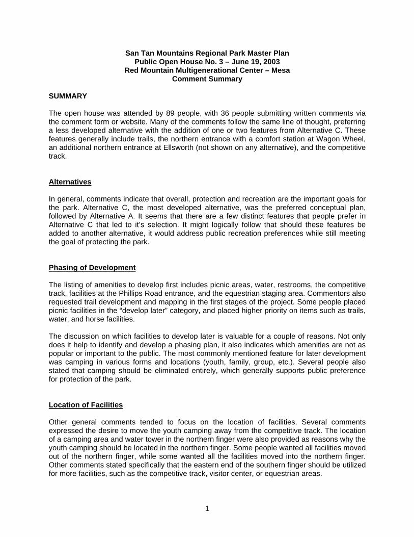
San Tan Mountains Regional Park Master Plan Public Open House No. 3 – June 19, 2003
Red Mountain Multigenerational Center – Mesa Comment Summary
SUMMARY The open house was attended by 89 people, with 36 people submitting written comments via the comment form or website. Many of the comments follow the same line of thought, preferring a less developed alternative with the addition of one or two features from Alternative C. These features generally include trails, the northern entrance with a comfort station at Wagon Wheel, an additional northern entrance at Ellsworth (not shown on any alternative), and the competitive track. Alternatives In general, comments indicate that overall, protection and recreation are the important goals for the park. Alternative C, the most developed alternative, was the preferred conceptual plan, followed by Alternative A. It seems that there are a few distinct features that people prefer in Alternative C that led to it’s selection. It might logically follow that should these features be added to another alternative, it would address public recreation preferences while still meeting the goal of protecting the park. Phasing of Development The listing of amenities to develop first includes picnic areas, water, restrooms, the competitive track, facilities at the Phillips Road entrance, and the equestrian staging area. Commentors also requested trail development and mapping in the first stages of the project. Some people placed picnic facilities in the “develop later” category, and placed higher priority on items such as trails, water, and horse facilities. The discussion on which facilities to develop later is valuable for a couple of reasons. Not only does it help to identify and develop a phasing plan, it also indicates which amenities are not as popular or important to the public. The most commonly mentioned feature for later development was camping in various forms and locations (youth, family, group, etc.). Several people also stated that camping should be eliminated entirely, which generally supports public preference for protection of the park. Location of Facilities Other general comments tended to focus on the location of facilities. Several comments expressed the desire to move the youth camping away from the competitive track. The location of a camping area and water tower in the northern finger were also provided as reasons why the youth camping should be located in the northern finger. Some people wanted all facilities moved out of the northern finger, while some wanted all the facilities moved into the northern finger. Other comments stated specifically that the eastern end of the southern finger should be utilized for more facilities, such as the competitive track, visitor center, or equestrian areas.
1
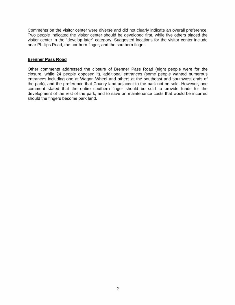
Comments on the visitor center were diverse and did not clearly indicate an overall preference. Two people indicated the visitor center should be developed first, while five others placed the visitor center in the “develop later” category. Suggested locations for the visitor center include near Phillips Road, the northern finger, and the southern finger. Brenner Pass Road Other comments addressed the closure of Brenner Pass Road (eight people were for the closure, while 24 people opposed it), additional entrances (some people wanted numerous entrances including one at Wagon Wheel and others at the southeast and southwest ends of the park), and the preference that County land adjacent to the park not be sold. However, one comment stated that the entire southern finger should be sold to provide funds for the development of the rest of the park, and to save on maintenance costs that would be incurred should the fingers become park land.
2

San Tan Mountains Regional Park Master Plan Public Open House No. 4 – September 4, 2003
Gilbert Community Center – Gilbert AND
Public Open House No. 5 – September 18, 2003 Walker Butte Junior High School – Queen Creek (Pinal County)
Comment Summary SUMMARY This summary presents the results of the fourth and fifth open houses. The same information was presented at both meetings and the same comment form was distributed to attendees. However, two separate meetings were conducted to allow greater attendance and opportunity for comment on the preliminary preferred master plan. In total, these open houses were attended by 81 people, with 29 and 52 people attending the meetings in Gilbert and Queen Creek, respectively. Preferred Master Plan In general, comments indicate that preferred master plan is supported by the public. However, many comments focused on the recent Boy Scouts proposal to lease the southern finger for a youth camp. While some people supported the Boy Scout proposal and questioned why it had not been reflected on the master plan, more comments expressed opposition to the inclusion of a youth camp. Reasons for opposition included potential displacement of the competitive track in the southern finger, exclusive use of public land (the youth camp would be fenced and the area closed to the public), and proximity of the camp to residential areas. Some comments suggested the youth camp be moved near the family campground to consolidate facilities. Other comments stated that the competitive track should be longer; the track parking, staging area, and entrance should be moved to the east off of Gary Road rather than Brenner Pass Road; and the competitive track should be implemented in the first phase of park development. Additional park access was also requested. Goals and Objectives The public was asked to comment on if the preferred master plan meets the goals and objectives for the park, which were established early in the process. Every comment stated that the plan did meet the goals and objectives for the park.
1

DISPLAY ADVERTISEMENTS, PRESS RELEASES, AND NEWSPAPER ARTICLES

SAN TAN MOUNTAINS REGIONAL PARK MASTER PLAN INFORMATION DISTRIBUTION Press Release Distribution List
Publication Contact Name San Tan Monthly
Karen Stapp
Johnson Ranch Hotshot
Patty Shepard
Gila River News
Julie
Valley Publishing
David Brown
Copper Basin Gazette
DJ Burrough
Chandler Sun Lakes Independent
Brian Johnson, Editor
Gilbert Independent
John S. Wolfe, Editor
Florence Blade-Tribune
News Editor
Coolidge Examiner
News Editor
Arizona Republic
Harvey Parson, EV Editor
Arizona Republic
Cindy Hernandez, reporter
East Valley Tribune
Chris Coppola, Metro Editor
East Valley Tribune
Craig Anderson, reporter
Display Advertisement Distribution List East Valley Tribune Chandler Sun Lakes Independent
Newsletter Public Mailing Lists USPS Mailing List 321 recipients Email Mailing List 461 recipients

PUBLIC OPEN HOUSE/SCOPING MEETING for the
S A N TA N M O U N TA I N S R E G I O N A L PA R K M A S T E R P L A N
The public is invited to attend the first open house/scoping meetingfor the San Tan Mountains Regional Park Master Plan Project.Maricopa County Parks and Recreation Department is beginning the
process of updating the master plan for the Park and would like to hearyour comments. The meeting will be informational, allowing people todrop in any time between 5 p.m. – 7 p.m. to review information displaysand speak with project team members. There will be a shortintroduction of the project and project team at 5:30 p.m.
Tuesday, February 11, 2003Queen Creek Elementary School — Cafeteria
23636 S. 204 Street Queen Creek, AZ 852425 p.m. to 7 p.m.
(located just south of Chandler Heights Road, between Hawes and Ellsworth roads)
For more information, visit www.santanpark.net, or call (602) 383-2594.

PUBLIC OPEN HOUSEfor the S A N T A N M O U N T A I N SR E G I O N A L PA R K M A S T E R P L A N
The public is invited to attend the second open house for the San TanMountains Regional Park Master Plan project. Maricopa County Parksand Recreation Department is updating the master plan for the Park
and would like to hear your comments. The meeting will be informal,allowing people to drop in any time from 5 p.m. – 7 p.m. to reviewinformational displays and speak with project team members. The teamwill be displaying information on park resources and regional recreationneeds identified through public comment and other studies.
Thursday, April 17, 2003Hull Elementary School — Multipurpose Room
2424 E. Maren Drive Chandler, Arizona 852495 p.m. – 7 p.m.
(located about 1/2 mile south of Riggs Road and 1/2 mile east of Cooper Road, near La Paloma Parkin the Cooper Commons subdivision)
For more information, visit www.santanpark.net, or call (602) 383-2594.

PUBLIC OPEN HOUSEfor the S A N T A N M O U N T A I N SR E G I O N A L PA R K M A S T E R P L A N
The public is invited to attend the third open house for the San TanMountains Regional Park Master Plan project. Maricopa County Parks andRecreation Department is updating the master plan for the Park and would
like to hear your comments. The meeting will be informal, allowing people todrop in any time from 5:30 p.m. – 7:30 p.m. to review informational displaysand speak with project team members. The team will be presenting threeconceptual master plan alternatives for the park. Comments received at thisopen house will help the project team identify a single preferredmaster plan alternative.
Thursday, June 19, 2003Red Mountain Multigenerational Center
7550 E. Adobe Road, Mesa, Arizona 852075:30 p.m. – 7:30 p.m.
(located near Red Mountain Park, the nearest major crossroads are University Drive and Power Road)
For more information, visit www.santanpark.net,
or call (602) 383-2594.

PUBLIC OPEN HOUSEfor the S A N T A N M O U N T A I N SR E G I O N A L PA R K M A S T E R P L A N
The public is invited to attend one of two final open houses for the San TanMountains Regional Park Master Plan project. Maricopa County Parks andRecreation Department is updating the master plan for the Park and would like
to hear your comments. The meeting will be informal, allowing people to drop inany time from 5:30 p.m. – 7:30 p.m. to review informational displays and speak withproject team members. The team will be presenting the preferred master planalternative for the Park. Comments received at this open house will help theproject team further refine the preferred master plan alternative beforepresenting it to the Maricopa County Parks and Recreation Commission.
For more information, visit www.santanpark.net,
or call (602) 383-2594.
Thursday, Sept. 4, 2003Gilbert Community Center
100 N. Oak, Gilbert, AZ 85234
5:30 p.m. – 7:30 p.m.
(located near Page Park, the nearest major crossroads are Elliot and Gilbert roads)
OR Thursday, Sept. 18, 2003Walker Butte Junior High School – Multipurpose Room
29697 N. Desert Willow Blvd., Queen Creek, AZ 85242
4:00 p.m. – 6:00 p.m.
(green building southwest of Hunt Highway, east of the Johnson ranch entrance of Bella Vista)

NEWS for immediate release
Maricopa County Date: January 14, 2003 _______ Parks and Recreation Department 411 N. Central Avenue, Suite 470 Phoenix, AZ 85004 www.maricopa.gov/parks For more information contact: Rand Hubbell, Marketing Coordinator (602) 506-1114
MARICOPA COUNTY TO HOLD FIRST PUBLIC OPEN HOUSE MEETING FOR THE SAN TAN MOUNTAINS REGIONAL PARK MASTER PLAN
PHOENIX – Maricopa County will hold the first public open house meeting regarding the San Tan Mountain Regional Park Master Plan Project on Tuesday, February 11, 2003. The meeting will be held from 5-7 p.m. at the Queen Creek Elementary School cafeteria at 23636 S. 204th Street, Queen Creek, Arizona, 85242. The open house will allow the public to learn about the project and provide input into the planning process. The meeting will be informal, allowing people to “drop in” any time between 5 and 7 p.m. to review informational displays and speak with project team members. There will be a short introduction of the project and project team at 5:30 p.m. The 10,198-acre park is located south of Hunt Highway and Ellsworth Road near the Town of Queen Creek in Pinal County. The updated master plan will identify a long-term and flexible approach to providing recreational opportunities in the park, along with protecting park resources. Since a majority of the land in the park is owned by the BLM, an Environmental Assessment will also be prepared. A project website (www.santanpark.net) and telephone line (602-383-2594) have been established to provide project updates and comment opportunities. The first project newsletter was mailed to area residents in January; copies will be available at the open house, and may be requested through the website or phone line.
- STOP –
Adobe Dam Recreation Area * Buckeye Hills Recreation Area * Cave Creek Recreation Area * Estrella
Mountain Regional Park * Lake Pleasant Regional Park * McDowell Mountain Regional Park *
Paradise Valley Golf Course * San Tan Mountains Regional Park * Spur Cross Ranch Conservation
Area * Usery Mountain Recreation Area * White Tank Mountain Regional Park

NEWS for immediate release
Maricopa County Date: March 20, 2003 _______ Parks and Recreation Department 411 N. Central Avenue, Suite 470 Phoenix, AZ 85004 www.maricopa.gov/parks For more information contact: Rand Hubbell, Marketing Coordinator (602) 506-1114
MARICOPA COUNTY TO HOLD SECOND PUBLIC OPEN HOUSE MEETING FOR THE SAN TAN MOUNTAINS REGIONAL PARK MASTER PLAN
PHOENIX – Maricopa County will hold the second public open house meeting regarding the San Tan Mountains Regional Park Master Plan Project on Thursday, April 17, 2003. The meeting will be held from 5-7 p.m. at the Hull Elementary School multipurpose room at 2424 E. Maren Drive, Chandler, Arizona, 85249 (located about ½ mile south of Riggs Road and ½ mile east of Cooper Road, near La Paloma Park in the Cooper Commons subdivison). The meeting will be informal, allowing people to “drop in” any time between 5 and 7 p.m. to review displays and speak with project team members. Information presented will include a summary of park resources and regional recreation needs that have been identified through public comment and other studies. The first public open house, held in February, drew 65 attendees. The 10,198-acre study area for the master plan includes the 7,938-acre park and 2,260 acres of adjacent Maricopa County land. It is located south of Hunt Highway and Ellsworth Road near the Town of Queen Creek in Pinal County. A project website (www.santanpark.net) and telephone line (602-383-2594) have been established to provide project updates and comment opportunities.
- STOP -
Adobe Dam Recreation Area * Buckeye Hills Recreation Area * Cave Creek Recreation Area * Estrella
Mountain Regional Park * Lake Pleasant Regional Park * McDowell Mountain Regional Park *
Paradise Valley Golf Course * San Tan Mountains Regional Park * Spur Cross Ranch Conservation
Area * Usery Mountain Recreation Area * White Tank Mountain Regional Park

NEWS for immediate release
Maricopa County Date: May 20, 2003 _______ Parks and Recreation Department 411 N. Central Avenue, Suite 470 Phoenix, AZ 85004 www.maricopa.gov/parks For more information contact: Rand Hubbell, Marketing Coordinator (602) 506-1114
MARICOPA COUNTY TO HOLD 3rd PUBLIC OPEN HOUSE FOR SAN TAN MOUNTAINS REGIONAL PARK MASTER PLAN
PHOENIX – Maricopa County will hold the third public open house meeting regarding the San Tan Mountains Regional Park Master Plan on Thursday, June 19, 2003. The meeting will be held from 5:30 – 7:30 p.m. at the Red Mountain Multigenerational Center at 7550 E. Adobe Road, Mesa, Arizona, 85207 (located near Red Mountain Park, the nearest major crossroads are University Drive and Power Road). The public is encouraged to attend this important meeting, as three conceptual master plan alternatives identified for the park will be presented. Comments received at this open house will help the project team to identify a single preferred recreation alternative. The meeting will be informal, allowing people to drop in any time between 5:30 and 7:30 p.m. to review displays and speak with project team members. The 10,198-acre study area for the master plan includes the 7,938-acre park and 2,260 acres of adjacent Maricopa County land. The study area is located south of Hunt Highway and Ellsworth Road near the Town of Queen Creek in Pinal County. A project website (www.santanpark.net) and telephone line (602-383-2594) have been established to provide project updates and comment opportunities.
- STOP -
Adobe Dam Recreation Area * Buckeye Hills Recreation Area * Cave Creek Recreation Area * Estrella
Mountain Regional Park * Lake Pleasant Regional Park * McDowell Mountain Regional Park *
Paradise Valley Golf Course * San Tan Mountains Regional Park * Spur Cross Ranch Conservation
Area * Usery Mountain Recreation Area * White Tank Mountain Regional Park

NEWS for immediate release
Maricopa County Date: August 6, 2003 _______ Parks and Recreation Department 411 N. Central Avenue, Suite 470 Phoenix, AZ 85004 www.maricopa.gov/parks For more information contact: Rand Hubbell, Marketing Coordinator (480) 471-0173
MARICOPA COUNTY TO HOLD 4th SET OF PUBLIC OPEN HOUSES FOR SAN TAN MOUNTAINS REGIONAL PARK MASTER PLAN
PHOENIX – Maricopa County will hold two open house meetings regarding the San Tan Mountains Regional Park Master Plan. The first meeting will be held on Thursday, September 4, 2003, from 5:30 – 7:30 p.m. at the Gilbert Community Center at 100 N. Oak, Gilbert, Arizona, 85234 (located near Page Park, the nearest major crossroads are Elliot and Gilbert roads). The second public open house will be held on Thursday, September 18, 2003, from 4:00 p.m. – 6:00 p.m. at the Walker Butte Junior High School Cafeteria-Multipurpose Room at 29697 N. Desert Willow Blvd., Queen Creek, Arizona, 85242 (green building southwest of Hunt Highway, east of the Johnson Ranch entrance at Bella Vista). The same information will be presented at both meetings. The public is encouraged to attend this important meeting, as the preferred master plan alternative for the park will be presented. Comments received at these open houses will help the project team to further refine the preferred alternative before presenting it to the Maricopa County Parks and Recreation Commission. The open houses will be informal, allowing people to drop in any time to review displays and speak with project team members. The 10,198-acre study area for the master plan includes the 7,938-acre park and 2,260 acres of adjacent Maricopa County land. The study area is located south of Hunt Highway and Ellsworth Road near the Town of Queen Creek in Pinal County. A project website (www.santanpark.net) and telephone line (602-383-2594) have been established to provide project updates and comment opportunities.
- STOP -
Adobe Dam Recreation Area * Buckeye Hills Recreation Area * Cave Creek Recreation Area
* Estrella Mountain Regional Park * Lake Pleasant Regional Park * McDowell Mountain
Regional Park * Paradise Valley Golf Course * San Tan Mountains Regional Park * Spur
Cross Ranch Conservation Area * Usery Mountain Recreation Area * White Tank Mountain
Regional Park

By CIuistina LeonardThe AriZtXfa ~Iic
QUEEN CREEK - It basbeen years in the making, butMaricopa County officialshave finally set the date for agrand opening of San TanMountain Regional Park forNov. 23.
And they're ecstatic aboutIt.
The Arizona RepublicOctober 24, 2002
"What it really signa1~ is, the beginning of a real park
with real staff and real over-sight," said Don Stapley,chairman of the Board of Su-- pervisors.
Once officially opened, thepark will charge a fee of $Sper vehicle.
The county plans to host a,celebration at the 10,OOO-acrepark witk horse trail rides, ahayride and tours to a famousgravesite.
Officials are workIng torenovate trails and install aparking lot, modular build-ings and fenc,iDg.
A film started work lastmonth on a master plan duefor completion next year.
In 1988, the coUnty madean agreement with the Bu-reau of Land Management tomanage the majority of theproperty, which sits in PinalCounty.
Maricopa County acquiredadditional land in the early1990s, but never had thefunds to turn San Tan into afull-scale park, Stapley said
It has remained relativelyunmanaged as the EastValley's populatiort continuesto boom and development hascrept up to the park's edges.People still use the land, butthere is no parking, no facili-ties and no oversight.
Despite a tough budgetcrunch, the county has dedi- +cated about $800,000 for plan-ning and park development,County Parks Director BillScalzo said.
"It's very exciting thoughbecause people want to know,what are we doing? What'sthe progress?" said Supervi-sor Fulton Brock, whose dis-trict includes the East Valley.

.
Q.-:EM8.8
.&M.~~c-o ...
.~ .8
< ~u >
~~
La
Regb8::~:I!: ~) Peoria ll7 )
~
5t111rc.-~- C;)i ua.. AIU. TONTONAnONAL
Cave c.- FOREs t u :lei;. ~ Ars -.;! Iii N M~ P~ Scfdale I r'»l1
x ' '
'oP;o~~--;
w.."_:-;C:J
--= .. r.-. ,. - ~ ---
.r: u,-Y. ~-~ . --- Re&Io8I
'1-.- . ~a- PM
. '.:- "'t .
~": .l~~,. j COONTY SIn ..
cxx.wTY ~~~PM
*' WaterYTI1t AI-. ~
See SAN TAN I~ W
SulaII1I St.r/The ArizwIa R!IIAiI:
Bob Ingram makes his way through San Tan Mountain Regional Park in his four-wheel-drlve tnJCk. The park will cele-brate its grand opening Saturday, even though there's not a single amenity in the park.
f t ' S 1 San -r.I abmn is UII ~s I.-st ~ Plllsant atIracts the Ia~ shareregional park. Park system attendance ci visikIIs to UII county's regional pam.or coun y 5 an an reboundedinthemostrecentfiscal~r. Park attendance for fiscal 2002:
. . after two ~rs of decline: ~. Pleasant S~~;~":;:,: --'By Adam K)8W(Xm Mountain Pride .and one of EstI1II u-Ia.I t);&4'~';3:IM.EThe AriZrJna RepjIIic the event orgamzers. L5 .. ... w...Wai1 ~-?; - 155.866
Regardless of oow 1999 USIfy ~ t;;~ 96,160
Park rangers say the many people turn out Sat- 2000 U Cave Creek r'1 &1.655planned grand openinl urday, it's a big step for a 2001 10 McOOMI Mountain l' 60.550this weekend of the eighth beleaguered park with a 2002 1.2 SIXJr CItISs Rlr-=I1 ~ . ~~Maricopa County regional history of being sOOt up, . ..-'
parkmayattract~many dumped on and romped "*=~~~ ,I ~m...~~~~_aws patrons it could get out of over.
hand. "It's been a long timeBut after laboring al- coming," said Queen
most a decade tn belp pre- Creek 1bwn manager Cyn-serve the 10,(MX) desert thia SeelhAmmer.acres in Pinal County Maricopa County Su-south of Queen Creek, pervisors Chainnan Donthey are secretly pleased Stapley, woo made theat the prospect of bosting a park one of his top priori- - -wave of park enthusiasts. ties wben elected in 1994,
~ ;:t~..~ They're oolding the Sat- said, "I was surprised then "'.. Ieurday event to show off to find that the county WIlle .. "San Tan Mountain Re- owned 10,(XX) acres in an- R8IIDI-IIiODalPark,eventOOUihit other county. But. I .10 ..~.doesn't have a single rB- warmed up real quick _It RI' ~mad-. toilet, running w8- when I was out there and jJter or any trails other than reaIized the potential." G90dyear. '"
those that were cut i11e- Although still recover- ~ u-Jt8 ~/,gally. jog from years of abuse, _.I ,..
"If we get as many the park boasts some of horses as I think we may, it the finest desert vistas
could look like a picture of and wildlife in the area.the Oklahoma Land Stapley and SeelhammerRush, " said Roe Rosbrook,president of San ~ -- --- -- .. !

s~~E~
~
'0 I
~1=
...
~
00!. ~ ~
'0 ~
~1
-5 "~N
C
"~
~.a!J
~ ~ ~
~ of j
~
58! A
i i"~
~ ~
"i f!
~"~
.i 8. § i~
C
/J ~
w.s
@"&
~
a ~ '.5..8 g)"
'O~
~
'0 ~
§
oS ~ ~
~i~
1;~j~
o~~
~liJ 8:~
;~.8~
li~j~
] f~
8 ~ ~
.8 i e. ~
Off ~
!1. ~.8 ~ ~ ~ t ~
e if'~
~ ~
[:'s §~~
§"~,~
~~
~ail~
~~
~.s
e~ e.~
~'O
'E
'S~
~"i~
~~
g!~~
.s~
~'S
!'B,S
~~
"~
e c:.s ~1~
-~
~~
o~
~~
~
~
~B
B;"'Q
.~..i=
g.~
8e e e;-'=
.J'~ ~ ~
~.o ~ t' ~
.a ~ 0:; ~
~ :- ~
... ,8 ~ i
=
...~
~
...~c~
C'
.eQ...C
u~=
~~
.c~d
~~
~~
=
: 5 ~
~
R e"a -g ~ ~
-=
_5 ~ -
~
~ ~
.= I;C
~ -g Z
0 " ~
~e8cnC
.)3=o
~u~
8!o:=
o~~
=
~.c"=
. .-
~~
~
t~
(/)cf. E
c ~
=-c
--E
GI 0
00 IV
00 IV
>.-
U-o
0 N
occci =
~
-IV~
0
M~
.2Ln ~
E
~o~
1.0
1Q
.~0
5'"0 il:~
=
":':'o~
.- -0-
c=.
c ooC
-0 C
E
.- .- ::e
III Q..
!~
~
S!Q
~
-g ~
~.99!5o
"CO
\~~
IV
. O>
-~I
~.. 5 .. IV
!J iii iii .c
~ ~
0\
~~
Z"E
.-oC
~t-
~t-
N-c
1iI~
:2.-IIIQloC
cnOo
ZC
Z~
~oC
2Z~
ooo"'l.O~
~~
(/)O~
.JS~
~:£u!.9;
... '-d' ,=
,~
F'
~
Q) >
.; ~
I
Q) -=
~ . . ~
I I
aD = ..
.~ ,~
,~ ~
~
'i £ ~]
~ -5
'E ~ ~
'§ f .~
-:.! i ~
.~ ~
J:e-s~
~=
~
!-&>
.=
~-s~
C/}
>]tQ
)Q)&
cO:
~:~
]~ j;~
i!i ~
1t~~
iii'f!i~i
c..a ~ ~
8. ~
~ =
'C -=
c. i ~
a Q
) of ~
Q 5 Q
,~
B ~
!~
~~
Q) :E
~ 8
-=
Q C
/} 0 ~ oS
.~ !'~
~
:s ~u~
Q)-~
80S
Q
) 00
'C
~bO
""'~c.~
0
..9; ~i ~ ~
"',s-g ~
~ g i
~ e'm
~§'E~
-g]~-:S
B=
""C
B
.. ~
~~
'" tJ8
o""~
~~
c"'~i
Q) ,; ~
~
~.. ~
'
~
~
: t-
-= ~
~
~
In'
~oS
~~
'= d~
j 8j
~~
~~
§~: ~
~j §
~=
a~~
~
,.0~
'i<.s
!.~
c.5< ~
]~
~ ~
~ C
J8 ;~
a g .'!Jm
~~
(J I
""' U
I~'O
' U
I
.B'O
' :g.
~ 'g
i ~
I: I:
=
=
=
IU
Co.
UI P
: ~ Ij..j
8 ~
:9 ~:~
~(9. ~ ~
!4)
.0i~
:aCoI:
OC
Ul'=
""'
cn
'; &
.=3 ~
~
9l~ Iri i
.s ~ oS
.~ ofj u O
J c t.~- "0 ~
,:g &].8
~ .~
~ j~
E U
I~.~
.~.s.s 6
0 oJi
~""'
s~
~
OC
,0.=
1:1:
'g § ~
-;: ,~~
5 ~
~'=
.o .=
~ebei
~:~
~
~'~
~ ~
~ ~
.~ ~ ~
j:ci ~.~
1. i i,~~
~.8,;
~ ~
,~
~ '5 !9 a, G
> ~.~
~ ~
'c ~
0
I 5 ~
't; ~ § B
~'-'4 t'
~~
~:s
~~
~'e.s~
-u~~
B::
i~.~
~
~1
!Q
.':= 6
>
G>
~ I1J 'i3 Q.
~ # .c 's ~
oS f
G ~
~
.c ,-
~~
~
G>
"a '
G>
'O
G>
~
.sB~
..J ~
'~
~
~8~
v2 ,~~
.~i~
~ ~~
~,~
~~ ~
~§~
~fj§ e
~ia,§
~'g~
'=!."O
!.§8.o.c~
'§Q.B
g-5 ~
~.s~
,j~
.8 ~
!~
~~
,t'~ ~~
! ~
'i~j8
~~
~,~
J f
~ '=
0 !~ i i~
,$ ~
~~
i 1 ; i ~ ~
§..8 ~ ~ j ~'~
! it
g~ ~
I ~
8 ~ l:fi i ~
.s S' 8 ~
!
5 i &
B: S i ,§ ~
i.! G
ii1~ a ~
~.'B
~~ e';]
8~ i~
G.8 ~
;~
Q)~
~
-.~
~>
l:=
Co~
8°=
~
~U
""'t; =
'Q
1~
e: 8. Q
) Co) S
1= ~
~ ui
Co fo B
Q)
~ =
~
tn l;:~
n~
"Q):O
£j' Q
) w
=
flJQ)
~ ~
=
U
.Y
o IS IC
I U
J;, b
.c~.
'C:a
>t ~
j8. § ~
'C
~..§ ~
i ~
g.~ § f ~~Q
) ~ ~.!S
~ i
= Q
. 0
Q) 0
~ O
'~
=.=
80
4) Q
~
].fIJ
.~ e ~a
~
o~
~ O
.Yo
!2
~.c
~8!
!O"'b
bO;Q
~
OO
~~
~
Q)
.~~
=
'Co
Q)t:
Q)
=
=
50 Q
) '.c
bO
.c 0
S § ~.~
.S.§~
~ ...:~.a~
~
~'ao>..a~
]~.s].ai
il:a1~
~
~
=
5 . W
W
.a =
=
0 =
Q
) 1= e
8 °t:...
... £ ~
~
~ -5
=
'Q1 e.J.
§ bO
~~
].!S
~
Q.
ro m -<
C
o -~
oS.~
«I ~
§
! ~
.S
f, ~
O.S
-g ~ f-I ~
;: ~
~
'e ~
'" ~
~
0.2,iD
0 oS
~,Q
s
s ,s ~
oS
iV C
=
r o.s =
,Q
Q. g
> '""
~

:C'C~~3C~ ~~~3~~~ ~g~~.g~! ~ a OJ a ~ g g cn ~ !§.z ~ g a cn- > ~e.~oq PI ~ cnoI ~~<~~~~.,~c ~- ~~~ c:
, ~ C' ':. C' _. Q. S C' ~ C' cn Q.oQ 0 ~ rot - 0 0 PI 8
'C~~=:.~3 - ~s.~S'o-<~~C'[ Ot3:S.,C' ~'<~"'Ooo """" ~~o. t:I ~C'()
~ C' c ~o oC'cn -~ PPl()()o~o~~e:~ C'~~"cnc~ .:--. C' ()C'~
c:Eo.2~'<~ >nC)C"CC'~~t1'C 'g~~th
E~:Eccl'C~~~~?~a*[~&~gcn()~';:." ~ ~ ~ ~ ~", ~ ~ 3 ~~, 3 cn '< ~ I;-: m (') g g..~'< ~ cn 6' ~ < n ~ '0 C ~ 3 ~!A () S 'C tS ~.a g! ~~ 5.~'~ :~'t;. Cii g'Ci~ ~g-~ ~.qg~ ... I .,- ""CI Q,Q. ~ ~~-~ PIo.::.o.§- ~.Cb (') o~ ~C' C' ~ g Q"","~g.n""'~ C' rot ~ < 0 c 0 ~ Q, rot () Cb ~ 'C §:~. °:3'°tno:3' C ~ :E'< 30 C'..,., g;g.iI, ~~ ~mg8'~C'c .s's:.F1o o ~'A '0 eo.. 'T 5 , C' .!.., ~ ~ ~ ".. ~ 't1 POI 0 0 ., ~ I I Q.~ I cn I C' I 0; ;.+.~. '~'. ~ th
.;!.G
>:1-
~~DO:u-3c.~n
Q)o-»-+- Q) c-,'-r-+-C ~._.
(/) -0 :5.('t) -, C.f).
-'CDC;;-'<c-,~ CD :U>r-+- 0-. ('t)~ CD',',CD.. 3
~. ',-
':!ii.
From Page Bl b~t~~e
Leon, '8abQut fairnes.s for all iandown-ers:.
"Philosophically, I thinkpeople bavea right to o.wn pri-"vate property. That's the basisof our whole country's founda':'tion," he said. "I do not under-stand people who say, 'Well,that's too bad, they bought landthat has no legal access.' n
.Stapley also disagrees thatthe decision sets a precedentrt dOesn't violate park policy,be said, because the easementis not permanent and the passdoeSn't ~averse through theproperty but hugs its edge.
Bowers, .who owns 1.25acres of land, and other prop-erty owners near the 3,600-acre recreation area in Mesabave been battling for accessfor years. The utility road,which is used to maintain mi-::rowave towers, is the onlyway to reach the properties.
The county's Parks and Re-::reation Commission voted~.hem down in 1998 and 1999.
But Bowers and others also- -
day, "~~,"We felt'tims'" ,
. 'said,
Reach the reporter atc h ristina.leonardGlarizonarepublic.com or (602) 444-4845.
lOOl . L J~w_:>-a
J!lqnd~'M uuoz!.IV ~4.L
~'<C")
5:rAg.~.
r;0
~
'~thUbl~ ~!t's.n~()t .ep\n'Pth oseof* amG enwm~t..,~o~e l C?~p!ex & ar~', em'" ro ,~, .
J.a.1~~ ~ lltmentSi!:fif4: 'that Vt~.9 o::~=oni'in~~tio\'o-tflebOar~; from derljing rUSon8bte ac-
had warned that approval: cess to Private property. Sta:-
would ~~.t~pr~~t,~ other pley saidtheIawgave credl"bil-
cases. ,~Ur19".." ity to the ~ent that ~d-
Co~:( t;.~~~ AI owners had ~ legal claim. an,d'"";:~*-::~;tv1a~;., ... .~~qrjp~i~e the co~ty .~~vet:~d a
'y,past..~ ',,:, ~$~'~' 1aWSUlt.-'.'rt'.!;r~,r-.~.".!Cf:!t.'"'~ks';'B '~~~.b8Si:e- Still, the'issueisho~d{b;aveei d ft~~~. ~~_I: ." ed +\.':'n' '-~Co . , c ve ~c~i~O .~C4U~ti~ re- , return tOi~~~~ ~
:::;~quests~~~e'atS on'park sion foi'COriSiC;IerStion In.Stead:',~d.;.s~~:tbe cdU.iltY~ of appeanngbef-Q1'e the.~er,-..d~g'Wi~~ situations visors We4nes~y). said Laurel
departin~t~~~Sjt>ji':':;at tJ,1~:$Ii1:lf,'Cl'O$§..Ranch;Con- Arndt, a: membeti of the'irS-outlined _:$ff!i~~~~~ons!PJt ,serYa~;;f41'ea and,San Tan memberPar~'~;Commi$Sion,denial, ','iriclu~"..[~e'd ;~nntsji1;Re2i~~~ whicb is-bemg dissolved:andtraffic, the effe~ on wildlife, ::' StapI:e:y' ,.dded that Wednes- replaced: Witl1; a 'seven-mem-and plants; the fear of riCochet 'jday's.'(ue<:ision";was based ber commission. , ~damage from ao~by ~hoot- largely on new legislation pro- Even though the decisioning.rang.e'an4~~liabi1- tecting Shooting ranges. "acknowledges something onity to thecount:;:,:'!specially b~ ' Bowers', request. had drawn our part," ,Bowers said he
cause the road doesn't meet fierCe opposition from the Rio doesn't "know what it. meanscounty standards..,' . Salado' Sportsman's Club, as far as a usable resolve" be-
Parks officialS wouldn't which'~ a l~to operate a cause the access is temporary.comment on the decision Fri- gun range next to the utility "1 guess we could go up thereday, but Stapley said "they road. Club members feared and sit and think. .. he said.
now agree and are supportive the range will have to cJose if --of what we are doing." residential traffic is nearby.
Parks DirectQJ" Bill Scalzo In 1998, Bowers also pushedhad previously told The Re- through a one-sentence

Page 1 of 3:WSZdt> Archives
@
Online News & Information
Newszap Online archives.
Chandler Sun Lakes IndependentJanuary 29, 2003
January 29, 2003
Growth challenges San Tans
Mountain park is key for Chandler's recreation future
By Brian Johnson/Independent Newspapers
It's the closest desert mountain park to south Chandler, and officials fromChandler, Gilbert, Maricopa County and others are beginning a process toget the public's input as to how the park should be developed.
The first of four public meetings throughout 2003 has been scheduled from 5to 7 p.m., Feb. 11, at the Queen Creek Elementary School in Queen Creek.
At issue is how to make sure the lO.OOO-acre park. once home to ancientIndians and miners. meets the needs of area residents - and the tens ofthousands who are expected to move into the area within a few short years
Bob Ingram, regionaI park superintendent for Maricopa County, saiddevelopers tell him they will build between 50,000 and 70,000 homes in thenext five to eight years - all within 10 miles of the park.
That translates to an additional 250,000 people who may want to take a hikein the park.
"It's an issue," Mr. Ingram said "With the increase in population you getmore usage of your park. The other part of that is it may also protect yourpark if you have a whole bunch of backyards up against the park boundary ."
Dave McDowell, assistant community services director for Chandler. said acommittee made up of representatives from Chandler. Gilbert. Mesa. QueenCreek and Maricopa County has been meeting to ensure the park is protectedand developed in a timely manner.
All have contributed funds to the master plan update that will result from theseries of public meetings held throughout the year.
"What we've heard from folks is they're interested in hiking, mountainbiking, horseback riding and more passive activities like bird watching andenjoying nature."
4/10/03
Mr. Ingram said past issues of park boundaries have largely been settled.
tp://www .newszap.com/archi ves/index.inn ?loc=detai I &doc=l2003/J anuary/29- 31 OO-news705. txt

~wszup Archi yes Page 2 of 3And even though he calls the boundaries "terrible" because of the varioustracts of private, state and Gila River Indian Community that jut into thepark, he doesn't think they'll change.
Instead, he said the public is invited to attend the planning meetings. Aprivate finD has been hired to update the master plan and will take commentsfrom the public.
"We're trying to get a feel for what people want out here," he said.
"Out here" is a surprisingly beautiful mountain range situated about 25minutes from downtown Chandler. Goldmine Mountain is the highest peak(at 2,448 feet) that is seen when gazing to the southeast from Chandler.
The San Tan Mountains run behind Goldmine Mountain, which got its namefor the approximately 130 mining claims made on it throughout the 20thcentury.
When spring rains come, Mr. Ingram said there are amazing stands of wildflowers such as yellow poppies that are nearly blinding to the eye.
"There's some real beauty out here," he said.
At this point, it appears that the park will be developed not as a campground,but for day uses such as hiking, mountain bike riding, horseback riding andpicnicking.
The trick will be balancing all of those interests in a fair and equitablemanner.
"They need to have a stable," said Bob Crowley, a resident of a nearbydevelopment, who was hiking in the park last week.
Parks officials said horses can cause the most damage to the fragile desertenvironment.
Mr. Ingram is in the process of hiring a trail planner and a trail technician.Their first task will be to walk the nearly 16-square-miles of county parkland to get an idea of what's there and where trails should go.
Earlier plans called for a shooting range but Mr. Ingram said that andmotorized vehicles will probably be banned from a final plan.
"Ten thousand acres may sound big, but not when you start running a motorin it," he said.
Enter search word(s):
Ad~"'.D£..~r.cb..Qp_tj-QllS I Heln r- Perform Search I
* Note: only the past 14 days or articles will be searched,use the advanced search to find older documents
Show me all stories between the dates of:
IOO-news705.txt 4/1 0103

Page 1 of 2T:i~une Online1St V~~e
ENTERT.AJNMENT ~ aASs-=JED CXSPlA Y ADS~ SPORTS 8USlN£SS ORNION LFESTYL£of
t TribuneecoMMcx1day. February 10,2003 -
YOUR LOCAL WEATHER: I PI1oeni~: 60° I Scottsdale: 58° I Mesa: 570 I Olandlet: 5~0 I GIelMSaIt: 550 I luke
'1arket Glance
'hotography:;et Out:ontact Us~t The Tribune5ubscribe~dveltlserribune In Education
QASStFtED UNKS._-
East Valley TribuneFebruary 10,2003
~nSERSNews Update
San Tan outline to be unveiled Tuesday
By Joe Kullman, Tribune
The hope for preserving wilderness on the East Valley's southern edge
hinges largely on the future of San Tan Mountains Regional Park.
On Tuesday, residents can get a first look at proposals for protecting the 10,200-acre swath of open desert south of Queen Creek from the Impact of developmentpoised to erupt around it.
Jobs:ars-tomes For Sale
-tomes For Rent
:;arage Sales
~Flnd It Fait- t"
An outline for a $290,000 park master plan being done jointly by Maricopa County,Mesa, Chandler. Gilbert and Queen Creek will be presented at a public open housefrom 5 to 7 p.m. Tuesday at Queen Creek Elementary School.
Driving the effort is the potential for building more than 100,000 homes In theareas of Maricopa and Pinal counties near the San Tan Mountains. ~ ;" 1:,8S6:538~888
~~11(M ~ Many feel the park should be used as more of a recreation facility or naturepreserve, officials said.
tSince 1975"Ideas range from Disneyland to a conservation area" that would allow limited
access, said Alden Rosbrook, president of the San Tan Mountains Pride Association.:;;..-~
The group was formed In 1998 by a handful of Queen Creek-area residentsalarmed at the damage being done In the San Tans as urban growth edged closerand park use jumped sharply.
Now there are almost 150 members, including residents of Scottsdale. Mesa.Chandler and Gilbert. Their push for protecting the park helped spark the plan.
Rosbrook Is on a 14-person master plan advisory committee that Includesmembers of mountain biking, off-road vehlcleand environmental groups, as well aslocal business people and the Gila River Indian Community, which borders San Tanpark.
Some "want to keep the park as pristine as possible," Rosbrook said, but newresidents will Increase the demand for recreation uses.
Funding will be the project's biggest hurdle. Unless there is a strong economicrecovery, the state won't see parks as a funding priority, said William Scalzo,
tp :11 eastvalleytri bune.com/i ndex. php ?sty=48 3 2/10/03

Page 2 of 21St Vu!lt T "t>une Online
director of Maricopa County's parks department.
The park is in Pinal County but is managed by Maricopa County under anagreement with the federal Bureau of Land Management, which owns more than 70
percent of the land. The rest has been acquired by Maricopa County.
The master plan is to be completed this fall, but the county won't be able tofund Improvements until at least next year, Scalzo said.
Advocates hope some work can be done sooner.
"Many imp rovements would not be real expensive, and we might be able to rely onvolunteers," said Bill Heath, Queen Creek's representative on the master plancommittee.
Preservation of the San Tan Mountains -might have to be a grass-roots effort,"Rosbrook said.
Open house planned What: Public open house on San Tan Mountains
Regional Park master planWhen: 5 to 7 p.m. TuesdayWhere: Queen Creek Elementary School, 23636 S. 204 th St.Information: Call (602) 506-1114
Contactjoe Kullman byemail, or phone (480) 898-2342
V!SIT OUR AFFlUATES: Ahwatukee Foothills News Freedom Ccxnm~icatkInS Inc.

Tempe . ~ad~upe . Chandler. &II lakeS. OcotiRo . MesaApache Junction. Gold Canyon. rilbert . Queen Creek
Ahwablkee FooUills
....
The Arizona RepublicFebruary 10, 2003Harvey Parson, East Valley editor. 602.444.NEWS (6397)
Tickets are on sale nowfor youth th~ter show
GILBERT - Tickets are onsale for the Gilbert Youth The-atre's production of Bye ByeBirdie, which begins Friday.
Forty-eight .youths are per-forming ii1 the musical
It will be performed at7 p.m.. Friday and Saturday andF~b. 21-22 at Mesquite JuniorHigh, 130 W. Mesquite St.There are 2 p.m.. shows on sat-urday and Feb: 22. .
Tickets are $8 for adults and$6 for students, senior citizensand members of the GilbertFine Arts Association.
. Tickets are available atScrapb90ks Etc., 2820 E. Uni-.versity J;)rive, Mesa; 8J;I.d at the'n-easure Chest, 38SN. Gilbert.Road,
County holding meetingon San Tan park plan
QUEEN CREEK -..:. MaricopaCounty will hold the first pub-lic open house meeting"oQ theSan Tan Mountain RegionalPark Master Plan Project onThesday. The meeting will beheld frotn 5 to 7 p.m. a~ theQueen Creek ElementarySchool cafeteria;" 23636 S.204th St.::- People can review informa-tlQnal displays a:n~ speak withproject team members. ."- The 10,~8-&cre park issouth of Hunt Highway andEllsworth Road near QueenCreek in Pinal County. The up-dated master plan will identifya long-term and; flexible ap-proach . to providing recre-
ational "Opportimities in the'park, ?long with protectingpark ~urces. " "
Information/comments:www.santanp~k.net and (602)383-2S~.
Today is. the deadline.for bus trip to Capitol.
MESA -: 1bqay is .the reser-vation deadline for a free busride'. to the state Capitol onFeb. 1J for Neighborhood Dayat the Legislature..
'the ride includes a lunch, atour of the' Capitol, remarksfrom Gov. Janet Napolitano~d a meeting with state Sen.Marilyn Jarrett, R-Mesa.
The bus leaves Mesa' Cen-tennial Center at 10:30 a.m.
Inf ormatio n/reserva ti 0 ns:(480) 644-5700. . .
Kinesiology depa.rtmentseeks women for study
TEMPE - The KinesiologyDepartment at ArizOna StateUniversity is recruiting wom-en ages 25-Y5 with and withoutrheumatoid arthritis. The de-partment is conducting twostudies involving hormonal re-. .$ponse to exercISe.
Information: (480) 727-6093.
TODAY IN MESA
WHO'S MEETING Mesa school administrators andMesa Education Association'sMeet and Confer Committee.
KEY ISSUE Start of process to negotiate teacherand administrator salaries and benefits.
WHEN/WHERE 4 p.m. at Mesa Public Schools CurriculumServices Center, 549 N. Stapley Drive.

Gilbert - Your TownMarch 2003
B4-t"- ,.,.0"., at dIc SGKt811 MoImmiJU ReIi-' P8rt.
Chandler. During the informal meeting. residents canreview displays and ~ with project team members.
For man information. visit www.santanpark.net or call(602) 383-2594.
..-
Maricopa County and East Valley municipalities are indie process of updating d1e San Tan Mountains RegionalPark maSter plan. The plan provides an opportunity for out-.door endlusiasts to detemline which amenities die ~should have, induding.biking and mountain biking trails.The plan also lays die foundation forreaeation uses in the10,198 aae regional park. located southeast of Gilbert nearHunt ~ and Ellsworth Road. The park currendy hasno deYeioped facilities. The purpose of die master plan is tooudine future policies and potential recreation opportuni-ties in and around die park.
Offia.ls held an o~ house February 11 to allow com-munity members to identify iSSues and concerns related topark ~opment and use. A second meeting will be heldfrom ~ to 7" p.m., Thursday. April 17 at die Hull ElementarySchool multipurpose room. 2424 E. Maren Drive, in

Ocotillo NewsApril 10, 2003
Open house for proposed regional park
It's a short drive from Southern Chandler to enjoy the beauty of the San TanMountains. A public open house meeting about the proposed San Tan MountainsRegional Park Master Plan Project will be held on Thursday, April 17 from 5-7 p.m.at Hull Elementary, 2424, E. Maren Dr. in Chandler, near Riggs and Cooper RoadsIn the Cooper Commons subdivision.
The informal meeting will offer a casual -drop In" atmosphere to review displaysand speak with project team members. Information presented will Include asummary of park resources and regional recreation needs Identified through publiccomment and other studies. The first public meeting earlier this year drew 65attendees.
The 10,198-acre study area for the master plan includes the 7,938-acre park and2,260 acres of adjacent Maricopa County land, and is located south of HuntHighway and Ellsworth Road near the Town of Queen Creek.
Project updates and comments are available through the project webslte atwww.santanQark.net or by calling 602-383-2594.
~t~_t9~QP

The Arizona RepublicMay 12, 2003
May. 12,200312:00AM
First public meeting
on trails is this week
QUEEN CREEK - The Maricopa County Trail Commission Is conducting the first In a two-set series of public open house meetings to gatherfeedback and Input about corridor plans for the county's regional trail system.
The commission will hold a meeting from 5 to 7 p.m. Thursday at the Queen Creek Town Hall Multi-Purpose Room, 22350 S. Ellsworth Road.
The group will focus on the corridor connecting Spur Cross Ranch Conservation Area to McDowell Mountain Park to Usery Mountain RecreationArea to San Tan Mountain Park.
Information: (602) 506-8003.

Page 1 of 1San Tan park visit will cost
.
~~ PRINTTHIS
The Arizona RepublicJune 7,2003
COUnl)' 11) dUlrgC' entry
Christina LeonardThe Arizona RepublicJun. 7, 200312:00 AM
Maricopa County officials say they've poured more money Into the San Tan Mountains Regional Park than any other park in the system, with theexception of Lake Pleasant. Now it's time for folks to start giving back.
County supervisors this week approved new entry fees for the 1 O,OOQ-acre park. Vehicles will pay $5, and those who hike, bike or ride horses intothe park will pay $1 starting July 1.
The county will collect the fees on the "honor system" initially.
In 1988, the county made an agreement with the Bureau of Land Management to manage the majority of the property, which sits in Pinal County.Maricopa County aCQuired additional land in the early 19908. but never had the funds to tum San Tan into a full-scale park.
It remained relatively unmanaged until recently. So far, the county has pumped about $1.5 million into the park for fencing, staffing and planning.They expect to sink an additional $370.000 into the area next year. parks and recreation spokesman Rand Hubbell said.
The department is currently developing a master plan for the park to determine things such as the location of entrances, facilities and picnic sites.
Hubbell said the department expects to generate about $6,000 from the fees next fiscal year. The fees are equivalent to those charged in thecounty's nine other parks.
Also on Wednesday, the supervisors eliminated recreational vehicle dump station fees throughout the park system.
Reach the reporter at [email protected] or (602) 444-4845.
Find this article at:, ttp :J Iwww. azcen traI. corrY arlzonarepublicnocaL/art'K;Ies/O6O7 santan ohtml
Check lie box to Include lie list of links referenced ., lie artk:Ie
6/18/03

San Tan revamping opens oldwounds, prompts new debate
.y .I. CRAIG ANDERSON t \VO Mfing('rs" of land.TRIBUNE On Thlu"Sday, Phoenix
t'onsuiting finn Environ-A publicly f':lnded Inentai Plunning Group
revamping of the San Tan \vill present three optionsMountains Regional Park for the pl\rk's updatedmaster plan has opened 1n3ster pllU'l. ranging fromold wounds and created rel:Jtivt'ly minor land-new debate over issues scape Chl\l1ges to adding asuch as a possible road significant number of rec-closure, park access, USe reationai facilities andfees and what to do with other amenities. Those on
San Tan planConsultinq firm Environmental
Planninq Group is offerinqseveral alternatives for
improvinq San Tan MountainsReqional Park:
hand at the open housewill have a chance to givetheir opinions aboutwhich .direction parkplanners should take.
To develop the threeproposals, the consultingfirm has held two publicmeetings and met pri-vately with interestgroups such as the park'sStakeholders AdvisoryGroup. The final plan will
t)
§.0Of:e;..c>.t)
~>
i~
SEE SAN TAN. PAGE AS
PARK TARGET: Atruck Is s.eenthrouQh a tJ°lemade by shotgunshells on a SanTan MountainsReQlonal Parkboundary sign onBrenner PassRoad. So,!,e parkactivists want theroad closedbecause It dividesthe park and'creates noise andpollution..
TORU KAWANA.TRIBUNE
ai!:.. :'-:;'-"L
Ip:J! ~-~
r,,:,,:,~~-~AlCOIIItT
oJ
,~~.~o;f
~.. .~ I
eo
t::
] ,."
{ .~.'.
L. . ~:~,{~
~
'. . :~.:~:~~Ii.;~1ji~;..~;;';~
~.'-;QlJI'~:tt£f~
. !':';,
.':.r-r. I .~
:-:-.1 .'~
~.,.,'- .. A '---~
;~ i~~ :.(~.Il'.,,;:,,'...~I-o:-I I .. "-, ~ -~::e: ::1.. .- ..,_.,.' Ift.£ RIftR IIfDIArI ca;;~TT
~ [n,.~ ~ rIaIO
r-
I;.~
0 so.~ FIGWIs: Thesefoothills make up the hiohest
. portion of the county-manaqed .south finqer."Plans incfudeT!habllltatinqtrails and mine sites. bulldinqa competitive track andprotectinq wildlife.
0 SO8tMrn Flatllads: Thislow area bor~rs the GilaRiver Indian Community.which could participate inarea educational proqrams.Other plans include creatinqadditional trails. acompetitive track and qroupc~nq areas.
t) MInerai Butte ExteasJon:This IonQ. thin section of thesouth finqer contains theleast pristine land. Somewould like to rehabilitate thisformer ora vel pit site. andothers have suQQested .selling it to qenerate parkrevenue.
G
0 Gofdmine Mountains: Thismountainous area with sharpvalleys and a variety ofwildflowers also is home to ahistoric Qrave site. Proposedchanqes 1nclude closinQiIIeoal access points andprotectino historic and. archaeoloOlcal' sites.
0 CMtrII Y.ey: Part .. planners want this U-shaped
valley to be the main oateway'. Into the park. Plans Include
creatinQ a main parkentrance, visitor center,picnic areas and anequestrian staolno area.
G .,.. L8s: The areafeatures Isolated Sonorandesert foothills that offer a. dear view of the park. Plans
include rebuildino trails and, protecfino sensitive
veoetation and habitat0 .~ ,...uIs:'This
piece of county-manaoedland comprises half of thepark's lnorth-finqer.1It is thesite of a planned JohnsonRanch water tank and couldbe used for youth camp/noactivities.
G BnI8r p~ Thiscontroversial piece of thenorth fi~r contains a roadthat some Park enthusiastswould like to dose. However,'Rural/Metro and MaricopaCounty offidals say it isneeded to provide emeroency. services.
G TIle Gap: These hilly uplandscontain hiQh concentrationsof saguaro cactus and greatviews of wildlife. Plans
. include featurlnQ, archaeoiooicai sites and
rehabilitatino roads andtrails.
0 Nllpiis HUls: This mountainarea contains dramaticlandforms such as Rock Peakand interior valleys. .
Su9Qestions indudeprotectin9 the hiOhconcentration of historic andarchaeoiooicai sites, andrebuildino roads and trails. Scott ~edTNlnIE
§N\0-
~

MONDAY, JUNE 16, 2003 . A~AL
P'ROM PAGE A1.
be approved in November byan eight..member delegationrepresenting Maricopa, andPinal counties and four EastValley municipalities.
Advisory group memberGordon BrQwnsa.id MaricopaCounty, Queen Creek, Mesa,Chandler and Gilbert arespending about $240,000 toupdate the master plan. HaW-ever, an atmosphere of dis-trust - created in part bythe fact that Maricopa'County manages the' parkdespite its Pinal County'loca-tion - has so~e qu'estloning ,
whether the ,process is awaste of taxpayers' money.
, Advisory group president
Alden Rosbrook sa1d he isdisappointed that MaricopaCounty ParkS and Recl'eationofticials have proceeded tofence in the park and imple-ment a daily use fee' beforethe master plan update has 'been completed.
~ are we an advisOrygroup if they're just going totell us what they'~ going todo?- said Rosbrook,' a PinalCounty resident. "
Brown said two old issueshave resurfaced dUring theprocess that many parkenthusiasts had believedwere dead: Possible closing
:/~,
Open houseWhat: San Tan Mountains RegionalPark master plan open house
When: 5:30 p.m. Thursdav
Where: Red MountainMultigenerational Center. 7550 E.Adobe Road. Mesa.
of BrelU1er PaSs Road .andsale ot land in areas known asthe park's' north and southfingers. ,
Maricopa County Supervi':ear Don Stapley,R-Diatrict 2of Mesa, Said the ~ -two 10~ ~hes ot iandextending east - are WlU8Ual'. .because they were acquiredfrom, the Bqreali ot LandManagement ,after it fore-closed on a pz;vate propertyown-er.: A debate has beenraging for years as towhether they belong to the,park or should be sold for aprofit. ,'.
'~ere's a difference ofopinion on the board. - Stap-ley said. 8 A couple ot themwould like to sell right now,-
'Despite the consultingfirm's suggestion that a por-tion of the soUth finger besold to generate park. reve-nue, Stapley said the count;yis 8not going to sell off thefingen at.this time. .
S~apley ~so dismissedanother master plan
suggestion, closing BrennerPass Road in the north fin- .
ger. Emergency services pro-vider RuraVMetro COrp. hasargued that the busy road - .which some say doesn'tbelopg In the park - is vitalto reaching county residentsin an emergency.
-It's not Maricopa Coun-ty's intention t:O close' Bren-ner Pass (Road),- Stapleysaid. -We're not going tostrand ~ bunch or private
. property owners out there. ~StW, San Tan. MQuntaln
.Pride vice president Bill.Heath said he believea it willbe necessary to close: .. theroad in a few years ror. thesake of the parJc, and that itwas never meant to be usedas a major thoroughfare.
Stapley .said he was con-cerned from the .beginnitlgthat the JDaster pIan update .:procesa : woUld be. MdySfunc-tionaL. However-, Brown said.'.he hopes the inwlW.d parties .
. won't let personal dift'erencesovershadow. the goal or creat-
. ing abetter park. .. At some Wint you have
to ~ .t'l the park for?"Brown said. '"Is it for people?If so, why iIijure people for"the good of the park?b
CONTACT WRlTDI (480).89S.~74or clnderJ~lztrlb.com

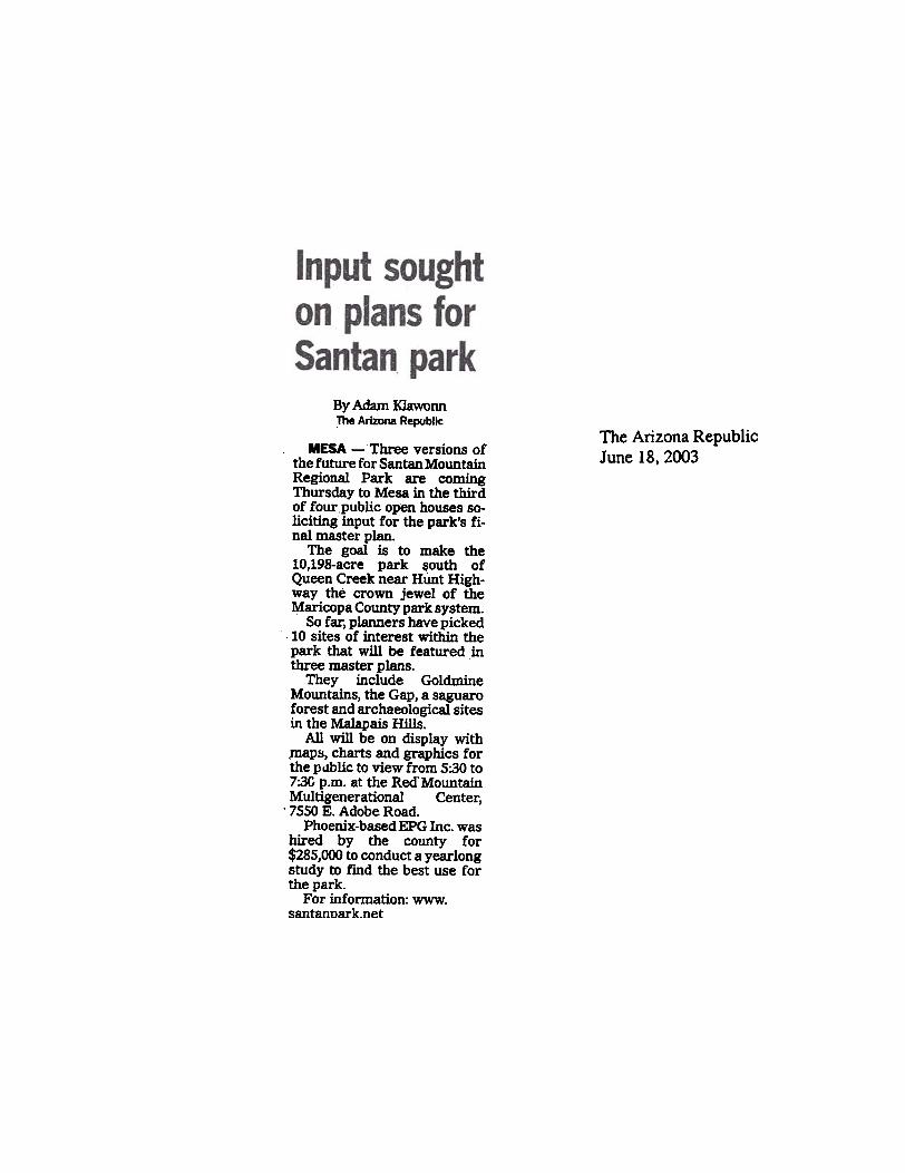
By Adarri KIawonnThe Arizona Republic
The Arizona RepublicJune 18, 2003
MESA - Three versions ofthe future for Santan MountainRegional Park are comingThursday to Mesa in the thirdof four public open houses so-liciting input for the park's fi-nal master plan.
The goal is to make the10,198-acre park south ofQueen Creek near Hoot High-way the crown jewel of theMaricopa County park system.
So far, planners have picked: 10 sites of interest within thepark that will be featured inthree master plans.
They include GoldmineMountains, the Gap, a saguaroforest and archaeological sitesin the Maiapais Hills.
All will be on display with,maps, charts and graphics forthe public to view from 5:30 to7:3G p.m. at the Red. MountainMultigenerational Center,. 7550 E. Adobe Road.
Phoenix-basedEPG Inc. washired by the county for$285,000 to conduct a yearlongstudy to find the best use forthe park.
For information: www.santannark.net

Page 1 of 1It's time to speak up
~~ PRINTTHIS
The Arizona RepublicAugust 21,2003
It's time to speak upMt'('/i/l.y.f ,,'ill ,lli\'C public chat..,.. to dC'/('rnlil/e .1)(IlI1cJII park s futur,.
Aug. 21, 2003 12:00 AM
The process to update the Santan Mountains Regional Park master plan is moving forward. The project team will unveil the preferred master planat t.w° open-house meetings Sept. 4 and 18, making it more convenient for the public to attend. Although these meetings are still weeks away,residents are strongly encouraged to mark their calendars now and make a commitment to drop by one of the meetings. Public input is imperative
In June, three conceptual master-plan alternatives were displayed for public viewing at the third open house. Project team members were on handto answer questions and gather the pertinent feedback from current and future park users and the public that was used to form this plan.
"':be ~'tematives included maps detailing the park with minimum development, moderate development and high development. The developmenti[lv,?rves recreational activities the public had suggested at earlier meetings and ranges from family picnic areas to a visitor center with restroomand parking facilities to family camping and riding stables.
Obviously, these alternatives reflect the varying preferences of the public. Some want to preserve as much of the park as possible. while othershope for multiple uses. and stili others fall somewhere in between.
the'altematives also showed the park with and without the closure of Brenner Pass Road. Public input Is especially crucial on this point, becausenearby residents say they need the road to remain open so emergency vehicles can reach them Quickly. They have a valid argument.
It will be interesting to see the various options pared down into the preferred master plan
The project team is dedicated to providing Maricopa and Pinal counties the recreation and amenities residents desire without sacrificing precioushabitats and natural resources or the wishes of those who live so close to the Santana.
These vast differences prove the importance of the open-house meetings. They allow the project team members and the public to openly discussideas that will evolve Into the Santan Mountains Regional Park master plan.
Find this article at:h ttp" J Iwww.azcentral.oorr/arizonarepublic/eastvalieyopinions/articles/0821 seed it0821 . h Iml
Check tt\e oox to include tt\e list of links referenced in the artk:le
9/3/03
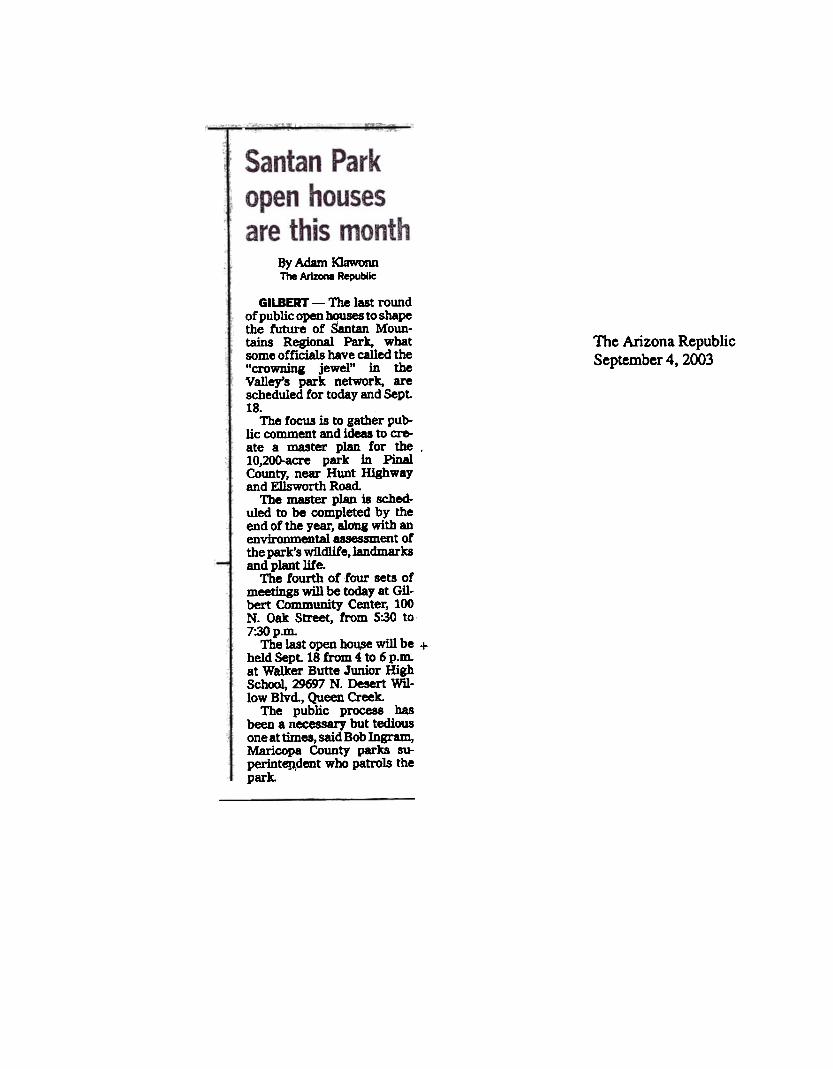
8yAdamI<JawonnThe ArIZaIa Republic
The Arizona RepublicSeptember 4, 2003
GILBERT - The last roundof public open houses to shapethe future of Santan Moun-tains Regional Park, whatsome officials have called the"crowning jewel" in theValley's park network, arescheduled for today and Sept18.
The focus is to gather pub-lic comment and ideas to cre-ate a master plan for the ,10,2oo-acre park in PinalCounty, near Hunt Highwayand Ellsworth Road
The master plan ia sched-uled to be completed by theend of the year, along with anenvironmental ~~ent ofthe park's wildlife,landmarkaand plant life.
The fourth of tour sets ofmeetings will be today at Gil-bert Community Center, 100N. Oak Street, from 5:30 to-7:30p.m.
The last open bou.se will be +held Sept 18 from 4 to 6 p.m.at Walker Butte Junior HighSchool, 29697 N. Desert Wil-low Blvd, Queen Creek.
The public process hasbeen a necessary but tediousone at times, said Bob Ingram,Maricopa County parks su-perint6!J,dent who patrols thepark.
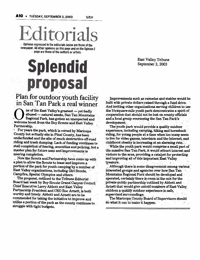
A 10 . TUESDA V, SEPTEMBER 2, 2003 S/EV
East Valley TribuneSeptember 2, 2003
hnpro:vemen~ SUch as ramadaS $d,stables ~ould bebUilt wjth privatedouars, raised tbrO'ugh a fU:nq drive. .
~4in"it~ other organizations serviDg chiIdren to usethe l.v~square-,1ilile youth pai'k'deinonStr~tes a spirit ofc()O~rationth8tShoU1d not be .loSt on count.y()fflcialsaDaa:focal~ui> overSeefugthe San Tan Park's' 'development. . '" ..
" '
~eyouth park ~ould provi.de.a ~ty out4oar~:rience,including ~p~, ~ and ho~back'ridi#g.for young people at a ~ew~en:tOo 'In8i1Y seem
, ,
to live for video g$1es, television and the .Iritemet;.andchildhOOd, obesity is.incrp.SI.CIinD', at ana~ng rate.: '
, ,-~, ' . ,
," ,While ,the youth parkWQUldcomp~a~ p~ Q(t}Je massf'lesanTmParkj it wotJ:ld attract interest andVisiwrs to t-he'ar~~Vidingacata1Yst for p~~"mid imprQY)ng all of this i1I1~,itantEast Valley~~.. " '. 'J ':. ~ AI~~ there is some dis~~entainong~ou$ ,
tnterested ~il~ and ~encies o~er how,san Tan .."
.. .,,'~oun~ Regional Park sh0ur4 ~ deVelopedanq ,
operat;ed, ce~y there.Is rOOmmthe ~ for ,the ,. . ' . .
pnvate-pub1i.c .partners'hip outlii1E!9byAb~tt andArn~ttthat y,rould give ~ld 'nuriJ,bers ofEastV81leychildren, qQ8UtY out~Q()texpedencein saf~' "supervisoo'$UrrqupcJings,. .
. The Maricopa CoUnty Board' of Supervisors shoulddo what it can to' n18keit happen. '
. Opinions expressed in the editorials below are those of the
newspaper. AI.I other opinions on this page and on the Opinion 2. page are those of the authors or artists.
. .. .
~1~h...fpr.()utdoQrY9uth f~c~li~1n~ San.Tah Park..a real. Wlnner. . , '...' .O. neofth~.East VaH~ysgr~test-yetba~.
abUsed - natUral assets, San Tan Mountams. .. RegioliaI Par~ has got:ten an ~~ected and .
.welcom~~ from the :B9y~outs.arid ~ast.v alley.Partnershi.. "'. 'p. ,..' For years the par~ wh:ich:is oWned byM.8ricopaCountY but act'tia~ sim in PiiiaICOunty, has been.unde~ed and the Site of much; de~ctive of! -r~ad'.ri~and~.aSh dumping,Lackof~~ con~~~.tocstall completion' 9f fencing, amenities.andpOlicing, but~
... ..~r plan for fut1ire uses and improyements,is..' \ . I" "
~~anngcompIetion. C. "c' .'..
;; N<Jw.theSCouts andP~netship haye come up wi,tha"p~, to, allow the $coutsto lease'~d.i:mprove.~. "
'portion"Ofthe park fot youth camp~'by a number 'ofE~ VaHey organiiatio~ incfuditig GirISc~utS, ;
C~pfire,Special Olympics and others... .,'.. The pr<?~, outlii1ed to the Tribune Editorial. . "
'. ,, Board last week by Boy'SCouts Grand CMyoIi Council:"ChiefEXee~tive~ Ab90tt,and Ea"stVa1ley "
Pattne~ship President and CEO Roc Ari1~tt, is bothworthyand:tittlefy.Abbott and Atnett.areto becommended for ~ the initia:tivetO improve andutilize a p9rtion of the park as the courit;y continues t9 "strogglewith tight budgets. .. .

~
~.:t
J.. c~8Ig.
J].!
GI..
. ..
C
c.-...;
E~
8..-
'&~
.!!..
III U
o-~D
OE
..
c
,2 ~
'E
mEc~0.--~o
1/-~
ol;'~Cl/
~.c
0..(.11ft
[~o~!.IE";,x~
I/
2.~Elft
!:E~..
C"
-81,Q
ICo~
~I/
~~
S"O
8§.!i ~B
j80S
ii"" IJ:R
- o§ ~
if ~ .: ~
~.~
~ '.~.oi
~~
i § .
> I.~
:a !
8'i l
~el05i!t
ii
"t: 5
~.g
~.~
.~
s:a:i '8 0\-
tI ~
~
. 0\
-.. c
~~
lOb05-B
~~
~
NO
vi
od'iiilll~';i~
i .;;
Its ~
~~
'O~
I !~
.s~.8!S
~
.~.a
~.8
1~
0\"'§
81 .8.5~
~'O
-'~
! Ij';
~-5 ~
~ ~
-a'
~.l11!t Itl!~
I]li~
~~
! 'i1;i!~
_1.f~
l~o~
a.§.s8!6j .~
i i Ii 1 j i .~
f ~ ~
i
E
'~1~
i.!a~i
iiiQ
,) "'O
~.i~
!!s ~
05 i
~8
to) j!~
Oi.a~
6
f§
~~
~~
.M..
oS
.
U
~~
.c'a~i~
tli.,
t!.c'i~
~,;
&
05°
1ro
a~i1~
I'
~~
.0
'w'!!'a
~
~
.i't;
~
k'G'i
~]'~
~JI~
ro ~
8"i~~
tJ""~~
-9.s
~
. .!;:~
~19G
.8~
..Q
~fi
§rS~
tl6Q
,) :a
~
'iJ oS
'C
~'
~i~
i.fj~!
-cJ
,g 0
5~~
8
.g .8.s~
~"a
a~
vr' i
~I~
,!-Joo
~+
-' ~
~
ip..~
~
i D
o:J
'j!
~
(/)..~,~
-=
0 &
)... ~
~~
a
to) ~
~
~~
!i.8 ~
.~(/)
~.:- ~
~~
~., .~ f
~
~.~
:ailCli
CD
s 15
t!.8~.e-
The A
rizona Republic
Septem
ber 13, 2003

From P-..' Al
be IDd BItBB haft beId ~cl8im8 but haVeD't wort8daince 1992. M'JI1ina cIaimI r-.mala ICdve if tbe ~ P81I81 ~ $100 fee.
BI8k ~ ~ P8rl87 tbethreat of . WW'kiDI copper and8QidmlDe8wb8twouJdbeP8I"k I8IIdmID . ~~ withdie lateral ~ ~ ~~~~t. .
. "It tbat'I wb8t it ~ down
1D,~-wouJdUb.1IDdtr8de, . be 8id. -U tII8J lift U8
, my P1'obJ81Ia. ~ _on IOta~ Dod8e or iDather ~.pany ~ 1111 dIU DI8I8'IaL .
Be ~ ~ tr8d8 the tOO. ~ - fm': 8OQ tQ 1,200
acra eut of tbe P8rk. WhIch. B)e8k 8id be'd tIleD try to leUfor de.-~~ .
Ja ~ BlMk 8Id B8t8
My d)8y wouJd ~ the~ C.Jaim8 In tile perk that B8t8I
mJBojI8d from .. brot!8r,. - C8lJed "Tb8 M81 ofthe Mouataln. . C8118' 8IId biI
miDID& plrtDer, R.B. -Ted"Rodney, --buried at tbe tootof tl8 GoIdDIiD8 ~!!!~ In
. Uae park.
Us.e lie bllI.ucI'KYBob IDIram. die par"1U-
~, ..,. ~ ~ty8IMXI]d throw ~ atdIe~
. "IckID'tW8Dttoj\l8tautomat-k:8Dy lift up park J8Dd.' JI8.. -We b8ft . )aDd ~=-- that DeId8 to be fO1-
F8dIra1 omcl8I8 lay . 1IDd
Po-.tiII probI.nI for ,..s., ., ~ ~ P8k'1 S285,OCX) ~ pI8I ~ Id-*IIedto be completed by the 8nd of the 188', but III tutu,. II cloudedby e mlnlna cleNn. . pnJPosed ~ ~ ~ 8Id . by .GObert d8¥8Iop.- in PlniI CCM8Ity SUperiw c-t.
. .
-_'i~ uellkmlb_PIP8'-wort b'OID B188k to prove be II
~ lad tD .. tile d8t8BI
of b ..-:~ "P8k ~- ~ be tied lIP b ,-.If die lad ~n~~IIeDCY ctIoO8eI to ~ tbecJaIm.'
.It~~~... Judae ~ D8r9w to ~ .
_t the DepBrtmeDt of IIItwt-
01', 8Dd If BII8t Jolt, ~ could
~ lIP tD die U.s. Supr-.~
Ba-. If, wI» Uvw In m88It u.. DMIbDe .. P81'k.
8788beWMl81D..cd8tbi1be-
!
- be-. &L . .
-I WIRIW . tD ..,. --..y Ware I die 10 I ~ .8ometIdDI 1Ped8J." D- 8d.~ Iud u.,'n1Do*l: 1D -bK.k1Dcl1lde8_~BIstce .. ... * .-rk'lIOutherD fJDaer. a bID:..~ pit BJ.k'I miaIDa GIdI-1IooI8drr...~1*; tij rani amd8JI ~ .Jd ~WII mIntDa !8I!!IP'~ Ioct.IDJD8pprQpri8te UM b -cI8iID. .
B8I8 ~ B8k . a:~ mID wIlD ... ma-tIaa8d mIaiaI die C81DyW1)'. jaIt 1D IPI88 It. BLM. . AIU111Gt
with . pick aDd IIKIvel," Ibe8dded, r8ferriJI& to the idea ofuIiDI ~ ~~. .
But Ibe doesn't want to ... it10 that far. Markopa Countyparka lad recreatDi DirectorBill Sc8lm laid die -tr Ia~ 0PPa8ed to a trade, but itwill wait for the reau1t8 of tileBLM 1Dqujry.
Butdletlmill8ofdleDOtlce. to wart die cIaim8, which colD-
ddes with die muter pl&wrap-up, Ia 8uIpect. he IIJd.
-n'I UJlfortllD8te In a ~dIat a r- iDdivjduaJa ~ baV8IUch . IiIDiftCInt effect mopen IP8C8. " $c&Iao laid.
SCCMIIIW8dk.,1aoBoy SCXJIIt ~ would
Jfke to obtain up to 1,2001Cre1IlODI die par" ~ftD&er - ~ Butta ~ acamp.
'nJey fen In lOve with theIdea after a mule ride tbrouIhtlleP81'kIad~Jfketomabdle_a"k7w-jmp8Ct"C8mpiIIa -. aDpIem with aCXJrr81lor8boutaoheedof--. 8Id LIzT7 c. Abbott,8axIt BDcuti.«BO fIX' IbGr8IdC8iJZCoImdL
But dIeIr pmpciaa1 C8me u aIurpriIe to tile CODIultaDt8 whow.e IdI.d - --(XX) to~ up . ID8Ita' pI8.
MariaJPI c.-t,. P8rb offi.cIa1s and tbe muter plaDner,§G IDC., of PI-.1x. wm ptdIeir &at kXIk at die SaIut8'pJ8I -- die araJp'l Jr9tIIa,~ 8rcbit8ct comesto the Vaney tb1I ~ to di.-pJar d8IIIIII at the ftD8l public
open boU8e m the IDUt« pi8D.'nI8t will be ck-. 'lbIInd8JtIun 4 ID 6 p.m. .. die WaJ8Butte JUIIior HjJh ScOOoI cafe-teria, 29697 N. DeI8It WDIowBlvd.,QuBCreek.AbboUI8idBo,Smutotftciala,witbqpcx't from tile Eat VaDe,~. . bUllDe88I1'OUP.are JobbYilll tile ~ClXmty BO8rd of ::-.ipa,~for &pPIV9aL 'nI8 COUDty II de-veiDpflla the park with tIDaD-ciallUPportfromw..,GU-bert.CII8Id1«aa4Que81Creek.AJIO alcx1a the . Park'I
IOUth8m ftJ1aer D8r M1-.IButte II EI~. . cuDm1M8De~~de-YeJr4)C. BaI:r1 ~ Sutberi8ld,~ been ~ m'two fekIIIyCOUDt8 ofcrimiDal damaae ladJiUeriDI in tile park ~arIes.. .
SutherlaDd ~buildID8 m8t8rI81 ICrap8 ID .aitewithiDdlepark,1aidCbuck T-" '..iiio . PIaalCounty Aaam81'a Office~.~ .
~vir-:In~) mYeltipt-«'Ifortlle~.,.be..damIIed tile ~ --be.CUt mID park land ID b!dIdculvertl aDd pcx'tioaI of . rOId.Be ~ DOt be re8dIed fur~
'nI8 C8M II 8C!IeduJ8d for .pre-trial ccmference on Sept.30. If ~ SUtherJaodCCRIIdf8C88rJthiDctlunpro.b8tkIa ID 18 mmthl in j8il. Tee-prdeII _do TIle Q)Uft ..could force him ID pay reatitu-tx.a to nbabilirat8 tile -.
'ByAd8m~1118 AI-. ~
P1oydBle8k'lmJlJJlJgclaimin d8 SaD ~ ~.. -~taia R.-
PIrt iID 't tb8 ftrst timebe hu run afoul 01 the 1m. 011miDiDI iaua, ad be keep.tr8Ck ~ Ida Ire8t8It bita.
Be bu . yellowed pIMItD 81-b.uD of n8WIPIPeI' cljppiDpdatiDab8ckmoreth8Dthree
. dec8d8I. "ftIyd'I Adgen~
II b81id-written in blue Dl8l'keraIona tbe blDdinl.
ODe cIjp i8 . 8tOry from tbe~SrmiDdIe~about bow BJeak'8 miDinI out-fit posted armed IUIrdI at d18entry to keep out 1Dapecton.
Now. tbe land be and AliceB8te8,84,-lookinItoptback JJIc1udes the MineralButte area aIona SIn nn
~"'-!U8111 ReIkxI8l P8rk'IIOIItb8m nnaer. a. fonDS',Il'avel pit from which federIl,offida\8 ousted tile BI8abanKIDd ~ fCX' I8WIIC I8Dd-IC8pe rvck, . ID ~ule for tile claim.
It eveatuaBy feU to a privateIn--. BJeak uj4, wtM)_1tto tile We8t8D SaYiIIp . Lola,which, in tUrn, lost ita ~inlDtndUltJ'yWldecollapleill
dlel8t8~A--oftr8D88CtiOGI made It P8rt of the
COUDty'I part pI8D.
ButwitbiDtb81partceIDiIIiJII cI8im8 IC8eped in ~tory. B8t8' oldelt brot!)II'.Mansel CIrter. held them8kxII with hi8 partII£, R.B.'"red" RDdIIeJ.1iDC8 dIe'l94O8.lbeaYL
BateI CIIJIe to QueelI Creekfrom Ohio to care tor 8n aIinI
c.rtBr wJM) died ID 1987.Both Cart8I' md Rodney
pUled away and Into local~ n.y .. burled - tbe~ bae of dI8 Go1dmtnaM!!!!!!t8IDI. 11)8 cI8fmI fen toBatel. who DOW co-owna themwitbBlak.
-rd jIIat like to trade It for~_pt_ofwbatI earned out of It," she said... And lib 1 ujd, I earDed It. ..

COMMENT SUMMARY TABLE AND MISCELLANEOUS SUPPORT LETTERS

~6e29533969
11/19/2663 69:43
PAGE 8119'rr.l\f - /?dXAIV~
~ql...J~c.. 16 h/~/ - (.(5 M.A I ~ - "/?'ra
November 17, 2003
Mr. William C. Scalzo. DirectorMaricopa County Parks and Recreation De~nt411 N. Central Avenue, Suite 470Pooenix, Arizona 85004
William C. Scalzo,
The O'¥>untain bike trails included in the San Tan Mountains Regional Park Master PlanFinal Draft will be a welcome addition to the Valley, providing much-~ o~rop}x)rtwrlties for bicyclists, eqoostrians, hikers and joggers to use and enjoy.Additionally, I enthusiastically support the inclusion of the molLT!!ain bike track in thePark.s master pJan.
The roountain bike track provides a great opportunity for bicyclists of all ages andabilities to get outdoors aOO exercise. While located in the southeast vaUey. this biketrack has garnered support nom potential users on both sides ofthc valley arxl will attradusers wi¥> might otherwise not utilize the park.
The master plan is the resuh of an extensive public process with input ftom manystakeholders. The process included five open house ~~ and the creat~n of aStakeholders Advisory Group and Joint Planning Committee.
The final draft of the plan reflects that public process by including a wide variety ofu.gesand amenities, oonefiting people in both MaricQpa and Pinal Cowuies. I belie~ themaster plan will allow the park to become a great regional facility that everyo~ will beproud of.
Thank you for the opportwrity to provide input into the development ofthc San TanMountains Regional Park Master Plan.
Sincerely.
~ ~::~~;;:~:oaIitioll of Arizona Bicyclists[602-493-9222] WWW.CAZBlKE.COM

San Tan Mountains Regional Park Master Plan Draft Comment Summary Table 12/11/03
No. Date Name/Affiliation Method Issue/Concern Action TakenFederal/State Agencies
1. 12/16/02 Victoria Carella, ASLD Email Will be available to serve as a resource to the project team but cannot be on the advisory group. Would like to be on mailing list.
Added to email list.
2. 8/22/03 Victoria Carella, ASLD Email Wants hardcopy of newsletter #4 mailed to her, was unable to access on website.
Mailed newsletter.
3. 11/4/03 Brian Clifford, US Representative Jeff Flake’s office
Phone line Is reviewing federal lands in Rep. Flake’s district and wanted to know the background on the San Tan Park, such as how it is being managed by the County even though it is BLM land.
Discussed CRMP, planning process, project issues. Mailed 4 newsletters and copy of CRMP. 11/5 Mr. called back to ask why County didn’t just buy the land instead of the CRMP. Advised to call County.
Local Agencies 1. 12/20/02 Jon Wootten, Queen Creek
Councilman Email Wants to be on mailing list. Added to email list.
2. 1/31/03 Jon Wootten, Queen Creek Councilman
Email Received electronic newsletter. Asked if he could have a copy of the SAG roster.
2/7 Advised would send him a roster with 11 of the 14 members (those that agreed to release contact info). Forwarded file with attachment. Mr. Wooten also had questions on how SAG was formed, discussed process, roles & responsibilities over phone.
4. 2/11/03 Debbie Francis, Pinal County Sheriff’s Office
OH 1 comment
States that Sheriff’s Office would like questions answered: 1. who is responsible for patrolling and policing park, 2. who is responsible for criminal investigations in the park, 3. who is responsible for prosecuting crimes in the park? Provides numbers for contact.
County will contact Ms. Francis.
5. 2/14/03 Jon Wootten, Queen Creek Councilman
Email Dialogue between Mr. Wootten and G. Bernosky (planner) regarding a trails map Mr. Wootten has been maintaining.
-
6. 3/18/03 Cynthia Seelhammer, Town of Queen Creek
Website Wants to be added to the mailing list. Added to email list.
7. 4/4/03 Linda Edwards, Planning Director, Town of Gilbert
Email Wants to know who from the Town of Gilbert has been attending meetings.
Advised that Tami Ryall is the representative on the JPC. She has attended all meetings and coordinated the article that appeared in the March edition of the town newsletter.
8. 4/8/03 Jon Wootten, Queen Creek Email and Scheduled a phone call regarding the potential Note: phone conversation with M.
1

San Tan Mountains Regional Park Master Plan Draft Comment Summary Table 12/11/03
No. Date Name/Affiliation Method Issue/Concern Action Taken Councilman phone for a 4H representative on the SAG. Discussed
Boy Scouts were added because the emphasis was on youth and education, thought that group would bring more diversity. Also discussed the issues heard from the public, issues that Jon is aware of (fencing/access, ATV/OHV, shooting range). Jon would like to see more access, at a minimum more equestrian step-throughs. Would also like a shooting range but understands the concerns.
Doyle and L. Long.
9. 4/8/03 Kenny Martin, Parks Superintendent, Gilbert Parks & Recreation Dept.
Email Wants to be added to the mailing list. Added to email list.
10. 4/24/03 David Dobbs, Vice Mayor, Town of Queen Creek
Website Would like mountain bike trails with a section that can be used for race course. Supports overnight camping. Would like the location of the visitor center in one of the fingers to be considered.
-
11. 06/05/03 David Dobbs, Vice Mayor, Town of Queen Creek
Email Expressed concern that the next open house date wasn’t reflected on website, but his browser was pulling up an archived page. Mr. Dobbs also expressed thanks for the email notifying the public that the third newsletter was available on the website.
-
12. 06/23/03 Jon Wootten, Queen Creek Councilman
Email Missed the open house. Hears the County still only wants a single entrance. Doesn’t agree with this and wanted to know public response and general update from public meeting.
Advised the plans are on the project website and show between 2-4 entrances. Although not all requested entrances were included on the plans, the public seemed to recognize that efforts had been made to include their requests and increase accessibility. Also advised biggest issue locally is Brenner Pass Rd.
13. 8/20/03 Kenny Martin, Gilbert Parks Superintendent
Email Thanks for the update on newsletter #4. -
14. 9/4/03 Jon Wootten, Queen Creek Councilman
Email Wanted information on the new boy scout proposal, such as if the JPC, SAG, and consultant had reviewed the plans and if they would be presented at the open house.
County responded that the plans had not been reviewed, but the initial evaluation studied youth camping in that area and it was eliminated due to public comment, infrastructure cost, etc. It may delay the schedule a little.
2

San Tan Mountains Regional Park Master Plan Draft Comment Summary Table 12/11/03
No. Date Name/Affiliation Method Issue/Concern Action Taken 15. 9/18/03 Jon Wootten, Queen Creek
Councilman Email Wanted to confirm open house time. Also wants
to know if the Boy Scout proposal will be shown at meeting.
County responded that the open house time was correct, EPG will not be evaluating the BSA proposal but the BSA will be at the meeting.
16. 9/23/03 David Dobbs, Vice Mayor, Town of Queen Creek
Email Attended the open house and was disappointed that the scout camp would replace the competitive track. Wanted to know why this was occurring and how the camp fit into the process at this late stage after public involvement supported the preferred master plan.
County responded that the track has not been displaced, advised Mr. Dobbs to Contact Mr. Scalzo.
Public Citizens 1.
9/25/02 Richard Kuhn Email Owns home 3 miles from park, near Higley and Hunt Hwy. Thinks park should allow OHV use. Requests addition to mailing list.
Added to email list.
2. 1/05/03 Mary Kabanuk Email Wants to be added to the mailing list. Added to email list. 3. 1/09/03 John Lichtenberger Website Wants to be added to the mailing list. Added to email list. 4. 1/9/03 Creighton Wright Website Wants to be added to the mailing list. Added to email list. 5. 1/9/03 Albert and Karen Holler Website Wants to be added to the mailing list. Added to USPS list. 6. 1/9/03 Karen Stapp Website Wants to be added to the mailing list. Added to both lists. 7. 1/10/03 Kevin Dorer Website Wants to be added to the mailing list. Added to USPS list. 8. 1/10/03 Warner Weber Website Wants to be added to the mailing list. Added to email list. 9. 1/11/03 Alden Rosbrook Website Wants to be added to the mailing list. Added to email list. 10. 1/12/03 Trish Haskell Website Wants to be added to the mailing list. Added to email list. 11. 1/13/03 Vicki Richards Website Wants to be added to the mailing list. Added to email list. 12. 1/13/03 Judy Kenney Website Wants to be added to the mailing list. Added to email list. 13. 1/13/03 Benjamin Worrell Website Wants to know if there will be allowances for
OHV since there are BLM lands. Wants to be added to the mailing list.
Advised that under cooperative agreement County manages land, County policy prohibits ATV use. Added to USPS list.
14. 1/13/03 Lindy Obremski, Arizona Clean and Beautiful
Website Would like to add Leandra Lewis to the mailing list.
Added to email list.
15. 1/14/03 Gila River Indian Newspaper Website Wants to be added to the mailing list. Added to email list. 16. 1/15/03 Lynette Durrett Website Wants to be added to the mailing list. Added to email list. 17. 1/19/03 Anne Reed Website Interested in providing input into the process.
Lives in adjacent subdivision. Wants to be added to the mailing list.
Advised of open house date, methods for comment. Added to email list.
18. 1/21/03 Mark Trainor Website Lives near the park, wiling to volunteer for trail work projects. Wants to be added to the mailing list.
Added to email list.
19. 1/20/03 Randal Nemire Website Would like to see mountain bike trails. Says the MBAA would be able to help build trails and with maintenance. Wants to be added to the mailing
Advised mountain bike interests represented on advisory group. Added to email list.
3

San Tan Mountains Regional Park Master Plan Draft Comment Summary Table 12/11/03
No. Date Name/Affiliation Method Issue/Concern Action Taken list.
20. 1/20/03 Scott Hansen Website Suggest providing a variety of multiuse trails for hikers horses, bikes. Wants some trails difficult and some ADA accessible. Thinks trails should be marked and reviewed by user groups before being final. Wants to be added to the mailing list.
Advised team will be looking at multiuse trails to meet regional needs. Advisory group is being formed to help review information. Added to email list.
21. 1/20/03 Paul Beakley Website Wants to be added to the mailing list. Added to both lists. 22. 1/20/03 Dale Wiggins Website Wants to be added to the mailing list. Added to email list. 23. 1/20/03 Charlene Todd Website Park should offer challenging mountain bike
trails. Would be willing to help build and maintain trails. Wants to be added to the mailing list.
Advised team would be looking at multiuse trails. Added to email list.
24. 1/20/03 Michael Bennett Website Would like to help build trails. Wants to be added to the mailing list.
Advised team would be looking at multiuse trails. Added to email list.
25. 1/20/03 Scott O’Connor Website Would like mountain bike trails. Wants to be added to the mailing list.
Advised team would be looking at multiuse trails. Added to email list.
26. 1/20/03 Mike Walker Website Would like mountain bike trails. Wants to be added to the mailing list.
Advised team would be looking at multiuse trails. Added to email list.
27. 1/21/03 Lance Rudnick Website Wants to be added to the mailing list. Added to email list. 28. 1/21/03 Theodore DeZorzi Website Enjoys the park. Wants to be added to the
mailing list. Added to both lists.
29. 1/21/03 Anne Reed Email Is concerned berms and installation of razor wire. Thinks this technique is dangerous to horses and OHV. Is also concerned with damaged saguaros.
Advised the berms and intended to prevent OHV access, which is against County policy. EPG would notify ranger of saguaros. B. Ingram responded clarifying County policy on OHV, saguaro damage was due to a microburst.
30. 1/21/03 Anne Reed Email States that the resources that the developers in Pinal County have pledged to the park will be reallocated by the time the master planning process is finished.
-
31. 1/23/03 Evan Website Wants to be added to the mailing list. Added to email list. 32. 1/24/03 Jeff Thomas Website Wants to be added to the mailing list. Added to email list. 33. 1/25/03 Beni DeMattei Website Wants to be added to the mailing list. Added to email list. 34. 1/25/03 Roy Conrad Website Wants to be added to the mailing list. Added to email list. 35. 1/25/03 Sheryl Geis Website Wants to be added to the mailing list. Added to both lists. 36. 1/25/03 Anne Reed Email Advises damaged saguaros are near south
finger along the road leading to the quarry. -
37. 1/25/03 Anne Reed Email Thinks that the berms are dangerous. Things ATV use should be considered in park. Thinks park boundaries should be more clearly
-
4

San Tan Mountains Regional Park Master Plan Draft Comment Summary Table 12/11/03
No. Date Name/Affiliation Method Issue/Concern Action Taken identified.
38. 1/26/03 Marajo Long Website Wants to be added to the mailing list. Added to email list. 39. 1/26/03 Linda Kinney Website Wants to be added to the mailing list. Added to email list. 40. 1/28/03 Mark Pederson Website Wants to be added to the mailing list. Added to both lists. 41. 1/28/03 Phil Dixon Website Wants to be added to the mailing list. Added to email list. 42. 1/29/03 Brian Fry Website Wants to be added to the mailing list. Added to email list. 43. 1/29/03 San Tan Adobe Website Wants to be added to the mailing list. Added to USPS list. 44. 1/30/03 Frank West Website Wants to be added to the mailing list. Added to email list. 45. 1/30/03 Janet Wright Website Wants to be added to the mailing list. Added to email list. 46. 1/30/03 Carl Kinney Website Future development should include recreational
opportunities. Wants to be added to the mailing list.
Added to email list.
47. 1/30/03 Carl & Valerie Bloom Website Include trials for hiking, biking and horse. Would like access on the west side.
Added to email list.
48. 1/30/03 James Abbott Website Has hiked in park. Thinks main uses should be hiking and education. No OHV. County should use all volunteers available.
Added to email list.
49. 1/30/03 Scott O’Connor News comment
Would like hiking, biking, horses, picnicking, camping. No OHV unless in separate area away from other users. Maintain emphasis on preservation and restoration but maintain access and trailheads. Much scarring from roads, litter.
-
50. 1/31/03 Georgia Peterson Email Received email copy of newsletter. Saw the open house mentioned in the San Tan Monthly and will attend.
-
51. 1/31/03 Georgia Peterson News comment
Would like hiking and horse trails. Provide horse trailer parking to minimize damage to park. No OHV use or overnight camping, commercial entertainment (balloon rides). Preserve most areas of park, prevent degradation, restrict road use to entrance and not bordering residences.
-
52. 1/31/03 Lucille Schmidt News comment
Likes hiking, horse trails, picnic areas, not OHV (too noise and destructive), maintain beauty. -
53. 1/31/03 Diana Taylor Email Owns land near park. Would like to receive email updates.
Emailed copy of newsletter, added to email list.
54. 1/31/03 Robert Crowley Website Website looks good. Wants to be added to the mailing list.
Added to email list.
55. 2/3/03 Thomas King Website Limit recreation to hiking, biking, horses. No overnight camping, the space is too small. -
56. 2/3/03 Candy Hess Website Wants to be added to the mailing list. Added to email list. 57. 2/3/03 Mary Kabanuk Website Uses park often for horseback riding. Preserve
natural beauty, less impact on environment. -
5

San Tan Mountains Regional Park Master Plan Draft Comment Summary Table 12/11/03
No. Date Name/Affiliation Method Issue/Concern Action Taken 58. 2/4/03 Terry Abbott Website Wants to participate in planning. Has been
involved with 4H club for 20 years and wants the park to meet youth needs.
Advised team looks forward to hearing comments on education topics, provided information for open house. Mr. Abbott responded that he plans to attend.
59. 2/4/03 Charlene Todd Website Keep park for multiuse trails (hiking, biking, equestrian). -
60. 2/4/03 Helena Casciotti News comment
Park needs more hiking trails, keep as little impact as possible. -
61. 2/4/03 Jack Locust News comment
Provide riding stables for people who want the experience, cleanliness and place for family recreation. No OHV.
-
62. 2/6/03 Ron McCoy News comment
Plan for hiking, biking, horses. No OHV, commercial use, camping, skeet shooting, and other urban activities. Keep park natural, don’t let trails interfere with natural landscape. Keep quite and pristine.
-
63. 2/6/03 WM Smithers News comment
Wants hiking, no OHV. Make more access points, up to 3 locations. Make trails in both easy and difficult categories. Would like to know southern boundaries of park.
-
64. 2/6/03 Tracey Melick Website Would like to see equestrian uses: parking area for trailers, hitching posts, bathrooms, picnic area, water for horses.
-
65. 2/6/03 Annette Minnick Website Wants to be added to the mailing list. Added to email list. 66. 2/6/03 Bob Sandblom Website Wants to be added to the mailing list. Added to email list. 67. 2/6/03 Leslie Paterson Website Wants to be added to the mailing list. Added to email list. 68. 2/6/03 Lisa Hembree Website Wants to be added to the mailing list. Added to email list. 69. 2/6/03 Kathy Chruma Website Building home in area, available to volunteer.
Wants to be added to the mailing list. Added to email list.
70. 2/7/03 Lynn Maring News comment
Keep hiking, bike, horse trails, and shooting range. No overnight camping, OHV. Park should be cost effective; shooting range may be cost-prohibitive.
-
71. 2/7/03 Jeff Brown Website Moving to area in April 2003. Wants to be added to the mailing list.
Added to email and USPS list. Advised to contact team in April when mailing address changes.
72. 2/7/03 Denise Brooks Website Wants to be added to the mailing list. Added to email list. 73. 2/7/03 Pat Merrick Website Wants directions to park and date it will be
opened. Advised where park entry is and how to get there.
74. 2/8/03 Luis Rivera Website Wants to be added to the mailing list. Added to USPS list. 75. 2/8/03 Char Wester Website Wants to be added to the mailing list. Lives near
park and would like to pass information to Advised of open house date. Added to email list.
6

San Tan Mountains Regional Park Master Plan Draft Comment Summary Table 12/11/03
No. Date Name/Affiliation Method Issue/Concern Action Taken others.
76. 2/9/03 Bruce Wachtel Website Wants to be added to the mailing list. Added to email list. 77. 2/9/03 CW Vanderhoof Website Wants to be added to the mailing list. Added to USPS list. 78. 2/9/03 Dan and Karen Chudler Website Uses entrance off Olberg Rd (favorite entrance).
Likes scenery. Many places they hike don’t have trails and they would like to know more about trail development plans and how they can help.
Advised of open house date and that there would be maps they could mark their areas of interest on.
79. 2/9/03 T. Stanley Website Wants to be added to the mailing list. Added to email list. 80. 2/9/03 Mike Barriga Website Wants to be added to the mailing list. Added to email list. 81. 2/10/03 Gary Newson Website Wants to be added to the mailing list. Added to both lists. 82. 2/10/03 Randy Snyder Website Wants to be added to the mailing list. Added to both lists. 83. 2/10/03 Sharon Clark Website Wants to be added to the mailing list. Added to USPS list. 84. 2/10/03 Mike Snodgrass Website Wants to be added to the mailing list. Added to email list. 85. 2/10/03 Ross Smith Website Wants to be added to the mailing list. Added to email list. 86. 2/10/03 Virginia Minor News
comment Wants trails for hiking, biking, horses, picnicking facilities. No OHV (destroy plants and scare animals). Don’t overdevelop; preserve natural beauty.
-
87. 2/10/03 Thomas King News comment
Wants trails for hiking, biking, equestrian, also picnicking, shooting range. No OHV, overnight camping (disruptive to others and park). Do not commercialize park, limit amenities.
-
88. 2/10/03 Karen Melchioris Website Wants to be added to the mailing list. Added to email list. 89. 2/11/03 Lauretta Clark Phone line Moving to area soon, would like to receive more
information. Is concerned that development of park could impact her property values.
Advised that most people see park as an amenity, but team has just started process and she has time to comment. Emailed and mailed newsletter.
90. 2/11/03 Kirby Chadwick Website Says the open house was a waste of time, team really does’t want to listen to the public. Park was better when it was BLM land because there was access.
County sent letter response to Ms. Chadwick on 2/19.
91. 2/11/03 Stan Klonowski Website Wants to be added to mailing list. Added to email list. 92. 2/11/03 Cissy McQuillen Website Wants to see a dog friendly park with hiking
trails and small campground. Wants to be added to the mailing list.
Added to both lists.
93. 2/11/03 Karen Stapp News comment
Wants hiking opportunities, no dirt bikes (noise, pollutant, dangerous, intrusive to other users). Key issue is preservation, too much development.
-
94. 2/11/03 Jim Kechely OH 1 comment
Wants shooting range so users have one in area, some areas of park well-suited for this -
7

San Tan Mountains Regional Park Master Plan Draft Comment Summary Table 12/11/03
No. Date Name/Affiliation Method Issue/Concern Action Taken use. Don’t allow sports or athletic fields, other park already providing. Don’t overdevelop the park.
95. 2/11/03 Terry Abbott OH 1 comment
A small section of park (50 acres) should be used for shooting range. Need in east valley, people already use local area for target practice. Develop the park to meet the needs of all local residents. Consider environmental issues but not so park is unusable. Supplies map with potential location for shooting range noted.
-
96. 2/11/03 Tom Alberti OH 1 comment
Wants horse, hiking, mountain bike trails. Picnic ramadas, bathrooms at entrance, water, shooting range (in SE quadrant T3S, R7E) off Olberg Rd. No OHVs, noisy and careless, not compatible with other users. No athletic fields, enough plans already for those. Keep pristine, don’t overdevelop.
-
97. 2/11/03 Kirby Chadwick OH 1 comment
Wants equestrian, hiking, mountain biking. Keep primitive and undeveloped. Make trails safe; Goldmine trail should be made safer. No shooting (not compatible with other users), OHV (destroy terrain), arena (will be available elsewhere). Wants access on north side, not available now. Wants equestrian entrance at Skyline & Lazy Loop. Protect petroglyphs and other historic places. Wants connections with regional trails.
-
98. 2/11/03 Sharon Clark OH 1 comment
Wants horse trails and safe/adequate parking for horse trailers (separate from other parking). Wants restrooms, water, ramada, barbeque, dogs on leashes. No OHV, shooting, RC planes, long-term or overnight camping. Keep park undeveloped, keep trails that access private land. Would support usage fee.
-
99. 2/11/03 Clyde & Dorothy Snell OH 1 comment
Wants campground, mountain bike and hiking trails, competition track (tri-athelon), archery, building for indoor games, shooting range. NO OHV (hard on environment), RC planes (noisy), ultralights.
-
100. 2/11/03 Dru Alberti OH 1 comment
Wants horse, biking, hiking trails, ramadas, parking, restrooms, camping, shooting range in southern finger. No ATV (not compatible with other users). May want vendor for horse
8

San Tan Mountains Regional Park Master Plan Draft Comment Summary Table 12/11/03
No. Date Name/Affiliation Method Issue/Concern Action Taken stables.
101. 2/11/03 Nonda Brown OH 1 comment
Wants ramadas, picnic areas for day use, camping, education center, historical center, trail signage and plaques. No OHV or hunting. Protect and preserve desert.
-
102. 2/11/03 Jim Jorde OH 1 comment
Wants hiking, horse, off-road trails. No shooing or hunting. Wants boundary defined with fencing and supervision, no dumping, shooting, fires, signage to park from major roads so people can find it. Signs to show when you are leaving park.
-
103. 2/11/03 Marty McMurry OH 1 comment
Wants scenic drive “loop” with picnic areas (for ADA, elderly, or kids), restrooms. Wants overnight camping for remote areas for horse and hikers only (some areas too remote to visit in one day). Include information on points of interest, history and trivia, wildlife (makes park more interesting to visit), No fires allowed, group picnic site (generate revenue). No ATVs. Make park accessible fore everyone, lots of trails but regulated. Can charge for picnic areas.
-
104. 2/11/03 Mindy Ferguson OH 1 comment
Wants horse trails, hiking trails, restrooms at trail heads, more space for horse trailers separate from other parking. No OHV (noisy, destroys habitat), shooting or RC airplanes (noisy and dangerous), overnight camping with vehicles. Concerned with development of homes near the park, ruins feeling of isolation. Park should be kept as natural as possible. Keep trails accessible through private land. Would support reasonable fee.
-
105. 2/11/03 Leigh Davis OH 1 comment
Feels more parking for horse trailers and other vehicles is a big issue, parking trailers on street is a safety issue. Suggests separating cars and trailers. Wants restrooms, running water. Would pay a fee, volunteer time to help with maps or trails. No OHV (destructive, noisy, not compatible with other users), No shooting, RC planes, overnight parking of RVs or vehicles, only leashed dogs. Issues are access to private land using existing trails, keep park primitive and undeveloped, make maps of trails accessible. Concerned the park will be overdeveloped like Usery.
-
9

San Tan Mountains Regional Park Master Plan Draft Comment Summary Table 12/11/03
No. Date Name/Affiliation Method Issue/Concern Action Taken 106. 2/11/03 Kay Frenzer OH 1
comment Wants horse, hiking trails. No OHV or shooting range. Preserve the area including wildlife and petroglyphs, prevent OHV and dumping. Wants marked trails, bathrooms, if fee charged make an annual fee an option.
-
107. 2/11/03 Miriam Weible OH 1 comment
Wants hiking, horse trails, perhaps hay rides. No OHV (destructive, not compatible with other users), shooting range. Keep quiet and pristine.
-
108. 2/11/03 Caroline Rosbrook OH 1 comment
Wants hiking, horse, mountain bike trails, bird watching, day use. No camping (park too small, fire hazard), OHV or shooting. Keep pristine.
-
109. 2/11/03 George Berkezchuk OH 1 comment
Wants horse and other trails, camping, open spaces. No OHV or shooting range (dangerous and noisy). Don’t sell fingers or develop.
-
110. 2/11/03 Regina Whitman OH 1 comment
Keep park simple and costs down, don’t build what can’t be maintained. Wants nature and equestrian trails, “no frills” picnic area. No camping, OHV, shooting range, equestrian facilities. Suggests low maintenance, low impact plan for cost reasons.
-
111. 2/12/03 Denise Dudley Phone line Wants to be on email mailing list. Added to email list. 112. 2/12/03 Brian Johnson, Reporter,
Chandler Independent Phone line Wants to be on email list. Spoke to B. Ingram at
the county and would also like a contact at EPG.
Provided contact name, added to email list.
113. 2/12/03 Robert Kemmeries Website Wants to be added to the mailing list. Added to email list. 114. 2/12/03 Rick Hankins Website Wants to be added to the mailing list. Added to USPS list. 115. 2/12/03 Georgia Peterson Email Open house was informative. For SAG, include
one more member from the GRIC since they border the park, add Regina Whitman, questions need for equestrian representation since no formal organization in the area.
-
116. 2/12/03 Thomas Lang News comment
Wants hiking, biking, horse trails, ADA access. No shooting, OHV. Biggest issue is access. -
117. 2/13/03 Lance Davis OH 1 comment
Wants nature trails to see variety of plants and animals. No equestrian use (don’t pick up after themselves), preserve natural beauty.
-
118. 2/13/03 Denise Dudley Website Biggest interest is access that will be available. Would like an entrance off of Ellsworth. -
119. 2/14/03 Caroline Rosbrook Website The first open house was excellent. - 120. 2/17/03 C. Harrison OH 1
comment Wants hiking paths with destinations, benches, and shade trees. Also mountain bikes paths. No OHV (noise). Key issues are repair of current trails, trash, lack of facilities. Wants park to be
-
10

San Tan Mountains Regional Park Master Plan Draft Comment Summary Table 12/11/03
No. Date Name/Affiliation Method Issue/Concern Action Taken connected to the city-wide trail system (i.e. Indian Bend Park). Comments that some hiking trails are too rocky and steep for kids.
121. 2/17/03 Gloria McDowell OH 1 comment
Wants hiking and a playground. -
122. 2/17/03 Anonymous OH 1 comment
Wants an extensive network of multiuse trails (biking, hiking, horseback). There are not many trails in this part of the valley. No OHV (noise). Issues are funding to complete items in master plan (trailheads, trails, bathrooms). Needs to be more signage for parking and trails.
-
123. 2/17/03 Neal & Crissy Gilbert News comment
Wants hiking, bike, horse trails. These activities can be done with families with minimal damage to wildlife. No OHV (destructive and disruptive). Keep the park in natural habitat. Wants trail signs like at Usery, and bathrooms (facilities, not portable).
-
124. 2/17/03 Marilyn Fleury Website Wants to be added to the mailing list. Added to email list. 125. 2/17/03 George Hartz Website Wants to be added to the mailing list. Added to both lists. 126. 2/17/03 Donna Hartz Website Wants to be added to the mailing list. Added to email list. 127. 2/18/03 Laurel Arndt Website Open house was informative. Plan should be
flexible enough to be reassessed as time goes on (every 3-5 years). Needs may change as population grows. Major emphasis now should be on equestrian use and hiking. Isn’t a strong need now for mountain bike courses but this may change in the future.
-
128. 2/18/03 Gene Cooley Phone line Wants information on if he can picnic in the park and if there are facilities available.
Left message that the park is open for day use but there are no facilities like tables or ramadas available. Team will be looking into things like that during the master plan process.
129. 2/19/03 Doug Hunt Phone Wanted to know how EPG was involved, where the park is located, if there would be a mountain bike track, what the website is, if there would be more open houses.
EPG is consultants doing the master plan/EA. Gave location of park, website address, summary of PI opportunities. Team received a couple of comments for mountain bike track.
130. 2/19/03 Gerald VanZee Website Is a member of a local hiking club in Springfield community. Winter resident, will use park for hiking and trail running.
-
131. 2/19/03 Karen Jones Website Wants to be added to mailing list, wants a map Advised that map would soon be
11

San Tan Mountains Regional Park Master Plan Draft Comment Summary Table 12/11/03
No. Date Name/Affiliation Method Issue/Concern Action Taken of the area that shows roads and homes in the park area.
posted to website, a map is also on newsletter and shows roads.
132. 2/20/03 Mary Hauser OH 1 comment
Wants hiking, biking, horse trails; those three uses are compatible. No OHV or engines of any kind, no shooting due to wildlife and proximity of homes. Keep park natural.
-
133. 2/20/03 Don Melton Website Wants to be added to the mailing list. Added to both lists. 134. 2/21/03 Fabian Rice Website Moving to area from Illinois. Wants to know
more about project and possible impact. Advised that many in the area see the park as an amenity. Summarized schedule, comments from open house.
135. 2/22/03 Jeannine Markandeya Website Is interested in moving to the area from Virginia and would like to see the development process.
Advised just started the process, summarized schedule.
136. 2/22/03 Dave Franquero Website Is upset that there has not been public involvement on the project and hopes that a trails system for mountain bikers has been developed.
Advised process just started, summarized public involvement opportunities, advised no plans yet but team has heard many comments requesting multiuse trails that will accommodate mountain bikes.
137. 2/23/03 Bo & Anne Mowry Website Wants to be added to the mailing list. Added to email list. 138. 2/23/03 Linda Wolfe Website Wants to be added to the mailing list. Added to email list. 139. 2/24/03 Jon Brady Website Wants to be added to the mailing list. Added to both lists. 140. 2/25/03 Valerie Randhawa Website Wants to know when the dates and times for the
next public meeting are. Advised not yet determined but will be in April. She will be notified via email and the website will be updated.
141. 2/25/03 Jed Schroeder Phone line Is moving to the area soon and had questions on financial impact of project, specifically on property values.
3/4 Discussed project. Mr. is new to area, thought park sounded interesting, wanted number to Pinal County Planning Dept. (provided).
142. 2/26/03 Anonymous Phone line Wanted to know how to get into the park. Provided directions. 143. 2/26/03 Jim Hegyes Phone line,
website Is a member of the Sun Lakes hiking club. Wants to receive project information and first newsletter.
Added to mailing lists, sent first newsletter.
144. 2/26/03 Gordon McCleary Website Wants to receive a survey by email or US mail to comment on project.
Emailed comment form.
145. 2/26/03 Phillip Lebert Website Is interested in mountain biking. - 146. 2/26/03 C.B. Clement, Jr. Website Wants to be added to the mailing list. Added to both lists. 147. 2/26/03 Jaime Porras Website Wants to be added to the mailing list. Added to email list. 148. 2/26/03 Brian Ewald Website Wants shooting range, not many ranges in the
SE Valley. Forces people to seek desert areas -
12

San Tan Mountains Regional Park Master Plan Draft Comment Summary Table 12/11/03
No. Date Name/Affiliation Method Issue/Concern Action Taken to shoot in and they leave trash.
149. 2/26/03 Christi Williams Website Wants to be added to the mailing list. Added to email list. 150. 2/27/03 Fran Jones-Lory Website Don’t allow OHV, keep bicycles. - 151. 2/27/03 Jim Copenhaver Website Wants to be added to the mailing list. Added to email list. 152. 2/27/03 Bill Wilson OH 1
comment Wants San Tan Park to be more like Usery Park with the best camping, picnic, riding, flying, hiking, shooting, concerts, archery, games, rides, tours. No OHV (no positive contribution), no sports arena (litter). Park is one of the few places left to ride horses in the desert, it has a wild and untouched feeling.
-
153. 2/27/03 Michael Wagner Website Wants to be added to the mailing list. Added to email list. 154. 3/1/03 Thuringer Website Wants to be added to the mailing list. Added to email list. 155. 3/1/03 Stefan Radloff Website Wants to be added to the mailing list. Added to email list. 156. 3/1/03 John Chatfield Website Wants to be added to the mailing list. Added to email list. 157. 3/1/03 William Luffman Website Is the hike master for the Sun Lakes Hiking
Club. Wants to be notified of all planning meetings, is happy that there is an interest in future development of the park.
-
158. 3/2/03 Diana Taylor Website Owns land adjacent to the park. Wants to be added to the mailing list.
Added to email list.
159. 3/2/03 Diana Taylor Email Wanted to know when the actual park improvements would begin, did not see it outlined in process chart.
Advised that improvements depend on fund availability, and there are no funds in the budget. However, master plan will be flexible to allow for implementation in the future.
160. 3/3/03 Mark Radel Website Wants to be added to the mailing list. Added to email list. 161. 3/3/03 Todd Waltman Website Building a house in San Tan Heights and is very
interested in mountain biking. Added to mailing list. Advised most comments have requested multiuse trails for hiking, biking, equestrian.
162. 3/3/03 Kevin Dunn Website Wants to be added to the mailing list. Added to USPS list. 163. 3/3/03 Paul Snyder Website Is excited to hear of the development of the
park. -
164. 3/4/03 Jim Hegyes News comment
Wants hiking, camping (with permit and usage fee), horse riding on some trails. The rest of the trails would be dual usage for hiking and biking. Does not want hunting (including bow), OHV (disturbs and destroys natural environment). Feels abuse, illegal dumping, unintentional trespassing on state land are issues. Master plan should set the standard for natural, safe,
-
13

San Tan Mountains Regional Park Master Plan Draft Comment Summary Table 12/11/03
No. Date Name/Affiliation Method Issue/Concern Action Taken environmentally concerned use.
165. 3/6/03 Leo McElrath Website Likes to hike. - 166. 3/7/03 Gene Nemeth OH 1
comment Wants a shooting range. Says this will stop shooting in the desert and teach marksmanship, safety, generate revenue for park maintenance. No OHV unless in a set-aside area with limited access, heavy fines for rule-breaking. Park should be available to all people including motorized vehicles on designated roads. All people cannot walk, bike, ride horses.
-
167. 3/7/03 Jeff & Monica Downey OH 1 comment
Wants hiking, horse trails, bike trails, picnic areas. No OHV, shooting ranges. Only allow activities that don’t destroy land and disturb wildlife, adjacent residences.
-
168. 3/8/03 Linda Smith Website Park boundaries are very hard to identify. Would like restroom at parking lot. -
169. 3/9/03 Sharon Steinhauer Website Likes new trailhead, will hike in park. Has heard that residents have a harder time accessing the park now.
-
170. 3/9/03 Brian & Kathy Brewer Website Looks forward to hiking in park. - 171. 3/10/03 Roc Arnett Phone Met with Lt. Governor Mary Thomas of GRIC
and she said they hadn’t been notified or invited to participate in project. Explained representation on SAG, Mr. Arnett asked that he receive an email summarizing the conversation so he could forward it to Ms. Thomas.
Sent email advising GRIC represented on SAG.
172. 3/10/03 Dr. D.C. & Marge Meredith News comment
Wants hiking trails and trailheads, picnic areas for family use. No OHV or shooting ranges. Maintain open spaces, prohibit buildings, clean up trash.
-
173. 3/10/03 Beni DeMattei Email Did not get newsletter attachment with email. Requested hard copy be sent and she be added to the USPS list.
Advised attachment not included with newsletter email because some people could not open it. Added to USPS list and sent hardcopy of newsletter 1.
174. 3/10/03 William Berry Website Wants to be added to the mailing list. Will attend meetings when possible.
Added to email list.
175. 3/12/03 Jeff Garelick Website Wants to be added to the mailing list. Added to email list. 176. 3/12/03 Rick Hankins OH 1
comment Wants hiking and backpacking. No OHV or mountain bikes. Keep park natural. Park is hard to find, no signs.
-
177. 3/12/03 Martin Matsen Website Wants to be added to the mailing list. Added to email list. 178. 3/12/03 Tom Gardiner News Wants hiking, biking, horse riding. No OHV or -
14

San Tan Mountains Regional Park Master Plan Draft Comment Summary Table 12/11/03
No. Date Name/Affiliation Method Issue/Concern Action Taken comment overnight camping. Keep family recreation,
return old roads to natural state and don’t add new ones. Park needs new trails and a detailed map.
179. 3/14/03 Milt Moltich Website Wants to be added to the mailing list. Added to both lists. 180. 3/15/03 Margaret Hennicker Website Wants children’s play area so they can learn
about the desert and play (desert friendly playground). Also wants picnic areas.
-
181. 3/15/03 Ward MacKenzie Website Wants to be added to the mailing list. Added to email list. 182. 3/15/03 Matt Jackman Website Wants to be added to the mailing list. Added to both lists. 183. 3/15/03 Pamela Barrett Website Wants to be added to the mailing list. Added to both lists. 184. 3/15/03 Clyde Lunsford Website Mountain bikes in park during winter. - 185. 3/15/03 Douglas Gilmore Website Wants to be added to the mailing list. Added to USPS list. 186. 3/15/03 Tom & Laurie Weekly Email Wants to know where they can get information
on hiking in the park. There are no trail maps yet, but provided directions to parking lot.
187. 3/17/03 Keith Pharr Website Likes to hike, mountain bike, ride horses. - 188. 3/17/03 Karla Smith Website Will be moving to an area near the park. Likes
to ride horses. -
189. 3/17/03 Alan Zelhart Website Wants to be added to the mailing list. Added to email list. 190. 3/17/03 Brian Powell, Reporter, East
Valley Tribune Website Wants to be added to the mailing list. Added to email list.
191. 3/18/03 Beni DeMattei Email Expressed interest in being on SAG as 4H representative.
Spoke to Ms. on phone, explained the JPC decided education interests would be best represented by Boy Scouts, but encouraged her to contact team with any information or concerns.
192. 3/18/03 Brian Thompson News comment
Wants family-friendly picnic area with barbeque grills, bathrooms, trash cans. No OHVs (never stay on trails, destroy desert and vegetation). Issues are trash dumping, shooting, hunting. Keep park clean for future generations.
-
193. 3/18/03 Maureen McDonald Website Wants an equestrian center for public use. Lives in subdivision with no arenas, has 1-acre lots that don’t allow much space for housing horses. People want place for kids and families to practice riding.
-
194. 3/19/03 Bruce, Supergo Bike Shop Website Wants a trail map, says many customers are looking for mountain bike trails.
Advised no trail maps right now but identifying existing trails is part of team efforts. General maps are available on website.
195. 3/19/03 Clyde Powers News comment
Wants horseback riding and hiking trails. No OHV (scare horses and destroy area). Wants -
15

San Tan Mountains Regional Park Master Plan Draft Comment Summary Table 12/11/03
No. Date Name/Affiliation Method Issue/Concern Action Taken the park to stay the way it is, don’t build houses around it on the state trust land.
196. 3/19/03 Rick Knox Website Wants OHV use, many local areas are closed off. -
197. 3/19/03 John Price Website Likes to hike, wants to be updated on progress of park.
Added to email list.
198. 3/22/03 Donna Website Wants to be added to the mailing list. Added to email list. 199. 3/22/03 Anonymous Website Wants to be added to the mailing list. Added to email list. 200. 3/23/03 Cheryl Davison Website Wants to know why northern boundary has
been fenced, if access is restricted to gated entrances. Ms. asked if more entrances would be provided and said parking lot is very full, would more parking be provided?
Explained County policy on entrances, reasons for fencing. Too early in process to know specific features, but team has heard comments on more access and parking, comments are detailed in next newsletter.
201. 3/24/03 Jim Relph Website Wants a shooting range. For 50 years people have used the area for target shooting and it is an important use.
-
202. 3/24/03 Joshua Gibbons Website Is interested in mountain bike trails for the park. Wants an email response.
Don’t have specific uses or trails planned, but have heard much interest in mountain biking.
203. 3/24/03 Bob Dotson Website Email regarding illegal shooting in the park and recommended solutions.
Forwarded to County for response.
204. 3/25/03 Michele Hermansen Website Wants hiking, mountain biking, camping areas, and areas for orienteering. -
205. 3/25/03 Deborah McCrite Website Wants to be added to the mailing list. Added to email list. 206. 3/25/03 Michael Shumaker Website Wants to be added to the mailing list. Added to USPS list. 207. 3/26/03 Beni DeMattei News
comment Wants hiking, bike, equestrian trails to preserve natural beauty, plants, wildlife. No OHV. Preserve beauty and enhance the southeast area.
-
208. 3/29/03 Naoto Kumazawa Website Wants to be added to the mailing list. Added to both lists. 209. 3/29/03 Nancy Favour Website Wants to be added to the mailing list. Added to email list. 210. 3/30/03 Stephanie Neto Website Is concerned the step over isn’t designed
appropriately. The concrete is showing through the dirt and young horses won’t step on it. Wire is wrapped around poles and this is a safety hazard.
Advised concerns forwarded to County. County responded on 4/1.
211. 4/1/03 Jim Davies Website Wants to be added to the mailing list. Added to email list. 212. 4/1/03 Sonja Kokos Website Wants to be added to the mailing list. Added to email list. 213. 4/2/03 Pamela Barrett News
comment Wants horseback riding, hiking, picnic areas with ramadas, restrooms. No OHV or mountain bikes (they tear up terrain), no shooting. County
-
16

San Tan Mountains Regional Park Master Plan Draft Comment Summary Table 12/11/03
No. Date Name/Affiliation Method Issue/Concern Action Taken should acquire land on east and west to protect it from developers. This would add flat land to the park for use as parking/picnic areas. Wants step over gates all over so people who live near park can access it without cluttering the parking lots. Most people who moved to the area did so because of the park and the new fence is blocking use. Do not mark trails, leave park as pristine as possible.
214. 4/2/03 Stan Peterson Website Wants to be added to the mailing list. Added to both lists. 215. 4/3/03 Sarah Reed Email Wants to be removed from mailing list. Removed from email list. 216. 4/3/03 Sheryl Geis Email Wants to know why meeting is being held so far
away from the people who would use the park the most. Asked if it was a way of preventing public input.
Advised the park is regional and will serve users in many parts of the valley. Rotating the location is intended to encourage more public input, not prevent it.
217. 4/5/03 Scott Link Website Wants to be added to the mailing list. Added to email list. 218. 4/6/03 Charles Elliott Website Wants to be added to the mailing list. Added to email list. 219. 4/6/03 Jeff and Brandy Ware Website Wants to be added to the mailing list. Added to USPS list. 220. 4/8/03 Frank Arnold Website Wants to be added to the mailing list. Added to email list. 221. 4/9/03 Cash Eagan Website Wants to be added to the mailing list. Added to email list. 222. 4/9/03 Herb Schumann Phone Wants to be added to the mailing list. Added to USPS list. 223. 4/9/03 Anthony Bibars Website Wants to be added to the mailing list. Added to USPS list. 224. 4/9/03 Bill & Diane Newcomb Website Wants shooting range in park. This would
prevent shooting on county property in unsafe areas, or from littering and shooting at cacti.
-
225. 4/10/03 Scott Veirs Website Wants to be added to the mailing list. Added to both lists. 226. 4/10/03 Harry & Cissy McGraw News
comment Wants hiking, overnight camping, picnic areas. No horseback riding (don’t pick up after themselves and hikers have to walk around), ATVs, shooting range, development in park. Preserve natural habitat, protect resources.
-
227. 4/10/03 John Somerville Website Wants to be added to the mailing list. Added to USPS list. 228. 4/10/03 James Casady Website Wants to be added to the mailing list. Added to email list. 229. 4/11/03 Jeff Grout Website Wants mountain bike trails. Volunteered to help
with trail work. -
230. 4/11/03 Gloria Cardenas Website Is buying a house in Queen Creek and is excited to be near a park. Wants on mailing list.
Added to email list.
231. 4/12/03 Mark & Jo Bounds Website Wants maps of the “master planned community” as it will be upon completion.
Alternatives not developed for the park yet, so there are no maps depicting future park facilities or trails. There are maps of area on website.
17

San Tan Mountains Regional Park Master Plan Draft Comment Summary Table 12/11/03
No. Date Name/Affiliation Method Issue/Concern Action Taken 232. 4/13/03 Don Richie Website Wants to be added to the mailing list. Added to USPS list. 233. 4/13/03 Gayle & R.D. Weatherford Email Supports park, thinks it will make area
educational and enlightening. Likes that there is a project website.
-
234. 4/13/03 Anne Reed Email Outlines features and activities for inclusion in the master plan (Indian exhibits, botanical garden, arboretum, wildlife display, stagecoach exhibit, wild horse exhibit, horse retirement center, riding table, horse trails connecting to other parks, desert survival exhibit, aviary, museum, amphitheater, horse, hiking, biking trails, tram or stairway leading to tall hill with views, restaurants, galleries, all past inclusions from old master plan).
-
235. 4/14/03 Sandra Naegele Website Wants visitor center in northern finger (road will be there from water company), water could be supplied to center. Several entrances (Phillips Rd., gravesites, south side of park). Have hiking (trail should have at least 1 mile before hike starts), horse riding, picnics, barbeques, camping, ADA access.
-
236. 4/14/03 Jerry Misner Website Wants to be added to the mailing list. Added to email list. 237. 4/15/03 Terry Fawley Website Wants to know how park will be developed
(what services, features, etc.). Advised not that far in the process, but he will be updated via newsletters.
238. 4/15/03 Jackie McAllister Website Wants to be added to the mailing list. Added to USPS list. 239. 4/15/03 Michael Bennett Phone line Is attending open house, wanted background
information on project. Discussed process, current task, trail designations.
240. 4/16/03 Bill & Amy Mihailov Phone line Wants to be added to the mailing list. Added to USPS list. 241. 4/17/03 Trent Website Wants to be added to the mailing list. Added to email list. 242. 4/17/03 Barbara Young OH 2
Comment Agrees with vision statement, recreation most important. Current use should be considered. An area for ATV use should be considered. Should be more than one access point (the current one at Wagon Wheel).
-
243. 4/17/03 Daniel Koveilels OH 2 Comment
All goals equally important. Team needs to identify service roads that were closed due to misuse. Competitive track would draw users from around the valley.
-
244. 4/17/03 Michael Bennett OH 2 Comment
Mission statement is good, recreation is most important goal. Cultural is most important resource. Agrees with activities recommended for further study. Competitive track would be
-
18

San Tan Mountains Regional Park Master Plan Draft Comment Summary Table 12/11/03
No. Date Name/Affiliation Method Issue/Concern Action Taken great, but multi-use trails also should be available. Develop competitive tracks with future in mind so they don’t become too easy.
245. 4/17/03 Milt Moltich OH 2 Comment
Wants mountain bike trails and competitive track with variety (change of elevation and scenery).
-
246. 4/17/03 Mike Distefano OH 2 Comment
Likes vision statement. For goals thinks recreation could have designated days for certain types of users, education: guest speaker on flora/fauna for kids, protection: a hiker log book on what wildlife they have seen. History should be preserved. Mountain biking and education are important.
-
247. 4/17/03 Marty McMurry OH 2 Comment
Vision statement is too vague. Consider a variety of users (vehicle access is only way for elderly and families with young children to access the park, it’s not just for horses). Team was so thorough he was educated just looking at maps. Important resources are land use, transportation, cultural. Preserve Brenner Pass and pave it from Thompson to Judd. Wants picnic grounds, hike-in overnight camping, water, restrooms. Hiking, horseback riding, picnicking and points of interest will draw the most users with least impact to environment. Team “methods are commendable.”
-
248. 4/17/03 Anonymous OH 2Comment
Likes vision statement, protection is most important goal, followed by education. Doesn’t want any park structures or lights visible from house on Skyline and Peace Pipe. Visual is most important resource. No arena lights, stables, shooting range, staging area, camping, parties, fires, amphitheatre, OHV. Wants only one access away from homes. Keep park pristine, keep hiking and horseback riding. Wants small visitor/educational area, marked trails of varied difficulties and lengths for different users.
-
249. 4/17/03 Jerry Chadwick OH 2 Comment
Wants a step-through (only) on north side of park for horses. Planning is well thought out, but don’t let money from private interests dictate the park plan. Wants horseback riding, mountain biking, hiking, birding, etc.
-
19

San Tan Mountains Regional Park Master Plan Draft Comment Summary Table 12/11/03
No. Date Name/Affiliation Method Issue/Concern Action Taken 250. 4/17/03 Kirby Chadwick OH 2
Comment Vision statement is “excellent”. Recreation is most important goal. Don’t let park supervisors control what happens to park, give people the access they want (on north side of the park). Keep buildings to a minimum, keep park as natural as possible. Protect animals, including mountain lions. Two access points (Wagon Wheel and Skyline, Skyline and Lazy Loop) would be great for equestrians, Goldmines will keep people from accessing on the south. Connect to Queen Creek trail system. Use annual pass.
-
251. 4/17/03 Anonymous OH 2Comment
Likes vision statement, goals should have more emphasis on recreation. Recreation activities look good except the elimination of rock climbing. Wants trail access for all user groups (mountain bikers should have access to all trails in park).
-
252. 4/17/03 Lori Haight OH 2 Comment
Likes vision statement. Goals in order of importance are recreation, protection, education. Trail maps should be provided. Protect cacti, keep out shooters and dumping. Main activities should be horse riding, hiking. No shooting, OHV, camping. Separate bike trails from horses (they scare horses). Add more access points for horseback, additional parking areas. Is not happy about fencing.
-
253. 4/17/03 Pam Barrett OH 2 Comment
Likes vision statement. Goals in order of importance are recreation, protection, limited education. Doesn’t want major educational facilities, at most a few marked plants. Need more access points, step over gates would be fine. Protect cacti, keep out shooters and dumping. Main activities should be horse riding, hiking. No shooting, OHV, camping. Separate bike trails from horses (they scare horses). Add more parking areas, land just north and east of park entrance, private land on the west side (south of Goldmine Mtn.) to protect from developers and add more flatland to park. Doesn’t like fence.
-
254. 4/17/03 Cheryl Davison OH 2 Comment
Likes vision statement, education most important goal (to protect historic value of area). -
20

San Tan Mountains Regional Park Master Plan Draft Comment Summary Table 12/11/03
No. Date Name/Affiliation Method Issue/Concern Action Taken No camping. Park needs more access, step-through gates are fine.
255. 4/17/03 Dru Alberti OH 2 Comment
Likes vision statement. Goals in order of importance are recreation, protection, education. Wants shooting range in southern finger. Doesn’t think camping with hook-ups is necessary, wanted to know if other camping would be accessible to equestrians. Wants trails with access points, more access.
-
256. 4/17/03 Alyssa Kechely OH 2 Comment
Likes vision statement. Wants entrance on north side of the park and around the perimeter. Horseback riders and hikers use the park most.
-
257. 4/17/03 Sue Ehlbeck OH 2 Comment
Likes vision statement. Protection is most important, but can’t be achieved without education. Disagrees with eliminating museum and educational center. Wants amphitheater for education. Eliminate water and electric hookups. Wants good hiking and interpretive trails.
-
258. 4/17/03 Allison Phayre OH 2 Comment
In vision statement say “adapting” instead of “responding”, otherwise statement is great. Wants barrier-free/ADA trails. No arena, competitive trails,shooting range. Education center and amphitheater would meet education goal. A well-designed building could have museum, education, and amphitheater capabilities with minimal footprint.
-
259. 4/17/03 Keith Pharr OH 2 Comment
Likes vision statement. Is a mountain biker, horse rider. Supports multi-use trails, opposed to OHV.
-
260. 4/17/03 Dawn Crabtree OH 2 Comment
Likes vision statement, preservation most important goal. Agrees with all eliminations, doesn’t want camping area. Most important activities are hiking, mountain biking, family trails, easy access from any direction.
-
261. 4/17/03 Joan Walker OH 2 Comment
Likes vision statement. Goals in order of importance are protection, education, recreation. Air quality is an important resource, but all are equally important. Agrees with most eliminated items. Wants an educational center/museum. Keep camping low-impact with solar power for bathhouse and waterheating. Wants hiking, camping, biking, no RVs.
-
21

San Tan Mountains Regional Park Master Plan Draft Comment Summary Table 12/11/03
No. Date Name/Affiliation Method Issue/Concern Action Taken 262. 4/18/03 Pam Hively Website Wants to be added to the mailing list. Added to email list. 263. 4/18/03 Paul Beakley Email Wanted copies of open house displays to fill out
comment form. Advised diplays aren’t distributed them but team is still looking for recreation comments and he can still send those in via mail or website.
264. 4/20/03 Ray Knott Website Wants to be added to the mailing list. Added to email list. 265. 4/20/03 Kristina O’Toole Website Wants to be added to the mailing list. Added to USPS list. 266. 4/22/03 Scott Ward OH 2
Comment Agrees with vision statement. Thinks trails, nature trails, wildlife protection, eating areas are important.
-
267. 4/23/03 Lori Cummings Website Wants trail improvements and trail maps available to plan routes. Also wants mountain bike trails. Low-impact recreation would be great. No OHV (noisy and dangerous, inconsistent with park setting). Wildlife or birdwatching trail would be good and could generate revenue for local economy.
-
268. 4/24/03 Marty Coplea Website Wants to be added to the mailing list. Added to email list. 269. 4/24/03 Kris Finitzer Website Is glad to see the development of a recreational
area near home. -
270. 4/24/03 Jack Bowman Website Is building a home near Riggs and Val Vista. Is very excited about park. Wants hiking and biking trails.
-
271. 4/24/03 Shawn Warner Website Wants many miles of mountain bike trails of various levels. Also would like an organized “race” loop to attract events.
-
272. 4/24/03 Kevin Donnellan Website Would like many miles of mountain bike trails with various levels of challenge and a section that can be used for races. Also wants the adjacent County land to be park of the park.
-
273. 4/24/03 Steve Belt Website Wants multi-use trails (horseback, hiking, biking). Wants trails of varying difficulties. Trails should have alternatives to avoid shortcutting. Use volunteers to build and maintain trails.
-
274. 4/24/03 Todd Prynn Website Thinks this park should be like South Mountain with as much land as possible used for outdoor recreation.
-
275. 4/24/03 Chris Gil Website Is member of a downhill mountain bike team. Would like to see a course like this in park. It is a downhill track with numerous jumps and banked turns, takes 30-45 seconds to complete. There is no such course in Arizona, so it would
Advised that team has heard many comments from mountain bikers, other users not opposed to this type of use. Right now no mechanism for accepting
22

San Tan Mountains Regional Park Master Plan Draft Comment Summary Table 12/11/03
No. Date Name/Affiliation Method Issue/Concern Action Taken attract lots of visitors. Mr. would help with building and maintenance.
volunteers, advised would forward his comments. County also responded that downhill track would go through process, requested more information. Gave competitive track web address for the McDowell park as an example of what is being considered for San Tan. Also advised of next open house date. County is working on forming partnerships for trail building.
276. 4/25/03 Mark Wood Website Wants trails four mountain biking. Trails could also be multi-use. -
277. 4/25/03 Curt Kempton Website Wants mountain bike trails of varying difficulties for new and experienced riders. Also wants a race track available. Wants adjacent County land included in park.
-
278. 4/25/03 Rob MacDonald Website Would like to see mountain bike trails in park, says South Mountain is getting crowded. -
279. 4/25/03 Ryan Miller Website Is co-captain of 50-member mountain bike team called Missing Link Racing. Would like mountain bike trails of various difficulty. Wants adjacent County land included in park.
-
280. 4/25/03 Shelby Lindstrom Website Likes parking lot for trailers. Would like parking lot to include trash bins so horse riders could clean up (manure).
-
281. 4/25/03 Paul Beakley Email Wants multiuse and mountain bike trails. Provide many levels of difficulty. Trails will help restrict travel in park and route away from sensitive areas. Mountain bikers would like to volunteer for design, building, maintenance. Wants competitive track, additional entrance on north side. Adjacent County land should be included in park.
-
282. 04/28/03 Darik Russell Website Wants to be added to the mailing list. Added to email list. 283. 04/28/03 Teresa Appleton Website Wanted to know how many new stores and
houses there would be in Queen Creek by 2005, but did not provide email address for response.
Added to USPS list.
284. 04/28/03 Stephen Gilmore Website Says dust control on Brenner Pass is terrible, should be paved. -
285. 04/29/03 Kristen Montgomery Website Lives off Ellsworth and Hunt Hwy. Bought a County policy allows for a single
23

San Tan Mountains Regional Park Master Plan Draft Comment Summary Table 12/11/03
No. Date Name/Affiliation Method Issue/Concern Action Taken custom home there due to park access and is upset it is blocked.
access point, but team has received numerous comments requesting additional access and will consider those as the master plan alternatives are developed.
286. 04/30/03 Kelly Karns Website Wants to be added to the mailing list. Added to email list. 287. 04/30/03 Brian Benene Website Wants to be added to the mailing list. Added to USPS list. 288. 04/30/03 Javier Apostol Website Owns land at Judd and Royce in Pinal County.
Wants to know if anything will be done to encourage private enterprise in the park.
Vendor activities are being evaluated against a number of criteria. Discussed process, park goals, if concession is part of master plan it would still be subject to County proposal process.
289. 05/01/03 Ronald Mattila OH 2 Comment
Wants walking, horses, maintain the environment. No OHV, shooting, RVs, only day use. Master plan is too much, cut activities back. Fencing is a bad idea.
-
290. 05/02/03 Jean Rader Phone line Just moved and wanted address updated on mailing list. Asked when next open house would be, why so far from Queen Creek. Ms. asked if there would be horse facilities, original plan had many facilities on the 80 acres now owned by Circle G. Ms. suggested a map of the location be included in the newsletter.
Advised team wants other communities to have a chance to participate. Alternatives will be shown at next open house.
291. 05/02/03 David Rowe Website Wants to know if mountain bike trails will be part of plan, could generate revenue by holding races and other activities.
County has multi-use trails that allow mountain bikers; park is also currently open. Team have received requests for a competitive track and are evaluating that.
292. 05/02/03 Tom Felix Website Wants to be added to the mailing list. Added to USPS list. 293. 05/02/03 Julie Pickering Website Wants to be added to the mailing list. Added to email list. 294. 05/02/03 Troy Erickson Website Wants to be added to the mailing list. Added to email list. 295. 05/02/03 David Rowe Website Wants to know if there will be mountain bike
trails as part of park. Races and competitions could generate revenue. Mr. wanted map to park.
Trails are multi-use which allow for mountain bikes. Park is currently accessible to bikers and team is looking at competitive track. No trail map now but general map is on website. Provided directions to entrance.
296. 05/05/03 Myra Getsch, Beazer Homes Website Beazer Homes is starting new community near park and wanted pictures, historical info and similar info for marketing purposes.
Emailed County request form and R. Rojo’s phone number.
297. 05/05/03 J. Ripley Email County received request for a large aerial map. Emailed request form.
24

San Tan Mountains Regional Park Master Plan Draft Comment Summary Table 12/11/03
No. Date Name/Affiliation Method Issue/Concern Action Taken 298. 05/05/03 Thomas Lange Website Gravesite has poor access and the main
entrance is too far away for residents who don’t have horse trailers. An information center isn’t adequate, wants a historical center that tells history of park.
-
299. 05/07/03 Gibby Gorman OH 2 Comment
Wants horse, hiking, mountain bikes. Keep park simple and natural but provide several access points. No OHV, alcohol, or guns. Provide shade, water, bathrooms, ranger supervision.
-
300. 05/07/03 Humberto Badillo Website Wanted to know how NEPA regulations would protect cultural remains. Mr. wanted a large map to use for a geology club outing, is okay with paying for it.
EA is being prepared for the project, many comments have focused on protecting the park rather than overdeveloping it. Sent Mr. the County request form.
301. 05/08/03 Sharon Dobbs OH 2 Comment
Wants hiking, biking, horse riding, camping, learning about park (plant, wildlife, history). Wants more than one entrance, no ATVs or shooting range. Maintain natural beauty while accommodating approved activities.
-
302. 05/08/03 Miguel Romero OH 2 Comment
Agrees with vision statement and goals. Wants a shooting range to prevent unauthorized shooting. Is needed because the nearest range is 25-30 miles away. Wants 1 or 2 developed campsites, which would be popular during winter.
-
303. 05/09/03 Bob Rouleau Website Is looking forward to hiking opportunities in the area. -
304. 05/11/03 Sandy Beeler Website Wants off-leash dogs allowed in park. Reviewed County policy, dogs must be on leash. Ms. appreciated call and wanted copy of policy emailed to her for her records.
305. 05/11/03 Allan Rodriquez Website Wants a competitive trail for mountain bikers. Advised team is considering this feature.
306. 05/12/03 Daniel Branson Website Wants to be added to the mailing list. Added to email list. 307. 05/14/03 Chris Varoga Website Wants to be added to the mailing list. Added to both lists. 308. 05/15/03 Norma Furman Phone Upset over closure of Brenner Pass Rd.
Concerned with emergency services, historical use, dust from Gary Rd. Says uses pedestrian bridge or walkway for park users rather than close road.
-
309. 05/15/03 Clyde Snell Phone Concerned over closure of Brenner Pass Rd. Residents will take down the signs like they did a year ago, many will be angry. If dust is the
-
25

San Tan Mountains Regional Park Master Plan Draft Comment Summary Table 12/11/03
No. Date Name/Affiliation Method Issue/Concern Action Taken problem it should be paved, not closed.
310. 05/15/03 D. J. Burrough Website Wants to be added to the mailing list. Added to email list. 311. 05/16/03 Tracey Melick Website Wants new email address updated on mailing
list. Updated address.
312. 05/16/03 Cheryl Davison Email Wanted to check on status of planning process, specifically on if more access points have been added. Says parking in the lot is very difficult because it’s too busy, residents would like a step-through to alleviate some of this congestion. 5/21 Ms. emailed back upset because info not on website, facility had no record of meeting “this” week”.
Advised of next open house date, will be presenting alternatives. Some alternatives will have additional access points. 5/21 Advised that web updated this morning, called facility to check their calendar, meeting on June 19.
313. 05/18/03 Mark Dillemuth Website Wants to be added to the mailing list. Added to email list. 314. 05/19/03 Dawndi Katich Email Email to Town of Queen Creek manager
Cynthia Seelhammer expressing concern over park fencing.
Ms. Seelhammer explained fencing is for protection, referred Ms. to project website.
315. 05/19/03 Kathy Einberger Phone Concerned with closure of Brenner Pass Rd. Has used Brenner Pass since moving to the area 8 years ago.
-
316. 05/19/03 Eugene Hamilton Phone Concerned with closure of Brenner Pass Rd, has used it since moved to area 23 years ago. Gary Rd. not a good alternative, too many heavy vehicles go to/from the gravel pit.
-
317. 05/20/03 Dawndi Katich Email Can’t find the comment form on the website and wants to submit email address for mailing list.
Advised there are a few ways to submit comments, and a direct email like the one she sent is fine. Also advised team has a different email address for her. She said that is her work email address and either is fine.
318. 05/20/03 Dawndi Katich Website Upset over fencing, wants more entrances. Parking lot is too full. Equestrian users are being unfairly punished by having limited access. Was not aware of website or previous public meetings.
Advised team has heard comments on access and fencing. Provided date for next open house. Will show 3 alternatives, some will have more access points.
319. 05/20/03 Concerned citizen Phone Concerned with closure of Brenner Pass Rd. Concerned with ambulatory response, thinks 4 miles too far to drive around. If dust is a problem pave it but don’t close it.
-
320. 05/20/03 Mike Floyd Website Wants to be added to the mailing list. Added to email list. 321. 05/21/03 Larry Shelton Website Owns property near park and County land, Emailed some general information.
26

San Tan Mountains Regional Park Master Plan Draft Comment Summary Table 12/11/03
No. Date Name/Affiliation Method Issue/Concern Action Taken wants more information on if it will be protected from future development and if riding will be allowed.
Advised project maps don’t have parcel numbers so requested cross roads of his property.
322. 05/22/03 Dawndi Katich Web comment
Wants restrooms, water (for horses and people), picnic areas with barbeques, equestrian gates at every entrance and more trailer parking. No ATVs, concession stands, or commercial development. Wants park to be safe and natural, keep it simple. Upset that there is only 1 crowded entrance. Should be several step-over gates around the park so residents don’t need a trailer.
-
323. 05/24/03 Bryon Nelson Website Wants to be added to the mailing list. Added to email list. 324. 05/24/03 Lois Kluge Website Wants to be added to the mailing list. Added to email list. 325. 05/26/03 Jody Bender Website Wants to be added to the mailing list. Added to email list. 326. 05/26/03 Kim Koczara Website Wants to be added to the mailing list. Added to USPS list. 327. 05/27/03 Lindley Bark Website Wants to be added to the mailing list. Added to email list. 328. 05/27/03 Mike Hanson Phone Is opposed to closing the Brenner Pass Road,
doesn’t want further mileage added to his commute. If closing road would help make adjacent County land park land, he would support it. Asked if there is still only going to be one entrance.
Added to USPS list. Advised the alternatives have looked at other entrance points.
329. 05/28/03 Tammy George Website Wants to be added to the mailing list. Added to USPS list. 330. 05/30/03 Justin Jorgensen Website Wants to know if there would be paved running
paths through or around the park. Also wants water fountains.
Advised there would be multi-use trails, but didn’t think they would be paved as comments have requested the park stay natural. Team is looking at water as part of the alternatives.
331. 05/30/03 Jayne Abraham Website Wants a competition race course for mountain biking.
Advised team is evaluating this as part of the alternatives.
332. 05/30/03 Charles King Website Wants mountain bike access and race opportunities for the MBAA Arizona Championship Series.
Advised trails are multi-use and allow mountain bikers, team is evaluating a competitive track as part of the alternatives.
333. 05/31/03 Janelle Scichilone Website Thinks the park has great opportunities for hiking and other activities, wants on mailing list.
Added to USPS list.
334. 06/01/03 C.K.Luster Website Wants to be added to the mailing list. Added to email list. 335. 06/02/03 Kevin Hutchison Website Wants to know if there are hiking trails in the
San Tans and if there are trail maps. There are multi-use trails currently open to hikers. No trail maps yet. Trails are a result of historical use rather than programming, part of
27

San Tan Mountains Regional Park Master Plan Draft Comment Summary Table 12/11/03
No. Name/Affiliation Method Issue/Concern Action Takenthe master plan will inventory those trails.
336. 06/02/03 Lynette Branson Website Interested in park for horse back riding. There are multi-use trails currently open to horses.
337. Wants to be added to the mailing list. 06/02/03 Gary Abe Website Added to email list. 338. 06/03/03 Richard Maudsley Website Use the park often. Want to be added to mailing
list. Added to both lists.
339. 06/05/03 Rich Maines Website Wants to be added to the mailing list. Added to email list. 340. 06/05/03 Suzanne Levy Website Would like an area large enough for a group
equestrian trailride (NATRC or Endurance). Wants water tanks for horses and bathroom facilities. Enough trails for a total ride of 50 miles would be great. No shooting range.
-
341. 06/05/03 Mike Benjamin Website Wants to be added to the mailing list. Added to email list. 342. 06/05/03 Keith Landon Website Wants to be removed from mailing list. Removed from email list. 343. 06/06/03 Jerry Misner Website Is glad the project is finally happening, would
like to help with trail building. -
344. 06/06/03 Regina Raichart Website Noted on the newsletter that facilities such as boarding stables, ramadas, interpretive centers, competitive tracks, etc. could be included. Ms. prefers the park to not be overdeveloped like other County parks. Preserving a natural and pristine area for future generations would be preferred. Wants us to consider a “no-build” alternative.
Explained that newsletter showed examples of what could occur in certain areas. Team will show three conceptual plans, the first is more passive and includes mostly trails, not the facilities she mentioned. Encouraged her to attend the next open house to review all three plans.
345. 06/07/03 Manuela Roigk Email Wants to go hiking in the San Tan Park. Wanted to know where park entrance was.
Provided directions to park entrance. Advised there are some general maps on the website and noted that the map in Newsletter #3 has the park entrance on it.
346. 06/08/03 Ray Harlow Website Wants to be added to the mailing list. Added to email list. 347. 06/08/03 Terri Deardeuff Website Wants to be added to the mailing list. Added to email list. 348. 06/05/03 Anne Reed Email Location for the open house is inconvenient.
Does not support closing Brenner Pass Road, Gary Road is not capable of dealing with heavy traffic. Does not think that comments are being solicited from the public. Suggests questionnaires be sent to all of her neighbors and she will distribute them if team doesn’t. Thinks only the people who attended the open house will decide the future of the park.
6/11 Reviewed process in response email. Discussed opportunities for public comment, reason for rotating the open house, encouraged Ms. to relay team contact information to any neighbors interested in the project. Ms. responded that she is still opposed to closing Brenner Pass Rd.
Date
28

San Tan Mountains Regional Park Master Plan Draft Comment Summary Table 12/11/03
No. Name/Affiliation Method Issue/Concern Action Taken349. 06/09/03 Les Suave Website Wants to be added to the mailing list. Added to both lists. 350. 06/10/03 Spencer Arnett Website Wants to be added to the mailing list. Added to email list. 351. 06/10/03 Gary Moss Phone line Heard that Brenner Pass Rd. might be closed.
Owns land on the road, wanted to discuss the pros and cons of the closure.
Discussed reasoning and some of the concerns heard from other citizens. Provided open house information.
352. 06/11/03 Ken Sahr Phone line Received the third newsletter but didn’t like the map because the road names were covered by the text. He doesn’t have internet, so asked if a different map could be mailed.
Mailed a copy of the aerial map from the project website.
353. 06/12/03 Tom Schmidt Website Wants to be added to the mailing list. Added to both lists. 354. 06/12/03 Linda Sanchez Email Does not want Brenner Pass Road to close,
concerned with emergency response time and commute.
-
355. 06/13/03 Janet Marksberry Website Wants the mountain bikers to be on separate trails from hikers and horses. They spook horses and don’t see people sometimes. They also make trails wider and more compact.
-
356. 06/13/03 Eileen Estes Website Wants to be added to the mailing list. Added to email list. 357. 06/16/03 Mark Patrick Website Wants to be added to the mailing list. Added to email list. 358. 06/16/03 Kent Taylor, President, Pinal
County Trails Association Letter Wants more than one access point, looped
trails, historic trails to incorporate history of park, coordinate plans with Pinal County (access points, trailheads, links).
-
359. 06/17/03 Sherry Morris Website Wants to be added to the mailing list. Added to email list. 360. 06/17/03 William Thomas Website Wants to be added to the mailing list. Added to both lists. 361. 06/17/03 Ed Guerra Website Wants a northern entrance at Ellsworth for the
horse community. Have placed entrance on Wagon Wheel to address those concerns. Mr. was glad to see a northern entrance and hope it makes it to the final plan.
362. 06/18/03 Beth Mason Website Wants to be added to the mailing list. Added to email list. 363. 06/18/03 William Gadberry Website Wants to be added to the mailing list. Added to USPS list. 364. 06/18/03 Jim Fisher Website Wants to be added to the mailing list. Owns land
adjacent to park. Added to USPS list.
365. 06/18/03 Kaye Howell Website Wants entrance at Ellsworth, is unable to attend open house.
Advised team has placed an entrance on Wagon Wheel.
366. 06/18/03 Lynn Blaugh Website Thanks the team for including cultural sites in the studies, is concerned with protection of sites. Want to know which BLM archaeologist is working on project.
Advised Cheryl Blanchard is BLM archaeologist.
367. 06/18/03 Norm Gumenik Website Just learned of the project, interested in information. Wants to be added to the mailing
Added to email list.
Date
29

San Tan Mountains Regional Park Master Plan Draft Comment Summary Table 12/11/03
No. Name/Affiliation Method Issue/Concern Action Takenlist.
368. 06/18/03 Barbara Slegel Website Wants to be added to the mailing list. Added to email list. 369. 06/18/03 Bernie Dowd Phone line Wanted to know how a fee could be charged if
the park has BLM land. Asked if a “golden eagle pass” would be honored, which usually allows access to federal or Forest Service parks. He wanted a hiking trails map.
Advised there is an agreement between BLM and Maricopa County that allows the county to manage the park under their policies. Probably County passes only, for more information call the county. No trail map, but provided B. Heath phone number as she hikes extensively in the area.
370. 06/19/03 Kathleen Klosterman Website Doesn’t want the park to be overdeveloped, no camping or ATVs, limit mountain bikes to their own trails.
-
371. 06/19/03 Anonymous Phone line Wanted to know where/when the open house would be.
Provided open house information.
372. 06/19/03 Anonymous Phone line Wanted to know if the project was still active. Had heard the Town of queen Creek was given 24 hours to obtain 300 signatures to keep project active.
Advised that may have been regarding something else and provided open house info.
373. 06/19/03 Mary Kovacs Email Says the project website locks up her computer, wants it fixed.
Advised the website is functioning properly, could be her connection, memory, or browser.
374. 06/19/03 Cheryl Allen Website Wants more horse trails and facilities, including possibly an arena and trails that ATVs and mountain bikes are not allowed on.
-
375. 06/19/03 Denise Skyriotis Website Is moving to Queen Creek soon and is excited about park. -
376. 06/19/03 Anne Reed OH 3 Goals: education, recreation, protection, rehabilitation. Wants access from CHRU3 development. Opposed to closing Brenner Pass Rd. Wants equestrian stable/staging area and visitor center moved to southern finger to reclaim mined land. Will sue if any camping or water tank is placed in northern finger, wants it left alone. Wants access from south and east, comfort station in northern finger and at 5 or more entrances. Do not fence park or sell fingers, opposed to fees.
-
377. 06/19/03 Anonymous OH 3 Goals: protection, rehabilitation, recreation, education. Prefers A. Keep Brenner Pass open for safety. Too much money was spent on newsletters, wants to know where the $650,000
-
Date
30

San Tan Mountains Regional Park Master Plan Draft Comment Summary Table 12/11/03
No. Name/Affiliation Method Issue/Concern Action Takenwent.
378. 06/19/03 Brian Townsend OH 3 Goals: protection, recreation, rehabilitation, education. Prefers C. Close Brenner Pass for better use of park and facilities options. Likes competitive track, develop it in earlier phases. Keep bike projects and competitive track.
-
379. 06/19/03 David Hull OH 3 Wants bike trails, shooting range, ATV area. Don’t close Brenner Pass, under access for closure would be waste of money. Opposed to fees. Such a large park should be used not saved, prepare for all sports. Close unique features of park and control access to natural/cultural resources and wildlife corridors. Close visually sensitive areas. Identifying areas for reclamation is a waste of money.
-
380. 06/19/03 Dennis Claypool OH 3 Goals: protection, recreation, education, rehabilitation. Prefers C and all features. Doesn’t care if road is closed. Develop camp/picnic sites, trails, restrooms first, develop stables later. Thanks for the great work.
-
381. 06/19/03 Jerry Chadwick OH 3 Goals: recreation, protection, education, rehabilitation. Prefers C. Likes northern entrance and that people were listened to. Keep road open. In C, likes extra trails and comfort station in northern finger, but maybe less of the other features. Develop north entrance first, many people will use it.
-
382. 06/19/03 Kirby Chadwick OH 3 Goals: recreation, protection, education, rehabilitation. Likes combination of A and C. A has more protection of environment with less amenities. Likes comfort station at northern entrance, more extensive trail system from C, and competitive track. Don’t overdevelop central basin as it is very pretty. Wants water for horses. Don’t sell land or close road. Develop trails, restrooms, scout camping first. Camping, visitor center can wait. Thanks for listening to people and doing a good job.
-
383. 06/19/03 Jeff Baran OH 3 Goals: recreation, protection, rehabilitation, education. Prefers B but should include mountain biking. Close road but provide emergency access. Alt. A should include more entries, in B likes more entrances and camping.
-
Date
31

San Tan Mountains Regional Park Master Plan Draft Comment Summary Table 12/11/03
No. Name/Affiliation Method Issue/Concern Action TakenLikes that C has a variety and competitive track, but may be too much too soon. Move youth campground. Develop trailheads and parking first, educational stuff later.
384. 06/19/03 Julie Olcutt OH 3 Goals: Recreation, protection, rehabilitation, education. Move youth campsite further from competitive track.
-
385. 06/19/03 Jane Abraham, Director, MBAA
OH 3 Goals: connect, provide, accommodate, support. Likes C with the competitive track. Wants length of trails by segment, parking and road access for competitive track, longer competitive loop (7-10 miles). Keep road open. Add track to all alternatives. A: likes north trailhead and amenities. B: likes visitor center, youth camping. C: move youth camping to water tower. Develop track first and more expensive options later.
386. 06/19/03 Kathy Eichberger OH 3 Goals: protection, education, rehabilitation, recreation. Doesn’t like any alts., wants new ones. Don’t close road. Put in lots of entrances. Put museum and bike trails on east end of south finger by mine. Thinks A will be “less mess”, didn’t like anything else. Add more park rangers early to prevent trash and park misuse, anything else can come later.
-
387. 06/19/03 George Berkezchuk OH 3 Goals: protection, rehabilitation, education, recreation. . Doesn’t like any alts., wants new ones. Don’t close road, sell land, or collect fees. Put museum in south finger. Need buffer where housing occurs and “get less fancy”. Develop first: pave Brenner Pass, walking trails, buildings at Phillips Rd.
-
388. 06/19/03 Gayle Hartman-Weatherford, founding member of San Tan Art League
OH 3 Goals: education, protection, recreation, rehabilitation. Doesn’t like any alts. Don’t close road. Park needs education/cultural center, include local artist gift shop by park entry by for revenue. In southern area put a geology display leading to mineral butte extension. Move youth camping adjacent to family camping near Phillips Rd. Use Mineral Butte for parking. Don’t destroy undeveloped desert.
-
389. 06/19/03 Donald Richie, Sr. OH 3 Goals, education most important. Prefers A. Keep road open and pave it. -
Date
32

San Tan Mountains Regional Park Master Plan Draft Comment Summary Table 12/11/03
No. Name/Affiliation Method Issue/Concern Action Taken390. 06/19/03 Tom Culp OH 3 Prefers C. Close road to open up campsite.
Likes competitive track but for safety the youth camping should be moved away from it to the northern finger.
-
391. 06/19/03 William Vineyard OH 3 Goals: recreation, protection, education, rehabilitation. Prefers A because it keeps access to a minimum. Keep road open. Put gate entrance at Ellsworth for hikers to get into the Goldmines Mtns. there. Place a sign indicating where Ellsworth and Wagon Wheel entrance is. Too much proposed in Alt. C. Team is doing a great job.
-
392. 06/19/03 Rick Scott OH 3 Goals: recreation, education, other two don’t even belong. Prefers C. Youth camp should be farther away from track. Close road if it means opening up camping. Develop track first for more use and funding. Suggests paved loop for cyclists.
-
393. 06/19/03 Bill Lazenby OH 3 Prefers C. Close road to allow camping in northern finger. Track should be away from other events.
-
394. 06/19/03 Ruth Centoz OH 3 Goals: recreation, education, protection, rehabilitation. Prefers C. Arena should be in Mineral Butte area, good place for mountain bikes too. Keep road open for safety. Alt. A is too passive, but likes parking lot. Likes horse facilities added to B, likes most of the features in C. Develop horse and bike features first.
-
395. 06/19/03 Nonda Brown OH 3 Goals: education is most important, wants to know where education center is. Doesn’t like any alternatives, wants museum/art/education center. Keep road open for emergency vehicles. Don’t sell fingers. Wants major entrance on east side of south finger to direct traffic away from neighborhoods and relieve traffic congestion on north side of the park.
-
396. 06/19/03 Robert Crowley OH 3 Goals: recreation, education, protection, rehabilitation. Alts A and B are both acceptable if access to southwest corner of park is added. Best hiking is in that area, use existing access from Olberg Rd and existing parking that has resulted there. Keep road open for safety/emergency response. Competitive track
-
Date
33
San Tan Mountains Regional Park Master Plan Draft Comment Summary Table 12/11/03
No. Name/Affiliation Method Issue/Concern Action Takenshould use existing Goldmine Mtn. roads. Don’t disturb SE corner of park with camping and track, place only trails there like in A&B. Develop trails, picnic, comfort station, equestrian staging first. Develop water tank, interpretive/barrier free trails, group areas, ramadas, stables later. Access to SW side of park could be limited to day passes from ranger at main entrance. Wouldn’t need to develop trails since it is mostly solid rock, could limit it to certain number of users per day.
397. 06/19/03 Clyde Snell OH 3 Goals: recreation, education. Prefers C. Keep road open due to historical use and emergency response. Eliminate from C host sites, group and family camping, maintenance. Develop water, family picnic, restrooms, equestrian stables, corral first. Develop group picnic, visitor center, entry station later. More footwork is needed, all county employees should walk different areas to get a better perspective of the park.
-
398. 06/19/03 Thomas King OH 3 Goals: protection, rehab, recreation, education. Prefers A. Keep road open due to historical use, put in underpass. Does not like B or C due to overuse. Develop parking, restrooms, water, equestrian staging first, camping later. Keep park as natural as possible, fee structure needs to be rethought. There will be no pedestrian traffic, will be by vehicle and annual pass should be used.
-
399. 06/19/03 Phillip Haller OH 3 Goals: protection, recreation, rehab, education. Prefers C. Wants more mountain bike access with downhill trails included in all alts. Close road. Develop mountain bike track first, camping spots later.
-
400. 06/19/03 Michael Bennett OH 3 Goals: recreation, education, protection, rehabilitation. Prefers C. Would like a downhill track about 5 minutes long, would also generate revenue. Keep road open for more trail access. Competitive track needs to be bigger, use volunteer work to build trails.
-
401. 06/19/03 Humberto Badillo OH 3 Goals: education, protection. Recommends preservation of land that has not been planned -
Date
34

San Tan Mountains Regional Park Master Plan Draft Comment Summary Table 12/11/03
No. Name/Affiliation Method Issue/Concern Action Takenfor development. Do not build water tank, would diminish natural beauty. Keep road open because development would restrict access to park. Develop campgrounds and sign-in boxes first, picnic tables later. Preserve park, developing would surround park with an eye sore.
402. 06/20/03 Alli Shelly Website Wants to be added to the mailing list. Added to email list. 403. 06/20/03 Stephen Gilmore Website Does not want Brenner Pass to close.
Understands there is trash, but thinks as more people move in emergency vehicles need access to area.
-
404. 06/20/03 Cheryl Davison Email Prefers B, provides recreational access but not too much. Initially wanted another step-through access on north side, but after speaking with B. Ingram understands it could cause potential problems. Wants to keep what there currently is with a few additional facilities.
-
405. 06/20/03 David Brown Email Thanks for the email (re: web update), wants to stay informed. -
406. 06/20/03 Sheryl Geis Email Thanks for the email (re: web update). - 407. 06/20/03 George Ramirez Website May move to area, wants on mailing list. Added to mailing list. 408. 06/20/03 David Rowe Website Trails should be designated as user specific. Mr.
is a mountain biker and doesn’t feel welcome by horse riders and hikers.
County trail designations are multi use, competitive track is closed to only mountain bikers during events.
409. 06/20/03 Dawn Crabtree Email Wants a map of existing trails placed on website.
Have an inventory but haven’t placed a map on website because the county trails and resources people are reviewing them, some trails may be moved or reclaimed. That product will likely be available after master plan process.
410. 06/22/03 Ron Hunkler Website San Tan Historical Society has $400 left over from the gravesite fencing fund for construction of a ramada at the Carter/Kennedy homesite.
Advised would forward info to rest of team.
411. 06/22/03 Vern Wingert Website Wants to be added to the mailing list. Added to email list. 412. 06/23/03 Dixie Damrel Email Thanks for the project update email. - 413. 06/23/03 William Berry Email Thanks for the project update email, missed the
open house but plans to attend the next one. -
414. 06/23/03 Clark Hurlbert Website Is moving to Gilbert soon and wants to receive past/current info on park.
Mailed all three newsletters and add to mailing list.
415. 06/23/03 Mary & Pete Golightly OH 3 Goals: recreation, rehabilitation, education, -
Date
35

San Tan Mountains Regional Park Master Plan Draft Comment Summary Table 12/11/03
No. Name/Affiliation Method Issue/Concern Action Takenprotection. Prefers B, is a good compromise because “not too much, not too little”. There should be a paved road into the more remote areas for seniors and disabled to enjoy park. Brenner Pass should also stay open and would add second access to southern areas. Doesn’t like use of southern areas in Alt. C, leave them primitive. Develop facilities at west end of Phillips Rd. first. Sell Mineral Butte or entire southern area to fund other development of park and save cost of maintaining that area.
416. 06/23/03 Cheryl Davison OH 3 Goals: protection, recreation, education, rehabilitation. Prefers B, offers more access but still limited. Alt. A is too limited in development. Would like step-through entrance on Ellsworth for hikers, bikers, equestrians. Keep road open but not paved to discourage speeding and increased use. Do not sell any part of park. Likes what development has been accomplished.
-
417. 06/23/03 Ron Hunkler OH 3 Goals: protection, rehabilitation, recreation, education. Prefers A, least amount of development and cost, more can be done later. Use north finger for visitor center, barrier-free and interpretive trail, family picnic area. Keep road open. As other roads develop in future it could be closed but right now it would alienate 60-80 families. Would like more pedestrian, bike, and horse entrances. Has marked then on a map included with comment form (8 total). Some could be closed in future. Doesn’t like riding stable because most vendors would want private trails for their rides for safety. Develop comfort station at trailhead, water source, trail markings and map first, picnic area later. Fee system should start later when more amenities are available so people feel they are getting something for their money.
-
418. 06/23/03 George Cheatham OH 3 Goals: recreation, protection, education, rehabilitation. Prefers C. Wants racquet sports, baseball, frisbee golf. Region is growing so all activities should be included. Close road because it causes access, maintenance and
-
Date
36

San Tan Mountains Regional Park Master Plan Draft Comment Summary Table 12/11/03
No. Name/Affiliation Method Issue/Concern Action Takensecurity issues, creates two separate parks. Alt. A is good for horse people, wants to know if the water fountains will be chilled. Alt. B needs more amenities for youth camping (archery, spur trail for longer hike through GRIC). On Alt. C the horses should be moved to secondary entry to be closer to youth camping and boy scouts. Develop everything now.
419. 06/23/03 Chris Mooney Website Wants to be added to the mailing list. Added to email list. 420. 06/23/03 Victor Tait Website Wants lots of hiking trails and overnight
camping. There are many residents who like mountains and would like to know more area history.
-
421. 06/23/03 Patrick McDermott Website Wants a competitive bike track, a 3-loop facility with 25 miles of trail. Track would get a lot of use.
-
422. 06/24/03 Bambi Sandquist Website Lives near Phillips Rd. entrance and wants info on park.
Added to email list and mailed all three newsletters. *Note-Newsletters were returned as insufficient address.
423. 06/21/03 Beni DeMattei Email Has GPS maps and has marked points of interest on several trails. Wanted to know if team was interested in reviewing information.
S. Peters spoke to Ms. at the open house. Team would like to see her info and GPS data, either mail or bring it in to copy.
424. 06/24/03 Celia McMurry Email Is opposed to closing Brenner Pass. Concerned with additional traffic by residential areas if traffic goes down Gary. Residents use Brenner Pass for hauling water. Gary Rd. is busy with big trucks. Doesn’t want her trips to be longer. Concerned with Rural Metro and emergency response, says captain of Queen Creek Rural Metro station is very opposed to closing road. Should stay open for historical use reasons and is concerned with wild fires and access. If the County doesn’t want to maintain that part of the park with road open it should be sold to fund the rest of the park. There are enough hiking trails in main park anyway.
Similar comments regarding the road closure had been heard from other residents, the counties are currently researching ownership. Maricopa County responded that the process is ongoing, no decisions have been made, and if road is closed it wouldn’t be immediate. Also explained concerns with keeping road open, and recent conversations with Rural Metro.
425. 06/24/03 Mike Walker Website Prefers Alt. C, it provides more trail options, access, mountain bike opportunities. -
426. 06/25/03 Clarke McNeace Website Wants to be added to the mailing list. Added to email list. 427. 06/25/03 Pamela Barrett OH 3 Goals: protection, rehabilitation, recreation,
education. Prefers A with small ramada, couple -
Date
37

San Tan Mountains Regional Park Master Plan Draft Comment Summary Table 12/11/03
No. Name/Affiliation Method Issue/Concern Action Takenof picnic tables, water faucet, and restroom in the equestrian area. Don’t close road. Leave as natural as possible, park is too small and too hot for field trips and camping. Should be day use only. Trails first, picnic and ramadas later.
428. 06/26/03 Corina & Donald Richie OH 3 Goals: protection, rehabilitation, education, recreation. Prefers A. Don’t close Brenner Pass. Need water to attract users, especially for events that will generate revenue. Everything on southern finger in Alt. C should be moved further east. Develop trail heads, trails, roads, water first. Campgrounds and competitive track later.
-
429. 06/26/03 Donna Metivier Web comment form
No OHV or large organized activities, needs to stay as wilderness. Don’t limit dogs to certain trails. Not too many restrictions and fences, just fence perimeter. The barbwire fence is inappropriate for horses, parking lot too small, main trails are fenced off in the middle of the park rather than just the perimeter.
-
430. 06/27/03 Robin Green Website Is purchasing property in the area and wants to receive information.
Added to mailing list and sent 3 newsletters.
431. 06/29/03 Traci Garcia Website Wants to be added to the mailing list. Added to email list. 432. 06/30/03 Creighton Wright OH 3 Goals: recreation, education, protection,
rehabilitation. Prefers B with addition of competitive track. Road should be closed but doesn’t think it will happen. Eliminate camping in southern finger of Alt. C. Likes trails, northern access, picnic areas, visitor center in A and B. Develop first: north trailhead, trails, family/group picnic. Develop camping areas and visitor center last.
-
433. 06/30/03 Stash & Norma Furman OH 3 Goals: protection, education, recreation, rehabilitation. Prefers A, least development. Add to Alt. A an interpretive/educational center at main entrance. Keep road open due to emergency response. Eliminate youth and all camping, damaging to desert. Alt. C seems too expensive and ambitious. Develop first: more rangers to watch for OHV and vandals. Later: if absolutely necessary, close Brenner Pass last but only after Judd and Gary roads are paved. Keep park natural without much development.
-
Date
38

San Tan Mountains Regional Park Master Plan Draft Comment Summary Table 12/11/03
No. Name/Affiliation Method Issue/Concern Action Taken434. 06/30/03 Marty McMurray OH 3 Goals: recreation, rehabilitation, education,
protection. Prefers B. Keep road open for safety and commutes. Add to B additional trail at west end from Alt. C. Develop first: water, restrooms, horse staging, multi-use trails. Later: interpretive trail, monument sign.
-
435. 07/01/03 Vicki Richards Website Wants to be added to the mailing list. Is already on email list. 436. 07/01/03 Brandi Polvorosa Website Wants to be added to the mailing list. Added to email list. 437. 07/02/03 Maureen Macdonald Website Wants to be added to the mailing list. Prefers
Alternative A, less is more. Keep road open. Already on email list.
438. 07/02/03 Rogelio Moreno Website Wants to be added to the mailing list. Added to USPS list. 439. 07/03/03 Sara Gomez Website Wants to be added to the mailing list. Added to email list. 440. 07/05/03 Christine Bonngard Website Wants to be added to the mailing list. Added to email list. 441. 07/07/03 William Stone Website Upset about the closure of Brenner Pass Rd. If
local issues like this are being discussed then local citizens need to be on the park committee.
Decision to close road hasn’t been made. Provided a few reasons for considering closure. There are local residents on the SAG. Mr. wanted contacts, provided 4 names and phone numbers.
442. 07/07/03 Marla Martella OH 3 Goals: recreation, protection, rehabilitation, education. Prefers Alt. B. Wants good hiking trails with signage that are safe and well-kept. Close road. Develop visitor center, trail heads, monument signs showing trails, and trail markers first.
-
443. 07/07/03 Ed Martella OH 3 Goals: recreation, protection, education, rehabilitation. Prefers Alt. B. Plan C has too much infrastructure and is too expensive, not necessary for a desert park, don’t develop beyond day picnic activity. Develop trails first.
-
444. 07/07/03 Steve Skyriotis Website Wants updates on outcome of June 2003 open house, wants added to mailing list.
Discussed attendance, information shown, general comments. Added to mailing list.
445. 07/08/03 Keith Pharr Website Likes Alts. B and C. Wants good trails that are along ridge or parallel to washes. He rides bikes and doesn’t like to be in washes. Also wants mountain bike course.
-
446. 07/09/03 Wendy Putler Email Wants to know how to use the photos on the project website for the San Tan Area Riders Pony Club (non-profit children’s group) for their website.
County has request forms, but suggested she contact them to see if there is a different requirement for non-profit groups. Also suggested the San Tan Historical Society.
Date
39

San Tan Mountains Regional Park Master Plan Draft Comment Summary Table 12/11/03
No. Name/Affiliation Method Issue/Concern Action Taken447. 07/09/03 Evan Harrison Website Wants to be added to the mailing list. Added to USPS list. 448. 07/10/03 Brian Thrash Website Wants to be added to the mailing list. Added to both lists. 449. 07/11/03 Evan VanKoeck Website Wants to be added to the mailing list. Added to both lists. 450. 07/11/03 Ron Luttenegger Website Wants to be added to the mailing list. Added to both lists. 451. 07/11/03 Helen Hiner OH 3 Goals: recreation, education, protection,
rehabilitation. Prefers Alt. C. Wants at least 50 miles of horse trails for NATRC. Close road for benefit of many rather than few. Doesn’t want competitive track to be for bikes only. Develop first: comfort stations at trail head, water storage tank, barrier free trails, family picnic area w/comfort station. Is sending GPS trails, wants to take A. Fish for rides through park, will provide a horse.
A. Fish emailed Ms. Hiner to thank her for the GPS maps and accept her offer to horseback ride through the park. He also advises that the park is not large enough for a competitive trail. A trail like this would also greatly damage the land and doesn’t meet the goals and objectives for the park.
452. 07/11/03 Evan VanKoeck, Terra Pave Phone line Wants all newsletters mailed to him. Wants to discuss a new pavement his company produces, B. Ingram suggested he call us.
Sent newsletters and OH 3 comment form.
453. 07/11/03 Anonymous Phone line Wants a small water park like at Tempe Town Lake for moms and kids in Johnson Ranch to use.
-
454. 07/11/03 Afaq Ajmeri Website Wants to be added to the mailing list. Added to USPS list. 455. 07/12/03 Jacquelyn Scherrer Website Wants to be added to the mailing list. Added to email list. 456. 07/14/03 Larry Abbott, Boy Scouts Website Wants to be added to the mailing list. Added to USPS list. 457. 07/15/03 Eric Neufang Website Wants copy of land owner map on website. Advised the map is formatted to
print on an 8 ½ x 11 printer. 458. 07/17/03 William Reid Website Lives on south side of mountain and depends
on Brenner Pass as only access. Advised closure was only being considered north of Judd Road, not in the southern area of the park.
459. 07/17/03 Anthony Gloria Website Wants to be added to the mailing list. Added to email list. 460. 07/18/03 Bambi Sandquist Website Wanted to know update on plans since June 19
meeting. Concerned there are no directional signs to park. Wants to know where all money on park has been spent because she hasn’t seen improvements other than the fence and ranger building. Upset that fees are being charged when there are no restrooms or water. Upset she contacted EPG a month ago with concerns and had no return message.
EPG responded that an email was received on June 24 that did not detail concerns, it stated Ms. lived near Phillips Road and wanted materials on the project. EPG mailed all three newsletters to the address she provided and they were returned. County emailed a response detailing all expenditures on the park for FY2003. County advised that directional signs are ready, but must be installed by Pinal County, suggested Ms.
Date
40

San Tan Mountains Regional Park Master Plan Draft Comment Summary Table 12/11/03
No. Name/Affiliation Method Issue/Concern Action Takencontact her supervisor for information on when that will occur. Ms. Sandquist emailed EPG with her correct mailing address (a PO box rather than street number). 7/23 – EPG resent newsletters.
461. 07/19/03 Ernest Bracamonte Website Wants to be added to the mailing list. Added to USPS list. 462. 07/19/03 Brad Greer Website Wants to be added to the mailing list. Added to email list. 463. 07/21/03 William Reid OH 3 Goals: protection, rehabilitation, recreation,
education. Prefers Alt. A, keep Brenner Pass open. Develop first: hiking and horse trails, picnic facilities. Develop later: camping, competitive track. Sell or trade fingers and use money to buy land to make the boundaries better. Fence and protect park from illegal dumping.
-
464. 07/22/03 Jayne Abraham Email MBAA wants a track long enough for events and located away from residents, preferably near the other park amenities.
County advised that team is considering the length required for events, but the central valley of the park cannot support the track. Provided open house date.
465. 07/25/03 John Roberts Phone line Works for the GRIC and wanted to know when the next open house was as he missed the last one. Is concerned with park/GRIC interface, development pressures. He will attend next open house.
Advised Elaine Blackwater is on SAG and has expressed similar concerns.
466. 07/26/03 Susan Schultz Website Wants the park to be protected and left as/is. - 467. 07/28/03 Thomas Email Is building a home near the park and wants to
know if park is open for hiking. Also wanted to know how high the mountains are and how to access the park.
Provided general elevations for mountains, and directions to the Phillips Road entrance.
468. 07/29/03 Oliver Weaver Website Wants to be added to the mailing list. Added to both lists. 469. 07/29/03 Shannon Wilson Website Wants to be added to the mailing list. Added to email list. 470. 07/30/03 Courtnay Stout-Brown Website Wants to be added to the mailing list. Added to email list. 471. 07/31/03 Danile Kovelkis OH 3 Goals: rehabilitation, protection, education,
recreation. Wants Alternative A with competitive track and more difficult bike trails established in future. Likes youth camping, but no other camping. Develop competitive track first for revenue, equestrian stables and camping later.
-
472. 08/01/03 Julia Graham Website Moving to area soon, wants to be added to the mailing list.
Added to email list.
473. 08/02/03 Duane Tilus Website Wants to be added to the mailing list. Added to email list.
Date
41

San Tan Mountains Regional Park Master Plan Draft Comment Summary Table 12/11/03
No. Name/Affiliation Method Issue/Concern Action Taken474. 08/02/03 Patrick McDermott Website Competitive track is too small. Needs to be
comparable to other parks with 3 loops, one of which is 10 or more miles.
Team is revising the track based on mountain biker comments, have also been speaking to Tom Culp, SAG member and MBAA trails planner. Trails in master plan only conceptual, will be refined by County.
475. 08/04/03 Roc Arnett Phone line Mr. Arnett wants to know who on the GRIC is involved with the project. He spoke to Gv. Narcia recently and wasn’t aware of project.
Left voicemail that E. Blackwater replaced F. Ringlero on SAG. Barnaby Lewis of cultural department also tracking on project.
476. 08/04/03 Mark Flint Website Is a member of MTBAccess, a mountain biking organization. Wants a competitive track that is big enough to host events.
Team is revising the track based on mountain biker comments, have also been speaking to Tom Culp, SAG member and MBAA trails planner. Trails in master plan only conceptual, will be refined by County.
477. 08/04/03 Humberto Badillo Phone line Wants to know when next open house is. Emailed dates and locations for both open houses.
478. 08/06/03 Chris Johnson Website Wants to be added to the mailing list. Added to email list. 479. 08/07/03 Adam Loberg Website Wants a project schedule and map mailed or
emailed to him. Advised they are on website, but will mail if he can’t download them. Mr. said he was having printing problems, requested newsletters be mailed.
8/8 mailed all three newsletters.
480. 08/07/03 Ken Davis Website Is considering moving near park, asked if the multi-use trails shown on the maps allow for mountain biking.
Mountain biking is allowed, park is currently open, provided location for entry.
481. 08/08/03 Janet Calabrese Website Wants to be added to the mailing list, asked if there are hiking trails.
Added to email list. Multi-use trails do allow hiking.
482. 08/10/03 Bill Fischbach Website Wants to be added to the mailing list. Added to email list. 483. 08/12/03 Michael Conley Website Wants to be added to the mailing list. Added to email list. 484. 08/13/03 Mark Wallace Website Wants to know if park is open and where the
entrance is. Park is open, explained multi-use trails. Gave directions to entrance.
485. 08/16/03 Michael Goettl Website Wants to be added to the mailing list to be updated on park plans and opportunities for volunteer work.
Added to email list.
486. 08/16/03 Jim Lozon Website Wants to be added to the mailing list. Added to email list. 487. 08/17/03 Shari Allen Website Is moving to Gilbert, wants information about
hiking and biking in park. Trails are multiuse, added to mailing lists.
488. 08/17/03 Kennard Snider Website Is interested in the park trail system and Added to mailing list, advised park
Date
42

San Tan Mountains Regional Park Master Plan Draft Comment Summary Table 12/11/03
No. Name/Affiliation Method Issue/Concern Action Takenopening dates. is open.
489. 08/18/03 Jean Rader Phone line Wants to be added to mailing list, says she received one mailing and nothing since.
Checked list and do have current address.
490. 08/21/03 Helen Hiner Email Advised she would be at the September 4 open house to show the team photos of the park. -
491. 8/22/03 Dick Burgess Website Wants to be added to mailing lists. Is a hiker and is excited about park.
Added to both mailing lists.
492. 8/26/03 Jeanine Luttenegger Phone line Lives on Brenner Pass and Donnelly roads, is concerned with any uses in southern finger, especially that the parking lot and staging area will impact them. This concern would be alleviated by placing facilities off entrance from Gary Road. However, she would still prefer no uses in finger.
Discussed maintenance issues, provided number to local SAG member at her request.
493. 8/27/03 Donna Phone line Wanted info on entry permits for the park. Faxed a copy of the form. 494. 8/27/03 Gordon McCleary Website Wants to be added to the mailing list. Added to email list. 495. 8/28/03 Kim Fisher Website Wants to be added to the mailing lists. Added to both lists. 496. 8/29/03 William Reid Website Wants to be added to the mailing lists. Added to both lists. 497. 8/29/03 Brian Paterick Website Wants to be added to the mailing lists. Added to both lists. 498. 8/29/03 Larry Abbott, BSA Phone Wants to be added to mailing list. Added to email list. 499. 8/29/03 Guy Bell Email The competitive track should be a minimum of 7
miles and should be difficult enough to take 35 minutes to complete. The team should contact mountain bike clubs.
Team has heard similar comments from theSAG representative of the MBAA. The planners are evaluating the issue, but there may not be enough room.
500. 8/29/03 Ron Luttenegger Phone Concerned with uses in the southern finger, especially the entrance/parking. Entrance should be off Gary Road.
-
501. 9/1/03 Scott & Stephanie Selle Email Wants on mailing address, says the website is a great way to learn about project and is exciting about mountain bike trails.
Added to USPS list.
502. 9/2/03 John Roberts, GRIC Phone Wanted to verify open house location and time. Will be attending, may bring GRIC councilmember with him.
-
503. 9/3/03 Jeanine Luttenegger Letter Bought property on Brenner Pass and Donnoloy with the impression that nothing would be put in that area except equestrian trails. Is upset at the potential for a competitive track, entrance, and staging area. Park is big enough to place these elsewhere so residents aren’t affected.
-
504. 9/4/03 Brian Townsend OH 4 Concerned the boy scout camp would displace the competitive track and negatively affect the revenue that could be generated by the track for
-
Date
43

San Tan Mountains Regional Park Master Plan Draft Comment Summary Table 12/11/03
No. Name/Affiliation Method Issue/Concern Action Takenthe entire park. Also concerned the addition of the boy scout camp will impact the timing of the project.
505. 9/4/03 Anonymous OH 4 Wants a large visitor center to create a good first impression and introduction to the park. Limit the extent of trails and keep activities to a limited area.
-
506. 9/4/03 Jayne Abraham OH 4 Would move the youth camp by the family campground. Add more access for mountain bike, horses, hiking, and local people. Cost efficiency of the boy scout partnership is biased to their group. Keep working on the competitive track, it will provide revenue.
-
507. 9/4/03 Pat McDermott OH 4 Competitive track needs to be longer, use Mineral Butte for part of track. As much of park as possible should be trail accessible for all users, there shouldn’t be a large area without trails. Do not allow the youth camping to take over the competitive track, or move the track to the Malpais Hills area.
-
508. 9/4/03 Tom Culp OH 4 Move competitive track staging area to finger space and move boy scouts to finger or by the adult camping. Eliminate all mines/mining claims.
-
509. 9/4/03 Greg Svelund OH 4 Eliminate the boy scout area, is concerned it will negatively impact the competitive track. Supports the competitive track and opposes anything that would detract from it.
-
510. 9/8/03 Richard and Linda Maudsley Email Boy scout camp is good idea, they take care of their facilities and park would be used in good way. Is unhappy that fee is already in place as there was no warning and there are no facilities in the park to justify paying for entrance. They use park regularly and haven’t been able to find information on a yearly pass.
Advised the fees will help to provided amenities, offered to mail or fax pass application. They emailed back they do want the pass, mailed on 9/11.
511. 9/7/03 Joe Giannotti Web comment form
Wants extended mountain bike track in park. Don’t allow OHV as they damage the area. Access is a key issue. Track should be at least 7-10 miles.
-
512. 9/9/03 Stephanie Neto Website Is curious about fences. Lots of trails have been cut off, wanted to know if fences are for reservation or private land and if there were openings on the private land. She usually
The fencing is to identify park boundaries and prevent access onto both private and tribal lands, protect park resources, allow for
Date
44

San Tan Mountains Regional Park Master Plan Draft Comment Summary Table 12/11/03
No. Name/Affiliation Method Issue/Concern Action Takenstages at Thompson and there haven’t been any envelopes and the box is taped up. Also has a hard time attending meetings on Thursday nights.
better management, collect fees. Discussed access points proposed in plan, will advise County of fee station issue.
513. 9/10/03 Yuri Bahti Website Wants to be added to the mailing list. Added to email list. 514. 9/10/03 Ted Falkowski OH 4 Wants more access points with trailheads and
parking. They could be smaller than the paved “official” entry points. Wants 6 trailheads and 3-4 official entry points (noted on map) to reduce congestion in the park and on boundary roads, be sensitive to historical access and people’s habits, reduce illegal entry. Wants cell towers and communication towers on a high point with road access. Lend/lease the land but don’t sell it, and use the cash to support park personnel salaries and projects.
-
515. 9/10/03 Anthony & Annette Cox Website Wants to be added to the mailing list. Added to USPS list. 516. 9/11/03 Karen Hickman Website Wants to know if overnight camping will be in
park and when the camping area would be completed.
A family campground has been proposed in northern finger; development depends on funding and will likely be phased.
517. 9/12/03 John Flores Website Wants to be added to the mailing list. Added to USPS list. 518. 9/12/03 Veronica Sanchez Website Wants to be added to the mailing list. Added to USPS list. 519. 9/13/03 Jeff Bowen Website Wants to be added to the mailing list. Added to email list. 520. 9/17/03 Jim Lozon Website Wants to be added to the mailing list. Added to email list. 521. 9/17/03 Lynn Weiss Website Wants to be added to the mailing list. Added to email list. 522. 9/18/03 Kimberly Westcott Website Wants to know if there are any maps of existing
trails and when they can start using the park. There is no trail map yet but the park is open. Gave directions to entrance.
523. 9/18/03 Keith Pharr Phone line Cannot attend the open house. Advised would send the open house comment form and most recent newsletter. Mailed on 9/19.
524. 9/18/03 Charles Dellinger Website Likes scout camp because it will preserve area for the kids, but has concerns. 1. entrance from Gary not Brenner Pass, 2. concerned with lighting, 3. doesn’t want noise from large gatherings, 4. doesn’t want area fenced off.
Advised would forward comments to County for reference during future discussions with scouts.
525. 9/18/03 Georgia Peterson OH 5 Wants more entrances for residents so they don’t have to trailer when they border park. Fence is ugly and residents who share a backyard with the park shouldn’t have to look at it, suggests an alternative be thought of. Wants GRIC included in planning and future
-
Date
45

San Tan Mountains Regional Park Master Plan Draft Comment Summary Table 12/11/03
No. Name/Affiliation Method Issue/Concern Action Takendevelopment. Likes scout idea but doesn’t want them to sell the land later like the miners are trying to do.
526. 9/18/03 Humberto Badillo OH 5 The planned low density residential behind the Goldmine Mtn. Is too close to cultural resources that may need surveyed. Wants overnight camping for the general public, not just the scouts. Development around Hunt Hwy. should be carefully distributed so park isn’t surrounded by development. Is concerned with all development near and around the park.
-
527. 9/18/03 Nonda Brown OH 5 An entrance into the southern finger off Gary Rd. makes more sense than off Brenner Pass. Gary will be paved and is a better location for people coming from Johnson Ranch, Florence, and Coolidge.
-
528. 9/18/03 Tom King OH 5 Is in favor of Alternative A, does not feel scouts belong in the park. -
529. 9/18/03 Dea Montague OH 5 Supports scout development. They are responsible, conservation-conscious users. There are hundreds of scout troops in the east valley that need camping facilities and there usually isn’t enough space. Their proposal is a good way to minimize taxpayer cost for development.
-
530. 9/18/03 Kathi Bachi OH 5 Likes Alt C. Wants as few roads as necessary, low impact, as few disturbances to vegetation as possible. Likes scout plan, keep park as natural as possible. Likes that there is a vision for our youth in the future.
-
531. 9/18/03 Kirby Chadwick OH 5 Master plan is very nice, thanks for listening to what people want. Be sure there are trails for all levels of hiking, biking, and horse riding ability. Keep the competitive track. Concerned about any part of park being given to any group to the exclusion of the general public. Understands need for a youth camp, but a public park shouldn’t be closed to the public. Don’t change park plan for the scouts at this late date, they had opportunities to be involved months ago. Mountain bike trails should also be open to everyone. Plan is very well done and is a good plan.
-
Date
46

San Tan Mountains Regional Park Master Plan Draft Comment Summary Table 12/11/03
No. Name/Affiliation Method Issue/Concern Action Taken532. 9/18/03 Ken Bolan OH 5 Likes Alt. C. Limit motorized traffic in northern
and southern foothills area. Wants Brenner Pass closed and area set aside for youth, especially in southern foothills. Wants more focus on youth activities and the scout camp should be reflected in the proposed plan. Try to eliminate/reduce impacts on park from roads, buildings, other structures. Scout camp supports goals of education, recreation. More areas in park should include low impact uses.
-
533. 9/18/03 Stephen Ryan OH 5 Eliminate camping. Too much noise, parties. If camping is a must, allow for supervision. Park should be monitored by enforcement.
-
534. 9/18/03 Helen Hiner OH 5 Plan looks like a good start and is ready to take the next step forward. Scout camp should be in the plan for the future. Plan meets the goals for the park and the job was well done.
-
535. 9/19/03 Bambi Sandquist Email Ms. went to open house and her and her neighbors are upset that a special interest group would be allowed to lease part of the park. The late proposal is unconstitutional and is excluding the input of surrounding residents. The residents will be seeking to protect their rights in this matter.
Advised Ms. Sandquist would forward her note to the County for response. She responded back on Tuesday that she hadn’t heard from the County. R. Rojo called Ms. Sandquist.
536. 9/19/03 Gayle Hartman Email Attended open house. Gary Road should be the entrance not Brenner Pass as there is too much dust and Gary will be paved. Traffic shouldn’t be diverted through residential areas.
-
537. 9/19/03 Brian Dailey Website Wants to be added to the mailing list. Added to USPS list. 538. 9/21/03 Andrea Bastek Website Is excited about future development of the park,
wanted information on what they could do in the park and how to enter it. Website seemed to indicate development would start in Nov. 2002.
Provided directions to entrance. Nov. 2002 was start of planning, but the County has added parking lot, fee station, fencing.
539. 9/21/03 Jon Young Website Wants to be added to the mailing list. Added to email list. 540. 9/21/03 Jeff Andrus Website Wants to be added to the mailing list. Added to email list. 541. 9/23/03 Humberto Badillo Email Wants to know what will be done with land west
of Goldmine Mt. The area has good habitat. Concerned with high concentration of archaeological sites he saw on map.
Land is private, County has no control and it will likely be developed sometime in future. Pinal Co. has development restrictions in area and suggested he contact them. Team tried to be sensitive to cultural sites and did not plan activities in Malpais Hills.
Date
9/29 – Mr. responded that he wanted more info on GRIC and who to contact regarding cultural sites in/around park. Also wanted to know if
47

San Tan Mountains Regional Park Master Plan Draft Comment Summary Table 12/11/03
No. Name/Affiliation Method Issue/Concern Action Taken
10/7 – Mr. thanked for info, wants EPG to attend zoning meeting on 10/18 but said he would forward time/location info later.
10/7 – Provided contact names for GRIC, no SHPO consultation required. Emphasized contact Pinal Co. or Town of QC for zoning info.
9/26/03 Don Palacio Website Wants to be added to both mailing lists, wants 5 copies of Newsletter #4.
Added to mailing lists, sent newsletters.
9/26/03 Ralph Peterson Letter Received form letter and is responding. Does not support competitive track or scout camp because southern finger should be left alone and facilities placed in rest of park where they don’t impact residents and views. Doesn’t like fence, is a waste of money, ugly, and ineffective. Secure roads instead. Doesn’t want access from Brenner Pass. Concerned not enough security will be provided for park.
-
9/26/03 Lila Sanchez Letter Does not support competitive track or scout camp because the southern finger should be left alone and facilities placed in rest of park where they don’t impact residents and views. Doesn’t want access from Brenner Pass. Concerned not enough security will be provided for park.
-
9/26/03 Fred Alvarez Letter Does not support competitive track or scout camp because southern finger should be left alone and facilities placed in rest of park where they don’t impact residents and views. Doesn’t want access from Brenner Pass. Concerned not enough security will be provided for park.
-
9/26/03 William & Loretta Reid Letter Does not support competitive track or scout camp because southern finger should be left alone and facilities placed in rest of park where they don’t impact residents and views. Doesn’t want access from Brenner Pass. Concerned not enough security will be provided for park.
-
9/26/03 Jeanine & Ron Luttenegger Letter Does not support competitive track or scout camp because southern finger should be left alone and facilities placed in rest of park where they don’t impact residents and views. Doesn’t want access from Brenner Pass. Concerned not enough security will be provided for park.
-
9/27/03 Holly & Jesse Sanger Website Wants to be added to mailing list. Added to email list. 9/27/03 Mario Payan Website Wants to be added to mailing list. Added to USPS list.
DateSHPO consultation required. Still wanted more info on private land.
542.
543.
544.
545.
546.
547.
548. 549.
48

San Tan Mountains Regional Park Master Plan Draft Comment Summary Table 12/11/03
No. Name/Affiliation Method Issue/Concern Action Taken9/27/03 William Reid Email Opposes scout camp, park is public land and
should not be set aside for exclusive use. -
9/30/03 Charles Dellinger Email Does not support competitive track due to traffic down Brenner Pass, destruction of desert and habitat. Park should have only low impact activities like horse and hiking trails. Concerned with health of adjacent residents because using Brenner Pass will cause lots of dust. People may crash into their property, it could bring crime to area.
-
10/1/03 Raz Alivarius Website Wants to be added to mailing list. Added to email list. 10/1/03 Verdene Glyshaw Phone line Heard that a BMX track would go into southern
finger. Is upset because it will cause dust that will complicate her health problems. She was told bulldozing into the mountain would be necessary to build it. Also upset meeting notices didn’t state comments would be taken, there won’t be enough park supervision, she hasn’t receive any mailings.
Discussed multi-use trail designations and master plan. Mailed Ms. all 4 newsletters and comment form from OH 4.
10/1/03 Charles Dellinger Letter Does not support competitive track or scout camp because southern finger should be left alone and facilities placed in rest of park where they don’t impact residents and views. Doesn’t want access from Brenner Pass. Concerned not enough security will be provided for park.
-
10/1/03 Ray Barnes Letter Does not support competitive track or scout camp because the southern finger should be left alone and facilities placed in rest of park where they don’t impact residents and views. Doesn’t want access from Brenner Pass. Concerned not enough security will be provided for park.
-
10/1/03 Georgia Peterson Email Email sent to Supv. Sandie Smith. States everyone in Unit 8 received letter on their gate from the Lutteneggers stating they don’t want a BMX track in the mountains. Ms. wanted more information on the issue.
-
10/2/03 Mr. & Mrs. Gomez Letter Does not support competitive track or scout camp because southern finger should be left alone and facilities placed in rest of park where they don’t impact residents and views. Doesn’t want access from Brenner Pass. Concerned not enough security will be provided for park.
-
10/2/03 Tom Claeys Website Wants to be added to mailing list. Added to email list.
Date550.
551.
552. 553.
554.
555.
556.
557.
558.
49

San Tan Mountains Regional Park Master Plan Draft Comment Summary Table 12/11/03
No. Name/Affiliation Method Issue/Concern Action Taken10/3/03 Bill & Linda Wilson Letter Does not support competitive track or scout
camp because southern finger should be left alone and facilities placed in rest of park where they don’t impact residents and views. Doesn’t want access from Brenner Pass. Concerned not enough security will be provided for park.
-
10/5/03 Eric Website Wants more information on hiking, biking, and roller blading activities. Could not locate on the website.
Referred Mr. to Newsletter 4, which outlines activities proposed for the park. No rollerblading area as team is trying to preserve a desert mountain park setting so paved areas will be minimized and activities kept mainly to multi-use (hiking, mountain biking, and horse) trails.
10/6/03 Carol & Joseph Meagher Letter Does not support competitive track or scout camp because southern finger should be left alone and facilities placed in rest of park where they don’t impact residents and views. Doesn’t want access from Brenner Pass. Concerned not enough security will be provided for park.
-
10/7/03 Wendle Lehnerd Website Wants to be added to mailing list. Added to email list. 10/8/03 Lynn Blaugh Website Ms. and her husband are site stewards through
agreements with BLM, State Lands, and Tonto Forest. They are in the process of getting an agreement with the City of Phoenix, and are members of the AZ Archaeological Society. Wants to visit petroglyph sites either alone or with a ranger. Wants to know if the sites in the park will be monitored by stewards and if Brenner Pass is or will be closed.
Brenner Pass would not be closed as Pinal County owns the right-of-way, will contact County for info on stewardship or site visits.
564. 10/8/03 Bambi Sandquist Email Wants the master plan and boy scout proposal posted on project website so people have time to comment.
10/15 Ms. responded that she wants all contact info for entire SAG and JPC, and contact info for the boy scouts. 10/21 Ms. wanted to know how a private organization was invited to have exclusive use
Advised JPC supports plan so Newsletter #4 is appropriate to review and comment on. Team doesn’t have the scout plan to post. 10/21 Per County direction, emailed info request form to be completed for the info Ms. requested.
Date559.
560.
561.
562. 563.
10/21 B. Ingram responded that he is working with SHPO and the San Tan Pride to set up a steward program. The park would also like to offer guided hikes but don’t have the resources at this time.
50

San Tan Mountains Regional Park Master Plan Draft Comment Summary Table 12/11/03
No. Name/Affiliation Method Issue/Concern Action Takenof public land and why the public wasn’t informed. 10/21 Advised Ms. proposal didn’t
come through consultant or Parks Dept. It is under the jurisdiction of the Board of Supervisors because the land is owned by the County but isn’t designated as park land.
565. 10/9/03 Ron Luttenegger Phone line Advised team had just met with the JPC and they support plan, but in response to resident comments team is trying to move competitive track parking/staging are further away from road.
566. 10/10/03 Mike & Mary George Letter
-
567. 10/10//03 Dwight & Gloria McDowell Letter
-
568. 10/10/03 Michael Collins Website Added to both lists. 569. 10/14/03 Bill Pickron Email There is a boy scout proposal but
team doesn’t have much information on it. It came to light shortly before last open house. Team is moving forward with initial plan, which includes a track in that finger.
570. 10/15/03 Jeanine Luttenegger Phone line Team just met with the JPC and they support plan, but in response to resident comments are trying to move competitive track parking/staging are further away from road. Team is trying to balance public recreation needs and cultural and environmental sensitivities of park.
571. 10/15/03 Rhona Page Website Added to email list.
Date
Wanted an update on the project. He still opposes parking in that location, would prefer it off of Gary. However, he uses this area of park and would prefer track to scout camp because that would close area to public.
Does not support competitive track or scout camp because southern finger should be left alone and facilities placed in rest of park where they don’t impact residents and views. Doesn’t want access from Brenner Pass. Concerned not enough security will be provided for park. Does not support competitive track or scout camp because southern finger should be left alone and facilities placed in rest of park where they don’t impact residents and views. Doesn’t want access from Brenner Pass. Concerned not enough security will be provided for park. Wants to be added to mailing lists. Mr. owns 3 lots in Unit 8 near southern finger and has heard boy scouts may be planning campground in area. Wanted to know if there was truth to the rumor.
Wanted an update on the project. She still opposes parking in that location, would prefer it off of Gary and will pursue that issue. Doesn’t understand why anything has to be in that area when the park is so large.
Wants to be added to mailing list.
51

San Tan Mountains Regional Park Master Plan Draft Comment Summary Table 12/11/03
No. Name/Affiliation Method Issue/Concern Action Taken572. 10/18/03 Rena Presti Website Added to email list. 573. 10/19/03 Paul Barry Website Added to USPS list. 574. 10/19/03 Tim Focht Website Added to USPS list.
575. 10/20/03 William & Martha Stone Letter
-
576. 10/20/03 Teresa Frey Website Added to both lists. 577. 10/21/03 Maellen Pittman Website Added to email list. 578. 10/22/03 Amy Williams Website
10/27 – Ms. would like application mailed or faxed.
Added to mailing lists. Advised fee is for benefit of park. There is an annual pass available, asked if she wanted it via mail or fax. 10/28 – Mailed application.
10/22/03 Humberto Badillo Email Advised the Pinal County planning and zoning meeting is tomorrow. He can’t attend so will call the department for a summary. Also advised a large cultural site was found near Rittenhouse and Power roads.
-
10/23/03 Kathleen Forden Website Wants to be added to mailing list. Added to email list. 10/27/03 Verdene Glyshaw Phone line Wanted to discuss materials mailed to her on
10/1. She thought a summary of the Sept. open houses was going to be included in one of the newsletters. Is still concerned with track, thinks it will cause dust and health problems for local residents. Wanted to know why it couldn’t be moved further west. She is also concerned that the track will cut into the mountains and ruin their views. She couldn’t find the master plan on the website.
The open house would be in the 5 newsletter to be distributed in the next couple of months. Team is trying to be sensitive to concerns of the GRIC, tried to keep track in lower elevations for visual reasons. Master plan map is in newsletter #4, which was mailed to her. If anyone has problems printing call EPG, will mail a hardcopy.
th
582. 10/27/03 George Rettenger Letter Does not support competitive track or scout camp because southern finger should be left alone and facilities placed in rest of park where they don’t impact residents and views. Doesn’t want access from Brenner Pass. Concerned not enough security will be provided for park.
-
583. 10/30/03 Marty & Celia McMurry Letter Doesn’t want competitive track or scout camp, -
DateWants to be added to mailing list. Wants to be added to mailing list. Wants to be added to mailing list. Is interested in mountain bike trails. Does not support competitive track or scout camp because southern finger should be left alone and facilities placed in rest of park where they don’t impact residents and views. Doesn’t want access from Brenner Pass. Concerned not enough security will be provided for park. Wants to be added to mailing lists. Wants to be added to mailing list. Wants to know if there is a discount admission available. Isn’t happy with fee because she has used park daily for 15 years and picked up trash, etc.
579.
580. 581.
52

San Tan Mountains Regional Park Master Plan Draft Comment Summary Table 12/11/03
No. Name/Affiliation Method Issue/Concern Action Takensouthern finger should be left alone and facilities placed in rest of park where they don’t impact residents. Doesn’t want access from Brenner Pass due to dust, road is not all public. Area can’t support parking, visitors, competitors, vendors. Doesn’t want track cut into mountain. Not enough security will be provided for park.
584. 10/30/03 Erin Sanders Website Wants to be added to mailing lists. Added to both lists. 585. 11/2/03 Anthony Bibars Website Wants to be added to mailing list. Added to USPS list. 586. 11/6/03 Daniel Ketcham Website Wants to be added to mailing list. Is interested
in mountain bike opportunities in park. Added to email list.
587. 11/7/03 Marie Shrock Website Is concerned with the proposed competitive track and couldn’t find information on it on the project website.
Advised all four newsletters would be mailed. Provided County description of competitive track to clarify it is a non-motorized, multiuse trail.
588. 11/10/03 Robert Miller Website Wants to be added to mailing list. Added to email list. 589. 11/13/03 Verdene Glyshaw Phone line Wants to know what the Nov. 18 meeting is
about, where and when it is, and why the public was not notified.
County spoke to Ms. over the phone and emailed the agenda.
590. 11/14/03 Linda Kaye Sanchez Letter Concerned with competitive track. To mitigate development of track wants zoning, fire protection, dust control, speed bumps, large enough parking to prevent parking on or near private land, traffic signage, waste facilities, appropriate use of lighting and PA systems near residential areas.
-
591. 11/17/03 Sara Goodnick Website Wanted information on trail planning efforts. Ms. is VP of Trails for Arizona State Horseman’s Association.
Advised there are comment forms for the trail planning effort on website. Forwarded email to County.
592. 11/18/03 William Reid Website Wants to know when November meeting is scheduled.
Advised no more open houses planned, but presentation was made to Commission.
593. 11/22/03 Jill Roth Website Wants to be added to mailing lists. Added to both lists. 594. 11/25/03 Todd Waltman Website Wants to know when Eawill be available for
review and how long until development. Would also like to volunteer.
Advised EA in early 2004, contact County for volunteer information.
595. 11/27/03 Wendy Thomson Website Wants to be added to mailing list. Added to email list. 596. 11/28/03 William Schmitt Website Wants to be added to mailing list. Added to USPS list. 597. 11/28/03 Jesse Sanger Website Wants to be added to mailing list. Added to email list. 598. 12/1/03 Jason Goracke Website Wants to be added to mailing list. Added to both lists. 599. 12/1/03 Robin Sullivan Website Wants to know if there are running trails yet. Advised park is currently open.
Date
53

San Tan Mountains Regional Park Master PlanComment Summary- 6th Open House on October 6, 2004
No. Name/Affiliation
Are there any features that you would change in the master plan? Why?
Are there activities or amenities that you did not see in the master plan that you feel should be included, based on meeting the park's vision statement and goals and objectives? Why?
Are there activities or amenities in the master plan that you feel should be eliminated? Why?
Do you feel the final master plan meets the vision and goals and objectives for the park?
Other comments or issues? Action Taken
1 Robert & Arlette Millas
Yes Please send a pass application form so we may register and ride in the park.
Annual pass sent.
2 David Dobbs Yes. The south finger would still have a mountain bike track.
No, but it would be nice to have the mtn. bike track in the south finger.
No Mostly, but it catered to vocal locals to preserve the south finger.
3 Marie Shrock No-it looks almost ideal.
An archery range would be nice.
No Yes Very glad your going to preserve the south finger and just have trails in the north finger instead of a competative track.
4 Regina Whitman
No, as a member of The SAG Committee, I am in complete agreement in this final plan & feel proud to have been a part of its creation.
5 Alden Rosbrook
More entrances. Better access.
No No Yes No
6 Pete Fioravanti No, keep the multi-use trails for mtn. bikers, hikers, etc.
Add more restrooms at the trail heads & water stations
No Yes, well planned. Mtn. bikers are not the enemy.

San Tan Mountains Regional Park Master PlanComment Summary- 6th Open House on October 6, 2004
No. Name/Affiliation
Are there any features that you would change in the master plan? Why?
Are there activities or amenities that you did not see in the master plan that you feel should be included, based on meeting the park's vision statement and goals and objectives? Why?
Are there activities or amenities in the master plan that you feel should be eliminated? Why?
Do you feel the final master plan meets the vision and goals and objectives for the park?
Other comments or issues? Action Taken
7 Kathy Boltz - Mountain Bike Assoc. of AZ, Recreation Director
Multi-use trails are great.
Add restrooms, shade (ramadas) & picnic tables to the trailheads.
Please be receptive to volunteer help. Many mountain bikers are very interested in being involved in the multi-use trails at the San Tan Park.
8 Paul Durazo Add restrooms, ramadas, and water to all trail heads.
More restrooms and shade.
No Yes Please keep the web site updated as quickly as possible.
9 Daniel Rirdan Paramount objective should be conservation and minimal impact. However, be aware that fence has a huge visual impact - and none too good.
10 Carol Meagher No No No Yes, there seems to be a positive attitude.
Thank you for listening & understanding our concern for the preservation of the park.
11 Hayley Wihongi
Trails used for biking (north finger) could be better planned with the assistance of MBAA (Mountain Bike Assoc.) free of charge.
12 Russ & Dodie Baird
Yes Get-er-done! Thanks for all the hard work.

San Tan Mountains Regional Park Master PlanComment Summary- 6th Open House on October 6, 2004
No. Name/Affiliation
Are there any features that you would change in the master plan? Why?
Are there activities or amenities that you did not see in the master plan that you feel should be included, based on meeting the park's vision statement and goals and objectives? Why?
Are there activities or amenities in the master plan that you feel should be eliminated? Why?
Do you feel the final master plan meets the vision and goals and objectives for the park?
Other comments or issues? Action Taken
13 Verdene Glyshaw
Don't think so. Need time to digest what all is going in.
Campground for motor RVs and trailers. Not enough room for that.
So far, looks good. Thank you for eliminating the bike track.
14 Ed Guerra Yes, fencing around the south finger. Sell the land to the GRIC and use the money to complete the park.
Mountain bikes, horses & hikers can co-exist much better if people are taught trail etiquette. A trail head billboard could serve this purpose to educate who has the right way, how to let others pass; etc.
15 Nonda Brown No No No Yes I would like to see workshops and lectures on educating the public, especially the youth, on environmental issues as well as proper park etiquette. Education, I believe, is the key to conservation & preservation.
16 Anonymous No No No Yes Please use the entry station for educational purposes.

San Tan Mountains Regional Park Master PlanComment Summary- 6th Open House on October 6, 2004
No. Name/Affiliation
Are there any features that you would change in the master plan? Why?
Are there activities or amenities that you did not see in the master plan that you feel should be included, based on meeting the park's vision statement and goals and objectives? Why?
Are there activities or amenities in the master plan that you feel should be eliminated? Why?
Do you feel the final master plan meets the vision and goals and objectives for the park?
Other comments or issues? Action Taken
17 Georgia Peterson
No No More or less. I think there should be no places for RV's. Too expensive.
18 Gerhardt H. Obrikat
19 Steve Jorgensen
No - current planned development looks good.
Mtn. bike competitive track. Provide further recreational opportunity for growing local population. Provide influx of revenue to help attain self sufficiency.
None Yes Most of the arguments I have heard against mtn. bike trails are without basis in reality. Dust, noise, traffic, etc. are not any greater than any otheractivity. Any rational person can see that 2000 lbs. of horse and rider are harder on the landscape than 200 lbs. of bike and rider.
20 William J. Perry Jr.
Make the south finger Indian property as was originally outlined - get the 8 m. For the park.
No No Yes & No mountain bike races.
Again - south finger to the Indians, get the $8 mil. For San Tan Park only improvements.

San Tan Mountains Regional Park Master PlanComment Summary- 6th Open House on October 6, 2004
No. Name/Affiliation
Are there any features that you would change in the master plan? Why?
Are there activities or amenities that you did not see in the master plan that you feel should be included, based on meeting the park's vision statement and goals and objectives? Why?
Are there activities or amenities in the master plan that you feel should be eliminated? Why?
Do you feel the final master plan meets the vision and goals and objectives for the park?
Other comments or issues? Action Taken
21 Doug Mann Add parking/access at north & west side of park which is where most of visitors will come from.
Competitive track (mountain bike) similar to that in McDowell Mtn. Regional Park.
Not sure if a visitor center structure is warranted although the restroom, parking, trailhead combo is good.
Except for parking/access on north & west side.
Site plan appears to have good multi-use trail network. Is the single (central) parking area sized to handle early morning/weekend overflow use? (i.e. South Mtn. Park/Pima Canyon congestion).
22 Marshall Brown Yes. There seems to be very limited access/parking. Most visitors will be from the NW side of the park, yet only reasonable access (vehicular) is on the East/SE side of the park.
Yes, mountain biking competative loop. This used to be included and recently seems to have disappeared. A competative loop would help avoid conflicts between high speed mtn. bikers and other patrons on multi-use trails.
No. This park is huge and should easily accommodate all planned activities/ amenities.
No. This park is supposed to accommodate patrons from the SE section of Maricopa County; but, localized neighborhoods near the park seem to have been able to severely limit access to the park. This park is not private, and small personal interest groups should not be able to access like they seem to have been able to.
I'm not sure why conservation space can't accommodate a competative loop. There doesn't seem to be anything planned for the SW portion of the park - why can't this accommodate a competative loop or conservation space. More public parking areas at multiple points of entry please!!

APPENDIX B RESOURCE MAPS AND TABLES

R. 6 E. R. 7 E. R. 7 E. R. 8 E.
T. 2 S.
T. 3 S.
T. 3 S.
T. 4 S.
Po
wer
Rd
.
So
ssam
an R
d.
Haw
es R
d.
Ells
wo
rth
Ave
.
Cri
smo
n R
d.
Sig
nal
Bu
tte
Ro
ad
Mo
eur
Rd
.
Hash Knife Draw Rd.
Bella Vista Rd.
Hunt Highway
MARICOPA CO.
PINAL CO.
Gila RiverIndian Community
Rec
ker
Rd
.
M:/
proj
ects
/san
tan/
mxd
s/el
evat
ion.
mxd
Gila RiverIndian Community
S A N T A N
M O U N T A I N S
Rock Peak
MineralButte
ChandlerHeights
GOLDMINE MOUNTAINS
YellowPeak
The Gap
Skyline Rd.
Bel
l Rd
.
So
ssam
an R
d.
Skyline Dr.
Mustang Trail
Quail Trail
Sun Dance Dr.
Dove Roost Rd.
Lazy L
oo
p
Go
ld M
ine G
ulch
Trail
Wag
on
Wh
eel Rd
.
Wild
Ho
rse
Dr.
War Dance Circle
Pio
nee
r P
ath
Pea
ce P
ipe
Pl.
Quail Trail
Mustang Trail
Thunder Cloud Dr.
Valley V
iew R
d.
Judd Rd.
Phillips Rd.
Gary R
d.
Ro
yce
Rd
.R
oyc
e R
d.
Bry
ce T
rail
San
dri
dg
e D
r. Pam
ela
Rd
.
Var
nu
m R
d.
Ed
war
ds
Rd
.
Bonnie Ln.
Ivar Rd.
Daniel Rd.
Virgil Rd.
Gail Rd.
Lind Rd.Lind Rd.
Rolls Rd.
Rolls Rd.
Allen Rd.
Roberts Rd.
Mild
red
Rd
.
Th
om
pso
n R
d.
Brenner Pass R
d.
Brenner Pass Rd.
Silverdale Rd.
Th
om
pso
n R
d.Butterfie
ld Trail
Homestead Rd.Cib
ola
Cir
cle
Donnaloy R
d.
Dixie Rd.
Wilma Rd.
Ells
wo
rth
Ave
.
Olberg Rd.
Olberg Rd.
Ellen P
l.
Do
lores P
l.
Don
na P
l.
Shirley R
d.D
orman R
d.
Go
ssn
er R
d.
Josephine Rd.
Val
ley
Vie
w R
d.
ArizonaFarms Rd.
Avram Pl.
Date: December 4, 2003
ELEVATION
Sources: USGS, Chandler Heights, AZ (1991),Blackwater, AZ (1982), Sacaton, AZ (1982),Sacaton NE, AZ (1991), 1:24,000-scale topographic maps. Digital Elevation Models from Maricopa County Departmentof Parks and Recreation, December 2000. Contour Interval 40 feet.
0
1200 2400
4800Feet
Elevation Levels (feet)
General Reference Features
San Tan Park Boundary
County LineGila River Indian CommunityTownship and RangeRoad
Maricopa County Property
< 1,5001,500 - 1,7501,750 - 2,0002,000 - 2,2502,250 - 2,5002,500 - 2,7502,750 - 3,000
Tri
ca R
d.
Victo
r Rd.
Figure B-1

R. 6 E. R. 7 E. R. 7 E. R. 8 E.
T. 2 S.
T. 3 S.
T. 3 S.
T. 4 S.
Po
wer
Rd
.
So
ssam
an R
d.
Haw
es R
d.
Ells
wo
rth
Ave
.
Cri
smo
n R
d.
Sig
nal
Bu
tte
Ro
ad
Mo
eur
Rd
.
Hash Knife Draw Rd.
Bella Vista Rd.
Hunt Highway
MARICOPA CO.
PINAL CO.
Gila RiverIndian Community
Rec
ker
Rd
.
M:/
proj
ects
/san
tan/
mxd
s/slo
pe.m
xd
Gila RiverIndian Community
S A N T A N
M O U N T A I N S
Rock Peak
MineralButte
ChandlerHeights
GOLDMINE MOUNTAINS
YellowPeak
The Gap
Skyline Rd.
Bel
l Rd
.
So
ssam
an R
d.
Skyline Dr.
Mustang Trail
Quail Trail
Sun Dance Dr.
Dove Roost Rd.
Lazy L
oo
p
Go
ld M
ine G
ulch
Trail
Wag
on
Wh
eel Rd
.
Wild
Ho
rse
Dr.
War Dance Circle
Pio
nee
r P
ath
Pea
ce P
ipe
Pl.
Quail Trail
Mustang Trail
Thunder Cloud Dr.
Valley V
iew R
d.
Judd Rd.
Phillips Rd.
Gary R
d.
Ro
yce
Rd
.R
oyc
e R
d.
Bry
ce T
rail
San
dri
dg
e D
r. Pam
ela
Rd
.
Var
nu
m R
d.
Ed
war
ds
Rd
.
Bonnie Ln.
Ivar Rd.
Daniel Rd.
Virgil Rd.
Gail Rd.
Lind Rd.Lind Rd.
Rolls Rd.
Rolls Rd.
Allen Rd.
Roberts Rd.
Mild
red
Rd
.
Th
om
pso
n R
d.
Brenner Pass R
d.
Brenner Pass Rd.
Silverdale Rd.
Th
om
pso
n R
d.Butterfie
ld Trail
Homestead Rd.Cib
ola
Cir
cle
Donnaloy R
d.
Dixie Rd.
Wilma Rd.
Ells
wo
rth
Ave
.
Olberg Rd.
Olberg Rd.
Ellen P
l.
Do
lores P
l.
Don
na P
l.
Shirley R
d.D
orman R
d.
Go
ssn
er R
d.
Josephine Rd.
Val
ley
Vie
w R
d.
ArizonaFarms Rd.
Avram Pl.
SLOPE
Sources: USGS, Chandler Heights, AZ (1991),Blackwater, AZ (1982), Sacaton, AZ (1982),Sacaton NE, AZ (1991), 1:24,000-scale topographic maps. Digital Elevation Models from Maricopa County Departmentof Parks and Recreation, December 2000.
0
1200 2400
4800Feet
Date: December 4, 2003
Slope (%)
0 - 5
5 - 10
10 - 20
20 +
Tri
ca R
d.
Vic
tor
Rd
.
Figure B-2
General Reference Features
San Tan Park Boundary
County LineGila River Indian CommunityTownship and Range
Maricopa County PropertyPublic RoadPark ServiceRoad/Trail

R. 6 E. R. 7 E. R. 7 E. R. 8 E.
T. 2 S.
T. 3 S.
T. 3 S.
T. 4 S.
Po
wer
Rd
.
So
ssam
an R
d.
Haw
es R
d.
Ells
wo
rth
Ave
.
Cri
smo
n R
d.
Sig
nal
Bu
tte
Ro
ad
Mo
eur
Rd
.
Hash Knife Draw Rd.
Bella Vista Rd.
Hunt Highway
MARICOPA CO.
PINAL CO.
Gila RiverIndian Community
Rec
ker
Rd
.
M:/
proj
ects
/san
tan/
mxd
s/hy
dro.
mxd
HYDROLOGY
Gila RiverIndian Community
0
1200 2400
4800Feet
S A N T A N
M O U N T A I N S
Rock Peak
MineralButte
ChandlerHeights
GOLDMINE MOUNTAINS
YellowPeak
The Gap
Skyline Rd.
Bel
l Rd
.
So
ssam
an R
d.
Skyline Dr.
Mustang Trail
Quail Trail
Sun Dance Dr.
Dove Roost Rd.
Lazy L
oo
p
Go
ld M
ine G
ulch
Trail
Wag
on
Wh
eel Rd
.
Wild
Ho
rse
Dr.
War Dance Circle
Pio
nee
r P
ath
Pea
ce P
ipe
Pl.
Quail Trail
Mustang Trail
Thunder Cloud Dr.
Valley V
iew R
d.
Judd Rd.
Phillips Rd.
Gary R
d.
Ro
yce
Rd
.R
oyc
e R
d.
Bry
ce T
rail
San
dri
dg
e D
r. Pam
ela
Rd
.
Var
nu
m R
d.
Ed
war
ds
Rd
.
Bonnie Ln.
Ivar Rd.
Daniel Rd.
Virgil Rd.
Gail Rd.
Lind Rd.Lind Rd.
Rolls Rd.
Rolls Rd.
Allen Rd.
Roberts Rd.
Mild
red
Rd
.
Th
om
pso
n R
d.
Brenner Pass Rd.
Brenner Pass Rd.
Silverdale Rd.
Th
om
pso
n R
d.Butterfie
ld Trail
Homestead Rd.Cib
ola
Cir
cle
Donnaloy R
d.
Dixie Rd.
Wilma Rd.
Ells
wo
rth
Ave
.
Olberg Rd.
Olberg Rd.
Ellen P
l.
Do
lore s P
l .
Don
na P
l.
Shirley R
d.D
orman R
d.
Go
ssn
er R
d.
Josephine Rd.
Val
ley
Vie
w R
d.
ArizonaFarms Rd.
Avram Pl.
Legend
Wash/Stream
Watershed Boundary
Flood Prone Area
Date: December 4, 2003
Sources: Maricopa County Department of Parks and Recreation,December 2000. EPG, Inc, 2003. Dibble and Associates, 2003.
Trica R
d.
Victo
r Rd.
Figure B-3
General Reference Features
San Tan Park Boundary
County LineGila River Indian CommunityTownship and Range
Maricopa County PropertyPublic RoadPark ServiceRoad/Trail

!(!(
!(!(
!(!(
!(
!(!(
!(!(!(!(!(!(
!( !(!(
!(
!(!(
!(
!(
!(
!(!(
!(!(
!(!(!(
!(
!(
!(!(
!(!(
!(
!(
!(
!(!(
!(
!(
!(
!( !(
!(
!(
!(
!(!(
!( !(
!(!(
!(!(
!( !(!(
!(!(!(
!(
!(
!(!(!( !(!(!( !(!(!(!( !(
!( !(!(
!(
!(!(!(!( !(!(
!(
!(!(!(
!( !(!(!( !(
!(
!(!(!(
!( !(
!(!(
!(!(
!(!(
!(!(!( !(
!(!(!(!(
!(
!(
!(!(
!(!(
!(!(!( !(
!(!(!(!( !(!(
!(!(!(
!(!(
!(!( !(!(!(
!( !(
!(!( !(
!(!(
!( !(
!(!(
!( !(
!( !(
!(
!( !(
!(
!(!(!(
!(
!(!(!(
!(
!(!(
!(
!(!(
!(
!( !(!(
!(
!(
!(!(
!(!(
!(
!(!(
!(!(
!(
!(!(!(
!(
!(
!( !(
!(
!(
S
R. 6 E. R. 7 E. R. 7 E. R. 8 E.
T. 2 S.
T. 3 S.
T. 3 S.
T. 4 S.
Po
wer
Rd
.
So
ssam
an R
d.
Haw
es R
d.
Ells
wo
rth
Ave
.
Cri
smo
n R
d.
Sig
nal
Bu
tte
Ro
ad
Mo
eur
Rd
.
Hash Knife Draw Rd.
Bella Vista Rd.
Hunt Highway
MARICOPA CO.
PINAL CO.
Gila RiverIndian Community
Rec
ker
Rd
.
M:/
proj
ects
/san
tan/
mxd
s/ut
ilitie
s.mxd
Date: December 4, 2003
UTILITIES
Sources: Maricopa County Department of Parks and Recreation,December 2000. EPG, Inc, 2003.
Gila RiverIndian Community
0
1200 2400
4800Feet
S A N T A N
M O U N T A I N S
Rock Peak
MineralButte
ChandlerHeights
GOLDMINE MOUNTAINS
YellowPeak
The Gap
Skyline Rd.
Bel
l Rd
.
So
ssam
an R
d.
Skyline Dr.
Mustang Trail
Quail Trail
Sun Dance Dr.
Dove Roost Rd.
Lazy L
oo
p
Go
ld M
ine G
ulch
Trail
Wag
on
Wh
eel Rd
.
Wild
Ho
rse
Dr.
War Dance Circle
Pio
nee
r P
ath
Pea
ce P
ipe
Pl.
Quail Trail
Mustang Trail
Thunder Cloud Dr.
Valley V
iew R
d.
Judd Rd.
Phillips Rd.
Gary R
d.
Ro
yce
Rd
.R
oyc
e R
d.
Bry
ce T
rail
San
dri
dg
e D
r. Pam
ela
Rd
.
Var
nu
m R
d.
Ed
war
ds
Rd
.
Bonnie Ln.
Ivar Rd.
Daniel Rd.
Virgil Rd.
Gail Rd.
Lind Rd.Lind Rd.
Rolls Rd.
Rolls Rd.
Allen Rd.
Roberts Rd.
Mild
red
Rd
.
Th
om
pso
n R
d.
Brenner P
ass Rd.
Brenner Pass Rd.
Silverdale Rd.
Th
om
pso
n R
d.Butterfie
ld Trail
Homestead Rd.Cib
ola
Cir
cle
Donnaloy R
d.
Dixie Rd.
Wilma Rd.
Ells
wo
rth
Ave
.
Olberg Rd.
Olberg Rd.
Ellen P
l.
Do
lore s P
l .
Don
na P
l.
Shirley R
d.D
orman R
d.
Go
ssn
er R
d.
Josephine Rd.
Valley V
iew R
d.
ArizonaFarms Rd.
Avram Pl.
Tri
ca R
d.
Victo
r Rd.
Legend
Water Line
Electric Distribution Line
Well
Proposed Water Tank
!(
S
Figure B-4
General Reference Features
San Tan Park Boundary
County LineGila River Indian CommunityTownship and Range
Maricopa County PropertyPublic RoadPark ServiceRoad/Trail

R. 6 E. R. 7 E. R. 7 E. R. 8 E.
T. 3 S.
T. 4 S.
Gila RiverIndian Community
M:/
proj
ects
/san
tan/
mxd
s/ge
olog
y.m
xd
Date: December 4, 2003
GEOLOGY
Sources: USGS, Chandler Heights, AZ (1991), Blackwater, AZ (1982), Sacaton, AZ (1982), Sacaton NE, AZ (1991), 1:24,000-scale topographic maps. Maricopa County Department of Parks and Recreation, 2000. Fissures mapped from AZGS OFR 94-11, Ray Harris. AZGS OFR 96-9.
0
1200 2400
4800Feet
Legend
Alluvium
Granite
Rhyolite
Schist
Earth Fissures
Identified Fault
Approximate Fault
Concealed Fault
T. 2 S.
T. 3 S.
Po
wer
Rd
.
So
ssam
an R
d.
Haw
es R
d.
Ells
wo
rth
Ave
.
Cri
smo
n R
d.
Sig
nal
Bu
tte
Ro
ad
Mo
eur
Rd
.
Hash Knife Draw Rd.
Bella Vista Rd.
Hunt Highway
MARICOPA CO.
PINAL CO.
Rec
ker
Rd
.
Gila RiverIndian Community
Skyline Rd.
Bel
l Rd
.
So
ssam
an R
d.
Skyline Dr.
Mustang Trail
Quail Trail
Sun Dance Dr.
Dove Roost Rd.
Lazy L
oo
p
Go
ld M
ine G
ulch
Trail
Wag
on
Wh
eel Rd
.
Wild
Ho
rse
Dr.
War Dance Circle
Pio
nee
r P
ath
Pea
ce P
ipe
Pl.
Quail Trail
Mustang Trail
Thunder Cloud Dr.
Valley V
iew R
d.
Judd Rd.
Phillips Rd.
Gary R
d.
Ro
yce
Rd
.R
oyc
e R
d.
Bry
ce T
rail
San
dri
dg
e D
r. Pam
ela
Rd
.
Var
nu
m R
d.
Ed
war
ds
Rd
.
Bonnie Ln.
Ivar Rd.
Daniel Rd.
Virgil Rd.
Gail Rd.
Lind Rd.Lind Rd.
Rolls Rd.
Rolls Rd.
Allen Rd.
Roberts Rd.
Mild
red
Rd
.
Th
om
pso
n R
d.
Brenner Pass Rd.
Brenner Pass Rd.
Silverdale Rd.
Th
om
pso
n R
d.Butterfie
ld Trail
Homestead Rd.Cib
ola
Cir
cle
Donnaloy R
d.
Dixie Rd.
Wilma Rd.
Ells
wo
rth
Ave
.
Olberg Rd.
Olberg Rd.
Ellen P
l.
Do
lore s P
l .
Don
na P
l.
Shirley R
d.D
orman R
d.
Go
ssn
er R
d.
Josephine Rd.
Val
ley
Vie
w R
d.
ArizonaFarms Rd.
Avram Pl.
Trica R
d.
Victo
r Rd
.
Figure B-5
S A N T A N
M O U N T A I N S
GOLDMINE MOUNTAINS
The Gap
MineralButte
ChandlerHeights
Rock Peak
General Reference Features
San Tan Park Boundary
County LineGila River Indian CommunityTownship and Range
Maricopa County PropertyPublic RoadPark ServiceRoad/Trail

R. 6 E. R. 7 E. R. 7 E. R. 8 E.
Gila RiverIndian Community
M:/
proj
ects
/san
tan/
mxd
s/so
ils.m
xd
Date: December 4, 2003
SOILS
Sources: USGS, Chandler Heights, AZ (1991), Blackwater, AZ (1982), Sacaton, AZ (1982),Sacaton NE, AZ (1991), 1:24,000-scale topographic maps. Maricopa County Department ofParks and Recreation, 2002. USDA Soil Map Units of Eastern Maricopa and Northern PinalCounties Area, AZ (1974), Gila River Indian Reservation, AZ (1998).
0
1200 2400
4800Feet
Legend
EARTH FISSURES
CARRIZO VERY GRAVELLY COARSESAND, 0 TO 1 PERCENT SLOPESCRISTOBAL-GUNSIGHT COMPLEX,3 TO 15 PERCENT SLOPES
QUILOTOSA-MOMOLI-VAIVACOMPLEX, 1 TO 15 PERCENT SLOPESQUILOTOSA-ROCK OUTCROP-VAIVACOMPLEX, 20 TO 65 PERCENT SLOPES
ANTHO GRAVELLY SANDY LOAM,1 TO 3 PERCENT SLOPES;RILLITO-GUNSIGHT COMPLEX,3 TO 15 PERCENT SLOPESANTHO SANDY LOAM, 1 TO 3PERCENT SLOPESCAVELT GRAVELLY LOAM, 1 TO 5PERCENT SLOPES
GILMAN LOAM
GRAVEL PIT
GRAVELLY ALLUVIAL LAND
LAVEEN LOAM, 0 TO 1 PERCENT SLOPES
LAVEEN LOAM, 1 TO 3 PERCENT SLOPES
PINAMT VERY GRAVELLY LOAM,3 TO 5 PERCENT SLOPES
RILLITO GRAVELLY LOAM, 1 TO 3PERCENT SLOPESROCK LAND;POMPEII-LOMITAS-ROCK OUTCROPCOMPLEX, 15 TO 65 PERCENT SLOPESROUGH BROKEN LAND;CAVELT-CARRIZO-GUNSIGHTCOMPLEX, 1 TO 10 PERCENT SLOPESTREMANT GRAVELLY LOAM, 1 TO 3PERCENT SLOPES
T. 3 S.
T. 4 S.
T. 2 S.
T. 3 S.
Po
wer
Rd
.
So
ssam
an R
d.
Haw
es R
d.
Ells
wo
rth
Ave
.
Cri
smo
n R
d.
Sig
nal
Bu
tte
Ro
ad
Mo
eur
Rd
.
Hash Knife Draw Rd.
Bella Vista Rd.
Hunt Highway
MARICOPA CO.
PINAL CO.
Rec
ker
Rd
.
Gila RiverIndian Community
Skyline Rd.
Bel
l Rd
.
So
ssam
an R
d.
Skyline Dr.
Mustang Trail
Quail Trail
Sun Dance Dr.
Dove Roost Rd.
Lazy L
oo
p
Go
ld M
ine G
ulch
Trail
Wag
on
Wh
eel Rd
.
Wild
Ho
rse
Dr.
War Dance Circle
Pio
nee
r P
ath
Pea
ce P
ipe
Pl.
Quail Trail
Mustang Trail
Thunder Cloud Dr.
Valley V
iew R
d.
Judd Rd.
Phillips Rd.
Gary R
d.
Ro
yce
Rd
.R
oyc
e R
d.
Bry
ce T
rail
San
dri
dg
e D
r. Pam
ela
Rd
.
Var
nu
m R
d.
Ed
war
ds
Rd
.
Bonnie Ln.
Ivar Rd.
Daniel Rd.
Virgil Rd.
Gail Rd.
Lind Rd.Lind Rd.
Rolls Rd.
Rolls Rd.
Allen Rd.
Roberts Rd.
Mild
red
Rd
.
Th
om
pso
n R
d.
Brenner Pass Rd.
Brenner Pass Rd.
Silverdale Rd.
Th
om
pso
n R
d.Butterfie
ld Trail
Homestead Rd.Cib
ola
Cir
cle
Donnaloy R
d.
Dixie Rd.
Wilma Rd.
Ells
wo
rth
Ave
.
Olberg Rd.
Olberg Rd.
Ellen P
l.
Do
lore s P
l .
Don
na P
l.
Shirley R
d.D
orman R
d.
Go
ssn
er R
d.
Josephine Rd.
Val
ley
Vie
w R
d.
ArizonaFarms Rd.
Avram Pl.
Trica R
d.
Victo
r Rd
.
Figure B-6
S A N T A N
M O U N T A I N S
GOLDMINE MOUNTAINS
The Gap
MineralButte
ChandlerHeights
Rock Peak
General Reference Features
San Tan Park Boundary
County LineGila River Indian CommunityTownship and Range
Maricopa County PropertyPublic RoadPark ServiceRoad/Trail

R. 6 E. R. 7 E. R. 7 E. R. 8 E.
T. 3 S.
T. 4 S.
MARICOPA CO.
PINAL CO.
Gila RiverIndian Community
M:/
proj
ects
/san
tan/
mxd
s/ve
geta
tion.
mxd
Date: December 4, 2003
VEGETATION
Sources: USGS, Chandler Heights, AZ (1991), Blackwater, AZ (1982), Sacaton, AZ (1982), Sacaton NE, AZ (1991), 1:24,000-scaletopographic maps. Maricopa County Department of Parks and Recreation, December 2000. EPG, Inc, 2003.
Gila RiverIndian Community
0
1200 2400
4800Feet
S A N T A N
M O U N T A I N S
Rock Peak
MineralButte
YellowPeak
The Gap
MineralButte
YellowPeak
Gary R
d.
Brenner Pass Rd.
Silverdale Rd.
Th
om
pso
n R
d.Butterfie
ld Trail
Homestead Rd.Cib
ola
Cir
cle
Donnaloy R
d.
Dixie Rd.
Wilma Rd.
Ells
wo
rth
Ave
.
Olberg Rd.
Olberg Rd.
Ellen P
l.
Do
lore s P
l .
Don
na P
l.
Shirley R
d.D
orman R
d.
Go
ssn
er R
d.
Josephine Rd.
Val
ley
Vie
w R
d.
ArizonaFarms Rd.
Avram Pl.
Trica R
d.
Victo
r Rd
.
T. 2 S.
T. 3 S.
Po
wer
Rd
.
So
ssam
an R
d.
Haw
es R
d.
Ells
wo
rth
Ave
.
Cri
smo
n R
d.
Sig
nal
Bu
tte
Ro
ad
Mo
eur
Rd
.
Hash Knife Draw Rd.
Hunt Highway
Rec
ker
Rd
.
ChandlerHeights
GOLDMINE MOUNTAINS
Skyline Rd.
Bel
l Rd
.
So
ssam
an R
d.
Skyline Dr.
Mustang Trail
Quail Trail
Sun Dance Dr.
Dove Roost Rd.
Lazy L
oo
p
Go
ld M
ine G
ulch
Trail
Wag
on
Wh
eel Rd
.
Wild
Ho
rse
Dr.
War Dance Circle
Pio
nee
r P
ath
Pea
ce P
ipe
Pl.
Quail Trail
Mustang Trail
Thunder Cloud Dr.
Valley V
iew R
d.
Bella Vista Rd.
Gila RiverIndian Community
Judd Rd.
Phillips Rd.
Ro
yce
Rd
.R
oyc
e R
d.
Bry
ce T
rail
San
dri
dg
e D
r. Pam
ela
Rd
.
Var
nu
m R
d.
Ed
war
ds
Rd
.
Bonnie Ln.
Ivar Rd.
Daniel Rd.
Virgil Rd.
Gail Rd.
Lind Rd.Lind Rd.
Rolls Rd.
Rolls Rd.
Allen Rd.
Roberts Rd.
Mild
red
Rd
.
Th
om
pso
n R
d.
Brenner Pass Rd.
Legend
Palo Verde - Saguaro -Ironwood Mixed ScrubFoothill Palo Verde -Mixed Cactus
Creosote Bush Scrub
Area of High SaguaroCactus Density
Xeroriparian Wash
Area of High ChollaCactus DensityArea of 1994Fire Disturbance
Figure B-7
General Reference Features
San Tan Park Boundary
County LineGila River Indian CommunityTownship and Range
Maricopa County PropertyPublic RoadPark ServiceRoad/Trail

R. 6 E. R. 7 E. R. 7 E. R. 8 E.
M:/
proj
ects
/san
tan/
mxd
s/py
gmy_
owl.m
xd
Date: December 4, 2003
SENSITIVE SPECIESHABITAT
Sources: Maricopa County Department of Parksand Recreation, December 2000. USFWS, 2003.AGFD, 2003. BLM, 2003.
0
1200 2400
4800Feet
Legend
Suitable Habitat for CactusFerruginous Pygmy-Owl
Additional Special Status Species That Have thePotential to Occur in the Project Area Vicinity
R. 6 E. R. 7 E. R. 7 E. R. 8 E.
T. 3 S.
T. 4 S.
MARICOPA CO.
PINAL CO.
Gila RiverIndian Community
Gila RiverIndian Community
S A N T A N
M O U N T A I N S
Rock Peak
MineralButte
YellowPeak
The Gap
YellowPeak
Gary R
d.
Brenner Pass Rd.
Silverdale Rd.
Th
om
pso
n R
d.Butterfie
ld Trail
Homestead Rd.Cib
ola
Cir
cle
Donnaloy R
d.
Dixie Rd.
Wilma Rd.
Ells
wo
rth
Ave
.
Olberg Rd.
Olberg Rd.
Ellen P
l.
Do
lore s P
l .
Don
na P
l.
Shirley R
d.D
orman R
d.
Go
ssn
er R
d.
Josephine Rd.
Val
ley
Vie
w R
d.
ArizonaFarms Rd.
Avram Pl.
Trica R
d.
Victo
r Rd
.
T. 2 S.
T. 3 S.
Po
wer
Rd
.
So
ssam
an R
d.
Haw
es R
d.
Ells
wo
rth
Ave
.
Cri
smo
n R
d.
Sig
nal
Bu
tte
Ro
ad
Mo
eur
Rd
.
Hash Knife Draw Rd.
Hunt Highway
Rec
ker
Rd
.
ChandlerHeights
GOLDMINE MOUNTAINS
Skyline Rd.
Bel
l Rd
.
So
ssam
an R
d.
Skyline Dr.
Mustang Trail
Quail Trail
Sun Dance Dr.
Dove Roost Rd.
Lazy L
oo
p
Go
ld M
ine G
ulch
Trail
Wag
on
Wh
eel Rd
.
Wild
Ho
rse
Dr.
War Dance Circle
Pio
nee
r P
ath
Pea
ce P
ipe
Pl.
Quail Trail
Mustang Trail
Thunder Cloud Dr.
Valley V
iew R
d.
Bella Vista Rd.
Gila RiverIndian Community
Judd Rd.
Phillips Rd.
Ro
yce
Rd
.R
oyc
e R
d.
Bry
ce T
rail
San
dri
dg
e D
r. Pam
ela
Rd
.
Var
nu
m R
d.
Ed
war
ds
Rd
.
Bonnie Ln.
Ivar Rd.
Daniel Rd.
Virgil Rd.
Gail Rd.
Lind Rd.Lind Rd.
Rolls Rd.
Rolls Rd.
Allen Rd.
Roberts Rd.
Mild
red
Rd
.
Th
om
pso
n R
d.
Brenner Pass Rd.
Figure B-8
Common Name Scientific Name Federal Status
State Status
Wildlife Greater western mastiff bat Eumops perotis californicus SC Lesser long-nosed bat Leptonycteris curasoae
yerbabuenae E WC
California leaf-nosed bat Macrotus californicus SC WC Western small-footed myotis Myotis leibii SC Cave myotis Myotis velifer SC Pocketed free-tailed bat Nyctinomops femorosaccus SC Pale townsend’s big-eared bat Plecotus townsendii pallescens SC American peregrine falcon Falco peregrinus anatum SC WC Cactus ferruginous pygmy-owl Glaucidium brasilianum cactorum E WC Sonoran desert tortoise Gopherus agassizi SC WC
Vegetation Toumey agave Agave toumeyana var. bella SR San Carlos wild buckwheat Eriogonum capillare SC SR Golden barrel cactus Ferocactus cylindraceus var.
eastwoodiae SR
Thornber fishhook cactus Mammillaria thornberi SR Organ pipe cactus Stenocereus thurberi SR Key: Federal Status: E = Endangered SC = Special Concern State Status: WC = Wildlife of Special Concern SR = Salvage Restricted
General Reference Features
San Tan Park Boundary
County LineGila River Indian CommunityTownship and Range
Maricopa County PropertyPublic RoadPark ServiceRoad/Trail
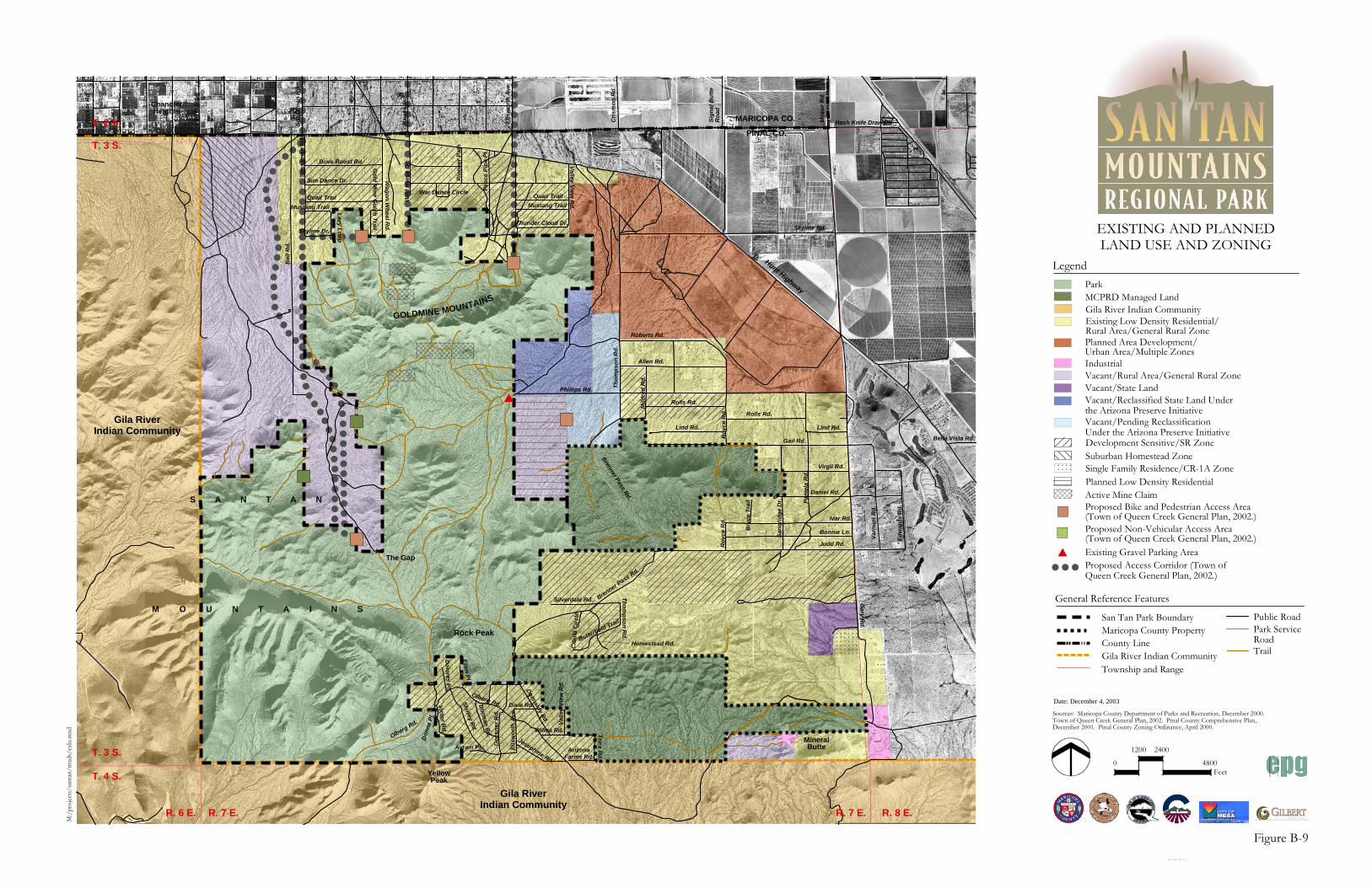
!!
!!
!!
!!!
!!
!!
!!
!!
!!
!!
!!
!!
!!
!!
!!
!!
!!
!
!
!!
!!
!!
!!
!!
!!
!!
!!
!!
!!
!!
!!
!!
!!
!!
!!
!!!!!!!!!!!!!
!!!!
!!
!!!!
!!!
!!!!
!!!
!!
!!
!!
!!
!!
!!
!!!!!!!
!!
!!
!!
!!
!
! ! ! ! ! !
)
)
)
)
))
)
#
R. 6 E. R. 7 E. R. 7 E. R. 8 E.
T. 2 S.
T. 3 S.
T. 3 S.
T. 4 S.
Po
wer
Rd
.
So
ssam
an R
d.
Haw
es R
d.
Ells
wo
rth
Ave
.
Cri
smo
n R
d.
Sig
nal
Bu
tte
Ro
ad
Mo
eur
Rd
.
Hash Knife Draw Rd.
Bella Vista Rd.
Hunt Highway
MARICOPA CO.
PINAL CO.
Gila RiverIndian Community
Rec
ker
Rd
.
M:/
proj
ects
/san
tan/
mxd
s/ex
lu.m
xd
Date: December 4, 2003
Sources: Maricopa County Department of Parks and Recreation, December 2000.Town of Queen Creek General Plan, 2002. Pinal County Comprehensive Plan,December 2001. Pinal County Zoning Ordinance, April 2000.
Gila RiverIndian Community
0
1200 2400
4800Feet
S A N T A N
M O U N T A I N S
Rock Peak
MineralButte
ChandlerHeights
GOLDMINE MOUNTAINS
YellowPeak
The Gap
Skyline Rd.
Bel
l Rd
.
So
ssam
an R
d.
Skyline Dr.
Mustang Trail
Quail Trail
Sun Dance Dr.
Dove Roost Rd.
Lazy L
oo
p
Go
ld M
ine G
ulch
Trail
Wag
on
Wh
eel Rd
.
Wild
Ho
rse
Dr.
War Dance Circle
Pio
nee
r P
ath
Pea
ce P
ipe
Pl.
Quail Trail
Mustang Trail
Thunder Cloud Dr.
Valley V
iew R
d.
Judd Rd.
Phillips Rd.
Gary R
d.
Ro
yce
Rd
.R
oyc
e R
d.
Bry
ce T
rail
San
dri
dg
e D
r. Pam
ela
Rd
.
Var
nu
m R
d.
Ed
war
ds
Rd
.
Bonnie Ln.
Ivar Rd.
Daniel Rd.
Virgil Rd.
Gail Rd.
Lind Rd.Lind Rd.
Rolls Rd.
Rolls Rd.
Allen Rd.
Roberts Rd.
Mild
red
Rd
.
Th
om
pso
n R
d.
Brenner Pass Rd.
Brenner Pass Rd.
Silverdale Rd.
Th
om
pso
n R
d.Butterfie
ld Trail
Homestead Rd.Cib
ola
Cir
cle
Donnaloy R
d.
Dixie Rd.
Wilma Rd.
Ells
wo
rth
Ave
.
Olberg Rd.
Olberg Rd.
Ellen P
l.
Do
lore s P
l .
Don
na P
l.
Shirley R
d.D
orman R
d.
Go
ssn
er R
d.
Josephine Rd.
Val
ley
Vie
w R
d.
ArizonaFarms Rd.
Avram Pl.
Proposed Access Corridor (Town ofQueen Creek General Plan, 2002.)
Gila River Indian Community
Vacant/Rural Area/General Rural ZoneVacant/State Land
Park
Planned Low Density Residential
Existing Low Density Residential/Rural Area/General Rural Zone
Legend
)Proposed Bike and Pedestrian Access Area(Town of Queen Creek General Plan, 2002.)
Vacant/Reclassified State Land Underthe Arizona Preserve InitiativeVacant/Pending ReclassificationUnder the Arizona Preserve Initiative
) Proposed Non-Vehicular Access Area(Town of Queen Creek General Plan, 2002.)
#
EXISTING AND PLANNEDLAND USE AND ZONING
Development Sensitive/SR Zone
Industrial
Planned Area Development/Urban Area/Multiple Zones
! ! !
Active Mine Claim
Suburban Homestead ZoneSingle Family Residence/CR-1A Zone
MCPRD Managed Land
Trica R
d.
Victo
r Rd
.
Existing Gravel Parking Area
Figure B-9
Trail
General Reference Features
San Tan Park Boundary
County LineGila River Indian CommunityTownship and Range
Maricopa County PropertyPublic RoadPark ServiceRoad

R. 6 E. R. 7 E. R. 7 E. R. 8 E.
T. 2 S.
T. 3 S.
T. 3 S.
T. 4 S.
Po
wer
Rd
.
So
ssam
an R
d.
Haw
es R
d.
Ells
wo
rth
Ave
.
Cri
smo
n R
d.
Sig
nal
Bu
tte
Ro
ad
Mo
eur
Rd
.
Hash Knife Draw Rd.
Bella Vista Rd.
Hunt Highway
MARICOPA CO.
PINAL CO.
Gila RiverIndian Community
Rec
ker
Rd
.
M:/
proj
ects
/san
tan/
mxd
s/sc
enic
.mxd
Gila RiverIndian Community
S A N T A N
M O U N T A I N S
Rock Peak
MineralButte
ChandlerHeights
GOLDMINE MOUNTAINS
YellowPeak
The Gap
Skyline Rd.
Bel
l Rd
.
So
ssam
an R
d.
Skyline Dr.
Mustang Trail
Quail Trail
Sun Dance Dr.
Dove Roost Rd.
Lazy L
oo
p
Go
ld M
ine G
ulch
Trail
Wag
on
Wh
eel Rd
.
Wild
Ho
rse
Dr.
War Dance Circle
Pio
nee
r P
ath
Pea
ce P
ipe
Pl.
Quail Trail
Mustang Trail
Thunder Cloud Dr.
Valley V
iew R
d.
Judd Rd.
Phillips Rd.
Gary R
d.
Ro
yce
Rd
.R
oyc
e R
d.
Bry
ce T
rail
San
dri
dg
e D
r.
Pam
ela
Rd
.
Var
nu
m R
d.
Ed
war
ds
Rd
.
Bonnie Ln.
Ivar Rd.
Daniel Rd.
Virgil Rd.
Gail Rd.
Lind Rd.Lind Rd.
Rolls Rd.
Rolls Rd.
Allen Rd.
Roberts Rd.
Mild
red
Rd
.
Th
om
pso
n R
d.
Brenner Pass R
d.
Brenner Pass Rd.
Silverdale Rd.
Th
om
pso
n R
d.
Butterfield Trail
Homestead Rd.Cib
ola
Cir
cle
Donnaloy R
d.
Dixie Rd.
Wilma Rd.
Ells
wo
rth
Ave
.
Olberg Rd.
Olberg Rd.
Ellen P
l.
Do
lores P
l .
Don
na P
l.
Shirley R
d.D
orman R
d.
Go
ssn
er R
d.
Josephine Rd.
Val
ley
Vie
w R
d.
ArizonaFarms Rd.
Avram Pl.
VISUAL RESOURCES
Sources: USGS, Chandler Heights, AZ (1991),Blackwater, AZ (1982), Sacaton, AZ (1982),Sacaton NE, AZ (1991), 1:24,000-scale topographic maps. Digital Elevation Models from Maricopa County Departmentof Parks and Recreation, December 2000.
0
1200 2400
4800Feet
Date: December 4, 2003
Scenic Quality Classifications
Class A
Class B
Class C
Vic
tor
Rd
.
Trica R
d.
Figure B-10
General Reference Features
San Tan Park Boundary
County LineGila River Indian CommunityTownship and Range
Maricopa County PropertyPublic RoadPark ServiceRoad/Trail

R. 7 E. R. 8 E.
Gila RiverIndian Community
������������ � ����������� ����������
Date: December 4, 2003
���������������
������������ ���������������������������������������� !��������������� !���������"#������������!$�%%%&�������'����'���(�'�)*�����'� ����+,�'���(����-.�������/����������,���(0��!%%%)
�
���� ����
����
����YellowPeak
���� �
������ ��������
���������� ��������
����� ��������
R. 6 E. R. 7 E.
T. 3 S.
T. 4 S.
MARICOPA CO.
PINAL CO.
Gila RiverIndian Community
S A N T A N
M O U N T A I N S
Rock Peak
MineralButte
The Gap
Gary R
d.
Brenner Pass Rd.
Silverdale Rd.
Th
om
pso
n R
d.
Butterfield Trail
Homestead Rd.Cib
ola
Cir
cle
Donnaloy R
d.
Dixie Rd.
Wilma Rd.
Ells
wo
rth
Ave
.
Olberg Rd.
Olberg Rd.
Ellen P
l.
Do
lores P
l .
Don
na P
l.
Shirley R
d.D
orman R
d.
Go
ssn
er R
d.
Josephine Rd.
Val
ley
Vie
w R
d.
ArizonaFarms Rd.
Avram Pl.
Trica R
d.
Victo
r Rd.
T. 2 S.
T. 3 S.
Po
wer
Rd
.
So
ssam
an R
d.
Haw
es R
d.
Ells
wo
rth
Ave
.
Cri
smo
n R
d.
Sig
nal
Bu
tte
Ro
ad
Mo
eur
Rd
.
Hash Knife Draw Rd.
Hunt Highway
Rec
ker
Rd
.
ChandlerHeights
GOLDMINE MOUNTAINS
Skyline Rd.
Bel
l Rd
.
So
ssam
an R
d.
Skyline Dr.
Mustang Trail
Quail Trail
Sun Dance Dr.
Dove Roost Rd.
Lazy Lo
op
Go
ld M
ine G
ulch
Trail
Wag
on
Wh
eel Rd
.
Wild
Ho
rse
Dr.
War Dance Circle
Pio
nee
r P
ath
Pea
ce P
ipe
Pl.
Quail Trail
Mustang Trail
Thunder Cloud Dr.
Valley V
iew R
d.
Bella Vista Rd.
Gila RiverIndian Community
Judd Rd.
Phillips Rd.
Roy
ce R
d.
Ro
yce
Rd
.
Bry
ce T
rail
San
dri
dg
e D
r. Pam
ela
Rd
.
Var
nu
m R
d.
Ed
war
ds
Rd
.
Bonnie Ln.
Ivar Rd.
Daniel Rd.
Virgil Rd.
Gail Rd.
Lind Rd.Lind Rd.
Rolls Rd.
Rolls Rd.
Allen Rd.
Roberts Rd.
Mild
red
Rd.
Th
om
pso
n R
d.
Brenner Pass R
d.
�����������
�������������������������������������� ������������ �������������� ��������������� ����������� �� ��������������� �������
������������������������������������������������� ����������� �������������� ��������������� ����������� � ���������������� �������
�������������������������������������� ����������� �������������� ��������������� ����������� � ���������������� �������
� ���!���"��� #����������
�������� ������ �
��������
����!��� �"�����������
�#��������!���
$� ����������� �� ��
��%����!��
�� ���� ����!���� ���
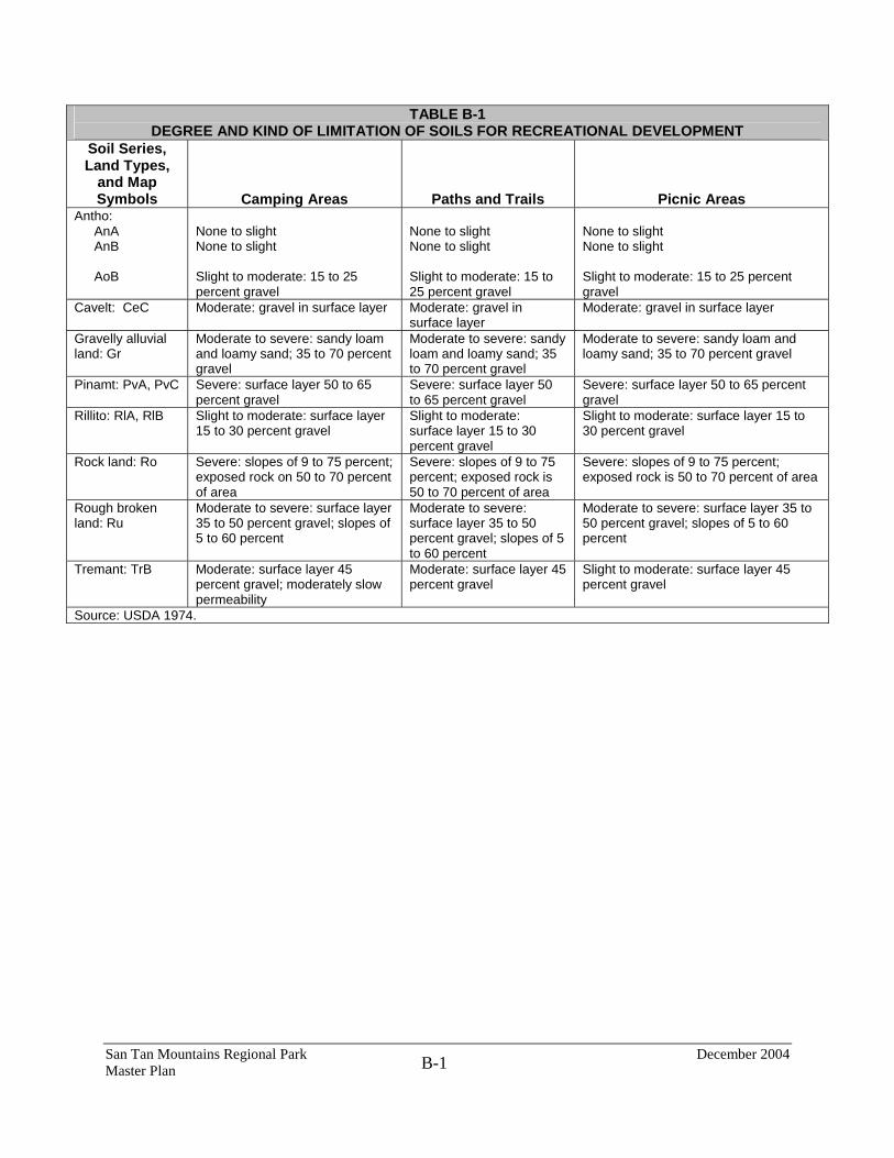
San Tan Mountains Regional Park December 2004 Master Plan B-1
TABLE B-1 DEGREE AND KIND OF LIMITATION OF SOILS FOR RECREATIONAL DEVELOPMENT
Soil Series, Land Types,
and Map Symbols Camping Areas Paths and Trails Picnic Areas
Antho: AnA AnB AoB
None to slight None to slight Slight to moderate: 15 to 25 percent gravel
None to slight None to slight Slight to moderate: 15 to 25 percent gravel
None to slight None to slight Slight to moderate: 15 to 25 percent gravel
Cavelt: CeC Moderate: gravel in surface layer Moderate: gravel in surface layer
Moderate: gravel in surface layer
Gravelly alluvial land: Gr
Moderate to severe: sandy loam and loamy sand; 35 to 70 percent gravel
Moderate to severe: sandy loam and loamy sand; 35 to 70 percent gravel
Moderate to severe: sandy loam and loamy sand; 35 to 70 percent gravel
Pinamt: PvA, PvC Severe: surface layer 50 to 65 percent gravel
Severe: surface layer 50 to 65 percent gravel
Severe: surface layer 50 to 65 percent gravel
Rillito: RlA, RlB Slight to moderate: surface layer 15 to 30 percent gravel
Slight to moderate: surface layer 15 to 30 percent gravel
Slight to moderate: surface layer 15 to 30 percent gravel
Rock land: Ro Severe: slopes of 9 to 75 percent; exposed rock on 50 to 70 percent of area
Severe: slopes of 9 to 75 percent; exposed rock is 50 to 70 percent of area
Severe: slopes of 9 to 75 percent; exposed rock is 50 to 70 percent of area
Rough broken land: Ru
Moderate to severe: surface layer 35 to 50 percent gravel; slopes of 5 to 60 percent
Moderate to severe: surface layer 35 to 50 percent gravel; slopes of 5 to 60 percent
Moderate to severe: surface layer 35 to 50 percent gravel; slopes of 5 to 60 percent
Tremant: TrB Moderate: surface layer 45 percent gravel; moderately slow permeability
Moderate: surface layer 45 percent gravel
Slight to moderate: surface layer 45 percent gravel
Source: USDA 1974.

San Tan Mountains Regional Park December 2004 Master Plan B-2
TABLE B-2 INTERPRETATIONS OF ENGINEERING PROPERTIES OF SOILS
Degree and Kind of Limitation for - Suitability as a Source of - Soil Features Affecting - Soil Series, Land
Types, and Map Symbols
Septic Tank Absorption
Fields
Dwellings Without
Basements
Local Roads
and Streets Road Fill Sand Topsoil Gravel
Pond Reservoir
Areas Embankments,
Dikes, and Levees Irrigation Antho: AnA, AnB, AoB
Slight Slight Slight Good or fair: sandy loam and appreciable amount of fines
Poor: mainly sandy loam
Good in AnA and AnB. Poor in AoB; gravel
Not suitable: mainly sandy loam
Moderately rapid permeability
Medium to low shear strength; medium to low compressibility; medium to low compacted permeability; fair to good compaction; medium to high susceptibility to piping
Moderate available water capacity; AnB and AoB have slopes of 1 to 3 percent
Cavelt: CeC Severe: lime hardpan at depth of 5 to 20 inches
Severe: lime hardpan at depth of 5 to 20 inches
Severe: lime hardpan at depth of 5 to 20 inches
Fair: A-4; hardpan at depth of 5 to 20 inches
Not suitable: mainly loam; hardpan at depth of 5 to 20 inches
Poor: mainly loam; hardpan at depth of 5 to 20 inches
Not suitable: mainly loam; hardpan at depth of 5 to 20 inches
Lime hardpan at depth of 5 to 20 inches
Medium to low shear strength; low to medium compressibility; low to medium compacted permeability; medium to high susceptibility to piping; fair compaction
Low available water capacity; gravelly; lime hardpan at depth of 5 to 20 inches
Gravelly alluvial land: Gr
Severe: variable material; hazard of ground water contamination
Slight to moderate: material variable and contains fines; short, steep slopes
Slight to moderate: material variable and contains fines
Good: variable in content of fines
Poor to fair: variable in content of fines
Poor: contains gravel
Poor to fair: variable in content of fines
Very rapid permeability
Medium to high shear strength; medium to low compressibility; medium to low compacted permeability; medium to low susceptibility to piping; fair to good compaction
Low available water capacity; very rapid permeability
Pinamt: PvA, PvC
Severe: moderately slow permeability
Slight Slight Good Unsuited: mainly very gravelly sandy clay loam
Poor: very gravelly
Poor: fairly high content of fines
Moderately slow permeability
Medium shear strength; low to medium compressibility; low compacted permeability; medium to low susceptibility to piping; good to fair
Low available water capacity; moderately slow permeability; very gravelly; slope

San Tan Mountains Regional Park December 2004 Master Plan B-3
TABLE B-2 INTERPRETATIONS OF ENGINEERING PROPERTIES OF SOILS
Degree and Kind of Limitation for - Suitability as a Source of - Soil Features Affecting - Soil Series, Land
Types, and Map Symbols
Septic Tank Absorption
Fields
Dwellings Without
Basements
Local Roads
and Streets Road Fill Sand Topsoil Gravel
Pond Reservoir
Areas Embankments,
Dikes, and Levees Irrigation compaction
Rillito: RlA, RlB
Slight to moderate: moderate permeability
Slight Slight to moderate: A-2 or A-4
Fair to good: A-2 or A-4
Unsuited: excessive fines
Poor: gravelly and limy
Poor: excessive fines
Moderate permeability
Medium shear strength; low to medium compressibility; low to medium compacted permeability; medium to high susceptibility to piping; fair to good compaction
Moderate available water capacity; moderate permeability; gravelly and limy
Rock land: Ro
Severe: rock outcrop; shallow and very shallow soil
Severe: rock outcrop; shallow and very shallow soil
Severe: rock outcrop; shallow and very shallow soil
Poor: rock outcrop; shallow and very shallow soil
Unsuited: rock outcrop; shallow and very shallow soil
Poor: rock outcrop; shallow and very shallow soil
Unsuited: rock outcrop; shallow and very shallow soil
Rock outcrop; shallow and very shallow soil
Rock outcrop; shallow and very shallow soil
Rock outcrop; shallow and very shallow soil
Rough broken land: Ru
Severe: soil variable and steep
Severe: soil variable and steep
Severe: soil variable and steep
Poor: soil variable and steep
Unsuited: soil variable and steep
Poor: soil variable and steep
Unsuited: soil variable and steep
Steep; high potential for seepage
Soil variable; steep Soil variable and steep
Tremant: TrB
Slight to moderate: moderate permeability below depth of 16 inches
Slight Slight to moderate: A-2 and A-4
Good to fair: A-2 and A-4
Poor: excessive fines
Poor: gravel
Unsuited: excessive fines
Moderate permeability below depth of 16 inches
Medium shear strength; low to medium compressibility; medium to low compacted permeability; medium susceptibility to piping; fair to good compaction
Moderate available water capacity; moderately slow permeability; slope
Source: USDA 1974.

San Tan Mountains Regional Park December 2004 Master Plan
B-4
TABLE B-3 SAN TAN MOUNTAIN REGIONAL PARK FLORA VEGETATIVE SPECIES
SURVEYED APRIL, 2003
Dixie Z. Damrel, Arizona State University/ Desert Botanical Garden
ACANTHACEAE Carlowrightia arizonica Arizona Wrightwort; native shrub AIZOACEAE Trianthema portulacastrum Desert Horsepurslane; native ephemeral AMARANTHACEAE Amaranthus fimbriatus Fringed Amaranth; native ephemeral Amaranthus palmeri Carelessweed; native ephemeral Tidestromia lanuginosa Woolly Tidestromia; native ephemeral APIACEAE Bowlesia incana Hairy Bowlesia; native ephemeral Daucus pusillus Wild Carrot; native ephemeral ASCLEPIADACEAE Asclepias subulata Desert Milkweed; native perennial Cynanchum arizonicum Arizona swallow-wort; native perennial Sarcostemma cynanchoides var. hartwegii Hartweg's Twinevine; native perennial ASTERACEAE Acourtia wrightii Brownfoot; native shrub, perennial Adenophyllum porophylloides San Felipe Dogweed; native perennial/shrub Ambrosia ambrosioides Canyon Ragweed; native shrub Ambrosia deltoidea Triangle-leaf Bur-sage; native shrub Ambrosia dumosa White Burrobush; native shrub
Antheropeas lanosum White Easterbonnets; native ephemeral Baccharis sarothroides Desert-broom; native shrub Baileya multiradiata var. multiradiata Desert Marigold; native perennial Baileya pleniradiata Woolly Desert Marigold; native perennial Bebbia juncea var. aspera Chuckwalla's Delight; native shrub Brickellia coulteri Coulter's Brickellbush; native shrub Calycoseris wrightii White Tackstem; native ephemeral Chaenactis carphoclinia Pebble Pincushion: native ephemeral Chaenactis stevioides Steve's Dustymaiden; native ephemeral; Conyza canadensis Canadian Horseweed; introduced ephemeral Encelia farinosa var. farinosa Brittlebush; native shrub Filago arizonica Arizona Cottonrose; native ephemeral Filago californica California Cottonrose; native ephemeral Gaillardia arizonica Arizona Blanketflower; native ephemeral Gymnosperma glutinosum Tatalencho; native shrub Helianthus annuus Sunflower; native ephemeral Heterotheca subaxillaris Camphorweed; native ephemeral Hymenoclea salsola var. pentalepis Cheesebush; native shrub Isocoma acradenia Alkalai Jimmyweed; native shrub Isocoma tenuisecta Burroweed; native shrub Lactuca serriola

San Tan Mountains Regional Park December 2004 Master Plan
B-5
Prickly Lettuce; introduced ephemeral Lasthenia californica California Goldfields; native ephemeral Malacothrix glabrata Smooth Desert-Dandelion; native ephemeral Monoptilon bellioides Mojave Desertstar;native ephemeral Pectis papposa Chinchweed; native ephemeral Perityle emoryi Rock-daisy; native ephemeral Porophyllum gracile Odora; native ephemeral Rafinesquia neomexicana Desert Chicory; native ephemeral Senecio lemmonii Lemmon's Ragwort; native perennial Sonchus asper Sowthistle; introduced ephemeral Sonchus oleraceus Common Sowthistle; introduced ephemeral Stephanomeria pauciflora Brownplume Wirelettuce; native shrub Stylocline micropoides Woollyhead Neststraw; native ephemeral Trixis californica Trixis; native shrub Uropapps lindleyi Silver Puffs; native ephemeral Verbesina encelioides ssp. auriculata Golden Crownbeard; native ephemeral BORAGINACEAE Amsinckia menziesii var. intermedia Coast Fiddleneck; native ephemeral Amsinckia tessellata Bristly Fiddleneck; native ephemeral Cryptantha angustifolia Panamint Cryptantha; native ephemeral Cryptantha barbigera Bearded Cryptantha; native ephemeral Cryptantha decipien Gravelbar Cryptantha; native ephemeral Cryptantha maritima var. pilosa Guadalupe cryptantha; native ephemeral Cryptantha pterocarya Wingnut Cryptantha; native ephemeral Harpagonella palmeri var. arizonica Arizona Grapplinghook; native ephemeral
Pectocarya heterocarpa Chuckwalla combseed; native ephemeral Pectocarya platycarpa Broad-nut Comb Bur; native ephemeral Pectocarya recurvata Arch-nut Comb Bur; native ephemeral Pectocarya setosa Moth Combseed; native ephemeral Plagiobothrys arizonicus Bloodweed; native ephemeral BRASSICACEAE Brassica tournefortii Gouan Asian Mustard; introduced ephemeral Caulanthus lasiophyllus California Mustard; native ephemeral Descurainia pinnata Tansy Mustard; native ephemeral Draba cuneifolia var. integrifolia Wedgeleaf Whitlow-grass; native ephemeral Lepidium lasiocarpum Pepperweed; native ephemeral Lesquerella tenella Moapa Bladderpod; native ephemeral Sinapis arvensis L. Charlock Mustard; introduced ephemeral Sisymbrium irio L. London Rocket; introduced ephemeral Streptanthus carinatus ssp. arizonicus Twistflower; native ephemeral Thysanocarpus curvipes Hook. Lace-pod; native ephemeral CACTACEAE Carnegiea gigantea Saguaro; native tree cactus Cylindropuntia acanthocarpa var. major Buckhorn Cholla; native shrub cactus Cylindropuntia arbuscula Pencil Cholla; native shrub cactus Cylindropuntia bigelovii var. bigelovii Teddybear Cholla; native shrub cactus Cylindropuntia fulgida var. fulgida Chainfruit Cholla; native shrub cactus Cylindropuntia leptocaulis Desert Christmas Cholla; native shrub cactus Echinocereus engelmannii var. acicularis Engelmann Hedgehog Cactus; native cactus Ferocactus cylindraceous var. lecontei

San Tan Mountains Regional Park December 2004 Master Plan
B-6
Barrel Cactus; native barrel cactus Ferocactus wislizeni Orange Flower Barrel Cactus; native barrel cactus Mammillaria grahamii var. grahamii Arizona Pincushion Cactus; native cactus Opuntia macrodasys Bunnyears Prickly-pear; introduced shrub cactus Opuntia engelmannii Engelmann's Prickly-pear; native shrub cactus Opuntia phaeacantha Brown-spined Prickly-pear; native shrub cactus CAMPANULACEAE Nemacladus glanduliferus var. occidentalis Thread-plant; native ephemeral CANNABACEAE Cannabis sativa Hemp; introduced ephemeral CARYOPHYLLACEAE Herniaria hirsuta var. cinerea Rupturewort; introduced ephemeral Loeflingia squarrosa Spreading Pygmyleaf; native ephemeral Silene antirrhina L. Sleepy Catchfly; native ephemeral CHENOPODIACEAE Atriplex elegans Whitescale Saltbush; native ephemeral Atriplex canescens Winged Saltbush; native shrub Chenopodium berlandieri var. zschackii Zschack's Goosefoot; native ephemeral Chenopodium murale Nettle-leaf Goosefoot; introduced ephemeral Chenopodium pratericola Desert Goosefoot; native ephemeral Salsola tragus L. Tumbleweed; introduced ephemeral CRASSULACEAE Crassula connnata var. connata Sand Pygmyweed; native ephemeral
CROSSOSOMATACEAE Crossosoma bigelovii Desert Mock-orange; native shrub CUCURBITACEAE Cucurbita digitata Fingerleaf Gourd; native perennial EPHEDRACEAE Ephedra fasciculata Mormon-tea; native shrub EUPHORBIACEAE Argythamnia lanceolata Narrowleaf Silverbush; native shrub Argythamnia neomexicana New Mexico Silverbush; native perennial Chamaesyce capitellata Head Sandmat; native perennial Chamaesyce micromeria Sonoran Sandmat; native ephemeral Chamaesyce polycarpa Smallseed Sandmat; native perennial Chamaesyce setiloba Yuma Sandmat; native ephemeral Euphorbia eriantha Desert Pointsettia; native perennial FABACEAE Acacia greggii Catclaw Acacia; native shrub Astragalus didymocarpus var. dispermus Dwarf White Milkvetch; native ephemeral Astragalus nuttallianus Nuttall Locoweed; native ephemeral Calliandra eriophylla Desert Fairyduster; native shrub Dalea mollis Silky Dalea; native ephemeral/ perennial Lotus humistratus Foothill Deervetch; native ephemeral Lotus rigidus Shrubby Deervetch; native perennial/shrub Lotus salsuginosus var. brevivexillus Deervetch; native ephemeral Lotus strigosus var. tomentellus Deervetch; native ephemeral Lupinus arizonicus Arizona Lupine; native annual

San Tan Mountains Regional Park December 2004 Master Plan
B-7
Lupinus concinnus ssp. orcuttii Orcutt's Lupine; native ephemeral Lupinus sparsiflorus ssp. mohavensis Mojave Lupine; native ephemeral Olneya tesota Ironwood; native tree Parkinsonia florida Blue Paloverde; native tree Parkinsonia microphylla Littleleaf Paloverde; native shrub/ tree Prosopis velutina Velvet Mesquite; native tree Senna covesii Hairy Senna; native perennial FOUQUIERIACEAE Fouquieria splendens ssp. splendens Ocotillo; native shrub GERANIACEAE Erodium cicutarium Filaree; introduced ephemeral Erodium texanum Texas Stork's-bill; native ephemeral HYDROPHYLLACEAE Eucrypta chrysanthemifolia var. bipinnatifida Spotted Hideseed; native ephemeral Eucrypta micrantha Dainty Desert Hideseed; native ephemeral Nama hispidum Bristly nama; native ephemeral Phacelia crenulata var. ambigua Notch-leaf Phacelia; native ephemeral Phacelia distans Wild-heliotrope; native ephemeral Pholistoma auritum var. arizonicum Sticky Waterleaf; native ephemeral KRAMERIACEAE Krameria grayi White Ratany; native shrub LAMIACEAE Salvia columbariae Chia; native ephemeral Hyptis emoryi Desert Lavender; native shrub
LILIACEAE Dichelostemma capitatum Bluedicks; native perennial LOASACEAE Mentzelia affinis Yellow Comet; native ephemeral Mentzelia involucrata Whitebract Blazingstar; native ephemeral MALPIGHIACEAE Janusia gracilis Slender Janusia; native shrub-vine MALVACEAE Abution incanum Pelotazo; native shrub Horsfordia newberryi Yellow Felt Plant; native shrub Malva parviflora L. Cheeseweed; introduced ephemeral Sphaeralcea ambigua Desert-Apricot Mallow; native perennial/ shrub Sphaeralcea coulteri Coulter’s Mallow; native annual NYCTAGINACEAE Acleisanthes longiflora Angel Trumpet; native perennial Allionia incarnata Trailing Four-O'Clock; native perennial Boerhavia intermedia Five-winged Ringstem; native ephemeral Boerhavia wrightii Largebract Spiderling; native ephemeral Mirabilis bigelovii Desert Four-O'Clock; native shrub OLEACEAE Menodora scabra Rough Menodora; native shrub ONAGRACEAE Camissonia boothii Booth's Evening-primrose; native ephemeral Camissonia californica Sun-drops; native ephemeral Camissonia chamaenerioides

San Tan Mountains Regional Park December 2004 Master Plan
B-8
Longcapsule Suncup; native ephemeral Camissonia claviformis ssp. peeblesii Browneyes; native ephemeral Oenothera primiveris Sun-drops; native ephemeral OROBANCHACEAE Orobanche cooperi Desert Broomrape; native annual/parasite PAPAVERACEAE Argemone gracilenta Prickly-poppy; native perennial Eschscholzia californica ssp. mexicana Mexican Golden Poppy; native ephemeral Eschscholzia minutiflora Pygmy Golden Poppy; native ephemeral PEDALIACEAE Proboscidea althaeifolia Golden Devil'sclaw; native ephemeral PLANTAGINACEAE Plantago ovata Desert Indianwheat; native ephemeral Plantago patagonica Woolly Plantain; native ephemeral POACEAE Aristida adscensionis Sixweeks Threeawn; native annual Aristida purpurea var. nealleyi Parish's Threeawn; native perennial Avena sativa Common Oat; introduced annual Bouteloua aristidoides Needle Grama; native annual Bouteloua barbata Sixweeks Grama; native annual Bromus arizonicus Arizona Brome; native annual Bromus rubens Red Brome; introduced annual Cynodon dactylon Bermuda Grass; introduced perennial Dasyochloa pulchella Low Woollygrass; native perennial Echinochloa colona Junglerice; introduced annual
Hordeum murinum ssp. glaucum Smooth Barley; introduced annual Leptochloa panicea ssp. brachiata Mucronate Sprangletop; native annual Muhlenbergia microsperma Littleseed Muhly; native annual Muhlenbergia porteri Bush Muhly; native perennial Panicum miliaceum Broomcorn Millet; introduced annual Pennisetum ciliare Buffelgrass; introduced perennial Phalaris minor Littleseed Canarygrass; introduced annual Pleuraphis rigida Big Galleta; native perennial Poa bigelovii Bigelow's Bluegrass; native annual Schimus arabicus Arabian Schismus; introduced annual Schimus barbatus Mediterranean Schismus; introduced annual Sorghum bicolor Sorghum; introduced annual/ perennial Tridens muticus Slim Tridens; native perennial Urochloa arizonica Arizona Signalgrass; native annual Vulpia octoflora Sixweeks Fescue; native annual POLEMONIACEAE Eriastrum diffusum Miniature Woollystar; native ephemeral Gilia flavocincta Lesser Yellowthroat Gilia; native ephemeral Gilia stellata Gilia; native ephemeral Linanthus aureus Golden Linanthus; native ephemeral Linanthus bigelovii Bigelow's Linanthus; native ephemeral Linanthus demisus Desert-snow; native ephemeral POLYGONACEAE Chorizanthe brevicornu var. brevicornu Brittle Spineflower; native ephemeral

San Tan Mountains Regional Park December 2004 Master Plan
B-9
Chorizanthe rigida Rigid Spinyherb; native ephemeral Eriogonum deflexum Flatcrown Buckwheat; native ephemeral Eriogonum fasciculatum var. polifolium Flat-topped Buckwheatbrush; native shrub Eriogonum inflatum Desert Trumpet; native perennial Eriogonum tricopes Little Desert Trumpet; native ephemeral Eriogonum wrightii Wright Buckwheat; native ephemeral Pterostegia drymarioides Pterostegia; native ephemeral PORTULACACEAE Calandrinia ciliata Redmaids; native ephemeral Cistanthe monandra Pussypaws; native ephemeral PTERIDACEAE Astrolepis sinuata ssp. sinuata Wavy Cloak Fern; native perennial Astrolepis cochisensis Cochise Scaly Cloakfern; native perennial Cheilanthes parryi Parry's Lipfern; native perennial Notholaena standleyi Star Cloakfern; native perennial Pellaea truncata Cliff Brake Fern; native perennial RANUNCULACEAE Delphinium parishii Desert Larkspur; native perennial RESEDACEAE Oligomeris linifolia Linear-leaved Cambess; native ephemeral RHAMNACEAE Colubrina californica Las Animas Nakedwood; native shrub Ziziphus obtusifolia ssp. canescens Gray-thorn; native shrub
RUBIACEAE Galium stellatum ssp. eremicum Starry Bedstraw; native shrub SELAGINELLACEAE Selaginella arizonica Ressurection Fern; native perennial SIMAROUBACEAE Castela emoryi Corona de Cristo; native shrub/tree Note: not actually in the park; near the N border SOLANACEAE Datura discolor Desert Thorn-apple; native perennial Lycium andersonii Wolfberry; native shrub Lycium berlandieri Berlandier's Wolfberry; native shrub Lycium exsertum Wolfberry; native shrub Lycium fremontii Wolfberry; native shrub Nicotiana trigonophylla Desert Tobacco; native ephemeral Physalis sp. native Solanum elaeagnifolium Silverleaf Nightshade; native perennial STERCULIACEAE Ayenia filiformis TransPecos Ayenia: native perennial/subshrub ULMACEAE Celtis pallida Desert Hackberry; native shrub/tree URTICACEAE Parietaria hespera Pellitory; native ephemeral VERBENACEAE Aloysia wrightii Oreganillo; native shrub

San Tan Mountains Regional Park December 2004 Master Plan
B-10
VISCACEAE Phoradendron californicum Desert Mistletoe; native perennial parasite ZYGOPHYLLACEAE Fagonia laevis California Fagonbush; native perennial Kallstroemia californica California Caltrop; native ephemeral Kallstroemia parviflora Warty Caltrop; native ephemeral Larrea tridentata Creosote Bush; native shrub Tribulus terrestris Goatheads; introduced ephemeral

APPENDIX C
INTERGOVERNMENTAL AGREEMENTS
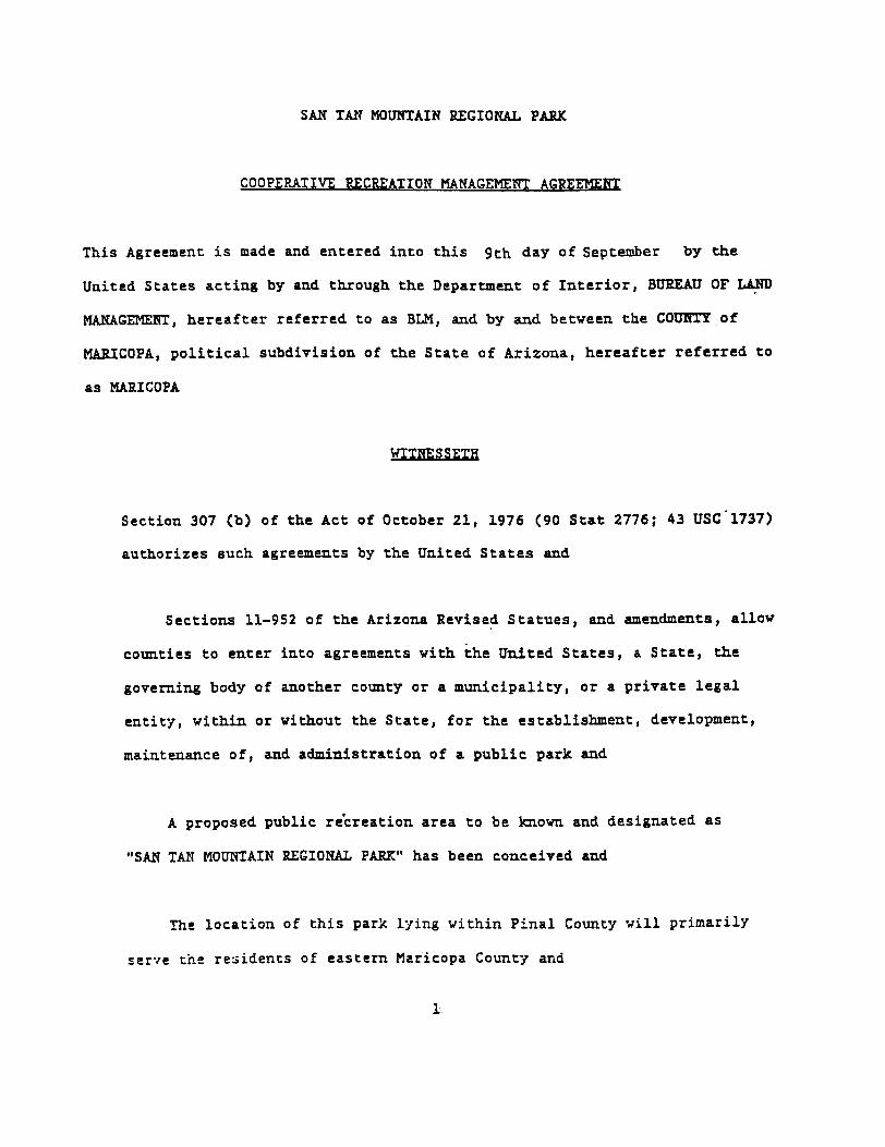
SAN TAli MOUNTAIN REGIONAL PARK
COOPEP..ATlVE RECREATION MANAGEMENT AGREEMEflT
This Agreement is made and entered into this 9th day of September by the
Unit~d States acting by and through the Departm~t of Int~rior, BUREAU OF ~
MANAGEMENT, hereafter referred to as BLM, and by and between the COUHrY of
MARICOPA, political subdivision of the St&te of Arizon&, hereaf~er referred to
as MARICOPA
WITNESSETH
Section 307 (b) of the Act of October 21,1976 (90 Stat 2776; 43 USC"1737)
authorizes such agreements by the United States and
Sections 11-952 of the Arizona Revise~ Statues, and amendments, allow
counties to enter into agreements with the United States, a State, the
governing body of another county or a municipality, or a private legal
entity, within or without the State1 for the establishment, development,
ma~tenance of, and administration of a public park and
A proposed public re'creation area to be known and designated as
"SAN TAN MOUtfIAIN REGIONAL PARK" has been conceived &nd
The location of this park lying within Pinal County "*i1l primarily
ser"{e the. re'.3idents of eastern Maricopa County and
1
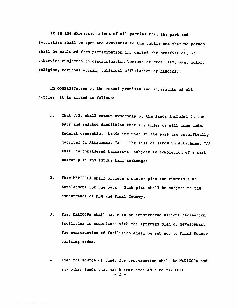
It is the expressed intent of all parties that the park and
facilities shall be open and available to the public and that no person
shall be excluded from participation in, denied the benefits of, or
otherwise subjected to discrimination because of race, sex, age, color,
religion, national origin, political affiliation or handicap.
In consideration of the mutua! promises and agreements of all
parties, it is agreed as follows:
1. That U.S. shall retain ownership of the lands included in the
park and related fa~ilities that are under or will ~ome under
federal ownership. Lands included in the p~rk are specifically
decribed in Attachment "A". The list of lands in Attachment "AI
shall be considered tentative, subject to completion of a park
master plan and future land 'exChanges
2. That MARICOPA shall produce a master plan and timetable of
development for the park. Such plan shall be subject to the
concurr~ce of BLM and Pinal County.
3. That MARICOPA shall cause to be constructed various recreation
facilities in accordance with the approved plan of development
The construction of facilities shall be subject to Pinal County
building codes.
4. That the source of funds for construction shall be MARICOPA and
any other funds that may become a',ailable to MARICOPA.- 2 -

5. That all maintenance and operational costs of the park and
facilities shall be the responsibility of MARICOPA.
6. That MARICOPA shall, at all times during the term of this
agreement, keep the premises in a neat, clean, sanitary,
healthful and safe condition.
,7. That MARICOPA may establish such fees and charges as may become
necessary to offset maintenance and operation costs. This must.
be consistent with the plans and approved by BLM.
8. That MARICOPA shall indemnify and save harmless U.S., its
officers, agents and employees from and against any claims,
demands, liabilities or loss which may be imposed upon them for
injury or death of persons or damage to property as the result
of this agreement or with the occupancy or use of the park
premises, pursuant to this Agreement by MARICOPA officers,
agents and employees.
9. To the extent legally permissible under the Federal Tort Claims
Act, 28 U.S.C. 2671, et seq, or other applicable federal law,
the United States shall save, hold harmless and indenmify
MARICOPA or any of its departments, agencies, officers or
employees from all costs and damages occurring to any person,
legal entities or property arising out of or in connection with
any negligent act or omission of the United States, its agency- 3 -

or independent ~ontracto~s in the course of performance of the
provisions of this agreement, and not caused by any negligent
act or omission of MARICOPA or any of its departments, agencies,
officers, employees, agents or independent contractors.
1.0. That the term of this Agre~ent shall be twenty-five (25) years
and may be rEnewed, subject to the mutual cona~t of all parties
u. Ij
All signs and other printed literature will. display both
parties' names and logos
12. That MARICOPA County Park Rules and Regulations, as well as
regulations adopted by the Boards of Supervisors of Maricopa and
Pinal ~ounties, shall apply in the operation of the park as long
as they do not conflict with any federal laws or regulations.
13. MARICOPA shall agree to provide at no cost to BLM ~aw
enforcement services for the park and patrols when ~d if deemed
necessary by appropriate officials.
14. That this agre~ent may be termi~ated by either party subject to
twelve (12) months prior written notice. Said termination shall
not be without due cause. If the agreement is terminated by
MARICOPA prior to the expiration date, Pinal County will have
- 4 -

the first right to operate the park If neither MARICOPA nor
Pinal Coun~y wish ~o operate the park, federal lands and
improvements thereon will revert to BLM.
15. Termination of this agre~ent by BLM or other federal actions
prior to the expiration date would entitle MARICOPA to
reasonable compensation not to exceed fair market value for the
cost of perm~t recreation facilities constructed in
accordance with an approved Plan of Development.
-~~.A~~-- ~./J.~iField Solicitor
U.S. Department of Interior
APPROVED AS TO FORM:
.-::~t~..~i~(jK&ricopa County Attorney
5~

ATTAC~T A
sec.. 4.sec.. 8,sec.. 9,sec.. 1O,sec.. 16,sec.. 17,sec.. 19,sec.. 20,sec.. 21,sec.. 22,lec..28,sec.. 29,sec.. 30.sec.. 31,sec.. 32.
100400560400320400558.61160640160640640640640640
S~SW~, w~5wksE~;E;, E~SW~iW~, 5E~, 5~NE~;W~NE~, W~;N~;E;, E~NW~;Lots 2-4, E;, SE~NWk, E~SW~;
E~E\;All;SW~;All;All;Al1~ (S~ unsurveyed);All, (5; unsurveyed);All.
Total: Approximately 6,898.61 acres, more or less.
STATE LAND TO BE ACQUUED
NW\;S;.
sec. 15,sec. 16,
Total: Approximately 480 acres, more or less
PRIVATE LANDS TQ BE ACQUIRED
SWtiwk.
sec.. 15,sec. 22,
Total: Approximately 320 acres, more or less.

- -~
United States Department of the Interior
-.-!If aULY' aana TO
2800 (025)
3809p'Sepcember 26, 1988
Pinal Coun~y Board of SupervisorsAttn: John H. Encimas, D1rec~or af HighvaysP. o. Box 72771arence, Arizona 85232
GenClemeu:
In accordance vi~h che information provided by the P~nal County HighwayDepartment, we are accepcing the affidavit s~bmitt.d by the coun~yregarding the' roads established per authority of a.s. 2477.
Serial 1'0. !:egal Deac.nptioD.Road Name
T. S S., R. 6 E., lec. 23T. S s., R. e 2., aec. 34T. S 5.. R. 8 E., .e~. 34~~ 6 S.. K. Z E., .e~. 21
8e~. 28t~ 6 S.. R. 2 E., 8e~. 2St. 6 S., R. 2 E., ..~. ~S:T. 3 S.. R. 6 E., 8ac. 17T.10 8., R. 11 E.. sec. 20~.10 S., R. 11 R., sec. 33T.l S., R. 10 E., 8ec. 33
sec. 348ec.36
T.3 S.. R. 7 E., sec. 24.T. 3 S.. ~. 7 !., sec. 22
sec. 23.' eec. 28
: sec. 33T. 3 5.. R. 7 E., sec. 23
A-22896£'-2.2.897A-2.2.898A-22899
N. Avuon St.N. Aricona Blvd.E. Bartlatt B.d.Ej.ddea. Valley ad.
A-22900A-21901"'-22.902-
"'-12904A-2290S&-22.907
". 'Kesquite Rd.. B.al.toD. Rd.
"'. Killri8e 'B.d..E. Dav1.& P.anch ad.E. Grand Valley Rd.E. Silver Ung ad.
A,-22908A,-22910
W. Gai1 Bod.N. Brenner ad.
j.zA-23494'W. Judd Rd.
'l1;1e land containing Est~..nci&.aoadJ",'T. .,"1.0 5 ,...8..':.11 .E~ec~.~~"9'; has baentrauaferred to the 8~&~e. We vi~ forward a copy of the affidavit you,'!ubmit~ed CO tham 80 tha~ they can note their records ~S to ~he road'sex.i9~eace.
If you have any quesc1ons, please contact Jim Andersen ac 863-4464.
S1nc,rely,
.,- -'t:"~
Arthur E. Tofo1erPhoenix Resource Area ~auager
BUREAU OF LAND MANAGEMENTPhoenix District Office
2015 W.st Deer Valley Rol.dPhO8DLx. Arizona 86027

AFFIDAVIT OF ESTABLIS~~ENT Of ROAD~AY
NTY OF PINAL))as
STATE OF ARIZONA)
I, John M. Encinas, hereby certify chat all roads listed herein were 1aid out,
opened and esc&blishment prior to passage of the 'Federal Land Policy and Management,
Act of October 21, 1976. I
ItSignature
'1Title DIRECTOR. OF HIGH~AYS
at Florence, Arizona
Notary
My Commission ~piT.. an J: \~- ~C)i-
North Avalon Streee
Nor~h Arizona Boulevard
Ease Bartlect R.aad
Hidden Valley Road
West Hesquite Road
South B.alston Road
Wast M.i.llrise Road
A 4 ~IO
East Davis R&ncb Road
East Grand Valley Road
Easr SiJ.var !:ing Road
West Gail Road
South Es~ancia load
No~th Brenner P45S Road
West Judd Road
ALL RIGHT-CPO-WAY WIDTRS ARE SO FOCT CENTERLINE WIDTH

APPENDIX D SCENIC QUALITY RATING FORMS


Copyright © 2022 FDOKUMEN