Sales File Practice Manual For Assessors - Tax Equalization ...
113
State of Nebraska Department of Property Assessment and Taxation Sales File Practice Manual For Assessors January, 2004 Exhibit 125
-
Upload
khangminh22 -
Category
Documents
-
view
1 -
download
0
Transcript of Sales File Practice Manual For Assessors - Tax Equalization ...
State of Nebraska
Department of Property Assessment and Taxation
Sales File Practice
Manual
For Assessors
January, 2004
Exhibit 125
Introduction
The Sales File Practice Manual has been prepared for the use of those who do the work in the assessor offices and are responsible for filling out information to be submitted to the Department of Property Assessment and Taxation for use in the sales file. This manual will describe the steps in building the sales file, beginning with the filing of a deed and Real Estate Transfer Statement, Form 521. This manual will explain the function of the Sales Worksheets, Rosters, and other documents that complete the sales file processes. All of these forms and their instructions are represented here. Please use the instructions when preparing the various forms so you know how they should be filled out. Thanks to those assessors who had suggestions and corrections. We appreciate their input. Many of the members of the Department’s staff have contributed information for this manual. We would like to take this opportunity to thank each of them.
i
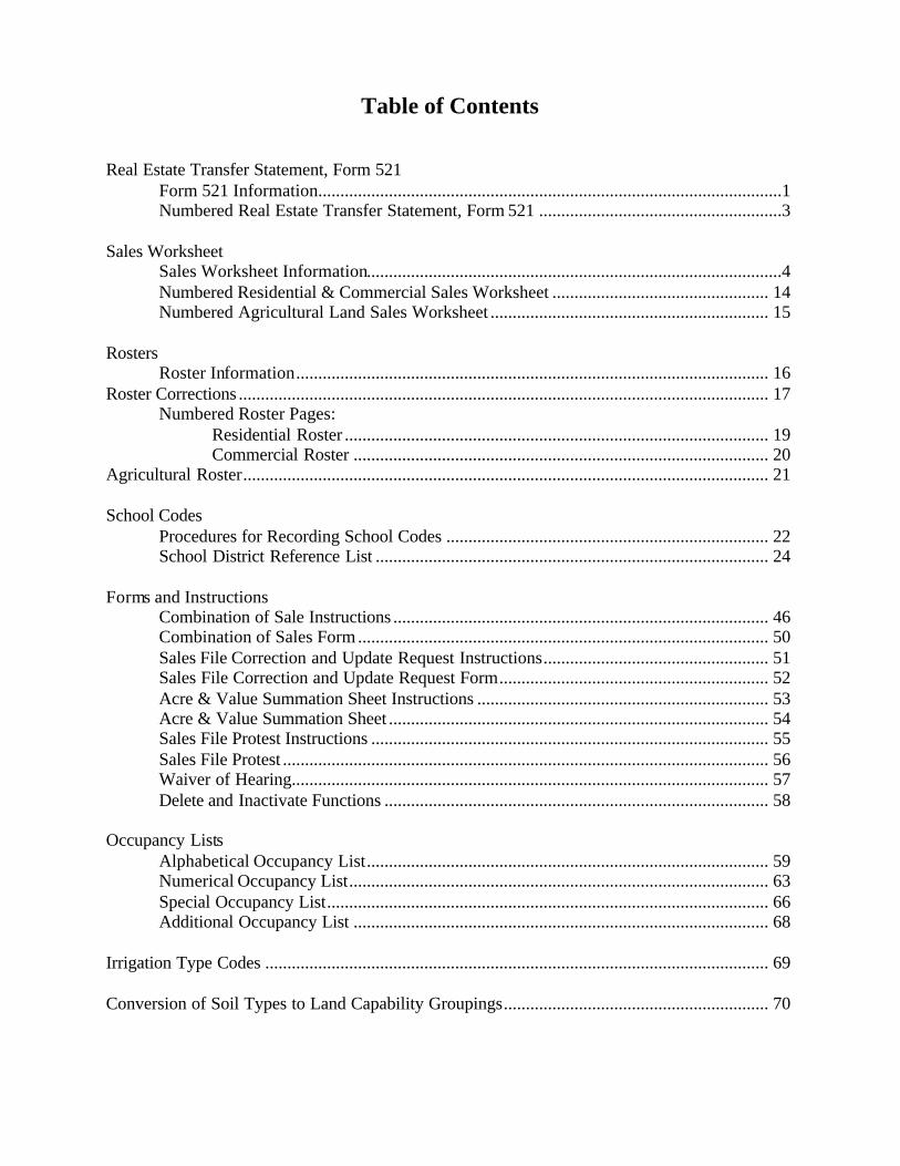
Table of Contents Real Estate Transfer Statement, Form 521
Form 521 Information.........................................................................................................1 Numbered Real Estate Transfer Statement, Form 521 .......................................................3
Sales Worksheet
Sales Worksheet Information..............................................................................................4 Numbered Residential & Commercial Sales Worksheet ................................................. 14 Numbered Agricultural Land Sales Worksheet ............................................................... 15
Rosters
Roster Information........................................................................................................... 16 Roster Corrections ........................................................................................................................ 17
Numbered Roster Pages: Residential Roster ................................................................................................ 19 Commercial Roster .............................................................................................. 20
Agricultural Roster....................................................................................................................... 21 School Codes
Procedures for Recording School Codes ......................................................................... 22 School District Reference List ......................................................................................... 24
Forms and Instructions Combination of Sale Instructions ..................................................................................... 46 Combination of Sales Form ............................................................................................. 50 Sales File Correction and Update Request Instructions................................................... 51 Sales File Correction and Update Request Form............................................................. 52 Acre & Value Summation Sheet Instructions .................................................................. 53 Acre & Value Summation Sheet ...................................................................................... 54 Sales File Protest Instructions .......................................................................................... 55 Sales File Protest .............................................................................................................. 56 Waiver of Hearing............................................................................................................ 57 Delete and Inactivate Functions ....................................................................................... 58
Occupancy Lists
Alphabetical Occupancy List........................................................................................... 59 Numerical Occupancy List............................................................................................... 63 Special Occupancy List.................................................................................................... 66 Additional Occupancy List .............................................................................................. 68
Irrigation Type Codes .................................................................................................................. 69 Conversion of Soil Types to Land Capability Groupings............................................................ 70

Sales File Pract ice Manual January, 2004 Page 1
The Real Estate Transfer Statement, Form 521 All transactions of real property for which a Real Estate Transfer Statement is required shall be available for the development of a sales file by the Property Tax Administrator. The Department receives all Real Estate Transfer Statements, Form 521, filed each month by each county register of deeds All Real Estate Transfer Statements, Form 521, with an amount stated for Documentary Stamp Tax greater than $1.75 or consideration greater than $100.00 are captured in the sales file database. Transactions meeting these criteria are defined as sales in the sales file database. The Department captures specific information from Form 521 to identify the sale, including, but not limited to: county name and number; book and page; selling price; date of sale; name of grantor and grantee; amount of personal property included in sale; and, legal description and address of the property. The information contained in the sales file captured from Form 521 is not confidential. While all information on Form 521 is captured, the following numbered Form 521 shows the fields that carry through the sales file and on the rosters. The descriptions of the numbered fields used in the sales file are described below.
1. Cnty No: County number, a one (1) or two (2) digit number identifying the alphabetical order by name of the county, not the license number historically assigned for motor vehicles. This information is Line 2 on Form 521.
2. Book: From the office of the Register of Deeds, the number of the book in which the deed is found. This information is Line 28 on Form 521.
3. Page: From the office of the Register of Deeds, the number of the page on which the first page of the deed is found. This information is Line 29 on Form 521.
4. Sale Date: The actual sale date of the property. MM/DD/YYYY format: 01/14/2003. This information is Line 3 on Form 521.
5. Date Deed Recorded: This is the date that the deed is recorded in the Register of Deed’s office. MM/DD/YYYY format: 01/14/2004. This information is line 26 on Form 521.
6. Grantor’s Name: The name of the person(s) selling the property. This information is the top line of Line 5 on Form 521.
7. Grantee’s Name: The name of the person(s) buying the property. This information is the top line of Line 6 on Form 521.
8. Legal Description: The actual legal description of record for the property being sold. This is line 20 of Form 521.
9. Address of Property: The address of the situs of the property. This information is line 18 of Form 521.

INSTRUCTIONS
The Register of Deeds shall not accept a deed for recording unlessitems 1 through 25 are properly completed and this statement issigned.
WHO MUST FILE. Any grantee, or the grantee’s authorizedrepresentative, who has a deed to real property recorded must file thisstatement. A land contract or memorandum of contract requires acompleted transfer statement, which will be exempt from thedocumentary stamp tax until the deed is presented for recording.
WHEN AND WHERE TO FILE. This statement must be filed withthe Register of Deeds when the deed or land contract or memorandumof contract is presented for recording.
SPECIFIC INSTRUCTIONSGRANTEE (BUYER)
LINE 1. Indicate county where property is located. If located in morethan one county, indicate county where transfer is being filed.
LINE 4. The date of the deed is the date on which it was signed by thegrantor unless otherwise specified in the deed.
LINES 5 AND 6. Enter the complete name, address, and telephonenumber. Business addresses should be used for business organizationssuch as corporations, trusts, and partnerships.
LINE 7. Indicate the type of property being transferred. Mark only onebox in categories A and B. Mark C only if property is a mobile home.IOLL means improvement on leased land.
LINE 8. The type of deed includes, but is not limited to: tax, warranty,quit claim, partition, mineral, sheriff, cemetery, trustee, and bill of saleconveying realty or tenements.
LINE 9. No longer applicable.
LINE 11. Check the appropriate box to indicate what propertyinterests were retained or transferred. If the box marked “NO” ischecked, explain.
LINE 12. A purchase for the same use would mean a purchase with thesame intended use of the property. Examples of change in use are avacant lot becoming a cemetery or an agricultural lot becoming asubdivision.
LINE 13. Check the appropriate box to indicate if the sale wasbetween relatives. A relative is a seller related to the buyer by bloodor marriage.
LINE 14. Indicate the current market value if the total purchase priceis nominal. Nominal consideration would be a purchase price bearingno relation to the current market value of the real property, such as a
purchase for “one dollar” or a gift or purchase when the realconsideration is concealed. Current market value is the purchase pricewhich would be paid for the real property purchased, based upon a salebetween a willing buyer and a willing seller in the ordinary course oftrade made at the time of registering this deed.
LINE 15. Check the box marked “YES” if the buyer assumed amortgage as part of the purchase price, and indicate the amount andinterest rate. If no mortgage was assumed, check the box marked“NO.”
LINE 16. If this sale subdivides the subject property into two or moreparcels, check the box marked “YES.” If this sale does not subdivideor split the property, check the box marked “NO.”
LINE 20. The legal description may be found in your deed or abstractof the real property.
LINE 21. Indicate the total number of acres included if the transferwas of agricultural or horticultural land.
LINE 22. Enter the total purchase price or consideration paid or to bepaid, including cash, mortgages, property traded, assumed liabilities,leases, easements, and personal property purchased.
LINE 23. The total dollar value of items included in the totalpurchase price contained in line 22 which did not relate to thepurchase price of the real property, such as unattached personalproperty (drapes, stoves, refrigerators, etc.). If none, check the boxmarked “NO” and enter zero.
AUTHORIZED SIGNATURE. This statement must be signed anddated by the grantee or the grantee’s authorized representative.
REGISTER OF DEEDS
The Register of Deeds shall not record the deed if items 1 through 25on this statement have not been completed or the statement has notbeen signed by the grantee or authorized representative.
The Register of Deeds shall complete items 26 through 29 at the timethe deed is recorded.
The Register of Deeds shall forward the canary and pink copies of thisstatement to the assessor when items 1 through 29 are complete.
The Register of Deeds is required to forward the white copy of thisstatement to the Nebraska Department of Revenue with the monthlyNebraska Documentary Stamp Tax Return, Form 52. Both taxable andexempt copies must be included.
Sales File Practice Manual January, 2004 Page 2

(1) Single Family (4) Industrial (6) Recreational (8) Mineral Interests- (9) State Assessed
(2) Multi-Family (5) Agricultural (7) Mineral Interests- (10) Exempt
(3) Commercial
$22 Total purchase price, including any liabilities assumed . . . . . . . . . . . . . . . . . . . . . . . . . . . . . . . . . . . . . . . . . . . . . . . . . 22
$23 Was nonreal property included in purchase? YES NO (if Yes, enter amount and attach itemized list) . . 23
FORM
521TO BE FILED
WITH REGISTEROF DEEDS
THE DEED WILL NOT BE RECORDED UNLESS THIS STATEMENT IS SIGNED AND LINES 1-25 ARE ACCURATELY COMPLETED
Mo. Day Yr. Mo. Day Yr.
1 County Name 2 County Number 3 Date of Sale 4 Date of Deed
Nebraska Department of Property Assessment & Taxation Authorized by Sections 76-214, 77-1327, R.R.S. 1943Form No. 2-146-67 Rev. 12-00 Supersedes 2-146-67 Rev. 9-94
NEBRASKA DEPARTMENT OF REVENUE — White Copy COUNTY ASSESSOR — Canary and Pink Copies GRANTEE — Goldenrod Copy
Mo. Day Yr.
27 Value of Stamp or Exempt Number
$
26 Date Deed Recorded
Grantor’s Name, Address, and Telephone (Please Print) Grantee’s Name, Address, and Telephone (Please Print)Grantor’s Name (Seller) Grantee’s Name (Buyer)
Street or Other Mailing Address Street or Other Mailing Address
City State Zip Code City State Zip Code
Telephone Number Telephone Number
( ) ( )
5 6
Real Estate Transfer StatementRead instructions on reverse side
Print or Type Name of Grantee or Authorized Representative Telephone Number
Signature of Grantee or Authorized Representative Title Date
Under penalties of law, I declare that I have examined this statement and that it is, to the best of my knowledge and belief, true andcorrect, and that I am duly authorized to sign this statement.
REGISTER OF DEEDS’ USE ONLY FOR NDR USE ONLY28 Deed Book 29 Deed Page 30
(A) Status (B) Property Type (C)(1) Improved
(2) Unimproved
(3) IOLL
PROPERTY CLASSIFICATION NUMBER. Check one box in categories A and B. Check C also if property is mobile home.
10 Type of Transfer
Sale Auction Gift Exchange Foreclosure Satisfaction of Contract Life Estate Other (explain)
9
11 Ownership Transferred in Full (if No, explain division) 12 Was real estate purchased for same use? (if No, state intended use)
YES NO YES NO
13 Was sale between relatives? (If Yes, check appropriate box)YES NO Spouse Parents and Child Family Corporation or Partnership
Grandparents and Grandchild Brothers and Sisters Aunt or Uncle to Niece or Nephew Other
14 If the real estate was transferred for nominal consideration, what is the current market 15 Was mortgage assumed? If Yes, state amount and interest rate.
value? YES NO $ %
16 Does this conveyance divide a current parcel of land? 17 Was sale through a real estate agent? (if Yes, name of agent)
YES NO YES NO
18 Address of Property 19 Name and Address of Person to Whom Tax Statement Should be Sent
20 Legal Description
21 If agricultural, list total number of acres ___________________
(1) Mobile Home
signhere
25
printed with soy ink on recycled paper
$24 Adjusted purchase price paid for real estate (line 22 minus line 23) . . . . . . . . . . . . . . . . . . . . . . . . . . . . . . . . . . . . . . . 24
Producing
Nonproducing
8 Type of Deed
Warranty Sheriff Executor Mineral Cemetery
Quit Claim Conservator Partition Trust Other__________
7
Sales File Practice Manual January, 2004 Page 3

Sales File Practice Manual January, 2004 Page 4
Supplemental Worksheet Information The assessor shall provide to the Department supplemental data required by the Department in the form of a sales worksheet for each Real Estate Transfer Statement with the required stated consideration of more than $100 or documentary stamp tax of more than $1.75 paid. Property Classification Codes, codes which are required on all property record cards by REG. 10-004.02, are a key element in classifying sales into property classes and subclasses. It is vital that this information is reported on the Supplemental Sales Worksheet as it is identified on the property record card. The assessor shall forward a copy of the Real Estate Transfer Statement and the supplemental data to the Department on or before the fifteenth of the second month following the month the deed was recorded. For example, if the deed is recorded in January, the assessor’s supplemental information is to be sent to the Department on or before the 15th of March.

Sales File Practice Manual January, 2004 Page 5
SALES WORKSHEET INFORMATION* (Also known as the ‘green-sheet’ or the assessor’s supplemental information.)
THERE ARE TWO SALES WORKSHEETS.
A. Residential & Commercial Sales Worksheet B. Agricultural Land Sales Worksheet DEFINITIONS:
A. Residential. Real property with dwellings originally designed for occupancy by one family, or duplexes originally designed for occupancy by two families. Unimproved or vacant land designed or platted for residential use or zoned residential.
B. Commercial. Real property used for commerce, trade or business. Multifamily
dwellings originally designed for occupancy by more than two families. Unimproved or vacant land designed or plotted for commercial use or zoned commercial.
C. Industrial. Real property used for the process or manufacture of goods or
materials. Unimproved or vacant land designed or plotted for industrial use or zoned industrial.
D. Agricultural. Agricultural or horticultural land used primarily for the production of
agricultural or horticultural products. Both worksheets are broken into three different sections. 1. IDENTIFICATION SECTION:
RESIDENTIAL/COMMERICAL
* Sales File Worksheet is required by Reg. 12-003.
Cnty No Book Page Sale Date School District Code
1 2 3 4 Base: 13 Affiliated: 14 Unified: 15
Location ID Sale Number Useability & Code # Parcel Number
16 17 18 19 Geo Code Twn Rng Sect Qtr Subdiv Area Blk Parcel
Date of Sale Assessed Value 24 25 26 27 28 29 30 31 32
Land Improvements Total Date of Sale Property Classification Code
20 21 22 Status Property Type Zoning Location City Size Parcel Size
Assessor Location: R/C 23 A) 33 B) 34 C) 35 D) 36 E) 37 F) 38

Sales File Practice Manual January, 2004 Page 6
AGRICULTURAL LAND
Definitions:
1. Cnty No: County number, a one (1) or two (2) digit number identifying the alphabetical order by name of the county, not the license number historically assigned for motor
vehicles. This information is the same as Line 2 on Form 521. 2. Book: From the office of the Register of Deeds, the number of the book in which the
deed is found. This information is the same as Line 28 on Form 521. 3. Page: From the office of the Register of Deeds, the number of the page on which the first
page of the deed is found. This information is the same as Line 29 on Form 521. 4. Sale Date: The actual sale date of the property. MM/DD/YYYY format: 01/22/2003.
This information is the same as Line 3 on Form 521. The information in the preceding four fields MUST match the information as it is written on Form 521. If it does not match the informa tion on Form 521, it can create duplicate information in the sales file. School District Code: The school district code found on the school district reference list provided by the Department.
13. Base: A hyphenated six-digit code that indicates the base school district in which the sold real property is located. The format is 00-0000 with the first two digits indicating the county where the school district is headquartered, followed by a four-digit number assigned to the school district by the Department of Education.
14. Affiliated: The six-digit code used to indicate if the base school is affiliated with another school district.
15. Unified: The six-digit code used to indicate if the base school is unified with another school district.
16. Location ID: Unique identification number or account number used to identify a parcel within a county. This is a nine digit field.
17. Sale Number: County sale number assigned and used by the County. This is a four digit field.
18. Usability: An identifier indicating the assessor’s determination of the use of the sale for the sales files. This is a one digit field.
1 = Sale to be used in studies. 4 = Sale not to be used in studies. 2 = Sale to be used as adjusted.
Cnty No Book Page Sale Date School District Code
1 2 3 4 Base: 13 Affiliated: 14 Unified: 15
Location ID
Sale Number Useability & Code # Parcel Number
16 17 18 19 Geo Code Twn Rng Sect Qtr Subdiv Area Blk Parcel
Date of Sale Assessed Value 24 25 26 27 28 29 30 31 32
Land Improvements Total Date of Sale Property Classification Code
20 21 22 Status Property Type Zoning Location City Size Parcel Size
Irrigation Type: A 23 A) 33 B) 34 C) 35 D) 36 E) 37 F) 38

Sales File Practice Manual January, 2004 Page 7
Code #: The county assigned code number that represents the assessor’s determination of the comparability of the sale for use in the assessment process. This is a two digit number.
Parcel Number: 24 -32 24. GeoCode: The governmental township area where the property is located using a four-
digit sequential number starting in the upper right corner of the state going west and back east numbering without regard to county lines. Geo Code Maps are available from the Department.
25. Twn: The two-digit township number assigned in the rectangular survey method starting at the Nebraska/Kansas border with 01 and sequentially going north to South Dakota.
26. Rng: The three-digit number assigned in the rectangular survey method starting at the sixth principal meridian going both east and west to the Nebraska borders.
27. Sect: The two-digit number identifying the section in each township numbered from east to west and back again starting with 01 in the northeast corner and ending with 36 in the southeast corner of the township.
28. Qrt. The quarter identifier starting in the northeast quarter with 1, then going to the northwest quarter with 2, then to the southwest quarter with 3, and finishing in the southeast quarter with 4.
29. Subdiv: The county assigned subdivision identifier. The subdivision field has five digits. The first two digits may be used to identify a town or city. The last three digits may be used for the assigned codes of the subdivisions within a city or village. The subdivision code for a parcel in a rural area may be used to describe location of the parcel.
30. Area: A county assigned code that represents either geographic or non-geographic market areas in the county. The code can be used to describe similar properties grouped together for the purpose of analysis, adjustments, updates or revaluation. This is a five-digit field.
31. Blk: The block number assigned to the property. This is a three-digit field. 32. Parcel: The county assigned four-digit identifier assigned to the individual piece of
property within a block. Date of Sale Assessed Value: 20-22
20. Land: The assessed value of the land at the time of sale, not including the value of improvements.
21. Improvements: The assessed value of all structural improvements which are real property at the time of sale.
22. Total: The total sum of both land (20) and improvements (21) at the time of sale.
R/C 23 Assessor Location (Res. & Com.): Assessor location is an alpha numeric field limited to twenty spaces. It is defined and used by the assessor to group similar type property. It may be a city, village, or other area description. or A 23 Irrigation Type (Ag): The kind of irrigation and water source as indicated by the assessor. A two digit code as indicated.
10: gravity/well 11: gravity/canal
12: gravity/stream or river
13: gravity/water from off site source, not on parcel 20: pivot/well

Sales File Practice Manual January, 2004 Page 8
21: pivot/canal 22: pivot/stream or river
23: pivot/water from off site source, not on parcel
30: towline/well 31: towline/canal 32: towline/stream or river
33: towline/water from off site source, not on parcel 40: volume gun/well
41: volume gun/canal 42: volume gun/stream or river 43: volume gun/water from off site source, not on parcel 50: side roller/well 51: side roller/canal 52: side roller/stream or river 53: side roller/water from off site source, not on parcel
60: other Date of Sale Property Classification Code: 33-38The Property Classification Code is part of Reg. 10-004.02. Be sure to review that information.
33. Status A): The type of real property. A one digit number from 1 to 3. 1. Improved. Land with buildings.
2. Unimproved. Land without buildings or structures. 3. IOLL (Improvements on Leased Land). Any item of real property that is located on land owned by a person other than the building owner.
34. Property Type B): The use of real property parcels at the present time, regardless of legal use or zoning. A two digit number from 01 through 12.
01 Single Family. Real property parcels predominantly used or intended to be used as a dwelling place or abode whether occupied by the owner, tenant or lessee, and where the occupancy is for a period of time usually year-around as opposed to a transitory occupancy by a single family or two families.
02 Multi-family. Dwellings predominantly used for occupancy by more than two families.
03 Commercial. Parcels of real property predominantly used or intended to be used for commerce, trade, or business.
04 Industrial. Parcels of real property predominantly used or intended to be used for the process or manufacture of goods or materials.
05 Agricultural. Parcels which are primarily used for the production of agricultural or horticultural products.
06 Recreational. Parcels of real property predominately used or intended to be used for diversion and relaxation on an occasional basis.
07 Mobile Home. Portable or relocatable device of any description without motive power, which is used, or designed to be used for residentia l, office, commercial, agricultural, or other similar purposes.
08 Minerals-Nonproducing. Parcel of real property in which there is no known activity related to the recovery of a mineral.
09 Minerals-Producing. Parcel of real property which has come into production to recover a mineral(s) and for which production payments are being made or received.

Sales File Practice Manual January, 2004 Page 9
10 State Centrally Assessed. Parcels of operating real property valued by the Property Tax Administrator. Types of property include: railroad operating property and public service entity
operating property. 11 Exempt. Parcels that receive a property tax exemption. 12 Game & Parks In Lieu. Parcels of real property acquired by the Game
& Parks Commission for wildlife management purposes. 35. Zoning C): The public regulation and enforcement of the use of real property by a county or incorporated city. An incorporated city is granted legal zoning jurisdiction for a specific area outside of the city limits based on the class of city. A one digit number from 1 through 7 with 0 indicating there is no zoning.
1. Single Family. Real property predominantly used or intended to be used as a dwelling place or abode whether occupied by the owner, tenant or lessee, and where the occupancy is for a period of time usually year-round as opposed to a transitory occupancy by a single family or two families.
2. Multi-family. Dwellings predominantly used for occupancy by more than two families.
3. Commercial. Parcels of real property predominantly used or intended to be used for commerce, trade, or business.
4. Industrial. Parcels of real property predominantly used or intended to be used for the process or manufacture of goods or materials.
5. Agricultural. Parcels which are primarily used for the production of agricultural or horticultural products.
6. Recreational. Parcels of real property predominately used or intended to be used for diversion and relaxation on an occasional basis.
7. Mobile Home. Portable or relocatable device of any description without motive power, which is used, or designed to be used for residential, office, commercial, agricultural, or other similar purposes.
0. Not Applicable. 36. Location D): The physical location of the property. A one digit number from 1 through 3.
1. Urban. Located within the limits of an incorporated city or village. 2. Suburban. Located outside the limits of an incorporated city or village,
but within the legal jurisdiction of an incorporated city or village. 3. Rural. Located outside of an urban or suburban area. Unincorporated
villages and subdivisions outside the legal jurisdiction of incorporated city or village shall be classified as rural.
37. City Size E): The population of the city in which the property is located, or which has jurisdiction thereof. A one digit number from 1 through 8 with 0 indicating the parcel is not located in a city.
1. + 300,000 2. 100,000-299,999
3. 12,001-100,000 4. 5,001-12,000

Sales File Practice Manual January, 2004 Page 10
5. 2,501-5,000 6. 800-2,500 7. 101-799
8. 1-100 0. 0
38. Parcel Size F): The size of a parcel of land in square feet or acres. A two digit number from 1 through 10.
1. <10,000 sq. ft. 2. 10,000 – 20,000 sq. ft. 3. 20,001 sq. ft. – .99 ac. 4. 1.00 – 1.99 ac. 5. 2.00 – 4.99 ac.
6. 5.00 – 9.99 ac. 7. 10.00 – 19.99 ac. 8. 20.00 – 40.00 ac. 9. 40.01 – 160.00 ac. 10. > 160.00 ac.
2. DETAIL SECTION:
RESIDENTIAL/COMMERICAL
Residential
Commercial
Multiple Improvements:
Multiple. Improvements. : ___ R 42_ _
Multiple. Improvements. : ___C 42____
Construction Date:
Construction Date : ____R 43_____
Construction Date : ____C 43_____
Floor:
Floor Sq. Ft. :____R 44______ ________________
Floor Sq. Ft. :____C 44______
Building Cost New
Cost: _______R 45_________
Cost: ____ C 45______
Single Family Style: R 46
Residential Condition: R 47
Commercial Occupancy Code: C 46
(100) Mobile Home
(10)
Worn Out
Primary:___a___ Other1:___b___ Other2:___c___
(101) One Story
(20)
Badly Worn
Commercial Construction Class: C 47
(102) Two Story
(30)
Average
(1) Fireproof Structural Steel Frame
(103) Split Level
(40)
Good
(2) Reinforced Concrete Frame
(104) 1 ½ Story
(50)
Very Good
(3) Masonry Bearing Walls
(111) Bi-Level
(60)
Excellent
(4) Wood or Steel Framed Ext. Walls
(106) Other
(5) Metal Frame and Walls
Townhouse or Duplex Style:
Residential Quality: R 48
(6) Pole Frame
(301) One Story
(10)
Low
Cost Rank: C 48
Condition: C 49
(302) Two Story
(20)
Fair
(10) Low
(10) Worn Out
(307) 1 ½ Story (30)
Average
(20) Average
(20) Badly Worn
(308) Split Level
(40)
Good
(30) Above Average
(30) Average
(309) 2 ½ Story
(50)
Very Good
(40) High
(40) Good
(304) One Story Duplex
(60)
Excellent
(50) Very Good
(305) Two Story Duplex
(60) Excellent
A. Residential & Commercial Definitions: 42. Multiple Improvements: The number of improvements on the parcel. If
more than one, the number of the improvements shall be entered. 43. Construction Date: The year of original construction of the primary structure. 44. Floor: The total surface area (sq.ft.) calculated using perimeter measurements of the primary structure.

Sales File Practice Manual January, 2004 Page 11
45. Building Cost New: The replacement cost at the time of construction of the primary structure.
B. Residential Definitions: See the Residential & Commercial Sales Worksheet
46. Style: (Single Family or Townhouse, Duplex) Is a three-digit number describing the primary structure type.
47. Condition: The condition of the improvements at time of sale. 48. Quality: The description of the cost based on the type and qua lity of
materials used and the workmanship applied.
C. Commercial Definitions: See the Residential & Commercial Sales Worksheet 46. Commercial Occupancy Code: Is a three-digit number indicating a description of the predominate type of improvement. Space has been provided to record the occupancy code for up to three improvements on the same commercial parcel. See the Occupancy Code List. 47. Class: Is a one-digit number describing the construction type of the primary structure. 48. Cost Rank: The quality of the construction based on the type and qua lity of materials and the workmanship applied. 49. Condition: The condition of the improvement at time of sale.
AGRICULTURAL LAND
In reporting the following information, multiple parcel information must be combined on one worksheet.
LCG ACRES VALUE LCG ACRES VALUE IRRIGATED 42 1A1 42 a 42 v GRASSLAND 58 1G1 58 a 58 v
43 1A 43 a 43 v 59 1G 59 a 59 v
44 A1 44 a 44 v 60 2G1 60 a 60 v
45 2A 45 a 45 v 61 2G 61 a 61 v
46 3A1 46 a 46 v 62 3G1 62 a 62 v
47 3A 47 a 47 v 63 3G 63 a 63 v
48 4A1 48 a 48 v 64 4G1 64 a 64 v
49 4A 49 a 49 v 65 4G 65 a 65 v
DRYLAND 50 1D1 50 a 50 v 66 Shelterbelt/Timber 66 a 66 v
51 1D 51 a 51 v 67 Accretion 67 a 67 v
52 2D1 52 a 52 v 68 Waste 68 a 68 v
53 2D 53 a 53 v 69 Other 69 a 69 v
54 3D1 54 a 54 v 70 AGLAND TOTAL 70 a 70 v
55 3D 55 a 55 v 71 Roads 71 a
56 4D1 56 a 56 v 72 Farm Sites 72 a 72 v
57 4D 57 a 57 v 73 Home Sites 73 a 73 v
74 Recreation 74 a 74 v
77 Dwellings 77 v 75 Other 75 a 75 v
78 Outbuildings 78 v 76 Non-AG TOTAL 76 a 76 v
79 Total Recapture Value: (Only on Agricultural) 79 v

Sales File Practice Manual January, 2004 Page 12
Agricultural Definitions:
42 to 65. LCG (Land Capability Groupings): A grouping of soils that have similar capabilities and characteristics by land use. Land Capability Groupings are determined by the Department and provided to the counties as Soil Conversions to Land Capability Groupings. This field is filled in on the worksheet and the following information must be placed in the correct LCG.
42 a to 65 a. Acres: The number of acres in each LCG. This is a required field on agricultural land parcels. 42 v to 65 v. Value: Assessed value of the total acres in the LCG. This is an optional field for the individual groupings. 66 a and 66 v. Shelterbelt/Timber: Number of acres and the assessed value of the total acres classified as Shelterbelt/Timber. Shelterbelt/Timber is defined as natural and planted strands of trees and/or shrubs where livestock grazing is not practiced or possible. 67 a and 67 v. Accretion: Number of acres and the assessed value of the total acres classified as Accretion. Accretion is defined as land that has been formed by alluvial deposits associated with a body or stream of water. These land areas may vary in size by the raising and lowering of the associated water or as the stream or river changes it channel. 68 a and 68 v. Waste: Number of acres and the assessed value of the total acres classified as Waste. Waste is defined as land that is lying in or adjacent to and in common ownership or management with land used for the production of agricultural products, cannot be used economically, and is not suitable for recreational or agricultural use or production. 69 a and 69 v. Other: Number of acres and the assessed value of the total acres classified as Other. Other is defined as land that does not apply to any other classification. Intensive use areas such as nurseries, feedlots, vineyards, sod farms, and orchards would all qualify as Other.
70 a and 70 v. Agland Total: The total acres and eighty percent value of all agricultural land. Both of these fields are required on agricultural land parcels.
71 a. Roads: Report the number of acres of public roads and adjoining ditch areas on land privately owned. There is no assessable value. 72 a and 72 v. Farm Sites: The total acres and one-hundred percent value of all land that is contiguous to agricultural or horticultural land and upon which is located a building or structure that is used for agricultural or horticultural purposes, including an uninhabitable or unimproved farm home site. This land shall not be classified as agricultural land and does not include a home site. 73 a and 73 v. Home Sites: : The total acres and one-hundred percent value of all land that is contiguous to agricultural or horticultural land, not exceeding one acre, and holds a residence and necessary improvement which is used or intended to be used for residential purposes. This land shall not be classified as agricultural land or horticultural land.

Sales File Practice Manual January, 2004 Page 13
74 a and 74 v. Recreation: The total acres and one-hundred percent value of all land that is part of an agricultural record but not being used for agricultural purposes which is used for diversion and relaxation on an occasional basis. 75 a and 75 v. Other: The total acres and one-hundred percent value of all land that is part of an agricultural record but not being used for agricultural purposes which is not classified in any other category, i.e. intermittent small drainage ways, stream channels, private lakes and ponds.
76 a and 76 v. Non-Ag Total: The total acres and one-hundred percent value of all non-agricultural land. If there are non-agland acres, both the acres and value are required fields. 77 v. Dwellings: One-hundred percent of the assessed value of all residential improvements (house and garage) for the current assessment year. This is a required field if it is an improved parcel. 78 v. Outbuildings: One-hundred percent of the assessed value of all other improvements and outbuildings for the current assessment year. This is a required field if it is an improved parcel. 79 v. Total Recapture Value (Agricultural Land only): The total recapture value is the eighty percent market value applied to the parcel(s) in the sale when the agricultural land qualifies for special valuation. This value applies to only the agricultural land. The non-agland value is not to be included in this amount.
3. COMMENTS SECTION:
RESIDENTIAL/COMMERICAL and AGRICULTURAL
Assessor's Adjustment to Sale Price (+ or -): 39
Assessor Comments and Reason for Adjustment: 40 Comments from _____________________________ Comments: 41
(Continue on back)
39. Assessor’s Adjustment to Sale Price (+ or -): The total amount of adjustment to the SALE PRICE. Must indicate if this is a plus or minus amount to the sale price. This field is used in conjunction with a ‘2’ in the usability box on the worksheet. 40. Assessor Comments and Reason for Adjustment: All pertinent information from the assessor’s office that applies to the sale and the reasons for adjustments. 41. Comments from: The name of person(s) other than the assessor who have comments. Comments: The comments from persons other than the assessor.

Residential & Commercial Sales Worksheet
Residential
Commercial
Multiple Improvements:
Multiple. Improvements. : ___R 42____
Multiple. Improvements. : ____ C 42___
Construction Date:
Construction Date : ___ R 43______
Construction Date : ____ C 43_____
Floor:
Floor Sq. Ft. :____ R 44______ ________________
Floor Sq. Ft. :____ C 44______
Building Cost New
Cost: _______ R 45_________
Cost: _______ C 45__________
Single Family Style: R 46
Residential Condition: R 47
Commercial Occupancy Code: C 46
(100) Mobile Home
(10)
Worn Out
Primary:___a__ Other1:___ b___ Other 2:___ c ___
(101) One Story
(20)
Badly Worn
Commercial Construction Class: C 47
(102) Two Story
(30)
Average
(1) Fireproof Structural Steel Frame
(103) Split Level
(40)
Good
(2) Reinforced Concrete Frame
(104) 1 ½ Story
(50)
Very Good
(3) Masonry Bearing Walls
(111) Bi-Level
(60)
Excellent
(4) Wood or Steel Framed Ext. Walls
(106) Other
(5) Metal Frame and Walls
Townhouse or Duplex Style:
Residential Quality: R 48
(6) Pole Frame
(301) One Story
(10)
Low
Cost Rank: C 48
Condition: C 49
(302) Two Story
(20)
Fair
(10) Low
(10) Worn Out
(307) 1 ½ Story (30)
Average
(20) Average
(20) Badly Worn
(308) Split Level
(40)
Good
(30) Above Average
(30) Average
(309) 2 ½ Story
(50)
Very Good
(40) High
(40) Good
(304) One Story Duplex
(60)
Excellent
(50) Very Good
(305) Two Story Duplex
(60) Excellent
Assessor's Adjustment to Sale Price (+ or -): 39
Assessor Comments and Reason for Adjustment: 40 Comments from Comments:
41
(Continue on back)
96-121-99 Sales File Practice Manual January, 2004 Page 14
Cnty No Book Page Sale Date School District Code
1 2 3 4 Base: 13 Affiliated: 14 Unified: 15 Location
ID Sale Number Useability & Code # Parcel Number
16 17 18 19 Geo Code Twn Rng Sect Qtr Subdiv Area Blk Parcel
Date of Sale Assessed Value 24 25 26 27 28 29 30 31 32
Land Improvements Total Date of Sale Property Classification Code
20 21 22 Status Property Type Zoning Location City Size Parcel Size
Assessor Location: R/C 23 A) 33 B) 34 C) 35 D) 36 E) 37 F) 38
Agricultural Land Sales Worksheet
Assessor's Adjustment to Sale Price (+ or -): 39 Total Recapture Value 79 v
Assessor Comments and Reason for Adjustment: 40 Comments from _____________________________ Comments: 41
(Continue on back)
96-106-99 Sales File Practice Manual January, 2004 Page 15
Cnty No Book Page Sale Date School District Code
1 2 3 4 Base: 13 Affiliated: 14 Unified: 15
Location ID Sale Number Useability & Code # Parcel Number
16 17 18 19 Geo Code Twn Rng Sect Qtr Subdiv Area Blk Parcel
Date of Sale Assessed Value 24 25 26 27 28 29 30 31 32
Land Improvements Total Date of Sale Property Classification Code
20 21 22 Status Property Type Zoning Location City Size Parcel Size
Irrigation Type: A 23 A) 33 B) 34 C) 35 D) 36 E) 37 F) 38
LCG ACRES VALUE LCG ACRES VALUE IRRIGATED 42 1A1 42 a 42 v GRASSLAND 58 1G1 58 a 58 v
43 1A 43 a 43 v 59 1G 59 a 59 v 44 2A1 44 a 44 v 60 2G1 60 a 60 v 45 2A 45 a 45 v 61 2G 61 a 61 v 46 3A1 46 a 46 v 62 3G1 62 a 62 v 47 3A 47 a 47 v 63 3G 63 a 63 v 48 4A1 48 a 48 v 64 4G1 64 a 64 v
49 4A 49 a 49 v 65 4G 65 a 65 v DRYLAND 50 1D1 50 a 50 v 66 Shelterbelt/Timber 66 a 66 v
51 1D 51 a 51 v 67 Accretion 67 a 67 v 52 2D1 52 a 52 v 68 Waste 68 a 68 v 53 2D 53 a 53 v 69 Other 69 a 69 v 54 3D1 54 a 54 v 70 AGLAND TOTAL 70 a 70 v 55 3D 55 a 55 v 71 Roads 71 a 56 4D1 56 a 56 v 72 Farm Sites 72 a 72 v
57 4D 57 a 57 v 73 Home Sites 73 a 73 v 74 Recreation 74 a 74 v
77 Dwellings 77 v 75 Other 75 a 75 v 78 Outbuildings 78 v 76 Non-AG TOTAL 76 a 76 v

Sales File Practice Manual January, 2004 Page 16
Roster Information The Department shall develop statistical studies to help measure the level and quality of assessment in the major classes of real property in each county by early April of each year. Residential real property is measured for the previous two years. Commercial/industrial real property and agricultural real property are measured for the previous three years. In order to comply with the requirements of reporting the level and quality of assessment, rosters of the sales file database shall be provided by the Department twice per year to assessors. The first bi-annual roster is generally done in mid-September and the second bi-annual roster is generally done in late November or early December. The assessor is to update and correct the roster and return it to the Department within a month of the issue date. The assessor may request in writing additional rosters for use in the assessment process.

Sales File Practice Manual January, 2004 Page 17
Roster Corrections
Please indicate in Red ink all changes that need to be made on the Rosters. Send only the Roster pages that contain corrections back to the Department. We suggest you keep a copy of those pages on which you make changes. Please keep the following in mind when you are correcting rosters for each property type. The whole roster should be looked at and corrected - not just what is mentioned here. Double check the accuracy of all information and make sure it is correct. The following list includes but is not limited to that which should be checked. t Be sure the sale belongs in your county. If it does not, indicate that it should be removed because it
is in the “wrong county”. t If the sale is a duplicate, determine which record is correct and write, “Delete - duplicate of book -
----, page ------” on the sale that needs to be removed. t If a sale needs to be combined with another sale or sales to make a 100% interest, please use the
lowest book and page as the active sale and indicate which sales need to be included with it. The other sales need to be usability ‘4’. Remember to combine the sales prices and note the total combined sale price. Combine any assessment information to complete the 100% interest.
t Be sure you understand the Property Classification Code that is used on the sales worksheets. It is
important that the sales are coded correctly. Please use the following chart to help you check the code information.
Write all information legibly in the correct area so the Department understands what is being changed. Comments need to go in the county information box, not at the bottom of the form or in the Department information box.
PROPERTY CLASSIFICATION CODE (USE THE CHART BELOW)
(A) Status
(B) Property Classification Code
(C) Zoning
(D) Location
(E) City Size
(F) Parcel Size
1 Improved 2 Unimproved 3 IOLL
01 Single Family 08 Minerals- 02 Multi-Family Nonproducing 03 Commercial 09 Minerals- 04 Industrial Producing 05 Agricultural 10 State Assessed 06 Recreational 11 Exempt 07 Mobile Home 12 Game & Parks
in Lieu
1 Single Family 2 Multi-Family 3 Commercial 4 Industrial 5 Agricultural 6 Recreational 7 Mobile Home 0 N/A
1 Urban 2 Suburban 3 Rural
1 +300,000 2 100,000-299,999 3 12,001-99,999 4 5,001-12,000 5 2,501-5,000 6 800-2,500 7 101-799 8 1-100 0 0
1 <10.000 sq ft 6 5.00-9.99 ac 2 10,000-20,000 sq ft 7 10.00-19.99 ac 3 20,001 sq ft -.99 ac 8 20.00-40.00 ac 4 1.00-1.99 ac 9 40.01-160.00 ac 5 2.00-4.99 ac 10 >160.00 ac

Sales File Practice Manual January, 2004 Page 18
t Be sure everything is filled in and accurate to the best of your knowledge.
• School Codes are to be correct per the current School District Reference List • Usability is to reflect the intended use of the sales in the sales file. If this field is
blank, the sale file will indicate the sale as a qualified sale.
• Geocode and Area are correct
• Assessed Values for Land, Improvements and Total Values are correct
• Assessor's Adj. Amount (which is an adjustment to sale price) reflects a plus or minus
• Explain the assessor adjustment in the county information.
t The current assessment is to reflect the property that sold. (Vacant Lot to Vacant Lot, etc.) Or is it
so different now that it should be coded out? Change the code to a 4 if you want a residential sale removed from the qualified roster. Explain why in the county information.
t If it is a sale of multiple parcels, is the information for all the parcels included? t Are the occupancy codes correct? t Are the acres filled in? t Are the Reported Totals Agland and Non-Agland values correct? Do they equal the Total
Assessed Land Value / Current Year when they are added together? t Is the assessed value of improvements equal to the totaled value of dwellings and outbuildings? t Do your comments say what you want them to say?

Sales File Practice Manual January 2004 Page 19
PA&T: QUALIFIED RESIDENTIAL SALE ROSTER : 2004 ** COUNTY 99 Sample ** CONTAINING SALES FROM 07/01/01 THRU 06/30/03 Run Date: 12/04/02 04:00:31 Record # 1 of 1 Page 1
County: 99 1 Book: 2 Page: 3 Sale Date: 00/00/00 4 Recorded Date: 00/00/00 5
Seller: 6 Buyer: 7 Legal Desc: 8
Location ID: 16 Sale No: 17 School: Base: 13 Affil: 14 Unif: 15
Usability: 18 Code #: Will be shaded when >0 19
Parcel Number
Assessor Location: 23 Geo Twn Rng Sect Qtr Subdiv Area Blk Parcel 24 25 26 27 28 29 30 31 32 Address of Property: 9 Property Classification Code / Date of Sale: 0000
Residential: Mult Impr: 42 Status PropType Zoning Location City Size Parcel Size
Const Date: 43 Style: 46 33 34 35 36 37 38 Floor Area: 44 Condition: 47 Property Classification Code / Current Year: 0000
Cost New: $ 45 Quality: 48 Status PropType Zoning Location City Size Parcel Size
Recreation – Acres: Recreation – Amt: This area is shaded when any or all parts are brought forward from previous year
Form 521: Assessed Value / Date of Sale: 0000 Assessed Value / Current Year: 0000 Total Purchase Price $10 Land $ 20 Land $ Non-Real Property $11 Imprmnt $ 21 Imprmnt $
Adj. Purchase Price $12
This area will be shaded when doc stamp calc occurs.
Total $ 22 Total $
This area is shaded when any or all parts are brought forward from previous year
County Information:
Adj. Amount $ 39 Adj. Sale Price $ Ratio: 000.00
40 Ratio Formula: Assessed Total/(Adj. Purchase Price + Assessor Adjustment) 000000/(000000 + 0)County: 99 Book: Page: Sale Date: 00/00/00 Recorded Date: 00/00/00 Seller: Buyer: Legal Desc: Location ID: Sale No: School: Base: Affil: Unif: Usability: Code #: Will be shaded
when >0 Parcel Number
Assessor Location: Geo Twn Rng Sect Qtr Subdiv Area Blk Parcel Address of Property: Property Classification Code / Date of Sale: 0000
Residential: Mult Impr: Status PropType Zoning Location City Size Parcel Size Const Date: Style: Floor Area: Condition: Property Classification Code / Current Year: 0000 Cost New: $ Quality: Status PropType Zoning Location City Size Parcel Size Recreation – Acres: Recreation – Amt: This area is shaded when any or all parts are brought forward from previous year
Form 521: Assessed Value / Date of Sale: 0000 Assessed Value / Current Year: 0000 Total Purchase Price $ Land $ Land $ Non-Real Property $ Imprmnt $ Imprmnt $ Adj. Purchase Price $
This area will be shaded when doc stamp calc occurs.
Total $ Total $
This area is shaded when any or all parts are brought forward from previous year
County Information:
Adj. Amount $ Adj. Sale Price $ Ratio: 000.00
Ratio Formula: Assessed Total/(Adj. Purchase Price + Assessor Adjustment) 000000/(000000 + 0)County: 99 Book: Page: Sale Date: 00/00/00 Recorded Date: 00/00/00 Seller: Buyer: Legal Desc: Location ID: Sale No: School: Base: Affil: Unif: Usability: Code #: Will be shaded
when >0 Parcel Number
Assessor Location: Geo Twn Rng Sect Qtr Subdiv Area Blk Parcel Address of Property: Property Classification Code / Date of Sale: 0000
Residential: Mult Impr: Status PropType Zoning Location City Size Parcel Size Const Date: Style: Floor Area: Condition: Property Classification Code / Current Year : 0000 Cost New: $ Quality: Status PropType Zoning Location City Size Parcel Size Recreation – Acres: Recreation – Amt: This area is shaded when any or all parts are brought forward from previous year
Form 521: Assessed Value / Date of Sale: 0000 Assessed Value / Current Year: 0000 Total Purchase Price $ Land $ Land $ Non-Real Property $ Imprmnt $ Imprmnt $ Adj. Purchase Price $
This area will be shaded when doc stamp calc occurs.
Total $ Total $
This area is shaded when any or all parts are brought forward from previous year
County Information:
Adj. Amount $ Adj. Sale Price $ Ratio: 000.00
Ratio Formula: Assessed Total/(Adj. Purchase Price + Assessor Adjustment) 000000/(000000 + 0)

Sales File Practice Manual January 2004 Page 20
PA&T: QUALIFIED COMMERCIAL SALE ROSTER : 2004 ** COUNTY 99 Sample ** CONTAINING SALES FROM 07/01/00 THRU 06/30/03 Run Date: 12/04/02 04:00:31 Record # 1 of 1 Page 1
County: 99 1 Book: 2 Page: 3 Sale Date: 00/00/00 4 Recorded Date: 00/00/00 5 Final Protest Date: 00/00/00Seller: 6 Buyer: 7 Legal Desc: 8
Location ID: 16 Sale No: 17 School: Base: 13 Affil: 14 Unif: 15 Usability: 18 Code #: Will be shaded
when >0 19 Parcel Number
Assessor Location: 23 Geo Twn Rng Sect Qtr Subdiv Area Blk Parcel 24 25 26 27 28 29 30 31 32 Address of Property: 9 Property Classification Code / Date of Sale: 0000
Commercial/Industrial: Mult Impr: 42 Status PropType Zoning Location City Size Parcel Size
Const Date: 43 Class: 47 33 34 35 36 37 38 Floor Area: 44 Rank: 48 Property Classification Code / Current Year: 0000
Cost New: $ 45 Condition: 49 Status PropType Zoning Location City Size Parcel Size
Occup. Code:Primary (1) 46a Oth(2) 46b Oth(3) 46c This area is shaded when any or all parts are brought forward from previous year
Form 521: Assessed Value / Date of Sale: 0000 Assessed Value / Current Year: 0000 Total Purchase Price $ 10 Land $ 20 Land $ Non-Real Property $ 11 Imprmnt $ 21 Imprmnt $ Adj. Purchase Price $ 12
This area will be shaded when doc stamp calc occurs.
Total $ 22 Total $
This area is shaded when any or all parts are brought forward from previous year
County Information:
Adj. Amount $ 39 Adj. Sale Price $
40 Department Information:
Use Adj. Amount $ Adj. Sale Price $ Ratio: 000.00
Ratio Formula: Assessed Total/(Adj. Purchase Price +/ - Reviewer Adjustment) 22 / ( 12 + / - Reviewer Adjustment ) 000000/(000000 +/- 0)
County: 99 Book: Page: Sale Date: 00/00/00 Recorded Date: 00/00/00 Final Protest Date: 00/00/00Seller: Buyer: Legal Desc: Location ID: Sale No: School: Base: Affil: Unif: Usability: Code
#: Will be shaded when >0
Parcel Number
Assessor Location: Geo Twn Rng Sect Qtr Subdiv Area Blk Parcel Address of Property: Property Classification Code / Date of Sale: 0000
Commercial/Industrial: Mult Impr: Status PropType Zoning Location City Size Parcel Size Const Date: Class: Floor Area: Rank: Property Classification Code / Current Year: 0000 Cost New: $ Condition: Status PropType Zoning Location City Size Parcel Size Occup. Code:Primary (1) Oth(2) Oth(3) This area is shaded when any or all parts are brought forward from previous year
Form 521: Assessed Value / Date of Sale: 0000 Assessed Value / Current Year: 0000 Total Purchase Price $ Land $ Land $ Non-Real Property $ Imprmnt $ Imprmnt $ Adj. Purchase Price $
This area will be shaded when doc stamp calc occurs.
Total $ Total $
This area is shaded when any or all parts are brought forward from previous year
County Information:
Adj. Amount $ Adj. Sale Price $
Department Information:
Use Adj. Amount $ Adj. Sale Price $ Ratio: 000.00
Ratio Formula: Assessed Total/(Adj. Purchase Price + Reviewer Adjustment) 000000/(000000 + 0)

Sales File Practice Manual January 2004 Page 21
PA&T: QUALIFIED AG SALE ROSTER : 2004 ** COUNTY 99 Sample ** CONTAINING SALES FROM 07/01/00 THRU 06/30/03 Run Date: 12/04/02 04:00:31 Record # 1 of 1 Page 1
County: 99 1 Book: 2 Page: 3 Sale Date: 00/00/00 4 Recorded Date: 00/00/00 5 Final Protest Date: 00/00/00
Seller: 6 Legal Desc: 8 Location ID: 16 Sale No: 17
Buyer: 7
Usability: 18 Code #: Will be shaded when >0 19 Parcel Number
Assessor Location: R23 Geo Twn Rng Sect Qtr Subdiv Area Blk Parcel
24 25 26 27 28 29 30 31 32 Address of Property: 9 Property Classification Code / Date of Sale: 0000
School: Base: 13 Affil: 14 Unif: 15 Status Prop Type Zoning Location City Size Parcel Size
Agricultural Land: (80%) 33 34 35 36 37 38 LCG Acre(s) Value Property Classification Code / Current Year: 0000 1A1 0.00 42 a $0 42 v Status Prop Type Zoning Location City Size Parcel Size1A 0.00 43 a $0 43 v This area is shaded when any or all parts are brought forward from previous year
2A1 0.00 44 a $0 44 v Commercial/Industrial: Mult Impr: C42 2A 0.00 45 a $0 45 v Const Date: C43 Class: C47
3A1 0.00 46 a $0 46 v Floor Area: C44 Rank: C48 3A 0.00 47 a $0 47 v Cost New: $ C45 Condition: C49
4A1 0.00 48 a $0 48 v Occup. Code:Primary (1) C46a Oth(2) C46b Oth(3) C46c 4A 0.00 49 a $0 49 v Residential: Mult Impr: R42
Sub-Total A 0.00 n/a n/a n/a Const Date: R43 Style: R46 1D1 0.00 50 a $0 50 v Floor Area: R44 Condition: R47
1D 0.00 51 a $0 51 v Cost New: $ R45 Quality: R48 2D1 0.00 52 a $0 52 v
2D 0.00 53 a $0 53 v 3D1 0.00 54 a $0 54 v Non-Agricultural Real Property Land: (100%)
3D 0.00 55 a $0 55 v Acre(s) Value 4D1 0.00 56 a $0 56 v Roads 71 a 0.00 n/a n/a
4D 0.00 57 a $0 57 v Farm site 72 a 0.00 72 v $0
Sub-Total D 0.00 n/a n/a n/a Home site 73 a 0.00 73 v $0
1G1 0.00 58 a $0 56 v Recreation 74 a 0.00 74 v $0
1G 0.00 59 a $0 59 v Other 75 a 0.00 75 v $0
2G1 0.00 60 a $0 60 v Non-AgLand Total 0.00 n/a $0 n/a
2G 0.00 61 a $0 61 v
3G1 0.00 62 a $0 62 v Dwellings n/a n/a 77 v $0
3G 0.00 63 a $0 63 v Outbuildings n/a n/a 78 v $0
4G1 0.00 64 a $0 64 v Non-Ag Total n/a n/a $0 n/a
4G 0.00 65 a $0 65 v
Sub-Total G 0.00 n/a n/a n/a Type of Irrigation: A23 Blank Sub-Total LCG 0.00 n/a n/a n/a Maj Land Use Acres: 100 %
Non-Classified Land: (80%) Shbt/Tbr 0.00 66 a $0 66 v Reported Totals:
Accretion 0.00 67 a $0 67 v Agland 70 a 0.00 70 v $0
Waste 0.00 68 a $0 68 v Non-Agland 76 a 0.00 76 v $0
Other 0.00 69 a $0 69 v Recapture Value n/a n/a 79 v $0 Sub-Tot Non 0.00 n/a $0 n/a Total Acres 0.00 n/a n/a n/a Selling price per Acre Agland n/a n/a $0 n/a
Form 521: Assessed Value / Date of Sale: 0000 Assessed Value / Current Year: 0000 Total Purchase Price 10 $ Land $ 20 Land $
Non-Real Property 11 $ Imprmnt $ 21 Imprmnt $
Adj. Purchase Price 12 $
This area will be shaded when doc
stamp calc occurs. Total $ 22 Total $
This area is shaded when any or all parts are brought forward from previous year
County Information:
Adj. Amount $ 39 Adj. Sale Price $
40 Department Information:
Use Adj. Amount $ Adj. Sale Price $
Protest Determination:
Use Adj. Amount $ Adj. Sale Price $ Ratio: 000.00
Ratio Formula: Reported Agland Total / (Adj. Purchase Price – Improvements - Reported Non-Agland + Reviewer 000000 / (000000 – 000000 – 0 + 0)

Sales File Practice Manual January 2004 Page 22
Procedures for Recording School Codes
1. The six-digit codes on the July 2003- June 2004 reference list are the "required" school district codes for base school district, affiliated school or class 6 high school, and unified school for the following: - Certificate of Taxes Levied, Form 49, (due December 1) - School District Taxable Value Report (due August 25) - Supplemental green worksheets for sales - Sales Data Confirmation Sheet - Sales Rosters 2. Record school codes in the exact format shown on the attached 2003-2004 School District Reference List. A second school code indicates if the base school is part of an affiliated system or joined with a Class 6 high school, as noted by the A or J on the reference list. For certain base schools, there may be a third code indicating the unified system of which the base school district participates in or is affiliated with. If the base school is a Class 1 elementary district, it requires a second code to identify the high school partner, i.e. affiliated with a Class 2-5 (K-12) or joined with a Class 6 high school only. If the base school is a Class 1 elementary district that is now affiliated with a unified system, it requires three codes; the base school code, original affiliated code, and the unified code. The letter “A” designates that the district is affiliated with a unified system. If the base school is a Class 2-5 and is a receiving district of affiliation, it will have it's respective base school code listed a second time as the affiliated district. If the base school is a Class 2-5 and is not a receiving district of affiliation, it will have the base school code listed once. For class 6 high schools, the base school code is to be listed once. If the base school is a Class 2 or 3 participating in a unified system, it will have it's respective base school code listed, the original affiliated code if applicable, and a third code for the unified system. The letter “U” designates that the district is participating in a unified system. 3. Sales File green sheets, confirmation sheets, or rosters : Do not record a class 6 or a unified school as the base school code. Instead, identify elementary base school, high school code and unified code, if applicable, for sales transactions. For multiple parcel sales, located in more than one school district, record the school codes associated with the predominate parcel of the sale and note the other parcels’ school codes in the assessors remarks.

Sales File Practice Manual January 2004 Page 23
**** Examples of Recording School Codes on Sales Transactions ****
Example #1: Subject property is in 71 Platte County, located in an overlapping Colfax County elementary school district, which is part of an affiliated system. Base school District 5R affiliated with Lakeview Community 5
1st code 2nd code (base) (affil)
*record 2 school codes 19-0505 71-0005 ----------------------------------------------------------------------------------------------------------------------- Example #2: Subject property is in 71 Platte County, located in Lakeview Community 5, which is a receiving district or headquarters of an affiliated system. Base school Lakeview Community 5
1st code 2nd code (base) (affil)
*record 2 school codes 71-0005 71-0005 -------------------------------------------------------------------------------------------------------------------------- Example #3: Subject property is in 51 Keith County, located in an overlapping Garden County school that is joined with a class 6 high school. Base school Lewellen Elem 44 joined with Garden County High School 1
1st code 2nd code (base) (joined class 6)
*record 2 school codes 35-0044 35-0001 -------------------------------------------------------------------------------------------------------------------------- Example #4: Subject property is in 11 Burt County, located in class 3 school which is not a receiving district of affiliation Base school Tekamah-Herman 1
1st code (base)
*record 1 school code 11-0001

STATE OF NEBRASKA DEPT OF PROPERTY ASSESSMENT AND TAXATION JULY 2003-JUNE 2004 SCHOOL DISTRICT REFERENCE LIST
Class of Base Affiliated or Affiliated Headquarter Base School Joined Unified Joined or County for
Cnty# County School District Name School Code Code Code Unified Base School ESU
Sales File Practice Manual January, 2004 Page 24
1 ADAMS JUNIATA 1 1 01-0001 01-0090 J ADAMS 09 KENESAW 3 3 01-0003 ADAMS 09 HOLSTEIN 11 1 01-0011 01-0090 J ADAMS 09 HOLSTEIN 11 1 01-0011 01-0123 A ADAMS 09 DISTRICT 15 1 01-0015 01-0090 J ADAMS 09 HASTINGS 18 3 01-0018 ADAMS 09 RISING STAR 29 1 01-0029 01-0090 J ADAMS 09 TRI-VIEW 33 1 01-0033 01-0090 J ADAMS 09 AYR 53 1 01-0053 01-0090 J ADAMS 09 WALLACE 60 1 01-0060 01-0090 J ADAMS 09 ADAMS CENTRAL HIGH 90 6 01-0090 ADAMS 09 SILVER LAKE 123 3 01-0123 01-0123 A ADAMS 09 SHELTON 19 3 10-0019 BUFFALO 10 SANDY CREEK 1C (SoCent NE
Unif5) 3 18-0501 65-2005 U CLAY 09
DONIPHAN-TRUMBULL 126 3 40-0126 HALL 09 MINDEN R3 3 50-0503 KEARNEY 11 LAWRENCE 71 (SoCentrl NE Unif 5) 3 65-0071 65-2005 U NUCKOLLS 09 BLUE HILL 74 3 91-0074 WEBSTER 09 SOUTH CENTRAL NE UNIF 5 3 65-2005 U NUCKOLLS 2 ANTELOPE VALLEY VIEW 4 1 02-0004 02-0009 A ANTELOPE 08 VALLEY VIEW 4 1 02-0004 02-0049 02-2001 A ANTELOPE 08 CLEARWATER 6 (NE Unif Dist 1) 3 02-0006 02-2001 U ANTELOPE 08 NELIGH-OAKDALE 9 3 02-0009 02-0009 A ANTELOPE 08 ELGIN 18 3 02-0018 ANTELOPE 08 SUNNYSIDE 35 1 02-0035 02-0009 A ANTELOPE 08 SUNNYSIDE 35 1 02-0035 70-0005 A ANTELOPE 08 ORCHARD 49 (NE Unif Dist 1) 3 02-0049 02-0049 02-2001 U ANTELOPE 08 BOONE CENTRAL 1 3 06-0001 06-0001 A BOONE 07 EWING 29 2 45-0029 45-0029 A HOLT 08 CREIGHTON 13 3 54-0013 KNOX 01 ELKHORN VALLEY 80 3 59-0080 59-0080 A MADISON 08 PLAINVIEW 5 3 70-0005 70-0005 A PIERCE 08 NEBRASKA UNIFED DIST 1 3 02-2001 U ANTELOPE 3 ARTHUR CENTER VALLEY 12 1 03-0012 03-0500 J ARTHUR 16 ARTHUR ELEM 32 1 03-0032 03-0500 J ARTHUR 16 ARTHUR CO HIGH 500 6 03-0500 ARTHUR 16 STARR 28 1 60-0028 03-0500 J MCPHERSON 16 4 BANNER BANNER 1 3 04-0001 BANNER 13 POTTER-DIX 9 3 17-0009 CHEYENNE 14 BAYARD 21 3 62-0021 62-0021 A MORRILL 13 5 BLAINE SANDHILLS 71 3 05-0071 BLAINE 10 ANSELMO-MERNA 15 3 21-0015 21-0015 A CUSTER 10 SARGENT 84 3 21-0084 21-0084 A CUSTER 10 GATES C23 1 21-0523 21-0015 A CUSTER 10 LOUP CO 25 2 58-0025 LOUP 10 6 BOONE BOONE CENTRAL 1 3 06-0001 06-0001 A BOONE 07 CEDAR RAPIDS 6 3 06-0006 06-0006 A BOONE 07 ST EDWARD 17 3 06-0017 06-0017 A BOONE 07 SHELL CREEK 57 1 06-0057 06-0001 A BOONE 07 SHELL CREEK 57 1 06-0057 59-0013 A BOONE 07 SOUTH AKRON 60 1 06-0060 06-0001 A BOONE 07

STATE OF NEBRASKA DEPT OF PROPERTY ASSESSMENT AND TAXATION JULY 2003-JUNE 2004 SCHOOL DISTRICT REFERENCE LIST
Class of Base Affiliated or Affiliated Headquarter Base School Joined Unified Joined or County for
Cnty# County School District Name School Code Code Code Unified Base School ESU
Page 25 January, 2004 Sales File Practice Manual
6 BOONE ELGIN 18 3 02-0018 ANTELOPE 08 WOLBACH 43 2 39-0043 GREELEY 10 SPALDING 55 3 39-0055 GREELEY 10 NEWMAN GROVE 13 3 59-0013 59-0013 A MADISON 08 ELKHORN VALLEY 80 3 59-0080 59-0080 A MADISON 08 CLOVERLEAF 95 1 59-0095 06-0001 A MADISON 08
CLOVERLEAF 95 1 59-0095 59-0013 A MADISON 08 CLOVERLEAF 95 1 59-0095 59-0080 A MADISON 08 FULLERTON 1 3 63-0001 63-0001 A NANCE 07 BELGRADE 8 1 63-0008 06-0006 A NANCE 07 BELGRADE 8 1 63-0008 63-0001 A NANCE 07 7 BOX BUTTE ALLIANCE 6 3 07-0006 07-0006 A BOX BUTTE 13 HEMINGFORD 10 3 07-0010 07-0010 A BOX BUTTE 13 EAST POINT 25 1 07-0025 07-0006 A BOX BUTTE 13 DISTRICT 39 1 07-0039 07-0006 A BOX BUTTE 13 DISTRICT 39 1 07-0039 07-0010 A BOX BUTTE 13 DISTRICT 42 1 07-0042 07-0006 A BOX BUTTE 13 DISTRICT 44 1 07-0044 07-0006 A BOX BUTTE 13 BELMONT 39 1 23-0039 07-0010 A DAWES 13 ANGORA 41 1 62-0041 62-0021 A MORRILL 13 BRIDGEPORT 63 3 62-0063 62-0063 A MORRILL 13 8 BOYD BUTTE 5 (Boyd Unified) 3 08-0005 08-2002 U BOYD 08 LYNCH 36 (Niobrara-Lynch Unif) 3 08-0036 08-0036 08-2001 U BOYD 08 SPENCER-NAPER 38 (Boyd Unif) 3 08-0038 08-0038 08-2002 U BOYD 08 PLEASANT VIEW 1 1 52-0001 52-0100 J KEYA PAHA 17 KEYA PAHA CO HIGH 100 6 52-0100 17 BOYD CO. UNIFIED 3 08-2002 U BOYD NIOBRARA-LYNCH UNIFIED 3 08-2001 U BOYD 9 BROWN RAVEN 3 1 09-0003 09-0010 A BROWN 17 HIGHLAND GROVE 7 1 09-0007 09-0010 A BROWN 17 AINSWORTH 10 3 09-0010 09-0010 A BROWN 17 BUFFALO FLATS 17 1 09-0017 09-0010 A BROWN 17 WESTSIDE 21 1 09-0021 09-0010 A BROWN 17 EDDY'S SCHOOL 65 1 09-0065 09-0010 A BROWN 17 SANDHILLS 71 3 05-0071 BLAINE 10 KEWANEE 4 1 16-0004 16-0006 J CHERRY 17 VALENTINE HIGH 6 6 16-0006 CHERRY 17 ELSMERE 101 1 16-0101 16-0006 J CHERRY 17 SPRINGVIEW 56 1 52-0056 52-0100 J KEYA PAHA 17 KEYA PAHA CO HIGH 100 6 52-0100 KEYA PAHA 17 BASSETT ELEM 74 1 75-0074 75-0100 J ROCK 17 ROCK CO HIGH 100 6 75-0100 ROCK 17
10 BUFFALO GIBBON 2 3 10-0002 10-0002 A BUFFALO 10 KEARNEY 7 3 10-0007 10-0007 A BUFFALO 10 ELM CREEK 9 3 10-0009 10-0009 A BUFFALO 10 ODESSA 12 1 10-0012 10-0007 A BUFFALO 10 ODESSA 12 1 10-0012 10-0009 A BUFFALO 10 RIVERDALE 15 1 10-0015 10-0007 A BUFFALO 10 RIVERDALE 15 1 10-0015 10-0105 A BUFFALO 10 RIVERDALE 15 1 10-0015 10-0119 A BUFFALO 10 PLEASANT HILL 16 1 10-0016 10-0007 A BUFFALO 10 PLEASANT HILL 16 1 10-0016 10-0105 A BUFFALO 10 SHELTON 19 3 10-0019 BUFFALO 10

STATE OF NEBRASKA DEPT OF PROPERTY ASSESSMENT AND TAXATION JULY 2003-JUNE 2004 SCHOOL DISTRICT REFERENCE LIST
Class of Base Affiliated or Affiliated Headquarter Base School Joined Unified Joined or County for
Cnty# County School District Name School Code Code Code Unified Base School ESU
Sales File Practice Manual January, 2004 Page 26
10 BUFFALO CENTER 28 1 10-0028 10-0002 A BUFFALO 10 CENTER 28 1 10-0028 10-0007 A BUFFALO 10 STONE 36 1 10-0036 10-0002 A BUFFALO 10 STONE 36 1 10-0036 10-0007 A BUFFALO 10 DISTRICT 65 1 10-0065 10-0002 A BUFFALO 10 DISTRICT 65 1 10-0065 10-0069 A BUFFALO 10 RAVENNA 69 3 10-0069 10-0069 A BUFFALO 10 PLEASANTON 105 3 10-0105 10-0105 A BUFFALO 10 AMHERST 119 3 10-0119 10-0119 A BUFFALO 10 ANSLEY 44 3 21-0044 21-0044 A CUSTER 10
SUMNER-EDDYVILLE-MILLER 101 3 24-0101 24-0101 A DAWSON 10 CENTURA 100 3 47-0100 47-0100 A HOWARD 10
11 BURT TEKAMAH-HERMAN 1 3 11-0001 BURT 02 OAKLAND-CRAIG 14 3 11-0014 BURT 02 LYONS-DECATUR NORTHEAST 20 3 11-0020 11-0020 A BURT 02 ELM CREEK 31 1 11-0031 11-0020 A BURT 02 BANCROFT-ROSALIE 20 3 20-0020 20-0020 A CUMING 02 LOGAN VIEW 594 3 27-0594 DODGE 02
12 BUTLER LINWOOD 2 1 12-0002 19-0123 J BUTLER 07 GARFIELD 3 1 12-0003 12-0056 A BUTLER 07 GARFIELD 3 1 12-0003 19-0123 J BUTLER 07 ABIE 25 1 12-0025 12-0056 A BUTLER 07 ABIE 25 1 12-0025 12-0502 A BUTLER 07 ABIE 25 1 12-0025 19-0123 J BUTLER 07 RISING CITY 32 2 12-0032 BUTLER 07 DAVID CITY 56 3 12-0056 12-0056 A BUTLER 07 BRUNO 86 1 12-0086 12-0056 A BUTLER 07 BRUNO 86 1 12-0086 12-0502 A BUTLER 07 EAST BUTLER 2R 3 12-0502 12-0502 A BUTLER 07 SCHUYLER ELEM 2 1 19-0002 19-0123 J COLFAX 07 SCHUYLER CENTRAL HIGH 123 6 19-0123 COLFAX 07 RAYMOND CENTRAL 161 3 55-0161 55-0161 A LANCASTER 02 COLUMBUS 1 3 71-0001 PLATTE 07 LAKEVIEW COMMUNITY 5 3 71-0005 71-0005 A PLATTE 07 SHELBY 32 3 72-0032 POLK 07 SEWARD 9 3 80-0009 80-0009 A SEWARD 06 CENTENNIAL 67R 3 80-0567 SEWARD 06
13 CASS PLATTSMOUTH 1 3 13-0001 13-0001 A CASS 03 WEEPING WATER 22 3 13-0022 13-0022 A CASS 03 STULL 28 1 13-0028 13-0001 A CASS 03 LOUISVILLE 32 3 13-0032 CASS 03 CONESTOGA 56 3 13-0056 13-0056 A CASS 03 MANLEY 96 1 13-0096 13-0022 A CASS 03 ELMWOOD-MURDOCK 97 3 13-0097 CASS 03 WAVERLY 145 3 55-0145 55-0145 A LANCASTER 06 SYRACUSE-DUNBAR-AVOCA 27 3 66-0027 66-0027 A OTOE 04 NEBRASKA CITY 111 3 66-0111 66-0111 A OTOE 04 ASHLAND-GREENWOOD 1 3 78-0001 78-0001 A SAUNDERS 02
14 CEDAR HARTINGTON 8 3 14-0008 CEDAR 01 RANDOLPH 45 3 14-0045 CEDAR 01 LAUREL-CONCORD 54 3 14-0054 CEDAR 01 WYNOT 101 3 14-0101 CEDAR 01 COLERIDGE 41R 3 14-0541 CEDAR 01

STATE OF NEBRASKA DEPT OF PROPERTY ASSESSMENT AND TAXATION JULY 2003-JUNE 2004 SCHOOL DISTRICT REFERENCE LIST
Class of Base Affiliated or Affiliated Headquarter Base School Joined Unified Joined or County for
Cnty# County School District Name School Code Code Code Unified Base School ESU
Page 27 January, 2004 Sales File Practice Manual
14 CEDAR NEWCASTLE 24 3 26-0024 DIXON 01 CROFTON 96 3 54-0096 KNOX 01 WAUSA 76R 3 54-0576 KNOX 01 BLOOMFIELD 86R 3 54-0586 KNOX 01 WAYNE 17 3 90-0017 90-0017 A WAYNE 01
15 CHASE IMPERIAL ELEM 3 1 15-0003 15-0015 J CHASE 15 CHAMPION 12 1 15-0012 15-0015 J CHASE 15 CHASE CO HIGH 15 6 15-0015 CHASE 15 LAMAR 42 1 15-0042 15-0015 J CHASE 15 WAUNETA-PALISADE 536 3 15-0536 CHASE 15 GRANT 1 3 68-0001 PERKINS 16 WHEATLAND 112 2 68-0112 PERKINS 16
16 CHERRY VALENTINE ELEM 1 1 16-0001 16-0006 J CHERRY 17 KEWANEE 4 1 16-0004 16-0006 J CHERRY 17 SIMEON 5 1 16-0005 16-0006 J CHERRY 17 VALENTINE HIGH 6 6 16-0006 CHERRY 17 WOOD LAKE 7 1 16-0007 16-0006 J CHERRY 17 CROOKSTON 16 1 16-0016 16-0006 J CHERRY 17 PIONEER 26 1 16-0026 81-0004 J CHERRY 13 CODY-KILGORE 30 2 16-0030 CHERRY 17 DISTRICT 45 1 16-0045 16-0006 J CHERRY 17 BROWNLEE 52 1 16-0052 86-0001 J CHERRY 16 EVERGREEN 53 1 16-0053 16-0006 J CHERRY 17 MERRIMAN 70 1 16-0070 16-0006 J CHERRY 17 MERRIMAN 70 1 16-0070 81-0004 J CHERRY 13 SPARKS 71 1 16-0071 16-0006 J CHERRY 17 IRWIN 78 1 16-0078 81-0004 J CHERRY 13 DISTRICT 83 1 16-0083 16-0006 J CHERRY 17 ELSMERE 101 1 16-0101 16-0006 J CHERRY 17 GOOSE CREEK 127 1 16-0127 16-0006 J CHERRY 17 WILLOW VALLEY 128 1 16-0128 16-0006 J CHERRY 17 HART LAKE 134 1 16-0134 16-0006 J CHERRY 17 REDMILL 143 1 16-0143 38-0011 J CHERRY 16 DISTRICT 167 1 16-0167 16-0006 J CHERRY 17 CARVER 170 1 16-0170 16-0006 J CHERRY 17 BALLARD MARSH 178 1 16-0178 16-0006 J CHERRY 17 CUTCOMB LAKE 180 1 16-0180 16-0006 J CHERRY 17 HYANNIS ELEM 1 1 38-0001 38-0011 J GRANT 16 ASHBY 7 1 38-0007 38-0011 J GRANT 16 HYANNIS HIGH 11 6 38-0011 GRANT 16 DISTRICT 5 1 38-0005 38-0011 J GRANT 16 MULLEN 1 3 46-0001 HOOKER 16 GORDON ELEM 1 1 81-0001 81-0004 J SHERIDAN 13 GORDON HIGH 4 6 81-0004 SHERIDAN 13 NORTH STAR 83 1 81-0083 81-0004 J SHERIDAN 13 BINGHAM 85 1 81-0085 38-0011 J SHERIDAN 16 STRASBURGER 131 1 81-0131 81-0004 J SHERIDAN 13 THEDFORD HIGH 1 6 86-0001 THOMAS 16
17 CHEYENNE SIDNEY 1 3 17-0001 17-0001 A CHEYENNE 14 LEYTON 3 3 17-0003 17-0003 A CHEYENNE 14 POTTER-DIX 9 3 17-0009 CHEYENNE 14 LORENZO 33 1 17-0033 17-0001 A CHEYENNE 14 DISTRICT 77 1 17-0077 17-0001 A CHEYENNE 14 DISTRICT 77 1 17-0077 17-0003 A CHEYENNE 14

STATE OF NEBRASKA DEPT OF PROPERTY ASSESSMENT AND TAXATION JULY 2003-JUNE 2004 SCHOOL DISTRICT REFERENCE LIST
Class of Base Affiliated or Affiliated Headquarter Base School Joined Unified Joined or County for
Cnty# County School District Name School Code Code Code Unified Base School ESU
Sales File Practice Manual January, 2004 Page 28
17 CHEYENNE LODGEPOLE 4J 2 17-0504 CHEYENNE 14
18 CLAY SUTTON 2 3 18-0002 CLAY 09 HARVARD 11 3 18-0011 CLAY 09 CLAY CENTER 70 3 18-0070 CLAY 09 SANDY CREEK 1C (SoCent NE
Unif5) 3 18-0501 65-2005 U CLAY 09
DISTRICT 15 1 01-0015 01-0090 J ADAMS 09 AYR 53 1 01-0053 01-0090 J ADAMS 09 ADAMS CENTRAL HIGH 90 6 01-0090 ADAMS 09 SHICKLEY 54 3 30-0054 30-0054 A FILLMORE 06 DONIPHAN-TRUMBULL 126 3 40-0126 HALL 09 LAWRENCE 71 (So Cent NE Unif 5) 3 65-0071 65-2005 U NUCKOLLS 09 DAVENPORT 47 (Brun-Davenpt Unif) 2 85-0047 85-2001 U THAYER 05 BLUE HILL 74 3 91-0074 WEBSTER 09 SOUTH CENTRAL NE UNIFIED
DIST 5 3 65-2005 U NUCKOLLS
BRUNING-DAVENPORT UNIFIED SYSTEM
2 85-2001 U THAYER
19 COLFAX RICHLAND 1 1 19-0001 19-0123 J COLFAX 07 SCHUYLER ELEM 2 1 19-0002 19-0123 J COLFAX 07 FISHER'S SCHOOL 24 1 19-0024 19-0123 J COLFAX 07 LEIGH 39 3 19-0039 19-0039 A COLFAX 07 CLARKSON 58 3 19-0058 19-0058 A COLFAX 07 HOWELLS 59 3 19-0059 19-0059 A COLFAX 07 SCHUYLER CENTRAL HIGH 123 6 19-0123 COLFAX 07 DISTRICT 4R 1 19-0504 19-0123 J COLFAX 07 DISTRICT 5R 1 19-0505 19-0039 A COLFAX 07 DISTRICT 5R 1 19-0505 19-0058 A COLFAX 07 DISTRICT 5R 1 19-0505 19-0059 A COLFAX 07 DISTRICT 5R 1 19-0505 19-0123 J COLFAX 07 DISTRICT 5R 1 19-0505 71-0005 A COLFAX 07 DODGE 46 3 27-0046 DODGE 02 NORTH BEND CENTRAL 595 3 27-0595 DODGE 02
20 CUMING WEST POINT 1 3 20-0001 20-0001 A CUMING 02 BANCROFT-ROSALIE 20 3 20-0020 20-0020 A CUMING 02 WISNER-PILGER 30 3 20-0030 20-0030 A CUMING 02 BEEMER 55 3 20-0055 20-0055 A CUMING 02 DISTRICT 82 1 20-0082 20-0001 A CUMING 02 DISTRICT 82 1 20-0082 20-0020 A CUMING 02 DISTRICT 82 1 20-0082 20-0030 A CUMING 02 DISTRICT 82 1 20-0082 20-0055 A CUMING 02 DISTRICT 82 1 20-0082 87-0001 A CUMING 02 OAKLAND-CRAIG 14 3 11-0014 BURT 02 LYONS-DECATUR NORTHEAST 20 3 11-0020 11-0020 A BURT 02 HOWELLS 59 3 19-0059 19-0059 A COLFAX 07 DODGE 46 3 27-0046 DODGE 02 SCRIBNER-SNYDER 62 3 27-0062 DODGE 02 LOGAN VIEW 594 3 27-0594 DODGE 02 PENDER 1 3 87-0001 87-0001 A THURSTON 01
21 CUSTER ANSELMO-MERNA 15 3 21-0015 21-0015 A CUSTER 10 BROKEN BOW 25 3 21-0025 21-0025 A CUSTER 10 ANSLEY 44 3 21-0044 21-0044 A CUSTER 10 TAPPAN VALLEY 75 1 21-0075 21-0025 A CUSTER 10 SARGENT 84 3 21-0084 21-0084 A CUSTER 10

STATE OF NEBRASKA DEPT OF PROPERTY ASSESSMENT AND TAXATION JULY 2003-JUNE 2004 SCHOOL DISTRICT REFERENCE LIST
Class of Base Affiliated or Affiliated Headquarter Base School Joined Unified Joined or County for
Cnty# County School District Name School Code Code Code Unified Base School ESU
Page 29 January, 2004 Sales File Practice Manual
21 CUSTER ARNOLD 89 3 21-0089 CUSTER 10 NEW HOPE 153 1 21-0153 24-0020 A CUSTER 10 ROUND HILL 164 1 21-0164 21-0025 A CUSTER 10 ROUND HILL 164 1 21-0164 21-0044 A CUSTER 10 ROUND HILL 164 1 21-0164 21-0180 A CUSTER 10 ROUND HILL 164 1 21-0164 24-0101 A CUSTER 10 MASON CITY 169 1 21-0169 21-0044 A CUSTER 10 MASON CITY 169 1 21-0169 82-0015 A CUSTER 10 CALLAWAY 180 3 21-0180 21-0180 A CUSTER 10 BERWYN 234 1 21-0234 21-0025 A CUSTER 10 BERWYN 234 1 21-0234 21-0044 A CUSTER 10 OCONTO 256 1 21-0256 21-0025 A CUSTER 10 OCONTO 256 1 21-0256 21-0180 A CUSTER 10 OCONTO 256 1 21-0256 24-0101 A CUSTER 10 GATES C23 1 21-0523 21-0015 A CUSTER 10 GATES C23 1 21-0523 21-0025 A CUSTER 10 GATES C23 1 21-0523 21-0084 A CUSTER 10 SANDHILLS 71 3 05-0071 BLAINE 10 GOTHENBURG 20 3 24-0020 24-0020 A DAWSON 10 DISTRICT 81 1 24-0081 21-0180 A DAWSON 10 DISTRICT 81 1 24-0081 24-0011 A DAWSON 10 DISTRICT 81 1 24-0081 24-0020 A DAWSON 10 SUMNER-EDDYVILLE-MILLER 101 3 24-0101 24-0101 A DAWSON 10
LOUP CO 25 2 58-0025 LOUP 10 LITCHFIELD 15 2 82-0015 82-0015 A SHERMAN 10 ORD 5 3 88-0005 88-0005 A VALLEY 10 ARCADIA 21 2 88-0021 88-0021 A VALLEY 10 FAIRPLAY 26 1 88-0026 88-0005 A VALLEY 10
22 DAKOTA JACKSON 4 1 22-0004 22-0011 A DAKOTA 01 JACKSON 4 1 22-0004 22-0031 A DAKOTA 01 JACKSON 4 1 22-0004 26-0001 A DAKOTA 01 SO SIOUX CITY 11 3 22-0011 22-0011 A DAKOTA 01 HOMER 31 3 22-0031 22-0031 A DAKOTA 01 PONCA 1 3 26-0001 26-0001 A DIXON 01 ALLEN 70 3 26-0070 DIXON 01 EMERSON-HUBBARD 61R 3 87-0561 THURSTON 01
23 DAWES CHADRON 2 3 23-0002 23-0002 A DAWES 13 ALPHA 3 1 23-0003 23-0002 A DAWES 00 ALPHA 3 1 23-0003 81-0003 A DAWES 00 VALLEY STAR 28 1 23-0028 23-0071 A DAWES 00 VALLEY STAR 28 1 23-0028 83-0500 J DAWES 13 BELMONT 39 1 23-0039 07-0010 A DAWES 00 BELMONT 39 1 23-0039 23-0071 A DAWES 00 BELMONT 39 1 23-0039 83-0500 J DAWES 13 TABLE CENTER 41 1 23-0041 07-0010 A DAWES 00 TABLE CENTER 41 1 23-0041 23-0002 A DAWES 00 ANTELOPE 44 1 23-0044 23-0002 A DAWES 13 ANTELOPE 44 1 23-0044 81-0003 A DAWES 13 TRUNK BUTTE 49 1 23-0049 23-0002 A DAWES 00 WHITNEY 62 1 23-0062 23-0002 A DAWES 00 WHITNEY 62 1 23-0062 23-0071 A DAWES 00 PRAIRIE HOME 69 1 23-0069 23-0002 A DAWES 00 PRAIRIE HOME 69 1 23-0069 81-0003 A DAWES 00 COTTONWOOD 70 1 23-0070 07-0010 A DAWES 00 CRAWFORD 71 3 23-0071 23-0071 A DAWES 13
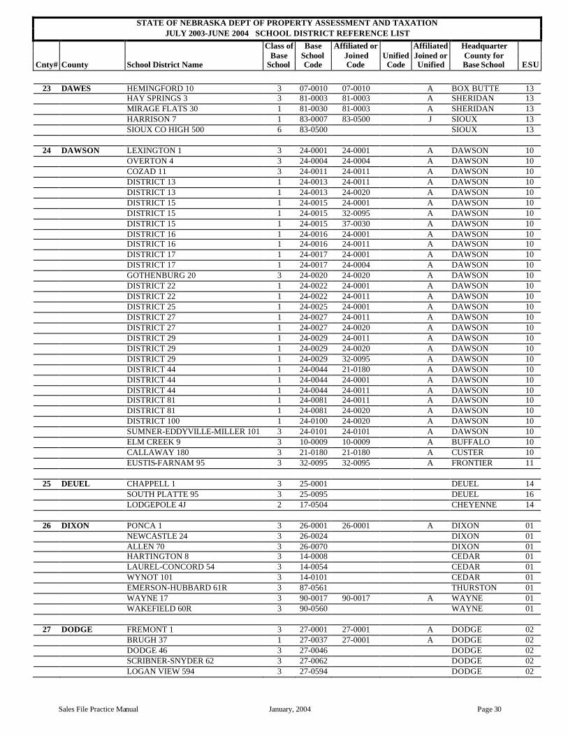
STATE OF NEBRASKA DEPT OF PROPERTY ASSESSMENT AND TAXATION JULY 2003-JUNE 2004 SCHOOL DISTRICT REFERENCE LIST
Class of Base Affiliated or Affiliated Headquarter Base School Joined Unified Joined or County for
Cnty# County School District Name School Code Code Code Unified Base School ESU
Sales File Practice Manual January, 2004 Page 30
23 DAWES HEMINGFORD 10 3 07-0010 07-0010 A BOX BUTTE 13 HAY SPRINGS 3 3 81-0003 81-0003 A SHERIDAN 13 MIRAGE FLATS 30 1 81-0030 81-0003 A SHERIDAN 13 HARRISON 7 1 83-0007 83-0500 J SIOUX 13 SIOUX CO HIGH 500 6 83-0500 SIOUX 13
24 DAWSON LEXINGTON 1 3 24-0001 24-0001 A DAWSON 10 OVERTON 4 3 24-0004 24-0004 A DAWSON 10 COZAD 11 3 24-0011 24-0011 A DAWSON 10 DISTRICT 13 1 24-0013 24-0011 A DAWSON 10 DISTRICT 13 1 24-0013 24-0020 A DAWSON 10 DISTRICT 15 1 24-0015 24-0001 A DAWSON 10 DISTRICT 15 1 24-0015 32-0095 A DAWSON 10 DISTRICT 15 1 24-0015 37-0030 A DAWSON 10 DISTRICT 16 1 24-0016 24-0001 A DAWSON 10 DISTRICT 16 1 24-0016 24-0011 A DAWSON 10 DISTRICT 17 1 24-0017 24-0001 A DAWSON 10 DISTRICT 17 1 24-0017 24-0004 A DAWSON 10 GOTHENBURG 20 3 24-0020 24-0020 A DAWSON 10 DISTRICT 22 1 24-0022 24-0001 A DAWSON 10 DISTRICT 22 1 24-0022 24-0011 A DAWSON 10 DISTRICT 25 1 24-0025 24-0001 A DAWSON 10 DISTRICT 27 1 24-0027 24-0011 A DAWSON 10 DISTRICT 27 1 24-0027 24-0020 A DAWSON 10 DISTRICT 29 1 24-0029 24-0011 A DAWSON 10 DISTRICT 29 1 24-0029 24-0020 A DAWSON 10 DISTRICT 29 1 24-0029 32-0095 A DAWSON 10 DISTRICT 44 1 24-0044 21-0180 A DAWSON 10 DISTRICT 44 1 24-0044 24-0001 A DAWSON 10 DISTRICT 44 1 24-0044 24-0011 A DAWSON 10 DISTRICT 81 1 24-0081 24-0011 A DAWSON 10 DISTRICT 81 1 24-0081 24-0020 A DAWSON 10 DISTRICT 100 1 24-0100 24-0020 A DAWSON 10 SUMNER-EDDYVILLE-MILLER 101 3 24-0101 24-0101 A DAWSON 10 ELM CREEK 9 3 10-0009 10-0009 A BUFFALO 10 CALLAWAY 180 3 21-0180 21-0180 A CUSTER 10 EUSTIS-FARNAM 95 3 32-0095 32-0095 A FRONTIER 11
25 DEUEL CHAPPELL 1 3 25-0001 DEUEL 14 SOUTH PLATTE 95 3 25-0095 DEUEL 16 LODGEPOLE 4J 2 17-0504 CHEYENNE 14
26 DIXON PONCA 1 3 26-0001 26-0001 A DIXON 01 NEWCASTLE 24 3 26-0024 DIXON 01 ALLEN 70 3 26-0070 DIXON 01 HARTINGTON 8 3 14-0008 CEDAR 01 LAUREL-CONCORD 54 3 14-0054 CEDAR 01 WYNOT 101 3 14-0101 CEDAR 01 EMERSON-HUBBARD 61R 3 87-0561 THURSTON 01 WAYNE 17 3 90-0017 90-0017 A WAYNE 01 WAKEFIELD 60R 3 90-0560 WAYNE 01
27 DODGE FREMONT 1 3 27-0001 27-0001 A DODGE 02 BRUGH 37 1 27-0037 27-0001 A DODGE 02 DODGE 46 3 27-0046 DODGE 02 SCRIBNER-SNYDER 62 3 27-0062 DODGE 02 LOGAN VIEW 594 3 27-0594 DODGE 02

STATE OF NEBRASKA DEPT OF PROPERTY ASSESSMENT AND TAXATION JULY 2003-JUNE 2004 SCHOOL DISTRICT REFERENCE LIST
Class of Base Affiliated or Affiliated Headquarter Base School Joined Unified Joined or County for
Cnty# County School District Name School Code Code Code Unified Base School ESU
Page 31 January, 2004 Sales File Practice Manual
27 DODGE NORTH BEND CENTRAL 595 3 27-0595 DODGE 02 OAKLAND-CRAIG 14 3 11-0014 BURT 02 WEST POINT 1 3 20-0001 20-0001 A CUMING 02 ARLINGTON 24 3 89-0024 WASHINGTON 03
28 DOUGLAS OMAHA 1 5 28-0001 DOUGLAS 19 ELKHORN 10 3 28-0010 28-0010 A DOUGLAS 03 WATERLOO 11 3 28-0011 DOUGLAS 03 MILLARD 17 3 28-0017 DOUGLAS 03 VALLEY 33 3 28-0033 DOUGLAS 03 RALSTON 54 3 28-0054 DOUGLAS 03 BENNINGTON 59 3 28-0059 DOUGLAS 03 WESTSIDE 66 3 28-0066 DOUGLAS 03 FREMONT 1 3 27-0001 27-0001 A DODGE 02 GRETNA 37 3 77-0037 SARPY 03 FORT CALHOUN 3 3 89-0003 WASHINGTON 03 ARLINGTON 24 3 89-0024 WASHINGTON 03
29 DUNDY DUNDY CO 117 3 29-0117 DUNDY 15 IMPERIAL ELEM 3 1 15-0003 15-0015 J CHASE 15 CHAMPION 12 1 15-0012 15-0015 J CHASE 15 CHASE CO HIGH 15 6 15-0015 CHASE 15 LAMAR 42 1 15-0042 15-0015 J CHASE 15 WAUNETA-PALISADE 536 3 15-0536 CHASE 15 STRATTON 8 (Hitchcock Co Unif) 3 44-0008 44-2001 U HITCHCOCK 15 HITCHCOCK CO UNIFIED SYSTEM 3 44-2001 U HITCHCOCK
30 FILLMORE EXETER-MILLIGAN 1 3 30-0001 FILLMORE 06 FILLMORE DISTRICT 25 3 30-0025 30-0025 A FILLMORE 06 STRANG 36 1 30-0036 30-0025 A FILLMORE 06 STRANG 36 1 30-0036 30-0054 A FILLMORE 06 STRANG 36 1 30-0036 85-0094 85-2001 A FILLMORE 06 OHIOWA 40 1 30-0040 30-0025 A FILLMORE 06 OHIOWA 40 1 30-0040 85-0094 85-2001 A FILLMORE 06 SHICKLEY 54 3 30-0054 30-0054 A FILLMORE 06 SUTTON 2 3 18-0002 CLAY 09 MERIDIAN 303 3 48-0303 48-0303 A JEFFERSON 05 FRIEND 68 3 76-0068 SALINE 06 DAVENPORT 47 (Brun-Davenpt Unif) 2 85-0047 85-2001 U THAYER 05 BRUNING 94 (Brun-Davenpt Unif) 2 85-0094 85-0094 85-2001 U THAYER 05 MCCOOL JUNCTION 83 2 93-0083 YORK 06 HEARTLAND 96 3 93-0096 YORK 06 BRUNING-DAVENPORT UNIF
SYSTEM 2 85-2001 U THAYER
31 FRANKLIN FRANKLIN R6 3 31-0506 FRANKLIN 11 SILVER LAKE 123 3 01-0123 01-0123 A ADAMS 09 ALMA 2 3 42-0002 HARLAN 11 WILCOX-HILDRETH 3 50-0001 KEARNEY 11 MINDEN R3 3 50-0503 KEARNEY 11 RED CLOUD 2 3 91-0002 WEBSTER 09
32 FRONTIER MAYWOOD 46 3 32-0046 32-0046 A FRONTIER 15 EUSTIS-FARNAM 95 3 32-0095 32-0095 A FRONTIER 11 MEDICINE VALLEY 125 3 32-0125 FRONTIER 15 ARAPAHOE 18 3 33-0018 FURNAS 11 CAMBRIDGE 21 3 33-0021 FURNAS 11

STATE OF NEBRASKA DEPT OF PROPERTY ASSESSMENT AND TAXATION JULY 2003-JUNE 2004 SCHOOL DISTRICT REFERENCE LIST
Class of Base Affiliated or Affiliated Headquarter Base School Joined Unified Joined or County for
Cnty# County School District Name School Code Code Code Unified Base School ESU
Sales File Practice Manual January, 2004 Page 32
32 FRONTIER ELWOOD 30 2 37-0030 37-0030 A GOSPER 11 HAYES CENTER 79 3 43-0079 HAYES 15 MCCOOK 17 3 73-0017 73-0017 A RED WILLOW 00 DISTRICT 41 1 73-0041 73-0017 A RED WILLOW 00 REPUBLICAN & TWIN VALLEY
179 3 73-0179 73-0179 A RED WILLOW 15
33 FURNAS ARAPAHOE 18 3 33-0018 FURNAS 11 CAMBRIDGE 21 3 33-0021 FURNAS 11 SOUTHERN VALLEY 540 3 33-0540 FURNAS 11 ALMA 2 3 42-0002 HARLAN 11 REPUBLICAN & TWIN VALLEY
179 3 73-0179 73-0179 A RED WILLOW 15
34 GAGE SOUTHERN 1 3 34-0001 GAGE 05 BEATRICE 15 3 34-0015 GAGE 05 DANIEL FREEMAN 34 3 34-0034 GAGE 05 DILLER-ODELL 100 3 34-0100 GAGE 05 TRI COUNTY 300 3 48-0300 48-0300 A JEFFERSON 05 NORRIS 160 3 55-0160 55-0160 A LANCASTER 06 LEWISTON 69 3 67-0069 PAWNEE 04 CRETE 2 3 76-0002 76-0002 A SALINE 06 WILBER-CLATONIA 82 3 76-0082 76-0082 A SALINE 06
35 GARDEN GARDEN CO HIGH 1 6 35-0001 GARDEN 14 WELL VALLEY 33 1 35-0033 35-0001 J GARDEN 14 LEWELLEN ELEM 44 1 35-0044 35-0001 J GARDEN 14 OSHKOSH ELEM 131 1 35-0131 35-0001 J GARDEN 14 LISCO 53J 1 35-0553 35-0001 J GARDEN 14 LODGEPOLE 4J 2 17-0504 CHEYENNE 14 CHAPPELL 1 3 25-0001 DEUEL 14 SOUTH PLATTE 95 3 25-0095 DEUEL 16 BINGHAM 85 1 81-0085 35-0001 J SHERIDAN 14 LAKESIDE 91 1 81-0091 35-0001 J SHERIDAN 14 ELLSWORTH 119 1 81-0119 35-0001 J SHERIDAN 14
36 GARFIELD RIVERVIEW 5 1 36-0005 36-0100 J GARFIELD 10 RICHLAND 14 1 36-0014 36-0100 J GARFIELD 10 BURWELL ELEM 15 1 36-0015 36-0100 J GARFIELD 10 DISTRICT 70 1 36-0070 36-0100 J GARFIELD 10 BURWELL HIGH 100 6 36-0100 GARFIELD 10 CHAMBERS 137 2 45-0137 45-0137 A HOLT 08 ORD 5 3 88-0005 88-0005 A VALLEY 10 WHEELER CENTRAL 45 3 92-0045 WHEELER 08
37 GOSPER ELWOOD 30 2 37-0030 37-0030 A GOSPER 11 LEXINGTON 1 3 24-0001 24-0001 A DAWSON 10 DISTRICT 15 1 24-0015 24-0001 A DAWSON 10 DISTRICT 15 1 24-0015 37-0030 A DAWSON 10 EUSTIS-FARNAM 95 3 32-0095 32-0095 A FRONTIER 11 ARAPAHOE 18 3 33-0018 FURNAS 11 CAMBRIDGE 21 3 33-0021 FURNAS 11 SOUTHERN VALLEY 540 3 33-0540 FURNAS 11 BERTRAND 54 3 69-0054 PHELPS 11
38 GRANT HYANNIS ELEM 1 1 38-0001 38-0011 J GRANT 16 DISTRICT 2 1 38-0002 38-0011 J GRANT 16

STATE OF NEBRASKA DEPT OF PROPERTY ASSESSMENT AND TAXATION JULY 2003-JUNE 2004 SCHOOL DISTRICT REFERENCE LIST
Class of Base Affiliated or Affiliated Headquarter Base School Joined Unified Joined or County for
Cnty# County School District Name School Code Code Code Unified Base School ESU
Page 33 January, 2004 Sales File Practice Manual
38 GRANT DISTRICT 5 1 38-0005 38-0011 J GRANT 16 ASHBY 7 1 38-0007 38-0011 J GRANT 16 HYANNIS HIGH 11 6 38-0011 GRANT 16 ARTHUR ELEM 32 1 03-0032 38-0011 J ARTHUR 16
39 GREELEY GREELEY 7 2 39-0007 GREELEY 10 WOLBACH 43 2 39-0043 GREELEY 10 SPALDING 55 3 39-0055 GREELEY 10 NORTH LOUP SCOTIA 1J 3 39-0501 39-0501 A GREELEY 10 CEDAR RAPIDS 6 3 06-0006 06-0006 A BOONE 07 ST PAUL 1 3 47-0001 47-0001 A HOWARD 10 ORD 5 3 88-0005 88-0005 A VALLEY 10 WHEELER CENTRAL 45 3 92-0045 WHEELER 08
40 HALL GRAND ISLAND 2 3 40-0002 HALL 10 CEDAR HOLLOW 3 1 40-0003 40-0082 J HALL 10 WOOD RIVER ELEM 8 1 40-0008 40-0083 J HALL 10 ALDA 12 1 40-0012 40-0083 J HALL 10 PLAINVIEW 16 1 40-0016 40-0083 J HALL 10 NORTHWEST HIGH 82 6 40-0082 HALL 10 WOOD RIVER HIGH 83 6 40-0083 HALL 10 DONIPHAN-TRUMBULL 126 3 40-0126 HALL 09 DISTRICT 1R 1 40-0501 40-0082 J HALL 10 KENESAW 3 3 01-0003 ADAMS 09 RISING STAR 29 1 01-0029 01-0090 J ADAMS 09 ADAMS CENTRAL HIGH 90 6 01-0090 ADAMS 09 SHELTON 19 3 10-0019 BUFFALO 10 AURORA 4R 3 41-0504 HAMILTON 09 CENTURA 100 3 47-0100 47-0100 A HOWARD 10
41 HAMILTON GILTNER 2 2 41-0002 HAMILTON 09 HAMPTON 91 3 41-0091 HAMILTON 09 AURORA 4R 3 41-0504 HAMILTON 09 SUTTON 2 3 18-0002 CLAY 09 HARVARD 11 3 18-0011 CLAY 09 DONIPHAN-TRUMBULL 126 3 40-0126 HALL 09 CENTRAL CITY 4 3 61-0004 MERRICK 07 HIGH PLAINS COMMUNITY 75 3 72-0075 POLK 07 HEARTLAND 96 3 93-0096 YORK 06
42 HARLAN ALMA 2 3 42-0002 HARLAN 11 FRANKLIN R6 3 31-0506 FRANKLIN 11 SOUTHERN VALLEY 540 3 33-0540 FURNAS 11 WILCOX-HILDRETH 1 3 50-0001 KEARNEY 11 HOLDREGE 44 3 69-0044 69-0044 A PHELPS 11 LOOMIS 55 2 69-0055 69-0055 A PHELPS 11 DISTRICT R7 1 69-0507 69-0044 A PHELPS 11 DISTRICT R7 1 69-0507 69-0055 A PHELPS 11
43 HAYES HAYES CENTER 79 3 43-0079 HAYES 15 WAUNETA-PALISADE 536 3 15-0536 CHASE 15 MAYWOOD 46 3 32-0046 32-0046 A FRONTIER 15 STRATTON 8 (Hitchcock Co Unif) 3 44-0008 44-2001 U HITCHCOCK 15 WALLACE 65R 2 56-0565 LINCOLN 16 MCCOOK 17 3 73-0017 73-0017 A RED WILLOW 15 HITCHCOCK CO UNIFIED SYSTEM 3 44-2001 U HITCHCOCK

STATE OF NEBRASKA DEPT OF PROPERTY ASSESSMENT AND TAXATION JULY 2003-JUNE 2004 SCHOOL DISTRICT REFERENCE LIST
Class of Base Affiliated or Affiliated Headquarter Base School Joined Unified Joined or County for
Cnty# County School District Name School Code Code Code Unified Base School ESU
Sales File Practice Manual January, 2004 Page 34
44 HITCHCOCK CULBERTSON 1 (Hitchcock Co Unif) 3 44-0001 44-0001 44-2001 U HITCHCOCK 15 STRATTON 8 (Hitchcock Co Unif) 3 44-0008 44-2001 U HITCHCOCK 15 TRENTON 11 (Hitchcock Co Unif) 3 44-0011 44-2001 U HITCHCOCK 15 WAUNETA-PALISADE 536 3 15-0536 CHASE 15 HAYES CENTER 79 3 43-0079 HAYES 15 FITCH 8 1 73-0008 44-0001 44-2001 A RED WILLOW 00 FITCH 8 1 73-0008 73-0017 A RED WILLOW 00 MCCOOK 17 3 73-0017 73-0017 A RED WILLOW 00 HITCHCOCK CO UNIFIED SYSTEM 3 44-2001 U HITCHCOCK
45 HOLT PAGE 2 1 45-0002 02-0049 02-2001 A HOLT 08 PAGE 2 1 45-0002 45-0007 A HOLT 08 PAGE 2 1 45-0002 45-0029 A HOLT 08 REDBIRD 3 1 45-0003 08-0036 08-2001 A HOLT 08 REDBIRD 3 1 45-0003 45-0007 A HOLT 08 REDBIRD 3 1 45-0003 45-0025 J HOLT 08 REDBIRD 3 1 45-0003 54-0583 02-2001 A HOLT 08
O'NEILL 7 3 45-0007 45-0007 A HOLT 08 EMMET 20 1 45-0020 45-0007 A HOLT 08 EMMET 20 1 45-0020 45-0025 J HOLT 08 ATKINSON ELEM 21 1 45-0021 45-0025 J HOLT 08 WEST HOLT HIGH 25 6 45-0025 HOLT 08 MEEK 27 1 45-0027 08-0038 08-2002 A HOLT 08 MEEK 27 1 45-0027 45-0007 A HOLT 08 MEEK 27 1 45-0027 45-0025 J HOLT 08 EWING 29 2 45-0029 45-0029 A HOLT 08 INMAN 30 1 45-0030 02-0049 02-2001 A HOLT 08 INMAN 30 1 45-0030 45-0007 A HOLT 08 INMAN 30 1 45-0030 45-0029 A HOLT 08 INMAN 30 1 45-0030 45-0137 A HOLT 08 STUART 44 3 45-0044 HOLT 08 STARVIEW 49 1 45-0049 45-0007 A HOLT 08 PHOENIX 53 1 45-0053 45-0025 J HOLT 08
OPPORTUNITY 60 1 45-0060 45-0007 A HOLT 08 UNION 74 1 45-0074 45-0025 J HOLT 08 PLEASANT VIEW 89 1 45-0089 45-0025 J HOLT 08 DISTRICT 90 1 45-0090 45-0007 A HOLT 08 DISTRICT 102 1 45-0102 45-0025 J HOLT 08 CHAMBERS 137 2 45-0137 45-0137 A HOLT 08 DISTRICT 165 1 45-0165 45-0007 A HOLT 08 DISTRICT 165 1 45-0165 45-0137 A HOLT 08 RIDGEWAY 180 1 45-0180 45-0025 J HOLT 08 CLOVER COVE 210 1 45-0210 45-0025 J HOLT 08 CLEARWATER 6 (NE Unified Dist 1) 3 02-0006 02-2001 U ANTELOPE 08 ORCHARD 49 (NE Unified Dist 1) 3 02-0049 02-0049 02-2001 U ANTELOPE 08 SPENCER-NAPER 38 (Boyd Unif) 3 08-0038 08-0038 08-2002 U BOYD 08 DISTRICT 70 1 36-0070 36-0100 J GARFIELD 10 BURWELL HIGH 100 6 36-0100 GARFIELD 10 VERDIGRE 83R (NE Unified Dist 1) 3 54-0583 54-0583 02-2001 U KNOX 08 WHEELER CENTRAL 45 3 92-0045 WHEELER 08
NEBRASKA UNIFIED DISTRICT 1 3 02-2001 U ANTELOPE BOYD CO. UNIFIED 3 08-2002 U BOYD NIOBRARA-LYNCH UNIFIED 3 08-2001 U BOYD
46 HOOKER MULLEN 1 3 46-0001 HOOKER 16
47 HOWARD ST PAUL 1 3 47-0001 47-0001 A HOWARD 10
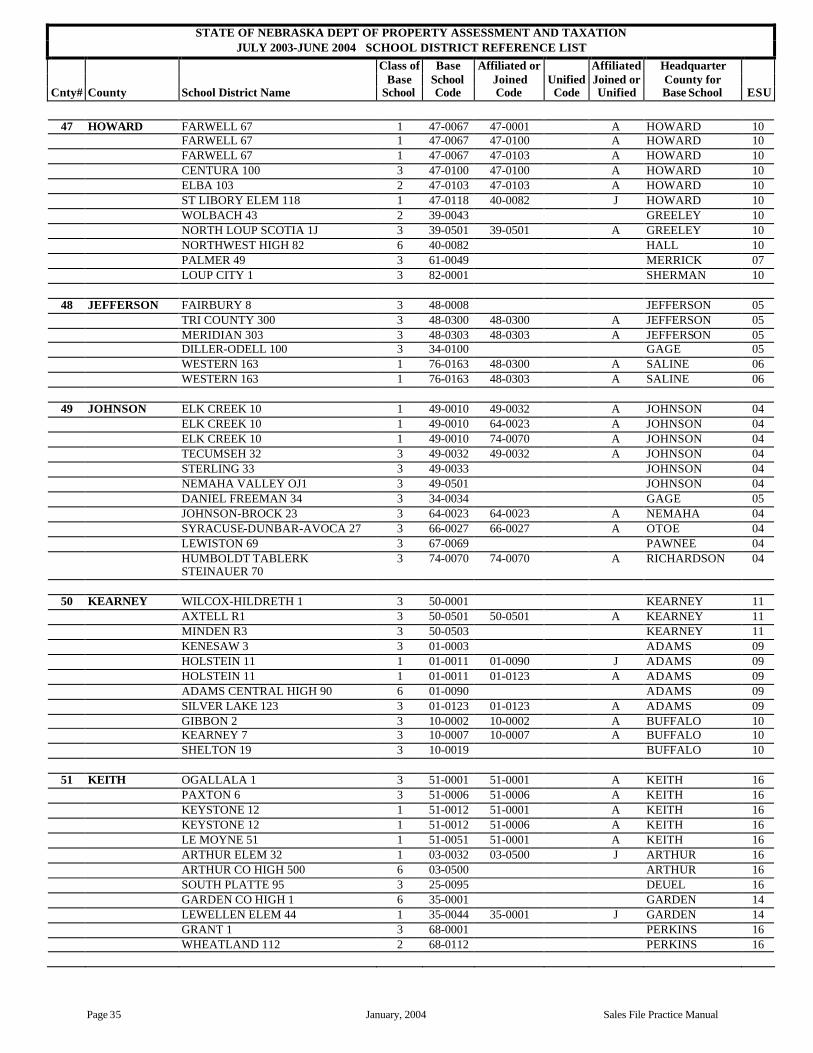
STATE OF NEBRASKA DEPT OF PROPERTY ASSESSMENT AND TAXATION JULY 2003-JUNE 2004 SCHOOL DISTRICT REFERENCE LIST
Class of Base Affiliated or Affiliated Headquarter Base School Joined Unified Joined or County for
Cnty# County School District Name School Code Code Code Unified Base School ESU
Page 35 January, 2004 Sales File Practice Manual
47 HOWARD FARWELL 67 1 47-0067 47-0001 A HOWARD 10 FARWELL 67 1 47-0067 47-0100 A HOWARD 10 FARWELL 67 1 47-0067 47-0103 A HOWARD 10 CENTURA 100 3 47-0100 47-0100 A HOWARD 10 ELBA 103 2 47-0103 47-0103 A HOWARD 10 ST LIBORY ELEM 118 1 47-0118 40-0082 J HOWARD 10 WOLBACH 43 2 39-0043 GREELEY 10 NORTH LOUP SCOTIA 1J 3 39-0501 39-0501 A GREELEY 10 NORTHWEST HIGH 82 6 40-0082 HALL 10 PALMER 49 3 61-0049 MERRICK 07 LOUP CITY 1 3 82-0001 SHERMAN 10
48 JEFFERSON FAIRBURY 8 3 48-0008 JEFFERSON 05 TRI COUNTY 300 3 48-0300 48-0300 A JEFFERSON 05 MERIDIAN 303 3 48-0303 48-0303 A JEFFERSON 05 DILLER-ODELL 100 3 34-0100 GAGE 05 WESTERN 163 1 76-0163 48-0300 A SALINE 06 WESTERN 163 1 76-0163 48-0303 A SALINE 06
49 JOHNSON ELK CREEK 10 1 49-0010 49-0032 A JOHNSON 04 ELK CREEK 10 1 49-0010 64-0023 A JOHNSON 04 ELK CREEK 10 1 49-0010 74-0070 A JOHNSON 04 TECUMSEH 32 3 49-0032 49-0032 A JOHNSON 04 STERLING 33 3 49-0033 JOHNSON 04 NEMAHA VALLEY OJ1 3 49-0501 JOHNSON 04 DANIEL FREEMAN 34 3 34-0034 GAGE 05 JOHNSON-BROCK 23 3 64-0023 64-0023 A NEMAHA 04 SYRACUSE-DUNBAR-AVOCA 27 3 66-0027 66-0027 A OTOE 04 LEWISTON 69 3 67-0069 PAWNEE 04 HUMBOLDT TABLERK
STEINAUER 70 3 74-0070 74-0070 A RICHARDSON 04
50 KEARNEY WILCOX-HILDRETH 1 3 50-0001 KEARNEY 11 AXTELL R1 3 50-0501 50-0501 A KEARNEY 11 MINDEN R3 3 50-0503 KEARNEY 11 KENESAW 3 3 01-0003 ADAMS 09 HOLSTEIN 11 1 01-0011 01-0090 J ADAMS 09 HOLSTEIN 11 1 01-0011 01-0123 A ADAMS 09
ADAMS CENTRAL HIGH 90 6 01-0090 ADAMS 09 SILVER LAKE 123 3 01-0123 01-0123 A ADAMS 09 GIBBON 2 3 10-0002 10-0002 A BUFFALO 10 KEARNEY 7 3 10-0007 10-0007 A BUFFALO 10 SHELTON 19 3 10-0019 BUFFALO 10
51 KEITH OGALLALA 1 3 51-0001 51-0001 A KEITH 16 PAXTON 6 3 51-0006 51-0006 A KEITH 16 KEYSTONE 12 1 51-0012 51-0001 A KEITH 16 KEYSTONE 12 1 51-0012 51-0006 A KEITH 16 LE MOYNE 51 1 51-0051 51-0001 A KEITH 16 ARTHUR ELEM 32 1 03-0032 03-0500 J ARTHUR 16 ARTHUR CO HIGH 500 6 03-0500 ARTHUR 16 SOUTH PLATTE 95 3 25-0095 DEUEL 16 GARDEN CO HIGH 1 6 35-0001 GARDEN 14 LEWELLEN ELEM 44 1 35-0044 35-0001 J GARDEN 14 GRANT 1 3 68-0001 PERKINS 16 WHEATLAND 112 2 68-0112 PERKINS 16

STATE OF NEBRASKA DEPT OF PROPERTY ASSESSMENT AND TAXATION JULY 2003-JUNE 2004 SCHOOL DISTRICT REFERENCE LIST
Class of Base Affiliated or Affiliated Headquarter Base School Joined Unified Joined or County for
Cnty# County School District Name School Code Code Code Unified Base School ESU
Sales File Practice Manual January, 2004 Page 36
52 KEYA PAHA PLEASANT VIEW 1 1 52-0001 52-0100 J KEYA PAHA 17 MILLS 3 1 52-0003 52-0100 J KEYA PAHA 17 NORDEN 21 1 52-0021 52-0100 J KEYA PAHA 17 SPRING VIEW 56 1 52-0056 52-0100 J KEYA PAHA 17 BURTON 64 1 52-0064 52-0100 J KEYA PAHA 17 KEYA PAHA CO HIGH 100 6 52-0100 KEYA PAHA 17 HIGHLAND GROVE 7 1 09-0007 52-0100 J BROWN 17 SPARKS 71 1 16-0071 52-0100 J CHERRY 17 BASSETT ELEM 74 1 75-0074 52-0100 J ROCK 17
53 KIMBALL KIMBALL 1 3 53-0001 KIMBALL 14 POTTER-DIX 9 3 17-0009 CHEYENNE 14
54 KNOX CREIGHTON 13 3 54-0013 KNOX 01 CROFTON 96 3 54-0096 KNOX 01 NIOBRARA 1R (Niobrara-Lynch Unif 3 54-0501 08-2001 U KNOX 01 SANTEE C5 2 54-0505 KNOX 01 WAUSA 76R 3 54-0576 KNOX 01 VERDIGRE 83R (NE Unified Dist 1) 3 54-0583 54-0583 02-2001 U KNOX 01 BLOOMFIELD 86R 3 54-0586 KNOX 01 ORCHARD 49 (NE Unified Dist 1) 3 02-0049 02-0049 02-2001 U ANTELOPE 08 LYNCH 36 (Niobrara-Lynch Unif) 3 08-0036 08-0036 08-2001 U BOYD 08 PLAINVIEW 5 3 70-0005 70-0005 A PIERCE 08 OSMOND 42R 3 70-0542 PIERCE 08 NEBRASKA UNIFIED DISTRICT 1 3 02-2001 U ANTELOPE NIOBRARA-LYNCH UNIFIED 3 08-2001 U BOYD
55 LANCASTER LINCOLN 1 4 55-0001 55-0001 A LANCASTER 18 OAK VALLEY 13 1 55-0013 55-0148 A LANCASTER 06 MIDDLE CREEK 38 1 55-0038 80-0005 A LANCASTER 06 HAINES BRANCH 69 1 55-0069 55-0001 A LANCASTER 06 WAVERLY 145 3 55-0145 55-0145 A LANCASTER 06 MALCOLM 148 3 55-0148 55-0148 A LANCASTER 06 ROKEBY 152 1 55-0152 55-0001 A LANCASTER 06 ROKEBY 152 1 55-0152 55-0160 A LANCASTER 06 ROKEBY 152 1 55-0152 76-0002 A LANCASTER 06 CHENEY 153 1 55-0153 55-0001 A LANCASTER 06 CHENEY 153 1 55-0153 55-0145 A LANCASTER 06 CHENEY 153 1 55-0153 55-0160 A LANCASTER 06 CHENEY 153 1 55-0153 66-0501 A LANCASTER 06 OLIVE BRANCH 158 1 55-0158 76-0002 A LANCASTER 06 OLIVE BRANCH 158 1 55-0158 76-0082 A LANCASTER 06 NORRIS 160 3 55-0160 55-0160 A LANCASTER 06 RAYMOND CENTRAL 161 3 55-0161 55-0161 A LANCASTER 02 DANIEL FREEMAN 34 3 34-0034 GAGE 05 PALMYRA OR1 3 66-0501 66-0501 A OTOE 04 CRETE 2 3 76-0002 76-0002 A SALINE 06 WILBER-CLATONIA 82 3 76-0082 76-0082 A SALINE 06 MILFORD 5 3 80-0005 80-0005 A SEWARD 06
56 LINCOLN NORTH PLATTE 1 3 56-0001 56-0001 A LINCOLN 16 HALL 5 1 56-0005 56-0001 A LINCOLN 16 HALL 5 1 56-0005 56-0007 A LINCOLN 16 HALL 5 1 56-0005 56-0037 A LINCOLN 16 HALL 5 1 56-0005 57-0501 A LINCOLN 16 HALL 5 1 56-0005 60-0090 J LINCOLN 16 BRADY 6 2 56-0006 LINCOLN 16

STATE OF NEBRASKA DEPT OF PROPERTY ASSESSMENT AND TAXATION JULY 2003-JUNE 2004 SCHOOL DISTRICT REFERENCE LIST
Class of Base Affiliated or Affiliated Headquarter Base School Joined Unified Joined or County for
Cnty# County School District Name School Code Code Code Unified Base School ESU
Page 37 January, 2004 Sales File Practice Manual
56 LINCOLN MAXWELL 7 2 56-0007 56-0007 A LINCOLN 16 PLATTE VALLEY 8 1 56-0008 56-0001 A LINCOLN 16 PLATTE VALLEY 8 1 56-0008 56-0037 A LINCOLN 16 HERSHEY 37 3 56-0037 56-0037 A LINCOLN 16 COUNTY CENTER 44 1 56-0044 32-0046 A LINCOLN 16 COUNTY CENTER 44 1 56-0044 56-0001 A LINCOLN 16 SUTHERLAND 55 3 56-0055 56-0055 A LINCOLN 16 ROSEDALE 82 1 56-0082 56-0001 A LINCOLN 16 ROSEDALE 82 1 56-0082 56-0037 A LINCOLN 16 ROSEDALE 82 1 56-0082 56-0055 A LINCOLN 16 ROSEDALE 82 1 56-0082 60-0090 J LINCOLN 16 WALLACE 65R 2 56-0565 LINCOLN 16 ARNOLD 89 3 21-0089 CUSTER 10 NEW HOPE 153 1 21-0153 24-0020 A CUSTER 10 GOTHENBURG 20 3 24-0020 24-0020 A DAWSON 10 DISTRICT 100 1 24-0100 24-0020 A DAWSON 10 MAYWOOD 46 3 32-0046 32-0046 A FRONTIER 15 EUSTIS-FARNAM 95 3 32-0095 32-0095 A FRONTIER 11 MEDICINE VALLEY 125 3 32-0125 FRONTIER 15 PAXTON 6 3 51-0006 51-0006 A KEITH 16 STAPLETON R1 3 57-0501 57-0501 A LOGAN 16 MCPHERSON CO HIGH 90 6 60-0090 MCPHERSON 16 WHEATLAND 112 2 68-0112 PERKINS 16
57 LOGAN STAPLETON R1 3 57-0501 57-0501 A LOGAN 16 SANDHILLS 71 3 05-0071 BLAINE 10 ARNOLD 89 3 21-0089 CUSTER 10
58 LOUP LOUP CO 25 2 58-0025 LOUP 10 SANDHILLS 71 3 05-0071 BLAINE 10 SARGENT 84 3 21-0084 21-0084 A CUSTER 10
59 MADISON MADISON 1 3 59-0001 59-0001 A MADISON 08 NORFOLK 2 3 59-0002 59-0002 A MADISON 08 SUNNY MEADOW 3 1 59-0003 59-0002 A MADISON 08 SUNNY MEADOW 3 1 59-0003 59-0005 A MADISON 08 BATTLE CREEK 5 3 59-0005 59-0005 A MADISON 08 NEWMAN GROVE 13 3 59-0013 59-0013 A MADISON 08 WINTER 20 1 59-0020 59-0002 A MADISON 08 DEDERMAN 24 1 59-0024 59-0002 A MADISON 08 DEDERMAN 24 1 59-0024 59-0005 A MADISON 08 DEDERMAN 24 1 59-0024 70-0002 A MADISON 08 WARNERVILLE 25 1 59-0025 59-0001 A MADISON 08 WARNERVILLE 25 1 59-0025 59-0002 A MADISON 08 WARNERVILLE 25 1 59-0025 59-0005 A MADISON 08 REICHE 37 1 59-0037 59-0001 A MADISON 08 REICHE 37 1 59-0037 59-0002 A MADISON 08 REICHE 37 1 59-0037 59-0005 A MADISON 08 GOOD CHEER 48 1 59-0048 59-0001 A MADISON 08 GOOD CHEER 48 1 59-0048 59-0002 A MADISON 08 GOOD CHEER 48 1 59-0048 59-0005 A MADISON 08 ELKHORN VALLEY 80 3 59-0080 59-0080 A MADISON 08 CLOVERLEAF 95 1 59-0095 59-0013 A MADISON 08 CLOVERLEAF 95 1 59-0095 59-0080 A MADISON 08 EMERICK 96 1 59-0096 59-0001 A MADISON 08 EMERICK 96 1 59-0096 59-0005 A MADISON 08 EMERICK 96 1 59-0096 59-0013 A MADISON 08

STATE OF NEBRASKA DEPT OF PROPERTY ASSESSMENT AND TAXATION JULY 2003-JUNE 2004 SCHOOL DISTRICT REFERENCE LIST
Class of Base Affiliated or Affiliated Headquarter Base School Joined Unified Joined or County for
Cnty# County School District Name School Code Code Code Unified Base School ESU
Sales File Practice Manual January, 2004 Page 38
59 MADISON EMERICK 96 1 59-0096 59-0080 A MADISON 08 KALAMAZOO 97 1 59-0097 59-0001 A MADISON 08 KALAMAZOO 97 1 59-0097 59-0005 A MADISON 08 KALAMAZOO 97 1 59-0097 59-0013 A MADISON 08 KALAMAZOO 97 1 59-0097 71-0067 A MADISON 08
60 MCPHERSON TRYON 4 1 60-0004 60-0090 J MCPHERSON 16 DALY 26 1 60-0026 03-0500 J MCPHERSON 16 DALY 26 1 60-0026 60-0090 J MCPHERSON 16 STARR 28 1 60-0028 60-0090 J MCPHERSON 16 MCPHERSON CO HIGH 90 6 60-0090 MCPHERSON 16 CENTER VALLEY 12 1 03-0012 03-0500 J ARTHUR 16 CENTER VALLEY 12 1 03-0012 60-0090 J ARTHUR 16 ARTHUR ELEM 32 1 03-0032 03-0500 J ARTHUR 16 ARTHUR CO HIGH 500 6 03-0500 ARTHUR 16 STAPLETON R1 3 57-0501 57-0501 A LOGAN 16
61 MERRICK CENTRAL CITY 4 3 61-0004 MERRICK 07 CHAPMAN 9 1 61-0009 40-0082 J MERRICK 10 PALMER 49 3 61-0049 MERRICK 07 GRAND ISLAND 2 3 40-0002 HALL 10 CEDAR HOLLOW 3 1 40-0003 40-0082 J HALL 10 NORTHWEST HIGH 82 6 40-0082 HALL 10 DISTRICT 1R 1 40-0501 40-0082 J HALL 10 FULLERTON 1 3 63-0001 63-0001 A NANCE 07 TWIN RIVER 30 3 63-0030 63-0030 A NANCE 07 HIGH PLAINS COMMUNITY 75 3 72-0075 POLK 07
62 MORRILL BAYARD 21 3 62-0021 62-0021 A MORRILL 13 ANGORA 41 1 62-0041 07-0006 A MORRILL 13 ANGORA 41 1 62-0041 62-0021 A MORRILL 13 ANGORA 41 1 62-0041 62-0063 A MORRILL 13 HILL 44 1 62-0044 62-0021 A MORRILL 13 HILL 44 1 62-0044 62-0063 A MORRILL 13 BRIDGEPORT 63 3 62-0063 62-0063 A MORRILL 13 BROADWATER 128 1 62-0128 17-0003 A MORRILL 13 BROADWATER 128 1 62-0128 62-0063 A MORRILL 13 BANNER 1 3 04-0001 BANNER 13 ALLIANCE 6 3 07-0006 07-0006 A BOX BUTTE 13 LEYTON 3 3 17-0003 17-0003 A CHEYENNE 14 GARDEN CO HIGH 1 6 35-0001 GARDEN 14 LISCO 53J 1 35-0553 35-0001 J GARDEN 14 HIGHLAND 5 1 79-0005 79-0032 A SCOTTS BLUFF 13
63 NANCE FULLERTON 1 3 63-0001 63-0001 A NANCE 07 SHADY NOOK 2 1 63-0002 63-0001 A NANCE 07 SHADY NOOK 2 1 63-0002 63-0030 A NANCE 07 BELGRADE 8 1 63-0008 06-0006 A NANCE 07 BELGRADE 8 1 63-0008 63-0001 A NANCE 07 TWIN RIVER 30 3 63-0030 63-0030 A NANCE 07 CEDAR RAPIDS 6 3 06-0006 06-0006 A BOONE 07 ST EDWARD 17 3 06-0017 06-0017 A BOONE 07 WOLBACH 43 2 39-0043 GREELEY 10 PALMER 49 3 61-0049 MERRICK 07 HIGH PLAINS COMMUNITY 75 3 72-0075 POLK 07
64 NEMAHA JOHNSON-BROCK 23 3 64-0023 64-0023 A NEMAHA 04

STATE OF NEBRASKA DEPT OF PROPERTY ASSESSMENT AND TAXATION JULY 2003-JUNE 2004 SCHOOL DISTRICT REFERENCE LIST
Class of Base Affiliated or Affiliated Headquarter Base School Joined Unified Joined or County for
Cnty# County School District Name School Code Code Code Unified Base School ESU
Page 39 January, 2004 Sales File Practice Manual
64 NEMAHA AUBURN 29 3 64-0029 64-0029 A NEMAHA 04 LOCUST GROVE 32 1 64-0032 64-0029 A NEMAHA 04 BROWNVILLE 34 1 64-0034 64-0029 A NEMAHA 04 ELK CREEK 10 1 49-0010 49-0032 A JOHNSON 04 ELK CREEK 10 1 49-0010 64-0023 A JOHNSON 04 ELK CREEK 10 1 49-0010 74-0070 A JOHNSON 04 NEMAHA VALLEY OJ1 3 49-0501 JOHNSON 04 NEBRASKA CITY 111 3 66-0111 66-0111 A OTOE 04 FALLS CITY 56 3 74-0056 74-0056 A RICHARDSON 04 SOUTHEAST RN1 3 74-0501 RICHARDSON 04
65 NUCKOLLS SUPERIOR 11 (SoCentral NE Unif5) 3 65-0011 65-2005 U NUCKOLLS 09 NELSON 15 (SoCentral NE Unif 5) 3 65-0015 65-2005 U NUCKOLLS 09 LAWRENCE 71 (SoCentrl NE Unif 5) 3 65-0071 65-2005 U NUCKOLLS 09 SANDY CREEK 1C (SoCentrl NE
Unf5 3 18-0501 65-2005 U CLAY 09
DAVENPORT 47 (Brun-Davenpt Unif) 2 85-0047 85-2001 U THAYER 05 DESHLER 60 3 85-0060 THAYER 05 THAYER CENTRAL COMM 70 3 85-0070 85-0070 A THAYER 05 GUIDE ROCK R1 (SoCentrl NE Unf5) 3 91-0501 65-2005 WEBSTER 09 SOUTH CENTRAL NE UNIF DIST 5 3 65-2005 U NUCKOLLS BRUNING-DAVENPORT UNIF
SYSTEM 2 85-2001 U THAYER
66 OTOE SMALLFOOT 11 1 66-0011 13-0056 A OTOE 04 SMALLFOOT 11 1 66-0011 66-0027 A OTOE 04 SMALLFOOT 11 1 66-0011 66-0111 A OTOE 04 MCCARTNEY 17 1 66-0017 66-0111 A OTOE 04 UNADILLA 20 1 66-0020 66-0027 A OTOE 04 SYRACUSE-DUNBAR-AVOCA 27 3 66-0027 66-0027 A OTOE 04 HAZEL DELL 36 1 66-0036 66-0111 A OTOE 04 OTOE 78 1 66-0078 66-0027 A OTOE 04 NEBRASKA CITY 111 3 66-0111 66-0111 A OTOE 04 PALMYRA OR1 3 66-0501 66-0501 A OTOE 04 CONESTOGA 56 3 13-0056 13-0056 A CASS 03 ELMWOOD-MURDOCK 97 3 13-0097 CASS 03 DANIEL FREEMAN 34 3 34-0034 GAGE 05 STERLING 33 3 49-0033 JOHNSON 04 NEMAHA VALLEY OJ1 3 49-0501 JOHNSON 04 WAVERLY 145 3 55-0145 55-0145 A LANCASTER 06 NORRIS 160 3 55-0160 55-0160 A LANCASTER 06 JOHNSON-BROCK 23 3 64-0023 64-0023 A NEMAHA 04
67 PAWNEE PAWNEE CITY 1 3 67-0001 PAWNEE 04 LEWISTON 69 3 67-0069 PAWNEE 04 SOUTHERN 1 3 34-0001 GAGE 05 DILLER-ODELL 100 3 34-0100 GAGE 05 ELK CREEK 10 1 49-0010 49-0032 A JOHNSON 04 ELK CREEK 10 1 49-0010 64-0023 A JOHNSON 04 ELK CREEK 10 1 49-0010 74-0070 A JOHNSON 04 TECUMSEH 32 3 49-0032 49-0032 A JOHNSON 04 HUMBOLDT TABLERK
STEINAUER 70 3 74-0070 74-0070 A RICHARDSON 04
68 PERKINS GRANT 1 3 68-0001 PERKINS 16 WHEATLAND 112 2 68-0112 PERKINS 16 SOUTH PLATTE 95 3 25-0095 DEUEL 16 HAYES CENTER 79 3 43-0079 HAYES 16
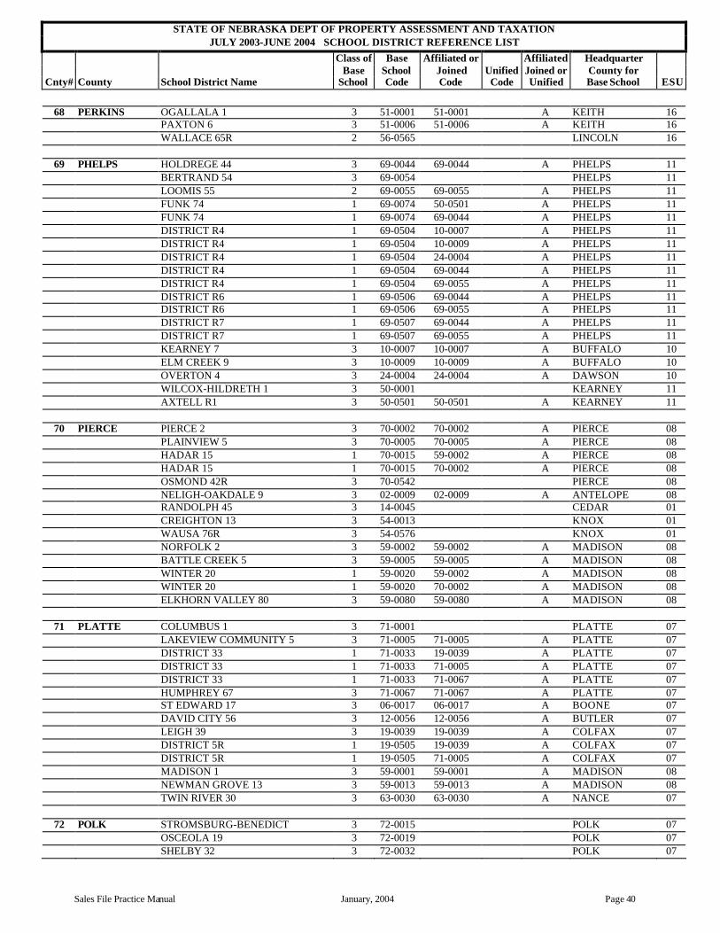
STATE OF NEBRASKA DEPT OF PROPERTY ASSESSMENT AND TAXATION JULY 2003-JUNE 2004 SCHOOL DISTRICT REFERENCE LIST
Class of Base Affiliated or Affiliated Headquarter Base School Joined Unified Joined or County for
Cnty# County School District Name School Code Code Code Unified Base School ESU
Sales File Practice Manual January, 2004 Page 40
68 PERKINS OGALLALA 1 3 51-0001 51-0001 A KEITH 16 PAXTON 6 3 51-0006 51-0006 A KEITH 16 WALLACE 65R 2 56-0565 LINCOLN 16
69 PHELPS HOLDREGE 44 3 69-0044 69-0044 A PHELPS 11 BERTRAND 54 3 69-0054 PHELPS 11 LOOMIS 55 2 69-0055 69-0055 A PHELPS 11 FUNK 74 1 69-0074 50-0501 A PHELPS 11 FUNK 74 1 69-0074 69-0044 A PHELPS 11 DISTRICT R4 1 69-0504 10-0007 A PHELPS 11 DISTRICT R4 1 69-0504 10-0009 A PHELPS 11 DISTRICT R4 1 69-0504 24-0004 A PHELPS 11 DISTRICT R4 1 69-0504 69-0044 A PHELPS 11 DISTRICT R4 1 69-0504 69-0055 A PHELPS 11 DISTRICT R6 1 69-0506 69-0044 A PHELPS 11 DISTRICT R6 1 69-0506 69-0055 A PHELPS 11 DISTRICT R7 1 69-0507 69-0044 A PHELPS 11 DISTRICT R7 1 69-0507 69-0055 A PHELPS 11 KEARNEY 7 3 10-0007 10-0007 A BUFFALO 10 ELM CREEK 9 3 10-0009 10-0009 A BUFFALO 10 OVERTON 4 3 24-0004 24-0004 A DAWSON 10 WILCOX-HILDRETH 1 3 50-0001 KEARNEY 11 AXTELL R1 3 50-0501 50-0501 A KEARNEY 11
70 PIERCE PIERCE 2 3 70-0002 70-0002 A PIERCE 08 PLAINVIEW 5 3 70-0005 70-0005 A PIERCE 08 HADAR 15 1 70-0015 59-0002 A PIERCE 08 HADAR 15 1 70-0015 70-0002 A PIERCE 08 OSMOND 42R 3 70-0542 PIERCE 08 NELIGH-OAKDALE 9 3 02-0009 02-0009 A ANTELOPE 08 RANDOLPH 45 3 14-0045 CEDAR 01 CREIGHTON 13 3 54-0013 KNOX 01 WAUSA 76R 3 54-0576 KNOX 01 NORFOLK 2 3 59-0002 59-0002 A MADISON 08 BATTLE CREEK 5 3 59-0005 59-0005 A MADISON 08 WINTER 20 1 59-0020 59-0002 A MADISON 08 WINTER 20 1 59-0020 70-0002 A MADISON 08 ELKHORN VALLEY 80 3 59-0080 59-0080 A MADISON 08
71 PLATTE COLUMBUS 1 3 71-0001 PLATTE 07 LAKEVIEW COMMUNITY 5 3 71-0005 71-0005 A PLATTE 07 DISTRICT 33 1 71-0033 19-0039 A PLATTE 07 DISTRICT 33 1 71-0033 71-0005 A PLATTE 07 DISTRICT 33 1 71-0033 71-0067 A PLATTE 07 HUMPHREY 67 3 71-0067 71-0067 A PLATTE 07 ST EDWARD 17 3 06-0017 06-0017 A BOONE 07 DAVID CITY 56 3 12-0056 12-0056 A BUTLER 07 LEIGH 39 3 19-0039 19-0039 A COLFAX 07 DISTRICT 5R 1 19-0505 19-0039 A COLFAX 07 DISTRICT 5R 1 19-0505 71-0005 A COLFAX 07 MADISON 1 3 59-0001 59-0001 A MADISON 08 NEWMAN GROVE 13 3 59-0013 59-0013 A MADISON 08 TWIN RIVER 30 3 63-0030 63-0030 A NANCE 07
72 POLK STROMSBURG-BENEDICT 3 72-0015 POLK 07 OSCEOLA 19 3 72-0019 POLK 07 SHELBY 32 3 72-0032 POLK 07

STATE OF NEBRASKA DEPT OF PROPERTY ASSESSMENT AND TAXATION JULY 2003-JUNE 2004 SCHOOL DISTRICT REFERENCE LIST
Class of Base Affiliated or Affiliated Headquarter Base School Joined Unified Joined or County for
Cnty# County School District Name School Code Code Code Unified Base School ESU
Page 41 January, 2004 Sales File Practice Manual
72 POLK HIGH PLAINS COMMUNITY 75 3 72-0075 POLK 07 RISING CITY 32 2 12-0032 BUTLER 07 TWIN RIVER 30 3 63-0030 63-0030 A NANCE 07 COLUMBUS 1 3 71-0001 PLATTE 07 CENTENNIAL 67R 3 80-0567 SEWARD 06
73 RED WILLOW FITCH 8 1 73-0008 44-0001 44-2001 A RED WILLOW 00 FITCH 8 1 73-0008 73-0017 A RED WILLOW 00 FITCH 8 1 73-0008 73-0179 A RED WILLOW 00 MCCOOK 17 3 73-0017 73-0017 A RED WILLOW 15 DISTRICT 41 1 73-0041 73-0017 A RED WILLOW 00 REPUBLICAN & TWIN VALLEY
179 3 73-0179 73-0179 A RED WILLOW 15
CAMBRIDGE 21 3 33-0021 FURNAS 11 HITCHCOCK CO UNIFED SYSTEM 3 44-2001 U HITCHCOCK
74 RICHARDSON MAPLE GROVE 47 1 74-0047 74-0056 A RICHARDSON 04 FALLS CITY 56 3 74-0056 74-0056 A RICHARDSON 04 HUMBOLDT TABLERK
STEINAUER 70 3 74-0070 74-0070 A RICHARDSON 04
SOUTHEAST RN1 3 74-0501 RICHARDSON 04 DAWSON-VERDON 15C 3 74-0515 RICHARDSON 04 JOHNSON-BROCK 23 3 64-0023 64-0023 A NEMAHA 04 PAWNEE CITY 1 3 67-0001 PAWNEE 04
75 ROCK NEWPORT 18 1 75-0018 75-0100 J ROCK 17 PONY LAKE 30 1 75-0030 75-0100 J ROCK 17 PLEASANT HILL 55 1 75-0055 75-0100 J ROCK 17 ROSE 72 1 75-0072 75-0100 J ROCK 17 BASSETT ELEM 74 1 75-0074 75-0100 J ROCK 17 SYBRANT 77 1 75-0077 75-0100 J ROCK 17 ROCK CO HIGH 100 6 75-0100 ROCK 17 AINSWORTH 10 3 09-0010 09-0010 A BROWN 17
76 SALINE CRETE 2 3 76-0002 76-0002 A SALINE 06 VALLEY VIEW 18 1 76-0018 76-0002 A SALINE 06 DIAMOND 31 1 76-0031 76-0002 A SALINE 06 DIAMOND 31 1 76-0031 76-0044 A SALINE 06 DORCHESTER 44 3 76-0044 76-0044 A SALINE 06 FRIEND 68 3 76-0068 SALINE 06 WILBER-CLATONIA 82 3 76-0082 76-0082 A SALINE 06 WESTERN 163 1 76-0163 48-0300 A SALINE 06 WESTERN 163 1 76-0163 48-0303 A SALINE 06 EXETER-MILLIGAN 1 3 30-0001 FILLMORE 06 TRI COUNTY 300 3 48-0300 48-0300 A JEFFERSON 05 MERIDIAN 303 3 48-0303 48-0303 A JEFFERSON 05 MILFORD 5 3 80-0005 80-0005 A SEWARD 06
77 SARPY BELLEVUE 1 3 77-0001 SARPY 03 PAPILLION-LAVISTA 27 3 77-0027 SARPY 03 GRETNA 37 3 77-0037 SARPY 03 SOUTH SARPY 46 3 77-0046 SARPY 03 LOUISVILLE 32 3 13-0032 CASS 03 OMAHA 1 5 28-0001 DOUGLAS 19 MILLARD 17 3 28-0017 DOUGLAS 03 ASHLAND-GREENWOOD 1 3 78-0001 78-0001 A SAUNDERS 02
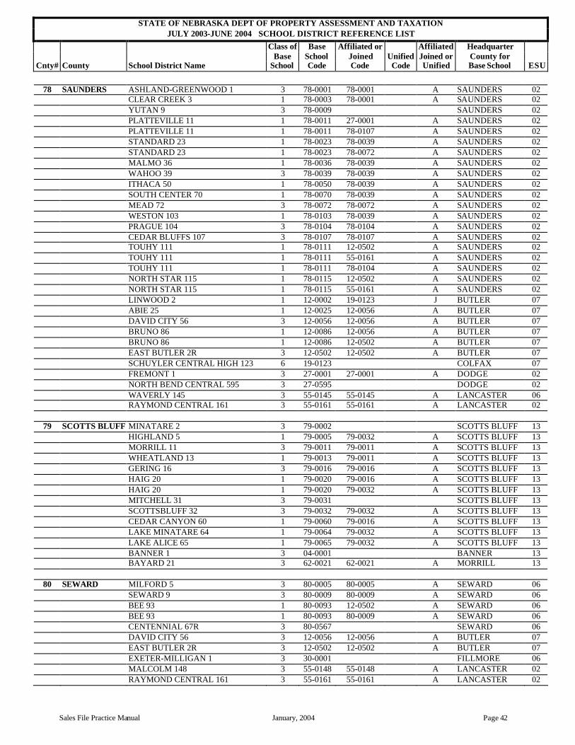
STATE OF NEBRASKA DEPT OF PROPERTY ASSESSMENT AND TAXATION JULY 2003-JUNE 2004 SCHOOL DISTRICT REFERENCE LIST
Class of Base Affiliated or Affiliated Headquarter Base School Joined Unified Joined or County for
Cnty# County School District Name School Code Code Code Unified Base School ESU
Sales File Practice Manual January, 2004 Page 42
78 SAUNDERS ASHLAND-GREENWOOD 1 3 78-0001 78-0001 A SAUNDERS 02 CLEAR CREEK 3 1 78-0003 78-0001 A SAUNDERS 02 YUTAN 9 3 78-0009 SAUNDERS 02 PLATTEVILLE 11 1 78-0011 27-0001 A SAUNDERS 02 PLATTEVILLE 11 1 78-0011 78-0107 A SAUNDERS 02 STANDARD 23 1 78-0023 78-0039 A SAUNDERS 02 STANDARD 23 1 78-0023 78-0072 A SAUNDERS 02 MALMO 36 1 78-0036 78-0039 A SAUNDERS 02 WAHOO 39 3 78-0039 78-0039 A SAUNDERS 02 ITHACA 50 1 78-0050 78-0039 A SAUNDERS 02 SOUTH CENTER 70 1 78-0070 78-0039 A SAUNDERS 02 MEAD 72 3 78-0072 78-0072 A SAUNDERS 02 WESTON 103 1 78-0103 78-0039 A SAUNDERS 02 PRAGUE 104 3 78-0104 78-0104 A SAUNDERS 02 CEDAR BLUFFS 107 3 78-0107 78-0107 A SAUNDERS 02 TOUHY 111 1 78-0111 12-0502 A SAUNDERS 02 TOUHY 111 1 78-0111 55-0161 A SAUNDERS 02 TOUHY 111 1 78-0111 78-0104 A SAUNDERS 02 NORTH STAR 115 1 78-0115 12-0502 A SAUNDERS 02 NORTH STAR 115 1 78-0115 55-0161 A SAUNDERS 02 LINWOOD 2 1 12-0002 19-0123 J BUTLER 07 ABIE 25 1 12-0025 12-0056 A BUTLER 07 DAVID CITY 56 3 12-0056 12-0056 A BUTLER 07 BRUNO 86 1 12-0086 12-0056 A BUTLER 07 BRUNO 86 1 12-0086 12-0502 A BUTLER 07 EAST BUTLER 2R 3 12-0502 12-0502 A BUTLER 07 SCHUYLER CENTRAL HIGH 123 6 19-0123 COLFAX 07 FREMONT 1 3 27-0001 27-0001 A DODGE 02 NORTH BEND CENTRAL 595 3 27-0595 DODGE 02 WAVERLY 145 3 55-0145 55-0145 A LANCASTER 06 RAYMOND CENTRAL 161 3 55-0161 55-0161 A LANCASTER 02
79 SCOTTS BLUFF MINATARE 2 3 79-0002 SCOTTS BLUFF 13 HIGHLAND 5 1 79-0005 79-0032 A SCOTTS BLUFF 13 MORRILL 11 3 79-0011 79-0011 A SCOTTS BLUFF 13 WHEATLAND 13 1 79-0013 79-0011 A SCOTTS BLUFF 13 GERING 16 3 79-0016 79-0016 A SCOTTS BLUFF 13 HAIG 20 1 79-0020 79-0016 A SCOTTS BLUFF 13 HAIG 20 1 79-0020 79-0032 A SCOTTS BLUFF 13 MITCHELL 31 3 79-0031 SCOTTS BLUFF 13 SCOTTSBLUFF 32 3 79-0032 79-0032 A SCOTTS BLUFF 13 CEDAR CANYON 60 1 79-0060 79-0016 A SCOTTS BLUFF 13 LAKE MINATARE 64 1 79-0064 79-0032 A SCOTTS BLUFF 13 LAKE ALICE 65 1 79-0065 79-0032 A SCOTTS BLUFF 13 BANNER 1 3 04-0001 BANNER 13 BAYARD 21 3 62-0021 62-0021 A MORRILL 13
80 SEWARD MILFORD 5 3 80-0005 80-0005 A SEWARD 06 SEWARD 9 3 80-0009 80-0009 A SEWARD 06 BEE 93 1 80-0093 12-0502 A SEWARD 06 BEE 93 1 80-0093 80-0009 A SEWARD 06 CENTENNIAL 67R 3 80-0567 SEWARD 06 DAVID CITY 56 3 12-0056 12-0056 A BUTLER 07 EAST BUTLER 2R 3 12-0502 12-0502 A BUTLER 07 EXETER-MILLIGAN 1 3 30-0001 FILLMORE 06 MALCOLM 148 3 55-0148 55-0148 A LANCASTER 02 RAYMOND CENTRAL 161 3 55-0161 55-0161 A LANCASTER 02

STATE OF NEBRASKA DEPT OF PROPERTY ASSESSMENT AND TAXATION JULY 2003-JUNE 2004 SCHOOL DISTRICT REFERENCE LIST
Class of Base Affiliated or Affiliated Headquarter Base School Joined Unified Joined or County for
Cnty# County School District Name School Code Code Code Unified Base School ESU
Page 43 January, 2004 Sales File Practice Manual
80 SEWARD CRETE 2 3 76-0002 76-0002 A SALINE 06 VALLEY VIEW 18 1 76-0018 76-0002 A SALINE 06 DORCHESTER 44 3 76-0044 76-0044 A SALINE 06 FRIEND 68 3 76-0068 SALINE 06
81 SHERIDAN GORDON ELEM 1 1 81-0001 81-0004 J SHERIDAN 13 HAY SPRINGS 3 3 81-0003 81-0003 A SHERIDAN 13 GORDON HIGH 4 6 81-0004 SHERIDAN 13 RUSHVILLE ELEM 5 1 81-0005 81-0006 J SHERIDAN 13 RUSHVILLE HIGH 6 6 81-0006 SHERIDAN 13 PRAIRIE VIEW 22 1 81-0022 81-0006 J SHERIDAN 13 CLINTON 26 1 81-0026 81-0004 J SHERIDAN 13 CLINTON 26 1 81-0026 81-0006 J SHERIDAN 13 MIRAGE FLATS 30 1 81-0030 81-0003 A SHERIDAN 13 MIRAGE FLATS 30 1 81-0030 81-0006 J SHERIDAN 13 BANNER 35 1 81-0035 81-0006 J SHERIDAN 13 NORTH STAR 83 1 81-0083 81-0004 J SHERIDAN 13 BINGHAM 85 1 81-0085 38-0011 J SHERIDAN 16 LAKESIDE 91 1 81-0091 07-0006 A SHERIDAN 00 LAKESIDE 91 1 81-0091 38-0011 J SHERIDAN 16 LAKESIDE 91 1 81-0091 81-0006 J SHERIDAN 13 ELLSWORTH 119 1 81-0119 38-0011 J SHERIDAN 16 EXTENSION 129 1 81-0129 81-0006 J SHERIDAN 13 STRASBURGER 131 1 81-0131 81-0004 J SHERIDAN 13 BOILING SPRINGS 132 1 81-0132 81-0006 J SHERIDAN 13 GOLDEN RULE 133 1 81-0133 81-0004 J SHERIDAN 13 GOLDEN RULE 133 1 81-0133 81-0006 J SHERIDAN 13 ALLIANCE 6 3 07-0006 07-0006 A BOX BUTTE 13 HEMINGFORD 10 3 07-0010 07-0010 A BOX BUTTE 13 CHADRON 2 3 23-0002 23-0002 A DAWES 13 ANTELOPE 44 1 23-0044 23-0002 A DAWES 13 ASHBY 7 1 38-0007 38-0011 J GRANT 16 HYANNIS HIGH 11 6 38-0011 GRANT 16
82 SHERMAN LOUP CITY 1 3 82-0001 SHERMAN 10 LITCHFIELD 15 2 82-0015 82-0015 A SHERMAN 10 HAZARD 32 1 82-0032 10-0069 A SHERMAN 10 HAZARD 32 1 82-0032 10-0105 A SHERMAN 10 HAZARD 32 1 82-0032 82-0015 A SHERMAN 10 RAVENNA 69 3 10-0069 10-0069 A BUFFALO 10 NORTH LOUP SCOTIA 1J 3 39-0501 39-0501 A GREELEY 10 CENTURA 100 3 47-0100 47-0100 A HOWARD 10 ELBA 103 2 47-0103 47-0103 A HOWARD 10 ARCADIA 21 2 88-0021 88-0021 A VALLEY 10
83 SIOUX GLEN 2 1 83-0002 83-0500 J SIOUX 13 BODARC 6 1 83-0006 83-0500 J SIOUX 13 HARRISON 7 1 83-0007 83-0500 J SIOUX 13 CURLY 12 1 83-0012 83-0500 J SIOUX 13 PINK 43 1 83-0043 83-0500 J SIOUX 13 HILLVIEW 51 1 83-0051 83-0500 J SIOUX 13 PANHANDLE 68 1 83-0068 83-0500 J SIOUX 13 CHALK BUTTE 73 1 83-0073 83-0500 J SIOUX 13 SIOUX CO HIGH 500 6 83-0500 SIOUX 13 VALLEY STAR 28 1 23-0028 83-0500 J DAWES 13 CRAWFORD 71 3 23-0071 23-0071 A DAWES 13 MORRILL 11 3 79-0011 79-0011 A SCOTTS BLUFF 13
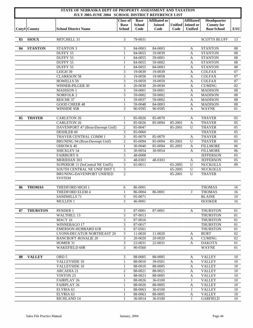
STATE OF NEBRASKA DEPT OF PROPERTY ASSESSMENT AND TAXATION JULY 2003-JUNE 2004 SCHOOL DISTRICT REFERENCE LIST
Class of Base Affiliated or Affiliated Headquarter Base School Joined Unified Joined or County for
Cnty# County School District Name School Code Code Code Unified Base School ESU
Sales File Practice Manual January, 2004 Page 44
83 SIOUX MITCHELL 31 3 79-0031 SCOTTS BLUFF 13
84 STANTON STANTON 3 3 84-0003 84-0003 A STANTON 08 DUFFY 55 1 84-0055 19-0039 A STANTON 08 DUFFY 55 1 84-0055 59-0001 A STANTON 08 DUFFY 55 1 84-0055 59-0002 A STANTON 08 DUFFY 55 1 84-0055 84-0003 A STANTON 08 LEIGH 39 3 19-0039 19-0039 A COLFAX 07 CLARKSON 58 3 19-0058 19-0058 A COLFAX 07 HOWELLS 59 3 19-0059 19-0059 A COLFAX 07 WISNER-PILGER 30 3 20-0030 20-0030 A CUMING 02 MADISON 1 3 59-0001 59-0001 A MADISON 08 NORFOLK 2 3 59-0002 59-0002 A MADISON 08 REICHE 37 1 59-0037 59-0002 A MADISON 08 GOOD CHEER 48 1 59-0048 84-0003 A MADISON 08 WINSIDE 95R 3 90-0595 90-0595 A WAYNE 01
85 THAYER CARLETON 26 1 85-0026 85-0070 A THAYER 05 CARLETON 26 1 85-0026 85-0094 85-2001 A THAYER 05 DAVENPORT 47 (Brun-Davenpt Unif) 2 85-0047 85-2001 U THAYER 05 DESHLER 60 3 85-0060 THAYER 05 THAYER CENTRAL COMM 1 3 85-0070 85-0070 A THAYER 05 BRUNING 94 (Brun-Davenpt Unif) 2 85-0094 85-0094 85-2001 U THAYER 05 OHIOWA 40 1 30-0040 85-0094 85-2001 A FILLMORE 06 SHICKLEY 54 3 30-0054 30-0054 A FILLMORE 06 FAIRBURY 8 3 48-0008 JEFFERSON 05 MERIDIAN 303 3 48-0303 48-0303 A JEFFERSON 05 SUPERIOR 11 (SoCentral NE Unif5) 3 65-0011 65-2005 U NUCKOLLS 09 SOUTH CENTRAL NE UNIF DIST 5 3 65-2005 U NUCKOLLS BRUNING-DAVENPORT UNIFIED
SYSTEM 2 85-2001 U THAYER
86 THOMAS THEDFORD HIGH 1 6 86-0001 THOMAS 16 THEDFORD ELEM 4 1 86-0004 86-0001 J THOMAS 16 SANDHILLS 71 3 05-0071 BLAINE 10 MULLEN 1 3 46-0001 HOOKER 16
87 THURSTON PENDER 1 3 87-0001 87-0001 A THURSTON 01 WALTHILL 13 3 87-0013 THURSTON 01 MACY 16 3 87-0016 THURSTON 01 WINNEBAGO 17 3 87-0017 THURSTON 01 EMERSON-HUBBARD 61R 3 87-0561 THURSTON 01 LYONS-DECATUR NORTHEAST 20 3 11-0020 11-0020 A BURT 02 BANCROFT-ROSALIE 20 3 20-0020 20-0020 A CUMING 02 HOMER 31 3 22-0031 22-0031 A DAKOTA 01 WAKEFIELD 60R 3 90-0560 WAYNE 01
88 VALLEY ORD 5 3 88-0005 88-0005 A VALLEY 10 VALLEYSIDE 10 1 88-0010 39-0501 A VALLEY 10 VALLEYSIDE 10 1 88-0010 88-0005 A VALLEY 10 ARCADIA 21 2 88-0021 88-0021 A VALLEY 10 VINTON 23 1 88-0023 88-0005 A VALLEY 10 FAIRPLAY 26 1 88-0026 36-0100 J VALLEY 10 FAIRPLAY 26 1 88-0026 88-0005 A VALLEY 10 ELYRIA 63 1 88-0063 36-0100 J VALLEY 10 ELYRIA 63 1 88-0063 88-0005 A VALLEY 10 RICHLAND 14 1 36-0014 36-0100 J GARFIELD 10

STATE OF NEBRASKA DEPT OF PROPERTY ASSESSMENT AND TAXATION JULY 2003-JUNE 2004 SCHOOL DISTRICT REFERENCE LIST
Class of Base Affiliated or Affiliated Headquarter Base School Joined Unified Joined or County for
Cnty# County School District Name School Code Code Code Unified Base School ESU
Page 45 January, 2004 Sales File Practice Manual
88 VALLEY BURWELL ELEM 15 1 36-0015 36-0100 J GARFIELD 10 BURWELL HIGH 100 6 36-0100 GARFIELD 10 NORTH LOUP SCOTIA 1J 3 39-0501 39-0501 A GREELEY 10 LOUP CITY 1 3 82-0001 SHERMAN 10
89 WASHINGTON BLAIR 1 3 89-0001 WASHINGTON 03 FORT CALHOUN 3 3 89-0003 WASHINGTON 03 ARLINGTON 24 3 89-0024 WASHINGTON 03 TEKAMAH-HERMAN 1 3 11-0001 BURT 02 LOGAN VIEW 594 3 27-0594 DODGE 02 BENNINGTON 59 3 28-0059 DOUGLAS 03
90 WAYNE WAYNE 17 3 90-0017 90-0017 A WAYNE 01 WAKEFIELD 60R 3 90-0560 WAYNE 01 WINSIDE 95R 3 90-0595 90-0595 A WAYNE 01 RANDOLPH 45 3 14-0045 CEDAR 01 LAUREL-CONCORD 54 3 14-0054 CEDAR 01 WISNER-PILGER 30 3 20-0030 20-0030 A CUMING 02 NORFOLK 2 3 59-0002 59-0002 A MADISON 08 PIERCE 2 3 70-0002 70-0002 A PIERCE 08 PENDER 1 3 87-0001 87-0001 A THURSTON 01
91 WEBSTER HOLSTEIN 11 1 01-0011 01-0090 J ADAMS 09 RED CLOUD 2 3 91-0002 WEBSTER 09 BLUE HILL 74 3 91-0074 WEBSTER 09 GUIDE ROCK R1 (SoCentrl NE Unf5) 3 91-0501 65-2005 U WEBSTER 09 WALLACE 60 1 01-0060 01-0090 J ADAMS 09 ADAMS CENTRAL HIGH 90 6 01-0090 ADAMS 09 SILVER LAKE 123 3 01-0123 01-0123 A ADAMS 09 SUPERIOR 11 (SoCentral NE Unif5) 3 65-0011 65-2005 U NUCKOLLS 09 LAWRENCE 71 (SoCentral NE Unif5) 3 65-0071 65-2005 U NUCKOLLS 09 SOUTH CENTRAL NE UNIFIED
DIST 5 3 65-2005 U NUCKOLLS
92 WHEELER WHEELER CENTRAL 45 3 92-0045 WHEELER 08 CLEARWATER 6 (NE Unified Dist 1) 3 02-0006 02-2001 U ANTELOPE 08 ELGIN 18 3 02-0018 ANTELOPE 08 SPALDING 55 3 39-0055 GREELEY 10 EWING 29 2 45-0029 45-0029 A HOLT 08 CHAMBERS 137 2 45-0137 45-0137 A HOLT 08 NEBRASKA UNIFIED DISTRICT 1 3 02-2001 U ANTELOPE
93 YORK YORK 12 3 93-0012 YORK 06 MCCOOL JUNCTION 83 2 93-0083 YORK 06 HEARTLAND 96 3 93-0096 YORK 06 SUTTON 2 3 18-0002 CLAY 09 EXETER-MILLIGAN 1 3 30-0001 FILLMORE 06 HAMPTON 91 3 41-0091 HAMILTON 09 STROMSBURG-BENEDICT 15 3 72-0015 POLK 07 HIGH PLAINS COMMUNITY 75 3 72-0075 POLK 07 CENTENNIAL 67R 3 80-0567 SEWARD 06

Sales File Practice Manual January, 2004 Page 46
Combination of Sales for Partial Interest Sales
Situation
A sale occurs in a county that involves multiple Form 521s for a single parcel of real estate.
Register Of Deed’s (ROD) Procedure
The ROD sends in all copies of Form 521s so multiple sales are entered in the sales file.
Assessor’s Procedure for the Sales Worksheet
The assessor should staple all Form 521s involved with the sale to one completed supplemental worksheet that covers the entire parcel of real estate sold.
The supplemental worksheet should use the lowest page number of the multiple Form 521s with the information for the parcel of real estate. The assessor should state in the assessor’s comment block of the supplemental worksheet which books and pages are combined to complete the sale as well as the amount of the combined sale price.
Do not make an adjustment to combine the sale prices on the supplemental sheet as the combined sale price will be entered in the primary Form 521.
Assessor’s Procedure for the Combination Form
The combination of sale form is attached to the front / top of the multiple Form 521s.
Section I: Use the following information to be sure the combined information will be properly entered in the sales file: Enter the following information for each of the additional sales that will not be used in the sales file after they are combined with the primary sale in Section II. Section I: The sales to be combined with the main sale in Section II.
County Number Book Page
Sale Date
Usability (Numeric)
Prop Type (Numeric)
Sale Price (line 22 of the 521)
Non-Real Property (line 23 of the 521)
Adjusted Sale Price (line 24 of the 521)
4
4
4
4
4
4
Total of Section I

Sales File Practice Manual January, 2004 Page 47
• Cnty No: County number, a one (1) or two (2) digit number identifying the alphabetical order by name of the county, not the license number historically assigned for motor vehicles. This information is the same as Line 2 on Form 521.
• Book: From the office of the Register of Deeds, the number of the book in which the deed
is found. This information is the same as Line 28 on Form 521.
• Page: From the office of the Register of Deeds, the number of the page on which the first page of the deed is found. This information is the same as Line 29 on Form 521.
• Sale Date: The actual sale date of the property. MM/DD/YYYY format: 01/22/2003.
This information is the same as Line 3 on Form 521.
• Usability: A numeric identifier indicating the assessor’s determination of the use of the sale for the sales files. This is a one digit field.
1 = Sale to be used in studies. 4 = Sale not to be used in studies. 2 = Sale to be used as adjusted.
Since the sales that are entered in the first part of the Combination Sale Form will not be used because they are being combined with another sale, the Usability information is pre-entered on this form.
• Prop Type: The use of real property parcels at the present time, regardless of legal use or
zoning. This is a two digit number that is the same as the property type that was filled in on the Sales Worksheet. See page 4 of Sales Worksheet Information for the acceptable Prop Type Codes.
• Sale Price: The sale price before any adjustments listed on Form 521. This information
is from Line 22 of Form 521. • Non Real Property: The amount of the non real property that was included in the sale
price and listed on Form 521. This information is from Line 23 of Form 521. • Adjusted Sale Price: The adjusted sale price is the sale price less any non real property
listed on Form 521 that was included in the sale. This information is from Line 24 of Form 521.
• Total of Section I: This information is the summed total of all information listed for the
multiple Form 521s on Line 22, Line 23, and Line 24 of the Form 521s listed in Section I of the form. This does not include the amounts from the primary Form 521 which is listed in Section II of the form.

Sales File Practice Manual January, 2004 Page 48
Section II: Use the following information to be sure the combined information will be properly entered in the Department’s sales file: Enter the following information for the primary sale that will be used in the sales file. Section II: The main sale. Identify the information from the book and page of the primary Form 521 that will be the combined information. This should be the sale with the lowest Page Number.
County Number Book Page Sale Date
Usability (Numeric)
Prop Type (Numeric)
Sale Price (line 22 of the521)
Non-Real Property (line 23 of the 521)
Adjusted Sale Price (line 24 of the 521)
Total of Section I
Combined Total of Section I and II
• Cnty No: County number, a one (1) or two (2) digit number identifying the alphabetical
order by name of the county, not the license number historically assigned for motor vehicles. This information is the same as Line 2 on Form 521.
• Book: From the office of the Register of Deeds, the number of the book in which the deed
is found. This information is the same as Line 28 on Form 521.
• Page: From the office of the Register of Deeds, the number of the page on which the first page of the deed is found. This information is the same as Line 29 on the Form 521.
• Sale Date: The actual sale date of the property. MM/DD/YYYY format: 01/22/2003.
This information is the same as Line 3 on Form 521.
• Usability: A numeric identifier indicating the assessor’s determination of the use of the sale for the sales files. This is a one digit field.
1 = Sale to be used in studies. 4 = Sale not to be used in studies. 2 = Sale to be used as adjusted.
• Prop Type: The use of real property parcels at the present time, regardless of legal use or
zoning. This is a two digit number that is the same as the property type that was filled in on the Sales Worksheet.
• Sale Price: The sale price before any adjustments listed on Form 521. This information
is from Line 22 of Form 521. • Non Real Property: The amount of the non real property that was included in the sale
price and listed on Form 521. This information is from Line 23 of Form 521. • Adjusted Sale Price: The adjusted sale price is the sale price less any non real property
listed on Form 521 that was included in the sale. This information is from Line 24 of Form 521.

Sales File Practice Manual January, 2004 Page 49
• Total of Section I: Complete this area with the amounts entered in Section I representing the summed amounts for the Sale Price, Non Real Property Amount and Adjusted Sale Price.
• Combined Total of Section I and II: Complete this area with the amounts entered in Section II for the main sale summed with the amounts entered in Section I. These amounts are the totals of Sale Price (Line 22), Non Real Property Amount (Line 23), and Adjusted Sale Price (Line 24) for all of the 521s listed in both Sections I and II.
The Comments:
Assessor Comments _______________________________________________________
_______________________________________________________
_______________________________________________________
_______________________________________________________
All information on the sale should be written in the comments section. Examples of information would be:
Combine Book 2003, Pages 4567, 4568, 4569, 4570 & 4571 for a total sale price of $358,000.
or,
Book 34 Pages 21 and 22 combined for a total sale price of $27,000.
Other Possible Situations
Not all the 521s have been recorded for a partial interest sale : The assessor should not hold the sale waiting for additional Form 521s to come in. If additional Form 521s come in, the assessor should notify their liaison and complete a combination form identifying the sale as an additional Form 521, coding the sale a 4, not to be used. Submit the combination form and Form 521 to your liaison who will make sure the information for the sale is correct.
A partial interest sale is in the sales file and has not been combined: The assessor should notify their liaison to make the correction, coding out the subsequent Form 521s, and make the appropriate statement in the comment box combining the book, pages and sale amounts and submit the data to their liaison.
Corrections to sales that need to be combined later should be made on the Combination of Sale Form and submitted to the Liaison.

96-234-2003 Sales File Practice Manual January,2004 Page 50
Combination of Sale Form List the 521’s in Section I that are to be combined with the main sale in Section II. Section I: The sales to be combined with the main sale in Section II.
County Number Book Page Sale Date
Usability (Numeric)
Prop Type (Numeric)
Sale Price (line 22 of the 521)
Non-Real Property (line 23 of the 521)
Adjusted Sale Price (line 24 of the 521)
4
4
4
4
4
4
Total of Section I
Section II: The main sale. Identify the information from the book and page of the main 521 that will be the combined information. This should be the sale with the lowest Page Number.
County Number Book Page
Sale Date
Usability (Numeric)
Prop Type (Numeric)
Sale Price (line 22 of the521)
Non-Real Property (line 23 of the 521)
Adjusted Sale Price (line 24 of the 521)
Total of Section I
Combined Total of Section I and II
Assessor Comments (these comments will be entered in the sales file for the sale identified in Section II):
Section I allows you to change the usability of the combined records to a 4 (Do Not Use) within the State Sales File. Total all Sales Prices, Non-Real Property and Adjusted Sale Prices in Section I. Section II allows you to define which record you would like to keep as your main record for the combined properties. Within this section you will need to take the Totals of Section I and add it to your sale in Section II. The Combined Total of Section I and II will be entered as the total sales price on the sale identified in Section II. The Assessor comments will be entered into the state sales file for the sale identified in Section II.

Sales File Practice Manual January, 2004 Page 51
Sales File Correction and Update Request
The Sales File Correction and Update Request Form should be used to make corrections in the sales file when there is no current roster available. It may be used to make corrections to all property types. First, complete the shaded area of the form. All shaded boxes must be filled in (county, book, page, and sale date). Next, complete any change that needs to be made. Only fill in the boxes that are changes or updates to the sale. All changes need to be made in RED. Include comments for changes involving qualification of the sale, property type or assessed value. Send the completed Sales File Correction and Update Request Form to your Liaison and they will forward it to the Department to be data entered. The changes will be reflected on the next roster.

96-235-2003 Sales File Practice Manual January, 2004 Page 52
Sales File Correction and Update Request
Fill in only the fields that need to be changed. Shaded areas must be filled in on all documents . All changes must be in red. School District Codes County Book Page Sale Date Base Affiliated Unified
Location ID Sale Number Usability Code
Parcel Number GeoCode Twn Rng Sect Qtr Subdiv Area Blk Parcel
Property Classification Code Status Prop Type Zoning Location City Size Parcel Size
Mult Imp Mult Imp
Const Date Const Date Floor Area Floor Area
Cost New: $ Cost New: $ Style Class
Condition Rank
Quality
Condition
Occup. Code: Primary_____
Other (2)_____Other (3)_____
Acres Value Acres Value Acres Value
1A1 1G1 Roads 1A 1G Farm Site
2A1 2G1 Home Site 2A 2G Recreation
3A1 3G1 Other 3A 3G Non-Ag Total
4A1 4G1 4A 4G
1D1 Shbl/Tim Dwellings 1D Accretion Outbldgs
2D1 Waste 2D Other
3D1 Agland Total Recapture Value 3D
4D1 F521 Line 22 4D
F521 Line 23
F521 Line 24
Assessed Value / Current Year:
(Must provide a copy of original F521)
Land Improvement Assessor Comments: Total Adj. Amount $ Adj. Sale Price $
County Information
Assessor Location

Sales File Practice Manual January, 2004 Page 53
Instructions for Acre and Value Summation Sheet
The Acre and Value Summation Sheet should be used to ‘add’ up the information from a sale of multiple parcels. Each Parcel Column would represent one of the parcels in the sale. This information is available as an Excel spreadsheet and is available from the Liaisons. As information is entered in each of the acres columns and value columns for a parcel, the information is totaled in the totals column. The information in the totals column should then be transferred to the corresponding boxes on the supplemental worksheet (or green sheet).

Sales File Practice Manual January, 2004 Page 54
TOTALS PARCEL 1 PARCEL 3 PARCEL 4
Acres Value Acres Value Acres Value Acres Value Acres Value
1A1 1A
2A1
2A 3A1
3A
4A1 A 4A C Subtotal Irrigated 0.00 $0 0.00 $0 0.00 $0 0.00 $0 0.00 $0
R 1D1 E 1D
2D1 & 2D
3D1
V 3D A 4D1
L 4D U Subtotal Dry 0.00 $0 0.00 $0 0.00 $0 0.00 $0 0.00 $0 E 1G1
1G
S 2G1
U 2G
M 3G1
M 3G
A 4G1
T 4G
I Subtotal Grass 0.00 $0 0.00 $0 0.00 $0 0.00 $0 0.00 $0
O SHBL/TBR
N ACCRETION
WASTE
S OTHER H AG LAND TOTALS 0.00 $0 0.00 $0 0.00 $0 0.00 $0 0.00 $0 E ROADS
E FARM SITES
T HOME SITES
RECREATION
OTHER
Non-AG TOTALS 0.00 $0 0.00 $0 0.00 $0 0.00 $0 0.00 $0
Total Ag + Non-Ag 0.00 $0 0.00 $0 0.00 $0 0.00 $0 0.00 $0 VALUES
AG LAND $0 $0 $0 $0 $0
NON-AGLAND $0 $0 $0 $0 $0
HOUSE $0 $0 $0 $0 $0
OTHER $0 $0 $0 $0 $0
TOTAL IMPRVS $0 $0 $0 $0 $0
TOTAL VALUE $0 $0 $0 $0 $0

Sales File Practice Manual January, 2004 Page 55
INSTRUCTIONS FOR SALES FILE PROTEST
WHO MAY FILE. An assessor may protest the adjustment, qualification or nonqualification of a sale of commercial, industrial or agricultural real property to the Department of Property Assessment and Taxation. The adjustment, qualification or nonqualification of sales of residential real property is the responsibility of the assessor. The protest shall be mailed to the main office of the Department of Property Assessment and Taxation within 30 days of the date on the certificate of mailing on the qualified and nonqualified semi annual sales roster sent by the Property Tax Administrator to the assessor. CONTENTS OF PROTEST.
• County # - Book – Page – Sale Date These boxes should be filled in exactly as they appear on the roster to allow for quick access of the record within the sales file database.
• Documentation Attached Check the appropriate box yes or no. If yes, be sure to include
all documentation pertinent to the protest in determining if the sale is arm’s length or whether the selling price should be adjusted for time, personal property or atypical financing to more accurately reflect the price paid for the real property.
• Comments The protest shall contain the reasons for the protest of the adjustment,
qualification or nonqualification of the sale and shall state the action the assessor wishes the Department of Property Assessment and Taxation to take. The burden of proof to alter the contents of the qualified sales roster after the verification process shall be on the person filing the protest to provide evidence to the Property Tax Administrator to show, by more than a mere difference of opinion, that the property should be treated in the manner being advocated.
REQUESTED COUNTY USE. Circle the action you are requesting (1 Use the sale, 2 Use sale as adjusted, 4 Sale not arm’s length) and in the designated boxes fill in the sale price as stated on line 24 of the 521, if requesting an adjustment the plus or minus adjustment you are seeking to the sale price, and the sale price after the adjustment. SIGNATURE AND DATE. Be sure to sign and date the Sales File Protest before submitting to the Department of Property Assessment and Taxation. HEARING OR WAIVER OF HEARING. The protesting party shall be entitled to a hearing on the merits of the protest before the Property Tax Administrator or may waive the hearing. The waiver of hearing shall be in writing on the prescribed form as provided by the Department of Property Assessment and Taxation and shall be done in conjunction with the filing of the protest or at any time prior to a scheduled hearing. APPEAL PROCEDURES. The action of the Property Tax Administrator may be appealed to the Nebraska Tax Equalization and Review Commission in accordance with the Nebraska Tax Equalization and Review Commission Act and the rules and regulations of the Commission.


Sales File Practice Manual January, 2004 Page 57
WAIVER OF HEARING
I have read and understand the Department of Property Assessment and Taxation’s Regulations and Directives, specifically, Title 350, Nebraska Administrative Code, Chapter 12, Sales File Regulations and Nebraska Department of Property Assessment and Taxation, Directive XX-X, Responsibilities of the County or State Assessor and the Department of Property Assessment and Taxation in the Development of the Real Property Sales File for Assessment Year XXXX, regarding the process available to protest the Department’s inclusion, exclusion or adjustment of transactions in the sales file, including the right to a hearing before the Property Tax Administrator. I hereby agree to submit this protest to the Property Tax Administrator for determination based on the materials provided accompanying this protest and the materials developed by the Department in the sales verification process and waive the right to a hearing before the Property Tax Administrator. I understand that this waiver does not affect the right to a written determination of this protest by the Property Tax Administrator and that it does not limit in any way the ability to appeal the decision of the Property Tax Administrator to the Nebraska Tax Equalization and Review Commission. Dated this ____ day of ____________________. Signature: _________________________________ Title: _________________________________
96-237-2003
County # Book Page Sale Date

Sales File Practice Manual January, 2004 Page 58
The Delete and Inactivate Functions The delete function within the State Sales File will be used to remove all references of records that are erroneous, outdated, or have been determined to never be used within the sales file. The inactivate function within the State Sales File will be used for those records that are deemed not usable in one study period but could be used in subsequent study periods.

Alphabetical Occupancy List
Sales File Practice Manual January, 2004 Page 59
Alphabetical Occupancy List
The following list contains the occupancies in alphabetical order by occupancy name. 600 Administration Building 300 Apartment (High Rise) 989 Apartment (High Rise), Interior Space 596 Apartment (High Rise), Shell 573 Arcade 301 Armory 367 Arts and Crafts Building (College) 589 Assisted Living, Multiple Residence (Low Rise) 576 Atrium 302 Auditorium 455 Auto Dealership, Complete 303 Automobile Showroom 410 Automotive Center 563 Bag Fertilizer Storage 304 Bank 443 Bank, Central 578 Bank, Mini 442 Bar/Tavern 384 Barber Shop 305 Barn 561 Barn, Feeder 398 Barn, Fruit Packing 396 Barn, Hog 397 Barn, Sheep 383 Barn, Tobacco 467 Boat Storage Building 466 Boat Storage Shed 488 Bookstore (Schools) 306 Bowling Alley 582 Branch Post Office 498 Broadcast Facility 420 Bulk Fertilizer Storage 556 Bulk Oil Storage 394 Cabin, Transient Labor 530 Cafeteria 515 Casino 443 Central Bank 309 Church 308 Church with Sunday School 310 City Club 368 Classroom (College) 356 Classroom (Elementary and Secondary School) 598 Classroom, Relocatable 444 Clinic, Dental 311 Clubhouse 441 Cocktail Lounge 447 Cold Storage Facility 448 Cold Storage, Farm 377 College (Entire) 555 Commercial Utility, Arch-Rib, Quonset
471 Commercial Utility Building, Light 477 Commodity Storage, Farm Utility 493 Commodity Storage, Flathouse 562 Commodity Storage Shed, Farm 369 Commons (College) 357 Commons (Elementary and Secondary School) 514 Community Center 491 Community Service Building, Government 413 Community Shopping Center 991 Community Shopping Center, Interior Space 461 Community Shopping Center, Shell 497 Computer Center 313 Convalescent Hospital 419 Convenience Market 531 Convenience Store, Mini-Mart 482 Convention Center 524 Corn Crib Building 450 Cotton Gin 314 Country Club 315 Creamery 316 Dairy 317 Dairy Sales Building 426 Day Care Center 564 Dehydrator Building 444 Dental Office/Clinic 318 Department Store 575 Dining Atrium 319 Discount Store 458 Discount Store, Warehouse 320 Dispensary 407 Distribution Warehouse 321 Dormitory 393 Dormitory, Labor 499 Dry Cleaners/Laundry 365 Elementary School (Entire) 480 Environmental Vegetable Building 472 Equipment Shed 470 Equipment (Shop) Building 588 Extended Stay Motel 448 Farm Cold Storage 562 Farm Commodity Storage Shed 558 Farm Implement Arch-Rib, Quonset 476 Farm Implement Building 478 Farm Implement Shed 566 Farm Sun Shade Shelter 557 Farm Utility Arch-Rib, Quonset 477 Farm Utility Building 565 Farm Utility Shelter 479 Farm Utility Storage Shed

Alphabetical Occupancy List
Sales File Practice Manual January, 2004 Page 60
349 Fast Food Restaurant 561 Feeder Barn 516 Fellowship Hall 563 Fertilizer Storage, Bag 420 Fertilizer Storage, Bulk 486 Field Houses 355 Fine Arts and Crafts Building (Elementary and Secondary School) 322 Fire Station (Staffed) 427 Fire Station (Volunteer) 483 Fitness Center 493 Flathouse 532 Florist Shop 533 Food Store, Warehouse 517 Foyer/Narthex 323 Fraternal Building 324 Fraternity House 469 Freestall Barn 398 Fruit Packing Barn 594 Full Service Hotel 423 Garage, Mini-Lube 527 Garage, Municipal Service 528 Garage, Service Repair 526 Garage, Service Shed 326 Garage, Storage 523 Golf Cart Storage Building 491 Government Community Service Building 327 Governmental Building 493 Grain Storage, Flathouse 421 Grain Storage, Utility 521 Greenhouse, Hoop, Arch-rib 518 Greenhouse Lath Shade House 520 Greenhouse, Modified Hoop 519 Greenhouse Shade Shelter 522 Greenhouse, Straight Wall 424 Group Care Home 370 Gymnasium (College) 358 Gymnasium (Elementary and Secondary School) 417 Handball-Racquetball Club 329 Hangar, Maintenance and Office 328 Hangar, Storage 409 Hangar, T 418 Health Club 484 High School (Entire) 525 High Rise Mini Warehouse 396 Hog Barn 430 Hog Shed 429 Hog Shed, Modified 330 Home For The Elderly 521 Hoop Greenhouse, Arch-rib 520 Hoop Greenhouse, Modified 428 Horse Arena 331 Hospital 381 Hospital, Veterinary 313 Hospital, Convalescent 594 Hotel, Full Service
595 Hotel, Limited Service 416 Indoor Tennis Club 994 Industrial Building, Interior Space 454 Industrial Building, Shell 392 Industrial Engineering Building 453 Industrial Flex Building 495 Industrial Heavy Manufacturing 494 Industrial Light Manufacturing 989 Interior Space, Apartment (High Rise) 991 Interior Space, Community Shopping Center 994 Interior Space, Industrial Building 987 Interior Space, Multiple Residence (Low Rise) 990 Interior Space, Neighborhood Shopping Center 993 Interior Space, Office Building 992 Interior Space, Regional Shopping Center 335 Jail, Correctional Facility 489 Jail, Police Station 366 Junior High School (Entire) 490 Kennel 496 Laboratory 393 Labor Dormitory 518 Lath Shade House (Greenhouse) 336 Laundromat 499 Laundry/Dry Cleaners 560 Lean-To 371 Lecture Hall (College) 359 Lecture Classrooms (Elementary and Secondary School) 372 Library, College 337 Library, Public 360 Library, Secondary Schools, Media Center 555 Light Commercial Arch-Rib, Quonset 471 Light Commercial Utility Building 537 Lodge 338 Loft 390 Lumber Storage Building, Vertical 339 Lumber Storage Shed, Horizontal 583 Mail Processing Facility 581 Main Post Office 361 Manual Arts Building (Elementary and Secondary School) 340 Market 419 Market, Convenience 533 Market, Food Warehouse 586 Market, Roadside 446 Market, Super 473 Material Shelter 391 Material Storage Building 468 Material Storage Shed 585 Mechanical Penthouse 341 Medical Office 584 Mega Warehouse 440 Milkhouse

Alphabetical Occupancy List
Sales File Practice Manual January, 2004 Page 61
578 Mini Bank 423 Mini-Lube Garage 531 Mini-Mart Convenience Store 386 Mini Warehouse 525 Mini Warehouse, High Rise 597 Mixed Retail with Office Units 459 Mixed Retail with Residential Units 429 Modified Hog Shed 520 Modified Hoop Greenhouse 342 Mortuary 343 Motel 588 Motel, Extended Stay 544 Motel, Office-Apartment 542 Motel Room, 1 Story, Double Row 543 Motel Room, 1 Story, Single Row 540 Motel Room, 2 Story, Double Row 541 Motel Room, 2 Story, Single Row 374 Multipurpose Building (College) 362 Multipurpose Building (Elementary and Secondary School) 352 Multiple Residence (Low Rise) 987 Multiple Residence (Low Rise), Interior Space 587 Multiple Residence (Low Rise), Shell 589 Multiple Residence, Assisted Living (Low Rise) 451 Multiple Residence, Senior Citizen (Low Rise) 459 Multiple Residential Units Mixed with Retail 527 Municipal Service Garage 481 Museum 517 Narthex/Foyer 485 Natatorium 412 Neighborhood Shopping Center 990 Neighborhood Shopping Center, Interior Space 460 Neighborhood Shopping Center, Shell 544 Office-Apartment (Motel) 344 Office Building 993 Office Building, Interior Space 492 Office Building, Shell 444 Office, Dental 341 Office, Medical 599 Office, Relocatable 554 Office Shed 597 Office Units Mixed with Retail 556 Oil Storage, Bulk 431 Outpatient (Surgical) Center 577 Parking Levels 345 Parking Structure 388 Parking Structure, Underground 571 Passenger Terminal 585 Penthouse, Mechanical 375 Physical Education Building (College) 363 Physical Education Building (Elementary and Secondary School)
346 Post Office 581 Post Office, Main 582 Post Office, Branch 395 Potato Storage 570 Poultry House - Cage, One Story, Elevated 474 Poultry House - Cage Operation, One Story 569 Poultry House - Cage, Three Story 567 Poultry House - Cage, Two Story 568 Poultry House - Cage, Two Story, Elevated 475 Poultry House - Floor Operation 583 Processing Facility, Mail 558 Quonset, Farm Implement Arch-Rib 557 Quonset, Farm Utility Arch-Rib 555 Quonset, Light Commercial Arch-Rib 417 Racquetball-Handball Club 552 Recreational Enclosure 348 Rectory 414 Regional Shopping Center 992 Regional Shopping Center, Interior Space 462 Regional Shopping Center, Shell 598 Relocatable Classroom 599 Relocatable Office 530 Restaurant, Cafeteria 349 Restaurant, Fast Food 529 Restaurant, Snack Bar 350 Restaurant, Table Service 432 Restroom Building 353 Retail Store 597 Retail Mixed with Office Units 586 Roadside Market 551 Rooming House 376 Science Building (College) 364 Science Classrooms (Elementary and Secondary School) 526 Service Garage Shed 528 Service Repair Garage 408 Service Station 466 Shed, Boat Storage 472 Shed, Equipment 562 Shed, Farm Commodity Storage 478 Shed, Farm Implement 479 Shed, Farm Utility Storage 561 Shed, Feeder Barn 430 Shed, Hog 339 Shed, Lumber Storage, Horizontal 468 Shed, Material Storage 429 Shed, Modified Hog 526 Shed, Service Garage 554 Shed Office Structure 596 Shell, Apartment (High Rise) 461 Shell, Community Shopping Center 454 Shell, Industrial Building 587 Shell, Multiple Residence (Low Rise) 460 Shell, Neighborhood Shopping Center

Alphabetical Occupancy List
Sales File Practice Manual January, 2004 Page 62
492 Shell, Office Building 462 Shell, Regional Shopping Center 397 Sheep Barn 565 Shelters, Farm Utility 473 Shelters, Material 566 Shelters, Sun Shade 413 Shopping Center, Community 991 Shopping Center, Community, Interior Space 461 Shopping Center, Community, Shell 459 Shopping Center, Mixed with Residential Units 412 Shopping Center, Neighborhood 990 Shopping Center, Neighborhood, Interior Space 460 Shopping Center, Neighborhood, Shell 414 Shopping Center, Regional 992 Shopping Center, Regional, Interior Space 462 Shopping Center, Regional, Shell 403 Shower Building 303 Showroom, Automobile 534 Showroom Store, Warehouse 405 Skating Rink 529 Snack Bar 378 Stable 559 Stables, High-Value 563 Storage, Bag Fertilizer 420 Storage, Bulk Fertilizer 556 Storage, Bulk Oil 470 Storage, Equipment Shop 447 Storage Facility, Cold 476 Storage, Farm Implement 477 Storage, Farm Utility 493 Storage, Flathouse 326 Storage Garage 421 Storage, Gra in 523 Storage, Golf Cart 328 Storage Hangar 390 Storage, Lumber Building, Vertical
339 Storage, Lumber Shed, Horizontal 391 Storage, Material 395 Storage, Potato 406 Storage Warehouse 318 Store, Department 319 Store, Discount 458 Store, Discount Warehouse 533 Store, Food Warehouse 353 Store, Retail 534 Store, Warehouse Showroom 522 Straight Wall Greenhouse 446 Supermarket 409 T-Hangar 442 Tavern/Bar 373 Technical Trades Building (College) 416 Tennis Club, Indoor 380 Theater, Cinema 379 Theater, Live Stage 383 Tobacco Barn 456 Tool Shed 394 Transient Labor Cabin 387 Transit Warehouse 580 Truck Stop 388 Underground Parking Structure 477 Utility Building, Farm 471 Utility Building, Light Commercial 480 Vegetable Building, Environmental 381 Veterinary Hospital 574 Visitor Center 487 Vocational School 458 Warehouse Discount Store 407 Warehouse, Distribution 533 Warehouse Food Store 525 Warehouse, High Rise Mini 584 Warehouse, Mega 386 Warehouse, Mini 534 Warehouse Showroom Store 406 Warehouse, Storage 387 Warehouse, Transit

Numerical Occupancy List
Sales File Practice Manual January, 2004 Page 63
Numerical Occupancy List
The following list contains the occupancies available in numerical order by occupancy number. 300 Apartment (High Rise) 301 Armory 302 Auditorium 303 Automobile Showroom 304 Bank 305 Barn 306 Bowling Alley 308 Church with Sunday School 309 Church 310 City Club 311 Clubhouse 313 Convalescent Hospital 314 Country Club 315 Creamery 316 Dairy 317 Dairy Sales Building 318 Department Store 319 Discount Store 320 Dispensary 321 Dormitory 322 Fire Station (Staffed) 323 Fraternal Building 324 Fraternity House 326 Storage Garage 327 Governmental Building 328 Storage Hangar 329 Hangar, Maintenance and Office 330 Home For The Elderly 331 Hospital 335 Jail (Correctional Facility) 336 Laundromat 337 Library, Public 338 Loft 339 Lumber Storage Shed, Horizontal 340 Market 341 Medical Office 342 Mortuary 343 Motel 344 Office Building 345 Parking Structure 346 Post Office 348 Rectory 349 Fast Food Restaurant 350 Restaurant 352 Multiple Residence (Low Rise) 353 Retail Store 355 Fine Arts and Crafts Building (Elementary and Secondary School) 356 Classrooms (Elementary and Secondary School) 357 Commons (Elementary and Secondary School)
358 Gymnasium (Elementary and Secondary School) 359 Lecture Classrooms (Elementary and Secondary School) 360 Library, Media Center (Elementary and Secondary School) 361 Manual Arts Building (Elementary and Secondary School) 362 Multipurpose Building (Elementary and Secondary School) 363 Physical Education Building (Elementary and Secondary School) 364 Science Classrooms (Elementary and Secondary School) 365 Elementary School (Entire) 366 Junior High School (Entire) 367 Arts and Crafts Building (College) 368 Classrooms (College) 369 Commons (College) 370 Gymnasium (College) 371 Lecture Hall (College) 372 Library, College 373 Technical Trades Building (College) 374 Multipurpose Building (College) 375 Physical Education Building (College) 376 Science Building (College) 377 College (Entire) 378 Stable 379 Theater, Live Stage 380 Theater, Cinema 381 Veterinary Hospital 383 Tobacco Barn 384 Barber Shop 386 Mini Warehouse 387 Transit Warehouse 388 Underground Parking Structure 390 Lumber Storage Building, Vertical 391 Material Storage Building 392 Industrial Engineering Building 393 Labor Dormitory 394 Transient Labor Cabin 395 Potato Storage 396 Hog Barn 397 Sheep Barn 398 Fruit Packing Barn 403 Shower Building 405 Skating Rink 406 Storage Warehouse 407 Distribution Warehouse 408 Service Station 409 T-Hangar 410 Automotive Center

Numerical Occupancy List
Sales File Practice Manual January, 2004 Page 64
412 Neighborhood Shopping Center 413 Community Shopping Center 414 Regional Shopping Center 416 Tennis Club, Indoor 417 Racquetball-Handball Club 418 Health Club 419 Convenience Market 420 Bulk Fertilizer Storage 421 Grain Storage, Utility 423 Mini-Lube Garage 424 Group Care Home 426 Day Care Center 427 Fire Station (Volunteer) 428 Horse Arena 429 Modified Hog Shed 430 Hog Shed 431 Outpatient (Surgical) Center 432 Restroom Building 440 Milkhouse 441 Cocktail Lounge 442 Bar/Tavern 443 Central Bank 444 Dental Office/Clinic 446 Supermarket 447 Cold Storage Facility 448 Cold Storage, Farm 450 Cotton Gin 451 Multiple Residence, Senior Citizen (Low Rise) 453 Industrial Flex Building 454 Industrial Building, Shell 455 Auto Dealership, Complete 456 Tool Shed 458 Warehouse Discount Store 459 Mixed Retail with Residential Units 460 Neighborhood Shopping Center, Shell 461 Community Shopping Center, Shell 462 Regional Shopping Center, Shell 466 Boat Storage Shed 467 Boat Storage Building 468 Material Storage Shed 469 Freestall Barn 470 Equipment (Shop) Bu ilding 471 Light Commercial Utility Building 472 Equipment Shed 473 Material Shelter 474 Poultry House - Cage Operation, One Story 475 Poultry House - Floor Operation 476 Farm Implement Building 477 Farm Utility Building 478 Farm Implement Shed 479 Farm Ut ility Storage Sheds 480 Vegetable Building, Environmental 481 Museum 482 Convention Center 483 Fitness Center 484 High School (Entire)
485 Natatorium 486 Field Houses 487 Vocational School 488 Bookstore (Schools) 489 Jail (Police Station) 490 Kennel 491 Government Community Service Building 492 Shell, Office Building 493 Flathouse 494 Industrial Light Manufacturing 495 Industrial Heavy Manufacturing 496 Laboratory 497 Computer Center 498 Broadcast Facility 499 Dry Cleaners/Laundry 514 Community Center 515 Casino 516 Fellowship Hall 517 Narthex/Foyer 518 Greenhouse Lath Shade House 519 Greenhouse Shade Shelter 520 Greenhouse, Modified Hoop 521 Greenhouse, Hoop, Arch-rib 522 Greenhouse, Straight Wall 523 Golf Cart Storage Building 524 Corn Crib Building 525 Mini Warehouse, High Rise 526 Service Garage Shed 527 Municipal Service Garage 528 Service Repair Garage 529 Snack Bar 530 Cafeteria 531 Mini-Mart Convenience Store 532 Florist Shop 533 Warehouse Food Store 534 Warehouse Showroom Store 537 Lodge 540 Motel Room, 2 Story, Double Row 541 Motel Room, 2 Story, Single Row 542 Motel Room, 1 Story, Double Row 543 Motel Room, 1 Story, Single Row 544 Office-Apartment (Motel) 551 Rooming House 552 Recreational Enclosure 554 Shed Office Structure 555 Light Commercial Arch-Rib, Quonset 556 Bulk Oil Storage 557 Farm Utility Arch-Rib, Quonset 558 Farm Implement Arch-Rib, Quonset 559 Stables, High Value 560 Lean-To 561 Feeder Barn 562 Commodity Storage Shed, Farm 563 Bag Fertilizer Storage 564 Dehydrator Building 565 Farm Utility Shelter 566 Farm Sun Shade Shelter

Numerical Occupancy List
Sales File Practice Manual January, 2004 Page 65
567 Poultry House - Cage, Two Story 568 Poultry House - Cage, Elevated Two Story 569 Poultry House - Cage, Three Story 570 Poultry House - Cage, Elevated One Story 571 Passenger Terminal 573 Arcade 574 Visitor Center 575 Dining Atrium 576 Atrium 577 Parking Levels 578 Mini Bank 580 Truck Stop 581 Post Office, Main 582 Post Office, Branch 583 Mail Processing Facility 584 Mega Warehouse 585 Mechanical Penthouse 586 Roadside Market 587 Multiple Residence (Low Rise), Shell
588 Motel, Extended Stay 589 Multiple Residence, Assisted Living (Low Rise) 594 Hotel, Full Service 595 Hotel, Limited Service 596 Apartment (High Rise), Shell 597 Mixes Retail with Office Units 598 Relocatable Classroom 599 Relocatable Office 600 Administration Building 987 Multiple Residence (Low Rise), Interior Space 989 Apartment (High Rise), Interior Space 990 Neighborhood Shopping Center, Interior Space 991 Community Shopping Center, Interior Space 992 Regional Shopping Center, Interior Space 993 Interior Space, Office Building 994 Interior Space, Industrial Building

Special Occupancy Lists
Sales File Practice Manual January, 2004 Page 66
Special Occupancy Group Lists
Elementary and Secondary School Occupancies
302 Auditorium 488 Bookstore (School) 356 Classroom 598 Classroom, Relocatable 357 Commons 426 Day Care Center 365 Elementary School (Entire) 355 Fine Arts and Crafts Building 358 Gymnasium 484 High School (Entire)
366 Junior High School (Entire) 359 Lecture Classrooms 361 Manual Arts Building 360 Media Center Library 362 Multipurpose Building 363 Physical Education Building 432 Restroom Building 364 Science Classrooms 403 Shower Building 487 Vocational School (Entire)
College Occupancies
367 Arts and Crafts Building 302 Auditorium 488 Bookstore (School) 530 Cafeteria 368 Classroom 377 College (Entire) 369 Commons320 Dispensary 321 Dormitory 486 Field Houses 324 Fraternity House 370 Gymnasium
371 Lecture Hall 372 Library 374 Multipurpose Building 481 Museum 485 Natatorium 345 Parking Structure 375 Physical Education Building 432 Restroom Building 376 Science Building 403 Shower Building 373 Technical Trades Building
Farm Occupancies
563 Bag Fertilizer Storage 305 Barn 561 Barn, Feeder 398 Barn, Fruit Packing 396 Barn, Hog 397 Barn, Sheep 383 Barn, Tobacco 420 Bulk Fertilizer Storage 394 Cabin, Transient Labor 448 Cold Storage, Farm 477 Commodity Storage, Farm Utility 493 Commodity Storage, Flathouse 562 Commodity Storage Shed, Farm 524 Corn Crib Building 450 Cotton Gin 315 Creamery 316 Dairy 564 Dehydrator Building 393 Dormitory, Labor 562 Farm Co mmodity Storage Shed 558 Farm Implement Arch-Rib, Quonset 476 Farm Implement Building 478 Farm Implement Shed
566 Farm Sun Shade Shelter 557 Farm Utility Arch-Rib, Quonset 477 Farm Utility Building 565 Farm Utility Shelter 479 Farm Utility Storage Shed 561 Feeder Barn 563 Fertilizer Storage, Bag 420 Fertilizer Storage, Bulk 469 Freestall Barn 398 Fruit Packing Barn 493 Grain Storage, Flathouse 421 Grain Storage, Utility 396 Hog Barn 430 Hog Shed 429 Hog Shed, Modified 428 Horse Arena 393 Labor Dormitory 560 Lean-To 390 Lumber Storage Building, Vertical 339 Lumber Storage Shed, Horizontal 391 Material Storage Building 468 Material Storage Shed 440 Milkhouse

Special Occupancy Lists
Sales File Practice Manual January, 2004 Page 67
429 Modified Hog Shed 395 Potato Storage 570 Poultry House - Cage, One Story, Elevated 474 Poultry House - Cage Operation, One Story 569 Poultry House - Cage, Three Story 567 Poultry House - Cage, Two Story 568 Poultry House - Cage, Two Story, Elevated 475 Poultry House - Floor Operation 558 Quonset, Farm Implement Arch-Rib 557 Quonset, Farm Utility Arch-Rib 472 Shed, Equipment 562 Shed, Farm Commodity Storage 478 Shed, Farm Implement 479 Shed, Farm Utility Storage 561 Shed, Feeder Barn 430 Shed, Hog 468 Shed, Material Storage 429 Shed, Modified Hog
526 Shed, Service Garage 397 Sheep Barn 565 Shelter, Farm Utility 566 Shelter, Sun Shade 378 Stable 559 Stables, High-Value 563 Storage, Bag Fertilizer 420 Storage, Bulk Fertilizer 476 Storage, Farm Implement 477 Storage, Farm Utility 421 Storage, Grain 391 Storage, Material 395 Storage, Potato 383 Tobacco Barn 456 Tool Shed 394 Transient Labor Cabin 477 Utility, Farm
Light Commercial Sheds and Outbuildings
470 Equipment (Shop) Building 472 Equipment Shed 555 Light Commercial Arch-Rib, Quonset 471 Light Commercial Utility Building 339 Lumber Storage Shed, Horizontal 390 Lumber Storage Building, Vertical
473 Material Shelter 391 Material Storage Building 468 Material Storage Shed 554 Shed Office Structure 526 Service Garage Sheds 456 Tool Shed

Additional Occupancy List
Sales File Practice Manual January, 2004 Page 68
Additional Occupancy List
The following quality rankings are going to be used in the following examples to define average as being typical (what is typically found in a county), low being limited by size or age or functionality, and excellent being the top of the line and fully functional.
10 Low Quality
20 Fair Quality
30 Avg. Quality
40 Good Quality
50 Very Good Quality
60 Excellent Quality
808 Truck Stops: Generally includes the 408 service station set up for truck service, 435 truck wash setup, 419 convenience store, 350 restaurant, and scale facilities.
816 Dairy Farm: Generally includes the components of the 316 milking set up including loafing shed and feed lots, 421 grain storage / handling, feed processing / handling, grain processing / handling, silos, 477 feed / equipment storage (farm utility building) and sewage disposal.
820 Land Fill: Land fills and land associated with and for the repository for refuse. Quality is dependant upon how environmentally sound the operation is.
825 Transmission Facilities: Low, fair and average covers most stand alone towers. Good, very good and excellent qualities include studios, transmitters and towers.
834 Quarries: Rock, clay, and gravel. Rock is at the top of the quality range and gravel pits are on the low end of the scale.
839 Lumber Yard: Generally includes the components of 353 retail sales, 339 horizontal lumber storage, 390 vertical lumber storage, and 391 material storage.
841 Co-op Complex: Generally average quality includes 421 grain storage, 408 service station, 325 garage service, 420 bulk fertilizer, 353 retail and 419 convenience market. The old iron clad elevators, limited by size or age or functionality are low quality and the large unit train terminals that are the top of the line and fully functional are excellent quality.
851 Mobile Home Park/RV Park: Low quality will have gravel roads, limited size per space, and electrical and water hookups. Very good quality will have concrete paving, gutters, driveways, sidewalks and parking pads for double wide type mobile homes, ample size per space, electrical, water and sewer. NOTE: Mobile home parks and recreational vehicle parks. Recreational parks generally tend to have lower quality tendencies.
883 Sale Barn: Generally includes a show ring for sales, office, roof structure over livestock pens and open air livestock pens, area for veterinary type work, and possibly a café facility.
896 Hog Confinement: Generally includes 396 hog barn, 429 modified hog shed and 430 hog shed and sewage disposal.
899 Cattle Feed Lots: Generally includes the components of feed processing, grain storage, grain processing/handling, feed/equipment storage, office/scale, veterinary facilities and sewage disposal.

Sales File Practice Manual January, 2004 Page 69
Irrigation Type Codes 10: gravity/well 11: gravity/canal
12: gravity/stream or river 13: gravity/water from off site source, not on parcel 20: pivot/well 21: pivot/canal
22: pivot/stream or river 23: pivot/water from off site source, not on parcel
30: towline/well 31: towline/canal 32: towline/stream or river
33: towline/water from off site source, not on parcel 40: volume gun/well 41: volume gun/canal 42: volume gun/stream or river 43: volume gun/water from off site source, not on parcel 50: side roller/well 51: side roller/canal 52: side roller/stream or river 53: side roller/water from off site source, not on parcel
60: other

Sales File Practice Manual January, 2004 Page 70
CONVERSION OF SOIL TYPES TO LAND CAPABILITY GROUPINGS
THE ASTERISK ON SLOPES INDICATES ALL SLOPE PERCENTAGES INCLUDED
SOIL NAME SLOPE DRY IRR GRS CAP UNIT ACKMORE Silt Loam 0-1 2D1 2A1 2G1 2W3 ADAIR Clay Loam, Eroded 3-5 2D 2A 2G 3E2 ADAIR Clay Loam, Eroded 5-9* 3D1 3A1 3G1 3E2 ADAIR Clay Loam, Eroded 8-12 4D1 4A1 4G1 4E2 ADAIR-PAWNEE Soils, Sev. Eroded 5-8 4D1 4A1 4G1 4E8 ADAIR-PAWNEE Soils, Sev. Eroded 8-12 4D 4A 4G 6E4 ADAIR-PAWNEE Complex Soils, Sev. Eroded 6-12 4D 4A 4G 6E4 ALBATON Clay 0-1 3D1 3A1 3G1 3W1 ALBATON Silt Loam 0-1 3D1 3A1 3G1 3W2 ALBATON Silty Clay 0-2* 3D1 3A1 3G1 3W1 ALBATON Silty Clay, Depressional 0-1 4D 4A 4G 5W1 ALBATON Silty Clay, Ponded 0-2* 4D 4A 4G 5W1 ALBATON Silty Loam 0-2* 3D1 3A1 3G1 3W2 ALBATON Silty Clay Loam 0-2* 3D1 3A1 3G1 3W2 ALBATON Variant Clay 0-2 3D 3A 3G 4W1 ALCESTER Silt Loam 2-6 1D 1A 1G 2E1 ALCESTER Silt Loam 6-11 3D1 3A1 3G1 3E1 ALCESTER Silt Loam, Gullied 11-60 4D 4A 4G 7E7 ALCESTER Silty Loam 2-6 1D 1A 1G 2E1 ALCESTER Silty Clay Loam 2-6 1D 1A 1G 2E1 ALDA Loam 0-1 2D 2A 2G 2W4 ALDA Loam 0-2* 3D 3A 3G 3W4 ALDA Soils 0-1 3D 3A 3G 3W4 ALDA Fine Sandy Loam 0-1 2D 2A 2G 2W6 ALDA Fine Sandy Loam 0-2* 3D 3A 3G 3W6 ALDA Sandy Loam 0-2 3D 3A 3G 3W4 ALDA V F Sandy Loam 0-1 3D 3A 3G 3W4 ALICE Fine Loamy Sand 0-3 3D 3A 3G 4E5 ALICE Fine Sandy Loam 0-3* 2D 2A 2G 3E3 ALICE Fine Sandy Loam 3-6* 3D 3A 3G 4E3 ALICE Fine Sandy Loam 6-9 4D1 4A1 4G1 4E3 ALICE Fine Sandy Loam, Eroded 6-9 4D1 4A1 4G1 4E3 ALICE Loamy Fine Sand 0-3 3D 3A 3G 4E5 ALICE-DIX Complex Soils 0-3 2D 2A 2G 3E3 ALICE-DIX Complex Soils 3-6 3D 3A 3G 4E3 ALICE-DIX Complex Soils 6-20 4D 4A 4G 6E3 ALLIANCE Loam 0-1 1D 1A 1G 2C1 ALLIANCE Loam 1-3 1D 1A 1G 2E1 ALLIANCE Loam 0-1 2D1 2A1 2G1 3C1 ALLIANCE Loam 1-6* 2D 2A 2G 3E1 ALLIANCE Loam, Eroded 6-9 4D1 4A1 4G1 4E8 ALLIANCE Silt Loam 0-1 1D 1A 1G 2C1 ALLIANCE Silt Loam 1-3 1D 1A 1G 2E1 ALLIANCE Silt Loam 3-9 2D 2A 2G 3E1 ALLIANCE Silt Loam, Eroded 3-9 3D 3A 3G 3E8 ALLIANCE-ROSEBUD Loam 1-3 1D 1A 1G 2E1 ALLIANCE-ROSEBUD Loam 3-6 2D 2A 2G 3E1 ALLIANCE-ROSEBUD Loam 6-11 4D1 4A1 4G1 4E1 ALLUVIAL LAND — — — — 4G 6W1 ALMERIA Fine Sandy Loam 0-2 4D1 4A1 4G1 5W7 ALMERIA Fine Sandy Loam, Channeled 0-2 4D 4A 4G 6W7 ALMERIA Fine Sandy Loam, Wet 0-2 4D1 4A1 4G1 5W7 ALMERIA Loamy Fine Sand 0-2 4D1 4A1 4G1 5W7 ALMERIA-HISTOSOLS Complex Soils, Channeled — 4D 4A 4G 7W7 ALTVAN Loam 0-1 1D 1A 1G 2C1

SOIL NAME SLOPE DRY IRR GRS CAP UNIT
Sales File Practice Manual January, 2004 Page 71
ALTVAN Loam 1-3 2D 2A 2G 3E1 ALTVAN Loam 3-6* 3D 3A 3G 4E1 ALTVAN Loam, Deep 0-1 2D1 2A1 2G1 3C1 ALTVAN Loam, Deep 3-5 2D 2A 2G 3E1 ALTVAN Loam, Eroded 3-5 3D 3A 3G 4E8 ALTVAN Loam, Mod. Deep 3-5 3D 3A 3G 4E1 ALTVAN Loam, Mod. Deep, Deep 1-3 2D 2A 2G 3E1 ALTVAN Loam, Mod. Deep, Deep 5-9 4D1 4A1 4G1 4E1 ALTVAN Fine Sandy Loam, Deep 1-3 2D 2A 2G 3E1 ALTVAN-CHAPPELL Complex Soils 5-9 4D1 4A1 4G1 4E1 ALTVAN-CHAPPELL Complex Soils, Eroded 5-9 4D1 4A1 4G1 4E1 ALTVAN-DIX Complex Soils 3-9 4D1 4A1 4G1 4E1 ALTVAN-DIX Complex Soils 6-30 4D 4A 4G 6E3 ALTVAN-ECKLEY Complex Soils 3-9 4D1 4A1 4G1 4E1 ANGORA V F Sandy Loam 1-6 3D 3A 3G 4E9 ANGORA V F Sandy Loam 6-20 4D 4A 4G 6E9 ANSELMO Loam 0-2* 1D 1A 1G 2C1 ANSELMO Loam, Occ Flooded 0-1 1D 1A 1G 2C1 ANSELMO Fine Sandy Loam 0-3* 2D1 2A1 2G1 2E3 ANSELMO Fine Sandy Loam 1-6* 2D 2A 2G 3E3 ANSELMO Fine Sandy Loam 5-11* 4D1 4A1 4G1 4E3 ANSELMO Fine Sandy Loam 11-20 4D 4A 4G 6E3 ANSELMO Fine Sandy Loam 9-30* 4D 4A 4G 6E3 ANSELMO Fine Sandy Loam, Alkali Var. 0-3 4D1 4A1 4G1 4S1 ANSELMO Fine Sandy Loam, Eroded 5-9 4D1 4A1 4G1 4E3 ANSELMO Fine Sandy Loam, Hummocky 3-7* 2D 2A 2G 3E3 ANSELMO Fine Sandy Loam, Terraced 0-3* 2D1 2A1 2G1 2E3 ANSELMO Loamy Fine Sand 0-5* 3D1 3A1 3G1 3E5 ANSELMO Loamy Fine Sand 3-7* 3D 3A 3G 4E5 ANSELMO Loamy Fine Sand 5-9 4D1 4A1 4G1 4E5 ANSELMO Sandy Loam, Terraced 0-3 2D1 2A1 2G1 2E3 ANSELMO Sandy Loam, Terraced 3-5 2D 2A 2G 3E3 ANSELMO V F Sandy Loam 0-1 1D 1A 1G 2C1 ANSELMO V F Sandy Loam 1-3 1D 1A 1G 2E1 ANSELMO V F Sandy Loam, Terraced 0-1 1D 1A 1G 2C1 ANSELMO-BRIDGEPORT Complex Soils 0-3 2D 2A 2G 3E3 ANSELMO-DUNDAY Loamy Fine Sand 3-8 4D1 4A1 4G1 4E5 ANSELMO-LONGPINE Complex Soils 9-30 4D 4A 4G 6E3 ANSELMO-O’NEILL Sand Loam 0-2 2D1 2A1 2G1 2E3 ANSELMO-O’NEILL Sand Loam 2-6 2D 2A 2G 3E3 ANSELMO-ROCK OUTCROP Complex Soils 11-20 4D 4A 4G 6E3 AOWA Complex Soils, Channeled 0-2 4D 4A 4G 6W7 AOWA Silt Loam 0-2 2D1 2A1 2G1 2W3 AOWA Silt Loam, Channeled 0-2* 4D 4A 4G 6W7 ARVADA Loam 0-3 4D 4A 4G 6S1 ASCALON Fine Sandy Loam 1-3 2D1 2A1 2G1 2E3 ASCALON Fine Sandy Loam 3-6 2D 2A 2G 3E3 ASHOLLOW Loamy V F Sand 3-9 4D1 4A1 4G1 4E5 ASHOLLOW Loamy V F Sand 9-20 4D 4A 4G 6E5 ASHOLLOW-TASSEL Complex Soils 9-30 4D 4A 4G 6E3 BADLAND — — WST — — 8S8 BAHL Clay 0-6 4D1 4A1 4G1 4S2 BALTIC Silty Clay 0-2 3D1 3A1 3G1 3W1 BALTIC Silty Clay Loam 0-2 3D1 3A1 3G1 3W1 BANKARD Sand 0-2 4D 4A 4G 6S5 BANKARD Fine Sand 0-2* 4D1 4A1 4G1 6E5 BANKARD Loamy Sand 0-2 3D 3A 3G 4E5 BANKARD Loamy Sand, Channeled 0-2* 4D 4A 4G 6W7 BANKARD Loamy Coarse Sand 0-2 4D1 4A1 4G1 6E5 BANKARD Loamy Fine Sand 0-3* 3D 3A 3G 4E5

SOIL NAME SLOPE DRY IRR GRS CAP UNIT
Sales File Practice Manual January, 2004 Page 72
BANKARD Loamy Fine Sand 0-2* 3D 3A 3G 4W5 BANKARD Loamy Fine Sand, Alkali,Wet Var 0-2 4D 4A 4G 6S1 BANKARD Loamy Fine Sand, Channeled 0-2 4D 4A 4G 6W5 BANKARD Loamy Fine Sand, Channeled 0-2* 4D 4A 4G 6W7 BANKARD Loamy Fine Sand, Loamy Subsoil Var. 0-1 3D 3A 3G 4E5 BANKARD Loamy Fine Sand, Wet Variant 0-1 3D 3A 3G 4W5 BANKARD V F Sandy Loam 0-3 3D 3A 3G 4E3 BANKS Fine Sand — 4D1 4A1 4G1 6E5 BANKS Loamy Fine Sand — 3D 3A 3G 4E5 BARNEY Loam 0-2* 4D1 4A1 4G1 5W7 BARNEY Loam, Channeled 0-2* 4D 4A 4G 6W7 BARNEY Soils 0-2 4D1 4A1 4G1 5W7 BARNEY Fine Sandy Loam 0-2 4D1 4A1 4G1 5W7 BARNEY Fine Sandy Loam, Channeled 0-2 4D 4A 4G 6W7 BARNEY Silt Loam 0-2 4D1 4A1 4G1 5W7 BARNEY Silt Loam, Channeled — 4D 4A 4G 6W7 BARNEY Silty Clay Loam 0-1 4D1 4A1 4G1 5W7 BARNEY Var. Fine Sand 0-2 4D1 4A1 4G1 5W7 BARNEY Variant Loam 0-1 4D1 4A1 4G1 5W7 BARNEY-BOEL Complex Soils, Channeled 0-2 4D 4A 4G 6W7 BARREN BADLANDS — 9-100 WST — — 8S8 BAYARD Loam 0-1 1D 1A 1G 2C1 BAYARD Loam, Slightly Wet — 2D1 2A1 2G1 2W1 BAYARD Fine Sandy Loam 0-1 2D1 2A1 2G1 2E3 BAYARD Fine Sandy Loam 0-3* 2D 2A 2G 3E3 BAYARD Fine Sandy Loam 1-6* 3D 3A 3G 4E3 BAYARD Fine Sandy Loam 5-9* 4D1 4A1 4G1 4E3 BAYARD Fine Sandy Loam 9-20 4D 4A 4G 6E3 BAYARD Loamy Fine Sand, Hummocky 2D 2A 2G 3E3 BAYARD Loamy Fine Sand, Wind Hummocky — 2D 2A 2G 3E3 BAYARD V F Sandy Loam 1-3 2D1 2A1 2G1 2E3 BAYARD V F Sandy Loam 1-3 2D 2A 2G 3E3 BAYARD V F Sandy Loam 3-6 3D 3A 3G 4E3 BAYARD V F Sandy Loam 6-9 4D1 4A1 4G1 4E3 BAYARD V F Sandy Loam 9-20 4D 4A 4G 6E3 BAYARD-DIX Complex Soils 3-9 4D1 4A1 4G1 4E3 BAYARD-DIX Complex Soils 9-20 4D 4A 4G 6E3 BAZILE Loam 0-2 2D1 2A1 2G1 2S5 BAZILE Loam 2-6 2D 2A 2G 3E1 BAZILE Loam 6-11 4D1 4A1 4G1 4E1 BAZILE Loam, Terraced 0-1 2D1 2A1 2G1 2S5 BAZILE Soils 0-1 2D1 2A1 2G1 2E6 BAZILE Soils 1-7 2D 2A 2G 3E1 BAZILE Soils, Terraced 0-1 2D1 2A1 2G1 2E6 BAZILE Complex Soils 0-6* 3D1 3A1 3G1 3E6 BAZILE Complex Soils 6-11 4D1 4A1 4G1 4E6 BAZILE Loamy Fine Sand 0-6* 3D1 3A1 3G1 3E6 BAZILE Loamy Fine Sand 6-11 4D1 4A1 4G1 4E6 BAZILE Silt Loam 0-2 1D 1A 1G 2C1 BAZILE Silt Loam 0-1 2D1 2A1 2G1 2S5 BAZILE Silt Loam 1-7* 2D 2A 2G 3E1 BAZILE Silty Clay Loam 2-6 2D 2A 2G 3E1 BECKTON Silt Loam 0-2 4D1 4A1 4G1 4S1 BELFORE Silt Loam 0-1* 1D1 1A1 1G1 1-1 BELFORE Silt Loam 0-3 1D 1A 1G 2E1 BELFORE Silt Loam, Eroded 1-3 1D 1A 1G 2E1 BELFORE Silty Clay Loam 0-2* 1D1 1A1 1G1 1-1 BELFORE Silty Clay Loam 0-3 1D 1A 1G 2E1 BELFORE Silty Clay Loam, Terraced 0-2 1D1 1A1 1G1 1-1 BELFORE-MOODY Silty Clay Loam 0-1 1D1 1A1 1G1 1-1

SOIL NAME SLOPE DRY IRR GRS CAP UNIT
Sales File Practice Manual January, 2004 Page 73
BELFORE-MOODY Silty Clay Loam 1-3 1D 1A 1G 2E1 BENFIELD Soils, Sev. Eroded 3-9 4D1 4A1 4G1 4E8 BENFIELD Silty Clay Loam 7-11 4D1 4A1 4G1 4E2 BENFIELD Silty Clay Loam 11-30 4D 4A 4G 6E2 BENFIELD Silty Clay Loam, Eroded 3-9* 3D1 3A1 3G1 3E8 BENFIELD-KIPSON Silty Clay Loam 11-30 4D 4A 4G 6E2 BENFIELD-KIPSON Silty Clay Loam, Eroded 6-11* 4D1 4A1 4G1 4E8 BENFIELD-KIPSON Silty Clay Loam, Sev. Eroded 3-9 4D1 4A1 4G1 4E8 BETTS Loam, Eroded 3-11 4D1 4A1 4G1 4E8 BETTS Clay Loam 6-15 4D1 4A1 4G1 4E8 BETTS Clay Loam 15-30 4D 4A 4G 6E9 BETTS Clay Loam 30-60 4D 4A 4G 7E9 BETTS Clay Loam, Eroded 6-15* 4D1 4A1 4G1 4E8 BIGWINDER Fine Sandy Loam 0-1 4D 4A 4G 6W7 BLAKE Silty Clay Loam 0-2 1D1 1A1 1G1 1-1 BLANCHE Fine Sandy Loam 0-3 3D 3A 3G 4E3 BLANCHE Loamy Fine Sand 0-3 4D1 4A1 4G1 6E5 BLANCHE V F Sandy Loam 0-3 3D 3A 3G 4E3 BLENCOE Silty Clay 0-1 2D1 2A1 2G1 2W2 BLENCOE Silty Clay, Clayey Substratum 0-2 2D1 2A1 2G1 2W2 BLENCOE Silty Clay Loam 0-1 2D1 2A1 2G1 2W2 BLENDON Loam 0-2 1D1 1A1 1G1 1-1 BLENDON Loam 0-1 1D 1A 1G 2C1 BLENDON Loam 1-3 1D 1A 1G 2E1 BLENDON Loam 2-6 2D 2A 2G 3E3 BLENDON Fine Sandy Loam 0-3* 2D1 2A1 2G1 2E3 BLENDON Fine Sandy Loam 1-6* 2D 2A 2G 3E3 BLENDON Fine Sandy Loam, Clayey Subs. 1-5 2D 2A 2G 3E3 BLENDON Sandy Loam 0-3 1D 1A 1G 2E1 BLENDON V F Sandy Loam 0-2 2D1 2A1 2G1 2E3 BLENDON-MUIR Complex Soils 0-2 2D1 2A1 2G1 2E3 BLOWNOUT LAND — 0-30* WST — — 7E5 BLOWNOUT LAND-VALENTINE Complex Soils 0-60* WST — — 7E5 BLUERIDGE Coarse Sand 6-30 4D 4A 4G 6S4 BLUERIDGE Grav Loamy Sand 20-50 — — 4G 7S4 BLUERIDGE-BAYARD Complex Soils 6-20 4D 4A 4G 6S4 BLYBURG Silt Loam 0-2 1D1 1A1 1G1 1-1 BLYBURG Silt Loam 2-6 1D 1A 1G 2E1 BLYBURG Silty Clay, Overwash 0-2 2D1 2A1 2G1 2W1 BLYBURG Silty Clay Loam 0-2 1D1 1A1 1G1 1-1 BOEL Loam 0-2 3D 3A 3G 3W4 BOEL Soils, Channeled 0-3 4D 4A 4G 6W7 BOEL Fine Sandy Loam 0-3* 3D 3A 3G 3W6 BOEL Loamy Fine Sand 0-2 3D 3A 3G 4W5 BOEL Loamy Fine Sand, Channeled — 4D 4A 4G 6W7 BOEL Silty Clay Loam, Overwash 0-2 3D 3A 3G 3W4 BOEL-ALDA Complex Soils 0-2 3D 3A 3G 3W6 BOEL-INAVALE Complex Soils — 4D 4A 4G 6W7 BOEL-INAVALE Complex Soils, Channeled — 4D 4A 4G 6W7 BOELUS Fine Sand 0-6 3D 3A 3G 4E6 BOELUS Loamy Sand 0-6* 3D1 3A1 3G1 3E6 BOELUS Loamy Sand 6-11 4D1 4A1 4G1 4E6 BOELUS Loamy Sand, Gravelly Subs. 0-3 3D1 3A1 3G1 3E6 BOELUS Loamy Fine Sand, Sandy Substratum 0-3 3D1 3A1 3G1 3E6 BOELUS-LORETTO Complex Soils 0-2 2D1 2A1 2G1 2E6 BOELUS-LORETTO Complex Soils 2-7 3D1 3A1 3G1 3E6 BOELUS-MEADIN Complex Soils 6-11 4D1 4A1 4G1 6E6 BOELUS-SIMEON Sandy Sub. —, Loamy Sands 0-3 4D1 4A1 4G1 6E6 BOLENT Fine Sandy Loam 0-2 3D 3A 3G 4W6 BOLENT Loamy Sand 0-2 3D 3A 3G 4W5

SOIL NAME SLOPE DRY IRR GRS CAP UNIT
Sales File Practice Manual January, 2004 Page 74
BOLENT Loamy Fine Sand, Channeled 0-2 4D 4A 4G 6W7 BOLENT-INGLEWOOD Complex Soils, Calcareous 0-2 3D 3A 3G 4W5 BOONE-ROCK OUTCROP Complex Soils 20-60 — — 4G 7S4 BOYD Silty Clay 6-11 4D1 4A1 4G1 4E4 BOYD Silty Clay 11-15 4D 4A 4G 6E4 BREAKS-ALLUVIAL LAND — — 4D 4A 4G 6E7 BREAKS-ALLUVIAL LAND Complex Soils 0-30* 4D 4A 4G 6E1 BRIDGEPORT Loam 0-1 1D 1A 1G 2C1 BRIDGEPORT Loam 1-3 1D 1A 1G 2E1 BRIDGEPORT Loam 3-5 2D 2A 2G 3E1 BRIDGEPORT Loam 3-5 2D 2A 2G 3E3 BRIDGEPORT Silt Loam 0-1 1D 1A 1G 2C1 BRIDGEPORT Silt Loam 1-3 1D 1A 1G 2E1 BRIDGEPORT Silt Loam 3-7 2D 2A 2G 3E1 BRIDGEPORT V F Sandy Loam 1-5* 2D 2A 2G 3E3 BRIDGEPORT V F Sandy Loam 5-9 4D1 4A1 4G1 4E3 BRIDGEPORT V F Sandy Loam 9-20 4D 4A 4G 6E3 BRIDGEPORT-HAVRE Loam 0-1 1D 1A 1G 2C1 BRIDGEPORT-HAVRE Loam 1-3 1D 1A 1G 2E1 BRIDGET Loam 0-1 1D 1A 1G 2C1 BRIDGET Loam 1-3 1D 1A 1G 2E1 BRIDGET Silt Loam 0-1 1D 1A 1G 2C1 BRIDGET Silt Loam 1-3 1D 1A 1G 2E1 BRIDGET Silt Loam 3-9* 2D 2A 2G 3E1 BRIDGET Silt Loam 9-20 4D 4A 4G 6E1 BRIDGET V F Sandy Loam 0-1 1D 1A 1G 2C1 BRIDGET V F Sandy Loam 1-3 2D1 2A1 2G1 2E3 BRIDGET V F Sandy Loam 0-1 2D1 2A1 2G1 3C1 BRIDGET V F Sandy Loam 1-6* 2D 2A 2G 3E1 BRIDGET V F Sandy Loam 1-6* 2D 2A 2G 3E3 BRIDGET V F Sandy Loam 6-9 4D1 4A1 4G1 4E1 BRIDGET V F Sandy Loam 6-9 4D1 4A1 4G1 4E3 BRIDGET V F Sandy Loam 9-20 4D 4A 4G 6E1 BRIDGET V F Sandy Loam 9-30* 4D 4A 4G 6E3 BRIDGPORT Loam 1-3 2D1 2A1 2G1 2E3 BRISTOW Silty Clay 20-40 — — 4G 7S4 BRISTOW Silty Clay 30-60 WST — — 7S4 BROADWATER Loamy Sand, Channeled 0-2 4D 4A 4G 6W7 BROCKSBURG Loam 0-2* 2D1 2A1 2G1 2S5 BROCKSBURG Fine Sandy Loam 0-2 2D1 2A1 2G1 2E3 BROCKSBURG Sandy Loam 0-2 2D1 2A1 2G1 2S6 BROKEN ALLUVIAL LAND — 9-30 4D 4A 4G 6E1 BRUNSWICK-PAKA Complex Soils 6-15 4D1 4A1 4G1 4E3 BRUNSWICK-PAKA Complex Soils *11-30 4D 4A 4G 6E3 BRUNSWICK-PIVOT Complex Soils 9-30 4D 4A 4G 6E3 BRUNSWICK-TASSEL Fine Sandy Loam 11-40 4D 4A 4G 6E3 BRUNSWICK-TASSEL Loamy Sands 3-11 4D1 4A1 4G1 4E3 BUFFINGTON Silty Clay 0-1 3D1 3A1 3G1 3S2 BUFFINGTON Silty Clay Loam 1-3 2D 2A 2G 3E2 BUFFINGTON Silty Clay Loam 0-1 3D1 3A1 3G1 3S2 BUFFINGTON Silty Clay Loam, Alkali 0-1 4D1 4A1 4G1 4S1 BUFTON Clay Loam 1-3 2D 2A 2G 3E1 BUFTON Clay Loam 0-1 3D1 3A1 3G1 3S2 BUFTON Clay Loam 3-9 4D1 4A1 4G1 4E1 BUFTON Clay Loam 9-20 4D 4A 4G 6E1 BUFTON Silty Clay Loam 1-3 2D 2A 2G 3E1 BUFTON Silty Clay Loam 0-1 3D1 3A1 3G1 3S2 BUFTON Silty Clay Loam 3-9 4D1 4A1 4G1 4E1 BUFTON Silty Clay Loam 9-20 4D 4A 4G 6E1 BUFTON-ORELLA Complex Soils 3-9 4D1 4A1 4G1 4E1

SOIL NAME SLOPE DRY IRR GRS CAP UNIT
Sales File Practice Manual January, 2004 Page 75
BUFTON-SLICKSPOTS Complex Soils 0-9 4D 4A 4G 6S1 BURCHARD Loam 6-11 3D1 3A1 3G1 3E1 BURCHARD Loam 11-15 4D1 4A1 4G1 4E1 BURCHARD Clay Loam 3-7 2D 2A 2G 3E1 BURCHARD Clay Loam 5-12* 3D1 3A1 3G1 3E1 BURCHARD Clay Loam 7-17* 4D1 4A1 4G1 4E1 BURCHARD Clay Loam 11-30 4D 4A 4G 6E1 BURCHARD Clay Loam, Eroded 6-12* 3D 3A 3G 3E8 BURCHARD Clay Loam, Eroded 11-18 4D1 4A1 4G1 4E8 BURCHARD Clay Loam, Sev. Eroded 7-11 4D1 4A1 4G1 4E8 BURCHARD Silt Loam 5-11 3D1 3A1 3G1 3E1 BURCHARD Silt Loam 11-17 4D1 4A1 4G1 4E1 BURCHARD-MORRILL Clay Loams 6-11 4D1 4A1 4G1 4E1 BURCHARD-NODAWAY Complex Soils 2-30 4D 4A 4G 6E1 BURCHARD-SHELBY Clay Loam 12-17 4D1 4A1 4G1 4E1 BURCHARD-SHELBY Clay Loam, Eroded 12-17 4D1 4A1 4G1 4E8 BURCHARD-SHELBY Clay Loam, Sev. Eroded 12-17 4D 4A 4G 4E8 BURCHARD-STEINAUER Clay Loam 11-30 4D 4A 4G 4E1 BURCHARD-STEINAUER Clay Loam 12-17 4D1 4A1 4G1 4E1 BURCHARD-STEINAUER Clay Loam, Eroded 9-17* 4D1 4A1 4G1 4E8 BUSHER Fine Sandy Loam 0-6* 2D 2A 2G 3E3 BUSHER Fine Sandy Loam 6-9 4D1 4A1 4G1 4E3 BUSHER Loamy V F Sand 0-5* 3D1 3A1 3G1 3E5 BUSHER Loamy V F Sand 3-6 3D 3A 3G 4E5 BUSHER Loamy V F Sand 5-9* 4D1 4A1 4G1 4E5 BUSHER Loamy V F Sand 9-20 4D 4A 4G 6E5 BUSHER Loamy V F Sand, Eroded 1-5 3D 3A 3G 4E5 BUSHER Loamy V F Sand, Eroded 5-9 4D1 4A1 4G1 4E5 BUSHER V F Sandy Loam 1-6 2D 2A 2G 3E3 BUSHER V F Sandy Loam 6-9 4D1 4A1 4G1 4E3 BUSHER V F Sandy Loam 9-20 4D 4A 4G 6E3 BUSHER-JAYEM Loamy V F Sand 0-3 2D 2A 2G 3E3 BUSHER-JAYEM Loamy V F Sand 3-6 3D 3A 3G 4E3 BUSHER-JAYEM Loamy V F Sand 6-9 4D1 4A1 4G1 4E3 BUSHER-PHIFERSON Complex Soils 0-6 3D 3A 3G 4E5 BUSHER-TASSEL Complex Soils 0-6 2D 2A 2G 3E3 BUSHER-TASSEL Complex Soils 3-9 4D1 4A1 4G1 4E3 BUSHER-TASSEL Complex Soils 6-30 4D 4A 4G 4E3 BUSHER-TASSEL Complex Soils 0-6 3D 3A 3G 4E5 BUSHER-TASSEL Complex Soils 9-30* 4D 4A 4G 6E3 BUSHER-TASSEL Complex Soils 6-20* 4D 4A 4G 6E5 BUSHER-TASSEL Loamy V F Sand 0-6 3D 3A 3G 4E3 BUSHER-TASSEL Loamy V F Sand 3-9 4D1 4A1 4G1 4E5 BUSHER-TASSEL Loamy V F Sand 6-30* 4D 4A 4G 6E3 BUSHER-TASSEL Loamy V F Sand 5-20* 4D 4A 4G 6E5 BUSHMAN V F Sandy Loam 1-4 2D 2A 2G 3E3 BUTLER Silt Loam 0-1 2D1 2A1 2G1 2W2 BUTLER Silt Loam, Depressional 0-1 3D1 3A1 3G1 3W2 BUTLER Silt Loam, Terraced 0-1 2D1 2A1 2G1 2W2 BUTLER Silty Clay Loam 0-2* 2D1 2A1 2G1 2W2 BUTLER-GAYVILLE Silt Loam 0-1 4D1 4A1 4G1 4S1 BUTLER-SLICKSPOTS Complex Soils 0-1 3D1 3A1 3G1 3S1 CALAMUS Loamy Sand 0-2 4D1 4A1 4G1 6E5 CALAMUS Loamy Fine Sand 0-2 4D1 4A1 4G1 6E5 CALCO Silt Loam, Overwash 0-2 2D 2A 2G 2W4 CALCO Silty Clay Loam 0-2 2D 2A 2G 2W4 CALCO Silty Clay Loam, Wet 0-2 4D1 4A1 4G1 5W7 CAMPUS Complex Soils 9-30 4D 4A 4G 6E1 CAMPUS-CANYON Loam 9-30 4D 4A 4G 6E1 CANYON Loam 0-5 4D 4A 4G 6S4

SOIL NAME SLOPE DRY IRR GRS CAP UNIT
Sales File Practice Manual January, 2004 Page 76
CANYON Loam 9-30* 4D 4A 4G 6S4 CANYON Loam, Eroded 0-5 4D 4A 4G 6S4 CANYON Soils 3-30 4D 4A 4G 6S4 CANYON Soils 30-50 — — 4G 7S4 CANYON Complex Soils — 4D 4A 4G 6S4 CANYON Complex Soils 0-9 4D 4A 4G 7S4 CANYON Complex Soils 9-20 — — 4G 7S4 CANYON Fine Sandy Loam 3-30* 4D 4A 4G 6S4 CANYON Sandy Loam 0-20* 4D 4A 4G 6S4 CANYON V F Sandy Loam 3-30 4D 4A 4G 6S4 CANYON-BAYARD Complex Soils 6-20 4D 4A 4G 6S4 CANYON-BLANCHE Sandy Loam 5-9 4D 4A 4G 6S4 CANYON-BRIDGET-ROCK OUTCROPAssoc —,Steep — — 4G 7S4 CANYON-CAMPUS Loam 9-30 4D 4A 4G 6S4 CANYON-OTERO-ROCK OUTCROP Cmplx Soils 15-60 — — 4G 7S4 CANYON-ROCK OUTCROP Complex Soils 11-60 — — 4G 7S4 CANYON-ROSEBUD Loam 5-9 4D 4A 4G 6S4 CANYON-ROSEBUD Loam, Eroded 5-9 4D 4A 4G 6S4 CANYON-SIDNEY Loams 9-20 4D 4A 4G 6S4 CANYON-SIDNEY Loams, Eroded 9-20 4D 4A 4G 6E8 CARR Fine Sandy Loam 0-1 2D1 2A1 2G1 2S6 CARR Silt Loam 0-2 2D1 2A1 2G1 2S5 CARUSO Loam 0-2* 2D 2A 2G 2W4 CARUSO-GAYVILLE Complex Soils 0-1 2D 2A 2G 2W4 CASS Loam 0-2* 1D1 1A1 1G1 1-1 CASS Loam, Channeled 0-3 4D 4A 4G 6W7 CASS Loam, Clayey Sub. 0-2 1D1 1A1 1G1 1-1 CASS Loam, Deep 0-1 1D1 1A1 1G1 1-1 CASS Loam, Occ Flooded 0-2* 2D1 2A1 2G1 2W3 CASS Soils 0-1 1D1 1A1 1G1 1-1 CASS Fine Sandy Loam 0-3* 2D1 2A1 2G1 2E3 CASS Fine Sandy Loam 0-2 2D1 2A1 2G1 2S3 CASS Fine Sandy Loam, Calcareous Var. 0-1 2D1 2A1 2G1 2E3 CASS Fine Sandy Loam, Clayey Sub 0-2 2D1 2A1 2G1 2E3 CASS Fine Sandy Loam, Deep 0-3* 2D1 2A1 2G1 2E3 CASS Fine Sandy Loam, Loamy Sub 0-1 2D1 2A1 2G1 2E3 CASS Fine Sandy Loam, Mod. Deep 0-2 2D1 2A1 2G1 2E3 CASS Fine Sandy Loam, Occ Flooded 0-1 2D1 2A1 2G1 2S6 CASS Fine Sandy Loam, Overwash 0-2 2D1 2A1 2G1 2S6 CASS Silt Loam 0-1 2D1 2A1 2G1 2W3 CASS V F Sandy Loam 0-1 1D1 1A1 1G1 1-1 CASS V F Sandy Loam, Occ Flooded 0-1 1D1 1A1 1G1 1-1 CHAPPELL Fine Sandy Loam 0-3 2D 2A 2G 3E3 CHAPPELL Sandy Loam 0-3* 3D 3A 3G 4E3 CHAPPELL Sandy Loam 3-9* 4D1 4A1 4G1 6E3 CHAPPELL-DIX Complex Soils 1-5* 3D 3A 3G 4E3 CHEYENNE Loam 0-1 2D1 2A1 2G1 3C1 CHEYENNE Loam 1-3 2D 2A 2G 3E1 CLAMO Silty Clay 0-1 3D1 3A1 3G1 3W1 CLAMO-SLICKSPOTS Complex Soils 0-2 4D1 4A1 4G1 4S1 CLARNO Loam 2-7 1D 1A 1G 2E1 CLARNO Loam 6-11 3D1 3A1 3G1 3E1 CLAYEY ALKALI LAND — 0-1 — — 4G 7S1 CLAYEY ALLUVIAL Land — 0-3 — — 4G 6W1 COLBY Loam 3-9 4D1 4A1 4G1 4E9 COLBY Loam 9-30 4D 4A 4G 6E9 COLBY Silt Loam 3-11* 4D1 4A1 4G1 4E9 COLBY Silt Loam 9-30* 4D 4A 4G 6E9 COLBY Silt Loam 30-60 4D 4A 4G 7E9 COLBY-ULYSSES Silt Loam 3-5 3D 3A 3G 4E9

SOIL NAME SLOPE DRY IRR GRS CAP UNIT
Sales File Practice Manual January, 2004 Page 77
COLBY-ULYSSES Silt Loam 5-30* 4D 4A 4G 6E9 COLBY-ULYSSES Silt Loam, Eroded 9-20 4D 4A 4G 6E8 COLERIDGE Silt Loam 0-2 2D 2A 2G 2W4 COLO Fine Sandy Loam, Overblown 0-2 2D 2A 2G 2W4 COLO Silt Loam 0-1 2D 2A 2G 2W4 COLO Silt Loam, Occ Flooded 0-1 2D 2A 2G 2W4 COLO Silt Loam, Overwash 0-1 2D 2A 2G 2W4 COLO Silty Clay Loam 0-2* 2D 2A 2G 2W4 COLO Silty Clay Loam, Clayey Subs. 0-2 2D 2A 2G 2W4 COLO Silty Clay Loam, Drained 0-1 1D1 1A1 1G1 1-1 COLO-KENNEBEC Soils 0-1 2D 2A 2G 2W4 COLO-KENNEBEC Soils, Occ Flooded 0-1 2D 2A 2G 2W4 COLO-LAMO Silty Clay Loam 0-1 2D 2A 2G 2W4 COLO-NODAWAY Complex Soils 0-2 2D 2A 2G 2W4 COLO-NODAWAY Silty Clay Loam 0-2 2D 2A 2G 2W4 COLY Loam 15-31 4D 4A 4G 6E9 COLY Silt Loam 3-6 3D1 3A1 3G1 3E9 COLY Silt Loam 5-11* 4D1 4A1 4G1 4E8 COLY Silt Loam 3-11* 4D1 4A1 4G1 4E9 COLY Silt Loam 11-31 4D 4A 4G 6E8 COLY Silt Loam 9-31* 4D 4A 4G 6E9 COLY Silt Loam 30-60 4D 4A 4G 7E9 COLY Silt Loam, Eroded 5-11* 4D1 4A1 4G1 4E8 COLY Silt Loam, Eroded 9-20* 4D 4A 4G 6E9 COLY & HOBBS Silt Loam 0-50 4D 4A 4G 6E9 COLY & ULY Silt Loam 9-30 4D 4A 4G 6E9 COLY-HOBBS Soils 0-31 4D 4A 4G 6E9 COLY-HOBBS Silt Loam 2-60 4D 4A 4G 7E9 COLY-HOBBS Silt Loam, Eroded 2-17 4D 4A 4G 6E9 COLY-KENESAW Silt Loam 0-3 2D 2A 2G 2E9 COLY-KENESAW Silt Loam 7-10 4D1 4A1 4G1 4E9 COLY-NUCKOLLS Silt Loam 9-30 4D 4A 4G 6E9 COLY-NUCKOLLS Silt Loam, Eroded 9-15 4D 4A 4G 6E9 COLY-ULY Complex Soils 15-31 4D 4A 4G 6E9 COLY-ULY Silt Loam 9-30* 4D 4A 4G 6E9 COLY-ULY Silt Loam, Eroded 3-11* 4D1 4A1 4G1 4E8 COLY-ULY Silt Loam, Eroded 11-20 4D 4A 4G 6E9 COLY-ULY-HOBBS Soils 15-31 4D 4A 4G 6E9 COZAD Loam, Sandy Subs. Var. 0-2 1D 1A 1G 2C1 COZAD Loam, Wet Substratum 0-1 1D 1A 1G 2C1 COZAD Soils, Sev. Eroded 3-7 3D1 3A1 3G1 3E8 COZAD Soils, Sev. Eroded 7-11 4D1 4A1 4G1 4E8 COZAD Fine Sandy Loam 0-1 1D 1A 1G 2E1 COZAD Silt Loam 0-2* 1D1 1A1 1G1 1-1 COZAD Silt Loam 0-1 1D 1A 1G 2C1 COZAD Silt Loam 1-3 1D 1A 1G 2E1 COZAD Silt Loam 3-6 2D 2A 2G 3E1 COZAD Silt Loam 7-11 4D1 4A1 4G1 4E1 COZAD Silt Loam, Eroded 3-5 2D 2A 2G 3E1 COZAD Silt Loam, Eroded 5-11 4D1 4A1 4G1 4E1 COZAD Silt Loam, Eroded 6-11 4D1 4A1 4G1 4E8 COZAD Silt Loam, Saline-Alkali 0-1 4D1 4A1 4G1 4S1 COZAD Silt Loam, Terraced 0-1 1D1 1A1 1G1 1-1 COZAD Silt Loam, Terraced 0-1 1D 1A 1G 2C1 COZAD Silt Loam, Terraced 1-3 1D 1A 1G 2E1 COZAD Silt Loam, Terraced 3-7 2D 2A 2G 3E1 COZAD Silt Loam, Wet 0-1 2D 2A 2G 2W4 COZAD Silt Loam, Wet Sub. 0-1 1D1 1A1 1G1 1-1 COZAD Silt Loam, Wet Substratum 1-3 3D 3A 3G 3W4 COZAD Silty Clay 0-1 1D 1A 1G 2C1

SOIL NAME SLOPE DRY IRR GRS CAP UNIT
Sales File Practice Manual January, 2004 Page 78
COZAD-HOBBS Silt Loam 2-30 4D 4A 4G 6E9 COZAD-SLICKSPOTS Complex Soils, Terraced 0-1 3D1 3A1 3G1 3S1 CRAFT Loam 0-2 1D 1A 1G 2C1 CRAFT Loam, Channeled 0-2 4D 4A 4G 6W7 CRAFT Loam, Occ. Flooded 0-2 2D 2A 2G 2W4 CRAFT Loamy V F Sand 0-2 2D 2A 2G 3E3 CRAFT V F Sandy Loam 0-3 2D 2A 2G 2W4 CRAFT V F Sandy Loam 0-1 2D1 2A1 2G1 3C1 CRAFT V F Sandy Loam, Alkali 0-1 4D1 4A1 4G1 4S1 CREIGHTON Complex Soils 7-20 4D 4A 4G 6E3 CREIGHTON V F Sandy Loam 0-1 1D 1A 1G 2C1 CREIGHTON V F Sandy Loam 1-3 1D 1A 1G 2E1 CREIGHTON V F Sandy Loam 1-6* 2D 2A 2G 3E1 CREIGHTON V F Sandy Loam 2-6* 2D 2A 2G 3E3 CREIGHTON V F Sandy Loam 6-11 4D1 4A1 4G1 4E1 CREIGHTON V F Sandy Loam 5-11* 4D1 4A1 4G1 4E3 CREIGHTON-NORREST Complex Soils 6-11 4D1 4A1 4G1 4E1 CREIGHTON-NORREST Complex Soils 11-30 4D 4A 4G 6E1 CRETE Silt Loam 1-3 1D 1A 1G 2E2 CRETE Silt Loam 0-2* 1D 1A 1G 2S2 CRETE Silt Loam 3-6 2D 2A 2G 3E2 CRETE Silt Loam 7-11 4D1 4A1 4G1 4E2 CRETE Silt Loam, Terraced 1-3 1D 1A 1G 2E2 CRETE Silt Loam, Terraced 0-3* 1D 1A 1G 2S2 CRETE Silt Loam, Thick Solum 0-1 1D 1A 1G 2S2 CRETE Silty Clay Loam 0-3* 1D 1A 1G 2S2 CRETE Silty Clay Loam 3-7* 2D 2A 2G 3E2 CRETE Silty Clay Loam, Eroded 3-7* 2D 2A 2G 3E2 CRETE Silty Clay Loam, Terraced 3-6 2D 2A 2G 3E2 CRETE Var. Slty Clay Loam 1-4 4D1 4A1 4G1 4S2 CROFTON Soils 30-60 4D 4A 4G 7E7 CROFTON Silt Loam 7-17* 4D1 4A1 4G1 4E9 CROFTON Silt Loam 15-30* 4D 4A 4G 6E9 CROFTON Silt Loam 30-60 4D 4A 4G 7E9 CROFTON Silt Loam, Eroded 1-7* 3D1 3A1 3G1 3E8 CROFTON Silt Loam, Eroded 6-17* 4D1 4A1 4G1 4E8 CROFTON Silt Loam, Eroded 6-18* 4D1 4A1 4G1 4E9 CROFTON Silt Loam, Eroded 17-30 4D 4A 4G 6E8 CROFTON Silt Loam, Eroded 11-31* 4D 4A 4G 6E9 CROFTON Silt Loam, Sev. Eroded 12-17 4D 4A 4G 4E8 CROFTON Silt Loam, Sev. Eroded 7-12 4D1 4A1 4G1 4E8 CROFTON Silt Loam, Sev. Eroded 17-30 4D 4A 4G 6E8 CROFTON-ALCESTER Silt Loam 20-60 4D 4A 4G 7E9 CROFTON-GAVINS Silt Loam 30-60 4D 4A 4G 7E9 CROFTON-NORA Complex Soil, Eroded 6-15* 4D1 4A1 4G1 4E8 CROFTON-NORA Complex Soils, Eroded 2-6 3D1 3A1 3G1 3E8 CROFTON-NORA Silt Loam 15-30* 4D 4A 4G 6E9 CROFTON-NORA Silt Loam, Eroded 1-7 3D1 3A1 3G1 3E8 CROFTON-NORA Silt Loam, Eroded 6-12* 3D 3A 3G 3E8 CROFTON-NORA Silt Loam, Eroded 2-6 3D1 3A1 3G1 3E9 CROFTON-NORA Silt Loam, Eroded 11-17* 4D1 4A1 4G1 4E8 CROFTON-NORA Silt Loam, Eroded 11-15 4D1 4A1 4G1 4E9 CROFTON-THURMAN Complex Soils 6-15* 4D1 4A1 4G1 4E8 CROFTON-THURMAN Complex Soils 15-30 4D 4A 4G 6E8 CROWTHER Loam 0-1 4D1 4A1 4G1 5W7 CROWTHER Loam 0-1 4D1 4A1 4G1 6E5 CROWTHER Loam, Wet 0-1 4D1 4A1 4G1 5W7 CULLISON Loam 0-1 4D1 4A1 4G1 5W7 CULLISON Loam, Wet 0-2* 4D1 4A1 4G1 5W7 CULLISON Fine Sandy Loam 0-2 4D1 4A1 4G1 5W7

SOIL NAME SLOPE DRY IRR GRS CAP UNIT
Sales File Practice Manual January, 2004 Page 79
CUT & FILL LAND — 0-30 WST — — —- CUTCOMB Mucky Peat 0-2 4D1 4A1 4G1 5W7 DAILEY Loamy Sand 0-3 3D 3A 3G 4E5 DAILEY Loamy Sand 3-9 4D1 4A1 4G1 6E5 DAILEY Loamy Fine Sand 0-3 3D 3A 3G 4E5 DAILEY Loamy Fine Sand 3-9 4D1 4A1 4G1 6E5 DANKWORTH Loamy Sand 3-6 4D1 4A1 4G1 6E5 DARR Fine Sandy Loam 0-1 2D1 2A1 2G1 2S5 DARR Silt Loam 0-1 2D1 2A1 2G1 2S5 DAWES-KEITH Loam 1-3 2D 2A 2G 3E2 DAWES-KEITH Loam 0-1 3D1 3A1 3G1 3S2 DETROIT Silt Loam 0-1 1D1 1A1 1G1 1-1 DETROIT Silt Loam 0-1 1D 1A 1G 2C1 DETROIT Silt Loam, Terraced 0-1 1D1 1A1 1G1 1-1 DETROIT Silt Loam, Terraced 1-3 1D 1A 1G 2E1 DICKINSON Soils 11-17 4D 4A 4G 6E3 DICKINSON Fine Sandy Loam 6-11 4D1 4A1 4G1 4E3 DICKINSON Fine Sandy Loam 11-20 4D 4A 4G 6E3 DICKINSON Fine Sandy Loam, Eroded 6-11 4D1 4A1 4G1 4E3 DIX Loam 3-9 4D 4A 4G 6S4 DIX Complex Soils 5-30* 4D 4A 4G 6S4 DIX Complex Soils 0-20 4D 4A 4G 7S4 DIX Gravelly Loam 3-20* 4D 4A 4G 6S4 DIX Gravelly Loam 11-50 — — 4G 7S4 DIX Loamy Sand 20-50 — — 4G 7S4 DIX Loamy Coarse Sand 6-50 — — 4G 7S4 DIX Sandy Loam 0-3 4D 4A 4G 6S4 DIX-BAYARD Complex Soils 5-20* 4D 4A 4G 6S4 DIX-CHAPPELL Loam 9-15 4D 4A 4G 6S4 DIX-SULLY-SARBEN Complex Soils 20-60 — — 4G 7S4 DOGER Fine Sand 0-6 3D 3A 3G 4E5 DOGER Loamy Fine Sand 0-3 3D1 3A1 3G1 3E5 DOGER Loamy Fine Sand 3-6 3D 3A 3G 4E5 DOGER-DUNDAY Loamy Fine Sand 0-3 3D 3A 3G 4E5 DOGER-DUNDAY Loamy Fine Sand 3-9 4D1 4A1 4G1 6E5 DOGER-DUNDAY Loamy Fine Sand, Loamy Sub 0-3 3D 3A 3G 4E5 DOUGHBOY Fine Sandy Loam 0-2 2D1 2A1 2G1 2E3 DOUGHBOY Loamy Fine Sand 0-3 3D1 3A1 3G1 3E6 DRAKNAB Loamy Fine Sand 0-3 3D 3A 3G 4E5 DUDA Loamy Fine Sand 0-3 3D 3A 3G 4E5 DUDA Loamy Fine Sand 3-6 4D1 4A1 4G1 6E5 DUDA-FISHBERRY Complex Soils 0-3 3D 3A 3G 4E5 DUDA-TASSEL Complex Soils 3-6 4D1 4A1 4G1 6E5 DUDA-TASSEL Loamy Sand 3-6 4D1 4A1 4G1 6E5 DUDLEY-MOODY Complex Soils 0-2 4D1 4A1 4G1 4S1 DUNDAY Loamy Sand 0-6* 3D 3A 3G 4E5 DUNDAY Loamy Fine Sand 0-6* 3D 3A 3G 4E5 DUNDAY Loamy Fine Sand 3-9 4D1 4A1 4G1 4E5 DUNDAY Loamy Fine Sand 3-11* 4D1 4A1 4G1 6E5 DUNDAY Loamy Fine Sand, Eroded 2-5 3D 3A 3G 4E5 DUNDAY Loamy Fine Sand, Hummocky 3-6 3D 3A 3G 4E5 DUNDAY Loamy Fine Sand, Loamy Substratum 0-3* 3D 3A 3G 4E5 DUNDAY Loamy Fine Sand, Terraced 2-5 3D 3A 3G 4E5 DUNDAY-ANSELMO Loamy Fine Sand 0-1 3D 3A 3G 4E5 DUNDAY-ANSELMO Loamy Fine Sand, Hmmcky 3-6 3D 3A 3G 4E5 DUNDAY-DUDA Loamy Fine Sand 0-3 3D 3A 3G 4E5 DUNDAY-VALENTINE Loamy Fine Sand 0-5* 3D 3A 3G 4E5 DUNDAY-VALENTINE Loamy Fine Sand 3-9* 4D1 4A1 4G1 6E5 DUNN Loamy Sand 0-3 3D 3A 3G 4E6 DUNN Loamy Fine Sand 0-3 3D 3A 3G 4E6

SOIL NAME SLOPE DRY IRR GRS CAP UNIT
Sales File Practice Manual January, 2004 Page 80
DUNN Loamy Fine Sand 9-20 4D 4A 4G 6E6 DUNN-JOSBURG Loamy Fine Sands 3-9 4D1 4A1 4G1 6E6 DUROC Loam 0-1 1D 1A 1G 2C1 DUROC Loam 1-3 1D 1A 1G 2E1 DUROC Loam 0-1 2D1 2A1 2G1 3C1 DUROC Loam 1-6* 2D 2A 2G 3E1 DUROC Loam, Occ Flooded 0-2 2D 2A 2G 2W4 DUROC Loam, Terraced 0-1 1D 1A 1G 2C1 DUROC Loam, Terraced 1-3 1D 1A 1G 2E1 DUROC Loam, Terraced, Gravelly Substratum 0-1 2D1 2A1 2G1 3C1 DUROC Silt Loam 0-1 1D 1A 1G 2C1 DUROC Silt Loam 1-3 1D 1A 1G 2E1 DUROC Silt Loam, Terraced 0-1 1D 1A 1G 2C1 DUROC Silt Loam, Terraced 1-3 1D 1A 1G 2E1 DUROC Silt Loam, Terraced 0-1 2D1 2A1 2G1 3C1 DUROC V F Sandy Loam 1-3 1D 1A 1G 2E1 DWYER Loamy Sand 0-3 4D1 4A1 4G1 6E5 DWYER Loamy Fine Sand 9-17 4D 4A 4G 6E5 DWYER-VALENTINE Loamy Fine Sand 3-17 4D 4A 4G 6E5 ECKLEY Gravelly Sandy Loam 3-30 4D 4A 4G 6S4 EDALGO Silty Clay Loam 7-11 4D1 4A1 4G1 4E2 EDALGO Silty Clay Loam, Eroded 3-7 2D 2A 2G 3E2 ELS Fine Sand 0-3* 4D1 4A1 4G1 6E5 ELS Fine Sand, Calcareous 0-2 4D1 4A1 4G1 6E5 ELS Loamy Sand 0-2 3D 3A 3G 4W5 ELS Loamy Fine Sand 0-3* 3D 3A 3G 4W5 ELS Loamy Fine Sand, Alkali 0-3 4D 4A 4G 6S1 ELS-ELSMERE Fine Sand 0-3 4D1 4A1 4G1 6E5 ELS-HOFFLAND Complex Soils, (Els)Calcareous 0-2 4D1 4A1 4G1 6E5 ELS-IPAGE Complex Soils 0-3 4D1 4A1 4G1 6E5 ELS-IPAGE Complex Soils, Els Calcareous 0-3 4D 4A 4G 6W5 ELS-IPAGE Fine Sand 0-3 4D1 4A1 4G1 6E5 ELS-IPAGE-TRYON Loamy Sand 0-6 4D1 4A1 4G1 6E5 ELS-SELIA Complex Soils, Calcareous 0-2 4D1 4A1 4G1 6E5 ELS-TRYON Complex Soils 0-2 4D1 4A1 4G1 6E5 ELS-TRYON Complex Soils, Els Calcareous 0-2 4D 4A 4G 6W5 ELSMERE Complex Soils 0-5 3D 3A 3G 4W5 ELSMERE Fine Sand 0-3* 3D 3A 3G 4W5 ELSMERE Fine Sand 0-3* 4D 4A 4G 6W5 ELSMERE Fine Sandy Loam 0-2 2D 2A 2G 2W6 ELSMERE Fine Sandy Loam 0-2* 3D 3A 3G 3W6 ELSMERE Fine Sandy Loam 0-2* 3D 3A 3G 4W5 ELSMERE Fine Sandy Loam 1-5 4D 4A 4G 6W5 ELSMERE Loamy Fine Sand 0-3* 3D 3A 3G 3W5 ELSMERE Loamy Fine Sand 0-3* 3D 3A 3G 4W5 ELSMERE Loamy Fine Sand, Calcareous 0-2 3D 3A 3G 4W5 ELSMERE Loamy Fine Sand, Clayey Substratum 0-2 3D 3A 3G 4W5 ELSMERE Loamy Fine Sand, Drained 0-3 3D1 3A1 3G1 3E5 ELSMERE Loamy Fine Sand, Loamy Substratum 0-3 3D 3A 3G 4W5 ELSMERE Loamy Fine Sand, Saline-Alkali 0-3 4D 4A 4G 6S1 ELSMERE-IPAGE Loamy Fine Sand 0-3 3D 3A 3G 4E5 ELSMERE-LOUP Complex Soils 0-2 3D 3A 3G 4W5 ELSMERE-LOUP Complex Soils 0-2 4D1 4A1 4G1 5W7 ELSMERE-SELIA Loamy Fine Sand 0-3* 4D 4A 4G 6S1 ELTREE Silt Loam 0-2 1D1 1A1 1G1 1-1 ELTREE Silt Loam 2-6 1D 1A 1G 2E1 ELTREE Silt Loam 6-11 3D1 3A1 3G1 3E1 ENNING-MINNEQUA Complex Soils 6-20 4D 4A 4G 6S4 ENNING-ROCK OUTCROP Complex Soils 9-40 — — 4G 7S4 EPPING Silt Loam 1-30* 4D 4A 4G 6S4

SOIL NAME SLOPE DRY IRR GRS CAP UNIT
Sales File Practice Manual January, 2004 Page 81
EPPING-BADLAND Complex Soils 3-50 — — 4G 6S4 EPPING-BADLAND Complex Soils 3-60* — — 4G 7S4 EPPING-KEOTA Silt Loams 3-30 4D 4A 4G 6S4 EPPING-MITCHELL Complex Soils 3-20 4D 4A 4G 6S4 EPPING-ROCK OUTCROP Complex Soils 30-60 — — 4G 7S4 EUDORA Loam, Sandy Sub 0-2 1D1 1A1 1G1 1-1 EUDORA Silt Loam 0-1 1D1 1A1 1G1 1-1 EXLINE Soils — 4D 4A 4G 6S1 EXLINE-WOOD RIVER Fine Sandy Loam 0-1 4D 4A 4G 6S1 EXLINE-WOOD RIVER Silt Loam 0-1 4D 4A 4G 6S1 FILLMORE Complex Soils 0-1 3D1 3A1 3G1 3W2 FILLMORE Silt Loam 0-1* 3D1 3A1 3G1 3W2 FILLMORE Silt Loam, Drained 0-1 2D1 2A1 2G1 2W2 FILLMORE Silt Loam, Ponded 0-1 4D1 4A1 4G1 4W2 FILLMORE Silty Clay Loam 0-2* 3D1 3A1 3G1 3W2 FILLMORE Silty Clay Loam, Ponded — 4D1 4A1 4G1 4W2 FILLMORE Var. Silt Loam 0-1 3D1 3A1 3G1 3W2 FISHBERRY Fine Sandy Loam 0-6 4D 4A 4G 6S4 FISHBERRY-DUDA Complex Soils 6-30 4D 4A 4G 6S4 FISHBERRY-ROCK OUTCROP Complex Soils 20-60 — — 4G 7S4 FLUVAQUENTS Sandy — 0-1* WST — — 8W7 FLUVAQUENTS Silty — — WST — — 8W7 FONNER Loam 0-1 3D 3A 3G 3W4 FONNER Sandy Loam 0-2 3D 3A 3G 3W6 FONNER Var. Loamy Sand 0-2 4D1 4A1 4G1 4S4 FORNEY Soils, Swales 0-2 3D1 3A1 3G1 3W1 FORNEY Silt Loam, Overwash 0-2 2D1 2A1 2G1 2W2 FORNEY Silty Clay 0-2* 3D1 3A1 3G1 3W1 GANNETT Loam 0-2* 4D1 4A1 4G1 5W7 GANNETT Loam, Wet 0-2* 4D1 4A1 4G1 5W7 GANNETT Fine Sandy Loam 0-1 4D1 4A1 4G1 5W1 GANNETT Fine Sandy Loam 0-2 4D1 4A1 4G1 5W5 GANNETT Fine Sandy Loam 0-2* 4D1 4A1 4G1 5W7 GANNETT Sandy Loam 0-3* 4D1 4A1 4G1 5W7 GANNETT Sandy Loam, Ponded 0-3 4D1 4A1 4G1 5W7 GANNETT Silt Loam, Overwash 0-2 4D1 4A1 4G1 5W7 GANNETT Var. Silt Loam 0-2 4D1 4A1 4G1 5W7 GANNETT-LOUP Loam 0-2 4D1 4A1 4G1 5W7 GANNETT-LOUP Fine Sandy Loam 0-2 4D1 4A1 4G1 5W7 GANNETT-LOUP Fine Sandy Loam, Drained 0-2 4D1 4A1 4G1 5W7 GATES Silt Loam 1-3 2D 2A 2G 2E9 GATES Silt Loam 6-11 4D1 4A1 4G1 4E9 GATES Silt Loam 11-30 4D 4A 4G 6E9 GATES Silt Loam, Eroded 3-6 3D1 3A1 3G1 3E8 GATES Silt Loam, Eroded 6-11 4D1 4A1 4G1 4E8 GATES Silt Loam, Eroded 11-17 4D 4A 4G 6E9 GATES V F Sandy Loam 0-3* 2D 2A 2G 2E9 GATES V F Sandy Loam 3-6 3D1 3A1 3G1 3E9 GATES V F Sandy Loam 6-11 4D1 4A1 4G1 4E9 GATES V F Sandy Loam 11-30* 4D 4A 4G 6E9 GATES V F Sandy Loam, Eroded 3-6 3D1 3A1 3G1 3E8 GATES V F Sandy Loam, Eroded 6-11 4D1 4A1 4G1 4E8 GATES-HERSH Complex Soils 0-3 3D1 3A1 3G1 3E9 GATES-HERSH Complex Soils 20-60* 4D 4A 4G 7E9 GAVINS Silt Loam 6-30* 4D 4A 4G 6S4 GAVINS Silt Loam 30-60 — — 4G 7S4 GAYVILLE Var. Silt Loam 0-2 4D1 4A1 4G1 4S1 GAYVILLE-CARUSO Complex Soils 0-1 4D1 4A1 4G1 4S1 GEARY Soils, Sev. Eroded 3-7 3D 3A 3G 4E8 GEARY Soils, Sev. Eroded 5-12* 4D1 4A1 4G1 4E8

SOIL NAME SLOPE DRY IRR GRS CAP UNIT
Sales File Practice Manual January, 2004 Page 82
GEARY Soils, Sev. Eroded 11-15 4D 4A 4G 6E8 GEARY Complex Soils 11-30 4D 4A 4G 6E1 GEARY Complex Soils, Sev. Eroded 11-30 4D 4A 4G 6E8 GEARY Silt Loam 3-7* 2D 2A 2G 3E1 GEARY Silt Loam 6-11* 4D1 4A1 4G1 4E1 GEARY Silt Loam 11-31* 4D 4A 4G 6E1 GEARY Silty Clay Loam 3-7* 2D 2A 2G 3E1 GEARY Silty Clay Loam 6-11* 4D1 4A1 4G1 4E1 GEARY Silty Clay Loam 11-30* 4D 4A 4G 6E1 GEARY Silty Clay Loam, Eroded 3-7* 3D1 3A1 3G1 3E8 GEARY Silty Clay Loam, Eroded 5-8 3D 3A 3G 3E8 GEARY Silty Clay Loam, Eroded 5-12* 4D1 4A1 4G1 4E8 GEARY Silty Clay Loam, Eroded 11-17* 4D 4A 4G 6E8 GEARY Silty Clay Loam, Sev. Eroded 5-12* 4D1 4A1 4G1 4E8 GEARY Silty Clay Loam, Sev. Eroded 11-31* 4D 4A 4G 6E8 GEARY Var Slty Cl Loam, Eroded 6-11 4D1 4A1 4G1 4E8 GEARY Var Slty Cl Loam, Eroded 11-30 4D 4A 4G 6E8 GEARY-HOBBS Soils 0-31 4D 4A 4G 6E1 GEARY-HOBBS Silt Loam 0-30* 4D 4A 4G 6E1 GEARY-JANSEN Soils 5-11 4D1 4A1 4G1 4E1 GEARY-JANSEN Soils 11-30 4D 4A 4G 6E1 GEARY-JANSEN Soils, Eroded 5-11* 4D1 4A1 4G1 4E8 GEARY-JANSEN Soils, Sev. Eroded 5-11 4D1 4A1 4G1 4E8 GEARY-JANSEN Silt Loams 3-6 2D 2A 2G 3E1 GERING Loam 0-1 3D 3A 3G 3W4 GERING Loam, Alkali 0-1 4D1 4A1 4G1 4S1 GIBBON Loam 0-2* 2D 2A 2G 2W4 GIBBON Loam, Saline 0-1 4D1 4A1 4G1 4S1 GIBBON Loamy Sand, Overwash 0-2* 2D 2A 2G 2W4 GIBBON Silt Loam 0-2* 2D 2A 2G 2W4 GIBBON Silt Loam, Saline 0-2* 4D1 4A1 4G1 4S1 GIBBON Silt Loam, Saline-Alkali 0-2 4D1 4A1 4G1 4S1 GIBBON Silty Clay Loam 0-2* 2D 2A 2G 2W4 GIBBON Var Silt Loam 0-2 2D 2A 2G 2W4 GIBBON Variant Soils 0-2 4D1 4A1 4G1 5W7 GIBBON-GAYVILLE Complex Soils 0-1 4D1 4A1 4G1 4S1 GIBBON-GAYVILLE Silt Loam 0-2 4D1 4A1 4G1 4S1 GIBBON-SALTINE Silt Loams 0-1 4D1 4A1 4G1 4S1 GIBBON-SLICKSPOTS Complex Soils 0-1 4D1 4A1 4G1 4S1 GLENBERG Loam 0-1 1D 1A 1G 2C1 GLENBERG Fine Sandy Loam 0-1 2D1 2A1 2G1 2E3 GLENBERG Fine Sandy Loam 0-2* 2D 2A 2G 3E3 GLENBERG Fine Sandy Loam, Channeled 0-2 4D 4A 4G 6W7 GLENBERG Fine Sandy Loam, Saline Alkali 0-1 3D 3A 3G 4E5 GLENBERG Fine Sandy Loam, Slightly Wet 0-1 3D 3A 3G 4W5 GLENBERG Loamy Fine Sand 0-2 3D 3A 3G 4E5 GLENBERG Loamy V F Sand 0-3 3D 3A 3G 4E5 GLENBERG Loamy V F Sand, Occ Flooded 0-3 3D 3A 3G 4W5 GLENBERG V F Sandy Loam 0-2 2D 2A 2G 3E3 GLENDIVE Fine Sandy Loam 0-1* 2D 2A 2G 3E3 GGOSHEN Loam 0-1 1D 1A 1G 2C1 GOSHEN Loam 1-3 1D 1A 1G 2E1 GOSHEN Loam 0-1 2D1 2A1 2G1 3C1 GOSHEN Fine Sandy Loam 0-3* 2D1 2A1 2G1 2E3 GOSHEN Silt Loam 0-1 1D 1A 1G 2C1 GOSHEN Silt Loam 1-3 1D 1A 1G 2E1 GOSPER Loam 0-2 1D 1A 1G 2C1 GOSPER Loam, Saline-Alkali 0-2 4D1 4A1 4G1 4S1 GOSPER Fine Sandy Loam 0-2 2D1 2A1 2G1 2E3 GOTHENBURG Soils 0-3* 4D 4A 4G 7W7

SOIL NAME SLOPE DRY IRR GRS CAP UNIT
Sales File Practice Manual January, 2004 Page 83
GOTHENBURG Fine Sandy Loam 0-2 4D 4A 4G 7W7 GOTHENBURG Loamy Sand 0-2 4D 4A 4G 7S7 GOTHENBURG Loamy Sand 0-2 4D 4A 4G 7W7 GOTHENBURG Sandy Loam 0-2 4D 4A 4G 7W7 GRABLE Fine Sandy Loam 0-2 2D1 2A1 2G1 2S5 GRABLE Silt Loam 0-2 2D1 2A1 2G1 2S5 GRABLE V F Sandy Loam 0-2 2D1 2A1 2G1 2S5 GRAVEL PITS — — WST — — 8S1 GRAVELLY ALLUVIAL LAND — 0-3* — — 4G 7S3 GRAVELLY LAND — 3-31* — — 4G 7S3 GRAYBERT V F Sandy Loam 0-1 1D 1A 1G 2C1 GRAYBERT V F Sandy Loam 1-3 1D 1A 1G 2E1 GRAYBERT V F Sandy Loam 3-6 2D 2A 2G 3E1 GRIGSTON Silt Loam 0-2* 1D1 1A1 1G1 1-1 GRIGSTON Silt Loam 0-2 2D1 2A1 2G1 2W3 GRIGSTON Silt Loam, Channeled 0-3 4D 4A 4G 6W7 GRIGSTON Silt Loam, Wet Substratum 0-1 1D1 1A1 1G1 1-1 GULLIED LAND — 30-100 WST — — 7E1 GULLIED LAND — 31-65* WST — — 8E1 GULLIED LAND —, Judson Materials — WST — — 8E1 GULLIED LAND-IDA Complex Soils 30-60 WST — — 7E1 GUS Clay Loam 0-1 4D1 4A1 4G1 5W7 GUS Clay Loam, Wet 0-1 4D1 4A1 4G1 5W7 GYMER Silty Clay Loam, Eroded 5-11 4D1 4A1 4G1 4E8 HADAR Loamy Fine Sand 2-7* 3D1 3A1 3G1 3E6 HADAR-THURMAN Complex Soils 5-15 4D1 4A1 4G1 4E6 HALL Silt Loam 0-1 1D1 1A1 1G1 1-1 HALL Silt Loam 0-1 1D 1A 1G 2C1 HALL Silt Loam 1-3 1D 1A 1G 2E1 HALL Silt Loam 3-7 2D 2A 2G 3E1 HALL Silt Loam, Eroded 3-7 3D1 3A1 3G1 3E8 HALL Silt Loam, Sandy Sub 0-1 1D1 1A1 1G1 1-1 HALL Silt Loam, Terraced 0-1 1D1 1A1 1G1 1-1 HALL Silt Loam, Terraced 0-1 1D 1A 1G 2C1 HALL Silt Loam, Terraced 1-3 1D 1A 1G 2E1 HALL Silt Loam, Wet Subtratum 0-1 2D 2A 2G 2W4 HALL Silty Clay Loam, Sandy Sub. 0-1 1D1 1A1 1G1 1-1 HALL-EXLINE Silt Loam 0-1 3D1 3A1 3G1 3S1 HALL-O’NEILL Complex Soils 0-1 1D 1A 1G 2C1 HALL-SLICKSPOTS Complex Soils 1-3 3D1 3A1 3G1 3S1 HASTINGS Soils, Eroded 3-11 4D1 4A1 4G1 4E8 HASTINGS Soils, Sev. Eroded 1-3 1D 1A 1G 2E1 HASTINGS Soils, Sev. Eroded 3-7 3D1 3A1 3G1 3E8 HASTINGS Soils, Sev. Eroded 7-11 4D1 4A1 4G1 4E8 HASTINGS Complex Soils, Sev. Eroded 3-6 3D1 3A1 3G1 3E8 HASTINGS Silt Loam 0-1 1D1 1A1 1G1 1-1 HASTINGS Silt Loam 0-1 1D 1A 1G 2C1 HASTINGS Silt Loam 0-3 1D 1A 1G 2E1 HASTINGS Silt Loam 3-7* 2D 2A 2G 3E1 HASTINGS Silt Loam 6-11* 4D1 4A1 4G1 4E1 HASTINGS Silt Loam, Eroded 3-7 3D1 3A1 3G1 3E8 HASTINGS Silt Loam, Thin Sol. Var. 0-1 1D 1A 1G 2C1 HASTINGS Silty Clay Loam 0-1 1D1 1A1 1G1 1-1 HASTINGS Silty Clay Loam, Eroded 1-3 1D 1A 1G 2E1 HASTINGS Silty Clay Loam, Eroded 3-6 3D1 3A1 3G1 3E8 HASTINGS Silty Clay Loam, Eroded 6-11 4D1 4A1 4G1 4E8 HASTINGS Silty Clay Loam, Sev. Eroded 3-7* 3D1 3A1 3G1 3E8 HASTINGS Silty Clay Loam, Sev. Eroded 7-12* 4D1 4A1 4G1 4E8 HASTINGS Silty Clay Loam, Sev. Eroded 12-17 4D 4A 4G 6E8 HASTINGS Silty Clay Loam, Terraced,Eroded 3-7 3D1 3A1 3G1 3E8

SOIL NAME SLOPE DRY IRR GRS CAP UNIT
Sales File Practice Manual January, 2004 Page 84
HAVERSON Fine Sandy Loam 0-1 2D1 2A1 2G1 2E3 HAVERSON Fine Sandy Loam 0-1* 2D 2A 2G 3E3 HAVERSON Silt Loam 0-3 1D 1A 1G 2C1 HAVERSON Silt Loam, Occ Flooded 0-3 2D1 2A1 2G1 2W3 HAVERSON Silty Clay Loam, Occ Flooded 0-3 2D1 2A1 2G1 2W3 HAVERSON-LAS Loam, Saline-Alkali 0-1 4D1 4A1 4G1 4S1 HAVRE Loam — 1D 1A 1G 2C1 HAVRE Fine Sandy Loam — 2D1 2A1 2G1 2E3 HAVRE Silt Loam 0-1 1D 1A 1G 2C1 HAXTUN Fine Sandy Loam 0-3 2D1 2A1 2G1 2E3 HAXTUN Loamy Fine Sand 0-3 3D1 3A1 3G1 3E5 HAYNIE Silt Loam 0-2* 1D1 1A1 1G1 1-1 HAYNIE Silt Loam 0-2* 2D1 2A1 2G1 2W3 HAYNIE Silt Loam, Channeled — 4D 4A 4G 6W7 HAYNIE Silty Clay, Overwash 0-2 2D1 2A1 2G1 2W1 HAYNIE Var. Silt Loam 0-1 2D1 2A1 2G1 2W3 HAYNIE-ALBATON Soils 0-1 2D1 2A1 2G1 2W1 HAYNIE-SARPY Soils 0-2 2D1 2A1 2G1 2W1 HEDVILLE Loam 7-30 4D 4A 4G 6S4 HEDVILLE Sandy Loam 6-30* 4D 4A 4G 6S4 HEDVILLE Stoney Loam — 4D 4A 4G 6S4 HEMINGFORD Loam 0-1 1D 1A 1G 2C1 HEMINGFORD Loam 1-3 1D 1A 1G 2E1 HEMINGFORD Loam 3-6 2D 2A 2G 3E1 HENNINGS Fine Sandy Loam 0-2 2D1 2A1 2G1 2E3 HENNINGS Fine Sandy Loam 2-6 2D 2A 2G 3E3 HENNINGS Fine Sandy Loam 6-11 4D1 4A1 4G1 4E3 HENNINGS-ANSELMO Complex Soils 11-20 4D 4A 4G 6E3 HERSH Soils 3-5 2D 2A 2G 3E3 HERSH Soils 5-9 4D1 4A1 4G1 4E5 HERSH Fine Sandy Loam 0-7* 2D 2A 2G 3E3 HERSH Fine Sandy Loam 6-11 4D1 4A1 4G1 4E3 HERSH Fine Sandy Loam 11-17* 4D 4A 4G 6E3 HERSH Loamy Fine Sand 3-6 3D 3A 3G 4E5 HERSH-ANSELMO Sols 9-30 4D 4A 4G 6E3 HERSH-ANSELMO Fine Sandy Loam 0-3* 2D 2A 2G 3E3 HERSH-GATES Complex Soil 0-3 2D 2A 2G 3E3 HERSH-GATES Complex Soils 15-30 4D 4A 4G 6E3 HERSH-GATES Complex Soils 20-60 — — 4G 7E3 HERSH-KENESAW Complex Soils, Undulating 0-3 2D1 2A1 2G1 2E3 HERSH-VALENTINE Soils 5-11 4D1 4A1 4G1 4E5 HERSH-VALENTINE Soils 11-31 4D 4A 4G 6E3 HERSH-VALENTINE Soils 5-9 4D1 4A1 4G1 6E3 HERSH-VALENTINE Complex Soils 1-6 2D 2A 2G 3E3 HERSH-VALENTINE Complex Soils 6-11 4D1 4A1 4G1 4E5 HERSH-VALENTINE Complex Soils 9-30* 4D 4A 4G 6E3 HERSH-VALENTINE Loamy Fine Sand 0-5 3D 3A 3G 4E5 HISLE-SLICKSPOTS Complex Soils 0-6 4D 4A 4G 6S1 HISTOSOLS —, Wet — WST — — 8W7 HOBBS — — 4D 4A 4G 6W7 HOBBS Soils 0-2 2D1 2A1 2G1 2W3 HOBBS Fine Sandy Loam 0-7* 2D1 2A1 2G1 2W3 HOBBS Silt Loam 0-1 1D1 1A1 1G1 1-1 HOBBS Silt Loam 0-1 1D 1A 1G 2C1 HOBBS Silt Loam 0-3* 1D 1A 1G 2E1 HOBBS Silt Loam 0-2* 2D1 2A1 2G1 2W3 HOBBS Silt Loam 3-7* 2D 2A 2G 3E1 HOBBS Silt Loam, Calcareous 0-1 1D1 1A1 1G1 1-1 HOBBS Silt Loam, Channeled 0-2* 4D 4A 4G 6W7 HOBBS Silt Loam, Freq. Flooded 0-2 4D 4A 4G 6W7

SOIL NAME SLOPE DRY IRR GRS CAP UNIT
Sales File Practice Manual January, 2004 Page 85
HOBBS Silt Loam, Occ Flooded 0-3* 2D1 2A1 2G1 2W3 HOBBS Silt Loam, Seldom Flooded — 1D1 1A1 1G1 1-1 HOBBS Silty Clay Loam 0-1 1D1 1A1 1G1 1-1 HOBBS-MCCOOK Silt Loam 0-3* 2D1 2A1 2G1 2W3 HOFFLAND Fine Sandy Loam 0-1 4D1 4A1 4G1 5W7 HOFFLAND Fine Sandy Loam, Wet 0-1 4D1 4A1 4G1 5W7 HOLDER Silt Loam 0-1 1D1 1A1 1G1 1-1 HOLDER Silt Loam 0-1 1D 1A 1G 2C1 HOLDER Silt Loam 1-3 1D 1A 1G 2E1 HOLDER Silt Loam 3-7* 2D 2A 2G 3E1 HOLDER Silt Loam 5-11* 4D1 4A1 4G1 4E1 HOLDER Silt Loam, Eroded 3-7 2D 2A 2G 3E1 HOLDER Silt Loam, Eroded 3-5 3D1 3A1 3G1 3E8 HOLDER Silt Loam, Thick 0-1 1D1 1A1 1G1 1-1 HOLDER Silty Clay Loam 6-11 4D1 4A1 4G1 4E1 HOLDER Silty Clay Loam, Eroded 3-6 3D1 3A1 3G1 3E8 HOLDER Silty Clay Loam, Eroded 5-11* 4D1 4A1 4G1 4E8 HOLDER Silty Clay Loam, Sev Eroded 3-7 3D1 3A1 3G1 3E8 HOLDER Silty Clay Loam, Sev. Eroded 5-11* 4D1 4A1 4G1 4E8 HOLDREGE Soils, Sev. Eroded 3-7 3D 3A 3G 4E8 HOLDREGE Soils, Sev. Eroded 7-10 4D1 4A1 4G1 4E8 HOLDREGE Complex Soils 3-7 2D 2A 2G 3E1 HOLDREGE Fine Sandy Loam 0-3 1D 1A 1G 2E1 HOLDREGE Silt Loam 0-1 1D 1A 1G 2C1 HOLDREGE Silt Loam 1-3 1D 1A 1G 2E1 HOLDREGE Silt Loam 3-7* 2D A 2G 3E1 HOLDREGE Silt Loam 5-11* 4D1 4A1 4G1 4E1 HOLDREGE Silt Loam, Eroded 1-3 1D 1A 1G 2E1 HOLDREGE Silt Loam, Eroded 3-5 2D 2A 2G 3E1 HOLDREGE Silt Loam, Eroded 3-7* 3D1 3A1 3G1 3E8 HOLDREGE Silt Loam, Eroded 7-11 4D1 4A1 4G1 4E8 HOLDREGE Silt Loam, Overblown 0-1 1D 1A 1G 2C1 HOLDREGE Silt Loam, Overblown 1-3 1D 1A 1G 2E1 HOLDREGE Silt Loam, Sev. Eroded 5-11 4D1 4A1 4G1 4E8 HOLDREGE Silty Clay Loam, Eroded 3-6 3D1 3A1 3G1 3E8 HOLDREGE Silty Clay Loam, Eroded 6-11 4D1 4A1 4G1 4E8 HOLDREGE-COLY Complex Soils, Eroded 7-10 4D1 4A1 4G1 4E8 HOLDREGE-COLY Complex Soils, Sev. Eroded 3-7 3D1 3A1 3G1 3E8 HOLDREGE-COLY Silt Loam, Eroded 1-3 1D 1A 1G 2E1 HOLDREGE-COLY Silt Loam, Eroded 3-6 3D1 3A1 3G1 3E8 HOLDREGE-HALL Silt Loam 0-1 1D 1A 1G 2C1 HOLDREGE-HORD Silt Loam 0-3 1D 1A 1G 2E1 HOLDREGE-KEITH Silt Loam 0-1 1D 1A 1G 2C1 HOLDREGE-KEITH Silt Loam 1-3 1D 1A 1G 2E1 HOLDREGE-KEITH Silt Loam 3-6 2D 2A 2G 3E1 HOLDREGE-KEITH Silt Loam, Eroded 1-3 1D 1A 1G 2E1 HOLDREGE-KEITH Silt Loam, Eroded 3-6 3D1 3A1 3G1 3E8 HOLDREGE-ULY Soils, Eroded 3-7 3D1 3A1 3G1 3E8 HOLDREGE-ULY Soils, Eroded 3-9 4D1 4A1 4G1 4E8 HOLDREGE-ULY Silt Loam 1-3 1D 1A 1G 2E1 HOLDREGE-ULY Silt Loam 7-9 4D1 4A1 4G1 4E1 HOLDREGE-ULY Silt Loam, Eroded 3-6 3D1 3A1 3G1 3E8 HOLLY SPRINGS Silty Clay Loam 0-1 2D 2A 2G 2W4 HOLT Fine Sandy Loam 0-6* 2D 2A 2G 3E3 HOLT-LONGPINE Complex Soils 2-6 2D 2A 2G 3E3 HOLT-LONGPINE Complex Soils 6-9 4D1 4A1 4G1 4E3 HOLT-TASSEL Fine Sandy Loam 3-6 3D 3A 3G 4E3 HOLT-TASSEL Fine Sandy Loam 6-11 4D1 4A1 4G1 4E3 HOLT-VETAL Complex Soils 0-6 2D 2A 2G 3E3 HORD Complex Soils 3-6 2D 2A 2G 3E1

SOIL NAME SLOPE DRY IRR GRS CAP UNIT
Sales File Practice Manual January, 2004 Page 86
HORD Fine Sandy Loam 0-7* 2D1 2A1 2G1 2E3 HORD Silt Loam 0-2* 1D1 1A1 1G1 1-1 HORD Silt Loam 0-1 1D 1A 1G 2C1 HORD Silt Loam 1-7* 1D 1A 1G 2E1 HORD Silt Loam 0-1 2D 2A 2G 2W4 HORD Silt Loam 3-6 2D 2A 2G 3E1 HORD Silt Loam, BedRock Sub 0-2 1D1 1A1 1G1 1-1 HORD Silt Loam, Eroded 3-7 2D 2A 2G 3E1 HORD Silt Loam, Sandy Sub 0-1 1D1 1A1 1G1 1-1 HORD Silt Loam, Terraced 0-1 1D1 1A1 1G1 1-1 HORD Silt Loam, Terraced 0-1 1D 1A 1G 2C1 HORD Silt Loam, Terraced 1-3 1D 1A 1G 2E1 HORD Silt Loam, Thin Solum Var 0-3 1D 1A 1G 2C1 HORD Silt Loam, Thin Solum Var 3-7 2D 2A 2G 3E1 HORD Silt Loam, Wet Substratum 0-1 2D 2A 2G 2W4 HORD Silty Clay Loam 0-1 1D 1A 1G 2C1 HORD Silty Clay Loam, Wet Substratum 0-1 2D 2A 2G 2W4 HORD V F Sandy Loam 0-1 1D1 1A1 1G1 1-1 HORD V F Sandy Loam 1-* 1D 1A 1G 2E1 HORD V F Sandy Loam, Imp Drained 0-1 2D 2A 2G 2W4 HORD COMPLEX Soils, Sandy Var. 0-3 3D 3A 3G 4E5 HORD-HALL Silt Loam, Terraced 0-1 1D 1A 1G 2C1 HORD-HALL Silt Loam, Terraced 1-3 1D 1A 1G 2E1 HORD-HOBBS Silt Loam 0-7 1D 1A 1G 2E1 HORD-O’NEILL Complex Soils 0-1 2D1 2A1 2G1 2E3 HORD-ORTELLO Fine Sandy Loam 1-3 2D1 2A1 2G1 2E3 HORD-SLICKSPOTS Complex Soils 0-1 4D1 4A1 4G1 4S1 HUMBARGER Loam, Gravelly Sub. 0-1 1D1 1A1 1G1 1-1 HUMBARGER Silt Loam 0-1 1D1 1A1 1G1 1-1 IDA Soils 30-60 4D 4A 4G 7E9 IDA Silt Loam 11-17 4D1 4A1 4G1 4E9 IDA Silt Loam 17-31* 4D 4A 4G 6E9 IDA Silt Loam 30-60 4D 4A 4G 7E9 IDA Silt Loam, Eroded 6-11 3D 3A 3G 3E8 IDA Silt Loam, Eroded 7-17* 4D1 4A1 4G1 4E8 IDA Silt Loam, Eroded 17-31* 4D 4A 4G 6E8 IMLAY-ROCK OUTCROP Complex Soils 11-60 — — 4G 7E1 INAVALE — — 4D 4A 4G 7S1 INAVALE Loam 0-5 2D1 2A1 2G1 2S5 INAVALE Sand, Channeled 0-2* 4D 4A 4G 6W5 INAVALE Soils 0-3 2D 2A 2G 3E3 INAVALE Soils 0-2 3D 3A 3G 4E5 INAVALE Soils, Wet 0-2 3D 3A 3G 3W6 INAVALE Coarse Sand, Channeled — 4D 4A 4G 6W7 INAVALE Fine Sand 0-11* 4D1 4A1 4G1 6E5 INAVALE Fine Sand, Channeled 0-3* 4D 4A 4G 6W7 INAVALE Fine Sandy Loam 0-5* 2D 2A 2G 3E3 INAVALE Loamy Sand 0-3 3D 3A 3G 4E5 INAVALE Loamy Sand 2-9* 4D1 4A1 4G1 6E5 INAVALE Loamy Fine Sand 0-3* 3D 3A 3G 4E5 INAVALE Loamy Fine Sand 0-5* 3D 3A 3G 4E5 INAVALE Loamy Fine Sand 0-9* 4D1 4A1 4G1 6E5 INAVALE Loamy Fine Sand, Hummocky 0-7 4D1 4A1 4G1 6E5 INAVALE-BARNEY Complex Soils, Channeled — 4D 4A 4G 6W5 INAVALE-BOEL Complex Soils 0-6 4D 4A 4G 6W5 INAVALE-BOEL Complex Soils, Channeled — 4D 4A 4G 6W5 INAVALE-ELSMERE Soils 0-2 4D 4A 4G 6W7 INAVALE-PLATTE Complex Soils 0-7 3D 3A 3G 4E5 INGLEWOOD Fine Sand, Calcareous 0-2 4D1 4A1 4G1 6E5 INGLEWOOD Loamy Fine Sand, Calcareous 0-2 3D 3A 3G 4E5

SOIL NAME SLOPE DRY IRR GRS CAP UNIT
Sales File Practice Manual January, 2004 Page 87
INTERIOR Silty Clay, Channeled 0-2 4D 4A 4G 6W7 IPAGE Sand 0-3 4D1 4A1 4G1 6E5 IPAGE Sand, Terraced 0-3 4D1 4A1 4G1 6E5 IPAGE Fine Sand 0-3 4D1 4A1 4G1 6E5 IPAGE Fine Sand, Calcareous 0-3 3D 3A 3G 4E5 IPAGE Fine Sand, Calcareous 0-3 4D1 4A1 4G1 6E5 IPAGE Loamy Sand 0-3 3D 3A 3G 4E5 IPAGE Loamy Fine Sand 0-3* 3D 3A 3G 4E5 IPAGE Loamy Fine Sand, Alkali Sub 0-3 4D1 4A1 4G1 4S5 IPAGE Loamy Fine Sand, Terraced 0-3 3D 3A 3G 4E5 IPAGE-ELS Loamy Fine Sand 0-3 3D 3A 3G 3W5 IPAGE-ELS Loamy Fine Sand 0-3 3D 3A 3G 4W5 IPAGE-TRYON Complex Soils 0-3 4D1 4A1 4G1 6E5 IPAGE-TRYON Fine Sand 0-3 4D1 4A1 4G1 6E5 JANISE Loam 0-2* 4D 4A 4G 6S1 JANISE Loam 0-2 4D 4A 4G 6S4 JANISE Loam, Drained 0-2 4D 4A 4G 6S1 JANISE Soils 0-3 4D 4A 4G 6S1 JANISE Loamy Fine Sand, Drained,Overblown 0-3 4D1 4A1 4G1 4S5 JANISE Loamy Fine Sand, Overblown 0-3 4D 4A 4G 6S5 JANKOSH Loam 0-2 4D 4A 4G 6S1 JANSEN Loam 0-2 2D1 2A1 2G1 2S5 JANSEN Loam 2-7* 2D 2A 2G 3E1 JANSEN Loam 6-11* 4D1 4A1 4G1 4E1 JANSEN Loam, Eroded 3-7 2D 2A 2G 3E1 JANSEN Fine Sandy Loam 0-2 2D1 2A1 2G1 2E3 JANSEN Fine Sandy Loam 2-6 2D 2A 2G 3E3 JANSEN Loamy Sand 0-3 3D 3A 3G 4E6 JANSEN Loamy Fine Sand 0-3 3D 3A 3G 4E6 JANSEN Sandy Clay Loam, Eroded 7-11 4D1 4A1 4G1 4E8 JANSEN-MEADIN Loam 0-6* 4D1 4A1 4G1 4S4 JANSEN-MEADIN Complex Soils 5-11 4D1 4A1 4G1 4E1 JANSEN-MEADIN Complex Soils 0-2 4D1 4A1 4G1 4S4 JANSEN-MEADIN Complex Soils 11-30 4D 4A 4G 6E1 JANSEN-MEADIN Complex Soils, Eroded 5-11 4D1 4A1 4G1 4E8 JANSEN-MEADIN Complex Soils, Eroded 11-30 4D 4A 4G 6E8 JANSEN-SANDOSE Complex Soils 0-3 2D 2A 2G 3E3 JANUDE Loam 0-2* 1D1 1A1 1G1 1-1 JANUDE Loam, Clayey Sub 0-2 1D1 1A1 1G1 1-1 JANUDE Fine Sandy Loam 0-1 2D1 2A1 2G1 2E3 JANUDE Sandy Loam 0-2 2D1 2A1 2G1 2E3 JAYEM Fine Sandy Loam 0-3* 2D 2A 2G 3E3 JAYEM Fine Sandy Loam 2-6* 3D 3A 3G 4E3 JAYEM Fine Sandy Loam 6-9 4D1 4A1 4G1 4E3 JAYEM Fine Sandy Loam 9-20 4D 4A 4G 6E3 JAYEM Loamy Sand, Overblown 0-3 3D 3A 3G 4E5 JAYEM Loamy Fine Sand 0-6* 3D 3A 3G 4E5 JAYEM Loamy V F Sand 0-5* 3D1 3A1 3G1 3E5 JAYEM Loamy V F Sand 3-6 3D 3A 3G 4E5 JAYEM Loamy V F Sand 5-9* 4D1 4A1 4G1 4E5 JAYEM -VETAL Loamy V F Sand 5-9 4D1 4A1 4G1 4E5 JOHNSTOWN Loam 0-1 1D 1A 1G 2C1 JOHNSTOWN Loam 1-3 1D 1A 1G 2E1 JOHNSTOWN Loam 3-6 2D 2A 2G 3E1 JOHNSTOWN Fine Sandy Loam 0-3* 2D1 2A1 2G1 2E3 JOSBURG Loam 0-2 1D 1A 1G 2C1 JOSBURG Fine Sandy Loam 0-2 2D1 2A1 2G1 2E3 JOSBURG-DUNN Loamy Fine Sand 0-3 3D1 3A1 3G1 3E5 JUDSON Fine Sandy Loam 2-6* 2D1 2A1 2G1 2E3 JUDSON Silt Loam 0-3* 1D1 1A1 1G1 1-1

SOIL NAME SLOPE DRY IRR GRS CAP UNIT
Sales File Practice Manual January, 2004 Page 88
JUDSON Silt Loam 1-7* 1D 1A 1G 2E1 JUDSON Silty Clay Loam 0-2 1D1 1A1 1G1 1-1 JUDSON Silty Clay Loam 2-6 1D 1A 1G 2E1 KADOKA Silt Loam 0-2 1D 1A 1G 2C1 KADOKA Silt Loam 2-6 2D 2A 2G 3E1 KADOKA Silt Loam 6-9 4D1 4A1 4G1 4E1 KADOKA Silt Loam, Deep Var. 1-3 2D 2A 2G 3E1 KADOKA Silt Loam, Deep Var. 3-9 2D 2A 2G 3E1 KEITH Loam 0-1 1D 1A 1G 2C1 KEITH Loam 1-3 1D 1A 1G 2E1 KEITH Loam 0-1 2D1 2A1 2G1 3C1 KEITH Loam 1-6* 2D 2A 2G 3E1 KEITH Loam, Alkali Sub Var. 0-3 4D1 4A1 4G1 4S1 KEITH Loam, Eroded 3-6 2D 2A 2G 3E1 KEITH Loam, Eroded 3-5 3D1 3A1 3G1 3E8 KEITH Loam, Eroded 6-9 4D1 4A1 4G1 4E1 KEITH Loam, Gravelly Substratum 0-1 1D 1A 1G 2C1 KEITH Loam, Gravelly Substratum 1-3 1D 1A 1G 2E1 KEITH Loam, Gravelly Substratum 3-6 2D 2A 2G 3E1 KEITH Fine Sandy Loam 1-3 2D1 2A1 2G1 2E3 KEITH Fine Sandy Loam, Caliche Sub 0-1 1D 1A 1G 2E1 KEITH Fine Sandy Loam, Caliche Sub 1-3 2D 2A 2G 3E1 KEITH Fine Sandy Loam, Eroded 3-5 2D 2A 2G 3E3 KEITH Fine Sandy Loam, Thick 0-3* 2D1 2A1 2G1 2E3 KEITH Silt Loam 0-1 1D 1A 1G 2C1 KEITH Silt Loam 1-3 1D 1A 1G 2E1 KEITH Silt Loam 3-9* 2D 2A 2G 3E1 KEITH Silt Loam 5-9 4D1 4A1 4G1 4E1 KEITH Silt Loam, Caliche Sub 0-1 1D 1A 1G 2C1 KEITH Silt Loam, Eroded 1-3 1D 1A 1G 2E1 KEITH Silt Loam, Eroded 3-7* 3D1 3A1 3G1 3E8 KEITH Silt Loam, Eroded 5-9 4D1 4A1 4G1 4E8 KEITH Silt Loam, Thick 0-1 1D 1A 1G 2C1 KEITH Silt Loam, Thick 1-3 1D 1A 1G 2E1 KEITH-GOSHEN Silt Loam 0-1 1D 1A 1G 2C1 KEITH-KUMA Silt Loam 0-1 1D 1A 1G 2C1 KEITH-RICHFIELD Silt Loam 0-1 1D 1A 1G 2C1 KEITH-RICHFIELD Silt Loam 1-3 1D 1A 1G 2E1 KEITH-TRIPP Fine Sandy Loam 0-3 1D 1A 1G 2E1 KEITH-TRIPP Fine Sandy Loam 3-5 2D 2A 2G 3E1 KEITH-TRIPP Fine Sandy Loam, Eroded 3-5 3D1 3A1 3G1 3E8 KEITH-TRIPP Fine Sandy Loam, Eroded 5-9 4D1 4A1 4G1 4E8 KEITH-ULYSSES Loam 5-9 4D1 4A1 4G1 4E1 KEITH-ULYSSES Loam, Eroded 3-5 3D1 3A1 3G1 3E8 KEITH & ULYSSES Silt Loam 3-9 2D 2A 2G 3E1 KENESAW Fine Sandy Loam, Calcareous Var. 0-1 2D1 2A1 2G1 2E3 KENESAW Silt Loam 0-2 1D1 1A1 1G1 1-1 KENESAW Silt Loam 0-1 1D 1A 1G 2C1 KENESAW Silt Loam 1-3 1D 1A 1G 2E1 KENESAW Silt Loam 1-7* 2D 2A 2G 3E1 KENESAW Silt Loam 5-11 4D1 4A1 4G1 4E1 KENESAW Silt Loam, Terraced 0-1 1D 1A 1G 2C1 KENESAW Silt Loam, Terraced 1-3 1D 1A 1G 2E1 KENESAW V F Sandy Loam 0-1 1D 1A 1G 2C1 KENESAW V F Sandy Loam 1-3 1D 1A 1G 2E1 KENESAW-COLY Silt Loam 1-3 1D 1A 1G 2E1 KENESAW-COLY Silt Loam 3-5 2D 2A 2G 3E1 KENESAW-COLY Silt Loam, Hummocky 3-7 2D 2A 2G 3E1 KENESAW-SLICKSPOTS Complex Soils 0-2 4D1 4A1 4G1 4S1 KENNEBEC Silt Loam 0-2* 1D1 1A1 1G1 1-1

SOIL NAME SLOPE DRY IRR GRS CAP UNIT
Sales File Practice Manual January, 2004 Page 89
KENNEBEC Silt Loam, Channeled — 4D 4A 4G 6W7 KENNEBEC Silt Loam, Occ Flooded 0-2* 2D1 2A1 2G1 2W3 KENNEBEC Silt Loam, Overwash 0-2 2D1 2A1 2G1 2W3 KENNEBEC-COLO Soils, Channeled 0-2 4D 4A 4G 6W7 KENNEBEC-NODAWAY Silt Loam 0-4 2D1 2A1 2G1 2W3 KEOTA Silt Loam 1-3 2D 2A 2G 3E1 KEOTA Silt Loam 3-5 3D 3A 3G 4E1 KEOTA-EPPING Silt Loam 3-9 4D1 4A1 4G1 4E1 KEOTA-EPPING Silt Loam 5-9 4D1 4A1 4G1 6E1 KEYA Loam 0-2 1D 1A 1G 2C1 KEZAN Silt Loam 0-2* 3D 3A 3G 4W7 KEZAN Silt Loam, Channeled 0-2* 4D 4A 4G 6W7 KIPSON Soils 11-30 4D 4A 4G 6S4 KIPSON Complex Soils 9-30 4D 4A 4G 6S4 KIPSON Silt Loam 6-31* 4D 4A 4G 6S4 KIPSON-BENFIELD Complex Soils 6-25* 4D 4A 4G 6S4 KIPSON-BENFIELD Silty Clay Loams 5-17* 4D 4A 4G 6S4 KIPSON-SOGN Complex Soils 3-60* — — 4G 7S4 KUMA Loam 0-1 1D 1A 1G 2C1 KUMA Silt Loam 0-1 1D 1A 1G 2C1 KUMA Silt Loam 1-3 1D 1A 1G 2E1 KUMA Silt Loam 3-6 2D 2A 2G 3E1 KYLE Silty Clay 1-6* 3D 3A 3G 4E4 KYLE Silty Clay 0-1 4D1 4A1 4G1 4S2 KYLE-SLICKSPOTS Complex Soils 0-2 4D 4A 4G 6S4 LABETTE Silty Clay Loam 5-12 4D1 4A1 4G1 4E1 LABU Silty Clay 2-6 3D1 3A1 3G1 3E4 LABU Silty Clay 6-11 4D1 4A1 4G1 4E4 LABU-SANSARC Silty Clay 11-30 4D 4A 4G 4E4 LABU-SANSARC Silty Clay 11-40* 4D 4A 4G 6E4 LAIRD Fine Sandy Loam 0-3 4D1 4A1 4G1 4S1 LAMO Clay Loam, Sandy Sub 0-1 2D 2A 2G 2W4 LAMO Silt Loam 0-2* 2D 2A 2G 2W4 LAMO Silt Loam, Occ Flooded 0-1 2D 2A 2G 2W4 LAMO Silt Loam, Overwash 0-1 2D 2A 2G 2W4 LAMO Silt Loam, Wet 0-1 4D1 4A1 4G1 5W7 LAMO Silty Clay Loam 0-2* 2D 2A 2G 2W4 LAMO Silty Clay Loam, Sandy Sub. 0-1 2D 2A 2G 2W4 LAMO Silty Clay Loam, Wet 0-2* 4D1 4A1 4G1 5W7 LAMO Variant Loam 0-1 4D1 4A1 4G1 5W7 LAMO-LUTE Loam 0-2 4D1 4A1 4G1 4S1 LAMO-SALTINE Complex Soils 0-1 3D 3A 3G 3W4 LAMO-SLICKSPOTS Complex Soils 0-2 4D1 4A1 4G1 4S1 LAMOURE Silt Loam 0-1 3D1 3A1 3G1 3W2 LAMOURE Silt Loam, Mod. Saline 0-1 3D1 3A1 3G1 3S1 LAMOURE Silt Loam, Saline 0-1 4D1 4A1 4G1 4S1 LAMOURE Silty Clay Loam 0-2 2D 2A 2G 2W4 LAMOURE Sity Clay Loam 0-1 3D1 3A1 3G1 3W1 LAMOURE Silty Clay Loam, Alkali 0-2 3D1 3A1 3G1 3S1 LAMOURE-COLO Silty Clay Loam 0-1 2D 2A 2G 2W4 LANCASTER Loam 3-8 2D 2D 2G 3E1 LANCASTER Loam 7-11 4D1 4A1 4G1 4E1 LANCASTER Loam 8-12 4D1 4A1 4G1 4E8 LANCASTER Loam, Eroded 3-7 3D1 3A1 3G1 3E8 LANCASTER Loam, Sev. Eroded 7-16 4D1 4A1 4G1 4E8 LANCASTER Soils, Sev. Eroded 7-11 4D1 4A1 4G1 4E8 LANCASTER-EDALGO Soils 11-30 4D 4A 4G 6E8 LANHAM Clay Loam 8-30 4D 4A 4G 6E2 LAS Loam 0-1* 2D 2A 2G 2W4 LAS Loam, Alkali 0-1 4D1 4A1 4G1 4S1

SOIL NAME SLOPE DRY IRR GRS CAP UNIT
Sales File Practice Manual January, 2004 Page 90
LAS Loam, Saline-Alkali 0-1 4D1 4A1 4G1 4S1 LAS Sand, Overwash 0-1 3D 3A 3G 4W1 LAS Fine Sandy Loam, Alkali 0-1 4D1 4A1 4G1 4S1 LAS Fine Sandy Loam, Saline-Alkali — 4D1 4A1 4G1 4S1 LAS ANIMAS Loam 0-2* 2D 2A 2G 2W4 LAS ANIMAS Loam 0-2 4D1 4A1 4G1 5W7 LAS ANIMAS Loam, Alkali 0-1 4D1 4A1 4G1 4S1 LAS ANIMAS Soils 0-2 2D 2A 2G 2W4 LAS ANIMAS Fine Sandy Loam 0-1 3D 3A 3G 3W6 LAS ANIMAS Fine Sandy Loam — 3D 3A 3G 4W1 LAS ANIMAS Fine Sandy Loam, Alkali 0-1 4D1 4A1 4G1 4S1 LAS ANIMAS Fine Sandy Loam, Channeled 0-2 4D 4A 4G 6W7 LAS ANIMAS Fine Sandy Loam, Occ Flooded 0-2 3D 3A 3G 3W6 LAS ANIMAS Loamy Sand — 3D 3A 3G 4W5 LAS ANIMAS Loamy Fine Sand — 3D 3A 3G 4W5 LAS ANIMAS-LISCO Complex Soils, Occ Flooded 0-2 3D 3A 3G 3W6 LAS ANIMAS-LISCO V F Sandy Loam 0-2 4D1 4A1 4G1 4S1 LAUREL Soils — 4D 4A 4G 6S1 LAWET Loam 0-1 3D 3A 3G 4W4 LAWET Loam, Drained 0-2 3D 3A 3G 3W4 LAWET Loam, Gravelly Sub. Var 0-1 3D 3A 3G 4W4 LAWET Loam, Ponded 0-2 4D 4A 4G 5W7 LAWET Soils, Wet 0-2 4D1 4A1 4G1 5W7 LAWET Fine Sandy Loam, Drained 0-1 3D 3A 3G 3W4 LAWET Silt Loam 0-2* 3D 3A 3G 4W4 LAWET Silt Loam, Drained 0-2* 3D 3A 3G 3W4 LAWET Silt Loam, Saline-Alkali 0-2* 4D1 4A1 4G1 4S1 LAWET Silty Clay Loam 0-1 3D 3A 3G 4W4 LAWET V F Sandy Loam 0-1 4D 4A 4G 6S1 LAWET SLICKSPOTS Complex Soils 0-2* 4D1 4A1 4G1 4S1 LAWET-LUTE Complex Soils 0-2 4D1 4A1 4G1 4S1 LAWETT Loam 0-2 4D1 4A1 4G1 5W7 LEISY Loam 2-6 1D 1A 1G 2E1 LEISY Fine Sandy Loam 2-6 2D 2A 2G 3E3 LEISY Fine Sandy Loam 6-9 4D1 4A1 4G1 4E3 LEMOYNE Sand 0-2 4D11 4A1 4G11 6E5 LESHARA Soils, Clayey Sub. 0-1 2D 2A 2G 2W6 LESHARA Fine Sandy Loam 0-1 2D 2A 2G 2W6 LESHARASilt Loam 0-2* 2D 2A 2G 2W4 LESHARA Silt Loam, Alkali 0-2 4D 4A 4G 6S1 LESHARA Silt Loam, Deep 0-2 2D 2A 2G 2W4 LESHARA Silt Loam, Drained 0-1 1D1 1A1 1G1 1-1 LESHARA Silt Loam, Mod. Deep 0-2 2D 2A 2G 2W4 LESHARA Silt Loam, Mod. Saline 0-1 3D1 3A1 3G1 3S1 LESHARA Silt Loam, Saline 0-1 4D1 4A1 4G1 4S1 LESHARA-GIBBON Silt Loam 0-1 2D 2A 2G 2W4 LEWELLEN Loam 0-2 4D1 4A1 4G1 6E5 LEWELLEN-McCULIGAN Complex Soils 0-2 4D 4A 4G 6S1 LEX Loam 0-2* 3D 3A 3G 3W4 LEX Loam, Saline 0-1 4D1 4A1 4G1 4S1 LEX Loam, Saline-Alkali 0-2* 4D1 4A1 4G1 4S1 LEX Soils, NonCalcareous Var. 0-1* 3D 3A 3G 3W4 LEX Clay Loam 0-1 3D 3A 3G 3W4 LEX Silt Loam 0-1 3D 3A 3G 3W4 LEX Variant Loam 0-1 4D1 4A1 4G1 4S1 LEX-ALDA Soils 0-1 2D 2A 2G 2W4 LEX-LUTE Loam 0-2 4D1 4A1 4G1 4S1 LIBORY Loamy Fine Sand 0-6* 3D1 3A1 3G1 3E6 LIBORY-BOELUS Fine Sand 0-5 3D 3A 3G 4E5 LIBORY-BOELUS Loamy Fine Sand 0-5 3D1 3A1 3G1 3E5

SOIL NAME SLOPE DRY IRR GRS CAP UNIT
Sales File Practice Manual January, 2004 Page 91
LIBORY-WHITELAKE Loamy Fine Sand 0-3 4D1 4A1 4G1 4S1 LISCO Fine Sandy Loam 0-2 4D 4A 4G 6S1 LISCO V F Sandy Loam 0-2 4D 4A 4G 6S1 LISCO V F Sandy Loam, Wet 0-1 4D1 4A1 4G1 5W7 LOAMY ALLUVIAL LAND — 0-3* — — 4G 6W3 LOAMY ALLUVIAL LAND — 0-3 — — 4G 7S3 LOCKTON Loam 0-1 3D 3A 3G 3W4 LODGEPOLE Silt Loam 0-1 3D1 3A1 3G1 3W2 LOESS HILLS & BLUFFS — — — — 4G 7E1 LOHMILLER Silty Clay, Occ Flooded 0-2 3D1 3A1 3G1 3W2 LOHMILLER Silty Clay Loam 0-2 2D1 2A1 2G1 3C1 LOHMILLER Silty Clay Loam, Channeled 0-2 4D 4A 4G 6W7 LONGFORD Loam 1-5* 2D 2A 2G 3E2 LONGFORD Soils, Eroded 2-8 3D 3A 3G 4E8 LONGFORD Complex Soils 1-4 3D1 3A1 3G1 3E6 LONGFORD Silty Clay Loam 3-6 2D 2A 2G 3E2 LONGFORD Silty Clay Loam, Eroded 2-6* 3D1 3A1 3G1 3E8 LONGFORD Silty Clay Loam, Eroded 5-12* 4D1 4A1 4G1 4E8 LORETTO Loam 0-2* 1D1 1A1 1G1 1-1 LORETTO Loam 0-2 1D 1A 1G 2C1 LORETTO Loam 1-7 1D 1A 1G 2E1 LORETTO Loam, Eroded 3-7 2D 2A 2G 2E8 LORETTO Loam, Sand Substratum 2-6 1D 1A 1G 2E1 LORETTO Loam, Sand Substratum 6-11 3D 3A 3G 3E8 LORETTO Complex Soils 0-5 2D1 2A1 2G1 2E3 LORETTO Fine Sandy Loam 0-3 2D1 2A1 2G1 2E3 LORETTO Fine Sandy Loam 2-6 2D 2A 2G 3E3 LORETTO Fine Sandy Loam, Eroded 0-7* 2D1 2A1 2G1 2E3 LORETTO Fine Sandy Loam, Overblown 2-4 2D 2A 2G 3E3 LORETTO Fine Sandy Loam, Terraced 0-2 2D1 2A1 2G1 2E3 LORETTO Sandy Loam 0-3 2D1 2A1 2G1 2E3 LORETTO Sandy Loam 3-6 2D 2A 2G 3E3 LORETTO-NORA Fine Sandy Loam, Eroded 7-12 3D1 3A1 3G1 3E3 LORETTO-VALENTINE Complex Soils 3-9 4D1 4A1 4G1 4E3 LOUP Loam 0-2* 4D1 4A1 4G1 5W7 LOUP Loam, Wet 0-2* 4D1 4A1 4G1 5W7 LOUP Soils 0-2 4D1 4A1 4G1 5W7 LOUP Complex Soils 0-3 4D1 4A1 4G1 5W7 LOUP Fine Sand 0-1 4D1 4A1 4G1 5W7 LOUP Fine Sand, & Marsh 0-1 4D1 4A1 4G1 5W7 LOUP Fine Sandy Loam 0-2 3D 3A 3G 4W7 LOUP Fine Sandy Loam 0-2* 4D1 4A1 4G1 5W7 LOUP Fine Sandy Loam, Drained 0-2 3D 3A 3G 4W6 LOUP Fine Sandy Loam, Wet 0-2* 4D1 4A1 4G1 5W7 LOUP Loamy Fine Sand, Wet 0-1 4D1 4A1 4G1 5W7 LOUP Silt Loam 0-1 4D1 4A1 4G1 5W7 LOUP-ELS Complex Soils 0-3 4D1 4A1 4G1 5W7 LOUP-GANNETT Loamy Fine Sand 0-2 4D1 4A1 4G1 5W7 LOUP-GANNETT Loamy Fine Sand, Drained 0-2 4D1 4A1 4G1 5W7 LOUP-INAVALE Complex Soils, Channeled 0-2 4D 4A 4G 6W7 LUTE Loam 0-2 4D 4A 4G 6S1 LUTON Clay 0-2* 3D1 3A1 3G1 3W2 LUTON Soils, Saline 0-2 4D 4A 4G 6S1 LUTON Silt Loam, Overwash 0-1 3D1 3A1 3G1 3W2 LUTON Silty Clay 0-2* 3D1 3A1 3G1 3W1 LUTON Silty Clay, Thin Surface 0-2 3D1 3A1 3G1 3W1 LUTON Silty Clay Loam 0-1 3D1 3A1 3G1 3W2 LUTON-LESHARA Clay 0-1 3D1 3A1 3G1 3W2 LYNCH Silty Clay 2-6 3D1 3A1 3G1 3E4 LYNCH Silty Clay 6-11 4D1 4A1 4G1 4E4

SOIL NAME SLOPE DRY IRR GRS CAP UNIT
Sales File Practice Manual January, 2004 Page 92
LYNCH-BRISTOW Silty Clay 6-11 4D1 4A1 4G1 4E4 LYNCH-BRISTOW Silty Clay 11-30 4D 4A 4G 6E5 LYNCH-VERDEL Complex Soils 6-11 4D1 4A1 4G1 4E4 MACE Silt Loam 0-1 1D 1A 1G 2C1 MACE Silt Loam 1-3 1D 1A 1G 2E1 MACE-ALLIANCE Silt Loam 0-1 1D 1A 1G 2C1 MACE-ALLIANCE Silt Loam 1-3 1D 1A 1G 2E1 MADE LAND — — 4D 4A 4G 7S1 MALCOLM Complex Soils 5-12 4D1 4A1 4G1 4E1 MALCOLM Complex Soils 12-25 4D 4A 4G 6E1 MALCOLM Silt Loam 5-11* 4D1 4A1 4G1 4E1 MALCOLM Silt Loam 11-25 4D 4A 4G 6E1 MALCOLM Silt Loam, Eroded 5-12* 4D1 4A1 4G1 4E8 MANTER Fine Sandy Loam 2-6 2D 2A 2G 3E3 MANTER Loamy Fine Sand 0-3 3D1 3A1 3G1 3E5 MANTER Loamy Fine Sand 3-6 3D 3A 3G 4E5 MANTER-SATANTA Fine Sandy Loam 0-3 2D 2A 2G 3E3 MANTER-SATANTA Fine Sandy Loam 3-6 3D 3A 3G 4E3 MANVEL Silty Clay Loam 2-6 3D 3A 3G 4E1 MARIAVILLE V F Sandy Loam 3-30 4D 4A 4G 6S4 MARIAVILLE-KEOTA Silt Loam 15-60 — — 4G 7S4 MARIAVILLE-PAKA Loam 15-40 4D 4A 4G 6S4 MARLAKE — — WST — — 8W7 MARLAKE Loam 0-1 WST — — 8W7 MARLAKE Fine Sandy Loam 0-1 WST — — 8W7 MARLAKE Loamy Sand 0-1 WST — — 8W7 MARLAKE Loamy Fine Sand 0-2* WST — — 8W7 MARLAKE Mucky Peat 0-1 WST — — 8W7 MARLAKE V F Sandy Loam 0-1 WST — — 8W7 MARLAKE Var. Silt Loam 0-1 WST — — 8W7 MARSH — — WST — — 8W1 MARSH — 0-1 WST — — 8W3 MARSH — 0-1* WST — — 8W7 MARSHALL Silty Clay Loam 0-2* 1D1 1A1 1G1 1-1 MARSHALL Silty Clay Loam 1-7* 1D 1A 1G 2E1 MARSHALL Silty Clay Loam 5-11* 3D1 3A1 3G1 3E1 MARSHALL Silty Clay Loam, Eroded 2-7* 2D1 2A1 2G1 2E1 MARSHALL Silty Clay Loam, Eroded 5-12* 3D 3A 3G 3E8 MARSHALL Silty Clay Loam, Eroded 11-17 4D1 4A1 4G1 4E8 MARSHALL Silty Clay Loam, Sev. Eroded 5-12 4D1 4A1 4G1 3E8 MARSHALL Silty Clay Loam, Terraced 0-2 1D1 1A1 1G1 1-1 MARSHALL-PONCA Soils 11-17 4D1 4A1 4G1 4E1 MARSHALL-PONCA Soils, Eroded 11-17 4D1 4A1 4G1 4E8 MARSHALL-PONCA Silt Loams 11-17 4D1 4A1 4G1 4E1 MARSHALL-PONCA Silty Clay Loam, Eroded 7-11 3D 3A 3G 3E8 MASKELL Loam 0-2 1D1 1A1 1G1 1-1 MASKELL Loam 2-6 1D 1A 1G 2E1 MASSIE Silt Loam 0-1 WST — — 8W7 MASSIE Silty Clay Loam 0-1 WST — — 8W7 MAYBERRY Clay, Eroded 3-9 4D1 4A1 4G1 4E4 MAYBERRY Clay, Sev. Eroded 2-7 3D 3A 3G 4E4 MAYBERRY Clay, Sev. Eroded 3-11 4D1 4A1 4G1 4E4 MAYBERRY Loam 3-9 2D 2A 2G 3E2 MAYBERRY Soils, Sev. Eroded 3-9 4D1 4A1 4G1 4E8 MAYBERRY Clay Loam 3-9 2D 2A 2G 3E2 MAYBERRY Clay Loam, Eroded 3-9 4D1 4A1 4G1 4E8 MAYBERRY Silty Clay Loam 3-6 2D 2A 2G 3E2 MAYBERRY Silty Clay Loam 7-11 4D1 4A1 4G1 4E2 MAYBERRY Silty Clay Loam, Eroded 2-7* 3D1 3A1 3G1 3E8 MAYBERRY Silty Clay Loam, Eroded 6-11* 4D1 4A1 4G1 4E8

SOIL NAME SLOPE DRY IRR GRS CAP UNIT
Sales File Practice Manual January, 2004 Page 93
MCCASH V F Sandy Loam 0-1 1D 1A 1G 2C1 MCCASH V F Sandy Loam 1-3 2D1 2A1 2G1 2E3 MCCOOK Loam 0-2* 1D1 1A1 1G1 1-1 MCCOOK Loam 0-2* 1D 1A 1G 2C1 MCCOOK Loam 0-1 2D1 2A1 2G1 2W3 MCCOOK Loam 0-2 2D 2A 2G 2W4 MCCOOK Loam 0-1 2D1 2A1 2G1 3C1 MCCOOK Loam, Channeled 0-2 4D 4A 4G 6W7 MCCOOK Loam, Overflow 0-1 2D1 2A1 2G1 2W3 MCCOOK Loam, Saline-Alkali 0-1 4D1 4A1 4G1 4S1 MCCOOK Loam, Sand Sub Var 0-1 2D1 2A1 2G1 2S3 MCCOOK Fine Sandy Loam 0-3* 2D1 2A1 2G1 2E3 MCCOOK Sand Loam 0-1 3D 3A 3G 4E5 MCCOOK Silt Loam 0-3* 1D1 1A1 1G1 -1 MCCOOK Silt Loam 0-2 1D 1A 1G 2C1 MCCOOK Silt Loam 1-3 1D 1A 1G 2E1 MCCOOK Silt Loam, Channeled 0-3 4D 4A 4G 6W7 MCCOOK Silt Loam, Occ Flooded 0-2 2D1 2A1 2G1 2W3 MCCOOK Silt Loam, Wet 0-1 2D1 2A1 2G1 2W3 MCCOOK Silty Clay Loam, Gravel Sub Var 0-1 3D 3A 3G 4E1 MCCOOK V F Sandy Loam 0-1 1D 1A 1G 2C1 MCCOOK-HAVERSON Loam 0-1 1D1 1A1 1G1 1-1 MCGREW Loam 0-1 2D 2A 2G 2W4 MCGREW Loam, Alkali 0-1 4D1 4A1 4G1 4S1 MCGREW Fine Sandy Loam 0-1 3D 3A 3G 3W6 MCKELVIE Loamy Fine Sand 0-3 3D 3A 3G 4E5 MCKELVIE Loamy Fine Sand 3-9 4D1 4A1 4G1 6E5 MCKELVIE Loamy Fine Sand 9-30 4D 4A 4G 6E5 MCKELVIE-FISHBERRY Complex Soils 9-30 4D 4A 4G 6E5 MCKELVIE-FISHBERRY-RCK OTCRP Cmplx Soils 11-60 — — 4G 7E5 MCKELVIE-ROCK OUTCROP Complex Soils 20-60 — — 4G 7E5 MCKELVIE-TASSEL-RONSON Complex Soils 15-70 — — 4G 7E5 MCKELVIE-USTORTHENTS Complex Soils 20-60 — — 4G 7E5 MCPAUL Silt Loam 0-3* 2D1 2A1 2G1 2W3 MCPAUL Silt Loam, Wet 0-1 2D1 2A1 2G1 2W3 MEADIN Loam 0-3 4D1 4A1 4G1 4S4 MEADIN Loam 3-31 4D 4A 4G 6S4 MEADIN Soils, Eroded 7-31 4D 4A 4G 6S4 MEADIN Gravelly Sandy Loam 3-30 4D 4A 4G 6S4 MEADIN Loamy Sand 0-30* 4D 4A 4G 6S4 MEADIN Loamy Sand, Terraced 0-2 4D 4A 4G 6S4 MEADIN Loamy Fine Sand 0-3* 4D 4A 4G 6S4 MEADIN Sandy Loam 0-3 4D1 4A1 4G1 4S4 MEADIN Sandy Loam 3-30 4D 4A 4G 4S4 MEADIN Sandy Loam 0-17* 4D 4A 4G 6S4 MEADIN Silt Loam, Terraced 0-1 4D 4A 4G 6S4 MEADIN-DUNDAY Loamy Fine Sand 0-1 3D 3A 3G 4E5 MEADIN-DUNDAY Loamy Fine Sand, Hummocky 1-3 3D 3A 3G 4E5 MEADIN-O’NEILL Complex Soils 3-30 4D 4A 4G 6S4 MEDIHEMISTS — 0-2 WST — — 8W7 MERRICK Loam 0-1 1D1 1A1 1G1 1-1 MERRICK Loam 0-2 1D 1A 1G 2C1 MINATARE-JANISE Soils 0-1 4D 4A 4G 6S1 MINATARE-JANISE Complex Soils 0-1 4D 4A 4G 6S1 MINNEQUA Silty Clay Loam 1-5 3D 3A 3G 4E9 MINNEQUA Silty Clay Loam 5-12 4D 4A 4G 6E9 MITCHELL Fine Sandy Loam 0-5* 2D 2A 2G 3E3 MITCHELL Fine Sandy Loam 5-9 4D1 4A1 4G1 4E3 MITCHELL Silt Loam 0-1 1D 1A 1G 2C1 MITCHELL Silt Loam 1-3 2D 2A 2G 2E9

SOIL NAME SLOPE DRY IRR GRS CAP UNIT
Sales File Practice Manual January, 2004 Page 94
MITCHELL Silt Loam 0-1 2D1 2A1 2G1 3C1 MITCHELL Silt Loam 1-6* 3D1 3A1 3G1 3E9 MITCHELL Silt Loam 5-9* 4D1 4A1 4G1 4E9 MITCHELL Silt Loam 9-20 4D 4A 4G 6E9 MITCHELL Silt Loam, Thin 1-5 3D 3A 3G 4E9 MITCHELL Silt Loam, Thin 5-20* 4D 4A 4G E9 MITCHELL Silt Loam, Wet Var. 0-1 2D 2A 2G 2W4 MITCHELL V F Sandy Loam 0-1 2D1 2A1 2G1 3C1 MITCHELL V F Sandy Loam 1-9* 2D 2A 2G 3E3 MITCHELL V F Sandy Loam 6-9 4D1 4A1 4G1 4E3 MITCHELL V F Sandy Loam 9-20 4D 4A 4G 6E3 MITCHELL Very Fine Loam 6-9 4D1 4A1 4G1 4E1 MITCHELL-BUFFINGTON Soils, Alkali 0-5 4D1 4A1 4G1 4S1 MITCHELL-EPPING Complex Soils 3-9 4D1 4A1 4G1 4E3 MITCHELL-EPPING Complex Soils 9-30 4D 4A 4G 4E3 MITCHELL-EPPING Complex Soils 3-9 4D1 4A1 4G1 4E4 MITCHELL-EPPING Complex Soils 9-20 4D 4A 4G 6E1 MITCHELL-EPPING Complex Soils 9-30 4D 4A 4G 6E9 MITCHELL-EPPING Silt Loam 9-30 4D 4A 4G 6E1 MITCHELL-EPPING V F Sandy Loam 3-9 4D1 4A1 4G1 4E4 MITCHELL-EPPING V F Sandy Loam 9-20 4D 4A 4G 6E1 MIXED ALLUVIAL LAND — 0-1 — — 4G 6W4 MODALE Silt Loam 0-2 1D1 1A1 1G1 1-1 MODALE V F Sandy Loam 0-2 1D1 1A1 1G1 1-1 MONONA Silt Loam 0-1 1D1 1A1 1G1 1-1 MONONA Silt Loam 1-7* 1D 1A 1G 2E1 MONONA Silt Loam 5-12* 3D1 3A1 3G1 3E1 MONONA Silt Loam 11-17* 4D1 4A1 4G1 4E1 MONONA Silt Loam 17-31* 4D 4A 4G 6E1 MONONA Silt Loam, Eroded 1-7 2D1 2A1 2G1 2E1 MONONA Silt Loam, Eroded 2-7* 2D 2A 2G 2E8 MONONA Silt Loam, Eroded 5-12* 3D 3A 3G 3E8 MONONA Silt Loam, Eroded 11-17* 4D1 4A1 4G1 4E8 MONONA Silt Loam, Sand Sub, Eroded 12-30 4D 4A 4G 6E1 MONONA Silt Loam, Terraced 0-2 1D1 1A1 1G1 1-1 MONONA-CROFTON Silt Loam 12-18 4D1 4A1 4G1 4E1 MONONA-CROFTON Silt Loam, Eroded 12-18 4D1 4A1 4G1 4E8 MONONA-IDA Silt Loam 17-30 4D 4A 4G 6E1 MONONA-IDA Silt Loam 30-60 — — 4G 7E1 MONONA-IDA Silt Loam, Eroded 5-11 3D 3A 3G 3E8 MONONA-IDA Silt Loam, Eroded 11-17 4D1 4A1 4G1 4E8 MONONA-KIPSON Complex Soils 30-70 — — 4G 7E1 MONONA-SHELBY-KIPSON Complex Soils 30-70 — — 4G 7E1 MOODY Loam 0-2 1D1 1A1 1G1 1-1 MOODY Loam 2-6 1D 1A 1G 2E1 MOODY Fine Sandy Loam 7-11 3D1 3A1 3G1 3E3 MOODY Silty Clay Loam 0-2* 1D1 1A1 1G1 1-1 MOODY Silty Clay Loam 1-7* 1D 1A 1G 2E1 MOODY Silty Clay Loam 6-11* 3D1 3A1 3G1 3E1 MOODY Silty Clay Loam, Eroded 1-3 1D 1A 1G 2E1 MOODY Silty Clay Loam, Eroded 1-7* 3D1 3A1 3G1 3E8 MOODY Silty Clay Loam, Eroded 6-11* 3D 3A 3G 3E8 MOODY Silty Clay Loam, Terraced 0-2* 1D1 1A1 1G1 1-1 MOODY-ANSELMO Complex Soils 3-7* 2D1 2A1 2G1 2E3 MOODY-ANSELMO Complex Soils, Depressions — 3D 3A 3G 3W6 MOODY-LEISY Complex Soils 2-6 2D1 2A1 2G1 2E3 MOODY-LEISY Comlex Soils 6-11 3D1 3A1 3G1 3E3 MOODY-MARSHALL Soils 3-7 1D 1A 1G 2E1 MOODY-MARSHALL Soils 7-12 3D1 3A1 3G1 3E1 MOODY-MARSHALL Soils, Eroded 3-7 2D1 2A1 2G1 2E1

SOIL NAME SLOPE DRY IRR GRS CAP UNIT
Sales File Practice Manual January, 2004 Page 95
MOODY-MARSHALL Soils, Eroded 7-12 3D1 3A1 3G1 3E1 MOODY-NORA Soils 0-5 1D 1A 1G 2E1 MOODY-NORA Soils 5-11 3D1 3A1 3G1 3E1 MOODY-NORA Silt Loam 3-7 1D 1A 1G 2E1 MOODY-NORA Silt Loam, Eroded 3-7 3D1 3A1 3G1 3E8 MOODY-NORA Silt Loam, Sev. Eroded 3-7 3D1 3A1 3G1 3E8 MOODY-NORA Silty Clay Loam 11-15 4D1 4A1 4G1 4E1 MOODY-THURMAN Complex Soils, Eroded 2-6 3D1 3A1 3G1 3E8 MOODY-THURMAN Complex Soils, Eroded 6-11 4D1 4A1 4G1 4E8 MORRILL Loam 3-5 1D 1A 1G 2E1 MORRILL Loam 5-12 3D1 3A1 3G1 3E1 MORRILL Loam 12-17 4D1 4A1 4G1 4E1 MORRILL Loam, Eroded 3-5 3D1 3A1 3G1 3E8 MORRILL Loam, Eroded 12-18 4D1 4A1 4G1 4E8 MORRILL Loam, Eroded 5-12* 4D1 4A1 4G1 4E8 MORRILL Soils 12-17 4D1 4A1 4G1 4E1 MORRILL Soils, Eroded 5-12 4D1 4A1 4G1 4E8 MORRILL Soils, Sev. Eroded 3-12* 4D1 4A1 4G1 4E8 MORRILL Soils, Sev. Eroded 8-18* 4D 4A 4G 6E8 MORRILL Clay Loam 3-7 2D 2A 2G 3E1 MORRILL Clay Loam 5-11* 3D1 3A1 3G1 3E1 MORRILL Clay Loam 11-15 4D1 4A1 4G1 4E1 MORRILL Clay Loam 11-30 4D 4A 4G 6E1 MORRILL Clay Loam, Eroded 3-7 3D1 3A1 3G1 3E8 MORRILL Clay Loam, Eroded 5-12* 4D1 4A1 4G1 4E8 MORRILL Clay Loam, Sev. Eroded 6-12 4D1 4A1 4G1 4E8 MORRILL Complex Soils 5-8 2D 2A 2G 3E3 MORRILL Complex Soils 8-12 4D1 4A1 4G1 4E3 MORRILL Complex Soils 12-18 4D 4A 4G 6E3 MORRILL Complex Soils, Sev. Eroded 5-8 4D1 4A1 4G1 4E3 MORRILL Complex Soils, Sev. Eroded 8-18 4D 4A 4G 6E3 MORRILL-MAYBERRY Cmplx Soils, Sev. Eroded 3-9 4D1 4A1 4G1 4E3 MOVILLE Silt Loam 0-1 2D1 2A1 2G1 2W2 MUCK — — 3D1 3A1 3G1 2W4 MUCK — 0-1 4D1 4A1 4G1 5W7 MUIR Silt Loam 0-1* 1D1 1A1 1G1 1-1 MUIR Silt Loam 0-4* 1D 1A 1G 2E1 MUIR Silt Loam 3-6 2D 2A 2G 3E1 MUIR Silt Loam, Eroded 3-7 3D1 3A1 3G1 3E8 MUIR Silt Loam, Sandy Substratum 0-1 1D1 1A1 1G1 1-1 MUIR Silt Loam, Seldom Flooded 0-1 1D1 1A1 1G1 1-1 MUIR Silty Clay Loam 0-2* 1D1 1A1 1G1 1-1 MUIR Silty Clay Loam, Drained 0-1 1D1 1A1 1G1 1-1 MUIR-MEADIN Complex Soils 0-3 2D 2A 2G 3E1 MUNJOR Soils 0-2 3D 3A 3G 3W5 MUNJOR Fine Sandy Loam 0-3* 2D1 2A1 2G1 2E3 MUNJOR Fine Sandy Loam 0-2 2D 2A 2G 3E3 MUNJOR Fine Sandy Loam, Channeled 0-2 4D 4A 4G 6W7 MUNJOR Fine Sandy Loam, Slightly Wet Var. 0-1 2D1 2A1 2G1 2W3 MUNJOR Loamy Fine Sand 0-3* 3D1 3A1 3G1 3E5 NAPA-LUTON Complex Soils 0-1 4D1 4A1 4G1 4S1 NAPIER Silt Loam 2-6 1D 1A 1G 2E1 NAPIER Silt Loam 6-11 3D1 3A1 3G1 3E1 NAPIER Silt Loam 11-15 4D1 4A1 4G1 4E1 NAPIER-GULLIED LAND Complex Soils 2-11 4D 4A 4G 7E1 NENZEL Loamy Fine Sand 0-3 3D 3A 3G 4E5 NENZEL Loamy Fine Sand, Calcareous 0-3 3D 3A 3G 4E5 NEWMAN Loamy Fine Sand 1-3 3D1 3A1 3G1 3E5 NEWMAN Loamy Fine Sand, Eroded 1-7* 3D1 3A1 3G1 3E5 NEWMAN Loamy Fine Sand, Imp Drained 0-1 3D 3A 3G 3W5

SOIL NAME SLOPE DRY IRR GRS CAP UNIT
Sales File Practice Manual January, 2004 Page 96
NIMBRO Silt Loam 0-2 1D 1A 1G 2C1 NIMBRO Silt Loam 0-2 2D 2A 2G 2W4 NISHNA Silty Clay 0-1 3D1 3A1 3G1 3W1 NODAWAY Silt Loam 0-2* 2D1 2A1 2G1 2W3 NODAWAY Silt Loam, Channeled 0-2* 4D 4A 4G 6W7 NODAWAY-COLO Complex Soils 0-2 2D1 2A1 2G1 2W3 NODAWAY-COLO Silt Loam 0-2 2D1 2A1 2G1 2W3 NORA Silt Loam 0-2 1D1 1A1 1G1 1-1 NORA Silt Loam 1-7* 1D 1A 1G 2E1 NORA Silt Loam 6-12* 3D1 3A1 3G1 3E1 NORA Silt Loam 11-17* 4D1 4A1 4G1 4E1 NORA Silt Loam 15-30 4D 4A 4G 6E1 NORA Silt Loam, Eroded 1-7* 3D1 3A1 3G1 3E8 NORA Silt Loam, Eroded 6-12* 3D 3A 3G 3E8 NORA Silt Loam, Eroded 11-17* 4D1 4A1 4G1 4E8 NORA Silt Loam, Eroded 17-31 4D 4A 4G 6E8 NORA Silt Loam, Sev. Eroded 7-12 4D1 4A1 4G1 3E8 NORA Silty Clay Loam 2-6 1D 1A 1G 2E1 NORA Silty Clay Loam 6-11 3D1 3A1 3G1 3E1 NORA Silty Clay Loam 11-17 4D1 4A1 4G1 4E1 NORA Silty Clay Loam, Eroded 2-6 3D1 3A1 3G1 3E8 NORA Silty Clay Loam, Eroded 6-11 3D 3A 3G 3E8 NORA Silty Clay Loam, Eroded 11-15 4D1 4A1 4G1 4E8 NORA-ALCESTER Silt Loam 11-15 4D1 4A1 4G1 4E1 NORA-ALCESTER Silt Loam 15-30 4D 4A 4G 6E1 NORA-ANSELMO Complex Soils, Eroded 7-12 3D 3A 3G 3E8 NORA-ANSELMO Complex Soils, Sev. Eroded 7-12 4D1 4A1 4G1 3E8 NORA-ANSELMO Complex Soils, Sev. Eroded 12-17 4D 4A 4G 4E8 NORA-CROFTON Soils, Sev. Eroded 7-12 4D1 4A1 4G1 3E8 NORA-CROFTON Soils, Sev. Eroded 12-18 4D 4A 4G 4E8 NORA-CROFTON Complex Soils, Eroded 2-6 3D1 3A1 3G1 3E8 NORA-CROFTON Complex Soils, Eroded 6-11 3D 3A 3G 3E8 NORA-CROFTON Complex Soils, Eroded 11-15 4D1 4A1 4G1 4E8 NORA-CROFTON Silt Loam 12-17 4D1 4A1 4G1 4E1 NORA-CROFTON Silt Loam, Eroded 12-17 4D1 4A1 4G1 4E8 NORA-CROFTON Silt Loam, Sev. Eroded 12-17 4D 4A 4G 4E8 NORA-MARSHALL Soils, Eroded 12-18 4D1 4A1 4G1 4E8 NORA-MARSHALL Soils, Sev. Eroded 7-12 4D1 4A1 4G1 3E8 NORA-MARSHALL Soils, Sev. Eroded 12-18 4D 4A 4G 4E8 NORA-MOODY Soils, Eroded 12-18 4D1 4A1 4G1 4E8 NORA-MOODY Complex Soils, Eroded 3-7 3D1 3A1 3G1 3E8 NORA-MOODY Silty Clay Loam 7-11 3D1 3A1 3G1 3E1 NORA-MOODY Silty Clay Loam 11-17 4D1 4A1 4G1 4E1 NORA-THURMAN Complex Soils 7-11 3D1 3A1 3G1 3E1 NORA-THURMAN Complex Soils 11-17 4D1 4A1 4G1 4E1 NORREST Loam 6-11 4D1 4A1 4G1 4E1 NORREST Loam 11-30 4D 4A 4G 6E1 NORREST Clay Loam 1-3 2D 2A 2G 3E1 NORREST Clay Loam 3-9 4D1 4A1 4G1 4E1 NORREST Silty Clay Loam 1-3 2D 2A 2G 3E1 NORREST Silty Clay Loam 3-9 4D1 4A1 4G1 4E1 NORREST Silty Clay Loam 9-20 4D 4A 4G 6E1 NORREST-CANYON Complex Soils 11-30 4D 4A 4G 6E1 NORWEST Loam 0-2 2D 2A 2G 2W4 NOVINA Fine Sandy Loam 0-2 2D 2A 2G 2W6 NOVINA Sandy Loam 0-2 2D 2A 2G 2W6 NUCKOLLS Soils, Sev. Eroded 15-31 4D 4A 4G 6E8 NUCKOLLS Silty Clay Loam, Sev. Eroded 7-12 4D1 4A1 4G1 4E8 NUCKOLLS Silty Clay Loam, Sev. Eroded 12-17 4D 4A 4G 6E8 NUCKOLLS & ULY Silt Loam 9-31* 4D 4A 4G 6E1

SOIL NAME SLOPE DRY IRR GRS CAP UNIT
Sales File Practice Manual January, 2004 Page 97
NUCKOLLS, ULY & CANLON Soils 9-31 4D 4A 4G 6E1 NUCKOLLS-HOBBS Complex Soils 9-30 4D 4A 4G 6E1 NUCKOLLS-HOLDREGE Soils, Eroded 3-9 4D1 4A1 4G1 4E8 NUCKOLLS-HOLDREGE Silt Loam 3-6 2D 2A 2G 3E1 NUCKOLLS-HOLDREGE Silt Loam 6-9 4D1 4A1 4G1 4E1 NUCKOLLS-MEADIN Soils 9-30 4D 4A 4G 6E1 NUNN Silt Loam — 1D 1A 1G 2C1 NUNN-SLICKSPOTS Complex Soils — 4D1 4A1 4G1 4S1 O’NEILL Loam 0-2 1D 1A 1G 2C1 O’NEILL Loam 0-3* 2D1 2A1 2G1 2S5 O’NEILL Loam, Eroded 3-5 2D 2A 2G 3E1 O’NEILL Fine Sandy Loam 0-3* 2D 2A 2G 3E3 O’NEILL Fine Sandy Loam 2-6 3D 3A 3G 4E3 O’NEILL Fine Sandy Loam 6-9 4D1 4A1 4G1 6E3 O’NEILL Loamy Sand 0-3 3D 3A 3G 4E5 O’NEILL Loamy Fine Sand 0-3 3D 3A 3G 4E5 O’NEILL Sandy Loam 0-2* 2D 2A 2G 3E3 O’NEILL Sandy Loam 2-6 3D 3A 3G 4E3 O’NEILL Sandy Loam, Eroded 3-7 3D 3A 3G 4E3 O’NEILL-MEADIN Fine Sandy Loam 0-3 3D 3A 3G 4E3 O’NEILL-MEADIN Fine Sandy Loam 2-6 4D1 4A1 4G1 4S4 O’NEILL-MEADIN Fine Sandy Loam 11-30 4D 4A 4G 6E3 O’NEILL-MEADIN Fine Sandy Loam 3-9 4D1 4A1 4G1 6E3 O’NEILL-MEADIN Fine Sandy Loam 6-11 4D 4A 4G 6S4 O’NEILL-MEADIN Sandy Loam 2-6 3D 3A 3G 4E3 O’NEILL-MEADIN Sandy Loam 6-11 4D1 4A1 4G1 6E3 O’NEILL-VALENTINE Complex Soils 0-9 4D1 4A1 4G1 6E3 OBERT Silt Loam, Wet 0-2 4D1 4A1 4G1 5W7 OGLALA Loam 9-30 4D 4A 4G 6E1 OGLALA V F Sandy Loam 1-3 2D1 2A1 2G1 2E3 OGLALA V F Sandy Loam 3-6 2D 2A 2G 3E3 OGLALA V F Sandy Loam 6-9 4D1 4A1 4G1 4E3 OGLALA-CANYON Loam 9-20 4D 4A 4G 6E1 OGLALA-CANYON Complex Soils 3-6 2D 2A 2G 3E1 OGLALA-CANYON Complex Soils 6-11 4D1 4A1 4G1 4E1 OGLALA-CANYON Complex Soils 3-9 4D1 4A1 4G1 4E3 OGLALA-CANYON Complex Soils 11-30 4D 4A 4G 6E1 OGLALA-CANYON Complex Soils 9-30 4D 4A 4G 6E3 OGLALA-CANYON V F Sandy Loam 3-9 4D1 4A1 4G1 4E1 OGLALA-CANYON V F Sandy Loam 9-30 4D 4A 4G 6E1 OLBUT-BUTLER Silt Loam 0-1 3D1 3A1 3G1 3S1 OLNEY Loam 3-9 4D1 4A1 4G1 4E1 OMADI Silt Loam 0-2* 1D1 1A1 1G1 1-1 ONAWA Clay 0-1 2D1 2A1 2G1 2W1 ONAWA Silt Loam 0-1 2D1 2A1 2G1 2W2 ONAWA Silt Loam, Overwash 0-1 2D1 2A1 2G1 2W2 ONAWA Silty Clay 0-2 2D1 2A1 2G1 2W1 ONAWA-HAYNIE Soils 0-1 2D1 2A1 2G1 2W1 ONAWA-HAYNIE Silty Clay Loam 0-1 2D1 2A1 2G1 2W1 ONITA Silt Loam 0-2* 1D 1A 1G 2C1 ONITA Silty Clay Loam 0-1 1D 1A 1G 2S1 ORD Loam 0-2* 2D 2A 2G 2W4 ORD Loam 0-2 3D 3A 3G 3W4 ORD Fine Sandy Loam 0-3* 2D 2A 2G 2W6 ORD Fine Sandy Loam, Alkali 0-3 4D1 4A1 4G1 4S1 ORD Silt Loam 0-1 2D 2A 2G 2W4 ORD V F Sandy Loam 0-2* 2D 2A 2G 2W4 ORD-LOUP Fine Sandy Loam 0-2 3D1 3A1 3G1 3E6 ORD-LUTE Fine Sandy Loam 0-2 4D1 4A1 4G1 4S1 ORELLA Clay 0-30* 4D 4A 4G 6S4

SOIL NAME SLOPE DRY IRR GRS CAP UNIT
Sales File Practice Manual January, 2004 Page 98
ORELLA Silty Clay Loam 3-30 4D 4A 4G 6S4 ORELLA BADLAND Complex Soils 3-50 — — 4G 7S4 ORELLA-BADLAND Complex Soils 3-50 — — 4G 6S4 ORPHA Loamy Fine Sand 3-9 4D1 4A1 4G1 6E5 ORPHA-NIOBRARA Complex Soils 9-30 4D 4A 4G 6E5 ORPHA-ROCK OUTCROP Complex Soils 20-60 — — 4G 7E5 ORTELLO Loam 0-2* 1D1 1A1 1G1 1-1 ORTELLO Loam 1-6* 1D 1A 1G 2E1 ORTELLO Loam, Loamy Sub 0-1 1D1 1A1 1G1 1-1 ORTELLO Loam, Loamy Sub 1-3 1D 1A 1G 2E1 ORTELLO Loam, Terraced 0-1 1D1 1A1 1G1 1-1 ORTELLO Complex Soils 7-11 4D1 4A1 4G1 4E3 ORTELLO Complex Soils, Eroded 6-12* 4D1 4A1 4G1 4E3 ORTELLO Complex Soils, Eroded 12-17 4D 4A 4G 6E3 ORTELLO Fine Sandy Loam 0-3 2D1 2A1 2G1 2E3 ORTELLO Fine Sandy Loam 1-7* 2D 2A 2G 3E3 ORTELLO Fine Sandy Loam 5-11* 4D1 4A1 4G1 4E3 ORTELLO Fine Sandy Loam, Eroded 1-3 2D1 2A1 2G1 2E3 ORTELLO Fine Sandy Loam, Eroded 3-7 2D 2A 2G 3E3 ORTELLO Fine Sandy Loam, Eroded 5-11 4D1 4A1 4G1 4E3 ORTELLO Fine Sandy Loam, Imp Drained 0-1 3D 3A 3G 3W4 ORTELLO Fine Sandy Loam, Loamy Sub 0-7* 2D 2A 2G 3E3 ORTELLO Fine Sandy Loam, Substratum 0-3 2D1 2A1 2G1 2E3 ORTELLO Fine Sandy Loam, Terraced 0-2 2D1 2A1 2G1 2E3 ORTELLO Loamy Fine Sand 1-5 3D1 3A1 3G1 3E5 ORTELLO Sandy Loam 2-6 2D 2A 2G 3E3 ORTELLO Sandy Loam 6-11 4D1 4A1 4G1 4E3 ORTELLO Sandy Loam 11-15 4D 4A 4G 6E3 ORTELLO V F Sandy Loam 1-3 1D1 1A1 1G1 1-1 ORTELLO V F Sandy Loam, Imp Drained 0-1 2D 2A 2G 2W4 ORTELLO-COLY Complex Soils 11-31* 4D 4A 4G 6E3 ORWET Loam 0-2* 3D 3A 3G 4W4 OTERO Fine Sandy Loam 1-5 3D 3A 3G 4E3 OTERO Fine Sandy Loam 5-12 4D1 4A1 4G1 6E3 OTERO Loamy V F Sand 0-6* 3D 3A 3G 4E5 OTERO Loamy V F Sand 3-9 4D1 4A1 4G1 4E5 OTERO Loamy V F Sand 9-20 4D 4A 4G 6E5 OTERO V F Sandy Loam 0-3 2D 2A 2G 3E3 OTERO V F Sandy Loam 3-6 3D 3A 3G 4E3 OTERO V F Sandy Loam 6-9 4D1 4A1 4G1 4E3 OTERO Variant V F Sandy Loam 0-2 3D 3A 3G 3W6 OTERO-BAYARD Fine Sandy Loam 0-3 2D 2A 2G 3E3 OTERO-BAYARD Fine Sandy Loam 3-5 3D 3A 3G 4E3 OTERO-BAYARD Fine Sandy Loam 5-9 4D1 4A1 4G1 4E3 OTERO-BAYARD V F Sandy Loam 0-1 2D1 2A1 2G1 3C1 OTERO-CANYON Loam 6-20 4D 4A 4G 6E1 OTERO-CANYON Loam 20-45 — — 4G 7S4 OTERO-EPPING Complex Soils 9-60 — — 4G 7E5 OVINA Loam 0-2* 2D 2A 2G 2W4 OVINA Fine Sandy Loam 0-3 2D1 2A1 2G1 2E3 OVINA Fine Sandy Loam 0-3* 2D 2A 2G 2W6 OVINA Fine Sandy Loam 0-1 3D 3A 3G 4W6 OVINA Loamy Fine Sand 0-2 2D 2A 2G 2W6 OVINA Loamy Fine Sand 0-3 3D 3A 3G 3W5 OVINA-SLICKSPOTS Complex Soils 0-2 3D1 3A1 3G1 3S1 OVINA-THURMAN Loamy Fine Sand 0-6 3D1 3A1 3G1 3E6 OWEGO Silty Clay 0-2* 3D1 3A1 3G1 3W1 PAKA Loam 0-2 1D1 1A1 1G1 1-1 PAKA Loam 0-2* 1D 1A 1G 2C1 PAKA Loam 0-6* 1D 1A 1G 2E1

SOIL NAME SLOPE DRY IRR GRS CAP UNIT
Sales File Practice Manual January, 2004 Page 99
PAKA Loam 2-6 2D 2A 2G 3E1 PAKA Loam 6-11 3D1 3A1 3G1 3E1 PAKA Loam 6-15* 4D1 4A1 4G1 4E1 PAKA Loam, Eroded 6-11 3D1 3A1 3G1 3E1 PAKA Loam, Eroded 6-11 4D1 4A1 4G1 4E8 PAKA Complex Soils 0-6* 3D1 3A1 3G1 3E6 PAKA Complex Soils 6-11 4D1 4A1 4G1 4E6 PAKA Fine Sandy Loam 0-2 2D1 2A1 2G1 2E3 PAKA Fine Sandy Loam 2-6 2D 2A 2G 3E3 PAKA Sandy Loam 3-8 2D 2A 2G 3E3 PAKA Sandy Clay Loam 3-8 2D 2A 2G 3E3 PAKA-MARIAVILLE oam 3-6 2D 2A 2G 3E3 PAKA-MARIAVILLE Loam 11-30 4D 4A 4G 4E1 PARSHALL Sandy Loam, Deep 0-5* 2D 2A 2G 3E3 PARSHALL Sandy Loam, Deep 5-9 4D1 4A1 4G1 4E3 PARSHALL Sandy Loam, Mod. Deep 0-5* 3D 3A 3G 4E3 PATHFINDER Loamy Fine Sand 0-2 4D 4A 4G 6S1 PAWNEE Clay, Eroded 3-9 4D1 4A1 4G1 4E4 PAWNEE Clay, Eroded 9-12 4D 4A 4G 6E4 PAWNEE Loam 0-3 1D 1A 1G 2S2 PAWNEE Loam 3-9 2D 2A 2G 3E2 PAWNEE Soils, Sev. Eroded 2-9* 4D1 4A1 4G1 4E4 PAWNEE Soils, Sev. Eroded 7-12 4D 4A 4G 6E4 PAWNEE Clay Loam 3-9* 2D 2A 2G 3E2 PAWNEE Clay Loam 7-12* 4D1 4A1 4G1 4E2 PAWNEE Clay Loam, Eroded 2-7* 3D1 3A1 3G1 3E8 PAWNEE Clay Loam, Eroded 3-9* 3D 3A 3G 3E8 PAWNEE Clay Loam, Eroded 6-12* 4D1 4A1 4G1 4E8 PAWNEE-MAYBERRY Soils, Sev. Eroded 9-12 4D 4A 4G 6E4 PAWNEE-MAYBERRY Clay Loam, Eroded 3-9 3D 3A 3G 3E8 PAWNEE-MAYBERRY Clay Loam, Eroded 9-12 4D1 4A1 4G1 4E8 PAWNEE-MAYBERRY Clay Loam, Sev. Eroded 9-12 4D1 4A1 4G1 4E8 PENROSE-MINNEQUA Silty Clay Loam 5-20 4D 4A 4G 6S4 PENROSE-SHALE OUTCROP Complex Soils 10-50 — — 4G 7S4 PERCIVAL Silty Clay 0-2* 2D1 2A1 2G1 2W1 PERCIVAL-ALBATON Silty Clay 0-2 3D1 3A1 3G1 3W1 PHIFERSON-TASSEL-RCK OUTCROP Cmplx Sls 6-30 4D 4A 4G 6E5 PIERRE Clay 1-6 3D 3A 3G 4E4 PIERRE Clay 6-20 4D 4A 4G 6E4 PIERRE Silty Clay 1-5 3D 3A 3G 4E4 PIERRE Silty Clay 5-30 4D 4A 4G 6E4 PIERRE-SLICKSPOTS Complex Soils 3-9 4D 4A 4G 6S1 PITS — — WST — — 8S8 PITS —, Gravel — WST — — 8S8 PITS —, Sand & Gravel — WST — — 8S8 PITS & DUMPS — 0-9* WST — — 8S8 PITS & QUARRIES — — WST — — 8S8 PIVOT Loamy Sand 0-3 3D 3A 3G 4E5 PIVOT Loamy Sand 3-9 4D1 4A1 4G1 6E5 PIVOT Loamy Fine Sand 0-3 3D 3A 3G 4E5 PIVOT-VALENTINE Complex Soils 0-9 4D1 4A1 4G1 6E5 PLATTE Loam 0-2* 3D 3A 3G 4W6 PLATTE Loam 0-1* 4D1 4A1 4G1 5W1 PLATTE Loam 0-3* 4D 4A 4G 6W4 PLATTE Loam, Wet 0-1 3D 3A 3G 4W6 PLATTE Soils 0-1 3D 3A 3G 4W4 PLATTE Soils 0-3* 4D 4A 4G 6W4 PLATTE Fine Sandy Loam 0-1 3D 3A 3G 4W6 PLATTE-ALDA Loams, Channeled 0-3 4D 4A 4G 6W7 PLATTE-ALDA Complex Soils 0-2 3D 3A 3G 4W6

SOIL NAME SLOPE DRY IRR GRS CAP UNIT
Sales File Practice Manual January, 2004 Page 100
PLATTE-ALDA Complex Soils 0-3* 4D 4A 4G 6W4 PLATTE-GOTHENBURG Cmplx Soils, Channeled 0-3 4D 4A 4G 7W7 PLATTE-INAVALE Complex Soils, Channeled 0-3* 4D 4A 4G 6W7 PLATE-MCCOOK Soils 0-2 3D 3A 3G 4W6 PLATTE-SARPY Complex Soils 0-2 4D 4A 4G 7W4 PLATTE-SARPY Complex Soils, Channeled 0-6 4D 4A 4G 7W7 PLATTE-WANN Complex Soils 0-2 — — 4G 7S4 PLATTE-WANN Complex Soils, Channeled 0-2 4D 4A 4G 6W7 PLATTE-WANN Complex Soils, Channeled 0-2 4D 4A 4G 7S7 PONCA Silty Clay Loam, Eroded 2-6 2D 2A 2G 2E8 PONCA Silty Clay Loam, Eroded 6-11 3D 3A 3G 3E8 PONCA Silty Clay Loam, Eroded 11-17 4D1 4A1 4G1 4E8 PONCA-CROFTON Complex Soils, Eroded 6-11 3D 3A 3G 3E8 PONCA-CROFTON Complex Soils, Eroded 11-17 4D1 4A1 4G1 4E8 PONCA-CROFTON Complex Soils, Eroded 17-30 4D 4A 4G 6E8 PONCA-DOW Silt Loam, Eroded 5-11 3D 3A 3G 3E8 PONCA-DOW Silt Loam, Eroded 11-17 4D1 4A1 4G1 4E8 PONCA-IDA Silt Loam, Eroded 7-11 3D 3A 3G 3E8 PONCA-IDA Silt Loam, Eroded 11-17 4D1 4A1 4G1 4E8 PONDEROSA Loamy V F Sand 6-9 4D1 4A1 4G1 4E5 PONDEROSA Loamy V F Sand 9-20 4D 4A 4G 6E5 PONDEROSA V F Sandy Loam 3-6 2D 2A 2G 3E3 PONDEROSA V F Sandy Loam 6-9 4D1 4A1 4G1 4E3 PONDEROSA-TASSEL-VETAL Complex Soils 6-30 4D 4A 4G 6E3 PONDEROSA-TASSEL-VETAL Complex Soils 6-30 4D 4A 4G 6E5 PROMISE Silty Clay 2-6 3D1 3A1 3G1 3E4 RAUVILLE Loam — 4D1 4A1 4G1 5W7 RAUVILLE Soils 0-2* 4D1 4A1 4G1 5W7 REDSTOE Silt Loam 0-2 2D1 2A1 2G1 2S5 REDSTOE Silt Loam 2-6 2D 2A 2G 3E1 REDSTOE Silt Loam 6-11 4D1 4A1 4G1 4E1 REDSTOE-GAVINS Complex Soils 11-30 4D 4A 4G 6E1 REE Loam 1-3 1D 1A 1G 2E1 REE Loam, Clayey Substratum 2-6 1D 1A 1G 2E1 REE Silt Loam 2-6 2D 2A 2G 3E1 REE Silt Loam 6-11 4D1 4A1 4G1 4E1 REE Silt Loam 11-15 4D 4A 4G 6E1 RELIANCE Silt Loam 2-6 2D 2A 2G 3E1 RELIANCE Silt Loam 6-11 4D1 4A1 4G1 4E1 RELIANCE Silty Clay Loam 2-6 2D 2A 2G 3E1 RICHFIELD Loam 0-1 1D 1A 1G 2C1 RICHFIELD Silt Loam 1-3 1D 1A 1G 2E1 RIVERWASH — — WST — — 8E7 RIVERWASH — — WST — — 8S1 RIVERWASH — 0-3* WST — — 8S7 RIVERWASH — 0-2* WST — — 8W7 ROCK LAND — 30-100* WST — — 7S3 ROCK OUTCROP-CANYON Complex Soils 30-60 WST — — 7S3 ROCK OUTCROP-EPPING Complex Soils 9-100 WST — — 7S3 ROCK OUTCROP-EPPING Complex Soils 11-60 WST — — 7S4 ROCK OUTCROP-TASSEL Complex Soils 11-60 WST — — 7S3 ROCK OUTCROP-TASSEL Complex Soils 9-100* WST — — 7S4 ROCK OUTCROP-TASSEL Complex Soils 9-70 WST — — 8S8 ROKEBY Silt Loam 0-1 1D 1A 1G 2E2 ROKEBY Silty Clay Loam — 1D 1A 1G 2S2 RONSON Fine Sandy Loam 0-3 2D 2A 2G 3E3 RONSON-ANSELMO Fine Sandy Loam 6-9 4D1 4A1 4G1 4E3 RONSON-ANSELMO Fine Sandy Loam 9-30 4D 4A 4G 6E3 RONSON-TASSEL Fine Sandy Loam 0-6* 3D 3A 3G 4E3 RONSON-TASSEL Fine Sandy Loam 6-11 4D1 4A1 4G1 6E3

SOIL NAME SLOPE DRY IRR GRS CAP UNIT
Sales File Practice Manual January, 2004 Page 101
ROSEBUD Loam 0-1 1D 1A 1G 2C1 ROSEBUD Loam 0-1 2D1 2A1 2G1 3C1 ROSEBUD Loam 0-5* 2D 2A 2G 3E1 ROSEBUD Loam 3-6 3D 3A 3G 4E1 ROSEBUD Loam 3-9* 4D1 4A1 4G1 4E1 ROSEBUD Loam 9-15 4D 4A 4G 6E1 ROSEBUD Loam, Deep 0-1 2D1 2A1 2G1 3C1 ROSEBUD Loam, Deep 1-5* 2D 2A 2G 3E1 ROSEBUD Loam, Deep 5-9 4D1 4A1 4G1 4E1 ROSEBUD Loam, Eroded 3-5 3D 3A 3G 4E1 ROSEBUD Loam, Mod. Deep 0-1 2D1 2A1 2G1 3C1 ROSEBUD Loam, Mod. Deep 1-3 2D 2A 2G 3E1 ROSEBUD Loam, Mod. Deep 3-5 3D 3A 3G 4E1 ROSEBUD Loam, Mod. Deep 5-9 4D1 4A1 4G1 4E1 ROSEBUD Fine Sandy Loam 3-5 2D 2A 2G 3E3 ROSEBUD Fine Sandy Loam 5-9 4D1 4A1 4G1 4E3 ROSEBUD Fine Sandy Loam, Eroded 3-5 2D 2A 2G 3E3 ROSEBUD Fine Sandy Loam, Eroded 5-9 4D1 4A1 4G1 4E3 ROSEBUD Silt Loam 1-3 2D 2A 2G 3E1 ROSEBUD-CANYON Loam 0-3 3D1 3A1 3G1 3S1 ROSEBUD-CANYON Loam 3-6 3D 3A 3G 4E1 ROSEBUD-CANYON Loam 3-9 4D1 4A1 4G1 4E1 ROSEBUD-CANYON Loam, Eroded 6-11 4D1 4A1 4G1 4E1 ROSEBUD-CANYON Loam, Leveled 0-1 3D1 3A1 3G1 3S1 ROSEBUD-CANYON Complex Soils 3-9* 4D1 4A1 4G1 4E1 ROSEBUD-CANYON Complex Soils 9-30 4D 4A 4G 6E1 ROSEBUD-CANYON Complex Soils, Eroded 5-9 4D1 4A1 4G1 4E1 ROSEBUD-CANYON Complex Soils, Eroded 9-15 4D 4A 4G 6E1 ROUGH BROKEN LAND — 30-65* — — 4G 7E1 ROUGH BROKEN LAND —, Caliche — — — 4G 7E1 ROUGH BROKEN LAND —, Caliche 30-60* — — 4G 7S1 ROUGH BROKEN LAND —, Gullied 30-60 — — 4G 7E1 ROUGH BROKEN LAND —, Loess 15-100 — — 4G 7E1 ROUGH BROKEN LAND —, Sandy 30-60 — — 4G 7E1 ROUGH BROKEN LAND —, Till —- — — 4G 7E1 ROUGH STONEY LAND — 7-50* — — 4G 7S1 ROXBURY Silt Loam 0-3* 1D1 1A1 1G1 1-1 RUSCO Silt Loam 0-2* 2D1 2A1 2G1 2W3 RUSCO Silty Clay Loam 0-1 2D1 2A1 2G1 2W3 RUSCO Var Slty Cl Loam 0-1 3D1 3A1 3G1 3W3 RUSHCREEK Loam 0-2 4D1 4A1 4G1 4S1 SALINE-ALKALI LAND — 0-2* 4D 4A 4G 6S1 SALIX Silty Clay Loam 0-1 1D1 1A1 1G1 1-1 SALIX-VOLIN Silt Loam 0-1 1D1 1A1 1G1 1-1 SALMO Silt Loam 0-2 4D1 4A1 4G1 4S1 SALMO Silty Clay Loam 0-2 3D 3A 3G 4W1 SALMO Silty Clay Loam, Channeled 0-2 4D1 4A1 4G1 5W7 SALTINE-GIBBON Complex Soils 0-2 4D1 4A1 4G1 4S1 SALTINE-GIBBON Silt Loam 0-1 3D1 3A1 3G1 3S1 SALTINE-LESHARA Silt Loam 0-1 4D1 4A1 4G1 4S1 SAMSIL Silty Clay 3-30 4D 4A 4G 6S4 SAMSIL-PIERRE Complex Soils 3-30 4D 4A 4G 6S4 SAMSIL-ROCK OUTCROP Complex Soils 9-50 4D 4A 4G 6S4 SAMSIL-SHALE OUTCROP Complex Soils 9-50 — — 4G 7S4 SANDOSE Loamy Fine Sand 0-3 3D1 3A1 3G1 3E6 SANDOSE-HENNINGS Complex Soils 0-3 3D1 3A1 3G1 3E6 SANDOSE-HENNINGS Complex Soils 3-6 3D 3A 3G 4E6 SANDOSE-HENNINGS Complex Soils 6-11 4D1 4A1 4G1 4E6 SANDY ALLUVIAL LAND — 0-2 4D 4A 4G 4W5 SANDY ALLUVIAL LAND — 0-3* — — 4G 6S5

SOIL NAME SLOPE DRY IRR GRS CAP UNIT
Sales File Practice Manual January, 2004 Page 102
SANDY ALLUVIAL LAND — 0-3* — — 4G 6W5 SANDY ALLUVIAL LAND — 0-1 — — 4G 7S5 SANDY ALLUVIAL LAND — 0-6* — — 4G 7W5 SANDY ALLUVIAL LAND — 0-3 WST — — 8W5 SANSARC Silty Clay 20-40 4D 4A 4G 6S4 SANSARC Silty Clay 30-60 — — 4G 7S4 SANSARC-NORA Complex Soils 11-30 4D 4A 4G 6S4 SARBEN Fine Sandy Loam 1-5 2D 2A 2G 3E3 SARBEN Fine Sandy Loam 5-9 4D1 4A1 4G1 4E3 SARBEN Fine Sandy Loam 9-30 4D 4A 4G 6E3 SARBEN Loamy Fine Sand 0-6* 3D 3A 3G 4E5 SARBEN Loamy Fine Sand 6-9 4D1 4A1 4G1 6E5 SARBEN Loamy Fine Sand 9-20 4D 4A 4G 6E5 SARBEN Loamy V F Sand 0-3 3D1 3A1 3G1 3E5 SARBEN Loamy V F Sand 3-9* 4D1 4A1 4G1 4E5 SARBEN Loamy V F Sand 9-30* 4D 4A 4G 6E5 SARBEN Loamy V F Sand 20-60 4D 4A 4G 7E5 SARBEN V F Sandy Loam 1-3 2D 2A 2G 3E3 SARBEN V F Sandy Loam 3-9 4D1 4A1 4G1 4E3 SARBEN-BUSHER Complex Soils 0-3 2D 2A 2G 3E3 SARBEN-BUSHER Complex Soils 3-9 4D1 4A1 4G1 4E3 SARBEN-BUSHER Loamy V F Sand 0-3 3D 3A 3G 4E3 SARBEN-BUSHER Loamy V F Sand 3-9 4D1 4A1 4G1 4E3 SARBEN-VETAL Loamy V F Sand 9-30 4D 4A 4G 6E5 SARPY Loam 0-1 2D 2A 2G 2W4 SARPY Soils 0-1 2D 2A 2G 3E1 SARPY Fine Sand 0-11* 4D1 4A1 4G1 6E5 SARPY Fine Sand 0-6* 4D 4A 4G 6S7 SARPY Fine Sand — 4D 4A 4G 7E5 SARPY Fine Sand 0-2 4D 4A 4G 7S7 SARPY Fine Sand, Hummocky — 4D 4A 4G 6E5 SARPY Fine Sandy Loam — 2D1 2A1 2G1 2E3 SARPY Fine Sandy Loam, Imp Drained — 3D 3A 3G 3W6 SARPY Loamy Fine Sand 0-3* 2D 2A 2G 3E3 SARPY Loamy Fine Sand 0-4 3D 3A 3G 3W5 SARPY Loamy Fine Sand 3-7 3D 3A 3G 4E3 SARPY Loamy Fine San 0-6* 4D1 4A1 4G1 4S7 SARPY Loamy Fine Sand, Freq. Flooded — 4D 4A 4G 6W7 SARPY Loamy Fine Sand, Loamy Subs. 0-2 2D 2A 2G 3E3 SARPY Silty Clay, Overwash 0-2 4D1 4A1 4G1 4S2 SARPY-DUNELAND Complex Soils 0-4 4D 4A 4G 6S7 SARPY-GRABLE Var. Cmplx Soils 0-6 4D 4A 4G 6S7 SARPY-HAYNIE Complex Soils 0-3 4D1 4A1 4G1 4S7 SARPY-RIVERWASH Complex Soils 0-3 4D1 4A1 4G1 5W7 SATANTA Loam 0-1 1D 1A 1G 2C1 SATANTA Loam 1-3 1D 1A 1G 2E1 SATANTA Loam 3-6 2D 2A 2G 3E1 SATANTA Fine Sandy Loam 1-3 2D 2A 2G 3E1 SATANTA Fine Sandy Loam 0-6* 2D 2A 2G 3E3 SATANTA Fine Sandy Loam 6-11* 4D1 4A1 4G1 4E3 SATANTA V F Sandy Loam 1-3 1D 1A 1G 2E1 SATANTA V F Sandy Loam 1-3 2D1 2A1 2G1 2E3 SATANTA V F Sandy Loam 3-6 2D 2A 2G 3E3 SATANTA-ALTVAN Complex Soils 3-6 3D 3A 3G 4E1 SATANTA-CANYON Complex Soils 6-11 4D1 4A1 4G1 4E3 SATANTA-CANYON Complex Soils 11-20 4D 4A 4G 6E1 SATANTA-DIX Complex Soils 3-9 4D1 4A1 4G1 4E3 SAVO Silty Clay Loam 0-2 1D 1A 1G 2C1 SAVO Silty Clay Loam 2-6 1D 1A 1G 2E1 SCHAMBER Soils 3-30 4D 4A 4G 6S4

SOIL NAME SLOPE DRY IRR GRS CAP UNIT
Sales File Practice Manual January, 2004 Page 103
SCHAMBER Grvly Sndy Loam 3-30* 4D 4A 4G 6S4 SCOTT Soils 0-1* 4D1 4A1 4G1 4W2 SCOTT Silt Loam 0-2 4D1 4A1 4G1 4W2 SCOTT Silt Loam 0-1* 4D 4A 4G 6W1 SCOTT Silt Loam, Drained 0-1 3D1 3A1 3G1 3W2 SCOTT Silty Clay Loam —- 3D1 3A1 3G1 3W2 SCOTT Silty Clay Loam 0-1 4D1 4A1 4G1 4W2 SCOTT Silty Clay Loam, Drained 0-1 3D1 3A1 3G1 3W2 SCOTT Var. Silty Clay 0-1 4D1 4A1 4G1 4W2 SCOTT Variant Loam 0-1 4D1 4A1 4G1 4W2 SCOVILLE Fine Sand 0-3* 4D1 4A1 4G1 6E5 SCOVILLE Loamy Fine Sand 0-3* 3D 3A 3G 4E5 SHARPSBURG Silty Clay Loam 0-2* 1D1 1A1 1G1 1-1 SHARPSBURG Silty Clay Loam 1-6* 1D 1A 1G 2E1 SHARPSBURG Silty Clay Loam 5-11* 3D1 3A1 3G1 3E1 SHARPSBURG Silty Clay Loam, Eroded 2-7* 2D1 2A1 2G1 2E1 SHARPSBURG Silty Clay Loam, Eroded 5-12* 3D 3A 3G 3E8 SHARPSBURG Silty Clay Loam, Eroded 9-17* 4D1 4A1 4G1 4E8 SHARPSBURG Silty Clay Loam, Sev. Eroded 3-12* 4D1 4A1 4G1 3E8 SHARPSBURG Silty Clay Loam, Sev. Eroded 3-7 3D 3A 3G 3E8 SHARPSBURG Silty Clay Loam, Sev. Eroded 12-17 4D 4A 4G 4E8 SHARPSBURG Silty Clay Loam, Terraced 0-1 1D1 1A1 1G1 1-1 SHARPSBURG Silty Clay Loam, Terraced 1-3 1D 1A 1G 2E1 SHARPSBURG Var Slty C Loam 1-4 4D1 4A1 4G1 4S8 SHARPSBURG-MARSHALL Soils 3-7* 1D 1A 1G 2E1 SHARPSBURG-MARSHALL Soils 7-12 3D1 3A1 3G1 3E1 SHARPSBURG-MARSHALL Soils, Eroded 3-7 D1 2A1 2G1 2E1 SHARPSBURG-MARSHALL Soils, Eroded 7-12 3D 3A 3G 3E8 SHARPSBURG-WYMORE Silty Clay Loam 2-4 1D 1A 1G 2E1 SHARPSBURG-WYMORE Slty Clay Loam, Eroded 4-6 3D1 3A1 3G1 3E8 SHARPSBURG-WYMORE Slty Clay Loam, Eroded 6-12 3D 3A 3G 3E8 SHARPSBURG-WYMORE Slty Clay Loam, Eroded 12-17 4D1 4A1 4G1 4E8 SHARPSBURG-WYMORE Slty C Lm, Sev. Eroded 6-12 4D1 4A1 4G1 3E8 SHARPSBURG-WYMORE Slty C Lm, Sev. Eroded 12-17 4D 4A 4G 4E8 SHELBY Clay Loam 5-12* 3D1 3A1 3G1 3E1 SHELBY Clay Loam 9-15 4D1 4A1 4G1 4E1 SHELBY Clay Loam 15-30 4D 4A 4G 6E1 SHELBY Clay Loam, Eroded 5-12 3D 3A 3G 3E8 SHELBY-BURCHARD Soils, Sev. Eroded 8-12 4D 4A 4G 4E1 SHELBY-BURCHARD Clay Loam 6-17* 4D1 4A1 4G1 4E1 SHELBY-BURCHARD Clay Loam, Eroded 3-5 2D1 2A1 2G1 2E1 SHELBY-BURCHARD Clay Loam, Eroded 5-12* 3D1 3A1 3G1 3E1 SHELBY-BURCHARD Clay Loam, Eroded 12-18 4D 4A 4G 4E1 SHELBY-BURCHARD Clay Loam, Eroded 6-12 4D1 4A1 4G1 4E1 SHELBY-BURCHARD Clay Loam, Sev. Eroded 6-12 4D 4A 4G 4E1 SHELL Loam 0-1 2D1 2A1 2G1 2W3 SHELL Silt Loam 0-2* 2D1 2A1 2G1 2W3 SHELL Silt Loam, Clayey Subs 0-2* 2D1 2A1 2G1 2W3 SHELL Silt Loam, Occ Flooded 0-2 2D1 2A1 2G1 2W3 SHELL Silty Clay Loam 0-1 2D1 2A1 2G1 2W3 SHELL Var. Silty Cl Loam 0-1 2D1 2A1 2G1 2W3 SHINGLE Complex Soils 3-9 4D 4A 4G 6S4 SIDNEY Loam 3-6 2D 2A 2G 3E1 SIDNEY-CANYON Loams 3-6 3D 3A 3G 4E1 SIDNEY-CANYON Loams 6-9 4D1 4A1 4G1 4E1 SIDNEY-CANYON Loams, Eroded 6-9 4D1 4A1 4G1 4E8 SIDNEY-CANYON Complex Soils 3-9* 4D1 4A1 4G1 4E1 SILTY ALLUVIAL LAND — 0-7* — — 4G 6W1 SILTY ALLUVIAL LAND —, Wet — — — 4G 6W1 SILVER CREEK Complex Soils 0-2 4D1 4A1 4G1 4S1

SOIL NAME SLOPE DRY IRR GRS CAP UNIT
Sales File Practice Manual January, 2004 Page 104
SILVER CREEK Complex Soils, Slickspots 0-2 4D1 4A1 4G1 4S1 SILVER CREEK Silt Loam 0-2* 3D1 3A1 3G1 3W2 SILVER CREEK Silt Loam, Saline-Alkali 0-1 4D1 4A1 4G1 4S1 SILVER CREEK Silty Clay Loam 0-2 3D1 3A1 3G1 3W2 SIMEON Sand 0-30* 4D 4A 4G 6S4 SIMEON Loamy Sand 0-6 3D 3A 3G 4E5 SIMEON Loamy Sand 0-3 4D1 4A1 4G1 6E5 SIMEON Loamy Sand 0-30* 4D 4A 4G 6S4 SIMEON Sandy Loam 0-6 3D 3A 3G 4E3 SIMEON Sandy Loam 0-9* 4D 4A 4G 6S4 SIMEON-MANTER-RONSON Complex Soils 6-17 4D 4A 4G 6E5 SIMEON-MEADIN Complex Soils 0-9 4D 4A 4G 6S4 SIMEON-TALMO-ORTELLO Complex Soils 9-30 4D 4A 4G 6S4 SIMEON-THURMAN Complex Soils 6-30 4D 4A 4G 6E5 SIMEON-VALENTINE Sand, Eroded 9-60 4D 4A 4G 6S4 SIMEON-VALENTINE Complex Soils 0-24* 4D 4A 4G 6S4 SIMEON-VALENTINE Complex Soils, Eroded 3-30 4D 4A 4G 6S4 SIMEON-VALENTINE Fine Sand 6-17 4D 4A 4G 6S4 SIMEON-VALENTINE Fine Sand, Eroded 0-9 4D 4A 4G 6S4 SIMEON-VALENTINE Loamy Sand 0-6* 4D 4A 4G 6S4 SKILAK Silty Clay Loam 6-20 4D 4A 4G 6E1 SLICKSPOTS — 0-1* 4D 4A 4G 6S4 SLICKSPOTS-KEITH Complex Soils 0-1 4D 4A 4G 6S4 SLICKSPOTS-WABASH Complex Soils 0-1 4D1 4A1 4G1 4S4 SOGN Complex Soils — 4D 4A 4G 6S4 SOGN-KIPSON Complex Soils 6-30 4D 4A 4G 6S4 SOGN-ROCK OUTCROP Complex Soils 11-30 4D 4A 4G 6S4 SOLOMON Silty Clay 0-2* 3D1 3A1 3G1 3W1 SPOIL BANKS — — WST — — —- SPOIL BANKS — — WST — — 7E1 SPOIL BANKS — — WST — — 8S1 STEINAUER Loam 6-11 4D1 4A1 4G1 4E9 STEINAUER Loam 11-30 4D 4A 4G 6E9 STEINAUER Soils 11-30 4D 4A 4G 6E9 STEINAUER Soils, Eroded 12-18 4D 4A 4G 6E9 STEINAUER Soils, Sev. Eroded 12-18 4D 4A 4G 6E9 STEINAUER Clay Loam 5-12 4D1 4A1 4G1 4E9 STEINAUER Clay Loam 11-31* 4D 4A 4G 6E9 STEINAUER Clay Loam 20-50* 4D 4A 4G 7E9 STEINAUER Clay Loam, Eroded 6-12* 4D1 4A1 4G1 4E9 STEINAUER Clay Loam, Eroded 11-31* 4D 4A 4G 6E9 SULCO Loam 30-60 4D 4A 4G 7E9 SULCO-McCONAUGHY Complex Soils 9-30 4D 4A 4G 6E9 SULCO-McCONAUGHY Complex Soils, Eroded 3-6 3D 3A 3G 4E9 SULCO-McCONAUGHY Complex Soils, Eroded 6-9 4D1 4A1 4G1 4E9 SULCO-McCONAUGHY Complex Soils, Eroded 9-20 4D 4A 4G 6E9 SULLY Silt Loam 6-9 4D1 4A1 4G1 4E9 SULLY Silt Loam 30-60 4D 4A 4G 7E9 SULLY-DIX Complex Soils 9-20 4D 4A 4G 6E9 SULLY-MCCONAUGHY Silt Loam 9-30 4D 4A 4G 6E9 SULLY-MCCONAUGHY Silt Loam, Eroded 9-20 4D 4A 4G 6E9 TALMO-LORETTO Complex Soils 3-9 4D 4A 4G 6S4 TASSEL Soils 3-30 4D 4A 4G 6S4 TASSEL Soils 20-50 — — 4G 7S4 TASSEL Loamy Fine Sand 3-30 4D 4A 4G 6S4 TASSEL Loamy V F Sand 3-30 4D 4A 4G 6S4 TASSEL Loamy V F Sand 20-50 — — 4G 7S4 TASSEL-ANSELMO Complex Soils 3-30 4D 4A 4G 6S4 TASSEL-ASHOLLOW-RCK OTCRP Cmplx Soils 20-60 4D 4A 4G 6E3 TASSEL-ASHOLLOW-RCK OTCRP Cmplx Soils 9-60 — — 4G 7S4

SOIL NAME SLOPE DRY IRR GRS CAP UNIT
Sales File Practice Manual January, 2004 Page 105
TASSEL-BUSHER Complex Soils 3-30 4D 4A 4G 6S4 TASSEL-BUSHER Loamy V F Sand 3-30 4D 4A 4G 6S4 TASSEL-BUSHER-RCK OTCRP Complex Soils 6-30 4D 4A 4G 6S4 TASSEL-BUSHER-RCK OTCRP Complex Soils 11-60* — — 4G 7S4 TASSEL-DUDA Complex Soils 3-15 4D 4A 4G 6S4 TASSEL-DUDA Loamy Sand 0-30* 4D 4A 4G 6S4 TASSEL-OTERO-RCK OTCRP Complex Soils 15-60 — — 4G 7S4 TASSEL-PONDEROSA-RCK OTCRP, Association 9-70 — — 4G 7S4 TASSEL-ROCK OUTCROP Complex Soils 9-70* — — 4G 7S4 TASSEL-RONSON-DUDA Complex Soils 15-70 — — 4G 7S4 TASSEL-VALENTINE-DUDA Complex Soils 15-70 — — 4G 7S4 THIRTYNINE Loam 1-3 1D 1A 1G 2E1 THIRTYNINE Loam 3-6 2D 2A 2G 3E1 THIRTYNINE Loam 6-9 4D1 4A1 4G1 4E1 THURMAN Sand 3-20 4D 4A 4G 6E3 THURMAN Soils 7-17 4D 4A 4G 6E3 THURMAN Fine Sand 0-6* 3D 3A 3G 4E5 THURMAN Fine Sand 0-5 4D1 4A1 4G1 6E3 THURMAN Fine Sand 6-11 4D 4A 4G 6E5 THURMAN Fine Sandy Loam 0-3 2D 2A 2G 3E3 THURMAN Fine Sandy Loam 3-11* 4D1 4A1 4G1 4E3 THURMAN Fine Sandy Loam 11-30 4D 4A 4G 6E3 THURMAN Fine Sandy Loam, Terraced 0-3 2D 2A 2G 3E3 THURMAN Loamy Sand 1-7 3D1 3A1 3G1 3E5 THURMAN Loamy Sand 0-6* 3D 3A 3G 4E5 THURMAN Loamy Sand 6-11 4D1 4A1 4G1 4E5 THURMAN Loamy Sand 5-11 4D 4A 4G 6E5 THURMAN Loamy Sand, Eroded 2-11* 4D1 4A1 4G1 6E5 THURMAN Loamy Fine Sand 0-7* 3D1 3A1 3G1 3E5 THURMAN Loamy Fine Sand 2-7* 3D 3A 3G 4E5 THURMAN Loamy Fine Sand 6-12* 4D 4A 4G 6E5 THURMAN Loamy Fine Sand 7-20* 4D 4A 4G 6E5 THURMAN Loamy Fine Sand, Eroded 1-3 3D1 3A1 3G1 3E5 THURMAN Loamy Fine Sand, Eroded 3-7 3D 3A 3G 4E5 THURMAN Loamy Fine Sand, Loamy Sub. 0-3 3D1 3A1 3G1 3E5 THURMAN Loamy Fine Sand, Loamy Sub. 2-7 3D 3A 3G 4E5 THURMAN Loamy Fine Sand, Sev. Eroded 3-7 3D 3A 3G 4E5 THURMAN Loamy Fine Sand, Silty Sub 0-5 3D1 3A1 3G1 3E5 THURMAN Loamy Fine Sand, Terraced 0-3* 3D1 3A1 3G1 3E5 THURMAN Loamy Fine Sand, Thick 0-2 3D1 3A1 3G1 3E5 THURMAN Loamy Fine Sand, Wind Eroded 0-7 4D1 4A1 4G1 6E5 THURMAN & VALENTINE Loamy Fine Sand 0-3 3D1 3A1 3G1 3E5 THURMAN & VALENTINE Loamy Fine Sand 3-6 3D 3A 3G 4E5 THURMAN & VALENTINE Loamy Fine Sand 6-11 4D1 4A1 4G1 4E5 THURMAN-ANSELMO Fine Sandy Loam 1-3 2D1 2A1 2G1 2E3 THURMAN-ANSELMO Fine Sandy Loam, Eroded 1-3 2D1 2A1 2G1 2E3 THURMAN-ANSELMO Fine Sandy Loam, Eroded 3-7 2D 2A 2G 3E3 THURMAN-ANSELMO Fine Sandy Loam, Eroded 7-12 3D1 3A1 3G1 3E3 THURMAN-CROFTON Complex Soils 11-30 4D 4A 4G 6E5 THURMAN-LEISY Complex Soils 3-6 3D 3A 3G 4E5 THURMAN-LEISY Complex Soils 6-11 4D1 4A1 4G1 4E5 THURMAN-LORETTO Complex Soils 2-6 3D1 3A1 3G1 3E5 THURMAN-MONONA Complex Soils 6-11 4D1 4A1 4G1 4E5 THURMAN-MOODY Complex Soils, Eroded 2-6 3D1 3A1 3G1 3E5 THURMAN-MOODY Complex Soils, Erodd 6-11 4D1 4A1 4G1 4E5 THURMAN-MOODY Complex Soils, Eroded 11-30 4D 4A 4G 6E5 THURMAN-ORTELLO Complex Soils 6-11 4D1 4A1 4G1 4E5 THURMAN-VALENTINE Soils 1-7 3D 3A 3G 4E5 THURMAN-VALENTINE Complex Soils 0-6 4D1 4A1 4G1 6E5 THURMAN-VALENTINE Loamy Fine Sand 0-3 3D1 3A1 3G1 3E5

SOIL NAME SLOPE DRY IRR GRS CAP UNIT
Sales File Practice Manual January, 2004 Page 106
THURMAN-VALENTINE Loamy Fine Sand 3-5 3D 3A 3G 4E5 THURMAN-VALENTINE Lmy F Sand, Loamy Sub 0-3 3D1 3A1 3G1 3E5 THURMAN-VALENTINE Lmy F Sand, Terraced 0-3 3D1 3A1 3G1 3E5 THURMAN-VALENTINE Lmy F Sand, Undulating 0-5 3D 3A 3G 4E5 TRENT Silt Loam 0-2 1D1 1A1 1G1 1-1 TRENT Silt Loam 0-2 1D 1A 1G 2C1 TRENT Silt Loam, Mod Wet 0-2 1D1 1A1 1G1 1-1 TRENT Silty Clay Loam 0-1 1D1 1A1 1G1 1-1 TRIPP Loam 0-1 1D 1A 1G 2C1 TRIPP Loam 1-5* 2D 2A 2G 3E1 TRIPP Loam 5-9 4D1 4A1 4G1 4E1 TRIPP Fine Sandy Loam 0-5* 2D 2A 2G 3E3 TRIPP Loamy V F Sand, Overblown 0-6* 3D 3A 3G 4E5 TRIPP Silt Loam 0-1 1D 1A 1G 2C1 TRIPP Silt Loam 1-3 1D 1A 1G 2E1 TRIPP Silt Loam, Saline-Alkali 0-2 4D1 4A1 4G1 4S5 TRIPP V F Sandy Loam 0-1 2D1 2A1 2G1 3C1 TRIPP V F Sandy Loam 1-6* 2D 2A 2G 3E1 TRIPP V F Sandy Loam 1-6* 2D 2A 2G 3E3 TRIPP V F Sandy Loam 6-9 4D1 4A1 4G1 4E1 TRIPP V F Sandy Loam 6-9 4D1 4A1 4G1 4E3 TRIPP V F Sandy Loam, Eroded 3-6* 3D1 3A1 3G1 3E8 TRIPP V F Sandy Loam, Eroded 5-9* 4D1 4A1 4G1 4E8 TRIPP-KEITH Silt Loam 0-1 1D 1A 1G 2C1 TRIPP-KEITH Silt Loam 1-3 1D 1A 1G 2E1 TRYON Loam 0-2 4D1 4A1 4G1 5W7 TRYON Soils, Drained 0-2 4D1 4A1 4G1 5W7 TRYON Fine Sandy Loam 0-2* 4D1 4A1 4G1 5W7 TRYON Fine Sandy Loam, Wet 0-2* 4D1 4A1 4G1 5W7 TRYON Loamy Fine Sand 0-2* 4D1 4A1 4G1 5W7 TRYON Loamy Fine Sand, Drained 0-2 4D1 4A1 4G1 5W7 TRYON Loamy Fine Sand, Wet 0-2 4D1 4A1 4G1 5W7 TRYON-ELS Loamy Sands 0-3 4D1 4A1 4G1 5W7 TRYON-ELS Loamy Complex — 0-3 4D1 4A1 4G1 5W7 TRYON-ELS Loamy Fine Sand 0-2 4D1 4A1 4G1 5W7 TRYON-INAVALE Complex Soils, Channeled — 4D 4A 4G 6W7 TRYON-IPAGE Complex Soils 0-3 4D1 4A1 4G1 5W7 TUTHILL Fine Sandy Loam 0-6* 2D 2A 2G 3E3 TUTHILL Fine Sandy Loam 6-11 4D1 4A1 4G1 4E3 TUTHILL Loamy Fine Sand 0-3 3D 3A 3G 4E5 TUTHILL Loamy Fine Sand 3-9 4D1 4A1 4G1 6E5 UDORTHENTS — — 4D 4A 4G —- UDORTHENTS —, Silty — 4D1 4A1 4G1 4S9 UDORTHENTS —, Silty — 4D 4A 4G 6S9 ULY Silt Loam 0-1 1D 1A 1G 2C1 ULY Silt Loam 0-3* 1D 1A 1G 2E1 ULY Silt Loam 3-6 2D 2A 2G 3E1 ULY Silt Loam 3-11* 4D1 4A1 4G1 4E1 ULY Silt Loam 11-30* 4D 4A 4G 6E1 ULY Silt Loam, Eroded 3-7* 3D1 3A1 3G1 3E8 ULY Silt Loam, Eroded 6-11 4D1 4A1 4G1 4E8 ULY Silt Loam, Eroded 11-30* 4D 4A 4G 6E8 ULY Var Slty Cl Loam, Eroded 3-6 4D1 4A1 4G1 4S1 ULY-COLY Silt Loam 7-9 4D1 4A1 4G1 4E1 ULY-COLY Silt Loam 9-31* 4D 4A 4G 6E1 ULY-COLY Silt Loam, Eroded 6-11* 4D1 4A1 4G1 4E8 ULY-COLY Silt Loam, Eroded 11-25* 4D 4A 4G 6E8 ULY-HOBBS — — 4D 4A 4G 6E8 ULY-HOBBS Silt Loam 0-30* 4D 4A 4G 6E1 ULY-HOBBS Silt Loam, Eroded 0-30 4D 4A 4G 6E8

SOIL NAME SLOPE DRY IRR GRS CAP UNIT
Sales File Practice Manual January, 2004 Page 107
ULY-HOLDREGE Silt Loam 5-11* 4D1 4A1 4G1 4E1 ULY-HOLDREGE Silt Loam 11-15 4D 4A 4G 6E1 ULY-HOLDREGE-COLY Soils, Eroded 5-11 4D1 4A1 4G1 4E8 ULY-HOLDREGE-COLY Silt Loam, Eroded 6-11 4D1 4A1 4G1 4E8 ULYSSES Loam 1-3 1D 1A 1G 2E1 ULYSSES Loam 3-6 2D 2A 2G 3E1 ULYSSES Loam, Eroded, Clay Sub Var 3-7 3D1 3A1 3G1 3E8 ULYSSES Clay Loam, Sev. Erd, Clay Sub Var 5-9 4D 4A 4G 6E8 ULYSSES Silt Loam 3-6 2D 2A 2G 3E1 ULYSSES Silt Loam 5-9* 4D1 4A1 4G1 4E1 ULYSSES Silt Loam 9-20 4D 4A 4G 6E1 ULYSSES Silt Loam, Eroded 3-7* 3D1 3A1 3G1 3E8 ULYSSES Silt Loam, Eroded 5-9* 4D1 4A1 4G1 4E8 ULYSSES-COLBY Silt Loam, Eroded 3-6 3D1 3A1 3G1 3E8 ULYSSES-COLBY Silt Loams, Eroded 6-9* 4D1 4A1 4G1 4E8 URBAN LAND — 3-30 4D 4A 4G —- URBAN LAND-CRETE-SHARPSBURG Cmplx Sls 0-2 1D 1A 1G — URBAN LAND-JUDSON Complex Soils 1-3 1D 1A 1G — URBAN LAND-KENNEBEC-ZOOK — 0-2 1D 1A 1G — URBAN LAND-PAWNEE-MAYBERRY Cmplx Soils 2-7 3D 3A 3G — URBAN LAND-WYMORE Complex Soils 0-2 2D1 2A1 2G1 — URBAN LAND-WYMORE-SHRPSBRG Cmplx Soils 2-7 3D1 3A1 3G1 — USTORTHENTS —, Level — WST — — — USTORTHENTS —, Steep — WST — — 7S8 USTORTHENTS Steep —, Spoil Banks — WST — — 7S8 V SANDY ALLUVIAL LAND — — — — 4G 7E1 VALENT Sand, Rolling 9-17* 4D 4A 4G 6E5 VALENT Sand, Rolling & Hilly 14-60* 4D 4A 4G 7E5 VALENT Complex Soil, Rolling and Hilly 9-60* 4D 4A 4G 6E5 VALENT Fine Sand 0-9* 4D1 4A1 4G1 6E5 VALENT Fine Sand 9-17 4D 4A 4G 6E5 VALENT Fine Sand, Gullied 30-60 4D 4A 4G 7E5 VALENT Fine Sand, Hilly — 4D 4A 4G 7E5 VALENT Fine Sand, Rolling 9-17* 4D 4A 4G 6E5 VALENT Fine Sand, Rolling & Hilly 11-50* 4D 4A 4G 7E5 VALENT Loamy Sand 0-9* 4D1 4A1 4G1 6E5 VALENT Loamy Fine Sand 0-3 3D 3A 3G 4E5 VALENT Loamy Fine Sand 0-9* 4D1 4A1 4G1 6E5 VALENT Loamy Fine Sand 9-17 4D 4A 4G 6E5 VALENT-DWYER Loamy Fine Sand 0-3 4D1 4A1 4G1 6E5 VALENT-DWYER Loamy Fine Sand 3-17 4D 4A 4G 6E5 VALENT-ELS Complex Soils 0-9 4D1 4A1 4G1 6E5 VALENT-TASSEL-ROCK OUTCROP Cmplx Soils 9-60 — — 4G 7S5 VALENT-TRYON Complex Soils 0-24 4D 4A 4G 6E5 VALENTINE Complex Soil, Hilly 3-60* 4D 4A 4G 7E5 VALENTINE Complex Soil, Rolling and Hilly 9-60* 4D 4A 4G 6E5 VALENTINE Fine Sand 0-9* 4D1 4A1 4G1 6E5 VALENTINE Fine Sand 9-24* 4D 4A 4G 6E5 VALENTINE Fine Sand 3-17* 4D 4A 4G 7E5 VALENTINE Fine Sand, Eroded 3-17 4D 4A 4G 7E5 VALENTINE Fine Sand, Hilly — 4D 4A 4G 7E5 VALENTINE Fine Sand, Hilly 15-50* 4D 4A 4G 7E5 VALENTINE Fine Sand, Level 0-1 4D1 4A1 4G1 6E5 VALENTINE Fine Sand, Nearly Level 0-3 4D1 4A1 4G1 6E5 VALENTINE Fine Sand, Rolling 1-24* 4D 4A 4G 6E5 VALENTINE Fine Sand, Rolling & Hilly 9-60* 4D 4A 4G 7E5 VALENTINE Loamy Sand 0-3 3D 3A 3G 4E5 VALENTINE Loamy Sand 1-17 4D 4A 4G 6E5 VALENTINE Loamy Sand, Hilly 15-60 4D 4A 4G 7E5 VALENTINE Loamy Sand, Hummocky 3-30 4D 4A 4G 6E5

SOIL NAME SLOPE DRY IRR GRS CAP UNIT
Sales File Practice Manual January, 2004 Page 108
VALENTINE Loamy Fine Sand 0-3 3D 3A 3G 4E5 VALENTINE Loamy Fine Sand 3-10* 4D1 4A1 4G1 6E5 VALENTINE Loamy Fine Sand 3-17 4D 4A 4G 6E5 VALENTINE Loamy Fine Sand, Eroded 3-17 4D 4A 4G 6E5 VALENTINE Loamy Fine Sand, Gently Rolling — 4D1 4A1 4G1 6E5 VALENTINE Loamy Fine Sand, Nearly Level 0-3* 3D 3A 3G 4E5 VALENTINE Loamy Fine Sand, Rolling 3-17* 4D 4A 4G 6E5 VALENTINE Loamy Fine Sand, Rolling 3-9 4D1 4A1 4G1 6E5 VALENTINE Loamy Fine Sand, Undulating — 4D 4A 4G 6E5 VALENTINE-BOELUS Fine Sand 0-9 4D1 4A1 4G1 6E5 VALENTINE-BOELUS Loamy Fine Sand 0-3 3D 3A 3G 4E5 VALENTINE-BOELUS Loamy Fine Sand 3-9 4D1 4A1 4G1 6E5 VALENTINE-BOLENT Loamy Sands 0-6 4D1 4A1 4G1 6E5 VALENTINE-DUDA Complex Soils 3-9 4D1 4A1 4G1 4E5 VALENTINE-DUDA Complex Soils 9-24 4D 4A 4G 6E5 VALENTINE-DUNDAY Loamy Fine Sand 0-3 3D 3A 3G 4E5 VALENTINE-DUNDAY Loamy Fine Sand 3-9 4D1 4A1 4G1 6E5 VALENTINE-DWYER Fine Sand, Rolling 3-17 4D 4A 4G 6E5 VALENTINE-DWYER Loamy Fine Sand, Rolling 5-15 4D 4A 4G 6E5 VALENTINE-ELS Complex Soils 0-9 4D1 4A1 4G1 6E5 VALENTINE-ELS Fine Sand 0-9 4D1 4A1 4G1 6E5 VALENTINE-ELS Loamy Fine Sand 0-9 4D1 4A1 4G1 6E5 VALENTINE-HERSH Complex Soils 11-30 4D 4A 4G 6E5 VALENTINE-IPAGE Fine Sands 1-30 4D 4A 4G 6E5 VALENTINE-LIBORY Complex Soils 0-9 4D1 4A1 4G1 6E5 VALENTINE-PIVOT Complex Soils 0-9 4D1 4A1 4G1 6E5 VALENTINE-ROUGH BROKEN Soils — — — 4G 7S5 VALENTINE-ROUGH BROKEN LAND Cmplx Soils — — — 4G 7S5 VALENTINE-SANDOSE Complex Soils 0-9 4D1 4A1 4G1 6E5 VALENTINE-SANDOSE Loamy Fine Sand 0-9 4D1 4A1 4G1 6E5 VALENTINE-SANDOSE Loamy Fine Sand 0-9 4D1 4A1 4G1 6E6 VALENTINE-SIMEON Sand 3-9 4D1 4A1 4G1 6E5 VALENTINE-SIMEON Sand, Eroded 9-30 4D 4A 4G 6E5 VALENTINE-SIMEON Complex Soils 0-3 3D 3A 3G 4E5 VALENTINE-SIMEON Complex Soils 0-11* 4D1 4A1 4G1 6E5 VALENTINE-SIMEON Complex Soils, Eroded 9-40 4D 4A 4G 6E5 VALENTINE-TASSEL Complex Soils 3-17 4D 4A 4G 6E5 VALENTINE-TASSEL Complex Soils, Rolling — 4D 4A 4G 6E5 VALENTINE-THURMAN Complex Soils 3-9 4D1 4A1 4G1 4E5 VALENTINE-THURMAN Complex Soils 0-17 4D 4A 4G 6E5 VALENTINE-THURMAN Complex Soils, Rolling 2-17 4D 4A 4G 6E5 VALENTINE-TRYON Complex Soils 0-24* 4D 4A 4G 6E5 VALENTINE-TRYON Fine Sand 0-17 4D 4A 4G 6E5 VALENTINE-WEWELA Complex Soils 3-9 4D1 4A1 4G1 6E5 VALENTINE-WEWELA Loamy Fine Sand 3-6 4D1 4A1 4G1 6E5 VALENTINE-WEWELA Loamy Fine Sand 6-30 4D 4A 4G 6E5 VEBAR Fine Sandy Loam, Mod.Deep 0-3 3D 3A 3G 4E3 VEBAR Sandy Loam 0-3 2D 2A 2G 3E3 VEBAR Sandy Loam 3-5 3D 3A 3G 4E3 VEBAR Sandy Loam 5-9 4D1 4A1 4G1 4E3 VEBAR Sandy Loam 9-15 4D 4A 4G 6E3 VERDEL Silty Clay 0-2 1D 1A 1G 2S2 VERDEL Silty Clay 2-6 3D1 3A1 3G1 3E4 VERDEL Silty Clay 6-11 4D1 4A1 4G1 4E4 VERDEL Silty Clay Loam 1-3 2D1 2A1 2G1 2E4 VERDEL Silty Clay Loam 0-2* 1D 1A 1G 2S2 VERDEL Silty Clay Loam 3-6 2D 2A 2G 3E3 VERDIGRE Loam 2-6 2D 2A 2G 3E2 VERDIGRE Loam 6-11 4D1 4A1 4G1 4E2 VERDIGRE Loam 11-30 4D 4A 4G 6E2

SOIL NAME SLOPE DRY IRR GRS CAP UNIT
Sales File Practice Manual January, 2004 Page 109
VERDIGRE Fine Sandy Loam 2-6 2D 2A 2G 3E3 VERDIGRE Fine Sandy Loam 6-11 4D1 4A1 4G1 4E3 VERDIGRE Fine Sandy Loam 11-30 4D 4A 4G 6E3 VETAL Loam 0-1 1D 1A 1G 2C1 VETAL Loam 1-3 1D 1A 1G 2E1 VETAL Loam 3-6 2D 2A 2G 3E1 VETAL Fine Sandy Loam 0-2* 2D1 2A1 2G1 2E3 VETAL Fine Sandy Loam 0-6* 2D 2A 2G 3E3 VETAL Fine Sandy Loam, Loamy Substratum 0-3 2D1 2A1 2G1 2E3 VETAL Loamy Fine Sand 0-3 3D1 3A1 3G1 3E5 VETAL Loamy Fine Sand 3-6 3D 3A 3G 4E5 VETAL Loamy V F Sand 0-3 3D1 3A1 3G1 3E5 VETAL V F Sandy Loam 0-2 1D 1A 1G 2C1 VETAL V F Sandy Loam 1-3 2D1 2A1 2G1 2E3 VETAL V F Sandy Loam 0-3 2D 2A 2G 3E1 VETAL V F Sandy Loam 3-6 2D 2A 2G 3E3 VETAL-BAYARD Soils 1-5 3D1 3A1 3G1 3E5 VOLIN Silt Loam 0-2* 1D1 1A1 1G1 1-1 WABASH Silt Loam 0-1 3D1 3A1 3G1 3W2 WABASH Silty Clay 0-1* 3D1 3A1 3G1 3W1 WABASH Silty Clay, Depressional 0-1 4D 4A 4G 5W1 WABASH Silty Clay Loam 0-1 3D1 3A1 3G1 3W2 WAKEEN Silt Loam 3-10 4D1 4A1 4G1 4E1 WAKEEN Silt Loam 10-31 4D 4A 4G 6E1 WAKEEN Silt Loam, Eroded 3-10 4D1 4A1 4G1 4E8 WAKEEN Silty Clay Loam 11-30 4D 4A 4G 6E1 WAKEEN-KIPSON Silty Clay Loam 7-11 4D1 4A1 4G1 4E1 WAKEEN-KIPSON Silty Clay Loam, Sev. Eroded 7-11 4D1 4A1 4G1 4E8 WANN Loam 0-2* 2D 2A 2G 2W4 WANN Loam, Deep 0-3 2D 2A 2G 2W4 WANN Loam, Deep Saline 0-1 4D1 4A1 4G1 4S1 WANN Loam, Saline 0-1 4D1 4A1 4G1 4S1 WANN Fine Sandy Loam 0-3* 2D 2A 2G 2W6 WANN Fine Sandy Loam, Alkali 0-2 4D1 4A1 4G1 4S1 WANN Fine Sandy Loam, Deep 0-2 2D 2A 2G 2W6 WANN Fine Sandy Loam, Mod Deep 0-2 3D 3A 3G 3W6 WANN Fine Sandy Loam, Saline-Alkali 0-2* 4D1 4A1 4G1 4S1 WANN Sandy Loam 0-2 2D 2A 2G 2W6 WANN Silt Loam 0-2* 2D 2A 2G 2W6 WANN Silt Loam, Mod.Saline — 4D1 4A1 4G1 4S1 WANN V F Sandy Loam 0-2 2D 2A 2G 2W6 WAUBONSIE V F Sandy Loam, Loamy Substratum 0-2 2D1 2A1 2G1 2S6 WET ALLUVIAL LAND — 0-1 4D 4A 4G 5W1 WET ALLUVIAL LAND — 0-1* 4D 4A 4G 5W7 WET ALLUVIAL-ALDA Complex Soils 0-1 4D 4A 4G 5W7 WEWELA Loam 0-2 1D 1A 1G 2C1 WEWELA Fine Sandy Loam 0-6* 2D 2A 2G 3E3 WILDHORSE Sand 0-2 4D 4A 4G 6S1 WILDHORSE Fine Sand 0-3 4D 4A 4G 6S1 WILDHORSE Loamy Fine Sand 0-3* 4D 4A 4G 6S1 WILDHORSE-HOFFLAND Complex Soils 0-3 4D 4A 4G 6S1 WILDHORSE-IPAGE Complex Soils, Calcareous 0-3 4D 4A 4G 6S1 WOOD RIVER Soils 0-2 4D1 4A1 4G1 4S1 WOOD RIVER Silt Loam 1-3 1D 1A 1G 2E2 WOOD RIVER Silt Loam 0-1 1D 1A 1G 2S2 WOOD RIVER Silt Loam 1-3 4D1 4A1 4G1 4S1 WOOD RIVER Silt Loam, Eroded 3-7 2D 2A 2G 3E2 WOOD RIVER-EXLINE Fine Sandy Loam 0-3 4D1 4A1 4G1 4S1 WOOD RIVER-EXLINE Silt Loam 0-1 4D1 4A1 4G1 4S1 WOOD RIVER-SLICKSPOTS Complex Soils 0-1 4D1 4A1 4G1 4S1

SOIL NAME SLOPE DRY IRR GRS CAP UNIT
Sales File Practice Manual January, 2004 Page 110
WOODBURY Silty Clay 0-2 3D1 3A1 3G1 3W1 WOODLY Fine Sandy Loam 0-3 2D1 2A1 2G1 2E3 WOODLY Loamy Fine Sand 0-3 3D1 3A1 3G1 3E5 WYMORE Soils, Eroded 7-9 4D1 4A1 4G1 4E2 WYMORE Soils, Sev. Eroded 5-8 4D1 4A1 4G1 4E2 WYMORE Soils, Sev. Eroded 8-12 4D 4A 4G 4E4 WYMORE Silty Clay, Eroded 2-7 3D1 3A1 3G1 3E4 WYMORE Silty Clay Loam 1-3 1D 1A 1G 2E2 WYMORE Silty Clay Loam 0-3* 1D 1A 1G 2S2 WYMORE Silty Clay Loam 2-9* 2D 2A 2G 3E2 WYMORE Silty Clay Loam 5-8 4D1 4A1 4G1 4E2 WYMORE Silty Clay Loam, Eroded 2-7* 2D 2A 2G 3E2 WYMORE Silty Clay Loam, Eroded 3-9 3D1 3A1 3G1 3E2 WYMORE Silty Clay Loam, Eroded 5-12* 4D1 4A1 4G1 4E2 WYMORE Silty Clay Loam, Sev. Eroded 3-12* 4D1 4A1 4G1 4E2 YOCKEY Loam, Alkali 0-2 4D1 4A1 4G1 4S1 YOCKEY Silt Loam 0-1 2D 2A 2G 2W4 YOCKEY Silt Loam, Alkali 0-1 4D1 4A1 4G1 4S1 YOCKEY V F Sandy Loam, Channeled 0-2 4D 4A 4G 6W7 ZOE Silty Clay Loam 0-2* 4D1 4A1 4G1 4S1 ZOE-ZOOK Silty Clay Loam 0-1 4D1 4A1 4G1 4S1 ZOOK Silt Loam 0-2* 2D1 2A1 2G1 2W2 ZOOK Silt Loam, Overwash 0-2 2D 2A 2G 2W4 ZOOK Silty Clay 0-2* 3D1 3A1 3G1 3W1 ZOOK Silty Clay Loam 0-1 2D 2A 2G 2W4 ZOOK Silty Clay Loam, Overwash 0-2 2D 2A 2G 2W4