RURAL ADDRESSING AND COMPUTER MAPPING IN NEW MEXICO
10
METHODS AND TECHNIQUES Pro ruronol Ge raphn. U(4). 1990, pp. 471-480 0 Copyright 1% by Aseociation of American Grographen RURAL ADDRESSING AND COMPUTER MAPPING IN NEW MEXICO William J. Gribb Robert J. Czerniak John A. Hamngton, Jr. Universify of Wyoming New Mexico State University Indiana State Uniam’ty Specifying the location of a rural residence is a common geographr problem. Mod addrew’ng systems are desgned for urban areasand are not applicable to rural areas. The mile marker addrrssingsystem meetsallof the requirements for a rural addressing system. With the addition of computer mapping techniques, rural addressing can be done efictently and can provide the basis for a county’s computer mapping system. Projects m New Mexico provide several examples of computerized rural addressing projects. Key Wordr: rural addteasing, mile marker addmsins system, computer mapping, New Mexico. Specifying the location of a residence, a common geographic problem, can be especially frustrating in rural areas where population densities are low and road signs infrequent. The problem has been exacerbated in rural areas where address- ing systems have not kept pace with pop- ulation growth. This paper explains the computer implementation of the most ef- fective rural addressing system, the “mile marker system.” We also examine the process used by New Mexico counties to implement computerized rural ad- dressing and provide a case study of one county’s rural addressing system as the basis for developing a more comprehen- sive computer mapping system. Locating a residence in rural areas is more difficult than in urban areas, but no less important. The inability to locate a structure is no mere inconvenience when emergency medical services or police and fire protection are needed (Banovetz 1984, 169). The ease with which a rural resi- dence can be located may determine whether or not a house will receive more mundane services, such as telephone and cable television installation, or private package delivery. The per capita cost of delivering a good or service in rural areas can be so high, because of the additional time needed to locate a new address, that a service may be denied, as is true for private package delivery systems such as Federal Express or United Parcel Service (Turner 1988). Addressing systems, de- signed for urban areas, can generate a se- ries of problems for rural counties with high population growth rates (Banovetz 1984,6). Several factors contribute to this problem. The design of most addressing systems meets the requirements of urban- ized areas (Corwin 1978). In addition, ru- ral mail is often delivered to a mailbox which may not be at the same location as the residence, but at the junction of two roads, the place of easiest access, or a box at the post office itself (US Postal Service 1975). A need clearly exists in rural areas for a comprehensive addressing system that provides a mailing address, identifies the geographic location of the residence, and relates the location to the road system. 471
Transcript of RURAL ADDRESSING AND COMPUTER MAPPING IN NEW MEXICO
METHODS AND TECHNIQUES
Pro ruronol Ge raphn. U (4 ) . 1990, pp. 471-480 0 Copyright 1% by Aseociation of American Grographen
RURAL ADDRESSING AND COMPUTER MAPPING IN NEW MEXICO
William J. Gribb Robert J. Czerniak John A. Hamngton, Jr. Universify of Wyoming New Mexico State University Indiana State Uniam’ty
Specifying the location of a rural residence is a common geographr problem. Mod addrew’ng systems are desgned for urban areasand are not applicable to rural areas. The mile marker addrrssingsystem meetsallof the requirements for a rural addressing system. With the addition of computer mapping techniques, rural addressing can be done efictently and can provide the basis for a county’s computer mapping system. Projects m New Mexico provide several examples of computerized rural addressing projects. Key Wordr: rural addteasing, mile marker addmsins system, computer mapping, New Mexico.
Specifying the location of a residence, a common geographic problem, can be especially frustrating in rural areas where population densities are low and road signs infrequent. The problem has been exacerbated in rural areas where address- ing systems have not kept pace with pop- ulation growth. This paper explains the computer implementation of the most ef- fective rural addressing system, the “mile marker system.” We also examine the process used by New Mexico counties to implement computerized rural ad- dressing and provide a case study of one county’s rural addressing system as the basis for developing a more comprehen- sive computer mapping system.
Locating a residence in rural areas is more difficult than in urban areas, but no less important. The inability to locate a structure is no mere inconvenience when emergency medical services or police and fire protection are needed (Banovetz 1984, 169). The ease with which a rural resi- dence can be located may determine whether or not a house will receive more mundane services, such as telephone and
cable television installation, or private package delivery. The per capita cost of delivering a good or service in rural areas can be so high, because of the additional time needed to locate a new address, that a service may be denied, as is true for private package delivery systems such as Federal Express or United Parcel Service (Turner 1988). Addressing systems, de- signed for urban areas, can generate a se- ries of problems for rural counties with high population growth rates (Banovetz 1984,6). Several factors contribute to this problem. The design of most addressing systems meets the requirements of urban- ized areas (Corwin 1978). In addition, ru- ral mail is often delivered to a mailbox which may not be at the same location as the residence, but at the junction of two roads, the place of easiest access, or a box at the post office itself (US Postal Service 1975).
A need clearly exists in rural areas for a comprehensive addressing system that provides a mailing address, identifies the geographic location of the residence, and relates the location to the road system.
471

472 THE PROFESSIONAL GEOGRAPHER
Quadrant System Northeast Quadrant
Southwest
- 0 north 0 east
Baseline and Grid System
countv boundary
9 miles north and 1 5 miles east of the 0.0 point
.ewis Ave
3ural Addressing Mile Marker System
7
510 i \. 0
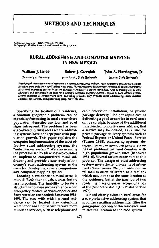
Figure 1. Four common addressing systems.
Addressing Systems Four methods commonly used to ad-
dress structures include the street and av- enue system, the quadrant system, the baseline and grid system, and the mile marker or century system (State of Iowa 1981) (Fig. 1). The mile marker system, at present the most effective system for lo- cating rural residences, is based on the distance of a structure from a designated road beginning, generally an intersec- tion. For example, a residence at 256 Hen- derson Road is 2.56 miles from the begin-
ning of Henderson Road (Fig. 1). The mile marker system best meets the demands of an effective rural addressing system be- cause it reflects the distances between res- idences (Corwin 1978, 36).
The system was effectively implement- ed by several counties in the Rocky Mountain region (Turner 1988). Each county created a printed rural addressing atlas by mapping all roads, dwellings, and associated addresses. In counties with high growth rates, however, maintaining the atlases has become time-consuming and costly because of the addition of new roads

VOLUME 42, NUMBER 4, NOVEMBER,
and many addresses over a short period of time.
One way to control system mainte- nance problems and reduce costs is with computer mapping (Calkins and Tomlin- son 1977, 16-30; Lam 1985; Wunderlich 1986,83). Rural addressing may also form the basis for a geographic information system (CIS). The potential exists to pro- cess and retrieve large amounts of infor- mation relating to a given address and street (Burrough 1986; Emery 1982, 72- 73; Klein and Marshall 1987).
The Committee on Geodesy (1983) of the National Research Council listed 36 different community data bases that ac- cess data by address, street, or parcel num- bers. The data bases included voting pre- cincts, ad valorem tax responsibilities, school districts, and zoning, among many other site attributes. With the addition of a GIs-compatible data structure and anal- ysis capabilities, a rural addressing atlas is one of several products that could be produced from the computerized data.
Computerized Rural Addressing Implementation
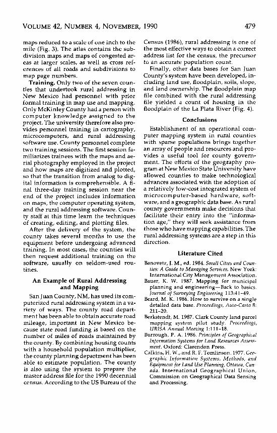
In Wyoming, 22 of 23 counties use some form of rural addressing. Of Colorado’s 63 counties, 56 have adopted rural ad- dressing. New Mexico is of special inter- est because out of the 11 counties with rural addressing six have adopted com- puter mapping to produce and maintain their addressing atlases (Fig. 2).
The county governments have provid- ed the personnel to conduct rural ad- dressing, sign posting, and questionnaire delivery. New Mexico State University has provided the computer mapping exper- tise, initial data base construction, and personnel training. The creation of pub- lic-private cooperative efforts has been an effective method of funding the rural ad- dressing projects. Private corporations and counties have joined together to provide funds for the project.
Project Acceptance and Coordination Responsibility. Rural addressing is a
major responsibility for local govern-
1990 473
ment. If the project is to succeed, elected officials such as county commissioners must understand the project’s scope and total costs. They must strongly support the rural addressing effort, committing staff time to the development and main- tenance of the addressing system.
The project contributes to many private and public agencies, including emergency medical services, road network mainte- nance, county clerk records, and the as- sessor’s office records. Emery (1982, 71) identified computer mapping needs for over 26 different county user groups.
The addressing project also affects other agencies such as the postal service, the most important public agency, and the utilities, the largest of the private organi- zations. Discussions should be held with these groups to determine the implemen- tation schedule for a new addressing sys- tem. Further, the groups should discuss how coordination among them can best take place. As Coleman and Henry (1987) have noted, a team approach to data base production, processing, and management seems to work best.
Funding. The budget for a rural ad- dressing project will depend on the scope and structure of the project. Project bud- gets vary in range from $40,000 to more than $250,000 including hardware, soft- ware, data base construction, field work and addressing.
The county can accomplish many tasks without excessive expense to its budget. Examples of county activity include as- signing rural addressing tasks as addi- tional duties of existing personnel and hiring part-time personnel to create the rural addressing system. Experience in New Mexico demonstrates that financing the rural addressing project comes from a combination of four sources. They in- clude the general fund of the county, the sale of the addressing atlas, contributions from the private sector, and grants or sup- port from other agencies.
County funds represent the core fund- ing for the project. If they do not account for a major portion of the development costs, they will be a significant percent of

474 THE PROFESSIONAL GEOGRAPHER
Figure 2. Status of rural addressing in New Mexico’s counties.
the maintenance of the system, usually above 90%. To assist in financing the pro- ject some counties, for example Grant County, NM, have tried to sell the atlases to those who have not contributed to the development of the system. Contribu- tions from utility, telephone, or cable television companies are the second most common funding sources. US West and CONTEL are the best examples of cor-
porate sponsors, providing both organi- zational expertise and financial support.
Gutherie (1987, 109) states that it is im- portant to get external and utility agen- cies involved in an addressing project. Both Colorado and New Mexico have used this method to accomplish rural address- ing (Turner 1988). In addition, banks, real estate companies, title offices, and parcel delivery firms have supported addressing

VOLUME 42, NUMBER 4, NOVEMBER, 1990 475
efforts. Support from state or federal sources has not been a determining factor.
Personnel. To create a computerized rural addressing system, a mix of talents and levels of effort is required. The most common method has been for a county to act as the lead agency for field work, oc- casionally hiring outside contractors to complete the work. For example, with the exception of Bernalillo County (Albu- querque), all New Mexico counties that have established computer mapping sys- tems have had their computer data bases created by geographers at New Mexico State University.
The following groups of county per- sonnel need to be involved in a rural ad- dressing project: the elected officials who have approved the project, the personnel who have data bases pertinent to the proj- ect, and the staff who create and maintain the rural addressing system. The com- missioners’ responsibility to the citizens of the county is to administer an address- ing project to the benefit of the entire jurisdiction. Further, they are responsible for ensuring that the system does what it is supposed to do, is integrated into the existing county computer system (Bur- rough 1986, 16), stays within the speci- fied budget, and is delivered within the designated timeframe.
A major constraint to the success of ru- ral addressing and computer mapping is finding local expertise in mapping and computer literacy. Semprivivo (1980) cites inadequate local expertise as one of three reasons why information systems fail. The two other reasons are lack of management skills and involvement and incorrect de- cisions about matching a new data base structure to a county’s organizational hi- erarchy.
Data Collection Two sources employed in collecting data
for rural addressing are mapped data and field survey data. The base map data are obtained from printed sources. Field data are collected from field observation and house-to-house interviews.
Mapped data. The US Geological Sur-
vey is the primary source of mapped data (Donahue and Faedtke 1982,116; Harvey 1986,272). Data include orthophoto quad- rangles produced between 1975 and 1982 with the Public Land Survey System (PLSS) overlay. Chrisman and Neimann (1985) stated that the PLSS can be a crucial element in building a GIs. Another source is the US Geological Survey 7.5 minute topographic maps. They identify the fed- eral, state, and municipal boundaries (Levy et al. 1987, 102). The 7.5 minute quadrangles also serve as the basic unit for data storage.
The county-approved subdivision plats provide information for locating subdi- visions, the accompanying road networks within the subdivision, and individual parcels. They must be combined with the PLSS (Oberg 1987; Speer and Little 1986). Other sources of maps used in rural ad- dressing include councils of government, state and federal agencies, and the utility companies. The state highway depart- ment can also provide maps and aerial photography. Maps and photographs from these sources, however, may be of vary- ing scales. Although Emery (1982) found more than 100 different utility maps that have GIS applications, Fitzgerald (1987, 11) found that ”many of these were out- dated or unavailable, and available maps were plotted in at least fourteen different scales.”
Field data. Not all residences or estab- lishments can be identified from ortho- photography. The photography may be dated, new residences having been con- structed or older residences relocated, or it may be misinterpreted. For example, at 1:24,000 it is difficult to determine the oc- cupancy of a dwelling. Field crews are needed to update, correct, and identify missing or incorrect information. This field work can be done when county per- sonnel post road names and calculate and post the distance to each building. Field crews also can interview the occupant, leave the questionnaire to be completed later, or ask neighbors if the house is oc- cupied. Several visits to a residence may be required to complete the question-

476 THE PROFESSIONAL GEOGRAPHER
naire, but if follow-up procedures are car- ried out, a 90% response rate for surveys is not uncommon (Turner 1988).
Digitizing The most common way to create com-
puter generated rural addressing maps is to enter all information into the computer using a manual digitizer with the com- puter keyboard as a supporting device. Initial digitizing creates a file for each 7.5 minute topographic map and subdivision. The coordinate geometry is a key element in positioning data from several map sources (Committee on Geodesy 1983,22). The 20 standard latitude and longitude positions on an orthophoto quad are reg- istered with reference to latitude, longi- tude, state plane coordinates, and digitiz- er unit coordinates. New Mexico State University utilizes the state plane coor- dinate system so that accuracy can be maintained and subdivisions can be easily incorporated (Bauer 1987, 42; Berkstendt 1987; Committee on Geodesy 1983, 24).
The following information is entered into the data base: the rural addressing data, road network, dwellings/establish- ments, township /range and sections, po- litical boundaries, prominent physical features, utilities, subdivision bound- aries, and parcels. Throughout the digi- tizing stage, data input personnel edit the data. The initial data base is then arranged by quadrangle sheet number. Each quad- rangle is plotted at 1:24,000, using the quadrangle sheet number as the file iden- tifier. The number remains with the quad- rangle throughout the project (Beard 1986, 212; Committee on Geodesy 1983,44).
Field Editing The county receives two copies of each
plotted map, retaining the first set for its records. County personnel edit the sec- ond set of maps for digitizing errors or errors of omission and update the digi- tized information from the field check. Errors commonly found are mislabeling of township and range, misalignment of municipal boundaries, incorrect identifi- cation of structures, omission of new roads
and buildings or realignment of old roads. Corrections are made directly onto the plotted maps.
The corrected maps are returned from the county to the university and redigi- tized. Because reference points are iden- tified in the original map files, the re- alignment of the field maps to the original maps is easily accomplished and revisions digitized. After the modifications have been entered into the data base, a final draft plot of each map is made and sent to the county. At this point the county completes its final revision.
Delivery and Use The county receives seven products at
the end of the rural addressing project: hardware for processing, software for ru- ral addressing, rural addressing data bas- es, a master copy of the rural addressing atlas, topographic maps and orthophotos, and technical training. Each is tailored to the needs of the county.
Hardware and software. The computer equipment recommended for rural ad- dressing includes an IBM-PC or compat- ible with digitizing tablet (minimum size of 36 x 48 inches) and incremental pen plotter (minimum size of 11 x 17 inches with four pens). Hardware costs range from $10,000 to $25,000. Although the county purchases this equipment, during the rural addressing process it is housed at the university. The university builds the data base, configures the system, and tests the software. At the end of the proj- ect the software, which may be developed at the university or purchased from a commercial vendor, is returned to the county.
Data bases. The two data bases stored in the computer’s memory are the geo- graphic base files and the survey data. Each geographic base file includes an auxiliary subfile, a geographic subfile, and a label subfile. The auxiliary subfile contains in- formation on the coordinate extremes, number of points, nodes, and links. The geographic base subfile has all of the dig- itized points, their link numbers, and as- sociated designations. The label subfile

VOLUME 42, NUMBER 4, NOVEMBER, 1990 477
s
+ + + +
+
I
,I
a
I I I I a :
,
\ + + + \
+ + + n P a a
: + + + a
a: B a a P
+y + " I,
+ "
+ " 1111
0
1 I
+ +
'\ " +
u MILES
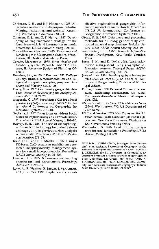
00800 Figure 3. Sample page from the rural addressing atlas for Chaves County, NM

478 THE PROFESSIONAL GEOGRAPHER
FLOODPLAIN
0 1
MILES
Figure 4. Example of combining a rural addressing system with environmental data. Residences in haz- ardous floodplain locations are identified in this example.
lists all the labels, their parameters, and coordinates.
The survey base contains the relational data base software, and incorporates the information collected from the field sur- veys. The data base usually consists of the old address, the new address, the type of structure, the name of resident, and the telephone number. The information can
be accessed by the data base program and incorporated into other software. More importantly, this data base can be inte- grated into the county clerk's and asses- sor's office records.
Atlas. One of rural addressing's main functions is locating residents in need of emergency care. An atlas is produced for this purpose with each of the quadrangle
VOLUME 42, NUMBER 4, NOVEMBER, 1990 479
maps reduced to a scale of one inch to the mile (Fig. 3). The atlas contains the sub- division maps and maps of congested ar- eas at larger scales, as well as cross ref- erences of all roads and subdivisions to map page numbers.
Training. Only two of the seven coun- ties that undertook rural addressing in New Mexico had personnel with prior formal training in map use and mapping. Only McKinley County had a person with computer knowledge assigned to the project. The university therefore also pro- vides personnel training in cartography, microcomputers, and rural addressing software use. County personnel complete two training sessions. The first session fa- miliarizes trainees with the maps and ae- rial photography employed in the project and how maps are digitized and plotted, so that the transition from analog to dig- ital information is comprehensible. A fi- nal three-day training session near the end of the project includes information on maps, the computer operating system, and the rural addressing software. Coun- ty staff at this time learn the techniques of creating, editing, and plotting files.
After the delivery of the system, the county takes several months to use the equipment before undergoing advanced training. In most cases, the counties will then request additional training on the software, usually on seldom-used rou- tines.
An Example of Rural Addressing and Mapping
San Juan County, NM, has used its com- puterized rural addressing system in a va- riety of ways. The county road depart- ment has been able to obtain accurate road mileage, important in New Mexico be- cause state road funding is based on the number of miles of roads maintained by the county. By combining housing counts with a household population multiplier, the county planning department has been able to estimate population. The county is also using the system to prepare the master address file for the 1990 decennial census. According to the US Bureau of the
Census (1986), rural addressing is one of the most effective ways to obtain a correct address list for the census, the precursor to an accurate population count.
Finally, other data bases for San Juan County’s system have been developed, in- cluding land use, floodplain, soils, slope, and land ownership. The floodplain map file combined with the rural addressing file yielded a count of housing in the floodplain of the La Plata River (Fig. 4).
Conclusions Establishment of an operational com-
puter mapping system in rural counties with sparse populations brings together an array of people and resources and pro- vides a useful tool for county govern- ment. The efforts of the geography pro- gram at New Mexico State University have allowed counties to make technological advances associated with the adoption of a relatively low-cost integrated system of microcomputer-based hardware, soft- ware, and a geographic data base. As rural county governments make decisions that facilitate their entry into the ”informa- tion age,” they will seek assistance from those who have mapping capabilities. The rural addressing systems are a step in this direction.
Literature Cited Banovetz, J. M., ed. 1984. Small Cifies and Coun-
ties: A Guide to Managing Services. New York: International City Management Association.
Bauer, K. W. 1987. Mapping for municipal planning and engineering-Back to basics. Iournal of Surveying Engineering 113:41-49.
Beard, M. K. 1986. How to survive on a single detailed data base. Proceedings, Auto-Carto 8: 211-20.
Berkstendt, M. 1987. Clark County land parcel mapping system pilot study. Proceedings, URlSA Annual Meeting 1:111-18.
Burrough, P. A. 1986. Principles of Geographical Information Systems for Land Resources Assess- ment. Oxford: Clarendon Press.
Calkins, H. W., and R. F. Tomlinson. 1977. Geo- graphic Information Systems, Methods, and Equipment for Land Use Planning, Ottawa, Can- a d a . International Geographical Union, Commission on Geographical Data Sensing and Processing.
THE PROFESSIONAL GEOGRAPHER
Chrisman, N. R , and 8. J. Neimann. 1985. Al- ternative routes to a multipurpose cadastre: Merging institutional and technical reason- ing. Proceedings, Auto-Carto 7:84-94.
Coleman, D. J., and G. F. Henry. 1987. Devel- oping an implementation strategy for the New Brunswick land information network. Proceedings, URISA Annual Meeting 1:38-50.
Committee on Geodesy. 1983. Procedures and Standards for a Multipurpose Cadastre. Wash- ington, DC: National Academy Press.
Corwin, Margaret A. 1978. Street Naming and Numbering Systems. Report Number 332, Chi- cago, IL: American Society of Planning Of- ficials.
Donahue, J. G.,and W. J. Faedtke. 1982. DuPage County, Illinois, remonumentation and in- tegrated computer mapping program. Sur- veying and Mapping 42127-38.
Emery, H. A. 1982. Community geographic data base. Journal of the Surveying and Mapping Di- vision ASCE 108:69-79.
Fitzgerald, C. 1987. Justifying a GI5 for a local planning agency. Proceedings, G I s / LlS 87, In- ternational Conference on Geographic In- formation Systems 2:10-18.
Gutherie, J . 1987. Pages from an address book: Notes on implementing an address database. Proceedings, URISA Annual Meeting 1:lOl-10.
Harvey, R. B. 1986. The use of orthophotog- raphy and GIS technology to conduct a storm drainage utility impervious surface analysis: A case study. Proceedings ACSM-ASPRS An- nual Meeting: 271-78.
Klein, D. H., and E. T. Marshall. 1987. Using a PC-based CAD system to establish an auto- mated mappingifacility management sys- tem for a small incorporated city. Proceedings URISA Annual Meeting 1:195-203.
Lam, A. H. S. 1985. Microcomputer mapping systems for local governments. Proceedings Auto-Carto 7:327-36.
Levy, A., R. Watkins, R. Brown, J. VanArman, and J. S. Reel. 1987. Implementing a cost-
effective regional/local geographic infor- mation network in south Florida. Proceedings GISILZS 87, International Conference on Geographic Information Systems 2:lOl-10.
Oberg, R. E. 1987. Data entry and processing methods for building geodetically con- trolled cadastral map database. Technical Pa- pers ACSM-ASPRS Annual Meeting: 213-19.
Semprevivo, P. C. 1980. Teams in Znformation Systems Development. New York: Yourdon Press.
Speer, T W., and D. Little. 1986. Land infor- mation management using geographic in- formation systems. Technical Papers ACSM- ASPRS Annual Meeting: 206-09.
State of Iowa. 1981. Standard Address Systems for Iowa Counties. Iowa City, IA: Office of Plan- ning and Programming, Division of Munic- ipal Affairs.
Turner, Susan. 1988. Personal Communication. Rural addressing coordinator, US WEST Communication-New Mexico, Albuquer- que, NM.
US Bureau of the Census. 1986. Data User News (May). Washington, DC: US Department of Commerce.
US Postal Service. 1975. New Towns and the US. Postal Service: Some Guidelines for Postal Ofi- cials and New Town Developers. Washington DC: Government Printing Office.
Wunderlich, G. 1986. Land information sys- tems for rural jurisdictions. Proceedings U R E A Annual Meeting 1:83-91.
WILLIAM J. GRIBB (Ph.D., Michigan State Univer- sity) is an Assistant Professor of Geography at the University of Wyoming, Laramie, WY 82071. ROBERT J. CZERNIAK (Ph.D., University of Colorado) is an Assistant Professor of Earth Sciences at New Mexico State University, Las Cruces, MN 88033. JOHN A. HARRINGTON, JR. (Ph.D., Michigan State Univer- sity) is an Associate Professor of Geography at Indiana State University, Terre Haute, IN 47809.