Roadside Manual (M 25-30)
342
Roadside Manual M 25-30 July 2003
-
Upload
khangminh22 -
Category
Documents
-
view
1 -
download
0
Transcript of Roadside Manual (M 25-30)

Roadside Manual M 25-30 July 2003


Roadside Manual M 25-30 July 2003
Environmental and Engineering Service Center Design Office

Americans with Disabilities Act (ADA) InformationMaterials can be provided in alternative formats: large print, Braille, cassette tape, or on computer disk for people with disabilities by calling the Office of Equal Opportunity (OEO) at 360-705-7097. Persons who are deaf or hard of hearing may contact OEO through the Washington Relay Service at 7-1-1.
Title VI Notice to PublicIt is the Washington State Department of Transportation’s (WSDOT) policy to assure that no person shall, on the grounds of race, color, national origin or sex, as provided by Title VI of the Civil Rights Act of 1964, be excluded from participation in, be denied the benefits of, or be otherwise discriminated against under any of its federally funded programs and activities. Any person who believes his/her Title VI protection has been violated, may file a complaint with WSDOT’s Office of Equal Opportunity (OEO). For Title VI complaint forms and advice, please contact OEO’s Title VI Coordinator at 360-705-7098 or 509-324-6018.
To get the latest information on WSDOT administrative and engineering manuals, sign up for e-mail updates for individual manuals at: www.wsdot.wa.gov/publications/manuals
Washington State Department of Transportation Administrative and Engineering Publications PO Box 47304 Olympia, WA 98504-7304
Phone: 360-705-7430 E-mail: [email protected] Internet: www.wsdot.wa.gov/publications/manuals

Comment Form
From: ______________________________ Date: __________________________________________ Phone: __________________________________________ E-mail: ____________
To: WSDOT HEADQUARTERS, DESIGN OFFICETRANSPORTATION BUILDING310 MAPLE PARK AVENUE SEPO BOX 47329OLYMPIA WA 98504-7329
Subject: ROADSIDE MANUAL
¨ Marked copies attached. Comment :
Preserve this original for future use u Submit copies only


Foreword
The Roadside Manual has been prepared to coordinate and guide the management of Washington State highway roadsides including planning, design, construction, and maintenance activities.
The intent of this manual is to provide a consistent, coordinated, proactive approach to the treatment of roadsides statewide and to facilitate cost-effective restoration of state roadsides. The policies and guidelines provided here allow room for regional variations within the statewide parameters.
This manual implements the policies found in the Design Manual and the Roadside Classification Plan.
For further information, to offer comments on the Roadside Manual, call the Roadside and Site Development Unit of the Headquarters Design Office at 360-705-7245 or [email protected].
To order additional copies of the Roadside Manual contact Engineering Publications at 360-705-7428.
Harold Peterfeso State Design Engineer Washington State Department of Transportation
Roadside Manual Foreword February 2003


Contents Chapters
100- Manual Description 100-1
110- Roadside Functions 110-1
120- Sustainable Roadside 120-1
200- Roadside Policy 200-1
210- Federal Legislation & Policy 210-1
220- State Legislation & Policy 220-1
230- Department of Policy & Planning 230-1
300- Operational Functions 300-1
310- Roadside Safety 310-1
320- Signing 320-1
400- Environmental Functions 400-1
410- Designated Areas 410-1
420- Wetlands 420-1
440- Water Quality 440-1
450- Wildlife 450-1
460- Noise Abatement 460-1
500- Visual Functions 500-1
600- Auxiliary Functions 600-1
610- Safety Rest Areas 610-1
620- Universal Access 620-1
630- Parking Area Design 630-1
700- Soil & Soil Amendments 700-1
710- Erosion Control 710-1
720- Contour Grading 720-1
740- Soil Bioengineering 740-1
800- Vegetation 800-1
810- Vegetation Restoration 810-1
820- Irrigation 820-1
910- Design Enhancement 910-1
Roadside Manual Contents July 2003

Contents Appendices
Appendix A- Signature Authority A-1
Appendix B- Slope Visualization Diagram A-2
Appendix C- Sun Angles and Solar Exposure A-3
Appendix D- Plant Spacing A-4
Glossary G-1
Index I-1
Roadside Manual Contents July 2003

100 Manual Description
Purpose The Washington State Department of Transportation (WSDOT) has developed the Roadside Manual to provide coordination between all WSDOT partners responsible for roadside activities, and to establish a common basis for consistent roadside management decisions statewide. It also establishes a convenient and accessible reference for new and previously unpublished material related to roadside management including planning, design, construction, and maintenance. In addition, the manual supplements statewide roadside guidelines established in the Roadside Classification Plan.
General Roadsides are an important component of highway design, operation, and maintenance because of the operational, environmental, visual and auxiliary functions they provide. Properly designed and maintained, roadsides complement the functions of the roadway, integrate the roadway facility into the surrounding landscape and provide a positive psychological effect on vehicle occupants.
Almost one-third of fatal accidents are single vehicle run-off-the-road accidents. Recognition of this fact has led to roadway, traffic barrier, sign, and lighting standard designs that can reduce the seriousness of roadside encroachments. Roadsides can have a significant effect on errant-vehicle occupant safety. Refer to the Design Manual for guidance on roadway and roadside safety design.
Roadsides include virtually every habitat type that occurs in Washington State. They provide for native plant preservation and revegetation, habitat for animal species, and opportunities for stormwater storage and aquifer recharge.
In addition, there is increasing scientific evidence that roadsides can have a psychological effect on vehicle occupants. Nature-dominated roadsides may relieve drive-related stress and may have an immunizing effect on reaction to future drive-related stresses1. The inverse has also been shown to be true: drives dominated by human development can increase drive-related stress2. These research findings have important implications
1 Kaplan, Stephen, “The Urban Forest as a Source of Psychological Well-Being,” in Gordon A. Bradley (ed.), Urban Forest Landscapes: Integrating Multidisciplinary Perspectives, University of Washington Press, Seattle, 1995, pp. 100-108. 2 Parsons, R., L.G. Tassinary, R.S. Ulrich, M.R. Hebl, and M.M. Grossman, “The View from the Road: Implications for Stress Recovery and Immunization,” in Journal of Environmental Psychology, in press.
Roadside Manual Chapter 100 - Manual Description July 2003 100-1

for management of roadsides. Roadsides are important for both physical safety of, and psychological impact on vehicle occupants.
Definitions The roadside is the area outside the traveled way. This applies to all lands managed by WSDOT and may extend to elements outside the right of way boundaries.3 This includes unpaved median strips and auxiliary facilities such as rest areas, roadside parks, viewpoints, heritage markers, pedestrian and bicycle facilities, wetlands and their associated buffer areas, stormwater treatment facilities, park and ride lots, and quarries and pit sites.
Format This manual is organized around a framework of roadside functions: operational, environmental, visual and auxiliary. Each of these functional areas has relevance to planning, design, construction and maintenance personnel.
To avoid unnecessary duplication, existing WSDOT roadside publications have been outlined, referenced, or transferred to this manual.
Each division in this manual includes the following:
• Resources, including related published material and who to contact for more information.
• Definitions of technical terms specific to the division’s subject matter. These and other definitions are also found in the glossary.
• Procedures for accomplishing roadside projects, including coordination and communication procedures, schedules, and required actions. Most chapters include a list of recommended procedures for each subject area.
Revisions This manual will continue to present the best and most up-to-date information available. It is vital that you, the user, participate in the revision process by using the form provided at the front of the manual to report flaws and to contribute new material.
3 WSDOT owns and manages the land within the right of way boundaries. WSDOT also owns, or has partial investment in, properties outside of the right of way boundaries; for example, wetland mitigation sites. In addition, WSDOT has an interest in elements outside the right of way boundaries which may affect roadway safety.
Roadside Manual Chapter 100 - Manual Description July 2003 100-2

110 Roadside Functions
General
Definitions
The roadway is the portion of a highway, including shoulders, for vehicular use. A divided highway has two or more roadways.
Figure 110.1 shows the extent of a typical forested roadside and an example of the possible locations of roadside functional features.
Figure 110.1 Roadside Functional Area Examples
The Washington State Department of Transportation (WSDOT) is responsible for the stewardship of approximately 97,500 acres of roadsides along 7,061 miles (in 2001) of state roadway, including hundreds of auxiliary facilities.
Roadside management encompasses planning, design, construction, and maintenance of the roadside environment. The roadside is managed to fulfill four functional categories: operational, environmental, visual, and auxiliary functions. In reality, these functions are interrelated and inseparable but the four functions help communicate the range of roadside management issues.
The roadside provides the essential area for these functions and contributes to WSDOT's delivery of transportation services. Table 110.1 shows the functions and some examples of those functions. In the next several chapters these examples and their applications are discussed in greater detail.
Roadside Manual Chapter 110 Roadside Development July 2003 110-1

Function Examples operational functions
Those functions that provide safe and multiuse roadsides. Operational functions include access control, and providing recovery areas and sight distances with accommodations for signs and utilities, and snow storage. The Design Manual remains the primary guidance for operational design guidance.
environmental functions
Those functions that protect and enhance our natural and built surroundings. Environmental functions include water quality preservation, protection and improvement, stormwater detention and retention, wetland and sensitive area protection, noxious weed control, noise control, habitat protection, habitat connectivity, air quality improvement, and erosion control.
visual functions
Those functions that are designed and experienced primarily from a visual perspective. Visual functions promote a positive quality of life and are integral to operational, environmental, and auxiliary functions. They include positive guidance and navigation, distraction screening, corridor continuity, roadway and adjacent property buffering, and scenic view preservation.
There are two primary roadside views: those from the roadway, and those toward the roadway. In addition, many environmental functions, such as noxious weed control, wetland and sensitive area preservation, and habitat preservation are readily perceived and evaluated through sight.
auxiliary functions
Those functions that provide additional operational, environmental, and visual functions for a complete transportation system. Examples of auxiliary facilities are community enhancement areas, safety rest areas, roadside parks, viewpoints, agricultural uses, heritage markers, bicycle and pedestrian facilities, park and ride lots, and quarries and pits.
Table 110.1 Roadside Functions
Roadside Manual Chapter 110 Roadside Development July 2003 110-2

Roadside Management
The roadside is managed to fulfill these operational, environmental, visual, and auxiliary functions. Decisions concerning roadside management must be balanced to coordinate and integrate these functions without compromising safety.
Roadside functions vary at different locations according to specific highway and site conditions. Although every area of roadside simultaneously provides many functions, some roadside sections are used primarily to serve very specific functions that are dictated by highway traffic and safety needs, the physical environment, legislated requirements, commitments, and WSDOT policies and programs.
Roadsides are managed in three zones: Zone one, when present, is a vegetation-free zone immediately adjacent to the roadway. Zone two typically contains the clear zone (although in some locations, the Design Clear Zone may extend beyond the right of way line). Zone three extends from Zone 2 to the right of way line, as seen in Figure 110.2. Please see the Maintenance Manual or the Roadside Classification Plan for more information.
Figure 110.2 Roadside Management Zones
Roadside Manual Chapter 110 Roadside Development July 2003 110-3


120 Sustainable Roadsides
General Roadside management encompasses roadside planning, design, construction, and maintenance. The primary challenge in roadside management is to preserve and restore roadside character and fulfill roadside functions, regardless of fluctuations in funding and personnel. By setting feasible standards and working consistently within long-term goals, roadside management can promote sustainable roadsides.
Reference
Integrated Vegetation Management for Roadsides, WSDOT, July 1997.
Resources
Region’s Landscape Architects
Headquarters (HQ) Design Office Roadside and Site Development Office
Definition
Sustainable roadsides are those roadsides that are designed and maintained with the intent of integrating successful operational, environmental, and visual functions with low life cycle costs.
Managing for Sustainable Roadsides Sustainable roadsides fulfill roadside design intent and roadside functions over the long term, within present and future available funding, personnel, and equipment allocations and methodologies. To achieve sustainable roadsides, roadside partners must strive to utilize, protect, and support the physical and ecological resources necessary for a fully functioning roadside.
The primary management considerations for sustainable roadsides are:
• Design intent: Roadside functions (operational, environmental, visual and auxiliary) and maintenance standards, criteria, and actions are coordinated and balanced to the greatest degree possible to achieve the design intent on all levels. Design to achieve the long-term goals of Integrated Vegetation
Roadside Manual Chapter 120 - Sustainable Roadsides July 2003 120-1

Management (IVM). Refer to Integrated Vegetation Management for Roadsides.
• 20-year planning horizon: All roadside management decisions are weighed in their long-term context, including projected land use and public health, safety, and welfare considerations. Address future adjacent land uses and roadside functions when designing present-day projects.
• Projected life cycle costs: All roadside management decisions are in keeping with present and future available funding, personnel, equipment, and methodologies. What are the costs of the project over its “lifetime?”
• Utilize, protect, and support the roadway and roadside infrastructure: All roadside management decisions are balanced with the need to sustain, and to preserve, restore, and enhance the roadside character and natural environment. The emphasis is on careful management of existing and volunteer native vegetation.
• Continued cooperative involvement: Roadside management decisions are based on continued active involvement between all roadside partners within WSDOT. This begins at the earliest planning stages with communication between all affected parties through an open, collaborative management process and designated lines of communication between roadside partners.
This manual presents criteria and details for implementation of the sustainable roadside concept. All documents pertaining to roadside management such as design documents, construction plans, and area maintenance plans shall be created and implemented using the considerations for managing sustainable roadsides.
Roadside Manual Chapter 120 - Sustainable Roadsides July 2003 120-2

200 Roadside Policy
General Roadside policy is governed by a web of jurisdictional entities, and affects planning, design, construction, and maintenance.
An activity is directed by department policy and guidelines that are influenced by federal, state, and local legislation and regulations. Roadside policy is also influenced by public input and tribal legislation.
WSDOT
ROADSIDE
POLICY
CONSTRUCTIONPLANNING DESIGN MAINTENANCE
TRIBAL
LEGISLATION
PUBLIC
INPUTFEDERAL
LEGISLATION
LOCAL
LEGISLATION
STATE
LEGISLATION
Procedures
Public Involvement
Public involvement in WSDOT roadside activities is conducted in a manner that is consistent with the process established for roadways in general. (See WSDOT Design Manual chapter on Public Involvement and Hearings.) It is the department’s goal that decisions be made in the best overall public interest and that other agencies and the public be involved early enough to influence project decisions.
Roadside Manual Chapter 200 - Roadside Policy July 2003 200-1


210 Federal Legislation and Directives
General Federal legislative acts and policies govern many roadside activities. See the Design Manual chapter on documentation requirements. The Environmental Procedures Manual contains extensive references to laws and directives applicable to the environment. The following is a brief summary of the major acts and policies affecting roadsides.
Planning Intermodal Surface Transportation Efficiency Acts of 1991 and Transportation Equity Act for the 21st Century of 1998
Emphasizes issues including multimodal transportation; reorganizes transportation funding structures; links transportation, land use, and air quality standards; and mandates a state plan to guide statewide transportation improvement program development.
Americans with Disabilities Act of 1990
Requires all services, programs, and activities, when viewed in their entirety, to be readily accessible to, and usable by people with disabilities.
Federal Highway Administration 1998 National Strategic Plan
The vision for this strategic plan is to create the best transportation system in the world by creating the safest, most efficient, and most effective highway and intermodal transportation system in the world for the American people. http://www.fhwa.dot.gov/aap/fhplan.html
Environment The following list includes legislation, regulations, and guidelines most commonly encountered in roadside activities. For more complete information, see the WSDOT Environmental Procedures Manual or contact the Headquarters (HQ) Environmental Affairs Office. The Federal Highway Administration web site, found at http://www.fhwa.dot.gov/environment/env_sum.htm#AN also contains references to environmental regulations.
Roadside Manual Chapter 210 - Federal Legislation and Directives July 2003 210-1

Policy
National Environmental Policy Act (NEPA), 42 USC 4321-4347 (1969)
Established to ensure consideration of environmental factors through a systematic interdisciplinary approach before committing the department and FHWA to a course of action.
Declares that it is the “continuous responsibility” of the federal government to “use all practicable means” to “assure for all Americans safe, healthful, productive, and esthetically and culturally pleasing surroundings.”
Water Quality
Clean Water Act, 33 USC 1344
Established to restore and maintain chemical, physical, and biological integrity of the nation’s water through the prevention, reduction, and elimination of pollution. Section 404 addresses discharge of dredge and fill in all waters of the United States, including wetlands, and is enforced by the U.S. Army Corps of Engineers (COE) and the U.S. Environmental Protection Agency (EPA).
Air Quality
Clean Air Act, 42 USC 7401-7642
Established to protect and enhance air quality and to assist state and local governments with air pollution prevention programs.
Biology/ Wetlands
Endangered Species Act of 1973 as amended, 16 USC 1531-1543
Established to conserve species of fish, wildlife, and plants facing extinction. Rivers and Harbors Act of 1899, 33 USC 401
Protects navigable waters of the United States. Enforced by the U.S. Army Corps of Engineers.
Preservation of Nation’s Wetlands, DOT Order 5660.1A
Provides policy and implementing procedures that require transportation facilities to be planned, constructed, and operated to ensure protection, preservation, and enhancement of the nation’s wetlands to the fullest extent practicable.
Roadside Manual Chapter 210 - Federal Legislation and Directives July 2003 210-2

Executive Order on Invasive Species, No. 13112, February 1999
Directs Federal agencies to expand and coordinate their efforts to combat the introduction and spread of plants and animals not native to the United States. The Federal Highway Administration has developed guidelines that provide a framework for preventing the introduction of and controlling the spread of invasive plant species on highway rights-of-way.
Noise
Noise Control Act of 1972, 42 USC 4901 et. seq.
Established to protect the public health and welfare from detrimental noise.
Visual Quality
Design/Maintenance
Presidential Memorandum on Environmentally Beneficial Landscaping, FRL-5054-1 (1994)
Directs federal agencies to lead the country toward more environmentally and economically beneficial landscape practices including:
• Use of regionally native plants.
• Construction with minimal impact to habitat.
• Reduced use of fertilizer, pesticides, and other chemicals.
• Use of water-efficient and runoff-reduction practices.
• Use of demonstration projects employing these practices.
Pertains to all highway programs using federal funds and arranges the development of implementation guidance. Directed these be incorporated into agency landscape guidelines, procedures, and practices by February of 1996.
FHWA Scenic Enhancement Initiatives Memorandum, HRW-12 (1990)
Rescinds 1977 memorandum permitting selective clearing of right of way vegetation to improve visibility of outdoor advertising structures.
Encourages states to retain excess lands that could be used to restore, preserve or enhance the scenic beauty and quality of the highway environment, including scenic vistas, wetlands, and preservation of wildlife habitat.
Roadside Manual Chapter 210 - Federal Legislation and Directives July 2003 210-3

Surface Transportation and Uniform Relocation Assistance Act of 1987, Section 130.
Requires at least one quarter of one percent of funds expended for landscape projects be used to plant native wildflowers.
23 CFR 752 - “Highway Beautification Act” of 1965 and all subsequent amendments
Establishes provisions and controls to protect the public investment, promote safety and recreation, and preserve natural beauty along federal and primary highway system roadsides including:
• Control of outdoor advertising signs.
• Authorization for information centers at safety rest areas.
• Control of junkyards.
Allocation of 3% of federal aid funds apportioned to states for landscape and roadside development and for acquisition of interest in, and improvement of, strips of land necessary for the restoration, preservation, and enhancement of scenic beauty adjacent to the highways.
Roadside Manual Chapter 210 - Federal Legislation and Directives July 2003 210-4

220 State Legislation and Directives
General See Design Manual for safety and documentation requirements. The Environmental Procedures Manual contains references to laws and directives applicable to the environment. The following is a brief summary of the major state acts and directives affecting roadsides.
Planning RCW 47.06, Amended in 1993 by Engrossed House Bill 1007
Directs the Transportation Commission to develop the Transportation Policy Plan for Washington State, and directs WSDOT to develop the Statewide Multimodal Transportation Plan.
Washington State Growth Management Act of 1990 and amendments
Sets goals to guide planning for growth in all communities exceeding a set threshold. Requires designations of natural resource lands and critical areas. Provides for regional transportation planning program.
Requires state agencies to comply with local comprehensive plans and development regulations. Requires local governments to develop a process for siting “essential public facilities.”
Requires certain cities and counties to designate environmentally sensitive areas, including wetlands, flood plains, and habitat.
Environmental The following list includes legislation, regulations, and guidelines most commonly encountered in roadside activities. For more complete information on state environmental legislation, regulations, and guidelines directly affecting WSDOT actions, see the WSDOT Environmental Procedures Manual or contact the Headquarters Environmental Affairs Office.
General
State Environmental Policy Act (SEPA) and RCW 43.21C
Declares a state environmental policy and promotes efforts to prevent or eliminate damage to the environment, including visual impacts.
Roadside Manual Chapter 220 - State Legislation and Directives July 2003 220-1

State Environmental Policy Act Rules: WAC 197-11
Establishes uniform requirements for agencies and developers to comply with SEPA regulations.
Transportation Commission and Transportation Department Environmental Policy Act Rules: WAC 468-12
Integrates the policies and procedures of SEPA into the programs, activities, and actions of the department.
Water Quality
Puget Sound Water Quality Authority Act: RCW 90.70
Established the Puget Sound Water Quality Authority and directed the Authority to develop a Puget Sound Water Quality Management Plan.
Puget Sound Runoff Program: WAC 173-270
Provides guidelines and criteria for implementation of the program.
Shoreline Management Act of 1971: RCW 90.58
Manages Washington State’s shorelines by planning for and supporting all reasonable and appropriate uses.
State Water Pollution control Act: RCW 90.48
Protects all surface and underground waters.
Water Resources Act of 1971; RCW 90.54
Provides for utilization and management of waters in Washington State.
Biology/ Wetlands
Hydraulic Code of Washington, RCW 75.20 and WAC 220-110
Establishes program for regulating activities within the waters of the state for fish protection. Requires hydraulic project approval for actions within the ordinary high water mark. Administered by the Washington State Department of Fish and Wildlife and the Tribes.
Fish Passage, RCW 75.20.060 and RCW 77.16.210
Requires that any structures placed in waters of the state provide for unobstructed passage of fish.
WAC 220-110-070 States that bridges are preferred as water crossing structures by the department in order to ensure free and unimpeded fish passage for adult and juvenile fishes and to preserve spawning and rearing habitat.
Roadside Manual Chapter 220 - State Legislation and Directives July 2003 220-2

Executive Order 89-10: Protection of Wetlands
Provides for “no net loss” of wetlands. Directs each state agency to provide an action plan to minimize the destruction or loss of wetlands and to preserve and enhance their beneficial value.
Executive Order 90-04: Protection of Wetlands
Provides for wetland protection by all state agencies. Defines mitigation and provides for the Department of Ecology to develop guidance and policy on wetland protection.
Noise
Noise Control Act of 1974: RCW 70-107
Expands efforts to abate and control noise while considering the social and economic impact upon the community and the state.
Sound Level Measurement Procedures: WAC 173-58
Establishes standardized procedures to measure sound levels from sources including environmental and construction noise.
Maximum Environmental Noise Levels: WAC 173-60
Establishes maximum noise levels for identified environments.
Visual Quality
Scenic and Recreational Highway Act of 1967: RCW 47.39
Establishes the Scenic and Recreational (S&R) Highways Program and designates more than 1900 miles of scenic highways.
Roadside Improvement and Beautification: RCW 47.40
Outlines permit process for persons wishing to use highway right of way for improvement and beautification. Establishes penalty for destroying native flora on state lands. Mandates litter removal, and authorizes state and local Adopt-a-Highway programs.
Junkyards Adjacent to Interstate and Primary Highways: RCW 47.41
Establishes controls for junkyards adjacent to highways.
Highway Advertising Control Act-Scenic Vistas Act of 1971: RCW 47.42
Amends the Highway Advertising Control Act to include the designated Scenic and Recreational Highways. Controls advertising signs along state highways and their interference with views.
Roadside Manual Chapter 220 - State Legislation and Directives July 2003 220-3

Amended Scenic and Recreational Highway Act of 1967: RCW 47.39 (1990)
Directs WSDOT to develop criteria and a threshold methodology to evaluate highways for possible inclusion in the S&R system. States that scenic and recreational highways are designated because of a need to develop management plans that will protect and preserve the scenic and recreational resources from loss through inappropriate development. States that protection of these resources includes managing land use outside normal highway rights of way, and adds additional routes to the S&R System.
Amended Scenic and Recreational Highway Act of 1967: RCW 47.39 (1993)
Includes 45% of state highways in the Scenic and Recreational Highway (S&R) system. Directs the department to consider the use of the designated system by bicycles and pedestrians. Delegates authority for establishment of planning and design standards for S&R highways.
Scenic Enhancement for Utilities Accommodation on State Highway Rights of Way: WAC 468-34-330
Describes a scenic classification system for utilities accommodation on state highway rights of way as developed through cooperation of WSDOT and the Aerial Utility Industry.
Maintenance Roadway Safety, RCW 47.32.130
Provides for the removal of elements, such as vegetation, outside WSDOT right of way to increase roadway safety.
Compost Products, RCW 43.19A.050
Instructs the department to prepare a strategy to increase purchases of recycled-content products.
(2) Compost products as a percentage of the total dollar amount (spent on soil cover or soil amendments) on an annual basis:
( c) At least eighty percent by 1998.
Integrated Pest Management, RCW 17.15 120
Directs state agencies to use those principles when managing pests.
Fertilizer Regulation, Substitute Senate Bill 6474, Chapter 36, Laws of 1998, effective date: June 11, 1998
• Requires license for distribution of bulk fertilizers.
Roadside Manual Chapter 220 - State Legislation and Directives July 2003 220-4
• Requires identification of those products that are (i) waste derived fertilizers, (ii) micronutrient fertilizers, or (iii) fertilizer materials containing phosphate.
• Requires a minimum labeling statement that it meet Washington standards for arsenic, cadmium, cobalt, mercury, molybdenum, lead, nickel, selenium and zinc.
• Defines “compost” and “soil amendment.”
Noxious Weed Control, RCW 17.10.145
Directs state agencies to control noxious weeds on their lands.
Preservation, restoration and cleanup of areas disturbed through utility installation, maintenance and repairs: WAC 468-34-340
Outlines criteria for utility use of highway right of way, requires utilities to repair or replace unnecessarily removed or disfigured trees and shrub, and specifies vegetation management practices.
Vegetation Management Program, WAC 173-270-040
States that the purposes of vegetation management in highway rights of way are to establish and maintain stable plant communities that resist encroachment by undesirable plants, noxious weeds, and other pests; meet WSDOT operational, health, natural resources and environmental standards; be cost effective; and protect the public investment with minimal negative impacts on the environment. Requires a vegetation management program for all state highways with the Puget Sound basin.
Partnerships Adopt a Highway, RCW 47.40.100 and WAC 468-72
Establishes and provides guidelines for state Adopt-a-Highway program. The purpose of the program is to provide volunteers and businesses an opportunity to contribute to a cleaner environment, enhanced roadsides, and protection of wildlife habitats.
Rest Areas Acquisition of Property for Preservation of Beauty, Historic Sites, Viewpoints, Safety Rest Areas, Buffer Zones: RCW 47.12.250
Authorizes acquisition of property, or interests, or rights to property adjacent to state highways for the stated purposes.
Roadside Areas-Safety Rest Areas: RCW 47.38
Directs the development of rules and establishes limitations on use of rest areas and other roadside areas. Authorizes development of
Roadside Manual Chapter 220 - State Legislation and Directives July 2003 220-5

information centers. Establishes recreational vehicle sanitary disposal systems.
Recreational Vehicle RCW 46.16 and 46.68
Authorizes and sets up an account for additional fees charged for recreational vehicles to be used for the construction, maintenance and operation of recreational vehicle sanitary disposal systems at safety rest areas.
Uniform Building Code Requirements for Barrier-Free Accessibility: RCW 19.27 and 70.92
Requires all new structures, and those being substantially renovated, be approachable and usable by persons with disabilities.
Roadside Manual Chapter 220 - State Legislation and Directives July 2003 220-6

230 Departmental Policy and Planning
Transportation Commission The Transportation Commission provides policies to shape and direct decisions about the future of Washington’s transportation systems. The state transportation policy summary can be found on the Internet at: http://www.wsdot.wa.gov/commission/ReportsPlans/StateTranspPolicy.htm
The policy addresses several issue areas, one of which is environmental protection and energy conservation. The environmental section of the policy states the following three principles:
• Minimize, and avoid when practical, air, water, and noise pollution; energy usage; use of hazardous materials; flood impacts; and impacts on wetlands and heritage resources from transportation activities.
• When practical, and consistent with other priorities, protect, restore and enhance fish and wildlife habitats and wetlands impacted by transportation facilities.
• Coordinate and take the lead in partnering with other agencies in environmental issues affecting transportation to reduce costs and increase effectiveness.
Executive Order Number E 1018.00 In this order, dated September 26, 2001, the Secretary of Transportation committed the department:
• To implement and maintain an environmental management system that embraces all the department’s program functions.
• To establish, maintain and make available to the public appropriate performance indicators of the department’s exercise of its environmental stewardship, and to consistently review these indicators as a basis to improve the department’s performance.
• To comply with all environmental laws and regulations applicable to our business and activities.
• To assure that employees of the department receive training appropriate to their functions concerning the department’s environmental responsibilities.
Roadside Manual Chapter 230 - Departmental Policy and Planning July 2003 230-1

• To communicate to contractors, designers, consultants, and other participants in the department’s work the management practices and compliance requirements established to further the aims of this Policy Statement {Executive Order # E1018.00].
• To encourage employees and all other citizens to communicate with the department about ways to increase the effectiveness of departmental practices supporting its mission of environmental stewardship.
• To make every reasonable effort to also protect the cultural and historic resources of the state.
Planning
State Highway System Plan
The State Highway System Plan is the state highway portion of the Washington Transportation Plan (WTP). The WTP was developed, and is updated, by the Washington State Transportation Commission in response to RCW 47.06, as well as to state law and federal laws, such as the Transportation Equity Act for the 21st Century (TEA 21), and the Clean Air Act.
The WTP specifically defines service objectives and proposes strategies for maintaining, preserving, and improving state highways. This plan forms the basis for development of future state transportation programs, projects, and budgets.
Statewide Roadside Plans
Roadside Classification Plan, M-25-31, (1996)
Provides a statewide roadside classification process and guides roadside treatment for the management of safe, environmentally beneficial, and sustainable roadsides. The text of the Roadside Classification Plan can be found at the following website:
http://www.wsdot.wa.gov/eesc/cae/design/roadside/rcp.htm
Vegetation Management, Environmental Impact Statement (EIS), 1993
Produced in response to proposed anti-pesticide legislation, this document incited a large response from the public with regard to the use of chemical herbicides. As a result, the Department has shifted its roadside management emphasis toward locally based, long-term planning Integrated Vegetation Management (IVM). In addition, the EIS recommended development and use of Roadside Management Plans for each of the area maintenance offices. The plans provide the
Roadside Manual Chapter 230 - Departmental Policy and Planning July 2003 230-2

means for documenting site-specific long term goals and determining the planning and evaluation necessary to achieve those goals.
Region and Route-Specific Roadside Plans
The following planning tools are available in some, but not all, areas. Corridor Management Plans
WSDOT defines transportation corridors as “accessible, passable routes between points encompassing a traveler’s perspective and experience of the available resources while using a transportation mode (roadway/railway, trail/path, or water route).
A corridor management plan is a document composed of maps and written material stating a community’s vision and goals for a scenic byway corridor. This document inventories and assesses the resources of the corridor, and outlines specific strategies and actions to preserve and enhance them.
Roadside Master Plans
Guides roadside related, long-term design and management activities on Washington State highway roadsides. Based on the Roadside Classification Plan, Roadside Master Plans are route-specific conceptual plans prepared for a route, or portion of a route, where conditions require coordination beyond that provided under the Roadside Classification Plan.
Route Development Plans (RDP)
A long-range plan for a specific highway corridor that describes existing highway conditions and local land use plans. Recommends improvements and goals for future improvements and transportation services. The plan is developed through cooperative efforts with affected city, county and regional agencies.
Route Development Plans are route-specific and may include a Roadside Master Plan where roadside planning concerns are identified.
Policies
Environmental
Water Quality Policy
Minimize and control levels of harmful pollutants generated by transportation activities. Mandates preventing them from entering surface and groundwater resources.
Roadside Manual Chapter 230 - Departmental Policy and Planning July 2003 230-3

Fish and Wildlife Habitat Protection Policy
Protect, restore, and enhance, where feasible, fish and wildlife habitat and populations within transportation corridors.
Noise Abatement Policy
Minimize noise impacts from transportation systems and facilities.
Wetlands Conservation Policy
Support federal and state “no net loss” policies by protecting, restoring, and enhancing natural wetlands adversely impacted by transportation related construction, maintenance, and operations activities. (Department Directive 31-12)
Use of Hazardous Substances Policy
• Reduce and eliminate, where practical, the reliance of the state’s transportation system on environmentally hazardous substance utilized in the construction and maintenance of transportation facilities.
• Ensure the adoption of best management practices in handling hazardous substances for transportation purposes.
Visual Quality
Visual Quality Policy
Protect and enhance the visual quality of Washington State’s transportation corridors and facilities.
For more information on visual impact assessment on Interstate highways see this website: http://www.wsdot.wa.gov/EESC/design/Roadside/#Viu
Utilities Accommodation Policy
The objective of this policy is to prescribe the means by which utility installations, when located in a manner not interfering with the free and safe flow of traffic or otherwise impairing the highway of its visual quality, may be accommodated within state highway rights of way.
Heritage Resources
State Transportation Policy on Heritage Resources
WSDOT has an interest in preserving, enhancing, and interpreting heritage resources to:
• Provide appropriate access to those resources that have been identified by national, tribal, state, and local resource management entities.
Roadside Manual Chapter 230 - Departmental Policy and Planning July 2003 230-4

• Provide directional and interpretive signing along the transportation system. Consider directional signing on the transportation system to access cultural, natural, and historical resources only when resources are identified as significant in regional transportation plans or where there are clear economic benefits.
• Assist, where appropriate, with preserving and enhancing heritage resources that are within transportation corridors or are an integral part of the traveling experience along a corridor. Identify significant proposed transportation projects relating to the preservation, enhancement, or interpretation of resources on the transportation system in regional transportation plans.
• Avoid, minimize, or mitigate impacts of transportation projects on heritage resources.
• Cooperate in promoting heritage resources to aid tourism and achieve economic benefits.
• Commit state funding to leverage funding opportunities from other sources for transportation projects that preserve, enhance, and interpret heritage resources within transportation corridors.
Directives
• Adopt a Highway Litter Control Program (D 51-50)
• Safety Rest Areas and Roadside Parks (D 55-96)
• Protection of Wetlands (D 31-12)
References
• Construction Manual (M 41-01)
• Design Manual (M 22-01)
• Environmental Procedures Manual (M 31-11)
• Highway Runoff Manual (M 31-16)
• Hydraulics Manual (M 23-03)
• Maintenance Manual (M 51-01)
• Plans Preparation Manual (M 22-31)
• Roadside Classification Plan (M 25-31)
• Safety Manual (M 75-01)
• Scenic Byway Logo Signing Guidelines (M 3003.00)
• Standard Specifications for Road, Bridge and Municipal Work (M 41-10)
Roadside Manual Chapter 230 - Departmental Policy and Planning July 2003 230-5

• Transportation Commission Policy Catalog found on the web at: http://www.wsdot.wa.gov/commission/ReportsPlans/Catalog.pdf
• Utilities Manual (M 22-87)
• Water Quality Manual (M 22-15)
• Defining Washington’s Heritage Corridors Program, WSDOT, 1995
Roadside Manual Chapter 230 - Departmental Policy and Planning July 2003 230-6
300 Operational Functions
General Roadside operational functions are those that provide for safe, multi-use roadsides. Operational functions include access control, and providing recovery areas and sight distances with accommodations for signs and utilities. They complement roadway operational functions.
The most critical of roadside operational functions are those that affect vehicle occupant safety. These will be covered in the Roadside Safety chapter of this manual. The roadside operational features most seen and used by travelers are informational and instructional signs within the roadside right of way limits. In addition, critical features of roadside design include provisions for bicycle and pedestrian safety, maintenance access, and worker safety.
Although operational functions receive priority consideration in all phases of roadside management, sustainable roadsides require integration of operational features with environmental, visual, and auxiliary functions.
References
Design Manual (M 22-01), WSDOT
Hydraulics Manual (M 23-03), WSDOT
Roadside Classification Plan (M25-31), WSDOT
Traffic Manual (M 51-01), WSDOT
Utilities Accommodation Policy (M 22-86), WSDOT
Utilities Manual (M 22-87), WSDOT
Roadside Design Guide, AASHTO
Design Objectives Division 7 of the Design Manual is the authority for roadside safety. Chapter 310 of this manual discusses aspects of, and possible enhancements to, roadside safety. Chapter 320 discusses signs in the roadside corridor. Other operational design objectives are:
Delineation:
Primary Considerations
Design vegetation and grading to help guide traffic through the
Roadside Manual Chapter 300 - Operational Functions July 2003 300-1

highway corridor. For example, plantings in median strips, and the use of directional berms help guide the driver along the roadway.
Hydraulics:
Primary Considerations
Integrate hydraulic elements such as swales, ditches, redirectional berms, and detention/retention basins into roadside designs. Refer to the Design Manual, the Highway Runoff Manual, and the Hydraulics Manual for hydraulic design objectives.
Snow drift control:
Primary Considerations
Encourage features that act as a reservoir for snow (such as forest growth) where drifting snow is a problem. Gentle slopes can also be used to reduce the accumulation of drifting snow.
Snow storage:
Primary Considerations
In snow belt areas, consider:
• Storage of plowed snow and the direction of snow blown by snow blowing equipment.
• Allowance for snow storage areas in safety rest areas, for example.
• Effect of deicing chemicals on vegetation selected for roadsides in snow belt areas.
Drainage designs need to consider runoff and snow melt while snow is in the storage area. If snow is piled over the top of drainage inlets, the inlets will not function. Rain or melting snow runs down the outside of the snow pile to low areas, forming ponds or flowing across the road. This causes a safety problem on the roadway. Consult the Hydraulics Manual for drainage design.
Roadside Manual Chapter 300 - Operational Functions July 2003 300-2

Utilities:
Maintain and enhance aesthetic quality when accommodating utilities within the right of way. Locate utilities to make them as visually unobtrusive as practical.
Integrate utility structures into the existing landscape by integrating characteristics of region in which they are located. Consult with the landscape architecture office for compliance with the Roadside Classification Plan.
Primary Considerations
• Integrate utility structures with adjacent vegetation. Use existing and planted trees as backdrops to utility structures.
• Select colors of utility structures to blend into the background. See Landscape Aesthetics: A Handbook for Scenery Management, (USFS) for examples.
• Minimize disruption of views from the highway by placing utility structures away from significant views.
• Place utilities underground where practical.
• Scale the utility structure to complement the roadway design speed and the scale of the highway.
• Consider vehicle speeds in utility design. A structure becomes more prominent as design speeds decrease.
• WSDOT lighting requirements are based on light levels. See the Design Manual and the Traffic Manual, for lighting information.
Additional Sources of Information Landscape Aesthetics: A Handbook for Scenery Management, United States Forest Service, Agriculture Handbook Number 701, 1995
Manual of Aesthetic Design Practice, Province of British Columbia, Ministry of Transportation and Highways, Highway Engineering Branch, 1991.
Roadside Manual Chapter 300 - Operational Functions July 2003 300-3

310 Roadside Safety
General Safety is the top priority of WSDOT.
Roadside safety addresses the area outside of the roadway. It is an important component of total highway design. Since run-off-road accidents comprise almost one third of all motor vehicle accidents, the physical characteristics of the roadside can either reduce, or increase the seriousness of the consequences of vehicles leaving the roadway.
While safety of vehicle occupants is a major consideration in roadside design, the safety of personnel working along the roadside is also a critical consideration. Some of the same mitigation measures that protect vehicle occupants can allow personnel working in roadside areas escape routes, or shields. Those mitigation measures include making the slope traversable, or installing traffic barriers or earth berms.
WSDOT personnel are trained, and are familiar with the dangers inherent in working in roadside areas. Volunteers, such as Adopt-a-Highway groups, and contractors must also be aware of roadside hazards. Anyone working in roadside areas must wear highly visible vests and protective headgear, and use traffic control measures. In addition, make every effort to have workers face oncoming traffic. Check the Safety Manual and the Construction Manual for more detail.
References
Construction Manual (M 41-01)
Safety
Design Manual (M 22-01)
Sight distance along the roadway
Roadside safety
Traffic safety elements
Sight distance at intersections
Sight distance at road approaches
Sight distance for paths and trails
Roadside Classification Plan, (M 25-31) WSDOT
Roadside Design Guide, AASHTO
Safety Manual (M 75-01), WSDOT
Roadside Manual Chapter 310 - Roadside Safety July 2003 310-1

Traffic Manual (M 51-02), WSDOT
Resources
• WSDOT Maintenance & Operations Programs (M&OP) Safety Office
• WSDOT Headquarters (HQ) Design Office
• Regional field offices
• WSDOT Adopt-a-Highway coordinator
• Landscape Architecture offices
• Maintenance offices
• Construction offices
Definitions
fixed service item A stationary facility or structure such as a utility box or light standard.
maintenance pull-off A widened shoulder area near fixed service items. Suggested width, 12 feet minimum. Suggested length, 100 feet maximum.
solar exposure refers to the exposure of the road surface to the rays of the sun. Solar exposure can be blocked by landforms, structures, and vegetation adjacent to the roadway.
Safety of Vehicle Occupants
Fogline
Right of Way Boundary
clear zone
Figure 310.1 Clear Zone Example
Roadside Manual Chapter 310 - Roadside Safety July 2003 310-2

Clear Zone
The clear zone is the total roadside border area, starting at the edge of the traveled way, available for use by errant vehicles. This area may consist of a shoulder, a recoverable slope, a nonrecoverable slope, and/or a clear run-out area. The clear zone cannot contain a critical slope (slopes steeper than 3(H):1(V) are considered critical slopes). The Design Clear Zone is the minimum target value used in highway design. In areas with an open character, the clear zone may extend beyond the right of way boundary.
Primary Considerations
Provide a clear zone, as discussed in the Design Manual.
On new and major reconstruction projects, grade roadsides to mitigate impacts on errant vehicles whenever reasonable.
• Smooth and flatten slopes so there are no significant discontinuities and the fewest practical protruding fixed objects.
• Round toe of slope to make it traversable, and to assist an encroaching vehicle’s contact with the surface.
These actions will have the added visual benefit of a more natural-appearing topography in most regions.
In some instances, removal of all trees within the Design Clear Zone may not be desirable (such as within a forest or park). If the impacts are minimal, a barrier or a deviation may be appropriate. In other cases, removal of trees may be necessary to increase driver safety. In these cases, analyze roadside-encroachment-accident reports to determine if roadside vegetation is contributing to accident rates. If vegetation is removed, replace with shrubs or groundcovers.
A deviation is required anywhere that a Design Clear Zone is not provided, or the driver is not protected from hazards.
Sight Distance
The sight distance is the length of highway visible to the driver.
The decision sight distance is the sight distance required for a driver to 1) detect an unexpected or difficult-to-perceive information source or hazard, 2) interpret the information, 3) recognize the hazard, 4) select an appropriate maneuver, and 5) complete the maneuver safely and efficiently.
Roadside Manual Chapter 310 - Roadside Safety July 2003 310-3

SightDistance
Figure 310.2 Sight distance
It is essential that the driver of a vehicle be able to see far enough to assess developing situations and take appropriate action. Roadside landforms, signs, structures, and vegetation must be designed and maintained to facilitate safe driving.
Primary Considerations
• Allow for adequate sight distance at intersections and at vertical and horizontal curves when designing landforms, and locating signs, vegetation, and other roadside objects. See the Design Manual for details.
• Within sight distance on the inside of horizontal curves or at intersection approaches, select low-growing vegetation that, at maturity, will not obstruct signs or hazards from the view of the driver.
• Maintain vegetation growth in a desirable condition so that signs are not obscured.
• RCW 47.32.130 provides for the removal of vegetation outside WSDOT right of way to increase roadway safety.
Traffic Barriers
A traffic barrier is any type of longitudinal barrier, including bridge rails, guardrails, earthen berms, or impact attenuators used to redirect vehicles from hazards located within the Design Clear Zone; to prevent median crossovers; to prevent errant vehicles from going over the side of a bridge structure; or to protect workers, pedestrians, or bicyclists from
Roadside Manual Chapter 310 - Roadside Safety July 2003 310-4

vehicular traffic. See the Design Manual for details on their use and placement.
Considerations
There are barrier designs that visually fit into their surroundings. They can be used in sensitive areas, examples are: steel-backed timber rail, weathering steel w-beam, simulated stone concrete barrier, etc. Contact the HQ Design Office for details.
Use these barriers to maintain corridor continuity or where they enhance the existing roadside character, as determined in the Roadside Classification Plan, and where they are evident in, and similar to the adjacent surroundings.
Fire Control
The goal of roadside fire control is to reduce potential fire hazards. One of the objectives of Roadside Management Zone 1 is fire prevention.
Primary Consideration
Do not block access to fire hydrants when the hydrant is located in the right of way. This is a consideration when locating noise walls or thick hedges.
Roadway Shading
Forested areas are cooler in summer and warmer in winter due to the insulating effect of masses of trees. Removal of vegetation can result in problems with sunlight and headlight glare. Analyze the cause of shading to avoid removing trees unnecessarily. Appendix C shows the relationship of sun angle and vegetation to roadway shading.
Too much shading might result in frost, snow, and ice remaining on the roadways, prolonging hazardous driving conditions. However, removing too much vegetation from the roadsides can create a sterile and barren appearance and increase solar glare. If it is determined that removing trees will increase solar exposure, re-vegetate the affected area with lower growing vegetation in conformance with the Roadside Classification Plan.
Primary Considerations
Before vegetation removal takes place, consider the following:
• Wherever practical, locate structures and trees to limit shading on the road surface during early morning and late evening hours.
Roadside Manual Chapter 310 - Roadside Safety July 2003 310-5

• Accident history is available for any given location. Use accident history to evaluate whether icing has contributed to accidents in a particular location. Use accident history information to evaluate if shading by the vegetation is contributing to accident rates.
• Talk to maintenance personnel to determine where icing historically occurs.
• Analyze shading elements before the removal of trees and vegetation to determine if that action is warranted. Removal of vegetation will not increase solar exposure if a land form or structure will still be blocking sunlight.
• Deciduous trees that lose their leaves in winter can be used where solar exposure is desired. Planting evergreens to the north of the roadway will generally block wind without obstructing sunlight.
Sunlight and headlight glare
Glare caused by the low angle of the sun in winter, or during the early or late hours of the day can be a serious problem to the motorist. Glare from oncoming headlights can also be a problem.
Primary Considerations
Locate roadside features to screen reflective objects where practical.
• Glare can be blocked with vegetation, glare screens, berms, walls, etc..
• Vegetation in medians can reduce headlight glare.
• Bright lights from land uses, such as adjacent industrial complexes, can be screened by walls or evergreen trees and shrubs.
Tunnel entrances present a particularly difficult situation where the driver’s eye must adjust from the bright glare outside the tunnel to lower light levels inside the tunnel. Upon leaving the tunnel, the driver’s eye must readjust from the lower light levels inside the tunnel to the bright glare outside. Each of these situations can present hazardous driving conditions for the driver.
Glare at a tunnel entrance can be mitigated with dark evergreen vegetation that helps the driver’s eye transition to the lower light levels in the tunnel.
Roadside Manual Chapter 310 - Roadside Safety July 2003 310-6

Worker & Pedestrian Safety
Maintenance crew safety
Maintenance access is especially critical in high traffic volume areas.
Primary Considerations • Follow the Safety Manual for traffic control. See possible traffic
control plans under Standard Plans.
• During the planning and design phases of roadway construction, allow for the widest practical shoulder width near fixed service points. See the Design Manual, Division 400 for shoulder width requirements.
• Provide for maintenance vehicle access where shoulder area is limited by providing maintenance pull-offs in a nearby location.
• When other options do not exist, design harness tie off points where crews are able to secure themselves while working in areas with vertical elevation changes greater than 10 feet. WAC 296-155-245 provides requirements for “Fall Restraint and Fall Arrest.” The Washington State Department of Labor and Industries enforces this WAC.
Recommendations
Coordinate with the regional Traffic Engineer.
When incorporated into designs, where practical, the following recommendations will enhance worker safety.
• Maintenance pull-off areas or wide shoulders (minimum 12 feet) adjacent to a device or item requiring regular service. Near utility poles, sign bridges, pull-boxes, and junction boxes (fixed service points), the ideal shoulder width is 20 feet.
• Note: Design these maintenance pull-off areas to support vehicles with a wide-stance and outriggers (Sign Trucks, aerial manlifts, portable VMS trailers). Balance this cost against the future cost of extensive lane and traffic control, the hazard of road crew exposure to traffic, and restriction of traffic flow.
• Fill material for these shoulders must be flat, located above the Ordinary High Water Level of nearby surface waters, and be firm enough to support the weight of a 41,000 GVW maintenance
Roadside Manual Chapter 310 - Roadside Safety July 2003 310-7

vehicle. The footprint of these vehicles is 35 feet long by 12 feet wide.
• Place junction boxes, vaults, and other fixed service points on the right side of the roadway (rather than in median strips) as much as practical, with as much parking and re-entry area as practical.
• When fixed service points such as transmitters, cabinets, camera poles and sediment ponds are more than 24 feet from the roadway edge, provide an access support road capable of supporting large (17.5 ton) service vehicles. The configuration in Figure 310.3 is not as noticeable to passing motorists.
Median
Fixed Service Item
Access Road
Figure 310.3 Possible maintenance access road configuration
• When long stretches of 2500 feet or more of guardrail are used in areas with limited shoulder, provide a maintenance parking area adjacent to either end, where practical.
Security
To minimize security problems at pedestrian areas (trails, safety rest areas, and viewpoints), it is essential to provide clear visibility into the facility from adjacent areas, and within the facility itself.
Roadside Manual Chapter 310 - Roadside Safety July 2003 310-8

Primary Considerations
• Locate buildings and other structures to provide the maximum practical visibility from other areas.
• At Safety Rest Areas, locate “Free Coffee” shelters to provide visibility to the largest area possible.
• Locate auxiliary structures (local information boards, panels, etc.) to allow maximum visibility of site.
• Where practical, install lighting and Emergency (911) cellular phone linkages to discourage vandalism, theft, and person-to-person crimes.
• The following are general recommendations for areas where security concerns regarding vegetation are present. These actions have been used successfully in a number of areas to alleviate security concerns while minimizing impacts on existing vegetation. These actions are only applicable to an existing security concern, and are not intended as a standard treatment for every roadside area!
• Analyze the area to determine the security concern source and extent. Tailor all actions to preserve as much vegetation as possible while alleviating the security concern.
• Complete removal of all vegetation (clearing) is not an acceptable method of alleviating every security concern.
Where vegetation is reducing desired visibility, consider the following actions:
• Limb branches of large evergreen trees (Western Red Cedar, Douglas fir, etc.) to approximately 10 feet above ground level. Since branches of these trees tend to droop down, prune off the ends of branches that hang lower than 6 feet above ground level.
• Prune smaller deciduous trees to encourage an open habit with leaves above a 6-foot elevation (Hazelnut, Serviceberry, Vine Maple, etc.). Remove only branches that are within the direct line of vision.
• Trim shrubs and groundcover to 2 feet in height and do not allow them to grow higher than 3 feet in height (Salal, Snowberry, Nootka Rose, etc.).
• Limit the use of shrubs in areas directly adjacent to paths, parking areas, and remote picnic sites.
Consult with the region’s Landscape Architecture Office or HQ Roadside & Site Development Office for site and species specific pruning methods.
Roadside Manual Chapter 310 - Roadside Safety July 2003 310-9


320 Signing
General It is essential that the driver of a vehicle be able to gather information in time to make careful decisions. Roadside signs and adjacent vegetation must be designed, located and maintained to facilitate safe driving. WSDOT does not remove or trim vegetation to increase visibility of signs that are physically located outside of the right of way.
Signs both on and off the right of way are strictly regulated by an array of statutes and regulations to assure that motorists receive proper warning, guidance, and services information while maintaining the integrity of the roadside environment.
References
Design Manual, M 22-01, WSDOT
Traffic Manual, M 51-02, WSDOT
Advertising Along Washington Highways, WSDOT
Highway Advertising Control: Motorist Information Signs, M 55-94,
WSDOT
Highway Advertising Control: Scenic Vistas Act of 1971, M 55-95,
WSDOT
Roadside Classification Plan, M 25-31, WSDOT
Scenic Byway Logo Signing Guidelines, M 3001.00, WSDOT
Resources
• Headquarters (HQ) Design Office
• The region’s and HQ Traffic Office
• Regional and HQ Real Estate Services Offices
• HQ Rural Community Partnerships Office
• Maintenance Offices
Roadside Manual Chapter 320 - Signing July 2003 320-1

Primary Considerations • Consult signing specialists and outdoor advertising
representatives in the region’s and HQ Traffic Office about signing related procedures and issues.
• Establishing access control can affect legally permitted outdoor advertising signs located on adjacent private property. The region’s and HQ Real Estate Services offices are responsible for compensation procedures.
• Integrate sign locations with existing and proposed conditions.
• Consider existing vegetation when placing signs.
• Coordinate sign location with the region’s Traffic Engineer.
• Coordinate new plantings with the region’s Landscape Architect.
To decide whether a sign is needed, given a certain set of roadway and traffic conditions, the engineer must rely on judgment and consistent criteria that is based on:
• An understanding of the road user’s information needs and how road users acquire information.
• A vision of traffic control, wherein individual traffic signs are viewed as part of a larger system of signs, signals and markings that provide clear and timely information to the road user.
• Accepted procedures and devices resulting from traffic control engineering studies.
Roadside Manual Chapter 320 - Signing July 2003 320-2

400 Environmental Functions
General Environmental functions include water quality preservation, protection and improvement; stormwater detention and retention; wetland and sensitive area protection; noxious weed control; noise control; habitat protection; habitat connectivity; air quality improvement; and erosion control.
Environmental functions are inseparable from operational, visual and auxiliary functions. For example, a central median can provide visual screening from oncoming traffic, reduce headlight glare to improve safety, provide habitat for certain wildlife, and provide a location for stormwater collection.
In addition to WSDOT personnel, the following table shows local, state, federal, and tribal agencies and their areas of interest. Many of these agencies might be involved in any one environmental project. Because of the complexity of laws, regulations, and environmental impacts, consult the region’s Environmental Office or the Headquarters Environmental Affairs Office for any project with an environmental component. They will coordinate with the appropriate agencies.
Roadside Manual Chapter 400 - Environmental Functions July 2003 400-1

AGENCY PRIMARY AREA OF INTEREST
U. S. Army Corps of Engineers Wetlands, streams, and navigable rivers. “Waters of the U. S.”
U. S. Environmental Protection Agency (EPA)
Wetlands, hazardous wastes, sole source aquifers, water quality, etc.
U. S. Fish and Wildlife Service (USFWS)
Wetlands, threatened and endangered species, migratory birds, Refuges, etc.
U. S. Forest Service (USFS) Roadway and pit site easements, fish passage through roadway structures, recreational access along State Routes within Forest Service boundaries.
Natural Resource Conservation Service (NRCS)
Wetlands, farm land, erosion control, etc.
National Marine Fisheries Service (NMFS)
Threatened and endangered marine species (including salmon)
Washington State Department of Ecology
Water quality certification, shorelines, wetlands, permits for aquatic weed management, and National Pollutant Discharge Elimination System (NPDES) permits
Washington State Department of Natural Resources
Pit Site Reclamation Plans, Forest Practices Act, Surface Mining Permits. shoreline management.
Washington State Department of Agriculture
Pesticide licensing, permits for aquatic weed management
Office of Archaeology and Historic Preservation
Archaeological, cultural, and historic resources
Washington State Department of Fish and Wildlife (WDFW)
Priority species, threatened and endangered species, Hydraulic Project Approvals, wetlands associated with surface waters
Indian Tribes Fish, fish habitat, and archaeological and cultural sites
Local Jurisdictions
(cities and counties)
Wetland, streams, wildlife, shoreline, critical area ordinances, and grading permits
Table 400.1 Agency Involvement
Roadside Manual Chapter 400 - Environmental Functions July 2003 400-2

410 Designated & Sensitive Areas
General Some areas have been given special designation by local, state or federal agencies and require special consideration because of either environmental or political considerations. Sensitive areas (also called critical areas) such as sites with endangered plant and animal species, and designated lands such as local historic sites, state forests, or national parks, require special consideration during construction and maintenance activities. Of particular concern are activities that would alter the nature of the sensitive area or designated land, such as disturbance of native vegetation, the addition of stormwater to a stream or wetland, vegetation removal on a steep slope, or fill placed in a wetland or on a floodplain. These types of activities can be subject to special regulations.
Wetlands, streams, and wildlife habitat are sensitive areas. They will be covered in later chapters in this division.
References
Environmental Procedures Manual, M 31-11, WSDOT
Washington State Growth Management Act, which designates local jurisdiction critical or sensitive areas ordinances
Resources
The region’s Environmental Office
Headquarters (HQ) Environmental Affairs Office
Statewide Erosion Control Coordinator
Definitions
critical area See sensitive area. critical habitat (A) Specific areas within the geographical area occupied by the species, at the time it is listed, on which are found those physical or biological features both essential to the conservation of the species, and which may require special management considerations or protection. (B) Specific areas outside the geographical area occupied by the species, at the time it is listed, that the U. S. Secretary of the Interior or the U. S.
Roadside Manual Chapter 410 - Designated & Sensitive Areas July 2003 410-1

Secretary of Commerce determines are essential for the conservation of the species.1 designated lands Lands that have been officially recognized or identified for their special functions. Many of these are managed for environmental functions as well as other uses, such as recreation. These can include:
• National Wildlife Refuges.
• National Forests.
• National Parks.
• State, county, and local jurisdiction parks.
• Wild and Scenic Rivers
• Scenic and Recreational Highways
• Designated critical habitat for threatened or endangered species such as spotted owls.
• Priority habitat areas such as oak woodlands, agricultural lands, and sensitive plant habitat.
endangered species Any species of plant or animal that is in danger of extinction throughout all or a significant portion of its range.2
Environmental Resource Area Areas that have been identified in the field by a biologist as having high environmental resource value. Environmental Resource Areas may include (but are not limited to): stream corridors; oak woodlands, or other high quality habitat areas designated as locally or regionally important; known habitats for state or federal endangered, threatened, or priority species; and rare or sensitive plant communities.
sensitive areas (also called critical areas) Places in the landscape that are subject to natural hazards or that support unique, fragile, or valuable natural resources. In many cases, these areas have been designated as sensitive by local jurisdictions under the state Growth Management Act (GMA) and thus may have special regulations attached to them. Each jurisdiction has its own definition of what constitutes a sensitive area and has its own set of regulations that address the restrictions associated with these areas.
These areas can be highly susceptible to disturbance. Examples of sensitive areas include:
• Streams.
1 Endangered Species Act (ESA), 1973 2 ESA, 1973
Roadside Manual Chapter 410 - Designated & Sensitive Areas July 2003 410-2

• Wetlands.
• Steep slopes.
• Erosion hazard areas.
• Coal mine hazard areas.
• Landslide hazard areas.
• Seismic hazard areas.
• Floodplains, and smaller watersheds feeding into shellfish harvest areas.
threatened species Any species of plant or animal that is likely to become an endangered species within the foreseeable future throughout all or a significant portion of it range.3
Planning
Identification of Resources
Identify all sensitive areas and designated lands during the project planning phase. The following sources can be used to identify these areas:
• Local jurisdiction's sensitive area inventories, maps, and regulations: These sources define what the jurisdiction considers to be a sensitive area, indicate where all the inventoried sensitive areas are, and identify the regulations relating to the management and development of these areas.
• National Wetland Inventory Maps: These maps provide the approximate location of large wetlands.
• Soil surveys: These surveys are normally available for each county. They identify soil types, including soils highly susceptible to erosion and those on steep slopes. The surveys are available from the Natural Resource Conservation Service (NRCS).
• Washington State Department of Natural Resources (DNR) stream typing maps: These maps indicate stream location and type.
• U. S. Geological Survey (USGS) quadrangle maps: These maps help to identify steep slopes, streams, floodplains and some wetland areas.
• Federal Emergency Management Agency (FEMA) maps: These maps identify hazard zones within the 100- and 500-year flood boundaries.
3 ESA, 1973
Roadside Manual Chapter 410 - Designated & Sensitive Areas July 2003 410-3

• DNR Natural Heritage Program: This program provides the location of sensitive plant areas and high quality native plant communities.
• Washington State Department of Fish and Wildlife (WDFW). Priority Habitat and Species office will provide information on the location of priority species and habitats.
• U. S. Fish and Wildlife Service (USFWS) and National Marine Fisheries Service (NMFS) Threatened and Endangered Species Section will provide information on the approximate location of federally listed plant and animal species and critical habitat.
• Site visit by EAO or the region’s Biologist: Such visits are usually required to identify uninventoried wetlands, streams, habitat areas etc.. Some threatened and endangered plant species can only be identified at certain stages of growth so the sensitive plant survey must be conducted during specific times of the year.
Design Different designated and sensitive areas have many different management and design considerations. Management requirements for these areas can affect project design. Work closely with the environmental staff to coordinate activities. During the design phase, identify and consider the sensitive areas and designated lands. Where appropriate, locate sensitive areas and include them on plans and diagrams for the project.
Identify the regulations pertaining to each sensitive area in the design phase. For example, regulations might require mitigation and/or the establishment of buffers, or timing restrictions for certain construction activities such as pile driving. Consult the Environmental Procedures Manual.
Minimize Impacts
Minimize impacts to sensitive areas during design. Examples of measures to avoid impacts to adjacent areas include:
• Asymmetrical widening to avoid wetlands, critical slopes, active slide areas, or the locations of endangered plant species.
• Alignment or profile shifts.
• Design deviations.
• Installing guardrails to avoid slope flattening that will encroach upon sensitive areas.
Roadside Manual Chapter 410 - Designated & Sensitive Areas July 2003 410-4

• Building retaining walls to minimize the fill footprint.
• Minimizing clearing limits to avoid impacting buffers.
Construction
Primary Considerations
• Emphasize sensitive areas during precontract meetings. Note the kinds of activities that are not allowed in the sensitive areas and designated lands (such as clearing, grading, stockpiling materials, construction equipment, vehicle parking, etc.). This will help to minimize confusion and also help contractors and construction personnel avoid the sensitive areas.
• Install construction fencing or flagging to protect sensitive areas from encroachment by construction activities, if appropriate.
• Erosion control can be a significant issue in sensitive areas. See Division 7.
Timing Restrictions
Timing restrictions due to the presence of threatened and endangered species relate to the sensitive portions of their life cycle. Sensitive times include winter periods, migratory periods, and breeding seasons. Adjustments might be possible depending on site specific use.
Maintenance Coordinate maintenance activities within sensitive areas and designated lands to minimize disturbances.
• Place roadside clearing debris only in designated disposal or holding areas.
• Do not clear vegetation in sensitive areas or their buffers without direction from the region’s Environmental Office. Some designated lands might require similar treatment.
• Avoid removal of vegetation on steep slopes to maintain their stability and minimize erosion. Consult the region’s Environmental Office or the Landscape Architecture Office if such slopes are present.
Special Considerations
• Avoid the use of herbicides except to control invasive, exotic, or noxious weeds.
• Herbicide use over water requires an additional permit and licensing.
Roadside Manual Chapter 410 - Designated & Sensitive Areas July 2003 410-5

• Avoid spraying herbicides in or adjacent to ditches that drain into wetlands and/or streams, as well as in, or adjacent to, sensitive plant habitats.
• Avoid mowing during the upland bird and migratory fowl nesting season in accordance with our memorandum of understanding (MOU) with WDFW for eastern Washington.
• Promote desirable native vegetation.
Resolving Conflicting Needs
Certain conflicts might arise during construction and maintenance of roadsides. Some of the more common are listed below.
• Environmental impacts might be unavoidable when safety or practical construction and operations would be compromised. Evaluate impacts on a case by case basis to integrate project design with overall environmental, safety, and maintenance considerations.
• Vegetation removal restrictions might occur in sensitive areas and their buffers. These restrictions can sometimes be mitigated by replacing the removed materials with acceptable alternate materials. See the region’s Biologist or Landscape Architect, or the HQ Roadside & Site Development Office for desirable replacement plant species.
• Mitigation might be required for loss of, or direct impacts to a sensitive area or designated land. Mitigation for these impacts will vary with the sensitive area. For example, in a seismic hazard area, engineering designs ensuring that a proposed bridge will withstand an earthquake might be sufficient for mitigating the impacts. In a flood hazard area, building outside the floodplain or creating additional flood storage might be used to mitigate construction impacts. The direct loss of a sensitive habitat area for plants or animals will usually require compensatory mitigation.
The region’s Environmental Office or the HQ Environmental Affairs Office can complete coordination of sensitive area regulations and other environmental regulation requirements.
Roadside Manual Chapter 410 - Designated & Sensitive Areas July 2003 410-6

420 Wetlands
General Wetlands are highly protected by law. Federal, state and local laws, and departmental policies require the Washington State Department of Transportation (WSDOT) to operate with “no net loss” of wetland function or acreage.
Special care must be taken in all steps of roadside management to ensure appropriate stewardship of wetlands and their associated buffers. Identification of wetland boundaries, categories and types, assessment of functions, and evaluation of impacts requires the expertise of a trained professional. Contact the region’s Environmental Office promptly for assistance. Water quality issues are addressed in the water quality chapter of this manual.
Any addition of fill material, or disturbance of existing soil in areas where water moves through or over the soil, has the potential to either disturb existing wetlands or create new wetlands. See the Hydraulics Manual and the Highway Runoff Manual for more information.
References
Construction Manual, M 41-01, WSDOT
Design Manual, M 22-02, WSDOT
Environmental Procedures Manual, M 31-11, WSDOT
Highway Runoff Manual, M 31-16, WSDOT
Hydraulics Manual, M 23-03, WSDOT
Policy Catalog, “Transportation Wetland Conservation Policy,” WSDOT. (p.78) http://www.wsdot.wa.gov/commission/ReportsPlans/Catalog.pdf
http://www.fhwa.dot.gov/environment/guidebook/chapters/v1ch14.htm
Wetland Mitigation Sites Monitoring Report, WSDOT
Wetlands Delineation Manual, U. S. Army Corps of Engineers, 1987. http://www.wes.army.mil/el/wetlands/wlpubs.html
Cowardin, L. M., V. Carter, F. C. Golet, and E. T. LaRoe. 1979. Classification of Wetlands and Deepwater Habitats of the United States. Office of Biological Services, Fish and Wildlife Service, U. S. Department of the Interior, Washington, D. C.
Roadside Manual Chapter 420 - Wetlands July 2003 420-1

Resources
Wetland training is available to anyone within the department who might encounter wetlands in the course of their work. Contact your training coordinator.
For wetlands identification and delineation, impact analysis, mitigation, conceptual design, and monitoring, call the region’s Environmental Office or the HQ Environmental Affairs Office.
For final site plan development, construction observation and inspection, and plant establishment, call the region’s (or HQ Design Office) Landscape Architect or Environmental Office.
Definitions
compensatory mitigation The attempt to compensate for wetlands impacts. It usually involves the creation, preservation, restoration, or enhancement of a wetland to replace functions lost due to unavoidable impacts.
constructed wetlands Areas “created or restored specifically to treat either point or nonpoint source pollution wastewater.”1 Although a constructed wetland might look the same as a created wetland, different regulations apply. Design and maintenance of constructed wetlands is determined according to their stormwater and hydraulic functions. Vegetation is used to maximize the desired functions.
created wetlands Those wetlands that have been constructed on a nonwetland site specifically to compensate for wetland losses permitted under Section 404 of the Clean Water Act.2 Created wetlands can also be created to compensate for impacts under local permits or WSDOT directive. Wetlands can also be accidentally created as a result of construction activities.
delineated wetland A wetland whose boundary has been identified by a qualified biologist using a standard delineation methodology evaluating soils, vegetation, and hydrology. A right of entry might be required to formally delineate a wetland for project purposes if it does not occur entirely on WSDOT right of way. The delineated boundary is flagged in the field and surveyed. The biology report will include the delineation survey with flag locations and numbering.
ditches Narrow depressions designed to collect, convey, and discharge stormwater runoff from roadway surfaces, adjacent right of way, and groundwater discharge from adjacent slopes. Many ditches are diverted streams and creeks. Because of this hydraulic function, it
1 TRB, 1996 2 TRB, 1996
Roadside Manual Chapter 420 - Wetlands July 2003 420-2

is not uncommon to see wetland (hydrophytic) vegetation growing in roadside ditches.
exotic species A species found in but not native to a particular area.
groundwater Water that occurs below the surface of the earth, which is contained in pore spaces. It is either passing through or standing in the soil and underlying strata and is free to move under the influence of gravity.3
habitat The environment occupied by individuals of a particular species, population, or community.4 hydrology The science that relates to the occurrence, properties, and movement of water on the earth. It includes water found in the oceans, lakes, wetlands, streams, and rivers, as well as in upland areas, above and below ground, and in the atmosphere.5
impact An action that adversely affects a wetland or other ecosystem; for example, road construction, timber clearing, or agricultural activities that result in wetland conversion or degradation.6
indicator One of the specific environmental attributes measured or quantified through field sampling, remote sensing, or compilation of existing data from maps or land use reports, used to assess ecosystem condition or functions or exposure to environmental stress agents.7
invasive vegetation Those (typically) nonnative plant species that will often outcompete native plant communities.
jurisdictional wetlands All naturally occurring wetlands, some wetlands unintentionally created as the result of construction activities, and those created specifically for the compensation of wetland losses. These wetlands are regulated by the Army Corps of Engineers and local jurisdictions. (Ditches created in non-wetland areas that support wetland vegetation are not considered jurisdictional wetlands.) Check with the Environmental Office for site specific clarification.
monitoring The collection of information after construction to assess if the replacement project is successful and to keep the regulatory agencies and construction agency informed about the status of the replacement project.8
3 TRB, 1996 4 TRB, 1996 5 TRB, 1996 6 TRB, 1996 7 TRB, 1996 8 TRB, 1996
Roadside Manual Chapter 420 - Wetlands July 2003 420-3

natural wetlands Those wetlands in existence due to natural forces alone, or unintentionally developed through construction or management practices which alter hydrology. Natural wetlands can be found in unusual areas, including filled areas, some ditches, inactive borrow pits, ponds, and agricultural fields. Natural wetlands are protected by federal, state, and local regulations as well as WSDOT’s internal policies. (See Division 2.)
nonjurisdictional wetlands Nonjurisdictional wetlands include those artificial wetlands intentionally created from nonwetland sites, including, but not limited to, irrigation and drainage ditches, canals excavated in uplands, stormwater detention ponds, wastewater treatment facilities created in uplands, and certain agricultural activities and landscape amenities created in uplands. Grass-lined swales and wastewater treatment facilities can be constructed in wetlands but must be so designated and specifically designed for water treatment purposes. Mitigation will be required to compensate for the wetland lost to such a facility
The Shoreline Management Act and Growth Management Act include as nonjurisdictional those wetlands created after July 1, 1990, that were unintentionally created as a result of the construction of a road, street, or highway. WSDOT has a “no net loss” policy regarding wetlands and will mitigate impacts to wetlands created after that date.
pollutant An element that enters a biological pathway or becomes concentrated to the extent that it might cause injury to living organisms or the functioning of environmental systems.
restoration Ecological restoration is the process of assisting the recovery and management of ecological integrity. Ecological integrity includes a critical range of variability in biodiversity, ecological processes and structures, regional and historical context, and sustainable cultural practices.9
soil erosion The part of the overall process of denudation that includes the physical breakdown, chemical dissolving, and transportation of material by agents such as water, wind, ice, and gravity.10
wetland Wetlands are defined under the Clean Water Act as “those areas that are inundated or saturated by surface or groundwater at a frequency and duration sufficient to support, and that under normal circumstances do support, a prevalence of vegetation typically adapted for life in saturated soil conditions. Wetlands generally include swamps, marshes, bogs, and similar areas.” Areas do not
9 http://nabalu.flas.ufl.edu/ser/definitions.html 10 TRB, 1996
Roadside Manual Chapter 420 - Wetlands July 2003 420-4

need to have surface water throughout the year to qualify as wetlands.11
wetland banking A form of compensatory mitigation where, typically, a large mitigation site is developed using creation and/or restoration. This is developed in advance of project wetland impacts. Credit is withdrawn from the bank to compensate for unavoidable wetland impacts. This is generally accomplished through a written agreement signed by regulatory agencies governing the use of the bank.
wetland buffer The area adjacent to a wetland that serves to protect the wetland from outside influences. Wetland buffers also contribute to the integral functions of the wetland. Regulated buffer widths vary depending upon the quality of the wetland and guidelines established by the local jurisdiction under the state Growth Management Act. Required buffer widths will be identified in the project’s wetland/biology report. Wetland buffers must be shown on contract plans sheets. No work may occur within an identified wetland buffer area unless it has been approved by the appropriate permitting agency.
wetland functions The physical, chemical, and biological processes that can be attributed to a wetland ecosystem. Wetland functions are generally grouped into three categories: (1) habitat (providing the factors and conditions necessary to support wetland-dependent species); (2) water quality (improving the quality of downstream surface and groundwaters through the uptake of contaminants, sediment retention, nutrient retention, supply, and so forth); (3) hydrology (moderating surface and groundwater flows, including flood attenuation, maintenance of base flow, and so forth).12
Planning
Identification & Assessment
Conduct a preliminary inventory in the vicinity of a project to identify the presence of wetlands as early as possible in the planning stage. This includes areas possibly impacted by the project. Identify jurisdictional and nonjurisdictional wetlands.
General information collected includes the wetland class according to dominant vegetation type (such as forested, scrub-shrub, or
11 Clean Water Act, 1972 12 Transportation Research Board. Report 370: Guidelines for the Development of Wetland Replacement Areas. Washington, D.C.: National Academy Press, 1996. pp 71-8.
Roadside Manual Chapter 420 - Wetlands July 2003 420-5
emergent) and water source. This is outlined in a national wetland classification system.13 To indicate their quality or rarity, wetlands are rated into categories (sometimes called classes): I, II, III, IV, with Category I being the highest quality. The higher the category the more important impact avoidance becomes and more extensive mitigation will be required. For more information see the Environmental Procedures Manual. A biologist identifies and rates wetlands. Ratings assist in determining appropriate buffers for the wetland and define replacement ratios for compensatory mitigation.
The rating includes:
• Size.
• Determination of rough boundaries.
• Class of wetland (forested, scrub-shrub or emergent).
• Diversity of plant communities.
• Habitat features.
• Connection to streams or other wetlands.
• Presence of threatened and endangered species.
• Quality of existing buffers or surroundings.
WSDOT policy is to delineate as a jurisdictional wetland (those wetlands regulated by the Corps of Engineers) all ditches that were constructed in a wetland, or in an area that once was a wetland.
In a farmed wetland, or agricultural field, under Natural Resource Conservation Service (NRCS) jurisdiction, the presence of wetland vegetation is not required.
Should any unintentionally created nonjurisdictional ditches occur within a project’s limits, identify them by type, location, and predominant features rather than by delineating and surveying them. Present this information in the Wetland/Biology Report.
Wetland Indicators
Wetlands must be considered in all phases of roadside management. An indication of any one of the three wetland parameters (wetland hydrology, wetland soils, or wetland vegetation) is considered a “Red Flag”. Consider the presence of these as possible wetland indicators, and do not discount the potential for wetland presence until investigated by a trained wetland biologist. Contact your region’s
13 Cowardin et al. 1979
Roadside Manual Chapter 420 - Wetlands July 2003 420-6

Environmental Office or the HQ Environmental Affairs Office for further investigation.
The following is a partial list of indicators of potential wetland areas. Sites having any of these indicators must be examined further by a biologist prior to beginning work:
Wetland Hydrology
• Areas that have standing water at any time of the year
• Topographical low areas
• Areas near streams, lakes, or other shorelines
• Areas with water seeping out of a hillside
• Ditches that hold water long after rain events
• Ditches that flow to other water bodies such as streams, lakes, ponds, and the like.
Wetland Soils
• Areas where vehicles get stuck or leave ruts.
• Areas with dark, sticky soils.
• “Unsuitable soils” for construction or foundation.
• Highly organic soils.
• Clay soils that are pale gray or mottled.
• Sites within flood plains.
• Soils that give off a rotten egg smell when disturbed.
Wetland Vegetation
• Obvious wetland plants such as skunk cabbage, cattails, or spike rush.
• Trees such as alders, willows or western red cedars dominating low-lying areas.
• Shrub thickets in low-lying areas.
Design
Project Definition
Roadside wetland management involves created, constructed, and natural wetlands. Cost-effective wetland management includes:
Roadside Manual Chapter 420 - Wetlands July 2003 420-7

• Thorough site analysis as early as possible in the project definition process, including an inventory of all wetlands.
• Early involvement of all partners in roadside management, including representation from environmental affairs, planning, design, construction, maintenance, and, if necessary, regulating agencies.
Impacts
Impact analyses are found initially in the Biology/Wetland Report, and later in more detail in the mitigation plan developed by the biologist. It addresses such factors as:
• Type of impact; permanent or temporary.
• Size of impact.
• Size of impact in relation to size of entire wetland.
• Assessment of impacts to functions provided by the wetland.
• Cumulative impacts from the entire project.
Functions provided by the wetland include flood attenuation, fish & wildlife habitat, water quality enhancement, groundwater recharge, erosion control and shoreline stabilization.
Uniqueness or geographic location might contribute to the wetland’s importance.
Wetland Mitigation
The department’s wetland policy requires that every project or activity must avoid wetland impacts to the greatest extent possible and then minimize any unavoidable impacts. Wetland impacts might be unavoidable when safety or practical construction and operation would be compromised. Evaluate impacts on a case-by-case basis to integrate project design with overall environmental, safety, and maintenance considerations.
Whenever a wetland will be impacted by project construction or any other roadside management activity, compensatory mitigation is required. Federal, state, regional, local laws, and/or departmental policies can mandate mitigation. Mitigation proceeds as follows:
1) Avoid the impact altogether
2) Minimize the impact
3) Reduce the impact over time
4) Rectify after impact
Roadside Manual Chapter 420 - Wetlands July 2003 420-8

5) Compensate for the impact with mitigation
Compensatory mitigation usually involves the creation, restoration, or preservation and enhancement of a wetland to replace functions lost due to the unavoidable impact. The primary goal is to compensate for direct wetland losses and temporal impacts. Additional goals for mitigation are:
• No overall net loss of wetlands, as defined by acreage and function.
• Restoration and/or creation of wetlands where feasible.
• Increased quality and quantity of the wetlands base.
Measures to Minimize Impacts
Use all practicable measures to reduce and minimize wetland impacts. These include:
• Asymmetrical widening to avoid critical slopes, active slide areas, and wetlands.
• Alignment or profile shifts.
• Design deviations.
• Installing guardrails to avoid slope flattening that will encroach upon sensitive areas.
• Building retaining walls to minimize the fill footprint.
• Minimizing clearing limits to avoid impacting buffers.
Design of Wetland Mitigation Sites The design phase of a wetland mitigation project includes:
• Inventory of any wetlands not identified in the planning stages
• Delineation
• Avoidance and minimization of impacts
• Selection of a mitigation site
• Impact assessment
• Development of mitigation ratios (replacement ratios)
• Permit negotiations with resource agencies
• Conceptual compensatory mitigation design
• Development of the final wetland mitigation plan
• Contract preparation
Roadside Manual Chapter 420 - Wetlands July 2003 420-9

Site selection is probably the most important factor in the success of a mitigation site.
When considering location of wetland mitigation, consider long-term viability of the wetland. While mitigation can be done adjacent to the roadway this is often not the best location for long term operation and maintenance of the road, or for the ecological value of the wetland. Strongly consider mitigation sites that are not adjacent to the roadway. Partnering with other organizations and mitigation banking can help make this a practical alternative.
Primary Considerations:
• Include a biologist, a hydraulic engineer, and a landscape architect in the mitigation design team.
• Coordinate with the Area Maintenance Office.
• Knowledge gained from past projects might be relevant to the project. An annual monitoring report is available for reference. Consult with the HQ Environmental Office Monitoring Program to discuss results of monitoring past wetland mitigation sites.
The type of wetland being replaced, targeted functions, and site conditions drives design criteria.
The following steps will improve coordination between design and maintenance of created wetlands:
• Minimize the overlap between wetland buffers and the Design Clear Zone when wetlands are constructed adjacent to the roadway.
• Field-verify the wetland location with the area maintenance supervisor.
• Fence boundary with wildlife fence.
• Identify compensatory mitigation wetlands in all plans, including Right of Way Plans and Roadside Management Plans.
Wetland Mitigation Banking Program
WSDOT is using mitigation banking as a way to mitigate for future wetland impacts that are unavoidable. Wetland banking can allow for construction on a large site that can be used for multiple projects within the watershed. Because the impact is mitigated in advance of the project, there is no temporal loss of wetland functions. The wetland bank is constructed with advanced funding, which the project repays at the time of construction. Contact the Wetland Mitigation Banking unit in HQ Environmental Office for more information.
Roadside Manual Chapter 420 - Wetlands July 2003 420-10

Construction of Mitigation Wetlands Activities during construction include verifying appropriate hydrology, contour grading and other earthwork, erosion control, plant material inspection, possible soil amendment, and planting.
Primary Considerations:
• Erosion prevention is especially critical in wetlands, and adjacent to existing wetlands, streams and shorelines. Monitor erosion prevention measures to ensure continuous functioning during construction and until plants are established. See Division 7 for more information on erosion control methods. The stormwater site plan and/or the Temporary Erosion and Sediment Control Plan (TESC Plan) address necessary measures for erosion control.
• Minimize soil compaction by minimizing the amount of time equipment is on site and by working during a period in which the water table is at its lowest level, or by scarifying the area after coarse grading is complete.
• Grading activities: prior to final grading, designers check site conditions. Refer all questions or changes to the landscape architect or biologist on the team.
• Protect adjacent desirable vegetation using construction fencing.
• Consult with the landscape architect on weed control, soil amendments, plant material inspection, and planting techniques.
• Flag existing wetlands that are not to be disturbed by using construction fencing to keep construction equipment out of them.
• Refer to the Construction Manual for more information on construction practices.
• For mitigation wetlands that require formal monitoring, specify monitoring wells to be installed as part of the construction contract. Consult with Hydraulics to determine the best locations for these monitoring wells. Survey in the well locations and note on plans. Consult with environmental staff for the type of well needed.
• Consider installing wetland boundary signs. They are available from the region’s Environmental office or the HQ Environmental Affairs Office.
Monitoring Monitoring compensatory wetland mitigation sites provides a systematic means of tracking the development of the site over time,
Roadside Manual Chapter 420 - Wetlands July 2003 420-11

shows compliance with the terms of the permits, and provides feedback for future wetland mitigation planning and design. Although not all sites require formal monitoring, all sites are monitored on at least an informal basis.
Depending on permit requirements, some sites may be monitored for five years or more to ensure they have met the standards of success established in the permit. This inspection may include evaluation of:
• Delineation (to verify that wetland criteria has been met and that acreage meets or exceeds permit requirements)
• Hydrology
• Soils
• Vegetation survival
• Plant species diversity
• Percentage of vegetative cover
• Water quality
• Wildlife use
• Bird species diversity
• Identification of disturbances and problems
The extent of items monitored depends on the permit requirements. Observations are recorded along with recommendations for remediation requirements to fulfill the terms of the permit.
Primary Considerations:
• The HQ Monitoring Program assumes the lead in wetland monitoring for permit compliance and to gather information for use in future wetland mitigation planning and design.
For sites that do not require permits, the region’s Biologist may do monitoring.
• Periodic monitoring reports are required to be submitted to the regulating agencies. Current practice is to submit an annual report, but ultimately the permit determines the frequency.
• The Monitoring Program advises regions and other offices as to whether Standards of Success have been met. The Standards of Success are determined based on the original permit for any particular wetland and are determined in conjunction with the permitting agency.
• If Standards of Success are not met, the region’s environmental staff, biologists, and landscape architects will coordinate remedial
Roadside Manual Chapter 420 - Wetlands July 2003 420-12
action with permitting agencies. This might require coordination with other disciplines.
Maintenance
Wetland Mitigation Sites
Compensatory mitigation sites are usually retained by WSDOT and maintained according to a management plan, or as needed, based on the monitoring report.
Except for the plant establishment period and trash pickup, no maintenance activities take place in created wetlands unless otherwise stated in the management plan, the contingency plan for the wetland, or the wetland monitoring report. In most cases, this restriction on maintenance activities also applies to the designed upland buffer around the wetland.
Long-term maintenance required in the management plan may include:
• Repairing damage to the site from vandalism, storms, or fire.
• Control of exotic and invasive weed species.
• Eradication of state-listed noxious weeds.
• Plant replacement, if necessary, to meet permitting requirements.
• Selective removal of some types of trees to facilitate the natural succession of desirable plant communities. This decision is made in conjunction with the Biologist and Landscape Architect.
• Other activities required to maintain a functioning wetland as determined by the region’s Environmental Office or the HQ Environmental Affairs Office.
Primary Considerations
• Establish a feedback loop for typical maintenance problems that might arise specific to the selected site. Include the region’s Environmental Office, HQ Monitoring, the design Biologist, and the Landscape Architect in that loop.
• Wetland vegetation is not to be sprayed, mowed, or cleared except when necessary to maintain designated roadside ditches or detention ponds. Designate herbicide restrictions near wetlands.
• In wetland mitigation sites, some vegetation management may be performed in accordance with management or contingency plans for the site.
Roadside Manual Chapter 420 - Wetlands July 2003 420-13

• Application of herbicides in wetland mitigation sites requires an aquatic certification on the applicator’s license. One must pass both the aquatic and pesticide tests to use pesticides in wetlands. The appropriate applicator’s permit is obtained from the Department of Agriculture. See the HQ Roadside Maintenance Office for more details and assistance in obtaining the permit.
• Develop a long-term maintenance plan with the cooperation of the Maintenance division, EAO Biology, HQ Monitoring, and the Landscape Architects.
Ditches
Operational activities may be allowed for maintenance of roadside ditches, upon notification of the region’s environmental office and obtaining permits, if necessary. Permit requirements depend upon several factors, including how wide the ditch is, the type of soil the ditch is in, connections with other wetlands or streams, and fish use of ditches during all or part of the year.
Identify all roadside ditches in plans, including Right of Way Plans and Roadside Management Plans.
Contact the region’s Environmental Office if there is any present or historical evidence of wetlands related to roadside ditches.
Additional Sources of Information National Research Council. Restoration of Aquatic Ecosystems. Washington, D.C.: National Academy Press. 1992
Restoring Wetlands in Washington, 93-17, Washington State Department of Ecology, 1993.
Transportation Research Board. Guidelines for the Development of Wetland Replacement Areas, NCHRP Report 379. Washington, D.C.. National Academy Press, 1996.
Roadside Manual Chapter 420 - Wetlands July 2003 420-14

440 Water Quality
General Roadways can have an impact on the quality of the region’s water resources. An increase in the amount of impervious surface within a watershed contributes to higher volumes of stormwater runoff and increases peak flows. This raises the potential for soil erosion and the transportation of a variety of pollutants to receiving water bodies. With the increase in impervious surface area, precipitation is not able to infiltrate the soil and groundwater table, which reduces the amount of water available for aquifer recharge and baseflow throughout the year. Thus, the quantity and quality of stormwater runoff must be managed in order to effectively protect and maintain water quality.
A continuous vegetated cover can intercept precipitation and protect the soil from erosion. Mature vegetation can also take up and transpire large volumes of water. Once that vegetation is removed, water is no longer held in that system, and it moves quickly over the soil surface increasing the potential for erosion and possible flooding. Consider retaining as much mature vegetation as practical to protect water quality and decrease stormwater quantity.
Federal, state, local, and departmental policies require that runoff from state highway systems be managed to reduce the adverse impacts associated with stormwater pollution. The major components used to detain, treat, and convey highway runoff are located in the roadside environment.
References
WAC 173-201A –Water Quality Standards for Surface Waters of the State of Washington.
WAC 173-204 – Sediment Management Standards.
Environmental Procedures Manual, M 31- 11, WSDOT
Highway Runoff Manual, M 31-16, WSDOT
Washington State Stormwater Management Plan, WSDOT, 1997
Resources
The region’s Environmental Office
The region’s Hydraulics Office
Environmental Affairs Office – Water Quality Program
Roadside Manual Chapter 440 - Water Quality July 2003 440-1
Maintenance & Operations Program Environmental Service Branch
NW Regional Water Quality Program
Headquarters Hydraulics Office
Definitions
Best Management Practices (BMPs) Physical, structural, and/or managerial practices that, when used singly or in combination, reduce the downstream quality and quantity impacts of stormwater.1
biofiltration the cleaning of surface water using plants and other biological methods to extract or retain sediment and pollutants.
buffer The zone contiguous with a sensitive area that is required for the continued maintenance, function, and structural stability of the sensitive area. The critical functions of a riparian buffer (those associated with an aquatic system) include shading, input of organic debris and coarse sediments, uptake of nutrients, stabilization of banks, interception of fine sediments, overflow during high water events, protection from disturbance by humans and domestic animals, maintenance of wildlife habitat, and room for variation of aquatic system boundaries over time due to hydrologic or climatic effects. The critical functions of terrestrial buffers include protection of slope stability, attenuation of surface water flows from storm water runoff and precipitation, and erosion control.2 detention pond A type of drainage facility designed to hold surface and stormwater runoff for a short period of time and then release it over time via adjacent surface water bodies or aquifers. impervious surface A hard surface area that either prevents or retards the entry of water into the soil. Common impervious surfaces include roof tops, walkways, driveways, parking lots, concrete or asphalt paved roadways, gravel roads, packed earthen materials, and oiled surfaces.
infiltration The downward movement of water from the surface to the subsoil.
retention pond A type of drainage facility designed to hold water for a considerable length of time allowing it to evaporate or infiltrate into the soil. runoff That portion of the precipitation on a drainage area that is discharged as overland flow. Types include surface flow, groundwater flow, and seepage.
1 Highway Runoff Manual, M 31-16. WSDOT, pp Glossary 1-2. 2 Ibid
Roadside Manual Chapter 440 - Water Quality July 2003 440-2

stormwater That portion of precipitation that does not naturally percolate into the ground or evaporate, but flows via overland flow, interflow, channels, or pipes into a defined surface water body or infiltration facility. Stormwater Site Plan (SSP) A plan that shows the measures that will be taken during and after project construction to provide erosion, sediment, and stormwater control. Specific elements of the plan are outlined in the Highway Runoff Manual. swale A shallow drainage conveyance with relatively gentle side slopes, generally with flow depths less than one foot. May be designed for infiltration, biofiltration, or water conveyance.
Temporary Erosion and Sediment Control Plan (TESC) A plan required on any project involving earthwork. The specific elements are outlined in the Highway Runoff Manual. watershed An area of land surface defined by a topographic divide that collects precipitation into a stream or river. Sometimes referred to as a drainage basin.
The Highway Runoff Program
The Highway Runoff Program was developed in cooperation with the Department of Ecology and codified in Chapter 173-270 (Highway Runoff Rule) of the Washington Administrative Code. The Highway Runoff Program is implemented by the Highway Runoff Manual.
The Highway Runoff Manual
The WSDOT Highway Runoff Manual contains approved methods of dealing with runoff from WSDOT facilities. These methods are known as Best Management Practices (BMPs). Examples of water quality BMPs found in the Highway Runoff Manual are:
• Biofiltration swale
• Vegetative filter strip
• Compost berms
• Nutrient control wet pond
• Engineered soils
• Ecology embankments
• Water quality infiltration pond
Revisions to the Highway Runoff Manual can be found at: http://wwwi.wsdot.wa.gov/eesc/environmental/Stormwater/HRMRevision.htm
Roadside Manual Chapter 440 - Water Quality July 2003 440-3

National Pollutant Discharge Elimination System (NPDES) Permits
The discharge of stormwater by municipal and industrial sources is regulated by the NPDES permit program, authorized under the Federal Water Pollution Control Act (the Clean Water Act). The purpose of the NPDES program is to prohibit non-stormwater discharges into storm sewers, to reduce or eliminate discharge of stormwater-borne pollutants, and to manage stormwater. NPDES permits cover programmatic activities as well as project and site specific base line (industrial) activities.
NPDES General Construction Permits
Construction disturbing greater than 5 acres on state highways and WSDOT facilities requires a project specific NPDES permit. The regional Environmental Coordinator obtains these permits through the Department of Ecology (Ecology). These permits authorize discharge of “managed” runoff from state highways for the duration of the project.
NPDES Municipal Stormwater Discharge Permits
Projects in areas covered by Municipal NPDES permits must apply to the local jurisdiction as well as obtain Ecology permits. Jurisdictions covered by Municipal NPDES permits include: King County, Snohomish County, Pierce County, Clark County, and Spokane County. (This is scheduled to broaden to include the entire state in March 2003. In addition, the threshold for the permit lowers to 1 acre of disturbance)
Planning Planning includes a site analysis and impact assessment to determine the potential water quality impacts related to project development. It is important to note that the assessment of water quality conditions extends well beyond the highway right of way. The effect of on-site conditions (those changes occurring within the project boundaries or roadside zones) on the off-site receiving water bodies must be determined.
Utility agreements with municipalities might exist allowing them to discharge stormwater into our system, or vise versa, provided conditions specified in the utility agreement are upheld. Contact the regional Utilities Office for information on these agreements.
Roadside Manual Chapter 440 - Water Quality July 2003 440-4

The offices shown in the following table might be involved during the planning phase to make a preliminary determination of impacts.
RESPONSIBILITY TASK
Water Quality Program • Watershed Needs Assessments
• Water quality reports for Environmental Assessments or Environmental Impact Statements
Hydraulic Engineer or Project Engineer’s Office
• Preliminary hydraulics effects assessment
Surveying • Evaluation to determine needed surveys and monument preservation
Materials • Preliminary soils survey
Real Estate Services • Evaluation to determine needed acquisition, easements, or permits
Utilities • Research for existing stormwater discharge agreements
• Evaluation to determine needed relocations
Biologist • Preliminary biological impacts review
Environmental Coordinator
• Evaluation to determine needed permits
Table 440.1 Area of Responsibility During Planning
Design The configuration of the storm drainage system is determined in the design phase. Consult the Highway Runoff Manual and local regulations governing stormwater facilities. The Highway Runoff Manual requirements are used, unless local requirements are more stringent. If the project requires a NPDES permit for construction, specific permit conditions might require additional controls to manage runoff. Site characteristics that influence the design of the stormwater system include, but are not limited to, the following:
Roadside Manual Chapter 440 - Water Quality July 2003 440-5

• Soil characteristics
• Water table elevation
• Proximity of the highway to natural water bodies and wetlands
• Area of available land
• Priorities listed in Regional Basin Plans
• Fish Resources
• Water Quality Sensitive Areas
• Outfall inventory and field screening results
• Slopes
• Amount of rainfall
• Groundwater protection concerns
• Area of existing and new highway surface to be treated
• Intensity of surrounding land use conditions (urban, rural, residential, and so forth)
• Average daily traffic count
Blend retention/detention ponds into the surrounding landscape. Consider ponds with shapes that are not rectangular.
A typical system is composed of catch basins located adjacent to the roadway, a detention/retention pond in the right of way, and a grass lined swale meandering through the right of way. From there the runoff might flow into a receiving water body. The catch basin, detention pond, and swale seen in Figure 440.1 are all examples of Best Management Practices (BMPs).
Figure 440.1 Typical Best Management Practices in the Roadside
Catch basin
Stormwater BMPs
Constructed Wetland
Stream
Roadside Manual Chapter 440 - Water Quality July 2003 440-6

Regional hydraulics staff serve as the primary contact for the design of the project’s drainage system. Most projects lend themselves to easily installing one or more of these management practices. However, there are times when the site does not provide for easy installation of any of the BMPs or when the preferred BMPs identified in the Highway Runoff Manual are not well suited for the site. Contact the HQ or Regional Water Quality Program for additional assistance when these types of problems arise.
Roadside Manual Chapter 440 - Water Quality July 2003 440-7

Offices most likely to be involved in design and their roles in water quality management are shown in the following table:
OFFICE ROLE
Project Engineer’s Office/Project Manager
• Design of stormwater system
• Hydraulic Report
• Stormwater Site Plan (SSP)
• TESC plan
• Site design in response to data and appropriate Best Management Practices.
Environmental Coordinator
• Permit compliance assistance
• Permit Application and Public Notice Submittals
Surveying • Research existing monuments
• Do surveys as needed
Materials • Complete Soils/Geotechnical Survey
Real Estate Services • Obtain needed fee titles & easements
Utilities • Pursue any needed utility relocations
Regional or HQ Water Quality Program
• SSP review and approval
• PS&E plans review
• Water quality assistance
HQ Hydraulics • Concurrence on Type A report (structures over 1.22 m diameter)
Regional Hydraulics Office
• Hydraulic assistance
• Type B report approval authority
• PS&E review
Landscape Architect • Site analysis,
• Assist the Project or Hydraulics Engineer in grading to blend water quality facility into the landscape.
Biology • Comment on specific plan elements
• Biological Impact Assessment
Maintenance • Analyze & comment on specific plan elements for impact on maintenance and future operations.
Table 440.2 Roles During the Design Phase
Roadside Manual Chapter 440 - Water Quality July 2003 440-8

Construction The primary concern with stormwater runoff during construction activities is erosion prevention and sediment control. Deposition of sediment in water bodies degrades water quality and severely impacts aquatic habitat. Refer to the Erosion Control chapter for information. The Highway Runoff Manual provides guidance to fulfill the requirements for temporary erosion and sediment control, as well as permanent control measures to manage stormwater after construction is complete.
OFFICE ROLE
Construction Field Office • Implement Stormwater Site Plan
• Implement Temporary Erosion and Sediment Control Plan and inspect frequently
• Permit compliance
Environmental Coordinator • Permit compliance assistance
Regional or HQ Water Quality Office
• Permit compliance assistance
Regional Hydraulics Office • Permit compliance assistance
Surveying • Protect existing monuments
• Surveying as needed
Project Manager’s Office • Ensure permit compliance
Landscape Architect • Advise and assist Project Manager with landscape construction inspection
Table 440.3 Roles During Construction
Consult the Highway Runoff Manual for detailed information on the Stormwater Site Plan and Temporary Erosion & Sediment Control Plan requirements. For technical assistance with the development of these plans, contact the regional Environmental staff, Hydraulics, or Water Quality Units.
Maintenance Maintenance of stormwater control facilities such as detention ponds or swales usually includes:
Roadside Manual Chapter 440 - Water Quality July 2003 440-9

• Weed control and noxious weed removal
• Periodic sediment removal and disposal
• Reestablishing grass after sediment removal
It is important that grass lined swales remain grass lined. It is the roughness of the vegetation that slows water movement and aids in removal of sediment and pollutants from the water.
Consult the guidance found within the Highway Runoff Manual, the regional Environmental and Hydraulics staff, or the Area Maintenance Superintendent before performing activities (such as deepening ditches or plugging existing drainage structures) that alter the designed drainage pathways within the roadside area.
Resolving Conflicting Needs Certain conflicts might arise during design, construction, and maintenance of the roadway. Some of the more common conflicts associated with water quality concerns are listed below.
Wetlands and Stormwater
Wetlands naturally provide water quality benefits. They can remove pollutants, attenuate flows, and recharge ground water. However, natural wetlands cannot be used as stormwater treatment facilities in place of treatment BMPs such as biofilters or a wet pond. All stormwater runoff must be treated before it is allowed to flow into a natural wetland or other water body. In addition, any plan to allow treated stormwater to flow into a natural wetland must be approved by the regional Biologist or Environmental Office in order to meet permitting agencies’ standards and requirements.
Personnel working within the roadside environment must be aware of the fundamental differences in regulatory restrictions for natural wetlands and detention/retention ponds. While these ponds might look similar to some natural wetlands, a detention/retention pond is built specifically for receiving and/or treating runoff. and not regulated as a jurisdictional wetland.
Protective buffer zones serve to provide protection to natural and created wetlands.
The removal of material from wetlands or buffer zones is prohibited without appropriate permits.
Further information can be obtained by consulting the wetland section of this manual. Contact the regional Environmental staff or the HQ Biology Unit with questions concerning the presence of
Roadside Manual Chapter 440 - Water Quality July 2003 440-10

wetlands. Contact regional Hydraulics or the regional Water Quality Unit for further information on detention/retention ponds.
Maintenance Requirements
Permit Conditions
More than one permit from more than one agency might be required for work in streams or fish bearing waters. The most common restriction in those permits has to do with the timing of the work. Normally, these restrictions will require any work be done during low flow conditions to minimize impacts to fish and water quality.
The manager of the maintenance or construction project must be certain that all persons involved in the project are aware of permit terms and conditions. Regional environmental staff are available to answer project specific questions and are responsible for coordination with resource agencies. For general permit regulations help, contact the regional or HQ Environmental Office.
Mixing Zones
Mixing Zones are only for unavoidable work in water. When work is necessary in water, all water discharged from the site must meet the State’s Water Quality Standards according to WAC 173-201A. A mixing zone for turbidity is authorized during and immediately after necessary in-water or shoreline construction activities that result in the disturbance of in-place sediments.
• Use of a turbidity mixing zone is intended for brief periods of time (such as a few hours or days).
• It requires all local and state permits.
• Mixing zones cannot damage the ecosystem, adversely affect public health, or result in a loss of sensitive habitat.
• All appropriate Best Management Practices must be in place.
See the Regional Water Quality or HQ Water Quality Office or the regional Environmental Office for assistance.
Seasonal Restrictions For Construction Activity
Seasonal restrictions for erosion and sediment control practices apply to construction projects. The restrictions are identified in the Highway Runoff Manual. Contact the regional Environmental Office, regional Water Quality Unit, Hydraulics, or the HQ Water Quality Program for further information on Highway Runoff Manual erosion and sediment control guidance.
Roadside Manual Chapter 440 - Water Quality July 2003 440-11

Additional Sources of Information: Dunne, Thomas, and Luna B. Leopold. Water in Environmental
Planning. New York: W.H. Freeman and Company. 1978.
Horner, Richard, et al. Fundamentals of Urban Runoff Management: Technical and Institutional Issues. Washington, DC: Terrene Institute. 1994.
Schueler, Tom. Site Planning for Urban Stream Protection. Washington, DC: The Center for Watershed Protection with assistance from US Environmental Protection Agency, Office of Wetlands, Oceans and Watersheds, 1995.
Roadside Manual Chapter 440 - Water Quality July 2003 440-12
450 Wildlife
General Roads can form a significant barrier to fish, small mammals, amphibians, and reptiles. Many species of wildlife have been impacted by development to the point where they have been listed as threatened or endangered. Other species that are more adaptable to urban environments have expanded their ranges and their populations. For example, some species such as red-tailed hawks have adapted very successfully to the altered habitats available on the roadside rights of way.
Wildlife requires special consideration during the planning, design, construction, and maintenance phases of highways. Of particular concern are:
• Locations of roads in relation to wildlife migration corridors and critical habitat areas.
• Noise generating activities.
• Alteration of habitat.
• Creation of an impenetrable barrier to wildlife movement.
• Regulations pertaining to threatened and endangered species.
References
Endangered Species Act of 1973: http://www.fhwa.dot.gov/environment/env_sum.htm#AN
Environmental Procedures Manual, M 31-11, WSDOT: The manual can be found on the internet at: http://www.wsdot.wa.gov/fasc/EngineeringPublications/Manuals/EPM/EPM.htm
Resources
EAO Wildlife Biologist/Biology Projects Coordinator
Region’s Biologist
Region’s Environmental Coordinator
Roadside Manual Chapter 450 - Wildlife July 2003 450-1

Definitions
anadromous Born in fresh water, migrating to and living in salt water, and then returning to freshwater to reproduce.1
critical habitat Specific areas that possess physical or biological features that are essential to the conservation of a listed species. These might require special management considerations or protection.2
endangered species Any species that is in danger of extinction throughout all or a significant portion of its range.3 habitat The environment occupied by individuals of a particular species, population, or community. listed species Any species listed by a state or federal agency as threatened or endangered under the Endangered Species Act of 1973. migration corridor An area that is usually used by migrating wildlife to move between suitable habitat. native Applied to a species that occurs naturally in an area and, therefore, one that has not been introduced by humans either accidentally or intentionally.4 old growth forest A late successional or climax stage in forest development. In western Washington, ancient or old growth forests have a canopy of very large living conifers, shade-tolerant trees beneath the canopy, and abundant large snags and logs.5 riparian The interface of aquatic and terrestrial systems in flood plains, rivers, and streams. Riparian systems are valued for diverse functions such as flood reduction, groundwater supply, streambank stabilization, habitat and migration corridors for wildlife, erosion control, and preservation of water habitats.6 species Includes any subspecies of fish, wildlife, or plants; any distinct population segment of any species of vertebrate fish or wildlife that interbreeds when mature.7 threatened species Any species that is likely to become an endangered species within the foreseeable future throughout all or a significant portion of its range.8
1 Johnson and Stipula. 1993. p. G1 2 Endangered Species Act of 1973 3 ibid. 4 Transportation Research Board. NCHRP Report 379:Guidelines for the Development of Wetland Replacement Areas. Washington, DC: 1996, p. 74. 5 Norse, Elliott A. Ancient Forests of the Pacific Northwest, Washington, DC: Island Press. 1990. p. 287. 6 TRB, 1996. p. 76. 7 Endangered Species Act, 1973
Roadside Manual Chapter 450 - Wildlife July 2003 450-2

wildlife Any undomesticated animals, including vertebrates and invertebrates.
Planning Identify all important wildlife habitat, such as nest and roost sites, and habitat used by threatened and endangered species during the project-planning phase.
In addition to the federal Endangered Species Act, which protects threatened and endangered species, some kinds of wildlife habitat are protected and regulated by local jurisdictions. Examples of habitats that might be regulated by a local jurisdiction include: oak savannas, native outwash prairies, talus slopes, cliffs, riparian corridors, old growth forests, streams, and wetlands.
The following sources of information can be used to help identify these areas:
• Local jurisdiction's fish and wildlife habitat regulation and inventory maps. These maps identify what types of habitat the jurisdiction regulates, indicate where all the inventoried habitat areas are, and identify the regulations relating to the management and development of these areas.
• National Wetland Inventory Maps. These maps provide the location of wetlands on a large scale.
• Department of Natural Resources (DNR) stream typing maps. These maps indicate stream location and type.
• DNR Natural Heritage Program provides the location of high quality native plant communities.
• Washington Department of Fish and Wildlife (WDFW) Priority Habitat and Species provides information on the location of priority species and habitats.
• United States Fish & Wildlife Service Threatened and Endangered Species Section provides information on the location of threatened and endangered species and critical habitat.
• WSDOT deer kill database provides information on which state highways experience large numbers of deer-and-vehicle collisions.
• Biological assessment by regional or EAO Biologist – usually required to identify uninventoried habitat features, identify wildlife migration corridors, and to verify wildlife use. Identification of some habitat features or seasonal use by a
8 Ibid.
Roadside Manual Chapter 450 - Wildlife July 2003 450-3

threatened or endangered species can be time dependent For example, concentrations of wintering bald eagles can only be observed during the winter.
Design When mitigation for wildlife impacts is recommended for a project, coordination between offices is necessary. The designer works closely with the regional Environmental Office. Address all wildlife concerns during the design phase. Examples are:
• Planning for large mammal overcrossing or undercrossing when a highway crosses a migratory route for deer or elk.
• Providing wildlife fencing where accident statistics indicate the need.
Figure 450.1 Elk Fencing on SR 90
• Planning for small animal migration across the highway. Consider barrier and culvert designs that allow passage.
• Flagging or survey markers to assist in locating and protecting large Douglas fir trees in critical spotted owl habitat.
• Habitat improvements for streams including in-stream placement of logs and root wads. Do not trim vegetation along the shores of creeks. If no vegetation is present, revegetate the streambank with desirable native riparian vegetation.
Either the regional or HQ Environmental Office prepares a biological assessment for projects having federal funds, actions, or permits to meet section 7 of the Threatened and Endangered Species Act as amended in 1973. The assessment assists in identifying wildlife concerns associated with the project and assessing the potential impacts.
Primary Considerations
Potential concerns involving transportation projects include:
Roadside Manual Chapter 450 - Wildlife July 2003 450-4
• Loss of critical habitat for threatened and endangered species.
• Creation of uncrossable barriers for small mammals, reptiles, amphibians, insects, and fish.
• Disruption of migratory routes for larger mammals such as deer, elk, and bear.
• Disruption of migratory routes for anadromous fish.
• Increased human access and disturbance within the extensive home ranges of threatened and endangered species such as wolves and grizzly bears.
• Maintenance activities, practices, and policies that conflict with Best Management Practices for habitat management.
• Increased vehicle-and-animal collisions.
• Noise disruption during the breeding season of threatened, endangered, or sensitive species.
• Noise disruption during critical periods, for example wintering periods or migratory periods.
• Elimination of food resources.
• Impacts to water quality that would affect any species.
Minimize impacts to wildlife and wildlife habitat, and mitigate for the unavoidable impacts with the design.
Mitigation can involve:
• Vertical and horizontal road alignment shifts and modifications.
• Installing oversized culverts as wildlife underpasses.
• Installing wildlife overpasses.
• Including fish baffles in culverts.
• Reducing clearing limits to save significant trees.
• Wildlife reflectors. See Design Manual for placement.
Design sustainable mitigation systems by considering long-term maintenance needs.
Construction Timing restrictions might be imposed on the project due to the presence of nesting, migrating, or wintering threatened or endangered species. Restrictions are dependent upon the distance from the species' activity center, the type of activity proposed, and the time of year the activity is proposed. Pile driving, blasting, and other noise
Roadside Manual Chapter 450 - Wildlife July 2003 450-5

generating activities are of the greatest concern. Timing restrictions might also be placed on projects involving construction in or over water, such as culvert or bridge installation or pile driving.
Primary Considerations
During construction, clearly flag or place construction fencing around all habitat areas and features that are to be saved or avoided in the field, and include those locations in the plans of the project. This will minimize confusion and will help avoid impacting these areas and/or features.
Projects near stream or wetland habitat areas must have their erosion control measures carefully implemented and maintained during construction to avoid impacting aquatic species.
Maintenance Maintenance activities impact wildlife habitat. The following maintenance activities will enhance wildlife habitat:
• Regional maintenance managers coordinate their planned maintenance activities with the regional Environmental Office.
• Field maintenance personnel are trained to ensure that adverse impacts do not occur. Commitment and cooperation of Maintenance and Environmental Office staff to bettering efforts to protect wildlife habitat will enhance both the work and the environmental interests of WSDOT.
• Do not clear vegetation in areas designated and preserved as critical habitat areas.
• A Memorandum of Understanding with the WDFW requires that WSDOT avoid mowing during the upland bird and migratory fowl nesting season in Eastern Washington. In those affected areas, delay highway roadside mowing until after July first.
• The Integrated Vegetation Management Plan includes provisions to allow and encourage native vegetation growth where possible and indicates how best to do so. It is appropriate to designate and provide areas such as this for habitat improvement within maintained highway right of way.
• Highway maintenance plans do not provide for construction of wildlife habitat or enhancement areas. However, prudent use of maintenance resources in combination with routine activities can effectively enhance wildlife habitat in many ways. Control of exotic species such as Himalaya blackberry and Scotch broom offer habitat benefits to native animals in addition to cleaning up
Roadside Manual Chapter 450 - Wildlife July 2003 450-6
a sight distance problem or signing installation site. Brush piles created from clearing debris and logs offer habitat benefit if they are not obtrusive to other highway use considerations.
• Though not a maintenance function, projects undertaken by state forces might include features such as bird boxes, nesting platforms, and perches for raptors. In-stream placement of large woody debris such as logs and root wads can improve stream habitat, sometimes as on-site mitigation for needed maintenance work in HPA regulated projects.
Resolving Conflicting Requirements Certain conflicts might arise during design, construction, and maintenance of the roadways. All parties are working together to provide the best possible product.
The regional biologist or the EAO Wildlife Biologist can complete coordination on wildlife habitat regulations and other environmental regulations. Mediators and facilitators are available to resolve conflicts.
Roadside Manual Chapter 450 - Wildlife July 2003 450-7


460 Noise Abatement
General The purpose of this chapter and the noise abatement policy is to provide a means by which the Washington State Department of Transportation (WSDOT), in conjunction with other programs, can fairly and uniformly accommodate citizens seeking relief from the traffic noise generated by the vehicular use of state highways.
References
National Highway System Designation Act of 1995
United States Code of Federal Regulations 23 CFR 772, July 8, 1982, http://www.access.gpo.gov/nara/cfr/waisidx_01/23cfr772_01.html
United States Code (USC) 23.109(i) Federal Aid Highways Standards http://uscode.house.gov/uscode-cgi/fastweb.exe?search
Federal Highway Administration Report "Measurement of Highway-Related Noise," May 1996.
Priority Study for Noise Abatement of Existing State Highways, 1985, WSDOT, Northwest Region
Washington State Department of Transportation (WSDOT) Directive D 22-22, “Noise Evaluation for Existing State Highways”
Design Manual, M 22-01, WSDOT
Environmental Procedures Manual, M 31-11, Chapter 446, WSDOT
http://www.wsdot.wa.gov/fasc/engineeringpublications/manuals/EPMstart.pdf
Standard Plans for Road, Bridge, and Municipal Construction, M 21-01, WSDOT
Resources:
HQ Environmental Affairs Office. http://www.wsdot.wa.gov/environment/eao/air_noise/default.htm
The region’s Environmental Office
The region’s Materials Engineer
The region’s Landscape Architect Office
Roadside Manual Chapter 460 - Noise Abatement July 2003 460-1
Definitions
decibel A decibel is a unit used to measure and describe the intensity of sound. A decibel is one-tenth of a Bel. A Bel is defined as the common logarithm of the ratio of two powers. Mathematically, a decibel is defined as:
dB = 10 log10 (P1/P2),
Where P2 is the reference pressure and is equal to 2 x 10⁻⁵ N/m2 (0.0002 µ bars).
dBA (A-Weighted Sound Level) The sound pressure levels in decibels measured with a frequency weighting network corresponding to the A-scale on a standard sound level meter as specified by ANSI S1.4-1971. The A-scale tends to suppress lower frequencies (below 1,000 Hz) and best approximates the sound as heard by the normal human ear.
insertion loss The actual acoustical benefit derived from a noise barrier.
Leq A statistical descriptor that provides a single number to describe the varying traffic noise levels. It is a constant, average sound level that, over the specified period of time, contains the same amount of sound energy as the varying levels of the traffic noise.
receiver Any human that could potentially experience wayside noise from vehicles on a roadway at a given location.
receptor A coordinate point in three dimensional space for which the decibel level is either measured or calculated. Receptor may also be referred to as a “receiver point”.
Requirements for Noise Analysis The department considers placing abatement for traffic noise from state highways under two project types, a Type I for new projects, and a Type II for retrofit projects. Figure 460.1 shows the process involved in the decision to install a noise abatement barrier such as a wall or berm.
Roadside Manual Chapter 460 - Noise Abatement July 2003 460-2

Type IConstruct new highwaySignificantly change horizontalor vertical alignmentIncrease number of throughlanesProjects that significantly alterroadside ground contours
Type IINeighborhoods predatinghighwayWSDOT field and aerial photoreviewLocations that meet age andhousing density requirementsNoise levels exceed minimumrequirements
NoiseAnalysis
Notconsidered
Is abatement feasible?Substantial noisereduction?Property accessunaffected?Safety unaffected?List in Design Manualchapter 1140
No furtherconsiderationIs abatement reasonable?
CostAmount of noise abatedIs land use stable?Sufficient number ofhomes benefited?
PublicInvolvement
PrioritizingProgramming
FundingConstruction
Requirements not met
No
No
No
Yes
Yes
Requirements met
Yes
PrioritizationPriority calculatedfollowing formula inDirective 22-22Locations placed instatewide list
Noise AnalysisSufficientnoise reductionNo adverseeffects
No
Yes
Figure 460.1 Noise Abatement Decision Process
Roadside Manual Chapter 460 - Noise Abatement July 2003 460-3

Type I A traffic noise analysis is required by law for projects having federal funds, actions, or permits and is required by state policy for other projects that meet any one of the following criteria:
• Involve construction of a new highway.
• Significantly change the horizontal or vertical alignment.
• Increase the number of through traffic lanes on an existing highway.
State policy and federal guidance also requires the review and possible consideration of abatement on projects that substantially alter the ground contours surrounding a state highway.
If analysis shows that noise abatement is feasible and reasonable, then it becomes part of the project. The Acoustics Office or appropriate regional staff conducts the required noise analysis.
Noise barriers are considered where land use is changing rapidly if there is local zoning or ordinances to control the new development of noise sensitive land uses adjacent to transportation corridors.
The date of public knowledge is the date of approval of the Record of Decision (ROD) or Finding of No Significant Impact (FONSI). After this date WSDOT is not responsible for providing noise abatement for new development that occurs adjacent to the proposed highway project. Providing noise abatement becomes the responsibility of local communities and private developers.
Type II (Retrofit) Type II projects propose noise abatement on existing highways. These are stand-alone projects and construction of these barriers is not necessarily associated with projects that provide capacity improvements. However, communities must meet the conditions of Directive D 22-22, 23 CFR 772 and section 339 (b)(2) of the "National Highway System Designation Act of 1995."
The development and implementation of Type II projects are not mandatory requirements of USC 23.109(i). However, WSDOT maintains a retrofit list in order to provide greater noise abatement, where feasible and reasonable, as funding allows.
Retrofit projects are prioritized in an order reflecting traffic noise levels, number of homes benefiting, cost, and the achievable reductions. Sensitive areas are given extra consideration if most of the buildings existed before the highway.
Roadside Manual Chapter 460 - Noise Abatement July 2003 460-4

Barriers for Type II projects are normally constructed in order of their priority but might be constructed as a Type I project or part of some other project.
Requirements for Consideration Locations that are determined to be impacted by traffic noise levels will be considered for traffic noise abatement. Where abatement eligibility requirements are met, at a minimum, all of the following types of abatement must be considered:
• Traffic management measures, for example: traffic control devices and signing for prohibition of certain vehicle types, time-use restrictions for certain vehicle types, and modified speed limits;
• Change of alignment either vertical or horizontal;
• Construction of noise barriers
• Acquisition of property.
In instances where severe traffic noise impacts occur, noise abatement measures other than those listed above may be proposed for Type I and II projects. These will be reviewed and approved by WSDOT (or the FHWA in the case of projects having federal funds, actions, or permits) on a case-by-case basis when the conditions of 23 CFR 772.13(a) have been met.
When identifying and evaluating noise abatement measures to be incorporated in a project, the relevant criteria to consider are feasibility and reasonableness.
Feasibility deals primarily with engineering considerations like: “Can a substantial reduction be made?” or “Will abatement measures affect property access?”
Reasonableness assesses the practicality of the abatement measure given a number of factors including:
• Cost;
• Amount of noise reduction; and
• Future absolute traffic noise levels.
It is WSDOT's policy to make final decisions on the construction of noise barriers after final horizontal and vertical alignments are determined and a detailed engineering analysis of the feasibility and reasonableness of noise abatement can be made. Only barriers that meet WSDOT's criteria, as accepted by FHWA, are constructed.
Roadside Manual Chapter 460 - Noise Abatement July 2003 460-5

Department directive D 22-22 and the Priority Study for Noise Abatement of Existing State Highways outline the criteria for noise evaluation for Type II projects. A separate list of retrofit site priorities has been updated in 2003.
Feasibility
Noise abatement is considered only where noise impacts have been identified. Noise impacts are defined in 23 CFR 772 as "impacts which occur when the predicted traffic noise levels approach or exceed the noise abatement criteria (NAC), or when the predicted traffic noise levels (design year) substantially exceed the existing noise levels." The department considers “approach” to be “within 1 decibel of” and “substantially exceed” to be “10 or more decibels above.”
Every reasonable effort is made to attain a 10 dBA (or greater) insertion loss at the first row of receivers. However, for a barrier to be included in a Type I study as feasible a majority of the first row of receivers must get a minimum of a 5 dBA insertion loss and at least one receiver must have at least a 7 decibel reduction.
Safety factors to consider in the feasibility assessment of the noise abatement include the following:
• Maintaining a Design Clear Zone
• Redirection of errant vehicles
• Adequate sight distance
• Fire and other emergency vehicle access
Barrier placement must also consider potential environmental impacts to wetlands, historic properties, park lands, property access, utility placement, and other sensitive sites.
Though some noise might be reflected from a barrier placed on one side of the roadway to the unprotected side, studies have shown that any measured increases in noise levels have been less than can be perceived by normal human hearing. Little benefit is derived from making the wall absorptive.
Multiple reflections of noise between two parallel plane surfaces, such as noise barriers or retaining walls on both sides of a highway, can theoretically reduce the effectiveness of individual barriers and contribute to overall noise levels. There are designs available to mitigate this problem such as battered walls; however, they can be costly and their use can cause sound to travel to other locations. In this case, it might be appropriate to consider noise absorptive
Roadside Manual Chapter 460 - Noise Abatement July 2003 460-6

treatments or to change wall orientation. Coordinate with the Acoustics office when considering alternate designs.
Studies have suggested making the width-to-height ratio of the roadway section to the barriers at least 10W:1H to avoid a reduction in the performance of parallel reflective noise barriers. The width is the distance between the barriers, and the height is the average height of the barriers above the roadway. This means that two parallel barriers 3 m tall would be at least 30 m apart. Where this ratio cannot be achieved, consider other methods for at least one face.
Individual and Local Agency Participation
Where abatement costs would exceed the allowable limits as set in the department policy, individuals or the local government agency may be offered the option to share in the cost of abatement. This will only be allowed where such an offer is not in violation of other department or state policy or other regulation or law. Such an offer may be made under the following conditions:
• The department's share does not exceed the amount determined in this and other policy documents.
• The participating individuals or local agency pay the department the same amount as that determined to exceed the allowable costs as set forth in this or other policies.
Reasonableness
Once a noise barrier has been determined to be feasible, the department determines whether its construction is reasonable. The decision to recommend or not recommend a noise barrier is normally the responsibility of the Acoustic program manager or Acoustic program staff with concurrence from design personnel.
Reasonableness is determined based on the following factors:
• Noise level in the design year approaches or exceeds the noise abatement criteria in Table 1 of 23 CFR 772 or qualifies as a substantial exceedance.
• A majority of the first row of receivers obtain a minimum 5 dBA insertion loss and at least one receiver has at least a 7 decibel reduction.
• The noise mitigation cost per residence (or residential equivalent1) is determined by counting all residences (including owner-occupied, rental units, mobile homes) benefited by the noise barrier in any subdivision or given development, and
1 For residential equivalent calculations see D 22-22.
Roadside Manual Chapter 460 - Noise Abatement July 2003 460-7

dividing that number into the total cost of the noise abatement measure. Each unit in a multifamily building is counted as a separate residence. Refer to the Environmental Procedures Manual.
• The date of development is an important part of the determination of reasonableness. More consideration is given to developments that were built before the highway. For the purposes of definition, "most" will be defined as at least 50%.
• More consideration is also given to areas with larger increases over existing noise levels. This gives greater consideration to projects for highways in new locations and for major reconstruction than it does to projects of smaller magnitude.
• Severe noise impacts (either a predicted design year increase of at least 15 dBA over existing noise levels, or an absolute traffic noise level of 75 dBA Leq or more) receive additional consideration and might be allowed to exceed the above mentioned cost per household.
All human use areas, including those in areas zoned for commercial use, are included in a traffic noise analysis.
Normally, only outdoor areas of frequent human use are considered for noise abatement. Indoor locations may be considered if the noise levels of such areas approach or exceed the FHWA noise criteria per 23 CFR 772 and outdoor activities do not exist. Establishment of indoor noise levels is done in accordance with the conditions in the FHWA publication "Measurement of Highway-Related Noise."
Normally, noise abatement built pursuant to this policy will be constructed within the highway right of way. There can be cases in which department right of way is not the most prudent location for abatement, but abatement can be reasonable if constructed on adjacent property. In these cases:
• The department's cost is limited to normal cost for abatement on department right of way.
• The adjacent property owners allow access and easements as necessary to construct and maintain the barrier and the cost of such access if factored into the reasonableness calculation.
Primary consideration is given to ground floor outdoor activity areas. Design of noise mitigation measures for other than ground floor receivers often results in a wall that must be very high and would likely not meet the criteria (costs, visual impacts, and so forth). In addition, walls that are constructed tall enough to break the line of sight for higher receivers are seldom acceptable to ground floor residents. On occasion, a building with more than one floor might be
Roadside Manual Chapter 460 - Noise Abatement July 2003 460-8

located so that it is possible to mitigate traffic noise levels to an upper floor by constructing a noise barrier of reasonable height.
Mitigation is not excluded for ground floor impacts merely on the basis that mitigation cannot be provided for upper floor impacts.
The use of the property is included when considering the reasonableness of abatement. For example, churches, schools, and parks might be in use only during specific hours or days of the week. These same facilities generally have a greater number of receivers than if simply counted as a residence. In these cases, residential equivalents (usage factor multiplied by the number of users [see D 22-22, page 4]) are used. The residential equivalents in D 22-22 are used when including general use facilities in an analysis, whether for a Type I or Type II project.
The relationship of the location of a noise barrier to the receptors to be protected is considered in making a reasonableness determination. Very tall barriers located very close to the receptors can have a significant negative visual impact.
When the Acoustics program determines that noise abatement is reasonable, the costs of enhancing environmental or visual quality are not taken into consideration. Aesthetic improvements for wall placement, landscaping, and/or texture is outside the cost allowance for the reasonableness criteria and would be reviewed and approved on its own merits by the design team.
Extenuating Circumstances
Any special circumstances will be evaluated to determine whether to provide noise abatement. This could include the historical significance of an area or the presence of any long term efforts to maintain the character or cultural value of a sensitive area.
Public Involvement Public involvement procedures are in the Design Manual. The design office and the noise abatement manager decide the appropriate level of public involvement for each project. The purpose of the public involvement is to assure that the wishes of the affected communities are known to the department and that every effort to provide noise abatement to an impacted community is made.
The opinions of the residents are incorporated in the design of the noise abatement. Where a location meets the eligibility requirements for noise abatement, the opinions of the public, and particularly those of adjacent property owners are used in determining whether a barrier or other practicable mitigation is implemented; the location, height, length of a barrier; and, where practicable, the composition and finish
Roadside Manual Chapter 460 - Noise Abatement July 2003 460-9

of a barrier. Opinions of the residents are also considered in the reevaluation of the assumptions used in applying reasonableness criteria.
Public involvement is also necessary to keep the adjacent communities informed of the actions of the department and of what to expect in the future. Depending on the size, controversy, and impact of the project, actions to involve the public might include the following:
• Special open houses
• Mailers
• Workshops
• Joint WSDOT/Citizen committees
Where a community or homeowner's association exists, all correspondence to members of the community will occur through the association to the greatest extent possible. Polls, petitions, or surveys of the communities’ desires will only be considered valid if the following occur in conjunction with other criteria of this chapter:
• Performed by the department or performed by the association under the rules and bylaws of the association.
• Contain the address, signature, and printed name of residents along with their expressed wishes concerning abatement.
Residents living adjacent to a highway might have scenic vistas that they wish to maintain. Noise mitigation measures might be designed that effectively mitigate traffic noise while maintaining the vista. This issue is considered when assessing mitigation measures. If it is not reasonably possible to both effectively mitigate traffic noise and maintain the scenic view, the opinion of the majority of the residents determines whether abatement is placed.
Noise abatement will not be planned if it is obvious that the majority of the affected people are in opposition to or have no desire for noise mitigation.
The design office is responsible for ensuring that the desires of each community are known to the department and that correspondence is complete. This means, for instance, that the same people surveyed will in the same manner be apprised of the department's decision regarding abatement. Where barriers are proposed, this includes the approximate height, length, and alignment of barriers.
Roadside Manual Chapter 460 - Noise Abatement July 2003 460-10

Coordination with Local Officials
Control of land use surrounding high traffic corridors is the most effective means of preventing impacts to residents. This control, however, is in the hands of local officials. For this reason, the department assists the local government by providing information that will help them recognize the incompatible land uses near the state highways.
WSDOT apprises local officials as well as political representatives through the department's public involvement process as outlined in the Design Manual, through participation in Metropolitan Planning Organization (MPO) and Regional Transportation Planning Organization (RTPO) planning sessions, and may take additional measures as determined on a case-by-case basis. Local officials are invited to all community meetings, noise related meetings, and open houses.
The department also provides officials with information regarding the anticipated noise levels to abutting properties for the purpose of reducing or eliminating future impacts to wayside residential use areas caused by traffic related noise.
Roadside Manual Chapter 460 - Noise Abatement July 2003 460-11

Design The two basic types of noise barriers are noise walls and earth berms. See the Design Manual for considerations in selecting the type of noise barrier, considerations in locating noise barriers, and design procedures. Noise berms are preferred where right of way widths and corridor continuity allow for their construction. An earthen noise berm can be constructed to full height or to partial height in conjunction with a noise wall to reach the required height. Refer to Division 7 for information on earth berms. An alternative to noise barriers is realignment or lowering of highway profiles.
Once the height and location of a noise barrier have been determined in the noise report, they cannot be changed without affecting the abatement level. Therefore, any changes to height or location during design will require further noise analysis.
Departmental Coordination
When noise mitigation is recommended for a project, coordination between various offices is necessary. The Acoustics program makes the determination for a noise wall or berm. The Project Engineer’s office determines whether a berm is appropriate given the right of way width, available materials, and other considerations, and then coordinates with other offices in the department as shown in Table 460.2.
Roadside Manual Chapter 460 - Noise Abatement July 2003 460-12

OFFICE ROLE
Project Manager Prepare design using resources needed to add value to the project. See that permits are obtained. Conduct public involvement.
Real Estate Services Negotiate acquisitions, easements, and leases.
Acoustics Program Noise analysis to determine need, reasonableness and feasibility. Calculate height, location, and orientation of noise barriers.
Access and Hearings Assist in public involvement efforts. Assist in obtaining permits (State Design Engineer approval for limited access routes) for all openings in walls.
Local Programs Obtain construction permits from local governments (in some regions).
Materials Obtain permits and investigate soils.
Utilities Consult on utilities issues.
Surveying Protect existing monuments. Survey ground breaks for walls with independent alignment.
Principal Architect Provide list of acceptable wall designs and surfaces. Approve final wall design and surface selection through the Project Engineer’s Office.
Structures Design the wall if appropriate.
Landscape Architecture
Assist in selection of wall surface to blend within the corridor. Assist in siting the barrier. Design noise berms. Revegetate barriers.
Construction Consult on constructibility issues. Administer the contract to construct the mitigation per plans.
Maintenance Assist in siting barriers to respond to maintenance concerns.
Environmental Consult on wildlife barrier issues. Obtain environmental permits.
Hydraulics Consult on drainage issues.
Design Imaging Service Center
Develop proposed barrier images for public presentations.
Table 460.2 Coordination for Noise Abatement Measures
Roadside Manual Chapter 460 - Noise Abatement July 2003 460-13

Safety
Provide for construction, maintenance, and emergency vehicle access so that the access road is less noticeable to travelers. Access may also be necessary for utilities. A principal concern is the placement of noise walls relative to nearby housing and pedestrian use. Consider planted setbacks from pedestrian paths to soften the visual impact of noise walls. The following figure illustrates the placement of noise walls relative to residential areas and access to safety elements such as fire hydrants.
Figure 460.2 Provide Access Where Needed
Do not block fire hydrants with walls. Provide access to fire hydrants from roadway where practical. For example, the figure above shows an access door adjacent to a fire hydrant.
When designing and locating noise walls, consider providing harness tie off points or other safety mechanism where maintenance might be necessary and drop-offs are greater than 3 meters.
Visual Quality
Noise walls are not only seen from the road, they are seen from adjacent neighborhoods. In some cases it is preferable to retain vegetation and use a noise wall rather than to remove mature trees and use a berm.
Roadside Manual Chapter 460 - Noise Abatement July 2003 460-14

Where practical, set noise walls back from the road and use vegetation to screen and soften the appearance of the wall as seen in the figure below. Texture can also be used to add visual appeal to noise walls. Vegetation and some textures also have acoustic benefits.
Figure 460.3 Textured Noise Wall with Vegetation
Consider the aesthetic advantage, to motorists and the community, of the combination of a short wall on top of a landscaped berm. When berms are combined with noise walls the acoustics are affected. Discuss this option with the Acoustics program during the Noise Analysis phase.
Consider use of tiered or stepped walls instead of just one wall. The resulting terraces can be planted with vegetation, which softens the appearance of the wall.
Construction Construction noise is temporary but might adversely affect nearby residents. During project development, the design engineer considers ways to reduce or mitigate the adverse impacts of construction. All reasonable methods are incorporated in the plans and specifications of the contract.
In most cases, daytime noise from construction activities is exempt from local laws. For all other cases, permits from local agencies might be needed. Each local agency is contacted to determine the local regulation and whether a permit is required. Some acoustical analysis might be needed before the local agency will grant the permit. This is done on a case-by-case basis.
Roadside Manual Chapter 460 - Noise Abatement July 2003 460-15

These same actions apply to maintenance activities in all but emergency situations. In the latter case, the police department and the local permitting agency are to be contacted and apprised of the situation at the earliest possible opportunity.
Maintenance Maintenance costs might increase when noise walls are used because of the increased cost of maintaining a structure and the cost of graffiti removal.
Locating a noise wall set back from the property line can leave a dead-zone creating a maintenance problem. Real Estate Services can negotiate air space leases to allow for maintenance by adjacent landowners.
Consult with the region’s Maintenance Supervisor and consider maintenance permits with adjacent landowners in this situation. These can be coordinated through the Adopt-a-Highway program. The Northwest Region Noise Wall Construction Problems Report, 1995, provides information regarding these issues.
Additional Sources of Information Federal Highway Administration Report Number FHWA-DP-58-1, "Noise Barrier Cost Reduction Procedure STAMINA 2.0\OPTIMA: User's Manual." March 1983.
Federal Highway Administration Special Report, "Highway Construction Noise: Measurement, Prediction and Mitigation." May 2, 1977.
Federal Highway Administration Technical Advisory T6160.2, "Analysis of Highway Construction Noise." March 13, 1984.
Federal Highway Administration Report, "FHWA Highway Traffic Noise Prediction Model," FHWA-RD-77-108.
Federal Highway Administration Report Number FHWA RD-76-58, "Noise Barrier Design Handbook." February 1976.
"Fundamentals and Abatement of Highway Traffic Noise," September 1980.
FHWA directive "Highway Traffic Noise Analysis and Abatement: Policy and Guidance", June 1995.
Roadside Manual Chapter 460 - Noise Abatement July 2003 460-16

500 Visual Functions
General Roadside visual functions are those roadside features that are primarily perceived or experienced through sight. Primary visual functions include:
• Driver guidance and navigation
• Distraction and glare screening
• Corridor continuity
• Reinforcing community character
• Scenic preservation
The driver uses visual information from the roadside environment to assist in controlling, guiding, and navigating the vehicle as shown in Figure 500.1. The driver and passengers also form impressions and memories from what is seen along the roadside, thus roadsides are important in establishing community and state identity.
DriverGuidance
& Navigation
CorridorContinuity
Distraction& Glare
Screening
ScenicPreservation
DriverResponse &
Vehicle Control
Perception& Memory
AccumulatedRoadsideVisualImpact
FUNCTIONS PROCESSING RESPONSE
Statementof CommunityCharacter
Figure 500.1 Input & Output Model for Roadside Visual Functions
The driver can only absorb and process a limited amount of visual information at a time. Excessive visual stimulation and complexity
Roadside Manual Chapter 500 - Visual Functions July 2003 500-1

can distract the driver and decrease driver control. Conversely, monotony from lack of visual interest can decrease driver attention and thus diminish control.1 Difficulties with perception, attention, and distraction are a primary cause in over forty percent of traffic accidents.2
Visual stimuli are translated into driver responses. The sequence of visual events leading to an appropriate decision must be organized to meet this objective. Highway alignment, roadway geometrics, landform configurations, vegetation, and structures all contribute to driver guidance.
Visual functions are inseparable from other roadside functions. Operational functions such as sight distance, headlight screening, signing, and sunlight glare mitigation can also be considered visual functions. The retention of native vegetation and habitat, an environmental function, also has a visual impact on motorists.
Resources The region’s Landscape Architects
Maintenance & Operations Programs Landscape Architect
HQ Scenic Byway Coordinator within Highways & Local Programs
HQ Design Office Roadside and Site Development Unit
References Roadside Classification Plan (M 25-31), WSDOT
G. J. Alexander and H. Lunenfeld, Positive Guidance In Traffic Control, FHWA, Washington, D. C., April 1975.
G. J. Alexander and H. Lunenfeld, Driver Expectancy In Highway Design and Traffic Operations, USDOT Final Report FHWA-TO-86-1, FHWA, Washington, D. C., 1986.
Peter L. Hornbeck and Garland A. Okerlund, Jr., Visual Values for the Highway User, FHWA, Washington, D. C. (undated).
T. J. Post, G. J. Alexander, and H. Lunenfeld, A User’s Guide To Positive Guidance (2nd edition), Report FHWA-TO-81, FHWA, Washington, D. C., 1981.
Sally Schauman, et al., Visual Perception of the Roadway and Roadside Elements by the Observer in Motion, Washington State
1 A. Wertheim, 1978, “Explaining Highway Hypnosis.” Accident Analysis and Prevention, 10:111-129. G.W. Williams, 1963, “Highway Hypnosis,” International Journal of Clinical and Experimental Hypnosis, 103: 143-151. 2 Transportation Research Board, 1993
Roadside Manual Chapter 500 - Visual Functions July 2003 500-2

Transportation Center, WA-RD 283-1, TRAC/WSDOT, Seattle, Washington, December 1992.
Transportation Research Board (TRB), Human Factors Research In Highway Safety, National Research Council, Circular 414, Washington, D. C., September 1993.
Definitions aesthetics Evaluations and considerations with the sensory quality of resources (sight, sound, smell, taste, and touch) and especially with respect to judgment about their pleasurable qualities.3
cognition The mental process or function by which knowledge is acquired.
coherence Quality of state of being united in principles and relationships or to be logically and aesthetically connected.
complexity The multiple qualities in a landscape that provide visual interest such as the combination of form, color, and texture.
control The driver’s ability to safely drive the vehicle.
corridor continuity The overall coordination and sequence of visual features as experienced by the roadway user.
expectancy The driver’s readiness to respond to events, situations, or the presentation of information. It is primarily a function of the driver’s experience.
feature A visually distinct or outstanding part, quality, or characteristic of a landscape.
form The mass or shape of an object. Usually considered to be three dimensional. In the figure below, the forms of the mountain, hills and valley are shown.
Figure 500.2 Forms in the Landscape
landscape An area composed of interacting ecosystems that are repeated because of geology, land form, soils, climate, biota, and
3 U. S. Department of the Interior, Bureau of Land Management. BLM Manual: visual resource management, Washington D. C. 1977.
Roadside Manual Chapter 500 - Visual Functions July 2003 500-3

human influences throughout the area. Landscapes are generally of a size, shape, and pattern that is determined by interacting ecosystems.4
navigation Trip planning and execution.
view Something that is looked toward or kept in sight, especially a broad landscape or panorama. Act of looking toward an object or scene. The figure below shows views from the roadway toward the forest along the roadside.
vista A confined view, especially one seen through a long passage, as between rows of trees or down a canyon. A vista often focuses upon a specific feature in the landscape.
Policy 23 USC 1310A “Control of Outdoor Advertising”
The Congress hereby finds and declares that the erection and maintenance of outdoor advertising signs, displays, and devices in areas adjacent to the Interstate System and the primary system should be controlled in order to protect the public investment in such highways, to promote the safety and recreational value of public travel, and to preserve natural beauty
23 CFR 750 “Highway Beautification Act” of 1965 and all amendments. This federal policy prohibits the clearing of vegetation along Interstate highways for viewing of commercial establishments.
RCW 47.32.130 Gives WSDOT the authority to remove objects and structures on, or in proximity to the right of way that pose an immediate threat to roadway safety.
RCW 47.38 Roadside Areas -- Safety Rest Areas
RCW 47.39 and amendments. Scenic and Recreational Highway Act of 1967.
RCW 47.42 “Highway Advertising Control and Scenic Vistas Act” Controls advertising signs along state highways.
Roadside Classification Plan, M 25-31, WSDOT
Planning Fulfill the visual functions in accordance with the Roadside Classification Plan for achieving corridor continuity, blending, and buffering with adjacent land uses. The following measures will aid in achieving this goal.
4 U. S. F. S., December 1995.
Roadside Manual Chapter 500 - Visual Functions July 2003 500-4

• Provide adequate right of way to meet the requirements of the Roadside Classification Plan including acquisition of additional land for the following purposes:
• Blending
• Buffering
• Screening
• Environmental obligations
• Allow for generous medians and wide right of way buffer widths when acquiring land for state highways and state highway projects.
• Increase normal right of way widths to protect desirable views and vistas or to provide for visual screening.
• Consult the Corridor Plans along Scenic Byways or Heritage Tour Routes that reflect community preferences for treatment of the roadside and provide guidance for visual quality along roadway segments.
• Coordinate with the Heritage Corridors Program Office and the regional Planning Office to obtain current Corridor Plans on designated routes.
• Work with local communities to enhance community character.
• Consider partnership agreements with adjacent property owners to reduce maintenance impacts while ensuring adherence with the Roadside Classification Plan.
Public Involvement
Public involvement in WSDOT roadside activities is conducted in a manner that is consistent with the process established for roadways in general. (See WSDOT Design Manual chapter on “Public Involvement and Hearings.”) It is the department’s goal that decisions be made in the best overall public interest and that other agencies and the public be involved early enough to influence project decisions.
WSDOT also conducts public meetings to get public responses to proposed transportation projects using visual simulations. In addition, WSDOT (partnering with universities) conducts visual preference research to assess drivers’ and community’s values and perceptions for roadside view alternatives.5
5 Schauman, et al., 1992, 1996
Roadside Manual Chapter 500 - Visual Functions July 2003 500-5

Design
Physical Features
Expectancy and Driver Response
Driver expectations are an important basis for the design of safe roadways. Roadside features can create patterns that can provide the driver with clues to what lies ahead. The visual environment can be enhanced to reinforce accurate expectations about what driving responses are necessary.
An effective highway design is based on predictability and coherence in the visual environment (corridor continuity). It anticipates driver expectations and surprise factors, and gives the driver sufficient visual information to accurately predict upcoming roadway conditions. This information forewarns drivers and helps them avoid accidents. Land use, sight distance, terrain, corridor continuity, screening distractions, and reinforcing visual features give the driver clues about the road ahead.
“Positive Guidance” is a process that uses engineering tools to optimize the highway system in order to improve traffic operations and safety at hazardous locations. When this procedure is applied, the roadside features are an integral part of a Positive Guidance design of a highway information system.
Distraction
Drivers might have difficulty seeing and selecting relevant visual information within complex visual scenes. When there is too much visual information (“clutter”), drivers can be distracted and safety can be impaired.
Drivers can make poor decisions when they are distracted. All aspects of the visible environment contribute to information overload and distraction. Special attention is required to keep highway directional signs to a minimum, and to locate them in such a way as to avoid distracting the driver.
Research on advertising signs within view of the roadway suggests that novel, sensuous, or moving displays are likely to distract the driver’s attention. Minimize these distractions through roadside screening or negotiations with responsible parties. When this fails, WSDOT has the authority to remove object and structures outside the right of way that pose an immediate threat to motorists and roadway safety (RCW 47.32.130). Such action may especially be warranted where accident data verifies that such object or structure does indeed pose a safety hazard.
Roadside Manual Chapter 500 - Visual Functions July 2003 500-6

Recommendations
Design in such a way as to:
• Send a clear message.
• Minimize visual distractions.
• Design roadsides so they are sustainable, given expected service level and funding.
• Define the roadway through appropriate roadside treatments (landform, vegetation, wall treatment, and so forth) to enhance guidance characteristics.
• Provide for screening of distractions with berms and vegetation.
• Avoid unnecessary tree removal next to commercial and industrially zoned areas.
• When designing for roadside treatment, consider the existing treatment or character of the adjacent road segment to provide for corridor continuity.
Roadsides and Memory
Perceptual or cognitive factors influence the memories or impressions of a place. It is the roadside and the view from the road that the driver or visitor remembers long after having driven along the road.
Roadsides are more than a buffer for the roadway; they are often the transition into a community. Drivers associate and derive impressions about communities by what they see along the roadside. The roadside can be a community amenity. The preservation of visual quality strongly supports the economic interests of the state through the tourism industry. WSDOT will endeavor to support a community’s effort to enhance their entrance as outlined in the Roadside Classification Plan.
The presence of natural features and the perception of a clean, healthy natural environment have often been linked with positive visual preference.6 Among scenic roadway users, natural features (lakes, rivers, mountains, hills, natural vegetation, long distance views) are most highly valued.7 Structures and activities having a negative impact on the natural quality of the landscape are regarded with suspicion, and commercial establishments, signs, and multifamily housing are generally viewed as detractors to visual quality. Research on the extent of agreement among observers of
6 Kaplan and Kaplan, 1982, 1989 and Kaplan, 1995. 7 Kent, 1993.
Roadside Manual Chapter 500 - Visual Functions July 2003 500-7
environmental attractiveness found that natural and rural environments are preferred over urban and semiurban environments.8 However, the public, generally values visual features that fit the locality and contribute to a sense of place. Cultural landscapes are generally most valued by the people who live nearby.9
Directed Attention Fatigue
People use directed attention to work in distracting surroundings and make decisions in complex situations, such as driving on heavily traveled roads. The visual environment can aggravate or alleviate directed attention fatigue. Extended, unrelieved periods of directed attention can diminish the capacity to analyze, plan, and make decisions resulting in irritability and taking unnecessary risks. Visual access to natural environments is one of the key elements in counteracting directed attention fatigue through restorative experiences.10 There is increasing evidence11 to suggest that natural and naturalized roadsides might diminish or alleviate directed attention fatigue in the roadway user. Therefore, careful planning and design of corridor views for scenic vistas and aesthetically pleasing roadside treatment can be important for improving roadway safety.
Recommendations
• Consider viewer perceptions when designing and maintaining roadside areas.
• Provide for opening up desirable views by planting or encouraging low growing vegetation.
• Consider berms and vegetation to screen undesirable views where right of way widths and corridor continuity allow.
• Consider working with community partners to provide community gateways that enhance roadside character in keeping with the Roadside Classification Plan.
Maintenance Maintenance activities affect roadside visual quality. When there are extensive visual impacts from a maintenance activity, such as removal of significant vegetation, public involvement is recommended. The Corridor Plan can be used for guidance.
8 Coughlin and Goldstein, 1970. and Ulrich, 1981, 1986. 9 Melnick, 1983. 10 Kaplan, 1995. 11 Parsons, et al., 1998.
Roadside Manual Chapter 500 - Visual Functions July 2003 500-8

• Identify opportunities to partner with adjacent land owners to preserve or reveal desirable views and roadside segments that enhance or maintain corridor continuity. (It is not WSDOT policy to remove vegetation to open up views toward commercial properties.) Balance desirable visual functions with the needs of roadway users and adjacent landowners.
• Coordinate with the regional Landscape Architect, or the HQ Design Office Landscape Architect in regions without a Landscape Architect.
• On Scenic Byways coordinate with the Heritage Corridors Program Office.
• Enhance or retain vegetation to screen undesirable views and to meet the requirements of the Roadside Classification Plan (corridor continuity, blending with, and buffering adjacent land uses).
• Maintain low growing vegetation or limb up trees to retain desirable views.
• Carefully consider actions before removing vegetation to open up views. Consider whether development adjacent to the highway is likely to eliminate the view after removing vegetation. Analyze the angle of view from the driver’s perspective and minimize removal of vegetation to meet the view objective. Consider selective removal of tree limbs or removal of only the limbs on the lower one third of the tree to reveal desirable views.
• Consider the Corridor Plan as a basis for determining the Maintenance Plan and funding service levels for a given highway corridor.
Additional Sources of Information Robert E. Coughlin and Karen A. Goldstein, The Extent Of Agreement Among Observers On Environmental Attractiveness, Regional Science Research Institute discussion paper #37, Philadelphia, PA, February 1970.
C.W. Hamilton, R. Bell, D. Giblin, K. Wolf, and K. Ewing, Planting for Sustainable Roadsides: Empirical and Experimental Studies and Recommendations for Western Washington. Technical Research Report WA-RD 439.1. Olympia, Washington: Washington State Department of Transportation, 1998. Chapter Four: Landscape Perception and Roadside Design Guidelines.
R. Kaplan and S. Kaplan, The Experience Of Nature: A Psychological Perspective, Cambridge University Press, Cambridge and New York, 1989.
Roadside Manual Chapter 500 - Visual Functions July 2003 500-9
R. Kaplan and S. Kaplan, Cognition And Environment: Functioning In An Uncertain World, Praeger Publishers, New York, 1982.
Stephen Kaplan, “The Urban Forest As A Source Of Psychological Well-Being,” Urban Forest Landscape, Gordon A. Bradley, ed., University of Washington Press, Seattle and London, 1995, pp. 100108.
Richard L. Kent, “Attributes, Features, And Reasons For Enjoyment Of Scenic Routes: A Comparison Of Experts, Residents, And Citizens,” Landscape Research 18(2) 1993 92-102, 1993.
Frances E. Kuo and William C. Sullivan. “Aggression and Violence in the Inner City: Effects of Environment via Mental Fatigue.” Environment and Behavior. Vol.33No.4, July 2001 543-571. http://www.herl.uiuc.edu/IMAGES/scientific_article_VV.pdf
R. Z. Melnick, “Protecting Rural Cultural Landscapes: Finding Value In The Countryside,” Landscape Journal 2:85-96, 1983.
P. A. Miller, “Scenic Value In The Urbanizing Landscape,” Urban Forest Landscape, Gordon A. Bradley, ed., University of Washington Press, Seattle and London, 1995, pp. 111-127.
R. Parsons, Tassinary, L. G., Ulrich, R. S., Hebl, M. R., and M. M. Grossman, “The View From The Road: Implications For Stress Recovery And Immunization,” Journal of Environmental Psychology, November 1998.
Carla B. Rabinowitz and Robert E. Coughlin, “Analysis Of Landscape Characteristics Relevant To Preference,” Regional Science Research Institute discussion paper # 38, Philadelphia, PA, March 1970.
Andrea Faber Taylor, Frances E. Kuo, and William C. Sullivan. “Views of Nature and Self-Discipline: Evidence From Inner City Children.” Journal of Environmental Psychology. 2001 21. http://www.herl.uiuc.edu/IMAGES/scientific_article_GG.pdf Robert Ulrich, “Human Responses to Vegetation and Landscapes,” Landscape and Urban Planning 13, 1986 pp. 29-44.
--- “Natural Versus Urban Scenes: Some Psychophysiological Effects,” Environment and Behavior, 13.5, 1981, pp. 523-56.
--- “Scenery in the Travel Route,” in Experience of Nature, Rachel and Steven Kaplan, eds., 1974.
K. Wolf, The View From the Road, Seattle, WA, 1998. http://www.cfr.washington.edu/research.envmind/
Roadside Manual Chapter 500 - Visual Functions July 2003 500-10

600 Auxiliary Functions
General Auxiliary functions are those functions that serve additional operational, environmental, and visual functions for a complete transportation system. Examples of auxiliary functions are community enhancement areas, safety rest areas, farming of roadsides, and quarries and pit sites.
Auxiliary functions enhance driver and passenger safety, comfort, and mobility, or are related to roadway maintenance.
Roadside Manual Chapter 600 - Auxiliary Functions July 2003 600-1

610 Safety Rest Areas & Traveler Services
General The safety rest area program began in 1967 when the Rest Area Master Plan was adopted by the Highway Commission as a part of “Policy on Roadside Development and Highway Beautification.” This program was developed to be consistent with the policy and procedures for the administration of federal funds, covering utilization of Federal-aid funds for highway purposes, and additional funds authorized under Title III of the Highway Beautification Act of 1965.
Roadside facilities, such as safety rest areas, roadside parks, points of interest, and traveler information centers, encourage the safe and pleasurable use of Washington's highway system by providing opportunities for rest and orientation. These facilities give highway users a chance to relax, exercise their pets, plan their trip, obtain traveler information, or use restrooms. Benefits include reduced driver fatigue, improved highway safety, refuge from adverse driving conditions, and enhanced tourism. This chapter includes planning, design, maintenance, and operational guidelines for these facilities.
Resources The tables accompanying this chapter displays the many disciplines involved in safety rest area (SRA) planning, design, construction, maintenance, etc. It outlines the roles they play during the different phases of SRA management. The HQ Maintenance and Operations Programs is the chief contact point for questions concerning safety rest areas and traveler information services.
References • 20 United State Congress (USC) 107 The Randolph-Sheppard
Act
• 23 USCS 111 Land use and access to rights-of-way – Interstate System
• 42 USC Section 12101 et seq Americans with Disabilities Act of 1990
• Title 23 Code Federal Regulations (CFR) - Highways
• Chapter 111 - Agreements relating to use of access to rights-of-way – Interstate System
Roadside Manual Chapter 610 - Safety Rest Areas &Traveler Services July 2003 610-1

• Chapter 116 - Maintenance
• Chapter 131 - Control of outdoor advertising
• Chapter 319 - Landscaping and scenic enhancement
• Chapter 635 – Construction and Maintenance, Subpart E – Interstate Maintenance Guidelines
• Chapter 752 - Landscape and roadside development
• Non-regulatory supplement (NS 23 CFR OPI: HNG-14) contains information on vending machines in Interstate Rest Areas and abandonment of Interstate Rest Areas.
• Chapter 771 Environmental impact and related procedures.
• Revised Code of Washington (RCW) 46.16.063 Additional fee for recreational vehicles.
• RCW 46.68.170 RV account -- Use for sanitary disposal systems.
• RCW 47.06.040 Statewide multimodal transportation plan
• RCW 47.28.030 Contracts -- State Forces
• Chapter 47.38 RCW Roadside Areas -- Safety Rest Areas
• Washington Administrative Code (WAC) 468-32-010 Safety Rest Area Rules
• Chapter 47.39 RCW Scenic and Recreational Highway Act of 1967
• Chapter 47.42 RCW Scenic Visa Act of 1971
• Chapter 468-66 WAC Highway Advertising Control Act
• Chapter 51-40 WAC Uniform Building Code Requirements for Barrier-Free Accessibility
• Chapter 246-290 WAC Public Water Supplies
• Design Manual, M 22-01, WSDOT
• Highway Runoff Manual, M 31-16, WSDOT
• Highway System Plan, WSDOT
• Hydraulics Manual, M 23-03, WSDOT
• Maintenance Manual, M 51-01, WSDOT
• Right of Way Manual, M 26-01, WSDOT
• Roadside Classification Plan, M 25-31, WSDOT
• Traffic Manual, M 51-02, WSDOT
Roadside Manual Chapter 610 - Safety Rest Areas &Traveler Services July 2003 610-2

• Manual on Uniform Traffic Control Devices, (MUTCD), USDOT, FHWA; including the Washington State Modifications to the MUTCD, M 24-01, WSDOT
• Safety Rest Areas: Planning, Location and Design, USDOT, FHWA, 1981
• Guide for Development of Rest Areas on Major arterials and Freeways, AASHTO Task Force on Geometric design, 2000
Agreements
Interpretive Signs and Markers, Agreement with Washington State Parks Commission (GM 869) 1989.Highways and Local Programs Division is responsible for this agreement.
Traveler and Commercial Information Services
Agreement with a private vendor for the sole right to provide commercial advertisement in safety rest areas. (AA-1-10312) Highways and Local Programs Division & Real Estate Services are responsible for this agreement.
Vending Machines
The department has an agreement with The Department of Services for the Blind (DSB) for the placement and operation of vending machines within safety rest areas (GCA 10377). HQ Maintenance and Operations Programs are responsible for this agreement.
Definitions ancillary services Those secondary services provided at safety rest areas that include, but are not limited to, vending machines, interpretive signing, telephones, recreational vehicle (RV) sanitary disposal facilities, trails, scenic viewpoints, commercial and public information displays, and visitor information centers.
Community, Trade and Economic Development (CTED). Their website is found at: http://www.cted.wa.gov/default.asp They assists the department in the building and sustaining strong social, environmental and economic foundations.
information display A kiosk that includes a map of Washington, local travel services, and attractions. In selected safety rest areas, commercial travel information is provided. The display may be free standing or wall mounted.
Roadside Manual Chapter 610 - Safety Rest Areas &Traveler Services July 2003 610-3

kiosk A conveniently located structure accommodating ancillary services such as vending machines, traveler information, or telephones. The kiosk may be free standing or wall mounted.
Office of Trade and Economic Development (OTED) Their website is found at: http://www.oted.wa.gov/aboutoted.htm. They provide the department leadership and support to promote sustainable economic vitality throughout the state.
point of interest A scenic, historical, natural, or other attraction of sufficient interest to travelers to warrant construction of a pullout and/or viewing area within WSDOT right of way. The site might include interpretive displays, potable water, or other ancillary services. A point of interest might be located within a larger roadside park or safety rest area.
recreational vehicle (RV) Defined as a camper (RCW 46.04.085), travel trailer (RCW 46.04.623), and motor home (RCW 46.04.305). They may be used for recreational or permanent lodging and can include sleeping, eating, and restroom facilities.
recreational vehicle account In 1980 an additional fee for licensing of recreational vehicles was established (RCW 46.16.063). An account was established in the motor vehicle fund (RCW 46.68.170), and the recreational vehicle sanitary disposal systems were defined (RCW 47.38.050). The revenues received from the account are for construction, maintenance, and operation of the recreational vehicle sanitary disposal systems at safety rest areas and are intended to provide the revenue for a self-supporting program (RCW 46.38.050). HQ Maintenance and Operations Programs are responsible for the management of this program.
Recreational Vehicle Citizens Advisory Committee The department utilizes a volunteer citizen-based group of recreational vehicle users to help define the need of the recreational users. They provide guidance on the expenditure of funds from the RV account and RV account fee adjustments.
The department may increase the RV account fee after consultation with citizen representatives of recreational vehicle user community. The fee cannot be adjusted more than once every four years. The fee adjustments must be preceded by an evaluation per RCW 46.16.063.
roadside park A roadside user facility for safe vehicular parking off the traveled way. These sites might be equipped with features or elements such as a point of interest, picnic tables, and/or chemical toilets. Unlike a safety rest area, a roadside park does not necessarily provide a permanent rest room building.
Roadside Manual Chapter 610 - Safety Rest Areas &Traveler Services July 2003 610-4

Safety Rest Area Roadside Master Plan A visual depiction of existing and projected safety rest areas and roadside parks. The Master Plan considers a 20-year planning horizon.
safety rest area (SRA) A roadside facility equipped with permanent rest room building(s), parking area, potable water, picnic tables, refuse receptacles, illumination, and other ancillary services. SRAs might include traveler information and telephones. Since the change in WSDOT’s structure regarding Safety Rest Areas the Safety Rest Area Team has been disbanded. Though no formal team currently exists, many disciplines will continue to work on Safety Rest Areas. Contact HQ Maintenance and Operations for information.
traveler information Commercial and non-commercial information that informs and orients the traveling public. Examples include access information for food, gas, lodging, local attractions, regional tourist attractions, roadway conditions, and construction schedules.
vicinity zones Areas on the National Highway System and on Scenic and Recreational Highways that need a safety rest area or roadside park facility in order to meet WSDOT service objectives.
visitor information center A staffed or non staffed facility that displays and dispenses free tourist and travel maps and brochures. Free Coffee Program - A program that allows non-profit service organizations to serve coffee to the traveling public on a donation basis.
Policy The Transportation Commission adopts the Highway System Plan that includes service objectives for safety rest areas (SRA), roadside parks, and points of interest. Funding for safety rest areas and roadside parks is provided through the Preservation (P3) and Improvement (I3) budgets.
The following table shows the Transportation Commission’s service objectives and the goals that are used to meet those objectives by the HQ Maintenance and Operations Programs.
Roadside Manual Chapter 610 - Safety Rest Areas &Traveler Services July 2003 610-5

SERVICE OBJECTIVES SRA GOAL
Maintain state highways on a daily basis to ensure safe, reliable, and pleasant movement of people and goods.
Provide the traveler with safe, clean, reliable, and pleasant rest area facilities.
Preserve the highway infrastructure cost effectively to protect the public investment.
Refurbish rest areas to extend service life and improve safety.
Support tourism development and other industries.
Ensure public access to appropriately sized, rest room equipped facilities every 60 miles on the National Highway System and Scenic and Recreational Highways.
Preserve, restore, enhance and maintain the heritage resources along Scenic & Recreational highways.
Maintain and enhance facilities as identified in Corridor Management Plans.
Develop a statewide network of traveler information.
Provide traveler and commercial information facilities and services along or accessible from Scenic and Recreational Highways.
Table 610.1 WSDOT Service Objectives and Safety Rest Area Goals
Location and Site Design
Conformance with Safety Rest Area and Roadside Park Master Plan
Use the Safety Rest Area and Roadside Park Master Plan as a guide to site location. Check maps of the current plan, which are available from HQ Maintenance and Operations Programs.
Spacing
• Space SRAs and roadside parks approximately every 60 miles on National Highway System and Scenic and Recreational Highways.
• Consider the location of other available public facilities when deciding where to locate a SRA. (Other public facilities might fill
Roadside Manual Chapter 610 - Safety Rest Areas &Traveler Services July 2003 610-6
traveler needs or provide partnering opportunities for cost savings, improved service, or additional amenities.)
Availability of Utilities
• Determine the proximity and availability of water, power, and sewage systems prior to site acquisition. Prepare the required legal documents, such as well agreements, easements, water rights, and acquisition documents.
• Use traffic data from the Transportation Data Office to determine if potable water supply, electric power, parking area space, and sewage disposal are adequate for the anticipated needs.
• Consider future expansion needs for a 20 to 50 year planning horizon, especially for sites using on-site sewage or water systems.
Site Conditions
Safety rest areas require certain site conditions to fulfill their function. SRAs need large parcels of land to provide adequate space for parking passenger vehicles and trucks and for sewage lagoons. They also need level building sites and safe ingress and egress from the highway. Consider the project from a Value Engineering perspective and with the following site selection criteria:
• Grade and aspect of slope to accommodate parking, sewage lagoons, and building site.
• History of flooding and relationship of the grade to the high water line (if site is within floodplain).
• Soil conditions. Soil bearing capacity determines building load and roadway support capabilities plus the potential for earth movement. Sewage lagoon design is affected by soil type.
• Vegetation and natural features on the site affect site design and might require mitigation if impacted.
• Prevailing wind direction and typical wind velocities can affect building siting and design, and visitor experience.
Adjacent Land Use
• Consult local planning offices for information on zoning and expected development in the area of the proposed site to determine if those uses are compatible with a rest stop.
• Acquire a buffer area or scenic easement on adjacent lands, if possible, to protect scenic views and existing vegetation.
Roadside Manual Chapter 610 - Safety Rest Areas &Traveler Services July 2003 610-7

• Incorporate any cultural, historical, or scenic points of interest into the site design to enhance visitor experience and education.
Traffic Ingress and Egress
• Refer to Design Manual for guidance on ramp design and when designing access to rest areas from highways without access control.
• Locate safety rest areas on access-controlled highways a minimum of 1 mile from the closest on or off ramp ending and consult with the HQ Access Office.
• Use a level or negative grade on the ramp leaving the facility in order to allow big trucks and heavy RVs to accelerate.
Parking Area Design
• Parking area design is included in an ultimate build-out plan. Include stages on the plan.
• Provide separate parking areas for passenger cars, and trucks and RVs. Truck drivers prefer their parking area to be on the left for ease of merging onto the highway. Consider separating truck parking from RV parking in SRAs that allow 8 hour stays.
• Design passenger car parking stalls to be at least 3 m (10 ft) wide. 9-foot stall widths may be justified if 60 degree angle parking is used.
• Provide shade for vehicles where practical.
• Divide large paved parking areas into smaller segments with planting islands. Design planting islands to facilitate sweeping and snow plowing. For example, provide radii on planting islands to accommodate sweeping equipment.
• Provide areas for snow storage requirements.
• Refer to the Hydraulics Manual for drainage design.
• Preserve existing landscape features to the greatest extent possible.
• Design vehicular and pedestrian circulation to be safe, simple, direct, and obvious.
• Americans with Disabilities Act (ADA) accessible parking stalls are usually closest to the restroom building.
Walkways
Consider the following guidelines:
• Design walkways for direct pedestrian movement to all facilities.
Roadside Manual Chapter 610 - Safety Rest Areas &Traveler Services July 2003 610-8

• Design walkway widths to handle peak hour pedestrian traffic. Provide at least 3 m (10 ft) wide walkways.
• Comply with ADA requirements.
• Design the access route to buildings and utilities to accommodate service vehicles.
Recreational Trails
• Provide recreational trails where practical.
• Consider paving or stabilizing some recreational trails to facilitate ADA access. Refer to Design Manual for sidewalk design.
Picnic Tables
• Provide one picnic table for every ten passenger car parking stalls, with a minimum of four tables per SRA.
• Provide shelters for 50 percent of the picnic tables at each site, (Two or more tables might be clustered under one roof.) Provide windscreens for picnic tables in areas exposed to frequent high winds.
• Provide a minimum of one ADA accessible picnic table per safety rest area.
• Place picnic tables near or adjacent to walkways, but far enough from the restrooms to provide some privacy to users.
• Place tables on concrete slabs.
• Provide a water source with a quick coupler valve within 30 m (100 ft) of the picnic table for cleaning purposes.
Bicycle Facilities
Provide bicycle racks where appropriate. Consider providing access from bicycle routes on local roads when they are directly adjacent to safety rest areas or roadside facilities. Consideration of this action is made in concert with local law enforcement and local community groups, and may require early FHWA approval since it is an access break.
Vegetation
Vegetation enhances the physical environment by providing shade, shelter from wind, visual screening, wildlife habitat, and other benefits. The goal of planting design and plant selection in safety rest areas is to provide those functions while also providing a safe
Roadside Manual Chapter 610 - Safety Rest Areas &Traveler Services July 2003 610-9

environment. Refer to the Vegetation chapter of this manual for more detail.
• Design the planting plan, choose plant species, and maintain vegetation for clear sight lines. Do not create hiding places near walkways and parking lots.
• Design low maintenance, obstacle-free lawns.
• Round lawn edges to match the turning radius of large mowing equipment.
• Select vegetation to minimize water usage.
Pet Areas
• Provide ADA accessible, well-lit areas for visitors to walk their pets away from, and downwind of, picnic areas, kiosks, and plaza areas and away from moving vehicles.
• Provide trash receptacles near pet areas.
• Consider providing shade.
Site Activities
Safety rest areas might provide opportunities for activities such as Motorcycle Safety Day and regional bicycle event check points.
• The region’s Operation Office coordinates site activities.
• HQ Maintenance & Operations Programs coordinate improvements or activities that involve more than one region.
• POW/MIA Memorial requests are coordinated by HQ Maintenance & Operations Programs.
Utilities and Infrastructure Contact the region’s Utilities section for acquisition of Utility Service Agreements for any utility needs.
Future Utilities
• Provide sleeves and conduits for future utilities (water and sewer lines, power, telephone) during the initial stages of safety rest area development, in accordance with the ultimate site plan.
• Address safety rest area site-specific agreements with WSDOT maintenance, utility companies, and others during site design.
Roadside Manual Chapter 610 - Safety Rest Areas &Traveler Services July 2003 610-10

Telephones
Telephones are provided at most safety rest areas.
• Provide freestanding telephones in a visible, well lit, covered location, if practical.
• Direct dial telephones are provided according to Agreement AA-1-10312 in selected safety rest areas.
• Where telephones have been removed due to extreme vandalism, consider advance signing of this condition on the highway.
Hydraulics, Wastewater, and Water System
• Refer to the Hydraulics Manual for information on water and sewage disposal systems, including reservoirs, long distance pressure sewers, septic tanks, drainfields, and sewage lagoons.
• OSC Hydraulics provides design recommendations that minimize costs.
• The Washington State Department of Health regulates drinking water, (Refer to WAC Title 246-290.)
• Meter irrigation, building, RV Dump Station, and source water use separately. Meters are to be automatically recorded.
• Water rights are required from the Department of Ecology for well water use over 19,000 liters (5,000 gallons) a day. Use of existing nearby municipal water supply is preferable.
Septic Tanks
• Provide access for pumping when installing new septic tanks.
• Refer to the Hydraulics Manual for additional guidelines.
Solid Waste Management
• Provide adequate area for locating trash receptacles on a widened sidewalk or plaza area, a minimum of 0.5 m (1 ft) from the lawn area and adjacent to parking areas, picnic areas, rest rooms, pet areas, and kiosks.
• Use waste receptacles that are easy to use and accessible to all.
• Encourage the use of recycled materials and offer recycling opportunities to the greatest extent practical.
• Encourage nonprofit groups to coordinate recycling programs for aluminum cans and newspaper whenever possible.
Roadside Manual Chapter 610 - Safety Rest Areas &Traveler Services July 2003 610-11

• Each region is responsible for the choice and method of waste disposal. Select bin location, size, and design to accommodate waste handling equipment needs.
Recreational Vehicle (RV) and RV Sanitary Disposal Facilities
• Contact HQ Maintenance and Operation Programs for recreational vehicle sewage and water needs.
• Construct recreational vehicle (RV) sanitary disposal facilities at sites served by municipal sewage treatment service, or at sites served by treatment lagoons, with adequate capacity. Drainfields are not an option because of sewage volumes, technical requirements, maintenance requirements, and costs.
• RV sanitary disposal facilities and associated maintenance, operation and sewage treatment costs are funded from the RV account. Meter RV sanitary waste volume separately to assure appropriate cost distribution.
• The HQ Accounting Office provides quarterly updates on expenditures from the RV account for review by the RV Citizens’ Advisory Committee.
Buildings
Codes
Comply with the Uniform Building Code, the Americans with Disabilities Act, and other state and local codes and requirements.
Restroom Capacity Design
• Each restroom requires an ADA accessible toilet stall.
• Male/female ratio for restroom stalls is 40:60.
• Design the ability to close a portion of the restroom while cleaning, leaving a portion of each restroom open for use.
• Provide ADA Unisex facilities where possible.
Plaza Areas
Provide paved plazas for pedestrians at all new safety rest areas. A plaza provides unobstructed pedestrian movement, enhances safety, and reduces wear and maintenance in areas of heavy use.
• Pave plazas with concrete or appropriate local materials. The ADA Manual does not recommend asphalt concrete pavement for plaza areas, curb cuts, or ADA accessible ramps.
Roadside Manual Chapter 610 - Safety Rest Areas &Traveler Services July 2003 610-12

• Consider pedestrian movement needs when locating fixtures, such as benches, kiosks, telephones, and vending machines, within the plaza area.
• Consider security, setbacks from walks, and sight lines for safety. Avoid creating potential hiding places.
Kiosks
• Install kiosks at all Interstate safety rest areas and at non-Interstate rest areas where a shelter is needed for information displays, vending machines, or refreshments served by volunteers.
• A kiosk is usually equipped with backlit information displays.
• Wire and plumb kiosks for volunteer refreshment needs, backlit displays, and vending machines.
• Locate kiosks to give volunteers an unobstructed view of restroom entrances and as much of the site as possible.
Rehabilitation and Expansion
Rehabilitation might be required to correct deficiencies, minimize life cycle costs, or to extend the life of the facility. Rehabilitation might require, but is not limited to: upgrading the sewage system, installing a new roof, new partitions, restroom fixtures, insulation, and sealing the floor and walls. Additional work might include: resurfacing walkways; relocating building walls; constructing restroom buildings; expanding the parking area; providing or upgrading kiosks, RV dump stations, irrigation systems, picnic tables, sidewalks, plazas, heat/ventilation systems, or plumbing; and any related or general update to the surrounding vegetation and grounds, or safety and maintenance needs.
If expansion includes constructing a new restroom building, the new building must meet ADA accessibility requirements. Walkways and plaza areas between the new and old building must also meet ADA accessibility requirements.
Operations
Signing
All traffic control signing for safety rest areas is the responsibility of the region’s Traffic Office in accordance with Manual of Uniform Traffic Control Devices (MUTCD).
Roadside Manual Chapter 610 - Safety Rest Areas &Traveler Services July 2003 610-13

Development of guidelines for placement and content of pedestrian signs within safety rest areas is the responsibility of the HQ Maintenance and Operations Programs.
Design and install signs to minimize visual clutter.
Traveler Information Services
Traveler Information
Traveler information, provided by WSDOT at all safety rest area facilities, includes:
• State highway map
• Emergency information
• Safety rest area rules
• Nearby community attractions
Commercial Advertising Information and commercial advertisements are allowed in selected safety rest areas under an operating contract. Advertisements promoting the use of drugs, alcohol or tobacco products are not permitted.
Commercial traveler information includes:
• Commercial attractions
• Traveler services such as food, gas, and lodging
• Nonprofit attractions
The HQ Maintenance and Operations Programs approves the design and location of freestanding backlit displays for commercial advertising signs.
Advertising Concession
Highways and Local Programs Division is responsible for developing and implementing the advertising contract. This agreement provides the concessionaire with an exclusive right to sell commercial advertising space in selected safety rest areas. This agreement also allows for disbursing state publications and reserves space for state displays. Refer requests for commercial advertisement sales or material distribution to the Highways and Local Programs Division.
The concessionaire is responsible for:
• Stocking supplies.
• Annual maintenance and periodic display upgrades.
Maintenance
Roadside Manual Chapter 610 - Safety Rest Areas &Traveler Services July 2003 610-14

The region’s maintenance personnel are responsible for cleaning the sign surface and surrounding areas.
Notifications
The concessionaire notifies Highways and Local Programs Division, who notifies the HQ Maintenance and Operations Programs, which, notifies the region’s Maintenance Superintendent prior to installing or removal of traveler information displays, including interpretive signs.
Expanded Revenue Pilot – HQ Maintenance and Operations Programs are responsible for the development and monitoring of programs that generate revenue at Safety Rest Areas. An example would be the use of interactive video screens for traveler information. The concessionaire could pay more those than is currently being paid for printed brochures.
Visitor Information Centers
Highways and Local Programs Division (H&LP) is responsible for agreement GCA 0083 with the Department of Community, Trade, and Economic Development. This agreement specifies the locations of gateway visitor information centers that use motor vehicle fuel tax revenues for their staffing. Currently the agreement expired on June 30, 2002 and the visitor information centers located in the safety rest area are not in operation at this time.
H&LP shall coordinate with the HQ Maintenance and Operations Programs for all intended use of the safety rest area sites.
Requests for relocation of Visitor Information Centers from WSDOT facilities are forwarded to the H&LP. The contract requires a 90-day notice period.
Free Coffee Program
HQ Maintenance and Operations Programs is responsible for overseeing the operation of the Free Coffee Program, which provides coffee at selected safety rest areas. For Free Coffee Program Rules see http://www.wsdot.wa.gov/biz/restareas/freecoffeeprogram.htm
Each region’s Operations Office or Maintenance Office is responsible for scheduling nonprofit organizations, issuing permits. HQ Maintenance and Operations Program are responsible for adopting guidelines for the safe and clean operation of the program.
Vending Machines
HQ Maintenance and Operations Programs is the lead on all vending machines and services provided within the safety rest areas.
Roadside Manual Chapter 610 - Safety Rest Areas &Traveler Services July 2003 610-15
Together with the area maintenance offices, the department will determine the appropriateness and feasibility of existing and proposed vending machines installations and grant or deny approval.
FHWA 23CFR752 – prohibits the following vended items within Interstate safety rest areas:
Petroleum products
Motor vehicle replacement parts
HQ Maintenance and Operations Programs determine what is appropriate and desirable to vend at the SRAs. Currently the following is a list of approved items:
Canned Soda Pop or Soft Drinks
Canned Juice
Cookies
Candy Bars
Gum
Packaged Snack Foods
Newspapers
Per state law (RCW 47.18.220) and federal Regulation (Randolph-Sheppard Act, U.S.C. 107(a)(5)) the department must give priority to vending services and vending machines within SRAs to the Department of Services for the Blind (DBS).
WSDOT and DSB have entered into a Government Contract Agreement (GCA 10377). HQ Maintenance and Operations Programs are responsible for developing and maintaining this agreement. DBS is responsible for the maintenance and operations of the vending machines including cleanup and vandalism.
Security Considerations
A safer environment is created by:
• Providing adequate lighting and coordinating security efforts with the Washington State Patrol (WSP).
• Tracking incident trends and reporting them to the HQ Maintenance and Operations Programs.
Volunteers distributing refreshments can provide additional security where refreshment shelters are centrally located. Refer to Division 8 of this manual for recommendations on designing planting plans and maintaining vegetation for security.
Roadside Manual Chapter 610 - Safety Rest Areas &Traveler Services July 2003 610-16

Partnership Agreements
Public and private partnerships may provide opportunities to improve and expand the safety rest area facility system.
Limit such “partnership” safety rest area developments to vicinity zones identified within the highway system plan. Roadside parks and points of interest might be developed outside of vicinity zones. Sites within vicinity zones have first priority.
Prioritize projects according to critical needs such as volume, distance to nearest public facility, and routes served; and a statewide system cost/benefit analysis.
Early coordination and communication between HQ Maintenance and Operations Programs and the agreement sponsor (“partner”) are important to ensure that there is adequate funding, especially if WSDOT is charged with maintenance responsibilities.
Maintenance Plans
• The region’s Maintenance Superintendents are responsible for developing annual work plans for all safety rest areas.
• HQ Maintenance and Operations Programs, in cooperation with the regions, develops the level of service standards and the statewide biennial maintenance and operation budget for safety rest areas.
• The regional maintenance is responsible for cleaning and maintaining the outer surface of the Plexiglas panels and all other portions of the display case structures and kiosks.
Seasonal Closures
In general, Safety Rest Areas are open for public use at all times throughout the year. However, safety rest areas might be closed seasonally for the following reasons:
• Utility system limitations
• Periods of low use
Temporary Closures
Generally, safety rest areas are open for public use throughout the year. However safety rest areas might be closed temporarily for the following reasons:
• Utility system failures
• Emergencies
Roadside Manual Chapter 610 - Safety Rest Areas &Traveler Services July 2003 610-17

• Other safety precautions
• Reconstruction
• Routine Maintenance
• Vandalism
The Regional Administrator has the authority to temporarily or seasonally close an SRA.
In the event that it becomes necessary for the department to temporarily close or restrict access (non-emergency) to an SRA or a display case structure, the HQ Maintenance and Operations Programs shall notify the Traveler Information Program Concessionaire within 24 hours prior to the closure. Scheduled SRA reconstruction or maintenance requiring a longer-term closure, the Maintenance and Operations Program will provide advance notification to the Concessionaire.
Permanent Closures
Approval, Documentation, Notification Safety rest areas may be closed permanently or relocated. NS 23 CFR 752 (OPI: HNG-14) provides detailed closure procedures for Interstate safety rest areas. Evaluate SRA sites scheduled for closure for other transportation and highway uses. FHWA approval is required to transfer such facilities to other federal, state, or local agencies.
Level of Development Roadside facilities have different levels of development and require varying site size and amenity levels. The table 610.2 shows site sizing, and site amenities for points of interest, roadside parks, tourist information centers, and safety rest areas.
Resource Matrix Roadside facilities such as safety rest areas are complex projects requiring the cooperation of interrelated disciplines. Table 610.3 shows offices involved in safety rest area development and operation.
Level of Development for Roadside User Facilities
Site Development
Point of Interest
Roadside
Park
Tourist Information
Center
Safety Rest
Area Site
Minimum site size - best professional judgment based on site specific requirements
0-1 acres
1-3 acres
2-5 acres
3-30 acres
Potable water no optional required required
Roadside Manual Chapter 610 - Safety Rest Areas &Traveler Services July 2003 610-18

Electrical power no preferred required required ADA code compliance required required required required
Sewage Disposal Off site sewage disposal no no preferred preferred On site sewage disposal - lagoons, constructed wetlands, drainfields
no
optional
optional
optional
RV sanitary disposal systems no no no optional Rest Room Facility
Permanent building no optional required required Toilets and wash basins no optional preferred required Portable toilets (rentals), pit, chemical, vault or composting toilets
no
preferred
vault or compost optional
optional
Parking and Pavement Impervious optional preferred required required Soft surface/unpaved optional optional no no Truck parking no no optional required Recreational Vehicle parking optional preferred required required
Site Amenities Pedestrian plaza no no preferred preferred Sidewalks no no required required Picnic tables no preferred no required Trails & nature walks optional optional no preferred Pet walking area no optional preferred required Bicycle access and/or racks optional optional required required Vegetation RCP treatment level 3 no no required required Point of Interest - scenic viewpoint, historic, cultural and/or natural feature
required
optional
optional
optional
Ancillary Services Telephone service no optional required Preferred Refuse receptacles optional preferred required required Vending machines no no optional optional Volunteer refreshment area no no optional preferred Information kiosk - separate facility no optional optional preferred Interpretive displays and markers preferred optional preferred optional Memorial Signs optional optional optional optional
Safety and Security Fencing optional optional required required Site illumination no optional required required Surveillance cameras no no optional optional
Table 610.2 Level of Development for Roadside Use Facilities
Roadside Manual Chapter 610 - Safety Rest Areas &Traveler Services July 2003 610-19

FU
NC
TIO
N O
R
OFF
ICE
LO
NG
TER
M
PLAN
NIN
G
PR
OG
RAM
MIN
G
BI
ENN
IAL
BUD
GET
D
EVEL
OPM
ENT
SI
TE
SELE
CTI
ON
D
ELIV
ERY
O
PER
ATIO
NS
& M
AIN
TEN
ANC
E
PU
BLIC
/PR
IVAT
E C
ON
TRAC
TS
C
LOSU
RES
HQ
M
aint
enan
ce
and
Ope
ratio
ns
Prog
ram
s (M
&O
P)
Dev
elop
and
m
aint
ain
Con
ditio
n A
sses
smen
ts.
Ran
k id
entif
ied
need
s. Id
entif
y pa
rtner
ship
s.
Dev
elop
es
timat
es fo
r po
tent
ial
solu
tions
. Pr
iorit
ize
solu
tions
. D
evel
op C
apita
l Pl
an th
at
inte
grat
es w
ith
Hig
hway
Sys
tem
Pl
an.
Dev
elop
scop
e sc
hedu
le a
nd
budg
et fo
r bi
enni
al p
lan.
Pe
rfor
m c
ost
bene
fit a
nd
retu
rn-o
n-in
vest
men
t an
alys
is.
Sele
ct P
roje
cts.
Dev
elop
pr
ojec
t lis
t ba
sed
on
prog
ram
sizi
ng.
Dev
elop
C
apita
l Pla
n th
at in
tegr
ates
w
ith H
ighw
ay
Syst
em P
lan.
Dev
elop
SR
A si
te
sele
ctio
n cr
iteria
. Le
ad si
te
sele
ctio
n te
am.
Mon
itor,
man
age,
ad
just
, and
re
port.
Dev
elop
co
nsis
tent
and
ac
coun
tabl
e as
set
man
agem
ent
prac
tice.
Dev
elop
and
m
onito
r all
expa
nded
reve
nue
pilo
ts.
Dev
elop
Pe
rman
ent S
RA
C
losu
re P
olic
y.
Lead
on
Perm
anen
t SR
A
Clo
sure
s and
po
int o
f con
tact
w
ith F
HW
A.
Not
ify
conc
essi
onai
re,
Rea
l Est
ate
Serv
ices
, and
H
&LP
of S
RA
fo
r clo
sure
s ove
r 10
day
s and
D
epar
tmen
t of
Serv
ices
for t
he
Blin
d fo
r cl
osur
es o
ver 3
0 da
ys
Road
side
Man
ual
C
hapt
er 6
10 -
Safe
ty R
est A
rea
& T
rave
ler S
ervi
ces
July
200
3 S
S
610
-20

Due
to c
hang
es w
ithin
WSD
OT,
the
follo
win
g ta
bles
will
und
ergo
cha
nges
. Th
ey a
re re
tain
ed h
ere
for i
nfor
mat
ion
purp
oses
onl
y. F
or m
ore
spec
ific
role
s, co
ntra
ct H
Q M
aint
enan
ce a
nd O
pera
tions
. FU
NC
TIO
N O
R
OFF
ICE
LON
G T
ERM
PL
ANN
ING
SI
TE
SELE
CTI
ON
BU
DG
ET
DEV
ELO
PMEN
TPR
OG
RAM
MIN
GPA
RTN
ERSH
IPS
DES
IGN
C
ON
STR
UC
TIO
NO
PER
ATIO
NS
& M
AIN
TEN
ANC
EC
ON
TRAC
TSC
LOSU
RES
PRO
GR
AM
M
AN
AG
EMEN
T O
SC so
licits
co
st e
stim
ates
fo
r lon
g te
rm
plan
s fro
m th
e re
gion
’s
prog
ram
m
anag
ers.
Ver
ify
avai
labi
lity
of fu
ndin
g.
Reg
iona
l pr
ogra
m
man
agem
ent
utili
ze o
n-ca
ll co
nsul
tant
s to
deve
lop
cost
es
timat
es fo
r pr
eser
vatio
n &
im
prov
emen
t, w
aste
-wat
er, &
w
ater
syst
em
proj
ects
. D
evel
op R
V
proj
ect c
ost
estim
ates
. D
evel
op c
ost
estim
ates
for
rem
aini
ng
proj
ect t
ypes
.
OSC
Pro
gram
M
anag
emen
t sc
hedu
les a
ll pr
ojec
ts
acco
rdin
g to
pr
iorit
izat
ion
&
adju
sts a
s ne
eded
. Th
e re
gion
’s
Prog
ram
M
anag
ers
prog
ram
in
divi
dual
pr
ojec
ts b
y O
SC
prio
rity
&
esta
blis
hed
wor
k or
ders
.
Adj
ust
prog
ram
min
g to
re
flect
pa
rtner
ship
co
ntrib
utio
ns a
s ne
eded
.
Ver
ify
avai
labi
lity
of fu
ndin
g.
Ver
ify
avai
labi
lity
of
fund
ing.
N/A
N
/A
N
/A
PRO
JEC
T D
EVEL
OPM
ENT
Ensu
re
cons
iste
ncy
betw
een
SRA
Sy
stem
Pla
n an
d H
ighw
ay
Syst
em P
lan.
Lead
inte
r-di
scip
linar
y si
te se
lect
ion
revi
ew te
am
in c
onse
nsus
ba
sed
sele
ctio
n of
si
tes f
or n
ew
safe
ty re
st
area
de
velo
pmen
t
Prov
ide
hist
oric
al c
osts
fo
r bud
get
deve
lopm
ent.
Dev
elop
H
ighw
ay
Syst
em P
lan
estim
ates
in
clud
ing
stor
mw
ater
.
Prov
ide
estim
ates
for
site
- al
l but
se
wer
and
wat
er
Reg
ion
lead
s in
deve
lopi
ng
partn
ersh
ips a
nd
coor
dina
tes
with
HC
P on
po
tent
ial
partn
ersh
ips.
Con
sult
Atto
rney
G
ener
al e
arly
in
proc
ess o
f de
velo
ping
pa
rtner
ship
s.
Ass
ist i
n pr
ovid
ing
criti
cal
expe
rtise
. Le
ad fo
r ro
adw
ay
geom
etric
s (p
relim
inar
y de
sign
onl
y re
quire
d pr
ior t
o si
te
acqu
isiti
on).
Coo
rdin
ate
cons
truct
ion
insp
ectio
n.
N/A
Ensu
rere
gion
al
coor
dina
tion
on c
ontra
cts
(util
ities
, pa
rtner
ship
, et
c.).
N/A
Road
side
Man
ual
C
hapt
er 6
10 -
Safe
ty R
est A
rea
& T
rave
ler S
ervi
ces
July
200
3 S
S
610
-21

FUN
CTI
ON
OR
O
FFIC
E LO
NG
TER
M
PLAN
NIN
G
SITE
SE
LEC
TIO
N
BUD
GET
D
EVEL
OPM
ENT
PRO
GR
AMM
ING
PAR
TNER
SHIP
S D
ESIG
N
CO
NST
RU
CTI
ON
OPE
RAT
ION
S &
MAI
NTE
NAN
CE
CO
NTR
ACTS
CLO
SUR
ES
LAN
DSC
APE
A
RC
HIT
ECT
Prov
ide
tech
nica
l as
sist
ance
re
late
d to
vi
sual
co
ntin
uity
and
fu
ture
SR
A
site
loca
tion
or e
xpan
sion
.
Mem
ber o
f Si
te
Sele
ctio
n R
evie
w
Team
.
Parti
cipa
te in
SR
A T
eam
bu
dget
de
velo
pmen
t pr
oces
s. A
ssis
t Pr
ogra
m
Man
ager
s with
co
st e
stim
ates
fo
r site
de
velo
pmen
t.
N/A
Pa
rtici
pate
inpa
rtner
ship
de
sign
layo
ut
of jo
int
faci
litie
s.
Dev
elop
site
pl
ans,
incl
. ve
geta
tive
rem
oval
, to
loca
te
build
ing,
pa
rkin
g, &
ut
ilitie
s. R
evie
w
build
ing
and
utili
ty la
yout
.
OSC
or R
egio
n as
sist
s with
in
spec
tion
durin
g co
nstru
ctio
n to
en
sure
la
ndsc
ape
desi
gn
spec
ifica
tions
ar
e m
et.
Prov
ide
tech
nica
l as
sist
ance
to
Mai
nten
ance
&
Ope
ratio
ns
whe
n ac
tiviti
es
dist
urb
exis
ting
tops
oil o
r pl
antin
gs.
Rev
iew
co
ntra
cts a
s ne
eded
.
N/A
AR
CH
ITEC
T A
ssis
t in
phas
ing
build
ing
and
stru
ctur
e co
ncep
ts fo
r lo
ng te
rm
plan
.
Mem
ber o
f Si
te
Sele
ctio
n R
evie
w
Team
.
Prov
ide
cost
es
timat
es fo
r bu
ildin
gs.
Prov
ide
build
ing
alte
rnat
ives
. In
spec
t and
ve
rify
cond
ition
s pr
iorit
ized
by
cond
ition
ch
eckl
ist
ratin
gs.
N/A
Pa
rtici
pate
inpa
rtner
ship
de
sign
layo
ut
of jo
int
faci
litie
s.
Des
ign
build
ings
&
thei
r lay
out.
Rev
iew
bu
ildin
g de
sign
s de
velo
ped
with
team
m
embe
rs.
Obs
erve
bu
ildin
g co
nstru
ctio
n.
Prov
ide
regu
lato
ry
guid
ance
for
oper
atio
ns a
nd
mai
nten
ance
re
late
d to
bu
ildin
g co
des
(e.g
. AD
A).
Coo
rdin
ate
repa
ir or
re
plac
emen
t of
disp
lay
case
s.
Rev
iew
co
ntra
cts a
s ne
eded
.
N/A
UTI
LITI
ES
OFF
ICE
N/A
Parti
cipa
tein
site
se
lect
ion
and
revi
ew
proc
ess.
N
/AN
/APr
ovid
ete
chni
cal
assi
stan
ce to
re
gion
s re
gard
ing
wat
er &
w
aste
wat
er
issu
es.
Prov
ide
assi
stan
ce
rega
rdin
g ex
istin
g ut
ility
lo
catio
n.
N/A
Prov
ide
assi
stan
ce
whe
n ne
eded
,
Dev
elop
ut
ility
ag
reem
ents
.
N/A
Road
side
Man
ual
C
hapt
er 6
10 -
Safe
ty R
est A
rea
& T
rave
ler S
ervi
ces
July
200
3 S
S
610
-22

FUN
CTI
ON
OR
O
FFIC
E LO
NG
TER
M
PLAN
NIN
G
SITE
SE
LEC
TIO
N
BUD
GET
D
EVEL
OPM
ENT
PRO
GR
AMM
ING
PAR
TNER
SHIP
SD
ESIG
N
CO
NST
RU
CTI
ON
OPE
RAT
ION
S &
MAI
NTE
NAN
CE
CO
NTR
ACTS
CLO
SUR
ES
ENVI
RO
N-
MEN
TAL
Iden
tify
envi
ron-
men
tal i
ssue
s re
late
d to
lo
ng te
rm
safe
ty re
st
area
pla
nnin
g.
Prov
ide
tech
nica
l as
sist
ance
re
late
d to
en
viro
n-m
enta
l iss
ues.
Mem
ber o
f Si
te
Sele
ctio
n R
evie
w
Team
; C
ondu
ct
envi
ron-
men
tal
revi
ew o
n si
te p
rior t
o ac
quis
ition
. Pr
ovid
e ad
vice
re
gard
ing
final
site
.
N/A
A
ssis
t pro
gram
man
ager
s with
co
st e
stim
ates
fo
r en
viro
nmen
tal
miti
gatio
ns.
Pa
rtici
pate
in
disc
ussi
ons t
o id
entif
y en
viro
nmen
tal
conc
erns
.
Rev
iew
de
sign
to
ensu
re
inco
rpo-
ratio
n of
en
viro
n-m
enta
l m
itiga
tion
mea
sure
s.
Rev
iew
per
mits
as
nee
ded.
Pr
ovid
e re
gula
tory
gu
idan
ce fo
r op
erat
ions
and
m
aint
enan
ce
rela
ted
to
envi
ronm
enta
l re
gula
tion.
Rev
iew
for
envi
ron-
men
tal
com
plia
nce.
N/A
FUN
CTI
ON
OR
O
FFIC
E LO
NG
TER
M
PLAN
NIN
G
SITE
SE
LEC
TIO
N
BUD
GET
D
EVEL
OPM
ENT
PRO
GR
AMM
ING
PAR
TNER
SHIP
SD
ESIG
N
CO
NST
RU
CTI
ON
OPE
RAT
ION
S &
MAI
NTE
NAN
CE
CO
NTR
ACT
S C
LOSU
RES
HYD
RA
ULI
CS
N/A
M
embe
rof
Site
Se
lect
ion
Rev
iew
Te
am.
Ass
ist t
he
regi
on’s
Pr
ogra
m
Man
ager
s and
on
-cal
l co
nsul
tant
s to
iden
tify
sew
age,
w
ater
, and
st
orm
wat
er
need
s upo
n w
hich
cos
t es
timat
es a
re
base
d.
N/A
Parti
cipa
tein
disc
ussi
ons t
o id
entif
y hy
drau
lic
conc
erns
.
D
evel
op o
r re
view
hy
drau
lic
desi
gns.
Prov
ide
assi
stan
ce w
hen
need
ed
Prov
ide
assi
stan
ce
whe
n ne
eded
,
N/A
N/A
Road
side
Man
ual
C
hapt
er 6
10 -
Safe
ty R
est A
rea
& T
rave
ler S
ervi
ces
July
200
3 S
S
610
-23

FUN
CTI
ON
OR
O
FFIC
E LO
NG
TER
M
PLAN
NIN
G
SITE
SE
LEC
TIO
N
BUD
GET
D
EVEL
OPM
ENT
PRO
GR
AMM
ING
PAR
TNER
SHIP
SD
ESIG
N
C
ON
STR
UC
TIO
NO
PER
ATIO
NS
& M
AIN
TEN
ANC
E
CO
NTR
ACTS
CLO
SUR
ES
TRA
FFIC
EN
GIN
EER
N
A
Parti
cipa
tein
site
sele
ctio
n re
view
pr
oces
s.
N
/AA
ssis
tpr
ogra
m
man
ager
s w
ith c
ost
estim
ates
for
need
ed
mai
nlin
e im
prov
emen
ts
N/A
Rev
iew
desi
gn fo
r tra
ffic
is
sues
.
N
/A
N/A
N
/AR
egio
n’s
Traf
fic
Engi
neer
re
spon
sibl
e fo
r pe
rman
ent
rem
oval
of
sign
ing
on
the
mai
nlin
e.
TRA
NSP
OR
-TA
TIO
N
DA
TA
OFF
ICE
Prov
ide
HC
P w
ith
proj
ecte
d tra
ffic
cou
nts
to a
ssis
t in
prio
ritiz
ing
futu
re sa
fety
re
st a
rea
loca
tions
.
Prov
ide
Proj
ect
Dev
elop
-m
ent w
ith
proj
ecte
d us
e fo
r pot
entia
l si
te lo
catio
ns. Pr
ovid
e re
gion
s w
ith p
roje
cted
us
e to
ass
ist i
n de
velo
ping
cos
ts
estim
ates
for
pres
erva
tion
&
impr
ovem
ent
proj
ects
.
N/A
A
ssis
t with
the
dete
rmin
atio
n of
futu
re si
te
use,
as
mod
ified
to
incl
ude
partn
er
faci
litie
s.
Inst
all
perm
anen
t an
d te
mpo
rary
tra
ffic
co
unte
rs
whe
n ne
eded
.
N/A
M
aint
ain
and
mon
itor t
raff
ic
coun
ters
.
N
/AN
/A
REA
L ES
TATE
SE
RVI
CES
Coo
rdin
ate
with
HC
P on
ac
quis
ition
an
d di
spos
al
of W
SDO
T re
al e
stat
e su
itabl
e fo
r re
st a
rea
or
road
side
pa
rk
deve
lopm
ent
Prop
erty
aq
uisi
tion
or
leas
es
nece
ssar
y fo
r de
velo
pmen
t of
new
site
s, ex
pans
ion
of
exis
ting
site
s be
yond
R/W
, an
d pr
oper
ty
acqu
isiti
on
for u
tility
in
stal
latio
n.
Site
sele
ctio
n re
view
team
.
Dev
elop
pro
ject
fu
ndin
g es
timat
e.
Parti
cipa
te in
SR
A T
eam
bu
dget
de
velo
pmen
t pr
oces
s. A
ssis
t re
gion
’s p
rogr
am
man
ager
s with
co
st e
stim
ates
fo
r pro
perty
ac
quis
ition
.
Set u
p w
ork
orde
rs fo
r pr
oper
ty
acqu
isiti
on
(land
and
la
bor)
Ass
ist i
n de
term
inin
g ty
pes o
f use
rs
to c
onsi
der i
n pa
rtner
ship
s.
Req
uire
s su
ndry
site
pl
an fo
r ac
quis
ition
.
N/A
N/A
Dev
elop
air
spac
e re
al
esta
te le
ase
cont
ract
s. D
evel
op
partn
ersh
ip
cont
ract
s.
Con
duct
su
rplu
s pr
oper
ty
revi
ew. H
elp
deci
de
whe
ther
pr
oper
ty
shou
ld b
e su
rplu
sed
or
reta
ined
.
Road
side
Man
ual
C
hapt
er 6
10 -
Safe
ty R
est A
rea
& T
rave
ler S
ervi
ces
July
200
3 S
S
610
-24

FUN
CTI
ON
OR
O
FFIC
E LO
NG
TER
M
PLAN
NIN
G
SITE
SE
LEC
TIO
N
BUD
GET
D
EVEL
OPM
ENT
PRO
GR
AMM
ING
PA
RTN
ERSH
IPS
DES
IGN
C
ON
STR
UC
TIO
NO
PER
ATIO
NS
& M
AIN
TEN
ANC
E
CO
NTR
ACTS
CLO
SUR
ES
RV
CIT
IZEN
S A
DVI
SOR
Y C
OM
MIT
TEE
(a c
itize
ns
advi
sory
gr
oup
auth
oriz
ed b
y le
gisl
atio
n)
Prov
ide
inpu
t re
gard
ing
prio
ritiz
atio
n of
RV
pr
ojec
ts a
nd
need
s for
long
te
rm
plan
ning
.
Thro
ugh
HC
P, m
ake
pref
eren
ces
know
n fo
r si
tes t
hat
offe
r the
po
tent
ial o
f pr
ovid
ing
RV
sani
tary
di
spos
al
faci
litie
s.
Rec
omm
end
prio
ritiz
ed
proj
ect l
ists
for
pres
erva
tion
&
impr
ovem
ent
budg
ets.
Prov
ide
RV
's sh
are
of
sew
age
syst
em
proj
ects
in
clud
ing
RV
fa
cilit
ies.
Mon
itor a
nd
reco
mm
end
expe
nditu
re o
f R
V a
ccou
nt
fund
ing.
N/A
M
ay p
artic
ipat
eas
a fu
ndin
g pa
rtner
in th
e de
velo
pmen
t of
safe
ty re
st a
rea
proj
ects
that
pr
ovid
e op
portu
nity
for
RV
sani
tary
di
spos
al
faci
litie
s.
Rev
iew
site
de
sign
s for
pr
ojec
ts th
at
incl
ude
RV
sa
nita
ry
disp
osal
fa
cilit
ies.
N/A
Thro
ugh
HC
P,pr
ovid
e in
put
to H
Q M
&O
P or
regi
ons o
n m
aint
enan
ce &
op
erat
ion
issu
es o
f co
ncer
n to
RV
co
mm
unity
.
N/A
N/A
ECO
NO
MIC
PA
RTN
ER-
SHIP
O
FFIC
E
N/A
N/A
N/A
N/A
Prov
ide
assi
stan
ce to
re
gion
s and
H
erita
ge
Cor
ridor
s Pr
ogra
m st
aff
on p
artn
ersh
ip
issu
es.
N/A
N/A
N/A
N/A
N/A
ATT
OR
NEY
G
ENER
AL'
S O
FFIC
E
Prov
ide
advi
ce o
n le
gal i
ssue
s re
late
d to
fu
ture
rest
ar
ea sy
stem
de
velo
pmen
t.
N/A
N/A
N/A
Adv
ise
regi
ons
on le
gal i
ssue
s re
late
d to
pa
rtner
ship
op
portu
nitie
s.
N
/AN
/AN
/AR
evie
w a
ndap
prov
e co
ntra
cts.
Prov
ide
cont
ract
de
velo
pmen
t ad
vice
.
N
/A
Tab
le 6
10. 3
Coo
rdin
atio
n fo
r Sa
fety
Res
t Are
a Is
sues
Road
side
Man
ual
C
hapt
er 6
10 -
Safe
ty R
est A
rea
& T
rave
ler S
ervi
ces
July
200
3 S
S
610
-25

620 Universal Access
General The guidance in this chapter is for providing barrier free movement from a parking area to a building, viewpoint, or shelter such as those found in transit centers, safety rest areas, or viewpoints. For considerations along a highway, such as sidewalks or curb cuts, see the Design Manual and Standard Plan F3.
The goal of universal access design is to make the transitions encountered in the physical environment as unrestricted as possible. Accessibility problems are often encountered at transitions such as those from street to curb, light to dark, or inside to outside.
Universal access design accommodates access for all generations, from grandparent to grandchild. Nearly 90% of the population will be considered “disabled” at some time in their lifetime. Disabilities may be motor - a broken leg to Multiple Sclerosis; audio - temporary or permanent loss of hearing; visual - temporary or permanent impairment of sight; internal - such as cardiac or respiratory ailments; or anyone of a thousand different maladies affecting today’s population. Eliminating barriers and restrictions, whenever possible, within the public transportation system benefits everyone.
Washington State law does not differentiate between temporary (sprained ankle) and permanent (amputated leg) disabilities.
References
Design Manual, WSDOT, M 22-01
Standard Plans for Road, Bridge, and Municipal Construction, WSDOT, M 21-01.
Accessibility Design for All: An Illustrated Handbook, Washington State Regulations (WAC 51-40), by Barbara L. Allan and Frank C. Moffett, Olympia, Washington: A.I.A. Washington Council, 1998. Provides dimensions and slopes for accessibility in the state of Washington.
Americans with Disabilities Act (ADA): Accessibility Guidelines For Buildings and Facilities, Transportation Facilities, Transportation Vehicles, Architectural and Transportation Barriers Compliance Board, Washington, D.C. (1331 F St., N. W., Suite 1000, Washington DC 20004-1111), 1996. Minimum guidelines for accessibility at the federal level. http://www.usdoj.gov/crt/ada/adahom1.htm
Roadside Manual Chapter 620 Universal Access July 2003 620-1

28CFR Part ,36 “Nondiscrimination on the Basis of Disability by Public Accommodations and in Commercial Facilities; Final Rule,” Federal Register, July 26, 1991. http://www.usdoj.gov/crt/ada/reg3a.html
49 CFR Part 27 “Nondiscrimination on the basis of Handicap in Programs and Activities Receiving or Benefitting from Federal Financial Assistance.
49 CFR Part 37, Subpart C Transportation Facilities
Transportation Equity Act for the 21st Century - Section 1202, Bicycle and Pedestrian Walkways. Establishes eligibility for federal matching funds of at least 80% for audible traffic signals and audible signs at street crossings. Any changes to this bill, which is set to expire on September 30, 2003 can be found through the following link: http://www.fhwa.dot.gov/reauthorization/index.htm
ADA Guide for Small Businesses, U.S. Small Business Administration with the U.S. Department of Justice. http://www.usdoj.gov/crt/ada/smbusgd.pdf
Resources
HQ Office of Equal Opportunity ADA Coordinator
HQ M&OP Architects
HQ Design Office Landscape Architect
Region’s Landscape Architects
Region’s Local Programs Engineers
Region’s Traffic Engineers
Definitions
ADA Americans with Disabilities Act 42 U.S.C. 12201 http://www4.law.cornell.edu/uscode/42/ch126.html#PC126 accessible route of travel This is defined in the Washington Administrative Code (WAC) 51-40 as “a continuous unobstructed path connecting all accessible elements and spaces in an accessible building or facility that can be negotiated by a person using a wheel chair and that is usable by persons with other disabilities.”1
facility All or any portion of buildings, structures, vehicles, equipment, roads, walks, parking lots, or other real or personal property or interest in such property.2
1 Accessibility Design for All, p. 6. 2 Subpart A, 49 CFR Part 27.
Roadside Manual Chapter 620 Universal Access July 2003 620-2

ramp Any directional route of pedestrian travel having a running slope between 2% and 8.3%. Refer to table 620.1.
Planning All transportation facilities that are designed for pedestrian use (such as park and ride lots, safety rest areas, and viewpoints) are required to be in compliance with the Americans with Disabilities Act. That Act is the minimum standard for access requirements. This does not apply to sidewalks, which must follow the street grade. In planning for pedestrian projects, include the region’s Landscape Architect. In regions having no Landscape Architect, include the HQ Design Office Landscape Architect.
Design For specific design requirements refer to Accessibility Design for All: An Illustrated Handbook, Washington State Regulations (WAC 51-40).
There are unique elements in each site. Not all areas or elements within a site must be accessible, but the overall facility must meet the accessibility standards found in Accessibility Design for All.
For construction of new transportation facilities, sites must have accessible routes of travel connecting site entrances, public building entrances, and accessible site facilities such as drinking fountains and picnic tables.3
For alterations to existing transportation facilities, it is desirable that the primary entrance be accessible. However, when this is not possible the building must have one accessible entrance to areas of primary function that “may serve but shall not pass through kitchens, storage rooms, toilet rooms, bathrooms, closets, or other similar spaces.”4
Consider all users of the facility. For example:
• Most people who are considered legally blind actually do retain varying degrees of sight. Contrasting or highlighted edge treatments on counters and steps help to visually define the boundaries. Good lighting is also important.
• Color-blindness is also classified as a disability and must be considered when designing.
• Include appropriate lighting. General visibility has a large effect on accessibility situations either by creating impacts or solutions.
• Color is an important visual cue.
3 Accessibility Design for All p. 15. 4 Ibid. p. 15.
Roadside Manual Chapter 620 Universal Access July 2003 620-3

• Strobe lights and flashing warning devices are helpful to warn deaf or hearing impaired individuals in emergency situations.
• Ramps allow access for wheel chairs, baby strollers, shopping carts, etc.
• Stairs are easier to manage than ramps for people using crutches.
• Lever-type door handles are preferred to knobs by amputees, people afflicted with arthritis or with a broken arm, and people carrying bulky objects.
Many design options can be combined to provide enhanced access.
The following table is an overview of requirements for accessible routes of travel between parking areas and buildings:
• Any slope equal to or less than 2% (1V:50H) is considered level.
• The maximum cross slope is 2%.
• Any ramp over 5% (1V:20H) requires handrails (handrails not required for curb cuts).
• Any ramp over 5% that is higher than 12.7 mm (½”) above the adjacent grade requires edge protection.
• The maximum slope for any ramp is 8.3% (1V:12H).
• The maximum rise of any ramp is 0.76 m (30”) before a landing is required.
• The minimum size of a landing is 1.52 m2 (5’ X 5’). Exceptions can be made where right of way does not permit this.
• Whenever a ramp is wider than 1.5 m (5’) wide, the landing shall be as wide as the ramp.
• Landings shall have a maximum slope of 2% in any direction.
• Provide landings in the following situations: • At the top and bottom of ramps. • Whenever ramps change direction. • Provide intermediate ramps where the rise is greater than 30”.
• Any abrupt elevation change greater than 12.7 mm (½”) requires a ramp.
• Apply a 45 degree bevel to any change of elevation between 6.35 mm and 12.7 mm (¼” and ½”). Rounding does not produce the same ramping effect.
Table 620.1 Americans with Disabilities Act (ADA): It's all in the numbers
Roadside Manual Chapter 620 Universal Access July 2003 620-4

Sidewalks along streets and highways will follow the terrain and comply with the Standard Plans.
Ensure drainage structures, such as inlets, do not interfere with pedestrian movement. Minimize the size of inlet openings in accessible routes. Refer to Accessibility for All for greater detail.
Construction Minor deviations from the design can create physical barriers for disabled people. Follow the Standard Specifications for Road, Bridge and Municipal Construction and ADA requirements. When designs are altered to enhance accessibility, the designer must always be consulted to ensure compatibility with the required design parameters.
During construction inspection, ensure that the top and bottom of ramps are flush with the adjacent landings to provide smooth transitions.
Maintenance Maintenance personnel are responsible for the ongoing care of universally accessible facilities. Decisions and actions by maintenance personnel have a direct effect on providing universal access.
For example:
• When only one portable toilet is provided at a viewpoint or rest stop, that toilet must be accessible for all. Accessible portable toilets are available from most portable toilet providers.
• Repair of potholes and large cracks, and removal of debris from sidewalks, stairs, etc., are important for maintaining universal access.
• When replacement of site furniture is necessary, work with the Heritage Corridors Program for replacement with accessible furnishings.
• Routine maintenance activities and special projects must be planned so that accessible features are not obstructed without provision for the disabled.
• Snow removal operations in Safety Rest Areas shall not create additional barriers to facility access.
Roadside Manual Chapter 620 Universal Access July 2003 620-5

Additional Sources of Information The following site offers information on audible traffic signals and describes how the blind learn to cross intersections and the difficulties they encounter. http://www.acb.org/pedestrian/signals.html
U.S. Architectural and Transportation Barriers Compliance Board http://www.access-board.gov/
George A. Covington, Bruce Hannah, Access by Design, New York: Van Nostrand Reinhold. 1997.
Selwin Goldsmith, Designing for the Disabled: The New Paradigm, Oxford: Architectural Press, 1997.
Roberta L. Null, PhD with Kenneth F. Cherry, Universal Design: Creative Solutions for ADA Compliance, Belmont, CA: Professional Publications, Inc., 1996.
Puget Sound Council of Governments and the Municipality of Metropolitan Seattle. Transition plan to provide public transportation services accessible to the handicapped in the central Puget Sound region. 1980.
Washington State Department of Transportation. Transition Plan for Highway Rest Areas. 1994. A survey and plan done by consultants Veninga and Salogga to bring the 39 WSDOT Safety Rest Areas into compliance with ADA regulations. This document can be viewed by contacting the OSC Roadside and Site Development Unit or the Heritage Corridors Program. All Safety Rest Areas have been brought into compliance.
Roadside Manual Chapter 620 Universal Access July 2003 620-6

630 Parking Area Design
General Parking areas are an important component of many transportation facilities such as safety rest areas, park and ride lots, and viewpoints. The parking area is often the first thing users see upon entering the facility, creating an important first impression.
The optimum design for a parking area is not necessarily one that provides the maximum number of parking spaces. It is one that provides safe pedestrian and vehicular circulation, with ample stall and aisle widths, adequate turning radii, reasonable gradients, a pleasing appearance, visual access for law enforcement surveillance, provisions for handling and treating stormwater runoff, fits the site, is easy to maintain, and is in close proximity to the facility it serves. These elements illustrate the complexity of issues that must be addressed in parking area design.
Studies show that the use of shaded parking in hot weather can reduce noxious emissions by up to a ton a day for a municipality. The use of porous pavements for overflow parking areas can decrease the size of stormwater facilities needed.
Parking facilities must conform to local (city or county) regulations and zoning codes in addition to the guidelines outlined in this chapter.
References Design Manual, WSDOT, M 22-01
Roadside Manual, WSDOT, M 25-30, Chapter 620 “Universal Access.”
Standard Plans for Road, Bridge, and Municipal Construction, WSDOT, M 21-01.
Accessibility Design for All: An Illustrated Handbook, Washington State Regulations (WAC 51-40), by Barbara L. Allan and Frank C. Moffett, Olympia, Washington: A.I.A. Washington Council, 1998. Provides dimensions and slopes for accessibility in the state of Washington.
Guide for the Design of High Occupancy Vehicle and Public Transfer Facilities. AASHTO, 1983
Manual of Uniform Traffic Control Devices (MUTCD) for pavement markings and signing at http://mutcd.fhwa.dot.gov/
Roadside Manual Division 6 Auxiliary Facilities July 2003 630-1

Resources The region’s Landscape Architect
Headquarters Roadside and Site Development Unit
Region or Environmental Affairs Office Water Quality Unit
The region’s Hydraulics Engineer or the HQ Hydraulics Office
The region’s Traffic Engineer, for signage, illumination, and traffic data.
Definitions context sensitive design A collaborative, interdisciplinary approach that involves all stakeholders to develop a transportation facility that fits its physical setting and preserves scenic, aesthetic, historic, and environmental resources, while maintaining safety and mobility. Context Sensitive Design is an approach that considers the total context within which a transportation improvement project will exist.1
facility All or any portion of buildings, structures, vehicles, equipment, roads, walks, parking lots, or other real or personal property or interest in such property.2
Planning • When choosing locations for parking facilities consider impacts the
facility will have on existing desirable vegetation, topography, and adjacent neighbors. For example if there are large trees, how can parking be sited to preserve these trees? How can the site design minimize grading?
• Encourage design and placement of facilities to provide for safety and access to services by many different types of transportation, such as car, bicycle, or pedestrian travel.
• Use context sensitive design principles in planning and funding of projects. See http://www.fhwa.dot.gov/csd/index.htm for more information on context sensitive design.
• Location of the parking facility in relation to the facility it serves should be carefully considered. Parking areas should not be the dominant visual element of the facility. Rather, the parking area design should direct the viewer to the main point of entry or attention.
1 U.S. Department of Transportation, Federal Highway Administration. http://www.fhwa.dot.gov/csd/ 2 Subpart A, 49 CFR Part 27.
Roadside Manual Division 6 Auxiliary Facilities July 2003 630-2

Design • Adjust design to comply with local regulations and requirements.
• Design aisles and breaks in planting strips to provide for easy maintenance. Aisles should be wide enough to allow access by street sweepers. High points in corner areas will allow water to drain away from these locations so they do not collect water and leaves. Refer to planting area design later in this chapter for additional design considerations.
• Ensure environmental quality by addressing air, drinking water and noise concerns, watershed restoration, and preservation of habitats and public green spaces.
• Use transportation facilities to enhance community aesthetics by incorporating unique local features (scenic views, community neighborhoods, historic districts, cultural and natural resources, etc.) and providing focal points for communities through those facilities such as multimodal stations, pedestrian plazas, and parkways.
Pedestrian Safety
Security
Users of a facility should feel safe and not feel imprisoned or threatened. For example lighting, security cameras, emergency telephones, and appropriate vendors are preferable to fences and on-site security. Frequent removal of graffiti, broken glass, and trash is important when providing an environment that feels safe and secure to the user.3 The perception of safety is as important as its reality.
In planting areas near conflicting traffic movement, such as backing vehicles or opposing traffic, select shrubs and groundcovers that grow no higher than 2 feet and keep trees limbed up to 8 feet above ground level to provide clear sight lines for safe traffic movement.4
Clear lines of vision are important so that police can provide surveillance within the site and surveillance from the street. Lighting is an important component in pedestrian and vehicle security and safety.
Sidewalks
Provide sidewalks near bus transfer areas or a scenic viewpoint with a minimum width of 10 feet. Provide 10 square feet per person for each user expected to be at the focal point at any one time:
3 Robert J. Spillar, P.E.. Park-and-Ride Planning and Design Guidelines. New York: Parsons Brinckerhoff Inc. 1997. 4 Design Manual, Chapter 1025.07(2d).
Roadside Manual Division 6 Auxiliary Facilities July 2003 630-3

Compare the density above with the following: Disneyland on a crowded summer day has a density of approximately 15 square feet per person. A crowded theater lobby has a density of approximately 5 square feet per person.5
Design slopes across access driveways so that cross slopes do not exceed 2 percent. This will allow safe crossing for people in wheelchairs or using strollers or walkers.
Accessibility
All pedestrian facilities must be designed to meet standards set by the Americans with Disabilities Act. See Chapter 620 of this manual for these guidelines. Accessible parking spaces must be located nearest to the destination point, such as a rest room or bus stop. The number of accessible parking spaces shall be provided according to Figure 630.16:
Total Number of Spaces in Lot or Garage
Minimum Number of Accessible Spaces
1-25 1
26-50 2
51-75 3
76-100 4
101-150 5
150-200 6
201-300 7
301-400 8
401-500 9
501-999 2% of total spaces
Over 1000 20 spaces, plus 1 space for every 100 spaces, or fraction thereof, over 10007
Figure 630.1 Ratio of handicap parking stalls to total stall numbers.
5 Abbaté, Mike. “Pedestrian Density:” GreenWorks, PC * Landscape Architecture * Environmental Design. 6 Accessible Design For All, Appendix A, p. 23. WAC 51-40-1103. 7 Accessibility Design for All. Appendix A, p. 33.
Roadside Manual Division 6 Auxiliary Facilities July 2003 630-4
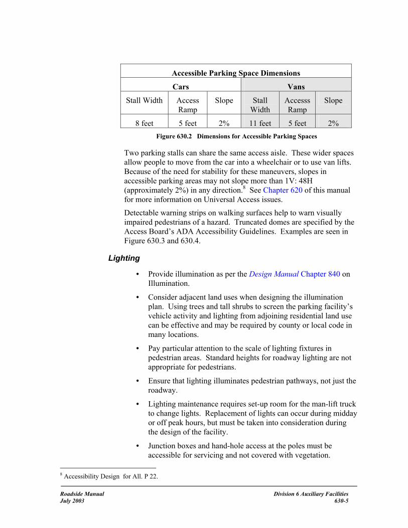
Accessible Parking Space Dimensions
Cars Vans
Stall Width Access Ramp
Slope Stall Width
Accesss Ramp
Slope
8 feet 5 feet 2% 11 feet 5 feet 2% Figure 630.2 Dimensions for Accessible Parking Spaces
Two parking stalls can share the same access aisle. These wider spaces allow people to move from the car into a wheelchair or to use van lifts. Because of the need for stability for these maneuvers, slopes in accessible parking areas may not slope more than 1V: 48H (approximately 2%) in any direction.8 See Chapter 620 of this manual for more information on Universal Access issues.
Detectable warning strips on walking surfaces help to warn visually impaired pedestrians of a hazard. Truncated domes are specified by the Access Board’s ADA Accessibility Guidelines. Examples are seen in Figure 630.3 and 630.4.
Lighting
• Provide illumination as per the Design Manual Chapter 840 on Illumination.
• Consider adjacent land uses when designing the illumination plan. Using trees and tall shrubs to screen the parking facility’s vehicle activity and lighting from adjoining residential land use can be effective and may be required by county or local code in many locations.
• Pay particular attention to the scale of lighting fixtures in pedestrian areas. Standard heights for roadway lighting are not appropriate for pedestrians.
• Ensure that lighting illuminates pedestrian pathways, not just the roadway.
• Lighting maintenance requires set-up room for the man-lift truck to change lights. Replacement of lights can occur during midday or off peak hours, but must be taken into consideration during the design of the facility.
• Junction boxes and hand-hole access at the poles must be accessible for servicing and not covered with vegetation.
8 Accessibility Design for All. P 22.
Roadside Manual Division 6 Auxiliary Facilities July 2003 630-5
Pedestrian Circulation
See the Design Manual, Chapter 1025 on Pedestrian Design Considerations and the MUTCD (http://mutcd.fhwa.dot.gov) for pavement markings and signing.
Clear separation of pedestrian and vehicle circulation will increase safety in parking facilities. Once people leave their vehicles, lines of approach to the bus stop or toilets should be obvious. People will take the shortest, most direct route to their destination.
For park and ride lots, aisle lengths should not exceed 400 feet if possible.9
Minimize pedestrian crossings in front of moving vehicles. When this is necessary, especially in safety rest areas, provide cues to the drivers before pedestrian crossings. Cues can include items such as:
• signing
• painted crosswalks
• rumble strips in advance of a stopping or slowing condition
• speed bumps
• raised crosswalks
• embedded lights in pavement
Parking areas may require more aggressive delineation than typical roadway applications to indicate pedestrian paths and vehicular channelization. Using planting islands to direct pedestrian and vehicular traffic can be effective.
Vehicular Circulation
Separate vehicle circulation from pedestrian circulation as much as possible.
In two-way vehicular circulation patterns, minimize left hand turns when entering the lot to minimize traffic delays.
The most desirable direction for internal circulation within the parking area is clockwise. This is because it follows the normal pattern of driving to the right.
Locate the vehicle entrance and exit far from the major pedestrian circulation area. For example, locate the entrances as far from the bus stop as possible.
9 AASHTO. Guide for the Design of High Occupancy Vehicle and Public Transfer Facilities. 1983. p. 24.
Roadside Manual Division 6 Auxiliary Facilities July 2003 630-6

In large multi-aisle parking lots, consider two-lane vehicular cross aisles to facilitate circulation. These cross aisles can be located when each row exceeds 25 stalls.
Allow enough length and slope on driveways to provide access for large vehicles (such as trucks, busses, and motor homes) so that the back bumpers do not drag on curb cuts. See the Road Approaches chapter in the Design Manual.
Circulation within the parking lot should be clearly indicated by planting beds or islands and differences in paving patterns. Excessive use of pavement markings is difficult to maintain.
For small parking lots with uncontrolled or stop-controlled driveway intersections on one-way streets, it is desirable to utilize separate entry and exit points to avoid left-turn conflicts with outbound traffic. The inbound lane can be on one side of the lot and the outbound on the other, or the lanes can be separated by a wide divider.
Transit Movement
Separate bus loading and unloading areas from auto and pedestrian travel ways.
Provide covered, enclosed areas for pedestrians to wait for buses.
At transit stops truncated domes are required10 at loading areas. Figures 630.3 and 630.4 show views of truncated domes.
Figure 630.3 Truncated Domes under construction at transit stop
10 Design Manual, chapter 1025 and Standard Plans.
Roadside Manual Division 6 Auxiliary Facilities July 2003 630-7
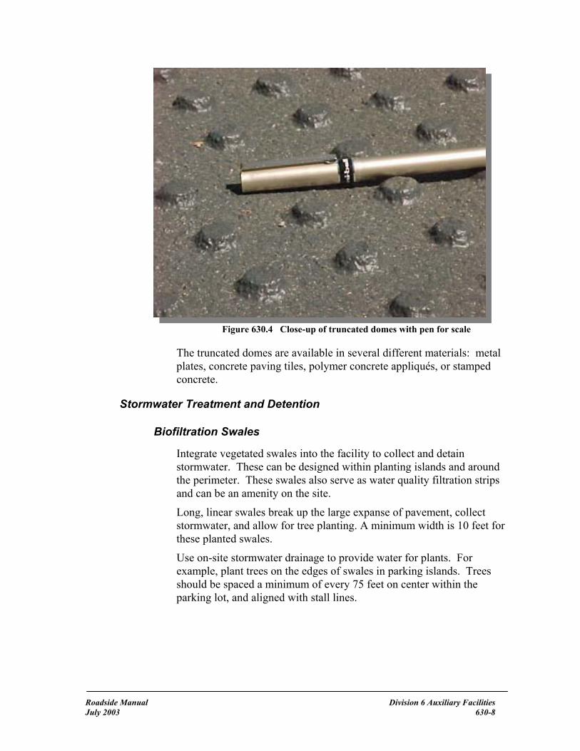
Figure 630.4 Close-up of truncated domes with pen for scale
The truncated domes are available in several different materials: metal plates, concrete paving tiles, polymer concrete appliqués, or stamped concrete.
Stormwater Treatment and Detention
Biofiltration Swales
Integrate vegetated swales into the facility to collect and detain stormwater. These can be designed within planting islands and around the perimeter. These swales also serve as water quality filtration strips and can be an amenity on the site.
Long, linear swales break up the large expanse of pavement, collect stormwater, and allow for tree planting. A minimum width is 10 feet for these planted swales.
Use on-site stormwater drainage to provide water for plants. For example, plant trees on the edges of swales in parking islands. Trees should be spaced a minimum of every 75 feet on center within the parking lot, and aligned with stall lines.
Roadside Manual Division 6 Auxiliary Facilities July 2003 630-8
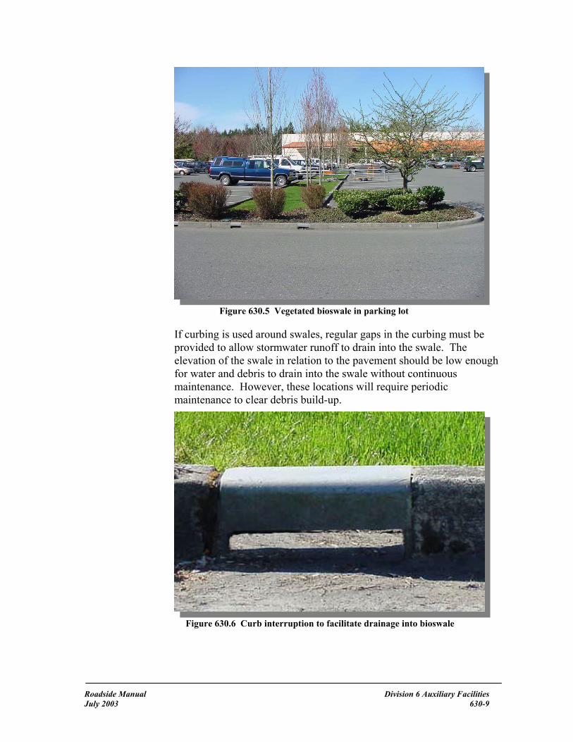
Figure 630.5 Vegetated bioswale in parking lot
If curbing is used around swales, regular gaps in the curbing must be provided to allow stormwater runoff to drain into the swale. The elevation of the swale in relation to the pavement should be low enough for water and debris to drain into the swale without continuous maintenance. However, these locations will require periodic maintenance to clear debris build-up.
Figure 630.6 Curb interruption to facilitate drainage into bioswale
Roadside Manual Division 6 Auxiliary Facilities July 2003 630-9

If curbing is not placed around the swale, stop blocks must be used for each parking space surrounding the swale to prevent vehicles from entering the swale.
Compacted soils resist infiltration of water. Rip soils in planting islands before adding soil amendments and plant materials. These planting islands can require subsurface drainage.
Figure 630.7 Inlet for subsurface drainage
Permeable Pavements
Consider vegetated pervious open grid-type parking stalls to allow infiltration of stormwater. These are most effective for peripheral or overflow parking. Consult with the region, or state Materials, or Hydraulics office to select an appropriate pavement type.
An alternative modular paving system that can support long-term parking is available.
Roadside Manual Division 6 Auxiliary Facilities July 2003 630-10

Figure 630.8 Permeable Paving Systems
These interlocking paving systems can support truck or bus traffic and full-time use. Consider users of the facility since these surfaces can cause problems for some pedestrians, especially when wearing high-heels.
Porous Concrete Pavement
No-fines porous concrete pavement is an emerging technology in our area that has been used in the eastern United States and in Europe for years. Costs are slightly higher (approximately 25% more) than that of conventional Portland cement concrete pavement. However, because porous concrete pavement infiltrates water at 270 to 450 inches per hour per square foot (3-5 gallons per minute per square foot), stormwater detention facilities are usually not needed to mitigate those surfaces, thereby reducing costs for stormwater mitigation.
Figure 630.9 Porous concrete sidewalk cross-section, in Olympia
Roadside Manual Division 6 Auxiliary Facilities July 2003 630-11

Porous concrete pavement uses large aggregate and Portland cement with an additive to slow the rate of evaporation of the mix during placement. The thickness of the pavement is greater than conventional concrete to provide structural stability and is laid over an aggregate subbase. Because of the large pore spaces (15 to 25% of the total volume), porous concrete pavement is more resistant to frost heave than conventional concrete pavement. With regular (4 times per year) vacuuming or blowing to remove fine materials that can clog the pore spaces, these systems can continue to infiltrate stormwater and last as long as conventional concrete pavement systems. Higher installation and maintenance costs might be balanced by savings in stormwater storage and treatment costs.
The large pore spaces may cause problems with people in spiked heels, or people with pointed-tip canes. For this reason the use of this system may be more appropriate on outlying areas.
Regional water quality engineers can provide assistance in calculating water storage and infiltration needs with porous concrete systems.
Because these systems infiltrate water at high rates, they are not appropriate where pollutants, such as fluid drips are likely to occur and where ground water tables are close to the surface. See the region water quality engineer for appropriate locations.
Information on pavements can be found at: http://www.wsdot.wa.gov/fasc/engineeringpublications/Manuals/Volume1.pdf
Planting Area Design
Tree shading for emissions reduction
While cars sit in the sun, gasoline evaporates from fuel tanks and worn hoses. These evaporated materials are principle components of smog. In 1999, the United States Forest Service and the University of California at Davis completed a pilot study to measure the difference in parking lot microclimate and parked vehicle emissions resulting from the presence or absence of shade tree cover. Results indicate that shade tree cover in parking lots reduces motor-vehicle hydrocarbon and nitrogen oxide emissions from cars parked in those lots.
In this study, conducted in Sacramento California, interior vehicle temperatures averaged 45ºF cooler in the tree-shaded vehicle when compared with temperatures inside unshaded vehicles. Increasing parking lot canopy cover from 8% to 50% would reduce total vehicle-generated hydrocarbon emissions by two percent and nitrogen oxide emissions by just under 1% in similar climates. In addition, this study noted that there
Roadside Manual Division 6 Auxiliary Facilities July 2003 630-12

was a user preference for shaded parking spaces. 11 (Shade also extends the life of asphalt pavement.)
Trees in parking areas provide shade, visually reduce the impact of large pavement areas, and reduce heat gain.
• Use perimeter trees and shrubs to screen the parking area from nearby residential uses, while allowing for visibility by security personnel.
Figure 630.10 Use of berms and vegetation to screen parking from residential area
• Design for a minimum of 50% canopy cover over parking areas.
• Select tree species that do not drip pitch or attract aphids.
• Where trees are planted near a bus route, or bus parking, limb up trees to eight (8) feet above the ground.
• Use planting areas to divide paved surfaces into smaller, more defined parking areas.
• Consider end islands to delineate aisles and intersections and to protect the end vehicles. End islands should have raised curbs.
11 Klaus I. Scott, James R. Simpson, and E. Gregory McPherson. “Effects of Tree Cover on Parking Lot Microclimate and Vehicle Emissions. Journal of Arboriculture 25(3): May 1999. pp. 129-142. http://wcufre.ucdavis.edu/research/air.html
Roadside Manual Division 6 Auxiliary Facilities July 2003 630-13

Figure 630.11 Raised curbs around end island
• An alternative to planting in linear parking islands is the design of large concentrated planting islands within parking lots. This can allow plant communities to establish in these islands. They can also be stormwater infiltration areas.
• Keep landscaping as low-maintenance as reasonably possible.
Figure 630.12 Large, concentrated planting island
• In high snow load areas, end islands may cause difficulties with snow removal. In these areas, large central planting islands may be more appropriate. Consider snow storage needs and adjacent vegetation in high snow load areas.
Roadside Manual Division 6 Auxiliary Facilities July 2003 630-14

• In arid climates, irrigation may be necessary for plant survival. These areas benefit most from tree shading of parking stalls in the summer due to higher temperatures.
• Consider the use of structural soils12 under paved surfaces to allow root penetration without damage to the pavement and to retain parking spaces while increasing soil volume for trees in parking islands. This will benefit both the tree and long-term maintenance of the parking lot. Additional information can be found at: http://www.hort.cornell.edu/department/faculty/bassuk/uhi/pubs.html
• Interior planting islands should have drainage provided and depth to allow tree root growth at least 3 feet deeper than paving grade.
• Plant trees to align with the parking stall lines to prevent their damage by car bumpers, as shown in Figure 630.13 and 630.14.
Plant trees aligned with parking stalllines to avoid damage from cars.
Figure 630.13 Locating trees in line with stall lines
12 See chapter 700 in this manual for a description of this mix.
Roadside Manual Division 6 Auxiliary Facilities July 2003 630-15

Figure 630.14 Align trees with parking stall lines to minimize bumper damage to trees
Stall Layout and Size
Good parking area design is easy to understand and convenient for the user and it uses the site efficiently.
• Provide wider stalls for short-term users (turnover of five or more cars per day), and narrower stalls for long-term users (turnover of one or two cars per day).
• Provide 10 feet wide stall widths in safety rest areas. Stall widths of 9 ft may be justified if 60 degree angle parking is used.
• Provide a minimum of 8.5 feet wide stalls in park and ride lots. Wider stalls are easier to park in and exit from.
• Efficient layouts provide parking around the periphery of the site and orient the stalls to the longest dimension of the site.
The large AASHTO design passenger car has the following dimensions:
Roadside Manual Division 6 Auxiliary Facilities July 2003 630-16

19'-0"
7'-0"
AASHTO Passenger Car A large number of sport utility vehicles (SUVs) and trucks on the road have these dimensions.
Orientation of Aisles to Destination
Aligning the parking stalls perpendicular to the focus of a facility allows pedestrians to reach their goal without having to cut between parked cars, cross vehicular traffic, or cut across stormwater swales. This is shown in Figure 630.15.
Destination
Figure 630.15 Aisles oriented perpendicular to destination – note bumper overhang
Car bumpers overhang tire stops and curbs. Consideration must be made in the design of sidewalks and planting areas for this overhang.
Roadside Manual Division 6 Auxiliary Facilities July 2003 630-17

Vehicular overhang ~ Varies with car manufacturer(Use 3 feet for most extreme case)5'-0" wide minimum
walking area
8'-0" minimum sidewalk width
Concrete curb and gutter
Figure 16 Car bumper overhang
Parking Angle
The decision to use angle or perpendicular parking should consider all factors. Some considerations are listed below:
Angle Parking (most often 60 degrees)
• One-way aisles are used.
• Most drivers find angled-in parking easier to use.
• It is appropriate for short stays with high turnover, such as those in safety rest areas.
• Angled parking generally takes more space than perpendicular parking.
• Angled parking has been used successfully in oddly dimensioned sites to achieve layout efficiency.
• Planting areas are easier to provide.
Figure 630.17 shows the minimum aisle width and turning radius needed for angled parking.
Roadside Manual Division 6 Auxiliary Facilities July 2003 630-18

18 F
t Wid
eAi
sle
Figure 630.17 Angled Parking
Perpendicular Parking (90 degree)
• Perpendicular parking requires less knowledge of the circulation pattern because two-way aisles are used.
• Wider aisle widths are necessary to allow for two-way traffic and to allow drivers to pass a waiting vehicle.
• A slightly higher number of stalls can be accommodated in a rectangular lot when compared to angle parking layouts.
Figure 630.18 shows the wider aisles and necessary turning radius needed when parking and perpendicular stalls and the minimum aisle width.
Roadside Manual Division 6 Auxiliary Facilities July 2003 630-19

24 F
t Wid
eAi
sle
Figure 630.18 Perpendicular parking
Figure 630.19 shows a comparison between angle and perpendicular parking stalls.
Roadside Manual Division 6 Auxiliary Facilities July 2003 630-20

16 Parking Stalls in 92 Ft
18 Parking Stalls in 90 Ft
21'-6
"St
all D
epth
21'-6
"St
all D
epth
21'-6
"St
all D
epth
21'-6
"St
all D
epth
PlantingArea
PlantingArea
Figure 630.19 Comparison between dimensions in angle and perpendicular parking layout
Note that as stall width decreases, aisle width increases. Perpendicular parking is more difficult when aisle widths are not wide enough.
Driver and pedestrian safety and the flow of traffic must be considered when determining the number of spaces in a parking lot. Efficiency and convenience must be in balance.
Other stall angles are used less commonly. For example, a 45-degree angle can provide stall space in a narrow lot because stall-to-curb dimensions and aisle widths decrease with angle of stall.
Roadside Manual Division 6 Auxiliary Facilities July 2003 630-21

Motorcycle and Bicycle Parking
Motorcycle Parking
Provide for motorcycle parking. A good place for this is at the end of rows where insufficient room remains for a full car width. Mark motorcycle stalls individually, as with car stalls, and mark clearly for “Motorcycle Parking Only” to prevent cars from occupying an area that may be big enough for several motorcycles. Generally, it is appropriate to include one motorcycle stall for every 100 car stalls. Motorcycle stalls should be at least 4’-9” wide and 9’-0” long at a 60 degree angle.
Consider providing racks to secure motorcycles for long-term parking areas. Embed these racks in concrete and use steel tubing or reinforced concrete. Placing high-tensile strength wire cable (1/3” diameter) loosely inside the steel tubing and securing each end can provide additional security since, as it moves within the tube, it is difficult to cut with a hacksaw. A preservative wax or grease can also be used to coat the wire cable to allow it to move more freely within the tube. Place the attachment area a minimum of 1 foot above the ground. To address theft and safety concerns due to the higher exposure of motorcycles and their users, it is desirable to provide adequate lighting at the location of the racks.
Bicycle Parking
Provide bicycle racks and/or storage units near the pedestrian waiting areas in park and ride lots. Storage units are preferable to racks to keep bicycles out of the weather and provide extra security. Some municipalities rent the storage units for a nominal fee to help pay for the extra cost. Maintenance of these units must be included in budget provisions. The designer should coordinate with the agency that will maintain the park and ride facility.
Locate the bicycle racks so they are accessible to bicyclists without conflicting with major pedestrian or vehicular paths of travel. For areas with high bicycle use, some separation between bicycle racks is desirable to prevent concentration of all users at one point.
Consider bicycle use at safety rest areas and viewpoints where bicycles are permitted, and provide racks as appropriate.
Bicycle racks should support the frame of the bike, allow at least one wheel to be locked to the frame, allow the use of different kinds of bicycle locks, and be durable and easy to use. To address theft and safety concerns due to the higher exposure of bicycles and their users, it is desirable to provide adequate lighting at the location of the racks.
Roadside Manual Division 6 Auxiliary Facilities July 2003 630-22

See the Bicycle Facilities chapter of the Design Manual for further information.
Construction When constructing parking facilities, avoid compaction of soil within planting strips. This can alleviate the need to rip the soil before planting. Avoid impacts to plants that will remain after construction. See Chapter 800 of this manual for more information on mitigating impacts to vegetation.
Maintenance Adequate funding for maintenance must be provided to maintain public safety. Clean facilities provide the perception of safety and discourage vandalism. Immediate removal of graffiti and litter removal are necessary.
Consult Maintenance personnel during the design phase of any parking facility to determine their concerns and respond to their suggestions.
Additional Sources of Information Linda S. Glisson, ed. The Parking Handbook for Small Communities. National Mainstreet Center: Washington D.C. 1994.
http://www.epa.gov/owow/nps/bioretention.pdf Information on design of planting islands within parking areas.
Roadside Manual Division 6 Auxiliary Facilities July 2003 630-23


700 Soil and Soil Amendments
General With increased focus on stormwater in Washington and new understanding of the role of soils in the mitigation of water quality and quantity, engineered soil and soil amendments have become an important stormwater Best Management Practice (BMP). Topsoil is a biologically active system of minerals, organic matter, air, water, and microorganisms that can take thousands of years to develop. Topsoil nourishes and provides structural support for plant roots and absorbs and cleans water. This chapter focuses on for the use of soil and compost for roadside projects.
Much of the roadside environment is reduced to subsoil at the surface following a typical roadway construction project. Subsoil has little or no organic matter, few pore spaces, and few microorganisms. While the mineral component of soil provides structural support for roads and bridges, climax vegetation cannot grow in this environment, thus we see nitrogen fixing pioneer species like red alder, and exotic plants including Scotch broom and Himalaya blackberry, colonizing construction sites. The resulting community of native and exotic, invasive plants can require costly maintenance and time consuming management. The job of reconstructing a functioning soil community is difficult and costly, and might not be achievable in some areas.
It is necessary to have healthy soil to revegetate a site. Revegetation is necessary to provide slope stabilization, erosion control, biofiltration and infiltration for water quality, screening, local climate modification, habitat, and so forth. Revegetation might also be necessary to meet permit or environmental requirements. As a result, healthy topsoil is an important component of a construction project.
Plant life and water absorption capability require similar soil conditions: loose, friable soil with the right balance of organic matter, microorganisms, and minerals. In contrast, roadway construction requires highly compacted soils with low organic matter content for stability. WSDOT requires that soils for road foundations are compacted to 95% density. Plants require that soils have a density of less than 80%. This density complication poses a challenge in all phases of roadside revegetation management.
Roadside Manual Chapter 700 - Soil and Soil Amendments July 2003 700-1

References
Highway Runoff Manual, M 31-16
Revisions to Highway Runoff Manual: http://wwwi.wsdot.wa.gov/eesc/environmental/Stormwater/HRMRevision.htm
Construction Manual, M 41-01
Design Manual, M 22-01
Roadside Classification Plan, M 25-31
Standard Specifications for Road, Bridge and Municipal Construction, M 41-10
Resources
The region’s Landscape Architect
The region’s Environmental Office
Headquarters Maintenance & Operations Program (HQ M&OP) Materials Lab
HQ Design Office Roadside and Site Development Unit
Definitions
biosolids Treated wastewater residuals or solids used as a soil amendment. clay Mineral soil particles with a diameter of less than 0.002 millimeter. A fine-grained soil that has a high plasticity index in relation to liquid limits.1
climax vegetation Relatively stable vegetation in equilibrium with its environment and with good reproduction of the dominant plants.2 compost Stable, mature, decomposed organic solid waste that is the result of the accelerated, aerobic biodegradation and stabilization under controlled conditions. The result has a uniform, dark, soil-like appearance.
humus Decomposed organic matter that remains once visible plant structure can no longer be determined.
leaching The removal of materials (CaCO3, MgCO3, and other more soluble materials) in solution from the soil.
1 Donahue, Roy L., John C. Shickluna, and Lynn S. Robertson, Soils: An Introduction to Soils and Plant Growth, Prentice-Hall, Inc., Englewood Cliffs, New Jersey, 1971, p. 509. 2 Ibid, p. 510.
Roadside Manual Chapter 700 - Soil and Soil Amendments July 2003 700-2

loam A soil texture class that contains 7 to 27 percent clay, 28 to 50 percent silt, and less than 52 percent sand.3 microorganisms Forms of life that are either too small to be seen with the unaided eye, or are barely discernible.4
mottling Soils irregularly marked with spots of color. The presence of orange mottling usually indicates soils that have been though periods of saturation interspersed with periods where the soil had dried out. pioneer species Fast growing plants that are quick to establish on poor soils. Nodules on their roots fix nitrogen giving them a competitive edge in disturbed soil environments. pore space Total space not occupied by soil particles in a bulk volume of soil, commonly expressed as a percentage.5 ripping Deep scarification using specialized equipment, usually done on compacted soils to increase pore space and improve soil structure for plant growth and infiltration of surface water. sand A mineral soil particle between 0.05 and 2.0 mm in diameter. A soil textural class.6 silt A mineral soil separate consisting of particles of 0.002 and 0.05 mm in diameter. A soil textural class.7 soil The unconsolidated mineral and organic matter on the surface of the earth that has been subjected to and influenced by genetic and environmental factors of parent material, climate (including moisture and temperature effects), macro and microorganisms, and topography, all acting over a period of time and producing a product – soil – that differs from the material from which it is derived in many physical, chemical, biological, and morphological properties and characteristics.8 soil horizons Layers of soil approximately parallel to the land’s surface and differing from underlying or overlying layers in physical, chemical, and biological properties or characteristics, such as color, structure, texture, consistency, amount of organic matter, and degree of acidity or alkalinity.9. The “O Horizon” is the organic layer. The “A Horizon” is a mineral layer forming at or adjacent to the surface, in which humus is accumulated. The “B Horizon” is a mineral layer comprised of fine grained soils that have been leached.
3 Ibid, p. 536. 4 Ibid, p. 538. 5 Ibid, p. 546. 6Donahue, et al., p. 550. 7 Ibid, p. 552. 8 Ibid, p. 553. 9 Ibid, p. 558.
Roadside Manual Chapter 700 - Soil and Soil Amendments July 2003 700-3

O Horizon
A Horizon
B Horizon
Figure 700.1 Soil Horizons
soil organic matter The fraction of the soil that includes plant and animal residues at various stages of decomposition, cells and tissues of soil organisms, and substances synthesized by soil organisms.10 soil structure The combination or arrangement of primary soil particles into secondary particles or units. The secondary units are characterized and classified on the basis of size, shape, and degree of distinctness into classes, types, and grades respectively. Examples are: platy, prismatic, columnar, blocky, granular, and crumb.11
subsoil The soil layers below the A Horizon that contain little or no organic matter.
tilth The physical condition of soil as related to its ease of tillage, fitness as a seedbed, and ease of seedling emergence and root penetration.12 topsoil The original or present, dark-colored (A Horizon), upper soil that ranges from a few millimeters to a meter thick at different locations.13
unsuitable soils Generally organic soils that are not appropriate for engineering functions. These soils might be ideal for roadside restoration and revegetation functions.
10 Ibid, p. 561. 11 Ibid, p. 561. 12 Ibid, p. 570. 13 Ibid, p. 570.
Roadside Manual Chapter 700 - Soil and Soil Amendments July 2003 700-4

Structure and Disturbance The ideal soil for most plants is approximately 50% solid and 50% pore space. The solid component contains minerals and organic matter. Ideally, pore space contains roughly equal parts of air and water. Microorganisms (such as fungi) or invertebrates (such as earthworms) are present in a healthy soil and function to process organic matter, recycle nutrients, and nurture plants.
Any disturbance to the soil alters and influences this complex system. Disturbances include construction, fertilizer and pesticide application, soil compaction from foot traffic and equipment use, and altering hydrological patterns through irrigation, grade changes, and stormwater retention. In other words, any management activity on the roadside is a potential disturbance to the soil system. In areas where plant cover is desirable, roadside management activities are selected and timed to minimize harmful disturbances to the soil, and are focused on long-term soil health.
Soil preservation and preparation are necessary to support goals of the Roadside Classification Plan (RCP).
The following table lists recommended practices for dealing with soils along the roadside.
During the project definition process, determine how and to what extent soils will be affected. Document in the Design File.
Minimize the extent of disturbance activities to minimize impacts to soil outside the project’s construction limits.
Before beginning any earthwork that includes disruption of the soil, note whether the soils in this area are part of a fill slope comprising the roadway prism. If so, work with the Regional Materials Engineer.
Mitigate construction-related soil compaction in vegetation restoration areas.
Stockpile and reuse native soils where practical.
Minimize erosion potential and weed species invasion by establishing a healthy plant cover.
Maintain roadside management zones 2 and 3 to stabilize and improve soil tilth and fertility.
Figure 700.2 Summary of Recommended Practices
Roadside Manual Chapter 700 - Soil and Soil Amendments July 2003 700-5

Soil Amendments The decision to use a soil amendment depends upon the existing soil and the desired outcome. Some soil amendments might encourage unwanted exotic vegetation, while the combination of other soil amendments with native soils might favor native vegetation. Check with the region Landscape Architecture Office or the HQ Design Office Roadside & Site Development Unit for recommendations.
Topsoil
Topsoil can be an amendment when only subsoil remains on a site. Commercial topsoil generally consists of mineral soils mechanically combined with organic matter. See the Standard Specifications Division 9 for working descriptions of topsoil.
Remove, stockpile, and replace existing topsoil when appropriate. Existing topsoil can have necessary nutrients, organic matter, and microorganisms. The use of existing topsoil onsite can reduce the costs of disposing of excess excavated material. An examination of the site with an inventory of existing vegetation is necessary prior to determining when to use existing topsoil. Stockpiling of topsoil might not be advisable when noxious weeds and their seeds are present. Consult the Landscape Architect for assistance.
Imported topsoil can be used to provide a medium for plant growth when native soil has been removed or is highly disturbed.
Compost
Compost is highly decomposed organic matter that is used to add nutrients and improve soil structure for plant growth. Acceptable compost products originate a minimum of 65 percent by volume from recycled plant waste. A maximum of 35 percent by volume of other approved organic waste and/or biosolids may be substituted for recycled plant waste. Compost should have a Carbon to Nitrogen ratio (C:N) of approximately 30:1.
Bark or Wood Chip Mulch
Mulch shall be bark or wood chip fiber as described in the Standard Specifications Division 9. Mulch is used on top of soil and around plants to moderate soil temperature, retain soil moisture, provide a base for desirable fungal colonization, and inhibit weed growth.
Fertilizer
Commercial fertilizers are labeled to document the content’s ratio of Nitrogen (N), Phosphorus (P), and Potassium (K) (Usually listed in
Roadside Manual Chapter 700 - Soil and Soil Amendments July 2003 700-6

order: N-P-K). These are the three main elements associated with plant growth and health. Generally, nitrogen encourages green top growth, while phosphorus and potassium encourage root growth. Fertilizer is applied in various combinations (for example, 20-20-20 or 10-15-5), as determined to be necessary by the results of a soil analysis.
Mycorrhizae
Mycorrhizae are a group of fibrous fungi existing naturally in topsoils that engulf soil particles and pore spaces to absorb water and nutrients in solution and transfer this solution to the roots of plants. In effect, they multiply the plants’ root systems many times.
Additional benefits from mycorrhizae may include plant species diversity and improved soil structure. The mycorrhizae applied depend on the species of plant. Check with the Horticulturist or Landscape Architect for assistance.
Structural Soils The Urban Horticulture Institute at Cornell University has developed a cost effective structural soil mix that can improve the survivability of street trees in urban environments. This mix might be useful in selected WSDOT projects. The mix is:
• 80% angular stones ¾ to 1 ¼ inch in diameter
• 20% topsoil with organic matter content of 10%
• Soil stabilizer per the manufacturer’s specifications
• Potable water – enough to cause soil to coat the stones without having water run off
The angular stones form a skeleton that provides the weight-holding capability for the mix. Specialized compaction tests are not needed with this mix. The water storing polymers bind the stones together and stabilize the soil mix. In addition, this structural soil mix leaves a large volume of rooting space that allows the plants to get oxygen and water. See the Regional or HQ Design Office Landscape Architects for more information.
More information can be found at: http://www.urban-forestry.com/citytrees/v36n3a12.html
Roadside Manual Chapter 700 - Soil and Soil Amendments July 2003 700-7

Planning During the planning process designers and engineers are to consider the following:
• Impacts the proposed construction will have on existing soils.
• Treatment needed to provide adequate soils for restoration of roadside character
Procedures
Determine the extent soils will be impacted. This analysis is performed at the earliest phase of the project. This knowledge will be used to complement design and construction. Consider:
• How the proposed project will affect the existing soil.
• Existing soil compaction and compaction ratios resulting from construction activities.
• Measures to mitigate overly compacted soils, such as ripping the soil.
• Expected treatment levels and soil preparation to accomplish those levels; for example, soil amendments and mulch.
Design Activities during the design phase include:
• Soil preservation — plan to stockpile and redistribute existing topsoil within the contract’s order of work.
• Site analysis. Prepare a plant inventory to document predevelopment conditions.
• Consult with the Landscape Architect prior to considering stockpiling topsoil.
• Cost savings can be realized by using soils unsuitable for engineering uses (those with high organic content) on roadside projects.
• Determine where to stockpile soil on site.
• Determination of the extent of cut and fill slopes and clearing and grubbing limits.
• Soil analysis (type, compaction, and fertility).
• Specifying topsoil and amendments.
• Matching proposed vegetation with the soil, climate, hydrology,
Roadside Manual Chapter 700 - Soil and Soil Amendments July 2003 700-8

and anticipated maintenance levels.
The challenge to the roadside designer is to specify the appropriate soil preparation for planting, to prevent soil erosion, and to achieve desired soil structure. Appropriate soil preparation, including possible amendments, is crucial for the success of desirable roadside revegetation.
Procedures
Site Analysis
• Examine proposed planting areas for any apparent drainage problems. Note any underlying characteristics that might affect drainage (hardpan, compacted subsoil, clay layers, and so forth.). Plan to correct deficiencies or plant appropriate species.
• Analyze soil for susceptibility to erosion from stormwater runoff.
• Determine solar exposure of slopes (slope aspect) and its effect on soil and vegetation.
• Conduct a plant inventory or a germination test to determine seed bank to decide if topsoil stockpiling is practical.
Soil Testing
Perform a soil test to determine nutrient content and pH of soil.
• Obtain a soil sample bag or a plastic bag capable of holding approximately one quart of soil
• Select a representative area for your sample. If the soil seems to vary in color and composition within the project area, sample those soils also.
• Dig a hole 300 to 460 mm (12 to 18 inches) deep and set the material to the side. Scrape off a small amount of material from the top to the bottom of the side of the hole and place into plastic bag. Do not include any material taken from the hole initially. Refill the hole with the set aside material.
• Locate the test pit on the site map. If more than one sample is taken from the site, number the test pits to correspond with the samples taken.
Roadside Manual Chapter 700 - Soil and Soil Amendments July 2003 700-9

• Seal the bag tightly and place in a manila envelope and write all the information on the paper surface: your name, date of sampling, site location, and sample identification (such as test pit #1).
• Fill out Soil Test Form and include it with your sample.
• Box or wrap sample for mailing.
• Send the soil sample to a soil chemistry lab listed below.
• Consult with the Landscape Architect for specific amendment recommendations when you get test results, if necessary.
Soil testing laboratories for soil chemical properties (call laboratories for forms and pricing information):
A & L Western Agricultural Laboratories 10220 SW Nimbus Ave., Bldg K-9 Portland, OR 97223 Phone: 503-968-9225
Black Laboratories 503 N. Gardner Rd. Burlington WA 98233 Phone: 360-757-6112
Harris Laboratories, Inc. 621 Rose Street, Box 80837 Lincoln, NE 68501 402-476-2811
Northwest Agricultural Consultants 2545 West Falls Kennewick, WA 99336 Phone: 509-783-7450
Soil and Plant Laboratory, Inc. PO Box 1648 Bellevue, WA 98009-1648 Phone: 425-746-6665
The WSDOT Materials Laboratory does soil testing for engineering properties such as soil strength and gradation. The Regional Materials Engineer can help with soils engineering and related testing.
Roadside Manual Chapter 700 - Soil and Soil Amendments July 2003 700-10

Compaction
Appropriate soil treatment is crucial for the success of roadside restoration (including erosion prevention seeding). Analyze the soil for compaction. Pay close attention to areas that have been, or will be, staging areas. These areas will have to be ripped to restore pore spaces between the soil particles. Rip compacted soils, ideally in two directions, to a minimum depth of 460 mm (18 inches) before planting. The roots of most plants are above this depth.
Specify in all contracts that the contractor has the responsibility to restore the soil to a less than 80% density in all staging areas. Higher compaction rates are allowed in areas that are critical for road or structure stability. Include the costs of these procedures as part of the contract. The contract cannot be closed until this step is completed.
Soil compaction can be tested using the bulk density test. Test the soil to a depth of 0.6 m (2 feet). If the density is greater than 80%, take steps to break up the compacted soil. Contact the regional Materials Engineer for assistance.
Clearing and Grubbing
Set clearing and grubbing limits to minimize soil disturbance.
In some areas grubbing is unnecessary. Stumps and root systems may be left in the soil to provide stability. Decomposition of trees varies in time depending upon species and climate. Their decomposition, however, will provide nutrients, organic matter, and habitat for microorganisms.
Plans, Specifications, and Estimate (PS&E)
• Specify soil amendments to achieve revegetation and restoration requirements.
• Specify wide-track construction equipment in contract documents when it is necessary to work in wet soils.
• Where practical, strip topsoil and stockpile for redistribution after completion of rough grading. This is the best source of native seeds but it is also a source of exotic invasive vegetation and noxious weeds. (The plant inventory and germination test performed during the site analysis determine what plants are growing in the soil.)
• Assess the entire project for other places to use removed topsoil. Restoration sites are practical locations to place excess topsoil.
Roadside Manual Chapter 700 - Soil and Soil Amendments July 2003 700-11

Soil Treatment to Enhance Native Plant Growth
To encourage native woody plant species, the following technique can be employed. Incorporate 3 inches of Compost Type 2 into the top 12 inches of soil. Place 3 inches of bark or wood chip mulch on the surface. Plant through these layers. This is shown in Figure 700.3.
Figure 700.3 Amendments to encourage native woody plants
Construction The challenge to the Project Manager and the Construction Office is to avoid or minimize damage to the soils resulting from construction activities. Mitigate unavoidable damage to the soil before planting.
Procedures
The following procedures will minimize impacts to topsoil during construction:
• Set limits of work areas for vehicles and equipment to minimize and prevent excessive soil compaction. Use flagging and fencing in conjunction with signs to define work areas.
• Minimize compaction during construction. Avoid heavy machinery use on saturated soil.
• Use wide-track construction equipment.
• Cover staging areas with a 150 mm (6 inch) layer of wood chip mulch to reduce compaction.
Roadside Manual Chapter 700 - Soil and Soil Amendments July 2003 700-12

• Before specifying or beginning earthwork that includes scarifying the soil, note and document the soils’ structural function and performance. This is particularly critical on fill slopes where the soil is compacted to comprise the highway prism.
• Mitigate construction-related soil compaction in vegetation restoration areas by ripping the soil to loosen its structure.
• When stockpiling topsoil, mound soil no higher than 1.3 m (4 feet) high for less than 1 year. Cover to prevent soil erosion and contamination by weeds.
• Use only well composted soil amendments and incorporate them as specified.
• Avoid walking, operating equipment or driving vehicles on planting areas after soil preparation is complete.
• Minimize erosion potential by establishing a healthy plant cover.
Maintenance Maintenance activities can greatly affect soil structure in a positive or negative way. A solid plant cover is the best defense against erosion and invasive species. Routine maintenance activities can help build the soil to support vigorous plant growth.
Procedures
• Plants suffer from nutrient deficiencies in the soil. Contact the Landscape Architect for recommendations before amending soil. The Landscape Architect can provide information on appropriate fertilizers or soil amendments.
• Allow organic matter to remain on the ground where it will not jeopardize safety or visual quality. Logs and brushpiles enrich the soil and provide habitat while decomposing. Such decomposition can reduce the need for additional fertilization or soil amendments and reduce maintenance expenditures.
• Fresh wood chips can use up available nitrogen and affect plant growth. To avoid this problem, spread wood chips thinly over a large area or add nitrogen to aid in decomposition.
• Avoid driving vehicles or operating equipment on saturated soil and in vegetated areas.
• Reseed, cover, or mulch bare soils as soon as possible when they have been exposed by maintenance activities or errant vehicles.
Roadside Manual Chapter 700 - Soil and Soil Amendments July 2003 700-13


710 Erosion Prevention and Sediment Control
General Erosion is a natural process that can be greatly accelerated by human activities, especially those that change or remove vegetation or that disturb the soil. In addition to human activities, fire and animal activities can also accelerate erosion. Soil is composed of mineral and organic matter and takes thousands of years to develop. The U. S. is losing topsoil seventeen times faster than it develops1. All construction activities have the potential to cause soil erosion. Therefore, erosion prevention and sediment control are components of any project that disturbs vegetation or soil horizons. Erosion prevention will reduce both the need for costly sediment controls and the risk of environmental damage.
Federal, state, and local water quality regulations prohibit the discharge of turbid water from construction activities into adjacent water bodies and require WSDOT to use approved Best Management Practices (BMPs). The water quality and stormwater BMPs can be found in the Highway Runoff Manual and the Standard Specifications for Road, Bridge and Municipal Construction 2002.
All highway construction projects and any activities involving earthwork require a Temporary Erosion and Sediment Control (TESC) Plan and may require a Stormwater Site Plan (SSP).
Adding any new impervious surface can require that an SSP be included in your project. Check with the regional environmental office and the Highway Runoff Manual for compliance with the applicable regulations. An SSP includes the permanent and temporary stormwater pollution prevention BMPs and includes the TESC Plan. When the project clears vegetation, a NPDES permit might be required. Check with the environmental office to determine area thresholds for permit requirements. The SSP will be used to satisfy the requirements of the NPDES permit. In addition, the SSP will be used to aid acquisition of HPA, Shoreline, and Army Corps of Engineer (ACOE) permits.
References
RCW 90.48.080 -- Discharge of polluting matters in waters prohibited
1 Pimentel, David, “Environment and Economic Costs of Soil Erosion and Conservation Benefits,” Science, 24 February 1995.
Roadside Manual Chapter 710 - Erosion Prevention and Sediment Control July 2003 710-1

WAC 173-201A -- Water quality standards for surface waters of the state of Washington
Highway Runoff Manual, M 31-16, WSDOT
Hydraulics Manual, M 23-03, WSDOT
Standard Specifications for Road, Bridge, and Municipal Construction, M 41-10, WSDOT and APWA.
http://www.wsdot.wa.gov/eesc/environmental/WQTESC.htm
Resources
The region’s Erosion Control Specialist
The region’s Water Quality Unit
The region’s Environmental Staff
The region’s Hydraulics
The region’s Landscape Architect
HQ M&OP Geotechnical Engineers
HQ Environmental Affairs Office
Statewide Erosion Control Coordinator
HQ Design Office Landscape Architect
Definitions
Best Management Practices (BMPs) Physical, structural, and managerial practices that, when used singly or in combination, improve the downstream quality of stormwater and reduce the downstream quantity impacts of stormwater.
bioregion A geographic region based on topography and biological similarities such as watersheds, plant/animal ecosystems, or relative elevations.
check dam A small barrier, such as quarry spalls, sand bags, or silt fencing, that slows water velocity and allows solids to settle out behind the barrier.
wood chip berm A berm with a minimum height of 2 feet constructed to trap sediments on a construction site. Berms must be constructed on contour to distribute treatment along entire berm and prevent blowouts by accumulating water. Once vegetation has been established, berms may be raked and leveled to provide a mulch layer around woody vegetation.
Roadside Manual Chapter 710 - Erosion Prevention and Sediment Control July 2003 710-2

detention facility An above or below ground facility, such as a pond or tank, that temporarily stores stormwater runoff and subsequently releases it at a slower rate than it is collected by the drainage facility. erosion The wearing away of the land surface by running water, wind, ice, or other geological agents, including such processes as gravitational creep; also detachment and movement of soil or rock fragments by human and animal activities.
Erosion Control: Any temporary or permanent BMPs taken to prevent or reduce soil erosion, whether from wind or water.
fascine A tied bundle of plant stems or branches, laid in a trench or a terrace on the contour and staked into position. Used to slow water velocities, trap sediment and establish vegetation. Used on basically stable slopes that have a shallow, unstable surface layer.
hydraulic conveyance system Natural and man made drainage facilities that collect, contain, and provide for the flow of surface and stormwater from the highest elevations down to a receiving water body. The natural elements of the conveyance system include swales, and small drainage courses, streams, rivers, lakes, and wetlands. The man made elements of the conveyance system include gutters, ditches, pipes, channels, and most retention/detention facilities.2
retention The process of collecting and holding surface and stormwater runoff with no surface outflow.
retention/detention facility (R/D) A type of drainage facility designed either to hold water for a considerable length of time and then release it by evaporation, plant transpiration, and/or infiltration into the ground; or to hold surface and stormwater runoff for a short period of time and then release it to the surface and stormwater management system.
Sediment control The trapping of soil particles moved by wind or water. settleable solids (SS) The materials which settle out of suspension within a defined period (typically one hour). It is reported on a volume basis (milliliter per liter, mL/L), but can also be reported on a weight basis (milligrams per liter, mg/L).
steppe A grass covered semi-arid plain, such as those found in Washington east of the Cascade mountain range. Stormwater Site Plan (SSP) A plan and report that documents the BMPs that will be taken during and after project construction to provide temporary erosion and sediment control and permanent stormwater quality and quantity control. The SSP also includes the
2 Highway Runoff Manual, WSDOT
Roadside Manual Chapter 710 - Erosion Prevention and Sediment Control July 2003 710-3

Hydraulics Report, Vegetation Management Plan, Downstream Analysis Report, as well as other reports. The SSP is required by the Washington State Department of Ecology (Ecology) in order to get a NPDES baseline/general permit. In addition, the SSP will be used to aid acquisition of HPA, Shoreline, and ACOE Permits.
tackifier An amendment, resistant to water, which is added to organic material such as mulch to cause it to adhere to adjacent particles and to the soil.
Temporary Erosion and Sediment Control (TESC) Plan A “living” plan that provides for the prevention, interception, and treatment of all potential turbidity and silt-laden runoff that could occur during clearing, grading, construction, and site stabilization. The TESC Plan describes stabilization and structural practices, both of which are implemented to minimize erosion and the transport of sediments.
Total Suspended Solids (TSS) The entire weight of organic and inorganic particles dispersed in a volume of water, expressed in milligrams per liter (mg/L).
turbidity The visual clarity of the water as measured in Nephelometric Turbidity Units (NTUs). The turbidity, or clarity, of surface streams is an important determinant of its condition and productivity. Turbidity in water is caused by suspended and colloidal matter, such as clay, silt, organic and inorganic matter, and microorganisms. Turbidity does not settle out of water in a reasonable time period. The turbidity of drinking water is less than 1 NTU, while the turbidity of stream water can vary from fewer than 10 NTUs to greater than a few hundred NTUs.
water bars Small logs, or concrete barriers, usually less than 15cm in diameter, placed along a trail or slope to intercept the downhill flow of precipitation and direct it to a desired location.
water quality standards The discharge of polluted waters to waters of the state is a violation of the Washington State Water Pollution Control Law (RCW 90.48.080). Ecology establishes surface water quality standards (WAC 173-021A) as required by the Environmental Protection Agency (EPA). These standards are intended to protect surface waters of the state for beneficial uses including: public health, enjoyment, and the propagation and protection of fish, shellfish, and wildlife. State water quality criteria are defined for classifications of waters and include turbidity, fecal coliforms, dissolved oxygen, temperature, and pH. All water discharged from construction sites shall meet the water quality standards for turbidity at the discharge point into the surface water resource. There is not a “dilution” or “mixing zone.”
Roadside Manual Chapter 710 - Erosion Prevention and Sediment Control July 2003 710-4

wattle A length of straw contained in a sausage-shaped netting. These are biodegradable and are generally buried to half their depth along the contour to reduce slope length, slow water velocity, and trap sediment.
Process of Erosion (Water) Raindrop – The impact of raindrops on bare soil displaces soil particles. Over the duration of a storm, significant volumes of sediment are made available to be transported.
Sheet – As rain accumulates a non-concentrated, uniform layer of runoff is formed. This sheet flow transports detached soil from raindrop impacts, as well as plucks off additional soil particles caused by the shear stress of the runoff.
Rill – When sheet flows converge, increased volumes and velocities of water are concentrated. Small, intermittent watercourses with steep sides, known as rills, are formed. They are usually only a few inches deep.
Gully – When rills converge and/or impervious surfaces focus runoff in a single location, a large channel, known as a gully, is formed. Volumes and velocities of water, along with shear stress are increasing dramatically.
Stream Bank - Bank erosion of existing streams/channels is caused by increased peak flows.
Process of Erosion (Wind) As is the case with water erosion, the loss of soil by wind movement involves detachment and transportation processes. The lifting and abrasive action of the wind results in some detachment of tiny soil grains from the granules or clods of which they are a part. When the wind is laden with soil particles, however, its abrasive action is greatly increased. The impact of these rapidly moving grains dislodges other particles from soil clods and aggregates. These dislodged particles are now ready for movement.
Saltation – The most important of the mechanics of wind erosion is saltation, defined by soil particles bouncing short distances. They remain close to the ground, usually no higher than twelve inches. Depending on soil conditions, saltation may account for 50-70% of total erosion.
Surface Creep – Saltation encourages surface creep, which is the rolling and sliding along the surface of larger soil particles. Not only is surface creep initiated by saltation, it is actually prolonged by the ricocheting action of saltating particles. Surface creep may account
Roadside Manual Chapter 710 - Erosion Prevention and Sediment Control July 2003 710-5

for 5-25% of total erosion.
Suspension – Dust particles of fine sand size or smaller are moved parallel and upward to the ground surface. Suspension can reach ten feet to many miles into the sky. Very fine particles are lifted from the surface by impact/saltation and carried high into the air, remaining suspended in air for long distances. Although it is a spectacular and visible method of transporting soil, it may account for only 15% of total erosion.
Factors Affecting Severity of Erosion √ Gravity
√ Soil Type and Texture
√ Precipitation & Climate
√ Storm intensity, storm duration,
√ Vegetation
√ Surface Area
√ Slope Length & Gradient
√ Surface Texture
Vegetation is the single most important element in the prevention and control of erosion from wind and water.
Maintaining or reestablishing vegetation is fundamental in preventing erosion. Eroding sites require stabilization through the use of measures such as:
√ vegetation
√ check dams to slow water
√ impervious soil tackifiers
√ soil particle binders to bind soil particles together
√ erosion prevention blankets to reduce the force of water splash on soils
√ In more extreme cases, walls to decrease slope angle or barriers to block wind may be needed.
Site Analysis An assessment of the factors affecting erodibility, whether before, during, or after construction, can provide critical information about erosion potential. Erosion and sediment control efforts are most effective when addressed during the planning or design phase.
Roadside Manual Chapter 710 - Erosion Prevention and Sediment Control July 2003 710-6

Address the following elements in a comprehensive appraisal of the site:
• Topography.
• Water source, direction of flow, and local depressions.
• Prevailing wind direction.
• Average and extreme rainfall patterns.
• Vegetation present on site and at an appropriate reference site.
• Sensitive areas such as adjacent wetlands or streams.
• General soil type(s).
• Angle and length of slope.
• Type of erosion feature, when present: rills, gullies, bank undercutting, alluvial fans, etc..
• Pre-development stormwater runoff flow.
• Adjacent land use and associated impervious surfaces and runoff.
Erosion Prevention & Control BMPs Erosion control BMPs are used to prevent and/or minimize soil loss. Erosion control is more effective at preventing turbid runoff than sediment control. Project sites require erosion control when vegetation is removed, when the soil is disturbed, or when water flow has the potential to cause erosion. All erosion control BMPs require regular maintenance.
Principles for vegetative erosion control include, but are not limited to:
• Minimize the disturbance to desirable vegetation (The less disturbed, the less to stabilize).
• Limit or eliminate the following activities in the area:
− Soil compaction.
− Mechanical damage to roots and above-ground vegetation.
− Alterations to desired hydrological patterns.
− Deposition or addition of chemicals detrimental to plants or soil environment.
− Clearing. (If grubbing is not necessary, cut off tops and leave roots.)
Roadside Manual Chapter 710 - Erosion Prevention and Sediment Control July 2003 710-7

The following table gives an overview of recommended erosion prevention & control practices.
Recommended Erosion Prevention & Control Practices
• Design the Temporary Erosion Control Plan (TESC) for the project.
• Avoid extensive grading and earthwork in erosion prone areas.
• Preserve desirable vegetation whenever reasonable.
• Consider clearing the site in small increments whenever vegetation must be removed. Limit the duration of exposure to erosional processes.
• Install erosion prevention BMPs prior to any grading activity.
• Install hydraulic conveyance system to handle increased runoff.
• Keep runoff velocities low.
• Divert runoff from steep slopes and bare areas by constructing interceptor drains and berms.
• Divert “clean” water away from disturbed areas.
• Protect cleared areas with mulches and temporary, fast growing herbaceous covers.
• Soils that create exceptionally highly turbid runoff, such as clay and silt, should receive further protection.
• Inspect and maintain BMPs.
• Understand that erosion control plans and SSPs must be modified to fit the site conditions at any point in time.
Figure 710.1 Recommended Erosion Prevention Practices
For more detailed information refer to the Standard Specifications for Road, Bridge, and Municipal Construction.
Sediment Control BMPs Conventional sediment control BMPs are capable of removing a certain size soil particle, but in most cases it is not enough to bring the runoff in compliance with state water quality standards. Detention time and volume is critical in sediment control. Sand and gravel takes only seconds to trap, but silt and clay can take hours to weeks to settle. Providing such detention time is not always possible. Thus, preventing erosion in the first place makes sediment control more effective.
Roadside Manual Chapter 710 - Erosion Prevention and Sediment Control July 2003 710-8

There are 13 minimum requirements in the Highway Runoff Manual and installing sediment control BMPs is one outlined as one of the first orders of work on a site.
Methods
Vegetation
Vegetation slows or prevents erosion by intercepting raindrop impacts, retaining soil with its roots, slowing runoff velocities, and decreasing runoff volumes by increasing infiltration and transpiring water to the atmosphere.
Erosion prevention & control BMPs are most likely to succeed when planned as part of the construction process. In much of the roadside environment there is no topsoil after construction. Mulches, water, lime, and/or fertilizers might be required in order to establish vegetation. Use a soil analysis to establish these additional requirements. A Horticulturist can interpret the soil analysis.
If outside the optimum planting seasons, a method of soil cover, other than vegetation, may be necessary. These include mulches and erosion control fabrics.
Seeding
Establish grass to stabilize soils whenever possible, especially before winter rains (temporary irrigation may be necessary - see the region’s Landscape Architect for assistance). See the region’s Landscape Architect or region’s Environmental Office for site-specific seed mixes. Seed within the following time frames:
• In Western Washington: March 1 to May 15 and August 15 to October 1.
• In Eastern Washington: October 1 to November 15.
Long Term Erosion Control
Native trees, shrubs, and groundcovers or emergent plants (as appropriate) are used to revegetate disturbed areas as a BMP for long-term erosion control and sediment control. To restore disturbed areas to continuous vegetative cover, consider the following points in conjunction with the Highway Runoff Manual Best Management Practices (BMPs):
• Maintain continuous vegetative cover. This might not be possible in the steppe ecosystem, but maximum cover is desirable.
Roadside Manual Chapter 710 - Erosion Prevention and Sediment Control July 2003 710-9

• Leave the soil surface rough and loose after soil preparation and final grading, with ridges and furrows perpendicular to the slope (on contour). This will slow the water’s velocity, increase water detention and infiltration, decrease runoff, and promote vegetative growth. (This differs from soil treatment prior to installing a grass lawn.)
• Facilitate bonding of the topsoil with the subsoil. Consider ripping the subsoil prior to placing topsoil. Rough-grade, stair-step, or groove slopes along the contours.
Along the contours
Cultivate perpendicular to the slope
Figure 710.2 Groove Slopes Along Contours
• When applying compost or topsoil, incorporate it several inches deeper than the topsoil layer. This is needed to minimize the formation of a slip plane, eliminates a perched water table, and provides roots a zone of penetration into the existing subsoil. The final surface of the topsoil will be rough in both cases.
Compost
Compost-Subsoil Mix
Subsoil
Figure 710.3 Soil Profile After Tilling to Mix Soil Layers
Topsoil can be added on slopes of 2H:1V or flatter. In some sites, it is better to amend existing soil than to add topsoil. Check with the
Roadside Manual Chapter 710 - Erosion Prevention and Sediment Control July 2003 710-10

region’s Landscape Architecture Office for soil sampling and additional soil amendment information.
Mulches
Mulches can be used on the surface for temporary erosion prevention and control and incorporated into the soil to improve the soil environment for establishing vegetation. Organic mulches such as straw, wood fiber, chips, Compost Type 2, and bark are most effective for these purposes.
Both organic and synthetic tackifiers are available and can be added to bind the mulch, seed, and fertilizer to the disturbed soil surface until vegetation is established. These tackifiers can reduce the displacement of soil particles, seeds, and mulch caused by wind or rainfall.
Silt Fence
• Silt fencing is a temporary sediment control measure and must be installed per Standard Specification 8-01.3(9)A. There are numerous types of silt fencing available. Check with the region’s Environmental Office or the Statewide Erosion Control Coordinator for more information.
• Stronger, more positive controls are desirable for erosion control on projects that will overwinter, or where the BMPs may need to operate with little more than occasional inspection.
• Consider design elements in the project’s earthwork and drainage that will allow good construction staging for erosion control methods and use silt fence only as a very short term (90 days) solution to erosion control.
• Flair ends to allow ponding of water and sediment. Be sure to check with the local jurisdictional agencies for specific local requirements for silt fence installation.
• Maintenance is crucial for proper silt fence performance. Redistribute the accumulated sediment in an appropriate location as directed by the Construction Inspector or the Environmental Coordinator.
Rolled Erosion Control Products(RECPs)
RECPs, also known as blankets and mats, are available in various materials and strengths depending upon the desired function. They can be used to cover soil during establishment of vegetation. Some may be left in place, if biodegradable, and will degrade over time when exposed to light. Contact the region’s Environmental Office,
Roadside Manual Chapter 710 - Erosion Prevention and Sediment Control July 2003 710-11

Hydraulics, the Statewide Erosion Control Coordinator, or the HQ Design Office Landscape Architect for aid in calculating the strength and type of material needed for each site.
RECPs must be installed properly to function well. An anchor trench is typically used and the fabric must be pinned and staked firmly in an overlapped position so that water does not lift the material from below.
Anchor Trench Overlap
Pin & stake according to manufacturer’s specifications
Soil
Figure 710.4 Typical RECP installation
Roadside Manual Chapter 710 - Erosion Prevention and Sediment Control July 2003 710-12

The following table lists types of erosion control fabrics. See manufacturers for details.
ROLLED EROSION CONTROL PRODUCTS
PRODUCT ADVANTAGES DISADVANTAGES
Netting
Not recommended
• Temporary (<1 yr.) and used with dry mulch
• More costly than tackifier
• Netting might interfere with maintenance if improperly anchored
• Wildlife, such as birds, reptiles, and amphibians, might get tangled in the netting
Open Weave Mats
• Low to moderate cost
• Moderate sediment yields
• Allows moderate vegetative density
• Moderate moisture absorption
• Temporary (1-2 years)
• Low flows only
• Incomplete ground cover (approximately 60% Open Space)
Blankets • Low to moderate cost
• Easy to install
• Good moisture absorption
• Very low sediment yield
• Allows high vegetative density
• Temporary (1-3 years)
• Low to moderate flows
• Netting might interfere with maintenance if improperly anchored.
Turf Reinforcing Mats
• Moderate costs
• Long-term (indefinite)
• Moderate to high flows
• Encourages infiltration
• Allows moderate to high vegetative density
• Extends performance limits of vegetation
• Flexible - conforms to differential settlement
• Low to moderate sediment yields (unvegetated)
• Requires vegetative establishment for effective long-term performance
Figure 710.5 Advantages and Disadvantages of Rolled Erosion Prevention Products by Type
Roadside Manual Chapter 710 - Erosion Prevention and Sediment Control July 2003 710-13
Wattles, Water Bars and Fascines
Wattles, water bars and fascines can be used to intercept runoff and to direct water across a slope to a selected location. They are common bioengineering techniques. Imbed and stake wattles, water bars, and fascines into the slope. They may be used in sets or in combination with other erosion control and sediment control methods.
Straw Bales
• As check dams, they are not an approved BMP.
• Other materials, such as quarry spalls, washed gravel, sand bags, and geotexitle-encased silt dikes, are approved.
• Straw bale barriers are similar to silt fence in function and are an approved BMP.
Sandbags
Sandbags can be used as a temporary interceptor to slow water velocity. Sandbags placed across access or interior construction roads provide for a means to divert or slow erosive water flows on a construction site.
Bonded Fiber Matrix
A bonded fiber matrix is a continuous layer of wood fiber strands held together by a water-resistant bonding agent. When properly applied, it eliminates direct raindrop impact on soil , allows no gaps between the product and the soil, and it has a high water-holding capacity. A bonded fiber matrix will not form an impervious crust that can inhibit plant growth, and it will biodegrade completely into materials known beneficial to plant growth.
PAM
Polyacrylamide (PAM)is an inorganic polymer flocculant, with the ability to stabilize soils and remove fine suspended sediments from stormwater runoff. It is an approved BMP for soil binding and tacking mulch. The approved standard specification is as follows:
8-01.3(2)C Soil Binding Using Polyacrylamide (PAM) PAM shall be applied only to areas that drain to completed sedimentation control BMPs in accordance with the TESC plan. PAM shall not be applied to the same area more than once in a 48 hour period, or more than 7 times in a 30 day period.
Roadside Manual Chapter 710 - Erosion Prevention and Sediment Control July 2003 710-14

When applied with water, it shall be completely dissolved and mixed prior to application to the soil. PAM shall be applied at a rate of 0.5 pounds/1000 gallons water/1 acre. A minimum of 200 pounds of cellulose fiber mulch, treated with a non-toxic dye, shall be added and applied with the PAM. When applied dry, the maximum rate is 5 pounds/1 acre. The PAM cannot be applied when it is raining. For small areas, a hand-held “organ grinder” fertilizer spreader, set to the smallest setting, will work. Tractor-mounted spreaders will work for larger areas. Polyacrylamide (PAM) products shall meet ANSI/NSF Standard 60 for drinking water treatment. PAM shall be “anionic” (non-ionic) and linear (non-crosslinked). The minimum average molecular weight shall be 5 Mg/mole. See the latest Standard Specifications for Road, Bridge and Municipal Construction for full PAM specifications.
Wood Chip Berms
Wood chip berms are an approved Standard Specification for erosion control. Studies have shown they are effective in slowing and treating stormwater runoff when installed and maintained properly. In addition to their immediate benefits, these berms can be either left in place or can be redistributed around adjacent plantings once vegetation has stabilized the upslope surfaces.
Figure 710.6 Wood chip berm detail
Roadside Manual Chapter 710 - Erosion Prevention and Sediment Control July 2003 710-15


720 Contour Grading
General Contour grading directs water to a desired point, prevents erosion, provides noise deflection, provides visual fit of the facility into the landscape, and protects desirable vegetation. Examples of locations where contour grading is used are wetland mitigation sites and noise berms.
Contour grading plans detail the blending of the constructed landform with the surrounding earth forms. Blending the facility into adjacent landforms is Washington State Department of Transportation (WSDOT) policy, as stated in the Roadside Classification Plan.
References Construction Manual, M 41-01, WSDOT
Design Manual, M 22-01, WSDOT
Highway Runoff Manual, M 31-16, WSDOT
Hydraulics Manual, M 23-03, WSDOT
Roadside Classification Plan, M 25-31, WSDOT
WSDOT Soil Bioengineering website: http://www.wsdot.wa.gov/eesc/cae/design/roadside/SBwebsite/mainpage/Index.html
Resources The region’s Landscape Architect Office
The region’s Materials Engineer
HQ Hydraulics Office
HQ Roadside and Site Development Unit
HQ Geotechnical Branch
Definitions angle of repose The angle between the horizontal and the maximum slope that a soil assumes through natural processes.
Roadside Manual Chapter 720 - Contour Grading March 2003 720-1
berm The continuous artificial contouring of a slope or water-channel bank.1
contour An imaginary line on the surface of the earth connecting points of the same elevation.
contour interval The difference in elevation between two contours.2
cross section The representation of a landform as it would appear if cut by an intersecting plane.
cut That part of the ground surface that, when graded, is lower than the original ground.3
datum In surveying, a reference point, line, or surface for computing or correlating the results of surveys. In surveying, there are two principal types of datums: vertical and horizontal.
elevation Vertical distance of a point above or below a reference surface or datum.4
fill That part of the ground surface that, when graded, is higher than the original ground.5
finish grading Minor changes to finalize a prepared earth surface to its desired grade.
grading Modification of the ground surface by cuts and/or fills.
interpolation The determination of the elevation of a location between two known points. Done by calculating the slope between known points and using the horizontal distance from the known point to the intermediate point to calculate the elevation of the intermediate point.
profile The representation of a landform seen from the side.
section See cross-section.
Contour Grading Plans WSDOT grading for roadways is represented on plans using cross-sections. Landforms other than the roadway prism are usually represented using contours. Contour grading plans are required for landforms that have irregular variations between cross-sections. They
1 Hugo Schiechtl, Bioengineering for Land Reclamation and Conservation, University of Alberta Press, 1980. 2 Morris M. Thompson, Maps for America, U.S. Department of Interior, Geological Survey National Center, Reston, Virginia, 1987. 3 Steven Strom and Kurt Nathan, Site Engineering for Landscape Architects, Van Nostrand Reinhold, New York, 1992. 4 Thompson, 1987 5 Strom and Nathan, 1992.
Roadside Manual Chapter 720 - Contour Grading March 2003 720-2

are also used to show fine grading where profiles or cross-sections do not show enough detail. Examples include wetland mitigation sites, retention and detention ponds, noise abatement berms, and interchanges. Cross-sections or grids for additional clarification often accompany contour grading plans. These elements, work together for an improved finished product that reduces the need for interpretation during construction. In addition, minor landform changes can affect sensitive plant and animal ecosystems. For example, providing for amphibian habitat requires grading plans to be accurate to within a few millimeters (inches) because these species need shallow water depths.
Contour lines graphically connect points of the same elevation in plan view. Contours are separated by a contour interval, which is the vertical separation between the contour lines. Each contour is separated from the next by that number of vertical units. In the figure below, the contour interval is 10 meters. Depending upon where the lines are drawn, the cross sections appear very different.
Contour Plan
Cross Sections
Cross Section
Lines
Hachure
Figure 720.1 Contours
In Figure 720.1, the contour line labeled “40” is exactly 40 units above a known point called a datum. Assume that every point on that line is exactly 40 meters above the datum. If this basin was filled with water to the 40 meter contour, the edge of the water would follow the contour line when viewed from above.
Roadside Manual Chapter 720 - Contour Grading March 2003 720-3

On any given plan sheet, contours that are spaced far apart have a gradual degree of slope. In contrast, contours that are spaced close together indicate steeper slopes. It is necessary to read the numbers along the contour lines to determine which direction the ground is sloped. Hachures are used on the down slope side of contours to depict enclosed concave forms.
The Rules of Contours:
• Existing contours are drawn with dashed lines. Proposed contours are drawn with solid lines.
• Contours never cross.
• Contour lines depict connected points of equal vertical position.
• All contour lines close on themselves (this may be either on or off the plan sheet or map).
• The steepest slope is along a line perpendicular to the contour lines. Water will always flow downhill in a line perpendicular to contour lines.
• Contour lines never merge into one another. However, on a vertical face, such as a retaining wall, they may appear to merge on the plan sheet.
• The greater the detail of the plan, the smaller the contour interval.
Use interpolation to determine the approximate elevation of any point between contour lines. A point half way between the 30 m and 40 m contours, would have an elevation of 35 meters. A point four-tenths of the distance between the 27 m and 28 m contours would have an elevation of 27.4 meters.
A contour plan conveys grading information that would otherwise require many cross-sections to convey. For complex roadside grading, cross-sections used alone do not provide adequate information to ensure that the design intent is being met. It is for this reason that most roadside grading is depicted in a contour grading plan format. When cross-sections are used in conjunction with a contour grading plan they represent the condition only at the location of the cross-section line.
Cross-sections are used differently when they are intended to show a typical condition. For example, on a linear facility with a centerline (such as a roadway), cross-sections are often used to represent a typical condition between two stations. Make the intention clear on the plan sheet.
Roadside Manual Chapter 720 - Contour Grading March 2003 720-4

Contour Design There are many, often competing elements that require consideration in the design phase. Routes that are designated scenic highways might have a Corridor Management Plan. Review and consider the Corridor Management Plan to identify any considerations, such as visual appearance or buffers that might need to be factored in to the design.
Consider the following factors when developing a contour grading plan and associated cross-sections:
• The intent of the plan when choosing contour intervals.
• Drainage (including detention and retention functions).
• Balancing of cut and fill within project limits, if possible. It might be possible to create a berm to use excavated material from that project.
• Maximum allowable cut or fill next to a structure (minimum cover over a footing, maximum fill behind a wall or next to a pier).
• Vehicle recovery areas.
• Sight distance.
• Pedestrian safety and security.
• Impacts to groundwater and surface water both on and off the right of way, including wetlands.
• Preservation of existing desirable vegetation.
• Preservation of existing topsoil.
• Slope angle and potential soil erosion.
• Soil properties and angle of repose.
• Fence detention and retention ponds if banks are equal to, or steeper than 3H to 1V
Slope rounding. For design details on slope rounding, see Standard Plans, number H8.
Roadside Manual Chapter 720 - Contour Grading March 2003 720-5
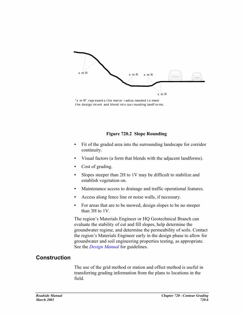
x m R x m R x m R
x m R
"x m R" represents the meter radius needed to meet the design intent and blend into surrounding landforms.
Figure 720.2 Slope Rounding
• Fit of the graded area into the surrounding landscape for corridor continuity.
• Visual factors (a form that blends with the adjacent landforms).
• Cost of grading.
• Slopes steeper than 2H to 1V may be difficult to stabilize and establish vegetation on.
• Maintenance access to drainage and traffic operational features.
• Access along fence line or noise walls, if necessary.
• For areas that are to be mowed, design slopes to be no steeper than 3H to 1V.
The region’s Materials Engineer or HQ Geotechnical Branch can evaluate the stability of cut and fill slopes, help determine the groundwater regime, and determine the permeability of soils. Contact the region’s Materials Engineer early in the design phase to allow for groundwater and soil engineering properties testing, as appropriate. See the Design Manual for guidelines.
Construction The use of the grid method or station and offset method is useful in transferring grading information from the plans to locations in the field.
Roadside Manual Chapter 720 - Contour Grading March 2003 720-6

Grids
To simplify staking during construction, a grid can be laid over the contour grading plan as seen in the simplified figure below.
09.95
45.20
37.05
Grid Built from Roadway Centerline
51.50
48.75
41.03
38.75
47.10
51.25
29.02
46.50
51.25
43.01
42.25
45.59
44.75
44.05
09.56
Grid intersection elevations (Typical)
36.15
44.04
34.75
20.10
42.97
50.67
44.10
Figure 720.3 The Grid
The grid size will be related to the size of the site and the complexity of the design contours. Make sure that enough grid points are used to reflect the contours as shown on the plan. Ensure that high and low spot elevations are located.
The grid is tied to a known base line and station point such as a roadway centerline, a fence, or a right of way line. Elevations at the grid intersections can then be determined by interpolation. Mark the elevation at all grid intersections. Contours and spot elevations can then be staked in the field using the elevations shown on the plans.
Station & Offset Method
The station and offset method is an alternative to the grid method for locating contours in the field.
• Define the base line either by extending a known center line or by
Roadside Manual Chapter 720 - Contour Grading March 2003 720-7

drawing a line between two known survey points.
• Identify lines perpendicular to the base line at station points to measure the distance of control points from the base line.
• If available, use a data collector with a “Roading” module to set stakes in the field. With proper survey techniques, elevations will be determined at the location of the station and the offset. By comparing the elevation with the contour, a cut or fill can be marked on the stake.
Stations Built from Roadway Station Point
Base
Line
A1A2A3
A4
A5
A6
A7
A8
Figure 720.4 Baseline, Stations, and Offset Points
Roadside Manual Chapter 720 - Contour Grading March 2003 720-8

A table showing the location of the control points, as in Tables 720.1 and 720.2, is an integral part of this method. Right or left direction of offset is determined by the direction of increasing stations.
Station Station Point Offset (m)
A1 0+511.80 15.70 Rt A2 0+527.90 35.27 Rt A3 0+550.00 49.35 Rt A4 0+570.82 57.46 Rt A5 0+600.00 45.23 Rt A6 0+626.47 40.77 Rt A7 0+700.00 29.00 Rt A8 0+719.24 12.00 Rt
Table 720.1 Metric Station & Offset Table
Station Station Point Offset (ft)
A1 5+11.80 51.51 Rt A2 5+27.90 115.72 Rt A3 5+50.00 161.91 Rt A4 5+70.82 188.52 Rt A5 6+00.00 148.39 Rt A6 6+26.47 133.76 Rt A7 7+00.00 95.14 Rt A8 7+19.24 39.37 Rt
Table 720.2 English Station & Offset Table As with all contour grading plans, the plan sheet is accompanied by cross-sections. Include notes stating that grading between cross-sections will be as shown on the plan. Discuss this with the contractor at the preconstruction meeting. The slope can also be labeled on the cross-section.
Cross-Sections
When cross-sections are included in a contract set, it is important to confirm whether they represent a typical condition or the condition only at a specific location. Generally, when cross-sections are used in conjunction with a contour grading plan they represent the condition only at the location of the cross-section line. Cross-sections that represent a typical condition are usually labeled as “Typical” or are labeled for “Sta ___ to Sta ___.”
Roadside Manual Chapter 720 - Contour Grading March 2003 720-9

Compaction
Soil compaction hinders plant growth and infiltration of water. The possibility of soil compaction exists when large equipment is grading a site. Soil compaction can be minimized by:
• Working when soils are not saturated.
• Ensuring vehicles have wide tracks or wide wheels (low ground pressure equipment [LGP]).
• Minimizing the passes a vehicle makes over any one area.
Refer to Chapter 700 of this manual, “Soil and Soil Amendments” for more information.
In some cases, such as in detention pond berms, compaction is desirable. They will fail if not compacted. Slopes can be compacted to prevent surface sloughing. See the soil bioengineering chapter for information on using plants in combination with other materials, such as logs or rock, to stabilize slopes.
Earth Berms
Figure 720.5 Roadside berm example
Berms are used to:
• Visually screen distracting views.
• Provide and enhance corridor continuity.
• Mitigate safety hazards.
• Provide noise abatement either alone or in conjunction with noise walls.
• Waste material from other sites.
• Retain or detain surface water flow.
Roadside Manual Chapter 720 - Contour Grading March 2003 720-10

Materials
Berms can be used to balance cut and fill. However, materials used in the berm must facilitate plant establishment and continued growth. Materials used in berms must allow for the stability of the berm.
The materials used in the berm will determine the angle of the slope. Finer grained materials, such as clays and silts, require a flatter slope for stability.
The use of recycled materials, such as asphalt, has environmental and legal implications. Consult the HQ Construction Materials Engineer when recycled materials are considered.
For details on topsoil and compost see the Soil and Soil Amendments chapter in this manual, Chapter 700.
When noise walls are constructed on a berm, the materials must be able to support the weight of the noise wall. Consult the Technical Services Unit and the region’s Materials Engineer for all berms that are used as a base for noise walls and when deciding whether material is suitable for a berm, as directed in the Design Manual.
For any berm over 3 m (10 ft) high and any berm in conjunction with a detention/retention pond, consult the region’s Materials Engineer. For detention/retention pond berms, consult with the Hydraulics engineer. These berms have specific engineering requirements and must meet dam design standards per the Washington State Department of Ecology.
For information on planting on berms within the highway right of way, see the vegetation chapter in this manual.
Roadside Manual Chapter 720 - Contour Grading March 2003 720-11

Berm Design
Berms can have variations in grades. When the slope, or grade, changes, the distance between contours on the plan changes as shown in the Figure below.
Figure 720.6 Varying Distances Between Contours
Variations in the distance between contours can make berms appear more natural and blend them into their surroundings.
Roadside Manual Chapter 720 - Contour Grading March 2003 720-12

740 Soil Bioengineering
General Soil bioengineering is the use of plant material, living or dead, to alleviate environmental problems such as shallow rapid landslides, and eroding slopes and streambanks. In bioengineering systems, plants are an important structural component, not just an aesthetic component. This approach to slope stabilization requires a true partnership between engineering geologists, maintenance personnel, civil engineers, and landscape architects.
Soil bioengineering technology has been practiced for thousands of years. Chinese historians, for example, recorded the use of soil bioengineering techniques for dike repair as early as 28 BC. Construction of the German autobahn system during the 1930s involved extensive applications of soil bioengineering technologies.
Soil bioengineering most often mimics nature by using locally available materials and a minimum of heavy equipment, and can offer roadside managers an inexpensive way to resolve local environmental problems. These techniques can also be used in combination with “hard” engineering techniques such as rock or concrete structures.
Soil bioengineering project areas require periodic monitoring and maintenance until plants have become established.
Benefits of soil bioengineering include:
• Erosion areas often begin small and eventually expand to a size requiring costly traditional engineering solutions. Installation of soil bioengineered systems while problems are small will provide economic savings and minimize potential impacts to the road and adjoining areas.
• Soil bioengineering work is often the only practical alternative on sensitive or steep sites where heavy machinery is not feasible.
• Many designs can be implemented by hand crews.
• Native plant species are usually readily available and adapted to local climate and soil conditions. Costs might be limited to labor for harvesting, handling, and transport to the project site.
• Soil bioengineering projects may be installed during the dormant season of late fall, winter, and early spring. This is the best time to install plants and it often coincides with a time when other construction work is slow.
Roadside Manual Chapter 740 Soil Bioengineering July 2003 740-1

• Years of monitoring have demonstrated that soil bioengineering systems provide limited initial benefits, but grow stronger with time as vegetation becomes established. Even if plants die, roots and surface organic litter continue to play an important role during reestablishment of other plants.
• Once plants are established, root systems remove excess moisture from the soil profile. This often is the key to long-term soil stability.
• Soil bioengineering provides improved environmental functions, such as slope stabilization, stormwater retention, and habitat values.
References Design Manual (M 22-01), Soil Bioengineering Chapter.
USDA Natural Resource Conservation Service. Chapter 16, “Streambank and Shoreline Protection,” Engineering Field Handbook. United States Department of Agriculture, 1996.
USDA Natural Resource Conservation Service. Chapter 18, “Soil Bioengineering for Upland Slope Protection and Erosion Reduction,” Engineering Field Handbook. United States Department of Agriculture, 1992.
H.H. Allen and J.R. Leech. Bioengineering for Streambank Erosion Control - Report 1, Guidelines. Technical Report EL-97-8. U.S. Army Engineer Waterways Experimental Station, Vicksburg, MS. 1997. Can be found on the Internet through the following link: http://www.wes.army.mil/el/wetlands/wlpubs.html
WSDOT Soil Bioengineering website: http://www.wsdot.wa.gov/eesc/cae/design/roadside/SBwebsite/mainpage/Index.html
Resources The region’s Materials Engineer
Headquarters (HQ) Design Office Roadside and Site Development Unit
HQ Materials Lab, Geotechnical Branch, Engineering Geologists and Geotechnical Engineers
The region’s Landscape Architect
Definitions angle of repose the angle between the horizontal and the maximum slope that a soil assumes through natural processes.1
1 Robert W. Zolomij. “Vehicular Circulation.” Handbook of Landscape Architecture Construction. 1975. p. 66.
Roadside Manual Chapter 740 Soil Bioengineering July 2003 740-2

Approximate Angle of Repose for Soil Texture
Very wet clay and silt 1V:3H
Wet clay and silt 1V:2H
Dry sand and gravel 1V:1¾
Dry clay 1V:1½
Moist sand 1V:1¼
slope gradient the angle of the slope as expressed in a percentage. soil bioengineering the use of live plant materials and engineering techniques to reinforce soil and stabilize slopes.
Planning Evaluate soil bioengineering methods as a possible tool for remediation and restoration of degraded slopes. Soil bioengineering has unique attributes, but is not appropriate for all sites. In some cases a conventional vegetative treatment works with less cost, or it may be best to use a geotechnically-engineered system alone or in combination with soil bioengineering.
• Evaluate projects that leave exposed slopes, and slopes requiring high maintenance for stabilization, for possible application of soil bioengineering technologies.
• Include bioengineering technologies as an alternative when evaluating costs.
• Include a slope stability analysis in plans for large erosional slopes.
Design
Landscape Setting and Uses
Consider the natural history and evolution as well as cultural and social uses of the surrounding landscape. An awareness of these factors, and how they shape the present and potential future landscape, is critical for project success.
Knowledge of current and future roadside and land management goals is essential for project success. Consider the natural history, cultural, and social issues of the surrounding landscape as well. A proposed soil bioengineering project within a forested landscape, for example, requires knowledge and understanding of:
• Road construction methods and current maintenance practices.
Roadside Manual Chapter 740 Soil Bioengineering July 2003 740-3

• Objective of the bioengineering project - repair, remediation, prevention, habitat, etc.
• The area's geologic and glacial history.
• Its propensity for wild fires, wind storms, and floods.
• Occurrence and trends of natural and management related erosion.
• Sequence of vegetation removal and revegetation efforts.
• Fire management history.
• Soil Types and Properties
• Hydraulic and hydrological erosion and scour characteristics.
Trends Within Erosion Sites
Whether erosion occurs naturally or through human-induced activities, a site begins to heal itself immediately upon “failure” by trying to achieve an angle of repose. In mountainous terrain, for example, wood may become embedded in the slope thus terracing eroding soils. Once an angle of repose has been achieved between these natural terraces, vegetation begins to establish. Herbaceous plants usually provide initial vegetative cover on these sites. This initial cover also assists in establishment of soil microorganisms. Typical succession patterns evolve in stages from exposed ground, through herbaceous plant, shrub, pioneer tree, and finally mature tree stages. The first step is to examine and document these trends. Soil bioengineering designs are used to accelerate site recovery by mimicking what is happening naturally.
Site Evaluation and Design Check List
There are many soil bioengineering systems. Selection of the appropriate technique, or techniques, is critical to successful restoration. At a minimum, consider the following:
Climatic Conditions:
Climates near the ground can vary considerably within short distances. South facing valley walls, for example, receive more direct sun rays, which cause higher soil temperatures, increased evaporation, more rapid snowmelt in the spring, and generally drier conditions than on the more shaded north facing walls. This difference will influence erosion rates and the composition and vigor of revegetation efforts.
• Consider precipitation types, amounts, seasonal variation, and duration.
• Consider temperatures, including seasonal averages and extremes.
Roadside Manual Chapter 740 Soil Bioengineering July 2003 740-4

Topography and Aspect:
• Slope gradient.
• Terrain shape (for example, gentle slope to valley or sharp peaks).
• Elevation of project area.
• Direction of sun exposure.
Soils
Identify conditions above, below, or within the project site that might have an effect on the project and incorporate these considerations into the design. Consult with the HQ Engineering Geologist to determine need for slope stability analysis. Some categories below will require soil testing to determine.
• Substrate - take soil probe sample from potential site.
• Soil types
• Soil permeability
• Moisture holding capacity
• Nutrient availability
Water
Detailed analysis or work in streams or rivers will require consultation with a hydraulics engineer. Work affecting streams or rivers will require consultation with the regional environmental office.
• Water velocity: Lateral stream stability
• Hydrologic regime: general and site specific.
• If applicable, stream and fish types affected by the erosion site.
• Location of natural drainage channels and areas of overland flow from road surfaces.
• Areas for safe water diversion.
• Condition of ditch line and culvert inlets and outlets.
Erosion Process
• Evidence of past sliding: deep or shallow failure surface in vicinity.
• Regional geomorphic trends or slope features (review aerial photos).
• Type of mass wasting or surface erosion feature.
Roadside Manual Chapter 740 Soil Bioengineering July 2003 740-5

• Source of eroding material: road fill slope, cut slope, landing, etc.
• Trend of site: improving naturally, remaining uniform, or worsening.
Vegetation
• Plant species and amount growing within and adjacent to project site. It is especially important to identify colonizing species.
• Locations for plant and seed collection.
Plant Materials
Living vegetation is the most critical component of a bioengineered system. Existing vegetation and knowledge of predisturbance plant communities can inform the designer of project limitations, opportunities, and long-term ecological goals.
Work with local native plant experts or the region’s Landscape Architect, or the HQ Roadside & Site Development Unit to select the most appropriate plant species for the project area.
Deciding which plants to use is affected by the following factors:
• Site characteristics (topography, elevation, aspect, soil moisture, nutrient levels).
• Existing vegetation.
• Intended role of vegetation in the project.
• Growth characteristics and ecological relationships of the plants.
• Availability.
• Logistical and economic constraints.
Plants that can resist mechanical stresses of erosion, floods, and landslides, while developing a strong, stabilizing root system are best suited for soil bioengineering applications.
Roadside Manual Chapter 740 Soil Bioengineering July 2003 740-6

Figure 740.1 Willow Rooting After 6 Week Immersion in Water.
Examples of riparian plants suitable for soil bioengineering work include willow, dogwood, cottonwood, big leaf maple, spruce, cedar, aspen, and alder.
Plants better suited for drier and poorer soil conditions include bitter brush, basin big sage, rubber rabbit brush, snowberry, white pine, lodgepole pine, Douglas maple, oceanspray, and blue elderberry.
The best indicator of which plant materials to consider for the soil bioengineering project is the plants growing on or adjacent to the project site. Plant materials are chosen from among those species available on the site or nearby. Alternatively, it might be possible to salvage like species from a similar area where vegetation is scheduled to be removed. Logistical concerns are important in the selection of plant material.
A single species may serve the primary structural requirement of the vegetation in a soil bioengineered system. However, it is preferable to use a mixture of species with varying, but complementary, characteristics. Benefits of using multiple species include:
• Lower susceptibility to devastation by disease or pests.
• Combinations of deep and shallow rooting species and vegetation of varying heights.
• The system is allowed to respond to changes in site conditions.
Roadside Manual Chapter 740 Soil Bioengineering July 2003 740-7
Construction
Project Planning and Implementation
Coordination & Communication
• Develop and implement a communication plan to keep all players involved, interested, and informed.
• Establish clear project objectives. Have these objectives reviewed and approved by participants including the maintenance personnel and the region’s Landscape Architect.
• List all project phases. Under each phase, catalogue and schedule all work items. For each work item, list the responsible parties and the dates the tasks must be completed. Identify and resolve timing conflicts. Build flexibility into the schedule (the Work Breakdown Structure).
• Ensure coordination between heavy equipment operators and hand crews.
Site Work
• Sites often require earthwork before installing a soil bioengineering system. Resolve timing conflicts that occur between scheduling heavy equipment, hand labor work, plant collection, and use.
• Select the right equipment for the job.
• Identify and remove work hazards.
• Determine access route for people and machinery to minimize site disturbance. For example, limiting hand crews to one entrance and exit route will cause less soil disturbance to the site and adjoining areas.
• Temporarily divert excess water.
• Stockpile excavated soils. Place soil in windrows to allow soil organisms access to oxygen. The least amount of time the soil is stockpiled the better.
• Retain or salvage existing vegetation for later use. Salvage material from healthy, young plants.
• Provide temporary surface erosion and sediment control measures.
Roadside Manual Chapter 740 Soil Bioengineering July 2003 740-8
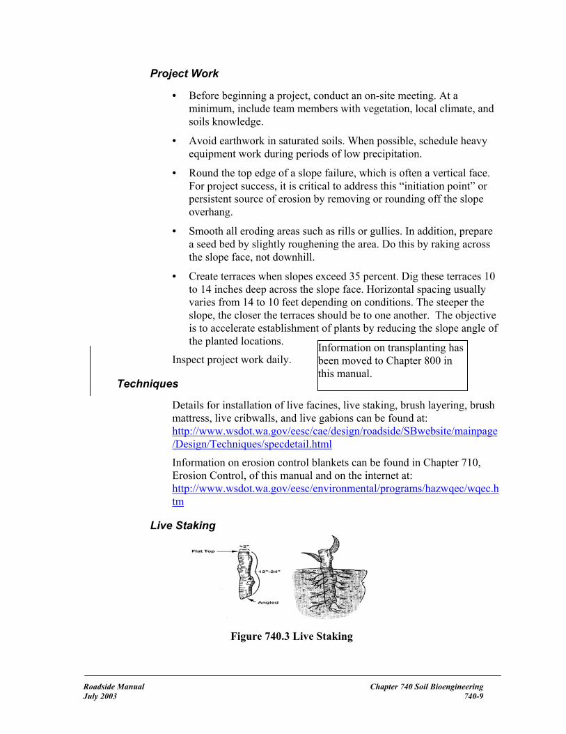
Project Work
• Before beginning a project, conduct an on-site meeting. At a minimum, include team members with vegetation, local climate, and soils knowledge.
• Avoid earthwork in saturated soils. When possible, schedule heavy equipment work during periods of low precipitation.
• Round the top edge of a slope failure, which is often a vertical face. For project success, it is critical to address this “initiation point” or persistent source of erosion by removing or rounding off the slope overhang.
• Smooth all eroding areas such as rills or gullies. In addition, prepare a seed bed by slightly roughening the area. Do this by raking across the slope face, not downhill.
• Create terraces when slopes exceed 35 percent. Dig these terraces 10 to 14 inches deep across the slope face. Horizontal spacing usually varies from 14 to 10 feet depending on conditions. The steeper the slope, the closer the terraces should be to one another. The objective is to accelerate establishment of plants by reducing the slope angle of the planted locations. Information on transplanting has
been moved to Chapter 800 in this manual.
Inspect project work daily.
Techniques
Details for installation of live facines, live staking, brush layering, brush mattress, live cribwalls, and live gabions can be found at: http://www.wsdot.wa.gov/eesc/cae/design/roadside/SBwebsite/mainpage/Design/Techniques/specdetail.html
Information on erosion control blankets can be found in Chapter 710, Erosion Control, of this manual and on the internet at: http://www.wsdot.wa.gov/eesc/environmental/programs/hazwqec/wqec.htm
Live Staking
Figure 740.3 Live Staking
Roadside Manual Chapter 740 Soil Bioengineering July 2003 740-9

Live staking involves insertion and tamping of live, rootable vegetative cuttings (such as willow, cottonwood, and red-osier dogwood). If correctly prepared and placed during early spring, the live stakes will root and grow.
Advantages: A system of stakes creates a living root mat that stabilizes soil by reinforcing and binding soil particles together and by extracting excess soil moisture. This is an appropriate technique for repair of small earth slips and slumps that usually have moist soils.
Disadvantages: Does not solve existing erosion problems (excluding benefits from associated mulch). Staking is not a short-term solution for slope instabilities.
Erosion Control Blanket
Installation of erosion control blankets involves site preparation, trenching, application of grass, and/or forb seed mix and soil amendment, and installation of fabric. This technique is suitable for treating surface erosion areas; especially fill slopes where there is a concentration of surface water runoff. The erosion control blanket provides immediate protection of the soil from erosion. The seed mix will sprout, grow, and lock the underlying soil in place with its root mass.
Figure 740.4 Erosion Control Blanket
Advantages: Excellent for mitigating surface erosion. The blanket offers immediate and uniform slope protection from rain and overland water flow.
Disadvantages: Can be labor-intensive and expensive. Could require numerous wood stakes or live stems to secure the erosion control blanket. Too much grass within the blanket will lead to over competition
Roadside Manual Chapter 740 Soil Bioengineering July 2003 740-10

for moisture and high tree and shrub mortality if live stakes are used. If the seeding is too dense, the combined matting of these grasses with the blanket can prevent other grasses from emerging.
Live Cribwalls
Figure 740.5 Live Cribwall Under Construction
A live cribwall consists of a hollow, box-like interlocking arrangement of untreated log or timber members. The structure is filled with suitable backfill material, such as topsoil, and layers of live branch cuttings, such as willow, which root inside the crib structure and extend into the slope. Tilt the cribwall back into the sloped surface at a 10% angle. Once live cuttings root and become established, subsequent vegetation gradually takes over the structural functions of wood members. Consider the flow of runoff adjacent to the wall to ensure that the wall will not be under-mined. Contact the materials engineer for help in calculating slope stress.
Figure 740.6 Live Cribwall with Willow Stakes
Roadside Manual Chapter 740 Soil Bioengineering July 2003 740-11

Advantages: Appropriate at the base of a cut or fill slope where a low wall, or log, might be required to stabilize the toe of a slope and reduce slope steepness. Useful where space is limited and a more vertical structure is required. Provides immediate protection from erosion and established vegetation provides long-term stability. Aesthetically more pleasing than gabion baskets.
Figure 740.7 Live Cribwall 18 months after installation
Disadvantages: Not designed for or intended to resist large, lateral earth stresses. Depending on soil quality of cut slope, may have to use commercial fill material. Can be labor intensive and expensive to construct. Can have high mortality if willow stems are not collected when dormant, are not properly stored, or are mishandled in transfer.
Variation: Toe Log Technique
Figure 740.8 Toe Log Technique
Roadside Manual Chapter 740 Soil Bioengineering July 2003 740-12

This technique is handy for very small cut slope erosion features, for example, 3 m by 4.5 m (10 feet high by 15 feet) wide. Place a 500 mm to 635 mm (20 to 24 inch) diameter log along the base of the erosion site. Lay 1.75 m (5 feet) long and 12.5 mm to 38 mm (½ to 1½ inch) diameter trimmed, live branches on top of the log and sloping down into the cut bank. The purpose is to take full advantage of excess water at the slope base. Place soil behind the log with soils from the slope face. Toe logging is a quick and effective tool in stabilizing the base of slopes. However, the log must be outside the Design Clear Zone and the site must be small and only slightly over-steepened. It is very important to use the right size log for existing slope conditions. Contact the materials engineer for help in calculating slope stress.
As in any soil bioengineering technique, the initiation point or source of persistent erosion must be addressed. This is usually located at the upper boundary of the site. For project success, it is critical to remove or round off the slope overhang.
Live Fascines
Figure 740.9 Live Fascines
Live fascines are also referred to as contour or willow wattling. They are long bundles of branch cuttings bound together into sausage-like structures that are placed in a trench parallel to the slope contour. Live fascines root into the slope face and provide a permanent structure.
Note: Where soil moisture is not sufficient to support live materials, fascines can also be constructed of plant stems not intended for rooting. The bundle still traps and holds sediments and reduces slope length and steepness between terraces. Plant vegetation between the terraces. As in all projects, recovery is dependent upon successfully establishing live vegetation.
Roadside Manual Chapter 740 Soil Bioengineering July 2003 740-13

Advantages: Immediately reduces surface erosion or rilling. Suited to steep, rocky slopes where digging is difficult. Capable of trapping and holding soil on the slope face, thus reducing a long slope into a series of shorter steps. Can also be used to manage mild gully erosion and can serve as slope drains when bundles are slightly angled. Best suited for moist soil conditions.
Disadvantages: On steep or long slope lengths, high runoff velocities can undermine fascines. A significant quantity of plant material is required and can dry out if not properly installed. Best suited for riparian, moist soil conditions. Otherwise high plant mortality could occur.
Brushlayering
Figure 740.10 Brushlayering
Brushlayering consists of placing live branch cuttings in small terraces excavated into the slope. Terraces can range from 0.6 m to 1 m (2 to 3 feet) wide. This technique is similar to live fascine systems because both involve cutting and placing of live branch cuttings on slopes. The two techniques differ in the orientation of the branches and the depth at which they are placed on the slope. In brushlayering, cuttings are oriented perpendicular to the slope contour. This placement is more effective for soil reinforcement and stability of the slope.
Advantages: Breaks up slope length into a series of shorter slopes separated by rows of brushlayer. Reinforces soil as roots develop thus adding resistance to sliding or shear displacement. Reinforces soil with unrooted branch stems. Provides slope stability and allows vegetative cover to become established. Traps debris on slope. Moderates soil
Roadside Manual Chapter 740 Soil Bioengineering July 2003 740-14

moisture by aiding infiltration on dry sites and drying excessively wet sites. Has a very high survival rate.
Disadvantages: Recommended on slopes up to 1V:2H in steepness and not to exceed 4.5 m (15 feet) in vertical height. Labor intensive.
Willow Fencing with Brushlayering
Figure 740.11 Willow fencing with brushlayer
Willow fencing with brushlayering is essentially a short willow fence supporting a brushlayer. Specifically, it is a short retaining wall built of living cuttings with a brushlayer at the base.
Sites where fine-textured soils can provide ample summer moisture, or where seepage of groundwater provides moisture, are suitable for willow/brushlayering fence installations.
These structures can also be constructed on drier sites. However, expect high willow mortality. In these situations, the willow/brushlayer shelf is considered a temporary planting platform. It is important, therefore, to establish deeper rooting shrubs and trees within the shelf.
When the structure begins to decay, root systems of the willows or the other plants will serve as the permanent feature.
Roadside Manual Chapter 740 Soil Bioengineering July 2003 740-15
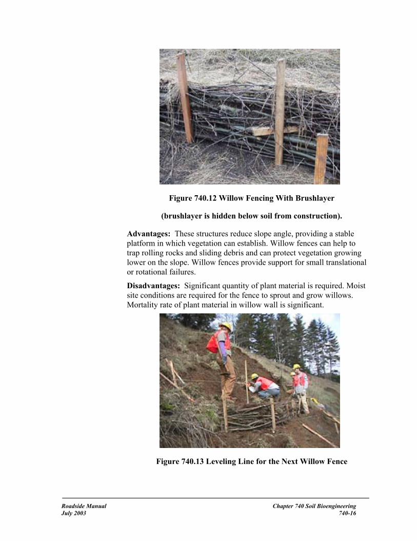
Figure 740.12 Willow Fencing With Brushlayer
(brushlayer is hidden below soil from construction).
Advantages: These structures reduce slope angle, providing a stable platform in which vegetation can establish. Willow fences can help to trap rolling rocks and sliding debris and can protect vegetation growing lower on the slope. Willow fences provide support for small translational or rotational failures.
Disadvantages: Significant quantity of plant material is required. Moist site conditions are required for the fence to sprout and grow willows. Mortality rate of plant material in willow wall is significant.
Figure 740.13 Leveling Line for the Next Willow Fence
Roadside Manual Chapter 740 Soil Bioengineering July 2003 740-16

Branchpacking
Branchpacking consists of alternating layers of live branch cuttings and compacted backfill to repair small, localized slumps and holes.
Figure 740.14 Branch Packing in Winter
Advantages: As plant tops grow, branchpacking system becomes increasingly effective in retarding runoff and reducing surface erosion. Trapped sediment refills localized slumps or holes while roots spread throughout the backfill and surrounding earth to form a unified mass. Plant material has a high survival rate.
Disadvantage: Not effective in slump areas greater than 1.3 m (4 feet) deep or 1.6 m (5 feet) wide.
Live Gully Repair
Live gully repair uses alternating layers of live branch cuttings and compacted soil to repair small rills and gullies. Similar to branchpacking, this method is more appropriate for repair of rills and gullies.
Roadside Manual Chapter 740 Soil Bioengineering July 2003 740-17

Figure 740.15 Live Gully Repair
Advantages: Offers immediate reinforcement to compacted soil, reduces velocity of concentrated flow of water, and provides a filter to reduce rill and gully erosion. Plant material in willow walls have a high mortality rate while plant material in the brushlayer component has a high survival rate.
Disadvantage: Limited to rills and gullies that are a maximum of 0.6 m (2 feet) wide, 0.3 m (1 foot) deep, and 5 m (15 feet) long.
Vegetated Geotextile
Figure 740.16 Vegetated Geotextile
This method uses synthetic or organic geotextile wrapped around lifts of soil with a mix of live branches placed between layers.
Note: Structural integrity is dependent upon compacted soil layers. Even with mechanized firming, soils support live cuttings.
Roadside Manual Chapter 740 Soil Bioengineering July 2003 740-18

Advantages: Retards rill and gully erosion and stabilizes fill banks. Is less expensive than other retaining walls such as gabion or Hilfiker baskets.
Disadvantages: Heavy equipment usually required to install lifts. Plants must be installed during their dormant season. Can be expensive.
Log Terracing
Figure 740.17 Three Toe Log Techniques
The log terracing technique uses alternating terraced logs to stop surface erosion on eroding slopes. Stopping the erosion is critical for successful revegetation efforts. Log terracing shortens the slope length and gradient between each structure, providing stable planting areas throughout most of the slope face. Logs must be installed in trenches and staked into place.
Note: Use logs that are a minimum of 0.3 m (12 inches) in diameter. Logs that are 400 mm to 500 mm (16 to 20 inch) in diameter work best. The most common error in log terracing is using logs that are too small in diameter.
Advantages: Logs create terraces reducing length and steepness of the slope. Provides stable areas for establishment of other vegetation such as trees and shrubs.
Disadvantages: Labor intensive and with possible safety hazards because of the use of logs on a slope. Heavy equipment required to place large logs.
Roadside Manual Chapter 740 Soil Bioengineering July 2003 740-19

Key Points:
• Involve all associated disciplines early in the process.
• Establish clear project objectives.
• Conduct predesign field review.
• Conduct plan-in-hand field review.
• Have a prework meeting with contractor to highlight key areas.
• Scheduling and timing of project is important when considering erosion outputs.
• When laying out the project, be consistent with the flagging.
• Ensure that terraces are level (on the contours) so that they do not act as stream channels. Level terraces will act to slow erosion.
• Diligent inspections of work-in-progress and timely feedback are critical. Develop a good working relationship with heavy equipment operators and hand crews. Poor inspection and poor communications can ruin a well designed project. Remember “You get what you inspect, not what you expect”!
• Monitor and document project effectiveness.
• Disseminate this information to colleagues and adjust future prescriptions based on monitoring results.
• Annual peer review by land managers provides good feedback and keeps them informed.
The complexity of the project dictates the level at which the aforementioned steps are performed.
An interdisciplinary team is necessary for all steps. The experience can also be very rewarding.
Maintenance Maintenance crews can request assistance with erosional problems on slopes in their area. The region’s Materials Engineer and the region’s Landscape Architect, or the OSC Roadside and Site Development Unit for regions with no Landscape Architect, are available to help with the design and implementation of soil bioengineering measures to treat erosional slopes or shallow rapid landslides.
For the first one to two summers after construction, additional watering might be necessary. Thereafter, the vegetated system will usually require little or no maintenance and will usually cut down on ditch cleaning requirements because erosion has been minimized.
Roadside Manual Chapter 740 Soil Bioengineering July 2003 740-20

Additional Sources of Information D. H. Bache and I. A. MacAskill. Vegetation in Civil and Landscape Engineering. London: Granada. 1984.
D. H. Barker, editor. Vegetation and slopes: Stabilization, protection, and ecology. New York: Thomas Telford. 1995.
N. J. Coppin and I.G. Richards. Use of Vegetation in Civil Engineering. London: Butterworths. 1990.
Donald H. Gray and Andrew T. Leiser. Biotechnical Slope Protection and Erosion Control. New York: VanNostrand Reinhold Co. 1982.
Donald H. Gray and Robbin B. Sotir. Biotechnical and Soil Bioengineering Slope Stabilization: A Practical Guide for Erosion Control. New York: John Wiley & Sons, Inc. 1996.
E.A. Lewis. Soil Bioengineering: An alternative for Roadside Management: A Practical Guide. United States Forest Service. San Dimas Technology and Development Center. San Dimas, California. 1999.
David F. Polster. “Soil Bioengineering for Steep/Unstable Slopes and Riparian Restoration.” In Watershed Restoration Technical Bulletin: Streamline. Volume 4. No. 4. British Columbia Ministry of Environment.
Hugo Schiechtl and R. Stern. Ground Bioengineering Techniques for Slope Protection and Erosion Control. Blackwell Science Publications, 1997. ISBN: 0-632-04061-0
Hugo Schiechtl. Bioengineering for Land Reclamation and Conservation. University of Alberta Press. 1980.
State of Alaska website on streambank stabilization http://www.state.ak.us/adfg/habitat/geninfo/webpage/techniques.htm
Turner & Schuster, eds. Landslides Investigation and Mitigation, Special Report, Transportation Research Board. 1996.
Roadside Manual Chapter 740 Soil Bioengineering July 2003 740-21


800 Vegetation
General Washington State Department of Transportation (WSDOT) practices an ecologically based program of roadside vegetation design and management that seeks to produce low-maintenance, self-sustaining plant communities. The use of native plants planted in the right location is integral to this system. The Roadside Classification Plan provides policy on roadside character classifications and appropriate treatment levels for revegetation.
Revegetation plans are an important part of many highway projects and are required when the project disturbs the roadside. The inclusion of a WSDOT Landscape Architect in the design development process can aid the design process and improve the environmental and visual quality of Washington’s roadsides.
References
• Construction Manual, M 41-01
• Design Manual, M 22-01
• Highway Runoff Manual, M 31-16
• Hydraulics Manual, M 23-03
• Integrated Vegetation Management for Roadsides, WSDOT
• Maintenance Manual, M 51-01
• Roadside Classification Plan, M 25-31. (Includes the “Roadside Classification Log.”)
• Standard Specifications for Road, Bridge and Municipal Construction, M 41-10
• Utilities Accommodation Policy, M 22-86
• Corridor management plans for Scenic and Recreational Highways
• RCW 17.10 State Noxious Weed List. The site below links to information on noxious weeds: http://www.wsdot.wa.gov/biz/maintenance/htm/weeds.htm
• RCW 47.40 Roadside Improvement and Beautification. Outlines permit process for persons wishing to use highway right of way for improvement and beautification. Establishes penalty for destroying native flora on state lands. Mandates litter removal, and authorizes state and local Adopt-a-Highway programs.
Roadside Manual Chapter 800 - Vegetation July 2003 800-1

• WAC 173-270-040 Vegetation Management Program. States that the purposes of vegetation management in highway rights of way are to establish and maintain stable plant communities that resist encroachment by undesirable plants, noxious weeds, and other pests; meet WSDOT operational, health, natural resources and environmental standards; be cost effective; and protect the public investment with minimal negative impacts on the environment. Requires a vegetation management program for all state highways with the Puget Sound basin.
• WAC 468-34-340 Preservation, restoration and cleanup of areas disturbed through utility installation, maintenance and repairs. Outlines criteria for utility use of highway right of way, requires utilities to repair or replace unnecessarily removed or disfigured trees and shrub, and specifies vegetation management practices.
Resources
The region’s Landscape Architects
The region’s Maintenance Office
HQ Design Office Roadside and Site Development Unit
HQ Horticulturist
HQ Maintenance & Operations Program (M&OP) Landscape Architect
Heritage Corridors Program (when working in a Scenic and Recreational Highway corridor)
Washington State Noxious Weed Control Board: http://www.wa.gov/agr/weedboard/index.html
Definitions
blend To create a balanced, visually harmonious interface between adjacent elements. A roadside treatment strategy that integrates roadside elements to preserve roadside character continuity.
buffer The zone contiguous with a sensitive area that is required for the continued maintenance, protection, insulation, function, and structural stability of the sensitive area. The critical functions of a riparian buffer (those associated with an aquatic system) include shading, input of organic debris and coarse sediments, uptake of nutrients, stabilization of banks, interception of fine sediments, filtering of pollutants, overflow during high water events, protection from disturbance by humans and domestic animals, maintenance of wildlife habitat, and room for variation of aquatic system boundaries over time due to hydrologic or climatic effects. The critical functions of terrestrial buffers include protection of
Roadside Manual Chapter 800 - Vegetation July 2003 800-2

slope stability, attenuation of surface water flows from storm water runoff and precipitation, and erosion control.1 climax vegetation A stable end-point to plant succession (“steady state”) where a group of species predominate and replaces itself.2
corridor management plans A written document that specifies the actions, procedures, controls, operational practices, and administrative strategies to maintain the scenic, historic, recreational, cultural, archeological, and natural qualities of a Scenic and Recreational Highway. cuttings Live plant material without a previously developed root system. Source materials for cuttings should be dormant when the cutting is taken. ecological succession The natural tendency of plant communities to evolve over time.
enclose A roadside treatment strategy, the aim of which is a more or less permeable buffer between two adjacent elements, typically the roadway and adjoining lands. Roadside treatments, such as berms, structures, or vegetation, are used to provide visual buffers along both sides of the road. In Figure 800.1 vegetation provides a sense of enclosure for the roadway.
Vegetation Line
Roadway
Figure 800.1 Vegetation enclosing the highway
expose A roadside treatment strategy, the aim of which is to preserve or open a visual sight line, or remove vegetation for operational purposes, such as in the Design Clear Zone.
forb An herbaceous plant, such as clover, which is not a grass, sedge, or rush.
groundcover Low-growing plants that form a dense, extensive growth and tend to prevent weeds and soil erosion.
Roadside Manual Chapter 800 - Vegetation July 2003 800-3
1 Highway Runoff Manual, M 31-16. WSDOT, pp Glossary 1-2. 2 Oliver and Larson, p. 147.

herb Any flowering plant except those developing persistent woody bases and stems above ground.
live poles A form of cutting taken from woody vegetation with a diameter greater than 50 mm (2 inches).
live stakes A form of cutting taken from one to two year old woody vegetation with a diameter of less than 50 mm (2 inches).
native plant A plant occurring naturally in a particular region, ecosystem, or habitat at the time of European settlement.
plant material Trees, shrubs, ground covers, cuttings, live stakes, live poles, rhizomes, tubers, rootstock, and seedlings are referred to collectively as “plants” or “plant material.”
reference site An established undisturbed natural site that is used as a comparative design guide to help determine the desired plant composition and species densities for the created, or enhanced project site. It should be located near the project site, preferably within the same watershed, and have similar landscape setting, hydrology and topography.
rhizome A root-like, usually horizontal stem, growing under or along the ground that sends out roots from its lower surface and leaves, or shoots from its upper surface. The primary means by which some plants spread or reproduce.
roadside classification Any of five classifications given to a route or stretch of roadway through a review process conducted by WSDOT, and documented in the WSDOT “Roadside Classification Log.” Roadside character classifications fall within two categories: natural and built. Natural includes the Open and Forest roadside character classification. Built includes the Rural, Semiurban, and Urban roadside character classifications.
roadside restoration The use of planning, design, construction, and maintenance activities to restore roadside plant communities according to designated roadside character and Roadside Classification Plan provisions.
roadside treatment strategies Conceptual design strategies used to coordinate implementation of roadside guidelines and fulfill roadside functions. The three basic treatment strategies are enclose/screen, expose, and blend.
Scenic and Recreational Highways A public road having special scenic, historic, recreational, cultural, archeological, and/or natural qualities that have been recognized as such through legislation or some other official declaration. The terms “byway,” “road,” and “highway” are synonymous. They are not meant to define higher or lower functional classifications or wider or narrower cross-sections. Moreover, the terms State Scenic Byway, National Scenic Byway, or All-American Road
Roadside Manual Chapter 800 - Vegetation July 2003 800-4

refer not only to the road or highway itself but also to the corridor through which it passes.
screen The use of roadside treatments such as vegetation, berms, or walls to visually block undesirable views, as seen in Figure 800.2. In the picture to the right, below, vegetation is used as a permeable screen for the noise wall.
Roadway
Vegetation Line
Figure 800.2 Use of vegetation to screen a wall
seedlings Plants grown from cuttings, seeds, or other approved propagation methods. They are generally under 3 years old and under 2 ft in height. Measurement is by height, in 3 inch increments, or by age and number of times transplanted. shrub A low, woody plant having several stems. sustainable roadsides Those roadsides that are designed with the intent of integrating successful operational, environmental, and visual functions with low life cycle costs.
tuber A swollen, usually underground stem, such as the potato, bearing buds from which new plant shoots arise.
weed Any plant growing in a location in which it is not desired. A plant growing out of place.
wildflowers Native flowering plants including flowering herbs, shrubs and trees.
xeriscape A landscaping concept based on water conservation through the use of plant materials and techniques appropriate for dry climates or site conditions.
Roadside Manual Chapter 800 - Vegetation July 2003 800-5
Vegetation
Functions of Vegetation
Vegetation has many functions and adds significant value to our environment. These functions include:
• Traffic calming
• Stress reduction
• Buffer or shade for pedestrian or park and ride facilities
• Stream bank stabilization
• Wetland mitigation
• Water quality improvement
• Water retention and smoother flows
• Air pollution mitigation
• Noise abatement
• Wildlife habitat
• Enclose, screen, expose, or blend
• Visual quality, quality of life
• Corridor continuity
• Roadside Character Classification as noted in the Roadside Classification Plan
Roadside Vegetation
Existing vegetation alone often meets roadside function requirements but revegetation projects are initiated after disturbance or for improvement projects. For revegetation of roadside areas disturbed during roadway projects, contact the region’s Landscape Architect or the HQ Roadside and Site Development Unit in regions without a landscape architect. They will provide planting designs and seeding specifications. All planting plans require the stamp and signature of a Landscape Architect.
Revegetation activities range from seeding grasses to installing diverse plant communities. Roadside revegetation can include planting trees, shrubs, ground covers, live stakes, live poles, rhizomes, tubers, rootstock, seedlings, and seeds. See the Standard Specifications for information on plant specification.
Roadside Manual Chapter 800 - Vegetation July 2003 800-6

Important additional functions of vegetation include:
CONCRETE GRASS
PRIVACY SCREENING
GROUNDTEMPERATURE
MODIFICATION
SCREENINGOBJECTIONABLE VIEWS GLARE SCREENING
SEASONAL VARIATION
TEMPERATUREMODIFICATION
ANNUAL VARIATION
TEMPERATUREMODIFICATION
SNOW STORAGE
GUIDANCE
AND SLOPESTABILIZATION
EROSION CONTROL
VIEW ENFOLDMENT
TRAFFIC CONTROL WIND DEFLECTION
Figure 800.3 Examples of Some Functions of Roadside Vegetation
General Guidelines for Roadside Vegetation
• Protect existing desirable vegetation.
• Maintain Design Clear Zone and sight distance according to the Design Manual.
• Maintain, restore, or enhance roadside functions.
Roadside Manual Chapter 800 - Vegetation July 2003 800-7

• Maintain, restore, or enhance roadside character classifications (Forest, Open, Rural, Semiurban, Urban).
• Implement Treatment Levels in the Roadside Classification Plan.
• Implement treatment strategies (enclose/screen, expose, blend).
• Choose the right plant for the right place, for example use shrubs on the outside of curves or within the clear zone.
• Provide complete vegetative cover, where possible.
• Encourage desirable volunteer growth by allowing natural succession to take place.
• Install, protect, and enhance desirable native plant material.
• Discourage invasive species and noxious weeds.
• Use Integrated Vegetation Management techniques.
• Perform soil analyses to determine if soil amendments are necessary.
• Provide topsoil and/or amend existing soils when installing projects where it will improve plant survivability.
• Design for self-sustaining plant communities to minimize long term maintenance.
• Minimize requirements for fertilizer and pesticide use.
Planning
Roadside Classification Plan
The RCP coordinates and guides the management of Washington State highway roadsides, including planning, design, construction, and maintenance activities. The RCP provides extensive roadside vegetation management guidance, including:
• Treatment level guidelines for Forest, Open, Rural, Semiurban, and Urban roadside character classifications.
• Treatment tools (landform, vegetation, and structure) used to restore roadside character.
The Roadside Classification Plan advocates the use of native plants, Integrated Vegetation Management, and a long-term management approach to achieve sustainable roadsides.
Integrated Vegetation Management (IVM)
Integrated Vegetation Management is a coordinated decision-making and action process that uses the most appropriate vegetation management
Roadside Manual Chapter 800 - Vegetation July 2003 800-8
methods and strategy, along with a monitoring and evaluation system, to achieve roadside maintenance program goals and objectives in an environmentally and economically sound manner.
Tactics selected are site specific. Chemical controls are used only when needed. IVM uses plant growth characteristics, principles of succession, and knowledge of natural and human-related factors affecting environmental change to achieve management goals, while minimizing impacts on the environment. For details, refer to Integrated Vegetation Management for Roadsides.
Corridor Management Plans
Corridor Management Plans identify the location of a Scenic and Recreational Highway route and its corridor. Revegetation plans can be affected due to the high visibility of these corridors. The maintenance of existing vegetation can also be affected.
Design It is WSDOT policy to use native plants, including wildflowers to the greatest extent practical. Wildflowers include native woody flowering shrubs and trees.
Species diversity, within the context of native plant associations, is encouraged. A diverse plant mix is less susceptible to disease and homogeneous decline.
Landscape Architects develop PS&E packages that include plant materials lists. Plant material selection is based on site-specific requirements.
Wherever practical, use a separate contract for planting projects. This usually results in better revegetation projects and it allows the roadway project to close out before the plant establishment period ends.
Landscape Plans, and any other plans that specify plants, require the stamp and signature of the Landscape Architect.
Design Criteria
Refer to the maintenance Functional Zone Objectives in Division 1. Select and locate plants with the following criteria in mind to avoid future problems and to avoid increased or difficult maintenance.
• Sight Distance Design for and maintain sight distance for motorist, bicycle, and pedestrian traffic. Sight distance is also a security issue for safety rest areas, park and ride lots, pedestrian facilities, and bicycle facilities (see the Design Manual).
Roadside Manual Chapter 800 - Vegetation July 2003 800-9

• Design Clear Zone The Design Clear Zone is a function of posted speed, side slope, and traffic volume. Do not locate trees that can grow over four inches in trunk diameter in the Design Clear Zone (see the Design Manual). Shrubs are appropriate for this zone.
• Traffic Barriers Set shrubs and ground cover plants a minimum of 2 ft and trees a minimum of 6 ft from traffic barriers to reduce maintenance.
• Vertical Clearance Provide appropriate setbacks for trees that might overhang the roadway. When trees do overhang the roadway, provide a minimum vertical clearance of 16 ft. Minimum vertical clearance over trails and pedestrian facilities is 10 ft.
• Medians and Gore Areas Design medians and gore areas to be a minimum of 10 ft wide. Narrower areas tend to be a problem for maintenance personnel, are expensive to irrigate, and generally are unsatisfactory for revegetation. Consider paving, stone, or other bare surface material in gore areas less than 10 ft wide.
• Right of Way Line Place trees and shrubs a minimum of 6 ft inside the right of way line.
• Curb Lines of City Streets Comply with local agency standards and WSDOT sight distance criteria for revegetation.
• Structures Locate trees as far back from structures as necessary to avoid operational conflicts and the need for excessive pruning.
• Trails Set back evergreen trees with branches less than 2 m (6 ft) from the ground a minimum of 6 m (20 ft) from trails. Select species native to the area wherever possible. Set back shrubs higher than 1.5 m (5 ft) a minimum of 2.4 m (8 ft) from trails, for security purposes.
• Other Roadside Features Do not locate vegetation that will interfere with signs, signals, or luminaires. Trees and shrubs can provide visual background for signs.
• Utilities Refer to the Utilities Accommodation Policy for guidance. Avoid impacting utility lines and sewer systems.
• Corridor Management Plans Where applicable consult these plans to enhance corridor continuity and to reinforce the character of the Scenic and Recreational Highway.
Plant Material Selection
Plant material selection is based on a site analysis of conditions, maintenance Functional Zone Objectives, plant availability, plant cost, plant success rates in the field, traffic speed, and other horticultural requirements.
Roadside Manual Chapter 800 - Vegetation July 2003 800-10

Follow these general guidelines for plant material selection for grasses, herbs, shrubs, trees, and groundcovers.
Grasses and Herbs
Consider the following criteria when selecting grass or herb plant material:
• Satisfaction of the functional requirements of the design.
• Ability to provide visual cues that reinforce changes in speed and driving conditions.
• Simplicity of appearance and compatibility with the speed of traffic and the overall landscape.
• Production of extensive root systems.
• Rapidity of establishment.
• Tolerance of site conditions.
• Resistance to insects and diseases.
• Availability from commercial suppliers.
• Ability to self-perpetuate.
• Compatibility with maintenance objectives.
Select species native to the area wherever practical.
Do not use herbs in roadside seed mixes where there are deer.
Do not use lupine adjacent to agricultural or grazing areas.
Do not use seed mixes that include species on the State Noxious Weed List (RCW 17.10). The site below links to information on noxious weeds. http://www.nwcb.wa.gov/weed_list/weed_listhome.html
Trees, Shrubs, and Groundcovers
Consider the following criteria, in addition to the criteria for grasses and herbs, for shrubs, trees, and groundcover:
• Appropriate characteristics for desirable functions.
• Suitability for space and site conditions.
• Compatibility with natural plant succession.
• Ability to regenerate after damage.
• Longevity.
• Ability to maintain or enhance habitat values for wildlife, where this is desirable. This is determined on a site specific basis in conjunction with the region’s environmental office.
Roadside Manual Chapter 800 - Vegetation July 2003 800-11

• Ability to withstand traffic-generated stresses, such as air pollution and air turbulence.
• Compliance with state and county noxious weed control regulations.
• Select plant species that do not impact endangered or rare species.
• Select species native to the area wherever possible.
• Consider compatibility with the site's natural plant selection process.
• Consider compatibility with roadside maintenance objectives for the area.
• Native flowering shrubs and trees to satisfy the requirement for the use of wildflowers on federally funded projects.
Plant Sizing
Plant size is based on:
• Guidelines of the Roadside Classification Plan
• Design requirements
• Commercially available sizes
• Vandal resistance
• Transplant survival
• Available funding
• Functional needs
• Maintenance requirements
• Smaller plants are usually more cost effective and more easily established than larger ones
Establishment of Vegetation: The Right Plant for the Right Place
Plant survivability is improved and maintenance requirements are decreased when plants are matched to site conditions and proposed use.
Successful establishment of vegetation improves with:
• Soil conditions that support the desired plant community or outcome. Restore the soil as closely as possible to the qualities existing in adjacent undisturbed soils. (Create the situation that supports the desired outcome. Refer to adjacent soils and plant communities for an indication of what the area will support in terms of vegetation.)
• Consider the use of mycorrhizal inoculants in areas with no topsoil.
• An understanding of plant succession dynamics and natural processes. For example: physiological characteristics; life history;
Roadside Manual Chapter 800 - Vegetation July 2003 800-12
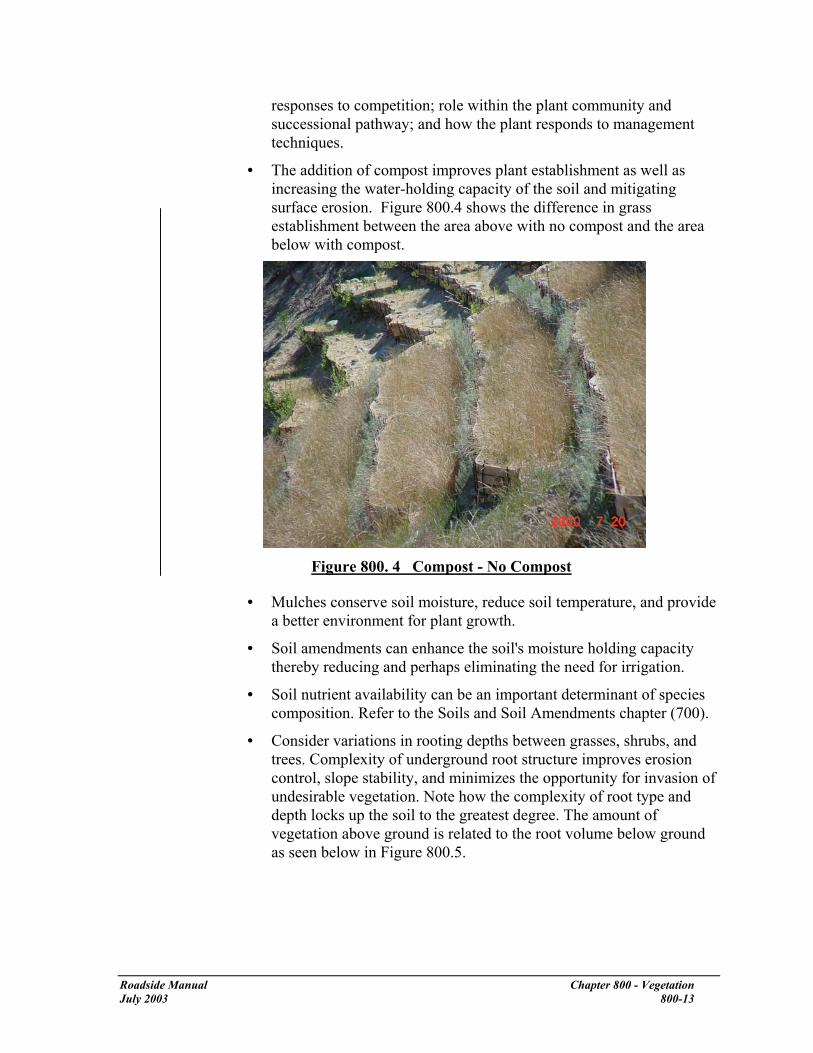
responses to competition; role within the plant community and successional pathway; and how the plant responds to management techniques.
• The addition of compost improves plant establishment as well as increasing the water-holding capacity of the soil and mitigating surface erosion. Figure 800.4 shows the difference in grass establishment between the area above with no compost and the area below with compost.
Figure 800. 4 Compost - No Compost
• Mulches conserve soil moisture, reduce soil temperature, and provide a better environment for plant growth.
• Soil amendments can enhance the soil's moisture holding capacity thereby reducing and perhaps eliminating the need for irrigation.
• Soil nutrient availability can be an important determinant of species composition. Refer to the Soils and Soil Amendments chapter (700).
• Consider variations in rooting depths between grasses, shrubs, and trees. Complexity of underground root structure improves erosion control, slope stability, and minimizes the opportunity for invasion of undesirable vegetation. Note how the complexity of root type and depth locks up the soil to the greatest degree. The amount of vegetation above ground is related to the root volume below ground as seen below in Figure 800.5.
Roadside Manual Chapter 800 - Vegetation July 2003 800-13
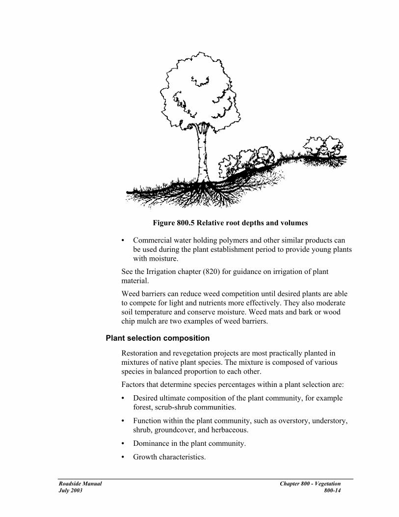
Figure 800.5 Relative root depths and volumes
• Commercial water holding polymers and other similar products can be used during the plant establishment period to provide young plants with moisture.
See the Irrigation chapter (820) for guidance on irrigation of plant material.
Weed barriers can reduce weed competition until desired plants are able to compete for light and nutrients more effectively. They also moderate soil temperature and conserve moisture. Weed mats and bark or wood chip mulch are two examples of weed barriers.
Plant selection composition
Restoration and revegetation projects are most practically planted in mixtures of native plant species. The mixture is composed of various species in balanced proportion to each other.
Factors that determine species percentages within a plant selection are:
• Desired ultimate composition of the plant community, for example forest, scrub-shrub communities.
• Function within the plant community, such as overstory, understory, shrub, groundcover, and herbaceous.
• Dominance in the plant community.
• Growth characteristics.
Roadside Manual Chapter 800 - Vegetation July 2003 800-14

• Compatibility with other species:
Select fewer numbers of fast growing species, such as elderberry or cottonwood, to reduce conflict with slower growing species.
Slower growing species, such as vine maple, salal, and spruce may require a higher percentage of representation to be successful in the development of the plant association.
Some species may not be appropriate for the initial planting phase. Included are understory plants, such as cedar, salal, or vine maple that demand a microenvironment that can only develop over time.
Spacing
The distance between plants is determined by the following considerations.
• Weed control. Densely spaced vegetation minimizes the establishment of weeds.
• Some plant species need support from surrounding plants in order to compete and develop. These form functional plant associations. Examples are snowberry, rose, salal, mahonia, spiraea, and mock orange. Plant spacing is based on closure of the canopy after approximately 5 to 7 years. The shrubs form a thicket over time that can shade out weeds.
• Consider the developmental needs of individual plants.
• The following species are examples of species that may be considered for clustering: aspen, hazelnut, and oceanspray.
• Space climax vegetation to resemble the spread in the natural plant community as determined by the reference site.
• Space species such as red alder to quickly perform their function in the plant succession scheme without causing undesirable competition to other desirable plants. A management program that includes periodic removal of plants that have outlived their function will be necessary.
• See Appendix D for methods to calculate plant spacing.
Determination of percentages within a plant selection mixture
This section discusses a method for determining the numbers of plants per species to use in a revegetation plant mixture. The percentages of the species within a plant selection mixture are based on the desired spacing and distribution in the planting area.
Roadside Manual Chapter 800 - Vegetation July 2003 800-15

• Decide on the native plant revegetation concept: Managed Succession or Accelerated Climax Community Development. (Refer to chapter 810 for more information on these concepts.)
• Develop the desired plant palette for the plant selection mixture.
For example, a roadside restoration mixture that follows Accelerated Climax Community Development principles is designed to consist of a shrub layer of snowberry, rose, and Oregon grape. Intermediate or understory species consist of oceanspray, hazelnut, and vine maple. The overstory is Douglas fir, western hemlock, red alder, and big leaf maple. Red alder is intended to function as a temporary cover crop (overstory) with most alders to be removed during the initial five to seven years.
• Establish an area size to base the calculations on. Metric and English examples are shown in the following three charts:
Total planting area 930 m2 10,000 sq ft
Spacing 1 m 3 ft Area per plant 0.836 m2 9 sq ft
Divide total by area per plant
930 m2 ÷ 0.836 m2 =
10,000 sq ft ÷ 9 sq ft =
Total number of plants 1112* 1111*
* Round to 1100 plants for this example.
For the overstory species of Douglas fir, western hemlock, red alder, and big leaf maple, determinations are made for the species mixture. Site conditions are less favorable for western hemlock; thus its percentage has been arbitrarily established at 2% of the total of 1100 plants. For the remaining species, the following calculations are made:
Total planting area 930 m2 10,000 sq ft
Spacing 5 m 15 ft Area per tree 37 m2 400 sq ft
Divide total by area per plant
930 m2÷ 37 m2 =
10,000 sq ft ÷ 400 sq ft =
Total number of trees 25 25
Twenty-five trees is about 4% of the total number of plants or 1-1/3% for each species.
Because, of the three species listed above, Douglas fir is the least competitive on the chosen site, it is assigned 2%, with red alder and big leaf maple each making up 1% of the total species mix. Overstory species will total 6% (2 +2 +1+1).
For intermediate height, understory species such as oceanspray, hazelnut, and vine maple, spacing is desired as seen below: (In a managed
Roadside Manual Chapter 800 - Vegetation July 2003 800-16

succession planting program these species would be added in subsequent years as the overstory develops and shade becomes available.)
Total planting area 930 m2 10,000 sq ft
Spacing 3 m 10 ft Area per tree 9.3 m2 100 sq ft
Divide total by area per plant
930 m2 ÷ 9.3 m2 =
10,000 sq ft ÷ 100 sq ft =
Total number of trees 100 100
One hundred plants are about 10% of the total. Vine maple is arbitrarily assigned 4% and the oceanspray and hazelnut are assigned 3% each.
The remaining percentage of 84% is shared by the shrub layer of snowberry, rose, and Oregon grape. Observations of the reference site for this project have documented a forest floor dominated by snowberry with rose and Oregon grape interspersed in mostly small clusters. The decision is to assign snowberry with 50%, rose with 20%, and Oregon grape with 14% based upon the ratios at the reference site.
The shrub layer shades out undesirable competitors through early closure. It has been experienced that a 1 m (3 ft) spacing per plant will provide this benefit within the normal plant establishment period of 5 to 7 years.
Roadside Manual Chapter 800 - Vegetation July 2003 800-17

The final mixture looks as follows:
Plant Selection EXAMPLE
Botanical name Common name
% Spacing Quantity 1100 Total*
Notes
Pseudotsuga menziesii
Douglas fir 2 3 m (10 ft) min. 22 -
Tsuga heterophylla, western hemlock
2 3 m (10 ft) min. 22 -
Alnus rubra red alder 1 3 m (10 ft) min. 11 -
Acer macrophyllum big-leaf maple
1 3 m (10 ft) min. 11 -
Holodiscus discolor oceanspray (creambush)
3 3 m (10 ft) min. 33 Clusters of 3 - 5
Corylus cornuta beaked hazelnut
3 3 m (10 ft) min. 33 Clusters of 3 - 7
Acer circinatum vine maple 4 2 m (6 ft)min. 44 -
Symphoricarpos albus
snowberry 50 1 m (3 ft) O C 550 -
Rosa gymnocarpa wood rose 20 1 m (3 ft) O C 220 Clusters of 15-25
Mahonia aquifolium Oregon grape
14 1 m (3 ft) O C 154 Clusters of 3 - 7
* Quantities are based on the area in the example above. In a real project situation, the quantities will be calculated for the actual planting area that is designated for the plant selection.
Figure 800. 6 Plant Selection for the Example
Notes: Average plant spacing of the plant mixture just under 1m (3 ft) on center. (930 m2/1100plants) Trees are to be randomly distributed throughout the planting area. OC = on center. Plant spacing measured from center to center of plant.
Construction Design documents consider construction requirements such as site accessibility and constraints such as contract timing. During construction:
• Do not deviate from plans without approval of the Landscape Architect.
Roadside Manual Chapter 800 - Vegetation July 2003 800-18

• Protect existing trees from construction impacts.
Ideally, the root zone of vegetation is protected out to 1.5 times the diameter of the drip line. At a minimum, protect the root zone to the outermost reach of its branches (the drip line). If cuts or fills are required in the vicinity of trees to be saved, consider retaining walls, tree wells, gravel, or drainage systems to protect the root systems.
Heavy equipment stored, parked, or driven around the base of a tree can compact the soil and deprive the tree's roots of the water and air they need to survive. Stockpiling building materials or fill can have a similar effect. Refer to the Soils and Soil Amendments chapter for more information on soil compaction and its minimization.
Scraping soil from roots or cutting them too deeply or too close to the tree can cause the tree to die or have a weakened hold and blow down. This damage may not be visible for years.
• Contracts often include a one-year plant establishment guarantee period from the contractor.
• On projects operating under a Corridor Management Plan, the community has had significant input into the plans and deviation could cause problems.
Transplant Guidelines
The reason for setting transplant guidelines is to increase the likelihood of plants surviving, growing to maturity, and reproducing. The chance of success is much greater if plants from the same altitude and ecosystem are used because they are adapted to that area’s climate and elevation.
Collect plant materials during the dormant season. Keep them protected from wind and heat. Best results are obtained when installation occurs the same day materials are collected. However, some believe greater success can be realized with cuttings if stems are soaked in water 5 days prior to planting. Protecting stems from wind and keeping them cool and moist is essential.
Upland Plant Species
Use local seed (collection) zones to identify the best areas to collect seeds, cuttings, or plants. A seed zone is an area with a defined boundary and altitudinal limits within which landform and climate are sufficiently uniform. The landscape architect or HQ horticulturist will be the source of information.
In 1966, seed zones were developed, based on climatic and physiographic information, to reduce the risk of maladapting commercial tree species and to provide structure for commercial seed trade. Each zone has geographic boundaries and is additionally divided into 500-foot
Transplant guidelines have been moved from the Soil Bioengineering chapter to this location. The text remains the same.
Roadside Manual Chapter 800 - Vegetation July 2003 800-19

elevation intervals. Seed lots are coded by both seed zone and elevation band.
• When collecting seeds, cuttings, or plants for smaller projects (perhaps a one-time collection) the elevation band can extend approximately 250 feet above and below the site.
• Salvage and transplant while plants are dormant.
• Collect cuttings from 30 to 50 parent plants in good condition (if available). In general, take no more than 33 percent of the parent plant’s material and take no more than 50 percent of cuttings or seed from a given area.
• For plant cuttings, use young shoots (1 to 2 years old). Older and larger stems tend to have higher mortality.
• Protect cuttings from wind by covering them with plastic sheeting or moist cloth.
Shrubs, Herbs, Grasses, and Riparian Species
Use watershed boundaries as seed, cutting, plant collection, and transplant zones. In addition, collect necessary plant material within a 500-foot elevation band of the planting site.
Gene Pool Conservation Guidelines
Making sure the seed lot, cuttings, or plant lots are genetically diverse is just as important as plant movement guidelines. To prevent loss of genes in the population, use a minimum of 30-50 unrelated donor plants. Collecting an equal number of seeds, cuttings, or plants from each donor plant or area will also ensure representation by as many parent plants as possible.
Separate donor plants by sufficient distance to the reduce risk of relatedness.
Planting
• Plant salvaged plants within about 2 hours of lifting. Keep plants moist and free from wind and heat exposure.
• Dig holes 2 times the volume of the root ball. Larger holes will be required in more compacted soils.
• Planting holes must be deep enough so that the downslope side of the rootball is entirely buried.
• Plant the plant so the root collar is at the depth at which it was previously growing.
Roadside Manual Chapter 800 - Vegetation July 2003 800-20

• Spread roots out so none are kinked or circling. Protect roots, especially fine root hairs on the main root system. Add water, if available, to reduce voids and increase root and soil contact.
• Use on-site soil to backfill the hole. Firmly tamp the soil around the plant. Be careful not to compact the soil.
• Transplanting a microsite: Depending on site conditions and project objectives, it might be preferable to salvage and transplant a small section of ground. This section usually contains several plants with roots, mycorrhizae, seed, soil, soil microorganisms, and duff materials. This technique provides great benefits to the area being revegetated. For transplanting small sections of ground, excavate an area large enough to “plant” the entire piece. Lay it in the excavated area and level with adjoining ground. Use excavated soil to secure edges of transplanted piece. Tap gently into place. Whenever possible, water the transplant.
Seed, Fertilizer, and Mulch
Figure 800. 7 Hand-Distribution of Mulch
Hydroseed or broadcast seed, fertilizer, and mulch. Make sure seed is covered with the correct depth of soil if broadcasting. The depth will depend on the type of seed being used. Check with the HQ Horticulturist for correct planting depths for the seed mix. Composted organic amendments, in place of fertilizer, also work well. Some compost blowers are able to inject seed as the compost is blown onto the site.
Once seeded, it is necessary to protect the site from additional surface water flow, specifically overland flow from roads. Direct the water flow away from the project area with gravel drains, swales, culverts, or drainpipe.
Weed-free straw or wood cellulose fiber mulches can be used as a mulch to minimize rain splash erosion. When using straw as a mulch, use as
Roadside Manual Chapter 800 - Vegetation July 2003 800-21

thin a layer as possible to cover the soil (¼ inch). Grass seed cannot sprout if the mulch is too thick.
Planting
Correct plant handling and planting techniques play a major part in plant establishment.
• Keep the rootball moist and bare roots covered at all times.
• When planting, the root flare should be 10% of the root ball depth above ground level.
• Dig the planting hole so it is a minimum of 2 times the diameter of the rootball width.
• Plants smaller than 20-gallon container size do not need to be staked.
• Mulch should cover only the edge of the rootball. When planting is completed, there should be no additional soil and little or no mulch over the root ball for container plants.
Additional information on tree planting can be found at the following website: http://hort.ifas.ufl.edu/woody/planting/index.htm
Maintenance The maintenance supervisor in charge of the contract area reviews and comments on plans during the development of the PS&E. Maintenance review is essential because WSDOT maintenance crews maintain landscape projects after installation.
Before maintenance crews make significant changes in existing roadside landscaping, consult any applicable Corridor Management Plan and the region’s Landscape Architect. Communication between all roadside partners is an important part of improving Washington’s roadsides.
Partnerships
Some projects have special partnership arrangements, for example, WSDOT might require the project sponsor or partner to maintain plant communities. Corridor Management Plans will describe partnership agreements within the scenic highway corridor. Project sponsors have included cities, counties, tribes, Metro, Intercity Transit, and other agencies. In these cases, the partner, or partners, reviews design documents and plant material selection prior to installation; they can also contribute labor, funding, and materials.
Roadside Manual Chapter 800 - Vegetation July 2003 800-22

Security and Visibility: Safety Rest Areas and Weigh Stations
WSDOT has a policy of not removing vegetation or limbing trees in the roadside to open views for adjacent property owners.
The following are general recommendations for areas where vegetation is creating security concerns or limiting visibility within Safety Rest Areas, weigh stations, etc. Visibility into a site is often needed or requested by agencies such as the Washington State Patrol.
The following actions have been used successfully in a number of areas to alleviate concerns while minimizing impacts on existing vegetation and the valuable functions it provides. These actions are only applicable to alleviate specific security and site visibility concerns, and are not intended as a standard treatment for every roadside area.
• Analyze the area to determine the source and extent of the concern.
• Evaluate all of the functions that the vegetation provides.
• Tailor all actions to balance any removal or thinning of vegetation with the functional value that the vegetation provides in the specific location.
• Complete removal of all vegetation (clearing) is not an acceptable method of alleviating every security concern. Strive for a win-win treatment that alleviates security and visibility concerns while retaining the functional value of the vegetation.
Where removal or thinning of vegetation is determined to be desirable, consider the following actions:
• Limb branches of large evergreen trees (Western Red Cedar, Douglas fir, etc.) to an approximate 9 ft elevation above the ground surface.
• Prune smaller deciduous trees to encourage an open habit with leaves above a 6 ft elevation (hazelnut, serviceberry, vine maple, etc.). Remove only branches that are within the direct line of vision.
• Trim shrubs and groundcover to a 2 ft height and do not allow to grow higher than 3 ft high before pruning again (salal, snowberry, Nootka rose, etc.).
• Information on correct pruning methods can be found at http://hort.ifas.ufl.edu/woody/pruning/index.htm
Consult with the region’s Landscape Architecture Office or HQ Roadside & Site Development Unit for site and species specific pruning methods.
Roadside Manual Chapter 800 - Vegetation July 2003 800-23

Additional Sources of Information • American Association of Nurserymen, American Standard for
Nursery Stock, Washington, D. C., latest version
• "Native and Adapted Plants for the Inland Northwest" WSU Cooperative Extension, Spokane County
• Jerry F. Franklin and C. T. Dyrness, Natural Vegetation of Oregon and Washington. Oregon State University Press. 1988.
• C. Leo Hitchcock and Arthur Cronquist, Flora and Fauna of the Pacific Northwest. University of Washington Press. 1973.
• Liberty Hyde Bailey and Ethel Zoe Bailey, Hortus Third: A Concise Dictionary of Plants Cultivated in the US and Canada. Macmillan Publishing Company, New York, 1976.
• N. J.Coppin and I. G. Richards, Use of Vegetation in Civil Engineering, Construction Industry Research and Information Association (CIRIA), London, 1990.
• D. H. Bache and I. A. MacAskill, Vegetation in Civil and Landscape Engineering, Granada Publishing Ltd, London, 1984
• Michael Dirr, Manual of Woody Landscape Plants, Champaign, Illinois, Stipes Publishing Company, 1983.
• Richard W. Harris, Arboriculture: Integrated Management of Landscape Trees, Shrubs and Vines, Prentice Hall Career and Technology, Englewood Cliffs, New Jersey, 1983.
Roadside Manual Chapter 800 - Vegetation July 2003 800-24

810 Vegetation Restoration
General The guidelines in this chapter provide background for the development of effective vegetation restoration methodologies. Two basic restoration approaches are used: managed succession and accelerated climax community development1. They are based on the principles of plant succession in natural ecosystems. The decision on which approach to use depends on permitting requirements, project goals, and roadside functional objectives. The Landscape Architect shall be involved in all discussions concerning these decisions.
The following table gives a general indication of when the two methods are used.
RCP Treatment
Level
Managed Succession
Accelerated Climax Community Development
1 X
2 X X
3 X
Figure 810.1 Restoration Method Use
When roadside areas are disturbed during roadway projects, the project’s lead agency or Project Office is responsible for rehabilitating the roadside according to the policies stated in the Roadside Classification Plan. The guidelines and discussion in this chapter will facilitate restoration of the roadside environment.
The use of native plants in roadside restoration will, over the long-term, reduce maintenance and life cycle costs of our roadsides. For example, the use of native plant communities reduces mowing costs over the life of the roadside.
References
Roadside Classification Plan, M 25-31, WSDOT
1 Not all experts accept the Climax concept, however because of its ease of use as a conceptual framework it will be used in this manual.
Roadside Manual Chapter 810 - Vegetation July 2003 810-1

Resources
Region’s Landscape Architects
HQ Design Office Roadside & Site Development Unit
Region’s Environmental Office
HQ Environmental Affairs Office Biology Unit
HQ Horticulturist
Definitions
accelerated climax plant community The process of restoring a site to a desirable climax plant community in reduced time when compared to natural processes. allogenic succession Changes in the composition of the plant community as a result of environmental forces. 2
autogenic succession Changes in the composition of a plant community due to plant interactions (facilitation or competition).3 climax vegetation A stable end-point to plant succession (“steady state”) where a group of species predominates and replaces itself.4
enhancement Any improvement of a structural component to increase the level of ecological functioning of a site.
genotype The genetic make-up of an organism. managed succession A technique that uses management activities to modify the rate and direction of succession. plant association A particular, consistent group of species growing in a particular, consistent type of habitat.
plant community A general term describing the group of plants growing in an area.
plant succession Directional, cumulative change in the species that occupy a given area through time.5 reference site An established, minimally disturbed natural site that is used as a comparative design guide to help determine the desired plant composition and species densities for the created or enhanced project site. Preferably, the reference site is near the project site, within the same watershed, and has similar hydrology, soils, solar exposure and aspect, and topography. Multiple reference sites can be used resulting in a number of possible community outcomes.
2 Oliver and Larson, p. 29. 3 Ibid., p. 29. 4 Ibid., p. 147.
Roadside Manual Chapter 810 - Vegetation July 2003 810-2

restoration The process of renewing and returning ecosystem function and health5 (for systems that have been significantly altered by human activity).
Succession Plant communities are in a constant state of fluctuation due to changes in their environment. As a general rule, the composition of any given community can shift in response to changing conditions caused by disturbances. If the disturbance is small, the change in plant community will not be dramatic. If the disturbance is large, such as fire, a landslide, or road building activities, the change in the plant community will be dramatic. Species most suited to the new conditions will colonize in the greatest number. Over time, if no new disturbance occurs, new plants will colonize the area. The new species often tend to be larger, longer lived, and/or woody. This directional, cumulative change in the species present over time is plant succession.
Succession is governed by both external and internal forces. Allogenic (external) forces include human activity, animals, fire, wind, flooding, earthquakes, land slides, climate change, and pathogens and pests.
Autogenic (internal) forces include competition or facilitation between the plants themselves that bring changes in relative abundance of species. These internal changes include displacement of one species by another, shifts in population structure (relative percentage of any one species to the population as a whole), facilitation of increasing dominance by one species due to the conditions created by another, and changes in available resources (sunlight, soil, moisture, etc.).
Disturbance and Succession
Depending on the severity of a disturbance, two types of succession can take place. These are primary and secondary succession.
Primary succession is the initial stage of plant community restoration following a severe disturbance that leaves bare soil. Initial colonizers, known as pioneer species, establish themselves rapidly during the first growing season, providing cover and minimizing soil erosion. Many plants involved in primary succession are those that can tolerate a wide variety of conditions including the scarcity of water and nutrients. They reproduce rapidly and often spread large quantities of seed using wind or animals as carriers; characteristics of
5 Society for Ecological Restoration, 1995.
Roadside Manual Chapter 810 - Vegetation July 2003 810-3

many weeds; for example Scotch broom in uplands or toad rush in a wetland.
Secondary succession begins either after the plant community of the primary successional phase has become established or following a more mild disturbance which leaves some of the predisturbance habitat in tact. Plants involved in secondary succession are generally longer lived and require somewhat more developed soil conditions to survive. They are often fast-growing trees or shrubs and serve to further stabilize and amend the soil. Examples of secondary succession include red alder colonizing a clear-cut, willow spreading into or along the edge of a wetland, or Douglas fir getting started in a windfall-caused clearing in a mature western hemlock forest.
Secondary succession can take place without the entire plant community being dominated by the new species. A single new species out-competing an established species for its niche habitat is an example of secondary autogenic succession.
Climax Plant Communities
As conditions change across varying habitats, the plant community that dominates the area changes. Communities also change over time as plants and animals alter the microenvironment by changing the nutrient content, texture, and moisture levels in the soil. Their physical structures also provide shade and intercept rainfall, affecting the microhabitats within their canopies. These changes, coupled with disturbances, give other species a competitive advantage.
Over a long period of time, a series of subtly different communities dominate the site. Eventually, in the absence of disturbance, a more slowly evolving state is reached in which existing species thrive and new species are mostly excluded. This later example is known as a climax community and represents a mature, relatively stable system. Even climax communities can be sent back to an earlier successional stage by disturbances such as fire or beaver activity.
Genetic Diversity One goal in vegetation restoration is to match the genotype of plant materials as closely as possible to that which occurs in similar plant associations within the watershed. Unlike agriculture or forestry, which selects genetic strains for a limited number of desirable characteristics (such as a crop ripening at the same time for ease of harvest), restoration seeks to promote and retain the natural range of variation of genotypes that occur within nearby reference sites. Genetic diversity often allows for wide variability within the same species in a single plant community.
Roadside Manual Chapter 810 - Vegetation July 2003 810-4

Appearance does not necessarily indicate the genetic adaptability of a plant. One member of a species might have characteristics that allow it to survive under stresses such as drought or pests. All members of the community can be of value.
Members of the same species found in different locations have different adaptations to their specific differences in habitats (for example soil type) or climate (for example blooming times might vary in accordance with local rainfall patterns). It is desirable to obtain plants grown from seeds or cuttings taken from within the same watershed whenever possible because these small differences can affect plant survival.
Vegetation Restoration Concepts
Managed Succession
With the strategy of managed succession, the objective usually is to manipulate the introduction of native pioneer species to develop site conditions that are conducive to desirable climax, or later successional species. This method is less expensive than planting an accelerated climax plant community and utilizes the desirable quality of promoting natural processes.
There are often situations where a later successional community might not be desirable. Managing successional patterns (arresting succession at a stable shrub stage for example) through careful design, site preparation, and selective maintenance is appropriate and desirable in many situations.
Management of the site might include introduction of pioneer species and secondary successional species or it might allow pioneer species to come in on their own. Periodic removal of the pioneer species and gradual introduction or encouragement of climax or later successional species might also be necessary. We expect our “mature” sites to go through some successional changes.
Pioneer or primary successional species are often weedy grasses and herbs that can rapidly colonize large patches of bare ground.
Eastern Washington
In much of Washington east of the Cascade Mountains, grasslands with herbs are often the climax species. Woody vegetation might be limited or nonexistent.
In grassland and prairie restoration, develop a seed mix of native grasses. See the region or HQ Landscape Architect for grass seed mixes for low moisture zones.
Roadside Manual Chapter 810 - Vegetation July 2003 810-5
• The species chosen are dependent upon the site and precipitation amounts. Use reference sites and local native ecosystem associations a guide.
• Growing contracts for grasses might require 2 years lead time to produce sufficient seed for WSDOT construction or restoration projects.
• Select a mixture that allows for quick erosion control and long-term soil structure enhancement.
• Add appropriate herbs to the seed mix for nitrogen fixing, nectar sources, and visual enhancement where wildlife forage will not contribute to a road-kill problem.
• Consider drill seeding native grasses. This gives the seed needed soil contact and protects the seed from wind and sun.
• Native grasses develop their root system before they develop top growth. Top growth might not be visible until the second or third year. Don’t give up.
• Before using fertilizers in native grassland restoration, analyze the site and its soil chemistry. Native grasses cannot use large flushes of nutrients. When fertilizers are necessary, use a slow-release form.
Woody vegetation might consist of a sagebrush community, or trees that grow only on north-facing slopes or in riparian zones.
• Where it is practical and desirable to grow woody species, select plants that have been grown locally, whenever possible, because these will be hardy in that climate.
• If fertilization is needed, use only slow-release granular fertilizer.
• Some species in Eastern Washington can be considered pioneer as well as climax species. Quaking aspen, lodgepole pine, water birch, and Ponderosa pine are examples.
Lowland Western Washington
Woody secondary successional species begin to dominate once the primary pioneers have thoroughly colonized and “improved” the site conditions. Suitable early successional plants for humid ecosystems in Washington are Douglas fir, black cottonwood, willows, red alder, bigleaf maple, paper birch (most common in Snohomish County and north), Oregon ash (most common in southern King County and south) and red osier dogwood. These plants essentially function as a cover crop and are also part of a mature forest.
Roadside Manual Chapter 810 - Vegetation July 2003 810-6

It is desirable that the species selection be proportioned to represent the natural, early succession stages or representative plant communities occurring in the watershed or sub-basin. Refer to Chapter 800 of this manual for an example of this calculation.
Accelerated Climax Plant Community Development
The objective is to restore a site to a desirable climax plant community, or “special” non-climax communities: such as Puget prairies & sedge meadow wetlands, in reduced time when compared to the natural process. This method is more expensive than managed succession, but can meet project goals and regulatory requirements. Desirable conditions can be reached within 5 to 7 years.
The process involves the introduction of representative species of the desired plant community. Management of the site includes initial control or removal of undesirable plants.
Understory species might be selectively introduced over time. Species are selected from the referenced native plant community. The plant selection is generally a simplified representation of the desired climax plant community.
Plant selection criteria include:
• Roadside Classification Plan treatment recommendations
• Native plant community
• Compatibility with site conditions
• Availability from commercial nursery sources
• Survival characteristics
• Functions to be provided by the plants
• Similar reference plant communities in the watershed or sub-basin
Factors limiting climax community development include the growth rate of the desirable species, development of upper soil horizons, and colonization by necessary insect, mycorrhizae, and animals.
Methods for Managing Succession Working with succession can assist the roadside manager to develop sustainable plant communities that require minimal ongoing management.
Management activities modify the rate and direction of succession. A management plan can be designed to either promote or hold succession at a given stage.
Roadside Manual Chapter 810 - Vegetation July 2003 810-7

The three components of managed succession are:
• Designed disturbance
• Controlled colonization
• Controlled species performance
These are detailed further on succeeding pages. Each of these components can be used to enhance or arrest succession along the roadside. Note: arresting succession requires ongoing maintenance. (For example, mowing or burning to maintain open grassland rather than Scotch broom or forest.)
Examples of possible components of managed succession follow.
• Plant (or allow colonization by) desirable early successional species such as red alder or bigleaf maple (controlled colonization).
• Thinning of these trees can be done once they grow large enough to provide shade (designed disturbance). However, trees will eventually self-thin because of competition for light, water, and nutrients.
• Interplant shade tolerant trees, such as western red cedar or western hemlock, or understory shrubs, such as salal or huckleberry (controlled colonization).
• Soil can be amended to optimize growing conditions for desired species (controlled species performance).
The overall goal of using managed succession is to establish sustainable plant communities.
Sustainable plant communities meet Roadside Classification Plan goals with minimal maintenance force expenditures.
Designed Disturbance
Designed disturbance is any activity initiated to create or eliminate site availability for plant growth. Examples of designed disturbance activities include, but are not limited to:
• Burning • Chopping • Clearing • Fertilizer application • Herbicide application • Mowing • Soil pH manipulation
Roadside Manual Chapter 810 - Vegetation July 2003 810-8

• Thinning • Adding topsoil and mulch
Along with climate, elevation, surface and ground water attributes, and orientation factors, soils are a primary determinant of vegetation patterns. Of these four factors, soils are most easily manipulated at any given location by the addition of amendments, nutrients, cultivation, grading, and water. It is important to replicate the natural soils on which the desired plant community is typically found.
The soil requirements of different plant communities can be drastically different with regard to pH, organic content, moisture levels, and chemical composition. Be sure the plants being installed either are adapted to the soil conditions of the site or that the resources are available to change the soil conditions. See Soil and Soil Amendments in Chapter 700 of this manual for more information.
Controlled Colonization
Controlled colonization usually involves adding plants to a site. Planting could range from seeding to planting large plants. In addition to introduced plants, desirable existing plants or seeds might be present on-site, or might be able to spread from adjacent sites. These plant starts will compete with, or augment, the ultimate design plant community. Caution: The introduction of exotic plants can seriously undermine vegetation restoration efforts. Every effort should be made to keep particularly troublesome species (for example English Ivy, Japanese knotweed, butterfly bush, Himalaya blackberry, purple loosestrife, Canada thistle, reed canarygrass, or Scotch broom) from becoming established at the site. Seed mixes, plantings and imported soils, should be guaranteed to be free of seeds, rhizomes, etc. If these noxious species are found they must be killed and removed immediately.
Controlled Species Performance
Controlled species performance uses various methods to decrease or enhance growth and reproduction of specific plant species. Successful controlled species performance recognizes the dynamic character of plant communities, and encourages specific plant communities that will resist invasion through competitive interactions. Individual species and their populations are targeted within this context. To accomplish this, the manager must have knowledge of species characteristics, including:
• Water, light, and nutrient requirements.
Roadside Manual Chapter 810 - Vegetation July 2003 810-9

• Physiological characteristics, such as root structure, or plant shape.
• Responses to competition.
• Role within the plant community and successional pathway.
• How each species responds to proposed management techniques.
By understanding and using this information, the roadside manager can use common practices to control species performance. Some examples of controlled species performance practices are:
• Mowing undesirable species after flowering but before seed production to eliminate reproduction.
• Not mowing where desirable species (such as lupine) exist until after seed production to allow for next year’s stand.
• Shading out shade intolerant invasive species with tree or shrub cover. (Not all invasive species are shade-intolerant, however.)
• Plant-specific application of selected herbicide.
Evaluation
To be successful, evaluate managed succession techniques until goals and objectives stated in the management plan are met, regulatory commitments are met, and the site is functioning. If a plant community is not developing according to the design set in the management plan, the region’s maintenance staff, with the landscape architecture office, the Biologist, and the HQ Horticulturist will evaluate the situation and adjust practices and/or management plan goals accordingly.
Contracts and Schedules
Growing Contracts
Because plants selected from genetic stock obtained from the same habitat as the project adapt better to those climatic conditions, growing contracts may be necessary to obtain sufficient numbers of desired plants. For woody vegetation, one to two years growing time may be necessary. Grass and herbs may require two years or more from seed collection to seed production in numbers sufficient to seed the project area.
Consider having vegetation grown from seeds or cuttings taken from the vegetation of the construction site before construction begins.
Roadside Manual Chapter 810 - Vegetation July 2003 810-10

When practical, allow time in the landscape contract for growing contracts where insufficient stock is available. This is in addition to the 1 to 3 year plant survival clause in the landscape contract.
Separate Roadside Revegetation Contracts
Because of the specialized nature and timing of roadside revegetation and restoration work, it can be advisable to separate this part of the contract from the engineering component of the project. This can allow the engineering contract to close while the revegetation contract continues. Funding must be assured in advance.
Consider work sequencing over at least two seasons to allow for managed succession practices.
Consider adding minimum landscape contractor’s qualifications and references to the contract. Contract inspectors shall include the restoration design team or the wetland design team to ensure the project is constructed as designed, that it will meet regulatory requirements, and to make necessary adjustments to meet unexpected soil or moisture conditions.
For grassland work, consider specifying no-till seed drilling for seeding without disturbing the soil layers. This can be done only where the existing vegetation has been eradicated using non-residual herbicides.
Construction Scheduling
Planting must be done during planting windows, per the Standard Specifications to allow for maximum growth during the rainy season.
Woody Vegetation
Plant stock one gallon or smaller in size, and use compost tilled into the soil with a bark or wood chip mulch layer to hold soil moisture and reduce weed competition. Continue to monitor plants during the first 3 to 5 years to determine plant moisture needs and supplement as practical and necessary.
Grasses and Herbs
The ideal seeding window is specified in the Standard Specifications to take advantage of seasonal rainfall.
It is possible that native grasses will not be visible the first year because they develop their root systems first before putting out top growth. A provision for initial erosion control must be made while the native vegetation becomes established. This can take the form of erosion control matting or a cover crop such as sterile wheat.
Roadside Manual Chapter 810 - Vegetation July 2003 810-11

Plant Establishment Maintenance and Monitoring Maintenance of new plantings until they become established is critical to the success of revegetation projects. Landscape contracts must include provision for plant establishment and weed control.
Plant Selection Including Plant Establishment (PSIPE) should be enforced in all contracts. Under this provision, the contractor maintains and guarantees plant survival for the first 1-3 years depending on the contract.
Allow funds for maintenance of the site until desirable plants become fully competitive with weeds (generally 5 to 7 years). Maintenance can include planting additional plants to meet coverage requirements. The Landscape Architect can arrange for contractors to perform this maintenance. These provisions allow WSDOT to meet required standards of success in restoration permitting and to restore roadside functions after roadway construction.
Consider the following techniques:
• Selective weeding.
• Wicking with herbicides, or other selective herbicide treatments, where appropriate.
• Native prairies need regular disturbance in the form of mowing or fire to prevent invasion by woody species. Controlled burns might be done in coordination with local fire department training. Burn no more than 1/3 to ½ of the prairie acreage per year. This allows a refuge for insects (such as butterflies) to survive the disturbance.
• For prairie restorations, high mowing (6-12 inches) can be done once late winter/early spring growth starts - this can be as early as January in lowland Western Washington and again before seeds mature. Mowing during this time will encourage natives and cut back the nonnative species by removing the leaves, flowers, and immature seeds of fast-growing non-natives.
Monitor native prairie vegetation during the growing season. Native herbs and grasses go dormant during the dry season (July through September). Monitoring during this season will not provide complete plant community data.
Roadside Manual Chapter 810 - Vegetation July 2003 810-12

Additional Sources of Information M.G. Barbour, J.H. Burke, and W.D. Pitts. 1987. Terrestrial Plant Ecology, Benjamin/Commings, Inc. , Menlo Park, California.
Kelly M. Cassidy. 1997. Land Cover of Washington State: Description and Management. Volume 1. In: Washington State Gap Analysis Project Final Report (K.M. Cassidy, C.E. Grue, M.R. Smith, and K.M. Dvornich, eds.). Washington Coopertive Fish and Wildlife Research Unit, University of Washington, Seattle. 260 p.
Sarah S. Cooke (editor), 1997. A Field Guide to the Common Wetland Plants of Western Washington and Northwestern Oregon. Seattle Audubon Society. 417 p.
Jerry F. Franklin and C. T. Dyrness, Natural Vegetation of Oregon and Washington. Oregon State University Press. 1988.
Donald Harker, Sherri Evans, Marc Evans, and Kay Harker, Landscape Restoration Handbook, Lewis Publishers. Boca Raton, 1993.
National Research Council, Restoration of Aquatic Ecosystems, National Academy of Sciences, Washington D.C., 1992.
Chadwick D. Oliver and Bruce C. Larson, Forest Stand Dynamics, Update Edition, New York, John Wiley & Sons, Inc., 1996.
Roberta Parish, R. Coupé, Dennis Lloyd, and Joe Antos (editors). Plants of Southern Interior British Columbia. Redmond Washington: Lone Pine Publishing. 1996.
Jim Pojar and Andy MacKinnon (editors). Plants of the Pacific Northwest Coast: Washington, Oregon, British Columbia and Alaska. Lone Pine Publishing. 1994.
Ronald J. Taylor. Sagebrush Country: A Wildflower Sanctuary. Mountain Press. 1992.
Roadside Manual Chapter 810 - Vegetation July 2003 810-13


820 Irrigation
General Irrigation provides additional moisture to plants during establishment (3-5 years), during long dry periods, or in special cases, on a continuing basis. Irrigation is a high maintenance and high cost item; use only when absolutely necessary.
References
Backflow Prevention Assemblies Approved for Installation in Washington State. Washington State Department of Health. Cross Connection Control Manual: Accepted Procedure and Practice. Pacific Northwest Section - American Water Works Association.
Design Manual, M 22-01, WSDOT
Standard Specifications for Road, Bridge and Municipal Construction, M 41-10, American Public Works Association and WSDOT
Resources
Regional or HQ Design Office Landscape Architects
Regional or HQ Utilities Section
Regional or HQ Maintenance Offices
Definitions1
approved Refers to an approval in writing by the health authority or other agency having jurisdiction.
atmospheric vacuum breaker(AVB) A device that contains a float check (poppet), a check seat and an air inlet vent. When water pressure is reduced to a gauge pressure of zero or below, the float check drops. This allows air to enter the device to prevent backsiphonage. It is designed to protect against backsiphonage only.
backflow Refers to the flow of water or other liquids, gases, or solids from any source back into the customer’s plumbing system or the serving utility’s water distribution system.
backflow prevention assembly Refers to a backflow preventer that is designed to be in-line tested and repaired, and to meet the head loss
1 Cross Connection Control Manual: Accepted Procedure and Practice
Roadside Manual Chapter 820 - Irrigation July 2003 820-1

and flow requirements of the recognized approval authority. The assembly consists of the backflow prevention unit, two resilient seated shutoff valves, and test cock(s).
backpressure Refers to water pressure that exceeds the operating pressure of the purveyor’s potable water supply.
backsiphonage Backflow due to a negative or reduced pressure within the purveyor’s potable water supply.
check valve A generic term used for a variety of valves that specifically allow flow in only one direction.
conduit A pipe containing electrical wiring.
contamination An impairment of the quality of potable water (by sewage, industrial fluids, or waste) that creates an actual hazard to the public health through poisoning or the spread of disease.
cross connection Any actual or potential physical connection between a potable water line and any pipe, vessel, or machine containing a nonpotable fluid, or having the possibility of containing a nonpotable fluid, such that it is possible for the non-potable fluid to enter the water system by backflow.
double check valve assembly (DCVA) An approved assembly consisting of two independently operating check valves, loaded to the closed position by springs or weights, and having suitable connections for testing. It is installed as a unit with and between two resilient seated shutoff valves
potable water Water that is safe for human consumption and free from harmful or objectionable materials as described by the jurisdictional health authority.
pressure vacuum breaker assembly An approved assembly consisting of a spring loaded check valve loaded to the closed position, an independently operating air inlet valve loaded to the open position, and suitable connections for testing. It is installed as a unit with and between two resilient seated shutoff valves. It is designed to protect against backsiphonage only.
reduced pressure backflow assembly An approved assembly consisting of two independently operating check valves, spring loaded to the closed position, separated by a spring loaded differential pressure relief valve loaded to the open position, and having four suitable test cocks for checking the water tightness of the check valves and the operation of the relief valve. It is installed as a unit with and between two resilient seated shutoff valves.
Roadside Manual Chapter 820 - Irrigation July 2003 820-2

service connection The piping connection by means of which water is conveyed from the serving utility’s distribution main to a customer’s premises.
sleeve A pipe containing other irrigation pipe. Also called casing pipe. (See Figure 820.1)
Planning
Source of Water
Sources of water for irrigation include municipal water systems and water pumped from a well, pond, stream, or irrigation district. When selecting a source of water, consider what permits and agreements might be needed as well as the cost and feasibility of bringing water from the source to the site. Show the location and water source on the irrigation plan. In some jurisdictions it might be necessary to calculate water use for the years of plant establishment. Calculate that cost and include it in the estimate.
Municipal Water Document in the project file:
• Location for the service meter. Define by contacting the serving utility.
• Location and depth of the municipal water main .
• Available liters per minute and the static water pressure in megapascals (or pounds per square inch [psi]) at the proposed meter location. Include this information on the plan sheet.
• Preliminary cost estimate for water meter and connection fee, monthly fees, and cost of water. An example of an irrigation system water cost estimate is found in the Appendix.
• Cost savings that might be realized on landscape rehabilitation jobs where there have been prior meters. Check for existing meters, their age, condition, and connections to the main.
• Water service agreement from the water supplier and an electrical service agreement with the electrical supplier. Work with the Utilities Section to obtain utility agreements.
• Cost for connections in the cost estimate.
Roadside Manual Chapter 820 - Irrigation July 2003 820-3

Well, Pond, Stream, or Irrigation District Document in the project file:
• Desired location of pump (for pond, stream or irrigation canal only).
• Location and type of power source.
• Length of suction line required.
• Height of suction lift.
• Type of suction intake.
• Need for screening of contaminants.
• Provide pump data in accordance with the Hydraulics Manual.
Obtain the needed permit(s) from the jurisdictional authority for water withdrawal.
Check with the serving utility about pipe and backflow details required.
Design
System Controls
• In appropriate locations, use electric (110 volts), battery, wind, or solar operated automatic controllers.
System Components
Select products with proven desirable performance records. Consult with maintenance personnel to determine desirable products. When a system is designed using a certain product, include a note to the contractor stating that the system has been designed with that product; but the contractor may use other manufacturers’ products that are approved by the Engineer as equal or better.
• A proprietary item request might be appropriate so that all components (for example, the same valve) in a maintenance area are the same. This allows for ease of maintenance and inventory control.
• Select durable, readily available, easy to operate, and vandal resistant irrigation components. Plastic rather than brass heads may be selected to discourage vandalism.
• Determine the size of service meter needed once the demand (gallons per minute) is known.
Roadside Manual Chapter 820 - Irrigation July 2003 820-4

• Meter water use for type of consumption where appropriate, especially at safety rest areas to determine irrigation versus restroom water use.
Layout
Perform a site analysis prior to layout design.
• Consider current and potential locations of power source, signs, guardrails, maintenance areas, planting areas, and so forth, when locating irrigation lines.
• Consider prevailing wind direction and velocity and its effect on spray patterns.
• Where practical, set sprinkler heads at least 0.6 m from trails and sidewalks, or use pop-up spray heads in order to minimize vandalism.
• Space sprinkler heads at a distance of 50 to 60% of their diameter of throw for groundcover and shrub areas. For turf areas, space them at a maximum of 50% of their diameter of throw.
• Install irrigation lines along slope contours rather than running downhill.
• Minimize the use of partial pattern heads and strip spray heads.
• Match precipitation rates for uniform coverage of the planting area.
• Balance head distribution evenly for each valve zone. Consider pressure change due to elevation and pressure loss from friction.
• For drip irrigation systems, install emitters in multiples at shrubs, and trees, to ensure a wider and more uniform distribution of water over the entire plant root area.
• Install drip emitters up-slope of trees and shrubs.
• When using a subsurface dripline irrigation system, a self-cleaning pressure-compensating system is preferred to keep the dripline from plugging with soil particles. A dripline system that incorporates root intrusion treated components or chemical release water delivery is also a preferred system.
• When possible, mount automatic controllers inside a building, for security, in a location that is easily accessible to maintenance personnel. If it is not feasible to locate the controller inside a building, then locate it away from sprinklers and preferably at a location from which the irrigation system can be viewed in operation.
Roadside Manual Chapter 820 - Irrigation July 2003 820-5

• Consider the need for winterization of irrigation systems to avoid freeze damage to system components. An air compressor fitting may be needed to blow out the lines for winter.
Piping
Irrigation systems typically use PVC pipe. Refer to the Standard Specifications for Road, Bridge and Municipal Construction for irrigation pipe and installation specifications.
Minimize the number of pipe sizes in order to reduce the number of contract Bid Items, and the construction cost. Where practical, eliminate small quantities of one size of pipe by increasing the size to the next size used on the project.
Include pipe design calculations (Pressure Loss Calculations) in the project file. An example of irrigation system pressure loss calculations can be found in the Appendix.
See Design Manual for additional design documentation requirements.
Sleeves
When irrigation lines are to be installed under pavement, provide sleeves for pipes and wiring. Install sleeves prior to paving per Standard Specifications for Road, Bridge and Municipal Construction.
• Sleeves must have smooth interior walls (not corrugated) and may be Class 200 PVC pipe, “Drain Pipe ___Diam.” or other pipe material that meets the specific load requirements.
• Size the sleeve so that the inside diameter (ID) is at least 2.5 times the combined outside diameters (OD) of the pipe(s) that are to be in it.
• Place metal locator strip above sleeve as noted in the drawing on the following page.
See the following Figure for an example of piping inside a sleeve.
Roadside Manual Chapter 820 - Irrigation July 2003 820-6
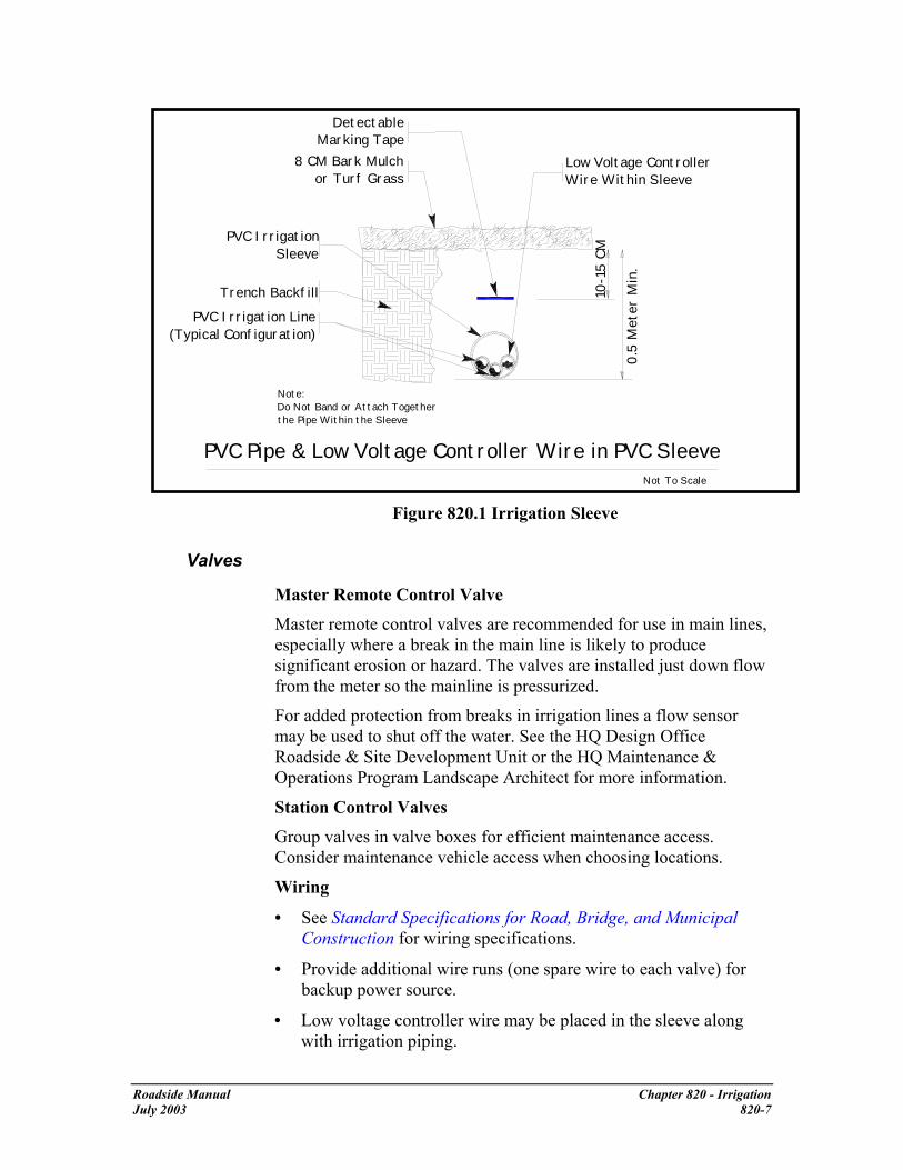
Detectable Marking Tape
8 CM Bark Mulchor Turf Grass
Low Voltage Controller Wire Within Sleeve
PVC Irrigation Sleeve
Trench Backfill
PVC Irrigation Line(Typical Configuration)
Note: Do Not Band or Attach Together the Pipe Within the Sleeve
Not To Scale
PVC Pipe & Low Voltage Controller Wire in PVC Sleeve
0.5
Me t
er M
in.
1 0-1
5 CM
Figure 820.1 Irrigation Sleeve
Valves
Master Remote Control Valve Master remote control valves are recommended for use in main lines, especially where a break in the main line is likely to produce significant erosion or hazard. The valves are installed just down flow from the meter so the mainline is pressurized.
For added protection from breaks in irrigation lines a flow sensor may be used to shut off the water. See the HQ Design Office Roadside & Site Development Unit or the HQ Maintenance & Operations Program Landscape Architect for more information.
Station Control Valves
Group valves in valve boxes for efficient maintenance access. Consider maintenance vehicle access when choosing locations.
Wiring
• See Standard Specifications for Road, Bridge, and Municipal Construction for wiring specifications.
• Provide additional wire runs (one spare wire to each valve) for backup power source.
• Low voltage controller wire may be placed in the sleeve along with irrigation piping.
Roadside Manual Chapter 820 - Irrigation July 2003 820-7

• The main electrical supply lines (110 volts) must be installed in a separate conduit.
• Use wire splices as specified in Section 9-15 of the Standard Specifications for Road, Bridge, and Municipal Construction. Check with the HQ Design Office Roadside & Site Development Office if additional information is needed.
Cross Connection Control Devices
The protection of public potable water supplies is accomplished by eliminating or controlling actual and potential cross connections (backflow). Cross connections might allow contamination to reverse flow into a potable water system or aquifer. Do not allow water to flow through the backflow device until the device has been tested by the serving utility. When a facility such as a safety rest area has no serving utility, backflow devices on wells are tested by an inspector with certification through Washington State Department of Health. Contact the HQ Maintenance Office for information.
Types of mechanical backflow devices are:
• Reduced pressure backflow assembly (RPBA).
• Double check valve assembly (DCVA).
• Pressure vacuum breaker assembly (PVBA).
• Atmospheric vacuum breaker (AVB).
All four types of mechanical devices provide adequate protection against a low degree of hazard contamination if installed correctly. Therefore, when selecting the type of device to be used against a low degree of hazard contamination, consider initial cost, serving utility requirements, and maintenance.
Of these four mechanical devices, the RPBA affords the greatest protection against backflow. The RPBA is the only mechanical device to be used where a backflow would produce a high degree of contamination hazard. The local serving utility is the ultimate approval authority for backflow prevention within their jurisdiction. It is therefore necessary to contact the local serving utility to ascertain what type of device they will require as a minimum.
Once the appropriate type of device has been determined, the device is selected from the current list in Backflow Prevention Assemblies Approved for Installation in Washington State, published and periodically updated by the Department of Health. Consult the HQ Design Office Roadside & Site Development Unit if you have questions.
A bore-sighted drain (sloped downward) to daylight must be
Roadside Manual Chapter 820 - Irrigation July 2003 820-8

provided to ensure positive drainage whenever there is an underground vault installation of an acceptable backflow device. The vault drain must be sized in accordance with the requirements of the Cross Connection Control Manual: Accepted Procedure and Practice.
Construction As a minimum, all mechanical backflow devices are installed in accordance with the most current copy of the Cross Connection Control Manual: Accepted Procedure and Practice, published by the Pacific Northwest Section - American Water Works Association. In addition, they must be installed in accordance with the Standard Specifications for Road, Bridge, and Municipal Construction, and their manufacturer’s recommendations.
Maintenance Irrigation systems require regular maintenance to function properly.
• Backflow prevention devices are to be tested annually by an inspector with certification through the Washington State Department of Health. Contact HQ Maintenance & Operations Program for information.
• Winterize irrigation lines by draining or blowing out the lines prior to the first winter freeze.
• Check system as part of Spring start-up and throughout the season.
• Repair irrigation system promptly to avoid water loss and to prevent erosion from broken water lines.
Roadside Manual Chapter 820 - Irrigation July 2003 820-9


910 Design Enhancement
General Design enhancement is the incorporation of manmade elements in the landscape to accomplish goals such as expression of community character, marking a community entrance, providing corridor continuity on a scenic or recreational highway, and as mitigation for visual impacts. Design enhancement can be found on tunnel portals, bridges, noise walls, community entrances, rest areas, and park and ride lots. It may consist of a landform, water feature, wall or barrier texture, color, pavement type, brick variation, site furnishings, or a combination of elements. Enhanced designs can lend a distinctive character to towns and cities when used appropriately. The continuation of a theme throughout a corridor provides interest and continuity.
The WSDOT Programs Offices administer a separate Enhancements Program described in Chapter 62 of the Local Agency Guidelines (LAG) Manual. The design enhancements described in this chapter are very appropriate for Scenic Byways described in the LAG Manual.
References Design Manual, (M 22-01) WSDOT, Chapters 700, 1130, and 1140 and
Instructional Letter IL 4053.00
Roadside Classification Plan, (M 25-31) WSDOT, Chapter 5
Traffic Manual, (M 51-02) WSDOT, Chapter 2
Local Agency Guidelines, WSDOT, Chapter 62
A Policy on Geometric Design of Highways and Streets (Green Book), 2001, AASHTO
Roadside Design Guide, 2002, AASHTO
Flexibility in Highway Design, FHWA
WSDOT/FHWA Agreement for Community Entrance Identification Plaques/Markers
Resources State Bridge and Structures Architect, WSDOT Bridge and Structures
Office, Olympia
Region’s Landscape Architect or HQ Roadside & Site Development Unit (for regions without a Landscape Architect)
Roadside Manual Chapter 910 - Design Enhancement 9/2/2003 910-1

HQ Assistant State Design Engineers
Rural Community Partnership Office in HQ Highways and Local Programs (formerly the Heritage Corridors Program)
Region’s Project Engineers
Region’s Traffic Engineers for assistance with gateway markers and signs
Region’s Local Programs Engineers for assistance with agreements or leases1
Real Estate Services Office for assistance with leases.
Regulations
Jurisdiction Within the limits of incorporated cities and towns, jurisdictional responsibility for Design Enhancements on the roadsides of state highways is consistent with Chapter 47.24.020 RCW and as clarified in Instructional Letter IL4053.00
Chapter 47.24 RCW CITY STREETS AS PART OF STATE HIGHWAYS 47.24.020 Jurisdiction, control. (2) The city or town shall exercise full responsibility for and control over any such street beyond the curbs and if no curb is installed, beyond that portion of the highway used for highway purposes. However, within incorporated cities and towns the title to a state limited access highway vests in the state, and, … the department shall exercise full jurisdiction, responsibility, and control to and over such facility. The full text of the law can be found at: http://www.leg.wa.gov/RCW/index.cfm?fuseaction=section§ion=47.24.020
Signs All design enhancements are to be devoid of any advertising or other informative messages.
RCW 47.42.020(8) - Signs are defined in part as “any outdoor sign, display, device, figure, painting, drawing, message, placard, poster, billboard, or other thing which is designed, intended, or used to advertise or inform.”
RCW 47.42.080(5) - No signs may be permitted on the right of way contrary to law or department adopted regulations.
1 WSDOT makes the determination whether the lease or agreement is needed.
Roadside Manual Chapter 910 - Design Enhancement 9/2/2003 910-2
WAC 468-66-010 (17) under Definitions, states "Sign" means any outdoor sign, display, device, figure, painting, drawing, message, placard, poster, billboard, or other thing which is designed, intended or used to advertise or inform, any part of the advertising or informative contents of which is visible from any place on the main-traveled way of the interstate system or other state highway.
WAC 468-66-030(10) under General Provisions states: "Notwithstanding any other provision of the act or these regulations, no signs visible from the main-traveled way of the interstate system, primary system, or scenic system which have any of the following characteristics shall be erected or maintained:" (10) "Signs which are erected or maintained upon trees, power poles, or painted or drawn upon rocks or other natural features."
In other words, nothing that displays a trade name or product or other commercial type of content, will be allowed within state highway right of way.
Planning When first considering a design enhancement, goals must be clearly stated and entered into the project Design Documentation Package if there is a state project. Define the purpose of the design enhancement and identify the agency requesting the enhancement.
Funding
Within the limits of incorporated cities and towns, funding responsibility for Design Enhancements on the roadsides of state highways is consistent with Chapter 47.24.020 RCW and as clarified in Instructional Letter IL4053.00. On managed access highways in incorporated cities and towns, the local jurisdiction has funding responsibility for roadside design enhancements unless amended by agreement.
On limited access highways, Washington State Department of Transportation (WSDOT) generally does not allocate special funding for enhanced designs or community gateways. WSDOT has incorporated additional design elements into proposed structures, at minimal cost, on a few select projects as visual mitigation for project impacts and where the location was highly visible. This has been done at the discretion of the Regional Administrator and the Project Engineer.
As WSDOT will not normally provide for design enhancements on limited access highways, funding must be clearly defined. For example, if a city is requesting and funding the design enhancement, either in whole or in part, this must be clearly stated and agreements must be signed in the planning stage of a project.
Roadside Manual Chapter 910 - Design Enhancement 9/2/2003 910-3

For example, WSDOT will pay for the cost for standard form liners for walls and a local jurisdiction will pay for the additional costs associated with an enhanced design. Some jurisdictions have funding available, such as “1% for the Arts” type funds, which might be used in this type of partnership project. Contact the region’s Landscape Architect for other possible grant sources early in the project-planning phase.
For stand-alone pieces, such as a gateway marker, funding will come from the community. The marker will have maintenance and repairs provided by the local community. A long-term agreement or lease will need to be negotiated with the local jurisdiction, community groups, etc. to cover these elements and outline responsibilities for maintenance and repairs.
Where agreements are needed, the Local Programs, Utilities Office, or Real Estate Services Office can assist in determining the type of agreement or lease required. Include WSDOT early in the project to avoid conflicts in negotiations. (The appropriate office varies by region.)
Figure 910.1 is an example of the type of project that can be funded by a combination of state and local funds. If testing determines that a noise wall is necessary, WSDOT will cover the cost of a standard noise wall. A local government can, through an agreement, fund the additional cost of form liners to create the enhanced design on the noise wall. This is also true for median elements or enhanced barrier designs.
Figure 910.1 Noise wall enhancement in Mill Creek
Roadside Manual Chapter 910 - Design Enhancement 9/2/2003 910-4

Design On managed access highways inside incorporated cities and towns, design responsibilities for community gateways or other design enhancements are divided at the curb line, with the cities having design responsibility outside the curb and WSDOT having design responsibility between the curbs. Where no curb exists, the cities have design responsibility for the area outside the paved shoulder, and WSDOT has design responsibility for the paved area.
Regardless of who is designing the element, safety for roadway users and for those viewing the design is critical. Nothing placed on the roadside is to be a distraction for the driver, or a hazard to vehicle occupants. Design enhancements must not violate the clear zone policy, or create sight distance problems. The photos in this chapter illustrate the types of designs that have been safe and effective on our highways. Designs that “grab the eye” or slow traffic are not appropriate. When any type of structure is involved, such as a wall, the Bridge and Structures Office must be consulted and their approval is required.
Design enhancements can be a part of the visual, functional, or architectural character of a facility. This can include the incorporation of impressions into a wall, barrier, or bridge structure.
Figure 910.2 Leaf Pattern on retaining wall at I-90 Sunset Interchange
Figure 910.2 shows a pattern done on retaining walls as visual mitigation for highway improvements within limited right of way. Designs should be easily comprehended so that drivers are not distracted. Design enhancements can also be a stand-alone piece such as a landform,
Roadside Manual Chapter 910 - Design Enhancement 9/2/2003 910-5

waterform, or sculpture in a community entrance, roadside park, safety rest area, or park and ride lot.
Process
Follow Context Sensitive Design principles when incorporating enhanced design elements into a transportation facility. Information on these principles can be found at: http://www.fhwa.dot.gov/csd/index.htm
For projects planning the use of state right-of-way, the early inclusion of all stakeholders in the project will ensure a better product. To facilitate the approval process, the State Bridge and Structures Architect and the region’s Landscape Architect will serve on the design team, along with community representatives and their contracted artists. WSDOT has the final approval on all design elements on WSDOT right of way.
As a first step, the stakeholders and WSDOT should determine the goals of the enhanced design elements. The theme should be consistent with highway’s and the local area’s character. The statement of goals and objectives will guide development and help keep the project on track.
When planning the location of design enhancements on state right-of way, the region’s Landscape Architect and the State Bridge and Structures Architect, along with other stakeholders, will do a visual assessment to determine placement.
The following questions, and their answers, can help guide design:
Roadside Manual Chapter 910 - Design Enhancement 9/2/2003 910-6

Question • What is the purpose of design enhancement? • What is the community character? • What is the historical significance? • What is the cultural significance? • How does enhancement contribute to corridor continuity? • Who is the audience?
• Driver & passengers • Transit and rail users • Pedestrian or recreational users • Community/neighborhood residents
• How long will the design enhancement be viewed? • Is it on a bridge portal that is seen for long moments on approach? • Is it on the side of the road and seen only briefly? • Is it at an intersection where drivers will be stopped at a light? • Is it at a park and ride lot or safety rest area?
• Is the design enhancement in a publicly accessible area (such as a viewpoint, park, or plaza)?
• How great is the potential for vandalism on the site? • Will the design enhancement create a distraction or act as a fixed
object that can be a hazard? • Will the design enhancement block sight lines (to signs, merging
traffic, etc.) or infringe on safety? • Will the design enhancement be lighted? • Will lighting create a distraction or glare problem? • Can the lighting be developed to enhance visibility for both road
users and pedestrians? • How high is the chance that the design could become an attractive
nuisance? • What are the dimensions of the design enhancement? • Does its scale relate to its context?
Figure 910.3 Questions to be answered for 30% review
Roadside Manual Chapter 910 - Design Enhancement 9/2/2003 910-7

Location
Incorporation of art into the design of a facility is an option for some projects. For a corridor project, a repeating element or pattern can be designed to be incorporated throughout its length. This might include wall textures, luminaire design, railing design, site furnishings, etc.
Figure 910.4 Site furnishings in Palouse
Site furnishings include such things as bicycle racks, street tree grates, trashcans, or benches.
Community Gateways
The WSDOT Traffic Manual Chapter 2, “Signs” has a section on “City/Community Entrance Markers” (under “Miscellaneous Signing”) that provides guidelines on these areas. It can be found at the following website: http://www.wsdot.wa.gov/fasc/EngineeringPublications/Manuals/Traffic.pdf
Where community gateway markers are within WSDOT rights-of-way, an agreement or lease is necessary. Approval by FHWA is required on the Interstate System. Maintenance of the gateway will be defined in the lease or agreement. Anything placed in these areas must meet clear zone and all other safety requirements described in the Design Manual.
Figure 910.5 shows an example of a subtle and effective gateway into Seattle. The text above the portal reads “SEATTLE – PORTAL TO THE PACIFIC.”
Roadside Manual Chapter 910 - Design Enhancement 9/2/2003 910-8

Figure 910.5 Tunnel portals can be an ideal location for a statement of community identity
Figure 910.6 shows another type of community gateway marker that meets the requirements found in the Traffic Manual.
Figure 910.6 Stand-alone community gateway marker
Cost Estimating
Costs for enhanced designs on structures can be determined by checking bid tabs for similar projects at: http://www.wsdot.wa.gov/biz/contaa/BIDTAB/default.htm
The State Bridge and Structures Architect is available to assist designers in determining additional costs of unique form liners for these elements. Each project is unique so there is no standard formula for determining the cost of a special form liner – it depends upon the design complexity.
The use of standard-size panels will minimize costs.
Roadside Manual Chapter 910 - Design Enhancement 9/2/2003 910-9

Coordination
Is the design acceptable to the community?
• City, arts commissioner, or jurisdictional agency involvement.
• Stand-alone art pieces, such as community gateways, might require a city building permit.
Approvals
For use of state right-of-way:
• Materials approval, including primer, paints, and sealers, from HQ Materials Laboratory
• Design approval for Bridges and Structures from WSDOT, as stated in the Design Manual Chapter 1130.04(5) and 1140.04
• Design approval for signs and illumination from the region’s Traffic Engineer.
• Design approval for stand-alone elements, vegetation, or earth forms from the region’s Landscape Architect
• Project design approval from the Regional Administrator and Project Engineer
• Final project design approval from the Assistant State Design Engineer
• Approval by FHWA for all community gateway (entrance) markers or other enhancements located within the Interstate right-of-way
At no time will any design enhancement be placed on, or incorporated into, WSDOT property without approval as stated above.
Maintenance When a design enhancement is part of a WSDOT facility, such as a portal, wall, or bridge, then WSDOT maintains the structure.
The group proposing any physically separate design enhancement is responsible for its maintenance. Designs are to require no additional work for WSDOT maintenance crews.
Roadside Manual Chapter 910 - Design Enhancement 9/2/2003 910-10

Removal
The local authority is responsible for relocating or removing any city/community sponsored entrance markers or other enhancements displaced because of highway improvement projects, such as roadway widening. City/community markers or enhancements not relocated by the local authority will be removed and disposed of by WSDOT, with removal and disposal costs billed to the local authority.2
The local authority is also responsible for relocating and/or removing any stand-alone structures that are repeated targets of vandalism, such as graffiti or damage to property. Structures not relocated or removed by the local authority will be removed and disposed of by WSDOT, with removal and disposal costs billed to the local authority.
2 WSDOT Traffic Manual. March 2002, p 2-32, http://www.wsdot.wa.gov/fasc/EngineeringPublications/Manuals/Traffic.pdf
Roadside Manual Chapter 910 - Design Enhancement 9/2/2003 910-11


Appendix A Signature Authority
Landscape Architects • Roadside Restoration Plans
• Wetland Mitigation Plans
• Contour Grading Plans
• Planting Plans
• Site Development Plans
• Irrigation Plans
• Co -signatory on Soil Bioengineering Plans, with Geotechnical Engineer or Engineering Geologist.
Roadside Manual Appendix A January 2003 SS A-1

Appendix B Slope Visualization Diagram
45°
1:1 sl
ope
100%
(1.00
)
80% (.80)
38°
31°
60% (.60)
50% (.50)
26°
1:2 slope
1:3 slope40% (.40)
33% (.333)
22°
17°
13°1:4 slope
25% (.25)
20% (.20) 1:5 slope 11°
6°10% (.10) 1:10 slope
5% (.05) 1:20 slope 3°2°1°1% (.01) 1:100 slope
MAX. FOR MOWING
1:12 slope8% (.08)
MAX. FOR ADA ACCESSIBLE RAMPSTEEP WALK/ROAD GRADE
MIN. LANDSCAPE SLOPE
G E N E R A L G U I D E
A N G L E I N D E G R E E S
S L O P E R A T I O ( V : H)
P E R C E N T G R AD
E
5°
1:2.5 slope
Note: • Maximum slopes for cut and fill depend upon the materials involved. See the
region’s Materials Engineer and the Standard Specifications for Road, Bridge and Municipal Construction 2-03.3(14) for guidance.
• The preferred slope for mowing is 1:3 or flatter. Refer to the Maintenance Manual for more specific information.
Roadside Manual Appendix January 2003 SS A-2

Appendix C Sun Angles and Solar Exposure
Figure 1 shows hourly sun angles for December 21st on a highway with a southwest- northeast road alignment with a tree canopy height that might be typical for forested areas where shading is a concern. The drawing shows that for this road alignment, shading is caused by vegetation far outside the average right of way dimensions. For example, at 11:00 AM trees that shade the roadway are a minimum of 300 to 400 feet beyond the roadway centerline.
11:00 AM 3:00PM 2:00PM 1:00 PMRoadway Centerline
12:00 Noon 10:00 AM
300’
Tree Line200’
100’
8:00AM 0 100’ 200’ 300’ 400’ 500’ 600’ 700’
Sun Positions for December 21
Figure 1 Southwest to Northeast Road Alignment
Roadside Manual Appendix July 2003 SS A-3

Figure 2 shows hourly sun angles for November 21st and January 21st on a road having an East-West alignment. It also depicts a tree canopy height that might be typical for forested areas where shading is a concern. The drawing shows that for this road alignment, shading is caused by vegetation far outside the average right of way dimensions. For example, at this time of year, for this road alignment, shading at 12:00 noon is caused by vegetation 500’ to 600’ beyond the roadway centerline. At no time during the day, for this example, does the sun reach an angle where it could reach the roadway.
Roadway Centerline
12:00 Noon
10:00AM & 2:00 PM 11:00 AM & 1:00 PM
300’ Tree Line
200’
100’ 8:00AM & 4:00 PM
N
0 100’ 200’ 300’ 400’ 500’ 600’ 700’
Sun Positions for November 21 and January 21
Figure 2 East-West Road Alignment
Roadside Manual Appendix July 2003 SS A-3

Appendix D Plant Spacing
Assumed geometric pattern for plant spacing
If this is the geometric shape that plants will be spaced, the area of the equilateral triangle is: Area = 2* X / 2 * √(X2 - X2 / 4) = X2 / 2 * √3 There will be one plant for each equilateral triangle shaped area throughout the area to be planted, plus two extra plants. Therefore, the number of plants that will be needed for an area in acreage is: No. of plants = acreage to be planted * 43560 sq. ft. per acre / X2 / 2 * √3 (where X is the plant spacing in ft.) + 2 more plants. Roadside Manual Appendix July 2003 SS A-4

Formula first developed by Julie Nelson, P.E. for the SCR WSDOT Environmental Office DRAFT Plant Spacing Formula for Vegetation Mitigation Projects
Assuming a 3’ on center planting requirement the following applies: A. Total Area of Above: 3’ x 5.2’ = 15.6 sq ft. B. Two (2) plants per 15.6 sq. ft. or one plant per 7.8 sq. ft. C. If at first you don’t think it will work try stacking the rectangles side by side and
top to bottom and you will start to see how it works. D. The only possible flaw would be around the edges of a large area to cover, where
it may come up a little short. E. When used in the Selah project the planting numbers came out just right. F. In the field construction of the formula is not expected to be exactly 3’ on-center
for each plant. Some variation will occur. G. There may be room for improvement so if you have suggesting please forward
them to the SCR Environmental Office (your comments are greatly appreciated) H. Formula easily changed for 2’, 4’, 5’, 8’, or 10’ on-center calculations.
Roadside Manual Appendix July 2003 SS A-4

Glossary accelerated climax plant community The process of restoring a site
to a desirable climax plant community in reduced time when compared to natural processes.
accessible route of travel This is defined in the Washington Administrative Code (WAC) 51-40 as “a continuous unobstructed path connecting all accessible elements and spaces in an accessible building or facility that can be negotiated by a person using a wheel chair and that is usable by persons with other disabilities.”1
ADA Americans with Disabilities Act 42 U.S.C. 12201 http://www4.law.cornell.edu/uscode/42/ch126.html#PC126
aesthetics Evaluations and considerations with the sensory quality of resources (sight, sound, smell, taste, and touch) and especially with respect to judgment about their pleasurable qualities.2
allogenic succession Changes in the composition of the plant community as a result of environmental forces. 3
alluvial fan A sloping fan-shaped mass of sediment deposited by a stream where it emerges from an upland onto a plain.
anadromous Born in fresh water, migrating to and living in salt water, and then returning to freshwater to reproduce.4
ancillary services Those secondary services provided at safety rest areas that include, but are not limited to, vending machines, interpretive signing, telephones, recreational vehicle (RV) sanitary disposal facilities, trails, scenic viewpoints, commercial and public information displays, and visitor information centers.
angle of repose The angle between the horizontal and the maximum slope that a soil assumes through natural processes.
atmospheric vacuum breaker(AVB) A device that contains a float check (poppet), a check seat and an air inlet vent. When water pressure is reduced to a gauge pressure of zero or below, the float check drops. This allows air to enter the device to
1 Accessibility Design for All, p. 6. 2 U. S. Department of the Interior, Bureau of Land Management. BLM Manual: visual resource management, Washington D. C. 1977. 3 Oliver and Larson, p. 29. 4 Johnson and Stipula. 1993. p. G1
Roadside Manual Glossary January 2003 1

prevent backsiphonage. It is designed to protect against backsiphonage only.
autogenic succession Changes in the composition of a plant community due to interplant interactions (facilitation or competition).5
backflow Refers to the flow of water or other liquids, gases, or solids from any source back into the customer’s plumbing system or the serving utility’s water distribution system.
backflow prevention assembly Refers to a backflow preventer that is designed to be in-line tested and repaired, and to meet the head loss and flow requirements of the recognized approval authority. The assembly consists of the backflow prevention unit, two resilient seated shutoff valves, and test cock(s).
background The distant part of a landscape. Generally, the landscape area located from 4 miles to infinity from the viewer.6
backpressure Refers to water pressure that exceeds the operating pressure of the purveyor’s potable water supply.
backsiphonage Backflow due to a negative or reduced pressure within the purveyor’s potable water supply.
berm The continuous artificial contouring of a slope or water- channel bank.7
Best Management Practices (BMPs) Physical, structural, and/or managerial practices that, when used singly or in combination, reduce the downstream quality and quantity impacts of stormwater.8
biofiltration the cleaning of surface water using plants and other biological methods to extract or retain sediment and pollutants.
bioregion A geographic region based on topography and biological similarities such as watersheds, plant/animal ecosystems, or relative elevations.
biosolids Treated wastewater residuals or solids used as a soil amendment.
5 Oliver and Larson. 6 U. S. Department of Agriculture, U. S. Forest Service, Landscape Aesthetics: A Handbook for Scenery Management, December 1995. 7 Hugo Schiechtl, Bioengineering for Land Reclamation and Conservation, University of Alberta Press, 1980. 8 Highway Runoff Manual, M 31-16. WSDOT, pp Glossary 1-2.
Roadside Manual Glossary January 2003 2

blend To create a balanced, visually harmonious interface between adjacent elements. A roadside treatment strategy that integrates roadside elements to preserve roadside character continuity.
buffer The zone contiguous with a sensitive area that is required for the continued maintenance, function, and structural stability of the sensitive area. The critical functions of a riparian buffer (those associated with an aquatic system) include shading, input of organic debris and coarse sediments, uptake of nutrients, stabilization of banks, interception of fine sediments, overflow during high water events, protection from disturbance by humans and domestic animals, maintenance of wildlife habitat, and room for variation of aquatic system boundaries over time due to hydrologic or climatic effects. The critical functions of terrestrial buffers include protection of slope stability, attenuation of surface water flows from storm water runoff and precipitation, and erosion control.9
check dam a small barrier, such as quarry spalls, sand bags, or silt fencing, that slows water velocity and allows solids to settle out behind the barrier.
check valve A generic term used for a variety of valves that specifically allow flow in only one direction.
clay Mineral soil particles with a diameter of less than 0.002 millimeter. A fine-grained soil that has a high plasticity index in relation to liquid limits.10
clear zone The total roadside border area, starting at the edge of the traveled way, available for use by errant vehicles.
climax vegetation Relatively stable vegetation in equilibrium with its environment and with good reproduction of the dominant plants.11 A stable end-point to plant succession (“steady state”) where a group of species predominate and replaces itself.12
coherence Quality of state of being united in principles and relationships or to be logically and aesthetically connected.
cognition The mental process or function by which knowledge is acquired.
9 Ibid 10 Donahue, Roy L., John C. Shickluna, and Lynn S. Robertson, Soils: An Introduction to Soils and Plant Growth, Prentice-Hall, Inc., Englewood Cliffs, New Jersey, 1971, p. 509. 11 Ibid, p. 510. 12 Oliver and Larson, p. 147.
Roadside Manual Glossary January 2003 3

color The property of reflecting light of a particular wavelength that enables the eye to differentiate otherwise indistinguishable objects. A hue (red, green, yellow, blue, and so on). as contrasted with a value (black, white, or gray).13
compensatory mitigation The attempt to compensate for wetlands impacts. It usually involves the creation, preservation, restoration, or enhancement of a wetland to replace functions lost due to unavoidable impacts.
complexity The multiple qualities in a landscape that provide visual interest such as the combination of form, color, and texture.
compost Stable, mature, decomposed organic solid waste that is the result of the accelerated, aerobic biodegradation and stabilization under controlled conditions. The result has a uniform, dark, soil-like appearance.
conduit A pipe containing electrical wiring.
control The driver’s ability to safely drive the vehicle.
constructed wetlands Areas “created or restored specifically to treat either point or nonpoint source pollution wastewater.”14 Although a constructed wetland might look the same as a created wetland, different regulations apply. Design and maintenance of constructed wetlands is determined according to their stormwater and hydraulic functions. Vegetation is used to maximize the desired functions.
contamination An impairment of the quality of potable water (by sewage, industrial fluids, or waste) that creates an actual hazard to the public health through poisoning or the spread of disease.
context sensitive design A collaborative, interdisciplinary approach that involves all stakeholders to develop a transportation facility that fits its physical setting and preserves scenic, aesthetic, historic, and environmental resources, while maintaining safety and mobility. Context Sensitive Design is an approach that considers the total context within which a transportation improvement project will exist.15
contour An imaginary line on the surface of the earth connecting points of the same elevation.
13 U. S. F. S., December 1995. 14 TRB, 1996 15 U.S. Department of Transportation, Federal Highway Administration. http://www.fhwa.dot.gov/csd/
Roadside Manual Glossary January 2003 4

contour interval The difference in elevation between two contours.16
contrast Diversity or distinction of adjacent parts. Effect of striking differences in form, line, color, or texture of a landscape.
corridor continuity The overall coordination and sequence of visual features as experienced by the roadway user.
corridor management plans A written document that specifies the actions, procedures, controls, operational practices, and administrative strategies to maintain the scenic, historic, recreational, cultural, archeological, and natural qualities of a Scenic and Recreational Highway.
created wetlands Those wetlands that have been constructed on a non-wetland site specifically to compensate for wetland losses permitted under Section 404 of the Clean Water Act.17 Created wetlands can also be created to compensate for impacts under local permits or WSDOT directive. Wetlands can also be accidentally created as a result of construction activities.
critical area See sensitive area.
critical habitat (A) Specific areas within the geographical area occupied by the species, at the time it is listed, on which are found those physical or biological features both essential to the conservation of the species, and which may require special management considerations or protection. (B) Specific areas outside the geographical area occupied by the species, at the time it is listed, that the U. S. Secretary of the Interior or the U. S. Secretary of Commerce determines are essential for the conservation of the species.18
cross connection Any actual or potential physical connection between a potable water line and any pipe, vessel, or machine containing a nonpotable fluid, or having the possibility of containing a nonpotable fluid, such that it is possible for the non-potable fluid to enter the water system by backflow.
cross section The representation of a landform as it would appear if cut by an intersecting plane.
cultural element Attributes in a human-altered landscape; generally, scenically positive cultural elements, most of which have
16 Morris M. Thompson, Maps for America, U.S. Department of Interior, Geological Survey National Center, Reston, Virginia, 1987. 17 TRB, 1996 18 Endangered Species Act (ESA), 1973
Roadside Manual Glossary January 2003 5

historical backgrounds or nostalgic connotations. Examples include split-rail fences, stone walls, barns, orchards, hedgerows, and cabins.19
cut That part of the ground surface that, when graded, is lower than the original ground.20
cuttings Live plant material without a previously developed root system. Source materials for cuttings should be dormant when the cutting is taken.
datum In surveying, a reference point, line, or surface for computing or correlating the results of surveys. In surveying, there are two principal types of datums: vertical and horizontal.
dBA (A-Weighted Sound Level) The sound pressure levels in decibels measured with a frequency weighting network corresponding to the A-scale on a standard sound level meter as specified by ANSI S1.4-1971. The A-scale tends to suppress lower frequencies (below 1,000 Hz) and best approximates the sound as heard by the normal human ear.
decibel A decibel is a unit used to measure and describe the intensity of sound. A decibel is one-tenth of a Bel. A Bel is defined as the common logarithm of the ratio of two powers. Mathematically, a decibel is defined as:
dB = 10 log10 (P1/P2),
Where P2 is the reference pressure and is equal to 2 x 10⁻⁵ N/m2 (0.0002 µ bars).
decision sight distance The sight distance required for a driver to 1) detect an unexpected or difficult-to-perceive information source or hazard, 2) interpret the information, 3) recognize the hazard, 4) select an appropriate maneuver, and 5) complete the maneuver safely and efficiently.
delineated wetland A wetland whose boundary has been identified by a qualified biologist using a standard delineation methodology evaluating soils, vegetation, and hydrology. A right of entry might be required to formally delineate a wetland for project purposes if it does not occur entirely on WSDOT right of way. The delineated boundary is flagged in
19 U. S. F. S., December 1995. 20 Steven Strom and Kurt Nathan, Site Engineering for Landscape Architects, Van Nostrand Reinhold, New York, 1992.
Roadside Manual Glossary January 2003 6

the field and surveyed. The biology report will include the delineation survey with flag locations and numbering.
Design Clear Zone The minimum target value used in highway design.
designated lands Lands that have been officially recognized or identified for their special functions. Many of these are managed for environmental functions as well as other uses, such as recreation. These can include: National Wildlife Refuges; National Forests; National Parks; state, county, and local jurisdiction parks; Wild and Scenic Rivers; Scenic and Recreational Highways; designated critical habitat for threatened or endangered species such as spotted owls; or priority habitat areas such as oak woodlands, agricultural lands, and sensitive plant habitat.
detention facility An above or below ground facility, such as a pond or tank, that temporarily stores stormwater runoff and subsequently releases it at a slower rate than it is collected by the drainage facility.
detention pond A type of drainage facility designed to hold surface and stormwater runoff for a short period of time and then release it over time via adjacent surface water bodies or aquifers.
ditches Narrow depressions designed to collect, convey, and discharge stormwater runoff from roadway surfaces, adjacent right of way, and groundwater discharge from adjacent slopes. Many ditches are diverted streams and creeks. Because of this hydraulic function, it is not uncommon to see wetland (hydrophytic) vegetation growing in roadside ditches.
double check valve assembly (DCVA) An approved assembly consisting of two independently operating check valves, loaded to the closed position by springs or weights, and having suitable connections for testing. It is installed as a unit with and between two resilient seated shutoff valves
ecological succession The natural tendency of plant communities to
ecosystem a complex of biological communities and the physical and chemical environment forming a functioning whole in nature. Wetlands, upland forests, lakes, and streams are examples of types of ecosystems.21
21 Transportation Research Board. “Report 379: Guidelines for the Development of Wetland Replacement Areas. Washington D.C.. National Academy Press. 1996. p. 72.
Roadside Manual Glossary January 2003 7

elevation Vertical distance of a point above or below a reference surface or datum.22
enclose A roadside treatment strategy, the aim of which is a more or less permeable buffer between two adjacent elements, typically the roadway and adjoining lands. Roadside treatments, such as berms, structures, or vegetation, are used to provide visual buffers along both sides of the road.
endangered species Any species of plant or animal that is in danger of extinction throughout all or a significant portion of its range.23
enhancement Any improvement of a structural component to increase the level of ecological functioning of a site.
Environmental Resource Area Areas that have been identified in the field by a biologist as having high environmental resource value. Environmental Resource Areas may include (but are not limited to): stream corridors; oak woodlands, or other high quality habitat areas designated as locally or regionally important; known habitats for state or federal endangered, threatened, or priority species; and rare or sensitive plant communities.
erosion The wearing away of the land surface by running water, wind, ice, or other geological agents, including such processes as gravitational creep. Also detachment and movement of soil or rock fragments by human and animal activities.
erosion prevention and sediment control Any temporary or permanent measures taken to reduce erosion, control siltation and sedimentation, and ensure that sediment-laden water does not leave a site.
exotic species A species found in but not native to a particular area.
expectancy The driver’s readiness to respond to events, situations, or the presentation of information. It is primarily a function of the driver’s experience.
expose A roadside treatment strategy, the aim of which is to preserve or open a visual sight line, or remove vegetation for operational purposes, such as in the Design Clear Zone.
22 Thompson, 1987 23 ESA, 1973
Roadside Manual Glossary January 2003 8

facility All or any portion of buildings, structures, vehicles, equipment, roads, walks, parking lots, or other real or personal property or interest in such property.24
fascine A tied bundle of plant stems or branches, laid in a trench or a terrace on the contour and staked into position. Used to slow water velocities, trap sediment and establish vegetation. Used on basically stable slopes that have a shallow, unstable surface layer.
feature A visually distinct or outstanding part, quality, or characteristic of a landscape.
fill That part of the ground surface that, when graded, is higher than the original ground.25
finish grading Minor changes to finalize a prepared earth surface to its desired grade.
fixed service item A stationary facility or structure such as a utility box or light standard.
forb An herbaceous plant, such as clover, which is not a grass, sedge, or rush.
foreground Detailed landscape generally found from the observer to 100 meters (300 feet) away.
form The mass or shape of an object. Usually considered to be three dimensional.
friable readily crumbled
genotype The genetic make-up of an organism.
grading Modification of the ground surface by cuts and/or fills.
groundcover Low-growing plants that form a dense, extensive growth and tend to prevent weeds and soil erosion.
groundwater Water that occurs below the surface of the earth, which is contained in pore spaces. It is either passing through or standing in the soil and underlying strata and is free to move under the influence of gravity.26
guidance The process of directing the course of the driver through signing and other visual clues.
24 Subpart A, 49 CFR Part 27. 25 Strom and Nathan, 1992. 26 TRB, 1996
Roadside Manual Glossary January 2003 9

gully A channel or miniature valley cut by concentrated runoff but through which water commonly flows only during and immediately after heavy rains or snowmelt.
habitat The environment occupied by individuals of a particular species, population, or community.27
herbaceous plant Any flowering plant except those developing persistent woody bases and stems above ground.
humus Decomposed organic matter that remains once visible plant structure can no longer be determined.
hydraulic conveyance system Natural and man made drainage facilities that collect, contain, and provide for the flow of surface and stormwater from the highest elevations down to a receiving water. The natural elements of the conveyance system include swales, and small drainage courses, streams, rivers, lakes, and wetlands. The man made elements of the conveyance system include gutters, ditches, pipes, channels, and most retention/detention facilities.28
hydrology The science that relates to the occurrence, properties, and movement of water on the earth. It includes water found in the oceans, lakes, wetlands, streams, and rivers, as well as in upland areas, above and below ground, and in the atmosphere.29
impact An action that adversely affects a wetland or other ecosystem; for example, road construction, timber clearing, or agricultural activities that result in wetland conversion or degradation.30
impervious surface A hard surface area that either prevents or retards the entry of water into the soil. Common impervious surfaces include roof tops, walkways, driveways, parking lots, concrete or asphalt paved roadways, gravel roads, packed earthen materials, and oiled surfaces.
indicator One of the specific environmental attributes measured or quantified through field sampling, remote sensing, or compilation of existing data from maps or land use reports,
27 TRB, 1996 28 Highway Runoff Manual, WSDOT 29 TRB, 1996 30 TRB, 1996
Roadside Manual Glossary January 2003 10

used to assess ecosystem condition or functions or exposure to environmental stress agents.31
infiltration The downward movement of water from the surface to the subsoil.
information display A kiosk that includes a map of Washington, local travel services, and attractions. In selected safety rest areas, commercial travel information is provided. The display may be free standing or mounted.
insertion loss The actual acoustical benefit derived from a noise barrier.
intactness Untouched or unaltered, especially by anything that harms or diminishes its character.
integrated vegetation management: (IVM) A vegetation management approach focusing on using long-term solutions to establish stable, low-maintenance roadside plant communities compatible with highway safety, maintenance objectives, neighbors’ concerns, and environmental quality, while at the same time deterring invasion of undesirable plants.
interpolation The determination of the elevation of a location between two known points. Done by calculating the slope between known points and using the horizontal distance from the known point to the intermediate point to calculate the elevation of the intermediate point.
invasive vegetation Those (typically) nonnative plant species that will often outcompete native plant communities.
jurisdictional wetlands All naturally occurring wetlands, wetlands unintentionally created as the result of construction activities, and those created specifically for the compensation of wetland losses. These wetlands are regulated by the Army Corps of Engineers and local jurisdictions.
kiosk A conveniently located structure accommodating ancillary services such as vending machines, traveler information, or telephones. The kiosk might also include a sheltered area for serving refreshments on a donation basis.
landscape An area composed of interacting ecosystems that are repeated because of geology, land form, soils, climate, biota, and human influences throughout the area. Landscapes are
31 TRB, 1996
Roadside Manual Glossary January 2003 11

generally of a size, shape, and pattern that is determined by interacting ecosystems.32
leaching The removal of materials (CaCO3, MgCO3, and other more soluble materials) in solution from the soil.
legibility The quality in a landscape that allows the viewer to understand or comprehend it and to make decisions about future actions.
Leq A statistical descriptor that provides a single number to describe the varying traffic noise levels. It is a constant, average sound level that, over the specified period of time, contains the same amount of sound energy as the varying levels of the traffic noise.
line The path, real or imagined, that the eye follows when perceiving abrupt differences in form, color, or texture. Within landscapes, lines may be found as roads, ridges, skylines, structures, changes in vegetative types, or individual trees and branches.33
listed species Any species listed by a state or federal agency as threatened or endangered under the Endangered Species Act of 1973.
live poles A form of cutting taken from woody vegetation with a diameter greater than 50 mm (2 inches).
live stakes A form of cutting taken from one to two year old woody vegetation with a diameter of less than 50 mm (2 inches).
loam A soil texture class that contains 7 to 27 percent clay, 28 to 50 percent silt, and less than 52 percent sand.34
maintenance pull-off A widened shoulder area near fixed service items. Suggested width 4 meters minimum. Suggested length 30 meters maximum.
microorganisms Forms of life that are either too small to be seen with the unaided eye, or are barely discernible.35
middleground The zone between the foreground and the background in a landscape. The area located from 100 meters to 4 miles from the observer.
32 U. S. F. S., December 1995. 33 BLM, 1977 34 Ibid, p. 536. 35 Ibid, p. 538.
Roadside Manual Glossary January 2003 12

migration corridor An area that is usually used by migrating wildlife to move between suitable habitat.
monitoring The collection of information after construction to assess if the replacement project is successful and to keep the regulatory agencies and construction agency informed about the status of the replacement project.36
mottling Soils irregularly marked with spots of color. The presence of orange mottling usually indicates soils that have been though periods of saturation interspersed with periods where the soil had dried out.
mycorrhizae A beneficial group of fibrous fungi that engulf soil particles and pore spaces to absorb water and nutrients in solution and transfer this solution to the roots of plants. In effect, they multiply the plants’ root systems many times.
mystery Characteristics in a landscape that excite wonder, curiosity, or surprise.
native plant A plant occurring naturally in a particular region, ecosystem, or habitat at the time of European settlement.
natural wetlands Wetlands in existence due to natural forces alone, or unintentionally developed through construction or management practices. Natural wetlands can be found in unusual areas, including filled areas, ditches, borrow pits, ponds, and agricultural fields. Natural wetlands are protected by federal, state, and local regulations as well as WSDOT’s internal policies. (See Division 2.)
navigation Trip planning and execution.
nonjurisdictional wetlands Nonjurisdictional wetlands include those artificial wetlands intentionally created from nonwetland sites, including, but not limited to, irrigation and drainage ditches, canals excavated in uplands, stormwater detention ponds, wastewater treatment facilities created in uplands, and certain agricultural activities and landscape amenities created in uplands. Grass-lined swales and wastewater treatment facilities can be constructed in wetlands but must be so designated and specifically designed for water treatment purposes. Mitigation will be required to compensate for the wetland lost to such a facility
36 TRB, 1996
Roadside Manual Glossary January 2003 13

old growth forest A late successional or climax stage in forest development. In western Washington, ancient or old growth forests have a canopy of very large living conifers, shade-tolerant trees beneath the canopy, and abundant large snags and logs.37
OTED Office of Trade and Economic Development. Their website is found at: http://www.oted.wa.gov/aboutoted.htm Provides leadership and support to promote sustainable economic vitality throughout the state.
physiographic a geographic unit with discrete physical characteristics, such as elevation, aspect, and rainfall patterns.
pioneer species Fast growing plants that are quick to establish on poor soils. Nodules on their roots fix nitrogen giving them a competitive edge in disturbed soil environments.
plant association A particular, consistent group of species growing in a particular, consistent type of habitat.
plant community A general term describing the group of plants growing in an area.
plant material Trees, shrubs, ground covers, cuttings, live stakes, live poles, rhizomes, tubers, rootstock, and seedlings are referred to collectively as “plants” or “plant material.”
plant succession Directional, cumulative change in the species that occupy a given area through time.5
point of interest A scenic, historical, natural, or other attraction of sufficient interest to travelers to warrant construction of a pullout and/or viewing area within WSDOT right of way. The site might include interpretive displays, potable water, or other ancillary services. A Point of Interest might be located within a larger roadside park or safety rest area.
pollutant An element that enters a biological pathway or becomes concentrated to the extent that it might cause injury to living organisms or the functioning of environmental systems.
pore space Total space not occupied by soil particles in a bulk volume of soil, commonly expressed as a percentage.38
37 Norse, Elliott A. Ancient Forests of the Pacific Northwest, Washington, DC: Island Press. 1990. p. 287. 38 Ibid, p. 546.
Roadside Manual Glossary January 2003 14

potable water Water that is safe for human consumption and free from harmful or objectionable materials as described by the jurisdictional health authority.
pressure vacuum breaker assembly An approved assembly consisting of a spring loaded check valve loaded to the closed position, an independently operating air inlet valve loaded to the open position, and suitable connections for testing. It is installed as a unit with and between two resilient seated shutoff valves. It is designed to protect against backsiphonage only.
profile The representation of a landform seen from the side.
old growth forest A late successional or climax stage in forest development. In western Washington, ancient or old growth forests have a canopy of very large living conifers, shade-tolerant trees beneath the canopy, and abundant large snags and logs.39
ramp Any directional route of pedestrian travel having a running slope between 2% and 8.3%.
receiver Any human that could potentially experience wayside noise from vehicles on a roadway at a given location.
receptor A coordinate point in three dimensional space for which the decibel level is either measured or calculated. Receptor may also be referred to as a “receiver point”.
recreational vehicle (RV) A general term used to describe motorized vehicles designed for pleasure travel. The cabin design frequently includes sleeping, eating, and toilet facilities.
recreational vehicle account In Washington, an account funded by an annual recreational vehicle license fee. Proceeds fund the construction, maintenance, and operation of RV sanitary disposal facilities in safety rest areas on federal-aid highways as authorized by RCW 46.68.
Recreational Vehicle Citizens Advisory Committee A volunteer advisory committee established under RCW 46.10.063, which provides for input from “citizen representatives of the recreational vehicle user community.” The committee provides guidance on the expenditure of funds from the Recreational Vehicle Account and advises WSDOT on operation of sanitary disposal facilities.
39 Norse, Elliott A. Ancient Forests of the Pacific Northwest, Washington, DC: Island Press. 1990. p. 287.
Roadside Manual Glossary January 2003 15

reduced pressure backflow assembly An approved assembly consisting of two independently operating check valves, spring loaded to the closed position, separated by a spring loaded differential pressure relief valve loaded to the open position, and having four suitable test cocks for checking the water tightness of the check valves and the operation of the relief valve. It is installed as a unit with and between two resilient seated shutoff valves.
reference site An established undisturbed natural site that is used as a comparative design guide to help determine the desired plant composition and species densities for the created, or enhanced project site. It should be located near the project site, preferably within the same watershed, and have similar landscape setting, hydrology and topography.
restoration Ecological restoration is the process of assisting the recovery and management of ecological integrity. Ecological integrity includes a critical range of variability in biodiversity, ecological processes and structures, regional and historical context, and sustainable cultural practices.40
retention The process of collecting and holding surface and stormwater runoff with no surface outflow.
retention/detention facility (R/D) A type of drainage facility designed either to hold water for a considerable length of time and then release it by evaporation, plant transpiration, and /or infiltration into the ground; or to hold surface and stormwater runoff for a short period of time and then release it to the surface and stormwater management system.
retention pond A type of drainage facility designed to hold water for a considerable length of time allowing it to evaporate or infiltrate into the soil.
rhizome A root-like, usually horizontal stem, growing under or along the ground that sends out roots from its lower surface and leaves, or shoots from its upper surface. The primary means by which some plants spread or reproduce.
rills A small, intermittent water course with steep sides, usually only a few inches deep.
riparian The interface of aquatic and terrestrial systems in flood plains, rivers, and streams. Riparian systems are valued for diverse functions such as flood reduction, groundwater
40 http://nabalu.flas.ufl.edu/ser/definitions.html
Roadside Manual Glossary January 2003 16

supply, streambank stabilization, habitat and migration corridors for wildlife, erosion control, and preservation of water habitats.41
ripping Deep cultivation using specialized soil ripping equipment, usually done on compacted soils to increase pore space and improve soil structure for plant growth and infiltration of surface water.
roadside classification Any of five classifications given to a route or stretch of roadway through a review process conducted by WSDOT, and documented in the WSDOT “Roadside Classification Log.” Roadside character classifications fall within two categories: natural and built. Natural includes the Open and Forest roadside character classification. Built includes the Rural, Semiurban, and Urban roadside character classifications.
roadside function: Any activity or role for which the roadside is specifically required, suited and used.
roadside: The roadside is the area outside the traveled way. This applies to all lands managed by WSDOT and may extend to elements outside the right of way boundaries.42 This includes unpaved median strips and auxiliary facilities such as rest areas, roadside parks, viewpoints, heritage markers, pedestrian and bicycle facilities, wetlands and their associated buffer areas, stormwater treatment facilities, park and ride lots, and quarries and pit sites.
roadside park A roadside user facility for safe vehicular parking off the traveled way. These sites might be equipped with features or elements such as a point of interest, picnic tables, and/or chemical toilets. Unlike a safety rest area, a roadside park does not necessarily provide a permanent rest room building.
roadside partner A person who’s work influences or impacts the roadside either directly or indirectly. Examples include but are not limited to: Architects, Environmental Offices, Heritage Corridors Program, Hydraulics Office, Landscape Architects, and Maintenance personnel.
roadside restoration The use of planning, design, construction, and maintenance activities to restore roadside plant communities
41 TRB, 1996. p. 76. 42 WSDOT owns and manages the land within the right of way boundaries. WSDOT also owns, or has partial investment in, properties outside of the right of way boundaries; for example, wetland mitigation sites. In addition, WSDOT has an interest in elements outside the right of way boundaries which may affect roadway safety.
Roadside Manual Glossary January 2003 17

according to designated roadside character and Roadside Classification Plan provisions.
roadside treatment strategies Conceptual design strategies used to coordinate implementation of roadside guidelines and fulfill roadside functions. The three basic treatment strategies are enclose/screen, expose, and blend.
roadway The roadway is the portion of a highway, including shoulders, for vehicular use. A divided highway has two or more roadways.
rotational failure a slide that moves along a surface of rupture that is curved and concave.43
runoff That portion of the precipitation on a drainage area that is discharged as overland flow. Types include surface flow, groundwater flow, and seepage.
Safety Rest Area Roadside Master Plan A map of existing and projected safety rest areas and roadside parks. The Master Plan considers a 20 year planning horizon.
safety rest area (SRA) A roadside facility equipped with permanent rest room building(s), parking area, potable water, picnic tables, refuse receptacles, illumination, telephones, and other ancillary services. SRAs might include traveler information.
Safety Rest Area Team A WSDOT working group representing various divisions, regions, service centers, and offices responsible for safety rest area planning, programming, design, construction, maintenance, and operation. The team assists the Heritage Corridors Program in the development of short and long term plans and budgets.
sand A mineral soil particle between 0.05 and 2.0 mm in diameter. A soil textural class.44
scale The degree of resolution at which ecological processes, structures, and changes across space and time are observed and measured.
Scenic and Recreational Highways A public road having special scenic, historic, recreational, cultural, archeological, and/or natural qualities that have been recognized as such through legislation or some other official declaration. The terms
43 Turner & Schuster, eds, 1996, Landslides Investigation and Mitigation, Special Report, Transportation Research Board, pp. 56-57. 44Donahue, et al., p. 550.
Roadside Manual Glossary January 2003 18

“byway,” “road,” and “highway” are synonymous. They are not meant to define higher or lower functional classifications or wider or narrower cross-sections. Moreover, the terms State Scenic Byway, National Scenic Byway, or All-American Road refer not only to the road or highway itself but also to the corridor through which it passes.
screen The use of roadside treatments such as vegetation, berms, or walls to visually block undesirable views.
section See cross-section.
seedlings Plants grown from cuttings, seeds, or other approved propagation methods. They are generally under 3 years old and under 600 mm (2 ft) in height. Measurement is by height, in 75mm (3inch) increments, or by age and number of times transplanted.
sensitive areas (also called critical areas) Places in the landscape that are subject to natural hazards or that support unique, fragile, or valuable natural resources. In many cases, these areas have been designated as sensitive by local jurisdictions under the state Growth Management Act (GMA) and thus may have special regulations attached to them. Each jurisdiction has its own definition of what constitutes a sensitive area and has its own set of regulations that address the restrictions associated with these areas.
The Shoreline Management Act and Growth Management Act include as nonjurisdictional those wetlands created after July 1, 1990, that were unintentionally created as a result of the construction of a road, street, or highway. WSDOT has a “no net loss” policy regarding wetlands and will mitigate impacts to wetlands created after that date.
These areas can be highly susceptible to disturbance. Examples of sensitive areas include: streams, wetlands, steep slopes, erosion hazard areas, coal mine hazard areas, landslide hazard areas, seismic hazard areas, and floodplains, and smaller watersheds feeding into shellfish harvest areas.
service connection The piping connection by means of which water is conveyed from the serving utility’s distribution main to a customer’s premises.
settleable solids (SS) Settleable solids are the materials which settle out of suspension within a defined period (typically one hour). It is reported on a volume basis (milliliter per liter,
Roadside Manual Glossary January 2003 19

mL/L), but can also be reported on a weight basis (milligrams per liter, mg/L).
shape Contour, spatial form, or configuration of a figure. Shape is similar to form, but shape is usually considered to be two-dimensional.
shrub A low, woody plant having several stems.
sight distance The length of highway visible to the driver.
silt A mineral soil separate consisting of particles of 0.05 and 0.002 mm in diameter. A soil textural class.45
sleeve A pipe containing other irrigation pipe. Also called casing pipe. (See Figure 840.1)
slope gradient the angle of the slope as expressed in a percentage.
soil The unconsolidated mineral and organic matter on the surface of the earth that has been subjected to and influenced by genetic and environmental factors of parent material, climate (including moisture and temperature effects), macro and microorganisms, and topography, all acting over a period of time and producing a product – soil – that differs from the material from which it is derived in many physical, chemical, biological, and morphological properties and characteristics.46
soil bioengineering the use of live plant materials and engineering techniques to reinforce soil and stabilize slopes.
soil erosion The part of the overall process of denudation that includes the physical breakdown, chemical dissolving, and transportation of material by agents such as water, wind, ice, and gravity.47
soil horizons A layer of soil approximately parallel to the land’s surface and differing from adjacent genetically related layers in physical, chemical, and biological properties or characteristics, such as color, structure, texture, consistency, amount of organic matter, and degree of acidity or alkalinity.48
soil organic matter The organic fraction of the soil that includes plant and animal residues at various stages of decomposition, cells and
45 Ibid, p. 552. 46 Ibid, p. 553. 47 TRB, 1996 48 Ibid, p. 558.
Roadside Manual Glossary January 2003 20

tissues of soil organisms, and substances synthesized by the soil population.49
soil structure The combination or arrangement of primary soil particles into secondary particles or units. The secondary units are characterized and classified on the basis of size, shape, and degree of distinctness into classes, types, and grades respectively. Examples are: platy, prismatic, columnar, blocky, granular, and crumb.50
solar exposure refers to the exposure of the road surface to the rays of the sun. Solar exposure can be blocked by land forms, structures, and vegetation adjacent to the roadway.
species Includes any subspecies of fish, wildlife, or plants; any distinct population segment of any species of vertebrate fish or wildlife that interbreeds when mature.51
steppe A grass covered semi-arid plain, such as those found in Washington east of the Cascade mountain range.
stormwater That portion of precipitation that does not naturally percolate into the ground or evaporate, but flows via overland flow, interflow, channels, or pipes into a defined surface water body or infiltration facility.
Stormwater Site Plan (SSP) A plan that shows the measures that will be taken during and after project construction to provide erosion, sediment, and stormwater control. Specific elements of the plan are outlined in the Highway Runoff Manual.
swale A shallow drainage conveyance with relatively gentle side slopes, generally with flow depths less than one foot. May be designed for infiltration, biofiltration, or water conveyance.
subsoil The soil layers below the topsoil that contain little or no organic matter.
sustainable roadsides are those roadsides that are designed and maintained with the intent of integrating successful physical, environmental and visual functions with low life cycle costs.
Temporary Erosion and Sediment Control (TESC) Plan A plan required on any project involving earthwork. The specific elements are outlined in the Highway Runoff Manual.
49 Ibid, p. 561. 50 Ibid, p. 561. 51 Endangered Species Act, 1973
Roadside Manual Glossary January 2003 21

texture The visual interplay of light and shadow created by variations in the surface of an object. Grain or nap of a landscape or a repetitive pattern of tiny forms. Visual texture can range from smooth to coarse as seen in the sketch below.
Background
Middleground
Foreground
Figure 500.1 Texture
threatened species Any species of plant or animal that is likely to become an endangered species within the foreseeable future throughout all or a significant portion of it range.52
tilth The physical condition of soil as related to its ease of tillage, fitness as a seedbed, and ease of seedling emergence and root penetration.53
topsoil The original or present, dark-colored, upper soil that ranges from a few millimeters to a meter thick at different locations.54
Total Suspended Solids (TSS) The entire weight of organic and inorganic particles dispersed in a volume of water, expressed in milligrams per liter (mg/L).
traffic barrier Any type of longitudinal barrier, including bridge rails, guardrails, earthen berms, or impact attenuators used to redirect vehicles from hazards located within the Design Clear Zone; to prevent median crossovers; to prevent errant vehicles from going over the side of a bridge structure; or to protect workers, pedestrians, or bicyclists from vehicular traffic.
translational failure a slide mass that displaces along a planar or undulating surface of rupture and slides out over the original ground surface. Translational slides frequently grade into
52 ESA, 1973 53 Ibid, p. 570. 54 Ibid, p. 570.
Roadside Manual Glossary January 2003 22

flows or spreads. Generally, translational slides are relatively shallower than rotational slides.55
traveler information Commercial and non-commercial information that informs and orients the traveling public. Examples include access information for food, gas, lodging, local attractions, regional tourist attractions, roadway conditions, and construction schedules.
tuber A swollen, usually underground stem, such as the potato, bearing buds from which new plant shoots arise.
turbidity The visual clarity of the water as measured in Nephelometric Turbidity Units (NTUs). The turbidity, or clarity, of surface streams is an important determinant of its condition and productivity. Turbidity in water is caused by suspended and colloidal matter, such as clay, silt, organic and inorganic matter, and microorganisms. Turbidity does not settle out of water in a reasonable time period. The turbidity of drinking water is less than 1 NTU, while the turbidity of stream water can vary from fewer than 10 NTUs to greater than a few hundred NTUs.
unity Landscape with a quality or state of being made whole or a condition of harmony.
“unsuitable soils” Generally organic soils that are not appropriate for engineering functions. These soils might be ideal for roadside restoration and revegetation functions.
vicinity zones Areas on the National Highway System and on Scenic and Recreational Highways that need a safety rest area or roadside park facility in order to meet WSDOT service objectives.
view Something that is looked toward or kept in sight, especially a broad landscape or panorama. Act of looking toward an object or scene
visitor information center A staffed or non staffed facility that displays and dispenses free tourist and travel maps and brochures.
vista A confined view, especially one seen through a long passage, as between rows of trees or down a canyon. A vista often focuses upon a specific feature in the landscape.
55 Turner & Schuster.
Roadside Manual Glossary January 2003 23

Volunteer Refreshment Program A program that allows non-profit service organizations to serve refreshments to the traveling public on a donation basis.
water bars Small logs, or concrete barriers, usually less than 15cm in diameter, placed along a trail or slope to intercept the downhill flow of precipitation and direct it to a desired location.
water quality standards The discharge of polluted waters to waters of the state is a violation of the Washington State Water Pollution Control Law (RCW 90.48.080). Ecology establishes surface water quality standards (WAC 173-021A) as required by the Environmental Protection Agency (EPA). These standards are intended to protect surface waters of the state for beneficial uses including: public health, enjoyment, and the propagation and protection of fish, shellfish, and wildlife. State water quality criteria are defined for classifications of waters and include turbidity, fecal coliforms, dissolved oxygen, temperature, and pH. All water discharged from construction sites shall meet the water quality standards for turbidity at the discharge point into the surface water resource. There is not a “dilution” or “mixing zone.” Turbidity shall not exceed 5 NTUs over the water resource’s turbidity when the water resource’s turbidity is 50 NTUs or less, or have more than a 10 percent increase in turbidity when the water resource’s turbidity is more than 50 NTUs.
watershed An area of land surface defined by a topographic divide that collects precipitation into a stream or river. Sometimes referred to as a drainage basin.
wattle Alength of straw contained in a sausage-shaped netting. These are biodegradable and are generally buried to half their depth along the contour to slow water flow and trap sediment.
weed Any plant growing in a location in which it is not desired. A plant growing out of place.
wetland Wetlands are defined under the Clean Water Act as “those areas that are inundated or saturated by surface or groundwater at a frequency and duration sufficient to support, and that under normal circumstances do support, a prevalence of vegetation typically adapted for life in saturated soil conditions. Wetlands generally include swamps, marshes,
Roadside Manual Glossary January 2003 24

bogs, and similar areas.” Areas do not need to have surface water throughout the year to qualify as wetlands.56
wetland banking A form of compensatory mitigation where typically a large mitigation site is developed using creation and/or restoration. This is developed in advance of project wetland impacts. Credit is withdrawn from the bank to compensate for unavoidable wetland impacts. This is generally accomplished through a written agreement signed by regulatory agencies governing the use of the bank.
wetland buffer The area adjacent to a wetland that serves to protect the wetland from outside influences. Wetland buffers also contribute to the integral functions of the wetland. Regulated buffer widths vary depending upon the quality of the wetland and guidelines established by the local jurisdiction under the state Growth Management Act. Required buffer widths will be identified in the project’s wetland/biology report. Wetland buffers must be shown on contract plans sheets. No work may occur within an identified wetland buffer area unless it has been approved by the appropriate permitting agency.
wetland functions The physical, chemical, and biological processes that can be attributed to a wetland ecosystem. Wetland functions are generally grouped into three categories: (1) habitat (providing the factors and conditions necessary to support wetland-dependent species); (2) water quality (improving the quality of downstream surface and groundwaters through the uptake of contaminants, sediment retention, nutrient retention, supply, and so forth); (3) hydrology (moderating surface and groundwater flows, including flood attenuation, maintenance of base flow, and so forth).57
wildflowers Native flowering plants including flowering forbes, shrubs and trees.
wildlife Any undomesticated animals, including vertebrates and invertebrates.
xeriscape A landscaping concept based on water conservation through the use of plant materials and techniques appropriate for dry climates or site conditions.
56 Clean Water Act, 1972 57 Transportation Research Board. Report 370: Guidelines for the Development of Wetland Replacement Areas. Washington, D.C.: National Academy Press, 1996. pp 71-8.
Roadside Manual Glossary January 2003 25


Auxiliary Functions 600-1 General 600-1 Contour Grading 720-1
Baseline, Stations, and Offset 720-8 Points (Figure 720.4)
Construction 720-7 Contour Design 720-5 Contour Grading Plans 720-2 Contours (Figure 720.1) 720-3 Definitions 720-1 angle of repose 720-1 berm 720-1 contour 720-2 contour interval 720-2 cross section 720-2 cut 720-2 datum 720-2 elevation 720-2 fill 720-2 finish grading 720-2 grading 720-2 interpolation 720-2 profile 720-2 section 720-2 Earth Berms 720-10 English Station and Offset 720-9 Table (Table 720.2) General 720-1 Metric Station and Offset 720-9
Table (Table 720.1) References 720-1 Resources 720-1 Roadside Berm Example 720-10
(Figure 720.5) Slope Rounding 720-6
(Figure 720.2) The Grid (Figure 720.3) 720-7
Varying Distance Between 720-12 Contours (Figure 6)
Departmental Policy and Planning 230-1 Directives 230-5 Heritage Resources 230-4 Planning 230-2
Transportation Commission 230-1 Policies 230-3
Environmental 230-3 Executive Order 1018.00 230-1
References 230-5 Region and Route-Specific 230-3 Roadside Plans
State Highway System Plan 230-2 Statewide Roadside Plans 230-2 Visual Quality 230-4 Designated & Sensitive Areas 410-1 Construction 410-5 Definitions 410-1 critical area 410-1 critical habitat 410-1 designated lands 410-2 endangered species 410-2 Environmental Resource 410-2 Area sensitive areas 410-2 threatened species 410-3 Design 410-4 General 410-1 Maintenance 410-5 Planning 410-3 References 410-1 Resources 410-1 Environmental Functions 400-1 Agency Involvement 400-2
(Table 400.1) General 400-1 Erosion Prevention and 710-1 Sediment Control Advantages and 710-13
Disadvantages of Rolled 710-2 Erosion Types (Table 710.2)
Definitions 710-2 Best Management Practices (BMPs) 710-2
bioregion 710-2 check dam 710-2 wood chip berm 710-2 detention facility 710-2 erosion 710-3 erosion control 710-3
erosion prevention and 710-3 Roadside Manual Index February 2003 I-1

sediment control fascine 710-3 hydraulic conveyance 710-3
system retention 710-3 retention/detention 710-3 facility settleable solids 710-3
steppe 710-3 Stormwater Site Plan 710-3 tackifier 710-4
Temporary Erosion and 710-4 Sediment Control Plan 710-4 Total Suspended Solids turbidity 710-4
water bars 710-4 water quality standards 710-4 wattle 710-4
Erosion Prevention Measures 710-6 Example of Silt Fence 710-11 Installation (Figure 710.3)
Factors Affecting erosion 710-5 General 710-1
Groove Slopes Along 710-9 Contours (Figure 710-1)
Methods 710-8 Process of Erosion 710-5
Recommended Erosion 710-7 Prevention Practices (Table 710.1)
References 710-1 Resources 710-2
Rolled Erosion Prevention 710-11 Fabric Installation (Figure 710.4)
Seeding 710-9 Sediment Control Measures 710-7
Site Analysis 710-5 Soil Profile After Tilling to 710-9 Mix Soil Layers (Figure 710.2)
Federal Legislation and Directives 210-1 Air Quality 210-2 Biology/Wetlands 210-2 Environment 210-1 General 210-1 Noise 210-3 Planning 210-1 Policy 210-2
Visual Quality 210-3 Design/Maintenance 210-3 Water Quality 210-2 Glossary 1 Irrigation 820-1 Construction 820-9 Definitions 820-1 approved 820-1 atmospheric vacuum 820-1
breaker (AVB) backflow 820-1 backflow prevention 820-1
assembly backpressure 820-2 backsiphonage 820-2 check valve 820-2 conduit 820-2 contamination 820-2 cross connection 820-2
double check valve 820-2 assembly (DCVA)
potable water 820-2 pressure vacuum breaker 820-2
assembly reduced pressure backflow 820-2 assembly
service connection 820-3 sleeve 820-3 Design 820-4 General 820-1 Irrigation Sleeve 820-7 (Figure 820.1) Maintenance 820-9 Planning 820-3 References 820-1 Resources 820-1 Manual Description 100-1 Definitions 100-2
Format 100-2 General 100-1
Purpose 100-1 Revisions 100-2
Roadside Manual Index February 2003 I-2

Parking Area Design 630-1 Additional Sources 630-23
of Information Construction 630-23 Definitions 630-2 Design 630-3 General 630-1 Maintenance 630-23 Motorcycle & Bicycle 630-22 Parking Pedestrian Circulation 630-6 Pedestrian Safety 630-3 Planning 630-2 Planting Area Design 630-12 Ratio of Handicap Parking 630-4 Stalls (Figure 630-1) References 630-1 Resources 630-2 Stall layout & size 630-22
Stormwater Treatment & 630-8 Detention Transit Movement 630-7 Vehicular Circulation 630-6 Noise Abatement 460-1 Additional Sources of
Information 460-16 Construction 460-15
Coordination for Noise 460-13 Abatement Measures (Table 460.2) Definitions 460-2
decibel 460-2 dBA (A-Weighted 460-2
Sound Level) insertion loss 460-2
Leq 460-2 receiver 460-2 receptor 460-2 Design 460-12 General 460-1 Maintenance 460-16
Noise Abatement Decision 460-3 Process (Figure 460.1) Provide access where needed 460-14 (Figure 460.2) Public Involvement 460-9
References 460-1 Requirements for 460-5
Consideration Requirements for Noise 460-2
Analysis Resources 460-1 Safety 460-14 Visual Quality 460-14 Operational Functions 300-1 Additional Sources of 300-3
Information Delineation 300-2 Design Objectives 300-1 General 300-1 Hydraulics 300-2 References 300-1 Snow Drift Control 300-2 Snow Storage 300-2 Utilities 300-3 Parking Area Design 630-1 Roadside Functions 110-1 Definitions 110-1 General 110-1 Roadside Functions 110-2
(Table 110.1) Roadside Management 110-3
Roadside Management 110-3 Zones (Figure 110.2)
Roadside Policy 200-1 General 200-1 Procedures 200-1 Public Involvement 200-1 Roadside Safety 310-1 Definitions 310-2 fixed service item 310-2 maintenance pull-off 310-2 solar exposure 310-2 General 310-1 References 310-1 Resources 310-2 Safety of Vehicle Occupants 310-2 Clear Zone 310-3
Roadside Manual Index February 2003 I-3

Clear Zone Example 310-2 (Figure 310.1)
Fire Control 310-5 Roadway Shading 310-5 Sight Distance 310-3 Sight Distance 310-4 (Figure 310.2) Sunlight and Headlight 310-6 Glare Traffic Barriers 310-4
Worker and Pedestrian 310-7 Safety Maintenance Crew Safety 310-7 Possible Main Access 310-8 Road (Figure 310.3)
Security 310-8 Safety Rest Areas & 610-1 Traveler Services Agreements 610-3 Buildings 610-12 Coordination for Safety Rest 610-20 Area Issues (Table 610.3) Definitions 610-3 ancillary services 610-3 CTED 610-3 information display 610-3 Free Coffee Program 610-3 kiosk 610-4 point of interest 610-4 recreational vehicle (RV) 610-4 recreational vehicle 610-4
account Recreational Vehicle 610-4
Citizens Advisory Committee roadside park 610-4 Safety Rest Area 610-5 Roadside Master Plan
safety rest area 610-5 traveler information 610-5 vicinity zones 610-5 visitor information center 610-5 General 610-1 Level of Development 610-18
Level of Development for 610-18 Roadside Use Facilities
(Table 610.2) Location and Site Design 610-6
Operations 610-13 Policy 610-5 References 610-1 Resource Matrix 610-18 Resources 610-1 Utilities and Infrastructure 610-10
WSDOT Service Objectives 610-6 and Safety Rest Area Goals (Table 610.1)
Signing 320-1 General 320-1 Primary Considerations 320-2 References 320-1 Resources 320-1 Soil Bioengineering 740-1 Additional Sources of 740-25 Information Construction 740-8 Definitions 740-3 Design 740-3 General 740-1 Live gully repair 740-21 Maintenance 740-24 Planning 740-3 Project Planning & 740-8 Implementation References 740-2 Resources 740-2 Techniques 740-12 Willow rooting 740-7 (Figure 740-41) Soil and Soil Amendments 700-1
Amendments to Encourage 700-12 Native Plants (Figure 700.2)
Construction 700-12 Definitions 700-2 biosolids 700-2 clay 700-2 climax vegetation 700-2 compost 700-2 humus 700-2 leaching 700-2
Roadside Manual Index February 2003 I-4
loam 700-2 microorganisms 700-3 mottling 700-3 pioneer species 700-3 pore species 700-3 ripping 700-3 sand 700-3 silt 700-3 soil 700-3 soil horizons 700-3 soil organic matter 700-4 soil structure 700-4 subsoil 700-4 tilth 700-4 topsoil 700-4 unsuitable soils 700-4 Design 700-8 General 700-1 Maintenance 700-13 Planning 700-8 Procedures 700-9 References 700-2 Resources 700-2 Soil Amendments 700-6 Structural Soils 700-7 Structure and Disturbance 700-5
Summary of Recommended 700-5 Practices (Table 700.1)
State Legislation and Directives 220-1 Biology/Wetlands 220-2 Environmental 220-1 General 220-1 Maintenance 220-4 Noise 220-3 Partnerships 220-5
Planning 220-1 Rest Areas 220-5 Visual Quality 220-3 Water Quality 220-2
Sustainable Roadsides 120-1 Definition 120-1 General 120-1
Managing for Sustainable 120-1 Roadsides
20-Year Planning Horizon 120-2 Continued Cooperative 120-2
Involvement Design Intent 120-1 Projected Life Cycle Costs 120-2
Utilize, Protect… 120-2 …Infrastructure
Reference 120-1 Resource 120-1
Universal Access 620-1
Additional Sources of 620-6 Information ADA table 620-4 Construction 620-5 Definitions 620-2
ADA 620-2 accessible route of travel 620-2 facility 620-2 ramp 620-2
Design 620-3 General 620-1 Maintenance 620-5 Planning 620-3
References 620-1 Resources 620-2 Vegetation 800-1 Additional Sources of 800-21
Information Construction 800-19 Definitions 800-2 blend 800-2 buffer 800-2 climax vegetation 800-3 corridor management 800-3
plans cuttings 800-3
ecological succession 800-3 enclose 800-3 expose 800-3 forb 800-4 groundcover 800-4 herbaceous plant 800-4 live poles 800-4 live stakes 800-4
Roadside Manual Index February 2003 I-5

native plant 800-4 plant material 800-4 reference site 800-4 rhizome 800-4 roadside classification 800-4 roadside restoration 800-4
roadside treatment 800-4 strategies
scenic and recreational 800-5 highways
screen 800-5 seedlings 800-5 shrub 800-5 sustainable roadsides 800-5 tuber 800-5 weed 800-5 wildflowers 800-6 xeriscape 800-6 Design 800-9
Examples of Some Functions 800-7 of Roadside Vegetation (Figure 800.3) General 800-1 Maintenance 800-19
Planning 800-8 Planting 800-19 Plant Selection for the 800-18
Example (Table 810.1) References 800-1 Resources 800-2 Use of Vegetation to Screen 800-5
A Wall (Figure 800.2) Vegetation 800-6 Vegetation Restoration 810-1
Accelerated Climax Plant 810-7 Additional Sources of 810-13 Information Climax Plant Communities 810-4 Community Development 810-7
Methods for Managing Succession Construction Scheduling 810-11 Contracts and Schedules 810-10 Controlled Colonization 810-9 Controlled Species 810-9
Definitions 810-2 accelerated climax plant 810-2 community
allogenic succession 810-2 autogenic succession 810-2 climax vegetation 810-2 enhancement 810-2 genotype 810-2 managed succession 810-2 plant association 810-2 plant community 810-2 plant succession 810-2 reference site 810-2 restoration 810-3
succession 810-3 Designed Disturbance 810-8 Disturbance and Succession 810-3 Eastern Washington 810-5 General 810-1 Genetic Diversity 810-4 Grasses and Forbs 810-11 Growing Contracts 810-10 Landscape Contracts 810-11 Lowland Western 810-6 Washington
Maintenance and Monitoring 810-12 Managed Succession 810-5 Plant Establishment 810-10 Performance Evaluation
References 810-1 Resources 810-2 Vegetation Restoration 810-5
Concepts Woody Vegetation 810-11
Visual Functions 500-1 Additional Sources of 500-9
Information Definitions 500-3 aesthetics 500-3 cognition 500-3 coherence 500-3 complexity 500-3 control 500-3 corridor continuity 500-3 expectancy 500-3 feature 500-3
Roadside Manual Index February 2003 I-6

form 500-3 landscape 500-3 navigation 500-4 view 500-4 vista 500-4 Design 500-6 Forms in the Landscape 500-3
(Figure 500.2) General 500-1
Input & Output Model for 500-1 Roadside Visual Functions (Figure 500.1)
Maintenance 500-8 Planning 500-4 Policy 500-4 References 500-2 Resources 500-2 Water Quality 440-1 Additional Sources of 440-12
Information Area of Responsibility 440-5
During Planning (Table 440.1) Construction 440-9 Definitions 440-2
Best Management 440-2 Practices (BMPs)
biofiltration 440-2 buffer 440-2 detention pond 440-2 impervious surface 440-2 infiltration 440-2 retention pond 440-2 runoff 440-2 stormwater 440-3 Stormwater Site Plan 440-3 swale 440-3
Temporary Erosion and 440-3 Sediment Control Plan (TESC)
watershed 440-3 Design 440-5
General 440-1 Highway Runoff Manual 440-3 Highway Runoff Program 440-3
Maintenance 440-10 Planning 440-4
References 440-1 Resolving Conflicting Needs 440-10 Maintenance Requirements 440-11 Wetlands & Stormwater 440-10 Resources 440-1 Roles During Construction 440-9
(Table 440.3) Roles During the Design 440-8
Phase (Table 440.2) Typical Best Management 440-6
Practices in the Roadside (Figure 440.1)
Wetlands 420-1 Additional Sources of 420-14
Information Construction of Mitigation 420-10
Wetlands Definitions 420-2 compensatory mitigation 420-2 constructed wetlands 420-2 created wetlands 420-2 delineated wetland 420-2 ditches 420-2 exotic species 420-3 groundwater 420-3 habitat 420-3 hydrology 420-3 impact 420-3 indicator 420-3 invasive vegetation 420-3 jurisdictional wetlands 420-3
monitoring 420-3 natural wetlands 420-4 nonjurisdictional wetlands 420-4 pollutant 420-4 restoration 420-4 soil erosion 420-4 wetland 420-4 wetland banking 420-5 wetland buffer 420-5 wetland functions 420-5 Design 420-7 Design of wetland 420-9 mitigation sites General 420-1 Maintenance 420-13
Roadside Manual Index February 2003 I-7

Monitoring 420-12 Planning 420-5 Identification & 420-5
Assessment Wetland Indicators 420-6
References 420-1 Resources 420-2 Wildlife 450-1 Construction 450-5 Definitions 450-2 anadromous 450-2 critical habitat 450-2 endangered species 450-2 habitat 450-2 listed species 450-2 migration corridor 450-2 native 450-2 old growth forest 450-2 riparian 450-2 species 450-2 threatened species 450-2 wildlife 450-3 Design 450-4 General 450-1 Maintenance 450-6 Planning 450-3 References 450-1 Resolving Conflicting 450-7
Requirements Resources 450-1
Roadside Manual Index February 2003 I-8