
Revisiting Asian monsoon formation and change associated ...
13
Revisiting Asian monsoon formation and change associated with Tibetan Plateau forcing: I. Formation Guoxiong Wu • Yimin Liu • Buwen Dong • Xiaoyun Liang • Anmin Duan • Qing Bao • Jingjing Yu Received: 1 August 2011 / Accepted: 7 March 2012 / Published online: 5 April 2012 Ó Springer-Verlag 2012 Abstract Numerical experiments with different idealized land and mountain distributions are carried out to study the formation of the Asian monsoon and related coupling processes. Results demonstrate that when there is only extratropical continent located between 0 and 120°E and between 20/30°N and the North Pole, a rather weak mon- soon rainband appears along the southern border of the continent, coexisting with an intense intertropical conver- gence zone (ITCZ). The continuous ITCZ surrounds the whole globe, prohibits the development of near-surface cross-equatorial flow, and collects water vapor from trop- ical oceans, resulting in very weak monsoon rainfall. When tropical lands are integrated, the ITCZ over the longitude domain where the extratropical continent exists disappears as a consequence of the development of a strong surface cross-equatorial flow from the winter hemisphere to the summer hemisphere. In addition, an intense interaction between the two hemispheres develops, tropical water vapor is transported to the subtropics by the enhanced poleward flow, and a prototype of the Asian monsoon appears. The Tibetan Plateau acts to enhance the coupling between the lower and upper tropospheric circulations and between the subtropical and tropical monsoon circulations, resulting in an intensification of the East Asian summer monsoon and a weakening of the South Asian summer monsoon. Linking the Iranian Plateau to the Tibetan Pla- teau substantially reduces the precipitation over Africa and increases the precipitation over the Arabian Sea and the northern Indian subcontinent, effectively contributing to the development of the South Asian summer monsoon. Keywords Rainfall pattern Tibetan Plateau thermal forcing Positive feedback mechanism Vorticity balance Global warming 1 Introduction The monsoon is generally considered an atmospheric response to the change in land-sea thermal contrast induced by the seasonal evolution of solar radiation (Wallace and Hobbs 1977; Holton, 2004). However, the monsoon is not controlled by simple land-sea thermal contrast alone; zonal asymmetric diabatic heating and large-scale orography can significantly affect it (e.g., Chen 2003; Wu et al. 2009; Kucharski et al. 2010). Wave–mean flow interaction is another method of fully understanding the dynamics of monsoon circulation. Schneider and Bordoni (2008) showed that over the course of seasonal cycles simulated with an idealized general circulation model (GCM) without This paper is a contribution to the special issue on Global Monsoon Climate, a product of the Global Monsoon Working Group of the Past Global Changes (PAGES) project, coordinated by Pinxian Wang, Bin Wang, and Thorsten Kiefer. G. Wu Y. Liu (&) A. Duan Q. Bao State Key Laboratory of Numerical Modeling for Atmospheric Sciences and Geophysical Fluid Dynamics, Institute of Atmospheric Physics, Chinese Academy of Sciences, Beijing, China e-mail: [email protected] B. Dong Department of Meteorology, National Centre for Atmospheric Science, University of Reading, Reading, UK X. Liang National Climate Center, China Meteorological Administration, Beijing, China J. Yu National Meteorological Information Center, China Meteorological Administration, Beijing, China 123 Clim Dyn (2012) 39:1169–1181 DOI 10.1007/s00382-012-1334-z
-
Upload
khangminh22 -
Category
Documents
-
view
1 -
download
0
Transcript of Revisiting Asian monsoon formation and change associated ...
Revisiting Asian monsoon formation and change associatedwith Tibetan Plateau forcing: I. Formation
Guoxiong Wu • Yimin Liu • Buwen Dong •
Xiaoyun Liang • Anmin Duan •
Qing Bao • Jingjing Yu
Received: 1 August 2011 / Accepted: 7 March 2012 / Published online: 5 April 2012
� Springer-Verlag 2012
Abstract Numerical experiments with different idealized
land and mountain distributions are carried out to study the
formation of the Asian monsoon and related coupling
processes. Results demonstrate that when there is only
extratropical continent located between 0 and 120�E and
between 20/30�N and the North Pole, a rather weak mon-
soon rainband appears along the southern border of the
continent, coexisting with an intense intertropical conver-
gence zone (ITCZ). The continuous ITCZ surrounds the
whole globe, prohibits the development of near-surface
cross-equatorial flow, and collects water vapor from trop-
ical oceans, resulting in very weak monsoon rainfall. When
tropical lands are integrated, the ITCZ over the longitude
domain where the extratropical continent exists disappears
as a consequence of the development of a strong surface
cross-equatorial flow from the winter hemisphere to the
summer hemisphere. In addition, an intense interaction
between the two hemispheres develops, tropical water
vapor is transported to the subtropics by the enhanced
poleward flow, and a prototype of the Asian monsoon
appears. The Tibetan Plateau acts to enhance the coupling
between the lower and upper tropospheric circulations and
between the subtropical and tropical monsoon circulations,
resulting in an intensification of the East Asian summer
monsoon and a weakening of the South Asian summer
monsoon. Linking the Iranian Plateau to the Tibetan Pla-
teau substantially reduces the precipitation over Africa and
increases the precipitation over the Arabian Sea and the
northern Indian subcontinent, effectively contributing to
the development of the South Asian summer monsoon.
Keywords Rainfall pattern � Tibetan Plateau thermal
forcing � Positive feedback mechanism �Vorticity balance � Global warming
1 Introduction
The monsoon is generally considered an atmospheric
response to the change in land-sea thermal contrast induced
by the seasonal evolution of solar radiation (Wallace and
Hobbs 1977; Holton, 2004). However, the monsoon is not
controlled by simple land-sea thermal contrast alone; zonal
asymmetric diabatic heating and large-scale orography can
significantly affect it (e.g., Chen 2003; Wu et al. 2009;
Kucharski et al. 2010). Wave–mean flow interaction is
another method of fully understanding the dynamics of
monsoon circulation. Schneider and Bordoni (2008)
showed that over the course of seasonal cycles simulated
with an idealized general circulation model (GCM) without
This paper is a contribution to the special issue on Global Monsoon
Climate, a product of the Global Monsoon Working Group of the Past
Global Changes (PAGES) project, coordinated by Pinxian Wang, Bin
Wang, and Thorsten Kiefer.
G. Wu � Y. Liu (&) � A. Duan � Q. Bao
State Key Laboratory of Numerical Modeling for Atmospheric
Sciences and Geophysical Fluid Dynamics,
Institute of Atmospheric Physics,
Chinese Academy of Sciences, Beijing, China
e-mail: [email protected]
B. Dong
Department of Meteorology, National Centre for Atmospheric
Science, University of Reading, Reading, UK
X. Liang
National Climate Center,
China Meteorological Administration, Beijing, China
J. Yu
National Meteorological Information Center,
China Meteorological Administration, Beijing, China
123
Clim Dyn (2012) 39:1169–1181
DOI 10.1007/s00382-012-1334-z
a hydrological cycle and with a uniform lower boundary,
the Hadley cell undergoes rapid transitions between the
eddy-dominated regime around the equinoxes and a more
closely angular momentum–conserving regime around the
solstices. Bordoni and Schneider (2008) used reanalysis
data to show that the onset of the Asian monsoon marks a
transition between the two circulation regimes. Further
study from Bordoni and Schneider (2010) suggests that in
axisymmetric steady-state simulations, the strength of the
cross-equatorial Hadley cell, the location and intensity of
the main convergence zone, and the upper- and lower-level
winds in the summer subtropics do not change as rapidly as
in the corresponding eddy-permitting simulations.
Using the post-First Global Atmospheric Research
Program (GARP) Global Experiment (FGGE) data and
horizontal dimension fitting to the monsoon circulation,
Chen (2003) proposed a planetary-scale perspective on the
maintenance of summer monsoon circulations and illus-
trated some basic features common to the major monsoon
circulations in Asia, North America, South America, and
Australia that differ from the classic monsoon circulation
model. He demonstrated that monsoon circulation is ‘‘dri-
ven by the east–west differential heating and maintained
dynamically by a balance between a vorticity source and
advection. This dynamic balance is reflected by a spatial
quadrature relationship between the monsoon divergent
circulation and the monsoon high (low) at upper (lower)
levels.’’ On the other hand, based on reanalysis-data
diagnosis, Wu and Liu (2003) revealed a spatial quadrature
relation between monsoon circulations and the vertical
diabatic heating profile and reported that such a relation is
a consequence of the land-sea distribution along the sub-
tropics. They demonstrated that although in summer there
is generally heating over the continent and cooling over the
ocean, a quadrupole heating pattern exists over each sub-
tropical continent and its adjacent oceans. The ocean
region to the west of the continent is characterized by
strong longwave radiative cooling (LO); the western and
eastern portions of the quadrupole heating are dominated
by sensible heating (SE) and condensation heating (CO),
respectively; and the ocean region to the east of the con-
tinent is characterized by double dominant heating (D),
with LO prevailing over CO. These then compose a
LOSECOD heating quadrupole. Accompanying this
LOSECOD heating pattern is a distinct circulation pattern:
in the upper troposphere, anticyclonic circulation over the
continent is accompanied by cyclonic circulations over the
oceans on its western and eastern sides, while near the
surface, cyclonic circulation over the continent is accom-
panied by anticyclonic circulations over the oceans on both
sides. Liu et al. (2004) and Wu et al. (2009) further
interpreted such a heating and circulation coupling by
using the following Sverdrup balance of potential vorticity
equation:
b v � g h�1z oQ=oz; ð1Þ
Where b ¼ of =oy; g ¼ f þ f is absolute vorticity, and Q is
diabatic heating; the other symbols are conventional
notations in meteorology. They showed that across each
subtropical continent, desert and monsoon are jointly
formed as a twin system by large-scale continental
forcing, local-scale sea-breeze forcing, and regional-scale
orographic forcing. By defining a streamfunction w,
v ¼ ow=ox
the explicit quadrature relation between the streamfunction
and the diabatic heating profile can be obtained as follows:
ow=ox ¼ gðbhzÞ�1oQ=oz: ð2Þ
As demonstrated in Wu and Liu (2003), a continental
surface monsoon low is coupled with an upper tropospheric
high and is accompanied by CO to its east and surface SE
and radiation cooling to its west. Thus a monsoon
circulation is not simply ‘‘driven by the east–west
differential heating’’; rather it is associated with the
east–west differential heating profile.
Using general circulation model (AGCM) experiments,
Kucharski et al. (2010) found that both north–south and
east–west contrasts in atmospheric heating contributed to
the maintenance of the South Asian summer monsoon
(SASM), but their relative impact depended on regional
scales: the monsoon circulation and precipitation over
northern India are mainly due to the north–south contrast,
whereas the low-level cyclone and rainfall in the Bay of
Bengal and southern India result from the east–west gra-
dient. Xu et al. (2009) examined the relative impacts of
various land-sea distributions and mountains on the extent
and intensity of the Asian monsoon by conducting a series
of AGCM simulations. They found that the tropical sub-
continental-scale zonal land-sea distribution and the Asian
mountains contribute almost equally to the enhancement of
the monsoon circulation and play a more important role
than the large-scale meridional land-sea contrast between
the Eurasian continent and the Indian Ocean.
In addition to land-sea thermal contrast, the shape and
location of the continent can affect monsoon circulation as
well. Chou (2003) employed an intermediate atmospheric
model coupled with a mixed-layer ocean and simple land-
surface model having an idealized Afro-Eurasian continent
but no physical topography in order to study how the tro-
pospheric temperature gradient induced by land-sea dis-
tribution and Tibetan Plateau (TP) forcing affects the
intensity of the Asian summer monsoon. It was shown that
an increase in prescribed heating and a weaker surface
1170 G. Wu et al.
123
albedo over Eurasia and the TP can strengthen the merid-
ional temperature gradient, enhance the Asian summer
monsoon circulation, and favor strong convection. Chou
(2003) thus concluded that ‘‘the corresponding monsoon
rainbelt extends northward and northeastward’’. This
agrees well with the observation that in association with the
weakening trend in the surface sensible heat flux over the
TP during the past several decades, the Asian summer
monsoon circulation has also weakened, leading to flood-
ing in southern China and drought in northern China (Duan
and Wu 2008, 2009; Yang et al. 2011). Based on concep-
tual land distribution, Young (1987) and Dirmeyer (1998)
reported that the latitude of a continent could influence the
surface flow, and the location and shape of the land can
affect monsoon climate. However, the land used in
Young’s study was a simple rectangle; the northern
boundary of the land used in Dirmeyer’s experiments
extended to only 40�N. Consequently, a false forcing
associated with artificial baroclinic instability is imposed
on the atmosphere near the northern boundary of the con-
tinent, resulting in an annually persistent rainfall maximum
occurring at midlatitudes rather than at low latitudes, par-
ticularly in summer. In addition, the size of the mountain in
Dirmeyer’s experiments is comparable to the continent,
which may also unfavorably affect the underlying physics.
To further understand the influence of land-sea distri-
bution and large-scale orography on the Asian monsoon,
we performed a series of aqua-planet experiments based on
a GCM by using various idealized land distributions sim-
ilar to those of Chou (2003) and Liang et al. (2006), but
focusing on their influences on tropical-subtropical cou-
pling, the coupling between the Southern and Northern
hemispheres, and the coupling between the lower and
upper troposphere, as these couplings can influence the
configuration and intensity of the monsoon. These ideal-
ized land-sea distribution experiments are complementary
to the recent study of Kucharski et al. (2010), which
focused on understanding the role of the north–south and
east–west thermal contrasts in the SASM. In addition, the
influence of large-scale orography on the formation of the
Asian monsoon system is also investigated by embedding
into the continent an idealized TP as well as Iranian Plateau
(IR) and diagnosing their dynamic and thermal influences
compared with those from the experiments without oro-
graphic forcing.
The model employed for this study and the experiment
design are introduced in Sect. 2. The influence of an
extratropical continent alone on atmospheric circulation is
examined in Sect. 3; the coexistence of an intertropical
convergence zone (ITCZ) and a monsoon rainband is also
demonstrated. The contribution of the integration of a
tropical subcontinent and an extratropical continent to the
formation of a prototype Asian monsoon is discussed in
Sect. 4. The development of the East Asian monsoon
(EAM) due to the existence of the TP is discussed in Sect.
5. In Sect. 6, an idealized IR is connected to the TP, and its
effect of blocking cold and dry airflow from the north on
the development of the South Asian monsoon (SAM) is
analyzed. A summary and conclusions are presented in
Sect. 7.
2 Model description and experiment design
The numerical model used for this study is the spectral
AGCM developed at the State Key Laboratory of Numeri-
cal Modeling for Atmospheric Sciences and Geophysical
Fluid Dynamics, Institute of Atmospheric Physics (IAP/
LASG). This model has nine levels in the vertical and is
rhomboidally truncated at wave-number 42 in the hori-
zontal (i.e., the SAMIL-R42L9 version; Wu et al. 2003).
The Simplified Simple Biosphere model SSiB (Xue et al.
1991) has been used to calculate land surface processes (Liu
and Wu 1997). This model can simulate the observed cli-
matology well, including sea level pressure, precipitation,
specific humidity, geopotential high, temperature, and
winds (Wu et al. 2003). To conduct sensitivity experiments,
the entire surface of the model Earth is first covered with
water to form an aqua-planet experiment (Exp AQU), as
demonstrated in the Aqua-Planet Experiment Project
(Chapter 4.16, APE, http://www.met.reading.ac.uk/*mike/
APE/atlas.html). The sea surface temperature (SST) used in
all experiments is the zonally averaged climatological SST
provided by the Second Atmospheric Model Intercompari-
son Program (AMIP-II, Fiorino 2000), which has seasonal
variation. Consequently, the tropical east–west thermal
contrast that existed in Kucharski et al. (2010) is absent at
the initial state. The zonal mean of the model climatology of
wind, temperature, humidity, and surface pressure from
Exp AQU are taken as initial values for other idealized
experiments.
Five types of land distributions with different geometries
are embedded in the aqua-planet for different experiments
(Table 1). In Exp MID, a continent is located over
0�–120�E and 30�–90�N to investigate the influence of a
continent at middle and high latitudes on circulations. In
Exp SUB, the southern boundary of the continent in Exp
MID is extended 10� southward into the subtropics, mim-
icking the main part of the Eurasian continent. In Exp TRO,
three square-shaped tropical lands over (0�–50�E, 35�S–
20�N), (75�–85�E, 5�–20�N), and (95�–105�E, 9�S–20�N)
are introduced to represent the tropical African, Indian, and
Indochina Peninsula subcontinents, respectively, which are
then integrated into the main Eurasian continent as in
Exp SUB to form the ‘‘Afro-Eurasian continent,’’ as was
done in our previous study (Liang et al. 2006). Exp TP uses
Revisiting Asian monsoon formation 1171
123
the same continent as that in Exp TRO, but adds an ideal-
ized TP to investigate its influence on the monsoon. Since
the IR is comparable in size to the TP, another experiment,
Exp TPIR, is designed, in which the idealized IR is added
to Exp TP to investigate its impacts on the monsoon.
Because the spin-up period of the model, as measured by
the global mean surface air temperature, is about 6 months,
all of these experiments were integrated for 10 years, and
the means of the last 8 years were used for the following
analyses.
3 Coexistence of ITCZ and monsoon-effect due
to an extratropical continent
The distributions of rainfall and wind at the lowest model
level r = 0.991 in Exp MID are shown in Fig. 1a and b. In
January (Fig. 1a), in addition to the equatorial rainfall
along the ITCZ, the main precipitation at midlatitudes
appears over the ocean. Strong northwesterly winds
([20 m s-1) develop along the offshore region east of the
continent in thermally adapting to the underlying warm
SST (Wu and Liu 2000), which agrees with wintertime
observations (Wu et al. 2009). Along the eastern front of
the continental anticyclone, this strong northerly transports
high potential vorticity from middle and high latitudes to
the subtropics. Transient high-vorticity perturbations in
the subtropics are then transported westward along the
easterly, forming another band of apparent rainfall
(4–6 mm day-1) to the south of the continent, resembling
the mechanism of zonally asymmetric instability (Hsu and
Plumb 2000; Liu et al. 2007).
In July (Fig. 1b), continental heating generates a large-
scale near-surface cyclone over land. Precipitation occurs
along the southern and eastern boundaries of the continent
in a seemingly monsoonlike distribution. However, unlike
the Asian monsoon, in which the most intense rainfall
appears over the southern and southeastern continent, in
Exp MID the maximum rainfall appears over the ocean.
The area enclosed by thick red curves in Fig. 1b denotes
the region in which the change in wind direction exceeds
120�—one of the criteria proposed by Ramage (1971) in
defining the monsoon. A large area with a change in wind
direction exceeding 120� appears to the south of the con-
tinent between 20� and 30�N, where the January rainfall
exceeds 4 mm day-1, presenting a weak winter monsoon.
Over the eastern continent, on the other hand, no significant
change in wind direction or rainfall is observed, and
therefore no summer monsoon over land is produced in
Exp MID.
In Exp SUB, the subtropical land experiment, the
southern boundary in Exp MID is extended to 20�N, close
to the northern end of the Arabian Sea (ABS), the Bay of
Bengal (BOB), and the South China Sea (SCS). The sim-
ulated January circulation at r = 0.991 (Fig. 1c) is similar
to that in Exp MID, with strong rainfall and northerly wind
developing along 120�–135�E. However, these do not
reach low latitudes, nor do they interact with the tropical
easterly. Rainfall in the tropics is confined to the weak
winter ITCZ. The simulated July circulation (Fig. 1d) is
also similar to its counterpart in Exp MID (Fig. 1b). Weak
rainfall (4–6 mm day-1) occurs over the southeastern
corner of the continent. A reversal in wind direction
between January and July occurs along the southern
boundary. The appearance of a seasonal wind reversal and
weak rainfall over the southeastern continent indicates the
occurrence of a ‘‘weak’’ East Asian summer monsoon
(EASM) in Exp SUB.
Despite their differences, the simulated climates in Exps
MID and SUB bear some prominent common features.
First, the weak ‘‘monsoon’’ near the southern continental
boundary and the ITCZ along the equator coexist as two
distinct entities where the continent exists (0�–120�E).
Consequently, there is no apparent transequatorial flow
from one hemisphere to another in either winter or sum-
mer. Second, these two rainbands in summer are associated
with a near-surface westerly in the north and a tropical
easterly to the south, respectively, while the area of zonal-
wind transition in between experiences rare rainfall. To aid
in understanding these similarities, Fig. 2a and c show the
meridional circulations in these two experiments. Figure 2a
shows the ocean domain between 150� and 180�E in Exp
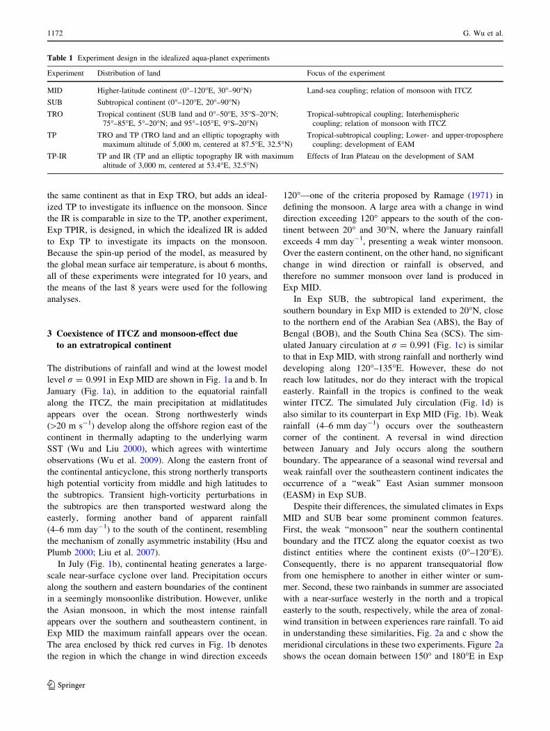
Table 1 Experiment design in the idealized aqua-planet experiments
Experiment Distribution of land Focus of the experiment
MID Higher-latitude continent (0�–120�E, 30�–90�N) Land-sea coupling; relation of monsoon with ITCZ
SUB Subtropical continent (0�–120�E, 20�–90�N)
TRO Tropical continent (SUB land and 0�–50�E, 35�S–20�N;
75�–85�E, 5�–20�N; and 95�–105�E, 9�S–20�N)
Tropical-subtropical coupling; Interhemispheric
coupling; relation of monsoon with ITCZ
TP TRO and TP (TRO land and an elliptic topography with
maximum altitude of 5,000 m, centered at 87.5�E, 32.5�N)
Tropical-subtropical coupling; Lower- and upper-troposphere
coupling; development of EAM
TP-IR TP and IR (TP and an elliptic topography IR with maximum
altitude of 3,000 m, centered at 53.4�E, 32.5�N)
Effects of Iran Plateau on the development of SAM
1172 G. Wu et al.
123

(a)
(b)
(c)
(d)
Fig. 1 Wind vectors at r = 0.991 (arrows; the unit vector shown at
the bottom of the figure is in m s-1) and precipitation (shading; in
mm day-1) in January (a and c) and July (b and d) in Exps MID
(a and b) and SUB (c and d). The areas enclosed by thick orange lines
in (b) and (d) denote regions where the difference in wind direction
between January and July exceeds 120�. The heavy dashed linedenotes the continent boundary
Revisiting Asian monsoon formation 1173
123
(a)
(b)
(c)
(d)
(e)
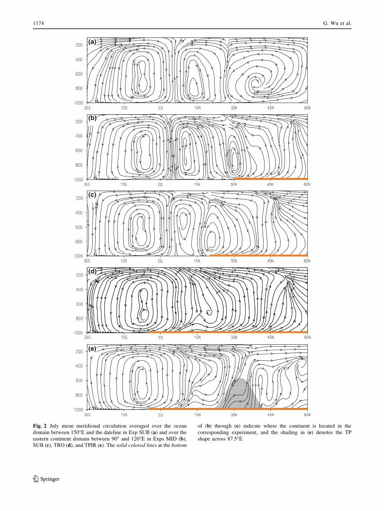
Fig. 2 July mean meridional circulation averaged over the ocean
domain between 150�E and the dateline in Exp SUB (a) and over the
eastern continent domain between 90� and 120�E in Exps MID (b),
SUB (c), TRO (d), and TPIR (e). The solid colored lines at the bottom
of (b) through (e) indicate where the continent is located in the
corresponding experiment, and the shading in (e) denotes the TP
shape across 87.5�E
1174 G. Wu et al.
123
SUB, representing the mean meridional circulation. The
corresponding meridional circulation in Exp MID is similar
(not shown). Figure 2b and c show the eastern continent
domain averaged between 90� and 120�E in Exps MID and
SUB, respectively. In all three panels (Fig. 2a–c) there is
no significant difference in the Southern Hemisphere
meridional circulation. In the Northern Hemisphere over
the ocean, a complete thermally direct cell in the tropics
between 5� and 30�N and an indirect cell at midlatitudes
between 30� and 60�N are pronounced (Fig. 2a). A sig-
nificant difference exists over the continent. The persistent
land heating in summer generates dominant ascending air
over the eastern part of the continent, which induces a
‘‘monsoon type’’ of meridional circulation with an
ascending arm over land in the north and a descending arm
over the ocean in the south, forming a center just above the
southern edge of the continent (Fig. 2b, c). As a result, the
meridional extent of the ‘‘Hadley cell’’ decreases the far-
ther the continent penetrates equatorward-farther south in
Exp SUB than in Exp MID. Consequently, the descending
arm of the Hadley cell is centered near 25�N in Exp MID
and near 15�N in Exp SUB, corresponding to the ‘‘dry’’
belts in Fig. 1b and d.
The ITCZ between the Northern Hemisphere and
Southern Hemisphere Hadley cells maintains a continuous
convection belt surrounding the globe near the equator
(Fig. 1). This suppresses water vapor transport across the
equator. Furthermore, a substantial portion of the water
vapor over the tropical ocean converges toward the ITCZ
to form heavy rainfall; only a minor part is left to sustain
the ‘‘monsoon’’ to the north. The monsoon rainfall there-
fore becomes rather weak in both winter and summer. This
implies that when the monsoon rain belt and the ITCZ
coexist in the same longitude domain, the monsoon
intensity will become weaker. In addition, in Exp MID, the
water vapor that is transported to sustain the monsoon is
from a wider belt of the tropical ocean south of 30�N,
whereas in Exp SUB it is from a narrower belt south of
20�N. Thus, the ‘‘monsoon rainfall’’ in Exp MID is
apparently stronger than that in Exp SUB in both winter
and summer.
4 Rudiments of the Asian monsoon—the influence
of tropical land
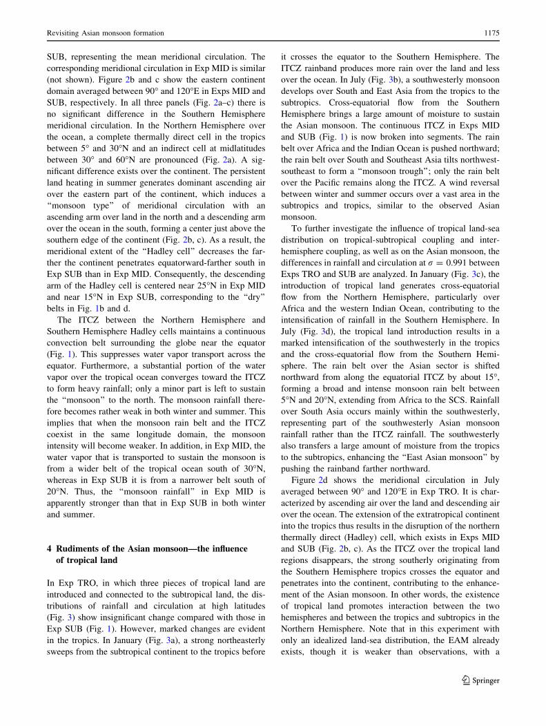
In Exp TRO, in which three pieces of tropical land are
introduced and connected to the subtropical land, the dis-
tributions of rainfall and circulation at high latitudes
(Fig. 3) show insignificant change compared with those in
Exp SUB (Fig. 1). However, marked changes are evident
in the tropics. In January (Fig. 3a), a strong northeasterly
sweeps from the subtropical continent to the tropics before
it crosses the equator to the Southern Hemisphere. The
ITCZ rainband produces more rain over the land and less
over the ocean. In July (Fig. 3b), a southwesterly monsoon
develops over South and East Asia from the tropics to the
subtropics. Cross-equatorial flow from the Southern
Hemisphere brings a large amount of moisture to sustain
the Asian monsoon. The continuous ITCZ in Exps MID
and SUB (Fig. 1) is now broken into segments. The rain
belt over Africa and the Indian Ocean is pushed northward;
the rain belt over South and Southeast Asia tilts northwest-
southeast to form a ‘‘monsoon trough’’; only the rain belt
over the Pacific remains along the ITCZ. A wind reversal
between winter and summer occurs over a vast area in the
subtropics and tropics, similar to the observed Asian
monsoon.
To further investigate the influence of tropical land-sea
distribution on tropical-subtropical coupling and inter-
hemisphere coupling, as well as on the Asian monsoon, the
differences in rainfall and circulation at r = 0.991 between
Exps TRO and SUB are analyzed. In January (Fig. 3c), the
introduction of tropical land generates cross-equatorial
flow from the Northern Hemisphere, particularly over
Africa and the western Indian Ocean, contributing to the
intensification of rainfall in the Southern Hemisphere. In
July (Fig. 3d), the tropical land introduction results in a
marked intensification of the southwesterly in the tropics
and the cross-equatorial flow from the Southern Hemi-
sphere. The rain belt over the Asian sector is shifted
northward from along the equatorial ITCZ by about 15�,
forming a broad and intense monsoon rain belt between
5�N and 20�N, extending from Africa to the SCS. Rainfall
over South Asia occurs mainly within the southwesterly,
representing part of the southwesterly Asian monsoon
rainfall rather than the ITCZ rainfall. The southwesterly
also transfers a large amount of moisture from the tropics
to the subtropics, enhancing the ‘‘East Asian monsoon’’ by
pushing the rainband farther northward.
Figure 2d shows the meridional circulation in July
averaged between 90� and 120�E in Exp TRO. It is char-
acterized by ascending air over the land and descending air
over the ocean. The extension of the extratropical continent
into the tropics thus results in the disruption of the northern
thermally direct (Hadley) cell, which exists in Exps MID
and SUB (Fig. 2b, c). As the ITCZ over the tropical land
regions disappears, the strong southerly originating from
the Southern Hemisphere tropics crosses the equator and
penetrates into the continent, contributing to the enhance-
ment of the Asian monsoon. In other words, the existence
of tropical land promotes interaction between the two
hemispheres and between the tropics and subtropics in the
Northern Hemisphere. Note that in this experiment with
only an idealized land-sea distribution, the EAM already
exists, though it is weaker than observations, with a
Revisiting Asian monsoon formation 1175
123
maximum of 4–6 mm day-1 confined to a small region in
the southeastern corner of the continent (Fig. 3b), even
without the presence of the TP.
Although no east–west thermal gradient exists at the
initial stage of Exp TRO, the rainfall configuration in
Fig. 3b indicates a CO associated with a southerly over the
southeastern continent and a SE and radiative cooling
associated with a northerly over the western continent
along the tropical-subtropical areas. Correspondingly, a
monsoon low exists over the land and subtropical highs
occur over the oceans. Eventually, a Sverdrup balance in
(1) and (2) is developed between the east–west gradient of
(a)
(b)
(c)
(d)
Fig. 3 Distributions of wind vectors at r = 0.991 (arrows; the unit
vector shown at the bottom of the figure is in m s-1) and precipitation
(shading; in mm day-1) in Exp TRO (a and b) and the differences
between Exps TRO and SUB (c and d) in January (a and c) and July
(b and d). The areas enclosed by thick red lines in (b) denote regions
where the difference in wind direction between January and July
exceeds 120�. The heavy dashed line denotes the continent boundary
1176 G. Wu et al.
123
the heating profile and the monsoon circulation in the
tropical and subtropical areas. Because the rainfall pattern
in Fig. 3b resembles the observed Asian summer monsoon
to some extent, we may infer that land-sea distribution,
especially that across South Asia, plays a fundamental role
in the formation of a prototype Asian monsoon, particularly
its southern portion.
5 Development of the east Asian monsoon—the
influence of the Tibetan Plateau
It has long been recognized that heating over the TP can
affect the Asian monsoon (e.g., Yeh et al. 1957; Flohn
1957; Ye and Wu 1998; Liu and Yin 2002; Yanai and Wu
2006; Wu et al. 2007, 2009). Such heating generates a
lower-level cyclonic circulation in the surrounding area
and an upper-level anticyclone aloft, pumping the warm,
moist surface air from the surrounding area to the upper
troposphere over its eastern portion. To further investigate
the underlying dynamics, an idealized TP with the fol-
lowing ellipsoidal shape is placed on the continent in Exp
TRO:
hðk;uÞ ¼ hmax � cosp2
k� k0
kd
� �cos
p2
u� u0
ud
� �
where ðk0;u0Þ denotes the longitude and latitude of the TP
center, hmax is its maximum height, and ðkd;udÞ is its half-
width in longitude and latitude. In Exp TP ðk0;u0Þ,ðkd;udÞ, and hmax are taken as (87.5�E, 32.5�N), (25�,
8.25�), and 5 km, respectively. The ellipse presented in
Fig. 4a and b denotes the contour hðk;/Þ ¼ 1; 000 m.
Figure 4a shows the simulated distributions of precipi-
tation and the wind field in July at the near-surface level
r = 0.991 in Exp TP. Figure 4b shows the differences
between the experiments with and without the TP, i.e.,
between Figs. 4a and 3b. The elevated mountain heating
produces not only lower-troposphere cyclonic circulation
but also strong rainfall ([16 mm d-1) on the southeastern
slope of the TP, partly because the local SE generates a
geostrophic Rossby wave that ascends to the east and
descends to the west, and partly because over the south-
eastern TP the upstream warm, moist air which is trans-
ported along the southwesterly from the Indian Ocean is
pumped upward.
The large-scale latent heating associated with this strong
rainfall induces a Gill-type Rossby wave circulation (Gill
1980), with a northerly of [5 m s-1 to its west and an
intense southerly of [10 m s-1 to its east and southeast
(Fig. 4a). The difference between Exps TP and TRO as
presented in Fig. 4b reveals that the existence of the TP
enhances the subtropical anticyclone over the western
North Pacific, increases the rainfall over the BOB, eastern
TP, and eastern Asia, while it decreases the rainfall over
central Asia, the Arabian Sea, and the Indian subcontinent.
The relatively unified tropical-subtropical coupling, as
presented in Exp TRO (Fig. 3b), is thus deformed to
become a regional pattern: increased rainfall to the east and
decreased rainfall to the west. This is because the intro-
duction of the TP induces positive feedback processes in
the Asian monsoon region, as explained next.
When the zonal flow is weak, the potential vorticity
equation at a steady state can be approximated by the
Sverdrup relation, as presented in (1). Because the latent
heating associated with the condensation of water vapor
carried by the southerly increases with height in the lower
troposphere, following (1), it produces positive vorticity.
For a quasi–steady state, this generation of positive vor-
ticity should be balanced by the negative planetary vor-
ticity advection of the southerly. The development of the
southerly provides more water vapor to sustain the con-
vective instability and thus the monsoon rainfall. There-
fore, the generation of positive vorticity and the monsoon
latent heating form a positive feedback via development of
the southerly. Consequently, we infer that it is the inten-
sification of the southerly due to the existence of the TP
that enhances the coupling between the tropics and sub-
tropics and between the two hemispheres, resulting in the
strong development of the subtropical East Asian monsoon.
The strong northerly to the west of the circulation
transports cold, dry air southward from the subtropics
toward central Asia, the Arabian Sea, and India, thereby
strongly reducing the summer rainfall there. Because dif-
fusive SE decreases with increasing height, Eq. (1) indi-
cates that negative vorticity is produced. To maintain a
steady state, positive planetary vorticity transfer is required
via a northerly from higher latitudes, which would con-
tinuously bring cold air from the north and, in return,
further enhance surface SE. Thus, via the meridional
transfer of vorticity and energy, a quasi–steady state is
maintained by surface SE and the prevailing northerly to
the west of the TP. Furthermore, the development of a
persistent dry northerly in these areas causes continuous
surface evaporation. Consequently, a rainfall reduction
area appears over central Asia, the Arabian Sea, and India,
as shown in Fig. 4b, implying that an isolated TP alone will
weaken the SASM.
The above results obtained from Exp TP are basically
the same as those obtained in Liang et al. (2006); however,
Exp TP uses an updated version of the numerical model. In
this run, the heavy rainfall appears mainly over the
southeastern TP and to its east, while rainfall over northern
and western India is weak in the simulation (Fig. 4a). The
decreased Indian rainfall due to the introduction of the TP
as shown in Fig. 4b contradicts the general notion that
increased TP forcing results in enhanced Indian rainfall
Revisiting Asian monsoon formation 1177
123

(e.g., Duan et al. 2006). It also contradicts the correlation
analysis result that stronger/weaker TP forcing in summer
corresponds to increased/decreased precipitation over
northern India, as we will see in Part II of this study.
To understand the above mentioned discrepancy from
observations, we explore the impact of the ‘‘Iranian Pla-
teau’’ next.
6 Development of the South Asian monsoon-blocking
effect of the Iranian Plateau
In reality, there is another plateau, the IR, which is the same
size as the TP and located to the west of it. So a new
experiment is designed, in which both the ‘‘Iranian Plateau’’
and the ‘‘Tibetan Plateau’’ are present to explore the
(a)
(b)
(c)
(d)
(e)
Fig. 4 Wind vectors at r = 0.991 (arrows; the unit vector shown at
the bottom of the figure is in m s-1) and precipitation (shading; in
mm day-1) in July in Exp TP (a); difference between Exps TP and
TRO (b); Exp TPIR (c); difference between Exps TPIR and TRO (d);
and difference between Exps TPIR and TP (e). The heavy curvedenotes the orographic contour at 700 m, and the heavy dashed linedenotes the continent boundary. [Refer to Fig. 10 in Wu et al. (2009)
and Fig. 6 in Liang et al. (2006).]
1178 G. Wu et al.
123
discrepancy mentioned in Sect. 5. To mimic the impacts of
the IR together with the TP, an orography similar to the TP
but with different parameters of ðk0;u0Þ, ðkd;udÞ, and hmax
set at (53.4�E, 32.5�N), (22.5�, 8.25�), and 3 km, respec-
tively, is added to Exp TP, and this is Exp TPIR.
Figure 4c is similar to Fig. 4a but represents Exp TPIR.
Compared to Exp TP, dramatic changes occur over South
Asia: a rainfall area of more than 10 mm day-1 appears,
with a center of about 16 mm day-1 over its northwestern
offshore region. The weakened South Asian monsoon in
Exp TP is overcome in Exp TPIR. The difference between
Exps TPIR and TRO as presented in Fig. 4d shows that the
existence of the TP and IR not only enhances the EAM but
also shifts the South Asian rainband northward and con-
tributes to the formation of the northern branch of the
Indian monsoon.
Figure 4e shows the difference between Fig. 4c and a,
representing the contribution of the IR to the development
of the South Asian monsoon. The IR forcing induces a
near-surface cyclonic circulation. The anomalous northerly
to its west reduces the rainfall over North Africa. On the
contrary, the anomalous southerly to its east cancels the
northerly that exists in Exp TP (Fig. 4a) and brings water
vapor to sustain the rainfall over the area from the eastern
Arabian Sea to southeastern Asia, forming a rain belt
mimicking the SASM. We may infer that the presence of
the IR generates a strong southerly to its east and southeast
and blocks the cold and dry northerly from the north that
exists only if the TP orographic forcing is imposed (as in
Exp TP), thus contributing to the formation of the South
Asian monsoon, at least to its northern part.
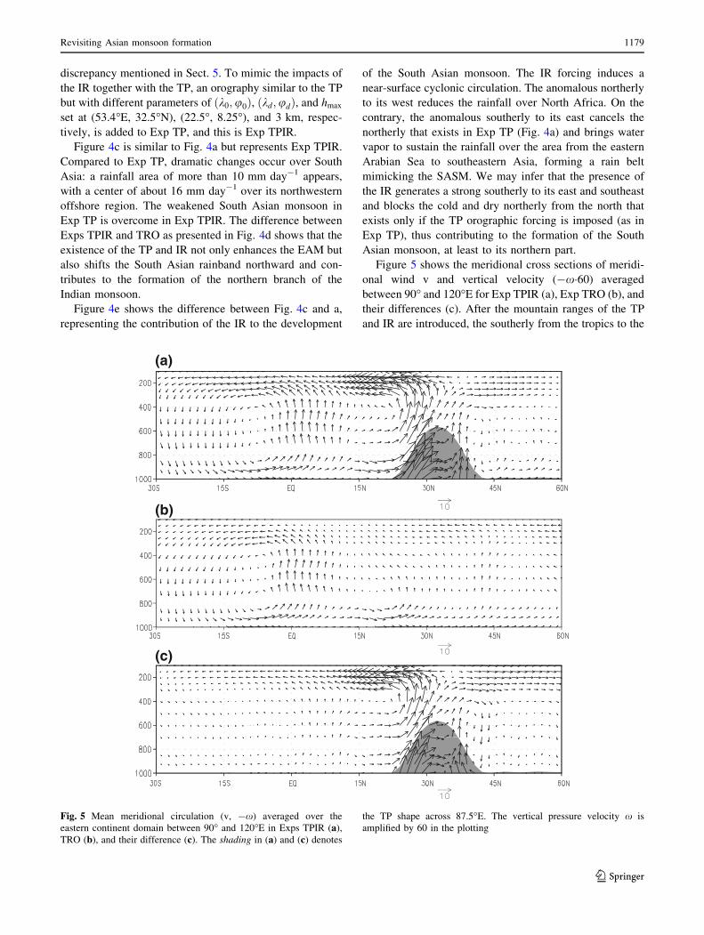
Figure 5 shows the meridional cross sections of meridi-
onal wind v and vertical velocity (-x�60) averaged
between 90� and 120�E for Exp TPIR (a), Exp TRO (b), and
their differences (c). After the mountain ranges of the TP
and IR are introduced, the southerly from the tropics to the
(a)
(b)
(c)
Fig. 5 Mean meridional circulation (v, -x) averaged over the
eastern continent domain between 90� and 120�E in Exps TPIR (a),
TRO (b), and their difference (c). The shading in (a) and (c) denotes
the TP shape across 87.5�E. The vertical pressure velocity x is
amplified by 60 in the plotting
Revisiting Asian monsoon formation 1179
123
subtropics and the upward motion over the southern slope of
the TP are substantially increased. This implies that large-
scale orography plays a significant role in enhancing the
circulation coupling between the tropics and subtropics, and
between the lower and upper troposphere. The marked
intensification of the coupling between the tropics and
subtropics causes a large amount of moisture to be trans-
ported to higher latitudes from tropical regions (Fig. 5a, c).
Consequently, the July rainband over East China is pushed
farther northward, and about 2–4 mm day-1 more rainfall
occurs over northern China, Korea, and northern Japan.
7 Summary
Although seasonal changes in land-sea thermal contrast
that result from the annual evolution of the solar azimuth
are essential for the occurrence of the monsoon, the ide-
alized experiments presented in this study reveal that these
seasonal changes alone are not a sufficient condition for the
existence of the monsoon. For a continent located at
extratropical latitudes, the experiments (Exps MID and
SUB) produce seasonal changes in land-sea thermal con-
trast but give insignificant monsoon rainfall. In such
circumstances, a very weak monsoon rainband coexists
with the ITCZ along the equator, and tropical water vapor
substantially converges to the ITCZ, which effectively
prohibits the interaction of circulation systems between the
two hemispheres.
The existence of tropical land creates an asymmetric
thermal contrast between the two hemispheres. Cross-
equator flows in winter and summer thus develop, and the
zonal symmetry of the ITCZ in Exps MID and SUB is
destroyed. Abundant water vapor evaporated from the
tropical oceans in the Northern and Southern hemispheres
is transported from the winter hemisphere to the summer
hemisphere to sustain the remarkable precipitation in the
summer hemisphere’s tropical area. The occurrence of
heavy precipitation and wind reversal between winter and
summer in this area marks the formation of a prototype
Asian monsoon. It is obvious that the tropical land plays an
essential role in enhancing the circulation coupling
between the Southern and Northern hemispheres.
The uplifted orographic thermal forcing in summer
generates a cyclonic circulation in the lower troposphere,
with a southerly to its east and a northerly to its west.
Consequently, TP forcing strengthens the circulation cou-
pling between the subtropics and tropics, and between the
lower and upper troposphere. Abundant water vapor is
transported from the tropical ocean to the extratropical
continent to its east, where it condenses during the course
of northward travel, thereby developing a strengthened
EAM. The integration of the IR into the TP generates an
extra cyclonic circulation in the lower troposphere, which
contributes to the dryness in North Africa and the occur-
rence of heavy precipitation over the Arabian Sea and
northern India. This, together with the forcing induced by
the tropical land, causes the South Asian monsoon to
develop.
In this study, the prescribed SST is zonally averaged,
which excludes the east–west thermal contrast induced by
SST. The Asian monsoon system develops as a conse-
quence of land-sea distribution and large-scale mountains.
These results do not rule out the contributions of the east–
west gradient of either diabatic heating or the heating
profile to the development of the Asian monsoon. Indeed,
as tropical land and large-scale mountains are introduced
into the integration, strong rainfall occurs over the eastern
continent, and thus the east–west thermal contrast develops
during the course of this simulation. The east–west thermal
contrast and monsoon circulations interact with each other
during monsoon development and eventually reach a
Sverdrup balance, as presented in (1). In this regard, large-
scale mountains and land-sea distribution could be con-
sidered the primary forcing factors of the monsoon climate.
Acknowledgments This study was jointly supported by the MOST
Programme (2010CB950403 and 2012CB417200), and the NSFC
Projects (40925015, 40875034). BD was supported by the U.K.
National Centre for Atmospheric Science-Climate (NCAS-Climate).
We thank the anonymous reviewers for their valuable suggestions on
the improvement of the manuscript.
References
Bordoni S, Schneider T (2008) Monsoons as eddy-mediated regime
transitions of the tropical overturning circulation. Nat Geosci
1:515–519. doi:10.1038/ngeo248
Bordoni S, Schneider T (2010) Regime transitions of steady and time-
dependent hadley circulations: comparison of axisymmetric and
eddy-permitting simulations. J Atmos Sci 67:1643–1654
Chen TC (2003) Maintenance of summer monsoon circulations: a
planetary-scale perspective. J Clim 16(12):2022–2037 doi:
10.1175/1520-0442(2003)016\2022:MOSMCA[2.0.CO;2
Chou C (2003) Land-sea heating contrast in an idealized Asian
summer monsoon. Clim Dyn 21(1):11–25. doi:10.1007/s00382-
003-0315-7
Dirmeyer PA (1998) Land-sea geometry and its effect on monsoon
circulations. J Geophys Res 103(D10)(10):11555–11572. doi:
10.1029/98JD00802
Duan AM, Wu GX (2008) Weakening trend in the atmospheric
heating source over the Tibetan Plateau during recend decades.
Part I: observations. J Clim 21:3150–3164
Duan AM, Wu GX (2009) Weakening trend in the atmospheric
heating source over the Tibetan Plateau during recend decades.
Part II: connection with climate warming. J Clim 22:4197–4212
Duan K, Yao T, Thompson LG (2006) Response of monsoon
precipitation in the Himalayas to global warming. J Geophys Res
111(19D19):D19110. doi:10.1029/2006JD007084
Fiorino M (2000) AMIP II sea surface temperature and sea ice
concentration observations. PCMDI Report, Lawrence Liver-
more National Laboratory
1180 G. Wu et al.
123

Flohn H (1957) Large-scale aspects of the ‘‘summer monsoon’’ in
South and East Asia. J Meteorol Soc Jpn 75:180–186
Gill AE (1980) Some simple solutions for heat-induced tropical
circulation. Q J Roy Meteor Soc 106(449):447–662. doi:10.1002/
qj.49710644905
Holton JR (2004) An introduction to dynamic meteorology. Elsevier
Academic Press, Amsterdam, p 535
Hsu CJ, Plumb RA (2000) Nonaxisymmetric thermally driven circu-
lations and upper-tropospheric monsoon dynamics. J Atmos
Sci 57(9):1255–1276. doi:10.1175/1520-0469(2000)057\1255:
NTDCAU[2.0.CO;2
Kucharski F, Bracco A, Barimalala R, Yoo JH (2010) Contribution of
the east-west thermal heating contrast to the South Asian
monsoon and consequences for its variability. Clim Dyn
37:721–735. doi:10.1007/s00382-010-0858-3
Liang XY, Liu YM, Wu GX (2006) Roles of tropical and subtropical
land-sea distribution and the Qinghai-Xizang Plateau in the
formation of the Asian summer monsoon. Chin J Geophys-Ch
49(4):983–992 (in Chinese)
Liu H, Wu GX (1997) Impacts of land surface on climate of July and
onset of summer monsoon: a study with an AGCM plus SSiB.
Adv Atmo- spheric Sci 14:289–308
Liu X, Yin ZY (2002) Sensitivity of East Asian monsoon climate
to the uplift of the Tibetan Plateau. Palaeogeogr Palaeocl
183(3–4):223–245. doi:10.1016/S0031-0182(01)00488-6
Liu Y, Wu G, Ren R (2004) Relationship between the subtropical
anticyclone and diabatic heating. J Clim 17(4):682–698. doi:
10.1175/1520-0442(2004)017\0682:RBTSAA[2.0.CO;2
Liu Y, Hoskins B, Blackburn M (2007) Impact of the Tibetan
orography and heating on the summer flow over Asia. J Meteorol
Soc Jpn 85B:1–19. doi:10.2151/jmsj.85B.1
Ramage CS (1971) Monsoon meteorology. Academic Press, New
York, p 296
Schneider T, Bordoni S (2008) Eddy-mediated regime transitions in
the seasonal cycle of a Hadley circulation and implications for
monsoon dynamics. J Atmos Sci 65:915–934
Wallace JM, Hobbs PV (1977) Atmospheric Science: an introductory
survey. Academic Press, New York
Wu G, Liu Y (2000) Thermal adaptation, overshooting, dispersion,
and subtropical anticyclone Part I: Thermal adaptation and
overshooting. Chin J Atmos Sci 24(4):433–446 (in Chinese). doi:
10.3878/j.issn.1006-9895.2000.04.01
Wu G, Liu Y (2003) Summertime quadruplet heating pattern in the
subtropics and the associated atmospheric circulation. Geophys
Res Lett 30(5):1201. doi:10.1029/2002GL016209
Wu T, Liu P, Wang Z, Liu Y, Yu R, Wu G (2003) The performance of
atmospheric component model R42L9 of GOALS/LASG. Adv
Atmos Sci 20(5):726–742. doi:10.1007/BF02915398
Wu G, Liu Y, Wang T, Wan R, Liu X, Li W, Wang Z, Zhang Q, Duan
A, Liang X (2007) The influence of the mechanical and thermal
forcing of the Tibetan Plateau on the Asian climate. J Hydrome-
teorl 8(4):770–789. doi:10.1175/JHM609.1
Wu GX, Liu Y, Zhu X, Li W, Ren R, Duan A, Liang X (2009) Multi-
scale forcing and the formation of subtropical desert and
monsoon. Ann Geophys 27(9):3631–3644. doi:10.5194/angeo-
27-3631-2009
Xu Z, Fu C, Qian Y (2009) Relative roles of land-sea distribution and
orography in Asian monsoon intensity. J Atmos Sci 66(9):2714–
2729
Xue Y, Sellers PJ, Kinter JJ, Shukla J (1991) A simplified biosphere
model for global climate studies. J Clim 4:345–364
Yanai M, Wu GX (2006) Effects of the Tibetan Plateau. In: Wang B
(ed) The Asian monsoon. Springer, Berlin, pp 513–549. doi:
10.1007/3-540-37722-0_13
Yang K, Guo XF, He J, Qin J, Koike T (2011) On the climatology and
trend of the atmospheric heat source over the Tibetan Plateau:
An experiments-supported revisit. J Clim 24:1525–1541
Ye DZ, Wu GX (1998) The role of the heat source of the Tibetan
Plateau in the general circulation. Meteorol Atmos Phys
67(1–4):181–198. doi:10.1007/BF01277509
Yeh TC, Lo SW, Chu PC (1957) The wind structure and heat balance
in the lower troposphere over Tibetan Plateau and its surround-
ing. Acta Meteor Sinica 28:108–121 (in Chinese)
Young JA (1987) Physics of monsoon: the current view. In: Fein JS,
Stephens PL (eds) Monsoons. Wiley, Washington D C, pp 211–243
Revisiting Asian monsoon formation 1181
123


![[Revised] Revisiting Verb Aspect in T'boli](https://static.fdokumen.com/doc/165x107/631ef9e50ff042c6110c9f71/revised-revisiting-verb-aspect-in-tboli.jpg)