Clay mineral assemblages in the northern South China Sea: implications for East Asian monsoon...
18
Climatic and tectonic controls on weathering in south China and Indochina Peninsula: Clay mineralogical and geochemical investigations from the Pearl, Red, and Mekong drainage basins Zhifei Liu State Key Laboratory of Marine Geology, Tongji University, Shanghai 200092, China ([email protected]) Christophe Colin Laboratoire IDES, Ba ˆt. 504, UMR 8148 CNRS, Universite ´ de Paris XI, F-91405 Orsay, France Wei Huang State Key Laboratory of Marine Geology, Tongji University, Shanghai 200092, China Khanh Phon Le Oil and Gas Faculty, Hanoi University of Mining and Geology, Hanoi, Vietnam Shengqi Tong State Key Laboratory of Marine Geology, Tongji University, Shanghai 200092, China Zhong Chen South China Sea Institute of Oceanology, Chinese Academy of Sciences, Guangzhou 510301, China Alain Trentesaux UMR PBDS 8110 CNRS/USTL, FR 1818, Universite ´ de Lille I, F-59655 Villeneuve d’Ascq, France [1] Results of clay mineralogy, major element geochemistry, and Sr and Nd isotopes in 93 argillaceous samples collected from drainage basins of the Pearl, Red, and Mekong rivers reveal different degrees of chemical weathering in Southeast Asia despite similar climate conditions across these regions. The kaolinite/illite ratio, illite chemistry index, and illite crystallinity can be used as indicators of chemical weathering intensity. These mineralogical proxies combined with the K 2 O/(Na 2 O + CaO) molar ratio, chemical index of alteration (CIA), and weathering trends observed from major element results indicate intensive silicate weathering in the Pearl River basin, moderate to intensive in the Mekong River basin, and moderate in the Red River basin. Although a significant modification of eNd(0) values in our riverine sediments during chemical weathering and transport is unlikely, 87 Sr/ 86 Sr ratios are controlled by various states of chemical weathering of high-Sr minerals such as plagioclase (rich in Na and Ca) with a linear decrease trend from the Pearl, Mekong, to Red river basins. Our results suggest that it is not the warm climate with heavy monsoon precipitation but tectonics playing the most significant role in controlling weathering and erosion processes in south China and Indochina Peninsula. Strong physical erosion caused by tectonic activities and river incision along the eastern margin of the Tibetan Plateau and along the Red River fault system is responsible for high contents of primary minerals in the lowlands of Red and Mekong river basins. G 3 G 3 Geochemistry Geophysics Geosystems Published by AGU and the Geochemical Society AN ELECTRONIC JOURNAL OF THE EARTH SCIENCES Geochemistry Geophysics Geosystems Article Volume 8, Number 5 11 May 2007 Q05005, doi:10.1029/2006GC001490 ISSN: 1525-2027 Click Here for Full Articl e Copyright 2007 by the American Geophysical Union 1 of 18
-
Upload
independent -
Category
Documents
-
view
2 -
download
0
Transcript of Clay mineral assemblages in the northern South China Sea: implications for East Asian monsoon...
Climatic and tectonic controls on weathering in south Chinaand Indochina Peninsula: Clay mineralogical andgeochemical investigations from the Pearl, Red, and Mekongdrainage basins
Zhifei LiuState Key Laboratory of Marine Geology, Tongji University, Shanghai 200092, China ([email protected])
Christophe ColinLaboratoire IDES, Bat. 504, UMR 8148 CNRS, Universite de Paris XI, F-91405 Orsay, France
Wei HuangState Key Laboratory of Marine Geology, Tongji University, Shanghai 200092, China
Khanh Phon LeOil and Gas Faculty, Hanoi University of Mining and Geology, Hanoi, Vietnam
Shengqi TongState Key Laboratory of Marine Geology, Tongji University, Shanghai 200092, China
Zhong ChenSouth China Sea Institute of Oceanology, Chinese Academy of Sciences, Guangzhou 510301, China
Alain TrentesauxUMR PBDS 8110 CNRS/USTL, FR 1818, Universite de Lille I, F-59655 Villeneuve d’Ascq, France
[1] Results of clay mineralogy, major element geochemistry, and Sr and Nd isotopes in 93 argillaceoussamples collected from drainage basins of the Pearl, Red, and Mekong rivers reveal different degrees ofchemical weathering in Southeast Asia despite similar climate conditions across these regions. Thekaolinite/illite ratio, illite chemistry index, and illite crystallinity can be used as indicators of chemicalweathering intensity. These mineralogical proxies combined with the K2O/(Na2O + CaO) molar ratio,chemical index of alteration (CIA), and weathering trends observed from major element results indicateintensive silicate weathering in the Pearl River basin, moderate to intensive in the Mekong River basin, andmoderate in the Red River basin. Although a significant modification of eNd(0) values in our riverinesediments during chemical weathering and transport is unlikely, 87Sr/86Sr ratios are controlled by variousstates of chemical weathering of high-Sr minerals such as plagioclase (rich in Na and Ca) with a lineardecrease trend from the Pearl, Mekong, to Red river basins. Our results suggest that it is not the warmclimate with heavy monsoon precipitation but tectonics playing the most significant role in controllingweathering and erosion processes in south China and Indochina Peninsula. Strong physical erosion causedby tectonic activities and river incision along the eastern margin of the Tibetan Plateau and along the RedRiver fault system is responsible for high contents of primary minerals in the lowlands of Red and Mekongriver basins.
G3G3GeochemistryGeophysics
Geosystems
Published by AGU and the Geochemical Society
AN ELECTRONIC JOURNAL OF THE EARTH SCIENCES
GeochemistryGeophysics
Geosystems
Article
Volume 8, Number 5
11 May 2007
Q05005, doi:10.1029/2006GC001490
ISSN: 1525-2027
ClickHere
for
FullArticle
Copyright 2007 by the American Geophysical Union 1 of 18

Components: 11,196 words, 11 figures, 1 table.
Keywords: clay minerals; major elements; chemical weathering; Pearl River; Red River; Mekong River.
Index Terms: 1039 Geochemistry: Alteration and weathering processes (3617); 3617 Mineralogy and Petrology: Alteration
and weathering processes (1039); 1065 Geochemistry: Major and trace element geochemistry.
Received 23 September 2006; Revised 24 January 2007; Accepted 12 February 2007; Published 11 May 2007.
Liu, Z., C. Colin, W. Huang, K. P. Le, S. Tong, Z. Chen, and A. Trentesaux (2007), Climatic and tectonic controls on
weathering in south China and Indochina Peninsula: Clay mineralogical and geochemical investigations from the Pearl, Red,
and Mekong drainage basins, Geochem. Geophys. Geosyst., 8, Q05005, doi:10.1029/2006GC001490.
1. Introduction
[2] Evaluating factors controlling continentalweathering and erosion is crucial for a better under-standing of earth science processes [Gaillardet etal., 1999; Clift, 2006]. Moreover, chemical andphysical denudation of silicates can potentiallyaffect the global carbon cycle and thereby globalclimate [Raymo et al., 1988; Raymo and Ruddiman,1992]. On various geological timescales, tectonic-driven mountain uplift, precipitation, and climatevariability have been considered as the primarycontrolling factors on erosion, although their rela-tive roles remain intensely debated [Zhang et al.,2001; Burbank et al., 2003; Reiners et al., 2003;Dadson et al., 2003; Molnar, 2004; Clift et al.,2006a]. Such debate has further reinforced the needfor a clearer understanding of the factors thatcontrol weathering and erosion occurring in moun-tain belts and world’s largest river basins today[Milliman and Syvitski, 1992; McLennan, 1993;Summerfield and Hulton, 1994; Canfield, 1997;Gaillardet et al., 1999; Singh et al., 2005; Selvarajand Chen, 2006].
[3] One area with weathering products particularlyuseful for evaluating the importance of climatic,tectonic, or erosional control on weathering anderosion is the region of Southeast Asia [Clark etal., 2004; Liu et al., 2005; Clift et al., 2004]. Herecontinental scale strike-slip faults, extensive crustalthickening, surface uplift, and regional climaticinteractions have shaped the dramatic modernlandscape [Schoenbohm et al., 2004; Clift et al.,2006a, 2006b]. The fluvial systems have the high-est denudation rates in the world [McLennan,1993; Summerfield and Hulton, 1994] and supplyas much as 70% of the global suspended sedimentto the world ocean [Milliman and Meade, 1983].Studies of weathering and erosion based on rivergeochemistry have been carried out in the Yangtze
and Yellow rivers in North China, on the island ofTaiwan, and in the Ganges-Brahmaputra Riversystem in South Asia [Zhang et al., 1990; Galyand France-Lanord, 1999; Yang et al., 2004; Singhet al., 2005; Selvaraj and Chen, 2006]. However,only a few studies have been conducted in the PearlRiver in south China [Zhang and Wang, 2001], andalmost none in the Red and Mekong rivers inIndochina Peninsula, though the region is uniquefor addressing uplift of the Tibetan Plateau,changes in land-sea patterns, and the reorganizationof river networks [Wang, 2004; Clift et al., 2006b].
[4] In this study, clay mineralogy, major elementgeochemistry, and Sr-Nd isotopes have been inves-tigated for the first time on modern argillaceoussediments along the Pearl, Red, and Mekong riversin order to evaluate the present weathering anderosion processes and their weathering mecha-nisms in the region. These three river basins nowexperience similar climate conditions but havebeen affected earlier by different tectonic activitiesapart from their geographic differences. To obtaininformation on sediment sources, Sr and Nd isotopecompositions were analyzed. Sr and Nd isotoperesults were then combined with mineralogical (claymineral content, illite chemistry index, and illitecrystallinity) and major element (chemical indexof alteration (CIA), K2O/(Na2O + CaO) molarratio) proxies to quantify chemical weatheringstates for the river sediments.
2. Hydrographic and GeologicalSettings
[5] The Pearl, Red, and Mekong drainage basinsrespectively run through south China and Indo-china and all drain into the South China Sea(Figure 1). This region is dominated by the sub-tropical Asian monsoon climate, with an annualheavy rainfall of 1700–2000 mm (Figure 2)
GeochemistryGeophysicsGeosystems G3G3
liu et al.: controls on weathering in s. china 10.1029/2006GC001490
2 of 18

[Zhang and Wang, 2001; Gupta et al., 2002]. Raineverywhere is seasonal, with nearly 85–90% of theannual rainfall arriving during the summer mon-soon season between May and October. However,the headwaters of the Mekong and Red rivers,which are situated in the eastern Tibetan Plateau,have a humid and cold climate during summermonsoon seasons, and parts of their discharges are
derived from plateau’s summer snowmelt. Temper-ature in Pearl and Red deltas varies between 13–30�C in winter and 16–29�C in summer, but theMekong River delta has relatively uniform temper-ature range between 26 and 30�C, without obviouswinter to summer difference (Figure 2). All thethree rivers rank among the largest rivers in theworld in terms of annual average sediment dis-
Figure 1. Geological map and bathymetry of SE Asia (modified after Commission for the Geological Map of theWorld [1975]) and locations of study areas (squared) in the Pearl, Red, and Mekong river basins. Bathymetry inmeters.
GeochemistryGeophysicsGeosystems G3G3
liu et al.: controls on weathering in s. china 10.1029/2006GC001490liu et al.: controls on weathering in s. china 10.1029/2006GC001490
3 of 18

charge: 69 � 106 t for the Pearl, 130 � 106 t for theRed, and 160 � 106 t for the Mekong [Millimanand Meade, 1983; Milliman and Syvitski, 1992].The three river basins are well vegetated throughall seasons except the highlands in Red andMekong basins during winter. Average annualrunoff is 686 mm for the Pearl, 1025 mm for theRed, and 595 mm for the Mekong [Milliman andMeade, 1983].
[6] Despite sharing similar East Asian monsoonclimate and hydrologic conditions, the three riverbasins have quite different relief and geologicalsettings. The Pearl River mostly drains throughthe low relief south China craton composed ofMesozoic-Cenozoic granite rocks and Paleozoiccarbonates (Figure 1). The western part of the Pearldrainage basin is dominated by Paleozoic-Mesozoiccarbonate rocks, mainly Permian-Triassic lime-stone; while in its eastern part, Mesozoic-Cenozoicgranitic rocks and Paleozoic sedimentary rocks(limestone, shale, and sandstone) are the majorrock types. The Red and Mekong rivers originateon a high relief of the Tibetan Plateau and flowsoutheastward through steep valleys along theeastern Tibetan margin into Indochina plains beforemeeting the South China Sea. The Red River flowsalong the NW-SE-aligned Red River fault system,which regulates the distribution of mountain areas,the drainage basin shape, and the river’s relativestraight course (Figure 1). Paleozoic-Mesozoicsedimentary rocks prevail in most parts of theupper and middle reaches, with minor intrusiveand extrusive igneous rocks exposed along the RedRiver fault zone. Recent geomorphic and tectonicinvestigations revealed an active Red River fault
even today [Replumaz et al., 2001; Leloup et al.,2001] and a minimum of 5 mm/yr long-termaverage slip rate since Pliocene time [Schoenbohmet al., 2004, 2006a]. The Mekong River transects amajor Paleozoic-Mesozoic sedimentary terrain(meta-sandstone, shale, slate, and phyllite), minorintrusive igneous rocks and Precambrian metamor-phic rocks in its upper and middle reaches [Liu etal., 2004, 2005], while Mesozoic sedimentaryrocks (mainly sandstone and mudstone) prevail inmost parts of the lower Mekong River basin, inwhich several large Neogene basalt bodies outcrop(Figure 1).
3. Sampling and Analytical Methods
[7] Fieldworks were carried out during dry seasonsin March 2004 to the Pearl River and in January–February 2005 to the Red River and Mekong Riverin order to reach the river beds and collect muddychannel deposits. A set of 93 argillaceous samples(37 from the Pearl River basin, 39 from the RedRiver basin, and 17 from the Mekong River delta)were collected at 93 different locations (Figure 3).Sampling sites were chosen to avoid contaminationfrom riverbank sediments. All samples were ana-lyzed for clayminerals andmajor elements. Selected20 samples with various geological settings andbasin-wide distributions were also analyzed for Rb,Sr, and Nd concentrations, as well as for 87Sr/86Srand 143Nd/144Nd ratios.
[8] Clay minerals were identified by X-ray diffrac-tion (XRD) using a Philips PW 1710 diffractometerat the Laboratoire PBDS, Universite de Lille I forPearl River samples, and using a PANalytical
Figure 2. Rainfall and temperature distribution at stations of Guangzhou, Hanoi, and Ho Chi Minh City from lowerreaches of the Pearl, Red, and Mekong river basins, respectively. See Figure 1 for the station locations. Monthlyaverage data of Guangzhou between 1971 and 2000 are obtained online through the China Meteorological DataSharing Services Network (http://cdc.cma.gov.cn); data of Hanoi (between 1898 and 1990) and Ho Chi Minh City(between 1906 and 1990) are from online data of the World Weather Information Service (http://www.worldweather.org/).
GeochemistryGeophysicsGeosystems G3G3
liu et al.: controls on weathering in s. china 10.1029/2006GC001490
4 of 18

diffractometer at the Laboratoire IDES, Universitede Paris XI for Red River and Mekong Riversamples on oriented mounts of non-calcareousclay-sized (<2 mm) particles [Holtzapffel, 1985].The oriented mounts were obtained following themethods described in detail by Liu et al. [2004].Several repeat samples analyzed by both laborato-ries show a difference less than the measuringaccuracy (<5%) for each clay mineral concentra-tion. Three XRD runs were performed, followingair-drying, ethylene-glycol solvation for 24 hours,and heating at 520�C for two hours. Identificationof clay minerals was made mainly according to theposition of the (001) series of basal reflections on thethree XRD diagrams. Semi-quantitative estimates
of peak areas of the basal reflections for the mainclay mineral groups of smectite (including mixed-layers) (15–17 A), illite (10 A), and kaolinite/chlorite (7 A) were carried out on the glycolatedcurve [Holtzapffel, 1985] using the MacDiff soft-ware (available at http://servermac.geologie.uni-frankfurt.de/Staff/Homepages/Petschick/RainerE.html, 2001). Relative proportions of kaolinite andchlorite were determined on the basis of the ratiofrom the 3.57/3.54 A peak areas.
[9] Geochemical analysis of major elements, Rb,Sr, and Nd concentrations, and Sr-Nd isotopes wasperformed on bulk carbonate- and organic-freesediments with particles <63 mm. Organic matter
Figure 3. Sample locations and distribution of average clay mineral assemblages in the (a) Pearl River, (b) RedRiver, and (c) Mekong River drainage basins. See Figure 1 for their geographic locations and Table S1 fordetailed GPS positions and clay mineral proportions. All samples were measured for clay minerals and majorelements; selected samples with solid circles were also analyzed for Rb, Sr, and Nd concentrations and Sr-Ndisotopes. N, number of surface samples.
GeochemistryGeophysicsGeosystems G3G3
liu et al.: controls on weathering in s. china 10.1029/2006GC001490
5 of 18

and calcite were removed using 10% H2O2 and 1%HCl, respectively, in order to purify granule silicateparticles. Particles <63 mm were wet sieved toremove potential local coarse grains that maysignificantly change the general geochemical com-position. Our experiments indicate that there arealmost no particles >63 mm in original argillaceoussamples. XRD measurements on 40 calcite- andorganic-free bulk samples (<63 mm) indicate thatthere is no significant content of dolomite in allriver sediments. Major elements were measured byX-Ray fluorescence (XRF) using an ARL9800XP+
spectrometer at the Center of Modern Analyses,Nanjing University. A mixture of 0.6000 g samplewith 6.6000 g fluxing agent of Li tetraborate andLi metaborate (Li2B4O7:LiBO2 = 67:33) was addedto a little 120 mg/l LiBr flux in a platinum crucible.The mixture was then fused using an automaticgas-fired CLAISSE burner system to make a glassdisc for XRF measurement. The Rb, Sr, and Ndconcentrations were analyzed by inductively cou-pled plasma-mass spectrometry (ICP-MS) using aThermo VG-X7 mass spectrometer at the State KeyLaboratory of Marine Geology, Tongji University.About 30–40 mg pre-prepared sediments wereheated in an oven under 600�C. The sedimentswere then dissolved using a mixture solution ofHNO3 + HF on a hot plate. The eluted sample wasdiluted by 2% HNO3 for the trace element mea-surement. Uncertainties on concentration measure-ment for Rb, Sr, and Nd are <3%.
[10] 87Sr/86Sr and 143Nd/144Nd isotopic ratios weremeasured using a thermal ionization Triton TI massspectrometer at the State Key Laboratory for Min-eral Deposits Research, Nanjing University. About50 mg pre-prepared sediments were dissolvedusing a mixture solution of 2 mL concentratedHF and 0.5 mL concentrated HNO3 under 120�C.Sr and Nd were eluted and purified following themethods described in detail by Pu et al. [2005].The 87Sr/86Sr ratios have been corrected from massfractionation using normalization to an 88Sr/86Srratio = 0.1194. Replicate analyses of NBS-987 Srstandard (n = 20) during the study gave a mean87Sr/86Sr of 0.710260 ± 0.000010 (2s), close to itscertified value of 0.710250. Similarly, 143Nd/144Ndratios have been corrected from mass fractionationusing a normalization to the natural 146Nd/144Ndratio = 0.7219. Replicate analyses of Nd JNdistandard (n = 15) during the study gave a mean143Nd/144Nd of 0.512104 ± 0.000006 (2s), close toits certified value of 0.512115. For convenience,Nd isotopic ratio results are expressed as eNd(0) =[((143Nd/144Ndmeas)/0.512638) � 1] � 10000,
using the CHUR value given by Jacobsen andWasserburg [1980].
4. Results
4.1. Clay Minerals
[11] For the clay fraction of the Pearl River sedi-ments, kaolinite (30–67%) is the most dominantclay mineral with an average of 46%; chlorite (15–37%) and illite (6–40%) present in lesser abun-dance with a similar average content of about 25%.Smectite (0–11%) is very scarce with an averagecontent of about 2% (auxiliary material Table S1).1
Such results are in agreement with those obtainedby Boulay et al. [2005] for a few Pearl River deltasediment samples. The clay mineral assemblageshave been calculated for different river sections(Figure 3). Kaolinite is the dominant clay mineral,with more than 50% of the total clay content in theeastern part of the basin. Illite increases to about10% of the total in the western part of the basin,but smectite is usually less than 2%, with anexception in the northwestern Pearl River whereit forms about 10% of the sediment (Figure 3a).The illite chemistry index and illite crystallinityhave been also calculated from the X-ray diffracto-grams. Illite chemistry index refers to the ratio ofthe 5 A and 10 A peak areas [Esquevin, 1969].Illite crystallinity was obtained from half heightwidth of the 10 A peak [Chamley, 1989]. Illitechemistry index in the entire Pearl River drainagebasin is usually between 0.50 and 0.80, with only afew locations where values reach 0.45–0.50, andillite crystallinity varies between 0.24 and0.42�D2q, with an average value of 0.30�D2q(Table S1).
[12] For the Red River sediments, illite (31–57%)is the dominant clay mineral, with an averagecontent of 44%; kaolinite (17–38%) and chlorite(6–29%) are less abundant, with a similar averagecontent of about 25%; smectite (1–14%) is still aminor component averaging at 6%, and thus higherthan in the Pearl River basin (Table S1). The claymineral assemblages for different river sectionsdisplay a similar distribution with a little highersmectite content in the upper reach (Figure 3b).The illite chemistry index varies between 0.27 and0.63, but most of analyses are less than 0.50, withan average value of 0.40, and the illite crystallinity
1Auxiliary materials are available at ftp://ftp.agu.org/apend/gc/2006gc001490.
GeochemistryGeophysicsGeosystems G3G3
liu et al.: controls on weathering in s. china 10.1029/2006GC001490
6 of 18

is between 0.11 and 0.23�D2q, with an averagevalue of 0.20�D2q (Table S1).
[13] Samples from the Mekong River delta havesimilar clay mineral assemblages between variouslocations: kaolinite (24–41%), illite (21–38%),and chlorite (21–30%) again making up the dom-inant clay minerals with an average content of28%, 35%, and 26%, respectively. Smectite (6–18%) is a minor clay mineral with an averagepercentage of 11%, a value considerably higherthan the Pearl and Red records (Figure 3c). Theillite chemistry index and illite crystallinity rangebetween 0.46–0.90 and 0.19–0.21�D2q, respec-
tively, with average values of 0.47 and 0.20�D2q(Table S1).
4.2. Major Elements
[14] The bulk carbonate-free surface sediments(<63 mm) from the Pearl, Red, and Mekong basinsare characterized by high contents of SiO2, Al2O3,Fe2O3, and K2O, and by low concentrations ofMgO, TiO2, CaO, Na2O, P2O5, and MnO (Table S1).We have selected some elements and plotted themon variation diagrams using SiO2, Al2O3, and TiO2
along the x axis (Figure 4). Data of upper conti-nental crust (UCC) from Taylor and McLennan[1985] were also plotted as a reference. A moderate
Figure 4. Selected variation diagrams of major elements in the Pearl, Red, and Mekong river basins are plottedagainst SiO2, Al2O3, and TiO2. Data of upper continental crust (UCC) from Taylor and McLennan [1985] were alsoplotted as a reference. Dashed lines indicate linear correlations with a coefficient (r2).
GeochemistryGeophysicsGeosystems G3G3
liu et al.: controls on weathering in s. china 10.1029/2006GC001490
7 of 18

to strong negative correlation between SiO2 andAl2O3 and Fe2O3 indicates potential grain-sizecontrol on SiO2 content because quartz-rich min-eral associations often produce a higher SiO2
concentration. There is a great dispersion in dia-grams of K2O versus SiO2 and Al2O3. K2O/Al2O3
ratios are low in smectite and kaolinite, and high inminerals such as illite, muscovite, and biotite.Ratios of K2O/SiO2 and K2O/Al2O3 are high inRed River sediments, moderate in Mekong Riversediments, and low in Pearl River sediments. Theincreasing trend of TiO2 with Fe2O3 can be attrib-uted to their common source from ferromagnesiumminerals such as biotite, amphibole, and pyroxene.The major element results imply significant differ-ences in mineralogical compositions between thethree rivers.
4.3. Isotopic Results
[15] Rb, Sr, and Nd concentrations as well as87Sr/86Sr ratios and eNd(0) measured on carbon-ate-free fractions (<63 mm) are listed in Table 1.The Sr concentrations vary between 40.7–79.1 ppmfor the Pearl River sediments, 136.2–152.8 ppmfor the Red River, and 69.3–94.3 ppm for theMekong River. The Rb concentrations show anopposite trend: 124.1–243.9 ppm for the Pearl,64.9 – 147.6 ppm for the Red, and 127.0 –146.3 ppm for the Mekong. Consequently, Pearl
River sediments are characterized by higher Rb/Srratios than those of the Red and Mekong rivers.
[16] Mekong River sediments present narrowranges of Sr-Nd isotopic values: 87Sr/86Sr ratiosbetween 0.720 and 0.722 and eNd(0) between�9.9 and �10.8. The Pearl and Red river sedi-ments have similar, relative wider ranges of eNd(0)between �10.4 and �13.3 and wider variations in87Sr/86Sr ratios: 0.728–0.742 for the Pearl and0.716–0.734 for the Red.
5. Discussion
5.1. Mineralogical Changes
[17] Significant different clay mineral assemb-lages exist in surface sediments from Pearl,Red, and Mekong drainage basins, as shown bythe illite+chlorite � kaolinite � smectite ternarydiagrams (Figure 5). Apparently, the differences inclay mineral distribution are related to the intensityof weathering, geology and weathering regime ofthe drainage basins [Chen, 1978; Gingele et al.,2001].
[18] In general, weathering intensity is mainlycontrolled by lithology, climate, and morphologyand, in turn, determines the formation of clays[Chamley, 1989]. A simple scenario is that parentrocks with different lithological compositions in
Table 1. Rb, Sr, and Nd Concentrations and Sr-Nd Isotopic Data of Argillaceous Sediments From the Pearl River,Red River, and Mekong Rivera
Sample Sr, ppm Rb, ppm Nd, ppm Rb/Sr 87Sr/86Sr Error 143Nd/144Nd Error eNd(0) Error
PR04 52.6 207.2 50.9 3.94 0.733442 0.000003 0.512039 0.000041 �11.7 0.80PR09-2 58.7 243.9 45.8 4.16 0.742222 0.000005 0.511957 0.000006 �13.3 0.12PR15-2 62.1 235.6 49.5 3.79 0.735662 0.000006 0.511989 0.000005 �12.7 0.10PR19 40.7 124.1 34.3 3.05 0.735209 0.000003 0.512106 0.000009 �10.4 0.18PR25 71.9 128.6 49.8 1.79 0.727507 0.000002 0.512004 0.000003 �12.4 0.06PR30 79.1 150.5 45.6 1.90 0.730134 0.000003 0.512053 0.000009 �11.4 0.18PR37-2 64.1 171.9 63.0 2.68 0.737314 0.000005 0.512099 0.000029 �10.5 0.57PR40-1 65.6 153.1 48.4 2.33 0.728329 0.000002 0.512025 0.000003 �12.0 0.06RS03 150.1 64.9 34.1 0.43 0.734244 0.000004 0.512003 0.000004 �12.4 0.08RS11 137.4 147.6 56.2 1.07 0.715813 0.000003 0.511968 0.000004 �13.1 0.08RS16 151.2 146.2 58.6 0.97 0.717309 0.000003 0.512039 0.000004 �11.7 0.08RS23 136.2 89.3 31.5 0.66 0.723133 0.000003 0.512106 0.000006 �10.4 0.12RS26 144.9 92.5 42.3 0.64 0.725997 0.000003 0.512027 0.000006 �11.9 0.12RS32 152.8 94.4 44.6 0.62 0.724829 0.000005 0.512050 0.000003 �11.5 0.06RS35 152.6 87.8 39.0 0.58 0.727307 0.000003 0.512027 0.000005 �11.9 0.10MR02 69.3 129.5 32.7 1.87 0.720276 0.000003 0.512131 0.000005 �9.9 0.10MR04 94.3 146.3 31.1 1.55 0.720699 0.000002 0.512115 0.000004 �10.2 0.08MR09 87.1 127.0 37.9 1.46 0.721307 0.000003 0.512082 0.000005 �10.8 0.10MR13 88.7 140.6 39.0 1.58 0.722173 0.000003 0.512104 0.000005 �10.4 0.10MR16 83.4 131.5 34.7 1.58 0.721801 0.000003 0.512098 0.000005 �10.5 0.10
aPR, Pearl River; RS, Red River; MR, Mekong River. The samples were decarbonated and wet sieved (63 mm) before chemical analyses.
GeochemistryGeophysicsGeosystems G3G3
liu et al.: controls on weathering in s. china 10.1029/2006GC001490
8 of 18

the upper reach of a river attribute to various claymineral distributions in its lower drainage basin.This scenario, however, does not apply to the Pearl,Red, and Mekong drainage basins. Although alarge dissimilarity in their parent lithologies existsin each river basin, the clay mineral assemblage issimilar basin-wide (Figures 3 and 5), implying aprimary influence of hydrolytic conditions andmorphology on clay formation. The reason for thisbasin-wide clay similarity appears to be upon thevarious hydrolytic weathering processes occurringin each river basin. During chemical weathering,subtraction of ions from minerals in parent rocksstatistically concerns first the more mobile ions,like Na, K, Ca, Mg, and Sr. This hydrolyticweathering process has been called bisialitizationwith the formation of 2:1 layer clays (the assem-blage of two tetrahedral sheets with one octahedralsheet, e.g., smectite) [Pedro, 1981]. Transitionalelements tend to be evacuated later (Mn, Ni, Cu,Co, Fe), and followed by Si. This process corre-sponds to monosialitization with the formation of1:1 layer clays (the assemblage of one tetrahedralsheet with one octahedral sheet, e.g., kaolinite). Alis the less mobile element through the hydrolyticprocess. The final process of hydrolytic weatheringis alitization with the formation of Al hydroxides(e.g., gibbsite). An increase of hydrolysis intensityand ionic subtraction in weathering parent rocksgives way to secondary minerals that become moreand more depleted in cations, especially the moremobile cations.
[19] Kaolinite is readily found in monosialitic soils,and therefore displays a strong climatic depen-dence controlled mainly by the intensity of conti-
nental hydrolysis [Chamley, 1989]. Kaolinite isalso common on steep slopes within a drainagebasin with relative good drainage conditions. Thereis much more kaolinite in the Pearl River sedimentsthan in the sediments of two other rivers. Warmand humid climate conditions combined with alow-relief, stable (cratonic) morphology in thePearl River basin encourage significant chemicalweathering processes of monosialitization and ali-tization. Both granites in the east as well assedimentary rocks in the entire basin produce asignificant amount of kaolinite in modern claymineral assemblages. Parent aluminosilicates asso-ciated with calcite and dolomite in the carbonaterocks in the west have undergone weatheringprocesses similar to granitic and other sedimentaryrocks in the eastern part of the Pearl River basin.
[20] Illite is the most abundant clay mineral in theRed and Mekong drainage basins with at least 35%of the total clay assemblage compared to the PearlRiver sediments (Figure 3). Illite is considered as aprimary mineral, which reflects decreased hydro-lytic processes in continental weathering and in-creased direct rock erosion under cold and aridclimatic conditions. In our three river basins, illitecould have been derived from physical erosion ofmetamorphic and granitic parent rocks, mainlylocated at high elevation in eastern Tibet. Or itmay have been formed by weathering of nonlayersilicate, such as feldspar from granites under mod-erate hydrolysis conditions, and by degradation ofmicas. Such illite formations occur mainly in thehighland part of the Red and Mekong drainagebasins, the eastern Tibetan Plateau and its marginalregions. Although warm and humid climate con-
Figure 5. Comparison between clay mineral ternary diagrams of argillaceous sediments from the Pearl, Red, andMekong basins.
GeochemistryGeophysicsGeosystems G3G3
liu et al.: controls on weathering in s. china 10.1029/2006GC001490
9 of 18

ditions in their middle-lower reaches are similar tothe Pearl River basin, the Red and Mekong riverbasins have a different history of tectonic activitiesand river incision in the eastern Tibetan Plateauand its marginal regions as well as humid and coldclimate in their headwaters, which may have sig-nificantly increased physical erosion and decreasedhydrolytic weathering processes as bisialitizationand monosialitization. These weathering processesproduce the high content of illite (primary mineral)and reasonable amount of kaolinite and smectite(secondary minerals) as found in samples analyzed.Mesozoic-Cenozoic sedimentary rocks prevail inthe headwaters of the Mekong River basin in theTibetan Plateau, allowing physical weathering pro-cesses to form lithosols containing only illite andchlorite [Liu et al., 2003].
[21] Smectite is a secondary mineral, which isderived from chemical weathering of parent alu-minosilicate and ferromagnesian silicate underwarm and humid conditions. Smectite is formed
in confined environments, by recombination ofreleased cations. Smectite is not formed in thesame part of the river basin as kaolinite. In theMekong drainage basin, widely distributed bisial-litic soil in the middle and lower reaches is apotential source for smectite in the delta [Liu etal., 2004]. Mineralogical components of the bisial-litic soil are 2:1 layer clays (e.g., smectite). Distri-bution of bisiallitic soil in the Pearl and Red riverbasins, however, is very limited [Segalen, 1995].Although the chemical weathering of extrusivebasaltic rocks in various climatic conditions couldproduce smectite [Griffin et al., 1968], the minorextrusive igneous rocks exposed along the RedRiver fault zone and several large Neogene basaltbodies outcropped in the lower Mekong Riverbasin do not produce a significant amount ofsmectite, as indicated from the results of claymineral assemblages of the Red and Mekong rivers(Figures 3b and 3c).
[22] Therefore the similar clay mineral assemb-lages basin-wide in each of these river basinssuggest that the difference in clay mineral distri-bution in the Pearl, Red, and Mekong rivers can beattributed to the intensity of chemical weathering,tectonic activities, and tectonic-induced river inci-sion, rather than their dissimilarity in parent lithol-ogy. The kaolinite/illite ratio hence can be used as achemical weathering indicator. This mineralogicalratio is also independent from the weathering ofvolcanic rocks. Higher kaolinite/illite values indi-cate strengthened chemical weathering and weakphysical erosion, and vice versa when the ratio islow.
[23] If considering that there is no important dia-genesis or reworking for illite in all surface riversamples, we can select illite chemistry index andillite crystallinity as indicators of the intensity ofchemical weathering. Ratios of illite chemistryindex lower than 0.5 represent Fe-Mg-rich illites,which are characteristic of weak chemical weath-ering conditions; ratios higher than 0.5 are found inAl-rich illites, which are formed by strong hydro-lysis [Esquevin, 1969]. Lower values of illitecrystallinity represent higher crystallinity, whichis characteristic of weak hydrolysis in continentalsources [Chamley, 1989; Krumm and Buggisch,1991]. The high illite crystallinity may also requiresome degree of low temperature burial metamor-phism as well. Our results, however, show highestillite crystallinity in the Red River basin withsimilar values for both metamorphic and sedimen-tary sources, and thus do not support the above
Figure 6. Correlations of kaolinite/illite ratio with(a) illite chemistry index and (b) illite crystallinity inargillaceous sediments from the Pearl, Red, and Mekongriver basins.
GeochemistryGeophysicsGeosystems G3G3
liu et al.: controls on weathering in s. china 10.1029/2006GC001490
10 of 18

mentioned hypothesis. The kaolinite/illite ratioindicator fits well with the mineralogical resultsof illite chemistry index and illite crystallinity(Figure 6). Increase in the illite chemistry index,or decrease in the illite crystallinity (with highervalues), is associated with an increased kaolinite/illite ratio, suggesting that these three mineralogi-cal parameters indicate the average state of chem-ical weathering for the river sediments. Theirvalues are high in the Pearl River sediments,moderate in the Mekong River sediments, andlow in the Red River sediments. These resultssuggest that strengthened chemical weatheringand strong hydrolysis operate in the Pearl Riverbasin, moderate chemical weathering and moderatehydrolysis in the Mekong River basin, and rela-tively weak hydrolysis and strong physical erosionin the Red River basin.
5.2. Chemical Mobility and WeatheringTrends
[24] Major element composition of river sedimentscan be used to assess the state of chemical andphysical weathering and to determine the geochem-ical process operating in a river basin [Vital andStattegger, 2000; Singh et al., 2005]. The chemicalcomposition of weathering products in a river basinis expected to demonstrate well-established con-cepts on mobility of various elements duringweathering [Nesbitt et al., 1980; Singh et al.,2005]. We use elemental ratios calculated withrespect to the least mobile element Al to identifyand evaluate the major element mobility. The ratioof the content of element X and Al2O3 in riversamples divided by the ratio of the same element
content in UCC gives the following elemental ratio[Singh et al., 2005]:
Elemental ratioðXÞ ¼ X=Al2O3ðriversÞX=Al2O3ðUCCÞ
:
This elemental ratio refers to the relative enrich-ment or depletion of the element, i.e., >1 indicatesenrichment, <1 indicates depletion, and = 1indicates no change in the relative abundance ofthe element.
[25] The elemental ratios calculated from averagemajor element concentrations normalized to UCCare displayed in Figure 7. All major elements fromour three rivers show a similar chemical mobilitywith little differences. The mobility of SiO2 iscritical for understanding of chemical weathering.The SiO2 content is depleted in the Pearl Riversediments but rather stable in the Red and Mekongrivers, suggesting stronger chemical weatheringoccurring in the Pearl River basin. The immobileTi is markedly enriched in all river sediments and,along with higher Fe values, it confirms theircommon source from ferromagnesium minerals ineach individual river (Figure 4). The highly mobileelements Ca and Na from all the three rivers showsimilar lowest values related to their chemicalweathering. Mg and K have become tightly incor-porated in clay minerals, with more Mg in illite andmore K in micaceous minerals. In comparison,more depleted Mg and K in Pearl River sedimentssuggest stronger chemical weathering than in theRed and Mekong river basins.
[26] The degree of chemical weathering can beestimated by the chemical index of alteration(CIA) [Nesbitt and Young, 1982]:
CIA ¼ Al2O3= Al2O3 þ CaO*þ Na2Oþ K2Oð Þ½ � � 100;
where CaO* represents CaO associated with thesilicate fraction of the sample. For primaryminerals (non altered minerals), all feldspars haveCIA value of 50 and the mafic minerals biotite,hornblende, and pyroxenes have CIA valuesbetween of 50–55, 10–30, and 0–10, respectively.Feldspar and mica weathering to smectite andkaolinite result in a net loss of K and Na inweathering profiles, whereas Al is resistant and isenriched in weathering products [Nesbitt andYoung, 1982]. This induces an increase of CIAvalues by about 100 for kaolinite and 70–85 forsmectite. The CIA value is thought to quantify thestate of chemical weathering of the rocks byreferring to the loss of labile elements such as Na,
Figure 7. Elemental ratios of argillaceous sediments inthe Pearl, Red, and Mekong river basins, calculatedfrom average major element concentrations normalizedto UCC [Taylor and McLennan, 1985] with respect toAl2O3. The error bar of each element refers to thestandard deviation of all samples.
GeochemistryGeophysicsGeosystems G3G3
liu et al.: controls on weathering in s. china 10.1029/2006GC001490
11 of 18

Ca, and K. CIA values are 75–88 for the PearlRiver sediments, 72–83 for the Mekong Riversediments, and 65–78 for the Red River sediments(Figure 8). Such CIA values are in agreement withthe clay mineralogical results, which indicatehigher kaolinite/illite ratio for the Pearl Riversediments and lower values for the Red Riversediments (Figure 6).
[27] The CIA values are well correlated with theK2O/(Na2O + CaO) molar ratio (Figure 8a) fromthe three rivers. The range of the K2O/(Na2O +CaO) molar ratio in the three rivers stronglysuggests changes of the mineralogy between anend-member rich in plagioclase (high content of Naand Ca) and another rich in K-feldspar, micas, andillite. Increase in the K2O/(Na2O + CaO) molarratio is associated with CIA increase, suggesting a
preferential hydrolysis of plagioclase (enrichmentof Na) relative to K-feldspar and micas (enrich-ment in K) during the silicate weathering processof river sediments. The much higher mobility inelements Ca and Na than in element K from all thethree river basins (Figure 7) and more plagioclasein Red and Mekong river samples than in PearlRiver samples by bulk XRD results support thishypothesis. A linear correlation of CIA with theillite chemical index (Figure 8b) also well demon-strate that the degree of chemical weathering isstrongest in the Pearl River basin, moderate in theMekong River basin, and relatively weak in theRed River basin. In comparison, chemical weath-ering in the Amazon River [Vital and Stattegger,2000], the Yangtze River and the Yellow River[Yang et al., 2004] are much weaker (Figures 8aand 8b).
[28] The variability of chemical weathering inten-sity determines the mineral characteristics of riversamples, because coarse and fine grain river sedi-ments must have resulted from different weatheringprocesses. Coarse and quartz rich sediments tend tohave lower Al2O3 values whereas fine grain andclay rich sediments have higher Al2O3 values. Ourmajor element results show a negative correlationbetween SiO2 and Al2O3, suggesting grain-sizecontrol on SiO2 content (Figure 4). However, suchmineralogical control appears to have had littleeffect on the chemical weathering intensity of finegrain aluminosilicate minerals from the three riverbasins. All samples used in this study are argilla-ceous sediments almost without particles >63 mmand they were wet sieved (<63 mm) to reduce any
Figure 8. Correlations of chemical index of alteration(CIA) with (a) K2O/(Na2O+CaO) molar ratio and(b) illite chemistry index of argillaceous sediments inthe Pearl, Red, and Mekong river basins. The graphsshow linear correlations of mineralogical and elementgeochemical proxies of chemical weathering. Averagedata of clayey sediments from the Amazon River [Vitaland Stattegger, 2000], the Yellow River, and the YangtzeRiver [Yang et al., 2004] were plotted for comparison.
Figure 9. Correlation of SiO2 (%) with CIA inargillaceous sediments from the Pearl, Red, and Mekongriver basins.
GeochemistryGeophysicsGeosystems G3G3
liu et al.: controls on weathering in s. china 10.1029/2006GC001490
12 of 18
potential grain size effect. Moreover, CIA is amolar ratio of Al2O3/(Al2O3 + CaO* + Na2O +K2O), which has reduced dilution effects by SiO2
content. The scatterplot of SiO2 versus CIA indi-cates almost no or weak mineralogical dependenceof CIA for the Red and Pearl basins but a clearlinear relationship between SiO2 content and theweathering index for the Mekong River basin(Figure 9). Such negative correlation of CIA withSiO2 content in Mekong River samples cannot beexplained as the quartz control on CIA, becauseCIA is independent from SiO2 content. The variousCIA values in Mekong River samples are resulted
from differently weathered provenances, and mostCIA values falling at 75–78 are obviously lowerthan those of Pearl River samples and higher thanthose of Red River samples.
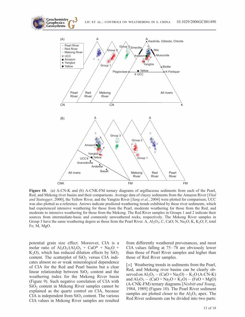
[29] Weathering trends in sediments from the Pearl,Red, and Mekong river basins can be clearly ob-served onAl2O3� (CaO +Na2O)�K2O (A-CN-K)and Al2O3� (CaO + Na2O + K2O)� (FeO +MgO)(A-CNK-FM) ternary diagrams [Nesbitt and Young,1984, 1989] (Figure 10). The Pearl River sedimentsamples are plotted closer to the Al2O3 apex. TheRed River sediments can be divided into two parts:
Figure 10. (a) A-CN-K and (b) A-CNK-FM ternary diagrams of argillaceous sediments from each of the Pearl,Red, and Mekong river basins and their comparisons. Average data of clayey sediments from the Amazon River [Vitaland Stattegger, 2000], the Yellow River, and the Yangtze River [Yang et al., 2004] were plotted for comparison; UCCwas also plotted as a reference. Arrows indicate predicted weathering trends exhibited by these river sediments, whichhad experienced intensive weathering for those from the Pearl, moderate weathering for those from the Red, andmoderate to intensive weathering for those from the Mekong. The Red River samples in Groups 1 and 2 indicate theirsources from intermediate-basic and commonly unweathered rocks, respectively. The Mekong River samples inGroup 3 have the same weathering degree as those from the Pearl River. A, Al2O3; C, CaO; N, Na2O; K, K2O; F, totalFe; M, MgO.
GeochemistryGeophysicsGeosystems G3G3
liu et al.: controls on weathering in s. china 10.1029/2006GC001490
13 of 18

the first six samples (Group 1 in Figure 10) arecloser to UCC, indicating more intermediate tobasic rock sources; other samples (Group 2 inFigure 10) with higher Al2O3 are arranged almostparallel to the A-CN line, suggesting a similarcomposition of unweathered rocks in these sam-ples. While most samples are packed into a fieldsimilar to the majority from the Red River, the lastthree samples (Group 3 in Figure 10) from theMekong River much closer to the Al2O3 apex mayindicate a weathering degree comparable to thosefrom the Pearl River. The main trends of silicateweathering in all the three river basins displaypreferential leaching of CaO and Na2O and enrich-ment of Al2O3, while K2O contents are constant forall sediments from the Red River and for sedimentsof intermediate weathering stages from the Pearl
and Mekong rivers. During strong weathering,leaching of K2O occurs for most of samples fromthe Pearl River and the last three samples (Group 3)from the Mekong River. Accordingly, we infer thatplagioclase is selectively weathered first in all threeriver basins, while K-feldspar remains almost intactfor all samples from the Red River, most samplesfrom the Mekong River, and a few samples fromthe Pearl River. These weathering processes havebeen investigated and confirmed under both exper-imental and field conditions [White and Brantley,2003]. The leaching of CaO and Na2O in Yellowand Yangtze river sediments indicates early tointermediate weathering stages [Yang et al.,2004], and the considerable leaching of K2O inthe lowermost Amazon River sediments implies anintensive weathering stage [Vital and Stattegger,2000] (Figure 10). By comparison, silicate weath-ering can be considered as of moderate for the RedRiver sediments, moderate to intensive for theMekong River sediments, and intensive for thePearl River sediments.
[30] The weathering intensity often influences theSr isotopic composition in river sediments. On thecontrary, neither chemical weathering on land[Borg and Banner, 1996] nor grain-size sortingduring transport [Tutken et al., 2002; Goldstein andJacobsen, 1988] can significantly modify eNd(0)values in sediments subsequently deposited in riverbasins. The confinement of all eNd(0) values fromthe three studied rivers to a narrow range alsoconveys a similar message (Figure 11a). Becauseall the Mekong samples come from the deltadownstream and features of their isotopically dis-tinct sources (if there are any) must have beenmixed during the confluence, their Nd isotoperange considerably narrower than those from thePearl and the Red is thus reasonable. As they areindependent from the weathering process, these
eNd(0) values can be used as a reference topetrological settings. For each individual river, norelationship between the eNd(0) values and the87Sr/86Sr ratios has been observed, suggesting thatvariations in Sr isotopic composition are notcaused by major changes in the petrological source(e.g., basalt). A good correlation between 87Sr/86Srwith Rb/Sr ratio and K2O/(Na2O + CaO) molarratio for the three rivers (Figures 11b and 11c),however, denotes a major control on the 87Sr/86Srratio by Rb/Sr and mineralogical composition inthe sediments. High 87Sr/86Sr ratios are associatedto high K2O/(Na2O + CaO) molar ratios, implyingthe presence of high-Rb, low-Sr minerals such aspotassium feldspar and biotite in the river sedi-
Figure 11. Correlations of 87Sr/86Sr with (a) eNd(0),(b) Rb/Sr, and (c) K2O/(Na2O + CaO) molar ratio,indicating the isotopic distribution in argillaceoussediments from the Pearl, Red, and Mekong basins.Error bars refer to the measurement uncertainty. Samplenumbers are also marked (see sample locations inFigure 3).
GeochemistryGeophysicsGeosystems G3G3
liu et al.: controls on weathering in s. china 10.1029/2006GC001490
14 of 18

ments. In contrast, low 87Sr/86Sr ratios are associ-ated to low K2O/(Na2O + CaO) molar ratios,implying the presence of low-Rb, high-Sr mineralssuch as plagioclase (rich in Na and Ca). As the Srconcentration in plagioclase is about 10 timeshigher than biotite, a low proportion of this mineralcan strongly decrease the 87Sr/86Sr ratios of theriver sediments. Because the K2O/(Na2O + CaO)molar ratio is also correlated to other indicesof chemical weathering (mineralogical proxiesand CIA), we suggest that 87Sr/86Sr ratios inriver sediments are likely mainly controlled bythe state of chemical weathering but not by thepresence of basic rocks (such as in the Mekong andthe Red rivers). Strong physical erosion in the RedRiver and in a less extension of the Mekong Riverwould produce sediments with high contents ofunaltered plagioclase that induce the nonradiogenicSr composition.
5.3. Climatic Versus Tectonic Controlson Weathering
[31] Climate is an important variable that controlsthe geochemical environment of weathering pro-cesses and also has an overriding influence uponthe characteristic of the weathering products[Nesbitt et al., 1980; McLennan, 1993; Gaillardetet al., 1999; Singh et al., 2005]. The degree ofweathering increases with high mean annual tem-perature and precipitation. Temperature controlsthe rate of chemical weathering reactions, andprecipitation provides an aqueous medium andmoisture for ion exchange for these reactions.Weathering intensity is also related closely tovegetation and runoff, because vegetation keepsmoisture for chemical reactions while runoffaffects the rates of both chemical and mechanicaldenudations [Summerfield and Hulton, 1994]. Allour three river basins mainly experience a humidsubtropical East Asian monsoon climate withheavy monsoon precipitation and warm tempera-ture during summers (Figure 2). They are wellvegetated through all seasons except the highlandsof the Red and Mekong river basins during winter.The annual runoff ranging from 595–1025 mmdoes not present a significant difference betweenthe basins [Milliman and Meade, 1983]. Thus thesimilar subtropical East Asian monsoon climatealong with similar hydrologic conditions shouldproduce a comparable intensity of the chemicalweathering in these basins. But on the basis of ourresults from clay mineralogy and major elementgeochemistry of surface sediments, the Pearl Riverbasin has a stronger weathering intensity than the
Red and Mekong basins. Therefore, beside themonsoon climate, other factors may also controlthe continental weathering and erosion in the Redand Mekong river basins.
[32] Glacial scour is potentially responsible ofstronger physical erosion in the highland part ofthe Red and Mekong river basins. Colin et al.[2006] implied that physical erosion of the high-land Himalayas and Indo-Burman Ranges duringglacial periods could have been induced by glacialscour and frost action. However, in the central andeastern Tibetan Plateau, where the highland Redand Mekong river basins are located, significantglacial events are absent from the entire Holocene[Schafer et al., 2002], excluding the glacial scouras a major factor that affects on the physicalerosion. Tectonic processes can increase the expo-sure of fresh, unaltered rock surfaces. The highrates of such physical weathering caused by mod-ern or recent tectonic activities in the easternTibetan Plateau and along the Red River faultsystem [Replumaz et al., 2001; Schoenbohm etal., 2004, 2006a] can produce primary minerals(micas, illite, plagioclase, and K-feldspar). More-over, the reconstruction of the paleo-Red Riverindicates 1400 m river incision and 1400–1500m surface uplift since the Pliocene [Schoenbohm etal., 2004, 2006b]. Such strong incision produces asuspended sediment yield of 1083 t/km2/yr for theRed River, about 7 times higher than the PearlRiver (157 t/km2/yr) and 5 times higher than theMekong River (203 t/km2/yr) [Milliman andMeade, 1983]. In this way, the tectonic uplift hasdramatically increased the slope of the easternTibetan margin, where reside the upper to middlereaches of the Red and Mekong rivers. The basinslope is most strongly associated with both mechan-ical and chemical denudation rates [Summerfield andHulton, 1994]. Therefore more primary mineralsformed in the Red and Mekong river basins canindicate more physical erosion than in the PearlRiver. These minerals are transported very rapidlyto the river delta without chemical alteration.Therefore minerals very sensitive to chemicalweathering such as plagioclase are present in thelowlands of the Red and Mekong river sediments.
6. Conclusions
[33] The three of the world’s largest river basins,the Pearl, Red, and Mekong river basins exhibitdifferent degrees of chemical weathering despitethe fact that they are all influenced by East Asianmonsoon climate and similar hydrologic condi-
GeochemistryGeophysicsGeosystems G3G3
liu et al.: controls on weathering in s. china 10.1029/2006GC001490
15 of 18

tions. Clay mineralogical indicators (kaolinite/illiteratio, illite chemistry index, and illite crystallinity)and major elemental indexes (chemical mobility,K2O/(Na2O + CaO) molar ratio, CIA index, andweathering trend ternary diagrams), combined withRb, Sr, and Nd concentration and Sr-Nd isotopicresults, indicate intensive silicate weathering in thePearl River basin, moderate to intensive in theMekong River basin, and moderate in the RedRiver basin. Our results exclude the parent lithol-ogy as a major control on the mineralogical andgeochemical compositions of river bed sediments.We suggest that the monsoon climate with heavyprecipitation and warm temperature during sum-mers is one of the most significant factors thatcontrol the silicate chemical weathering in thesethree river basins. However, strong physical ero-sion caused by tectonic activities and river incisionin the eastern Tibetan Plateau and along the RedRiver fault system appears to be responsible forhigh contents of primary minerals in the lowlandsof the Red and Mekong river basins. Although asignificant modification of the eNd(0) values in ourriverine sediments during chemical weathering andtransport is unlikely, the 87Sr/86Sr ratios are con-trolled mainly by the state of chemical weatheringof high-Sr minerals such as plagioclase (rich in Naand Ca) with a linear decrease trend from the Pearl,Mekong, to Red River basins. Apparently, bothclimatic and tectonic factors exert control on thepresent weathering in south China and IndochinaPeninsula, contributing to the mineralogical, ele-mental and isotopic variations in sediments fromtheir rivers.
Acknowledgments
[34] We thank Tonghua Li, An H. Le, and Nam Phong Le for
assistance during fieldworks and Lianwen Liu, Shaoyong
Jiang, Lei Shao, and Peijun Qiao for technical help in
laboratories. We specially thank Peter D. Clift, Laurent D.
Labeyrie, and an anonymous reviewer for their constructive
reviews on the early version of this paper. This study was
supported by the Natural Science Foundation of China
(40331002, 40321603, and 40506014), the Fok Ying Tung
Education Foundation (101018), the Doctoral Program of
Higher Education (20060247032), the Excellent Young Teach-
ers Program and the Program for New Century Excellent
Talents in University of the Ministry of Education of China
(NCET-04-0372), and the Laboratory of Marginal Sea Geol-
ogy Grant of the Chinese Academy of Sciences (BYH03A08).
References
Borg, L. E., and J. L. Banner (1996), Neodymium and stron-tium isotopic constraints on soil sources in Barbados, WestIndies, Geochim. Cosmochim. Acta, 60, 4193–4206.
Boulay, S., C. Colin, A. Trentesaux, N. Frank, and Z. Liu(2005), Sediment sources and East Asian monsoon intensityover the last 450 kyr: Mineralogical and geochemicalinvestigations on South China Sea sediment, Palaeogeogr.Palaeoclimatol. Palaeoecol., 228, 250–277.
Burbank, D. W., A. E. Blythe, J. Putkonen, B. Pratt-Sitaula,E. Gabet, M. Oskin, A. Barros, and T. P. Ojha (2003),Decoupling of erosion and precipitation in the Himalayas,Nature, 426, 652–655.
Canfield, D. E. (1997), The geochemistry of river particulatesfrom the continental USA: Major elements, Geochim. Cos-mochim. Acta, 61, 3349–3365.
Chamley, H. (1989), Clay Sedimentology, 623 pp., Springer,New York.
Chen, P.-Y. (1978), Minerals in bottom sediments of the SouthChina Sea, Geol. Soc. Am. Bull., 89, 211–222.
Clark, M. K., L.M. Schoenbohm, L. H. Royden, K. X.Whipple,B. C. Burchfiel, X. Zhang, W. Tang, E. Wang, and L. Chen(2004), Surface uplift, tectonics, and erosion of eastern Tibetfrom large-scale drainage patterns, Tectonics, 23, TC1006,doi:10.1029/2002TC001402.
Clift, P. D. (2006), Controls on the erosion of Cenozoic Asiaand the flux of clastic sediment to the ocean, Earth Planet.Sci. Lett., 241, 571–580.
Clift, P. D., G. D. Layne, and J. Blusztajn (2004), Marinesedimentary evidence for monsoon strengthening, Tibetanuplift and drainage evolution in East Asian, in Continent-Ocean Interactions Within East Asian Marginal Seas, Geo-phys. Monogr. Ser., vol. 149, edited by P. Clift et al.,pp. 255–282, AGU, Washington, D. C.
Clift, P. D., A. Carter, I. H. Campbell, M. S. Pringle, N. VanLap, C. M. Allen, K. V. Hodges, and M. T. Tan (2006a),Thermochronology of mineral grains in the Red and Mekongrivers, Vietnam: Provenance and exhumation implicationsfor Southeast Asia, Geochem. Geophys. Geosyst., 7,Q10005, doi:10.1029/2006GC001336.
Clift, P. D., J. Blusztajn, and A. D. Nguyen (2006b), Large-scale drainage capture and surface uplift in eastern Tibet–SW China before 24 Ma inferred from sediments of theHanoi basin, Vietnam, Geophys. Res. Lett., 33, L19403,doi:10.1029/2006GL027772.
Colin, C., L. Turpin, D. Blamart, N. Frank, C. Kissel, andS. Duchamp (2006), Evolution of weathering patterns inthe Indo-Burman Ranges over the last 280 kyr: Effects ofsediment provenance on 87Sr/86Sr ratios tracer, Geochem.Geophys. Geosyst., 7, Q03007, doi:10.1029/2005GC000962.
Commission for the Geological Map of the World (1975),Geological World Atlas, scale 1:10000000, U. N. Educ.Sci. and Cult. Org., Paris.
Dadson, S. J., et al. (2003), Links between erosion, runoffvariability and seismicity in the Taiwan orogen, Nature,426, 648–651.
Esquevin, J. (1969), Influence de la composition chimique desillites surcristallinite, Bull. Cent. Rech. Rau SNPA, 3, 147–153.
Gaillardet, J., B. Dupre, P. Louvat, and C. J. Allegre (1999),Global silicate weathering and CO2 consumption rates de-duced from the chemistry of large rivers, Chem. Geol., 159,3–30.
Galy, A., and C. France-Lanord (1999), Weathering processesin the Ganges-Brahmaputra basin and the riverine alkalinitybudget, Chem. Geol., 159, 31–60.
Gingele, F. X., P. D. Deckker, and C.-D. Hillenbrand (2001),Clay mineral distribution in surface sediments betweenIndonesia and NW Australia: Source and transport byocean currents, Mar. Geol., 179, 135–146.
GeochemistryGeophysicsGeosystems G3G3
liu et al.: controls on weathering in s. china 10.1029/2006GC001490
16 of 18

Goldstein, S. J., and S. B. Jacobsen (1988), Nd and Sr isotopicsystematic of river water suspended material: Implicationsfor crustal evolution, Earth Planet. Sci. Lett., 87, 215–221.
Griffin, J. J., H. Windom, and E. D. Goldberg (1968), Thedistribution of clay minerals in the world ocean, Deep SeaRes., 15, 433–459.
Gupta, A., L. Hock, X. Huang, and P. Chen (2002), Evaluationof part of the Mekong River using satellite imagery, Geo-morphology, 44, 221–239.
Holtzapffel, T. (1985), Les mineraux argileux: Preparation,analyse diffractometrique et determination, Soc. Geol. NordPubl., 12, 136 pp.
Jacobsen, S. B., and G. J. Wasserburg (1980), Sm-Nd isotopicevolution of chondrites, Earth Planet. Sci. Lett., 50, 139–155.
Krumm, S., and W. Buggisch (1991), Sample preparationeffects on illite crystallinitymeasurements: Grain size gradationand particle orientation, J. Metamorph. Geol., 9, 671–677.
Leloup, P. H., N. Arnaud, R. Lacassin, J. R. Kienast, T. M.Harrison, P. Trinh, A. Replumaz, and P. Tapponnier (2001),New constraints on the structure, thermochronology, andtiming of the Ailao Shan-Red River shear zone, SE Asia,J. Geophys. Res., 106, 6683–6732.
Liu, Z., C. Wang, A. Trentesaux, X. Zhao, H. Yi, X. Hu, andW. Jin (2003), Paleoclimate changes during early Oligocenein the Hoh Xil region, northern Tibetan Plateau, Acta Geol.Sin., 77, 504–513.
Liu, Z., C. Colin, A. Trentesaux, D. Blamart, F. Bassinot,G. Siani, and M.-A. Sicre (2004), Erosional history of theeastern Tibetan Plateau over the past 190 kyr: Clay miner-alogical and geochemical investigations from the southwes-tern South China Sea, Mar. Geol., 209, 1–18.
Liu, Z., C. Colin, A. Trentesaux, G. Siani, N. Frank, D. Blamart,and S. Farid (2005), Late Quaternary climatic control on ero-sion and weathering in the eastern Tibetan Plateau and theMekong basin, Quat. Res., 63, 316–328.
McLennan, S. M. (1993), Weathering and global denudation,J. Geol., 101, 295–303.
Milliman, J. D., and R. H. Meade (1983), World-wide deliveryof river sediment to the oceans, J. Geol., 91, 1–21.
Milliman, J. D., and J. P. M. Syvitski (1992), Geomorphic/tectonic control of sediment discharge to the ocean: Theimportance of small mountainous rivers, J. Geol., 100,525–544.
Molnar, P. (2004), Late Cenozoic increase in accumulationrates of terrestrial sediment: How might climate change haveaffected erosion rates?, Annu. Rev. Earth Planet. Sci., 32,67–89.
Nesbitt, H. W., and G. M. Young (1982), Early Proterozoicclimates and plate motions inferred from major elementchemistry of lutites, Nature, 299, 715–717.
Nesbitt, H. W., and G. M. Young (1984), Prediction of someweathering trends of plutonic and volcanic rocks based onthermodynamic and kinetic considerations, Geochim. Cos-mochim. Acta, 48, 1523–1534.
Nesbitt, H. W., and G. M. Young (1989), Formation and diag-enesis of weathering profiles, J. Geol., 97, 129–147.
Nesbitt, H. W., G. Mackovics, and R. C. Price (1980), Chemi-cal processes affecting alkalis and alkaline Earth during con-tinental weathering, Geochim. Cosmochim. Acta, 44, 1659–1666.
Pedro, G. (1981), Les grands traits de l’evolution cristallochi-mique des mineraux au cours de l’alteration superficielle desroches, Rend. Soc. Ital. Mineral. Petrol., 37, 633–666.
Pu, W., J. Gao, K. Zhao, H. Ling, and S. Jiang (2005),Separation method of Rb-Sr, Sm-Nd using DCTA and
HIBA (in Chinese with English abstract), Nat. Sci., 41,445–450.
Raymo, M. E., and W. F. Ruddiman (1992), Tectonic forcingof the late Cenozoic climate, Nature, 359, 117–122.
Raymo, M. E., W. F. Ruddiman, and P. Froelich (1988), Influ-ence of late Cenozoic mountain building on ocean geochem-ical cycles, Geology, 16, 649–653.
Reiners, P. W., T. A. Ehlers, S. G. Mitchell, and D. R.Montgomery (2003), Coupled spatial variations in precipita-tion and long-term erosion rates across the WashingtonCascades, Nature, 426, 645–647.
Replumaz, A., R. Lacassin, P. Tapponnier, and P. H. Leloup(2001), Large river offsets and Plio-Quaternary dextralstrike-slip rate on the Red River fault (Yunnan, China),J. Geophys. Res., 106, 819–836.
Schafer, J. M., S. Tschudi, Z. Zhao, X. Wu, S. Ivy-Ochs,R. Wieler, H. Baur, P. W. Kubik, and C. Schluchter(2002), The limited influence of glaciations in Tibet on glo-bal climate over the last 170000 yr, Earth Planet. Sci. Lett.,194, 287–297.
Schoenbohm, L. M., K. X. Whipple, B. C. Burchfiel, andL. Chen (2004), Geomorphic constraints on surface uplift,exhumation, and plateau growth in the Red River region,Yunnan Province, China, Geol. Soc. Am. Bull., 116, 895–909.
Schoenbohm, L. M., B. C. Burchfiel, L. Chen, and J. Yin(2006a), Miocene to present activity along the Red Riverfault, China, in the context of continental extrusion, upper-crustal rotation, and lower-crustal flow, Geol. Soc. Am. Bull.,118, 672–688.
Schoenbohm, L. M., B. C. Burchfiel, and L. Chen (2006b),Propagation of surface uplift, lower crustal flow, and Ceno-zoic tectonics of the southeast margin of the Tibetan Plateau,Geology, 34, 813–816.
Segalen, P. (1995), Les Sols Ferrallitiques et Leur RepartitionGeographique, vol. 3, Les Sols Ferrallitiques en Afrique eten Extreme-Orient, Australie, Oceanie, 201 pp., Inst. deRech. Pour le Dev., Paris.
Selvaraj, K., and C.-T. A. Chen (2006), Moderate chemicalweathering of subtropical Taiwan: Constraints from solid-phase geochemistry of sediments and sedimentary rocks,J. Geol., 114, 101–116.
Singh, M., M. Sharma, and H. J. Tobschall (2005), Weatheringof the Ganga alluvial plain, northern India: Implications fromfluvial geochemistry of the Gomati River, Appl. Geochim.,20, 1–21.
Summerfield, M. A., and N. J. Hulton (1994), Natural controlsof fluvial denudation rates in major world drainage basins,J. Geophys. Res., 99, 13,871–13,883.
Taylor, S. R., and S. M. McLennan (1985), The ContinentalCrust: Its Composition and Evolution, 312 pp., Blackwell,Malden, Mass.
Tutken, T., A. Eisenhauer, B. Wiegand, and B. T. Hansen(2002), Glacial-interglacial cycles in Sr and Nd isotopiccomposition of Arctic marine sediments triggered by theSvalbard/Barents Sea ice sheet, Mar. Geol., 182, 351–372.
Vital, H., and K. Stattegger (2000), Major and trace elementsof stream sediments from the lowermost Amazon River,Chem. Geol., 168, 151–168.
Wang, P. (2004), Cenozoic deformation and the history of sea-land interactions in Asia, in Continent-Ocean InteractionsWithin East Asian Marginal Seas, Geophys. Monogr. Ser.,vol. 149, edited by P. Clift, pp. 1–22, AGU, Washington,D. C.
White, A. F., and S. L. Brantley (2003), The effect of time onthe weathering of silicate minerals: Why do weathering rates
GeochemistryGeophysicsGeosystems G3G3
liu et al.: controls on weathering in s. china 10.1029/2006GC001490
17 of 18

differ in the laboratory and field?, Chem. Geol., 202, 479–506.
Yang, S., H.-S. Jung, and C. Li (2004), Two unique weatheringregimes in the Changjjiang and Huanghe drainage basinseochemical evidence from river sediments, Sediment. Geol.,164, 19–34.
Zhang, C., and L. Wang (2001), Multi-element geochemistryof sediments from the Pearl River system, China, Appl. Geo-chem., 16, 1251–1259.
Zhang, J., W. W. Huang, M. G. Liu, and Q. Zhou (1990),Drainage basin weathering and major element transportationof two large Chinese rivers (Huanghe and Changjiang),J. Geophys. Res., 95, 13,277–13,288.
Zhang, P., P. Molnar, and W. R. Downs (2001), Increasedsedimentation rates and grain sizes 2–4 Myr ago due tothe influence of climate change on erosion rates, Nature,410, 891–897.
GeochemistryGeophysicsGeosystems G3G3
liu et al.: controls on weathering in s. china 10.1029/2006GC001490
18 of 18