republic moldova - World Bank Group
24
REPUBLIC MOLDOVA PROJECT “CONTROL OF AGRICULTURAL POLLUTION” RAPORT NR.4 SOIL CONSERVATION MANAGEMENT PROGRAM FOR REDUCTION OF NUTRIENT POLUTION OF WATER RESOURCES Realized by: Serafim Andriesh “___” April 2002
-
Upload
khangminh22 -
Category
Documents
-
view
2 -
download
0
Transcript of republic moldova - World Bank Group

REPUBLIC MOLDOVA PROJECT “CONTROL OF AGRICULTURAL POLLUTION”
RAPORT NR.4
SOIL CONSERVATION MANAGEMENT PROGRAM FOR REDUCTION OF NUTRIENT POLUTION OF WATER RESOURCES
Realized by: Serafim Andriesh “___” April 2002

2
Contents
1. INTRODUCTION 2. PROJECT BASE 3. NATURAL CONDITIONS
3.1. Climat 3.2. Relief 3.3. Vegetation 3.4. Soil fauna 3.5. Parental rocks 3.6. Soils 3.7. Conditions of land utilizaton
4. DETERMINATION OF USENESS AND BONITET OF AGRICULTURAL TERRITORIES’ OF ZONE
5. SOIL DEGRADATION AND ITS DAMAG E FOR ENVIRONMENT AND ECONOMY 6. COMPLEX PROGRAMME OF SOIL CONSERVATION
6.1. Principles and subjects opf strategy for combating with soil degradation 6.2. Restructuring and reconstruction of landscapes 6.3. Amelioration of solonetzic and salinizate soils 6.4. Conservation of eroded soils 6.5. Soil fertilization 6.6. Earth mulching of eroded soils 6.7. Measures for protection and ecological reconstruction of pastures 6.8. Succession of complex measures for soil conservation
7. EFFICIENCY OF COMPLEX MEASURES FOR SOIL CONSERVATION
BIBLIGORAPHY
1.INTRODUCTION
3
About 100 years ago Black Sea was considered extremely rich. Its waters were pure, they were populated by differend species of fishes and other sea inhabitants.
Now Black Sea, according to the documents of OUN, presents of “sea ecological catastrophe of century” and 90% of sea basin is lifeless. During 30-35 years quantity of nitrates, phosphates, pesticides, petrol products increased very significantly in Black Sea Waters. Surplus of organic matter (first of all is soil humus) and mineral matters (nitrates and phosphates) brings to “red stipes”, increases of plankton, decreases of dissolved oxygen. Together with decreasing of illumination it conducts to very serious harm to sea flora and fauna. Republic Moldova has its participation in Black Sea polluation by means flow of rivers Dniester and Prut.
2.PROJECT BASE
Ecological situation in Republic Moldova is rather tense. Degradation processes of all natural
resources are presented. Simultaneously with grave consequences of global climate change, Republic Moldova has local difficulties conmnected with toxic residues, polluation of upper and ground waters by nutrients, especially nitrates, and soil erozion.
În Republic Moldova 80% of agricultural lands are situated on slopes and exposed to erosion. Surface of eroded soils is 858 thousands ha or 324% from total surface. On territory situated in hydrographic basin of river Lapushna, which flows in river Prut, quota of eroded soils is much more – 33-66%. Exception is for village Tochile-Raducani situated in first bottoms of rivers Prut and Lapusna, where surface of eroded soils is 14% from total.
The degradation processes of soils, first of all soil erosion, are results not only of natural conditions but human activity, also. From natural conditions the main negative role play heavy showers, broken up relief, composition of parental rocks.
Cutting down of forests, plughing of steppes, exceeding of limits of land utilization increased different forms of erosion including landslides. Land privatisation have brought to excessive breaking up of agricultural massives, parcelling them from tops of slopes to valleys. It much accelerated the erosional processes including linear erosion.
As the result of erosion, 26 million tones of fertile soil are losing annual. This soil contains 700,000 t of humus, 50.000 t of hidrogen, 34.000 t of P205, 597,000 t of K20. So, every year one average hectare of eroded soil losses about 30 t fertile soil together with 800 kg of humus, 60 kg of N, 40 kg of P205 and 635 kg of K20. În conditions of Republic Moldova the permissible limit of soil erosion is 5 t per ha. So, soil loss from slopes is more than 6 times more than permissible limit.
În lake basins as a result of accumulation of organic matter, nutritive elements (N, P205, K20) and Na2SO4 the processes of biochgemical reduction of sulfates are intensified- This process provocates of pollution of lake waters with Na2CO3 and H2S. Nutritive elements (N,P.K.) being accumulated in water basins bring to biological polluation of waters.
From these reasons we consider that in Moldova”s conditions combatting with soil erosion is the main factor for decreasing of polluation of water basins and rivers.
The subject of this report is realizations of certain studying for identification and description of most suitable agricultural practices based on activisation of soil conservation and improvement of soil fertility . It demonstrates possibility of reduction of nuntrient losses from agricultural territories and, as the result, reduction of polluation by nutrients of rivers Lapushna waters.
For implementation of this scope the consultant have carried out analysis of data concerning to natural conditions of project”s zone (climate, relief, flora, fauna, soils and land structure). Forms of soil degradation, their harmfulness for environment and economy were evaluated. Usefulness and land bonitet of agricultural territories of every village were determined. These calculations were made on the base of soil structure. Agrotechnical and ameliorative measures for soil conservation and improving of soil fertility were worked out.
On the base of this analysis it was suggested series of agricultural practices which are best for environment. Measures to protect and ameliorate of soils were worked out in scope of their testing and demonstration in limits of this project
3.NATURAL CONDITIONS

4
3.1.Climate . The project”s zone is caracterised by temperate continental climate with
excessive nature. Average annual temperature is 8,4-9,5°C, the most hot month is julie with average temperature 21°C, most cold month is ianuary with average t° (-3,7°C). Duration of ther season with t° more than 10°C is 173 – 181 days, sum of air temperatures more than 10°C is 3120-3210°C.
Average annual precipitations are 480-550 mm in nord part of hydrographical basin of river Lapushna and 400-450 mm in south-east part. During warm period 70-75% precipitations from total are occured. Most of them have shower character.
3.2.Relief is represented by three types: vaterscheds, slopes and basins flood. Watersheds with
altitudes 230-250 m over sea take about 10% in this hydrographic basin. In geomorphological structure slopes are predominant. It is related first of all to villages
Pashcani, Lapushna, Sofia, Negrea, Carpineni and Voinescu where slopes take 60-80% from territory. The third main form of relief is represented by alluvial valleys of river Lapushna and its
tributaries and another numerous ravines. This form occupies around 10-12% in villages Pashcani, Sofia, Negrea, Carpineni, Mingir, Voinescu, and 15-18% in villages Lapushna and Tochile-Raducani. Through these valleys different water solubile nutrients and salts flow in rivers the Prut, the Danube, and after in the Black Sea.
3.3.Flora .On territory of examined polygon two main forms of vegetatioon are predominant:
forest-steppe and steppe. In the first zone with forests of oak, maple which together with grasses Agropyron, Festuca, Bromus etc. form favourable condition for developmen of gray forest soils and cernozems podzolic and leached. This vegetation formation with mentio ned soils occupies territories with heights 200-250 m and with annual precipitations 500-550 mm.
Below this level the steppe zone had been formed by grasses xerophytic (Stipa capillata, Poa pratensis, Agrostis tenuis, Festuca valesiaca etc.). In steppe zone chernozems modal, ordinary and calcareous had been formed. On territory of pol,ygon interzonal hydrophilic vegetation represented by Salicornia sp., Salsola dendroides etc. is found. It settled near rivers.
3.4.Soil fauna . During last 10-12 years biolo gical degradation of soil population reached its
peak, espesially in eroded soils. According to data obtained in laboratory of microbiology of Institute of Pedology and Agrochemistry “N.Dimo” structure and function of soil population have changed significantly. It have brought to increasing of the processes of dehumification, destructuring, decreasing of biological nitrogen fixation etc. As a result soil fertility is decreased significantly. Losses of biological mass from eroded soils constitute 1,1-7,8 t/ha annual depending on degree of erosion. A lot of species disappeared completely.
3.5.Parental rocks in project’s zone are represented by next ones: eluvial loams 10-15%, loess
loams 60-70%, sandy loams and fine clay 5%. Alluvial and deluvial deposits constitute 10-15%. Alternation of layers fine clay where water permeability is very slow with sandy loams layers
where permeability to water is high brings up to create landslides. 3.6.Soils. In conditions of temperate continental climate under forest-steppe and steppe
vegetation soil structure had been formed rather complex (table 1). Forest soils are situated on small territories, on watersheds with altitudes 220-253 m. These
soils are very good for fruit - trees and viticulture. Next type of soils, which is most important from its high productivity and surface, is
chernozem. This type of soil depending of composition and characreristics is dividing on next subtypes: podzolic, leached, modal (typic), ordinary, calcareous and vertic.
On territory of investigated villages chernozem podzolic occupies insignificant surface (0,1% from total). So we will give characteristics for more significant subtypes (table 2).
Chernozem leached occupies significant territories in villages Mingir – 18,5%, Negrea – 13%. This chernozem is favourable for horticulture, cereal crops, soya beens, sunflower, corn etc. Average bonitet of chernozem leached constitutes 94 points.

5
Table 1
Structure and composition of soils % from total agricultural territory
Alluvial soils Deteriorated
soils including
Villages Total surface of agricul-
tural teritory,
ha
Cer- no-
zems
De- lu- vial soils
total Saliniz
ated Mea-dow
bog-gy
Ero-ded soils Land-
slides rave-nes
Pascani 3306 12,2 5,2 15,0 - 0,8 62,1 4,7 0,8 Lapusna 5448 27,0 9,4 6,1 3,1 1,6 53,7 3,7 0,1 Sofia 2291 15,2 6,8 4,7 4,7 0,1 65,7 7,3 0,2 Negrea 1606 27,3 7,1 5,0 4,4 - 54,3 6,1 0,2 Carpineni 10112 30,3 5,1 3,9 2,1 0,2 54,2 6,1 0,4 Mingir 5122 53,7 2,6 9,3 - 1,2 32,5 1,5 0,1 Voinescu 2284 35,1 1,0 9,6 - - 48,7 3,2 2,4 Tochile-Raducani
3948 59,7 0,9 17,0 5,2 0,3 14,0 5,4 3,0
Average in Moldova
70,0
5,0
8,0
34
1,5
0,8
Resource of information: Land cadastre of Republic Moldova. Chisinau. 2001.Pedological investigations having been made in period 1992-1994 for every village in scale 1:10 000
Table 2
Structure of chernozems’ suptypes on territory of villages
from hydrographic basin Lapushna, %
Including subtypes Village Total surface of agricultu-
ral territory
ha
Quota of cherno-
zems, % from total
Lea-ched
Mo- dal
Ordi-nary
Calca-reous
Vertic
Pascani 3306 12,2 3,6 - 3,2 5,4 - Lapusna 6448 27,0 2,4 0,9 12,2 11,4 0,1 Sofia 2291 15,2 2,9 0,7 3,8 7,8 - Negrea 1606 27,3 13,0 - 8,6 5,7 - Carpineni 10112 30,3 5,9 0,5 17,2 6,4 0,3 Mingir 5122 53,7 18,5 - 18,3 16,4 0,5 Voinescu 2284 37,5 - - 2,1 35,4 - Tochile-Raducani 3943 62,7 - - - 62,7 - Average in Moldova
2548000 70,0 11,7 8,3 18,8 19,9 0,4
Source of information: 1.Pedo logical investigations for every village in scale 1:10000. 2.National
Complex Programme to improve soil fertility. Chisinau, 2001. Chernozem modal (typic) is situated on small surfaces in villages Lapushna (0,9%), Sofia
(0,5%) and Carpineni (0,5%). This soil is the most productive in Moldova, it has the best bonitet 100 points. This soil is favourable for the same crops as chernozem leached.

6
Chernozem ordinary occupies more surfaces in villages Mingir (18,3 %), Lapushna (12,2%), Carpineni (17,2%). The soil is good for all agricultural crops including horti / and viticulture. Bonitet of this soil constitutes 82 points.
Chernozem calcareous is presented terd in all villages. In south part of hydrographic basin its quata is rather big: în Tochile-Raducani – 62,9%, Voinescu – 35,4%, Mingir – 16,4%. This soil is favourable for horti – and viticulture, cereals, sunflower, tabacco etc. Quality of grapes grown here is the highest. Bonitet of chernozem calcareous is 76 points.
Chernozem vertic has very slight produc tivity (bonitet 45-50 points), occupies small territory in villages Lapushna (0,1%), Carpineni (0,3%) and Mingir (0,5%). This soil has non favourable agrophiscal characteristics, is very compact. It is bad for horticulture and viticulture. Satisfactory yields can be obtained only in wet years.
On high- water bed of the river Lapushna soils hydromorfic alluvial had been formed. This soil type occupies large surfaces in villages Tochile-Raducani – 17%, Pascani – 15% (table 1). In another villages quota of aluvial soils constitutes 3,9-9,6% from total. Structure of the alluvial soils is rather different: alluvial flaky soils, swampy meadow soils, alluvial solonetzs and solonchaks.
Deluvial soils are forming as a result of water erosion, washing down pedologic material from slopes and accumulating it in depressions. Thickness of humic profile varies from 80-100 cm to 2-3 m. Content of humus in these soils varies from 1-2% to 3-4%. Usually deluvial soils are fertile. The are good for horticulture, sunflower, vegetables, fodder beet, alfalfa etc.
Erosional processes play very significant role in phisical, chemical and biological dergradation of soils and in polluation of environment including waters of the rivers Lapushna and Prut by nutrients. So we present more detailed characteristics and structure of eroded soils (table 3) together with soils deteriorated by landslides and ravenes (table 1).
According to pedological investigations in villages situated in hydrographic basin Lapushna quota agricultural lands deteriorated by landslides and ravenes is 2,3-4,8 times more than average in Moldova and constitutes 7,5-8,4% from total.
Deteriorated soils intensificate the process of sealing of local water basins, streams and rivers and pollution them with nutrients and organic matter.
Structure of erodated soils in villages is presented in table 3. They have surface 15810 ha. Quata of eroded soils in average in Republic Moldova constitutes 34% from total, in judetul Lapushna 42,8% that is 8,4% more than in Moldova. Summary, in hydrographic basin Lapushna with very complex relief and often showers of rain, quota of eroded soils is very high and constitutes in most villages 48,7-65,7% that is 1,4-1,9 times more than average in Moldova.
Structure of eroded soils is next. Slight eroded soils occupy 34,3-49,5%, moderate eroded – 30,4 -41,1% and heary eroded – 11,3-25,2%.
Table 3 Structura of eroded soils, % from total
Includind degree of erosion Villages Total, ha Slight Moderate heavy
Pascani 1928 41,4 41,1 17,5 Lapusna 2389 47,2 30,4 22,4 Sofia 1309 49,5 39,2 11,3 Negrea 793 48,0 35,6 16,4 Carpineni 5429 46,2 34,1 19,7 Mingir 2196 34,3 40,5 25,2 Voinescu 1048 43,3 40,0 16,7 Tochile-Raducani 718 43,3 40,0 16,7 Total in judet 105599 54,4 32,1 13,4 Total in Moldova 858000 58,7 29,5 11,8 *Source of information: Land cadastre of Republic Moldova, Chisinau, 2001
Conclusion from this investigation is next. For soil conservation, environmental protection amd
essentially to decrease pollution of the rivers Lapushna,Prut, Danube and the Black Sea with nutritive
7
substances it is neccessary to elaborate and implement on territory the complex of measures to combat with soil erosion.
3.7.Condition of land utilization. Data about condition of natural and anthropogenic
ecosystems are presented in table 4. Quota of agricultural lands varies from 52,9 in village Sofia to 82,3% in village Voinescu. Grade of land utilization in agriculture is inadmissible high: în judet is 72,2%, in Republica 75,2%. For comparison, in France this indes is 56%, Italy 58%, Holland 60%, Poland and Romania 62%. Only in Great Britain agricultural lands take 74% mainly on a score of pastures and hay lands.
Forest fund divided between villages is not uniform. În Lapusna, Sofia, Negrea its quota reaches to optimal level – 30,1-36,5% from total. But in Voinescu this index is inadmissible small – 4,5%, being optimal 20-25%. Average in Moldova forests occupy 12,5%, in judet this index is 17,9%, that is grade of aforrestation is slight.
Pastures and hay lands take in Moldova 15,0%, in investigated villages 8-12%, only in Tochile –Raducani 22,2% from total surface. Quota lands deteriorated by landslides and ravenes is very high: from 1,9 to 4,6% (average in Moldova 2,1%).
Destroying of ecological equilibration has brought to encreasing of land drying up in beach of the Prut. Wet zone stretches different villages. More surfaces are exposed in Lapushna – 1,2%, Mingir – 0,7% and Pascani 0,8%. It is neccessary to carryout some measures for restabilisation of habilitant conditions in these villages, for rational utilization of wetted zone.

8
Table 4 Structure of main categories of land utilization in villages situated in basin of the river Lapushna, % from total
Total agricultural
surface
Including Other territories, % Villages Total
surface, ha
ha % arabil livezi, vii
Pastures,
%
Fo
rests, %
Swamps,
%
Waters,
lakes, %
total ravenes landslides
Pascani 4976 3306 66,4 46,9 35,2 11,9 20,0 0,5 0,8 3,8 0,6 2,7
Lapusna 8920 6448 61,1 45,3 19,9 13,9 30,1 1,2 0,5 1,9 0,1 0,5
Sofia 4330 2291 52,9 53,4 31,4 8,0 36,5 0,1 0,4 4,6 0,1 2,5
Negrea 2725 1606 58,9 47,4 30,2 13,2 31,7 - 0,4 3,8 0,2 0,6
Carpineni 13614 10112 74,3 70,6 17,2 9,0 16,5 0,2 1,0 1,9 0,3 0,8
Mingir 7603 5122 67,4 64,5 20,6 10,0 19,5 0,7 4,8 2,9 0,1 1,3
Voinesu 2776 2284 82,3 67,8 17,8 11,8 4,5 - 2,2 3,3 1,9 0,1
Tochile-
Raducani
5048 3943 78,1 52,8 18,7 22,2 12,6 0,3 3,1 2,1 0,1 -
Total in judet 343931 248514 72,2 63,1 17,8 13,6 17,9 0,5 1,5 2,1 0,3 0,6
Total in
Republic
3384000 2543600 75,2 71,6 13,2 11,1 12,5 0,5 2,2 2,2 0,3 0,7
Source of information: Land cadastre of Republic Moldova, 2001
9
4.DETERMINATION OF USENESS AND L BONITET OF AGRICULTURAL TERRITORIES OF ZONE
Criterias (limits) for classification of agricultural lands for determination of their fitness are next:
- inclination of territory, grade; - surface erosion, grade; - ravene erozion, m; - deterioration of soil by landslides; - depth of ground waters, m; - grade gleing and its depth; - grade of salinisation and its depth; - grade of alkalinisation and its depth; - content of stones (skeleton), % - texture of upper horisont.
Depending on different above mentioned factors the six classes of fitness of agricultural lands are established:
- class 1 – without limitatations - class 2– with small limitations; - classs 3– with moderate limitations; - class 4 – with strong limitations - class 5 – with very strong limitations; - class 6 – lands which are not good for anything in agriculture
Classification of lands was made in accord with “Methology of soil evaluation in new conditions of economy of agricultural lands”, Chisinau, 1999. Bonitets of every soil were taken from pedological investigation carried out in every village during 1992-1994.
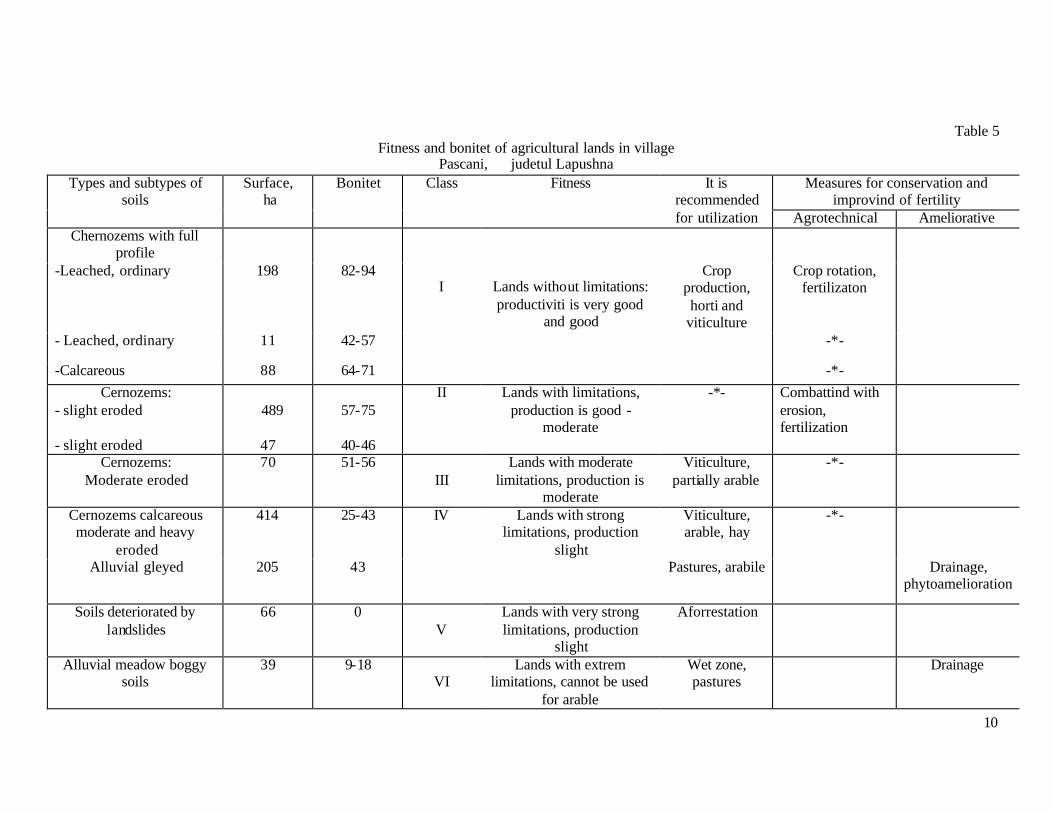
Fitness and bonitet of agricultural lands in 8 villages are presented in tables 5-12 in Romanian language. Here are presented materials for village Pascani.(table 5).
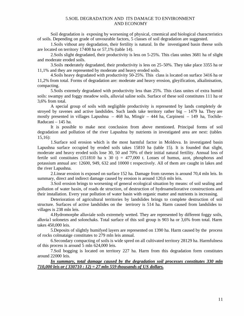
Average bonitets for every village and yields of main crops are presented in table 13. Production level of soils in all villages is lower than in average în Moldova.
Average soil bonitet in Republic is 65 points, but in investigated villages it is 55-62 points, 3-10 points less. It is understandable that level of productivity of agricultural crops in these villages, calculated on the base of bonitet, is lower in comparison with Republican and district levels.
To obtain maximal profit it is neccessary to use agricultural territories according to their fitness classfication.
10
Table 5 Fitness and bonitet of agricultural lands in village
Pascani, judetul Lapushna Measures for conservation and
improvind of fertility Types and subtypes of
soils Surface,
ha Bonitet Class Fitness It is
recommended for utilization Agrotechnical Ameliorative
Chernozems with full profile
-Leached, ordinary 198 82-94 Crop production, horti and
viticulture
Crop rotation, fertilizaton
- Leached, ordinary 11 42-57 -*-
-Calcareous 88 64-71
I
Lands without limitations: productiviti is very good
and good
-*- Cernozems:
- slight eroded
489
57-75 II Lands with limitations,
production is good - moderate
- slight eroded 47 40-46
-*- Combattind with erosion, fertilization
Cernozems: Moderate eroded
70 51-56 III
Lands with moderate limitations, production is
moderate
Viticulture, partially arable
-*-
Cernozems calcareous moderate and heavy
eroded
414 25-43 Viticulture, arable, hay
-*-
Alluvial gleyed 205 43
IV Lands with strong limitations, production
slight Pastures, arabile Drainage,
phytoamelioration
Soils deteriorated by landslides
66 0 V
Lands with very strong limitations, production
slight
Aforrestation
Alluvial meadow boggy soils
39 9-18 VI
Lands with extrem limitations, cannot be used
for arable
Wet zone, pastures
Drainage
11
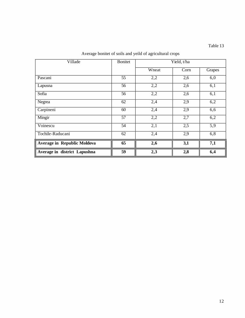
5.SOIL DEGRADATION AND ITS DAMAGE TO ENVIRONMENT AND ECONOMY
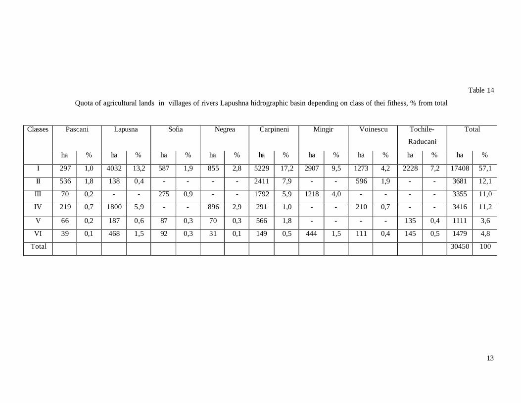
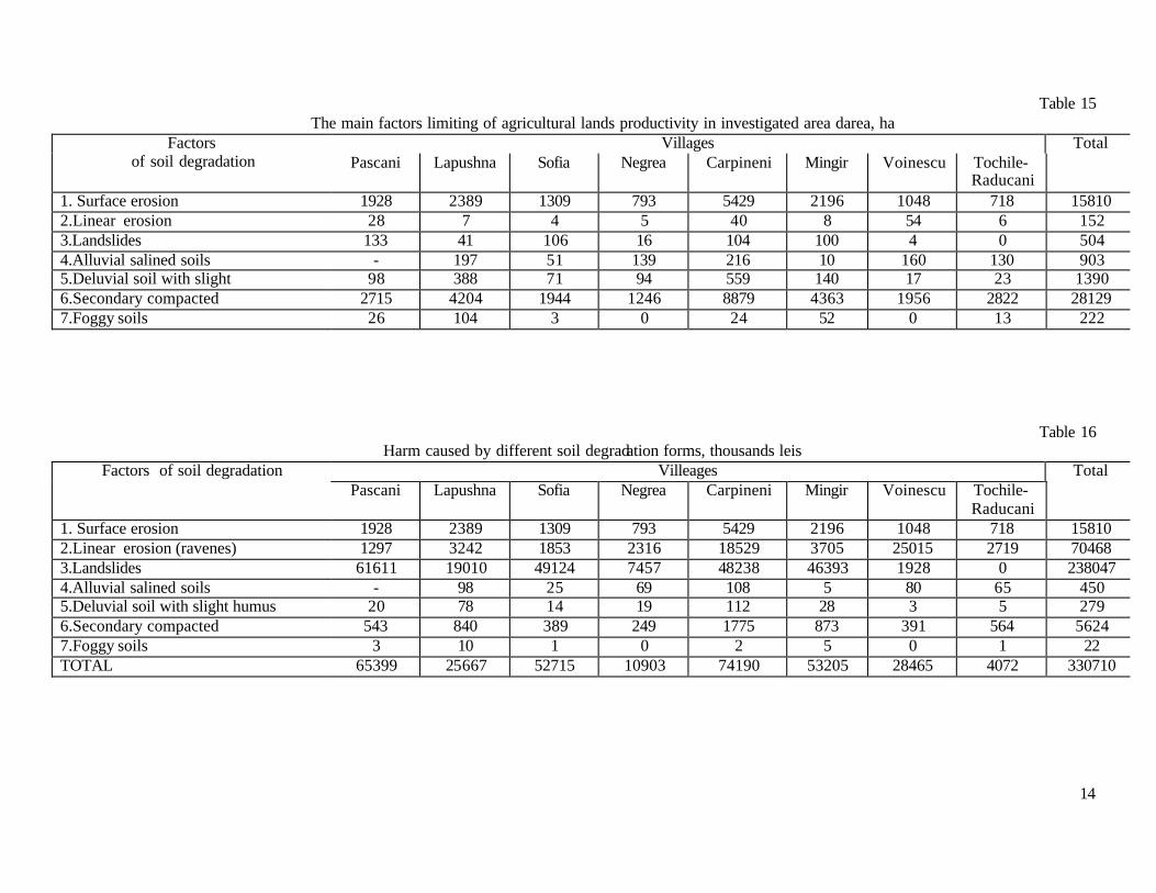
Soil degradation is exposing by worsening of physical, cmemical and biological characteristics of soils. Depending on grade of unvourable factors, 5 classes of soil degradation are suggested. 1.Soils vithout any degradation, their fertility is natural. In the investigated basin theese soils are located on territory 17408 ha or 57,1% (table 14). 2.Soils slight degradated, their productivity is less on 5-25%. This class unites 3681 ha of slight and moderate eroded soils. 3.Soils moderately degradated, their productivity is less on 25-50%. They take place 3355 ha or 11,1% and they are represented by moderate and heavy eroded soils. 4.Soils heavy degradated with productivity 50-25%. This class is located on surface 3416 ha or 11,2% from total. Forms of degradation are: moderate and heavy erosion, gleyification, alkalinisation, compacting. 5.Soils extemely degradated with productivity less than 25%. This class unites of extra humid soils: swampy and foggy meadow soils, alluvial saline soils. Surface of these soil constitutes 111 ha or 3,6% from total. A special group of soils with negligible productivity is represented by lands completely de stroyed by ravenes and active landslides. Such lands take territory rather big – 1479 ha. They are mostly presented in villages Lapushna – 468 ha, Mingir – 444 ha, Carpineni – 149 ha, Tochile-Raducani – 145 ha. It is possible to make next conclusion from above mentioned. Principal forms of soil degradation and pollution of the river Lapushna by nutrients in investigated area are next: (tables 15,16):
1.Surface soil erosion which is the most harmful factor in Moldova. In investigated basin Lapushna surface occupied by eroded soils takes 15810 ha (table 15). It is founded that slight, moderate and heavy eroded soils lose 30, 50 and 70% of their initial natural fertility. Annual loss of fertile soil constitutes (151810 ha x 30 t) = 477,000 t. Losses of humus, azot, phosphorus and potassium annual are: 12600, 949, 632 and 10000 t respectively. All of them are caught in lakes and the river Lapushna. 2.Linear erosion is exposed on surface 152 ha. Damage from ravenes is around 70,4 mln leis. In summary, direct and indirect damage caused by erosion is around 120,6 mln leis. 3.Soil erosion brings to worsening of general ecological situation by means: of soil sealing and pollution of water basin, of roads de struction, of destruction of hydroameliorative constructions and their installation. Every year pollution of water basin with organic matter and nutrients is increasing. Deterioration of agricultural territories by landslides brings to complete destruction of soil structure. Surfaces of active landslides on the terrirory is 514 ha. Harm caused from landslides to villages is 238 mln leis.
4.Hydromorphe alluviale soils extremely wetted. They are represented by different foggy soils, alluvia l solonetzs and solonchaks. Total surface of this soil group is 903 ha or 3,6% from total. Harm takes 450,000 leis. 5.Deposits of slightly humifyed layers are represented on 1390 ha. Harm caused by the process of rocks colmataige constitutes to 279 mln leis annual. 6.Secondary compacting of soils is wide spred on all cultivated territory 28129 ha. Harmfulness of this process is around 5 mln 624,000 leis. 7.Soil bogging is located on territory 227 ha. Harm from this degradation form constitutes around 22000 leis. In summary, total damage caused by the degradation soil processes constitutes 330 mln 710,000 leis or ( 330710 : 12) = 27 mln 559 thousands of US dollars.
12
Table 13
Average bonitet of soils and yeild of agricultural crops
Yield, t/ha Villade Bonitet
Wneat Corn Grapes
Pascani 55 2,2 2,6 6,0
Lapusna 56 2,2 2,6 6,1
Sofia 56 2,2 2,6 6,1
Negrea 62 2,4 2,9 6,2
Carpineni 60 2,4 2,9 6,6
Mingir 57 2,2 2,7 6,2
Voinescu 54 2,1 2,5 5,9
Tochile-Raducani 62 2,4 2,9 6,8
Average in Republic Moldova 65 2,6 3,1 7,1
Average in district Lapushna 59 2,3 2,8 6,4
13
Table 14
Quota of agricultural lands in villages of rivers Lapushna hidrographic basin depending on class of thei fithess, % from total
Pascani Lapusna Sofia Negrea Carpineni Mingir Voinescu Tochile-
Raducani
Total Classes
ha % ha % ha % ha % ha % ha % ha % ha % ha %
I 297 1,0 4032 13,2 587 1,9 855 2,8 5229 17,2 2907 9,5 1273 4,2 2228 7,2 17408 57,1
II 536 1,8 138 0,4 - - - - 2411 7,9 - - 596 1,9 - - 3681 12,1
III 70 0,2 - - 275 0,9 - - 1792 5,9 1218 4,0 - - - - 3355 11,0
IV 219 0,7 1800 5,9 - - 896 2,9 291 1,0 - - 210 0,7 - - 3416 11,2
V 66 0,2 187 0,6 87 0,3 70 0,3 566 1,8 - - - - 135 0,4 1111 3,6
VI 39 0,1 468 1,5 92 0,3 31 0,1 149 0,5 444 1,5 111 0,4 145 0,5 1479 4,8
Total 30450 100
14
Table 15
The main factors limiting of agricultural lands productivity in investigated area darea, ha Villages Total Factors
of soil degradation Pascani Lapushna Sofia Negrea Carpineni Mingir Voinescu Tochile-Raducani
1. Surface erosion 1928 2389 1309 793 5429 2196 1048 718 15810 2.Linear erosion 28 7 4 5 40 8 54 6 152 3.Landslides 133 41 106 16 104 100 4 0 504 4.Alluvial salined soils - 197 51 139 216 10 160 130 903 5.Deluvial soil with slight 98 388 71 94 559 140 17 23 1390 6.Secondary compacted 2715 4204 1944 1246 8879 4363 1956 2822 28129 7.Foggy soils 26 104 3 0 24 52 0 13 222
Table 16 Harm caused by different soil degradation forms, thousands leis
Villeages Total Factors of soil degradation Pascani Lapushna Sofia Negrea Carpineni Mingir Voinescu Tochile-
Raducani
1. Surface erosion 1928 2389 1309 793 5429 2196 1048 718 15810 2.Linear erosion (ravenes) 1297 3242 1853 2316 18529 3705 25015 2719 70468 3.Landslides 61611 19010 49124 7457 48238 46393 1928 0 238047 4.Alluvial salined soils - 98 25 69 108 5 80 65 450 5.Deluvial soil with slight humus 20 78 14 19 112 28 3 5 279 6.Secondary compacted 543 840 389 249 1775 873 391 564 5624 7.Foggy soils 3 10 1 0 2 5 0 1 22 TOTAL 65399 25667 52715 10903 74190 53205 28465 4072 330710
15
6. SOIL CONSERVATION PROGRAM
6.1 Principles and objectives of the soil conservation strategy
The first principle consists in the identification of problems, their causes and solutions through
a thorough investigative program on the soil quality. This could be done via detailed integrated studies on representative pilot sites. Such studies should involve the monitoring of agrochemical, agrophysical and microbiological parameters of pilot areas representative for different types of landscape (plane, slope, floodplain), vegetation (forest, pasture, arable land) and soil. An other fundamental principle for soil conservation is that an area should be used in such a way that its “ecological capacity” is not exceeded. A third principle would be the implementation of sustainable agriculture practices of the territory of one of the communes within the project pilot area. The main objectives for the realization of the principles mentioned above are as follows: - protection of the landscapes in order to protect the soil, maintain the biodiversity, ensure self-purification, restrict the soil and water pollution with nutrients; - stimulation of studies on the soil chemistry, erosion processes, soil amelioration in pilot areas in order to identify the soil status and nutrient pollution sources; - development and implementation of measures for soil conservation and decreasing nutrient pollution of the water resources.
6.2 Landscape organisation and reconstruction The major environmental policy objectives in the field of maintaining the natural resources/potential and ensuring the environmental security of the population are: extension of the forested areas, grasslands, wetlands and green areas within the settlements.
6.2.1 Ecological reconstruction and extension of forest coverage Within the pilot area (8 communes) we recommend to afforest the following areas: a) degraded areas on hillsides (656 ha), including - 504 hectares affected by landslides; - 152 hectares affected by ravines; b) water protection strips within the river floodplain (132 ha), including - protection strips along the river Lapusna and its tributaries; - water reservoirs in the catchment; c) other degraded lands (604 ha), d) newly created recreation areas (40 ha), e) 10% of the heavily eroded lands (approximately 300 ha). New soil protection forest belts would have to be planted and existing ones to be reanimated on a total area of 321 hectares. In total, about 1720 hectares will have to be planted with trees. The total costs required to do that would be US$ 836,000.

16
6.2.2 Ecological reconstruction and extension of grasslands This is necessary to be done on the entire area of 5591 hectares of degraded lands (Table 17). The extension of grasslands could be achieved through the following: - grassing the canals for runoff evacuation (16 ha); - grassing the small valleys and ravines to decrease the loss of eroded topsoil (32 ha); - taking 10% from the heavily eroded land out of intensive cultivation, i.e. transforming arable land in meadows (300 ha). The costs of antierosional measures on pastures are estimated at 35 lei/ha, so for the total area of 5591 ha it will amount at 196,000 lei or approximately US$ 16,000. The costs of grassing the runoff evacuation canals, [vilcele] and heavily eroded lands are: 348 ha x 6,800 lei/ha = 2,366,000 lei. Total costs under this item: 2,562,000 lei equivalent to approximately US$ 213,500.
It is necessary to extent the surface of the swamped areas with 23 ha in the river meadow
Lapusna. The cost of one ha – 20.000lei. The expenses for these work would be (23 ha x 20.000 lei)
460.000 lei or 38.1 thousand USD. In small river meadows, by special projects, is necessary to be created a waterfall of swamped lands, which would serve to the regulation of the flows of small and middle rivers and to the biological self pruning of waters, biodiversity conservation, attenuation of the dryness of climate and the consequences of drought, especially in the southern part of the plot (wilages Voinicescu and Tochile – Raducani) where the quantity of atmospheric precipitations is decreased and is about 400-450 mm. The result of these works would be the improvement of ecological state of the territory, decreasing of polution of the waters of Lapusna Prut river, and later Danube and the Black Sea, including organig substances (humus) of soil.
17
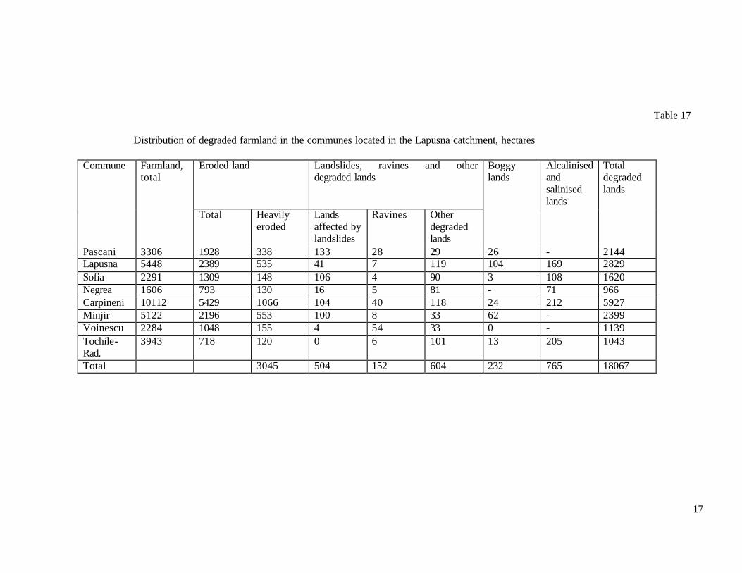
Table 17
Distribution of degraded farmland in the communes located in the Lapusna catchment, hectares
Commune Farmland, total
Eroded land Landslides, ravines and other degraded lands
Boggy lands
Alcalinised and salinised lands
Total degraded lands
Total Heavily eroded
Lands affected by landslides
Ravines Other degraded lands
Pascani 3306 1928 338 133 28 29 26 - 2144 Lapusna 5448 2389 535 41 7 119 104 169 2829 Sofia 2291 1309 148 106 4 90 3 108 1620 Negrea 1606 793 130 16 5 81 - 71 966 Carpineni 10112 5429 1066 104 40 118 24 212 5927 Minjir 5122 2196 553 100 8 33 62 - 2399 Voinescu 2284 1048 155 4 54 33 0 - 1139 Tochile-Rad.
3943 718 120 0 6 101 13 205 1043
Total 3045 504 152 604 232 765 18067

18
6.3 Improvement of the solonets and saline soils with a humidity excess from Lapusna river meadow The entire surface of the saline meadow soils (alluvial) is 765 ha. The soil classification according to the level of solonetzitzation and salinization is composed from 4 amelioration groups. First Group – nonsolonetzizated and nonsalinizated lands; is not requiring special improving meansures. The surface of alluvial, nonsalinizated and nonsolonetizated soils is 180 ha on our plot. The agricultural land may be used as arable land or pastures and hay fields. The second Group – weak and moderate affected by salinization. They may be used as culturated pastures and hay fields. The soil cover is presented by alluvial marshy grounds slight and moderate salinizated and solonetzizated. These soils need chemical improvements; growing of plants which would tolerate the salinization and solonetzisation. The surface of this group of soils is 700 ha; expenses for improvement – (700 ha x 370 lei) 6559 thousand lei; or 546 thousand USD. Recovering of expenses is 6-8 years. The Third Group – lands that need considerable agrophysical and chemical improvements. The surface of these soils is 65 ha, total expenses (65 ha x 12885 lei) 835 thousand lei or 70 thousand USD; recovering of expenses 6-8 years. The Fourth Group – plots that cannot be improved, presented by soils with high and very high level of salt containt such as solonetz and alluvial soloncheak. The economic efficiency of these improving works of these soils is lacks. It would be more reasonable to use these lands as pastures. To improve the alluvial salted soils on a surface of 765 ha is necessary to expend 7 mln. 394 thousand lei or 616 thousand USD. Expenses may be recovered within 6-8 years. 6.4. Conservation of eroded soils The surface of eroded soils is 15 thousand 810 ha. 6.4.1.Phytotecnical measures
În crop rotation (tab.17 ) is determined in accordance to the angle of the slope and the erosion degree of the soil. As the slope and the degree of erosion is bigger the percentage of the perennial and dense crops is higher and vice versa. On the slightly eroded soils the following percentage of the agricultural crop rotation is recomended: cultivated crops – 50%, dense crops – 30%, perennial crops – 20%. On the moderate and high eroded soils the share of the dense and
Table 18 The optimal report of agricultural crops on slopes, %
Percentage of plants in crop rotation Gradient of slope
Degree of erosion Cultivated
crops Dense crops Perennial crops
The protection coefficient of soils against erosion
1-30 Slight 50 30 20 0.52 3-50 Moderate 30 40 30 0.64 5-70 Strong 20 50 30 0.70
>7 Strong and very strong complexity
0 35 65 0.87

19
perennial crops is increasing to 70-80%, and for the cultivated crops is decreasing to 20 – 30%. If the gradient of slope is bigger than 70, with high and very high degradated soils, the share of perennial crops is 65% and the dense ones – 35%. An efficient and less expensive measure is the cultivation of agricultural crops in bands (alternation of the dense crops with the cultivated crops). Herein is presented an eexample of antierosional crop rotation for 4 years:
- slope with 2-50, cultivation of crops bands with the breadth of 100 – 150 m; corn, pea; autumn wheat, sun flower.
- Slope with 5 – 80, cultivation of crops in bands with a breadth untill 100m and buffer bands with grass with the breadth of 4m: wheat, corn, pea, wheat.
Implimentation of the antierosional crop rotation ensures soil protection against erosion, conservation of organic substance also for the agrophysical and biological properties of soil. 6.4.2. Soil cultivation system
The soil cultivation system is made to emprove the conditions of growth of agricultural crops and also the amelioration of the productivity potential of soil. On the eroded lands soil cultivation must contribute to the minimization of sheet erosion. This system is known as “Cultivation system for soil conservation”. The minimal cultivation of soil ensures the minimization of:
- teterioration of agrophysical properties of soil; - humus losses; - oil consumption for 1 ha; - maintainance of soil biodiversity; - sheet erosion. It is very necessary that the basic treatment of soil, sowing of crops be made only across the
slope or horizontally. 6.4.3 The complex of agrotechnical measures in vineyards and orchads
In the teritory of the mentioned plot the share of the fruit – growing crops often situated on slopes, is big enough and is made up of: orchads – 2319 ha, vineyards – 4519 ha. The main antierosional measures in the friut – growing plantation are the following:
- profound pluging in strips; - fissuring of soil on the traces of the tractor ,s wheels; - herbal row spacing with perennial grasses, period of herbal row spacing 3 years, the herbal
row spacing band must be placed in the miiddle of the space between rows, the band must occupy only half of row surface; according to the degree of slope is necesary to grass the forth (inclination of slope of 1-50) or the second or the third row (inclination more than 50).
Implimentation of this complex of agrotechnical measures in the fruit – ground plantation allows:
- diminishing the humus losses and nourishing elements; - obtainig a gross profit of 14.2 lei/ha.
6.5 Soil Fertilization For conservation of soil fertilization we propose the following action plan:
- minimization of soil erosion in the admissible limits (5-6 t/ha); - optimization of structure of crop – rotation; - implimentation of antierosional crop-rotations; - increase of pod – bearing plants (lucerne, pea, soya, bean) until 20-25%, that would lead to
the accumulation of 30-35 kg/ha of biological nitrogen, total 600-700t; - annual incorporation in soil of 5 t/ha of dung (compost), in total 102,5 thousand t (table 18).
20
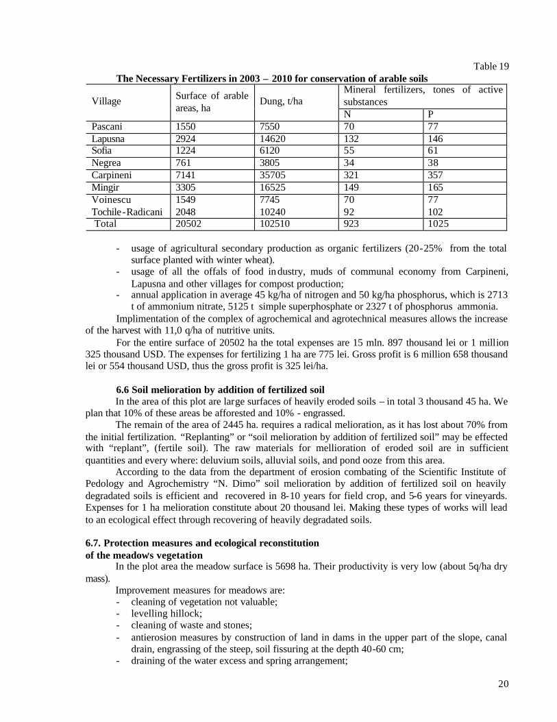
Table 19 The Necessary Fertilizers in 2003 – 2010 for conservation of arable soils
Mineral fertilizers, tones of active substances Village Surface of arable
areas, ha Dung, t/ha
N P Pascani 1550 7550 70 77 Lapusna 2924 14620 132 146 Sofia 1224 6120 55 61 Negrea 761 3805 34 38 Carpineni 7141 35705 321 357 Mingir 3305 16525 149 165 Voinescu 1549 7745 70 77 Tochile-Radicani 2048 10240 92 102 Total 20502 102510 923 1025
- usage of agricultural secondary production as organic fertilizers (20-25% from the total
surface planted with winter wheat). - usage of all the offals of food in dustry, muds of communal economy from Carpineni,
Lapusna and other villages for compost production; - annual application in average 45 kg/ha of nitrogen and 50 kg/ha phosphorus, which is 2713
t of ammonium nitrate, 5125 t simple superphosphate or 2327 t of phosphorus ammonia. Implimentation of the complex of agrochemical and agrotechnical measures allows the increase
of the harvest with 11,0 q/ha of nutritive units. For the entire surface of 20502 ha the total expenses are 15 mln. 897 thousand lei or 1 million
325 thousand USD. The expenses for fertilizing 1 ha are 775 lei. Gross profit is 6 million 658 thousand lei or 554 thousand USD, thus the gross profit is 325 lei/ha.
6.6 Soil melioration by addition of fertilized soil
In the area of this plot are large surfaces of heavily eroded soils – in total 3 thousand 45 ha. We plan that 10% of these areas be afforested and 10% - engrassed. The remain of the area of 2445 ha. requires a radical melioration, as it has lost about 70% from the initial fertilization. “Replanting” or “soil melioration by addition of fertilized soil” may be effected with “replant”, (fertile soil). The raw materials for mellioration of eroded soil are in sufficient quantities and every where: deluvium soils, alluvial soils, and pond ooze from this area. According to the data from the department of erosion combating of the Scientific Institute of Pedology and Agrochemistry “N. Dimo” soil melioration by addition of fertilized soil on heavily degradated soils is efficient and recovered in 8-10 years for field crop, and 5-6 years for vineyards. Expenses for 1 ha melioration constitute about 20 thousand lei. Making these types of works will lead to an ecological effect through recovering of heavily degradated soils. 6.7. Protection measures and ecological reconstitution of the meadow,s vegetation In the plot area the meadow surface is 5698 ha. Their productivity is very low (about 5q/ha dry mass). Improvement measures for meadows are:
- cleaning of vegetation not valuable; - levelling hillock; - cleaning of waste and stones; - antierosion measures by construction of land in dams in the upper part of the slope, canal
drain, engrassing of the steep, soil fissuring at the depth 40-60 cm; - draining of the water excess and spring arrangement;
21
- mineral fertilization etc. For the productivity increase of the pastures is necessary to impliment the controled pasturing. 6.8. Phasing of the complex of measures for soil conservation
In table 19 are presented the measures for land improvement and the volume of implimentations for each year separately. A special attention is payed to the measures of soil conservation that would contribute to the minimazing of the environment polution with nutrients. These measures are:
- antierosional soil protection through forest phytotechnical and agrotechnical measures; - rational usage of the dung, organogeneous wasters; - extent of agroforest works: on slopes – of foresting of the deteriorated soils by land slide
ravines, also for the heavily – eroded soils; setting up of t he protection bands for soil; in the river meadow – creation of river – side bands for protecting water resources (rivers and lakes), in total 1992 ha;
- reestablishing of the wet areas and establishing the habitates in the Lapusna river – meadow on a surface of 23 ha;
- reanimation of the heavily eroded soils through biological measures (cultivation of perennial grasses, incorporation in soil of local fertilizers, compostes) on about 300ha;
- pastures reanimation through agrotechnical and agrochemical measures on 5698 ha; - implimentation of controled pasturing; - forming an equilibrated balance of humus and nutritive elements in soil through utilization
of secondary agricultural production and organic and mineral fertilizers; - it will be tested / demonstrated first of all simple measures, efficient, cheap and accessible for all land owners, for all the inhabitants of the respective village. The biggest source of water resource polution with nutrients is soil erosion. It is planned
testing / demonstration of simple efficient and cheap agricultural practices for soil erosion combating (antierosional crop – rotation, cultivation of agricultural plants in bands, horizontal soil cultivation, preserve of vegetable remainigs on the soil surface, fissuring, engrassing between rows in vineyards and orchads, forming of tampon bands from perennial grasses, creation of protection bands from bushes, etc.
We will explain to the farmers and land awners the necessity of extention of the surfaces with
pod – bearing plants, nitrogen fixing, lucerne pea, soya etc.. We will prove that the soil fertilization according to the type of soil, agrochemical indexes,
predecessor, the cultivated agricultural crop, allows to obtain both an essential increase of harvest and an economic profit.

22
Table 20 Phasing of the conservation works of soil
Area, ha Years Conservative agricultural
practices Total Included in
the project 1 2 3 4
5
Enforesting: land slide 504 252 13 63 63 63 50
Ravines 152 76 4 19 19 19 15
Other deteriorated lands 604 181 9 45 45 45 37
Heavily eroded soils 300 94 5 24 24 24 15
Establish of river-side bands 132 132 7 33 33 33 26
Protection and reconstruction
of pastures
5698;
8
villages
3 villages - - 1
village
2
villages 3 vill.
Controled pasturing 5698;
8
villages
3 villages - - 1
village
2
villages 3 vill.
Extention of the grass
vegetation:
Drain channels 16 16 - 1 3 6 6
Along dales 32 32 - 4 8 10 10
Heavily eroded soils 300 50 - 5 10 15 20
Cultivation of lucerne pea 2700 1300 200 400 600 700 800
Conservation of eroded soil:
Arable 15800 1500 100 500 1000 1200 1500
In vineyards 4519 2500 150 300 900 2000 2500
In orchads 2319 800 50 100 300 500 800
Soil fertilization:
Organic 2000 2000 400 800 1000 1500 2000
Mineral 35000 17000 4000 8000 10000 13000
1700
0
Secondary Production 950 500 - 50 100 300 500
Extention of damp areas 23 10 - - 3 3 4

23
7. Efficiency of complex of soil conservation measures 7.1. Criterions for plot selection for testing / demonstration Criterions for selection of emplacements where the testing / demonstration of the set practices
in our view could be made are as follows: - availability of the village ,s inhabitants, local public administration, farmers, associations
leaders to actively participate in project realization; - state of land fund, the hidrographical selected basin for testing, the soil and the types of
degradation should be typical for the eight villages from the plot area; - type of ownership (private, public) for testing / demonstration; agreement and participation
of the land owner in testing; - accessibility of the area for organization of visits; - buildings (rooms) for agricultural ecological workshops, farmers and rural inhabitants
trainings; - available special equipments in the area. 7.2. Ecological efficience of soil conservation measures Combating of soil erosion through forest and agrotechnical measures are the main soil
conservation measures and minimizing the degree of polution of the environment implimentation of forest and phytoameliorative measures allow to perfect the relation between natural and antropic echosystems, to form a favorable microclimate and hidrical regime for obtaining high harvests of agricultural crops and health protection of rural inhabitants.
As a rule the, the forestry protection plantation have a multifunctional influence on the environment. They influence the hydric regime of territory, the composition of water, air, flora and fauna etc. Creation of a green framework in the plot area will be a prioritary measure for environment protection.
Extention of damp areas would serve to the regulation of the leakings of Lapusna river and small rivers, it would also contribute to the selfcleaning of waters, diminish the climate dryness and the consequences of drought, also to the biodiversity protection.
Melioration of heavily eroded soil by addition of fertilized soil would permit farmers to obtain an agronomic, ecologic effect, and in the future an economic effect.
Technologies, procedures and the complex of soil conservation measures mentioned in this report (agrotechnical, phytotechnical, forest, hidrotechnical, agrochemical, biological, amelioration measures) were elaborated by the Scientific Institute for Pedology and Agrochemistry “N.Dimo” and have been tested in production conditions in different pedoclimatic zones of Republic of Moldova.
Institute,s elaborations are exposed in recomendations, methodical instructions, normatives, limits, brochures, monographies, placards, etc. Some of these works are presented in the bibliography.
24
BLIOGRAFIE
1. ? ???? ? ???????. ?.2. ??????? «? ??????», 1985.
2. ? ???? ? ???????. ?.3. ??????? «? ??????», 1986.
3. Degradarea solurilor si desertificarea. Chisinau; 2000.
4. Programul complex de sporire a fertilitatii solului, Chisinau, 2001.
5. Cerbari V., Andries S. Sa oprim degradarea solului. Chisinau, 2001.
6. Cadastru funciar al Republicii Moldova la 1 ianuarie 2001.
7. Studiile pedologice efectuate de catre Institutul de Proiectarti pentru Organizarea Teritoriului în
anii 1990-1994.
8. Hartile pedologice la scara 1:10000 pentru fiecare comuna din bazinul hidrografic al râului
Lapusna (poligonul de cercetare).
9. Metodologia valorificarii superioare a solului în noile conditii de gospodarire a terenurilor
agricole, Chisinau, 1999.
10. Recomandari privind ameliorarea solurilor erodate prin aport de materiale pamântos, Chisinau,
2001.
11. Buletin de monitoring ecopedologic (agrochimic) editia VII Chisinau, 2001.
12. ????????? ?? ????????????? ? ?????????? ? ???????????? ????????? ? ????????
????????? ? ????????? ???, ???????, 1987.
13. Buletin de monitoring ecopedologic. Edtia I. Chisinau „Agroinformreclama”, 1993.
14. Buletin de monitoring ecopedologic pedoameliorativ. Editia II. Chisinau. Agroinformreclama,
1995.
15. Buletin de monitoring ecopedologic (pedoerozional). Editia a treia. Chisinau, 1996.
16. Burlacu I. Deservirea agrochimica a agriculturii Republicii Moldova, Chisinau, 2000.
17. ?????? ????. ??? ????, ? ?? -?? «Pontos”, 2001.