Renewable energy sources solutions in Sobrance district and its impact on geotourism, In: GEOTOUR`12...
148
GEOTOUR’12 & IRSE’12 INTERNATIONAL TWIN CONFERENCE GEOTOUR & IRSE 2012 GEOPARKS, GEOHERITAGE AND GEOCONSERVATION ¤ IRSE: History of Central European Mining Proceedings Edited by: Ľ. Štrba 04. – 06. October, 2012 Salgótarján, Hungary
Transcript of Renewable energy sources solutions in Sobrance district and its impact on geotourism, In: GEOTOUR`12...
[Zadajte text]
GEOTOUR’12 & IRSE’12
INTERNATIONAL TWIN CONFERENCE
GEOTOUR & IRSE 2012
GEOPARKS, GEOHERITAGE AND GEOCONSERVATION
¤ IRSE: History of Central European Mining
PPrroocceeeeddiinnggss EEddiitteedd bbyy:: ĽĽ.. ŠŠttrrbbaa
04. – 06. October, 2012
Salgótarján, Hungary
GEOTOUR & IRSE 2012
GEOPARKS, GEOHERITAGE
AND GEOCONSERVATION
¤
IRSE: History of Central European Mining
Edited by: Ľubomír Štrba
GEOTOUR & IRSE 2012
Geoparks, Geoheritage and Geoconservation
IRSE: History of Central European Mining
(Conference Proceedings)
Editor
Ľubomír Ńtrba
Publisher
Technical University of Końice
Letná 9
Końice
Slovakia
December 2012
First edition
Number of copies: 60
ISBN 978-80-553-1270-5
Texts were not grammatically corrected. Authors are responsible for the professional content of the articles.
CONTENTS
THE TELKIBÁNYA FIELD TRAINING EDUCATIONAL PARK IN WORKING ORDER ......................................................... 6
Hartai Éva & Németh Norbert
DATA ON THE HEALTH TOURISM STUDIES OF THE NORTH HUNGARY ...................................................................... 16
Zoltán Nagy & Tekla Sebestyén Szép
COMPETITIVENESS OF TOURISM IN SLOVAKIAN GEOPARKS .................................................................................... 22
Eva Tomková & Lenka Muchová
ASSESSMENT OF GEOSITE ATTRACTIVENESS IN EASTERN UKRAINE ........................................................................ 29
Mariia Dakhova & Roksolana Ńčuroková
USING NON-CONTACT MEASUREMENT METHODS FOR MONITORING GROUND ICE IN THE CAVE AREA OF ONE OF
THE LEADING GEOTOURIST ATTRACTIONS - THE DOBŃINSKÁ ICE CAVE .................................................................. 32
Juraj Gańinec, Silvia Gańincová and Ņofia Kuzevičová
THE SMRDÁKY SPA, ITS BALNEOLOGICAL IMPORTANCE – PRESENT AND FUTURE ................................................... 40
Lenka Řezníčková & Michaela Sehnálková
MARKET POSITIONS AND SOURCES OF POSSIBLE DEVELOPMENT OF THE THERMAL BATHS OF NORTHERN
HUNGARY ............................................................................................................................................................... 45
Zsolt Péter
RENEWABLE ENERGY SOURCES SOLUTIONS IN SOBRANCE DISTRICT AND ITS IMPACT ON GEOTOURISM .................. 54
Lenka Pčolinská, Sergej Strajņák, Jana Jablonská
CREATING SPATIAL MODELS OF HISTORICAL MONUMENTS FOR 3D GIS IN GEOTOURISM ........................................ 67
Ņofia Kuzevičová, Marcela Gergeľová, Ńtefan Kuzevič
HYDROGEOLOGICAL FIELD TRIP ON THE OPEN KARST OF BÜKK MOUNTAINS AND ON THE THERMALKARST OF
BÜKK REGION (NORTH HUNGARY) ......................................................................................................................... 73
László Lénárt
THE ANALYSIS OF THE GEOTOURISTIC POTENTIAL BY THE HELP OF A COMPLEX INDEX IN ONE SAMPLE AREA
(AGGTELEK-RUDABÁNYA MOUNTAINS)................................................................................................................. 80
Beáta Szilasi Siskáné, Zsuzsa Piskóti-Kovács, Lajos Szalontai, János Vágó
THE SIGNIFICANCE OF THE PAST TEACHERS AND PROFESSIONALS IN MINING - SPECIALLY S. MIKOVINY - FOR
TOURISM ................................................................................................................................................................. 90
Gejza M. Timčák & Jana Jablonská
THE WELL-KNOWN PROFESSOR OTTO CSÉTI – FOUNDER OF THE NOW 140 YEAR-OLD DEPARTMENT OF
GEODESY AND MINE SURVERYING ....................................................................................................................... 101
István Havasi
HISTORICAL ORE MINING SITES IN LOWER SILESIA (POLAND) AS GEO-TOURISM AND INDUSTRIAL TOURISM
ATTRACTION ......................................................................................................................................................... 110
Maciej Madziarz
CONDITIONS FOR IMPLEMENTATION OF THE PROGRAMME OF POST-MINING RELICS‟ MANAGEMENT FOR
GEOTOURISM ON EXAMPLE OF THE PROJECT “RECLAMATION OF TERRITORIES DEGRADED BY MINING
ACTIVITIES IN THE AREA OF THE MIRSK COMMUNE AND ESTABLISHING THE TOURIST ROUTE – BY THE
TRACES OF THE FORMER ORE MINING” .................................................................................................................. 122
Malwina Kobylańska
MINING AND GEOLOGICAL HERITAGE PROTECTION AS CHALLENGE FOR LOCAL COMMUNITIES............................. 129
Agata Juzyk, Jan Kudełko, Anna Szczerbiak
MAPPING OF MINING ACTIVITIES IN SPIŃ-GEMER PART OF SLOVAK ORE MOUNTAINS AND THE HISTORY OF
MINING.................................................................................................................................................................. 139
Ńtefan Kuzevič, Juraj Gańinec, Marcela Gergeľová, Ņofia Kuzevičová, Miriam Münnich

GEOTOUR

Salgótarján, 04. – 06. October 2012
6
THE TELKIBÁNYA FIELD TRAINING EDUCATIONAL PARK IN WORKING ORDER
Hartai Éva & Németh Norbert
Institute of Mineralogy and Geology, University of Miskolc, 3515 Miskolc-Egyetemváros
e-mail: [email protected], [email protected]
ABSTRACT
The Institute of Mineralogy and Geology (University of Miskolc), the BERG Faculty (Technical University of Końice) and the Local Authority of Telkibánya established the Field Training Educational Park in 2010. The park is based on the diverse geology and the gold-silver ore mineralization around Telkibánya, on the remnants of the ancient mining and on the existing touristic facilities (including a museum of mining) of the locality. It consists of an educational centre attached to a youth hostel inside the village, an educational trail
in the Veres-víz mining area and an underground demonstration site in the conserved Mária Adit. The park can be used by student groups for education, by professionals for meetings, and also by civilians for tourism,
widening the offers at Telkibánya.
Introduction
Telkibánya is an ancient mining town in the Tokaj Mts (also referred by geographers as Zemplén
Mountains), NE Hungary, close to the Slovakian border and the town Końice. It is surrounded by
forest-covered hills with outstanding medieval and later objects of industrial history (adits, shafts,
remnants of processing plants etc). Mining activity produced gold and silver from the veins of an
epithermal mineralization, which is still the potential target of prospecting projects. The village is
frequented recently by tourists, with several accommodations and recreational facilities. There is
also a museum dedicated to the history of mining and industry together with the wildlife and the
minerals in the building of a former porcelain manufacture.
In 2004–2005 a feasibility study of a common Hungarian-Slovakian field educational centre was
worked out in the frame of a PHARE CBC project lead by the Institute of Mineralogy and Geology,
University of Miskolc, in which educational programs were proposed to realize in the mining area
including the underground and open-pit mines. The partners of the institute were the BERG Faculty,
Technical University of Końice and Telkibánya Local Authority. Based on this feasibility study a
proposal for the realization was submitted and supported by the HUSK Cross-border Co-operation
Program 2007–2013. The project was implemented in 2009-2010. In this article the facilities of the
Educational Park are briefly introduced. The recent knowledge about the geology, mineralization
and mining of Telkibánya was summarized in a volume of the Publications of the University of
Miskolc in 2009, edited by the authors of the present text; in the recent paper mainly the articles of
this publication are referred.
The natural and historic background: geology and mining of Telkibánya
The Tokaj Mountains are built up by volcanic rocks of Miocene age (formed 14-10 million years
ago) such as andesite, dacite and rhyolite (Fig. 1). The thickness of the volcanic mass is cca. 3000
m. Similarly to the recent volcanoes, the volcanic complex is built up by altering lava flows and
pyroclastics. The volcanic activity lasted for about five million years, in three major phases,
partially on dry land, partially in the sea. During the volcanism sediments like clay and pebbles
were also deposited. As a result of the hydrothermal alteration of the rhyolitic tuff, „noble clay‟
deposits were also exploited e. g. at Füzérradvány (Gyarmati 1977, Zelenka et al. 2012).
GEOTOUR & IRSE 2012
7
Fig. 1 Simplified geological map of the Tokaj Mts. after Gyarmati (1977).
Telkibánya lies inside the remnants of a caldera surrounded by rhyolitic volcanic cones. The
rhyolitic rocks have a great variety: vesicular-amygdule lava rocks, welded tuffs, which were
deposited as ardent volcanic ash, or fast-cooled, glassy varieties, like obsidian and perlite all occur
in the surroundings of the village. The latter, an important isolator raw material, is mined at
Pálháza, but there is a small abandoned quarry at Telkibánya too.
The second volcanic phase produced not only ignimbrite flows and small domes, but also the gold-
silver ore mineralization the miners were searching for. The host rock of this mineralization is
andesite from the first volcanic phase. The ore formation was accompanied by rock alteration
Salgótarján, 04. – 06. October 2012
8
processes as the hydrothermal solutions ascending along the fractures of the solidified rocks
decomposed the original rock-forming minerals, and a new, potassium-rich mineral assemblage was
formed (Fig. 2). The results of these processes can be observed N and NE from Telkibánya on the
surface.
The ore mineralization occurs in veins, or in the brecciated host rock of the veins. There are about
20 known and exploited veins with a strike of N-S in the area, in which the minerals were
precipitated from hot hydrothermal solutions accompanying the volcanism. The infill is changing
with depth, according to the increasing temperature of the hydrothermal system. At the top the most
abundant vein mineral is quartz. There are several cm long quartz crystals, the longest ones are 10
cm. Opal and cinnabar also occurs, both in the veins and in the host rock, in minor patches. At
lower levels the veins are filled with clay minerals instead of quartz. The most important ore
minerals (native gold and silver sulphides) are very rarely visible; we can observe these only by
microscope as fine grains in the brecciated host rock or in the veins. The gold is frequently
associated with the much more abundant pyrite. The gold content is low, reaching only a few grams
per one metric ton rock. The silver content can be as high as several g/t. At the bottom level reached
by exploration drillholes only a base metal sulphide mineralization was explored (Székyné Fux
1970, Molnár et al. 2009).
The gold and silver mining in Telkibánya goes back to the 14th century. That time mining took
place on surface, in open pits. The pits (depressions of a few meters across) followed the surface
outcrops of the veins. We can have an impression about the intensity of the open-pit mining
considering the several thousands pits in the area of Kánya Hill and Gyepű Hill.
The underground mining started about two hundred years later, as the near-surface parts were
exhausted. Adits were opened; these days we know about 80 adits in the area, some of which are
still accessible. The ventilation and the transport between the different levels were solved by
vertical shafts. The excavated ore was processed in water-powered ore mills, transported to the
surface through the drainage adits at the bottom level of the mines. However, the yield of the mines
was rather low, and mining was pursued in certain periods in need of precious metals only. Finally,
the mining ceased in the 1850's (Benke 2009, 2011).
After the 2nd World War ore prospecting started again in order to detect new gold and silver
reserves. Although these ore reserves did not prove to be economic, prospecting is still going on,
and the last project was finished in 2001. Beyond surface sampling and soil geochemistry, the cores
of several exploration drillholes were assayed and documented, providing new information on the
rocks and minerals (Zelenka et al. 2009).
Fig. 2 Well formed crystals of adularia, a characteristic K-feldspar
formed by the rock alteration from the Kánya Hill, Telkibánya. Largest crystals are 4 mm. Photo: Szakáll S.
GEOTOUR & IRSE 2012
9
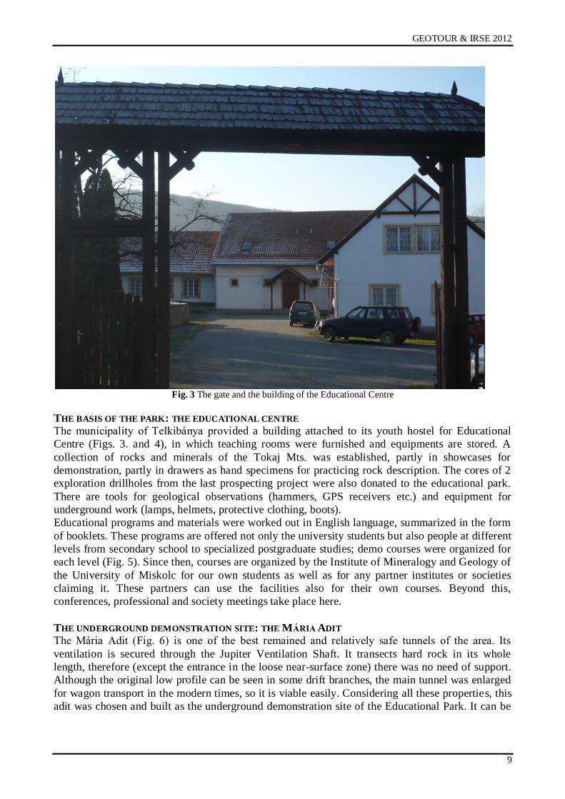
Fig. 3 The gate and the building of the Educational Centre
THE BASIS OF THE PARK: THE EDUCATIONAL CENTRE
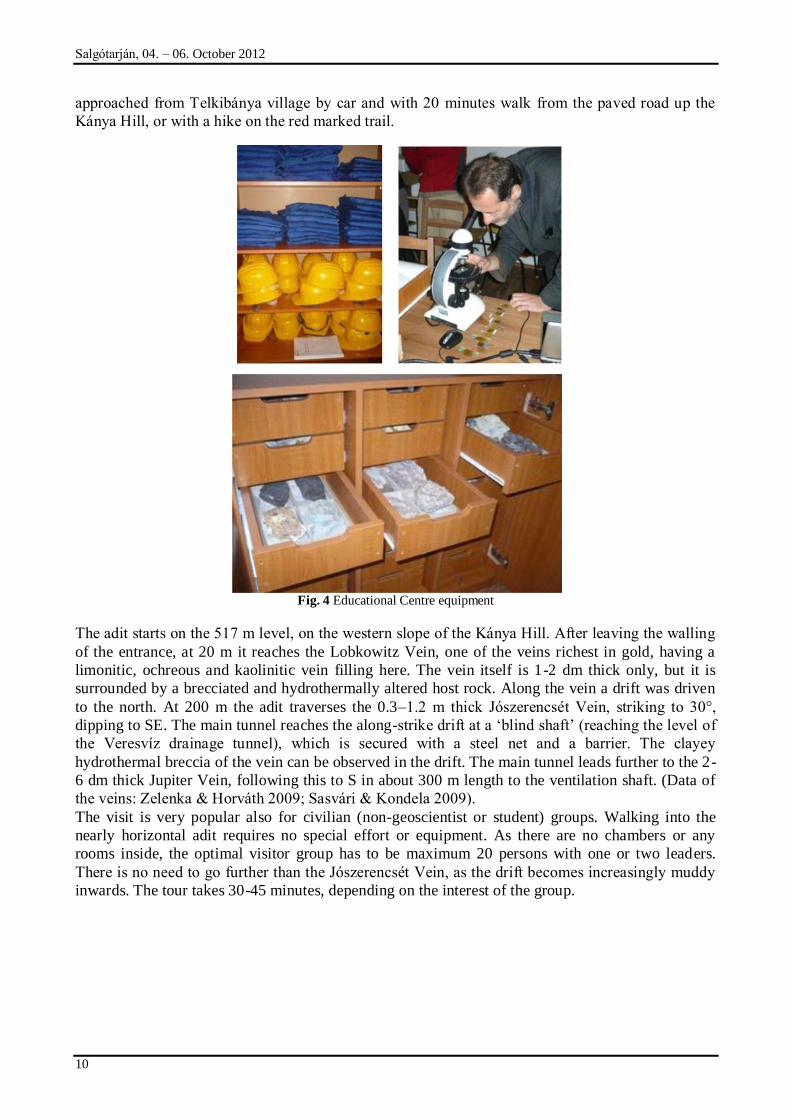
The municipality of Telkibánya provided a building attached to its youth hostel for Educational
Centre (Figs. 3. and 4), in which teaching rooms were furnished and equipments are stored. A
collection of rocks and minerals of the Tokaj Mts. was established, partly in showcases for
demonstration, partly in drawers as hand specimens for practicing rock description. The cores of 2
exploration drillholes from the last prospecting project were also donated to the educational park.
There are tools for geological observations (hammers, GPS receivers etc.) and equipment for
underground work (lamps, helmets, protective clothing, boots).
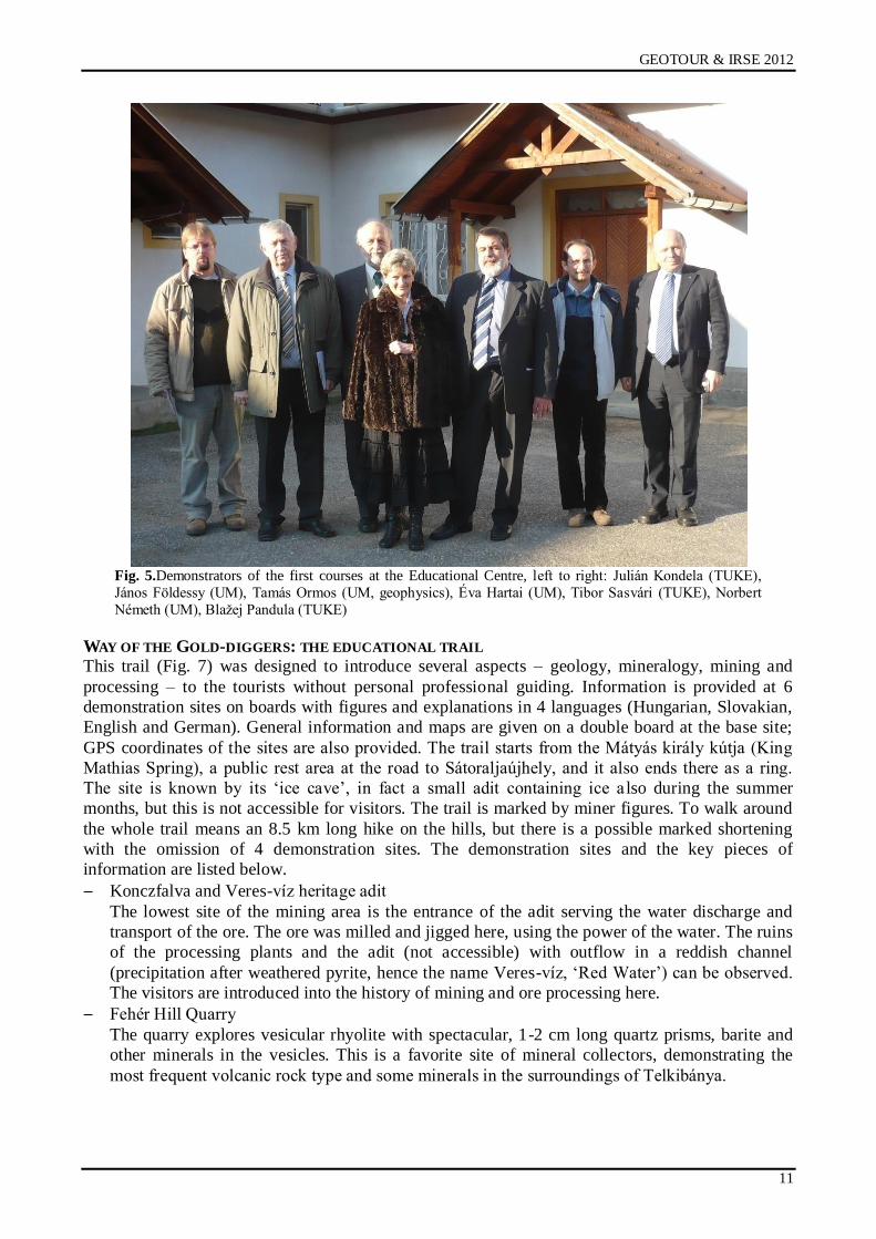
Educational programs and materials were worked out in English language, summarized in the form
of booklets. These programs are offered not only the university students but also people at different
levels from secondary school to specialized postgraduate studies; demo courses were organized for
each level (Fig. 5). Since then, courses are organized by the Institute of Mineralogy and Geology of
the University of Miskolc for our own students as well as for any partner institutes or societies
claiming it. These partners can use the facilities also for their own courses. Beyond this,
conferences, professional and society meetings take place here.
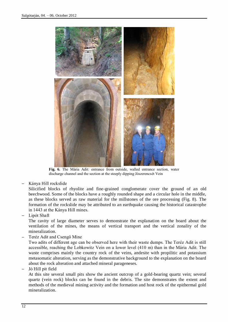
THE UNDERGROUND DEMONSTRATION SITE: THE MÁRIA ADIT
The Mária Adit (Fig. 6) is one of the best remained and relatively safe tunnels of the area. Its
ventilation is secured through the Jupiter Ventilation Shaft. It transects hard rock in its whole
length, therefore (except the entrance in the loose near-surface zone) there was no need of support.
Although the original low profile can be seen in some drift branches, the main tunnel was enlarged
for wagon transport in the modern times, so it is viable easily. Considering all these properties, this
adit was chosen and built as the underground demonstration site of the Educational Park. It can be
Salgótarján, 04. – 06. October 2012
10
approached from Telkibánya village by car and with 20 minutes walk from the paved road up the
Kánya Hill, or with a hike on the red marked trail.
Fig. 4 Educational Centre equipment
The adit starts on the 517 m level, on the western slope of the Kánya Hill. After leaving the walling
of the entrance, at 20 m it reaches the Lobkowitz Vein, one of the veins richest in gold, having a
limonitic, ochreous and kaolinitic vein filling here. The vein itself is 1-2 dm thick only, but it is
surrounded by a brecciated and hydrothermally altered host rock. Along the vein a drift was driven
to the north. At 200 m the adit traverses the 0.3–1.2 m thick Jószerencsét Vein, striking to 30°,
dipping to SE. The main tunnel reaches the along-strike drift at a „blind shaft‟ (reaching the level of
the Veresvíz drainage tunnel), which is secured with a steel net and a barrier. The clayey
hydrothermal breccia of the vein can be observed in the drift. The main tunnel leads further to the 2-
6 dm thick Jupiter Vein, following this to S in about 300 m length to the ventilation shaft. (Data of
the veins: Zelenka & Horváth 2009; Sasvári & Kondela 2009).
The visit is very popular also for civilian (non-geoscientist or student) groups. Walking into the
nearly horizontal adit requires no special effort or equipment. As there are no chambers or any
rooms inside, the optimal visitor group has to be maximum 20 persons with one or two leaders.
There is no need to go further than the Jószerencsét Vein, as the drift becomes increasingly muddy
inwards. The tour takes 30-45 minutes, depending on the interest of the group.
GEOTOUR & IRSE 2012
11
Fig. 5.Demonstrators of the first courses at the Educational Centre, left to right: Julián Kondela (TUKE),
János Földessy (UM), Tamás Ormos (UM, geophysics), Éva Hartai (UM), Tibor Sasvári (TUKE), Norbert
Németh (UM), Blaņej Pandula (TUKE)
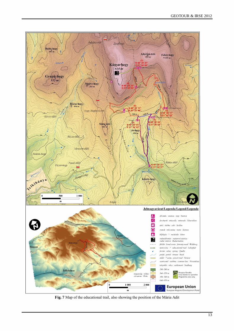
WAY OF THE GOLD-DIGGERS: THE EDUCATIONAL TRAIL
This trail (Fig. 7) was designed to introduce several aspects – geology, mineralogy, mining and
processing – to the tourists without personal professional guiding. Information is provided at 6
demonstration sites on boards with figures and explanations in 4 languages (Hungarian, Slovakian,
English and German). General information and maps are given on a double board at the base site;
GPS coordinates of the sites are also provided. The trail starts from the Mátyás király kútja (King
Mathias Spring), a public rest area at the road to Sátoraljaújhely, and it also ends there as a ring.
The site is known by its „ice cave‟, in fact a small adit containing ice a lso during the summer
months, but this is not accessible for visitors. The trail is marked by miner figures. To walk around
the whole trail means an 8.5 km long hike on the hills, but there is a possible marked shortening
with the omission of 4 demonstration sites. The demonstration sites and the key pieces of
information are listed below.
Konczfalva and Veres-víz heritage adit
The lowest site of the mining area is the entrance of the adit serving the water discharge and
transport of the ore. The ore was milled and jigged here, using the power of the water. The ruins
of the processing plants and the adit (not accessible) with outflow in a reddish channel
(precipitation after weathered pyrite, hence the name Veres-víz, „Red Water‟) can be observed.
The visitors are introduced into the history of mining and ore processing here.
Fehér Hill Quarry
The quarry explores vesicular rhyolite with spectacular, 1-2 cm long quartz prisms, barite and
other minerals in the vesicles. This is a favorite site of mineral collectors, demonstrating the
most frequent volcanic rock type and some minerals in the surroundings of Telkibánya.
Salgótarján, 04. – 06. October 2012
12
Fig. 6. The Mária Adit: entrance from outside, walled entrance section, water
discharge channel and the section at the steeply dipping Jószerencsét Vein
Kánya Hill rockslide
Silicified blocks of rhyolite and fine-grained conglomerate cover the ground of an old
beechwood. Some of the blocks have a roughly rounded shape and a circular hole in the middle,
as these blocks served as raw material for the millstones of the ore processing (Fig. 8). The
formation of the rockslide may be attributed to an earthquake causing the historical catastrophe
in 1443 at the Kánya Hill mines.
Lipót Shaft
The cavity of large diameter serves to demonstrate the explanation on the board about the
ventilation of the mines, the means of vertical transport and the vertical zonality of the
mineralization.
Teréz Adit and Csengő Mine
Two adits of different age can be observed here with their waste dumps. The Teréz Adit is still
accessible, reaching the Lobkowitz Vein on a lower level (410 m) than in the Mária Adit. The
waste comprises mainly the country rock of the veins, andesite with propilitic and potassium
metasomatic alteration, serving as the demonstrative background to the explanation on the board
about the rock alteration and attached mineral parageneses.
Jó Hill pit field
At this site several small pits show the ancient outcrop of a gold-bearing quartz vein; several
quartz (vein rock) blocks can be found in the debris. The site demonstrates the extent and
methods of the medieval mining activity and the formation and host rock of the epithermal gold
mineralization.
GEOTOUR & IRSE 2012
13
Fig. 7 Map of the educational trail, also showing the position of the Mária Adit

Salgótarján, 04. – 06. October 2012
14
Fig. 8 Broken ore grinding millstone in the Kánya Hill rockslide
CONCLUSION: THE GEOTOURISTIC POTENTIAL
Telkibánya was before the development of the Educational Park a growing recreational site already.
The project was successful mainly as it had met the demands of the local people interested in
tourism, fitting into and enhancing the touristic offers of Telkibánya. The historical gold-mining
area and the developed touristic objects will expectedly attract more visitors to the region not only
from Hungary but – due to the vicinity of the border – the Slovakian side as well. They expectedly
visit other scenes in the region, which in turn can contribute to the improvement of other touristic
services.
People who visit the geological attractions and the old mining sites will acquire more knowledge
about the non-living part of nature. The developed objects, the educational trail and the
underground mines in living natural scenery and a picturesque landscape can help people in the
better understanding of natural processes and the acceptance of mining activity as a source of the
indispensable raw materials.
The increasing number of visitors, and as a consequence, the development of touristic services can
also be an important factor to reduce the socio-economical problems and to raise the employment of
local citizens.
Acknowledgements
The described work was carried out as part of the TÁMOP‐4.2.1.B‐10/2/KONV‐2010‐0001
project in the framework of the New Hungarian Development Plan. The realization of this project is
supported by the European Union, co-financed by the European Social Fund.
REFERENCES
BENKE T. 2009: The history of the Mining of Telkibánya. Publications of the University of
Miskolc, Geosciences, Series A, Mining, 78, 7-25.
BENKE T. 2011: The history of the Mining of Telkibánya. In: Böhm J, Rybár P, Ńtrba Ľ. eds:
Present Issues of geotourism in Slovakia and Hungary (monograph), 23-40.
GEOTOUR & IRSE 2012
15
GYARMATI P. 1977: Intermediate volcanism in the Tokaj Mts. Annales Inst. Geol. Publ. Hung, 58,
196p. (in Hungarian with extended English abstract)
MOLNÁR F, ZELENKA T, PÉCSKAY Z. 2009: Geology, styles of mineralization and spatial-
temporal characteristics of the hydrothermal system in the low-sulphidation type epithermal
gold-silver deposit at Telkibánya. Publications of the University of Miskolc, Geosciences,
Series A, Mining, Vol. 78, pp. 45-71.
SASVÁRI T, KONDELA J. 2009: Structural characteristics of epithermal, low-sulphide precious
metals mineralization at Telkibánya, Tokaj Mountains, Hungary. Publications of the University
of Miskolc, Geosciences, Series A, Mining, Vol. 78, 115-140.
SZÉKYNÉ Fux V. 1970: The ore mineralization of Telkibánya and its Carpathian context.
Akadémiai Kiadó, Budapest, 266p. (in Hungarian)
ZELENKA T, FÖLDESSY J, KOMLÓSSY Gy. 2009: Modern mineral explorations in Telkibánya.
Publications of the University of Miskolc, Geosciences, Series A, Mining, Vol. 78, 159-170.
ZELENKA T, HORVÁTH J. 2009: Characteristics of the Telkibánya veins. Publications of the
University of Miskolc, Geosciences, Series A, Mining, Vol. 78, 71-96.
ZELENKA T, GYARMATI P, KISS J. 2012: Paleovolcanic reconstruction in the Tokaj Mountains.
Central European Geology, in press

Salgótarján, 04. – 06. October 2012
16
DATA ON THE HEALTH TOURISM STUDIES OF THE NORTH HUNGARY
Zoltán Nagy & Tekla Sebestyén Szép
University of Miskolc, Faculty of Economics, Institute of World and Regional Economics
3515 Miskolc, Miskolc-Egyetemváros
e-mail: [email protected], [email protected]
ABSTRACT
For the past decade tourism has become one of the most significant sectors of the world economy. In our study we present the tendencies of Hungarian health tourism, with special regard to the North-Hungarian Subregions. After the review of the main tourism indicator we give recommendations for the development of health tourism and describe the creation process of the Virtual Health Tourism Research Center, together
with its objectives and results.
INTRODUCTION Geotourism is a new alternative form of mass tourism, capable of sustaining the cultural and
environmental heritage in our world. Geotourism and health tourism feature several linking points:
the main object aimed at by both of them is controlling tourist activities in a sustainable way and
ensure the environmental integrity for the recreation of tourists.
In the tourism of North-Hungary there have not been considerable changes for the last decades.
While tourism became one of the most important subsectors of the world economy, negative
tendencies can be observed in this Hungarian region. The number of bed-places in collective tourist
accommodation available in the period between 2001 and 2010 shows a highly unfavorable and
downward tendency: The number of accommodation dropped from 35,022 to 34,754, the nights
spent in the collective tourist accommodation of the region also decreased from 1,474,358 to
1,445,018, whereas the nights spent by non-residents fell from 320,968 to 235,951 (KSH, 2012).
These data draw attention to the declining importance of tourism, however, it is one of the main
regional development targets. On the other hand, we should not ignore the effects of the economic
crisis escalating in 2008, which have changed many positive processes. According to the detailed
data, the number of bed-places in hotels, the nights spent in collective tourist accommodation and
nights spent by non-residents in collective tourist accommodation increased in many subregions
(eg. in Bélapátfalva, Edelény, Sátoraljaújhely, Tokaj Subregions), but the major problem is that
these tendencies are not the same in the bigger settlements, moreover the numbers reduced. (Tab. 1)
Unfortunately in the two county seats of the North Hungarian region (Miskolc and Salgótarján) both
the number of bedplaces and the bednights spent show a decrease. In two outlier subregions
improving trends can be observed: in Mezőkövesd Subregion the utilization of collective tourist
accommodation increased by 50 %, but the number of bed places did not change. Another outlier is
the Hatvan Subregion, where similar processes took place with significant decreasing number of
beds. In five subregions both of these indicators improved and these subregions seem to be the
winners of this decade: Rétság, Bélapátfalva, Sárospatak, Abaúj-hegyköz and the Tokaj Subregion.
Despite this considerable development is still questionable, in that growth started from a rather low
level in most cases.
HEALTH TOURISM IN HUNGARY
Health tourism has an increasing role both in Hungarian and in the international tourism supply. In
the last years many health tourism investments have been implemented as a main object of the
tourism development strategy. These investments mainly mean medical bath developments. The
main problem is that the economic and regional effects of these improvements are lower than the
expectation of the investors. According to Molnár Cs.-Kincses Á.-Tóth G. (2009) the positive
effects of the medical bath developments in Hajdúszoboszló, Mezőkövesd and Orosháza can be
observed in the given settlements, while the surrounding villages are affected only to a smaller
GEOTOUR & IRSE 2012
17
extent. These restrained effects could be proved by the low number and density of companies,
bednights spent, the different data of tourist accommodations, low income per capita, high
unemployment and low employment rate as well. Generally the complex utilization is missing in
many cases: the medical baths are developed without spa hotels or diversified medical supply (eg.
In Miskolctapolca). Contact and cooperation with the existing tourist attractions is also incomplete.
In the North-Hungarian Region, just four subregions have spa hotels (Miskolc Subregion has none).
Furthermore the North-Hungarian Region considerably lags behind the other regions in the
importance and turnover of tourism as well.
Tab. 1 Changes of the main tourism data (%, 2001-2010) in the subregions of North-Hungarian Region
Subregion
Changes of the number
of bed-places in hotels
(%, 2001-2010,
2001=100%)
Changes of the
number of bed-places
in collective tourist
accommodation (%,
2001-2010,
2001=100%)
Changes of the nights
spent in collective
tourist
accommodation (%,
2001-2010,
2001=100%)
Changes of the nights
spent by non-
residents in collective
tourist
accommodation (%,
2001-2010,
2001=100%)
Abaúj-Hegyköz +86 bed-places* 199,0 190,6 155,1
Balassagyarmat -34 bed-places * 38,5 32,2 28,2
Bátonyterenye Hotel doesn‟t operate. 61,3 35,4 5144,4
Bélapátfalva 141,9 118,5 133,8 115,3
Bodrogköz Hotel doesn‟t operate. 90,3 44,5 17,8
Edelény 139,3 120,2 96,3 96,2
Eger 157,6 107,8 106,1 55,3
Encs Hotel doesn‟t operate. 38,5 17,3 0,0
Füzesabony -117 bed-places * 137,8 99,0 30,3
Gyöngyös 55,2 83,4 75,6 77,4
Hatvan -67 bed-places * 60,6 220,8 147,5
Heves +50 bed-places * 74,0 39,1 3,0
Kazincbarcika -82 bed-places * 21,9 22,0 10,9
Mezőcsát Hotel doesn‟t operate.
Mezőkövesd 564,7 104,0 157,9 84,5
Miskolc 158,1 74,5 82,0 84,2
Ózd 44,1 64,4 32,3 53,5
Pásztó 88,7 23,0 46,8 2,9
Pétervására 201,0 126,1 94,1 15,4
Rétság +83 bed-places * 108,8 117,2 1539,2
Salgótarján 50,7 43,0 52,8 29,0
Sárospatak 76,4 150,3 130,8 264,1
Sátoraljaújhely 169,1 84,8 94,6 69,7
Szécsény +48 bed-places * 100,3 60,5 30,6
Szerencs -46 bed-places * 73,9 41,9 15,4
Szikszó Hotel doesn‟t operate.
Tiszaújváros 57,4 217,2 70,5 110,5
Tokaj 259,5 242,4 303,9 143,0
Comment: * In subregions where hotels did not operate in 2001 (2010) we indicate the number of bed places
created or discontinued between 2001 and 2010.
In Mezőcsát and Szikszó Subregions there was no operating tourist accommodation in 2010.
Source: own compilation based on KSH TEIR data
Salgótarján, 04. – 06. October 2012
18
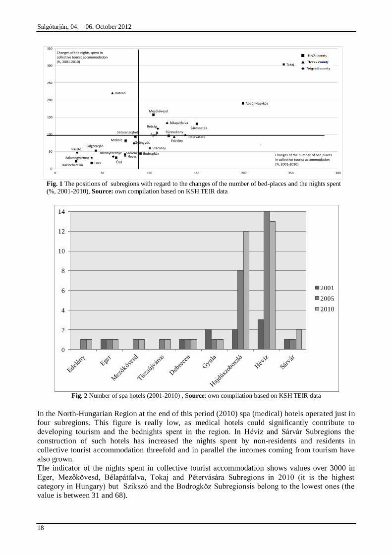
Fig. 1 The positions of subregions with regard to the changes of the number of bed-places and the nights spent
(%, 2001-2010), Source: own compilation based on KSH TEIR data
Fig. 2 Number of spa hotels (2001-2010) , Source: own compilation based on KSH TEIR data
In the North-Hungarian Region at the end of this period (2010) spa (medical) hotels operated just in
four subregions. This figure is really low, as medical hotels could significantly contribute to
developing tourism and the bednights spent in the region. In Hévíz and Sárvár Subregions the
construction of such hotels has increased the nights spent by non-residents and residents in
collective tourist accommodation threefold and in parallel the incomes coming from tourism have
also grown.
The indicator of the nights spent in collective tourist accommodation shows values over 3000 in
Eger, Mezőkövesd, Bélapátfalva, Tokaj and Pétervására Subregions in 2010 (it is the highest
category in Hungary) but Szikszó and the Bodrogköz Subregionsis belong to the lowest ones (the
value is between 31 and 68).
Abaúj-Hegyköz
Balassagyarmat
Bátonyterenye
Bélapátfalva
Bodrogköz
Edelény
Eger
Encs
Füzesabony
Gyöngyös
Hatvan
Heves
Kazincbarcika
Mezőkövesd
Miskolc
Ózd
Pásztó
Pétervására
Rétság
Salgótarján
SárospatakSátoraljaújhely
Szécsény
Szerencs
Tokaj
0
50
100
150
200
250
300
350
0 50 100 150 200 250 300
Changes of the nights spent in collective tourist accommodation (%, 2001-2010)
Changes of the number of bed places in collective tourist accommodation(%, 2001-2010)
0
2
4
6
8
10
12
14
2001
2005
2010
GEOTOUR & IRSE 2012
19
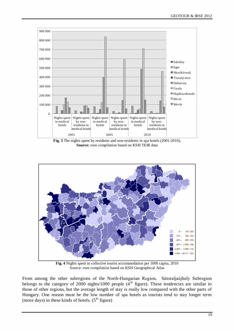
Fig. 3 The nights spent by residents and non-residents in spa hotels (2001-2010),
Source: own compilation based on KSH TEIR data
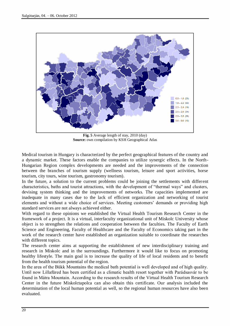
Fig. 4 Nights spent in collective tourist accommodation per 1000 capita, 2010
Source: own compilation based on KSH Geographical Atlas
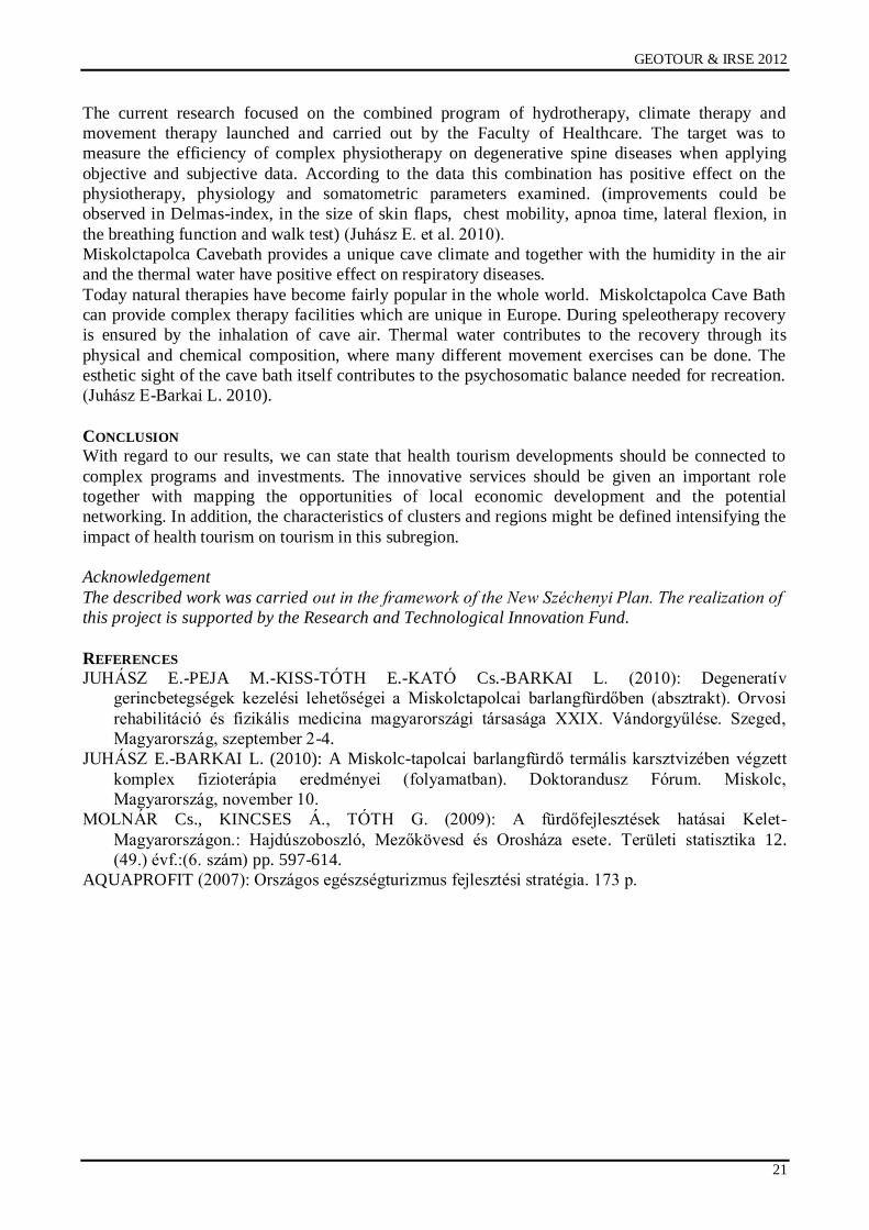
From among the other subregions of the North-Hungarian Region, Sátoraljaújhely Subregion
belongs to the category of 2000 nights/1000 people (4th
figure). These tendencies are similar to
those of other regions, but the average length of stay is really low compared with the other parts of
Hungary. One reason must be the low number of spa hotels as tourists tend to stay longer term
(more days) in these kinds of hotels. (5th
figure)
0
100 000
200 000
300 000
400 000
500 000
600 000
700 000
800 000
900 000
Nights spent in medical
hotels
Nights spent by non-
residents in medical hotels
Nights spent in medical
hotels
Nights spent by non-
residents in medical hotels
Nights spent in medical
hotels
Nights spent by non-
residents in medical hotels
2001 2005 2010
Edelény
Eger
Mezőkövesd
Tiszaújváros
Debrecen
Gyula
Hajdúszoboszló
Hévíz
Sárvár
Salgótarján, 04. – 06. October 2012
20
Fig. 5 Average length of stay, 2010 (day)
Source: own compilation by KSH Geographical Atlas
Medical tourism in Hungary is characterized by the perfect geographical features of the country and
a dynamic market. These factors enable the companies to utilize synergic effects. In the North-
Hungarian Region complex developments are needed and the improvements of the connection
between the branches of tourism supply (wellness tourism, leisure and sport activities, horse
tourism, city tours, wine tourism, gastronomy tourism).
In the future, a solution to the current problems could be joining the settlements with different
characteristics, baths and tourist attractions, with the development of “thermal ways” and clusters,
devising system thinking and the improvements of networks. The capacities implemented are
inadequate in many cases due to the lack of efficient organization and networking of tourist
elements and without a wide choice of services. Meeting customers‟ demands or providing high
standard services are not always achieved either.
With regard to these opinions we established the Virtual Health Tourism Research Center in the
framework of a project. It is a virtual, interfaculty organizational unit of Miskolc University whose
object is to strengthen the relations and cooperation between the faculties. The Faculty of Earth
Science and Engineering, Faculty of Healthcare and the Faculty of Economics taking part in the
work of the research center have established an organization suitable to coordinate the researches
with different topics.
The research center aims at supporting the establishment of new interdisciplinary training and
research in Miskolc and in the surroundings. Furthermore it would like to focus on promoting
healthy lifestyle. The main goal is to increase the quality of life of local residents and to benefit
from the health tourism potential of the region.
In the area of the Bükk Mountains the medical bath potential is well developed and of high quality.
Until now Lillafüred has been certified as a climatic health resort together with Parádsasvár to be
found in Mátra Mountain. According to the research results of the Virtual Health Tourism Research
Center in the future Miskolctapolca can also obtain this certificate. Our analysis included the
determination of the local human potential as well, so the regional human resources have also been
evaluated.
GEOTOUR & IRSE 2012
21
The current research focused on the combined program of hydrotherapy, climate therapy and
movement therapy launched and carried out by the Faculty of Healthcare. The target was to
measure the efficiency of complex physiotherapy on degenerative spine diseases when applying
objective and subjective data. According to the data this combination has positive effect on the
physiotherapy, physiology and somatometric parameters examined. (improvements could be
observed in Delmas-index, in the size of skin flaps, chest mobility, apnoa time, lateral flexion, in
the breathing function and walk test) (Juhász E. et al. 2010).
Miskolctapolca Cavebath provides a unique cave climate and together with the humidity in the air
and the thermal water have positive effect on respiratory diseases.
Today natural therapies have become fairly popular in the whole world. Miskolctapolca Cave Bath
can provide complex therapy facilities which are unique in Europe. During speleotherapy recovery
is ensured by the inhalation of cave air. Thermal water contributes to the recovery through its
physical and chemical composition, where many different movement exercises can be done. The
esthetic sight of the cave bath itself contributes to the psychosomatic balance needed for recreation.
(Juhász E-Barkai L. 2010).
CONCLUSION
With regard to our results, we can state that health tourism developments should be connected to
complex programs and investments. The innovative services should be given an important role
together with mapping the opportunities of local economic development and the potential
networking. In addition, the characteristics of clusters and regions might be defined intensifying the
impact of health tourism on tourism in this subregion.
Acknowledgement
The described work was carried out in the framework of the New Széchenyi Plan. The realization of
this project is supported by the Research and Technological Innovation Fund.
REFERENCES
JUHÁSZ E.-PEJA M.-KISS-TÓTH E.-KATÓ Cs.-BARKAI L. (2010): Degeneratív
gerincbetegségek kezelési lehetőségei a Miskolctapolcai barlangfürdőben (absztrakt). Orvosi
rehabilitáció és fizikális medicina magyarországi társasága XXIX. Vándorgyűlése. Szeged,
Magyarország, szeptember 2-4.
JUHÁSZ E.-BARKAI L. (2010): A Miskolc-tapolcai barlangfürdő termális karsztvizében végzett
komplex fizioterápia eredményei (folyamatban). Doktorandusz Fórum. Miskolc,
Magyarország, november 10.
MOLNÁR Cs., KINCSES Á., TÓTH G. (2009): A fürdőfejlesztések hatásai Kelet-
Magyarországon.: Hajdúszoboszló, Mezőkövesd és Orosháza esete. Területi statisztika 12.
(49.) évf.:(6. szám) pp. 597-614.
AQUAPROFIT (2007): Országos egészségturizmus fejlesztési stratégia. 173 p.
Salgótarján, 04. – 06. October 2012
22
COMPETITIVENESS OF TOURISM IN SLOVAKIAN GEOPARKS
Eva Tomková & Lenka Muchová
Institute of Geotourism, BERG Faculty, Technical University of Košice
e-mail: [email protected], [email protected]
ABSTRACT
The advantage of Slovakia, despite the relatively small area, for building Geoparks is very great variability of geological structure with lots of natural formations (GEOTOP) which in many cases are linked to the
value of mining objects and objects of archaeological, economic, and cultural heritage of European significance. In Slovakia, they are currently built three geoparks in different categories. One of geoparks is geopark is operational categories geoparks and the remaining 2 geoparks are in categories building geoparks. And it is these three geoparks of Slovakia will further assessed for competitiveness in tourism. The competitiveness will be evaluated of the various parameters, for example infrastructure, human, cultural and natural
resources.
GEOPARKS OF SLOVAKIA
Establishment of Geoparks initiative in Slovakia dates back to the years 1998 - 2000 when the idea
first began to emerge establishment and management of these areas in Banská Ńtiavnica later
Banska Bystrica and Fiľakovo. They are currently established in Slovakia three geoparks:
Banskobystrický geopark, Banskońtiavnický geopark a Novohradský geopark (Novohrad – Nógrád
geopark).
Banskobystrický geopark
The main precondition for the development of the project of building Geopark is the existence and
amount of use of geological, mining and their downstream ecological phenomena and historical
heritage of Banska Bystrica and its surroundings. They are two key areas geo-montaneous areas:
Starohorsko-ńpaņodolinská a Ľubietovsko-ponická geo-montaneous area. The project was initiated
and prepared for active participation of regional and local authorities, professional institutions in the
city of Banská Bystrica and private sector representatives. Geopark is managed through public-
private partnerships.
Banskoštiavnický geopark
Geological history and subsequent modification of the landscape due to mining area makes the
region Banská Ńtiavnica unique not only in Slovakia but also in the world. Given the universality of
the values of this area, the town of Banská Ńtiavnica and technical monuments in its surroundings
of the "Convention on the Protection of the World Cultural and Natural Heritage" written in 1993,
the World Heritage List as a cultural heritage.
GEOPARK NOVOHRAD – NÓGRÁD Geopark Novohrad - Nógrád area includes 28 municipalities on the Slovak side (southern districts
of Rimavská Sobota, Lučenec a Veľký Krtíń) and 63 villages on the Hungarian side (the northern
part of the county Nógrád). On its territory are protected region Cerová Highlands protected area
and TK Karancs Medves.
ANALYSIS OF THE COMPETITIVENESS OF GEOPARKS
Lack of necessary information prevents us measure, monitor competitiveness specifically defined
territory Geoparks. Given this fact, this issue will be addressed at the district level, where the
geopark is situated in Slovakia.
GEOTOUR & IRSE 2012
23
The aim is to identify competitive advantages and disadvantages of the business environment in the
Slovak regions and formulate appropriate strategies in regional economic development. It will be
used to model complex comparative SR districts using elements that are used to evaluate the
competitiveness of the country renowned international institutions.
For this evaluation will be used index of regional business environment and such an evaluation of
the regional business environment can be done by using publicly available data, combined with
unique research information between business and government. The results will be used to
attracting business to the area Geoparks, higher economic growth and growth in living standards.
They provide complete information on the opportunities and threats in the region.
Index of regional business environment
Index of regional business environment reflects the overall quality of business conditions in the
districts. It outputs a comprehensive model is calculated for each district based on the available data
and data obtained from affective survey among managers of companies. For each district has a
value in the range [1, 6], where 1 reflects the worst possible conditions for entrepreneurship and 6
reflects the best possible conditions.
IRPP each consisting of 106 independent indicators that evaluate different aspects of the business.
Each of these indicators, like all IRPP, reaching values in the range [1, 6] and allows a comparison
of districts in the area. All 106 indicators are further classified into 8 pillars which combine
indicators into larger logical units. The pillars represent 8 major areas of the business environment.
Following pairs consists of four sub-indices of the regional business environment. As a result of the
merger itself is IRPP.
The structure and weights subindices and pillars in the IRPP:
Subindex I: Economic activity 31%
1. Pillar: Economic environment 14%
2. Pillar: Economic issues 17%
Subindex II: Administration and
Legislation 15%
3. Pillar: Legislation 7%
4. Pillar: Administration 8%
Subindex III: Technology and
infrastructure 23%
5. Pillar: Infrastructure 12%
6. Pillar: Technology 11%
Subindex IV: Education and Human
Resources 31%
7. Pillar: Human resources 20%
8. Pillars: Education 11%
COMPARISON OF SELECTED DISTRICTS OF GEOPARKS
District of Banská Bystrica
General Information
Population: 110,908
Area: 809 km ²
Population density: 137 ob. / Km ²
Number of workers: 59,082 (53.2%)
Unemployment: 8.6%

Salgótarján, 04. – 06. October 2012
24
District of Banská Štiavnica
General Information
Population 16,731
Area 292 km ²
Density 57 ob. / Km ²
Number of employed 6,975 (41.8%)
Unemployment 16.5%
Lučenec
General Information
Population 72,899
Area 826 km ²
Density 88 ob. / Km ²
Number of employed 21,544 (29.6%)
Unemployment 23.1%
District of Banská Bystrica
Position Score
(1-79) (1-6) SR
IRPP 29 3,48 3,43
Subindex I: Economic activity 29 3,64 3,51
1. pilier: Economic enviroment 29 3,55 3,48
2. pilier: Economic output 25 3,71 3,53
Subindex II: Administration and Legislation 67 3,11 3,32
3. pilier: Legislation 56 3,29 4,19
4. pilier: Public Administration 71 2,47 2,63
Subindex III: Technology and Infrastructure 32 3,21 3,3
5. pilier: Infrastructure 33 2,93 3,26
6. pilier: Technologies 24 3,52 3,34
Subindex IV: Education and Human
Resources 21 3,7 3,43
7. pilier: Human resources 20 3,96 3,68
8. pilier: Education 27 3,23 3,16
Geopark of Banská Bystrica is situated in the district and the town of Banská Bystrica
Kremnica. District of Banská Bystrica is on 29. position of the 79 districts in Slovakia by the
Index of regional business environment.
Geopark of Banská Ńtiavnica is situated besides the district Banská Ńtiavnica, which is
located on the 60th by IRPP place and the districts Krupina, Left, Ņiar Hronom, Zvolen,
Golden Moravec and Ņarnovica. If we count all the districts containing both the Index of
regional business development position average is 44.
Geopark Novohrad (Novograd) on the Slovak side and extends to district, which is located on
62. position (IRPP). District of Lučenec, but not the only one who has given the explanatory
role of the Geopark. Also includes districts of Veľký Krtíń and Rimavská Sobota. Taking into
account all the three districts in which at least part of the geopark is so mean position IRPP is
72.
GEOTOUR & IRSE 2012
25
District of Banská Štiavnica
Position Score
(1-79) (1-6) SR
IRPP 63 3 3.43
Subindex I: Economic activity 64 2,88 3,51
1. pilier: Economic enviroment 60 2,97 3,48
2. pilier: Economic output 67 2,81 3,53
Subindex II: Administration and Legislation 24 3,5 3,32
3. pilier: Legislation 23 4,45 4,19
4. pilier: Public Administration 20 2,75 2,63
Subindex III: Technology and Infrastructure 62 2,73 3,3
5. pilier: Infrastructure 75 3,52 3,26
6. pilier: Technologies 54 2,95 3,34
Subindex IV: Education and Human
Resources 60 3,07 3,43
7. pilier: Human resources 57 3,26 3,68
8. pilier: Education 69 2,74 3,16
District of Lučenec
Pozícia Skóre
(1-79) (1-6) SR
IRPP 62 3,03 3.43
Subindex I: Economic activity 61 3,02 3,51
1. pilier: Economic enviroment 57 3,08 3,48
2. pilier: Economic output 61 2,96 3,53
Subindex II: Administration and Legislation 30 3,41 3,32
3. pilier: Legislation 31 4,39 4,19
4. pilier: Public Administration 40 2,65 2,63
Subindex III: Technology and Infrastructure 57 2,81 3,3
5. pilier: Infrastructure 50 2,78 3,26
6. pilier: Technologies 59 2,84 3,34
Subindex IV: Education and Human
Resources 62 3,01 3,43
7. pilier: Human resources 64 2,99 3,68
8. pilier: Education 56 3,03 3,16
The structure of the business sector
Business sector District of Banská Bystrica District of Banská Štiavnica
District of
Lúčenec
Agriculture
Heavy industry
Light industry
Construction
Trade and transport
Other services
Salgótarján, 04. – 06. October 2012
26
The table represents the structure of the business sector of the various areas of the business
sector in the district. Area, the grouping of sections and divisions of Standard Industrial
Classification on the basis of the register of economic entities SR published by the Statistical
Office so that the related activities in one area, so that one area does not contain unrelated
work and that it area as possible. The shares are calculated based on the number of employees
working in all the companies in the area at the beginning of 2010.
The biggest competitive advantages
District of Banská
Bystrica District of Banská Štiavnica District of Lúčenec The potential for tourism
development 0.36
Bureaucracy and delays in
proceedings at offices 0.36
The availability of free labor 0.67
Availability of the necessary
materials and services 0.27
Motivation of employees to
productive work 0.31
The impact of the minimum wage
on business 0.42
Motivation of employees to
productive work 0.19
Reliability of business partners 0.27 The impact of corruption on the
decision offices 0.29
The availability of free labor
0.17
Justice recruitment for positions in
companies 0.16
The ability of companies to use the
latest technology 0.23
Effect of environmental
conditions on business 0.16
The potential for tourism development
0.15
Effect of environmental conditions
on business 0.20
The biggest barriers to business development
District of Banská
Bystrica District of Banská Štiavnica District of Lúčenec Bureaucracy and delays in
proceedings at offices -0.46
Position to influence business district -
1.15
Position to influence business
district -1.25
Management of local
governments -0.39
Quality of road infrastructure -0.86
Perception unemployment -0.79
Law enforcement in the district
court -0.37
Perception unemployment -0.81
Migration of skilled labor -0.67
Perception unemployment -0.36 Migration of skilled labor -0.76 Quality of road infrastructure -0.62
Protection of private property -
0.33
The level of competition in the
industry -0.65
Perceived level of technology -
0.60
Communication with authorities
and availability information -
0.27
The level of competition in the service
of -0.64 The development potential of the
district -0.53
The impact of the informal
economy to business -0.25
Knowledge of foreign languages -0.58 Knowledge of foreign languages -
0.40
Impact on the business activities
of the authorities -0.25
Availability of capital and financial
resources -0.45
Interest of the state and state
institutions of the district -0.40
Implementation Task authorities
-0.24
Availability of the necessary materials
and services -0.37 Educational level -0.39
Position to influence business
district -0.23
Effect of environmental conditions on
business -0.34
The level of competition in the
service of -0.36
The above table competitive advantages and barriers show a list of factors that respondents
perceive as the biggest competitive advantages or disadvantages of the district under the terms
of the business. In the Executive Opinion Survey, it was important not to be contained
questions about specific companies and the overall business environment.
Score each factor for each district, under which are ranked from most negative (most barriers
to business development) to most positive (most competitive advantage) is calculated by
GEOTOUR & IRSE 2012
27
comparing the real value of the factor in the survey, with its reference value with respect to
the meaning given to it in that respondents attributed the district.
Evaluation of competitive advantages and barriers
The biggest competitive advantage belonging to the district of Geopark Banská Bystrica is its
potential for tourism development, which is why this potential is well used for example in the
form of Geotourism. Create and develop geotourism on the ground, it should be a strategic
objective of Geopark. Another advantages are: Motivation of employees to productive work,
The availability of free labor and the following positive factors should be used to build
Geotourism in the Geopark and involving indigenous population to its creation.
As the biggest barriers were evaluated mainly problems with the authorities: Communication
with the authorities, The availability of information, Bureaucracy, Management of local
governments, ...
The biggest positives of Geopark of Banská Ńtiavnica include Motivation of employees to
productive work, Reliability of business partners, The ability of firms to use the latest
technology, Level of competition in services and others.
The biggest barriers to business development district extending into Geopark of Banská
Ńtiavnica are: Impact location for business district (District BS), Quality of road
infrastructure, Skilled labor migration, Level of competition in services, ...
The last evaluation was Geopark Novohrad, districts in which lies and for this area is a plus:
Availability of free labor, The ability of firms to use the latest technology, Communication
with authorities and availability of information.
Barriers are: Influence the position of the business district (the district of Lúčenec, Veľký
Krtíń) Perceptions of unemployment, Quality of infrastructure, Level of education,
Development potential of the district (District of Veľký Krtíń).
CONCLUSION
Based on the Index of regional business environment that currently Geopark Banská Bystrica
is one of the most advanced, which is probably the location of the district Banská Bystrica on
29th place from 79 districts of Slovakia. Districts of Geopark Banská Ńtiavnica are on 44th
place and districts of geopark Novohrad placed on the 72nd place. First Geopark is necessary
to support the development of Geotourism and especially the potential of tourism
development in the territory, which would increase area attendance and thus its economic
stability, which could mean a shift in the ranking that determines the IRPP.
Negatives in the remaining two geoparks is a Llck of infrastructure and infrastructure just as
the structure of the different sectors of activity is currently in its integrated form impact on
other economic activities in the region and its competitiveness.
Improvements in infrastructure can reduce cost and time and improve productivity and also
change the competitive advantages of firms in different regions. It is widely recognized
multiplier effect, which provides infrastructure investments. Investments in infrastructure
should be directed to the device: the progress in the field of education and training and access
to facilities, educational interventions aimed at developing regional activities (ie regionally
differentiated), supporting research and development, consultancy services, providing access
to capital and finance, improving performance of regional and local government and local
government towards economic activities, measures to promote the prevention of crime and
corruption.
Salgótarján, 04. – 06. October 2012
28
REFERENCES
[1] Banskobystrický geomontánny park: [online]. Dostupné na internete:
<http://www.sazp.sk/public/index/go.php?id=1208 >
[2] Geopark Banská Ńtiavnica: [online]. Dostupné na internete:
<http://www.sazp.sk/public/index/go.php?id=1209>
[3] Geopark Novohrad – Nógrád: Dostupné na internete: <http://geopark.sk/geoparky-
sr/geopark-novohrad--ngrad>
[4] Konkurencieschopné regióny 21: [online]. Dostupné na internete: <
http://regiony21.sk/vystupy/publikacia/publikacia.html>
[4] VÝROSTKOVÁ, E.: Regionálna ekonomika a rozvoj. Iura Edition, 2010. ISBN 978-80-
8078-361-7.
[5] BUČEK, M., REHÁK, Ń., TVRDOŅ, J.: Eogionálna ekonoómia a politika: Iura Edition,
2010. ISBN 978-80-8078-362-4.
GEOTOUR & IRSE 2012
29
ASSESSMENT OF GEOSITE ATTRACTIVENESS IN EASTERN UKRAINE
Mariia Dakhova & Roksolana Ščuroková
Institute of Geotourism, BERG Faculty, Technical University of Košice
e-mail: [email protected], [email protected]
ABSTRACT
The assessment method and criteria depend on the objectives of research. Other important factors are
length and complexity of the assessment procedure. It was important for our research area to evaluate not only natural geosites, but also anthropogenic geosites. Proceeding from these criteria, Rybar‟s assessment method was used to evaluate the attractiveness of geosites of Eastern Ukraine. Eastern Ukraine consists of 3 regions (oblasts): Kharkiv oblast, Donetsk oblast, Luhansk oblast. At this paper we evaluate 63 Eastern Ukrainian geosites for their touristic utilization. This scoring enabled us to divide geosites of Eastern Ukraine into categories and choose the most prespective ones to develop
geotourism in this area.
INTRODUCTION
During the last two decades several approaches to geosites assessment appeared. This topic
was studied by Emmanuel Reynard, Georgia Fontana, Lenka Kozlik, Cristian Scapozza, Lucie
Kubalikova, Paulo Periera, Diamantino Periera, Maria Isable Caetano Alves, Pavol Rybar,
Ioan Baca, Eduard Schuster etc. [1, 4, 5, 6]. These scientists propose different assessment
methods and criteria depend on the objectives of research. Other important factors are length
and complexity of the assessment procedure. It was important for our research area to
evaluate not only natural geosites, but also anthropogenic geosites. Proceeding from these
criteria, Rybar‟s assessment method was used to evaluate the attractiveness of geosites of
Eastern Ukraine. Eastern Ukraine consists of 3 regions (oblasts): Kharkiv oblast, Donetsk
oblast, Luhansk oblast. This area is an industrial center of Ukraine. Natural resources of
Eastern Ukraine have been the engine for its economic growth [8].
GEOSITE ASSESSMENT
At this paper we evaluate 63 Eastern Ukrainian geosites for their touristic utilization. Taking
into account the specific features of research area, the initial criteria of prof. Rybar‟s
assessment method was adjusted for Eastern Ukraine. As a natural objects, geosites are
evaluated by the following criteria: primary geological properties, uniqueness of the object,
accessibility of the object, existing scientific and professional publications, condition of
observation (research), safety criteria, availability of information about the object, visual
value of the object, value of provided services and object in the tourist area [7]. It is important
to note that Ukraine doesn‟t have either national geosites network or geoparks in its territory.
In Ukraine exist geological monuments of state significance, which we equate to the objects
listed in national geosites network. Geosite‟s location in the preserved area doesn‟t mean that
geosite is protected as geological heritage. Eastern Ukraine is an area with a large number of
national ar local parks and protected areas, where, usually, wildlife and ecology dominate, and
geological background is often missing. In Ukraine, biological heritage preservation still more
important than geological heritage preservation. Estimate of visual value of the object
depends on object‟s surroundings. The assessment of geosite by this criterion in initial
assessment method, gives 0 points to geosite overlooking man-made structures. According to
adjusted to Eastern Ukraine prof. Rybar‟s assessment method, geosite in plain landscape with
great view overlooking several man-made structures gets 1 point less, than object in plain
landscape with great view. The assessment of value of provided services (viz. accommodation
and catering) based on character whether the distance from geosite to locations of services can
Salgótarján, 04. – 06. October 2012
30
be passed in less than 30-40 minutes. At the area of some geosites of Eastern Ukraine are
located anthropogenic objects, which do not connected with mining activities, the following
are examples of such geosites: Outcropping of Cenozoic geological materials at Kazatcha
hill, Outcropping of Jurassic and Cretaceous geological materials close to Kremenec hill,
Outcropping of Cenozoic geological materials at Gorodischenska hill. Most of this geosites
are visited by holidaymakers, however they are not attracted to these areas by geological
heritage. But visiting geosites by holidaymakers creates a background for development of
geotourism industry at these areas.While this geological heritage has long been popular with
tourists, its main attractions have been mostly limited to aesthetic and recreational values.
Scientific values are often ignored or not included at all as part of the attraction. One of the
reasons for this is the lack of scientific information related to a particular site that can be
easily understood by the public. That is why it is important to make the geosciences
interesting for „ordinary people‟, who are main economic drivers – especially in regard to
tourism [3].
As an anthropogenic objects, geosites were evaluated by the following criteria: age of the
object, historic value of the object, aesthetic value of the object, authenticity, value of
municipalities, objects and cultural rout reconstruction, excellence, emotional value, utility
value, value of provided services, safety criteria. We should emphasize, that applied method
anthropogenic activity means actions connected to mining activity. Only 4 geosites were
evaluated purely by anthropogenic criteria: Mining complex of the Bronze Age “Kartamyshsky
mine”, Lysychansk Mining Museum, Project “Ukrainian technoland”, Salt mines of Soledar.
The highest score get Project “Ukrainian technoland” and Salt mines of Soledar [7].
There are a lot of disused quarries, which were evaluated both as natural and as anthropogenic
objects. Regrettably, most part of these quarries is used for waste dumping. 14 gesites were
appreciated both as natural and anthropogenic geosites: Smirnovsky limestone quarry,
exposure of Late Cretaceous and Cenozoic strata at Melova village, exposure of Cenomanian
strata near Jaremovka village, exposure of Late Jurassic strata close to Protopopovka village,
exposure of Jurassic strata close to Mala Komyshevacha village, Grekovsky Karst area,
Exposure of Cenozoic sands near Novoselovka village, Karaguz gully, Railway cutting near
Izvarine village, Esaulovsky, Central-Nagolnitchanske mineral deposit, mineral deposit at
Nagolno-Tarasivka village, heaps of Komsomolsky Quarry, Oktabrsky mariupolite massif
(Karaguz gully, Central-Nagolnitchanske mineral deposit, mineral deposit at Nagolno-
Tarasivka village have the highest rate of evaluation as athropogenic objects).
The scoring geosites of Eastern Ukraine by prof. Rybar‟s method enabled us to divide this
geosites into categories and choose the most prespective ones to develop geotourism in this
area. The most perspective natural objects are: Kleban-Bykske exposure of Permian
sediments, Kravetska gulch, Druzhkovske petrified wood, exposure of Cretaceous sediments
at the National Park “Svatye Gory”, Repne lake, Slepne lake , Exposure of Jurassic and
Cretaceous strata close to Kremenec hill, Royal Rocks (Korolivske Skaly), Sheepback rocks,
Stylske exposure of Devonian sediments, Outcrop of Kalmius granite massif, Razdolnensky
zakaznik.
CONCLUSION
As can been seen above, we can select 17 the most perspective geosites for development
geotourism in Eastern Ukraine. Our previous research, based on the opinion poll of
inhabitants of Kharkiv region, showed that the most interesting for tourists are following
geosites of Eastern Ukraine: Shatilovsky spring, Exposure of Cretaceous sediments at the
National Park “Svatye Gory”, Kam‟yani mohyly (stone barrows), Sheepback rocks, Salt
mines at Soledar, Druzhkovske petrified wood, Berezivske mineral waters, Project “Ukrainian
technoland”, Royal Rocks (Korolivske Skaly), Explosure of Jurassic and Cretaceous strata
close to Kremenec hill, Razdolnensky zakaznik [2]. The level of interest in following geosites
GEOTOUR & IRSE 2012
31
of Eastern Ukraine wasn‟t discovered at that: research: Repne lake, Slepne lake, Lysychansk
Mining Museum and Permian reef. 8 geosites of 11, which were selected (based on our
opinion poll), as the most interesting for tourists, were also selected as the most attractive
geosites for tourists by prof. Rybar‟s method.
REFERENCES
[1] BACA, Ioan, SCHUSTER, Eduard: Listing, evaluation and touristic utilisation of
geosites containing archelogical artefacts case study: Ciceo Ridge (Bistrita-Nasaud
Country, Romania). In: Revista Geografica Academica, Volume 5,(2011), number 1, 5-
20.
[2] DAKHOVA, Mariia: Survey of inhabitants of Kharkiv region about their level of
awareness and level of interest in “geosites” of Eastern Ukraine. In: Geeotourisn and
its implications: international PhD conderence 2012: proceedings.
[3] DOWLING, R.K. & NEWSOME, D. (eds.) 2006. Geotourism. Elsevier, Oxford.
[4] KUBALIKOVA, Lucie: Priklady hodnoceni geomorfologickych lokalit v zapadnej casti
narodneho parku Podyji. In: Thayensia, 8 (2011) 3-25.
[5] PERIERA, P., PERIERA, D., CAETANO ALVES, M.I.: Geomorphosite assessment in
Montesinho National Park (Portugal). In: Geographica Helvetica, Volume 62 (2007),
[6] number 3, 159-168.
[7] REYNARD, E., FONTANA G., KOZLIK L., et SCAPOZZA, C.: A method for
assessring the scientific and aditional values of geomorphosites. In: Geographicaa
Helvetica. Volume
[8] (2007), number 3, 148-158.
[9] RYBAR, Pavol: Assessment of attractiveness (value) of geotouristic objects. In: Acta
Geoturistica. Volume 1 (2010),.number 2, 13-21.
[10] ЗІНЬ Е.А. Регіональна економіка Киев: «ВД «Професіонал», 2007.
Salgótarján, 04. – 06. October 2012
32
USING NON-CONTACT MEASUREMENT METHODS FOR MONITORING GROUND ICE
IN THE CAVE AREA OF ONE OF THE LEADING GEOTOURIST ATTRACTIONS - THE
DOBŠINSKÁ ICE CAVE
Juraj Gašinec, Silvia Gašincová and Ţofia Kuzevičová
Institute of Geodesy, Cartography and Geographical Information Systems, BERG Faculty,
Technical University of Košice
e-mail: [email protected], [email protected], [email protected]
ABSTRACT
The present contribution is devoted to the issue of monitoring of floor ice in the Great Hall and the Small Hall cave by terrestrial laser scanning method combined with the method of electronic tachymeter. This paper presents the results achieved in the second stage surveying work carried out for
the implementation the grant project VEGA No. 1/0786/10 „Research on the dynamics of the glacial trappings and filling of the cave spaces by non-contact methods in terms of their safe and sustainable utilization asa part of the natural heritage of Slovak republic" resolution of collective staff of the Institute of Geodesy, Cartography and Geographic Information Systems Technical University of Kosice Faculty of Mining, Ecology, Procces Control and Geotechnology. This problem, members of the research team actively involved since 2010. The project was oriented as basic research to develop effective non-destructive and non-contact measurement methods for monitoring changes in time and
spacetime filling ice cave spaces, followed by the creation of three-dimensional model cave. View of the fact that the project research team plans to continue to do so in order to be the next stage in the measurement area of the cave in the future based usable geodetic control consisting of geodetic points located on the surface and underground, whose position is determined by the currently valid national implementation JTSK 03 (Datum of Uniform Trigonometric Cadastral Network) and Baltic Vertical
Datum - After Adjustment.
INTRODUCTION Under the decree of Ministry of Economy of the Slovak Republic no. 1/1993 from 20 July
1993 on mining measurement documentation during mining activities and other activities
carried this way, the provisions of decree apply to execution, keeping, completion and
preserving of mining measurement documentation of cave accessing works and the works of
keeping the caves in safe conditions. In the years 2010 and 2011, began deal with this
problem in an innovative project VEGA No. 1/0786/10 based on cooperation of the Institute
of Geodesy, Cartography and Geographic Information Systems, of Faculty BERG at the
Technical University of Końice with the Slovak Caves Administration Liptovský Mikuláń.
The main objective of the project was to digitally registering and exact modeling of changes
in the caves of ice filling the need for their protection and operation.
DOBŠINSKÁ ICE CAVE
The cave spaces, their sinter and ice filling impress the visitors both emotionally and
aesthetically. In Slovak Republic there are now more than 5500 caves known which are part
of country„s natural heritage. It is not only because of respect and admiration towards these
nature„s creations but also because of human natural attempt to discover the laws and
regularities of their morphogenetics and speleogenesis or demanding conditions their fauna
has to adapt to. All the mentioned above are the reasons for their thorough scientific research
aimed to know and conserve them for future generations. Advanced civilized society
features the interest in developing and protecting its natural heritage. Slovakia can be proud to
unique resources and beauty of caves since 44 out of the total number are declared as national
natural monuments. They are irreplaceable proof of live as well as inanimate part of nature
GEOTOUR & IRSE 2012
33
development and adaptability and human beings as well as civilization‟s formation.
Legislative protection of the caves is provided by the NR SR no.543/2002 Statute on nature
and nation protection according to which the caves are protected as natural monuments and
the most important of them as national natural monuments. To prevent possible natural
destructive or anthropogenic processes to the caves and their decor, flora and fauna the caves
protection is based on exact scientific research.
Dobńinská Ice Cave ranks among the most important world‟s caves. Its magnificent ice filling
had remained the same for thousands of years in the altitude of only 920 to 950 metres. It was
with reason, in 2000, included among unique natural values of world‟s natural heritage. The
cave is in territory of National Natural Reserve Stratená within Slovak Paradise National
Park. It had been modelled by paleocreek Hnilec in middle trias steinalm and wetterstein
limestone of Stratená sheet [1]. Dobńinská Ice Cave is a part of cave system called Stratenská
cave which consists of 6 independent caves: Dobńinská Ice Cave, Duča Cave, Stratenská Cave
+ Dog Holesy, Military Cave, Green Cave and Sinter Cave (Fig. 1).
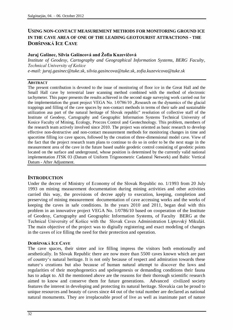
Fig. 1 Map of Dobńinská Ice Cave [5]
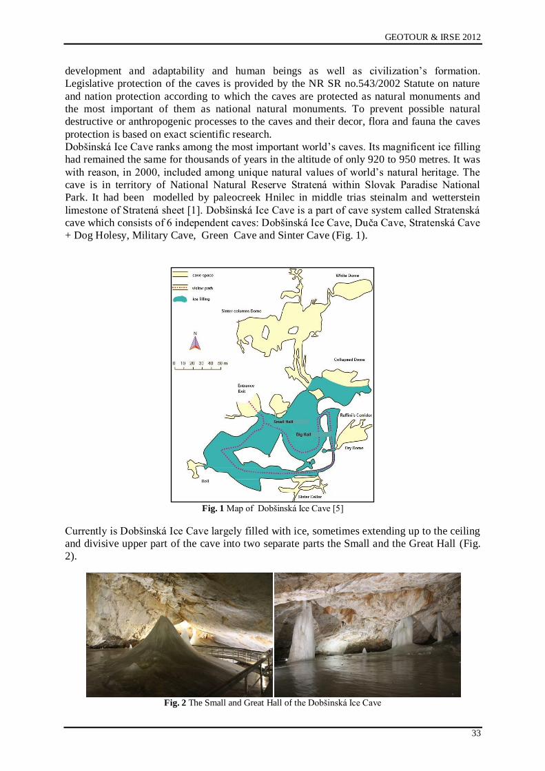
Currently is Dobńinská Ice Cave largely filled with ice, sometimes extending up to the ceiling
and divisive upper part of the cave into two separate parts the Small and the Great Hall (Fig.
2).
Fig. 2 The Small and Great Hall of the Dobńinská Ice Cave
Salgótarján, 04. – 06. October 2012
34
GROUND ICE MEASUREMENT WITHIN DOBŠINSKÁ ICE CAVE
Surveying measurements was realized in cooperation with personnel Slovak Administration
Caves. View of to the short, two-year duration of the project have been made only two stages
of measurement. In the first phase of surveying work, which took place in March 2011, has
been the focus of detailed spatial Small and Great Hall of the cave made terrestrial laser
scanner Leica ScanStation C10 was used universal motorized measuring station Trimble ®
VX ™ Spatial Station [3]. Positional and vertical connecting was implemented in the
maintained points of underground positional and vertical geodetic control on cartographic
coordinate system of Datum of Uniform Trigonometric Cadastral Network (S-JTSK) and the
Baltic Vertical Datum - After Adjustment (Bpv) [2].
Under the amendment decree of the Geodesy Cartography and Cadastre Authority of the
Slovak Republic No. 300/2009 [7] as amended by Decree No. 75/2011 [8] from the 1st April
2011 declared the validity of the national implementation of the S- JTSK with name JTSK03.
For that reason, all surveying measurements was realized in that coordinate system and the
binding all previous measurements in this coordinate system recalculate the appropriate
transformation procedures.
The horizontal and vertical connection of Dobšinská Ice Cave to the national
implementation JTSK03 and Baltic Vertical Datum - After Adjustment
Connecting the surface network points in the Dobńinská Ice Cave to the State Spatial
Network is implemented by Slovak Permanent Observation Service - SKPOS , utilizing the
signals of Global Navigation Satellite Systems (GNSS). For a static measurement about
length of three hours we used two GNSS sets Leica GPS1200 and GPS900, which are
determined orientation line from 5001 to 5002 points, located approximately 1047 m. The
transformation to the national implementation JTSK 03 (Datum of Uniform Trigonometric
Cadastral Network) and Baltic Vertical Datum - After Adjustment was realized by the
authorized points of coordinate transformations between geodetic binding systems available
on the website of the Institute of Geodesy and Cartography in Bratislava
(http://awts.skgeodesy.sk). From orientation line from 5001 to 5002 have been stabilized the
surface surveying points No. 8001 and 8002, points scoring box underground cave No. 5004
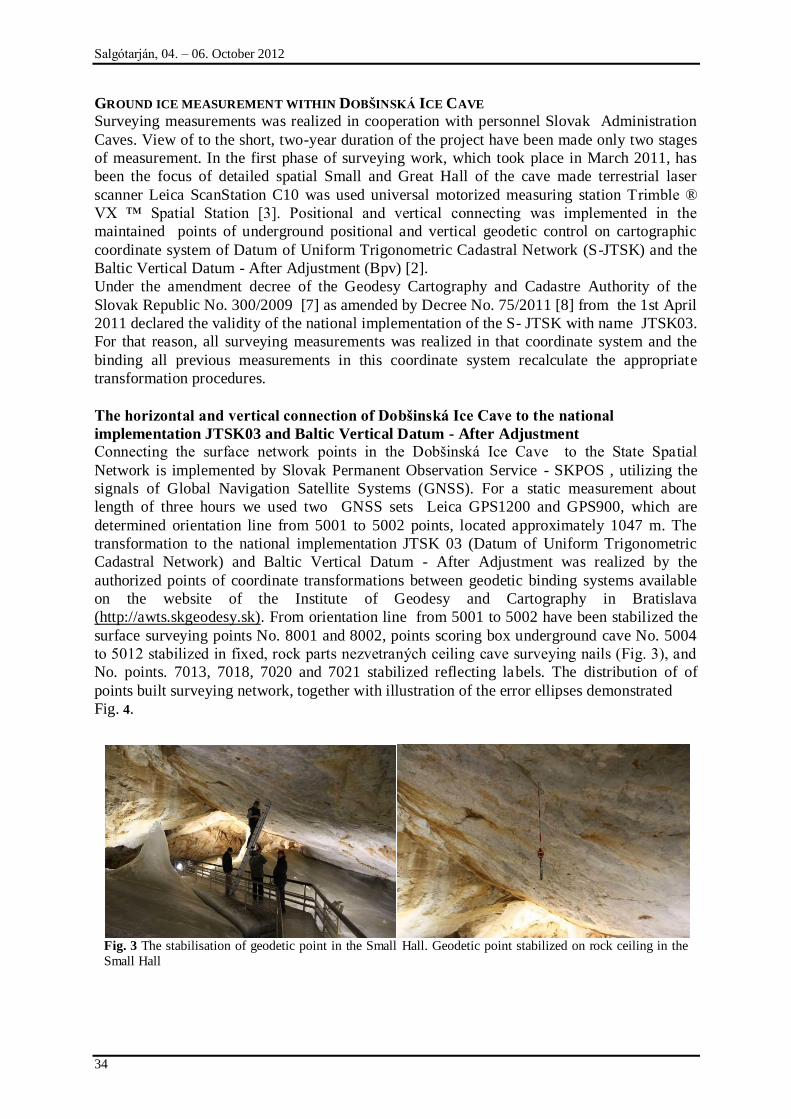
to 5012 stabilized in fixed, rock parts nezvetraných ceiling cave surveying nails (Fig. 3), and
No. points. 7013, 7018, 7020 and 7021 stabilized reflecting labels. The distribution of of
points built surveying network, together with illustration of the error ellipses demonstrated
Fig. 4.
Fig. 3 The stabilisation of geodetic point in the Small Hall. Geodetic point stabilized on rock ceiling in the
Small Hall
GEOTOUR & IRSE 2012
35
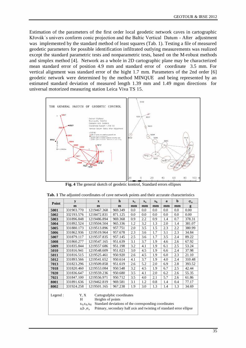
Estimation of the parameters of the first order local geodetic network caves in cartographic
Křovák´s univers conform conic projection and the Baltic Vertical Datum - After adjustment
was implemented by the standard method of least squares (Tab. 1). Testing a file of measured
geodetic parameters for possible identification infiltrated outlying measurements was realized
except the standard parametric tests and nonparametric tests, based on the M-robust methods
and simplex method [4]. Network as a whole in 2D cartographic plane may be characterized
mean standard error of position 4.9 mm and standard error of coordinate 3.5 mm. For
vertical alignment was standard error of the hight 1.7 mm. Parameters of the 2nd order [6]
geodetic network were determined by the method MINQUE and being represented by an
estimated standard deviation of measured length 1.39 mm and 1.49 mgon directions for
universal motorized measuring station Leica Viva TS 15.
Fig. 4 The general sketch of geodetic kontrol, Standard errors ellipses
Tab. 1 The adjusted coordinates of cave network points and their accurate characteristics
Point y x h sy sx sh a b a
m m m mm mm mm mm mm g
5001 331903.770 1219467.368 969.349 0.0 0.0 0.0 0.0 0.0 0.00
5002 332193.576 1218472.831 871.125 0.0 0.0 0.0 0.0 0.0 0.00
5003 331896.848 1219486.894 969.368 0.9 2.2 0.9 1.4 0.7 378.31
5004 331892.524 1219504.504 965.336 1.2 3.2 1.3 2.0 1.4 381.07
5005 331880.173 1219513.896 957.751 2.0 3.5 1.5 2.3 2.2 380.99
5006 331862.936 1219519.964 957.678 2.3 3.6 1.7 3.1 2.3 34.84
5007 331879.117 1219537.835 957.145 2.5 3.6 1.7 3.5 2.4 89.22
5008 331860.277 1219547.165 951.639 3.1 3.7 1.9 4.6 2.6 67.92
5009 331835.844 1219557.686 951.198 3.2 4.1 1.9 6.1 2.5 53.24
5010 331816.941 1219548.609 951.023 3.0 4.5 1.9 6.6 2.4 37.98
5011 331816.515 1219525.461 950.920 2.6 4.5 1.9 6.0 2.3 21.10
5012 331893.566 1219541.652 950.614 4.1 3.7 1.9 4.0 2.4 310.48
7013 331823.296 1219509.858 951.619 2.6 5.2 2.0 6.9 2.8 393.52
7018 331820.460 1219553.084 950.548 3.2 4.5 1.9 6.7 2.5 42.44
7020 331836.647 1219559.236 950.680 3.5 4.1 2.0 6.2 2.6 55.35
7021 331847.100 1219556.971 950.712 3.5 4.0 2.1 5.7 2.6 61.86
8001 331891.636 1219462.819 969.581 3.1 1.2 0.8 1.4 0.4 77.17
8002 331924.258 1219501.165 967.238 1.9 3.0 1.3 1.4 1.3 34.69
Legend : Y, X Cartografphic coordinates H Heights of points
sY,sX,sH Standard deviations of the corresponding coordinates
a,b , a Primary, secondary half axis and twisting of standard error ellipse
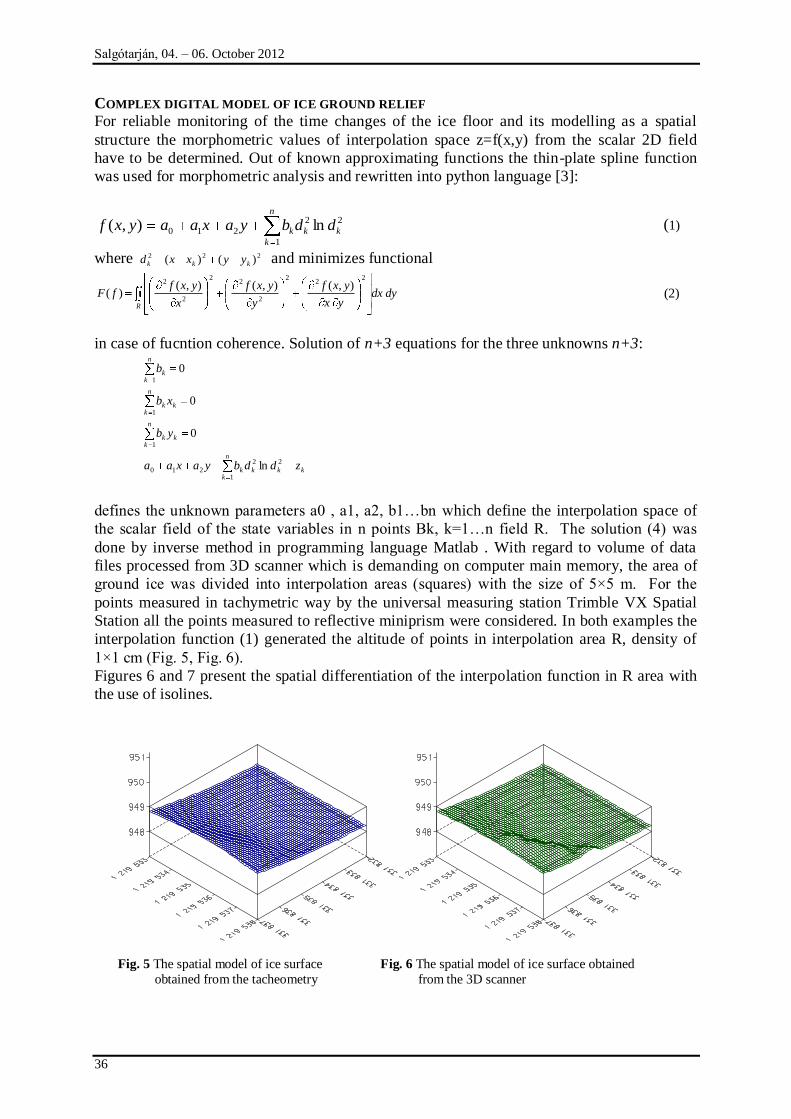
Salgótarján, 04. – 06. October 2012
36
COMPLEX DIGITAL MODEL OF ICE GROUND RELIEF
For reliable monitoring of the time changes of the ice floor and its modelling as a spatial
structure the morphometric values of interpolation space z=f(x,y) from the scalar 2D field
have to be determined. Out of known approximating functions the thin-plate spline function
was used for morphometric analysis and rewritten into python language [3]:
n
k
kkk ddbyaxaayxf1
22
210 ln),( , (1)
where 222 )()( kkk yyxxd and minimizes functional
dydxyx
yxf
y
yxf
x
yxffF
R
22
2
2
22
2
2 ),(),(),()( (2)
in case of fucntion coherence. Solution of n+3 equations for the three unknowns n+3:
k
n
kkkk
n
kkk
n
kkk
n
kk
zddbyaxaa
yb
xb
b
1
22
210
1
1
1
ln
0
0
0
defines the unknown parameters a0 , a1, a2, b1…bn which define the interpolation space of
the scalar field of the state variables in n points Bk, k=1…n field R. The solution (4) was
done by inverse method in programming language Matlab . With regard to volume of data
files processed from 3D scanner which is demanding on computer main memory, the area of
ground ice was divided into interpolation areas (squares) with the size of 5×5 m. For the
points measured in tachymetric way by the universal measuring station Trimble VX Spatial
Station all the points measured to reflective miniprism were considered. In both examples the
interpolation function (1) generated the altitude of points in interpolation area R, density of
1×1 cm (Fig. 5, Fig. 6).
Figures 6 and 7 present the spatial differentiation of the interpolation function in R area with
the use of isolines.
Fig. 5 The spatial model of ice surface Fig. 6 The spatial model of ice surface obtained
obtained from the tacheometry from the 3D scanner
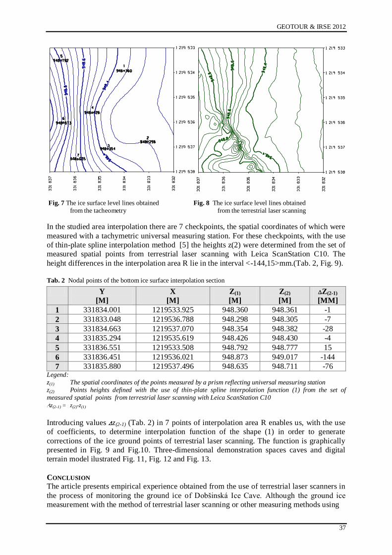
GEOTOUR & IRSE 2012
37
Fig. 7 The ice surface level lines obtained Fig. 8 The ice surface level lines obtained
from the tacheometry from the terrestrial laser scanning
In the studied area interpolation there are 7 checkpoints, the spatial coordinates of which were
measured with a tachymetric universal measuring station. For these checkpoints, with the use
of thin-plate spline interpolation method [5] the heights z(2) were determined from the set of
measured spatial points from terrestrial laser scanning with Leica ScanStation C10. The
height differences in the interpolation area R lie in the interval <-144,15>mm.(Tab. 2, Fig. 9).
Tab. 2 Nodal points of the bottom ice surface interpolation section
Y
[M]
X
[M]
Z(1)
[M]
Z(2)
[M]
Z(2-1)
[MM]
1 331834.001 1219533.925 948.360 948.361 -1
2 331833.048 1219536.788 948.298 948.305 -7
3 331834.663 1219537.070 948.354 948.382 -28
4 331835.294 1219535.619 948.426 948.430 -4
5 331836.551 1219533.508 948.792 948.777 15
6 331836.451 1219536.021 948.873 949.017 -144
7 331835.880 1219537.496 948.635 948.711 -76 Legend:
z(1) The spatial coordinates of the points measured by a prism reflecting universal measuring station
z(2) Points heights defined with the use of thin-plate spline interpolation function (1) from the set of
measured spatial points from terrestrial laser scanning with Leica ScanStation C10
z(2-1) = z(2)-z(1)
Introducing values z(2-1) (Tab. 2) in 7 points of interpolation area R enables us, with the use
of coefficients, to determine interpolation function of the shape (1) in order to generate
corrections of the ice ground points of terrestrial laser scanning. The function is graphically
presented in Fig. 9 and Fig.10. Three-dimensional demonstration spaces caves and digital
terrain model ilustrated Fig. 11, Fig. 12 and Fig. 13.
CONCLUSION
The article presents empirical experience obtained from the use of terrestrial laser scanners in
the process of monitoring the ground ice of Dobńinská Ice Cave. Although the ground ice
measurement with the method of terrestrial laser scanning or other measuring methods using
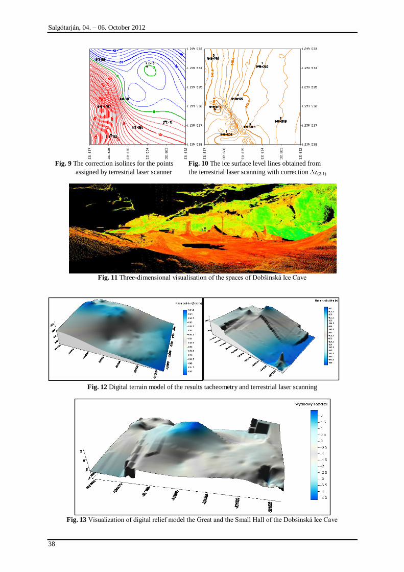
Salgótarján, 04. – 06. October 2012
38
Fig. 9 The correction isolines for the points Fig. 10 The ice surface level lines obtained from
assigned by terrestrial laser scanner the terrestrial laser scanning with correction z(2-1)
Fig. 11 Three-dimensional visualisation of the spaces of Dobńinská Ice Cave
Fig. 12 Digital terrain model of the results tacheometry and terrestrial laser scanning
Fig. 13 Visualization of digital relief model the Great and the Small Hall of the Dobńinská Ice Cave
GEOTOUR & IRSE 2012
39
laser telemeters is not suitable because of ice optical qualities, there are few places in
Dobńinská Ice Cave where movement of people is limited due to safety reasons or it could be
due to potential damage to ice filling and decor. The other reason for its use is the fact that
laser scanning is a powerful measurement device which measures the object surface with
incomparably higher density and efficiency than standard geodetic methods. The article has
presented the case when the points of interpolation area are measured with sufficient accuracy
with the use of tachymetric or other geodetic method which can define morphometric
parameters of interpolation function in the certain area. The function assigns the corrections
to the points of laser terrestrial scanning.
Acknowledgement
The article was written within solution of VEGA no. 1/0786/10 „Research of caves„ ice filling
dynamics with the use of contactless methods with regard to their safe and sustainable use as
a part of Slovak Republic natural heritage“ and project „Excellent research centre for
obtaining and processing of earth resources – 2nd phase“ within Research and Development
operational program granted by European Regional Development Fund (code ITMS:
26220120038).
REFERENCES
[1] BELLA, P.: Rovné podlahové ľadové povrchy v zaľadnených jaskyniach (Dobńinská
ľadová jaskyņa, jaskyņa Scărişoara). Aragonit, 10, 12–16. ISSN 1335-213X, 2005.
[2] ČERNOTA, P.- STAŅKOVÁ, H: Vyuņití nepřímého měření délek při připojovacím a
usměrņovacím měření, sborník VI. Vedecko-odborné konferencie s medzinárodnou
účasťou Geodézia, Kartografia a geografické informačné systémy 2010, Demänovská
dolina, Slovensko, ISBN 978-80-553-0468-7.
[3] GAŃINEC, J. - GAŃINCOVÁ, S. - ČERNOTA, P. - STAŅKOVÁ, H.: Moņnosti pouņitia
laserového skenovania ľadovej výplne Dobńinském ľadovej jaskyne a rieńenie súvisiacich
problémov v programovacom jazyku Python, Sborník referátů XVIII. Konference
SDMG, Praha, 2011, str.51-60, ISBN 978-80-248-2489-5.
[4] GAŃINCOVÁ, S. - GAŃINEC, J. -, STAŅKOVÁ, H. - ČERNOTA, P.: Porovnanie MNŃ
a alternatívnych odhadovacích metód pri spracovaní výsledkov geodetických meraní In:
SDMG 2011 : sborník referátů 18. konference : Praha, 5.-7. října 2011. - Ostrava : VŃB-
TU, 2011 P. 40-50. - ISBN 978-80-248-2489-5.
[5] MIČIETOVÁ, E. - MINÁROVÁ, O.: Komplexný digitálny model reliéfu a interpolačné
metódy. Geodetický a kartografický obzor, ročník 34/76, 1988, č. 7, s. 165-173.
[6] SOKOL, Ń.: Application of statistical Methods for Geodetic Measurements Processing.
In.: Ingeo´98. STU Bratislava 1998, s. 225-231.
[7] Vyhláńka č. 300/2009, Úradu geodézie, kartografie a katastra Slovenskej republiky zo 14.
júla 2009, ktorou sa vykonáva zákon Národnej rady Slovenskej republiky č. 215/1995
Z.z. o geodézii a kartografii.
[8] Vyhláńka č. 75/2011, Úradu geodézie, kartografie a katastra Slovenskej republiky zo 14.
júla 2009, ktorou sa vykonáva zákon Národnej rady Slovenskej republiky č. 215/1995
Z.z. o geodézii a kartografii.
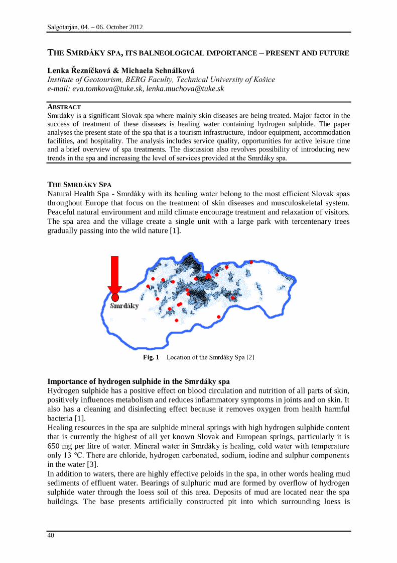
Salgótarján, 04. – 06. October 2012
40
THE SMRDÁKY SPA, ITS BALNEOLOGICAL IMPORTANCE – PRESENT AND FUTURE
Lenka Řezníčková & Michaela Sehnálková
Institute of Geotourism, BERG Faculty, Technical University of Košice
e-mail: [email protected], [email protected]
ABSTRACT
Smrdáky is a significant Slovak spa where mainly skin diseases are being treated. Major factor in the success of treatment of these diseases is healing water containing hydrogen sulphide. The paper analyses the present state of the spa that is a tourism infrastructure, indoor equipment, accommodation facilities, and hospitality. The analysis includes service quality, opportunities for active leisure time and a brief overview of spa treatments. The discussion also revolves possibility of introducing new
trends in the spa and increasing the level of services provided at the Smrdáky spa.
THE SMRDÁKY SPA
Natural Health Spa - Smrdáky with its healing water belong to the most efficient Slovak spas
throughout Europe that focus on the treatment of skin diseases and musculoskeletal system.
Peaceful natural environment and mild climate encourage treatment and relaxation of visitors.
The spa area and the village create a single unit with a large park with tercentenary trees
gradually passing into the wild nature [1].
Fig. 1 Location of the Smrdáky Spa [2]
Importance of hydrogen sulphide in the Smrdáky spa
Hydrogen sulphide has a positive effect on blood circulation and nutrition of all parts of skin,
positively influences metabolism and reduces inflammatory symptoms in joints and on skin. It
also has a cleaning and disinfecting effect because it removes oxygen from health harmful
bacteria [1].
Healing resources in the spa are sulphide mineral springs with high hydrogen sulphide content
that is currently the highest of all yet known Slovak and European springs, particularly it is
650 mg per litre of water. Mineral water in Smrdáky is healing, cold water with temperature
only 13 °C. There are chloride, hydrogen carbonated, sodium, iodine and sulphur components
in the water [3].
In addition to waters, there are highly effective peloids in the spa, in other words healing mud
sediments of effluent water. Bearings of sulphuric mud are formed by overflow of hydrogen
sulphide water through the loess soil of this area. Deposits of mud are located near the spa
buildings. The base presents artificially constructed pit into which surrounding loess is
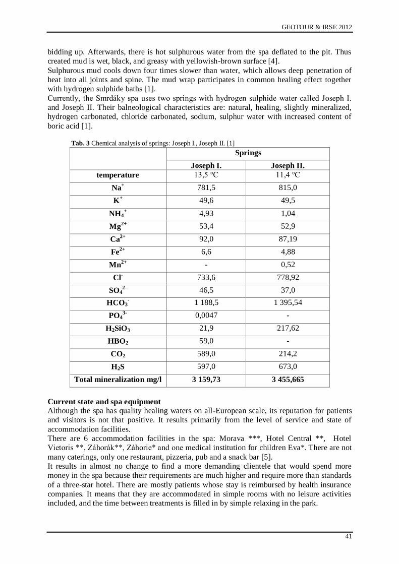
GEOTOUR & IRSE 2012
41
bidding up. Afterwards, there is hot sulphurous water from the spa deflated to the pit. Thus
created mud is wet, black, and greasy with yellowish-brown surface [4].
Sulphurous mud cools down four times slower than water, which allows deep penetration of
heat into all joints and spine. The mud wrap participates in common healing effect together
with hydrogen sulphide baths [1].
Currently, the Smrdáky spa uses two springs with hydrogen sulphide water called Joseph I.
and Joseph II. Their balneological characteristics are: natural, healing, slightly mineralized,
hydrogen carbonated, chloride carbonated, sodium, sulphur water with increased content of
boric acid [1].
Tab. 3 Chemical analysis of springs: Joseph I., Joseph II. [1]
Springs
Joseph I. Joseph II.
temperature 13,5 °C 11,4 °C
Na+ 781,5 815,0
K+ 49,6 49,5
NH4+ 4,93 1,04
Mg2+ 53,4 52,9
Ca2+ 92,0 87,19
Fe2+ 6,6 4,88
Mn2+ - 0,52
Cl- 733,6 778,92
SO42- 46,5 37,0
HCO3- 1 188,5 1 395,54
PO43- 0,0047 -
H2SiO3 21,9 217,62
HBO2 59,0 -
CO2 589,0 214,2
H2S 597,0 673,0
Total mineralization mg/l 3 159,73 3 455,665
Current state and spa equipment
Although the spa has quality healing waters on all-European scale, its reputation for patients
and visitors is not that positive. It results primarily from the level of service and state of
accommodation facilities.
There are 6 accommodation facilities in the spa: Morava ***, Hotel Central **, Hotel
Vietoris **, Záhorák**, Záhorie* and one medical institution for children Eva*. There are not
many caterings, only one restaurant, pizzeria, pub and a snack bar [5].
It results in almost no change to find a more demanding clientele that would spend more
money in the spa because their requirements are much higher and require more than standards
of a three-star hotel. There are mostly patients whose stay is reimbursed by health insurance
companies. It means that they are accommodated in simple rooms with no leisure activities
included, and the time between treatments is filled in by simple relaxing in the park.
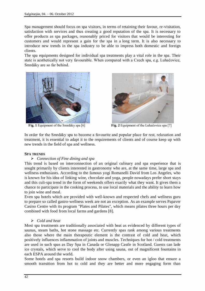
Salgótarján, 04. – 06. October 2012
42
Spa management should focus on spa visitors, in terms of retaining their favour, re-visitation,
satisfaction with services and thus creating a good reputation of the spa. It is necessary to
offer products as spa packages, reasonably priced for visitors that would be interesting for
customers and would represent a gain for the spa in a long term. It is also necessary to
introduce new trends in the spa industry to be able to impress both domestic and foreign
clients.
The spa equipments designed for individual spa treatments play a vital role in the spa. Their
state is aesthetically not very favourable. When compared with a Czech spa, e.g. Luhačovice,
Smrdáky are so far behind.
Fig. 1 Equipment of the Smrdáky spa [6] Fig. 2 Equipment of the Luhačovice spa [7]
In order for the Smrdáky spa to become a favourite and popular place for rest, relaxation and
treatment, it is essential to adapt it to the requirements of clients and of course keep up with
new trends in the field of spa and wellness.
SPA TRENDS
Connection of Fine dining and spa
This trend is based on interconnection of an original culinary and spa experience that is
sought primarily by clients interested in gastronomy who are, at the same time, large spa and
wellness enthusiasts. According to the famous yogi Romanelli David from Los Angeles, who
is known for his idea of linking wine, chocolate and yoga, people nowadays prefer short stays
and this culi-spa trend in the form of weekends offers exactly what they want. It gives them a
chance to participate in the cooking process, to use local materials and the ability to learn how
to join wine and meal.
Even spa hotels which are provided with well-known and respected chefs and wellness guru
to prepare so called gastro-wellness week are not an exception. As an example serves Papaver
Casino Centre with its program "Plates and Pilates", which means pilates three hours per day
combined with food from local farms and gardens [8].
Cold and heat
Most spa treatments are traditionally associated with heat as evidenced by different types of
saunas, steam baths, hot stone massage etc. Currently spas rank among various treatments
also those where the main therapeutic element is the contrast of cold and heat, which
positively influences inflammation of joints and muscles. Techniques for hot / cold treatments
are used in such spas as Day Spa in Canada or Glenapp Castle in Scotland. Guests can lade
ice crystals, which serve to cool the body after using sauna, out of magnificent fountains in
each ESPA around the world.
Some hotels and spa resorts build indoor snow chambers, or even an igloo that ensure a
smooth transition from hot to cold and they are better and more engaging form than
GEOTOUR & IRSE 2012
43
immersion into ice water. Arctic ice chamber with falling snow is built in Las Vegas at Qua
Baths & Spa at Caesar Palace. Another example of a modern concept of cold is Dolder Grand
Hotel in Switzerland, where guests can throw snow balls into each other or Aqua Spa in the
UK, which has an igloo where accommodated guests can order an early morning wake-up
shower [8].
Relaxation for feet
Wellness and spa centres begin to focus on the care of feet. We can call it e.g. "foot
fitness". It is not just a classic pedicure but mainly treatment of pain arising from wearing
wrong shoes. The "foot fitness" is sought mostly by women who constantly underlie to
dictates of global fashion trends, which forces them to wear dangerously high heels, popular
flip-flops and other bulky shoes. Inspiration can be found in the Canyon Ranch SpaClub in
Las Vegas which introduced a comprehensive program called Healthy Feet offering
computerized gait analysis and a wide list of procedures for feet care [8].
Combination of sound, light and water
Experts agree that different sounds stimulate people differently, e.g. the sound of nature can
relax the human body, while the sound of drums revives, and even the colour can influence
our mood. Novelty in massages is the sound of wind and river produced directly by the hands
of the therapist. Combination of sound, light and water is the best combination to achieve
total relaxation of body and soul. In some centres, even pools are transformed into concert
halls with the help of music or procedures are associated with night laser show. [8]
Unforgettable Experiences
The essence of this trend is to provide clients with breathtaking experiences that they
otherwise have no opportunity to try. There are no limits for imagination in this case. The
base can be formed by spa and wellness parks located in different ice geysers, Caribbean
lagoons and tropical waterfalls. ESPA at the Ritz-Carlton in Hong Kong offers a unique
experience to its visitors. It has the highest spa in the world located on the 116th floor. Guests
who swim in the pool feel like being in the plane [8].
Spa and men
Care about appearance and body was purely a matter of women for a long time. Today, even
men begin to realize the importance of caring for their body, face and soul regeneration. It
often results from the profession in which men underlie to physical or psychological pressure.
They have a demanding job which forces them to stretch their energy [9].
That is the reason why spa resorts increasingly focus on male clients. They create special
cosmetics for them; provide them with treatments based on their ideas. This trend presents a
strong competitive advantage and creates new opportunities for spas [9].
CONCLUSION
To dispose with healing water and to have suitable conditions for treatment of various
diseases is only half of the success of the spa. The other half is management that should see
clients as individuals with their own needs and desires, and therefore strive to satisfy them.
However, we often face with an approach that does not meet our expectations and we get
negative experience. It does not make a good name for the spa. Spas should gradually adapt
their products and services to constantly changing trends and find the most efficient way to
align them with the requirements of the clients. The ability to use them gives either spa or
wellness department a competitive advantage and the ability to ensure a stable clientele that
would be satisfied with the money spent.
Salgótarján, 04. – 06. October 2012
44
REFERENCES
[1] ĆURÁK, Tibor: Smrdáky historický obraz obce. Końice: AGENTÚRA SÁŃA
KOŃICE, 2006. 93pg. ISBN 80-969537-1-0.
[2] Location of the Smrdáky Spa [online]. [citation 22.09.2012]. Available on the Internet:
<http://a-z-kupele.slovenske.info/kupele-lokality.php>.
[3] Slovak healing springs [online]. [citation 22.09.2012]. Available on the Internet:
<http://www.ask.sk/sk/liecebne_kupele/slovenske_liecebne_kupele_piestany.ph>.
[4] ELIAŃOVÁ, Darina: Kúpeľníctvo. Ochrana prírodných kúpeľov v Slovenskej
republike. Bratislava: Ekonóm, 2007. 142s. ISBN 978-225-2452-0.
[5] Bruņúra SPA Smrdáky. Price catalogue 2012. 7pg.
[6] The Smrdáky Spa. [online]. [citation 22.09.2012]. Available on the Internet:
<http://www.vodnesvety.sk/kupele-smrdaky/350?task=view>.
[7] Kúpele Luhačovice. [online]. [citation 22.09.2012]. Available on the Internet:
<http://www.google.sk/imgres?start=303&um=1&hl=sk&client=opera&rls=en&channe
l=suggest&tbm=isch&tbnid=mmB9Gi4T3U8VJM:&imgrefurl=http://relax.romantickep
obyty.sk/romanticky-pobyt-liecebny-dom-niva-ii-a1-7300-
sk.htm&docid=W_4z2pg4If7Q4M&itg=1&imgurl=http://relax.romantickepobyty.sk/im
age/1/600x500/19801.jpeg&w=336&h=500&ei=f8peUPbYMpHcsgabmICoDQ&zoom
=1&iact=hc&vpx=1139&vpy=2&dur=678&hovh=274&hovw=184&tx=135&ty=59&si
g=102915658779758629212&page=14&tbnh=150&tbnw=145&ndsp=24&ved=1t:429,r
:17,s:303,i:136&biw=1366&bih=655>.
[8] CHROMÁ, K. Drņte se spa trendů pro rok 2012. In Hotel&spa. ISSN: 1802-3274. 2012,
vol. 6, č. 8, pg. 38-39.
[9] Do spa přicházejí Muņi. In Hotel&spa. ISSN: 1802-3274. 2012, vol. 6, č. 5, pg. 30-31.
GEOTOUR & IRSE 2012
45
MARKET POSITIONS AND SOURCES OF POSSIBLE DEVELOPMENT OF THE
THERMAL BATHS OF NORTHERN HUNGARY
Zsolt Péter
University of Miskolc, Institute of World and Regional Economics
3515 Hungary, Miskolc, Miskolc-Egyetemváros
e-mail: [email protected]
ABSTRACT
Outstanding natural conditions are at disposal of Hungary in the case the hot water sources which can
be found under the surface. About 80% of the territory where thermal water can be found. We are in the world's forefront on this basis, question but, that on the area of the utilization so distinguished our positions. I am for responding to this question in my study, with a strange look onto the north Hungary
region's baths.
INTRODUCTION
Hungary has prominent health tourism facilities. More than 80% of the country‟s territory has
potential thermal water resources. Next to Japan Iceland Italy and France Hungary has the
world's fifth most significant thermal water reserve. In addition mofetta mud can expand the
supply of health tourism. Among the 1372 thermal wells 197 recognized medicinal waters are
listed. 385 settlements have baths with thermal or/and medicinal water 65 of which are
qualified spas [1].
DEVELOPMENTS OF TODAY
Hungary's first baths were built at the foot of the Buda hills by the ancient Romans who had
advanced bathing culture. The same water was used in the Middle Age during the reign of
King Sigismund and Matthias when famous spas operated.
The Second World War and the subsequent years made dramatic effects on tourism
development. Almost all tourist attractions directly or indirectly suffered the devastation of
war. International tourist disappeared. The development of domestic tourism was the first
priority. Several new baths had been built since the second five-year plan period which was
followed by the expansion of hotel capacity in Budapest and in the countryside.
In the 70s the UN within the framework of the VÁTI a Thermal Project Office was
established for creating thermal development programs.
After the change of regime the bath improvements primarily occurred in the framework of
Széchenyi Plan (launched in 2000). The health tourism sub program wanted to improve the
competitiveness of the Hungarian baths to the European level. Thanks to developments
facilities involved in the program could increase their initial 221 average opening days to 316
their water surface was extended by 31 thousand m2. Tourist traffic raised by 26% it reached
16.1 million visitors [1].
MARKET POSITIONS ON THE DOMESTIC AND INTERNATIONAL MARKET
Hungary has the world's fifth most significant thermal water reserve in the case of water
quality has a relative advantage position because usually high temperature meets with high
mineral content. Competitors as Italy and France have waters usually with high mineral
content and lower temperatures or as in Japan and Iceland high temperatures with lower
mineral content.
Salgótarján, 04. – 06. October 2012
46
Fig. 1 Thermal baths and spas of Hungary,
Source: National Health Tourism Development Strategy 2007. 13. p.
Fig. 2 Tourism projects financed by Széchenyi Plan
Source: Budai Z. 2002.
GEOTOUR & IRSE 2012
47
Tab. 1 Natural healing factors and thermal baths of the Hungarian regions (2011)
Therma
l water
Thermal
Bath
Ther
mal
cave
Medical
mud
Medical
gas
Climati
c health
resort
Northern Great
Plain 61 8 0 2 0 2
Southern Great
Plain 42 11 0 1 0 1
Western
Transdanubia 40 11 0 2 0 4
Southern
Transdanubia 26 10 1 0 0 1
Central
Hungary 26 13 1 0 0 0
Northern
Hungary 20 7 2 0 1 4
Central
Transdanubia 9 3 1 0 0 1
Hungary 224 63 6 5 1 13 Source: Own compilation based on the data of the National Public Health and Medical Officer Service
Thermal water can be explored almost under the whole country but the regions of the Great
Plain can‟t be beaten nor in quality nor in quantity but the distribution of thermal baths is
more balanced with the exception of Central Transdanubia (Table 1).
Several internationally known spas are available in Hungary many of them are meeting the
international standards and provide quality services. Although the National Public Health and
Medical Service Office ensures that all spas meet the applicable requirements adequate
facilities –thanks to the lack of resources- have not been available in many places.
The expected medium and long-term growth of domestic and foreign demand and the
expansion of the (high-speed) road network will stimulate reconstruction and enlargement of
the less known and peripheral resorts however the lack of sufficient capital, appropriate
marketing and specific knowledge can lead to non sustainable operation.
Hungary‟s main competitors are the neighboring countries and EU Member States. Spa
services are generally extremely high-priced and high quality products on the international
tourism markets. Because of the moderate supply of these services in Hungary, Austria
Germany Switzerland or Italy are often chosen by the market segments of high demand.
Czech Republic, Slovakia, Romania and Poland have become stronger competitors in the
recent years too (Figure 3).
Despite the fact that Hungary has excellent conditions for health tourism, strengthening
competition is expected in the future. In the recent years wellness tourism which is less
dependent on natural resources have had definitely significant growth in comparison of
medical tourism. This is both opportunities and threats for the country because „cheap‟ and
good quality water is almost everywhere but it is not unique from the viewpoint of the
tourists.
In my opinion the existence of the healing thermal water can be a good communication point
of the future.
Today Hungary has only 197 acknowledged as healing water of the potential 1372. Assuming
that other waters which are not registered have similar characteristics it would be appropriate
to support the official recognition procedure.
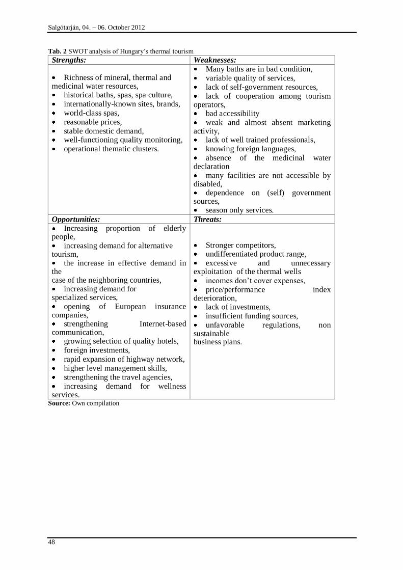
Salgótarján, 04. – 06. October 2012
48
Tab. 2 SWOT analysis of Hungary‟s thermal tourism
Strengths: Weaknesses: Richness of mineral, thermal and
medicinal water resources, historical baths, spas, spa culture, internationally-known sites, brands, world-class spas, reasonable prices, stable domestic demand, well-functioning quality monitoring, operational thematic clusters.
Many baths are in bad condition, variable quality of services, lack of self-government resources, lack of cooperation among tourism
operators, bad accessibility weak and almost absent marketing
activity, lack of well trained professionals, knowing foreign languages, absence of the medicinal water
declaration many facilities are not accessible by
disabled, dependence on (self) government
sources, season only services.
Opportunities: Threats:
Increasing proportion of elderly people, increasing demand for alternative
tourism, the increase in effective demand in
the case of the neighboring countries, increasing demand for
specialized services, opening of European insurance
companies, strengthening Internet-based
communication, growing selection of quality hotels, foreign investments, rapid expansion of highway network, higher level management skills, strengthening the travel agencies, increasing demand for wellness
services.
Stronger competitors, undifferentiated product range, excessive and unnecessary
exploitation of the thermal wells incomes don‟t cover expenses, price/performance index
deterioration, lack of investments, insufficient funding sources, unfavorable regulations, non
sustainable business plans.
Source: Own compilation

GEOTOUR & IRSE 2012
49
Fig. 3 Competitors of thermal tourism
Source: Budai Z. (2002)
THERMAL BATHS OF NORTHERN HUNGARY
Northern Hungary have 16 thermal baths of which 7 are healing and a dry bath. It is a
question that the thermal baths have significant effects on the regions‟ tourism. The answer is
not easy because of the complexity of supply and demand in tourism but tourist traffic
numbers clarifies the picture. In 2000 with the exception of Mezőcsát, Mátraderecske and
Tab. 3 Change of number of bed nights (2000 =100%)
2001 2002 2003 2004 2005 2006 2007 2008 2009
Bogács 13% 27% 35% 26% 31% 27% 35% 29% 30%
Mezőkövesd -1% -10% 27% 12% 71% 121% 114% 82% 173%
Eger -9% -18% -31% -23% -2% -2% 1% 3% -9%
Egerszalók 146% 207% 173% 1019
%
1394
%
1725
%
3941
%
3878
%
3979
%
Bükkszék 33% -15% -22% 3% -48% -54% -55% -45% -58%
Gyöngyös -1% 23% 9% -14% -40% -34% -30% -34% -53%
Hatvan -44% -29% -34% -34% -72% -29% -30% 3% 98%
Kazincbarcika -19% -28% -26% 2% 1% -22% -7% 2% 12%
Mátraderecske 47% -2% 280% 659% 250% 431% 53%
Miskolc -14% -10% -4% -11% -17% -12% -9% -16% -27%
Sárospatak 2% 21% 55% 22% 13% 59% 81% 87% 72%
Szerencs -4% -2% -40% -47% -44% -40% -58% -66% -69%
Tarnaméra -16% -24% 82% 86% 99% -66% -1% 17% -61%
Tiszaújváros 7% 14% 44% 38% 16% 20% 20% 24% -3%
Northern
Hungary -3% -1% 1% -4% -2% 0% 1% 1% -6%
Source: Author‟s own calculation based on CSO data
Salgótarján, 04. – 06. October 2012
50
Demjén every settlement had commercial accommodation establishments. Values have been
marked in gray that exceeded the regional average. Eger and Miskolc are big cities with a
complex supply of tourist attractions their performance are effected by several factors beyond
thermal tourism. In the case of other settlements bath reconstructions or newly developed
resorts meant significant growth especially when development of accommodation occurred in
the same area. Competition is strengthening resorts without significant investments have
found themselves on the periphery (Bükkszék, Gyöngyös, Szerencs, Tarnaméra, Mezőcsát,
Pásztó).
POSSIBLE SOURCES OF DEVELOPMENT
In the last two decades significant developments took place in the region. New or totally
modernized (Tiszaújváros, Eger, Egerszalók, Miskolc, Sárospatak Demjén) or partially
renovated baths (Bogács, Mezőkövesd) can be found in the region but several old fashioned
resorts have definitely less visitors than 20-30 years ago. It can be a good question where the
further sources of investments can come from. I think this question can be answered better on
(micro)-regional level. A settlement is often has so few tourist attractions that a combination
of a bigger area can attract tourists more effectively for a bit longer stay.
In my earlier research „The processes of regional tourism context, in particular the North-
Hungarian region‟ with the help of principal component analysis I was able to group the
indicators that are associated with the development of the number of guest nights. Four factors
were crated:
1. economic activity factor
2. tourism supply factor
3. regional attractiveness factor
4. regional social situation factor
The “tourism supply” and “economic activity” factors appeared significantly in the model
based on the results of the principal component analysis. The model can explain the specific
values of the micro-regional guest night numbers at 68.3%. It is not appropriate to judge the
micro-regions‟ position exclusively on the basis of that categorization, since the values of the
categories range between considerably wide boundaries; therefore, I classified the micro-
regions using cluster analysis.
The Eger micro-region is a distinct „group‟ on the basis of the eigenvalues of the “economic
activity” and “tourism supply” factors, where the “economic activity” and “tourism supply”
are above average. The micro-region‟s level of “economic activity” is more favorable than its
(at regional level) already outstanding “tourism supply”. The capital necessary to develop
tourism supply may come from internal sources as well. There are investors from outside due
to its fame, visitor turnover and growth potential, and further investment is expected. It is
necessary to improve the efficiency of the sector, to enhance the region‟s (foreign)
recognition and to establish new (artificial) tourism attractions in order to keep up the pace of
growth.
The Tokaj micro-region is a similar „group‟ with its, outstanding tourism supply (for the
region), that far outweighs its economic potential. The resources of tourism development
come from the region only to a lesser extent. There are a significant number of domestic and
foreign investors, primarily in the area of wine production and accommodation, due to its
growth potential as well as the domestic and international awareness of the name “Tokaj”.
There is a chance to gain resources for the establishment of new/artificial attractions from
state sources in order to enhance to a greater extent the micro-region‟s visitor turnover. Due to
the nature of the tendering systems, primarily local governmental initiatives will bring quality
change in the region.
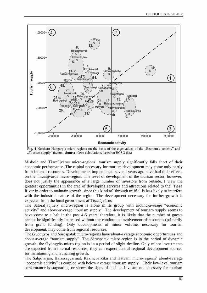
GEOTOUR & IRSE 2012
51
Fig. 4 Northern Hungary‟s micro-regions on the basis of the eigenvalues of the „Economic activity” and
„Tourism supply” factors, Source: Own calculations based on HCSO data
Miskolc and Tiszaújváros micro-regions‟ tourism supply significantly falls short of their
economic performance. The capital necessary for tourism development may come only partly
from internal resources. Developments implemented several years ago have had their effects
on the Tiszaújváros micro-region. The level of development of the tourism sector, however,
does not justify the appearance of a large number of investors from outside. I view the
greatest opportunities in the area of developing services and attractions related to the Tisza
River in order to maintain growth, since this kind of „through traffic‟ is less likely to interfere
with the industrial nature of the region. The development necessary for further growth is
expected from the local government of Tiszaújváros.
The Sátoraljaújhely micro-region is alone in its group with around-average “economic
activity” and above-average “tourism supply”. The development of tourism supply seems to
have come to a halt in the past 4-5 years; therefore, it is likely that the number of guests
cannot be significantly increased without the continuous involvement of resources (primarily
from grant funding). Only developments of minor volume, necessary for tourism
development, may come from regional resources.
The Gyöngyös and Sárospatak micro-regions have about-average economic opportunities and
about-average “tourism supply”. The Sárospatak micro-region is in the period of dynamic
growth, the Gyöngyös micro-region is in a period of slight decline. Only minor investments
are expected from internal resources; they can expect central regional development sources
for maintaining and launching growth.
The Salgótarján, Balassagyarmat, Kazincbarcika and Hatvani micro-regions‟ about-average
“economic activity” is coupled with below-average “tourism supply”. Their low-level tourism
performance is stagnating, or shows the signs of decline. Investments necessary for tourism
Salgótarján, 04. – 06. October 2012
52
developments of minor significance can be financed rather from internal resources. The
micro-regions have to designate those narrow areas of development that carry the chances for
sustainable tourism growth (e.g. villages in extraordinary landscapes at the foot of the Bükk
Mountains). An increase of the significance of tourism cannot be expected without the
systematic cooperation of local governments and micro-regional centers.
The tourism supply of Bélapátfalva, Pétervására, Abaúj-hegyköz, Füzesabony micro-regions
far outweighs the economic opportunities. The Abaúj-hegyköz micro-region is in the period
of fast growth, whereas the Bélapátfalva micro-region is in the period of slowing growth. The
signs of decline can be experienced in the Pétervására and Füzesabony micro-regions. The
sources of the further development of tourism can come almost exclusively from external,
primarily domestic resources. The narrow sources of the local governments and the small
number of highly skilled professionals form a barrier to winning tender sources. Further
results can be expected from investment incentive, investment supporting programs that
promote regional tourism potential.
The Mezőkövesd, Rétság, Szécsény micro-regions have less significant “tourism supply” than
the previous group but have somewhat more favorable economic potential. The Mezőkövesd
micro-region is in the period of dynamic development, the Rétság micro-region in
„revitalization‟, whereas the Széchenyi micro-region is in decline. The Mezőkövesd micro-
region is on growth track B due to its tourism supply; the regional significance of tourism is
less significant in the other two cases. It is predominantly the Mezőkövesd micro-region that
can expect grant funding; in the case of the other two, their location near Budapest and
utilizing the Old Village of Hollókő and its Surround-ings to a greater extent may bring
results. The Mezkövesd micro-region, capitalizing on its excellent availability, should expand
its catchment area, both inside and outside the region.
The Heves, Mezőcsát, Bodrogköz, Szikszó and Encs micro-regions belong to those lagging
behind in the national rank on the basis of their economic power. Their tourism supply and
performance is negligible, which is even coupled with decline. There is a small chance for the
regional-level development of tourism. The Mezőcsát and Heves micro-regions are in the best
position, as they can utilize their excellent accessibility, the proximity of Lake Tisza and a
thermal water supply. The tourism developments can come almost exclusively outside the
region. In my opinion, only isolated development can be expected. For the majority of the
micro-region‟ settlements, it would be worth trying to find other means of encouraging
development/growth.
The “tourism supply” and economic performance of the Bátonyterenye, Pásztó, Szerencs,
Edelény and Ózd micro-regions are deeply below average. The visitor turn-over is negligible
compared to the population, and processes of marginalization have been typical for long
years. Apart from some exceptions (e.g. Edelény), significant tour-ism investments cannot be
expected from internal and external (private or budgetary) resources. Special attention has to
be paid in the case of tourism development so that the criteria of sustainability are complied
with. The Szerencs micro-region undeservedly belongs to this group, since its settlements
belonging to the wine-region, the architectural and cultural heritage of Szerencs would justify
tourism development. The development of the micro-region‟s accommodation supply is
reasonable, especially in the core area of the Tokaj Wine Region (historic cultural landscape -
World Heritage Site) [4].
CONCLUSION
The last two decades have brought significant mostly positive changes to the operation of the
thermal baths in Hungary. Thanks to the Széchenyi Plan and the National Development Plan
several baths were refurbished and modernized. However we can not be satisfied intense
competition can be expected in the near future but effective service development and
marketing communication can provide a competitive advantage. The region‟s economic
GEOTOUR & IRSE 2012
53
situation can be a barrier for the further development which can be eliminated by the external
investors. Health tourism can be an attractive investment field in its complexity. There are
good examples, the realization of well-thought-out business plans brought success in many
cases (Demjén, Tiszaújváros)
REFERENCES
[1] [1] Aquaprofit Műszaki, Tanácsadási és Befektetési Rt.: Országos Egészségturizmus
Fejlesztési Stratégia. (National Health Tourism Development Strategy) 2007. május 30.
173 p.
[2] [2] Dr. Budai Zoltán: Marketing a fürdőfejlesztésben. (Marketing in the case of thermal
baths development) Turizmus Bulletin VI. évfolyam 1. szám 2002.
http://itthon.hu/site/upload/mtrt/Turizmus_Bulletin/02_01/SZ3.HTM
[3] [3] Dr. Budai Zoltán: A Széchenyi Terv keretében megvalósuló egészségturisztikai
fejlesztések első félévének eredményei. (Health tourism developments of the The
Széchenyi Plan first half results) Turizmus Bulletin V. évfolyam 3. szám, 2001.
http://itthon.hu/site/upload/mtrt/Turizmus_Bulletin/01_09/Sz3.htm
[4] [4] Péter Zsolt: A turizmus térségi folyamatainak összefüggései, különös tekintettel az
Észak-magyarországi régióra. (Issues of the regional processes of tourism with special
regard to northern Hungary) PhD disszertáció Miskolc, 2010. 180 p.
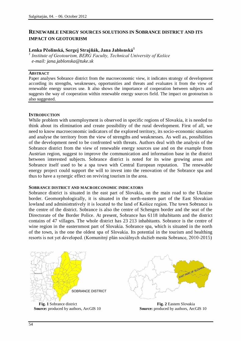
Salgótarján, 04. – 06. October 2012
54
RENEWABLE ENERGY SOURCES SOLUTIONS IN SOBRANCE DISTRICT AND ITS
IMPACT ON GEOTOURISM
Lenka Pčolinská, Sergej Strajňák, Jana Jablonská1
1 Institute of Geotourism, BERG Faculty, Technical University of Košice
e-mail: [email protected]
ABSTRACT
Paper analyses Sobrance district from the macroeconomic view, it indicates strategy of development according its strengths, weaknesses, opportunities and threats and evaluates it from the view of renewable energy sources use. It also shows the importance of cooperation between subjects and
suggests the way of cooperation within renewable energy sources field. The impact on geotourism is
also suggested.
INTRODUCTION
While problem with unemployment is observed in specific regions of Slovakia, it is needed to
think about its elimination and create possibility of the rural development. First of all, we
need to know macroeconomic indicators of the explored territory, its socio-economic situation
and analyse the territory from the view of strengths and weaknesses. As well as, possibilities
of the development need to be confronted with threats. Authors deal with the analysis of the
Sobrance district from the view of renewable energy sources use and on the example from
Austrian region, suggest to improve the communication and information base in the district
between interested subjects. Sobrance district is noted for its wine growing areas and
Sobrance itself used to be a spa town with Central European reputation. The renewable
energy project could support the will to invest into the renovation of the Sobrance spa and
thus to have a synergic effect on reviving tourism in the area.
SOBRANCE DISTRICT AND MACROECONOMIC INDICATORS
Sobrance district is situated in the east part of Slovakia, on the main road to the Ukraine
border. Geomorphologically, it is situated in the north-eastern part of the East Slovakian
lowland and administratively it is located to the land of Końice region. The town Sobrance is
the centre of the district. Sobrance is also the centre of Schengen border and the seat of the
Directorate of the Border Police. At present, Sobrance has 6118 inhabitants and the district
contains of 47 villages. The whole district has 23 213 inhabitants. Sobrance is the centre of
wine region in the easternmost part of Slovakia. Sobrance spa, which is situated in the north
of the town, is the one the oldest spa of Slovakia. Its potential in the tourism and healthing
resorts is not yet developed. (Komunitný plán sociálnych sluņieb mesta Sobrance, 2010-2015)
Fig. 1 Sobrance district Fig. 2 Eastern Slovakia
Source: produced by authors, ArcGIS 10 Source: produced by authors, ArcGIS 10
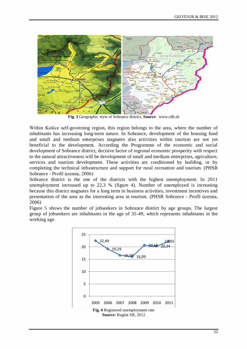
GEOTOUR & IRSE 2012
55
Fig. 3 Geographic view of Sobrance district, Source: www.cdb.sk
Within Końice self-governing region, this region belongs to the area, where the number of
inhabitants has increasing long-term nature. In Sobrance, development of the housing fund
and small and medium enterprises stagnates also activities within tourism are not yet
beneficial to the development. According the Programme of the economic and social
development of Sobrance district, decisive factor of regional economic prosperity with respect
to the natural attractiveness will be development of small and medium enterprises, agriculture,
services and tourism development. These activities are conditioned by building, or by
completing the technical infrastructure and support for rural recreation and tourism. (PHSR
Sobrance - Profil územia, 2006)
Sobrance district is the one of the districts with the highest unemployment. In 2011
unemployment increased up to 22,3 % (figure 4). Number of unemployed is increasing
because this district stagnates for a long term in business activities, investment incentives and
presentation of the area as the interesting area in tourism. (PHSR Sobrance - Profil územia,
2006)
Figure 5 shows the number of jobseekers in Sobrance district by age groups. The largest
group of jobseekers are inhabitants in the age of 35-49, which represents inhabitants in the
working age.
Fig. 4 Registered unemployment rate
Source: Regdat SR, 2012
22,49
19,19
16,59 16,09
20,66 20,3422,33
0
5
10
15
20
25
2005 2006 2007 2008 2009 2010 2011
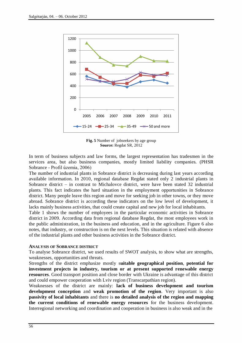
Salgótarján, 04. – 06. October 2012
56
Fig. 5 Number of jobseekers by age group
Source: Regdat SR, 2012
In term of business subjects and law forms, the largest representation has tradesmen in the
services area, but also business companies, mostly limited liability companies. (PHSR
Sobrance - Profil územia, 2006)
The number of industrial plants in Sobrance district is decreasing during last years according
available information. In 2010, regional database Regdat stated only 2 industrial plants in
Sobrance district – in contrast to Michalovce district, were have been stated 32 industrial
plants. This fact indicates the hard situation in the employment opportunities in Sobrance
district. Many people leave this region and move for seeking job in other towns, or they move
abroad. Sobrance district is according these indicators on the low level of development, it
lacks mainly business activities, that could create capital and new job for local inhabitants.
Table 1 shows the number of employees in the particular economic activities in Sobrance
district in 2009. According data from regional database Regdat, the most employees work in
the public administration, in the business and education, and in the agriculture. Figure 6 also
notes, that industry, or construction is on the next levels. This situation is related with absence
of the industrial plants and other business activities in the Sobrance district.
ANALYSIS OF SOBRANCE DISTRICT
To analyse Sobrance district, we used results of SWOT analysis, to show what are strengths,
weaknesses, opportunities and threats.
Strengths of the district emphasize mostly suitable geographical position, potential for
investment projects in industry, tourism or at present supported renewable energy
resources. Good transport position and close border with Ukraine is advantage of this district
and could empower cooperation with Lviv region (Transcarpathian region).
Weaknesses of the district are mainly: lack of business development and tourism
development conception and weak promotion of the region. Very important is also
passivity of local inhabitants and there is no detailed analysis of the region and mapping
the current conditions of renewable energy resources for the business development.
Interregional networking and coordination and cooperation in business is also weak and in the
0
200
400
600
800
1000
1200
2005 2006 2007 2008 2009 2010 2011
15-24 25-34 35-49 50 and more
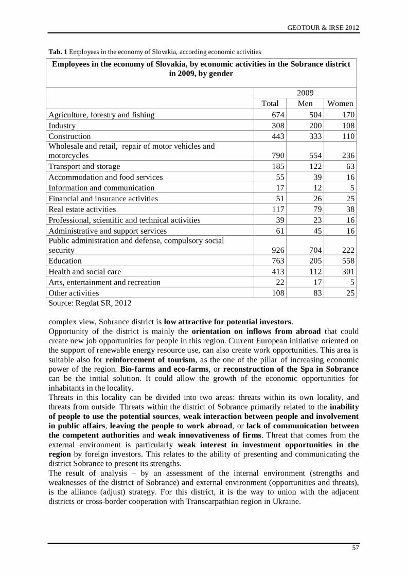
GEOTOUR & IRSE 2012
57
Tab. 1 Employees in the economy of Slovakia, according economic activities
Source: Regdat SR, 2012
complex view, Sobrance district is low attractive for potential investors.
Opportunity of the district is mainly the orientation on inflows from abroad that could
create new job opportunities for people in this region. Current European initiative oriented on
the support of renewable energy resource use, can also create work opportunities. This area is
suitable also for reinforcement of tourism, as the one of the pillar of increasing economic
power of the region. Bio-farms and eco-farms, or reconstruction of the Spa in Sobrance
can be the initial solution. It could allow the growth of the economic opportunities for
inhabitants in the locality.
Threats in this locality can be divided into two areas: threats within its own locality, and
threats from outside. Threats within the district of Sobrance primarily related to the inability
of people to use the potential sources, weak interaction between people and involvement
in public affairs, leaving the people to work abroad, or lack of communication between
the competent authorities and weak innovativeness of firms. Threat that comes from the
external environment is particularly weak interest in investment opportunities in the
region by foreign investors. This relates to the ability of presenting and communicating the
district Sobrance to present its strengths.
The result of analysis – by an assessment of the internal environment (strengths and
weaknesses of the district of Sobrance) and external environment (opportunities and threats),
is the alliance (adjust) strategy. For this district, it is the way to union with the adjacent
districts or cross-border cooperation with Transcarpathian region in Ukraine.
Employees in the economy of Slovakia, by economic activities in the Sobrance district
in 2009, by gender
2009
Total Men Women
Agriculture, forestry and fishing 674 504 170
Industry 308 200 108
Construction 443 333 110
Wholesale and retail, repair of motor vehicles and
motorcycles 790 554 236
Transport and storage 185 122 63
Accommodation and food services 55 39 16
Information and communication 17 12 5
Financial and insurance activities 51 26 25
Real estate activities 117 79 38
Professional, scientific and technical activities 39 23 16
Administrative and support services 61 45 16
Public administration and defense, compulsory social
security 926 704 222
Education 763 205 558
Health and social care 413 112 301
Arts, entertainment and recreation 22 17 5
Other activities 108 83 25
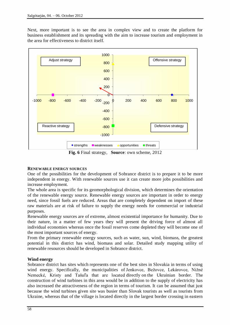
Salgótarján, 04. – 06. October 2012
58
Next, more important is to see the area in complex view and to create the platform for
business establishment and its spreading with the aim to increase tourism and employment in
the area for effectiveness to district itself.
Fig. 6 Final strategy, Source: own scheme, 2012
RENEWABLE ENERGY SOURCES
One of the possibilities for the development of Sobrance district is to prepare it to be more
independent in energy. With renewable sources use it can create more jobs possibilities and
increase employment.
The whole area is specific for its geomorphological division, which determines the orientation
of the renewable energy source. Renewable energy sources are important in order to energy
need, since fossil fuels are reduced. Areas that are completely dependent on import of these
raw materials are at risk of failure to supply the energy needs for commercial or industrial
purposes.
Renewable energy sources are of extreme, almost existential importance for humanity. Due to
their nature, in a matter of few years they will present the driving force of almost all
individual economies whereas once the fossil reserves come depleted they will become one of
the most important sources of energy.
From the primary renewable energy sources, such as water, sun, wind, biomass, the greatest
potential in this district has wind, biomass and solar. Detailed study mapping utility of
renewable resources should be developed in Sobrance district.
Wind energy
Sobrance district has sites which represents one of the best sites in Slovakia in terms of using
wind energy. Specifically, the municipalities of Jenkovce, Beņovce, Lekárovce, Niņné
Nemecké, Kristy and Tańuľa that are located directly on the Ukrainian border. The
construction of wind turbines in this area would be in addition to the supply of electricity has
also increased the attractiveness of the region in terms of tourism. It can be assumed that just
because the wind turbines given site was busier than Slovak tourists as well as tourists from
Ukraine, whereas that of the village is located directly in the largest border crossing in eastern
-1000
-800
-600
-400
-200
0
200
400
600
800
1000
-1000 -800 -600 -400 -200 0 200 400 600 800 1000
strengths weaknesses opportunities threats
Offensive strategyAdjust strategy
Reactive strategy Defensive strategy
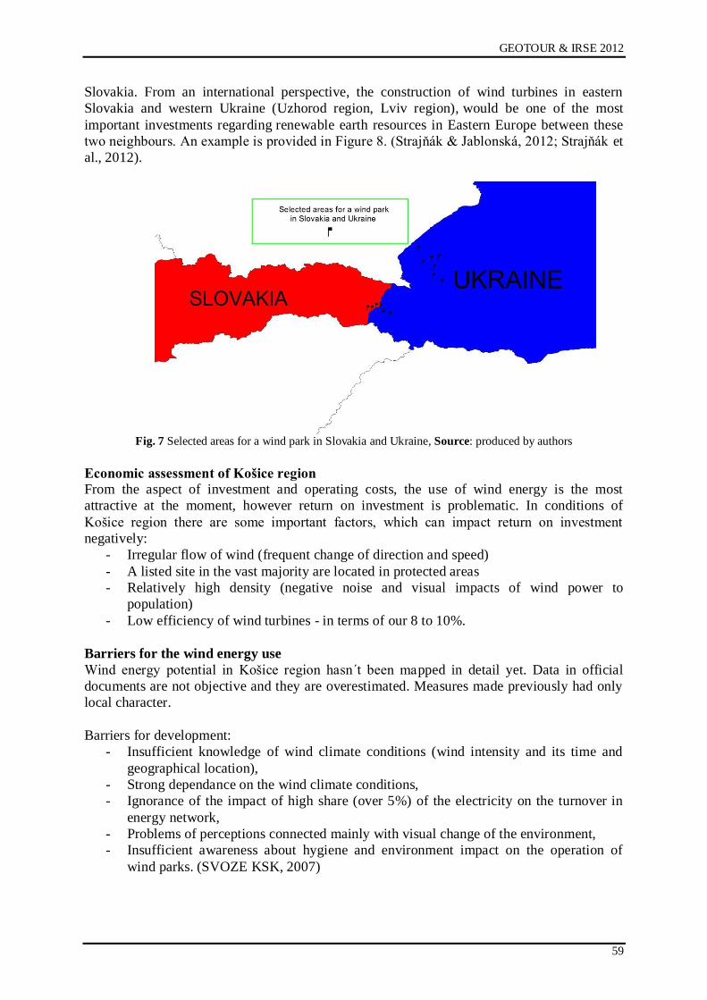
GEOTOUR & IRSE 2012
59
Slovakia. From an international perspective, the construction of wind turbines in eastern
Slovakia and western Ukraine (Uzhorod region, Lviv region), would be one of the most
important investments regarding renewable earth resources in Eastern Europe between these
two neighbours. An example is provided in Figure 8. (Strajņák & Jablonská, 2012; Strajņák et
al., 2012).
Fig. 7 Selected areas for a wind park in Slovakia and Ukraine, Source: produced by authors
Economic assessment of Košice region
From the aspect of investment and operating costs, the use of wind energy is the most
attractive at the moment, however return on investment is problematic. In conditions of
Końice region there are some important factors, which can impact return on investment
negatively:
- Irregular flow of wind (frequent change of direction and speed)
- A listed site in the vast majority are located in protected areas
- Relatively high density (negative noise and visual impacts of wind power to
population)
- Low efficiency of wind turbines - in terms of our 8 to 10%.
Barriers for the wind energy use
Wind energy potential in Końice region hasn´t been mapped in detail yet. Data in official
documents are not objective and they are overestimated. Measures made previously had only
local character.
Barriers for development:
- Insufficient knowledge of wind climate conditions (wind intensity and its time and
geographical location),
- Strong dependance on the wind climate conditions,
- Ignorance of the impact of high share (over 5%) of the electricity on the turnover in
energy network,
- Problems of perceptions connected mainly with visual change of the environment,
- Insufficient awareness about hygiene and environment impact on the operation of
wind parks. (SVOZE KSK, 2007)
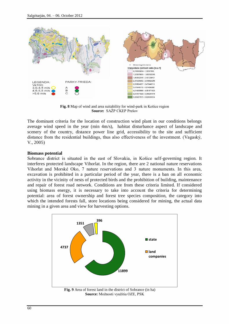
Salgótarján, 04. – 06. October 2012
60
Fig. 8 Map of wind and area suitability for wind-park in Końice region
Source: SAŅP CKEP Preńov
The dominant criteria for the location of construction wind plant in our conditions belongs
average wind speed in the year (min 4m/s), habitat disturbance aspect of landscape and
scenery of the country, distance power line grid, accessibility to the site and sufficient
distance from the residential buildings, thus also effectiveness of the investment. (Vagaský,
V., 2005)
Biomass potential
Sobrance district is situated in the east of Slovakia, in Końice self-governing region. It
interferes protected landscape Vihorlat. In the region, there are 2 national nature reservations
Vihorlat and Morské Oko, 7 nature reservations and 3 nature monuments. In this area,
excavation is prohibited in a particular period of the year, there is a ban on all economic
activity in the vicinity of nests of protected birds and the prohibition of building, maintenance
and repair of forest road network. Conditions are from these criteria limited. If considered
using biomass energy, it is necessary to take into account the criteria for determining
potential: area of forest ownership and forest tree species composition, the category into
which the intended forests fall, store locations being considered for mining, the actual data
mining in a given area and view for harvesting options.
Fig. 9 Area of forest land in the district of Sobrance (in ha)
Source: Moņnosti vyuņitia OZE, PSK
11899
4737
1351396
state
land companies
GEOTOUR & IRSE 2012
61
On the figure 9 we can see the area of forest land in Sobrance district. Most of the forest land
is in the state ownership. Figure 10 compares possibilities of the use the trees potential,
suitable as the biomass material. Forests in the area are mostly of the beech-oak trees. For the
energy use, it´s possible to use, except part of timber with no good quality, residue after
extraction (the top of the tree limbs and branches), thin wood, calamity wood (uprooted
stumps, roots of trees) (Moņnosti vyuņitia OZE, PSK). For example, the village Koromľa has
an area of approximately 220 hectares, which qualifies for fast-growing trees.
Fig. 10 Representation of trees in the district of Sobrance (in %)
Source: Moņnosti vyuņitia OZE, PSK
For energy use in Sobrance district, there is potential 13 000 to 21 000 m3 of forest biomass
(waste from felling, firewood and thinner, ...) (Moņnosti vyuņitia OZE, PSK).
Tab. 2 Potential of Sobrance district
Sobrance district
Area of the district 53 840 ha
Area of forest timber land 18 383 ha
Forestation 34,14%
Forest stand inventory 3 677 715 m3
Planned annual production 55 893 m3
Of the restoration 40 308 m3
Source: Moņnosti vyuņitia OZE, PSK.
Solar energy The next potential from the renewables in Końice region has solar energy. Due to financial
and technological possibilities, assumption for the solar energy use, especially in heat
production and hot water, is real. The current photovoltaic (PV) technology allows without
major structural changes to integrate the energy distribution system, photovoltaic generators,
providing several percent share of annual consumption of electricity. Using the technical
potential of solar is now, compared with other technologies, more expensive. (SVOZE KSK,
2007).
Regarding the assessment of Sobrance district, in Figure 11 can be seen that the district is still
in the band of radiation sufficient sun throughout the year. On the first picture of horizontally
mounted photovoltaic modules is likely to total annual global radiation in this district in 1100
0 10 20 30 40 50 60 70
beech
oak
hornbeam
maple
ash
spruce
fir
pine
larch
other broadleaf
66,38
10,08
7,78
3,2
2,54
2,07
1,93
1,89
1,39
1,06
Salgótarján, 04. – 06. October 2012
62
kWh/m2
The second figure shows the optimal inclination of photovoltaic modules. The annual total
radiation in the district of Sobrance is about 1200 kWh/m2.
Fig. 11 Global irradiation and solar electricity potential in Slovakia and Sobrance district
Source: http://re.jrc.ec.europa.eu/pvgis/
SUCCESSFUL EXAMPLE OF DEVELOPMENT IN GUSSING, AUSTRIA Similar situation as in the Sobrance district was in the Austrian region Burgenland. Local
institutions fought with high unemployment. As the starting point they decided to utilize all
the resources, that the region had and so achieve economic growth by contribution of
investment incentives and cooperation of individual subjects.
Burgenland is the youngest region in Austria. Gussing has approximately 4000 inhabitants. In
the 50's the region bordered with Hungary. There was a lack of jobs and many people left the
region because of work, mostly to the USA (about 9000 people). Therefore, the idea of
industrial development and creating job opportunities created, to decrease people leaving their
homes and families, and that human capital could remain in the region. The conditions were
particularly to use all natural resources and material in this region. In 1988 the construction of
the station began. The authors of the project relied on what they had: biomass, solar energy,
forests, agricultural machinery. But the important thing was to find experts in various
directions: technology, chemical processes, environmental impacts etc. At the beginning of
construction of the station's founders had to hang with the lack of funds and had to count
primarily with their own money and loans, as Austria at that time wasn´t part of the European
Union.
The basic philosophy of the installation was the final customer shouldn´t buy oil, gas, and
various raw materials from external suppliers, but to exploit domestic sources - solar,
biomass, and therefore that any money could remain in the region. It was necessary to
determine what the potential of the region is - forests, meadows and natural resources. Then it
was necessary to determine the energy consumption in the city Gussing. It was found that 70
000 ha in the region can be used for the purpose of obtaining energy, consumption would be
able to cover 136%. The investment for the construction operation in Gussing was 47 million
EUR.
The actual device in Güssing includes four operations:
1) the operation of research and development - cooperation with the Technical University in
Vienna,
2) operation of the demonstration - demonstration of how the operation works and what
benefits it provides,
3) the possibility of providing know-how - to help others who are interested and has got a
plan,
GEOTOUR & IRSE 2012
63
4) ecotourism – use the space as a tourist area – energy weeks, cooperation, culture and
sports, parades in technical operations.
The device provides the following benefits especially for the region: the region is 45%
supplied by these sources. It has created more than 1000 jobs.
Fig. 12 Concept of the multifunctional operation in Gussing
Source: own scheme, 2007
The basic concept of the operation is to link the three pillars: the university as a representative
of science, technology research centres and industry as the representatives of technological
constructions. Table 3 gives an overview of the use of energy resources.
Tab. 3 Possibilities of the renewables use
Sources Product
Sun heat -cooling
Waste wood
Sawdust
Forest wood
Cuttings
electricity
gas
Grass, grain
Canola oil, old oil
biogas, bio-oil
Source: own scheme, 2007
Similar excursions and practical processing of renewable energy sources contribute to a better
informed society, but especially information to those who want to work and participate in
specific solutions for renewable energy. Topic of renewable energy is currently very topical,
and although the first research centres slowly emerge in our country, it is true that the
conditions of the construction of facilities and access to this issue in both countries differ. It is
often hampered by conflicts of interest and legislative constraints. (Pčolinská, 2007)
HOW TO INCREASE AWARENESS AND SPREAD INFORMATION BETWEEN SUBJECTS?
As in the relation to the use of renewable energy sources is missing information database in
specific regions in our country, which would be a kind of connecting individual entities -
governments, businesses, research and development institutions and investors, creating
Salgótarján, 04. – 06. October 2012
64
'information platform” offers the ability to link these entities, that shared constantly updated
information in the specific regional conditions.
Bio-informator is the practical tool for individual interested subjects – municipalities,
entrepreneurs, that are interested in using all energy sources in its environment. The result of
this, should be clear view about bio-energy sources and their use through specific simulations
about financial-investment difficulty.
Planned simulator can contribute not only to the clarification of bio-energy sources field, but
it can also help to choose the concrete solution of the construction project and simulated
construction of the individual equipment aimed at renewable sources use.
Complete information tool will be ended with the section dedicated to the financing of
specific bio-projects. Project of the construction equipment, that will be chosen according
criteria sponsor (municipalities, entrepreneurs), can be financially evaluated and return on
investment will be set by responsible and expert subject. As the projects aimed on
construction of biomass equipment are highly capital-intensive, simulator allows clarify
possibilities of the projects, by bank loan or financing from European funds.
Fig. 12 Simulator of new energy possibilities
Source: Ņiaran et al., 2006
This implies the continuity of cooperation between various sectors to be included in the
project and will be involved in the preparation of this information medium. Since the aim is
not only to inform, but also to improve cooperation between individuals, it is expected
especially mutual cooperation between these sectors:
- Private and public sector - candidates of renewable sources use or submitters criteria,
municipalities, farms, institutions, regional development (SARIO), international
cooperation, research institutions.
- Technology sector - bodies competent to carry out biotechnology projects -
entrepreneurs, research institutes, etc.
- Financial sector - banking institutions, entities responsible for communicating
information about project funding from the European funds. (Pčolinská, 2007)
POTENTIAL FOR TOURISM (GEO-TOURISM, ECOTOURISM)
District of Sobrance can use the potential of its natural, geological and cultural base for
increasing the tourism. In the locality, tourists can find more attractions that are waiting for
GEOTOUR & IRSE 2012
65
their discovering. Of course, without investment, development is stagnating. Sobrance spa,
already founded in the 14th century needs restoration and in the future there is possibility of
its renovation within investment project that can bring financial capital to the locality. Within
the Sobrance spa there was created nature trail in 2011 (Lesy SR, 2012). It is situated near to
the Sobrance town and the Vihorlat mountains and offers possibilities for the whole family to
know the nature and Sobrance surroundings. It is the real solution of geo-tourism.
Another point of geo-tourism should be near the town Sobrance in villages Podhoroď and
Beňatina. In the plan of rural development of Końice self-governing region, it is the locality
for creation geo-park for its geological structure (SRCR DZ, 2009). Both, nature trail and
geo-park should contribute to the economic growth by support domestic and foreign tourism.
Close to the Sobrance, in Tibava, Orechová and Choňkovce, more wine entrepreneurs exist
and they are focused on the production of standard varietal and attributive wine. Also tourists
that are looking for history and local culture and religion can discover wooden orthodox
churches in Ruská Bystrá, listed in UNESCO and Inovce village.
Surroundings of the Sobrance region offer walks and touristic possibilities to the nature
treasures in Vihorlat mountains: Morské Oko, Sninský kameņ and close Zemplínska Ńírava
especially suitable for tourism in summer. Interesting for tourists can be also the locality of
ponds near the village Senné, in the district of Michalovce.
According the example of Gussing in Austria, potentially created renewable energy plants and
centres should be used for the ecotourism as the touristic points and demonstration for the
interested ones in renewables.
CONCLUSION
Economic situation in the district of Sobrance is alarm and should be discussed and solved
between experts from fields like economy, sociology, entrepreneurship, research and
educational institutions. Starting point should be to analyse district´s sources and possibilities
that can contribute to its economic growth. In the paper we tried to analyse the region from
the view of the renewable energy sources use, name the fields of development and show the
example of the rural development in Austria.
We hope that suggested solutions can contribute to the development of the region and
especially of Sobrance district. Renewable energy sources could be the way of the
development but it requires better information and cooperation base. That could be solved by
suggested simulator Bio-informator. Another way is to use the natural and cultural resources
as the tourism incentives.
REFERENCES
[1] Databáza regionálnej ńtatistiky. Regdat. Available at: http://px-
web.statistics.sk/PXWebSlovak/
[2] ĆUROVČÍK J. a kol.: Stratégia rozvoja cestovného ruchu v regióne Dolný Zemplín.
Końický samosprávny kraj Końice. 2009. Dostupné na:
http://zastupitelstvo.vucke.sk/Dokumenty/2009/25-
2009/dokument1351%20zast25bod10-4main.pdf
[3] Komunitný plán sociálnych sluņieb mesta Sobrance, Sobrance. 2010-2015. Available at:
http://www.sobrance.sk/download/komunitny-plan.pdf
[4] Lesy SR, 2012. Dostupné na: http://www.lesy.sk/files/aktivity/naucne-chodniky/lensicky-
naucny-chodnik-sobranecke-kupele.pdf
[5] Moņnosti vyuņitia Obnoviteľných zdrojov energie v komunálnej sfére Preńovského
samosprávneho kraja Dostupné na: http://enersupply.euke.sk/wp-
content/uploads/Potencial-dendromasy-v-okrese-Sobrance.pdf
Salgótarján, 04. – 06. October 2012
66
[6] PČOLINSKÁ, L.: Bio-informátor – komunikačná podpora subjektov pri vyuņití
obnoviteľných zdrojov energie. In: Odpady – odborný časopis pre podnikateľov,
organizácie, obce, štátnu správu a občanov, roč. 7, 2007, č. 7, s. 28. ISSN 1335-7808
[7] PČOLINSKÁ, L.: Bio-energetické centrá v Rakúsku. In: Odpady – odborný časopis pre
podnikateľov, organizácie, obce, štátnu správu a občanov, roč. 7, 2007, č. 12, s. 9. ISSN
1335-7808
[8] PHSR Sobrance - Profil územia. In: Program hospodárskeho a sociálneho rozvoja
okresu Sobrance. 2006. Available at:
http://www.sobrance.sk/dokumenty/dokumenty/samosprava/phsr/phasr-profil-uzemia.pdf
[9] STRAJŅÁK S., Jablonská J., (2012). In: RIED 2012 : 1st Scientific Seminar and 1st
Symposium Synergy : Intercollegiate Sustainable Energy Network : 19-20 June 2012,
Montreal, Canada. - [Montreal : ÉTS], 2012 P. 1.
[10] STRAJŅÁK S., JABLONSKÁ J., KOSTKOVÁ A., (2012) In: ICAST 2012 : 2nd
International Conference on Arts, Social Sciences and Technology : 3rd. - 5th. March
2012, Penang, Malaysia. - Penang : University Teknologi MARA (UiTM) Kedah, 2012
P. 12084-1-12084-13. - ISBN 978-983-44499-1-9
[11] Stratégia vyuņitia obnoviteľných zdrojov energie v Końickom samosprávnom kraji. 2007.
Dostupné na:
http://www.vucke.sk/APIR/sk/Pre_Podnikatelov/Investicne_prostredie/energetika/obnovi
telnezdroje/Documents/KoncepciavyuzivaniaobnovzdrojovenergievKSK.pdf
[12] ŃÚRI M., HULD T.A., DUNLOP E.D. OSSENBRINK H.A., 2007. Potential of solar
electricity generation in the European Union member states and candidate countries.
Solar Energy, 81, 1295–1305, http://re.jrc.ec.europa.eu/pvgis/.
[13] VAGASKÝ, V.: Je Slovensko vhodnou krajinou na vyuņívanie energie z vetra? In :
Enviromagazín. 2005. č. 4. s. 22. Dostupné na:
http://www.enviromagazin.sk/enviro2005/enviro4/12_oze.pdf
[14] ŅIARAN, P., PČOLINSKÁ, L., JURKOVÁ J.: Zvýńenie príleņitostí vyuņitia biomasy v
podmienkach slovenského trhu prostredníctvom zlepńenej komunikačnej siete a
kooperácie medzi jednotlivými kompetentnými subjektami. In : Obnoviteľné zdroje
surovín a energie - ńanca pre znevýhodnené regióny : Zborník referátov z
medzinárodného workshopu a prezentácie na CD : Bardejovské kúpele-Zemplínska
ńírava. Końice : Dúnadan s.r.o., 2006. s. 92-95. ISBN 80-225-2276-7.
[15] www.cdb.sk/Files/Galleries/mapyokresov/sobrance.jpg?w=1300
[16] http://www.forestportal.sk/forestportal/les_financie/biomasa/lesna_biomasa/lesna_bioma
sa.html

GEOTOUR & IRSE 2012
67
CREATING SPATIAL MODELS OF HISTORICAL MONUMENTS FOR 3D GIS IN
GEOTOURISM
Ţofia Kuzevičová1, Marcela Gergeľová
1, Štefan Kuzevič
2
1 Institute of Geodesy and Geographical Information Systems, BERG Faculty,
Technical University of Košice
e-mail: [email protected], [email protected] 2 Institute of Business and Management, F BERG, Technical University of Košice
e-mail: [email protected]
ABSTRACT
The article will be devoted to creating spatial models of historical monuments important from geotourism point of view using the latest methods and techniques for collecting spatial data and its
processing and use in GIS. Most geographical information systems (GIS) currently used in practice are based on the use of 2D possibly 2.5 D spatial data. With the rapid development of computer technology and the increasing need for analysis and modeling of real 3D environments, a new generation of GIS known as 3D GIS. 3D GIS is capable of 2D like storing, handling, storing, analyzing and generating output data stored in the database, but in the case of 3D GIS data that describe and display 3D objects and phenomena. To obtain the spatial coordinates to create a 3D model is the most appropriate to use surveying methods (eg spatial polar method), digital
photogrammetry and laser scanning.
INTRODUCTION
Currently importance and use spatial modelling objects increase. This has helped the
development of computer technology, software and equipment, in particular the creation of
new data models enabling full 3D approach. The transition from two-dimensional to three-
dimensional space in computer CAD and GIS systems was a matter of time and it is now
possible to create three-dimensional map outputs based on information from two-dimensional
nature, all within a single computer system. Currently runs digitization project of cultural
heritage, which includes creating spatial models of objects and buildings.
CREATION OF SPATIAL MODELS
Under the model it is necessary to understand a simplified view of the fact of reality. Display
reality is called object modelling (original). Model is displayed only some selected features
artwork that we are interested in examining, from the other abandoned. The aim of modelling
in general may be some effort to understanding the behaviour of the real nature of the model,
but there may be also the creation of logical structures completely abstract nature. The
principle of modelling is trying to understanding the properties of the studied reality and a
logical structure. [1]
Spatial model object can be displayed in three different details:
Block model, which shows the basic view of the area, for example. Although the
buildings are the correct height, but not modelled roof
Urban model as a block model of the basic shapes of roofs
Detailed model includes all essential details with photo textures.
REPRESENTATION OF 3D OBJECTS
Three-dimensional object for processing in the computer environment must be clearly
described. Representation can be expressed as:
Analytical representation - a mathematical expression of the subject. It can be functional regulation, parametric or implicit expression.
Salgótarján, 04. – 06. October 2012
68
Surface representation only works with a surface object, as can be made analytically
or approximated by points, lines or polygons.
Volume representation keeps the entire volume of the solid, that is, information about all points of space that an object occupies.
Logical representation stores information about how the object was created from some
simpler units (folding, intersection, difference, rotation, etc.).
OBTAINING OF SPATIAL COORDINATES
To obtain the spatial coordinates to create spatial models using various measurement methods.
By Pavelka [2] methods to obtain the spatial coordinates are:
Digital Photogrammetry (aerial, terrestrial, satellite) - Measuring method allowing
modelling in 3D space using 2D images.
Laser scanning (air, land) - is currently the most effective method of spatial
measurement and creation three-dimensional (3D) models. It is a non-contact
determination of the spatial coordinates, with extreme speed, accuracy, complexity,
and safety, working on the principle of spatial polar method
Triangulation 3D scanner - for obtaining the shape of small objects are devices that
typically use a combination of several CCD cameras, laser pointer or other assistive
devices.
Radar Interferometry (air, satellite) - is a method of processing two or more radar
satellite images used for the creation of digital terrain models or monitoring
deformations of the earth's crust.
surveying methods (land measurement)
GNSS (Global Navigation Satellite Systems)
Special (physical) - Physical Geodesy
CREATING A SPATIAL MODEL BY LASER SCANNING
For creation of spatial object model was chosen tunnel in the village Smolník. The historic
mining town Smolník is located 18 km north of the southern part of Roņņava Volovské
Vrchy. The beginnings of mining activities date back to the 11th century, but the first written
mention of Smolník is up from 1243. Mining in the beginning focused on precious metals,
especially gold and silver. He later moved to the mining of iron and copper, whose production
base gave glory to Smolník mining for centuries. [4]
At the foot of the hill, just opposite the local authority we can see the grated entrance to an
underground passage. This leads the historic inn, where there are vast cellars. It is likely that
in Smolník as in this passage gave miners dig to through it supplied the restaurant. It was
easier to bring goods before pub and then bear down into the cellars where the need for cold
storage of food. However, it is also possible that the old shaft was situated there earlier and
just uses it as Smolnícka basement is pierced through and through, and lead mines of the
Middle Ages did not keep any records. In the past, because in the village collapsed in the floor
of several buildings, even in the heart. [4]
The basic method of operation of the scanner is the polar spatial method. To determine the
coordinates of a point P is necessary to know the length vector radius d (measured length) and
angles ζ, ω. Angles are obtained as the position mirrors that scatter the laser bunch length as a
rangefinder scanner pulse synchronized with the position of the mirrors. The result of the
calculation of the 3D coordinates of the measuring point of the object in the coordinate system
of the scanner, which is generally oriented and positioned. For scanning points objects is used
distraction laser beam with which they are measured on the surface of the object points in the
profiles of the selected density. Such measured points form cloud points. [3]
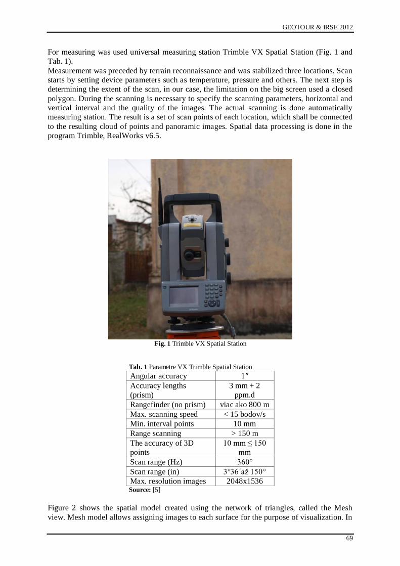
GEOTOUR & IRSE 2012
69
For measuring was used universal measuring station Trimble VX Spatial Station (Fig. 1 and
Tab. 1).
Measurement was preceded by terrain reconnaissance and was stabilized three locations. Scan
starts by setting device parameters such as temperature, pressure and others. The next step is
determining the extent of the scan, in our case, the limitation on the big screen used a closed
polygon. During the scanning is necessary to specify the scanning parameters, horizontal and
vertical interval and the quality of the images. The actual scanning is done automatically
measuring station. The result is a set of scan points of each location, which shall be connected
to the resulting cloud of points and panoramic images. Spatial data processing is done in the
program Trimble, RealWorks v6.5.
Fig. 1 Trimble VX Spatial Station
Tab. 1 Parametre VX Trimble Spatial Station
Angular accuracy 1″
Accuracy lengths
(prism)
3 mm + 2
ppm.d
Rangefinder (no prism) viac ako 800 m
Max. scanning speed < 15 bodov/s
Min. interval points 10 mm
Range scanning > 150 m
The accuracy of 3D
points
10 mm ≤ 150
mm
Scan range (Hz) 360°
Scan range (in) 3°36´aņ 150°
Max. resolution images 2048x1536 Source: [5]
Figure 2 shows the spatial model created using the network of triangles, called the Mesh
view. Mesh model allows assigning images to each surface for the purpose of visualization. In

Salgótarján, 04. – 06. October 2012
70
Figure 3 is spatial model with an associated photo textures. Because visualized object is
inside the small dimensions, the display was used as door frames.
Fig. 2Cloud of points and mesh model
Fig. 3 Model with photo texture
CREATION OF SPATIAL MODELS USING DIGITAL PHOTOGRAMMETRY
In this creation model is used intersection photogrammetry. The principle of this method is
based on the forward intersection using the known ground baselines, using images that are
convergent. It is a contactless measurement method. The processing shall be made in using
special software. Before capturing the object was made terrain reconnaissances, which
allowed exclusion and reduce the negative impact of objects on the capturing schedule and
allow planning camera survey station.
Using this method were created spatial models Delius Pavilion at the Technical University in
Końice (Fig. 4) and VIII. At Calvary Chapel in Końice.
USING IN GEOTOURISM
Spatial models in addition to its basic function object visualize play currently a very important
role in modelling phenomena in the landscape. The application of models is very varied and
widespread. First of all, it's visualization of objects, whether alone or in connection with the
environment (landscape, city), with application to the simulation of the appearance of the city,
in the reconstruction of buildings eventually new construction. They are used in the impact
assessment of new construction on the surrounding buildings and landscape. With the
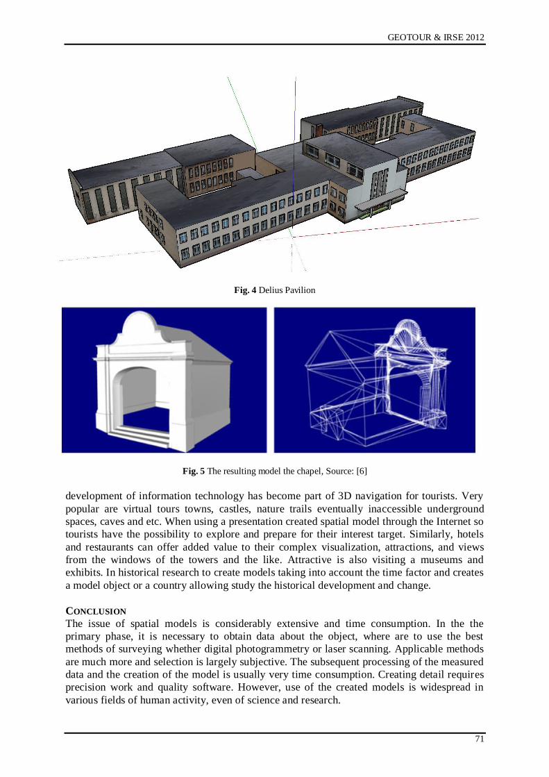
GEOTOUR & IRSE 2012
71
Fig. 4 Delius Pavilion
Fig. 5 The resulting model the chapel, Source: [6]
development of information technology has become part of 3D navigation for tourists. Very
popular are virtual tours towns, castles, nature trails eventually inaccessible underground
spaces, caves and etc. When using a presentation created spatial model through the Internet so
tourists have the possibility to explore and prepare for their interest target. Similarly, hotels
and restaurants can offer added value to their complex visualization, attractions, and views
from the windows of the towers and the like. Attractive is also visiting a museums and
exhibits. In historical research to create models taking into account the time factor and creates
a model object or a country allowing study the historical development and change.
CONCLUSION
The issue of spatial models is considerably extensive and time consumption. In the the
primary phase, it is necessary to obtain data about the object, where are to use the best
methods of surveying whether digital photogrammetry or laser scanning. Applicable methods
are much more and selection is largely subjective. The subsequent processing of the measured
data and the creation of the model is usually very time consumption. Creating detail requires
precision work and quality software. However, use of the created models is widespread in
various fields of human activity, even of science and research.
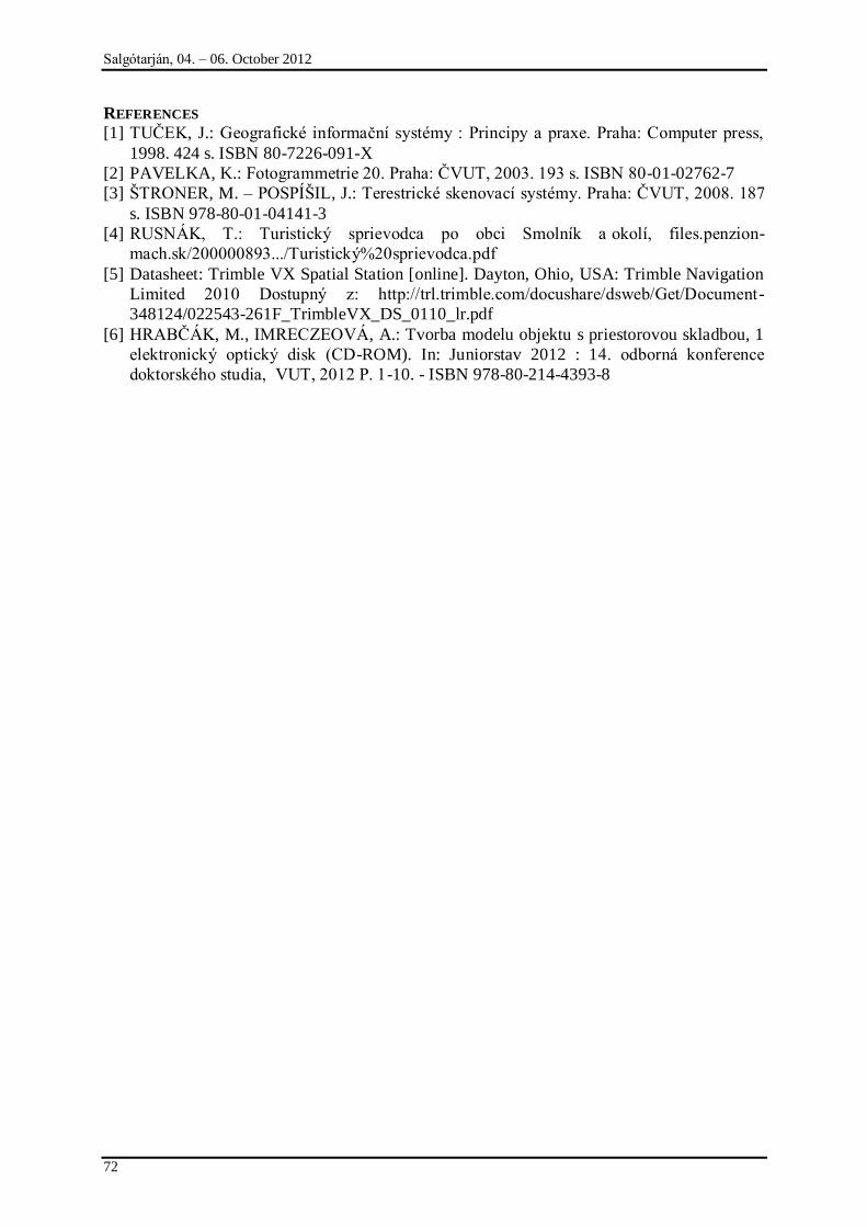
Salgótarján, 04. – 06. October 2012
72
REFERENCES
[1] TUČEK, J.: Geografické informační systémy : Principy a praxe. Praha: Computer press,
1998. 424 s. ISBN 80-7226-091-X
[2] PAVELKA, K.: Fotogrammetrie 20. Praha: ČVUT, 2003. 193 s. ISBN 80-01-02762-7
[3] ŃTRONER, M. – POSPÍŃIL, J.: Terestrické skenovací systémy. Praha: ČVUT, 2008. 187
s. ISBN 978-80-01-04141-3
[4] RUSNÁK, T.: Turistický sprievodca po obci Smolník a okolí, files.penzion-
mach.sk/200000893.../Turistický%20sprievodca.pdf
[5] Datasheet: Trimble VX Spatial Station [online]. Dayton, Ohio, USA: Trimble Navigation
Limited 2010 Dostupný z: http://trl.trimble.com/docushare/dsweb/Get/Document-
348124/022543-261F_TrimbleVX_DS_0110_lr.pdf
[6] HRABČÁK, M., IMRECZEOVÁ, A.: Tvorba modelu objektu s priestorovou skladbou, 1
elektronický optický disk (CD-ROM). In: Juniorstav 2012 : 14. odborná konference
doktorského studia, VUT, 2012 P. 1-10. - ISBN 978-80-214-4393-8
KEY WORDS: HISTORICAL MONUNTS, 3D MODEL, PHOTOGRAMMETRY, LASER
SCANNING
GEOTOUR & IRSE 2012
73
HYDROGEOLOGICAL FIELD TRIP ON THE OPEN KARST OF BÜKK MOUNTAINS
AND ON THE THERMALKARST OF BÜKK REGION (NORTH HUNGARY)
László Lénárt
University of Miskolc
e-mail: [email protected]
SUMMARY
Based on the EU Water Framework Directive, out of the 185 subsurface water bodies in Hungary, 14 are located under uncovered karst, and 15 are located under covered karst. The total areas are 9.200 and 22.300 km2 respectively, which accounts for 34 % of the area of the entire country. There are two
open karst areas in the Bükk Mountains and there are two thermal karst water bodies in relation with the Bükk Mountains. The Bükk HU_kt.2.1 thermal karst water body is the second largest in Hungary with its 4.300 km2 area. Cold and tepid water karst springs can be found in the Bükk and at its brim. Tepid and warm karst water springs are located at its surroundings; and there are wells yielding warm and hot water. There are over 1000 shaft caves, sinkholes, spring caves and caves with entrances at both ends in the Bükk Mountains. Many dolines can be found in the Bükk as well; in certain areas their number is high. Also, there are a number of canyons in the Bükk Mountains. Flowing water bodies on the surface are
most typical at the rim of the mountains. These creeks have smaller and larger waterfalls. There aren‟t many lakes in the area. The most significant hydrogeological structures are the springs, sinkholes, dolines, caves and waterfalls in the Bükk Mountains. In the surrounding area the most important are the rivers, lakes, wells, including the thermal karst water yielded by the wells, and the deposits created by it. Some of these still exist, but some have disappeared due to human activity or natural forces. The thermal karst water is mainly mineral or medicinal water, its usage is recreational. There is
evidence that thermal karst water had been used for bathing even before the times of the Turkish
occupation.
INTRODUCTION
There are thousands of hydrogeological objects in the Bükk thermal karst and Bükk
mountains, proving very interesting for both professionals and laymen alike.
It is not possible to give a detailed introduction of all of them in present paper due to scope
limitations, but we will provide a comprehensive overview and a few examples.
Unfortunately, due to the same reason, we can't attach maps showing the exact location of the
karst hydrogeological objects discussed but we are including a few photographs of them. In
our opinion, a detailed discussion should be done as an individual publication, as we've done
so in the past. (Since the number of curiosities have increased and the ways of publication are
much smoother today, it is even more reasonable to create a detailed publication of our
material.)
Most of the hydrogeological objects in the Bükk and its area are strongly related to karst
water, so we will mainly discuss karst hydrogeological natural values.
Let‟s follow the path of water and list those natural value groups and their members that are
worthy of our attention. (Please note that to physically approach these objects can be at times
difficult. There are some which can be viewed from a car, but in some cases a long hike is
needed, or we would have to go underground into a cave. Most of these spectacularities are
free to view but in some instances it must be paid for.) In many cases, for example regarding
wells or springs, it is not the water itself that we will see but the natural formations the water
created, or the structures made by humans near or on top of the upwelling water.
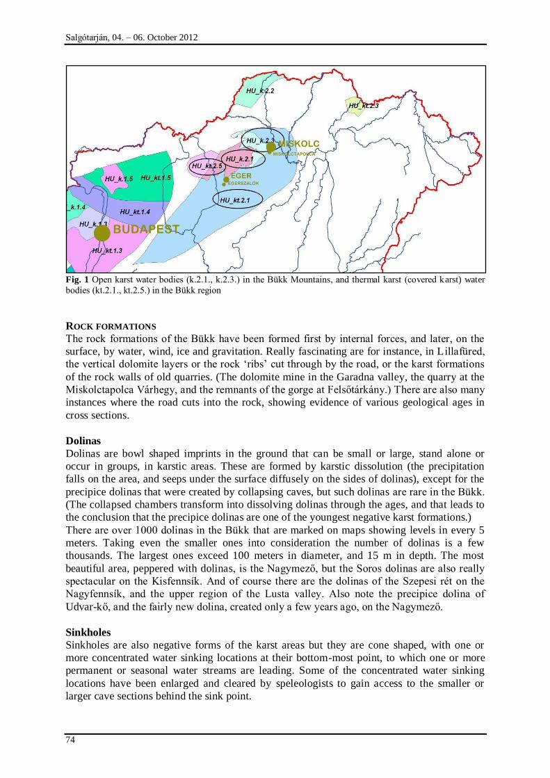
Salgótarján, 04. – 06. October 2012
74
Fig. 1 Open karst water bodies (k.2.1., k.2.3.) in the Bükk Mountains, and thermal karst (covered karst) water
bodies (kt.2.1., kt.2.5.) in the Bükk region
ROCK FORMATIONS
The rock formations of the Bükk have been formed first by internal forces, and later, on the
surface, by water, wind, ice and gravitation. Really fascinating are for instance, in L illafüred,
the vertical dolomite layers or the rock „ribs‟ cut through by the road, or the karst formations
of the rock walls of old quarries. (The dolomite mine in the Garadna valley, the quarry at the
Miskolctapolca Várhegy, and the remnants of the gorge at Felsőtárkány.) There are also many
instances where the road cuts into the rock, showing evidence of various geological ages in
cross sections.
Dolinas
Dolinas are bowl shaped imprints in the ground that can be small or large, stand alone or
occur in groups, in karstic areas. These are formed by karstic dissolution (the precipitation
falls on the area, and seeps under the surface diffusely on the sides of dolinas), except for the
precipice dolinas that were created by collapsing caves, but such dolinas are rare in the Bükk.
(The collapsed chambers transform into dissolving dolinas through the ages, and that leads to
the conclusion that the precipice dolinas are one of the youngest negative karst formations.)
There are over 1000 dolinas in the Bükk that are marked on maps showing levels in every 5
meters. Taking even the smaller ones into consideration the number of dolinas is a few
thousands. The largest ones exceed 100 meters in diameter, and 15 m in depth. The most
beautiful area, peppered with dolinas, is the Nagymező, but the Soros dolinas are also really
spectacular on the Kisfennsík. And of course there are the dolinas of the Szepesi rét on the
Nagyfennsík, and the upper region of the Lusta valley. Also note the precipice dolina of
Udvar-kő, and the fairly new dolina, created only a few years ago, on the Nagymező.
Sinkholes
Sinkholes are also negative forms of the karst areas but they are cone shaped, with one or
more concentrated water sinking locations at their bottom-most point, to which one or more
permanent or seasonal water streams are leading. Some of the concentrated water sinking
locations have been enlarged and cleared by speleologists to gain access to the smaller or
larger cave sections behind the sink point.
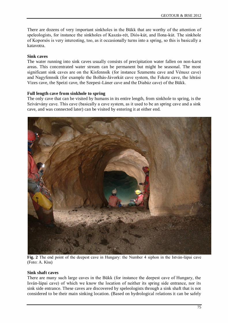
GEOTOUR & IRSE 2012
75
There are dozens of very important sinkholes in the Bükk that are worthy of the attention of
speleologists, for instance the sinkholes of Kaszás-rét, Diós-kút, and Ilona-kút. The sinkhole
of Koporsós is very interesting, too, as it occasionally turns into a spring, so this is basically a
katavotra.
Sink caves The water running into sink caves usually consists of precipitation water fallen on non-karst
areas. This concentrated water stream can be permanent but might be seasonal. The most
significant sink caves are on the Kisfennsík (for instance Szamentu cave and Vénusz cave)
and Nagyfennsík (for example the Bolhás-Jávorkút cave system, the Fekete cave, the létrási
Vizes cave, the Speizi cave, the Szepesi-Láner cave and the Diabáz cave) of the Bükk.
Full length cave from sinkhole to spring The only cave that can be visited by humans in its entire length, from sinkhole to spring, is the
Szivárvány cave. This cave (basically a cave system, as it used to be an spring cave and a sink
cave, and was connected later) can be visited by entering it at either end.
Fig. 2 The end point of the deepest cave in Hungary: the Number 4 siphon in the István-lápai cave
(Foto: A. Kiss)
Sink shaft caves
There are many such large caves in the Bükk (for instance the deepest cave of Hungary, the
Isván-lápai cave) of which we know the location of neither its spring side entrance, nor its
sink side entrance. These caves are discovered by speleologists through a sink shaft that is not
considered to be their main sinking location. (Based on hydrological relations it can be safely

Salgótarján, 04. – 06. October 2012
76
assumed that the sink side of István lápai cave might be discovered from the Szepesi-Láner
cave system, and the spring side from the Szent István cave, as soon as speleologists find
these connecting passages.)
Shaft caves
There aren‟t many shaft caves (vertical, mostly open) in the Bükk. Of the few, the Kis-kőháti
shaft cave must be mentioned where we can reach a huge spectacular chamber through the
entrance shaft. The Szeleta shaft cave, Bányász cave and Hársas shaft cave belong to the same
category as well.
Cave ruins (rock arches and natural bridges)
The various size and length cave ruins are wonderfully spectacular sights. They can be formed
by external forces (water, wind, gravitation) in many different positions. The stone rib of
Ablakos-kő („Window Rock‟) has basically got a hole in its middle, thus making a formation
after which it has got its name. The „natural‟ entrance of the above mentioned Udvar-kő
precipice dolina is the rock bridge called Sziklakapus sinkhole. The Háromkúti-nagy-
sziklakapu (rock arch) is a rock formation, but the Büdöspest and the Suba-lyuk are cave
passage sections, opened at both ends.
Spring caves
Water exits from a number of caves even today, and based on morphological and
hydrogeological characteristics of the caves, it can be safely assumed that water used to exit
from them at one time. The first group includes the Kecske-lyuk, the Szent István cave, and
the Imó spring cave. The latter groups includes the Szeleta cave, Istállós-kői cave, Hillebrand
Jenő cave, Balla cave, etc. (These last ones are also significant from the Bükk‟s
archaeological point of view, with regards to palaeolithic age humans.) The Szent István cave
is a tourist cave as well as a medicinal cave. The Miskolctapolca Tavas cave encompasses the
cave spa and bath.
Sinter caves
So far we‟ve been discussing postgenetic caves, i. e. when first the rock that later
encompassed the cave had been formed, and later the cave came into existence. In case of
sinter caves, the formation of the rock encompassing the cave and the formation of the cave
itself happens basically at the same time. For this reason the caves formed in sinter are called
syngenetic caves. The more significant sinter caves of the Bükk were formed in the sinter
deposit of the Szinva valley, and these are the Anna sinter cave, the Soltész-kerti cave and the
Soltész shaft, which were discovered and explored by mining methods. (A section of Anna
sinter cave operates as tourist cave.) There used to be sinter mining close to Mónosbél at one
time. This probably have destroyed many sinter caves.
Not enclosed cold water springs There are over 1000 springs located in the Bükk mountains with various yields, exiting
various types of rocks at different levels above sea level. The not enclosed springs (i. e. the
water leaves the spring in a natural way, no human made structures built onto the spring) are
usually small and seasonal, but a number of them can be considered permanent. The
Eszperantó spring exits dolomite, the Disznós creek and Létrási creek exits shale, the
Soltészkerti spring exits sinter, and the Imó spring exits limestone.
Enclosed cold water springs for tourists
A significant number of larger springs are for tourist use (for instance the Mária spring,
Bársonyos spring, Wekerle spring, Tamás well, Vörös-kői seasonal spring, Sólyom well,
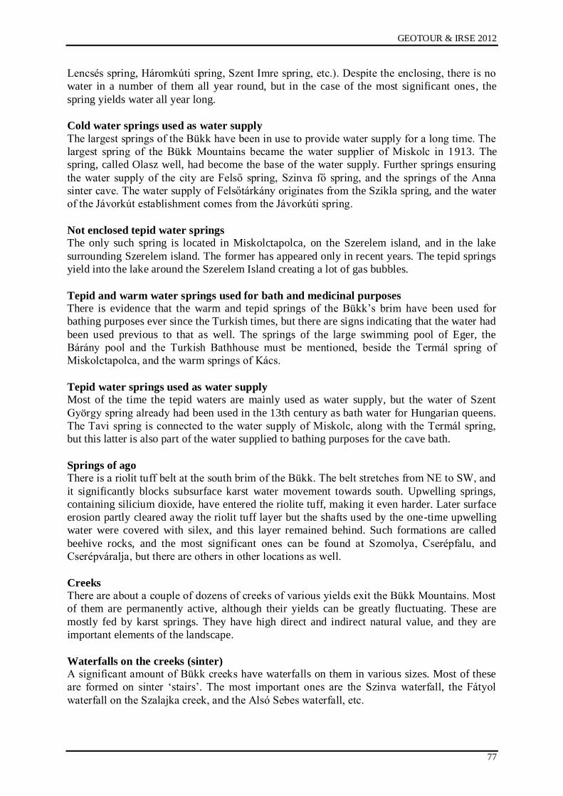
GEOTOUR & IRSE 2012
77
Lencsés spring, Háromkúti spring, Szent Imre spring, etc.). Despite the enclosing, there is no
water in a number of them all year round, but in the case of the most significant ones, the
spring yields water all year long.
Cold water springs used as water supply
The largest springs of the Bükk have been in use to provide water supply for a long time. The
largest spring of the Bükk Mountains became the water supplier of Miskolc in 1913. The
spring, called Olasz well, had become the base of the water supply. Further springs ensuring
the water supply of the city are Felső spring, Szinva fő spring, and the springs of the Anna
sinter cave. The water supply of Felsőtárkány originates from the Szikla spring, and the water
of the Jávorkút establishment comes from the Jávorkúti spring.
Not enclosed tepid water springs The only such spring is located in Miskolctapolca, on the Szerelem island, and in the lake
surrounding Szerelem island. The former has appeared only in recent years. The tepid springs
yield into the lake around the Szerelem Island creating a lot of gas bubbles.
Tepid and warm water springs used for bath and medicinal purposes There is evidence that the warm and tepid springs of the Bükk‟s brim have been used for
bathing purposes ever since the Turkish times, but there are signs indicating that the water had
been used previous to that as well. The springs of the large swimming pool of Eger, the
Bárány pool and the Turkish Bathhouse must be mentioned, beside the Termál spring of
Miskolctapolca, and the warm springs of Kács.
Tepid water springs used as water supply Most of the time the tepid waters are mainly used as water supply, but the water of Szent
György spring already had been used in the 13th century as bath water for Hungarian queens.
The Tavi spring is connected to the water supply of Miskolc, along with the Termál spring,
but this latter is also part of the water supplied to bathing purposes for the cave bath.
Springs of ago
There is a riolit tuff belt at the south brim of the Bükk. The belt stretches from NE to SW, and
it significantly blocks subsurface karst water movement towards south. Upwelling springs,
containing silicium dioxide, have entered the riolite tuff, making it even harder. Later surface
erosion partly cleared away the riolit tuff layer but the shafts used by the one-time upwelling
water were covered with silex, and this layer remained behind. Such formations are called
beehive rocks, and the most significant ones can be found at Szomolya, Cserépfalu, and
Cserépváralja, but there are others in other locations as well.
Creeks
There are about a couple of dozens of creeks of various yields exit the Bükk Mountains. Most
of them are permanently active, although their yields can be greatly fluctuating. These are
mostly fed by karst springs. They have high direct and indirect natural value, and they are
important elements of the landscape.
Waterfalls on the creeks (sinter) A significant amount of Bükk creeks have waterfalls on them in various sizes. Most of these
are formed on sinter „stairs‟. The most important ones are the Szinva waterfall, the Fátyol
waterfall on the Szalajka creek, and the Alsó Sebes waterfall, etc.
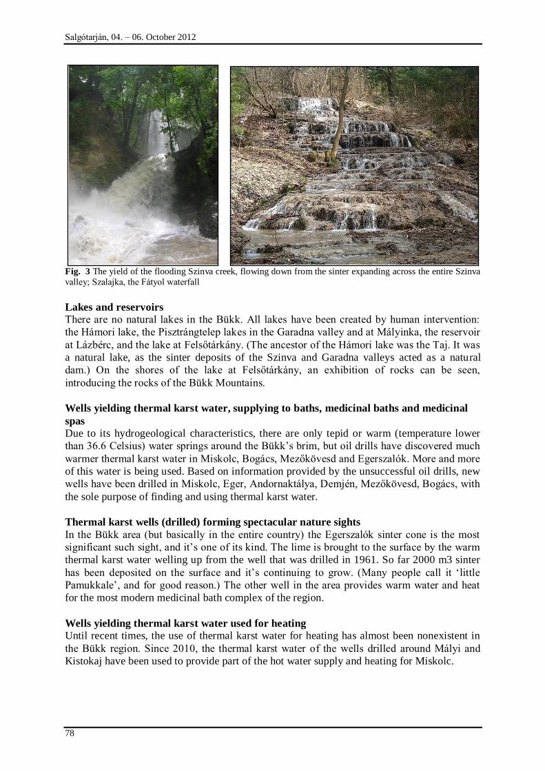
Salgótarján, 04. – 06. October 2012
78
Fig. 3 The yield of the flooding Szinva creek, flowing down from the sinter expanding across the entire Szinva
valley; Szalajka, the Fátyol waterfall
Lakes and reservoirs There are no natural lakes in the Bükk. All lakes have been created by human intervention:
the Hámori lake, the Pisztrángtelep lakes in the Garadna valley and at Mályinka, the reservoir
at Lázbérc, and the lake at Felsőtárkány. (The ancestor of the Hámori lake was the Taj. It was
a natural lake, as the sinter deposits of the Szinva and Garadna valleys acted as a natural
dam.) On the shores of the lake at Felsőtárkány, an exhibition of rocks can be seen,
introducing the rocks of the Bükk Mountains.
Wells yielding thermal karst water, supplying to baths, medicinal baths and medicinal
spas Due to its hydrogeological characteristics, there are only tepid or warm (temperature lower
than 36.6 Celsius) water springs around the Bükk‟s brim, but oil drills have discovered much
warmer thermal karst water in Miskolc, Bogács, Mezőkövesd and Egerszalók. More and more
of this water is being used. Based on information provided by the unsuccessful oil drills, new
wells have been drilled in Miskolc, Eger, Andornaktálya, Demjén, Mezőkövesd, Bogács, with
the sole purpose of finding and using thermal karst water.
Thermal karst wells (drilled) forming spectacular nature sights
In the Bükk area (but basically in the entire country) the Egerszalók sinter cone is the most
significant such sight, and it‟s one of its kind. The lime is brought to the surface by the warm
thermal karst water welling up from the well that was drilled in 1961. So far 2000 m3 sinter
has been deposited on the surface and it‟s continuing to grow. (Many people call it „little
Pamukkale‟, and for good reason.) The other well in the area provides warm water and heat
for the most modern medicinal bath complex of the region.
Wells yielding thermal karst water used for heating Until recent times, the use of thermal karst water for heating has almost been nonexistent in
the Bükk region. Since 2010, the thermal karst water of the wells drilled around Mályi and
Kistokaj have been used to provide part of the hot water supply and heating for Miskolc.
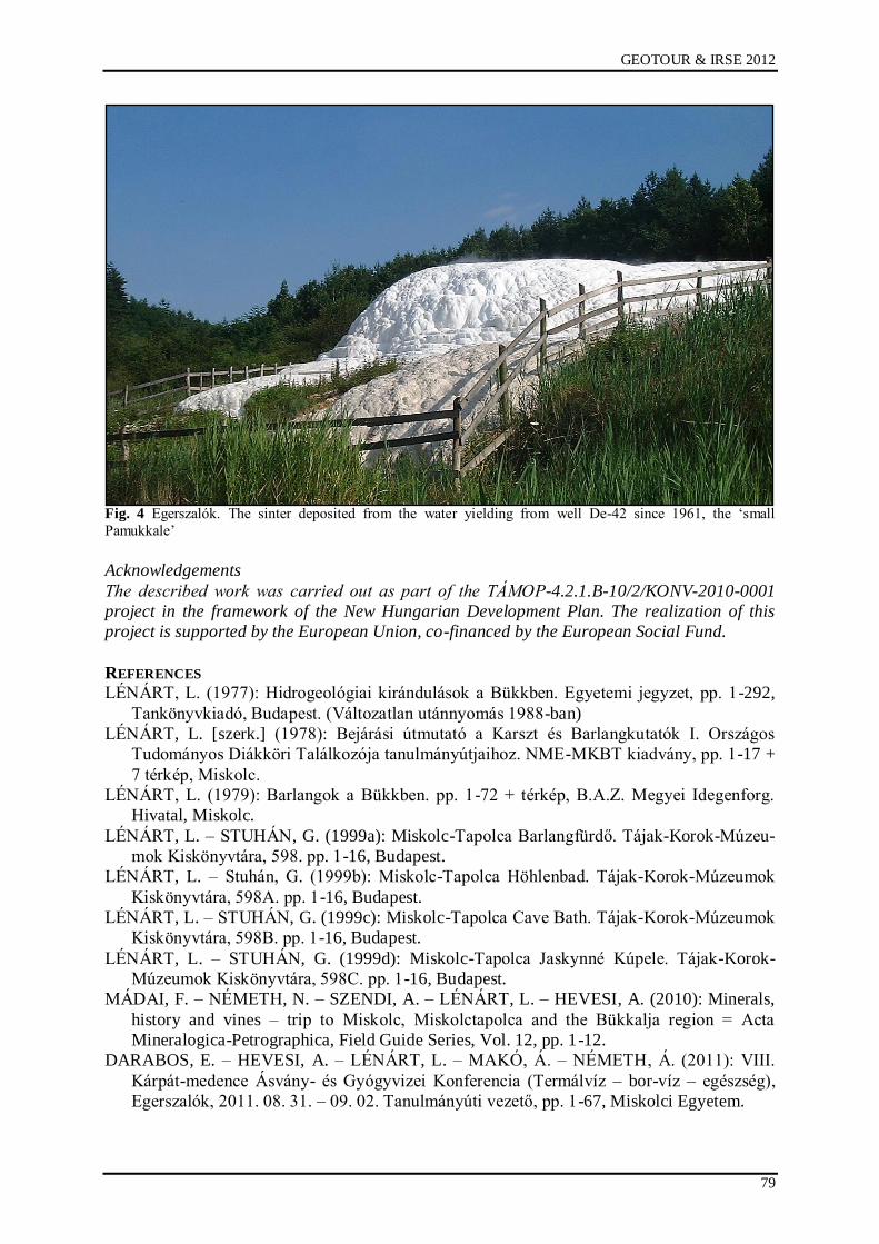
GEOTOUR & IRSE 2012
79
Fig. 4 Egerszalók. The sinter deposited from the water yielding from well De-42 since 1961, the „small
Pamukkale‟
Acknowledgements
The described work was carried out as part of the TÁMOP-4.2.1.B-10/2/KONV-2010-0001
project in the framework of the New Hungarian Development Plan. The realization of this
project is supported by the European Union, co-financed by the European Social Fund.
REFERENCES
LÉNÁRT, L. (1977): Hidrogeológiai kirándulások a Bükkben. Egyetemi jegyzet, pp. 1-292,
Tankönyvkiadó, Budapest. (Változatlan utánnyomás 1988-ban)
LÉNÁRT, L. [szerk.] (1978): Bejárási útmutató a Karszt és Barlangkutatók I. Országos
Tudományos Diákköri Találkozója tanulmányútjaihoz. NME-MKBT kiadvány, pp. 1-17 +
7 térkép, Miskolc.
LÉNÁRT, L. (1979): Barlangok a Bükkben. pp. 1-72 + térkép, B.A.Z. Megyei Idegenforg.
Hivatal, Miskolc.
LÉNÁRT, L. – STUHÁN, G. (1999a): Miskolc-Tapolca Barlangfürdő. Tájak-Korok-Múzeu-
mok Kiskönyvtára, 598. pp. 1-16, Budapest.
LÉNÁRT, L. – Stuhán, G. (1999b): Miskolc-Tapolca Höhlenbad. Tájak-Korok-Múzeumok
Kiskönyvtára, 598A. pp. 1-16, Budapest.
LÉNÁRT, L. – STUHÁN, G. (1999c): Miskolc-Tapolca Cave Bath. Tájak-Korok-Múzeumok
Kiskönyvtára, 598B. pp. 1-16, Budapest.
LÉNÁRT, L. – STUHÁN, G. (1999d): Miskolc-Tapolca Jaskynné Kúpele. Tájak-Korok-
Múzeumok Kiskönyvtára, 598C. pp. 1-16, Budapest.
MÁDAI, F. – NÉMETH, N. – SZENDI, A. – LÉNÁRT, L. – HEVESI, A. (2010): Minerals,
history and vines – trip to Miskolc, Miskolctapolca and the Bükkalja region = Acta
Mineralogica-Petrographica, Field Guide Series, Vol. 12, pp. 1-12.
DARABOS, E. – HEVESI, A. – LÉNÁRT, L. – MAKÓ, Á. – NÉMETH, Á. (2011): VIII.
Kárpát-medence Ásvány- és Gyógyvizei Konferencia (Termálvíz – bor-víz – egészség),
Egerszalók, 2011. 08. 31. – 09. 02. Tanulmányúti vezető, pp. 1-67, Miskolci Egyetem.
Salgótarján, 04. – 06. October 2012
80
THE ANALYSIS OF THE GEOTOURISTIC POTENTIAL BY THE HELP OF A COMPLEX
INDEX IN ONE SAMPLE AREA (AGGTELEK-RUDABÁNYA MOUNTAINS)
Beáta Szilasi Siskáné, Zsuzsa Piskóti-Kovács, Lajos Szalontai, János Vágó
University of Miskolc, Institute of Geography
ABSTRACT
In Hungary, similar to the other central-european countries, the closure of the uneconomical mines has increased after the year of 1990. Several (unfavourable) consequences have appeared at the level of society and environment as well. This study focuses on analysing the utilization opportunities of the mining areas and the traditions relating to the mining for the purpose of tourism. The authors demonstrate the quantifiable survey of the possibilities of the future in a Hungarian sample area. The authors would introduce the touristic possibilities of the utilization of the geo-and cultural heritage in
the Aggtelek-Rudabánya Mountains.
INTRODUCTION
In Hungary, similar to the other central-european countries, the closure of the uneconomical
mines has increased after the year of 1990. Several (unfavourable) consequences have
appeared at the level of society and environment as well. The most remarkable changes were
shown in the case of cessation of workplaces and besides that, the role of these townships
have altered in the hierarchy of settlements. In the aspect of environment, emphasis was put
mostly on the managing of the refuses and the recultivation of the surface gashes. Many
factors have been significantly altered by today, for example the role of the mining in the
economy.
In the year of 2008 the mining industry gave only the 0,2 % of the Gross Domestic Product,:
it producted 54 billion hungarian forints gross added value; but the turistic sector gave 2,6%.
Mining can not be considered export-oriented, because 90 % of the sales happens inland. The
proportion of employeed in the mining industry were under 0,5 % in the 2000‟s, their number
was nine thousands in the year of 2008 according to the data of the Hungarian Central
Statictical Office.
The utilization of the ex-mining areas and the analysis of their opportunities are getting into
focus nowadays again. One of these ways is the re-estimating of these areas to decide whether
they are appropiate to produce secondary raw materials. The production can be restarted by
the help of foreign capital or the participation of inland consortiums (for example in the case
of uranium core in the Mecsek mountain or terra ponderosa in Rudabánya). The other way is
connected to the renewable resources: experts are analysing the utiliziation possibilities of the
“mining-heat”, which can be extracted from the underground minings. By the brownfield
investments there are opportunities to recycle the abandoned mining areas, mechanic factories
and factory floors can be developed easily.
This study focuses on analysing the utilization opportunites of the mining areas and the
traditions relating to the mining for the purpose of tourism and relationship to its
neighbourhood.
Tourism planning provides a primary mechanism through government policies for tourism
may be implemented (Hall, 2000) and, in its different forms, can be a mechanism for
delivering a range of more specific outcomes. These will include:
The integration of tourism alongside other economic sectors;
The direction and control of physical patterns of development;
The conservation of scarce or important resources;
The active promotion and marketing of destinations;

GEOTOUR & IRSE 2012
81
The creation of harmonious social and cultural relations between tourists and local
people (S. Williams, 2009).
The tourism planning has the potential to minimise the negative effects, maximise
economic returns to the destination and build positive attitudes towards tourism in the host
community (S. Williams, 2009.).
THE CHARACTERISTICHS OF THE SAMPLE AREA
The Aggtelek-Rudabánya Mountains can be found in Northeast part of Hungary. The
Aggtelek-Rudabánya Mountains is the southernmost element of the Inner Western
Carpathians (Gy. Less, 2000.). This area has two parts, on the North the Aggtelek Karst, all
the caves of the Aggtelek and Slovak Karst were entitled to World Heritage Sites by the
UNESCO World Heritage Committee in 1995.
Fig. 1 The location of the sample area
Currently, more than 1200 caves are known in the karst
(http://anp.nemzetipark.gov.hu/geology-and-caves), among them the longest Hungarian cave,
the Baradla-Domica (25,5 km). The underground world is nearly untouched with a lot of
different rock and mineral formations (Figure 1.).
Salgótarján, 04. – 06. October 2012
82
The Southern part is the Rudabánya Hill. Rudabánya is one of the oldest miner settlements in
the country. Geological research has proved that around 35 million tons of ore is still hidden
in the ground. During the research activities not only ores were found here but also the 10-
million-year-old skull of an ancient ape, representing the last stage before the development of
apes and humans separated. The finding is known in the world as Rudapithecus Hungaricus
(http://www.rudabanya.hu/en/index.html). One of the most popular tourist destinations is the
mine lake of Rudabánya (Figure 1.).
THE GOAL AND THE METHOD OF THE STUDY
The primary aim of the research is to help by the accurate and numerical assessing of the
possibilities and to mark the important objectives, which could be applied in the future. This
is necessary because when the empirical research was performed it was experienced that the
Mayors and the notaries consider the tourism as the only survival chance for the settlements.
They think it it easier to establish and develop the tourism than an industrial investment and
they judge it could be a workplace-generating process as well. This is the reason, why we
wanted to collect and demonstrate numerical data, which could be show that how many and
what kind of investments are neccessary to perform the plans and whether there is a realistic
chance to carry out them at all.
Also it is very important to cooperate with the local decision-makers to implement such useful
projects, which could be submitted for the appropriate tender resources. The authors have
applied several methods through the investigation, among them the complex application of
the emphirical research was found to be the most effective. In consequence, questionnaire
surveys and interviews were carried out in Hungary and in Austria as well, and statistical data
were processed.
Among the literature relating to the closure of mines we can find the “Closure Risk
Classification Model”, which is created by the experts of the University of New South Wales.
It is a complex index, which contains several basic data:
CRF = Σ (RE + RSH + RC + RLU + RLF + RT),
where the CRF is the closure risk factor, the RE is the environmental risk, the RSH is the
safety and health risk, the RC is the community risk, the RLU is the final land use risk, the
RLF is the legal and financial risk, while the RT is the technical risk (Laurence, D. C. 2001).
An advanced version of the above mentioned model is a complex indicator, which could be
appropriate for modeling the characteristics and the facilities of the ex-mining areas. The
data-rows of the index are complex thereby they can help by deciding, which factors should
be taken into consideration and take advantage in the aspect whether of workplace-creation,
or in the touristic utilization.
The first and second steps in the construction of composite indicators are the following:
• Theoretical framework: A theoretical framework should be developed to provide the
basis for the selection and combination of single indicators into a meaningful
composite indicator under a fitness-for-purpose principle.
• Data selection: Indicators should be selected on the basis of their analytical
soundness, measurability, country coverage, relevance to the phenomenon being
measured and relationship to each other. The use of proxy variables should be
considered when data are scarce (OECD Handbook, 2008.).
GEOTOUR & IRSE 2012
83
The factor of the economical and social underprivileged areas (ESUA) was created by
summarizing different indexes ordered into five main groups (Siskáné Szilasi, B. 2010).
These are the followings:
1. Natural factors (NF)
- Agricultural areas (AA)
- Forests (F)
- Meadows and other natural habitats (MONH)
- Areas interfered with mining (AIM)
- Protected area (PA)
Because of the mining, the change of landuse is remarkable, and unfortunately there are many
unsolved problems: one of them is the vegetation-recovering in the cultivation areas and on
the surface of the spoils. The index would can be visualized on map aright thereby it is getting
to be easily interpreted (Figure 2.).
Fig. 2 The land use of the sample area.
2. Social factor (characteristics) (SF)
- Number of population (NP)
- The distribution of the popultion by age and gender (DPAG)
- The educational level of the population (EP)
- The economic activity of the population, rate of unemployment (EAP-U)
- The employment structure of the population (ESP)
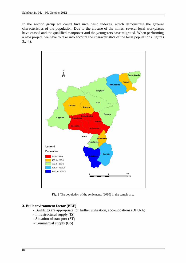
Salgótarján, 04. – 06. October 2012
84
In the second group we could find such basic indexes, which demonstrate the general
characteristics of the population. Due to the closure of the mines, several local workplaces
have ceased and the qualified manpower and the youngsters have migrated. When performing
a new project, we have to take into account the characteristics of the local population (Figures
3., 4.).
Fig. 3 The population of the settlements (2010) in the sample area
3. Built environment factor (BEF)
- Buildings are appropriate for further utilization, accomodations (BFU-A)
- Infrastructural supply (IS)
- Situation of transport (ST)
- Commercial supply (CS)
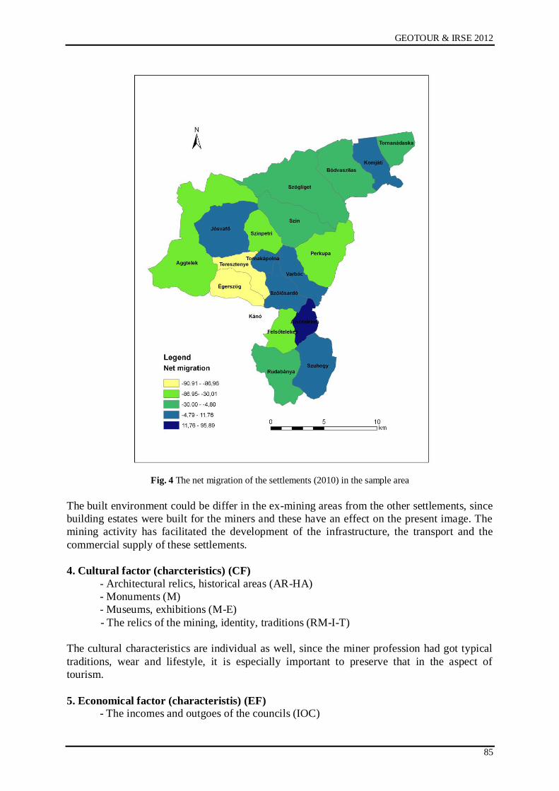
GEOTOUR & IRSE 2012
85
Fig. 4 The net migration of the settlements (2010) in the sample area
The built environment could be differ in the ex-mining areas from the other settlements, since
building estates were built for the miners and these have an effect on the present image. The
mining activity has facilitated the development of the infrastructure, the transport and the
commercial supply of these settlements.
4. Cultural factor (charcteristics) (CF)
- Architectural relics, historical areas (AR-HA)
- Monuments (M)
- Museums, exhibitions (M-E)
- The relics of the mining, identity, traditions (RM-I-T)
The cultural characteristics are individual as well, since the miner profession had got typical
traditions, wear and lifestyle, it is especially important to preserve that in the aspect of
tourism.
5. Economical factor (characteristis) (EF)
- The incomes and outgoes of the councils (IOC)
Salgótarján, 04. – 06. October 2012
86
- The economical situation of the population (ESP)
- Workplace-creating investments (WCI)
- Enterprises (E)
Of course, one of the most important index-group contains the characteristics of the
economical situation. The different size of the settlements has an effect on the data, so it is
important to create dimensions and the unified metric.
In the construction of composite indicators the normalisation is very important. Indicators
should be normalised to render them comparable. Attention need to be paid to extreme values
as they may influence subsequent steps in the process of building a composite indicator.
Skewed data should also be identified and accounted for (OECD Handbook, 2008.).
Different normalisation methods will produce different results for the composite indicator
(Ranking; Standardisation; Min-Max; Indicators above or below the mean etc.). The authors
demonstrate the theoretical background of the “ Indicators above or below the mean”
normalisation type.
This transformation considers the indicators which are above and below an arbitrarily defined
threshold, p, around the mean:
1 if w>(1+p)
Itqc= 0 if (1-p) w (1+p) where w =
0t
cqc
t
qc
x
x
-1 if w < (1-p)
The threshold p builds a neutral region around the mean, where the transformed indicator is
zero. This reduces the sharp discontinuity, from -1 to +1, which exists across the mean value
to two minor discontinuities, from -1 to 0 and from 0 to +1, across the thresholds. A larger
number of thresholds could be created at different distances from the mean value, which
might overlap with the categorical scales. An indicator that moved from significantly below
the mean to significantly above the threshold in the consecutive year would have a positive
effect on the composite (OECD Handbook, 2008.).
SUMMARY
The composite indicator should ideally measure multidimensional concepts which cannot be
captured by a single indicator, e.g. competitiveness, industrialisation, sustainability, single
market integration, knowledge-based society, etc (OECD Handbook, 2008.).
The factor of the economical and social underprivileged areas (ESUA) was created by
summarizing different indexes ordered into five main groups (Siskáné Szilasi, B. 2010).
ESUA = Σ (NF + SF + BEF + CF + EF),
where the NF is the natural factor, the SF is the social factor, the BEF is the built
environmental factor, the CF is the cultural factor, the EF is the economical factor.
In the future we plan to make an empirical study and we will continue the analyses of
statistical data. (Imputation of missing data, Multivariate analysis, Normalisation, Weighting
and aggregation, Robustness and sensitivity, Presentation and visualisation). According to our
results the examined sample area has good possibilities to develop geotourism.
{

GEOTOUR & IRSE 2012
87
Acknowledgement
„The described work was carried out as part of the TÁMOP-4.2.2/B-10/1-2010-0008 project
in the framework of the New Hungarian Development Plan. The realization of this project is
supported by the European Union, co-financed by the European Social Fund.”
REFERENCES
[1] B. SZILASI SISKÁNÉ 2010: A bányászati tevékenység megszűnésével hátrányos
gazdasági helyzetbe került területek turisztikai hasznosításának lehetőségei
magyarországi mintaterületeken. Manusscript, Miskolc, 10 p.
[2] S. WILLIAMS 2009: Tourism geography. A new synthesis. Routledge Taylor and
Francis Group, London and New York, pp.: 157-180
[3] OECD 2008: Handbook on Constructiong Composite Indicators. European Commission.
www. oecd.org, 158 p.
[4] LESS GY.-Grill J.-Róth L.-Szentpétery I.-Gyuricza Gy 1988: Geological map of the
Aggtelek-Rudabánya Mts. 1:25000. Hung. Geol. Inst. Budapest
[5] DOBOS E. 2001: A regionális elemzések módszertani kérdései. Elméleti megfontolások.
ECOSTAT A gazdaságelemzés Módszerei 2001/II. szám, Budapest, 53 p.
[6] RAPPAI G.- SZERB L. 2011: Összetett indexek készítése új módon: A szűk
keresztmetszetekért történő büntetés módszere. Műhelytanulmányok 2011/1. Pécs. 19 p.
[7] A. SOLARSKA –Z. JARY 2010: Geoheritage and Geotourism Potential of the Strzelin
Hills (Sudetic Foreland, SW Poland). Geographica Pannonica. Volume 14, Issue 4. pp.:
118-125 Internet sources:
http://anp.nemzetipark.gov.hu/geology-and-caves
http://www.rudabanya.hu/en/index.html
http://anp.nemzetipark.gov.hu/geology-and-caves
http://www.rudabanya.hu
http://www.ksh.hu

Salgótarján, 04. – 06. October 2012
88

IRSE
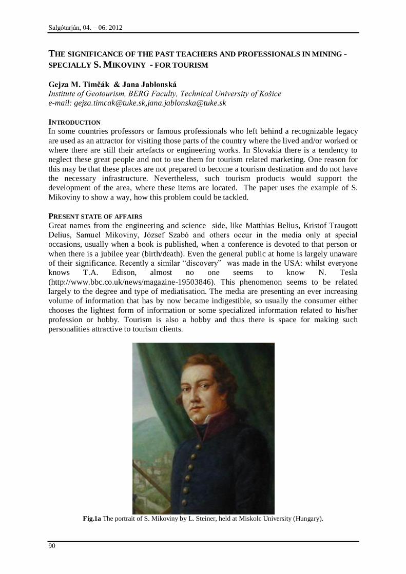
Salgótarján, 04. – 06. 2012
90
THE SIGNIFICANCE OF THE PAST TEACHERS AND PROFESSIONALS IN MINING -
SPECIALLY S. MIKOVINY - FOR TOURISM
Gejza M. Timčák & Jana Jablonská
Institute of Geotourism, BERG Faculty, Technical University of Košice
e-mail: [email protected],[email protected]
INTRODUCTION
In some countries professors or famous professionals who left behind a recognizable legacy
are used as an attractor for visiting those parts of the country where the lived and/or worked or
where there are still their artefacts or engineering works. In Slovakia there is a tendency to
neglect these great people and not to use them for tourism related marketing. One reason for
this may be that these places are not prepared to become a tourism destination and do not have
the necessary infrastructure. Nevertheless, such tourism products would support the
development of the area, where these items are located. The paper uses the example of S.
Mikoviny to show a way, how this problem could be tackled.
PRESENT STATE OF AFFAIRS
Great names from the engineering and science side, like Matthias Belius, Kristof Traugott
Delius, Samuel Mikoviny, József Szabó and others occur in the media only at special
occasions, usually when a book is published, when a conference is devoted to that person or
when there is a jubilee year (birth/death). Even the general public at home is largely unaware
of their significance. Recently a similar “discovery” was made in the USA: whilst everyone
knows T.A. Edison, almost no one seems to know N. Tesla
(http://www.bbc.co.uk/news/magazine-19503846). This phenomenon seems to be related
largely to the degree and type of mediatisation. The media are presenting an ever increasing
volume of information that has by now became indigestible, so usually the consumer either
chooses the lightest form of information or some specialized information related to his/her
profession or hobby. Tourism is also a hobby and thus there is space for making such
personalities attractive to tourism clients.
Fig.1a The portrait of S. Mikoviny by L. Steiner, held at Miskolc University (Hungary).
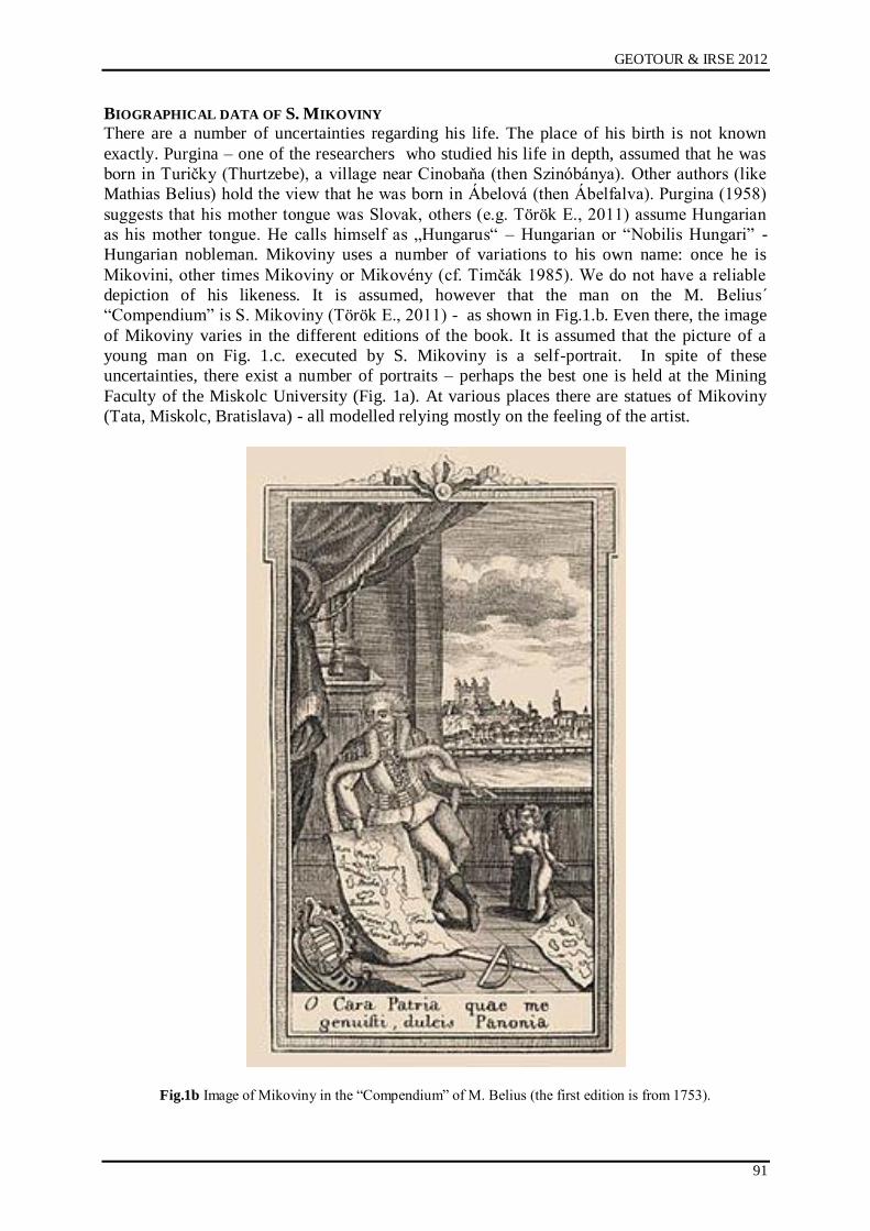
GEOTOUR & IRSE 2012
91
BIOGRAPHICAL DATA OF S. MIKOVINY
There are a number of uncertainties regarding his life. The place of his birth is not known
exactly. Purgina – one of the researchers who studied his life in depth, assumed that he was
born in Turičky (Thurtzebe), a village near Cinobaņa (then Szinóbánya). Other authors (like
Mathias Belius) hold the view that he was born in Ábelová (then Ábelfalva). Purgina (1958)
suggests that his mother tongue was Slovak, others (e.g. Török E., 2011) assume Hungarian
as his mother tongue. He calls himself as „Hungarus“ – Hungarian or “Nobilis Hungari” -
Hungarian nobleman. Mikoviny uses a number of variations to his own name: once he is
Mikovini, other times Mikoviny or Mikovény (cf. Timčák 1985). We do not have a reliable
depiction of his likeness. It is assumed, however that the man on the M. Belius´
“Compendium” is S. Mikoviny (Török E., 2011) - as shown in Fig.1.b. Even there, the image
of Mikoviny varies in the different editions of the book. It is assumed that the picture of a
young man on Fig. 1.c. executed by S. Mikoviny is a self-portrait. In spite of these
uncertainties, there exist a number of portraits – perhaps the best one is held at the Mining
Faculty of the Miskolc University (Fig. 1a). At various places there are statues of Mikoviny
(Tata, Miskolc, Bratislava) - all modelled relying mostly on the feeling of the artist.
Fig.1b Image of Mikoviny in the “Compendium” of M. Belius (the first edition is from 1753).
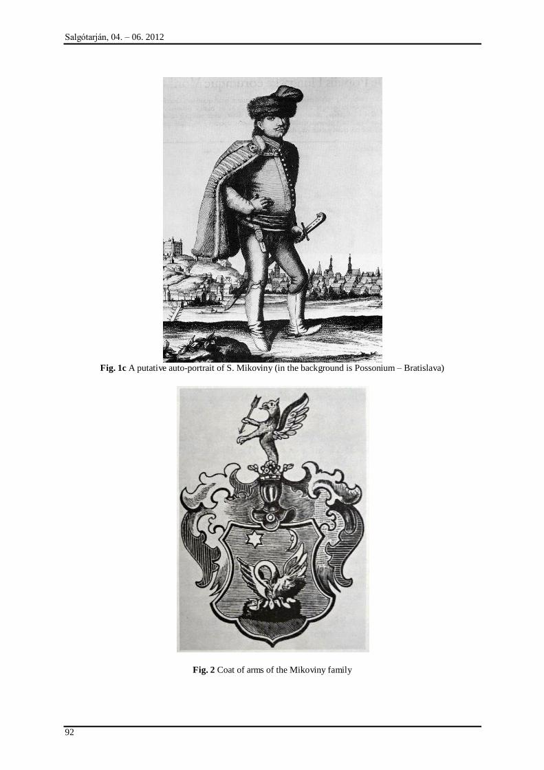
Salgótarján, 04. – 06. 2012
92
Fig. 1c A putative auto-portrait of S. Mikoviny (in the background is Possonium – Bratislava)
Fig. 2 Coat of arms of the Mikoviny family
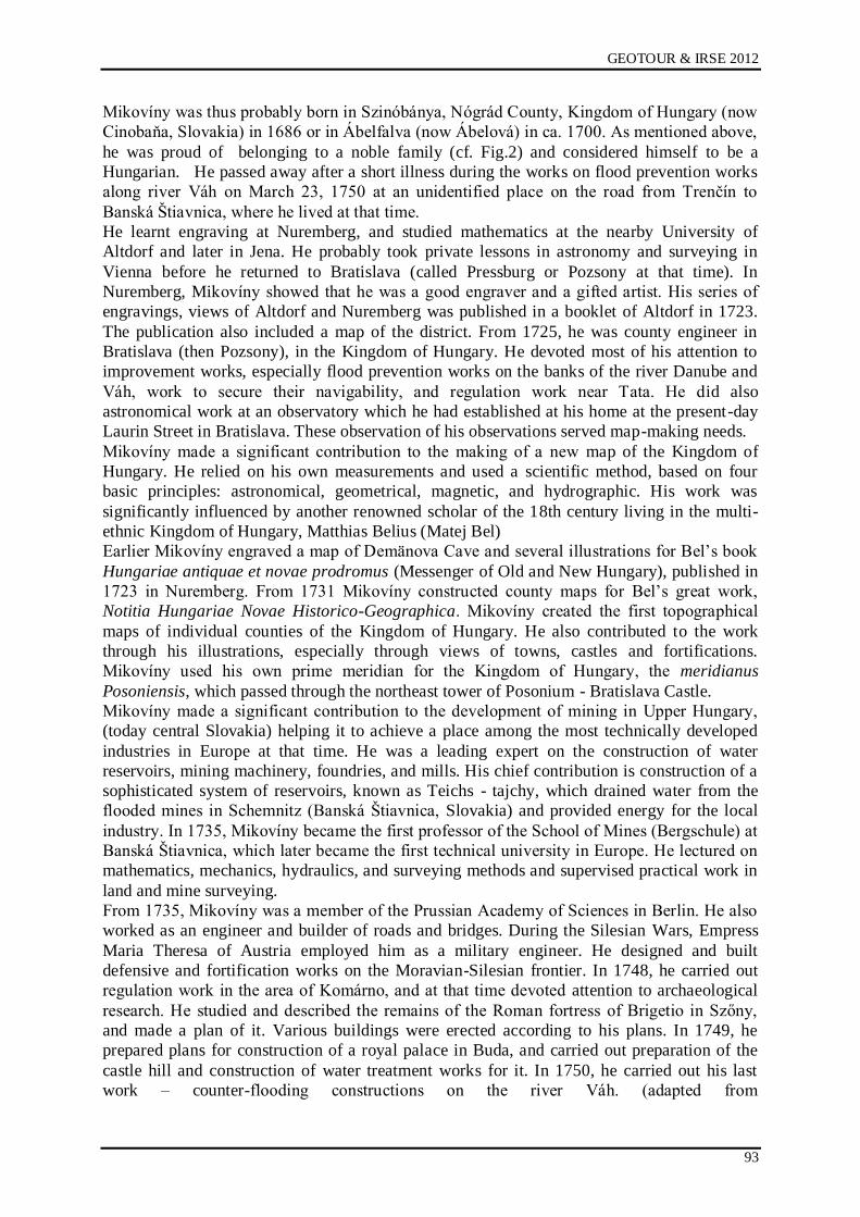
GEOTOUR & IRSE 2012
93
Mikovíny was thus probably born in Szinóbánya, Nógrád County, Kingdom of Hungary (now
Cinobaņa, Slovakia) in 1686 or in Ábelfalva (now Ábelová) in ca. 1700. As mentioned above,
he was proud of belonging to a noble family (cf. Fig.2) and considered himself to be a
Hungarian. He passed away after a short illness during the works on flood prevention works
along river Váh on March 23, 1750 at an unidentified place on the road from Trenčín to
Banská Ńtiavnica, where he lived at that time.
He learnt engraving at Nuremberg, and studied mathematics at the nearby University of
Altdorf and later in Jena. He probably took private lessons in astronomy and surveying in
Vienna before he returned to Bratislava (called Pressburg or Pozsony at that time). In
Nuremberg, Mikovíny showed that he was a good engraver and a gifted artist. His series of
engravings, views of Altdorf and Nuremberg was published in a booklet of Altdorf in 1723.
The publication also included a map of the district. From 1725, he was county engineer in
Bratislava (then Pozsony), in the Kingdom of Hungary. He devoted most of his attention to
improvement works, especially flood prevention works on the banks of the river Danube and
Váh, work to secure their navigability, and regulation work near Tata. He did also
astronomical work at an observatory which he had established at his home at the present-day
Laurin Street in Bratislava. These observation of his observations served map-making needs.
Mikovíny made a significant contribution to the making of a new map of the Kingdom of
Hungary. He relied on his own measurements and used a scientific method, based on four
basic principles: astronomical, geometrical, magnetic, and hydrographic. His work was
significantly influenced by another renowned scholar of the 18th century living in the multi-
ethnic Kingdom of Hungary, Matthias Belius (Matej Bel)
Earlier Mikovíny engraved a map of Demänova Cave and several illustrations for Bel‟s book
Hungariae antiquae et novae prodromus (Messenger of Old and New Hungary), published in
1723 in Nuremberg. From 1731 Mikovíny constructed county maps for Bel‟s great work,
Notitia Hungariae Novae Historico-Geographica. Mikovíny created the first topographical
maps of individual counties of the Kingdom of Hungary. He also contributed to the work
through his illustrations, especially through views of towns, castles and fortifications.
Mikovíny used his own prime meridian for the Kingdom of Hungary, the meridianus
Posoniensis, which passed through the northeast tower of Posonium - Bratislava Castle.
Mikovíny made a significant contribution to the development of mining in Upper Hungary,
(today central Slovakia) helping it to achieve a place among the most technically developed
industries in Europe at that time. He was a leading expert on the construction of water
reservoirs, mining machinery, foundries, and mills. His chief contribution is construction of a
sophisticated system of reservoirs, known as Teichs - tajchy, which drained water from the
flooded mines in Schemnitz (Banská Ńtiavnica, Slovakia) and provided energy for the local
industry. In 1735, Mikovíny became the first professor of the School of Mines (Bergschule) at
Banská Ńtiavnica, which later became the first technical university in Europe. He lectured on
mathematics, mechanics, hydraulics, and surveying methods and supervised practical work in
land and mine surveying.
From 1735, Mikovíny was a member of the Prussian Academy of Sciences in Berlin. He also
worked as an engineer and builder of roads and bridges. During the Silesian Wars, Empress
Maria Theresa of Austria employed him as a military engineer. He designed and built
defensive and fortification works on the Moravian-Silesian frontier. In 1748, he carried out
regulation work in the area of Komárno, and at that time devoted attention to archaeological
research. He studied and described the remains of the Roman fortress of Brigetio in Szőny,
and made a plan of it. Various buildings were erected according to his plans. In 1749, he
prepared plans for construction of a royal palace in Buda, and carried out preparation of the
castle hill and construction of water treatment works for it. In 1750, he carried out his last
work – counter-flooding constructions on the river Váh. (adapted from
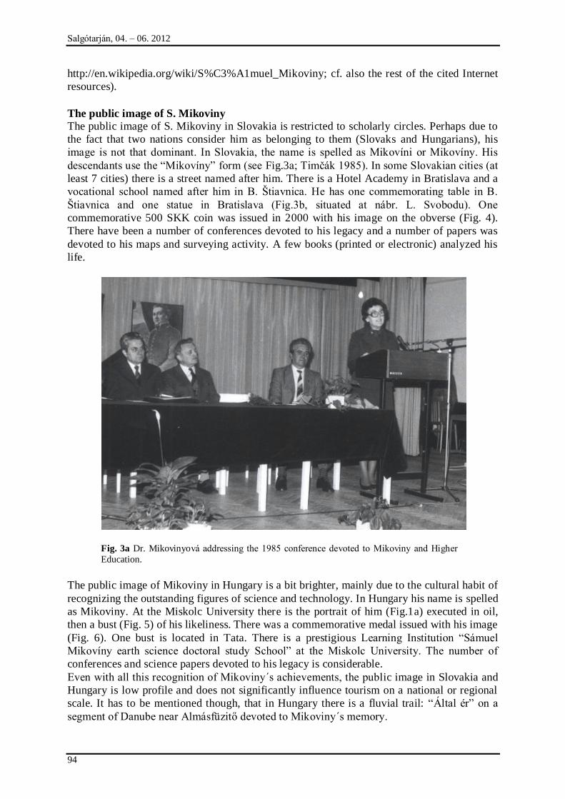
Salgótarján, 04. – 06. 2012
94
http://en.wikipedia.org/wiki/S%C3%A1muel_Mikoviny; cf. also the rest of the cited Internet
resources).
The public image of S. Mikoviny
The public image of S. Mikoviny in Slovakia is restricted to scholarly circles. Perhaps due to
the fact that two nations consider him as belonging to them (Slovaks and Hungarians), his
image is not that dominant. In Slovakia, the name is spelled as Mikovíni or Mikovíny. His
descendants use the “Mikovíny” form (see Fig.3a; Timčák 1985). In some Slovakian cities (at
least 7 cities) there is a street named after him. There is a Hotel Academy in Bratislava and a
vocational school named after him in B. Ńtiavnica. He has one commemorating table in B.
Ńtiavnica and one statue in Bratislava (Fig.3b, situated at nábr. L. Svobodu). One
commemorative 500 SKK coin was issued in 2000 with his image on the obverse (Fig. 4).
There have been a number of conferences devoted to his legacy and a number of papers was
devoted to his maps and surveying activity. A few books (printed or electronic) analyzed his
life.
Fig. 3a Dr. Mikovinyová addressing the 1985 conference devoted to Mikoviny and Higher
Education.
The public image of Mikoviny in Hungary is a bit brighter, mainly due to the cultural habit of
recognizing the outstanding figures of science and technology. In Hungary his name is spelled
as Mikoviny. At the Miskolc University there is the portrait of him (Fig.1a) executed in oil,
then a bust (Fig. 5) of his likeliness. There was a commemorative medal issued with his image
(Fig. 6). One bust is located in Tata. There is a prestigious Learning Institution “Sámuel
Mikovíny earth science doctoral study School” at the Miskolc University. The number of
conferences and science papers devoted to his legacy is considerable.
Even with all this recognition of Mikoviny´s achievements, the public image in Slovakia and
Hungary is low profile and does not significantly influence tourism on a national or regional
scale. It has to be mentioned though, that in Hungary there is a fluvial trail: “Által ér” on a
segment of Danube near Almásfüzitő devoted to Mikoviny´s memory.
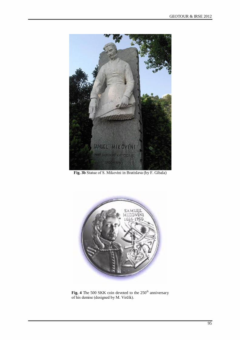
GEOTOUR & IRSE 2012
95
Fig. 3b Statue of S. Mikovíni in Bratislava (by F. Gibala)
Fig. 4 The 500 SKK coin devoted to the 250th
anniversary
of his demise (designed by M. Virčík).
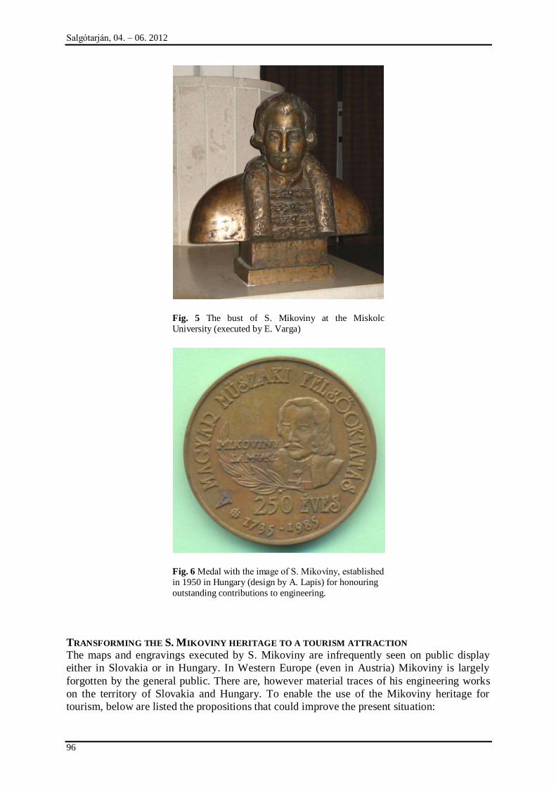
Salgótarján, 04. – 06. 2012
96
Fig. 5 The bust of S. Mikoviny at the Miskolc
University (executed by E. Varga)
Fig. 6 Medal with the image of S. Mikovíny, established
in 1950 in Hungary (design by A. Lapis) for honouring
outstanding contributions to engineering.
TRANSFORMING THE S. MIKOVINY HERITAGE TO A TOURISM ATTRACTION
The maps and engravings executed by S. Mikoviny are infrequently seen on public display
either in Slovakia or in Hungary. In Western Europe (even in Austria) Mikoviny is largely
forgotten by the general public. There are, however material traces of his engineering works
on the territory of Slovakia and Hungary. To enable the use of the Mikoviny heritage for
tourism, below are listed the propositions that could improve the present situation:
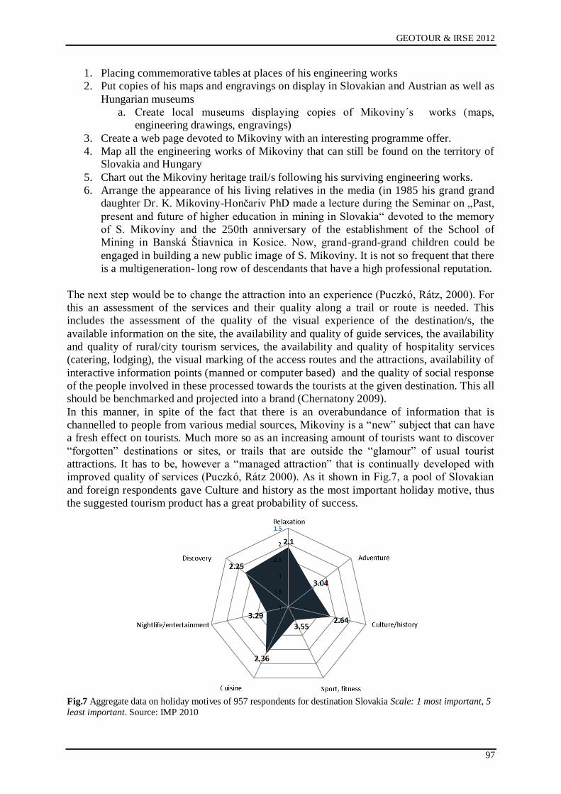
GEOTOUR & IRSE 2012
97
1. Placing commemorative tables at places of his engineering works
2. Put copies of his maps and engravings on display in Slovakian and Austrian as well as
Hungarian museums
a. Create local museums displaying copies of Mikoviny´s works (maps,
engineering drawings, engravings)
3. Create a web page devoted to Mikoviny with an interesting programme offer.
4. Map all the engineering works of Mikoviny that can still be found on the territory of
Slovakia and Hungary
5. Chart out the Mikoviny heritage trail/s following his surviving engineering works.
6. Arrange the appearance of his living relatives in the media (in 1985 his grand grand
daughter Dr. K. Mikoviny-Hončariv PhD made a lecture during the Seminar on „Past,
present and future of higher education in mining in Slovakia“ devoted to the memory
of S. Mikovíny and the 250th anniversary of the establishment of the School of
Mining in Banská Ńtiavnica in Kosice. Now, grand-grand-grand children could be
engaged in building a new public image of S. Mikoviny. It is not so frequent that there
is a multigeneration- long row of descendants that have a high professional reputation.
The next step would be to change the attraction into an experience (Puczkó, Rátz, 2000). For
this an assessment of the services and their quality along a trail or route is needed. This
includes the assessment of the quality of the visual experience of the destination/s, the
available information on the site, the availability and quality of guide services, the availability
and quality of rural/city tourism services, the availability and quality of hospitality services
(catering, lodging), the visual marking of the access routes and the attractions, availability of
interactive information points (manned or computer based) and the quality of social response
of the people involved in these processed towards the tourists at the given destination. This all
should be benchmarked and projected into a brand (Chernatony 2009).
In this manner, in spite of the fact that there is an overabundance of information that is
channelled to people from various medial sources, Mikoviny is a “new” subject that can have
a fresh effect on tourists. Much more so as an increasing amount of tourists want to discover
“forgotten” destinations or sites, or trails that are outside the “glamour” of usual tourist
attractions. It has to be, however a “managed attraction” that is continually developed with
improved quality of services (Puczkó, Rátz 2000). As it shown in Fig.7, a pool of Slovakian
and foreign respondents gave Culture and history as the most important holiday motive, thus
the suggested tourism product has a great probability of success.
Fig.7 Aggregate data on holiday motives of 957 respondents for destination Slovakia Scale: 1 most important, 5
least important. Source: IMP 2010
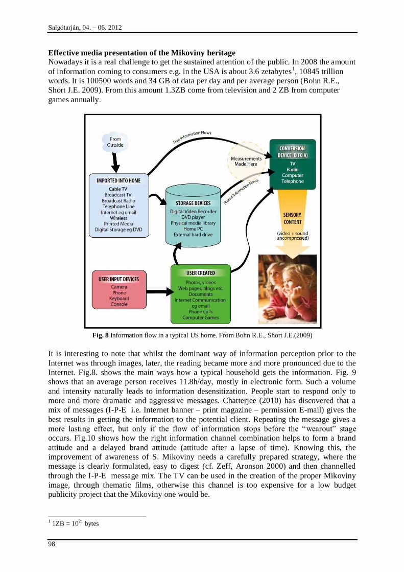
Salgótarján, 04. – 06. 2012
98
Effective media presentation of the Mikoviny heritage
Nowadays it is a real challenge to get the sustained attention of the public. In 2008 the amount
of information coming to consumers e.g. in the USA is about 3.6 zetabytes1, 10845 trillion
words. It is 100500 words and 34 GB of data per day and per average person (Bohn R.E.,
Short J.E. 2009). From this amount 1.3ZB come from television and 2 ZB from computer
games annually.
Fig. 8 Information flow in a typical US home. From Bohn R.E., Short J.E.(2009)
It is interesting to note that whilst the dominant way of information perception prior to the
Internet was through images, later, the reading became more and more pronounced due to the
Internet. Fig.8. shows the main ways how a typical household gets the information. Fig. 9
shows that an average person receives 11.8h/day, mostly in electronic form. Such a volume
and intensity naturally leads to information desensitization. People start to respond only to
more and more dramatic and aggressive messages. Chatterjee (2010) has discovered that a
mix of messages (I-P-E i.e. Internet banner – print magazine – permission E-mail) gives the
best results in getting the information to the potential client. Repeating the message gives a
more lasting effect, but only if the flow of information stops before the “wearout” stage
occurs. Fig.10 shows how the right information channel combination helps to form a brand
attitude and a delayed brand attitude (attitude after a lapse of time). Knowing this, the
improvement of awareness of S. Mikoviny needs a carefully prepared strategy, where the
message is clearly formulated, easy to digest (cf. Zeff, Aronson 2000) and then channelled
through the I-P-E message mix. The TV can be used in the creation of the proper Mikoviny
image, through thematic films, otherwise this channel is too expensive for a low budget
publicity project that the Mikoviny one would be.
1 1ZB = 10
21 bytes
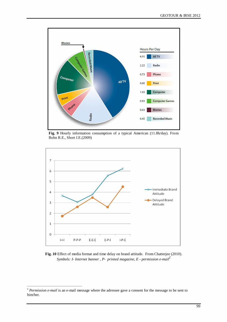
GEOTOUR & IRSE 2012
99
Fig. 9 Hourly information consumption of a typical American (11.8h/day). From
Bohn R.E., Short J.E.(2009)
Fig. 10 Effect of media format and time delay on brand attitude. From Chatterjee (2010).
Symbols: I- Internet banner , P- printed magazine, E - permission e-mail2
2 Permission e-mail is an e-mail message where the adressee gave a consent for the message to be sent to
him/her.

Salgótarján, 04. – 06. 2012
100
SUMMARY
The person of S. Mikoviny and his tangible outputs can be worked into a mining heritage
tourism product and thus to make the mining heritage a more visible part of the tourism offer.
Similar strategy applies also for other brilliant scientists and engineers of the past who were
culturally affiliated to the area of Slovakia. The message has to be delivered to a specific
segment of the client spectrum – students, young couples and those who seek “forgotten”
beauties of both natural and engineering type. At present, as under the present fiscal
conditions, financial support of such project from government funds is less probable, a PP
partnership could solve the problem, and the “Mikoviny heritage” should be a part of a
destination management unit as defined in Act No. 91/2010 and No. 386/2011.
REFERENCES
BOHN R.E., SHORT J.E., 2009: How much information? 2009; Global Information Industry
Center, UCf, San Diego 2009, update 2010
CHATTERJEE P. 2010: The role of varying information quantity in ads on immediate and
enduring cross-media synergies, available at:
http://papers.ssrn.com/sol3/papers.cfm?abstract_id=1859605
CHERNATONY de L.: Značka, C-press, Brno, 2009
Excerpt from the Mikoviny tractate on mapping: http://zlatyfond.sme.sk/autor/226/Samuel-
Mikovini
Innovative Management Partner: Marketingová stratégia SACR na roky 2010-2013, IMP
Bratislava, 2010
Mikoviny medal: http://meteorarchiv.mcse.hu/2004/Meteor-2004-05.pdf
PUCZKÓ L., RÁTZ T.: Az attrakciótól az élményik, Geomédia, Budapest., 2000
PURGINA J.: Samuel Mikovíni; ņivot a dielo, FBERG TU Końice, 2000
TIMČÁK G.M. (Ed.): Proceedings of the Seminar „Past, present and future of higher
education in mining in Slovakia“ devoted to the memory of S. Mikovíny and the 250th
anniversary of the establishment of the School of Mining in Banská Ńtiavnica, ČSVTS,
Mining Faculty, TU Końice, 1985.
TIMČÁK G.M.: Introduction to the Seminar on S. Mikoviny, in: Proc. of the Seminar „Past,
present and future of higher education in mining in Slovakia“ devoted to the memory of
S. Mikovíny and the 250th anniversary of the establishment of the School of Mining in
Banská Ńtiavnica, ČSVTS, Mining Faculty, TU Końice, 1985, pp. 1-4
TÖRÖK E., 2011: Mikoviny Sámuel, Budapest, ISBN: 978-963-08-1495-9
ZEFF R., Aronson B.: Reklám az interneten, Geomedia, Budapest, 2000
Internet resources:
http://banyaszmult.uw.hu/a069.htm
http://en.wikipedia.org/wiki/S%C3%A1muel_Mikoviny
http://historia.szm.com/osobnosti/mikovini.htm
http://hu.wikipedia.org/wiki/Varga_%C3%89va_%28szobr%C3%A1sz%29
http://pi.library.yorku.ca/ojs/index.php/soi/article/view/18119/16889
http://sk.wikipedia.org/wiki/Samuel_Mikov%C3%ADny
http://www.fomi.hu/honlap/magyar/szaklap/2010/10/4.pdf
http://www.masternewmedia.org/information_overload_what_it_is_and_how/
http://www.telegraph.co.uk/science/science-news/8316534/Welcome-to-the-information-age-
174-newspapers-a-day.html
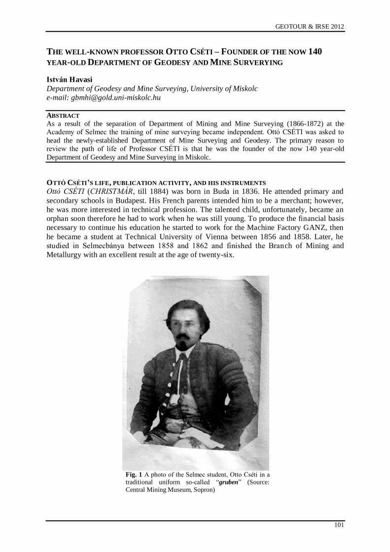
GEOTOUR & IRSE 2012
101
THE WELL-KNOWN PROFESSOR OTTO CSÉTI – FOUNDER OF THE NOW 140
YEAR-OLD DEPARTMENT OF GEODESY AND MINE SURVERYING
István Havasi
Department of Geodesy and Mine Surveying, University of Miskolc
e-mail: [email protected]
ABSTRACT
As a result of the separation of Department of Mining and Mine Surveying (1866-1872) at the Academy of Selmec the training of mine surveying became independent. Ottó CSÉTI was asked to
head the newly-established Department of Mine Surveying and Geodesy. The primary reason to review the path of life of Professor CSÉTI is that he was the founder of the now 140 year-old
Department of Geodesy and Mine Surveying in Miskolc.
OTTÓ CSÉTI’S LIFE, PUBLICATION ACTIVITY, AND HIS INSTRUMENTS
Ottó CSÉTI (CHRISTMÁR, till 1884) was born in Buda in 1836. He attended primary and
secondary schools in Budapest. His French parents intended him to be a merchant; however,
he was more interested in technical profession. The talented child, unfortunately, became an
orphan soon therefore he had to work when he was still young. To produce the financial basis
necessary to continue his education he started to work for the Machine Factory GANZ, then
he became a student at Technical University of Vienna between 1856 and 1858. Later, he
studied in Selmecbánya between 1858 and 1862 and finished the Branch of Mining and
Metallurgy with an excellent result at the age of twenty-six.
Fig. 1 A photo of the Selmec student, Otto Cséti in a
traditional uniform so-called “gruben” (Source:
Central Mining Museum, Sopron)
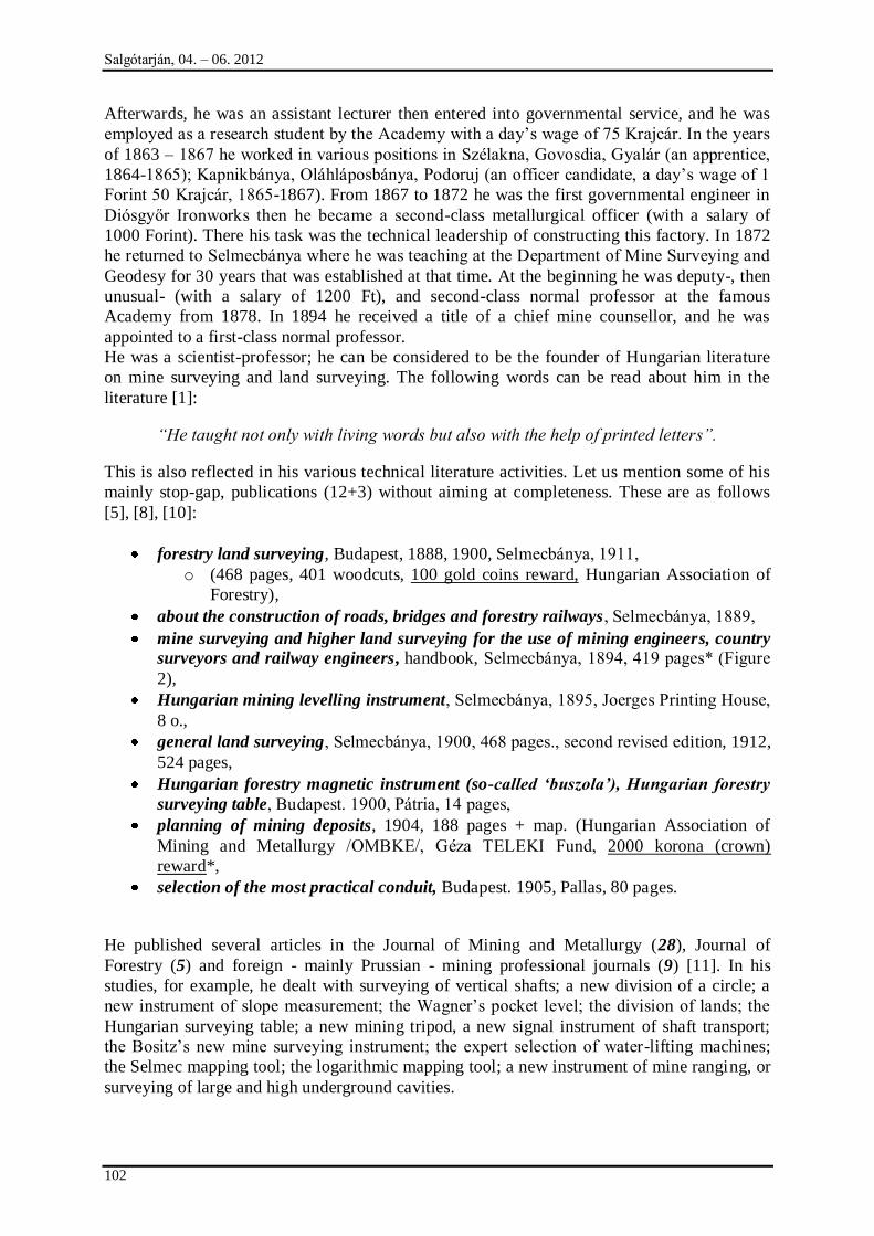
Salgótarján, 04. – 06. 2012
102
Afterwards, he was an assistant lecturer then entered into governmental service, and he was
employed as a research student by the Academy with a day‟s wage of 75 Krajcár. In the years
of 1863 – 1867 he worked in various positions in Szélakna, Govosdia, Gyalár (an apprentice,
1864-1865); Kapnikbánya, Oláhláposbánya, Podoruj (an officer candidate, a day‟s wage of 1
Forint 50 Krajcár, 1865-1867). From 1867 to 1872 he was the first governmental engineer in
Diósgyőr Ironworks then he became a second-class metallurgical officer (with a salary of
1000 Forint). There his task was the technical leadership of constructing this factory. In 1872
he returned to Selmecbánya where he was teaching at the Department of Mine Surveying and
Geodesy for 30 years that was established at that time. At the beginning he was deputy-, then
unusual- (with a salary of 1200 Ft), and second-class normal professor at the famous
Academy from 1878. In 1894 he received a title of a chief mine counsellor, and he was
appointed to a first-class normal professor.
He was a scientist-professor; he can be considered to be the founder of Hungarian literature
on mine surveying and land surveying. The following words can be read about him in the
literature [1]:
“He taught not only with living words but also with the help of printed letters”.
This is also reflected in his various technical literature activities. Let us mention some of his
mainly stop-gap, publications (12+3) without aiming at completeness. These are as follows
[5], [8], [10]:
forestry land surveying, Budapest, 1888, 1900, Selmecbánya, 1911,
o (468 pages, 401 woodcuts, 100 gold coins reward, Hungarian Association of
Forestry),
about the construction of roads, bridges and forestry railways, Selmecbánya, 1889,
mine surveying and higher land surveying for the use of mining engineers, country
surveyors and railway engineers, handbook, Selmecbánya, 1894, 419 pages* (Figure
2),
Hungarian mining levelling instrument, Selmecbánya, 1895, Joerges Printing House,
8 o.,
general land surveying, Selmecbánya, 1900, 468 pages., second revised edition, 1912,
524 pages,
Hungarian forestry magnetic instrument (so-called „buszola‟), Hungarian forestry
surveying table, Budapest. 1900, Pátria, 14 pages,
planning of mining deposits, 1904, 188 pages + map. (Hungarian Association of
Mining and Metallurgy /OMBKE/, Géza TELEKI Fund, 2000 korona (crown)
reward*,
selection of the most practical conduit, Budapest. 1905, Pallas, 80 pages.
He published several articles in the Journal of Mining and Metallurgy (28), Journal of
Forestry (5) and foreign - mainly Prussian - mining professional journals (9) [11]. In his
studies, for example, he dealt with surveying of vertical shafts; a new division of a circle; a
new instrument of slope measurement; the Wagner‟s pocket level; the division of lands; the
Hungarian surveying table; a new mining tripod, a new signal instrument of shaft transport;
the Bositz‟s new mine surveying instrument; the expert selection of water-lifting machines;
the Selmec mapping tool; the logarithmic mapping tool; a new instrument of mine ranging, or
surveying of large and high underground cavities.
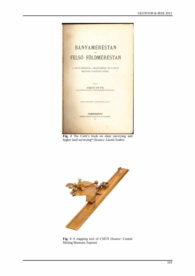
GEOTOUR & IRSE 2012
103
Fig. 2 The Cséti‟s book on mine surveying and
higher land surveying* (Source: László Szabó)
Fig. 3 A mapping tool of CSÉTI (Source: Central
Mining Museum, Sopron)
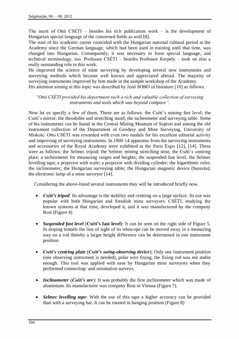
Salgótarján, 04. – 06. 2012
104
The merit of Ottó CSÉTI – besides his rich publication work – is the development of
Hungarian special language of the concerned fields as well [8].
The start of his academic career coincided with the Hungarian national cultural period at the
Academy since the German language, which had been used in training until that time, was
changed into Hungarian. Consequently, it was necessary to form special language, and
technical terminology, too. Professor CSÉTI – besides Professor Kerpely – took on also a
really outstanding role in this work.
He improved the science of mine surveying by developing several new instruments and
surveying methods which became well known and appreciated abroad. The majority of
surveying instruments improved by him made in the sample workshop of the Academy.
His attention aiming at this topic was described by Jenő SOBO in literature [10] as follows:
“Ottó CSÉTI provided his department such a rich and valuable collection of surveying
instruments and tools which was beyond compare”.
Now let us specify a few of them. These are as follows: the Cséti‟s mining fast level; the
Cséti‟s mirror; the theodolite and stretching stand; the tacheometer and surveying table. Some
of his instruments can be found in the Central Mining Museum of Sopron and among the old
instrument collection of the Department of Geodesy and Mine Surveying, University of
Miskolc. Otto CSÉTI was rewarded with even two medals for his excellent editorial activity
and improving of surveying instruments. In 1900 14 apparatus from the surveying instruments
and accessories of the Royal Academy were exhibited at the Paris Expo [12], [14]. These
were as follows: the Selmec tripod; the Selmec mining stretching strut; the Cséti‟s centring
plate; a tacheometer for measuring ranges and heights; the suspended fast level; the Selmec
levelling tape; a projector with scale; a projector with dividing cylinder; the logarithmic ruler;
the inclinometer; the Hungarian surveying table; the Hungarian magnetic device (buszola);
the electronic lamp of a mine surveyor [14].
Considering the above-listed several instruments they will be introduced briefly now.
Cséti‟s tripod: Its advantage is the stability and centring on a large surface. Its use was
popular with both Hungarian and Swedish mine surveyors. CSÉTI, studying the
known systems at that time, developed it, and it was manufactured by the company
Rost (Figure 4)
Suspended fast level (Cséti’s fast level): It can be seen on the right side of Figure 5.
In sloping tunnels the line of sight of its telescope can be moved away in a measuring
way on a rod thereby a larger height difference can be determined in one instrument
position.
Cséti‟s centring plate (Cséti‟s swing-observing device): Only one instrument position
(one observing instrument is needed), polar wire fixing, the fixing rod was not stable
enough. This tool was applied with ease by Hungarian mine surveyors when they
performed connecting- and orientation surveys.
Inclinometer (Cséti‟s arc): It was probably the first inclinometer which was made of
aluminium. Its manufacturer was company Rost in Vienna (Figure 7).
Selmec levelling tape: With the use of this tape a higher accuracy can be provided
than with a surveying bar. It can be rotated in hanging position (Figure 8)
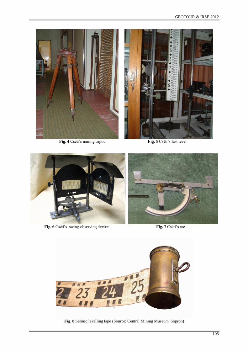
GEOTOUR & IRSE 2012
105
Fig. 4 Cséti‟s mining tripod Fig. 5 Cséti‟s fast level
Fig. 6 Cséti‟s swing-observing device Fig. 7 Cséti‟s arc
Fig. 8 Selmec levelling tape (Source: Central Mining Museum, Sopron)
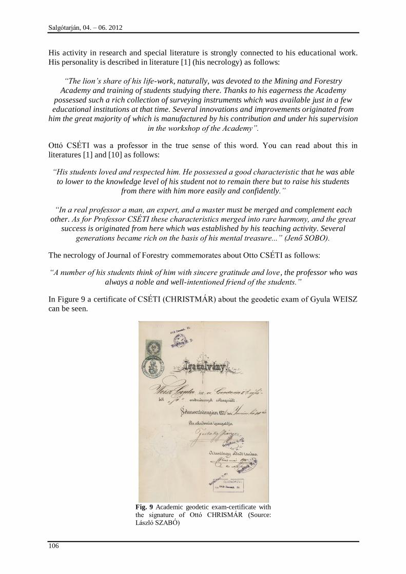
Salgótarján, 04. – 06. 2012
106
His activity in research and special literature is strongly connected to his educational work.
His personality is described in literature [1] (his necrology) as follows:
“The lion‟s share of his life-work, naturally, was devoted to the Mining and Forestry
Academy and training of students studying there. Thanks to his eagerness the Academy
possessed such a rich collection of surveying instruments which was available just in a few
educational institutions at that time. Several innovations and improvements originated from
him the great majority of which is manufactured by his contribution and under his supervision
in the workshop of the Academy”.
Ottó CSÉTI was a professor in the true sense of this word. You can read about this in
literatures [1] and [10] as follows:
“His students loved and respected him. He possessed a good characteristic that he was able
to lower to the knowledge level of his student not to remain there but to raise his students
from there with him more easily and confidently.”
“In a real professor a man, an expert, and a master must be merged and complement each
other. As for Professor CSÉTI these characteristics merged into rare harmony, and the great
success is originated from here which was established by his teaching activity. Several
generations became rich on the basis of his mental treasure...” (Jenő SOBO).
The necrology of Journal of Forestry commemorates about Otto CSÉTI as follows:
“A number of his students think of him with sincere gratitude and love, the professor who was
always a noble and well-intentioned friend of the students.”
In Figure 9 a certificate of CSÉTI (CHRISTMÁR) about the geodetic exam of Gyula WEISZ
can be seen.
Fig. 9 Academic geodetic exam-certificate with
the signature of Ottó CHRISMÁR (Source:
László SZABÓ)
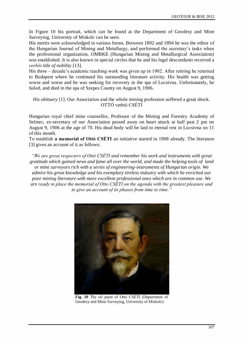
GEOTOUR & IRSE 2012
107
In Figure 10 his portrait, which can be found at the Department of Geodesy and Mine
Surveying, University of Miskolc can be seen.
His merits were acknowledged in various forms. Between 1892 and 1894 he was the editor of
the Hungarian Journal of Mining and Metallurgy, and performed the secretary‟s tasks when
the professional organization, OMBKE (Hungarian Mining and Metallurgical Association)
was established. It is also known in special circles that he and his legal descendants received a
verbói title of nobility [13].
His three – decade‟s academic teaching work was given up in 1902. After retiring he returned
to Budapest where he continued his outstanding literature activity. His health was getting
worse and worse and he was seeking for recovery in the spa of Lucsivna. Unfortunately, he
failed, and died in the spa of Szepes County on August 9, 1906.
His obituary [1]: Our Association and the whole mining profession suffered a great shock.
OTTÓ verbói CSÉTI
Hungarian royal chief mine counsellor, Professor of the Mining and Forestry Academy of
Selmec, ex-secretary of our Association passed away on heart attack at half past 2 pm on
August 9, 1906 at the age of 70. His dead body will be laid to eternal rest in Lucsivna on 11
of this month.
To establish a memorial of Ottó CSÉTI an initiative started in 1908 already. The literature
[3] gives an account of it as follows:
“We are great respecters of Ottó CSÉTI and remember his work and instruments with great
gratitude which gained news and fame all over the world, and made the helping tools of land
or mine surveyors rich with a series of engineering-instruments of Hungarian origin. We
admire his great knowledge and his exemplary tireless industry with which he enriched our
poor mining literature with more excellent professional ones which are in common use. We
are ready to place the memorial of Otto CSÉTI on the agenda with the greatest pleasure and
to give an account of its phases from time to time.”
Fig. 10 The oil paint of Ottó CSÉTI (Department of
Geodesy and Mine Surveying, University of Miskolc)
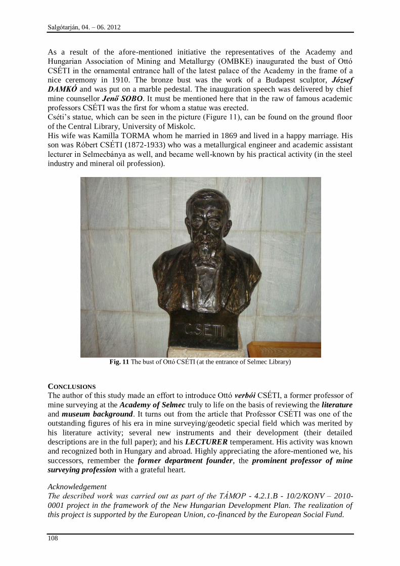
Salgótarján, 04. – 06. 2012
108
As a result of the afore-mentioned initiative the representatives of the Academy and
Hungarian Association of Mining and Metallurgy (OMBKE) inaugurated the bust of Ottó
CSÉTI in the ornamental entrance hall of the latest palace of the Academy in the frame of a
nice ceremony in 1910. The bronze bust was the work of a Budapest sculptor, József
DAMKÓ and was put on a marble pedestal. The inauguration speech was delivered by chief
mine counsellor Jenő SOBO. It must be mentioned here that in the raw of famous academic
professors CSÉTI was the first for whom a statue was erected.
Cséti‟s statue, which can be seen in the picture (Figure 11), can be found on the ground floor
of the Central Library, University of Miskolc.
His wife was Kamilla TORMA whom he married in 1869 and lived in a happy marriage. His
son was Róbert CSÉTI (1872-1933) who was a metallurgical engineer and academic assistant
lecturer in Selmecbánya as well, and became well-known by his practical activity (in the steel
industry and mineral oil profession).
Fig. 11 The bust of Ottó CSÉTI (at the entrance of Selmec Library)
CONCLUSIONS
The author of this study made an effort to introduce Ottó verbói CSÉTI, a former professor of
mine surveying at the Academy of Selmec truly to life on the basis of reviewing the literature
and museum background. It turns out from the article that Professor CSÉTI was one of the
outstanding figures of his era in mine surveying/geodetic special field which was merited by
his literature activity; several new instruments and their development (their detailed
descriptions are in the full paper); and his LECTURER temperament. His activity was known
and recognized both in Hungary and abroad. Highly appreciating the afore-mentioned we, his
successors, remember the former department founder, the prominent professor of mine
surveying profession with a grateful heart.
Acknowledgement
The described work was carried out as part of the TÁMOP - 4.2.1.B - 10/2/KONV – 2010-
0001 project in the framework of the New Hungarian Development Plan. The realization of
this project is supported by the European Union, co-financed by the European Social Fund.
GEOTOUR & IRSE 2012
109
The author is grateful to Attila SZEMÁN (chief museologist, Central Mining Museum,
Sopron) and Attila SZENDI (chief archivist, Library, Archives, Museum, University of
Miskolc) for special literature and some photographs which were made available for him.
REFERENCES
[1] verbói Ottó CSÉTI, Journal of Mining and Metallurgy, 22/1906.
[2] Károly Csáky: Famous professors of Selmec (MEK - PDF)
[3] Jó szerencsét- social, technical, mining and metallurgical weekly journal, Volume I,
Number 34, May 14, 1908.
[4] Journal of Forestry, Volume 45, Booklet 9, 1906.
[5] Gyula Szabó: Ottó CSÉTI (West-Hungarian University - PDF)
[6] Pál Vajda: Great Hungarian Inventors (Budapest, 1958).
[7] Mine Surveying (Hungary in the 20th
century - MEK).
[8] László Zsámboki: We departed from SELMEC, Miskolc, 1999.
[9] László Zsámboki: University bibliography I, The life and literature activity of the
professors of Selmec Mining and Forestry Academy, 1735-1918.; NME Miskolc, 1983.
[10] Commemoration of Ottó CSÉTI. Journal of Mining and Metallurgy, No. 12, 1910.
[11] CSÉTI, Lexicon of Selmec professors, 1735-1918.
[12] Hungarian technical creators, technical books, Budapest, 1964.
[13] Official columns, Personal news, Journal of Mining and Metallurgy, 36/1, 1903,
[14] Juraj Bernáth: Professor Ottó CSÉTI, the constructor of surveying instruments and his
successor Professor Gyula Szentisvány, Zbornik Slovenskáho, Volume 3, Mining
Museum, Bratislava, 1969, (Györgyné Tatár, 210/1977).
Internet sources:
http://www.joszerencset.hu/eletrajz/cseti_otto.htm
http://www.kfki.hu/physics/historia/historia/egyen.php?namenev=cseti&nev5=Cs%E9ti+Ott
%F3
http://erdeszetilapok.oszk.hu/01567/pdf/01567_718-754.pdf
http://mek.niif.hu/02100/02185/html/907.html
http://www.nyme.hu/index.php?id=17645&L=1&id=17645
http://www.nyme.hu/fileadmin/dokumentumok/emk/efelt/doc-
ftt/01_Bemutatkozunk/Cseti_Szabo.pdf
http://mek.niif.hu/00300/00355/html/ABC02469/02779.htm
Salgótarján, 04. – 06. 2012
110
HISTORICAL ORE MINING SITES IN LOWER SILESIA (POLAND) AS GEO-TOURISM
AND INDUSTRIAL TOURISM ATTRACTION
Maciej Madziarz
KGHM CUPRUM Ltd Research & Development Centre, Wrocław
e-mail: [email protected]
ABSTRACT
This article presents the possibilities of making use of the remains of several-century-old ore mining tradition in the area of Lower Silesia as major attractions of industrial tourism and geo-tourism, against a
background of the mining development in that area and characteristics of the research and cataloguing work conducted systematically for many years at former mining and metallurgical sites by the Mining Institute of Wrocław University of Technology. The article presents a project for the preservation, conservation and modern-day use of the survived remains of tin and cobalt ore mining in the vicinity of Krobica-Gierczyn-Przecznica at the foot of the Izerskie Mountains in the neighbourhood of Świeradów
Zdrój, which is executed by KGHM CUPRUM Sp. z o.o.
LOWER SILESIAN ORE MINING IN HISTORICAL PERSPECTIVE
„…There is land of such a nature that if you sow, it does not yield crops, but if you
dig, it nourishes many more than if it had borne fruit …”
This timeless thought was cited in the introduction to „De Re Metallica” – the first ever
complex study concerning mining, metallurgy and mineralogy, by its author Georgius
Agricola (actually Georg Bauer), a 16th-century researcher, scientist, physician and
philosopher, one of the most eminent intellects of the Renaissance. The above maxim,
expressed in ancient times by Greek philosopher Xenophanes, at least according to Agricola,
and concerning the Athenian silver mines, perfectly reflects the importance of mining carried
on over the ages in the area of Lower Silesia, especially in the Sudeten and their foothills,
where adverse weather conditions and poor soils did not favour stock-farming and plant-
growing, and the real source of wealth and prosperity of their inhabitants were the treasures
hidden deep in the mountains by the Nature. These treasures are made up of numerous
mineral deposits, especially metal and ore deposits, including gold, silver and copper, the
mining origin of which is covered with mists of history and can be traced back to as early as
the bronze age. Although the territorial notion of Silesia underwent essential changes
throughout its history, the mining of different ores had been successfully carried on here for
many ages, and Lower Silesia distinctly emerged as the area of long-standing mining activity.
To the north and to the east of its boundaries no mining activity had been carried on, it was
only in the remote Bytom and Tarnowskie Góry region (the Polish Ore Basin) that mining
activity was carried on a large scale. To the west, the nearest mining activity area was the
remote region of Freiberg. It should be stressed that despite the distinct separation of the
Lower Silesian mining, it took advantage of the experience of other, important mining centres
in Europe, achieving a high level of mining (and metallurgic) technology [4]. Since the
beginning of the 13th century the Silesia had been meant to embrace the land situated west of
Przesieka Śląska, i.e. the border forests separating the Lower and Upper Silesia, and the land
located east of Przesieka was called the Duchy of Opole. That distinction disappeared in the
middle of the 15th century when the whole historical region of that land along with the
Duchies of Upper Silesia was identified as the Silesia. However, in order to respect the old
divisions, the notions of Lower Silesia - Silesia Inferior, Niederschlesien for the former
Silesia and the Upper Silesia - Silesia Superior, Oberschlesien for the former Opole region
were used. The Poland‟s borders on the Bóbr and Kwisa Rivers were established in the year
GEOTOUR & IRSE 2012
111
of 1000, when the Wrocław bishopric was created and they did not undergo any major
changes throughout the Middle Ages. The south border constituted the massifs of the Sudeten,
the Izerskie Mountains and the Karkonosze Mountains [2]. Despite the complex and turbulent
political history of the Silesia, mining activity has always played an important economic role
here, providing livelihood for their inhabitants and for regional development opportunities.
The origin of many Lower Silesian places is associated with mining. Gold, ores of silver and
lead, copper, tin, arsenic, cobalt chromium, iron, hard coal, brown coal, rock materials, and
even mineral waters constituted and in part still constitute large resources of that region.
However, the subject of interest for former miners were, first of all, numerous, small
polymetallic ore deposits, usually containing a few basic ore minerals, exploited in a
documented manner over the period from the 13th to 20th century [4]. In Lower Silesia, more
precisely in the Sudeten, these types of ore formations encompass a number of deposits and
occurrences characterised by multicomponent and variable mineralisation and the abundance
of occurrence forms. The area of their occurrence is the Sudeten and their foothills, where
certain veins or mineralised zones reach the length of more than 2 km (Radzimowice), and the
depth of more than 300 m (Kowary) [3]. In the initial mining period, first of all the richest and
easily available deposits at small depths have been exploited, and the vein deposits initially
evaluated as abundant often turned out to be small and difficult in exploitation.
Lower Silesia is divided into six main regions in respect of the useful mineral occurrence
These are: Kłodzko Land, Sowie Mountains along with the Wałbrzych region, the foothills of
the Karkonosze Mountains, exploited gold-dust deposits in the vicinity of Lwówek, Złotoryja
and Legnica, the so-called North-Sudeten Zechstein depression (having outcrops south of
Lwówek and Złotoryja and near Grodziec), and Fore-Sudeten Zechstein monocline situated
north of Lubin [4]. The historically known deposits were exploited over many ages and they
were mostly the so-called “open deposits”, i.e. the ore bodies of those deposits were at least
partly exposed by the erosion surface, which allowed their early discovery and extraction [3].
German scientists Cloos, Berg, Bederke and Petrascheck were the first to undertake work
aimed to systematise the information on Lower Silesia deposit occurrence and genesis, in
combination with geological and structural assumptions. In 1936, the comprehensive study
“Schlesien. Bodenschätze und Industrie“, containing the evaluation of geological basis for the
development of mineral extraction and processing within the area of Lower Silesia, was
completed by a group of German scientists and researchers of that period, such as O.
Spangenberg, E. Bederke, O. Eisenkraut, I. Bartsch, L. Gäbler, F. Ilner, A. Metzing, M.
Morgeroth, E. Pralle, D. Rademacher, F.W. Siegert, H. Sinnreich, W. Thust [8]. Since 1945
that work has been intensely continued by the Polish researchers and, among other things, it
has resulted in the discovery of a huge polymetallic deposit of copper and silver, and
consequently in the modern-day boom in the ore mining in Lower Silesia. The deposits on the
Fore-Sudeten monocline, which were discovered only after World War II, are ranked among
the largest in the world and are nowadays intensely exploited in the three modern
underground mines.
The history of Lower Silesian ore mining is well known and mostly associated with the gold
mining which was carried on in many centres and was of special importance to them
[3,4,19,20]. First of all, the area in the former Legnica Duchy, between the rivers Kaczawa
and Bóbr in the region of Lwówek, Złotoryja, Mikołajowice and Bolesławiec was
distinguished by the volume of production. The boom in gold mining took place in the years
1180 – 1241, and only in the first half of the 13th century the mining law was introduced for
the gold mines as one of the earliest in Europe (Lwówek in 1278, Złotoryja in 1342). On the
European scale, Złoty Stok became a recognised centre of gold mining and metallurgy, where
the arsenic ore deposits containing gold were exploited. There, the very beginnings of mining
goes back to 1291, and the largest boom is traced back to 15th century and the first half of the
16th century. Till the end of the 17th century the goal of the mining activity was the
Salgótarján, 04. – 06. 2012
112
production of gold, and since the beginning of the 18th century the activity had been
concentrated on the production of arsenic, with gold being recovered as a by-product. The
exploitation in Złoty Stock was finally brought to an end in 1962. Gold mining was also
carried on in several other, smaller centres within the area of Lower Silesia – among them
some more important were: Stara Góra (Radzimowice), Pławna, Klecza – Radomice –
Pilichowice. According to German researcher Quiring the name Sowie Mountains – in
German: Eulengebirge, comes from the Celtic word meaning gold [19]. In fact, in the already-
exploited ore veins in the Sowie Mountains there were small amounts of that precious metal.
Hidden behind the fascinating shine of gold is the forgotten but yet several-century-old and
noble history of Lower Silesian mining and metallurgy of many other ores among which ores
of copper, lead and silver, tin and cobalt, arsenic, iron and, later, uranium were historically
most significant. It is worth stressing that gold and copper - the earliest used and mined
metals by human being [1] were fairly abundant in relatively easy to find polymetallic vein
deposits in the area of Lower Silesia, which can indicate very early beginnings of their
exploitation in that area. Although as yet there is no material evidence that the history of
Lower Silesian ore mining goes back more than one thousand years, there is no way not to
recall here again the works of German scientist H. Quiring, who linked the beginnings of
mining works in the Sudeten with the activity of Cretans – already around 2 thousand years
B.C., and their continuation with the influence of Celts, who stayed in the Silesia in the period
of the 4th to 3rd century B.C. (Celtic silver and bronze coins are known). It is also known that
in the period of the so-called “Lusatian Culture”, in the neighbourhood of Legnica and
Złotoryja arms and tools were locally made of bronze – an alloy of copper and tin (both these
metals occurred in Lower Silesia in easily accessible, naturally concentrated shallow
deposits), by casting in stone moulds, with the shortages replenished with imports from
Slovakia, Transylvania and Eastern Alps. In the bronze age this area was within the reach of
the so-called “Unietic Culture”, which formed from around 2100 B.C., especially south of
Wrocław. Numerous copper products as well as those made of bronze and gold, including
arms, daily necessities, ornaments, etc. are found in the discovered skeleton graveyards of that
culture. It is known that its twilight occurred as a result of the fall of already-existing copper
mining and processing centres, which were located in the areas where that culture evolved [2].
The documented history of copper ore mining in Lower Silesia – the metal which, besides
gold, was the earliest and initially most extensively used one in the human history, with the
fundamental importance to the development of civilisation, technology and culture, both in
ancient times and nowadays, encompasses the period of at least 700 years, as the first
survived information on the existence of “Cuprifodina in montibus” – which simply means „a
copper mine in the mountains” in Latin [4,6], in the vicinity of Miedzianka near Jelenia Góra,
comes from the year of 1311. The copper and arsenic ore deposits in the area of northern
Karkonosze, in the vicinity of Miedzianka i Ciechanowice, Radzimowice and Czarnów played
an essential role in the development of mining in Lower Silesia. The copper ores occurring in
Miedzianka Sudecka constituted the fundamental base of ore mining in Lower Silesia for
almost seven centuries. The second area in Lower Silesia, where copper mining activity was
carried on was the neighbourghood of Złotoryja, where already in the 18th century in the
place called Leszczyna a copper ore mine of sedimentary origin was started (constituting the
base of the modern-day copper ore mining in Poland), in the form of cupriferous shales poor
in metal but ensuring stable production. The gently and uniformly declining bed exploited
there in the “Stilles Glück” mine in the second half of the 19th century ensured the
smoothness and continuity of production, unlike the unpredictable vein deposits exploited, for
example, in Miedzianka [4]. Mining activity in the North Sudeten Zechstein depression was
resumed only in the thirties of the 20th century, when the progress in mining technology and
the shift in global mining towards more and more poorer ores made the mining of those
merely 0.8-1.2 per-cent ores with uniform mineralisation cost-effective. It gave the origin to
GEOTOUR & IRSE 2012
113
the so-called “Old Copper Basin”, operating until the nineties of the 20th century, in the
region of Złotoryja and Bolesławiec. Mining activity aimed at obtaining copper ores were also
carried on in a number of other places, such as Kondratów, Prusice, Chełmiec, Lipa,
Głuszyca, Jugowice, Wieściszowice, Dziwiszów, Szklarska Poręba.
The object of exploration and exploitation in the area of Lower Silesia were also polymetallic
deposits containing silver. Historically, the major centres of lead and silver ore mining and
metallurgy included: Srebrna Góra, Boguszów, Jabłów, Dziećmorowice, Bystrzyca Górna,
Janowice Wielkie, Radomierz, Przybkowice, Marcinków, Lutynia, Karpacz and Kowary [4,
9].
Poor deposits of tin ore occur on the northern slopes of the Izerskie Mountains, in the vicinity
of Gierczyn and small amounts of cobalt minerals exist in their neighbourghood, in
Przecznica. The tin ores were exploited in the 16th and 17th century, and the cobalt minerals
were exploited in the 18th and 19th century [4, 10, 11, 12, 13, 14].
The exploitation of iron ores was also carried on in Lower Silesia. The region of Kowary and
that of Janowa Góra were abundant of easily accessible magnetite. In Kowary, the iron ores
had been exploited since 1148. In the second half of the 19th century, Stanisławów near Jawor
became an important centre for mining that material.
The mining works on the Sudeten deposits, apart from few exceptions, were carried on
periodically, In the initial stage of exploitation, the richest and most easily accessible deposit
parts were extracted. They often included vein deposits, initially evaluated as abundant but
then turned out to be small and difficult in exploitation, which led to abandoning of mines,
devastation of their equipment and flooding of workings. The mining activity was interrupted
by wars, epidemics, population migrations or by falling prices of raw materials. Over a long
period, the knowledge about the Sudeten deposits was limited to those already recognised
during the mining activity carried on throughout the centuries, in the shallow near-surface
parts [4].
The documentary collection of the former German Higher Mining Office in Wrocław
(Oberbergamt zu Breslau) constitutes a rich source of information on the history of mining in
Lower Silesia, in which the especially rich materials come from the years of 1779 – 1852 (the
period of managing the mining and metallurgical activity in the Silesia). The main source
publications for historical studies are codes containing names, summaries and full texts of
documents from old chronicles. Furthermore, the works by H. Festenberga, E. Steinbecka and
H. Fechnera contain plenty of information. Among the works published after 1945, the work
by H. Dziekoński [4] is of special importance as it is a comprehensive source of information
on the history of Lower Silesian ore mining.
REMAINS OF FORMER ACTIVITY
Nowadays, most of the formerly exploited deposits in the area of Lower Silesia are only of
historical importance. Hundreds of years of the intense exploration and mining works left
numerous footprints in the area, still readable despite the lapse of centuries from the
termination of the activity. Inherent landscape element which is characteristic especially for
the mountains and foothills is numerous remains of former mining activity. They constitute a
precious and wealthy source of knowledge about the development of deposit mining
technology, providing the evidence of knowledge and skills of the generations of miners
connected over the centuries with the area of Lower Silesia. These relics occur in the area
mostly in the form of clearly distinguished heaps of waste rock, land subsidence, and often in
the form of partly or fully survived underground workings: (vertical or inclined) shafts,
(horizontal) drifts often in good condition, ruins of mine buildings, ore processing and
concentrating equipment (e.g. stream water damming reservoirs), or numerous footprints of
intense exploration activity – in the form of trenches or shallow shafts (hitherto usually
interpreted as the footprints of fortification!). These objects are usually devoid of any
Salgótarján, 04. – 06. 2012
114
protection or documentation. Many of the hitherto survived and accessible objects disappear
from the landscape forever, as a result of modern-day construction works carried on in their
vicinity, incorrect liquidation - without giving consideration to the historical value of such
type of objects, or filling them for dozens of years now with all kind of wastes, including
those considered hazardous. In many cases, unpreserved workings pose a serious hazard to
human and animal lives. In the works devoted to the history of Lower Silesian mining the
issue of preserving the relics of former activity and their importance - as a source of
knowledge about the old mining techniques, as well as the necessity to properly preserve and
conserve them, or even the possibilities of using them today as tourist attractions, apart from
few examples, practically have not been addressed. And yet the confrontation of information
derived from archive materials with that obtained during the field work can lead to the
enrichment of knowledge concerning the history of mining in Lower Silesia (and not only
there), and the “specific atmosphere” of old, underground workings constitutes a great
attraction for many people, which can be used to improve the attractiveness of presently
forgotten and declined places connected with the old ore mining.
The condition of historical relics of mining activity in Lower Silesia varies greatly.
Exploratory and documentary work conducted in the field reveals the footprints of merely
visible land subsidence marking the routes of drifts and galleries made at a small depth, or
collapsed shafts, as well as perfectly survived workings, with the fragments of lining,
equipment, etc. There exist large stretches of land covered with neighbouring remains of
shallow shafts (dooks) used in underground mining with the multi-shaft method (e.g. on the
slopes of the Ołowiane Mountains in the vicinity of Ciechanowie, in Lubachów near
Wałbrzych), footprints of trenches and shallow prospecting shafts marking all the regions of
former exploitation, naturally collapsed or “spaced-out”) drift outlets, but also survived large
complexes of underground workings, with clearly distinguished foreheads, exploratory drifts,
and often with exploitation chambers of relatively large sizes. In a number of former mining
centres there still exist, in various degree of preservation, channels supplying water from
rivers and streams to the processing equipment as well as water dams, often in the form of
reservoirs located close to the drift outlet. The water energy constituted the basic source for
driving drainage, hoisting and processing equipment in most of the former Lower Silesian ore
mines until the middle of the 19th century.
Those objects were built in the period from the 12th to 20th century and most of them is of
significant historical value and first of all they need to be properly documented, preserved and
conserved [6, 7, 8, 9, 10, 11, 12, 13, 14].
MINING AND ARCHAEOLOGICAL WORK
Considering the abundance of relics of the former exploitation in the area of Lower Silesia
and their undeniable historical and cognitive value, as well as the lack of studies concerning
their condition, already in 1995, work aimed at systematic cataloguing and documenting od
such type of objects was undertaken at the Mining Institute of Wrocław University of
Technology. This work has been systematically conducted for several years now within the
framework of statutory research of the Mining Institute of Wrocław University of
Technology. Because of the special character of work conducted at the objects of historical
value which should be subjected to preservation maintenance, the framework agreement on
scientific cooperation was concluded in 2006 between the Faculty of Geoengineering, Mining
and Geology of Wrocław University of Technology and the Faculty of Historical and
Pedagogical Sciences, the Institute of Archaeology and the Institute of History of the
University of Wrocław, with the aim to jointly conduct work concerning former mining sites
in the area of South-West Poland, thus the mining archaeology work. The research and
cataloguing work has been so far conducted at a number of former ore mining centres, among
which there are those of most importance from the viewpoint of the history of mining works
GEOTOUR & IRSE 2012
115
in Lower Silesia, as well as those of smaller importance but having a documented multi-
century history of exploration and exploitation. Among the regions under the study are: the
site of former copper and arsenic ore mining in the vicinity of Miedzianka, Ciechanowice and
Janowice Wielkie, polymetallic ores in Radzimowice and Czarnów, tin and cobalt ores in
Gierczyn and Przecznica, chromite in the Ślęża Massif, iron and uranium in the region of
Kowary, iron in Stanisławów, lead and silver in the neighbourhood Marcinków, Bystrzyca
Górnej and Modliszów.
It is worth noting that the scale of problems connected with researching former mining sites is
difficult to comprehend for people not engaged in that issue. Practically, at almost each centre
of former exploitation the mining works were carried on periodically within the space of
several hundred years. With the development of knowledge and technique, the previously
abandoned workings were revisited several times and the depth of exploitation was
continually increased with the aim to make use of the newest achievements in mining
technology and geological knowledge. The effect of such type of activities is a large number
of former mine workings and surface building remains, often spread even within a single
centre of former mining works over a large, usually undulating area, The footprints of former
works are usually obliterated as a result of different kind of works carried on after abandoning
the mining works, e.g. forestry works. The precise study of a single site, even without giving
consideration to underground workings is a long-term and arduous work requiring the
participation of a team of experts, including mining archaeologists. The identification and
examination of underground workings entail speleological works, and the access to the
interiors of former mines often requires reopening of their outlets that had been filled up for
hundreds of years. This type of activity involves, which is obvious, the necessity to make
many formal and legal arrangements, to say nothing about the considerable costs of its
completion. Due to the above reasons, most of the hitherto completed research and
cataloguing work has been limited to the superficial identification of former mining work sites
and still accessible parts of workings. Thanks to the cooperation with the archaeologists from
the Wrocław University and the Museum of Copper in Legnica, information on the forgotten
former work remains of historical value are passed to the competent Heritage Conservator and
as a result of these activities they will become protected by law.
Due to the importance of the historical mining centres, the scope and results of completed
research (and revitalisation) work, and what is particularly important – the possibilities of
using them in industrial tourism and geo-tourism, the results of the work carried out in the
operating area of former lead and silver ore mines in Bystrzyca Górna (the Sowie Mountains,
in the neighbourhood of Świdnica) and those conducted in the historical region of tin and
cobalt ore mining in Gierczym and Przecznica (in the neighbourhood of Świeradów) are
presented below.
FORMER LEAD AND SILVER ORE MINING SITES IN BYSTRZYCA GÓRNA (SOWIE MOUNTAINS,
IN NEIGHBOURHOOD OF ŚWIDNICA) The area of the occurrence of quarts-barite veins with polymetallic mineralisation (mainly in the form of lead and silver minerals) in the neighbourhood of Bystrzyca Górna in the Sowie Mountains was, within the space of more than five centuries, subjected periodically to fairly intense exploration and exploitation works [9]. Within the distance of about 500 m from the local buildings, in the area formerly known as “Goldener Wald” (Golden Forest), and more precisely, in the area known as “Silber Wiese” (Silver Meadow) the following mines operated in a chronological order: Segen Gottes, Christinenglück, Victor Friedrich, Wilhelmine, Beathe and probably Berthe. It should be assumed that, in that site, the mining works were carried on by the oldest Bystrzyca miners‟ guilds St. Stefens Achter and Geistliche Hülf Gottes. Although the documented information on the mining works in the neighbourhood of Bystrzyca Górna concerns only the year of 1539 [4] it is no way not to rule out the
Salgótarján, 04. – 06. 2012
116
considerably earlier moment of their beginning, the sign of which can be the shape and size of the cross-section of the workings reopened during the mining and archaeological work conducted by the Mining Institute of the Wrocław University of Technology with the support of Wrocław Section of Speleologists. The first mine operating in the described region was Segen Gottes, which was relatively large for the Sowie Mountains‟ conditions. As known from the survived documents, while driving the workings the footprints of „old works” were encountered, which was the sign of considerably earlier time of starting the mining works on the deposit in the massif of Widna Mountain [4]. The documented attempt to resume the exploitation there was undertaken for the last time in the year of 1844, in the mine called Beathe, however, the mining works were stopped only after a few years – probably because the deposit was exhausted. The area of the former mines in the north part of the Sowie Mountains, (inter alia in Bystrzyca) was revisited after the West Territories had been reunited with Poland. The exploration works were initially aimed to evaluate the prospects of the occurrence and extraction of uranium ores, and then barite [9]. Despite the numerous source materials, the proper identification of the mine workings
mentioned in the survived literature and historically operating in the region of Bystrzyca
Górna became possible only today owing to the mining archaeology work carried out in the
massif of Widna Mountain in the years 2006–2010. Those work was completed within the
framework of statutory research of the Mining Institute of the Wrocław University of
Technology under the name “Inwentaryzacja reliktów dawnych robót górniczych na obszarze
Dolnego Śląska wraz z dokumentacją wybranych obiektów” (Cataloguing of relics of former
mining works in the area of Lower Silesia along with documentation of selected objects) [9].
In consultation with the Institute of Archaeology of the University of Wrocław and after
obtaining the consent from the owner of that land – the State Forests, Forest Headquaters
Świdnica, part of the workings of the Beathe mine were reopened, first the so-called „upper
drift” located on the highest level (in 2008) (fig. 1), then the 18th-century lower drift (in
2009). The charting of the workings completed in comparison with the survived archive plans
from the collection of the former German Higher Mining Office in Wrocław (OBB Breslau)
made it possible to prove that the examined Beathe mine located in the “Silver Meadow”
(Silber Wiese), being a part of larger area called the “Gold Forest” (Goldener Wald), made use
of the main opening-out headings of the mines operating there in the previous centuries, i.e.:
Segen Gottes, Christinenglück, Victor Friedrich and Wilhelmine. In this way, it was possible
to prove without any doubts that the location and layout of the workings in the massif of the
Widna Mountain in the neighbourhood of Bystrzyca Góra corresponds to the mines known
from the subject literature and operating in that area in the period from the 16th to 19th
century [9]. After completing the charting and photographic documentation the workings
were preserved and filled up again. The complex of workings of the former mines in the
neighbourhood of Bystrzyca is wide, it is of great historical value and absolutely requires
further research and cataloguing work, as it constitutes an example of the mining work
development within the space of about 500 years, and the condition of its workings has not
been impaired as a result of exploration works for uranium ores – as it was the case in many
similar former ore mining centres in the area of Lower Silesia.
Based on the work results the concept of creating a tourist path presenting the attractions of
the Bystrzyca River valley, among which the special role should play the relics of the former
mining works, including the complex of perfectly survived underground workings dated back
to the period from the 16th century to the beginning of the 19th century in the neighbourhood
of Bystrzyca has been developed. The authorities of Świdnica Commune are interested in the
study results and are in favour of making the complex of historical mine workings in the
massif of Widna Mountain available for the tourist traffic as an industrial tourism and geo-
tourism attraction.
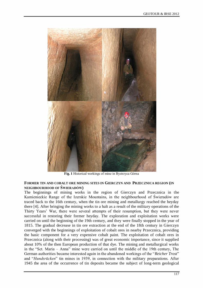
GEOTOUR & IRSE 2012
117
Fig. 1 Historical workings of mine in Bystrzyca Górna
FORMER TIN AND COBALT ORE MINING SITES IN GIERCZYN AND PRZECZNICA REGION (IN
NEIGHBOURHOOD OF ŚWIERADÓW)
The beginnings of mining works in the region of Gierczyn and Przecznica in the
Kamienieckie Range of the Izerskie Mountains, in the neighbourhood of Świeradów are
traced back to the 16th century, when the tin ore mining and metallurgy reached the heyday
there [4]. After bringing the mining works to a halt as a result of the military operations of the
Thirty Years‟ War, there were several attempts of their resumption, but they were never
successful in restoring their former heyday. The exploration and exploitation works were
carried on until the beginning of the 19th century, and they were finally stopped in the year of
1815. The gradual decrease in tin ore extraction at the end of the 18th century in Gierczyn
converged with the beginnings of exploitation of cobalt ores in nearby Przecznica, providing
the basic component for a very expensive cobalt paint. The exploitation of cobalt ores in
Przecznica (along with their processing) was of great economic importance, since it supplied
about 10% of the then European production of that dye. The mining and metallurgical works
in the “Sct. Maria – Anna” mine were carried on until the middle of the 19th century, The
German authorities became interested again in the abandoned workings of the “Reicher Trost”
and “Hundsrücken” tin mines in 1939, in connection with the military preparations. After
1945 the area of the occurrence of tin deposits became the subject of long-term geological
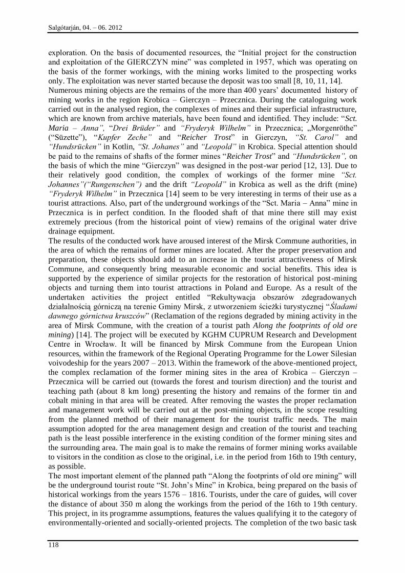
Salgótarján, 04. – 06. 2012
118
exploration. On the basis of documented resources, the “Initial project for the construction
and exploitation of the GIERCZYN mine” was completed in 1957, which was operating on
the basis of the former workings, with the mining works limited to the prospecting works
only. The exploitation was never started because the deposit was too small [8, 10, 11, 14].
Numerous mining objects are the remains of the more than 400 years‟ documented history of
mining works in the region Krobica – Gierczyn – Przecznica. During the cataloguing work
carried out in the analysed region, the complexes of mines and their superficial infrastructure,
which are known from archive materials, have been found and identified. They include: “Sct.
Maria – Anna”, “Drei Brüder” and “Fryderyk Wilhelm” in Przecznica; „Morgenröthe”
(“Süzette”), “Kupfer Zeche” and “Reicher Trost” in Gierczyn, “St. Carol” and
“Hundsrücken” in Kotlin, “St. Johanes” and “Leopold” in Krobica. Special attention should
be paid to the remains of shafts of the former mines “Reicher Trost” and “Hundsrücken”, on
the basis of which the mine “Gierczyn” was designed in the post-war period [12, 13]. Due to
their relatively good condition, the complex of workings of the former mine “Sct.
Johannes”(“Rungenschen”) and the drift “Leopold” in Krobica as well as the drift (mine)
“Fryderyk Wilhelm” in Przecznica [14] seem to be very interesting in terms of their use as a
tourist attractions. Also, part of the underground workings of the “Sct. Maria – Anna” mine in
Przecznica is in perfect condition. In the flooded shaft of that mine there still may exist
extremely precious (from the historical point of view) remains of the original water drive
drainage equipment.
The results of the conducted work have aroused interest of the Mirsk Commune authorities, in
the area of which the remains of former mines are located. After the proper preservation and
preparation, these objects should add to an increase in the tourist attractiveness of Mirsk
Commune, and consequently bring measurable economic and social benefits. This idea is
supported by the experience of similar projects for the restoration of historical post-mining
objects and turning them into tourist attractions in Poland and Europe. As a result of the
undertaken activities the project entitled “Rekultywacja obszarów zdegradowanych
działalnością górniczą na terenie Gminy Mirsk, z utworzeniem ścieżki turystycznej “Śladami
dawnego górnictwa kruszców” (Reclamation of the regions degraded by mining activity in the
area of Mirsk Commune, with the creation of a tourist path Along the footprints of old ore
mining) [14]. The project will be executed by KGHM CUPRUM Research and Development
Centre in Wrocław. It will be financed by Mirsk Commune from the European Union
resources, within the framework of the Regional Operating Programme for the Lower Silesian
voivodeship for the years 2007 – 2013. Within the framework of the above-mentioned project,
the complex reclamation of the former mining sites in the area of Krobica – Gierczyn –
Przecznica will be carried out (towards the forest and tourism direction) and the tourist and
teaching path (about 8 km long) presenting the history and remains of the former tin and
cobalt mining in that area will be created. After removing the wastes the proper reclamation
and management work will be carried out at the post-mining objects, in the scope resulting
from the planned method of their management for the tourist traffic needs. The main
assumption adopted for the area management design and creation of the tourist and teaching
path is the least possible interference in the existing condition of the former mining sites and
the surrounding area. The main goal is to make the remains of former mining works available
to visitors in the condition as close to the original, i.e. in the period from 16th to 19th century,
as possible.
The most important element of the planned path “Along the footprints of old ore mining” will
be the underground tourist route “St. John‟s Mine” in Krobica, being prepared on the basis of
historical workings from the years 1576 – 1816. Tourists, under the care of guides, will cover
the distance of about 350 m along the workings from the period of the 16th to 19th century.
This project, in its programme assumptions, features the values qualifying it to the category of
environmentally-oriented and socially-oriented projects. The completion of the two basic task
GEOTOUR & IRSE 2012
119
of the project – cleaning the objects and post-mining area from different types of waste, and
then carrying out the reclamation and management work, will bring about a considerable
improvement of the environment condition within the area of the three regions: Krobica,
Gierczyn and Przecznica in Mirsk Commune. The revitalisation of the environment,
preservation and exhibition of the old mining sites and, on their basis, creation of the tourist
path with an attractive underground section should contribute to the increase in tourist traffic
in the region of the above-mentioned commune. It will certainly have a positive impact on the
economic development of that region.
Fig. 2 Workings of former tin and cobalt ore mines from period of 16th to 19th century
CONCLUSION
As a result of the research and cataloguing work of the Mining Institute of the Wrocław
University of Technology concerning the former ore mining in Lower Silesia, a number of
historical mining sites hitherto known mainly from the source materials and historical studies
have been identified, where the exploration and cataloguing work was conducted for the last
Salgótarján, 04. – 06. 2012
120
time mostly at the turn of the 40s and 50s of the 20th century, in connection with the search
for uranium ores [17]. In order to exchange experience in the scope of identification and
documentation of such type of objects as well as to spread the results of the conducted work,
the conference “Dziedzictwo i historia górnictwa oraz wykorzystanie pozostałości dawnych
robót górniczych” (Mining heritage and history and making use of remains of former mining
works) is organised every year, starting from 2005. However, the most important effect of the
conducted work seems to be the practical use of their results, as the preparation basis for the
recent project executed by KGHM CUPRUM Sp z o.o., under the title “Rekultywacja
obszarów zdegradowanych działalnością górniczą na terenie Gminy Mirsk, z utworzeniem
ścieżki turystycznej Śladami dawnego górnictwa kruszców” (Reclamation of the regions
degraded by mining activity in the area of Mirsk Commune with the creation of the tourist
path Along the footprints of old ore mining). This project is a model example of how to make
use of scientific and research work that is conducted by the scientific centre - Wrocław
University of Technology, the results of which have turned out to be interesting for practical
point of view and become the subject of interest of the self-government bodies due to the
expected benefits associated with the improvement of the environment condition and
development of the Commune. It is worth stressing that Mirsk Commune representatives were
acquainted with the results of the research and cataloguing work during the conference
“Dziedzictwo i historia górnictwa oraz wykorzystanie pozostałości dawnych robót
górniczych”, which entailed their interest in the scope of the possibilities to make use of the
mining heritage survived in the area of the Commune in the development of industrial tourism
and geo-tourism, and hence to significantly improve the hitherto modest tourist proposal.
In the conditions of Lower Silesia, the project executed on the basis of the described work is
seen as an innovative and piloting project. For the first time, an attempt has been made to save
the complex of historical mining sites dated back in the period from the 16th to 19th century,
in a complex manner. They have been subject to intensive destruction since the 50s of the
20th century, when the exploration works were finally stopped there, and the former workings
have become illegal waste dumps. The research and cataloguing work of the Mining Institute
of the Wrocław University of Technology has become a contribution to the presently
conducted activities aimed to preserve, conserve and economically use the remains of the
former mining sites. The interest aroused by the described interdisciplinary Project among the
self-governing bodies of many Lower Silesian communes in the area of which similar remains
of former mining works are located (as for example in the Świdnica Commune, where the
above-mentioned remains of the former lead and silver ore mines are located) and in the
community of people widely associated with tourism – both those conducting economic
activity and those making use of attractions prepared for visiting, make it possible to assume
that in the near future similar activities will be undertaken in other historical centres of ore
mining and metallurgy in the Sudeten and at their foothills. The remains of several-century-
old mining activity, properly preserved and made available for visitors, may soon become the
major tourist attraction of Lower Silesia and its symbol on the tourist map of modern-day
Europe.
REFERENCES
[1] CRAIG J.R., VAUGHAN D.J., SKINNER B.J., Zasoby Ziemi, Warszawa 2003.
[2] CZAPLIŃSKI M., KASZUBA E., WĄS G., ŻERELIK R. (ed.), Historia Śląska, Wyd.
Uniw. Wroc., 2002.
[3] DZIEDZIC., K., KOZŁOWSKI S., MAJEROWICZ A., SAWICKI L. (ed.), Surowce
Mineralne Dolnego Śląska, Wrocław 1979.
[4] DZIEKOŃSKI T., Wydobywanie i metalurgia kruszców na Dolnym Śląsku od XIII do
połowy XX w., Wydawnictwo PAN, 1972.
GEOTOUR & IRSE 2012
121
[5] FESTENBERG-PACKISCH H., Der Metallische Bergbau Niederschlesiens, Wien 1881.
[6] MADZIARZ M., „Cuprifodina in montibus” o historii i pozostałościach dawnych robót
górniczych w rejonie Miedzianki – miasta zrodzonego i unicestwionego przez górnictwo,
Dzieje Górnictwa – element europejskiego dziedzictwa kultury, vol. 3, Wrocław 2010.
[7] MADZIARZ M., Kopalnie „Czarnów”, „Miedzianka” i „Stara Góra” w
poszukiwaniach okruszcowania uranowego oraz rud metali w latach 40. i 50. XX w. ,
Dzieje Górnictwa – element europejskiego dziedzictwa kultury, vol. 2, Wrocław 2009.
[8] MADZIARZ M., Stan rozpoznania historycznie eksploatowanych sudeckich złóż
polimetalicznych w świetle wyników powojennych prac geologiczno-poszukiwawczych,
Prace Naukowe Instytutu Górnictwa PWr, No. 128, Series: Studia i Materiały No. 36.
[9] MADZIARZ M., Tereny dawnych robót górniczych w Bystrzycy Górnej, Modliszowie i
Dziećmorowicach w świetle danych archiwalnych i badań współczesnych. [in:] Dzieje
górnictwa – element europejskiego dziedzictwa kultury, Wrocław 2008.
[10] MADZIARZ M, Pozostałości dawnych kopalń rud kobaltu w rejonie Przecznicy, Dzieje
Górnictwa - element europejskiego dziedzictwa kultury, Wrocław 2008.
[11] MADZIARZ M, Zadania i znaczenie sztolni w historycznej eksploatacji górniczej na
przyklei zachowanych wyrobisk dawnego górnictwa rud cyny i kobaltu okolic Gierczyna,
Dzieje Górnictwa - element europejskiego dziedzictwa kultury, Wrocław 2012.
[12] MADZIARZ M., MIZERA A., DĘBKOWSKI R., Projekt „Rekultywacja obszarów
zdegradowanych działalnością górniczą na terenie Gminy Mirsk z utworzeniem ścieżki
Śladami dawnego górnictwa kruszców” jako koncepcja kompleksowych działań w
zakresie ochrony i wykorzystania dziedzictwa górniczego Dolnego Śląska , Dzieje
Górnictwa - element europejskiego dziedzictwa kultury, Wrocław 2012.
[13] MADZIARZ M, SZTUK H., Eksploatacja rudy cyny w Górach Izerskich: historia czy
perspektywa dla regionu?, Prace Naukowe Instytutu Górnictwa Politechniki
Wrocławskiej Nr 117, Studia i Materiały No. 32, Wrocław 2006.
[14] MADZIARZ M, SZTUK H., Kopalnia "Gierczyn" - zapomniany epizod w historii
górnictwa rud Ziem Zachodnich, Dzieje Górnictwa - element europejskiego dziedzictwa
kultury, Wrocław 2008.
[15] NEY R. (red) Surowce Mineralne Polski, Surowce Metaliczne: miedź, srebro.
Wydawnictwo Centrum PPGSMiE PAN, Kraków 1997.
[16] PAULO A, STRZELSKA-SMAKOWSKA B., Rudy metali nieżelaznych i szlachetnych,
Kraków, Wyd. AGH, 2000.
[17] COLLECTIVE WORK, Ocena uranonośności Sudetów, Zakłady Przemysłowe R-1,
Kowary, 1959.
[18] COLLECTIVE WORK, Zarys Dziejów Górnictwa na Ziemiach Polskich. Vol. I and II,
Katowice 1961.
[19] QUIRING H., Geschichte des Goldes, Stuttgart, 1948.
[20] SACHS A., Bodenschätze Schlesiens. Erze, Kohlen, Nutzbare Gesteine, Leipzig 1906.
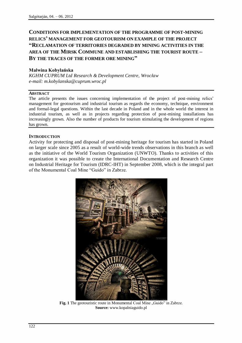
Salgótarján, 04. – 06. 2012
122
CONDITIONS FOR IMPLEMENTATION OF THE PROGRAMME OF POST-MINING
RELICS’ MANAGEMENT FOR GEOTOURISM ON EXAMPLE OF THE PROJECT
“RECLAMATION OF TERRITORIES DEGRADED BY MINING ACTIVITIES IN THE
AREA OF THE MIRSK COMMUNE AND ESTABLISHING THE TOURIST ROUTE –
BY THE TRACES OF THE FORMER ORE MINING”
Malwina Kobylańska
KGHM CUPRUM Ltd Research & Development Centre, Wrocław
e-mail: [email protected]
ABSTRACT
The article presents the issues concerning implementation of the project of post-mining relics‟ management for geotourism and industrial tourism as regards the economy, technique, environment
and formal-legal questions. Within the last decade in Poland and in the whole world the interest in industrial tourism, as well as in projects regarding protection of post-mining installations has increasingly grown. Also the number of products for tourism stimulating the development of regions
has grown.
INTRODUCTION
Activity for protecting and disposal of post-mining heritage for tourism has started in Poland
on larger scale since 2005 as a result of world-wide trends observations in this branch as well
as the initiative of the World Tourism Organization (UNWTO). Thanks to activities of this
organization it was possible to create the International Documentation and Research Centre
on Industrial Heritage for Tourism (IDRC-IHT) in September 2008, which is the integral part
of the Monumental Coal Mine “Guido” in Zabrze.
Fig. 1 The geotouristic route in Monumental Coal Mine „Guido” in Zabrze.
Source: www.kopalniaguido.pl
GEOTOUR & IRSE 2012
123
The Centre pays its attention on protecting, promotion and addition the new values to the
industrial heritage relics for touristic purposes. The superior institution in Poland in this area
is the National Heritage Board of Poland, which has been created on 1st January 2011 as a
consequence of establishing the new status to the National Centre of Research and
Monuments Documentation. The mission of the National Heritage Board of Poland is to
implement the State‟s policy concerning the protection of cultural heritage and its supervision
through assuring the best and most comprehensive conditions for preserving it for future
generations. In accordance with the strategies of these organizations the aim of activities
connecting to post-industrial relics‟ protection and preservation is to build a social shared
responsibility and to preserve sustainable development rules. It means to operate with respect
to environment protection issues and social matters.
TOURISTIC POTENTIAL OF HISTORICAL POST-MINING REMNANTS
An active management of industrial heritage, along with mining heritage, has a wide touristic
context. Post-industrial heritage tourism is touristic activity on the areas, where the main
attraction, and the main reason for visits is the heritage. Within the most valuable, movable
monuments, their parts or complexes, the best representative domains for history of polish
industry are among other things - mining and processing. The polish experiences of the
owners and administrators of open, mainly underground geotouristic routes, shows that these
ventures have a huge touristic potential. These routes were formed on the base of former gold
mines (the Gold Mine in Zloty Stok), salt mines (the “Wieliczka” Salt Mine), uranium mines
(the Underground Touristic-Educational Route in the Old Uranium Mine in Kletno) as well as
coal mines (the Heritage Park of Mining “Queen Luiza” in Zabrze).
The understanding of the value of post-mining and post-metallurgy objects by their
dispatchers as well local and private investors was in last several years the beginning for a
number of new undertakings with the post-industrial and geotouristic character. Among the
newest of them it should be mentioned:
the Kowarskie Mines in Kowary (opening in May 2011),
the Mining Route within the project titled „the New Adventure Tracks in monumental
Wieliczka Salt Mine" (opening in October 2012),
the Underground Multimedia Exhibition in the Bochnia Salt Mine (opening in
November 2011),
the Multimedia Museum in Historic Silver Mine in Tarnowskie Gory (opening in
April 2012),
“Reclamation of territories degraded by mining activities in the area of the Mirsk
Commune and establishing the tourist route – By the traces of the former ore mining”
(under construction).
The last from the these projects served the author as the example for analysis of conditions for
implementation of the programmes of post-mining heritage management connecting with
fulfilling the targets of industrial tourism.
ORIGIN AND BEGINNING OF THE PROJECT OF POST-MINING RELICS’ MANAGEMENT FOR
GEOTOURISM IN THE MIRSK COMMUNE
The origin of every undertaking with the geotouristic character is a disclosure of object or
objects complex of cultural heritage, so in the case of post-mining object these is often a
disclosure of collapsed entrance of adit or shaft. It is unfortunately and very often connected
with a health and life hazard of humans or animals. It is made for example through the finding
of the post-exploitation cavern as a hole in land surface. The origin of the program whose
purpose is management of the installations related to the former mining of tin and cobalt ore
located in the area of the Mirsk Commune (the Lower Silesia in Poland) is connected with the
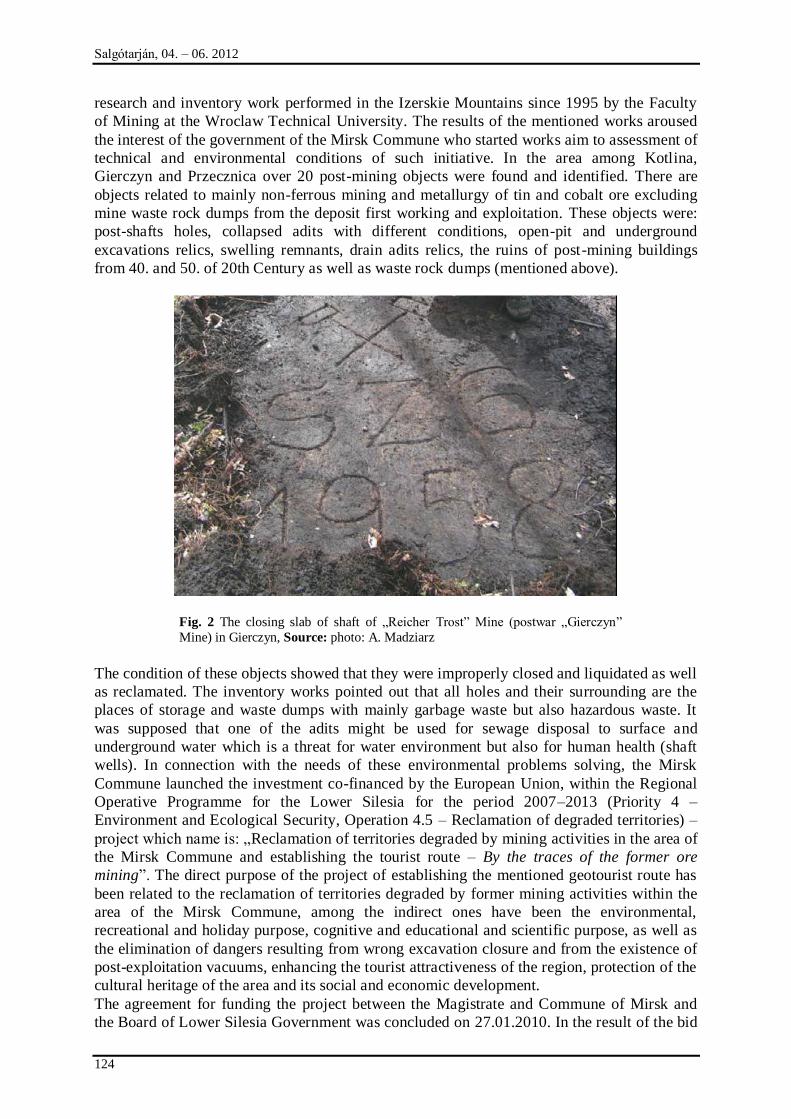
Salgótarján, 04. – 06. 2012
124
research and inventory work performed in the Izerskie Mountains since 1995 by the Faculty
of Mining at the Wroclaw Technical University. The results of the mentioned works aroused
the interest of the government of the Mirsk Commune who started works aim to assessment of
technical and environmental conditions of such initiative. In the area among Kotlina,
Gierczyn and Przecznica over 20 post-mining objects were found and identified. There are
objects related to mainly non-ferrous mining and metallurgy of tin and cobalt ore excluding
mine waste rock dumps from the deposit first working and exploitation. These objects were:
post-shafts holes, collapsed adits with different conditions, open-pit and underground
excavations relics, swelling remnants, drain adits relics, the ruins of post-mining buildings
from 40. and 50. of 20th Century as well as waste rock dumps (mentioned above).
Fig. 2 The closing slab of shaft of „Reicher Trost” Mine (postwar „Gierczyn”
Mine) in Gierczyn, Source: photo: A. Madziarz
The condition of these objects showed that they were improperly closed and liquidated as well
as reclamated. The inventory works pointed out that all holes and their surrounding are the
places of storage and waste dumps with mainly garbage waste but also hazardous waste. It
was supposed that one of the adits might be used for sewage disposal to surface and
underground water which is a threat for water environment but also for human health (shaft
wells). In connection with the needs of these environmental problems solving, the Mirsk
Commune launched the investment co-financed by the European Union, within the Regional
Operative Programme for the Lower Silesia for the period 2007–2013 (Priority 4 –
Environment and Ecological Security, Operation 4.5 – Reclamation of degraded territories) –
project which name is: „Reclamation of territories degraded by mining activities in the area of
the Mirsk Commune and establishing the tourist route – By the traces of the former ore
mining”. The direct purpose of the project of establishing the mentioned geotourist route has
been related to the reclamation of territories degraded by former mining activities within the
area of the Mirsk Commune, among the indirect ones have been the environmental,
recreational and holiday purpose, cognitive and educational and scientific purpose, as well as
the elimination of dangers resulting from wrong excavation closure and from the existence of
post-exploitation vacuums, enhancing the tourist attractiveness of the region, protection of the
cultural heritage of the area and its social and economic development.
The agreement for funding the project between the Magistrate and Commune of Mirsk and
the Board of Lower Silesia Government was concluded on 27.01.2010. In the result of the bid
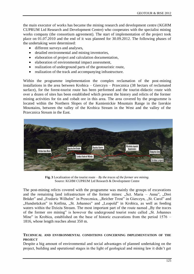
GEOTOUR & IRSE 2012
125
the main executor of works has became the mining research and development centre (KGHM
CUPRUM Ltd Research and Development Centre) who cooperates with the specialist mining
works company (the consortium agreement). The start of implementation of the project took
place on 01.07.2010 and the end of it was planned for 30.09.2012. The following phases of
the undertaking were determined:
different surveys and analyses,
detailed environmental and mining inventories,
elaboration of project and calculation documentation,
elaboration of environmental impact assessment,
realization of underground parts of the geotouristic route,
realization of the track and accompanying infrastructure.
Within the programme implementation the complex reclamation of the post-mining
installations in the area between Krobica – Gierczyn – Przecznica (38 hectars of reclamated
surface), for the forest-tourist route has been performed and the tourist-didactic route with
over a dozen of sites has been established which present the history and relicts of the former
mining activities for tin and cobalt ore in this area. The area covered by the programme is
located within the Northern Slopes of the Kamienickie Mountain Range in the Izerskie
Mountains, between the valley of the Krobica Stream in the West and the valley of the
Przecznica Stream in the East.
Fig. 3 Localization of the tourist route – By the traces of the former ore mining.
Source: KGHM CUPRUM Ltd Research & Development Centre
The post-mining relicts covered with the programme was mainly the groups of excavations
and the remaining land infrastructure of the former mines: „Sct. Maria – Anna”, „Drei
Brüder” and „Frederic Wilhelm” in Przecznica, „Reicher Trost” in Gierczyn, „St. Carol” and
„Hundsrücken” in Kotlina, „St. Johannes” and „Leopold” in Krobica, as well as feeding
waters within the Dzieża Stream. The most important part of the route named „By the traces
of the former ore mining” is however the underground tourist route called „St. Johannes
Mine” in Krobica, established on the base of historic excavations from the period 1576 –
1816, whose length reaches about 350 m.
TECHNICAL AND ENVIRONMENTAL CONDITIONS CONCERNING IMPLEMENTATION OF THE
PROJECT
Despite a big amount of environmental and social advantages of planned undertaking on the
project, building and operational stages in the light of geological and mining law it didn‟t get
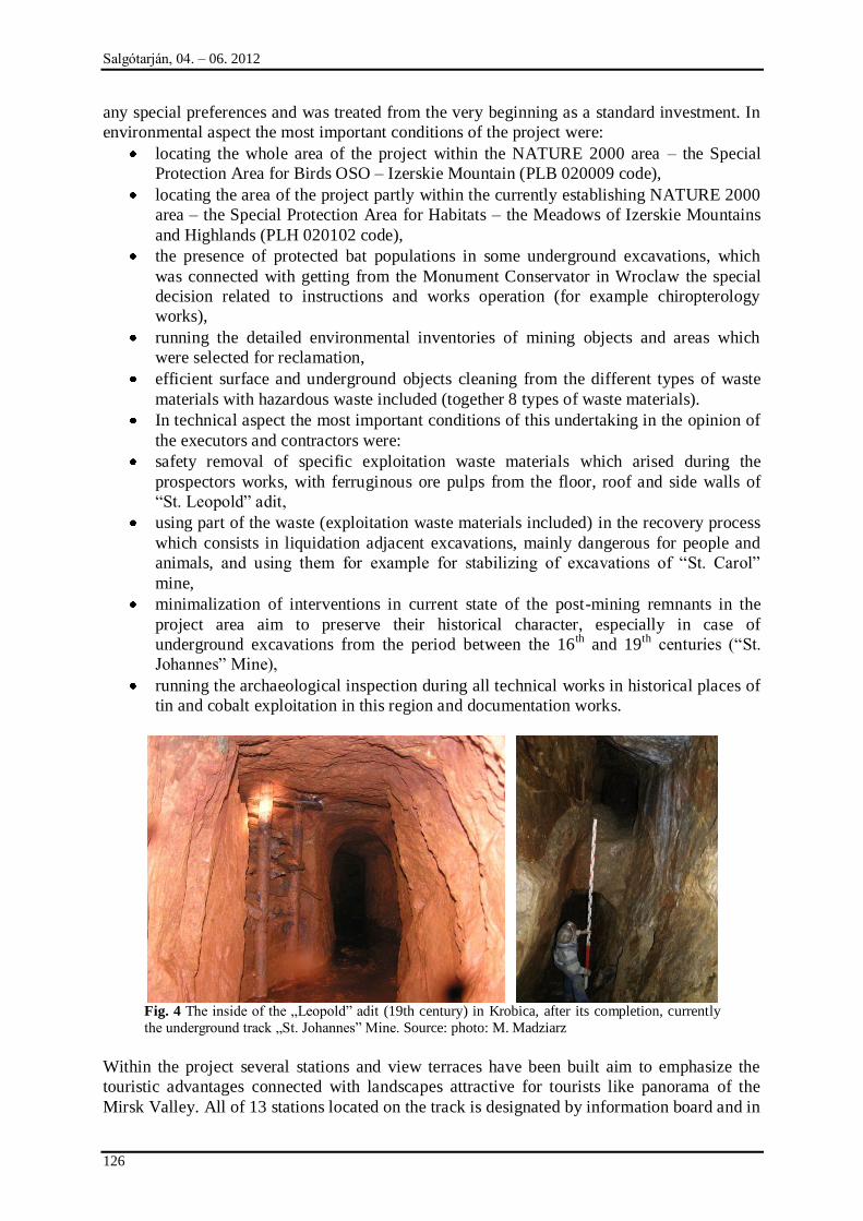
Salgótarján, 04. – 06. 2012
126
any special preferences and was treated from the very beginning as a standard investment. In
environmental aspect the most important conditions of the project were:
locating the whole area of the project within the NATURE 2000 area – the Special
Protection Area for Birds OSO – Izerskie Mountain (PLB 020009 code),
locating the area of the project partly within the currently establishing NATURE 2000
area – the Special Protection Area for Habitats – the Meadows of Izerskie Mountains
and Highlands (PLH 020102 code),
the presence of protected bat populations in some underground excavations, which
was connected with getting from the Monument Conservator in Wroclaw the special
decision related to instructions and works operation (for example chiropterology
works),
running the detailed environmental inventories of mining objects and areas which
were selected for reclamation,
efficient surface and underground objects cleaning from the different types of waste
materials with hazardous waste included (together 8 types of waste materials).
In technical aspect the most important conditions of this undertaking in the opinion of
the executors and contractors were:
safety removal of specific exploitation waste materials which arised during the
prospectors works, with ferruginous ore pulps from the floor, roof and side walls of
“St. Leopold” adit,
using part of the waste (exploitation waste materials included) in the recovery process
which consists in liquidation adjacent excavations, mainly dangerous for people and
animals, and using them for example for stabilizing of excavations of “St. Carol”
mine,
minimalization of interventions in current state of the post-mining remnants in the
project area aim to preserve their historical character, especially in case of
underground excavations from the period between the 16th
and 19th
centuries (“St.
Johannes” Mine),
running the archaeological inspection during all technical works in historical places of
tin and cobalt exploitation in this region and documentation works.
Fig. 4 The inside of the „Leopold” adit (19th century) in Krobica, after its completion, currently
the underground track „St. Johannes” Mine. Source: photo: M. Madziarz
Within the project several stations and view terraces have been built aim to emphasize the
touristic advantages connected with landscapes attractive for tourists like panorama of the
Mirsk Valley. All of 13 stations located on the track is designated by information board and in
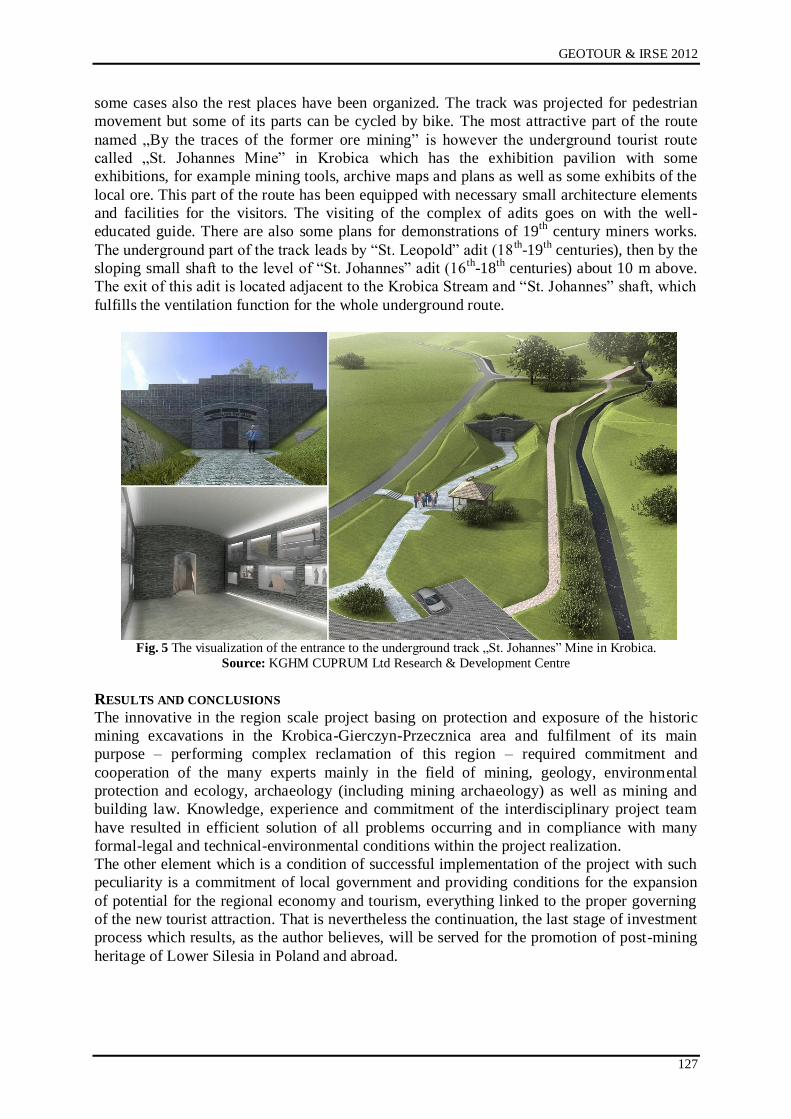
GEOTOUR & IRSE 2012
127
some cases also the rest places have been organized. The track was projected for pedestrian
movement but some of its parts can be cycled by bike. The most attractive part of the route
named „By the traces of the former ore mining” is however the underground tourist route
called „St. Johannes Mine” in Krobica which has the exhibition pavilion with some
exhibitions, for example mining tools, archive maps and plans as well as some exhibits of the
local ore. This part of the route has been equipped with necessary small architecture elements
and facilities for the visitors. The visiting of the complex of adits goes on with the well-
educated guide. There are also some plans for demonstrations of 19th
century miners works.
The underground part of the track leads by “St. Leopold” adit (18th
-19th
centuries), then by the
sloping small shaft to the level of “St. Johannes” adit (16th
-18th
centuries) about 10 m above.
The exit of this adit is located adjacent to the Krobica Stream and “St. Johannes” shaft, which
fulfills the ventilation function for the whole underground route.
Fig. 5 The visualization of the entrance to the underground track „St. Johannes” Mine in Krobica.
Source: KGHM CUPRUM Ltd Research & Development Centre
RESULTS AND CONCLUSIONS
The innovative in the region scale project basing on protection and exposure of the historic
mining excavations in the Krobica-Gierczyn-Przecznica area and fulfilment of its main
purpose – performing complex reclamation of this region – required commitment and
cooperation of the many experts mainly in the field of mining, geology, environmental
protection and ecology, archaeology (including mining archaeology) as well as mining and
building law. Knowledge, experience and commitment of the interdisciplinary project team
have resulted in efficient solution of all problems occurring and in compliance with many
formal-legal and technical-environmental conditions within the project realization.
The other element which is a condition of successful implementation of the project with such
peculiarity is a commitment of local government and providing conditions for the expansion
of potential for the regional economy and tourism, everything linked to the proper governing
of the new tourist attraction. That is nevertheless the continuation, the last stage of investment
process which results, as the author believes, will be served for the promotion of post-mining
heritage of Lower Silesia in Poland and abroad.
Salgótarján, 04. – 06. 2012
128
REFERENCES
[1] GAŃCZARCZYK T., Drugie życie kopalni, Nowy Przemysł, Nr 03 (131), 2009
[2] MADZIARZ M., MIZERA A., DĘBKOWSKI R., Projekt „Rekultywacja obszarów
zdegradowanych działalnością górniczą na terenie gminy Mirsk z utworzeniem ścieżki -
Śladami dawnego górnictwa kruszców” jako koncepcja kompleksowych działań w
zakresie ochrony i wykorzystania dziedzictwa górniczego Dolnego Śląska , [w:] P.P.
Zagożdżon i M. Madziarz (red.), Dzieje Górnictwa – element europejskiego dziedzictwa
kultury, tom 4, Wrocław 2012
[3] MADZIARZ M., SZTUK H. – Eksploatacja rudy cyny w Górach Izerskich: historia czy
perspektywa dla regionu?, Prace Naukowe Instytutu Górnictwa Politechniki
Wrocławskiej Nr 117, Studia
i Materiały Nr 32, 2006
[4] Studium wykonalności projektu „Rekultywacja obszarów zdegradowanych działalnością
górniczą na terenie Gminy Mirsk oraz utworzenie ścieżki turystycznej - Śladami dawnego
górnictwa kruszców”, oprac. KGHM CUPRUM Sp. z o.o. – Centrum Badawczo-
Rozwojowe, Wrocław, czerwiec 2009 r.
Internet sources:
www.ihtourism.pl
www.kopalniaguido.pl
GEOTOUR & IRSE 2012
129
MINING AND GEOLOGICAL HERITAGE PROTECTION AS CHALLENGE FOR LOCAL
COMMUNITIES
Agata Juzyk, Jan Kudełko, Anna Szczerbiak
KGHM CUPRUM Ltd Research & Development Centre, Wrocław
ABSTRACT
This Article attempts to present a problem concerning restoration of areas degraded by post-mining activity, establishing of new geotourist functions and benefits thereof for the local communities. Lower Silesia Province offers substantial potential for this type of projects. A restoration project related to post-mining relicts and consisting in constructing of a tourist route referred to as “Tracing evidence of old times ore mining” currently in progress in Mirsk Commune located in the south-
western part of Lower Silesia Province, served as an example for the purposes hereof.
Introduction
Pursuing activities for protection of the former mining facilities is necessary due to their
historic value and to the problem of their proper preservation. Still the efforts for preservation,
monitoring and protection of dormant mine facilities accessible for tourists, require proper
administration of mining elements of cultural heritage, based on relevant legal control.
Making an element of cultural heritage accessible, results from the dialog and cooperation
between several institutions and research centres, whose efforts are oriented for the scientific,
technical, organizational, legal and statutory support.
The main aim of activities pursued on the European level is to bring about the potential
partnership in multi-disciplinary cooperation which would comprise various institutions and
services oriented for forming the best protection, preservation and for emphasizing the
cultural value of the identified and accessible industrial sites.
The latter particularly concerns:
Ministries, e.g. of the Environment, Economy, Culture, Foreign Affairs,
geological, mining and archaeological services,
European, state and regional governments,
research institutions, research and development centres,
the European Council, UN and UNESCO,
local governments,
boards of large industrial plants,
professional and social organizations,
travel agencies,
job organization.
PROTECTION OF GEOLOGICAL AND MINING HERITAGE One of the issues of European policy is the proper assessment of its influence for cultural
heritage. The mentioned assessment covers profound analysis of the connections and
relationships between various fields of activity or occurring events (e.g. relationship between
agriculture and archaeological discoveries or between the degree of air pollution and
deteriorating state of preservation of technical sites). The next issue is linked to evaluation of
the actual interest of the Europeans in elements of cultural heritage and in consequence, in
gaining financial resources for activities connected with protection and restoration of
monuments, according to the present legislation (Conseil de l‟Europe, 1984).
Among the cultural heritage of a particular country/region one shall mention all traces of
human activity in the natural environment. They compose sources of information on human
life and activity, and on historical development of various crafts, technologies and arts.
Salgótarján, 04. – 06. 2012
130
Because of the fact that the historical monuments regarded as sites of historic and cultural
importance belong to non-renewable resources, their management must base on the long-term
prospect. It is also discernible that historical monuments and other places which form the
cultural heritage serve many people as sources of emotional and aesthetic experience and the
modern society may benefit from the protection and active use of the mentioned cultural
heritage.
Former mines constitute an integral part of archaeological heritage and testify the past mining
activities. The underground objects contain relics of mine working techniques used in the
past, pieces of equipment and housings (made of metal as well as wood). In the mine
surroundings are usually located the former mineral processing plants, smelting infrastructure
and social buildings.
The chain of underground mine workings normally develops according to geological structure
of the deposit (gathers, down- and upcasts, dens, seams), often transecting the encountered
geological formations. That enables the recognition of the occurring mineralization zones.
The exploited ore-bodies, with no useful components still contain vestigial amounts of
minerals. That helps in determining the basic structure and mineralization zones for the
former exploitation.
The local societies‟ activity linked to the excavation works, processing and smelting deeply
interferes in the landscape of mining regions and highly influences their economic
development. The essence of the matter can be observed while analysing the archival
documentations, the rich iconography, but also the changes in architecture, household
furnishing, in nomenclature and cultural traditions. Finally after suspending mineral
exploitation also nature claims its rights and the dormant mines often serve as shelters for
fauna and flora (vegetation, mouldings, insects, spiders, rodents). In general we can state that
old mines constitute a significant element of cultural heritage, often quite foreign for the
society and for environment defendants.
Mining sites as elements of cultural heritage, like the forgotten former mining pits, mine
waste dumps or ruined buildings and mining facilities form a tangible testimony of the long,
even a few hundred years old history of economic development of the region. They testify the
comprehensive knowledge and skills of miners from ancient times who, although vested with
simple means (compared to the contemporary ones), since the early medieval period were
able to excavate the riches of the earth. Large amount of relics of the former mining in Lower
Silesia, their undeniable historic and cognitive value, as well as lack of studies on their
present state of preservation, result in necessity of bringing into force the efforts on their
precise cataloguing and documentation.
Making an effort for protection of the former mining sites is necessary not only for their
historic value, but also for their proper preservation, in order to eliminate the threat posed in
some cases by them, especially towards people and animals. Still the activities adequate for
their preservation, monitoring and protection of the dormant mine workings accessible for
tourists in form of underground trails, like in Złoty Stok, Złotoryja, Kletno and Kowary in the
Owl Mountains and Jizera Mountains, are necessary for proper administration with mining
sites regarded as elements of cultural heritage and for disseminating knowledge about them.
Apart from the mentioned good examples of protecting the former Lower Silesian mining
heritage, problems occur by the complex and adequate preservation and making accessible the
two mining basins put out of action by the end of the last century and located in vast areas,
interesting in their geo-variety, i.e. the Old Copper Basin in the North Sudetes‟ Trough and
the Hard Coal Basin in the Middle Sudetes‟ Trough.
FUNDAMENTALS OF THE LOCAL DEVELOPMENT
Local development is a broad concept, which assumes that all changes, including
economical, are driven by ideas and social power. For purpose of this context, the most
GEOTOUR & IRSE 2012
131
important elements of local development seem: active attitude and acceptance of reforms
introduced by local communities, private enterprises operating within a given region,
ability of creative thinking etc. Local development comprises not only economical,
political and cultural changes but also other processes taking place in communities, since
the changes result in changes of “relationships, institutions, groups and other forms of
social systems”.
Local development takes place on three levels:
1. related to economy (establishment and development of private enterprises; local
government institutions and local communities);
2. related to natural environment and site development (allocation of resources,
development of neglected sites, protection of the natural environment);
3. related to culture and societies (identifying with a given region, common goals,
cognitive and educational benefits).
It seems that attitude of local authorities, which commit to stimulate business activity and
employment by facilitating suitable conditions within a given commune, constitutes
fundamentals of local development. On one hand, it means bringing into play numerous
instruments vested to a commune to acquire investors, and on the other hand, it means own
initiative of local authorities to use potential of a given commune, its resources (natural,
human and institutional) in order to achieve a multi-dimensional development – meaning
development, which offers additional employment, concerns social issues, improvement of
social, road and technical infrastructure, protection of environment as well as personal
development of its residents. It has been proved that key factors contributing to success are:
cooperation between institutions, organizations and enterprises of three branches of industry
(and such complete form of cooperation is partnership), and that development should be based
on local knowledge and skills, which calls for continuous growth and use of social potential,
the so called social capital and facilitating innovative activities, undertaken also in neglected
regions subject to restructuring, which is usually the case for former industrial regions,
including excavation industries (Nieroba, 2007).
GEOTOURIST POTENTIAL OF THE LOWER SILESIA PROVINCE
Closed mines and former production plants constitute resources often perceived as
burdensome and sometimes as an ugly burden even though they could be introduced back into
a business cycle with a new function, e.g. tourist venue, concert hall, art gallery. Adjusting the
post-industrial structures to new functions related to culture, science or leisure appears
possible and needed. Belief of local authorities in gaining significantly big benefits from the
like projects seems of a key importance. We shall now investigate benefits, which may be
gained from creative attitude toward a post-industrial facilities and its revitalization, in
particular within Lower Silesia region known for remains of former mining works, which in
particular have become an inherent and characteristic element of mountain and highland
regions.
Interchangeable influences of various cultures present for centuries within Lower Silesia have
contributed to rich resources of monuments and other substantial evidences of cultural
activity, including thousands of monuments of architecture and urban architectural ensembles.
These relicts stand out from the surrounding and are found mostly in a form of gangue heaps,
cavities, sometimes partially of completely preserved pit shafts, adits – usually in a good
condition, ruins of mining architecture, ore processing and floatation machines (e.g. reservoirs
for back water flow), and finally many evidences of intensive exploration works. These
structures are usually deprived of any form of protection and hardly any documents
concerning their past are found. Many of the preserved and accessible structures are
disappearing from the local landscape never to be seen again due to various works performed
Salgótarján, 04. – 06. 2012
132
in their surrounding or need to protect them in order to avoid danger to third parties etc.
Remains of mining and often also metallurgical works, represent a valuable and rich source of
knowledge concerning development of ore exploration technologies and also evidence of
knowledge and skills acquired by generations of miners connected for centuries with Lower
Silesia region.
Information concerning history of mining exploration within Lower Silesia region are found
inter alia in a series of documents originated by the former German State Mining Office based
in Wrocław (German: Oberbergamt zu Breslau), which offers considerable resources
concerning a period of time from 1779 to 1852 (subject to management of mining and
metallurgical works in Silesia region by the said office).
The main source publications for historical papers come from codes, which include names,
summaries and full content of extracts from old chronicles. Moreover, the most significant
volume of information is found in works by H. Festenberg-Packisch, E. Steinbeck and H.
Fechner. A piece of work by H. Dziekoński, published among other works after 1945, is of a
big significance and constitutes a rich source of information on history of ore mining within
Lower Silesia region, together with works by E. and Z. Piątek.
For centuries various mines were operated within Lower Silesia region. Gold, silver and lead
ore, copper, tin, later also rock coal, arsenic and cobalt used to be great natural resources of
the region. Lower Silesia was recognised as area of post-mining activity.
Lower Silesia comprises six main regions, where useful ore deposits are found, i.e.: Ziemia
Kłodzka (Kłodzko Land comprising Kłodzko Valley and surrounding Sudetes), Owl
Mountains including surroundings of Wałbrzych, foot of Karkonosze, exploited gold sand
deposits near Lwówek, Złotoryja and Legnica.
Condition of the preserved historic relics within Lower Silesia varies to a significant extent.
Research and documentation works conducted within them have revealed both barely visible
cavities, marking direction of adits and bottom roads explored at low depths, or collapsed pit
shafts, as well as perfectly-preserved excavations with fragments of their housings, pieces of
equipment etc. It is a concept of high significance for issues connected with development of
post-industrial structures since its properties such as accessibility, technical condition, tourists
value, will have a key meaning for estimation of investment expenses to be borne in order to
revive a given structure (Madziarz et al, 2005).
CONCEPTUAL STAGE OF THE INVESTMENT PROJECT
Field research, evaluation of tourist value of a given region as well as results of feasibility and
profitability analysis of the investment project constitute basic requirements of a revitalization
project aiming to restore old post-mine structures to life. Comprehensive approach will allow
to identify potential application of natural, technical and technological values. It is generally
believed that post-industrial area is nothing but wasteland and accumulation of waste, which
significantly decreases value of a given region.
Relevant features either positive, which speak in favour of some initiative, or negative which
speak against initiatives under consideration, are taken into account in order to establish a
specific character of chosen facilities. Such approach allows to choose the best direction for
use of facilities and their development, and points at prospects and risks. Choosing a structure
is not a difficult stage of the project. It is execution of next stages and adaptation works that
may present some difficulties.

GEOTOUR & IRSE 2012
133
Fig. 1 Dumps in Wałbrzych
Fig. 2 Facilities of the MP (Mining Plant) “Konrad”
Evaluation of chosen structures may be used as a basis for their optimal development, taking
into account existing natural and anthropogenic values of their surroundings. In case of
mining structures, it is believed that value of a structure is closely connected with geology,
mining technology machines and installations and necessary investment projects. Elements
which contribute to the value of structures are their infrastructures and making use of mines
and their natural green surrounding.
Investment profitability perspective encourages to undertake analysis of such post-mining
areas, which could be made accessible and form a proper character without necessity to bear
significant expenses and labour costs. The said projects apply to structures, in which mining
activities were terminated a long time ago and where nature as well as natural processes have
changed overall landscape of the surrounding area. The proposed concept ideas concerning
redevelopment of post-mining excavations calls for a completely new designing approach.
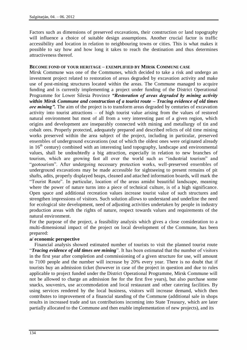
Salgótarján, 04. – 06. 2012
134
Factors such as dimensions of preserved excavations, their construction or land topography
will influence a choice of suitable design assumptions. Another crucial factor is traffic
accessibility and location in relation to neighbouring towns or cities. This is what makes it
possible to say how and how long it takes to reach the destination and thus determines
attractiveness thereof.
BECOME FOND OF YOUR HERITAGE – EXEMPLIFIED BY MIRSK COMMUNE CASE
Mirsk Commune was one of the Communes, which decided to take a risk and undergo an
investment project related to restoration of areas degraded by excavation activity and make
use of post-mining structures located within the areas. The Commune managed to acquire
funding and is currently implementing a project under funding of the District Operational
Programme for Lower Silesia Province “Restoration of areas degraded by mining activity
within Mirsk Commune and construction of a tourist route – Tracing evidence of old times
ore mining”. The aim of the project is to transform areas degraded by centuries of excavation
activity into tourist attractions – of high tourist value arising from the values of restored
natural environment but most of all from a very interesting past of a given region, which
origins and development are inseparably connected with mining and metallurgy of tin and
cobalt ores. Properly protected, adequately prepared and described relicts of old time mining
works preserved within the area subject of the project, including in particular, preserved
ensembles of underground excavations (out of which the oldest ones were originated already
in 16th century) combined with an interesting land topography, landscape and environmental
values, shall be undoubtedly a big attraction, especially in relation to new branches of
tourism, which are growing fast all over the world such as “industrial tourism” and
“geotourism”. After undergoing necessary protection works, well-preserved ensembles of
underground excavations may be made accessible for sightseeing to present remains of pit
shafts, adits, properly displayed heaps, cleaned and attached information boards, will mark the
“Tourist Route”. In particular, location of the areas amidst beautiful landscape, meaning
where the power of nature turns into a piece of technical culture, is of a high significance.
Open space and additional recreation values increase tourist value of such structures and
strengthen impressions of visitors. Such solution allows to understand and underline the need
for ecological site development, need of adjusting activities undertaken by people in industry
production areas with the rights of nature, respect towards values and requirements of the
natural environment.
For the purpose of the project, a feasibility analysis which gives a close consideration to a
multi-dimensional impact of the project on local development of the Commune, has been
prepared:
a/ economic perspective
Financial analysis showed estimated number of tourists to visit the planned tourist route
“Tracing evidence of old times ore mining”. It has been estimated that the number of visitors
in the first year after completion and commissioning of a given structure for use, will amount
to 7100 people and the number will increase by 20% every year. There is no doubt that if
tourists buy an admission ticket (however in case of the project in question and due to rules
applicable to project funded under the District Operational Programme, Mirsk Commune will
not be allowed to charge an admission fee for the first five years), but also purchase some
snacks, souvenirs, use accommodation and local restaurant and other catering facilities. By
using services rendered by the local business, visitors will increase demand, which then
contributes to improvement of a financial standing of the Commune (additional sale in shops
results in increased trade and tax contributions incoming into State Treasury, which are later
partially allocated to the Commune and then enable implementation of new projects), and its
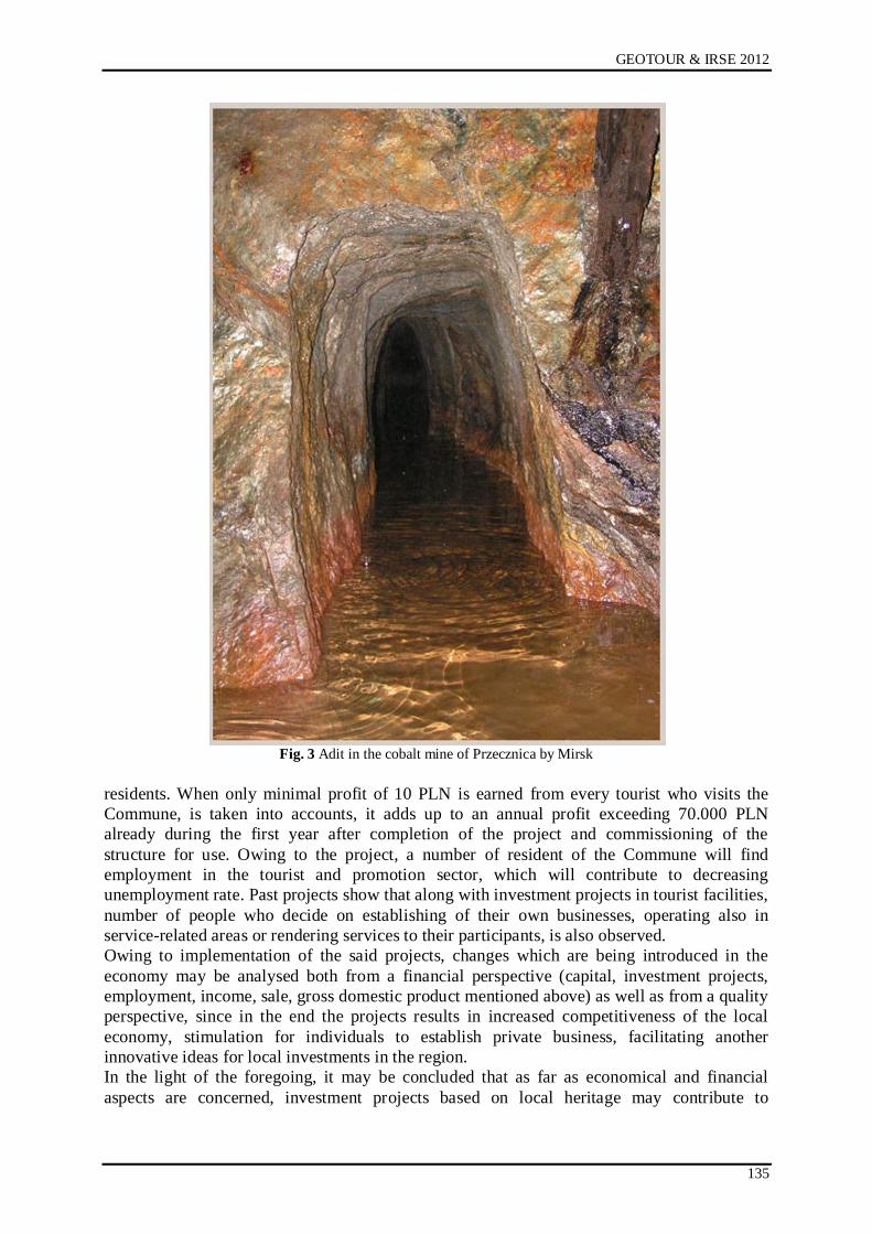
GEOTOUR & IRSE 2012
135
Fig. 3 Adit in the cobalt mine of Przecznica by Mirsk
residents. When only minimal profit of 10 PLN is earned from every tourist who visits the
Commune, is taken into accounts, it adds up to an annual profit exceeding 70.000 PLN
already during the first year after completion of the project and commissioning of the
structure for use. Owing to the project, a number of resident of the Commune will find
employment in the tourist and promotion sector, which will contribute to decreasing
unemployment rate. Past projects show that along with investment projects in tourist facilities,
number of people who decide on establishing of their own businesses, operating also in
service-related areas or rendering services to their participants, is also observed.
Owing to implementation of the said projects, changes which are being introduced in the
economy may be analysed both from a financial perspective (capital, investment projects,
employment, income, sale, gross domestic product mentioned above) as well as from a quality
perspective, since in the end the projects results in increased competitiveness of the local
economy, stimulation for individuals to establish private business, facilitating another
innovative ideas for local investments in the region.
In the light of the foregoing, it may be concluded that as far as economical and financial
aspects are concerned, investment projects based on local heritage may contribute to
Salgótarján, 04. – 06. 2012
136
substantial benefits, on condition that such projects are accompanied by promotion activities
of the local and regional authorities.
b/environment and landscape perspective
Attractiveness of a given region, which comprises post-mining structures arises from a
number of factors to start from environmental, educational, sport, social to economic. The
region may attract prospective investors, who want to restore usability of the existing
structures and which may be of significance to development of a commune or even a number
of communes. Evaluating attractiveness of mining excavations and their specific character
should be taken into consideration when choosing an optimal direction of adaptation works. It
does not mean that structures, which appear attractive due to its geological properties should
be subject to protection, which will ensure preservation of their geological landscape values.
Taking into account close surrounding of post-mining structures, comprehensive actions
which allow scientific, research, educational and tourist approach, should be brought to
attention. Such approach may be assumed in case of multi-level excavations of complex cubic
capacity and variable geological structure.
Existing greenery observed on excavations is also of big significance when decisions
concerning adaptation projects are being made. Sometimes, as the case may be, the areas
comprise very rare and vanishing or protected species, which are listed or attached to EU
directives, applicable under Natura 2000 Network. Such approach means linking e.g.
technical routes with nature routes, which present various flora and fauna species.
There is no doubt that projects aiming to revitalise post-industrial structures, including post-
mining facilities, initiate significant changes as far as natural environment and site
development is concerned. The said changes include, in particular:
Reasonable use of resources and protection of the natural environment,
Improved site development of degraded areas,
Eliminating risks for people and animals,
Site Development achieved through implementation of new investment projects.
One of the main outcomes of such projects is restoration and protection of balance in the
natural environment within the area subject to protection works, which has been affected due
to years of mining and processing activity, as well as later removal of household waste into
excavations. Such outcome is achieved due to execution of the planned revitalization projects,
which restore balance between the man, components of nature and inanimate components of
the surrounding.
c/ cultural and social perspective
Growing branch of industrial tourism may facilitate the process, whereby local communities
identify with a cultural heritage of their region. It reflects local traditions and customs, which
can be easily distinguished and identified. Contrary to some opinions which assume collapse
of a concept of private homeland [German concept of “Heimat”], the idea of local community
experiences a visible come back. During uncertain and turbulent times, individuals need to
underline cultural unity, stability and safety, which may be offered by local community and
areas occupied by its residents. This conclusion is reflected through the so called concept of
“discovering tradition”. Examples of such forms of restoring elements of local life include
fraternities of knights, history of which dates back to mid 70s of 20th century, when the first
knights tournaments were organised in a castle located in Golub-Dobrzyń. Currently hundreds
of fraternities operating within the so called Knights Movement bring closed history of the
middle ages, stage historical events, conducts educational projects. A similar situation is
observed in relation to revitalization of post-mining facilities, which together with restoration
GEOTOUR & IRSE 2012
137
of their usable functions, re-establish traditions connected with mining. Finding or sometimes
establishing a legend connected with a given relict of mining works, not only attracts tourists
but also encourages the local community to adopt new habits and customs as their own, which
builds identification of the local community with its region. The fact may be in particular of a
key importance for the region of Lower Silesia, which due to a complicated history connected
with occupation of the region by various nations, has experienced disturbances in continuity
of traditions and local identity. Going back to the example of Mirsk Commune, a number of
cognitive and educational benefits, which stimulate local development, may be pointed out.
Owing to a new tourist route, visitors will be encouraged and given opportunity to explore
natural landscapes shaped by mining activity and in addition evidence of economic growth of
the Lower Silesia (including remains of old times mining works) will be provided protection.
Geotourist development of facilities of ground and underground mining relics creates one of
the kind opportunity to protect them and pass to future generations. Revitalization undertaken
for purpose of tourism in the areas of underground excavations located in Mirsk Commune,
will consist in suitable preparation of the route taking into account environmental and mining
aspects, and will guarantee full and complete safety for visitors of the underground facilities.
Educational value of the remains of old times mining works is particularly important to
realize significance and role of mine exploration for civilization progress of societies. Relics
of old time mining works provide a valuable source of knowledge concerning past technology
and methods of exploration and processing of pure metal ores.
CONCLUSION
Investing in the past, understood as development and revitalization of late mining facilities,
increase prospective of the local market and build identification with the region and contribute
to positive changes in the natural environment? According to the authors, it is worth coming
to like the so called “unwanted heritage”. Decisions concerning the future of the old time
mining works remains lie particularly within competence of the local authorities. It is also
worth trying to raise public funding or find investors, who will see opportunities presented by
geotourism. Traditions may be preserved either owing to individual engagement, meaning
determination, pertinacity and commitment of supporters of the idea or by stimuli coming
from political or economic forces, which determine what parts and forms of traditions are
worth “investing”, in order to achieve desired profits.
Presently the interest in mining heritage protection in Lower Silesian province grows, which
manifests itself in engagement of local governments and companies as well. The fact can be
exemplified by the KGHM Cuprum Sp. z o. o. Research and Development Centre which is
currently carrying out a number of projects concerning complex assessment methods of the
technical situation of chamber excavations in old mines.
REFERENCES
Conseil de l‟ Europe, European Convention on the Protection of the Archaelogical Heritage”.
M. MADZIARZ, H. SZTUK,:Studies of old time mining facilities within the area of Lower
Silesia, Materials of the 1st Convention on Heritage and history of mining and
possibilities of using remains of old time mining works, Scientific research of the Mining
Institute of the University of Technology in Wrocław No. 111, Series name: Conventions,
No. 43, Wrocław 2005
E. NIEROBA: Tradition deprived of roots. Regional identity and identification of Opole
Province communities with their region in the age of globalization, from:
http://www.interreg.uni.opole.pl/biblioteka/docs/e_nieroba.pdf
Project`s feasibility analysis: “Restoration of areas degraded by mining activity within Mirsk
Commune and construction of a tourist route – Tracing evidence of old times ore
mining”, Wrocław 2009
Salgótarján, 04. – 06. 2012
138
A. SZTANDO: Influence of local authorities on local development within the light of
evolution in structural models of communes. Jelenia Góra, 11/1998
GEOTOUR & IRSE 2012
139
MAPPING OF MINING ACTIVITIES IN SPIŠ-GEMER PART OF SLOVAK ORE
MOUNTAINS AND THE HISTORY OF MINING
Štefan Kuzevič1, Juraj Gašinec
2, Marcela Gergeľová
2, Ţofia Kuzevičová
2,
Miriam Münnich2
1 Institute of Business and Management, BERG Faculty, Technical University of Košice
e-mail: [email protected] 2 Institute of Geodesy and Geographical Information Systems, BERG Faculty, Technical
University of Košice
e-mail: [email protected], [email protected], [email protected]
ABSTRACT
This paper is deals mapping of mining in Spiń-Gemer part of Slovak Ore Mountains in GIS environment. The data, both in text and image form are presented thru geodatabase in ArcGIS. Mining has a rich history of the study area. The origins can be dated probably to the period of 4-5.c. BC, as evidenced by a number of archaeological finds. Written references to ore mining in Spiń-Gemer part of Slovak Ore Mountains are more than 700 years old. Spiń-Gemer part of Slovak Ore Mountains is in terms of ores and industrial exploitation of the most important department of Slovakia. The result is a comprehensive database of area where you can track the progress of mining, interested in different
mining ores and minerals.
INTRODUCTIONINTRODUCTION Spiń-Gemer Ore Mountains is in terms of ores and industrial exploitation of the most
important departments of Slovakia. Researched area in the centuries-old tradition of mining
activities. The origins can be dated probably to the period of 4-5.stor.pnl, as evidenced by a
number of archaeological finds. Written references to ore mining in Spiń-Gemer Ore
Mountains are more than 700 years. To save the information for future generations, it is
appropriate to create a comprehensive database on the territory where such is possible. the
progress of mining, interested in different mining ores and minerals today and follow
developments in terms of historical mining.
SPIŠ-GEMER ORE MOUNTAINS
Slovak Ore Mountains is the largest mountain range in Slovakia area, landscape area
suprovincie Inner Western Carpathians. The central part of the Slovak Ore Mountains -
territory (mainly) Volovské and Stolické hills and mountains and highlands Revúcka also
known as Spiń-Gemer Ore Mountains.
At its construction involved five paleoalpínskych príkrovových units - veporikum, gemerikum
(about 75% of the territory), meliatikum, tuniatikum and silicikum. The most widespread
sedimentary and metamorphic rocks vulkanogénne files - metapieskovce, metavulkanity,
phyllites, carbonates, granites ± lidity. The whole area is characterized by a rich Slovak Ore
Mountains presence of ore genesis and mineralization of varying ages. Geological
environment is characterized by extensive contamination mainly - As, Sb, Pb, Cu, Zn, Hg and
Cr. [1]
Spiń-Gemer Ore Mountains is among one of the most researched and also the most complex
areas of the Western Carpathians. During the 70th to 90 of the last century was carried large
amounts of geological work and exploratory nature of the research, as well as mining
operations in mining and quarrying, which enriched geological knowledge and substantially
specify the geological picture Slovak Ore Mountains. [3]
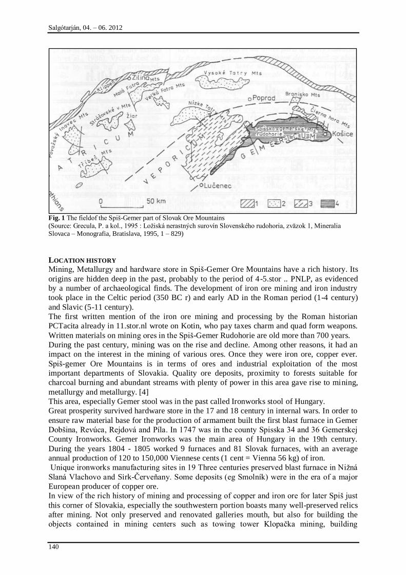
Salgótarján, 04. – 06. 2012
140
Fig. 1 The fieldof the Spiń-Gemer part of Slovak Ore Mountains
(Source: Grecula, P. a kol., 1995 : Loņiská nerastných surovín Slovenského rudohoria, zväzok 1, Mineralia
Slovaca – Monografia, Bratislava, 1995, 1 – 829)
LOCATION HISTORY
Mining, Metallurgy and hardware store in Spiń-Gemer Ore Mountains have a rich history. Its
origins are hidden deep in the past, probably to the period of 4-5.stor .. PNLP, as evidenced
by a number of archaeological finds. The development of iron ore mining and iron industry
took place in the Celtic period (350 BC r) and early AD in the Roman period (1-4 century)
and Slavic (5-11 century).
The first written mention of the iron ore mining and processing by the Roman historian
PCTacita already in 11.stor.nl wrote on Kotin, who pay taxes charm and quad form weapons.
Written materials on mining ores in the Spiń-Gemer Rudohorie are old more than 700 years.
During the past century, mining was on the rise and decline. Among other reasons, it had an
impact on the interest in the mining of various ores. Once they were iron ore, copper ever.
Spiń-gemer Ore Mountains is in terms of ores and industrial exploitation of the most
important departments of Slovakia. Quality ore deposits, proximity to forests suitable for
charcoal burning and abundant streams with plenty of power in this area gave rise to mining,
metallurgy and metallurgy. [4]
This area, especially Gemer stool was in the past called Ironworks stool of Hungary.
Great prosperity survived hardware store in the 17 and 18 century in internal wars. In order to
ensure raw material base for the production of armament built the first blast furnace in Gemer
Dobńina, Revúca, Rejdová and Píla. In 1747 was in the county Spisska 34 and 36 Gemerskej
County Ironworks. Gemer Ironworks was the main area of Hungary in the 19th century.
During the years 1804 - 1805 worked 9 furnaces and 81 Slovak furnaces, with an average
annual production of 120 to 150,000 Viennese cents (1 cent = Vienna 56 kg) of iron.
Unique ironworks manufacturing sites in 19 Three centuries preserved blast furnace in Niņná
Slaná Vlachovo and Sirk-Červeņany. Some deposits (eg Smolník) were in the era of a major
European producer of copper ore.
In view of the rich history of mining and processing of copper and iron ore for later Spiń just
this corner of Slovakia, especially the southwestern portion boasts many well-preserved relics
after mining. Not only preserved and renovated galleries mouth, but also for building the
objects contained in mining centers such as towing tower Klopačka mining, building
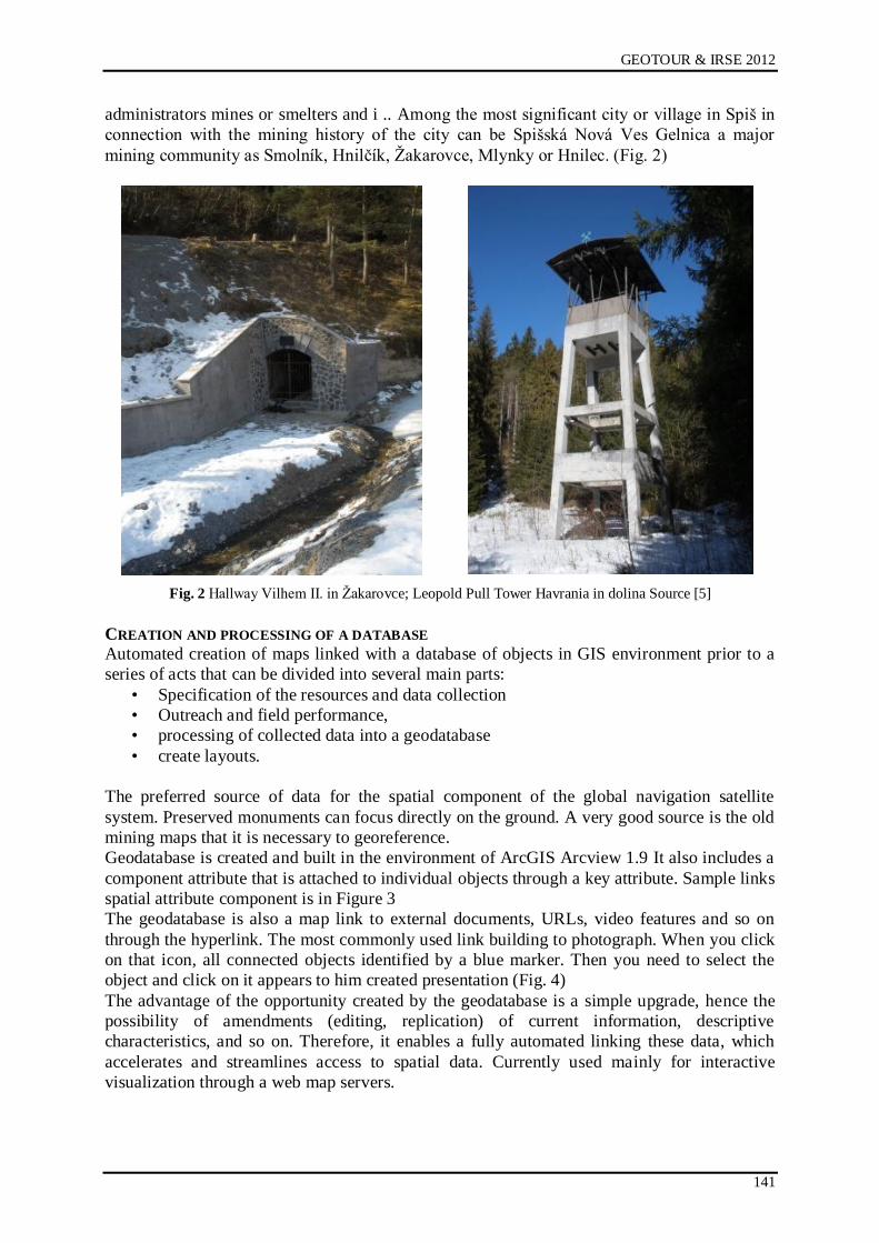
GEOTOUR & IRSE 2012
141
administrators mines or smelters and i .. Among the most significant city or village in Spiń in
connection with the mining history of the city can be Spińská Nová Ves Gelnica a major
mining community as Smolník, Hnilčík, Ņakarovce, Mlynky or Hnilec. (Fig. 2)
Fig. 2 Hallway Vilhem II. in Ņakarovce; Leopold Pull Tower Havrania in dolina Source [5]
CREATION AND PROCESSING OF A DATABASE
Automated creation of maps linked with a database of objects in GIS environment prior to a
series of acts that can be divided into several main parts:
• Specification of the resources and data collection
• Outreach and field performance,
• processing of collected data into a geodatabase
• create layouts.
The preferred source of data for the spatial component of the global navigation satellite
system. Preserved monuments can focus directly on the ground. A very good source is the old
mining maps that it is necessary to georeference.
Geodatabase is created and built in the environment of ArcGIS Arcview 1.9 It also includes a
component attribute that is attached to individual objects through a key attribute. Sample links
spatial attribute component is in Figure 3
The geodatabase is also a map link to external documents, URLs, video features and so on
through the hyperlink. The most commonly used link building to photograph. When you click
on that icon, all connected objects identified by a blue marker. Then you need to select the
object and click on it appears to him created presentation (Fig. 4)
The advantage of the opportunity created by the geodatabase is a simple upgrade, hence the
possibility of amendments (editing, replication) of current information, descriptive
characteristics, and so on. Therefore, it enables a fully automated linking these data, which
accelerates and streamlines access to spatial data. Currently used mainly for interactive
visualization through a web map servers.
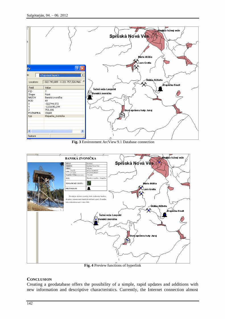
Salgótarján, 04. – 06. 2012
142
Fig. 3 Environment ArcView 9.1 Database connection
Fig. 4 Preview functions of hyperlink
CONCLUSION
Creating a geodatabase offers the possibility of a simple, rapid updates and additions with
new information and descriptive characteristics. Currently, the Internet connection almost
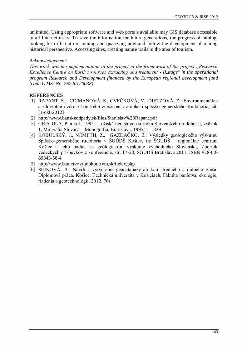
GEOTOUR & IRSE 2012
143
unlimited. Using appropriate software and web portals available may GIS database accessible
to all Internet users. To save the information for future generations, the progress of mining,
looking for different ore mining and quarrying now and follow the development of mining
historical perspective. Accessing sites, creating nature trails in the area of tourism.
Acknowledgement:
This work was the implementation of the project in the framework of the project „Research
Excellence Centre on Earth s sources extracting and treatment - II.stage" in the operational
program Research and Development financed by the European regional development fund
(code ITMS: No. 26220120038)
REFERENCES
[1] RAPANT, S., CICMANOVÁ, S., CVEČKOVÁ, V., DIETZOVÁ, Z.: Environmentálne
a zdravotné riziko z banského znečistenia z oblasti spińsko-gemerského Rudohoria, cit.
[1-okt-2012]
[2] http://www.banskeodpady.sk/files/Stanislav%20Rapant.pdf
[3] GRECULA, P. a kol., 1995 : Loņiská nerastných surovín Slovenského rudohoria, zväzok
1, Mineralia Slovaca – Monografia, Bratislava, 1995, 1 – 829
[4] KOBULSKÝ, J., NÉMETH, Z., GAZDAČKO, Ľ.: Výsledky geologického výskumu
Spińsko-gemerského rudohoria v ŃGÚDŃ Końice, in: ŃGÚDŃ – regionálne centrum
Końice a jeho podiel na geologickom výskume východného Slovenska, Zborník
vedeckých príspevkov z konferencie, str. 17-20, ŃGUDŃ Bratislava 2011, ISBN 978-80-
89343-58-4
[5] http://www.banictvovrudohori.tym.sk/index.php
[6] SEJNOVÁ, A.: Návrh a vytvorenie geodatabázy atrakcií stredného a dolného Spińa.
Diplomová práca. Końice: Technická univerzita v Końiciach, Fakulta baníctva, ekológie,
riadenia a geotechnológií, 2012. 76s.


GEOTOUR & IRSE 2012
Geoparks, Geoheritage and Geoconservation
IRSE: History of Central European Mining
(Conference Proceedings)
Editor
Ľubomír Ńtrba
Publisher
Technical University of Końice
Letná 9
Końice
Slovakia
December 2012
First edition
Number of copies: 60
ISBN 978-80-553-1270-5