selected geosites for geoheritage, geotourism, and ...
17
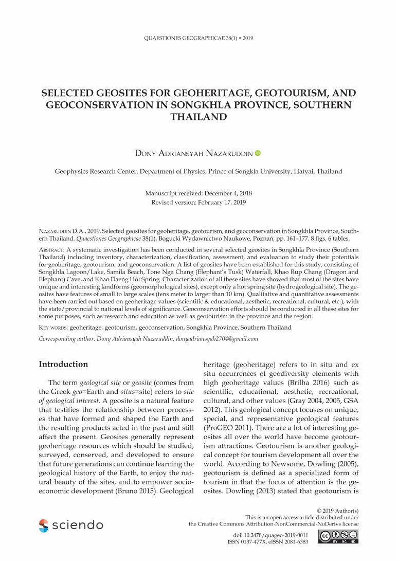
© 2019 Author(s) This is an open access article distributed under the Creative Commons Attribution-NonCommercial-NoDerivs license QUAESTIONES GEOGRAPHICAE 38(1) • 2019 SELECTED GEOSITES FOR GEOHERITAGE, GEOTOURISM, AND GEOCONSERVATION IN SONGKHLA PROVINCE, SOUTHERN THAILAND DONY ADRIANSYAH NAZARUDDIN Geophysics Research Center, Department of Physics, Prince of Songkla University, Hatyai, Thailand Manuscript received: December 4, 2018 Revised version: February 17, 2019 NAZARUDDIN D.A., 2019. Selected geosites for geoheritage, geotourism, and geoconservation in Songkhla Province, South- ern Thailand. Quaestiones Geographicae 38(1), Bogucki Wydawnictwo Naukowe, Poznań, pp. 161–177. 8 figs, 6 tables. ABSTRACT: A systematic investigation has been conducted in several selected geosites in Songkhla Province (Southern Thailand) including inventory, characterization, classification, assessment, and evaluation to study their potentials for geoheritage, geotourism, and geoconservation. A list of geosites have been established for this study, consisting of Songkhla Lagoon/Lake, Samila Beach, Tone Nga Chang (Elephant’s Tusk) Waterfall, Khao Rup Chang (Dragon and Elephant) Cave, and Khao Daeng Hot Spring. Characterization of all these sites have showed that most of the sites have unique and interesting landforms (geomorphological sites), except only a hot spring site (hydrogeological site). The ge- osites have features of small to large scales (tens meter to larger than 10 km). Qualitative and quantitative assessments have been carried out based on geoheritage values (scientific & educational, aesthetic, recreational, cultural, etc.), with the state/provincial to national levels of significance. Geoconservation efforts should be conducted in all these sites for some purposes, such as research and education as well as geotourism in the province and the region. KEY WORDS: geoheritage, geotourism, geoconservation, Songkhla Province, Southern Thailand Corresponding author: Dony Adriansyah Nazaruddin, [email protected] Introduction The term geological site or geosite (comes from the Greek geo=Earth and situs=site) refers to site of geological interest. A geosite is a natural feature that testifies the relationship between process- es that have formed and shaped the Earth and the resulting products acted in the past and still affect the present. Geosites generally represent geoheritage resources which should be studied, surveyed, conserved, and developed to ensure that future generations can continue learning the geological history of the Earth, to enjoy the nat- ural beauty of the sites, and to empower socio- economic development (Bruno 2015). Geological heritage (geoheritage) refers to in situ and ex situ occurrences of geodiversity elements with high geoheritage values (Brilha 2016) such as scientific, educational, aesthetic, recreational, cultural, and other values (Gray 2004, 2005, GSA 2012). This geological concept focuses on unique, special, and representative geological features (ProGEO 2011). There are a lot of interesting ge- osites all over the world have become geotour- ism attractions. Geotourism is another geologi- cal concept for tourism development all over the world. According to Newsome, Dowling (2005), geotourism is defined as a specialized form of tourism in that the focus of attention is the ge- osites. Dowling (2013) stated that geotourism is doi: 10.2478/quageo-2019-0011 ISSN 0137-477X, eISSN 2081-6383
-
Upload
khangminh22 -
Category
Documents
-
view
2 -
download
0
Transcript of selected geosites for geoheritage, geotourism, and ...
© 2019 Author(s) This is an open access article distributed under
the Creative Commons Attribution-NonCommercial-NoDerivs license
QUAESTIONES GEOGRAPHICAE 38(1) • 2019
SELECTED GEOSITES FOR GEOHERITAGE, GEOTOURISM, AND GEOCONSERVATION IN SONGKHLA PROVINCE, SOUTHERN
THAILAND
Dony ADriAnsyAh nAzAruDDin
Geophysics Research Center, Department of Physics, Prince of Songkla University, Hatyai, Thailand
Manuscript received: December 4, 2018Revised version: February 17, 2019
nAzAruDDin D.A., 2019. Selected geosites for geoheritage, geotourism, and geoconservation in Songkhla Province, Southern Thailand. Quaestiones Geographicae 38(1), Bogucki Wydawnictwo Naukowe, Poznań, pp. 161–177. 8 figs, 6 tables.
AbstrAct: A systematic investigation has been conducted in several selected geosites in Songkhla Province (Southern Thailand) including inventory, characterization, classification, assessment, and evaluation to study their potentials for geoheritage, geotourism, and geoconservation. A list of geosites have been established for this study, consisting of Songkhla Lagoon/Lake, Samila Beach, Tone Nga Chang (Elephant’s Tusk) Waterfall, Khao Rup Chang (Dragon and Elephant) Cave, and Khao Daeng Hot Spring. Characterization of all these sites have showed that most of the sites have unique and interesting landforms (geomorphological sites), except only a hot spring site (hydrogeological site). The geosites have features of small to large scales (tens meter to larger than 10 km). Qualitative and quantitative assessments have been carried out based on geoheritage values (scientific & educational, aesthetic, recreational, cultural, etc.), with the state/provincial to national levels of significance. Geoconservation efforts should be conducted in all these sites for some purposes, such as research and education as well as geotourism in the province and the region.
Key worDs: geoheritage, geotourism, geoconservation, Songkhla Province, Southern Thailand
Corresponding author: Dony Adriansyah Nazaruddin, [email protected]
Introduction
The term geological site or geosite (comes from the Greek geo=Earth and situs=site) refers to site of geological interest. A geosite is a natural feature that testifies the relationship between processes that have formed and shaped the Earth and the resulting products acted in the past and still affect the present. Geosites generally represent geoheritage resources which should be studied, surveyed, conserved, and developed to ensure that future generations can continue learning the geological history of the Earth, to enjoy the natural beauty of the sites, and to empower socioeconomic development (Bruno 2015). Geological
heritage (geoheritage) refers to in situ and ex situ occurrences of geodiversity elements with high geoheritage values (Brilha 2016) such as scientific, educational, aesthetic, recreational, cultural, and other values (Gray 2004, 2005, GSA 2012). This geological concept focuses on unique, special, and representative geological features (ProGEO 2011). There are a lot of interesting geosites all over the world have become geotourism attractions. Geotourism is another geological concept for tourism development all over the world. According to Newsome, Dowling (2005), geotourism is defined as a specialized form of tourism in that the focus of attention is the geosites. Dowling (2013) stated that geotourism is
doi: 10.2478/ quageo-2019-0011ISSN 0137-477X, eISSN 2081-6383

162 DoNy ADRiANSyAH NAzARUDDiN
a vehicle to appreciate geodiversity (and geosites), to understand geoheritage, and to foster geoconservation. Many countries have been conducting a number of efforts to protect their important geosites as natural heritage resources through geoconservation, a new emerging geosciences field which focused on the management and protection of those geological elements with exceptional values (Henriques et al. 2011), while developing tourism sector, one of which is through the creation of geoparks to be included in the UNESCo Global Geoparks (Henriques, Brilha 2017).
In Thailand, according to Kuttikul (2008), early efforts on the conservation of the natural features began in 1983 as a part of the Natural Site Selection Process by the Office of Natural Resources and Environmental Policy and Planning (ONEP). At least 2000 important natural sites were inventoried based on some criteria:1. Unique occurrence,2. Natural feature and aesthetic value,3. Historical interest (including local folklore),4. Holy site,5. Scientific, geographic, and archeological val
ue.In 1989, which was declared as the Year of
Natural and Environmental Protection by the Thai Government, 263 sites were selected as Natural Conservation Sites which have been categorized in 6 classes:1. Island and islet,2. Mountain, cave, waterfall, hot spring,3. Lake and swamp,4. Seashore,5. Fossil site, and6. Geomorphological site.
Most of those sites recognized by the government are mostly of geological features with significant geological interests. Geoconservation studies in Thailand have been more actively conducted by several researchers from universities, such as Tulyatid (2016), Singtuen, Won-In (2018a, b), and Won-In, Singtuen (2018). In addition, some parties in Thailand such as Department of Mineral Resources (DMR), Coordinating Committee for Geoscience Programmes in East and Southeast Asia (CCoP), and the National Geopark of Thailand, have organized the Regional Geoheritage Conference in 2018 to promote geoconservation of geoheritage resources
in Southeast region involving Thailand (as the host country), Indonesia, and Malaysia. The most prominent geoconservation effort in the country was when some parts of Satun province in Southern Thailand has been approved by UNESCO as the first Global Geopark in Thailand due to its rich geological and cultural diversity (Satun Geopark 2019).
Thailand consists of four regions: northern, north-eastern, central, and southern. Songkhla Province, one out of 14 provinces in southern region of the country, was also blessed with natural resources and some important geological features such as a tranquil lagoon/lake, fine beaches, enchanting waterfalls, beautiful caves, and interesting hot springs. However, while there are sites/features of geological significance and geotourism attractions in the province, their geoconservation is still in the early stage.
This article presents a systematic study to expose some selected geosites in Songkhla Province which can be seen as potential geoheritage and geotourism resources. Some general steps have been established for this study including of inventory, characterization, classification, assessment, and evaluation (adopted from Komoo 2000) which correspond to geoconservation procedures (Henriques et al. 2011).
Study Area
Songkhla Province (Changwat Songkhla in Thai language) which covers an area of around 7,580 km2 is situated between latitude 6°15' N to 8°00' N and longitude 100°00' E to 101°15' E (Pungrassami 1983). The province is a part of the Southern Thailand region and borders on Nakhon Si Tammarat and Phatthalung Provinces in the north, Satun Province in the west, Pattani Province, yala Province, and Gulf of Thailand in the east, and adjoining Malaysia’s states of Kedah and Perlis in the south (Fig. 1). The province consists of 16 districts (amphoe): Ranot, Krasae Sin, Sathing Phra, Singhanakhon, Khuan Niang, Muang Songkhla, Rattaphum, Bang Klam, Hat yai, Na Mom, Chana, Khlong Hoi Khong, Thepha, Sadao, Na Thawi, and Saba Yoi. Songkhla City is the provincial capital, meanwhile Hatyai is the economic and commercial hub of the Southern Thailand. The province is

SELECTED GEoSiTES foR GEoHERiTAGE, GEoToURiSM, AND GEoCoNSERvATioN iN SoNGKHLA PRoviNCE 163
ideal for tourism development due to its richness in both natural and cultural (or historical) aspects. In additions, this coastal province is one of important ports in Thailand which is situated around 950 km from Bangkok.
Materials and Methods
This research used some materials including map, literatures, and photographs related to Songkhla Province. Methodology of this research is the inventory, characterization, classification, assessment, and evaluation of selected geosites of the province. The inventory was carried out by identifying, selecting and listing important geosites of the province mainly through the geological survey. The survey was supported by information from literatures in public domain and discussion with some local geologists. The characterization of these sites was conducted by detailed observation and description of the selected sites, and the classification was based on the geodiversity category (Gray 2005), scope
(Brocx, Semeniuk 2007, Predrag, Mirela 2010), and scale (Brocx, Semeniuk 2007). Two assessment approaches were used in this research: (1) Qualitative approach, which was based on determination of geoheritage values, significance levels (ranking), and contents, and (2) Quantitative approach, which uses numerical assessment (valuing) of the sites based also on geoheritage values. Last but not least, the SWoT analysis was done to evaluate all these sites in term of strengths, weaknesses, opportunities, and threats.
General Geology
Geomorphologically, Songkhla Province mainly consists of coastal areas and plain areas with the rest of mountainous and hilly terrains. The province’s coastal areas are rich in natural features such as a large lagoon/lake in its north and some fine beaches along its shoreline. The shoreline is rather straight with great length in the northern part and curving in its south. Plain areas have no special geomorphologic features,
Fig. 1. Location map of the study area (source: Google Map, 2016).A – map of Thailand, B – map of Songkhla Province.
164 DoNy ADRiANSyAH NAzARUDDiN
but contribute as the places of a few hot spring manifestations. Mountainous and hilly areas contain some beautiful waterfalls, meanwhile limestone hills produce hidden yet wonderful caves.
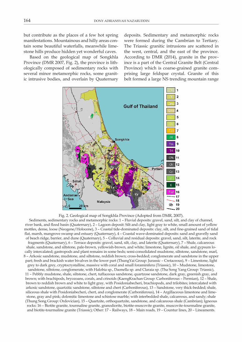
Based on the geological map of Songkhla Province (DMR 2007, Fig. 2), the province is lithologically composed of sedimentary rocks with several minor metamorphic rocks, some granitic intrusive bodies, and overlain by Quaternary
deposits. Sedimentary and metamorphic rocks were formed during the Cambrian to Tertiary. The Triassic granitic intrusions are scattered in the west, central, and the east of the province. According to DMR (2014), granite in the province is a part of the Central Granite Belt (Central Province) which is coarsegrained granite comprising large feldspar crystal. Granite of this belt formed a large NS trending mountain range
Fig. 2. Geological map of Songkhla Province (Adopted from DMR, 2007).Sediments, sedimentary rocks and metamorphic rocks: 1 – Fluvial deposits: gravel, sand, silt, and clay of channel,
river bank, and flood basin (Quaternary), 2 – Lagoon deposit: Silt and clay, light gray to white, small amount of yellow mottles, dense, loose (Neogene/Holocene), 3 – Coastal tide-dominated deposits: clay, silt, and fine-grained sand of tidal flat, marsh, mangrove swamp and estuary (Quaternary), 4 – Coastal wave-dominated deposits: sand and gravelly sand of beach ridge, barrier, and dune (Quaternary), 5 – Colluvial and residual deposits: gravel, sand, silt, laterite, and rock
fragments (Quaternary), 6 – Terrace deposits: gravel, sand, silt, clay, and laterite (Quaternary), 7 – Shale, calcareous shale, sandstone, and siltstone, palebrown, yellowishbrown, and white; limestone, lignite, oil shale, and gypsum lo
cally intercalated; gastropods and plant remains in some beds; semiconsolidated mudstone, siltstone, sandstone, marl, 8 – Arkosic sandstone, mudstone, and siltstone, reddish brown; cross-bedded; conglomerate and sandstone in the upper part; fresh and brackish water bivalves in the lower part (ThungYai Group: Jurassic – Cretaceous), 9 – Limestone, light
grey to dark grey, cryptocrystalline, massive with coral and small foraminifera (Triassic), 10 – Mudstone, limestone, sandstone, siltstone, conglomerate, with Halobia sp., Daonella sp. and Claraia sp. (Tha Song Yang Group: Triassic),
11 – Pebbly mudstone, shale, siltstone, chert, tuffaceous sandstone, quartzose sandstone, dark gray, greenish gray, and brown; with brachipods, bryozoans, corals, and crinoids (KaengKrachan Group: Carboniferous – Permian), 12 – Shale, brown to reddish brown and white to light gray, with Posidoniabecheri, brachiopods, and trilobites; intercalated with arkosic sandstone, quartzitic sandstone, siltstone and chert (Carboniferous), 13 – Sandstone, very thick-bedded; shale, siliceous shale with Posidoniabecheri, chert, and conglomerate (Carboniferous), 14 – Argillaceous limestone and limestone, gray and pink; dolomitic limestone and schistose marble; with interbedded shale, calcareous, and sandy; shale
(Thung Song Group: Ordovician), 15 – Quartzite, orthoquartzite, sandstone, and calcareous shale (Cambrian); Igneous rocks: 16 – Biotite granite, tourmaline granite, granodiorite, biotite-muscovite granite, muscovite-tourmaline granite, and biotite-tourmaline granite (Triassic); Other: 17 – Railways, 18 – Main roads, 19 – Countur lines, 20 – Lineaments.
SELECTED GEoSiTES foR GEoHERiTAGE, GEoToURiSM, AND GEoCoNSERvATioN iN SoNGKHLA PRoviNCE 165
covering from the North to South of Thailand. Meanwhile, the Quaternary deposits dominate the province and consist of fluvial deposits, lagoon deposits, coastal tidedominated deposits, coastal wavedominated deposits, colluvial and residual deposits, and terrace deposits.
Inventory
Songkhla Province offers beautiful landforms and rock exposures as well as exciting geological phenomena on some parts of its area. The inventory of selected geological features was conducted by geological survey to identify (to list) and map the sites and supported by some scientific and popular published sources, such as Sawata et al. (1983) who studied the Quaternary geology of Hatyai – Songkhla area in some locations including the Songkhla Lagoon, Rahim et al. (2005) which included the Samila Beach as one of tourism destinations in Songkhla Province, Siriphanich, Palakurthi (2006) who studied the factors affecting the Songkhla Lagoon as a the tourism destination, and TAT (2016) which listed sites of attraction in the province. Moreover, information from the above sources was complimented by discussion with other geologists in Thailand.
The selection of the sites with geoheritage significance needs to consider several criteria including uniqueness, representativeness, and rare occurrence (Predrag, Mirela 2010, Brocx, Semeniuk 2011). The location map and list of some important geological sites in Songkhla Province with
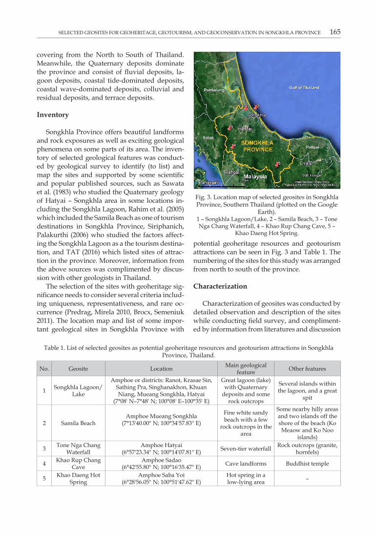
potential geoheritage resources and geotourism attractions can be seen in Fig. 3 and Table 1. The numbering of the sites for this study was arranged from north to south of the province.
Characterization
Characterization of geosites was conducted by detailed observation and description of the sites while conducting field survey, and complimented by information from literatures and discussion
Fig. 3. Location map of selected geosites in Songkhla Province, Southern Thailand (plotted on the Google
Earth).1 – Songkhla Lagoon/Lake, 2 – Samila Beach, 3 – Tone Nga Chang Waterfall, 4 – Khao Rup Chang Cave, 5 –
Khao Daeng Hot Spring.
Table 1. List of selected geosites as potential geoheritage resources and geotourism attractions in Songkhla Province, Thailand.
No. Geosite Location Main geological feature other features
1 Songkhla Lagoon/Lake
Amphoe or districts: Ranot, Krasae Sin, Sathing Pra, Singhanakhon, Khuan Niang, Mueang Songkhla, Hatyai
(7°08' N–7°48' N; 100°08' E–100°35' E)
Great lagoon (lake) with Quaternary
deposits and some rock outcrops
Several islands within the lagoon, and a great
spit
2 Samila BeachAmphoe Mueang Songkhla
(7°13'40.00" N; 100°34'57.83" E)
fine white sandy beach with a few
rock outcrops in the area
Some nearby hilly areas and two islands off the shore of the beach (Ko Meaow and Ko Noo
islands)
3 Tone Nga Chang Waterfall
Amphoe Hatyai(6°57'23.34" N; 100°14'07.81" E) Seventier waterfall Rock outcrops (granite,
hornfels)
4 Khao Rup Chang Cave
Amphoe Sadao(6°42'55.80" N; 100°16'35.47" E) Cave landforms Buddhist temple
5 Khao Daeng Hot Spring
Amphoe Saba yoi(6°28'56.05" N; 100°51'47.62" E)
Hot spring in a lowlying area –

166 DoNy ADRiANSyAH NAzARUDDiN
with other geologists and local communities. In addition to their geological significance, the selection of the sites should also consider their geoheritage values, such as scientific (and educational), aesthetic, recreational, and cultural values. A few sites have also economic, functional, or religious values. Other natural features (such as animals and plants) and manmade features (such as facilities and infrastructures) exist in the sites will also be mentioned in general to support the description (Nazaruddin 2017). A similar study conducted by Henriques, Neto (2015) in São Tomé island (Cameron Line, Central Africa) revealed that the selected geosites were considered under a geoconservation perspective including geological objects with different contents and representing different types of geoheritage. The following parts are the descriptions of each selected geosite in Songkhla Province.
Songkhla Lagoon/LakeThis coastal lagoon is a complex of lagoons
where the freshwater coming from the mountainous areas mixes with the salty ones entering
from the Gulf of Thailand (a freshwater lake with the brackish water in the area close to the sea). The lagoon lies between 7°08' N – 7°48' N, 100°08' E – 100°35' E which is located between Songkhla and Phattalung Provinces (except only the northern portion which is all situated in Phattalung Province and all southern portion is located in Songkhla Province). The lagoon covers an area with the maximum length of around 80 km and the maximum width of around 25 km and contains several islands (Sawasdee.com 2009). It is the largest natural lake in Thailand. Due to its large size, the lagoon is also called as the Great Songkhla Lake which can be divided into three portions: the northern portion, which is called Thale Noi (meaning small sea) and located in Phattalung Province, the middle portion, which is called Thale Luang (meaning big sea) and situated between Phattalung Province and Songkhla Province, and the southern portion, which is called Thale Sap Songkhla (meaning Songkhla Lake) and located in Songkhla Province. The lagoon covers seven districts in Songkhla Province as shown in Table 1. In the southern portion, people can visit
Fig. 4. Songkhla Lagoon area.a – the aerial view of the lagoon with the Tinsulanond Bridge which spans the lagoon, b – The Quaternary deposits in
the lagoon area where people usually enjoy the scenery of the water body, c – The Maharach Beach in Sathing Phra district (near the Songkhla Lagoon) is a part of the Songkhla Great Spit, d – The Jurassic – Cretaceous sedimentary
rocks which dominantly composed of sandstone in the lagoon area in Amphoe Krasae Sin.

SELECTED GEoSiTES foR GEoHERiTAGE, GEoToURiSM, AND GEoCoNSERvATioN iN SoNGKHLA PRoviNCE 167
Ko yo island, a small triangular island which has recently become an important tourist attraction. The provincial authority has excellently built the Tinsulanond Bridge, the longest concrete bridge in Thailand, connecting Ko yo island to the coastal areas. The south eastern end of the southern portion opens into the Gulf of Thailand allowing tides to propagate into the lagoon.
The lagoon areas are composed dominantly of Quaternary deposits (indicated by Qmc, Ql, Qms, and Qc in the geological map) and there are a few locations in the lagoon areas where preQuaternary rocks can be found. Based on DMR (2014), Ko yo island is composed of shale, sandstone, mudstone, and chert unit containing conodont fossils and regarded by the previous researcher as Early Carboniferous. According to the geological map DMR (2007), some isolated hills in the middle portion of the lagoon are composed of Jurassic – Cretaceous sedimentary rocks (JKI), such as in the biggest hill, Cape Chao in Amphoe Krasae Sin, and some others scattered in the nearby areas.
The lagoon also incorporates a 75-km spit with fine sandy beaches which is called Songkhla Great Spit which separates the lagoon from the sea. The
lagoon is also rich with the species of water plants (such as the habitat for mangrove swamps), its middle portion is known for its small population of irrawady dolphins, and its southern portion is known for its production of fish, shrimps, and crabs. Fig. 4 shows the Great Songkhla Lagoon and its surrounding areas.
Samila BeachAlthough Songkhla Province possesses many
fine beaches stretching along its coastal areas, Samila Beach (or Hat Samila in Thai language) is assumed as the most beautiful and developed beach in the province. Some other beaches in the province are Sathing Phra Beach, Maharach Beach, Sai Kaeo Beach, Chalatat Beach, Sakom Beach, and Soi Sawan Beach. Samila Beach is situated on the coordinates of 7°13'40.00" N, 100°34'57.83" E in the Songkhla City, Amphoe Mueang Songkhla, facing to the Gulf of Thailand. It is renowned for its fine white sands and the statue of a mermaid, the Songkhla’s most famous landmark (the symbol of the province). The beach extends totally around 2 km long and is easily accessible since it is located by Songkhla City.
Fig. 5. Samila Beach.a – the beautiful scenery of the beach, b – the mermaid statue on the outcrop of hornfels, c – the close-up view of the
hornfels outcrop, d – Songkhla City gate as a decoration in the beach area.
168 DoNy ADRiANSyAH NAzARUDDiN
Geologically, the beach is composed of Quaternary deposits (Qms) and the black hornfels which are scattered in some locations surrounded by the sands (Fig. 5). It is interpreted that the hornfels occurred as the previous mudstone in this area was subjected to contact metamorphism by a granite intrusion, the source of the heat. The hornfels can be distinguished from the sedimentary rocks among others by their high strength and dense.
Samila Beach is the most famous tourism attraction in the province where many local and international tourists visit the beach every day. Two small islands, i.e. Ko Meaow and Ko Noo (Cat and Rat islands) can be seen just offshore (in the Gulf of Thailand). Its beautiful panorama makes it suitable for recreational activities. Many facilities have been added to develop this beach as the main attraction of the province.
Tone Nga Chang WaterfallTone Nga Chang (meaning Elephant’s Tusk)
Waterfall is the most famous, most beautiful, and the largest waterfall in Songkhla Province, even one of the best in Southern Thailand. This waterfall is located on the coordinates of 6°57'23.34" N, 100°14'07.81" E in the Tone Nga Chang Wildlife Sanctuary, about 25 km from Hatyai and around 50 km from Songkhla City. It has seven levels (namely Tone Ba, Tone Plew, Tone Nga Chang, Tone Dum, Tone Namproy, Tone Ruesrikoybo, and Tone Metchoon) and offers scenic views, mainly in the third level (Tone Nga Chang, which gives name to the whole area) which is the most beautiful level. In the third level, the stream is separated into two resembling the elephant’s tusks (hence the name of the waterfall) with the height of about 20 m. The total distance between the first to the seventh levels is around 1,550 m.
Geologically, the Tone Nga Chang Waterfall occurs in the contact between the biggest Triassic granite intrusion in the province (Trgr) and sedimentary rocks comprising mostly gray to darkgray pebbly mudstone and darkgray sandstone interbeds (parts of Late Carboniferous Pru Chaba Formation according to DMR (2014) where this contact metamorphism produced hornfels and quartzite. Outcrops of granite (dominantly granite porphyry), hornfels, and quartzite can be observed in the waterfall area, meanwhile their boulders are scattered along the river in this area.
This waterfall is easily accessible and has drawn nature lovers, picnickers, and photographers to enjoy not only the waterfall, but also the clean air and greenery (Fig. 6). In additions, visitors can also go hiking and climbing the mountain and swimming in the pools. Trekking trails are provided for adventurous visitors. Local people consider this waterfall as a recreational area, so that many families travel here mainly during the weekends. Songkhla Province possesses some other waterfalls such as Boriphat Waterfall, Khao Kaeo Waterfall, Ton Plio Waterfall, Ton Dat fa Waterfall, Ton Lat Waterfall, and Phru Bon Waterfall.
Khao Rup Chang CaveKhao Rup Chang (meaning Dragon and
Elephant) cave complex is located in Padang Besar area (around 10 km in the NW of Padang Besar immigration Checkpoint), Amphoe Sadao (coordinates: 6°42'55.80" N, 100°16'35.47" E) which is close to the Malaysia – Thailand border. The cave complex has four main caves namely the Silent Meditation Cave, the Patriarch Cave, the 18 Arahant Cave, and the main and the biggest one, the Big Buddha Cave. This area has been developed into a Buddhist temple/pagoda (wat in Thai) area where Buddhist people from local areas and other countries, such as Malaysia, Singapore, and Myanmar, come to perform their prayer. Kiernan (2015) studied about Landforms as Scared Places and stated that although caves are hidden from sight, but they have been viewed as sacred by many faiths. In Buddhism, the caves are important among others due to their role at various stages in Buddha’s life.
Existing in a hill of Permian limestone (Pr) with the height of more than 100 m from the surface, this beautiful cave complex contains many interesting features, such as stalactites, stalagmites, the underground river, and other cave features (Fig. 7). According to DMR (2014), most of the Permian rocks in Thailand are limestone, where one of the limestone belts, i.e. the Ratburi Group extends to the southern part of the country including Songkhla Province.
Khao Daeng Hot SpringKhao Daeng Hot Spring is located in a lowly
ing area in the coordinates of 6°28'56.05" N, 100°51'47.62" E in the Amphoe Saba Yoi, around

SELECTED GEoSiTES foR GEoHERiTAGE, GEoToURiSM, AND GEoCoNSERvATioN iN SoNGKHLA PRoviNCE 169
5 km from the Talot Cave, another cave in the province. This hot spring site has been developed by the authority with some facilities for the comforts of visitors, such as several pools, gazebos, tiled walkways, and toilets (Fig. 8). Generally,
the formation of hot spring is strongly influenced by the geological structure (i.e. fault or fracture) and closely related to the magmatic activity or granite intrusion in or around the area. The origin of Khao Daeng Hot Spring is still unclear
Fig. 6. Tone Nga Chang Waterfall.a – the plank of the Tone Nga Chang Wildlife Sanctuary, b – the signboard shows the names of seven tiers of the
waterfall and other facilities in the area, c – the first tier (Tone Ba) where many people like to swim in its wide pool, d – the second tier (Tone Plew), e – the third and the most beautiful tier (Tone Nga Chang), f – the trail to go to the
third tier, g – an outcrop of granite, h – An outcrop of hornfels.

170 DoNy ADRiANSyAH NAzARUDDiN
and debatable. According to DEDE, CMU (2006), heat sources for hot springs may be related to or the combination of the granite intrusion, friction along fault planes, and volcanic eruption, depending on the geological setting of the area.
Production of the hot water in this site may be primarily from sedimentary rocks from which water will seep to the surface. The water has the surface temperature of around 35–40°C. Based on the geological map produced by DMR (2007), this hot spring is situated in the Carboniferous sedimentary rocks (Cy) which consist primarily
of sandstone (possibly as the aquifer) and many lineaments (possibly as the structural control of the hot spring).
Hot springs are one of the surface manifestations of a geothermal system, which might be used as a renewable energy source other than for heating, recreational or tourism, and other purposes. According to Subtavewung et al. (2005), there are approximately 43% of hot springs in Thailand used in tourism purpose, meanwhile 39% is unutilized, 17% is for the consumption, and only 1% is for the power plant (only one hot spring).
Fig. 7. Khao Rup Chang Cave.
a – the cave is in the limestone hill near a Chinese Buddist temple/pagoda, b – the signboard/notice board in the cave area, c – some cave structures and underground stream, d – inside of the Patriarch Cave, e – The Big
Buddha Cave, the main and the biggest cave in the area.

SELECTED GEoSiTES foR GEoHERiTAGE, GEoToURiSM, AND GEoCoNSERvATioN iN SoNGKHLA PRoviNCE 171
Classification
The selected geosites of Songkhla Province were categorized based on some classifications: geodiversity, scope, and scale. Geodiversity
consists of eight elements: rock, mineral, fossil, landform, landscape, process, soil, and other georesources (Gray 2005). In term of scope, Brocx, Semeniuk (2007) and Predrag, Mirela (2010) have classified geological sites into petrological
Fig. 8. Khao Daeng Hot Spring.a – the hot spring site was built near a rubber plantation area, b – some facilities have been built in the site for the
comforts of visitors such as pools, gazebos, tiled walkways, and toilets, c – two wells where the hot water originally come from, d – one of the pools where people like to swim in the hot water.
Table 2. Classification of some selected geosites in Songkhla Province, Thailand.
No. Geological site Geodiversity (Gray 2005)Scope
(Brocx, Semeniuk 2007, Predrag, Mirela 2010)
Scale(Brocx, Semeniuk
2007)1 SongkhlaLagoon/Lake Landform/landscape, rock Geomorphological site, petro
logical siteLarge scale
2 Samila Beach Landform/landscape, rock Geomorphological site, petrological site
Medium scale
3 Tone Nga Chang Waterfall Landform/landscape, rock Geomorphological site, petrological site
Medium scale
4 Khao Rup Chang Cave Landform/landscape, rock Geomorphological site, petrological site
Small scale
5 Khao Daeng Hot Spring Hydrogeologic process (hot spring)
Hydrogeological site Small scale

172 DoNy ADRiANSyAH NAzARUDDiNTa
ble
3. Q
ualit
ativ
e as
sess
men
t of s
elec
ted
geos
ites
for p
oten
tial g
eohe
rita
ge re
sour
ces
and
geot
ouri
sm a
ttrac
tions
in S
ongk
hla
Prov
ince
, Tha
iland
.
No.
Geo
site
Scie
ntifi
c (a
nd
educ
atio
nal)
valu
e
Aes
thet
ic
valu
eRe
crea
tiona
l va
lue
Cul
tura
l (a
nd
hist
oric
al)
valu
eEc
onom
ic v
alue
func
tiona
l va
lue
Relig
ious
val
ueLe
vel o
f si
gnifi
ca
nce
C
onte
nts
1.So
ngkh
la
Lago
on/
Lake
form
atio
n pr
oces
ses
of
lago
on; t
he
litho
logy
of t
he
lago
on
Attr
activ
e la
ndsc
ape
of
lago
on a
nd
its s
ur
roun
ding
s
Wat
erb
ased
re
crea
tiona
l ac
tiviti
es a
nd
hiki
ng in
its
surr
ound
ing
hills
The
lago
on h
as
been
a ri
ch c
ra
dle
for c
ultu
ral
and
life
of lo
cal
peop
le fo
r a
thou
sand
yea
rs
Loca
l com
mun
ity
can
gen
erat
e th
eir i
ncom
e by
th
e pr
oduc
tion
of
agri
cultu
ral p
rod
ucts
and
fish
erie
s in
the
lago
on a
rea
––
Nat
iona
lSc
enic
2.Sa
mila
Be
ach
Beac
h la
nd
form
s an
d pr
oces
ses;
lit
holo
gy o
f the
be
ach
Attr
activ
e la
ndsc
ape
of th
e be
ach
an
d its
sur
ro
undi
ngs
Enjo
y th
e sc
eni
c vi
ews
and
recr
eatio
nal
activ
ities
in th
e be
ach
area
Lege
nds
of th
e m
erm
aid
and
K
oh M
eaow
an
d K
oh N
oo
(Cat
and
Rat
is
land
s)
inco
me
gene
ra
tion
from
tour
ism
an
d re
crea
tiona
l ac
tiviti
es in
the
beac
h ar
ea
––
Stat
eSy
mbo
lic
3.To
ne N
ga
Cha
ng W
ate
rfal
l
form
atio
n pr
oces
ses
of
wat
erfa
ll; th
e lit
holo
gy o
f the
w
ater
fall
Attr
activ
e la
ndsc
ape
of w
ater
fall
an
d its
sur
ro
undi
ngs
Swim
min
g an
d hi
king
/clim
bin
g, e
njoy
ing
the
clea
n ai
r an
d gr
een
envi
ro
nmen
ts
–
inco
me
gene
ra
tion
from
tour
ism
an
d re
crea
tiona
l ac
tiviti
es in
the
wat
erfa
ll ar
ea
––
Stat
eic
ono
grap
hic
4.K
hao
Rup
Cha
ng C
ave
Kar
st la
nd
form
s; c
ave
form
atio
n
Attr
activ
e la
ndsc
ape
of
cave
and
its
surr
ound
in
gs
Cav
e ex
plor
atio
n
––
–
The
cave
is u
sed
as a
tem
ple
(wat
, th
e pl
ace
of w
or
ship
) for
loca
l an
d in
tern
atio
nal
Budd
hist
peo
ple
Stat
ein
dici
al
5.K
hao
Dae
ng
Hot
Spr
ing
form
atio
n pr
oces
ses
of
the
hot s
prin
g;
stru
ctur
al c
on
trol
; geo
ther
m
al s
yste
m;
wat
er q
ualit
y
A lo
wly
in
g ar
ea
surr
ound
ed
by th
e gr
een
envi
ronm
ent
Enjo
y th
e fr
esh
hot w
ater
and
sw
imm
ing/
bath
ing
–
inco
me
gene
ratio
n fr
om re
crea
tiona
l ac
tiviti
es in
the
hot s
prin
g ar
ea
Hot
spr
ing
ther
apy
and
skin
trea
tm
ent
–
Stat
ein
dici
al

SELECTED GEoSiTES foR GEoHERiTAGE, GEoToURiSM, AND GEoCoNSERvATioN iN SoNGKHLA PRoviNCE 173
site, stratigraphic site, mineralogical site, fossil (palentological) site, geomorphological site, speleological site, hydrological/hydrogeological site, structural site, and so on. The sites can also be categorized based on their scale (Brocx, Semeniuk 2007), such as regional scale/megascale (coverage of 100 × 100 km or larger), large scale/macroscale (coverage of 10 × 10 km or larger), medium scale/mesoscale (coverage of 1 × 1 km or larger), small scale/microscale (coverage of 10–100 m × 10–100 m or larger), fine scale/leptoscale (coverage of 1 × 1 m or larger), and very fine scale (coverage of 1 × 1 mm or larger).
The important geological sites in Songkhla Province are dominated by landform/landscape features (geomorphological sites), such as lagoon/lake, beach, waterfall, and cave. A phenomenon of hot spring which is categorized as a hydrogeological site is also a valuable resource of the province. These sites range from small to large scales. The classification of these selected sites is summarized in Table 2.
Assessment
in this study, two approaches were conducted to scientifically assess the geosites: the qualitative and quantitative assessments. The qualitative approach focuses on geoheritage values, mainly scientific (geological significances and interests) and educational (to train and educate people related to earth science and the general public), aesthetic (related to the beauty of the features), recreational (possibility for recreational and tourism activities), cultural (related to cultural and historical
values), economic (the financial value of the features), functional (the uses or functions of the features), and etc. (Gray 2004, 2005). The level of significance (ranking) of these sites should also be determined, including international, national, statewide, regional, and local (Brocx, Semeniuk 2007). In additions, contents displayed by geological objects are designated as indicial (assigned as indexes and correspond to a local scale content exhibiting clear relation between geological processes and their resulting products), iconographic (local scale content resulting from particular geological phenomena), symbolic (local scale content in a highly socialized place largely used by the public and may also expressive outcrops where significant geological features are widely exhibited), documental (regional scale content resulting from major geological phenomena and corresponds to a highly demonstrative record particularly relevant to understand significant geologic changes in a region), scenic (regional scale content providing high recreational function), and conceptual (global scale content clearly referred to singular geological occurrences) (Pena dos Reis, Henriques 2009). Table 3 shows the qualitative assessment of these selected geosites in the study area.
The quantitative approach was carried out to assess the sites numerically or to score the sites based on their geoheritage values and levels of significance (ranking). For the geoheritage values, there are six values which were established for this study: 0 = none, 1 = very poor, 2 = poor, 3 = fair, 4 = good, and 5 = very good, meanwhile for levels of significance, there are five categories
Table 4. Numerical assessment of selected geosites for potential geoheritage resources and geotourism attractions in Songkhla Province, Thailand.
No. Geosite
Scie
ntifi
c (a
nd
educ
atio
nal)
valu
e
Aes
thet
ic v
alue
Recr
eatio
nal v
alue
Cul
tura
l (an
d hi
sto
rica
l) va
lue
Econ
omic
val
ue
func
tiona
l val
ue
Relig
ious
val
ue
Leve
l of s
igni
fica
nce
Tota
l
1. Songkhla Lagoon/Lake 5 5 5 5 5 0 0 4 292. Samila Beach 5 5 5 5 5 0 0 3 283. Tone Nga Chang Waterfall 5 5 5 0 5 0 0 3 234. Khao Rup Chang Cave 5 5 5 0 0 0 5 3 235. Khao Daeng Hot Spring 5 3 5 0 3 4 0 3 23
Note: Geoheritage values: 0 = none; 1 = very poor; 2 = poor; 3 = fair; 4 = good; 5 = very good.Level of significant: 1 = local; 2 = regional(within the states/provinces); 3 = state-wide; 4 = national; 5 = international.
174 DoNy ADRiANSyAH NAzARUDDiN
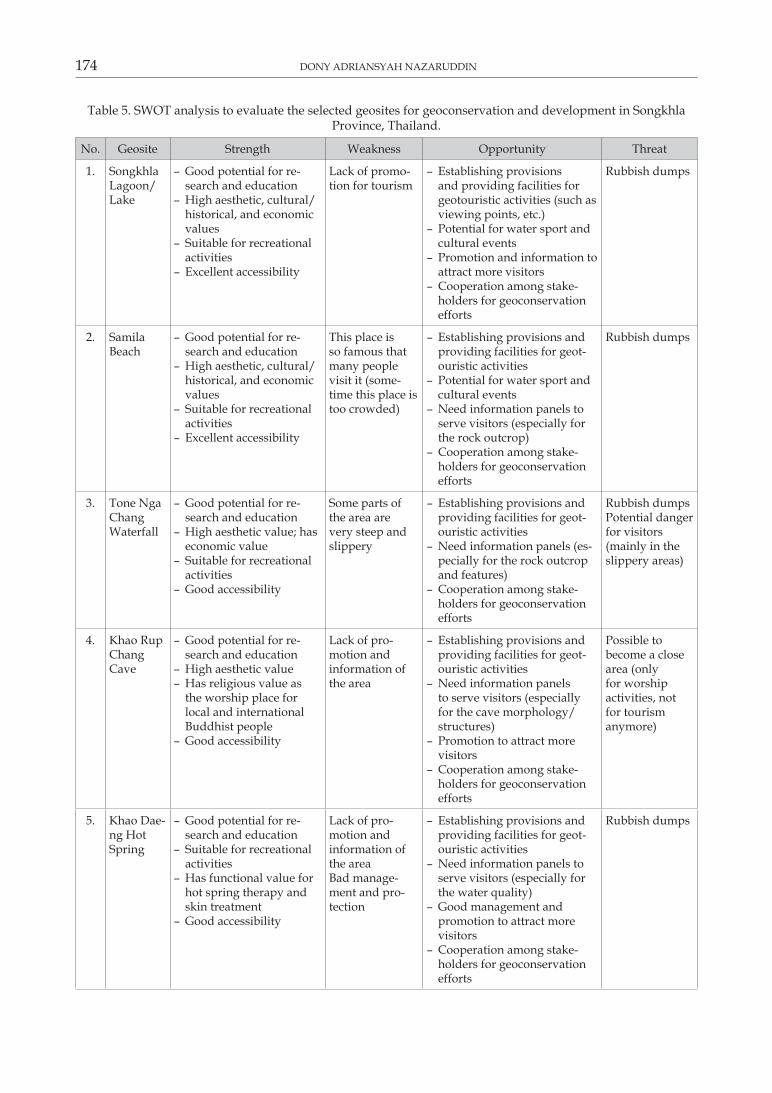
Table 5. SWOT analysis to evaluate the selected geosites for geoconservation and development in Songkhla Province, Thailand.
No. Geosite Strength Weakness opportunity Threat
1. Songkhla Lagoon/Lake
– Good potential for research and education
– High aesthetic, cultural/historical, and economic values
– Suitable for recreational activities
– Excellent accessibility
Lack of promotion for tourism
– Establishing provisions and providing facilities for geotouristic activities (such as viewing points, etc.)
– Potential for water sport and cultural events
– Promotion and information to attract more visitors
– Cooperation among stakeholders for geoconservation efforts
Rubbish dumps
2. Samila Beach
– Good potential for research and education
– High aesthetic, cultural/historical, and economic values
– Suitable for recreational activities
– Excellent accessibility
This place is so famous that many people visit it (sometime this place is too crowded)
– Establishing provisions and providing facilities for geotouristic activities
– Potential for water sport and cultural events
– Need information panels to serve visitors (especially for the rock outcrop)
– Cooperation among stakeholders for geoconservation efforts
Rubbish dumps
3. Tone Nga Chang Waterfall
– Good potential for research and education
– High aesthetic value; has economic value
– Suitable for recreational activities
– Good accessibility
Some parts of the area are very steep and slippery
– Establishing provisions and providing facilities for geotouristic activities
– Need information panels (especially for the rock outcrop and features)
– Cooperation among stakeholders for geoconservation efforts
Rubbish dumpsPotential danger for visitors (mainly in the slippery areas)
4. Khao Rup Chang Cave
– Good potential for research and education
– High aesthetic value – Has religious value as the worship place for local and international Buddhist people
– Good accessibility
Lack of promotion and information of the area
– Establishing provisions and providing facilities for geotouristic activities
– Need information panels to serve visitors (especially for the cave morphology/ structures)
– Promotion to attract more visitors
– Cooperation among stakeholders for geoconservation efforts
Possible to become a close area (only for worship activities, not for tourism anymore)
5. Khao Daeng Hot Spring
– Good potential for research and education
– Suitable for recreational activities
– Has functional value for hot spring therapy and skin treatment
– Good accessibility
Lack of promotion and information of the areaBad management and protection
– Establishing provisions and providing facilities for geotouristic activities
– Need information panels to serve visitors (especially for the water quality)
– Good management and promotion to attract more visitors
– Cooperation among stakeholders for geoconservation efforts
Rubbish dumps
SELECTED GEoSiTES foR GEoHERiTAGE, GEoToURiSM, AND GEoCoNSERvATioN iN SoNGKHLA PRoviNCE 175
of values: 1 = local, 2 = regional, 3 = state-wide, 4 = national, and 5 = international. Table 4 presents the scores obtained for each site in respect to geoheritage values and levels of significance. These qualitative and quantitative assessments can direct to the priority should be given to geosites for geoconservation and development efforts. Geosites with higher scores or values should be given more attention and priority.
Evaluation
The SWoT analysis was used to evaluate the strengths, weaknesses, opportunities, and threats of these geosites and to help to decide the efforts of conservation and development. The SWOT analysis of all these sites can be seen in Table 5.
Geotourism Potentials
Geotourism is made up of ‘ABC’ components which comprise the Abiotic elements of geology and climate, the Biotic elements of animals (fauna) and plants (flora), and Cultural or human elements, both past and present (Dowling 2013). This study has managed to characterize all selected geosites in the study area based on their respective abiotic, biotic, and cultural elements (see the previous Characterization section). Through geotourism, visitors are provided with a better understanding and appreciation of the Earth through its geosites and features, so that their existences and occurrences can be sustainably acknowledged. Visitors are also expected to understand the Earth’s inhabitants, mainly the local people who are engaged with geology and geomorphology of their area (Gordon 2012).
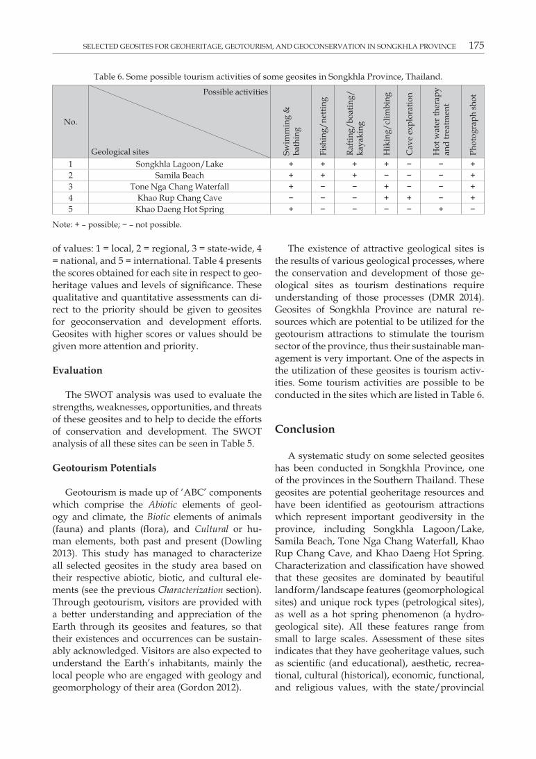
The existence of attractive geological sites is the results of various geological processes, where the conservation and development of those geological sites as tourism destinations require understanding of those processes (DMR 2014). Geosites of Songkhla Province are natural resources which are potential to be utilized for the geotourism attractions to stimulate the tourism sector of the province, thus their sustainable management is very important. One of the aspects in the utilization of these geosites is tourism activities. Some tourism activities are possible to be conducted in the sites which are listed in Table 6.
Conclusion
A systematic study on some selected geosites has been conducted in Songkhla Province, one of the provinces in the Southern Thailand. These geosites are potential geoheritage resources and have been identified as geotourism attractions which represent important geodiversity in the province, including Songkhla Lagoon/Lake, Samila Beach, Tone Nga Chang Waterfall, Khao Rup Chang Cave, and Khao Daeng Hot Spring. Characterization and classification have showed that these geosites are dominated by beautiful landform/landscape features (geomorphological sites) and unique rock types (petrological sites), as well as a hot spring phenomenon (a hydrogeological site). All these features range from small to large scales. Assessment of these sites indicates that they have geoheritage values, such as scientific (and educational), aesthetic, recreational, cultural (historical), economic, functional, and religious values, with the state/provincial
Table 6. Some possible tourism activities of some geosites in Songkhla Province, Thailand.
No.
Possible activities
Geological sites Swim
min
g &
ba
thin
g
fish
ing/
netti
ng
Rafti
ng/b
oatin
g/ka
yaki
ng
Hik
ing/
clim
bing
Cav
e ex
plor
atio
n
Hot
wat
er th
erap
y an
d tr
eatm
ent
Phot
ogra
ph s
hot
1 Songkhla Lagoon/Lake + + + + − − +2 Samila Beach + + + − − − +3 Tone Nga Chang Waterfall + − − + − − +4 Khao Rup Chang Cave − − − + + − +5 Khao Daeng Hot Spring + − − − − + −
Note: + – possible; − – not possible.
176 DoNy ADRiANSyAH NAzARUDDiN
to national levels of significance. SWOT analysis has been conducted to evaluate their respective strengths, weaknesses, opportunities, and threats. From the assessment, the Songkhla Lagoon/Lake has got the highest ranking due to its high value (qualitatively and quantitatively) and its national level of significance, although Samila Beach is more famous and favorite for local and international visitors.
Acknowledgements
The author would like to thank Dr. Helmut Duerrast, a geologist at Prince of Songkhla University for his advises and information mainly on the geology of the study area. Other local Thai colleagues, local communities, and visitors in Songkhla Province are also deserved my gratitude for their valuable discussions for this study. Great appreciation also goes to the reviewers of this manuscript for constructive comments and suggestions.
References
Brilha J., 2016. Inventory and Quantitative Assessment of Geosites and Geodiversity Sites: a review. Geoheritage 8: 119–134. DOI: 10.1007/s12371-014-0139-3.
Brocx M., Semeniuk V., 2007. Geoheritage and Geoconservation – History, Definition, Scope, and Scale. Journal of the Royal Society of Western Australia 90: 53–80.
Brocx M., Semeniuk V., 2011. Assessing Geoheritage Values: A Case Study Using the Leschenault Peninsula and its Leeward Estuarine Lagoon, South-western Australia. Proceeding of the Linnean Society of New South Wales 132: 115–130.
Bruno D.E., 2015. Concept of Geosite, In: Tiess G., Majumder T., Cameron T. (eds.), Encyclopedia of Mineral and Energy Policy. Springer: 1–5. DOI: 10.1007/978-3-642-40871-7_6-1.
DEDE [Department of Alternative Energy Development and Efficiency, Thailand] and CMU [Chiang Mai University], 2006. Potential Assessment of Hot Springs in Thailand, Exec-utive Summary Report, 21 p.
DMR [Department of Minerals Resources], 2007. Geological Map of Songkhla Province. Online: www.dmr.go.th/ewtadmin/ewt/dmr_web/download/pdf/South/Songkla.pdf (accessed 3 June 2016).
DMR [Department of Minerals Resources], 2014. Geology of Thailand. Ministry of Natural Resources and Environment, Bangkok, 508 p.
Dowling R.K., 2013. Global Geotourism – An Emerging Form of Sustainable Tourism. Czech Journal of Tourism 2(2): 59–79. DOI: 10.2478/cjot-2013-0004.
Gordon J.E., 2012. Rediscovering a Sense of Wonder: Geoheritage, Geotourism and Cultural Landscape Experiences. Geoheritage 4: 65–77. DOI: 10.1007/s12371-011-0051-z.
Gray M., 2004. Geodiversity: Valuing and Conserving Abiotic Nature. John Wiley, Chichester: 434 p.
Gray M., 2005. Geodiversity and Geoconservation: What, Why, and How? The George Wright Forum: 4–12.
GSA [Geological Society of America], 2012. Geoheritage. GSA Position Statement: 56–58.
Henriques M.H., Brilha J., 2017. UNESCO Global Geoparks: a Strategy towards Global Understanding and Sustainability. Episodes 40(4): 349–355.
Henriques M.H., Neto K., 2015. Geoheritage at the Equator: Selected Geosites of São Tomé Island (Cameron Line, Central Africa). Sustainability 7: 648–667. DOI: 10.3390/su7010648.
Henriques M.H., Pena dos Reis R., Brilha J., Mota, T., 2011. Geoconservation as an Emerging Geoscience. Geoheritage 3(2): 117–128. DOI: 10.1007/s12371-011-0039-8.
Kiernan K., 2015. Landforms as Sacred Places: Implications for Geodiversity and Geoheritage. Geoheritage 7(2): 177–193. DOI: 10.1007/s12371-014-0128-6.
Komoo I., 2000. Conservation Geology: A Multidisciplinary Approach in Utilization of Earth Resources without Destruction. In: Komoo I., Tjia H.D. (eds), Geological Heritage of Malaysia (Resource Development for Conservation and Na-ture Tourism). LESTARI UKM, Bangi: 3–11.
Kuttikul P., 2008. Geoheritage of Thailand. In: Leman M.S., Reedman A., Pei C.S. (eds), Geoheritage of East and South-east Asia. LESTARI UKM and CCOP: 216–249.
Nazaruddin D.A., 2017. Systematic Studies of Geoheritage in Jeli District, Kelantan, Malaysia. Geoheritage 9(1): 19–33. DOI: 10.1007/s12371-015-0173-9.
Newsome D., Dowling R.K., 2005. The Scope and Nature of Geotourism. In: Dowling R.K., Newsome D. (eds), Geot-ourism. Elsevier: 3–25.
Pena dos Reis R., Henriques M.H., 2009. Approaching an Integrated Qualification and Evaluation System for Geological Heritage. Geoheritage 1(1): 1–10. DOI: 10.1007/s12371-009-0002-0.
Predrag D., Mirela D., 2010. Inventory of Geoheritage Sites – the Base of Geotourism Development in Montenegro. Ge-ographica Pannonica 14(4): 126–132.
ProGEo [The European Association for the Conservation of the Geological Heritage], 2011. Conserving Our Shared Geoheritage – A Protocol on Geoconservation Principles, Sus-tainable Site Use, Management, Field Work, Fossil and Min-eral Collecting. 10 p. Online: www.progeo.se/progeo-protocol-definitions-20110915.pdf (accessed 30 March 2016).
Pungrassami T., 1983. Geology and Mineral Resources of Songkhla Province, Thailand. Workshop on Stratigraphic Correlation of Thailand and Malaysia: 327–343.
Rahim A., Mustafa R.A., Mohamed B., Ling R.S.J., 2005. Experiencing Cultural Tourism through the Identification of Cultural Routes within the IMT-GT. Forum Proceed-ings, 3rd Global Summit on Peace through Tourism – Educa-tion Forum: 17–26.
Satun Geoprak, 2019. Satun UNESCO Global Park. Online: www.satun-geopark.com/en/ (accessed February 17, 2019).
Sawata H., Trebuil G., Tanchotikul A., Darnsawasdi R., 1983. A Short Note on Geology of the Hadyai –Songkhla Area, Thailand. Workshop on Stratigraphic Correlation of Thailand and Malaysia: 204–212.
Singtuen V., Won-In K., 2018a. Geodiversity and Geoconservation of the Chaiyaphum Region in Thailand for Sustainable Geotourism Planning. GeoJournal of Tourism and Geosites 22(2): 548–560. DOI: 10.30892/gtg.22223-310.

SELECTED GEoSiTES foR GEoHERiTAGE, GEoToURiSM, AND GEoCoNSERvATioN iN SoNGKHLA PRoviNCE 177
Singtuen V., Won-In K., 2018b. Geological Perspective for Geotourism Development in Uthai Thani Province, Thailand. Journal of Environmental Management and Tourism 9(5): 1003–1010.
Siriphanich S., Palakurthi R., 2006. Factors Affecting Selection of Songkhla Lagoon of Thailand as A Cultural Tourism Destination. Annual of International Thai Tourism Jour-nal: 344–352.
Subtavewung P., Raksaskulwong M., Tulyatid J., 2005. The Characteristic and Classification of Hot Spring in Thailand. Proceedings of World Geothermal Congress 2005, Antalya, Turkey.
TAT [Tourism Authority of Thailand], 2016. Songkhla. Online: www.tourismthailand.org/About-Thailand/Destination/Songkhla (accessed 3 Jun 2016).
Tulyatid D., 2016. Geoconservation and Sustainable Development through Geotourism for the Kanchanaburi Region, Thailand (Abstract). 35th International Geological Con-gress, Cape Town, South Africa.
Won-In K., Singtuen V., 2018. Geoheritage Conservation for Sustainable Geotourism in Petrified Wood Forest Park, Tak Province, Thailand. The Turkish Online Journal of De-sign, Art and Communication, Special Edition: 1532–1537.