Relationships between tectonics, slope instability and climate change: Cosmic ray exposure dating of...
13
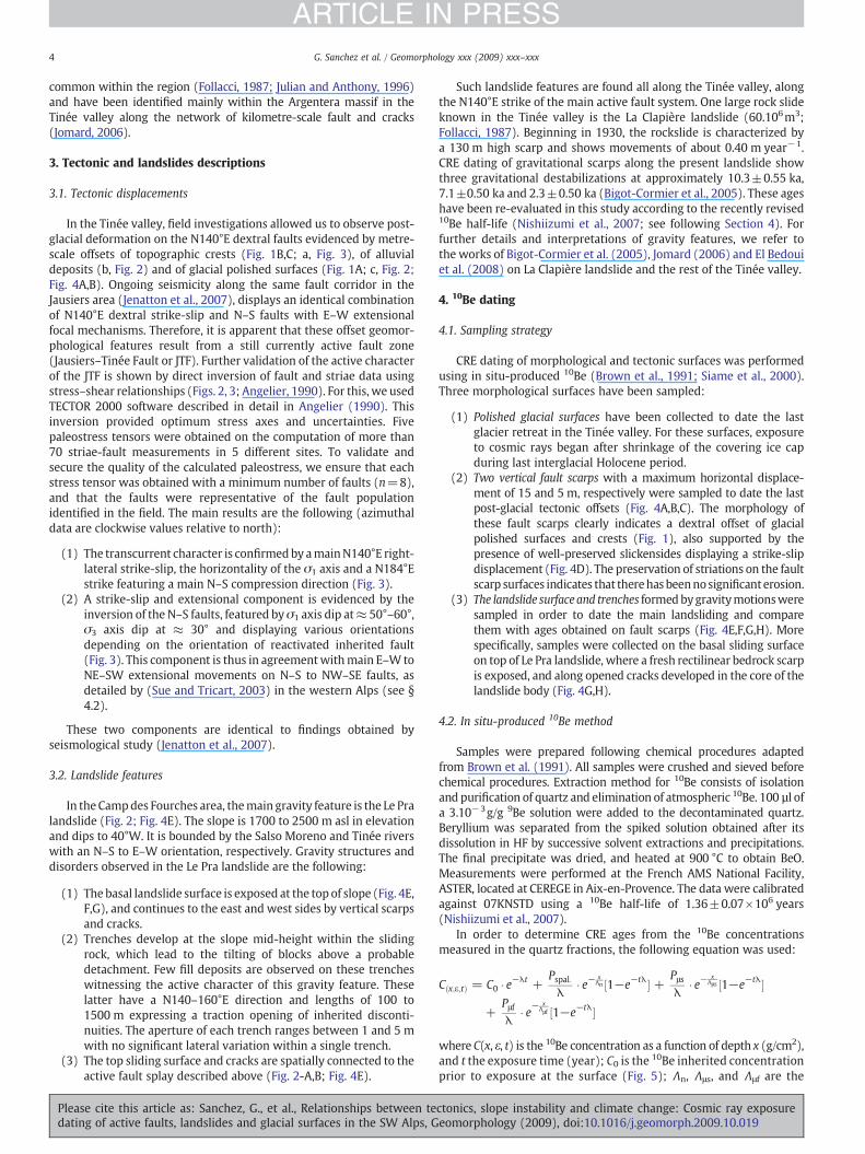
Relationships between tectonics, slope instability and climate change: Cosmic ray exposure dating of active faults, landslides and glacial surfaces in the SW Alps G. Sanchez a, ⁎, Y. Rolland a , M. Corsini a , R. Braucher b , D. Bourlès b , M. Arnold c , G. Aumaître b a GEOSCIENCE AZUR, UMR 6526, Université de Nice Sophia-Antipolis, 28 Av de Valrose, BP 2135, 06108 Nice, France b CEREGE, UMR CNRS 6635, Université Aix-Marseille, P.O. Box 80, Europôle méditerranéen de l'Arbois, 13345 Aix-en-Provence Cedex 04, France c CEA/DSM/LSCE, L'Orme des Merisiers 91198 Gif sur Yvette, France abstract article info Article history: Received 13 April 2009 Received in revised form 22 October 2009 Accepted 27 October 2009 Available online xxxx Keywords: Tectonics Landslide Climate changes Cosmic ray exposure dating South-western Alps In the Argentera massif (French Southern Alps), large active landslides develop along strike of an active corridor of dextral strike-slip faults revealed by shallow ongoing seismicity. Glacially polished bedrock outcrops are offset by right-lateral strike-slip faults. Gravitational structures appear to be spatially connected to these active faults. Dating using the in situ-produced 10 Be cosmogenic nuclide performed on glacial, tectonic and gravity surfaces. The late glacial–interglacial Holocene transition is constrained by 10 Be ages between 12 and 15 ka obtained on glacially polished surfaces. The main tectonic activity closely post-dates the main deglaciation event and is constrained by 10 Be ages of 11 and 7–8 ka obtained on fault scarps. Three successive periods of landsliding are recognized, at 11–12, 7–9 and 2.5–5.5 ka. These Holocene ages were obtained on right-lateral strike-slip fault scarps indicating that recent Alpine tectonics are expressed by transcurrent movements. The discussed close age relationship between deglaciation and a tectonic pulse may suggest that post-glacial rebound and enhanced pore water pressure do influence seismogenic tectonic activity. Gravitational destabilizations at 11–12 and 7–9 ka are coincidental with the main tectonic activity, and suggest tectonic shaking as a landslide trigger. The third gravitational destabilization at 2.5–5.5 ka could be attributed either to slope weakness resulting from multiple low-magnitude earthquake events, as currently revealed by the seismic activity or to climatic causes during the wetter optimum climatic period. These early and middle Holocene ages coincide with a phase of large landslide throughout the Alps scale which suggests that these large gravitational mass movements could be related to combined effects of intense tectonic activity and transitions form cold and dry period to warm and wetter phase. © 2009 Elsevier B.V. All rights reserved. 1. Introduction Active tectonics and climate change are thought to be key parameters in the development of large slope movements in mountain belts (Keefer, 1984; Ballantyne, 2002). It has been frequently recognized in high altitude (north Alps) and high latitude (Scandina- via) regions that climate change leads to landslide initiation and development (Soldati et al., 2004; Ivy-Ochs et al., 2009; Le Roux et al., 2009) and influence tectonic activity (Muir-Wood, 1989; Stewart et al., 2000). Post-glacial isostatic rebound (Cederbom et al., 2004; Champagnac et al., 2007) as well as slope decompression due to ice cap retreat (Bovis, 1982; Augustinus, 1995; Ballantyne, 2002) and increased pore groundwater pressure due to meltwater drainage or heavy rainfall (Caine, 1982; Costain et al., 1987; Gruber and Haeberli, 2007) are the main climatic factors thought to influence fault and slope stability, especially during periods of climate change. Earthquake shaking has also been invoked to contribute to large rock slope failure (Keefer, 1984). In zones of intense seismic activity, the relationship between active tectonics and rock slide development is clearly evidenced (San Andreas fault — McCalpin and Hart, 2003; Denali fault — M= 7.8 — Jibson et al., 2006). The strong ground acceleration and high frequency energy resulting from M> 7 earthquakes are shown to trigger large landslide and rockfall events. However, such relation- ships are more questionable in current low seismicity areas such as the Alps (Persaud and Pfiffner, 2004; Hippolyte et al., 2006; Agliardi et al., 2009), where it is difficult to ascertain whether tectonic structures play an active or a passive role in slope gravitational deformation. This present paper deals with the relationships between seismicity, landslide triggering and climate change. Using published data and new 10 Be cosmic ray exposure dating (CRE) of fault, landslide and polished glacial surface pertinent features, we summarize tectonic activity, large landslide and climate history in the south-western Alps. We focus on the southern flank of the Argentera–Mercantour massif where active faults (Jenatton et al., 2007) and large landslides features (Bigot-Cormier et al., Geomorphology xxx (2009) xxx–xxx ⁎ Corresponding author. Tel.: +33 492 07 68 05; fax: +33 492 07 68 16. E-mail addresses: [email protected] (G. Sanchez), [email protected] (Y. Rolland), [email protected] (M. Corsini), [email protected] (R. Braucher), [email protected] (D. Bourlès), [email protected] (M. Arnold), [email protected] (G. Aumaître). GEOMOR-03131; No of Pages 13 0169-555X/$ – see front matter © 2009 Elsevier B.V. All rights reserved. doi:10.1016/j.geomorph.2009.10.019 Contents lists available at ScienceDirect Geomorphology journal homepage: www.elsevier.com/locate/geomorph ARTICLE IN PRESS Please cite this article as: Sanchez, G., et al., Relationships between tectonics, slope instability and climate change: Cosmic ray exposure dating of active faults, landslides and glacial surfaces in the SW Alps, Geomorphology (2009), doi:10.1016/j.geomorph.2009.10.019
-
Upload
independent -
Category
Documents
-
view
1 -
download
0
Transcript of Relationships between tectonics, slope instability and climate change: Cosmic ray exposure dating of...

Geomorphology xxx (2009) xxx–xxx
GEOMOR-03131; No of Pages 13
Contents lists available at ScienceDirect
Geomorphology
j ourna l homepage: www.e lsev ie r.com/ locate /geomorph
ARTICLE IN PRESS
Relationships between tectonics, slope instability and climate change: Cosmic rayexposure dating of active faults, landslides and glacial surfaces in the SW Alps
G. Sanchez a,⁎, Y. Rolland a, M. Corsini a, R. Braucher b, D. Bourlès b, M. Arnold c, G. Aumaître b
a GEOSCIENCE AZUR, UMR 6526, Université de Nice Sophia-Antipolis, 28 Av de Valrose, BP 2135, 06108 Nice, Franceb CEREGE, UMR CNRS 6635, Université Aix-Marseille, P.O. Box 80, Europôle méditerranéen de l'Arbois, 13345 Aix-en-Provence Cedex 04, Francec CEA/DSM/LSCE, L'Orme des Merisiers 91198 Gif sur Yvette, France
⁎ Corresponding author. Tel.: +33 492 07 68 05; fax:E-mail addresses: [email protected] (G. Sa
(Y. Rolland), [email protected] (M. Corsini), braucher@[email protected] (D. Bourlès), [email protected] (M. Ar(G. Aumaître).
0169-555X/$ – see front matter © 2009 Elsevier B.V. Adoi:10.1016/j.geomorph.2009.10.019
Please cite this article as: Sanchez, G., et adating of active faults, landslides and glaci
a b s t r a c t
a r t i c l e i n f oArticle history:Received 13 April 2009Received in revised form 22 October 2009Accepted 27 October 2009Available online xxxx
Keywords:TectonicsLandslideClimate changesCosmic ray exposure datingSouth-western Alps
In the Argentera massif (French Southern Alps), large active landslides develop along strike of an activecorridor of dextral strike-slip faults revealed by shallow ongoing seismicity. Glacially polished bedrockoutcrops are offset by right-lateral strike-slip faults. Gravitational structures appear to be spatially connectedto these active faults. Dating using the in situ-produced 10Be cosmogenic nuclide performed on glacial, tectonicand gravity surfaces. The late glacial–interglacial Holocene transition is constrained by 10Be ages between 12and 15 ka obtained on glacially polished surfaces. The main tectonic activity closely post-dates the maindeglaciation event and is constrained by 10Be ages of 11 and 7–8 ka obtained on fault scarps. Three successiveperiods of landsliding are recognized, at 11–12, 7–9 and 2.5–5.5 ka. These Holocene ages were obtained onright-lateral strike-slip fault scarps indicating that recent Alpine tectonics are expressed by transcurrentmovements. The discussed close age relationship between deglaciation and a tectonic pulse may suggest thatpost-glacial rebound and enhanced pore water pressure do influence seismogenic tectonic activity.Gravitational destabilizations at 11–12 and 7–9 ka are coincidental with the main tectonic activity, andsuggest tectonic shaking as a landslide trigger. The third gravitational destabilization at 2.5–5.5 ka could beattributed either to slope weakness resulting from multiple low-magnitude earthquake events, as currentlyrevealed by the seismic activity or to climatic causes during the wetter optimum climatic period. These earlyand middle Holocene ages coincide with a phase of large landslide throughout the Alps scale which suggeststhat these large gravitational massmovements could be related to combined effects of intense tectonic activityand transitions form cold and dry period to warm and wetter phase.
+33 492 07 68 16.nchez), [email protected] (R. Braucher),nold), [email protected]
ll rights reserved.
l., Relationships between tectonics, slope insal surfaces in the SW Alps, Geomorphology (
© 2009 Elsevier B.V. All rights reserved.
1. Introduction
Active tectonics and climate change are thought to be keyparameters in the development of large slopemovements inmountainbelts (Keefer, 1984; Ballantyne, 2002). It has been frequentlyrecognized in high altitude (north Alps) and high latitude (Scandina-via) regions that climate change leads to landslide initiation anddevelopment (Soldati et al., 2004; Ivy-Ochs et al., 2009; Le Roux et al.,2009) and influence tectonic activity (Muir-Wood, 1989; Stewartet al., 2000). Post-glacial isostatic rebound (Cederbom et al., 2004;Champagnac et al., 2007) aswell as slope decompression due to ice capretreat (Bovis, 1982; Augustinus, 1995; Ballantyne, 2002) andincreased pore groundwater pressure due to meltwater drainage orheavy rainfall (Caine, 1982; Costain et al., 1987; Gruber and Haeberli,
2007) are themain climatic factors thought to influence fault and slopestability, especially during periods of climate change.
Earthquake shakinghas also been invoked to contribute to large rockslope failure (Keefer, 1984). In zones of intense seismic activity, therelationship between active tectonics and rock slide development isclearly evidenced (San Andreas fault—McCalpin andHart, 2003; Denalifault — M=7.8 — Jibson et al., 2006). The strong ground accelerationand high frequency energy resulting fromM>7 earthquakes are shownto trigger large landslide and rockfall events. However, such relation-ships are more questionable in current low seismicity areas such as theAlps (Persaud and Pfiffner, 2004; Hippolyte et al., 2006; Agliardi et al.,2009), where it is difficult to ascertain whether tectonic structures playan active or a passive role in slope gravitational deformation.
This present paper deals with the relationships between seismicity,landslide triggering and climate change. Using published data and new10Be cosmic ray exposure dating (CRE) of fault, landslide and polishedglacial surface pertinent features, we summarize tectonic activity, largelandslide andclimatehistory in the south-westernAlps.We focus on thesouthern flank of the Argentera–Mercantour massif where active faults(Jenatton et al., 2007) and large landslides features (Bigot-Cormier et al.,
tability and climate change: Cosmic ray exposure2009), doi:10.1016/j.geomorph.2009.10.019

2 G. Sanchez et al. / Geomorphology xxx (2009) xxx–xxx
ARTICLE IN PRESS
Please cite this article as: Sanchez, G., et al., Relationships between tectonics, slope instability and climate change: Cosmic ray exposuredating of active faults, landslides and glacial surfaces in the SW Alps, Geomorphology (2009), doi:10.1016/j.geomorph.2009.10.019
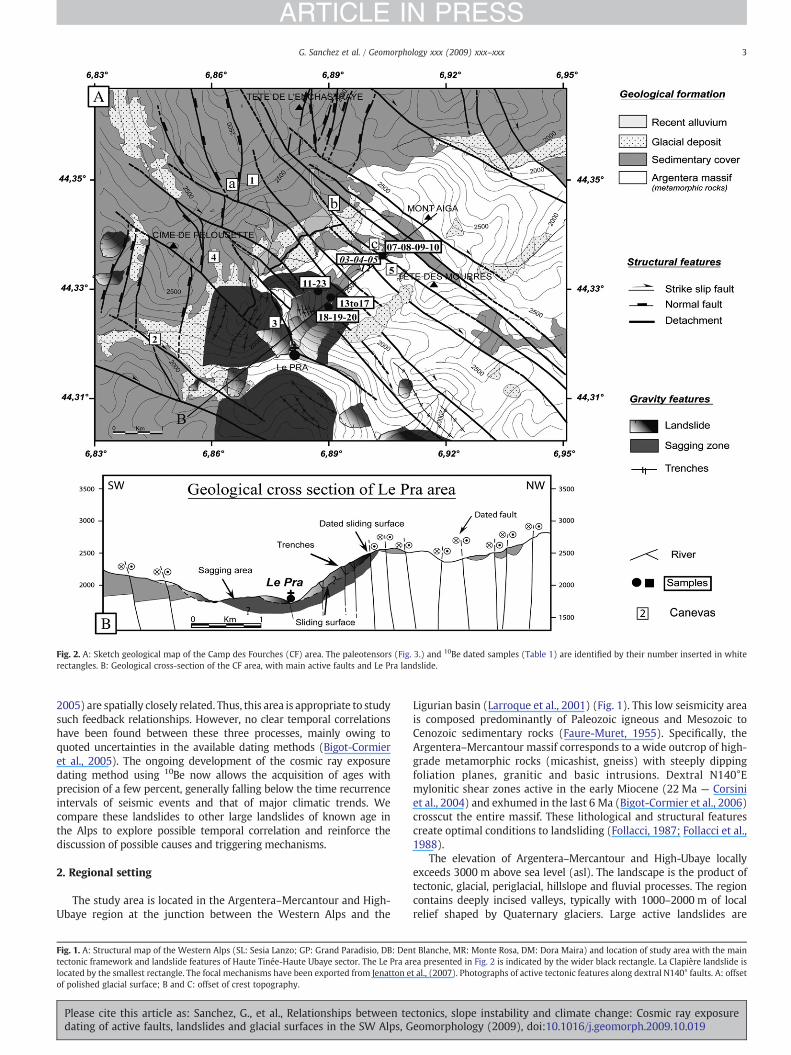
Fig. 2. A: Sketch geological map of the Camp des Fourches (CF) area. The paleotensors (Fig. 3.) and 10Be dated samples (Table 1) are identified by their number inserted in whiterectangles. B: Geological cross-section of the CF area, with main active faults and Le Pra landslide.
3G. Sanchez et al. / Geomorphology xxx (2009) xxx–xxx
ARTICLE IN PRESS
2005) are spatially closely related. Thus, this area is appropriate to studysuch feedback relationships. However, no clear temporal correlationshave been found between these three processes, mainly owing toquoted uncertainties in the available dating methods (Bigot-Cormieret al., 2005). The ongoing development of the cosmic ray exposuredating method using 10Be now allows the acquisition of ages withprecision of a few percent, generally falling below the time recurrenceintervals of seismic events and that of major climatic trends. Wecompare these landslides to other large landslides of known age inthe Alps to explore possible temporal correlation and reinforce thediscussion of possible causes and triggering mechanisms.
2. Regional setting
The study area is located in the Argentera–Mercantour and High-Ubaye region at the junction between the Western Alps and the
Fig. 1. A: Structural map of the Western Alps (SL: Sesia Lanzo; GP: Grand Paradisio, DB: Dentectonic framework and landslide features of Haute Tinée-Haute Ubaye sector. The Le Pra arlocated by the smallest rectangle. The focal mechanisms have been exported from Jenatton eof polished glacial surface; B and C: offset of crest topography.
Please cite this article as: Sanchez, G., et al., Relationships between tedating of active faults, landslides and glacial surfaces in the SW Alps, G
Ligurian basin (Larroque et al., 2001) (Fig. 1). This low seismicity areais composed predominantly of Paleozoic igneous and Mesozoic toCenozoic sedimentary rocks (Faure-Muret, 1955). Specifically, theArgentera–Mercantour massif corresponds to a wide outcrop of high-grade metamorphic rocks (micashist, gneiss) with steeply dippingfoliation planes, granitic and basic intrusions. Dextral N140°Emylonitic shear zones active in the early Miocene (22 Ma — Corsiniet al., 2004) and exhumed in the last 6 Ma (Bigot-Cormier et al., 2006)crosscut the entire massif. These lithological and structural featurescreate optimal conditions to landsliding (Follacci, 1987; Follacci et al.,1988).
The elevation of Argentera–Mercantour and High-Ubaye locallyexceeds 3000 m above sea level (asl). The landscape is the product oftectonic, glacial, periglacial, hillslope and fluvial processes. The regioncontains deeply incised valleys, typically with 1000–2000 m of localrelief shaped by Quaternary glaciers. Large active landslides are
t Blanche, MR: Monte Rosa, DM: Dora Maira) and location of study area with the mainea presented in Fig. 2 is indicated by the wider black rectangle. La Clapière landslide ist al., (2007). Photographs of active tectonic features along dextral N140° faults. A: offset
ctonics, slope instability and climate change: Cosmic ray exposureeomorphology (2009), doi:10.1016/j.geomorph.2009.10.019
4 G. Sanchez et al. / Geomorphology xxx (2009) xxx–xxx
ARTICLE IN PRESS
common within the region (Follacci, 1987; Julian and Anthony, 1996)and have been identified mainly within the Argentera massif in theTinée valley along the network of kilometre-scale fault and cracks(Jomard, 2006).
3. Tectonic and landslides descriptions
3.1. Tectonic displacements
In the Tinée valley, field investigations allowed us to observe post-glacial deformation on the N140°E dextral faults evidenced by metre-scale offsets of topographic crests (Fig. 1B,C; a, Fig. 3), of alluvialdeposits (b, Fig. 2) and of glacial polished surfaces (Fig. 1A; c, Fig. 2;Fig. 4A,B). Ongoing seismicity along the same fault corridor in theJausiers area (Jenatton et al., 2007), displays an identical combinationof N140°E dextral strike-slip and N–S faults with E–W extensionalfocal mechanisms. Therefore, it is apparent that these offset geomor-phological features result from a still currently active fault zone(Jausiers–Tinée Fault or JTF). Further validation of the active characterof the JTF is shown by direct inversion of fault and striae data usingstress–shear relationships (Figs. 2, 3; Angelier, 1990). For this, we usedTECTOR 2000 software described in detail in Angelier (1990). Thisinversion provided optimum stress axes and uncertainties. Fivepaleostress tensors were obtained on the computation of more than70 striae-fault measurements in 5 different sites. To validate andsecure the quality of the calculated paleostress, we ensure that eachstress tensor was obtained with a minimum number of faults (n=8),and that the faults were representative of the fault populationidentified in the field. The main results are the following (azimuthaldata are clockwise values relative to north):
(1) The transcurrent character is confirmedby amainN140°E right-lateral strike-slip, the horizontality of the σ1 axis and a N184°Estrike featuring a main N–S compression direction (Fig. 3).
(2) A strike-slip and extensional component is evidenced by theinversion of the N–S faults, featured byσ1 axis dip at≈ 50°–60°,σ3 axis dip at ≈ 30° and displaying various orientationsdepending on the orientation of reactivated inherited fault(Fig. 3). This component is thus in agreementwithmain E–WtoNE–SW extensional movements on N–S to NW–SE faults, asdetailed by (Sue and Tricart, 2003) in the western Alps (see §4.2).
These two components are identical to findings obtained byseismological study (Jenatton et al., 2007).
3.2. Landslide features
In the Campdes Fourches area, themain gravity feature is the Le Pralandslide (Fig. 2; Fig. 4E). The slope is 1700 to 2500 m asl in elevationand dips to 40°W. It is bounded by the Salso Moreno and Tinée riverswith an N–S to E–W orientation, respectively. Gravity structures anddisorders observed in the Le Pra landslide are the following:
(1) The basal landslide surface is exposed at the top of slope (Fig. 4E,F,G), and continues to the east and west sides by vertical scarpsand cracks.
(2) Trenches develop at the slope mid-height within the slidingrock, which lead to the tilting of blocks above a probabledetachment. Few fill deposits are observed on these trencheswitnessing the active character of this gravity feature. Theselatter have a N140–160°E direction and lengths of 100 to1500 m expressing a traction opening of inherited disconti-nuities. The aperture of each trench ranges between 1 and 5 mwith no significant lateral variation within a single trench.
(3) The top sliding surface and cracks are spatially connected to theactive fault splay described above (Fig. 2-A,B; Fig. 4E).
Please cite this article as: Sanchez, G., et al., Relationships between tedating of active faults, landslides and glacial surfaces in the SW Alps, G
Such landslide features are found all along the Tinée valley, alongthe N140°E strike of the main active fault system. One large rock slideknown in the Tinée valley is the La Clapière landslide (60.106m3;Follacci, 1987). Beginning in 1930, the rockslide is characterized bya 130 m high scarp and shows movements of about 0.40 m year−1.CRE dating of gravitational scarps along the present landslide showthree gravitational destabilizations at approximately 10.3±0.55 ka,7.1±0.50 ka and 2.3±0.50 ka (Bigot-Cormier et al., 2005). These ageshave been re-evaluated in this study according to the recently revised10Be half-life (Nishiizumi et al., 2007; see following Section 4). Forfurther details and interpretations of gravity features, we refer tothe works of Bigot-Cormier et al. (2005), Jomard (2006) and El Bedouiet al. (2008) on La Clapière landslide and the rest of the Tinée valley.
4. 10Be dating
4.1. Sampling strategy
CRE dating of morphological and tectonic surfaces was performedusing in situ-produced 10Be (Brown et al., 1991; Siame et al., 2000).Three morphological surfaces have been sampled:
(1) Polished glacial surfaces have been collected to date the lastglacier retreat in the Tinée valley. For these surfaces, exposureto cosmic rays began after shrinkage of the covering ice capduring last interglacial Holocene period.
(2) Two vertical fault scarps with a maximum horizontal displace-ment of 15 and 5 m, respectively were sampled to date the lastpost-glacial tectonic offsets (Fig. 4A,B,C). The morphology ofthese fault scarps clearly indicates a dextral offset of glacialpolished surfaces and crests (Fig. 1), also supported by thepresence of well-preserved slickensides displaying a strike-slipdisplacement (Fig. 4D). The preservation of striations on the faultscarp surfaces indicates that therehas beennosignificant erosion.
(3) The landslide surfaceand trenches formedbygravitymotionsweresampled in order to date the main landsliding and comparethem with ages obtained on fault scarps (Fig. 4E,F,G,H). Morespecifically, samples were collected on the basal sliding surfaceon top of Le Pra landslide, where a fresh rectilinear bedrock scarpis exposed, and along opened cracks developed in the core of thelandslide body (Fig. 4G,H).
4.2. In situ-produced 10Be method
Samples were prepared following chemical procedures adaptedfrom Brown et al. (1991). All samples were crushed and sieved beforechemical procedures. Extraction method for 10Be consists of isolationand purification of quartz and elimination of atmospheric 10Be. 100 µl ofa 3.10−3g/g 9Be solution were added to the decontaminated quartz.Beryllium was separated from the spiked solution obtained after itsdissolution in HF by successive solvent extractions and precipitations.The final precipitate was dried, and heated at 900 °C to obtain BeO.Measurements were performed at the French AMS National Facility,ASTER, located at CEREGE in Aix-en-Provence. The data were calibratedagainst 07KNSTD using a 10Be half-life of 1.36±0.07×10⁶ years(Nishiizumi et al., 2007).
In order to determine CRE ages from the 10Be concentrationsmeasured in the quartz fractions, the following equation was used:
Cðx;ε;tÞ = C0: e−λt +
Pspal:λ
: e−xΛn ½1−e−tλ� + Pμs
λ: e−
xΛμs ½1−e−tλ�
+Pμfλ
: e− x
Λμf ½1−e−tλ�
where C(x, ε, t) is the 10Be concentration as a function of depth x (g/cm2),and t the exposure time (year); C0 is the 10Be inherited concentrationprior to exposure at the surface (Fig. 5); Λn, Λ μs, and Λ μf are the
ctonics, slope instability and climate change: Cosmic ray exposureeomorphology (2009), doi:10.1016/j.geomorph.2009.10.019

Fig. 3. Paleotensors calculated (1,2,3,4,5) based on the direct inversion method (Angelier, 1990) in the measurement sites located in Fig. 2. We compute more than 70 striae-fault measurements in 5 different sites. Schmidt stereonets in lowerhemisphere have been used. Faults are shown by great circles and striae are indicated by solid dots and slip arrows. Stars with 5,4,3 branches mark the principal stress axes of σ1, σ2 and σ3 respectively. Large grey arrows show directions ofcompression and extension with azimuthal confidence in grey. The contours around poles give the principal stress axes uncertainty during the inversion. For the paleotensor 5, the σ1 axis is horizontal and a N184° strike indicatingtranscurrent movements on the NW–SE dextral fault. For the others paleotensors, the σ1 axis dip at ≈50°–60°, σ3 axis dip at ≈30° noticing a strike-slip and extensional component along the N140° and N–S fault.
5G.Sanchez
etal./
Geom
orphologyxxx
(2009)xxx–xxx
ARTICLE
INPRESS
Pleasecite
thisarticle
as:Sanchez,G
.,etal.,Relationships
between
tectonics,slopeinstability
andclim
atechange:
Cosmic
rayexposure
datingof
activefaults,landslides
andglacial
surfacesin
theSW
Alps,G
eomorphology
(2009),doi:10.1016/j.geomorph.2009.10.019
6 G. Sanchez et al. / Geomorphology xxx (2009) xxx–xxx
ARTICLE IN PRESS
Please cite this article as: Sanchez, G., et al., Relationships between tectonics, slope instability and climate change: Cosmic ray exposuredating of active faults, landslides and glacial surfaces in the SW Alps, Geomorphology (2009), doi:10.1016/j.geomorph.2009.10.019

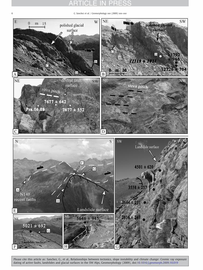
Fig. 4. Photographs of active tectonic and gravity structures with obtained 10Be ages. A: polished glacial features displaced by vertical dextral faults; B: 10Be age on polished glacial surfaceand fault surfaces; C: 10Be age profile along a dextral fault surface (located on photo A); D: Well-preserved striation on the fault scarps. E: photograph of the NW–SE vertical faults andlandslide. F: upper part of Le Pra Landslide, showing the main sliding surface; G: 10Be age profile along the sliding surface; H: tension crack on the eastern flank of the Pra Landslide.
Fig. 5. Sketchpresenting themodel used to calculate exposureagesof 3 samplesdistributedalonga landslide surface (A)andanactivedextral fault scarp (B). Ta, Tb, Tc, are the surfaceexposureages of samples a, b and c respectively; Xb and Xc are the depths of samples b and c before the first event. Yb and Yc are the distances of samples b and c from the rupture front. Production Pis the production at the top of the scarp. Just before the first event, sample a is exposed at the surface, the other samples are buried. Surface exposure age Ta of sample a, is determined usingEq. (1). During the period |Ta–Tb|, samples b and c accumulate 10Be at depth. This will be their inheritance for the next step. The age of sample and its inheritance have been calculated tooptimise themodelised 10Be concentration in comparison to themeasured 10Be concentration. Case A: After thefirst event, sample b is exposed at the surface, sample c is still buried but closerto surface. Surface exposure age Tb of sample b is determined, using a corrected production rate P⁎ at surface from the scarp side and P–P⁎ at depth Xb from the opposite side. Inheritanceof sample b acquired during the period |Ta–Tb| is considered and corrected for decay. For sample c still buried the parameters used to calculate the 10Be concentration are a production P⁎ atdepth (Xc–Xb) for the scarp side, a production P–P⁎ at depth Xc for the opposite side and inheritance acquired during the period |Ta–Tb| corrected for decay. After the second event, sample cis nowexposedat the surface. Surface exposure ageTcof sample c is determined, usinga correctedproduction rate P⁎at surface fromthescarp side andP–P⁎ at depthXc fromtheopposite side.Inheritance of sample c acquired during the period |Tb–Tc| is considered and corrected for decay. Case B: Themodel represents an ideal case. The complex geometry of the studied fault scarphas been simplified. After thefirst event, sample b is exposed at the surface, sample c is still buried. During the period |Tb–Tc|, the 10Be accumulation of sample b is calculated, using a particulartotal production rate P. The skyused to calculate theproductionPhasbeendividedup in 3partitions dependingon thenewgeometry of the scarp (P/2or P/4). The total production of sample bis equal to thehalf production fromthe scarp sideplus thequarterproductionat the surface andat thedepthXb fromtheopposite side. For sample c still buried theparameters used to calculatethe 10Be concentration are a production P at depth Xc. The inheritance acquired during the Ta–Tb period is considered and corrected for decay. After the second event, because a new portionof the scarp has been exposed, shielding factor for sample b has to be re-evaluated yielding to a corrected production rate P⁎⁎ taking into account the opening sky through angle θ. Theinheritance acquiredduring the |Tb–Tc| period is considered and corrected for decayduring Tc. The sample c is nowexposed at thesurface. The surface exposure age Tc of sample c is calculatedusing the half production from the scarp side plus the quarter production at the surface and at the depth Xb from the opposite side. Its inheritance acquired during the period |Tb–Tc|is considered and corrected for decay. The scarp exposed between the last sample and the glacial polished surface has to be ignored.
7G. Sanchez et al. / Geomorphology xxx (2009) xxx–xxx
ARTICLE IN PRESS
Please cite this article as: Sanchez, G., et al., Relationships between tectonics, slope instability and climate change: Cosmic ray exposuredating of active faults, landslides and glacial surfaces in the SW Alps, Geomorphology (2009), doi:10.1016/j.geomorph.2009.10.019

8 G. Sanchez et al. / Geomorphology xxx (2009) xxx–xxx
ARTICLE IN PRESS
effective apparent attenuation lengths (g/cm2), for neutrons, slowmuons, and fast muons, respectively. Pspal., Pμs, and Pμf are the relativespallogenic, slow and fast muons production rates (P=Pspal.+, Pμs,+Pμf). All calculations were performed using attenuation lengths of150, 1500, and 5300 g/cm2 with associated relative contributions tothe total surface production rate of 1.50%, and 0.65% for slow muonsand fast muons, respectively. These values are based on field-calibrated measurements (Braucher et al., 2003). A modern spallo-genic production rate at sea-level and high latitude of 4.5±0.3atoms/g/year, computed for internal consistency from the data ofStone (2000) according to the conclusions of the recently publishedstudy on absolute calibration of 10Be AMS standards by Nishiizumiet al. (2007), was used. This sea-level and high latitude productionrate has then been scaled for the sampling altitudes and latitudesusing the scaling factors proposed by Stone (2000).
For glacial polished surfaces, the surface production rates werecorrected for local slope and topographic shielding due to surround-ing morphologies following Dunne et al. (1999). For samples from thefault scarp and those taken along a vertical profile of the landslidesurface, the 10Be produced was also modeled following Dunne et al.(1999). However, due to their complex exposure history, two caseshave to be considered for the fault and landside scarps as:
(1) Half (180°) of the visible sky is shielded by a slope correspondingto thedip angle if it is larger than the surrounding relief shielding.Thus, the production rate results from cosmic ray penetrating thesurface above the scarp and straight on the scarp.
(2) Tectonic ruptures and creep progressively bring surfaces fromdepth to the surface, implying that production of cosmogenicnuclides at depth may have occurred in the samples for a non-negligible amount of time. To take this phenomenon intoaccount, first, the amount of 10Be accumulated before thatsample reaches the surface has thus been modeled as 10Beconcentration is a function of depth. Secondly, the 10Be pro-duction corresponding to the 10Be accumulated since thesample of the scarp is exposed to the surface is added (Fig. 5).Although depending on the sampling density (2.5 g cm−3), thisapproach allows more accurate exposure age estimations.
Table 110Be analytical data of the Le Pra area (Pra).
Samples Location 44°33 N Altitude (m) Dt (cm) Dr (cm) Pr
Glacial polished surfacePra.06.03 Morgon 2410 – 32Pra.06.04 Morgon 2384 – 32Pra.06.05 Morgon 2384 – 32Pra.06.12 Morgon 2434 – 32
Fault scarpPra.06.07 Morgon 2447 300 33Pra.06.08 Morgon 2459 300 300 32Pra.06.09 Morgon 2459 120 150 32Pra.06.10 Morgon 2459 100 70 32
Gravitational featuresPra.06.13 Le Pra 2517 250 35Pra.06.14 Le Pra 2493 141 34Pra.06.15 Le Pra 2493 207 34Pra.06.16 Le Pra 2493 273 34Pra.06.17 Le Pra 2493 338 34Pra.06.11 Le Pra 2437 33Pra.06.18 Le Pra 2478 293 33Pra.06.19 Le Pra 2478 98 33Pra.06.20 Le Pra 2478 98 33Pra.06.23 Le Pra 2321 400 30
The presented production rates are scaled to the sampling coordinates following Stone (200into account the revised 10Be half-life (Nishiizumi et al., 2007) and corrected for topographilandslide surface dip at α=70° and the polished glacial surface (sample Pra-06-05) dip ataccount the opening sky during fault motion. Dt (X in Fig. 5) is the distance between the uprupture and the sample.
Please cite this article as: Sanchez, G., et al., Relationships between tedating of active faults, landslides and glacial surfaces in the SW Alps, G
The snow shielding corrections to 10Be ages can overestimate theage by up to 8% if we consider reasonable assumptions taking intoaccount the snow height (1 m), the duration in months (6 months),physical properties (snow density: ρ=0.3 g cm−3) (Hippolyte et al.,2006). Thus, no correction was made for the snow cover as it isnegligible in relation to our age uncertainty.
Analytical uncertainties (reported as 1σ) include a conservative 1%uncertainty based on long-term measurements of standards, a 1σstatistical error on counted 10Be events, and the uncertainty associatedwith the chemical and analytical blank correction (associated 10Be/9Beblank ratio was 5.3±5.3×10⁻¹⁶). To compare the 10Be exposure ageswith absolute ages, errors were propagated assuming an additional 7%maximumuncertainty for production rates.Moreover, considering theobserved preservation of striation, all 10Be ages were calculatedconsidering the erosion as negligible during the time period involved,and are thus minimum ages.
4.3. 10Be dating
10Be dating of polished glacial surfaces gave approximate agesranging from 15.36±0.54 ka to 8.13±0.28 ka, which providesconstraints on the timing of the last deglaciation (transition betweenthe Last Glacial Maximum (LGM) and the interglacial Holocene)(Table 1; Fig. 2).
10Be dating of fault scarps yielded approximate ages between 11.12±1.01 ka and 7.68±0.64 ka for the two dated faults (Table 1; Fig. 4A,B,C). These ages were corrected using the fault scarp model describedin Fig. 5, which takes into account the evolving geometry of the activefault. These absolute ages confirm the field relationships, as the mainfault scarp dated at 11.12±1.01 ka cross-cuts polished glacial sur-faces dated at ~13 ka (Fig. 4B). The ages along the striae direction ofthe neighbouring minor parallel fault scarp are in good agreementand give a mean age of 7.68±0.64 ka for the middle part and theouter edge of the scarp face (Fig. 4C). The sample Pra.06.08 located inthe inner part gave an anomalous 10Be concentration which may bedue to its confined position (16.35±0.86 ka).
10Be dating of the landslide from the trench and landslide scarpprovided approximate ages ranging from 5.65±0.95 to 0.24±0.06 ka.
oduction P (at/g/year) St [10Be] (104 at/g) Tmin±σTmin (year)
.76 0.99 50.09±1.52 15,358±541
.46 0.64 26.25±1.32 12,726±704
.46 0.64 28.52±1.85 13,792±966
.47 0.97 26.33±0.77 8129±277
.73 0.99 19.09±1.64 11,119±1011
.47 1.00 14.45±0.69 N.a.
.47 1.00 16.27±1.28 7677±642
.47 1.00 19.20±1.29 7677±552
.56 1.00 9.63±0.13 5021±692
.18 1.00 10.62±0.14 4501±620
.18 1.00 8.28±0.56 3558±257
.18 1.00 6.34±0.45 2664±201
.18 1.00 5.63±0.49 2616±243
.12 0.98 2.77±1.13 836±346
.73 0.97 2.19±5.31 242±60
.73 0.97 8.22±1.21 3120±476
.73 0.97 7.25±1.08 2658±410
.59 0.98 8.74±1.42 5646±945
0) from a sea-level high latitudes 10Be production rate of 4.5 atoms g−1 year−1 takingc shielding (St) following Dunne et al. (1999). They are not corrected for dip slope. Theα=65°. For the sample b (Fig. 6), an angle θ=arctg (Xb/Yb) was used to taking intoper edge of the scarp and the sample. Dr (Y in Fig. 5) is the distance between the front
ctonics, slope instability and climate change: Cosmic ray exposureeomorphology (2009), doi:10.1016/j.geomorph.2009.10.019

9G. Sanchez et al. / Geomorphology xxx (2009) xxx–xxx
ARTICLE IN PRESS
The landslide surface yielded an age of 5.02±0.69 ka (Table 1; Fig. 4F).A profile sampled down the main sliding surface, where it is exposedon the upper part of slope, provides ages decreasing from 4.50±0.62 ka to 2.62±0.24 ka. Thus, the observed age decrease pattern is ingood agreement with a progressive exposure of the landslide footwallin response to rock mass failure propagation (Fig. 4G). The dating ofthe opened cracks yielded 10Be ages of 5.65±0.95 ka, 3.12±0.47 ka,2.66±0.41 ka, 0.84±0.35 ka and 0.24±0.06 ka, evidencing ongoinggravity motions since at least 5.70 ka (Fig. 4H).
In addition, the 10Be ages of the “La Clapière” landslide obtained byBigot-Cormier et al. (2005) have been recalculated (Table 2) using asea-level 10Be production rate of 4.5 atoms g−1 year−1 and re-evaluated according to the recently revised 10Be half-life (Nishiizumiet al., 2007). The recalculated 10Be ages for glacial polished surfacesrange from 21.93±5.32 to 13.65±1.49 ka, while those of gravita-tional scarps range from 2.50±0.68 to 12.75 ka±1.39 (see details inTable 2).
5. Discussion
The main question addressed in this paper is “what are thetriggering factors of Holocene landslides in the Alps”? Uplift combinedwith bedrock incision by rivers or glaciers, slope over-steepening,heavy precipitation, snowmelting, and favourably oriented rock massdiscontinuities such as joints, faults or schistosity are thought toproduce sufficient relief to predispose slopes to catastrophic failures(Korup et al., 2007). However, triggering factors of large landslides arenotwell understood. Themain processes proposed in the literature arethe following:
(1) Decompression of slopes or ‘debutressing’ and subsequentstress release following glacier retreat (Augustinus, 1995;Ballantyne, 2002; Cossart et al., 2008).
(2) Enhanced seismicity due to regional isostatic glacial rebound(Muir-Wood, 1989; Persaud and Pfiffner, 2004, Hormes et al.,2008)
(3) Increased temperature and wetter conditions during middleHolocene climatic optimum (Ivy-Ochs et al., 2009; Le Roux et al.,2009).
Table 210Be analytical data of “La Clapière landslide”.
Samples Location 44°15 N Altitude (m) Dr (cm)
Gravitational scarpsSite ATin 03-11 Rabuons valley 1482 20Tin 03-12 Rabuons valley 1481 80Tin 03-13 Rabuons valley 1478 430Tin 03-14 Rabuons valley 1470 1230
Site BTin 02-04 Tinée side 1740 –
Tin 02-05 Tinée side 1735 –
Tin 02-06 Tinée side 1750 –
Tin 02-07 Tinée side 1750 –
Site CTin 03-16 Tinée side 1826 70Tin 03-17 Tinée side 1827 –
Tin 03-18 Tinée side 1825 190Tin 03-19 Tinée side 1834 –
OthersTin 02-03 Tinée side 2221 –
Tin 02-08 Tinée side 1610 –
Tin 03-21 Tinée side 1602 –
Glacial polished surfaceTin 02-02 Tinée side 1615 –
Tin 03-09 Rabuons valley 1482 –
Tin 03-10 Rabuons valley 1482 –
Theses ages are recalculated from (Bigot-Cormier et al., 2005) taking into account the revis
Please cite this article as: Sanchez, G., et al., Relationships between tedating of active faults, landslides and glacial surfaces in the SW Alps, G
Phases of more frequent landsliding in the Alps are generallyascribed to climate change. Up to now, the impact of Holocene tectonicson rock slide initiation had rarely been discussed in this region despiteany convincing dating of Holocene tectonic activity (Persaud andPfiffner, 2004; Hippolyte et al., 2006; Agliardi et al., 2009). In thefollowing, we discuss these hypotheses in the light of new evidence anddating of active tectonic features in the south-western Alps.
5.1. Holocene tectonics activity and related landslides
From geological observations in the south-western Alps, offsets ofLGM moraines and of recent alluvial sediments, fault breccias andspeleothems have been identified along active seismic faults by Jomard(2006) and Larroque et al. (2001). Nevertheless, no precise ages of suchtectonic markers have been obtained so far. Further, Jomard (2006)proposed that these features are related to gravity movements.
Thus, for the first time in the south-western Alps, Early Holocene(11 and 8 ka) N140°E dextral kilometre-scale faults with up to 15 m ofcumulative offset have been evidenced by both field analysis (glaciallypolished surface offsets) and 10Be dating.
Tectonic studies undertaken in the Western Alps (Sue and Tricart,2003; Champagnac et al., 2006) reported recent N–S normal faultsresulting from brittle E–Wextension. Here we show that in the south-western Alps these N–S extensional faults branch into a network ofNW–SE (N140°E) right-lateral strike-slip faults. There are clearindications from ongoing seismicity that this dextral transtensivefault splay remains active (Jenatton et al., 2007). These data indicatethat Alpine extensional movements can be associated with transten-sional tectonics at the SW boundary of the rotating Apulian block(Collombet et al., 2002; Delacou et al., 2008).
Moreover, the 10Be age profile undertaken on a single fault scarp(Fig. 4C) allows an estimation of the earthquake slip history andaverage magnitude of individual seismic events. An age of 7.68 ±0.64 ka for the fault activity has been estimated for the two outermostsamples. Thus, given that the fault rupture behavior is a complexprocess, several cases have to be considered. (1) If an individualseismic event has occurred, the observed 1.5 m fault motion, whichcorresponds to the offset between the two outermost samples, wouldimply a magnitude M>7 as predicted by the empirical equation of
Production P (at/g/year) [10Be] (104 at/g) Tmin±σTmin (year)
16.48 18.17±1.89 12,749±138716.48 12.60±0.14 12,041±140712.41 7.14±0.81 11,416±134812.38 15.51±1.58 12,640±1352
19.31 15.98±5.90 10,026±375217.75 2.49±0.59 1309±31720.77 17.94±4.26 8848±214620.96 12.92±4.32 6306±2141
19.46 12.34±1.27 8722±94119.46 14.57±2.70 7610±144519.46 8.37±1.60 7326±143819.46 15.74±2.60 8180±1389
30.09 4.46±1.20 2493±68318.08 20.19±2.30 6966±82717.88 6.53±2.18 3688±1252
18.15 39.22±9.32 21,933±531916.48 24.40±4.03 14,953±254016.48 22.29±2.33 13,652±1492
ed sea-level high latitude 10Be production rate of 4.5 atoms g−1 year−1.
ctonics, slope instability and climate change: Cosmic ray exposureeomorphology (2009), doi:10.1016/j.geomorph.2009.10.019

10 G. Sanchez et al. / Geomorphology xxx (2009) xxx–xxx
ARTICLE IN PRESS
Wells and Coppersmith (1994). (2) It is also possible that some ofthe fault displacement may be attributed to multiple seismic events.This would require seismic recurrence of relatively high magnitude(M>5) earthquakes as to produce such displacements at the surface,in less than 1 ka (as suggested by the individual 1σ error of the ageestimates). (3) The fault offsetmay result from a slow creepingmotionover the 1 ka age range. Such a hypothesis is supported by theoccurrence of continuous seismic activity during periods of ≥2 yearalong the fault strike in the Jausiers area (Jenatton et al., 2007). It isdifficult to choose between these different scenarios, and thedisplacement observed at the surface may result from a combinationof coseismic slip and slow creep processes.
Consequently, what is the relationship between these tectonicevents and landslide development? In the Alps, this relationship hasrarely been proposed, except around the Insubric Line (Ambrosi andCrosta, 2006) and along the Belledonne fault (Hippolyte et al., 2006). Inaddition, it is generally considered that faults have a passive role in thedevelopment of large gravitational deformations (Di Luzio et al., 2004;Bois et al., 2008; Agliardi et al., 2009). The hypothesis of seismictriggering in landslide development has yet not been supported by anyclear temporal correlations of fault displacement and gravity features.
For the first time in the Alps we show spatial and temporalrelationships between faults and landslides. Indeed, in the study area(Fig. 1) gravity structures nucleate along main active faults. The mainsliding surface starts on a fault scarp (Fig. 4E) suggesting a strongspatial link between the active fault and the Le Pra landslide.Cosmogenic dating shows three periods of correlated tectonic andgravitational activities (Fig. 6):
(1) A first age group at 11–12 ka corresponds to both faults andgravitational scarps being exposed to cosmic rays. The errorsassociated to the 10Be dating recalculated from Bigot-Cormieret al. (2005) do not allow discrimination of the ages of faultingfrom those of gravitational destabilization, both being similarwithin error (<1 ka).
(2) A secondage group, corresponding to fault scarpexposure 7–8 kaago, is compared to landslides structures dated at 7–9 ka.The fault ages are similar (within error) to the gravitationalinitiation ageobtained in the LaClapière areawhile those of the lePra area precede it by 2.0±0.5 ka (Fig. 7).
(3) Finally, a third 10Be age group mainly comprises surfacesexposed due to landsliding between 5.5 and 2.5 ka. This last agegroup includes (i) data obtained in the Le Pra area showing thepropagation of a landslide surface between 5 ka and 2.6 ka(Fig. 4F,G), and (ii) ages of 2.5–3.7 ka obtained on gravitationalscarps in La Clapière landslide.
Fig. 6. Age distribution reported at 1σ level of the tectonic and gravity activities by botha binned frequency histogram and probability density distribution (Sircombe, 2004).The density curve is fitted by a filter of concordance, with a fixed confidence level of95%. The age ranges of total tectonic and landslide frequency are determined visuallyaccording to the density curve distribution.
Please cite this article as: Sanchez, G., et al., Relationships between tedating of active faults, landslides and glacial surfaces in the SW Alps, G
These three age groups show:
(i) a coincidence of tectonic and gravity displacements (age groups1 and 2). This coincidence suggests that some tectonic eventsdid trigger landslides. As large surface fault displacements alongactive faults suggest, the strong seismic shaking originatingfrom large rupture fault induces progressive movements alongactive or locally pre-existing faults that progressively break upthe rock slopes and lead to their gravitational destabilization.
(ii) the propagation of gravity motions without any evidence ofstrike-slip displacements (age group 3 and current situation ofmost landslides in the valley). These large mass movementsmay develop in response to slope weakening subsequent tomultiple low-magnitude earthquake events. Such ongoing low-magnitude shaking, which is evidenced by current seismicity(Jenatton et al., 2007), induces an increase in rock slopefracturing, specifically along the active fault and leading togradual, long-term reduction in rock strength. Thus, thisprogressive rock slope softening is thought to lead to long-lasting gravitational slope deformations over periods ofthousands of years.
At the scale of the Alps, these early Holocene fault ages (≈8 ka)coincide with a high landslide frequency (8–9 ka) in the whole Alpinearc which is commonly interpreted as the result of climate change,coinciding with a phase of global warming (Soldati et al., 2004;Hippolyte et al., 2006; Deplazes et al., 2007; Hippolyte et al., 2009; Ivy-Ochs et al., 2009; Le Roux et al., 2009). In the light of active tectonicsrelated to landslide triggering, we suggest that the development oflarge landslide events could be related to a phase of intense tectonicactivity.
5.2. Impact of climate change on slope morphology
The previous section (see Section 4.1) shows that active faulting inthe Alps promotes slope instability and landslide generation.However, the impact of climate change in a current low seismicityarea as the Alps cannot be excluded.
10Be ages obtained on polished glacial surfaces in the studied areaallow us to estimate the end of the last deglaciation at 13–12 ka. Thisresult is in accordancewith climate records at global scale (ice cores—Alley, 2004; global sea-level rise—Waelbroeck et al., 2002) and also atthe regional Alpine scale (pollen study — Ortu et al., 2008) (Fig. 7).This glacial–interglacial Holocene transition (11.5 ka) leading tothe total ice cap retreat was altogether a short and complex period(3–4 ka;Waelbroeck et al., 2002) implying that the change to warmerconditions occurred rapidly. However, in the Mediterranean area, it isstill not certain if these coincided exactly with warmer conditions.Several studies based on pollen (Ortu et al., 2008) and speleothemdata (Zanchetta et al., 2007) have shown the general tendency toa warmer and wetter period at around 8 ka (Climatic Optimum).Paleolake-level data document wetter conditions only from 5 ka(Magny et al., 2007; Ortu et al., 2008) while caution must be taken asseasonal variations may have influenced these paleolake-level data.
So, did deglaciation andwetter climatic conditions have any effectson tectonics and landslide activities?
This study shows that fault (11–8 ka) and landslide (≈ 10–8 ka)activities closely postdate the retreat of the Argentera massif ice cap(15–12 ka; Fig. 7). This spatiotemporal coincidence between large faultdisplacements and large gravitational mass movements followingabrupt climate change leads to the assumption that the melting ofAlpine ice cap and residual permafrost should have directly conditionedfault and rock mass stability. It has been shown by some authors thatuplift due to post-glacial isostatic rebound could have an influence onboth seismogenic activity and gravity motions by rapidly changing thestate of lithosphic stress (Muir-Wood, 1989, Stewart et al., 2000;Ballantyne, 2002; Hetzel and Hampel, 2005; Hormes et al., 2008;
ctonics, slope instability and climate change: Cosmic ray exposureeomorphology (2009), doi:10.1016/j.geomorph.2009.10.019

Fig. 7. Comparison between tectonic events, landslide triggered (Bigot-Cormier et al., 2005) and climatic data at the global scale since the last glacial maximum (Alley, 2004), and at the Argentera massif scale based on geomorphologic studies(Federici and Stephanini, 2001) and pollen studies (Ortu et al., 2008). LGM: Last Glacial Maximum; B-A: Bolling and Alleroid; YD: Younger Dryas.
11G.Sanchez
etal./
Geom
orphologyxxx
(2009)xxx–xxx
ARTICLE
INPRESS
Pleasecite
thisarticle
as:Sanchez,G
.,etal.,Relationships
between
tectonics,slopeinstability
andclim
atechange:
Cosmic
rayexposure
datingof
activefaults,landslides
andglacial
surfacesin
theSW
Alps,G
eomorphology
(2009),doi:10.1016/j.geomorph.2009.10.019

12 G. Sanchez et al. / Geomorphology xxx (2009) xxx–xxx
ARTICLE IN PRESS
Ustaszewski et al., 2008). These effects are shown to reduce lithostaticload (minimal stress axe:σ3) and to allow rupture of faults and facilitaterock mass failure. Increased pore groundwater pressure during glacialmelting, permafrost degradation or heavy rainfall events have also beenevoked to induce enhanced seismicity (Costain et al., 1987; Davies et al.,2001; Saar and Manga, 2003; Christiansen et al., 2007) and landsliding(Caine, 1982; Gruber and Haeberli, 2007). The rock slope in the studiedTinée valley is heavily fractured, structurally and lithologically con-trasted (shistosity, shear zone). The water in fissure and tectonicallystressed faults exert a fluid overpressure and enable the fault and rockslope to failmore readily. However, for the south-westernAlps, thebodyof these assumptions needs to be further testedby additional CRE datingof Holocene faults because in the studied example only two fault ageshave been obtained.
Another landslide triggering factor which has been suggested isincreased precipitation (Dortch et al., 2009) during optimum climaticconditions in the Alps (Ivy-Ochs et al., 2009; Le Roux et al., 2009). Theimportant phase of generalizeddestabilization in the valley at around4–5 ka could be correlatedwith an increase in cleft-water pressure duringa phase of intense precipitation. The short-lived hydrologic oscillationsduring themiddleHolocene tending to influence alteration could favourthe development of slope instability. However, given that in theArgentera massif it appears that a phase of tectonic destabilization(11–8 ka) occurred prior to landslide development and that thepaleohydrologic reconstructions are still a matter of debate, it seemsunlikely that wet climatic phases are the only triggering factor forlandslides.
5.3. Summary
The valleys in which the Le Pra and the La Clapière landsidesoccurred have a maximum height of 2 km, which results fromtectonic, glacial, periglacial and fluvial processes. Local lithology andstructure as fracture and foliation can play a major role in preparingrock slopes for landslides (Korup et al., 2007). These features inducerock anisotropy that probably leads to slope weakening (Follacci et al.,1988). Also, these large landslides are generally located along theactive faults, and do not affect the whole massif. This suggests thatlithology and structure of the rock slope are not the main triggeringfactors of landslides but may be important in predisposing the slope tofailure and enabling it to destabilize more easily by seismic shaking,ice melting or heavy precipitation.
Therefore, our preferred evolutionary model would be (1) theoccurrence of a major phase of tectonic activity at 11–8 ka leading towidespread slope fracturing; and (2) in the following evolution, theoccurrence of the wet ‘climatic optimum’ conditions resulted in thealteration of the fractured bedrock. This weathering process led to adecrease in rockmass resistance and promoted landslide development.
6. Conclusions
For the first time in the south-western Alps, dating using in situ-produced 10Be has been successfully performed to estimate ages ofrecent fault slip. Holocene ages of 11 and 7–8 ka have been obtainedon these active NW–SE (N140°E) dextral transtensive faults resultingfrom the rotation of the Apulian block. Coeval with a phase of intenselandslide activity identified at 11–12 and 8 ka, this tectonic activity isalso in concordance with large landslide in the Alps.
Moreover, here we have shown a case of spatial and temporalrelationships of landslides with active tectonic faults. To summarize,the main contribution of this paper is that:
(1) significant horizontal tectonic displacements (≈1.5 m) couldhave occurred during the early Holocene period (7–8 ka) alongan active dextral plurikilometre-scale fault system in the south-western Alps; and
Please cite this article as: Sanchez, G., et al., Relationships between tedating of active faults, landslides and glacial surfaces in the SW Alps, G
(2) potential high magnitude seismic events or, at least, multiplelow-magnitude earthquakes could trigger landslides as largegravity mass movements occurred in the same age range asrecent fault activity.
Within the active tectonic framework, climate changes also havean influence on landslide development. However, the understandingof the climate-fault stability relationship in the Alps requires furtherstudies.
Acknowledgments
The ASTER AMS national facility (CEREGE, Aix-en-Provence) issupported by the INSU/CNRS, the French Ministry of Research andHigher Education, IRD and CEA. This work was supported by the ANRANCEMT. We also wish to thank E. Ortu who provided us with pollenpaleoclimate data. C. Wibberley and N. Mancktelow have helpedimproving both formal and scientific aspects of the manuscript. Weare grateful to L. Smith and S. Binnie for their constructive remarks.
References
Agliardi, F., Crosta, G.B., Zanchi, A., Ravazzi, C., 2009. Onset and timing of deep-seatedgravitational slope deformations in the eastern Alps, Italy. Geomorphology 103,113–129.
GISP2 Ice Core Temperature and Accumulation Data. In: Alley, R.B. (Ed.), B.C. IGBPPAGES/World Data Center for Paleoclimatology. Data Contribution Series #2004-013. NOAA/NGDC Paleoclimatology Program, USA.
Ambrosi, C., Crosta, G.B., 2006. Large sackung along major tectonic features in theCentral Italian Alps. Engineering Geology 83, 183–200.
Angelier, J., 1990. Inversion of field data in fault tectonics to obtain the regional stress—III. A new rapid direct inversion method by analytical means. Geophysical JournalInternational 103, 363–376.
Augustinus, P.C., 1995. Glacial valley cross-profile development: the influence of in siturock stress and rock mass strength, with examples from the Southern Alps, NewZealand. Geomorphology 14, 87–97.
Ballantyne, C.K., 2002. Paraglacial geomorphology. Quaternary Science Reviews 21,1935–2017.
Bigot-Cormier, F., Braucher, R., Bourlès, D., Guglielmi, Y., Dubar, M., Stéphan, J.F., 2005.Chronological constraints on processes leading to large active landslides. Earth andPlanetary Science Letters 235, 141–150.
Bigot-Cormier, F., Sosson, M., Poupeau, G., Stephan, J.F., Labrin, E., 2006. The denudationhistory of the Argentera Alpine External Crystalline Massif (Western Alps, France-Italy): an overview from the analysis of fission tracks in apatites and zircons.Geodinamica Acta 19 (6), 455–473.
Bois, T., Bouissou, S., Guglielmi, Y., 2008. Influence of major inherited faults zones ongravitational slope deformation: a two-dimensional physical modelling of the LaClapière area (Southern French Alps). Earth and Planetary Science Letters 272,709–719.
Bovis, M.J., 1982. Uphill-facing (antislope) scarps in the Coast Mountains, southwestBritish Columbia. Geological Society of America Bulletin 93, 804–812.
Braucher, R., Brown, E.T., Bourlès, D.L., Colin, F., 2003. In situ produced 10Bemeasurements at great depths: implications for production rates by fast muons.Earth and Planetary Science Letters 211, 251–258.
Brown, E.T., Edmond, J.M., Raisbeck, G.M., Yiou, F., Kurz, M.D., Brook, E.J., 1991.Examination of surface exposure ages of Antarctic moraines using in situ produced10Be and 26Al. Geochimica et Cosmochimica Acta 55, 2269–2283.
Caine, N., 1982. Toppling failures from alpine cliffs on Ben Lomond, Tasmania. EarthSurface Processes and Landforms 7, 133–152.
Cederbom, C.E., Sinclair, H.D., Schlunegger, F., Rahn, M.K., 2004. Climate-inducedrebound and exhumation of the European Alps. Geology 32, 709–712.
Champagnac, J.D., Molnar, P., Anderson, R.S., Sue, C., Delacou, B., 2007. Quaternaryerosion-induced isostatic rebound in the western Alps. Geology 35, 195–198.
Champagnac, J.D., Sue, C., Delacou, B., Tricart, P., Allanic, C., Burkhard, M., 2006. Miocenelateral extrusion in the inner western Alps revealed by dynamic fault analysis.Tectonics 25, TC3014. doi:10.1029/2004TC001779.
Christiansen, L.B., Hurwitz, S., Ingebritsen, S.E., 2007. Annual modulation of seismicityalong the San Andreas Fault near Parkfield, CA. Geophysical Research Letters 34,L04306. doi:10.1029/2006GL028634.
Collombet, M., Thomas, J.C., Chauvin, A., Tricart, P., Bouillin, J.P., Gratier, J.P., 2002.Counterclockwise roataion of the western Alps since the Oligaocene: new insightsfrom paleomagnetic data. Tectonics 21, 14.1–14.15.
Corsini, M., Ruffet, G., Caby, R., 2004. Alpine and late hercynian geochronologicalconstraints in the Argentera Massif (Western Alps). Eclogae geolicae Helvetiae 97,3–15.
Cossart, E., Braucher, R., Fort, M., Bourlès, D.L., Carcaillet, J., 2008. Slope instability inrelation to glacial debuttressing in alpine areas (Upper Durance catchment,southeastern France): evidence from field data and 10Be cosmic ray exposure ages.Geomorphology 95, 3–26.
ctonics, slope instability and climate change: Cosmic ray exposureeomorphology (2009), doi:10.1016/j.geomorph.2009.10.019

13G. Sanchez et al. / Geomorphology xxx (2009) xxx–xxx
ARTICLE IN PRESS
Costain, J.K., Bollinger, G.A., Speer, J.A., 1987. Hydroseismicity: a hypothesis for the roleof water in the generation of intraplate seismicity. Seismological Reserach Letters58, 41–64.
Davies, M.C.R., Hamza, O., Harris, C., 2001. The effect of rise inmean annual temperatureon the stability of rock slopes containing ice-filled discontinuities. Permafrost andPeriglacial Processes 12, 137–144.
Delacou, B., Sue, C., Nocquet, J.M., Champagnac, J.D., Allanic, C., Burkhard, M., 2008.Quantification of strain rate in the Western Alps using geodesy: comparisons withseismotectonics. Swiss Journal of Geosciences 101, 377–385.
Deplazes, G., Anselmetti, F.S., Hajdas, I., 2007. Lake sediments deposited on the Flimsrockslide mass: the key to date the largest mass movement of the Alps. Terra Nova19, 252–258.
Di Luzio, E., Saroli, M., Esposito, C., Bianchi-Fasani, G., Cavinato, G.P., Scarascia-Mugnozza, G., 2004. Influence of structural framework on moutain slopedeformation in the Maiella anticline (Central Apennines, Italy). Geomorphology60, 417–432.
Dortch, J.M., Owen, L.A., Haneberg, W.C., Caffee, M.W., Dietsch, C., Kamp, U., 2009.Nature and timing of large landslides in the Himalaya and Transhimalaya ofnorthern India. Quaternary Science Reviews 28, 1037–1054.
Dunne, J., Elmore, D., Muzikar, P., 1999. Scaling factors for the rates of production ofcosmogenic nuclides for geometric shielding and attenuation at depth on slopedsurfaces. Geomorphology 27, 3–11.
El Bedoui, S., Guglielmi, Y., Lebourg, T., Pérez, J.L., 2008. Deep-seated failure propagationin a fractured rock slope over 10,000 years: the La Clapière slope, the south-easternFrench Alps. Geomorphology 105, 232–238.
Faure-Muret, A., 1955. Etudes géologiques sur le massif de l'Argentera-Mercantour etses enveloppes sédimentaires. Mémoire de la Carte géologique de France. 336 pp.
Federici, P.R., Stephanini, M.C., 2001. Evidence and chronology of the “little ice age” inthe Argentera massif (Italian Maritime Alps). Zeitschrift für Gletscherkunde undGlazialgeologie 37, 35–48.
Follacci, J.P., 1987. Les mouvements du versant de la Clapière à Saint-Etienne-de-Tinée(Alpes-Maritimes). Bulletin des laboratoires des ponts et chaussées 150–151, 39–54.
Follacci, J.P., Guardia, P., Ivaldi, J.P, 1988. Le Glissement de la Clapière (Alpes Maritimes,France) dans son cadre géodynamique. Landslides 1323–1327.
Gruber, S., Haeberli, W., 2007. Permafrost in steep bedrock slopes and its temperature-related destabilization following climate change. Journal of Geophysical Research112, F02S18. doi:10.1029/2006JF000547.
Hetzel, R., Hampel, A., 2005. Slip rate variations on normal faults during glacial–interglacial changes in surface loads. Nature 435, 81–84.
Hippolyte, J.C., Bourlès, D., Braucher, R., Carcaillet, J., Léanni, L., Arnold, M., Aumaitre, G.,2009. Cosmogenic 10Be dating of a sackung and its faulted rock glaciers, in the Alpsof Savoy (France). Geomorphology 108, 312–320.
Hippolyte, J.C., Brocard, G., Tardy, M., Nicoud, G., Bourlès, D., Braucher, R., Ménard, G.,Souffaché, B., 2006. The recent fault scarps of the Western Alps (France): Tectonicsurface ruptures or gravitational sackung scarps? A combined mapping, geomor-phic, levelling, and 10Be dating approach. Tectonophysics 418, 255–276.
Hormes, A., Ivy-Ochs, S., Kubik, P.W., Ferreli, L., Maria Michetti, A., 2008. 10Be exposureages of a rock avalanche and a late glacial moraine in Alta Valtellina, Italian Alps.Quaternary International 190, 136–145.
Ivy-Ochs, S., Poschinger, A.V., Synal, H.A., Maisch, M., 2009. Surface exposure dating ofthe Flims landslide, Graubünden, Switzerland. Geomorphology 103, 104–112.
Jenatton, L., Guiguet, R., Thouvenot, F., Daix, N., 2007. The 16,000 event 2003–2004earthquake swarm in Ubaye (French Alps). Journal of Geophysical Research 112.
Jibson, R.W., Harp, E.L., Schulz,W., Keefer, D.K., 2006. Large rock avalanches triggered bythe M 7.9 Denali Fault, Alaska, earthquake of 3 November 2002. EngineeringGeology 83, 144–160.
Jomard, H., 2006. Analyse multi-échelles des déformations gravitaires du Massif del'Argentera Mercantour. Ph.D. Thesis, Nice Sophia-Antipolis University, 217 p.
Julian, M., Anthony, E., 1996. Aspects of landslide activity in the Mercantour massif andthe French Riviera, southeastern France. Geomorphology 15, 175–289.
Keefer, D.K., 1984. Landslides caused by earthquakes. Geological Society of AmericaBulletin 95, 406–421.
Korup, O., Clague, J.J., Hermanns, R.L., Hewitt, K., Strom, A.L., Weidinger, J.T., 2007. Giantlandslides, topography, and erosion. Earth andPlanetary Science Letters 261, 578–589.
Please cite this article as: Sanchez, G., et al., Relationships between tedating of active faults, landslides and glacial surfaces in the SW Alps, G
Larroque, C., Béthoux, N., Calais, E., Courboulex, F., Deschamps, A., Déverchère, J.,Stéphan, J.F., Ritz, J.F., Gilli, E., 2001. Active and recent deformation at the SouthernAlps — Ligurian basin junction. Netherlands Journal of Geosciences/Geologie enMijnbouw 80, 255–272.
Le Roux, O., Schwartz, S., Gamond, J.F., Jongmans, D., Bourles, D., Braucher, R., Mahaney,W., Carcaillet, J., Leanni, L., 2009. CRE dating on the head scarp of a major landslide(Séchilienne, French Alps), age constraints on Holocene kinematics. Earth andPlanetary Sciences Letters. doi:10.1016/j.epsl.2009.01.034.
Magny,M., De Beaulieu, J.L., Drescher-Schneider, R., Vannière, B.,Walter-Simonnet, A.V.,Miras, Y., Millet, L., Bossuet, G., Peyron, O., Brugiapaglia, E., Leroux, A., 2007.Holocene climate changes in the central Mediterranean as recorded by lake-levelfluctuations at Lake Accesa (Tuscany, Italy). Quaternary Science Reviews 26,1736–1758.
McCalpin, J.P., Hart, E.W., 2003. Ridge-top spreading features and relationship toearthquakes, San Gabriel Mountains Region, Southern California: Part A. Distribu-tion and description of ridge-top depressions (sackungen): Part B. Paleoseismicinvestigations of ridge-top depressions. In: Hart, E.W. (Ed.), Ridge-Top Spreading inCalifornia. California Geological Survey, Open-File Report, 1 CD-ROM.
Muir-Wood, R., 1989. Extraordinary deglaciation reverse faulting in northern Fennos-candia. In: Gregersen, S., Basham, P.W. (Eds.), Earthquakes at North Atlantic PassiveMargins: Neotectonics and Post-glacial Rebound. Kluwer, Dordrecht, pp. 141–174.
Nishiizumi, K., Imamura, M., Caffee, M.W., Southon, J.R., Finkel, R.C., McAninch, J., 2007.Absolute calibration of 10Be AMS standards. Nuclear Instruments and Methods inPhysics Research Section B: Beam Interactions with Materials and Atoms 258,403–413.
Ortu, E., Peyron, O., Bordon, A., De Beaulieu, J.L., Siniscalco, C., Caramiello, R., 2008.Lateglacial and Holocene climate oscillations in the South-western Alps: an attemptat quantitative reconstruction. Quaternary International: Quaternary Stratigraphyand Evolution of the Alpine Region and the Mediterranean area in the Europeanand Global Framework 190, 71–88.
Persaud, M., Pfiffner, O.A., 2004. Active deformation in the eastern Swiss Alps: post-glacial faults, seismicity and surface uplift. Tectonophysics 385, 59–84.
Saar, M.O., Manga, M., 2003. Seismicity induced by seasonal groundwater recharge atMt. Hood, Oregon. Earth and Planetary Science Letters 214, 605–618.
Siame, L.L., Braucher, R., Bourles, D.L., 2000. Les nucleides cosmogeniques produits in-situ; de nouveaux outils en geomorphologie quantitative. Bulletin de la SociétéGéologique de France 171, 383–396.
Sircombe, K.N., 2004. AGE DISPLAY: an EXCEL workbook to evaluate and displayunivariate geochronological data using binned frequency histograms and proba-bility density distributions. Computers & Geosciences 30, 21–31.
Soldati, M., Corsini, A., Pasuto, A., 2004. Landslides and climate change in the ItalianDolomites since the Late glacial. CATENA. Geomorphic Impacts of RapidEnvironmental Change 55, 141–161.
Stewart, I.S., Sauber, J., Rose, J., 2000. Glacio-seismotectonics: ice sheets, crustaldeformation and seismicity. Quaternary Science Reviews 19, 1367–1389.
Stone, J.O., 2000. Air pressure and cosmogenic isotope production. Journal of GeophysicalResearch 105, 753–760.
Sue, C., Tricart, P., 2003. Neogene to ongoing normal faulting in the inner western Alps:a major evolution of the late alpine tectonics. Tectonics 22, 1–25.
Ustaszewski, M.E., Hampel, A., Pfiffner, O.A., 2008. Composite faults in the Swiss Alpsformed by the interplay of tectonics, gravitation and postglacial rebound: anintegrated field and modelling study. Swiss Journal of Geosciences 101-1, 223–235.
Waelbroeck, C., Labeyrie, L., Michel, E., Duplessy, J.C., McManus, J.F., Lambeck, K.,Balbon, E., Labracherie, M., 2002. Sea-level and deep water temperature changesderived from benthic foraminifera isotopic records. Quaternary Science Reviews21, 295–305.
Wells, D.L., Coppersmith, K.J., 1994. New empirical relationships among magnitude,rupture length, rupture width, rupture area, and surface displacement. Bulletin ofthe Seismological Society of America 84, 974–1002.
Zanchetta, G., Drysdale, R.N., Hellstrom, J.C., Fallick, A.E., Isola, I., Gagan, M.K., Pareschi,M.T., 2007. Enhanced rainfall in the Western Mediterranean during deposition ofsapropel S1: stalagmite evidence from Corchia cave (Central Italy). QuaternaryScience Reviews 26, 279–286.
ctonics, slope instability and climate change: Cosmic ray exposureeomorphology (2009), doi:10.1016/j.geomorph.2009.10.019