La forma del latte. Allusioni erotiche ed emergenze del reale
Upload
independentCategory
view
0download
0
Guam’s Hidden Gem Archaeological and historical studies at Ritidian
edited by
Mike T. Carson
BAR International Series 26632014

Published by
ArchaeopressPublishers of British Archaeological ReportsGordon House276 Banbury RoadOxford OX2 [email protected]
BAR S2663
Guam’s Hidden Gem: Archaeological and historical studies at Ritidian
© Archaeopress and the individual authors 2014
ISBN 978 1 4073 1305 4
Printed in England by Information Press, Oxford
All BAR titles are available from:
Hadrian Books Ltd122 Banbury RoadOxfordOX2 7BPEnglandwww.hadrianbooks.co.uk
The current BAR catalogue with details of all titles in print, prices and means of payment is available free from Hadrian Books or may be downloaded from www.archaeopress.com
Dedication
to Hiro Kurashina Rebecca Stephenson and Richard Randall
for inspiring generations
of ongoing research

List of Contributors
Mike T. Carson Research Associate
Micronesian Area Research Center University of Guam
Michael R. Clement, Sr.
Gatsung Micronesian Area Research Center
University of Guam
Boyd Dixon Senior Archaeologist
Guam Office Cardno TEC
Andrea Jaladoni Senior Lecturer
Archaeological Studies Program University of the Philippines, Diliman
Carlos Madrid Assistant Professor
Micronesian Area Research Center University of Guam
John A. Peterson
Assistant Vice President Graduate School, Research, and Sponsored Programs
University of Guam
Richard Schaefer Archaeologist Guam Office Cardno TEC

Table of Contents CONTEXTS OF NATURAL-CULTURAL HISTORY: A 3500-YEAR RECORD AT RITIDIAN IN GUAM
BY MIKE T. CARSON
1
Introduction 1
Building the Research Program 2
Research Excavations 5
Investigative Procedures 7
Landscape Evolution Model 8
1500–1100 B.C. 8
1100–700 B.C. 13
700 B.C.–A.D. 1 13
A.D. 1–500 15
A.D. 500–1000 16
A.D. 1000–1500 16
A.D. 1500–Present 17
Conclusions 19
Acknowledgements 20
Appendix A: Test-pit Profiles 20
References 41
Figure 1. Archaeological dating of human settlement in the Asia-Pacific region. 2
Figure 2. Ritidian in northern Guam, Mariana Islands. 2
Figure 3. Overview of Ritidian. 3
Figure 4. White-sand beach at Ritidian today. 3
Figure 5. Coastal plain landform at Ritidian, showing location of deeply buried palaeo-shoreline site deposit. 4
Figure 6. Sea-level history of Marianas region (data from Dickinson 2000, 2001, 2003). 4
Figure 7. Island-wide palaeo-terrain model of Guam, comparing (A) modern conditions versus (B) ancient first-settlement conditions 1500–1000 B.C. (from Carson 2011). 5
Figure 8. Distribution of geoarchaeological test pits at Ritidian. 6
Figure 9. Saipan and Palau HPO staff at Ritidian, 2009. 6
Figure 10. Potsherds encased in hardened calcrete, partly visible during controlled dissolving of calcrete material (from Carson and Peterson 2001a). 7
Figure 11. Schematic profile of coastal landform chronology at Ritidian. 8
Figure 12. Physical and cultural landscape conditions at Ritidian, 1500–1100 B.C. 11
Figure 13. Setting of buried cultural deposit outside the “Star Cave” at Ritidian. 11
Figure 14. Approximate re-constructed shapes of oldest pottery found at Ritidian. 12
Figure 15. Physical and cultural landscape conditions at Ritidian, 1100–700 B.C. 13
Figure 16. Coordination of site foot-print size, archaeo-shellfish remains, and sea-level history at Ritidian (after Carson 2012a). 13
Figure 17. Physical and cultural landscape conditions at Ritidian, 700 B.C.–A.D. 1. 14
Figure 18. Excavating outside a cliff-base cave at Ritidian, Walkway Pit 4. Photograph by Hiro Kurashina. 14
Figure 19. Conus sp. shell beads, found in Walkway Test Pit 2, dated 892–508 B.C. (from Carson 2012a). 14
Figure 20. Physical and cultural landscape conditions at Ritidian, A.D. 1–500. 15
Figure 21. Physical and cultural landscape conditions at Ritidian, A.D. 500–1000. 16
Figure 22. Physical and cultural landscape conditions at Ritidian, A.D. 1000–1500. 16

Figure 23. Architectural rendering of latte structure, composed by John Aguon (from Laguana et al. 2012). 17
Figure 24. Physical and cultural landscape conditions at Ritidian, A.D. 1500–present. 18
Figure 25. Example of latte ruins at Ritidian. Scale bar is in 20-cm increments. 18
Figure 26. Example of grinding mortars (lusong) in limestone bedrock at Ritidian. Scale bar is in 20-cm increments. 18
Figure 27. Stone-lined terracing at Ritidian. Scale-bar is in 20-cm increments. 19
Figure 28. Stone-lined well at Ritidian. Scale-bar is in 20-cm increments. 19
Figure 29. Examples of pictographs inside Ritidian caves. Scale bars are in20-cm increments. 20
Table 1. Ritidian radiocarbon dating summary. 9
RITIDIAN AND SONGSONG ACROSS THE ROTA CHANNEL: HISTORIC SIGNIFICANCE AND CULTURE OF HISTORIC PRESERVATION
BY CARLOS MADRID
44
Introduction 44
Historic Preservation 44
Ritidian 45
Rota 48
Apluy 50
The 1872 Rota Affair 50
Historical Significance 51
Acknowledgements 52
References 52
Figure 1. The iconic features of the Fort Santa Cruz, shown in this parade of the early 1930s in Hagatña. Two of the three impacts that hit the fort in 1898 are visible in the picture. Copy of original photograph, courtesy of Archivo de los Capuchinos de Navarra. 45
Figure 2. Ritidian excerpt of the 1832 map of Guam, by Governor Villalobos. Copy of original document, courtesy of Archivo del Museo Naval, Madrid. 47
Figure 3. Ritidian excerpt from the 1914 Map of Guam, by the US Army Corps of Engineers. Copy of original document, courtesy of Micronesian Area Research Center, University of Guam. 48
CONFLICT AT CONTACT: LATE 17TH CENTURY SPANISH MISSIONS AND LA REDUCCIÓN IN NORTHERN GUAM
BY ANDREA JALANDONI
53
Introduction 53
Literature Review 53
La Reducción as Conflict 55
Discussion 56
References 60
Figure 1. Guam and the Mariana Islands in the western Pacific (from Carson 2010). 54
Figure 2. Ritidian in northern Guam, with Casa Real study area highlighted, shown on a portion of U.S. Geological Survey 1:24,000 topographic series Ritidian Quadrangle. Graphic prepared by M.T. Carson. 54
Figure 3. Hypothetical pre-latte through latte period site-formation processes from 1500 B.C. to A.D. 1500. (After Jalandoni 2011, adapted from Dixon et al. 1999). 54
Figure 4. Photograph of the remains of a Spanish structure taken by Erik Reed in 1952. 54
Figure 5. Photograph of mampostería building material samples recovered from the Casa Real site. 57

Figure 6. Photograph of mampostería lime mortar recovered from the Casa Real site. 57
Figure 7. Photograph of in situ ceramic pot with combed lines, adjacent to lime mortar (mampostería). 57
Figure 8. Upper: Photograph of in situ ceramic pot large rim, adjacent to lime mortar (mampostería). 57
Figure 9. Photograph of ceramic assemblage with mampostería. 58
Figure 10. Photograph of two hearths and ceramic assemblage. 58
Figure 11. Synthesised time-line of Casa Real 2010 excavation findings, including stratigraphy and features. 59
Figure 12. Photograph of porcelain fragment from different angles. 59
Figure 13. Photographs of brick taken from all four sides. 59
Figure 14. Photograph of human long-bone spearheads found in a single excavation unit. 60
Figure 15. Photograph of limestone slingstone. 60
Figure 16. Photograph of igneous slingstone. 60
Table 1 Time-line of events at Ritidian and Inapsan, 1674–84, showing an overlap of the San Miguel Residence (from Jalandoni 2012). 55
Table 2. List of martyrs during the Contact Period in the Mariana Islands (from Hezel 1983). 56
RECONSTRUCTING CULTURAL LANDSCAPES FOR THE LATTE PERIOD SETTLEMENT OF RITIDIAN: A HYPOTHETICAL MODEL IN NORTHERN GUAM
BY BOYD DIXON AND RICHARD SCHAEFER
64
Introduction 64
Micronesian Analogies 65
Northern Guam 66
The Hypothetical Model 68
Conclusions 69
Acknowledgements 69
References 69
Figure 1. Traditional districts on Pohnpei (after Ayers et al. 1979:4). 65
Figure 2. Historic districts on Kosrae (after Cordy 1981:5). 66
Figure 3. Historic districts on Babeldoap, Palau (after Parmentier 1987:21). 66
Figure 4. Historic districts on Guam (after Commons.wikimedia.org/wiki/Atlas_of_Guam). 67
Figure 5. 1672 Map of Jesuit churches and mission houses on Guam (Courtesy of Micronesian Area Research Center, University of Guam). 67
Figure 6. Hypothetical catchment areas on northern Guam. 68
Figure 7. Stone boundary wall in northern Guam (after Dixon, Schaefer, et al. 2011). 68
Figure 8. Stone planting pile in northern Guam (after Dixon, Walker, et al. 2010). 68
Figure 9. Artefact scatter in northern Guam (after Dixon and Walker 2010). 68
Figure 10. Latte set in northern Guam (after Dixon and Carson 2010). 69
Table 1. Micronesian high islands and their districts, ordered by size. 65
THE ANCESTRAL LEGACY OF CHIEF APURO OF LITEKYAN: TEACHER OF MARI
BY MICHAEL R. CLEMENT, SR.
74
Introduction 74
Background 75
Life and Teaching in Litekyan, 1675 75
Resistance and Retribution 76

Chief Apuro’s Conversion 77
Mari, not Meris 78
Changing Names, Images, and Symbols 78
Mari Reflects Malay Language 79
Sources of Chamorro Cultural Heroes: Epic Poetry 80
Taotaomona Stories 80
The Legend of Chief Gadao 82
Conclusion about Chamorro Epic Poetry 82
References 83
Figure 1. Isle de Guahan, map by Alonzo Lopez. Litekyan is located at the very top. 75
Figure 2. Potsherd with a bat image moulded into the rim of a clay bowl. Found in the Mangilao Golf Course excavations by Al Lizama, Guam Historic Preservation Office. Photography by Michael Clement. 75
Figure 3. Segment of manuscript showing the word mari, as written by Fray Juan Pobre in 1602. Image from microfilm, translated by Margaret Driver, Micronesian Area Research Center, University of Guam. 76
Figure 4. Artistic illustration of Chief Apuro’s nightmare and apparition which caused him to give up the teaching of mari in Litekyan and brought the practice of ancestral poetry to an end. Illustration by Angel Flores, art student Vivian Pointer, George Washington High School, Guam. 77
Figure 5. The Lacsonmeris image of the Virgin Mary underscores the religious nature of the meris spelling. Such images were made in Samar in the 1600s with the Virgin’s face and hands made of ivory from the gadya. The ornateness is attributed to Baroque Jesuit influence. Iron, silver and precious stones and excellent craftsmanship were common in the Philippines in the 1600s and before, influenced by art from China. Concepcion Meris: a Spanish Marian name commemorating the Immaculate Conception. Source: T. Itaborra, http://groups.yahoo.com/group/lacsonmeris/attachments/folder/1204484716/item/880461553/view 79
Figure 6. Richard Manglona holds an ancient clay whistle in the form of a fowl or tottot (fruit dove) that he unearthed in Rota. It was a sacrificial bird and probably totemic. The whistle has a high shrill sound. The tottot was replaced by the Christian dove in tsamorita song metaphor. Referred to Clement by Dr. John Peterson of University of Guam. Photograph by Michael Clement. 79
Figure 7. Hang Tuah, 15th Century Malay warrior and cultural hero whose feats are debated in the Baba Dondang Sayang and connected to Chamorro history through the Malay diaspora in poetry and music. Shown in anime style. Courtesy of Dany ChOOng, Keanmun.Blogspot.com 80
Figure 8. Gamson, the taotaomona in the form of an octopus. Photograph courtesy of the Division of Aquatic and Wildlife Resources, Guam Department of Agriculture. 81
Figure 9. Bird’s nest fern. It typically grows out of tree or rock in the Marianas but also out of the belly of Anufat. Photograph by Michael Clement. 81
COMMUNITY ARCHAEOLOGY AT RITIDIAN: UNIVERSITY OF GUAM ARCHAEOLOGICAL FIELD SCHOOLS AND CONTRIBUTIONS TO COMMUNITY
HISTORY AND CULTURAL RESOURCE MANAGEMENT BY JOHN A. PETERSON
84
Introduction 84
2007 Field School Results 85
The Grotto Excavations, Fall 2007 86
Inventory Survey 87
Protohistoric Latte Village and the Search for the Casa Real 87
Beach Berm Buried Hearths 88
Ground-penetrating Radar 91

Rock Art in the Star Cave 92
Future Questions and Community Engagement: Firing Range Compliance 92
References 93
Figure 1. Sketch map showing the location of Latte 7-20-23 Ritidian (Halege), Hornbostel’s excavations, and the Spanish Block House at Ritidian (from Reed 1952:16, based on Hornbostel 1925). 84
Figure 2. Proposed fenceline for ungulate fence, area of potential effect and corridor for 2007 University of Guam Ritidian Archaeological Field School shown as “Sections E and F in the southwest”(from figure prepared by M.T. Carson). 85
Figure 3. Summary pollen diagram (from Stevenson 2008). 88
Figure 4. Percentage pollen diagram from the Grotto (from Horrocks 2008). 89
Figure 5. Percentage phytolith diagram from the Grotto (from Horrocks 2008). 89
Figure 6. Starch concentration diagram from the Grotto (from Horrocks 2008). 89
Figure 7. Kite aerial photography of beach berm, showing Units 1 through 10. 89
Figure 8. Quickbird Satellite imagery showing global positioning system (GPS) locations of Units 1 through 8. 89
Figure 9. Chronostratigraphy of Unit 5 in the beach berm area. 90
Figure 10. Chronostratigraphy of Unit 6 to level 5 in the beach berm area. 90
Figure 11. Chronostratigraphy of Unit 8 in the beach berm area. 90
Figure 12. Chronostratigraphy of Unit 6 showing both features to level 12. 90
Figure 13. Chronostratigraphy of Unit 9 showing feature, ceramics, and mamposteria to level 3 at 30 cm bgs. 90
Figure 14. Ground Penetrating Radar map of transect area in vicinity of Casa Real. Circles show areas of interest; both were buried hearths and rubble, as well as segments of communications cable from the US Navy listening post. 91
Figure 15. White rock art motifs in Star Cave showing mud dauber nests. 92
Figure 16. Ritidian Star Cave sample compared with a pure spectrum of calcium carbonate. 92
Figure 17. Peaks from sample match hydrogen succinate (C6H10N4O4) and imperatorin (C16H14O4). 92
Table 1: Diatom assemblages by level (from Winsborough 2008). 87
Table 2. Radiocarbon dates from Ritidian excavations. 88
LEARNING ABOUT LATTE AT RITIDIAN BY MIKE T. CARSON
96
Introduction 96
Site Identification and Context 97
Field Recording 99
Data Analysis 102
Conclusions 102
Acknowledgements 103
References 103
Figure 1. Study area of 2010 University of Guam archaeological training program. 97
Figure 2. Plan map of latte set in eastern portion of Ritidian Unit of Guam National Wildlife Refuge. Specific location is shown in Figure 1. 98
Figure 3. Sweeping of leaf-litter to expose pottery and other remains. 99
Figure 4. View of latte set after vegetation clearing. Scale bar is in 20-cm increments. 99
Figure 5. Students engaged in different aspects of site recording. 99
Figure 6. Recording surface findings within a measured 1 by 1 m grid square. 100

Figure 7. Collecting potsherds from a dense surface concentration. 100
Figure 8. Basalt adze, discovered on surface. Figure 9. Flaked chert artefact, discovered on surface. 100
Figure 9. Flaked chert artefact, discovered on surface 100
Figure 10. End of excavation on limestone bedrock. Scale bar is in 20-cm increments. 101
Figure 11. Students sifting the excavated volume from the first excavation square. 101
Figure 12. Example of thickened-rim pottery type, with combed exterior, often associated with latte period sites. 102
Figure 13. In situ discovery of a tiny fragment of porcelain. Scale bar is in 20-cm increments. Porcelain fragment is 9 mm long. 102
Table 1. Materials recovered during University of Guam 2010 field school at Ritidian. 103
SITE DEFINITIONS IN A COMPLEX ARCHAEOLOGICAL LANDSCAPE: AN EXAMPLE AT RITIDIAN, GUAM
BY MIKE T. CARSON, BOYD DIXON, JOHN A. PETERSON, AND ANDREA JALANDONI
105
Introduction 105
History of Site Definitions at Ritidian 107
Single or Multiple Sites? 109
Conclusions 111
Acknowledgements 111
References 111
Figure 1. Approximate distributions of archaeological occurrences in different landforms at Ritidian. 106
Figure 2. Areas of latte-related archaeological remains in northern Guam, recorded by Hornbostel (1925), re-drawn by Thompson (1932). 107
Figure 3. Latte set, burial-features, and Spanish-era ruins at Ritidian, recorded by Hornbostel (1925), with clarification of measurements by Kurashina et al. (1990). 108
Figure 4. Sketch of latte set at Ritidian, recorded by Hornbostel (1925), with clarification of measurements by Kurashina et al. (1990). Original measurements were in inches. For reference, the height of 44 inches equals 112 cm (1.12 m). 108
Figure 5. Aerial photograph of the Ritidian area in the 1980s. Copy of original at Ritidian Unit of GNWR. 110
1
Contexts of natural-cultural history: A 3500-year record at Ritidian in Guam
Mike T. Carson
ABSTRACT: The Ritidian Site in Guam holds a full-spectrum record of 3500 years of natural and cultural history of the Mariana Islands, now preserved within the Ritidian Unit of Guam National Wildlife Refuge. The site has produced substantive information from each major episode of human-environment relations in the remote Pacific Islands region. Ritidian ranks among the oldest of all known archaeological sites where human beings first lived in a Remote Oceanic environment, about 3500 years ago. The site contains abundant material evidence about the interplay between cultural activities and environmental change over the following centuries and millennia. The resulting high-resolution integrated natural-cultural history is so far unparalleled in the region. This summary reviews the holistic chronological sequence at Ritidian, proposes new research questions, and relates this information in larger contexts.
Introduction Ritidian means many things for people in different perspectives, sometimes with ardent debates, and it even goes by variable names and spellings. The diverse opinions and interpretations speak volumes of Ritidan’s powerful effects on people. Today, Ritidian is known as an archaeological site, as a place where important historical events occurred, as a home of preserved forest habitat, as a spiritual retreat, as an example of land-ownership struggles in Guam, and as much more. Among the many studies related to the site, Ritidian is recognised as one of the oldest known habitation sites in the Marianas and indeed in the entirety of the Remote Oceanic world (Figures 1 and 2). Despite divergent opinions, all can agree that Ritidian is imbued with immeasurable potency for studies of both natural history and cultural history, and logically the two are inherently connected. At present, Ritidian is a rare protected landscape in Guam (Figure 3), where visitors can experience a precious habitat that reverberates with a deep heritage. Important-ly, the opportunities for research, learning, and appre-ciation are accessible for all members of the public, supported year-round by US Fish and Wildlife Service (USFWS) in the Ritidian Unit of Guam National Wildlife Refuge (GNWR). Few places on earth offer the same opportunities.
How can we begin to understand the profundity and complexity of Ritidian’s integrated natural-cultural history? Toward this end, the present volume incor-porates eight chapters by different researchers. 1) This introductory chapter provides a chronological
narrative of landscape evolution at Ritidian over the last 3500 years, within which numerous contexts can be identified for further study.
2) Carlos Madrid presents a broad-perspective historical
view of life at Ritidian during the 1600s through 1800s, noting the role of Ritidian in linking communities between Guam and Rota, across the Rota Channel.
3) Drawing on both archaeological and historical evidence, Andrea Jalandoni investigates the mysteries surrounding a lost early Spanish-era settlement at Ritidian.
4) Based on their research in and around Ritidian in northern Guam, Boyd Dixon and Richard Schaefer develop a novel approach for understanding traditional land-use patterns prior to Spanish conquest.
5) Michael Clement, Sr. explores the historical legacy of Chief Apuro, the last recognised native leader at Ritidian in the 1600s.
6) As an admirable example of making archaeology relevant for modern society, John A. Peterson presents the findings of several years of sustained community engagement and university education in archaeology programs at Ritidian.
7) I report about research of megalithic latte ruins and associated findings in the eastern portion of Ritidian, undertaken as part of a 2010 student training program through University of Guam.
8) In concluding this volume, I collaborate with co-authors Boyd Dixon, John A. Peterson, and Andrea Jalandoni for considering issues of how to define the archaeological site complex at Ritidian, with variable possible interpretations.
Together with prior published work, the present volume conveys a sense of the current knowledge of archaeological and historical studies at Ritidian. In addition to these pages, readers are encouraged to consult with other literature (Bayman et al. 2012a, 2012b; Carson 2010, 2012a; Jalandoni 2011, 2012; Kurashina 1990). Ideally, more publications still are expected as studies continue. Ritidian contains material records from the entire 3500 years of human habitation in the Mariana Islands, and certainly the contexts of cultural activities changed considerably during this impressive time-span. Events of the 1600s may relate closely to events of the 1500s or 1700s, but how did they relate to events 1000, 2000, or even 3000 years earlier? How will they relate to events 50, 100, or 500 years in the future? The notion of context is essential for understanding how and why cultural events occurred in their defined place and time. Ritidian offers an exceptionally rare opportunity to examine long-term changing contexts of the environ-mental and social setting of a singular place over 3500 years of human habitation. This one place contains a vastly informative record over an impressive length of time. This record is priceless for a baseline chronological sequence in the Marianas region, but it is much more than that. The Ritidian case serves as an ideal model for learning about the fundamental inter-relations between people and

Guam’s Hidden Gem: Archaeological and Historical Studies at Ritidian
2
Figure 1. Archaeological dating of human settlement in the Asia-Pacific region.
Figure 2. Ritidian in northern Guam, Mariana Islands. their inhabited environment. This powerfully absorbing place embodies the results of long-term co-evolving natural and cultural histories, still ongoing today. We can examine how these contexts changed over time, and we can learn how today’s natural-cultural landscape came to exist. This outlook opens new possibilities for research of human-environment relations at a global scale.
This summary follows a simple chronological outline, portraying the physical and social context of each time interval, continuously from first settlement 3500 years ago up through the present day. Much of this work is based on a geoarchaeological investigation of the integrated natural-cultural history of Ritidian (Carson 2012a), bringing new evidence to bear on an earlier pioneering study (Kurashina 1990). Wherever possible, readers are referred to additional sources for more details. The contexts of each time-interval act as catalysts for addressing various research questions, and further questions may be asked about how these different contexts relate to each other. Answers are not always clear, and investigations will need to continue. More questions inevitably will develop as the ancient contexts become better studied.
Building the research program Before outlining the contexts of time intervals at Ritidian, a brief prelude can describe how the baseline primary data-set was assembled. Most of the field research occurred 2006–11, although its roots extend deeper and its branches continue growing. The following summary builds on another report, published separately (Carson 2012a). My first experience at Ritidian was in January 1998, as part of my introduction to Guam and Marianas archaeology. In the aftermath of a super-typhoon, Ritidian was calm among a scene of fallen trees and
Carson: Contexts of natural-cultural history: a 3500-year record at Ritidian in Guam
3
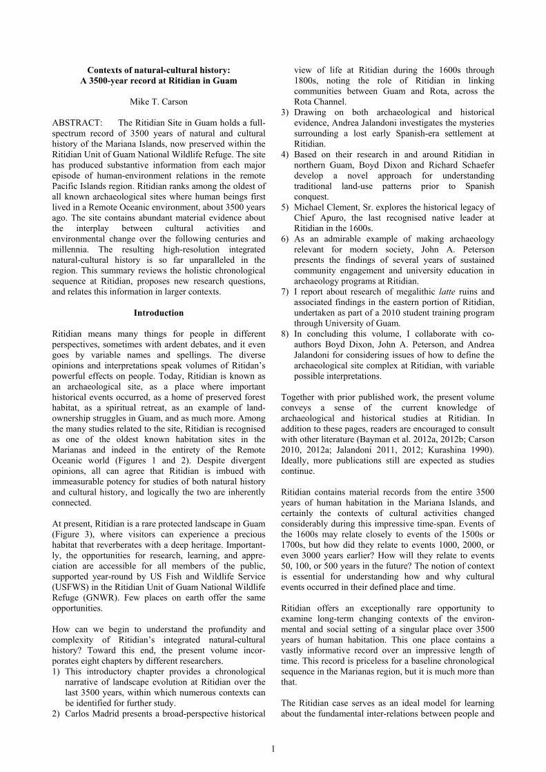
Figure 3. Overview of Ritidian.
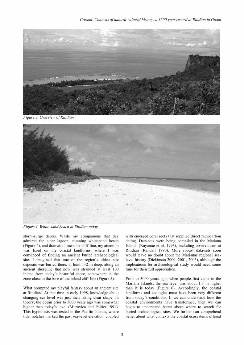
Figure 4. White-sand beach at Ritidian today. storm-surge debris. While my companions that day admired the clear lagoon, stunning white-sand beach (Figure 4), and dramatic limestone cliff-line, my attention was fixed on the coastal landforms, where I was convinced of finding an ancient buried archaeological site. I imagined that one of the region’s oldest site deposits was buried there, at least 1–2 m deep, along an ancient shoreline that now was stranded at least 100 inland from today’s beautiful shore, somewhere in the zone close to the base of the inland cliff-line (Figure 5). What prompted my playful fantasy about an ancient site at Ritidian? At that time in early 1998, knowledge about changing sea level was just then taking clear shape. In theory, the ocean prior to 3000 years ago was somewhat higher than today’s level (Mitrovica and Peltier 1991). This hypothesis was tested in the Pacific Islands, where tidal notches marked the past sea-level elevation, coupled
with emerged coral reefs that supplied direct radiocarbon dating. Data-sets were being compiled in the Mariana Islands (Kayanne et al. 1993), including observations at Ritidian (Randall 1990). More robust data-sets soon would leave no doubt about the Marianas regional sea-level history (Dickinson 2000, 2001, 2003), although the implications for archaeological study would need some time for their full appreciation. Prior to 3000 years ago, when people first came to the Mariana Islands, the sea level was about 1.8 m higher than it is today (Figure 6). Accordingly, the coastal landforms and ecologies must have been very different from today’s conditions. If we can understand how the coastal environments have transformed, then we can begin to understand better about where to search for buried archaeological sites. We further can comprehend better about what contexts the coastal ecosystems offered

Guam’s Hidden Gem: Archaeological and Historical Studies at Ritidian
4
Figure 5. Coastal plain landform at Ritidian, showing location of deeply buried palaeo-shoreline site deposit.
Figure 6. Sea-level history of Marianas region (data from Dickinson 2000, 2001, 2003). for the people living there at different times. Instead of trying to interpret the ancient past from our modern-age observations of the world as we know it today, we can capture a sense of the original contexts and allow the past to speak more for itself. In addition to the local sea-level history, the evolution of coastal landforms can be studied in the composition of the terrain and structural geology. At Ritidian and other sandy beaches of the Marianas, two major types of beach-sand matrix can be discerned (Randall 1990). One type is composed of eroded calcareous material, mostly from shells and corals, deposited incrementally in beds of storm-surge debris, eventually building volumes of coastal terrain. Another type is composed of more intact algal bioclasts and lagoon facies material, stranded along the relict palaeo-shorelines after the sea level lowered. What makes the sand composition so important? In places where palaeo-lagoon or palaeo-beach deposits can be identified, their associated landforms reveal the location, depth, and age of places where people potentially could have created ancient habitation sites, now preserved as archaeological layers. When exploring the setting at Ritidan, I saw that today’s land surfaces were made of the storm-surge type of sandy layer deposition, in many places mixed with organic soil formation. In the scattered instances of uprooted trees and crab burrows, though, I observed that lagoon facies
materials were buried, giving clues about the older landscape structure. While I dreamily explored the landscape at Ritidian for the first time, I was aware of a prior study by Hiro Kurashina and colleagues nearly one decade earlier, within the footprint of the former US Navy facilities known as NAVFAC Ritidian Point (Kurashina 1990). I had read a copy of the project report on file in the library of the Guam Historic Preservation Office, and I began to see for myself in person at the site about the great significance of the research. It was a visionary multi-disciplinary approach for a holistic comprehension of the ancient landscape setting at Ritidian, combining coastal geomorphology, sedimentology, ethnohistory, and archaeological excavations. The prior work by necessity was confined to a small footprint where access was allowed at the time, so the pioneering study still could be expanded into a larger area with even greater research potential. Indeed, standing there in person, I could imagine no better place for this scope of research. As a student of Pacific Islands archaeology, I was intensely drawn to the potential for linking archaeological chronologies with coastal landform evolution, but in the late 1990s I could not find many “proof of concept” examples that used convincing real-life data within the Pacific Islands region. In particular, I wanted to know about the interplay of changing sea level, beach-formation processes, and human use of coastal landforms. I found inspiration in one study that integrated coastal geomorphology with archaeology at the ancient site of Tarague in Guam (Kurashina and Clayshulte 1983a, 1983b), as well as one other reported for a site in Tonga (Dickinson et al. 1994). Much work still needed to be done if I wanted to pursue this topic, but meanwhile I could refer at least to these two successful studies. As strongly as I was interested in Ritidian and other sites of the Marianas, the practicalities of my career took me elsewhere for a few years. By the time I returned to the Mariana Islands in 2005, the most convincing studies of sea-level history had been published (Dickinson 2000, 2001, 2003), and meanwhile I had gained years of experience excavating coastal sites throughout the Pacific region and contextualizing archaeology with coastal geomorphology (e.g., Carson 2004, 2008a). I had learned how to coordinate archaeological findings with studies of coastal evolution, and at least a few other similar studies were underway independently by colleagues working in other parts of the Pacific (e.g., Dickinson and Burley 2007; Nunn 2005, 2007). I also learned that general issues about landscape evolution were gaining recog-nition among other professional archaeologists working at Ritidian (e.g., Dixon 2000), so I was not alone in my thinking or in identifying Ritidian as an important place for this scope of research. In 2005, two strokes of luck propelled my research back at Ritidian. First, I had the blessed fortune of excavating at Unai Bapot in Saipan, where I verified a buried coastal

Carson: Contexts of natural-cultural history: a 3500-year record at Ritidian in Guam
5
Figure 7. Island-wide palaeo-terrain model of Guam, comparing (A) modern conditions versus (B) ancient first-settlement conditions 1500 –1000 B.C. (from Carson 2011). habitation slightly more than 3500 years old (Carson 2005a, 2008b). Later in the same year, I had an unexpected opportunity to excavate at Ritidian as part of a routine resource management project, where at last I began to apply a long-brewing research model (Carson 2005b). By the end of 2005, enough evidence was available to confirm very ancient settlement in the Marianas at least 3500 years ago, plus Ritidian showed exciting promise for exploring more about long-term landscape evolution in tandem with archaeological evidence of cultural activities. In cooperation with US Fish and Wildlife Service (USFWS), I began a research program in limited fashion in 2005 and then in earnest in 2006 at the Ritidian Unit of Guam National Wildlife Refuge (GNWR). This program grew to include student training programs in archaeology by University of Guam after 2007 and University of Hawaii after 2008 (Bayman et al. 2012a, 2012b; Peterson, this volume). Generous funding was granted for certain parts of these studies by Guam Preservation Trust. This work was sustained through 2011, and the research resumed once more in 2013 with funding from the Chiang Ching-kuo Foundation in Taiwan. The research program continues to grow, thanks to the essential support of USFWS. Several different archaeological studies were conducted at Ritidian, including many by others independently and not just by myself, but my primary focus here is about the program for studying the last 3500 years of landscape evolution. This research involved survey of the
landforms, 77 controlled test-pit excavations for sampling key portions of the landscape, full analysis of recovered artefacts and archaeo-faunal records, 30 radiocarbon dates from secure contexts, and high-resolution rendering of the palaeo-terrain setting. The results were greatly informative not only for Ritidian itself but also as part of an island-wide study of Guam’s palaeo-habitat structure (Carson 2011, 2014a) (Figure 7).
Research Excavations The most crucial data collection was possible through a series of 77 test-pits that revealed stratigraphic layers in measurable locations, depths, and dates, often but not always containing cultural materials. Each test-pit was 1 by 1 m in plan and excavated a deep as was safely possible, in most cases well below 2 m depth. The full set of 77 test-pits proceeded when time allowed from 2005 through 2013. Of the 77 test-pit excavations for this study, most (67) were excavated in 2006–11, augmented by two in 2005 and another eight in 2013. The distributions are shown in Figure 8. The two test-pits in 2005 (ER-1 and 2) were excavated as part of an emergency recovery of human remains that has been disturbed by pig-burrowing in the Wildlife Refuge (Carson 2005b). This work was performed under contract to USFWS, when I was an employee of International Archaeological Research Institute, Inc. (IARII). My field assistants Rick Schaefer and Sandra Lee Yee helped in recovering the disturbed remains, excavating two formal test pits, and documenting the contexts of the findings. The formal research program began in 2006, with a set of 41 test-pits (FL-1 through 41) along and around a planned fenceline for protecting the native vegetation in the Wildlife Refuge, but this fence later was dismantled. During my free time of afternoons and weekends over the course of a few years, I personally dug 32 of those 41 test-pits by myself, and I am grateful to those who volunteered to assist with the nine others, including Matt Brown, Lon Bulgrin, Joey Condit, Leonard Iriarte, John Peterson, Virginia Peterson, Rick Schaefer, Chris Walker, Sam Walker, Joan Wozniak, and Sandra Lee Yee. For one of the most productive test pits in 2008, I had the pleasure of working with the Historic Preservation Office technical staff from the Commonwealth of the Northern Mariana Islands (Diego Camacho, Tommy Leon Guerrero, and Roque Magofna) and from the Republic of Palau (Calvin Emesiochel and Errolflynn Kloulechad) (Figure 9). In 2008 through 2009, I re-excavated many of the same test-pits of the fenceline series. I wanted to dig deeper to ensure that any potentially older buried deposits were not missed. This portion of the pit-digging program finally was completed by 2009. Later in 2009, I excavated a new series of seven test-pits in the area of a planned walking path near the Ritidian
Guam’s Hidden Gem: Archaeological and Historical Studies at Ritidian
6
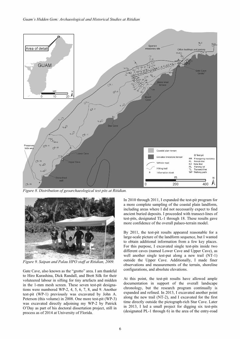
Figure 8. Distribution of geoarchaeological test pits at Ritidian.
Figure 9. Saipan and Palau HPO staff at Ritidian, 2009. Gate Cave, also known as the “grotto” area. I am thankful to Hiro Kurashina, Dick Randall, and Brett Silk for their voluteered labour in sifting for tiny artefacts and midden in the 1-mm mesh screen. These seven test-pit designa-tions were numbered WP-2, 4, 5, 6, 7, 8, and 9. Another test-pit (WP-1) previously was excavated by John A. Peterson (this volume) in 2008. One more test-pit (WP-3) was excavated directly adjoining my WP-2 by Patrick O’Day as part of his doctoral dissertation project, still in process as of 2014 at University of Florida.
In 2010 through 2011, I expanded the test-pit program for a more complete sampling of the coastal plain landform, including areas where I did not necessarily expect to find ancient buried deposits. I proceeded with transect-lines of test-pits, designated TL-1 through 18. These results gave more confidence of the overall palaeo-terrain model. By 2011, the test-pit results appeared reasonable for a large-scale picture of the landform sequence, but I wanted to obtain additional information from a few key places. For this purpose, I excavated single test-pits inside two different caves (named Lower Cave and Upper Cave), as well another single test-put along a new trail (NT-1) outside the Upper Cave. Additionally, I made finer observations and measurements of the terrain, shoreline configurations, and absolute elevations. At this point, the test-pit results have allowed ample documentation in support of the overall landscape chronology, but the research program continually is expanded and refined. In 2013, I excavated another point along the new trail (NT-2), and I excavated for the first time directly outside the pictograph-rich Star Cave. Later in 2013, I led a small project for digging six test-pits (designated PL-1 through 6) in the area of the entry-road

Carson: Contexts of natural-cultural history: a 3500-year record at Ritidian in Guam
7
Figure 10. Potsherds encased in hardened calcrete, partly visible during controlled dissolving of calcrete material (from Carson and Peterson 2001a). and parking-lots (Carson 2014b), with the assistance of University of Guam field technicians Brent Coffman, Bradley Halbert, Charmaine Ledesma, and Jacy Moore. USFWS employees Jaried Calaor and Mariana Sanders graciously assisted this work.
Investigative Procedures The research approach was simple and effective. Test-pit excavations found the buried coastal land surfaces, measured their depths/elevations, obtained dates for when they existed, and traced their locations and spatial distributions. This information then was coordinated with the known sea-level history, further corroborated by finding buried surfaces of ancient coral reefs of directly verifiable locations, depths, and dates. The results were combined with archaeological findings from the same excavations, for placing ancient cultural activities of known dates within the larger context of landscape evolution over the last 3500 years. The Ritidian excavations required perseverance for digging through a buried zone of cemented sand, known as calcrete, that had hardened into solid rock and sealed ancient archaeological materials within and beneath it (Carson and Peterson 2011a). The same calcrete zone had been encountered at other sites (Carson 2008b), but the work at Ritidian was exemplary for developing a practical means for excavation and recovery of the constituent archaeological materials. This strategy involved bulk-removal by percussive hammer or chisel, then soaking the blocks of calcrete in a light (5%) acid solution to loosen and partly dissolve the calcareous material (Figure 10). The remaining material then was washed in distilled water, and the contents were examined for full recovery of broken pottery, stone and shell tools, and other archaeological findings.
One critical obstacle for the Ritidian research was for precise and accurate dating of the buried deposits, because the unstable beach-sands tend not to preserve the kinds of charcoal that archaeologists often prefer for radiocarbon dating. For this purpose, I obtained context-paired pieces of known-taxa seashells with short-life charcoal, as a means to calculate a local “marine reservoir correction” (also known as ∆R) for certain types of shells (Carson 2010). This strategy proved successful, pairing samples of Anadara sp. shells (an important food resource, found in shallow-water environments typical of the earliest settlement period in the Marianas) with samples of carbonised coconut endocarps (definitely short-lived specimens, for the best control of radiocarbon dating). The results allowed direct dating of the shells most abundantly found in the buried archaeological deposits at Ritidian, often in clear contexts of food-refuse. Another key advance in the Ritidian landscape chronology was for direct radiocarbon dating of the bioclastic materials that composed the major constituents of the lagoon facies deposits at Ritidian. From the test-pit excavations, I collected intact (non-eroded) Halimeda sp. algal bioclasts that must have been freshly deposited in palaeo-beach surfaces. The radiocarbon dating proved successful, not only at Ritidian but also at other sites in Guam (Carson and Peterson 2012). These results, in conjunction with the marine reservoir correction study, created a new opportunity for direct dating of the palaeo-landforms. With all of these factors working favourably for the study of landscape evolution at Ritidian, the only major remaining challenge was simply to have enough time to complete a sufficient number of test-pit excavations and analyse the recovered materials. Little by little over a few years, I found enough luxury of “free” time for these pursuits. Also of key importance, Guam Preservation Trust funded the radiocarbon dating of 28 samples, made possible by dedicated staff Rosanna Barcinas and Joe Quinata. USFWS funded two test-pits in 2005 and another six in 2013. Other excavations and two more radiocarbon dates in 2013 were funded by the Chiang Ching-kuo Foundation. Although I continue with more research at Ritidian, the basic outline of the landscape evolution is now reported confidently. The resulting data-sets were coordinated for a chronology of landscape evolution at Ritidian. The most informative illustration of the chronology was possible through computer-aided terrain modelling, refined by the site-specific findings. Elevation contours were generated for the landforms identified in each major time interval. The results enabled three-dimensional rendering of the palaeo-landscape during each identified time interval, as part of an island-wide palaeo-habitat rendering of Guam (Carson 2011, 2014a) yet with extraordinarily high-resolution output at Ritidian (Carson 2012a).

Guam’s Hidden Gem: Archaeological and Historical Studies at Ritidian
8
Figure 11. Schematic profile of coastal landform chronology at Ritidian.
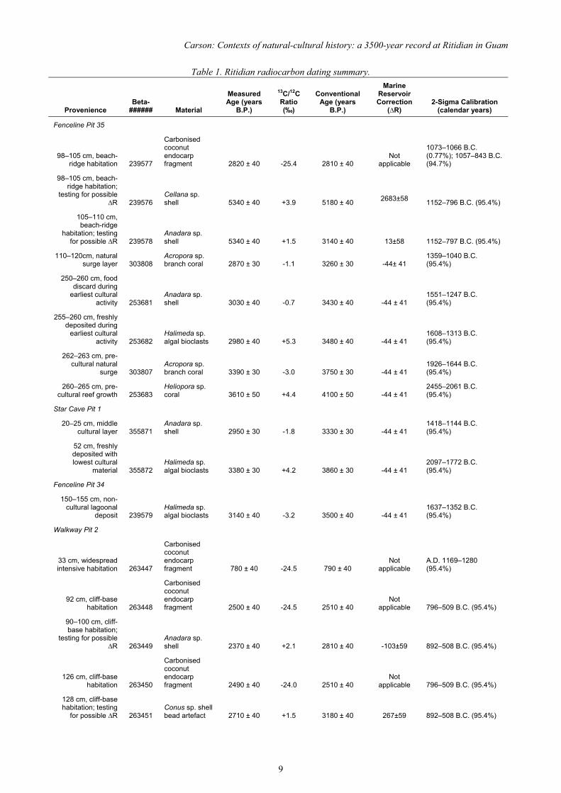
Landscape Evolution Model The basic outline of landscape evolution at Ritidian is driven by 1.8 m of lowering sea level and changing coastal ecology (Figure 11). As the habitat changed in its configuration, so did the cultural use of the available space and resource zones. Ritidian is unique as a single place with a material record of the full 3500-year sequence of human-environment relations in the Mariana Islands. The major stratigraphic units at Ritidian are depicted schematically in Figure 11. Individual test-pit documentation is provided in Appendix A at the end of this chapter. In each test-pit, the stratigraphic layer, association cultural material, location, and absolute elevation allowed the basis of a landscape chronology. Within this framework, a suite of 30 radiocarbon dates (Table 1) has enabled clear calendar year reference, so far in perfect agreement with the stratigraphic sequence and artefact associations.
In the following text, each discernable time period within the 3500-year sequence is presented in order. The measurable time-intervals range 400–700 years each, defined by stratigraphic associations and radiocarbon dating. The details may yet be refined, but the available evidence is reviewed here in terms of the environmental and social contexts of each definable time interval. For each time-interval, a three-dimensional model depicts the approximate configuration of the local environment at Ritidian, and then the available archaeological data are discussed. As noted, the complete radiocarbon dating results are provided in Table 1. The precise contexts of radiocarbon dates are indicated in the 77 stratigraphic profiles in Appendix A at the end of this chapter. Test-pit locations and other points of interest are shown in Figure 8. When considering the time-interval contexts and range of material evidence, different research questions may be proposed. As discussed here, many of these research questions do not yet have definite answers. This presentation is intended to encourage ongoing investiga-tion and pursuit of new knowledge.
1500–1100 B.C. The first time when people lived at Ritidian, the setting was a broad coral reef, with scattered patches of unstable sand around the base of the limestone cliff (Figure 12). In one of these patches of unstable sand, now buried more than 2 m deep and more than 100 m from today’s shoreline (at Fenceline Pit 35), broken pottery and other materials reveal the location of one of the very first habitation sites in the region, dated 1551–1313 B.C. (see profile of FL-35 in Appendix A). This site, along with others in the Mariana Islands, ranks among the oldest in all of Remote Oceania (Carson 2012a, 2014c; Carson and Kurashina 2012). In addition to this most securely dated shoreline site, new investigations (in July 2013) found a second location of early occupation at Ritidan, at a large cave locally known as the “Star Cave” (Figure 13). This location similarly was at the ancient shoreline, where a shallow lagoon bordered the cave openings at the limestone cliff-base. Dating will need further clarification, but tentatively it appears roughly equal to the shoreline site already documented. Conceivably, though, it could be even older. Red-slipped potsherds were found inside an intact lagoon facies deposit, dated as old as 2097–1772 B.C. and overlain by a later layer of beach sand with Anadara sp. shells dated 1418–1144 B.C. (see Star Cave test pit profile in Appendix A). The precise age of the pottery in this case must be equal to or slightly younger than the age of its associated bed of algal bioclasts, and meanwhile it must be older than the age of the Anadara sp. shell in the super-imposed stratigraphic layer. The initial inhabitants at Ritidian were among the first human beings ever to live in the small and remote islands of the Pacific, known as Remote Oceania. What were the
Carson: Contexts of natural-cultural history: a 3500-year record at Ritidian in Guam
9
Table 1. Ritidian radiocarbon dating summary.
Provenience Beta-
###### Material
Measured Age (years
B.P.)
13C/12C Ratio (‰)
Conventional Age (years
B.P.)
Marine Reservoir Correction
(∆R) 2-Sigma Calibration
(calendar years)
Fenceline Pit 35
98–105 cm, beach-ridge habitation 239577
Carbonised coconut endocarp fragment 2820 ± 40 -25.4 2810 ± 40
Not applicable
1073–1066 B.C. (0.77%); 1057–843 B.C. (94.7%)
98–105 cm, beach-ridge habitation;
testing for possible ∆R 239576
Cellana sp. shell 5340 ± 40 +3.9 5180 ± 40
2683±58 1152–796 B.C. (95.4%)
105–110 cm, beach-ridge
habitation; testing for possible ∆R 239578
Anadara sp. shell 5340 ± 40 +1.5 3140 ± 40 13±58 1152–797 B.C. (95.4%)
110–120cm, natural surge layer 303808
Acropora sp. branch coral 2870 ± 30 -1.1 3260 ± 30 -44± 41
1359–1040 B.C. (95.4%)
250–260 cm, food discard during
earliest cultural activity 253681
Anadara sp. shell 3030 ± 40 -0.7 3430 ± 40 -44 ± 41
1551–1247 B.C. (95.4%)
255–260 cm, freshly deposited during
earliest cultural activity 253682
Halimeda sp. algal bioclasts 2980 ± 40 +5.3 3480 ± 40 -44 ± 41
1608–1313 B.C. (95.4%)
262–263 cm, pre-cultural natural
surge 303807 Acropora sp. branch coral 3390 ± 30 -3.0 3750 ± 30 -44 ± 41
1926–1644 B.C. (95.4%)
260–265 cm, pre-cultural reef growth 253683
Heliopora sp. coral 3610 ± 50 +4.4 4100 ± 50 -44 ± 41
2455–2061 B.C. (95.4%)
Star Cave Pit 1
20–25 cm, middle cultural layer 355871
Anadara sp. shell 2950 ± 30 -1.8 3330 ± 30 -44 ± 41
1418–1144 B.C. (95.4%)
52 cm, freshly deposited with lowest cultural
material 355872 Halimeda sp. algal bioclasts 3380 ± 30 +4.2 3860 ± 30 -44 ± 41
2097–1772 B.C. (95.4%)
Fenceline Pit 34
150–155 cm, non-cultural lagoonal
deposit 239579 Halimeda sp. algal bioclasts 3140 ± 40 -3.2 3500 ± 40 -44 ± 41
1637–1352 B.C. (95.4%)
Walkway Pit 2
33 cm, widespread intensive habitation 263447
Carbonised coconut endocarp fragment 780 ± 40 -24.5 790 ± 40
Not applicable
A.D. 1169–1280 (95.4%)
92 cm, cliff-base habitation 263448
Carbonised coconut endocarp fragment 2500 ± 40 -24.5 2510 ± 40
Not applicable 796–509 B.C. (95.4%)
90–100 cm, cliff-base habitation;
testing for possible ∆R 263449
Anadara sp. shell 2370 ± 40 +2.1 2810 ± 40 -103±59 892–508 B.C. (95.4%)
126 cm, cliff-base habitation 263450
Carbonised coconut endocarp fragment 2490 ± 40 -24.0 2510 ± 40
Not applicable 796–509 B.C. (95.4%)
128 cm, cliff-base habitation; testing
for possible ∆R 263451 Conus sp. shell bead artefact 2710 ± 40 +1.5 3180 ± 40 267±59 892–508 B.C. (95.4%)
Guam’s Hidden Gem: Archaeological and Historical Studies at Ritidian
10
Table 1, continued.
Provenience Beta-
###### Material
Measured Age (years
B.P.)
13C/12C Ratio (‰)
Conventional Age (years
B.P.)
Marine Reservoir Correction
(∆R) 2-Sigma Calibration
(calendar years)
Trail Location 1
25–28 cm, widespread
intensive habitation 303809 Charcoal 920 ± 30 -23.9 940 ± 30
Not applicable
A.D. 1025–1160 (95.4%)
35–40 cm, cliff-base habitation 303810 Charcoal 1980 ± 30 -25.2 1980 ± 30
Not applicable
45 B.C. –A.D. 77 (95.4%)
65–70 cm, pre-cultural lagoonal
deposit 303811 Halimeda sp. algal bioclasts 3630 ± 30 +2.6 4080 ± 30 -44 ± 41
2416–2067 B.C. (95.4%)
Trail Upper Cave
5–10 cm, ritual use of cave 303812
Organic sediment 910 ± 40 -25.3 910 ± 40
Not applicable
A.D. 1030–1210 (95.4%)
30–35 cm, limited cave use 303813
Organic sediment 1880 ± 40 -25.0 1880 ± 40
Not applicable A.D. 53–236 (95.4%)
30–35 cm, limited cave use 303814
Organic sediment 1710 ± 40 -27.4 1710 ± 40
Not applicable A.D. 241–411 (95.4%)
Trail Lower Cave
15–20 cm, ritual use of cave 303815 Charcoal 340 ± 30 BP -27.9 290 ± 30
Not applicable
A.D. 1492–1602 (4.6%); A.D. 1615–1663 (30.8%)
30–35 cm, ritual use of cave 303816 Charcoal 520 ± 30 BP -25.8 510 ± 30
Not applicable
A.D. 1328–1341 (4.5%); A.D. 1396–1445 (90.0%)
45–50 cm, ritual use of cave 303817 Charcoal 520 ± 30 BP -24.0 540 ± 30
Not applicable
A.D. 1316–1354 (29.8%); A.D. 1389–1437 (65.6%)
75–80 cm, pre-dating cultural
activity 303818 Organic sediment 5560 ± 40 -22.5 5600 ± 40
Not applicable
4504–4351 B.C. (95.4%)
75–80 cm, pre-dating cultural
activity 303820 Halimeda sp. algal bioclasts 3790 ± 30 +0.1 4200 ± 30 -44 ± 41
2552–2241 B.C. (95.4%)
80–82 cm, pre-dating cultural
activity 303819 Beachrock bioclasts 4210 ± 30 +1.0 4640 ± 30 -44 ± 41
3109–2852 B.C. (95.4%)
Emergency Recovery Pit 2
20–25 cm, widespread
intensive habitation 247659
Carbonised coconut endocarp fragment 240 ± 40 -25.0 240 ± 40
Not applicable
A.D. 1520–1593 (14.8%); A.D. 1619–1685 (0.0%); A.D. 1732–1808 (31.2%); A.D. 1928–1950 (9.4%)
80 cm, widespread
intensive habitation 247660
Carbonised coconut endocarp fragment 340 ± 40 -24.4 350 ± 40
Not applicable
A.D. 1455–1638 (95.4%)
All calibrations are at 2-Sigma (95.4%), using OxCal version 4.2 (Bronk Ramsey and Lee 2013). Charcoal and organic sediments were calibrated with INTCAL13 data-set, and marine specimens were calibrated with MARINE13 data-set (Reimer et al. 2013). Local marine reservoir effect (∆R) follows calculations specifically for the Ritidian site (Carson 2010).
circumstances for people to settle in the Mariana Islands, more than 2000 km distant from any other inhabited land at that time? What made Ritidian attractive as one of these original settlements? The vast region of Remote Oceania lies beyond the ordinary reach of inter-visible islands of Near Oceania (Green 1991). The land-masses of Near Oceania were
inhabited for at least 40,000 years by hunter-gatherers, living in places once connected by land-bridges or within short water-crossings (Bellwood and Hiscock 2005). Most water-crossings in Near Oceania were less than 120 km, whereas the leap into Remote Oceania required a crossing of at least 350 km of ocean (Irwin 1998). Near Oceania was home for amazingly abundant and diverse plants and animals, and by comparison the islands of

Carson: Contexts of natural-cultural history: a 3500-year record at Ritidian in Guam
11
Figure 12. Physical and cultural landscape conditions at Ritidian, 1500–1100 B.C.
Figure 13. Setting of buried cultural deposit outside the “Star Cave” at Ritidian. Remote Oceania supported impoverished biota. If people lived in Near Oceania for so many thousands of years, then what happened about 1500 B.C. for the expansion of human populations into Remote Oceania? At least two developments were necessary. First was the set of sailing technology and navigational skills for such a voyage. Second was the ability to establish a viable community in remote and small islands that provided less of the essential life-supporting natural resources than in Near Oceania. The settlers at Ritidian and other sites must have possessed these traits and skills, or else the settlements never could have been successful. The first people to settle in Remote Oceania brought with them distinctive pottery and other cultural traits that did not exist at all for thousands of years in Near Oceania, suddenly appearing in Island Southeast Asia and then spreading from there eventually into Remote Oceania (Bellwood et al. 2011; Carson et al. 2013). The oldest known pottery of the region was found in the Philippines, dated about 2000–1800 B.C. (Hung 2008; Hung et al. 2011). By 1500 B.C., pottery-making groups founded sites in parts of Indonesia (Simanjuntak 2008), then slightly later in the Bismarck Archipelago about 1500–
1350 B.C. (Summerhayes 2007). In addition to the pottery, the sites themselves reflect formal residential occupation, qualitatively different from the preceding millennia of low-intensity hunter-gatherer campsites. The context in Near Oceania is essential for under-standing the first peopling of Remote Oceania. The archaeological evidence indicates a sudden emergence of a new kind of lifestyle with pottery-making and sedentary habitations in Near Oceania, spreading from the Philippines through Indonesia and even as far as the Bismarck Archipelago (Carson et al. 2013). At least as early as 1500 B.C., people were traveling over long distances and establishing new settlements, but their travels stayed comfortably within the easily accessible lands of Near Oceania. In most published overviews of the peopling of Remote Oceania, the Mariana Islands do not figure prominently at all, but rather the first settlers are described as makers of dentate-stamped Lapita pottery, found in Melanesia and Polynesia (Kirch 1997; Spriggs 1997a). The Lapita migration route moved through the Bismarck Archipelago in Near Oceania about 1500–1350 B.C. (Summerhayes 2007), and only some time later did Lapita groups move into the Remote Oceanic islands of South Melanesia and West Polynesia, all post-dating 1200 B.C. (Green et al. 2008). First settlement at Ritidian, as at other early sites in the Mariana Islands, definitely pre-dated the Lapita legacy in Melanesia and Polynesia. At 1500 B.C., no other islands of Remote Oceania had been inhabited, but somehow people journeyed all the way to the Marianas and established at least eight settlements in three different islands, including the site at Ritidian (Carson and Kurashina 2012). The low-lying atolls elsewhere in Micronesia were not habitable at that time, still below sea level until perhaps A.D. 100–200 (Dickinson 2003). The larger land-masses in western Micronesia, like Palau and Yap, have shown no evidence of human habitation until perhaps 1100 B.C. at the earliest in Palau (Fitzpatrick 2003; Liston 2005) and an unknown later date in Yap (Intoh 1997). Marianas settlement at 1500 B.C. occurred in surprising isolation (Carson 2014c), more than 2000 km from any contemporaneously inhabited area. By comparison, the longest Lapita ocean-crossing in the Melanesia-Polynesia region would occur a few centuries later, about 1100 B.C., and over a much shorter distance of only 900 km between Vanuatu and Fiji (Irwin 1998). Accordingly, Rainbird (2004:85) called attention to early-period Marianas settlement as having required “the longest sea-crossing undertaken by that time in human history.” The technical practicalities of the Marianas colonising voyage currently are not well understood, and in fact modern computer-aided simulations suggest that it was virtually impossible (Fitzpatrick and Callaghan 2013). None-theless, the hard evidence is undeniable from multiple securely dated sites in the Marianas (Carson and

Guam’s Hidden Gem: Archaeological and Historical Studies at Ritidian
12
Figure 14. Approximate re-constructed shapes of oldest pottery found at Ritidian. Kurashina 2012), so far linked most clearly to a set of contemporaneous and slightly older sites within the central and northern Philippines (Carson et al. 2013; Hung et al. 2011). Although isolated to some extent from the rest of the world, the first Mariana Islanders probably were not so isolated from one another. Ritidian was one of at least three early sites in Guam, while other sites were inhabited in nearby islands of Tinian and Saipan (Carson and Kurashina 2012). These founding populations must have known about each other, and they likely interacted at least occasionally for sharing news and information, forming and continuing friendships and alliances, enabling marriage-partners, and so on. During this early period, the different site records show that people shared much the same cultural expressions in their pottery, stone and shell tools, personal shell ornaments, house construction, food recipes, and overall lifestyle (Carson 2014c). How did the Ritidian site relate with other early-period settlements in the Marianas? The evidence reflects a rather small-sized habitation, less than 20 by 20 m (400 sq m) at the shoreline site, plus an unknown size at the “Star Cave”. Other sites are estimated as much larger, for example 800 sq m at Unai Bapot in Saipan (Carson 2008b) and 3000 sq m at Unai Chulu in Tinian (Haun et al. 1999). In the limited excavations so far at Ritidian, the density of pottery and other artefacts is far less than has been reported in other sites, but perhaps more excavation in the future will reveal a different story. A large-format excavation will be necessary for learning more about the earliest habitation at Ritidian. So far, only a 1 by 1 m excavation (1 sq m) found this earliest cultural deposit in both of the known locations. In the case of the shoreline site documented at test-pit FL-35, nearby test pits at 10-m intervals did not encounter cultural materials at this depth, so the oldest site deposit must be confined within an area of less than 20 by 20 m. In the case of the “Star Cave,” further subsurface exploratory testing will be needed, but the available terrain at the edge of the limestone cliff and within the caves measured only a few sq m. Although the excavations have been limited in size, the dating is extremely confident in the range of 1551–1313 B.C. (Carson 2012a). Radiocarbon dates cross-confirm each other with redundant overlap in this range (see radiocarbon data in Table 1 and profile of FL-35 in
Appendix A). Additionally, radiocarbon dates from overlying (post-dating) and underlying (pre-dating) stratigraphic layers corroborate the dating, and these results constrain the total age-range most likely to the decades closest to 1500 B.C. (Carson and Kurashina 2012). Even in just the small test-pit excavation, the recovered artefacts allow a precious view into the lives of people who first occupied the site. For instance, 428 pieces of broken pottery (793.5 sq cm) represented about 10–20% of two different small bowls or jars, plus more than 55% of another shallow open bowl (Figure 14). None of these pieces showed significant erosion, and many could be re-fitted. These findings were overall consistent with the traditions of thin red-slipped pottery found in other early-period Marianas sites. Also within the small test-pit excavation, remains of discarded shellfish reveal aspects of the local environ-ment and how people interacted with their available resource zones. Among the most dominant food resource, people harvested arc clams such as Anadara sp. that soon declined rapidly in numbers with a falling sea level and loss of their preferred habitats in swamp-like shallow waters and grass-beds. These particular shellfish most likely lived within or close to the same shallow-water zones where the Halimeda sp. thrived. Although in lesser numbers, sea urchins and chitons were among the earliest local meals, absent in later contexts probably due to combined stress by harvesting and changing coastlines. Various limpets experienced a similar but more prolonged decline. Surely, more excavation will prove greatly informative at Ritidian. A larger sampling may recover the rarities of finely decorated pottery that typically appear in only 1% (or less) of early-period assemblages (Carson 2008b, 2014c), so far not observed in the very small sampling at Ritidian’s earliest site deposit. A larger sampling potentially can find a portion of the cultural deposit with denser material or better preservation, especially if the interior of the “Star Cave” can be explored fully. The first inhabitants evidently targeted a specialised coastal niche at Ritidian, with strong parallels at most of the other known earliest Marianas sites. Each of these sites was situated with strategic access to a coral reef ecosystem, a nearby mangrove or swampy zone, and a nearby inland forested terrain. These settings soon underwent substantial transformations, and eventually they could not support the same lifestyles as was the case for the first settlers in the islands. Perhaps most significantly, the early-period archaeo-logical deposit at Ritidian holds exquisite material evidence about the first contact between humanity and the Remote Oceanic environment. This contact occurred within a specific environmental and cultural context that existed during just a few centuries, approximately 1500–1100 B.C. Future research can be designed for learning

Carson: Contexts of natural-cultural history: a 3500-year record at Ritidian in Guam
13
Figure 15. Physical and cultural landscape conditions at Ritidian, 1100–700 B.C.
Figure 16. Coordination of site foot-print size, archaeo-shellfish remains, and sea-level history at Ritidian (after Carson 2012a). more about this context, guided by the preliminary findings.
1100–700 B.C. As the sea level began to lower, the sandy beaches began to accumulate more mass around the islands, necessarily covering the older habitation layers (Figure 15). At Ritidian and other sites, volumes of sand were left stranded close to the shore, as the sea level was undergoing a phase of drawdown. The newer deposits of sands accumulated as elongate piles or ridges, parallel with the shoreline.
During the centuries 1100–700 B.C., on one of the newly formed beach ridges at Ritidian, a habitation deposit contained concentrations of broken pottery, stone tools, and remains of small hearth-fires burned directly into the sands. Unlike during the earlier habitation, this new beach-ridge was elevated slightly above sea level of its time, but it was not by any means immune to the effects of the ocean. A layer of storm-surge debris interrupted the beach-ridge habitation, but the habitation resumed immediately thereafter (see profile of FL-35 and others in Appendix A). The beach-ridge habitation spanned an interesting time-interval for learning about how people interacted with their dynamic coastal environment, during a time of lowering sea level and other ecological trans-formations. Importantly, the natural environmental processes were combined with human-caused impacts on the same coastal habitat. Discarded shellfish midden contained significantly less Anadara bivalves and increasing frequency of Turbo and Trochus gastropods. Limpets, chitons, and sea urchins also showed significant decline in size, species richness, and overall abundance, as summarised in Figure 16 here but reported in detail elsewhere (Carson 2012a). The change in coastal ecology coincided with a change in cultural practice, reflected in the pottery and other artefacts. The initial beach-ridge habitation contained mixed thin and thick red-slipped pottery, whereas the later continued habitation contained only the thicker variety. The thicker variant was coarsely made, and the vessels were larger bowls and jars. The use of red-slipping was diminished in comparison to earlier pottery. This change implies that people were engaging in different modes of behaviour at Ritidian, and in fact the same change has been noted at other sites (Carson 2014c).
700 B.C.–A.D. 1 During the years 700 B.C.–A.D. 1, the ecological and social setting at Ritidian had become remarkably different from the scene of the first settlement period (Figure 17). By this time, people no longer lived in a single zone directly at the shoreline, where the coastal ecosystems were undergoing major change. Instead, people lived at a number of separate narrow pockets of slightly elevated beaches in scattered locations, along the base of the inland limestone cliff, specifically in locations directly outside small caves. By this time, the Mariana Islanders were no longer the sole inhabitants of Remote Oceania. Lapita groups were living in South Melanesia and West Polynesia (Spriggs 1997a), and other communities were living in Palau in far western Micronesia (Fitzpatrick 2003). The Pacific Island world was beginning to become populated far and wide (Carson 2013a), and presumably sea-crossing networks connected people over very long distances (Carson 2013b). Material evidence of these contacts, however, has

Guam’s Hidden Gem: Archaeological and Historical Studies at Ritidian
14
Figure 17. Physical and cultural landscape conditions at Ritidian, 700 B.C.–A.D. 1.
Figure 18. Excavating outside a cliff-base cave at Ritidian, Walkway Pit 4. Photograph by Hiro Kurashina.
Figure 19. Conus sp. shell beads, found in Walkway Test Pit 2, dated 892–508 B.C. (from Carson 2012a).
been notably lacking, especially concerning the Mariana Islands, although this topic may yet be addressed in new research. The caves themselves have shown no evidence of human use during this period, but presumably the caves somehow were important for the immediately adjacent habitations. Dripping water could be collected inside the caves. Coconut crabs (Birgus latro) often dwell in these settings, and their charred remains as expected are found in the midden-refuse of the cliff-base sites. From time to time, the caves likely provided shelter from typhoons and adverse weather, but no clear cultural deposits developed inside the caves until much later. Outside the caves, the cliff-base habitations contained dense charcoal and ash, unlike the scant or non-existent charcoal in prior occupation periods (Figure 18). Partly, this change was due to better preservation conditions in the stable elevated landforms. In the older occupation layers, the unstable beaches were less than ideal for preserving hearth features and concentrations of charcoal. Nonetheless, the density of burned organic material after 700 B.C. suggests an increased intensity of habitation. The cliff-base habitation deposits contain the first occurrence of tree-snail (Partula sp.) shells, previously absent in the site records. The sudden appearance after 700 B.C. must have accompanied a newly developed forested habitat directly in the coastal terrain at the cliff-base setting. Prior to this time, forests of course were well established in the island’s interior land-mass, but the unstable sandy beaches could not have supported more than minimal plant-growth and certainly not healthy forests. At Ritidian, five small cliff-base habitations were identified in the age-range 700 B.C.–A.D. 1, according to relative stratigraphy and pottery association. The age was confirmed by radiocarbon dating at two locations that represented the earliest and latest ends of the time-range. The oldest was outside the Ritidian Gate Cave or “grotto” (see profiles of WP-2, 4, and 5 in Appendix A). The youngest was outside the Ritidian Upper Cave (see profile of NT-1 in Appendix A). The pottery-type continued as a thick-coarse series of bowls, sometimes with bold-line incisions and impressions. Eventually, toward the end of this period, people were making and using a new type of large, flat-bottomed pan or griddle. Numerous Conus shell beads (N=71) were found at one location, likely broken from a single original necklace strand (Figure 19). The same bead-type is known at other Marianas sites, as old as 1500 B.C. but generally ending production by A.D. 1. In later periods, shell beads were larger and rougher, without the thorough polishing. In the centuries after 700 B.C., the archaeo-shellfish records indicate major change in the coastal ecosystem. The shellfish most important during earlier periods (e.g., Anadara sp., chitons, limpets, and sea urchins) by now were virtually absent from the site middens. Instead,

Carson: Contexts of natural-cultural history: a 3500-year record at Ritidian in Guam
15
Figure 20. Physical and cultural landscape conditions at Ritidian, A.D. 1–500. Turbo and Trochus shells were most commonly represented. Small amounts of bird bones appeared for the first time, possibly indicating a change in access to different resource zones, particularly the island’s inner forests. During this same time-interval, several new sites were occupied in coastal zones around Guam, Tinian, Saipan, and Rota. The lowered sea level by this time allowed more opportunities for coastal settlement, but the coastal ecology definitely was undergoing substantial trans-formation. Coincidentally, a noticeably larger resident population may be expected by this time. Major change is noted in the coastal ecology, reflecting a nearshore resource depression, along with marked decline and eventual total loss of decorated pottery. Naturally, the coastal environments continued as important parts of island life, but clearly the habitat was changing and requiring new modes of resource management by the islanders. For people whose lives were closely linked with coasts that were visibly transforming at the time, a major change in cultural practice may be expected, as seen in the change in pottery style. Regarding the coinciding factors of nearshore resource depression and decline of decorated pottery, the same results have been described in other Pacific Islands, for example in New Caledonia (Carson 2008a) and in Fiji (Nunn 2005). These different island societies had no direct contact with each other, so the same chronologies in each place are especially intriguing. The effects on coastal ecosystems largely were the same, due to the same regional sea-level drawdown. The similar forms of human response in different areas, however, will deserve closer study.
A.D. 1–500 Following the substantial coastal evolution as noted above, the years A.D. 1–500 witnessed temporary
stability of coastal zones. At Ritidian, the former shallow lagoon became mostly filled with new sediments and elevated just slightly above sea level, while people continued living in the cliff-base habitations in increasing intensity (Figure 20). One cave showed signs of limited cultural activity during this time, in the form of sparse charcoal and a few discarded shells, but curiously no artefacts were deposited. The most clearly diagnostic pottery type at this time was a large flat-bottomed shallow pan, actually continued from prior centuries but now occurring in greater popularity. The popularity of this pottery-type may have been due to a change in food production and consump-tion. Larger serving-sizes now were evident, possibly reflecting growth in household size. The shallow pans may have been griddles, reflecting a different cooking practice than previously was evidenced. Pending taxon-omic identifications, thick burned starchy residues most likely represent bread-fruit, taro, or yam. Several coastal habitations were evident throughout Guam during the first few centuries A.D. Beaches at Tumon supported widespread activities in the temporarily stable coastal conditions (Carson 2011), for example as reflected in dozens of hearths in one site (Carson and Peterson 2010). Stable conditions are further attested in the development of new soil horizons in southern Guam (Carson and Peterson 2011b), where the volcanic mountain slopes contributed clays and silts in soil build-up in coastal zones. Outside the Marianas, other Pacific Islands at this time showed clear records of impressive agricultural land-use, all beginning in the first centuries A.D. Slope-retention features and earthen terraces were constructed in the mountain slopes of Samoa (Carson 2006), while much larger and incredibly complex taro-growing irrigation systems and yam-planting mounds were constructed in New Caledonia (Sand 2002). The major earthwork complexes of Palau’s hilltops also began to be con-structed at this time or perhaps slightly earlier (Liston 2009). Meanwhile, the Pacific Islands of largest mass began to show signs of increased slope erosion, in part caused by inland forest-clearing for agricultural land-use, with an end-result of creating great volumes of clays and silts re-deposited in low-lying coastal zones (Spriggs 1997b). The overall stable conditions of A.D. 1–500 may have encouraged investment in agricultural production, but no formalised agricultural fields are evident in the Marianas. The coastal setting at Ritidian does not reveal any direct evidence of inland agricultural activity. For pursuing this topic, more research will be needed within inland zones and looking at other lines of evidence such as soil chemistry and preserved paleo-botanical remains. Stable coastlines enabled human settlement of new areas, not only in the Marianas but also at a broader regional scale in Micronesia. The many small atolls of Micronesia

Guam’s Hidden Gem: Archaeological and Historical Studies at Ritidian
16
Figure 21. Physical and cultural landscape conditions at Ritidian, A.D. 500–1000.
Figure 22. Physical and cultural landscape conditions at Ritidian, A.D. 1000–1500. became stable above sea level during the first few centuries A.D. (Dickinson 2003), and indeed people began inhabiting the low-lying islands in the Marshalls and Kiribati about this time (Thomas 2009; Weisler1999). Coincidentally, habitations appeared for the first time in the larger island-masses such as Pohnpei and Kosrae, as well as most likely in Yap and Chuuk (Intoh 1997). During the first centuries A.D., the notion of a “sea of islands” may have achieved a new meaning in Micro-nesia, when islands across the broad region consistently were inhabited without the large gaps of uninhabited zones as during previous centuries. Hau‘ofa (1994) promoted the “sea of islands” concept for stressing the inter-connectivity of island communities across the Pacific, especially noting the ocean as a medium for connecting rather than isolating island groups from one another. This point stresses that islanders are (and always have been) quite aware of the world beyond their shores, although the world itself may have been changing significantly in its physical form and in the ability of
people to inhabit it. At this same time, long-distance seaborne trading networks were incredibly active in regions west and south of the Mariana Islands, but so far no evidence even hints that these networks could have extended as far as the Marianas or any other Pacific Islands. One such network connected communities across the South China Sea, with exchange of specialised body ornaments and other materials among groups in Taiwan, the Philippines, and Vietnam (Hung et al. 2013). Another network involved traders from India, actively engaged with communities in Indonesia (Ardika and Bellwood 1991). Iron objects, glass beads, specialised forms of personal ornaments, and unique pottery designs all serve as excellent markers of these trade networks, but no such materials entered the Marianas or other parts of Remote Oceania at this time.
A.D. 500–1000 Archaeological evidence is sparse for the period A.D. 500–1000, compared to the abundance of information in the immediately post-dating centuries up through the present. In many places, the cultural deposits of A.D. 500–1000 have been disturbed by the next successions of occupations, as apparently occurred at Ritidian. This period is represented in the material record, although many basic questions still have not been addressed about it. During these centuries, the coastal plain began to approach the present-day conditions (Figure 21). The former lagoon was stable above sea level, and a new reef ecosystem already was growing in its more seaward location as known today. The former lagoon was now entirely buried, in some cases more than 2 m deep beneath the young coastal plain terrain. Over the new coastal plain at Ritidian, a surface of organic soil horizon began to form, only weakly over the bioclastic sands. In other areas, like in southern Guam where stable soil horizons already had been developing earlier, these conditions continued with thicker coastal soils. In places like Ritidian, however, layers of storm-surge sand periodically interrupted intervals of soil development, and the calcareous sands generally supported only thin organic layers. At Ritidian, habitations intensified at the same cliff-base sites, while low-intensity activities were diffused over the newly expanded coastal terrain. The cultural layers of this period, however, later became disturbed by super-imposed occupation horizons. The full record of this period therefore has been obscured or even removed in some parts.
A.D. 1000–1500 The period A.D. 1000–1500 brought a revolution in cultural use of the landscape (Figure 22), not only at Ritidian but also throughout the Mariana Islands. In fact,

Carson: Contexts of natural-cultural history: a 3500-year record at Ritidian in Guam
17
Figure 23. Architectural rendering of latte structure, composed by John Aguon (from Laguana et al. 2012). land-use intensified widely in Micronesia and across the entire Pacific at this time (Carson 2013b), coupled with increased frequency in long-distance travels between island groups. Additionally, sites of this period are very well represented in archaeological records due to their abundance and generally good preservation conditions of this time-range. The same sites are further magnified in terms of what people now know about them, because they relate to ethnohistoric traditions known today. By A.D. 1000, the habitat of the original island colonists no longer existed, but instead conditions resembled more or less the modern ecological structure. Forest growth was luxuriant, even in the coastal plains composed mostly of calcareous sands, where organic soils were growing thicker. Meanwhile, the vegetation overall was being altered by people at a scale never before seen, through intentional emphasis on growing economically important items (Athens and Ward 2004). Rats also appeared for the first time after A.D. 1000 (Pregill and Steadman 2009), necessarily translocated from some-where overseas, bringing clearly adverse effects on native forests and wildlife. The coastal ecosystems now were well established in their new conditions, including many large sandy beaches and broad coral reefs. Strombus gastropods now dominated the site middens, in part due to the favourable new habitat of open sandy nearshore zones. This rising importance of Strombus added one point to the pre-existing trends in the shellfish records, but this additional point was remarkably voluminous. It raises questions about a possible change in dietary preference, cooking recipes, and other factors that are not always obvious in archaeological material records. The new land-use system after A.D. 1000 coincided with the establishment of large villages, composed of arrangements of stone pillar-raised houses, locally known as latte. Each latte was made of paired rows of pillars that supported capital stones and an overarching super-structure (Laguana et al. 2012) (Figure 23). Today, only the stones survive, often in partly or totally collapsed condition.
At Ritidian, the latte-associated village complex covered almost the entire coastal plain landform, in excess of 100,000 sq m when accounting for locations of houses and other activity-areas inclusively. Latte sites were built not only at Ritidian but also throughout the Mariana Islands, even in the far northern islands (Carson 2012b). This material record indicates a very large resident population after A.D. 1000, expanding into new territories for the first time and at a grand scale. Along with the new latte constructions and widespread land-use, many aspects of material culture changed at this time. Large and thick pottery was produced prolifically. Mortar depressions were carved into boulders and sometimes into limestone bedrock for processing plant foods and possibly other purposes. Ritual use of caves was commemorated in painted pictographs of human figures, hand-prints, and various enigmatic images. Today’s observable latte stones and other surface-visible materials probably do not all relate to the earliest latte-associated period of A.D. 1000–1500. These older remnants mostly are buried and covered by successive generations of site occupation, although the stratigraphic layers show an overall strong continuity in the kinds of activities. The lowest portions of the stratigraphic layers yield dates close to A.D. 1000, but the surface-related portions of these layers contain definite foreign-introduced items of the A.D. 1600s or later in association with much later-dated radiocarbon results. The latte period in the Marianas coincided with a new era of stonework-construction elsewhere in Micronesia and also in Polynesia. Stonework house foundations and large stonework monuments appeared throughout the region after A.D. 1000 (Carson 2013b, 2013c). These new stone-filled constructions replaced older traditions of earthen-filled terraces in Samoa (Carson 2006), and the stonework traditions became part of a new cultural expression widespread throughout the Polynesian islands. At the same time, groups of Polynesians expanded eastwards to colonise the farthest reaches of the Pacific (Easter Island, Hawaii, and New Zealand), but others also sailed westwards and established “Polynesian Outlier” settlements in scattered pockets of Micronesia and Melanesia that were either uninhabited or under-utilised (Carson 2013c). The period A.D. 1000–1500 convincingly can be associated with a “sea of islands” in the way that Hau‘ofa (1994) envisioned. Populations expanded to live in almost every inhabitable island of the Pacific, even in the most marginal environmental zones. At the same time, long-distance voyaging connected communities across the Pacific.
A.D. 1500–Present The years A.D. 1500–present arguably are over-represented in archaeological and historical studies. Vastly more information is available about these years

Guam’s Hidden Gem: Archaeological and Historical Studies at Ritidian
18
Figure 24. Physical and cultural landscape conditions at Ritidian, A.D. 1500–present.
Figure 25. Example of latte ruins at Ritidian. Scale bar is in 20-cm increments.
Figure 26. Example of grinding mortars (lusong) in limestone bedrock at Ritidian. Scale bar is in 20-cm increments. than about any others in the more distant past. Many archaeological ruins of this period are accessible in surface-visible contexts (Figure 24), and numerous ethnohistories survive about these sites. Copious amounts of written historical documents pertain to this same period, often relatable to specific sites. At Ritidian, like at most sites in the Marianas, the surface-visible latte ruins reflect activities about A.D. 1500–1700 (Figures 25 and 26). This period was the last
time when the latte were used as habitations in the original intended sense. People continue to access the ruins, even today, not for dwelling in them but rather for various other reasons in recognition of the sites as heritage resources, spiritual locales, and links to the past in today’s modern contexts. Starting in the late 1600s, major cultural and historical transformations occurred at Ritidian and throughout the Marianas, in the context of encounters between native Mariana Islanders and groups of Spanish people who came to settle in the islands. These encounters involved economic interests, religious motivations, and political actions. Violent conflicts occurred most intensively in the late 1600s, when the native population was drastically reduced, and survivors were re-located into a few easily controlled villages in Guam (Jalandoni, this volume). Following the reducción period, Ritidian and other indigenous villages were deserted. Along with loss of village life, the traditional management systems were abandoned in regards to the forest, lagoon, and other resources. Compounded with these events, exotic animals such as pigs, deer, horses, water buffalo, and others began to degrade the terrestrial ecosystem. At Ritidian, latte village habitation continued all the way through the years of intensive Spanish encounters in the late 1600s. Well preserved archaeological deposits allow important insights into the social lives of people who lived at specific latte sets, for example revealing aspects of labour organisation, gender relations, and more (Bayman et al. 2012a, 2012b). These findings are most enlightening about a critical turning-point in Marianas cultural history. Nearly all of the surface-visible ruins date to this particular era of A.D. 1500–1700, also incorporating a few new additions of stone-faced terraces and stone-lined wells (Figures 27 and 28) due to Spanish influence in the later 1600s and continuing into later centuries (Madrid, this volume). Spanish missionaries lived at Ritidian during this time, although eventually the population was forced to re-locate into other villages in accordance with the reducción program. The material archaeological record and historical documents together reveal a more complex history than previously has been known at Ritidian (Jalandoni 2011, 2012; see also Jalandoni, this volume), further suggest-ing that the events of the late 1600s deserve closer study overall (Clement, this volume). Cave interiors show increased cultural use after A.D. 1500, reflected in greater density of shellfish remains, ash, and charcoal (see profiles of test-pits in Lower Cave and Upper Cave in Appendix A). Given the continued absence of pottery and other durable artefacts, cultural use of caves probably was restricted in scope. Rock-art images suggest ritual contexts (Figure 29), perhaps further reinforced by scattered human skeletal remains in at least two cases. Knowledge of ancient cave-use may

Carson: Contexts of natural-cultural history: a 3500-year record at Ritidian in Guam
19
Figure 27. Stone-lined terracing at Ritidian. Scale-bar is in 20-cm increments.
Figure 28 Stone-lined well at Ritidian. Scale-bar is in 20-cm increments. indeed change significantly after further excavations inside the Ritidian caves, not yet fully explored. After abandonment of Ritidian as a village complex, land-use has continued in limited forms. These more recent activities, since A.D. 1700, evidently did not cause the kinds of massive site-disturbance or destruction as seen in most parts of Guam. The Ritidian area remained important for resource-gathering and other non-intensive activities, yet it did not support the urban developments as seen elsewhere. Ritidian today may be viewed as a rarely preserved landscape that retains important evidence of cultural heritage prior to the large-scale and rapid cultural transformations of the last few centuries. During these last few centuries, Ritidian gained a new aspect of identity as a place associated with an older time and a different way of life. It most recently has become associated with disputes of land ownership, although in a sense it belongs to the public and with year-round public access, while it is protected as the Ritidian Unit of Guam National Wildlife Refuge.
Conclusions This summary illustrates the ongoing evolution of Ritidian as a landscape that has evolved over 3500 years
of intimately related natural and cultural histories. Knowing this information, the setting today can be understood as a rare embodiment of landscape heritage of exemplary value for new research (Carson 2014d). From each identifiable time-interval of the last 3500 years, significant archaeological and palaeo-landscape resources survive at Ritidian that can be observed, studied, experienced, and appreciated. The foregoing review provides basic contextual background for a complete 3500-year chronology at Ritidian. For each time interval, the ecological and social conditions are outlined in a manner that supports more focused studies. Depending on the given context and available evidence, different kinds of questions can be addressed, as shown here. The results at Ritidian demonstrate significant change over time in ecological structure, social-cultural behaviour, and combined “social-ecological” relation-ships. Change in ecological structure is noted in the terrain itself, supporting habitat, and natural resources. Change in social-cultural behaviour is reflected in artefact types, habitation locations and sizes, subsistence economy, and other factors. The changing social-ecological relations can be studied by combining the chronologies of the different types of information, working toward holistic contexts that more actively can guide modern research. The Ritidian case exemplifies how the social-ecological structure forms a fundamental context and part of the identity for all activity that occurred within it. This context can be reconstructed for any single time interval, and importantly its structure (or identity) depends to some extent on whatever has happened previously. This point is essential for formulating any studies that depend on historical contingencies, evolutionary process, or chronological context. Many of the transformations of the environment and society resulted from long-term processes, and sometimes multiple processes unfolded at different yet concurrent paces and rhythms. The truly long-term record at Ritidian surely will prove useful for larger global studies of human-environment relations. By virtue of spanning 3500 years, Ritidian’s integrated natural-cultural history encompasses noticeable change in climate, sea level, soil and terrain formation, forest composition, reef ecology, human population growth, social expression and practice, and inter-relations of all of these factors. The details as obtained from Ritidian enable a high-resolution narrative of long-term natural-cultural history that is not ordinarily possible in most other places. The results allow examination of considerable complexity all in one case study, helpful for capturing the essence of human-environment relations at a global scale. Landscape heritage at Ritidian is experienced by hundreds of people every day, thanks to the continuing efforts of USFWS staff for maintaining the protected habitat, services at the Refuge, ongoing updates of

Guam’s Hidden Gem: Archaeological and Historical Studies at Ritidian
20
Figure 29. Examples of pictographs inside Ritidian caves. Scale bars are in20-cm increments. information kiosks, and accessible hiking trail system. Much of the successful operation in this case involves not just maintenance but rather continued improvements and enhancements, made possible by USFWS staff and teams of researchers from the scientific community. Other key advantages for the admirable program at Ritidian include the availability of a large and contiguous preserved ecosystem, government-supported management, and realistic public access. These combined factors cannot be replicated except in a few rare places in the world, but their potential certainly can be maximised, as has been possible at Ritidian.
Acknowledgements This research followed the approach first started by Hiro Kurashina, Rebecca Stephenson, Richard Randall, and colleagues at Ritidian. The outcomes were made possible by years of ongoing support by all of the staff at Ritidian Unit of Guam National Wildlife Refuge. Funding support is appreciated from US Fish and Wildlife Service, Guam Preservation Trust, and the Chiang Ching-kuo Founda-tion. Writing was supported while the author was a Visiting Scholar at the Research School of Asia and the Pacific in the Australian National University.
Appendix A: Test-pit Profiles

Carson: Contexts of natural-cultural history: a 3500-year record at Ritidian in Guam
21
.

Guam’s Hidden Gem: Archaeological and Historical Studies at Ritidian
22

Carson: Contexts of natural-cultural history: a 3500-year record at Ritidian in Guam
23

Guam’s Hidden Gem: Archaeological and Historical Studies at Ritidian
24

Carson: Contexts of natural-cultural history: a 3500-year record at Ritidian in Guam
25

Guam’s Hidden Gem: Archaeological and Historical Studies at Ritidian
26

Carson: Contexts of natural-cultural history: a 3500-year record at Ritidian in Guam
27

Guam’s Hidden Gem: Archaeological and Historical Studies at Ritidian
28

Carson: Contexts of natural-cultural history: a 3500-year record at Ritidian in Guam
29

Guam’s Hidden Gem: Archaeological and Historical Studies at Ritidian
30

Carson: Contexts of natural-cultural history: a 3500-year record at Ritidian in Guam
31

Guam’s Hidden Gem: Archaeological and Historical Studies at Ritidian
32

Carson: Contexts of natural-cultural history: a 3500-year record at Ritidian in Guam
33
Guam’s Hidden Gem: Archaeological and Historical Studies at Ritidian
34

Carson: Contexts of natural-cultural history: a 3500-year record at Ritidian in Guam
35
Guam’s Hidden Gem: Archaeological and Historical Studies at Ritidian
36

Carson: Contexts of natural-cultural history: a 3500-year record at Ritidian in Guam
37

Guam’s Hidden Gem: Archaeological and Historical Studies at Ritidian
38

Carson: Contexts of natural-cultural history: a 3500-year record at Ritidian in Guam
39

Guam’s Hidden Gem: Archaeological and Historical Studies at Ritidian
40

Carson: Contexts of natural-cultural history: a 3500-year record at Ritidian in Guam
41
References Ardika, I.W. & P. Bellwood. 1991. Sembiran: the beginnings of Indian contact with Bali. Antiquity 65: 221–232. Athens, J.S. & J.V. Ward. 2004. Holocene vegetation, savanna origins and human settlement of Guam. In V. Attenbrow & R. Fullagar (eds), A Pacific Odyssey: Archaeology and Anthropology in the Western Pacific: Papers in Honour of Jim Specht, pp. 15–30. Records of the Australian Museum, Sydney. Bayman, J.M., H. Kurashina, M.T. Carson, J.A. Peterson, D. Doig & J. Drengson. 2012a. Latte household organization at Ritidian, Guam National Wildlife Refuge, Mariana Islands. Micronesica 42: 258–273. Bayman, J.M., H. Kurashina, M.T. Carson, J.A. Peterson, D. Doig & J. Drengson. 2012b. Household economy and gendered labor in the 17th Century A.D. on Guam. Journal of Field Archaeology 37: 259–269. Bellwood, P., G. Chambers, M. Ross & H.C. Hung. 2011. Are “cultures” inherited? Multidisciplinary perspectives on the origins and migrations of Austronesian-speaking peoples prior to 1000 BC. In B. W. Roberts & M. vander Linden (eds), Investigating Archaeological Cultures: Material Culture, Variability, and Transmission, pp. 321–354. Springer, New York. Bellwood, P. & P. Hiscock. 2005. Australia and the Austronesians. In C. Scarre (ed), The Human Past: World Prehistory and the Development of Human Societies, pp. 264–305. Thames and Hudson, London. Bronk Ramsey, C. & S. Lee. 2013. Recent and planned developments of the program OxCal. Radiocarbon 55: 3–4. Carson, M.T. 2004. Resolving the enigma of early coastal settlement in the Hawaiian Islands: the stratigraphic sequence of the Wainiha Beach Site in Kaua‘i. Geoarchaeology 19: 99–118. Carson, M.T. 2005a. National Register of Historic Places Nomination for the Unai Bapot Latte Site (Sp-1-0013) in Laulau, Saipan, Commonwealth of the Northern Mariana Islands. National Register of Historic Places, Washing-ton, D.C. Carson, M.T. 2005b. Salvage of disturbed human skeletal remains at Guam National Wildlife Refuge, Ritidian, Guam. Report prepared for US Fish and Wildlife Service. International Archaeological Research Institute, Inc., Honolulu. Carson, M.T. 2006. Samoan cultivation practices in archaeological perspective. People and Culture in Oceania 22: 1–29. Carson, M.T. 2008a. Coordination of environmental and
cultural chronology in New Caledonia. Geoarchaeology 23: 695–714. Carson, M.T. 2008. Refining earliest settlement in Remote Oceania: renewed archaeological investigations at Unai Bapot, Saipan. Journal of Island and Coastal Archaeology 3: 115–139. Carson, M.T. 2010. Radiocarbon chronology with marine reservoir correction for the Ritidian Archaeo-logical Site, northern Guam. Radiocarbon 52: 1627–1638. Carson, M.T. 2011. Palaeohabitat of first settlement sites 1500–1000 B.C. in Guam, Mariana Islands, western Pacific. Journal of Archaeological Science 38: 2207–2221. Carson, M.T. 2012a. Evolution of an Austronesian landscape: the Ritidian site in Guam. Journal of Austronesian Studies 3: 55–86. Carson, M.T. 2012b. An overview of latte period archaeology. Micronesica 42: 1–79. Carson, M.T. 2013a. Micronesia: archaeology. In I. Ness & P. Bellwood (eds), Encyclopedia of Human Migration, Volume 1: Prehistory, pp. 314–319. Wiley-Blackwell, New York. Carson, M.T. 2013b. Austronesian migrations and developments in Micronesia. Journal of Austronesian Studies 4: 25–52. Carson, M.T. 2013c. Recent developments in prehistory: perspectives on settlement chronology, inter-community relations, and identity formation. In R. Feinberg & R. Scaglion (eds), Polynesian Outliers: The State of the Art, pp. 27–48. Ethnology Monographs 21. University of Pittsburgh, Pittsburgh. Carson, M.T. 2014a. Paleo-terrain research: finding the first settlement sites of Remote Oceania. Geoarchaeology 29: printing in May 2014. Carson, M.T. 2014b. Archaeological resource survey at entrance road and parking-lots in Ritidian Unit of Guam National Wildlife Refuge. Report prepared for US Fish and Wildlife Service. University of Guam, Mangilao. Carson, M.T. 2014c. First Settlement of Oceania: Earliest Sites in the Mariana Islands. Springer, New York. Carson, M.T. 2014d. Natural-cultural landscape heritage at Ritidian, Guam. Journal of Cultural Heritage Management and Sustainable Development 4: printing in June 2014. Carson, M.T., H.C. Hung, G. Summerhayes & P. Bellwood. 2013. On the trail of decorative pottery style from Southeast Asia to the Pacific. Journal of Island and Coastal Archaeology 8: 17–36.

Guam’s Hidden Gem: Archaeological and Historical Studies at Ritidian
42
Carson, M.T. & H. Kurashina. 2012. Re-envisioning long-distance Remote Oceanic migration: early dates in the Mariana Islands. World Archaeology 44: 409–435. Carson, M.T. & J.A. Peterson. 2010. Archaeological research at the Baba Corporation Commercial Center in Lot 5093, Tumon, Tamuning Municipality, Guam. Report prepared for Architects Laguana and Cristobal. Archaeology Office, Micronesian Area Research Center, University of Guam, Mangilao. Carson, M.T. & J.A. Peterson. 2011a. Calcrete formation and implications for buried archaeological deposits in the Mariana Islands, western Pacific. Geoarchaeology 26: 501–513. Carson, M.T. & J.A. Peterson. 2011b. Archaeological resource identification survey in support of Pan-Micronesian Development Condominiums construction in Ipan, Talofofo, Guam. Report prepared for Pan-Micronesian Development. Archaeology Office, Micro-nesian Area Research Center, University of Guam, Mangilao. Carson, M.T. & J.A. Peterson. 2012. Radiocarbon dating of algal bioclasts in beach sites of Guam. Journal of Island and Coastal Archaeology 7: 64–75. Dickinson, W.R. 2000. Hydro-isostatic and tectonic influences on emergent Holocene paleoshorelines in the Mariana Islands, western Pacific Ocean. Journal of Coastal Research 16: 735–746. Dickinson, W. R. 2001. Paleoshoreline record of relative Holocene sea levels on Pacific islands. Earth-Science Reviews 55: 191–234. Dickinson, W.R. 2003. Impact of mid-Holocene hydro-isostatic highstand in regional sea level on habitability of islands in Pacific Oceania. Journal of Coastal Research 19: 489–502. Dickinson, W.R. & D.V. Burley. 2007. Geoarchaeology of Tonga: geotectonic and geo-morphic controls. Geoarchaeology 22: 229–259. Dickinson, W.R., D.V. Burley & R. Shutler, Jr. 1994. Impact of hydro-isostatic Holocene sea-level change on the geologic context of island archaeological sites, Northern Ha‘apai Group, Kingdom of Tonga. Geoarchaeology 9: 85–111. Dixon, B. 2000. Archaeological survey and testing at proposed brown tree snake pen, Guam National Wildlife Refuge, Ritidian Point, Territory of Guam, Mariana Islands. Report prepared for US Geological Survey. International Archaeological Research Institute, Inc., Honolulu. Fitzpatrick, S. 2003. Early human burials in the western Pacific: evidence for a c. 3000-year-old occupation on Palau. Antiquity 77: 719–731.
Fitzpatrick, S. & R. Callaghan. 2013. Estimating trajectories of colonisation to the Mariana Islands, western Pacific. Antiquity 87: 840–853. Green, R.C. 1991. Near and Remote Oceania: disestablishing “Melanesia” in culture history. In A. Pawley (ed), Man and a Half: Essays in Pacific Anthropology and Ethnobiology in Honour of Ralph Bulmer, pp. 491–502. The Polynesian Society, Auckland. Haun, A.E., J.A. Jimenez & M. Kirkendall. 1999. Archaeological investigations at Unai Chulu, Island of Tinian, Commonwealth of the Northern Mariana Islands. Report prepared for Department of the Navy, Naval Facilities Engineering Command. Paul H. Rosendahl, Ph.D., Inc., Hilo. Hau‘ofa, E. 1994. Our sea of islands. Contemporary Pacific 6: 147–161. Hung, H.C. 2008. Neolithic Interaction in Southern Coastal China, Taiwan and the Northern Philippines, 3000 BC to AD 1. Doctoral dissertation. The Australian National University, Canberra. Hung, H.C., M.T. Carson, P. Bellwood, F. Campos, P.J. Piper, E. Dizon, M.J.L.A. Bolunia, M. Oxenham, & Zhang C. 2011. The first settlement of remote Oceania: the Philippines to the Marianas. Antiquity 85: 909–926. Hung, H.C., K.D. Nguyen, P. Bellwood & M.T. Carson. 2013. Coastal connectivity: long-term trading networks across the South China Sea. Journal of Island and Coastal Archaeology 8: 384–404. Intoh, M. 1997. Human dispersals into Micronesia. Journal of Anthropological Science 105: 15–28. Irwin, G. 1998. The colonization of the Pacific Plate: chronological, navigational and social issues. Journal of the Polynesian Society 107: 111–143. Jalandoni, A. 2011. Casa real or not real? A Jesuit mission house in Guam. MA thesis. University of the Philippines, Diliman. Jalandoni, A. 2012. The casa real site in Ritidian, northern Guam: an historical context. Philippine Quarterly of Culture and Society 39: 27–53. Kayanne, H., T. Ishii, E. Matsumoto & N. Yonekura. 1993. Late Holocene sea-level change on Rota and Guam, Mariana Islands, and its constraint on geophysical predictions. Quaternary Research 40: 189–200. Kirch, P.V. 1997. The Lapita Peoples: Ancestors of the Oceanic World. Blackwell Publishers, Cambridge. Kurashina, H. (ed) 1990. Archaeological investigations at the Naval Facility (NAVFAC) Ritidian Point, Guam, Mariana Islands. Report prepared for Department of the Navy. Micronesian Area Research Center, Mangilao, and

Carson: Contexts of natural-cultural history: a 3500-year record at Ritidian in Guam
43
Applied Research Group, Bernice P Bishop Museum, Honolulu. Kurashina, H. & R.N. Clayshulte. 1983a. Site formation processes and cultural sequence at Tarague, Guam. Bulletin of the Indo-Pacific Prehistory Association 4: 114–122. Kurashina, H. & R.N. Clayshulte. 1983b. Site Formation Processes and Cultural Sequence at Tarague, Guam. Miscellaneous Publications 6. Micronesian Area Research Center, University of Guam, Mangilao. Laguana, A., H. Kurashina, M.T. Carson, J.A. Peterson, J.M. Bayman, T. Ames, R.A. Stephenson, J. Aguon & H. Putra. 2012. Estorian i latte: a story of latte. Micronesica 42: 80–120. Liston, J. 2005. An assessment of radiocarbon dates from Palau, western Micronesia. Radiocarbon 47: 295–354. Liston, J. 2009. Cultural chronology of earthworks in Palau, western Micronesia. Archaeology in Oceania 44: 56–73. Mitrovica, J.X. & W.R. Peltier. 1991. On postglacial geoid subsidence over the equatorial oceans. Journal of Geophysical Research 96, B12: 20053–20071. Nunn, P.D. 2005.. Reconstructing tropical paleo-shorelines using archaeological data: examples from the Fiji Archipelago, southwest Pacific. Journal of Coastal Research SI 42: 15–25. Nunn, P.D. 2007. Space and place in an ocean of islands: thoughts on the attitudes of the Lapita People towards islands and their colonization. South Pacific Studies 27: 25–35. Pregill, G.K. & D.W. Steadman. 2009. The prehistory and biogeography of terrestrial vertebrates on Guam, Mariana Islands. Diversity and Distributions 15: 983–996. Rainbird, P. 2004. The Archaeology of Micronesia. Cambridge University Press, Cambridge. Randall, R.H. 1990. General description of environment. In H. Kurashina (ed), Archaeological Investigations at the Naval Facility (NAVFAC) Ritidian Point, Guam, Mariana Islands, pp. 40–46. Report prepared for Department of the Navy. Micronesian Area Research Center, Mangilao, and Applied Research Group, Bernice P. Bishop Museum, Honolulu. Reimer, P.J., E. Bard, A. Bayliss, .W. Beck, P.G. Blackwell, C. Bronk Ramsey, C.E. Buck, H. Cheng, R.L. Edwards, M. Friedrich. P.M. Grootes, T.P. Guilderson, H. Haflidason, I. Hajdas, C. Hatté, T.J. Heaton, D.L. Hoffmann, A.G. Hogg, K.A. Hughen, K.F. Kaiser, B. Kromer, S.W. Manning, M. Niu, R.W. Reimer, D.A. Richards, E.M. Scott, J.R. Southon, R.A. Staff, C.S.M.
Turney & J. van der Plicht. 1013. INTCAL13 and MARINE13 radiocarbon age calibration curves 0–50,000 years cal BP. Radiocarbon 55: 1869–1887. Sand, C. 2002. Creations and transformations of prehistoric landscapes in New Caledonia, the southernmost Melanesian islands. In T.N. Ladefoged & M.W. Graves (eds), Pacific Landscapes: Archaeological Approaches, pp. 11–34. Ester Island Foundation. Bearsville Press, Los Osos. Simanjuntak, T. (ed). 2008. Austronesian in Sulawesi. Center for Prehistoric and Austronesian Studies, Yogyakatra. Spriggs, M. 1997a. The Island Melanesians. Blackwell Publishers, Cambridge. Spriggs, M. 1997b. Landscape catastrophe and landscape enhancement: are either or both true in the Pacific? In P.V. Kirch & T.L. Hunt (eds), Historical Ecology in the Pacific Islands: Prehistoric Environmental and Landscape Change, pp. 80–104. Yale University Press, New Haven. Summerhayes, G. 2007. The rise and transformations of Lapita in the Bismarck Archipelago. In S. Chiu & C. Sand (eds), From Southeast Asia to the Pacific: Archaeological Perspectives on the Austronesian Expansion and the Lapita Cultural Complex, pp. 141–184. Research Center for Humanities and Social Sciences, Academia Sinica, Taipei. Thomas, F.R. 2009. Historical ecology in Kiribati: linking past with present. Pacific Science 63: 567–600. Weisler, M.I. 1999. The antiquity of aroid pit agriculture and significance of buried A horizons on Pacific atolls. Geoarchaeology 14: 621–654.
44
Ritidian and Songsong across the Rota Channel: Historic Significance and Culture of Historic
Preservation
Carlos Madrid ABSTRACT: Using Ritidian and Rota as case studies, this chapter reflects on issues of historic preservation and assessing possible meanings of the past. New data brought to light here refer to: 1) measurements of colonial features in the Ritidian area; 2) the usage of traditional Chamorro canoes and knowledge of seafaring conditions over two decades after the end of the Spanish conquest of the Marianas; and 3) an ancient form of levy, known as apluy. Toward strengthening modern understanding of Mariana Islands history, documentary research can provide unique pieces of data that can contribute to the consolidation of historical memory.
Introduction Ritidian, the northwest point of Guam, and Songsong on the island of Rota, are the two ends of the Rota Channel. This 36-mile expanse of water was a point of reference in the trade line of the Manila Galleon which was the umbilical cord that linked two of the major world economies of the 18th Century, China and New Spain. The historic relevance of the Rota Channel is indubitable, not only because it had an impact on the daily lives and future destinies of the inhabitants of the Mariana Islands, but also because this trade route was part of the old foundations of the globalisation process in which we find ourselves now more than ever. Both sides of the Rota Channel share common elements. From the point of view of colonial history, both were peripheral points throughout the Spanish administration of the Mariana archipelago. On a more contemporary note, Rota and Ritidian have, or have had, archaeological remnants whose humble architecture deludes their significance on the historical level. Thus, questions arise as to how their historical significance may be assessed, and how their conservation, or lack thereof, can be approached.
Historic Preservation Only in recent times have modern models of historic preservation as instruments for economic and cultural development become part of political priorities in so called developed countries. The Mariana Archipelago is part of this scenario. When we look back to Guam of the 19th Century, we find that the Spanish colonial administration, which commemorated certain events of the past in plaques and memorials, did not have a policy to protect historic buildings or structures. Serving as a case in point, in 1894 the imposing building of the Colegio de San Juan de Letran, originally constructed in the late 1600s and repaired in the 1700s, was so dilapidated that it had to be demolished, now without visible trace near the intersection of Chalan Santo Papo with Route 4 in Hagatña. Likewise, historic preservation
policy was lacking during the early years of rule of the US Navy, when the Almacén, an 18th Century building located in the Plaza de España, was demolished, although the three ashlar arches of the entrance were retained and are now an architectural icon of Guam. Even the pre-World War II icon the Fort of Santa Cruz (Figure 1), constructed in 1801 off the coast of Sumay in the present-day US Naval Base, was demolished shortly after 1945. Given the distance and inherent cost of administering the archipelago, it is logical to assume that priority was given to the functional needs of government rather than to the preservation of the heritage of the Mariana Islands. Very much in line with the old colonial administration policies of the Spanish government, US geostrategic interests in the context of the Cold War favoured the prioritisation of military interests over the economic development of the island after WWII. Although the United States pioneered the legislation to protect the integrity of the heritage of Guam (e.g., National Park Service Act of 1916, the Historic Sites Act of 1935, and the National Historic Preservation Act of 1966, among others), there was an unfortunate lack of consideration for realistic funding and full application, resulting in the irreparable loss of the collective heritage of present and future inhabitants. Over time, the degree of protection has increased. Federally funded departments such as the Historic Preservation Offices of the Northern Mariana Islands and Guam, along with the Guam Preservation Trust, have spent decades raising awareness among communities, politicians, and decision-makers. Undoubtedly, the developmental progress of a culture of historic preservation must have been plagued by difficulties, given the broad context and history of the Marianas. Historically, colonial dominations exerted a contemptuous regard towards the indigenous components of local identities. One can speculate whether the political status of the people of Guam during the 19th Century and the first half of the 20th Century hindered the full integration of the historical heritage in the collective identity of the society. The succession of different colonial administrations, in which local identities were subordinated to those of metropolis priorities, likely played a role in impeding the free incorporation of the tangible heritage of colonial origins within the minds of the local populations. Other territories with similar heritage, such as Cuba, the Philippines, or Puerto Rico, have to confront the same realities. Perhaps the most decisive reason, besides the devastations of World War II, was the impact of the highly destructive natural phenomena, such as typhoons and earthquakes, in the already harsh tropical climate. Thus, for the majority of the population the mere idea of attaching emotions into preserving movable and immovable heritage might have appeared somewhat questionable. In that light, we can interpret occurrences such as the successive disappearance of ancestral Hagatña
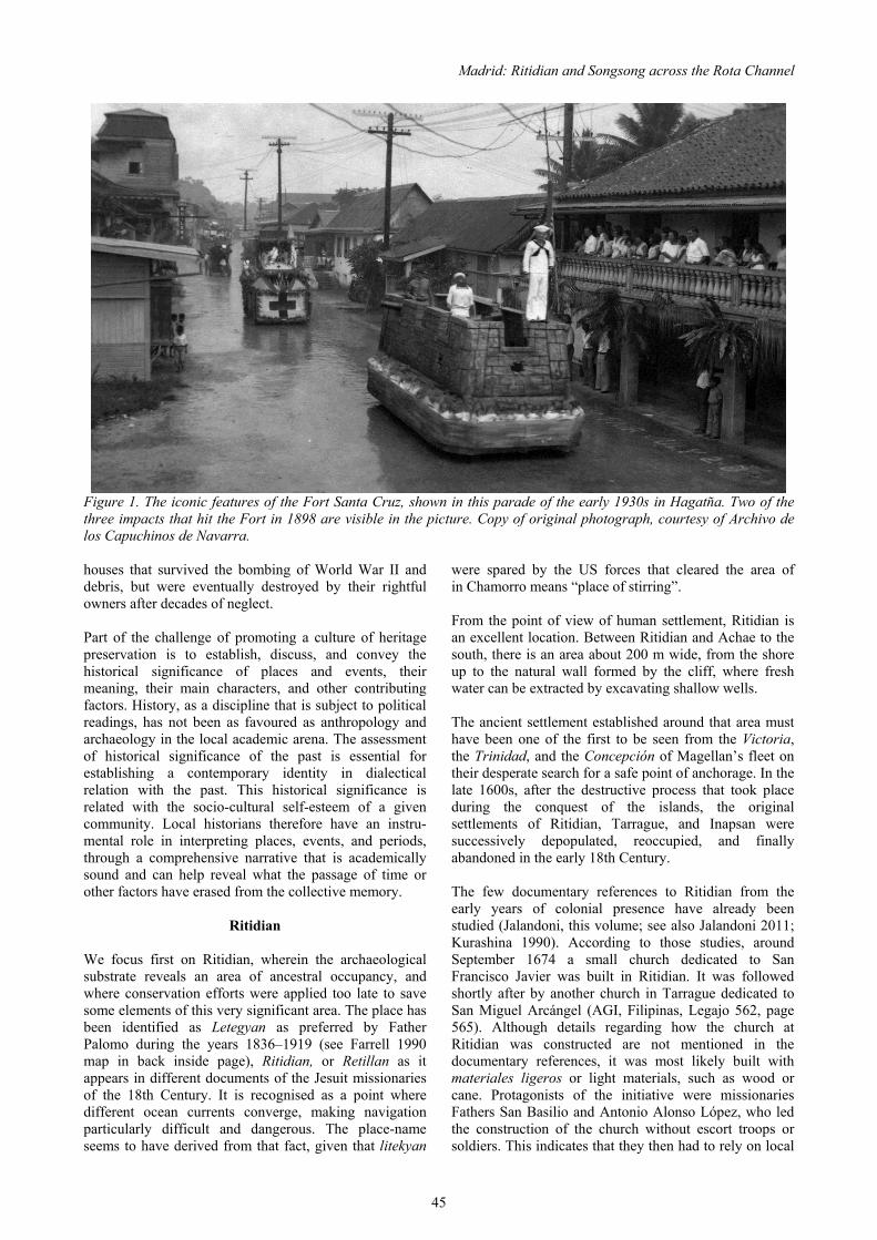
Madrid: Ritidian and Songsong across the Rota Channel
45
Figure 1. The iconic features of the Fort Santa Cruz, shown in this parade of the early 1930s in Hagatña. Two of the three impacts that hit the Fort in 1898 are visible in the picture. Copy of original photograph, courtesy of Archivo de los Capuchinos de Navarra. houses that survived the bombing of World War II and were spared by the US forces that cleared the area of debris, but were eventually destroyed by their rightful owners after decades of neglect. Part of the challenge of promoting a culture of heritage preservation is to establish, discuss, and convey the historical significance of places and events, their meaning, their main characters, and other contributing factors. History, as a discipline that is subject to political readings, has not been as favoured as anthropology and archaeology in the local academic arena. The assessment of historical significance of the past is essential for establishing a contemporary identity in dialectical relation with the past. This historical significance is related with the socio-cultural self-esteem of a given community. Local historians therefore have an instru-mental role in interpreting places, events, and periods, through a comprehensive narrative that is academically sound and can help reveal what the passage of time or other factors have erased from the collective memory.
Ritidian We focus first on Ritidian, wherein the archaeological substrate reveals an area of ancestral occupancy, and where conservation efforts were applied too late to save some elements of this very significant area. The place has been identified as Letegyan as preferred by Father Palomo during the years 1836–1919 (see Farrell 1990 map in back inside page), Ritidian, or Retillan as it appears in different documents of the Jesuit missionaries of the 18th Century. It is recognised as a point where different ocean currents converge, making navigation particularly difficult and dangerous. The place-name seems to have derived from that fact, given that litekyan
in Chamorro means “place of stirring”. From the point of view of human settlement, Ritidian is an excellent location. Between Ritidian and Achae to the south, there is an area about 200 m wide, from the shore up to the natural wall formed by the cliff, where fresh water can be extracted by excavating shallow wells. The ancient settlement established around that area must have been one of the first to be seen from the Victoria, the Trinidad, and the Concepción of Magellan’s fleet on their desperate search for a safe point of anchorage. In the late 1600s, after the destructive process that took place during the conquest of the islands, the original settlements of Ritidian, Tarrague, and Inapsan were successively depopulated, reoccupied, and finally abandoned in the early 18th Century. The few documentary references to Ritidian from the early years of colonial presence have already been studied (Jalandoni, this volume; see also Jalandoni 2011; Kurashina 1990). According to those studies, around September 1674 a small church dedicated to San Francisco Javier was built in Ritidian. It was followed shortly after by another church in Tarrague dedicated to San Miguel Arcángel (AGI, Filipinas, Legajo 562, page 565). Although details regarding how the church at Ritidian was constructed are not mentioned in the documentary references, it was most likely built with materiales ligeros or light materials, such as wood or cane. Protagonists of the initiative were missionaries Fathers San Basilio and Antonio Alonso López, who led the construction of the church without escort troops or soldiers. This indicates that they then had to rely on local

Guam’s Hidden Gem: Archaeological and Historical Studies at Ritidian
46
assistance for the construction. In 1676, the Jesuit Francisco Gayoso estimated that these early buildings, churches or residential schools for catechists, were at most 8 to 10 paces wide by 20 to 30 paces long (Letter signed in Manila, 1676, reproduced in Lévesque 2000, Volume 6:546, 551). Although he may have used the word pasos (paces) as a rough measure without specific equivalence, we are inclined to think that Jesuit Gayoso used the paso común, which measured 0.69 m (Moretti 1828:121). Other authors of the same period considered the paso común equal to two Roman paces (0.55 m). The paso grande still in use in Spain measures 1.393 m (five Roman paces), probably excessive for the paso común in this context (Anonymous n.d.). Assuming that Gayoso’s estimate was accurate, these structures were in the range of 13.8–20.7 m long and 5.5–6.9 m wide. The young catechists of this early mission at Ritidian observed occurrences, such as good fishing despite the abundance of sharks in the surrounding waters, as divine intervention in their favour (AGI, Filipinas, Legajo 562, page 587). But the acceptance of certain obligations derived from conversion met strong popular resistance. In one instance, there was a clash between a group of inhabitants of the settlement and the Christian missionaries. According to written sources, a group of islanders were unhappy because a young woman who lived in a guma urritao or “bachelor house” converted to Christianity and subsequently abandoned what to Christian eyes was concubinage (García 2004[1683]:438). There is some disparity in the different versions of the text. García and Morales seem to take their data from one another, while the letter of Gayoso, which was written closer in time and space to the actual events, offers plausible details worth consideration. Other disparities have been reviewed in Jalandoni (2011). In spite of contradicting sources that confound the timing of the event and the reason behind it, the Ritidian church transitioned from San Francisco Javier to San Miguel Arcángel. In line with Lévesque (2000, Volume 6:547 fn), it does seem plausible that at some point around 1680 or 1681, the Inapsan church (or the Tarrague church, which also was dedicated to San Miguel Arcángel) merged with the one at Ritidian, becoming known as San Miguel de Ritidian. After the forced re-location of the settlement’s popoulation, Ritidian must have remained a location for accessing terrestrial resources as well as for traversing the channel to the reef to access the abundance of marine resources available there. Given understanding and connection to natural seasons, the indigenous experience was one of engrained understanding with the environment. This was not always in line with colonial priorities, which lead to occasional conflicts. One tragic example was the Chamorro canoe that wrecked in December 1719, not far from Ritidian, somewhere in the Rota Channel. Its owner was the
Rotanese Francisco Pangui. At the coercion of the mayor of Rota, Spanish Captain Jose Sandoval, Pangui sailed from Guam to Rota despite the bad weather conditions. Going against his intuition to seek safe anchorage in a reef channel in Ritidian, Sandoval, presumably on a nearby vessel, forced them to continue, causing the sinking and loss of both Pangui and Vhudia. Reference to this is known because Pangui’s widow, Teresa Dida, in face of the tragic death of her husband, requested to be compensated at least with the value of the canoe, 20 pesos, two years later. This significant amount indicates the great value of the local vessels, and incidentally, that they were still in use two decades after the end of the conquest (AGI, Filipinas, Legajo 528, page 25). After the end of the Manila Galleon route in 1815, with the loss of resources and importance that the Marianas Archipelago had for the Spain, Ritidian maintained its agricultural value for the islanders and strategic importance for the colonial government. In 1819, French explorer Louis de Freycinet visited the archipelago and recorded for Ritidian, no less than nine farms, one of them a “Royal Farm” (not Jesuit-controlled) and the remaining eight private ranches. The Royal Farm measured 85.7 hectares and was entirely planted with corn. The eight private farms, which totalled 1543.2 hectares, had chickens, corn, dago, tomatoes, eggplant, bananas, peppers, potatoes, and tobacco. It is quite possible that these private farms were the same that Governor Villalobos observed 14 years later in his complete reconnaissance around the island. Villalobos (1979[1833]:17.31) wrote that there were in Ritidian “6 or 8 ranches with some cultivated fields, pigs and chickens. These ranches get their water supply from a well or surface-level hole. In the cliffs to the rear of these grounds there are two big caves where the water dripping from the ceiling has calcified”. The manuscript report was written by Governor Villalobos in 1833, based on a tour on the island that he conducted in 1832. The map that complemented the reconnaissance report (Figure 2) shows two surface wells in the area, but no stone building are shown in the image. The map legend indicates stone structures and wooden structures, but these symbols are not evident in the Ritidian area. It seems logical to assume that the stone structure should be described or mentioned, even in ruins as probably was the case in 1832. However, it would be a mistake if we interpret the absence of evidence in the report or map as proof of the non-existence of a stone structure in Ritidian. An explanation of this absence is found when analysing the rest of the reconnaissance report. Villalobos did not reference all chapels or Casas Reales in Guam. In fact, other existing buildings on the island, such as the ruins of an old fort in Tumon, or the commemorative plaques at the Camino Real in the Atantano Swamp, are not mentioned either. Therefore, the lack of reference to said structure in Ritidian is not indicative that it was not there. Returning our attention to the Villalobos map (see Figure 2), the blank square north of the large rectangle, could be

Madrid: Ritidian and Songsong across the Rota Channel
47
Figure 2. Ritidian excerpt of the 1832 map of Guam, by Governor Villalobos. Copy of original document, courtesy of Archivo del Museo Naval, Madrid. the ruins of a church or other related structure (Jalandoni, this volume; see also Jalandoni 2011:40–41). It is possible that the authors of the map forgot or were unable to label it in the map’s symbology, which is not uncommon. Additionally in this map (see Figure 2), the large rectangular area corresponds with a crop field. Its proximity to the probable building invites us to believe that there is a connection between the two. In contrast, the remaining “6 or 8 farms” were identified only by their wooden buildings and not by their fields. Perhaps the cultivated land marked in the map belonged to the government, possibly as part of the “Royal Farm” that Freycinet mentioned in 1819. A later map of Guam drawn in 1913–1914 by C. L. Sturdevant (Figure 3), shows a similar rectangular area, near a “spring”. Following the proportions offered in this map’s legend, the field was 140 m long by 100 m wide. The probable crop field is not depicted in exactly the same location, orientation, or size in the two maps. The rudimentary instruments that were most likely used for the 1832 map force us to be cautious with these measurements which should be taken as mere approximations. In fact, the overall similarities between the features in the two maps are more in line with the idea that these fields are one and the same. As for the stone building, likely to be a chapel, it was measured in 1952 as 11.8 m long and 4.6 m wide (Jalandoni, this volume; see also Jalandoni 2011:41). In November 2013, invited by archaeologist Mike Carson, I performed a visual survey of a nearby area in Ritidian, an open spot clear of vegetation formerly used as a baseball field. There, near the cliff line, Carson brought my attention to a stone alignment half-buried in the surface and running in parallel to the cliff line for about 3 m (Carson, this volume). That location matches reasonably with the southwest corner of the crop field in historic maps.
As far as its appearance is concerned, this stone align-ment may have been there since prehistoric times, the late 1600s, or possibly up through the 1900s. The stones are not carved. It is unlikely that any specific reference to this area was ever written by colonial authorities, but based on its location, I believe it is a remnant of an improvised infrastructure, perhaps for collecting or channelling of water, a retention wall, or land boundary that must have been there in direct connection to a spring and the crop field referenced in historic maps. The original length of the alignment remains uncertain, because the adjacent area was covered by debris in the 1970s, when it was cleared for making a baseball field. The 1832 map of Villalobos (see Figure 2) does not depict an existing spring in that particular area of Ritidian. In fact the whole map hardly includes any springs. But at the southwest corner of the crop field, it does include a line running from the cliff towards the ocean. And it includes some kind of buildings or structures in the other extreme of the line, near the ocean. On the 1914 map (see Figure 3), in the area of Ritidian the word “spring” was written near the southwest corner of the purported crop field. Noticeably, there is a straight line near two buildings that leads to the ocean, where three buildings were recorded. The depicted line, coincidental in both maps, might represent the same feature, such as a fence, walking trail from the spring to those structures, or canal of water from the spring to the nearby structure. A conservative interpretation is that the crop field and the spring were very near to the cliff line, if not adjacent to it, and that the stone alignment found there in 2010 is a remnant of that same feature. This conclusion takes into account the minor mapping errors of the 1914 map. Superimposing the 1914 US Navy map over current satellite images of Ritidian with Google Earth reveals that

Guam’s Hidden Gem: Archaeological and Historical Studies at Ritidian
48
Figure 3. Ritidian excerpt from the 1914 Map of Guam, by the US Army Corps of Engineers. Copy of original document, courtesy of Micronesian Area Research Center, University of Guam. the 1914 map incorrectly positions the crop field partially on a cliff. However, the location of fertile soil, availability of groundwater, and proximity to the chapel collectively dictate that this crop field must have been below the cliff line. Further comparison reveals that the map does not show the lowest of the terraces that run from Achae (south of Ritidian) to Ritidian Point, where the existing road passes before finally descending to the coastline. Historically, the northern cliffs of Guam were not as perfectly surveyed as other parts of the island. Samples of these misrepresentations can be glimpsed in this 1914 map (see Figure 3). At Achae Point, modern satellite images verify a pronounced steepness, which is not reflected in the map. Another discrepancy is revealed by matching the map with satellite images of the southwest side of the Ritidian Point cliff-line, or of the cliff-line between Pajon Point and Jinapsan. A US Army service map of Guam dated in 1922 and updated in 1944, follows many features of the 1914 map. It incorporated all of the above-noted distortions, including the absence of the lower terrace. The 1954 AFFE map, the first of Guam made using photogrammetric methods, corrected all previous charts. It included the lower terrace, but ignored existing buildings and springs in the area. From a strictly military point of view, the early 19th Century marked a new era in geostrategic posturing following post-Napoleonic Europe and the independence of Mexico. For the Spanish Government of the Marianas, Ritidian was a possible location that could be breached in the event of an invasion by a foreign power. Governor Villalobos, whose report undoubtedly provided
guidelines followed by his successors, specified Ritidian as one of the remote locations susceptible to invasion that should be monitored along with Tarrague and other noted coastal locations around the island (Villalobos 1979[1833]:11, 22). A surprise landing in a place like Ritidian would allow the unnoticed advance of enemy troops to the capital, by which point it would be too late to alert the residents and military forces. Specifically noted for its strategic value as an ideal point of defence against such a landing is the slope rising from Ritidian beach to the top of the cliff. The enemy could be intercepted from the height of the cliff, throwing “boulders, rifle shots, and artillery fire as circumstances permit” (Villalobos 1979[1833]:12, 24). Around the 1830s, the trail down to Ritidian was farther south near Achae Point. Most likely it is the very same path depicted by Sturdevant in his 1913–1914 map (see Figure 3). Unfortunately, sometime around 1968 all remnants at Ritidian, from both prehistoric and colonial times, were ignominiously destroyed (Jalandoni 2011:41), making it impossible to completely recover and restore them in their historical and ecological settings. Ideally, they could have been a valuable contribution to the sustainable economy and comprehensive knowledge of Guam’s past. Today, that southern end of the Rota Channel that was part of the Acapulco-Manila route is protected as part of the Guam National Wildlife Refuge.
Rota At the northern end of the channel between Ritidian Point

Madrid: Ritidian and Songsong across the Rota Channel
49
and the Island of Rota, in Songsong, the capital of Rota, survive the ruins of the Casa Real (Galván 1999:91), one of the most historically significant remnants of the Mariana Islands. The Casa Real is the only 18th Century municipal building in the Marianas that has survived to this day. The building, in ruins, still maintains elements of the vernacular architecture of the Marianas, for example in the impressive front steps. The building itself symbolises the historical process of the regeneration and change that occurred in the Mariana Islands from the 18th Century onwards. It was a complex and ambiguous transformation process in which new elements were added, older traditions and regional identities survived, and above all a collective voice re-emerged in a new shape. After the shocking trauma of the historical-era depopulation, the following generations of Chamorro people were transformed through their own roots on new cultural, religious, and ethnic basis, despite being subjected to a rigid and demanding regime that changed very little after 1898. The Casas Reales are testimonies to the limits of the colonial regime and its authoritarianism. Most likely constructed by the Rotanese themselves, this particular Casa Real was for two centuries where meetings were held among the village mayor, the principalía or prominent residents, and the island mayor. It was also the place where official documents were stored, and where complaints or requests to the government were registered. Such was the case of the claims against the former governor of the Marianas, Juan Antonio Pimentel, for the mistreatments he or his subordinates committed or tolerated during the long, dark period of eleven years in which he held the position as governor of the Mariana Islands, 1709–1720. These events are recounted in “Traslado auténtico de los autos de la demanda seguida por los padres Felipe María Moscati y Juan Antonio Cantova como viceprotectores de los naturales de las islas Marianas por cantidad de pesos contra el teniente general don Juan Antonio Pimentel, gobernador y capitán general que fue de dichas islas Marianas, 1724” (AGI, Filipinas, Legajo 528). At that time Rota was still comprised of seven villages, most of whose names are listed throughout the documented complaints against Governor Pimentel. Besides the village of Songsong, the other listed villages were Tarrancaya (now called Talakhåya), Torachaga, Seac, Yargua, and Titito or Atiteto (perhaps the place now called Titeto‘) (AGI, Filipinas, Legajo 528, page 67). One day in December 1719, the village leaders gathered in the Casa Real to testify about the lengthy series of offences and abuses suffered under the rule of Governor Pimentel and his subordinate, Captain Lorenzo López. This meeting lasted for three days. Even though villages were over six miles away and connected only by a bad road, their inhabitants were
required to meet Captain López every time he arrived in Songsong under the threat of being whipped. Even worse, the Captain was so aggressive and conceited that he dared to spit pugua (betelnut) juice on their clothes and faces. By the time their complaints were heard, it was too late to apply any sort of practical remedy. The Jesuit Joseph Bonani recorded the abuses as recounted by the village leaders of Rota, determined to bring the case to Father Cantova in Guam, who at the time held the official position of Defensor de Indios (Defender of the Indians). Once recorded, Father Bonani reiterated the offences in Chamorro, paragraph by paragraph to avoid confusion and preventing false accusations. In his report (AGI, Filipinas, Legajo 528, page 67), he stated that most of the denunciations “had been experienced firsthand or witnessed, and it was common knowledge by all. And they added that they had a lot more to demand than what was written, but because they did not remember all details, they did not dare to have it written, since they were afraid of doing some great sin by bearing false witness”. The enumeration of these grievances, collected in the Casa Real and in the nearby convent, which also has survived to this day, provides intriguingly informative historical information about Rota in particular and the Marianas in general. From these data we will have to elaborate on the idea that after the end of the conquest in 1697, a long period that extended beyond one generation started in the Marianas. It must have been a slow transition between the traditional society and the modern world, marked by the continued exploitation of islander labour. An example that corroborates this transition is the use of traditional canoes for inter-island transportation in the 1720s. It appears that the navigation knowledge was intact enough not only to construct and make use of the canoes, but also to keep track of the periods of the year called Inateta, from December to February, in which navigation was not advisable. Inateta seems to come from the Chamorro term inatotta, translatable as prohibition, forbidden, and taboo. Through Father Bonani’s records (AGI, Filipinas, Legajo 528, page 67.), the leaders of Rota stated:
We complain about the continuous voyages, done even in inconvenient periods such as the ones we commonly call Ynateta. And also [we complain] about the number of voyages, because the ones we did during the past administration, exceed in number the ones we did for the last three administrations. And about this, we solicit that the Mayors and other Officials not compel us to navigate against our will [Sheet 49v], because they estimate the weather conditions based in the strength of their ships and boats, and not in accordance to the fragility of our vessels. Thus, it would prevent us the loss of canoes and people, whose losses we are still lamenting to this day.
The same document recounts the case of two Rotanese

Guam’s Hidden Gem: Archaeological and Historical Studies at Ritidian
50
who drowned for not being permitted to seek safe anchorage in Ritidian (AGI, Filipinas, Legajo 528, pages 52 reverse and 53):
…the widows of Nicholas [Udhia] and Francisco Sangi request satisfaction, since it is commonly said that Captain Sandoval was the cause of the loss and death of their husbands, for having forced them with threats, when they were lost in December of 1719. Also, Teresa Dida, who is the widow of the said Francisco Pangi, Lieutenant, requests from Sandoval the payment of the average sized canoe that sunk along with her poor husband.
This testimony was confirmed in Hagatña on January 12, 1721 by another Rotanese, Lucas Uda, 20 years old, who specified the Ritidian incident in detail. In the sequence of protests, the registered names of the complainants are now in disuse, but they were mentioned in a way that is still familiar in Chamorro: Si Engue, si Dagui, si Yro, si Medu (AGI, Filipinas, Legajo 528). Such names are clearly pre-Christian. Generally, the indigenous names became surnames after baptism, and by 1720, it is likely that all Rotanese were baptised. The list of names that Father Bonani recorded from dictation, allows us to think that Christian names were not used on a daily basis, at least not by the people of Rota. Together with the use of traditional Chamorro canoes, the idea that there was not a sudden break or collapse of the traditional indigenous world after the end the military conquest in 1697 is feasible. This separation simply could have been less immediate and abrupt than is commonly supposed, but likely happened over the course of a lengthy transition period.
Apluy Those complainants si Engue, si Dagui, si Yro, si Medu, and others were required each to give Captain Lopez a sack of rice as an apluy. The apluy is a little-known term that requires some explanation. The earliest written reference dates from 1706 (translated from original in Lévesque 2000, Volume 10:534): “The report in question also recommends the introduction of tributes, asserting that the Marianos would pay them willingly, to prevent further excess in that regard, that is, what they call Aplui, personal services, labor, etc.” Apluy could be understood as a Spanish application of a pre-colonial levy. In the list of complaints compiled by Father Bonani in 1719 in the Casa Real of Rota, the apluy is mentioned as non-monetary tribute, when the Rotanese who acted as village mayor said that the Captain “took another 30 cavans as apluy or tribute” (AGI, Filipinas, Legajo 528). Following the same reasoning, the apluy must have been compensated somehow since there is a complaint that Governor Pimentel and his officers compensated it insufficiently: “they said Sandoval paid another Apluy of thirty bales of rice, with a few little machetes, or large table knives, which are worth no more than one or two reales” (AGI, Filipinas, Legajo 528, page 42).
Apluy may have been an ancient custom of donating products for the common good. The incorporation of such custom into the colonial structure is consistent with other taxes in the Spanish Philippines (the Tagalog polo) or the Spanish Americas (the mita from the Incas). Both were a kind of corvée, whereby adult men were required to labour on public works for a certain period during each year. If the apluy was a communal form of indigenous non-monetary tribute in the ancient Marianas, its name probably derived from the word apo‘luyi, which in Chamorro means “to allocate things for one another”. To the extent that this intriguing possibility requires further investigation, it should be mentioned that if this was a pre-Spanish contribution, its mere existence two decades after the conquest supports the existence of a transitional period between the ancient and the modern societies. In light of this research, it is evident that the whole Plaza of Songsong (comprised of the church, the convent and the Casa Real) has great symbolic meanings. Ideally, the Plaza of Songsong could be used in commemorations, celebrations, or simply incorporated into history curricula of the Marianas.
The 1872 Rota Affair The Casa Real was the venue of another significant incident in the history of the Marianas. Over a century and a half later, in January 1872, Gregorio Taisacan, as village mayor, and the village leaders or principalía of Rota (reportedly including Francisco Masga, superintendents Fernando Camacho, Braulio Ornelas, Leocadio Taimanao, and the bailiff Philip Mesgon, with the mayor of the island, Juan de la Cruz), met at the Casa Real and signed a request to resettle the entire Rota population in Umatac, southern Guam, which was against the will of the Rota people (for more details, see Madrid 2006:72–77). Because this resettlement would have led to cutting costs in the provincial coffers, it may appear that such a manoeuver was done in collusion with the government of the Marianas. Thus, it had to appear as if the resettlement truly represented the wishes of the Rotanese in order to be approved by the Governor General of the Philippines. Although there is no way to confirm who was behind it, there is a vestige of oral history that could supplement the account. Among the Rotanese who grew up before World War II, there is a story with characteristics that might refer to this same episode. The only known printed reference was a 2006 newspaper article by Anthony M. Calvo in Marianas Variety, titled “The Miracle of Rota’s Patron Saint” and apparently referring to a time-frame shortly after Spanish conquest. According to this document (Calvo 2006), the Spanish colonial government wanted to relocate the people of Rota in Guam so they could turn Rota into a huge pasture. Since the Rotanese did not want it, they prayed day and night to San Francisco de Borja, patron saint of the island, to prevent it. When a ship arrived to remove them, the Spanish

Madrid: Ritidian and Songsong across the Rota Channel
51
officer in charge threatened the Rotanese people be tying the local figurine of San Francisco de Borja atop the highest mast to intimidate them and facilitate the re-location. According to this oral history, that night the mast broke, puncturing and sinking the ship. Thus, the forced removal was averted through the miraculous mediation of San Francisco de Borja himself. If we assume that this episode refers to 1872, then some details appear to have historical basis. For example, the fact that the transfer was underway, and stopped only at the very last moment. Also, the fact that such an operation was avoided through the collective mediation of members of the church is consistent with surviving written accounts. The tale recalls divine intervention, but we otherwise could understand that the re-location was cancelled thanks to the seven Rotanese who dared to put in writing their dissatisfaction and requested mediation with the Governor to stop the relocation. There is no evidence that a ship went to Rota with the intent to re-locate its inhabitants, much less that it wrecked there. However, we know that the Governor of the Marianas, Luis de Ibáñez, was passing off the coast of Rota in mid-August 1872, just four weeks after the transfer was supposed to take place. He was aboard a steamship, the Maria del Rosario, which a few days later sank, running aground on the reefs off the coast of Tinian. Was Governor Ibáñez behind the attempt to re-locate the people of Rota to Umatac? If so, then was the overall intention to use Rota for pasture? The Governor could have had the Maria del Rosario anchoring discreetly in Rota, so he could pursue the re-location. Although it may be so, and as for now it is impossible to know it with certainty, we believe it is unlikely. The Crown had several acres of public land all over the archipelago available for use, so it appears unnecessary to remove the islanders of Rota for such use. Had the Governor dared to plot the whole re-location, then he would have not stopped it just because a letter was written appealing to him. Even the mere complicity of the Governor in this attempt of re-location would be inconsistent with prior permission granted by his predecessors to Chamorro families moving permanently to Saipan. The Spanish colonial government tried for two centuries to re-populate the archipelago, needing to have inhabitants in each of the main islands to deter foreign crews from illegally extracting natural resources, prevent the kidnapping of islanders, and to develop the overall economy of the province. If we rule out the complicity of the Governor, the other conceivable possibility is that the transfer operation was promoted directly by Father Valentin Casamayor, the parish priest of Rota. He was dissatisfied with his assignment to Rota in which he only stayed for about a year, although he left living traces among its inhabitants. Father Casamayor declared that the people of Songsong enthusiastically welcomed the news of the transfer, which
we know is false. That said, we consider that Father Casamayor could only have been the accomplice of someone else. Who was he? A local landowner? A foreign investor? The Governor? His or their identities remain unknown.
Historical Significance In the light of these episodes, and others that remain to be investigated, we conclude that the recovery of the historical significance of the Casa Real of Rota, and its transmission to future generations, serve as testimony of the continuous community life that the Chamorro people have sustained throughout the centuries in their homeland. From a broader perspective, as compared to other nations of the world that have incorporated traces of the western world, the peoples of the Marianas, like those of the Philippines, Mexico, Peru, Guatemala, Cuba, Puerto Rico, and Spain itself, were united through a transcontinental, globalising link. The Casas Reales, as municipal buildings, can be viewed as landmarks where the unjust dictates of authority could be (and were) contested, in times when absolutist political and religious structures claimed divine origin to their earthly power. No other country in the world represents the triumph of that struggle than the United States of America. Still, even during the Spanish colonial era, such claims were overcome for the first time, albeit briefly, with the Constitution of Cadiz in 1812. In that initial parliament, the Ilocano mestizo Ventura de los Reyes, the first parliamentary representative of the Philippines and its adjacent islands (including the Mariana Islands and the Batanes Islands, north of Luzon), succeeded in passing a law to close down the Manila Galleon route, because it was detrimental to the economic development of the islands (Diario de Sesiones de las Cortes Generales y Extraordinarias, 29 de marzo de 1813, cited in Castellanos Escudier 2007:104). Finally, the Casas Reales are the direct ancestors of the contemporary city halls of the Marianas, which have a decisive role in the current social articulation of the people of the archipelago. These municipal councils are rooted in both the ancient assembly tradition of Micronesian societies and the civic boards of the Hispanic world, whose legacy, both in the Marianas as in the United States, dates back to ancient Europe. Called Casa Real in the colonial context, their historical significance can be interpreted as part of the long struggle of the people to have a representative voice, with the right to decide their own priorities. Ritidian and Songsong, the two extremes of the Rota Channel, are part of this scenario. As a service from the academe to current and future challenges of the society in which we are engaged, historians and researchers must not only join forces with those who spent decades working for the development of a culture of historic preservation, but also must answer the demand for

Guam’s Hidden Gem: Archaeological and Historical Studies at Ritidian
52
information and data from artists, high school teachers, cultural activists, museum curators, village leaders, and other stakeholders. Facilitating and channelling the assignment of contemporary meanings to ancient sites, historic buildings, artefacts, biographies, and genealogies, and contributing to the overall consolidation of an identity based on historical memory, answers these calls for service and information.
Acknowledgements The author expresses his appreciation to archaeologists Mike Carson and John Peterson for giving the opportunity to participate in this publication. Most special gratitude goes to Aja Reyes, for helping to place this article in its final form, and Kelly G. Marsh for her suggestions. Many thanks are owed to Chamorro language instructors Jeremy Cepeda, Leonard Iriarte, and Jose Garrido for their invaluable help in the interpretation of Chamorro terms.
References Anonymous, n.d. Diccionario de la Real Academia de la Lengua Española. XXII Edición, Madrid. Archivo General des Indias, Filipinas. Legajo 528. Spanish Documents Collection. Micronesian Area Research Center, University of Guam, Mangilao. Archivo General des Indias, Filipinas. Legajo 562. Spanish Documents Collection. Micronesian Area Research Center, University of Guam, Mangilao. Calvo, A.M. 2006. The Miracle of Rota’s Patron Saint. News report in Marianas Variety. Castellanos Escudier, A. 2007. El Comercio Marítimo Ultramarino. Cuaderno 52 del Instituto de Historia Naval, Madrid. Galván, J. 1999. Pacific Islands: The Spanish Legacy. Ministerio de Educación y Cultura. Lunwerg. García, F. 2004 (1683). The Life and Martyrdom of the Venerable Father Diego Luis de San Vitores S.J. edited by James A. McDonough. Micronesian Area Research Center, University of Guam, Mangilao. Jalandoni, A. 2011. Casa Real or Not Real? A Jesuit Mission House in Guam. Unpublished M.A. thesis submitted to the Faculty of the Archaeological Studies Program. University of the Philippines, Diliman. Kurashina, H. (ed) 1990. Archaeological investigations at the Naval Facility (NAVFAC) Ritidian Point, Guam, Mariana Islands. Report prepared for Department of the Navy. Micronesian Area Research Center, Mangilao, and Applied Research Group, Bernice P Bishop Museum, Honolulu. Lévesque, R. 2000. History of Micronesia. A Collection
of Source Documents. Lévesque Publications, Montreal. Madrid, C. 2006. Beyond Distances. Governance, Politics and Deportation in the Mariana Islands from 1870 to 1877. Northern Mariana Islands Council for the Humanities, Saipan. Moretti, Conde de. 1828. Manual alfabético razonado de las monedas, pesos y medidas de todos los tiempos y países, con las equivalencias españolas y francesas. Imprenta Real, Madrid. Villalobos, Ramón María de. 1979 (1833). Geographic, Military and Political Description of the Island of Guam. Typescript and translation by F. Plaza. Working Papers 7 and 8. Micronesian Area Research Center, University of Guam, Mangilao.

53
Conflict at Contact: Late 17th Century Spanish Missions and la Reducción in Northern Guam
Andrea Jalandoni
ABSTRACT: The case of Casa Real in Ritidian is a microcosm of the interaction between the Spanish missionaries and the Chamorros on Guam, during the tenuous Contact Period. Through historical accounts and archaeological investigations, the possible foundation of a lost 17th Century church was located. Building the church in Ritidian changed the spatial and spiritual valuation of the land. This was intentional on the part of the Spaniards, as part of the process of la reducción. The Spanish material, technological, and policy introductions irreversibly transformed the local culture. Among the artefacts recovered were the stone and mortar construction material (mampostería), a brick fragment, and trade-ware porcelain. At a native residence nearby were found porcelain sherds and iron, as well as gender-specific work areas. The demise of the first church in Ritidian began because a Spanish missionary attempted to impose a Christian moral code over a cultural norm. Indications of resistance or conflict provide insight into how the Chamorros felt about the changes introduced by the Spaniards. Human bone spearheads found on the site are evidence of violence, and possibly resistance to the Spaniards during this period. By the end of the Chamorro Revolt of 1698, the whole northern population of the island of Guam was removed to southern villages.
Introduction Guam is the largest and southernmost of the Mariana Islands located in the Western Pacific Ocean, approximately 2414 km east of the Philippines (Figure 1). The first settlers of the Marianas are suspected to be Austronesians, originating from the northern Philippines or Island Southeast Asia about 1500 B.C. (Athens et al. 2004; Bellwood 1979; Carson 2010; Carson & Kurashina 2012; Hung et al. 2011). Ritidian is positioned on the northern tip of the island of Guam (Figure 2). The sea level dropping 2 m and introduction of additional vegetative species like rice, taro, and betelnut allowed the coastal regions of Guam to flourish from the pre-latte to latte periods (Figure 3). The Contact Period on Guam, dating A.D. 1521 through 1698, offers an interesting transition between the traditional latte period before the arrival of Ferdinand Magellan and the subsequent Spanish Period beginning at the end of the final reducción, which was the policy of re-locating people into more manageable space. Throughout the Marianas this was not a peaceful time. Missionaries tried to spread Christianity, and while they seemed to be successful for brief periods of time, many of them ended up martyrs. The case of Ritidian provides a microcosm of the conflict during the Contact Period which resonates throughout the Mariana Islands.
Literature Review An analysis of the literature confirms the presence of two churches in Ritidian (Jalandoni 2012). The first was a 1675 wooden church dedicated to Saint Francis Xavier that was so successful it expanded to include two schools (Garcia 2004). It was burned down as a result of an altercation between the resident Brother Diaz and the urritao (young elite men). The religious Brother Diaz was outraged over the long established practice of young girls being compensated to live in a house of young men, and meanwhile the urritao were equally incensed at the meddling of the Brother with their cultural tradition. Brother Diaz was murdered, and to escape the vengeance of the Spaniards and their archenemy neighbours in Tarragui (Tarague), the residents of Ritidian fled from their homes. The location of this church is presently unknown. A second church was inadvertently built in Ritidian. In 1681, the church of Saint Michael in Inapsan (Jinapsan) was built and burned down within the same month. The missionaries decided to rebuild the church later in the same year but in a more favourable location (Solorzano 1682). Unbeknownst to the Jesuits, they rebuilt the Inapsan church dedicated to Saint Michael in Ritidian. Land boundaries were not clearly delineated the way they are today. The present-day locations of Ritidian and Inapsan are vastly different from 17th Century European interpretation, and these do not represent the geographical boundaries defined by the kinship relations of the Chamorros. By 1682 the documentation begins to start recognising that the church is in fact in Ritidian (Table1). By 1684, there is no contemporary mention of a church in Inapsan, but instead all references refer to the church of Ritidian (Morales 1688; Ortiz 1685). In 1684, an organised Chamorro uprising prompted the Ritidian resident priest, Father Angelis, to head for the northern Mariana Islands and to inform the Spanish governor. However, before he could set sail he was murdered on the beach of Ritidian. Once the revolt was assuaged, the Spaniards instituted a reducción of the northern villages to the centre of the island. Ritidian was never again inhabited by a substantial population. In the 19th Century it was used for farming corn by the Jesuits, but it was one of the smallest church farms on the island (de Freycinet 1844). In 1952, Erik Reed photographed and recorded a derelict structure in Ritidian, previously mentioned by Hans Hornbostel (1924–25) and Douglas Osborne (1947). Osborne called it “Casa Real” because it looked to be a Spanish structure, not because of any Spanish royalty affiliation. Reed (1952) described it as an oblong stone building 11.8 m in length and 4.6 m wide. The doorway was located at the west end and the east end had no opening, as would be expected of the altar end of a church. The walls were 76 cm thick and stood up to 2 m high in 1952. There were three windows along each side

Guam’s Hidden Gem: Archaeological and Historical Studies at Ritidian
54
Figure 1. Guam and the Mariana Islands in the western Pacific (from Carson 2010).
Figure 2. Ritidian in northern Guam, with Casa Real study area highlighted, shown on a portion of U.S. Geological Survey 1:24,000 topographic series Ritidian Quadrangle. Graphic prepared by M.T. Carson.
Figure 3. Hypothetical pre-latte through latte period site-formation processes from 1500 B.C. to A.D. 1500. (After Jalandoni 2011, adapted from Dixon et al. 1999).
Figure 4. Photograph of the remains of a Spanish structure taken by Erik Reed in 1952. that were 1.27 m wide at the inside and narrowed to 76 cm on the outside. While the photograph from 1952 is grainy, it is clear that a stone structure once stood in Ritidian (Figure 4). By the time Fred Reinman surveyed the area, the structure was no longer recorded (1968, 1974, 1977). During the Cold War, a secret US Naval Facility was commissioned in Ritidian in 1968 and de-commissioned in 1992 (Aaron 2010). Thus it is assumed that the “Casa Real” was demolished to accommodate the US Navy Sound Surveillance System (SOSUS) (Jalandoni 2012). Other archaeologists, such as Mike Carson (2005, 2006) and Boyd Dixon (2000) have worked in the area, and while their findings do not directly involve Casa Real

Jalandoni: Conflict at Contact: Late 17th Century Spanish Missions and la Reducción in Northern Guam
55
Table 1. Time-line of events at Ritidian and Inapsan, 1674–84, showing an overlap of the San Miguel Residence (from Jalandoni 2012).
Year Events at Ritidian Events at Inapsan
1674 Church in Ritidian starts being built (Freycinet 2003; Garcia 2004)
None recorded
1675 Church in Ritidian completed and dedicated to St. Francis Xavier; church expanded, two schools erected; all structures burned down; Brother Diaz killed; people of Tarague burn Ritidian houses and food-bearing trees (Freycinet 2003; Garcia 2004)
None recorded
1680 People are living at Ritidian; hurricane devastates the area, and people abandon the village, never to live there again (Coomans 1680; Quiroga 1680; Stephenson 1990)
Tarragui, Ritidyan, Opi, Taopi, and Naigo have been reduced to Inapsan; Father Bouwens is assigned to Inapsan (de Rayo y Torres 1681; Pastor 1681)
1681 Chamorros returned to live in Ritidian; forced re-occupation of Ritidian (Solorzano 1682; Haynes and Wuerch 1993)
Church of San Miguel built in Inapsan (February); church burned (February); sixth residence burned down but being rebuilt; forced re-habitation; church/house of San Miguel rebuilt in a different place; residence built in Inapsan (Bouwens 1681; Garcia 2004; Solorzano 1681, 1682)
1682 Residence/church of San Miguel burned again and rebuilt; Saravia dates letters from “Resilian;” tried to build new residence in Ritidian where a year ago an angry mob burned it down and Father Bowens risked his life (Angelis 1682; Saravia 1682, 1683; Strobach 1683)
The sixth residence is Saint Michael in Inapsan; Father Bouwens is the priest in Inapsan; church/residence involving Father Bouwens is burned again; residence in Inapsan is restored (Coomans 1682,1683)
1684 Father Angelis is missioned in Ritidian at the Residence of Saint Michael; Father Angelis is martyred at Ritidian (Morales 1688; Ortiz 1685; Rogers 1995)
Residence of Saint Michael at unspecified location (Coomans 1684)
they provide reliable prehistoric and Spanish period data for the area (Jalandoni 2012). The surface finds are consistent with the historical data of the area and indicate that there may have been a village settlement here, abandoned in the late 1600s (Carson et al. 2010). This would correspond with the time-line of Casa Real and forced re-location of the people in the area to the south. Hiro Kurashina (1990) edited a compilation of Ritidian data. From 2008 through 2010, James Bayman conducted archaeological research at two adjacent latte buildings within a single presumed Spanish-period village in Ritidian (Bayman et al. 2012a, 2012b). His findings were that domestic activities were spatially segregated by gender and that traditional Chamorro economic organisation continued during the Contact Period, roughly contemporaneous with the Casa Real. Using Hornbostel’s 1924–25 sketch map, Peterson and Carson re-identified the general vicinity of Casa Real in 2009 (Carson et al. 2010). In 2010, ground-penetrating radar (GPR) conducted by Garcia and Associates (GANDA) resulted in anomalies of interest. These anomalies were excavated by Jalandoni and field school students from University of Guam (UOG) and University of Hawaii (UH). The excavation revealed the remnants of a stone structure foundation, likely to be the Spanish building or “Casa Real” of Hornbostel’s 1924–25 sketch map and Reed’s 1952 photograph.
La Reducción as Conflict La reducción can be defined broadly as a Spanish policy for making people live in church-centred communities (Farrell 2011). In a glossary to the translation of Velarde’s (1987) work of this subject, Driver defines it as
“the method employed by the Spanish ecclesiastical and military authorities to convert or Christianize the indigenous inhabitants of an area and bring them from what they considered rustic living conditions into more highly organized communities that were centred around a church or mission” (in Velarde 1987). In Ritidian two forms of reducción are observed. The first method was to entice, while the other was a complete upheaval, thus resembling the proverbial carrot and stick. First, missionaries were sent to infiltrate communities and build churches, schools, and other public buildings. These structures encouraged the voluntary relocation of the locals into a more manageable space (Jalandoni 2011). By incorporating stone from existing latte structures, they intended to harness the symbolic power of the latte in order to encourage the Chamorros willingly to re-locate themselves near the Spanish structure. While it was a non-violent approach, it was not peaceful. The imposition of a new religion and way of life was not embraced by all and often incited the locals to violence. The first church in Ritidian was burned and the religious Brother murdered because the religious impositions were not accepted by the locals. There is no clearer example of locals rejecting the foreign institution as the burning of the church in Inapsan during the same month when it was completed. When the church of Inapsan was rebuilt, unwittingly in Ritidian, it was meant to service the neighbouring villages of Tarragui, Ritidyan, Opi, Taopi, Naigo, in addition to Inapsan (De Rayo y Torres 1681), in effect to reduce all these villages to Inapsan (which was really Ritidian). However, this last example arguably crosses the line into the second kind of reducción.

Guam’s Hidden Gem: Archaeological and Historical Studies at Ritidian
56
Table 2. List of martyrs during the Contact Period in the Mariana Islands (from Hezel 1983). Name Birth Death Manner of Death
Louis de Medina Malaga, Spain
3 February 1637
Saipan, M
29 January 1670 speared, clubbed
Diego Luis de Sanvitores Burgos, Spain
12 November 1627
Tumon, Guam, MI
2 April 1672 speared, knived
Francisco Esquerra Manila, Philippines
4 October 1644
Ati, Guam, MI
2 February 1674 speared, clubbed
Pedro Diaz Avila, Spain
1574
Ritidian, Guam, MI
8 December 1675
stabbed with
knives
Antonio Maria de San Basolio Catana, Sicily
1643
Upi, Guam, MI
12 January 1676 clubbed in head
Sebastian de Monroy Seville, Spain
1649
Sumay, Guam, MI
6 September 1676 speared, clubbed
Manuel de Solorzano Fregenel, Spain
25 December 1649
Agana, Guam, MI
24 July 1684
stabbed with
knives
Balthasar Dubois Tournai, Belgium
15 March 1654
Agana, Guam, MI
24 July 1684
skull crushed
by club
Teofilo de Angelis Siena, Italy
15 January 1652
Ritidian, Guam, MI
24 July 1684 hanged
Augustin Strobach Iglou, Moravia
12 March 1646
Tinian, MI
August 1684 beaten with clubs
Karl von Boranga Vienna, Austria
8 July 1640
Rota, MI
24 September 1684 clubbed, speared
Pierre Coemans Antwerp, Belgium
30 January 1638
Saipan, MI
July 1685 beaten to death
After the first method proved ineffectual, then the second form of reducción, a complete re-location of whole villages, was forcefully implemented. In 1684, the last Chamorro revolt commenced with the murder of many of the Spaniards, including the priests. Father Angelis, assigned to Ritidian, was martyred on the beach while boarding a boat. The Spanish officials, exhausted with the enticement method, had the military forcibly evacuate the northern villages nearer the capital of Agana (or Hagatña). The revolt was considered squelched by 1698 and affected not just Ritidian, but resulted in the coerced re-location of most of the Marianas inhabitants to southern Guam (Jalandoni 2011). A quote from Velarde’s (1987:16) work (The “Reducción” of the Islands of the Ladrones, The Discovery of the Islands of the Palaos and other Happenings, originally published in 1759) provides insight into the time period 1616–1716, a range that covers the known Contact Period activity on Ritidian:
Another reason is that these natives love their independence so strongly that they tolerate nothing that restricts their freedom. The yoke of subjection is very hard on their pride and, though they all possess strange ways, the subjection causes some in desperation to take their own lives by hanging themselves. Some women practice sterilization or throw their newborn babies into the sea. They believe that it is better to die than to live and experience true sadness or hardship.
Velarde (1987) attests to the difficulty the Chamorros had
in accepting their subjugation. It is unknown if this account is factual or exaggerated to serve an alternate purpose. Nevertheless, keeping in mind the number of priests martyred and the Chamorro Revolt of 1684–98, it is plausible that the Chamorros valued their independence, and the conflict at contact was indeed severe (Table 2). There were 50 Jesuits that arrived in the Marianas from Sanvitores in 1668 until the end of the Contact Period in 1698 (Hezel 1983). Of those 50, 12 were killed by the Chamorros and martyred.
Discussion With the arrival of the Spaniards, the traditional lives of the Chamorros on Guam were disrupted as never before (Stephenson 1990). Inferences about the interaction of the Spaniards and the Chamorros can be made through the archaeological data. The artefacts recovered from the 2010 Casa Real excavation have been studied to ascertain Spanish influence. The major indicator of Spanish influence is mampostería, a Spanish introduction to Guam, and it was found in copious amounts at the site in Ritidian. Fragments of mampostería were excavated in all the units of the 2010 project and many of units from 2009 (Figures 5 and 6). Mampostería is a stone and mortar building method used on substantial architecture by the Chamorros after adaptation to Spanish cal y canto or lime mortar and stone construction techniques (Cunningham 2010). Masons mortared together stone rubble walls using compacted sand and earth upon bedrock, or upon a stone foundation above beach sands (Cunningham 2010). On

Jalandoni: Conflict at Contact: Late 17th Century Spanish Missions and la Reducción in Northern Guam
57
Figure 5. Photograph of mampostería building material samples recovered from the Casa Real site.
Figure 6. Photograph of mampostería lime mortar recovered from the Casa Real site.
Figure 7. Photograph of in situ ceramic pot with combed lines, adjacent to lime mortar (mampostería).
Figure 8. Upper: Photograph of in situ ceramic pot large rim, adjacent to lime mortar (mampostería). Guam, walls, forts, and churches were built with this mampostería technique (Flores 2011). There is no record of a fort being established in Ritidian, while in contrast there is literature to support a church being built in the area. The Jesuit missionaries instructed the natives on this new construction method for the purposes of evangelisation; for the locals were not taught the new technique to be used in their own homes but for the purposes of building churches and military structures. There is no evidence to support the use of lime as mortar in construction methods before the arrival of the Spaniards. The only stone structures built until then, the megalithic latte, show no evidence of cementation. While found scattered throughout the site, some of the mampostería is located within features (Figures 7 and 8) and can be dated by association to A.D. 1617–83 in the Contact Period. One midden excavated is a hodge-podge of indigenous pottery and Spanish mampostería material in an extremely compact, almost cement-like, deposit with lime mortar (Figure 9). While the ceramics may not display any deviation from latte period assemblages, their presence with mampostería and provenience associates the midden with the Contact Period. The deposition of the pottery is also curious because it is interspersed with mampostería, and the whole feature is only 10 cm thick but almost 1 sq m horizontally. The conclusion is that a structure with mampostería was destroyed almost simultaneously as the pottery was deposited. This perhaps hints at a violent event prior to or at the final abandonment of the site. The stratigraphically most recent feature, a hearth (Figure 10), was dated to the Contact Period. It could be inferred that the site was abandoned and left to dereliction after the Spaniards forced evacuation of the area. No archaeological evidence at the site was found for subsequent activity between this time and the US military digging of a trench for a cable circa 1968. The introduction of a church into an area like Ritidian shifted the spatial relationship of the Chamorros residing

Guam’s Hidden Gem: Archaeological and Historical Studies at Ritidian
58
Figure 9. Photograph of ceramic assemblage with mampostería.
Figure 10. Photograph of two hearths and ceramic assemblage. nearby, previously defined by the clan in residence. Even if the location of the first church is unknown, when its enlargement and subsequent two schools/dormitories are taken into consideration, certain elements of local society started revolving around the church complex, a distinctly non-indigenous concept heretofore unknown to the inhabitants at Ritidian or anywhere else in Guam or the Mariana Islands. The second church was constructed near existing latte
structures, if not amongst existing habitations. Hornbostel (1924–25) noted the material of the Spanish structure as having been taken from a nearby latte set, as well as from latte sets he observed partly intact in other areas of Ritidian. Using material from existing latte sets would, in the eyes of the Spanish authorities, make the Chamorros more receptive to the new structure and the new religion being introduced, a sort of transfer of power or symbolism. The implications are that building the church in Ritidian changed the spatial and spiritual valuation of the land. It was deliberate on the part of the Spaniards to entice before coercion was needed. The archaeological evidence of the shift in spatial valuation is the increase in activity at the Casa Real site during the Contact Period, preceded by an interval of deposition indicating a hiatus in human activity of some hundred years beforehand (Figure 11). The 2009 excavation by John Peterson (this volume) yielded radiocarbon dates calibrated about A.D. 1390–1450 for the two most recent pre-Contact occupation features. In 2010, additional radiocarbon dates for two features fell within the Contact Period, calibrated A.D. 1483–1665 and 1671–1683 (Jalandoni 2011). Struggles between Ritidian and Tarragui, archrival neighbours during the imposition of Christianity, also suggests shifts in Chamorro spiritual values inaccessible to archaeological enquiry alone. When Brother Diaz was murdered over a moral altercation with the urritao of Ritidian, the people of Tarragui seized the opportunity to attack their pre-Contact enemies. Even if those directly involved in the event had fled to Rota, Tarragui used the excuse to burn the village and cut down the food-bearing trees (Garcia 2004). Cutting the food-bearing trees in an island like Guam has the same objective as Romans salting the earth of Carthage: it discourages the enemy from re-populating the area. Latte period warfare was an aspect of shifting village alliances necessitated to secure claims to land and resources when both were becoming more scarce relative to the expanding population (Hunter-Anderson and Butler 1995; Russell 1998). Perhaps the Tarragui villagers were truly outraged at the atrocity committed against a religious person, but it seems more like that they were acting on pre-Christian rivalry between villages (Liston 1996). Artefacts recovered during excavation of Casa Real also encode changes in spiritual values in the Ritidian community associated with conflict. While the latte period pottery is fairly similar throughout the site, this would be expected from the brevity of the Spanish occupation of the area. Without over-emphasising the importance of the porcelain fragment recovered, it is assumed be indirect evidence of Asian trade and or exchange known to have begun between Manila and Mexico by the 1580s (Jalandoni 2011). The artefact was recovered from the same unit as the stone alignment, although not in a direct feature association. Since the stone alignment is likely to be a foundation dug into the basal sediment, the porcelain could have been deposited contemporarily during the use of the stone church, or discarded during its burning (Figure 12). This hypothesis is supported by the reducción in 1698 that forced the

Jalandoni: Conflict at Contact: Late 17th Century Spanish Missions and la Reducción in Northern Guam
59
Figure 11. Synthesised time-line of Casa Real 2010 excavation findings, including stratigraphy and features.
Figure 12. Photograph of porcelain fragment from different angles.
Figure 13. Photographs of brick taken from all four sides.
evacuation of the area. Therefore, all the artefacts are likely to be either pre-1698 or post-1968, when the Navy commissioned SOSUS. A brick fragment that is dated by association to A.D. 1617–1683 is anomalous to traditional construction materials (Figure 13). The latte period Chamorros did not make bricks before European contact. However, the brick is evidence of the Spaniards being present in Ritidian, and could be an example of local manufacture. It is broken, but it is a large enough piece for identification of mortar adhering to the surface. The imperfections of the brick, such as a groove and the uneven surfaces, indicate that it is hand-made. The brick fragment is likely a Spanish introduction. It was found on the site in spite of the fact that there are no historical reports of brick being used during the early church-building days on Guam. Alternatively, the brick could have been part of a Spanish oven or other feature, subsequently dismantled for re-use elsewhere. Historical records state the whole area was forcibly abandoned in 1684, and there is no further archaeological evidence of site use until 1968. The US then built the SOSUS and ran a cable through the site, presumably in the process of destroying the remaining ruins of the Casa Real. There is also a possibility that the brick comes from a farmhouse or ranch, as Reed (1952) mentioned the farm house of “Mr. Castro of Toto” to reference the location of Casa Real. How near Mister Castro of Toto’s farm house was to Casa Real and of what material it was made are unknown. Indications of resistance or violence would provide insight into how the Chamorros felt about the changes introduced by the Spaniards. Human bone spearheads were found at the Casa Real site and dated by association to the Contact Period (Figure 14). Worked human bones, usually made from the long bones of relatives, are found commonly in the Marianas and identified as spearheads (Craib 1986; McNeill 2005; Russell 2002). Diagnostically, they cannot be distinguished from harpoon points because the fragments with or without the line attachment of a harpoon have not been recovered. However, archaeological excavations have revealed skeletons with these spearheads embedded in them, or missing the leg bones presumed to have been deliberately extracted (Russell 1998). Also, there are no historical accounts of the use of harpoons for hunting sea mammals. Rainbird (2004) postulates they may have had a role in fishing, but admits the record specifies only their use in interpersonal violence. There are accounts of human-bone weapons being used against the Spaniards with notable efficacy (in Driver 1993). While it did not necessarily kill immediately, just skinning the soldier could lead to infection. Lack of medicine and medical practitioners made any infection fatal, and their presence may not have aided Spanish soldiers much either. The way the spearhead was carved facilitated entry but made it difficult to extract without ripping more flesh. These weapons were considered to be

Guam’s Hidden Gem: Archaeological and Historical Studies at Ritidian
60
Figure 14. Photograph of human long-bone spearheads found in a single excavation unit.
Figure 15. Photograph of limestone slingstone.
Figure 16. Photograph of igneous slingstone.
the worst weapon on earth by Quiroga, the acting Spanish governor, and their production and possession was banned in 1680 (Russell 1998). Slingstones are egg-shaped projectiles that have been found in Guam to be made of variable material such as basalt and other igneous stones, limestone, marble, or
baked clay (Thompson 1940). An igneous slingstone and a rarer limestone slingstone were recovered from the Casa Real 2010 excavation (Figures 15 and 16). Early Spanish accounts admired the manner in which the Chamorros slung their slingstones with uncanny accuracy (Freycinet 2003). These implements were used both in war and games as a means to display skill. These traditional weapons are clear evidence of conflict, and possibly resistance to the Spaniards coercion during this period, although inter-village violence was also noted in the historical documents of the region. Other artefacts such as mamposteria, hand-made bricks, and imported porcelain imply the presence of enticement, apparently less effective as a means of religious conversion and acculturation. There were other disruptions to the Chamorro way of life that were imposed by the Spaniards in the Contact Period that were drastically different from how they lived in the latte period. Recalling the demise of the first church in Ritidian, the altercation arose because Diaz attempted to impose a Christian moral code over a cultural norm (Jalandoni 2012). While there is no direct physical evidence of such an iconic event at Casa Real, the historical account is much more than just a compelling microcosm of what la reducción represented to the Chamorros of the Contact Period throughout the Marianas. While the degree of acculturation the Spaniards imposed on the Chamorros is not easy to delineate, it is clear that their introductions and policies forever altered the way of life of the islanders, for better or worse.
References Aaron, J. 2010. Regional Cold War historic context for the military installations, including Air Force, Navy, and Army in Guam and the Northern Mariana Islands. Internal report. Department of Defense Legacy Resource Management Program, Washington, D.C. Angelis, T. 1682. Account of the events in the Mariana Islands, by Fr. Angelis. In R. Lévesque (ed), History of Micronesia: A Collection of Source Documents, Volume 7: More Turmoil in the Marianas, 1678–1683. Document 1682I. Les Éditions Lévesque, Gatineau, Québec. Athens, J.S., M.F. Dega & J.V. Ward. 2004. Austronesian Colonisation of the Marina Islands: The palaeo-environmental evidence. Bulletin of the Indo-Pacific Prehistory Association 24: 21–30. Bayman, J.M., H. Kurashina, M.T. Carson, J.A. Peterson, D. Doig & J. Drengson. 2012a. Latte household organization at Ritidian, Guam National Wildlife Refuge, Mariana Islands. Micronesica 42: 258–273. Bayman, J.M., H. Kurashina, M.T. Carson, J.A. Peterson, D. Doig & J. Drengson. 2012b. Household economy and gendered labor in the 17th Century A.D. on Guam.

Jalandoni: Conflict at Contact: Late 17th Century Spanish Missions and la Reducción in Northern Guam
61
Journal of Field Archaeology 37: 259–269. Bellwood, P. 1979. Man’s Conquest of the Pacific. Oxford University Press, New York. Bouwens, G. 1681. Letter from Father Bouwens in Guam to Father Salgado in Manila, dated 20 May 1861. In R. Lévesque (ed), History of Micronesia: A Collection of Source Documents, Volume 7: More Turmoil in the Marianas, 1678–1683. Document 1681E. Les Éditions Lévesque, Gatineau, Québec. Carson, M.T. 2005. Salvage of disturbed human skeletal remains at Guam National Wildlife Refuge, Ritidian, Guam. Report prepared for Guam National Wildlife Refuge. International Archaeological Research Institute, Inc., Honolulu. Carson, M.T. 2006. Archaeological surface inspection and subsurface testing in a portion of beach-front area in Guam National Wildlife Refuge, Ritidian Unit, Guam. Report prepared for Guam National Wildlife Refuge. International Archaeological Research Institute, Inc., Honolulu. Carson, M.T. 2010. Radiocarbon chronology with marine reservoir correction for the Ritidian Archaeological Site, Northern Guam. Radiocarbon 52: 1627–1638. Carson, M.T. & H. Kurashina. 2012. Re-envisioning long-distance Remote Oceanic migration: early dates in the Mariana Islands. World Archaeology 44: 409–435. Carson, M.T., J.A. Peterson & J.M. Bayman. 2010. Work plan for archaeological field school investigations at Guam National Wildlife Refuge, Ritidian Unit, 2010 research modules. Micronesian Area Research Center, University of Guam, Mangilao. Coomans, P. 1680. Long report from Father Coomans in Agana to Father de Pape, dated 6 June 1680. In R. Lévesque (ed), History of Micronesia: A Collection of Source Documents, Volume 7: More Turmoil in the Marianas, 1678–1683. Document 1680H. Les Éditions Lévesque, Gatineau, Québec. Coomans, P. 1682. Composite report from 1680–1682, by Father Coomans. In R. Lévesque (ed), History of Micronesia: A Collection of Source Documents, Volume 7: More Turmoil in the Marianas, 1678–1683. Document 1682E. Les Éditions Lévesque, Gatineau, Québec. Coomans, P. 1683. Letter from Father Coomans in Rota to Father General, dated 30 May 1683. In R. Lévesque (ed), History of Micronesia: A Collection of Source Documents, Volume 7: More Turmoil in the Marianas, 1678–1683. Document 1683K. Les Éditions Lévesque, Gatineau, Québec. Craib, J.L. 1986. Casas de los antiguos; Social differentiation in protohistoric Chamorro society, Mariana Islands, Micronesia. Unpublished PhD thesis.
University of Sydney, Sydney. Cunningham, L. 2010. Mamposteria. Online resource at http://guampedia.com/mamposteria. Guampedia, Uni-versity of Guam, Mangilao. de Rayo y Torres, F. 1681. News from Manila in 1681. In R. Lévesque (ed), History of Micronesia: A Collection of Source Documents, Volume 7: More Turmoil in the Marianas, 1678–1683. Document 1681C. Les Éditions Lévesque, Gatineau, Québec. Dixon, B. 2000 Archaeological survey and testing at proposed brown tree snake pen, Guam National Wildlife Refuge, Ritidian Point, Territory of Guam, Mariana Islands. Report prepared for U.S. Geological Survey. International Archaeological Research Institute, Inc., Honolulu. Dixon, B., J.S. Athens, J.V. Ward, T. Mangeiri & T. Rieth. 1999. Archaeological inventory survey of Sasa Valley and Tenjo Vista Fuel Tank Farms, Piti District, Territory of Guam, Mariana Islands. Report prepared for Department of the Navy, Pacific Division, Naval Facilities Engineering Command. International Archaeological Research Institute, Inc., Honolulu. Driver, M.G. 1993. Fray Juan Pobre in the Marianas 1602. Miscellaneous Series No. 8. Micronesian Area Research Center, University of Guam, Mangilao. Farrell, D. 2011. History of the Mariana Islands to Partition. Public School System, Commonwealth of the Northern Mariana Islands, Saipan. Flores, J.S. 2011. Estorian Inalahan: History of a Spanish-era Village on Guam. Irensia Publications, Hagatna. Freycinet, L. 1844. Voyage Autour du Monde. 1ere Histoire du Voyage. Livre III. Les Marianas. Imprimerie Royale, Paris. Freycinet, L. 2003. An Account of the Corvette l’Uranie’s Sojourn at the Mariana Islands, 1819. Translated and edited by G. Barratt. Occasional Historical Papers No. 13. Commonwealth of the Northern Mariana Islands Division of Historic Preservation, Saipan. Garcia, F. 2004. The Life and Martyrdom of the Venerable Father Diego Luis de San Vitores, S.J. Translated and edited by J.A. McDonough. Monograph Series No. 3, Micronesian Area Research Center, University of Guam, Mangilao. Hezel, F.X. 1983. Jesuit Martyrs in Micronesia. Unpublished manuscript. Available online at http://micsem.org/pubs/articles/religion/frames/jesmartfr.htm Accessed April 2013. Hornbostel, H. 1924–25. Unpublished notes and catalog. Library Department, Bernice P. Bishop Museum, Honolulu.

Guam’s Hidden Gem: Archaeological and Historical Studies at Ritidian
62
Hung, H.C., M.T. Carson, P. Bellwood, F. Campos, P.J. Piper, E. Dizon, M.J.L.A. Bolunia, M. Oxenham, & Zhang C. 2011. The first settlement of remote Oceania: the Philippines to the Marianas. Antiquity 85: 909–926. Hunter-Anderson, R.L. & B. Butler. 1995. An Overview of Northern Marianas Prehistory. Micronesian Archaeological Survey Report No. 31. Commonwealth of Northern Marianas Islands, Division of Historic Preservation, Saipan Jalandoni, A. 2011. Casa Real Or Not Real? A Jesuit Mission House in Guam. M.A. thesis, Archaeological Studies Program, University of the Philippines, Diliman. Jalandoni, A. 2012. Literature review for the Casa Real Site in Ritidian, Northern Guam. Philippine Quarterly of Culture and Society 3: 27–53. Kurashina, H. (ed). 1990. Archaeological investigations at the Naval Facility (NAVFAC) Ritidian Point, Guam, Mariana Islands. Report prepared for Department of the Navy. Micronesian Area Research Center, Mangilao, and Applied Research Group, Bernice P. Bishop Museum, Honolulu. Lévesque, R. (ed). 1992. History of Micronesia: A Collection of Source Documents, Volume 7: More Turmoil in the Marianas, 1678–1683. Les Éditions Lévesque, Gatineau, Québec. Liston, J. 1996. The legacy of Tarague Embayment and its inhabitants, Andersen AFB, Guam, Volume I: Archaeology. Report prepared for 36 CES/CEV, Unit 14007, Environmental Flight, Andersen Air Force Base. International Archaeological Research Institute, Inc., Honolulu. McNeill,J.R. 2005. Putting the dead to work: An examination of the use of human bone in prehistoric Guam. In G.F.M. ratika, J. Buikstra, L.A. Beck, & S.R. Williams (eds), Interacting with the Dead, pp. 305–315. University Press of Florida, Gainesville. Morales, L. 1688. Letters reprinted under the title “The Great Spanish-Chamorro War.” Reported by D. Abelle in “Pacific Profile” April 1964: 22–23. Ortiz, A. 1685. Some eulogies written mostly by Father Bouwens in May 1685. In R. Lévesque (ed), History of Micronesia: A Collection of Source Documents, Volume 8: Last Chamorro Revolt, 1683-1688. Document 1685L. Les Éditions Lévesque, Gatineau, Québec. Osborne, D. 1947. Chamorro archaeology. Unpublished manuscript on file. Micronesian Area Research Center, University of Guam, Mangilao. Pastor. 1681. Population of the Mariana Islands in early times. Manuscript by father Pastor. In R. Lévesque (ed), History of Micronesia: A Collection of Source Documents, Volume 7: More Turmoil in the Marianas, 1678–1683. Document 1681B. Les Éditions Lévesque,
Gatineau, Québec. Quiroga, J. 1680. Letter to the Duchess of Aveiro. In R. Lévesque (ed), History of Micronesia: A Collection of Source Documents, Volume 7: More Turmoil in the Marianas, 1678–1683. Document 1680D. Les Éditions Lévesque, Gatineau, Québec. Rainbird, P. 2004. The Archaeology of Micronesia. Cambridge University Press, Cambridge. Reed, E.K. 1952. General report on Archaeology and History of Guam. Report prepared for Governor of Guam. U.S. National Park Service, Washington, D.C. Reinman, F.M. 1968. Guam prehistory. In I. Iwata & Y.H. Sinoto (eds), Prehistoric Culture in Oceania: A Symposium, pp. 41–50. Bishop Museum Press, Honolulu. Reinman, F.M. 1974. Archaeological site survey records: Guam Register of Historic Places inventory data forms. Unpublished documents on file. Guam Historic Preservation Office, Agana Heights. Reinman, F.M. 1977. An Archaeological Survey and Preliminary Test Excavations on the Island of Guam, Mariana Islands, 1965-1966. Micronesian Area Research Center, University of Guam, Mangilao. Rogers, R. 1995. Destiny’s Landfall: A History of Guam. University of Hawaii Press, Honolulu. Russell, S. 1998. Tiempon I Manmofo‘na: Ancient Chamorro Culture and History of the Northern Mariana Islands. Micronesian Archaeological Survey Report 32. Division of Historic Preservation, Commonwealth of the Northern Mariana Islands, Saipan. Russell, S. 2002 . The Island of Rota: An Archaeological and Historical Overview. Occasional Historic Papers Series No. 11. Commonwealth of the Northern Mariana Islands Division of Historic Preservation, Saipan. Saravia, A. 1682. Two letters from Governor Saravia, dated Ritidian 10 June 1682. In R. Lévesque (ed), History of Micronesia: A Collection of Source Documents, Volume 7: More Turmoil in the Marianas, 1678–1683. Document 1682N. Les Éditions Lévesque, Gatineau, Québec. Saravia, A. 1683. Governor Saravia build a proper fort at Agana, Guam. In R. Lévesque (ed), History of Micronesia: A Collection of Source Documents, Volume 7: More Turmoil in the Marianas, 1678–1683. Document 1683M. Les Éditions Lévesque, Gatineau, Québec. Solorzano, M. 1681. Jesuit annual report for 1680–1681. In R. Lévesque (ed), History of Micronesia: A Collection of Source Documents, Volume 7: More Turmoil in the Marianas, 1678–1683. Document 1681I. Les Éditions Lévesque, Gatineau, Québec.

Jalandoni: Conflict at Contact: Late 17th Century Spanish Missions and la Reducción in Northern Guam
63
Solorzano, M. 1682. Jesuit annual reports for 1681-1682, by Fr. Solorzano In R. Lévesque (ed), History of Micronesia: A Collection of Source Documents, Volume 7: More Turmoil in the Marianas, 1678–1683. Document 1682D. Les Éditions Lévesque, Gatineau, Québec. Stephenson, R.A. 1990. Ethnohistorical background. In H. Kurashina (ed), Archaeological investigations at the Naval Facility (NAVFAC) Ritidian Point, Guam, Mariana Islands, pp. 18-35. Report prepared for Department of the Navy. Micronesian Area Research Center, Mangilao, and Applied Research Group, Bernice P. Bishop Museum, Honolulu. Strobach, A. 1683. Letters from Fr. Strobach to Fr. Provincial of Bohemia, dated May 1683. In R. Lévesque (ed), History of Micronesia: A Collection of Source Documents, Volume 7: More Turmoil in the Marianas, 1678–1683. Document 1683G. Les Éditions Lévesque, Gatineau, Québec. Thompson, L.M. 1940. The function of latte in the Marianas. Journal of the Polynesian Society 49: 447–465. Velarde, P.M. 1987. The “Reducción” of the Islands of the Ladrones, the Discovery of the Islands of the Palaos and Other Happenings. Originally published in 1749 as Historia de la Provincia de Philipinas de la Compania de Jesus. Segundo Parte, que Comprehende los Progresos de esta Provincia desde el ano de 1616 Hasta el de 1716. Translated by E.F. Plaza and re-published as Working Papers No. 51, Micronesian Area Research Center, University of Guam, Mangilao.

64
Reconstructing Cultural Landscapes for the Latte Period Settlement of Ritidian: A Hypothetical Model in Northern Guam
Boyd Dixon and Richard Schaefer
ABSTRACT: In the few decades of la reducción accompanying the attempted destruction of traditional life ways on Guam and the Marianas archipelago circa 1700, Jesuits recorded remnants of what they observed in coastal Chamorro villages such as Ritidian in northern Guam. Architecture, subsistence activities, religious beliefs, and social structure were interpreted by the Spanish or western European clergy and their Mexican or Philippine assistants within the framework of their past experiences and religious training, since these practices were the very underpinnings of the culture they were attempting to erase. Other aspects of pre-Contact indigenous society were left unobserved since they presumably were of little or no consequence to the Jesuits, such as the nature and importance of the cultural landscape to the local inhabitants. This study attempts to identify possible cultural landscapes utilised by members of Ritidian and neighbouring Latte Period communities to apportion resources of the broad plateau above their respective villages, based on the geographical distribution of archaeological sites in northern Guam and analogies from other Micronesian societies whose cultural landscapes still retain some integrity today.
Introduction By the late 1600s when the Spanish first permanently settled on Guam, Jesuit clergy noted that high-ranking women and their clans held rights to use land and resources in the interior of the islands (Driver 1983, 1989), generally farmed by male and female family members and sometimes with the help of lower status individuals subservient to the nobles (Coomans 1997). Since the priests and their assistants rarely resided inland where few potential converts lived (except in southern Guam), their observations of indigenous land tenure were limited. We therefore know very little about the cultural landscape on the northern plateau as viewed by the Chamorro inhabitants, including how land was divided for use within individual communities, how land-use conflicts between neighbours were avoided or resolved, or how farmers and forest gatherers recognised resources which were theirs to use versus those that were off limits. Land tenure on Guam is a very contentious issue given rapid suburban and military development, but there is no reason to believe it was not equally important in the past. The northern coast of Guam including the Ritidian Point area appears to have been settled as early as 1500 B.C. (Hung et al. 2011), although it was not until well after A.D. 800 that large prehistoric villages appeared. Remains of latte or upright stone columns such as those recorded at Hila‘an, Haputo, Ritidian, Jinapsan, Tarague, and Pagat (Bayman et al. 2012; Craib 1986; Liston 1996; Olmo et al. 2001; Reinman 1977; Thompson 1932), indicate that virtually every fair-weather embayment on
the northern coast of Guam had a traditional community of some size. The few sources of fresh water were mostly situated in caves and sinks along the shoreline, except for springs near Mount Santa Rosa and Mount Mataguac (Taborosi 2004). Far fewer latte sets are recorded on the plateau, although the ubiquitous Latte Period pottery scatters suggest such settings likely served as a resource reservoir (Olmo et al. 2001) of forest products and arable soil for coastal communities to exploit, especially critical in time of drought or after major typhoons (Lobban and Schefter 1997). These swidden or slash-and-burn gardens were farmed near harvestable native trees, and appear to have been exploited from small and periodically shifting field camps identified archaeologically by their dark organic midden soil and diversity of stone and shell tools within larger pottery scatters (Dixon et al. 2006; Dixon, Bartow, et al. 2011; Dixon, Walker, et al. 2011). Today the steep escarpment and slopes of northern Guam are still cloaked by useful native forest species including banyan (Ficus sp.), Pisonia grandis, Screwpine or kafu (Pandanus fragrans), the Mariana Breadfruit or dokdok (Artocarpus mariannensis), paipai, and the ifit tree (Intisia bijuga); all had traditional uses in native construction of homes and watercraft (Falanruw 1993; Fosberg 1960; Stone 1970). Epiphytic ferns, cycads (Cycas circinalis), and Sea Hybiscus or pago (Hibiscus tiliaceus) are also common understory plants in the limestone forest. Non-native vegetation in the disturbed plateau above is often dominated by Hedge Acacia or tangantangan (Leucaena leucocephala) and lemonchina (Triphasia trifolia), both good indicators of vegetation disturbance since WWII. Forests also provided refuge for native birds, monitor lizards, and fruit bats. At first European contact in 1521, the native Chamorro diet included coconuts (Cocos nucifera), breadfruit (Artocarpus altilis and Artocarpus ariannensis), taro (Colocasia esculenta and Alocasia macrorrhiza), sugarcane (Saccharum officinarum ), bananas (Musa paradisiaca), and yams (Dioscorea bulbifera and Dioscorea esculenta). Rice (Oryza sativa) was offered to later sailors, as were non-indigenous sweet potatoes by the following century (Barratt 2003). Other plants such as betelnut (Areca cathechu) were valued by the native Chamorro, while many lesser known herbs and plants had medical uses not shared with the Spanish (Safford 1905). This study attempts to identify how all these resources may have been apportioned by members of Ritidian and neighbouring communities on the broad plateau above their respective villages, based on the geographical distribution of archaeological sites in northern Guam and analogies from other Micronesian societies whose cultural landscapes still retain some integrity today. This approach does not pretend to reconstruct the mindset of Latte Period peoples; rather it is a heuristic model or “what if” scenario to generate meaningful discussion about topics rarely if ever mentioned in the Spanish documents.
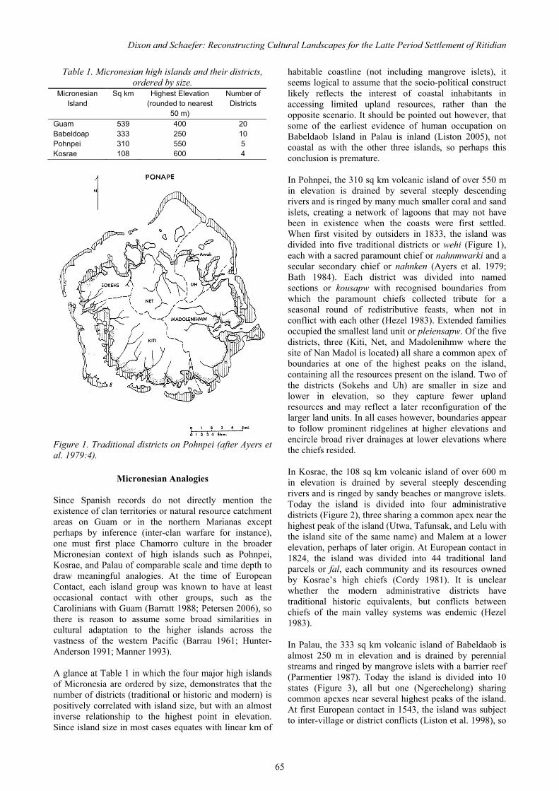
Dixon and Schaefer: Reconstructing Cultural Landscapes for the Latte Period Settlement of Ritidian
65
Table 1. Micronesian high islands and their districts, ordered by size.
Micronesian Island
Sq km Highest Elevation (rounded to nearest
50 m)
Number of Districts
Guam 539 400 20 Babeldoap 333 250 10 Pohnpei 310 550 5 Kosrae 108 600 4
Figure 1. Traditional districts on Pohnpei (after Ayers et al. 1979:4).
Micronesian Analogies Since Spanish records do not directly mention the existence of clan territories or natural resource catchment areas on Guam or in the northern Marianas except perhaps by inference (inter-clan warfare for instance), one must first place Chamorro culture in the broader Micronesian context of high islands such as Pohnpei, Kosrae, and Palau of comparable scale and time depth to draw meaningful analogies. At the time of European Contact, each island group was known to have at least occasional contact with other groups, such as the Carolinians with Guam (Barratt 1988; Petersen 2006), so there is reason to assume some broad similarities in cultural adaptation to the higher islands across the vastness of the western Pacific (Barrau 1961; Hunter-Anderson 1991; Manner 1993). A glance at Table 1 in which the four major high islands of Micronesia are ordered by size, demonstrates that the number of districts (traditional or historic and modern) is positively correlated with island size, but with an almost inverse relationship to the highest point in elevation. Since island size in most cases equates with linear km of
habitable coastline (not including mangrove islets), it seems logical to assume that the socio-political construct likely reflects the interest of coastal inhabitants in accessing limited upland resources, rather than the opposite scenario. It should be pointed out however, that some of the earliest evidence of human occupation on Babeldaob Island in Palau is inland (Liston 2005), not coastal as with the other three islands, so perhaps this conclusion is premature. In Pohnpei, the 310 sq km volcanic island of over 550 m in elevation is drained by several steeply descending rivers and is ringed by many much smaller coral and sand islets, creating a network of lagoons that may not have been in existence when the coasts were first settled. When first visited by outsiders in 1833, the island was divided into five traditional districts or wehi (Figure 1), each with a sacred paramount chief or nahnmwarki and a secular secondary chief or nahnken (Ayers et al. 1979; Bath 1984). Each district was divided into named sections or kousapw with recognised boundaries from which the paramount chiefs collected tribute for a seasonal round of redistributive feasts, when not in conflict with each other (Hezel 1983). Extended families occupied the smallest land unit or pleiensapw. Of the five districts, three (Kiti, Net, and Madolenihmw where the site of Nan Madol is located) all share a common apex of boundaries at one of the highest peaks on the island, containing all the resources present on the island. Two of the districts (Sokehs and Uh) are smaller in size and lower in elevation, so they capture fewer upland resources and may reflect a later reconfiguration of the larger land units. In all cases however, boundaries appear to follow prominent ridgelines at higher elevations and encircle broad river drainages at lower elevations where the chiefs resided. In Kosrae, the 108 sq km volcanic island of over 600 m in elevation is drained by several steeply descending rivers and is ringed by sandy beaches or mangrove islets. Today the island is divided into four administrative districts (Figure 2), three sharing a common apex near the highest peak of the island (Utwa, Tafunsak, and Lelu with the island site of the same name) and Malem at a lower elevation, perhaps of later origin. At European contact in 1824, the island was divided into 44 traditional land parcels or fal, each community and its resources owned by Kosrae’s high chiefs (Cordy 1981). It is unclear whether the modern administrative districts have traditional historic equivalents, but conflicts between chiefs of the main valley systems was endemic (Hezel 1983). In Palau, the 333 sq km volcanic island of Babeldaob is almost 250 m in elevation and is drained by perennial streams and ringed by mangrove islets with a barrier reef (Parmentier 1987). Today the island is divided into 10 states (Figure 3), all but one (Ngerechelong) sharing common apexes near several highest peaks of the island. At first European contact in 1543, the island was subject to inter-village or district conflicts (Liston et al. 1998), so

Guam’s Hidden Gem: Archaeological and Historical Studies at Ritidian
66
Figure 2. Historic districts on Kosrae (after Cordy 1981:5).
Figure 3. Historic districts on Babeldoap, Palau (after Parmentier 1987:21). it is unclear how many modern districts have traditional historic equivalents. The Contact Period pattern of chiefly residences near coastal embayments seems to have been preceded by use of prominent hilltops and ridges for fortifications, residency, and agriculture (Liston 2009).
Northern Guam Guam, the largest of the Mariana Islands, has a total land mass of 539 sq km and so is larger than Pohnpei, Kosrae, or Babeldaob in Palau. Southern Guam rises to just over 400 m in elevation, with numerous streams and rivers that drain the rolling uplands of volcanic origin. Northern Guam consists mostly of an uplifted reef resulting in a limestone or karst plateau of Pliocene, Pleistocene, and early Holocene origin, with volcanic soils predating the reef formation only exposed at Mount Santa Rosa and Mount Mataguac (Young 1988). Like the prow of a ship, the Ritidian Point massif forms the northern tip of the island, rising almost vertically to 150 m above the former Latte Period village. Today the island is divided into 20 administrative units locally called villages (Figure 4), 18 of which cover the southern end of the island and its neck, many reflecting traditional Chamorro villages into which northern villagers and residents of other Mariana islands were moved during the Spanish reducción of the late 1600s (Hezel 1983). This was also a period of considerable inter-village warfare on Guam as clans and families struggled with the demands of forced religious conversion (de Viana 2004). As with the high islands of Micronesia, many of these administrative units converge on the highest peaks of the island, Mount Jumulong (Agat, Talofofo, and Umatac), Mount Bolanos (Umatac, Talofofo, and Inarajan), and Mount Sasalaguan (Umatac, Merizo, and Inarajan). Smaller units cluster around the capital of Hagatna and imply a shallower time depth. In the north, only two administrative units exist today (Dededo and Yigo), their linear boundary reflecting the total depopulation of the area for over a century before being reoccupied by residents of the Colonial capital of Agana and neighbouring villages to the south. Before about 1700 however, Jesuit priests attempted to convert several coastal villages in northern Guam, constructing small churches and sometimes schools for local children at Hila‘an, Ritidian, Jinapson, Tarague, and Pagat (Jalandoni 2001). All these missions eventually met with disaster and martyrdom (Garcia 1980), culminating in the reducción which was a much larger disaster for the remaining local inhabitants who were moved to Pago and other southern villages under the watchful eyes of the Jesuits and military garrisons (Hezel 1983). Because of the historical vacuum in northern Guam for over a century after 1700, reconstruction of the “cultural landscape” for villages such as Ritidian must remain hypothetical and rely where appropriate on ethnohistoric analogies from other Micronesian high islands. King (2003:100–104) identifies five attributes that may make up a traditional cultural property (TCP), and this definition could easily apply to cultural landscapes as well: 1) spiritual power; 2) practice; 3) stories; 4) therapeutic quality; and 5) remembrances. TCP identified on Guam contain at least one or more of these attributes and are often, but not always associated with Latte Period archaeological sites (Kurashina et al. 1999). Mountain

Dixon and Schaefer: Reconstructing Cultural Landscapes for the Latte Period Settlement of Ritidian
67
Figure 4. Historic districts on Guam (after Commons.wikimedia.org/wiki/Atlas_of_Guam).
Figure 5. 1672 Map of Jesuit churches and mission houses on Guam (Courtesy of Micronesian Area Research Center, University of Guam). tops associated with characters of Chamorro legends also qualify, such as Mount Barrigada (Griffin et al. 2009), while other aspects of cultural landscapes such as particular view planes, groves of trees, clay sources for
pottery, or burial grounds may have been knowledge shared by only one or two families. Ritidian Point, one of the most memorable view planes on the island, surely qualifies as part of a cultural landscape for northern Guam, and there can be little doubt the cliffs and caves with their pictographs once evoked spiritual power, traditional practices, family stories, and community remembrances. The therapeutic quality of the waters may be encoded in the Chamorro place name of Ritidian, Litkayan or “the stirring place” (Tolentino 2011), perhaps a reference to the churning currents offshore that still make swimming and fishing there an exhilarating challenge. The healing properties of native forest herbs and plants from the plateau above should not be overlooked either. Like TCP, cultural landscapes are here defined as social constructs delimiting natural resources utilised by a given community or group of people, much as the fal in Kosrae or the better known ahupua’a of Hawai‘i (Handy 1940; Kirch 1985). Such areas may have fixed geographical boundaries easily recognized and avoided by non-members, or be more flexible use-zones where participa-tion is negotiated. On southern Guam with dense inland settlement and well defined drainages around the Fena basin (Dixon and Gilda 2011; Dye and Cleghorn 1990), cultural landscapes may have been relatively fixed by the end of the Latte Period. Resources of particular importance in southern Guam would have included those associated with wetland settings such as taro and rice, plus aquatic species of fish, shrimp, and eels in the mangroves. In contrast, on the northern Guam plateau with relatively homogeneous natural resource distribution (Olmo et al. 2001) and a lower population, it is hypothesised that these areas were probably more flexible (Dixon, Walker, et al. 2011). Resources of particular importance in northern Guam would have included those associated with dryland forest settings such as yams and breadfruit, plus avian species such as fruitbat. While hardly a perfect replica of such landscapes if they existed, the 1672 Alonso Lopez map of Jesuit churches and mission houses on Guam depicts a Spanish perspective on the spatial relationship of pre-reducción communities, with overland trails perhaps approximating some of the boundaries between the villages of Tumon, Hila‘an, Ritidian, Jinapsan, Tarague, Janum, and Pagat (Figure 5). Something similar was recognised by Chamorro for apportioning off-shore and reef resources associated with nearby communities at European contact (Russell 1998; Dixon, Gilda & Mangieri 2013), and likely reflected recognition of inafa’maolek or a sense of interdependence between families and clans with a much longer time depth (Cunningham 1992; Dixon et al. 2006). In the case of Ritidian and the frequent visits or escapes of its inhabitants to Rota before ca. 1700, these clan or family relationships likely spanned a broader expanse of the archipelago, while the removal of its residents to the village Pago during la reducción may also have

Guam’s Hidden Gem: Archaeological and Historical Studies at Ritidian
68
Figure 6. Hypothetical catchment areas on northern Guam.
Figure 7. Stone boundary wall in northern Guam (after Dixon, Schaefer, et al. 2011).
Figure 8. Stone planting pile in northern Guam (after Dixon, Walker, et al. 2010).
Figure 9. Artefact scatter in northern Guam (after Dixon and Walker 2010). reflected pre-existing intra-island kinship relations exploited by the Spanish military and clergy.
The Hypothetical Model To enable the reconstruction of possible cultural landscapes related to the Latte Period village of Ritidian and neighbouring communities on the northern Guam plateau, it is necessary to plot sets of archaeological sites that may be representative of broad types of land-use occurring in the region. Such hypothetical catchment areas for each village might have included natural resources such as arable soils, forest products, animal habitats, fresh water sources, and prominent landmarks of spiritual value. A distinction must be made at this juncture between the concepts of landscape and territory as recently developed in Hawai‘i where such divisions were more clearly drawn at European contact in 1778. Landscape is there proposed to refer to “lived-in environments compromising multiple, overlapping spaces within and among places and generally within the unit that can be referred to as a region…” (Kirch and Zimmerer 2010:28) – in our case study northern Guam. In contrast, “Territory is used to signify the space under the political or economic control of a socially organized group” (Kirch and Zimmerer 2010:28) – a more difficult concept to define in late Latte Period society on Guam or the Northern Mariana Islands than with the Hawaiian ahupua‘a. These archaeological data for northern Guam have been gathered for the majority of Department of Defense property in support of the Joint Guam Build Up Environmental Impact Statement between 2008 and 2011 (www.guambuildupeis.com), and are presented here only as groups of sites with arbitrary geometrical shapes denoting their rough location and orientation for their protection (Figure 6). In contrast, the latte sets are single structures; others on the plateau have been reported in the earlier literature (Reinman 1977), but most are no longer in existence. The location of village sites on the coast is indicated by their respective flags. Three types of sites are portrayed: stone walls (Figure 7)

Dixon and Schaefer: Reconstructing Cultural Landscapes for the Latte Period Settlement of Ritidian
69
Figure 10. Latte set in northern Guam (after Dixon and Carson 2010). and piles (Figure 8) presumed to relate to the planting of tubers such as yams and perhaps post-Contact sweet potatoes, artefact scatters (Figure 9) which probably relate to pre-Contact farming or forest collection and their camps, and latte sets (Figure 10) that are primarily residential in function. The large empty area in the middle of the figure reflects suburban and urban Dededo and Yigo, an area subjected to only sporadic archaeological research outside the scope of this study. Much of developed Andersen Air Force Base also predates cultural resource management studies, hence the absence of sites. The lack of artefact scatter clusters above Janum, Pagat, and Sasajyan is undoubtedly a reflection of the lack of survey on this portion of the plateau, but probably also a reflection of lower Latte Period population densities in the absence of sandy embayments. Hypothetical boundaries between possible cultural landscapes are portrayed by a dotted line to reflect their flexible nature, connecting prominent points along the coastline situated between each Latte Period village to the central topographical feature of the plateau – Mataguac Hill and its associated fresh water springs. A similar strategy is portrayed from Barrigada Hill and its historic spring to show the possible linkage of northern and southern Guam, in a pattern somewhat similar to that seen in Pohnpei, Kosrae, and Palau. If such cultural landscapes have any validity during pre-Contact times, it is expected that the patterns of interconnectivity would be closer to that portrayed by overland trails on the 1672 Jesuit map of Guam. Many of the points on the coast selected as the termini of the spokes radiating out from the hypothetical hub at Mataguac Hill were selected by virtue of their geographical prominence roughly mid-way between coastal embayments and the fact that they have Chamorro place names recorded on the USGS topographical map of the island, implying some longevity as being focal points in the cultural landscape over time. What is important to note is that all cultural landscapes enabled each community to access forests, arable soils,
and a reliable source of fresh water on the plateau. Presumably their size and orientation would change over time as clans intermarried and either shared or denied their neighbours access to specific resources. Sling stones found at many of these sites during archaeological survey suggest that such negotiations were not always peaceful. Other patterns of interest include the proximity of walls and presumed tuber planting piles to their corresponding Latte Period villages which, if indeed a reflection of the post-Contact introduction of crops such as the sweet potato (Dixon et al. 2010), might imply an increased concern for protecting valuable resources used for trade with visiting vessels (Quimby 2011) and later Jesuit clergy (Jalandoni 2011). The walls themselves may also denote an increased concern for marking individual or family farming plots in areas being contested, such as on the slopes immediately above Ritidian. Traditional planting areas with their nearby forest resources and temporary camps, as reflected archaeo-logically in clusters of artefact scatters, yielded largely Latte Period ceramics with lusong or mortars and stone or shell tools, and these sites were generally found in areas of relatively deep clay loam soils at greater distance from coastal settlements. Survey immediately above Ritidian did yield some artefact scatters, but other areas of arable soils nearby seem to have been left untilled, while areas along what have been reconstructed as pedestrian trails toward the cliff line overlooking neighbouring Jinapsan contained evidence of considerable use. If such a mosaic of artefact scatters reflects both areas of sustained use by individual communities and buffer zones of negotiated use between neighbours, then the location of isolated latte sets on the plateau would fit a model of their construction as symbolic boundary markers as has been proposed for southern Guam (Hunter-Anderson 1989; Hunter-Anderson et al. 1994). In this present study’s reconstruction of hypothetical boundaries between communities in the northern Guam plateau, isolated latte sets are located roughly between Hila‘an and Haputo, between Haputo and Ritidian, between Jinapsan and Tarague, and between Pagat and Sasajysan. Unlike the model proposed for southern Guam in which such latte sets as symbolic markers were never intended to be occupied (Hunter-Anderson 1989; Hunter-Anderson et al. 1994), it seems more likely such structures in Northern Guam served multiple functions and perhaps were occupied periodically by members of neighbouring communities when working on the plateau, much as some bai functioned in traditional Palauan societies (Liston et al. 1998). If such structures were gender specific, that remains to be identified archaeologically. All these latte sets were recorded as containing some domestic residential debris underneath and around them, so they appear to have been occupied at least sporadically. The absence of burials however, if not a reflection of limited testing or poor preservation in plateau soils, suggests they were not viewed as permanent

Guam’s Hidden Gem: Archaeological and Historical Studies at Ritidian
70
multi-generational habitations by their Latte Period families on the coast. It must be pointed out that this handful of inland latte sets undoubtedly under-represents many areas not surveyed or destroyed by suburban and military development.
Conclusions In concluding this brief foray into reconstructing possible cultural landscapes related to the Latte Period community of Ritidian, one must return to the Spanish documents at the time of first contact with Jesuit missionaries to get a feel for what social relations between neighbouring villages may have been, and whether they might reflect the existence of fluctuating socio-political boundaries during the Latte Period. It appears that the traditional pre-Contact lifestyle in northern Guam continued well beyond the first visit of Europeans to Guam in 1521, to judge from trade with sailing vessels conducted off the shore for decades (Quimby 2011). After Spanish settlement in Agana in 1668, initial acceptance of the Jesuits by Chamorro inhabitants at Ritidian is evident with the construction of the first church by 1674 and the celebration of religious speaking competitions between Ritidian and Tarague (Jalandoni 2011). This calm before the storm was followed by deliberate efforts by the emboldened clergy to eradicate many elements of Chamorro culture and convert local inhabitants to Christianity by force, baptising infants without the parents’ permission and sometimes with negative if not unexpected results. In December of 1675, members of the community of Ritidian killed Brother Pedro Diaz and his Philippine assistant who were trying to burn down a guma ‘urritao or single men’s house (Farrell 2011), and the ‘urritao then set fire to the church, plus two schools and a mission house recently constructed of perishable materials to serve nearly 400 residents. The perpetrators fled to Rota while members of the community of Tarague, traditional rivals and recent converts to the Catholic religion, burned the village of Ritidian and cut down nearby fruit-bearing trees. In 1681, the church of San Miguel in neighbouring Jinapsan was burned down and a new church was rebuilt in the resettled village of Ritidian in 1682, using maposteria or cobble masonry with burned lime mortar (Jalandoni 2011). After the murder of Fray Angelis at Ritidian in 1684, the Jesuits abandoned the church and the military relocated the entire Chamorro population to the southern village of Pago, following the policy of reducción. It therefore appears that the coastal communities of Ritidian, Jinapsan, and Tarague had a long-term competitive relationship that was only exacerbated by the arrival of Jesuit missionaries and local resident attempts to gain advantage over their rivals through acceptance of a new religion, however short-lived the conversion proved to be. It would not be much of a leap of faith (no
pun intended) to envision this competitive relationship as extending to the plateau above, perhaps expressed as the construction of walled gardens and latte-supported houses along previously negotiated land use boundaries, or maintenance and defence of the hypothetical cultural landscapes here portrayed.
Acknowledgements The author would like to thank Mike Carson, Chris Lobban, and two anonymous reviewers for their constructive reviews of this manuscript. Discussions concerning this topic of study with John Peterson, Lon Bulgrin, and Andrea Jalandoni are appreciated. The author must also thank the U.S. Navy and in particular Eric West of NAVFACPAC and Lon Bulgrin of NAVFACMAR for supporting cultural resources research related to the Joint Guam Build Up Environmental Impact Statement. The author’s participation in this process was facilitated by Cardno TEC archaeologist Terry Rudolph. All opinions expressed in this study are the sole responsibility of the senior author.
References Ayers, W., A. Haun & C. Severance. 1979. Pohnpei Archaeological Survey: 1978 Research. Micronesian Archaeological Survey Report 4. Commonwealth of the Northern Mariana Islands, Historic Preservation Office, Saipan. Bath, J. 1984. Sapwtakai: Archaeological Survey and Testing. Micronesian Archaeological Survey Report 14. Commonwealth of the Northern Mariana Islands, Historic Preservation Office, Saipan. Barrau, J. 1961. Subsistence Agriculture in Polynesia and Micronesia. Bishop Museum Bulletin 223. Bishop Museum Press, Honolulu. Barratt, G. 1988. Carolinian Contacts with the Islands of the Marianas: The European Record. Micronesian Archaeological Survey Report 25. Commonwealth of the Northern Mariana Islands, Historic Preservation Office, Saipan. Barratt, G. 2003. The Chamorros of the Mariana Islands Early European Records, 1521–1721. Occasional Historic Papers Series 10. Commonwealth of the Northern Mariana Islands, Historic Preservation Office, Saipan. Bayman, J., H. Kurashina, M. Carson, J. Peterson, D. Doig & J. Drengson. 2012. Latte household economic organization at Ritidian, Guam National Wildlife Refuge, Marianas Islands. Micronesica 42: 258–273. Coomans, P. 1997. History of the Mission in the Mariana Islands: 1667–1673. Occasional Historical Papers Series 4. Commonwealth of the Northern Mariana Islands, Historic Preservation Office, Saipan.

Dixon and Schaefer: Reconstructing Cultural Landscapes for the Latte Period Settlement of Ritidian
71
Cordy, R. 1983. Archaeological Survey of Innem, Okat and Loal Kosrae Island. Micronesian Archaeological Survey Report 7. Commonwealth of the Northern Mariana Islands, Historic Preservation Office, Saipan. Craib, J. 1986. Casas de los antiguos: Social differentiation in protohistoric Chamorro society, Mariana Islands, Micronesia. Unpublished PhD thesis, University of Sydney, Sydney. Cunningham, L. 1992. Ancient Chamorro Society. Bess Press, Honolulu. De Viana, A. 2004. In the Far Islands: The Role of Natives from the Philippines in the Conquest, Colonization and Repopulation of the Mariana Islands 1668–1903. The Argonaut Press, London. Published 1970 by N. Israel, Amsterdam and Da Capo Press, New York. Dixon, B., H. Bartow, J. Coil, W. Dickinson, G. Murakami & J. Ward. 2011. Recognizing inland expansion of latte period agriculture from multi-disciplinary data on Tinian, Commonwealth of the Northern Mariana Islands. Journal of Island and Coastal Archaeology 6: 375–397. Dixon, B. & M. Carson. 2010. Archaeological investigations conducted in support of the Joint Guam Build-Up Environmental Impact Statement: Threshold report No. 1. Prepared for Naval Facilities Engineering Command. Cardno TEC, Tamuning, Guam. Dixon, B. & L. Gilda. 2011. A comparison of an inland latte period community to coastal settlement patterns observed on southern Guam. People and Culture of Oceania 27: 65–86. Dixon, B., L. Gilda & T. Mangieri. 2013. Archaeological identification of stone fish weirs mentioned to Freycinet in 1819 on the island of Guam. Journal of Pacific History 48:349–368. Dixon, B., T. Mangieri, E. McDowell, K. Paraso & T. Reith. 2006. Latte period domestic household activities and disposal patterns on the Micronesian island of Tinian, CNMI. Micronesica 39: 55–71. Dixon, B., R. Schaefer & T. McCurdy. 2011. Level 1 Archaeological reconnaissance of 800 acres within selected properties on Andersen Air Force Base, Guam. Volume 1: Narrative. Report prepared for Naval Facilities Engineering Command. Cardno TEC, Guam for SEARCH, Honolulu. Dixon, B., R. Schaefer & T. McCurdy. 2010. Traditional Chamorro farming innovations during the Spanish and Philippine Contact Period on northern Guam. Philippine Quarterly of Culture and Society 38:291–321. Dixon, B. & S. Walker. 2010. Archaeological investigations conducted in support of the Joint Guam
Build-Up Environmental Impact Statement: Threshold report No 2. Report prepared for Naval Facilities Engineering Command. Cardno TEC, Tamuning, Guam. Dixon, B., S. Walker, M. Golabi & H. Manner. 2011. Two possible latte period agricultural sites in northern Guam: Their soils, plants, and interpretations. Micronesica 42: 216–266. Dixon, B., S. Walker, R. Schaefer, J. Whippy & C. Walker. 2010. Archaeological investigations conducted in support of the Joint Guam Build-Up Environmental Impact Statement: Threshold report No 3. Report prepared for Naval Facilities Engineering Command. Cardno TEC, Tamuning, Guam. Driver, M. 1983. Fray Juan Pobre de Zamora and his account of the Mariana Islands. Journal of Pacific History 18: 198–216. Driver, M. 1989. (Translator). Fray Juan Pobre's Residence in the Marianas 1602. Micronesian Area Research Center, University of Guam, Mangilao. Dye, T. & P. Cleghorn. 1990. Prehistoric use of the interior of southern Guam. Micronesica Supplement 2: 261–274. Falanruw, M. 1993. Micronesian agroforestry: Evidence from the past, implications for the future. In Raynor, B. & R. Bay (eds), Proceedings of the Workshop on Research Methodologies and Applications for Pacific Island Agroforestry, July 16-20, 1990; Kolonia, Pohnpei, Federated States of Micronesia, pp. 37–41. General Technical Report PSW-GTR-140. Pacific Southwest Research Station, Forest Service. Farrell, D. 2011. History of the Mariana Islands to Partition. Public School System, Commonwealth of the Northern Mariana Islands, Saipan. Fosberg, F.R. 1960. The vegetation of Micronesia. 1. General descriptions, the vegetation of the Marianas Islands, and a detailed consideration of the vegetation of Guam. Bulletin of the American Museum of Natural History 119: 1–76. Garcia, F. 1980. Sanvitores in the Marianas. Working Papers 22. Micronesian Area Research Center, University of Guam, Mangilao. Griffin, A., M. Carson & J. Peterson. 2009. A study of potential Traditional Cultural Properties in Guam. Report prepared for Naval Facilities Engineering Command. Micronesian Area Research Center, University of Guam for TEC Joint Venture, Honolulu. Handy, E. S. C. 1940. The Hawaiian Planter. Volume 1. His Plants, Methods and Areas of Cultivation. Bishop Museum Bulletin 161. Bishop Museum, Honolulu. Hezel, F. 1983. The First Taint of Civilization A History of the Caroline and Marshall Islands in Pre-Colonial
Guam’s Hidden Gem: Archaeological and Historical Studies at Ritidian
72
Days, 1521–1885. University of Hawaii Press, Honolulu. Hung, H.C.., M. Carson, P. Bellwood, F. Campos, P. Piper, E. Dizon, M. Bolunia, M. Oxenham & Zhang C. 2011. The first settlement of Remote Oceania: The Philippines to the Marianas. Antiquity 85: 909–926. Hunter-Anderson, R. 1989. Archaeological investigations in the Small Boat Harbor Project Area, Agat, Guam. Report prepared for U.S. Army Engineer District, Fort Shafter, Hawai‘i. International Archaeological Research Institute, Inc., Honolulu. Hunter-Anderson, R. 1991. A review of traditional Micronesian high island horticulture in Belau, Yap, Chuuk, Pohnpei, and Kosrae. Micronesica 24: 1–56. Hunter-Anderson, R., J. Amesbury & D. Moore. 1994. The Manenggon Hills Project. In R. Hunter-Anderson (ed), Archaeology in Manenggon Hills, Yona, Guam, Volume 1. Micronesian Archaeological Services, Mangilao, Guam. Jalandoni, A. 2011. Casa real or not real? A Jesuit mission house in Guam. Unpublished MA thesis. Archaeological Studies Program, University of the Philippines, Diliman. King, T. 2003 Places that Count: Traditional Cultural Properties in Cultural Resource Management. Altamira Press, Walnut Creek, California. Kirch, P. 1985. Feathered Gods and Fishhooks An Introduction to Hawaiian Archaeology and Prehistory. University of Hawaii Press, Honolulu. Kirch, P. & K. Zimmerer. 2010. Dynamically coupled human and natural systems: Hawai‘i as a model system. In P. Kirch (ed.) Roots of Conflict Soils, Agriculture, and Sociopolitical Complexity in Ancient Hawai‘i, pp. 3–30, School for Advanced Research Advanced Seminar Series, School for Advanced Research Press, Santa Fe. Kurashina, H., R. Stephenson, T. Iverson & A. Laguana. 1999. The megalithic heritage sites of the Marianas: Latte stones in past, present and future contexts. In W. Nuryanti (ed), Heritage, Tourism and Local Communities, pp.259–282. Gadjah Mada University Press, Yogyakarta, Indonesia. Liston, J., 1996. The legacy of Tarague Embayment and its inhabitants, Andersen AFB, Guam. Vol. 1: Archaeology. Report prepared for 36 CES/CEV, Environmental Flight, Andersen Air Force Base, Guam. International Archaeological Research Institute, Inc., Honolulu. Liston, J. 2005. An assessment of radiocarbon dates from Palau, Western Micronesia. Radiocarbon 47: 295–354. Liston, J. 2009. Cultural chronology of earthworks in Palau, Western Micronesia. Archaeology of Oceania 44:
56–73. Liston, J., M. Kashko & D. Welch. 1998. Archaeological inventory survey for the Capital Relocation Project, Melekeok, Republic of Palau. International Archaeological Research Institute, Inc., Honolulu. Lobban, C. & M. Schefter. 1997. Tropical Pacific Island Environments. University of Guam Press, Mangilao. Manner, H. 1993. A review of traditional agroforestry in Micronesia. In B. Raynor & R. Bay (eds), Proceedings of the Workshop on Research Methodologies and Applications for Pacific Island Agroforestry; July 16-20, 1990; Kolonia, Pohnpei, Federated States of Micronesia, pp. 32–36. General Technical Report PSW-GTR-140. Pacific Southwest Research Station, Forest Service. Olmo, R., T. Mangieri, D. Welch & T. Dye. 2001. Phase II archaeological survey and detailed recording at Commander, U.S. Naval Forces Marianas (COMNAVMARIANAS), Communications Annex (Formerly Naval Computer and Telecommunications Area Master Station, Western Pacific [NCTAMS WESTPAC]), Territory of Guam, Mariana Islands. Report prepared for Department of the Navy, Honolulu. International Archaeological Research Institute, Inc., Honolulu. Parmentier, R. 1987. The Sacred Remains Myth, History, and Polity in Belau. University of Chicago Press, Chicago. Petersen, G. 2006. Micronesia’s breadfruit revolution and the evolution of a culture area. Archaeology in Oceania 41: 82–92. Quimby, F. 2011. The hierro commerce: Culture contact, appropriation and colonial entanglement. Journal of Pacific History 46: 1–26. Reinman, F. 1977. An Archaeological Survey and Preliminary Test Excavations on the Island of Guam, Mariana Islands, 1965-1966. Miscellaneous Publication 1. Micronesian Area Research Center, University of Guam, Mangilao. Russell, S. 1998. Tiempon i Manomofo‘ona: Ancient Chamorro culture and history of the Northern Marianas Islands. Micronesian Archaeological Survey Report 32. Commonwealth of the Northern Mariana Islands, Historic Preservation Office, Saipan. Safford, W. E. 1905. The Useful Plants of Guam. Contributions from the United States National Herbarium. Vol. 9. Government Printing Office, Washington, D. C. Stone, B.C. 1970. The flora of Guam. Micronesica 6: 1– 659. Taborosi, D. 2004. Field Guide to Caves and Karst of

Dixon and Schaefer: Reconstructing Cultural Landscapes for the Latte Period Settlement of Ritidian
73
Guam. Bess Press, Honolulu. Thompson, L. 1932. Archaeology of the Mariana Islands. Bishop Museum Bulletin 100. Bishop Museum, Honolulu. Young, F. 1988. Soil Survey of the Territory of Guam. U.S. Department of Agriculture, Soil Conservation Service, U.S. Government Printing Office, Washington, D.C.

74
The Ancestral Legacy of Chief Apuro of Litekyan: Teacher of Mari
Michael R. Clement, Sr.
ABSTRACT: Apuro was an historian, ideologue, traditionalist, allegorical poet, teacher and Chief of Litekyan. It was a crossroad between Guam and the islands of Rota and Tinian to the north and the seat of Chamorro ancestral poetry. This ethnomusicological approach takes a broad look at relationships between Chamorro epic poetry, the Malay Pantun and the Singaporean style of poetic song debate, dondang sayang. The instructional centre for this epic Chamorro poetry was Litekyan. The life of the ancient village and its archaeology becomes more personal when imagined through the life of an important person such as Apuro. Like an archaeologist pieces together the fragments of potsherds to recreate the original, so too is it possible to connect the descriptions of similar song poet practices between neighbouring cultures in Island Southeast Asia and to establish some precedents for the poetic practices referred to as mari. This explores a new direction for music research, of which poetry was a part. Apuro’s demise is couched in the feelings and perceptions of the Padres of Litekyan who taught the children, replacing ancestral superstitions with Church Doctrine. A strong line is drawn between ancient and Christian beliefs and symbols.
Introduction Not much has been researched or written about ancient Chamorro expression, thought or feeling other than through the beliefs of the suruhanu and his/her use of natural medicines and spirits. Most of the writings are about losing armed battles with the Spanish Church, and those are written narrowly from the perspective of the Church and Spain. There is a gap in research about spiritual subjects such as music and poetry due to the condemnation of the ancient religion by the Church, the same as in other conquered countries. There is also a gap in linking Chamorro studies to the broader region of Island Southeast Asia. In these writings of the Society of Jesus (SJ) in Guam, the Jesuits labelled everything belonging to the ancient culture as being “bad, devil inspired.” An example is in the term atan baba which carries the meaning of evil eye or stare: a bad look. A plausible explanation of the original meaning of baba is that it is a reduction of the pre-conquest term babao (Malay: babato), i.e., the image of an ancestral spirit looking out from the roots of the nunu tree. Once the Jesuits condemned ancestral babao, they were considered “bad” and the term immediately fell out of use. Chamorros are best equipped, with the knowledge of their language, to research such symbols and meanings; but for many, their Catholic world view has overlaid their perception of these ancient beliefs. It created barriers to inquiry into pre-conquest belief, into the nature of the Chamorro and it obscured their objectivity about the pre-conquest past.
Another example lies in one lone Chamorro chant that was preserved by the Jesuits from pre-conquest times. To the ardent Catholic Chamorro ear, it can be nothing but the chant of the Holy Roman Church because this is the only chant his ear recognises. There is a logical lay ignorance of historical differences in musical and cultural contexts that one cannot be expected to know but it, nevertheless, blocks objective inquiry into the pre-conquest, indigenous nature of the Chamorro. In order to view the ancient culture objectively, the layman and academician both have to decontextualise the restrictive Catholic view of ancient belief in order to understand who was the Chamorro. In Psychologies of Liberation, Mary Watkins and Elaine Shulman (2008:5) speak of practices that “focus on the well-being and self-organization of people and their communities, when they promote critical reflection and transformation in local arenas, and when their goal is not the imposition of a prescribed yardstick of development but an opening toward a greater freedom in imagining the goals of life. This opening is based on the interrelatedness of individuals, communities, cultures, histories, and environments. … The recollection of a repressed or denied history is a key element in reclaiming vitality.” This paper is based in ethnomusicology and historical linguistics. It is limited to addressing the nature of sung ancestral Chamorro poetry and, specifically, the role of Chief Apuro of Litekyan (pron. Litekdzan) c. 1675, and the pressure put upon him by the Jesuits and the Spanish militia to give up teaching this poetry. Linguistically, it identifies specific ancestral themes and word symbols that point to connections with Malay culture. It does not attempt to connect Chamorro to any other language. Chief Apuro’s story is told through the words of the Jesuit missionaries in Litekyan and Padre Francisco Garcia in Spain who redacted their letters into a story of the early Jesuit experience in the 1660s through 1680s, recently translated by Margaret Higgins in 1985 and James A. McDonough in 2004. Litekyan is spelled according to the new Chamorro orthography. The Spaniards spelled it Ritidian (Figure 1). Liti, in Chamorro means to mix or stir. Yan means place; thus, the place where the open ocean currents mix with those of the Philippine Sea. The Jesuits used the education of young children to instil the belief in Christianity. Children represented a fresh generation of souls that had little knowledge of the ancient beliefs. They also used the agony of adults such as Apuro who banished himself to the hills in his struggle to hold on to his ancient beliefs. Of all Chamorros, Chief Apuro’s role as a teacher was most symbolic of ancient belief because the ancient poetry was built on the stories of ancestors, the heart and soul of the ancestor religion and skull cult. This paper represents a contextualisation of Apuro’s story, cradled in the circumstances, emotions and superstitions of the residents of Litekyan c. 1675–1676, based on the descriptions given by Padres of the

Clement: The Ancestral Legacy of Chief Apuro of Litekyan: Teacher of Mari
75
Figure 1. Isle de Guahan, map by Alonzo Lopez. Litekyan is located at the very top.
Figure 2. Potsherd with a bat image moulded into the rim of a clay bowl. Found in the Mangilao Golf Course excavations by Al Lizama, Guam Historic Preservation Office. Photography by Michael Clement. Society of Jesus (SJ). It also connects such poetry and teaching to the broader region of the Island Southeast Asia.
Background In the history of Guam that is best known today, Hagatña
seems to have been the centre of interest and activity. The earliest battles were fought there; the first church, the home of the Spanish governor, the residencies of the Jesuit Society of Jesus and the Collegio San Juan de Letran were built there. Quite simply, even though there was not a natural harbour, it was perhaps for other reasons that it was so conducive for being the main village: the openings in the coral cliff line and the slowly rising hills, the rivers and the fresh water of Hagatña Springs that made it important. Adjacent to Hagatña Bay there was Tumon Bay leading to present day Tanguisson, Lost Pond, Double Reef and eventually, the ancient villages of Litekyan and Tarragui. Along the way through Tumon Bay, it is fascinating to recall DuMont D’Urville’s account from 1829 of his tour, passing through today’s “Enchanted Forest,” the site of Padre Sanvitores’ death at the hand of Chief Matapang. He paints a word-picture of thousands of fruit bats rising from the caves into the sky. The bats and caves had deep spiritual significance in the Chamorros’ skull cult like vaults of ancestral history. The fanihi (fruit bat) was moulded into ceremonial pottery (Figure 2) and the caves were inscribed with drawings telling of ancient spirit voyages. Nature abounded and one could almost say that as long as nature survived on Guam, so would indigenous instinct and belief. Going northward along the shore was possible but not easily passable. There are some stretches with little or no beach, just sharp coral rock rising up from the water’s edge. Although there is little or nothing written about how the ancient people travelled up to Litekyan and Tarragui, they established villages there. Aside from the quality of the land for growing and the natural beauty, from the northern beaches it is possible to have a clear view of the island of Rota. Although Rota is about fifty miles further north in the archipelago, it looks imminently close from Litekyan. This was significant for catching sight of boats going to or coming from Rota. Whether this was a standard point of departure or arrival for proas was not reported. Nevertheless Litekyan was a vantage point and the natives in this area would have been the first to see such ships as Ferdinand Magellan’s, in 1521, and the many others that followed over the next three centuries. During la reducción, the natives witnessed the Spanish ships sailing to corral the people of Rota, Tinian and Saipan. They were witnesses to history.
Life and Teaching in Litekyan, 1675 According to Padre Garcia (translated in McDonough 2004:433):
In addition to the baptism of children whom their parents brought to the Padres, there was also an increasing number of adults who came to the Catechism, to Mass, and to Confession in all the churches of the island. In San Ignacio de Agadna there were about five hundred who came, San Francisco Xavier de Litekyan, had over four hundred; San Miguel de Tarragui some five hundred, Santa Rosa de Tepungan. more than three

Guam’s Hidden Gem: Archaeological and Historical Studies at Ritidian
76
hundred and San Jose de Fuuna had nearly seven hundred. For this reason it was deemed necessary from the Padres to demolish the old churches and build new and larger ones. The missionary who served on the Residencia of San Francisco Xavier de Litidyan, built a school for boys which he dedicated to San Miquel Arcangel. There were twenty-two pupils who went to the Church twice daily to learn the Doctrine and recite their prayers. … The Padre was moved to make this school the most important thing in the lives of the children of that village.
It was customary for the Jesuits to teach out of their residencies in the smaller villages which is why there was no mention of separate schools in Litekyan. The only collegio was in Hagatña: el Collegio San Juan de Letran. According to O’Malley, it was one of 800 Jesuit collegios in the world (Bailey 1999:28). Francisco Garcia describes long days of instruction for the children beginning at sunrise and ending at midnight. He speaks of their devotion, reverence and respect for the padres. “and if they meet one on the road, they accompany him as far as the church, singing verses of the Doctrine (McDonough 2004:436). He also writes about miracles and mysteries of the Holy Faith, witnessed by the children (translated in McDonough 2004:436):
Many of these children, besides learning to assist in the Mass, some being seven years, learned also the Litany of Our Lady, and many prayers. They learned to read, and had some instruction in music from the Padres, in order that they might later serve as Sacristans, and Catechists, and finally as coadjutors in the evangelical work.
The other side of the coin is what Garcia calls “the common enemy of man” and this leads to the main subject of this writing which is the role of Apuro, Chief of Litekyan, teacher of mari (Figure 3), the ancient poetry, and his conversion to Christianity. To appreciate how and why he converted, it helps to understand the fear that Chamorros felt from the missionaries drumming in the power of Christian miracles and the condemnations of their ancestor religion (skull cult). But first, Apuro is the only person from the ancient culture who was specifically mentioned in the Jesuit letters as being a teacher; as such, he was unique among all of the chiefs and, even though he is only mentioned this one time in history, the fact that his teaching was connected to mari, distinguishes him in Chamorro history. History tends to favour celebrating the warrior chiefs who fought battles of resistance but fighting for the ancestral beliefs and their perpetuation is equally important and warrants a better place in history for Chief Apuro.
Resistance and Retribution Litekyan is quite isolated. It is on the northernmost tip of Guam and about 15 miles north of Hagatña, but it had
Figure 3. Segment of manuscript showing the word mari, as written by Fray Juan Pobre in 1602. Image from microfilm, translated by Margaret Driver, Micronesian Area Research Center, University of Guam. caves and fresh water that enabled the village to exist. Tarragui, a couple of miles to the east, was its closest neighbour and further on was Tepungan. In 1672–76 the Society of Jesus built churches in each area. In 1675, one padre described the resistance as follows (translated in McDonough 2004:434):
The common enemy of man tried to oppose by every possible means this fortunate progress of our Holy Faith. He appeared to the poor natives in various horrible forms, revealing himself to the children of Tarrague in the shape of a frightful ghost, and although at first they were very much afraid, instructed as they were by the Padre to display the Cross at such times, they soon rejected him in view of this armament with which Christ vanquished the Prince of Darkness, and with which all abysmal shades are vanquished. He appeared also to adults in yet more fearful guise, and gave horrible cries to alarm them. They ran to the Padres to beg Crosses, by means of which to free themselves from the ferocious enemy … The Devil, unassisted, could not overcome the Christians.
The Spaniards eventually subdued rebellious Chamorros by shooting them (translated in McDonough 2004:435): Torrahi, the rebel chief [because of his] grave offences, caused the Sergeant to have him shot … . The soldiers then went to his village and burned his house. During these years, the Chamorros were constantly at war with the Church, Spain, the Society of Jesus and the soldiers, and there were many accounts in Garcia’s narrative of Chamorro rebelliousness and retribution by the Church. Garcia gives examples from all over the island, therefore it is not always possible to determine which apply to the village, church and schools at Litekyan. The following account of Litekyan (translated in McDonough 2004:438) implies that there were two residencias: 1) the San Francisco Xavier Residencia and boy’s school and 2) the Santa Sabina Martyr Residencia and girl’s school. There was also a public house or guma

Clement: The Ancestral Legacy of Chief Apuro of Litekyan: Teacher of Mari
77
Figure 4. Artistic illustration of Chief Apuro’s nightmare and apparition which caused him to give up the teaching of mari in Litekyan and brought the practice of ancestral poetry to an end. Illustration by Angel Flores, art student Vivian Pointer, George Washington High School, Guam. ulitao.
The Venerable Brother [Pedro Diaz] knew there was a public house in the village where ten or twelve bachelors lived with only one woman. His zeal would not let him rest day or night. … At last he was able to persuade the woman to leave the ulitaos and, seeing that she was repentant and desirous of living honestly, he took her into the girl’s school. The Devil, enemy of all purity, was unable to suffer the fact that a virtue so celestial should flourish on this earth, incited three ulitaos to enter the girl’s house, to satisfy their insatiable desires. They broke through the walls of the girl’s house on the night of 8 December, the day of the Concepcion de Nuestra Senora.
In reaction to this, Brother Diaz went after the ulitaos and “chastised them with divine justice … placing before them the enormity of the offense they had committed against God.” The narrative continues (translated in McDonough 2004:438):
The natives who were listening to this speech could not endure the strong words of the Brother, nor could the ulitaos, who knew that the Padres and Spaniards meant to put an end to their license and impose rules on them. They threw
themselves in fury upon the Venerable Brother and his companion, Don Isidro, and killed them with sticks and machetes, chopping their heads into bits with shocking and horrible cruelty. [Then] they attacked the Residencia and sacked the Church and house … and set fire to the Church and schools.
In retribution for these crimes (continuing in translation by McDonough 2004:439):
The villagers from Taragui, led by a Bisayan named Francisco Monsongsog, had come to punish those of Litekyan, burning their village, cutting down their fruit trees, and waiting in the hope of catching one of the killers [of which] some had fled to the jungle and others to the Island of Rota, asylum of the wicked.
By 1675, the Jesuit Society of Jesus had close to one hundred years of experience evangelising and spreading Christianity in all parts of the world. They had emerged from eight hundred years of Moorish rule in Spain and were intolerant of anyone who didn’t convert to Christianity; rules of the Spanish Inquisition: convert or die. Upon reaching the Philippine Islands, they encountered anew the Muslims. They were blinded to any other form of religion than Christianity and did not recognise the nature-based religion of the Chamorros with its ancestral skull cult; they could only accept such beliefs as heretical and superstitious. For instance, a noted in the missionary records (translation in McDonough 2004:441–442):
About this time, [one of the] Padres destroyed a skull, one of those by means of which, in this nation, the devil is invoked. He was awakened in the night to hear an Indio [Apuro] complain “Arri mangaron sie,” which means “the skulls are wicked.” … You must know Padre Pedro, that the infernal soul of that skull which you broke, was the thing that disturbed me last night … but with the sign of the Cross, the horrible apparition disappeared, and I was calmed.
Chief Apuro’s Conversion
Garcia uses the example of Padres who had passed into heaven through martyrdom to give strength to other Brothers of the Society in their effort to banish the natives’ superstitions. One night Brother Pedro and a companion went to the house of a native, Apuro, who had seen a vision (Figure 4), and found him “cringing and afraid, almost breathless.” Seeing them, Apuro said (translated in McDonough 2004:442):
My Padres, help me, for two frightful squadrons of demons are walking here, some in the guise of the people of this land, the others like the people of Spain, and they have told me that they are going to kill me because I teach our ancient poetry. They frighten me, for they give off a frightful fire which is not like clean fire, but is dirty and

Guam’s Hidden Gem: Archaeological and Historical Studies at Ritidian
78
malodorous. One thing that consoles me and that is the presence among them of three highly respectable persons, dressed in the habit of the Society, and surrounded by a beautiful radiance.
Who these persons may have been is not definitely known, but it is believed that they were Padre Sanvitores, Padre Medina and Padre Ezquerra. The particular change that took place in the native Apuro, appears to confirm the truth of this marvellous occurrence (translated in McDonough 2004:442:
[Apuro], handing him a missal and an image of San Francisco Xavier, he said, “Padre, I took this, not to keep for myself but to bring it to you.” Nor did he continue to teach his Meris, or fabulous poetry, nor hide in the hills.
Mari, not Meris
With Chief Apuro’s conversion, the door shut tightly on the teaching of the fabled poetry of mari, the name of the ancestral poetry of the ancient Chamorro. It was based on legend and mythology. It was allegorical, and use of the term mari was stamped out with the downfall of Chief Apuro. The Jesuits acknowledged the poetic skill of the Chamorros and used it to teach Church Doctrine, but they did not identify it as mari. Instead, they attempted to change the word to meris, a Marion Church term for the Virgin Mary, dating back to the 12th Century. An alternate spelling is maris, as in Stella Maris: Mary, Star of the Sea. Sanvitores reiterates Legaspi’s words that “Mary, Star of the Sea” was the first reason that our archipelago was named Marianas; the second was after Mariana, the Queen of Austria.
Changing Names, Images, and Symbols Father Sanvitores was especially taken with the image of Our Lady of Guadalupe when he was in Mexico and he adopted it for the Chamorros. Upon arriving in Tinian in July, 1668, he put images of Our Lady in roadside chapels that he built. Scarcely two months later, Ignacio Ipapa, a native of Tinian, became so affected by this image that he experienced an apparition and reported it to Padre Sanvitores (translation in Levesque 1995: Vol 4, 136–139):
She held two infants that appeared to feed at her sacred breasts. There came 8 other bigger children, who with a cord made of 8 cordlets, dragged at the feet of the Virgin a dog tied to it, despite it resistance and barking … the infernal barking of Cerberus [The guard dog of the underworld]. The image of the Lady of Guadalupe was shown to have enough power to tie and hold captive the devil and rout idol worship from these islands, what power would not the miraculous original of the sacred Image hold?
Father Sanvitores’ question implies how he intended to use the image of the Virgin to beat back the Devil, and it foreshadows the appearance of the Virgin in a physical
form, such as the statue of Maria Camalin. The Society of Jesus thus justified replacing the term mari with the name meris in reference to the Virgin, transforming the nature of mari and covering up its ancestral roots. In the Philippines, Lacsonmeris means an image or apparition of Mary (Figure 5) which could indicate a connection with the use of meris on Guam. Other ancestral images that the Society of Jesus wanted to condemn and replace were called babao aniti. Such images could have been that of the fanihi (fruit bat) the navigator of the soul, the tottot (fruit dove) a sacrificial fowl that Padre Sanvitores condemned and the skull and other images associated with clan and nature (Figure 6). Kurashina et al. (1999:9) identified the fruit dove in a stone carving of the Temple of Borobudur in Java, suggesting an ancestral connection. The Chamorros looked to the ancestral images for protection; but the Society of Jesus saw the images as idol worship and products of the devil that had to be destroyed. The opportunity came upon the death of Father Luis de Medina (translation in Levesque 1995: Vol. 1, 605):
We will counteract those [images] which these people usually carry and place in their houses and canoes either to signify their aniti or superstitions, or their jobs, actions and valiant deeds [with that] which we call the babao Dios “emblem of God.” So it is that we use it [the holy cross] as a symbol of God and of our missions, and that must be known how these infidels and apostates saw it by the grudge they showed to it … by grabbing it from the saintly man, breaking it up with their hands and throwing the pieces over the fields, but they couldn’t take away the constant spirit.
It apparently did not cross the minds of the SJ that they were replacing idols with idols. They used the word babao to their advantage but didn’t prevent it from eventually acquiring bad connotations in the form of atan baba: an evil stare. It comes from Malay/Philippines mythology as Babato T. Baliti, ancestral stone images nestled in the trunk of the Baliti tree (Chamorro nunu, Visayan nunok), highly symbolic in Chamorro culture. It is a key word in connecting Chamorro with Malay mythology. The connotation of baba as bad may reflect what David Irving (2010:80) refers to as “the manipulation and control of indigenous languages and their rhetorical devices for the advancement of the imperial project”. Staying on the theme of converting respected ancestral symbols into feared symbols under Christianity, Laura Thompson, in Guam and Its People (1947), cites how Chamorro women were taught to fear the taotaomona as the angry spirits of their former husbands who were killed by the Spaniards. They were taught to fear that their new Criollo, Mexican, Pampangan, Caviteno or Zamboageno husbands would be infected by these spirits when they went to work in the fields or jungle. They wore the colour red or they smeared carabao dung on their bodies, as

Clement: The Ancestral Legacy of Chief Apuro of Litekyan: Teacher of Mari
79
Figure 5. The Lacsonmeris image of the Virgin Mary underscores the religious nature of the meris spelling. Such images were made in Samar in the 1600s with the Virgin’s face and hands made of ivory from the gadya. The ornateness is attributed to Baroque Jesuit influence. Iron, silver and precious stones and excellent craftsmanship were common in the Philippines in the 1600s and before, influenced by art from China. Concepcion Meris: a Spanish Marian name commemorating the Immaculate Conception. Source: T. Itaborra, http://groups.yahoo.com/group/lacsonmeris/attachments/folder/1204484716/item/880461553/view
Figure 6. Richard Manglona holds an ancient clay whistle in the form of a fowl or tottot (fruit dove) that he unearthed in Rota. It was a sacrificial bird and probably totemic. The whistle has a high shrill sound. The tottot was replaced by the Christian dove in tsamorita song metaphor. Referred to Clement by Dr. John Peterson of University of Guam. Photograph by Michael Clement.
prophylactics, to ward off taotaomona spirits. Collectively, these and other actions by the Jesuits caused Chamorros to fear the taotaomona and they brought about the end of Chief Apuro’s teaching of mari.
Mari Reflects Malay Language Frey Juan Pobre first mentioned this skill or practice in 1602 (see Figure 3). He described the wisest men of the villages gathering in a big barn-like structure and engaging in mari. Margaret Driver (1989:18) translated the description of mari relayed to Fray Juan Pobre by his friend Sancho. Clement (2001:52) re-translated hacer coplas as “to make couplets” rather than “ballads” and estimado as “esteemed” instead of “spirited.” The term “debate” wasn’t used either in the original manuscript, but it was implied by the term “competition”. Frey Juan Pobre’s description of mari was actually observed by the Spaniard Sancho who observed the all-day, all-night competitions and reported them to Fray Juan Pobre as follows (translation in Driver 1989:18):
One debater will get to his feet and begin to argue or to make up couplets or to poke fun at those across from him who are from another village … someone from the opposing side gets up and argues against the first side … . The wisest of the indios gather for these debates, some will have learned the skill called mari when very young. These debates are the most esteemed of all their events.
It is clear that mari is described as a skill and not as the name of a form of poetry. It is also clear that it was based in male competition. Male-female song debate which came later in the colonial period, was not integral to mari. This is an important distinction both for understanding correctly the nature of ancient song poetry and the song poetry that followed in the colonial period. The skills Chief Apuro taught for debating in parallel form, in couplets, are core characteristics of Southeast Asian verbal arts (Clement 2001:19; Proschan 1989). Doctor William Peck of Rota linked the contemporary Chamorro poetic song debate to the Malay Pantun or poetic verse. Today, ancient Malay song debate survives in the song poetry of the Baba Chinese of Singapore called dondang sayang or “dear song”. Dondang sayang was influenced by Chinese opera of which there are both formal stage versions and casual street versions. Thomas, in his book, Like Tigers around a Piece of Meat (1986:71), appears to link dondang sayang to the street version of Chinese opera from the Fukien Province through the epic tale of Hang Tuah (Figure 7), the legendary 15th Century Malay Muslim warrior and his four laksamana, or admirals. The Baba of Singapore, even though their culture flourished in more recent times, give instructions for learning and performing dondang sayang that suggest how Chief Apuro might have taught mari to Chamorros in ancient times. In the term dondang, the Chamorro will recognise the cognate dandan which means either “to play music or

Guam’s Hidden Gem: Archaeological and Historical Studies at Ritidian
80
Figure 7. Hang Tuah, 15th Century Malay warrior and cultural hero whose feats are debated in the Baba Dondang Sayang and connected to Chamorro history through the Malay diaspora in poetry and music. Shown in anime style. Courtesy of Dany ChOOng, Keanmun.Blogspot.com ring” (as in church bells) or “sounds having rhythm and melody” (Topping et al. 1975:46). Lalai, “chant” in Chamorro also appears to have Malay roots (Topping et al. 1975). In the realm of music and verbal arts, virtually all the terms lead back to Malay roots: mari, babao, dandan and lalai, and all of these would be linked to the latte period of migration to the Marianas. Technically speaking, mari (from Proto-Austronesian *mai) means “come to the speaker?” It belongs to the “Old Malay” language which took shape in during the 4th Century A.D. and lasted one millennium until the development of Classical Malay in the 14th Century. This precludes Malay immigrants from bringing the name and practice of mari to the Marianas before the onset of the latte period, A.D. 700–1600, which makes mari a Malay loan word in the Chamorro language. At the “Literature of the Voice” conference in 2010, Ateneo, Manila, Muhammad Salleh of Sains University in Malaysia stated that the Hang Tuah epic belonged to the Filipinos as much as it belonged to the Malayans. By extension of the Chamorro’s Filipino/Visayan heritage and on account of the numerous Malay terms and concepts that are at the base of ancient Chamorro history, Hang Tuah could be an appropriate Island Southeast Asian study for Chamorros.
Sources of Chamorro Cultural Heroes: Epic Poetry Not much has been done about classifying Chamorro poetry; nor does anyone think about poetry as a Chamorro subject. Mari, however, reflects that chant was conceived in parallel couplet form, poetic and musical, and incessantly repeated so as not to break the sacred thread of clan history. Father Gerardo Bowens, a Belgian
Jesuit, describes how monotonous and static was the performance of the creation myth: twelve women, accompanied by body instruments and making gestures with their hands, barely moved their feet. In essence, the women were preserving the open-ended qualities and myriad possibilities of this epic. If there was a competitive aspect to this, it was among the women themselves in recalling and chanting the couplets correctly and to come up with the next example of Fu’una’s creation. Puntan and Fu’una were cultural heroes and their story was epic. In an obituary for Brother Pedro Diaz, August, 1675, Father Bowens mentions that Chief Apuro taught about the First Parents or the creation myth of Puntan and Fu’una (Clement, 2001, pp. 30-38; 52). As translated by Leveqsue (1995: Vol 6:357):
He arrived at the house of an Indian Chief named Apuro who had just taught a few disciples (as he is used to sometimes) certain poems in which such poets are used to mix in a thousand humbug stories regarding their First Parents, who they call creators of heavens, earth and sea, etc.
The variations were the myriad ways in which the poets could imagine Fu’una using Puntan’s body to create the universe and everything in it, like an unending theme and variations. There are references to similar creation stories in the Visayas, Malaysia and in Southern China through the Shang Dynasty myth of Pan’ku, (Schirokauer 1978:23), thus hinting at the particular roots of this myth. Epics most likely began with the words recited at the funeral of an important person, someone who was, perhaps, already a legend in their lifetime - someone about whom, stories were already being told. De Freycinet (1824) preserved some examples of funeral orations but, with the advent of Christianity, there was no longer room for such ancestral stories. In addition to the Creation Myth, funeral orations can be considered a source of epic poems.
Taotaomona Stories Puntan and Fu’una also fit into the category of taotaomona, the “people of before time,” the Mona or First People. In Rota, in the 1920s, the term tantanmona was used (Timoner, 1923). According to Gertrude Hornbostel (in Thompson 1947:174), “the names of a few famous ones, believed to have been district chiefs or magas, have survived”. Three of these taotaomona names are Gatos, Gamsom and Anufat. Gatos dwelled in the jungle and was believed to have a penis so long that he could lay it down across a river for his warriors to cross. Gatos is the Visayan word for 100 (Alcina 2004:92). Gamsom was one whose spirit returned to nature to live in the body of an octopus (Figure 8). Gamsom inhabits the locality called Gamsom, east of the district of Pago on the east coast of Guam (Thompson 1947:174).

Clement: The Ancestral Legacy of Chief Apuro of Litekyan: Teacher of Mari
81
Figure 8. Gamsom, the taotaomona in the form of an octopus. Photograph courtesy of the Division of Aquatic and Wildlife Resources, Guam Department of Agri-culture.
Figure 9. Bird’s nest fern. It typically grows out of tree or rock in the Marianas but also out of the belly of Anufat. Photograph by Michael Clement. Anufat has fangs and has a bird’s nest fern (Asplenium nidus) growing out of his belly (Cunnningham 1992:108) (Figure 9). He is perhaps the oldest taotaomona and appears to be one and the same as the supreme god of the Yapese people: Yelefaz, (pron. “Yelfath”). His name appears in the following incantation of the Yapese Tameron (translation in Wallesser 1910:23):
I implore you, o Tamag, may you implore Giliken, that he implore Ken, that he implore Tamanidad, that he implore Tamnin, that he implore the Blessed imparted, that they implore U(e)zret, that she implore Margigi, that she implore those of Sipin, that they implore Yelefaz.
This places Anufat/Yelefaz in the ancestral hierarchy of both the Chamorros and the Yapese, and such a connection is supported in the oral history of the Yapese people today (Dina Grong and Cindy Chugash, personal communication, 2012). In Yap, as in the Marianas, the spirit world is called macan or macana. Together the taotaomona form a category of Chamorro heroes and their epic moments, including the angry spirits of dead warriors from the Conquest of the Marianas. Then there are those Chamorro chiefs such as Kepuha who, apparently, were not heroes in the ancient world but who are remembered for their role in helping to establish Christianity; Kepuha giving his land for the church in Hagatña. Kepuha’s name, however, could tie his legendary status to the Kapuas river of Borneo, a Malay/Indonesian symbol of life and strength (Bernstein 1997:28). The idea of re-categorising stories as epics is not entirely new. Cunningham (1992:103), referring to mari, states: “The wisest competed to see who could speak or sing the most couplets in long epic poems”. Chamorros were not alone in having this form of poetry. Consider the following description by Padre Alcina (2005:47) in the 1600s of a similar form of poetry called siday in Samar, the closest Visayan Island to Guam:
This poetry is the most difficult of all; they use it either to praise others or to chant about the heroic exploits of their ancestors; or about the qualities or beauty of some woman or about some courageous man. It is extremely difficult to understand, and not even the Bisayans understand it, because there is not a word in it that is not metaphorical and that does not have a different meaning in the rhyme.
Alcina states that all of the poetry in those days was sung. Otherwise, this description deals mostly with the content of the poetry and not the method of delivery, i.e. whether or not it was competitive. Most importantly, it reflects ancient motives and practices and its description is not complicated by the very many forms of Filipino song and dance that appeared after Spanish influence took hold. Similarly, reading Alcina’s descriptions gives one the perspective of looking back into antiquity a few hundred years before the 1600s. For the Chamorro, this would be the early-to-middle latte period and before, that period to which most of the characteristics of modern Chamorro culture can be traced. Mari is one of those significant features of that ancient culture and its description aligns well with the siday of the Samarons.

Guam’s Hidden Gem: Archaeological and Historical Studies at Ritidian
82
The Legend of Chief Gadao Chief Gadao of Inalahan is one taotaomona whose legend has survived and is celebrated. This is probably owing to Liyang Gadao, the cave attributed to him and the rock drawings which have become the popular images or babao of cave art in Guam. According to Cabrera and Tudela (2006), cave art actually tells stories that are easy to understand. Some of the stick figures representing buried ancestral skeletons are missing body parts such as the skull, clavicle or femur. A missing femur would have been removed by a descendant to make a barbed spearhead to serve as a weapon. This allows for the spiritual strength of the ancestor to be carried forth in battle. Cabrera and Tudela (2006:51) close their paper on rock art saying:
After 500 years of silence, the rock art of the Mariana Islands slowly begins to reclaim the Chamorro people’s rightful ancestral voice, and by doing so, hopes to rejuvenate the innate cultural wisdom in the hearts of its modern day descendants.
In addition to the local mythology about Chief Gadao (e.g., Cunningham 1992:113), his story has roots in the Visayan and Malay regions which open the door to a larger story. In their isolation in the Mariana Islands, Chamorros lost contact with their Malayo-Indonesian past. Gadya, meaning elephant, is a Malay loan word in the Visayan language with Sanskrit roots: gaja. Padre Alcina (2004:52–71) says that “the Kings of Cambodia sent them as gifts to Manila and that it has been known to [the Visayans] since antiquity … hence we can regard the elephant as native to these islands.” Alcina’s following description is abbreviated (2004:63), yet this scene would have made the elephant legendary among the Visayans of which the pre-Chamorro was part:
A crocodile attacked a carabao. … The elephant saw it, put its trunk around one of the hind legs of the carabao and pulled both the carabao and crocodile out of the water … then the elephant put its leg on the crocodile’s spine, cracked it and the crocodile was killed.
In the Visayas, the gadya was used for heavy jobs such as hauling logs for construction and its ivory and bones were also used for items of art inspired by examples from China. In Christian times, the ivory was used for the faces and hands of figures of the Virgin. The elephant was an animal beyond imagination, thus, the Chamorro mythological character of Chief Gadao is linked to this deeper regional history. Gadao is both a linguistic cognate of gadya and a metaphor for a super-strong giant. In one story, Chief Gadao was able to take one gigantic step from Rota to Guam (probably Litekyan). Gadao survives today as the subject of a short written ancestral story but not as the central figure of an epic poem. He is a cultural hero and an epic character as attested to in the ancient rock art. The words of the poetry that carried his story throughout history are lost forever
but that epic poetry did exist and it should be regarded as such. Imagine two men, engaged in mari, debating Chief Gadao’s great qualities, feats, victories and wonders, each competitor trying to out-do the other. Their challenge goes on for hours until they run out of things to say. Imagine two young kids today, debating whose father is the biggest, strongest, smartest, etc., or a “yo mama” face-off. This was the content, character and essence of Chamorro epic poetry. In this manner of bettering one’s verbal opponent, the Gadao character was built into the legend it is today.
Conclusion about Chamorro Epic Poetry It is the notion that Chamorros had another type of poetry than the male-female colonial debate type known as tsamorita singing that has brought Chief’ Apuro’s life into focus. Suddenly, his words and his role as a teacher become more important in history, as do the techniques of mari that he employed to teach the ancestral poetry. Was it not Chief Apuro who cried out arri mangaronse, the skulls are wicked? Was it not, under him, that the ulitao raided the girl’s residence and buildings were raised? Chief Apuro puts a face on the rebel activities that took place at Litekyan in 1675. For this, his dramatic conversion - haunted by nightmares that threatened his life and made it all seem wrong - took place. This was an epic moment that defined Chief Apuro as a cultural hero and that opened the door to this re-interpretation of Chamorro verbal arts history. Mari, a borrowed Malay term in Chamorro that I suggest is from the Old Malay period, 4th to 14th Centuries, connects this poetic technique to the Malay diaspora. In truth, it extends the Malay diaspora to the Marianas. Not mentioned previously, it connects with Chamorro magi that Quackenbush links it to social usages in the Agutaynen language of Palawan (Clement 2001:50). Diaspora is the operational word. Since Chamorro is an isolated language that cannot be connected to any specific language within the Philippines sub-groups, the researcher is free not to attempt to connect Chamorro to any other Philippines language subgroup. Mari is an indication, however, that the Chamorro language and culture did not wholly develop or evolve without any outside influence and that influence was/is at the core of the Chamorro’s ancestral history. Peck’s association of tsamorita singing with the Malay pantun was perceptive. The pantun is the building block of the Dandong Sayong, in which Hang Tuah stands out as an area-wide hero. Because of the impossibility of making a direct connection of Chamorro to another Island Southeast Asian language, other than the 20.4 cognate relationship with the Toraja group of the Celebes (Clement 2001:11), a different approach must be taken towards Chamorro language research, a more thematic approach. This paper reflects such an approach. Mari, magi, dandong and lalai are grouped around their Malay connection with music.

Clement: The Ancestral Legacy of Chief Apuro of Litekyan: Teacher of Mari
83
They define a developmental period in language history that I suggest is related to the Chamorro pre-latte and latte periods. They complement such associations with stones of the lantai (latte). Within this larger geographical and cultural context, word associations such as gadao reverberate throughout many language and cultures. Gadao is not considered a taotaomona today, yet he is very much so. Gatos, Gamsom and Anufat are, and they point to a sharing of gods in Micronesia. They all fall into the category of the people of before and rank as epic cultural heroes. Their poetic form was decimated by the Spanish conquest; fragmented into short disjointed, deeds, feats or events. Like Humpty Dumpty, Chief Apuro’s memory cannot put them back together again, but it should at the least be recognised and celebrated for what it is.
References Alcina, F. 2004. History of the Bisayan People, Volume 2. University of Santo Tomas Press, Manila. Alcina, F. 2005. History of the Bisayan People, Volume 3. University of Santo Tomas Press, Manila. Bailey, G.A. 1999. Le style jesuite n’existe pas: Jesuit corporate culture and the visual arts. In J.W. O’Malley, G.A. Bailey, S.J. Harris & T.F. Kennedy (eds.), The Jesuits: Cultures, Sciences and the Arts, 1540–1773, pp. 39–89. University of Toronto Press, Toronto. Bernstein, J.H. 1997. Spirits Captured in Stone. Lynn Reiner Publications, Boulder. Cabrera, G. & H. Tudela 2006. Conversations with i man-aniti: Interpretation of Discoveries of the Rock Art in the Northern Mariana Islands. Micronesian Journal of the Humanities and Social Sciences 5:42–52. Clement, M.R. 2001. The Ancient Origins of Chamorro Music. Unpublished MA thesis, Micronesian studies, University of Guam, Mangilao. Cunningham, L.J. 1992. Ancient Chamorro Society. Bess Press, Honolulu. De Freycinet, L.D. de. 1824. Voyage autour du Monde. L’Imprimerie Royal. Chez-Pillet, Imprimeur-Libraire, Paris. Driver, M. (translator) 1989. The Account of Fray Juan Pobre’s Residence in the Marianas in 1602. Micronesian Area Research Center, University of Guam, Mangilao. D’Urville, D.J.S.C. 1843. Voyage au Pole Sud et dans l’Oceanie sur les Corvettes l’Astrolabe et la Zelee, Vol. V. Gide, Paris. Irving, D.R.M. 2010. Colonial Counterpoint: Music in Early Modern Manila. Oxford University Press, New York.
Kurashina, H., R.A. Stephenson, T.J. Iverson & A. Laguana. 1999. The megalithic heritage sites of the Marianas: Latte stones in past, present and future contexts. In W. Nuryanti (ed.), Heritage, Tourism and Local Communities, pp. 259–282. Gadjah Mada University Press, Yogyakarta. Levesque, R. (ed.) 1995. History of Micronesia: A Collection of Documents. Volumes 1 through 6. Levesque Publications, Gatineau. McDonough, J.A. (ed.) 2004. The Life and Martyrdom of Diego Luis de San Vitores, S.J. Micronesian Area Research Center, University of Guam, Mangilao. Proschan, F. 1989. Kmhmu Verbal Arts in America: The Poetics of Kmhmu Verse. Unpublished PhD dissertation, University of Texas, Austin. Schirokauer, C. 1978. A Brief history of Chinese and Japanese Civilizations. Harcourt Brace Jovanovitch, New York. Thomas, P.L. 1986. Like Tigers around a Piece of Meat: The Baba Style of Dodang Sayang. Institute of Southeast Asian Studies, Singapore. Thompson, L.M. 1947. Guam and Its People: A Study of Cultural Change and Colonial Education. Princeton University Press, New Jersey. Timoner, M. 1923. El Angel de las Carolinas, Supplement 1923. Topping, D.M., P.M. Ogo & B.C. Dungca. 1975. Chamorro-English Dictionary. University of Hawaii Press, Honolulu. Walleser, S. 1911. Religious beliefs and practices of the inhabitants of Yap (German south seas). Manuscript on file at Micronesian Area Research Center, University of Guam, Mangilao. Watkins, M. & H. Schulman. 2008. Psychologies of Liberation. Saint Martin’s Press, New York.

84
Community Archaeology at Ritidian: University of Guam Archaeological Field Schools
and Contributions to Community History and Cultural Resource Management
John A. Peterson
ABSTRACT: The Ritidian landscape is stunningly beautiful, pristine, and archaeologically complex. Sites from earliest settlement in Guam and the Marianas are found deeply buried in backbay deposits. Latte period sites are extensive with intact Latte features. The caves and grottoes preserve rock art including what might have been an ancient navigation chart in the images on the cave walls. Well depressions demonstrate the manipulation of the landscape for freshwater. The reefs and the Rota Channel support maritime resources for subsistence. The cliffs above Ritidian support one of the last surviving pristine vegetation communities on Guam, and are therefore still visited by suruhanos and suruhanas for medicinal plants. In the 1980s Dr. Hiro Kurashina and Dr. Rebecca Stephenson conducted anthropological studies at Ritidian as a teaching project by University of Guam Micronesian Area Research Center jointly with Bishop Museum. From 2007 through 2008 University of Guam field schools and classes were held to document the latte period landscape and to provide management data for projects on the US Fish and Wildlife Refuge System Property. From 2008 to 2011 the University of Hawaii Department of Anthropology collaborated with the University of Guam to undertake detailed documentation of latte as household features and to seek the location and the condition of the late 17th Century Spanish mission and associated settlement. In the course of these projects detailed survey data as well as feature discoveries in the coastal dunes and in backbay terrain were documented. These are reported here in the context of community archaeology projects that provided a superb opportunity for teaching and learning as well as contributing data for resource management and for public interpretation at the Ritidian Unit of Guam National Wildlife Refuge.
Introduction The Ritidian shoreline of northern Guam has received deserved attention from scholars since as early as the 1920s when Hans Hornbostel (1925) undertook detailed descriptions and latte period excavations (Figure 1). Ritidian lies across the strait from Rota, whose breadbox and Sabana outline is often crisp in the early morning light above the deep blue of the Pacific Ocean. A brisk current sweeps between the two islands, and it was the likely route that Ferdinand Magellan’s exhausted crew sailed around Guam for brief shelter on the leeward side. The steep escarpment rises several hundred feet to the top of the northern plateau of Guam, that stopped Japanese soldiers fleeing from the invading US Marines in 1944. The steep cliffs support some of the last pristine plant communities on Guam, and the few remaining fanihi (fruit bats) roost along the nearby Tarague cliffs. Hornbostel (notes from 20 July 1923) and later Douglas
Figure 1. Sketch map showing the location of Latte 7-20-23 Ritidian (Halege), Hornbostel’s excavations, and the Spanish Block House at Ritidian (from Reed 1952:16, based on Hornbostel 1925). Osborne (1947), Erik Reed (1952), and Fred Reinman (1977) all remarked on the integrity of the archaeology and the environment at Ritidian. All also mapped the few relicts of the Jesuit mission to the north that had been destroyed by fire and raids in the late 17th Century, only to be abandoned as reducción forced the remaining Chamorro to abandon their inland field systems above the village (Dixon et al. 2012) and move toward the Spanish settlements of Pago Bay and Hagatña (Jalandoni 2011a). In the 1980s the University of Guam conducted investigations that were the first comprehensive accounts of the archaeology (Kurashina 1990), the geology (Randall 1990), and the ethnography and ethnohistory (Stephenson 1990) of Ritidian. These studies provided the benchmark for successive work (Dixon2000; Olmo 1997), and provided critical insights into formation processes in coastal terrain. Along with Randall and Siegrist’s work at Tarague (1996), these projects established the baseline dating for coastal terrain that constrains all subsequent shoreline phenomena to post-5700 years before present (ybp). Radiocarbon ages of coral tips from the reef pinnacle of the last high sea still--‐stand dated from this era, when sea level was 1.8 m higher eustatically, and in the midst of tectonic uplifting that have stranded these formations as much as another 2 m above their elevation during their period of formation (Kayanne et al. 1993; Randall 1990). Radiocarbon ages from the tops of the reef platform in the era of 3500 ybp constrain the earliest settlement dates for shoreline sites around Guam and the Marianas Islands, signifying not only confirmation of a period of early discovery, but also changing sea level regimes that likely occasioned maritime swarming around the region in search of stable shoreline habitat for settlement. During this dynamic period of sea-level change mangrove habitat

Peterson: Community Archaeology at Ritidian
85
Figure 2. Proposed fenceline for ungulate fence, area of potential effect and corridor for 2007 University of Guam Ritidian Archaeological Field School shown as “Sections E and F in the southwest”(from figure prepared by M.T. Carson). was stressed throughout the region; it recovers slowly from perturbation. The appearance of Gafrarium and Anadara shell middens, both from mangrove and associated mudflats, at early pre-latte shoreline sites suggest that this threatened and diminished habitat was preferable for maritime nomad settlement. Documentation of the changing shoreline regime at Ritidian has provided a window into human-environment interaction during the early period of island settlement (Carson 2014; Peterson and Carson 2009). The Ritidian Unit of the Guam National Wildlife Refuge (GNWR) was established in 1993 after it was transferred from the Andersen Air Force Base to the US Fish and Wildlife Service (USFWS). The transfer was controversial as many on Guam believed it should be returned to native ownership, or at least to the Government of Guam. There were many dramatic moments during the transfer, including the efforts of the Governor of Guam to cut the chain closing the gate with an oxy acetylene torch. Nonetheless, the transfer was upheld, and the Ritidian Unit continues to be well managed as an environmental and archaeological preserve. In 2006 the Refuge management requested assistance with National Historic Preservation Act Section 106 Consultation regarding the proposed construction of an ungulate fence from the Ritidian Grotto to the Star Cave. Carson (this volume) volunteered to conduct the inventory survey for the project (Figure 2). He had excavated 16 units at 10–20 m intervals by the spring of 2007 when he encouraged a joint project as a University of Guam archaeological field school. Kurashina, Emeritus Director of the Micronesian Area Research Center (MARC) and Peterson, then current Director in
2007, organised a field class for the summer of 2007 at University of Guam (UOG). The field school attracted eight participants who were among a new generation in the Guam community to experience the character of Ritidian. In four brief weeks, 18 test units (each 1 by 1 m) were excavated, completing the fenceline right-of-way project but more importantly, opening Ritidian after many years to community and scholarly engagement in archaeological studies.
2007 Field School Results The findings from the test-pit units were not extraordinary: each contained sherds and other artefacts as well as shell and charcoal from the latte period of settlement scattered in the Shioya-type soils in the middle of the narrow coastal plain. Sherds are scattered on the surface throughout the entirety of the refuge. The results from the excavation units demonstrated that this surface scatter was ubiquitous and persistent over a long term. Later work supported this assessment of the long-term latte period settlement from 1000 ybp until after the late 17th Century coeval with Spanish missionary settlement that was possibly later (Bayman et al. 2012). Earlier deposits, and what has since been documented as the earliest settlement on Guam (Carson 2014) were found in the deeper test units that were excavated to assess the potential for intact deposits in the deeper sands of the Refuge as part of the inventory survey. At depths from 1.5 to 2 m, calcic sand with eroded and heavily encrusted thin walled, red slipped, calcareous tempered pottery was found scattered in the deposits. This raised several questions that guided the 2007 and later UOG field school projects at the Refuge. Where were the actual settlements located from these secondarily deposited sherds? What was the extent of palaeo--‐ shorelines at the Refuge, and what was the timing and character of progradation of shorelines during drawdown from the mid-Holocene high still--‐stand? What was the character of calcic horizons and how were they formed that constrained 3500 ybp era artefacts (see Carson and Peterson 2011)? How did sea level and shoreline processes impact settlement and terrain evolution, and what was the chronostratigraphy of these processes and settlement? Finally, questions arose about the historical period settlement of the Refuge. What were the proxemics of the short-lived mission presence and native Chamorro settlement? How did the mission estate accommodate Chamorro settlement, and what elements of Spanish culture were adopted by Chamorro villagers? And, more generally, how did Chamorro villagers utilise the full range of environmental opportunities, from the cliffs to the back beach zone, and from caves to waterwells and lagoonal and oceanic resources? Increasing community engagement continued from the first summer field session. Of the eight original students, three continued in archaeological studies and worked in local cultural resource management. Two of these students worked as interns at the Guam Historic Preservation Office. Another returned to graduate studies on Mediterranean sites through the Masters Program at

Guam’s Hidden Gem: Archaeological and Historical Studies at Ritidian
86
Barnard College. Four did not continue in archaeological studies, but often remark on the life-changing character of their experience. One recently graduated with a Masters in Education and includes archaeological elements in his high school classroom teaching. In the fall of 2007 and again in 2008, field classes in archaeology continued to focus on Ritidian as a field site. Enrolment rose to a dozen or more for each class, and field trips were an important element as well as a draw for enrolment. The relationship between MARC and the GNWR was strengthened by an explicit agreement that the field schools were an integral component of heritage management by the USFWS. Plans to develop interpretive sites and a trail network included testing excavations that were conducted as part of the field classes. Both Section 106 regulations and provisions of the Archaeological Resources Protection Act of 1979 (ARPA) exempt educational undertakings, and the activities of the field schools and classes were covered by provisions of the acts. The projects not only recruited a new generation of Pacific Islander students studying their islands, but also engaged them in the regulatory management of the resources.
The Grotto Excavations, Fall 2007 The Grotto project included plans for kiosks and trail improvements. Accordingly, testing excavations were conducted along the trail and in the staging area for tours and for construction of a kiosk. Altogether six test-pit units (1 by 1 m each) were excavated. Unit 1 was 1 m deep, and was the site for collection of a 10 cm level sampling collection for radiocarbon dating and palaeoenvironmental analyses. Unit 2 was excavated to 1.5 m deep, and the other four were excavated to various depths. Based on these findings, Patrick O’Day is completing doctoral dissertation research at the University of Florida on the marine faunal assemblage from Ritidian as well as other sites in the Marianas, and is contributing a chronology of marine resource exploitation in the region. The Grotto units provided materials to assess radiocarbon dating regimes for Ritidian research. Collection of different types of materials provided a comparative database for the efficacy of radiocarbon dating. A bulk sample of bioclastic sand, comprised of tests from Foraminiferae as well as Halimeda spp. coralline algae demonstrated the potential for this as a radiocarbon dating source material, following work by Yamaguchi et al. (2005) using Foraminiferae in the Marshall Islands, and Kemp et al. (2009) who demonstrated the reliability of using Foraminiferae lagoonal deposition ages to determine relative sea level. Carson and Peterson (2012) published the results of selectively dating Halimeda spp. that fall within the same expectations as for Foraminiferae. The Grotto deposits also provided an opportunity to evaluate assays for palaeoenvironmental studies for Guam and the Marianas. Pollen studies had been applied to
coring logs from a few sites in the region with problematic results (Athens and Ward 1999; 2005). While they demonstrated the change from pristine tropical forest to disturbance regimes, the chronostratigraphic sequences were limited to a few radiocarbon ages that were the basis for linear interpolation of the ages of samples. This dramatically smoothed the results and provided no basis for evaluating punctuated or short-term events, thus masking the episodic process of climate change and sea level drawdown in the region. Furthermore, the discovery of minute particles of charcoal, in a size range of less than 200 microns as counted on the pollen slides, was improperly attributed to local burning episodes during post-settlement. Charcoal particles in this size range are more likely dispersed from very distant landscapes, in this case from East Asia or the Philippines (Peterson et al. 2013). Linear interpolation introduced a gross smoothing of the stratigraphy of the charcoal particles while their appearance in the pollen assemblages was arguably from external sources. The result has been a controversy in the literature about whether there was early settlement or natural savannah habitat was forming before human settlement. The controversy is mooted by these two realisations. The Grotto deposits were the first subjected on Guam for a comparative analysis of pollen, phytoliths, starch residues, and diatoms. Ten samples were submitted each to three analysts: Winsborough (2008) processed and identified diatom species; Stevenson (2008) analysed pollen; and Horrocks (2008) processed and identified pollen, phytoliths, and starch residues. The results of these comparative studies provided compelling data for analysing shoreline evolution as well as cultural use of the environment. Other exploratory work on starch residues was done for projects on Guam by Loy (2001, 2002) but more recent work by Horrocks (personal communication 2013) demonstrates the difficulty of species determination from starch residues, while nonetheless illustrating the importance of these studies in establishing baselines for domesticate introduction and management in the region (Carson and Peterson 2010). Regarding diatom assemblages in the Grotto (Table 1), Winsborough (2008:4) concluded that:
…the samples from the Ritidian Grotto contain variable numbers and kinds of diatoms, allowing an interpretation of the paleoenvironment of many of the intervals. One sample, 70–80 cmbs is significantly different and represents a freshwater, aquatic habitat. The diatom assemblage is typical of that found in a small, temperate, circumneutral to slightly alkaline seasonal pond or stream draining a karstic limestone terrain. The diatoms in the Guam samples show no tidal influence, nor is there a suggestion that there was an increase in chloride concentration anywhere in the section.
Stevenson (2008) reported little or no pollen, but charcoal was found in all samples (Figure 3). Pollen consisted of a “large number of ‘crumpled’ grains”, three different palm

Peterson: Community Archaeology at Ritidian
87
Table 1: Diatom assemblages by level (from Winsborough 2008).
Sample Depth (cm below surface)
Comments
0–10 No diatoms, abundant phytoliths
10–20 4 individuals of one soil diatom, abundant phytoliths, some euglenophytes (Trachelomonas sp.), hooked plant hairs
20–30 No diatoms, some phytoliths, hooked plant hairs, Trachelomonas sp.
30–40 No diatoms, some phytoliths, stellate spores (5–7 μm), Trachelomonas sp.
40–50 14 individuals of one moss diatom, one coastal marine diatom, few phytoliths, abundant Trachelomonas sp.
50–60 3 diatom cells belonging to two aquatic species, few phytoliths, Trachelomonas sp.
60–70 18 diatom cells: 2 soil, 1 moss, and 3 aquatic species; few phytoliths, Trachelomonas sp.
70–80 265 diatom cells belonging to 30 species: 4 soil diatoms, 26 aquatic species; residue is more complex and appears to include microbial mat material
80–90 3 cells of a soil diatom, woody residue, no phytoliths
90–100 No diatoms, fine-grained organic-rich residue, no phytoliths
pollen types, and pollen “typical of a tropical lowland assemblage … dominated by types belonging to the Rubiaceae”. No cultivars were reported. Horrocks (2008) reported a higher frequency of pollen, phytoliths, and starch residues (Figures 4 through 6), and the triple sampling approach has higher potential recovery for microfossil evidence in difficult preservation milieu. In the sediments from the Grotto there appears to have been a relatively consistent environment except for the period represented in the deposits at 70–80 cm below ground surface (bgs) where Winsborough (2008) noted a distinctly different regime consisting of a freshwater, aquatic environment (see Table 1). Radiocarbon ages for the unit were collected from slightly different levels (Table 2), but indicate a long time--‐interval for formation of these sediments. At 30–40 cm bgs the conventional radiocarbon date was reported as 700±40 ybp (Beta 239583) (calibrated to A.D. 1260–1310 or 1360–1390); at 40–50 cm bgs the conventional radiocarbon age was 1000±40 ybp (Beta 239584) (calibrated A.D. 980–1060 or 1080–1150); and at 50–60 cm bgs the conventional radiocarbon age was 1370±40 ybp (Beta 239585) (calibrated A.D. 610–690). The samples were from bulk carbon in the sediment. In another of the Grotto units, a Turbo shell at 30–40 cm bgs had a conventional radiocarbon age of 1250±40 ybp (Beta 239580) (calibrated A.D. 1060–1250); a Murcidae shell at 40–50 cm bgs was 1300±40 ybp (Beta239581) (calibrated A.D. 1030–1200); and at 140–150 cm bgs charcoal was dated to 1550±40 ybp (Beta 239582)
(calibrated to A.D. 420–600). This suggests that the age of the freshwater ponding in the Grotto was earlier than A.D. 610–690 but later than A.D. 420–600 (see Table 2). Horrocks’ (2008) data (see Figures 4 through 6) show a higher concentration of diatoms, grasses, Dioscorea nummularia (thorny yam), Cyrtosperma, Colocasia or Alocasia taro, and other, undistinguished cultigens that could have been breadfruit (Artocarpus spp.), Tacca (arrowroot), or Cycas. A possible coconut pollen grain was found in the lower portion of the profile below this wet zone. The tri--‐partite assay for pollen, phytoliths, and starch residue has emerged as a very robust approach for recovering an array of data. Each requires different treatment during processing, and where one material source may be poorly preserved, another might be more durable, depending on taphonomic processes. Stevenson had low recovery for pollen, as did Horrocks, but phytolith and starch residue results were more effective. The presence of domesticates including Colocasia and Cyrtosperma taro, and starchy plants such as yam or breadfruit and possibly sweet potato were noted. Coconut pollen along with these starch grains from Aroids or yams possibly illustrate the broad spectrum of cultigens that were exploited in the early Micronesian Village. Subsequent to this trial program Horrocks has contributed very effective analysis for projects throughout Guam and the Marianas that is contributing to a growing database for plant species associated with settlement.
Inventory Survey Field archaeology classes in the fall of 2007 contributed new data for intensive survey of the Refuge. There were anecdotal accounts of two sets of latte period stone structures in the west end of the Refuge. The ubiquitous scatter of surface artefacts had been documented from the Nature Center to the western extent of the Star Cave. Field survey was conducted from Achae Point at the western extent of the Refuge to the Star Cave during the 2008 field class. This provided a baseline for subsequent excavations conducted in a latte set found near the Star Cave at the end of the excavation transect that had been completed in the previous year. Protohistoric Latte Village and the Search for the Casa
Real The 2008 archaeological field school expanded to include colleagues from the University of Hawaii. James Bayman brought students from Hawaii as well as from the US Mainland who responded to the field school announcement for the joint program. Bayman focused on the latte set documented near the Star Cave (Bayman et al. 2012). Peterson (reported here) conducted exploratory excavation in the beach berm between the Nature Center and the modern shoreline. Carson (this volume) began exploratory excavations in the east end of the Refuge. Kurashina contributed to the latte structure excavations and untiring support.

Guam’s Hidden Gem: Archaeological and Historical Studies at Ritidian
88
Table 2. Radiocarbon dates from Ritidian excavations.
Figure 3. Summary pollen diagram (from Stevenson 2008). The field schools promoted the engagement of local students as well as members of the community. Leonard Iriarte and his cultural group contributed opening songs and a continuing monitoring for sensitive cultural issues. Students from across the entire Pacific joined in fraternity for the eight-week field season. At least two marriages resulted from the social exchanges over the summer. The intellectual results of the investigations were compelling evidence for the protohistoric character of the occupation; discovery of Asian blue on white porcelain sherds, forged iron nails, and other material demonstrated that the site had been occupied during or after the Spanish intrusion to Ritidian. Beginning in 2008 and continuing through 2011, field school evidence accumulated that there was likely gender-specific work and use areas in the latte structure (Bayman et al. 2010).
Beach Berm Buried Hearths Peterson followed up on an exploratory unit excavated by Carson and Peterson in 2008 on the crown of the berm that formed behind the modern shoreline. As shown in Figures 7 and 8, ten test-pit units (1 by 1 m each) were excavated to 1 m depth to search primarily for evidence of the location of the “Casa Real” or Spanish mission structure that was reputed to have been northwest of the latte set that Hornbostel excavated in the 1920s (see Figure 1). The structure was photographed by Erik Reed in the 1950s and noted by Reinman (1977) and Osborne (1947) but had unfortunately been demolished during the construction of a US Naval Submarine listening post in the late 1970s.
Beta Sample
Excavation Unit
Depth (cm)
Sample material and treatment
Measured radiocarbon
years BP
13C/12C (‰)
Conventional (corrected) years BP
Calibrated calendar years
(2 Sigma) 239585 Unit 1
Grotto 50–60 organic sediment:
acid washes 1390±40 -26.2 1370±40 A.D. 610–690
239584 Unit 1 Grotto
40–50 organic sediment: acid washes
1000±40 -24.8 1000±40 A.D. 980–1060; A.D. 1080–1150
239583 Unit 1 Grotto
30–40 organic sediment: acid washes
700±40 -24.8 700±40 A.D. 1260–1310; A.D. 1360–1390
239582 Unit 2 Grotto
140–150
charred material: acid/alkali/acid
1600±40 -27.9 1550±40 A.D. 420–600
239581 Unit 2 Grotto
40–50 shell: acid etch 860±40 +1.6 1300±40 A.D. 1030–1200
239580 Unit 2 Grotto
30–40 shell: acid etch 820±40 +1.2 1250±40 A.D. 1060–1250
263459 Unit 9 Casa Real
30 charred material: acid/alkali/acid
360±50 -25.4 350±50 A.D. 1440–1650
263458 Unit 8 Casa Real
30 (charred material): acid/alkali/acid
370±40 -24.4 380±40 A.D. 1440–1640
263457 EUS 4-5/E 3-4/Latte
130 foraminifera: acid etch
4900±50 +3.7 5370±50 3880–3870 B.C.; 3860–3620 B.C.
263456 Unit 6 Casa Real
100 organic sediment: acid washes
810±40 -24.6 820±40 A.D. 1160–1270
263455 Unit 6 Casa Real
50 organic sediment: acid washes
520±40 -25.5 510±40 A.D. 1330–1340; A.D. 1400–1450
263454 Unit 6 Casa Real
130 organic sediment: acid washes
810±40 -25.4 800±40 A.D. 1170–1280
263453 Unit 5 Casa Real
130+ foraminifera: acid etch
1780±40 +1.8 2220±40 A.D. 90–340
263452 Unit 5 Casa Real
100 organic sediment: acid washes
510±40 -25.0 510±40 A.D. 1330–1340; A.D. 1400–1450

Peterson: Community Archaeology at Ritidian
89
Figure 4. Percentage pollen diagram from the Grotto (from Horrocks 2008).
Figure 5. Percentage phytolith diagram from the Grotto (from Horrocks 2008).
Figure 6. Starch concentration diagram from the Grotto (from Horrocks 2008).
Figure 7. Kite aerial photography of beach berm, showing Units 1 through 10.
Figure 8. Quickbird Satellite imagery showing global positioning system (GPS) locations of Units 1 through 8. The ten test-pit units documented scattered construction materials from a mampostería structure in the upper 30 cm, possibly associated with the former “Casa Real” building. Throughout the area, however, other features were documented that illustrated the mosaic character of shifting use of the berm for temporary hearths and roasting of fish and succulents. Several thin lenses of charcoal and fire-burned rock were found. Radiocarbon ages ranged from over the period from 350 to 2200 ybp that documented short-term use episodes that were then successively covered by eolian and surge deposition in the beach berm of the modern shoreline (Figures 9 through 13). The radiocarbon ages (see Table 2) were from three different materials, bulk soil carbon, charcoal, and

Guam’s Hidden Gem: Archaeological and Historical Studies at Ritidian
90
Figure 9. Chronostratigraphy of Unit 5 in the beach berm area.
Figure 10. Chronostratigraphy of Unit 6 to level 5 in the beach berm area.
Figure 11. Chronostratigraphy of Unit 8 in the beach berm area.
Figure 12. Chronostratigraphy of Unit 6 showing both features to level 12.
Figure 13. Chronostratigraphy of Unit 9 showing feature, ceramics, and mamposteria to level 3 at 30 cm bgs. bioclastic sands. The latter was dating the average age of Foraminiferae tests and Halimeda coralline algae. The oldest age, 2220±40 ybp (Beta 2634530)(calibrated to A.D. 90–340) from bioclastic sands dates the last lagoonal deposition before progradation of the shoreline from this locality. The depth, at 130 cm bgs, effectively dates the age range of the last period of sea level drawdown. The elevation of this deposit is likely more than 2 m above present sea level because of active tectonic uplift in northern Guam. In contrast, at the 2008 latte excavation unit, in square EUS 4--‐5./E 3--‐4, the radiocarbon age of

Peterson: Community Archaeology at Ritidian
91
Figure 14. Ground Penetrating Radar map of transect area in vicinity of Casa Real. Circles show areas of interest; both were buried hearths and rubble, as well as segments of communications cable from the US Navy listening post. bioclastic sand at 130 cm bgs is 5370±50 ybp conventional age, calibrated to 3880–3870 and 3860–3620 B.C. (Beta 263457). This unit is over 150 m inland from the beach berm, and this age differential illustrates the older age of lagoonal deposits left behind as the shoreline prograded from its 5000+ ybp mid-Holocene high still stand. An organic midden soil dating to 810±40 ybp (Beta 263454) (calibrated to A.D. 1170–1280) unconformably overlay the bioclastic sand, and suggests that there was a depositional interval before the back beach zone was fully utilized for settlement. Either intervening deposits were scoured from the berm, or there was a lengthy hiatus of deposition. Another age in the same range, 810±40 (Beta 263456) (calibrated to A.D. 1160–1270) was found in a hearth feature at 120 cm bgs in nearby Unit 6, providing support that this was the earliest of the latte era hearths on the back beach zone. This feature was also immediately above the bioclastic lagoonal sand deposit (Figure 9 should read “810”, not “800”; Figure 10 should read “810”, not “820”). The next higher hearth features dated to the period of 510±40 ybp (Beta 263452) (calibrated to A.D. 1330–1340 and 1400–1450) in Unit 5 at 100 cm bgs, and in Unit 6 at 80 cm bgs (Figure 8). Finally, Units 8 and 9 had hearth features dating from 370±40 (Beta 263458) (calibrated to A.D. 1440–1640) and 360±50 (Beta 363459) (calibrated to A.D. 1440–165) respectively, at 30 cm depth. The age ranges of the hearth features were stratified in clusters at 130–120 cm bgs, 100–80 cm bgs, and 30 cm bgs, but
were scattered randomly throughout the terrain and exposed in the units that were excavated. This suggests that there may have been periodic use of the back beach terrain for roasting pits or hearths, but all post-dated the 2000 ybp era drawdown of sea level that exposed new shoreline terrain (Figure 11 should read “370” not “380”; Figure 13 should read “360”, not “350”).
Ground-penetrating Radar In search of the demolished Casa Real structures, a ground-penetrating radar (GPR) survey was conducted in the spring of 2010 with the participation of field class students from UOG (Figure 14). Mike Desilets from Garcia and Associates conducted a survey with cross-hatched transects parallel to and perpendicular to the modern shoreline and just inshore from the beach berm terrain that had been investigated the previous field summer season. Several distinctive anomalies were found that were then evaluated by excavations in the next summer field school in 2011. Jalandoni (2011a) reported on these excavations in her MA thesis completed for her degree from the Archaeological Studies Program, University of the Philippines, Diliman, and later publication at the University of San Carlos in Cebu (Jalandoni 2011b). Mampostería features were documented that were likely fragments of the Casa Real structure, but they did not appear to be in situ. However, a very distinct anomaly was documented that consisted of a buried sheathed cable that had served the US Navy listening post. Additional hearths were exposed but were not dated during these investigations.

Guam’s Hidden Gem: Archaeological and Historical Studies at Ritidian
92
Figure 15. White rock art motifs in Star Cave showing mud dauber nests.
Figure 16. Ritidian Star Cave sample compared with a pure spectrum of calcium carbonate.
Figure 17. Peaks from sample match hydrogen succinate (C6H10N4O4) and imperatorin (C16H14O4).
Rock Art in the Star Cave University of Guam Micronesian Studies student Rudy Villaverde has been preparing a MA thesis on rock art inside the Star Cave at the Ritidian Unit. One particularly famous panel shows an array of white figures interpreted as stars, constellations, and other celestial elements. Villaverde interprets these as parts of an astral chart to aid in the teaching of navigational astronomy. The rock art panels are part of an extensive repertoire of figures in the
flank margin caves of the Ritidian escarpment ranging from the sky chart to human hand imprints and stick figures (Figure 15). The rock art panels are threatened by erosion from human impacts such as touching and higher humidity, but also from the effects of mud dauber nesting on the walls of the caves. This invasive species, Sphecinae argentatum, builds mud nests that often cover the pigments and could be erosive. Because of this serious problem for preservation of the rock art, UOG engaged in a cooperative agreement with the Refuge to document the rock art and to undertake characterisation studies of the pigments and the mud dauber nesting materials. Mark Willis of Blanton and Associates, Austin, Texas, produced a high-resolution 3D image of the major panels (http://youtu.be/JUSPDjXnGDc), and very small samples of pigment were collected and submitted to the Material Research and Technology Institute at the University of Texas at El Paso, to Russell Chianelli and graduate student Carmen Rocha. The results of geochemical analysis were inconclusive to date, but provided interesting results. The mud dauber material and the pigments are similar pH, but adhesion to the pigment may be ionic or chemically bound so that the nests will be difficult to remove without damaging and also removing the pigment. Also, while the white pigments were shown to be calcium carbonate (no surprise) (Figure 16), and the black consisted of Calcium Carbonate and charcoal (again, no surprise) a material was identified that was likely the organic binder for the pigments derived from a furocoumarin compound, matching hydrogen succinate (C6H10N4O4) and imperatorin (C16H14O4) (Figure 17), using Powder X-Ray Diffraction. Additional effort by students in the Material Research and Technology Institute will contribute data toward a conservation program to protect the rock art from further damage from the mud-dauber nests and to devise a protocol to remove the material, if possible.
Future Questions and Community Engagement: Firing Range Compliance
The Ritidian Unit of GNWR is one of the premier natural environments still extant on Guam. Its vistas of Rota in the blue distance, the deeper blue of the Rota Channel, the turquoise of the narrow fringing reef and lagoon, and the dramatically steep escarpment frame a relatively pristine tropical coastal environment with intact archaeological landscapes ranging from earliest settlement 3500 years ago in buried contexts to latte period structures in upper deposits and on the surface, likely coeval with Spanish intrusion in the late 17th Century. An agrarian history of Chamorro lancho use in the 17th and 18th Centuries, copra plantation development in the early 20th Century, and military developments into the 1970s followed this earlier, archaeological occupation (discussed by Carlos Madrid, this volume). Despite the restriction of the area to military use after World War II until its transfer to the USFWS in 1993, the

Peterson: Community Archaeology at Ritidian
93
Chamorro community of Guam has had access to this area for native plant gathering by suruhanos/as and harvesting of breadfruit and coconut as well as land crab and marine resources. The pig and deer fencing is protecting the vegetation in the Refuge from denudation, as well as rare and threatened species including native Cycads, endangered snail species, among others. The area is critical habitat for Micronesian Kingfisher, Mariana Common Moorhen, and Mariana Crow. The Refuge is also the site for a model brown tree snake monitoring program with established quadrants for observation and control. Other invasive species including cycad scale and butterflies, the coconut rhino beetle, and the little fire ant are monitored on Refuge lands, illustrating the importance of GNWR and its units for the preservation and conservation of the natural environment on Guam. Land crabs and green sea turtles are also monitored and protected along the shorelines and upland habitat of the Ritidian Unit of GNWR. Accordingly, biology classes as well as archaeology field schools have benefitted from the Refuge and in turn contribute to the preservation and conservation efforts at Ritidian. In addition to these issues and studies, the flank margin caves of the Ritidian, Jinapsan, and Tarague escarpment have contributed speleothem specimens that are providing chronological and isotopic data for climate studies for the region. Ritidian is an inestimable repository of natural and cultural knowledge for Guam and the Marianas. Monitoring and scientific management of species is critical to conservation, and ongoing geological studies benchmarking tectonic and sea level processes are invaluable contributions to regional environmental science. Cultural resource studies will continue to evolve on the site. The palaeoenvironmental protocol of documenting pollen, phytolith, and starch residue assem-blages, combined with fine-grained chronostratigraphy will continue to contribute data toward modelling the early Micronesian Village and the panoply of domesticated and other agroforestry resources. Isotopic studies and DNA analyses of human remains found on the Refuge will contribute to studies of palaeo-diet and migration. Migration is a contested issue. Ceramic design styles show a compelling connection with the Philippines, but the data are not robust and many other sites throughout the Philippines might contribute data toward studying these connections if only they were systematically documented and analysed. Intensive shoreline excavations in the zone above the mid-Holocene high stand and buried within 2 m of the present ground surface will be essential throughout the western Pacific to test theories of migration and affiliation. Studies at Ritidian have contributed to our detailed knowledge of this shoreline model and its application theoretically and as a discovery technique for 3500–4000 ybp sites in the region. Current planning to situate firing ranges for the proposed US Marine realignment in the Pacific region present a challenge to the management of the Refuge. Redevelopment of the Refuge with a shift in the entrance toward Achae Point, and restricted access in the central
and east end will limit community access. The Ritidian Unit is an extraordinary resource for research, and has already been established as a baseline for the study of invasive species, archaeology, island ecology, and the effects of climate change ranging from shoreline impacts to vegetative change. The range of data sources at Ritidian add to its value as a Refuge, much as it served as a refugium for Chamorro during the latter days of the Spanish reducción when they sought remote places like Ritidian to evade Spanish control. It is critical to research and community knowledge and access on Guam that this character is preserved by any upcoming programmatic changes incidental to the military buildup on Guam.
References Athens, J.S. & J.V. Ward. 1999. Paleoenvironment, vegetation and landscape change on Guam: The Laguas Core. In B. Dixon, J.S. Athens, J.V. Ward, T. Mangieri & T. Rieth (eds.) Archaeological inventory survey of the Sasa Valley and Tenjo Vista Fuel Tank Farms, Piti District, Territory of Guam, Mariana Islands, pp. 121–151. Report prepared for Department of the Navy, Pacific Division, Naval Facilities Engineering Command, Pearl Harbor, Hawaii. International Archaeological Research Insitute, Inc., Honolulu. Athens, J.S. & J.V. Ward. 2005. Holocene paleoenvironment of Saipan: Analysis of a core from Lake Susupe. Report prepared for Division of Historic Preservation, Department of Community and Cultural Affairs, Commonwealth of the Northern Mariana Islands, Saipan, by International Archaeological Research Institute, Inc., Honolulu. Bayman, J.M., H. Kurashina, M.T. Carson, J.A. Peterson, D.J. Doig & J.A. Dregson. 2012. Household economy and gendered labor in the 17th Century A.D. on Guam. Journal of Field Archaeology 37:259–269. Carson, M.T. 2014. First Settlement of Remote Oceania: Earliest Sites in the Mariana Islands. Springer Briefs in Archaeology, New York. Carson, M.T. & J.A. Peterson. 2010. Archeological research at the Laguna Pago Bay Resort, Lots 155 NEW, 164 NEW, and 164--‐4, Yona Municipality, Guam. Report prepared by Micronesian Area Research Center, University of Guam. Carson, M.T. & J.A. Peterson. 2011. Calcrete Formation and Implications for Buried Archaeological Deposits in the Mariana Islands, Western Pacific. Geoarchaeology: An International Journal 26:501–513. Carson, M.T. & J.A. Peterson. 2012. Radiocarbon dating of algal bioclasts on the beaches of Guam. Journal of Island and Coastal Archaeology 7:64–75. Dixon, B. 2000. Archaeological survey and testing of a proposed brown tree snake pen, Guam National Wildlife Refuge, Ritidian Point, Territory of Guam, Mariana

Guam’s Hidden Gem: Archaeological and Historical Studies at Ritidian
94
Islands. Report prepared for US Fish and Wildlife Service. International Archaeological Research Institute, Inc., Honolulu. Dixon, B., R. Schaefer & T. McCurdy. 2012. Traditional farming innovations during the Spanish and Philippine Contact Period on northern Guam. Philippine Quarterly of Culture and Society 39:1–28. Hornbostel, H. 1925. Unpublished notes and catalogs. Library Department, Bernice P. Bishop Museum, Honolulu. Horrocks, M. 2008. Plant microfossil analysis of samples from the Ritidian Unit, Guam National Wildlife Reserve. Report prepared by Microfossil Research, Auckland. Jalandoni, A. 2011a. Casa real or not real: A Jesuit mission house on Guam. Unpublished MA thesis, University of the Philippines, Diliman. Jalandoni, A. 2011b. The Casa Real Site in Ritidian, Northern Guam: A historical context. Philippine Quarterly of Culture and Society 39:27–53. Kayanne, H., T. Ishii, E. Matsumoto & Nobuyuki Yonekura. 1993. Late Holocene sea-level change on Rota and Guam, Mariana Islands, and its constraint on geophysical predictions. Quaternary Research 40:189–200. Kemp, A.C., B.P. Horton, D.R. Corbett, S.J. Culver, R.J. Edwards & O. van d Plassche. 2009. The relative utility of foraminifera and diatoms for reconstructing late Holocene sea-level change in North Carolina, USA. Quaternary Research 71: 9–21. Kurashina, H. (ed.) 1990. Archaeological investigations at the Naval Facility (NAVFAC) Ritidian Point, Guam, Mariana Islands. Report prepared for Department of the Navy. Micronesian Area Research Center, Mangilao, and Applied Research Group, Bernice Pauahi Bishop Museum, Honolulu. Loy, T.H. 2001. Cooking residues on four potsherds, Nimitz Hill, Guam. In D. Moore & R.L. Hunter-Anderson (eds.) Phase II archaeological survey, detailed recording of sites on the lands to be retained by the Navy, Nimitz Hill, Territory of Guam, Mariana Islands, pp. not numbered. Report prepared by Micronesian Area Research Services, Mangilao, Guam. Loy, T.H. 2002. Analysis of pottery sherds from two archaeological sites, Guam. D. Moore (ed.) Guam’s prehistoric pottery and its chronological sequence, pp. not numbered. Report prepared by Micronesian Archaeo-logical Research Services, Mangilao, Guam. Olmo, R. 1997. Archaeological monitoring in support of work plan, former NAVFAC at Ritidian Point, removal action. Document prepared by International Archaeo-logical Research Institute, Inc., Honolulu.
Osborne, D. 1947. Archaeology on Guam: A progress report. American Anthropologist 49:518–524. Peterson, J.A., S.A. Acabado & M.T. Carson. 2013. Protocols for assessment of vulnerability of historic resources to climate change, War in the Pacific (WAPA), Guam, and American Memorial (AMME) Units of the National Park Service. Report prepared for US National Park Service. Micronesian Area Research Center, University of Guam, Mangilao. Peterson, J.A. & M.T. Carson. 2009. Mid to late Holocene climate change and shoreline evolution in Tumon Bay, Guam. Presentation at Pacific Science Intercongress, Naha, Okinawa, Japan. Randall, R.H. 1990. General description of environment. In H. Kurashina (ed), Archaeological investigations at the Naval Facility (NAVFAC) Ritidian Point, Guam, Mariana Islands, pp. 40–46. Report prepared for Department of the Navy. Micronesian Area Research Center, Mangilao, and Applied Research Group, Bernice P. Bishop Museum, Honolulu. Randall, R.H.& H.G. Siegrist. 1996. The legacy of Tarague Embayment and its inhabitants, Andersen AFB, Guam, Volume III: Geology, beaches, and coral reefs. Report prepared for Andersen Air Force Base. International Archaeological Research Institute, Inc., Honolulu. Reed, E.K. 1952. General report on archeology and history of Guam. Report prepared by US National Park Service, Western Region Office, Santa Fe. Reinman, F.M. 1977. An Archaeological Survey and Preliminary Test Excavations on the Island of Guam, Mariana Islands, 1965–1966. Micronesian Area Research Center, University of Guam, Mangilao. Stephenson, R.A. 1990. Ethnohistorical background. In H. Kurashina (ed.) Archaeological investigations at the Naval Facility (NAVFAC) Ritidian Point, Guam, Mariana Islands, pp. 18–35. Report prepared for Department of the Navy. Micronesian Area Research Center, Mangilao, and Applied Research Group, Bernice P. Bishop Museum, Honolulu. Stevenson, J. 2008. Pollen and charcoal analysis of Ritidian Grotto, Guam. Report prepared by Department of Archaeology and Natural History, Research School of Pacific and Asian Studies, Australian National University, Canberra. Winsborough, B.W. 2008. Diatom paleoenvironmental analysis of sediments from the Ritidian Unit of the Guam Wildlife Refuge, Territory of Guam. Report prepared by Winsborough Consulting, Leander, Texas. Yamaguchi, T., H. Kayanne, H. Yamano, Y. Najima, M. Chikamori & H. Yokoki. 2005. Excavation of pit--‐agriculture landscape on Majuro Atoll, Marshall islands,

Peterson: Community Archaeology at Ritidian
95
and its implications. Global Environmental Research 9:27–36.

96
Learning about Latte at Ritidian
Mike T. Carson ABSTRACT: In the eastern portion of the Ritidian Unit of Guam National Wildlife Refuge, students from University of Guam learned and applied skills of site identification, mapping, recording, excavation, and data analysis at a latte set. This particular latte set was the largest and best preserved of several in the vicinity, distributed parallel with the rocky coastline about 4–9 m elevation. A fragment of porcelain ceramic indicated that the site was inhabited during the late A.D. 1600s, consistent with the timing of Spanish-era forced re-location of the local population. The associated cultural deposit mostly was surface-visible, although small quantities of artefacts and midden extended downward in the thin layer of 30 cm of sandy silt over the limestone bedrock. The spatial distribution of artefacts revealed very little or no material within the footprints of latte structure, compared to higher concentrations externally.
Introduction In the year 2010, an archaeological field training program gave University of Guam students new opportunities for hands-on experience at latte sites, considered to be the iconic ancestral sites of Guam. All of the students came with prior familiarity with local traditions about latte, and the occasion to work at a latte set carried a personal meaning for each student. The experience prepared students for future archaeological studies and employment, specifically at latte sites that are regarded as distinctively significant in Guam and Marianas archaeology. Whereas the oldest sites in the Marianas have been dated at least as old as 1500 B.C. (Carson and Kurashina 2012), latte sites of the broad period A.D. 1000–1700 have attracted the most attention of archaeologists in the Mariana Islands (Carson 2012). In local perception, latte sites offer a direct tangible link with the native Chamorro past prior to Spanish imperial turmoil. Latte today function as cultural symbols of Chamorro heritage (Kurashina et al. 1999). Latte sets are the stone ruins of ancient houses (Carson 2012; Laguana et al. 2012; Thompson 1940), typically composed of sets of upright columns with topping capitals, although many have fallen or have been broken. Where latte are found, they indicate that people once lived there prior to the Spanish program of reducción in the late A.D. 1600s, when large numbers of native Chamorro people were killed and survivors were re-located into a few small villages. Latte sets refer to single houses, and collections of them refer to larger villages. Thickened-rim pottery and other items often are associated with latte sets, and their specific forms have been found in subsurface layers as old as A.D. 900–1000. The surface-visible ruins often are dated closer to the time of widespread abandonment at the end of the reducción, effectively complete by A.D. 1700.
When developing the 2010 course, I consciously wanted to give students opportunities to learn every part of a typical archaeological investigation from start to finish, as well as to engage students in working at latte sites of special significance in Guam. I hoped to avoid a field school that concentrated too much on a narrow skill-set at risk of neglecting the broader range of problems and issues typically facing archaeologists on a daily basis. I meanwhile aimed to bring students into contact with a latte site of special meaning for most Guam residents. A successful example already was available, enacted by James Bayman in training students from University of Hawaii at latte sets in Ritidian during the years 2008 through 2010 (Bayman et al. 2012a, 2012b). Another successful example was enacted by John Peterson in training students from University of Guam in tasks of field survey and test excavation during 2007 (Peterson, this volume). The 2010 program extended opportunities for students in Guam, working with sites of their own island home but in a place that none of them previously had seen. The study area was in a place currently visited by very few people, in the eastern portion of the Ritidian Unit of Guam National Wildlife Refuge (Figure 1). This eastern portion of the Refuge has been closed to the public since 1993, in contrast to the open public access in the western portion of the Refuge. The primary purpose of the controlled access has been to support scientific studies and conservation of the natural and cultural resources with minimal adverse impact. For maximising the potential involvement of students at the University of Guam, the training course was offered in two sessions. The first was during the regular Spring 2010 semester (January through May), held on every Friday. The second was during the Summer 2010 session (full month of June), held on every Monday through Friday. In addition to the officially registered students, several members of the community joined informally. Students learned basic procedures of site identification, mapping, recording, excavation, and data analysis. The general approach was to give each student direct instruction and training, followed by controlled exercises for practising skills in groups and individually. By the end of the course, all of the students were able to perform each practical task successfully, and each student prepared a formal essay with focus on a particular problem or issue that was addressed during the course. By virtue of working in a place with very little prior archaeological study, the 2010 training program necessarily made new substantive contributions in local and regional archaeology. Prior efforts included informal reconnaissance of the overall distribution of megalithic latte sites and associated surface-visible artefacts at an island-wide scale (Hornbostel 1925; Osborne 1947; Reed 1952; Reinman 1974, 1977; Thompson 1932). Before the 2010 program, no intensive survey or excavation had yet been attempted within this particular study area in the eastern portion of Ritidian.

Carson: Learning about Latte at Ritidian
97
Figure 1. Study area of 2010 University of Guam archaeological training program. The 2010 results showed that a latte village complex once existed in the study area, but most of the individual latte sets had been badly decayed. The students concentrated on one latte set that appeared to be most intact (Figure 2), including the latte house posts and surrounding environs with variable densities of pottery fragments and other debris. Through the experience of working at the site and processing the new findings, students developed their own ideas about latte and about archaeology more generally.
Site Identification and Context Before making a commitment to bring the students to the eastern portion of the Refuge, I conducted a brief reconnaissance of the vicinity. At first, I was guided by reports from geologists John Jenson and Blaz Miklavic who had been investigating deep karst caves in the area. Those deep karst caves did not show any signs of ancient human activity, accessible only by serious caving efforts through tight-squeeze openings and long vertical drops. My colleagues graciously brought me to those caves, as well as to a few latte sets that they had seen along the way to their destinations. I then walked through the surrounding terrain to assess the potential for an archaeological field school. The study area was selected at a latte set that appeared to be the largest and best preserved of several in the vicinity, but it could be contextualised within the surrounding landscape. Within a 1-km-long area, parallel with the coastline, at least eight latte sets and numerous concentrations of broken pottery were found generally within a zone of 4–9 m elevation above present sea level.
At least two other latte sets were sighted at higher elevations farther landward, and one large overhang cave was found at the base of the interior limestone escarpment. The overhang cave contained a dense cultural deposit, but other areas offered little or no opportunity for subsurface layers in the rough limestone terrain. When first introduced to the study area, students immediately recognised that the terrain differed remarkably from what they had seen in the public-access areas in the western portion of the Refuge. Here in the eastern portion, the terrain consisted mostly of exposed limestone, with scattered pockets of shallow sediments up to 30 cm thick. In contrast, the more frequently visited western portion of the Refuge contained an extensive coastal plain of deep sandy sediments. The limestone terrain along the coast is a remnant of an old coral reef that has been under decay for several thousands of years. Although originally it was nearly level, today it slopes gently upward from the water’s edge to the interior raised limestone plateau of a much older coral formation. The surface is rough and irregular, and broken pieces of limestone are widespread. The sedimentary build-up is very little, but vegetation growth is rapid in this humid tropical setting, even with the rocky and quick-draining substrate. The inherent qualities of the limestone terrain provided a basis to start thinking about the potential for settlement and land-use as reflected in the archaeological record. The students could appreciate that the rocky surface was less than ideal for building a house or for subsistence

Guam’s Hidden Gem: Archaeological and Historical Studies at Ritidian
98
Figure 2. Plan map of latte set in eastern portion of Ritidian Unit of Guam National Wildlife Refuge. Specific location is shown in Figure 1. farming, although the various traditional tree and tuber-root crops of course still could grow here. Today’s vegetation notably included several coconut trees and a few breadfruit trees, among moderate to thick growth of assorted shrubs and small trees. Crops that preferred deep soils, however, would be difficult or impossible to grow in this setting. Several ruins of megalithic latte and dense concentrations of artefacts could be spotted easily on the surface, but students learned that surface visibility could be deceiving. The shrubs and trees blocked lines of sight, so confident surface-scanning required movement of the observer and close attention within 5 m of any inspected area. Additionally, leaf-litter could form up to 3 cm thick, so areas with noticeable leaf-litter required sweeping for clear view (Figure 3). Students quickly gained respect for the practice of walking in 5-m transect intervals. For the sake of having enough time for the overall course objectives, students in this case did not undergo the additional duty of excavating small test pits at periodic points along each surveying transect line, but rather they learned how to excavate under controlled conditions. Efforts concentrated at one latte set that happened to be the largest and best preserved of several in the vicinity. This setting implicitly was understood as a village complex, within which each latte set represented one house, but students voiced differing opinions about what actually may have happened at each house. For instance, most houses likely were domestic residences, but others
may have been for storage, community meetings, or other purposes. Moreover, the obviously different sizes could imply social or political ranking, wherein the larger constructions may have been associated with higher-ranking personages. The students already grasped the core issues about latte that have been discussed in academic literature (Bayman et al. 2012a, 2012b; Carson 2012; Craib 1986; Dixon et al. 2006; Graves 1986; Kurashina et al. 1999; Laguana et al. 2012; Thompson 1940), through personal viewpoints liberated of weighty jargon and discourse. Students phrased questions about learning if a particular latte set was the home of a chief, magician, warrior, fisherman, or other person identifiable in Chamorro traditions. They further were well aware of mythic traditions of a boy who leaped from Ritidian to the neighbouring island of Rota, possibly with an evidentiary record of this event yet to be discovered in the study area. Other questions revolved around relating the archaeological record to local histories of competitions between villages, including rivalries between the ancient inhabitants of Ritidian and nearby villages. Still others were concerned with finding evidence of what happened during the Spanish reducción period and abandonment of the latte village complex at Ritidian. Students were reminded that they each would be required to develop a topic and write a final essay for this course. After clearing the vegetation and leaf-litter to expose the selected latte set (Figure 4), students assessed the

Carson: Learning about Latte at Ritidian
99
Figure 3. Sweeping of leaf-litter to expose pottery and other remains.
Figure 4. View of latte set after vegetation clearing. Scale bar is in 20-cm increments.
Figure 5. Students engaged in different aspects of site recording. opportunities for learning further information. Detailed mapping could clarify the size and layout, toward addressing questions of site function in comparison to other nearby latte sets. The surface-visible pottery and other material appeared to occur in variable density across the surrounding area, and more precise information could help toward understanding how people once used the space and maintained inter-related activity areas. As has been noted already, the terrain did not offer much potential for subsurface excavation, but even this low potential deserved exploration for obtaining datable material in relation to the latte ruins.
Field Recording
While still formulating their individual topics, students began learning how to use surveyor’s tape and compass for mapping the latte set and surroundings, along with descriptive recording of the distributions of broken potsherds and other materials (Figure 5). At this stage in the learning process, the rudimentary data-recording and physical observations were not yet clearly linked to the larger objectives of answering significant research questions. Eventually for each student, a turning-point occurred when making a logical methodological link between the raw data and the targeted research topic. Some time was needed, though, for developing meaningful topics that realistically could be addressed through the available data. For those interested in the size of the selected latte set, the tallest standing column-post (haligi) could be measured as 120 cm above the ground surface, as compared to others in the surrounding area mostly ranging 60–90 cm high. With the added topping capitals (tasa), the original house would have been raised an additional 30–50 cm above the rocky ground. The wooden and thatch superstructure had disintegrated long ago, so the original size and design were matters of conjecture. In some cases, the pile-raised space beneath a house could accommodate various activities, but often only a small crawl-space was available. The selected latte set allowed the most spacious under-passing zone of 170 cm height, within a footprint of at least 2 by 5 m. The superstructure may have extended beyond the supporting pillar-posts. The measured height, under-passing zone, and overall footprint prompted re-assessment of notions about the past use of this particular latte and of latte in general. Some students expressed surprise about how “short” the houses were, compared to the popular artistic renditions of latte several metres tall. The evident size provided a frame of reference to hypothesise the kinds of activities that may have taken place within the house, beneath it, and outside to the front, back, left, and right. When contemplating the organisation of space at the latte set, a basic practical issue became obvious about not knowing the form or location of the entrance to the raised building. A ladder, rope, or notched tree-log may have served for passage between the house and the ground, but the exact position is unclear without any obvious archaeological trace. Most people implicitly understand the “front” of the house as its downslope side, in this case on the side facing the coastline. Nevertheless, the entrance may have been on this side or any other, and perhaps the location differed from one house to another. By orienting the “front” or “face” of the house downslope, the house itself occupied the high ground that offered better drainage, viewpoint, and other advantages. Excavations at other latte have verified that people were

Guam’s Hidden Gem: Archaeological and Historical Studies at Ritidian
100
Figure 6. Recording surface findings within a measured 1 by 1 m grid square.
Figure 7. Collecting potsherds from a dense surface concentration.
Figure 8. Basalt adze, discovered on surface. buried beneath or directly in the front/downslope side (Hornbostel 1925). This arrangement further could imply that cooking, tool-repair, and other daily routines occurred in different spaces outside the zone reserved for burial. Different latte sets elsewhere in Ritidian were
Figure 9. Flaked chert artefact, discovered on surface. found to be associated with separate arrangements of household activities (Bayman et al. 2012a, 2012b), so the differential use of space may have occurred simultaneously at scales of single and multiple latte sets. Now with more ideas taking shape, students began learning how to document the artefacts and midden associated with the latte. The surviving materials in principle could reveal clues about what people once did here, how the space was organised, and the role of this latte set in relation to others. As has been noted, the surviving materials were obvious on the ground surface, with only limited opportunity for subsurface cultural layers in this setting. Extending from the mapping layout of the latte set, a standard mapping grid allowed recording of each sq m of area in terms of its visible artefacts and midden (Figure 6). At least on the visible surface, broken pottery was the dominant material category (Figure 7), but shell and stone items could be noted after a brief scanning of the area. Of special interest to some of the students, artefacts such as a basalt adze (Figure 8) and flaked chert (Figure 9) must have been imported from other parts of the island (or possibly from other islands) where these raw materials existed naturally, not available within the immediate vicinity of Ritidian. Students quickly learned how to identify material categories of pottery, stone tools, and shell objects and to assess their basic functional categories or attributes. Most students already were quite familiar with handling hundreds of these artefacts while gardening, hunting, or exploring the forests. They now learned skills about how to assess a broken potsherd toward estimating the original size and shape of a pot, how to distinguish an adze from an axe, and how to record the quantity and distribution of material across a site. When plotting the spatial distribution of material, the most striking realisation was that the artefacts were most densely concentrated outside the footprint of the latte

Carson: Learning about Latte at Ritidian
101
structure (see Figure 2). This finding may seem contradictory to the notion of latte as domestic household residences, where abundant pottery and other debris might be expected. On the other hand, if the house were kept clean on a regular basis, then most of the discarded material ultimately may be deposited externally. Nonetheless, many (or perhaps most) latte sets throughout the islands indeed contain dense concentra-tions of artefacts and midden within their structural footprints, so the sparse material in the present case supported several new ideas about functional differences among latte. For whatever reasons, the footprint of this particular latte was kept noticeably clear of pottery and other debris. Students experimented with different ways of quantifying and recording the surface-finds. The quickest approach was a simple count of each material category, but students also recorded weights and physical dimensions of objects. Photographs and sketches of artefacts provided additional documentation. For the most part, the materials were left in place or returned to their registered 1 sq m grid-squares, but the findings from a few of the grid-squares were retrieved for further studies and returned to their positions later. The approach of in-field analysis allowed recording of information at the site and with minimal obligation of off-site processing and long-term curation. The total time in the field varied 2–15 minutes for each sq m of surface area being recorded, as compared to 2–4 minutes just for collecting materials into plastic bags and preparing a field catalogue. When considering that a single site or survey-area could include hundreds of sq m, the approach of in-field analysis can incur a significantly greater investment in precious field-time. Meanwhile, the total investment in field and laboratory time is equal, but very importantly the obligations for off-site curation are minimised or avoided. Moreover, a single person can conduct multiple aspects of the total project that otherwise could be separated among different people in an assembly-line approach of disconnected field and laboratory workers. The in-field collection has its merits, but it does not over-ride the importance of keeping certain artefacts and midden for specialised analysis that may not be possible in the field. These concerns can be met by collecting representative samples or sub-samples of material. Accordingly, the students collected from a set of grid-squares for fuller analysis, in this case targeting grid-squares of known high, medium, and low density of potsherds as measured by the in-field analysis (see Figure 2). The field excavation next proceeded into formal excavation at the latte set, including a single 1 by 1 m square that subsequently was expanded by an adjoining 1 by 1 m square. The primary goal was to identify a cultural deposit that ideally could provide directly datable material in relation to the original use of the latte set. A secondary goal was to compare the subsurface findings against the surface-visible remains, in this case somewhat
awkward because the surface showed extremely low frequency of material, measured as less than 3 potsherds per sq m of surface area. The small excavation disclosed a single sedimentary unit, associated with the use of the latte structure (Figure 10). The upper 10 am was distinguished by dense roots and rootlets of the modern vegetation, and the lower portion contained increasingly dense concentration of broken limestone bedrock material. No significant difference was noted in the constituent artefacts and midden throughout the 30 cm of the deposit. Sifting the sediment through a 3-mm wire mesh, students recovered very low frequency of pottery, shellfish remains, and fish bones (Figure 11). The broken earthenware pottery was the thickened-rim type (Figure 12), consistently found at sites of the latte period in the Mariana Islands (Carson 2012). These pieces were broken from large bowls, made of coarse clay paste with large volcanic-sand temper inclusions. Exterior surfaces showed rough combing in most cases, but some pieces were plain. A single tiny fragment of porcelain, measured 9 mm long, was found at the base of the excavation, resting on the underlying limestone bedrock (Figure 13). Given that porcelain was absent in the Mariana Islands until after Spanish contact, this fragment cannot date any earlier than Magellan’s arrival in A.D. 1521, but more likely it dates to the period of intensive Spanish interactions at Ritidian in the late 1600s as discussed by Jalandoni (this
Figure 10. End of excavation on limestone bedrock. Scale bar is in 20-cm increments.
Figure 11. Students sifting the excavated volume from the first excavation square.

Guam’s Hidden Gem: Archaeological and Historical Studies at Ritidian
102
Figure 12. Example of thickened-rim pottery type, with combed exterior, often associated with latte period sites.
Figure 13. In situ discovery of a tiny fragment of porcelain. Scale bar is in 20-cm increments. Porcelain fragment is 9 mm long. volume). By extension, the latte set and cultural deposit most likely date to the final decades of the 1600s prior to the completion of reducción by 1700. Even if the lonely wayward porcelain fragment had been disturbed and re-deposited, the overlying cultural deposit still must post-date the re-deposition in this location.
Data Analysis The in-field recording was augmented by laboratory processing and further studies of materials recovered through excavation and surface collection. Students swiftly conquered the routine tasks of washing, drying, sorting by material types, and recording the counts, weights, and overall dimensions of pieces. They showed variable levels of interest and frustration in further specialised studies, such as re-fitting of broken pottery, examining clay paste and temper inclusions by microscope, preparing scaled illustrations and photographs, or identifying fish and shellfish remains according to taxonomic references. Table 1 summarises the raw counts of findings from two
test excavations and four surface collections, and Figure 2 depicts the locations of each recovery unit. Students practised various statistical manipulations and graphic representations of the raw counts, weights, and other expressions of the findings that need not be repeated here. Given the small numbers of materials, the general patterns are clear in the tabulated raw counts of Table 1. The site apparently consists of a single undifferentiated cultural layer, bearing just one pottery type and limited other materials continuously from the exposed surface down to the underlying limestone bedrock. The only noted stratigraphic differentiation was that the subsurface retained a few fish bones and one very small porcelain fragment, otherwise not visible on the ground surface. All of the findings therefore can be related confidently to the use of the latte set at this location, evidently during the final decades of the A.D. 1600s according to the presence of the known historical-era porcelain fragment in a key stratigraphic position at the base of the deposit.
Conclusions The studies in 2010 verified a broadly dispersed latte village complex in the eastern portion of Ritidian, within which the largest and most intact latte set was examined in some detail. The densest remains were along a stretch of about 1 km, parallel with the coastline at 4–9 m elevation, although additional findings were noted in low frequency at higher elevations farther landward. In the rough limestone terrain, concentrations of latte structural ruins, broken pottery, other artefacts, and midden are surface-visible, while opportunities are minimal for subsurface cultural deposits except in a few scattered pockets and inside caves or rockshelters. The latte-associated occupation at Ritidian, as in most parts of the Mariana Islands, continued until abandonment during the Spanish reducción program, complete by A.D. 1700. Excavation at the one latte set in eastern Ritidian unearthed a tiny fragment of porcelain, indicative of this same time-range. Similar dating of imported glass, metal, and porcelain was possible for other latte sets in the western portion of Ritidian (Bayman et al. 2012a, 2012b), and further the remains of a Spanish missionary habitation were excavated within the central area of Ritidian (Jalandoni, this volume). The surface-visible latte ruins dominate the archaeological landscape today, but these occurrences represent only the most recent components in a long sequence of cultural occupation. Future research can address how the latte-associated landscape, of great significance for heritage issues today, relates to the long-term cultural sequence. Other archaeological studies confirmed cultural presence at Ritidian since approximately 1500 B.C. (Carson, this volume). The oldest deposits bearing thickened-rim pottery of a general latte-associated period have been dated near A.D. 1000, but these subsurface contexts necessarily pre-date the latte ruins that are visible on the surface today.

Carson: Learning about Latte at Ritidian
103
Table 1. Materials recovered during University of Guam 2010 field school at Ritidian.
Recovery unit Earthenware potsherds
High-fired porcelain
Stone flake Marine shell Fish bone
Test Excavation 1
0–10 cm 2 4 1
10 – 20 cm 3 1 4 3
20–30 cm 2 1 4 2
Test Excavation 2
0–10 cm 2 1 4 2
10 – 20 cm 2 5 2
20–30 cm 2 3 2
Surface Collection 1 7 2
Surface Collection 2 22 1 3
Surface Collection 3 52 2
Surface Collection 4 108 2 1
The individual latte sets can be interpreted as different kinds of house-supporting structures, although the exact functioning of each structure must have been variable. Some latte sets likely were used as domestic residences, while others may have served as storage sheds, workshops, community meeting places, or otherwise. Tellingly, some latte sets reveal dense artefacts and midden, while others reveal very little such material. Moreover, the archaeological debris potentially can be related to different past activities at each latte set within a complex, as well as variably within the broad interior and exterior spaces associated with each latte set. The 2010 research constituted only a very limited initial foray into the archaeological record of the eastern portion of Ritidian, as compared to the much greater detail already obtained for the western portion of the Refuge (Carson, this volume). Further exploration and studies now can be aware of the mostly surface-associated latte clusters among scattered subsurface deposits and a few caves and rockshelters. Important questions still can be pursued about the exact functioning of latte sets, their inter-relations within a village complex, and their long-term development.
Acknowledgements Special thanks are owed to the US Fish and Wildlife Service for supporting the educational and research activities within the Ritidian Unit of Guam National Wildlife Refuge. The 2010 archaeology courses were offered by the author through the Department of Anthropology at the University of Guam. The students who completed the course successfully were Vanessa Cabrera, Dee Cruz, Tonilynn Dotts, Asa Gonzales-Peterson, Bradley Halbert, Chris Halligan, Alex Laungowa, John Mercado, Jacy Moore, Nina Peck, Alyssa Posadas, Sandy Sidwell, and Brett Storie. Innumerable other students and members of the local community participated significantly throughout the program.
References Bayman, J.M., H. Kurashina, M.T. Carson, J.A. Peterson, D. Doig & J. Drengson. 2012a. Latte household organization at Ritidian, Guam National Wildlife Refuge, Mariana Islands. Micronesica 42: 258–273. Bayman, J.M., H. Kurashina, M.T. Carson, J.A. Peterson, D. Doig & J. Drengson. 2012b. Household economy and gendered labor in the 17th Century A.D. on Guam. Journal of Field Archaeology 37: 259–269. Carson, M.T. 2012. An overview of latte period archaeology. Micronesica 42: 1–79. Carson, M.T. & H. Kurashina. 2012. Re-envisioning long-distance Remote Oceanic migration: early dates in the Mariana Islands. World Archaeology 44: 409–435. Craib, J.L. 1986. Casas de los antiguos: Social differentiation in protohistoric Chamorro society, Mariana Islands. Unpublished doctoral dissertation, University of Sydney, Sydney. Dixon, B., T. Mangieri, E. McDowell, K. Paraso & T. Rieth. 2006. Prehistoric Chamorro household activities and refuse disposal patterns on the Micronesian island of Tinian, Commonwealth of the Northern Mariana Islands. Micronesica 39: 55–71. Graves, M.W. 1986. Organization and differentiation within late prehistoric ranked social units, Mariana Islands, western Pacific. Journal of Field Archaeology 13: 139–154. Hornbostel, H. 1925. Unpublished notes and catalogs. Library Department, Bernice P. Bishop Museum, Honolulu. Kurashina, H., R.A. Stephenson, T.J. Iverson & A. Laguana. 1999. The megalithic heritage sites of the
Guam’s Hidden Gem: Archaeological and Historical Studies at Ritidian
104
Marianas: Latte stones in past, present and future contexts. In W. Nuryanti (ed), Heritage, Tourism and Local Communities, pp. 259–282. Gadjah MadaUniversity Press,Yogyakarta. Laguana, A., H. Kurashina, M.T. Carson, J.A. Peterson, J.M. Bayman, T. Ames, R.A. Stephenson, J. Aguon & H. Putra. 2012. Estorian i latte: a story of latte. Micronesica 42: 80–120. Osborne, D. 1947. Chamorro archaeology. Unpublished manuscript on file. Micronesian Area Research Center, University of Guam, Mangilao. Reed, E.K. 1952. General report on archaeology and history of Guam. Report prepared for Governor of Guam. US National Park Service, Washington, DC. Reinman, F.M. 1974. Archaeological site survey records: Guam Register of Historic Places Inventory data forms. Unpublished documents on file. Micronesian Area Research Center, University of Guam, Mangilao. Reinman, F.M. 1977. An Archaeological Survey and Preliminary Test Excavations on the Island of Guam, Mariana Islands, 1965–1966. Micronesian Area Research Center, University of Guam, Mangilao. Thompson, L.M. 1932. Archaeology of the Mariana Islands. Bernice P. Bishop Museum Bulletin 100. Bishop Museum Press, Honolulu. Thompson, L.M. 1940. The function of latte in the Marianas. Journal of the Polynesian Society 49: 447–465.

105
Site Definitions in a Complex Archaeological Landscape:
An Example at Ritidian, Guam
Mike T. Carson Boyd Dixon
John A. Peterson Andrea Jalandoni
ABSTRACT: Ritidian in northern Guam can be represented as an archaeological site in variable ways, depending on theoretical perspectives and practical goals. Opinions differ about how to define the site’s contents and boundaries and about what makes the place significant for archaeology and other concerns. Changing perspectives can run contrary to notions of fixed sites with material properties and measured foot-prints. Nonetheless, sites need to be designated for government and resource management, and most archaeologists still use the term “site” for ease of discussion. Concepts of sites can vary in scale from single artefacts to whole landscapes, as well as from moments in time to millennial-scale sequences. Within these geographic and temporal scales, the significant contents of a site are matters of subjective interpretation. With these factors in mind, the Ritidian area is considered in terms of how it may constitute a site or set of sites.
Introduction As presented in the chapters of this book, Ritidian in northern Guam contains several significant archaeological resources that reasonably may be understood as a site, as parts of a site, or as a set of sites. Tangible contributing elements include surface-visible ruins, concentrations of artefacts and midden, subsurface cultural deposits, and caves with pictographs and cultural deposits. Intangible considerations may include traditional ethnohistories, mythologies, and other cultural perceptions of sites and landscapes. At Ritidian, these resources collectively represent the full-spectrum of human presence in the Mariana Islands, from 3500 years ago up through Spanish missionary contact and the modern era. Currently in the year 2014, the Guam Historic Properties Inventory (GHPI) lists two archaeological sites in Ritidian (Figure 1). According to this listing, Site 66-08-0012 covers the western portion of the Ritidian Unit of Guam National Wildlife Refuge (GNWR), while Site -0013 covers the eastern portion of the Refuge. The GHPI records for Sites 12 and 13 were submitted as nominations to the US National Register of Historic Places (NRHP) in the 1980s, but those nominations were not accepted by reason of needing more supporting documentation. An updated effort for a NRHP nomination was developed since 2011, although a final version has not yet been advanced for official decision-making. Now after considerable research at Ritidian, still some unresolved issues persist in considering site definitions.
For instance, the boundary of the Ritidian Unit of GNWR is arbitrary and not necessarily related to the original distribution of archaeological material, yet it remains important as a unit of management for responsible treatment of the archaeological and other resources. Another problem is how to manage the qualitatively different surface-visible ruins, subsurface deposits, and other components, even more complicated when knowing that they date to separate time periods and contexts. The multiple archaeological elements have markedly different reasons for being significant, and they relate to quite different research contexts and questions. The frustrations of site definition at Ritidian may be viewed as symptomatic of general concerns globally in archaeological practice. On the one hand, a unit of measurable area needs to be identified as significant for containing a site. On the other hand, the definition of significance becomes complicated when multiple elements are involved. In common practice, archaeological sites are defined as measurable units of space, within which materials of archaeological significance are found. These materials could occur in variable forms (different kinds of artefacts, midden, architectural elements, and other possibilities), and sometimes they are conceptualised at spatial scales of find-spots (single artefacts or clusters of objects), features (larger objects or structural ruins), or other components of the total entity. An idealised “total entity” therefore could encompass several individual parts that together reflect a “settlement pattern”, defined by Gordon Willey (1953:1) as “the way in which man disposed himself over the landscape in which he lived”. The archaeological components of a landscape allow reconstruction of past patterns of settlement and land-use, but realistically these diverse internal parts are unequal to each other and thus cause problems in how to interpret the patterns of unequal data-sets. Inequalities of the internal components are evident in terms of the size, configuration, information content, cultural functioning, time periods, or ability to contribute new substantive or theoretical knowledge. Archaeologists nonetheless have developed various ways to overcome these issues or to leverage the inherent inequalities toward a more realistic understanding of cultural use of a landscape (David and Thomas 2008; Willey 1956). Most archaeologists implicitly understand that the extant material record reflects only a biased portion of the original living context of a site. Accordingly, Rouse (1972) commented on the ability of archaeologists to study “remnants of settlement patterns” that have been long abandoned, whereas ethnographers and geographers may examine living settlement systems still in use. In an archaeological context, the material remnants necessarily reflect only the durable physical residues of a larger system that no longer is operating. Archaeologists may use knowledge of cultural systems toward interpreting the material remains in a site, but these interpretations necessarily are open to subjective debate.

Guam’s Hidden Gem: Archaeological and Historical Studies at Ritidian
106
Figure 1. Approximate distributions of archaeological occurrences in different landforms at Ritidian. Settlement pattern studies are familiar to most Pacific Islands archaeologists, ever since Roger Green (1967, 1970, 1986) proposed that the morphological shapes of architectural ruins could be interpreted as the material signatures of specific cultural activities. In this case, ethnographic and historical knowledge of living Polynesian settlement systems allowed for interpreting different forms of stonework and earthwork ruins as the locations of former dwelling houses, cooking houses, canoe sheds, religious shrines, and community activity centres. Each architectural feature in this scheme could be interpreted according to its size, shape, and placement in the overall spatial layout of the other features comprising a cohesive site. The link between form and function was effective for interpreting surface-visible ruins across Polynesia, and a similar approach potentially could be developed for other regions with different kinds of archaeological remains. Archaeological materials in many ways are suitable for objective physical description, but at some point they
require subjective interpretation or logical inference. Where one archaeologist may report a concentration of broken earthenware pottery, another may propose a residential habitation, temporary campsite, ritual feasting area, or other function-oriented category. Still others may refer to an associated time period of the pottery, the cultural group responsible for making the pottery, or the modern-day land-owner or place-name of where the materials were found. All of these types of information can contribute important knowledge about a site. Regarding the logical relationship between physical observation and intellectual interpretation of a site, this critical relationship is not always clear or convincing, and many sites are categorised in ways that are mysterious to people working in other regions. For instance, ruins of stone pillars in the Mariana Islands locally are known as latte. Without too much logical manoeuver, these objects can be understood as remnants of old house-supporting posts. More serious complications arise when interpreting these house posts as related to a domestic household,
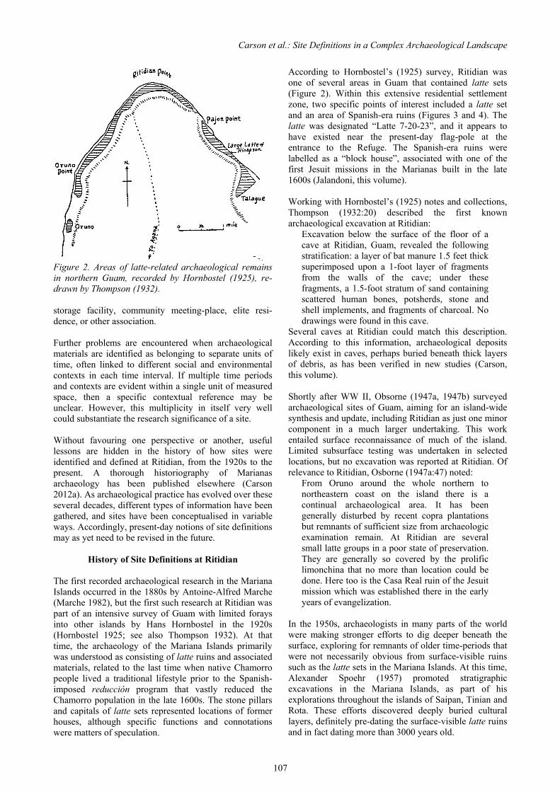
Carson et al.: Site Definitions in a Complex Archaeological Landscape
107
Figure 2. Areas of latte-related archaeological remains in northern Guam, recorded by Hornbostel (1925), re-drawn by Thompson (1932). storage facility, community meeting-place, elite resi-dence, or other association. Further problems are encountered when archaeological materials are identified as belonging to separate units of time, often linked to different social and environmental contexts in each time interval. If multiple time periods and contexts are evident within a single unit of measured space, then a specific contextual reference may be unclear. However, this multiplicity in itself very well could substantiate the research significance of a site. Without favouring one perspective or another, useful lessons are hidden in the history of how sites were identified and defined at Ritidian, from the 1920s to the present. A thorough historiography of Marianas archaeology has been published elsewhere (Carson 2012a). As archaeological practice has evolved over these several decades, different types of information have been gathered, and sites have been conceptualised in variable ways. Accordingly, present-day notions of site definitions may as yet need to be revised in the future.
History of Site Definitions at Ritidian The first recorded archaeological research in the Mariana Islands occurred in the 1880s by Antoine-Alfred Marche (Marche 1982), but the first such research at Ritidian was part of an intensive survey of Guam with limited forays into other islands by Hans Hornbostel in the 1920s (Hornbostel 1925; see also Thompson 1932). At that time, the archaeology of the Mariana Islands primarily was understood as consisting of latte ruins and associated materials, related to the last time when native Chamorro people lived a traditional lifestyle prior to the Spanish-imposed reducción program that vastly reduced the Chamorro population in the late 1600s. The stone pillars and capitals of latte sets represented locations of former houses, although specific functions and connotations were matters of speculation.
According to Hornbostel’s (1925) survey, Ritidian was one of several areas in Guam that contained latte sets (Figure 2). Within this extensive residential settlement zone, two specific points of interest included a latte set and an area of Spanish-era ruins (Figures 3 and 4). The latte was designated “Latte 7-20-23”, and it appears to have existed near the present-day flag-pole at the entrance to the Refuge. The Spanish-era ruins were labelled as a “block house”, associated with one of the first Jesuit missions in the Marianas built in the late 1600s (Jalandoni, this volume). Working with Hornbostel’s (1925) notes and collections, Thompson (1932:20) described the first known archaeological excavation at Ritidian:
Excavation below the surface of the floor of a cave at Ritidian, Guam, revealed the following stratification: a layer of bat manure 1.5 feet thick superimposed upon a 1-foot layer of fragments from the walls of the cave; under these fragments, a 1.5-foot stratum of sand containing scattered human bones, potsherds, stone and shell implements, and fragments of charcoal. No drawings were found in this cave.
Several caves at Ritidian could match this description. According to this information, archaeological deposits likely exist in caves, perhaps buried beneath thick layers of debris, as has been verified in new studies (Carson, this volume). Shortly after WW II, Obsorne (1947a, 1947b) surveyed archaeological sites of Guam, aiming for an island-wide synthesis and update, including Ritidian as just one minor component in a much larger undertaking. This work entailed surface reconnaissance of much of the island. Limited subsurface testing was undertaken in selected locations, but no excavation was reported at Ritidian. Of relevance to Ritidian, Osborne (1947a:47) noted:
From Oruno around the whole northern to northeastern coast on the island there is a continual archaeological area. It has been generally disturbed by recent copra plantations but remnants of sufficient size from archaeologic examination remain. At Ritidian are several small latte groups in a poor state of preservation. They are generally so covered by the prolific limonchina that no more than location could be done. Here too is the Casa Real ruin of the Jesuit mission which was established there in the early years of evangelization.
In the 1950s, archaeologists in many parts of the world were making stronger efforts to dig deeper beneath the surface, exploring for remnants of older time-periods that were not necessarily obvious from surface-visible ruins such as the latte sets in the Mariana Islands. At this time, Alexander Spoehr (1957) promoted stratigraphic excavations in the Mariana Islands, as part of his explorations throughout the islands of Saipan, Tinian and Rota. These efforts discovered deeply buried cultural layers, definitely pre-dating the surface-visible latte ruins and in fact dating more than 3000 years old.

Guam’s Hidden Gem: Archaeological and Historical Studies at Ritidian
108
Figure 3. Latte set, burial-features, and Spanish-era ruins at Ritidian, recorded by Hornbostel (1925), with clarification of measurements by Kurashina et al. (1990).
Figure 4. Sketch of latte set at Ritidian, recorded by Hornbostel (1925), with clarification of measurements by Kurashina et al. (1990). Original measurements were in inches. For reference, the height of 44 inches equals 112 cm (1.12 m). The discovery of older subsurface deposits in the Marianas effectively raised doubts about the prior archaeological surveys that relied on surface-observations and excavations primarily at the visible latte sets. Nonetheless, many terrain landforms of the Mariana Islands did not contain much potential for preserving ancient subsurface deposits, for example in shallow rocky clays and silts in the limestone plateau zone. Moreover, the surface-visible latte sets indeed attracted genuine attention for important research. In the 1950s through 1970s, island-wide surveys of Guam
continued to rely on informant-testimony and surface-reconnaissance. Limited test excavations primarily were concerned with visible latte sets and their associated deposits. These efforts continually accrued more details, but Ritidian was not subjected to intensive study. As reported first by Erik Reed (1952) and later by Fred Reinman (1968, 1974, 1977), Ritidian was described as: a) containing substantial broken pottery and other artefacts on the surface; b) possibly containing disturbed latte remains that could not be clearly identified through the thick vegetation; and c) possibly containing disturbed remnants of the Spanish-era missionary ruins or other similar structure. The island-wide surveys of Guam were instrumental in developing site-management systems, such as the Guam Historic Properties Inventory. Even today, Reinman’s (1974, 1977) site designations remain as the bulk Guam’s official site inventory, including the designations of Sites 12 and 13 at Ritidian (see Figure 1). In this case, the two sites at Ritidian were defined as seemingly continuous distributions of surface-visible ruins and concentrations of artefacts, although more details certainly could be added for refining these definitions. Excavation-focused archaeological research at Ritidian gained momentum with a study by Kurashina et al. (1990). This study involved several test excavations and monitoring of construction-work trenches, as part of the closure of the former US Navy operations, prior to transfer of the property to US Fish and Wildlife Service. In the vicinity of the government office building and parking-lots, subsurface deposits were found to relate to a widespread residential occupation as old as A.D. 1000, coincident with the latte period. Since the 1990s, several archaeological projects were conducted within the Refuge in compliance with government regulations for resource management. First was a study by Boyd Dixon (2000), eastward of the current office buildings, where excavations found considerable disturbance from the older US Navy structures. Second was an emergency recovery of human remains from the latte period, disturbed by pig-rooting in the western public-access portion of the Refuge (Carson 2005). Third was archaeological monitoring of construction-work for rehabilitation of a septic system, where burial-features of the latte period were discovered (Walth et al. 2013). Fourth was a study of the parking-lot areas prior to new construction-improvements, where scattered and scanty remnants of latte period cultural deposits were found (Carson 2014). Additional surveys have been conducted for gathering baseline knowledge about potential danger zones related to a possible live-fire military training-area in the adjoining Andersen Air Force Base in northern Guam, but those findings are only partly available while the full reporting is under review by government agencies (Dixon et al. 2011; Dixon, Jalandoni et al. 2013). Research-driven archaeology at Ritidian has occurred as outlined in the chapters of this volume. Not reported in

Carson et al.: Site Definitions in a Complex Archaeological Landscape
109
this volume, though, was a study of two adjacent latte sets, with attention to possible differences in their associated activity-areas as represented in differential patterns of artefacts and midden (Bayman et al. 2012a, 2012b). Another study focused on the ruins of the Spanish-era settlement (Jalandoni, this volume; see also Jalandoni 2011, 2012), finding clues about what happened to those ruins and how they potentially relate to the available historical records. An additional study explored the potential for archaeological evidence to reveal the overall traditional land-use practice and chronology (Peterson, this volume). Yet another research program examined the long-term and large-scale landscape chronology (Carson, this volume; see also Carson 2012b). Although convenient for discussion, a clean distinction is not entirely accurate between the government-compliance and research-driven archaeological investigations at Ritidian. In fact, the government-compliance work generated new substantive data, and these results have contributed to new theoretical ideas, scientific understanding, and testable hypotheses for further work. Meanwhile, the research-driven projects have been coordinated in cooperation with the resource management needs of US Fish and Wildlife Service (USFWS), for example including zones of planned protective fencing, hiking trails, and information kiosks. At present, the western portion of the Refuge at Ritidian has been studied much more intensively than the eastern portion. This imbalance should not be mistaken as meaning that the western half of the Refuge somehow contains more important resources. Rather, studies intentionally targeted the western portion of the Refuge, where public access creates the most opportunities for appreciation, education, and outreach. Meanwhile, the eastern portion of the Refuge has been closed to the general public, reserved for long-term research programs of the sensitive wildlife resources. Studies in the eastern portion simply have not yet been conducted in sufficient detail to compare with the western portion. As may be ascertained from this review, site designations at Ritidian could be interpreted in variable ways, each with its own strengths and weaknesses. The earlier efforts of island-wide surveys were the most explicit about defining site boundaries, but they relied on surface-visible findings without a full-scope view of the archaeological record. The later studies tended to focus on research topics that were not necessarily translatable into defining site contents and boundaries. Currently, an imbalance of study coverage disallows making comparable assessments of sites or components in the different areas of Ritidian.
Single or Multiple Sites? As reported in the chapters of this volume, Ritidian contains archaeological resources from the full 3500 years of human habitation in the Mariana Islands (see also Carson 2012b). Most of the known elements are on
the surface or accessible through shallow excavations, related to the period of latte approximately A.D. 1000 through 1700. Older elements are found in scattered locations in considerably deeper subsurface contexts of variable ages, generally following the chronological development of the physical landscape (Carson, this volume). A single large site for all of Ritidian may be appealing, but it is unrealistic to depict the extant archaeological materials as perfectly continuous without any separation of space. Additionally, as noted above, a single-unit site could misrepresent the multitude of individual components and time periods that are represented in this complex setting of Ritidian. One conceptual problem in making a site boundary is to account for the original site versus transformations of the site over time. If portions of an ancient site have been modified or destroyed by more recent land-use, then what should be depicted of its spatial extent? For most basic research purposes, the original site condition is of key interest. In others views, the transformations of the site over time constitute a uniquely intriguing topic of study. For management purposes and for realistic assessment of potential new studies, however, only the currently extant portions of a site are relevant. At least some portions of Ritidian have been subjected to massive land-disturbance, so a single continuous site unit cannot be maintained in the sense of practical resource management. Neither the latte set nor the Spanish-era ruins first noted by Hornbostel (1925) have been visible since at least the 1980s if not much earlier. The last known photograph of the Spanish-era ruins was recorded by Erik Reed during an island-wide archaeological survey of Guam (Reed 1952). A photograph of the general vicinity in the 1980s (Figure 5) shows that the entire zone surrounding the government office buildings already had been cleared of vegetation and transformed by massive earth-moving and levelling. According to local residents in Guam, the land-clearing was part of the US Navy operation in the 1960s and 1970s. Archaeological excavations indeed found evidence of this disturbance, in some cases resulting in removal of all but a few scattered remnants of cultural deposits (Carson 2014; Kurashina et al. 1990). In one view, the government office buildings and related structural remnants at Ritidian are associated with an important period in history. Conceivably, the modern land-alterations can be understood as part of this context. Specifically, the area was part of a US military installation after World War II, and at one point it served as a top-secret base in a network for tracking submarine movements during the “Cold War” era. The same office buildings continue to be used now by US Fish and Wildlife Service, but other related structures have decayed or have been intentionally dismantled. As should be clear, multiple layers of contexts and meanings are evident at Ritidian. Almost any single

Guam’s Hidden Gem: Archaeological and Historical Studies at Ritidian
110
Figure 5. Aerial photograph of the Ritidian area in the 1980s. Copy of original at Ritidian Unit of GNWR. portion of land within the Refuge can be associated with at least one of these contexts of importance in archaeology, history, or cultural perception of the landscape. In this sense, large contiguous site-units could be appealing, but complications arise when attempting to define the individual contributing elements in their specific contexts of significance. If the notion of a grandly embracing site-unit is discarded, then the only reasonable option is to identify several discrete boundaries of individual sites or site-components. Possibly, these multiple occurrences can be considered as significant contributing elements of a single complex or district, with intervening non-site space of non-contributing elements. As noted, however, the multiple archaeological elements at Ritidian relate to differing significant contexts, time periods, and associations that do not necessarily contribute logically to a single cohesive complex or district. Individual archaeological elements at Ritidian may be classified in terms of morphological type, as well as in terms of chronological association. The morphological types include surface-visible ruins, surface-visible concentrations of artefacts and midden, subsurface cultural deposits, and caves with pictographs and cultural
deposits. The chronological associations could be variable within the last 3500 years (see Carson, this volume), although the surface-visible components almost exclusively date within the last 1000 years in association with latte and Spanish occupation periods. When attempting to plot the individual elements at Ritidian on a map, the western coastal-plain portion of the Refuge can be recognised as containing more or less continuously distributed elements of different types. Partly, this distribution is due to the fact that archaeological studies have been most intensive in this zone, as compared to less thorough efforts in other zones at Ritidian. Nonetheless, limited reconnaissance and assessment so far reveals less density of archaeological materials in the other landforms, especially in the elevated limestone plateau and in the eastern limestone coastal terrace (see Figure 1). The previously proposed division of Ritidian in two Sites (12 in the west and 13 in the east) roughly follows a difference in the natural landforms on the west and east sides of the government office buildings (see Figure 1). On the west side of the Refuge, the coastal plain is composed of sandy sediments, and here the archaeological remains (both surface and subsurface)

Carson et al.: Site Definitions in a Complex Archaeological Landscape
111
occur in medium to high density, in fact more or less continuous when attempting to plot all of these findings in a single map. On the east side of the Refuge, the coastal plain is composed on a natural limestone terrace with a rough surface and little or no sediment, where the necessarily surface-visible archaeological elements appear to be in discrete clusters that potentially can be mapped as individual units. For the portions of the Refuge that consist of elevated limestone plateau, these areas do not appear to contain dense archaeological remains. Although not yet formally surveyed, casual observations have reported only very sparse and widely separated occurrences of broken potsherds from the latte period. Caves or other cavities potentially could contain cultural deposits, but this potential has not been explored in the upper limestone plateau. Additionally, trails may have connected coastal and inland/upland zones. The cliff-face, especially near the base of the cliff at the back of the coastal plain, is known to contain a series of caves with pictographs and cultural deposits (Carson, this volume). As with the coastal plain zones, the cliff-face and cliff-base have been studied intensively in the western portion of the Refuge, but sufficient studies have not yet been attempted in the eastern portion of the Refuge. Informal reconnaissance confirmed at least one large cave with a dense cultural deposit in the eastern portion cliff-face, and formal surveys in selected areas of the eastern zone confirmed additional caves with evidence of cultural use (Dixon et al. 2011; Dixon, Jalandoni et al. 2013).
Conclusions Given the numerous site designation issues at Ritidian, perhaps the best strategy is to use this complexity toward defining a site, set of sites, or series of site components. In this view, Ritidian represents a complex archaeological landscape, composed of multiple contributing elements that each can be recognised as significant for a specific context, association, and time-period. These elements are unified, however, in the sense that they contribute to the heritage values of the landscape in all its various definitions. As mentioned in the introductory chapter (Carson, this volume), Ritidian means many things for people in different perspectives, but all can agree that the archaeological resources are significant. For many people, the latte sets and human burials are especially meaningful as honoured places of ancestors or of spirits. The native forest further is respected for its medicinal resources, known by traditional practitioners. Among Ritidian’s other contributions, the contacts and conflicts among Chamorro and Spanish populations are most instructive for understanding local history and cultural identity, and one of the major documented events in this history occurred at Ritidian. Other interests may lie in the role of Ritidian in Cold War machinations between global super-powers with submarine forces in the Pacific region.
For some people, the knowledge of a very ancient and deeply buried habitation site is endlessly exciting, although it does not provide a direct first-hand experience as at the latte sets, pictographs inside caves, and other accessible material elements at Ritidian. Ritidian may be regarded as an example of a case that archaeologists world-wide have encountered in one form or another, where unmistakably significant archaeological resources exist yet do not necessarily allow clear agreement of site designation. By referring to a complex archaeological landscape, multiple perspectives can be accommodated in recognition of different types of significance and associations. Definite material boundaries will be desirable for practical management purposes, but these boundaries and definitions tend to require continual updates and revisions whenever new data and perspectives become available. Potentially, these differing views can strengthen one another, but site designation issues necessarily will persist due to the inherent complexities of any site.
Acknowledgements Thanks are due to US Fish and Wildlife Service for continued support of research at Ritidian, regardless of how the site(s) may be defined. The official site boundaries, contexts, and significance have not yet been finalised as of 2014. This work continues with input from the present authors, government agencies, and other interested parties.
References Bayman, J.M., H. Kurashina, M.T. Carson, J.A. Peterson, D. Doig & J. Drengson. 2012a. Latte household organization at Ritidian, Guam National Wildlife Refuge, Mariana Islands. Micronesica 42: 258–273. Bayman, J.M., H. Kurashina, M.T. Carson, J.A. Peterson, D. Doig & J. Drengson. 2012b. Household economy and gendered labor in the 17th Century A.D. on Guam. Journal of Field Archaeology 37: 259–269. Carson, M.T. 2005. Salvage of disturbed human skeletal remains at Guam National Wildlife Refuge, Ritidian, Guam. Report prepared for US Fish and Wildlife Service. International Archaeological Research Institute, Inc., Honolulu. Carson, M.T. 2012a. History of archaeological study in the Mariana Islands. Micronesica 42: 312–371. Carson, M.T. 2012b. Evolution of an Austronesian landscape: the Ritidian site in Guam. Journal of Austronesian Studies 3: 55–86. Carson, M.T. 2014. Archaeological resource survey at entrance road and parking-lots in Ritidian Unit of Guam National Wildlife Refuge. Report prepared for US Fish and Wildlife Service. University of Guam, Mangilao.

Guam’s Hidden Gem: Archaeological and Historical Studies at Ritidian
112
David, B. & J. Thomas (eds) 2008. Handbook of Landscape Archaeology. Left Coast Press, Walnut Creek. Dixon, B. 2000. Archaeological survey and testing at proposed brown tree snake pen, Guam National Wildlife Refuge, Ritidian Point, Territory of Guam, Mariana Islands. Report prepared for US Geological Survey. Inter-national Archaeological Research Institute, Inc., Honolulu. Dixon, B., A. Jalandoni, E. Lash, R. Schaefer & T. Meisner. 2013. Proposed Guam and CNMI military relocation 2012 roadmap adjustments, SEIS, live-fire training range complex footprint, access routes, and main cantonment alternatives, in-fill survey and testing. Report prepared for US Naval Facilities Engineering Command. Cardno-TEC, Honolulu. Dixon, B., R. Schaefer & T. McCurdy. 2011. Level 1 archaeological reconnaissance of 800 acres within selected properties on Andersen Air Force Base, Guam: Volume 1 narrative. Report prepared for SEARCH Inc. Cardno-TEC Inc., Honolulu. Green. R.C. 1967. Settlement patterns: Four cases studies in Polynesia. In W.G. Solheim (ed), Archaeology at the Eleventh Pacific Science Congress, pp. 101–132. Asian and Pacific Archaeology Series 1. Social Science Research Institute, University of Hawaii, Honolulu. Green, R.C. 1970. Settlement pattern studies in Polynesia. In R.C. Green and M. Kelly (eds), Studies in Oceanic Culture History, Volume 1, pp. 13–22. Pacific Anthropological Records 11. Department of Anthropology, Bernice P. Bishop Museum, Honolulu. Green, R.C. 1986. Some basic components of the ancestral Polynesian settlement system: Building blocks for more complex Polynesian societies. In P.V. Kirch (ed), Island Societies: Archaeological Approaches to Evolution and Transformation, pp. 50–54. New Directions in Archaeology. Cambridge University Press, Cambridge. Hornbostel, H. 1925. Unpublished notes and catalogs. Library Department, Bernice P. Bishop Museum, Honolulu. Jalandoni, A. 2011. Casa real or not real? A Jesuit mission house in Guam. Unpublished master’s thesis. Archaeological Studies Program, University of the Philippines, Diliman. Jalandoni,A. 2012. The Casa Real Site in Ritidian, northern Guam: A historical context. Philippine Quarterly of Culture and Society 39: 27–53. Kurashina, H., J.A. Simons, J.A. Toenjes, J. Allen, S.S. Amesbury, G.M. Heathcote, R.H. Randall, B.D. Smith, R.A. Stephenson & E.F. Wells (eds) 1990. Archaeological investigations at the Naval Facility (NAVFAC) Ritidian Point, Guam, Mariana Islands.
Report prepared for Department of the Navy. Micronesian Area Research Center, Mangilao, and Applied Research Group, Bernice P Bishop Museum, Honolulu. Marche, A.A. 1982. The Mariana Islands. Translation by S.E. Cheng of original French version published in 1889. Micronesian Area research Center, University of Guam, Mangilao. Osborne, D. 1947a. Chamorro archaeology. Unpublished manuscript on file. Micronesian Area Research Center, University of Guam, Mangilao. Osborne, D. 1947b. Archaeology on Guam: a progress report. American Anthropologist 49: 518–524. Reed, E.K. 1952. General report on archaeology and history of Guam. Report prepared for Governor of Guam. US National Park Service, Washington, DC. Reinman, F.M. 1968. Guam prehistory. In I. Yawata & Y.H. Sinoto (eds), Prehistoric Culture in Oceania: A Symposium, pp 41–50. Bishop Museum Press, Honolulu. Reinman, F.M. 1974. Archaeological site survey records: Guam Register of Historic Places Inventory data forms. Unpublished documents on file. Micronesian Area Research Center, University of Guam, Mangilao. Reinman, F.M. 1977. An Archaeological Survey and Preliminary Test Excavations on the Island of Guam, Mariana Islands, 1965–1966. Micronesian Area Research Center, University of Guam, Mangilao. Rouse, I. 1972. Settlement patterns in archaeology. In P.J. Ucko, R. Tringham & G.W. Dimbleby (eds), Man, Settlement and Urbanism, pp. 95–107. Duckworth Publishing, London. Thompson, L.M. 1932. Archaeology of the Mariana Islands. Bernice P. Bishop Museum Bulletin 100. Bishop Museum Press, Honolulu. Walth, C., S.L. Yee, D.G. DeFant, A. Osterholz, L.R. Leon Guerrero & R. Kanai. 2012. Archaeological monitoring and data recovery, Guam National Wildlife Refuge, septic system rehabilitation project. Report prepared for Techni-Con Inc. SWCA Environmental Consultants, Guam Office, Barrigada. Willey, G. 1953. Prehistoric Settlement Patterns in the Virú Valley, Perú. Bureau of American Ethnology Bulletin 155. US Government Printing Office, Washington, D.C. Willey, G. (ed) 1956. Prehistoric Settlement Patterns in the New World. Publication in Anthropology 23. Viking Fund Publications, New York.
Copyright © 2022 FDOKUMEN