RB0901 Cruise Report(10Sep) - British Oceanographic Data Centre
121
National Oceanography Centre, Southampton Cruise Report No. 40 RV Ronald H. Brown Cruise RB0901 15 APR-06 MAY 2009 RAPID mooring cruise report Principal Scientist D Rayner Editor P G Wright 2009 National Oceanography Centre, Southampton University of Southampton, Waterfront Campus European Way Southampton Hants SO14 3ZH UK Tel: +44 (0)23 8059 3038 Email: [email protected]
-
Upload
khangminh22 -
Category
Documents
-
view
0 -
download
0
Transcript of RB0901 Cruise Report(10Sep) - British Oceanographic Data Centre
National Oceanography Centre, Southampton
Cruise Report No. 40
RV Ronald H. Brown Cruise RB0901 15 APR-06 MAY 2009
RAPID mooring cruise report
Principal Scientist
D Rayner
Editor P G Wright
2009
National Oceanography Centre, Southampton University of Southampton, Waterfront Campus European Way Southampton Hants SO14 3ZH UK Tel: +44 (0)23 8059 3038 Email: [email protected]

DOCUMENT DATA SHEET
AUTHOR
RAYNER, D & WRIGHT, P G et al
PUBLICATION DATE 2009
TITLE RV Ronald H. Brown Cruise RB0901, 15 Apr-06 May 2009. RAPID Mooring Cruise Report.
REFERENCE Southampton, UK: National Oceanography Centre, Southampton, 121pp.
(National Oceanography Centre Southampton Cruise Report, No. 40)
ABSTRACT This report describes the mooring operations conducted during RV Ronald H. Brown cruise RB0901 between 15 April and 5 May 2009. These mooring operations were completed as part of the United Kingdom Natural Environment Research Council (NERC) funded RAPID-WATCH Programme to monitor the Atlantic Meridional Overturning Circulation at 26.5°N. The primary purpose on this cruise for the UK team was to service the RAPID Western Boundary moorings while the US team worked on the Western Boundary Time Series project. Cruise RB0901 was from Charleston, South Carolina to Charleston, South Carolina and covered the Western Boundary moorings deployed on cruises SJ08 and RB0701. This cruise was the seventh annual refurbishment of the Western Boundary section of an array of moorings deployed across the Atlantic in order to continuously observe the Atlantic Meridional Overturning Circulation (MOC). This array will be further refined and refurbished during subsequent years. The instruments deployed on the array consist of a variety of current meters, bottom pressure recorders, and CTD loggers, which, combined with time series measurements of the Florida Channel Current and wind stress estimates, will be used to determine the strength and structure of the MOC at 26.5°N. (http://www.noc.soton.ac.uk/rapid)
KEYWORDS
26.5°N, Atlantic Ocean, bottom pressure recorder, BPR, cruise RB0901 2009, CTD,
current meter, meridional overturning circulation, MicroCAT, MOC, mooring array,
moorings, North Atlantic, RAPID, RAPIDMOC, RAPID-WATCH, Ronald H.
Brown, THC, thermohaline circulation, Western Boundary
ISSUING ORGANISATION National Oceanography Centre, Southampton University of Southampton, Waterfront Campus European Way Southampton SO14 3ZH UK Tel: +44(0)23 80596116Email: [email protected]
A pdf of this report is available for download at: http://eprints.soton.ac.uk

Rapid Mooring Cruise Report for RB0901 – April – May 2009
5
Contents 1 Scientific and Ship’s Personnel 7 2 RV Ronald H. Brown 9 3 Itinerary 10 4 Acknowledgements 10 5 Introduction 11
5.1 Scientific Background and Description of the RAPID-MOC Observing System 11
5.2 The AMOC System 12 5.3 Array Specification 12 5.4 Eastern Boundary Sub-array 13 5.5 Mid-Atlantic Ridge Sub-array 13 5.6 Western Boundary Sub-array 13 5.7 Data Availability 13 6 Diary of Events 19 7 Mooring Operations 26 7.1 Mooring Summary 26 7.2 Diary of Events 26 8 Instruments 31 8.1 Summary of Instruments Recovered and Deployed 31 8.2 Instrument Problems 31 9 ADCP Processing 33 9.1 Stage 1 Processing 33 9.2 Stage 2 Processing 33 9.3 Plotting the Bins 34 10 SBE 37 MicroCAT Processing 35 10.1 Introduction 35 10.2 Stage 0 - Download 35 10.3 Stage 1 – Conversion from .asc to the RDB format 36
10.4 Stage 2 – Trimming of Data Record, Basic Statistics and Summary Plots 36
10.5 Calibration Dips 37 10.6 Problems with Calibration Dips 39 10.6.1 Pressure Sensor Errors 39 10.6.2 CTD Timing Errors 44 11 RCM11 Current Meter Processing 46 11.1 Stage 0 46 11.2 Stage 1 46 11.3 Stage 2 47 11.4 Data Problems 48
Rapid Mooring Cruise Report for RB0901 – April – May 2009
6
12 Seabird SBE26 SeaGauge or SBE53 BPR Processing 49 12.1 Stage 0 49 12.2 Stage 1 49 12.3 Stage 2 49 12.4 Correcting wbl2_2_200706 52 12.5 Splicing the WBL Time Series 53 References 57 Appendices A Details of Instruments Lowered on CTD Calibration Cast 58 B Instrument Record Lengths 60 C Instrument Set Up Details 62 D Deployment Tracks 77 E Mooring Diagrams 81 F Acoustic Release Record 91 G Logsheets 92 List of Tables 1.1 Details of science personnel 7 1.2 Details of ship’s crew 8 5.1 Summary of previous RAPID-MOC cruises 17 7.1 Mooring recovery and deployment summary 26 7.2 Mooring position, depths and times 30 8.1 Summary of instruments recovered and deployed 31 10.1 Comparison of pre-deployment calibration constants for MicroCATs 43 11.1 Problems with RCM11 instrument records for RB0901 47
Rapid Mooring Cruise Report for RB0901 – April – May 2009
7
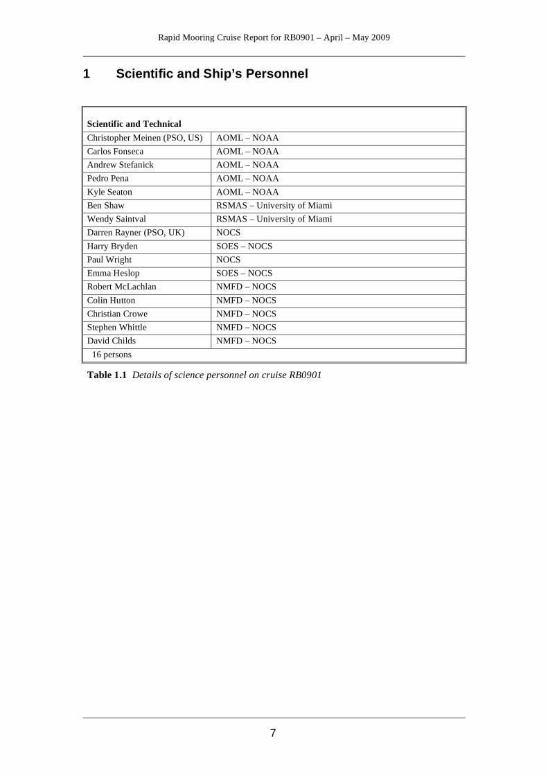
1 Scientific and Ship’s Personnel
Scientific and Technical Christopher Meinen (PSO, US) AOML – NOAA Carlos Fonseca AOML – NOAA Andrew Stefanick AOML – NOAA Pedro Pena AOML – NOAA Kyle Seaton AOML – NOAA Ben Shaw RSMAS – University of Miami Wendy Saintval RSMAS – University of Miami Darren Rayner (PSO, UK) NOCS Harry Bryden SOES – NOCS Paul Wright NOCS Emma Heslop SOES – NOCS Robert McLachlan NMFD – NOCS Colin Hutton NMFD – NOCS Christian Crowe NMFD – NOCS Stephen Whittle NMFD – NOCS David Childs NMFD – NOCS
16 persons
Table 1.1 Details of science personnel on cruise RB0901

Rapid Mooring Cruise Report for RB0901 – April – May 2009
8
Ship’s Crew Capt. Gerd Glang Commanding Officer LtCdr. Todd Haupt Executive Officer Lt. Nicole Manning Operations Officer (FOO) Ens. Loren Evory Navigation Officer Ens. John Rossi Junior Officer (Damage Control Officer) Ens. Dave Owen Junior Officer Lt. Mike Futch Medical Officer Frank Dunlop Chief Marine Engineer Robert Schwarz 1st Assistant Engineer Matt Lager 2nd Assistant Engineer James Reed 3rd Assistant Engineer Danny Torchio Junior Engineer Reginald Glover Junior Engineer Travis Martin Wiper Bruce Cowden Chief Bosun Reginald Williams Bosun Group Leader Victoria Carpenter AB Seaman/Deck Utilityman Dana Mancinelli AB Seaman/Deck Utilityman Roberto Mendez Ordinary Seaman Brett Lewis Ordinary Seaman Jesse Scott General Vessel Assistant Frank Footman General Vessel Assistant Richard Whitehead Chief Steward Moises Martinez Chief Cook Tyrone Baker 2nd Cook Vasiliy Nam General Vessel Assistant Jonathan Shannahoff Chief Survey Tech. Jeff Hill Lead Electronics Tech. 28 persons
Table 1.2 Details of ship’s crew on cruise RB0901
Rapid Mooring Cruise Report for RB0901 – April – May 2009
9
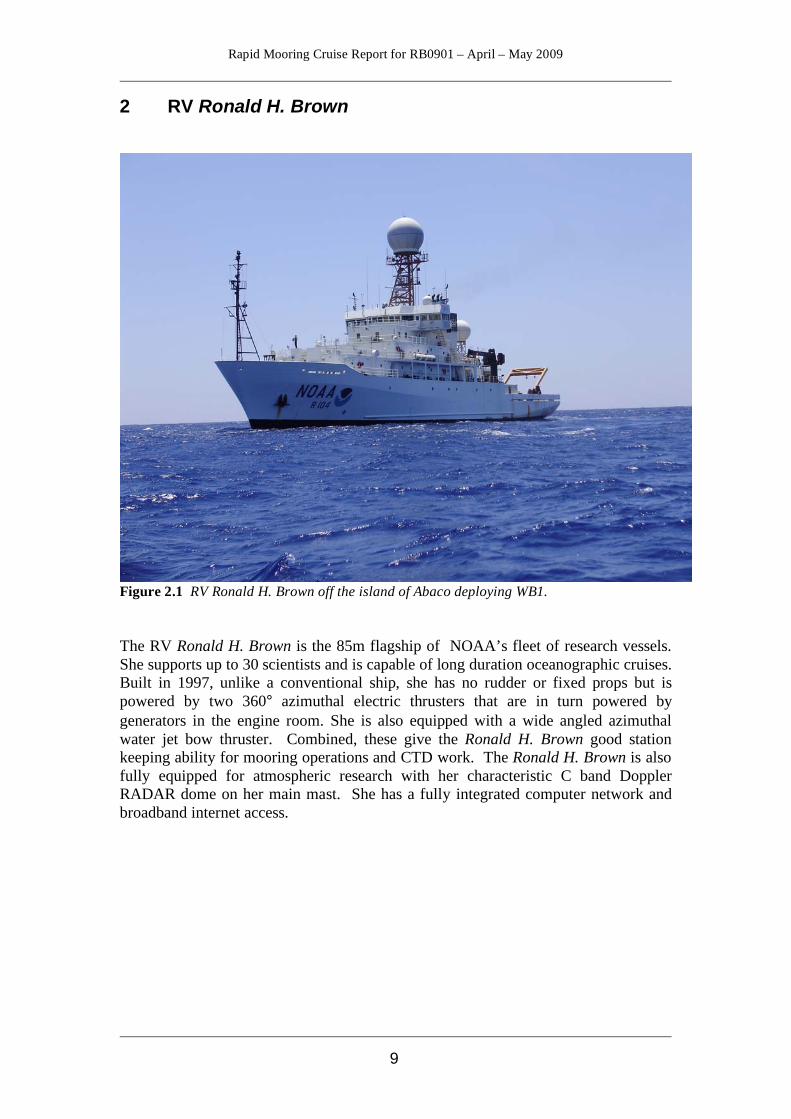
2 RV Ronald H. Brown
Figure 2.1 RV Ronald H. Brown off the island of Abaco deploying WB1. The RV Ronald H. Brown is the 85m flagship of NOAA’s fleet of research vessels. She supports up to 30 scientists and is capable of long duration oceanographic cruises. Built in 1997, unlike a conventional ship, she has no rudder or fixed props but is powered by two 360° azimuthal electric thrusters that are in turn powered by generators in the engine room. She is also equipped with a wide angled azimuthal water jet bow thruster. Combined, these give the Ronald H. Brown good station keeping ability for mooring operations and CTD work. The Ronald H. Brown is also fully equipped for atmospheric research with her characteristic C band Doppler RADAR dome on her main mast. She has a fully integrated computer network and broadband internet access.
Rapid Mooring Cruise Report for RB0901 – April – May 2009
10
3 Itinerary Departed Charleston, South Carolina 15th April 2009, arriving off Abaco Island, Bahamas 17th April to begin the NOAA/Miami Western Boundary Time Series. Upon completion the UK RAPID moorings were serviced. Returned to Charleston, South Carolina 5th May 2009. 4 Acknowledgements Darren Rayner The officers and crew of the Ronald H. Brown were extremely helpful throughout the cruise and the busy period of mooring operations would not have gone so smoothly without the good communication between the bridge officers and myself. This was the third cruise we have completed on the Ronald H. Brown for mooring operations and Bruce Cowden has been the Bosun each time. His familiarity with the moorings and instruments that we deploy was invaluable and led to an efficient and safe working deck with the deployment and recovery operations conducted without significant problems. The moorings team was once again professional and well organized and their experience also helped lead to another very successful cruise for the RAPID-WATCH project.
Rapid Mooring Cruise Report for RB0901 – April – May 2009
11
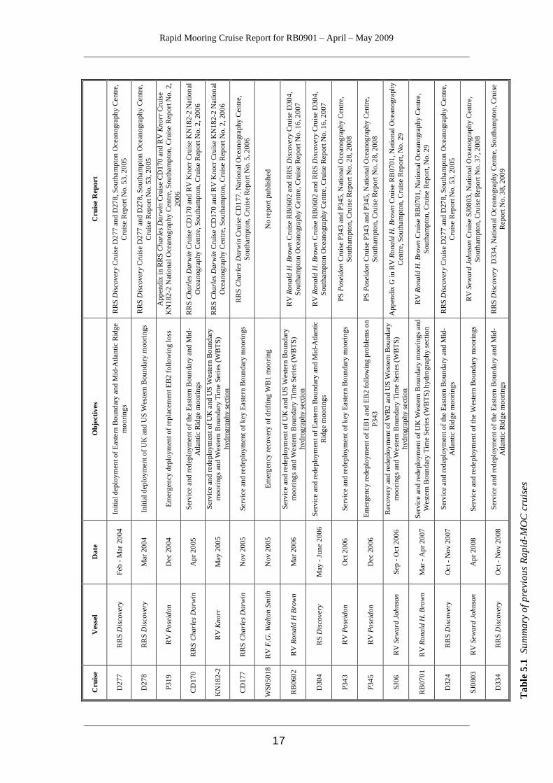
5 Introduction and Background Stuart Cunningham The RAPID-MOC observing system has been operational since spring 2004. The purpose of this cruise was to recover and redeploy the western boundary mooring array deployed off the Bahamas. This cruise is the 17th in total since Spring 2004. The cruises to date are shown in Table 5.1. The project web site is http://www.noc.soton.ac.uk/rapidmoc. The RAPID-MOC programme has completed the initial four years of planned deployments and has now moved into a second phase (NERC Directed Programme RAPID-WATCH http://www.noc.soton.ac.uk/rapid) through to 2014. 5.1 Scientific Background and Description of the RAPID-MOC Observing System The Atlantic Meridional Overturning Circulation (AMOC) at 26.5°N carries a northward heat flux of 1.3 PW. Northward of 26.5°N over the Gulf Stream and its extension much of this heat is transferred to the atmosphere and subsequently is responsible for maintaining UK climate about 5°C warmer than the zonal average at this latitude. However, previous sparse observations did not resolve the temporal variability of the AMOC and so it is unknown whether it is slowing in response to global warming as suggested by recent model results. In 2004 NERC, NSF and NOAA funded a system of observations in the Atlantic at 26.5°N to observe on a daily basis the strength and structure of the AMOC. Two papers ([Cunningham, et al., 2007] & [Kanzow, et al., 2007]) demonstrated that not only does the system of observations achieve a mass balance for the AMOC, it reveals dramatic and unexpected richness of variability. In the first year the AMOC mean strength and variability is 18.7±5.6 Sv. From estimates of the degrees-of-freedom the year-long mean AMOC is defined with a resolution of around 1.5 Sv so abrupt changes would be readily identified and long-term changes will be measured relative to the 2004-2005 average. The NERC contribution to the first four years of continuous AMOC observations was funded under the directed programme RAPID Climate Change. Following an international review of the system NERC will continue funding to 2014 under the programme RAPID-WATCH. The NSF and NOAA have also continued funding and commitments so that the system can continue operating at the same level of activity as during the period 2004-2008. The objectives of RAPID-WATCH are: To deliver a decade-long time series of calibrated and quality-controlled measurements of the Atlantic MOC from the RAPID-WATCH arrays and; To exploit the data from the RAPID-WATCH arrays and elsewhere to determine and interpret recent changes in the Atlantic MOC, assess the risk of rapid climate change, and investigate the potential for predictions of the MOC and its impacts on climate.
Rapid Mooring Cruise Report for RB0901 – April – May 2009
12
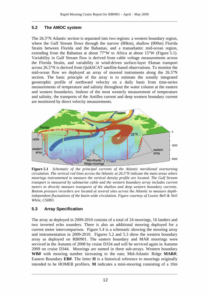
5.2 The AMOC system The 26.5°N Atlantic section is separated into two regions: a western boundary region, where the Gulf Stream flows through the narrow (80km), shallow (800m) Florida Straits between Florida and the Bahamas, and a transatlantic mid-ocean region, extending from the Bahamas at about 77°W to Africa at about 15°W (Figure 5.1). Variability in Gulf Stream flow is derived from cable voltage measurements across the Florida Straits, and variability in wind-driven surface-layer Ekman transport across 26.5°N is derived from QuikSCAT satellite-based observations. To monitor the mid-ocean flow we deployed an array of moored instruments along the 26.5°N section. The basic principle of the array is to estimate the zonally integrated geostrophic profile of northward velocity on a daily basis from time-series measurements of temperature and salinity throughout the water column at the eastern and western boundaries. Inshore of the most westerly measurement of temperature and salinity, the transports of the Antilles current and deep western boundary current are monitored by direct velocity measurements.
Figure 5.1 Schematic of the principal currents of the Atlantic meridional overturning circulation. The vertical red lines across the Atlantic at 26.5°N indicate the main areas where moorings instrumented to measure the vertical density profile are located. The Gulf Stream transport is measured by submarine cable and the western boundary array includes current meters to directly measure transports of the shallow and deep western boundary currents. Bottom pressure recorders are located at several sites across the Atlantic to measure depth-independent fluctuations of the basin-wide circulation. Figure courtesy of Louise Bell & Neil White, CSIRO.
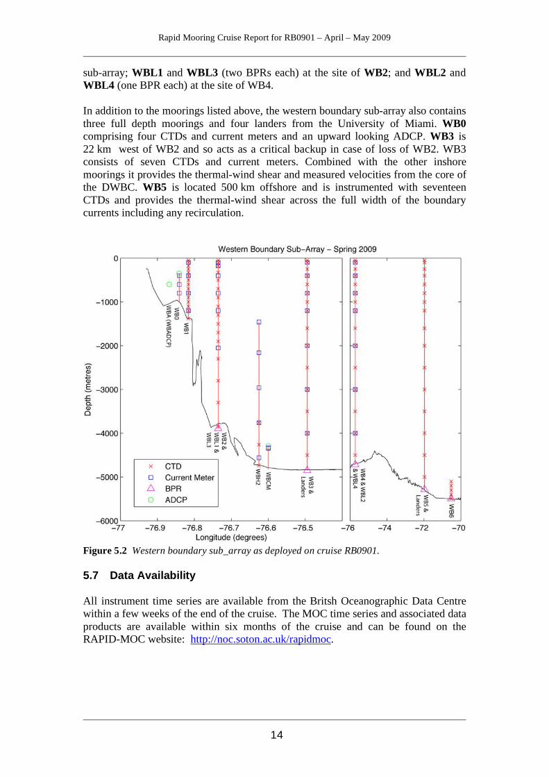
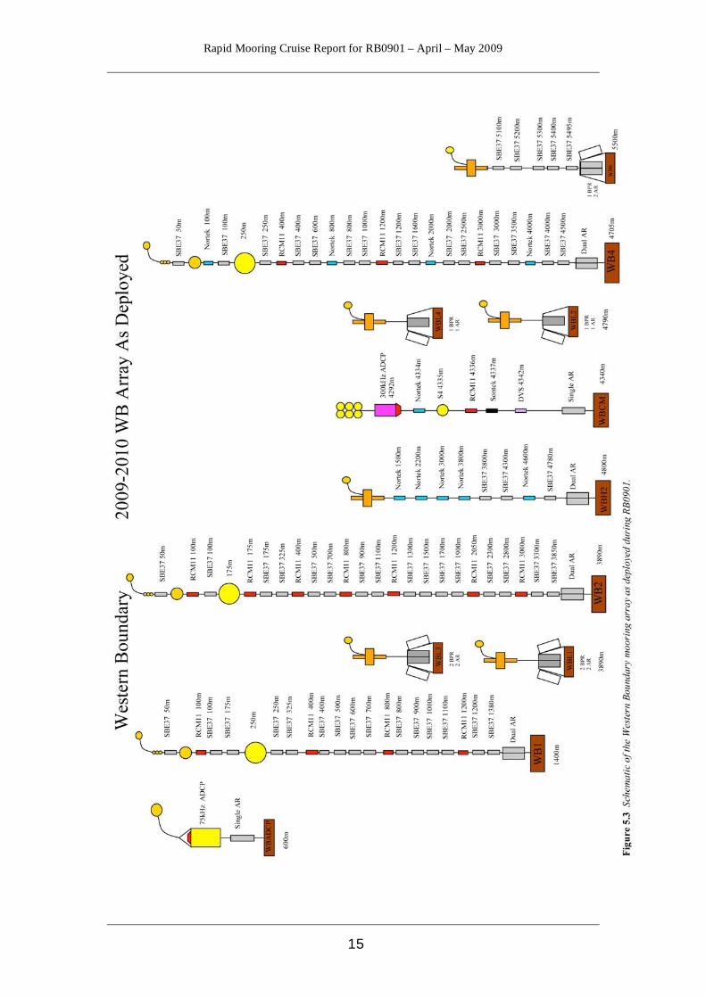
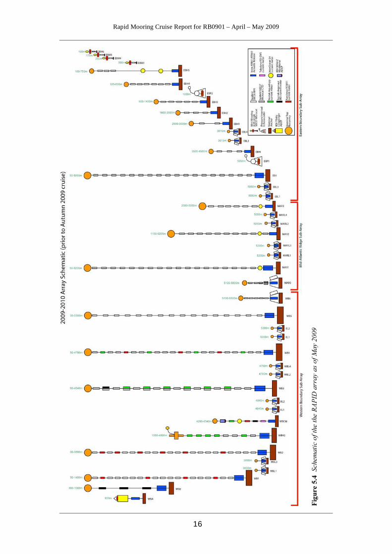
5.3 Array Specification The array as deployed in 2009-2010 consists of a total of 24 moorings, 16 landers and two inverted echo sounders. There is also an additional mooring deployed for a current meter intercomparison. Figure 5.4 is a schematic showing the mooring array and instrumentation in 2009-2010. Figures 5.2 and 5.3 show the western boundary array as deployed on RB0901. The eastern boundary and MAR moorings were serviced in the Autumn of 2008 by cruise D334 and will be serviced again in Autumn 2009 on cruise D344. Moorings are named in three sub-arrays. Western boundary WB# with mooring number increasing to the east; Mid-Atlantic Ridge MAR#; Eastern Boundary EB# . The letter H is a historical reference to moorings originally intended to be HOMER profilers. M indicates a mini-mooring consisting of a 10m
Rapid Mooring Cruise Report for RB0901 – April – May 2009
13
length mooring with one CTD instrument. Bottom landers instrumented with pressure recorders are indicated by L in the name. ADCP indicates an Acoustic Doppler Current Profiler mooring.
5.4 Eastern Boundary Sub-array The Eastern Boundary sub-array consists of one tall mooring EB1 consisting of eighteen CTDs and a series of shorter CTD moorings EBHi, EBH1, EBH2, EBH3, EBH4, and EBH5 that step up the slope reducing the influence of bottom triangles when combined with the more offshore EB1 mooring. They construct a single full depth density profile. Inshore of EBH5 there are a series of four “mini-moorings”, EBM1, EBM4, EBM5 and EBM6 that each consist of a single CTD and are relatively inexpensive meaning likely losses in this heavily fished area have less of an impact on the array. Finally the Eastern sub-array includes four bottom pressure landers; EBL1 and EBL3 – comprising two bottom pressure recorders (BPRS) each – at the site of EB1, and EBL2 and EBL4 – comprising one bottom pressure recorder each – at the site of EBH1. The landers are serviced in alternate years so that each recovery provides a two-year record with a year’s overlap with the previous lander to remove instrument drift. There are also two Inverted Echo Sounders with pressure sensors (PIES) deployed in the eastern boundary sub-array, EBP1 at the site of EB1 and EBP2 at the site of EBH4. Data from these are downloaded annually through acoustic telemetry but EBP1 was serviced on cruise D334 with EBP2 planned for turnaround in 2009.
5.5 Mid-Atlantic Ridge Sub-array The sub-array at the Mid-Atlantic Ridge consists of one full depth mooring (MAR1), three shorter moorings (MAR0, MAR2 and MAR3), and four landers (MARL1, MARL2, MARL3 and MARL4). MAR0 is a recent addition to the array and consists of three CTDs and a BPR to capture the Antarctic Bottom Water (AABW) contribution to the MOC to the west of the ridge. MAR1 provides a full depth density profile through eighteen CTDs, with MAR2 acting as a backup to 1000m on the west of the ridge. MAR3 is sited to the east of the ridge and allows separation of the eastern and western basin MOC contributions. The landers are deployed as per those for the Eastern Boundary, with two at the site of MAR1, and two at the site of MAR3. 5.6 Western Boundary Sub-array At the western boundary, WB2 is the pivotal mooring and provides a full depth density profile very close to the western boundary “wall”. The resolution of the profile can be improved by merging data from the nearby WB1. As of May 2009, WB2 comprises sixteen CTDs and seven current meters, whereas WB1 comprises fifteen CTDs and four current meters (Figs 5,2 and 5.3). Inshore of WB1 there is WBADCP that comprises a Longranger ADCP at a depth of 600m to measure the shallow Antilles current. East of WB2 is WBH2 consisting of three CTDs and five current meters. At the normal offshore extent of the Deep Western Boundary Current (DWBC) is WB4, which comprises fifteen CTDs and seven current meters. Further offshore is WB6 – comprising five CTDs and a bottom pressure recorder – which combined with MAR0 measures the contribution to the MOC of deep water below 5200m including the Antarctic Bottom Water. There are again four landers in this
Rapid Mooring Cruise Report for RB0901 – April – May 2009
14
sub-array; WBL1 and WBL3 (two BPRs each) at the site of WB2; and WBL2 and WBL4 (one BPR each) at the site of WB4. In addition to the moorings listed above, the western boundary sub-array also contains three full depth moorings and four landers from the University of Miami. WB0 comprising four CTDs and current meters and an upward looking ADCP. WB3 is 22 km west of WB2 and so acts as a critical backup in case of loss of WB2. WB3 consists of seven CTDs and current meters. Combined with the other inshore moorings it provides the thermal-wind shear and measured velocities from the core of the DWBC. WB5 is located 500 km offshore and is instrumented with seventeen CTDs and provides the thermal-wind shear across the full width of the boundary currents including any recirculation.
Figure 5.2 Western boundary sub_array as deployed on cruise RB0901. 5.7 Data Availability All instrument time series are available from the Britsh Oceanographic Data Centre within a few weeks of the end of the cruise. The MOC time series and associated data products are available within six months of the cruise and can be found on the RAPID-MOC website: http://noc.soton.ac.uk/rapidmoc.
Rapid Mooring Cruise Report for RB0901 – April – May 2009
15
Rapid Mooring Cruise Report for RB0901 – April – May 2009
16
Rapid Mooring Cruise Report for RB0901 – April – May 2009
17
Cru
ise
Rep
ort
RR
S D
isco
very
Cru
ise
D27
7 an
d D
278,
Sou
tham
pton
Oce
anog
raph
y C
entre
, C
ruis
e R
epor
t No.
53,
200
5
RR
S D
isco
very
Cru
ise
D27
7 an
d D
278,
Sou
tham
pton
Oce
anog
raph
y C
entre
, C
ruis
e R
epor
t No.
53,
200
5 A
ppen
dix
in R
RS
Cha
rles
Dar
win
Cru
ise
CD
170
and
RV
Kno
rr C
ruis
e K
N18
2-2
Nat
iona
l Oce
anog
raph
y C
entre
, Sou
tham
pton
, Cru
ise
Rep
ort N
o. 2
, 20
06
RR
S C
harl
es D
arw
in C
ruis
e C
D17
0 an
d R
V K
norr
Cru
ise
KN
182-
2 N
atio
nal
Oce
anog
raph
y C
entre
, Sou
tham
pton
, Cru
ise
Rep
ort N
o. 2
, 200
6
RR
S C
harl
es D
arw
in C
ruis
e C
D17
0 an
d R
V K
norr
Cru
ise
KN
182-
2 N
atio
nal
Oce
anog
raph
y C
entre
, Sou
tham
pton
, Cru
ise
Rep
ort N
o. 2
, 200
6
RR
S C
harl
es D
arw
in C
ruis
e C
D17
7. N
atio
nal O
cean
ogra
phy
Cen
tre,
Sout
ham
pton
, Cru
ise
Rep
ort N
o. 5
, 200
6
No
repo
rt pu
blis
hed
RV
Ron
ald
H. B
row
n C
ruis
e R
B06
02 a
nd R
RS
Dis
cove
ry C
ruis
e D
304,
So
utha
mpt
on O
cean
ogra
phy
Cen
tre, C
ruis
e R
epor
t No.
16,
200
7
RV
Ron
ald
H. B
row
n C
ruis
e R
B06
02 a
nd R
RS
Dis
cove
ry C
ruis
e D
304,
So
utha
mpt
on O
cean
ogra
phy
Cen
tre, C
ruis
e R
epor
t No.
16,
200
7
PS P
osei
don
Cru
ise
P343
and
P34
5, N
atio
nal O
cean
ogra
phy
Cen
tre,
Sout
ham
pton
, Cru
ise
Rep
ort N
o. 2
8, 2
008
PS P
osei
don
Cru
ise
P343
and
P34
5, N
atio
nal O
cean
ogra
phy
Cen
tre,
Sout
ham
pton
, Cru
ise
Rep
ort N
o. 2
8, 2
008
App
endi
x G
in R
V R
onal
d H
. Bro
wn
Cru
ise
RB
0701
, Nat
iona
l Oce
anog
raph
y C
entre
, Sou
tham
pton
, Cru
ise
Rep
ort,
No.
29
RV
Ron
ald
H. B
row
n C
ruis
e R
B07
01, N
atio
nal O
cean
ogra
phy
Cen
tre,
Sout
ham
pton
, Cru
ise
Rep
ort,
No.
29
RR
S D
isco
very
Cru
ise
D27
7 an
d D
278,
Sou
tham
pton
Oce
anog
raph
y C
entre
, C
ruis
e R
epor
t No.
53,
200
5
RV
Sew
ard
John
son
Cru
ise
SJ08
03, N
atio
nal O
cean
ogra
phy
Cen
tre,
Sout
ham
pton
, Cru
ise
Rep
ort N
o. 3
7, 2
008
RR
S D
isco
very
D33
4, N
atio
nal O
cean
ogra
phy
Cen
tre, S
outh
ampt
on, C
ruis
e R
epor
t No.
38,
200
9
Obj
ectiv
es
Initi
al d
eplo
ymen
t of E
aste
rn B
ound
ary
and
Mid
-Atla
ntic
Rid
ge
moo
rings
Initi
al d
eplo
ymen
t of U
K a
nd U
S W
este
rn B
ound
ary
moo
rings
Emer
genc
y de
ploy
men
t of r
epla
cem
ent E
B2
follo
win
g lo
ss
Serv
ice
and
rede
ploy
men
t of t
he E
aste
rn B
ound
ary
and
Mid
-A
tlant
ic R
idge
moo
rings
Se
rvic
e an
d re
depl
oym
ent o
f UK
and
US
Wes
tern
Bou
ndar
y m
oorin
gs a
nd W
este
rn B
ound
ary
Tim
e Se
ries (
WB
TS)
hydr
ogra
phy
sect
ion
Serv
ice
and
rede
ploy
men
t of k
ey E
aste
rn B
ound
ary
moo
rings
Emer
genc
y re
cove
ry o
f drif
ting
WB
1 m
oorin
g
Serv
ice
and
rede
ploy
men
t of U
K a
nd U
S W
este
rn B
ound
ary
moo
rings
and
Wes
tern
Bou
ndar
y Ti
me
Serie
s (W
BTS
) hy
drog
raph
y se
ctio
n
Serv
ice
and
rede
ploy
men
t of E
aste
rn B
ound
ary
and
Mid
-Atla
ntic
R
idge
moo
rings
Serv
ice
and
rede
ploy
men
t of k
ey E
aste
rn B
ound
ary
moo
rings
Emer
genc
y re
depl
oym
ent o
f EB
1 an
d EB
2 fo
llow
ing
prob
lem
s on
P343
Rec
over
y an
d re
depl
oym
ent o
f WB
2 an
d U
S W
este
rn B
ound
ary
moo
rings
and
Wes
tern
Bou
ndar
y Ti
me
Serie
s (W
BTS
) hy
drog
raph
y se
ctio
n
Serv
ice
and
rede
ploy
men
t of U
K W
este
rn B
ound
ary
moo
rings
and
W
este
rn B
ound
ary
Tim
e Se
ries (
WB
TS) h
ydro
grap
hy se
ctio
n
Serv
ice
and
rede
ploy
men
t of t
he E
aste
rn B
ound
ary
and
Mid
-A
tlant
ic R
idge
moo
rings
Serv
ice
and
rede
ploy
men
t of t
he W
este
rn B
ound
ary
moo
rings
Serv
ice
and
rede
ploy
men
t of t
he E
aste
rn B
ound
ary
and
Mid
-A
tlant
ic R
idge
moo
rings
Dat
e
Feb
- Mar
200
4
Mar
200
4
Dec
200
4
Apr
200
5
May
200
5
Nov
200
5
Nov
200
5
Mar
200
6
May
- Ju
ne 2
006
Oct
200
6
Dec
200
6
Sep
- Oct
200
6
Mar
- A
pr 2
007
Oct
- N
ov 2
007
Apr
200
8
Oct
- N
ov 2
008
Ves
sel
RR
S D
isco
very
RR
S D
isco
very
RV
Pos
eido
n
RR
S C
harl
es D
arw
in
RV
Kno
rr
RR
S C
harl
es D
arw
in
RV
F.G
. Wal
ton
Smith
RV
Ron
ald
H B
row
n
RS
Dis
cove
ry
RV
Pos
eido
n
RV
Pos
eido
n
RV
Sew
ard
John
son
RV
Ron
ald
H. B
row
n
RR
S D
isco
very
RV
Sew
ard
John
son
RR
S D
isco
very
Cru
ise
D27
7
D27
8
P319
CD
170
KN
182-
2
CD
177
WS0
5018
RB
0602
D30
4
P343
P345
SJ06
RB
0701
D32
4
SJ08
03
D33
4
Tab
le 5
.1 S
umm
ary
of p
revi
ous
Rapi
d-M
OC
cru
ises
Rapid Mooring Cruise Report for RB0901 – April – May 2009
18
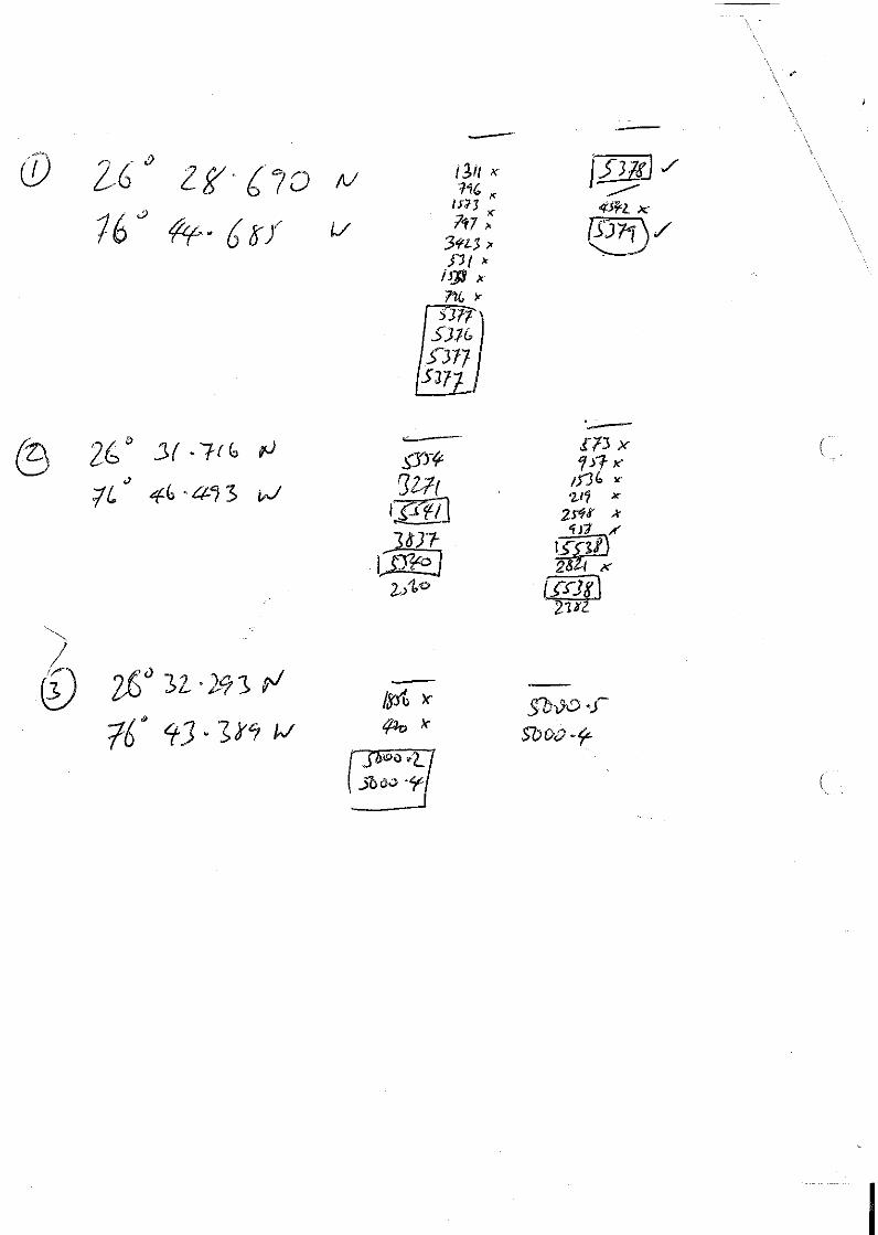
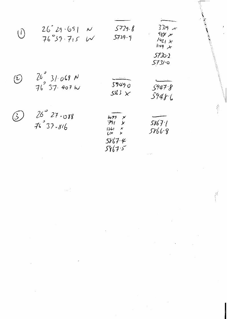
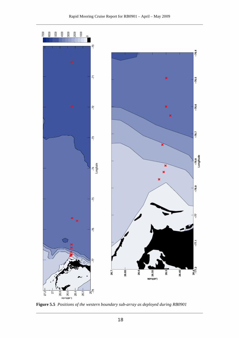
Figure 5.5 Positions of the western boundary sub-array as deployed during RB0901

Rapid Mooring Cruise Report for RB0901 – April – May 2009
19
6 Diary of Events Darren Rayner and Paul Wright All times are local time (GMT - 4) unless specified 12th April Darren, Paul and Emma traveled from Heathrow to Charleston via Atlanta (the moorings team traveled the previous day). 13th April Arrived at Charleston and boarded the RV Ronald H. Brown at 09:30 following collection of security badges at FLETC visitors centre. The moorings team were already at ship along with Jason Scott as mobilisation officer. The first lorry arrived about 11:30 and the moorings team began the mobilisation of deck components. There was a large delay between lorries as the agent only used one, which meant that it had to unload completely then go back, reload and then pass the security inspection on the way in to the base. The second load arrived at 15:30. We left the ship at 17:30. 14th April Arrived at ship at 09:30. Final gear was loaded on board. Harry arrived. We set up laboratories, lashed benches down, set up the Macs, and unloaded boxes. The mooring team organised the securing of the winches and gear to the aft deck and tools and instruments in the very chilly main laboratory. We reported aboard with personal gear, then went into Charleston in the evening as no meals served aboard. 15th April We finished setting up lab. The moorings team moved onboard. Chris worked on preparing current meters that require compass calibration so it could be done off the ship if need be. The ship was delayed an initial 12 hours due to problems with an exciter on the port engine. The new estimated sailing time was to be 07:30. Captain Glang informed PS Chris Meinen that the science would not be compromised and that the cruise would be extended a day longer if required. 16th April Sailing delayed due to further problems with the port main engine. By the time the work had been finished we had missed the tidal window for leaving the dock. Got under way at 14:30 on the slack tide to a fine first afternoon at sea. The scientists were treated by the sight of racing yachts sailing in the Charleston estuary and some dolphins playing on the bow wave. The weather improved as the front has passed leaving a 15 – 20 kt NE breeze and slight swell. Port main engine failed three times during the late afternoon, which caused some concern and left us drifting for roughly 30 minutes at a time. However, the engineers replaced a control board and all seemed fine by the evening. Ship back at full speed.
Rapid Mooring Cruise Report for RB0901 – April – May 2009
20
17th April All day at sea on passage for Marsh Harbour, there was a great deal to prepare and get sorted out. Ship hove to at 2300 to undertake the test CTD cast. The pressure sensor found to be inaccurate and so it was changed out. We tested two releases to get one prepared for WBADCP deployment in the morning whilst the launch is clearing customs for the Bahamas. Emma and Wendy were trained up to pilot the CTD and take water samples. Weather: Glorious day in the tropics. NE 15 – 20 kts, slight swell and some cumulus clouds. 18th April Arrived off Marsh Harbour, however the swell was too large to launch the RIB therefore we had to clear Bahamian immigration and customs on our return later in the cruise. Proceeded to the WBADCP site to deploy and recover WBADCP giving Chris time to iron out a couple of problems with the CTD prior to starting the hydro section. Both the deployment and the recovery went without a hitch. The US team then carried out CTD stations 1 - 4 during the day. During a CTD near WB2 it was realised that the positions were very similar and there was the risk of entanglement between the CTD and the mooring. All subsequent mooring positions were checked and found to be ok. It appears that the mooring drifted 0.5nm south of the drop position in 2008 bringing it closer to the usual CTD station position. When redeploying we intend to deploy the mooring further to the north. The CTD was completed without any problems. Weather: There has been about 15 – 20 kts ENE breeze all day with a 2m swell running, due to the storm off the NE coast of the US moving out to the Atlantic. These NE winds are not actually the trades. Fair weather cumulus clouds and a low humidity, all in all a nice day! 19th April No moorings work, ship continued with CTD stations 5 - 9 and two PIEs telemetry recoveries for the US team and Emma. Main lab was freezing cold despite the tropical conditions outside. Darren discussed with Chris the possibility of putting some MicroCATs on the CTD frame during his section to save time – this will depend on if we are able to fit them without removing bottles. They also discussed need for deep cast prior to deployment of WB6 so may put a couple of releases on one of the later casts too. Asked the Field Operations Officer to see if the engineers could adjust the main lab temperature. Weather: The wind has dropped to around 10 – 12 kts from the east, there is still a lazy swell so the ship is maintaining a gentle roll. Usual scattered fair weather cumulus clouds and blue skies.

Rapid Mooring Cruise Report for RB0901 – April – May 2009
21
20th April No mooring work, although moorings team continued to spool up the wires and load batteries into the instruments. Lt Manning had somehow managed to persuade the engineer to reduce the power of the main labs aircon, so now we could work in shorts and t-shirts rather than fleeces, jumpers and woolly hats! The US team continued with more CTD stations and PIES recoveries. Cast 11 had some MicroCATs (6798 - 6803) strapped on for their calibration dips. Cast 12 had MicroCATs 6804 – 6809. We estimated that there are about 8-10 daylight casts before the end of the section so with six MicroCATs per cast we should be able to eliminate some of the dip casts during the mooring operations. It adds about 30 minutes to the cast as ten bottle stops are extended from two minutes to five minutes, but we will look at how this will affect the timing of the end of the section and the start of mooring ops. On processing it turns out that SeaBird had changed the firmware…. after some research, Darren discovered that using the old software with a few extra commands sorts out the problems. A training directory and files have been set up in the rapid network for practicing processing the MicroCAT data while we were waiting. Weather: SE 20kts. Sea – lazy… Clouds - high cirrus – and some contrails. 21st April Another day, another few CTD casts with our MicroCATs strapped to the sides for calibration dips. Cloud cover increasing. Weather; wind turning to the S – 15 – 20kts. A swell starting to develop – ship rolling a bit. 22nd April Problems with the pressure sensors on the MicroCATs having a large error when compared to the CTD. US team completed CTD casts 23 – 25. Three MicroCATs were cal dipped on cast 23. Moorings team starting to attach Acoustic Releases to the CTD frame. Weather: Greyish skies. Wind SW 10 – 15 kts - decreasing, slight swell. 23rd April Continued CTD section. Combined more CTD casts with calibration dips, and included a couple of releases to test them prior to deployment on WB6. 24th April The US team completed CTD stations 26 to 28. Each CTD cast since has included an acoustic release (AR). One failed to respond. The ARs are contacted by lowering a transducer (or sometimes a more powerful super’ducer) over the side of the ship and a signal sent by means of a deck unit. Each AR replied and a range was established to the AR. When contact was made a signal could be sent to command the AR to open its jaws (to release the anchor). The ranges from an AR can be used to triangulate a

Rapid Mooring Cruise Report for RB0901 – April – May 2009
22
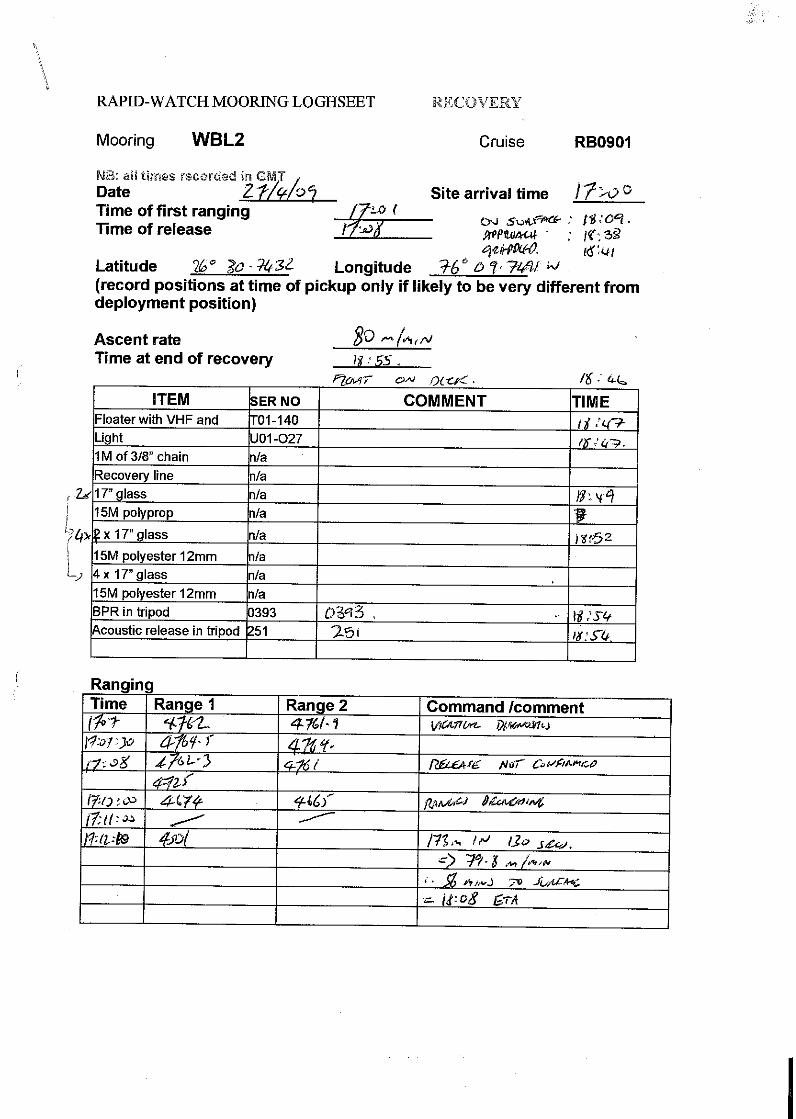
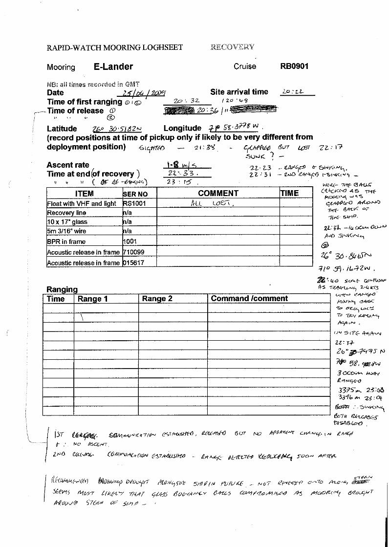
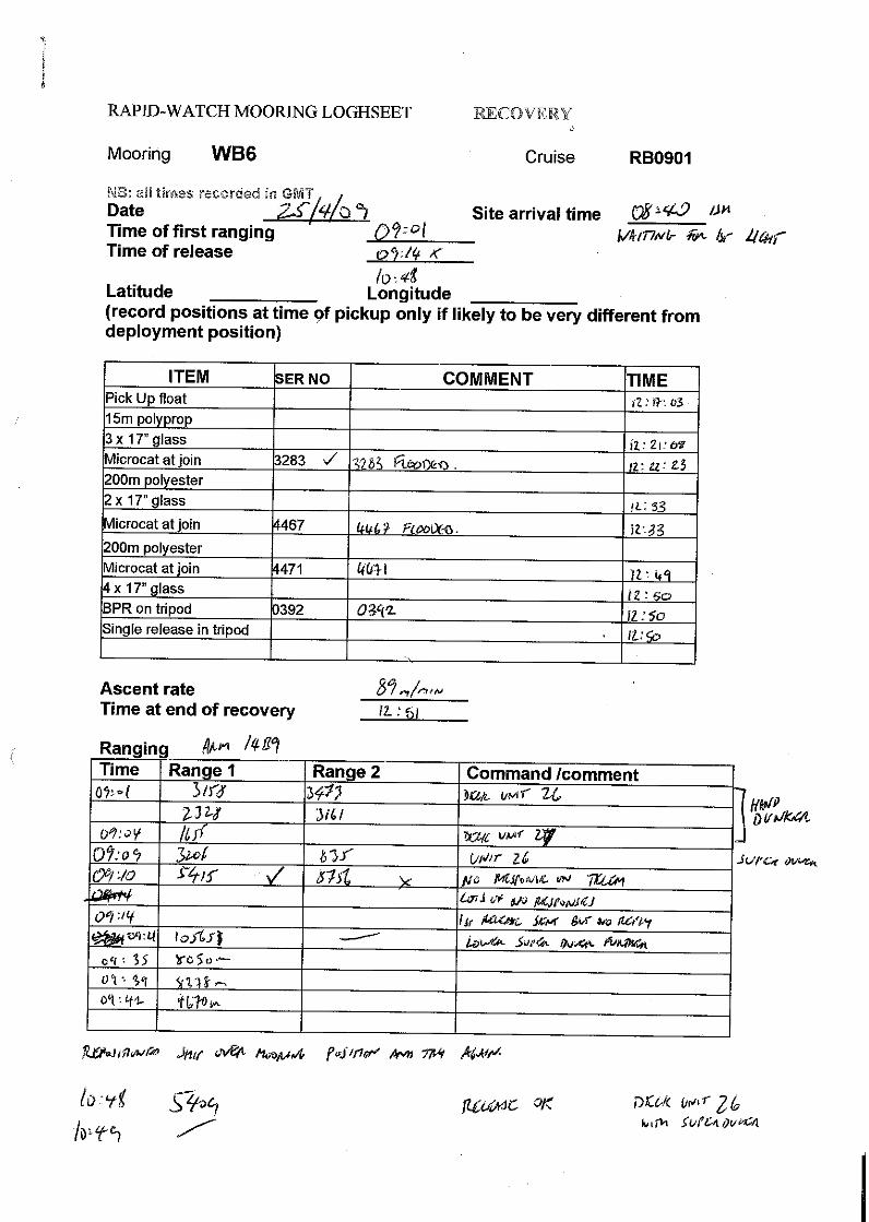
mooring if required. Darren discussed problems with LADCP data caused by the releases on the CTD frame during an overnight CTD. It seems that when the releases power up when being acoustically interrogated they disrupt the LADCP compass and cause the data to be invalid. As long as this is not for too long then the data should be able to be removed from the time series and the problem removed, but if the pause for release testing is too long this won't be possible. For the next cast we are again dipping two releases but with a cut off time of 20 minutes for talking to them. Weather: Seas and wind increasing. 25th April UK team up before 05:00 local time to release WB6. Waited until the start of dawn to release mooring. Two planets visible in the dawn sky – Venus and Mars. After nearly half an hour of trying, including using the super‘ducer and three different deck units it appeared as if the release had failed. The team were getting random ranges back from the release. Then it was decided to move the ship about 0.5 nm and contact was finally established. It was released just after 07:00 rising up at an estimated 89m/min (from ranges to/from the release). Mooring was grapnelled from port side and recovered. On recovery, two of the three MicroCATs were flooded with their end caps blown off. MicroCAT 4471 and the BPR 0392 were downloaded ok. After this it was decided to add two further MicroCATs to mooring wb6_2_2009. The new WB6 mooring was deployed without further problems after a short delay and the ship proceeded downwind to recover Bill John’s lander before sunset. Evening pick up of Bill John’s Lander: after a hopeful start, quick connection and release, the mooring surfaced on schedule. However, despite the fairish conditions the Brown had difficulty in manoevering to the mooring. There was no pick up line evident so it was difficult to grapple. The glass appeared to go beneath the ship slightly and then sink. Ranging on the releases confirmed that they were sinking rapidly so it seems that some of the glass buoyancy were destroyed by impact with the ship or propellors and there was insufficient left to support the lander. Weather: ENE 12 – 15 kts. Some swell. 26th April Spent the morning steaming to the WB4 site in order to deploy the WB4 mooring and the WBL2 lander. All instruments were set and prepared en-route. Meanwhile the mooring team had fully assembled all the relevant float arrangements for the mooring. Streamed the WB4 mooring and deployed at 17:04. There was a ship coming up rapidly astern of us, which failed to respond to hails from the bridge. As there was a danger that the ship might foul the mooring string, it was released slightly earlier than planned. Another problem was that the trawling winch used with the A frame on the stern did not function. As this is used to lift the anchor this was a problem that was overcome by the use of one of the ship’s aft cranes. Just as the anchor was about to be released the link holding the anchor to the crane failed, but as the anchor was over the sea, it simply plummeted down to the bottom a few seconds before it was meant to… We remained hove to here for the night to deploy WBL2 and to dip cast some ARs and MicroCATs. WBL2 deployed without a hitch. Two CTD casts were
Rapid Mooring Cruise Report for RB0901 – April – May 2009
23
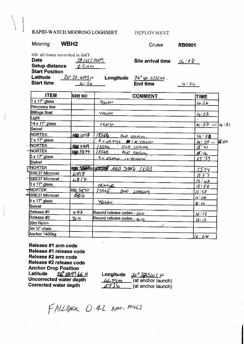
performed during the night to test six ARs and to calibrate eight MicroCATs. It was noticed that some of the Nortek current meters are deployed very close to the support buoyancy and may not be sufficient distance to remove current disruption effect. Need to think of this for the next moorings. Possibly we could deploy them looking downward instead of looking up. Weather; excellent. Contrails visible in the sky today. 27th April WB4 released and recovered with no problems. One glass float had imploded. Two MicroCATs have screws missing (one from the CTD guard and the other from the cable guide). This indicates that the mooring may have suffered from excess vibration. Darren is to look into this. WBL2 – smooth pick up and recovery. The data has a big step in the bottom pressure that appears to have to the mooring sinking or sliding about 30 cm lower on the bottom. It does not match the previous years data too well (chapter 12) Cast 31 – 10 MicroCATs. The US team recovered some data from a PIES. Darren commenced a further search for the WB4 mooring from 2006. The first position gave a lot of random positions but three that could be possible and that agreed with each other. We moved north and received no consistent ranges so moved south of the first position and again received no consistent ranges. The search was abandoned as it seems this mooring is not in the immediate vicinity. The AR appears to be dead or not there. Weather: cloudy in the evening after a lovely crescent moon set. 28th April Deployed the WBCM test mooring. Five different types of current meter have been deployed on the same mooring to see which is the best. There was a slight delay whilst modifying clamps for the DVS current meter. Deployed WBH2 and recovered WBH2. CTD cast 32 with ARs and eight MicroCATs. One of the releases had severe corrosion at the transducer end cap with some of the bolts having come out. This mooring was lucky to still be on site. No ranges from the corroded release were received and it was later confirmed to be flooded. A late night calibration dip was performed.

Rapid Mooring Cruise Report for RB0901 – April – May 2009
24
29th April
Figure 6.1 One of the side benefits of working at sea in the tropics! Rob and a mahi-mahi.
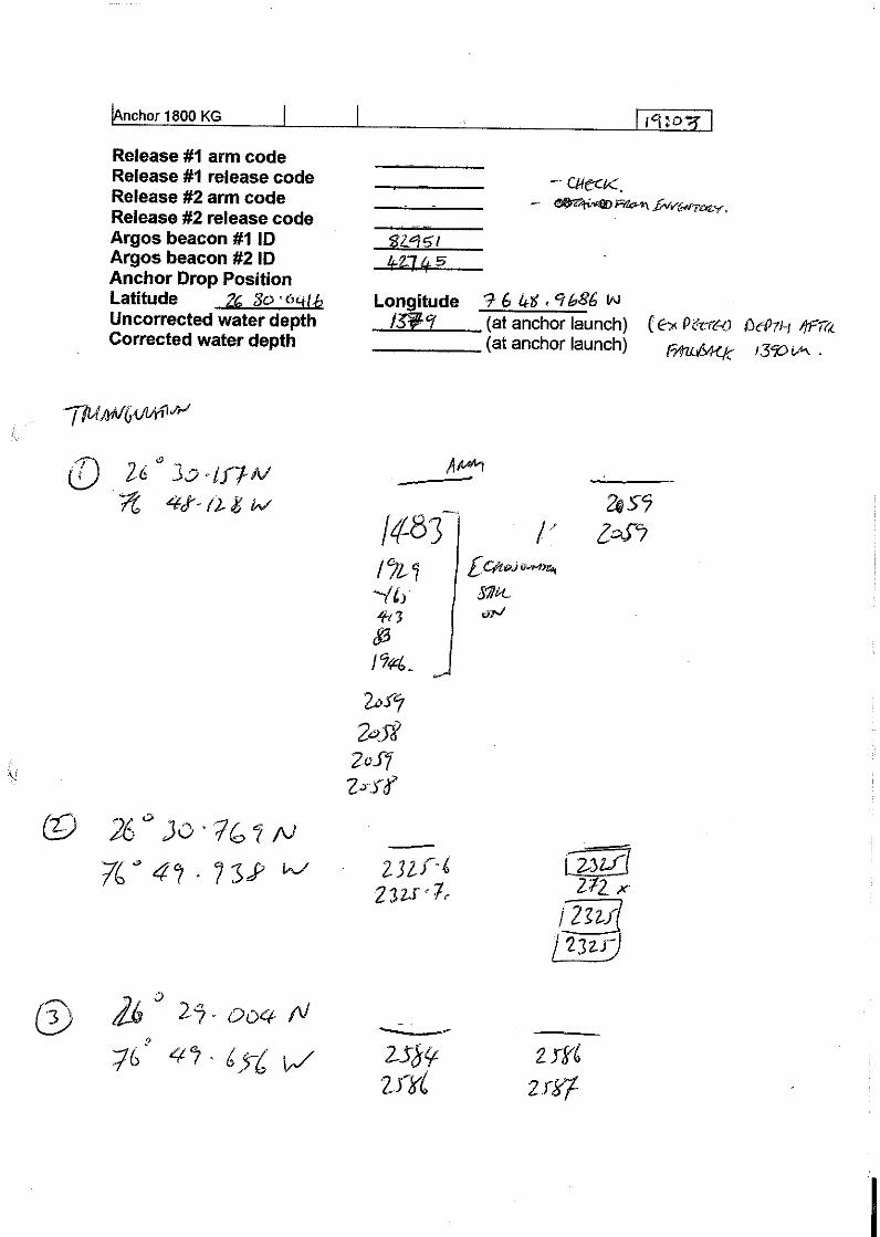
At last, something to write about fish. During the approach to WB2 it was noticed that the large steel buoy (the pick up was tangled around the glass) was surrounded by mahi-mahi. The approach was complicated by an awkward lay of the top section of the mooring meaning we had to start recovery from the steel sphere instead of the top of the mooring. As the moorings team made the task of picking up a two meter diameter steel ball out of the sea from a moving ship look easy one of the crew got busy with the rod and line and reeled in three large fish in rapid succession. WB2 was recovered without further incident as was WBLl with all instruments intact and full of data. The new WB2 was deployed smoothly but sadly the fish had all been eaten by the crew by the time the mooring work was finished. Conducted a triangulation survey to confirm the final position of the anchor. Calibration cast at 01:30 during the night.
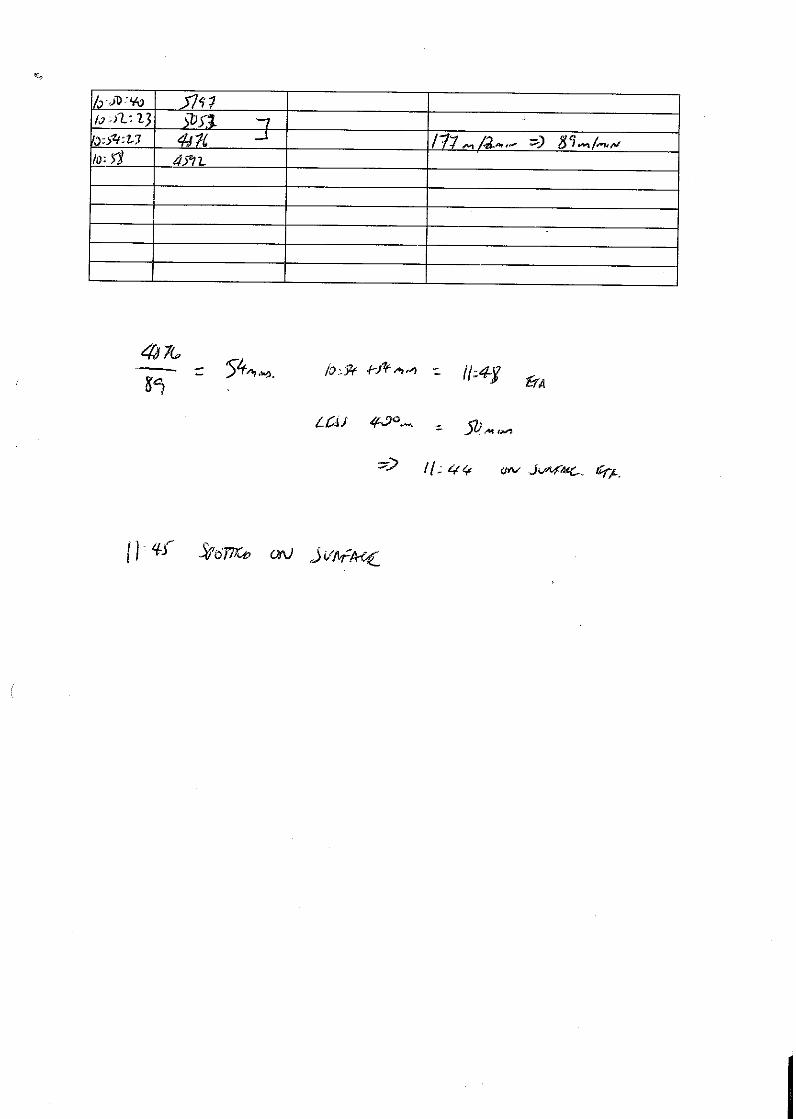
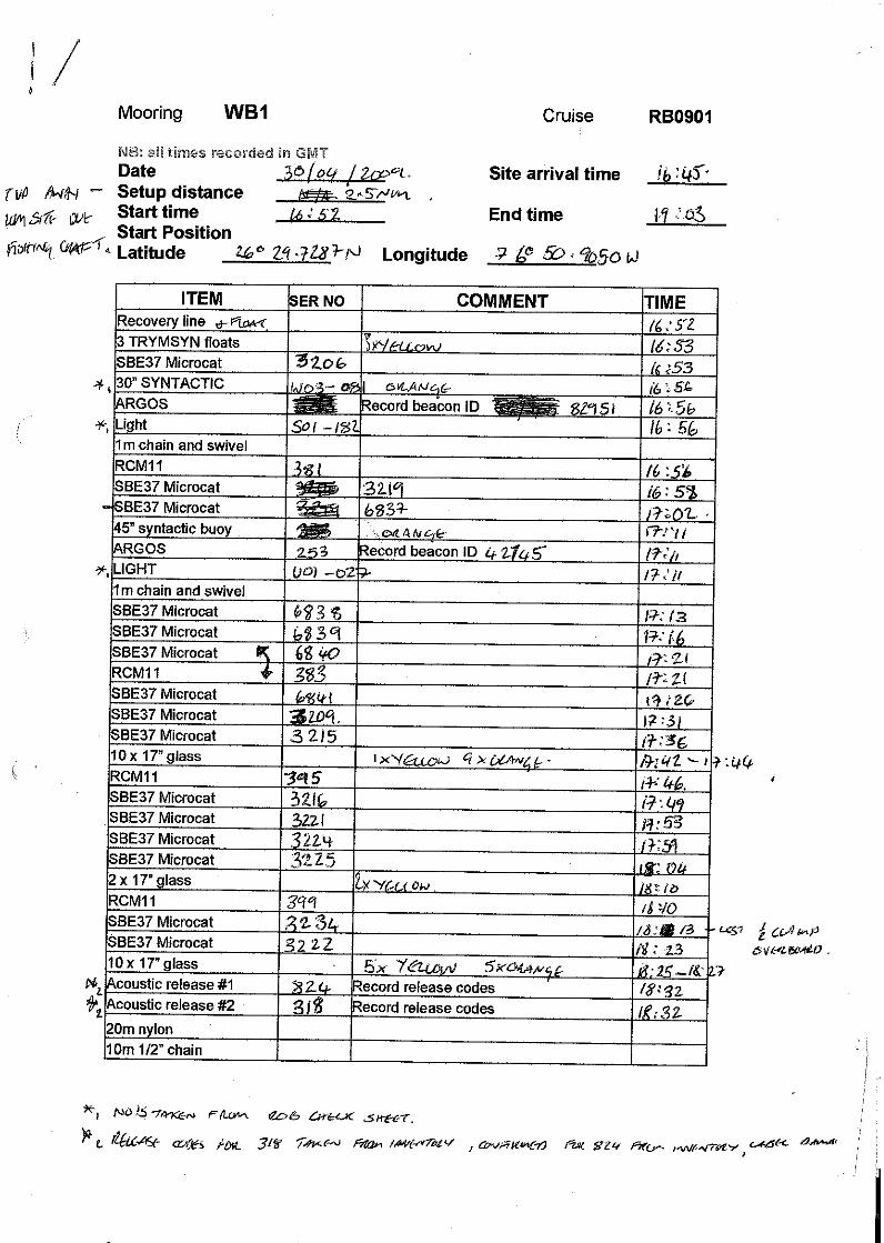
Weather: ENE 15 – 20 kts, varied clouds, cumulus and some cumulo stratos, No contrails due to dry air aloft. 30th April WB1 recovered and deployed. One flooded MicroCAT. CTD casts 34 and 35 carried out during the night. CTDs had to be scheduled around the ships holding tank discharges. Noted time errors on ships CTD. 3268 not post-deployment dip cast. The start distance for WB1 was in the middle of a fleet of sports fishing boats from Abaco. Possibly a competition. The RIB was launched from the ship to act as a guard boat for the top end of the mooring whilst we steamed offshore during deployment. This worked smoothly, with one boat waved down, and the mooring was deployed without any other problems. Two CTD calibration dips late evening. 1st May Cleared Bahamian immigration at Port Lucaya. Proceeded to Florida Straits for the US teams CTD stations. The UK team stripped the gear off the aft deck and

Rapid Mooring Cruise Report for RB0901 – April – May 2009
25
continued the data processing and the other paperwork/projects that had taken a back seat for the past week. 2nd May – 3rd May Completed Northwest Providence Channel section overnight and started first Florida Straits section. Offshore of Miami by about dinner time. Crossed back to Grand Bahama completing an underway ADCP survey before starting the 2nd CTD section again heading west. Finished second Florida Straits CTD section. Started shipboard ADCP sections across the Florida Straits cable. 4th May Finished ADCP section overnight. Started passage back to Charleston. Packed up computers and lab. End of science. 5th May Docked in Charleston.

Rapid Mooring Cruise Report for RB0901 – April – May 2009
26
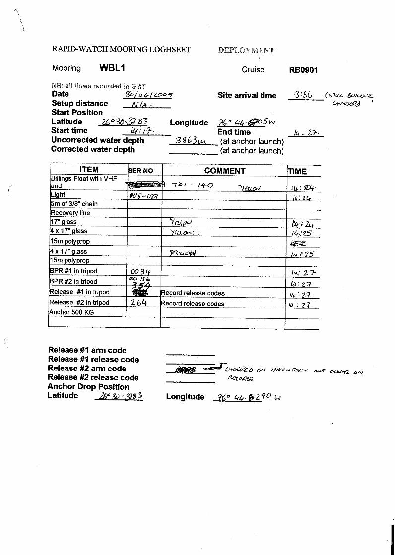
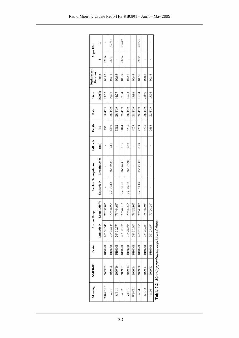
7 Mooring Operations Robert McLachan 7.1 Mooring Summary
Mooring Number Mooring ID Deployed Recovered 2008/02 WB1 SJ08 RB0901 2008/03 WB2 SJ08 RB0901 2008/04 WB4 SJ08 RB0901 2008/05 WBADCP SJ08 RB0901 2007/07 WB6 RB0701 RB0901 2008/08 WBH2 SJ08 RB0901 2007/05 WBL1 RB0701 RB0901 2007/06 WBL2 RB0701 RB0901
Mooring Number Mooring ID Deployed Recovery
2009/06 WB1 RB0901 2010 2009/07 WB2 RB0901 2010 2009/08 WB4 RB0901 2010 2009/09 WBADCP RB0901 2010 2009/10 WBL1 RB0901 2011 2009/11 WBL2 RB0901 2011 2009/12 WBH2 RB0901 2010 2009/13 WB6 RB0901 2011 2009/14 WBCM RB0901 2010
Table 7.1 Mooring recovery and deployment summary 7.2 Diary of Events Wednesday 15th April Mobilization complete, everything secured for sea. Calibrated the RDI DVS on shore. Calibrated one of the new Nortek’s to try the procedure out on a vessel, this worked well, and we will calibrate the others in due course. Sailing delayed due to engine problems. 16th April The ship sailed at 14:30 local. Engines failed on a further three occasions but once repaired we continued anyway. Set up lab spaces, installed batteries in to instrumentation and calibrated the sentinel ADCP. 17th April Configured the 75kHz ADCP ready for deployment. Assembled the ADCP in to the buoy and put the frame on, some modifications to the frame were required. The ADCP mooring is now ready for deployment. A CTD cast will take place tonight/early hours of the morning to 1000m, we will test two releases, SN’s 824 and 825.

Rapid Mooring Cruise Report for RB0901 – April – May 2009
27
18th April Good communications were received from both releases. Upon recovery both had fired. The trip to Bahamas immigration was cancelled due to the sea being too much for the small boat. We then deployed the ADCP mooring, all went well. We followed this with the recovery of the 2008 ADCP mooring, this also went well. 19th April Mooring WB4 was wound on to the winch ready for deployment; we then wound on most of WB2. The remaining Seabirds were checked and had new batteries installed, one of the new units, serial number 6830, the internals are out of line so the battery pack will not fit correctly, Seabird have been contacted. The remaining Nortek’s were checked and had their batteries installed. 20th April Finished wire winding WB2, wound on WB1 afterwards and then the rope section of WBH2. We have also started putting the new Seabirds on to the CTD frame for calibration dips; we are doing six at a time during the day. 21st April Wound the wire section of WBH2. Coiled WB6 ropes in to baskets. Continued Seabird calibration dips. 22nd April Continued with Seabird calibration dips. Spliced ropes for recovery lines. Checked and installed batteries in to BPR’s. Serviced, new batteries and bench tested the release from the ADCP mooring, serial number 318. 23rd April Continued with the calibration of the Norteks. Made up the glass spheres packs for WB6. Practised splicing polyester ropes. Wire test of two acoustic releases at 16:30 local, serial numbers 367 and 495 to 5200m. Initially we could not establish communication with either of the releases; we had one good range from serial number 495; we switched deck units from 26 to 27 but this did not improve communication. We decided to use the super-ducer over the side with deck unit 26. 495 responded straight away giving constant ranges and release confirmations. Serial number 367, however, did not respond, giving random ranges and release confirmations, even after lowering the super-ducer deeper. Upon recovery it was confirmed that serial number 367 had not released and that 495 had. Another two releases are going on for a wire test; serial numbers 359 and 256 to 5200m. Again we had difficulty establishing communication with the releases; we switched deck units and got good ranges from serial number 359, but nothing from serial number 256. We tried the super-ducer on serial number 256 and got random ranges, we tried this set up with 359 and had good ranges, so this proved the set up. Upon recovery 359 had fired and 256 hadn’t. The two releases that have now failed (367 & 256) were both recovered from MARL3 on D334, so at least one of them had worked after being deployed for 2+ years.
Rapid Mooring Cruise Report for RB0901 – April – May 2009
28
24th April Built Lander frame ready for deployment on WB6. The crane has been declared out of action preventing any large lifts. Two more releases lowered to 5200m, serial numbers 358 and 324. Both responded well to communication, both confirming release. Both releases had fired. Fire and flood drills. Two more releases were lowered on the frame to 5120m. Serial numbers 318 and 282. Both communicated well, both confirmed release. Both releases had fired. 25th April Up at 4.30am to fire the release of WB6 at 0500. This proved easier said than done, we could not establish any communication with the release. We tried different deck units and used the super-ducer, all to no avail. We decided to reposition the ship and try again. This solved the problem and communication was established. The mooring was recovered with nothing more than a few tangles to contend with; however two of the seabirds had flooded, serial numbers 4467 and 3283. Following this we readied WB6 for deployment. Two more SBE 37’s were added to this mooring at 5300m and 5500m. The mooring was deployed without incident. We then started unpacking the clamp on floats and assembling them together with the wire shots we have with us. We also started building WBL2, getting the billings float and the glass ready. 26th April Continued assembling the clamp on floats. Started getting the ARGOS, lights and VHF beacons ready for the Lander and WB4. Moved the 2700kg anchor in to position as well as a 600kg Lander anchor. It appears that the crane is working ok now. We then deployed mooring WB4, all went well, releases confirmed as on bottom. We then got the WBL2 Lander ready and deployed it, all went well. We triangulated WB4. CTD tonight with 6 releases on, serial numbers 354, 820, 819, 367, 256 and 497. Depth 4556m. 4 of the six releases worked and two failed. The two that failed were serial numbers 367 and 256, these are the releases that have already failed once. 27th April Fired release for WB4 at 6.45, the mooring was then recovered without any major problems. We then started stripping down and inspecting the recovered glass. We then started to build the sphere packs for WBH2. We arrived at the WBL2 site and released it. It took around an hour to reach the surface where we commenced recovery, all went well. Started to carry out an acoustic search for the 2006 – 2007 WB4 a lot of inconsistent ranges are being received, though some of them, if you pick the right ones, are close to each other. It was decided that we would steam 2 miles to see if the ranges we like de-crease or increase. No luck with the old WB4. Wound on the trial WB-CM mooring, and made up glass sphere packs for it. Doubled up two releases for WBH2, serial numbers 819 and 497. Put 10 Seabirds on the CTD frame for calibration cast, using the start later command.
Rapid Mooring Cruise Report for RB0901 – April – May 2009
29
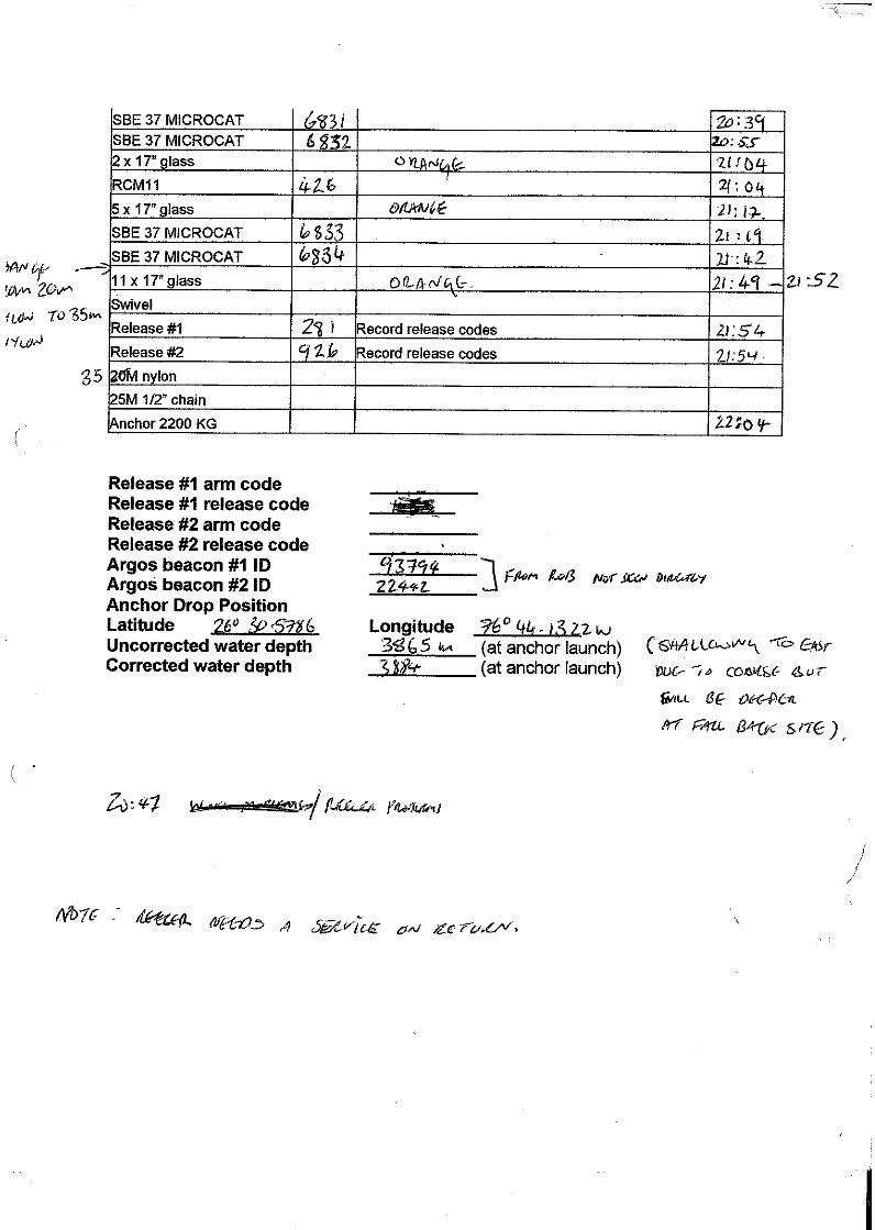
We had to recalibrate/compass 6 of the Nortek’s due to the fact that they are now being deployed looking down. Serviced the recovered RCM11’s. 28th April We started by deploying the WB-CM mooring. We then deployed WBH2. Recovery of the old WBH2 was then started; it took two hours from first sighting to getting hold of the recovery buoy. We then triangulated WBH2 mooring. Serviced, installed new batteries and tested four releases, these were then put on the CTD frame; serial numbers 264, 926, 354 and 281, 354 has already been tested. 9 Seabirds were put on the frame as well. Depth 3400m. We made up the glass sphere packs for WB2 and WBL1. One of the releases (serial number 906) from the WBH2 recovery had severe corrosion, we were fortunate that the mooring hadn’t broken away. 29th April All of the releases on the CTD frame had fired ok. Started communication with WB2, the releases were fired and recovery commenced. All went well. We then fired the release for WBL1, whilst this was on its way up we started getting things ready for the WB2 deployment. The Lander was recovered without problems. We then re-positioned the ship and started the deployment of WB2, all went well. We then started building glass sphere packs, doubling up releases and servicing instrumentation ready for the deployment of WB1 and WBL1 tomorrow. WB2 was triangulated. 30th April Communication was established with WB1 releases, the mooring was released and recovery commenced, all went well though some tangles did slow progress slightly. We then readied the WBL1 Lander for deployment. The Lander was deployed with Bruce filming the operation from underwater. WB1 was the prepared for deployment, the small boat was launched as a look out and warning to other vessels in the area as we were close to the shore. There were a lot of vessels about. The mooring was deployed without incident, we had to tow to position for just under an hour before the anchor was deployed. End of UK mooring work.
Rapid Mooring Cruise Report for RB0901 – April – May 2009
30

Rapid Mooring Cruise Report for RB0901 – April – May 2009
31
8 Instruments Darren Rayner
8.1 Summary of Instruments Recovered and Deployed Table 8.1 gives a summary of the instruments recovered and deployed on cruise RB0901. Appendix B gives more detailed information on which instruments were recovered from each mooring along with a summary of the length of record obtained. Complete setup details of deployed instruments can be found in Appendix C.
Instrument type
Manufacturer and model Total intended for recovery
Total recovered
Total lost
Total deployed
CTD SeaBird SBE37 SMP MicroCAT SeaBird SBE37 IMP MicroCAT
33 19
33 (1 flooded) 19 (2 flooded)
0 0
54 0
Single point current meter
Aanderaa RCM11 Interocean S4 Nortek Aquadopp Sontek Argonaut MD TRDI Doppler Volume Sampler
23 0 0 0 0
23 0 0 0 0
0 0 0 0 0
15 1 10 1 1
Current profiler
RD Instruments 75kHz Longranger ADCP RD Instruments 300kHz Workhorse Sentinel ADCP
1 0
1 0
0 0
1 1
BPR SeaBird SBE26 SeaBird SBE53
4 0
4 0
0 0
0 4
Table 8.1 Summary of instruments recovered and deployed.
8.2 Instrument Problems 8.2.1 Recovered Instruments There were very few problems with recovered instruments on this cruise; three flooded MicroCATs (serial numbers 3283 and 4467 from WB6 and 5769 from WB1), one jump in the pressure record of a BPR (serial number 393 from WBL2) and a slightly short record from an RCM11 due to possible corruption of the data storage unit (serial number 303 from WB1). The flooded instruments from WB6 are thought to be due to a weld failure of the Druck pressure sensor as per previous floods. Serial number 5769 has a Paine pressure sensor that should not suffer the same problem as the Druck sensors so the reason for this instrument flooding is at present unknown. Additionally there was evidence of likely strumming of the WB4 mooring as several of the recovered MicroCATs had screws missing, presumed shaken out. This caused one instrument (serial number 3220) to lose its conductivity guard and another to lose its guide clamp and be supported by only a single wire clamp – the guide clamp was recovered with the instrument beneath as it had slipped down the wire. The
Rapid Mooring Cruise Report for RB0901 – April – May 2009
32
instrument that lost its conductivity guard was not lowered on the CTD frame for a calibration dip. 8.2.2 Deployed and New Instruments MicroCAT serial number 6830 is a new instrument that arrived from SeaBird with the battery post misaligned. This made it impossible to insert the battery pack and this instrument needs to be returned to SeaBird for repair.
The new MicroCATs that were shipped direct to Charleston have a new firmware (version 3.0f). At first this caused some confusion as the commands and reply format were different to previous firmware versions. A new piece of software was supplied with these instruments (Seaterm V2), which does not allow download of the data in the usual format, and instead downloads in XML format, which can then be converted to ASCII. However this ASCII format would cause problems with running the stage 1 data processing routines, as it is not the same as previous firmware versions. It could be an option in the future if these stage 1 routines are modified, but work will need to be done on the date/time format as the XML format stores time either as seconds since January 1st 2000, or in Julian Day instead of dd mmm yyy hh:mm:ss as previously used. Instead the following commands were sent to the instrument to allow them to be downloaded with the previous version of Seaterm. OutPutExecutedTag=n to stop the MicroCAT terminating each reply with
<Executed/> OutPutFormat=3 to change the output data format to match that used previously (although this may only be important for transmitting real-time data)
Rapid Mooring Cruise Report for RB0901 – April – May 2009
33
9 ADCP Processing Paul Wright The Longranger ADCP deployed close inshore to Abaco to monitor the Antilles Current on mooring wbadcp_5_200808 was recovered and its data downloaded to a Windows based PC using RDI WINADCP software. As the ADCP has a built in pressure sensor it is possible to establish the depth of the unit for the bin mapping procedure. The raw data from the ADCP is converted by WINADCP into a .mat file and processed using MATLAB routines written by Jon Molina (RSMAS). All codes except for RDI’s WINADCP program are found in the exec folder: Programs: rapid/data/exec/rb0901/ADCP_processing Raw data: rapid/data/moor/raw/rb0901/adp/DEPL1000.000 Output from WINADCP: rapid/data/moor/raw/rb0901/adp/
wbadcp_5_200805_data.mat 9.1 Stage 1 Processing The binmap.m program, produced by Jon Molina, was edited slightly during the cruise and renamed binmapWBADCP.m for use with the wbadcp mooring location. It reads the data from the converted .mat file and determines the depth of the ADCP from the surface reflections. From this 40 bins (layers of ocean) are created and saved as another .mat file. This .mat file was inspected to decide which data need to be removed from the ends of the series. It is possible to then re-run the program having edited the code to change the values of the parameters AA and BB, which top and tail the input matrices. Output: rapid/data/moor/proc/wbadcp_5_200805/
wbadcp_5_200805_binmap.mat 9.2 Stage 2 Processing The MATLAB script bbmat2rodb.m, also produced by Jon Molina and edited for RB0901, reads the bin mapped data from the binmap.mat file and does the following:
• cuts off the deployment and recovery periods. This is not done via the info.dat file as with the other instruments but from inspection of the finished data set and then by changing the indexing on the input matrices. This can also be done during stage 1 (as was the case during RB0901)
• de-spiking, gap filling, correcting for magnetic variation and filtering the data. For this the code reads the info.dat file.
• Produces two series of RDB formatted ASCII data files, e.g. wbadcp_5_200805_bin36.cor - corrected for magnetic variation and
speed of sound
Rapid Mooring Cruise Report for RB0901 – April – May 2009
34
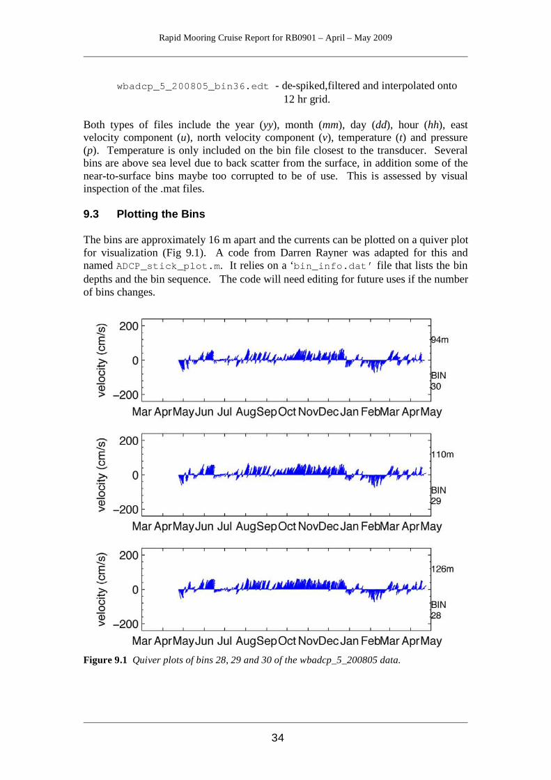
wbadcp_5_200805_bin36.edt - de-spiked,filtered and interpolated onto 12 hr grid.
Both types of files include the year (yy), month (mm), day (dd), hour (hh), east velocity component (u), north velocity component (v), temperature (t) and pressure (p). Temperature is only included on the bin file closest to the transducer. Several bins are above sea level due to back scatter from the surface, in addition some of the near-to-surface bins maybe too corrupted to be of use. This is assessed by visual inspection of the .mat files. 9.3 Plotting the Bins The bins are approximately 16 m apart and the currents can be plotted on a quiver plot for visualization (Fig 9.1). A code from Darren Rayner was adapted for this and named ADCP_stick_plot.m. It relies on a ‘bin_info.dat’ file that lists the bin depths and the bin sequence. The code will need editing for future uses if the number of bins changes.
Figure 9.1 Quiver plots of bins 28, 29 and 30 of the wbadcp_5_200805 data.
Rapid Mooring Cruise Report for RB0901 – April – May 2009
35
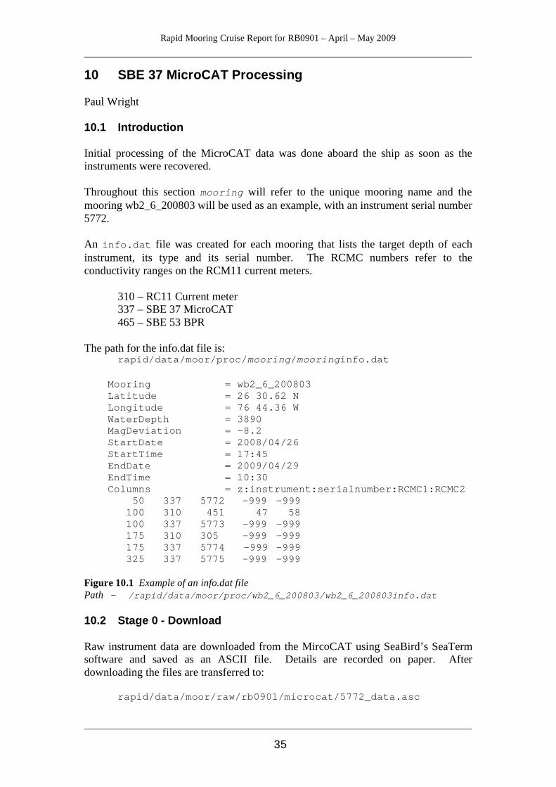
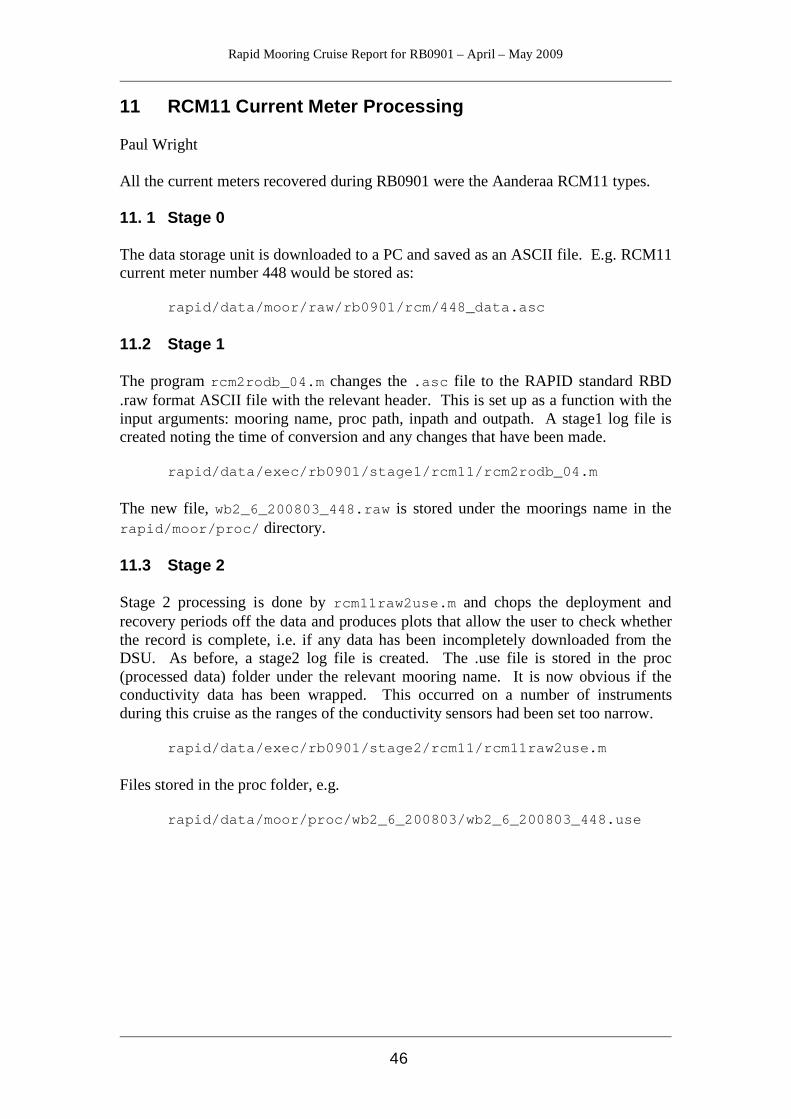
10 SBE 37 MicroCAT Processing Paul Wright 10.1 Introduction Initial processing of the MicroCAT data was done aboard the ship as soon as the instruments were recovered. Throughout this section mooring will refer to the unique mooring name and the mooring wb2_6_200803 will be used as an example, with an instrument serial number 5772. An info.dat file was created for each mooring that lists the target depth of each instrument, its type and its serial number. The RCMC numbers refer to the conductivity ranges on the RCM11 current meters.
310 – RC11 Current meter 337 – SBE 37 MicroCAT 465 – SBE 53 BPR
The path for the info.dat file is: rapid/data/moor/proc/mooring/mooringinfo.dat Mooring = wb2_6_200803
Latitude = 26 30.62 N Longitude = 76 44.36 W WaterDepth = 3890 MagDeviation = -8.2 StartDate = 2008/04/26 StartTime = 17:45 EndDate = 2009/04/29 EndTime = 10:30 Columns = z:instrument:serialnumber:RCMC1:RCMC2 50 337 5772 -999 -999 100 310 451 47 58 100 337 5773 -999 -999 175 310 305 -999 -999 175 337 5774 -999 -999 325 337 5775 -999 -999
Figure 10.1 Example of an info.dat file Path - /rapid/data/moor/proc/wb2_6_200803/wb2_6_200803info.dat 10.2 Stage 0 - Download Raw instrument data are downloaded from the MircoCAT using SeaBird’s SeaTerm software and saved as an ASCII file. Details are recorded on paper. After downloading the files are transferred to:
rapid/data/moor/raw/rb0901/microcat/5772_data.asc
Rapid Mooring Cruise Report for RB0901 – April – May 2009
36
under a filename based on their serial number (in this case 5772_data.asc). There are two types of MicroCAT, the only difference between them is how the data are downloaded. The inductive IMPs require an interface and a loop of wire through the ferrite mooring cable clamp and take a long time to download, while the straight forward cable connected SMP types are quicker and a laptop cable just plugs straight in. The only difference when using the software is that the IMPs need to have every command prefixed by the MicroCATs code number. The inductive IMPs are designed for telemetry uses. Darren Rayner has written a piece of software that speeds up the downloading process by downloading the MicroCATs hex data into a capture file and then converting it afterwards. Prior to use the MicroCAT needs to be stopped using SeaTerm and the number of logged samples established using the DS command. 10.3 Stage 1 – Conversion from .asc to the RDB format .raw Stage 1 processing converts the data for all the MicroCATs on each mooring from the manufacturers ASCII format to the RAPID RDB standard. i.e. header information, a standard date and time format and SI units rather than imperial.
rapid/data/exec/rb0901/stage1/microcat/mc_call_2_002.m The MATLAB script mc_call_2_002.m runs the conversion code microcat2rodb.m as a batch file for each mooring. It uses the info.dat file to select the instruments that it needs, therefore it is critical that the info.dat files accurately reflect the instruments, positions and times of deployment. The script opens the files and converts them to .raw files. It also produces summary plots of the data and creates a stage1_log file, which has a summary of the operations carried out. Output .raw files are stored in: rapid/data/moor/proc/mooring/microcat/ where mooring is the unique mooring name. e.g.
rapid/data/moor/proc/wb2_6_200803/microcat/ wb2_6_200803_5772.raw
The plot is stored as a postscript plot:
rapid/data/moor/proc/wb2_6_200803/microcat/ wb2_6_200803_5772.raw.ps
10.4 Stage 2 – Trimming of Data Record, Basic Statistics and Summary Plots Stage 2 processing removes the launching and recovery periods of the data, calculates the basic statistics and produces summary plots including 2-day low pass filtered data. The data is still NOT calibrated. The file is converted from mooring_serialnumber.raw file to mooring_serialnumber.use file using the MATLAB script microcat_raw2use_003.m.
Rapid Mooring Cruise Report for RB0901 – April – May 2009
37
rapid/data/exec/rb0901/stage2/microcat/
microcat_raw2use_003.m There are few things that need to be changed in the header of the MATLAB script.
• The variable ‘moor’ needs to changed to the mooring name (e.g. wb2_2_200808)
• The ‘operator’ needs to be changed (e.g. PW) • The ‘plot interval’ changed to make the output summary plots fit - generally
the period enveloping the deployment period is fine. • The paths need to be adjusted to match the directory structure of the cruise.
The output files are placed in the following: rapid/data/moor/proc/mooring/microcat e.g.
rapid/data/moor/proc/wb2_6_200803/microcat/ wb2_6_200803_5772.use
Three files are produced for each instrument: wb2_6_200803_5772.use A data file of the truncated time series data wb2_6_200803_5772.use.ps A postscript plot of the truncated
conductivity, temperature and depth time series
wb2_6_200803_5772.lowpass.ps A postscript plot of the truncated and 2-day low pass filtered time series
10.5 Calibration Dips The MicroCATs are strapped to a CTD frame and dipped before and after deployment for calibration purposes. A total of fourteen calibration dips were made. (see Appendix A for details of which MicroCATs were on which cast.) The processing technique for pre and post deployment calibration is identical. The MicroCATs are set up using SeaBird’s software on the Windows laptops. Care needs to taken with the newer SBE37s as the firmware is slightly different (see 13.2.2). Recovered data is stored in: rapid/data/moor/raw/rb0901/microcat_cal_dip/castX where, X = number of the cast. For each cast an info.dat file was constructed containing metadata, serial number and instrument codes for each of the MicroCATs involved in the cast. The file names follow the pattern castXinfo.dat and are located in the proc_calib directory: e.g. rapid/data/moor/proc_calib/rb0901/cal_dip/cast11info.dat There is only one stage to calibration dip casts, following a similar pattern to the previous section. However, this depends on whether the CTD data have been made

Rapid Mooring Cruise Report for RB0901 – April – May 2009
38
available or not. If there are no CTD data available, then a quick inspection can be carried out using the MATLAB script mc_call_calib2_noCTD.m. rapid/data/exec/rb0901/stage1/microcat/
mc_call_calib2_noCTD.m In the script the paths header information need to be edited to match the current cruise and the cast number needs to be added (‘moor’ = castX). The script converts the ASCII data files into RODB format by calling the microcat2rodb_2.m routine. It produces plots of the temperature, conductivity and pressure for quick checks for consistency. In particular it is important to check data consistency at the bottle stops. If the CTD data are available then the MATLAB code mc_call_calib2_RB0901.m performs the same tasks as before but adding the CTD data to the plots. For simplicity on this cruise, the basic (pre-processed) CTD data files, CTDcastX.dat, from the US team had their header lines commented out as the format was different from the UK CTD files. The original code is named mc_call_calib2_zbs.m.
Figure 10.4a A plot of the pressure calibration cast11 from RB0901. The flat steps are the bottle stops.
Rapid Mooring Cruise Report for RB0901 – April – May 2009
39
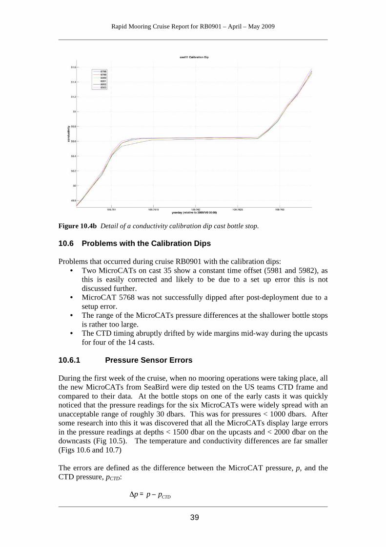
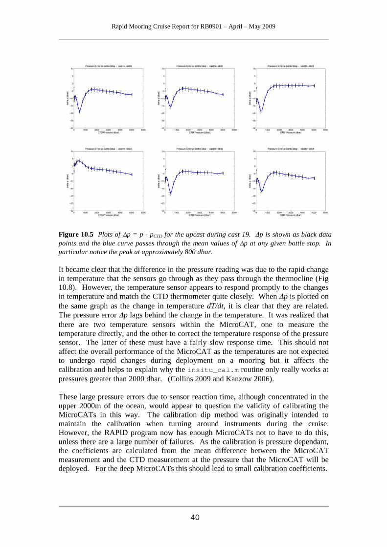
Figure 10.4b Detail of a conductivity calibration dip cast bottle stop. 10.6 Problems with the Calibration Dips Problems that occurred during cruise RB0901 with the calibration dips:
• Two MicroCATs on cast 35 show a constant time offset (5981 and 5982), as this is easily corrected and likely to be due to a set up error this is not discussed further.
• MicroCAT 5768 was not successfully dipped after post-deployment due to a setup error.
• The range of the MicroCATs pressure differences at the shallower bottle stops is rather too large.
• The CTD timing abruptly drifted by wide margins mid-way during the upcasts for four of the 14 casts.
10.6.1 Pressure Sensor Errors During the first week of the cruise, when no mooring operations were taking place, all the new MicroCATs from SeaBird were dip tested on the US teams CTD frame and compared to their data. At the bottle stops on one of the early casts it was quickly noticed that the pressure readings for the six MicroCATs were widely spread with an unacceptable range of roughly 30 dbars. This was for pressures < 1000 dbars. After some research into this it was discovered that all the MicroCATs display large errors in the pressure readings at depths < 1500 dbar on the upcasts and < 2000 dbar on the downcasts (Fig 10.5). The temperature and conductivity differences are far smaller (Figs 10.6 and 10.7) The errors are defined as the difference between the MicroCAT pressure, p, and the CTD pressure, pCTD:
!
"p = p # pCTD
Rapid Mooring Cruise Report for RB0901 – April – May 2009
40
Figure 10.5 Plots of Δp = p - pCTD for the upcast during cast 19. Δp is shown as black data points and the blue curve passes through the mean values of Δp at any given bottle stop. In particular notice the peak at approximately 800 dbar. It became clear that the difference in the pressure reading was due to the rapid change in temperature that the sensors go through as they pass through the thermocline (Fig 10.8). However, the temperature sensor appears to respond promptly to the changes in temperature and match the CTD thermometer quite closely. When Δp is plotted on the same graph as the change in temperature dT/dt, it is clear that they are related. The pressure error Δp lags behind the change in the temperature. It was realized that there are two temperature sensors within the MicroCAT, one to measure the temperature directly, and the other to correct the temperature response of the pressure sensor. The latter of these must have a fairly slow response time. This should not affect the overall performance of the MicroCAT as the temperatures are not expected to undergo rapid changes during deployment on a mooring but it affects the calibration and helps to explain why the insitu_cal.m routine only really works at pressures greater than 2000 dbar. (Collins 2009 and Kanzow 2006). These large pressure errors due to sensor reaction time, although concentrated in the upper 2000m of the ocean, would appear to question the validity of calibrating the MicroCATs in this way. The calibration dip method was originally intended to maintain the calibration when turning around instruments during the cruise. However, the RAPID program now has enough MicroCATs not to have to do this, unless there are a large number of failures. As the calibration is pressure dependant, the coefficients are calculated from the mean difference between the MicroCAT measurement and the CTD measurement at the pressure that the MicroCAT will be deployed. For the deep MicroCATs this should lead to small calibration coefficients.
Rapid Mooring Cruise Report for RB0901 – April – May 2009
41
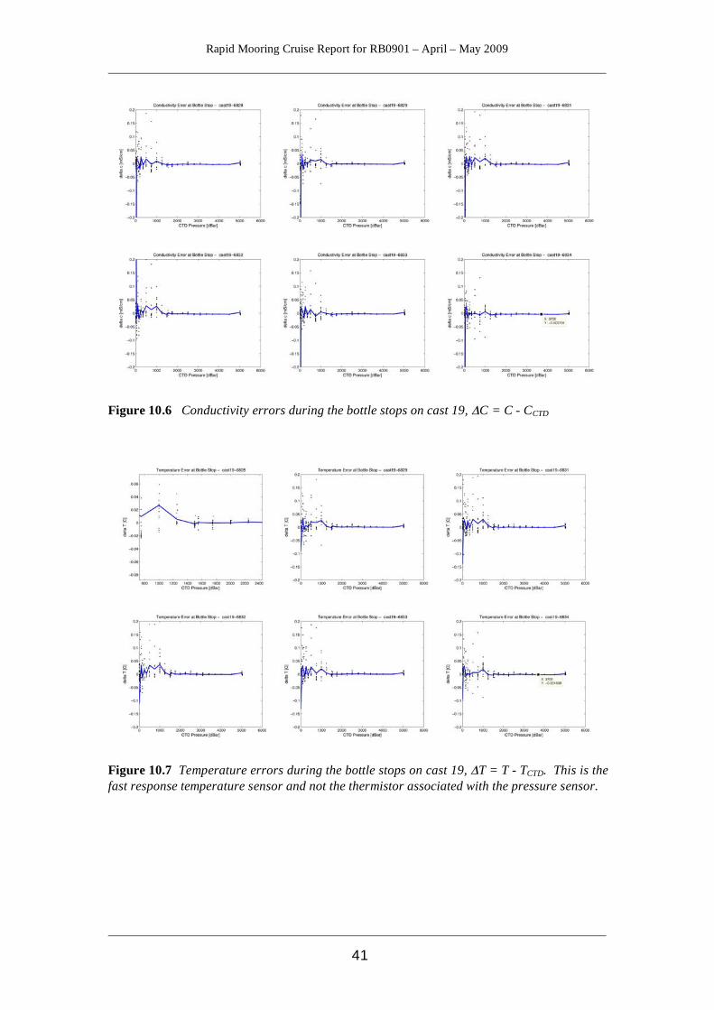
Figure 10.6 Conductivity errors during the bottle stops on cast 19, ΔC = C - CCTD
Figure 10.7 Temperature errors during the bottle stops on cast 19, ΔT = T - TCTD. This is the fast response temperature sensor and not the thermistor associated with the pressure sensor.

Rapid Mooring Cruise Report for RB0901 – April – May 2009
42
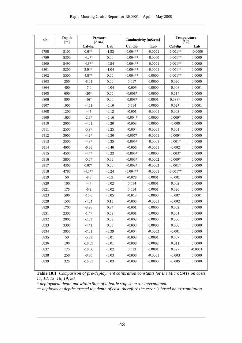
Figure 10.8 The pressure errors (black) for cast 20 with the rate of change of temperature superimposed in red. The dT/dt curves have been greatly exaggerated, by a factor of 1000, for visibility. Δp is generally positive on the downcast and negative on the upcast. The laboratory calibrations have come from the calibration certificates supplied by SeaBird and the coefficients are based the polynomial residuals for the expected values of conductivity and temperature that the MicroCAT at the depth that the MicroCAT is to be deployed. For example: MicroCAT 6832 is to be deployed at 2800m on mooring WB2 with the expected temperature and conductivity values of approximately 2.8°C and 32.6 mS/cm, which give laboratory calibration offsets of 0.000 mS/cm and 0.0000°C and calibration dip offsets of -0.003mS/cm and 0.000°C (Table 10.1). The calibration coefficients for the instruments dipped on casts 11, 12, 15, 16 19 and 20 are shown in Table 10.1. In almost all cases the calibration coefficients based on the dip casts are higher than the ones based on the laboratory determined certificates.
Rapid Mooring Cruise Report for RB0901 – April – May 2009
43
s/n Depth
[m] Pressure [dBar] Conductivity [mS/cm] Temperature
[°C] Cal-dip Lab Cal-dip Lab Cal-dip Lab
6798 5100 0.6** -1.53 -0.004** -0.0001 -0.001** -0.0000
6799 5300 -4.2** 0.00 -0.004** -0.0000 -0.001** 0.0000
6800 5490 -4.9** -0.54 -0.004** -0.0001 -0.001** 0.0000
6801 5200 2.9** -1.04 -0.004** -0.0001 -0.001** 0.0000
6802 5500 4.8** 0.00 -0.004** 0.0000 -0.001** 0.0000
6803 250 -5.01 0.00 0.017 0.0000 0.020 0.0000
6804 400 -7.0 -0.04 -0.005 0.0000 0.008 0.0001
6805 600 -20* 0.00 -0.008* 0.0000 0.01* 0.0000
6806 800 -16* 0.00 -0.008* 0.0001 0.038* 0.0000
6807 1000 -4.61 -0.10 0.014 0.0000 0.027 0.0001
6808 1200 -4.5 -0.12 -0.001 -0.0001 0.003 0.0000
6809 1600 -2.8* -0.16 -0.004* 0.0000 -0.000* 0.0000
6810 2000 -4.01 -0.20 -0.003 0.0000 -0.000 0.0000
6811 2500 -5.97 -0.25 -0.004 -0.0001 0.001 0.0000
6812 3000 -4.2* -0.30 -0.007* -0.0001 -0.000* 0.0000
6813 3500 -4.3* -0.35 -0.005* -0.0001 -0.001* 0.0000
6814 4000 -6.86 -0.40 -0.005 -0.0001 -0.002 0.0000
6815 4500 -4.4* -0.23 -0.005* 0.0000 -0.003* 0.0000
6816 3800 -0.0* 0.38 -0.003* -0.0002 -0.000* 0.0000
6817 4300 0.07* 0.00 -0.003* -0.0002 -0.001* 0.0000
6818 4780 -4.0** -0.24 -0.004** -0.0001 -0.001** 0.0000
6819 50 -8.6 -0.5 -0.078 0.0001 -0.001 0.0000
6820 100 -4.4 -0.02 0.014 0.0001 0.002 0.0000
6821 175 -6.2 -0.02 0.014 0.0001 0.020 0.0000
6823 500 -16.6 -0.05 -0.013 0.0000 -0.007 0.0001
6828 1500 -4.04 0.15 -0.005 -0.0001 -0.002 0.0000
6829 1700 -3.36 0.34 -0.001 0.0000 0.002 0.0000
6831 2300 -1.47 0.69 -0.001 0.0000 0.001 0.0000
6832 2800 -2.63 0.03 -0.003 0.0000 0.000 0.0000
6833 3300 -4.41 0.33 -0.003 0.0000 0.000 0.0000
6834 3850 -7.01 -0.39 -0.004 -0.0002 -0.001 0.0000
6835 50 -5.89 -0.01 -0.003 0.0001 0.007 0.0000
6836 100 -18.09 -0.01 -0.008 0.0002 0.011 0.0000
6837 175 -10.60 -0.02 0.013 0.0001 0.027 -0.0001
6838 250 -8.30 -0.03 -0.008 -0.0001 -0.003 0.0000
6839 325 -15.95 -0.03 -0.009 0.0000 -0.005 0.0000
Table 10.1 Comparison of pre-deployment calibration constants for the MicroCATs on casts 11, 12, 15, 16, 19, 20. * deployment depth not within 50m of a bottle stop so error interpolated. ** deployment depths exceed the depth of cast, therefore the error is based on extrapolation.
Rapid Mooring Cruise Report for RB0901 – April – May 2009
44
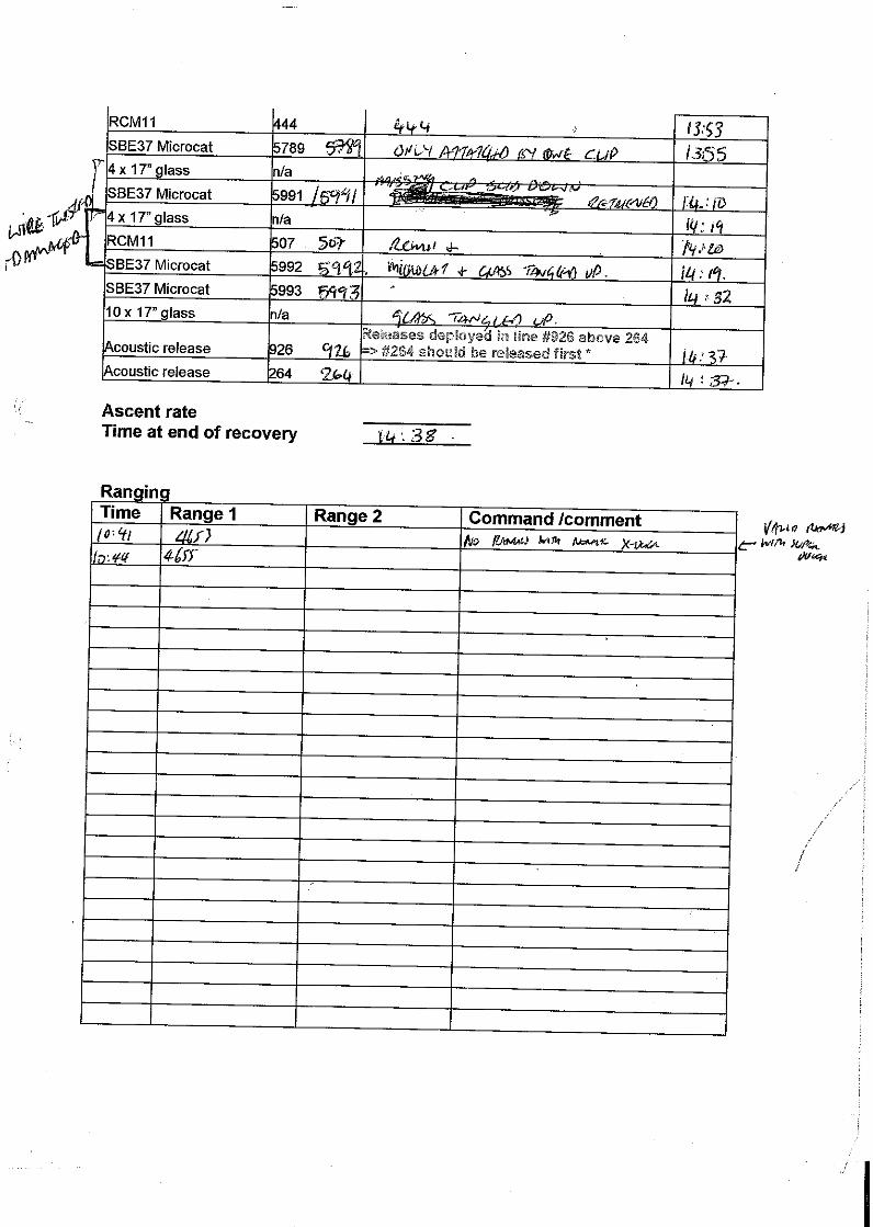
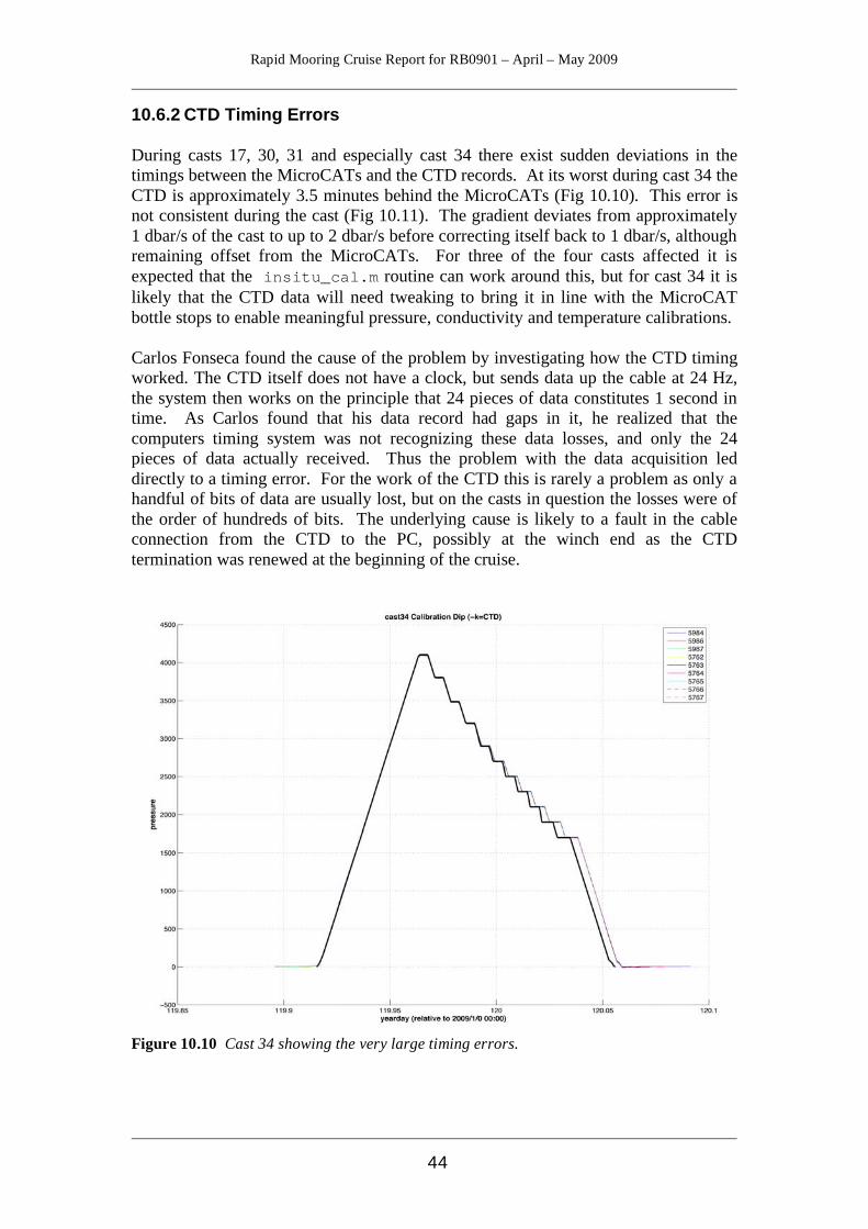
10.6.2 CTD Timing Errors During casts 17, 30, 31 and especially cast 34 there exist sudden deviations in the timings between the MicroCATs and the CTD records. At its worst during cast 34 the CTD is approximately 3.5 minutes behind the MicroCATs (Fig 10.10). This error is not consistent during the cast (Fig 10.11). The gradient deviates from approximately 1 dbar/s of the cast to up to 2 dbar/s before correcting itself back to 1 dbar/s, although remaining offset from the MicroCATs. For three of the four casts affected it is expected that the insitu_cal.m routine can work around this, but for cast 34 it is likely that the CTD data will need tweaking to bring it in line with the MicroCAT bottle stops to enable meaningful pressure, conductivity and temperature calibrations. Carlos Fonseca found the cause of the problem by investigating how the CTD timing worked. The CTD itself does not have a clock, but sends data up the cable at 24 Hz, the system then works on the principle that 24 pieces of data constitutes 1 second in time. As Carlos found that his data record had gaps in it, he realized that the computers timing system was not recognizing these data losses, and only the 24 pieces of data actually received. Thus the problem with the data acquisition led directly to a timing error. For the work of the CTD this is rarely a problem as only a handful of bits of data are usually lost, but on the casts in question the losses were of the order of hundreds of bits. The underlying cause is likely to a fault in the cable connection from the CTD to the PC, possibly at the winch end as the CTD termination was renewed at the beginning of the cruise.
Figure 10.10 Cast 34 showing the very large timing errors.

Rapid Mooring Cruise Report for RB0901 – April – May 2009
45
Figure 10.11 Plot showing the CTD timing drift of cast 31. Note that the drift starts suddenly at one point on the upcast and continues to diverge.
Rapid Mooring Cruise Report for RB0901 – April – May 2009
46
11 RCM11 Current Meter Processing Paul Wright All the current meters recovered during RB0901 were the Aanderaa RCM11 types. 11. 1 Stage 0 The data storage unit is downloaded to a PC and saved as an ASCII file. E.g. RCM11 current meter number 448 would be stored as:
rapid/data/moor/raw/rb0901/rcm/448_data.asc 11.2 Stage 1 The program rcm2rodb_04.m changes the .asc file to the RAPID standard RBD .raw format ASCII file with the relevant header. This is set up as a function with the input arguments: mooring name, proc path, inpath and outpath. A stage1 log file is created noting the time of conversion and any changes that have been made.
rapid/data/exec/rb0901/stage1/rcm11/rcm2rodb_04.m The new file, wb2_6_200803_448.raw is stored under the moorings name in the rapid/moor/proc/ directory. 11.3 Stage 2 Stage 2 processing is done by rcm11raw2use.m and chops the deployment and recovery periods off the data and produces plots that allow the user to check whether the record is complete, i.e. if any data has been incompletely downloaded from the DSU. As before, a stage2 log file is created. The .use file is stored in the proc (processed data) folder under the relevant mooring name. It is now obvious if the conductivity data has been wrapped. This occurred on a number of instruments during this cruise as the ranges of the conductivity sensors had been set too narrow. rapid/data/exec/rb0901/stage2/rcm11/rcm11raw2use.m Files stored in the proc folder, e.g.
rapid/data/moor/proc/wb2_6_200803/wb2_6_200803_448.use
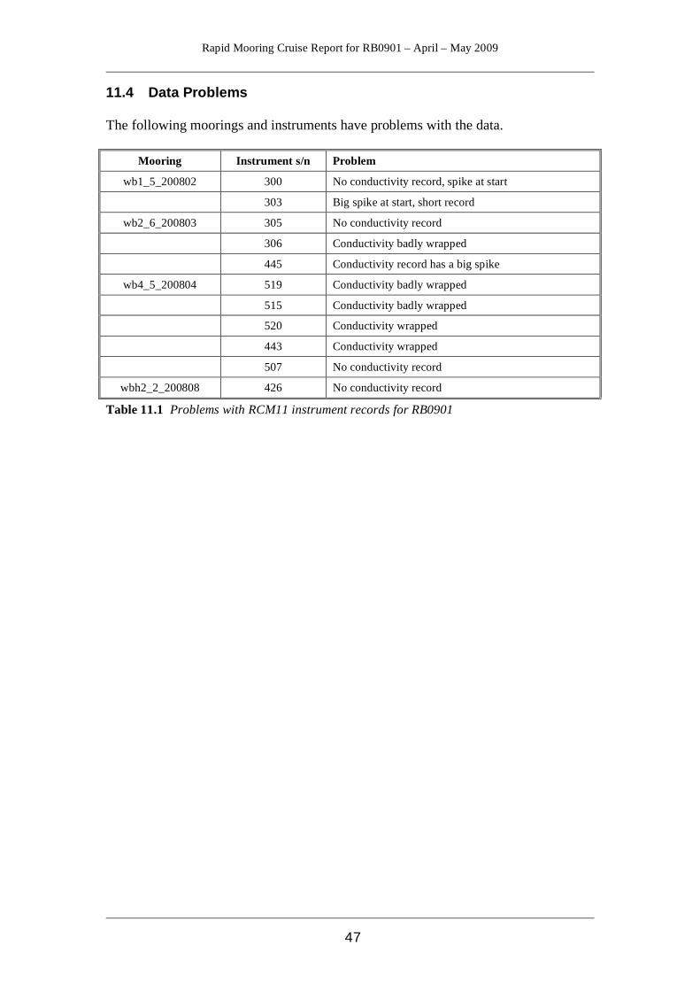
Rapid Mooring Cruise Report for RB0901 – April – May 2009
47
11.4 Data Problems The following moorings and instruments have problems with the data.
Mooring Instrument s/n Problem
wb1_5_200802 300 No conductivity record, spike at start
303 Big spike at start, short record
wb2_6_200803 305 No conductivity record
306 Conductivity badly wrapped
445 Conductivity record has a big spike
wb4_5_200804 519 Conductivity badly wrapped
515 Conductivity badly wrapped
520 Conductivity wrapped
443 Conductivity wrapped
507 No conductivity record
wbh2_2_200808 426 No conductivity record
Table 11.1 Problems with RCM11 instrument records for RB0901
Rapid Mooring Cruise Report for RB0901 – April – May 2009
48
Figure 11.1 The output plot of stage 2 processing of the RCM11 data from wb2_6_200803
Rapid Mooring Cruise Report for RB0901 – April – May 2009
49
12 BPR Processing Paul Wright RAPID uses the SeaBird SBE26 Seagauge and/or the SeaBird SBE53 BPR to measure bottom pressure. No major modifications were made to any of the file structures, formats or processing on this cruise. The following is based on the RAPID Data processing document (Collins 2009) and uses wb6_1_200707_0392 as an example. 12.1 Stage 0 Raw instrument data is downloaded from the BPR using SeaBird’s ‘SeaSoft for Waves’ software and saved as .hex and .tid files. Relevant details are recorded on paper and kept in the file by Darren Rayner. After downloading the files are transferred to:
rapid/data/moor/raw/rb0901/seagauge/0392_data.tid and 0392_data.hex
under filenames based on their serial number (in this case 0392_data.tid). An info.dat file is created for each mooring (see Chapter 10). In order for the programs to work the necessary empty folders must be created in the relevant directories. The programs do NOT automatically create directories. 12.2 Stage 1 Stage 1 processing takes the ASCII file and converts it into RDB format. The units are changed from psi to dbar. If there has been a clock offset recorded then this is applied at this point. The code is found in:
rapid/data/exec/rb0901/stage1/seagauge/ seagauge2rdb_002.m
The RDB output file is saved as wb6_1_200707_0392.raw with the header information taken from the info.dat file. A stage 1 log file is created that records activity. If the data has been “wrapped” this may be fixed. This has not been necessary for RB0901. 12.3 Stage 2 Stage 2 processing takes the .raw file and trims off the deployment and recovery sections and calculates the basic statistics. Additionally the routine applies an exponential-linear drift removal to the data and filters it through a 48-hr low pass filter in order to remove the tidal signals. The empirical fit is calculated by the subroutine purge_bp.m. The stage 2 program was renamed from seaguage_processing_002.m to seagauge_raw2use.m to match the generalized names given in the RAPID Data Processing document (Collins 2009) The previous named file has been kept in the same directory though.
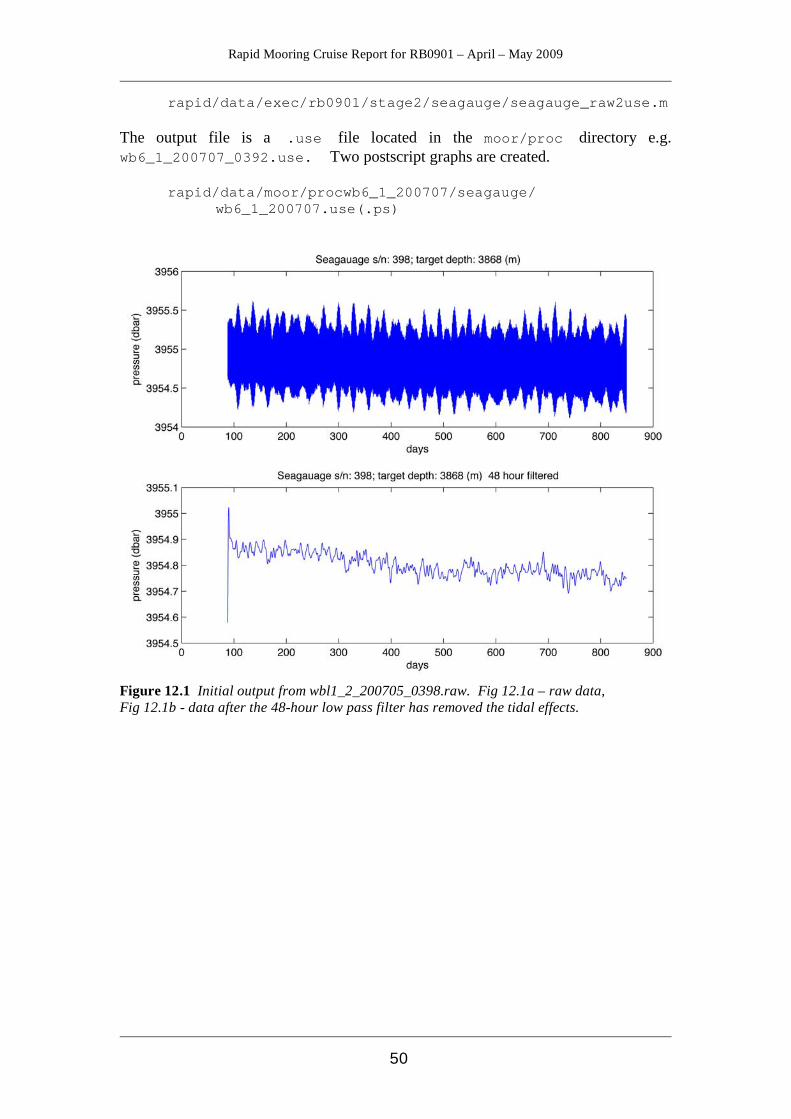
Rapid Mooring Cruise Report for RB0901 – April – May 2009
50
rapid/data/exec/rb0901/stage2/seagauge/seagauge_raw2use.m The output file is a .use file located in the moor/proc directory e.g. wb6_1_200707_0392.use. Two postscript graphs are created.
rapid/data/moor/procwb6_1_200707/seagauge/ wb6_1_200707.use(.ps)
Figure 12.1 Initial output from wbl1_2_200705_0398.raw. Fig 12.1a – raw data, Fig 12.1b - data after the 48-hour low pass filter has removed the tidal effects.
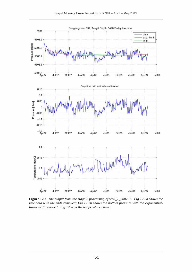
Rapid Mooring Cruise Report for RB0901 – April – May 2009
51
Figure 12.2 The output from the stage 2 processing of wb6_1_200707. Fig 12.2a shows the raw data with the ends removed; Fig 12.2b shows the bottom pressure with the exponential-linear drift removed. Fig 12.2c is the temperature curve.
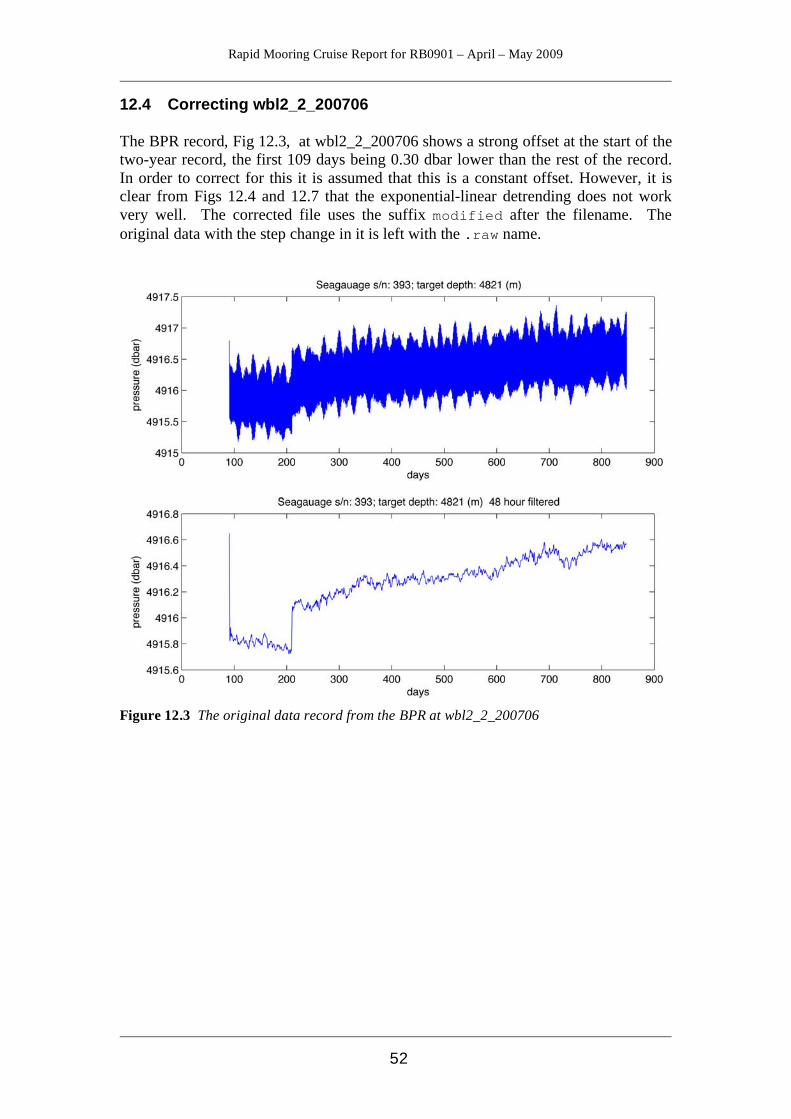
Rapid Mooring Cruise Report for RB0901 – April – May 2009
52
12.4 Correcting wbl2_2_200706 The BPR record, Fig 12.3, at wbl2_2_200706 shows a strong offset at the start of the two-year record, the first 109 days being 0.30 dbar lower than the rest of the record. In order to correct for this it is assumed that this is a constant offset. However, it is clear from Figs 12.4 and 12.7 that the exponential-linear detrending does not work very well. The corrected file uses the suffix modified after the filename. The original data with the step change in it is left with the .raw name.
Figure 12.3 The original data record from the BPR at wbl2_2_200706
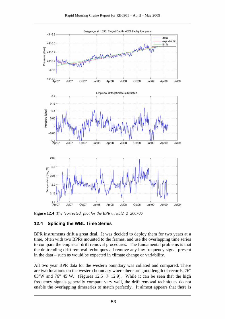
Rapid Mooring Cruise Report for RB0901 – April – May 2009
53
Figure 12.4 The ‘corrected’ plot for the BPR at wbl2_2_200706 12.4 Splicing the WBL Time Series BPR instruments drift a great deal. It was decided to deploy them for two years at a time, often with two BPRs mounted to the frames, and use the overlapping time series to compare the empirical drift removal procedures. The fundamental problems is that the de-trending drift removal techniques all remove any low frequency signal present in the data – such as would be expected in climate change or variability. All two year BPR data for the western boundary was collated and compared. There are two locations on the western boundary where there are good length of records, 76° 03’W and 76° 45’W. (Figures 12.5 12.9). While it can be seen that the high frequency signals generally compare very well, the drift removal techniques do not enable the overlapping timeseries to match perfectly. It almost appears that there is
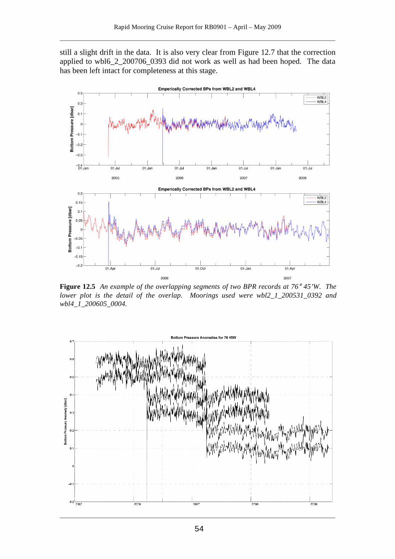
Rapid Mooring Cruise Report for RB0901 – April – May 2009
54
still a slight drift in the data. It is also very clear from Figure 12.7 that the correction applied to wbl6_2_200706_0393 did not work as well as had been hoped. The data has been left intact for completeness at this stage.
Figure 12.5 An example of the overlapping segments of two BPR records at 76° 45’W. The lower plot is the detail of the overlap. Moorings used were wbl2_1_200531_0392 and wbl4_1_200605_0004.

Rapid Mooring Cruise Report for RB0901 – April – May 2009
55
Figure 12.6 Combined plots of the bottom pressure anomalies for 76° 45’W. The curves have been offset for clarity.
Figure 12.7 Combined plots of the time series for the bottom pressure anomalies at 76° 03’W. The data that is widely separated is the corrected BPR from wbl2_2_200706. The curves are offset for visibility.
Figure 12.8 The combined bottom pressure records for 76° 45’W (lower) and 76° 03’W (upper), with a 10-day low pass filter applied to their mean values shown in black. The upper
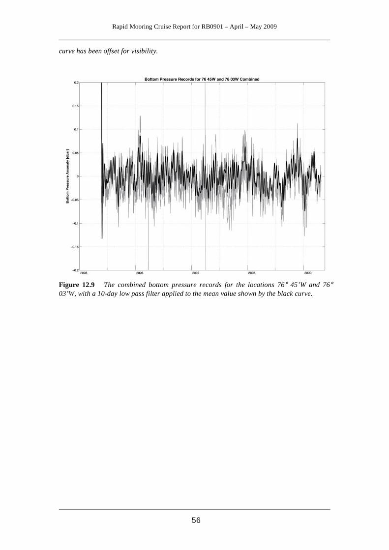
Rapid Mooring Cruise Report for RB0901 – April – May 2009
56
curve has been offset for visibility.
Figure 12.9 The combined bottom pressure records for the locations 76° 45’W and 76° 03’W, with a 10-day low pass filter applied to the mean value shown by the black curve.

Rapid Mooring Cruise Report for RB0901 – April – May 2009
57
References Bryden H. L., Mujahid A., Cunningham S. A., Kanzow T., “Adjustment of the Basin-Scale Circulation at 26°N to Variations in Gulf Stream, Deep Western Boundary Current and Ekman Transports as Observed by the RAPID Array”, Ocean Science Discussions, 6, 871-908, 2009 Collins J. et al, “Processing and Management of the RAPID-MOC/MOCHA Mooring Array Data”, 2009, NOCS internal document. Cunningham S.A., Kanzow T., Rayner D., Baringer M. O., Johns W. E., Marotzke J., Longworth H. R., Grant, E. M., Hirschii J. J-M., Beal. L, Meinen C., and Bryden H. L. (2007) “Temporal variability of the Atlantic Meridional Overturning Circulation at 26.5°N.” Science, 317, 935-938 Cunningham S.A. et al, “RRS Discovery D334 Cruise Report”, NOCS cruise report number 38, available at eprints.soton.ac.uk Kanzow T., Cunningham S.A., Rayner D., Baringer M. O., Johns W. E., Marotzke J., Hirschii J. J-M., Beal. L, Meinen C., and Bryden H. L., “Observed Flow Compensation Associated with the Meridional Overturning Circulation near 26.5°N in the Atlantic”, Science, 317. 938-941, 2007 Kanzow T., Send U., Zenk W., Chave A. D., Rhein M., “Monitoring the Integrated Deep Meridional Flow in the Tropical North Atlantic: Long Term Performance of a Geostrophic Array.” Deep Sea research I, 53, 528-546, 2006.

Rapid Mooring Cruise Report for RB0901 – April – May 2009
58
Appendix A - Details of Instruments Lowered on CTD Calibration Casts
Instrument Details Cruise Cast Number
Type s/n pre- or post-
deployment calibration comments SMP 6798 Pre-deployment SMP 6799 Pre-deployment SMP 6800 Pre-deployment SMP 6801 Pre-deployment SMP 6802 Pre-deployment
11
SMP 6803 Pre-deployment SMP 6804 Pre-deployment SMP 6805 Pre-deployment SMP 6806 Pre-deployment SMP 6807 Pre-deployment SMP 6808 Pre-deployment
12
SMP 6809 Pre-deployment SMP 6810 Pre-deployment SMP 6811 Pre-deployment SMP 6812 Pre-deployment SMP 6813 Pre-deployment SMP 6814 Pre-deployment
15
SMP 6815 Pre-deployment SMP 6816 Pre-deployment SMP 6817 Pre-deployment SMP 6818 Pre-deployment SMP 6819 Pre-deployment SMP 6820 Pre-deployment
16
SMP 6821 Pre-deployment SMP 6822 Pre-deployment SMP 6823 Pre-deployment Not logging fast enough – redone cast 20 SMP 6824 Pre-deployment SMP 6825 Pre-deployment SMP 6826 Pre-deployment
17
SMP 6827 Pre-deployment SMP 6828 Pre-deployment SMP 6829 Pre-deployment SMP 6831 Pre-deployment SMP 6832 Pre-deployment SMP 6833 Pre-deployment
19
SMP 6834 Pre-deployment SMP 6823 Pre-deployment SMP 6835 Pre-deployment SMP 6836 Pre-deployment SMP 6837 Pre-deployment SMP 6838 Pre-deployment
20
SMP 6839 Pre-deployment SMP 6840 Pre-deployment SMP 6841 Pre-deployment 23 SMP 3247 Pre-deployment
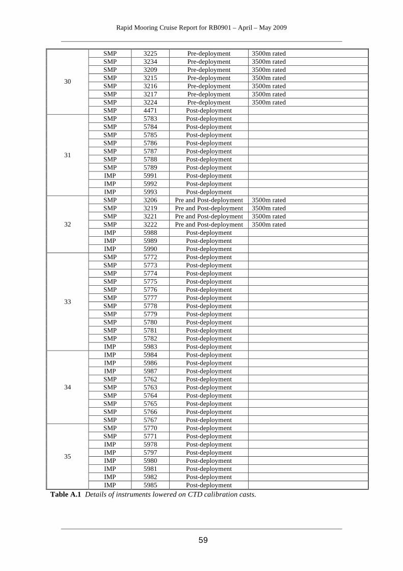
Rapid Mooring Cruise Report for RB0901 – April – May 2009
59
SMP 3225 Pre-deployment 3500m rated SMP 3234 Pre-deployment 3500m rated SMP 3209 Pre-deployment 3500m rated SMP 3215 Pre-deployment 3500m rated SMP 3216 Pre-deployment 3500m rated SMP 3217 Pre-deployment 3500m rated SMP 3224 Pre-deployment 3500m rated
30
SMP 4471 Post-deployment SMP 5783 Post-deployment SMP 5784 Post-deployment SMP 5785 Post-deployment SMP 5786 Post-deployment SMP 5787 Post-deployment SMP 5788 Post-deployment SMP 5789 Post-deployment IMP 5991 Post-deployment IMP 5992 Post-deployment
31
IMP 5993 Post-deployment SMP 3206 Pre and Post-deployment 3500m rated SMP 3219 Pre and Post-deployment 3500m rated SMP 3221 Pre and Post-deployment 3500m rated SMP 3222 Pre and Post-deployment 3500m rated IMP 5988 Post-deployment IMP 5989 Post-deployment
32
IMP 5990 Post-deployment SMP 5772 Post-deployment SMP 5773 Post-deployment SMP 5774 Post-deployment SMP 5775 Post-deployment SMP 5776 Post-deployment SMP 5777 Post-deployment SMP 5778 Post-deployment SMP 5779 Post-deployment SMP 5780 Post-deployment SMP 5781 Post-deployment SMP 5782 Post-deployment
33
IMP 5983 Post-deployment IMP 5984 Post-deployment IMP 5986 Post-deployment IMP 5987 Post-deployment SMP 5762 Post-deployment SMP 5763 Post-deployment SMP 5764 Post-deployment SMP 5765 Post-deployment SMP 5766 Post-deployment
34
SMP 5767 Post-deployment SMP 5770 Post-deployment SMP 5771 Post-deployment IMP 5978 Post-deployment IMP 5797 Post-deployment IMP 5980 Post-deployment IMP 5981 Post-deployment IMP 5982 Post-deployment
35
IMP 5985 Post-deployment Table A.1 Details of instruments lowered on CTD calibration casts.

Rapid Mooring Cruise Report for RB0901 – April – May 2009
60
Appendix B - Instrument Record Lengths
Mooring Instrument Serial Number
Depth (m)
Date of first usable record
Date of last usable record Comment
WBADCP ADCP 1767 598 24/4/2008 00:00 18/4/2009 00:00 40 bins (34 usable)
wbl1_2_200705 SBE 26 0398 3868.9 30/3/2009 21:15 29/4/2009 14:00
SBE 26 0399 3868.9 30/3/2009 21:00 29/4/2009 14:00
wbl2_2_200706 SBE 26 0393 4821 2/4/2007 18:30 27/4/2009 16:30 step change @109 dy
wb1_5_200802 SBE37 5762 50 23/4/2008 21:00 30/4/2009 09:30 RCM11 300 100 23/4/2008 21:30 30/4/2009 09:50 SBE37 5763 100 23/4/2008 21:00 30/4/2009 09:30 SBE37 5764 175 23/4/2008 21:00 30/4/2009 09:30 SBE37 5765 250 23/4/2008 21:00 30/4/2009 09:30 SBE37 5766 325 23/4/2008 21:00 30/4/2009 09:30 RCM11 301 400 23/4/2008 21:30 30/4/2009 09:50 SBE37 5767 400 23/4/2008 21:00 30/4/2009 09:30 SBE37 5768 500 23/4/2008 21:00 30/4/2009 09:30 SBE37 5769 600 - - Flooded SBE37 5770 700 23/4/2008 21:00 30/4/2009 09:30 RCM11 302 800 23/4/2008 21:30 30/4/2009 09:50 SBE37 5771 800 23/4/2008 21:00 30/4/2009 09:30 SBE37 5978 900 23/4/2008 21:00 30/4/2009 09:30 SBE37 5979 1000 23/4/2008 21:00 30/4/2009 09:30 SBE37 5980 1100 23/4/2008 21:00 30/4/2009 09:30 RCM11 303 1200 23/4/2008 21:30 10/4/2009 00:00 Short record SBE37 5981 1200 23/4/2008 21:00 30/4/2009 09:30 SBE37 5982 1380 23/4/2008 21:00 30/4/2009 09:30
wb2_6_200803 SBE37 5772 50 26/4/2008 18:00 29/4/2009 10:00 RCM11 451 100 26/4/2008 18:00 29/4/2009 10:30 SBE37 5773 100 26/4/2008 18:00 29/4/2009 10:00 RCM11 305 175 26/4/2008 18:00 29/4/2009 10:30 SBE37 5774 175 26/4/2008 18:00 29/4/2009 10:00 SBE37 5775 325 26/4/2008 18:00 29/4/2009 10:00 RCM11 306 400 26/4/2008 18:00 29/4/2009 10:30 SBE37 5776 500 26/4/2008 18:00 29/4/2009 10:00 SBE37 5777 700 26/4/2008 18:00 29/4/2009 10:00 RCM11 445 800 26/4/2008 18:00 29/4/2009 10:30 SBE37 5778 900 26/4/2008 18:00 29/4/2009 10:00 SBE37 5779 1100 26/4/2008 18:00 29/4/2009 10:00 RCM11 448 1200 26/4/2008 18:00 29/4/2009 10:30 SBE37 5780 1380 26/4/2008 18:00 29/4/2009 10:00 SBE37 5781 1500 26/4/2008 18:00 29/4/2009 10:00 SBE37 5782 1700 26/4/2008 18:00 29/4/2009 10:00 SBE37 5983 1900 26/4/2008 18:00 29/4/2009 10:00 RCM11 449 2050 26/4/2008 18:00 29/4/2009 10:30 SBE37 5984 2300 26/4/2008 18:00 29/4/2009 10:00 SBE37 5985 2800 26/4/2008 18:00 29/4/2009 10:00 RCM11 450 3000 26/4/2008 18:00 29/4/2009 10:30 SBE37 5986 3300 26/4/2008 18:00 29/4/2009 10:00 SBE37 5987 3850 26/4/2008 18:00 29/4/2009 10:00
wbh2_2_200808 RCM11 381 1500 27/4/2008 00:00 28/4/2009 16:45 RCM11 383 2200 27/4/2008 00:00 28/4/2009 16:45 RCM11 395 3000 27/4/2008 00:00 28/4/2009 16:45 RCM11 399 3800 27/4/2008 00:00 28/4/2009 16:45 SBE37 5988 3800 27/4/2008 00:00 28/4/2009 16:30 SBE37 5989 4300 27/4/2008 00:00 28/4/2009 16:30 RCM11 426 4600 27/4/2008 00:00 28/4/2009 16:45 No conductivity SBE37 5990 4780 27/4/2008 00:00 28/4/2009 16:30
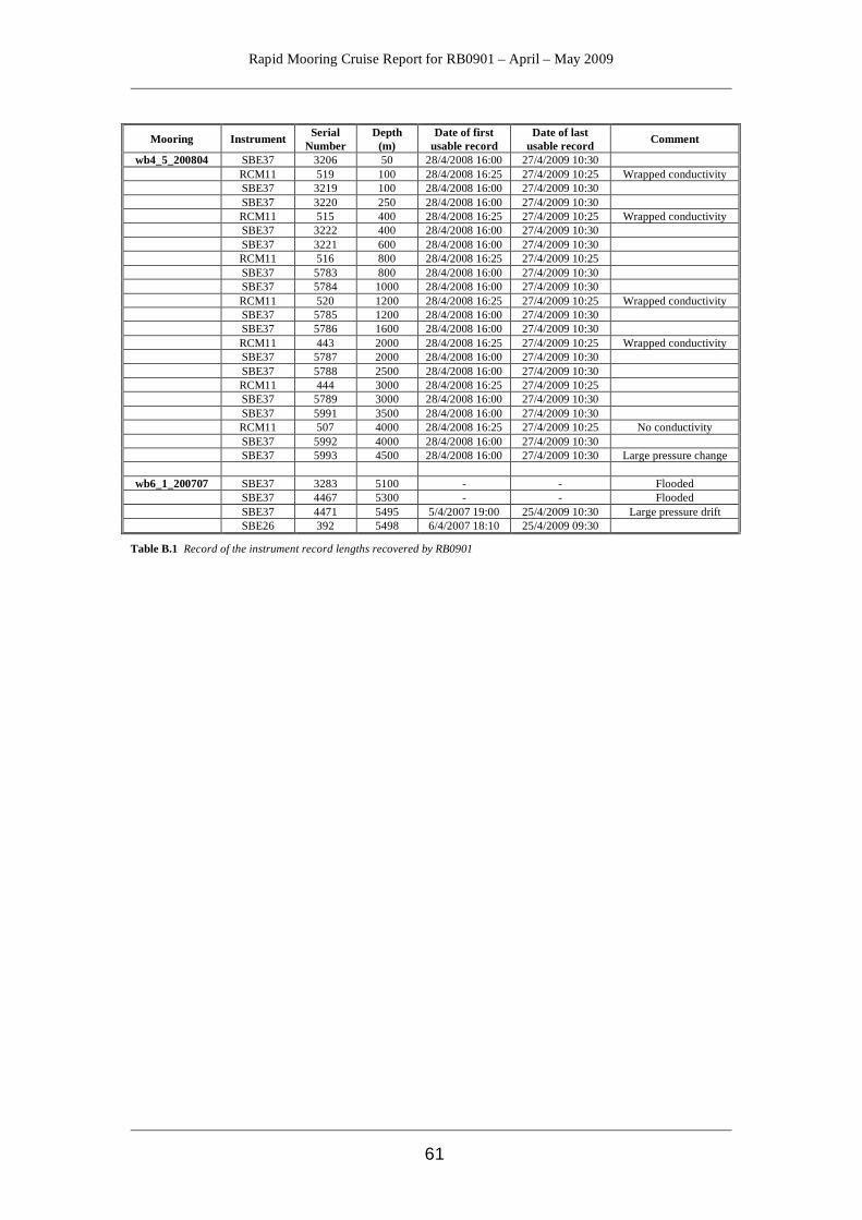
Rapid Mooring Cruise Report for RB0901 – April – May 2009
61
Mooring Instrument Serial
Number Depth
(m) Date of first
usable record Date of last
usable record Comment
wb4_5_200804 SBE37 3206 50 28/4/2008 16:00 27/4/2009 10:30 RCM11 519 100 28/4/2008 16:25 27/4/2009 10:25 Wrapped conductivity SBE37 3219 100 28/4/2008 16:00 27/4/2009 10:30 SBE37 3220 250 28/4/2008 16:00 27/4/2009 10:30 RCM11 515 400 28/4/2008 16:25 27/4/2009 10:25 Wrapped conductivity SBE37 3222 400 28/4/2008 16:00 27/4/2009 10:30 SBE37 3221 600 28/4/2008 16:00 27/4/2009 10:30 RCM11 516 800 28/4/2008 16:25 27/4/2009 10:25 SBE37 5783 800 28/4/2008 16:00 27/4/2009 10:30 SBE37 5784 1000 28/4/2008 16:00 27/4/2009 10:30 RCM11 520 1200 28/4/2008 16:25 27/4/2009 10:25 Wrapped conductivity SBE37 5785 1200 28/4/2008 16:00 27/4/2009 10:30 SBE37 5786 1600 28/4/2008 16:00 27/4/2009 10:30 RCM11 443 2000 28/4/2008 16:25 27/4/2009 10:25 Wrapped conductivity SBE37 5787 2000 28/4/2008 16:00 27/4/2009 10:30 SBE37 5788 2500 28/4/2008 16:00 27/4/2009 10:30 RCM11 444 3000 28/4/2008 16:25 27/4/2009 10:25 SBE37 5789 3000 28/4/2008 16:00 27/4/2009 10:30 SBE37 5991 3500 28/4/2008 16:00 27/4/2009 10:30 RCM11 507 4000 28/4/2008 16:25 27/4/2009 10:25 No conductivity SBE37 5992 4000 28/4/2008 16:00 27/4/2009 10:30 SBE37 5993 4500 28/4/2008 16:00 27/4/2009 10:30 Large pressure change
wb6_1_200707 SBE37 3283 5100 - - Flooded SBE37 4467 5300 - - Flooded SBE37 4471 5495 5/4/2007 19:00 25/4/2009 10:30 Large pressure drift SBE26 392 5498 6/4/2007 18:10 25/4/2009 09:30
Table B.1 Record of the instrument record lengths recovered by RB0901

Rapid Mooring Cruise Report for RB0901 – April – May 2009
62
Appendix C - Instrument Setup Details WBADCP_6_200909 RDI Longranger 75kHz Workhorse ADCP
s/n: 5817
System frequency: 76.8 kHz Beam angle: 20 degrees Water salinity: 36 Depth of transducer: 600 m Heading alignment: 0 Heading bias; 0 Depth cell size: 1600 cm Number of depth cells: 40 Blank after transmit: 0704 Pings per ensemble: 00010 Ambiguity velocity: 170 cm/s radial Time per ensemble: 00:30:00 Start date: 17 April 2009 @ 15:05:25 WBL1_3_200910 SBE53 BPR, s/n: 0034 User info line: WBL1_deployed_2009_RB0901 Tide interval: 30 Tide duration: 30 Frequency (reference): 96 Instrument started: 29 April 2009 Target depth: 3890 m SBE53 BPR, s/n: 0036 User info line: WBL1 _2009_RAPID Tide interval: 30 Tide duration: 30 Frequency (reference): 96 Instrument started: 29 April 2009 Target depth: 3890 m WBL2 _3_200911 SBE53 BPR BPR unit, s/n: 0033 INITLOGGING: Y Info header: wbl2_2009 Tide interval: 30 mins Tide Measurement Duration: 30 mins Reference sample freq: 96 Start: 26 April 2009 @ 20:00:00 Target depth:
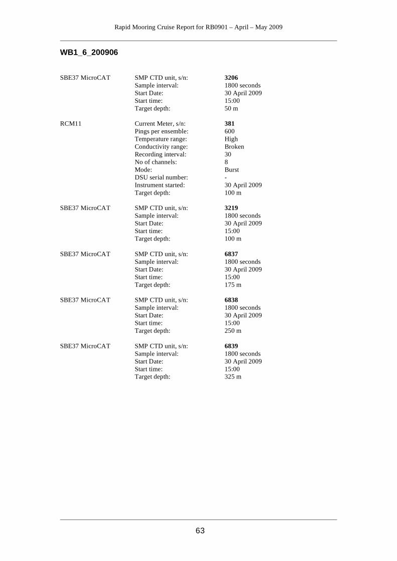
Rapid Mooring Cruise Report for RB0901 – April – May 2009
63
WB1_6_200906 SBE37 MicroCAT SMP CTD unit, s/n: 3206 Sample interval: 1800 seconds Start Date: 30 April 2009 Start time: 15:00 Target depth: 50 m RCM11 Current Meter, s/n: 381 Pings per ensemble: 600 Temperature range: High Conductivity range: Broken Recording interval: 30 No of channels: 8 Mode: Burst DSU serial number: - Instrument started: 30 April 2009 Target depth: 100 m SBE37 MicroCAT SMP CTD unit, s/n: 3219 Sample interval: 1800 seconds Start Date: 30 April 2009 Start time: 15:00 Target depth: 100 m SBE37 MicroCAT SMP CTD unit, s/n: 6837 Sample interval: 1800 seconds Start Date: 30 April 2009 Start time: 15:00 Target depth: 175 m SBE37 MicroCAT SMP CTD unit, s/n: 6838 Sample interval: 1800 seconds Start Date: 30 April 2009 Start time: 15:00 Target depth: 250 m SBE37 MicroCAT SMP CTD unit, s/n: 6839 Sample interval: 1800 seconds Start Date: 30 April 2009 Start time: 15:00 Target depth: 325 m
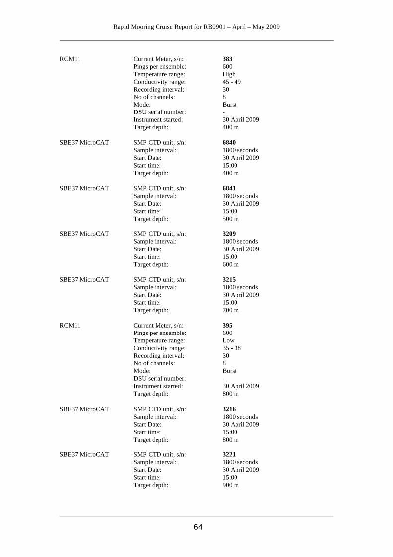
Rapid Mooring Cruise Report for RB0901 – April – May 2009
64
RCM11 Current Meter, s/n: 383 Pings per ensemble: 600 Temperature range: High Conductivity range: 45 - 49 Recording interval: 30 No of channels: 8 Mode: Burst DSU serial number: - Instrument started: 30 April 2009 Target depth: 400 m SBE37 MicroCAT SMP CTD unit, s/n: 6840 Sample interval: 1800 seconds Start Date: 30 April 2009 Start time: 15:00 Target depth: 400 m SBE37 MicroCAT SMP CTD unit, s/n: 6841 Sample interval: 1800 seconds Start Date: 30 April 2009 Start time: 15:00 Target depth: 500 m SBE37 MicroCAT SMP CTD unit, s/n: 3209 Sample interval: 1800 seconds Start Date: 30 April 2009 Start time: 15:00 Target depth: 600 m SBE37 MicroCAT SMP CTD unit, s/n: 3215 Sample interval: 1800 seconds Start Date: 30 April 2009 Start time: 15:00 Target depth: 700 m RCM11 Current Meter, s/n: 395 Pings per ensemble: 600 Temperature range: Low Conductivity range: 35 - 38 Recording interval: 30 No of channels: 8 Mode: Burst DSU serial number: - Instrument started: 30 April 2009 Target depth: 800 m SBE37 MicroCAT SMP CTD unit, s/n: 3216 Sample interval: 1800 seconds Start Date: 30 April 2009 Start time: 15:00 Target depth: 800 m SBE37 MicroCAT SMP CTD unit, s/n: 3221 Sample interval: 1800 seconds Start Date: 30 April 2009 Start time: 15:00 Target depth: 900 m
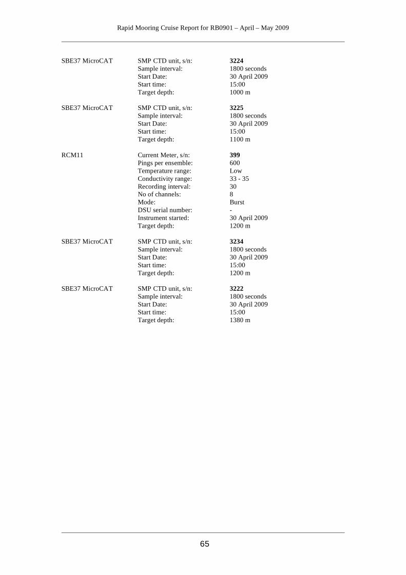
Rapid Mooring Cruise Report for RB0901 – April – May 2009
65
SBE37 MicroCAT SMP CTD unit, s/n: 3224 Sample interval: 1800 seconds Start Date: 30 April 2009 Start time: 15:00 Target depth: 1000 m SBE37 MicroCAT SMP CTD unit, s/n: 3225 Sample interval: 1800 seconds Start Date: 30 April 2009 Start time: 15:00 Target depth: 1100 m RCM11 Current Meter, s/n: 399 Pings per ensemble: 600 Temperature range: Low Conductivity range: 33 - 35 Recording interval: 30 No of channels: 8 Mode: Burst DSU serial number: - Instrument started: 30 April 2009 Target depth: 1200 m SBE37 MicroCAT SMP CTD unit, s/n: 3234 Sample interval: 1800 seconds Start Date: 30 April 2009 Start time: 15:00 Target depth: 1200 m SBE37 MicroCAT SMP CTD unit, s/n: 3222 Sample interval: 1800 seconds Start Date: 30 April 2009 Start time: 15:00 Target depth: 1380 m
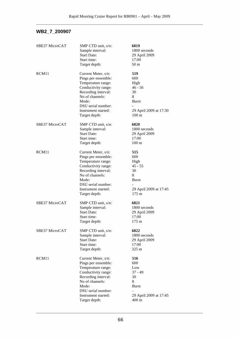
Rapid Mooring Cruise Report for RB0901 – April – May 2009
66
WB2_7_200907 SBE37 MicroCAT SMP CTD unit, s/n: 6819 Sample interval: 1800 seconds Start Date: 29 April 2009 Start time: 17:00 Target depth: 50 m RCM11 Current Meter, s/n: 519 Pings per ensemble: 600 Temperature range: High Conductivity range: 46 - 56 Recording interval: 30 No of channels: 8 Mode: Burst DSU serial number: - Instrument started: 29 April 2009 at 17:30 Target depth: 100 m SBE37 MicroCAT SMP CTD unit, s/n: 6820 Sample interval: 1800 seconds Start Date: 29 April 2009 Start time: 17:00 Target depth: 100 m RCM11 Current Meter, s/n: 515 Pings per ensemble: 600 Temperature range: High Conductivity range: 45 - 55 Recording interval: 30 No of channels: 8 Mode: Burst DSU serial number: - Instrument started: 29 April 2009 at 17:45 Target depth: 175 m SBE37 MicroCAT SMP CTD unit, s/n: 6821 Sample interval: 1800 seconds Start Date: 29 April 2009 Start time: 17:00 Target depth: 175 m SBE37 MicroCAT SMP CTD unit, s/n: 6822 Sample interval: 1800 seconds Start Date: 29 April 2009 Start time: 17:00 Target depth: 325 m RCM11 Current Meter, s/n: 516 Pings per ensemble: 600 Temperature range: Low Conductivity range: 37 - 49 Recording interval: 30 No of channels: 8 Mode: Burst DSU serial number: - Instrument started: 29 April 2009 at 17:45 Target depth: 400 m
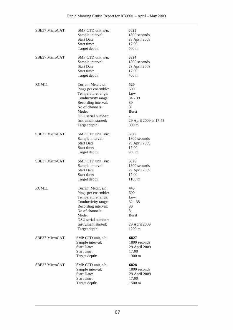
Rapid Mooring Cruise Report for RB0901 – April – May 2009
67
SBE37 MicroCAT SMP CTD unit, s/n: 6823 Sample interval: 1800 seconds Start Date: 29 April 2009 Start time: 17:00 Target depth: 500 m SBE37 MicroCAT SMP CTD unit, s/n: 6824 Sample interval: 1800 seconds Start Date: 29 April 2009 Start time: 17:00 Target depth: 700 m RCM11 Current Meter, s/n: 520 Pings per ensemble: 600 Temperature range: Low Conductivity range: 34 - 39 Recording interval: 30 No of channels: 8 Mode: Burst DSU serial number: - Instrument started: 29 April 2009 at 17:45 Target depth: 800 m SBE37 MicroCAT SMP CTD unit, s/n: 6825 Sample interval: 1800 seconds Start Date: 29 April 2009 Start time: 17:00 Target depth: 900 m SBE37 MicroCAT SMP CTD unit, s/n: 6826 Sample interval: 1800 seconds Start Date: 29 April 2009 Start time: 17:00 Target depth: 1100 m RCM11 Current Meter, s/n: 443 Pings per ensemble: 600 Temperature range: Low Conductivity range: 32 - 35 Recording interval: 30 No of channels: 8 Mode: Burst DSU serial number: - Instrument started: 29 April 2009 Target depth: 1200 m SBE37 MicroCAT SMP CTD unit, s/n: 6827 Sample interval: 1800 seconds Start Date: 29 April 2009 Start time: 17:00 Target depth: 1300 m SBE37 MicroCAT SMP CTD unit, s/n: 6828 Sample interval: 1800 seconds Start Date: 29 April 2009 Start time: 17:00 Target depth: 1500 m
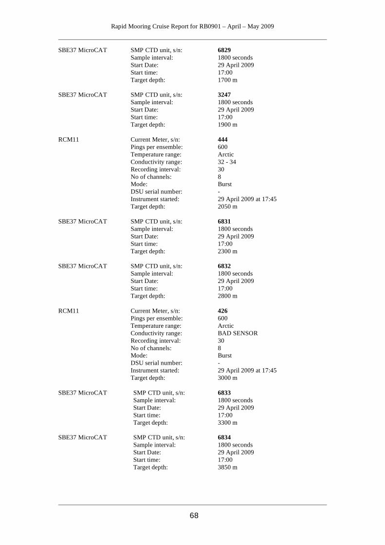
Rapid Mooring Cruise Report for RB0901 – April – May 2009
68
SBE37 MicroCAT SMP CTD unit, s/n: 6829 Sample interval: 1800 seconds Start Date: 29 April 2009 Start time: 17:00 Target depth: 1700 m SBE37 MicroCAT SMP CTD unit, s/n: 3247 Sample interval: 1800 seconds Start Date: 29 April 2009 Start time: 17:00 Target depth: 1900 m RCM11 Current Meter, s/n: 444 Pings per ensemble: 600 Temperature range: Arctic Conductivity range: 32 - 34 Recording interval: 30 No of channels: 8 Mode: Burst DSU serial number: - Instrument started: 29 April 2009 at 17:45 Target depth: 2050 m SBE37 MicroCAT SMP CTD unit, s/n: 6831 Sample interval: 1800 seconds Start Date: 29 April 2009 Start time: 17:00 Target depth: 2300 m SBE37 MicroCAT SMP CTD unit, s/n: 6832 Sample interval: 1800 seconds Start Date: 29 April 2009 Start time: 17:00 Target depth: 2800 m RCM11 Current Meter, s/n: 426 Pings per ensemble: 600 Temperature range: Arctic Conductivity range: BAD SENSOR Recording interval: 30 No of channels: 8 Mode: Burst DSU serial number: - Instrument started: 29 April 2009 at 17:45 Target depth: 3000 m SBE37 MicroCAT SMP CTD unit, s/n: 6833 Sample interval: 1800 seconds Start Date: 29 April 2009 Start time: 17:00 Target depth: 3300 m SBE37 MicroCAT SMP CTD unit, s/n: 6834 Sample interval: 1800 seconds Start Date: 29 April 2009 Start time: 17:00 Target depth: 3850 m
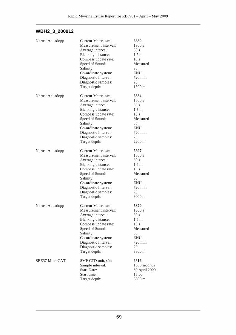
Rapid Mooring Cruise Report for RB0901 – April – May 2009
69
WBH2_3_200912 Nortek Aquadopp Current Meter, s/n: 5889 Measurement interval: 1800 s Average interval: 30 s Blanking distance: 1.5 m Compass update rate: 10 s Speed of Sound: Measured Salinity: 35 Co-ordinate system: ENU Diagnostic Interval: 720 min Diagnostic samples: 20 Target depth: 1500 m Nortek Aquadopp Current Meter, s/n: 5884 Measurement interval: 1800 s Average interval: 30 s Blanking distance: 1.5 m Compass update rate: 10 s Speed of Sound: Measured Salinity: 35 Co-ordinate system: ENU Diagnostic Interval: 720 min Diagnostic samples: 20 Target depth: 2200 m Nortek Aquadopp Current Meter, s/n: 5897 Measurement interval: 1800 s Average interval: 30 s Blanking distance: 1.5 m Compass update rate: 10 s Speed of Sound: Measured Salinity: 35 Co-ordinate system: ENU Diagnostic Interval: 720 min Diagnostic samples: 20 Target depth: 3000 m Nortek Aquadopp Current Meter, s/n: 5879 Measurement interval: 1800 s Average interval: 30 s Blanking distance: 1.5 m Compass update rate: 10 s Speed of Sound: Measured Salinity: 35 Co-ordinate system: ENU Diagnostic Interval: 720 min Diagnostic samples: 20 Target depth: 3800 m SBE37 MicroCAT SMP CTD unit, s/n: 6816 Sample interval: 1800 seconds Start Date: 30 April 2009 Start time: 15:00 Target depth: 3800 m
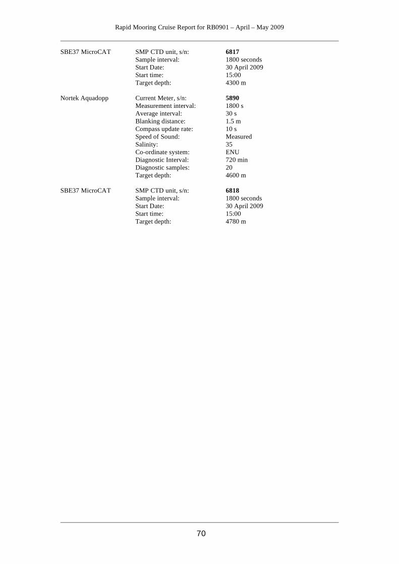
Rapid Mooring Cruise Report for RB0901 – April – May 2009
70
SBE37 MicroCAT SMP CTD unit, s/n: 6817 Sample interval: 1800 seconds Start Date: 30 April 2009 Start time: 15:00 Target depth: 4300 m Nortek Aquadopp Current Meter, s/n: 5890 Measurement interval: 1800 s Average interval: 30 s Blanking distance: 1.5 m Compass update rate: 10 s Speed of Sound: Measured Salinity: 35 Co-ordinate system: ENU Diagnostic Interval: 720 min Diagnostic samples: 20 Target depth: 4600 m SBE37 MicroCAT SMP CTD unit, s/n: 6818 Sample interval: 1800 seconds Start Date: 30 April 2009 Start time: 15:00 Target depth: 4780 m
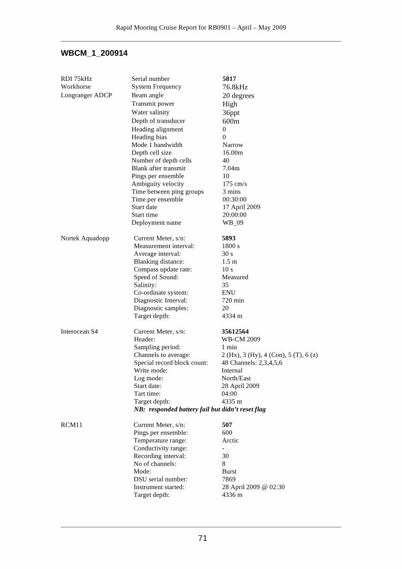
Rapid Mooring Cruise Report for RB0901 – April – May 2009
71
WBCM_1_200914 RDI 75kHz Serial number 5817 Workhorse System Frequency 76.8kHz Longranger ADCP Beam angle 20 degrees Transmit power High Water salinity 36ppt Depth of transducer 600m Heading alignment 0 Heading bias 0 Mode 1 bandwidth Narrow Depth cell size 16.00m Number of depth cells 40 Blank after transmit 7.04m Pings per ensemble 10 Ambiguity velocity 175 cm/s Time between ping groups 3 mins Time per ensemble 00:30:00 Start date 17 April 2009 Start time 20:00:00 Deployment name WB_09 Nortek Aquadopp Current Meter, s/n: 5893 Measurement interval: 1800 s Average interval: 30 s Blanking distance: 1.5 m Compass update rate: 10 s Speed of Sound: Measured Salinity: 35 Co-ordinate system: ENU Diagnostic Interval: 720 min Diagnostic samples: 20 Target depth: 4334 m Interocean S4 Current Meter, s/n: 35612564 Header: WB-CM 2009 Sampling period: 1 min Channels to average: 2 (Hx), 3 (Hy), 4 (Con), 5 (T), 6 (z) Special record block count: 48 Channels: 2,3,4,5,6 Write mode: Internal Log mode: North/East Start date: 28 April 2009 Tart time: 04:00 Target depth: 4335 m NB: responded battery fail but didn’t reset flag RCM11 Current Meter, s/n: 507 Pings per ensemble: 600 Temperature range: Arctic Conductivity range: - Recording interval: 30 No of channels: 8 Mode: Burst DSU serial number: 7869 Instrument started: 28 April 2009 @ 02:30 Target depth: 4336 m
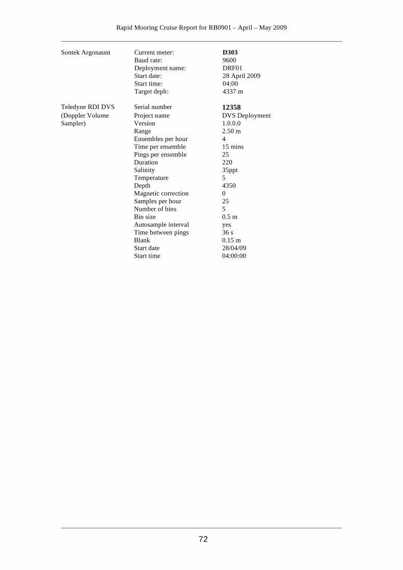
Rapid Mooring Cruise Report for RB0901 – April – May 2009
72
Sontek Argonaunt Current meter: D303 Baud rate: 9600 Deployment name: DRF01 Start date: 28 April 2009 Start time: 04:00 Target deph: 4337 m Teledyne RDI DVS Serial number 12358 (Doppler Volume Project name DVS Deployment Sampler) Version 1.0.0.0 Range 2.50 m Ensembles per hour 4 Time per ensemble 15 mins Pings per ensemble 25 Duration 220 Salinity 35ppt Temperature 5 Depth 4350 Magnetic correction 0 Samples per hour 25 Number of bins 5 Bin size 0.5 m Autosample interval yes Time between pings 36 s Blank 0.15 m Start date 28/04/09 Start time 04:00:00
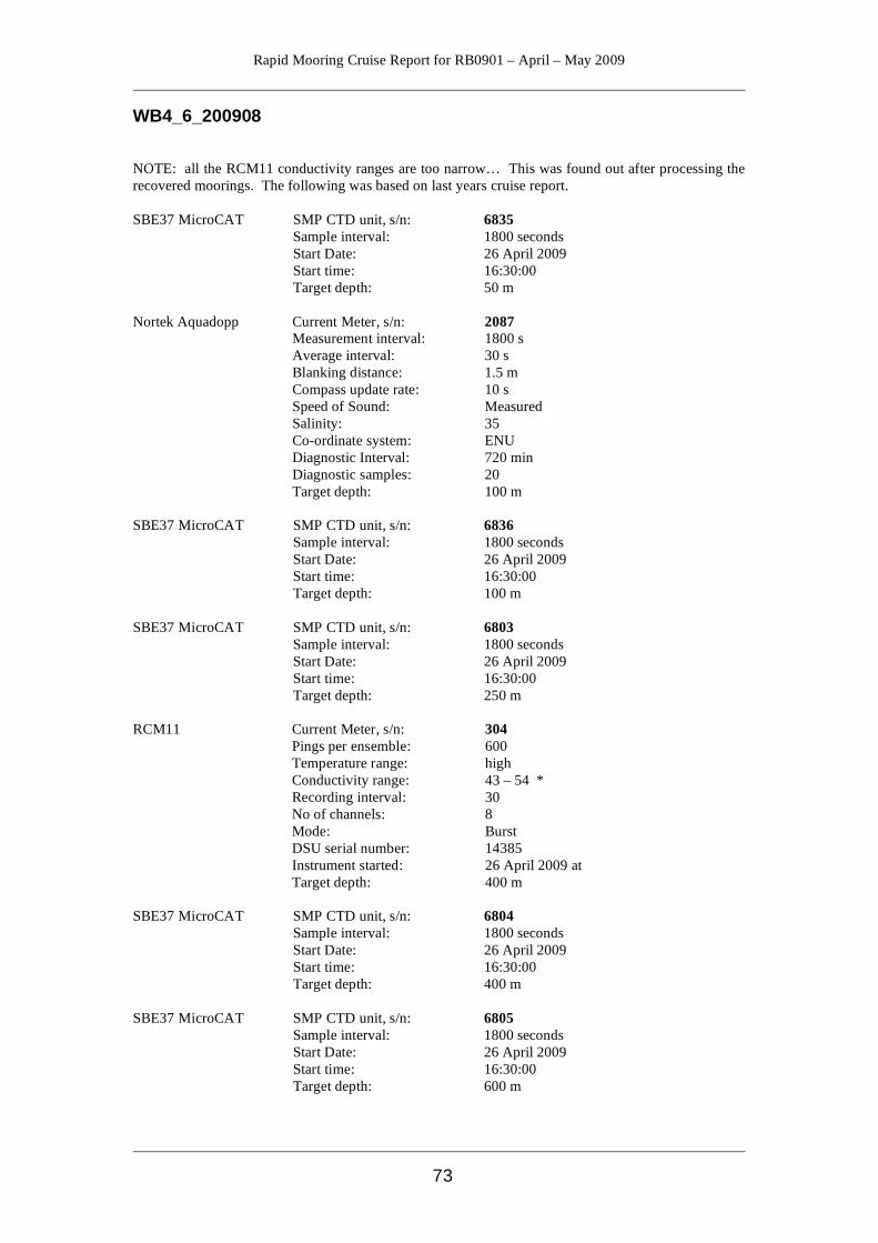
Rapid Mooring Cruise Report for RB0901 – April – May 2009
73
WB4_6_200908 NOTE: all the RCM11 conductivity ranges are too narrow… This was found out after processing the recovered moorings. The following was based on last years cruise report. SBE37 MicroCAT SMP CTD unit, s/n: 6835 Sample interval: 1800 seconds Start Date: 26 April 2009 Start time: 16:30:00 Target depth: 50 m Nortek Aquadopp Current Meter, s/n: 2087 Measurement interval: 1800 s Average interval: 30 s Blanking distance: 1.5 m Compass update rate: 10 s Speed of Sound: Measured Salinity: 35 Co-ordinate system: ENU Diagnostic Interval: 720 min Diagnostic samples: 20 Target depth: 100 m SBE37 MicroCAT SMP CTD unit, s/n: 6836 Sample interval: 1800 seconds Start Date: 26 April 2009 Start time: 16:30:00 Target depth: 100 m SBE37 MicroCAT SMP CTD unit, s/n: 6803 Sample interval: 1800 seconds Start Date: 26 April 2009 Start time: 16:30:00 Target depth: 250 m RCM11 Current Meter, s/n: 304 Pings per ensemble: 600 Temperature range: high Conductivity range: 43 – 54 * Recording interval: 30 No of channels: 8 Mode: Burst DSU serial number: 14385 Instrument started: 26 April 2009 at Target depth: 400 m SBE37 MicroCAT SMP CTD unit, s/n: 6804 Sample interval: 1800 seconds Start Date: 26 April 2009 Start time: 16:30:00 Target depth: 400 m SBE37 MicroCAT SMP CTD unit, s/n: 6805 Sample interval: 1800 seconds Start Date: 26 April 2009 Start time: 16:30:00 Target depth: 600 m
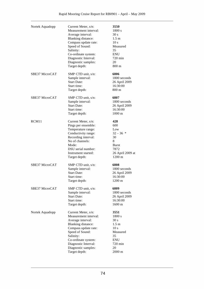
Rapid Mooring Cruise Report for RB0901 – April – May 2009
74
Nortek Aquadopp Current Meter, s/n: 3550 Measurement interval: 1800 s Average interval: 30 s Blanking distance: 1.5 m Compass update rate: 10 s Speed of Sound: Measured Salinity: 35 Co-ordinate system: ENU Diagnostic Interval: 720 min Diagnostic samples: 20 Target depth: 800 m SBE37 MicroCAT SMP CTD unit, s/n: 6806 Sample interval: 1800 seconds Start Date: 26 April 2009 Start time: 16:30:00 Target depth: 800 m SBE37 MicroCAT SMP CTD unit, s/n: 6807 Sample interval: 1800 seconds Start Date: 26 April 2009 Start time: 16:30:00 Target depth: 1000 m RCM11 Current Meter, s/n: 428 Pings per ensemble: 600 Temperature range: Low Conductivity range: 32 – 36 * Recording interval: 30 No of channels: 8 Mode: Burst DSU serial number: 7872 Instrument started: 26 April 2009 at Target depth: 1200 m SBE37 MicroCAT SMP CTD unit, s/n: 6808 Sample interval: 1800 seconds Start Date: 26 April 2009 Start time: 16:30:00 Target depth: 1200 m SBE37 MicroCAT SMP CTD unit, s/n: 6809 Sample interval: 1800 seconds Start Date: 26 April 2009 Start time: 16:30:00 Target depth: 1600 m Nortek Aquadopp Current Meter, s/n: 3551 Measurement interval: 1800 s Average interval: 30 s Blanking distance: 1.5 m Compass update rate: 10 s Speed of Sound: Measured Salinity: 35 Co-ordinate system: ENU Diagnostic Interval: 720 min Diagnostic samples: 20 Target depth: 2000 m

Rapid Mooring Cruise Report for RB0901 – April – May 2009
75
SBE37 MicroCAT SMP CTD unit, s/n: 6810 Sample interval: 1800 seconds Start Date: 26 April 2009 Start time: 16:30:00 Target depth: 2000 m SBE37 MicroCAT SMP CTD unit, s/n: 6811 Sample interval: 1800 seconds Start Date: 26 April 2009 Start time: 16:30:00 Target depth: 2500 m RCM11 Current Meter, s/n: 518 Pings per ensemble: 600 Temperature range: Arctic Conductivity range: 32 – 34 * Recording interval: 30 No of channels: 8 Mode: Burst DSU serial number: 14695 Instrument started: 26 April 2009 at Target depth: 3000 m SBE37 MicroCAT SMP CTD unit, s/n: 6812 Sample interval: 1800 seconds Start Date: 26 April 2009 Start time: 16:30:00 Target depth: 3000 m SBE37 MicroCAT SMP CTD unit, s/n: 6813 Sample interval: 1800 seconds Start Date: 26 April 2009 Start time: 16:30:00 Target depth: 3500 m Nortek Aquadopp Current Meter, s/n: 3552 Measurement interval: 1800 s Average interval: 30 s Blanking distance: 1.5 m Compass update rate: 10 s Speed of Sound: Measured Salinity: 35 Co-ordinate system: ENU Diagnostic Interval: 720 min Diagnostic samples: 20 Target depth: 4000 m SBE37 MicroCAT SMP CTD unit, s/n: 6814 Sample interval: 1800 seconds Start Date: 26 April 2009 Start time: 16:30:00 Target depth: 4000 m SBE37 MicroCAT SMP CTD unit, s/n: 6815 Sample interval: 1800 seconds Start Date: 26 April 2009 Start time: 16:30:00 Target depth: 4500 m
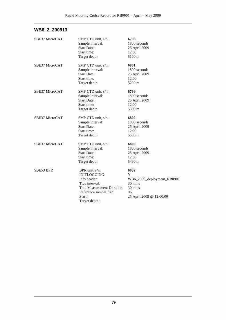
Rapid Mooring Cruise Report for RB0901 – April – May 2009
76
WB6_2_200913 SBE37 MicroCAT SMP CTD unit, s/n: 6798 Sample interval: 1800 seconds Start Date: 25 April 2009 Start time: 12:00 Target depth: 5100 m SBE37 MicroCAT SMP CTD unit, s/n: 6801 Sample interval: 1800 seconds Start Date: 25 April 2009 Start time: 12:00 Target depth: 5200 m SBE37 MicroCAT SMP CTD unit, s/n: 6799 Sample interval: 1800 seconds Start Date: 25 April 2009 Start time: 12:00 Target depth: 5300 m SBE37 MicroCAT SMP CTD unit, s/n: 6802 Sample interval: 1800 seconds Start Date: 25 April 2009 Start time: 12:00 Target depth: 5500 m SBE37 MicroCAT SMP CTD unit, s/n: 6800 Sample interval: 1800 seconds Start Date: 25 April 2009 Start time: 12:00 Target depth: 5490 m SBE53 BPR BPR unit, s/n: 0032 INITLOGGING: Y Info header: WB6_2009_deployment_RB0901 Tide interval: 30 mins Tide Measurement Duration: 30 mins Reference sample freq: 96 Start: 25 April 2009 @ 12:00:00 Target depth:
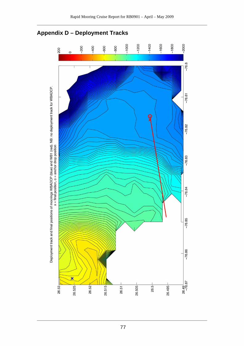
Rapid Mooring Cruise Report for RB0901 – April – May 2009
77
Appendix D – Deployment Tracks

Rapid Mooring Cruise Report for RB0901 – April – May 2009
78
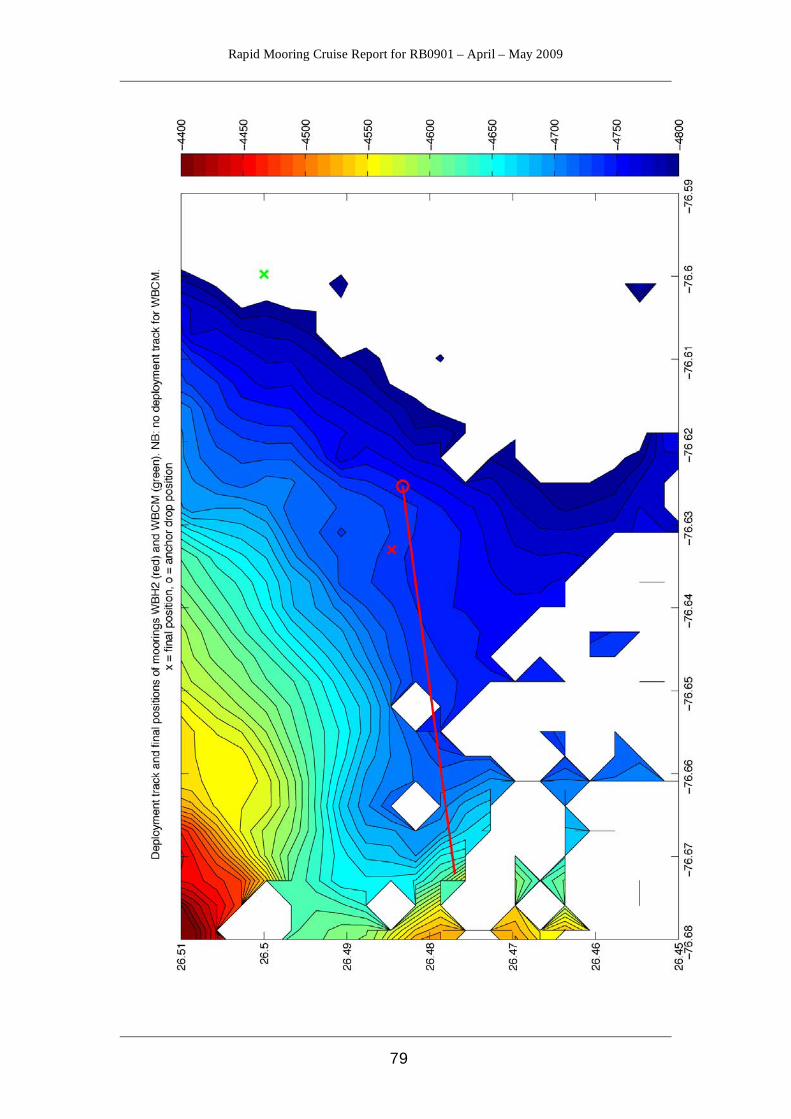
Rapid Mooring Cruise Report for RB0901 – April – May 2009
79
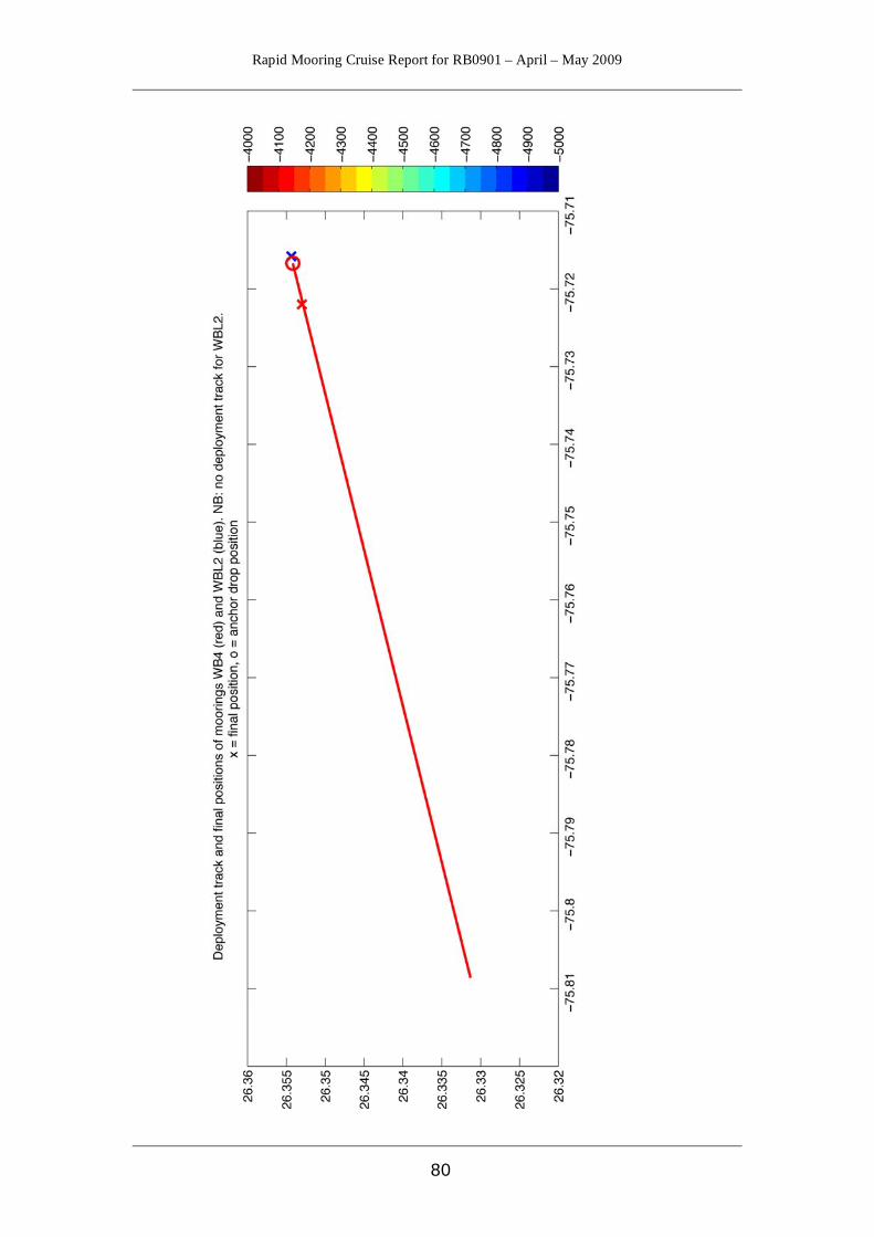
Rapid Mooring Cruise Report for RB0901 – April – May 2009
80

Rapid Mooring Cruise Report for RB0901 – April – May 2009
81
Appendix E - Mooring Diagrams
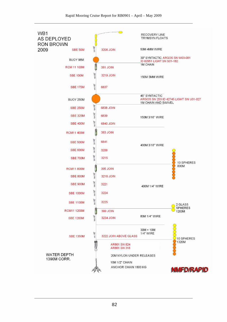
Rapid Mooring Cruise Report for RB0901 – April – May 2009
82
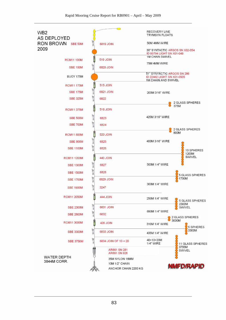
Rapid Mooring Cruise Report for RB0901 – April – May 2009
83

Rapid Mooring Cruise Report for RB0901 – April – May 2009
84
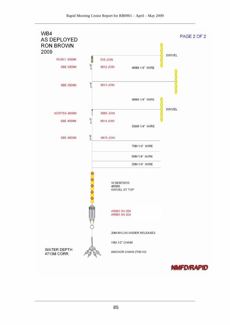
Rapid Mooring Cruise Report for RB0901 – April – May 2009
85
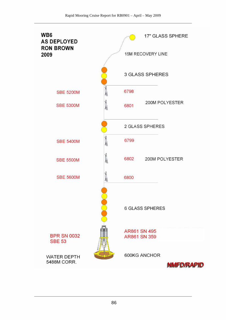
Rapid Mooring Cruise Report for RB0901 – April – May 2009
86
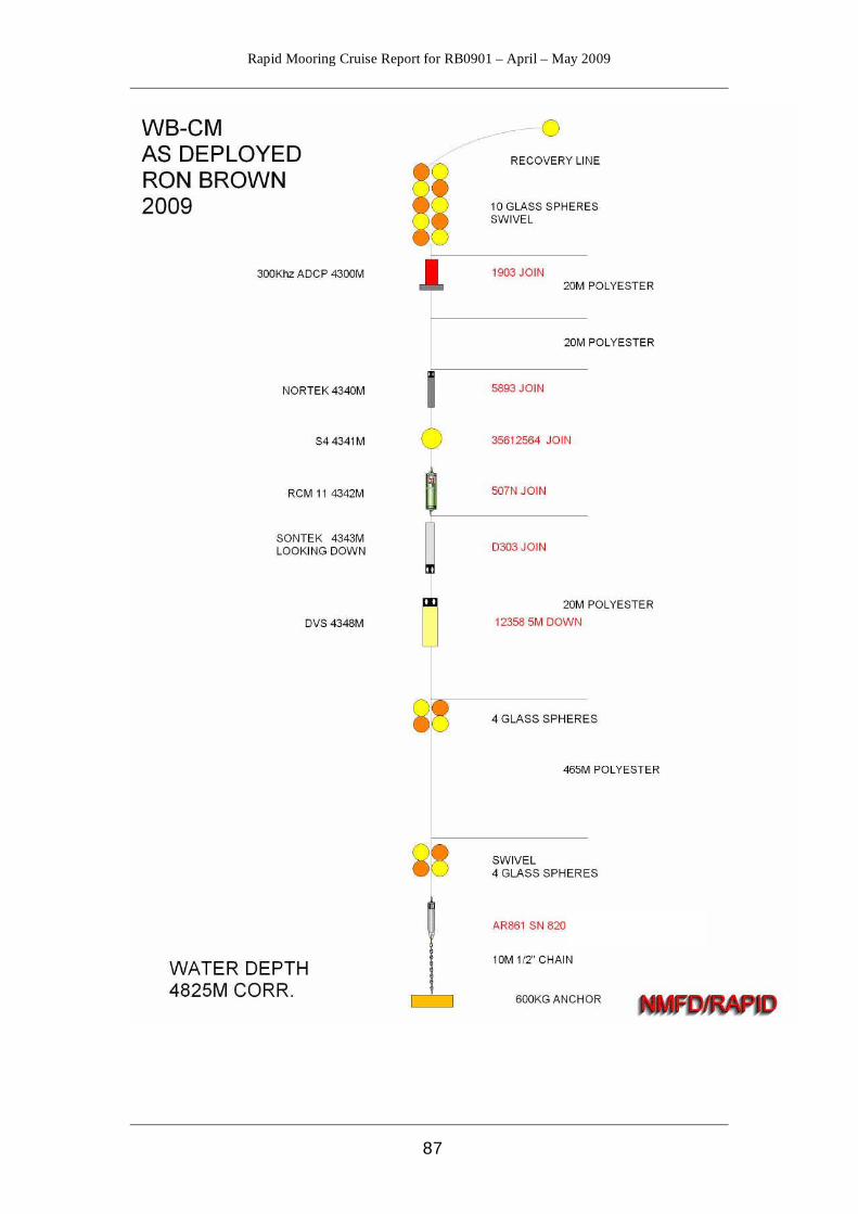
Rapid Mooring Cruise Report for RB0901 – April – May 2009
87
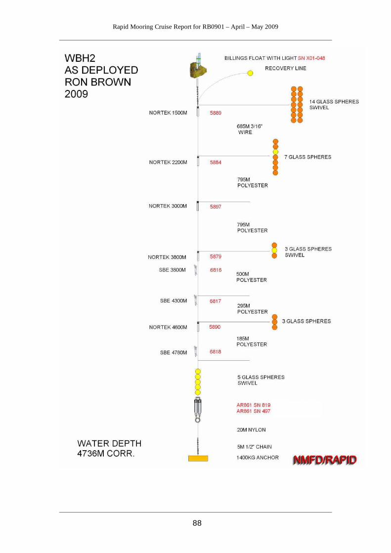
Rapid Mooring Cruise Report for RB0901 – April – May 2009
88
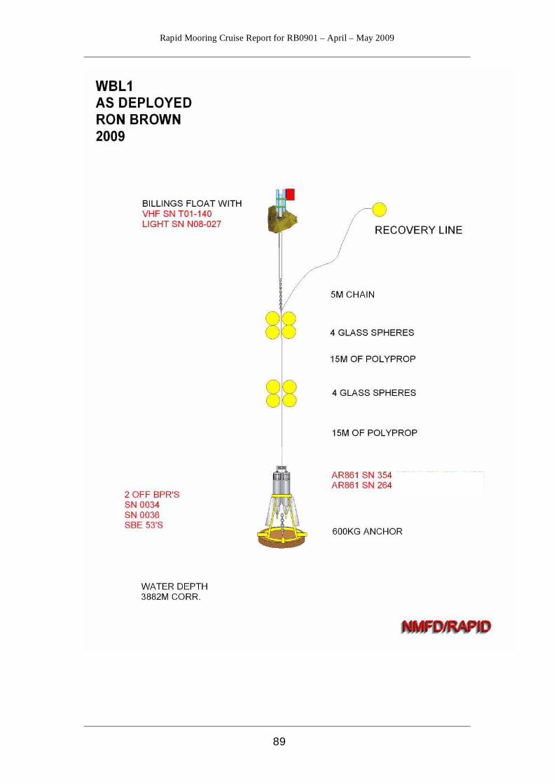
Rapid Mooring Cruise Report for RB0901 – April – May 2009
89
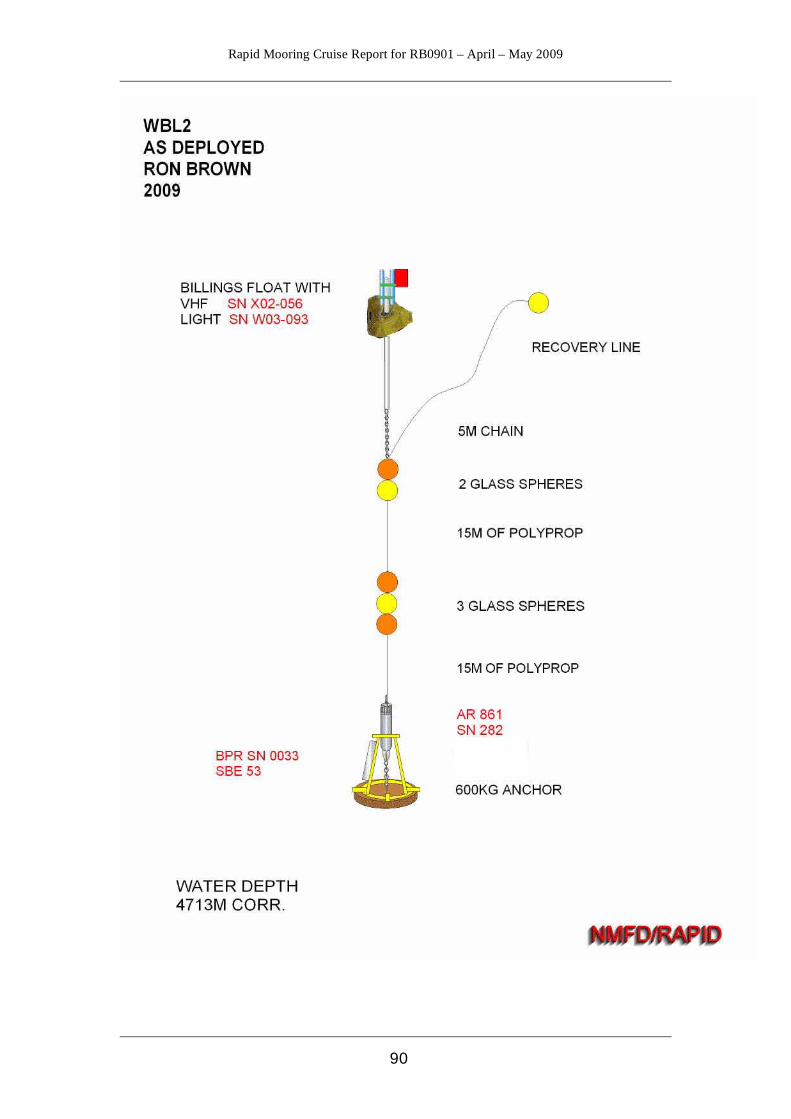
Rapid Mooring Cruise Report for RB0901 – April – May 2009
90

Rapid Mooring Cruise Report for RB0901 – April – May 2009
91
Appendix F - Acoustic Release Record

Rapid Mooring Cruise Report for RB0901 – April – May 2009
92
Appendix G - Logsheets These are scanned images due to past cases of typos being discovered in the logsheets.