Wales Marine Survey 2020 - British Oceanographic Data Centre
86
Wales Marine Survey 2020 Geological Survey Ireland is a division of the Department of the Environment, Climate and Communicaons
-
Upload
khangminh22 -
Category
Documents
-
view
1 -
download
0
Transcript of Wales Marine Survey 2020 - British Oceanographic Data Centre

Wales Marine Survey 2020
Geological Survey Ireland is a division of the Department of the Environment, Climate and Communica�ons
Document Information
Project title: CHERISH: Wales Marine Survey 2020 Current Document version: Final Version
Prepared By Date Comment
Kieran Craven 28th June 2021 Consultant CHERISH Project, Rodinia Consulting Ltd
James Barry 28th June 2021 Consultant CHERISH Project, Rodinia Consulting Ltd
Reviewed by Date Comment
David Hardy 29th June 2021
David Hardy 12th July 2021
David Hardy 27th July 2021
Approved By Date Comment
Sean Cullen 28th July 2021 Geological Survey Ireland
Version History
Ver. No. Ver. Date Comment By
1.1 28/06/21 Draft 1 KC, JB
2.1 01/07/21 Draft 2 KC, JB
2.2 12/07/21 Draft 2 KC, JB
Final 03/08/21 Final Version KC, JB
CHERISH: Wales Marine Survey 2020
ii
Table of Contents
Executive summary .................................................................................................... 1
1. Introduction ....................................................................................................... 2
1.1. Marine Survey Overview .................................................................................. 2
1.2. Geological Survey Ireland ................................................................................ 2
1.3. The CHERISH Project ........................................................................................ 3
2. Survey Overview and Activity .............................................................................. 4
2.1. Project Overview ............................................................................................. 4
2.2. Survey Area ...................................................................................................... 4
2.3. Survey Team .................................................................................................... 4
2.4. Survey Statistics ............................................................................................... 5
3. Survey Systems and Setup................................................................................... 7
3.1. Survey Platforms .............................................................................................. 7
3.1.1. R.V. Keary .............................................................................................. 7
3.1.2. Survey Software Utilised ....................................................................... 8
3.2. Geodetic Parameters ....................................................................................... 9
3.3. Vessel Dimension Control ................................................................................ 9
3.3.1. R.V. Keary .............................................................................................. 9
3.4. Calibration and Validation Work .................................................................... 10
3.5. Survey Order and Objectives ......................................................................... 11
3.6. Survey Datum, GNSS Tides and VORF Model ................................................. 11
4. Survey Data Summary (Data Rendered) ..............................................................13
4.1. Overview ........................................................................................................ 13
4.2. MBES Data ..................................................................................................... 13
CHERISH: Wales Marine Survey 2020
iii
4.3. SBES Data ....................................................................................................... 13
4.4. Shallow Seismic Data ..................................................................................... 13
4.5. Navigation Data ............................................................................................. 14
4.6. Water Column, Sound Velocity and Oceanographic Data .............................. 14
4.7. Backscatter Data ............................................................................................ 14
4.8. QINSy Online Navigation Data ....................................................................... 14
4.9. Final Data Delivery ......................................................................................... 15
5. Data Processing .................................................................................................16
5.1. Data Processing ............................................................................................. 16
5.2. Navigation Processing .................................................................................... 16
5.3. MBES Data Processing Methodology ............................................................. 16
5.3.1. Sounding Data Processing Workflow .................................................. 16
5.3.2. Backscatter Mosaic Generation .......................................................... 17
6. Quality Control and Quality Assurance ...............................................................18
6.1. QA and QC Procedures Overview .................................................................. 18
6.2. Operational and Online QA Procedures ......................................................... 18
6.3. Post Data Acquisition QC Procedures ............................................................ 18
6.4. Survey Standard ............................................................................................. 19
6.5. CARIS Hips & Sips Total Propagated Uncertainty Models .............................. 19
6.6. Sound Velocity Regime and Environmental Control ...................................... 20
6.7. Cross-line Statistics ........................................................................................ 20
6.8. System Checks and Calibration ...................................................................... 21
6.8.1. Calibration Patch Tests ........................................................................ 21
6.9. Sounding Density ........................................................................................... 22
6.10. Ground truthing ......................................................................................... 23

CHERISH: Wales Marine Survey 2020
iv
7. Data Deliverables...............................................................................................24
7.1. Data Structure and Management .................................................................. 24
7.2. Data Deliverables ........................................................................................... 24
8. Survey Results ...................................................................................................26
8.1. Bathymetry .................................................................................................... 26
8.1.1. Sarn Badrig .......................................................................................... 26
8.1.2. Dinas Dinlle ......................................................................................... 28
8.2. Backscatter Data ............................................................................................ 30
8.3. Shallow Seismic Data ..................................................................................... 33
8.4. Wreck Surveys ............................................................................................... 33
8.5. Seabed Contacts ............................................................................................ 35
8.6. Shoal Investigations (H102 Forms)................................................................. 35
8.7. Marine Mammal Observations ...................................................................... 35
8.8. Seabed Sampling and Ground-truthing.......................................................... 36
9. Conclusion .........................................................................................................37
9.1. Conclusions and Final Remarks ...................................................................... 37
References ................................................................................................................38
Glossary....................................................................................................................39
Appendix A Diplomatic Clearance for Survey .............................................................40
Appendix B Marine Mammal Observation Report ......................................................44
Appendix C: H-Notes from Survey ..............................................................................61

CHERISH: Wales Marine Survey 2020 - 1 -
Executive summary
Table 1: Survey Summary
Survey Summary
Survey Vessels: R.V. Keary (GSI)
Survey Legs: KRY20_03
Mobilisation Port: Arklow, Co. Wicklow Demobilisation Port:
Dun Laoghaire, Co. Dublin
Survey Area/s: Cardigan Bay, Wales Caernarfon Bay, Wales
Survey Duration: 01/09/2020 – 19/09/2020
N Boundary: S Boundary: E Boundary: W Boundary:
53.12437° N 52.67900° N 4.122334° W 4.413649° W
} WGS1984
UKHO Admiralty Charts 0002, 1121, 1123, 1410, 1411, 1970, 1971, 1972,
Key References
Survey Statistics
Minimum Water Depth (LAT):
0 m above LAT Maximum Water Depth (LAT):
15 m below LAT
Area Covered (Km2): 25.6 Survey Line Kilometres: 914.4
Operational (based on 24h days):
KRY – 3d 20h
Downtime (based on 24h days):
KRY – 2d 08h
Groundtruthing Stations:
0 Incidents to Report 0

CHERISH: Wales Marine Survey 2020 - 2 -
1. Introduction
1.1. Marine Survey Overview
This Report of Survey document represents survey work carried out by Geological Survey Ireland vessel RV Keary in CHERISH areas in Cardigan and Caernarfon Bays, Wales in 2020. Authorisation for the survey was received from the Maritime Policy Unit of the Foreign & Commonwealth Office (Ref 66/2020). There was no requirement for a marine licence for the activities conducted (multibeam geophysical surveys) as outlined by the Marine Management Organisation guidance.
This document is intended to provide a thorough overview of survey specifications, standards and quality control measures implemented during survey operations. It provides a record of the datasets acquired during operations and a description of how this data was modified (processed) and managed before leaving the vessel for final validation and distribution to the end user.
The CHERISH project identified two sites in Cardigan and Caernarfon Bays for which the project required detailed bathymetric surveys (Sarn Badrig and Dinas Dinlle). Three main site types were targeted: reefs, headlands, and shipwrecks. Reefs for multibeam surveys included Sarn Badrig in Cardigan Bay, while headlands included Dinas Dinlle in Caernarfon Bay. The wreck of “The Bronze Bell off Tel Y Bont, Gwynedd” (hereafter “The Bronze Bell”) was selected due to its designated status. Headland bathymetry will be used to generate seamless onshore-offshore maps. Multibeam surveying was carried out in depths <50m using the Geological Survey research vessel Keary which is equipped with a Kongsberg EM 2040 D multibeam echosounder between the 1st and 19th September 2020. Sub-bottom profiling using an Edgetech CHIRP 3200 was conducted along all survey lines.
While survey results are presented in the final section of this document, it is designed to be used in conjunction with a standard set of additional reports which are included as appendices. Accordingly, when taken together with this Report of Survey document, the appendices form the overall CHERISH North Wales 2020 survey report The data presented in this report, particularly hydrographic data, is acquired as part of a baseline study and should not be used for navigational purposes. Although every effort has been made to ensure the accuracy of the material contained in this report, complete accuracy cannot be guaranteed. Neither the Geological Survey Ireland nor the author accepts any responsibility whatsoever for loss or damage occasioned, or claimed to have been occasioned, in part or in full as a consequence of any person acting or refraining from acting, as a result of a matter contained in this report.
1.2. Geological Survey Ireland
Geological Survey Ireland, founded in 1845, is the national earth science agency. It is responsible for providing geological advice and information and for the acquisition of data for this purpose. GSI produces a range of products including maps, reports and databases and acts as a knowledge centre and project partner in all aspects of Irish geology. GSI is a division of the Department of the Environment, Climate and Communications.

CHERISH: Wales Marine Survey 2020 - 3 -
1.3. The CHERISH Project
The CHERISH (Climate, Heritage and Environments of Reefs, Islands and Headlands) Project is a 6 year (2017-2022) European-funded Ireland-Wales project between the Royal Commission on the Ancient and Historical Monuments of Wales, the Discovery Programme: Centre for Archaeology and Innovation Ireland, Aberystwyth University: Department of Geography and Earth Sciences and Geological Survey Ireland. The project will receive €5.1 million through the Ireland Wales 2014-2020 European Territorial Cooperation Programme.
CHERISH is a cross-disciplinary project. It aims to raise awareness and understanding of the past, present and near future impacts of climate change, storminess and extreme weather events on the rich cultural heritage of the Irish and Welsh regional seas and coast. It employs innovative techniques to study some of the most iconic coastal locations in Ireland and Wales: www.cherishproject.eu
CHERISH: Wales Marine Survey 2020 - 4 -
2. Survey Overview and Activity
2.1. Project Overview
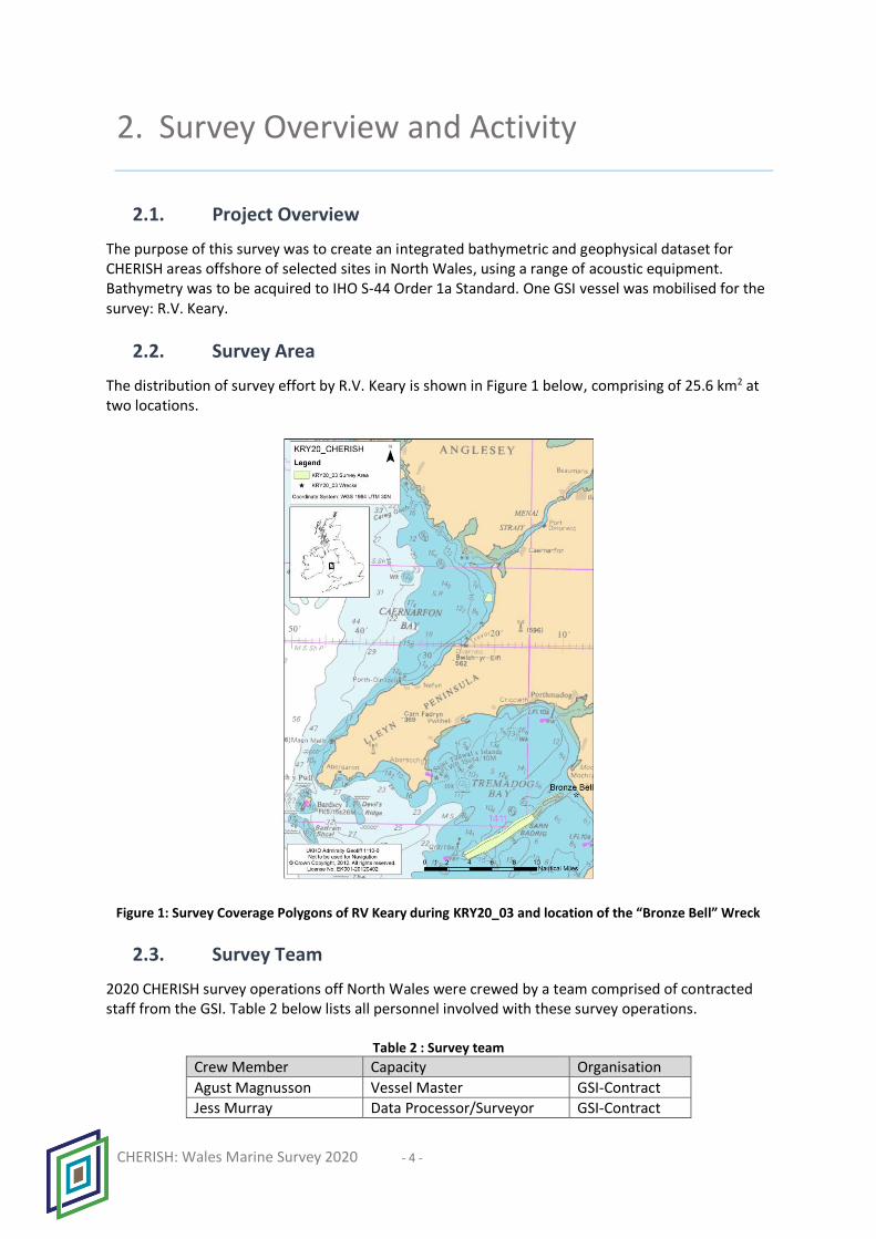
The purpose of this survey was to create an integrated bathymetric and geophysical dataset for CHERISH areas offshore of selected sites in North Wales, using a range of acoustic equipment. Bathymetry was to be acquired to IHO S-44 Order 1a Standard. One GSI vessel was mobilised for the survey: R.V. Keary.
2.2. Survey Area
The distribution of survey effort by R.V. Keary is shown in Figure 1 below, comprising of 25.6 km2 at two locations.
Figure 1: Survey Coverage Polygons of RV Keary during KRY20_03 and location of the “Bronze Bell” Wreck
2.3. Survey Team
2020 CHERISH survey operations off North Wales were crewed by a team comprised of contracted staff from the GSI. Table 2 below lists all personnel involved with these survey operations.
Table 2 : Survey team
Crew Member Capacity Organisation
Agust Magnusson Vessel Master GSI-Contract
Jess Murray Data Processor/Surveyor GSI-Contract

CHERISH: Wales Marine Survey 2020 - 5 -
2.4. Survey Statistics
Operations tables for the 2020 CHERISH North Wales survey are provided along with an over-arching summary of activity conducted. Should an individual day by day breakdown be required, this information is contained in the digital DPR (Daily Progress Report) issued each day and within the final project data delivery. Table 3 provides a breakdown of how daily events are categorised for reporting purposes. For INFOMAR survey operations, the inshore survey vessels operate a 12 hour working day with 12 hours scheduled every 24 hours, for an overnight port-call.
Table 3: Event Descriptor Breakdown
Event Descriptor Events Covered
Port Call Vessel alongside, usually for night hours, PR events and mobilisation/demobilisation.
Weather Standby Operations ceased due to poor weather
Standby Survey staff are working but vessel is not acquiring survey data
Transit Vessel is operational and travelling to destination
Data Acquisition Vessel is acquiring data and or validation data
Downtime Vessel Operations ceased due to problem with vessel systems
Downtime Survey Operations ceased due to problem with survey systems
Ground-truthing Seabed sampling, video/stills imagery ground-truthing
Other Non-standard work within the scope of normal operations
Table 4: KRY20_03 Operations Summary
Stats: Hours Stats: Days Stats: Percentages
Port Call 230 9.59 47.95
Weather Standby 48 2.00 10.00
Standby 25 1.04 5.19
Transit 53 2.20 10.98
Data Acquisition 99 4.14 20.69
Downtime Vessel 2 0.10 0.50
Downtime Survey 0 0.00 0.00
Ground-truthing 0 0.00 000
Other 23 0.94 4.69
Stats: Total Hours Stats: Total Days Stats: Total Percentage
480 20.00 100

CHERISH: Wales Marine Survey 2020 - 6 -
Figure 2: KRY20_03 Survey Statistics Pie Chart normalised to Operational Window
Table 5: KRY20_03 Operational Statistics
Survey Leg Line Kilometres (km) Area Covered (km2)
KRY20_03 914.4 25.6

CHERISH: Wales Marine Survey 2020 - 7 -
3. Survey Systems and Setup
3.1. Survey Platforms
The CHERISH project utilised one survey vessel, operated by GSI, in the implementation of survey work in North Wales in 2020 – the R.V. Keary.
3.1.1. R.V. Keary The Irish state research vessel R.V. Keary is an aluminium catamaran designed for near shore survey work. She is ideally suited in this role due to her stable twin hull construction, shallow draft, retractable equipment pod and hydraulically operated A-Frame and winch. The R.V. Keary is typically crewed by a team of 3 individuals. Table 7 provides information on her design specifications and survey equipment on board.
Figure 3: R.V. Keary

CHERISH: Wales Marine Survey 2020 - 8 -
Table 6: R.V. Keary Vessel Specifications
Specification / System Information
Length OA 15.5 m
Length (hull) 14.6 m
Beam (moulded) 5.6 m
Draught 1.9 m
Draught with pod deployed 2.4 m
Engines 2 x Cummins QSC 8.3 – 500 INT
Power output 368 kW/2600 RPM/Triple Phase
Transit Speed / Survey Speed 22 knots / 7.5 knots
Fuel 2000 lt Diesel
Generator Cummins Onan 13.5 kva
Max passenger and crew 12 persons
Passenger Licence P5
MBES Kongsberg Simrad EM2040D
SBES Kongsberg Simrad EA400
Subbottom Profiler Edgetec 3200XS Chirp (pod mounted)
R/T SV AML smart probe (pod mounted)
CTD/SVP Valeport SWiFT SVP
Positioning System and IMU POS-MV OceanMaster
DGPS EGNOS Corrections
Sediment Samplers Duncan & Associates Day and Hand grabs
USBL Sonardyne Scout
SSS Edgetec 4200
3.1.2. Survey Software Utilised The table below provides details on the primary software tools utilised by survey vessel during the survey to North Wales. Further information is provided in Section 4 of this document under Survey Data Summary.
Table 7: Software Utilised
Survey Aspect Vessel Software
MBES Data Acquisition R.V. Keary Kongsberg SIS
Online Survey Planning
R.V. Keary QPS QINSy
Online Navigation QC R.V. Keary Applanix POSview
SBES Data Acquisition R.V. Keary Simrad EA400
Shallow Seismic Data Acquisition
R.V. Keary Edgetec Discovery
Data Processing R.V. Keary Applanix POSpac, QPS Qimera, Caris HIPS & SIPS
Survey Reporting and Statistics
R.V. Keary Custom Excel Worksheets
SVP Data Acquisition R.V. Keary QPS QINSY & Datalog Express
CHERISH: Wales Marine Survey 2020 - 9 -
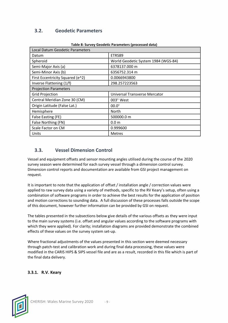
3.2. Geodetic Parameters
Table 8: Survey Geodetic Parameters (processed data)
Local Datum Geodetic Parameters
Datum ETRS89
Spheroid World Geodetic System 1984 (WGS-84)
Semi-Major Axis (a) 6378137.000 m
Semi-Minor Axis (b) 6356752.314 m
First Eccentricity Squared (e^2) 0.0066943800
Inverse Flattening (1/f) 298.257223563
Projection Parameters
Grid Projection Universal Transverse Mercator
Central Meridian Zone 30 (CM) 003 West
Origin Latitude (False Lat.) 00.0
Hemisphere North
False Easting (FE) 500000.0 m
False Northing (FN) 0.0 m
Scale Factor on CM 0.999600
Units Metres
3.3. Vessel Dimension Control
Vessel and equipment offsets and sensor mounting angles utilised during the course of the 2020 survey season were determined for each survey vessel through a dimension control survey. Dimension control reports and documentation are available from GSI project management on request. It is important to note that the application of offset / installation angle / correction values were applied to raw survey data using a variety of methods, specific to the RV Keary’s setup, often using a combination of software programs in order to achieve the best results for the application of position and motion corrections to sounding data. A full discussion of these processes falls outside the scope of this document, however further information can be provided by GSI on request. The tables presented in the subsections below give details of the various offsets as they were input to the main survey systems (i.e. offset and angular values according to the software programs with which they were applied). For clarity; installation diagrams are provided demonstrate the combined effects of these values on the survey system set-up. Where fractional adjustments of the values presented in this section were deemed necessary through patch-test and calibration work and during final data processing, these values were modified in the CARIS HIPS & SIPS vessel file and are as a result, recorded in this file which is part of the final data delivery.
3.3.1. R.V. Keary

CHERISH: Wales Marine Survey 2020 - 10 -
Installation offsets and angles for the R.V. Keary’s primary survey hardware were re-determined through dimension control survey in 2019. These values were applied to survey systems using Kongsberg SIS and Applanix POSview software. Values derived from the original dimension control survey were verified through standard calibration tests and refined where necessary.
Table 9: R.V. Keary Installation Parameters
R.V. Keary Offsets (metres) X (Stbd +) Y (Bow +) Z (Up +)
MBES Reference Point 0.000 m -0.000 m 0.000 m
EM2040 MBES Sonar Head 1 (Port) -0.341 m 0.046 m +0.087 m
EM2040 MBES Sonar Head 2 (Stbd) 0.352 m 0.041 m +0.085 m
EM2040 TX 0.000 m -0.051 m -0.083 m
Waterline Value -1.940 m
Installation Angles (degrees) Roll Pitch Heading
EM2040 MBES Sonar Head 1 (Port) 39.836° -1.504° -0.388°
EM2040 MBES Sonar Head 2 (Stbd) -39.928° -1.557° 1.240°
POS-MV IMU 0 0 0
Table 10: R.V. Keary Installation Parameters Applied in POS-MV
R.V. KearyApplanix POS-MV Software (IMU as Origin)
Heave & Sensor 1 & 2 Install Parameters. Roll Pitch Heading
Sensor 1 alignment angles (deg) 0.000 0.000 0.000
Sensor 2 alignment angles (deg) 0.000 0.000 0.000
X (Bow +) Y (+ Stbd) Z (+ Down)
Sensor 1 lever arm in meters 0.110 0.004 0.990
Sensor 2 lever arm in meters 0.000 0.000 0.000
Centre of Rotation in meters 0.000 0.000 -1.300
GAMS Install Parameters
Ant 1 – Ant 2 antenna separation (m) 3.289
Ant 1 – Ant 2 baseline vector (m) 0.004 -3.289 -0.002
Heading error for calibration 0.350
Ant 1 – Ant 2 azimuth correction 0.000
Roll Pitch Heading
Vehicle to reference alignment angles (deg) 0 0 0
Reference to IMU alignment angles (deg) -1.875 -2.282 -0.304
X (Bow +) Y (+ Stbd) Z (+ Down)
Reference to IMU lever arm (m) 0.016 -0.006 0.102
Reference to primary GNSS lever arm (m) 0.290 1.646 -6.015
3.4. Calibration and Validation Work
Survey platforms undertook individual calibration exercises and validation checks prior to the commencement of the survey season. Further information relating to this work can be found in Section 6 of this document and full details are available from GSI management on request.

CHERISH: Wales Marine Survey 2020 - 11 -
3.5. Survey Order and Objectives
Survey work was carried out to International Hydrographic Organisation (IHO) Special Publication (S-44) Order 1a. The objective for the survey was to acquire high resolution MBES bathymetry and backscatter data within the designated survey areas.
3.6. Survey Datum, GNSS Tides and VORF Model
All depth soundings delivered by GSI survey vessels were reduced to LAT using the UKHO’s VORF model. The model provides a separation value between the WGS84/ETRS89 Ellipsoid and LAT. Figure 4 provides a basic illustration of the reduction of soundings data using the UKHO VORF model value for LAT.

CHERISH: Wales Marine Survey 2020 - 12 -
Figure 4: VORF-GNSS Reduction of Soundings

CHERISH: Wales Marine Survey 2020
13
4. Survey Data Summary (Data Rendered)
4.1. Overview
Survey data acquisition conducted by GSI in the surveying of North Wales in 2020 for CHERISH was carried out by R.V Keary. Details on survey activity and vessel set up are provided in sections 1 and 2 of this document. This section provides information on data rendered by the GSI vessel.
4.2. MBES Data
Table 11: MBES Data logged during CHERISH Wales Marine Survey 2020
Descriptor Metadata Vessel R.V. Keary
Survey Leg KRY 20_03
MBES System Kongsberg Simrad EM2040D
Survey Lines (including crosslines) 387
Data Files 403 (including test lines)
Date Created 01/09/2020 – 19/09/2020
Dataset size 232 GB
File format .ALL
4.3. SBES Data
Table 12: SBES Data logged during CHERISH Wales Marine Survey 2020
Descriptor Metadata Vessel R.V. Keary
Survey Leg KRY 20_03
SBES Simrad EA400
Survey Mainlines 0
Data Files 0
Date Created N/A
Dataset size 0 MB
File format .asvp, .dg, .out, .raw, .txt, ..xyz
4.4. Shallow Seismic Data
Table 13: Shallow Seismic Data logged during CHERISH Wales Marine Survey 2020
Descriptor Metadata Vessel R.V. Keary
Survey Leg & Year KRY 20_03
Chirp Edgetec 3200XS
Survey Mainlines 382
Data Files 396
Date Created 03/09/2020 – 18/09/2020

CHERISH: Wales Marine Survey 2020
14
Dataset size 8.75 GB
File format .JSF
4.5. Navigation Data
Table 14: Navigation Data logged during CHERISH Wales Marine Survey 2020
Descriptor Metadata Vessel R.V. Keary
Survey Leg KRY 20_03
Navigation System POS-MV
Data Files 151 (excluding USB backup)
Date Created 01/09/2020 – 18/09/2020
Dataset size 8.81 GB
File format .000/.001 etc. POS MV format
4.6. Water Column, Sound Velocity and Oceanographic Data
Table 15: Sound Velocity Data logged during CHERISH Wales Marine Survey 2020
Descriptor Metadata Vessel R.V. Keary
Survey Leg KRY 20_03
Instrument Valeport SWiFT SVP (Bluetooth)
Sound Velocity Data Files 14 CARIS Daily Files (each day’s casts combined into one file)
Dataset size 206 KB (CARIS format)
Date Created 01/09/2020 – 18/09/2020
File formats CARIS .svp
4.7. Backscatter Data
Table 16: Backscatter Data logged during CHERISH Wales Marine Survey 2020
Descriptor Metadata Vessel R.V. Keary
Survey Leg KRY 20_03
MBES System Kongsberg Simrad EM2040D
Backscatter ARA, GeoTIFFS, Lines, Statistics
Survey Lines 382
Data Files 421
Dataset size 984 MB
File format .asc, .tiff, .txt,
4.8. QINSy Online Navigation Data
Table 17: QINSy Project Data logged during CHERISH Wales Marine Survey 2020
Descriptor Metadata Vessel R.V. Keary

CHERISH: Wales Marine Survey 2020
15
Survey leg KRY 20_03
Dataset size 260 GB
Data Files 1400
4.9. Final Data Delivery
The table below details the total amount of data generated by R.V. Keary during CHERISH Wales Marine Survey 2020.
Table 18: Final Data Delivery from CHERISH Wales Marine Survey 2020
Survey Leg Dataset Size
KRY20_03 1.30 TB, 28,036 files

CHERISH: Wales Marine Survey 2020
16
5. Data Processing
5.1. Data Processing
During survey operations all datasets were subject to first pass data processing in the field in close to real-time by on board data processors. This work was carried out by the personnel listed in Section 2.3 of this document, in order to ensure the required standards were obtained. Finalisation of all MBES datasets (1 survey leg) which encompasses the overall 2020 CHERISH North Wales survey delivery, was carried out prior to delivery of all data to UKHO. An overview of the data processing methodology employed is discussed below.
5.2. Navigation Processing
GSI operated vessels are equipped with Applanix POS-MV sensors which provide an integrated solution for positioning and motion reference information. Raw data from these systems are logged in Applanix propriety format and processed using Applanix POS-PAC software. This data is processed by uploading the GNSS data to PPRTX for processing. The processed data is natively in ITRF14 and subsequently transformed to ETRS89, using Applanix Pospac before merging with MBES data.
5.3. MBES Data Processing Methodology
All Raw MBES data files acquired during the project were converted (via Qimera) and imported into CARIS HIPS & SIPS software. Once converted, survey datasets were then organised by Julian day. The following workflow was followed: Data →Qimera→Processing→GSF→CARIS→Cleaning→Products
5.3.1. Sounding Data Processing Workflow Data gets imported into Qimera and the following cleaning steps occur:
• Reprocessed navigation data from POS-PAC was applied to survey data.
• SVP (Sound Velocity Profile) Data was then applied to correct for refraction errors caused by water column heterogeneity. A range of SV Algorithms were used to determine the most suitable method of applying SV corrections. (Example: nearest in distance verses nearest in time).
• GNSS tides were computed and soundings reduced to LAT (Lowest Astronomical Tide) using the UKHO’s VORF model. GNSS Tide Results were then checked for quality and consistency.
• Errors due to residual refraction effects or residual tide are resolved or corrected using the tools available in Qimera.
• Data is assessed for any remaining systemic issues and addressed as appropriate.
• Data is then exported to the GSF format The GSF files are then loaded to a Caris HIPS & SIPS project structure.

CHERISH: Wales Marine Survey 2020
17
Data cleaning was carried out using a range of tools in CARIS HIPS & SIPS to clean “noise” from the data. A CARIS base surface was then created to guide subset editing. A depth surface was produced during subset editing with erroneous depths removed. During manual cleaning, data from the shallow areas in Sarn Badrig and Dinas Dinlle were observed to have a high degree of noise. It is not known if this poor signal-to-noise ratio resulted from:
a) Short distances from transducer faces to seafloor and related signal response. b) Acoustic contamination due to reverberation of vessel engine noise in shallow water. c) Mobilisation of sediment due to vessel progress. d) Boulders occurring on seabed e) Marine vegetation
When operating in Irish waters, the RV Keary would ordinarily work in conjunction with smaller vessels which would survey very shallow areas. Due to the location of the survey area and restrictions imposed by COVID19, it was not possible to partner a smaller vessel with the RV Keary in this instance. As such, the RV Keary surveyed all depths – even those that may have been better addressed by a smaller vessel. While the source of the poor signal-to-noise cannot be fully resolved, it should be noted that the 0.1 m grid of the seabed around the Bronze Bell wreck on Sarn Badrig indicates a high density of boulders, likely the result of winnowing of a sub-glacial till. This suggests that in places the “noise” is a result of an uneven seabed. Therefore, in all instances, a ‘best effort’ was employed to remove false returns while preserving true seafloor response; despite a sub-optimal signal to noise ratio.
5.3.2. Backscatter Mosaic Generation Raw multibeam data was imported to QPS FMGT and processed using the geocoder algorithm.

CHERISH: Wales Marine Survey 2020
18
6. Quality Control and Quality Assurance
6.1. QA and QC Procedures Overview
Data Quality Assurance (QA) was maintained during survey operations using a combination of techniques including vessel handling and online acquisition quality checks to ensure data acquisition is conducted to the required standard. Post-data acquisition Quality Control (QC) checks were made during first pass data processing and more rigorously during final data processing. Quality Control processes and procedures employed during this survey are described in this section.
6.2. Operational and Online QA Procedures
1. During survey operations, MBES data quality was maintained by setting outer beam angles of not greater than 68 degrees for each transducer head (in certain cases the angles are increased for greater coverage, e.g. for vessel safety in hazardous areas).
2. Close attention was paid to sea state and weather conditions. Survey grounds were examined for sheltered areas to suit changing conditions.
3. Good swath overlap and correct survey speeds ensured good data quality and safe operation of the vessel within shallow areas.
4. A strong focus on acquiring sufficient sound velocity profiles during each day’s data acquisition allowed the on-board data processor to adequately correct sounding data for MBES refraction errors.
5. POS-MV navigation data was logged statically for a minimum of 10 minutes prior to departure, then continuously throughout the day and for 10 minutes after arrival to port on completion of each day’s survey operations. (In the event of a POS-MV failure and system restart; data must be logged for 10 minutes before resuming survey operations).
6. Cross lines are run to ensure good agreement of MBES data across the survey area and to generate cross-line statistics (Section 6.7) to demonstrate survey order achieved.
7. Data quality was monitored during acquisition by the vessel’s online surveyor. 8. Close attention was paid to position accuracy thresholds during data acquisition. 9. Data was monitored online using the acquisition software listed in Table 7. 10. A series of alert displays were continuously monitored to ensure all data feeds and
connections were active and functioning correctly throughout survey operations.
6.3. Post Data Acquisition QC Procedures
Navigation Data was checked for quality by the on-board data processor during first-pass QC processing. Applanix POSPAC software was used to post-process the POS-MV data and resulting outputs were QC’d by evaluating plots of Altitude/Height, vertical RMS and satellite geometry. MBES data was checked for quality using QPS Qimera & CARIS HIPS and SIPS software, in attitude editor and subset editor. Data density, survey statistics and error/uncertainty values were examined in this software to ensure IHO standards were maintained throughout (S44-Order 1a).

CHERISH: Wales Marine Survey 2020
19
Final data processing work (outlined in Section 5 of this document) carried out on these survey datasets resulted in the delivery of a depth surface that was QC’d and corrected for erroneous positions and depths. Statistical analysis (presented in Section 6.7of this document) was carried out on the dataset to demonstrate that the final product met all required specifications.
6.4. Survey Standard
The survey reported here was carried out to International Hydrographic Organization (IHO) Order 1a standard as per special publication S-44. Table 19 describes the key requirements in order to meet these standards and represent the minimum standards for position and depth accuracy achieved during data acquisition. Section 6.7 of this document presents the results of analysis carried out on survey cross-lines in order to determine the reliability/repeatability of depths obtained. The results provided demonstrate that the required IHO Order 1a standard was obtained for all survey legs during the INIS-Hydro project with greater than 95% confidence.
Table 19: IHO Standards for Hydrographic Surveys
Order 1a (S-44) Special Order (S-44)
Description of Areas
Shallower than 100m, features of concern to shipping.
Areas where under-keel clearance is critical
Max THU allowable (95%C)
Total Horizontal Uncertainty (THU) 5m+5% of depth
Total Horizontal Uncertainty (THU) 2 metres
Max TVU allowable (95%C)
See Figure 22 See Figure 22
Full Seafloor Search
Required Required
Feature Detection Cubic Features > 2m (Depths < 40m) 10% depth > 40m
Cubic Features > 1m
Figure 5: Maximum Allowable Total Vertical Uncertainty at 95% Confidence
6.5. CARIS Hips & Sips Total Propagated Uncertainty Models
0
0.5
1
1.5
0 50 100
Uncertainty (m)
Depth (m)
IHO S-44 Total Vertical Uncertainty (TVU) Allowable 95%C
Order1A
Special Order

CHERISH: Wales Marine Survey 2020
20
Standard deviation values for offset, alignment and timing errors were applied to survey data as part of a Total Propagated Uncertainty (TPU) computation made in CARIS HIPS & SIPS software. This process allows TPU to be utilised during statistical data cleaning and surface generation as required. The process in CARIS uses the same variables as described earlier. The main factor to note is the value applied for Sound Velocity Measurement Error (2.5 m/s). A further discussion on how environmental control was maintained over sound velocity conditions during survey operations is provided in Section 6.6. Cross-Line Statistics presented in Section 6.7 which have been computed using levels of uncertainty listed in the subsections below have been demonstrated to be within IHO Order 1a standard at 95% confidence for all beam angles.
Table 20: 2020 Standard Deviation values used in TPU calculation
Propagator Standard Deviation Heave Error 2% of Heave Amplitude
Measurement Errors 0.005 m
Gyro Alignment Errors 0.05 deg
Pitch Alignment Errors 0.01 deg
Roll Alignment Errors 0.01 deg
Gyro Measurement Error 0.02 deg
Pitch Measurement Error 0.01 deg
Roll Measurement Error 0.01 deg
Navigation Measurement Error 0.03 m
Transducer Timing Error 0.002 s
Navigation Timing Error 0.002 s
Gyro Timing Error 0.002 s
Heave Timing Error 0.002 s
Pitch Timing Std Dev 0.002 s
Roll Timing Error 0.002 s
Sound Velocity Measurement Error 2 m/s
Surface Sound Velocity Measurement Error 0.1 m/s
Tide Measurement Error 0.08 m
6.6. Sound Velocity Regime and Environmental Control
To maintain control over the sound velocity regime in the survey area, frequent sound velocity profiles were acquired and generally survey lines were restricted to small geographic areas and survey blocks especially when closer to shore. Target thresholds for sound velocity uncertainty in the order of 2m/s were deemed adequate for maintaining environmental control during survey operations. In areas of highly variable water column structure, this is not always possible.
6.7. Cross-line Statistics
Survey lines run perpendicular to the general trend of survey main-lines were acquired during the CHERISH Wales Marine Survey 2020 in the Sarn Badrig survey area. Due care was taken to run cross-lines in optimum weather conditions. Sound velocity profiles were acquired at the beginning or end of each line to ensure good environmental control was maintained over the water-column.

CHERISH: Wales Marine Survey 2020
21
Where necessary, further filtering of outer beam angles was undertaken during data processing. The resultant data was fully processed and used to generate a “true” depth surface. A quality control examination of the mainline data using CARIS HIPS & SIPS software was undertaken by comparing survey mainlines against the “true” surface computed using cross-line data. Analysis was conducted across the entire range of potential beam angles (up to 150 degrees) in sectors of 5 degrees for each survey leg. Results demonstrate the order of survey achieved and are presented below for the CHERISH Wales Marine Survey 2020 dataset (Table 21). Vessel track-lines are illustrated in Results Section 8.1. This imagery illustrates the location of the cross-lines used for QC
Table 21: KRY20_03 Cross-line Statistics
Beam Angle (deg) Count Max (+) Min (-) Mean
Std Dev
Special Order (%)
Order 1a (%)
-70.0 - -60.0 3,088,497 0.465 0.783 -0.017 0.059 99.791 99.992
-60.0 - -50.0 1,648,011 0.961 0.913 -0.011 0.061 99.657 99.986
-50.0 - -40.0 1,069,458 0.804 0.840 -0.006 0.061 99.717 99.985
-40.0 - -30.0 793,455 0.684 0.835 -0.005 0.064 99.667 99.964
-30.0 - -20.0 647,439 0.706 0.766 -0.005 0.065 99.716 99.979
-20.0 - -10.0 570,232 0.464 0.743 -0.008 0.065 99.737 99.993
-10.0 - 0.0 944,366 0.756 0.921 -0.012 0.066 99.674 99.978
0.0 - 10.0 961,176 0.706 1.072 -0.013 0.066 99.617 99.968
10.0 - 20.0 583,853 2.086 0.599 -0.012 0.066 99.656 99.990
20.0 - 30.0 664,262 0.600 0.564 -0.009 0.065 99.727 99.988
30.0 - 40.0 810,769 0.616 0.882 -0.011 0.062 99.794 99.985
40.0 - 50.0 1,091,733 0.751 0.879 -0.015 0.062 99.741 99.988
50.0 - 60.0 1,676,576 0.659 0.647 -0.019 0.060 99.738 99.989
60.0 - 70.0 3,157,246 0.656 0.765 -0.024 0.060 99.733 99.995
6.8. System Checks and Calibration
6.8.1. Calibration Patch Tests A full set of tests and checks were carried out for each vessel at the outset of 2020 INFOMAR survey operations. The accuracies of these outcomes were validated periodically through standard patch tests and QA’d by the on board data processors as survey operations were being undertaken. Where values for roll, pitch and heading were deemed to require modification, these changes were generally applied in the CARIS vessel file by the on-board data processor. A full record of these modifications may be accessed by opening the vessel file for each specific survey. A description of the work-flow applied during vessel patch tests is illustrated below. Further details concerning calibration and validation checks implemented during the 2020 survey leg are provided in the individual survey leg reports which are available on request from INFOMAR project management.

CHERISH: Wales Marine Survey 2020
22
Table 22: Standard Patch Test Calibration Run Lines
Roll Calibration Timing Calibration 1 2 3
21
Pitch Calibration Heading Calibration 2
1
1 2 3
6.9. Sounding Density
Sounding densities for CHERISH Wales Marine Survey 2020 were examined in CARIS HIPS & SIPS software as part of a standard QC process, ensuring that the density of soundings in the survey area met requirements. Correct sounding densities are achieved and QA’d during data acquisition through setting appropriate vessel speeds, high ping rates (up to 50Hz) and high swath overlap (typically 15-25%, yielding a total seafloor search. The final QC process was conducted as follows;
1. A “Base Surface” was created in CARIS HIPS & SIPS which was configured to display data density.
2. The surface was gridded at 2 metres and set to display areas with more than 9 “hits” per 2m² grid as GREEN, areas with 4-9 “hits” per cell as YELLOW and areas with less than 4 “hits” per cell as RED
3. The sounding density base surfaces are available as part of the final data delivery. 4. Through this QC process, UKHO sounding density requirements for shallow water surveys (9+
soundings within a 2 metre bin size) are demonstrated to meet the required specifications and figures illustrating the results of this QC analysis for each survey leg are provided in this section of this document.
Excluding cells at the extreme periphery of the data, there was complete coverage of >9 “hits” per 2m2 grid.

CHERISH: Wales Marine Survey 2020
23
Figure 6: KRY20_03 Sounding Density from Sarn Badrig region: 2m2 Base Surface
Figure 7: KRY20_03 Sounding Density from Dinas Dinlle region: 2m2 Base Surface
6.10. Ground truthing
Ground truthing was not carried out as part of the CHERISH Wales Marine Survey 2020.

CHERISH: Wales Marine Survey 2020
24
7. Data Deliverables
7.1. Data Structure and Management
Survey Data was stored on-board the survey vessels within a standardised directory structure system. The table below provides a generalised overview of the system.
Table 23: Survey Data Directory Structure
Main Directory Sub Directories Comments Administration GIS
Images
Party-Chief
Reporting
Geophysical SBP
Multibeam CARIS Final, fully-cleaned soundings
Deliverables Standard outputs
GSF All tidal and motion corrections applied, but may have spurious soundings
MBES-Raw-Data Raw data
Processing Log
Positioning Navigation
Singlebeam EA400
Sound-Velocity CARIS-SVP
7.2. Data Deliverables
The table below lists the standard deliverables that are available once final data processing is completed.
Table 24: Survey Deliverables
Data Deliverable Description CARIS Project CARIS HIPS & SIPS project containing all finalised survey
data separated by survey vessel and survey leg.
MBES xyz soundings Hydrographically corrected depth soundings for charts
Grids and Raster images Bathymetry Backscatter (Seabed Texture) Shaded Relief Fledermaus DTMs / Scene files
Geotiff imagery and Google Earth files.
Geo-referenced TIFF images KMZ files can be opened using Google Earth.
Shp files / Point information Spatial coverage (Survey area) Ship tracklines. SVP locations Investigations (Wreck and Shoal)

CHERISH: Wales Marine Survey 2020
25
Auxiliary Datasets CHIRP Sub-bottom data SBES data Daily Progress Reporting H-Forms Crew Lists Incident Records
Report of Survey Over-arching Report of Survey Document detailing survey methodologies and data delivery
To get a copy of data associated with the survey, please request it from the CHERISH project by contacting [email protected].

CHERISH: Wales Marine Survey 2020
26
8. Survey Results
8.1. Bathymetry
The GSI acquired high resolution bathymetry using MBES mapping systems with the R.V. Keary in from two locations around North Wales from 01/09/2020 to 19/09/2020. The two locations are described for the purposes of this report as: Sarn Badrig and Dinas Dinlle. The resulting datasets were acquired to IHO Order 1a standard or higher. Figures illustrating the resultant bathymetry coverage and corresponding track-lines are provided below.
8.1.1. Sarn Badrig 23.9 km2 was surveyed across 260 survey lines covering 825.3 km in the Sarn Badrig region (Figure 8). Depths ranged from -14.74 to -0.12 m (LAT), with a mean depth of -7.35 ± 2.84 m (s.d.) (Figure 9). In 2019, the length of the reef was surveyed as reconnaissance, with the shallow part surveyed to provide context for the wreck of “The Diamond”. In 2020, the focus was on the outer and deeper parts of the reef.
Figure 8: Vessel tracklines for Sarn Badrig, including crosslines, surveyed in 2020

CHERISH: Wales Marine Survey 2020
27
Figure 9: Bathymetry for the Sarn Badrig region acquired in 2020
Combining 2020 and 2019 survey results indicate a narrow (~80 m), 16 km long sinuous ridge along the apex of the reef (Figure 10). This is up to 8 m higher than surrounding seafloor and the ridge is situated at depths of 0 – 2 m. The north of the reef is shallower (~6 m) than the south (~11 m). The southern end of the ridge ends in a broad elevated triangular shaped platform (1.5 km wide, 2.5 km long). The sinuous morphology of the ridge, terminating in deeper waters in the broad platform is similar to that of an esker and delta system. Eskers form under the grounded base of an ice mass.

CHERISH: Wales Marine Survey 2020
28
Figure 10: Combined 2019 and 2020 CHERISH bathymetry data from Sarn Badrig showing sinuous ridge along apex of reef, terminating in a triangular elevated platform similar to an esker-delta landform assemblage. Profiles at five locations along ridge (axes in m, northwest to southeast).
8.1.2. Dinas Dinlle The objective of the survey was to extend data acquired in 2019 offshore of the CHERISH study site Dinas Dinlle promontory fort to the south to include the reef of Caer Arianrhod. 1.7 km2 was surveyed across 78 survey lines covering 74.1 km off Dinas Dinlle. Depths ranged from -7.47 to 0.60 m (LAT), with a mean depth of -3.03 ± 1.34 m (s.d.). The bathymetry was extended onshore as much as possible to facilitate a seamless onshore-offshore map to be created.

CHERISH: Wales Marine Survey 2020
29
Figure 11: Vessel tracklines for Dinas Dinlle, including crosslines, surveyed in 2020
Figure 12: Bathymetry for the Dinas Dinlle region acquired in 2020, including the Caer Arianrhod reef

CHERISH: Wales Marine Survey 2020
30
Bathymetry data acquired in 2020 includes the tear-drop shaped Caer Arianrhod.
Figure 13: Combined 2019 and 2020 CHERISH bathymetry data from Dinas Dinlle, with Caer Arianrhod reef in south of survey area.
8.2. Backscatter Data
Backscatter from KRY20_03 has been compiled into the backscatter mosaics shown in the figures below. Harder substrate (e.g. bedrock or gravel) returns a higher backscatter signal than softer substrate (e.g. muds). All locations show a diverse seabed type with both hard and soft substrates present. In Dinas Dinlle, soft sediment is found in the north of the survey area, with harder substrate forming Caer Arianrhod and surrounding seabed area (Figure 14 and Figure 15).

CHERISH: Wales Marine Survey 2020
31
Figure 14: Backscatter coverage (2m grid) for Dinas Dinlle acquired in 2020
Figure 15: Combined backscatter coverage (2m grid) for Dinas Dinlle acquired in 2019 and 2020

CHERISH: Wales Marine Survey 2020
32
In Sarn Badrig, harder substrate makes up the elevated platforms, with softer substrate at lower depths on the flanks of the reef, and along the crest of the sinuous ridge (Figure 16 and Figure 17).
Figure 16: Backscatter coverage (2m grid) for Sarn Badrig acquired in 2020

CHERISH: Wales Marine Survey 2020
33
Figure 17: Combined backscatter coverage (2m grid) for Sarn Badrig acquired in 2019 and 2020
8.3. Shallow Seismic Data
Shallow seismic data was acquired by the R.V. Keary during the CHERISH North Wales 2020 survey. Details of the dataset acquired are provided in Section 4.4 and the locations of the various ship track-lines may be viewed in Section 8.1 of this document. Water depths were very shallow during data acquisition.
Figure 18: Example of shallow seismic data from Line 0106. Vertical scale bar 5m, horizontal scale bar 500m
8.4. Wreck Surveys
Two shipwrecks were surveyed (Table 25). The remains of the “Bronze Bell” and surrounding debris field were recorded, along with an unnamed wreck discovered during the multibeam survey of Sarn Badrig. Wreck surveys were gridded at 0.1 m resolution.

CHERISH: Wales Marine Survey 2020
34
During cleaning of the data two further wrecks were identified. Three H525 forms were completed and are contained in Appendix C.
Table 25: Wrecks surveyed in North Wales
Wreck Northing Easting Result
Bronze Bell 52.78694° -4.131389° Full multibeam survey completed
Unnamed Wreck 52.77489 -4.18856 Full multibeam survey completed
The Bronze Bell was surveyed in 10th September 2020. The debris field of the wreck including Carrara Marble, anchors and cannon was surveyed (Figure 19). The seabed in the vicinity is rough, with large boulders present.
Figure 19: Debris field of the Bronze Bell (0.1m resolution). See Figure 1 for location
An unnamed wreck was located during the bathymetry survey on 4th September 202020 and surveyed on 10th September 2020. The length was measured at 41 m, with a width of 15 m. The main structure of the wreck appears to be well collapsed and / or buried. The bow is most likely oriented pointing WNW, with the highest point of the wreck being at the stern section approx. 1m from the seabed. There appears to be debris on the east side of the wreck site approx. 10-15m from the ‘centre line’. There are reports of the wreck ‘Diamond’ sunk in general area. Dimensions correlate with Wreck Site EU information on SV Diamond {built 1823, length 39.6m}

CHERISH: Wales Marine Survey 2020
35
Figure 20: Unnamed wreck on Sarn Badrig (0.1m resolution).
8.5. Seabed Contacts
Multiple contacts requiring reporting to UKHO through a H102 form were made during the course of the project and this is detailed in section 8.6. All sounding data has been supplied to the UKHO.
8.6. Shoal Investigations (H102 Forms)
Two H102 forms were submitted to the UKHO arising from the CHERISH North Wales 2020 survey. These are detailed in Appendix C with a total of 3 observations made. H102-KRY20_03-001
• Adjustment of 2m contour • Adjustment of sounding, chart indicates 3.4m; least depth of 1.32m observe
H102-KRY20_03-002
• Adjustments to 5m contour in two locations
8.7. Marine Mammal Observations
Marine mammal observation was conducted following the JNCC guidelines for minimising the risk of injury to marine mammals from geophysical surveys (August 2017). Details on marine mammal observations can be found in Appendix B MMO Report CHERISH Wales Marine Survey 2020. No marine mammals were observed during survey operations.

CHERISH: Wales Marine Survey 2020
36
8.8. Seabed Sampling and Ground-truthing
Seabed sampling was not carried out as part of the CHERISH Wales Marine Survey 2020.

CHERISH: Wales Marine Survey 2020
37
9. Conclusion
9.1. Conclusions and Final Remarks
All survey work was carried out to IHO S-44 Order 1a Standard. Bathymetry datasets from 2020 CHERISH North Wales survey leg has been combined, finalised and H.102 notes delivered to UKHO for updating nautical charts and publications in offshore waters to improve safety for mariners.
Bathymetry data acquired at both Dinas Dinlle and Sarn Badrig as part of the CHERISH project in 2019 was extended in this 2020 survey. At Dinas Dinlle, the Caer Arianrhod reef was surveyed and will be included in a seamless onshore – offshore map of the area combined with CHERISH UAV intertidal elevation data. At Sarn Badrig, a possible esker located along the axis of the reef terminating to the southwest in an offshore delta was surveyed.
Increased cleaning of depth soundings was required in Dinas Dinlle and Sarn Badrig to produce a coherent seabed. A lot of noise was present, with many soundings above and below seabed. At Sarn Badrig, the detailed wreck surveys (at 0.1m resolution) reveal the seabed to be composed of large boulders, with dimension of <2m. These boulders would lead to the appearance of “noise” when gridded at 2m. Best efforts were made to contain these boulder soundings in the final data delivery. It is possible the shallow nature of Dinas Dinlle, in combination with strong tides and mixed substrate caused the increased noise observed here. A CHERISH survey is planned for 2021 (subject to licence). This survey will focus on completing the multibeam data acquisition area around Sarn Badrig, focussing on the interpreted delta. The 2021 survey will also aim to acquire bathymetry from other Welsh areas for seamless onshore-offshore map compilation and collect seabed samples to generate sediment maps for areas surveyed as part of the CHERISH project from 2018. .

Appendix A: Diplomatic Clearance – KRY20_03 North Wales
38
References
IHO Standards for Hydrographic Surveys (S-44) 5th Edition 2008 JNCC guidelines for minimising the risk of injury to marine mammals from geophysical surveys: August 2017 NP 40 Irish Coast Pilot Sailing Directions UK Civil Hydrography Programme – Survey Specification 2013 UKHO Guides for UKHO notices NP100 UKHO ENC GB302049 UKHO VORF Model

Appendix A: Diplomatic Clearance – KRY20_03 North Wales
39
Glossary
GSI: Geological Survey Ireland IHO: International Hydrographic Organisation JNCC: Joint Nature Conservation Committee UKHO: United Kingdom Hydrographic Office DECC: Department of the Environment, Climate and Communications STCW95: Standards of Training Certification and Watch-keeping MBES: Multibeam Echosounder SBES: Singlebeam Echosounder SBP: Sub-bottom Profiler H-NOTE: Hydrographic Note HI: Hydrographic Instruction TPU: Total Propagated Uncertainty LAT: Lowest Astronomical Tide GNSS: Global Navigation Satellite System VORF: Vertical Offshore Reference Frame PPE: Personal Protective Equipment MMO: Marine Mammal Observer QC&QA Quality Control & Quality Assurance

Appendix A: Diplomatic Clearance – KRY20_03 North Wales
40
Appendix A: Diplomatic Clearance for Survey

Date: 14/08/2020
Ref: 66/2020
The Maritime Policy Unit (Legal Directorate) of the Foreign and Commonwealth Office presents its
compliments to the Embassy of Ireland and has the honour to refer to the Embassy’s application requesting
permission to undertake a marine scientific research cruise in the Territorial Sea/Exclusive Economic Zone of
the U
The appropriate United Kingdom authorities have been informed of the proposed marine scientific research cruise
KRY20_CHERISH by the vessel Keary scheduled to take place from 16th August – 4th October 2020. Approval
for the cruise has been given subject to the following conditions being met:
Please ensure that all raw and processed bathymetric and sub bottom profile data, along with any
supporting
report, is forwarded to UKHO within 3 months of completion of data collection at [email protected]
The marine scientific research is to be undertaken in conformity with the information specified in the research
application and the relevant provisions of UK and international law. Plans for any changes in activities or
additional activities are to be communicated in advance to the Maritime Policy Unit, Foreign Commonwealth
Office by email to [email protected].
If, in the course of the research activity any wreck, whether or not including valuable cargo, is discovered the
ordinary law would apply. Certain historic/dangerous wrecks are protected by the Protection of Wrecks Act 1973
and The Protection of Military Remains Act 1986 and the Marine and Coastal Access Act (MCAA) 2009. Any
removal from a wreck may require a Marine Licence. Any person recovering wreck material (of any kind not just
cargo but also any parts of a ship wreck or its contents) and bringing it into UK waters (12 nm limit) is required
by law to land it in the UK and report it to the Receiver of Wreck via email to [email protected].
It is requested that the vessel should at all times comply with the International Regulations for Preventing
Collisions at Sea 1972 (as amended) as set out in the Schedule to the Merchant Shipping (Distress Signals and
Prevention of Collisions) Regulations 1989 (SI 1989 No 1798). In particular, the vessel should comply with the
requirements of Rule 10 of the Collision Regulations when operating within the vicinity of traffic separation
schemes approved by the IMO. In this connection, the Embassy’s attention is drawn to the Admiralty Notice to
Mariners No 17 of 99 and Merchant Shipping Notice M1448.
Attention is also drawn to:
a) The safety zone established in accordance with international law and extending to 500 metres around all
water off-shore installations (it is an offence to enter such safety zones without permission from the
Minister of State for Energy (Part III of the Petroleum Act 1987));
b) Oil and Gas Development Areas which are marked on Admiralty Charts.
The master of the cruise vessel must be made aware of the possibility of encountering fixed, poorly lit and marked,
fixed fishing gear. Care should be taken not to interfere with the activities of commercial fishing vessels when
undertaking scientific trials. In the event of any fouling the vessel should report details to the Marine Management
Organisation (England), Northern Ireland Department of Agriculture and Rural Development (Northern Ireland)
or the local Marine Scotland Fishery Office, at the earliest opportunity.
Due care is taken not to interfere with the activities of commercial fishing vessels when undertaking scientific
trials such as this.
If the work is in an area which is crossed by both in and out of service submarine cables, no seabed intrusive
equipment shall be deployed within one nautical mile of an in service cable.

2
The reference data for these cables should be available from the KIS-ORCA charts website at www.kis-orca.eu
and/or Subsea Cables UK Secretary at www.subseacablesuk.org.uk. If outside UK waters, reference data for
these submarine cables and their owners can be found at www.telegeography.com.
If it is necessary to deploy seabed intrusive equipment within one nautical mile of an in service cable, a
representative for the work will need to contact the relevant submarine cable owner/operator for prior approval.
We ask that the vessel/master notifies the WFMC on days when the vessel is operational within Welsh waters.
The following information should be emailed in daily to: [email protected]
Vessel Name
IMO number
Vessel Master
Date
Location
Times – on task – off task.
Some activities may be exempt from the requirement of a marine licence. Often these exemptions are subject to
certain conditions that must be met before you carry out the activity. Further information on when a marine
licence is needed, including where an exemption may apply, can be found on the guidance on marine licences.
You may need to notify the appropriate licensing authorities that you intend to carry out the activity before you
do it and include details of how you will comply with any conditions associated with the exempt activity. If you
are unclear whether an exemption applies, or for further advice and guidance on marine licensing issues please
email [email protected] (England and Wales), [email protected]
(Northern Ireland) or [email protected] (Scotland).
The MMO currently have 4 byelaws in place within Marine Protected Areas to protect reef features from bottom
towed gear:
Inner Dowsing, Race Bank and North Ridge Site of Community Importance (SCI)
Haisborough, Hammond and Winterton SCI
Start Point to Plymouth Sound and Eddystone SCI
Land’s End and Cape Bank SCI
You must comply with these byelaws and are not allowed to use bottom towed gear where it is not permitted
within the sites.
Please see the link below for more information:
https://www.gov.uk/marine-conservation-byelaws#current-mmo-byelaws’’
If working inshore (0-6nm) contact the local Inshore Fisheries and Conservation Authority.
http://www.association-ifca.org.uk/ and should be aware of the Marine Protected Areas and any by-laws
attached to these.
Please have due regard to static fishing gear which can be left unattended, vessels are requested to keep a good
navigational lookout and avoid damage to the static gear.
The relevant information on such requirements can be found, for English and Welsh territorial waters and the
UK offshore marine area in the draft European Protected Species guidance available from the Joint Nature
Conservation Committee (JNCC) upon request from the following email address [email protected] and for
Scottish territorial waters via the guidance on The Protection of Marine European Protected Species From Injury
and Disturbance.
As a condition of entry, in accordance with article 249 of UNCLOS, the researching State shall provide access to
all data collected from within waters under UK jurisdiction. Preliminary reports are to be submitted no later than
3 months of completion of the research, with a short expedition narrative describing the expedition and its
preliminary results, and the ships expedition track chart (Latitude and Longitude positions to be supplied as MS
Excel spreadsheet or Arc GIS shapefile). Subsequently, final cruise reports, and all data resulting from research,

3
are to be submitted within 6 months of the completion of the research, including an assessment of the results of
the expedition. These should be in digital format and submitted to:
Foreign and Commonwealth Office, Maritime Policy Unit by email to [email protected]
UK Hydrographic Office, Outreach and National Engagement Manager, UK Hydrographic Office, Taunton,
Somerset TA1 2DN (please make any bathymetric data collected in UK territory waters available to the
UKHO for charting) / [email protected] & [email protected]
Paul McGarrigle, British Oceanographic Data Centre: Proudman Oceanographic Laboratory, Joseph
Proudman Building, 6 Brownlow Street, Liverpool L3 5DA / [email protected]
Jane Thompson, RSU Operations, NERC Research Ship Unit, National Oceanographic Centre, Empress
Dock, Southampton SO14 3ZH / [email protected]
JNCC Offshore Survey Programme Manager, JNCC, Monkstone House, City Road, Peterborough, PE1 1JY,
UK / [email protected]. Please provide 2 copies of all publications arising out of the expedition.
Marine Scotland Access to Sea Fisheries, Marine Laboratory Aberdeen (PO Box 101), 375 Victoria Road,
Aberdeen AB11 9DB / [email protected]
MARITIME POLICY UNIT
LEGAL DIRECTORATE
FOREIGN AND COMMONWEALTH OFFICE
LONDON
SW1A 2AH

Appendix B: Marine Mammal Observer (MMO) Report – KRY20_03 North Wales
44
Appendix B Marine Mammal Observation Report

Appendix B: Marine Mammal Observer (MMO) Report – KRY20_03 North Wales - 45 -
Document Information
Project title: MMO Report – CHERISH: Wales Marine Survey 2020 Current Document version Final Date 12/07/2021
Prepared By Date Comment
Kieran Craven 28/06/21 Prepared by Rodinia Consulting Ltd
Reviewed By Date Comment
Approved By Date Comment
Sean Cullen 12th July 2021
Version History
Ver. No. Ver. Date Comment Revised By
1.1 28/06/21 Kieran Craven
Final 12/07/21 Kieran Craven
Appendix B: Marine Mammal Observer (MMO) Report – KRY20_03 North Wales - 46 -
Executive Summary This report details marine mammal observation work conducted on the R.V. Keary during the CHERISH seabed survey of Caernarfon and North Cardigan Bays, North Wales carried out in September 2020. Survey operations described in this report imply the use of vessel mounted multibeam, single beam & sub-bottom profiler acoustic equipment installed on the Irish state research vessel R.V. Keary. MMO field work and reporting were conducted with due consideration for the “JNCC guidelines for minimising the risk of injury to marine mammals from geophysical surveys”, documentation issued in August 2017 by the Joint Nature Conservation Committee (JNCC). Operations in North Wales were not subject to licence conditions however due care was taken by the operations team to ensure that the guidance offered in the JNCC documentation was implemented. In a pre-season risk assessment categorizing risk to marine mammals both areas were deemed to be of low-medium risk for cetaceans. Pre-start up watches were carried out by the designated MMO for at least half an hour prior to system start-up and generally from when the vessel crews came on duty. System start-up was performed at all times while alongside and always more than 20 minutes prior to cast-off / departure. Survey operations took place in the survey area between the 1st and 19th September 2020. No cetacean sightings were made during this time.

Appendix B: Marine Mammal Observer (MMO) Report – KRY20_03 North Wales - 47 -
Table of Contents
Table of Contents ..................................................................................................... 47
1. Survey Vessel / MMO Platform ........................................................................................... 48
2. Acoustic Equipment ............................................................................................................ 49
3. Guideline and Licence Implementation ............................................................................... 50
4. Soft Start Procedure ............................................................................................................ 50
5. Survey Operations ............................................................................................................... 50
Chapter 2 APPENDIX A: MARINE MAMMAL RECORDING FORM – COVER PAGE ......................... 52

Appendix B: Marine Mammal Observer (MMO) Report – KRY20_03 North Wales - 48 -
1. Survey Vessel / MMO Platform The CHERISH project utilised one survey vessel, operated by GSI, in the implementation of survey work in CHERISH Wales Marine Survey 2020 - R.V. Keary. R.V. Keary The Irish state research vessel R.V. Keary is an aluminium catamaran designed for near shore survey work. She is ideally suited in this role due to her stable twin hull construction, shallow draft, retractable equipment pod and hydraulically operated A-Frame and winch. The R.V. Keary is typically crewed by a team of 3 individuals. Tables 1 & 2 provide information on her design specifications and survey equipment on board.
Figure 1: R.V. Keary
Appendix B: Marine Mammal Observer (MMO) Report – KRY20_03 North Wales - 49 -
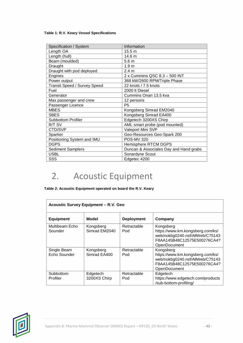
Table 1: R.V. Keary Vessel Specifications
Specification / System Information
Length OA 15.5 m
Length (hull) 14.6 m
Beam (moulded) 5.6 m
Draught 1.9 m
Draught with pod deployed 2.4 m
Engines 2 x Cummins QSC 8.3 – 500 INT
Power output 368 kW/2600 RPM/Triple Phase
Transit Speed / Survey Speed 22 knots / 7.5 knots
Fuel 2000 lt Diesel
Generator Cummins Onan 13.5 kva
Max passenger and crew 12 persons
Passenger Licence P5
MBES Kongsberg Simrad EM2040
SBES Kongsberg Simrad EA400
Subbottom Profiler Edgetech 3200XS Chirp
R/T SV AML smart probe (pod mounted)
CTD/SVP Valeport Mini SVP
Sparker Geo-Resources Geo-Spark 200
Positioning System and IMU POS-MV 320
DGPS Hemisphere RTCM DGPS
Sediment Samplers Duncan & Associates Day and Hand grabs
USBL Sonardyne Scout
SSS Edgetec 4200
2. Acoustic Equipment Table 2: Acoustic Equipment operated on board the R.V. Keary
Acoustic Survey Equipment – R.V. Geo
Equipment Model Deployment Company
Multibeam Echo Sounder
Kongsberg Simrad EM2040
Retractable Pod
Kongsberg https://www.km.kongsberg.com/ks/web/nokbg0240.nsf/AllWeb/C75143F8AA145B48C12575E500276CA4?OpenDocument
Single Beam Echo Sounder
Kongsberg Simrad EA400
Retractable Pod
Kongsberg https://www.km.kongsberg.com/ks/web/nokbg0240.nsf/AllWeb/C75143F8AA145B48C12575E500276CA4?OpenDocument
Subbottom Profiler
Edgetech 3200XS Chirp
Retractable Pod
Edgetech https://www.edgetech.com/products/sub-bottom-profiling/

Appendix B: Marine Mammal Observer (MMO) Report – KRY20_03 North Wales - 50 -
3. Guideline and Licence Implementation
Prior to the commencement of the year’s survey operations, a briefing was given to senior
survey personnel on the nature of the guidelines for multibeam, singlebeam and sub-bottom
profiler surveys in enclosed bays, inlets and estuaries. Where applicable, SAC extents
were input to planning software. Licence conditions and the practical aspects of their
implementation were discussed with the senior scientist on site. Copies of the DAHG
Guidance for underwater sound sources (Jan 2014) and JNCC guidelines for minimising
the risk of injury to marine mammals from geophysical surveys (Aug 2017) were available
on board all survey platforms and licences were circulated to the Party Chief tasked with
co-ordinating survey operations. The party chief ultimately took responsibility for collating
all sightings and MMO related activity during survey operations while qualified crew
members on each vessel acted in the role of marine mammal observer and all crew
members were involved in maintaining a watch for cetaceans.
4. Soft Start Procedure Multibeam echosounder soft starts were carried out as required. Where possible a ramp up
of system power was utilised however, a ramp up of power is not possible with all multibeam
/ singlebeam systems, so as a recommended alternative, a soft start consists of switching
power on and off during the soft start time period (20 minutes)
5. Survey Operations Survey operations on board the inshore survey fleet operated by the Geological Survey
Ireland are carried out during daylight hours. This fact necessitates a return to a secure
berth or mooring at the end of each day’s operations. Furthermore, the requirement to start
up and shut-down survey equipment at the beginning and end of each work day, leads to a
slightly different set of operating procedures than is used further offshore on coastal survey
vessels which operate 24 hour days.
This manner of operating has the advantage of having sufficient daylight for the MMO to
locate and identify marine mammals while survey systems are being operated, however it
also requires that the systems are started up correctly each day whereas an offshore
platform typically operates the sound source for days at a time. The requirement to re-start
the system each day has been addressed by, whenever possible, starting survey systems
while stationary and alongside prior to departure. This tackles the need to begin operations
at the innermost point of the survey area each day, however visibility can be restricted if the
vessels are in port. While moored, visibility generally is unaffected. Survey equipment on
each platform is online for a minimum of 20 minutes prior to departure each day. When long

Appendix B: Marine Mammal Observer (MMO) Report – KRY20_03 North Wales - 51 -
transits are necessary and the equipment must be switched off and retracted, the soft start
is carried out when the vessel arrives at the survey site.
CHERISH survey operations in North Wales were implemented on board the R.V. Keary
between the 1st and 19th September 2020. The vessel was based in both Pwllheli Marina
and Victoria Dock and returned there each evening throughout the duration of the survey.
Casual observations were maintained in the wheelhouse and back-deck by all survey crew
members throughout the operation.
The official marine mammal recording forms for this survey are presented in Appendix A.
It should be noted that the form titled “Marine Mammal Recording Form – Operations” is
designed for seismic rather than multibeam and sub-bottom profiler surveys. Several
hundred multibeam lines were acquired on this survey and it is not possible to enter the
start and end of line times for each line. It is also not necessary to enter the start and end
of each line as with multibeam and sub-bottom profiler there is no reduction in power
between survey lines. Data and time of start of first survey line after start up were entered
and date and time of end of last survey line before power off were entered.

Appendix B: Marine Mammal Observer (MMO) Report – KRY20_03 North Wales - 52 -
APPENDIX A: MARINE MAMMAL
RECORDING FORM – COVER PAGE
Regulatory reference number (e.g. DECC no., MMS permit no., OCS lease no., etc.) KRY20_03
Country Wales
Ship/ platform name R.V. Keary
Client DECC
Contractor CHERISH/GSI
Survey type site 4C 2D VSP 3D WAZ
4D other
OBC
Start date 01/09/2020
End date 19/09/2020
Number of source vessels
1
Type of source (e.g. airguns)
Multibeam
Number of airguns (only if
airguns used) N/A
Source volume (cu. in.)
Source depth (metres)
0.7m
Frequency (Hz)
400kHz
Intensity (dB re. 1µPa or bar
metres)
210 (MBES)
Shot point interval (seconds)
Approx. 0.1 sec (MBES)
Method of soft start
increase number of guns increase pressure increase frequency other
(where permitted) (where permitted)
Visual monitoring equipment
used (e.g. binoculars, big eyes, etc.)
Binoculars
Magnification of
optical equipment (e.g. binoculars)
7 x 50
Height of eye (metres)
3m
How was distance of animals estimated?
by eye
with laser rangefinder
with rangefinder stick/ callipers
with reticule binoculars
by relating to object at known distance
other
Number of dedicated MMOs
1
Training of MMOs
JNCC approved MMO induction course for UK waters
PSO training course for the Gulf of Mexico
MMO training course for Irish waters
other
none
Was PAM used?
yes no
Number of PAM operators
Description of PAM equipment

Appendix B: Marine Mammal Observer (MMO) Report – KRY20_03 North Wales - 53 -
Range of PAM hydrophones from
airguns (metres)
Bearing of PAM hydrophones from
airguns (relative to direction of travel)
Depth of PAM hydrophones (metres)

Appendix B: Marine Mammal Observer (MMO) Report – KRY20_03 North Wales - 54 -
MARINE MAMMAL RECORDING FORM - OPERATIONS Regulatory reference number KRY20_03 Caernarfon/Cardigan Bay Ship/ platform name: R.V. Keary (e.g. DECC no., MMS permit no., OCS lease no., etc.) Complete this form every time the airguns are used, including overnight, whether for shooting a line or for testing or for any purpose.
Times should be in UTC, using the 24 hour clock.
Date Reason for
firing l = line
t = test
x = test followed
immediately
by line
Time soft
start/
ramp-up
began
Time of
full power
Time of
start of
line
Time of
end of line
Time of
reduced
output (if relevant)
Time
airguns/
source
stopped
Time pre-
shooting
search
began
Time
search
ended
Time PAM
began
Time PAM
ended
Was it day
or night in
period
prior to
firing? d = day
n = night
w = dawn
k = dusk
Was any
mitigating
action
required? (yes/ no)
03/09/2020 L 08:02:00 08:22:00 08:22:00 17:27:00 17:27:00 17:27:00 06:50:00 18:37:00 NA NA D N
04/09/2020 L 09:03:00 09:23:00 09:23:00 17:57:00 17:57:00 17:57:00 06:45:00 19:10:00 NA NA D N
05/09/2020 L 08:36:00 08:56:00 08:56:00 18:09:00 18:09:00 18:09:00 07:15:00 19:20:00 NA NA D N

Appendix B: Marine Mammal Observer (MMO) Report – KRY20_03 North Wales - 55 -
06/09/2020 L 08:44:00 09:04:00 09:04:00 18:38:00 18:38:00 18:38:00 07:20:00 19:45:00 NA NA D N
08/09/2020 L 09:15:00 09:35:00 09:35:00 18:35:00 18:35:00 18:35:00 08:00:00 20:00:00 NA NA D N
09/09/2020 L 09:45:00 10:05:00 10:05:00 15:45:00 15:45:00 15:45:00 08:45:00 16:54:00 NA NA D N
10/09/2020 L 10:54:00 11:14:00 11:14:00 16:56:00 16:56:00 16:56:00 09:35:00 18:00:00 NA NA D N
12/09/2020 L 08:00:00 08:20:00 08:20:00 17:07:00 17:07:00 17:07:00 06:50:00 18:22:00 NA NA D N
14/09/2020 L 06:33:00 06:53:00 06:53:00 18:40:00 18:40:00 18:40:00 05:20:00 19:54:00 NA NA D N
15/09/2020 L 08:30:00 08:50:00 08:50:00 17:54:00 17:54:00 17:54:00 07:17:00 19:10:00 NA NA D N
16/09/2020 L 09:24:00 09:44:00 09:44:00 11:02:00 11:02:00 11:02:00 06:55:00 11:35:00 NA NA D N
17/09/2020 L 08:03:00 08:23:00 08:23:00 13:02:00 13:02:00 13:02:00 06:55:00 19:17:00 NA NA D N
18/09/2020 L 08:54:00 09:14:00 09:14:00 11:42:00 11:42:00 11:42:00 07:45:00 12:48:00 NA NA D N

Appendix B: Marine Mammal Observer (MMO) Report – KRY20_03 North Wales - 56 -

Appendix B: Marine Mammal Observer (MMO) Report – KRY20_03 North Wales - 57 -
MARINE MAMMAL RECORDING FORM - EFFORT
Regulatory reference number: KRY20_03 Ship/ platform name: R.V Keary
Please record the following for all watches, even if no marine mammals are seen. Start a new line on form if any one of these changes
Date Visual
watch
or
PAM
v =
visual
watch
p =
PAM
Time
of
start
of
watch
(UTC,
24hr
clock)
Time
of end
of
watch
(UTC,
24hr
clock)
Start position
(latitude and
longitude)
Depth
at
start
(m)
End position (latitude
and longitude)
Dept
h at
end
(m)
Spee
d of
vesse
l
(knot
s)
Sourc
e
activit
y
f = full
power
s =
soft
start
r =
reduce
d
power
(not
soft
start)
n =
not
active
Wind
directio
n
Wind
force
(Beauf
ort
scale)
Sea state
g =
glassy
(like
mirror)
s = slight
(no or
few
white
caps)
c =
choppy
(many
white
caps)
r =
rough
(big
waves,
foam,
spray)
or
Beaufort
sea
states (0
- 7+)
Swell
o =
low
(< 2
m)
m =
mediu
m
(2-4
m)
l =
large
(> 4
m)
Visibilit
y
(visual
watch
only)
p =
poor
(< 1
km)
m =
modera
te
(1-5
km)
g =
good
(> 5
km)
Sunglar
e
(visual
watch
only)
n = no
glare
w =
weak
glare
s =
strong
glare
v =
variable

Appendix B: Marine Mammal Observer (MMO) Report – KRY20_03 North Wales - 58 -
03/09/2020 V Jess Murray 06:50 18:37 52⁰53.116' N 4 4⁰24.465' W 4 6
f
SW 5 3 O M W
04/09/2020 V Jess Murray 06:45 19:10 52⁰53.116' N 4 4⁰24.465' W 4 7
f
SW 5 3 O M W
05/09/2020 V Jess Murray 07:15 19:20 52⁰53.116' N 4 4⁰24.465' W 4 7
f
W 4 3 O M W
06/09/2020 V Jess Murray 07:20 19:45 52⁰53.116' N 4 4⁰24.465' W 4 7
f
W 3 2 O G G
08/09/2020 V Jess Murray 08:00 20:00 52⁰53.116' N 4 4⁰24.465' W 4 6
f
SW 5 3 O P G
09/09/2020 V Jess Murray 08:45 16:54 52⁰53.116' N 4 4⁰24.465' W 4 5
f
N 3 2 O G G
10/09/2020 V Jess Murray 09:35 18:00 52⁰53.116' N 4 4⁰24.465' W 4 6
f
SW 1 1 O G G
12/09/2020 V Jess Murray 06:50 18:22 52⁰53.116' N 4 4⁰24.465' W 4 7
f
SW 5 3 O G G

Appendix B: Marine Mammal Observer (MMO) Report – KRY20_03 North Wales - 59 -
14/09/2020 V Jess Murray 05:20 19:54 52⁰53.116' N 4 4⁰24.465' W 4 7
f
NE 1 1 O G G
15/09/2020 V Jess Murray 07:17 19:10 52⁰53.116' N 4 4⁰24.465' W 4 7
f
S 1 1 O G G
16/09/2020 V Jess Murray 06:55 11:35 53⁰08.601' N 4 4⁰16.650' W 4 5
f
N 2 1 O G G
17/09/2020 V Jess Murray 06:55 19:17 53⁰08.601' N 4 4⁰16.650' W 4 5
f
N 2 1 O G G
18/09/2020 V Jess Murray 07:45 12:48 53⁰08.601' N 4 4⁰16.650' W 4 6
f
N 2 1 O G G

Appendix B: Marine Mammal Observer (MMO) Report – KRY20_03 North Wales - 60 -
Cetacean Sighting Record Form: KRY20_03 No cetaceans were sighted during the survey operations
Date:
Time (GMT): Duration:
Survey Ref. No. KRY20_03
Sighting no.: N/A
How did this sighting occur? (please tick)
While you were keeping a continuous watch for marine mammals Spotted incidentally by you or someone else Other (please specify) _
Ship: RV Keary Geological Survey Ireland, Beggars Bush Haddington Road Dublin [email protected]
Observer:
Location:
Ship's position (latitude and longitude):
Water depth:.
Species:
Certainty of identification:
Estimated Length:
Number of adults:
Colour:
Number of juveniles:
Weather:
Photograph or video taken: Optics Used: None.
Sighting Description: Direction of travel of animals in relation to ship:
Behaviour:
Travel direction of animals (compass points):
Activity of ship:
Sonar Systems pinging:
(when animals first seen)
Closest distance of animals from sonar head: (Record even if not pinging)

Appendix C: H-Notes – KRY20_03 North Wales
61
Appendix C: H-Notes from Survey

HYDROGRAPHIC NOTE H.102
(V8.0 Oct 2014)
62 Appendix C: H-notes – KRY20_03 North Wales
Date 28/06/2021
Ref. Number KRY20_03—001DH
Name of ship or sender Geological Survey Ireland / R.V. Keary / CHERISH
IMO number if applicable -
Address Beggars Bush, Haddington Road, Dublin 4, Ireland
E-mail/Tel/Fax of sender
General Locality West of Dinas Dinlleu, Caernarfon region, Wales
Subject 2m contour adjustment & sounding adjustment, chart 1970
Position (see Instruction 2)
Latitude See below
Longitude See below
GPS
POSpac -PPRTX
Datum WGS84
Accuracy 0.1m
Admiralty Charts affected 1970 (UKHO Geotiff provided 2019)
Edition Unknown
Latest Weekly Edition of Notice to Mariners held
Replacement copy of Chart No (see Instruction 3)
IS NOT required
ENCs affected NA
Latest update disk applied Week:
Make, model and or age of ECDIS if applicable
Qinsy/Caris
Publications affected (NP/DP number, Edition No.)
Unknown
Date of latest supplement/update, page & Light List No. etc
Unknown
Details of anomaly / observation:
1) Adjustment of 2m contour, centred on 53.070957N 4.345072W. See figures 2 & 3 for details.
2) Adjustment of sounding, chart indicates 3.4m; least depth of 1.32m observed. Coordinates 53.075320N 4.347508W. See figure 3 & 4 for details.
Data acquired by R.V. Keary: - equipped with Kongsberg EM2040 and POSmv Wavemaster. All depths are reduced to VORF LAT using GPStide methods. Navigation data is reprocessed using PP-RTX and transformed to ETRS89. Data acquired in September 2020, as part of CHERISH program.
Name of observer/reporter David Hardy
H.102A Submitted No H.102B Submitted No
Tick box if not willing to be named as source of this information

HYDROGRAPHIC NOTE H.102
(V8.0 Oct 2014)
63 Appendix C: H-notes – KRY20_03 North Wales
Figure 1 Overview location of survey block, with red circle indicating the area this observation refers to.
Figure 2 Zoomed images of area being reported.

HYDROGRAPHIC NOTE H.102
(V8.0 Oct 2014)
64 Appendix C: H-notes – KRY20_03 North Wales
Figure 3 Data filtered to show depths less than 2m LAT, to highlight adjustments needed to contours. Red circle
– highlights area less than 2m, obscured by sounding at 3.4m
Figure 4 Subset view of data where chart indicates 3.4m, showing shallowest reading of 1.32m.

HYDROGRAPHIC NOTE H.102
(V8.0 Oct 2014)
65 Appendix C: H-notes – KRY20_03 North Wales
Date 28/06/2021
Ref. Number KRY20_03—002DH
Name of ship or sender Geological Survey Ireland / R.V. Keary / CHERISH
IMO number if applicable -
Address Beggars Bush, Haddington Road, Dublin 4, Ireland
E-mail/Tel/Fax of sender
General Locality Sarn Badrig, west of Barmouth, Wales.
Subject Areas of significant depth adjustment, chart 1971
Position (see Instruction 2)
Latitude See below
Longitude See below
GPS
POSpac -PPRTX
Datum WGS84
Accuracy 0.1m
Admiralty Charts affected 1971 (UKHO Geotiff provided 2019)
Edition Unknown
Latest Weekly Edition of Notice to Mariners held
Replacement copy of Chart No (see Instruction 3)
IS NOT required
ENCs affected NA
Latest update disk applied Week:
Make, model and or age of ECDIS if applicable
Qinsy/Caris
Publications affected (NP/DP number, Edition No.)
Unknown
Date of latest supplement/update, page & Light List No. etc
Unknown
Details of anomaly / observation: Adjustments to 5m contour in two locations, centred at:
a) 52.697665N 4.362514W - Area 1 b) 52.718128N 4.311421W - Area 2
Data acquired by R.V. Keary: - equipped with Kongsberg EM2040 and POSmv Wavemaster. All depths are reduced to VORF LAT using GPStide methods. Navigation data is reprocessed using PP-RTX and transformed to ETRS89. Data acquired in September 2020, as part of CHERISH program.
Name of observer/reporter David Hardy
H.102A Submitted No H.102B Submitted No
Tick box if not willing to be named as source of this information
HYDROGRAPHIC NOTE H.102
(V8.0 Oct 2014)
66 Appendix C: H-notes – KRY20_03 North Wales
Figure 1 Overview location of survey block, with red circles indicating the areas this observation refers to.
Figure 2 Zoomed images of areas being reported.
Figure 3 Data display filtered to show depths less than 5m LAT, to highlight adjustments needed to contours.
Area 1
Area 2
Area 1
Area 2
Area 1
Area 2

HYDROGRAPHIC NOTE H.102
(V8.0 Oct 2014)
67 Appendix C: H-notes – KRY20_03 North Wales
Figure 4 Sounding plots (default HIPS method, 30m radius) over areas 1 & 2 to give indicative depths.
Area 1
Area 2

H525
68 Appendix C: H-notes – KRY20_03 North Wales
REPORT OF WRECK INVESTIGATION Wreck No: 01
Ship/Unit RV Keary HMOI No: Survey: KRY20_03 Date located: 04/09/2020 Date Examined/Swept: 10/09/2020 Listed Position: UNCHARTED Fixed Position: 52 º 46 . 4934’ N 4 º 11 . 3137’ W Method of Positioning: MBES GPS Accuracy (2,447σ): 0.2 metres Horizontal Datum: ETRS89 Depth Data: Swept Clear: N/A metres No sweep, data from EM2040P
MBES System (VORF LAT) Swept Foul: N/A metres Least E/S Depth: 6m metres
General Depth: 7 m metres Scour Depth: N/A metres
Tidal observations at: Tidal correction derived from GNSS height Cotidal adjustments by: Contact Data: Sonar Height: 1 metres Sonar Length: 41 metres
Sonar Width: 15 metres Orientation: WNW º / ESE º (Bows: 294 º )
Sonar Signal Strength: Nil Poor Moderate Strong Unknown Magnetic Anomaly: Nil Poor Moderate Strong Unknown Scour Length: N/A Direction (towards): º Seabed Texture: Sub-littoral mixed sediments
Debris Field: Yes Length: 10m 15m 12m
metres Direction (towards): 43 º 335 º 113 º
Buoyage: N/A Description (include attitude and whether intact): The main structure of the wreck appears to be well collapsed/buried, the bow is most likely oriented pointing WNW, with the highest point of the wreck being at the stern section approx. 1m from the seabed. There appears to be debris on the east side of the wreck site approx. 10-15m from the ‘centre line’. Reports of wreck ‘Diamond’ sunk in general area.

H525
69 Appendix C: H-notes – KRY20_03 North Wales
Figure 1: Position of Wreck on Chart

H525
70 Appendix C: H-notes – KRY20_03 North Wales
Figure 2: Wreck Orientation on the Seabed.
Figure 3: 3D Image of Wreck

H525
71 Appendix C: H-notes – KRY20_03 North Wales
Figure 4: 3D Image of Wreck
Figure 5: Cross Section along Length of Wreck

H525
72 Appendix C: H-notes – KRY20_03 North Wales
Figure 6: Cross Section Across width

H525
73 Appendix C: H-notes – KRY20_03 North Wales
REPORT OF WRECK INVESTIGATION Wreck No: 02
Ship/Unit RV Keary HMOI No: Survey: KRY20_03 Date located: 23/07/2021 Date Examined/Swept: 12/09/2020 Listed Position: UNCHARTED Fixed Position: 52 º 42 . 57323 N 4 º 18 . 7333
1 W
Method of Positioning: MBES GPS Accuracy (2,447σ): 0.1 metres Horizontal Datum: ETRS89 Depth Data: Swept Clear: N/A metres No sweep, data from EM2040P
MBES System (VORF LAT) Swept Foul: N/A metres Least E/S Depth: 0.2m
(?) metres
General Depth: 1 m metres Scour Depth: N/A metres
Tidal observations at: Tidal correction derived from GNSS height Cotidal adjustments by: Contact Data: Sonar Height: 1 metres Sonar Length: 80 metres
Sonar Width: 20 metres Orientation: NE º / SW º (Bows: Unkn
own )
Sonar Signal Strength: Nil Poor Moderate Strong Unknown Magnetic Anomaly: Nil Poor Moderate Strong Unknown Scour Length: N/A Direction (towards): º Seabed Texture: Shallow sandbank
Debris Field: Yes Length: 250 93m 78m
metres Direction (towards): N NE SSE
Buoyage: N/A

H525
74 Appendix C: H-notes – KRY20_03 North Wales
Description (include attitude and whether intact): Low relief and fragmented wreck on the crest of Sarn Badrig sandbank. Structure of vessel is collapsed, with a high density of fragments in the local area. Larger fragments in a radius of 80-90m to NE and SSE. To North, at radius up to 250m, 3-4 linear features of approx. 13-14m are observed (potential masts?). Least depth reported is from debris on crest of bank (0.2m LAT). Object is covered by main survey lines only (no wreck investigation) – as was recognised during processing only. Data has a high noise component, due to very shallow environment.
Figure 7: Position of Wreck on Chart

H525
75 Appendix C: H-notes – KRY20_03 North Wales
Figure 8: Wreck Orientation on the Seabed.

H525
76 Appendix C: H-notes – KRY20_03 North Wales
Figure 9: Wreck main structure & NE and SSE debris fields. Illuminated from NW.
Figure 10: Wreck main structure & NE and SSE debris fields. Illuminated from NE.
Figure 11: Debris field to N of main site (max distance 250m) – showing potential masts?

H525
77 Appendix C: H-notes – KRY20_03 North Wales
Figure 6: Maximum detail on main wreck site (10cm grid).
Approved: David Hardy Data Processor:
David Hardy Date: 23/07/2021

H525
78 Appendix C: H-notes – KRY20_03 North Wales
REPORT OF WRECK INVESTIGATION Wreck No: 03
Ship/Unit RV Keary HMOI No: Survey: KRY20_03 Date located: 23/07/2021 Date Examined/Swept: 12/09/2020 Listed Position: Charted – approx. 150m NE Fixed Position: 52 º 42 . 28636 N 4 º 19 . 6498
5 W
Method of Positioning: MBES GPS Accuracy (2,447σ): 0.1 metres Horizontal Datum: ETRS89 Depth Data: Swept Clear: N/A metres No sweep, data from EM2040P
MBES System (VORF LAT) Swept Foul: N/A metres Least E/S Depth: -0.6m
(? – drying height)
metres
General Depth: 2 m metres Scour Depth: N/A metres
Tidal observations at: Tidal correction derived from GNSS height Cotidal adjustments by: Contact Data: Sonar Height: 2.8 metres Sonar Length: 52 metres
Sonar Width: 13 metres Orientation: NNE º / SSW º (Bows: Unkn
own )
Sonar Signal Strength: Nil Poor Moderate Strong Unknown Magnetic Anomaly: Nil Poor Moderate Strong Unknown Scour Length: N/A Direction (towards): º Seabed Texture: Shallow sandbank
Debris Field: No
Length:
metres Direction (towards):
Buoyage: N/A

H525
79 Appendix C: H-notes – KRY20_03 North Wales
Description (include attitude and whether intact): Fragments of charted wreck observed. Data indicates that portions of the wreck will be visible on low tides – least depth of 0.6m above LAT. Object is covered by main survey lines only (no wreck investigation) – as was recognised during processing only. Data has a high noise component and sonar shadowing, due to very shallow environment.
Figure 12: Position of Wreck on Chart

H525
80 Appendix C: H-notes – KRY20_03 North Wales
Figure 13: Wreck Orientation on the Seabed.
Figure 14: Wreck, maximum details (20cm grid, coverage gaps due to sonar shadowing).
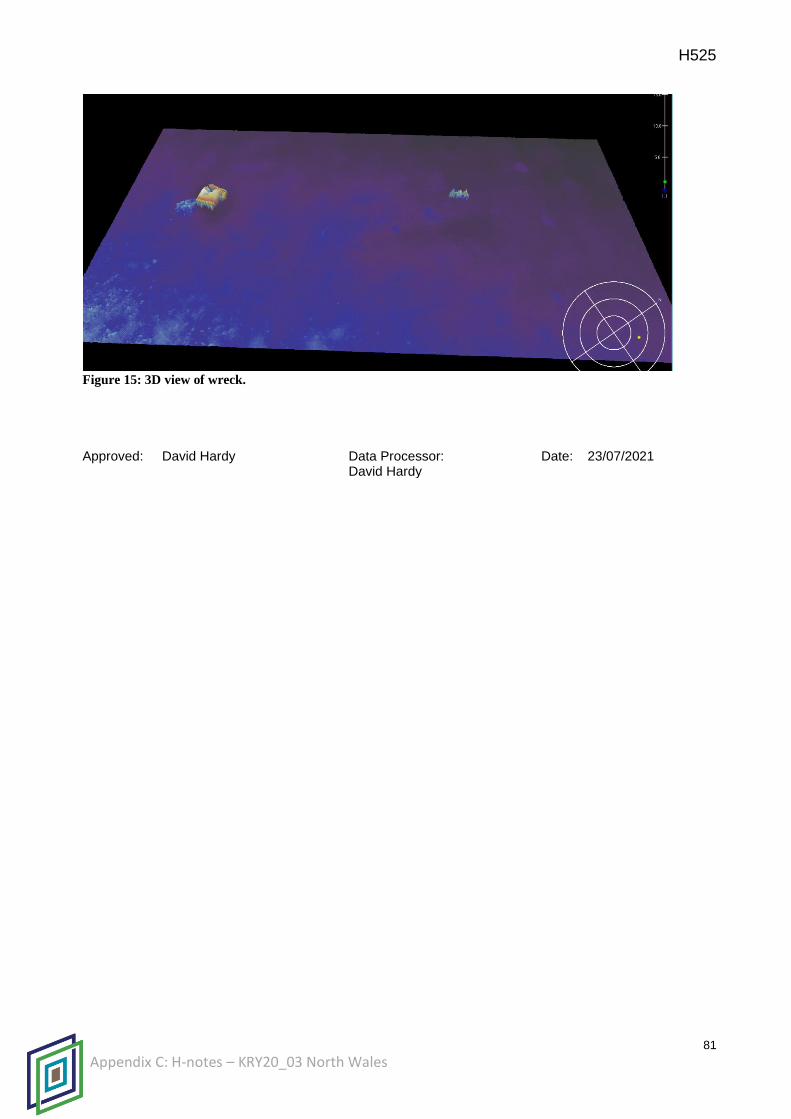
H525
81 Appendix C: H-notes – KRY20_03 North Wales
Figure 15: 3D view of wreck.
Approved: David Hardy Data Processor:
David Hardy Date: 23/07/2021