RAF Bentley Priory, Stanmore, Middlesex - Desk Based Assessment 2007
59
-
Upload
independent -
Category
Documents
-
view
2 -
download
0
Transcript of RAF Bentley Priory, Stanmore, Middlesex - Desk Based Assessment 2007

Halcrow Yolles 5th Floor 3 Shortlands Hammersmith London, W6 8DA Tel +44 (0)20 8233 3800 Fax +44 (0)20 8233 3801 www.halcrowyolles.com Halcrow Group Limited has prepared this report in accordance with the instructions of their client, VSM Estates Limited, for their sole and specific use. Any other persons who use any information contained herein do so at their own risk. © Halcrow Group Limited 2007
VSM Estates Ltd MoDEL RAF Bentley Priory Archaeological Desk-Based Assessment
Contents Amendment Record This report has been issued and amended as follows: Issue Revision Description Date Signed
001 000 Draft for Client Comments 15.10.07 JM

Contents
1 Executive Summary 6
2 Introduction 8 2.1 Project Background 8 2.2 Site Location and Description 8 2.3 Proposed Development summary 9
3 Aims and Methodology 10 3.1 Aims 10 3.2 Methodology 10 3.3 Brief and Consultation 12 3.4 Sources Consulted 12 3.5 Limitations 12
4 Planning and Legislative Framework 14 4.1 Introduction 14 4.2 Outline of Planning and Legislative Framework 14 4.3 National Planning Policy 14 4.4 Regional Planning Policy 15 4.5 Strategic and Local Planning Policy 16
5 Cultural Heritage Resource Baseline Data 21 5.1 Geology and Paleo-environment (including Geotechnical Records) 21 5.2 Topography and Historic Landscape Aspects 21 5.3 Statutory/Non-statutory Protected Features 21 5.4 Historic Environment Record (HER) 22 5.5 Previous archaeological assessment, investigation or survey (including
Aerial Photography, Field Walking and Geophysical Survey etc.) 22 5.6 Archaeological and Historical Background (including Placename
Evidence etc) 23
6 Additional Archaeological and Historical Research 28 6.1 Site Visit and Walkover 28
7 Assessment of Archaeological Potential and Mitigation 29 7.1 Known constraints 29 7.2 Archaeological Potential 29 7.3 Significance 29 7.4 Past impacts (including former and existing structures, infrastructure,
services, contamination etc.) 30 7.5 Proposed Development and Impacts 30 7.6 Recommendations for Further Work and/or Mitigation 31 7.7 Conclusions 32

8 Acknowledgements 33
9 Appendices 34
PDFMBP012 Rev000 October 2007 Archaeological Desk Based Assessment 6
1 Executive Summary
Halcrow Yolles has been appointed by VSM Estates Ltd to undertake an archaeological desk-based assessment covering RAF Bentley Priory, within Stanmore, in the London Borough of Harrow. The site is approximately 22 ha and consists of some extensive areas of green open space around an 18th century mansion (a Grade II listed building), much altered and added to. The mansion is set within a 19th century Italian Garden and some remnants of the surrounding former pleasure grounds and historic parkland still survive and all are within the curtilage of a Registered Park & Garden (Grade II).
Masterplan Options are in preparation based on the retention of the Grade II listed mansion complex – part of which forming a new museum - and the Italian Garden. The development proposal provides for approximately 110 dwellings, both apartments and houses. The impact of the development on any archaeological remains that might exist could be significant.
The assessment has suggested that generally there is significant potential for archaeological remains. In particular, the discovery of Roman coins and cremation burial urns next to the mansion in the 18th century indicates that there is most likely to have been a settlement or shrine on or nearby the site. The Anglo-Saxon origin of the name Bentley and the date of 1171 for the foundation of Bentley Priory by the Augustinian Canons indictates the possibility of Late Saxon/Medieval activities on the site although the priory itself may have been a small community or cell. In respect of the Post-Medieval and Modern periods there is potential for buried remains of known and unknown structures etc. From the creation of the estate beginning with the house and other features built in 1788 through to its incorporation in part in the Marquis of Abercorn’s mansion designed by Sir John Soane together with other new structures in the grounds, followed by various additions and alterations commissioned by Sir John Kelk (including the Italianate Gardens) and, finally, the 80 year occupation by the RAF, the site has been extensively ‘redeveloped’.
From its architect Sir John Soane and the artistic and political circles surrounding the Marquis of Abercorn in the early 19th century (including Wordsworth, Sir Walter Scott and leading members of the Tory party), to Air Chief Marshall Dowding, Fighter Command and the Battle of Britain in the 20th century (the

PDFMBP012 Rev000 October 2007 Archaeological Desk Based Assessment 7
residue of the estate was sold to the Air Ministry in 1926), the Priory has been the scene of notable events and it’s cultural heritage significance is undoubtedly high.
The assessment concludes that more information about the archaeological potential of the site is required in order to design a mitigation strategy to avoid impacts. As the first stage a proposed programme of integrated geo-technical and archaeological investigations has been accepted in principle by English Heritage and it is anticipated that a second phase of archaeological trial trench evaluation will follow once the detailed impacts of the proposed scheme have been assessed.
PDFMBP012 Rev000 October 2007 Archaeological Desk Based Assessment 8
2 Introduction
2.1 Project Background Halcrow Yolles (“Halcrow”) has been appointed by VSM Estates Ltd to undertake an archaeological desk-based assessment (DBA) covering RAF Bentley Priory, within the modern parish of Stanmore, in the London Borough of Harrow.
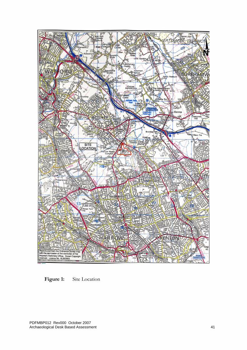
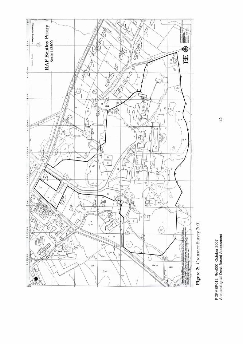
2.2 Site Location and Description Within this report reference to an area within the application boundary is stated as ‘the site’. A location plan of the site is presented in Figure 1. The site is located in north-west London within the London borough of Harrow at it’s centre lies at National Grid Reference (NGR) TQ 15453 93298 (Figure 2). To the north the main entrance to the site is directly off The Common (A4140) and much of the site boundary lies behind residential buildings which front onto that road. To the east, part of the site boundary lies behind residential buildings which front onto Priory Drive and the remainder borders a private road which is a spur off Priory Drive. To the south, the boundary borders that of the Bentley Priory Nature Reserve (known locally as the Bentley Priory Open space and formerly part of the Bentley Priory estate and latterly RAF Bentley Priory). To the west, the boundary continues to border the Bentley Priory Nature Reserve with a short stretch bordering Common Road. The site covers approximately 22ha.
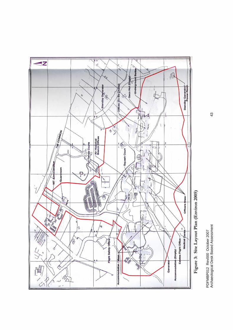
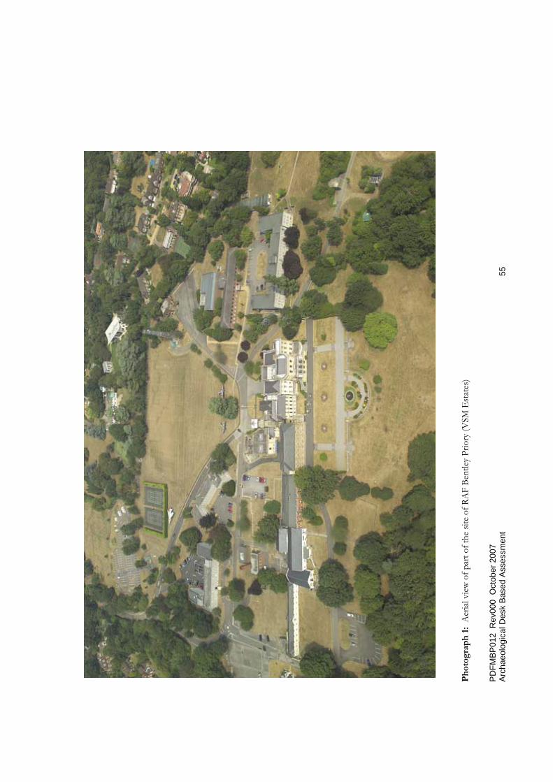
The site consist of some extensive areas of green open space around an 18th century mansion (a Grade II listed building) much altered and added to (Photograph 1). The mansion is set within its 19th century Italian Garden and some remnants of the surrounding former pleasure grounds and historic parkland still survive. The site together with the Bentley Priory Nature Reserve - formerly part of the estate - is a Registered Park and Garden (Grade II). The Nature Reserve is designated a site of Special Scientific Interest (SSSI). The site also comprises numerous RAF buildings, an underground bunker etc (Figure 3).
At present the application site is utilised as a non-flying Royal Air Force station although it was famous as the headquarters of Fighter Command during world War II. The station provides accommodation for the Defence Aviation Safety Centre, Air Historical Branch and RAF Ceremonial. The Ministry of Defence is

PDFMBP012 Rev000 October 2007 Archaeological Desk Based Assessment 9
releasing the site as part of its Greater London Estate consolidation , project MoDEL (Ministry of Defence Estate in London). The current station role will cease in 2008.
2.3 Proposed Development summary Masterplan Options are in preparation based on the retention of the Grade II listed mansion complex – part of which forming a new museum - and the Italian Garden. The current proposal provides for approximately 110 dwellings, both apartments and houses, mainly concentrated to the north around the entrance off The Common and to east and west of the mansion (Figure 4).

PDFMBP012 Rev000 October 2007 Archaeological Desk Based Assessment 10
3 Aims and Methodology
3.1 Aims It is in the interest of the local community, the developer and the Local Authority that archaeological issues are discussed, with an appropriately trained specialist, at an early stage in the planning process. This assessment represents such a commitment to establishing early advice to establish the Archaeological Resource of the site and surrounding study area.
The aims of this archaeological assessment were therefore to:
• Identify statutory and non-statutory archaeological constraints (including planning constraints) within and in the immediate vicinity of the site
• Assess the baseline conditions and offer an analysis of the extent, preservation, sensitivity, potential and importance of the recorded archaeological resource within the site
• Assess the baseline information and offer an analysis for the potential that unrecorded archaeological remains survive within the site
• Assess the potential impacts upon the known and currently unknown archaeological resource, taking into account the severity of the impacts and the importance of the resource
• Propose a programme of further works and/or suitable mitigation measures to avoid, reduce or remedy any adverse impacts caused by development, if required
3.2 Methodology This assessment was conducted with regard to standards set out by the Institute of Field Archaeologists (IFA, 1999).
Information was obtained for a study area extending approximately 750m from the centre of proposed development at OS grid-point TQ 15453 93298. The scope of resources examined included statutorily designated cultural heritage sites such as Listed Buildings, Scheduled Monuments, and Conservation Areas, as well as features of the cultural heritage resource recorded on the Greater London Sites and Monuments Record (SMR).

PDFMBP012 Rev000 October 2007 Archaeological Desk Based Assessment 11
The general approach and methodology has been to consider the effects on cultural heritage resources in the main groups as follows:
• Archaeological Sites and Monuments (including palaeo-environmental deposits) – Potential destruction or damage to sites and monuments due to permanent or temporary landtake and/or physical intrusion and indirect effects, such as changes to the drainage pattern
• Built Heritage (comprising Listed Buildings and non-Listed Buildings of historic interest) – Potential direct effects through loss or damage to buildings and indirect effects due to changes in their setting or vibration and air quality related damage
• Historic Landscape Character and Features - Potential direct loss or damage to landscape features and indirect effects on the setting of such features
These resources may be nationally or locally designated (by Registration, Listing or Scheduling), may appear in the national or local archaeological record, or may be identified from specialist study of the landscape and historic records.
A gazetteer listing the known cultural heritage resource within the study area was compiled and is provided in Appendix 1. Each entry has been assigned a Site reference number, marked on a cultural heritage features plan (Figure 2) and discussed in the text. In addition this report has involved a map regression study.
In summary the work has involved:
• identifying the sources available for consultation
• assembling, consulting and analysing the available resources
• consulting specialists as appropriate
• visiting the site
• preparing the written report
PDFMBP012 Rev000 October 2007 Archaeological Desk Based Assessment 12
3.3 Brief and Consultation No specific Brief was provided but reference has been made to the Greater London Archaeology Advisory Service (GLAAS), English Heritage, Archaeological Guidance Papers, 1. Desk-Based Assessments (Revised June 1998).
On 27th July 2007, the author of this report met with Kim Stabler, GLAAS Area Officer, and discussed various aspects of the site. Kim noted that in addition to the listed building and Registered Park and Garden, English Heritage would be seeking agreement to the retention of the Soane music room; the retention of the cisterns (see below, 7.3) and an assessment of the World War II bunker.
3.4 Sources Consulted
Sources included, though were not limited to, the following:
• The Greater London Sites and Monuments Record (SMR), maintained for this area by the Greater London Archaeology Advisory Service. This is a primary repository of all known archaeological and cultural heritage finds and features that have been identified within the area covered by the SMR.
• Local Studies Centre, Harrow Council Civic Library
• The Multi-Agency Geographic Information for the Countryside (MAGIC) website (http://www.magic.gov.uk)
• Cartographic Sources and Documentary Sources
• Historic Ordnance Survey mapping supplied by Envirocheck;
• Contemporary published accounts (e.g. travel guides, agricultural surveys);
• Place-name information
• Site visits and walkovers to provide further information on the archaeological potential of the site based on topography, current land use, and the extent of past ground disturbance.
3.5 Limitations It should be noted that:
• The report has been prepared under the express instructions and solely for the use of VSM Estates.

PDFMBP012 Rev000 October 2007 Archaeological Desk Based Assessment 13
• All work carried out in preparing this report has utilised and is based upon Halcrow’s professional knowledge and understanding of current (September 2007) relevant United Kingdom standards and codes, technology, and legislation. Changes in these areas may occur in the future and cause any conclusions, advice, recommendations or designs contained in this report to become inappropriate or incorrect. Halcrow does not accept responsibility for advising VSM Estates Ltd or any other interested parties of the facts or implications of any such changes in the future.
• This report has been prepared utilising factual information obtained from others. Halcrow take no responsibility for the accuracy of such information.
• This report represents an early stage of a phased approach to assessing the archaeological and cultural heritage resource of the site and study to allow the development of an appropriate mitigation strategy, should this be required. It does not comprise mitigation of impacts in itself.

PDFMBP012 Rev000 October 2007 Archaeological Desk Based Assessment 14
4 Planning and Legislative Framework
4.1 Introduction The following section highlights the key national, regional and local planning policies relevant to the study area.
4.2 Outline of Planning and Legislative Framework This assessment has taken into account relevant national and local legislation and policy, including:
• Ancient Monuments and Archaeological Areas Act 1979
• Planning (Listed Buildings and Conservation Areas Act) 1990
• DoE Planning Policy Guidance (PPG) Note 16, Archaeology and Planning 1990
• DoE/DNH PPG Note 15, Planning and the Historic Environment 1994
• DCMS, Heritage Protection for the 21st Century (White Paper), 2007
• DoE, The Hedgerow Regulations 1997 (and new guidance 2002)
• The Regional Planning Guidance for the South East (RPG9) 2001)
• The London Plan, 2004
• Harrow Council London, Harrow Unitary Development Plan (Written Statement and Proposals Plan) 2007
4.3 National Planning Policy 4.3.1 National Planning Policy Guidance 16: Archaeology and Planning
The importance of archaeology in the planning process is detailed in PPG16. The underlying principle is that archaeological remains should be seen as a finite and non-renewable resource and should be regarded as a part of the environment to be protected and managed. The primary objective is to secure the best possible treatment of the archaeological heritage.
Where nationally important archaeological remains, whether scheduled or not, and their settings, are affected by a proposed development there should be a presumption in favour of their physical preservation. If physical preservation in

PDFMBP012 Rev000 October 2007 Archaeological Desk Based Assessment 15
situ is not feasible, an archaeological excavation for the purposes of ‘preservation by record’ may be an acceptable alternative. From an archaeological point of view, this should be regarded as a second best option.
4.3.2 National Planning Policy Guidance 15: Planning and Historic Environment PPG15 recognises that the listed buildings, conservation areas and other historic sites, which together form some of the individual elements of the historic environment, are a unique and irreplaceable record that contributes to our understanding of both the present and the past.
In any development control decision, planning authorities are required to fully take account of and mitigate the possibility of unnecessary erosion or damage to this resource. PPG15 ensures that protection should be given not only to the assets themselves but also to the settings, which contribute to their character.
4.4 Regional Planning Policy 4.4.1 Regional Planning Guidance for the South East, 2001 (RPG9)
The Regional Planning guidance provides a context for planning in London, and identified 12 main principles that should govern the continuing development of the region. It reflects a variety of guidance related to achieving sustainable development, embracing the urban renaissance and the need to concentrate development in urban areas, securing economy in the use of land, and integrating land use and transport. The relevant heritage section and policy is:
Section D8 8. Management of the Historic Environment 8.1 The historic environment includes the physical evidence of past human activity. It is all around us as part of everyday life, and it is therefore dynamic and continually subject to change. It is not limited to the built environment and archaeological sites, but includes landscapes, both urban and rural and as an example of its great diversity, marine heritage sites around the coast. These environments are fragile and require protection, but also have an enormous potential to contribute to a sense of place and identity and add to the quality of our daily lives through understanding and appropriate management and access. POLICY BE7: MANAGEMENT OF THE HISTORIC ENVIRONMENT

PDFMBP012 Rev000 October 2007 Archaeological Desk Based Assessment 16
In developing and implementing plans and strategies, local authorities and other bodies should adopt policies and proposals which support the conservation and, where appropriate, the enhancement of the historic environment and the contribution it makes to local and regional distinctiveness and sense of place. Proposals that make sensitive use of historic assets through regeneration, particularly where these bring redundant or under-used buildings and areas into appropriate use, should be encouraged.
A Regional Spatial Strategy for the South East (RSSSE) has been prepared and once it has been approved by Government it will replace Regional Planning Guidance for the South East (RPG9). Consultation on the draft RSSSE plan ended 23 June 2006, and the Examination in Public ran from 27 November 2006 to 30 March 2007. The Report of the Examination in Public Independent Panel was published on 29 August 2007. The Secretary of State will now consider the recommendations contained in the Report and expects to publish any Proposed Changes to the draft Regional Spatial Strategy for consultation towards in the New Year.
4.5 Strategic and Local Planning Policy 4.5.1 Strategic Plan Policies - The London Plan (February 2004)
The regional strategic planning context is provided by the spatial development strategy for London, the Mayor’s London Plan. The policies in the Harrow Unitary Development Plan have been drafted in the light of the vision, objectives and strategic policy content of the London Plan. The relevant heritage policies and sections are:
Built heritage and views
Policy 4B.10 London’s built heritage
The Mayor will work with strategic partners to protect and enhance
London’s historic environment.
UDP policies should seek to maintain and increase the contribution
of the built heritage to London’s environmental quality, to the economy,
both through tourism and the beneficial use of historic assets, and
to the well-being of London’s people while allowing for London
to accommodate growth in a sustainable manner.

PDFMBP012 Rev000 October 2007 Archaeological Desk Based Assessment 17
Policy 4B.11 Heritage conservation
Boroughs should:
• ensure that the protection and enhancement of historic assets
in London are based on an understanding of their special character,
and form part of the wider design and urban improvement agenda,
and that policies recognise the multi-cultural nature of heritage issues
• identify areas, spaces and buildings of special quality or character
and adopt policies for their protection and the identification of
opportunities for their enhancement, taking into account the strategic
London context
• encourage and facilitate inclusive solutions to providing access for
all, to and within the historic environment.
Policy 4B.12 Historic conservation-led regeneration
The Mayor will, and boroughs should, support schemes that make use
of historic assets and stimulate environmental, economic and community
regeneration where they:
• bring redundant or under-used buildings and spaces into
appropriate use
• secure the repair and re-use of Buildings at Risk
• help to improve local economies and community cohesion
• fit in with wider regeneration objectives
• promote inclusiveness in their design.
Policy 4B.13 World Heritage Sites
The Mayor will work with the relevant boroughs, English Heritage and
site owners and occupiers to prepare management plans for London’s
World Heritage Sites. UDPs and management plans should protect their
historic significance and safeguard, and where appropriate enhance,
their settings.
PDFMBP012 Rev000 October 2007 Archaeological Desk Based Assessment 18
Policy 4B.14 Archaeology
The Mayor, in partnership with English Heritage, the Museum of London
and boroughs, will support the identification, protection, interpretation
and presentation of London’s archaeological resources. Boroughs in
consultation with English Heritage and other relevant statutory
organisations should include appropriate policies in their UDPs for
protecting scheduled ancient monuments and archaeological assets
within their area6.
4.60 Two thousand years of building have left layers of history, illuminating
London’s social, political and economic heritage. Today London has a
great wealth of fine historic buildings, spaces and archaeology, including
four World Heritage Sites and many buildings and sites of national
importance that add to the capital’s identity, attractiveness and cultural
richness. The historic environment also helps to attract tourists, and
provides valuable leisure opportunities and commercial and residential
space, and is an important part of London’s economy. The Mayor wishes
to see the sensitive management of London’s extraordinary historic assets
planned in tandem with the promotion of the very best modern
architecture and urban design. Designation of historic buildings is not
enough. Sensitive management requires clear details of what needs to be
protected, how and why. The Mayor expects boroughs and others to use
appropriate tools to manage the historic environment, including character
appraisals and conservation plans.
4.61 Much of London’s historic inheritance is inaccessible, badly maintained
or not viewed as relevant to local communities. The sensitive and
innovative use of historic assets within local regeneration should be
encouraged. Schemes such as Townscape Heritage Initiatives, Heritage
Economic Regenerations Schemes and Buildings at Risk Grants and their
successors, can play an import role in fostering the regeneration of
historic areas (see Policy 4B.12).
PDFMBP012 Rev000 October 2007 Archaeological Desk Based Assessment 19
4.62 Part of the city’s unique character is the juxtaposition of many different
types of buildings and spaces and this should be reflected in the way the
historic environment is managed. Buildings and places should not be seen
in isolation, and the settings of historic assets are often important to their
character and should be appropriately protected.
4.5.2 The Unitary Development Plan (30 July 2004) The Plan was adopoted by Harrow Council and replaced a previous UDP (28 Novemebr 1994) which was entirely superseded. The 2004 UDP contained the following policy in respect of cultural heritage:
SD2 Conservation Areas, Listed Buildings, Sites of Archaeological Importance, and Historic Parks and Gardens
2.60 Conservation Areas, Listed Buildings, archaeological features and Historic Parks and Gardens are of strategic importance as part of London’s built heritage and will be rigorously protected from harm, and enhancements sought where possible. The Council, as Local Planning Authority, has powers to designate parts of the Borough as Conservation Areas and, in the exercise of its functions under the Planning Acts, has a general duty to pay special attention to the desirability of preserving or enhancing the character or appearance of such areas. This duty will be given priority over other planning policies. In addition to the Statutory List compiled by the Secretary of State for the Department for Culture, Media and Sport, the Council maintains a local list of buildings of special architectural or historic interest. Both are published as Supplementary Planning Guidance to this Plan.
2.61 Change of use under these circumstances may fall within the category of "Enabling Development". Enabling Development is not a statutory term, although it has been established in the courts as a legitimate planning tool. It is generally used to denote a development that would be unacceptable in planning terms but for the fact that it would bring benefits to a heritage asset such as a listed building, sufficiently to justify it being carried out. The benefit to be secured by enabling development is typically the survival of the asset through rescue from decay, bringing it into

PDFMBP012 Rev000 October 2007 Archaeological Desk Based Assessment 20
beneficial use, securing its long-term future by some form of endowment, enhancing it, or its setting, by reversing inappropriate past development, or making it more accessible to the public. Enabling development will only be acceptable where the benefits to the community are clear, and clearly outweigh any disbenefits, and where the heritage asset and its setting are not materially harmed.
2.62 In addition, the applicant will have to demonstrate that the proposals will secure the long term future of the site in beneficial use, and without detrimental fragmentation; that the development proposed is the minimum necessary to secure the future of the heritage asset; that sufficient financial assistance to secure the future of the heritage asset is not available from another source; and that the need for the development stems from the nature of the heritage asset, rather than from the circumstances of the owner. Further information on enabling development is available in English Heritage's Policy Statement "Enabling Development and the Conservation of Heritage Assets", and detailed practical guidance in their "Proposals for Enabling Development Affecting Heritage Assets".
However, following a direction from the Secretary of State fifty-six policies including SD2 were deleted from the Harrow Unitary Development Plan (HUDP) on Friday, 28 September 2007. This was because the policies repeated and/or were inconsistent with national or regional policy. There are currently no proposals to specifically replace SD2.
4.5.3 Supplementary Planning Document (SPD) Planning consultancy DPP has been appointed by the London Borough of Harrow to help prepare Supplementary Planning Document (SPD) for the RAF Bentley Priory scheme.

PDFMBP012 Rev000 October 2007 Archaeological Desk Based Assessment 21
5 Cultural Heritage Resource Baseline Data
5.1 Geology and Paleo-environment (including Geotechnical Records) The geological map shows that the site is covered by Stanmore Gravel, comprising sandy and clayey gravel in part (British Geological Survey, 1995). This is underlain by Claygate Beds. The Claygate Beds comprise silt and fine grained sand. This stratification extends to a total depth of some approximately 10m. London Clay underlies the Claygate Beds and is approximately 80m thick in this location. A borehole was carried out in 1993 (Enviros, 2005) to assess ground conditions in the underground bunker and the sequence below the bunker compares to that set out above. Water seepage was encountered at a depth of 15m.
5.2 Topography and Historic Landscape Aspects The site is located to the north-east of suburban Stanmore in north-west London, situated on the western spur of a range of hills near the border of Middlesex and Hertfordshire. It is the highest point in the historic county of Middlesex. The site is on a naturally inclined plane in a semi-rural area. The topography varies greatly across the site with a steep slope down towards the south, south-west and a smaller slope to the east. The site is at an elevation of approximately 140m above Ordnance Datum (AOD).
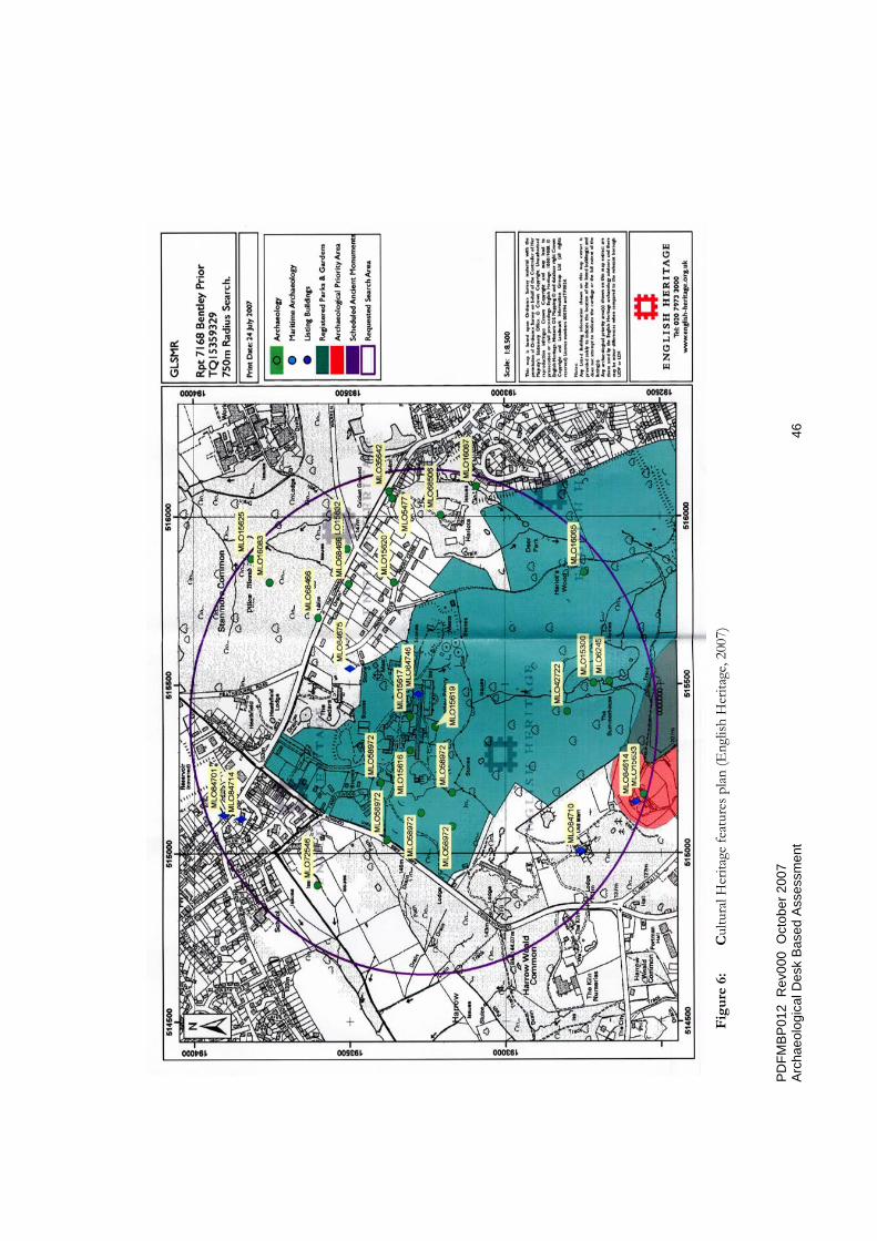
5.3 Statutory/Non-statutory Protected Features According to the MAGIC website, an interactive map based resource that contains information on key environmental schemes and designations, as supplied by seven government organisations including English Heritage, there are no Registered Battlefields; Protected Wreck Sites; Heritage Coasts; or World Heritage Sites within a 2 km radius of the area surrounding the site of the proposed development. Within the 750m study area there are no Scheduled Ancient Monuments; there is one Historic Park and Garden, Bentley Priory (Figure 5), within which there is a designated Area of Ancient Woodland. Bordering the Bentley Priory Nature Reserve to the south-west there is an Archaeological Priority Area.
The NMR was consulted to identify if any Buildings of Special Architectural or Historic Interest (Listed Buildings) survive within the limits of the site or wider study area. This showed that within the site there are two listed structures: the
PDFMBP012 Rev000 October 2007 Archaeological Desk Based Assessment 22
Central Entrance Block to Bentley Priory (Grade (II*), including the gate and railings, and the Garden Pavilion in the grounds of ‘Ad Astra’, Priory Drive (Grade II).
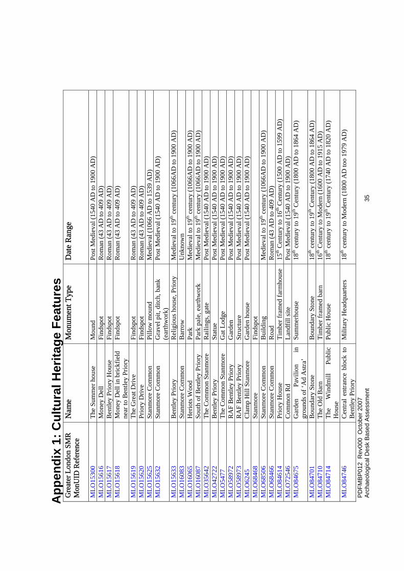
5.4 Historic Environment Record (HER) The local HER is still referred to as the Sites and Monuments Record (SMR), held by Greater London Archaeological Advisory Service, was consulted to establish if any Archaeological Findspots and Sites1 or other Cultural Heritage remains were recorded on their database within the site or a 750m radius study area surrounding it. This identified 28 such features and/or findspots within the study area (see Figure 6 & Appendix 1), 10 of which (Site nos. 1,2,3,7,8,9,19,20,24,25) were located within the site.
5.5 Previous archaeological assessment, investigation or survey (including Aerial Photography, Field Walking and Geophysical Survey etc.)
Neither the Greater London SMR or the Museum of London Archaeological Archive Centre (LAARC) has any record of any previous archaeological desk-based assessment (DBA) having been undertaken for this site. However, An Historical Assessment of RAF Bentley Priory, Stanmore, London Borough of Harrow was issued in July 2004, undertaken by Niall Hammond on behalf of Defence Estates at the request of Project MoDEL. It contains much useful material, analysis and detailed recommendations about wider aspects of cultural heritage and it is recommended that it is considered in conjunction with this report.
The intensive use of much of the site during former times (in particular, World War II) meant that it was not conducive to field walking or even aerial photography and no such surveys are known. Also, there have been no archaeological excavations carried out within the estate although there have been two recent minor archaeological investigations. In 1992, evaluation trenches (site code RBP92) were undertaken by the Museum of London Archaeology Service
1 A ‘Findspot’ represents the location of an archaeological artefact or scatter of artefacts. The circumstances of such findings are often uncertain and, as a general rule, they are unlikely to have been found as part of a formal archaeological investigation. The full significance of such findings is therefore often uncertain, although the presence of such finds usually suggest that the area has the potential to contain as yet undefined or undetected archaeological sites. A known ‘Site’ represents the known presence of an archaeological or other Cultural Heritage receptor.

PDFMBP012 Rev000 October 2007 Archaeological Desk Based Assessment 23
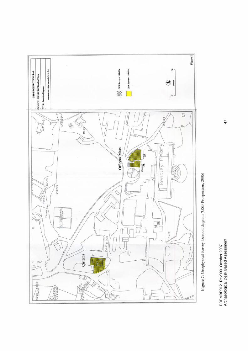
(MoLAS) in which were recorded natural clay, truncated by probably 19th/20th c landscape layers which in turn were cut by bedding trenches, possibly associated with Glentham House (Figure 6, MLO58972). A 20th century footing that was revealed was probably part of the World War II air base (details of the location of the trenches are still awaited]. In 1995, a geophysical survey [site code RAB05) was carried out by GSB Prospection. Two areas were surveyed, one over a series of 18th-19th century brick cisterns on the W side of the site, the other over a purported 18th century Sir John Soane designed music room attached to the N side of the present Officers’ Mess (Figure 7). The extent of the brick cisterns was successfully identified and high amplitude anomalies - perhaps the music room -were encountered, though they could be interpreted as landscaping features.
5.6 Archaeological and Historical Background (including Placename Evidence etc) This section provides a brief overview of the archaeological background of the study area which will aid in understanding the likelihood of encountering currently unrecorded resources within the application site and potentially determine their significance and likely condition. A Bibliography of sources consulted is contained in Appendix 2.
5.6.1 Prehistoric Period (c. 500,000 BP – AD42)
Although no prehistoric remains are known from the site, William Stukeley, a 18th century antiquarian, reported a seeing a Bronze Age 'barrow' near Brockley Hill, some 2.3km to the north-east of the site. Grim's Dyke (or Ditch), is a formidable pre-Roman landscape feature that crosses Brockley Hill and passes near to Bentley Priory. Until quite recently it was doubted whether the various apparently localized earthworks known by that name amounted to a single entity. Since the early 1990's it has been more definitely recognized as a 2,400 year old bank and ditch, some 50 miles in length, running from the northern limit at Dunstable, across the Chilterns, then south toward the Thames.
The potential is assessed as low to moderate.
5.6.2 Roman Period (AD42 – AD410) Both coins and cremation burials of the Roman period have been discovered within and adjacent to the RAF estate. In Lyson’s Environs of London, 1795 (Vulliamy 1930, 204), it is reported that men digging near Bentley Priory in 1781 found about 50 gold coins, two gold rings, a gold bracelet, etc., and the author states that ‘great quantities of antiquities , as coins, urns, gold rings etc., have been found in this neighbourhood’ [Site MLO15618]. In the immediate vicinity of the

PDFMBP012 Rev000 October 2007 Archaeological Desk Based Assessment 24
mansion there are a number of locations in which Roman remains have been discovered (Figure 6, Sites MLO15616/7/9). The recorded incidences of the discovery of Roman coins on the site is notable: MLO15616 - number of Roman coins found in Money Dell, including one of gold of Vespasian; MLO15617 - between 1766-88 a considerable quantity of gold Roman coins were found near the house while digging foundations of a wall: MLO15616 - 2 brass Roman coins of Tetricus and Constantine the Great found in drain repairs 1940-2 (in a barrel drain). Such remains may relate to ritual activity and it has been conjectured that a temple site may have been erected in the vicinity.
At Brockley Hill is the Roman settlement of Sulloniacae described as ‘An antient city in Antonine’s Itinerary’ (a descriptive road map of Roman Britian). Stukeley, , in his Itinerarium Curiosum, describes how ‘Mr Philpot, when digging his canal and foundations, …… which are upon the site of an old city, found many coins, [cinerary] urns and other antiquities, …… a great quantity of Roman bricks, gold rings and coins have ben found in the digging’. Sulloniacae is thought to have been the site of a fort erected during the initial years of the Roman invasion and thereafter the site of a posting-station or mutationes, on the main military highway into the heart of the new Roman province. Excavations conducted in 1970 within the grounds of the Royal Orthopaedic Hospital found much evidence in confirmation of a flourishing pottery industry in Roman Brockley Hill.
The potential is assessed as high.
5.6.3 Early Medieval Period (AD410 - AD1066) The name ‘Bentley’ is of Anglo-Saxon origin which literally translated means ‘a clearing or pasture of coarse grass’ (Gover et al, 1942). This suggests that at least by the late Saxon period the immediate area had an established agricultural population.
The potential is assessed as low-moderate.
5.6.4 Later Medieval Period (AD1066 – c. AD1550) The Augustinian Priory or cell which gave its name to the estate was founded around 1171, perhaps by Ranulf de Glanville, one of the most illustrious statesmen of the reign of Henry II. The Priory was dedicated to St Mary Magdalene and located just within the parish of great Stanmore. It appears to have been a small establishment. Dugdale’s Monasticon has only a short account of Benethley or Bentley Priory and it appears little was known about it. The Harrow Manor Court

PDFMBP012 Rev000 October 2007 Archaeological Desk Based Assessment 25
rolls of 1512 record that the Archbishops of Canterbury gave the building with all its lands to the Priory of St Gregory, outside Canterbury (Bowlt, 2000, 28). The rolls complained that no cannon had been presented to Bentley for 20 years past and no priest had said mass there for two years. The priory was not suppressed at the time of the Reformation suggesting that it was no longer in existence in the 1530’s. In 1536 the mother house was dissolved and the Bentley land was handed over to Thomas Cranmer: the priory building may have been ‘slighted’ ie the roof at least taken off. The location of the Priory is not known and no trace of the original monastic building have been found on the site but there is a tradition that it was near Lower Priory Farm, off Clamp Hill some 750m to the south-west of the mansion (Figure 6, Site MLO15633), outside the development area, and lower down the slope which in a more sheltered location (see below, 5.6.5). Relics are reported to have been found near this site including a figure of the Virgin (Bowlt 2000, 28) (Figure 6, Site MLO42722). However, other traces of the priory’s activities may survive on the site.
The potential is assessed at end as low to moderate.
5.6.5 Post-Medieval (AD1550 - AD1800) and Modern Period (AD1800+) After the Dissolution there was a succession of owners starting with Archbishop Cranmer in 1543, up until 1766 when the priory buildings and 329 acres of the estate were sold to James Duberley, a clothier made wealthy through supplying the army. Duberley is reported to have thrown down the remains of the old priory and had his new house erected away from the old site and on top of the hill to take advantage of the views. Much of Duberley’s house was incorporated into the later Sir John Soane mansion for the Marquis of Abercorn between 1788 and 1798. Soane substantially remodelled the house and designed several buildings for the grounds of Bentley Priory in 1789-90. These consisted of lodges, a greenhouse, stables and a coach house, a diary, hothouses, a peach house, gardener’s rooms, a bathing house, a boat house, an ice house and a pavilion. It may have been during this period that many of the cisterns (Photographs 2 & 3) located to the north-west of the house were constructed (see below 7.3). Thereafter, Sir Robert Smirke was then engaged by the Marquis and undertook enlargements to the Priory during 1810-18.
After the death of the Marquis in 1818, the estate passed into the hands of his grandson, the 2nd Marquis and later Duke of Abercorn, who live there until he moved to an estate in Scotland in 1840.The Dowager Queen Adelaide, widow of William IV, leased the Priory from 1846 until her deathin1849. After this the estate

PDFMBP012 Rev000 October 2007 Archaeological Desk Based Assessment 26
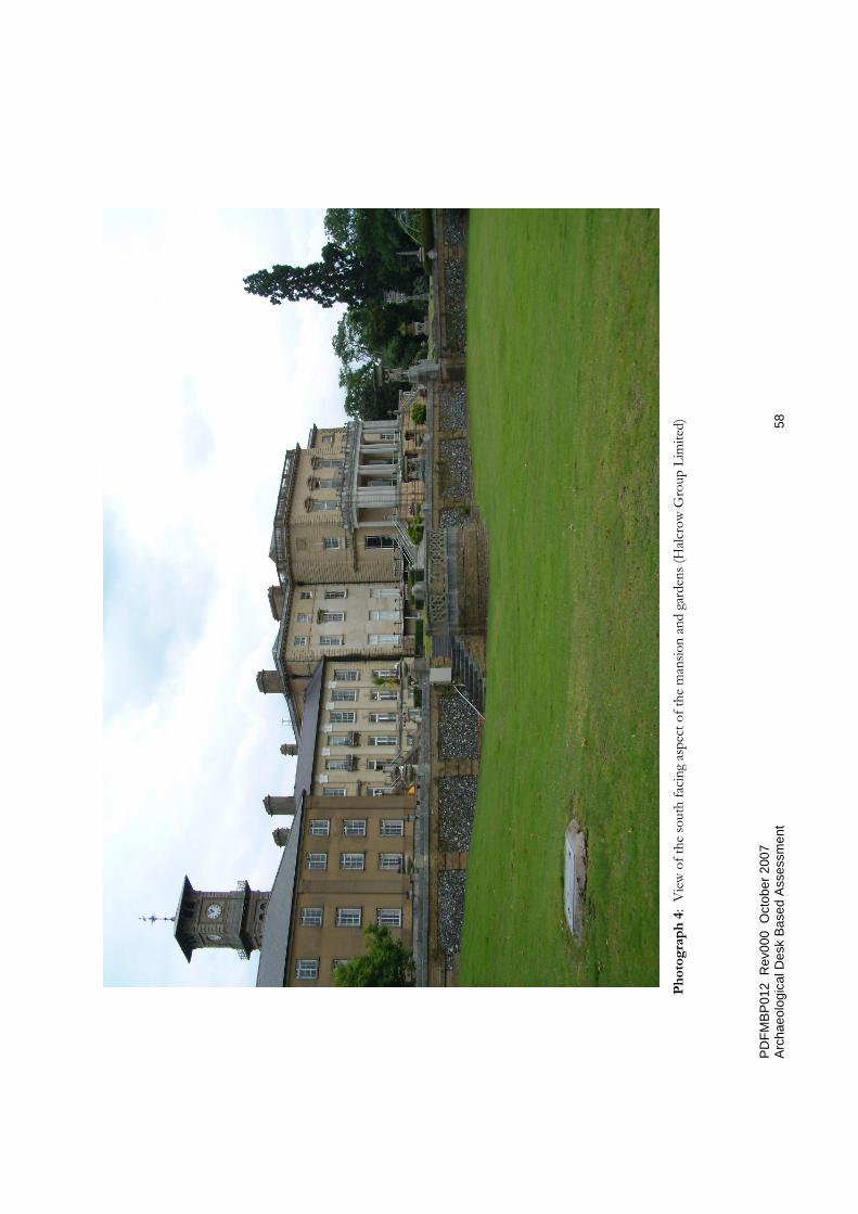
appears to have been little used until its purchase by Sir John Kelk, an eminent railway engineer. Kelk lavished money on improvements to the house and grounds remodelling them on Italianate lines and constructed of conservatories and ornamental gardens (Photograph 4). Under Kelk the late Victorian flowering of Bentley Priory had the greatest effect on the walled gardens - now gone - and the terraces which survive and for which there are detailed plans (Figure 8). The great importance of the historic landscape at Bentley Priory resides in its association with the picturesque. This was a theory about landscape that can easily be traced into the middle of the 18th century but that was brought in to sharp focus by its antagonism to Capability Brown and its support for the French Revolution. An Historic Landscape Character Areas study has been undertaken (Debois, 2007 - Figure 9).
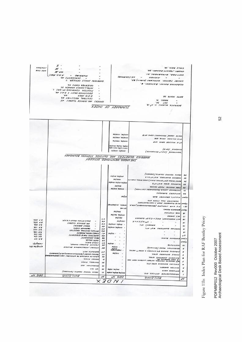
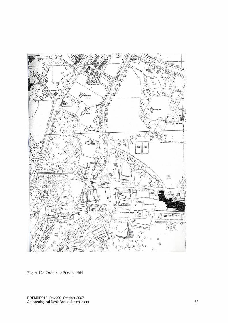
The estate was sold by Kelk by auction in 1881 (Figure 10) and purchased by Sir Frederick Gordon as a business venture and his company turned the house into a private residential hotel. To improve access to the site from London, Gordon built a railway from Harrow to Stanmore for his prospective guests. The hotel was not a success and shortly after his death in 1908, it was converted for use as a school for girls. Neither was the school a success and closed in 1924. Whilst the Priory stood empty, the large estate was split into lots and the Priory and the present grounds were sold to the Air Ministry in 1926. In 1936 it became the headquarters of Fighter Command and it was from there that the defence of Britain was conducted during the Battle of Britain (Photographs 5). Command and control systems vital to the Battle of Britain were developed at Bentley Priory. The result was a great deal of additional building both above ground (Figure 11) and below ground and other ground disturbances including a vast underground bunker, air raid shelters (Figure 12) etc., not all of which will be known.
The Officer’s Mess still contains the original office of Air chief Marshall Sir Hugh Dowding (later Lord Dowding), Air Officer Commanding-in-Chief Fighter Command during the Battle of Britain, preserved with its original furniture. Other battle of Britain historic artefacts are kept in the Officer’s Mess, including one of the few remaining Battle of Britain Lace Panels. The Officer’s Mess is also notable for the number of Royal portraits hanging in the building: there are two of Her Majesty the queen, one each of His Royal Highness the Duke of Edinburgh, George IV and the Queen Mother.
From its architect Sir John Soane and the artistic and political circles surrounding the Marquis of Abercorn in the early 19th century (including Wordsworth, Sir

PDFMBP012 Rev000 October 2007 Archaeological Desk Based Assessment 27
Walter Scott and leading members of the Tory party), to Air Chief Marshall Dowding and the Battle of Britain in the 20th century, the Priory has been the scene of notable events and it’s cultural heritage significance – both tangible and intangible - is undoubtedly high.
The potential is identified at end as high.

PDFMBP012 Rev000 October 2007 Archaeological Desk Based Assessment 28
6 Additional Archaeological and Historical Research
6.1 Site Visit and Walkover The author visited the site on two occasions: on July 23rd to undertake a walkover survey and on 8th August in company with John Phibbs (Debois Landscape Group) working on behalf of LiZLaKe (Chartered Landscape Architects and Urban Designers) to view and discuss aspects of the historic landscape, especially earthworks.

PDFMBP012 Rev000 October 2007 Archaeological Desk Based Assessment 29
7 Assessment of Archaeological Potential and Mitigation
7.1 Known constraints Currently there is a lack of archaeological/geotechnical information about the site and a lack of detailed information about previous impacts.
7.2 Archaeological Potential Although there are relatively few known archaeological sites and findspots, this assessment has suggested that there is potential for the recovery of as yet unidentified archaeological remains within the study area.
The potential for finds from the Prehistoric and Medieval periods has been assessed as low to moderate; for the Post-Medieval periods as moderate and for the Roman and Modern periods as high.
7.3 Significance The relative paucity of prehistoric finds from the vicinity of the site needs to be considered in the wider context of known major prehistoric monuments in the surrounding area.
The discovery in of Roman coins and cremation burial urns in the 18th century indicates that there must have been a settlement on or in the immediate vicinity of the site. Other than appearing to be a high class settlement from the type of objects found, there is no evidence for the nature and extent of the settlement: it could be a villa or village. The proximity of both Roman Watling Street and the nearby settlement/industrial centre at Sulloniacae suggest that it may have been strategically located to take advantage of the infrastructure in the area. Regarding any burial urns that might be encountered, they would have to be excavated carefully and with due reverence and the excavation area preferably screened off.
The Anglo-Saxon origin of Bentley and the date of 1171 for the foundation of Bentley Priory by the Augustinian Canons in dictates that although this may have been a small community or cell it was nevertheless significant, owned as it was for a time by the Archbishops of Canterbury. The location of the Priory is not known although Duberley is reported to have thrown down the remains of the old priory and had his new house erected away from the old site and on top of the hill which
PDFMBP012 Rev000 October 2007 Archaeological Desk Based Assessment 30
would imply that the Priory building was further down the slope to the south-west, a view that is supported by local tradition. However about that, in any case the Priory may well have had outbuildings and other features etc located elsewhere on the site.
For the Post-Medieval and Modern periods any ground disturbance could reveal the remains of structures and even landscaping and planting schemes, earthworks and the form and extent of beds, walks etc. Regarding the potential for buried structures, there are some 20-30 brick cisterns - some completely sealed ie capped - to the north-west of the mansion. The remains of fourteen (Photograph 2) have been studied by a specialist at English Heritage (Wittrick, 2001) who concluded that they most likely provided a source of fresh water storage and probably represent at least three separate phases of construction and reconstruction. He considers their form to be typical of 18th century shaft construction.
7.4 Past impacts (including former and existing structures, infrastructure, services, contamination etc.) As well as former structures that have been removed, the known past impacts, in particular associated with the use of the site by the RAF are extensive (eg the underground bunker, air raid shelters etc.) , and there are likely to be many significant impacts that are currently not known about, at least in detail. For example, extensive development occurred between 1960 and 1963 with the clearance of much of the woodland and the construction of numerous buildings and roadways in the southern half of the site, but the majority of those buildings had been removed by 1992 (Enviros, 2005). Areas of the site are known to be quite heavily contaminated, for example, radioactive materials are present in the bunker and other buildings contain asbestos (Figure 13). Information from Civil Defence records regarding whether or not there was bomb damage during WWII is still awaited, although the possible site of an aircraft crash is noted (Figure 13).
7.5 Proposed Development and Impacts The Masterplan Options are currently at outline stage but the approximately 110 dwellings, both apartments and houses, mostly concentrated to the north, east and west of the mansion (Figure 4) mainly in green areas where former major impacts are not known, are likely to have significant impact together with new service runs and other modifications eg new planting. The proposed foundation design for the dwellings has not been determined but it doesn’t appear likely that there will be basements or underground car parking. Another consideration will be the location and extent of compounds for storage of plant, materials and site accommodation.

PDFMBP012 Rev000 October 2007 Archaeological Desk Based Assessment 31
Any surviving archaeological deposits are likely to be very near existing surfaces and could be vulnerable as a consequence. Similarly, specific arrangements limiting the tracking of plant over open areas is to be recommended. Contamination remediation could be another source of impact for which archaeological considerations would need to be taken into account. Finally, a quite extensive programme of Geo-Environmental Investigation has been under consideration which potentially could have had implications for significant impact on any archaeological remains (see below 7.6).
7.6 Recommendations for Further Work and/or Mitigation The major difficulty that currently exists is the lack of detailed archaeological information about the site which means that it is not presently possible to set out a detailed mitigation strategy. Furthermore, the Masterplan Options are still under consideration and at present there is no detailed foundation design. Also, the amount of buried structures and ground disturbance - both known and unknown - militates against the likely effectiveness of the application of geophysical techniques.
Fortunately, as is best practice, the quite extensive programme of Geo-Environmental Investigations that has been proposed was developed jointly by Halcrow colleagues in the Site Investigation/Geotechnical and Archaeology and Cultural Heritage teams. In order to minimise the potential impact on any archaeological remains on the site and in respect of the estate’s status as a Registered Park and Garden, three techniques have been identified for obtaining geotechnical and contaminated land samples. Each technique has been selected to minimise the disturbance of Made Ground and natural ground whilst obtaining a sufficient number of samples for characterising the geotechnical nature and quality of the subsurface soil/geology. Trial pitting is the most intrusive technique of the three to be used at Bentley Priory, however the SI has been designed to minimise the requirement for trial pits. The following number of locations have been identified and are marked on the site plan (Figure 8):
Window sample bores – 68
Cable percussion boreholes – 12
Trial pits – 10.
In particular, the ten Trial Pits provide an opportunity of gaining an insight into the archaeological potential including that related to the former gardens eg design and layout of bedding trenches, creation of earthworks etc. An archaeological Watching Brief on the trenches with the provision for archaeologists supervising
PDFMBP012 Rev000 October 2007 Archaeological Desk Based Assessment 32
the excavations should significant remains be uncovered has been identified as a key element of the integrated approach. It will be a requirement that the archaeological contractors have sieving and metal detector facilities on site. The inclusion of a targeted earthwork survey as part of the exercise would be very useful in respect of both landscape/garden and archaeological considerations.
The proposed Phase One of archaeological investigations as an integrated part of the Geo-Environmental Investigations has been agreed in principle by English Heritage.
The Phase One works should provide an insight into the archaeological potential of the locations that are investigated and assist in designing Phase Two works which are likely to comprise trial trench evaluation targeted on the specifics of the assessment of detailed impacts of the proposed scheme. The level of ground disturbance throughout much of the site - both known and unknown -unfortunately would appear to militate against the use of geophysical techniques.
7.7 Conclusions Although there is a lack of detailed archaeological information from the site, there is evidence from historical and antiquarian sources both from the site and the surrounding area to indicate that there is significant potential of archaeological features/objects being found as a result of any ground disturbance.
English Heritage’s acceptance of the proposal for an integrated geotechnical and archaeological investigation should prove to be a useful first step in gaining an insight into a number of aspects of ground ‘conditions’. Once specific details of the below ground impacts of the proposed scheme have been determined a second phase of archaeological trial trench evaluation can be designed.
PDFMBP012 Rev000 October 2007 Archaeological Desk Based Assessment 33
8 Acknowledgements
The help and assistance of various colleagues was much appreciated: Bhavini Vyas, Ben Sansom and Josie Bristow. Consultation with Kim Stabler (Greater London archaeology Advisory Service, English Heritage) was beneficial. Reports, information and ideas were exchanged with John Phibbs (Debois Landscape Associates) and Liz Lake (LiZLaKe, Chartered Landscape Architects and Urban Designers). The staff at the Local Studies Centre, Harrow Civic Library, were very helpful.

PDFMBP012 Rev000 October 2007 Archaeological Desk Based Assessment 34
9 Appendices
PD
FMB
P01
2 R
ev00
0 O
ctob
er 2
007
Arch
aeol
ogic
al D
esk
Base
d A
sses
smen
t 3
5 App
endi
x 1:
Cul
tura
l Her
itage
Fea
ture
s G
reat
er L
ondo
n SM
R
Mon
UID
Ref
eren
ce
Nam
e M
onum
ent T
ype
Dat
e R
ange
MLO
1530
0 Th
e Su
mm
er h
ouse
M
ound
Po
st M
edie
val (
1540
AD
to 1
900
AD
) M
LO15
616
Mon
ey D
ell
Find
spot
R
oman
(43
AD
to 4
09 A
D)
MLO
1561
7 B
entle
y Pr
iory
Hou
se
Find
spot
R
oman
(43
AD
to 4
09 A
D)
MLO
1561
8 M
oney
Del
l in
bric
kfie
ld
near
to B
entle
y Pr
iory
Fi
ndsp
ot
Rom
an (4
3 A
D to
409
AD
)
MLO
1561
9 Th
e G
reat
Driv
e Fi
ndsp
ot
Rom
an (4
3 A
D to
409
AD
) M
LO15
620
Prio
ry D
rive
Find
spot
R
oman
(43
AD
to 4
09 A
D)
MLO
1562
5 St
anm
ore
Com
mon
Pi
llow
mou
nd
Med
ieva
l (10
66 A
D to
153
9 A
D)
MLO
1563
2 St
anm
ore
Com
mon
G
rave
l pit,
ditc
h, b
ank
(ear
thw
ork)
Po
st M
edie
val (
1540
AD
to 1
900
AD
)
MLO
1563
3 B
entle
y Pr
iory
R
elig
ious
hou
se, P
riory
M
edie
val t
o 19
th c
entu
ry (1
066A
D to
190
0 A
D)
MLO
1608
3 St
anm
ore
Com
mon
B
arro
w
Unk
now
n M
LO16
065
Her
iots
Woo
d Pa
rk
Med
ieva
l to
19th
cen
tury
(106
6AD
to 1
900
AD
) M
LO16
087
Sout
h of
Ben
tley
Prio
ry
Park
pal
e, e
arth
wor
k M
edie
val t
o 19
th c
entu
ry (1
066A
D to
190
0 A
D)
MLO
3564
2 Th
e C
omm
on S
tanm
ore
Rai
lings
, gat
e Po
st M
edie
val (
1540
AD
to 1
900
AD
) M
LO42
722
Ben
tley
Prio
ry
Stat
ue
Post
Med
ieva
l (15
40 A
D to
190
0 A
D)
MLO
5477
Th
e C
omm
on S
tanm
ore
Gat
Lod
ge
Post
Med
ieva
l (15
40 A
D to
190
0 A
D)
MLO
5897
2 R
AF
Ben
tley
Prio
ry
Gar
den
Post
Med
ieva
l (15
40 A
D to
190
0 A
D)
MLO
5897
3 R
AF
Ben
tley
Prio
ry
Stru
ctur
e Po
st M
edie
val (
1540
AD
to 1
900
AD
) M
LO62
45
Cla
mp
Hill
Sta
nmor
e G
arde
n ho
use
Post
Med
ieva
l (15
40 A
D to
190
0 A
D)
MLO
6846
8 St
anm
ore
Find
spot
MLO
6850
6 St
anm
ore
Com
mon
B
uild
ing
Med
ieva
l to
19th
cen
tury
(106
6AD
to 1
900
AD
) M
LO68
466
Stan
mor
e C
omm
on
Roa
d R
oman
(43
AD
to 4
09 A
D)
MLO
8461
4 Pr
iory
Hou
se
Tim
ber f
ram
ed fa
rmho
use
15th
Cen
tury
to 1
6th C
entu
ry (1
500
AD
to 1
599
AD
) M
LO72
546
Com
mon
Rd
Land
fill s
ite
Post
Med
ieva
l (15
40 A
D to
190
0 A
D)
MLO
8467
5 G
arde
n Pa
vilio
n in
gr
ound
s of ‘
Ad
Ast
ra’
Sum
mer
hous
e 18
th c
entu
ry to
19th
Cen
tury
(180
0 A
D to
186
4 A
D)
MLO
8470
1 B
ound
ary
Ston
e B
ound
ary
Ston
e 18
th c
entu
ry to
19th
Cen
tury
(180
0 A
D to
186
4 A
D)
MLO
8471
0 Th
e O
ld B
arn
Tim
ber f
ram
ed b
arn
16th
Cen
tury
to M
oder
n (1
600
AD
to 1
915
AD
) M
LO84
714
The
Win
dmill
Pu
blic
H
ouse
Pu
blic
Hou
se
18th
cen
tury
to 1
9th C
entu
ry (1
740
AD
to 1
820
AD
)
MLO
8474
6 C
entra
l en
tranc
e bl
ock
to
Ben
tley
Prio
ry
Mili
tary
Hea
dqua
rters
18
th c
entu
ry to
Mod
ern
(180
0 A
D to
o 19
79 A
D)

PDFMBP012 Rev000 October 2007 Archaeological Desk Based Assessment 36
Appendix 2: Sources Bibliography Anderson, N, September 2007, Bentley Priory Masterplan Options, Robert Adam Architects
Ancient Monuments and Archaeological Areas Act 1979
Ancient Monuments (Class Consents) Order 1984
Bowlt, EM, 2000, Harrow’s Past, Historical Publications
British Geological Survey, 1995, Geological Map Sheet 256 (North London) Solid & Drift Geology , Scale 1:50,000
Debois Landscape Group, August 2007, Bentley Priory Historic Landscape Survey
Department of the Environment (DoE), 1990, Planning Policy Guidance [Note 16]: Archaeology and Planning (PPG 16)
Department of the Environment (DoE), & Department of National Heritage (DHN), 1994, Planning Policy Guidance [Note 15]: Planning and the Historic Environment (PPG15)
Department for Culture, Media and Sport (DCMS) & Welsh Assembly Government (WAG), 2007, Heritage Protection for the 21st Century (White Paper)
GSB Prospection Ltd., 2005, Geophysical Survey Report 2005/91, RAF Bentley Priory, Stanmore, Middlesex
The Hedgerow Regulations 1997 (amended 2002)
Enviros Consulting, 2005, RAF Bentley Priory Land Quality Assessment Phase One: Desk Study Land Quality Assessment Report – Final
English Heritage Greater London Archaeology Advisory Service (GLAAS), 1999, Archaeological Guidance Papers: 1. Desk-Based Assessments
Gover, EB, Mawer, A, Stenton, FM, Madge, SJ, 1942, The Place-Names of Middlesex, apart from the City of London
PDFMBP012 Rev000 October 2007 Archaeological Desk Based Assessment 37
Government Office for the South East, 2004, Regional Planning Guidance for the South East (RPG9)
Greater London Authority, 2004, The London Plan
Hamlin, JF, 1997, The History of Royal Air Force Bentley Priory and Stanmore Park
Hammond, N, 2004, An Historical Assessment of RAF Bentley Priory, Stanmore, London Borough of Harrow (Version 2.0), Defence Estates (Document No.: ESWT/3055/3641/1)
Harrow Council London, 2007, Bentley Priory: Issues and Options Supplementary Planning Document
Harrow Council London, 2007, Harrow Unitary Development Plan (Written Statement and Proposals Plan)
Institute of Field Archaeologists (IFA), 1999, Standards and Guidance for an Archaeological Watching Brief. Institute of Field Archaeologists
Institute of Field Archaeologists (IFA), 2001, Standards and Guidance for Desk-based Assessment.
LiZLaKe, 2007, The Italian Garden, Bentley Priory: Inventory of Features
Lyson, 1795, Environs of London
Planning (Listed Buildings and Conservation Areas Act) 1990
National Heritage Act 2002
Perring, D, 1991, Roman London
Potter, J, 1994, Bentley Priory, A Provisional History, Garden Conservation 1, Architectural Association
Vuilliamy, CE, 1930, The Archaeology of Middlesex and London
Wittrick, A, July 2001, Bentley Priory Stanmore, Middlesex, LB Harrow: Brief report on the construction and significance of a group of buried brick cisterns uncovered during works at this site, English Heritage Historical Analysis & Research Team, Reports and Papers: 51 (Architectural Investigation, Report Series: B/*/2001)

PDFMBP012 Rev000 October 2007 Archaeological Desk Based Assessment 38
Internet Sources
British History Online http://www.british-history.ac.uk/search.aspx?query=bentley%20priory
English Heritage Historic Environment Local Management (HELM): http://www.helm.org.uk/server/show/nav.7740
Harrow Council London: RAF Bentley Priory Supplementary Planning Document http://www.harrow.gov.uk/site/scripts/download_info.php?downloadID=560&fileID=913
Historical Directories http://historicaldirectories.org/
The Multi-Agency Geographic Information for the Countryside (MAGIC) website: http://www.magic.gov.uk/
Royal Air Force: RAF Bentley Priory http://www.raf.mod.uk/rafbentleypriory/
VSM Estates and RAF Bentley Priory as part of Project MoDEL http://www.vsmestates.co.uk/RAF_Bentley_Priory.aspx

PDFMBP012 Rev000 October 2007 Archaeological Desk Based Assessment 39
Appendix 3: Illustrations
FIGURES
Figure 1: Site Location
Figure 2: Ordnance Survey 2001
Figure 3: Site layout plan (Enviros, 2005)
Figure 4: Bentley Priory Masterplan Options (Robert Adam Architects, 2007)
Figure 5: Bentley Priory, Registered Park and Garden (English Heritage, 2001) Figure 6: Cultural Heritage features plan (English Heritage, 2007) Figure 7: Geophysical Survey location diagram (GSB Prospection, 2005)
Figure 8: Plan shewing the Ground Floor & Curtilage of Bentley Priory, Middlesex (for Messers Debenham, Tewson, Farmer & Bridgewater, c. 1880)
Figure 9: Historic Landscape Character Areas (Debois, 2007)
Figure 10: Extract from Sale Catalogue estate map, 1880
Figure 11a: Plan of RAF Bentley Priory 1939
Figure 11b: Index for Plan of RAF Bentley Priory (Figure 11a) 1939
Figure 12: Ordnance Survey 1964
Figure 13: Potential Sources of Contamination (Enviros, 2005)
PDFMBP012 Rev000 October 2007 Archaeological Desk Based Assessment 40
PHOTOGRAPHS
Photograph 1: Aerial view of part of the site of RAF Bentley Priory (VSM Estates)
Photograph 2: Some of the c. 18th century brick cisterns (English Heritage)
Photograph 3: The fenced area around the reburied cisterns showing a viewing chamber - opposite is Building 268 (Halcrow Group Limited)
Photograph 4: View of the south facing aspect of the mansion and gardens (Halcrow Group Limited)
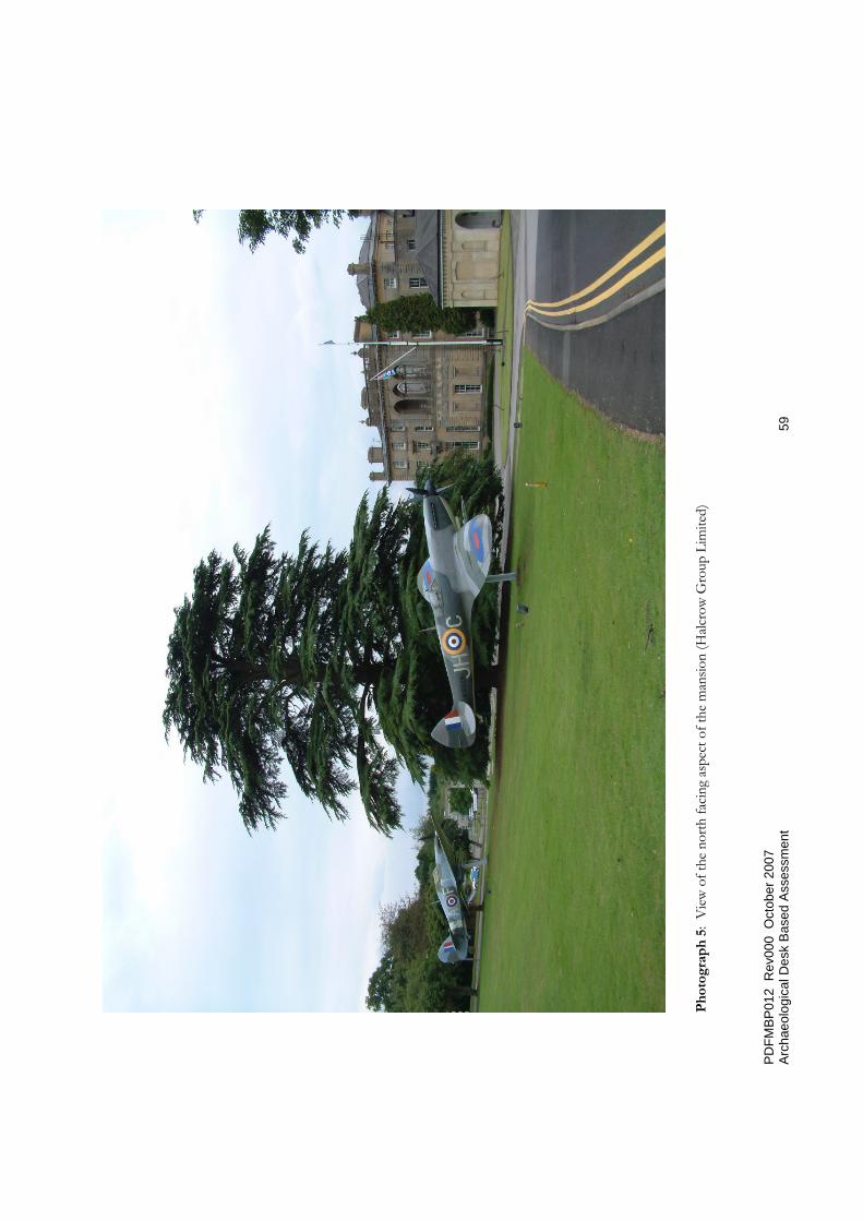
Photograph 5: View of the north facing aspect of the mansion (Halcrow Group Limited)
PDFMBP012 Rev000 October 2007 Archaeological Desk Based Assessment 41
Figure 1: Site Location
PD
FMB
P01
2 R
ev00
0 O
ctob
er 2
007
Arch
aeol
ogic
al D
esk
Base
d A
sses
smen
t 4
2
Figu
re 2
: O
rdna
nce
Surv
ey 2
001
PD
FMB
P01
2 R
ev00
0 O
ctob
er 2
007
Arch
aeol
ogic
al D
esk
Base
d A
sses
smen
t 4
3
Figu
re 3
: Si
te L
ayou
t Pla
n (E
nviro
n 20
05)

PD
FMB
P01
2 R
ev00
0 O
ctob
er 2
007
Arch
aeol
ogic
al D
esk
Base
d A
sses
smen
t 4
4
Figu
re 4
: Ben
tley
Prio
ry M
aste
rpla
n O
ptio
ns (R
ober
t Ada
m A
rchi
tect
s, 2
007)

PD
FMB
P01
2 R
ev00
0 O
ctob
er 2
007
Arch
aeol
ogic
al D
esk
Base
d A
sses
smen
t 4
5
Figu
re 5
: Be
ntley
Prio
ry, R
egist
ered
Par
k an
d G
arde
n (E
nglis
h H
erita
ge, 2
001)
PD
FMB
P01
2 R
ev00
0 O
ctob
er 2
007
Arch
aeol
ogic
al D
esk
Base
d A
sses
smen
t 4
6
Figu
re 6
: C
ultu
ral H
erita
ge fe
atur
es p
lan (E
nglis
h H
erita
ge, 2
007)
PD
FMB
P01
2 R
ev00
0 O
ctob
er 2
007
Arch
aeol
ogic
al D
esk
Base
d A
sses
smen
t 4
7
Figu
re 7
: Geo
phys
ical S
urve
y lo
catio
n di
agra
m (G
SB P
rosp
ectio
n, 2
005)

PD
FMB
P01
2 R
ev00
0 O
ctob
er 2
007
Arch
aeol
ogic
al D
esk
Base
d A
sses
smen
t 4
8
Figu
re 8
: P
lan sh
ewin
g th
e G
roun
d Fl
oor &
Cur
tilag
e of
Ben
tley
Prio
ry, M
iddl
esex
(for
Mes
sers
Deb
enha
m, T
ewso
n, F
arm
er &
Brid
gew
ater
, c. 1
880)

PD
FMB
P01
2 R
ev00
0 O
ctob
er 2
007
Arch
aeol
ogic
al D
esk
Base
d A
sses
smen
t 4
9
Figu
re 9
: Hist
oric
Land
scap
e Ch
arac
ter A
reas
(Deb
ois,
2007
)

PDFMBP012 Rev000 October 2007 Archaeological Desk Based Assessment 50
Figure 10: Extract from Sale Catalogue estate map, 1880

PD
FMB
P01
2 R
ev00
0 O
ctob
er 2
007
Arch
aeol
ogic
al D
esk
Base
d A
sses
smen
t 5
1
Figu
re 1
1a P
lan o
f Ben
tley
Prio
ry 1
939
PD
FMB
P01
2 R
ev00
0 O
ctob
er 2
007
Arch
aeol
ogic
al D
esk
Base
d A
sses
smen
t 5
2
Figu
re 1
1b:
Inde
x Pl
an fo
r RA
F Be
ntley
Prio
ry
PDFMBP012 Rev000 October 2007 Archaeological Desk Based Assessment 53
Figure 12: Ordnance Survey 1964

PD
FMB
P01
2 R
ev00
0 O
ctob
er 2
007
Arch
aeol
ogic
al D
esk
Base
d A
sses
smen
t 5
4 Fi
gure
13:
Pot
entia
l Sou
rces
of C
onta
min
atio
n (E
nviro
s, 20
05)
PD
FMB
P01
2 R
ev00
0 O
ctob
er 2
007
Arch
aeol
ogic
al D
esk
Base
d A
sses
smen
t 5
5 Ph
otog
raph
1: A
erial
view
of p
art o
f the
site
of R
AF
Bent
ley P
riory
(VSM
Est
ates
)

PDFMBP012 Rev000 October 2007 Archaeological Desk Based Assessment 56
Photograph 2: Some of the c. 18th century brick cisterns (English Heritage)

PD
FMB
P01
2 R
ev00
0 O
ctob
er 2
007
Arch
aeol
ogic
al D
esk
Base
d A
sses
smen
t 5
7
Phot
ogra
ph 3
: Th
e fe
nced
are
a ar
ound
the
rebu
ried
ciste
rns s
how
ing
a vi
ewin
g ch
ambe
r - o
ppos
ite is
Bui
ldin
g 26
8 (H
alcro
w G
roup
Li
mite
d)
PD
FMB
P01
2 R
ev00
0 O
ctob
er 2
007
Arch
aeol
ogic
al D
esk
Base
d A
sses
smen
t 5
8
Ph
otog
raph
4:
View
of t
he so
uth
facin
g as
pect
of t
he m
ansio
n an
d ga
rden
s (H
alcro
w G
roup
Lim
ited)
PD
FMB
P01
2 R
ev00
0 O
ctob
er 2
007
Arch
aeol
ogic
al D
esk
Base
d A
sses
smen
t 5
9
Phot
ogra
ph 5
: V
iew
of t
he n
orth
faci
ng a
spec
t of t
he m
ansio
n (H
alcro
w G
roup
Lim
ited)