Public Works - City of Menlo Park
11
Public Works City of Menlo Park 701 Laurel St., Menlo Park, CA 94025 tel 650-330-6600 www.menlopark.org STAFF REPORT City Council Meeting Date: Staff Report Number: Regular Business: 1/26/2021 21-017-CC Identify a preferred conceptual design for the Sharon Road sidewalk project and adopt Resolution No. 6610 restricting parking hours along Sharon Road and establishing a 15 miles per hour zone at La Entrada Middle School Recommendation Staff recommends that the City Council approve the following for the Sharon Road sidewalk project: • An asphalt strip design, with restricted day time parking, at the north side of Sharon Road from Alameda de las Pulgas to Altschul Avenue (Option A.) • Adopt Resolution No. 6610 (Attachment A) to establish a “no stopping” on-street parking zone per Table 3 and a 15 miles per hour speed (mph) zone at La Entrada Middle School per California Vehicle Code Section 23358.4. The Complete Streets Commission’s recommendations for a concrete sidewalk (Option B) and a concrete sidewalk with a parking lane (Option C) are described later in this report. Policy Issues The project is consistent with the 2016 general plan circulation element and is included in the fiscal year 2020-21 capital improvement program. Circulation element policy CIRC-1.9 supports Safe Routes to School programs which enhance the safety of school children who walk and bike to school. Background Existing street profile The project spans Sharon Road from Alameda de las Pulgas to the intersection of La Entrada Middle School at Altschul Avenue. Sharon Road is identified in the circulation element of the general plan as a bicycle boulevard, defined as a low volume residential street servicing local vehicles, bicyclists and pedestrians. This corridor is also used by students of La Entrada Middle School and included in its Safe Routes to School (Attachment B) map. The existing right-of-way is 60 feet wide and includes a two-way road, varying between 21 to 30 feet in width, with residential frontages beyond the edge of pavement. Sharon Road serves approximately 3,500 vehicles daily and has a posted speed of 25 mph. Frontage features consist of planting, heritage trees, gravel, retaining walls, limited sidewalks and asphalt strips. Parallel parking is available on both sides of Sharon Road, however, neither side has a continuous walkway. The site is prone to ponding due to existing low points and inadequate gutters. As a result, pedestrians are reported to walk into the roadway to bypass local ponding. The current walkable area is also obstructed by unrestricted parking. Police records reveal AGENDA ITEM G-1 Page G-1.1
-
Upload
khangminh22 -
Category
Documents
-
view
1 -
download
0
Transcript of Public Works - City of Menlo Park
Public Works
City of Menlo Park 701 Laurel St., Menlo Park, CA 94025 tel 650-330-6600 www.menlopark.org
STAFF REPORT
City Council Meeting Date: Staff Report Number:
Regular Business:
1/26/2021 21-017-CC
Identify a preferred conceptual design for the Sharon Road sidewalk project and adopt Resolution No. 6610 restricting parking hours along Sharon Road and establishing a 15 miles per hour zone at La Entrada Middle School
Recommendation Staff recommends that the City Council approve the following for the Sharon Road sidewalk project: • An asphalt strip design, with restricted day time parking, at the north side of Sharon Road from Alameda
de las Pulgas to Altschul Avenue (Option A.)• Adopt Resolution No. 6610 (Attachment A) to establish a “no stopping” on-street parking zone per Table
3 and a 15 miles per hour speed (mph) zone at La Entrada Middle School per California Vehicle CodeSection 23358.4.
The Complete Streets Commission’s recommendations for a concrete sidewalk (Option B) and a concrete sidewalk with a parking lane (Option C) are described later in this report.
Policy Issues The project is consistent with the 2016 general plan circulation element and is included in the fiscal year 2020-21 capital improvement program. Circulation element policy CIRC-1.9 supports Safe Routes to School programs which enhance the safety of school children who walk and bike to school.
Background Existing street profile The project spans Sharon Road from Alameda de las Pulgas to the intersection of La Entrada Middle School at Altschul Avenue. Sharon Road is identified in the circulation element of the general plan as a bicycle boulevard, defined as a low volume residential street servicing local vehicles, bicyclists and pedestrians. This corridor is also used by students of La Entrada Middle School and included in its Safe Routes to School (Attachment B) map.
The existing right-of-way is 60 feet wide and includes a two-way road, varying between 21 to 30 feet in width, with residential frontages beyond the edge of pavement. Sharon Road serves approximately 3,500 vehicles daily and has a posted speed of 25 mph. Frontage features consist of planting, heritage trees, gravel, retaining walls, limited sidewalks and asphalt strips. Parallel parking is available on both sides of Sharon Road, however, neither side has a continuous walkway. The site is prone to ponding due to existing low points and inadequate gutters. As a result, pedestrians are reported to walk into the roadway to bypass local ponding. The current walkable area is also obstructed by unrestricted parking. Police records reveal
AGENDA ITEM G-1
Page G-1.1
Staff Report #: 21-017-CC
City of Menlo Park 701 Laurel St., Menlo Park, CA 94025 tel 650-330-6600 www.menlopark.org
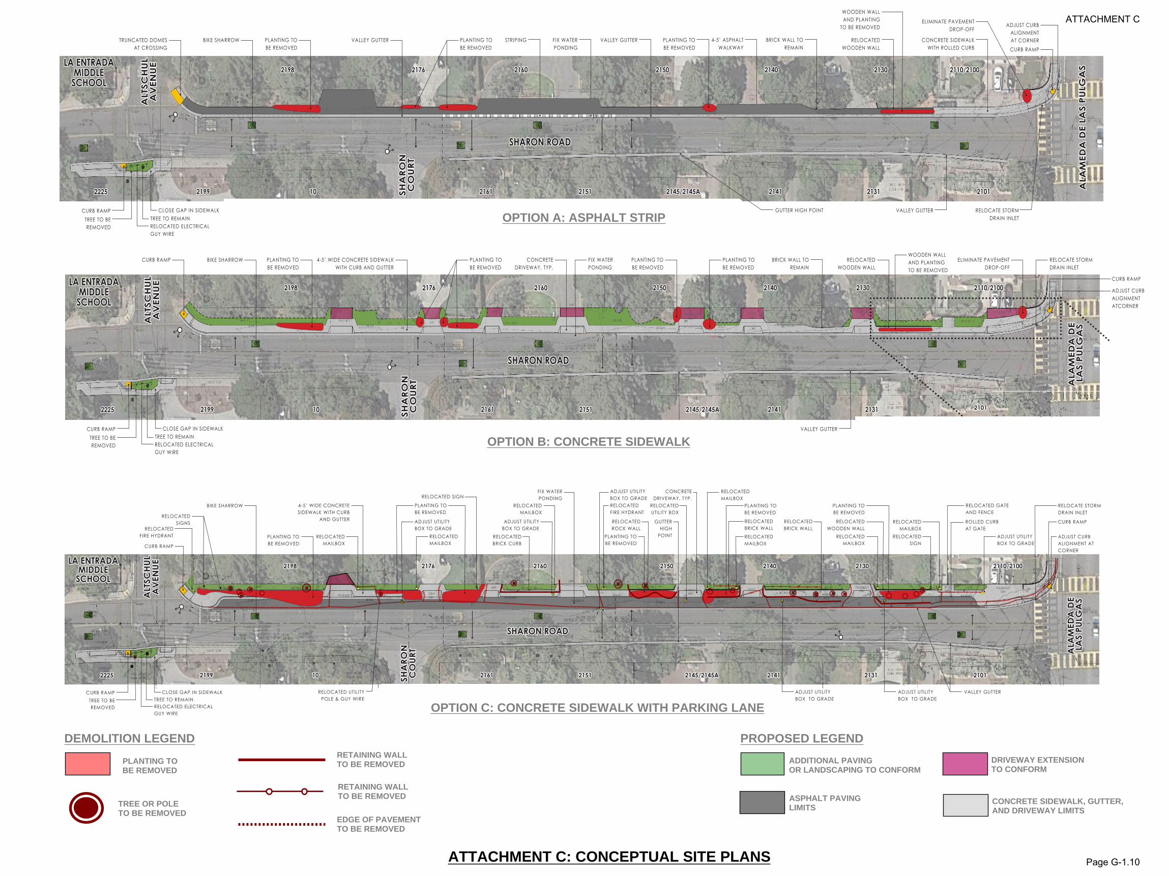
one collision with minor injuries in the project limit since 2008. The incident occurred at night and involved a driver and stationary object. In June 2018, a petition was submitted to staff with signatures of residents of the 2100 block of Sharon Road to gauge support for a walkway within the project limits. Signed petitions indicating support for the initiative were received from 75 percent of properties along the corridor. Design options and public outreach On January 15, 2020, staff held a meeting to solicit community input on two design options (Attachment C) at the multipurpose room at LaEntrada Middle School. Eighteen attendees were present at the meeting including residents of Sharon Road, representatives from Parents for Safe Routes, and other neighboring stakeholders. Both design options feature intersection improvements at Altschul Avenue and Alameda de las Pulgas, drainage mitigation to reduce ponding during rain events, and minimal impacts to heritage trees and large landscaping features, similar to the criteria used in the design of phases 1 and 2 of Santa Cruz Avenue sidewalks. The advantages and disadvantages of each option are assessed further in the Analysis section below. Option A includes an asphalt strip with a two-foot wide valley gutter that retains on-street parking outside of school arrival and dismissal hours. Option B includes a concrete sidewalk with a six-inch raised curb that eliminates parking due to space constraints. Both options meet City standards and American with Disability Act (ADA) design requirements and have been commonly constructed in Menlo Park neighborhoods. Staff received 19 online comments after the meeting of which 12 favored the asphalt path, five favored the concrete sidewalk, and two supported either option. Stakeholders supporting the asphalt pathway, including residents of Sharon Road, were attracted to its fewer frontage impacts and potential to retain parking. Proponents of the raised concrete sidewalk preferred the elevated curb as a physical barrier and safety feature. Multiple commenters encouraged lowering the site’s speed limit and requested the selected design account for drainage improvements. These and other design considerations are detailed in Table 1 in the Analysis section. Complete Streets Commission (CSC) meeting On September 9, 2020, staff presented to the CSC and recommended Option A with a reduced 15 mph zone along La Entrada Middle School. Stakeholders and residents supporting both Options A and B were present during the meeting and 12 public commenters spoke on the project. Staff noted that while both designs provide access to La Entrada Middle School, Option A retains on-street parking outside designated school hours, reflects the aesthetic of this block of Sharon Road, and carries fewer frontage and cost impacts. The CSC voted in favor of Option B (7-1-1) citing the benefit of a raised curb to separate pedestrians from bicycles and vehicles. The CSC also requested maintenance costs of each option for the City Council’s consideration. Lastly, the CSC requested evaluation of a third design option that incorporates a parking lane and concrete sidewalk (Option C.) Staff’s response is noted in the Analysis section.
Analysis Table 1 details the basis of design for Options A, B and C. These criteria include site constraints, intersection improvements, drainage, parking, bicycle and pedestrian safety, speed reduction and cost.
Page G-1.2

Staff Report #: 21-017-CC
City of Menlo Park 701 Laurel St., Menlo Park, CA 94025 tel 650-330-6600 www.menlopark.org
Table 1: Basis of design
Site constraints and alignment
The north side of Sharon Road (even house numbers) has less obstructions, and is wider, than the south side (odd house numbers.) Therefore, constructing the pedestrian facility along the north side is preferable. The south side includes steeper grades, more heritage trees, and utility poles along the proposed path of travel. The southern span of Sharon Road would also require installation of an additional pedestrian crossing at Sharon Court (which is narrow and heavily planted.)
Intersection improvements
All design options propose ADA-compliant sidewalks, driveways, and curb ramps at the intersection of Sharon Road and Altschul Avenue. These improvements are critical for access to La Entrada Middle School. The project will also consider similar improvements at the intersection of Alameda de las Pulgas which is in San Mateo County’s jurisdiction. The County is currently developing a corridor plan for this intersection and the City will continue coordination efforts for future designs in this area as part of that project’s Task Force.
Drainage
All design options include a concrete valley gutter spanning the south side of Sharon Road to mitigate ponding issues (Attachment C.) On the north side of Sharon Road, the asphalt path includes a 24” concrete valley gutter which conveys stormwater and acts as a separator between pedestrian and roadway traffic. The concrete sidewalk option would include a raised curb and gutter that provides similar drainage benefits.
On-Street parking restrictions
Option A’s asphalt path would also serve as a parking strip along the north side of Sharon Road where right of way width allows. Parking along the strip would be prohibited during school drop off, pick up and recess times per Table 3. Option B eliminates north-side parking entirely due to lack of space while Option C retains parking but is not recommended based on frontage and cost impacts (see Table 2.)
Bicyclist safety
Sharon Road is categorized as a bicycle boulevard, a low volume, residential street with shared bicycle and vehicle access. Therefore, a Class III bicycle route with shared lane markings (sharrows) is proposed with respect to this roadway classification. Class II bike lanes are impractical given insufficient street width.
Pedestrian safety
Option A’s asphalt path includes a 24” concrete valley gutter along the edge of pavement to separate pedestrian and roadway traffic. This design option would also feature signing and striping to further distinguish paths of travel and establish no stopping and 15 mph zones. Option B’s concrete sidewalk includes a 6” vertical curb to isolate foot traffic from bicycles and vehicles.
Speed reduction
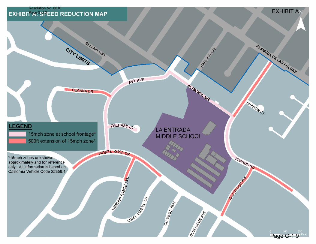
The project includes the proposal to install a 15 mph zone within 500 feet from La Entrada Middle School per the adopted 2019 Citywide Engineering and Traffic Study (Study) approved by the City Council October 15, 2020. The Study establishes City speed limits based on the California Vehicle Code (CVC) which allows local jurisdictions, by resolution, to reduce speed limits to 15 mph at 500 feet from school grounds when children are present. Signage for the speed reduction will be installed at all intersections and ingress egress points overlapping the 15 mph zone. Refer to Attachment D for a site plan.
Project cost Preliminary estimates are included in Table 2 and assume design, construction and administrative fees.
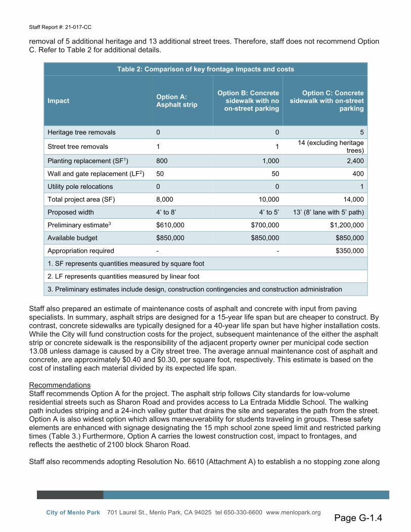
CSC feedback and recommendations The CSC requested a third design option that includes a concrete sidewalk with on-street parking (Option C.) This design would require widening the north side of Sharon Road by an additional 8-feet. Consequently, Option C results in higher frontage and cost impacts compared to Options A and B and
Page G-1.3
Staff Report #: 21-017-CC
City of Menlo Park 701 Laurel St., Menlo Park, CA 94025 tel 650-330-6600 www.menlopark.org
removal of 5 additional heritage and 13 additional street trees. Therefore, staff does not recommend Option C. Refer to Table 2 for additional details.
Table 2: Comparison of key frontage impacts and costs
Impact Option A: Asphalt strip
Option B: Concrete sidewalk with no on-street parking
Option C: Concrete sidewalk with on-street
parking
Heritage tree removals 0 0 5
Street tree removals 1 1 14 (excluding heritage trees)
Planting replacement (SF1) 800 1,000 2,400
Wall and gate replacement (LF2) 50 50 400
Utility pole relocations 0 0 1
Total project area (SF) 8,000 10,000 14,000
Proposed width 4’ to 8’ 4’ to 5’ 13’ (8’ lane with 5’ path)
Preliminary estimate3 $610,000 $700,000 $1,200,000
Available budget $850,000 $850,000 $850,000
Appropriation required - - $350,000
1. SF represents quantities measured by square foot
2. LF represents quantities measured by linear foot
3. Preliminary estimates include design, construction contingencies and construction administration Staff also prepared an estimate of maintenance costs of asphalt and concrete with input from paving specialists. In summary, asphalt strips are designed for a 15-year life span but are cheaper to construct. By contrast, concrete sidewalks are typically designed for a 40-year life span but have higher installation costs. While the City will fund construction costs for the project, subsequent maintenance of the either the asphalt strip or concrete sidewalk is the responsibility of the adjacent property owner per municipal code section 13.08 unless damage is caused by a City street tree. The average annual maintenance cost of asphalt and concrete, are approximately $0.40 and $0.30, per square foot, respectively. This estimate is based on the cost of installing each material divided by its expected life span. Recommendations Staff recommends Option A for the project. The asphalt strip follows City standards for low-volume residential streets such as Sharon Road and provides access to La Entrada Middle School. The walking path includes striping and a 24-inch valley gutter that drains the site and separates the path from the street. Option A is also widest option which allows maneuverability for students traveling in groups. These safety elements are enhanced with signage designating the 15 mph school zone speed limit and restricted parking times (Table 3.) Furthermore, Option A carries the lowest construction cost, impact to frontages, and reflects the aesthetic of 2100 block Sharon Road. Staff also recommends adopting Resolution No. 6610 (Attachment A) to establish a no stopping zone along
Page G-1.4
Staff Report #: 21-017-CC
City of Menlo Park 701 Laurel St., Menlo Park, CA 94025 tel 650-330-6600 www.menlopark.org
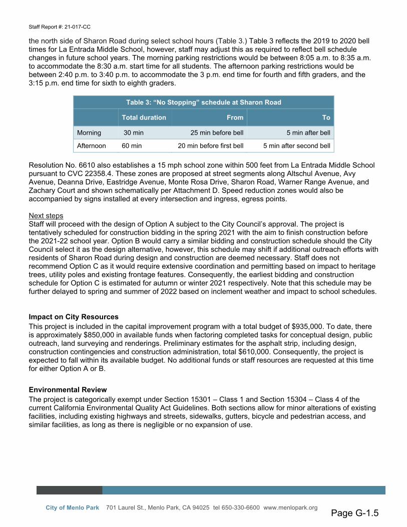
the north side of Sharon Road during select school hours (Table 3.) Table 3 reflects the 2019 to 2020 bell times for La Entrada Middle School, however, staff may adjust this as required to reflect bell schedule changes in future school years. The morning parking restrictions would be between 8:05 a.m. to 8:35 a.m. to accommodate the 8:30 a.m. start time for all students. The afternoon parking restrictions would be between 2:40 p.m. to 3:40 p.m. to accommodate the 3 p.m. end time for fourth and fifth graders, and the 3:15 p.m. end time for sixth to eighth graders.
Table 3: “No Stopping” schedule at Sharon Road
Total duration From To
Morning 30 min 25 min before bell 5 min after bell
Afternoon 60 min 20 min before first bell 5 min after second bell Resolution No. 6610 also establishes a 15 mph school zone within 500 feet from La Entrada Middle School pursuant to CVC 22358.4. These zones are proposed at street segments along Altschul Avenue, Avy Avenue, Deanna Drive, Eastridge Avenue, Monte Rosa Drive, Sharon Road, Warner Range Avenue, and Zachary Court and shown schematically per Attachment D. Speed reduction zones would also be accompanied by signs installed at every intersection and ingress, egress points. Next steps Staff will proceed with the design of Option A subject to the City Council’s approval. The project is tentatively scheduled for construction bidding in the spring 2021 with the aim to finish construction before the 2021-22 school year. Option B would carry a similar bidding and construction schedule should the City Council select it as the design alternative, however, this schedule may shift if additional outreach efforts with residents of Sharon Road during design and construction are deemed necessary. Staff does not recommend Option C as it would require extensive coordination and permitting based on impact to heritage trees, utility poles and existing frontage features. Consequently, the earliest bidding and construction schedule for Option C is estimated for autumn or winter 2021 respectively. Note that this schedule may be further delayed to spring and summer of 2022 based on inclement weather and impact to school schedules.
Impact on City Resources This project is included in the capital improvement program with a total budget of $935,000. To date, there is approximately $850,000 in available funds when factoring completed tasks for conceptual design, public outreach, land surveying and renderings. Preliminary estimates for the asphalt strip, including design, construction contingencies and construction administration, total $610,000. Consequently, the project is expected to fall within its available budget. No additional funds or staff resources are requested at this time for either Option A or B.
Environmental Review The project is categorically exempt under Section 15301 – Class 1 and Section 15304 – Class 4 of the current California Environmental Quality Act Guidelines. Both sections allow for minor alterations of existing facilities, including existing highways and streets, sidewalks, gutters, bicycle and pedestrian access, and similar facilities, as long as there is negligible or no expansion of use.
Page G-1.5
Staff Report #: 21-017-CC
City of Menlo Park 701 Laurel St., Menlo Park, CA 94025 tel 650-330-6600 www.menlopark.org
Public Notice Public Notification was achieved by posting the agenda, with the agenda items being listed, at least 72 hours prior to the meeting. Additional public outreach was achieved by sending postcards to residents and property owners within 500 feet of the project. Staff also advertised the meeting on La Entrada Middle School’s PTA Newsletter and Parents for Safe Routes website before the meeting.
Attachments A. Resolution No. 6610 B. Hyperlink – Safe Routes to School Map: menlopark.org/DocumentCenter/View/20901/La-Entrada-
School-Walk-and-Roll-Map C. Conceptual plans (Options A, B and C) D. Speed reduction map
Report prepared by: Michael Fu, Senior Civil Engineer Report reviewed by: Chris Lamm, Assistant Public Works Director
Page G-1.6
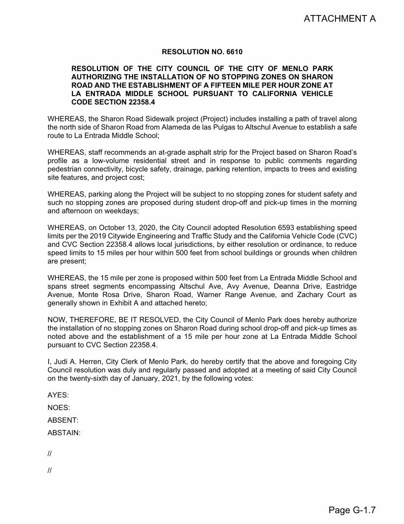
RESOLUTION NO. 6610
RESOLUTION OF THE CITY COUNCIL OF THE CITY OF MENLO PARK AUTHORIZING THE INSTALLATION OF NO STOPPING ZONES ON SHARON ROAD AND THE ESTABLISHMENT OF A FIFTEEN MILE PER HOUR ZONE AT LA ENTRADA MIDDLE SCHOOL PURSUANT TO CALIFORNIA VEHICLE CODE SECTION 22358.4
WHEREAS, the Sharon Road Sidewalk project (Project) includes installing a path of travel along the north side of Sharon Road from Alameda de las Pulgas to Altschul Avenue to establish a safe route to La Entrada Middle School;
WHEREAS, staff recommends an at-grade asphalt strip for the Project based on Sharon Road’s profile as a low-volume residential street and in response to public comments regarding pedestrian connectivity, bicycle safety, drainage, parking retention, impacts to trees and existing site features, and project cost;
WHEREAS, parking along the Project will be subject to no stopping zones for student safety and such no stopping zones are proposed during student drop-off and pick-up times in the morning and afternoon on weekdays;
WHEREAS, on October 13, 2020, the City Council adopted Resolution 6593 establishing speed limits per the 2019 Citywide Engineering and Traffic Study and the California Vehicle Code (CVC) and CVC Section 22358.4 allows local jurisdictions, by either resolution or ordinance, to reduce speed limits to 15 miles per hour within 500 feet from school buildings or grounds when children are present;
WHEREAS, the 15 mile per zone is proposed within 500 feet from La Entrada Middle School and spans street segments encompassing Altschul Ave, Avy Avenue, Deanna Drive, Eastridge Avenue, Monte Rosa Drive, Sharon Road, Warner Range Avenue, and Zachary Court as generally shown in Exhibit A and attached hereto;
NOW, THEREFORE, BE IT RESOLVED, the City Council of Menlo Park does hereby authorize the installation of no stopping zones on Sharon Road during school drop-off and pick-up times as noted above and the establishment of a 15 mile per hour zone at La Entrada Middle School pursuant to CVC Section 22358.4.
I, Judi A. Herren, City Clerk of Menlo Park, do hereby certify that the above and foregoing City Council resolution was duly and regularly passed and adopted at a meeting of said City Council on the twenty-sixth day of January, 2021, by the following votes:
AYES:
NOES:
ABSENT:
ABSTAIN:
//
//
ATTACHMENT A
Page G-1.7
IN WITNESS WHEREOF, I have hereunto set my hand and affixed the Official Seal of said City on this twenty-sixth day of January, 2021.
____________________________ Judi A. Herren, City Clerk
Resolution No. 6610 Page 2 of 3
Page G-1.8
Resolution No. 6610 Page 3 of 3 EXHIBIT A
Page G-1.9
RIGHT OF WAY
EXISTING EDGEOF ROADWAY
VALLEY GUTTER
CURB RAMP
4-5’ ASPHALTWALKWAY
RELOCATED WOODEN WALL
VALLEY GUTTER STRIPINGTRUNCATED DOMES AT CROSSING
VALLEY GUTTERCURB RAMP
RELOCATED ELECTRICAL GUY WIRE
BIKE SHARROW BRICK WALL TO REMAIN
PLANTING TO BE REMOVED
PLANTING TO BE REMOVED
WOODEN WALL AND PLANTING
TO BE REMOVED
TREE TO BE REMOVED
TREE TO REMAINCLOSE GAP IN SIDEWALK
CURB RAMP
RELOCATED ELECTRICAL GUY WIRE
TREE TO BE REMOVED
TREE TO REMAINCLOSE GAP IN SIDEWALK
GUTTER HIGH POINT
FIX WATER PONDING
GUTTER HIGH POINT
PLANTING TO BE REMOVED
ADJUST CURB ALIGNMENT AT CORNER
RELOCATE STORM DRAIN INLET
SHARON ROAD SIDEWALK IMPROVEMENTS
OPTION 1: STANDARD SIDEWALK WITH SHARROW
CONCEPT PLANOPTION 2: ASPHALT WALKWAY WITH SHARROW
0 10’ 20’ 40’0 10’ 40’5’
SHARON ROADSHARON ROAD
21612161 21512151101021992199
21982198 21762176 21602160 21502150 21402140 21302130 2110/21002110/2100
2145/2145A2145/2145A 21412141 21312131 21012101 ALA
MED
A D
E LA
S PU
LGA
SA
LAM
EDA
DE
LAS
PULG
AS
ALT
SCH
UL
ALT
SCH
UL
AV
ENU
EA
VEN
UELA ENTRADA LA ENTRADA
MIDDLE MIDDLE SCHOOLSCHOOL
SHA
RON
SH
ARO
N
CO
URT
CO
URT
22252225
VALLEY GUTTER CONCRETE SIDEWALK WITH ROLLED CURB
ELIMINATE PAVEMENT DROP-OFF
ELIM
VALLEY GUTTERCURB RAMP
RELOCATED ELECTRICAL GUY WIRE
CURB RAMP 4-5’ WIDE CONCRETE SIDEWALKWITH CURB AND GUTTER
RELOCATED WOODEN WALL
CURB RAMP
BIKE SHARROW
CONFOTO EXIS
CONDITI
ROLLED CURB
WOODEN WALL AND PLANTING TO BE REMOVED
PLANTING TO BE REMOVED
PLANTING TO BE REMOVED
PLANTING TO BE REMOVED
PLANTING TO BE REMOVED
WOODEN WALL AND PLANTING
TO BE REMOVED
ADJUST CURB ALIGNMENT ATCORNER
RELOCATE STORM DRAIN INLET
BRICK WALL TO REMAIN
CONCRETE DRIVEWAY, TYP.
FIX WATER PONDING
TREE TO BE REMOVED
TREE TO REMAINCLOSE GAP IN SIDEWALK
GUTTER HIGH POINT
ADJUST CURB ALIGNMENT
OPTION 1: STANDARD SIDEWALK WITH SHARROW
SHARON ROADSHARON ROAD
21612161 21512151101021992199
21982198 21762176 21602160 21502150 21402140 21302130 2110/21002110/2100
2145/2145A2145/2145A 21412141 21312131 21012101
ALA
MED
A D
EA
LAM
EDA
DE
LA
S PU
LGA
S L
AS
PULG
ASA
LTSC
HU
L A
LTSC
HU
L A
VEN
UE
AV
ENU
E
SHA
RON
SH
ARO
N
CO
URT
CO
URT
LA ENTRADA LA ENTRADA MIDDLE MIDDLE SCHOOLSCHOOL
OPTION 1: ALTERNATE CONFOR
ELIMINATE PAVEMENT DROP-OFF
ELIMINATE PAVEMENT DROP-OFF
22252225
CURB RAMP
RELOCATED ELECTRICAL GUY WIRE
CURB RAMP
4-5’ WIDE CONCRETESIDEWALK WITH CURB
AND GUTTER RELOCATED WOODEN WALL
CURB RAMP
BIKE SHARROW
PLANTING TO BE REMOVED
PLANTING TO BE REMOVED
PLANTING TO BE REMOVED
ADJUST CURB ALIGNMENT AT CORNER
RELOCATE STORM DRAIN INLET
RELOCATED BRICK WALL
FIX WATER PONDING
TREE TO BE REMOVED
TREE TO REMAINCLOSE GAP IN SIDEWALK
RELOCATED MAILBOX
RELOCATED SIGN
ADJUST UTILITY BOX TO GRADE
RELOCATED MAILBOX
RELOCATED FIRE HYDRANT
RELOCATED MAILBOX
RELOCATED MAILBOX
ADJUST UTILITY BOX TO GRADE
RELOCATED UTILITY BOX
RELOCATED MAILBOX
ADJUST UTILITY BOX TO GRADE
RELOCATED SIGN
RELOCATED MAILBOX
ADJUST UTILITY BOX TO GRADE
RELOCATED MAILBOX
RELOCATED SIGNS
PLANTING TO BE REMOVED
RELOCATED FIRE HYDRANT
RELOCATED BRICK WALL
RELOCATED GATE AND FENCE
RELOCATED ROCK WALL
ADJUST UTILITY BOX TO GRADE
RELOCATED BRICK CURB
RELOCATED UTILITY POLE & GUY WIRE
PLANTING TO BE REMOVED
CONCRETE DRIVEWAY, TYP.
ADJUST UTILITY BOX TO GRADE
VALLEY GUTTER
ROLLED CURB AT GATE
OPTION 3: STANDARD SIDEWALK WITH PARKING & SHARROW
SHARON ROADSHARON ROAD
21612161 21512151101021992199
21982198 21762176 21602160 21502150 21402140 21302130 2110/21002110/2100
2145/2145A2145/2145A 21412141 21312131 21012101
ALA
MED
A D
EA
LAM
EDA
DE
LA
S PU
LGA
S L
AS
PULG
ASA
LTSC
HUL
A
LTSC
HUL
A
VEN
UEA
VEN
UE
SHA
RON
SH
ARO
N
CO
URT
CO
URT
LA ENTRADA LA ENTRADA MIDDLE MIDDLE SCHOOLSCHOOL
22252225
LEGEND RELOCATION / REMOVAL SUMMARY
GUTTER HIGH
POINT
0 10’ 20’ 40’0 10’ 20’5’
JP
OPTION A: ASPHALT STRIP
OPTION B: CONCRETE SIDEWALK
OPTION C: CONCRETE SIDEWALK WITH PARKING LANE
21012101
ATTACHMENT C: CONCEPTUAL SITE PLANS
DEMOLITION LEGEND
ADDITIONAL PAVING OR LANDSCAPING TO CONFORM
PLANTING TO BE REMOVED
DRIVEWAY EXTENSIONTO CONFORM
CONCRETE SIDEWALK, GUTTER,AND DRIVEWAY LIMITS
ASPHALT PAVINGLIMITSTREE OR POLE
TO BE REMOVEDEDGE OF PAVEMENT TO BE REMOVED
RETAINING WALL TO BE REMOVED
RETAINING WALLTO BE REMOVED
PROPOSED LEGEND
ATTACHMENT C
Page G-1.10
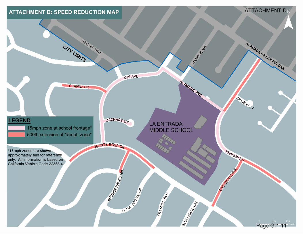
*1 Smph zones are showapproximately and for refere eeonly. All information is based onCalifornia Vehicle Code 22358.4
ATTACHMENT D
Page G-1.11