Providing Geographic-Multidimensional Decision Support over the Web
12
Y. Zhang et al. (Eds.): APWeb 2005, LNCS 3399, pp. 477 – 488, 2005. © Springer-Verlag Berlin Heidelberg 2005 Providing Geographic-Multidimensional Decision Support over the Web Joel da Silva, Valéria C. Times, Robson N. Fidalgo, and Roberto S.M. Barros Center for Informatics – Federal University of Pernambuco, P. O. Box 7851 Cidade Universitária, Recife – PE, Brazil, 50.732-970 {js, vct, rdnf, roberto}@cin.ufpe.br Abstract. For the last years, many researchers have been addressing their ef- forts to try to solve the problem regarding the integration between analytic and geographic processing systems. The main goal is to provide users with a system capable of processing both geographic and multidimensional data by abstracting the complexity of separately querying and analyzing these data in a decision making process. However, this integration may not be fully achieved yet or may be built by using proprietary technologies. This paper presents a service integra- tion model for supporting analytic and/or geographic requests over the Web. This model has been implemented by a Web Service, named GMLA WS, which is strongly based on standardized technologies such as Web Services, Java and XML. The GMLA WS query results are displayed using a Web browser as maps and/or tables for helping users in their decision making. 1 Introduction Several researchers from the Information Technology community have thoroughly investigated the problem of integrating the analytic and geographic processing [29- 33]. However, much of this work does no more than proposing an operator for the system interface. Moreover, this is an arduous task and deserves some special atten- tion. The main idea is to develop an open and extensible system with the analysis capabilities available in these two technologies. Thus, a geographic processing system [5-8] could take the advantage of the facilities implemented by an analytic tool [1,16], while the latter would receive a considerable gain in aggregating some spatial treat- ment for the geographic dimension. According to this, members from the project GOLAPA (Geographic Online Ana- lytic Processing Architecture) [17,18], have been studying a way of providing users with an abstraction of the complexity involved in querying analytic and geographic data for decision support [34,35]. The work presented in this paper is part of the GOLAPA project and aims to integrate the analytic and geographic services for deci- sion support over the Web. This article presents the GMLA Web Service, which pro- vides operations for performing analytic and/or geographic analysis over a geo- graphic-multidimensional data source. The remainder of this paper is organized as follows. The second section presents a summary of the main related work. The third section outlines the XML and Web services technologies together with a view of
Transcript of Providing Geographic-Multidimensional Decision Support over the Web

Y. Zhang et al. (Eds.): APWeb 2005, LNCS 3399, pp. 477 – 488, 2005. © Springer-Verlag Berlin Heidelberg 2005
Providing Geographic-Multidimensional Decision Support over the Web
Joel da Silva, Valéria C. Times, Robson N. Fidalgo, and Roberto S.M. Barros
Center for Informatics – Federal University of Pernambuco, P. O. Box 7851 Cidade Universitária, Recife – PE, Brazil, 50.732-970 {js, vct, rdnf, roberto}@cin.ufpe.br
Abstract. For the last years, many researchers have been addressing their ef-forts to try to solve the problem regarding the integration between analytic and geographic processing systems. The main goal is to provide users with a system capable of processing both geographic and multidimensional data by abstracting the complexity of separately querying and analyzing these data in a decision making process. However, this integration may not be fully achieved yet or may be built by using proprietary technologies. This paper presents a service integra-tion model for supporting analytic and/or geographic requests over the Web. This model has been implemented by a Web Service, named GMLA WS, which is strongly based on standardized technologies such as Web Services, Java and XML. The GMLA WS query results are displayed using a Web browser as maps and/or tables for helping users in their decision making.
1 Introduction
Several researchers from the Information Technology community have thoroughly investigated the problem of integrating the analytic and geographic processing [29-33]. However, much of this work does no more than proposing an operator for the system interface. Moreover, this is an arduous task and deserves some special atten-tion. The main idea is to develop an open and extensible system with the analysis capabilities available in these two technologies. Thus, a geographic processing system [5-8] could take the advantage of the facilities implemented by an analytic tool [1,16], while the latter would receive a considerable gain in aggregating some spatial treat-ment for the geographic dimension.
According to this, members from the project GOLAPA (Geographic Online Ana-lytic Processing Architecture) [17,18], have been studying a way of providing users with an abstraction of the complexity involved in querying analytic and geographic data for decision support [34,35]. The work presented in this paper is part of the GOLAPA project and aims to integrate the analytic and geographic services for deci-sion support over the Web. This article presents the GMLA Web Service, which pro-vides operations for performing analytic and/or geographic analysis over a geo-graphic-multidimensional data source. The remainder of this paper is organized as follows. The second section presents a summary of the main related work. The third section outlines the XML and Web services technologies together with a view of

478 J. da Silva et al.
some other related standards. In the four section, the integration model namely ISAG is presented. In the section five, some details concerning the GMLA Web Service implementation are given. The section six shows an application of the GMLA Web Service, with some experimental results. Finally, some conclusions regarding this investigation are given in the section seven.
2 Related Work
A lot of research about the integration of analytic and geographic processing has been found in literature [48-56], but just the following studies have showed to be more relevant to the work given in this paper: MapCube [29], GeoMiner [30], GOAL [31, 57] and SIGOLAP [32, 33].
MapCube is an operator used to perform aggregation and visualization of geo-graphic data and may be seen as a metaphor for an album of maps. MapCube is based on the Cube [58] operator and performs all combinations of aggregation for each data of each Data Warehouse (DW) dimension. The main difference between these two opera-tors is the presentation of their results. The Cube operator just presents its results in a tabular view, whereas the MapCube operator shows the results as both tables and maps.
GeoMiner is a project aiming at the mining of geographic data and is composed by three basic modules. However, just two modules of them can be considered as related work: the module for geo-cubes construction and the one for geographic OLAP. In [59, 60], Han et al. proposed two algorithms for the efficient construction of geo-graphic data cubes: Pointer Intersection and Object Connection. These algorithms provide a means of building analytic and spatial cubes based on the selective materi-alization of a geographic dataset. The specified criteria were: 1) the geo-dataset access frequency, 2) its storage cost and 3) the support for building other derivatives geo-graphic cubes.
Geographical Information On-Line Analysis (GOAL) is a project that aims to ac-complish the integration between DW / On-Line Analytical Processing (OLAP) and Geographical Information Systems (GIS). To achieve this, Kouba et al. [31,57] have implemented an architecture where the main component used to manage this task is the Integration Module (IM). For the case study presented in [57] the software GT Media98 and ArcView were used together with the MSOLAP server as the OLAP component. Because these tools have different interfaces for communication, the IM has to be adjusted to offer the appropriate support for each new software component. While the communication with ArcView was achieved by using Avenue scripts (the na-tive language of ArcView) and Delphi libraries, the communication with MSOLAP was done by implementing an OLE DB for OLAP provider [61] with Visual C++.
SIGOLAP aims to provide the integration between GIS and OLAP by a three tier architecture, which is based on a mediation approach. The implemented case study demonstrates this architecture by using the following technologies: MSOLAP Server; MSAccess and AutoDesk Mapguide Server; SQL Server and Visual Basic, and, Vis-ual Basic Script.
With regard to the work discussed above, we shall now conclude that: the Map-Cube approach, just provides multidimensional analytic processing over geographic data without considering the GIS operators (e.g. distance and adjacency). However,
Providing Geographic-Multidimensional Decision Support over the Web 479
despite using proprietary technologies and as a result, preventing them from being multi-platform based approaches and from providing extensibility and data inter-change capabilities, the reminding work discussed above, namely GeoMiner, GOAL and SIGOLAP do integrate SIG and OLAP functionalities. This lack of platform independence can be seen as a motivation for the work given in this paper.
3 XML and Web Services
This paper presents a XML (eXtensible Markup Language) based approach to provide users with analytic and geographic processing over the Web. The main goal is to provide an environment for decision making that abstracts the complexity involved in simultaneously querying multidimensional and/or geographic data. To overcome the limitations cited in the previous section, we use the Web Services technology, be-cause it is strongly based on XML, and thus, allows us to easily integrate systems with distinct functionalities. Using the Web Services and XML technologies, we have obtained an open and platform independent solution for the analytic and geographic processing integration.
The development of the XML [20] has been recognized as an important issue in the Information Technology research area. XML has become a standard for data pub-lication and data interchange over the Web. It is an extensible language that allows new standards to be specified from it, and thus, enables the development of new tech-nologies to be operated in conformity with it. Another technology that has been de-veloped from XML is Web Services [9]. These compose a distributed computational architecture based on auto-descriptive services that can be published, located and exe-cuted through the Web, and that publish interfaces and connections that are both defined and described in XML.
In this paper, both the XML and Web Service technologies are considered as es-sential for the processing, interchange and visualization of the analytic and geo-graphic data over the Web. XML for Analysis (XMLA) [13], Web Feature Service (WFS) [15] and Geography Markup Language (GML) [14] are mainly standardized and key technologies, that can be used in the development of Web Services for geo-graphic-multidimensional processing.
XML For Analysis (XMLA) is one of the open technologies that is available to en-able the OLAP [1] processing over the Web. It is a XML API based on SOAP[11] that has been created as an initiative of the Microsoft Corporation [23] and Hyperion Solutions Corporation [24] to provide an open access for multidimensional databases. This standardized access enables a non-proprietary communication between client applications and OLAP data servers through the Internet. XMLA implementation is based on the Web Services architecture and the description of its service is defined in terms of a WSDL document. XMLA provides two methods for managing their func-tionality: Execute and Discover. These enable the access to both data and metadata stored in a multidimensional OLAP Server. As these methods are invoked through SOAP, the input and output are XML documents.
The two most important XML based technologies that makes the provision for the geographic data processing over the Web are GML [14] and WFS [15]. GML is the OpenGIS [27] XML Schema for interchanging and storing the descriptive and geo-

480 J. da Silva et al.
metric properties of geo-referenced data. GML is based on the abstract model [26] of the OpenGIS consortium and its last stabilized version (i.e. 2.1.2) supports vector geo-data only. Although the GML 3.0 has recently been launched already, this is still under industry evaluation, and for this reason, we have decided to use GML 2.1.2 which is an evaluated and stabilized version.
WFS [15] is the OpenGIS Specification for providing some interfaces for the de-scription of operations used to manipulate geographic features (coded in GML) in a distributed environment through the HTTP protocol. The geographic features are spatial objects that must at least contain one geometric property and may have one or more descriptive properties. Operations for data manipulation include abilities to create, erase, change, obtain or search features based on spatial restrictions (e.g. adja-cency and distance) and on non-spatial criteria (e.g. population >= 800.000 and gen-der = "M"). The recovery of both data and metadata stored in a geographic database is achieved by the use of the following WFS operations: GetCapabilities, DescribeFea-tureType and GetFeature. The spatial, logic, arithmetic and comparison operators, which may be used in a WFS request are described in [25].
Based on XMLA and GML, we have specified the GMLA [17] according to the XML Schema [22] syntax. Thus, GMLA imports, extends, and integrates the original XML Schemas. With GMLA, the data that had been previously described by two distinct schemas, can now be described and semantically integrated by just one schema. This resulting schema is then used by the GMLA Web Service to describe and validate the geographic-multidimensional data.
The technologies discussed in this section have fundamentally contributed for the integration of the analytic and geographic processing. Using them helped in the de-velopment of the GMLA Request Schema, of the integration model and of the GMLA Web Service. These are described in the following sections.
4 The Model ISAG
Before developing the integration model and the GMLA Web Service for the analytic and geographic services integration, the GMLA Request Schema [37,63] was defined. This XML schema is responsible for the validation of requests that are processed by the GMLA Web Service and, consequently, for the prevention of syntactic errors. The GMLA Request Schema integrates the request syntax of the XMLA and WFS ser-vices and was defined to support the following three query types: MD (Multidimen-sional), GEO (Geographic) and GEOMD (Geographic-Multidimensional).
A query of type MD just contains analytic parameters allowing the execution of a multidimensional expression [28] or a metadata request. When this query type is submitted to the GMLA WS, it delegates this request to the XMLA analytic service that will process the corresponding result. On the other hand, a request of type GEO just contains geographic parameters, making the GMLA WS to activate the WFS service to produce the needed result. Finally, a GEOMD request contains both ana-lytic and geographic parameters, and in this case, both services (i.e. XMLA and WFS) are processed to obtain a solution satisfying the query. In addition, a GEOMD request can be further classified as follows: 1) Mapping GEOMD, where an analytic request is sent to the GMLA WS and analytic data are displayed on a map, and 2) Integration

Providing Geographic-Multidimensional Decision Support over the Web 481
GEOMD, where analytic and spatial restrictions are specified and used in the request processing. The GMLA Request Schema can be downloaded from http://www.cin. ufpe.br/~golapa/schemas, while some query examples can be downloaded from http://www.cin.ufpe.br/~golapa/gmlaws/requests.
In software engineering methodologies, models [36] are used to simplify and graphically indicate the main concepts, activities, processes and/or data involved in the development of a system. In using models, some aspects pertinent to the imple-mentation can be abstracted, enabling a better understanding of the main processes that compose a system.
After specifying the GMLA Request Schema, which defines the supported opera-tions types, the services integration model named ISAG [37] was specified. This model was specified in UML [36] and defines an activities group to enable the inte-gration of the analytic and geographic processing.
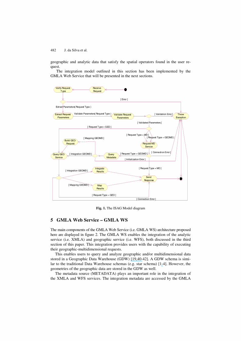
In figure 1, the highest abstraction level of the ISAG model is given. The activities of this model are sequentially performed and each execution result is used by the following activity in the sequence, until the processing is completed and the final state is reached. Each model activity has some sub activities, which need to be performed so that the main activity is concluded.
The ISAG model takes into account the existence of a metadata source, which con-tains information about which analytic data have a geographic correspondence, and about how to recover these correspondences. These are very useful for requests need-ing to either integrate or map the final query results. Data with geographic correspon-dences are considered here as those analytic data which are associated with some information that represent their geometry.
The first activity of the ISAG model shown in figure 1 is Receive Request. Then, the activity Verify Request Type is performed which classifies the request according to the query types defined by the GMLA Request Schema (i.e. MD, GEO or GEOMD). The next activity is Extract Request Parameters, which extracts some information from the analytic and/or geographic parameters found in the user request. Following this, these parameters are validated by the activity Validate Request Parameters. Next, the analytic and/or geographic services are asked to produce the query results. Following this, for a request of type MD, the activity Request MD Service solves the query and returns its response. Finally, for a GEO request, the next activity to be executed is the Query GEO Service which recovers the geographic information satis-fying the query.
If the request type is GEOMD, the next activity to be executed is the Request MD Service. Then, the activity Query Metadata is performed. For a mapping GEOMD, the metadata source is used to identify which analytic data have geographic corre-spondences and how to recover these correspondences. After doing this, in the activ-ity Build GEO Request, the GEO query that recovers all geographic correspondences of the analytic members involved in the request is formulated. In the activity Map Results, the resulting document is built, which contains the analytic data together with their corresponding geographic correspondences. If the request is of type integration GEOMD, after querying the metadata source, the next activity is the Query GEO Service, which recovers all geographic features satisfying the request. Then, in the activity Integrate Results, the response document is built, which just contains the
482 J. da Silva et al.
geographic and analytic data that satisfy the spatial operators found in the user re-quest.
The integration model outlined in this section has been implemented by the GMLA Web Service that will be presented in the next sections.
Throw Exception
Verify Request Type
Request MD Service
Send Response
Receive Request
Query Metadata
Query GEO Service
Extract Request Parameters
Validate Request Parameters
Validate Parameters( Request Type )
Build GEO Request
Integrate Results
Map Results
[ Validation Error ]
[ Validated Parameters ]
[ Error ]
Extract Parameters( Request Type )
[ Request Type = MD ]
[ Request Type = GEOMD ][ Connection Error ]
[ Request Type = MD ][ Request Type = GEOMD ]
[ Request Type = GEO ]
[ Mapping GEOMD ]
[ Integration GEOMD ]
[ Initialization Error ]
[ Request Type = GEO ]
[ Mapping GEOMD ]
[ Integration GEOMD ]
[ Connection Error ]
Fig. 1. The ISAG Model diagram
5 GMLA Web Service – GMLA WS
The main components of the GMLA Web Service (i.e. GMLA WS) architecture proposed here are displayed in figure 2. The GMLA WS enables the integration of the analytic service (i.e. XMLA) and geographic service (i.e. WFS), both discussed in the third section of this paper. This integration provides users with the capability of executing their geographic-multidimensional requests.
This enables users to query and analyze geographic and/or multidimensional data stored in a Geographic Data Warehouse (GDW) [19,40-42]. A GDW schema is simi-lar to the traditional Data Warehouse schemas (e.g. star schema) [1-4]. However, the geometries of the geographic data are stored in the GDW as well.
The metadata source (METADATA) plays an important role in the integration of the XMLA and WFS services. The integration metadata are accessed by the GMLA

Providing Geographic-Multidimensional Decision Support over the Web 483
WS whenever a GEOMD request is received. Thus, the GMLA WS can find out if the analytic data have some geographic correspondences. The metadata source implemen tation has been based on the MOF (MetaObject Facility) [38] specification, by the OMG (Object Management Group) [39] and on the metamodels GAM (Geographical and Analytical Metamodel) and GeoMDM (Geographical Multidimensional Meta-model) presented in [62].
Fig. 2. GMLA WS architecture
The GMLA WS implementation has been based on the Web Services architecture [9]. Thus, the GMLA WS provides a WSDL [21] document with the service descrip-tion and available operations, allowing a client application to be implemented regard-less of the chosen operating system or programming language.
The GMLA WS is both a client and a server. It can be seen as a client because it may access two other services (i.e. XMLA and WFS), and as a server, because a WSDL interface is provided to allow other applications to be developed.
The communication between the GMLA WS and the XMLA is based on the Web Services standard, and made by sending and receiving information coded in a SOAP envelope. On the other hand, the communication between the GMLA WS and the WFS service is achieved by sending and receiving HTTP [12] requests, instead of using the SOAP protocol due to the WFS do not operate according to the Web Ser-vices standard.
The GMLA CLIENT component is responsible for formulating the requests ac-cording to the GMLA Request Schema, sending these requests to the GMLA WS and then, after obtaining the response document, for graphically displaying the results.
When a client application sends a request to the GMLA WS, this is executed and a XML document is returned as the final result. The structure of this document is de-fined and validated by the GMLA Schema [17].

484 J. da Silva et al.
6 A GMLA WS Application
To illustrate an application for the GMLA WS, the processing of a GEOMD query is demonstrated having both analytic and geographic requests. In this example, the idea is to visualize the total of the product sales, classifying by the product category and grouping the results by country, states and cities. The key issue in this request is that users wish to graphically visualize the result on a map. Then, a query of type mapping GEOMD will be sent to the GMLA WS containing the proper request parameters.
After having received the request parameters sent by the client application, the GMLA WS performs the multidimensional request, which will result in a collection of product categories, together with their total of sales organized by country, states and cities. This processing is performed by the multidimensional service XMLA.
Following this, the GMLA WS identifies the resulting elements of the multidimen-sional request that have geographic correspondences, so that the needed information is displayed on a map. This is done by using the GMLA WS metadata source. Accessing this metadata allows the system to elaborate a request that will be sent to the WFS geo-graphic service to recover all the geographic features that are involved in the correspond-ing query.
Fig. 4. Graphic visualization of a GEOMD request result
After having received the response from the WFS geographic service, the GMLA WS builds a XML document containing the integration of the multidimensional and

Providing Geographic-Multidimensional Decision Support over the Web 485
geographic data, creates a SOAP envelope and then, returns it to the client application that had previously sent the request. Next, the client application receives the SOAP envelope and graphically shows the result. Then, the geographic data of the resulting document are transformed by the GMLA CLIENT to the Scalable Vector Graphics format (SVG) [43], showing them as a map. The multidimensional data are also sub-mitted to a XSLT processing [47] and visualized in the HTML format. The figure 4 demonstrates this query processing result, where a table with the multidimensional data is given at the bottom, and a map showing the elements involved in the request that have geographic correspondences is given at the top. The final graphic result can be visualized in a Web browser with a SVG Plugin [44]. For this case study, the Internet Explorer [45] was used.
As can be seen in the legend given above, in the right side of the browser screen (figure 4), the geographic data are organized in three themes: 1) Country, 2) States and 3) Cities. In these themes, all members showed in the multidimensional data table given at the bottom of the browser screen are displayed. To manipulate the data found in these themes, the operations available in the toolbar, located at the top of the web browser screen and above the map, may be used. These available operations include zoom in, zoom out, pan operator, label insertion and exclusion, and presentation of detailed information about each geographic feature found in the map. The interface component that is responsible for graphically showing the geographic data coded the in SVG format is an adaptation of the GeoClient Component of the GeoServer Project [46].
Any other request type that satisfies the GMLA Request Schema (see section 4) can be sent to the GMLA WS to be processed. However, this processing has not been shown here for the sake of simplicity and limitation of space.
7 Conclusions
The integration between analytic and geographic processing as a single tool provides a wider context for decision support. This is so because it aggregates: the capability of quickly analyzing a large volume of data and the power of visualizing data on maps and running spatial queries.
The work presented in this paper is part of the GOLAPA project, which is concerned with the development of a service layer, making a set of operations available for the geographic-multidimensional processing. Due to the use of open and extensible tech-nologies, the solutions discussed in this paper are independent from the GOLAPA, and as a result, they may be applied to any other projects aiming at integrating analytic and geographic processing.
The proposed integration model defines a set of activities that are performed for in-tegrating the tools provided by the analytic and geographic services used in the query and analysis of geographic-multidimensional data. The model is based on three request types defined by GMLA Request Schema, which integrates the syntax of both XMLA and WFS services. Also, this model takes into account the use of a metadata source to provide information about the relationships existing between the analytic and geo-graphic data.

486 J. da Silva et al.
The implementation of the integration model was achieved by specifying and devel-oping a Web Service namely GMLA WS. This integrates both the XMLA and WFS services to make operations available for the processing of analytic and/or geographic requests. This system prototype provides an environment that abstracts the complexity found in the joint use of analytic and spatial operators found in decision support queries. Moreover, the GMLA WS provides the visualization of both the analytic and/or geo-graphic information on maps and/or tables, through the use of a simple Web browser. Finally, for implementing the system prototype, technologies such as Web Services, GML, SVG, MOF, Java and XML were used to provide an extensible and platform independent solution.
References
1. S. Chaudhuri, U. Dayal. Decision support, Data Warehouse, and OLAP, Tutorials of the Twenty-Second international Conf. On Very Large Data Base, 1996.
2. W. H. Inmon. Building the Data Warehouse. 2nd edition. John Wiley & Sons, 1997. 3. R.Kimball. The Data Warehouse Toolkit., John Wiley&Sons, Inc, 1996. 4. R. Kimball, L. Reeves, M. Ross, and W. Thornthwaite. The Data Warehouse Lifecycle
Toolkit. Wiley, 1998. 5. G. Câmara, et al. Anatomia de Sistemas de Informação Geográfica. 10ª Escola de
computação, http://www.dpi.inpe.br/geopro/livros/anatomia.pdf, 1996. 6. N. Chrisman. Exploring Geographic Information Systems. John Wiley and Sons, 1996. 7. P. A. Longley, et al. Geographical Information Systems: Principles, Techiniques, Applica-
tions and Managemente. 2nd Edition, John Wiley and Sons, 1999. 8. M. F. Goodchild. Geographical Data Modeling. Computers & Geosciences. 1992. 9. W3C, Web Service Official Home Page, (http://www.w3.org/TR/2002/WD-ws-arch-
20021114/). 10. UDDI, UDDI official home page, last visit on 2003, (http://www.uddi.org/). 11. W3C, SOAP official home page, last visit on 2003 (http://www.w3.org/TR/2002/CR-
soap12-part0-20021219/). 12. W3C, HTTP official home page, last visit on 2003 (http://www.w3.org/Protocols/). 13. XMLA.org, XML For Analysis Specification, Version 1.1, Microsoft Corporation & Hy-
perion Solutions Corporation. 2002. 14. OpenGIS® Geography Markup Language (GML) Implementation Specification, version
2.1.2, 2002. 15. OpenGIS© Web Feature Service Implementation Specification, Version: 1.0.0., 2002. 16. E. Thomsen. OLAP Solutions - Building Multidimensional Information Systems. John
Wiley, 1997. 17. R. N. Fidalgo, J. Silva, V. C. Times, F. F. Souza, R. S. M. Barros. GMLA: A XML
Schema for Integration and Exchange of Multidimensional-Geographical Data. GEOINFO 2003, (http://www.geoinfo.info/Anais/geoinfo2003-48.pdf ).
18. R. N. Fidalgo, V. C. Times, F.F. Souza - GOLAPA: Uma Arquitetura Aberta e Extensível para Integração entre SIG e OLAP. In Proc. GeoInfo 2001, 2001.
19. Fidalgo R. N., Times, V. C., Silva, J., Souza, F.F.:GeoDWFrame: A Framework for Guid-ing the Design of Geographical Dimensional Schemas. Proc. Int. Conf. on Data Ware-housing and Knowledge Discovery (DaWaK), 2004.
20. W3C, XML official home page, 2003, (http://www.w3.org/XML).
Providing Geographic-Multidimensional Decision Support over the Web 487
21. W3C, WSDL official home page, last visit on 2003 (http://www.w3.org/TR/2001/NOTE-wsdl-20010315).
22. W3C, XML Schema official home page, last visit on 2003 (http://www.w3.org/). 23. Microsoft Corporation Official Home Page (www.microsoft.com). 24. Hyperion Solutions Corporation Official Home Page (www.hyperion.com). 25. OpenGIS© Filter Encoding Implementation Specification,
(http://www.opengis.org/techno /specs/02-059.pdf ). 26. OpenGis. The Abstract OpenGIS Specification. OpenGIS Document Nunber 99-100. Jun.,
1999. 27. OpenGis Official Home Page (www.opengis.org). 28. Introduction to Multidimensional Expressions - MDX (http://msdn.microsoft.com/ li-
brary/default.asp?url=/library/en-us/dnolap/html/intromdx.asp). 29. S. Shekhar, et al. Map Cube: A Visualization Tool for Spatial Data Warehouse. 2000
(http://www.cs. umn.edu /Research/shashi-group/Mapcube/mapcube.html). 30. J. Han, K. et al. GeoMiner: a system prototype for spatial data mining. Proc. ACM
SIGMOD, 1997. 31. GOAL Project official home page. Last visit on 2003 (http://krizik.felk.cvut.cz/goal/). 32. A.C. Ferreira, et al. An Architecture for Spatial and Dimensional Analysis Integration. In
Proc. of World Multiconference on Systemics, Cibernetics and Informatics (SCI 2001), 2001.
33. A.C. Ferreira. Um Modelo para Suporte à Integração de Analises Multidimensionais e Espaciais. Dissertação de Mestrado - UFRJ, 2002.
34. Daniel J. Power, Decision Support Systems Web Tour, http://dssresources.com/tour/index.html, 2002.
35. Daniel J. Power, What is a Decision Support Systems?, http://dssresources.com/papers/ whatisadss/index.html, 1998.
36. G. Booch, J. Rumbaugh, and I. Jacobson. The Unified Modeling Language User Guide. Addison-Wesley, 1999.
37. J. Silva, Integrando Serviços Analíticos e Geográficos para Suporte à Decisão na Web. MSc. Thesis – Universidade Federal de Pernambuco (UFPE), Brazil, 2004.
38. OMG - Object Management Group. MetaObject Facility (MOF) Specification 1.4. Especi-ficação, 2002.
39. Object Management Group Home Page, (www.omg.org). 40. H. B. Zghal, S. Faïz, H. B. Ghézala, Exploration Techniques of the Spatial Data
Warehouses: Overview and Application to Incendiary Domain, IEEE International Conference on Computer Systems and Applications (AICCSA'01), 2001.
41. T.Barclay, R. D. Slutz. J. Gray, TerraServer: A Spatial Data Warehouse. Proceedings of the 2000 ACM-SIGMOD Conference, 2000.
42. R. N. Fidalgo, Integração de Processamento Analítico com Sistemas de Informações Geográficas para Suporte à Decisão em Ambientes de Data Warehouse Geográfico, Phd Proposal, Universidade Federal de Pernambuco (UFPE), 2003
43. W3C Scalable Vector Graphics (SVG). http://www.w3.org/Graphics/SVG/. 44. Adobe SVGviewer, (http://www.adobe.com/svg ). 45. Microsoft Internet Explorer Official Home Page, (http://www.microsoft.com/windows/ie/
default.asp). 46. The GeoServer Project, (http://geoserver.sourceforge.net/html/index.php). 47. World Wide Web Consortium, XSL Transformations (XSLT), http://www.w3.org/
TR/xslt.

488 J. da Silva et al.
48. F. Ferri, E. Pourabbas, M. Rafanelli, F.L. Ricci, Extending Geographic Databases for a Query Language to Support Queries Involving Statistical Data, International Conference on Scientific and Statistical Database Management (SSDBM'00), 2000.
49. E. Pourabbas, M. Rafanelli, A Pictorial Query Language for Querying Geographic Data-bases Using Positional and OLAP Operators, SIGMOD Record, Vol. 31, Nº 2, June 2002.
50. D. Papadias, Y. Tao, P. Kalnis, J. Zhang, Indexing Spatio-Temporal Data Warehouses, IEEE International Conference on Data Engineering (ICDE), 2002.
51. L. Zhang, Y. Li, F. Rao, X. Yu, Y. Chen, D. Liu, An Approach to Enabling Spatial OLAP by Aggregating on Spatial Hierarchy, International Conference on Data Warehousing and Knowledge Discovery (DaWaK), 2003.
52. J. Han, K. Koperski, N. Stefanovic, Object-Based Selective Materialization for Efficient Implementation of Spatial Data Cubes, IEEE Transactions on Knowledge and Data Engi-neering, 2000.
53. T. B. Pedersen, N. Tryfona, Pre-aggregation in Spatial Data Warehouses, International Symposium on Spatial and Temporal Databases, 2001.
54. S. Prasher, X. Zhou, Multiresolution Amalgamation: Dynamic Spatial Data Cube Genera-tion, Australian Database Conference (ADC2004), 2004.
55. L. Zhang, Y. Li, F. Rao, X. Yu, Y. Chen, Spatial Hierarchy and OLAP-Favored Search in Spatial Data Warehouse, ACM Sixth International Workshop on Data Warehousing and OLAP, 2003.
56. D. Papadias, P. Kalnis, J. Zhang, Y.Tao, Efficient OLAP Operations in Spatial Data Warehouses, International Symposium on Spatial and Temporal Databases, (SSTD), 2001.
57. Z. Kouba, K. Matousek, P. Miksovsky. On Data Warehouse and GIS integration. Interna-tional Conference on Database and Expert Systems Applications (DEXA), 2000.
58. J. Gray, et al. Data cube: A relational aggregation operator generalizing group-by, cross-tab, and sub-totals. In Proc. 12th ICDE, 1996.
59. J. Han, et al. Selective materialization: An efficient method for spatial data cube construc-tion. In PAKDD, 1998.
60. N. Stefanovic. Design and implementation of on-line analytical processing (OLAP) of spa-tial data. M.Sc. Thesis, Simon Fraser University, Canada, 1997.
61. Microsoft OLE DB 2.0. Program Reference and Data Access SDK, Microsoft Press, 1998. 62. Fidalgo R. N., Times, V. C., Silva, J., Souza, F.F., Salgado, A.C.:Providing Multidimen-
sional and Geographical Integration Based on a GDW and Metamodels. Proc. Brazilian Symposium on Databases (SBBD). 2004.
63. Silva, J., Times, V. C., Fidalgo R. N., Barros, R. S. M., Towards a Web Service for Geo-graphic and Multidimensional Processing. VI Brazilian Symposium on GeoInformatics, Campos do Jordão, SP, 2004.