Provenance signatures of the Antarctic Ice Sheets in the Ross Embayment during the Late Miocene to...
21
Provenance signatures of the Antarctic Ice Sheets in the Ross Embayment during the Late Miocene to Early Pliocene: The ANDRILL AND-1B core record F.M. Talarico a, ⁎, S. Sandroni b a Dipartimento di Scienze della Terra, Università di Siena, Via Laterina 8, Siena, Italy b Museo Nazionale dell'Antartide, Università di Siena, Via Laterina 8, Siena, Italy abstract article info Article history: Received 23 December 2008 Accepted 22 April 2009 Available online 4 May 2009 Keywords: clasts provenance East Antarctic Ice Sheet West Antarctic Ice Sheet Pliocene Miocene Significant down-core modal and compositional variations are described for granule- to cobble-sized clasts in the Early Pliocene to Middle/Late Miocene sedimentary cycles of the AND-1B drill core at the NW edge of the Ross Ice Shelf (McMurdo Sound). Long-term shifts in compositional patterns outline an evolving provenance which is interpreted as reflecting the combined effects and complex interactions among variations in ice volume, ice flow patterns and paleogeographic changes linked to the local tectonic and volcanic activity. High-frequency variations and the petrological features of the basement clast fraction provide direct information about the potential source regions during both glacial maxima and minima. Provenance of the more distal material is identified in the region between Ross Island and the Skelton–Mulock glacier area (South Victoria Land) (Plio-Late Miocene section) and in the Darwin Glacier catchment (Miocene section). The provenance shifts can be discussed for their implications on ice dynamic models for the glacial evolution recorded in the western Ross Embayment. Reconstructed ice flow directions are consistent with the glaciological models for the Last Glacial Maximum, and the provenance data corroborate the contributions of both the East and West Antarctic Ice Sheets in influencing the modifications of the ice flow pattern of grounded ice in the western Ross Embayment in Miocene to Pleistocene time. © 2009 Elsevier B.V. All rights reserved. 1. Introduction The Late Cenozoic glacial evolution in the Ross Embayment region has been influenced by three primary elements of the Antarctic cryosphere, the East Antarctic Ice Sheet (EAIS) the West Antarctic Ice Sheet (WAIS) and the Ross Ice Shelf (Fig. 1) The two ice sheets are separated by the Transantarctic Mountains (TAM) and interact today, primarily where outlet glaciers from East Antarctica impinge on ice fed by ice streams that drain the WAIS (Fig. 1). The mainly marine-based WAIS contributes at least 2/3 of the present-day Ross Ice Shelf and it is considered much more unstable than the thicker EAIS (Hughes, 1973, 1977; Oppenheimer, 1998). Nevertheless, a detailed reconstruction of the oscillations of the two ice sheets is considered critical to any comprehensive models dealing with the behaviour of the Antarctic Ice Sheets during climatic changes (e.g., Bart and Anderson, 2000). Glacio- logical reconstructions of grounded ice expansion within the Ross Embayment during the Last Glacial Maximum (LGM) (Denton and Hughes, 2000, 2002) indicate that the WAIS and EAIS interacted in the past similarly to modern times, but with an approximately equal con- tribution of East and West Antarctic sourced ice feeding into grounded ice in the Ross Sea area. Previous petrographic studies from the Ross Sea are also suggestive of a relatively equal contribution from each source during the LGM (e.g., Licht et al., 2005). The ANDRILL McMurdo Ice Shelf (MIS) project (Naish et al., 2007) provides a unique access to a sedimentary record spanning the last 13 Ma and potentially including important climatic events (e.g., the Pliocene climatic optimum and cooling) (Crowley, 1996; Raymo et al., 1996; Zachos et al., 2001; Lisiecki and Raymo, 2005). The project recovered a 1 285 m drill core (AND-1B) from beneath the present-day McMurdo Ice Shelf (Fig. 1), an extension of the Ross Ice Shelf at the SW margin of the Ross Sea. Due to its longer record and its location with respect to previous drillholes in the McMurdo Sound, the AND-1B record can play a key role in contributing new constraints on the dynamics of the Antarctic Ice Sheet system in the Ross Embayment during the Late Cenozoic, and more specifically to reconstruct the interaction between EAIS outlet glaciers and WAIS in pre-LGM time (Naish et al., 2007, 2009). In this paper, we provide quantitative results based on logging of the gravel fraction (granule- to cobble-grain size classes) and on the petrographic characterisation of intrusive and metamorphic clasts occurring in the lowermost section (from 400 mbsf to the hole bottom) of the AND-1B core, which span in time from Lower Pliocene (ca. 3.5 Ma) to Middle Miocene (ca. 13 Ma) (Wilson et al., 2007a,b). The presented provenance data are integrated with the description of AND-1B core clasts for the uppermost 400 m of core in the Plio-Pleistocene record, Global and Planetary Change 69 (2009) 103–123 ⁎ Corresponding author. Tel.: +39 577233812; fax: +39 577233938. E-mail address: [email protected] (F.M. Talarico). 0921-8181/$ – see front matter © 2009 Elsevier B.V. All rights reserved. doi:10.1016/j.gloplacha.2009.04.007 Contents lists available at ScienceDirect Global and Planetary Change journal homepage: www.elsevier.com/locate/gloplacha
Transcript of Provenance signatures of the Antarctic Ice Sheets in the Ross Embayment during the Late Miocene to...
Global and Planetary Change 69 (2009) 103–123
Contents lists available at ScienceDirect
Global and Planetary Change
j ourna l homepage: www.e lsev ie r.com/ locate /g lop lacha
Provenance signatures of the Antarctic Ice Sheets in the Ross Embayment during theLate Miocene to Early Pliocene: The ANDRILL AND-1B core record
F.M. Talarico a,⁎, S. Sandroni b
a Dipartimento di Scienze della Terra, Università di Siena, Via Laterina 8, Siena, Italyb Museo Nazionale dell'Antartide, Università di Siena, Via Laterina 8, Siena, Italy
⁎ Corresponding author. Tel.: +39 577233812; fax: +E-mail address: [email protected] (F.M. Talarico).
0921-8181/$ – see front matter © 2009 Elsevier B.V. Aldoi:10.1016/j.gloplacha.2009.04.007
a b s t r a c t
a r t i c l e i n f oArticle history:Received 23 December 2008Accepted 22 April 2009Available online 4 May 2009
Keywords:clastsprovenanceEast Antarctic Ice SheetWest Antarctic Ice SheetPlioceneMiocene
Significant down-core modal and compositional variations are described for granule- to cobble-sized clasts inthe Early Pliocene to Middle/Late Miocene sedimentary cycles of the AND-1B drill core at the NW edge of theRoss Ice Shelf (McMurdo Sound).Long-term shifts in compositional patterns outline an evolving provenance which is interpreted as reflectingthe combined effects and complex interactions among variations in ice volume, ice flow patterns andpaleogeographic changes linked to the local tectonic and volcanic activity. High-frequency variations and thepetrological features of the basement clast fraction provide direct information about the potential sourceregions during both glacial maxima and minima. Provenance of the more distal material is identified in theregion between Ross Island and the Skelton–Mulock glacier area (South Victoria Land) (Plio-Late Miocenesection) and in the Darwin Glacier catchment (Miocene section). The provenance shifts can be discussed fortheir implications on ice dynamic models for the glacial evolution recorded in the western Ross Embayment.Reconstructed ice flow directions are consistent with the glaciological models for the Last Glacial Maximum,and the provenance data corroborate the contributions of both the East and West Antarctic Ice Sheets ininfluencing the modifications of the ice flow pattern of grounded ice in the western Ross Embayment inMiocene to Pleistocene time.
© 2009 Elsevier B.V. All rights reserved.
1. Introduction
The Late Cenozoic glacial evolution in the Ross Embayment regionhas been influenced by three primary elements of the Antarcticcryosphere, the East Antarctic Ice Sheet (EAIS) the West Antarctic IceSheet (WAIS) and the Ross Ice Shelf (Fig. 1) The two ice sheets areseparated by the Transantarctic Mountains (TAM) and interact today,primarily where outlet glaciers from East Antarctica impinge on ice fedby ice streams that drain the WAIS (Fig. 1). The mainly marine-basedWAIS contributes at least 2/3 of the present-day Ross Ice Shelf and it isconsidered much more unstable than the thicker EAIS (Hughes, 1973,1977; Oppenheimer, 1998). Nevertheless, a detailed reconstruction ofthe oscillations of the two ice sheets is considered critical to anycomprehensive models dealing with the behaviour of the Antarctic IceSheets during climatic changes (e.g., Bart and Anderson, 2000). Glacio-logical reconstructions of grounded ice expansion within the RossEmbayment during the Last Glacial Maximum (LGM) (Denton andHughes, 2000, 2002) indicate that the WAIS and EAIS interacted in thepast similarly to modern times, but with an approximately equal con-tribution of East and West Antarctic sourced ice feeding into groundedice in the Ross Sea area. Previous petrographic studies from the Ross Sea
39 577233938.
l rights reserved.
are also suggestive of a relatively equal contribution from each sourceduring the LGM (e.g., Licht et al., 2005).
The ANDRILL McMurdo Ice Shelf (MIS) project (Naish et al., 2007)provides a unique access to a sedimentary record spanning the last13 Ma and potentially including important climatic events (e.g., thePliocene climatic optimum and cooling) (Crowley, 1996; Raymo et al.,1996; Zachos et al., 2001; Lisiecki and Raymo, 2005).
The project recovered a 1 285 m drill core (AND-1B) from beneaththe present-dayMcMurdo Ice Shelf (Fig.1), an extension of the Ross IceShelf at the SWmargin of the Ross Sea. Due to its longer record and itslocationwith respect to previous drillholes in theMcMurdo Sound, theAND-1B record can play a key role in contributing new constraints onthe dynamics of the Antarctic Ice Sheet system in the Ross Embaymentduring the Late Cenozoic, and more specifically to reconstruct theinteraction between EAIS outlet glaciers and WAIS in pre-LGM time(Naish et al., 2007, 2009).
In this paper, we provide quantitative results based on logging ofthe gravel fraction (granule- to cobble-grain size classes) and on thepetrographic characterisation of intrusive and metamorphic clastsoccurring in the lowermost section (from 400 mbsf to the hole bottom)of the AND-1B core, which span in time from Lower Pliocene (ca. 3.5Ma)to Middle Miocene (ca. 13 Ma) (Wilson et al., 2007a,b). The presentedprovenance data are integrated with the description of AND-1B coreclasts for the uppermost 400 m of core in the Plio-Pleistocene record,

104 F.M. Talarico, S. Sandroni / Global and Planetary Change 69 (2009) 103–123

105F.M. Talarico, S. Sandroni / Global and Planetary Change 69 (2009) 103–123
which have been reported in a companion paper (Talarico et al.,submitted for publication). The data set is used 1) to identify thedominant source areas for glacial debris, 2) to document compositionaland textural variations with respect to sedimentary facies and glacial/interglacial sequence boundaries, and 3) to outline both long-term andshort-term compositional patterns.
The results help to constrain significant steps in Antarctic Ice Sheetevolution through the Plio-Miocene, and address key questions re-garding 1) the contribution ofWAIS and EAIS to the sedimentary recordat the SWendof the Ross Embayment in the Pliocene toMiddleMiocenetime, and 2) the assessment of the implications of AND-1B provenanceconstraints for glaciological models in comparison with LGM scenarios(e.g., Denton and Hughes, 2000; Denton and Marchant, 2000; Dentonand Hughes, 2002; Licht et al., 2005), as well as numerical ice sheetsmodels (MacAyeal et al., 1996; Hulbe and MacAyeal, 1999; Ritz et al.,2001; Huybrechts, 2002).
2. Geological setting
AND-1Bwas drilled in the bathymetric and depocentral axis of a ca.900 m deep basin that surrounds most of Ross Island, at the southerntip of the Terror Rift, a 70-km-wide structure that contains ca. 3.5 kmofsediments, accumulated along its central axis since its inception duringthe Middle Miocene (Henrys et al., 2007). The Terror Rift lies near thewestern margin of the larger Victoria Land Basin (Fig. 1), which is partof the West Antarctic Rift System (Cooper and Davey, 1985) and it isconsidered one of the sites of former ice streams that drained theWAIS- and EAIS-sourced outlet glaciers during the LGM(Hughes,1977;Denton and Hughes, 2000; Mosola and Anderson, 2006).
The area surrounding the AND-1B drill site includes extensiveoutcrops of the Cenozoic alkalic Erebus Volcanic Province (Kyle, 1990)(Ross Island, White Island, Black Island, Minna Bluff and the MountDiscovery–Mount Morning peninsula) (Fig. 1). The area lies immedi-ately east of amajor offset in the TAMrift flank inferred tomark amajortransverse fault zone (Cooper et al., 1991). More recently, Wilson(1999) has linked linear elements from the distribution of ErebusVolcanic Province rocks with the flank segmentation and referredto the combined area beneath southern McMurdo Sound and theadjacent segmented TAM rift as the “Discovery Accommodation Zone”.
Volcanic activity occurred during twomain phases, an initial phase(19 to ca.10Ma) (e.g., MountMorning (14.6 to 18.7 Ma), characterisedby trachytic rocks, and a more voluminous second phase (last 10 Ma)that is dominated by basanitic to phonolitic sequences (Kyle, 1990).The emergence of these major volcanic centres during deposition oftheAND-1B successionhas potentially altered the past glacialflow-linepathways. The most notable volcanic emergences during the deposi-tion of AND-1B sediments in the Lower Pliocene–MiddleMiocene timewindow include: White Island (mainly N0.2 Ma, but with volcanicdeposits as old as 7.65 Ma, Cooper et al., 2007), Black Island (N11.2 Maat its northwest part, 3.9 to 3.4Ma),Minna Bluff (11 to 7.26Ma),MountDiscovery (5.44 to 1.78 Ma), and Mount Bird (ca. 4.6 Ma) (Armstrong,1978; Kyle and Muncy, 1983; Wright-Grassham, 1987; Kyle, 1990;Wright and Kyle, 1990a; Wright and Kyle, 1990b).
The volcanic centres are flanked to the west by the South VictoriaLand (SVL) sector of the TAM which includes a crystalline basementcomposed of Late Precambrian to Cambrian metasedimentary clasticsand carbonates (Ross Supergroup) and Early Palaeozoic granitoids(Granite Harbour Intrusive Complex). The basement is overlain by aDevonian to Triassic sedimentary cover (Beacon Supergroup) whichconsists of a lower quartzose unit (Taylor Group) and an upper carbona-
Fig. 1. a) The Antarctic continent with present-day glacial flow lines (after Drewry, 1983; Baron the Antarctic continental shelf. b) Geological map (after Craddock, 1970; Borg et al., 1989;closely matching those of the AND-1B basement clasts (see also Figs. 5–7). Present-day gla(2000) and Drewry (1983) and inferred catchments are based on elevation data from DrewMinna Bluff; MD Mount Discovery; BI Black Island; WI White Island; ME Mount Erebus; MB
ceous unit rich in feldspathic sandstones (Victoria Group; Harrington,1965). In Jurassic time, both basement complex and Beacon Supergroupwere intrudedbydolerite sills anddykesof theFerrar Supergroup (Gunnand Warren, 1962; Kyle et al., 1981) (Fig. 1).
Basement rocks exposed in the Ferrar/Koettlitz glaciers (west ofAND-1B) and the Skelton to Byrd glacier sector of the TAM (south ofAND-1B) showawide range of lithological assemblages, metamorphicgrade and granitoid fabrics.
In the Ferrar–Koettlitz glacier area, upper amphibolite-facies toupper greenschist-facies metamorphic rocks of the Koettlitz Group(Cook and Craw, 2001; Talarico et al., 2005) comprise dominant pureand impure marbles and calc-silicate rocks, interlayered with peliticschists, paragneisses, amphibolites and minor amphibolitic schists(Williams et al., 1971; Findlay et al., 1984). These metasedimentaryrocks are intruded by pre-, syn-, and post-kinematic granitic and sub-ordinate dioritic to gabbroic plutons, plugs, dykes and sills of the 510 to480 Ma old Granite Harbour Intrusive Complex (Gunn and Warren,1962;Alliboneet al.,1993a). TheGraniteHarbour Intrusive Complex alsocontains a suite of late lamprophyric and felsic dykes (Allibone et al.,1993a,1993b), and in the upper Koettlitz Glacier, alkaline granitoids andnepheline syenites, inferred to be associated with extension at 539–531 Ma (Cooper et al., 1997, and references therein).
To the southwest of the Mount Morning/Mount Discovery vol-canic centres, in the Skelton Glacier–Mulock Glacier area, the lowergreenschist to lower amphibolite metasedimentary rocks of the SkeltonGroup (Gunn and Warren, 1962; Cook and Craw, 2002) are intruded byminor alkaline-type quartz syenites and granites (Rowell et al., 1993)including a biotite±hornblende porphyritic variety (Teall Island andMulock Glacier area) (Cottle and Cooper, 2006a; Carosi et al., 2007). Thelower greenschist metasedimentary rocks consist of a variety of li-thologies (Skinner, 1982; Cook,1997; Cook and Craw, 2002; Cook, 2007)including white to grey metalimestones, metasandstones (includingvolcanoclastic varieties), quartzite, polymict metaconglomerate (carry-ing basaltic, rhyolitic and trachytic pebbles), and slightly deformedflows/sills of trachyte, quartzo-syenite, or basaltic composition (Cook, 2007).
Higher grade metasedimentary rocks are restricted to limitedexposures in the Cook Glacier and Mulock Glacier area where theyinclude biotite±garnet or hornblende schists (occasionally injected byundeformed granitic veins), coarse-grained marbles, cordierite–biotiteschists, epidote–biotite–actinolite schists, and diopside±scapolitegranofelses (Cook, 1997; Cook and Craw, 2002; Cook, 2007). Exposuresto the south between Mulock and Darwin glaciers are dominated byfelsic granitoids (mainly post-tectonic granodiorites such as the CooperGranodiorite, but also less extensive foliated porphyritic monzogranite)and minor mafic intrusions (e.g., Fontaine Pluton; Cottle and Cooper,2006b). Further south, in the Britannia Range (between Darwin andByrd glaciers), medium- to high-grademetasedimentary rocks (bandedgneisses, schists with Ca-silicate layers, migmatites and minor amphi-bolite,marbles) and variably deformed (foliated tomylonitic) granitoidsare common (Carosi et al., 2007). Metamorphic rocks are dominated bystrongly deformed biotite±garnet and hornblende gneisses, oftencharacterised by the occurrence of hornblende-bearing leucosomes andmigmatitic textures. Sequences of fine grained pelitic schists or two-mica gneisses, interlayered with rare actinolite–plagioclase–biotiteschists and calc-silicate-fels locally occur. The metamorphic sequenceis intruded, mostly concordantly by large amounts of pre- to syn-kinematic granodioritic to monzogranitic magma. Deformation in thegranitoids is strongly heterogeneous and rare preserved igneous folia-tions are commonly overprinted by mylonitic gneissic textures, in-cluding thick greenschist-facies shear zones.
rett, 1999), location of McMurdo Sound (boxed) and of geological drill sites on land andCarosi et al., 2007). Also shown are the location of samples with petrographical featurescial flow lines of major outlet glaciers into the Ross Ice Shelf are after Fahnestock et al.ry (1983). Abbreviations: CG Carlyon Glacier; TI Teall Island; MM Mount Morning; MiBMount Bird; MIS McMurdo Ice Shelf.
106 F.M. Talarico, S. Sandroni / Global and Planetary Change 69 (2009) 103–123
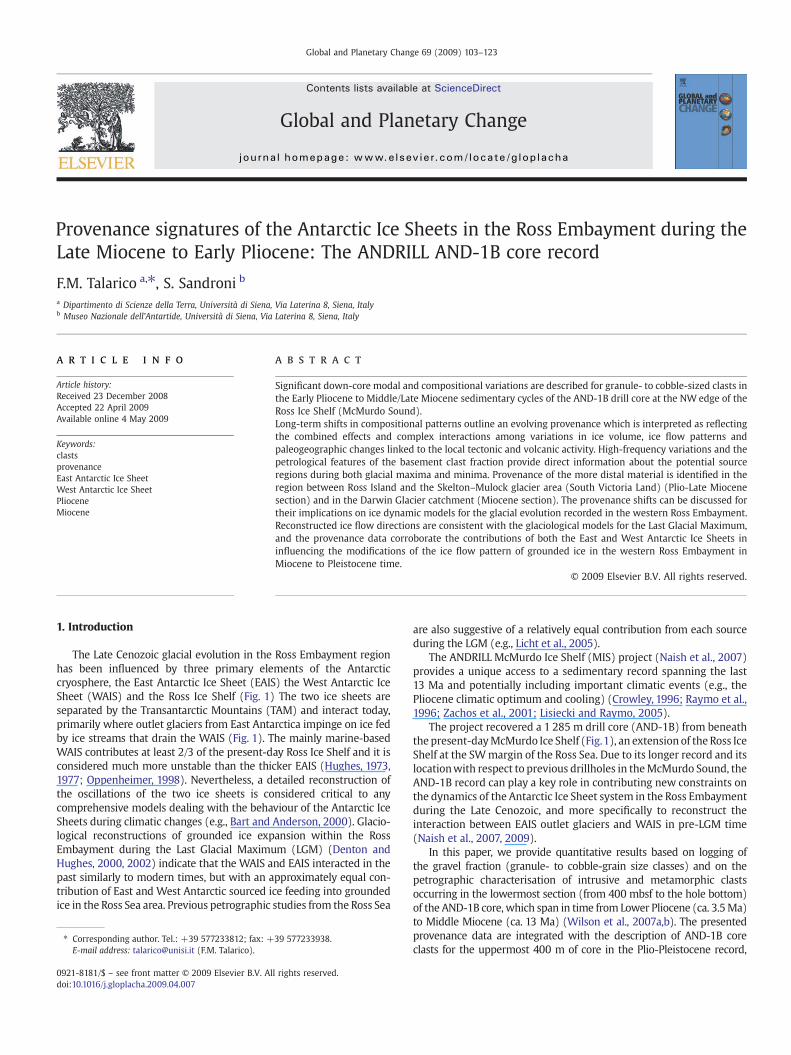
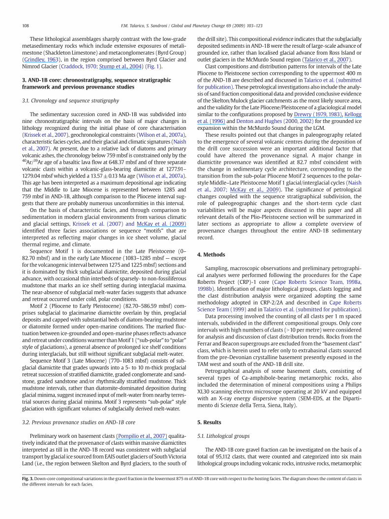
Fig. 2. Lithostratigraphy and sequence stratigraphy of the lowermost 870m of AND-1B core. Plotted alongside (left to right): clast compositions, clast abundance (average number ofclasts permetre), ratio of sedimentary clasts to total number of clasts (Sed/tot) and ratio of volcanic clasts to total number of clasts (Volc/tot). Age intervals are based on the initial agemodel of Wilson et al. (2007a). Lithostratigraphy after Krissek et al. (2007).
107F.M. Talarico, S. Sandroni / Global and Planetary Change 69 (2009) 103–123
108 F.M. Talarico, S. Sandroni / Global and Planetary Change 69 (2009) 103–123
These lithological assemblages sharply contrast with the low-grademetasedimentary rocks which include extensive exposures of metali-mestone (Shackleton Limestone) andmetaconglomerates (Byrd Group)(Grindley, 1963), in the region comprised between Byrd Glacier andNimrod Glacier (Craddock, 1970; Stump et al., 2004) (Fig. 1).
3. AND-1B core: chronostratigraphy, sequence stratigraphicframework and previous provenance studies
3.1. Chronology and sequence stratigraphy
The sedimentary succession cored in AND-1B was subdivided intonine chronostratigraphic intervals on the basis of major changes inlithology recognized during the initial phase of core characterisation(Krissek et al., 2007), geochronological constraints (Wilson et al., 2007a),characteristic facies cycles, and their glacial and climatic signatures (Naishet al., 2007). At present, due to a relative lack of diatoms and primaryvolcanic ashes, the chronology below 759mbsf is constrained only by the40Ar/39Ar age of a basaltic lava flow at 648.37 mbsf and of three separatevolcanic clasts within a volcanic-glass-bearing diamictite at 1277.91–1279.04 mbsf which yielded a 13.57±0.13Ma age (Wilson et al., 2007a).This age has been interpreted as a maximum depositional age indicatingthat the Middle to Late Miocene is represented between 1285 and759 mbsf in AND-1B, although comparison to the Pliocene interval sug-gests that there are probably numerous unconformities in this interval.
On the basis of characteristic facies, and through comparison tosedimentation in modern glacial environments from various climaticand glacial settings, Krissek et al. (2007) and McKay et al. (2009)identified three facies associations or sequence “motifs” that areinterpreted as reflecting major changes in ice sheet volume, glacialthermal regime, and climate.
Sequence Motif 1 is documented in the Late Pleistocene (0–82.70 mbsf) and in the early Late Miocene (1083–1285 mbsf — exceptfor thevolcanogenic interval between1275and1225mbsf) sections andit is dominated by thick subglacial diamictite, deposited during glacialadvance, with occasional thin interbeds of sparsely- to non-fossiliferousmudstone that marks an ice shelf setting during interglacial maxima.The near-absence of subglacial melt-water facies suggests that advanceand retreat occurred under cold, polar conditions.
Motif 2 (Pliocene to Early Pleistocene) (82.70–586.59 mbsf) com-prises subglacial to glacimarine diamictite overlain by thin, proglacialdeposits and capped with substantial beds of diatom-bearingmudstoneor diatomite formed under open-marine conditions. The marked fluc-tuation between ice-grounded andopen-marinephases reflects advanceandretreat under conditionswarmer thanMotif 1 (“sub-polar” to “polar”style of glaciations), a general absence of prolonged ice shelf conditionsduring interglacials, but still without significant subglacial melt-water.
Sequence Motif 3 (Late Miocene) (770–1083 mbsf) consists of sub-glacial diamictite that grades upwards into a 5- to 10 m-thick proglacialretreat succession of stratified diamictite, graded conglomerate and sand-stone, graded sandstone and/or rhythmically stratified mudstone. Thickmudstone intervals, rather than diatomite-dominated deposition duringglacialminima, suggest increased input ofmelt-water fromnearby terres-trial sources during glacial minima. Motif 3 represents “sub-polar” styleglaciationwith significant volumes of subglacially derived melt-water.
3.2. Previous provenance studies on AND-1B core
Preliminary work on basement clasts (Pompilio et al., 2007) qualita-tively indicated that the provenance of clasts withinmassive diamictitesinterpreted as till in the AND-1B record was consistent with subglacialtransport byglacial ice sourced fromEAISoutlet glaciers of SouthVictoriaLand (i.e., the region between Skelton and Byrd glaciers, to the south of
Fig. 3.Down-core compositional variations in the gravel fraction in the lowermost 875m of Athe different intervals for each facies.
the drill site). This compositional evidence indicates that the subglaciallydeposited sediments in AND-1Bwere the result of large-scale advance ofgrounded ice, rather than localised glacial advance from Ross Island oroutlet glaciers in the McMurdo Sound region (Talarico et al., 2007).
Clast compositions and distribution patterns for intervals of the LatePliocene to Pleistocene section corresponding to the uppermost 400 mof the AND-1B are described and discussed in Talarico et al. (submittedfor publication). These petrological investigations also include the analy-sis of sand fraction compositional data andprovided conclusive evidenceof the Skelton/Mulock glacier catchments as the most likely source area,and the validity for the Late Pliocene/Pleistocene of a glaciologicalmodelsimilar to the configurations proposed by Drewry (1979, 1983), Kellogget al. (1996) and Denton and Hughes (2000, 2002) for the grounded iceexpansion within the McMurdo Sound during the LGM.
These results pointed out that changes in paleogeography relatedto the emergence of several volcanic centres during the deposition ofthe drill core succession were an important additional factor thatcould have altered the provenance signal. A major change indiamictite provenance was identified at 82.7 mbsf coincident withthe change in sedimentary cycle architecture, corresponding to thetransition from the sub-polar Pliocene Motif 2 sequences to the polar-styleMiddle–Late PleistoceneMotif 1 glacial/interglacial cycles (Naishet al., 2007; McKay et al., 2009). The significance of petrologicalchanges coupled with the sequence stratigraphical subdivision, therole of paleogeographic changes and the short-term cycle clastvariabilities will be major aspects discussed in this paper and allrelevant details of the Plio-Pleistocene section will be summarized inlater sections as appropriate to allow a complete overview ofprovenance changes throughout the entire AND-1B sedimentaryrecord.
4. Methods
Sampling, macroscopic observations and preliminary petrographi-cal analyses were performed following the procedures for the CapeRoberts Project (CRP)-1 core (Cape Roberts Science Team, 1998a,1998b). Identification of major lithological groups, clasts logging andthe clast distribution analysis were organized adopting the samemethodology adopted in CRP-2/2A and described in Cape RobertsScience Team (1999) and in Talarico et al. (submitted for publication).
Data processing involved the counting of all clasts per 1 m spacedintervals, subdivided in the different compositional groups. Only coreintervals with high numbers of clasts (N10 permetre)were consideredfor analysis and discussion of clast distribution trends. Rocks from theFerrar and Beacon supergroups are excluded from the “basement clast”class, which is herein used to refer only to extrabasinal clasts sourcedfrom the pre-Devonian crystalline basement presently exposed in theTAM west and south of the AND-1B drill site.
Petrographical analysis of some basement clasts, consisting ofseveral types of Ca-amphibole-bearing metamorphic rocks, alsoincluded the determination of mineral compositions using a PhilipsXL30 scanning electron microscope operating at 20 kV and equippedwith an X-ray energy dispersive system (SEM-EDS, at the Diparti-mento di Scienze della Terra, Siena, Italy).
5. Results
5.1. Lithological groups
The AND-1B core gravel fraction can be investigated on the basis of atotal of 95,112 clasts, that were counted and categorized into six mainlithological groups including volcanic rocks, intrusive rocks,metamorphic
ND-1B corewith respect to the hosting facies. The diagram shows the content of clasts in

109F.M. Talarico, S. Sandroni / Global and Planetary Change 69 (2009) 103–123

110 F.M. Talarico, S. Sandroni / Global and Planetary Change 69 (2009) 103–123
rocks, sedimentary rocks, dolerites andquartz as defined in Pompilio et al.(2007) and in Talarico et al. (submitted for publication).
The volcanic rocks group is dominated bymainly subangular granulesto small andmedium-sized pebbles, that consist of a variety of aphyric toporphyritic varieties, some vesicular and/or amygdale-bearing, and rangein composition frommafic to intermediate and felsic. In several intervalsthe volcanic rocks have textural/mineralogical features typical of near-primary products (comprisingdominant glassy lapilli and veryangular tosubrounded ash shards) (Pompilio et al., 2007; Di Roberto et al., 2008).
Intrusive and metamorphic rocks (“basement clasts”) include avariety of rock types. Detailed petrographical data and distribution forthose occurring below 400 mbsf are described in Section 5.4. Com-positional features of basement clasts above 400 m are reported inTalarico et al. (submitted for publication).
The most abundant intrusive rocks occur as pebbles and small cobblesof biotite with or without hornblende granitoids (e.g., granites, syeno-granites, granodiorites) showing either isotropic fabrics or foliated tostrongly mylonitic fabrics, with minor occurrence of deformed felsicporphyries and gabbroids. Granules, pebbles and cobbles ofmetamorphicrocks include a variety of low-grade metasedimentary rocks of variousorigin (metalimestones, metagreywackes, metasandstones) and metar-hyolites scattered throughout the whole core; rare occurrences of biotiteand cordierite, biotite–actinolite schists and marble are present above400 mbsf (Talarico et al., submitted for publication), and abundant clastsof migmatites, amphibolites and other medium- or high-grade rocks,mixed with low-grade metasedimentary rocks, are common below1172 mbsf.
Sedimentary clasts mainly belong to the granule and small-pebbleclasses and consist of at least two major lithological types: a) quartz-arenites, likely sourced from the Beacon Supergroup, and b) intra-formational clasts of poorly- to moderately-sorted sandstone withgranule-grade clasts (reworked diamictites) and grey to black mud-stone and minor sandstones.
Dolerites occur as granules to subrounded pebbles and cobbles andthey are fine- or medium-grained with textural and mineralogicalsimilarities to the Ferrar Dolerite.
Quartz occurs as granules or small pebbles, some of which haveminormicas, and aremost likely fragments of coarse-grained granitoids.
5.2. Long-term compositional variability
The distribution of clasts of the six lithological groups (as definedabove) in the lowermost 875 m of the AND-1B core is summarized inFig. 2 in terms of their relative proportions using 1-m spacing data. Fig. 2also shows the variability of the abundance of clasts, and the values oftwo ratios: number of sedimentary clasts/total number of clasts (Sed/tot) and number of volcanic clasts/total number clasts (Volc/tot). Sinceboth sedimentary (mainly intrabasinal sediments) and volcanic clastsare most likely sourced within the same area of the drill site (or areasnearby), both ratios canprovide a direct insight in thefluctuations of thecontribution of local debris with respect to more distally sourced debrissupplied fromTAMoutlet glaciers.Moreover theSed/tot ratio canbealsoused as an indexof reworkingdue to dominance of intraclasts (includingclasts of diamictite) in the sedimentary clasts class.
Similarly to the Late Pliocene–Pleistocene section (Talarico et al.,submitted for publication), volcanic rocks represent the ubiquitousand persistent lithology throughout the lowermost 875m of the AND-1B core, constituting the prevailing rock type in the clast assemblages(up to 100% of the total number of clasts) in numerous and thick coreintervals. In detail, clast compositions and abundances indicate theoccurrence of three distinct petrofacies which suggest a first ordersubdivision of the investigated core section in six major intervals.
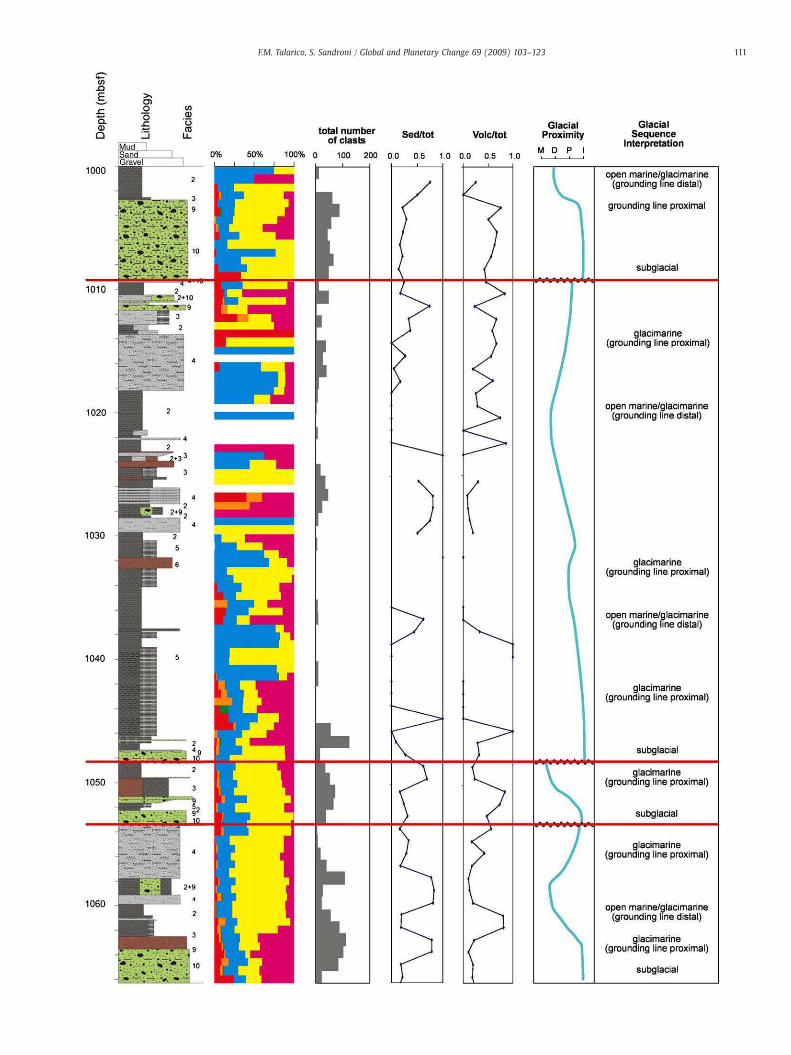
Fig. 4. An example stratigraphic log of Motif 3 sequences as identified by McKay et al. (submright): clast compositions, clast abundance (average number of clasts per metre), ratio of senumber of clasts (Volc/tot). Glacial proximity abbreviations: M marine; D ice distal; P ice p
Petrofacies 1 (P1) (ca. 585–760 mbsf, LSU 5.1–5.3–5.4; ca. 1225–1275 mbsf, LSU 7.1) — dominated by volcanic clasts with variable,sometimes high, amount of intraclasts (average Volc/tot N0.75) andvery rare metasedimentary clasts (restricted to LSU 7.1).
Petrofacies 2 (P2) (ca. 400–585mbsf, LSU 4.1–4.2–4.3–4.4; ca. 760–895mbsf, LSU 6.1)— similar to 1, but with volcanic clasts associated tovariable but always low contents of other lithologies (often morevaried than in 1 with quartz/metamorphics/intrusive rocks).
Petrofacies 3 (P3) (ca. 895–1225 mbsf, LSU 6.2–6.3–6.4; ca. 1275–1284 mbsf, LSU 8.1) — basement clasts show a persistent occurrencewith strong fluctuations of their relative proportions with respect tovolcanic clasts, but they often constitute the dominant lithology inassociation to sedimentary clasts (average Volc/tot b0.75).
Petrofacies 2 extends upcore to 82 mbsf, and Petrofacies 3 occurs inthe Late Pleistocene section above 82mbsf (Talarico et al., submitted forpublication). In the Petrofacies 1 interval between 585 and 760 mbsf,clast abundance allows a further distinction between the section belowca. 685mbsf (LSU5.4)mostly characterised by very lownumberof clastsand the section above 685mbsf (LSU 5.1–5.3) inwhich the average clastcontents are high.
Among the three petrofacies, only Petrofacies 3 shows distinctinternal patterns with prominent fluctuations of lithological propor-tions below 1000 mbsf, even within the single unit (e.g., the thickdiamictite in LSU 6.4) and a clear up-core increase of volcanic clasts inthe interval between 985 and 925 mbsf.
Dolerite clasts form a very subordinate and impersistent componentthroughout the lowermost 875 m of the AND-1B core, but with severaloccurrences mainly restricted to most diamictite units. Significantlyhigher contents were detected in the upper 80 m of AND-1B (Talaricoet al., submitted for publication)where theyare accompaniedbyahigherproportion of rounded quartz grains (many of which display over-growths) which indicates a concomitant increased contribution fromDevonian Beacon Supergroup (Taylor Group) sediments.
5.3. Short-term compositional fluctuations and clast compositionalvariability with respect to the main lithological facies
A number of high-frequency cycles are superimposed on thepreviously discussed long-term compositional patterns. These short-term changes in provenance are related to changes in sedimentaryprocesses over the glacial/interglacial cycle, and we use the sequencestratigraphic model developed by Krissek et al. (2007) and McKayet al. (2009) to discuss these changes.
In the Pleistocene–Late Pliocene section (Talarico et al., submittedfor publication), glacially derived diamicts have a strong Transantarc-tic Mountain provenance signal, while the composition of interglacialfacies are dominated by local volcanic products (mainly primarydeposits but also reworked felsic/intermediate lavas) and intraclasts,albeit a variable content of lonestones of basement lithologies, such asthe distinctive low-grademetasedimentary rocks occurs as lonestonesin diatomite facies, which point to a persistent involvement of thesame provenance area identified for the diamictite units.
A similar compositional pattern is also typical of clasts distributedin the 30 glacial/ interglacial cycles identified in the Early Pliocene toMiocene section (Krissek et al., 2007; McKay et al., 2009). In thediatomite–diamictite cycles (i.e., above 585 mbsf; motif 2) glacialminima are documented within diatomite which systematically showlower numbers of clasts and less varied compositions with respect toassociated glacial maxima sediments (Fig. 3), a pattern which closelymatches the one recognized in the section between 400 and 82 mbsf(Talarico et al., submitted for publication).
itted for publication) in the 1000 to 1100 mbsf core section. Plotted alongside (left todimentary clasts to total number of clasts (Sed/tot) and ratio of volcanic clasts to totalroximal; I ice contact/subglacial.
111F.M. Talarico, S. Sandroni / Global and Planetary Change 69 (2009) 103–123

112 F.M. Talarico, S. Sandroni / Global and Planetary Change 69 (2009) 103–123
Similar compositional differences are also evident in themudstone-diamictite cycles (between 775 and 1083 mbsf, motif 3) (Fig. 4), andfurther down-core in the Motif 1 diamictite-dominated sections at1083–1168 mbsf and 1275–1285 mbsf.
Additional information on clast distribution patterns and glacial/interglacial cycles is provided by the analysis of clast compositionalvariability with respect to the main lithological facies (Fig. 3). Thenumber of clasts per metre length throughout the investigated coresection is highly variable, ranging from b10 counts/m in the mudstonefacies, characterised by the lowest clast contents, to several hundredcounts per metre in diamictite intervals. Core intervals particularly richin clasts (N200 clasts/m) are mainly concentrated in the 550–750 mbsfsection, where they occur in both mudstone and diamictite facies andshow volcanic clasts-dominated assemblages. In diamictite facies, clastcompositions are dominated by volcanic clasts with variable and lowcontributions of other lithologies in the interval between ca. 200 and900 mbsf, and with more varied assemblages enriched in basementclasts in the remaining part of the cores. A similar core partition issuggested by mudstone dominated facies 3 and 4 but with a ca. 100 mdown-core shift of the boundaries. Massive mudstone facies show clastassemblages dominated by volcanic clasts with subordinate contentsof sedimentary clasts or quartz or intrusive rocks, a part from someintervals between 950 and 1075 mbsf, where basement clasts, in-cludinga significantproportionofmetamorphic rocks, are theprevailingcomponent.
Rhythmically interlaminated mudstone/siltstone/sandstone facies(facies 5 in Krissek et al., 2007) is restricted to a thin core section (at ca.1030–1046 mbsf); clasts are very few (3/m) but they include differentbasement rock types, intraclasts and volcanic clasts. Sandstone facies ismore common, with six occurrences all within the 598–884 mbsf coresection and dominated by volcanic clasts and variable clast contents(from 2 to ca. 6900 clasts/m). A similar volcanic clast-rich assemblageoccurs in conglomerate facies (at ca. 820.66–821.73 and 1220.55–1222.97 mbsf), whereas intraformational sedimentary clasts, rarelyassociated to other lithologies, and highly variable clast abundances(up to 200 clasts/m) are common in the breccia facies (at 437.37–440.12, 639.45–640.33, 662.31–663.34 and 872.51–875.74 mbsf).
5.4. Petrography of basement clasts and provenance inferences
In the Early Pliocene–Miocene section of the AND-1B core, 218samples of pebble- to cobble-sized basement clasts, representative of alllithological types, were collected and investigated using a petrologicalmicroscope. Table 1 shows the distribution of all identified rock types foreach LSU together with the wide range of lithologies already describedby Talarico et al. (submitted for publication) for the Pleistocene–LatePliocene section (114 samples).
All samples are cobble or pebbles of appropriate size to allow acomplete petrographic analysis using a standard thin section and aremainly from diamictite units (facies 10 and 9) and from facies (3)(mudstonewith dispersed clasts, as defined and logged by Krissek et al.,2007). Very rare samples were collected from clast-poor facies such asdiatomite and mudstone. The most common lithologies are monzo-granite and low-grade metasedimentary rocks in both facies (Table 1)and the low number of sampled clasts mainly reflects their primary lowabundance. No samples are available from the core section at 575–750 mbsf (LSU 4.4, 5.1, 5.2, 5.3 and 5.4) which is devoid of basementclasts andmainly consists of lapilli tuff and tuff breccia beds interpretedby Di Roberto et al. (2008) as the result of primary volcanic submarineprocesses originating from a very close volcanic system.
Clast logging and petrographical data allow a subdivision of thecore into 1) a section above 1172mbsf, where several lithologies alreadyreported for the uppermost 400 m (Talarico et al., submitted forpublication) represent a persistent occurrence, and 2) a section below1172 mbsf in which these lithologies are minor or absent whereas
gneisses (including migmatitic varieties) and muscovite-bearing mon-zogranites constitute a new distinctive clast assemblage.
5.4.1. Basement clasts above 1172 mbsfThe most common basement clasts above 1172 mbsf include
granitoids (dominant isotropic or foliated biotite granites and biotite-hornblende syenogranites and granodiorites), low-grademetasedimen-tary rocks (dominant biotite±calcite±Ca-amphibole metasandstones,biotite slates/phyllites, metalimestones), contact metamorphosedmetasandstones, amphibole–plagioclase granofelses, metabasalts andmetarhyolites (Fig. 5). Several other rock types (Table 1) show a morelimited occurrence. They comprise several types of intrusive rocksranging in composition from felsic (i.e., biotite-hornblende tonalite,biotite-hornblende alkali feldspar granite) to intermediate and mafic(i.e., isotropic or foliated biotite-hornblende quartzo-diorite andgabbro). In some samples heterogranular/porphyric textures areindicative of rather low emplacement depths suggesting a derivationfrom shallow intrusions or dyke swarms (e.g., microgranites, grano-phyres) (Fig. 6).
Commonly observedmineral assemblages in the metasedimentaryrocks include: biotite−muscovite±calcite+actinolite, i.e., a para-genesis diagnostic of greenschist-facies conditions (Bucher and Frey,1994). Detrital mineral grains of quartz, plagioclase, cherts andmuscovite are common. Most samples show a cleavage defined bybiotite and sericite. Some samples are characterised by a mm-scalecompositional layering, a well developed crenulation cleavage, or theyshowa diagenetic foliation (Passchier and Trouw,1996) defined by thepreferred alignment of detrital white mica grains and partiallyoverprinted by a weak cleavage defined by sericite and very finegrained biotite. In the amphibole-bearing rocks, actinolite nemato-blasts are always randomly oriented suggesting a static growth, mostlikely as result of contact metamorphism.
Comparisonwith themain rock units exposed in the Ross Orogen inSVL indicate that clast assemblages including pebbles of low-grademetamorphic rocks and of heterogranular/porphyric granitoidsmirrorthe lithological assemblages of the Skelton Group (Grindley andWarren, 1964) in restricted outcrop areas between the Skelton andMulock glaciers, about 100 km southwest of the AND-1B drill site(Figs. 1, 5, 6). As shown in Figs. 5 and 6 the petrographical charac-teristics of these clasts closely match the mineralogical and texturalfeatures of several major lithologies which are exclusive in mostoutcrops in the Teall Island–Mulock Glacier area, as recognized andmapped by several authors (Skinner,1982; Cook,1997; Cook and Craw,2002; Carosi et al., 2007; Cook, 2007).
For example the coexistence of pebbles of several basement rocktypes within short core intervals (i.e., b1 m thick) including meta-limestones, metabasalts and metarhyolites and strongly heterogranulargranitoids (e.g., LSU 6.3) indicate a provenance from a specific a com-positionally similar assemblage that is exposed in the northern part ofTeall Island (Carosi et al., 2007) and potentially in other unexposedareas near the Skelton Glacier.
In most metasandstones and amphibole-bearing granofelses,randomly oriented Ca-amphibole blasts and decussate textures over-print previously formed cleavages defined by finer grained whitemicas. These fabrics are indicative of static transformationswhich verylikely occurred during a local contact metamorphic event. Similarlithologies and fabrics were described by Skinner (1982) around themain intrusions in the Skelton Glacier area and were more recentlyresampled by the first author during field activity and mapping in theregion (Carosi et al., 2007).
In the lowermost part of the section granitoids (including bothisotropic and foliated varieties, Fig. 6) indicate a possible southerlyshift of provenance providing evidence for the involvement of areaslocated ca. 30 km S of the Mulock Glacier, along the north side of theCarlyon Glacier (Fig. 1).
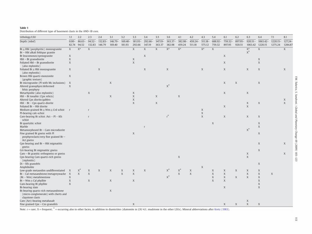
Table 1Distribution of different type of basement clasts in the AND-1B core.
Lithology/LSU 1.1 2.2 2.3 2.4 3.1 3.2 3.3 3.4 3.5 3.6 4.1 4.2 4.3 5.4 6.1 6.2 6.3 6.4 7.1 8.1
Depth (mbsf) 0.00–82.74
86.63–94.52
94.52–132.83
132.83–146.79
146.79–169.40
169.40–181.93
181.93–292.66
292.66–347.19
347.19–363.37
363.37–382.98
382.98–459.24
459.24–511.18
511.18–575.12
688.92–759.32
759.32–897.95
897.95–920.51
920.51–1063.42
1063.42–1220.15
1220.15–1275.24
127.24–1284.87
Bt±Hbl (porphyritic) monzogranite X X⁎ X X X X X⁎ X⁎ X⁎ X X⁎ X XBt−Hbl alkali feldspar granite X⁎
Bt leucomonzo/syenogranite X X XHbl−Bt granodiorite X X XFoliated Hbl−Bt granodiorite(also mylonitic)
X X X X
Foliated Bt±Hbl monzogranite(also mylonitic)
X X X X X X X X X
Brown Hbl quartz-monzonite(graphic texture)
X
Bt microgranite (Pl with Mc inclusions) X X X X XAltered granophyre/deformedfelsic porphyry
X X⁎
Metarhyolite (also mylonitic) X X X XHbl−Bt tonalite (Cpx relicts) X X X XAltered Cpx diorite/gabbro X XHbl−Bt−Cpx quartz-diorite X X X X XFoliated Bt−Hbl diorite X XMedium-grained Bt±Wm±Crd schist r r XPl-bearing calc-schist XCam-bearing Bt schist /Act−Pl−Kfsschist
r r⁎ X X X X
Bt quartzitic schist X XMarble r XMetamorphosed Bt−Cam microdiorite X⁎
Fine grained Bt gneiss with Plporphyroclasts/very fine grained Bt−Act gneiss
X X
Cpx-bearing and Bt−Hbl migmatiticgneiss
X X
Grt-bearing Bt migmatitic gneiss XCam−Bt granitic orthogneiss or gneiss X XCpx-bearing Cam quartz-rich gneiss(mylonitic)
X X
Di−Kfs granofels XAmphibolite XLow-grade metasedim undifferentiated X X⁎ X X X X X X X⁎ X⁎ X X X X X XBt−Cal metasandstone/metagreywacke X X X X X X X X X X X X(Bt−Wm) metalimestone X X⁎ X X X X XBt−Wm±Cal phyllite X X X X X X XCam-bearing Bt phyllite X XBt-bearing slate X XBt-bearing quartz-rich metasandstone(micro-conglomerate) with cherts andclaystone clasts
X
Cam (Act)-bearing metabasalt XFine grained Cpx−Czo granofels X X X X X
Note: r=rare; X=frequent; ⁎=occurring also in other facies, in addition to diamictites (diatomite in LSU 4.1; mudstone in the other LSUs). Mineral abbreviations after Kretz (1983).
113F.M
.Talarico,S.Sandroni/Globaland
PlanetaryChange
69(2009)
103–123
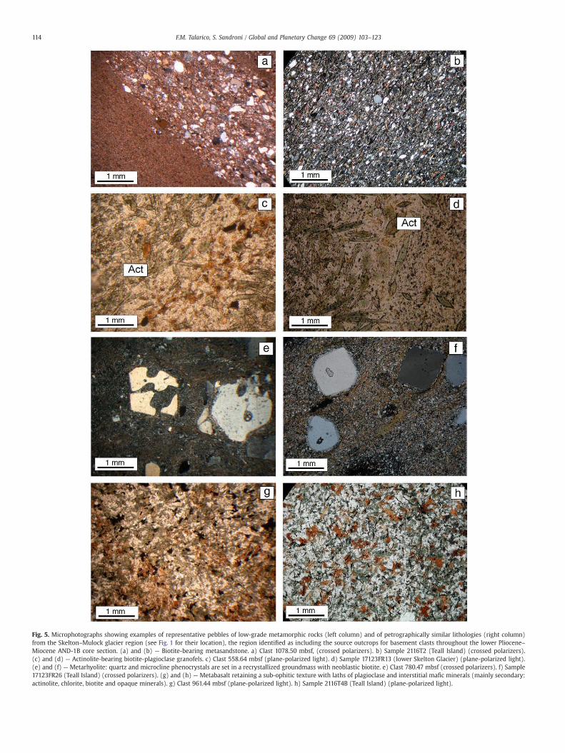
Fig. 5. Microphotographs showing examples of representative pebbles of low-grade metamorphic rocks (left column) and of petrographically similar lithologies (right column)from the Skelton–Mulock glacier region (see Fig. 1 for their location), the region identified as including the source outcrops for basement clasts throughout the lower Pliocene–Miocene AND-1B core section. (a) and (b) — Biotite-bearing metasandstone. a) Clast 1078.50 mbsf, (crossed polarizers). b) Sample 2116T2 (Teall Island) (crossed polarizers).(c) and (d) — Actinolite-bearing biotite-plagioclase granofels. c) Clast 558.64 mbsf (plane-polarized light). d) Sample 17123FR13 (lower Skelton Glacier) (plane-polarized light).(e) and (f) — Metarhyolite: quartz and microcline phenocrystals are set in a recrystallized groundmass with neoblastic biotite. e) Clast 780.47 mbsf (crossed polarizers). f) Sample17123FR26 (Teall Island) (crossed polarizers). (g) and (h) — Metabasalt retaining a sub-ophitic texture with laths of plagioclase and interstitial mafic minerals (mainly secondary:actinolite, chlorite, biotite and opaque minerals). g) Clast 961.44 mbsf (plane-polarized light). h) Sample 2116T4B (Teall Island) (plane-polarized light).
114 F.M. Talarico, S. Sandroni / Global and Planetary Change 69 (2009) 103–123

Fig. 6. Microphotographs showing examples of representative pebbles of felsic intrusive rocks (left column) and of petrographically similar lithologies (right column) fromthe Skelton–Darwin glacier region (see Fig. 1 for their location) (crossed polarizers). (a) and (b) — Porphyric monzogranite: phenocrystals of K-feldspar (Kfs) are set in a finegrained quartz-rich matrix. a) Clast 719.14 mbsf. b) Sample 2116F6 (lower Skelton Glacier). (c) and (d) — Foliated biotite granodiorite: a strained plagioclase (Pl) porphyroclast iswarped by a marked foliation defined by biotite and recrystallized quartz. c) Clast 1145.84 mbsf. d) Sample 2116F10 (Carlyon Glacier area). (e) and (f) — Heterogranular biotitemonzogranite: orthoclase (Or) with abundant inclusion of plagioclase (Pl), in sub-euhedral laths, and biotite (Bt). e) Clast 1167.91 mbsf. f) Sample 2416F9B (Carlyon Glacier area).(g) and (h) — Mylonitic monzogranite: strained microcline (Mc-I) porphyroclasts are surrounded by subpolygonal granoblastic aggregates of neoblastic microcline and quartz(Mc-II + Qtz). g) Clast 1186.38 mbsf. e) Sample 2416F14 (Darwin Glacier).
115F.M. Talarico, S. Sandroni / Global and Planetary Change 69 (2009) 103–123

Fig. 7. Microphotographs showing examples of representative basement clasts (left column) and of petrographically similar lithologies (right column) from the Carlyon–Byrd glacierregion (see Fig. 1 for their location), the region identified as including the source outcrops for basement clasts with occurrences restricted to the lowermost section of the AND-1Bsuccession (below1172mbsf). (a) and (b)—Actinolite-plagioclase schist. a) Clast 1217.41mbsf, (crossed polarizers). b) Sample 1916T13 (lower ByrdGlacier area) (crossed polarizers).(c) and (d) — Actinolite-bearing biotite-plagioclase fine grained gneiss. c) Clast 1189.63 mbsf (plane-polarized light). d) Sample 18106T14 (Darwin Glacier area) (plane-polarizedlight). (e) and (f)— Clinopyroxene-microcline granofels. e) Clast 1195.70mbsf (crossed polarizers). f) Sample 1816F7 (Darwin Glacier). (g) and (h)— Twomicamonzogranite: biotite(Bt) and muscovite (Ms) flakes define a weak foliation. g) Clast 1280.04 mbsf (crossed polarizers). h) Sample 2016F4 (Byrd Glacier area) (crossed polarizers).
116 F.M. Talarico, S. Sandroni / Global and Planetary Change 69 (2009) 103–123
117F.M. Talarico, S. Sandroni / Global and Planetary Change 69 (2009) 103–123
5.4.2. Basement clasts below 1172 mbsfThe distinctive assemblage of low/ medium- to higher-grade meta-
morphic clasts occurring below 1172 mbsf include actinolite–plagio-clase–K-feldspar schists, very fine grained biotite–actinolite gneisses,diopside–K-feldspar granofelses and biotite and/or hornblende-bearingmigmatitic gneisses. Mineral assemblages of the actinolite-bearing rocksindicate greenschist grade conditions, whereas the diopside–K-feldsparparagenesis and migmatitic textures are indicative of higher grade,amphibolite-facies conditions (Bucher and Frey,1994). As shown in Fig. 7,potential source rocks for these pebbles can be identified in the regionbetween Carlyon Glacier and Byrd Glacier (Fig. 1), where assemblages ofinterlayered greenschist and amphibolite grademetamorphic rockswithsimilar mineral compositions and textures have been reported by Carosiet al. (2007).
5.4.3. Provenance inferences based on Ca-amphibole compositions andgeothermobarometry
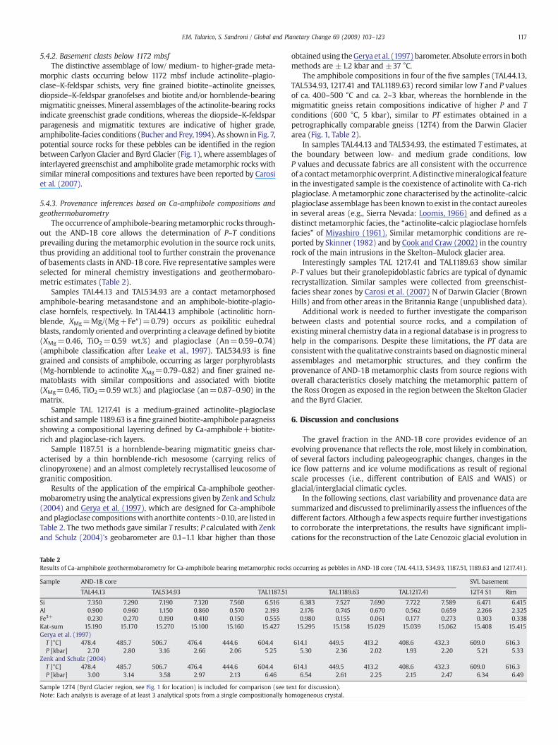
The occurrence of amphibole-bearingmetamorphic rocks through-out the AND-1B core allows the determination of P–T conditionsprevailing during the metamorphic evolution in the source rock units,thus providing an additional tool to further constrain the provenanceof basements clasts in AND-1B core. Five representative samples wereselected for mineral chemistry investigations and geothermobaro-metric estimates (Table 2).
Samples TAL44.13 and TAL534.93 are a contact metamorphosedamphibole-bearing metasandstone and an amphibole-biotite-plagio-clase hornfels, respectively. In TAL44.13 amphibole (actinolitic horn-blende, XMg=Mg/(Mg+Fe″)=0.79) occurs as poikilitic euhedralblasts, randomly oriented and overprinting a cleavage defined by biotite(XMg=0.46, TiO2=0.59 wt.%) and plagioclase (An=0.59–0.74)(amphibole classification after Leake et al., 1997). TAL534.93 is finegrained and consists of amphibole, occurring as larger porphyroblasts(Mg-hornblende to actinolite XMg=0.79–0.82) and finer grained ne-matoblasts with similar compositions and associated with biotite(XMg=0.46, TiO2=0.59 wt.%) and plagioclase (an=0.87–0.90) in thematrix.
Sample TAL 1217.41 is a medium-grained actinolite–plagioclaseschist and sample 1189.63 is afinegrained biotite-amphibole paragneissshowing a compositional layering defined by Ca-amphibole+biotite-rich and plagioclase-rich layers.
Sample 1187.51 is a hornblende-bearing migmatitic gneiss char-acterised by a thin hornblende-rich mesosome (carrying relics ofclinopyroxene) and an almost completely recrystallised leucosome ofgranitic composition.
Results of the application of the empirical Ca-amphibole geother-mobarometry using the analytical expressions given by Zenk and Schulz(2004) and Gerya et al. (1997), which are designed for Ca-amphiboleand plagioclase compositionswith anorthite contents N0.10, are listed inTable 2. The two methods gave similar T results; P calculated with Zenkand Schulz (2004)'s geobarometer are 0.1–1.1 kbar higher than those
Table 2Results of Ca-amphibole geothermobarometry for Ca-amphibole bearing metamorphic rocks
Sample AND-1B core
TAL44.13 TAL534.93 TAL1187.51
Si 7.350 7.290 7.190 7.320 7.560 6.516Al 0.900 0.960 1.150 0.860 0.570 2.193Fe3+ 0.230 0.270 0.190 0.410 0.150 0.555Kat-sum 15.190 15.170 15.270 15.100 15.160 15.427Gerya et al. (1997)T [°C] 478.4 485.7 506.7 476.4 444.6 604.4P [kbar] 2.70 2.80 3.16 2.66 2.06 5.25
Zenk and Schulz (2004)T [°C] 478.4 485.7 506.7 476.4 444.6 604.4P [kbar] 3.00 3.14 3.58 2.97 2.13 6.46
Sample 12T4 (Byrd Glacier region, see Fig. 1 for location) is included for comparison (see teNote: Each analysis is average of at least 3 analytical spots from a single compositionally ho
obtainedusing theGerya et al. (1997)barometer. Absolute errors in bothmethods are ±1.2 kbar and ±37 °C.
The amphibole compositions in four of the five samples (TAL44.13,TAL534.93, 1217.41 and TAL1189.63) record similar low T and P valuesof ca. 400–500 °C and ca. 2–3 kbar, whereas the hornblende in themigmatitic gneiss retain compositions indicative of higher P and Tconditions (600 °C, 5 kbar), similar to PT estimates obtained in apetrographically comparable gneiss (12T4) from the Darwin Glacierarea (Fig. 1, Table 2).
In samples TAL44.13 and TAL534.93, the estimated T estimates, atthe boundary between low- and medium grade conditions, lowP values and decussate fabrics are all consistent with the occurrenceof a contactmetamorphic overprint. Adistinctivemineralogical featurein the investigated sample is the coexistence of actinolite with Ca-richplagioclase. Ametamorphic zone characterised by the actinolite-calcicplagioclase assemblage has been known to exist in the contact aureolesin several areas (e.g., Sierra Nevada: Loomis, 1966) and defined as adistinct metamorphic facies, the “actinolite-calcic plagioclase hornfelsfacies” of Miyashiro (1961). Similar metamorphic conditions are re-ported by Skinner (1982) and by Cook and Craw (2002) in the countryrock of the main intrusions in the Skelton–Mulock glacier area.
Interestingly samples TAL 1217.41 and TAL1189.63 show similarP–T values but their granolepidoblastic fabrics are typical of dynamicrecrystallization. Similar samples were collected from greenschist-facies shear zones by Carosi et al. (2007) N of Darwin Glacier (BrownHills) and from other areas in the Britannia Range (unpublished data).
Additional work is needed to further investigate the comparisonbetween clasts and potential source rocks, and a compilation ofexistingmineral chemistry data in a regional database is in progress tohelp in the comparisons. Despite these limitations, the PT data areconsistentwith the qualitative constraints based on diagnosticmineralassemblages and metamorphic structures, and they confirm theprovenance of AND-1B metamorphic clasts from source regions withoverall characteristics closely matching the metamorphic pattern ofthe Ross Orogen as exposed in the region between the Skelton Glacierand the Byrd Glacier.
6. Discussion and conclusions
The gravel fraction in the AND-1B core provides evidence of anevolving provenance that reflects the role, most likely in combination,of several factors including paleogeographic changes, changes in theice flow patterns and ice volume modifications as result of regionalscale processes (i.e., different contribution of EAIS and WAIS) orglacial/interglacial climatic cycles.
In the following sections, clast variability and provenance data aresummarized and discussed to preliminarily assess the influences of thedifferent factors. Although a few aspects require further investigationsto corroborate the interpretations, the results have significant impli-cations for the reconstruction of the Late Cenozoic glacial evolution in
occurring as pebbles in AND-1B core (TAL 44.13, 534.93, 1187.51, 1189.63 and 1217.41).
SVL basement
TAL1189.63 TAL1217.41 12T4 S1 Rim
6.383 7.527 7.690 7.722 7.589 6.471 6.4152.176 0.745 0.670 0.562 0.659 2.266 2.3250.980 0.155 0.061 0.177 0.273 0.303 0.338
15.295 15.158 15.029 15.039 15.062 15.408 15.415
614.1 449.5 413.2 408.6 432.3 609.0 616.35.30 2.36 2.02 1.93 2.20 5.21 5.33
614.1 449.5 413.2 408.6 432.3 609.0 616.36.54 2.61 2.25 2.15 2.47 6.34 6.49
xt for discussion).mogeneous crystal.

118 F.M. Talarico, S. Sandroni / Global and Planetary Change 69 (2009) 103–123
the Ross Embayment and they can be conveniently discussed in thecontext of LGM glaciological scenarios (e.g., Denton and Hughes, 2000,2002), and of numerical ice sheets models (e.g., Huybrechts, 2002;Pollard and DeConto, 2009).
6.1. Long-term provenance shifts
Analysis of clast compositions and abundances throughout theentire core indicates that the long-term shifts in compositionalpatterns reflect the distribution of three petrofacies which divide thesedimentary succession into 6 major intervals, including from thebottom to the top (Fig. 8):
ca. 1275–1284 mbsf (Late Miocene) (Petrofacies 3): clast assem-blages include persistent basement clasts and volcanic rocksshowing strong fluctuations of their relative proportions, withbasement clasts often representing the dominant lithology inassociation to sedimentary clasts (average Volc/tot b0.75).ca. 1225–1275 mbsf (Late Miocene) (Petrofacies 1): dominated byvolcanic clasts with variable, sometimes high, amounts of intraclasts(average Volc/tot N0.75) and very rare metasedimentary clasts.ca. 895–1225 mbsf (Petrofacies 3): as above but with prominentfluctuations of lithological proportions below 985 mbsf, and a clearup-core increase of volcanic clasts in the interval between 985 and925 mbsf. A further subdivision is based on the petrography ofmetamorphic basement clasts that indicate a shift from ByrdGlacier–Darwin Glacier sourced debris (below 1172mbsf) to Skeltonsourced debris (above 1172 mbsf).ca. 760–895 mbsf (Petrofacies 2): similar to petrofacies 1, but withvolcanic clasts associated to variable but always low contents ofother lithologies (often more varied than in P1 with quartz/meta-morphic/intrusive rocks).ca. 585–760 mbsf (Late Miocene): similar to the ca. 1225–1275 mbsf interval (i.e., Petrofacies 1), with very low number ofclasts below ca. 685 and high average clast contents.ca. 82–585 mbsf (Pliocene–Late Pleistocene): with clast distribu-tion patterns and assemblages similar to those described for the ca.760–895 mbsf interval (Petrofacies 2).0–82 mbsf (Late–Middle Pleistocene): with clast distributionpatterns and assemblages similar to those described for the ca.1275–1284 mbsf interval (Petrofacies 3).
In the Pleistocene–Late Pliocene core sectionTalarico et al. (submittedfor publication) pointed out a major change in diamictite provenance at82.70 mbsf (corresponding to the transition from P2 to P3 in this study).This is coincident with a change in sedimentary cycle architecture thathas previously been interpreted as representing the transition from sub-polar conditions, warmer than present, to the modern style of cold polarice sheet (Naish et al., 2007; McKay et al., 2009).
This provenance shift in AND-1B core probably reflects importantdifferences in the dispersion processes of sediments and in theerosional patterns which were active during each regime.
However, changes in paleogeography – related to the regionalvolcanic evolution – can represent an important additional factor thatmight have strongly influenced the sediment provenance and com-plicated the climatic signal.
Fig. 8. Down-core distribution of identified petrological petrofacies (P1, P2 and P3) and prage intervals based on the initial age model of Wilson et al. (2007a). Sequence motif 1, 2 anProvenance areas include: SM Skelton–Mulock glacier area; BC Byrd–Carlyon glacier area; Loshow reconstructed pathways for ice sourced from the southern TAM outlet glaciers into theand theMiocene (C). BG, MG and SG schematically indicate ice flow fromByrd Glacier (northin B are after Sandroni and Talarico (2006), those in A are based on interpretations reported(2006). In A and B the position of Byrd Glacier flow lines is only inferred by comparison wmerged Landsat TM/Panchromatic image and do not include the corrections for isostatic/te
The down-core distribution of petrofacies and petrological boun-daries (as summarized above and shown in Fig. 8) demonstrate thatthe Early Pliocene to Late Miocene section further corroborate thisconclusion. Fig. 8 also includes three paleogeographic scenariosshowing reconstructed pathways for ice sourced from the southernTAM outlet glaciers into the AND-1B drill site during glacial expansionin the Late Pleistocene, the Pliocene and the Miocene.
Petrofacies 2 (typical of the motif 2 sequences in the Pliocenesection) further extends in the upper part of Motif 3 sequences.Petrofacies 3, identified in the Motif 1 sequences in the Pleistocenesection, is also associated to Motif 1 sequences identified by McKayet al. (2009) in the Late Miocene section, but the petrologicalboundary occurs within Motif 3 sequences, ca. 90 m above the motifboundary (at 1083 mbsf according to McKay et al., 2009).
The shifts from Petrofacies 3 to Petrofacies 1 or 2 and vice versa,their repetition in the succession and clast provenance from sourceareas S of Minna Bluff are difficult to be explained as reflecting asimple unroofing–erosional process as a consequence of the uplift of asingle crustal block including basement and Cenozoic volcanic rocksand close to the drill site area (e.g., in the Royal Society Range in theKoettlitz Glacier area).
In the Victoria Land Basin, the role of tectonic controls over clastscompositions was put forward by Talarico et al. (2000) and Smellie(2000, 2001), but in older sediments within the lower Miocene toOligocene record recovered at CRP-3 and CRP-2 drill sites.
This is not a surprise since the so far documented TAM upliftepisodes are confined within a time window which is definitely older(i.e., between 55 and 15 Ma) than the AND-1B core record (Fitzgerald,2002). However, tectonic activity is still ongoing within the McMurdoSound area, as shown by the widespread McMurdo Group alkalinevolcanism and minor faulting in the Quaternary (Jones 1997). The“Discovery accommodation zone”, a prominent structural corridorassociated with the major offset of the TAM rift flank in southernVictoria Land (Wilson,1999) also coincides with a zone of voluminousLate Cenozoic volcanism proximal to the mountain front (Kyle, 1990)and extending beneath the Ross Sea and Ross Ice Shelf (Damaske et al.,1994; Behrendt et al., 1996; Wilson et al., 2007b). It appears that thetransverse structures within the Discovery accommodation zone mayhave focusedmagmatism along a corridor transverse to the rift system,indicating a link between rift-flank structure and rift-related volcanicprocesses (Wilson, 1999).
The development of major volcanic edifices in this region(spanning in time from 19Ma to recent, and including the voluminousactivity associated with Mount Discovery at ca. 5 Ma), in turn, mayhave had a major influence on the patterns of glacial outflow from theTAM and the Ross Ice Shelf into the Ross Sea (Kyle,1981;Wilson,1999;Paulsen and Wilson, 2004).
In this context, the different content of volcanic fraction in thethree petrofacies can be potentially used as an indicator of theemergence of new volcanic centres along the ice paths, which actedeither as barrier with consequent changes in the flow patterns and/orprovided more extensive volcanic bedrock along the path of theadvancing ice sheet, with consequent modification of the debriscompositions in the diamictite deposited throughout the AND-1Bsedimentary record.
Basedon this assumption and theextensiveoccurrence of lapilli tuffs,volcanogenic turbidites and a lava flow, the almost compositionallymonogenic (volcanic) P1 can be interpreted as the result of primary
ovenance shifts in the AND-1B core. Lithostratigraphy after Krissek et al. (2007), withd 3 are according to Krissek et al. (2007) and McKay et al. (submitted for publication).c volcanic centres in the McMurdo Sound area. Paleogeographic scenarios (A, B and C)AND-1B drill site during glacial expansion in the Late Pleistocene (A), the Pliocene (B)
ern side), Mulock Glacier and Skelton Glacier, respectively. Flow lines in the CIROS-2 areain Barrett and Hambrey (1992), Ehrmann and Polozek (1999) and Sandroni and Talaricoith the LGM configuration (see text for discussion). The reconstructions are based on actonic uplift.

119F.M. Talarico, S. Sandroni / Global and Planetary Change 69 (2009) 103–123
120 F.M. Talarico, S. Sandroni / Global and Planetary Change 69 (2009) 103–123
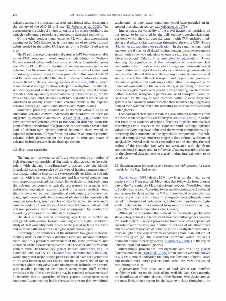
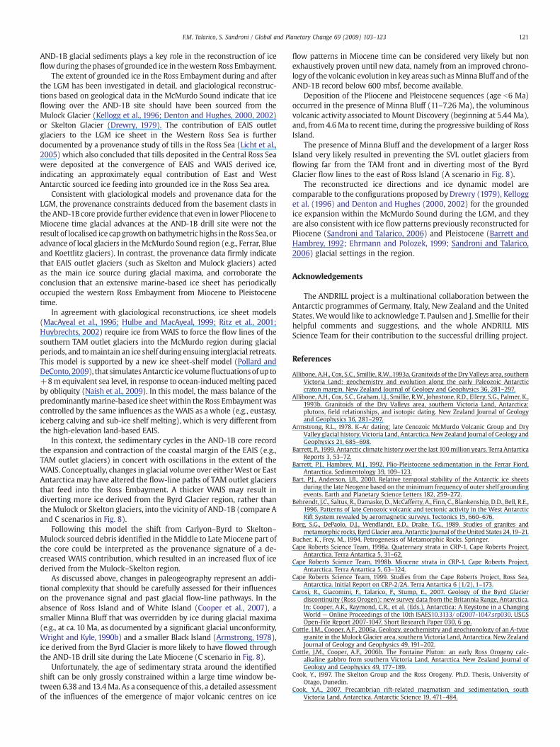
volcanic submarine processes that originated from a volcanic system inthe vicinity of the AND-1B drill site (Di Roberto et al., 2008). Theoccurrence in this facies of limited amounts of intraclasts testifies to thevariable sedimentary reworking of previously deposited sediments.
On the other compositional extreme, P3, with clast assemblagesdominated by TAM lithologies, is the signature of remotely sourceddebris eroded in the outlet EAIS glaciers of the Skelton/Byrd glacierarea.
The P2 petrofacies, compositionally similar to P1 butwith a variableminor TAM component, would imply a high dilution of Skelton–Mulock sourced debris with local volcanic debris. Identified changesfrom P3 to P1 or P2 are indicative of sudden increases in the in-volvement in the erosional processes of volcanic bedrocks, and, mostimportantly of near-primary volcanic products. In this context both P1and P2 facies would reflect the effects of discrete pulses of volcanicactivity. Based on the available agemodel (Wilson et al., 2007a), whichis not detailed enough to allow a deeper investigation, the AND-1Bsedimentary record could have been punctuated by several volcanicepisodes, some apparently documented only in the core (e.g., the lavaflow at 646–649 mbsf, dated at 6.38 Ma) and others which can becorrelated to already known dated volcanic events in the exposedvolcanic centres (i.e., Ross Island, Black Island, White Island).
Moreover, presently undated or unexposed volcanic units, orsubmarine volcanic centres underneath the McMurdo Ice Shelf (assuggested by magnetic anomalies; Wilson et al., 2007b) could alsohave contributed volcanic clasts to the AND-1B drill site. From thispoint of view, the advance of a grounded ice sheet with a basal debrisload of Skelton/Byrd glacier derived basement clasts would beexpected to incorporate a significant, but variable, amount of proximalvolcanic debris depending on the changes in time and space ofvolcanic bedrock present in the drainage system.
6.2. Short-term variability
The long-term provenance shifts are overprinted by a number ofhigh-frequency compositional fluctuations that appear to be coin-cident with changes in sedimentary processes over the glacial/interglacial cycle. Irrespective of the type of hosting sequence motif,most glacial minima intervals are systematically enriched in volcanicdetritus, with lower numbers of clasts and less varied compositionswith respect to associated diamictites. In the glacialminima sedimentsthe volcanic component is typically represented by granules withtextural/mineralogical features typical of primary products, onlyslightly reworked by post depositional sedimentary processes (i.e.,glassy lapilli, veryangular to subrounded ash shards). In these intervalscommon intraclasts, small pebbles of felsic/intermediate lavas and avariable content of lonestones of basement lithologies indicate thatvolcanic processes were sometimes accompanied by sea-bottomreworking processes or ice rafted debris episodes.
The data outline several interesting aspects to be further in-vestigated with a more focused sampling and a higher resolutionstudy of clast variability with respect to the glacial surfaces of erosionand internal patterns within each glacial/interglacial cycle.
For example, the occurrence of the distinctive low-grade metasedi-mentary rocks as lonestones in diatomite facies and massive mudstonefacies point to a persistent involvement of the same provenance areaidentified for the associated diamictite units. The association of volcanicpebbles with Skelton/Mulock glacier derived lonestones (e.g., indiatomite units, LSU 3.5, 3.6) (Talarico et al., submitted for publication)would imply that major calving processes should have been active alsoin the area between Mulock Glacier and the southern side of MountMorning (where both volcanic andmetamorphic bedrocks are present)with possible pinning of ice tongues along Minna Bluff. Calvingprocesses in the TAM outlet glaciers may be expected to have increasedin intensity, due to expansion of these glaciers during open waterconditions (assuming they had in the past the present-day low-altitude
catchments), as open water conditions would have provided an in-creased precipitation source (e.g., Kellogg et al., 1979).
Interestingly, the variability of the gravel fraction compositions donot appear to be mirrored by the bulk sediment geochemical com-positions which show an opposite pattern with TAM-enriched mud-stones and volcanic-rich diamictites throughout the entire AND-1B core(Monien et al., submitted for publication). In the sand fraction, modalanalyses reveal that not all glacial minima contain the same provenancesignal, with either volcanic glass or quartz (e.g., Seq. 3 and 4 in thePliocene section) (Talarico et al., submitted for publication). Under-standing the significance of the decoupling of gravel-size clastcompositions from those of associated fine grained sediments wouldrequire additional analyticalwork anda focused investigation in order tocompare the different data sets. These compositional differences couldsimply reflect the different transport and depositional processes.Granule- to pebble-sized clasts imply either fall-out (as implied by thedominant pyroclastics in the volcanic clasts) or ice rafting from eithericebergs or a glacimarine setting with distal grounding line. In contrast,bottom currents, terrigenous plumes and wind transport should beconsidered for the clay to sand fractions, within a more dispersivesystem which involved TAM-enriched debris mobilized by subglaciallyderivedmelt-water in front of the retreating ice sheet or from local TAMoutlet glaciers.
Comparison of clast composition in glacial minima sediments fromthe three sequencemotifs, as defined by Krissek et al. (2007), indicatesthat there is no evidence of major differences in glacial minima clastassemblages with respect to the sequence motif. Although episodicvolcanic activity may have influenced the volcanic compositions (e.g.,increasing the abundance of the pyroclastic component), this sub-stantial compositional similarity suggests that volume variations ofsubglacially derived melt-water (dependent on the changing thermalregime of the grounded ice) were not associated with significantcompositional changes and an influence of paleogeographic changeson the observed clast patterns in glacial minima intervals seem to beruled out.
6.3. Basement clasts provenance and integration with previous ice sheetmodels for the Ross Embayment
Stuiver et al. (1981) depict LGM flow lines for the major outletglaciers of the Transantarctic Mountains that follow the front of mostpart of the TransantarcticMountains, from theQueenMaudMountainsto SouthVictoria Land. According to thismodel amultitude of potentialsource areas for clasts within theMIS drill corewould be possible fromseveral areas mainly consisting of low-grade metasediments asso-ciated to deformed and undeformedgranitoids,withmedium- to high-grade metamorphic rocks sourced from more restricted areas (e.g.,upper Nimrod Glacier and Shackleton Glacier).
Although the recognition that some of the investigated pebbles canshow petrographical similarities with basement lithologies exposed tothe south of Byrd Glacier, a provenance from these areas appears notconsistent with the very low number of pebbles of metalimestonesand the apparent absence of dolomite in the investigated metalimes-tones in light of the very extensive exposures (more than 200 km) ofthese rock types (i.e., the Shackleton Limestone, which includes adominant dolomite-bearing variety, Talarico et al., 2007) in the regionbetween Byrd and Nimrod glaciers.
Interestingly provenance investigations and resulting glacialdynamic models by Licht et al. (2005) are in conflict with the Stuiveret al. (1981) model, indicating that only the flow lines of Byrd Glacierand northernmost outlet glaciers could reach the McMurdo Soundarea during the LGM.
A provenance from areas south of Byrd Glacier can thereforeconfidently rule out on the basis of the available data. Consequently,the identification of outlet glaciers of the Skelton–Byrd glacier area asthe most likely source region for the basement clasts throughout the
121F.M. Talarico, S. Sandroni / Global and Planetary Change 69 (2009) 103–123
AND-1B glacial sediments plays a key role in the reconstruction of iceflowduring the phases of grounded ice in thewestern Ross Embayment.
The extent of grounded ice in the Ross Embayment during and afterthe LGM has been investigated in detail, and glaciological reconstruc-tions based on geological data in the McMurdo Sound indicate that iceflowing over the AND-1B site should have been sourced from theMulock Glacier (Kellogg et al., 1996; Denton and Hughes, 2000, 2002)or Skelton Glacier (Drewry, 1979). The contribution of EAIS outletglaciers to the LGM ice sheet in the Western Ross Sea is furtherdocumented by a provenance study of tills in the Ross Sea (Licht et al.,2005) which also concluded that tills deposited in the Central Ross Seawere deposited at the convergence of EAIS and WAIS derived ice,indicating an approximately equal contribution of East and WestAntarctic sourced ice feeding into grounded ice in the Ross Sea area.
Consistent with glaciological models and provenance data for theLGM, the provenance constraints deduced from the basement clasts inthe AND-1B core provide further evidence that even in lower Pliocene toMiocene time glacial advances at the AND-1B drill site were not theresult of localised ice cap growthonbathymetric highs in theRoss Sea, oradvance of local glaciers in theMcMurdo Sound region (e.g., Ferrar, Blueand Koettlitz glaciers). In contrast, the provenance data firmly indicatethat EAIS outlet glaciers (such as Skelton and Mulock glaciers) actedas the main ice source during glacial maxima, and corroborate theconclusion that an extensive marine-based ice sheet has periodicallyoccupied the western Ross Embayment from Miocene to Pleistocenetime.
In agreement with glaciological reconstructions, ice sheet models(MacAyeal et al., 1996; Hulbe and MacAyeal, 1999; Ritz et al., 2001;Huybrechts, 2002) require ice from WAIS to force the flow lines of thesouthern TAM outlet glaciers into the McMurdo region during glacialperiods, and tomaintain an ice shelf during ensuing interglacial retreats.This model is supported by a new ice sheet-shelf model (Pollard andDeConto, 2009), that simulatesAntarctic ice volumefluctuationsof upto+8m equivalent sea level, in response to ocean-inducedmelting pacedby obliquity (Naish et al., 2009). In this model, the mass balance of thepredominantlymarine-based ice sheetwithin the Ross Embaymentwascontrolled by the same influences as theWAIS as a whole (e.g., eustasy,iceberg calving and sub-ice shelf melting), which is very different fromthe high-elevation land-based EAIS.
In this context, the sedimentary cycles in the AND-1B core recordthe expansion and contraction of the coastal margin of the EAIS (e.g.,TAM outlet glaciers) in concert with oscillations in the extent of theWAIS. Conceptually, changes in glacial volume over eitherWest or EastAntarctica may have altered the flow-line paths of TAM outlet glaciersthat feed into the Ross Embayment. A thicker WAIS may result indiverting more ice derived from the Byrd Glacier region, rather thantheMulock or Skelton glaciers, into the vicinity of AND-1B (compare Aand C scenarios in Fig. 8).
Following this model the shift from Carlyon–Byrd to Skelton–Mulock sourced debris identified in theMiddle to Late Miocene part ofthe core could be interpreted as the provenance signature of a de-creased WAIS contribution, which resulted in an increased flux of icederived from the Mulock–Skelton region.
As discussed above, changes in paleogeography represent an addi-tional complexity that should be carefully assessed for their influenceson the provenance signal and past glacial flow-line pathways. In theabsence of Ross Island and of White Island (Cooper et al., 2007), asmaller Minna Bluff that was overridden by ice during glacial maxima(e.g., at ca. 10 Ma, as documented by a significant glacial unconformity,Wright and Kyle, 1990b) and a smaller Black Island (Armstrong, 1978),ice derived from the Byrd Glacier is more likely to have flowed throughthe AND-1B drill site during the Late Miocene (C scenario in Fig. 8).
Unfortunately, the age of sedimentary strata around the identifiedshift can be only grossly constrained within a large time window be-tween 6.38 and 13.4Ma. As a consequence of this, a detailed assessmentof the influences of the emergence of major volcanic centres on ice
flow patterns in Miocene time can be considered very likely but nonexhaustively proven until new data, namely from an improved chrono-logy of the volcanic evolution in key areas such asMinna Bluff and of theAND-1B record below 600 mbsf, become available.
Deposition of the Pliocene and Pleistocene sequences (age b6 Ma)occurred in the presence of Minna Bluff (11–7.26 Ma), the voluminousvolcanic activity associated to Mount Discovery (beginning at 5.44 Ma),and, from 4.6Ma to recent time, during the progressive building of RossIsland.
The presence of Minna Bluff and the development of a larger RossIsland very likely resulted in preventing the SVL outlet glaciers fromflowing far from the TAM front and in diverting most of the ByrdGlacier flow lines to the east of Ross Island (A scenario in Fig. 8).
The reconstructed ice directions and ice dynamic model arecomparable to the configurations proposed by Drewry (1979), Kellogget al. (1996) and Denton and Hughes (2000, 2002) for the groundedice expansion within the McMurdo Sound during the LGM, and theyare also consistent with ice flow patterns previously reconstructed forPliocene (Sandroni and Talarico, 2006) and Pleistocene (Barrett andHambrey, 1992; Ehrmann and Polozek, 1999; Sandroni and Talarico,2006) glacial settings in the region.
Acknowledgements
The ANDRILL project is a multinational collaboration between theAntarctic programmes of Germany, Italy, New Zealand and the UnitedStates.Wewould like to acknowledge T. Paulsen and J. Smellie for theirhelpful comments and suggestions, and the whole ANDRILL MISScience Team for their contribution to the successful drilling project.
References
Allibone, A.H., Cox, S.C., Smillie, R.W., 1993a. Granitoids of the Dry Valleys area, southernVictoria Land: geochemistry and evolution along the early Paleozoic Antarcticcraton margin. New Zealand Journal of Geology and Geophysics 36, 281–297.
Allibone, A.H., Cox, S.C., Graham, I.J., Smillie, R.W., Johnstone, R.D., Ellery, S.G., Palmer, K.,1993b. Granitoids of the Dry Valleys area, southern Victoria Land, Antarctica:plutons, field relationships, and isotopic dating. New Zealand Journal of Geologyand Geophysics 36, 281–297.
Armstrong, R.L., 1978. K–Ar dating; late Cenozoic McMurdo Volcanic Group and DryValley glacial history, Victoria Land, Antarctica. New Zealand Journal of Geology andGeophysics 21, 685–698.
Barrett, P., 1999. Antarctic climate history over the last 100million years. Terra AntarticaReports 3, 53–72.
Barrett, P.J., Hambrey, M.J., 1992. Plio-Pleistocene sedimentation in the Ferrar Fiord,Antarctica. Sedimentology 39, 109–123.
Bart, P.J., Anderson, J.B., 2000. Relative temporal stability of the Antarctic ice sheetsduring the late Neogene based on the minimum frequency of outer shelf groundingevents. Earth and Planetary Science Letters 182, 259–272.
Behrendt, J.C., Saltus, R., Damaske, D., McCafferty, A., Finn, C., Blankenship, D.D., Bell, R.E.,1996. Patterns of late Cenozoic volcanic and tectonic activity in the West AntarcticRift System revealed by aeromagnetic surveys. Tectonics 15, 660–676.
Borg, S.G., DePaolo, D.J., Wendlandt, E.D., Drake, T.G., 1989. Studies of granites andmetamorphic rocks, Byrd Glacier area. Antarctic Journal of the United States 24,19–21.
Bucher, K., Frey, M., 1994. Petrogenesis of Metamorphic Rocks. Springer.Cape Roberts Science Team, 1998a. Quaternary strata in CRP-1, Cape Roberts Project,
Antarctica. Terra Antartica 5, 31–62.Cape Roberts Science Team, 1998b. Miocene strata in CRP-1, Cape Roberts Project,
Antarctica. Terra Antartica 5, 63–124.Cape Roberts Science Team, 1999. Studies from the Cape Roberts Project, Ross Sea,
Antarctica. Initial Report on CRP-2/2A. Terra Antartica 6 (1/2), 1–173.Carosi, R., Giacomini, F., Talarico, F., Stump, E., 2007. Geology of the Byrd Glacier
discontinuity (Ross Orogen): new survey data from the Britannia Range, Antarctica.In: Cooper, A.K., Raymond, C.R., et al. (Eds.), Antarctica: A Keystone in a ChangingWorld — Online Proceedings of the 10th ISAES10.3133/ of2007-1047.srp030. USGSOpen-File Report 2007-1047, Short Research Paper 030, 6 pp.
Cottle, J.M., Cooper, A.F., 2006a. Geology, geochemistry and geochronology of an A-typegranite in the Mulock Glacier area, southern Victoria Land, Antarctica. New ZealandJournal of Geology and Geophysics 49, 191–202.
Cottle, J.M., Cooper, A.F., 2006b. The Fontaine Pluton: an early Ross Orogeny calc-alkaline gabbro from southern Victoria Land, Antarctica. New Zealand Journal ofGeology and Geophysics 49, 177–189.
Cook, Y., 1997. The Skelton Group and the Ross Orogeny. Ph.D. Thesis, University ofOtago, Dunedin.
Cook, Y.A., 2007. Precambrian rift-related magmatism and sedimentation, southVictoria Land, Antarctica. Antarctic Science 19, 471–484.
122 F.M. Talarico, S. Sandroni / Global and Planetary Change 69 (2009) 103–123
Cook, Y.A., Craw, D., 2001. Amalgamation of disparate crustal fragments in the WalcottBay — Foster Glacier area, South Victoria Land, Antarctica. New Zealand Journal ofGeology and Geophysics 44, 403–416.
Cook, Y.A., Craw, D., 2002. Neoproterozoic structural slices in the Ross orogen, SkeltonGlacier area, south Victoria Land. New Zealand Journal of Geology and Geophysics45, 133–143.
Cooper, A.K., Davey, F.J., 1985. Episodic rifting of the Phanerozoic rocks of the VictoriaLand basin, western Ross Sea, Antarctica. Science 229, 1085–1087.
Cooper, A.K., Barrett, P.J., Hinz, K., Traube, V., Leitchenkov, G., Stagg, H.M.J., 1991.Cenozoic prograding sequences of the Antarctic continental margin: a record ofglacio-eustatic and tectonic events. Marine Geology 102, 175–213.
Cooper, A.F., Worley, B.A., Armstrong, R.A., Price, R.C., 1997. Synorogenic alkaline andcarbonatitic magmatism in the Transantarctic Mountains of South Victoria Land,Antarctica. In: Ricci, C.A. (Ed.), The Antarctic Region: Geological Evolution andProcesses. InSiena, Terra Antarctica Publication, pp. 245–252.
Cooper, A.F., Adam, L.J., Coulter, R.F., Eby, G.N., McIntosh, W.C., 2007. Geology,geochronology and geochemistry of a basinite volcano, White Island, Ross Sea,Antarctica. Journal of Volcanology and Geothermal Research 165, 189–216.
Craddock, C., 1970. Tectonic map of Gondwana, in geologic maps of Antarctica. In:Bushnell, V.C., Craddock, C. (Eds.), Antarctic Map Folio Series, Folio 12, plate XXIII.InAmer. Geogr. Soc., New York.
Crowley, T.J., 1996. Pliocene climates: the nature of the problem. Mar. Micropaleontol.27, 3–12.
Damaske, D., Behrendt, J., McCafferty, A., Saltus, R., Meyer, U., 1994. Transfer faults in thewestern Ross Sea: new evidence from the McMurdo Sounds/Ross Ice Shelf aero-magnetic survey (GANOVEX VI). Antarctic Science 6, 359–364.
Denton, G.H., Hughes, T.J., 2000. Reconstruction of the Ross ice drainage system,Antarctica, at the last glacial maximum. Geografiska Annaler 82A, 143–166.
Denton, G.H., Marchant, D.R., 2000. The geologic basis for a reconstruction of agrounded ice sheet in McMurdo Sound, Antarctica, at the last glacial maximum.Geografiska Annaler 82A, 167–211.
Denton, G.H., Hughes, T.J., 2002. Reconstructing the Antarctic ice sheet at the last glacialmaximum. Quaternary Science Reviews 21, 203–231.
Di Roberto, A., Pompilio, M., Wilch, T., 2008. Miocenic subaqueous volcaniclasticdeposits in ANDRILL-MIS core. Eos Trans. AGU 89, Fall Meet. Suppl., Abstract,C21B-0535.
Drewry, D.J., 1979. Late Wisconsin reconstruction for the Ross Sea region, Antarctica.J. Glaciol. 24, 231–244.
Drewry, D.J., 1983. Antarctica: Glaciological and Geophysical Folio. Scott Polar ResearchInstitute, Cambridge, United Kingdom, University of Cambridge. 9 pp.
Ehrmann, W., Polozek, K., 1999. The heavy mineral record in the Pliocene to Quaternarysediments of the CIROS-2 drill core, McMurdo Sound, Antarctica. Sediment. Geol.128, 223–244.
Fahnestock, M.A., Scambos, T.A., Bindschadler, R.A., Kvaran, G., 2000. A millennium ofvariable ice flow recorded by the Ross Ice Shelf, Antarctica. Journal of Glaciology, 46,652–664.
Findlay, R.H., Skinner, D.N.B., Craw, D., 1984. Lithostratigraphy and structure of theKoettlitz Group, McMurdo Sound, Antarctica. New Zealand Journal of Geology andGeophysics 27, 513–536.
Fitzgerald, P.G., 2002. Tectonics and landscape evolution of the Antarctic plate since thebreakup of Gondwana, with an emphasis on the West Antarctic Rift System and theTransantarctic Mountains. In: Gamble, J., Skinner, D.A. (Eds.), Proceedings of the 8thInternational Symposium on Antarctic Earth Science. In: N.Z. Bull., vol. 35. RoyalSoc., pp. 435–469.
Gerya, T.V., Perchuk, L.L., Triboulet, C., Audren, C., Sez ko, A.I., 1997. Petrology of theTumanshet zonal metamorphic complex, Eastern Sayan. Petrology 47, 165–185.
Grindley, G.W., 1963. The geology of the Queen Alexandra Range, Beardmore Glacier,Ross Dependency, Antarctica; with notes on the correlation of Gondwanasequences. New Zealand Journal of Geology and Geophysics 6, 307–347.
Grindley, G.W., Warren, G., 1964. Stratigraphic nomenclature and correlation in thewestern part of the Ross Sea. In: Adie, R.J. (Ed.), Antarctic Geology. InNorth HollandPublishing Co., Amsterdam, pp. 314–333.
Gunn, B.M., Warren, G., 1962. Geology of Victoria Land between the Mawson andMulock glaciers, Antarctica. New Zealand Geological Survey 71.
Harrington, H.J., 1965. Geology and morphology of Antarctica. Biogeography andecology in Antarctica. Monogr. Biol. 15, 1–71.
Henrys, S.A., Wilson, T.J., Whittaker, J., Fielding, C.R., Hall, J., Naish, T.R., 2007. Tectonichistory of Mid-Miocene to Present southern Victoria Land basin, inferred fromseismic stratigraphy, in McMurdo Sound, Antarctica. In: Cooper, A.K., Raymond, C.R.(Eds.), Antarctica: A Keystone in a Changing World-Online Proceedings for theTenth International Symposium on Antarctic Earth Sciences. USGS Open-File Report2007-1047, Short Research Paper 049.
Hughes, T.J., 1973. Is the West Antarctic Ice Sheet disintegrating? J. Geophvs. Res. 78,7884–7910.
Hughes, T.J., 1977. West Antarctic ice streams. Reviews of Geophysics and Space Physics15, 1–46.
Hulbe, C., MacAyeal, D., 1999. A new numerical model of coupled inland ice sheet, icestream, and ice shelf flowand its application to theWest Antarctic Ice Sheet. Journalof Geophysical Research 104, 349–366.
Huybrechts, P., 2002. Sea-level changes at the LGM from ice-dynamic reconstructions ofthe Greenland and Antarctic ice sheets during the glacial cycles. Quaternary ScienceReviews 21, 203–231.
Jones, S., 1997. Late Quaternary faulting and neotectonics, south Victoria Land,Antarctica. Journal of the Geological Society of London 154, 645–652.
Kellogg, T.B., Truesdale, R.S., Osterman, L.E., 1979. Late quaternary extent of the WestAntarctic ice sheet: new evidence from Ross cores. Geology 7, 249–253.
Kellogg, T.B., Hughes, T., Kellogg, D.E., 1996. Late Pleistocene interactions of East andWest Antarctic ice-flow regimes: evidence from the McMurdo Ice Shelf. Journal ofGlaciology 42, 486–500.
Kyle, P.R., 1981. Mineralogy and geochemistry of a basanite to phonolite sequence at HutPoint Peninsula, Antarctica, based on core from Dry Valley Drilling ProjectDrillholes 1, 2 and 3. Journal of Petrology 22, 451–500.
Kyle, P.R., 1990. A. McMurdo volcanic group, western Ross Embayment. Introduction. In:Le Masurier, W.E., Thomson, J.W. (Eds.), Volcanoes of the Antarctic Plate andSouthern Oceans: AGU Antarctic Research Series, vol. 48, pp. 19–25.
Kyle, P.R., Muncy, H.L., 1983. The geology of the mid-Miocene McMurdo Volcanic Groupat Mount Morning, McMurdo Sound, Antarctica. In: Oliver, R.L., James, P.R., Jago, J.B.(Eds.), Antarctic Earth Science, Fourth International Symposium. InCambridgeUniversity Press, Cambridge.
Kyle, P.R., Elliot, D.H., Sutter, J.F., 1981. Jurassic Ferrar Supergroup tholeiites from theTransantarctic Mountains, Antarctica, and their relationship to the initial frag-mentation of Gondwana. In: Cresswell, M.M., Vella, P. (Eds.), Gondwana Five, FifthInternational Gondwana Symposium, pp. 283–287.
Kretz, R., 1983. Symbols for rock forming minerals. Am. Mineral. 68, 277–279.Krissek, L.A., Browne, G.H., Carter, L., Cowan, E.A., Dunbar, G.B., McKay, R.M., Naish, T.,
Powell, R., Reed, J., Wilch, T.I., The ANDRILL MIS Science Team, 2007. Sedimentologyand stratigraphy of the AND-1B core, ANDRILL McMurdo Ice Shelf Project,Antarctica. Terra Antartica 14, 185–222.
Leake, B.E., Woolley, A.R., Arps, C.E.S., Birch, W.D., Gilbert, M.C., Grice, J.D., Hawthorne, F.C.,Kato, F.C., Kisch, H.J., Krichovichev, V.G., Linthout, K., Lair, J., Mandarino, J.A., Maresch,W.V., Nickel, E.H., Rock, N.M.S., Schumacher, J.C., Smith, D.C., Stephenson, N.C.M.N.,Ungaretti, L.,Whittaker, E.J.W., Youzhi, G.,1997. Nomenclature of amphiboles: report ofthe subcommittee on amphiboles of the International Mineralogical Association, com-mission on new minerals and mineral names. American Mineralogist 82, 1019–1037.
Licht, K.J., Lederer, J.R., Swope, J.R., 2005. Provenance of LGM glacial till (sand fraction)across Ross Embayment, Antarctica. Quaternary Science Reviews 24, 1499–1520.
Lisiecki, L.E., Raymo, M.E., 2005. A Pliocene–Pleistocene stack of 57 globally distributedbenthic δ18 O records. Paleoceanography 20, 1–17.
Loomis, A.A., 1966. Contact metamorphic reactions and process in the Mt. Tallac roofremnant, Sierra Nevada, California. Journal of Petrology 7, 221–245.
MacAyeal, D.R., Rommelaere, V., Huybrechts, P., Hulbe, C.L., Determann, J., Ritz, C., 1996.An ice shelf model test based on the Ross Ice Shelf, Antarctica. Annals of Glaciology23, 46–51.
McKay, R., Browne, G., Carter, L., Cowan, E., Krissek, L., Naish, T., Powell, R., Reed, J.,Talarico, F., Wilch, T., 2009. The stratigraphic signature of the Late CenozoicAntarctic ice sheets in the Ross Embayment. Bulletin of the Geological Society ofAmerica 121, 1537–1561.
Monien, D., Kuhn, G., von Eynatten, H., Talarico, F.M., submitted for publication. Prove-nance analysis of Ross Embayment basin deposits as evidence forWest Antarctic IceSheet growth. Global and Planetary Change.
Mosola, A.B., Anderson, J.B., 2006. Expansion and rapid retreat of the West Antarctic IceSheet in Eastern Ross Sea: possible consequence of over extended ice streams?Quaternary Science Reviews 25, 2177–2196.
Miyashiro, A., 1961. Evolution of metamorphic belts. J. Petrology 2, 277–311.Naish, T.R., Powell, R.D., Levy, R.H., The ANDRILL MIS Science Team, 2007. Initial science
results from AND-1B, ANDRILL McMurdo Ice Shelf Project, Antarctica. TerraAntartica 14, 111–328.
Naish, T., Powell, R., Levy, R., Wilson, G., Scherer, R., Talarico, F., Krissek, L., Niessen, F.,Pompilio, M., Wilson, T., Carter, L., DeConto, R., Huybers, P., McKay, R., Pollard, D.,Ross, J., Winter, D., Barrett, P., Browne, G., Cody, R., Cowan, E., Crampton, J., Dunbar,G., Dunbar, N., Florindo, F., Gebhardt, C., Graham, I., Hannah, M., Hansaraj, D.,Harwood, D., Helling, D., Henrys, S., Hinnov, L., Kuhn, G., Kyle, P., Läufer, A., Maffioli, P.,Magens, D., Mandernack, K., McIntosh, W., Millan, C., Morin, R., Ohneiser, C.,Paulsen, T., Persico, D., Raine, I., Reed, J., Riesselman, C., Sagnotti, L., Schmitt, D.,Sjunneskog, C., Strong, P., Taviani, M., Vogel, S., Wilch, T., Williams, T., 2009. Obliquity-paced Pliocene West Antarctic ice sheet oscillations. Nature 458, 322–328.
Oppenheimer, M., 1998. Global warming and the stability of the West Antarctic IceSheet. Nature 393, 325–332.
Passchier, C.W., Trouw, R.A.J., 1996. Microtectonics. Springer Verlag.Paulsen, T., Wilson, T., 2004. Subglacial bedrock structure in the Transantarctic
Mountains and its influence on ice sheet flow: insights from RADARSAT SARimagery. Global and Planetary Change 42, 227–240.
Pollard, M., DeConto, D., 2009. Modelling West Antarctic ice sheet growth and collapsethrough the last 5 million years. Nature 458, 329–332.
Pompilio, M., Dunbar, N., Gebhardt, A.C., Helling, D., Kuhn, G., Kyle, P., McKay, R.,Talarico, F., Tulaczyk, S., Vogel, S., Wilch, T., The ANDRILL-MIS Science Team, 2007.Petrology and geochemistry of the AND-1B Core, ANDRILL McMurdo Ice ShelfProject, Antarctica. Terra Antartica 14, 255–288.
Raymo, M.E., Grant, B., Horowitz, M., Rau, G.H., 1996. Mid-Pliocene warmth:stronger greenhouse and stronger conveyor. Marine Micropaleontology 27,313–326.
Ritz, C., Rommelaere, V., Dumas, C., 2001. Modelling the evolution of Antarctic ice sheetover the last 420,000 years: implications for altitude changes in the Vostok region.Journal of Geophysical Research-Atmospheres 106, 31943–31964.
Rowell, A.J., Rees, M.N., Duebendorfer, E.M., Wallin, E.T., Van, S.W.R., Smith, E.I., 1993. Anactive Neoproterozoic margin; evidence from the Skelton Glacier area, Transan-tarctic Mountains. Journal of the Geological Society of London 150, 677–682.
Sandroni, S., Talarico, F.M., 2006. Analysis of clast lithologies from CIROS-2 core,New Harbour, Antarctica — implications for ice flow directions during Plio-Pleisto-cene. Palaeoleography, Palaeoclimatology, Palaeoecology 231, 215–232.
Skinner, D.N.B., 1982. Stratigraphy and structure of low-grade meta-sedimentary rocksof the Skelton Group, southern Victoria Land — does teal greywacke really exist?
123F.M. Talarico, S. Sandroni / Global and Planetary Change 69 (2009) 103–123
In: Craddock, C. (Ed.), Antarctic geoscience. InUniversity ofWisconsin Press, Madison,pp. 555–563.
Smellie, J.L., 2000. Erosional history of the Transantarctic Mountains deduced from sandgrain detrital modes in CRP-2/2A, Victoria Land Basin, Antarctica. Terra Antartica 7,545–552.
Smellie, J.L., 2001. History of Oligocene erosion, uplift and unroofing of the Tran-santarctic Mountains deduced from sandstone detrital modes in CRP-3 drillcore,Victoria Land Basin, Antarctica. Terra Antartica 8, 481–489.
Stuiver, M., Denton, G.H., Hughes, T.J., Fastook, J.L., 1981. History of the marine ice sheetsin West Antarctica during the last glaciation: a working hypothesis. In: Denton,G.H., Hughes, T.J. (Eds.), The Last Great Ice Sheets. Wiley-Interscience, New York,pp. 319–439.
Stump, E., Gootee, B., Talarico, F., Van Schmus, W.R., Brand, P.K., Foland, K.A., Fanning, C.M.,2004. Correlation of Byrd and Selborne groups, with implications for the Byrd Glacierdiscontinuity, central Transantarctic Mountains. New Zealand Journal of Geology andGeophysics 47, 157–171.
Talarico, F.M., McKay, R.M., Powell, R.D., Sandroni, S., Naish, T., submitted for publica-tion,. The Late Cenozoic oscillations of the Antarctic Ice sheets revealed by prove-nance of basement clasts and grain detrital modes in ANDRILL core AND-1B. Globaland Planetary Change.
Talarico, F.M., Sandroni, S., Fielding, C., Atkins, C., 2000. Variability, petrography andprovenance of basement clasts from CRP-2/2A drillcore (Victoria Land Basin,Antarctica). Terra Antartica 7, 529–544.
Talarico, F.M., Findlay, R., Rastelli, N., 2005. Metamorphic evolution of the KoettlitzGroup in the Koettlitz–Ferrar Glaciers region (southern Victoria Land, Antarctica).Terra Antartica 12, 3–23.
Talarico, F.M., Sandroni, S., MIS Science Team, 2007. Clast provenance and variability inMIS (AND-1B) core and their implications for the paleoclimatic evolution recordedin theWindless Bight— southernMcMurdo Sound area (Antarctica). In: Cooper, A.K.,
et al. (Ed.), ProgramBook for the 10th ISAES. In: Open-File Report 2007, vol.104. IUGS,p. 14.
Williams, P.F., Hobbs, B.E., Vernon, R.H., Anderson, D.E., 1971. The structural andmetamorphic geology of basement rocks in the McMurdo Sound area, Antarctica.Journal of the Geological Society of Australia 18, 127–142.
Wilson, T.J., 1999. Cenozoic structural segmentation of the Transantarctic Mountains riftflank in southern Victoria Land. Global and Planetary Change 23, 105–127.
Wilson, G., Levy, R., Browne, G., Dunbar, N., Florindo, F., Henrys, S., Graham, I., McIntosh,W., McKay, R., Naish, T., Ohneiser, Powell, R., Ross, J., Sagnotti, L., Scherer, R.,Sjunneskog, C., Strong, C., Taviani, M., Winter, D., The ANDRILL MIS Science Team,2007a. Preliminary chronostratigraphy of the AND-1B core, ANDRILL McMurdo IceShelf Project, Antarctic. Terra Antartica 14, 297–316.
Wilson, G., Damaske, D., Möller, H.-D., Tinto, K., Jordan, T., 2007b. The geologicalevolution of southern McMurdo Sound — new evidence from a high-resolutionaeromagnetic survey. Geophysical Journal International 170, 93–100.
Wright, A.C., Kyle, P.R., 1990a. Mount Bird. In: LeMasurier, W.E., Thomson, J.W. (Eds.),Volcanoes of the Antarctica Plate and Southern Oceans. In: Antarctic ResearchSeries, vol. 48. American Geophysical Union, pp. 97–98.
Wright, A.C., Kyle, P.R., 1990b. Minna Bluff. In: LeMasurier, W.E., Thompson, J.W. (Eds.),Volcanoes of the Antarctic Plate and Southern Oceans. In: Antarctic Research Series,vol. 48. American Geophysical Union, pp. 117–119.
Wright-Grassham, A., 1987. Volcanic geology, mineralogy and petrology of the dis-covery volcanic subprovince, southern Victoria Land, Antarctica. PhD Thesis,New Mexico Institute of Mining and Technology.
Zachos, J.C., Pagani, M., Sloan, L.C., Thomas, E., Billups, K., 2001. Trends, rhythms, andaberrations in global climate 65 Ma to present. Science 292, 686–693.
Zenk, M., Schulz, B., 2004. Zoned Ca-amphiboles and related P–T evolution in meta-basites from the classical Barrovian metamorphic zones in Scotland. MineralogicalMagazine 68, 769–786.