Proposed New National highway (Feeder Route of ...
22
PRE-FEASIBILTY REPORT (PFR) for ENVIRONMENTAL IMPACT ASSESSMENT (EIA) AND ENVIRONMENTAL MANAGEMENT PLAN (EMP) for Proposed New National highway (Feeder Route of Bharatmala Project Route 5) NH-348 B starts from Ulwe (Padeghar) connecting Jambhulpada, Kauli Belodak, Chiner, Sai , Barapada and NH-348 BB starts from Chirner connecting Koporli and terminating near Khopate Village Submitted by NATIONAL HIGHWAYS AUTHORITY OF INDIA (Ministry of Road Transport & Highways Government of India)
-
Upload
khangminh22 -
Category
Documents
-
view
1 -
download
0
Transcript of Proposed New National highway (Feeder Route of ...

PRE-FEASIBILTY REPORT (PFR)
for
ENVIRONMENTAL IMPACT ASSESSMENT (EIA) AND ENVIRONMENTAL
MANAGEMENT PLAN (EMP)
for
Proposed New National highway (Feeder Route of Bharatmala Project Route 5)
NH-348 B starts from Ulwe (Padeghar) connecting Jambhulpada, Kauli Belodak,
Chiner, Sai , Barapada and NH-348 BB starts from Chirner connecting Koporli
and terminating near Khopate Village
Submitted by
NATIONAL HIGHWAYS AUTHORITY OF INDIA
(Ministry of Road Transport & Highways Government of India)

Proposed New National highway (Feeder Route of Bharatmala Project Route 5) NH-348 B starts from Ulwe (Padeghar)
connecting Jambhulpada, Kauli Belodak, Chiner, Sai , Barapada and NH-348 BB starts from Chirner connecting
Koporli and terminating near Khopate Village
03/20/2018
NHAI 2
1. Executive Summary .............................................................................................................. 4
2. Introduction of the Project / Background information ..................................................... 7
i. Identification of Project and Project Proponent .......................................................................... 7
ii. Brief Description of nature of the Project..................................................................................... 7
iii. Need for the Project and its importance to the Country and or region ................................. 8
iv. Demand Supply Gap ................................................................................................................... 9
v. Imports vs. Indigenous production ................................................................................................ 9
vi. Export Possibility ........................................................................................................................ 9
vii. Domestic / Export Markets ........................................................................................................ 9
viii. Employment generation (Direct and Indirect) due to the project .......................................... 9
3. Project Description ............................................................................................................. 10
i. Type of project including interlinked and interdependent projects, if any. ............................ 10
ii. Location (map showing general location, specific location and project boundary and project
site layout) with coordinates ................................................................................................................ 10
iii. Details of alternative sites considered and the basis of selecting the proposed site,
particularly the environmental considerations gone into should be highlighted. ........................... 10
iv. Size of magnitude of operation ................................................................................................ 10
v. Project description with process (a schematic diagram / flowchart showing the project layout,
components of the project etc. should be given.) ............................................................................... 11
vi. Raw material required along with estimated quantity, likely source, marketing area of final
product/s, Mode of transport of raw Material and Finished Product. ............................................ 11
vii. Resource optimization/ recycling and reuse envisaged in the project, if any, should be
briefly outlined. ..................................................................................................................................... 12
viii. Availability of water its source, Energy/ power requirement and source should be given. 12
ix. Quantity of wastes to be generated (liquid and solid) and scheme for their
Management/disposal. .......................................................................................................................... 12
x. Schematic representation of the feasibility drawing which give information of EIA purpose
13
4. Site Analysis ......................................................................................................................... 13
i. Connectivity ................................................................................................................................... 14
ii. Land form and land use................................................................................................................ 14
iii. Topography ............................................................................................................................... 14
iv. Existing land use pattern (agriculture, non-agriculture, forest, water bodies (including area
under CRZ), shortest distances from the periphery of the project to periphery of the forests,
national park, wildlife sanctuary, eco-sensitive areas, water bodies (distance from the HFL of the
river), CRZ. In case of notified industrial area, a copy of the Gazette notification should be given.
14

Proposed New National highway (Feeder Route of Bharatmala Project Route 5) NH-348 B starts from Ulwe (Padeghar)
connecting Jambhulpada, Kauli Belodak, Chiner, Sai , Barapada and NH-348 BB starts from Chirner connecting
Koporli and terminating near Khopate Village
03/20/2018
NHAI 3
v. Existing Infrastructure ................................................................................................................. 15
vi. Soil Classification ...................................................................................................................... 16
vii. Climatic data from Secondary sources ................................................................................... 17
viii. Social Infrastructure ................................................................................................................. 18
5. Planning Brief...................................................................................................................... 18
i. Planning Concept (type of industries, facilities transportation etc.) Town and Country
Planning/ Development authority Classification ............................................................................... 18
ii. Population Projection ................................................................................................................... 18
iii. Land use planning (breakup along with green belt etc.) ....................................................... 18
iv. Assessment of Infrastructure Demand (Physical & Social) .................................................. 18
v. Amenities / facilities ...................................................................................................................... 18
6. Proposed infrastructure ..................................................................................................... 19
i. Industrial Area (Processing Area) ............................................................................................... 19
ii. Residential Area (Non-Processing Area) .................................................................................... 19
iii. Green Belt .................................................................................................................................. 19
iv. Social Infrastructure ................................................................................................................. 19
v. Connectivity ................................................................................................................................... 19
vi. Drinking Water Management (Source and Supply of Water) .............................................. 20
vii. Sewerage System ....................................................................................................................... 20
viii. Industrial Waste management ................................................................................................. 20
ix. Solid Waste management ......................................................................................................... 20
x. Power Requirement and Supply / Source ................................................................................... 20
7. Rehabilitation and Resettlement (R & R) Plan:............................................................... 21
i. Policy to be adopted (Central/State) in respect of the project affected persons including home
oustees, land oustees and landless laborers (a brief outline to be given). ........................................ 21
8. Project Schedule & Cost Estimates ................................................................................... 21
9. Analysis of proposal (Final Recommendations) ............................................................... 21
i. Financial and social benefits with special emphasis on the benefit to the local people including
tribal population, if any, in the area. .................................................................................................. 21

Proposed New National highway (Feeder Route of Bharatmala Project Route 5) NH-348 B starts from Ulwe (Padeghar)
connecting Jambhulpada, Kauli Belodak, Chiner, Sai , Barapada and NH-348 BB starts from Chirner connecting
Koporli and terminating near Khopate Village
03/20/2018
NHAI 4
1. Executive Summary
The proposed project is a part of the Bharat Mala Project which has been envisaged as an umbrella
program under the Ministry of Road Transport and Highways. The project involves constructions
or improvement of national highways/ newly declared National Highways with an aim to improve
road connectivity to border areas, ports, backward areas, religious and tourist sites. The project has
identified 44 economic (freight) corridors, inter-corridors and feeder-routes for development.
The Bharatmala Project consists of connecting National Highways by improvement of State
Highways in 3 states viz.
Telangana – 2 packages
Madhya Pradesh – 7 Packages
Maharashtra – 5 Packages
Out of 5 packages in Maharashtra, there are 3 Inter Corridor stretches & 2 Feeder Routes. The
details are as follows:
Sr.
No
Route Stretch Start & End
locations of Corridor
Length in
km
(approx.)
1 Inter
Corridor
Banda – Madhkhol – Sankeshwar
section
Banda - Sankeshwar 103.60 km
2 Inter
Corridor
Sangamner – Nira – Pune – Kedgaon
section of
Lonand - Kedgaon 51.375 km
3 Inter
Corridor
Devmogra – Shree Mangal Harchand
Nagar – Patan
Songir-Nandurbar-
Visarwadi
114.50 km
4 Feeder
Route
Nandur Shingote – Ahmednagar
section
Kolhar – Nandur
Shingote
48.70 km
5 Feeder
Route
Ulwe – Raigad section of SH 104
(Development of National Highway
348B & 348BB)
Option 1(old):
Alignment Start
from Padeghar
village and ends at
Barapada Village
and another
alignment starts
from Chirner and
ends at Khopate
village
Option 2:
Alignment start
from Padeghar
and passing
through Chirner it
ends nearby Jite
Village and
25.35km
(Approx.)
(Option 1)
28.18km
length
(Approx.)
(Option 2)
29.6km
(Approx.)
(Option 3)
25.97km
(Approx.)
(Option 4)

Proposed New National highway (Feeder Route of Bharatmala Project Route 5) NH-348 B starts from Ulwe (Padeghar)
connecting Jambhulpada, Kauli Belodak, Chiner, Sai , Barapada and NH-348 BB starts from Chirner connecting
Koporli and terminating near Khopate Village
03/20/2018
NHAI 5
another alignment
starts from
Koproli village
ends at Khopate
village
Option 3:
Alignment start
from Padeghar
and passing
through Chirner,
Veshni, Rave and
ends nearby Jite
Village and
another alignment
starts from
Koproli village
ends at Khopate
village
Option 4:
Alignment start
from Padeghar
village and
passing through
Chirner,
Kalambusare,
Rave and ends
nearby Jite
Village and
another alignment
starts from
Chirner and ends
at Khopate village
The project corridor is proposed for development to 4-lane access-controlled roads depending
upon traffic and the Right of Way available. In this regard, NHAI has been entrusted with the
assignment of Development of Economic Corridors, Inter-Corridors, Feeder Routes and Coastal
Roads primarily to improve freight movement in the Country. NHAI has invited proposal from
Technical consultants for carrying out detailed project report.
Bharatmala Route 5:
The Pre-feasibility Report for Route 5 is development of National Highway of NH348B &
NH348BB situated in Raigad district. Which is a Feeder route.

Proposed New National highway (Feeder Route of Bharatmala Project Route 5) NH-348 B starts from Ulwe (Padeghar)
connecting Jambhulpada, Kauli Belodak, Chiner, Sai , Barapada and NH-348 BB starts from Chirner connecting
Koporli and terminating near Khopate Village
03/20/2018
NHAI 6
Components of the Project
The project corridor is proposed for development to 4 - lane access-controlled roads
depending upon traffic and the Right of Way available;
Provision of basic amenities like toll plazas, administrative buildings, rest areas, etc., and
other ancillary structures;
Avenue plantation shall be provided as per Green Highway (Plantation and Maintenance)
policy and Green Highways (Plantation Trans-plantation beautification and Maintenance)
policy 2015.
Need and Importance of the Project:
Cities have concentrated educational infrastructures, employment opportunities, skilled work
force, financial independence and the infrastructure to keep the demand-supply cycle intact. Thus,
for a young developing nation, exposure of the youth to the industries and business opportunities
in the cities plays a very important role in deciding the future and its demography. Transport
infrastructure forms the backbone of a country’s economy and provides a vital linkage between
the urban and the rural areas.
The Projected corridor interlinks the National Highways.
This corridor speeds up the freight movement and provides the better access to freight
vehicles as a link to the National Highway.
It also connects the rural areas to better prospects of medical support for humans as well
as cattle.
Manpower is the most copious resource of India. Thus, for a young developing nation,
exposure of the youth to the industries and business opportunities in the cities plays a
very important role in deciding the future and its demography. Education plays an
irreplaceable role in contributing to the prosperity of any state. The road connects the
rural areas with limited educational facilities to the urban ones with plenty opportunities
for higher education.
An important aspect which may not be always thought about is the frequency and impact
of accidents. As the roads will widen from 2 to 4 lanes the probability of accidents will
also reduce which causes a great impetus on planning of highway geometry.
The proposed project is a part of the Bharat Mala Project which has been envisaged as an umbrella
program under the Ministry of Road Transport and Highways. The project involves constructions
or improvement of national highways/ newly declared National Highways with an aim to improve
road connectivity to coastal/border areas, ports, backward areas, and religious and tourist sites.
The project has identified 44 economic (freight) corridors, inter-corridors and feeder-routes for
development.

Proposed New National highway (Feeder Route of Bharatmala Project Route 5) NH-348 B starts from Ulwe (Padeghar)
connecting Jambhulpada, Kauli Belodak, Chiner, Sai , Barapada and NH-348 BB starts from Chirner connecting
Koporli and terminating near Khopate Village
03/20/2018
NHAI 7
2. Introduction of the Project / Background information
i. Identification of Project and Project Proponent
Project: Proposed New National highway (Feeder Route of Bharatmala Project Route 5) NH-348
B starts from Ulwe (Padeghar) connecting Jambhulpada, Kauli Belodak, Chiner, Sai, Barapada
and NH-348 BB starts from Chirner connecting Koporli and terminating near Khopta Village in
the state of Maharashtra.
Project Proponent: National Highway Authority of India (NHAI)
ii. Brief Description of nature of the Project
The Development of National Highway NH348B & NH348BB project is situated in Raigad
district, in Maharashtra. This alignment is not yet fixed so details of the alternative is described
below.
The main common alignment for all alternative start from Padeghar to Chirner and second
alignment is from chirner to Khopate village for Option 1 & 4 while for option 2 & 3 second
alignment start from Koproli village and end at Khopate village.
1. The option 1 alignment starts from Padeghar and ends at Barapada which is Kharpada Toll
naka. This alignment is 26.5 km which passes through approximately 19 villages. For better
connectivity to the JNPT Port, the alignment is extended from Chirner village and ends at
Khopate village at Uran Taluka in Raigad district. Option 1 alignment passes through the
Eco sensitive zone of the Karnala bird Sanctuary which have notified boundary.
2. Option 2 alignment starts from Padeghar by passing through Chirner, Khoproli, Sarde,
Punade village and the alignment ends at Edapally Panvel Highway nearby Jite Village.
And another stretch of the alignment which start from Koproli village and end at Khopate
bridge. This alignment passes through two taluka that is Uran & Panvel. The total Length
of Option 2 alignment is approx. 28.18km length (Approx)
3. The Third option alignment length is 29.6km approx, which begins with Padeghar and
passes through Chirner, Koproli, Sarde, Vasheni, Rave and Kelavane and it also ends at
Edapally Panvel Highway nearby Jite Village. And another alignment starts Koproli and
end at Khopate bridge same as Option 2. This alignment passes through 3 Taluka that is
Uran, Pen and Panvel.
4. The option 2 & 3 starts from Padeghar and passes through Chirner- Koproli but nearby
Pandive village the alignment get bifurcated and option 3 alignment passes from village
Sarde to Kelvane and ends at Edapally Panvel Highway nearby Jite Village (approx 1 km
away) and third bifurcated alignment passes through village Sarde- Vasheni-Rave and it
also ends at Edapally Panvel Highway nearby Jite Village (0.54 km away). In this both
alternative have the another stretches of the alignment which is common and it start from
Koproli to Khopate Village.
Proposed New National highway (Feeder Route of Bharatmala Project Route 5) NH-348 B starts from Ulwe (Padeghar)
connecting Jambhulpada, Kauli Belodak, Chiner, Sai , Barapada and NH-348 BB starts from Chirner connecting
Koporli and terminating near Khopate Village
03/20/2018
NHAI 8
5. The 4th alternative alignment starts from Padeghar and by passes through chirner, juipunade
and Kelvane and ends at Edapally Panvel Highway nearby Jite Village around 1 km away
This alignment is 25.97 km approx. and another alignment passes through Chirner village
and ends at Khopate village in Raigad district. Option 4 alignment also passes through
reserved forest.
6. This road is single lane which is going to be upgraded and option 2, 3, 4 alignments is
newly proposed from chirner. so that the development of National highways will lead to
enhanced connectivity opportunity within the district as well as the surrounding areas.
Several State and National Highways are connected to the proposed project, which in turn
connect to several important cities within Maharashtra and also in other states. The
proposed road is interconnecting in the Raigad District. This route is important, as it
provide link to NH66, NH4 & NH17, SH 54, JNPT road which will be benefit to
Maharashtra & other State.
iii. Need for the Project and its importance to the Country and or region
The “Bharat mala” Project aims to develop road link to provide connectivity all over India
by providing National and state highways, and also to increase internal connectivity they
providing Interlinkages and feeder routes. Ministry of Road Traffic and Highway
(MORTH) and NHAI has under taken improvement various corridor (SH) for
Upgradation/Expansion, which are further connecting to National Highway under “Bharat
Mala” project. As a part of “Bharat Mala” project NHAI has under taken development of
National Highway 348B and NH348BB from 2 to 4 Lane in Raigad district.
At present, the existing route is two lane road which pass through various cities and
Villages. This route has poor geometry at many Locations and is also congested. To reduce
the traffic congestion widening and development of allied activities from 2 lanes to 4 lane
along the road will improve connectivity in the region.
The Project will substantially reduce the existing transport bottleneck to trade and will
foster regional economic cooperation. The entire region will be benefitted from the Project,
while the project area will gain through economic development and increased access to
markets and social services. Improving the project road will reduce transport cost and will
contribute to commercial and industrial development opportunities.
It will also improve mobility, reduce travel time and fuel consumption ultimately having
positive impact on Environment. Connectivity between rural parts of the district which will
be beneficial for trade, social integration and Commuters. Expansion or widening of road
will improved transportation access benefit for future development of social infrastructure
(e.g.: Hospitals, Schools etc.).
Other Benefits of the Project is tourism resources which is a treasure of tourist places. The
Raigad district have 161 tourist centers which are distributed all over the district The main
attraction is Historical fort like Hill station, Caves, Raigad fort, Janjira fort, Beautiful
beaches like Alibaug, Akshi, Nagaon etc.. Sanctuaries are one of the most important

Proposed New National highway (Feeder Route of Bharatmala Project Route 5) NH-348 B starts from Ulwe (Padeghar)
connecting Jambhulpada, Kauli Belodak, Chiner, Sai , Barapada and NH-348 BB starts from Chirner connecting
Koporli and terminating near Khopate Village
03/20/2018
NHAI 9
attractions for observation of wild animals, bird watcher and nature lover they are Karnala
Bird Sanctuary and Fansad Wild life.
The Raigad district is one of the coastal districts of Maharashtra. JNPT is the Famous
international port located near Uran town. Rasayani, Taloja, Nagothannne are the main
industrial centres developed in Raigad district. This project will set target as the new
centers of industrial development, area development along with entertainment/ tourism
throughout the corridor. Thus, this planning will not only reduce travel time but also
improve country’s economic growth, educational facilities, employment opportunities and
developing the nation.
iv. Demand Supply Gap
Not Applicable
v. Imports vs. Indigenous production
Not Applicable
vi. Export Possibility
Not Applicable
vii. Domestic / Export Markets
Not Applicable
viii. Employment generation (Direct and Indirect) due to the project
Highway construction broadly encompasses the process of construction and maintenance,
including the design, contracting, implementation, supervision, and maintenance of
highways and related structures, such as bridges and interchanges. The areas covered includes
public works, private contracting of civil works, and labor-based construction techniques. For this
purpose, 200 labours shall be employed per day.
Direct employment generation: During the construction phase manpower will be needed to take
the part in various project activities. Skilled, semi-skilled and unskilled labors, will likely to get
work. In the post construction phase, it is expected that the project will provide social benefits to
local people in terms of direct employment by way of better commercial and industrial
development of the area.
Indirect Employment: The project shall also induce indirect employment generation for cleaners,
guards, local vendors, operation and maintenance workers etc. Local vendors, construction
material traders, electrician, plumbers etc. will be benefitted through employment generated during
construction and maintenance phase.

Proposed New National highway (Feeder Route of Bharatmala Project Route 5) NH-348 B starts from Ulwe (Padeghar)
connecting Jambhulpada, Kauli Belodak, Chiner, Sai , Barapada and NH-348 BB starts from Chirner connecting
Koporli and terminating near Khopate Village
03/20/2018
NHAI 10
3. Project Description
i. Type of project including interlinked and interdependent projects, if any.
Not Applicable
ii. Location (map showing general location, specific location and project boundary and
project site layout) with coordinates
Map attached as Annexure 1
iii. Details of alternative sites considered and the basis of selecting the proposed site,
particularly the environmental considerations gone into should be highlighted.
Option 1 (old) Option 2 Option 3 Option 4
Alignment Start from
Padeghar village and
ends at Barapada
Village.
Another alignment
starts from Chirner
and ends at Khopate
village
Alignment start from
Padeghar and passing
through Chirner it
ends nearby Jite
Village. and another
alignment starts from
Koproli village ends
at Khopate village
Alignment start from
Padeghar and passing
through Chirner,
Veshni, Rave and
ends nearby Jite
Village and another
alignment starts from
Koproli village ends
at Khopate village
Alignment start from
Padeghar village and
passing through
Chirner,
Kalambusare, Rave
and ends nearby Jite
Village
Another alignment
starts from Chirner
and ends at Khopate
village
Comparison and detailed report on alternative alignment analysis will be presented in Annexure II
and will be detailed out in EIA.
iv. Size of magnitude of operation
The total Stretch of the alignment for Option 1 is 25.35 km approx starting from Padeghar in
Raigad District and ends at Barapada (Kharpada Toll naka). Option 2 alignment is 28.18 km
approx. Which starts from padeghar and and passing through Chirner it ends nearby Jite Village.
Whereas the third alternative alignment stretch is 29.6 km approx start from Padeghar and passing
through Chirner, Veshni, Rave and ends nearby Jite Village. Option 4 Alignment start from
Padeghar village and passing through Chirner, Kalambusare, Rave and ends nearby Jite Village
and another alignment starts from Chirner and ends at Khopate village All this Alternative
alignment is situated in Raigad district and it is development of Proposed New National Highway
the Right of Way (ROW) proposed is 60 m with 4 lane (2+2) carriageway and for Option 2,3 and
4 tunnels have been proposed.

Proposed New National highway (Feeder Route of Bharatmala Project Route 5) NH-348 B starts from Ulwe (Padeghar)
connecting Jambhulpada, Kauli Belodak, Chiner, Sai , Barapada and NH-348 BB starts from Chirner connecting
Koporli and terminating near Khopate Village
03/20/2018
NHAI 11
v. Project description with process (a schematic diagram / flowchart showing the project
layout, components of the project etc. should be given.)
vi. Raw material required along with estimated quantity, likely source, marketing area of
final product/s, Mode of transport of raw Material and Finished Product.
The material requirement during the construction phase of the project for a period of 24 months in
broad view per kilometer is as below:
Aggregate: 794568 (CUM)
Steel: 6245 (MT)
Cement: 51207 (MT)
Bitumen: 17065 (MT)
Consultancy services of preparation of Feasibility Study and Detailed Project
Report of Bharatmala project – Route 5
Develop Project Concept
Project Planning (Considering
Alternatives)
Final Plans / DPR
Construction of Bridges and appurtenant
structures
Preliminary Engineering (Preferred Plan)
Standards / Policies / Necessary
Clearances
Route Inspection and
Inventory
Sanctions from NHAI
and State/Central
Government
Road
Construction
Operation and Maintenance
Clearing
of site
Levelling/
Laying
Foundatio
n on coat
CC /
Bituminous Road

Proposed New National highway (Feeder Route of Bharatmala Project Route 5) NH-348 B starts from Ulwe (Padeghar)
connecting Jambhulpada, Kauli Belodak, Chiner, Sai , Barapada and NH-348 BB starts from Chirner connecting
Koporli and terminating near Khopate Village
03/20/2018
NHAI 12
The highway construction will require minor minerals like stones, gravel, ordinary clay, ordinary
sand, limestone, boulders, kankar, murum, brick earth, bentonite, road metals. As per MINES
AND MINERALS (DEVELOPMENT AND REGULATION) ACT, 1957, excavation of minor
minerals during construction of roads shall be executed after prior permit.
vii. Resource optimization/ recycling and reuse envisaged in the project, if any, should be
briefly outlined.
Not Applicable
viii. Availability of water its source, Energy/ power requirement and source should be
given.
Water: Water will be purchased. Details will be furnished in EIA report.
Power: LSD D.G sets shall be used for power for onsite construction sites, wherever grid power
supply is not available.
ix. Quantity of wastes to be generated (liquid and solid) and scheme for their
Management/disposal.
Wastes generated within the site would be of food items, paints, cement, grit, bitumen, tar, cement,
concrete, oil & grease etc. Waste shall be segregated and collected in separate bins and disposed-
off according to MoEF&CC regulations.
Proposed New National highway (Feeder Route of Bharatmala Project Route 5) NH-348 B starts from Ulwe (Padeghar)
connecting Jambhulpada, Kauli Belodak, Chiner, Sai , Barapada and NH-348 BB starts from Chirner connecting
Koporli and terminating near Khopate Village
03/20/2018
NHAI 13
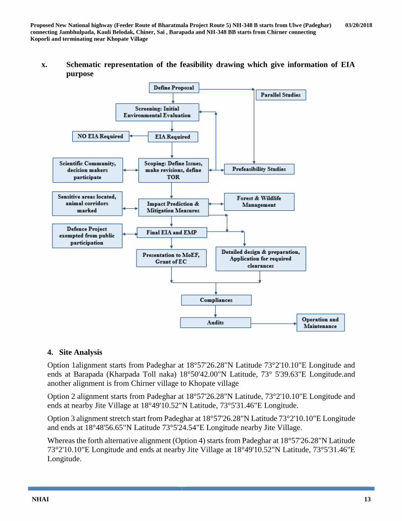
x. Schematic representation of the feasibility drawing which give information of EIA
purpose
4. Site Analysis
Option 1alignment starts from Padeghar at 18°57'26.28"N Latitude 73°2'10.10"E Longitude and
ends at Barapada (Kharpada Toll naka) 18°50'42.00"N Latitude, 73° 5'39.63"E Longitude.and
another alignment is from Chirner village to Khopate village
Option 2 alignment starts from Padeghar at 18°57'26.28"N Latitude, 73°2'10.10"E Longitude and
ends at nearby Jite Village at 18°49'10.52"N Latitude, 73°5'31.46"E Longitude.
Option 3 alignment stretch start from Padeghar at 18°57'26.28"N Latitude 73°2'10.10"E Longitude
and ends at 18°48'56.65"N Latitude 73°5'24.54"E Longitude nearby Jite Village.
Whereas the forth alternative alignment (Option 4) starts from Padeghar at 18°57'26.28"N Latitude
73°2'10.10"E Longitude and ends at nearby Jite Village at 18°49'10.52"N Latitude, 73°5'31.46"E
Longitude.

Proposed New National highway (Feeder Route of Bharatmala Project Route 5) NH-348 B starts from Ulwe (Padeghar)
connecting Jambhulpada, Kauli Belodak, Chiner, Sai , Barapada and NH-348 BB starts from Chirner connecting
Koporli and terminating near Khopate Village
03/20/2018
NHAI 14
And all this Alternative alignment is situated in Raigad district
i. Connectivity
The proposed route is connected and approached through State highways and National Highways.
As it is an expansion of existing road SH-104. Highway’s strategic location provides connectivity
to various economically developed cities of Maharashtra. The proposed road is interconnecting in
the Raigad District. This route is important, as it provide link to NH66, NH4 & NH17, SH 54,
JNPT road which will be benefit to Maharashtra & other State.
ii. Land form and land use
Land use change is partially applicable as there is 15-20 m of available Right of Way (ROW)
which would require additional land acquisition for Option 1.
Option 2, 3 and 4 are greenfield alignments so require land acquisition. Hence land use change is
anticipated.
iii. Topography
Option 2, 3 & 4 existing alignment is generally flat with rolling Terrain and after koproli village
(For Option 2 & 3) and chirner village (for option 4) the alignment is rerouted which would be
new alignment and it is hilly terrain so tunnel is Proposed at both the alignment.
Option 1 alignment is the area which is generally flat with rolling hills along the western part of
corridor and flat cultivated land in the central and southern portion of the corridor. The elevations
range between 3 m above MSL to 80 m above MSL, with most of the area being flat.
iv. Existing land use pattern (agriculture, non-agriculture, forest, water bodies (including
area under CRZ), shortest distances from the periphery of the project to periphery of
the forests, national park, wildlife sanctuary, eco-sensitive areas, water bodies (distance
from the HFL of the river), CRZ. In case of notified industrial area, a copy of the
Gazette notification should be given.
Land use change is partially applicable as there is 15-20 m of available Right of Way (ROW)
which would require additional land acquisition for Option 1.
Option 2, 3 and 4 are greenfield alignments so require land acquisition. Hence land use change is
anticipated. The details will be elaborated in EIA. There are several villages and settlements
located in the vicinity of the existing route.
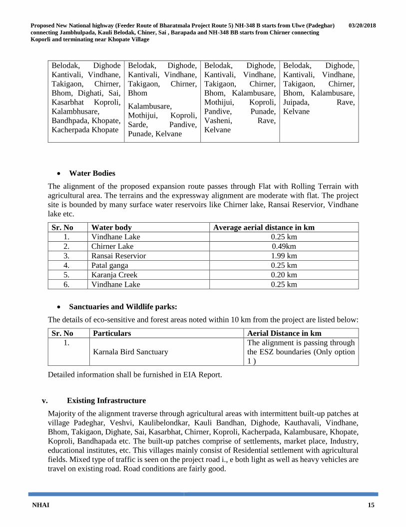
The list of villages though which concluded alignment is passing is as below;
Table 4-1: Village List
Option 1 (old) Option 2 Option 3 Option 4
Padeghar, Veshvi,
Kauli Bandhan, Kauli
Padeghar, Veshvi,
KauliBandhan, Kauli
Padeghar, Veshvi,
KauliBandhan, Kauli
Padeghar, Veshvi,
KauliBandhan, Kauli
Proposed New National highway (Feeder Route of Bharatmala Project Route 5) NH-348 B starts from Ulwe (Padeghar)
connecting Jambhulpada, Kauli Belodak, Chiner, Sai , Barapada and NH-348 BB starts from Chirner connecting
Koporli and terminating near Khopate Village
03/20/2018
NHAI 15
Belodak, Dighode
Kantivali, Vindhane,
Takigaon, Chirner,
Bhom, Dighati, Sai,
Kasarbhat Koproli,
Kalambhusare,
Bandhpada, Khopate,
Kacherpada Khopate
Belodak, Dighode,
Kantivali, Vindhane,
Takigaon, Chirner,
Bhom
Kalambusare,
Mothijui, Koproli,
Sarde, Pandive,
Punade, Kelvane
Belodak, Dighode,
Kantivali, Vindhane,
Takigaon, Chirner,
Bhom, Kalambusare,
Mothijui, Koproli,
Pandive, Punade,
Vasheni, Rave,
Kelvane
Belodak, Dighode,
Kantivali, Vindhane,
Takigaon, Chirner,
Bhom, Kalambusare,
Juipada, Rave,
Kelvane
Water Bodies
The alignment of the proposed expansion route passes through Flat with Rolling Terrain with
agricultural area. The terrains and the expressway alignment are moderate with flat. The project
site is bounded by many surface water reservoirs like Chirner lake, Ransai Reservior, Vindhane
lake etc.
Sr. No Water body Average aerial distance in km
1. Vindhane Lake 0.25 km
2. Chirner Lake 0.49km
3. Ransai Reservior 1.99 km
4. Patal ganga 0.25 km
5. Karanja Creek 0.20 km
6. Vindhane Lake 0.25 km
Sanctuaries and Wildlife parks:
The details of eco-sensitive and forest areas noted within 10 km from the project are listed below:
Sr. No Particulars Aerial Distance in km
1.
Karnala Bird Sanctuary
The alignment is passing through
the ESZ boundaries (Only option
1 )
Detailed information shall be furnished in EIA Report.
v. Existing Infrastructure
Majority of the alignment traverse through agricultural areas with intermittent built-up patches at
village Padeghar, Veshvi, Kaulibelondkar, Kauli Bandhan, Dighode, Kauthavali, Vindhane,
Bhom, Takigaon, Dighate, Sai, Kasarbhat, Chirner, Koproli, Kacherpada, Kalambusare, Khopate,
Koproli, Bandhapada etc. The built-up patches comprise of settlements, market place, Industry,
educational institutes, etc. This villages mainly consist of Residential settlement with agricultural
fields. Mixed type of traffic is seen on the project road i., e both light as well as heavy vehicles are
travel on existing road. Road conditions are fairly good.

Proposed New National highway (Feeder Route of Bharatmala Project Route 5) NH-348 B starts from Ulwe (Padeghar)
connecting Jambhulpada, Kauli Belodak, Chiner, Sai , Barapada and NH-348 BB starts from Chirner connecting
Koporli and terminating near Khopate Village
03/20/2018
NHAI 16
vi. Soil Classification
Raigad District: The district has three physiographic divisions i.e. (i) Coastal zone in west covers
about 20% percent of the district (ii) Central zone covers about 1/3 rd of the district, consisting of
fertile land in low lying area (iii) Hilly zone in the eastern part highly uneven in altitude and
covered with forest. This hill range is characterized by ruggedness and uneven topography, with
crestline of peaks and saddles forming the eastern horizon. Ulhas, Panvel and Patalganga are the
three main rivers in northern part. Kundalika River is the main river in central part whereas in the
southern part Savitri River is the main river.
Soil:
The soils in the district are formed from the Deccan Trap which is predominating rock formation
with small out crops of Laterite at a few places in the Poladpur taluka and Matheran hill. The soils
are grouped as Forest, Varkas, Rice, Khar or Saline, Coastal Alluvium and Laterite as per the
location and topographical situation.
Forest Soils: These soils are not used for agricultural purposes but yield valuable forest products
such as teak-wood, hirda (myrobalan), beheda, pepper, etc. However, these soils are heavily
eroded due to grazing and cutting of the forest trees.
Varkas Soil: These soils are located just below the forest soils all along the steeper slopes. They
are shallow in depth, which varies only between a foot and a foot and a half, heavily eroded and
sandy in texture and yellowish red to yellowish grey in color with acidic reaction. They are poor
in organic matter and nitrogen and possess very little retentivity of moisture. They
yield kharif millets but the production thereof could be increased with the addition of bulky
manures, lime and nitrogenous and phosphatic fertilizers.
Rice Soils: The district is the second largest producer of rice in the Maharashtra State. The region
is peculiarly terraced and, though the small strips in between the two terraces are levelled, it is
difficult to get even a few gunthas of land in one piece in a levelled condition. The depth varies
between two and six feet. They are loamy in texture, yellowish or reddish grey in colour, neutral
in reaction and almost devoid of lime. They are formed from the trap rock from the Sahyadri ranges
under heavy rainfall and humid climatic conditions. The linear response of rice to the application
of nitrogenous, phosphatic and potassic fertilizers is observed in these soils. Addition of bulky
manures in these soils is also found to be advantageous from the point of view of yield. There are
some patches of manat soils in Mangaon taluka which are rich in clay and silt and which become
stiff and hard when dry.
Khar soils: These soils are situated on the flat, levelled land near the sea at the point of creeks
formed due to the rivers. They are flat clay to clay loam in texture and reddish or yellowish grey

Proposed New National highway (Feeder Route of Bharatmala Project Route 5) NH-348 B starts from Ulwe (Padeghar)
connecting Jambhulpada, Kauli Belodak, Chiner, Sai , Barapada and NH-348 BB starts from Chirner connecting
Koporli and terminating near Khopate Village
03/20/2018
NHAI 17
in colour. These soils contain hardly more than one per cent of soluble salts. These soils are formed
due to the deposition of salts by the sea or from lands reclaimed from the sea.
Coastal alluvium soils: These soils are found all along the coast and at places where there are no
creeks. They are deep soils developed on flat land and loamy in texture with reddish grey colour.
They are devoid of clay fraction or humus and are open in nature. Calcium carbonate is found in
abundance throughout the profile but calcium has not entered the clay complex. The sub-soil water
level is only from ten to fifteen feet deep. The salt contents of the well water are higher in the
proximity of the sea; but due to excellent drainage, its use has not produced any deleterious effects.
The soils are almost neutral or slightly on the alkaline side of neutrality. Good garden crops like
coconut, areca-nut, plantain, etc., are grown in these soils, depending upon the availability of
water.
Laterite soils: Out-crops of laterite rock are observed amongst the Sahyadri ranges amidst the trap
rock mainly at Matheran and in the Poladpur taluka. These soils mostly occur on the mountain
peaks. They are coarser in texture, wherever there are no forests. They are yellowish-red in colour
and shallow in depth and yield coarse millets and Niger. The heavy rains in the mountainous
regions thoroughly leach the soils turning them acidic in reaction and devoid of calcium carbonate.
They are rich in sesquioxides, the ratio of silica to sesquioxides being less than two. But they are
generally poor in exchangeable bases or in fertility constituents. However, the soils from the forest
region are well-supplied with nitrogen and organic matter.
vii. Climatic data from Secondary sources
Raigad District
Raigad district is one of the four coastal districts situated along the western coast of the State and
is located between north latitude 17°51’00” and 19°08’00” and east longitudes 72°50’00” and
73°40’00”. It is bounded by Thane district in the north, Ratnagiri district in the south, Pune district
in the east and Arabian sea forms the western boundary having a length of about 250 km.
Climate:
The climate of the district is typical of west coast and characterized with plentiful and regular
seasonal rainfall, oppressive weather in summer and high humidity throughout the year. The mean
minimum temperature is 17.7°C and mean maximum temperature is 31.8°C. Except during the
monsoon season when the humidity is high, the air is generally dry. The summer season is the
driest part of the year when the relative humidity goes down to 20% or less particularly in the
afternoons.
Rainfall
The analysis of long term rainfall data indicates that normal annual rainfall over the district ranges
from 2200 mm to more than 3000 mm in the plains and it is above 5000 mm in the hills. The

Proposed New National highway (Feeder Route of Bharatmala Project Route 5) NH-348 B starts from Ulwe (Padeghar)
connecting Jambhulpada, Kauli Belodak, Chiner, Sai , Barapada and NH-348 BB starts from Chirner connecting
Koporli and terminating near Khopate Village
03/20/2018
NHAI 18
average annual rainfall is about 3,884 mm. About 48% of rainfall is received in July. During rainy
season humidity is above 80% and it ranges from 65 to 75 in rest of the year. The occurrence and
distribution of rainfall is mainly during kharif from June to September. The district received
rainfall about 45 days in a year.
viii. Social Infrastructure
This existing alignment is passes through villages like, Padeghar, Veshvi, Kaulibelondkar, Kauli
Bandhan, Dighode, Kauthavali, Vindhane, Bhom, Takigaon, Dighate, Sai, Kasarbhat, Chirner,
Koproli, Kacherpada, Kalambusare, Khopate, Koproli, Bandhapada, Veshani, Rave etc. This
villages mainly consist of Residential settlement and people mainly depends upon the agricultural
for their income source. Basic social infrastructure of this villages is not well developed along the
route. The villages on the proposed route have primary health care facilities, basic education,
markets, police station, transportation, roads etc., but for Higher education and Health care
facilities People have to go main city areas of Raigad Districts.
5. Planning Brief
i. Planning Concept (type of industries, facilities transportation etc.) Town and Country
Planning/ Development authority Classification
Not Applicable
ii. Population Projection
Not Applicable
iii. Land use planning (breakup along with green belt etc.)
Land use change is partially applicable as there is 15-20 m of available Right of Way (ROW)
which would require additional land acquisition for Option 1.
Option 2, 3 and 4 are greenfield alignments so require land acquisition. Hence land use change is
anticipated. Details of Land use breakup will be described in EIA.
iv. Assessment of Infrastructure Demand (Physical & Social)
Not Applicable
v. Amenities / facilities
The amenities proposed during operation phase are toll plaza, administrative buildings, weighing
stations, parking areas & rest areas and office cum residential complex of PIU. The toll plaza
location will be selected based on the traffic studies and a study of the existing physical features
including the availability of land & designed as per IRC 84.
Proposed New National highway (Feeder Route of Bharatmala Project Route 5) NH-348 B starts from Ulwe (Padeghar)
connecting Jambhulpada, Kauli Belodak, Chiner, Sai , Barapada and NH-348 BB starts from Chirner connecting
Koporli and terminating near Khopate Village
03/20/2018
NHAI 19
6. Proposed infrastructure
i. Industrial Area (Processing Area)
The project route is having various prestigious industrial projects viz.,
Patalganga MIDC Industrial Estate,
Roha Industrial Estate,
Taloja Industrial Estate,
Nagothane Industrial Estate
Khopoli Industrial Estate
ii. Residential Area (Non-Processing Area)
Not Applicable
iii. Green Belt
Avenue plantation shall be provided as per Green Highway (Plantation and Maintenance) policy
and Green Highways (Plantation Trans-plantation beautification and Maintenance) policy 2015.
iv. Social Infrastructure
Not Applicable
v. Connectivity
Road Infrastructure
The proposed expansion route 5 (SH-104) is connected and approached through State highways
and National Highways. This route is important, as it provide link to NH66, NH4 & NH17, SH 54,
JNPT road which will be benefit to Maharashtra & other State.
The project will also increase transportation connectivity from Raigad District to developed cities
like, Mumbai.
For linear projects, this generally does not apply. However, for the starting point and the end point,
the nearest railway stations/ airport is:
Railway Stations
1. Belapur Railway Station from Padeghar
2. Jite Railway Station near end of the alignment
Bus Depots

Proposed New National highway (Feeder Route of Bharatmala Project Route 5) NH-348 B starts from Ulwe (Padeghar)
connecting Jambhulpada, Kauli Belodak, Chiner, Sai , Barapada and NH-348 BB starts from Chirner connecting
Koporli and terminating near Khopate Village
03/20/2018
NHAI 20
1. Wavel bus stop from Padeghar
2. Jite Bus Stop
Airport
1. Chhatrapati Shivaji International Airport
Port:
1. Jawaharlal Nehru International Port
2. Mandava Port
vi. Drinking Water Management (Source and Supply of Water)
Drinking water will be purchased. Details will be furnished in EIA report.
vii. Sewerage System
Mobile toilets with package STP will be provided for the workers in construction phase. Toilets
and STPs shall be provided in the amenities area during the operation phase. Details will be
furnished in EIA report.
viii. Industrial Waste management
Not Applicable
ix. Solid Waste management
50 kg of municipal waste is expected to be generated during construction considering 200 labours.
During operation phase, the municipal solid waste generated from the amenities proposed along
the alignment. Waste management during construction and operational phase shall be done as per
Solid Waste Management Rules, 2016.
x. Power Requirement and Supply / Source
Power requirement during construction phase will be met with LSD D.G sets in case of non-
availability of electric supply. For operational phase, electrical supply will be used wherever
available.
Proposed New National highway (Feeder Route of Bharatmala Project Route 5) NH-348 B starts from Ulwe (Padeghar)
connecting Jambhulpada, Kauli Belodak, Chiner, Sai , Barapada and NH-348 BB starts from Chirner connecting
Koporli and terminating near Khopate Village
03/20/2018
NHAI 21
7. Rehabilitation and Resettlement (R & R) Plan:
i. Policy to be adopted (Central/State) in respect of the project affected persons including
home oustees, land oustees and landless laborers (a brief outline to be given).
Most of the land coming under the project area is agricultural and cultivated land. The land
required for the construction of Bypass will be acquired by NHAI before the commencement of
construction work and the R&R plan will be prepared and will be submitted in EIA.
8. Project Schedule & Cost Estimates
i. Likely date of start of construction and likely date of completion:
The project shall start its construction work as and when DPR is finalized and will get
Environmental clearance from MoEF&CC. The completion period of the project construction is
estimated about 24 months. The anticipated period of completion is in the year 2021.
ii. Estimated project cost along with analysis in terms of economic viability of the
project.
The estimated Civil cost of the project is approximately Rs 347.45Crores.
9. Analysis of proposal (Final Recommendations)
i. Financial and social benefits with special emphasis on the benefit to the local people
including tribal population, if any, in the area.
The project will have multiple benefits. It will reduce the travel time substantially within Raigad
and other district. Overall improvement will be expected in local area in following ways:
1. Development and improvement in transportation infrastructure facility will connect
villages with the nearby cities
2. Better approach to Medical & Educational services and quick transportation of perishable
goods like fruits, vegetables and dairy products.
3. Development of tourism and pilgrimage
4. Transporting, processing and marketing of agricultural products
5. Fast and safe connectivity resulting in savings in fuel, travel time and total transportation
cost to the society
6. Reduction in accidents due to curve improvements at various sections of the alignment
7. Reduction in pollution due to reduction in congestion
8. Indirect and direct employment opportunity to people from all skilled, semiskilled and
unskilled streams will act as social benefits
Proposed New National highway (Feeder Route of Bharatmala Project Route 5) NH-348 B starts from Ulwe (Padeghar)
connecting Jambhulpada, Kauli Belodak, Chiner, Sai , Barapada and NH-348 BB starts from Chirner connecting
Koporli and terminating near Khopate Village
03/20/2018
NHAI 22
It is assumed that the overall Bharat mala project will boost socio-economic development in
the entire central region of Maharashtra. Accordingly, Route 5 will contribute towards this
objective.