Proposal for the Development of Pedestrian Facilities in ...
88
TRANSPORT PLANNING UNIT TRANSPORT DEPARTMENT THE GOVERNMENT OF PUNJAB Proposal for the Development of Pedestrian Facilities in Gujranwala City
-
Upload
khangminh22 -
Category
Documents
-
view
1 -
download
0
Transcript of Proposal for the Development of Pedestrian Facilities in ...

TRANSPORT PLANNING UNIT
TRANSPORT DEPARTMENT THE GOVERNMENT OF PUNJAB
Proposal for the Development of Pedestrian Facilities in Gujranwala City

2013 Proposal for the Development of Pedestrian Facilities in Gujranwala City
ii
DISCLAIMER This report is meant to serve as a guidance note for the CDG/TMA offices, Gujranwala to
prepare reference designs and drawings and cost estimates. However, while preparing PC-1,
approval and tendering etc, all legally prevalent procedures should be followed and all
approvals/sanctions sought as per law.

2013 Proposal for the Development of Pedestrian Facilities in Gujranwala City
iii
Table of Contents ABBREVIATIONS ................................................................................................................ vii 1. Introduction ........................................................................................................................1
2. Aim and Objective of the Study .........................................................................................2
3. Methodology .......................................................................................................................2
4. Gujranwala –Phelwana da shehar ...................................................................................4
5. Assessment of Prevailing Pedestrian Infrastructure .........................................................12
5.1 Road Network ........................................................................................................... 12
6. Focus Group Discussion ...................................................................................................22
6.1 Constraints, Opportunities and Experiences ............................................................. 22
6.2 Availability and Preference for Walking as mode of Transport ............................... 23
6.3 Pedestrian Infrastructure and Black Spots ................................................................ 24
7. Pedestrian Count Survey ..................................................................................................25
7.1 Denga Phatak Intersection ......................................................................................... 30
7.2 Sheranwala Bagh ....................................................................................................... 32
7.3 Sialkoti Darwaza ....................................................................................................... 35
7.4 Alam Chowk ............................................................................................................. 37
7.5 Gondalawala Chowk ................................................................................................. 40
7.6 Maafiwala Chowk ..................................................................................................... 43
7.7 Munir Chowk ............................................................................................................ 45
7.8 Pindi Bypass .............................................................................................................. 47
7.9 Shiekhupura Moor ..................................................................................................... 49
8. Vehicular Traffic Count Survey .......................................................................................51
9. Pedestrian Infrastructure Type and Provision Requirements ...........................................53
9.1 Infrastructure Parallel to Carriage way ..................................................................... 53
9.2 Types of Pavement Markings used for Pedestrians .................................................. 61
9.3 Pedestrian Signal Heads ............................................................................................ 62
10. Recommendations ............................................................................................................65
Appendix ..................................................................................................................................73
Annex A: Pedestrian Counts Performa ....................................................................................74
Annex B: Traffic Counts Performa ..........................................................................................75
Annex C: Pavement Markings and Signage ............................................................................76

2013 Proposal for the Development of Pedestrian Facilities in Gujranwala City
iv
List of Figures
Figure 1: Methodology Adopted for the Study ........................................................................... 3 Figure 2 : Location Map of Gujranwala ..................................................................................... 4 Figure 3: Transit Locations within/ around the city (Google Amended).................................... 6 Figure 4: Location of High Pedestrian Movement (Google Amended) ..................................... 8 Figure 5: Identified High Pedestrian Movement Area (Google Amended) ................................ 9 Figure 6: Daily Traffic Volume at Identified Pedestrian Movement Location (Google
Amended) .......................................................................................................................... 10 Figure 7: Peak Hour Traffic Volume at Identified Pedestrian Movement Locations (Google
Amended) .......................................................................................................................... 11 Figure 8: Road Classification Map of Gujranwala ................................................................... 15 Figure 9: High Vehicular Volume with non-availability of Pedestrian Crossing ..................... 17 Figure 10: No Walkways Available to Pedestrian .................................................................... 17 Figure 11: Pedestrian crossing at Gujranwala Phattak ............................................................. 18 Figure 12: Figure: Non-Availability of Pedestrian Infrastructure ............................................ 18 Figure 13: Illegal Parking on Pedestrian Right of Way ............................................................ 19 Figure 14: Daily Pedestrian Volume Percentage ...................................................................... 26 Figure 15: Daily Pedestrian Volume at Nine Locations ........................................................... 27 Figure 16: Peak Hour Pedestrian Volume Percentage at Nine Locations ................................ 28 Figure 17: Peak Hour Pedestrian Volume at Nine Locations ................................................... 29 Figure 18: Location of Danga Phattak Intersection (Google Amended) .................................. 30 Figure 19: Daily Pedestrian Volume at Denga Phttak .............................................................. 31 Figure 20: Location of Sherawala Bagh (Google Amended) ................................................... 32 Figure 21: Daily Pedestrian Volume at Sheranwla Bagh ......................................................... 33 Figure 22: Pedestrian Facilities at Sheranwla Bagh ................................................................. 34 Figure 23: Pedestrian Facilities at Sheranwala Bagh ................................................................ 34 Figure 24: Pedestrian Facilities at Sheranwala Bagh ................................................................ 35 Figure 25: Location of Sialkoti Darwaza .................................................................................. 36 Figure 26: Dily Pedestrian Volume at Sialkoti Darwaza .......................................................... 37 Figure 27: Location of Alam Chowk ........................................................................................ 38 Figure 28: Peak Hour Pedestrian Volume at Alam Chowk ...................................................... 38 Figure 29: Pedestrian Facilities at Alam Chowk ...................................................................... 39 Figure 30: Pedestrian Facilities at Alam Chowk ...................................................................... 40 Figure 31: Location of Gondalawala Chowk ............................................................................ 41 Figure 32: Daily Pedestrian Volume at Gondalawala Chowk .................................................. 41 Figure 33: Pedestrian Facilities at Gondalawala Chowk .......................................................... 42 Figure 34: Pedestrian Facilities at Gondalawala Chowk .......................................................... 42 Figure 35: Location of Maafiwala Chowk ................................................................................ 43 Figure 36: Peak Hour Pedestrian Volume at Maafiwala Chowk .............................................. 44 Figure 37: Pedestrian Facilities at Maafiwlala Chowk ............................................................. 44 Figure 38: Pedestrian Facilities at Maafiwala Chowk .............................................................. 45

2013 Proposal for the Development of Pedestrian Facilities in Gujranwala City
v
Figure 39: Location of Munir Chowk ....................................................................................... 46 Figure 40: Daily Pedestrian Volume at Munir Chowk ............................................................. 46 Figure 41: Location of Pindi Bypass Chowk ............................................................................ 47 Figure 42: Peak Hour Pedestrian Volume at Pindi Bypass....................................................... 48 Figure 43: Peak Hour Pedestrian Volume at Pindi Bypass....................................................... 49 Figure 44: Location of Sheikhupura Morr ................................................................................ 50 Figure 45: Daily Volume at Sheikhupura Morr ........................................................................ 50 Figure 46: Peak Hour Traffic vs Pedestrian Volume at Nine Locations .................................. 52 Figure 47: Walkways, Sidewalks and Shoulder Design ........................................................... 54 Figure 48: Recommended Sidewalk Design ............................................................................. 54 Figure 49: Planting Buffer between Sidewalk and Street ......................................................... 57 Figure 50: Typical Zebra Crossing ........................................................................................... 58 Figure 51: Marking on Roads for Pedestrian ............................................................................ 59 Figure 52: Typical Pelican Crossing ......................................................................................... 60 Figure 53: Typical Puffin Crossing........................................................................................... 60 Figure 54: Typical Toucan Crossing......................................................................................... 61 Figure 55: Pedestrian Signal Head Indications ......................................................................... 64

2013 Proposal for the Development of Pedestrian Facilities in Gujranwala City
vi
List of Tables
Table 1: Total Traffic Volume and Passenger at the intersections around the city ................... 5
Table 2: Intersections Inventory Survey Results ..................................................................... 19
Table 3: Road Inventory Survey Results ................................................................................ 20
Table 4:Road Inventory Survey Results .................................................................................. 21
Table 5: Daily Volume of Pedestrian....................................................................................... 26
Table 6: Peak Hour Volume of Pedestrian .............................................................................. 28
Table 7: Summary of Pedestrian Count Survey at Denga Phattak .......................................... 31
Table 8: Summary of Pedestrian Count Survey at Sheranwala Bagh ...................................... 33
Table 9: Summary of Pedestrian Count Survey at Sialkoti Darwaza ...................................... 36
Table 10: Summary of Pedestrian Count Survey at Alam Chowk .......................................... 37
Table 11: Summary of Pedestrian Count Survey at Gondalawala Chowk .............................. 40
Table 12: Summary of Pedestrian Count Survey at Maafiwala Chowk .................................. 43
Table 13: Summary of Pedestrian Count Survey at Munir Chowk ......................................... 45
Table 14: Summary of Pedestrian Count Survey at Pindi Bypass Chowk .............................. 48
Table 15: Summary of Pedestrian Count Survey at Sheikhupura Morr .................................. 49
Table 16: Daily Traffic Volume at Nine Locations ................................................................. 51
Table 17: Peak Hour Traffic Volume ...................................................................................... 51
Table 18: Recommended Sidewalk Widths for Different Street Types .................................. 55
Table 19: Pedestrian Infrastructure at Nine Locations ............................................................ 65
Table 20: Pedestrian Infrastructure as per Road Classification .............................................. 66

2013 Proposal for the Development of Pedestrian Facilities in Gujranwala City
vii
ABBREVIATIONS
CBD Central Business Districts
CDG City District Government
ROW Right of Way
GoPb Government of the Punjab
Km Kilometer
LG Local Government
USP & MU Urban Sector Policy and Management Unit
UU Urban Unit
P & D Planning and Development
TMA Tehsil Municipal Administration

2013 Proposal for the Development of Pedestrian Facilities in Gujranwala City
viii
ACKNOWLEDGEMENT
Transport Planning Unit has been established at Transport Department, Government of the
Punjab to conduct Transport Planning, Traffic Assessment and Management Studies for cities
of the Punjab. The TPU team conducted field surveys, held discussions with the officials
concerned of the Government Departments, Administration of the Gujranwala District and
residents of the city to prepare and complete this report. The TPU team highly appreciates the
contribution of The Urban Unit for their valuable input and contribution during different
stages of the study especially for Public Transport Planning Surveys
The team would like to convey their special appreciation to the people of Gujranwala for their
interest, time and input during the field surveys. The TPU team would like to acknowledge
the officials from City District Government Gujranwala and Tehsil Municipal Administrations
(TMAs) for the provision of relevant data, guidance, and comments. Special thanks to young
students of Punjab College, Gujranwala for conducting Household Information Surveys with
full dedication and responsibility. The TPU team would also like to appraise the efforts of
Secretary, DRTA Gujranwala for facilitating field visits and providing data related to public
transport services in the city. It is worthy to appreciate the PDMFC and the Urban Unit for
providing GIS maps for the study area.
Finally, the team would like to convey their special appreciation to The Commissioner and
The District Coordination Officer, Gujranwala for his continuous guidance and support during
this study.

2013 Proposal for the Development of Pedestrian Facilities in Gujranwala City
1
1. Introduction
Walking being the prime form of movement and considered as most sustainable and
environment friendly mode serves as first mean of transport in any journey whether made by
car or by private/ public transport. It is because access to means of transport itself requires
movement and unless disabled people walk to their modes of movement. In reality, cities are
constituted by Pedestrians and their movement patterns affect its development. However,
several parameters pertaining to pedestrian movement and circulation needs to be addressed
before hand while developing/ planning a sustainable green city. Importantly; these
parameters to be considered at planning stage are relative to various social group needs and
the area in which they dwell. Inadequate planning not conforming with the needs of social
groups prevailing in the cities results in car dependent societies thus resulting in externalities
such as congestion, parking issues etc. In developing countries, impromptu growth, lack of
planning institutions and enforcements had further worsened the situation and problems
specifically related to pedestrians have become chronic. It is because due consideration is not
given to pedestrian movement during planning and construction phase of civic infrastructure.
For instance, Central Business Districts (CBD) areas having higher concentration of activities
require extensive movement by foot because; firstly, land in these areas is costly and is
usually used for revenue generation instead of service provision. Secondly, CBD areas are
usually composed of old quarters closely knitted. Walking can serve as an excellent mean of
transport in these closely knitted areas, where parking of private modes often become a
serious issue but it is not so especially in the cities of developing countries such as Pakistan.
Evidently, the major cities of Punjab are either developed along a primary transport link i.e.
canal, railway line or highway. Over the time, these cities have swollen and lack of planning
strategies/ guidelines or non-conformity to byelaws have resulted mostly in mono-centric
pattern of development where old quarters along the primary link have been transformed into
CBD area. In addition, these CBD areas are dominated by financial and commercial activities
resulting in lesser space for other civic amenities. The story is same for major cities of Punjab
province where pedestrians are given least priority in terms of planning and all efforts are
made to provide more space for vehicular traffic.
Promisingly, the situation is changing and due importance is now given to pedestrians. It is
because geometric designs of roadways prepared by local government entities include design

2013 Proposal for the Development of Pedestrian Facilities in Gujranwala City
2
of pathways. Nonetheless, it is imperative to review pedestrian mobility in old built up areas
which already serves as CBDs of the cities and where infrastructure is already developed.
This study was conducted on the request of City District Government (CDG), Gujranwala.
The CDG Gujranwala aims to provide, sustainable integrated and safe transport services to all
in their areas and to achieve its desired aim, a request was made to the Urban Unit, Planning
and Development Department, GoPb. The Urban Unit requested Transport Planning Unit
(TPU), a unit developed solely for the purpose of strategic planning within Transport
Department to conduct the underlying study through assistance and supervision of its
Transport Research Assistants.
2. Aim and Objective of the Study
The underlying study aims to review the existing facilities in the city and propose new
pedestrian infrastructure ensuring safe mobility and accessibility to activity locations for the
inhabitants.
Following constitute the objectives of the study:
To review and analyze the available pedestrian facilities within the city
To identify Pedestrian mobility and accessibility hazardous locations in the city where
modal conflicts results in accidents
To identify hot spots in the city where pedestrian facilities are of utmost important and
necessity
To propose and develop efficient pedestrian infrastructure for the people in the city
3. Methodology
Methodology for this study involves composite approach encompassing descriptive,
quantitative and quantitative analysis approach. The combination of both subjective and
objective techniques helped to examine the prevailing conditions and to propose necessary
infrastructure required to meet pedestrian needs. Assessment of existing situation was done by
field visits, consultation meetings, and descriptive examination of available literature if any.
Assessment helped to define the physical description of the prevailing infrastructure. In the
second phase methods or tool of analysis was applied i.e. both quantitative and qualitative
techniques to collect primary information regarding pedestrian needs and requirements.

2013 Proposal for the Development of Pedestrian Facilities in Gujranwala City
3
Figure 1: Methodology Adopted for the Study

2013 Proposal for the Development of Pedestrian Facilities in Gujranwala City
4
Pedestrian count surveys formulated the quantitative part; whereas focus group constituted the
qualitative part of the methodology. In the subsequent phase, both secondary and primary data
collected was analyzed and proposal was made for the development of infrastructure facilities.
In the last phase, the whole process was documented. Figure 1 below highlights the adopted
methodology for the underlying study.
4. Gujranwala –Phelwana da shehar
Gujranwala commonly known as the city of wrestlers or Phelwana da shehar is in fact the
industrial hub of the Punjab province and is the seventh largest city of the province. The other
major commercial expertise of the city is export of Rice. The total population of
approximately 2,661,360 of the city is dispersed within the residential quarters located along/
adjacent to the Grand Trunk (G.T) Road formally known as National Highway (N5). As stated
earlier, the city due to its development on the primary corridor (N5 and National Railway
Line) has flourished within the manufacturing and agricultural sector. Within agriculture
sector, the city is known for production grains primarily rice which is exported globally. In
addition, the city has a well developed structure of commercial and industrial entities which
produces ceramics, steel, cutlery, crockery, iron safes, metal tool, utensils, textiles, sanitary
and tannery goods. Figure 2 depicts the strategic importance of city due to its location.
Figure 2 : Location Map of Gujranwala

2013 Proposal for the Development of Pedestrian Facilities in Gujranwala City
5
Evidently, the city serves as the industrial heart of the province and provides jobs to people in
both industrial/ manufacturing and agriculture sector. In addition to people residing within the
city, it also provides employment opportunities for the people living in neighboring towns and
villages who commute to various manufacturing units on daily basis. Likewise, the city serves
as commercial centre for the people of neighboring towns / villages who commute to the CBD
area for retail shopping purposes through transit intersections highlighted in Figure 3 below.
In addition, due to development of the city along the National Highway N5, most of city CBD
area is located along the road. Evidently, pedestrian movement along N5 road is
comparatively higher than that in other parts of the city. In addition, facilities and services
such as schools, offices, hospitals, bus stands etc. are also located along this road. Presence of
these services results in generation of significant passengers trips mostly along / on GT Road
as indicated in Table 1.
Table 1: Total Traffic Volume and Passenger at the intersections around the city
Sr. No. Name of Intersection Total Traffic
Volume (PCUs) Total Passengers 1. Chan Da Qila Chowk 81544 407720
2. Judicial Colony Chowk 29700 148500
3. Wapda Town Chowk 88690 443450
4. Khiali Bypass Chowk 27222 136110
5. Jinnah Rodhian Chowk 35707 178535
6. Malhi / Nowshera Sansi Chowk 92624 463120
7. Nowshera Road / Awan Chowk 751 3755
8. Alam Chowk 58932 294660
9. Nawab Chowk 90565 452825
10. Alipur Chowk 49851 249255
11. Pindi Bypass Chowk 179081 895405
12. Sui Gas Chowk 68609 343045
13. Maifiwala Chowk 51270 256350
14. Sialkot Bypass Chowk 51067 255335
15. Chicharwali Pull Chowk 47626 238130
16. Ferozwala Chowk 60478 302390
17. Kanganiwala Bypass Chowk 65972 329860 (Source: Traffic Management Study for Gujranwala City, TPU)

2013 Proposal for the Development of Pedestrian Facilities in Gujranwala City
6
Figure 3: Transit Locations within/ around the city (Google Amended)

2013 Proposal for the Development of Pedestrian Facilities in Gujranwala City
7
Contrary, there is scarcity of pedestrian infrastructure in the city and along N5. Though
pathways have been constructed along few stretches of the roads in the city but they are not
inter-connected. Also, there does not exit adequate signs and pavement markings to direct/
guide pedestrians at intersections.
Road Inventory survey and Focus Group Discussion was conducted to identify the potential
pedestrian areas and to assess the available pedestrian facilities/ infrastructure in the city. It
was found that a high number of pedestrian movements were observed near and at Denga
Phatak, Sheranwala Bagh, Sialkoti Darwaza, Alam Chowk, Gondla Wala Phatak, Maafiwala
Chowk, Munir Chowk, Pindi Bypass and Shaikhupura Moor. These locations shown in Figure
4 and 5 below constitute high pedestrian movement areas in the city. Likewise Daily and Peak
Hour Traffic Counts highlighted in Figure 6 and 7 were made to examine the vehicular
movement and patterns at these identified locations. Importantly, almost all identified
locations through road inventory survey and Focus group discussion where pedestrian
movement was observed had high volume of vehicular traffic.
It was found that these locations have major commercial and retail centers thus resulting in
high pedestrian and vehicular traffic making these locations a hot spot / hazardous site within
the city transport network. People living in different quarters of the city, and from the
surrounding villages/ towns commute to these centers to access their desired activities.

2013 Proposal for the Development of Pedestrian Facilities in Gujranwala City
8
Figure 4: Location of High Pedestrian Movement (Google Amended)

2013 Proposal for the Development of Pedestrian Facilities in Gujranwala City
9
Figure 5: Identified High Pedestrian Movement Area (Google Amended)

2013 Proposal for the Development of Pedestrian Facilities in Gujranwala City
10
Figure 6: Daily Traffic Volume at Identified Pedestrian Movement Location (Google Amended)

2013 Proposal for the Development of Pedestrian Facilities in Gujranwala City
11
Figure 7: Peak Hour Traffic Volume at Identified Pedestrian Movement Locations (Google
Amended)

2013 Proposal for the Development of Pedestrian Facilities in Gujranwala City
12
5. Assessment of Prevailing Pedestrian Infrastructure
Pedestrian pathways and are integral part of the road geometry. Review of urban transport
infrastructure aided in examination of geometric design of roads; thus facilitating
classification of prevailing transport infrastructure into links and nodes. It was important
because field visits highlighted that presently very scarce pedestrian infrastructure exists in
the city.
5.1 Road Network
The city of Gujranwala being the third largest industrial center of Punjab is well linked to
other cities of the province through primary roads like Grand Trunk Road, Sheikhupura Road,
Sialkot Road, Hafizabad Road and Pasroor Road. Amongst provincial inter-city roads, G.T
Road has the heaviest traffic flows. The traffic flow on primary roads is made up of 87% of
motorized modes and 13% of non-motorized modes.
The road network prevailing in the city follows Hub and Spoke pattern. The existing road
network of Gujranwala city comprises of inner radial road in addition to outer ring road
around the city for inter / intra city traffic. The inner ring road i.e., circular road provides
mobility for Central Business District area in circular pattern. Central ring road i.e. Jinnah
Road, serves the intra city traffic requirement. This central ring road is incomplete due to a
missing link from Nowshera Road to N5 Road on Western side of the city. The outer ring
road i.e., Bye Pass Road, at the periphery of the city accommodates both intra-city and
intercity traffic.
During the last 30 years, the population of the city has increased from 0.30 million to 1.5
Million but there has been marginal increase in the length of urban roads. In order to assess
the existing transport infrastructure available to the people, a robust road inventory survey
was carried out. It helped to examine the available Right of Way (ROW), Encroachments if
any, and pedestrian infrastructure available if any. Based upon the survey results, Road
network in Gujranwala city can be divided into following four categories as highlighted in
Figure 8;
Trunk Roads
Primary Roads
Secondary Roads
Local/ Street Roads

2013 Proposal for the Development of Pedestrian Facilities in Gujranwala City
13
Trunks Roads
Gujranwala city is looped by Trunk Roads, providing a strategic network of major routes
linking centers of national/ provincial importance. Name of existing trunk roads are:
Grand Trunk Road
Gujranwala Road
Sialkot Bypass
Primary Roads
Primary roads are directly connected with trunk roads and also provide linkages to
commercial and institutional areas. Following are the intercity roads: -
Alama Iqbal Road Dulley Road
Eminabad Road Paka Fatomand Road
Ferozwala Road Gondlawala road
Hafizabad Road Hospital Road
Kacha Eminabad Road Kacha Fatomand Road
Nighar phatak road Nowshera Road
Sheikhupura Road Sialkot Road
Secondary Roads
These are the roads which fall under the jurisdiction of City District Government Gujranwala
for development works. Secondary roads are also connected with primary roads and deal with
main streamline of residential areas. The main secondary roads are;
Aroop Road Jamia Masjid Rd
Bazar Khardan Jinnah road
Circula Road Kacha Khiali Road1
Civil Hospital DHQ Kashmir Rd
College Road Main Market road
Dastgeer Road Mian Sansi Road
DC Road Nowshera Sansi Road
Ghanta Ghar Parao Road

2013 Proposal for the Development of Pedestrian Facilities in Gujranwala City
14
Ghordor Road Qazafi Road
Gill Road Rex Cinema Road
Gurjkah Road Sui Gas Road
Jail road Tipu Road
Locals/ Street Roads
Spread over the entire city, these roads provide accessibility from neighborhoods to the
secondary roads and access for people to their residences / work places etc. These roads fall
under the jurisdiction of Town Municipal Administrations.
Academy Road General Bus Stand Road N5 G.T Rd to Isb
Ahmad Nagar Road Ghakka Mitter Road Nomania Road
Airbase Road Ghalib Chowk Road Octroi Post Road
Alipur Chatha Road Ghosia Flyover Pasrur Road
Approach Road Gondlanwala Road Prince Road
Atta Muhammad Road GT Rd-Skp Road link Rahwali Gate Road N
Awami Road Gujranwala Cantt Road Rahwali Gate Road S
Bajwa Road Haidri Rd Railway Road
Bazar Road Kachehri Road Rustam Road
Canal Bank Road Khajoor Wali Road Sadiq Road
Cantt Road Lamba Wali Road Session Court Road
Cemetery Road Lohian Wala Bypass Shelton Road
Chenab Gate Road Madni Road Stadium Road
CMH Road Mandiala Road Station Road Denga Phatak Road Markaz-e-Sanat Road Sugar Mill Road
Exchange Road Model Town Road Suvay Wala Road
Dc Colony To Cantt Model Town Square Road Tower Road
Garden Town Road Munir Road Wadala Road
Garjakh Road Muslim Road Zia ul Haq Road

2013 Proposal for the Development of Pedestrian Facilities in Gujranwala City
15
Figure 8: Road Classification Map of Gujranwala

2013 Proposal for the Development of Pedestrian Facilities in Gujranwala City
16
All intersections where pedestrian movement was observed high during preliminary survey
are un-signalized except one i.e. Pindi By-pass Intersection. There exist no pavements
markings for Zebra crossing, also. Major intersections in the city do not have pedestrian
signals; making mobility by foot hard for the commuters. Furthermore, islands provided
within intersection for facilitation of pedestrian are also not available.
Likewise, most of the roads are encroached. Illegal parking and hawkers were the two most
dominant factors observed that cause barriers in pedestrian mobility. It is because the
pedestrian pathway areas are encroached by them. Occupation of ROW by these illegal parked
vehicles and hawkers force commuters to walk on main carriageway; thus, making them
vulnerable to accidents.
The mobility barriers experienced by the pedestrians are further aggregated due to lack of
signage pertaining to pedestrian movement guidance and facilitation. Key findings below
highlighted in Figure 9, 10, 11, 12 and 13 clearly depicts the deficiencies in the existing
pedestrian network in the city and need of sustainable pedestrian network in the city.
The available right of way where walkway should be available to commuters are either
encroached or used for parking purposes.
At various places, shop keepers have illegally extended their retail areas by occupying
pedestrian pathway space.
Frequent pedestrians and vehicle conflicts / collisions occur due to pedestrian usage of
road width. Especially, during lunch time when school children leave for their home.
Lack of proper signage results in inconvenience for the pedestrian; thus creating more
chaos and making pedestrian more vulnerable.
There exist no pedestrian signals at intersections resulting in problems and confusion
for pedestrians when to cross road.
There exist no underpasses or overhead bridges for pedestrian to cross primary
corridor N5 from onside of the CBD to other side.
The Road and Intersection Inventory survey results highlighted below in Table 2, 3 and 4
clearly depicts that that exist no pedestrian facilities in the city.

2013 Proposal for the Development of Pedestrian Facilities in Gujranwala City
17
Figure 9: High Vehicular Volume with non-availability of Pedestrian Crossing
Figure 10: No Walkways Available to Pedestrian

2013 Proposal for the Development of Pedestrian Facilities in Gujranwala City
18
Figure 11: Pedestrian crossing at Gujranwala Phattak
Figure 12: Figure: Non-Availability of Pedestrian Infrastructure

2013 Proposal for the Development of Pedestrian Facilities in Gujranwala City
19
Figure 13: Illegal Parking on Pedestrian Right of Way
Table 2: Intersections Inventory Survey Results
No. Intersection Name
Type Zebra Crossing
Pedestrian Signal
Island for Pedestrian Movement
Pedestrian Signage
1 Denga Phatak Uncontrolled No No No No
2 Sheranwala Bagh Uncontrolled No No No No
3 Sialkoti Darwaza Uncontrolled No No No No
4 Alam Chowk Uncontrolled No No No No
5 Gondalawala Phatak Uncontrolled No No No No
6 Mafiwala Chowk Uncontrolled No No No No
7 Munir Chowk Uncontrolled No No No No
8 Pindi Bypass Signalized Yes No Yes No
9 Shaikhupura Morr Uncontrolled No No No No

2013 Proposal for the Development of Pedestrian Facilities in Gujranwala City
20
Table 3: Road Inventory Survey Results
Yes/No TYPE %age of Length
1 Alama Iqbal Road 34 Yes Illegal Parking 10% Yes No No2 Eminabad Road 50 No Nill Nill Yes No No3 Ferozwala Road 38 Yes Illegal Parking/Shops 100% No No No4 Hafizabad Road 34 Yes Shops 100% Yes No No5 kacha Eminabad 60 Yes Illegal Parking/Shops 100% Yes No No6 Nighar phatak Road 30 No Nill Nill No No No7 Sheikhupura Road 44 Yes Shops 20% No No No8 Dulley Road 40 Yes Hawkers/Shops 70% Yes No No9 Fato mand Road 18 Yes Hawkers/Shops/Illegal Parking 50% No No No
10 Gondlawala road 62 Yes Parking/Shops 50% Yes No No11 Hospital Road 64 Yes Shops/Illegal Parking 60% Yes No No12 Kacha Fatomand Road 18 No Nill Nill No No No13 Nowshera Road 42 Yes Shops 80% Yes No No14 Sialkot Road 68 Yes Shops/Hawkers 60% Yes No No15 Aroop Road 24 No Nill Nill No No No16 Bazar KhaRoadan 38 Yes WorkShops/Shops/Hawkers 100% Yes No No17 Circular Road 28 Yes Shops 100% No No No18 Civil Hospital DHQ 42 Yes Illegal Parking 20% No No No19 College Road 52 Yes Shops 100% Yes No No20 Dastgeer Road 24 Yes Illegal Parking 50% No No No21 DC Road 32 Yes Illegal Parking/Shops 20% No No No22 Ghanta Ghar 24 Yes Illegal Parking/Shops 100% Yes No No23 GhoRoador Road 32 Yes Illegal Parking/Hawkers 50%/100% Yes No No24 Gill Road 22 Yes Illegal Parking/Shops 30% No No No25 Gurjkah Road 32 Yes Shops 30% Yes No No26 Jail road 32 Yes Jail 50% No No No27 Jamia Masjid Road 16 No No Nill No No No28 Jinnah Road 40 Yes Illegal Parking 50% No No No29 Kacha Khiali Road1 16 No Nill Nill No No No30 Kashmir Road 44 Yes Illegal Parking 5% No No No31 Main market road 68 Yes Illegal Parking/Shops 50% Yes No No32 Mian Sansi Road 32 No Nill Nill Yes No No33 Nowshera Sansi Road 16 Yes Shops 60% No No No34 Parao Road 48 Yes Illegal Parking/Shops 50% Yes No No35 Qazafi Road 16 Yes Shops 50% No No No36 Rex Cinema Road 14 Yes Illegal Parking 50% No No No37 Sui Gas Road 12 No Nill Nill No No No38 Tipu Road 18 No Nill Nill No No No39 Academy Road 20 No Nill Nill No No No40 Ahmad Nagar Road 20 No Nill Nill No No No41 Airbase Road 16 No Nill Nill No No No42 Alipur Chatha Road 22 No Nill Nill No No No43 Approach Road 18 Yes Illegal Parking/Shops 100% No No No44 Atta Muhammad Road 16 Yes Shops 50% No No No45 Awami Road 16 No Nill Nill No No No46 Bajwa Road 16 No Nill Nill No No No47 Bazar Road 24 Yes Illegal Parking 100% Yes No No48 Canal Bank Road 16 No Nill Nill No No No49 Cantt Road 24 No Nill Nill No No No50 Cemetery Road 16 No Nill Nill No No No51 Chenab Gate Road 50 No Nill Nill No No No52 CMH Road 16 No Nill Nill No No No53 Dinga Phatak Road 22 Yes Illegal Parking 100% Yes No No54 Exchange Road 50 Yes Shops 40% No No No55 DC Colony To Cantt Road 55 No Nill Nill Yes No No
Zebra Crossing Pedestrian Signage
Enchroachment
Sr. No. Road Name Width (ft) Sidewalk

2013 Proposal for the Development of Pedestrian Facilities in Gujranwala City
21
Table 4:Road Inventory Survey Results
Yes/No TYPE %age of Length
56 GaRoaden Town Road 45 No Nill Nill No No No57 Garjakh Road 16 Yes WorkShops/Others 50% Yes No No58 General Bus Stand Road 22 Yes Hawkers 50% No No No59 Ghakka Mitter Road 16 No Nill Nill No No No60 Ghalib Chowk Road 24 Yes Hawkers/Illegal Parking/WorkShops 70% Yes No No
61 Ghosia Flyover 24 No Nill Nill No No No62 Gondlanwala Road 60 Yes WorkShops/Illegal Parking 50% Yes No No63 GT Road-Skp Road link 40 Yes WorkShops/Illegal Parking 40% Yes No No64 Gujranwala Cantt Road 24 Yes Shops 30% No No No65 Haidri Road 14 Yes Hawkers/Illegal Parking 100% Yes No No66 Kachehri Road 52 Yes Illegal Parking 50% No No No67 Khajoor Wali Road 16 No Nill Nill No No No68 Lamba Wali Road 16 No Nill Nill No No No69 Lohian Wala Bypass 60 Yes WorkShops/Illegal Parking 60% Yes No No70 Madni Road 20 No Nill Nill No No No71 Mandiala Road 30 No Nill Nill No No No72 Markaz-e-Sanat Road 16 No Nill Nill No No No73 Model Town Road 65 Yes Illegal Parking 50% Yes No No74 Model Town Square Road 65 No Nill Nill Yes No No75 Munir Road 26 Yes Illegal Parking 50% No No No76 Muslim Road 20 No Nill Nill No No No77 N5 G.T Road to Isb 60 Yes Illegal Parking 100% No No No78 Nomania Road 16 No Nill Nill No No No79 Octroi Post Road 22 No Nill Nill No No No80 Pasrur Road 34 No Nill Nill Yes No No81 Prince Road 16 No Nill Nill No No No82 Rahwali Gate Road N 52 No Nill Nill No No No83 Rahwali Gate Road S 52 No Nill Nill No No No84 Railway Road 30 No Nill Nill No No No85 Rustam Road 16 No Nill Nill No No No86 Sadiq Road 16 No Nill Nill Yes No No87 Session Court Road 30 Yes Hawkers 20% No No No88 Shelton Road 26 No Nill Nill No No No89 Stadium Road 20 Yes Shops 50% No No No90 Station Road 24 Yes Shops 20% No No No91 Sugar Mill Road 30 Yes Illegal Parking 40% No No No92 Suvay Wala Road 18 No Nill Nill No No No93 Tower Road 16 No Nill Nill No No No94 Wadala Road 16 No Nill Nill No No No95 Zia ul haq Road 22 Yes Illegal Parking 10% No No No
Sidewalk Zebra CrossingWidth (ft)
Enchroachment
Pedestrian SignageSr. No. Road Name

2013 Proposal for the Development of Pedestrian Facilities in Gujranwala City
22
6. Focus Group Discussion
The first stage in phase II of the methodology involved focus group discussion. Focus group
discussion was selected as part of the methodology because in comparison to other qualitative
research methods such as interviews, participants, observation, it is more advantageous and
provides multiple views and different perspectives in a short time; thus, a large amount of
diverse data can be collected in a small period. It offers a more natural environment than
interviews where the opinion of the participant can be influenced by the interviewer. The
interaction among the participants enhances the quality of data producing check and balances
which the participants apply upon each other; consequently, eliminating abstract views. Focus
groups provide more specific, meaningful, vigorous feedback than one that can be obtained
from individually asked questions because they act as a part of the needs-assessment process
of the potential respondents. This makes focus group discussion more prominent than other
qualitative tools (Krugger and Casey, 2000; Patton, 2002; Litosseliti, 2003).
A number of focus group discussions were carried to collect information from various groups
belonging to different age bands and gender. The idea of probing multiple groups belonging to
diverse age bands (18 to 65 years or above) and gender (male and female) helped to collect
valid information pertaining to social groups’ experiences, which can be relative to them.
Topic guide containing questions and possible probes were developed and were passed to all
participants before the start of the session. Topic guide helped in keeping social group focused
on the research topic during the session.
6.1 Constraints, Opportunities and Experiences
The starting discussion in the focus group session probed walking experience of the
participants as mode of transport. A clear consensus was noticed among the focus group
members regarding quality of service offered by the pedestrian network. From the response of
the participants, it was evident that all the groups had almost identical experiences, whereas
limitations and constraints varied from one social group to another. Almost all the participants
belonging to various age groups had a firm belief that the city lack necessary pedestrian
infrastructure and they face barriers in their mobility and accessibility towards their desired
destinations. There was a general acceptance, that “the pedestrian network is present along
the main road i.e. Lahore Sargodha Road at few places in patches only but within residential
areas, there exists no network or even Right of Way for pedestrian movement as any space if
available along the road is either encroached by house owners or by street hawkers.”

2013 Proposal for the Development of Pedestrian Facilities in Gujranwala City
23
Furthermore, the pedestrian walkway patches along the Lahore-Sargodha Road are also
encroached by the Street hawkers; thus “forcing them to walk on the main carriage way.” In
facts participants were of the opinion that pedestrian infrastructure is “unfair to their needs.”
Safety is the other factor that constrains participants’ utilization of walkways. According to
the participants, walkways are not safe to use during off-peak hours, especially in the evening
and at night, because walking to and from the bus stop or activity location located within
neighbourhood or local commercial area is often extremely dangerous. Therefore, they tend to
utilize other modes or transport. An elderly participant “it is best to use other modes of
transport than walking after daylight as you never know what will happen to you.” Likewise,
women, particularly those who have small children were of the opinion that “if they have to
go out in the evening; they use a car or qingqi, which drops them near to their home.”
Correspondingly, participants were of the opinion that walking on main carriageway often
results in accidents with motorized modes of transport for them
It was evident from the participant’s responses that they face server constraints from the
existing network; thus limiting the number of opportunities they can access resulting in social
exclusion for them.
6.2 Availability and Preference for Walking as mode of Transport
In the context of availability and preference for walking as mode of transport, participants
were of the opinion that the presence of Qingqi in their area is “more beneficial” to them in
comparison to walking. It is because these Qingqi pick up and drop off passengers from and to
the homes, thus “allowing them more flexibility in their travel pattern and serving them as a
replacement to conventional public transport and walking.” Participants preferred Qingqi
over walking, if they do not own a car or have access to conventional modes of public
transport such as buses, wagons etc. The reasons stated for this preference were the “lower
fares and easy availability and non-availability of walkways.”
“Lack of pedestrian infrastructure” is the in fact the main cause for their preference for
alternate modes of transport instead of walking. The majority of participants in the focus
groups stated that they rarely prefer walking as a main mode of transport, except for trips
within the local neighbourhood. Trips made in the local area are often less than a mile and
include journeys to nearby shops or to neighbours houses. The reasons provided for not
considering walking as an option for an alternative mode of transport includes “availability of
2013 Proposal for the Development of Pedestrian Facilities in Gujranwala City
24
infrastructure, safety concerns, and weight carried in the form of shopping bags and babies in
laps.”
6.3 Pedestrian Infrastructure and Black Spots
On the subject of transport pedestrian infrastructure, it was broadly agreed among the groups
that its supply and provision are “inadequate” in the city. One of the serious problems cited in
the discussion was “lack of Right of Way for pedestrian infrastructure and encroachments on
the space if available.” According to participants either pedestrian paths are not available or
in case there exists any space for their construction, it is encroached by street hawkers and cart
sellers. Often it becomes impossible for participants to walk in case of traffic congestion on
the road. It is because motorists tend to violate road width and occupy pedestrian space left
along the metalled paved surface. This often results in causalities and fatalities.
Similarly, a majority of the participants pointed out that “road marking, pedestrian signalising
at intersection, and lighting” is a critical issue that creates black spots i.e. potential points for
accidents within the transport. Based on the analysis carried out to determine the physical
description of the transport links, consultation meetings and focus group discussion, following
locations were identified as Black Spots in the city where improvements in the prevailing
pedestrian network is of need of the hour.
1) Denga Phatak 2) Sheranwala Bagh 3) Sialkoti Darwaza 4) Alam Chowk 5) Gondalawala Phatak 6) Mafiwala Chowk 7) Munir Chowk 8) Pindi Bypass 9) Shaikhupura Moor
For this purpose pedestrian counts survey was conducted from 07:00 AM to 10:00 PM at
these nine locations. Correspondingly, the vehicular traffic data was also collected at these
nine locations.

2013 Proposal for the Development of Pedestrian Facilities in Gujranwala City
25
7. Pedestrian Count Survey
Pedestrian counts are usually employed to measure pedestrian volume and their directional
movements. A wide range of counting methods exists. The selection of method for counting
depends upon available resources, level of details required and duration for which it is
required.
The underlying study employed manual counting technique because it is easy to use and have
wider applications. The Performa used for counting purposes is attached as Annex A.
Surveyors conducted manual counts at all critical positions. These experts’ were trained to
conduct and collect the information adequately. Likewise, Traffic counts were carried out
during peak and off-peak hours in a day i.e., from 07:00 AM to 10:00 PM. Table 5 and 6
highlights Peak Hour Volume and Daily Volume of pedestrians at 9 locations respectively.
Figure 14 and 16 represent the Daily and Peak Hour pedestrian volume percentage share for
the nine locations respectively. Likewise, Figure 15 and 17 shows the location of these Black
Spots with daily and hourly pedestrian volume respectively. From the Figures, it is evident
that the volume is high at Pindi Bypass, Sheranwala Bagh, Sialkoti Darwaza and Alam
Chowk. Interesting from Pindi Bypass, traffic approaching from Rawalpindi, Wazirabad, Lala
Mousa, Kharain and surrounding villages either enters the city or access Bypass Road. Higher
Volume at this location is due to practice of public transport vehicles boarding and alighting
passengers from here.
Gondal wala Phattak, Sheranwala Bagh and Sialkoti Darwaza are the hub of CBD because
high passenger volume is observed at these locations; whereas Alam Chowk serves as Transit
Point between Sargodha and Gujranwala. It is because same practice of vehicles boarding and
alighting passengers was observed here too. Interesting Pindi Bypass, Sheranwala Bagh,
Sialkoti Darwaza and Alam Chowk are all located on Gujranwala by pass where vehicles
operate at high speed i.e. 70 to 100 kilometre per hour; thus making these locations hazardous
for pedestrian movement. Correspondingly, Sheikhupura Morr and Mafiwala Chowk serve a
transit point and same phenomena of passenger boarding and alighting as mentioned above is
observed during field visits and survey counts. Peak Hour volume was observed higher in
CBD area i.e at Sheranwala Bagh and Sialkoti Darwaza; evidently, this was due to shopping
trips made by commuters.

2013 Proposal for the Development of Pedestrian Facilities in Gujranwala City
26
Table 5: Daily Volume of Pedestrian
Location Daily Pedestrian Volume Denga Phatak 1441
Sheranwala Bagh 15426
Sialkoti Darwaza 12110
Alam Chowk 13963
Gondalawala Phatak 9153
Mafiwala Chowk 452
Munir Chowk 3410
Pindi Bypass 14789
Sheikhupura Morr 7559
Figure 14: Daily Pedestrian Volume Percentage
2%
20%
15%
18%12%0%
4%
19%
10%
Daily Pedestrian Volume
Denga Phatak
Sheranwala Bagh
Sialkoti Darwaza
Aalam Chowk
Gondala Wala Phatak
Maafiwaala Chowk
Munir Chowk
Pindi Bypass
Sheikhupura Moor

2013 Proposal for the Development of Pedestrian Facilities in Gujranwala City
27
Figure 15: Daily Pedestrian Volume at Nine Locations

2013 Proposal for the Development of Pedestrian Facilities in Gujranwala City
28
Table 6: Peak Hour Volume of Pedestrian
Location Peak Hour Volume Of Pedestrian Time
Denga Phatak 141 17:30-18:30
Sheranwala Bagh 1279 18:30-19:30
Sialkoti Darwaza 1043 10:45-11:45
Alam Chowk 1184 07:45-08:45
Gondalawala Phatak 921 13:15 -14:15
Mafiwala Chowk 46 13:15 -14:15
Munir Chowk 295 13:00 -14:00
Pindi Bypass 1583 14:30 -15:30
Shaikhupura Moor 775 13:00 -14:00
Figure 16: Peak Hour Pedestrian Volume Percentage at Nine Locations
2%
17%
14%
16%13%1%
4%
22%
11%
Peak Hour Volume of Pedestrian
Denga Phatak
Sheranwala Bagh
Sialkoti Darwaza
Aalam Chowk
Gondala Wala Phatak
Maafiwaala Chowk
Munir Chowk
Pindi Bypass
Shaikhupura Moor

2013 Proposal for the Development of Pedestrian Facilities in Gujranwala City
29
Figure 17: Peak Hour Pedestrian Volume at Nine Locations

2013 Proposal for the Development of Pedestrian Facilities in Gujranwala City
30
7.1 Denga Phatak Intersection
Location of Denga Phattak is depicted in Figure 18 below where hourly pedestrian volume
survey was performed. Table 7 below highlights the total and peak hour pedestrian volume at
the intersection. Likewise Figure 19 highlights the Daily Pedestrian volume at the
intersection; clearly, pedestrian volume is high during evening hours. Participants were of the
opinion that the railway line serves as cordon line for the city dividing into two halves and
people residing in part of the city commute towards other part for the accessing various
facilities.
In terms of pedestrian infrastructure availability, there exists no such facility. There is lack of
coordinated, continual pathways, pedestrian signage, and pedestrian signals. Furthermore, the
location is encroach by street vendors making mobility on foot cumbersome. Lack of adequate
pedestrian facilities results in longer journey times especially for people commuting in
evening hours; furthermore, results in accidents due to conflicts. The situation is further
worsened due to existence of railway line. The railway line is in operation and lack of
pedestrian signage and controlling mechanism results in casualties. It because people tend to
cross the Phattak even it is closed for Railway rolling stock movement.
Figure 18: Location of Danga Phattak Intersection (Google Amended)

2013 Proposal for the Development of Pedestrian Facilities in Gujranwala City
31
Table 7: Summary of Pedestrian Count Survey at Denga Phattak
Sr.No. Directions
Total No. of
Pedestrians
Peak Hours Morning (10:30 - 11:30)
After Noon (15:00 - 16:00)
Evening (17:30-18:30)
1 Denga Phatak to Ghala Mandi 750 47 58 78
2 Denga Phatak to City top Hotel 392 41 25 44
3 City top Hotel to Denga Phatak 298 21 24 19
Total 1441 109 107 141
Figure 19: Daily Pedestrian Volume at Denga Phttak
109 107
141
0
20
40
60
80
100
120
140
160
7:1
5
7:4
5
8:1
5
8:4
5
9:1
5
9:4
5
10
:15
10
:45
11
:15
11
:45
12
:15
12
:45
13
:15
13
:45
14
:15
14
:45
15
:15
15
:45
16
:15
16
:45
17
:15
17
:45
18
:15
18
:45
19
:15
19
:45
20
:15
20
:45
21
:15
21
:45
No
.of
Pe
de
stri
an
Time(HH:MM)
Daily Pedestrian Volume at Denga Phatak

2013 Proposal for the Development of Pedestrian Facilities in Gujranwala City
32
7.2 Sheranwala Bagh
The location of Sheranwala Bagh is shown in Figure 20 below; whereas Table 8 below
highlights pedestrian Peak Hour Volume for the location. The survey was carried out here on
all four directions. It is because the said location serves as primary transit point within the
CBD. The first two directions are from Sheranwala Bagh to Phatak and vice versa. The other
two directions are from Phatak to Sialkoti Darwaza and vice versa. Figure 21 highlights the
daily pedestrian mobility pattern at the intersection. It is evident that pedestrian volume is
high during afternoon and evening hours which is justified as the location serve as an
important transit node in the city. People commute from here to their homes after completing
their desired activities in the city.
Figure 20: Location of Sherawala Bagh (Google Amended)
Sheranwala Bagh

2013 Proposal for the Development of Pedestrian Facilities in Gujranwala City
33
Table 8: Summary of Pedestrian Count Survey at Sheranwala Bagh
Sr.No. Directions Total No.
of Pedestrians
Peak Hours Morning (11:00 - 12:00)
After Noon (12:30 - 13:30)
Evening (18:30-19:30)
1 Sheranwala Bagh to Phatak 1618 116 135 149
2 Phatak to Sheranwala Bagh 1761 130 136 89
3 Phatak to Sialkot Darwaza 5400 455 469 481
4 Sialkot Darwaza to Phatak 6647 456 465 560
Total no. of Pedestrians 15426 1157 1205 1279
Figure 21: Daily Pedestrian Volume at Sheranwla Bagh
There exists no pedestrian facility at the Sherawala Bagh. Figure 22, 23 and 24 below clearly
indicates that people tend to walk parallel to vehicular traffic resulting casualties and
accidents. Furthermore, presence of Railway crossing at Pasrur Road further worsened the
situation for the commuters who opt walking as their mode of travel. Mix traffic including
pedestrian, animal carts, non-motorized and motorized means creates delay at intersection in
journey time. The situation is more chronic for women, elderly people whose mobility is
barricaded by this mix traffic in case the railway crossing is closed due to rail operations.
1157 12051279
0
200
400
600
800
1000
1200
1400
7:1
5
7:4
5
8:1
5
8:4
5
9:1
5
9:4
5
10
:15
10
:45
11
:15
11
:45
12
:15
12
:45
13
:15
13
:45
14
:15
14
:45
15
:15
15
:45
16
:15
16
:45
17
:15
17
:45
18
:15
18
:45
19
:15
19
:45
20
:15
20
:45
21
:15
21
:45
No
. of
Pe
de
stri
an
Time (HH:MM)
Daily Pedestrian Volume at Sheranwala Bagh

2013 Proposal for the Development of Pedestrian Facilities in Gujranwala City
34
Figure 22: Pedestrian Facilities at Sheranwla Bagh
Figure 23: Pedestrian Facilities at Sheranwala Bagh
2013 Proposal for the Development of Pedestrian Facilities in Gujranwala City
35
Figure 24: Pedestrian Facilities at Sheranwala Bagh
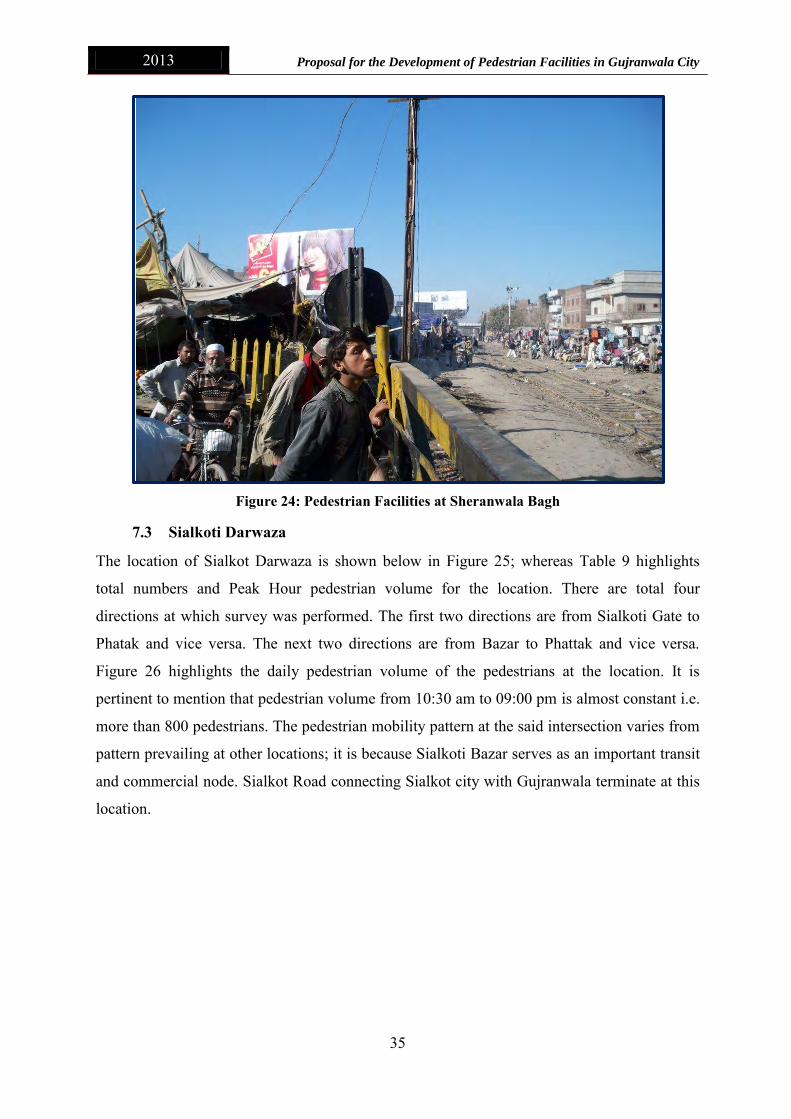
7.3 Sialkoti Darwaza
The location of Sialkot Darwaza is shown below in Figure 25; whereas Table 9 highlights
total numbers and Peak Hour pedestrian volume for the location. There are total four
directions at which survey was performed. The first two directions are from Sialkoti Gate to
Phatak and vice versa. The next two directions are from Bazar to Phattak and vice versa.
Figure 26 highlights the daily pedestrian volume of the pedestrians at the location. It is
pertinent to mention that pedestrian volume from 10:30 am to 09:00 pm is almost constant i.e.
more than 800 pedestrians. The pedestrian mobility pattern at the said intersection varies from
pattern prevailing at other locations; it is because Sialkoti Bazar serves as an important transit
and commercial node. Sialkot Road connecting Sialkot city with Gujranwala terminate at this
location.

2013 Proposal for the Development of Pedestrian Facilities in Gujranwala City
36
Figure 25: Location of Sialkoti Darwaza
Table 9: Summary of Pedestrian Count Survey at Sialkoti Darwaza
Sr.No. Directions Total No.
of Pedestrian
Peak Hours Morning (10:45 - 11:45)
After Noon (13:00 - 14:00)
Evening (18:00-19:00)
1 Sialkot Gate to Phatak 1798 188 113 124
2 Phatak to Sialkot Gate 2382 165 254 265
3 Bazar to Phatak 5331 495 397 378 4 Phatak to Bazar 2598 195 186 248
Total 12110 1043 950 1015
Sialkoti Darwaza

2013 Proposal for the Development of Pedestrian Facilities in Gujranwala City
37
Figure 26: Dily Pedestrian Volume at Sialkoti Darwaza
7.4 Alam Chowk
Alam Chowk connecting Hafizabad Road with Gujranwala Byepass serves as important
feeding artery in the road network of the city. Furthermore, the intersection is located next to
major residential areas from where trips are generated to employment, commercial and service
centers. Surveys were carried out in all four directions. Table 10 below highlights the total
number of pedestrian and the Peak Hour volume for the said location. Average daily
passenger volume is around 1150 pedestrians.
Table 10: Summary of Pedestrian Count Survey at Alam Chowk
Sr.No. Directions Total No.
of Pedestrian
Peak Hours Morning
(7:45 - 8:45)
After Noon (12:15 - 13:15)
Evening (16:45-17:45)
1 Hafizabad Road to Gujranwala 4508 280 416 337
2 Gujranwala city to Hafizabad Road 3891 387 420 382
3 Gujranwala city to Ladha wala 2856 201 177 277
4 Ladha wala to Gujranwala city 2707 316 96 179
Total No. of Pedestrian 13963 1184 1109 1175
1043950
1015
0
200
400
600
800
1000
1200
7:1
57
:45
8:1
58
:45
9:1
59
:45
10
:15
10
:45
11
:15
11
:45
12
:15
12
:45
13
:15
13
:45
14
:15
14
:45
15
:15
15
:45
16
:15
16
:45
17
:15
17
:45
18
:15
18
:45
19
:15
19
:45
20
:15
20
:45
21
:15
21
:45
No
. of
Pe
de
stri
ans
Time(HH:mm)
Daily Pedestrian Volume at Sialkoti Gate

2013 Proposal for the Development of Pedestrian Facilities in Gujranwala City
38
Figure 27: Location of Alam Chowk
Figure 28: Peak Hour Pedestrian Volume at Alam Chowk
Likewise, there exists no pedestrian facility at the said location as highlighted below in Figure
29 and 30; whereas the intersection is located along the Gujranwala Byepass which serves as
provincial highway. The notified speed of light vehicular traffic at Gujranwala Byepass ranges
from 70 to 100 Km per Hour whereas the notified speed for heavy vehicular traffic ranges
11841064
1175
0
200
400
600
800
1000
1200
1400
7:1
57
:45
8:1
58
:45
9:1
59
:45
10
:15
10
:45
11
:15
11
:45
12
:15
12
:45
13
:15
13
:45
14
:15
14
:45
15
:15
15
:45
16
:15
16
:45
17
:15
17
:45
18
:15
18
:45
19
:15
19
:45
20
:15
20
:45
21
:15
21
:45
No
. of
Pe
de
stri
an
Time (HH:MM)
Peak Hour Pedestrian Volume at Allam Chowk
Alam Chowk

2013 Proposal for the Development of Pedestrian Facilities in Gujranwala City
39
from 70 to 90 Km per Hour. Lack of pedestrian infrastructure primarily pedestrian signals or
zebra crossing often results in casualties and fatalities. The same has been highlighted by the
Focus Group participants.
Figure 29: Pedestrian Facilities at Alam Chowk

2013 Proposal for the Development of Pedestrian Facilities in Gujranwala City
40
Figure 30: Pedestrian Facilities at Alam Chowk
7.5 Gondalawala Chowk
Gondalawala Chowk is situated in vicinity of major retail and commercial centers.
Furthermore, Jinnah Stadium is located in proximity to it as highlighted by the Figure 31
below. Table 11 below highlights the total number of pedestrian and the Peak Hour volume
for the said location. The pedestrian mobility pattern at the said intersection varies from
mobility pattern prevailing at other locations. It is observed highest number of pedestrian pass
through the intersection between 12:30 pm to 15:00 pm. It is because major retail and
commercial activities are performed during these hours. People from surrounding villages
commute to commercial and retail centers located in vicinity of the intersection.
Table 11: Summary of Pedestrian Count Survey at Gondalawala Chowk
Sr.No. Directions Total No.
of Pedestrian
Peak Hours Morning (11:00 - 12:00)
After Noon (13:15 - 14:15)
Evening (16:00-17:00)
1 Phatak to Gondalawala 5483 492 561 420
2 Gondalawala to Phatak 3670 285 360 304
Total 9153 777 921 724

2013 Proposal for the Development of Pedestrian Facilities in Gujranwala City
41
Figure 31: Location of Gondalawala Chowk
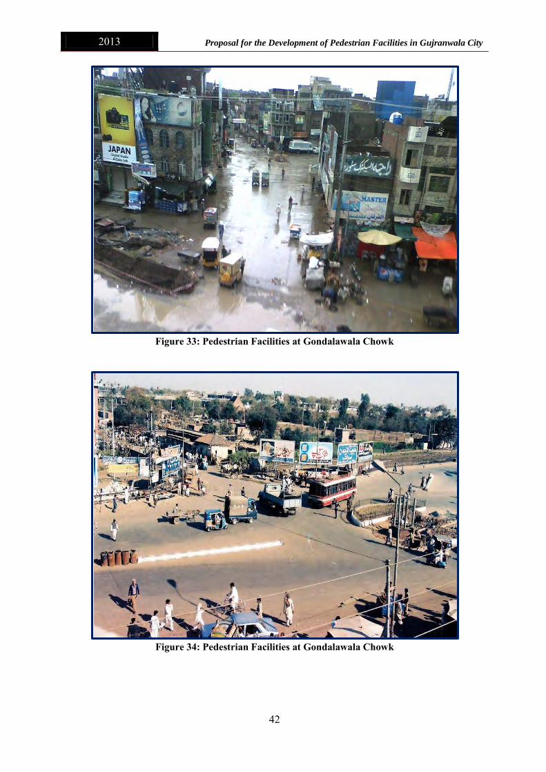
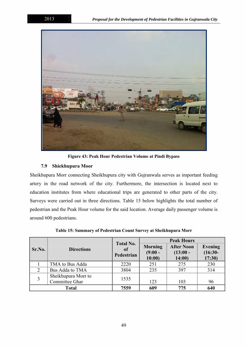
It is evident from the Figure 33 and 34 below that there exists no pedestrian facility at the
Gondalawala Chowk. People tend to walk parallel/ along/ within mix traffic resulting
casualties and accidents. Furthermore, presence of Railway crossing further worsened the
travelling conditions. Mix traffic including pedestrian, animal carts, non-motorized and
motorized barricaded the mobility of commuters resulting in longer journey time and
accidents.
Figure 32: Daily Pedestrian Volume at Gondalawala Chowk
777
921
724
0
200
400
600
800
1000
No
. of
Pe
de
stri
an
Time (HH:MM)
Daily Pedestrian Volume at Gondlanwala Chowk
Gondalawala Chowk
2013 Proposal for the Development of Pedestrian Facilities in Gujranwala City
42
Figure 33: Pedestrian Facilities at Gondalawala Chowk
Figure 34: Pedestrian Facilities at Gondalawala Chowk

2013 Proposal for the Development of Pedestrian Facilities in Gujranwala City
43
7.6 Maafiwala Chowk
Mafiwala Chowk is situated at the Sialkot Bypass and Aroop Road as shown below in Figure
35. Table 12 highlights the total pedestrian volume and Peak Hour pedestrian volume for the
location. Importantly, the pedestrian volume at the junction is not too high; however, due to
lack of pedestrian infrastructure results in fatal accidents as indicated by the participants of
the Focus Group Discussion. Highest pedestrian volume is observed at the instersection
during afternoon hours due to return trips made by the commuters especially children to their
homes.
Figure 35: Location of Maafiwala Chowk
Table 12: Summary of Pedestrian Count Survey at Maafiwala Chowk
Sr.No. Directions
Total No. of
Pedestrian
Peak Hours
Morning (8:00 - 9:00)
After Noon (13:15 - 14:15)
Evening (16:45-17:45)
1 Gujranwal to Maafiwala 452 34 46 37
Maafiwala Chowk

2013 Proposal for the Development of Pedestrian Facilities in Gujranwala City
44
Figure 36: Peak Hour Pedestrian Volume at Maafiwala Chowk
Figure 37: Pedestrian Facilities at Maafiwlala Chowk
34
46
37
05
101520253035404550
7:1
5
7:4
5
8:1
5
8:4
5
9:1
5
9:4
5
10
:15
10
:45
11
:15
11
:45
12
:15
12
:45
13
:15
13
:45
14
:15
14
:45
15
:15
15
:45
16
:15
16
:45
17
:15
17
:45
18
:15
18
:45
19
:15
19
:45
20
:15
20
:45
21
:15
21
:45
No
. of
Pe
de
stri
an
Time (HH:MM)
Daily Pedestrian Volume at mafiwala Chowk

2013 Proposal for the Development of Pedestrian Facilities in Gujranwala City
45
Figure 38: Pedestrian Facilities at Maafiwala Chowk
7.7 Munir Chowk
Most of the key education centers located in the Gujranwala city are located around the Munir
Chowk as shown in Figure 36 below. Furthermore it provides access to Wasa station, Jinnah
Stadium and Civil Hospital; thus making it an important node in the city transport network.
Though Daily pedestrian volume observed at this intersection shown below in Figure 39 is
less in comparison to its strategic location within the city transport network; however, it
provides vital connections to various activity locations.
Table 13: Summary of Pedestrian Count Survey at Munir Chowk
Sr.No. Directions Total No.
of Pedestrian
Peak Hours Morning
(9:30 - 10:30)
After Noon (13:00 - 14:00)
Evening (16:30-17:30)
1 Civil Hospital to Kachehri Chowk 1537 113 127 109
2 Kachehri Chowk to Civil Hospital 1185 83 103 97
3 Sialkot Road to Denga Phatak 391 37 40 39
4 Denga Phatak to Sialkot Road 297 18 25 34
Total 3410 251 295 279

2013 Proposal for the Development of Pedestrian Facilities in Gujranwala City
46
Figure 39: Location of Munir Chowk
Figure 40: Daily Pedestrian Volume at Munir Chowk
251
295279
0
50
100
150
200
250
300
350
7:1
5
7:4
5
8:1
58
:45
9:1
5
9:4
5
10
:15
10
:45
11
:15
11
:45
12
:15
12
:45
13
:15
13
:45
14
:15
14
:45
15
:15
15
:45
16
:15
16
:45
17
:15
17
:45
18
:15
18
:45
19
:15
19
:45
20
:15
20
:45
21
:15
21
:45
No
. of
Pe
de
stri
ans
Time (HH:MM)
Daily Pedestrian Volume at Munir Chowk
Munir Chowk

2013 Proposal for the Development of Pedestrian Facilities in Gujranwala City
47
7.8 Pindi Bypass
Travel to Pindi Bypass serves as the entry point of the Gujranwala city as shown below in
Figure 41. Inter-city traffic commuting to other parts of the country turn from here to
Gujranwala Bypass. In addition, this intersection serves as major transit point for intra-city
passengers commuting from surrounding rural areas to the city center. Table 14 depicts the
total pedestrian volume and Peak Hour volume of the walking commuters. The daily
passenger volume highlighted in Figure 39 clearly indicates that most the pedestrian trips are
made in afternoon and evening hours which are due to the fact stated above. People living in
suburbs and surrounding villages make return journeys their home in afternoon and evening
hours.
Likewise, there exist no pedestrian infrastructure/ facilities at Pindi Bypass as shown in the
Figure 43 below. Importantly, Pindi bypass has the highest number of pedestrian volume in
comparison to other intersections/ locations identified during the consultation meetings;
however. Lack of adequate pedestrian infrastructure results in mobility barriers and fatal
accidents.
Figure 41: Location of Pindi Bypass Chowk
Pindi Bypass Chowk

2013 Proposal for the Development of Pedestrian Facilities in Gujranwala City
48
Table 14: Summary of Pedestrian Count Survey at Pindi Bypass Chowk
Sr.No. Directions Total No. of Pedestrian
Peak Hours Morning
(9:30 - 10:30)
After Noon (14:30 - 15:30)
Evening (18:00-19:00)
1 Sialkot to Alipur chowk 5625 473 619 640
2 Alipur Chowk to Sialkot 4999 317 695 510
3 Petrol Pump to Sialkot 2386 119 145 226
4 Sialkot to Petrol Pump 1780 94 124 175
Total 14789 1003 1583 1551
Figure 42: Peak Hour Pedestrian Volume at Pindi Bypass
1003
1583 1551
0200400600800
10001200140016001800
7:1
57
:45
8:1
58
:45
9:1
59
:45
10
:15
10
:45
11
:15
11
:45
12
:15
12
:45
13
:15
13
:45
14
:15
14
:45
15
:15
15
:45
16
:15
16
:45
17
:15
17
:45
18
:15
18
:45
19
:15
19
:45
20
:15
20
:45
21
:15
21
:45
No
.of
Pe
de
stri
ans
Time (HH:MM)
Peak Hour Pedestrian Volume at Pindi Bypass
2013 Proposal for the Development of Pedestrian Facilities in Gujranwala City
49
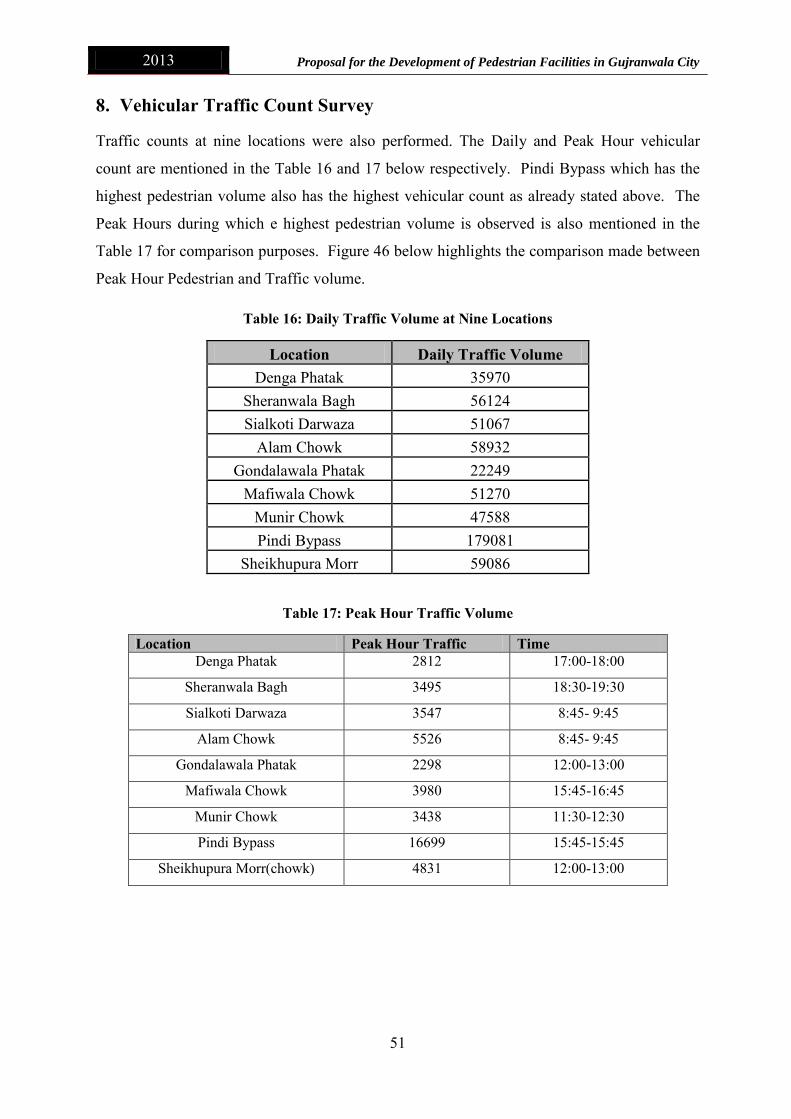
Figure 43: Peak Hour Pedestrian Volume at Pindi Bypass
7.9 Shiekhupura Moor
Sheikhupura Morr connecting Sheikhupura city with Gujranwala serves as important feeding
artery in the road network of the city. Furthermore, the intersection is located next to
education institutes from where educational trips are generated to other parts of the city.
Surveys were carried out in three directions. Table 15 below highlights the total number of
pedestrian and the Peak Hour volume for the said location. Average daily passenger volume is
around 600 pedestrians.
Table 15: Summary of Pedestrian Count Survey at Sheikhupura Morr
Sr.No. Directions Total No.
of Pedestrian
Peak Hours Morning
(9:00 - 10:00)
After Noon (13:00 - 14:00)
Evening (16:30-17:30)
1 TMA to Bus Adda 2220 251 275 230 2 Bus Adda to TMA 3804 235 397 314
3 Sheikhupura Morr to Committee Ghar 1535 123 103 96
Total 7559 609 775 640

2013 Proposal for the Development of Pedestrian Facilities in Gujranwala City
50
Figure 44: Location of Sheikhupura Morr
Figure 45: Daily Volume at Sheikhupura Morr
609
775
640
0
100
200
300
400
500
600
700
800
900
7:1
5
7:4
5
8:1
5
8:4
5
9:1
5
9:4
5
10
:15
10
:45
11
:15
11
:45
12
:15
12
:45
13
:15
13
:45
14
:15
14
:45
15
:15
15
:45
16
:15
16
:45
17
:15
17
:45
18
:15
18
:45
19
:15
19
:45
20
:15
20
:45
21
:15
21
:45
No
. of
Pe
de
stri
ans
Time(HH:MM)
Daily Pedestrian Volume at Sheikhupura Moor
Shiekhupura Mor
2013 Proposal for the Development of Pedestrian Facilities in Gujranwala City
51
8. Vehicular Traffic Count Survey
Traffic counts at nine locations were also performed. The Daily and Peak Hour vehicular
count are mentioned in the Table 16 and 17 below respectively. Pindi Bypass which has the
highest pedestrian volume also has the highest vehicular count as already stated above. The
Peak Hours during which e highest pedestrian volume is observed is also mentioned in the
Table 17 for comparison purposes. Figure 46 below highlights the comparison made between
Peak Hour Pedestrian and Traffic volume.
Table 16: Daily Traffic Volume at Nine Locations
Location Daily Traffic Volume Denga Phatak 35970
Sheranwala Bagh 56124 Sialkoti Darwaza 51067
Alam Chowk 58932 Gondalawala Phatak 22249
Mafiwala Chowk 51270 Munir Chowk 47588 Pindi Bypass 179081
Sheikhupura Morr 59086
Table 17: Peak Hour Traffic Volume
Location Peak Hour Traffic Time Denga Phatak 2812 17:00-18:00
Sheranwala Bagh 3495 18:30-19:30
Sialkoti Darwaza 3547 8:45- 9:45
Alam Chowk 5526 8:45- 9:45
Gondalawala Phatak 2298 12:00-13:00
Mafiwala Chowk 3980 15:45-16:45
Munir Chowk 3438 11:30-12:30
Pindi Bypass 16699 15:45-15:45
Sheikhupura Morr(chowk) 4831 12:00-13:00
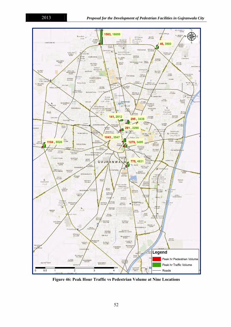
2013 Proposal for the Development of Pedestrian Facilities in Gujranwala City
52
Figure 46: Peak Hour Traffic vs Pedestrian Volume at Nine Locations

2013 Proposal for the Development of Pedestrian Facilities in Gujranwala City
53
It is evident from the data collected that there exists large variation in mode choice. It is
because the city has a steady growing vehicular traffic but pedestrian trips are at decline and
are not made as preferred mode of transport. It is because of lack of pedestrian infrastructure
and safety concerns. There is a dire need of not only pedestrian infrastructure provision but
policy formulation for the city. In terms of policy formulation, available rules and regulations
pertaining to pedestrian accessibility and mobility should be adhered. Furthermore, pedestrian
should be given priority everywhere, and their needs must be considered too while developing
new transport infrastructure in the city.
9. Pedestrian Infrastructure Type and Provision Requirements
This section focuses on the design recommendations of pedestrian infrastructure. Following
types of infrastructure can be provided depending upon the local conditions to facilitate
pedestrian in urban areas.
9.1 Infrastructure Parallel to Carriage way
Walkways
Walkways are the fundamental element of pedestrian mobility as they allow safe walking
paths separated from vehicular or other types of motorized traffic. However, provision of
walkways is influenced by the existing carriage way conditions. Therefore, to cater local
requirements, various types of walkways can be used as per the requirements of pedestrians to
optimize efficiency and achieve sustainability.
Sidewalks
In Gujranwala urban and suburban environments especially in residential quarters, the
preferred facility for pedestrians can be sidewalk. Sidewalks are typically constructed of
concrete and located adjacent to curbs and separated from the roadway by a buffer zone. They
provide positive separation from motor vehicle traffic, a hard smooth surface on which to
walk, and the opportunity to clearly indicate crossing points and movements at intersections
as shown below in Figure 47 and 48. The recommended standard minimum sidewalk width is 5
feet.
Shoulders
Shoulders on roadways, when designed according to AASHTO recommendations, are usually
wide and smooth enough to accommodate pedestrians where the provision of sidewalks or
paths may not be practicable or feasible. In urban residential which do not have high

2013 Proposal for the Development of Pedestrian Facilities in Gujranwala City
54
residential densities to warrant sidewalks, shoulders having width at least 4-foot should be
provided to accommodate pedestrian and bicycle traffic. Shared use of such shoulders by
other users, including motor vehicles, should be least allowed. Importantly, using shoulders as
the primary type of pedestrian facility often become problematic due to conflict between
pedestrians and motorists. Paved shoulders should only be a last-resort, low-cost pedestrian
facility and in case use strict enforcement measures should be placed to avoid pedestrian
vehicle conflicts.
Figure 47: Walkways, Sidewalks and Shoulder Design1
Figure 48: Recommended Sidewalk Design
1 http://www.planetizen.com/node/41262

2013 Proposal for the Development of Pedestrian Facilities in Gujranwala City
55
Sidewalks vs. Bikeways
Sidewalks are not to be used as bicycle facilities unless no other option is available. Sidewalks
should not be identified as part of a bikeway network. Conflicts arise when pedestrians share
sidewalks with bicyclists. Due to the horizontal operation space of both parties, a standard
sidewalk does not allow for adequate passing space. Typically it is only recommended that
children operate bicycles on sidewalks.
Sidewalk Width
For two people walking side-by-side or passing each other while traveling in opposite
directions on a sidewalk, the average space occupied is 4 feet 8 inches. In considering
accessibility standards, the ADA (Americans with Disability Act) Design Board calculates
that an average wheelchair occupies approximately three feet of horizontal space. It can be
reasoned that a wheelchair user and ambulatory pedestrian would occupy at least five feet of
horizontal space. Sidewalks in low and high traffic areas should be designed to consider these
dimensions. The Institute of Transportation Engineers (ITE) has a design guide for the
development of roads that includes design standards for curbs, gutters, and sidewalks. It
recommends a minimum sidewalk width of 5 feet to allow two people to pass comfortably or
to walk side-by-side if there is a buffer between the sidewalk and the street. A six-foot wide
sidewalk is recommended if it abuts the back of a curb. In Pakistan major cities such as
Lahore, Sidewalks of width 4 feet are generally provided.
Importantly, the width of a sidewalk or walkway needs to comfortably accommodate the
volume of pedestrians normally using it. For example, on a neighborhood collector that
provides a high volume of pedestrian access to a school, park, or other popular destinations, it
may be desirable to provide wider sidewalks. In high use areas, such as central business
districts, sidewalks can be 10 to 15 feet wide, if necessary. Conversely, when excessively
wide sidewalks are located in areas with low pedestrian volumes, the expansive pavement and
empty-looking sidewalks are uninviting to pedestrians.
Table 18: Recommended Sidewalk Widths for Different Street Types

2013 Proposal for the Development of Pedestrian Facilities in Gujranwala City
56
Location: Both Sides versus One Side
In almost every instance, it is desirable to provide sidewalks on both sides of streets used by
pedestrians. Pedestrians are also encouraged to walk on the side of the roadway facing traffic,
unlike bicyclists who ride with the direction of travel. Providing sidewalks on both sides
enables pedestrians to travel facing traffic in either direction, and minimizes the need for
pedestrian crossing points.
Several factors influence the decision of whether to place sidewalks, walkways, and widened
shoulders on both sides and one side. These factors include the available space within the
right-of-way, the existing physical limitations on the roadside, and which side of the street
origins and destinations (such as bus stops) are located. A sidewalk on one side may be
adequate for some local streets, especially when this improves a condition where there were
no sidewalks previously.
Sidewalk Buffer Area
Sidewalks alongside roadways are often separated by planting strips consisting of natural
vegetation or landscaping that creates a buffer from the noise and splash of moving vehicles
often separates sidewalk Buffer Area as shown below in Figure 49. Planting buffers (also
referred to as planting strips, landscape strips, landscape buffers, and nature strips) are
generally considered to be an effective separation treatment between walkways and streets in
all types of settings. The added separation of a planting buffer helps a pedestrian feel more
comfortable when walking along the street. The buffer area also provides space for
streetlights, fire hydrants, utility boxes, and bike racks. Other advantages of buffer areas
include:
Sidewalk can be at a constant level grade across driveways, avoiding dipping at every
driveway cut.
An area is provided for drainage runoff.
Aesthetic enhancement, increasing the appeal of the walkway and pedestrian
environment.
If planted with trees, they can provide shade and wind protection.

2013 Proposal for the Development of Pedestrian Facilities in Gujranwala City
57
Figure 49: Planting Buffer between Sidewalk and Street
Well-designed arterial and collector streets should include a planting strip as a standard. A
planting strip should be at least 5 feet wide. Since any buffer is better than no buffer, if right-
of-way is limited, a 3-foot buffer may be sufficient. Buffer landscaping should be relatively
low maintenance and should not obstruct vision of pedestrians or motorists at intersections.
Disadvantages of planting buffer strips may include:
Maintenance that varies depending on the type of landscaping selected.
If not designed and maintained properly, landscaping may hinder visibility and cause
security problems.
Root growth can sometimes lift and buckle sidewalks, creating a tripping hazard.
A swale ditch is sometimes used as a buffer area. It provides an economical alternative to curb
and gutter sections. However, attention should be paid to the slopes of the swale to allow for
maintenance.
Zebra Crossings
A Zebra crossing is a path across a road marked with black and white stripes where
pedestrians may cross as shown in Figure 50.
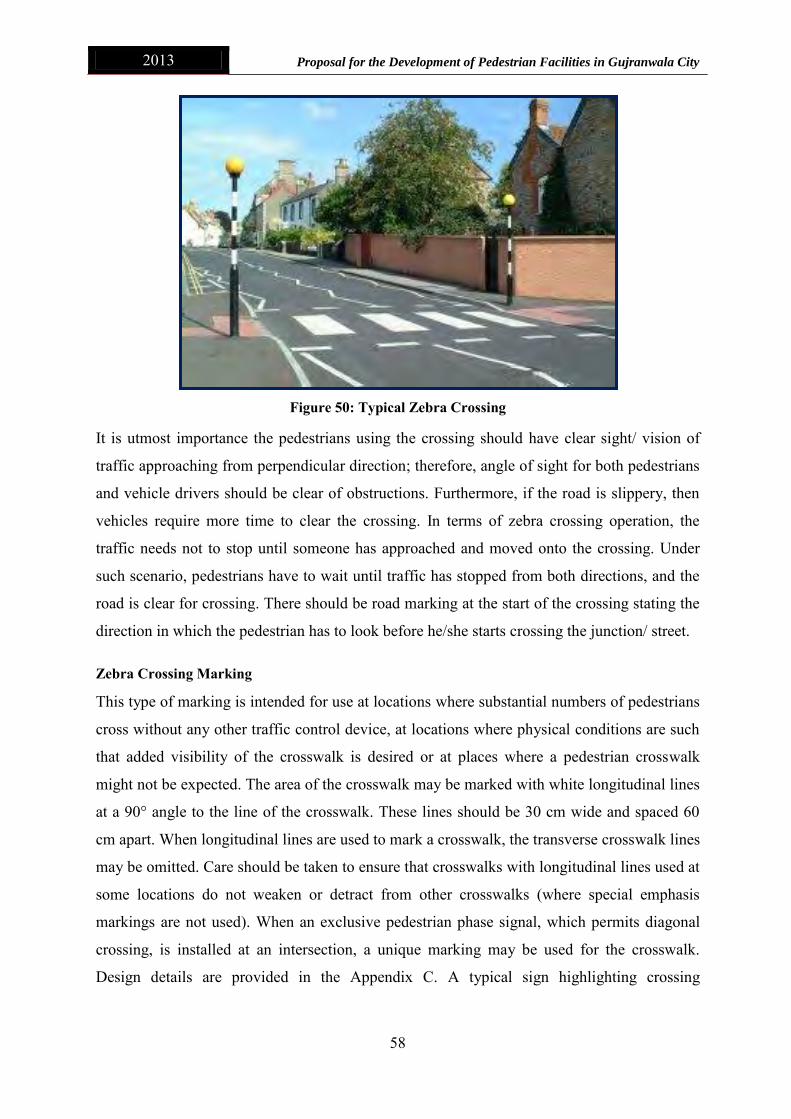
2013 Proposal for the Development of Pedestrian Facilities in Gujranwala City
58
Figure 50: Typical Zebra Crossing
It is utmost importance the pedestrians using the crossing should have clear sight/ vision of
traffic approaching from perpendicular direction; therefore, angle of sight for both pedestrians
and vehicle drivers should be clear of obstructions. Furthermore, if the road is slippery, then
vehicles require more time to clear the crossing. In terms of zebra crossing operation, the
traffic needs not to stop until someone has approached and moved onto the crossing. Under
such scenario, pedestrians have to wait until traffic has stopped from both directions, and the
road is clear for crossing. There should be road marking at the start of the crossing stating the
direction in which the pedestrian has to look before he/she starts crossing the junction/ street.
Zebra Crossing Marking
This type of marking is intended for use at locations where substantial numbers of pedestrians
cross without any other traffic control device, at locations where physical conditions are such
that added visibility of the crosswalk is desired or at places where a pedestrian crosswalk
might not be expected. The area of the crosswalk may be marked with white longitudinal lines
at a 90° angle to the line of the crosswalk. These lines should be 30 cm wide and spaced 60
cm apart. When longitudinal lines are used to mark a crosswalk, the transverse crosswalk lines
may be omitted. Care should be taken to ensure that crosswalks with longitudinal lines used at
some locations do not weaken or detract from other crosswalks (where special emphasis
markings are not used). When an exclusive pedestrian phase signal, which permits diagonal
crossing, is installed at an intersection, a unique marking may be used for the crosswalk.
Design details are provided in the Appendix C. A typical sign highlighting crossing

2013 Proposal for the Development of Pedestrian Facilities in Gujranwala City
59
approaching pedestrians to look right in case of traffic flow from right side is shown below in
Figure 51.
Figure 51: Marking on Roads for Pedestrian
The drivers approaching a Zebra crossing should be made aware of the crossing by black and
white poles with flashing yellow beacons and appropriate road markings2.
Pelican Crossings
Pelican crossings (shown in Figure 52) have red/amber/green signals facing drivers, and red
man/green man signal heads on the opposite side of the road to the pedestrians waiting to
cross. A pedestrian push button unit is required to operate these types of crossings. When the
steady red man is lit pedestrians should not cross. Likewise, when the steady red signal to
traffic is lit then drivers must stop. The steady green man will then light for pedestrians and
they should, having checked that it is safe to do so, cross the road. When the green man begins
to flash pedestrians should not start to cross although there is still enough time for those on
the crossing to finish their journey safely. At all Pelican crossings (apart from staggered
crossings) have a bleeping sound to indicate to the visibility impaired when the steady green
man is lit3.
2 http://www.devon.gov.uk/index/transport/traffic/pedestrian_crossings/types_of_pedestrian_crossings.htm 3 http://www.2pass.co.uk/crossing.htm

2013 Proposal for the Development of Pedestrian Facilities in Gujranwala City
60
Figure 52: Typical Pelican Crossing
Puffin Crossings
Puffin crossings shown in Figure 53 differ from Pelican crossings as they do not have a
flashing green man/flashing amber signal. The overall crossing time is established each time
by on-crossing pedestrian detectors. The demand for the crossing is still triggered by the push
button unit but kerb-side pedestrian detectors are fitted to cancel demands that are no longer
required. At the latest Puffin crossings the red man/green man signals are above the push
button unit on the pedestrians’ side of the road. This layout encourages pedestrians waiting at
the crossing to look at the approaching traffic at the same time as looking at the red man/green
man signal4.
Figure 53: Typical Puffin Crossing
4 http://www.burystedmundsdrivingschool.net/pedestrian-crossings.html

2013 Proposal for the Development of Pedestrian Facilities in Gujranwala City
61
Toucan Crossings
Toucan crossings shown in Figure 54 are designed for both pedestrians and cyclists and are
typically used adjacent to a cycle-path (Cyclists are not allowed to cross the road using Zebra,
Pelican or Puffin crossings). There is a green cycle symbol alongside the green man. At the
latest Toucan crossings the crossing time is established each time by on-crossing detectors in
the same way as Puffins crossings.
Figure 54: Typical Toucan Crossing
9.2 Types of Pavement Markings used for Pedestrians
Normal Dotted Line Marking
A Normal Dotted Line is used to delineate the extension of a line through an intersection or
interchange area. The line shall be of the same color as the line it extends. Design details are
provided in the Appendix C.
Dashed Line Marking
Dashed Line is used for the edge continuation at exit or entrance ramp separation. Design
details are provided in the Appendix C.
Junction Box Marking
A Box Junction Marking indicates a restriction of the traffic entering a junction unless the
crossing is clear from all traffic and a motorist is sure that his entrance in the junction would
not cause obstructions in the traffic. Box Junction Lines are yellow solid lines in the form of a
square in the centre of the junction and diagonal lines (odd in numbers) crossing each other at
90°. The size of the central yellow square shall be variable according to the size of the
junction. Design details are provided in the Appendix C.

2013 Proposal for the Development of Pedestrian Facilities in Gujranwala City
62
9.3 Pedestrian Signal Heads
Pedestrian signal heads provide special types of traffic signal indications exclusively intended
for controlling pedestrian traffic. These signal indications consist of the illuminated symbols
of a GREEN WALKING PERSON (symbolizing WALK) and an UPRAISED HAND or RED
WALKING PERSON (symbolizing DONT WALK) as shown in Figure 55. Engineering
judgment should determine the need for separate pedestrian signals.
Application of Pedestrian Signal Heads
Pedestrian signal heads shall be used in conjunction with vehicular traffic control signals
under any of the following conditions:
If a traffic control signal is justified by an engineering study and meets required
Traffic Warrant or Pedestrian Volume or in case of specialized Crossing such as
School or Hospital etc.
If an exclusive signal phase is provided or made available for pedestrian movements in
one or more directions, with all conflicting vehicular movements being stopped; or
Where engineering judgment determines that multiphase signal indications (as with
split-phase timing) would tend to confuse or cause conflicts with pedestrians using a
crosswalk guided only by vehicular signal indications.
Pedestrian signal heads should be used under any of the following conditions:
If it is necessary to assist pedestrians in making a reasonably safe crossing or if
engineering judgment determines that pedestrian signal heads are justified to minimize
vehicle-pedestrian conflicts;
If pedestrians are permitted to cross a portion of a street, such as to or from a median
of sufficient width for pedestrians to wait, during a particular interval but are not
permitted to cross the remainder of the street during any part of the same interval;
and/or
If no vehicular signal indications are visible to pedestrians, or if the vehicular signal
indications that are visible to pedestrians starting or continuing a crossing provide
insufficient guidance for them to decide when it is reasonably safe to cross, such as on
one-way streets, at T-intersections, or at multiphase signal operations.

2013 Proposal for the Development of Pedestrian Facilities in Gujranwala City
63
Size, Design, and Illumination of Pedestrian Signal Head Indications
Following should be considered while finalizing the size, design, and illumination of
pedestrian signal head indications;
All new pedestrian signal head indications shall be displayed within a rectangular
background and shall consist of symbolized messages.
Each pedestrian signal head indication shall be independently illuminated and emit a
single color.
The UPRAISED HAND (symbolizing DONT WALK) signal section shall be mounted
directly above or integral with the WALKING PERSON (symbolizing WALK) signal
section.
The WALKING PERSON (symbolizing WALK) signal indication shall be white, with
all except the symbol obscured by an opaque material.
The UPRAISED HAND (symbolizing DONT WALK) signal indication shall be
Portland orange, with all except the symbol obscured by an opaque material.
When not illuminated, the WALKING PERSON (symbolizing WALK) and
UPRAISED HAND (symbolizing DONT WALK) symbols shall not be readily visible
to pedestrians at the far end of the crosswalk that the pedestrian signal head indications
control.
For pedestrian signal head indications, the symbols shall be at least 150 mm (6 in)
high. The light source of a flashing UPRAISED HAND (symbolizing DONT WALK)
signal indication shall be flashed continuously at a rate of not less than 50 nor more
than 60 times per minute. The illuminated period of each flash shall be not less than
half and not more than two-thirds of the total flash cycle.
Pedestrian signal head indications should be conspicuous and recognizable to
pedestrians at all distances from the beginning of the controlled crosswalk to a point 3
m (10 ft) from the end of the controlled crosswalk during both day and night.
For crosswalks where the pedestrian enters the crosswalk more than 30 m (100 ft)
from the pedestrian signal head indications, the symbols should be at least 225 mm (9
in) high.

2013 Proposal for the Development of Pedestrian Facilities in Gujranwala City
64
Figure 55: Pedestrian Signal Head Indications
The installation of pedestrian signals should be based on an engineering study, which should
consider the following factors:
a. Potential demand for accessible pedestrian signals
b. A request for accessible pedestrian signals
c. Traffic volumes during times when pedestrians might be present, including periods of
low traffic volumes or high turn-on-red volumes
d. Complexity of traffic signal phasing
e. Complexity of intersection geometry

2013 Proposal for the Development of Pedestrian Facilities in Gujranwala City
65
10. Recommendations
In case of Gujranwala city, which has no proper-signalized traffic, it is recommended that all
Neighborhood Streets, CBD Streets, Secondary and Primary Streets which do have space for
pedestrian mobility must be provided with sidewalks. Potential locations from where
pedestrians tend to cross road must be provided with Zebra Crossings. The Main Roads and
Market Streets must be provided with Pelican crossing or Toucan crossing. Table 19
highlights the recommended pedestrian infrastructure to be provided at nine locations whereas
Table 20 highlights the recommended pedestrian infrastructure to be provided as various road
types. It is noteworthy here that those roads which are not included in the table can be
provided necessary mobility infrastructure as per the above mentioned data and pedestrian
requirements.
Table 19: Pedestrian Infrastructure at Nine Locations
Location Infrastructure to be Provided Signage to be Provided
Denga Phatak Pedestrian Signal Zebra Crossing, Stop Line, Dashed Line & Junction Box Marking
Sheranwala Bagh Pedestrian Signal Zebra Crossing, Stop Line, Dashed Line & Junction Box Marking
Sialkoti Darwaza Pedestrian Signal Zebra Crossing, Stop Line, Dashed Line & Junction Box Marking
Alam Chowk Overhead Bridge Stop Line, Dashed Line & Junction Box Marking
Gondalawala Phatak Pedestrian Signal Zebra Crossing, Stop Line, Dashed Line & Junction Box Marking
Mafiwala Chowk Overhead Bridge Stop Line, Dashed Line & Junction Box Marking
Munir Chowk Pedestrian Signal Zebra Crossing, Stop Line, Dashed Line & Junction Box Marking
Pindi Bypass Underpass Stop Line, Dashed Line & Junction Box Marking
Sheikhupura Morr Overhead Bridge Zebra Crossing, Stop Line, Dashed Line & Junction Box Marking

2013 Proposal for the Development of Pedestrian Facilities in Gujranwala City
66
Table 20: Pedestrian Infrastructure as per Road Classification
Name Classification of Road Pedestrian Crossing Type
GT Road Trunk Road Overhead Bridge for Perpendicular Crossing & Sidewalks
Gujranwala Bypass Trunk Road Overhead Bridge for Perpendicular Crossing & Sidewalks
Sialkot Bypass Trunk Road Overhead Bridge for Perpendicular Crossing & Sidewalks
Alama Iqbal Road Primary Road Overhead Bridge for Perpendicular Crossing & Sidewalks
Dulley Road Primary Road Overhead Bridge for Perpendicular Crossing & Sidewalks
Eminabad Road Primary Road Overhead Bridge for Perpendicular Crossing & Sidewalks
Fato mand Road Primary Road Overhead Bridge for Perpendicular Crossing & Sidewalks
Ferozwala Road Primary Road Overhead Bridge for Perpendicular Crossing & Sidewalks
Gondlawala Road Primary Road Overhead Bridge for Perpendicular Crossing & Sidewalks
Hafizabad Road Primary Road Overhead Bridge for Perpendicular Crossing & Sidewalks
Hospital Road Primary Road Overhead Bridge for Perpendicular Crossing & Sidewalks
Kacha Eminabad Primary Road Overhead Bridge for Perpendicular Crossing & Sidewalks
Kacha Fatomand Road Primary Road Overhead Bridge for Perpendicular Crossing & Sidewalks

2013 Proposal for the Development of Pedestrian Facilities in Gujranwala City
67
Nighar phatak Road Primary Road Overhead Bridge for Perpendicular Crossing & Sidewalks
Nowshera Road Primary Road Overhead Bridge for Perpendicular Crossing & Sidewalks
Sheikhupura Road Primary Road Overhead Bridge for Perpendicular Crossing & Sidewalks
Sialkot Road Primary Road Overhead Bridge for Perpendicular Crossing & Sidewalks
Aroop Road Secondary Road Zebra/ Pelican Crossing for Perpendicular Crossing & Sidewalks
Bazar Khardan Secondary Road Zebra/ Pelican Crossing & Sidewalks
Circula Road Secondary Road Zebra/ Pelican Crossing & Sidewalks
Civil Hospital DHQ Secondary Road Zebra/ Pelican Crossing & Sidewalks
College Road Secondary Road Zebra/ Pelican Crossing & Sidewalks
Dastgeer Road Secondary Road Zebra/ Pelican Crossing & Sidewalks
DC Road Secondary Road Zebra/ Pelican Crossing & Sidewalks
Ghanta Ghar Secondary Road Zebra/ Pelican Crossing & Sidewalks
Ghordor Road Secondary Road Zebra/ Pelican Crossing & Sidewalks
Gill Road Secondary Road Zebra/ Pelican Crossing & Sidewalks
Gurjkah Road Secondary Road Zebra/ Pelican Crossing & Sidewalks

2013 Proposal for the Development of Pedestrian Facilities in Gujranwala City
68
Jail Road Secondary Road Zebra/ Pelican Crossing & Sidewalks
Jamia Masjid Road Secondary Road Zebra/ Pelican Crossing & Sidewalks
jinnah Road Secondary Road Zebra/ Pelican Crossing & Sidewalks
Kacha Khiali Road1 Secondary Road Zebra/ Pelican Crossing & Sidewalks
Kashmir Road Secondary Road Zebra/ Pelican Crossing & Sidewalks
Main market road Secondary Road Zebra/ Pelican Crossing & Sidewalks
Mian Sansi Road Secondary Road Zebra/ Pelican Crossing & Sidewalks
Nowshera Sansi Road Secondary Road Zebra/ Pelican Crossing & Sidewalks
Parao Road Secondary Road Zebra/ Pelican Crossing & Sidewalks
Qazafi Road Secondary Road Zebra/ Pelican Crossing & Sidewalks
Rex Cinema Road Secondary Road Zebra/ Pelican Crossing & Sidewalks
Sui Gas Road Secondary Road Zebra/ Pelican Crossing & Sidewalks
Tipu Road Secondary Road Zebra/ Pelican Crossing & Sidewalks
Ahmad Nagar Road Local/Street Zebra/ Pelican Crossing & Sidewalks
Airbase Road Local/Street Zebra/ Pelican Crossing & Sidewalks

2013 Proposal for the Development of Pedestrian Facilities in Gujranwala City
69
Al - Hamd Street Local/Street Zebra/ Pelican Crossing & Sidewalks
Alipur Chatha Road Local/Street Zebra/ Pelican Crossing & Sidewalks
Approach Road Local/Street Zebra/ Pelican Crossing & Sidewalks
Atta Muhammad Road Local/Street Zebra/ Pelican Crossing & Sidewalks
Awami Road Local/Street Zebra/ Pelican Crossing & Sidewalks
Bajwa Road Local/Street Zebra/ Pelican Crossing & Sidewalks
Bazar Road Local/Street Zebra/ Pelican Crossing & Sidewalks
Bypass Road Local/Street Zebra/ Pelican Crossing & Sidewalks
Canal Bank Road Local/Street Zebra/ Pelican Crossing & Sidewalks
Cantt Road Local/Street Zebra/ Pelican Crossing & Sidewalks
Cemetery Road Local/Street Zebra/ Pelican Crossing & Sidewalks
Chenab Gate Road Local/Street Zebra/ Pelican Crossing & Sidewalks
CMH Road Local/Street Zebra/ Pelican Crossing & Sidewalks
Dhonkal More Road Local/Street Zebra/ Pelican Crossing & Sidewalks
Denga Phatak Road Local/Street Zebra/ Pelican Crossing & Sidewalks

2013 Proposal for the Development of Pedestrian Facilities in Gujranwala City
70
Exchange Road Local/Street Zebra/ Pelican Crossing & Sidewalks
Garjakh Road Local/Street Zebra/ Pelican Crossing & Sidewalks
General Bus Stand Road Local/Street Zebra/ Pelican Crossing & Sidewalks
Ghakka Mitter Road Local/Street Zebra/ Pelican Crossing & Sidewalks
Ghalib Chowk Road Local/Street Zebra/ Pelican Crossing & Sidewalks
Ghosia Flyover Local/Street Zebra/ Pelican Crossing & Sidewalks
Gondlanwala Road Local/Street Zebra/ Pelican Crossing & Sidewalks
GT RD-Seikhpura Rd Link Local/Street Zebra/ Pelican Crossing & Sidewalks
Gujranwala Cantt Airbase Road Local/Street Zebra/ Pelican Crossing & Sidewalks
Haidri Road Local/Street Zebra/ Pelican Crossing & Sidewalks
Jandu Sahi Road Local/Street Zebra/ Pelican Crossing & Sidewalks
Kachehri Road Local/Street Zebra/ Pelican Crossing & Sidewalks
Khajoor Wali Road Local/Street Zebra/ Pelican Crossing & Sidewalks
Lamba Wali Road Local/Street Zebra/ Pelican Crossing & Sidewalks
Lohian Wala Bypass Local/Street Zebra/ Pelican Crossing & Sidewalks

2013 Proposal for the Development of Pedestrian Facilities in Gujranwala City
71
Madni Road Local Street Zebra/ Pelican Crossing & Sidewalks
Mandiala Road Local/Street Zebra/ Pelican Crossing & Sidewalks
Model Town Road Local/Street Zebra/ Pelican Crossing & Sidewalks
Munir Road Local/Street Zebra/ Pelican Crossing & Sidewalks
Muslim Road Local/Street Zebra/ Pelican Crossing & Sidewalks
Nomania Road Local/Street Zebra/ Pelican Crossing & Sidewalks
Pasrur Road Local/Street Zebra/ Pelican Crossing & Sidewalks
Prince Road Local/Street Zebra/ Pelican Crossing & Sidewalks
Railway Rd Local/Street Zebra/ Pelican Crossing & Sidewalks
Rustam Road Local/Street Zebra/ Pelican Crossing & Sidewalks
Sadiq Road Local/Street Zebra/ Pelican Crossing & Sidewalks
Session Court Road Local/Street Zebra/ Pelican Crossing & Sidewalks
Shelton Road Local/Street Zebra/ Pelican Crossing & Sidewalks
Stadium Road Local/Street Zebra/ Pelican Crossing & Sidewalks
Station Road Local/Street Zebra/ Pelican Crossing & Sidewalks

2013 Proposal for the Development of Pedestrian Facilities in Gujranwala City
72
Sugar Mill Road Local/Street Zebra/ Pelican Crossing & Sidewalks
Suvay Wala Road Local/Street Zebra/ Pelican Crossing & Sidewalks
Tower Road Local/Street Zebra/ Pelican Crossing & Sidewalks
Wadala Road Local/Street Zebra/ Pelican Crossing & Sidewalks
Zia ul haq Road Local/Street Zebra/ Pelican Crossing & Sidewalks

2013 Proposal for the Development of Pedestrian Facilities in Gujranwala City
73
Appendix

2013 Proposal for the Development of Pedestrian Facilities in Gujranwala City
74
Annex A: Pedestrian Counts Performa

2013 Proposal for the Development of Pedestrian Facilities in Gujranwala City
75
Annex B: Traffic Counts Performa

2013 Proposal for the Development of Pedestrian Facilities in Gujranwala City
76
Annex C: Pavement Markings and Signage
Normal Dotted Line
Normal Dotted Lines Below
See Details of
50 cm50 cm
12 - 15 cm
Details of Normal Dotted Line

2013 Proposal for the Development of Pedestrian Facilities in Gujranwala City
77
Dashed Line
200 cm100 cm
12 - 15 cm

2013 Proposal for the Development of Pedestrian Facilities in Gujranwala City
78
Stop Line

2013 Proposal for the Development of Pedestrian Facilities in Gujranwala City
79
Zebra Crossing

2013 Proposal for the Development of Pedestrian Facilities in Gujranwala City
80
Box Junction Marking