project reef-ed - GBRMPA ELibrary
405
-
Upload
khangminh22 -
Category
Documents
-
view
0 -
download
0
Transcript of project reef-ed - GBRMPA ELibrary


•
•
•
PROJECT REEF-ED
Great Barrier Reef Educational Activities
PROJECT TEAM Ann Byrnes, Sydney College of Advanced Education
(PROJECT CO-ORDINATOR) Philip T. King, Woolgoolga High School, NSW
Jack A. Marsh, Brisbane College of Advanced Education Bob Moffatt, Benowa State High School, Qld Janet S. Oliver, St Aidan 1 s School, Brisbane
Antoinette L. 0 1 Neill, The Australian Museum, Sydney
~ Great Barrier Reef Marine Park Authority
Page 2

Preface The Great Barrier Reef Marine Park Authority has produced Project Reef-Ed, Great Barrier Reef Educatic:mal Activities to encourage study of the Reef and to assist educators organise visits to the Reef area. As well as being of personal benefit to those involved, Reef activities undertaken by schools and other organisations can make an important contribution to promoting community understanding of the Great Barrier Reef Marine Park. This book does not set out a particular course of Reef study. Rather, the aim has been to provide educators with a wide range of resource material from which they can select according to their own needs. The activities set out here have been designed with students from school years 10 to 12 in mind. However, many will be found interesting and enjoyable by other groups. Although most of the activities are designed for those visiting the Reef, many can be carried out in classrooms away from the Reef. The Great Barrier Reef is an excellent resource for education and thesP initial materials will be of assistance in developing programs which have the Reef as their focus.
Graeme Kelleher Chairman
Great Barrier Reef Marine Park Authority Townsville
Page 3

•
•
•
What's in this book1
GUIDE TO THE STUDENT ACTIVITIES Pre-planning, safety precautions and examples of activity sequences
STUDENT ACTIVITY OUTLINES Sheets for more than 150 separate Reef activites
APPENDIX: REEF EDUCATION Suggestions to help in the planning of Reef educational programs: aims, learning experiences and conten! and resources
Page 4

Acknowledgments Many individuals c111d orgdr1is.1timis !wl1wd g('IH'r(Jlhly in llw prep,11ation of theSl' 111<1tcri<ils_ l'he 1-'r()ject Tt•<rnl ,icknuwledgt'S grcJtl'tully the p.irt play(•d hv ,111 tl1os(' \vim contributed ide,1s, L'1wrgy, .idvicc and <issistrncc. In the early stages of the l)r-ojccl. thosv wl10 ( 011triliutl'd ide,1s tor student activitit:•s or \vho lwlpl'd liy comrncnting on t'<Hly dr-,1i1s include, dmor1gst otlwrs, L(•o 11.irlll'll, (;poff C:onol Iv·. A.ls. Cribb, John I ien, Peter r·luod, John S. lei I, J. i'·<,rn KPl ly, Cayle !vldyes, /\t hol lfos(' .md fo11\· Spcrri ng. Croups oi teachers atl t•nd i n1~ Rt '('I-Ed \\mks hops in H risb;rne and Swiney lw I peel sh<i pl' the di r·ect ions of the l'rowct ,rnd the scope d rid turnl or acl l\'I I ll'S subs\'qucnt I y dcveluped' Sta tf ,1 nd students o! d IHI rnbc r oi .\ l'\\' Sou I h VVa I es a ml C)uee11 s I ,1 ncl scu1 ncL1 r-v schools took p<i rt in the rev it'\\' i ng oi ,icti I/ i ! ies dt t lw Rl'C't. ThOS(' i 11vol ved i llC I uded QU('('ll sl <J lld sl LJ( l!'rltS fr( )Ill SI Aid ,111 1 s s( hoo I, l->risbcJ rw; Benmva, Clo111,ni, Cori nda, C bdqorw, Miriam Vci IL• ;md V\/oodridg(' Sl<lll' J-l igh School•,; St.n oi 1 lw Sea Collegt'. Southport ,md T(1mvocm1h;1 Cramm,ir School. Nt:'\V South \-V;ilcs groups ir1dudcd thos(' lrom \Voolgoolga and <_; rat'ton I l igh Schools; St r;1tht'icld c; i rls and Syd rwv c_; i rls I I igh SchoCJls ,rnd Nevv·Gisl le Cr.rnim,H School. Others 1.vl10 lwlpcd to dcvl'iop ;md L'val uate ;Ht 1 vit ies in thL' fo__,ld wen' p<HI i c i fldl 1ls i 11 proft•ssion.1 I development prugr ams for teachers mg.HJ iz('d al I he Red hv the Queensland Sci cr1u' d nd C(•ogr·.iphy Tc,h IH'rs Associations and Sydrwy Col legc cH .. '\rh·;inc('d Educ1! ion. SI udents irom teadwr cduc1t ion ;rnd ki sure si ud if's progra rns at Syd ricv ,md 8 rish.inc Col lcgcs nl i\dv,rncC'd Ed u1a1 ion also 1.vorked on t ht' ,ic! ivi lies during rf'cf visih. -ll,achcr·s 1.\·ho helped mg,lll i7(' t'idd rl'v iews oi act iv it ic~ inc I udt'd Ii 111 flakl'r, Ric h<ird B;rn m·r, Ted B rambl cbv, Denni<; G ri dger, [a rl 8ovd, CI t ·11 Cou rll'rwy, Ted De Boer, Lw riP )dckson, fJJvid Kopel kP, c; reg Ma r1 in, Pat Offord, lthel Smith dnd C reg \Vo rt h. St,11 f of the Heron Is I and Research St<ition, JmJ staff frmn Heron and !adv Elliott Islands gave assistanu·_ Represl'ntatives of the New South \-V,1lcs ,rnd Quf'ensl and Ed uc,11 ion LJep,1rtnw11ts µrovided adviu' to the f-'r-oject and rev iew<'d cJctivitv llld!eri a I ,i[ st ·vcral st,1gr·s. Personnel included Alan Cl;ivton, Robert 1\.kAI I ister and Robert Herschel I of Queensl,rnd d 11d f-r-,m k J L1ddon, Ccoff Young, Amw Skinner and Brian Ralph oi New South \Vales. Others who revie1.\'C'd f>ruwct dctivitv rn<itl'ri;il in its final st<lgf's of devolopnient were Jim Baker, Cladstone State High School: l'etc'r f-1 oocL L,' 11 ivr•rsity of i'<ew 1~ 11gl,rnd; An ncl tf' C n·en<1 I I, Department of Arts, Herit;1ge and E rwi rormwnt; Nt'.el Cough, Victmia Col lcgc, Rusrk11; Crl'g .l'vkCarvic, Mac by State High School; Miriam Preker, Heron lsl;rncl Research Station and st;ifi; C1rden \i\-'allacc, Queensland Museum. Jan Chee is thanked ior use of her u npu bl ished poem <1 nd fJd n icl Cunnington for his "music". The activity User roles and zoning game has been adaptr:d from tlw ideas of R rian i\rrnour ,rnd Reefscape aesthetics from those of Rob Simson. Thanks to !Jeter flood ior thL' USL' of his d iagrarns on the form ill inn and dev(•lopment oi a coral cay featured 111
Formation and development of a cay. The co-opcration oi the Department of I-Id rbou rs dnd ,\-1ari Ill' and FI i nd('rs Uni v('rs ity i 11 releasing the tidal data for Fcbru&y l 9Bll ior Tidal changes is gratciul Iv <Kk 1101.;,-lcdgcd Thanks also to the Port Authorities of C lads!one, l'vlilckav, Tmvnsvi I le and Cairns_ Pilst and pn'sent personnel of the Queens I ci rid National I' Mks and Wi Id Ii fc Service and the Creal Barrier Ree( lv1arinc P,irk i\uthority offorl'd continued advice and suppcnt. The early encouragement of Steve IJornm, Peter Hu nnam. C(•off Mercer, G r;iharn .lv1orris, PP!er Ogi Ivie, fJavid Savage ,rnd Len Zel I was espec ia 11 y valued. Special thanks go to Kirk Peterson who was assm:iatcd with the Project over a long period. The task ot finally transformi rig acl ivitics mdtci-ial from the Project into pub I ished form has rested 1.vith a product ion team headed by Lesley !'>-1u rdoch at C RRM P/\_ Their work is greatly appreciated by a 11 rnernbl'rs oft he Pro1ect TC',1rn.
Ann Byrnes Pro Jee! Co-ordinator 1 2 September 1988
'
Page 5

•
•
•
GUIDE TO THE STUDENT ACTIVITIES Introduction This Great Barrier Reef Educational Activities section of Projecl Reef-Ed presents marine environmental activities from a multi-disciplinary perspective. Not only are the wonders of the Reef explored from a scientific perspective in the natural world but also in the human dimension issues of conservation and management are investigated as well as opportunities for creative and artistic expression. Select from more than 150 activities those which will enhance your group's Reef-Ed learning experiences. Use them as they are, or adapt or modify them to suit your audience and purposes. Examples of reef trips and programs using a combination of these activities are given later in this section. Appropriate aims, content and learning experiences are discussed in more detail in the Appendix as well as a very comprehensive bibliography of resources for teaching and learning about the Reef. In terms of content, the activities are not mutually exclusive. There is overlap among them. In designing the activities, an effort was made to introduce students to ways of observing, recording and evaluating which may be new to them. Coupling of fun and enjoyment with learning has been seen as an important goal for these reef experiences. The majority of enquiries are open-ended. Educators using these activities will be cast in the role of !earners a long with their students. The emphasis of the activities is on the process of finding-out, encouraging students' confidence in their own ability and to investigate their environment.
Target group The activities have been designed with Yedr 10 to 12 students in mind. Most of the activities are related to Reef fieldwork, and it is students in Years 10 to 12 who belong to the school-age group most likely to be able to make a Reef visit. Some items in the activity collection will be found useful by tPachers of more junior students and some by educators of post-school groups.
Sites of Activities Most of the activities are designed to be carried out while on a field trip to a !oca!ity on the Great Barrier reef. These involve m<1king observations in the field, working on material collected in the field, or considering data, feelings or ideas ,gained through fieldwork. Of these field trip activities, some are intended to be carried out in base camp (e.g. involving discussion or laboratory work); some are marine field activities (e.g. involving reef walking, snorkelling or boating); some are island field activities {e.g. involving cay walking). A few of the activities are school-based. For a group going to the Great Barrier Reef, such activities can be used in pre- or post-field trip work. The table below shows symbols used on the activity sheets:
... Reef walking Island
1111!1 • Snorkelling School
A. Base camp Sea
Page 6

Arrangement of the Activities Activities in this volume have been grnuped according to the main divisions of the conceptual framework given in the appendix. Somf' are designated as ''natural world activities" and some as "human dimension activities" according to their main emphasis. But the arrangement is somewhat arbitrary.
Formats of activity sheets A variety of formats has been used for the activities. Some classroom activities are highly structured, and stimulus material is often included. By contrast, most field trip activity outlines are set out briefly. In some cases, there is an identikit or fieldsheet on which to record answers in the field. For water work, this can be photocopied on to sheets of plastic drafting film, or laminated between sheets of plastic.
Duration and demand of activities The activities vary in the length of time thf'y take to carry out and the demand they make on students. Some are designed to be completed in a single session; others are to be worked on intermittently over an entire field trip. Some presuppose access 10 particular field equipment or facilities; others do not. Careful inspection of the activity outlines will enable educators to make a selection of activities which matches the needs and abilities of their students, the expertise of staff and the facilities, time and equipment which will be available. Symbols with each activity indicate the approximate duration of the activity and the degree of relative difficulty.
• Easy. Can be accomplished by most Year 10 to 12 students.
• • Some difficulty, especially for students not following the subject specialty related to the activity.
• • • Greatest difficulty. Suited to students undertaking studies in subject specialty related to the activity.
References In most cases information needed by educators to organise activities can be found on the activity sheets themselves or in the basic list of readings in the Appendix. This basic list includes Mather and Bennett (1984), A Coral Reef Handbook, available from Wonderland Aquarium Shop, Townsville, which is a must for anyone who intends running a Reef field trip. In cases where reference must be made to other literature, e.g. Great Barrier Reef Marine Park Authority publications, or articles in popular magazines, this is indicated dearly on the activity sheets. On some activity sheets, ideas for further reading are given, but unless stated otherwise this reading is for enrichment purposes only and is not essential. Visitors to the Heron Island Research Station will have some access to the station's library which can be expected to have a copy of items on the basic list as well as many other items of book and journal material with them. One way to do this is to have students take responsibility for transporting items in their luggage. For those interested in further pursuing specific topics related to the activities, the Great Barrier reef Marine Park Authority's compu!er~based guide to current and past reef literature may be useful. This on-line database, REEF, is available to members of the public th rough the CSIRO's public access network, AUSTRALIS, and can be accessed at many major libraries, e.g. at universities and colleges of advanced education.
Environmental protection In designing this material, activities which involve collecting of specimens (marine or non-marine) or manipulating the environment have been avoided as much as possible. Any collecting, experimentation or other manipulation of environments on reefs or island national parks can be carried out only if a suitable permit is held. This applies both to biological and non-biological material. Collecting should be minimised at all times. See details concerning permits below.
Page 7

•
•
•
Being prepared "Be prepared" is an important motto for anr educator planning to use the field trip activities. Jt is essential to read activities carefully before the trip; to make sure that staff undcrst<1nd how activities will be organised; to check that activities fit the features of the site being visited; !O make sure that suitable equipment is being taken on the trip or will be available at 1he field site; and to check up on any reference material needed. Students and staff may have to be prepared with new skills or knowledge to carry out the activities. Enough time should be allowed before rhe field trip and/or during the field trip program to review activity procedures. Provision should be made, when selecting activities, for unexpected or unpredictable ci rcu ms ta nces, e.g. bad we at her, non-availability of boats. Before using the field activities, educators should ensure that stafi understand and are competent in safe procedures for reef walking, snorkelling and boating as appropriate.
Ten basic safety rules for the Reef Field trips can be quite free of even minor injury or accident if basic safety precautions are observed. This set of rules ensures thJt everyone can enjoy the whole field trip vvithout mishap. Discuss with your students at the beginning of the excursion.
1. Never wander over the reef or island by yourself. A 'buddy-system' operates on land as well as in the
2. 3.
4.
5.
6. 7.
8. 9.
10.
water. Only go reef-walking, swimming or snorkelling if a responsible person is keeping a look out. Always wear sandshoes or othPr protf'ctive iootwear when reef-walking. Avoid going barefoot on land, too. Use gloves if you have to handle an <mirnal unless you definitely know it's harmless. learn to recognise toxic and venomous reef-top dnimals and don't touch these at all. Don't rub your eyes with your hands after touching marine life . Don't harrass animals. Oefensivf' mechanisms are likelv to operate if creatures are disturbed (eg A ray will normally move quietly away or remain stationary if it detects your presence, but if cornered it will defend itself). Don't swim in the sea at night. Be careful of currents when swimming or snorkelling. Swim into the current. Don't swim where currents are strong. Act cautiously in smal I boats and observe al I necessdry ~afety precautions. Inform a responsible person in the event of any injury. Make sure all coral cuts and scratches are cleaned-up and treated promptly. Sunburn/heat exhaustion is a health hazard. "SLIP on a shirt; SLOP on some cream; SLAP on a hat". Make sure you drink extra water before any reef activities .
Page 8

Getting permits Several types of permits may be required for ;i 1ield trip in the Great Barrier Reef area. Apply for permits well in advance. (a} To enter the Great Barrier Reef Marine Park and conduct an education activity in it, a permit must be
obtained from the Great Barrier Reef Marine Park Authority. One of the conditions attached to the issuing of this permit is that you fill in a report on the educational activity carried out. This will help the GBRMPA to find out about the way in which educational groups wish to make use of the Reef. Application forms for this permit can be obtained by writing to the Great Barrier Reef Marine Park Authority, Townsville, or to offices of the Queensland National Parks and Wildlife Service.
Executive Officer Great Barrier Reef Marine Park Authority P.O. Box 1379 TOWNSVlllE QLD 4810 Phone 077 818811 Director Queensland National Parks and Wildlife Service P.O. Box 190 NORTH QUAY QLO 4000 Phone 07 2240414 Regional Superintendent Queensland National Parks and Wildlife Service 212 Quay Street ROCKHAMPTON QLD 4700 Phone 079 276070 Regional Superintendent Queensland National Parks and \!Vildlife Servicf' Marlowe Street, Pallarenda TOWNSVILLE Qt.D 4810 Phone 077 741411 Regional Superintendent Queensland National Parks and Wildlife Service 41 Esplanade CAIRNS Ql.D 4870 Phone 070 519811
(b) In addition, if you plan to camp on an island which is a Queensland national park, then a permit 10
camp must be obtained from Q.NPWS. (c) Some islands in the Reef area have camping areas controlled by the Queensland Deparlment of Lands.
Permission !O use these areas must be obtained from the lands Department. (d) Collecting of any kind of natural marerial, dead or alive, either within the marine park or within island
national parks, can be carried out only if an appropriate Collecting Permit is obtained. Only very limited collecting is allowed for educational purposes.
Assistance in the field Although Q.NPWS rangers and research station personnel may be able to offer some help during a student field trip, group leaders should ensure that they are prepared to conduct their programs essentially independently. If assistance, advice, or use of equipment is required for a field trip, arrangements for this should be made well beforehand. Heron Island Research Station has some equipment, e.g. microscopes and aquaria, which can be ust>d by student groups, and the services of a boat driver is available to a limited extent. At some islands, officer5 of the Q.NPWS may be able to be present during part of a field trip to advise group leaders on local conditions ;:ind possibly to help organise one or more field activities or to give a talk to a group.
'
'
Page 9

•
•
•
Organisation of activities The key role of tides and weather in planning a field program must always be kept in mind. Jn preparing for fie Id activities, it is suggested that ti me for a briefing and review session be a I lowed before and after each field study. Some of this briefing and review can ake place at school before aml after the trip. But some time also needs to be set aside for this purpose during the field trip itself. All data gathered in the field should be plotted and written up as soon as possible after it is collected. A field trip program based on a cure oi activities which all students do and a series of elective activities which are carried out by small g1·oups cf students working semi-independently seems to work well. However, in planning for elective project work, the following points are important: • No fieldwork should be carried out in reef or island locations by a lone student. A buddy is essential at
all times and, for reef-top or snorkelling work, two pairs of students are a minimum. In snorkelling activities, close surveillance of students by a responsible ad ult is necessary.
• For reef-walking activities, general adult surveillance is recommended with the possibility of visual contact and hand signals between dispersed student groups.
The table below shows an example of a schedule for a field tirp organised at Heron Island Research Station for a Year 12 school group.
Example of field trip schedule (Year 12 school group - Heron Island Research Station) DAY 1 High tide 9.00 a.m. Low tide 3.00 p.m. D.A. Y 5 High tide 11.12 a.m. Low tide 5.23 p.rn. 9.00 Arrive at Heron Island 7.45- 8.30 BREAKFAST 9.30-11 .00 L:npack; se1 up kitchen 9.00-12.00 Plan elective projects (work in pairs)
11.00-12.00 First cay walk (4) 12.00- 1.00 LUNCH 1.00- 2.00 LUNCH 1 00- 5.00 Further work on elective projects, using 2.00- 4.00 Reef walk: core activity (2) aqu;iria, laboratory, reef flat and/or library 4.00- 5.00 Initial perception responses (6), (125) 5.00- 6.00 DINNER 5.00- 6.00 DINNER 6.00- 7.30 Free time 6.00- 7.30 Free time 7.30- 9.00 Nocturnal studies: core activities (5), (76) 7.30- 8.30 Program outline Set up logs, iood webs
9.00
DAY 2 7.30" 8.30 9.30-10.30
10.30-11.00 11 .00-12.00 12.00- 1.00
1.00- 2.30 2.30- 4.30
5.00- 6.00 6.00- 7.00 7.30- 8.30 9.30
DAY 3 7.45- 8.30 9.00-12.00
12.00- 1.00 1.00- 2.30 2.30- 4.30 5.00- 6.00 6.00- 7.30 7.30- 9.00
DAY4 7.45- 8.30 9.00-11.00
11.00-12.00 12.00- 1.00 1.00- 5.00
5.00- 6.00 6.00- 8.00
(78), dangers (111), (112) Bed
High tide 9.30 a.m. Low tide 3.40 p.m. BREAKFAST Snorkelling {J), (58) Morning ted Cay walk: rare activity (4) LUNCH Free time Reel walk: core activities on coral, algae (41), (28) Set up Graffiti Wall (124) DINNER Ranger talk Bed
High tide 10.05 a.m. !.ow tide 4.15 p.m. BREAKFAST Snorkelling around wreck {109); fish ~potting (59). (66), (69), (72) LL NCH Tour of museum and library Reef walk: core activities {3). (9), (10) DINNER Free time Creative activites (118). (119), Turtle watching (96), (121 J
High tide 10.40 a.m. I.ow tide 4.50 p.m. BREAKFAST Trip to the bommie for snork(•I (77), (36), (37) Free time LUNCH Cay walk: core activities {77). {87), (69). (90), (98) DINNER Introduction w the lab: microscope examination of reef organisms
DAY6 7.45- 6.30 9.00-10.00
10.00-12.00 12.00- 1.00 1.00- 4.30 5.00- 6.00 6.00- 7.30 7.30- 9.00
DAY 7 7.45- 8.30 9.00-12.00
12.00- 1.00 HJO- 4.00 4.00- 6.00 6.00- 8.00 8.00-10.00
DAY 8 7.45- 8.00 9.00-11.00
12.00-
High tide 11.40 a.m. low tide 6.20 p.m. BREAKFAST Prepare for role game (143) Snorkelling LUNCH Further work on elective projects DINNER Free time Talk by visiting scientist or present role game (143)
High tide 12.20 p.m. Low tide 6.00 p.m. BREAKFAST Complete proiects LUNCH Group discussions (102), (115), (127), (141) Free time DINNER Reef quiz (101)
BREAKf AST Clean up, pack up Evaluation Depart island for home
Page 10
EXAMPLES OF REEF ACTIVITY PROGRAMS Some suggested learning programs are summarised in this section. Symbols for activities are as follows:
D Core activity-to be done by entire group
Q Elective activity-to be done by small groups
Numbers refer to the activity numbers suggested. The programs are "flow diagrams" rather than field-trip schedules. Some activities shown early in each program may continue on and off throughout the field trip.
PROGRAM 1: MARINE SCIENCE· 5 DAYS, YEAR 11
This is a s,day program d!.'signed for Year 11 students studying a marine science unit in a Q~sland multistr<1nd science course. It is suitable for a group camping on a wilderness island.
FOCUS
I NTROOUCTIO N TO THE REEF
THE REEF AS A J HUMAN RESOURCE
ISLAND AND REEF LIFE
HUMAN IMPACT
IMPRESSIONS J
SEQUENCE
Pre-trip Activities 1uch as 11 O, 111 & 112, then:
Then, Posl·lrip Ac Ii vi ties
'
'
Page 11

•
•
•
PROGRAM 2: INTERulSCli'llNAltY - 7 DAYS, YEAR 11
This week-long program is sur.gested for a group of Year 11 and 12 students with a variety of school backgrounds. It is dcsjgned to provide students with an experience of the red which relates to many areas of school curricula and which helps students develop a greater awareness of thcm>dvc" their environment and their 1csponsibility to that environment.
FOCUS
PERC cf'TJON S
FIRST CAY ANO REEF WALKS
SENSES
NOCTURNAL OBSERVATIONS
BIRDS
INTRODUCTORY SNORKH
TURTLES
HUMAN IMPACT
ANIMAL DISGUISE & COLOURATION
ART
J l
J
] J J J J J J J
MARINE ASSOCIATIONS J FOOD WEB & ECOLOGY]
PHOTOGRAPHY & MUSIC
MARINE PARK PLANNING
PERCEPTIONS & EXPRESSION
J J
]
SEQUENCE
Pre-hip Activities, then:
Then, Pod-hip Activilie5
Page 12

PROGRAM 3: GEOLOGY· 7 DAYS, YEAR 11
This is a week-long program suitable for students following a geological cour~ such as the New South Wales Year l 1 and 12 Geology 2 Unit cour~. The
' program has a fairly strong discipline focus and assumes that students have been well prepared for a tightly organised study week.
FOCUS SEQUENCE
] Pre-trip Activities,
INTRODUCTION TO THE such aJ 1, 11, 15, 17, 19,
GREAT BARRIER REEF 112 & 150 then:
EVALUATION J REEF BIOTA J NOCTURNAL STUDIES J HUMAN IMPACT J SEDIMENT J REEF I NV ERTE BRA TES J
REEF STRUCTURE
J ' SEDIMENTARY MATERIALS J CORALS J CAY FORMATION J ISLAND PLANTS J REEF INVERTEBRATES J REEF MANAGEMENT J REEF & CAY UFE J COMMUNITY J EVALUATION J
Then, Post-trip Activities wch aJ
155 & 159.
Page 13

•
•
'
PROGRAM 4: C EOGRAPHY - 7 DAYS, YEAR 11 This is a suggested activity progr~m for se11ior school geography students at Heron Island.
FOCUS
INTRODUCTORY
CAY FORMS
REEF FLAT STUDIES
FISH
BIRDS
VEGETATION
INTERACTION
CREATIVE RESPONSE
HUMAN IMPACT
MANAGEMENT
PERCEPTIONS
J
J J J
J J ] J
SEQUENCE
Pre-trip Activities such a.s 1, 18, 20 & 112, then:
888 50
Then, Po1t-lrip Activities such a! 142, 144 & 145
Page 14
PROGRAM 5: BIOLOGY - 7 DAYS, VEAR 11
This is a sequence of activities focusing on plant and animal diversity. A unit oo diversity of life is a feature of probably all senior school biology courses. The selection of activities fisted here would be appropriate, for e:>:ample, as part of study for the New South Wales Year 11 and 12 biology 2 unit syllabus (1980) core unit entitled Diversi ly and Evolution. The great variety of I ife on a reef flat makes it an especially suitable location for introducing students to representatives of most major animal phyla.
FOCUS
I NTROD UCTO RY ClASSI FICA T JON
CORALS & ALGAE
CORALS
WORMS
MOLLUSCS
CRABS
FISH
CAY PLANTS
BIRDS
TURTLES
] ]
J J
l ]
J J
SEQUENCE
Pre-trip Activities, then:
Then, Post-trip Activities
'
Page 15

LIST OF STUDENT ACTIVITIESThe Natural WorldIntroductory Location
On location ..................................................................................................................................................... SchoolYour first reef walk ...................................................................................................................................... Reef walkingSnorkelling over the edge ....................................................................................................................... SnorkellingYour first cay walk ........................................................................................................................................ IslandIntroductory nocturnal studies ............................................................................................................. Island
6. Sensations .......................................................................................................................................................... Island
Sky, ocean, atmosphere7. Night skies ....................................................................................................................................................... Island
How clear is the water? ............................................................................................................................ IslandReef waters - temperature .................................................................................................................. Sea
10. Reef waters - oxygen and pH ............................................................................................................. Sea11. Tidal changes .................................................................................................................................................. School12. Endeavour, reef and tides ....................................................................................................................... School13. Monitoring tides ........................................................................................................................... Sea14. Measuring currents ...................................................................................................................................... Sea15. It's tropical ....................................................................................................................................................... School16. Weather station ............................................................................................................................................. Island17. Wind and waves ........................................................................................................................................... School
Reef, cay, island structures18. Air photo interpretation .............................................................................................................. School19. Reef and island cross-sections ................................................................................................... School20. Formation and development of a cay .............................................................................................. School21. Getting down to the nitty gritty .......................................................................................................... Island22. Sediment rain .................................................................................................................................................. Reef walking23. Sand patterns - sedimentary structures ......................................................................................... Reef walking24. Sediment-organism interaction .......................................................................................................... Reef walking25. Beach rock ....................................................................................................................................................... Island26. High island rocks ........................................................................................................................................... Island27. High island beach sediments .................................................................................................................. Island
Life on the reef28. Identifying algae ........................................................................................................................................... Reef wa king29. Pressing algae .................................................................................................................................................. Reef wa king30. Algae are important ................................................................................................................................... Reef wa king31. Map an algae forest ................................................................................................................................... Reef wa king32. Getting to know an active reef creature ......................................................................................... Reef wa king33. Animal roll call ................................................................................................................................ Reef wa king34. Classifying can be fun ................................................................................................................................. Reef wa king35. Animal survival tricks ................................................................................................................................. Reef wa king36. Colour in invertebrates ............................................................................................................................ Reef wa king37. Getting food ..................................................................................................................................................... Reef wa king38. Foram studies .................................................................................................................................................. Reef wa king39. Drifters ............................................................................................................................................. Sea40. Luminous life .................................................................................................................................................. Sea41. Coral polyp - architect of the reef ................................................................................................... Reef walking42. Love a coral clump ....................................................................................................................... Reef walking43. Coral colonies ................................................................................................................................ Reef walking44. Coral fingerprints ......................................................................................................................... Reef walking45. Microatolls ....................................................................................................................................................... Reef walking46. Corals in space ................................................................................................................................................ Reef walking47. Growth forms - corals and algae ...................................................................................................... Reef walking48. Coral-tree comparison .............................................................................................................................. School
1.
Page 16

49. Worm watching .............................................................................................................................. Reef walking50. Clams big and beautiful .............................................................................................................. Reef walking51. Homing chitons? ........................................................................................................................... Island52. Looking at Linckia ............................................................................................................ Reef walking53. Cucumbers are cute ..................................................................................................................... Reef walking54. Cucumber count ........................................................................................................................... Reef walking55. Sea-cucumber habitats ................................................................................................................ Reef walking56. Ghost crabs ...................................................................................................................................... Island57. Hermit crabs .................................................................................................................................... Island58. Following a friendly fish .............................................................................................................. Snorkelling59. Pursuing a parrotfish ..................................................................................................................... Snorkelling60. Super spotter .................................................................................................................................. Snorkelling61. Who's who in the fish families ................................................................................................. Snorkelling62. Colour patterns in reef fishes ................................................................................................... Snorkelling63. Movement in fishes ..................................................................................................................... Snorke ing64. Schooling of fishes ....................................................................................................................... Snorke ing65. Fish distribution Snorke ing66. Fish territoriality .............................................................................................................................. Snorke ing
67. Fish-bird comparison ................................................................................................................... School68. Whale watch .................................................................................................................................... Sea69. Associations between species ................................................................................................................ Snorkelling70. Goby and shrimp ........................................................................................................................... Snorkelling71. Clownfish and anemone .......................................................................................................................... Snorkelling72. Cleaner wrasse ................................................................................................................................ Snorkelling73. Reef-top transect ........................................................................................................................... Reef walking74. Boulder communities ................................................................................................................................. Reef walking75. Ecology of a reef pool ................................................................................................................................. Reef walking76. Inner coral zone by night .......................................................................................................... Reef walking77. Map a bommie scuba project ................................................................................................... Snorkelling78. Food web of a coral cay and reef ........................................................................................................ Base camp
Island life79. What plant is that?.......................................................................................................................................... Island80. She-oak study .................................................................................................................................................. Is and81. Love a tree ....................................................................................................................................................... Is and82. Leaf variations ................................................................................................................................ Island83. On the lean - windshearing of Pisonia ....................................................................... Is and84. Seeds and fruits .............................................................................................................................. Is and85. Pisonia and sex ................................................................................................................................ Is and86. Island environmental stations ................................................................................................... Is and87. Vegetation distribution on a cay .......................................................................................................... Island88. Cay bird life .................................................................................................................................... Is and89. Bird behaviour ................................................................................................................................ Is and90. Bird feeding techniques .............................................................................................................. Is and91. Wrong song - bird calls ......................................................................................................................... Is and92. Flight patterns ................................................................................................................................ Is and93. Bird nests ......................................................................................................................................... Is and94. Those magnificent birds in their flying machines ..................................................................... Is and95. "There came a big spider Is and96. Turtle watching ............................................................................................................................................. Island
Page 17

The Human DimensionThe reef as human resource
97. Why people go where on holiday ...................................................................................................... Island98. Tourist survey .................................................................................................................................. Island99. Recreational fishing ..................................................................................................................... Sea
100. Your trip by sea .............................................................................................................................. Sea101. Reef quiz ........................................................................................................................................... Base camp
Human impact102. Effects of humans ........................................................................................................................................ Island103. Litter on the island ....................................................................................................................... Island104. Waste disposal from a cay ....................................................................................................................... Island105. Trampling effects on a reef flat ............................................................................................................. Reef walking106. Effects of building projects ....................................................................................................... Island107. Are you a perfect camper? .................................................................................................................... Island108. Effects of boating ........................................................................................................................................... Snorkelling109. Wrecks ................................................................................................................................................................. Snorkelling
Human well-being110. Keep cooking .................................................................................................................................. School111. Safety on the reef ......................................................................................................................... Base camp112. Dangerous reef creatures ............................................................................................................ School113. First aid at the reef ........................................................................................................................................ School114. Survival from trees ........................................................................................................................................ Island115. What would you do if . .............................................................................................................................. Base camp
116. Human comfort on a cay ......................................................................................................................... Island117. Castaways on the reef ................................................................................................................................. School
Creative response118. Reef orchestra ................................................................................................................................................ Base camp119. Art and the reef ............................................................................................................................................. School120. Kite making ..................................................................................................................................................... Island121. Projection art .................................................................................................................................................. Base camp122. Art and photography ................................................................................................................................. Island123. Fil m makers ..................................................................................................................................................... Island124. Graffiti wall ....................................................................................................................................................... Base camp
Human perceptions and perspectives125. How do I feel? ................................................................................................................................................ Base camp126. Reefscape aesthetics ................................................................................................................................... Island127. Arousal evaluation ........................................................................................................................................ Base camp128. Perspectives ......sland129. Be a detective! ......sland130. Guess the texture ........................................................................................................................................ sland131. Blindfold walk ...... sland132. A sound map .................................................................................................................................. Island133. Can we map it? ............................................................................................................................................. Base camp134. Perception of place ...................................................................................................................................... Base camp135. The best place and the worst place ................................................................................................... Base camp136. Me and the reef ............................................................................................................................................. Base camp137. I want to preserve my personal space! ............................................................................................ Base camp138. I magine ............................................................................................................................................. Island139. How are we satisfied? ................................................................................................................... Base camp140. Shell jewellery ................................................................................................................................ Island141. Decisions! Decisions! ................................................................................................................... Base camp
Page 18

Management and conservation142. Compatible uses ............................................................................................................................ School143. User roles and zoning game ...................................................................................................... School/Base camp144. Develop an island! ....................................................................................................................... School145. Under the influence ..................................................................................................................... School146. Am I willing to be committed? ................................................................................................. School147. Showing off .................................................................................................................................... Base camp148. Selecting a reef-walking area ................................................................................................... Reef walking149. A quick-look reef-top survey ................................................................................................... Reef walking150. Getting permits .............................................................................................................................. School151. Following the rules ....................................................................................................................... Island152. Do the right thing ......................................................................................................................... Base camp153. Rangers' work ................................................................................................................................ Island154. An island management plan ..................................................................................................... Island155. Environmental impact statements ............................................................................................. School156. What impact? .................................................................................................................................. School
Scientific investigation157. Follow a scientist ........................................................................................................................... Island158. Were you lucky enough?.............................................................................................................. Sea159. Researching the research ............................................................................................................ School
Page 19

List s Aden activi iesTHE NATURAL WORLDIntroductory Location
1. On location ...................................................................................................................................................... School2. Your first reef walk ....................................................................................................................................... Reef walking3. Snorkelling over the edge ........................................................................................................................ Snorkelling
Your first cay walk ......................................................................................................................................... IslandIntroductory nocturnal studies .............................................................................................................. IslandSensations ........................................................................................................................................................... Island
Page 20

Page 21

Ora location 11/2 hr •
Concepts AimLocation To become familiar with the location of the Great Barrier Reef and with someScaleDistance
places and features in the reef area.
Skills You will needGraphing Map of Queensland coast and Great Barrier Reef (e.g. 1:2 200 000, Great Barrier0
Measuring Reef Marine Park Authority, 1983)0 Ruler, protractor, coloured pencils
Attitudes Calculator (optional)Interest in 0 Published map of inland Queensland (optional)natural 0 Coloured pictures or slides of some reef scenes (optional)environments
1. The best knownWhen you think about the Great Barrier Reef, which places first come intoyour mind? What about the others in your group — which reef places are theymost aware of? At the beginning of this activity, before you start looking at themaps, make a list of the first five towns or cities you can think of on themainland near the reef area and of the first five islands or reefs.(a) Compare your list with others from your group. How many places, in all,are mentioned? Which are most frequently mentioned? List commonlymentioned ones in table 1.1.You might also like to draw a histogram (column graph) of the data on aseparate piece of graph paper.
Table 1.1
Mainland townor city
Number ofmentions
Reef orisland
Number ofmentions
The Great Barrier Reef is a collection of more than 2900 separate coral reefswhich lie in shallow water on the continental shelf off the Queenslandmainland. It occupies a strip of sea greater in area than the state of Victoriaand is one of the earth's largest biologically created features. Widelyconsidered to be a natural wonder of the world, the Great Barrier Reef is oneof Australia's leading tourist attractions. The waters around its reefs are usedby the fishing industry and by shipping. It is of great economic importanceto many Queensland coastal communities and is an area of immenseinterest to scientists.Today, most of the reef is part of the Great Barrier Reef Marine Park. Thishas been established to protect the reef while allowing people to use the reefarea in a reasonable way.
(b) Why do you think that some of these places are better known than others?Discuss possible reasons.
Page 22

0 100 200 300 k mII I I
QUEENSLAND
145° 150°
Fig. 1.1. Some towns, reef localities and bathymetric contours of the Great Barrier Reef region.
Page 23

2. Where are some important towns and cities on the eastQueensland coast situated?
On figure 1.1, some places on the Queensland mainland coast are marked bythe numbers 1 to 12. Using the published map of the Great Barrier Reef area tohelp you, answer the following questions.
(a) Write down the number (1 to 12) which marks each of the places listedbelow:Place NumberBundabergBowenGladstoneProserpineTownsvilleMackayInghamInnisfailCairnsRockhamptonPort DouglasCooktown
(b) Of these places, Townsville has the largest population. Judging from theprinting on the map, which of the places has the smallest population?
(c) Which of the places on the list cannot be reached by train?
3. What are the locations of some of the well-known reefs andislands in the Great Barrier Reef area?On figure 1.1, some well-known islands and reefs are shown by the letters A toK. Use the published map of the Great Barrier Reef area to help you do thefollowing:
(a) Write down the letter (A to K) which marks each of the reefs and islandslisted below.Island or reef Letter Nearby mainland town or cityCapricorn-Bunker GroupWhitsunday GroupLindeman GroupMagnetic IslandPalm IslandsHinchinbrook IslandDunk IslandGreen IslandLow IslandRibbon Reef no. 10Lady Elliott Island
(b) For each island or reef, give the name of the closest mainland place listed inquestion 2(a).
4. Your reef visitHave you been to the Great Barrier Reef area recently or are you going soon?
(a) What is the name of an island or reef you've been to, or will soon bevisiting?
(b) From what place on the mainland do people leave to get to this island orreef?
(c) Try to find these places on the coloured map.
Page 24

5. How big is the Great Barrier Reef?Look at the published map which shows the Great Barrier Reef.
(a) The scale of any map can be shown as a ratio (e.g. 1:1000). What is the scaleof the map you are looking at expressed as a ratio?What distance on the earth's surface does 1 cm on this map represent?If two places are 1000 km apart on the earth's surface, what would be thedistance between them on this map?
(b) The northernmost end of the Great Barrier Reef is near Anchor Cay. Itslatitude is approximately 9°S and its longitude is approximately 144°E. Thesouthernmost end of the reef is near Lady Elliott Island at approximatelylatitude 24°S.Approximately how many kilometres apart are the northern and southernends of the Great Barrier Reef?
(c) Most of the Great Barrier Reef region which is marked on figure 1.1 is nowpart of the Great Barrier Reef Marine Park. The immense area of this parkcreates many difficulties for those who have to manage it.• What do you think might be some of these difficulties?• Can you suggest how some of these difficulties could be overcome?
How can people in the community help?
6. How much of the Great Barrier Reef is in a tropic zone?Most people have the idea that the Great Barrier Reef occurs in the tropics.It's an idea fostered by many travel advertisements. But how correct is it? We'llnow see.
The tropic zones are the zones between the equator and the Tropic ofCapricorn (23 1/2° south of the equator) and the equator and the Tropic ofCancer (23 1/2° north of the equator).
(a) Find the Tropic of Capricorn on the map. It is latitude 23 1/2°S. Is most of theGreat Barrier Reef north or south of this line?
(b) What is the nearest reef island to the Tropic of Capricorn?
(c) Name two parts of the Great Barrier Reef which are south of the Tropic ofCapricorn.
7. Where is the continental shelf?Many published maps of the reef area show submarine contour lines. Eachbathymetric contour line joins places of equal depth below sea-level.Sometimes the depths are given in metres, sometimes in fathoms. (A fathom is1.8288 metres.)Use a published map with submarine contours shown in metres to help youanswer the following:
(a) On figure 1.1, three bathymetric depth contours have been drawn but notlabelled. The contours show depths of 200, 2000 and 4000 metres. Use thepublished map to check out which is the 200-metre contour on figure 1.1.Label the contour. Using two different coloured pencils, shade in the areaon figure 1.1 which is shallower than 200 m and the area which is between200 and 2000 metres in depth.
Reefs of the Great Barrier Reef rise up from the continental shelf or occur asfringes around the mainland or some nearby islands. The 200-metre depthcontour is close to the outer edge of the continental shelf.
(b) The width of the continental shelf varies.• Approximately how many kilometres east of the mainland is the 200-
metre contour along the Tropic of Capricorn near Rockhampton?• Approximately how many kilometres east of the mainland is the 200-
metre contour along latitude 16°S (near Port Douglas)?• Is the continental shelf wider in the north or in the south?• Do you think it is easier to take visitors to reefs near the shelf edge from
Cairns or from Gladstone?
Page 25

8. Where do the place names come from?(a) Captain James Cook sailed northwards along the Queensland coast in 1770,
coming aground on a reef near the present position of Cooktown. What doyou think might be the origin of each of the names Cook gave to places inthe reef area? Talk about this with others. A book on Australian historymight help you check your answers.
Whitsunday PassageMagnetic Island
• Endeavour RiverCape Tribulation
(b) On a map of the reef area, find an island or reef whose name matches eachof the following descriptions:• a colour• a land-living reptile• a long-necked bird• an accident to a ship0 a ship name after a woman
a long strip of cloth• not high0 singer from myths of Ancient Greece
(c) Look at the names given on the 1:2 200 000 map for islands and reefs and forplaces on the Queensland coastline.• Can you find place names which seem to be of Aboriginal origin?• Why do you think so few names on the map seem to be of Aboriginal
origin?• You might like to get a map of another part of Queensland (e.g.
southwest Queensland). Is the situation regarding Aboriginal names thesame as in the reef area? What is a possible explanation?
(d) Feel like naming an island yourself? Look at pictures of two different placeson the reef. Think up some new names for them. Give your reasons.
Page 26

=1116ZE2
Your first reef walk 2 hr •
ConceptsReef flatReef crestSedimentCoralsAlgae
SkillsObservingUsing all sensesHandling livingthings
AttitudesAppreciation of
naturalenvironment
Enjoyment ofoutdoor experience
Aim• To see the reef for the first time and to experience the changes as you walk
from the beach across the reef flat to the edge of the reef.• To develop skills and confidence in observing, and handling living things on
the reef.
WhenStart when the tide is going out.
You will need• Suitable reef-walking footwear and clothing, gloves, hat and sunscreen• Underwater viewers and/or face mask
SAFETYAvoid touching your eyes during a reef walk. Some marine creatures, e.g.sea-cucumbers, produce substances which can irritate our eyes. Before thereef walk discuss dangerous living things of the reef with your leader.
Saiddy
Page 27

What to do1 Each person should pick up a handful of sand from the beach.
2. Look carefully through the sand and try to decide what it is made of. Discussand share information. Where do you think all the "bits" came from? How didthey get here?
3. Walk out from the beach across the reef flat towards the reef edge where youshould see water breaking and some large coral boulders.
4. Look for changes as you walk out:• Notice changes in water depth.• Notice changes in material you tread on as you walk out: is it sandier
close to the island or close to the reef edge? Walk carefully in the coralzone to avoid hurting the coral or yourself.
5. Look for colour variations; listen for sounds.
6. Pick up and feel the textures of animals such as a sea-cucumber, a blue seastar, a sea hare.
7. Stand still for a few minutes, then use a coral viewer or face mask to look intoa pool. Is anything moving about?
8. Try to distinguish between hard coral, soft coral and algae. Feel each one withyour gloved hands.
9. Can you find four types of corals which look different?
10. When you reach the outer edge of the reef, carefully lift a few boulders andobserve the variety of life and colour beneath these drab-looking boulders.Always return the boulders to their original positions. Organisms on bouldersleft upside down will quickly die.
11. Look down over the reef crest at the sea. What do you see? How does it makeyou feel? Look back at the cay.
12. Observe the tide situation. It may be beginning to come in again.
13. Walk back to the beach in your own time but be aware that the tide may becoming in.
14. When you get back either write down or discuss with your group:• your two outstanding impressions from the reef walk• whether the reef was as you expected• where the easiest and most difficult places to walk were• your favourite animal.You might like to tape-record your discussion.
Ideas for further things to do15. Just before you leave the island at the end of your trip, discuss again:
• your outstanding impressions of your visit to this reef• your feelings on the first day• your feelings and knowledge now.
ReadingEdmonds, C. 1978. Dangerous marine animals of the Indo-Pacific region. Newport:
Wedneil Publications.
Page 28

ConceptsReef edge 0 To become more confident in using snorkelling equipmentCurrent 0 To gain confidence in snorkelling over the reef edge.EqualisingSnorkel-clearing You will need
Aim
SkillsSnorkellingCooperation
AttitudesAppreciation of
naturalenvironment
Self-confidenceResponsibilityEnjoyment
• Face mask, snorkel, sandshoes, gloves• Fins• Wetsuit (optional)• Safety boat, motor• Safety line (20 m float rope)• Vinegar and Stingose in boatTo be done during a low-tide period.
Before this activity, revise your snorkelling skills in the lagoon on the reef-top close to the beach. Show your buddy that you can fin correctly, keepyour hands at your sides, clear your mask, and duck dive.The next stage is to snorkel over the edge of the coral crest in an organisedgroup.
Safety Precautions• Stay with your buddy in a group.• Do not go snorkelling in strong currents.• An adult observer must remain on the reef crest.• Sandshoes and first aid equipment can be stored in a small boat; plastic
tidy bins or buckets can be tied to dead coral on the crest.• Less-confident swimmers should snorkel in reef crest pools.• A safety boat with driver and observer should anchor about 10 metres
off the reef crest. One or two float ropes should be run out from theboat.
What to do1. Walk across the reef-top to the reef edge with the rest of your party. Put on
snorkelling gear and carefully enter the water outside the reef crest. Take carenot to get cut by corals. Avoid breaking corals.
2. In groups of eight, snorkel around the float ropes — keep with your buddy.Gain confidence with your gear and try diving to see the reef below. Becareful of dangerous animals you have learned about. Swim and snorkelup-current.
3. After 10 to 15 minutes, check your buddy out in the following skills:(a) duck-diving (bend at the waist, legs straight, legs raised to thrust you
below the surface)(b) effective equalising(c) effective underwater swimming, legs only providing propulsion(d) effective snorkel-clearing upon surfacing.
ReadingMoffatt, R.D. 1988. Snorkelling. Ashmore: Wetpaper Publications.
Page 29

— C5003tCc.1 4.7irtS C ieufrt er sh ✓imp - F--(y /To ti 5 po w6a g rab 4d 4vi i
di;-6 - Ace( k, kop iccA rct
3r‘ri-tfe.. — Oriqicxrach nclia Sovgoniq Co NC- Cow s fe -(-"ac
Page 30
Concepts/topics AimArea * To develop skills and confidence in knowing your way around the cayPerimeter * To become aware of some features of the cay environment.VegetationDirection You will needDistribution * Hat, sunscreenWindward * Suitable footwear and clothing for walking on the beachLeeward • Camera (optional)
Skills Binoculars (optional)*Observing Magnetic compass (optional)*Using equipment Outline map of reef and island (optional)
AttitudesConfidenceAppreciationof naturalenvironment
Enjoyment ofoutdoorexperience
What to do1. Walk around the edge of the cay, noting the time you leave and return.
2. As you walk around the cay, think about the following questions and makeobservations.(a) Where are the directions north, south, east and west?(b) How far out is the edge of the reef from here? (Look for waves breaking.)(c) How far up the beach do you think the water comes at high tide? Can you
see tide lines?(d) Where did the sand on this beach come from?(e) Is there any rock on the beach? Where?(f) Where is the wind coming from? Can you notice different wind effects on
different sides of the island?(g) Which is the leeward and which is the windward side of the island?(h) What kinds of living or dead animals or plants can you spot on the beach
as you go along?(i) Does vegetation on the windward side of the island seem different from
that on the leeward side? How?(j) How many different kinds of birds can you see? What are they doing?(k) What signs are there on the cay of human activities, past or present?(I) Can you see any tracks leading into the cay from the beach?
3. When you get back, have a group discussion about what you've seen.(a) Decide which looked like interesting spots to go back to next time.(b) On a piece of paper on the wall at base camp, start a list of birds which
your group has seen. Don't worry about names, brief descriptions will do!You could add to the list throughout the trip.
(c) Decide: Is the cay as you expected?
Ideas for further things to do4. Take photographs of the main plants you see along the edge of the cay.
5. Make some sketches or paintings of beach views.
6. Take a set of photographs on "Beachcombing".
7. Make up a summary in pictorial or table form comparing your impressions offour different sides of the cay.
CONSERVATION NOTES• Be careful not to disturb birds while walking on a cay.
Page 31

Introductory nocturnal stacl:as
Concepts/topicsNocturnalbehaviour
Change indiversity
SkillsObservingRecordingQuestioning
AttitudesSelf-relianceCuriosityAppreciation ofneed for safety
Interest in naturalenvironments
Aime To find out what a cay is like at night.
You will needO Sandshoes6 Torche Hand lens (optional)Do this activity after you have walked around the cay in daylight.
WARNING• On many islands, the Queensland Department of Geographic
Information has left star pegs. These are small, often inconspicuous,sharp pieces of metal which stick out of the sand and can severelydamage your feet. Wear shoes.
• In summer, turtles come up on to the beach to lay eggs. Don't shineyour torches into their eyes as they will return to the sea and may notlay for another year — consult information on turtle watching.
What to do1. Walk around the cay at about 7.30 p.m. noting crabs, turtles, mutton-birds,
stingrays, sharks, spiders, luminous life, shells.
2. If it is the appropriate season, get up early, about 5.00 a.m., and find a mutton-bird runway. Observe the mutton-bird take-off patterns.
3. Depending on what you see, try to answer some of these questions:(a) Ghost crabs. Where are they going? What are they doing? What is their
reaction to light? How do they behave when frightened? Are theredifferent populations from one side of the island to the other? What wasthe biggest one you saw?
(b) Fish. Can you spot any small sharks or fish in the shallows? What do theyappear to be doing? Do they seem to be affected by your torch light?
(c) Spiders. Spider spotting can be fun! Do their eyes glow? Are the eyesdifferent colours? Can you identify species by eye-glow colour? Howmany different species can you spot?
(d) Luminous life. Look back at your footprints in the sand. Can you seeglowing dots in the sand? Can you still see them when you shine the torchon them? Pick them up, observe with a hand lens. Who can find thelargest and the brightest? Put them on your face, hands, arms. Makeyourself a glowing skeleton. How long does each animal glow? Dodifferent areas have greater abundance (wet sand, dry sand, north, south,east or west aspect)?
(e) Molluscs. Look on the beach rock. Can you find any giant chitons? Howmany? What are they doing? Who can find the largest one? What othermolluscs are active at night?
(f) Reptiles and mammals. Can you find any land reptiles or mammals?(g) Turtles. If you are visiting in the laying season, how many turtles were
seen during your walk round the island? What species? Did there seem tobe different numbers at different places on the island? Can you track aturtle? Can you tell the difference between tracks of animals heading forthe land or the sea?
(h) Mutton-birds. How do they arrive back to the island? Are they affected byobstacles, or by light? How do they land? What social interactions occuramong the birds on the island? How do they take off in the morning?How many take off at once? Is there any leadership in the take-offsequence?
Page 32

Aim• To use all your senses in experiencing the reef.
You will needO Writing materials
What to do1. At four different places, sit in silence for 10 minutes by yourself, out of sight
and sound of others.
2. Use all your five senses to gain an impression of your surroundings:• sight• touch• smell• sound• taste.
3. Write down key words about your feelings about the surroundings, e.g. hot,smelly, noisy.
4. Return to base and compare your findings with others.
5. Which sense dominated?
Ideas for further things to do6. Go for a blindfold walk.
7. Carry out some of the arts and crafts activities such as "Art and the reef" (no.119) and "Art and photography" (no. 122).
ConceptsSensationsPerceptionsIndividualdifferences
SkillsCollecting data
AttitudesAppreciationof environmentalqualities
Page 33

Sky, ocean, atmosphere
7. Night skies ........................................................................................................................................................ Island
How clear is the water? ............................................................................................................................ Island
Reef waters — temperature .................................................................................................................. Sea
10. SeaReef waters — oxygen and pH .............................................................................................................
11. Tidal changes ................................................................................................................................................... School
12. Endeavour, reef and tides .......................................................................................................... School
13. Monitoring tides ........................................................................................................................................... Sea
14. Measuring currents ...................................................................................................................................... Sea
15. It's tropical ........................................................................................................................................................ School
16. Weather station .............................................................................................................................................. Island
17. Wind and waves ............................................................................................................................ School
Page 34

Page 35

ConceptsDirection 0 To identify some planets and constellations and become aware of theConstellations significance of constellations for navigation.Planet o To observe the moon and become aware of the relationship between moonStar phases and tides.Phases ofthe moon You will need
Neap tide • A star chart for the month (these are printed in the "Australian" on the firstSpring tide weekend of the month; also available from newsagents)
Skills Binoculars (optional)
Observing • Telescope (optional)0 Pocket torchCommunicating
Mapping Magnetic compass
Identifying Tide table
Using compassWhat to do
Attitudes Moon watchCuriosity 1. Using information from the newspaper or calendar, try to find out what timeAwareness and the moon is due to rise on this day. If the moon is predicted to rise after dark,appreciation keep a watch out for it rising above the horizon. Use your compass to find outof natural the direction in which it rises. In what direction does it move across the sky?environment Keep a note of your observations and try to make a diagram to illustrate them
later.
2. What shape is the visible part of the moon? Make a rough sketch. Discuss withyour teacher: In what phase is the moon — full moon, half moon, or ...? (Youcould repeat this on the last night of your trip and make a comparison).
3. Afterwards, look at tide charts for this area. How are tides related to moonphases?
Star and planet watch4. Identify the Milky Way. Discuss with your teacher and others: What is this
feature? How do you account for the way it looks? Why is it significant to us?
5. Study the star chart and identify five constellations, e.g. Orion's Belt.
6. Discuss differences between a star and a planet. Does a planet differ inappearance from a star?
7. Use the star chart to identify planets visible this month.
8. Watch the sky carefully for about 10 minutes for satellites, space debris ormeteors.
9. Locate the Southern Cross and pointers and determine the position of thesouth pole as illustrated in figure 7.1.
10. How could the Southern Cross and pointers help you decide the way to sail ifyou were trying to make a trip back to the mainland from this island?
Aim
Page 36

Fig. 7.1. Determining the direction of the South Pole.
Southern Cross
•/
•/
South Celestial Pole
/
/
0 Pointers
Page 37

25 centimetres
ice-cream container lid
ConceptsLight absorptionPhotic zoneTurbidity
SkillsObservingMeasuringRecording
AttitudesInterest inmethods ofscience
Willingness towork withprecision
Aim• To measure the clarity of water using a Secchi disc.
You will need• A boat or rubber float• A cord marked at quarter-metre intervals (perhaps with coloured ties) wound
on to a creel• A metre or half-metre rule or plastic measuring tape• A Secchi disc (a white plastic lid of an ice-cream container or a white metal disc
of 30cm diameter)• Lead sinkers or belt weights attached to the bottom of the Secchi disc• Underwater camera (optional)• Scuba gear (optional)
A Secchi disc is used to measure the clarity of water. Clarity at differentplaces and at different times can be compared. Water clarity ortransparency is affected by suspended material such as plankton orsediment. Cloudiness of water caused by suspended material is known asturbidity.
Fig. 8.1. A home-made Secchi disc.n
Page 38

How to use the Secchi discTwo people are needed. One person unreels the cord. The other person lowers thedisc into the water counting the metre marks at the waterline as the disc goes down.The first reading taken is the depth at which the Secchi disc first disappears fromsight. The disc is now lowered another metre then raised slowly. The second readingis the depth at which it becomes visible again. The two readings are averaged andthe average is recorded as the Secchi disc depth.In carrying out the procedures from a small boat, it is important to keep the boatstable. If possible, take readings on the shady side of the boat; glare on the top ofthe water would affect your readings.
What to do1. Before you go out to a reef, take some readings with a Secchi disc near the
mainland. You could make some readings in a bay near your home bylowering the disc from a bridge or wharf. Better still, try out the Secchi disc inthe port from which you are travelling out to the reef. Also, you might be ableto take some readings offshore, on the way out to the reef.
2. At the reef you are visiting, paddle or motor out past the reef crest in a boat.Take a Secchi disc reading at one or more points. Does the disc disappear?If the disc does not disappear, this means the water is very clear. Simplyrecord the maximum depth at which you can see the disc.
3. Try to repeat the readings at the same spots at different tide conditions,especially at low tide.
4. Compare the readings you have taken:(a) How does the clarity of reef waters compare with the clarity of inshore
waters?(b) Does the clarity of water just off the reef seem to differ at low tide and
high tide?(c) What are some possible explanations for the differences you observe?
The photic zone in the sea is the surface zone in which enough light canpenetrate to allow photosynthesis to occur. It can be considered as thezone below which no light, except about 1 per cent, is able to penetrate.The bottom of the photic zone in any place is about 2.5 times the depth ofa Secchi disc reading (Pipkin et al. 1977).
5. Why is water clarity an important factor affecting the distribution of life in thesea? Consider particularly corals and algae.
Ideas for further things to do6. If it is a safe scuba-diving area and you have competent scuba divers in your
group with an underwater camera, ask them to dive down to the Secchi depthand take a colour photo. Take one near the surface and, if possible, onebelow the Secchi level for comparison. When developed, compare anddiscuss results.
7. Using reports from others or your own observations, find out about thedistribution of life forms at some of the spots where you took Secchi readings.
8. Through reading and discussion, make a list of factors which affect waterturbidity.
ReferencePipkin, B.W., Gorsline, D.S., Casey, R.E., and Hammond, D.E. 1977. Laboratory
exercises in oceanography. San Francisco: W.H. Freeman.
Page 39

ConceptsTemperatureAbiotic factorsVariation
SkillsMeasuringRecordingHypothesising
AttitudesQuestioningInterest in
naturalenvironment
PersistenceInterest inmethod ofscientificinvestigation
Aim• To measure temperature in reef waters at various times and places.
You will need• Reef-walking gear and boating gear• A bucket• A thermometer (in shield)• Outline map of the reef and cay• Clipboard with paper or recording sheet• Pencil
What to do1. (a) Select a number of sample sites (e.g., pool in beach rock, moat, reef flat,
lagoon, reef slope) and record these on a map of the reef.(b) Draw up a data table with columns for: site, temperature and time.(c) At each site at low tide record the temperature (°C) of the water with a
thermometer.(d) Tabulate (or graph) these results on the data sheet.
2. Where possible, repeat your tests at high tide.
Questions to answer3. At low tide: Are some places warmer than others? Why might this be?
4. At any particular place, do high-tide values for temperature differ from thoseat low tide. If so, why might this be?
5. At high tide: Are some places warmer than others? Why might this be?
Ideas for further things to do6. By reading, find out how the values you've found here for temperature
compare with those in the open ocean and with other coastal environments.
7. By reading, find out something about how temperature is an important factorin affecting the distribution of life in the sea.
8. By reading, find out something about how temperature affects movement ofwater in the ocean.
ReadingHopley, D. 1982. The geomorphology of the Great Barrier Reef. New York:
John Wiley.
Page 40

Nil 10. Reef waters - oxygen and pH 2 hr + • •
ConceptsSolutionGasSolubilityOxygenRespirationCarbon dioxideAcidityAlkalinitypHAbiotic factorPhotosynthesis
SkillsRecordingGraphingHypothesising
AttitudesCuriosityInterest innaturalenvironment
PersistenceInterest inmethods ofscientificinvestigation
Aim• To measure dissolved oxygen and pH in reef waters at various times and places.
You will need• Reef-walking gear• Boat (optional) or snorkelling gear• Buckets• Test kit or an environmental probe instrument for dissolved oxygen and pH
(e.g. by Hach — test kits by Hach are available from Selby-Anax suppliers inmajor Australian cities)
• Map of cay and reef• Clipboard with paper or recording sheet• Pencil
In the sea, animals and plants and many bacteria need oxygen forrespiration, just as living things on land do. Because there is a largepercentage of oxygen in the air, for land-dwellers there is usually noproblem in getting enough oxygen. However, water will hold only a limitedamount of dissolved oxygen. Normally there are about 8 p. p.m. (parts permillion) of oxygen in sea water but the amount can vary widely.pH is a measure of how acidic or alkaline a solution is. The pH scale runsfrom 7 to 14: pH 7 is neutral; a solution with pH below 7 is acidic; one withpH above 7 is alkaline. The pH of ocean water is slightly alkaline, usuallybetween 8.0 and 8.4 at the surface. However, the values vary in differentenvironments and at different times. Marine life cannot survive if pH is toofar from the range 7.0 to 8.5.
Page 41

What to do1. Select a number of sample sites (lagoon, moat, reef pool, reef crest, reef
slope) and record these on a map of the reef.
2. Draw up a data table for site, oxygen (p.p.m.) and pH.
3. Collect samples of surface water at these sites at low tide, measuring pH andoxygen.
4. Tabulate or graph these results and answer the following questions:(a) Are there any differences in oxygen and pH values between the sites
selected?(b) If differences are found, suggest possible reasons for these variations.
5. Fill two buckets with water. Leave one in the sun and the other in the shadeand carry out the tests above. Does this help explain differences found?
6. What role do you think photosynthesising plants have in affecting the valuesmeasured in this activity?
Ideas for further things to do7. Test water on the inner reef flat at high tide for oxygen content. Compare
your results with the low-tide results for this location. Suggest possible reasonsfor your results.
8. You may be able to arrange to collect water samples at a particular locality atsi milar tide conditions both during the day and at night (just before dawn). Ifso, test for oxygen and pH, and compare results. Suggest possible reasons foryour results.
9. Get two beakers of water — either sea water or fresh. Test the water in onebeaker for pH. Now blow into the water in the other beaker for about aminute, using a drinking straw. Test this water for pH. What do you notice?Does this help explain the results of any tests you have carried out in the field?
Some factors which affect oxygen content• Raising temperature or salinity lowers oxygen solubility.• Photosynthesis adds oxygen to water.• Turbulence at top of water allows oxygen to enter water.
Some factors which affect pH• Respiration and decomposition make water more acidic by adding
carbon dioxide.• Photosynthesis makes water more alkaline by removing carbon
dioxide.
Page 42

•• •
_Jr to moon to moon
water surface
11. Tidal changes 11/2 hr
ConceptsNeap and springtides
Diurnal,semidiurnaland mixed tides
Phases of the moonTide levels
SkillsPlotting dataon graphs
Interpreting graphsand maps
AttitudesInterest innaturalenvironments
Interest ininterrelationsof people andtheir environment
AimTo explore for the following questions:• How often do high and low tides occur at any particular place on the coast?• How do the heights of tides change over a month?• How are tides related to the phases of the moon?• What effects do tides have on the marine life of reefs?• How are people's activities influenced by tides?• How do tides vary in different parts of the Great Barrier Reef area?
You will need• Millimetre graph paper• Ruler, pencil• A set of tide tables for the Queensland coast
Most people know about tides. These regular rises and falls in sea-levelare extremely important to anyone who is spending time on a beach,rocky shore or reef, or who is using the sea for boating or swimming. Theedge of the sea changes its position throughout each day because oftides. In channels, tides alter the depth of water and change the speed anddirection of currents.
Fig. 11 .1 . The effect on tides of the gravitational pull of the full moon.
Page 43

DAY 1 DAY 2 DAY 3
Time Metres Time Metres Time Metres0019 2.12 0116 2.08 0223 2.060618 0.58 0713 0.79 0823 0.961244 2.57 1336 2.34 1435 2.131942 0.59 2037 0.61 2131 0.61
Figure 11.2: Tide table for Bundaberg for three days (time given in the 24-hourclock notation).
DAY 1 DAY 2 DAY 3
Time00501614
Metres0.293.06
Time01361707
Metres0.223.03
Time02201759
Metres0.232.94
Figure 11.3: Tide table for Weipa for three days (time given in the 24-hour docknotation).
For many marine plants and animals which live on reef tops and along theshoreline, tides mean being alternately submerged in water and exposedto the drying effects of the atmosphere.Tides vary from place to place and from time to time. At any particularlocation, the tidal range (i.e., the difference in height between a high tideand the next low tide) gradually changes from one day to the next. Thegravitational pull of the moon and sun on the earth's oceans are a majorcause of tides (figure 11.1) Changes in tide heights throughout eachmonth, and throughout the year, are linked to changes in position of earth,sun and moon.The Great Barrier Reef is an area of the earth where tidal ranges are bigand the influence of tides is great. People who visit the reef need to beaware of tidal activity.Tides can be predicted well in advance by experts. Tables of predicted tideheights and times for most main coastal ports can be obtained easilythrough harbour authorities. Local boat sheds and fishing gear shopsusually have tide tables.
What to doTide patternsFigures 11.2 and 11.3 are tide tables for three days at two different places inQueensland: Bundaberg and Weipa (on the Gulf of Carpentaria).
1. Using the information in these tables, plot tide curves for each place on graphpaper. For convenience, you can use straight lines to join points on the graph.(Plot days on the horizontal axis and tide height on the vertical.)
2. Read the information below and then label each tide curve you have drawnaccording to whether it shows a diurnal or semidiurnal pattern.
There are three major kinds of tide patterns:• Semidiurnal tide pattern
This is a "twice-daily" pattern. There are two high and two low tideseach time the moon goes around the earth (i.e., each 24 hr 50 min.).The two high tides are similar or fairly similar to each other in height,and so are the low tides.
• Diurnal tide patternThis is a "once-daily" tide pattern. There is one high and one low tideapproximately each 24 hours.
• Mixed tide patternMixed tide patterns are complex. There are (usually) two highs andtwo lows each day, but they are very dissimilar in height.
Page 44

Sun Sun
Lunar tide
Solar tide---.4
Night
Lunar tide,_.-3,
First- or third-quarter moon
Night
Tidal rangeThe difference in height between one high tide and the next low tide is known asthe tidal range.
3. (a) What is the greatest tidal range on the tide curve you have just drawn forBundaberg?
(b) On what day does it occur?
(c) Are tidal ranges shown on these curves greater at Bundaberg or Weipa?
Monthly changes in tidesIn the tide tables find the tides for twenty-eight days at Gladstone in the GreatBarrier Reef area.
4. Notice how the tidal range changes throughout the month.
The tidal range at any place changes throughout each lunar month (29.5days). Tides with greatest tidal range come twice each month at times ofnew moon and full moon. These are called spring tides. Tides with thesmallest tidal range also come twice each month, at times of half moon.These are called neap tides.Changes in tide height throughout a month are caused by regular changesin the relative positions of the sun, moon and earth. At each full moon andnew, the moon, earth and sun are aligned and the force of the sun is addedto that of the moon in producing tides. At times of half moon, the sun andmoon act at right angles to each other and the tidal effect of the sun tendsto counteract that of the moon (see figure 11.4).
Fig. 11.4. Positions of the Sun, Moon and Earth at (a) spring and (b) neap tides (after Pipkin et al., 1977).
Page 45

5. Use the tide curve given for Gladstone and the information provided above tofill in table 11.1 about tides on different days of the month.
Table 11.1: Tides at Gladstone
Tidal range Phase of moon Type of tidein metres (new, full (spring or(approx.) or half) neap)
Day 8
Day 16
Day 23
Day 27
Tide levelsMean tide levels of various kinds are calculated by tide experts who average tideoccurences over a long period. Descriptions of some mean tide levels are given intable 11.2.
Table 11.2: Mean tide levels and their definitions
Tide level Abbreviation Simple definition
Mean high water spring MHWS Long-term average of high tides whichoccur at full moon or new moon.
Mean high water neap MHWN Long-term average of high tides whichoccur at half moon.
Mean high water MHW Long-term average high-tide level.(This is used for land survey purposes.)
Mean sea-level ML The average level of the sea over along period. This is an average levelwhich would exist if there were notides.
Mean low water MLW Long-term average of low-tide level.
Mean low water neap MLWN Long-term average of low tides whichoccur at half moon.
Mean low water spring MLWS Long-term average of low tides whichoccur at full moon or new moon.
Page 46

'Vidal cycle over 12 days at a !men poneday
1I i h '7 ; nn
1 1 1 I I 1 I 1 1 1
• mean high eater okpringit ides
average high tide level
• mean high water of neap tides
.plash .111C
Upper
shore
middle shore
',teer short:
sti hd l etirill /One
neap e, age sytrt
tidal tidal lid: I
rang,: rang,.
41mean lire seater of neat , rides
(75'; average lire ride level
• lire \y.ltel al sprIlle, I Ides
Metre ::
6. Figure 11.5 shows mean tide levels labelled 1 to 6. Read table 11.2 and decidewhich of the tidal ranges, marked A, B and C, corresponds to: neap tidalrange; average high tidal range; spring tidal range. Fill in the letters belowfigure 11.5.
Shoreline exposure at low tideAnswer the following questions.
7. Suppose you are helping to organise a class excursion to study marine plantsand animals which live in the littoral zone (i.e., the intertidal zone) of a nearbyisland. Will it be better to have the excursion in part of the month when thereis a new moon or when there is a half moon? Why?
8. I magine you are a barnacle living on top of a coral reef. Suppose you are atMHWS level. You are briefly covered with water each day on days 20, 21, 22and 23. After day 23, about how many days will you be likely to have to wait tobe covered again by high tide?But what if you were a sea anemone? Would you be likely to be able tosurvive in this spot? Why?
Fig. 11.5
Tidal ranges and zonation on the shore
Tidal currentsA map of a reef in the southern part of the Great Barrier Reef is given in figure11.6. Along the north-western side of this reef, an area which is excellent forsnorkelling and scuba diving is shown. In this area, tidal currents during anincoming tide (i.e., flood tide) move towards the south-west; those during anoutgoing tide (i.e., ebb tide) move towards the north-east. Their maximum speedis about 2 km/hr.
9. On the map, draw arrowheads to show the direction of movement of currentsduring ebb and flood tides.
10. If your group wanted to snorkel along this area during a flood tide, would itbe easier if you entered the water near the lighthouse and swam towards themarker buoys, or vice versa?
11. If an oar was accidentally dropped in the water at point A during an ebb tide,what is the shortest time you could expect it to take to reach point B?
Page 47

Fig. 11.6. Lady Elliott Island.
Page 48

Full Third Quarter New First Quarter
0 c • CD
PREDICTIONS(METRES)
7.00
5.00
3.00
1.00
-1.00
Gladstone
41 1 ' 1 1 1 ' ^ I 1 o
hI l l ti lt i ; t
; I I I
TIME
1 t
1 3 5 7 9 11 13 15 17 19 21 23 25 27 29 2FEB 1988 MAR
CD FIRMS
1 1 1 1 - 1 1 1 1 1
1r I I"\IN
7.00I I 1
5.00
PREDICTIONS 3.00(METRES)
1.00
-1.00
TIME
Mackay
1 1 1 1 1 1 1 1 1 1 1 1 1 1 1
1 3 5 7 9 11 13 15 17 19 21 23 25 27 29 2FEB 1988 MAR
cD FIRMS
IA: I I
11111 ,
7.00
5.00
PREDICTIONS 3.00(METRES)
1.00
- 1.00
TIME
Townsville
I1 I
AfAAPAr41,I 4 r I I, ' 11'
1I I I I I I I I I I I I I I
1 3 5 7 9 11 13 15 17 19 21 23 25 27 29 2FEB 1988 MAR
p FIRMS
7.00 -1
Cairns
A
"1 II, 0 1 1 ,1 11
1 1 1 1 1 1 1 1 1 1 1 1 1 1 1
1 3 5 7 9 11 13 15 17 19 21 23 25 27 29 2FEB 1988 MAR
p FIRMS
Fig. 11.7. Curves showing one month of tides at Gladstone,Mackay, Townsville and Cairns (February, 1988)
Vertical axis — tide height in metres.Horizontal axis — time in days.
Phases of moon shown.
5.00
PREDICTIONS3.00
(METRES)
1.00
- 1.00
TIME
) ' ) 1 1
11 1 11 ,1 1 1
Page 49
Differences in tides in the Great Barrier Reef areaTide characteristics vary throughout the Great Barrier Reef area.
12. (a) Figure 11.7 shows February tide curves for Cairns, Townsville, Mackay andGladstone. Which place has the greatest tidal range during this month?
(b) Which has the smallest tidal range?
13. Figure 11.8 is a map showing lines of equal tidal range for the Great BarrierReef area. From this map, what can you say about tidal ranges at Green Islandand Heron Island?
Most parts of the Great Barrier Reef have semidiurnal tides but successivehigh tides are somewhat different, especially in the north. In winter time,daytime high tides are not as high as night-time high tides. In summer,daytime high tides are higher than night-time ones.
A mishap!One fine June afternoon some people who had been out in a small aluminiumdinghy on North West Island Reef finished with their gear for the day and took itout of the water. They left it high on the beach well above the level where hightide had reached that afternoon. But next morning it had washed away.
16. What do you think might have happened?
Page 50

Page 51

ConceptsDiurnal tidesSemidiurnal
tides
SkillsComprehensionAnalysis
AttitudesI nterest in
naturalenvironmentsand historicalevents
Aim• To consider the influence of tides in an event important in Australian history.
You will need• Writing paper and pen* Figure 11.7 from previous exercise
James Cook's ship the Endeavour struck a coral reef just east of theposition of Cooktown at 11 p.m. on 10 June 1770. The event is describedin the extract below from Cook's journal.
What to doRead the extract from the journal and, on separate paper, answer these questions:(a) What tide changes does Cook record here?(b) How did the tide changes affect attempts to save his ship?(c) Why do you think Cook expected there to be a high tide at about noon on 11
June?(d) Do you think Cook would have anticipated getting his ship free at this tide if
he had been able to study a tide curve for the area (such as the one givenhere for Cairns in figure 11.7)? Why?
Extract from Cook's journal of 10 June 1770 to 12 June 1770. (Italic sections tellabout the tidal changes.)
We had the advantage of a fine breeze, and a clear moonlight night, and instanding off from six till near nine o'clock, we deepened our water from fourteento twenty-one fathom, but while we were at supper it suddenly shoaled, and wefeel into twelve, ten, and eight fathom, within the space of a few minutes; Ii mmediately ordered everybody to their station, and all was ready to put aboutand come to an anchor, but meeting at the next cast of the lead with deep wateragain, we concluded that we had gone over the tail of the shoals which we hadseen at sun-set, and that all danger was past: before ten, we had twenty and oneand twenty fathom, and before the lead could be cast again, the ship struck, andremained immoveable, except by the heaving of the surge, that beat her againstthe craggs of the rock upon which she lay.In a few moments everybody was upon the deck, with countenances whichsufficiently expressed the horrors of our situation. We had stood off the shorethree hours and a half, with a pleasant breeze, and therefore knew that we couldnot be very near it, and we had too much reason to conclude that we were upona rock of coral, which is more fatal than any other, because the points of it aresharp, and every part of the surface so rough as to grind away whatever is rubbedagainst it, even with the gentlest motion. In this situation all the sails werei mmediately taken in, and the boats hoisted out to examine the depth of waterround the ship: we soon discovered that out fears had not aggravated ourmisfortune, and that the vessel had been lifted over a ledge of the rock, and lay ina hollow within it: in some places there was from three to four fathom, and inothers not so many feet.As soon as the long-boat was out, we struck our yards and top-masts, and carriedout the stream anchor on the starboard bow, got the coasting anchor and cableinto the boat ... having taken ground, our utmost force was applied to thecapstern, hoping that if the anchor did not come home, the ship would be got off,but to our great misfortune and disappointment we could not move her: duringall this time she continued to beat with great violence against the rock, so that itwas with the utmost difficulty that we kept upon our legs; and to complete thescene of distress, we saw by the light of the moon the sheathing boards from thebottom of the vessel floating away all round her, and at last her false keel, so thatevery moment was making way for the sea to rush in which was to swallow us up.
Page 52

We had now no chance but to lighten her, and we had lost the opportunity ofdoing that to the greatest advantage, for unhappily we went on shore just at highwater, and by this time it had considerably fallen, so that after she should belightened so as to draw as much less water as the water had sunk, we should bebut in the same situation as at first; and the only alleviation of this circumstancewas, that as the tide ebbed the ship settled to the rocks, and was not beatenagainst them with so much violence.This however was not time to indulge conjecture, nor was any effort remitted indespair of success: that no time might be lost, the water was immediately startedin the hold, and pumped up: six of our guns, being all we had upon the deck, ouriron and stone ballast, casks, hoop staves, oil jars, decayed stores, and many otherthings that lay in the way of heavier materials, were thrown overboard with theutmost expedition, every one exerting himself with an alacrity almost approachingto cheerfulness, with the least repining or discontent; yet the men were so fari mprest with a sense of their situation, that not an oath was heard among them,the habit of profaneness, however strong, being instantly subdued, by the dreadof incurring guilt when death seemed to be so near.While we were thus employed, day broke upon us, and we saw the land at abouteight leagues distance, without any island in the intermediate space, upon which,if the ship should have gone to pieces, we might have been set ashore by theboats, and from which they might have taken us by different turns to the main:the wind however gradually died away, and early in the forenoon it was a deadcalm; if it had blown hard, the ship must inevitably have been destroyed. Ateleven in the forenoon we expected high water, and anchors were got out, andevery thing made ready for another effort to heave her off if she should float, butto our inexpressible surprize and concern she did not float by a foot and a half,though we had lightened her near fifty ton, so much did the day-tide fall short ofthat in the night.We now proceeded to lighten her still more, and threw overboard every thingthat it was possible for us to spare: hitherto she had not admitted much water, butas the tide fell, it rushed in so fast, that two pumps, incessantly worked, couldscarcely keep her free. At two o'clock, she lay heeling two or three streaks tostarboard, and the pinnace, which lay under her bows, touched the ground: wehad now no hope but from the tide at midnight ...About five o'clock in the afternoon, we observed the tide begin to rise, but weobserved at the same time that the leak had gained upon us so considerably, thatit was imagined she must go to the bottom as soon as she ceased to be supportedby the rock: this was a dreadful circumstance, so that we anticipated the floatingof the ship not as an earnest of deliverance, but as an event that would probablyprecipitate our destruction.We well knew that our boats were not capable of carrying us all on shore, andthat when the dreadfull crisis should arrive, as all command and subordinationwould be at an end, a contest for preference would probably ensue, that wouldincrease the horrors even of shipwreck, and terminate in the destruction of us allby the hands of each other; yet we knew that if any should be left on board toperish in the waves, they would probably suffer less upon the whole that thosewho should get on shore ...To those only who have waited in a state of such suspense, death has approachedin all his terrors; and as the dreadful moment that was to determine our fate cameon, every one saw his own sensations pictured in the countenance of hiscompanions; however, the capstan and windlace were manned with as manyhands as could be spared from the pumps, and the ship floating about twentyminutes after ten o'clock, the effort was made, and she was heaved into deepwater.
Source:Hughes, Thea S. 1981. James Cook. Sydney, Movement Publications pp. 39-43.
(Italics added).
Page 53

10-15 min. each
Topics/conceptsTidal rangeDiurnal tidesSemidiurnal tides
SkillsSnorkellingGathering dataGraphing dataInterpreting data
AttitudesInterest innaturalenvironment
Interest inmethods ofscientificenquiry
AimTo consider the following questions about tide changes on the reef-top duringyour field trip:• How far apart, in time, are high and low tides experienced on this reef-top?• What is the difference in height between low- and high-tide water levels on
this reef-top?• Does water level on the reef-top change at a constant rate? If not, how does
the rate of change vary?• Is there a period of "slack" water on this reef-top? If so, how long does it last?• Are the heights of two successive high tides the same? (optional)• Are daytime high tides on two successive days the same height?• Do daytime high tides occur at the same time each day?• How does the tide data you've gathered compare with tide time predictions
for your nearest main port?
Of all the processes which take place on the top of the reef, tide changesare among the most important. The growth and distribution of marineplants and animals are strongly influenced by tides. Tides affect themovement and depositing of sediments. For people, tides affect boating,reef-walking and other activities.• At high tide, water from the open ocean flows across the top of a reef
bringing a supply of nutrients and dissolved oxygen to reef-toporganisms. During a falling tide water flows in all directions off thereef-top until ultimately the reef rim, and some other parts of the reef-top, become exposed (figure 13.2). At low tide, the sea outside the reefmay be at a lower level than water which is dammed up in pools or alagoon on the reef-top. During the rising of a tide, water may not flowon to the top of a reef until it has risen as high as the reef rim. Then itmay flood across the reef-top rather rapidly (figure 13.3).For about half the tidal cycle, water in pools or a lagoon on a reef-topmay stay at "slack water"— neither rising nor falling — for manyhours. During this time, this water is isolated from the open ocean andcannot exchange materials with it.
• On top of any reef, the pattern of water-level change owing to tides islikely to be unique and is unlikely to be the same as the patternpredicted for nearby mainland ports on tide tables.
• Official tide observations are made with automated tide gauges whichare designed to record tides over long periods of time. However, usefulobservations of tide changes can be made with simple equipment.
You will need• Reef-walking and snorkelling gear• Plastic string or tape marked in metres and with a heavy fishing sinker
attached to one end• Fieldsheet and pencil• Tide tables for mainland port near reef8 Graph paper8 A waterproof watch8 Equipment as listed for measuring tide height by either of the two methods
given below.
Equipment for method I• A wharf pile, or one or more other vertical structures, fixed in reef-top. These
could be stakes driven into the reef flat and sloping beach. If stakes are used,a hammer to drive them in will be needed and a clinometer or level.
Page 54

• Measuring scale(s) marked in metres and tenths of metres. A thin strip ofplastic or wood can be used as scale.
• Plastic tape to attach measuring scale to vertical support(s)• Transparent plastic tube(s) about 1.25 cm diameter (see figure 13.4) (optional)
Equipment for method He Heavy weight — a loose boulder or even a lead weight from a weight belt• A piece of string about 3 metres long• A sealed empty plastic bottle to act as a float (e.g. 2-litre drink bottle)This activity calls for hourly measurement of tide heights during daytime hours oftwo successive days. Each tide measurement may take about 10-15 minutes.
What to doSetting up equipment (field work)Method 1If a wharf pile or other fixed vertical structure is available on the reef flat, it shouldbe used for this activity. Otherwise, drive one or more stakes firmly into the reef-top at low tide. The location of one stake should be on the reef flat no more than30 m from a beach and should be covered by some water at low tide (about 0.5 mdepth is ideal). One or more other stakes could be driven into the lower part ofthe beach to allow for the full tidal range.Attach a measuring scale to the vertical support(s) so that the lower end of thescale dips into the water. Attach the transparent plastic tube, if being used, anddrop a coloured plastic bead into the tube so that it floats on the water surface.Method IISelect a monitoring site about 10-30 m offshore at low tide. Place the looseboulder or heavy weight on the reef-top at this point. Attach .about 2-3 m of stringto the weight and tie the floating bottle to it as a marker buoy.
Gathering tide data (field work)Every hour during daytime, record water levels at your monitoring point. Recorddata on the fieldsheet. Try to measure between small waves. (The job of collectingdata can be shared out among group members. Two people will be needed totake each reading.)Method IBefore starting, find out the distance from the base of the measuring scale on thestake or pile on the reef flat to the bottom of the water. Record. (If also using astake or series of stakes driven into the beach, use a levelling line and clinometeror spirit level to help find out how high the base of the scale is above the bottomof the water at the reef flat stakes.)Each hour, note water height on the measuring scale.Method HUsing marked tape or string and a small weight to act as a plum-bob, measuretotal water depth at the monitoring site.
Analysing dataPlot your data on graph paper to produce tide curves for this reef-top. Answer thefollowing:1. Tide range
(a) What was the difference in height between low- and high-water levels onday 1? on day 2?
(b) What was the average difference?
2. Tide times(a) About how many hours apart were the high and low tides you measured
on each day?(b) Approximately how many high tides do you think occur each 24-hr period
at this reef?
Page 55

sea-level
guy ropes
transparentperpex tube
rubber bung
small boreconnecting tubing
Fig. 13.4.
Fig. 13.1 . Water flowing offreef-top as tide falls.
Fig. 13.2. Reef rim and otherparts of reef-top exposed.Water leaking outthrough reef framework.
Fig. 133. Rapid flooding ofreef-top when tide rises as highas the reef rim.
Page 56

3. Rate of change of water level(a) Look at the tide curves you have drawn. Are some parts of the curves
much flatter or steeper than others?(b) If so, use two coloured pencils to mark in the flattest and steepest parts of
the curves.(c) When does water height change most rapidly on this reef-top?(d) Why is this important to people walking on reefs?
4. Exposure of the reef(a) From what you have seen of this reef at low tide, what zone of the reef-
top, normally covered at high tide, is uncovered for the longest period ofti me during the tidal cycle?
(b) Consider a clam living on the reef-top about 0.3 m above the lowest tidelevel you have measured. After being exposed on a falling tide, abouthow long would it be before this clam was covered again with water onthe rising tide?
5. Comparison with tidal predictions for mainlandLook at the tide chart for the mainland port nearest the reef you are visiting.Note the information given for the two days you've been making observationsat the reef.(a) Do high tides at this reef occur at the same time as high tides at the
nearest mainland port? If not, what is the difference in time?(b) How does the tidal range given for the mainland port compare with the
differences in tide height you've measured on the reef top?(c) Suggest two reasons the values you've recorded might differ from those
noted in the published tide chart.6. Comparison with tide levels on reef slope
(a) Do you think that height differences between one low tide and the nexthigh would be the same on the reef-top as on the reef slope?
(b) Why might this be worthwhile investigating?(c) How could you go about finding out?
Ideas for further things to do7. Beach-width changes
(a) Make hourly measurements of daytime changes in the width of a beach.(b) Make a graph showing how width of the beach changes during one
daytime period.(c) Think of a way to measure the average angle of slope of the beach at this
point.(d) Explain carefully how beach slope and changing beach width
measurements can be used to calculate rises and falls in tide levels.8. Tide changes in the reef slope area
(a) Make some measurements of changes in water depth in a particularlocality on the reef slope (for example, this could be done beside aparticular buoy or a particular bommie). A depth line or diver's gaugecould be used.
(b) Ideally some of these measurements would be made at the same time andon the same day as the reef-top monitoring. Try to obtain somemeasurements when you anticipate the tide will be low or near low andsome when you anticipate the tide will be high.
(c) Compare the data with that obtained for the reef-top. What similaritiesand differences do you notice?
9. Reef-top corals(a) At a particular time (as close as possible to low tide) on the reef-top,
measure heights to which coral colonies are exposed above water on thereef-top.
(b) What is the maximum height?(c) Does the height vary with type of coral (e.g. colony of branching coral vs
colony of smooth coral)?(A group of people could share the job of measuring a number of differentcolonies at the one time.)
Page 57

10. Depth profile of reef-topHave different members of your group spread out at stations along a transectacross the reef-top. At a particular time, each person should measure the max.and min. depth of water present within a 1-metre-radius area aroundhim/her. Use the information to make a depth profile of the reef-top.
13. Monitoring tides
Recorders: Locality: Date:
Day 1
Readingno. Time
Date:
Readingon scale*
Totaldepth**
Day 2
Readingno. Time
Date:
Readingon scale*
Totaldepth**
•Note:* If method I using pole(s) and scale is being used, distance between bottom of scaleand reef floor must be recorded:
** If method II using depth line is being used, then total depth can be read directly.
Page 58
1 Measuring currents
ConceptsCurrentDirectionSpeedTide
SkillsObservingUsing equipmentRecording andprocessing data
AttitudesPersistenceWillingness to
work inscientificmanner
Aim• To develop an awareness of water current patterns on and around the reef.
You will need• Some empty plastic bottles with coloured caps, partly filled with sand so that
they float mostly submerged• A watch with second-hand• A recording sheet• Outline map of the reef• Magnetic compass• 50 m tape
What to do1. Select a number of sites about 5 m offshore from a cay. Mark these on your
map.2. Select the times of two high tides to record your observations.3. Draw up a data table for recording current speed and direction for the sites
you choose.4. (a) Working in small groups at each of the recording sites, estimate current
speed by finding out the time a floating drink bottle takes to travel a setdistance (say 50 m).
(b) Observe the approximate direction of movement using a compass.(c) Collect all bottles used.
5. (a) Compile all data from class members and make two maps showing yourdata (arrows of different sizes for different speeds could be used assymbols on the map).
(b) Is any pattern evident? Were results different on different days? If so, whatis a possible explanation?
6. Repeat the procedure above, but carry out observations at various spots onthe reef flat as the tide is falling and when water is shallow enough for wading.Is a pattern evident?
Ideas for further things to do7. (a) At low tide, look at broken sticks of dead coral on the reef-top near the
ri m.(b) Do they appear to be aligned? Using a compass, make measurements of
alignment at a number of places on the reef and plot these on a map.(c) Is any pattern evident? If so, might it be related to currents, do you think?
What other kinds of water movement might be involved?8. (a) In a boat moored at a spot over the reef slope, perform some simple
current speed and direction measurements during falling and rising tides.Time the movement of something which floats attached to a line.
(b) What is the maximum speed you record? Does the current direction on arising tide differ from that during a falling tide?
9. Do some reading to help you find out how currents in the Great Barrier Reefare produced and how currents are important to people and other livingthings in the Great Barrier Reef.
Page 59

TopicsClimateWeather
SkillsMaking graphsAnalysing dataInterpreting graphs
AttitudesAppreciation of
i mportance ofcollecting data
Interest ininterrelationship ofpeople and theirenvironment
AimTo explore the following questions:• What temperature and rainfall conditions occur in the reef area?• How are climates at the reef different from those in some other parts of
Australia?• How are people and other living things affected by rainfall and air
temperature in the reef area?
You will need• Millimetre graph paper• Ruler• Map of Queensland coast and Great Barrier Reef• Calculator (optional)
Weather and climate are vital to anyone who lives in the Great Barrier Reefarea or who goes there for a holiday. How much rain there is and how hotthe weather is are two factors which certainly have a big effect on ourcomfort and enjoyment at the reef. The plants we see growing on reefislands or on the nearby mainland are also strongly influenced by rainfalland temperature and rain affects marine life by causing freshwater run-offfrom land.Most of the Great Barrier Reef region lies north of the Tropic of Capricornand has hot, moist climates. However, because the reef is more than2000 km long, it spans several climatic zones, and climatic conditions varyconsiderably along its length.
What to doA. Rainfall
1. Look at table 15.1 which shows rainfall of some places around Australia.(a) How does the yearly average rainfall of Cairns in north Queensland
compare with the rainfall of the state capital city nearest your home? Canyou find out the yearly average rainfall of the place where you live? Howdoes this compare with Cairns rainfall?
(b) Rainfall in Cairns is greater than that in Sydney. However, not only are theyearly totals rather different but the distribution of rainfall over the year isdissimilar.For each of these two cities, work out the percentage of the yearly totalrainfall which occurs in each month of the year. Plot your data on twohistogram graphs. Now write a few lines comparing rainfall distribution inthe two places. (You might like to consider the following: What is thewettest four-month period in each city? What percentage of annualrainfall occurs in these periods?)
(c) Look at the graphs of rainfall distribution at some places in the reef area(figure 15.1). Make sure you know where these places are on the map.How does the rainfall pattern at Lady Elliott Island in the south comparewith that at Thursday Island, off Cape York, and Low Islands, off PortDouglas? Which of these islands' patterns least resembles that of Cairns?
Page 60

Table 15.1: Mean annual rainfall and mean monthly rainfall for some Australianplaces.
Meanannual
Mean monthly data
Jan. Feb. Mar. Apr. May June July Aug. Sept. Oct. Nov. Dec.
Cairns 2032 424 441 449 190 94 47 28 27 34 38 87 173Brisbane 1213 173 182 150 79 85 83 64 43 34 100 98 122Sydney 1212 102 113 135 124 121 131 100 80 69 78 81 78Melbourne 656 48 48 52 58 58 49 48 51 59 68 59 58Adelaide 575 13 4 32 55 52 57 81 85 66 38 34 23Perth 869 8 12 19 45 123 183 173 137 80 54 21 14Darwin 1535 393 330 285 103 14 3 1 2 13 52 124 242Alice Springs 285 38 45 34 14 17 15 17 12 10 22 25 36Canberra 625 60 57 54 49 48 37 39 48 52 69 61 51
Source: Australian Bureau of Meteorology
The strong seasonality of rainfall in northern parts of Queensland islargely due to tropical cyclones which are common in the area betweenDecember and March. The influence of these diminishes to the south.
2. Look at the map of annual rainfall distribution in Queensland coastal areasof the reef region (figure 15.2).(a) What are the lines on the map called? What do they represent?(b) lsohyets in the area between Bundaberg and Cooktown run roughly
parallel to the coast. Read the values of these isohyets carefully. Whatdo they suggest to you about the general direction of origin of moisturewhich falls on the mainland coast?
(c) Highest annual rainfall values of over 4000 mm occur in the Innisfaildistrict. Here, high ranges occur close to the coast. What effect do youthink these ranges might have on rainfall?
3. But do we know how much rain falls over the Great Barrier Reef itself?Rainfall maps of north Queensland area generally do not show isohyetsover the sea. This is because not enough information has been able to becollected in the offshore areas. There are, however, recording stations on afew islands. Data collected at these give us some idea of whether rainfall inthe offshore area is similar to that in the nearby coastal areas. The tablebelow compares the rainfall at three islands with that at three nearbymainland points. Ratios of the rainfalls at three sets of places are given.
Low Islands/Port Douglas = 1.02Green Island/Cairns = 1.09Heron Island/Gladstone = 0.98
What is the maximum percentage difference shown here between rainfall ofan island and a mainland point?
Page 61

B. Temperature4. North Queensland has a reputation for having a hot climate. Just how hot is
it? What temperature statistics do you think we can use to get a good pictureof temperature condition there?Look at table 15.2 which shows temperatures at some places in Australia.(a) Plot the monthly mean minimum and mean maximum temperatures for
Cairns as two curves on a graph. Calculate the mean temperatures foreach month and plot these as a third curve on the graph. From themonthly temperatures, calculate a figure for the mean annualtemperature.
(b) Repeat the processes above for the state capital city nearest where youlive.
(c) In a few lines, describe the main differences between temperatureconditions in the two places.
5. Do temperature conditions change from north to south along the reef area?To help you answer this question, look at the diagram of temperature datafrom Thursday Island in the north and Lady Elliott Island in the south (figure15.3).What do these graphs suggest about temperature differences between northand south of the reef area?
6. Are temperatures on islands of the reef noticeably different from those of themainland? Examine the graphs of temperatures at Lady Elliott Island andnearby Gladstone (figure 15.4). How do the maximum temperatures of thetwo places differ? How do the minimum temperatures of the two placesdiffer?At which place is the difference between maximum and minimum monthlytemperatures less?What do you think might be the main reason for this?
C. Climate and people7. For many overseas visitors to Australia, two musts are a trip to north
Queensland to see the Great Barrier Reef and a visit to central Australia to seeAyers Rock.(a) How different is the total annual rainfall in Alice Springs from that in
Cairns?(b) What major contrast in the scenery in these two areas do you think might
be related to rainfall difference?(c) What kinds of temperature conditions would a person visiting Heron
Island and Alice Springs in July need to be prepared for?8. (a) As a publicity gimmick, travel companies have sometimes offered refunds
to tourists whose holidays are spoiled by rain. From the data given in table15.3, at which of the island tourist resorts listed is there most chance ofhaving a rainy day?
Table 15.3: Rainfall data for various islands
Mean annual rainfall (mm) Mean number of rain days
Brampton Is. 1571 98Lindeman Is. 1671 108Hayman Is. 1496 105Dunk Is. 3129 147Green Is. 2139 109Heron Is. 1069 136
(b) From your other knowledge of Queensland climate, do you think yourchance of having a rainy day at this resort might be higher in January orJuly?
9. People's needs are affected by climate. What are some household andpersonal things which people buy to make life enjoyable and comfortable in atropical coastal city but which are not so imporant in a cool coastal city? Whatare some things more needed in a cool coastal city than in a tropical place?Make a short list for each kind of area.
Page 62

D. Climate and vegetation10. In the reef area, some islands such as Dunk Island support lush growth of
tropical rainforest. Tropical rainforest is also widespread on the mainlandcoast. Some tourist operators offer "Reef and Rainforest" travel packages.
Tropical rainforest grows only in areas where total annual rainfall exceeds1270 mm.
(a) On the rainfall map of north-eastern Australia (figure 15.2) mark in thoseareas where there is sufficient rainfall to allow tropical rainforest to grow.
(b) What other factors do you think might limit the distribution of tropicalrainforest at the present time?
E. Rainfall and the reef11. Look at the graph in figure 15.5 which shows how salinity varies throughout
the year in surface waters of the reef off Cairns.(a) Compare this graph with one which shows rainfall throughout the year
in the same area (figure 15.6). What similarity is there in the main trendsshown on the two graphs? What possible explanation can you offer forthis?
(b) Salinity measurements across the continental shelf indicate that salinitychanges throughout the year are greatest close to the mainland. Whymight this be?
(c) Look at a map of the Queensland coast. Why do large freshwater inputsto reef waters occur at about latitudes 14°S, 20°S and 24°S?
(d) What factor, apart from direct rainfall and run-off from the mainland, doyou think might affect salinity of surface water in this area?
It is thought that many corals have a low tolerance to falls in salinity andto silt. This run-off after rain may be an important factor affecting coraldistribution.
ReadingsHopley, D. 1982. The geomorphology of the Great Barrier Reef. New York: John
Wiley.Pickard, G.L., Donguy, J.R., Nenin, C., and Rougerie, F. 1977. A review of the
physical oceanography of the Great Barrier Reef and western Coral Sea.Australian Institute of Marine Science monograph series, vol. 1. Canberra:AGPS.
Page 63

*•.-A-f$•
COOK TOWN
GREENI S.
LOW.
WILLISI S. •
•20°15
25°LATITUDE
0
Fig. 15.110°5
MEAN ANNUAL RAINFALL
o LAND STATION
6000 • ISLAND STATION
5000
DARU( PNG)
2000 N ••• ∎THURSDAY IS.
C.YORK
1 000
,HARVEY CREEK
INNISFAIL
-r
` 0CAIRNS
° MACKAY
III I SANDY
TOWNSVILLE I I CAPENORTH o •••""
0'1
E
U- 3000
4000
MAX.
•—I6PINE 0ISR.
E.....EF.:HERON
Lo G ADST NE IS.
1 I
MIN.
Table 15.2:Temperatures for some Australian places (monthly mean maximum and minimum temperatures, °C)
Jan. Feb. Mar. Apr. May June July Aug. Sept. Oct. Nov. Dec.
Max. Min. Max. Min. Max. Min. Max. Min. Max. Min. Max. Min. Max. Min. Max. Min. Max. Min. Max. Min. Max. Min. Max. Min.
Cairns 31 24 31 24 30 23 29 22 27 20 26 18 26 17 26 17 28 19 29 20 31 22 31 23
Heron Island 30 25 30 25 29 24 27 23 25 21 22 18 21 17 23 18 25 19 27 21 28 22 30 24
Brisbane 29 21 29 21 28 20 27 17 24 14 21 11 21 9 22 10 24 13 26 16 27 18 29 20
Sydney 26 19 26 19 25 17 22 15 19 11 17 9 16 8 18 9 20 11 22 13 24 16 25 17
Melbourne 24 14 26 14 24 13 20 11 17 8 14 7 13 6 15 7 17 8 20 9 22 11 24 13
Adelaide 29 17 29 17 26 15 22 12 19 10 16 8 15 7 17 8 18 9 22 11 25 14 27 16
Perth 30 18 30 19 28 18 25 14 21 12 19 10 18 9 18 9 20 10 22 12 25 14 27 16
Darwin 32 25 32 25 33 25 33 24 33 23 32 21 31 20 32 21 33 23 34 25 34 26 34 26
Alice Springs 36 21 35 21 33 17 28 13 23 8 20 5 19 4 22 6 27 10 31 15 34 18 35 20
Canberra 28 13 27 13 25 11 18 7 15 3 12 1 11 0 13 1 16 2 19 6 23 8 26 11
Source: Australian Bureau of Meteorology
Page 64

QUEENSLANDAverage Annual Rainfall
Millimetres
THURSDAY ISLAND. .." ....
n....
•/
/ s'.
.% •/
.../S
— / s\ / S\ .
— \ • .,/
/--- ..... / /n .0
• .., S--• —°' LADY ELLIOTT ISLAND
\
I I I I I I I I I I I II F M A nn i i A s o N D
— THURSDAY ISLANDSW .... .... ....
n•n .... ..Z. , ..." .0.•••• ... , 10.
— •••nn / .
•
0
lk,.. -- * // 0'
//
//.0...... _ " I. .
No."* LADY ELLIOTT ISLAND
°C)32
30
28
26
24
22
20
26
24
22
20
18
16
Fig. 15.2
The lines on the map show the average annual rainfall based on all Years of recordfor selected stations.
Fig. 15.3. Mean maximum and minimum monthlytemperatures for Thursday Island and Lady Elliott Island.
32
30
28
26
24
22
— ——
—
1
—N.
i
an
_
GLADSTONE //
.. / /
aa\
N. /S. , LADY ELLIOTT
*3/4 N.....••"" ISLAND
I I I ) !I I- I I I
26
24
22
20
18
16
14
F M A M I J A 0 N D
LADY ELLIOTT ISLAND
\
GLADSTONE
Fig. 15.4. Mean maximum and minimum monthlytemperatures for Lady Elliott Island and Gladstone.
Page 65

CENTRE
36
\\\
0-Tv-S--..
\
1-.......- -- ...- ....-
•
z<34enCt
4
.:(33tL
32
31
JAN FEB MAR APR MAY JUN JUL AUG SEP OCT NOV DEC
Fig. 15.5. Seasonal variations of water salinity in various parts of the Great Barrier Reef (fromPickard et al., 1977). The line labelled "centre" represents the Cairns region.
0.25
_J 0.2
7
LLI
0.15
0
0
U-
V) 0.1
-J
•Ct
110'05
0X
1 I IDEC JAN FEB MAR APR MAY JUN JUL AUG SEP OCT NOV DEC
Fig. 15.6. Seasonal variations of rainfall in various parts of the Great Barrier Reef (from Pickard etal., 1977). The line labelled "centre" represents the Cairns region.
JAN
0
Page 66

Ali 16. Weather station 20 min. twice each day
ConceptsTemperatureDirectionPressureRelative humidityBarometerVentimeterAnemometerWindrose
SkillsObservingMeasuringComparingGraphingUsing equipment
AttitudesPersistenceResponsibilityAppreciation
of importance ofgathering data
Aim• To use equipment to collect data on weather variations during a visit to a reef
island.• To compare the weather conditions at this island during your visit with
conditions at other places, and at other times, in the reef area.
You will need• Watch• Pencil• Sheet to record data• Weather instruments:
❑ ventimeter, cup anemometer or other wind gauge❑ compass❑ wet-and-dry bulb thermometer or ordinary thermometer❑ si mple barometer (optional)❑ rain gauge or an ordinary container to catch rain
What to do1. Decide which of the following weather variables you will monitor during your
trip:• air temperature (only an ordinary dry thermometer needed)• humidity (use wet-and-dry bulb thermometer)• wind speed• wind direction• atmospheric pressure• rainfall (amount can be measured if you have a rain gauge; otherwise, just
record whether rain has fallen or not)• cloud cover percentage.
2. Make a plan to make measurements and record data twice throughout yourtrip each day (9 a.m. and 3 p.m. are best). Members of the group can taketurns doing this. Draw up a table on which to record the data.
3. Make measurements and record data on graphs.
4. Construct morning and afternoon windroses to show the windspeed and winddirection data you've gathered (see figure 17.1 in activity 17).(a) What is the prevailing wind direction during your field trip?(b) Are morning and afternoon winds different?(c) Compare the windroses you've drawn up with those given in the
literature (e.g. Hopley 1982) or Bureau of Meterology records:• for this or a nearby island at other times of the year.• for other parts of the Great Barrier Reef at this time of the year.
(d) What might be the significance of those differences for people?
5. On how many days did rain fall during the trip?
6. Were morning and afternoon temperatures different?
7. What was the maximum temperature and the minimum temperaturerecorded during your trip?
8. Did morning and afternoon air pressure readings differ? Did changes in airpressure seem to be related to changes in other weather conditions?
9. Compare the temperature and humidity data you obtain with nearbymainland data for the same days (if obtainable). (Try the post office.) Whatdifferences do you note? How might people there have been feeling?
10. Using literature, compare your temperature data with that obtained in otherparts of the reef at the same month of the year. What difference do you note?How might people have felt in those places?
Page 67
11. Compare your temperature data with the temperatures which usually occur atthis island or a nearby island at other times of the year. How much hotter andcolder does the weather here usually get than it is now? Would that becomfortable?
Ideas for further things to do12. The activity "Human Comfort on a Coy" (no. 116) could be done with this
activity.
ReadingsBureau of Meteorology. 1984. Observing the weather. Canberra: AGPS.Hopley, D. 1982. The geomorphology of the Great Barrier Reef. New York: John
Wiley.
Notes1. Observing the Weather shows the weather recording equipment and outlines
the method for obtaining weather data used by the Bureau of Meteorology'snetwork of cooperative weather observers.
2. Contact the Bureau of Meteorology in your nearest capital city regarding itsdata. Some reef islands have weather recording stations.
3. Hopley (1982) gives some regional climatic data.4. Relative humidity is determined using difference between wet and dry bulb
thermometer readings and a relative humidity data table (see Observing theWeather, p. 30).
Page 68

17. Wird and waves 1'/2 h • •
ConceptsWindrosePrevailing windSwellWindwardLeewardCayWave
SkillsMaking and
interpreting graphs
AttitudesInterest ininterconnections ofabiotic and bioticcomponents ofecosystems
AimTo explore the following questions:• How can we use graphs to show the patterns of winds which occur at a
particular place?• What are the predominant winds in the reef area?• How are waves in reef waters related to wind?• How is the structure of a reef related to prevailing winds?• How is the distribution of living things on a reef related to prevailing winds?
You will need• Protractor• Ruler• A published map of the Great Barrier Reef Region
It is hard to overexaggerate the importance of wind in the reef area. Windsbring rain to the reef, wind action affects plants on reef islands and windblowing on the surface of the sea produces waves. For people using boats,winds are extremely important; they have a major effect on comfort andsafety at sea.Waves caused by wind are a major factor influencing the way marineplants and animals are distributed on a reef. They play a big part in thebreaking-up of corals and other hard skeletons. They carry fragments ofpulverised material across the top of a reef. The structure of a reef, and theway it develops, are thought to be greatly influenced by the action ofwaves.
What to doWind patterns
Feel the wind! Where is it coming from? How fast is it? How long will itblow for? A windrose is a graph which summarises wind informationcollected at a particular weather recording station. On the simple windroseshown in figure 17.1, the main winds observed at a station are shown asspoke-like lines. Wind directions are indicated by the directions of theselines (wind blows towards the dot). The length of a line indicates howfrequently wind blows in that direction. The number beside the lineindicates mean wind speed (km/hr).
24
Fig. 17.1. A wind rose. 27
Page 69
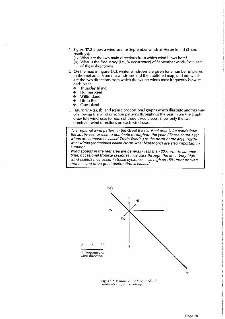
1. Figure 17.2 shows a windrose for September winds at Heron Island (3 p.m.readings).(a) What are the two main directions from which wind blows here?(b) What is the frequency (i.e., % occurrence) of September winds from each
of these directions?
2. On the map in figure 17.3, winter windroses are given for a number of placesin the reef area. From the windroses and the published map, find out whichare the two directions from which the winter winds most frequently blow ateach place.O Thursday IslandO Holmes ReefO Willis Island• Lihou ReefO Cato Island
3. Figure 17.4 (a), (b) and (c) are proportional graphs which illustrate another wayof showing the wind direction patterns throughout the year. From the graph,draw July windroses for each of these three places. Show only the twodominant wind directions on each windrose.
The regional wind pattern in the Great Barrier Reef area is for winds fromthe south-east or east to dominate throughout the year. (These south-eastwinds are sometimes called Trade Winds.) In the north of the area, north-west winds (sometimes called North-west Monsoons) are also important insummer.Wind speeds in the reef area are generally less than 20 km/hr. In summertime, occasional tropical cyclones may pass through the area. Very highwind speeds may occur in these cyclones — as high as 150 km/hr or evenmore — and often great destruction is caused.
NW
0 5 10
I . IW, Frequency ofwind direction
SE
Fig. 17.2. Windrose for Heron island.September 3 p.m. readings.
Page 70

140°150° 160 °
Fig. 17.3. Winter wind roses for various placesin the Reef area (from Pickard et al., 1977).
Wind and waves4. Get a dish of water and blow gently across the top of the water. What do you
notice?
Wind blowing on the sea produces waves. The waves produced in a stormare short and choppy. The maximum height they can reach depends onwind speed, the length of time the wind keeps blowing and the distancewind blows across open water. Waves produced in a storm becometransformed outside the storm area into long waves called swell which cantravel long distances.
5. Considering the prevailing wind direction in the area off the Queenslandcoast, what sides of a reef are most likely to be affected by the action of swell?
Wind, waves, reefsFigure 17.5 shows maps of a number of different reefs in the Great Barrier ReefMarine Park. Cays are islands built up from sand or shingle (gravel) which ismoved about on the reef top by waves. Prevailing winds are from the south-east.
6. On the maps, mark with arrows the prevailing wind directions and label thewindward and leeward sides of each reef.
7. Are sand cays located closer to the windward or leeward sides of the reef-top?
8. Are gravel cays located close to the windward or leeward sides?
9. Now do the leeward and windward sides of a reef differ?(a) On which side is the reef slope steeper?(b) On which side are pinnacles or bommies developed?
10. For visitors to a reef, snorkelling or scuba diving along the reef front is afavourite way to view underwater scenery. On which side of a reef do youthink this is safer — the windward or leeward side?
Page 71

100Lady
90Elliott Is.
80
70
60
9am 3pm % 5 0
40
30
10
1 0
I F MAMJJA 0
NE
1CCThursdays. 90
80
70
60
3pm °/,, 50
40J30
Cook town
9am 3pm
F M A J ASONAS
100
90-
80 ,70-
60-
ty. 50-
40-
30-
10-
1 0
0-J F ;.1 1 A J . A S 6 N 6
NORTH WEST REEF
Fig. 17.4
Fig. 17 .5 Some reefs in the Great Barrier Reef region.
Page 72

Page 73

Reef, cay, island structures
18. Air photo interpretation ............................................................................................................... School19. Reef and island cross-sections .................................................................................................... School20. Formation and development of a cay .............................................................................................. School21. Getting down to the nitty gritty ............................................................................................... Island22. Sediment rain ................................................................................................................................... Reef walking23. Sand patterns — sedimentary structures ................................................................................ Reef walking24. Sediment-organism interaction ............................................................................................... Reef walking25. Beach rock ....................................................................................................................................... Island26. High island rocks ............................................................................................................................ Island27. High island beach sediments ...................................................................................................... Island
Page 74

Page 75

18. Air photo interpretation 1'/2 hr • •
Concepts AimAerial photograph • To use an air photo to make a preliminary map of reef-top features. Then toScale check out the truth of the map by looking at the reef itself.DirectionReef-top You will needZone • Air photo(s) of the reef or island you are visiting (vertical photos, taken fromGround truth directly above, are needed)Satellite imagery • Pocket stereoviewer (optional)
Skills
Hypothesising
Using stereo
Interpretingair photo
viewer
• Piece of plastic tracing film or good-quality tracing paper
• Sharp pencil, rubber• Reef-walking gear
• Clipboard
• Compass and tape for field work (optional)
This activity can be done in conjunction with other reef-walking activities.
Attitudes To understand the Great Barrier Reef, we need to look at it in manyWillingness to work different ways. Some of its features can be seen only at close range. But,
with new for other features, a "bird's-eye" view may be better.technology Photographs taken from planes or satellites are now used extensively to
provide information about natural features of the Great Barrier Reef andabout human activities in the reef area. As in mainland areas, air photosare used in the making of maps of the Great Barrier Reef.An air photo is an important tool in any field study of an individual reef orisland. Air photographs of most reefs and islands in the Great Barrier Reefarea can be obtained from government authorities.
Page 76

What to doA. Beginning to explore the air photo (classroom)1. Try to find out the following information about any air photo you are using.
Make a record of it. (The margin of the photo may help.)(a) When was the photo taken?(b) What is the direction of magnetic north on the photo?(c) From how high above sea-level was the photo taken?(d) What is the scale of the photo? This can be worked out as follows:
Scale = Height above ground level Focal length of lens used
(Focal length is given on the margin of the photo.)(e) What is the reference number of the photograph? The run number and
the number of the individual photo should be noted.
2. If you, or other members of your group, are using several adjacent oroverlapping photos of the reef-top, it's a good idea to spend a few minutesarranging all the photos on a table to get a composite picture of the reef's top.
3. If you have two overlapping photos of a particular area of the reef top, youcan use a pocket stereoviewer to give you a three-dimensional (stereo) imageof the area. Try it out!
B. Making a preliminary map (classroom)4. (a) Look at one air photo. It should show part of the reef-top extending from
beach to the seaward edge of the reef.• Pick out the beach and the seaward edge of the reef.• Are there any areas of apparent deep water, such as pools or a lagoon,
on the reef-top?• Do there seem to be any distinct zones on the other parts of the reef-
top? What do you think these zones might be? (Discuss with others.)(b) Make a tracing of the air photo showing the beach and reef edge.
• Draw in the boundaries of any zones you can see on the reef-top.• Dot in the position of any apparent deep-water areas.
When tracing from an air photo, use tracing paper big enough to cover thewhole photo. Hold it in place with sticky tape. Trim it to fit. Draw themargins of the air photo on your tracing. Show north.
C. Ground-truthing (field work)5. Walk out across the reef-top from the beach to the reef edge in the area
covered by your map. (If possible, take the air photo with you — but it shouldbe sealed in plastic.) Try to check out what the apparent zones you have seenin the air photo really are. How do they differ from one another? (Are they,for example, high areas; low areas; areas covered with coral growth; bareareas; sandy areas; gravel banks; boulder banks; algae growths or ... what?)You may like to use a compass and a tape measure to find out exactly thedirection you're walking from the beach — and the distance.
6. Check out apparent deep-water areas on your map. What are they?
D. Finalising the map (classroom)7. On your tracing paper, label the zones and other features you've observed in
the field. Write brief notes on the features which make each zone distinctive.
8. How did your preliminary ideas about these zones compare with the "groundtruth"?
9. What do you think are the advantages of using an air photo to help in themaking of a map? (Discuss with others.)
Ideas for further things to doNow your group could try activity no. 73, "Reef-top Transect".
ReadingGreen, C., and Milne, T. 1979. The stereo atlas of Australia — aerial photographs
and map interpretation. Adelaide: Rigby. (The introductory section of thisbook provides useful information on using air photos.)
Page 77

19. Reef and island cross-sections 1-11/2 hr
Concepts AimScale To draw, and compare, topographic profiles of:Distance • a shelf reef and cayTopography 0 a continental island.BathymetryContour line You will needProfile 0 Topographic maps showing a reef with cay and a continental island (e.g.Vertical Heron Island and Lizard Island)
exaggeration • Ruler, pencilShelf reef • Graph paperCayContinental What to doSkills 1. Look at each map and decide where you will draw your cross-section. A line
Map reading A-B drawn across the map is used to indicate the position of the cross-section.
Measuring 2. On graph paper draw horizontal and vertical axes for your profile, makingCalculating allowance for the maximum height and greatest depths which occur. TheDrawing horizontal axis represents distance A-B on the map. The vertical axis
represents the height above and below sea-level in metres. (You will need toAttitudes decide whether to use the same scale for both vertical and horizontal axes. ItWillingness will probably be best if at first you draw the cross-section with a large vertical
to work with exaggeration —see information at the end of the activity. Later, forprecision comparison, you could repeat the cross-section using the same scale for both
axes so that there is no vertical exaggeration.) (figure 19.1)
3. Lay the edge of a piece of loose paper along the section line A-B on yourmap. With a pencil, mark off each point where the paper crosses a contourline. Label each contour line value. Then transfer the points on to thehorizontal of the graph you've drawn (figure 19.2).
4. Above each of the points marked on the horizontal axis of your cross-section,draw in a light cross. Join the crosses to form the topographic cross-section(figure 19.3).
5. Draw cross-sections of the other map(s).
6. If ti me allows, repeat, using less vertical exaggeration.
Page 78

Questions to consider7. Think about advantages and disadvantages of using vertical exaggeration
greater than 1. Does a profile drawn with a considerable vertical exaggerationgive a true picture of slopes, or is steepness exaggerated? If two profiles aredrawn with the same vertical exaggeration, can they be used for comparingslopes?
8. Using the profiles you've drawn, compare the underwater slopes around acontinental island with those around an offshore reef. What differences doyou notice?
9. How does the height above sea-level of the cay differ from that of thecontinental island? Why are cays so vulnerable during storms?
INFORMATIONThe vertical exaggeration (VE) of a cross-section is the ratio of the verticalscale to the horizontal scale.
Vertical scale VE - Horizontal scale
If both scales are identical, then VE = 1; if the vertical scale is greater thanthe horizontal scale, then VE will be greater than 1. For example, if bothscales are 1 cm = 100 metres, then VE = 1, but if the horizontal scale is1 cm = 100 metres and the vertical scale is 1 cm = 500 metres, then VE = 5.
rock t= outszhay or sandy zone
REEF S1 OPE REEF RN REEF FLAT CAY
Schematic =se-section of reef
Page 79

Page 80
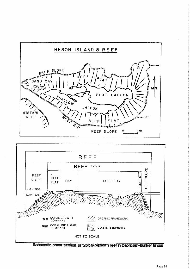
REEFSLOPE
REEFFLAT
REEF
REEF TOP
HIGH TIDE
2
REEF FLATwct
CAY
** CORAL GROWTHDOMINANT
nnn CORALLINE ALGAEDOMINANT
// ORGANIC FRAMEWORK
CLASTIC SEDIMENTS
NOT TO SCALE
cross-section of typical reef in er
1 iF SLOPE
..ccft C. 'Int 'wan is
'''
..... I
otittOit"tn%tit"PII 111 I'''' ifil"
i''' ' REEF I '''s ''' :"'"/"Z„ r4k.„„111111/
. ,,,e_... SAND CAY \II 1 1 LA /1"7-
-"."*„ \ I i I I / i
,,,/„."*„ iiiii„ / :
WISTARI ,
. ' ,, n \ i
R ii;*:(N 0 / I I I I 1 IREEF \ \
-......Ailii,;// %1IIIIIIIIIIiiiminwil,,,iffill 111111111111S ''''''''' ‘‘‘"S
REEF 1 1 FLAT / ;1
11 ' ;00
REEF SLOPE ?
Page 81

20. Formation and development of a cay 11/2 h
Words tochoose from:south-eastbreak upnorth-westgainrefractionlose
Words tochoose from:leewardsand cayshingle caydivergegreaterlessconverge
Aim
You will need• Pencil and paper• Airphoto of a reef (optional)• Shallow tray (e.g. baking dish) and water (optional)• Plasticine or wood (optional)• Clipboard
A cay is a low island formed on the top of a reef from broken-up skeletonsof coral and other reef life. Some cays are made of sand; some fromcoarse debris, shingle; others are mixed sand and shingle.
What to doWaves are important in forming a cay1. Read the following paragraphs and, after discussion among your group,
choose the appropriate words or phrases from the list given at left to fill thegaps:(a) Waves beating on the front of the reef coral and other living
things and bring debris up on to the reef-top, especially during storms.(b) Since prevailing winds in the Great Barrier Reef area are from
the , greatest wave attack comes from this direction.(c) As waves approach the reef front, they are bent as they enter shallowing
water. This process of bending is called(d) Waves which break on the reef rim most of their energy. They
pass on to the reef into shallow water and travel across the reef-top. In theshallow water they are transformed into smaller waves and are refracted(bent).
2. Read the following paragraphs and, after discussion with others, choose thesuitable words or phrases from the list given at left to fill the gaps:(a) Moving water can transport sand, gravel and other reef sediment. The
the energy of the water, the coarser the sediment it can carry.(b) Most of the coarse debris brought up by waves on to a reef is dumped
near the reef rim on the windward side of the reef. This coarse debris maybuild up to form a
(c) Finer debris, such as sand, is transported across the reef-top to theside of the reef-top.
(d) Because of the refraction of waves, waves coming from differentdirections may meet (i.e., ) at a point on the leeward side of thereef-top.
(e) If this happens (i.e., if the waves "bump into one another"), water velocityis reduced. Water no longer has enough energy to carry the sand, so it isdeposited forming a
Wind also moves sediment3. Wind blows some sand up on to a cay from the reef-top at low tide. Find out
the name for ridges of windblown sand.Do you think windblown sand is likely to be coarser or finer than beach sanddeposited from water?
ConceptsCay To explore the following questions:Prevailing wind 0 How does a cay form?Leeward • What changes take place as a cay develops?WindwardRefractionShingleSandHumansSuccessionClimaxZone
SkillsAnalysingApplying
information
AttitudesInterest innaturalenvironments
Page 82

Storms are important4. Much of the movement of sediment on a reef-top seems to take place during
major storms. During a storm, waves may bring much sediment up on to theedges of a cay forming a ridge. Do you think that sediment transported inwaves in storm conditions is likely to be coarser or finer than sedimenttransported in non-storm conditions?
Stages of development of a cay5. Look at table 20.1 showing information about three cays in the Great Barrier
Reef area near Cairns.(a) Which of these cays:
• is smallest?• is largest?• has trees in its vegetation?• has the greatest area of bare sand?• has some plants but no trees?• is most likely to be unstable?
(b) Which of these cays is most like a newly formed cay?(c) Which of these cays seems to be at the most mature stage of
development?(d) Which of the cays corresponds to each of the following cay development
stages:• Early-stage cay• Intermediate-stage cay• Mature-stage cay
(e) Find out the names of two other mature-stage cays in the Great BarrierReef area.
Table 20.1: Information on three cays near Cairns
Aream2 Vegetation
% areavegetated
Green Is. 139 100 heavy vegetation including a forestzone (114 species of vascular plants)
84
MichaelmasCay
29 030 herbs and grasses (5 species ofvascular plants)
26
Arlington Is. 4 600 generally unvegetated 0
Words tochoose from:quartzguanonesting placephosphatesgraveldeadcalcium carbonate
Words tochoose from:windbirdsflotsamdigestive tractjetsam
The coming of birds and plants6. Read the following sentences and, after discussion, complete the sentences
by choosing appropriate words from the list at left to fill the spaces:(a) The sand which makes up a newly formed sand cay is almost entirely
which comes from the hard skeletons of coral and other forms ofreef life.
(b) As the cay becomes larger, and rises above sea-level, seabirds begin to useit as a
(c) They help to change the island's composition by adding their wastedroppings, , and by leaving scraps of food.
(d) bodies of birds and seashore creatures may also be added to thecay.
(e) Gradually a thin layer of humus develops on the cay. Important materialspresent in the humus include some nitrates and
7. Choose words from the list given at left to complete each of the statementsbelow:(a) Plant parts or seeds which can travel to a cay by floating in sea water, e.g.
octopus bush, coconut, are referred to as(b) Plants which have seeds that are sticky or have hooks can arrive at a cay
attached to(c) Some seeds are carried to a cay via the of a bird or other animal.(d) The can carry winged seeds to an island.
Page 83

Words tochoose from:humusgrasses and creepersringshiftingbindsalt-tolerantshrubsanimalsPisonia
Words tochoose from:insectswaveswindswimblownflyfishparasiteslogs
A vegetation succession8. Choose words from the list at left to fill the spaces below:
(a) The first plants to colonise a cay are which can cope with harshconditions. They are and drought-resistant. They are able towithstand high temperatures, sand and wind. They can live in the sandeven though it is poor in phosphates and nitrates. They provide food forsome which migrate to the cay. They also contribute material tothe of the cay when they die. The changes to the island broughtabout by the first colonies create conditions in which other types of plantscan grow.
(b) Then may begin to grow: octopus bush (Argusia) and fan flower(Scaevola) may be among these.
(c) Finally, a forest of tall trees such as , Cordia and Casuarina maybecome established on the interior of the island.
(d) The final pattern of vegetation may be an interior forest zone, surroundedby a of shrubs, surrounded by an outer zone of herbs and grasses.
9. Survival problems for plants on a cay include the seven listed in the left-handcolumn in table 20.2. Changes brought about by early colonisers of a cay helpto reduce these problems for later arrivals.Use lines joining the columns to show which of the survival problems each ofthe changes listed helps to reduce for later plants. (Each letter may be usedmore than once.)
Table 20.2
Survival problems for plants Changes produced by early plants
1. Exposure to drying winds. A. Some plants 'fix' nitrogen from the
2. Exposure to high temperatures. atmosphere using bacteria whichlive in lumps (nodules) on their
3. Risk of being sand-blasted. roots. When plants die, their
4. Low concentrations of nitrates bodies form humus.
in soil. B. Foliage of plants create shade.
5. Exposure to salt spray. C. Roots of grasses and other plants
6. Poor moisture holding capacity help to bind sand.
of soil. D. Vegetation acts as a wind break.
7. Risk of being buried or totallyuncovered by moving sand.
10. As different plant types follow one another in becoming established on theisland, distinct vegetation zones may form on the island.(a) Figure 20.1 shows a sketch and cross-section of an island with a beach and
the following vegetation zones:• grass and herb zone• shrub zone• forest zone.Label each of the zones on the diagrams.
(b) What do you think might happen to each of these zones if the cay was toget larger?
Animals on cays11. Animals arrive at a cay in a variety of ways. In the sentences below, choose
suitable words from the list given at left to fill the spaces.(a) Seabirds mostly in.(b) Land birds and shore birds fly in or are in.(c) Winged also arrive by air.(d) Some flightless insects, spiders and other arthropods are probably blow in
by(e) Some invertebrates which are arrive attached to birds or other
animals.(f) A few animals arrive by swimming there (e.g. turtles) or by floating on
objects such as
Page 84

Spinifexcouch, grass,creepers
Octopus bush (Argusia)Coastal she-oak( Casuarina)Native cabbage(Scaevola)
Pisonia
0 100
metres
Fig. 20.1. Vegetation zones on a cay.
12. Below are shown food chains involving living things found on islands.
A. Algae --> fish ---> seabird
B. Algae -› fish seashore crab seabird
C. Tree --> leaf-eating insect land bird
(a) A producer is a living thing which makes its own food by trapping sunenergy during photosynthesis. A consumer cannot make its own food. Itconsumes other living things to get energy.Label the living things shown in the food chains above to show whetherthey are producers or consumers.
(b) A herbivore eats plants; a carnivore eats animals; an omnivore eats plantsand animals.Label any consumers in the food chains shown which are herbivores.
(c) Which of the food chains shown above could not occur on a newlyformed cay? Why?
(d) Why is it that carnivores are the dominant animals in early formed cays?(e) From what environment does the material eaten by the cay animals in
food chains A and B come?
Page 85

Fresh water changes cays13. Fresh water which falls on a cay helps vegetation to become established by:
• providing moisture which plants absorb through their roots.• seeping down through the sand washing away sea-salt.• dissolving humus material and taking it underground.(a) On cays which have minium diameters of greater than 100 m, a lens of
fresh water develops in the subsurface. Which of the cays in figure 20.2below is likely to have a lens of fresh water?
(b) If a cay does not have a subsurface fresh water lens, the only plants whichcan grow on it are salt-resistant herbs and grasses. Of the islands shown infigure 20.2 which will not develop a vegetation of shrubs and trees?
14. Fresh water also dissolves calcium carbonate and phosphate from cay materialand deposits it elsewhere. This calcium carbonate and phosphate formcement which joins sand or other debris together to form rock.(a) What do you think is the major source of the phosphate on a coral cay?(b) Find out the names of some ocean islands from which Australia imports
phosphate rock for fertiliser.
Cays change shape15. (a) Small unconsolidated cays are very mobile. Figure 20.3 shows how one cay
moved about over an 8-year period. Use coloured pencils to show thedifferent positions of the cay and number the cay positions from oldest (1)to youngest (5).
(b) The edges of large vegetated cays also change. Figure 20.4 shows a caybefore and after a cyclone. Use coloured pencils and labels on thediagram to highlight what happened to this cay.
(c) Beaches on cays may also change shape because of seasonal change inwind direction. Figure 20.5 shows a cay in two seasons. Use colouredpencils and labels to highlight what happened to the cay.
Fig. 20.2.
Page 86

................. 23 SEPT.117720 NOV.1116
................ 21 OCT. 197623 AUG.1976
• HIGHEST POINT OFEACH SURVEY
---- 27 Anil 1176 - - - - - - - 19 JULY 1975
- 23 JUNE 1975
- 22 JULY 1969
REEF FLAT WITHLIVING CORALS
22.6 75‘..,23.6.75%
*24.6 75
22 , 7:. 69
/16 7• 75 20.7.7S9.775
SANDEDREEFFLAT
0
21.10.75
20 11 7627.4.7600
23.9 770 19.11.7
40mI
0
Fig. 20.3
Rock on a cay16. Sand or other material can become cemented together in several ways to
form rock on a cay. Three important types are shown in table 20.3.
Table 20.3
Type ofrock
Where generallyfound
Type of cement and how deposited
Dune rock
Cay rock
Beach rock
Cay interior
Cay interior
On beach
Calcium carbonate deposited from freshwater
Phosphate from bird guano
Aragonite (a type of calcium carbonate)deposited from sea water
(a) If rock develops on a cay, do you think this helps make the cay morestable? Why or why not?
(b) Beach rock is thought to develop under cover of sand in the intertidalzone (i.e., between high- and low-tide level). But on many cays, this rockis exposed to our view on the beach. What kind of change to the caysdoes this possibly indicate?
Page 87

Oct., 1975
BEACHROCK
• LIGHTHOUSE
VEGETATION
June, 1980: Sandmass after Cyclone Simon (Feb. 1980)
0 1001
Metres
Fig. 20.4. North Reef sand cay, 1974-1980.
Ideas for further things to do17. Obtain a vertical air photo which shows waves approaching a reef. Can you
see waves bending and changing direction in the air photo? If possible, makea tracing of the outline of the reef, and draw in some of the most easy-to-seewave crests. Attach your tracing to these sheets.
18. Get a shallow tray of water and put into it a flat slab of plasticine or wood, orsome other solid material, to represent a submerged reef. The "reef" shouldbe just below the surface of the water in the tray. Using a ruler, make waveswhich travel towards the reef. Look at what happens to the waves. Do you seebending? You could make a sketch of the wave pattern.
19. Make a series of labelled diagrams showing how a cay might change from theti me it forms initially to the stage when it has a tall forest.
20. Once a cay has formed as a bare sand island, how does it need the sea to helpit become a heavily vegetated cay?
21. People change cays. Make a list of some ways in which people have causedand are causing change to cays in the Great Barrier Reef. If possible, readliterature to help you (e.g. Hopley 1985).
22. Read some literature (e.g. Hopley 1985) to find out how old some GreatBarrier Reef cays are. What technique is used to help us find the age of a cay?
Page 88

Page 89

NODAL POINT(ACCRETION)
Diffracted Waves
SOUTH EAST
OCEAN WAVES
WAVE INTERACTION AROUND A CORAL CAY
Diffracted Waves
Approaching
Wave Fronts
Reef Flat
ao
WAVE MOVEMENT ACROSS A PLATFORM REEF
Fig. 20.6
ReadingsFosberg, F. 1976. Coral island vegetation. In Biology and geology of coral reefs, ed.
O.A. Jones and R. Endean, vol. 3, Biology 2. New York: Academic Press.Heatwole, H. 1976. The ecology and biogeography of coral cays. In Biology and
geology of coral reefs. See Fosberg 1976.Hopley, D. 1982. The geomorphology of the Great Barrier Reef. New York: John
Wiley.Hopley, D. 1985. Coral cays. Townsville: Great Barrier Reef Marine Park Authority.Talbot, F., ed. 1984. Reader's Digest book of the Great Barrier Reef. Sydney:
Reader's Digest.
Page 90

ConceptsSedimentSandGravelCalciumcarbonate
SkillsUsing lens or
microscopeClassifying
AttitudesInterest innaturalphenomena
Aim• To consider the composition, size, shape and origin of sand grains and other
sediment on a cay beach.
You will need• Two small plastic bags• A hand lens (or a stereo microscope, if available)• A piece of transparent self-adhesive plastic about 10cm square• A plastic dropper bottle of dilute hydrochloric acid (optional)• A piece of plastic fly-mesh• A piece of mm graph paper
Feel that crunch beneath your feet as you walk around the beach! Brushyourself down after sitting on the sand. Look closely now — what is thesand made up of? Where does it come from?
What to do1. Walk around the beach and collect two samples of dry beach material (a very
small handful of each will do).One sample should be sand and the other coarser material if you can find it.(You might like to use your sieve to get the coarser material.)
2. Look at the material carefully, using your hand lens (or microscope).(a) What size are the coarsest grains you've collected and what size are the
finest?(b) Do all the grains seem to be made of the same chemical substance. Think
up some ways you might find out. Smell? Crush? Look at the colour? Onething which might help is to add a little acid to some of the grains. Howdo they react? What does the result mean?
(c) Can you see any clues as to the origin of this material. Do all the grainshave the same shape? Can you recognise fragments of the skeletons ofreef animals or plants? If so, is it easier to recognise these in the fine orcoarse material?
(d) What kinds of living things produced any skeletal fragments in yoursample? Where do you think the material has come from and how has itreached the beach?
Some years ago, reef research workers attempted to find out if there hadbeen severe infestations of crown-of-thorns starfish on the Great BarrierReef in the past. The way they did this was to look for fragments of crown-of-thorns skeletons in samples of ancient Great Barrier Reef sedimentscollected from drill holes. Before they could do this, they had to becomethoroughly acquainted With the kinds of pieces which a crown-of-thornsskeleton breaks up into and how these pieces change in appearance asthey are tumbled about on the reef.
Page 91

3. Would you be able to recognise different-sized pieces of a particular kind ofskeleton? Test yourself by looking out on the reef for different-sized (large,medium, small) pieces of broken:• gastropod ("snail") shell or• clam shell or• honeycomb coral or• fine coral or• staghorn coral or• sea urchin or• tube worm.Make a series of sketches showing how one of these skeleton types breaksdown into smaller pieces.
Ideas for further things to do4. Design a simple experiment to find out which types of reef skeletons break up
most easily as they are carried around on the reef.
5. Use reference material to find out the relative contribution differentorganisms make to reef sediment (per cent composition).
6. Use a set of sieves with different mesh sizes to work out the grain sizedistribution of a beach sand sample. (To do this you will also need somethingto measure sand fractions — either by mass or by volume.) Plot your size dataon a histogram. Compere grain size distributions of sediments from differentparts of cay and reef. Can you find any systematic pattern?
ReferenceHopley, D. 1982. The geomorphology of the Great Barrier Reef. New York: John
Wiley.
arCti KG 4Croce krt ro-6 5 Ivionvn ; a -h., 5
Page 92

ConceptsSedimentDistributionInteraction
SkillsObservingMeasuringRecordingAnalysing
AttitudesInterest inmethods ofenquiry inscience
Aim• To find out whether the amount of sediment raining down is different on
different parts of the reef flat.
You will needO Reef-walking gearO Small plastic specimen tubes (about 2 cm diameter) with holes drilled near
upper rim (35 mm film canisters or cut down vinegar bottles can be used. Theholes can be drilled with a hot nail.)
O Strong twine or wireO Air photo of reef-top (optional)O Knotted 20 m rope (optional)O A suitable permit8 Small boat for use at night tide (optional)This activity requires two sessions each of about 1-1 1/2 hours on the reef flat at lowtide. One session should be at the beginning of your trip, the other at the end.
The amount of sediment raining down from above may affect thedistribution of plants and animals on a reef. If different amounts ofsediment rain down on different parts of the reef, this could possibly beone factor influencing the relative distribution of corals and fleshy algaeon a reef flat.
What to do1. Across the reef flat, put out a series of open plastic tubes attached to fixed
objects (e.g. boulders, iron slabs). The tubes should be held in place using, forexample, wire or tape threaded through holes near the top of the tube.The mouths of the tubes should all be at the same tidal level (e.g. slightlybelow the upper limit of coral growth on the reef flat). It may be useful to setout the sediment traps along a transect line if used for other study.
2. After a number of days, collect the tubes. (Or check the tubes daily at low tideand, if a boat is available, at high tide.)
3. Compare the amount of sediment in the tubes. Is there any systematicvariation in amount across the reef flat? Is there any variation in the size of thesediment in the tubes, i.e., do some tubes contain coarser sediment thanothers?
4. Discuss your findings and their possible significance with others in your group.
We acknowledge the help of A. Cribb, Botany Department, University of Queensland with this activity.
Attach collecting tubes for sedimentto dead coral at low tide water level.
Page 93

23. Sand patterns: sedimentary structures 2 hr • •
ConceptsInorganicsedimentarystructure
Organicsedimentarystructure
BedRipple markBurrowTrailClassification
SkillsMeasuringRecordingObserving
AttitudesAppreciation ofnaturalenvironments
Interest inmethods ofscience
Aim• To gain some understanding of the way structures in reef-top sediment
deposits are produced by moving water and air, and by living things.
You will need• Reef-walking gear• Snorkelling gear• Clipboard and paper• Plastic ruler• Camera (optional)• Transparent viewing boxThis activity requires approximately 2 hours — part of which should be at time oflow tide and part at higher tide level. It could be carried out over a number ofdays.
In places where deposits of sand or other sediments are forming, air, waterand living things act on the sediment to produce distinctive featuresknown as sedimentary structures. These include various kinds of ripplemarks, grooves, burrows, tracks and trails.
What to do1. As the tide goes out, walk along the beach and also through the water on the
inner reef flat.(a) Look for structures produced on the surface of the sand by moving water.
You might find grooves, or ripple marks, or other similar structures. Howmany different kinds can you find? A transparent viewer will help youlook through shallow water to the sandy bottom.
(b) Try to make a pictorial catalogue of all the different kinds of sedimentarystructures produced here by water movement. Make labelled sketcheswith a scale. Use a camera, too, if you have one.In each case, try to work out which way the water currents or wavesmoved to produce the structure. Show this on your sketches with arrows.
(c) If you see ripple marks, note their wavelength (i.e., distance betweencrests) and amplitude (i.e., difference in height between trough and crest).Are the crests, in plan view, straight or curved? Are the marks, in profileview, symmetrical or asymmetrical? Draw sketches. Do you think theywere produced by currents (asymmetrical) or waves (symmetrical)?
2. While walking on the beach or reef flat, keep your eyes open for sedimentarystructures made by living things. Look for trails, tracks, burrows, holes ormounds. Do you know what animals made these and how they wereproduced? Make some pictures of the features you've seen.
3. While snorkelling over the reef flat or looking out from a "submarine" orglass-bottomed boat, keep your eyes out for ripple marks on the bottom andespecially for ripples of moving sand. Look at the moving sand carefully andnotice how the ripples change. Make a sketch to show what you see.
Page 94

Ideas for further things to do4. Look for sedimentary structures made by wind. You might see them on sand
dunes at the back of your beach. Add sketches of them to your pictorialcatalogue of sedimentary structures.
5. Look for sedimentary structures made by turtles, people and birds. How gooda detective are you? Can you work out what each animal was doing at theti me it made the structures? Which way was it going, for example?
6. While walking on the reef crest at low tide, look for patches of loose, dead,coral sticks which have been lined up nearly parallel to one another. This isone type of sedimentary structure. Could it help us to work out which waywater moves on the reef-top? What other process, apart from movement ofwater current, might be involved here?
7. Can you invent a classification scheme for all the sedimentary structuresyou've seen? Explain the basis for the classification you use. Is it based on theway you think the structures originate? on features of the structures you canactually see? on both?
A final question to think about8. Sedimentary structures are often found in ancient rocks. They are very useful
in helping geologists work out what was happening in the ancientenvironments in which the sediment was deposited.(a) How would sedimentary structures such as the ones you've observed at
the reef look if we saw them in ancient sedimentary rocks — say, in a roadcutting, or quarry?
(b) If sedimentary structures such as the ones you've observed were found insome ancient sedimentary rocks, just what clues could they give us aboutpast environments and events? Make a list of things they could tell us.
ReadingsClark, I., and Cook, B. 1983. Geological science: perspectives of the earth.
Canberra: Australian Academy of Science.Reineck, H.E., and Singh, I.B. 1975. Depositional sedimentary environments. New
York: Springer Verlag.
Page 95

24. Sediment-organism interaction
ConceptsSedimentBiogenesisBioerosionBoringBurrowingBindingTurbidityAdaptation
SkillsObservingRecording
AttitudesInterest innaturalenvironments
Aim• To explore some relationships between living things and sediment in reef
environments.
You will need• Reef-walking gear• Snorkelling gear• Field sheet and pencil• Camera (optional)This activity requires about 2 hours in total but this could be spread over anumber of days of your trip.
Sediments include materials such as mud, sand, pebbles and boulders. Onreefs, there is a close link between sediments and living things. Someplants and animals contribute to sediments by building calcium carbonateskeletons. Some animals help in sediment production by biting, boringand scraping solid reef material so that smaller fragments are produced.Some animals consume sediment, or graze on top of it. Some animalsshelter in sediment; some burrow through it. Some animals use sedimentto help build themselves protective coatings.Plants of the reef hold sediment in place in a variety of ways. Some act asbaffles — trapping loose sediment (among tufts or filaments). Some bindsediments together using roots or holdfasts. Some grow over and encrustloose sediments, "welding" them together forming solid rock. Theseactions help to stabilise a reef.For many fixed organisms, loose sediment is a threat: it can engulf them: itcan prevent light reaching them. Having some way of coping with loosesediment is an important survival factor for some organisms.
What to do1. Read the list on the field sheet of some processes carried out by reef
organisms.
2. While reef-walking or snorkelling over the reef, look for the following livingthings. You may not be able to find all of them at the reef you are visiting.On beach rockchitonOn reef flat: goby; Christmas tree worms; spaghetti worm; Halimeda (disc-
weed) (several types); sea grapes; clam; red-lipped stromb;sea-cucumbers (various types); sea grass (if present)
On reef crest: turf-like algae; pink-encrusting algaeOn reef slope: parrotfish
3. Observe these organisms and their surroundings to try to find out which ofthe processes listed on the field sheet they carry out. Note this on the sheetand record your observations in a brief note and/or sketch.
4. Can you add to the list of organisms which carry out some of these processes?
Ideas for further things to do5. How do sea-cucumbers consume material from the reef flat? Observe sea-
cucumbers and describe the process carefully. Be patient!
6. Look to see if different species of sea-cucumber produce different kinds offaecal pellets.
7. Try to find out what effect chitons have on beach rock. Design and carry outan experiment to measure the amount of change they produce.
8. Look at plate-like corals growing on the reef slope. Are they mostly horizontalor tilted? Would their orientation assist them in coping with sediment whichfalls on to them?
Page 96

9. Try to find grains of sediment (coarse or fine) which are derived fromskeletons of different organisms. Perhaps you will be able to find pieces ofcoral, disc-weed (Halimeda), foram, mollusc, echinoderm and others. Youcould glue them on to some cardboard or mount them between two sheets ofself-adhesive plastic, as a reference collection. (A permit is required to collectspecimens.)
Research through reading10. Read about studies of reef-top sediment to find out about the relative
contribution made by the skeletons of different groups of plants and animals.
11. Halimeda is a major producer of sediment in the Great Barrier Reef region.Find out some place where Halimeda is dominant in sediment.
12. Although animals which consume sediment, bite skeletons or scrape rock maytake in large amounts of calcium carbonate, it is not actually the calciumcarbonate which they use for food. Find out what is used as food by:parrotfish, sea-cucumbers, chitons on beach rock.
13. How do molluscs bore into solid material?
14. One of the most important processes which helps the break-up of reefmaterial is boring by sponges. Find out the name of any type of sponge whichdoes this and the method used.
15. Mushroom corals (Fungia sp.) have some ability to get rid of sediment whichfalls on them. Find out something about the process.
16. Many reef-building organisms cannot survive in water which is made toocloudy by sediment. Find out why this is so, and how the fact limits thegeographic distribution of coral reefs.
17. Like marine organisms, many land-living animals and plants interact withsedimentary material (soil, etc.) in the ocean environment. Can you think ofterrestrial counterparts for some of the marine processes and organisms listedon the field sheet?
References and further reading listBakens, G.J., 1973. Biology and ecology of tropical holothurians. In Biology and
geology of coral reefs, ed. O.A. Jones and R. Endean, vol. 2, pp. 326-67. NewYork: Academic Press.
Hopley, D. 1982. The geomorphology of the Great Barrier Reef. New York: JohnWiley.
Orme, W. 1977. Aspects of sedimentation in the coral reef environment. InBiology and geology of coral reefs, ed. O.A. Jones and R. Endean, vol. 4, pp.129-82. New York: Academic Press.
Schumacher, H. 1977. Ability in fungiid corals to overcome sedimentation. In Proc.Third Intern. Coral Reef Symposium. Miami, Florida.
Talbot, F., ed. 1984. Reader's Digest book of the Great Barrier Reef. Sydney:Reader's Digest.
Page 97

FIELD SHEET
24. Sediment-organism interacUon
Process Example(s) of organismswhich carry out process
Notes ( make further notes andsketches on separate sheet)
Building rigidskeletons
Boring intoskeletons
Scraping rocks
Biting skeletons
Consuming sediment
Sheltering insediment
Using sediment asbody covering
Grazing on thesurface of sediment
Binding sedimenttogether usingholdfast
Trapping sediment intufts or filaments
"Welding" togetherloose reef materialto form a rigid mass
Page 98

- 1111191=111nM
11116 25. Beach rock 11/2 hr
ConceptsFragmental rockLithificationCementErosionTimeChangeSlopeDip
SkillsObservingInferringMap reading
AttitudesAppreciation of
naturalenvironments
Interest inmethods andproducts ofscience
Aim• To study the location and composition of beach rock and to make inferences
about the origin of this rock type.• To observe organisms which live on beach rock and to consider processes
which are causing beach rock to be destroyed.
You will need• Outline map or air photo of island• Hand lens• Plastic dropper bottle of dilute hydrochloric acid (optional)• Clinometer (optional)
On the edges of some reef islands and at some spots on the mainlandcoast in the reef area, large, low masses of a distinctive type of rock,known as beach rock, can be found exposed among or close to beachesof coral sand and gravel.
What to do1. Find a place where there is beach rock on the beach you are visiting.
(a) Look carefully at the surface of the beach rock, using a hand lens. (Ifpossible, choose a whitish-coloured patch of rock to look at. Most beachrock has a blackish-coloured surface because of algae growing on it.)
(b) Put a few drops of dilute hydrochloric acid on the beach rock and watchwhat happens.
(c) Can you see fragments in the rock? Based on the acid test, what do youthink the composition of the fragments is? What do you think is the originof the fragments? How does the general size and shape of the fragmentscompare with the fragments of the nearby beach? Based on yourobservations, how do you think the beach rock formed?
2. (a) Mark outcrops of beach rock on an outline map of the island. (A verticalair photo may be helpful.) Are layers visible in the beach rock? Are thelayers sloping? If so, measure or estimate the slope and direction of slope(i.e., dip) and mark this on your map.
(b) How do the slopes on the beach rock compare with those on the nearbybeach? Does this comparison throw any light on the way beach rockforms and the location in which it forms?
3. (a) What animals and plants can you see living on beach rock?(b) What effect, if any, do animals and plants seem to have on beach rock?(c) What signs are there that beach rock is being destroyed?(d) What processes are causing the destruction?
4V^'
Schematic diagram ofmagnified view of thinsection of rock
Page 99

Ideas for further things to do and think about
There have been many ideas about the way beach rock forms. Presentaccepted scientific theory about Great Barrier Reef beach rock is that:• Beach rock is formed by the cementing together of calcium carbonate
beach sand. This sand is largely derived from broken-up skeletons ofliving things.
• The cementing process takes place in the intertidal area of a beach.8 The cementing takes places in sand deep in the beach, under cover of
loose material.O The cement is calcium carbonate which has been deposited from
solution in sea water.8 Sloping layers in beach rock are present because there were sloping
sand layers in the beach from which the rock formed.
4. Read the ideas given above about beach rock origin. For which of these ideashave you seen some supporting evidence during your field trip?
5. Look at the map of beach rock outcrops at the place you are visiting.(a) If beach rock forms deep in a beach under cover of sand, why is it now
exposed at the surface for us to see? What might have happened?(b) Cays are thought to change in shape and position through time. If you are
visiting a cay, does the location of beach rock here give any clues to thecay having a different position or shape in the past?
6. Some people think of rock as something which forms only very slowly. ButCoca-Cola bottles and World War II plane debris have been found embeddedin beach rock in some places, indicating a recent origin. If beach rock isforming today in the area you are studying, where might it be forming?
ReadingsBarnes, D.J. 1983. Perspectives on coral reefs. Canberra: Clouston/Aus. Inst.
Marine Science.Hopley, D. 1982. The geomorphology of the Great Barrier Reef. New York: John
Wiley.Stoddart, D.T. and Steers, J.A. 1977. Nature and origin of reef islands. In Biology
and geology of coral reefs. ed. O.A. Jones and R. Endean, vol. 4, Geology II,pp. 78-80.
Further readingDavies, P.J., and Kinsey, D.W. 1973. Organic and inorganic factors in recent beach
rock formation, Heron Island, Great Barrier Reef. Journal of SedimentaryPetrology 43(1): 59-81.
Jell, J.S., and Flood, P.G. 1977. Guie to the geology of reefs of the Capricorn andBunker groups, Great Barrier Reef province, with special reference to HeronReef. Dept. Geology, Univ. Old., Papers 8(3): 32-33.
Page 100
626. High island rocksnNri- 1111=N1111INC-_
1 1/2 hr+ • •
Concepts AimSedimentary 0 To find out what rock types occur on a continental island and to make a map
rock of their distribution.Igneous rockMetamorphic You will need
rock • Sketch map of island attached to field board and/or air photo of island andOutcrop map piece of good tracing paper to fit over itInterpretation • Pencil or fine penmap • Hand lens
Dip • Clinometer (optional)Cay • Geological hammer (optional)Continental • Compassshelf
Skills What to doObserving 1. Select part of the island for study. Where possible, walk around the edge of
Using a key this part of the island observing outcrops of different rock types along the
Identifying shoreline and marking them on the map (or tracing paper) using different
rocks symbols. Indicate where you think the boundary between one rock type and
Interpretating another occurs.
data 2. Observe each different rock type with a lens and, using the key given in theMap making field sheet, try to decide whether it is a rock of igneous, sedimentary orMap reading metamorphic origin. Can you identify any minerals? Try to identify the rock.
Attitudes 3. If the rock has sloping layers, measure the dip of these if you have a compass
Interest in and clinometer.
natural world If you have an appropriate collecting permit, you may be able to take
Perseverance specimens of the rocks back to base camp for closer observation.
Willingness to 4. Try to find out what kinds of rocks are outcropping away from the shorelinesuspend on the part of island you are studying. You could do this by walking back andjudgment forth across the area along several traverse lines looking at outcrops and
marking symbols on your map. Look carefully at the air photo, too. It mightgive you clues as to what rock type occurs where.
5. The data you have now plotted on your map forms a geological outcrop mapof part of the island. With the help of your leader, try to convert this into ageological interpretation map. This is a kind of best-guess map!
6. Try to obtain a published geological map of the nearby mainland. Lookcarefully at the shading and symbols on this. Do any of the rock types whichoccur on the mainland nearby also occur here? Does the map help youdecide the approximate age of the rocks you have seen on the island?
7. Coral cays are islands made up only of reef debris whereas the island you arestudying is made up of continental rocks. Discuss with other members of yourgroup: Why do the rocks on the high islands of the Great Barrier Reefresemble types of rocks found on the mainland? How has the island becomecut off from the mainland? Where do the minerals in each of the rocks you'vefound come from? Do any of the rocks appear to have formed from reefdebris?
Page 101

26. E]gh lolancl rocks
A key to help distinguish rocks1. (a) Fizzes strongly when hydrochloric acid is added ..................................
(b) Does not fizz strongly or at all when hydrochloric acid is added ....
2. (a) Has recognisable pieces of skeletons of living things visible ............(b) Sugary texture; perhaps wavy patterns; probably no recognisable
pieces of living things .....................................................................................(c) Does not fit clearly into (a) or (b) ...............................................................
3. (a) Has grains mostly or entirely too small to be seenwith naked eye .................................................................................................
(b) Has grains large enough to be seen with naked eye ............................
4. (a) Has no layering .................................................................................................(b) Has layering .........................................................................................................
5. (a) Has rounded or oval holes and/or has largely columnarstructures and/or .............................................................................................
(b) No holes, columnar structures or large crystals ......................................
Go to 2Go to 3
Limestone (sedimentary rock)
Marble (metamorphic rock)Limestone or marble
Go to 4Go to 8
Go to 5Go to 7
Igneous rock of volcanic origin(If dark-coloured, may bebasalt; if light-coloured, may berhyolite)Go to 6
6. (a) Has fine grains which rub off easily
e.g. mudstone(sedimentary rock)
(b) Grains cling together and do not rub off .................................................. Hornfels (metamorphic rockproduced by heat): Igneousrock of volcanic origin (If dark-coloured, may be basalt; ifli ght-coloured may be rhyolite)
7. (a) Grey or fawn-coloured; grains rub off fairly easily;layers slightly irregular ................................................................................... Shale (sedimentary rock)
(b) Layers regular; somewhat shiny; rock tends tosplit along layers ............................................................................................... Slate (metamorphic rock
produced by pressure)(c) Irregular layers in light-coloured or reddish rock;
grains do not rub off easily ........................................................................... Rhyolite (igneous rock)
No layers present ............................................................................................. Go to 10Layers present ................................................................................................... Go to 9
Layers made of flakes of shiny minerals .................................................... Schist (metamorphic rockproduced by pressure)
Alternating layers of flakey and blocky mineral grains ........................ Gneiss (metamorphic rockproduced by pressure)
Layers made of angular or roundedfragments of broken up material ................................................................ Go to 14
10. (a) Grains mostly irregular in shape and interlocking; two or morekinds of minerals present ............................................................................... Go to 11
(b) Grains mostly regular in shape, often with hexagonal outlines;texture sugary; perhaps only one type of mineral present ................ Hornfels (metamorphic rock
produced by heat)
11. (a) Generally light-coloured rock, perhaps pink, grey or cream ............ Go to 12(b) Generally dark-coloured rock, black or nearly black .......................... Go to 13
12. (a) Grains mostly greater than 2 mm in size; mostly glassy transparentgrains (quartz) and pink or white grains (feldspar);occasional black grains .................................................................................... Granite (igneous rock of deep-
seated origin)(b) Grains mostly smaller than 2 mm;
different composition from (a) .................................................................... (another type of igneous rock)
Page 102

13. (a) Grains mostly greater than 1 mm in size; Mostly black andcolourless or white grains .............................................................................
(b) Grains mostly smaller than 2 mm in size ....................................................
14. (a) Grains are sand-sized (less than 2 mm in size) ........................................(b) Grains are gravel-sized and rounded
(greater than 2 mm in size) ...........................................................................
Gabbro (igneous rock)(another type of igneous rockof deep-seated origin)
Sandstone (sedimentary rock)
Conglomerate(sedimentary rock)
Page 103

lag 27. High island beach sediments 11/2 hr +
Concepts/topics AimSediment • To find out the composition of sand on the beaches of a high island and to
provenances make inferences about the origins of the sand.Mineralproperties You will need
SkillsObservingUsing equipmentWorking with
precisionMaking
inferences
AttitudesInterest innaturalenvironment
Interest inprocesses ofscience
• Hand lens• Small plastic bagsc Dilute hydrochloric acid in plastic bottle• Stereomicroscope (optional)• Several plastic containers e.g.
— graduated medicine cups, about 30 ml;— beaker, about 250 ml
• Plastic kitchen sieve
What to do1. (a) Collect samples of beach sand from several places on the island (about
75 cc from each place will do). Use the sieve to keep out any largefragments from your samples.
(b) Try to find out approximately what percentage of each sand sample iscomposed of calcium carbonate. Measure out some sand by dropping itinto a measuring cup filled with water, until the sand reaches the 25 mlmark. Transfer the sand to a larger container and add hydrochloric acidgradually until the fizzing stops. Measure the volume of residue, if any.What percentage by volume of the original sample has dissolved away?
2. The dissolved-away portion of each sample was probably calcium carbonate.(a) What could originally have produced this calcium carbonate?(b) Look at the untreated samples with a lens to help test out your ideas
about this.
3. Look at the undissolved residue of each sample using a lens or microscope.(a) How many different kinds of particles are present?(b) What are their characteristics?(c) Are any of the particles mineral grains which you can identify using table
27.1?
Table 27.1
Clear or white, shiny jagged grains Quartz
Clear or white or pink shiny Feldspargrains with one or two flat sides
Light-coloured shiny flaky grains Mica
Black or dark-green shiny grains Augite orwith one or two flat sides Hornblende
Black or rust-coloured opaque grains Iron oxide
(d) Where could these undissolved minerals have come from? Does yourknowledge of rocks on the island help you answer this?
4. Is the percentage of calcium carbonate different in different samples you havecollected? If so, consider why this might be the case.
Page 104

Page 105

Life on the reef Location
28. Identifying algae ................. Reef walking 54. Cucumber count .................. Reef walking29. Pressing algae ....................... Reef walking 55. Sea-cucumber habitats.... Reef walking30. Algae are important .......... Reef walking 56. Ghost crabs ............................. Island31. Map an algae forest .......... Reef walking 57. Hermit crabs ........................... Island32. Getting to know an 58. Following a friendly
active reef creature ............ Reef walking fish ............................................ Snorkelling33. Animal roll call ..................... Reef walking 59. Pursuing a parrotfish ........... Snorkelling34. Classifying can 60. Super spotter ........................ Snorkelling
be fun ..................................... Reef walking 61. Who's who in the fish35. Animal survival tricks ........ Reef walking families ................................... Snorkelling36. Colour in 62. Colour patterns in reef
invertebrates ........................ Reef walking fishes ........................................ Snorkelling37. Getting food .......................... Reef walking 63. Movement in fishes ........... Snorkelling38. Foram studies ........................ Reef walking 64. Schooling of fishes ............. Snorkelling39. Drifters ................................... Sea 65. Fish distribution .................... Snorkelling40. Luminous life ........................ Sea 66. Fish territoriality .................... Snorkelling41. Coral polyp - architect 67. Fish-bird comparison ......... School
of the reef ............................... Reef walking 68. Whale watch ........................ Sea42. Love a coral clump ............. Reef walking 69. Associations between43. Coral colonies ...................... Reef walking species ...................................... Snorkelling44. Coral fingerprints ............... Reef walking 70. Goby and shrimp .................. Snorkelling45. Microatolls ............................ Reef walking 71. Clownfish and46. Corals in space ...................... Reef walking anemone ................................. Snorkelling47. formsGrowth - corals 72. Cleaner wrasse ...................... Snorkelling
and algae ............................... Reef walking 73. Reef-top transect .................. Reef walking48. Coral-tree 74. Boulder communities ......... Reef walking
comparison ............................. School 75. Ecology of a reef pool ......... Reef walking49. Worm watching .................... Reef walking 76. Inner coral zone by50. Clams big and night ........................................ Reef walking
beautiful ................................. Reef walking 77. Map a bommie scuba51. Homing chitons? .................. Island project ...................................... Snorkelling52. Looking at Linckia .............. Reef walking 78. Food web of a coral cay53. Cucumbers are cute ........... Reef walking and reef .................................... Base camp
Page 106

Page 107

gial 28. Iderallying algae 2 hr +
Aim• To identify algae from different reef-top habitats.
You will need• Reef-walking gear• Bucket or plastic bags to carry specimens in water• Collecting permit (essential)• Felt pen with permanent ink• Knife• Reference material, e.g. Cribb and Cribb (1985)• Numbered plastic or metal tags for attaching to specimens• AquariumUp to two hours will be required at low tide. This activity could be carried out inconjunction with other activities. About an hour at base camp will be required.
natural 1. Walk out across the reef-top at low tide. Collect small specimens of as manyenvironments different kinds of algae as you can. (In most cases, samples need not be any
Willingness to bigger than 100 cc and could be much smaller.) Don't forget the encrustingsuspend judgment algae. Attach a numbered tag to each specimen or place each specimen in a
small tied plastic numbered bag.
2. If possible, keep a record of where you see each type and whether it was onthe inner reef flat, outer reef flat, or reef rim; whether in pools, growing insand, or attached to hard surfaces under boulders. Draw up a field sheetsi milar to the sample in figure 28.1 to help you.
3. At base camp, arrange the specimens in an aquarium. Display to othermembers of your group.
4. Consider these questions:(a) Which of the algae are: red; green; brown?(b) Which of the algae seem to have calcium carbonate stiffening?(c) Which of the algae are adapted for growing in sand?
5. Try to identify as many of the algae as possible using Cribb and Cribb (1985)and/or Mather and Bennett (1984).
6. Do your field observations suggest to you that different algae live in differentzones of the reef-top? Are certain habitats, such as sandy surfaces, preferredby some algae? Could you devise a method of obtaining more reliableanswers to these questions?
7. Use the specimens you have collected to make a reference collection ofpressed, dried algae (see activity 29 "Pressing Algae").
8. If facilities are available, extract pigment fro'm some green, brown and redalgae using methylated spirits. Dip the end of some filter paper or blottingpaper into the coloured liquid. Notice what happens as the liquid is soakedup. Are there noticeable differences between the material from the green,pink or brown forms of algae? Why is the colouring matter important toalgae?
ReferencesCribb, A.B. and Cribb, J.W. 1985. Plant life of the Great Barrier Reef and adjacent
shores. St Lucia: Univ. Qld Press.Mather, P., and Bennett, I. 1984. A coral reef handbook. Brisbane: Australian Coral
Reef Society.
ConceptsPigmentChlorophyllCalciumcarbonate
Red algaeBrown algaeGreen algae
SkillsObservingHandling livingthings
Using literature
AttitudesI nterest in What to do
Page 108

f'JQrnc of Qeer :
Vale : 4 o x; Ancre_ fin e..
i ox imcit-e- area of reef :
Coil ex:rors ::te6rtlert
1\k"netber
bre. or Pee( f3p — Hab-it$ — :ar1j °
con (7 ZT SA1
er
rat VT tel., b IzZe14'der 5tnAct °"r`Telf2 :S II =
ditty
I
Z
3
4
III NIP
Fig. 28.1. A field sheet you could use to record your findings.
Page 109

29. Pressing algae 1'/2 hr
ConceptsAlgaeBinomial
AimTo make a reference collection of dried, pressed algae.
nomenclature You will needDivision • Reef-walking gearGenus • Collecting permit (essential)Species • Algae specimens collected from reef-top (see activity 28 "Identifying algae")Herbarium and information about where they were collected
Skills • A set of file cards or stiff drawing paper sheets (at least 12 cm x 20 cm)
Manipulation of • Box to store cards flat
materials and • Wax paper
equipment • Newspapers
Using literature • Dissecting needle
Observing • Blotting paper (optional)• Sticky tape
Attitudes • Plant press (plywood with straps or cords to tie)Interest in e Pieces of thick cardboard from the sides of cartonsmethods of About 1 1/2 hours are required initially in the field; then time each day.science
What to do1. Identify each specimen using reference material (e.g. Cribb and Cribb 1985).
This is easier to do when the specimen is wet.
2. Wash the specimen to remove all sediment and loose debris. Trim thespecimen so that, when spread out, it will fit on the card, leaving about 8 cmat the bottom for writing information.
3. Arrange the specimen on the card. If it is coarse, it can be spread out withyour fingers, or teased out with the dissecting needle. If it is delicate, it shouldbe "floated" into position. Put the algae into a shallow tray filled with waterand arrange in a natural-looking position. Place the card under the algae andlift carefully so that the water drains away from the card without disturbingthe specimen. In pencil, place an identification number on the card.
4. Place the card on blotting paper or a newspaper. Cover the specimen with apiece of wax paper.
5. Stack the specimens in a sandwich as shown in figure 29.1.
6. Stack the sandwiches one above the other and place in a plant press.
7. If possible, place the press in a warm, dry, draughty place. The newspaper andblotting paper should be changed each day until the specimens are dry.
8. When dry, the algae will probably be stuck to the card. If not, tape into placewith small strips of sticky tape.
9. Print on the card information such as:Scientific name: (division, genus, species)Common name:Reef on which found:Habitat in which found on reef:Collectors name(s):Date:
10. Discuss with others how a herbarium like this can be used.
11. Is the usefulness a sufficient justification for removing material from the reef?
ReferenceCribb, A.B., and Cribb, J.W. 1985. Plant life of the Great Barrier Reef and adjacent
shores. St Lucia: Univ. Qld Press.
Page 110
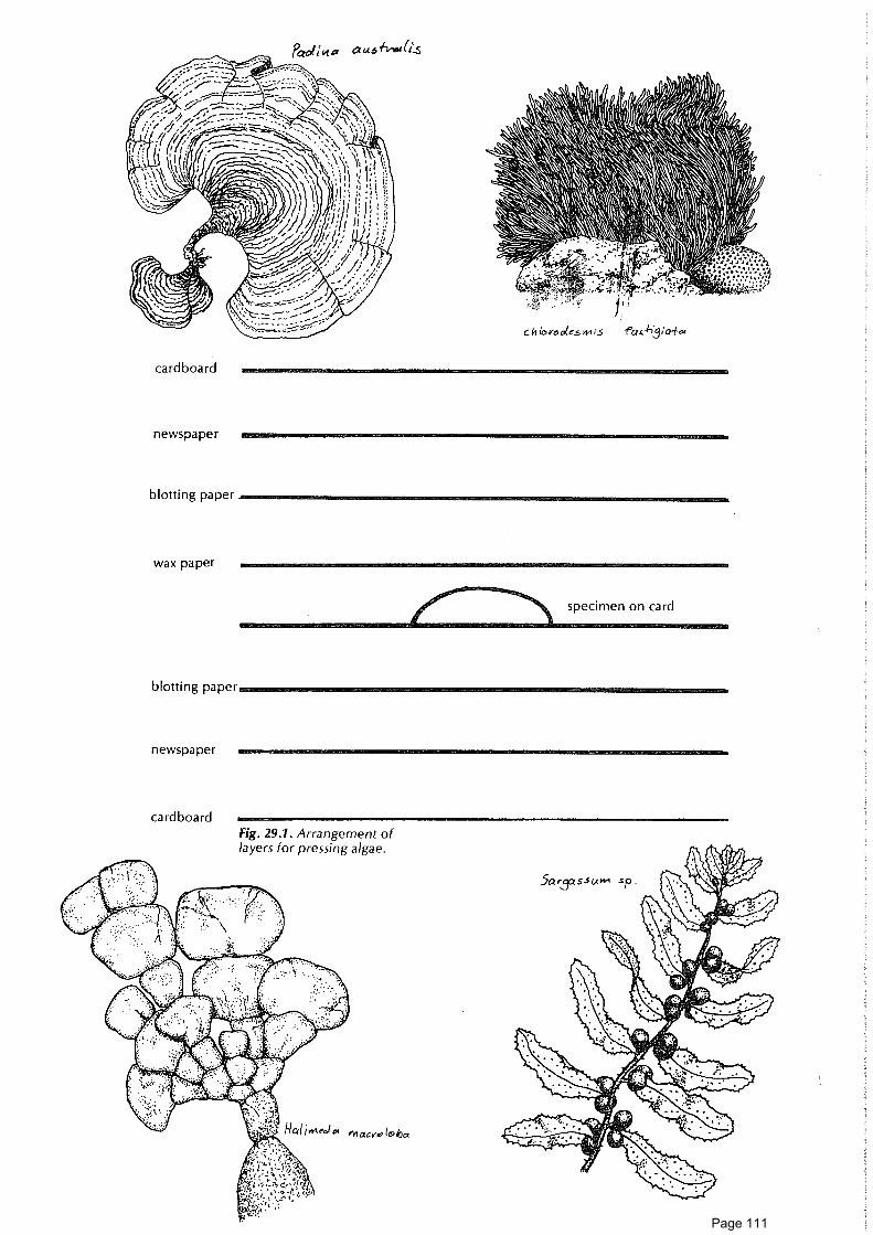
specimen on card
Fig. 29.1. Arrangement oflayers for pressing algae.
C h 10e0otes vo fa,-1-;3;a4a
cardboard
Pad u .5 (i_s
newspaper
blotting paper
wax paper
blotting paper
newspaper
cardboard
Page 111

ConceptsAlgaeSpeciesDiversityPhotosynthesisZooxanthellaeSymbiosisGrazing
SkillsObservingRecordingIdentifying
AttitudesConfidence inown abilityto observe
Interest innaturalenvironment
Aim• To investigate a number of algae species on the reef.
You will need• Reef walking gearS Reference material e.g. Cribb and Cribb (1985)This activity needs to be conducted at low tide on the reef flat.
What to do1. Walk out on to the reef flat towards the reef edge and see how many species
of algae you can identify with the aid of reference material.
2. The "pink paint" that covers much of the rubble on the reef is, in fact, algae.How many different species can you find in a few square metres? Lookcarefully at the way the algae binds the coral rubble.
Consider now3. What do you think is the role of the large algae growing on the reef in the
general reef community? What would happen to this algae if the reef grazerswere removed? Can you think of a way of testing your ideas?
4. What part do you think the "pink paint" algae play in reef construction?
5. Much of the algae on the reef is hidden within the tissues of the living coralpolyps. Take a good look at the reef: if you think about this hidden algae,how does this change your opinions on what at first may look like a"consumer-dominated" community?
Ideas for further things to do6. The algae within the tissues of the polyps are called zooxanthellae. You may
like to find out more about these algae. For instance, of what benefit is it tothe algae to live within the polyp? what is the benefit to the polyp? You maythen be able to appreciate why luxuriant, hard coral growth is restricted towarm, clear, shallow waters.
ReadingCribb, A.B., and Cribb, J.W. 1985. Plant life of the Great Barrier Reef and adjacent
shores. St Lucia: Univ. QId Press.Talbot, F. ed. 1984. Readers Digest hook of the Great Barrier Reef. Sydney:
Reader's Digest.
Page 112

31. Map an algae forest 1 hr • •
Concepts AimDiversity • To investigate the distribution of various types of algae in an area of the reef.DistributionAdaptations You will needHabitats • Measuring tape or 1-metre length of stringProducers • Markers, surveyors tape (coloured plastic tape)Photosynthesis • Graph paperSubstrata • Collecting permit and plastic bags (optional)
SkillsHypothesising What to doObservingMeasuring Part A
Recording 1. Select an area of the reef flat in shallow water at low tide where lots of
Interpreting different algae are visible.
Identifying 2. Briefly describe the substrate(s), e.g. sand, coarse coral rubble, dead coral, liveMapping corals.
Attitudes 3. Using the tape, measure out an area 1-metre square as a quadrant. Define
Interest in your square by tying coloured plastic tape to coral boulders or large clumps of
natural algae at the corners. (You would need a permit to place pegs or poles into the
environment sand or coral. Tie-on markers are less damaging.)
Persistence 4. Looking down on the squre, accurately plot the location and cover of theInitiative main types of algae on graph paper. Use symbols for different types of algae.Enjoyment of Identify algae types as you map. Give a temporary made-up name to any yououtdoor can't identify. Make a sketch for later identification or take a sample back toexperience base camp if you have a permit.
5. If one type of algae covers another, devise a method of showing this on themap.
Part B6. What do the algae feel like to touch?
7. (a) What different colours are present? Which is the most common?(b) What different-shaped structures do these algae plants have? Make
sketches of some shapes which interest you.(c) What different forms do the algae plants occur in (e.g. clumps, mats)?(d) What is the most common species of algae present?
8. Are the algae providing shelter for animals? If so, what types?
9. Is there any evidence that the algae are being grazed? What by?
10. What happens to the algae when the tide drops leaving it temporarilyuncovered? What would happen if this drop were permanent?
Questions to consider11. What do you think would happen if you put a net or cage over your area so
that no animals could enter the area?
12. What are the functions of algae on a reef?
13. What similarities and differences are there between your algae forest and theforest on the island? Draw up an illustrated chart to show this. Display at yourbase camp.
Page 113

Ideas for further things to do14. Compare algae maps from different areas on the reef flat or from different
places, e.g. reef flat, reef crest, leeward side, windward side. What differences,if any, do you observe?
15. Do the variety and density of algae seem to change as you move across thereef flat towards the reef rim?
ReadingsMather, P., and Bennett, I. 1984. A coral reef handbook. Brisbane: Australian Coral
Reef Society.Cribb, A.B., and Cribb, J.W. 1985. Plant life of the Great Barrier Reef and adjacent
shores. St Lucia: Univ. Qld Press.
liodim.ola To040
Page 114

32. Getting to know an active reef creature 2 hr
Concepts AimEcosystems * To observe a living reef creature to find out how the animal is adapted to itsAdaptation environment through its structural, functional and behavioural characteristics.Structure 9 To describe in detail the particular habitat of the selected animal.FunctionBehaviour You will needEnvironment Reef-walking gear and glovesHabitat e Pencil and notebookNiche This activity should take place at low tide.
SkillsWhat to doObserving
Recording 1. Decide on an animal you would like to find out more about. Choose a fairly
Inferring slow-moving animal.Suggested animals: hermit crab; sea hare; sea-cucumber; blue sea star; cowry
Attitudes or other large mollusc.Appreciation 2. Find it. Note its position exactly.of naturalenvironment 3. Roughly sketch its surroundings (to scale, if possible). On this sketch, mark its
Perseverence position and then map any movements throughout your observation time.
Feeling of 4. Describe the appearance of your animal. Use labelled sketches, note coloursachievement
and make measurements. Take particular care to note all the structuralfeatures of the animal which you think are important adaptations.
5. Try to find out from your observations:(a) the particular habitat or micro-habitat your animal seems to prefer(b) how it feeds(c) how it moves and its rate of movement(d) what it reacts to and how it reacts. (As a last resort only, how it reacts to
you, your shadow, your nearness, your touch.)(e) any camouflage or defence mechanisms the animal has(f) any predators it seems to have(g) any competitors it seems to have(h) whether it is solitary or whether it lives with others of its kind. How many?
6. Write up your results and display your maps and illustrations.
7. Discuss your results with reference to the needs of the animal and survival.What is your animal's niche?
Ideas for further things to do8. Try to discover the range over which your animal moves in a specific time
(hours, a day, a week).
9. You will need to put some thought into experimental design, e.g. how canyou tag your animal? How will you map movements?
10. Design the perfect predator of your animal.
11. Find out more about your animal from books and other reference material.
Page 115

ConceptsDiversity • To make a list of all the different types of animals you see on the reef flat.Classification • To classify these reef-flat animals into major groups.PhylumClass You will needSpecies • Reef-walking gear, including gloves
Skills • Notebook and pencil
Observing • Transparent viewer for looking underwater
Recording• Polaroid camera (optional)
Analysing data • Tape-recorder (optional)
Classifying • Small sheets of paper (a block of scribble paper)• Pictures of common reef organisms on a sheet for use in the field (optional)
Aim
AttitudesInterest innaturalenvironments
Interest inprocesses ofscience
What to do1. Throughout your visit, compile a list of all the different types of animals you
see on the reef flat. Common names will do.If you don't know the name of an animal, observe it carefully, sketch it, orphotograph it, or describe it into the tape-recorder. Do not collect animals.
2. Make a note of different types of habitats (living places) where you see eachtype of animal.
3. Put the information about each type of animal on a separate sheet of paper.
4. How many different types of animal did you see?
5. Now classify your animals into groups.(a) You might like to sort them into groups according to their phylum (and, if
possible, class). To do this, you will have to read up on the distinguishingcharacters of phyla and classes and identify the phylum (and class) towhich each animal belongs.
(b) Alternatively, you might want to classify the animals according to someother system, e.g., according to whether mobile (or not); feeding habits;edibility; colour; living place; or any other characteristic.
6. Arrange your sheets of paper into a booklet or make a wall display showingthe grouping you've chosen.
Ideas for further things to do7. Use pictures in the literature to try to identify as many of the types of animals
as possible. Try to apply a genus (and, if possible, species) name to each.
8. Carry out a similar roll call for the reef front (snorkelling), cay (walking) andreef crest (walking). Compare the number of types you record in theseenvironments with the number seen on the reef flat. (If there are differences,how significant is this?) Are some animals found in several of those major reefenvironments?
ReferenceMather, P., and Bennett, I. 1984. A coral reef handbook. Brisbane: Australian Coral
Reef Society.
Page 116

Classifying can be fun 2 hr + 1 hr
ConceptsPhylumClassSpeciesClassificationIdentificationBiological key
SkillsObservingRecordingClassifyingUsing literature
AttitudesAppreciation ofnaturalenvironments
Interest inmethods ofscience
Enjoyment ofoutdoorexperience
Aim• To classify common animals on the reef flat.• To devise and use a simple biological key.
You will need• A manipulative permit for in situ handling• A notebook and pencil or portable tape-recorder• Reef-walking gear• Some friends to try out your keyThis activity requires two hours in the field and about an hour at base camp.
What to doBefore your start, review safety precautions for studying reef biota.1. Find about ten different common animals on the reef flat, e.g., sea-cucumber;
clam; tube worm; sponge; fish, ascidian; crab; stromb shell; chiton; sea-urchin; coral.
2. As you find each animal, observe it carefully. Handle it gently. Do not removefrom site.
3. Make a note of some easily observable characteristics which you think mightbe useful to define the group to which this animal belongs.
4. Replace each animal where you found it.
5. Now, with your partner, sort out your notes on these animals. Consider onecharacteristic at a time and divide the animals into groups on the basis ofpresence or absence of that characteristic. Do this until each animal has aplace of its own in your system. This can be written down as a biological keysuch as the one below:
Example of a key1. (a) legs
(b) no legs2. (a) fins and scaly body
(b) no fins or scaly body3. (a) body soft, no shell skeleton or outer casing
(b) some hard parts, shell skeleton or outer casing4. (a) Elongate body with opening at other end;
not attached(b) Body not elongate; attached
5. (a) Small, translucent, jelly-like, with 1 or 2 bodyopenings at top; living with others in colony
(b) Body soft but not jelly-like; many openings in body6. Etc.
6. Now, try out your key on some friends. Give them a copy of the key and anexample of one of the types of animals you've used to make up the key. Seewhether they can use the key to identify the specimen. Amend your key ifnecessary. Trial it further to improve it.
7. Something to think about: Is the key you've made useful only for identifyingexactly the same species as you used in constructing the key? Or is it useablewith a wide range of species?
crabgo to 2fishgo to 3go to 4go to 6sea cucumber
go to 5ascidian
sponge
Page 117

Ideas for further things to do8. On the basis of your own observations and of your reading about invertebrate
groups, try to make up a key which could be used to work out which phylumof invertebrates a particular specimen found on the reef flat belongs to. Makesure you refer only to easily observable characteristics. Try out your key onsome friends.
9. As a result of reading and your own observations, produce a key to the classesof just one phylum. A good one to try would be phylum Echinodermata. Itsclasses include Asteroidea, Holothuria and Ophiuroidea. See whether the keycan be used to identify some echinodern found on the reef.
10. Using members of just one class, produce a key to its species. You could trythis for class Holothuria:e.g. red-bellied Holothuria edulis
black Holothuria atracurry-coloured Stichopus varegatusgreen Stichopus chloronotuslong, thin, striped Synapta maculata
ReferencesRosen, G., and Kelly, N. 1981. Focus on life. Sydney: McGraw Hill.Mather, P., and Bennett, I. 1984. A coral reef handbook. Brisbane: Australian Coral
Reef Society.
Page 118

35. Animal survival tricks-,..:77.7,7 11n11n11.11n1=1:=7:71M111111111•W -----'y
AimConceptsPredation • To find out by observations the methods (or adaptations) which a variety ofAdaptation different reef animals use to protect themselves from predators or toSurvival successfully "warn off" or "trick" their predators.Warningcoloration You will need
Camouflage • Usual reef-walking and/or snorkelling gearCounter- 0 Notebook or waterproofed field sheet attached to clipboard and pencilcolouring * A partner
Behaviour This activity could be spread out over your trip, so that you collect information onSymbiosis every reef walk or snorkel.
SkillsObservingInferringRecordingDiscussing
AttitudesAppreciationof naturalenvironment
Confidence inown abilityto makeobservations
What to do1. Think of all the different ways an animal might protect itself from predators or
"warn off" or "trick" its predators. Make a list and try to find at least oneanimal which fits each category. You will probably find lots you hadn'tthought of.Here are some common ones to start you off: stingray; blue Linckia sea star;brittle star; epaulet shark; turtleweed crab; gobies; nudibranch; hermit crab;cowry; flutemouth; threadfin butterfly fish.
2. Find an animal. Observe it in its environment. Watch its behaviour as well asits colour and shape. Add it to your list if you feel it's a good example.
3. Copy the field sheet example or invent your own if you prefer.
FIELD SHEET
35. Animal survival tricks
Adaptations which enable animals to avoid predation
Animal Structuraladaptation
Behaviouraladaptation
How this adaptation helps the animalto avoid its predators
Page 119

dill 36. Colour in invertebrates 2 hr •
Concepts AimDiversity • To survey the diversity of colour in a variety of invertebrates on the reef andZooxanthellae to attempt to correlate colour differences with different reef environments.EnvironmentInvertebrate You will needHabitat • Notebook and pencilCorrelation Map of reef-topRandom • Compass and measuring tapedistribution • Usual reef-walking and/or snorkelling gear
Skills This activity should be conducted at low tide.
Observing What to doRecordingMapping
1. Select an invertebrate species within which you have noticed colour variation.
Analysing 2. Some suggested species: clam (Tridacna maxima), tube worm (SpirobranchusHypothesising giganteus).
Attitudes 3. Select a segment of the reef-top to survey. This should start from the beach
Appreciation and end at the reef crest. You may decide to either count every animal on a
of beauty and li ne transect or sample over a broader area.
diversity 4. Survey your area. For each animal, record colour, position (distance frombeach) and habitat.
5. Plot colours on a map and/or use a grid or scoring system to try to discover ifcolour seems to be related to habitat or distance from the reef crest or anyother factor of the reef environment.
6. Can any conclusions be drawn? Can any correlations be made or is thedistribution random so far as you have been able to find out?
Some questions to consider7. What advantages might colour variation have?
8. Try to find out what causes the colour variation in your selected invertebratespecies.
Ideas for further things to do9. Survey other areas on different sides of the reef for comparison.
10. Is there a distinct difference between the results from the windward side ofthe island and those from the leeward side?
ReadingsGrassle, J.F. 1973. Variety in coral reef communities. In Biology and geology of
coral reefs, ed. O.A. Jones and R. Endean, vol. 2, pp. 247-70. New York:Academic Press.
McMichael, D.F. 1974. Growth rate, population size and mantle coloration in thesmall giant clam Tridacna maxima (Roding) at One Tree Island, CapricornGroup, Queensland. In Proc. of the Second International Coral Reef
Symposium, pp. 241-54. Brisbane: Great Barrier Reef Committee.
Page 120

37. Getting food 2 hr + *
Concepts AimDiversity • To observe a variety of invertebrates feeding on the reef flat so as to analyseHerbivore the relationship between the environment, the animal's way of life and theCarnivore food it eats.PredatorGrazer You will needSkills • Reef-walking gear
Observing • Snorkelling gear (optional)
Recording • Transparent viewer for reef walks
Analysing • Field sheet and pencil
Synthesising • Underwater slate (optional)• Tape-recorder (optional)
Attitudes • Camera (optional)Confidence inown powers of What to doobservation 1 Throughout the time you are at the reef, make observations of reef
Curiosity invertebrates feeding (e.g. sea anemone, sea-cucumber, crab, gastropod,chiton, clam). Observe each animal carefully and make notes on the fieldsheet (or record into the tape-recorder) about:• its habitat (a brief description)• what it is eating• how it obtains the food• type of food• whether the animal is mobile or sessile (fixed)• if mobile, how the animal moves• if mobile, an estimate of its speed. (See if you can devise a good way of
measuring speed so that comparisons between animals can be made.)
2. When you have built up a number of records, analyse the information. Canyou place any of the organisms you've observed into feeding groups such aspredator, grazer, filter feeder, scavenger. Can methods of food-getting berelated to other aspects of an organism's way of life, especially such things asi mmobility and locomotion? Can methods of food-getting be related to anorganism's habitat?
Ideas for further things to do3. You might like to get from books some more information about feeding by
animals you have seen in the field.
ReferencesTalbot, F., ed. 1984. Reader's Digest book of the Great Barrier Reef. Sydney:Reader's Digest.Bennett, I. 1981. The Great Barrier Reef. Sydney: Lansdowne.
Page 121

FIELD SHEET
37. Gettng food
Animal Habitat FoodHow
obtained
Mobileor
sessile(fixed)
Method oflocomotion
(if any) Speed
Page 122

ConceptsSizeProtozoanTestDiversityBenthosPlanktonHabitatSediment
SkillsObserving
using lensor microscope
Manipulationof smallobjects
AttitudesCuriosityPerserverenceInterest innaturalenvironments
Interest inmethods ofscience
Aim• To become aware of common types of reef-top forams and to gain some
insight into the contribution of these animals to reef-top sediment.
You will need• Permit• Sediment samples• Hand lens• Fine watercolour brush (00 sable)• Stereomicroscope if possible (and light source if available)• Petri dishes (optional)• Matchboxes or special cardboard storage trays (optional)• Rose Bengal solution (optional)
This is a solution of alcohol (70%) and Rose Bengal stain (0.1%).This activity requires up to an hour to collect samples plus another hour and a halfto study them.
Common reef animals which often pass completely unnoticed by visitorsare the foraminifera (called forams for short). These are small, single-celled organisms which, like their well-known relatives the amoebas,belong to phylum Protozoa, class Sarcodina. However, unlike the Amoebawe see moving in a drop of pond water, forams in the sea have hard shells.These shells (called tests) are usually made of calcium carbonate and theyare often very complex in structure with ornate outer surfaces bearingspikes, knobs and ridges. Most forams are quite tiny — sizes usually arebetween 0.1 mm and 2 mm. However, in some tropical environments theygrow to larger sizes and are often the same shape and size as coins. So-called star-sand, found in some reef areas, is made up almost entirely ofstar-like forams.
What to do1. (a) Collect a few samples of sediment from various places on the reef.
Suggested locations: beach, reef flat, reef rim and, if possible, reef slope.About 50-100 cc for each sample will do.
(b) Back at base, examine the sediment carefully using a microscope ifpossible. Pick out as many different kinds of foram shells as you can.
(c) How many different types can you find? Can you identify any of them?( Use reference material such as Mather and Bennett 1984 or Maxwell1968). Do the samples have different kinds of forams?
2. (a) When reef-walking, look for algae clumps to which living forams areattached. Turtle weed (Chlorodesmis fastigiata) and chain-weed(Halimeda) are two types worth inspecting. Collect pieces of the algae.Take back to base in sea water and examine.
(b) Are different type of forams attached to different kinds of algae?(c) Try to identify the forams using reference material. Make sketches of
shapes you see.(d) Can you distinguish living from dead forams? What colours do you see
among the living ones?
3. When walking on the reef rim, look in small pools and on algae turf forconfetti-like disc-shaped forams. They probably belong to the genusMarginopora. Take some back for a close look under a lens or microscope.Can you see structures in the interior of the test?
Page 123

Ideas for further things to do4. When walking on the beach look out for disc-shaped or star-shaped forams in
the sand. In some parts of the world, disc forams are used to make necklaces.
5. Look carefully at a living disc-shaped foram. What colour is its protoplasm?
6. Why do you think it is an advantage for large forams which containzooxanthellae to have a disc-like shape, rather than, say, a sphere or rod-likeshape?
7. Read some published descriptions of reef sediment (e.g., Maxwell 1968,Hopley 1982). About what percentage of reef-top sediment is derived fromforams?
8. Find out how abundant living forams are in different sediment samples byadding Rose Bengal solution. This stains the living forams red.
9. Find out something about the internal structure of a large foram by making athin section of it (see instructions below). Which is the first-formed part of theshell? How are the other chambers arranged?
10. Read to find out how forams obtain their food, and what animals eat forams.Draw a food chain which include forams.
11. The forams which live on the reef itself are benthic types. Some shells ofplanktonic types of forams can also be found on reef-tops. They are muchsmaller (typically less than 0.5 mm in size) and thinner-walled than the benthicones. Have you noticed any planktonic forams in your samples?
12. Make a reference collection of forams in a matchbox or special cardboardforam tray (see details below).
Notes on foram techniques(a) Some large reef forams can be spotted easily with the naked eye. For smaller
species or fine detail, a microscope is needed. The ideal is a stereomicroscopewith a good light source and a magnification of 40 or more. If you don't havea microscope, a hand lens will help.
(b) To search through dry sediment for forams, you need to sprinkle the sedimentthinly on something with a dark background. A petri dish resting on a blackbackground will do.
(c) Pick out the forams with the moistened tip of a top-quality, very finewatercolour brush (00 sable) or the damp tip of a needle. It takes a bit ofpractice.
(d) A collection of forams can be mounted with glue on a cardboard tray. Paintthe inside of a matchbox tray with a thin smear of glue such as gum arabic. Letthe•glue dry. When the forams are put on this with a moistened brush, theywill become attached. Other glues and solvents can be used or even double-sided sticky tape. Special cardboard trays for holding forams are availablecommercially or can be homemade.
(e) Making a thin section of a foram shell:• Choose a large foram.• Attach it to a glass slide using a smear of a clear nail varnish.• Under a stereomicroscope, grind away the top of the foram using a
roughened glass slide. (This can be prepared by roughening up a glassslide with some fine carborundum grinding powder or sandpaper.)
O When the top of the foram has been ground away, use nail varnishremover to release the foram. Turn the foram over, carefully reattach andgrind away the second side. Now you have a section which shows theinternal structure of the foram shell.
Page 124

ReadingsMather, P., and Bennett, I. 1984. A coral reef handbook. Brisbane: Australian Coral
Reef Society. (Contains photographs of Great Barrier Reef forams.)Maxwell, W.G.H. 1968. Atlas of the Great Barrier Reef. Amsterdam: Elsevier. pp.
172-76. (Contains lists and photographs of Great Barrier Reef forams.)
Further readingHedley, R.H., and Adams, C.G. 1974. Foraminifera, vol. 1. London: Academic
Press.Jell, J.S., Maxwell, W.G.H., and McKellar, R.G. 1965. The significance of large
foraminifera in Heron Island reef sediments. J. Palaeont. 39: 273-79.Murray, J.W. 1973. Distribution and ecology of living benthic foraminifera.
London: Heinemann.
Fig. 38.1 Common reef-top foraminiferaa, b Marginopora sp (x6) c Calcarina sp (x10)
d Mississippina sp (x20) e Baculogypsina sp (x8)f Elphidium sp (x20) g Spiroloculina sp (x30)
h Peneroplis sp (x12)
Page 125

3 Drifters 2 hr + • •
Concepts AimIdentification To identify some organisms that make up plankton ("drifters of the sea").
Producers • To develop an understanding of the role of plankton in marine food webs and
Consumers in life cycles of organisms, and of the part played by plankton in theLarval forms distribution of marine plants and animals.Food chainAdaptation You will needSkills
• Plankton net
Observing• Boat (optional)
Recording data• Collecting jars(s)
Collecting• Formalin (3 %) (Warning: Formalin should be handled with care)
specimens• Petri dish
Using equipment• Hand lens (20x or greater)• Stereomicroscope (if available)
Attitudes • Collecting permitCuriosityAppreciation What to doof interrelatedness 1. Collect plankton from reef waters using a plankton net. This can be done byof ecosystem towing a net either by swimming or behind a boat for 5-10 minutes (boatcomponents speed, 1.5-2 knots).
2. It is possible for you to collect more than one sample, collect plankton atdifferent times of the day from different areas of the reef, e.g. windward side,leeward side, lagoon.
3. Place each plankton sample in a labelled collecting bottle. Some material canbe looked at when fresh (fascinating!) and some can be preserved for laterstudy (use a 3 per cent solution of formalin and rinse off in sea water beforeobservation).
4. Search through samples to find different forms of planktonic life. A hand lenscan be used to begin the sorting out and identifying of various types ofplankton in a petri dish. Further examination should be carried out using amicroscope, if available.
Although plants are very abundant among plankton, they are extremelysmall. You may not be able to see them unless you are using a fairlypowerful microscope.
5. Can you pick out any plants among the plankton? What helps you torecognise that these are plants?
6. In fresh plankton, what kinds of movements can you see?
7. Use the plankton identikit (p. 000) to identify as many different types ofplankton as possible from your sample(s).
Page 126

Questions to consider8. What is the importance of plankton in ocean food chains? In particular, why
are phytoplankton (plant plankton) important? What do zooplankton eat?What are some organisms which consume plankton? Make some diagramsshowing ocean food chains or food webs which involve plankton.
9. How do the shapes, sizes and materials of planktonic organisms help them tolive a floating lifestyle?
10. Many animal species have planktonic larval stages. What might be some of thebenefits of having planktonic larvae?
11. How is the colour of ocean water related to plankton?
Ideas for further things to do12. Find out how scientists are now able to map plankton movements from
satellites. Why could this be important?
13. What would be the effect on the reef if all the plankton disappeared?
14. What could cause the death or disappearance of plankton in reef waters?
ReadingsNewell, G.E., and Newell, R.C. 1977. Marine plankton: a practical guide. London:
Hutchinson.Wicksead, J.H. 1965. An introduction to the study of tropical plankton. London:
Hutchinson Tropical Monographs.
Page 127

ORDER EUPHAUSIACEA
Euphausiid adult
39. Drifter's Identikit
CRUSTACEA
ORDER MYSIDACEA
Hemisiriella Caridean larva
ORDER DECAPODA
Zoeae larva
Megalopa larva
Phyllosoma larva
COPEPODA
Calanoid
Cirripedenauplius larva
Page 128

39. Drifters Identikit (cont.)
Page 129

ConceptsBioluminescencePlankton
Skills• Plankton net
Collecting• Boat (optional)
Observing• Collecting jar
Recording• Hand lens
Experimenting• Microscope
Identifying• Forceps
Attitudes • Photographic paperCuriosity • PermitDesire to question
Aim• To examine and try to identify reef organisms which display bioluminescence.
You will need
40. Luminous life 3/4 hr
What to do1. Go for a walk at night where the water meets the coral cay sand. Movement
over the sand can cause certain aquatic organisms at the water's edge tobioluminesce ("light up"). Try to sample these "lights" by picking them upwith forceps from the sand and placing in a collecting bottle. (Alternatively,pick up a small patch of sand which contains a light. Place in a bottle and,back in the laboratory, try to isolate the organism which was lit up.) In thelaboratory examine the bioluminescent organism and try to identify it, usingreference material. _
2. (a) Collect plankton from reef waters using a plankton net. (Refer to thetechnique in activity 39, "Drifters".)
(b) Examine the plankton sample in the dark — either by collecting at nightor using a dark room. If bioluminescence is not readily observed, shakethe plankton in the bottle.
(c) Try to identify what planktonic life bioluminesces. What phylum, class?
3. (a) Find out, by observation, something about the nature of thebioluminescence of the organisms you've collected:• Is it continuous or intermittant?• Is there a latency period, i.e., does the light go off for a period of
ti me?• How long do flashes last?• Does the light affect photographic paper?• Is the light produced any differently when the bottle is shaken?• Does the light intensity always remain the same over a period of time?
What experiment can you do to show this?(b) If a camera is available, try to photograph these flashes. (Don't use your
camera flash.)
Ideas for further things to do and think about4. Try to find out what bioluminescence is. What causes it?
5. How could bioluminescence be a survival advantage to reef organisms?
NOTEThis activity cannot be carried out during some parts of the year.Bioluminescence is not predictable.
Page 130

dill 41. Coral polyp - architect of the reef 2-3
ConceptsPolypCoralliteColonyNematocystPhotosynthesisZooxanthellaeSymbiosis
SkillsObservingRecordingAnalysingUsing literature
AttitudesInterest innaturalenvironments
Aim• To become familiar with the basic structure and function of polyps of a stony
coral.• To recognise similarities and differences between various polyp types.• To gain some understanding of the way polyps contribute to building of a
reef.
You will need• Reef-walking gear• Board, paper, pencil• Hand lens• Small plastic ruler• Transparent viewing box (optional)• Camera (optional)The fieldwork in this activity should be done over two to three hours during oneor several low-tide periods.
During the daytime, most coral polyps withdraw their tentacles and socannot easily be seen. However, a few different types of reef-top coralpolyps are extended during the daytime and can be used for this study.These are: daylight coral (Goniopora); organ-pipe coral (Tubiporamusica); soft corals (Sarcophyton and Xenia). Mushroom corals (Fungia)also often extend their tentacles during the daytime.
What to doPolyp types (fieldwork)1. On the reef flat, find a coral colony whose polyps have tentacles extended.
(Initially, find a daylight coral, if possible. This can be recognised by its long,thin polyps which withdraw quickly when you touch them. If a daylight coralcannot be found, look for organ-pipe coral or one of the soft corals. Organ-pipe coral has a red skeleton and pale green polyps.)(a) Make simple sketches showing a plan of the polyp and a side view. Give a
scale.(b) Make notes on other aspects of the polyp. How many tentacles are
visible? What other structures can you see? What sort of skeleton (if any)does it have? How does the polyp behave? What is its relationship withother polyps?
2. Locate the other kinds of coral colonies listed above and make similarobservations on their polyps.
Mushroom coral polyp (fieldwork)3. On the reef flat, look out for a mushroom coral (Fungia). This is a solitary
coral. How wide is the polyp? Where is the mouth? Is the coral attached toanything? Are the tentacles extended? What happens if a few grains of sandfall on it?
Ideas for further things to doCoral skeletons (labwork)4. Look at the skeletons of some dead stony coral colonies and try to identify the
li mestone cup (corallite) built up by each polyp in the colony. (Using a handlens or microscope is worthwhile.) What colour is the skeleton? What shape iseach coral cup? What internal structures can you see inside each corallite?What function do you think these might have? Where do you think the livingpolyp dwelt in each? Record your observations as labelled sketches.
Page 131

Nematocysts (Iabwork)5. In your laboratory at school, or in a reef research station, try to observe the
discharge of stinging cells (nematocysts) from the tentacles of a sea-anemone.(A specific collecting permit is needed if a reef animal is used.)(a) Take a clean slide and lick it (the protein in your saliva will act as a
stimulus).(b) Touch the slide to the tentacle of anemone or coral or, best of all, a
hydroid (they have very large and beautiful nematocysts).(c) Add a drop of methylene blue (a biological stain that will help you see the
structures of the nematocyst).(d) Wash off the methylene blue.(e) Place a cover slip on the slide.(f) View under high-powered microscope. Identify the following structures:
• Nematocysts consist of a capsule containing a tightly coiled and foldedthread.
• Discharged nematocyst with the threads averting.• Discharged threads of varying length, diameter and structure. They
commonly bear a formidable array of spines. Several different types ofspines may be present on a thread of a single nematocyst type.
Further questions to consider6. Table 41.1 shows a simple classification of phylum Cnidaria. The corals you
observed in the field belong to class Anthozoa. Based on your observations,which belong to the hexacoral group and which belong to the octocoralgroup?
Table 41.1: Phylum Cnidaria (All have stinging cells-nematocysts)
Class AnthozoaNo medusoid stage in life history — polyp only.
Class HydrozoaIn life history, usually analternation between free-swimming medusoidstage "jelly-fish", andfixed polyp stage.
Class ScyphozoaUsually there is onlymedusoid stage in lifehistory, e.g. box jelly-fish. Zoantharia
(hexacorals)Have 6 (or multiples of 6)tentacles.
Alcyonaria(octocorals)Have 8 branchingtentacles.
Includes groups such assea-anemones (noskeletons) andscleractinian corals (stonycorals). These corals haveli mestone skeletons andare major reef builders.
Mostly do not have hardli mestone skeletons (andso are not major reefbuilders). Includes thesoft corals and the seawhips, sea fans, sea-pensand other groups. (TwoGreat Barrier Reef speciesdo have hard, coloured,li mestone skeletons —blue in one case and redin the case of the organ-pipe coral, Tubiporamusica.)
Page 132

Xenia sp.Goecpera sp.
_...,.zer',S0
'
i'T • n-' \ '4,4.1,461
")
13.4*Me34 rlt. Is ! ''. f l'
Tur372:ora musica Sarccphyton sp.
7. Read to find out more about stony corals (Scleractinia).(a) What are the most favourable conditions for the growth of reef-building
corals?(b) Why are most corals found only in clear, shallow waters?(c) How do corals capture their food? What are nematocysts? What do they
do?(d) What causes the colour of living stony corals? Why does the colour
disappear when the coral dies?(e) What is the role of the minute algae, zooxanthellae, which live within the
tissue of reef-building corals? How do the corals benefit from thepresence of the zooxanthellae and how do the zooxanthellae benefitfrom being in the corals? Is this symbiosis?How do corals produce their skeletons?What are some natural agencies which destroy coral polyps? How canhuman activities contribute to coral damage?How do corals reproduce? What kind of sexual and asexual processes areinvolved?
ReadingsDeas, W., and Domm, S. 1976. Corals of the Great Barrier Reef. Sydney: Ure Smith.Goreau, T.F., Goreau, N.I., and Goreau, T.J. 1979. Corals and coral reefs. Scientific
American, August 1979.Great Barrier Reef Marine Park Authority, Reef Notes series: The coral polyp; The
soft touch; Coral spawning event.Jenkins, M. 1983. Seashore studies. London: Allen and Unwin.Mather, P., and Bennett, I. 1984. A coral reef handbook. Brisbane: Australian Coral
Reef Society.Sheppard, C.R. 1983. A natural history of the coral reef. Poole, Dorset: Blandford
Press.Talbot, F., ed. 1984. Readers Digest book of the Great Barrier Reef. Sydney:
Readers Digest.
(f)(g)
(h)
Page 133

dig 42. Love a coral clump 11/2 hr •
ConceptsStructureCharacteristicsCommunity
relationships
SkillsObservingMeasuringDrawingRecordingUsing references
in the field
AttitudesInterest innaturalenvironment
Enjoyment ofoutdoorexperience
Aim• To become acquainted with some coral and its associates.
You will need• Reef-walking gear• 1-metre rule or tape; clipboard and pen, or underwater slate and pencil• Map of the island and/or its reef• Pictures of common coral forms (for example, on GBRMPA leaflets)• Snorkel and mask or glass-bottomed viewing box or tube (optional)
What to do1. Select a small area or clump of coral in shallows which you can observe
several times over a few days.
2. Mark its position on the island/reef map.
3. Draw your clump, looking down on it and then looking at its side view.
4. Measure your clump: width, height from its base on sand or rubble, and itscircumference. Record these measurements.
5. Note your clump's shape, colour and feel. Using coral pictures, try to decidewhether it is made up of hard or soft coral and what the coral's name is.
6. What happens to your clump at low tide — is it exposed? Does it have somedead bits?
7. Is your coral alone or is it surrounded by lots of relatives?
8. Who uses your coral? What is it being used for? Are algae growing on yourclump? shells? worms? Are fish sheltering in your clump? Are there fish closeby? Are some creatures merely moving around your clump or resting on, orin, it?
9. What happens to your clump when you touch it? Can you see its polyps?When?
10. After getting to know your clump, consider: what made you pick thatparticular clump? are you fond of it? Make a list of some further questionsabout it which you'd like to explore.
Ideas for further things to do11. Attempt other activities in this handbook which involve coral and the
creatures which live close to it.
ReadingsBennett, I. 1981. The Great Barrier Reef. Sydney: Lansdowne.Mather, P., and Bennett, I. 1984. A coral reef handbook. Brisbane: Australian Coral
Reef Society.
Page 134

dill 43. Coral coloniesn
11/2-2 hr + 1/2-1 hr •
ConceptsCorallite To become familiar with various shapes in which coral colonies grow.Colony 0 To become aware of various ways in which coral polyps are packed togetherGrowth form within coral colonies.Asexual
reproduction You will needDiversity
Almost all stony corals are colonies of many polyps living together.Colonies differ in many ways: the overall shape (or growth form) of thecolony; the size and shape of the corallites (limestone cups in which eachpolyp lives); the way these corallites are packed within the colony.
What to do1. Go walking on the reef-top; look into pools; snorkel over the reef edge, if
possible. Which of the common colony types shown on the field sheet canyou spot? Record your sightings on the field sheet.
2. Considering the various shapes in which coral colonies grow, what do youthink might be the particular advantages and disadvantages of each shape forgrowth and survival? Think about: ability to get light (why is this important?);ability to fill space; ability to resist being broken.
3. If there are rubble piles of dead corals on beach, look at some of these coralcolonies.(a) If you had no prior knowledge of corals, but were asked to classify these
colonies into different groups, how would you go about the job in thefield? How many different colony kinds can you find?
(b) How are coral polyps packed together in each colony? For each colony,try to decide whether each surface pit was the home of one polyp orseveral. Is packing material developed between the walls of adjacent pits?How wide do you think each polyp was? Are there clear radiatingpartitions in each pit?
Further questions for you to consider4. How could people's activities affect coral colonies? Which coral colony shapes
do you think would be most easily damaged by people? Discuss ways in whichthis could be investigated by reef researchers.
5. How fast do coral colonies grow? How is coral growth investigated?
6. Do scientists consider that a particular coral species grows in only one colonyshape or not?
7. Are all the polyps in a colony the same? Do different polyps in a colonyfunction in different ways?
8. Is there any communication between the separate polyp members of a coralcolony? If so, how?
9. Coral polyps can reproduce sexually, but they can also reproduce asexually bybudding of polyps and fragmentation of colonies. Try to find out somethingabout asexual reproduction in corals.
Aim
SkillsObserving
in field
AttitudesPersistenceInterest innaturalenvironments
• Reef-walking gear (part of activity could be done snorkelling)• Board, field sheet, pencil• Camera (optional)This activity requires between 11/2 and 2 hours at low tide for fieldwork whichcould be spread over several low-tide periods, plus 1/2 to 1 hour for a study of theliterature.
Page 135

Idea for another investigation10. The genus Acropora is one of the most abundant of coral groups. Using the
literature, find out the distinguishing characteristics of the genus Acropora.Locate a specimen of branching Acropora in the field or in a laboratorycollection. Try to understand how the branches grew and how new coral cupsdevelop. What happens to the coral cup at the tip of each branch as thebranch grows?
Related studyActivity 41, "Coral polyp — architect of the reef", could be done before this
activity.
ReadingsDeas, W., and Domm, S. 1976. Corals of the Great Barrier Reef. Sydney: Ure Smith.Great Barrier Reef Marine Park Authority, Reef Notes series: The coral polyp; The
soft touch; Coral spawning event.Mather, P., and Bennett, I. 1984. A coral reef handbook. Brisbane: Australian Coral
Reef Society.Talbot, F., ed. 1984. Readers Digest book of the Great Barrier Reef. Sydney:
Readers Digest.
Ac ror Oral 9 .
Page 136

Corallitesare rounded and donot have a commonwall
A HONEYCOMBPATTERN
Corallites polygonalwith common wall.Mouth can be seenhere. Some less regularforms have severalmouths in eachdepression.
Irregular ridges and Meandering ridges.depressions. Each Many mouths can bedepression has several seen in pits.mouths.
A HONEYCOMBPATTERN
Not a colony but asingle polyp.
MUSHROOM CORALBRAIN PATTERN
STAGHORN FORMCommon on reefslope.
CLUB-LIKE FORMCommon on reef flat.
Common reef flat. Has stubby branches.
HEMISPHERE FORM KNOBBLY FORM
FIELD SHEET
43. Coral coloniesPacking arrangements of polypsWhich of these can you spot?
A HONEYCOMBPATTERN
Colony shapesWhich of these can you spot?
Page 137

44. Coral fingerprints 1-2 hr •
Aim• To learn more about the features of corals by comparing pictures of dead
coral skeletons with living and dead coral specimens.
You will need• Reference material Mather and Bennett (1984)• Underwater board and pencil• Reef-walking gear and/or snorkelling gear
SkillsThis activity can be done at both high and low tide.
Observing What to doDrawing
1. (a) When walking or snorkelling, try to locate examples of living corals whichComparing
match the patterns of coral skeletons in Mather and Bennett. Note eachAttitudes pattern as it is recognised. Sketch the living coral. Note the colours.Persistence (b) If you're not sure about a match-up, put a question mark beside theInterest in picture. Why is it often difficult to match the living coral with the picture?naturalenvironments
ReadingsMather, P., and Bennett, I. 1984. A coral reef handbook. Brisbane: Australian Coral
Reef Society.
?(ate. cora( - Acropora
ConceptsSkeletonCoralliteSpeciesGenusSeptumPolypDiversity
2. (a) On the beach or reef-top, or perhaps in a museum display, look out forskeletons of dead coral which match the pictures in your referencematerial. Once again make a note if you make a match.
(b) Is it easier to match pictures with dead coral specimens than with liveones?
3. At your base camp, make a display of any sketches you've made.
4. Make a list of the pictures for which matches have been found on the reefyou're visiting. Which species has been most commonly found?
Ideas for further things to do5. Find out the meaning of the following two words related to coral skeletons:
corallite, septum. What function does the septum perform?
6. Whereabouts in the corallite does the coral polyp live?
7. Learn the distinguishing characters of four genera of corals.
Page 138

AI 45. Microatolls 2 hr • •
ConceptsColonyMicroatollTideReef rimChange
SkillsObservingMeasuringRecordingInferringPredictingCooperatingwith others
AttitudesInterest innaturalenvironments
Interest inprocesses ofscientificenquiry
Aim• To study shapes and structures of reef-flat microatolls and to consider how
these are related to environmental conditions on the reef flat.
You will need• Reef-walking gear• Paper and pencil• Camera (optional)• Measuring tape• Measuring rod, 1 metre in length, marked into 2cm lengths• Watch
Early scientists gave the name microatoll to ring-shaped coral coloniesthey saw growing on some reef flats. The reefs on which microatolls formhave a reef rim which acts like a "dam" at low tide: the "dam" holds back ashallow pool of water on the reef flat. This pool is sometimes called a"moat".
What to do1. Find a microatoll on the inner reef flat.
(a) Make a sketch of the microatoll. How wide is it? How high is it above thereef floor?
(b) Which part of the microatoll consists of living coral? What do you thinkwill happen to the microatoll as the coral grows?
(c) Why do you think the top part of the microatoll is dead? Do you think themicroatoll will grow any higher? If not, why? (Hint: Think about the effectof tides here.)
(d) Is the centre part of the microatoll dead? If so, why?(e) Are there some younger microatolls forming in the centre of the main
microatoll?
2. Find some other microatolls:(a) Are all the microatolls made of the same kind of coral? If not, how many
types of corals are forming microatolls here? Make a simple description ofeach kind.
(b) Make sketches (with a scale) of some different shapes and sizes ofmicroatolls you see. Photograph them if you have a camera.
3. (a) Working with a group, close to anticipated low tide, keep a close watchon the height of water over a number of nearby microatolls as the tidefalls on the reef top. Using a measuring stick, measure the distancebetween the water surface and the top of the living coral on themicroatolls. (Everyone doing this should make the measurements atexactly the same times, agreed on beforehand. Measurements should betaken about fifteen minutes apart.)
(b) At the lowest level reached by the water, is the water surface so low thatthe living coral is exposed? If not, how close does the falling water surfacecome to the living coral? If so, how much below the upper edge of theliving coral does it fall?
(c) At the microatoll you're observing, is the upper edge of the living coral allat the same level? How can you find out?
Page 139

Page 140

14
SIDE VIEW TOP VIEW
(A) TOP HAT MICROATOLL
DEAD SURFACE
r
12
LIVING TISSUE
(B) UP-GROWN MICROATOLL
CENTRE LINE
ALL MEASUREMENTS IN CENTIMETRES
Fig. 45.3. Unusual microatoll types.
Page 141

(d) Compare your results with those from other microatolls.• Is there a similarity between the results for all the microatolls?• If not, is there a similarity between the results for microatolls of one
particular type of coral?• If several microatolls give similar results, does this mean that their tops
are at the same level as one another?• If the tops of microatolls in your group measurements are at the same
level as one another, what is the likely cause of this? How do youthink microatoll height is connected with water level?
4. Make a diagramatic sketch to scale showing your results from 3(a)
Ideas for further things to do6. Changes to the height of the "dam" around some reefs are thought to affect
microatoll growth. Several types of unusual microatolls are illustrated in figure45.3 and descriptions of their formation given (Hopley 1982).(a) In figure 45.3, match the description given to each diagram.Which of the two kinds of microatolls matches up with each of thedescriptions on the next page:
• If level of water "dammed-up" on a reef-top rises, then the living rimof the microatoll may begin to grow upwards and perhaps inwards.
• If the level of water "dammed-up" on a reef-top falls then the upperpart of the microatoll will die and further growth will be at a lowerlevel.
(b) Look around on your reef-top. Do either of these unusual microatolltypes occur here?
7. At Heron Island some years ago, breaching of the reef rim to form a harbourled to a slight lowering of the level of dammed-up water on the reef flat atlow tide. What effect do you think this might have had on reef-flat coralcolonies? If you are visiting Heron Island, try to find out what happened.
ReadingsHopley, D. 1982. The geomorphology of the Great Barrier Reef. New York: John
Wiley.Jell, J.S., and Flood, P.G. 1977. Guide to the geology of reefs of the Capricorn and
Bunker groups, Great Barrier Reef province, with special reference to HeronReef. Dept. Geology, Univ. Qld, Papers 8(3).
Scoffin, T.P., and Stoddart, D.R. 1978. The nature and significance of microatolls.Phil. Trans. R. Soc. Lund., B284: 99-112.
Page 142

46. Corals in space 2WEE=EIMMffEMINIMEL--1 1111=11M11111111111111C-_
ConceptsCompetitionResourceIntraspecificInterspecificInteractionAggression
SkillsObservingComparingAnalysing
AttitudesInterest inmethods ofscience
Interest innaturalworld
Persistence
Aim• To explore spatial relationships and interaction between coral colonies as they
grow to occupy space on a reef.
You will need• Reef-walking gear• Camera (if possible)• Plastic rule (approx. 30-40 cm)This activity requires about two hours at low tide on the reef flat. Yourobservations could be continued on the reef slope by snorkelling or looking outfrom a coral-viewing boat.
When we see corals growing near one another on a reef top we can askourselves whether they are friendly neighbours or whether they arecompeting fiercely with one another? If they are competing, what resourceare they competing for? Can we see signs of their competition? How dothey compete? Who wins?
What to do1. Before you start your fieldwork, look at the list below of some conditions
needed by corals to survive and grow. Why are each of these important to acoral?
• Supply of small animals• Supply of dissolved oxygen• Supply of light• Water currents• Space
Studies carried out on corals have shown that corals do compete with oneanother in seeking resources. Some have mechanisms which help them toprevent others taking over space on the reef and thus from gettingexposure to water currents and needed resources such as light and food.Some hint of such struggles can be seen on the reef flat by looking at thespatial relationships of adjacent coral colonies.
2. When walking on the reef top or when snorkelling on the reef slope, lookcarefully at places where coral colonies come close to one another or growagainst or over one another.
Look for the following kinds of relationships:(a) Encrusting: one coral colony growing over and encrusting another.(b) Overtopping with deep shade: one coral colony spreading out over another,
strongly shading all, or part, of it.(c) Overtopping with light shade: one coral colony filling in space over another,
but without much shading.(d) Close approach: two coral colonies coming very close to each other but
"keeping their distance" so that there is a narrow gap of uniform widthbetween the two.
(e) Intergrowing: the branches of one coral colony intergrowing with those ofanother.
Make some sketches or take some photos to illustrate each of these types ofspatial relationships.
Page 143

3. Consider the different kinds of spatial relationships you have observed. Fromthese spatial relationships, what can you tentatively infer about ways in whichthe adjacent coral colonies might be possibly affecting each other in eachcase. Make a list of your ideas.
Ideas for further things to do4. When any two particular kinds of corals are adjacent to each other, do they
always display the same kind of spatial relationship? Does one of the twoalways seem to win against the other? Design (and if possible, try out) a fieldobservation project which would help you to answer these questions.
5. By field observation, try to find out more about close-approach relationships.What kinds of corals participate in such relationships? Are the distances alwaysthe same? Does the distance depend on the types of corals involved?
Research studies by scientists have shown that corals can actively attackother corals using the stinging cells in their ordinary tentacles, strongstinging cells in long sweeper tentacles, digestive filaments which aresent out from one coral to digest the soft part of the other coral, or by useof poisons. Different types of corals tend to use different methods; aspecies strong in one method may be less strong using other methods.Scientists studying aggression among corals have recognised a sort ofhierarchy or "pecking order", although factors affecting which coral winsare complex.
6. Find more about some of the mechanisms by which coral colonies competewith each other for space. Read Talbot (1984) pp. 95-132, Endean (1982) pp.209-11, Sheppard (1983) pp. 73-76, and Done (1983) p. 136.
7. Carry out reading or field observation on the way other sessile (fixed) marineorganisms, such as sponges, compete with each other for space.
8. What about fixed organisms which live on land? See if you can find out howsome of these compete with each other for space.
ReadingsEndean, R. 1982 Australia's Great Barrier Reef. St Lucia: Univ. QId Press.Done, T. 1983. Coral zonation: its nature and significance. In Perspectives on coral
reefs, ed. D. J. Barnes. Canberra: Clouston/Aust. Inst. Marine Science.Sheppard, C..R. 1983. A natural history of the coral reef. Poole, Dorset: Blandford
Press.Talbot, F., ed. 1984 Reader's Digest book of the Great Barrier Reef. Sydney:
Reader's Digest.
Some further specialised readingsConnell, J.H. 1973. Population ecology of reef-building corals. In Biology and
geology of coral reefs, ed. 0. A. Jones and R. Endean, vol. 2, pp. 205-45. NewYork: Academic Press.
Lang, J. 1973. Interspecific aggression by scleractinian corals. Why the race is notonly to the swift. Bulletin of Marine Science 23: 260-79.
Sheppard, C.R. 1979. Interspecific aggression between reef corals, with referenceto their distribution. Marine Ecology — Progress Series 1, pp. 237-47.
Potts, D.C. 1976. Growth interactions among morphological variants of the coralAcropora palifera. In Coelenterate ecology and behaviour, ed. G. 0. Mackie,pp. 79-88. New York: Plenum.
Page 144

gill 47. Growth forms - corals and algae 1-1 3/4 hr
ConceptsGrowth formSpeciesGenusIntraspecificvariation
Interspecificvariation
AlgaeCoralColony
SkillsObservingComparing
AttitudesI nterest innaturalenvironments
Curiosity
Aim• To explore some ways in which the growth form of a plant or animal is
affected by its environment.
You will need• Pencil and recording sheetO Reef-walking gear• Snorkelling gear (optional)For this activity, about 1 1/2 hours on the reef at low tide is required, plus about 1/4hour on land.
We are all familiar with the idea that the form in which a particular type ofplant grows is partly influenced by its environment. For example, if youtake two garden shrubs of the same species and grow them in differentplaces, they may end up looking quite different, depending on how muchsunlight, wind or water they get and what sort of soil they are growing in.Not only may the overall size and shape of the shrubs differ, but theleaves may be of different size and the spacing of branches different. Oneshrub may, for example, end up looking compact, and the other may lookquite straggly.
What to do1. Look at some plants on the cay:
(a) Can you find a case where, within an individual plant, there are two ormore growth forms? (Look, for example, at a grass plant with long runnersgrowing partly in shade and partly in the sun).
(b) Can you find two plants which are of the same species but which havedifferent growth forms?
(c) Make some sketches of your observations.
2. Go walking on the reef flat. Look for plants of the alga sea grapes (Caulerparacemosa) growing partly in sunlight and partly in deep shade (e.g. beneath acoral colony).(a) Find out whether the shaded parts of a plant have a different growth form
from the parts of the plant growing in full sunlight. Follow the longrunners from shady to sunlit areas.
(b) Describe any variation you see within individual plants. Make sketches ofyour observations.
3. (a) Look at some large colonies of coral on the reef. Look both on the reefflat and the reef crest. Does the growth form of the coral appear tochange within one colony? For example: Is one part of it flat and sheetlike, whereas another part of it has branches? Does one part of it have aclosely spaced, compact branching form, and another part straggly openbranches? Make notes on your observations and draw some sketches.
(b) You could also make similar observations while snorkelling or looking atthe reef slope from a "submarine".
Page 145

Questions to consider4. If someone handed you several broken-up bits of a particular coral colony, or
of a sea grapes plant, and if the pieces each displayed different growth forms,do you think you could be misled into thinking they came from differentspecies of coral or algae?
5. Based on what you have seen in this study, do you think that growth form is avery reliable guide to deciding whether two different specimens of coral orsea grapes belong to the same species?
For many years, scientists have found it hard to decide which coralcolonies belong to which species. They often have had difficulty decidingwhether two corals with different growth forms belong to different species,or to the same species. Recent studies, however, indicate that one speciesof coral can grow in many different forms — depending on environmentalconditions (see Talbot 1984, pp. 125, 127, 129).
Ideas for further things to think about6. What is meant by the terms "intraspecific variation" and "interspecific
variation"?
7. Think about the following aspects of intraspecific variation in humans. Whichare influenced by environment, which by inheritance, which by both?
skin colour; eye colour; body height; body weight.
8. Read literature to find out the types of coral features which are used todistinguish one genus and species from another.
ReadingsCribb, A.B., and Cribb, J.W. 1985. Plant life of the Great Barrier Reef and adjacent
shores. St Lucia: Univ. Qld Press.Mather, P., and Bennett, I. 1984. A coral reef handbook. Brisbane: Australian Coral
Reef Society.Talbot, F., ed. 1984. Reader's Digest book of the Great Barrier Reef. Sydney:
Reader's Digest.
rU' it Co v•oc , -)J rac..14xos
Page 146

el
, •
.:... ,- .c. j: ,,, ;....••=—N-...-......._., . -.i ., , ...., ,,,,, .•-•^.'s .: • ' 1. : .-4.-.-----.`-'-1 -1 .
ConceptsHabitatAdaptationNicheEcologyPhotosynthesisZooxanthellae
SkillsAnalysingComparing
AttitudesInterest indiversity ofliving things
Aim• To make some comparisons between the form, function and roles of corals
and those of trees and other land plants.
You will need• Pen and paper• Basic reference material on biology and reef life.
People who see the underwater scenery of the Great Barrier Reef areoften reminded of beautiful gardens; many favourite reef snorkelling spotshave been named "coral gardens". Whereas the main scenic features inthe underwater "gardens" of the reef are corals, in land gardens it is oftentrees and shrubs which are the outstanding features. From a biologicaland aesthetic point of view, what similarities and differences existbetween corals and trees?
What to doThrough discussion with others, by reading books and other literature and, ifpossible, by making your own observations of coral and trees, answer thequestions below.
1. Corals and trees have many different growth forms. By looking at pictures orby looking at living trees or corals, make sketches of some different shapes inwhich corals and trees grow.
2. Try to find out by reading: About how high are the tallest trees? How fast dotrees grow? What is the biggest coral colony you can find out about? How fastcan the branch of a coral grow?
3. From each of the alternatives shown in the left-hand column of table 48.1choose one which best fits a staghorn coral colony and a tree.
- ..k-A•"-- 4:ixv44w•....,.„,k..- ,-,. :- --..d3::-.%... ..,--,,*$:., •,-....,. ..., . •.ft4cz-k.t?`,4::-:r̀•----;-, :-?,i,.. •...--
Co — Ada. 3p
Page 147

Table 48.1
Staghorn coralcolony Tree
Animal/plant
Fixed/mobile
Single organism/collection of many organisms
Material in which itlives: air and soil/water
Has a rigid skeleton of:calcium carbonate/woodand cellulose
Animals which live inits branches:fishes/birds
Animals which eat it:fishes/birds
4. For both staghorn coral and a tree, answer the questions below:(a) Does it take in any material from the floor to which it is attached?(b) Does it capture other living things to eat?(c) Does it make all its own food?
5. Write a brief description of the following:• Coral polyp• Leaf• Photosynthesis• Nematocyst• Chlorophyll
6. Why do trees need light? Why do they tend to grow upwards and spread out?
Although the polyps of reef-building corals are animals, they harbourwithin their tissues many minute single-celled green plants calledzooxanthellae. These algae carry out photosynthesis. The relationshipbetween coral polyps and the algae is symbiosis. Both parties benefitfrom the relationship. The coral polyp, as well as capturing living thingsusing the stinging cells on its tentacles, also derives some food materialfrom the photosynthesis of the zooxanthellae. It is helped by the algae togrow its calcium carbonate skeleton at a rapid rate.
7. Reef-building corals grow only in well-lit areas of the sea. Based on theinformation given above, why do you think this is the case?
8. Make a sketch of a coral colony growth form which allows the colony toreceive much light.
Page 148

Ideas for further things to do and think about9. Both trees and living corals are brightly coloured. Try to find out what causes
the colouring in each.
10. In some species of corals, the way the colony grows is affected by watermovement. Branches tend to grow aligned somewhat parallel to current orwave direction. Can you think of a way in which moving air affects the growthof a tree?
11. What destructive effects do storms have on trees and corals?
12. Many trees and corals are able to carry out asexual reproduction. Try to findout how this happens.
13. Both trees and coral colonies are hosts to many small invertebrate animals.What are some of these? How do they affect the hosts?
14. On some trees in rainforests, epiphytes such as staghorn ferns grow. Considerthe relationship between a staghorn fern and the tree on which it grows. Howdoes this compare with the relationship between coral polyps andzooxanthellae?
15. Scientists have found that some reef-building corals are able to grow well inlower light intensities than others. Think about a rainforest. Do all green plantsrequire the same light intensity? What are some green plants which do well inlow light intensities?
16. Coral colonies and trees can interfere with the growth of neighbouring coralsor trees. Find out some methods by which this happens.
ReadingsTalbot, F. 1984. Reader's Digest book of the Great Barrier Reef. Sydney: Reader's
Digest.Sheppard, C. R. 1983. A natural history of the coral reef. Poole, Dorset: Blandford
Press.Jones, O.A. and Endean, R. 1973-1977. Biology and geology of coral reefs. VoIs 1-4.
New York: Academic Press.Goreau, T. F., Goreau, N.I., and Goreau, T.J. 1979. Corals and coral reefs. Scientific
American, August 1979.
Page 149

49. Worm watching 1 hr
ConceptsDiversityAdaptationHabitat
SkillsObserving • Underwater slate and pencil.
Recording * Worm identikit• Snorkelling gear (optional)
Attitudes o Hand lens
Aim• To become aware of diversity among reef-top worms and to recognise some
different adaptations possessed by worms.
You will need
CuriosityPatienceInterest innaturalenvironments
What to do1. Start at the beach and walk slowly out through the inner sand zone to the reef
crest looking carefully for worms along the way under boulders, in crevices, inalgae clumps or in coral colonies. Be careful to return all boulders to theiroriginal position.
2. When you find a worm, look carefully at it for at least three minutes. Answeras many of the following questions as possible:(a) Where does the worm live?(b) Does the worm move about from place to place or is it more or less fixed
in the one location?(c) Is the worm flat and leaf-like in shape without segments or does it have a
long segmented body, or some other shape?(d) Does it have any bristles, legs, feathery gills or other appendages?(e) What sort of movement does it make?(f) How does it react to stimuli?(g) Can you see its head? What is the shape of the head? Where is the
mouth?(h) How do you think it might get food and oxygen? What colour is it? Is the
colour a means of camouflage?
3. Try to identify the worm using the identikit.
4. Now make a detailed ,,ketch giving a scale.
5. Repeat your study and information collection for other worms.
6. Compile your information, read some literature on worms and write a shortreport on your observations.
WarningSome worms have bristles which are extremely irritating if handled. Do not pickup worms.
Page 150

FIELD SHEMT
Worm !cE rtait
Page 151

50. Clams big and beautiful 2 hr
Aim• To become familiar with some clam features.• To record the distribution and variety of clams on a reef top.• To explore possible reasons for clam distribution.
You will need• Hand click counter or notebook• Paper and pencil or portable tape-recorder• Magnetic compass• Plastic ruler• Stopwatch• 5 m length of rope
What to do1. Select a distinctive landmark at the edge of the island and from this, walk out
across the reef-top to the reef crest. Use a compass and walk on a constantcompass bearing. Afterwards, plot the line of your traverse on a map.
2. As you walk out along the traverse, you will need to:(a) Keep a count of the distance you are from your cay landmark. (That's
what the rope is for.)(b) Click or count the total number of clams.
Record a clam if it is less than 1 metre from your transect line.
3. When you come to a clam stand back while you record its size, mantle colour,distance from shore and whether it is embedded in the coral or not. Thenmove so your body shadow falls across the clam. Time how long the clamtakes to close. Are the shells still slightly apart? If so, measure distance apart.(Be careful!)
4. If you think there are several species of clam present, code your results with adifferent symbol for each.
5. Do a similar transect from another point on the island, i.e., one on thewindward and one on the leeward side of the reef.
6. You could now use your data to estimate:(a) The average density of clams on the reef.(b) The ratios of different colours of clam.
If you think there is more than one species present, you could do thesecalculations separately for each species.
7. From your results, can you see any regular patterns or trends in thedistribution of clams on the reef-top, or in the distribution of particularcolours of clams?
8. Can you put forward any hypotheses about why clams are distributed the waythey are on the reef-tor.
Ideas for further things to do9. Try to find out what causes the colours in the clam mantles; how fast a clam
grows; how clams reproduce.
10. Make a histogram showing frequency of sizes and classes of the clams you'veseen.
ReadingMcMichael, D.F. 1974. Growth rate, population size and mantle coloration in the
small giant clam Tridacna maxima (Roding) at One Tree Island, Capricorngroup, Queensland. In Proc. of the Second International Coral ReefSymposium, pp. 241-54. Brisbane: Great Barrier Reef Committee.
ConceptsDiversityDistributionAdaptation
SkillsHypothesisingMeasuringIdentifyingRecordingInterpretingEnquiring in ascientificmanner
AttitudesPersistenceCuriosityAppreciation ofqualities ofnaturalenvironment
Page 152

FIELD SHEET
50. Clams big and beautiful
Recorder: Island•
Landmark on island:
Compass-bearing along transect: Weather .
Distancefromshore (m)
Speciescode(optional)
Cumulativetotal Colour Size
Time takento close
Distancebetweenclosedshells
Page 153

51. Homing chitons? 2 hr +
ConceptsHerbivoreConsumerHoming
SkillsObservingMappingRecordingDesigningexperiments
AttitudesPersistenceCuriosityDesire toquestion
AimO To investigate behaviour of chitons on beach rock
You will needO Tubes of artists acrylic paintO Fine-hair paintbrushO Magnetic compassO RulerO Polaroid camera with flash unit (optional)O Waterproof, coloured plastic tapeO Notebook or clipboard and sheet, and pencilO PermitThis activity requires at least two hours in total, at various times during your trip. Itis best done at low tide after nightfall.
What to do1. Locate five chitons on the beach rock.
2. Identify each one by painting a very small dot on a shell segment. On the firstchiton, paint the dot on the first segment; on the second chiton, put the doton the second segment, and so on.
3. Make a precise record of the initial location of each specimen. Take compassbearings on obvious features to locate accurately where the chiton is, andmap its position on a sketch or an instant photograph. Waterproof tape couldbe tied to the beach rock to further identify the site.
4. Record movements only of the marked chitons which take place while youwatch.
5. Look at some chitons to find out:(a) how chitons move,(b) whether there are any signs of grazing off the algae which grows as a film
on the rock,(c) what happens when water splashes on to a chiton,(d) whether you can easily move a chiton.
6. Return to the site after one or two hours and at the next low tide to find outwhat has happened to the marked chitons. Can you find five marked chitons?Is each one in the same place? Have any disappeared? How far did eachmove?
7. Return to the site for as many low tides as possible, noting differences, if any,in positions of marked chitons.
Questions to consider8. Do chitons graze and move only at night?
9. Do you think each chiton has a "home base"? If so, does the chiton stay nearits home base?
Some further things to do10. Devise other experiments to find out more about chitons and their
movements.
Page 154

4 52. Looking at Linckia
ConceptsWarning colorationTube feetAdaptationHabitat
SkillsObservingRecordingExperimenting
AttitudesAppreciationof naturalenvironment
Curiosity
Aim• To observe the large blue sea star Linckia and to develop an understanding of
how this particular reef animal is adapted to its environment.
You will needO A notebook or waterproof sheet attached to a clipboard; a pencil* Ruler or tapeO Watch* Sheet of clear perspex about 30 cm square* Usual reef-walking gear
What to do1. Find a blue sea star on the reef flat at low tide.
2. Observe carefully and sketch the animal.
3. Make some measurements, e.g., total diameter, length of longest arm.
4. Gently pick up the sea star. As you lift it, quickly check beneath to see if itsstomach is everted. If so, take note of what the animal was feeding on.
5. Place the sea star on the perspex and splash it gently with sea water a coupleof times.
6. When the animal has relaxed, look at it from underneath the perspex. Try towork out how the tube feet are operated and how they are rotated. Howmany tube feet does it have? Can you see its mouth? Put a small piece ofbread, fish or algae under one arm. What happens?
7. Time how long your sea star takes to "walk off" the perspex. Can you workout its speed?
8. Gently turn the sea star on its back in water. Watch how it turns itself over.How does it do it? Time how long it takes. Be patient. Remember that theanimal is extremely vulnerable in this position, so do not leave before it hasturned itself right over.
9. Is Linckia easily seen on the reef? Why? How do you think this might help it tosurvive?
10. Describe the habitat of this animal.
11. Discuss what you consider to be this animal's major adaptations to enable it tosurvive in this part of the reef.
Ideas for further things to do12. Consider populations — how many Linckia live on a particular section of the
reef?Select a manageable study area. Decide whether to do a total count or whetherto sample one area and estimate total numbers. Make a careful census of thepopulation within an easily distinguished area. Your results can be comparedwith other people's results over time and we may be able to see whether thepopulation is static, whether it changes seasonally, or whether it is decreasing orincreasing.
13. Find out more about blue Linckia from books or other reference material.
Page 155

ConceptsAdaptationMorphologyHabitat
SkillsObservingRecording
AttitudesCuriosityAppreciationof naturalenvironment
Aim• To spend some time with a sea-cucumber so as to learn as much about its
structure and behaviour as possible.• To make observations concerning the habitat and population density of these
kinds of animals.
What to do1. Find somewhere comfortable in the water on the reef-top with a
sea-cucumber.
2. Now make careful observations of your animal for at least 5-10 minutes. Try todiscover:(a) its main external features — mouth, anus, tube feet, etc.(b) how it feeds(c) how it moves(d) what it reacts to and how it reacts(e) how it uses camouflage or defensive mechanisms(f) how it reacts to other sea-cucumbers around it(g) how it reacts to you.
3. Now look around you:(a) Are there other sea-cucumbers of this kind about?(b) Is there a particular habitat this type of sea-cucumber seems to prefer?(c) Make a rough estimate of the population density of this type of sea-
cucumber: about how many are there per square metre?
4. From your observations, why do you think sea-cucumbers are called "vacuumcleaners of the reef"?
5. Read literature to find out more about the biology of holothurians(sea-cucumbers).
6. Make up a report on "My Experiences with a Sea-Cucumber" and give athree-minute talk based on it to members of your group.
If4 MeiabsiVi,
Page 156
54. Cucumber count 2 hr +1 hr • •
ConceptsPopulationdistribution
AbundanceHabitatAdaptationCompetitionNicheSustainable
yield
SkillsObservingCollecting and
recording dataSynthesising dataHypothesising
AttitudesAppreciation of
naturalenvironments
Confidence inmakingobservations
Interest in methodsof science
Aim• To estimate the size and density of the sea-cucumber (holothurian)
population of the reef-top.• To gain an appreciation of the part sea-cucumbers play in the reef ecosystem.
You will need• Reef-walking gear and possibly snorkelling gear• Underwater board, waterproof field sheet and pencil• Reference material• Measuring tape or cord (20 m) (optional)• 1-metre string, or metre stick• Map or air photo of reef• Ruler• Transparent graph paper (optional)
This activity requires about two hours at low tide for fieldwork and about onehour for follow-up work.
PRECAUTIONSAvoid touching eyes after handling sea-cucumbers. Material from theseanimals may irritate the eyes.
What to doGathering data (field work)1. Divide into small groups (about four people per group). Each group is to
make a transect at low tide across the reef-top from beach to reef crest,counting sea-cucumbers.
(a) Each group should select a starting point which is recognisable on a mapor air photo, take a compass bearing to the reef crest and walk along thisbearing.
(b) Use a knotted cord or measuring tape as the transect line, or measure thetransect line using paces.
(c) At sample points every 20 metres along the transect line, count all the seacucumbers in a 4-square-metre area (you could conveniently do this bylooking at a 2-square-metre area on either side of the transect line at eachof your sample points). If you can, decide what species the sea-cucumbersbelong to by referring to reference material.
(d) Record the information on the field sheet.
Analysing data2. Work out the average number of sea -cucumbers (all kinds) per square metre
on the reef-top.One way this can be done is to combine the totals from each station on yourtransect and divide this by the total number of square metres sampled.
3. Make an estimate of the total number of sea-cucumbers on the reef flat andreef rim.(a) Use a map or air photo to work out the total area of the reef-top (not
including lagoon, if present). (A grid such as transparent graph paper willhelp you do this.)
(b) Use the value obtained in (2) for the average number of individuals persquare metre. Multiply this by the total area of the reef-top (excludinglagoon).
4. Work out the relative numbers of the various species of sea-cucumber. (Listthe names of the species in order of abundance. Express the relativeabundance as a ratio.)
Page 157

Questions to consider5. Do you think that the method used to calculate the average number of sea-
cucumbers per square metre is valid? If not, how could the method have beeni mproved?
6. (a) Look at your transect data. Does the population density of sea-cucumbersseem to be different in different zones of the reef-top (inner reef flat,outer reef flat, reef rim, etc.)? (You could make a graph showing the totalnumbers of sea-cucumbers obtained at each station along the transect.)
(b) Look at the transect data obtained by other groups. Is there any differencebetween sea-cucumber population density on the windward and leewardsides of the reef?
(c) If sea-cucumber population density is not the same on different sides ofthe reef or in different reef-top zones, what factors might contribute tothis?
7. (a) Select two common sea-cucumber species, e.g. the "curry" cucumber(Stichopus variegatus) and the "knobbly" cucumber (Stichopuschloronotus).
(b) Examine the distribution data for each.(c) In which zone of the reef-top is the population density of each species
least? greatest?
8. According to research studies reported by Bakus (1973), an individual sea-cucumber might take in as much as 100 grams (estimate) of sediment eachday. Let's assume an average intake rate per individual of 30 grams per day.How much sediment might be taken in annually by all the sea-cucumbers onthis reef-top?Try to design an experiment to find out what sedimentary material they aretaking in and what they are actually using from it?
9. What factors, natural and human-influenced, might cause a population of aspecies of sea-cucumber on a reef-top to fluctuate from time to time? Howcould this fluctuation be identified?
Sustainable useWhen humans harvest living things, it is important to safeguard futureproduction by ensuring that annual harvest size is not too great. Theterm "sustainable use" refers to the conservation practice of using aliving resource at a level which allows the supply of the resource to bemaintained indefinitely into the future.
10. In the past, fishing of some sea-cucumbers (called beche-de-mer or trepang)took place on many reefs in the Great Barrier Reef area. Suppose someonewanted to carry out beche-de-mer fishing now at a particular reef. Reefmanagement authorities would have to decide whether this would beallowed. How do you think they could determine whether the proposedfishing activity would be detrimental to this reef and whether, and how, itcould be carried out on a sustainable use basis? Are there other factors whichyou think should be taken into consideration in deciding whether theproposed fishing should be allowed to go ahead? What kind of informationdo you think the reef management authorities would ideally like to haveavailable to them before they have to make a decision like this?
Other studiesRelated studies which could be done before this are activity 32, "Getting to knowan active reef creature", or activity 53, "Cucumbers are cute".
ReadingsBakus, Gerald. 1973. The biology and ecology of tropical holothurians. In Biology
and geology of coral reefs, ed. 0. A. Jones and R. Endean, vol. 2. New York:Academic Press
Page 158

FIELD SHEET
54. Cucumber countSta-tionno.
Metresfromshore
Zone of reefe.g. reef flat,
reef rim
Total sea-cucumbers
present
No. of eachspecies, e.g.A = 24, C = 3
Sta-tionno.
Metresfromshore
Zone of reefe.g. reef flat,
reef rim
Total sea-cucumbers
present
No. of eachspecies, e.g.A = 24, C = 3
1 21
2 22
3 23
4 24
5 25
6 26
7 27
8 28
9 29
10 30
11 31
12 32
13 33
14 34
15 35
16 36
ISLAND/REEF: LOCATION OF TRAVERSE:Starting point:
Bearing:
DATE: PEOPLE IN GROUP:(Initials)
CALCULATIONS:Total no. sea-cucumbers counted Total area of reef-top (including lagoon)
m2
Total area of reef sampled onthis traverse
m2
No. of sea-cucumbers on thisreef-top (excluding lagoon)
m2
Average no. of sea-cucumbersper metre 2 on this traverse
If sediment consumption each day = 30g,total amount of sediment consumed yearly
Page 159

55. Sea-cucumber habitats - 11111M--
ConceptsHabitatAdaptationCompetitionNicheNiche diversity
SkillsObservingCollecting andrecording data
Synthesising dataHypothesising
AttitudesAppreciation of
naturalenvironments
Confidence inmakingobservations
Aim• To find out where different types of sea-cucumber live on the reef-top.
You will needO Reef-walking gear and possibly snorkelling gear• Board, field sheet and pencil• Reference materialAt least two hours are required for fieldwork, mainly or entirely at low tide. Theactivity could be done piecemeal over several days.
PRECAUTIONSAvoid touching eyes after handling sea-cucumbers. Materials from theseanimals may irritate the eyes.
What to doGathering data (fieldwork)
1. Walk or snorkel across the reef-top on one or more occasions. Explore livingand dead coral clumps and look under boulders. Each time you find a sea-cucumber, note which species it is and the habitat in which it lives. Record onthe field sheet provided.
2. During your fieldwork, think about the physical differences between thevarious habitats. Which seems to provide the most and least protection fromli ght and desiccation? Which is best and least endowed with loose sedimentparticles? Which seems most exposed to wave action? Make a note of otherways in which the habitats might differ physically from one another.
Analysing data (back at base)3. How many species did you find?
4. From the data recorded on your field sheet, what appears to be the habitat, orrange of habitats, favoured by each species?
5. Is each habitat occupied by more than one species?
Questions to considerBased on your fieldwork, literature study and discussion, answer the following:
6. Can you recognise any adaptation(s) which especially seem to fit each speciesfor the habitat it occupies?
7. Where one or more species occupy the same habitat, to what extent do youthink they might be competing with each other?
8. There is a tendency in reef areas for life roles of inhabitants to be very diverse,with available resources being finely divided up (i.e., partitioned) by reefinhabitants. This is called niche diversity. To what extent do studies of sea-cucumbers support the idea of niche diversity?
ReadingBakus, Gerald. 1973. The biology and ecology of tropical holothurians. In Biology
and geology of coral reefs, ed. 0. A. Jones and R. Endean, vol. 2. New York:Academic Press.
Page 160

FIELD SHEET
55. Sea-cu ;umber habitats
Reef: Date(s): Observers:
For each species make a tally in the spaces below as you go.
Species Reef flat Reef crest
Exposed onsandy areas
Underbouldersor coral
Exposedonrubble Other
Underboulders
Exposedonpavement
Exposedon rubble Other
A
B
C
D
E
F
G
H
Calculations:
Page 161

Ghost crabs
Aim• To observe the behaviour, distribution and size variation of ghost crabs on the
beach at night.
You will need• A torch• Companions• A field notebook and pencil• A watch with a second hand• Some "crab food" (you decide what to try but make sure it is not left on the
beach after your experiment)• A permit
What to doAttitudes 1 After dark, at low tide, walk around the island along the sandy beaches.Desire to
2. Spot some ghost crabs.question
Enjoyment of 3. Observe one carefully, especially the shape of the carapace, the eye stalks and
outdoor their position, the colour of the crab, the size of the pincers, number of legs,
experience etc.
Persistence 4. Try to catch one and check to see whether it is male or female. If female, doesit have eggs? Note its size.
5. Chase a crab. What does it do? Do all the crabs react in the same way? Doessize seem to influence the way they react?
6. When a crab stops, how long does it take to burrow? Does it burrowclockwise or anticlockwise? Does this vary with size.
7. How many species of ghost crab can you find?
8. Why do you think these crabs are nocturnal?
9. Try to find out what the crabs eat and how they feed. Put down somedifferent foods, e.g. a chop bone, some bread, and see what happens.(Remove these when you leave.)
10. Either discuss your findings with other groups who have also looked at ghostcrabs or write a brief report on your observations and conclusions about ghostcrabs.
Ideas for further things to do11. Do you think you could get a population density estimate of ghost crabs for
the whole island? Work out your experimental design. You will probably needto mobilise your whole group to help. Try it on different nights and averageyour results. Does it make a difference if it is a clear night, a cloudy night or afull moon?
12. Find out minimum and maximum sizes of crabs on your island.
ConceptsStructureFunctionBehaviourAdaptationEnvironmentNocturnalenvironments
SkillsObservingDiscussingExperimentingCooperating
Page 162
ConceptsAdaptationNicheNocturnalBehaviourPopulationDistributionHabitat
SkillsObservationRecordingInferringExperimenting
AttitudesAppreciation of
naturalenvironment
CuriosityPerseverence
Aim• To observe the structural and behavioural adaptations of the large red land
hermit crabs. (Lady Musgrave Island is a good place for this.)
You will need• A torchO A watchO Companions8 Some "crab food" (you decide what crab food to use but make sure it is not
left on the beach afterwards)8 Acrylic paint and a fine-hair paintbrush• Permit, if animals are to be marked or tagged
What to do1. Walk around the island along the beach after dark.
2. On the leeside of the island you may find some large red land hermit crabs onthe beach.
3. Observe one animal carefully. Note size, colour, number of legs, shape andsize of its eye stalks, what sort of shell it has, etc. Do they all have the sametype and size of shell?
4. Watch how they move. Do they leave a track on the sand? How fast can theymove? Design an experiment to work out their speed.
5. Observe the hermit crabs' way of perceiving and reacting to the environment.Experiment with sounds, light, vibration.
6. Observe their method of obtaining food and if they have food preferences.Put out your "crab food" and see which is preferred and how it is consumed.
7. Does a hermit crab have a particular range within which it stays? Work out away of tagging or marking some animals. Observe crabs' undisturbedmovements over time. Mark your observation spot. Go back to the same placethe next night and see if you can find your marked animals. Are they in thesame area? How far have they moved? (Acrylic paint dots might be used tomark individual crabs, but a permit will be needed.)
8. Discuss your observations and decide what you think are the most importantadaptations this animal has which enables it to survive. Are they mainlybehavioural or structural? Why do you think it is a nocturnal animal?
Ideas for further things to do9. What is the population of red hermit crabs on this island? You may need to
mobilise your whole group in order to monitor the entire island. If you dividethe island into sections you may also be able to work out the preferred habitatfor these crabs.
10. Discuss why they are not evenly distributed around the whole island.
11. Where do they go during the day?
Page 163

ad 58. Followii a friendly fish 1 hr
ConceptsFish structureFish behaviourInterrelationshipsAdaptations
AimTo investigate the lifestyle of a single fish.
This activity consists of two parts — an introductory exercise and an in-depthexercise for those who wish to investigate their fish further.
You will needSkills 0 Snorkelling gear and appropriate protection from sunObserving • Underwater slate and pencilRecordingunderwater
What to doAttitudesAppreciation of
Introductory activity1. In a reef pool or harbour follow a particular fish quietly. (A sweetlip or bream
natural is suggested.)environments
Confidence in 2. Observe its feeding behaviour. How much searching and "working" for food
making and is performed?
recording 3. What structural adaptations possessed by the fish help it to find and take itsobservations food?
In-depth activity — a single fish4. Select one fish which you can observe carefully. (A parrotfish, butterfly fish or
puffer fish is suggested.)(a) Observe and record its general structure. Note its size; sketch it, noting
scale; record exact colour patterns, relative size and position of fins, size,shape and position of mouth.
(b) Observe and record its• method of locomotion (note use of all fins, tail, etc.)• method of catching/obtaining food and ingesting — snorkel around
with the fish to observe• method of perceiving and reacting to the environment• sense organs• response to changes (waves/depths/other fish/other groups/you)• special behaviour, e.g. territoriality, special relationships (symbiotic,
commensal, parasitic).Note: To get definitive data you will need to devise a record sheet which
• is easy to use and record on in the field,• allows you to record factual data such as measurements, numbers.• allows you to obtain statistically valid data, i.e., number of
observations, to enable you to put forward an hypothesis onbehaviour.
5. After your snorkel, identify your fish by reading.
Ideas for further things to do6. Refer to the books listed below and compare the authors' notes with your
own observations.
7. Check previous research findings on the species you've observed.
ReadingCarcasson, R.H. 1977. A field guide to the reef fishes of tropical Australia and the
Indo-Pacific region. London: Collins.Coleman, N. 1981. Australian sea fishes north of 30°S. Sydney: Doubleday.Grant, E. 1978. Guide to fishes. Brisbane: Dept Primary Industry. (Waterproof
version available.)
Page 164
59. Pursuing a parrotfish 2
ConceptsFish structureFish behaviourInterrelationshipAdaptation
SkillsObservingRecordingunderwater
AttitudesAppreciationPerseverenceEnjoyment ofoutdoorexperience
Aim• To investigate the lifestyle of a parrotfish (family Scaridae).
You will need• Snorkelling gear• Underwater slate and pencil• Reef-walking shoesThis activity requires one hour at high tide and one hour at low tide.
What to doAt high tide1. Before going into the water, put a copy of the outline drawing of a parrotfish
on your underwater slate.
2. Snorkel across the reef flat and find a school of parrotfish.
3. Lie very still in the water and listen. What do you hear?
4. Can you observe where these creatures have been feeding? As the schoolmoves on, examine the coral more closely.
5. Follow the school and try to observe how many individuals are present. Arethey all the same colour? Are they all the same species? Are they all the samesize?
6. As you follow the school, try to observe what types of corals are grazed. Makeas many observations as you can on behaviour and factors which you believeare important in the life of a parrotfish.
At low tide7. Walk across the reef flat at low tide, leave your sandshoes on a conspicuous
coral boulder and put on your fins and mask.
8. Find a school of parrotfish close to the reef edge. Repeat the observations youmade at high tide. However, make comparisons between the behaviour of theschool at low tide and at high tide. Do the fish appear to be as active? Are theschools larger or smaller? Is feeding activity as intense?
9. Consider the following questions in relation to your observations:(a) Do you believe parrotfish would have an effect on the growth rate of
corals?(b) What would limit the distribution of parrotfish?(c) How would a Crown-of-Thorns starfish plague affect parrotfish
populations on a coral reef? How would this affect the predators ofparrotfish?
Ideas for further things to do10. Distinguishing between parrotfish species can be difficult. You may like to
consult the list of references given below. With the aid of these texts, carefullymark in your slate diagram distinguishing features of three different species. Itwill be quite a feat if you can go on to the reef and find these species. Youmay also like to research sexual dichromatism from the references given.
ReadingsColeman, N. 1981. Australian sea fishes north of 30°S. Sydney: Doubleday.Carcasson, R.H. 1977. A field guide to the reef fishes of tropical Australia and the
Indo-Pacific region. London: Collins.Grant, E. 1978. Guide to fishes. Brisbane: Dept Primary Industry.
Page 165

Fig. 59.1.
Page 166

60. Super spotter 1/2 hr + 1/2 hr
ConceptsSpecies
identification
SkillsObserving 0 Snorkelling gear
underwater 8 Underwater slate and pencil
Using reference 0 A desire to test oneself in a competitive nature
materials • Fish identification guides such as books by Carcasson (1977) or Coleman (1981)
Comparing e An underwater watch between group membersThis activity requires about half an hour snorkelling and a further half-hour on the
Attitudes beach.Desire forachievement What to do
Enjoyment of Fieldworkoutdoor 1. This is a fun project to test your powers of observation in spotting fish at aexperience particular location. Take a slate with you and, at your favourite spot, make a
labelled sketch and/or write a description in less than ten words of aparticular species. Repeat this for as many species as you can find in half anhour.
Back on the beach2. With the other members of your group, consult the reference material and
see how many species you can identify from your descriptions.If you have identified more than 10 species you are an excellent spotter; 7-10,very good; 4-7, good; less than 4, suggest you take up golf!This project can be done at any bommie on any of the islands so long as thereis an abundance of fish and your group has the suggested handbooks whichcontain fish identification information.
Ideas for further things to do3. Test how good you are at identifying fish families. Over your stay, see if you
can identify five species from each of the family forms you have memorised.At the end of your stay you should be able to take your friends on a snorkeland identify ten fish for them.
Consider now4. When people first view the fishes of the reef, they are often overwhelmed by
the incredible number of different species. After this exercise, do you nowfeel more confident in identifying individual species?
ReferencesCarcasson, R.H. 1977. A field guide to the reef fishes of tropical Australia and the
Indo-Pacific region. London: Collins.Coleman, N. 1981. Australian sea fishes north of 30°S. Sydney: Doubleday.
AimTo become familiar with a number of fish species while having fun.
You will need
Page 167

61. Who's who in the fish families
ConceptsFishFamiliesSpecies
SkillsObservingRecordingunderwater
Using referencebooks
Aim• To be able to identify members of a few fish families at a glance.
You will need• Reference book on coral reef fish, e.g. Carcasson (1977) or Coleman (1981)• Snorkelling gear• Underwater slate and pencil
What to do1. With your reference material, become familiar with the general form of the
fish families: Scaridae (parrotfish); Labridae (wrasses); Serranidae (cods);Chaetodontidae (butterfly fish); and Pomacentridae (pullers, damsel fish).
2. Copy a generalised outline for each family on to an underwater slate beforeyou go into the water.
3. Go snorkelling over the reef edge and try to pick out fish of a species fromeach of the above families. Observe their features and make notes about themon your slate — now go back to your reference book and track your fishdown to a species name.
Ideas for further things to do4. Test how good you are at identifying fish families. Over your stay, see if you
can identify five species from each of the family forms you have memorised.At the end of your stay you should be able to take your friends on a snorkeland identify ten fish for them.
Consider now5. When people first view the fishes of the reef, they are often overwhelmed by
the incredible number of different species. After this exercise, have yougained a little more order in your ideas on fish on the reef?
ReadingsCarcasson, R.H. 1977. A field guide to the reef fishes of tropical Australia and the
Indo-Pacific region. London: Collins.Coleman, N. 1981. Australian sea fishes north of 30°S. Sydney: Doubleday.Grant, E. 1978. Guide to fishes. Brisbane: Dept. Primary Industry.
Ziodp 4518
* • e? „Age o to CDRC a
0 e e co 09 41' 0,
•
m.
gt7 06, 0cioCel ao0j)
Page 168

62. Colour patterns in reef fishes 1 hr
ConceptsCamouflage 9 To investigate the range of colours and colour patterns of reef fish.Warning colour 9 To develop observation skills in the field.Signal coloursand patterns You will need
Counter shading 0 Underwater slate and pencilDisruptive 0 A buddypatterns
Diversity What to doAdaptation 1. Before your fieldwork, draw a number of fish outlines on your slate.Skills
Aim
ObservingRecordingInferringComparing
AttitudesAppreciation of
naturalenvironments
Confidence inown powersof observation
2. Snorkel in a very safe area. Attempt to stay in one place, e.g. near a coralclump.
3. Concentrate on just one fish at a time. For your first fish, select one with asi mple, definite pattern.
4. Don't try to identify the fish. Concentrate only on colour and pattern.
5. On the appropriate outline on your underwater slate, carefully record eachnew pattern.
6. Don't get too frustrated. Many fish will disappear just as you are halfwaythrough your recording. You will get faster with practice. Record the moststriking patterns first. Fill in the other details second.
7. After you leave the water, discuss:(a) What sort of pattern was most common?(b) What colours were most common?(c) Why do you think there are so many different patterns and colours?(d) Why do you think particular types of patterns are more common?(e) How do you think each pattern helps species survival?(f) Try to classify the patterns into groupings, e.g. camouflage, counter
shading, disruptive colouring.(Note: There is no simple "right" answer to any of these questions. You are thescientist who might come up with some original ideas by personal observations.)
8. (a) Write a brief report stating your findings and conclusions.(b) If you wish to make this into a major project, you will need to sample a
variety of environments on the reef and make many more observations.
Ideas for further reading9. Find out if reef fishes have colour vision.
10. Identify some of the fish you have observed.
11. Find out about the fish whose colour and patterns change radically as theymature. Think about how this may aid survival.
12. Find out about the nocturnal change patterns of fishes.
13. Find out about fishes which are dichromic.
14. Find out about fishes which change sex (e.g. wrasses and anemone fish). Docolour and pattern change too? Why or why not?
ReadingsEhrlich P. R. et al. 1977. The behaviour of Chaetodontid fishes with special
reference to Lorenz's "poster coloration" hypothesis. J. Zoo/ Lond 183, 213 -28.Endler, J. A. 1978. A predator's view of animal colour patterns. Evol. Biol. 11,
319-64.
Page 169

63. Movement in fishes 11/2 hr - 2 hr • •
Concepts AimAdaptation 8 To observe variety in the methods of locomotion among different fishes andLocomotion to attempt to relate this to body shape and lifestyle.HabitatOscillation You will needUndulation 0 Snorkelling gearPropulsion 8 Underwater sheet and pencil
SkillsObserving What to doSnorkelling 1. Before you go into the field, read the field sheet carefully; make sure you
Recording know the names of the fins on the fish; check up on what is meant by
underwater oscillation (back and forth movement) and undulation.
Analysing 2. Go snorkelling and look for these three different fish types:Hypothesising 8 butterfly fish
• parrotfishAttitudesEnjoyment of
•
trevally (or kingfish or dart)
outdoorYou might find a butterfly fish if you snorkel across the reef flat at high tide; a
experienceparrotfish might be found near the reef edge and a trevally over the reefslope. You could visit these localities when snorkelling at low tide.
Willingness to Don't approach the fish too closely. Lie still in the water and don't scare thesuspend
fish with sudden movements.judgment
3. For each fish, make observations as follows:(a) Where does it live (e.g. among coral, close to coral?)(b) What does it feed on (is it a herbivore? is it a predator?)(c) What is the main type of locomotion you observe (stationary,
manoeuvring, cruising, fast swimming?)(d) For any of these types of movement you observe, write down which parts
of the fish are involved, and whether you think the movement isoscillation or undulation.
4. Back at base camp, review your data(a) Of the three fishes, in which is depth-to-length ratio:
• greatest?8 least?
(b) Which of the three fish appears to be a specialist for locomotion involving8 maneouvring?8 sprinting and accelerating?
(c) How does the characteristic locomotion of the three fishes fit in with this• habitat?8 food source?
(d) Concerning the way manoeuvring is carried out, do body fins seem to bemainly involved or movements of tail fin and body? What about in fastswimming?Look at figure 63.1. Do your own observations fit in with the schemesuggested here. How do they differ?
(e) Look at the shape of the tail fin. In which kind of fish is the tail moststrongly forked?
5. Based on your observations, do you think that:(a) body shape and type of fins might be correlated with the main kind of
locomotion carried out by a fish?(b) body shape might be able to be correlated with habitat and type of
feeding?
Page 170

UNDULATION OF THE BODYAND CAUDAL FIN
UNDULATION OFLONG-BASED FINS
OSCILLATION OFSHORT-BASED FINS
PERIODICPROPULSION
WINGLIKE.FINS
OARLIKEFINS
CRUISINGAND SPRINTING
Fig. 63.1
ACCELERATING MANOEUVRING
TRANSIENTPROPULSION
Ideas for further things to do6. Based on your guesses made in question 5, make one or two predictions or
hypotheses. Carry out further fieldwork to test these.
7. Triggerfish and box fish have interesting means of locomotion. Look for thesefish in the field and observe them.
ReferenceWebb, P. W. 1984. Form and function in fish swimming. Scientific American, 251
(1), July 1984:58-68.
UNDULATORY MOTION OSCILLATORY MOTION
Page 171

FIELD SHEET
63. Movement in fishes
Butterfly fish Parrotfish Trevally
Habitat(among coral, closeto coral, open water, etc.)
Feeding seen(if any)
Type(s) of locomotionmostly observed(stationary,manoeuvring,cruising,fast swimming)
When stationaryFins used
Fin movement(oscillation orundulation)
When manoeuvringFins used
Fin movement(oscillation orundulation)
When cruisingor fast swimmingIs movement of tail finand body or movement ofother fins morei mportant?
Does the body and tailfin oscillate or undulate?
Page 172

64. Schooling of fishes
ConceptsBehaviourSocial
organisationAdaptationSchool
SkillsObservingRecordingHypothesising
AttitudesInterest in
naturalenvironments
Enjoyment ofunderwaterexperience
Aim• To observe features of schools of fish and of behaviour of fish within schools.
You will need• Notebook or underwater sheet; pencile Snorkelling gear, a visit to underwater observatory or trip in submarine
viewer.
Many types of fish tend to go around in groups or schools. This providestourists to the reef with spectacular underwater viewing. For commericalfishermen in reef zones where commercial fishing is allowed, it is a greatconvenience. Once a school has been located, many fish can be caughtfairly readily.
What to do1 When looking underwater, locate a school of fish and make observations.
2. Answer these questions about the school:(a) Are all the fish of the same species?(b) Are all the fish the same size? If so, why might this be? (Think about the
maximum swimming speeds of small and large fish.)(c) Approximately what shape is the school? For example, is it spherical,
cylindrical, sheetlike? (Make some rough sketches to show what you thinkit would look like from above and from the side.)
(d) Does it have many fish or only a few? (Make a rough estimate.)(e) Most of the time, are the fish swimming parallel to one another?(f) Is the spacing from fish to fish nearly uniform most of the time?(g) What happens to the acceleration of the fish when the school makes a
sharp turn to left or right?(h) What happens to the spacing and acceleration of the fish if the school is
startled?(i) Are there leaders? Do the fish travelling at the front of the school trade
places with those behind?(j) Do fish schools "break up" if the fish start to feed?(k) Are there any signs of aggression within the school?
3. Make a list or sketches of some other species of fish which you also see inschools. Do these schools have different characteristics from the first schoolyou looked at?
4. Compare your observations with those of others in your group.
Questions to think about5. Why might fish form schools? It has been speculated that by swimming
together, fish might create the illusion of a single huge animal moving throughthe water, and that this might help prevent attack by predators. Does this ideaseem feasible? Can you think of some other possible advantages ordisadvantages of schooling for fish? How could such ideas be investigated?
Read Shaw (1962) and other literature for discussion of some suggestions.
Many questions about fish schooling and the possible advantages it hasfor fish are still to be answered by research.
ReferencesShaw, E. 1962. Schooling of fishes. In Scientific American (1982), Life in the Sea. San
Francisco: W. H. Freeman.
Page 173
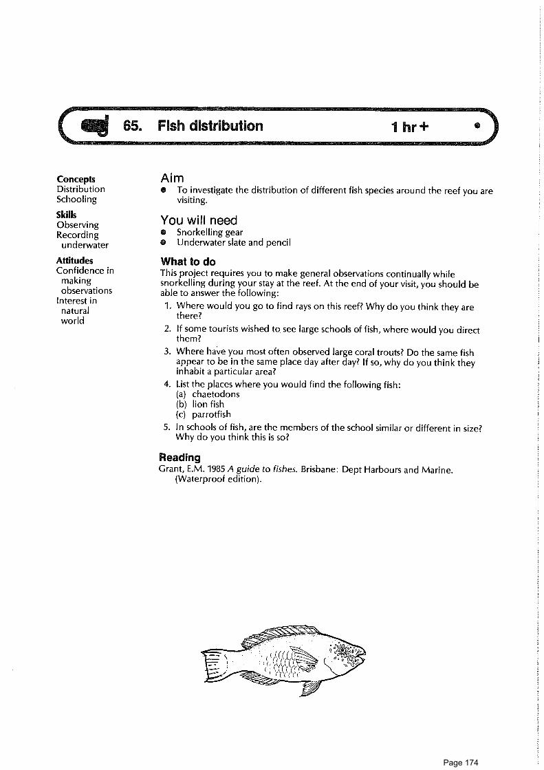
65. Fish distribution
ConceptsDistributionSchooling
SkillsObservingRecording
underwater
AttitudesConfidence in
makingobservations
Interest innaturalworld
Aim• To investigate the distribution of different fish species around the reef you are
visiting.
You will needO Snorkelling gearO Underwater slate and pencil
What to doThis project requires you to make general observations continually whilesnorkelling during your stay at the reef. At the end of your visit, you should beable to answer the following:
1. Where would you go to find rays on this reef? Why do you think they arethere?
2. If some tourists wished to, see large schools of fish, where would you directthem?
3. Where have you most often observed large coral trouts? Do the same fishappear to be in the same place day after day? If so, why do you think theyinhabit a particular area?
4. List the places where you would find the following fish:(a) chaetodons(b) lion fish(c) parrotfish
5. In schools of fish, are the members of the school similar or different in size?Why do you think this is so?
ReadingGrant, E.M. 1985 A guide to fishes. Brisbane: Dept Harbours and Marine.
(Waterproof edition).
Page 174

ConceptsTerritorialityInterrelationshipInterdependence
SkillsObservingRecordingunderwater
AttitudesAppreciation of
naturalenvironments
Confidence inmakingobservations
Aim• To investigate the territorial behaviour of species of damselfish.
You will needO Snorkelling gearO Underwater slate
What to do1. Before entering the water become familiar with several species of damselfish
(get to know their appearance from pictures and diagrams in the books).
2. Find an area of coral which in inhabitated by a species of territorial fish. Usethe lagoon at high tide.
3. Draw the coral area as a rough outline map. Show the size of the coral area onyour map. (Select an area no larger than 2 m across.)
4. Using reference material, identify the fish species.
5. Make a drawing of the fish species you are studying.
6. From your observations in the field, report on(a) the range of the fish (show this on your map)(b) behaviour towards members of the same species(c) behaviour towards members of other species(d) feeding habits(e) any other relevant behaviour shown.
Consider further7. What would be the effect of removing your fish species from the small coral
area you have been studying?
8. What are the advantages gained by these fish in being territorial?
Ideas for further things to do9. Consult textbooks on fishes and find out which families have territorial
species.
ReferencesRisk, M.J., and Sammarco, P.W. 1982. Bioerosion of corals and the influence of
damsel fish territoriality: Preliminary study. Oecologia 53, 376-80.Carcasson, R.H. 1977. Field guide to the reef fishes of tropical Australia and the
Indo-Pacific region. London: Collins.
Page 175

67. Fish-bird comparison
ConceptsHabitatAdaptationNicheEcology
SkillsAnalysingComparing
AttitudesInterest inrelationshipsbetweenorganisms andenvironment
Aim• To make some comparisons between the living places, body forms and
lifestyles of birds and fishes.
You will need• Pen• Basic reference material on biology and reef life• Worksheets
On a reef island, the birds are an eyecatching part of the scenery —moving about in the air, in trees or on the ground. When we gosnorkelling, however, it is the fishes which catch our attention — adazzling array of shapes, sizes and colours moving past our view in thewater. What similarities and differences are there between theenvironments these two groups inhabit, and the adaptations they display?Within island bird communities and reef fish communities, what differentkinds of roles are adopted by different species?
What to do1. (a) Through discussion with others, by reading books and, if possible, by
making your own observations of birds and fishes, fill in the spaces onworksheet A.
(b) Discuss. How does the body form and function of each group fit it for lifein the medium it inhabits?
2. (a) Can you recognise parallels in the lifestyles of some fishes and birds? Lookat worksheet B and, by discussion, reading reference material orobservation in the field, try to fill in as many spaces as possible.
Useful readingsTalbot, F., ed. 1984. Reader's Digest book of the Great Barrier Reef. Sydney:
Readers Digest.Morgan, D.S., ed. 1983 Biological science - the web of life. Canberra: Aust.
Academy of Science.
Page 176

WORKSHEET A
67. Fish-bird comparison
Birds Fishes
To what phylum do they belong?
To what class do they belong?
In what medium do they spend most of their lives? Air
Do they have fixed or mobile lifestyles?
What organs do they use to obtain oxygen?
What kind of locomotion do they carry out? Swimming
What appendages do they use in locomotion?
What name is given to a group of these creatuers? Flock
What kind of body covering(s) do they have?
Are they warm-blooded (homoithermic) orcold-blooded (poikilothermic)?
What are some sense organs which they useto find out about their environment?
What kinds of materialsdo they eat?
Some eat plants,some eat animals,some eat bothplant and animalmatter
What kind of fertilisationdo they have — internal orexternal?
Most (but not all)have externalfertilisation
Do their eggs have a hardexternal shell?
Most fish eggs donot have a hardexternal shell
Do they give parentalcare to their young?
Page 177

WORKSHEET B
67. Fish-bird comparison
Great Barrier Reefbird example
Great Barrier Reeffish example
Has small body size
Has large body size
Moves rapidly
Moves slowly
Stays on or near theground
Buff-bandedland rail
Moves about in a group
Is territorial
Catches and eatsvertebrate animals
Catches and eatsinvertebrate animals
Is a herbivore
Moves around among branchesof another living thing
Silver-eye whichmoves about inbranches ofPisonia tree
Uses colour and shadingas camouflage
Has bright colouring
Lives in a hole inthe ground
Has long, pointedmouth parts for selectingsmall food items
Page 178

• Field notebook and pencilThis activity requires at least half an hour spread over your trip, and maybe muchmore if you spot a whale.
This is an activity everyone can be involved in. Keep your eyes peeled allthe time you are visiting the reef region especially in winter and spring.Make careful observations if you come across any of the following:whales, dolphins or dugong. These observations are vital to marineresearch, so the better your observations, the more you are contributingto the survival of these animals. Seeing a whale is not an everyday eventin the reef area, nor easy. But, especially in September, as whales travelsouth from their breeding grounds, you may be lucky.
ConceptsPopulationdynamics
ExtinctionVulnerabilityEndangered You will needSkills 0 Camera
ObservingRecordingCommunicating
AttitudesCaring for reefResponsibilityIntellectualhonesty
Aim• To develop a feeling of responsibility for observations and to understand that
everyone's observations are needed to contribute to scientific research in thisi mmense, unpopulated reef region.
68. Whale watch
nIM11111,-77--
What to doAt sea1. At sea, the whales you are most likely to see are the humpbacks. Sightings
have also been recorded of the rare blue whale, southern right whale and theminke.
2. Observe the spout, the shape of the back and the method of diving.
3. Record date, time, place of sighting, identification, number, estimate of size,direction of travel and speed and whether there are any young.
Strandings
4. Report the finding immediately by radio or telephone to the QueenslandNational Parks and Wildlife Service or the Queensland Museum. (If alive, theanimal may be able to be saved. If dead, it should be observed before itdecomposes.)
5. Observe the animal carefully and fill in the stranding report sheet asaccurately as possible.WRITE DOWN EVERYTHING — DO NOT RELY ON MEMORY
6. Take photographs or make sketches. These should show:(a) The side of the whole animal(b) Close-ups of the head, fins and flippers.(c) Close-ups of wounds or any unusual features.
Make sure you have something to show the scale, e.g. a person standing besidethe specimen.
7. See notes about observations and strandings, and procedures to be followed,in the leaflet published by the Great Barrier Reef Marine Park Authority.
ReadingsGreat Barrier Reef Marine Park Authority. 1987. Whales — Reef Notes. Townsville.Gould League of Victoria. 1979. Whales — junior survival. Prahran.
Page 179

FIELD SHEET
68. Whale watch
Stranding report
Species:
Date of stranding:
Time of stranding:
Locality:
Number of individuals:
Condition:
Length (tip of upper jaw to tail notch):
Sex:
Number and longitudinal extent of throat grooves:
Number of teeth each side of jaw:
Colour description (plus photos and sketches):
Remarks:
Observer's name:
Address:
Page 180

Animal 1 Animal 2 Which animalbenefits and how
all 69. Associeois between species
Concepts AimAssociation 0 To observe some distinctive associations between some unlike organismsMutualism which "live together".SymbiosisCommensalism You will needAdaptation 0 Usual reef-walking and/or snorkelling gear
Skills n Underwater slate.
Observing This activity requires several hours at various times during the fieldtrip.
What to do1. On the reef, try to find examples of some of the interesting distinctive
associations between unlike organisms. Good ones to look out for are: Gobyand shrimp, needle coral and gall crab, turtleweed and crab, anemone andclownfish, cleaner wrasse and large fish.
2. Go on a shallow snorkel over the sandy flat at high tide. Look for holes in thesand with a sand-coloured goby standing guard. Hover nearby until the gobyno longer notices you and you may find there is also a shrimp living in thehole and working industriously to clean it out. Observe them carefully and tryto work out what sort of relationship is involved — who is helping whom?
3. On a reef walk, look for needle coral (Seriatopora) or the more club-likebranching coral Pocillopora. In each clump look for a slightly expanded fan-shaped branch.
A tiny female gall crab lives inside coral gall. What sort of relationship do youthink this is?
4. Find some bright-green turtle weed. Gently run your fingers through the tuft.If you find a small lump in there, very gently tease it out. You will probablyfind it is a tiny, delicate, pale-green crab. What sort of relationship is this?(Make sure the crab gets back safely into its own tuft of turtle weed).
5. On the reef walk near the reef crest or when snorkelling, look for the largeanemone with its attendant clownfish. How many clownfish are there? Whatsizes are they? Which is the dominant one? Look for other anemones andcompare them.
6. When snorkelling, look for the small, slim, blue wrasse and see if you can findits cleaning station. You may find large fish of several different species linedup for cleaning just like cars at a car wash. What sort of relationship is this?
7. When snorkelling, if you are ever lucky enough to see a large manta ray lookfor the remora or sucker fish attached to it. (You may even find remorasfollowing you around.) What sort of relationship is the one between a remoraand a manta ray?
8. Make a table of all the relationships you find on the reef, heading your tableas shown below.
Snorkelling
AttitudesPerseverenceAppreciation of
naturalenvironments
Page 181

so 70. The goby and shrimp 1/2 hr •
ConceptsCamouflageMutualismRelationships
SkillsObserving
underwaterRecordingunderwater
AttitudesPerseverenceFascinationWonder
AimO To investigate the mutualistic relationship that exists between a goby and a
shrimp.(This project requires patience and careful observation while snorkelling inshallow water.)
You will need• Snorkelling gear• Underwater slate and pencil
What to do1. At high tide, snorkel over the sandy patches in the lagoon (choose an area as
close to the cay as possible). Focus your vision about 2-3 metres in front of youand directed down to the sand. Move slowly, making as little noise as possible.Keep your eyes open for a pale slim little fish with large eyes lying on the sandat the entrance to a hole.
2. Once you've found your fish, move in cautiously to about 2 metres distance. Ifthe fish quickly retreats down the hole, move back slightly, remain very still,and wait for its reappearance.
3. Now, observe carefully, taking note of the following:(a) How would you describe the reappearance of the goby (bold, watchful)?(b) After the goby takes up station at the entrance to the hole, how long does
it take for the shrimp to appear?(c) When the shrimp does appear, is it involved in any particular activity?(d) Does the goby appear to be involved in any activity besides observation?(e) Make a sudden movement towards the hole. What happens?(It would be a good idea to copy these questions on to your slate before youleave the beach).
Questions to consider4. What appears to be the relationship between the goby and the shrimp?
5. Would survival be any more difficult for either the goby or shrimp if eachlived a solitary life?
6. What particular adaptation does the shrimp have to fulfil its role in therelationship? What adaptations do you think the goby possesses to fulfil itsrole in the relationship?
Page 182

71. Clownfish and anemone 1/2 hr +•
ConceptsSpecial
associationAdaptationCommensalismSymbiosis
SkillsObservingRecordingHypothesing
AttitudesPerseverenceAppreciation of
naturalenvironment
Confidence inmakingobservations
Aim• To investigate the association between anemones and clownfish.
You will need• Snorkelling gear or reef-walking gear and transportable viewer• Underwater slate or waterproof sheet; pencilThis activity can take from half an hour to many hours. It can be done in pools onthe reef-top at low tide or on the reef front while snorkelling.
What to do1. Visit a particular anemone while snorkelling on the reef front or while
observing a reef-top pool.(a) Record the size of the anemone and sketch the species of fish associated
with it for later identification.(b) Record the numbers of clownfish fish present. Is there a dominant
member of the group?(c) Do the clownfish touch the anemone? If so, how do they move when
doing this?(d) Do the clownfish appear to concentrate in any particular region of the
anemone?(e) Does the anemone react to the movements of the fish?(f) What evidence, if any, do you see of either the clownfish or anemone
feeding?(g) How far do the clownfish move from the anemone?(h) What do the clownfish do when away from the anemone?(i) What behaviour is displayed by the clownfish to other fish species?(j) How have the fish reacted to your presence and movements?
2. If possible, visit and observe other clownfish/anemone associations.(a) Are other species of clownfish present?(b) Are particular types of clownfish associated with particular types of
anemones?(c) Can you recognise common patterns in the behaviour of the clownfish at
the anemones you observe?
Questions for you to consider3. Clownfish, unlike other fish, are not stung by nematocysts from the anemones
they are associated with. Various reasons have been suggested for this. Try tofind out about the research that has been undertaken on this.
4. In this association, who benefits, and how? Read literature discussingsymbiosis and commensalism relationships. What kind of association is theclownfish/anemone partnership? How does the special association comparewith other special associations you know of on the reef?
Ideas for further things to do5. Investigate other special associations on the reef, e.g. crab/turtle weed.
ReadingAllen, G.R. 1975. Anemone fish and their amazing partnership. Australian Natural
History 18(8).
Page 183

72. Cleaner wrasse
Concepts AimInterrelationships 6 To investigate a mutualistic relationship on the reef.SymbiosisFish behaviour You will needSkills o Snorkelling gear
Observing 0 Underwater slate and pencil
Recordingunderwater What to do
1. Snorkel along the reef edge until you find a cleaner station. Coral bommiesAttitudes are likely areas.Confidence in
2. Observe a fish being cleaned. What parts of the fish are cleaned?makingobservations 3. Study the behaviour of the wrasse inviting the fish to be cleaned and the
Interest in behaviour of the fish receiving the cleaning.
natural (a) Record the movements of the wrasse before cleaning begins.
environment (b) Record the behaviour of the fish about to be cleaned.
and especially (c) Observe the range and territory of the wrasse.
in interrelatednessof living Questions to think about back on the beachthings 4. Did different species show similar behaviour before cleaning commenced?
5. What factors might influence the size and position of a station?
6. Comment on the role of the wrasse in the coral reef community.
Ideas for further things to do7. You can learn more about the cleaner wrasse by consulting the following
reference:Behavioural ecology of cleaning fish. Aust. Nat. Hist. Sept. 1982: pp. 232-38.
4-leaver COrassc a c_lte4-1- -swecfl;r5
(Lattrotdea ("4,.0.‘iplia4us 4 Galen' ," ?ic4.a.)
Page 184

73. Reef-top transect 2 h + 1 hr • •
ConceptsDistributionAbundanceTransectSampleZonationLine interceptQuadratSedimentSandGravelMudEncrusting algaeFleshy algae
SkillsCooperatingEstimatingRecordingHypothesisingEvaluating
AttitudesInterest in methodsof scientificenquiry
Willingness tosuspendjudgment
Willingness towork with others
Aim• To investigate the pattern of distribution of reef-top organisms and sediment
by gathering data along a transect from beach to reef edge.
Many reefs have a distinct natural zonation of reef-top sediments andliving things, features near the reef edge different from those on innerparts of the reef-top.Does the reef you are visiting have an obvious pattern of natural zones? Ifso, how is one zone different from another? Are there different zones ondifferent sides of the reef? Why might the natural zonation pattern exist?You've probably already done some walking and looking about on thereef-top during your field trip, so you already may have some ideas aboutthese questions. One purpose of this activity is to gather data in asystematic way to help test out any guesses you may have made.
You will need(For each small working team)• Reef-walking gear• 20-metre-long rope or cord, knotted or marked at 1-metre intervals• Clip board, pencil• Field sheets on waterproof paper• Viewing box with transparent bottom (optional)• Magnetic compass• Map or air photo of reef-top• 1-metre-long plastic rodThis activity requires at least one low-tide period on the reef-top (about twohours), and about one hour at base camp plotting and discussing data.
What to doOrganising the fieldwork
1. With your group leader, study a map or air photo of the reef-top. Select atraverse line across the reef-top from beach to reef-edge. Mark the startingpoint on the map.
2. Using the map, work out how many stations there will be for collecting dataalong the transect. A convenient distance between stations is 20 metres.
3. Divide into small working teams of about four people. Each team is to collectdata at a number of stations spaced out along the transect. Your group leaderwill allocate stations. Each team should have stations close to the beach, in thecentral part of the traverse, and near the reef edge.
4. Discuss the features you are going to record on the traverse.
Page 185

In the field5. Each team should walk out along the traverse line from the starting point on
the beach. Use a compass and measured rope to help reach your stations.
6. At each station, study a 2-metre-square area along your traverse line from thestation. Take a "birds-eye" view.Make estimates and record the following on field sheet A:(a) What percentage of the area of the "floor" of the strip is made of:
• living coral• dead coral (still standing)• rocky pavement• loose sediment (sand)• loose sediment (mud)O loose sediment (fine gravel)• loose sediment (coarse gravel)
(b) What percentage of the area is covered by marine plants?• green or brown fleshy algae• pink encrusting algaeO other types of algaeO sea grasses (if any)• no visible plants
(c) How many different types of corals are present?(d) How many different types of algae are present?(e) Anything else?
7. Also at each station, make a quick sketch on field sheet B of the appearanceof part of your area (a 1-metre-square area would be adequate). Put infeatures using symbols.
At base camp8. Combine the data from all groups.
(a) Make up three graphs: one for the coral and sediment distribution data,one for the algae data and one for the species diversity data. Use coloursand shading decided upon by the whole group. Hang the graphs whereeveryone can look at them. (See the suggestions for presenting data at theend of this activity.)
(b) Finalise the field sketches. Colour them using colours agreed upon by thewhole group. Hang the pictures where everyone can look at them.
9. Discuss the results:(a) Along the traverse line, are there any systematic variations in the amount
of live coral, dead coral, loose sediment, sand, gravel, algae, fleshy algae,etc?
(b) Are distinct zones present? In what way is one different from another?(c) What are some factors which might cause variation along the traverse? In
particular, think about the distribution of sand, coarse gravel, living coraland fleshy algae.
(d) How could the possible influence of some factors on the distribution ofbiota and sediment be investigated?
10. What are some shortcomings and problems in the field method used?(a) Do you think that a good sample of the reef-top has been examined?
How could it be improved?(b) Are there difficulties in splitting the job among different teams? How
could this problem be overcome?
Page 186

Ideas for further things to do11. Carry out one or more transects on other parts of the reef-top. Compare data
from the transects. Do different parts of the reef display different zonationpatterns? Is there any obvious difference between windward and leewardsides? What might account for any differences you observe?
12. Compare data from your transect(s) with data (if available) from past transectsmade here. Have there been changes through time here? What might havecaused these?
13. Prepare a group report of your transect so that future groups can comparetheir own observations with yours.
Ideas for alternative ways to organise this transect14. Each small team could do an entire traverse on its own. Then all traverses
made by different teams could be compared. Discuss the advantages anddisadvantages of this method.
15. The sampling method used could be varied. The stations could be spacedfurther apart or closer, depending on time available. The quadrat areaexamined at each station could be enlarged or reduced. A circle could beexamined instead of a rectangle. Discuss the advantages and disadvantages ofthis method.
16. A line intercept method could be used for gathering data instead of a quadratmethod. Along the whole traverse, a record could be made of the length ofthe transect line which lies on, say, living coral, sand, dead coral, etc. Discussthe advantages and disadvantages of each method.
Some ideas for presenting dataThere are some useful methods for presenting data obtained at transect stations:• Bar graphs
For each station draw a vertical bar divided into different sections ofappropriate length for each component measured. Colour or shade eachsection of the bar in a distinctive way.
• Fence diagramPlan out a bar graph as above, but join up the data points from differentstations. Colour or shade the whole graph area. This provides a good way ofvisualising change across the reef-top.
• Kite diagramDraw horizontal bars across the graph, each representing one component.The width of the bar represents the percentage of a component, or thenumber of species.
Specialist readingsOn reef-top zonationDone, T. 1983. Coral zonation: its nature and significance. In Perspectives on coral
reefs, ed. D.J. Barnes, pp. 107-47. Canberra: Clouston/Aust. Inst. MarineScience.
Jell, J.S., and Flood, P.G. 1977. Guide to the geology of reefs of the Capricorn andBunker groups, Great Barrier Reef province, with special reference to HeronReef. Dept. Geology, Univ. QId. Papers 8(3).
On reef fieldwork methodologyLoya, Y. 1978. Plotless and transect methods. In Coral reefs — research methods,
ed. D. Stoddard and R. Johannes. Paris: UNESCO.Stoddard, D. 1972. Field methods in the study of coral reefs. In Proc. First Intern.
Symp. on Corals and Coral Reefs. Cochin: Marine Biological Association.Stoddard, D. 1969. Biology and morphology of recent coral reefs. Biol. Rev. 44:
433-98.
Page 187

FIELD SHEET A
73. Reef-top transectName of Date Place where Bearing Field team Time Timereef traverse of members started finished
starts traverse
COMPONENTS STATIONS (metres from origin)
Living coral
Dead standing coral
Rocky pavement
Coarse gravel (1 cm)
Fine gravel
Sand (2mm)
Mud (if any)
MARINE PLANT COVER
Green/brown fleshy algae
Pink encrusting algae
Other types of algae
Seagrasses (if any)
No visible plants
NO. OF SPECIES
Coral
Fleshy algae
Page 188

FIELD SHEET B
73. Reef top transect
Name of Date Place where Bearing Field teamreef traverse of members
starts traverse
Time Timestarted finished
Metres
KEY
Scale 1:100
Live coral
Dead coral
Fleshy algae
Sand
Coarse gravel
StationMetres
StationMetres
Page 189

AI 74. Boulder communities 2 hr • •
ConceptsCommunity 0 To study organisms living on and under a reef-crest boulder and a reef-flatProducers boulder and to develop an understanding of interrelationships betweenConsumers organisms and their environment.DecomposersDiversityFood web
Attitudes Board and field sheet
Awareness 0 Perspex viewing box (A4 size) (optional)
Curiousity 0 Acetate sheets (OHP transparency sheets)
Confidence in 0 Very fine waterproof OHP pens
own powers 0 Tape-recorder (optional)
of observation This activity should be done during one or two low-tide periods.
Interest innatural What to doenvironment 1. (a) Find an interesting boulder on the reef flat. Observe it through the
viewer.(b) Draw its outline on an acetate sheet placed in the bottom of the box.(c) Identify anything growing on the upper side of the boulder. Add it to
your drawing. Label it or use a symbol for it.(d) If the boulder is still underwater, observe any mobile animals in or around
it. Add them to your sketch. When you finish, clip the drawing to aclipboard and start a new sheet.
(e) Turn the boulder over carefully. Draw the outline on another acetatesheet. Try to identify as many living organisms as you can. Add them toyour sketch.
(f) Make sure you return the boulder carefully to its original position.(g) On the field sheet, list each organism. From your own observations,
decide whether it is a producer, consumer or decomposer and how andwhat it eats. You may wish to make your observations on the tape-recorder and write them down later.
2. Do the same thing for a reef-crest boulder. You may have to do this atanother low-tide period.
3. Compare the communities from the two boulders. Are they similar? If not,why do you think they are different?
Ideas for further things to do4. For each boulder, draw up the relationships as you saw them. This may be part
of a food web. You may wish to expand this and add mobile animals whichwould also be part of this web.
5. Would you describe your boulder communities as closed systems?
6. Is the top of each boulder dominated by producers or consumers? Is thebottom of each boulder dominated by producers or consumers? Suggestreasons for your answers.
NOTEThis activity can be followed without use of the perspex viewing box.Simply make sketches on a recording sheet held on a clipboard. Asnorkel mask may be helpful in viewing the boulder.
Aim
You will need• Reef-walking gear• Notebook and pencil
Page 190

FIELD SHEET
74. Boulder communities
Reef-flat boulder
Name oforganism
Located ontop or bottomor side ofboulder?
Producer,consumer ordecomposer
Fixed ormobile?
If a consumer:Grazer,predator,filter feederor ...?
Reef-crest boulder
Name oforganism
Located ontop or bottomor side ofboulder?
Producer,consumer ordecomposer
Fixed ormobile?
If a consumer:Grazer,predator,filter feederor ...?
Page 191

All 75. Ecology of a reef pool 2 hr • •
ConceptsEcologyEcosystemHabitatNicheProducerConsumerCommunityCarnivoreHerbivoreOmnivoreScavengerDecomposerAbiotic factorBiotic factor
SkillsObs What to doObservingRecording Map the pool — (field sheet A)
Mapping 1. Choose a distinctive reef-top pool that is not too large. Pools near the reef rim
Identifying are good for this activity.
Cooperating 2. Make measurements of the pool, using tape or knotted string. Select a scaleUsing equipment and, using diagram 1 of field sheet A, carefully sketch the pool outline.
Attitudes 3. Roughly mark on, or shade in, areas of coral and sand.
Interest in 4. On diagram 2, draw a cross-section of the pool. Use the measuring tape and anatural staff or plumb bob to make the measurements of the pool. Choose suitableenvironment horizontal and vertical scales.
Intellectual Observe physical and chemical conditions in pool — field sheet B (optional)honesty 5. On field sheet B, record answers to questions about physical and, if possible,
Self-reliance chemical conditions of the pool. If possible, make one set of observations ofDesire to temperature and wave conditions when you first arrive at the pool, andquestion another set as you leave the pool.
Initiative Observe organisms6. In notebook or on underwater board, make a list of the organisms you can
see, where they are and what they are doing. (If you don't know what theyare, give them names and identify them later from your notes and sketches.)
Questions to consider after the fieldwork7. What are some ways in which organisms in the pool affect one another? Were
you able to see any feeding relationships between organisms? Whichorganisms are the producers and which are the consumers? From yourobservations and reading, draw a food chain. Draw a part of a possible foodweb which involves the pool.
8. Suggest possible ways energy enters and leaves the pool.
9. How might physical and chemical conditions in the pool affect living things inthe pool?
10. If you have measured physical and chemical conditions in water elsewhere onthe reef, how do these differ from those in the pool?
11. Discuss the possible effects of tides, winds, currents, sediments, cyclones andpeople on the pool and its community.
Aim• To map a reef pool and to identify some of the common organisms that
inhabit it.• To observe interactions between the pool organisms and the environment.
You will need• Underwater board or notebook; field sheets• Reef-walking gear• Compass• Waterproof measuring tape or knotted string• Measuring staff (1-2 metres) or plumb bob of length of knotted string 1-2
metres long with sinker on end• Pictures of common reef-top organisms, e.g. from GBRMPA leafets (optional)• Thermometer and water-test kit (optional)• Camera (optional)
Page 192

Ideas for further things to do12. Mark on the map and profile on field sheet A the organisms observed, using
symbols.
13. Check out a different reef pool. How do conditions differ? Are the organismsdifferent?
ReadingBennett, I. 1982. The Great Barrier Reef. Sydney: Lansdowne.Mather, P., and Bennett, I. 1984. A coral reef handbook. Brisbane: Aust. Coral
Reef Society.Talbot, F., ed. 1984. Reader's Digest book of the Great Barrier Reef. Sydney:
Reader's Digest.
Page 193

FIELD SHEET A
75. Ecology of a reef pool
Pool map and profile
Team no Date Time Tide
Group members
Location of pool
Indicate north, scale, boundaries, major features, wave zones and give directions to island features, so thatthe pool can be relocated at a later date.
Diagram 1: Map of aerial view of pool
Side X Side Y
Scale:
Diagram 2: Pool profileInvestigate the depth of the pool along the transect line; take soundings at a number of positions along thetransect line. Draw a depth profile of the pool. Indicate the types of substrate found along the transect line(coral, coral rubble, sand).
Side X Side Y
Horizontal scale (use the same as in diagram 1)
Vertical scale:
Page 194

FIELD SHEET B
75. Ecology of a reef pool
Abiotic conditions
Physical conditions in pool
Condition At beginningof activity(time )
At end ofactivity(time )
Has therebeen a change?
What is the watertemperature (°C)?
Is new water cominginto the pool?
Are there waves on thepool?
Can you see all thebottom of the pool?
Are the tops of algae orcoral growing in the poolexposed to the air?
Is the tide risingor falling?
Chemical conditions in the pool
Condition At beginningof activity(time )
At end ofactivity(time )
Has therebeen a change?
Dissolved oxygen(p.p.m.)
pH
Salinity
Page 195

ConceptsNocturnalbehaviour
Ecology
SkillsObservingCommunicating
AttitudesCuriositySelf-relianceEnjoyment ofoutdoorexperience
Appreciation ofnaturalenvironment
Aim• To observe some life on the reef flat on a calm night, at low tide.• To observe nocturnal behaviour of some animals in the inner coral zone.
You will need• A torch (underwater torch, if possible)• Protective reef-walking footwear (sandshoes or rubber booties)• Other reef-walking gear, including windproof jacket
What to do1. Assemble on the beach just after dark and select a buddy.
2. Discuss possible dangers of walking out onto the reef at night and precautionsneeded.
3. Walk out over the innermost coral zone, stopping at a number of places.Preferably choose an area where you have walked during the day. Walk onlyin very shallow water. Stay close to shore; keep with your group.
4. At each place:(a) Stand still for 30 seconds and listen carefully.(b) Discuss with your partner any sounds you hear.(c) Try to find out what it is that makes the sounds.(d) Shine your torch through the water and see what you can find.
5. Return to the shore and discuss the following:(a) Did you see a snapping shrimp?(b) Were the coral polyps really out?(c) Were any fish sleeping?(d) Who saw any crayfish?
hermi 4. Crab -- Dare:lamas €0 /5 (to5
Page 196

77. Map-a-bommie scuba project 3 hr + •••- B11 —PISIAREMERNMer7-77
Concepts AimEcology • To investigate the ecology of a submerged coral mass (bommie). This is aDistribution project requiring the use of scuba. It is recommended for a group of three orHabitat four divers.PopulationEnvironment You will needSkillsOrganisational
skillsOrientation
skillsUsing compassObserving and
recordingunderwater
MappingCooperation
AttitudesAppreciation of
naturalenvironment
PerseverenceEnjoyment ofoutdoorexperience
• Diving gear (scuba)• Underwater slate and pencil• Underwater camera and torch (optional)• Submersible compassYou will need to make three scuba dives at less than 10 metres.
What to do1. To understand the ecology of a bommie, it is first necessary to analyse the
physical features of the bommie and to assess the physical factors to which it isexposed. Choose a bommie which has appealed to you while snorkellingalong the reef slope. Try to choose a bommie no larger than 5 m in diameterand no smaller than 2 m in diameter. Your bommie should also be in less than10 m of water (to reduce your air consumption and avoid decompressionproblems).
First dive2. (a) Record the position of your bommie on an outline map of the reef. You
will need to take compass bearings from the bommie to prominentfeatures of the island (end of vegetation, towers, etc.).
(b) Record the size of your bommie.3. Record the depth of the bommie at low tide. Hover above the bommie and
make an outline sketch of the bommie on your slate. Now descend to thebase of your bommie and make a sketch of its western side. Move through90° (naturally, using your compass) and make a sketch of its northern side.Continue this procedure so that you obtain sketches of the eastern andsouthern aspects also. As you make these sketches, pencil in any prominentfeatures, e.g. masses of brain coral, caves.
4. Make relevant notes on such things as currents in the area, slope of thebottom, proximity of other bommies and any other physical factors which youthink may have an influence on your bommie.
Second dive5. Slowly circle your bommie and, on the sketch you made on the first dive,
record the locations of resident fish on your map (e.g., cod in caves, paintedsweetlip, flutemouths under coral overhangs). Take particular note ofterritorial species such as moray eels, clownfish, etc. Try to find any cleanerstations. As you record the different fish species, jot down their approximatenumbers as shown in the example in figure 77.1.
Third dive6. Now move in close to your bommie and record the interesting and noticeable
invertebrate life. By this time, you may have to use fresh outline drawings ofyour bommie. Try to find and mark on your map the location of nudibranchs,stinging hydroids, soft corals, etc. Look for sponges and ascidians underoverhangs.What kind of hard corals are predominant on your bommie? (perhaps you canenlist the aid of students who have done activity 43, "Coral Colonies".) Makesketches of some of the corals so that you can identify them later.
Page 197
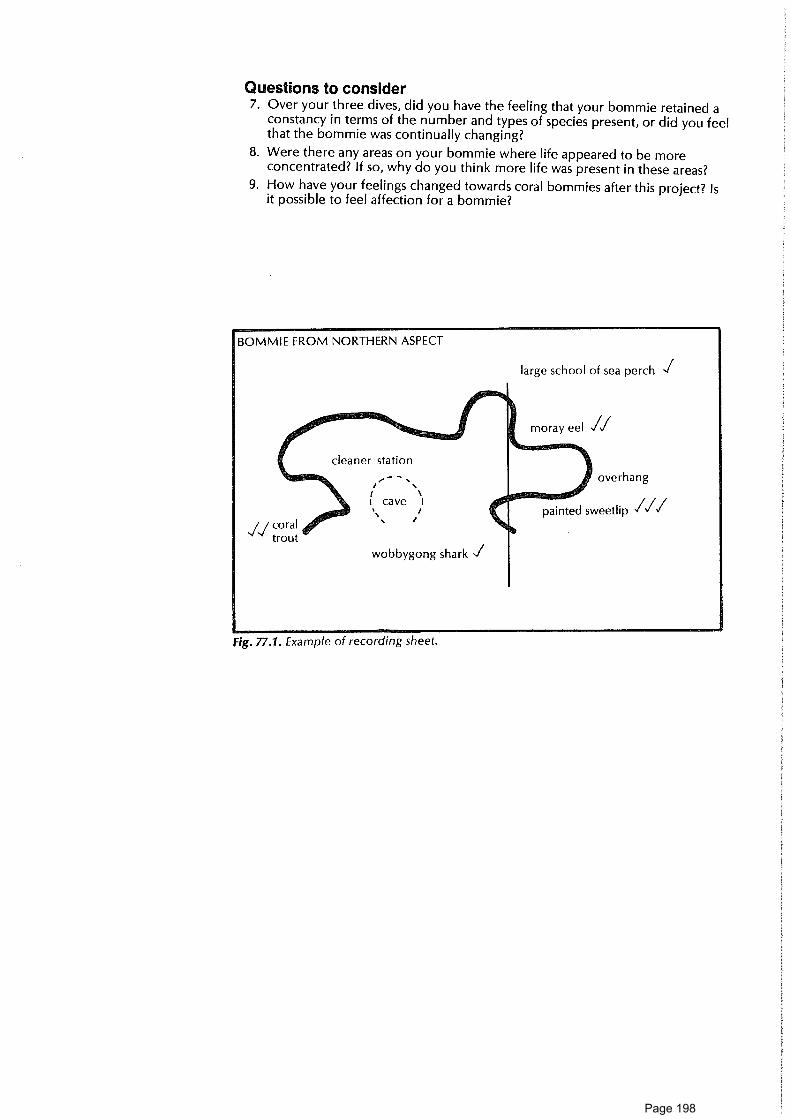
BOMMIE FROM NORTHERN ASPECT
large school of sea perch 1
moray eel 1✓
cleaner station
overhangr
1 ni N
. painted sweetlip ✓✓✓cave I
.
wobbygong shark
✓/ coral
trout
Questions to consider7. Over your three dives, did you have the feeling that your bommie retained a
constancy in terms of the number and types of species present, or did you feelthat the bommie was continually changing?
8. Were there any areas on your bommie where life appeared to be moreconcentrated? If so, why do you think more life was present in these areas?
9. How have your feelings changed towards coral bommies after this project? Isit possible to feel affection for a bommie?
Fig. 77.1. Example of recording sheet.
Page 198

78. Food web of a coral cay and reef 11/2 hr • •=11•1 7. -
Concepts AimFood web • To investigate the flow of energy and cycle of materials on a cay and reef. ThisEnergy flow activity is best done after a few days on the cay when you are familiar with aMaterial cycle number of island and reef organisms.ProducerConsumer You will needInterrelationships 0 Pencil and recording sheet
Skills Large sheet of paper (approx. 2 m x 2 m) or blackboard
Observing This activity will take a total of about 1 1/2 hours spread over several days.
RecordingInterpreting What to do
1. By now you should be able to list many of the life forms you have seen overAttitudes the last few days under the headings of producer, consumer or decomposerPersistence ( Don't forget zooxanthellae — the algae which live inside the tissue of coralAppreciation of polyps and many other reef animals).
interrelatedness2. On the same large piece of paper and side by side make up a food web for
of living thingsthe reef and a food web for the cay.
3. Keep adding to this chart each day as you observe more organisms anddiscover their relationships to one another.
4. Use coloured arrows to show the flow of energy through the web you havedrawn. How does energy enter and leave the system?
5. Use arrows of one or more other colours to show the transfer of one material(e.g. carbon, nitrogen) through the system. How does each material enter andleave the system?
6. Can you identify any links between the reef and the cay?
7. How are the trees of the cay dependent on the reef and the cay itself?
Further things to do8. Consider other communities you have studied, e.g., desert, rainforest
communities. Are there any principles which hold true for all communities?
Clams - -77-104acoa gig as
Page 199

Island life
79. What plant is that? Island80. She-oak study ................................................................................................................................................... Island81. Love a tree ........................................................................................................................................................ Island82. Leaf variations ................................................................................................................................................ Island83. On the lean — windshearing of Pisonia ....................................................................... Island84. Seeds and fruits .............................................................................................................................................. Island85. Pisonia and sex ................................................................................................................................................ Island86. Island environmental stations ................................................................................................................ Island87. Vegetation distribution on a cay ........................................................................................................... Island88. Cay bird life ..................................................................................................................................................... Island89. Bird behaviour ................................................................................................................................................ Island90. Bird feeding techniques ............................................................................................................................ Island91. Wrong song — bird calls .......................................................................................................................... Island92. Flight patterns ................................................................................................................................................ Island93. Bird nests .......................................................................................................................................................... Island94. Those magnificent birds in their flying machines .............................................................. Island95. "There came a big spider ......................................................................................................................... Island96. Turtle watching .............................................................................................................................................. Island
Page 200

Page 201

ConceptsIdentificationBiological keyClassification
SkillsObservingRecordingUsing a
biologicalkey
AttitudesCuriosityAppreciation of
naturalenvironment
Aim• To develop a simple key which others can use to identify trees, shrubs and
other plants on a coral cay using simple external features.
You will need• Notebook or waterproof sheet attached to a clipboard• Biro/pencil• Hand lens
What to do1. Walk around the coral cay and examine the leaves from the different types of
trees and shrubs.
2. Find out the names of the trees and shrubs using Cribb and Cribb (1985).
3. To establish your key, use leaf characters such as leaf size, shape, hairs(presence/absence), colour, oil glands, simple or compound, entire or serrate,and the leaf arrangement (alternate or opposite).
4. Sort out the leaves on the basis of one characteristic at a time. You may wantto start with simple or compound, alternate or opposite, or others suggesteduntil each has a place of its own. Present the information as a biological keysi milar to the one in table 79.1.
5. You could use other features in your key such as the size of the plant, flowers(e.g. colour), root type (e.g. prop or buttressed) or fruit.
6. Make diagrams of your leaves and their arrangement, together with any otheradditional features (e.g. flower, fruit). You may wish to produce a key usingillustrations of leaves or other features, rather than descriptions in words.
7. Repeat the above with herbs and vines as well as shrubs and trees.
8. Test your key with a friend.
ReadingsMather, P., and Bennett, I. 1984. A coral reef handbook. Brisbane: Australian Coral
Reef Society.Cribb, A. B., and Cribb, J. W. 1985. Plant life of the Great Barrier Reef and adjacent
shores. St Lucia: Univ. Qld Press.
Page 202

Table 79.1: Example of key for some cay plants
(Main species: Pisonia grandis; Casuarina equisetifolia;Argusia argentea; Scaevola sericea; Pandanus tectorius)
1. (a) Leaves reduced to tiny scales on needle branchlets .................................................................... Casuarina sp.
(b) Leaves not reduced. ............................................................................................................................... Go to 2
2. (a) Leaves very large in dense clusters at top oftree like pineapple tops. Tree has prop roots ................................................................................ Pandanus sp.
(b) Leaves not as above. Trees do not have prop roots. .................................................................. Go to 3
3. (a) Broad oval-shaped pale-green leaves with prominent mid rib.Huge tree often with large buttress roots. ..................................................................................... Pisonia sp.
(b) Not as above, smaller trees and shrubs. ......................................................................................... Go to 4
4. (a) Silvery, furry, elongated, oval-shaped leaves. Small-petalled, cream flowers. .................. Argusia sp.
(b) Shiny dark-green leaves with rounded ends. Small tree or shrub .......................................... Scaevola sp.
Page 203
80. She-oak study
ConceptsAdaptationNitrogen fixingCladodeTranspirationTap rootBacteriaSymbiosisNitrogen cycle
SkillsObservingRecordingInferring
AttitudesInterest innaturalenvironments
Aim• To consider ways in which coastal she-oaks are adapted for life on a coral
cay and some ways in which they affect cay environments.
You will need• Field sheet• Pencil and notebook• Hand lens
When a new cay is being progressively colonised by plants, coastal she-oaks (Casuarina equisitifolia variety incarna) are probably the first trees tobecome established. They can live in windy conditions and in porous soilwith little water-holding capacity; they can grow in sand which is poor innutrient substances such as nitrates.
What to do1. Walk around the edge of a cay and find some coastal she-oak trees.
2. Look for each of the features listed on the field sheet. On the field sheet,make a sketch of any feature you are able to see — give a scale for each.
Questions to consider3. Think about the following questions. Discuss with others and write your
answers in your notebook.(a) It is claimed that having reduced leaves helps the tree conserve its own
moisture and survive when soil moisture is low. How could havingreduced leaves be of benefit to the plant in this way? (Hint: Think abouttranspiration, stomata, surface area.)
(b) How could the presence of nitrogen-fixing bacteria in the she-oak rootshelp the she-oak trees themselves to survive in cay conditons and be ofbenefit to other plant colonies of a cay?
(c) Find out the names of some other plants which contain nitrogen-fixingbacteria.
(d) Many she-oak trees have a long tap root. How could this help survival in acay environment?
(e) How could having winged seeds help she-oaks become established on acay?
(f) How does the profuse shedding of branchlets by the she-oak help otherplants become established and survive on a cay?
(g) How do she-oaks help a cay to become stabilised?(h) How do she-oaks provide protection for some other plants on the cay?
Ideas for further things to do4. Read about the nitrogen cycle. Why are bacteria important in the nitrogen
cycle? Why is the relationship between the she-oak and its nitrogen-fixingbacteria regarded as symbiosis?
ReadingsCribb, A. B., and Cribb, J. W. 1985. Plant life of the Great Barrier Reef and adjacent
shores. St Lucia: Univ. Queensland Press.Bronson, H. 1975. The coastal she-oak. Beach conservation. Brisbane: Beach
Protection Authority of Queensland. (Leaflet).
Page 204

FIELD SHEET
80. She-oak study
Where to look Feature Sketch or notes
Foliage ofthe tree
Needle-like foliage. These are not leaves but branchlets with greenstems which carry out photosynthesis. They are shed when they reachabout 30cm in length.
Rings of tooth-like scales onthe stems. These are the trueleaves.
Roots of thetree(if exposed)
Branched root system.
Lumps about the size of a fist on the roots. These contain bacteriawhich are able to take atmospheric nitrogen gas and convert it intosubstances such as nitrates which are used by the green plant.
Tap root (if partly exposed)
Underneath thetree or in coneson the tree
Winged seeds
Underneath thetree
Layers of fallen needles underthe tree
Anywhere in ornear the tree
Animals using the tree. Arethere any?
Page 205

- 77:711177=1M- 77-
81. Love a Tree 1 hr
ConceptsBioticcharacteristics
Aim* To learn more about trees and to develop new feelings towards them.
What to do1. Select a tree that you like. Identify it, if possible, using the reference material.
2. Measure its girth (at chest height), and the extent of its canopy of leaves.
3. Estimate its height using several methods to cross-check. (See methodsoutlined below.)
4. Draw a leaf, noting its colour, feel, size and shape. Do a bark rubbing byplacing the paper over the bark and rubbing the crayon or dark pencil over itto pick up the texture of the bark.
5. Can you see any flowers, pods or seeds?
6. Consider who uses your tree: are there birds resting in it, or nesting in it, orfeeding from it? Are there any signs of other occupants or users?
7. Do these users appear to be affecting your tree?
8. How do you think your tree got to be at that place? Would its seeds haveblown in, been brought in by birds, or washed ashore? If your tree had neverarrived, what would the island be like now?
9. If someone arrived to cut down your tree, what would you do? How wouldyou convince that person not to cut it down?
10. Is your tree alone, or does it have many relations? What if the relations wereall removed?
11. Is your tree having an effect on the surrounding area? Does it dropleaves/bark on the ground nearby? What is the local soil like? Is there deepshade?
12. Make a badge to wear showing some of your feelings about your tree.
How to estimate a tree's height in metres(a) Without a clinometer
Against the trunk of the tree place an object of known height (h): a metrerule or a ranging pole can be used, or even a person whose height is known.Move away from the tree. Hold up a pencil at arm's length and, sighting withone eye, cover the object against the tree with the pencil. Then move thepencil upwards. Count the number of pencil lengths needed to reach the topof the tree and multiply this by h. (see figure 81.1.)
(b) Using a clinometerThis must be done in pairs as one person must sight while the other watchesthe clinometer (or protractor and hanging weight).Starting from a place considerably closer to the tree than the tree is high,move back until the clinometer registers 45 0 to the top of the tree. The heightof the tree (H) is equal to the distance of the sighter from the tree (x) plus theheight of the sighter to eye level (y). (Note: With practice you can judge the450 from your eyes to the top of the tree even without using a clinometer.)
Interrelationships You will needForest * Tape measure, paper, crayon or heavy 4B pencil,Perception to 1 m rule, or a 2 m ranging rod or a clinometer (could be a protractor with a
Skills swinging weight)
Using senses
•
Reference book on trees
Measuring andrecording
Expressingand revisingpersonal values
AttitudesWillingness to
investigateAppreciation
of naturalenvironment
Page 206

Page 207

idis 82. Leaf varieties
ConceptsLeaf distributionAdaptationDiversity
SkillsObservingDrawingMappingI magining
AttitudesAppreciation of
naturalenvironment
AimO To become more sensitive to plants on the cay and to develop an awareness
of diversity in the cay environment.
You will need• Field notebook• Reference book• Island map (optional)
What to do1. Select a number of leaves that you consider fit the following descriptions. (It is
not necessary to actually collect the leaves.)O a long thin leafO a leaf larger than 5 cnn2
O a leaf that feels waxyO a leaf that feels hairyO a leaf that is silvery• a leaf with points on it• a leaf smaller than 1 cm 2
• a leaf being eaten by an insect• a type of leaf often covered in bird excreta• your favourite leaf• a leaf like a needlee a leaf coloured redO a leaf on a vine• a leaf growing in a clump/clustere a leaf on a wood stem• a leaf with serrated edges• a leaf that squashes to produce a liquid• a blade leafO a leaf which can cut you
2. When you have matched the description, draw or trace around the shape ofthe leaf; label each drawing. Use a reference book to identify the species,noting if the species is native or introduced. Where each of the leaves wasfound could be marked on an island map.
Ideas for further things to do3. Give your list and drawings to someone else. See if they can find the same
examples. Where were most of the examples found?
4. Discuss the island environment and how you think the leaves you've foundare adapted to this environment.
ReadingCribb, A.B., and Cribb, J.W. 1985. Plant life on the Great Barrier Reef and adjacent
shores. St Lucia: Univ. Queensland Press.
Page 208

4111L83. On the lean - windshearing of Pisonia 1'/2 h
ConceptsEnvironmentAbiotic factorWindshearing
SkillsObservingMeasuringCompass reading
AttitudesCuriosityInterest ininterrelatednessof organism andenvironment
Aim• To study windshearing of Pisonia grandis trees on a coral cay.
You will need• Map of the coral cay• Magnetic compass and tape measure• Clinometer
What to do1. Select an area where there is an abundance of trees.
2. Using a tape measure and compass, mark on the map the position of Pisoniatrees on a line transect from one side of the cay to the other.
3. Examine the trees for windshearing as you walk from one side of the cay tothe other.
4. Rate the amount of windshearing you observe along different parts of thetransect. You could use a three or four-point scale from "most obvious" to"least obvious". Place your ratings on the map using symbols or numbers.
5. Using a compass, note the direction in which the trees lean.
6. Measure the angle of lean of the main trunks of wind sheared Pisonia grandistrees.
Questions to consider7. On which side of the island is windshearing in Pisonia grandis most obvious?
8. In what direction do the trees lean?
9. How does this relate to the direction of the prevailing wind?
10. What is the greatest angle of lean of the main trunks of windsheared Pisoniagrandis trees?
11. How far back from the beach are the Pisonia trees more or less vertical?
12. Does the height of Pisonia trees vary with distance from the beach?
13. Could erosion of the beaches you are studying have brought some treesformerly protected from the main effects of wind close to the beach? If so,what evidence is there of this?
Page 209

A& 8s. Seeds and fruits 11/2 hr •
ConceptsSeedFruitDispersalAdaptation
SkillsObservingRecordingDrawingInferring
AttitudesInterest innaturalenvironment
Enjoyment ofoutdoorexperience
Aim• To explore ways in which plants travel to a cay.
You will need• Notebook and pencil• Hand lens (optional)
This activity will take a total of about 11/2 hours at various times throughout yourvisit. (Note: Seasonal variation in fruiting times will affect this activity.)
What to do1. As you walk around the cay, look for fruits and seeds on plants; fruits and
seeds associated with animals (e.g., in faeces or on feathers); and seeds beingblown around.
2. Walk along the beach and see if there is any plant material along theshoreline. Are there any fruits or seeds which have been floating?
3. Make sketches of all the different types of seeds and fruits you see. Take noteof any features that might have helped the species to which they belong tocolonise an island, e.g., hooks, sticky coating, wings, buoyant structure.
4. Sum up your findings in a table using headings such as those below:
Brief description Species or Feature ofof seed or fruit common name fruit or seed
of plant which helpsit to travelto a cay
Means of travelto cay: water,wind, animal
ReadingCribb, A.B., and Cribb, J.W. 1985. Plant life of the Great Barrier Reef and adjacent
shores. St Lucia: Univ. Queensland Press.
Page 210

1.11685. Pisonia and sex 11/2 hr • •
ConceptsClassification • To distinguish between male and female Pisonia grandis trees.Distribution • To study the distribution of the male and female trees in part of the cay.Plant reproduction • To discover whether individuals of one sex tend to be grouped together.Dispersal This activity can be done only at flowering time (spring/summer months).
Skills You will needObservingRecording • Diagrams of male and female Pisonia grandis flowers
Identifying • A notebook or paper attached to a clipboard• Pencil
Attitudes • Hand lensCuriosity • ForcepsInterest in • Measuring tapenaturalenvironment What to do
Interest in 1. Map out an area of Pisonia grandis forest 50 m x 50 m square.
Aim
methods of2. Using symbols or numbers, make a simple map of the area showing thescience
position of Pisonia grandis trees.
3. Examine each Pisonia grandis tree for flowers and distinguish its sex. Mark thesex of the tree on the map.
Questions to consider4. Do the plants occur in single-sex groupings. If so, why?
5. What does this group tell you about the history of plant colonisation on theisland?
6. What methods are used by Pisonia grandis to reproduce its own kind?
7. Pisonia grandis has very sticky fruits. What problems does this create for birds?
ReadingCribb, A.B., and Cribb, J.W. 1985. Plant life of the Great Barrier Reef and adjacent
shores. St Lucia: Univ. Queensland Press.
Page 211
Ian 86. Island envircnmental stations 1-2 hr
ConceptsHabitatEnvironmentAtmosphereEmotion
SkillsObservingAnalysingRecordingExpressingCooperating
AttitudesAppreciation ofenvironment
Aim• To make detailed observations of a variety of island and seashore habitats.
You will need• A sketch map and list showing environmental stations which have been
marked on the island.• Paper and pencil• Thermometer• Metre rule• Height metre (optional)
Your leader has set up a number of observation stations along a route onthe island. The sites are marked by coloured tape. There is a card ofinstructions at each site. The stations are in a variety of habitats, such asforest and beach edge. The stations may be linked together with string.
What to do1. Divide into a number of small groups.
2. Each group should go to one of the marked environmental stations.
3. At each station, read the card of instructions and questions. Carry out theinstructions and record your observations on paper. Leave the card at thestation.
4. After about 15 minutes, move on to the next station.
5. Continue until you have been to all the stations or until a signal is given tostop.
6. Return to base. Discuss and compare results. Display materials whereappropriate.
Possible sites and examples of questions for cardsSite number A: Leaf litter area under treesHow much of the ground is covered by leaf litter? How deep is the litter? Howmuch of it is: freshly fallen leaves; dry, fairly complete leaves; broken-downleaves? How does the leaf litter feel as you dig in it? Is it moist or dry? How does itsmell? What are some animals you can find living in it? What effects can leaf litterhave on the ground beneath? Can you think of some places on the island wherethere is more litter than here, or less litter than here?
Site number B: What happened here areaThis is an unusual area on the island. There is evidence here of some kind ofchange not too long ago. Is the evidence of human origin, e.g., old pipeline, stonewall or building, ruin or wreck, rubbish heap, cut-down trees? Or is it of naturalorigin, e.g. blown-over tree? Using the evidence available and all your powers ofobservation and deduction, put forward some suggestions. What has happened inthis area in the past?
Page 212

Site number C: Shoreline areaAt the high tide mark, observe flotsam and other debris. How much of thematerial has been made by people? What signs of life are there here? On thebeach, do high tides reach much the same level every day?
Site number D: Dense tree areaWhat types of trees are here? Are the trees native trees or exotics? Are the treesevenly spread through the area or are they concentrated into clumps? What is theaverage density of trees in the area? What percentage of the sky is obscured bytrees? In what condition are the trees? What animals and plants are using treeshere?
Site number E: Bird areaThis is a place where groups of birds congregate. Observe the types of birds; theirsize, shapes, distinctive colourings and features. Look for nesting sites. Make noteson their behaviour, including calls, when near their nests or when moving aroundthe nesting area.
Site number F: Dreamtime areaThis is a landscape where you can get a fairly long view into the distance. Sit, relaxand "become" the scene you are in. Record your thoughts in short phrases orsketches. Allow the area to take you over.
Site number G: Littered areaThis is a place where humans have littered. What is the dominant kind of litter?How does it affect the site — does it make it ugly, unsafe? Can you decide on thecauses of the litter? Can you work out ways to prevent littering at this place?
Site number H: Clearing areaThis is an open-space area among trees. Sit in the middle of the area andconcentrate on using all your senses. Record your feelings about hotness,coldness, wind, shade, sounds and the life going on in the clearing. Is there muchdifference between the middle and the edges of the clearing?
Site number I: Shapes areaThis is a place where there is a variety of shapes in vegetation, rocks and otherthings (including those made by people). Discover as many variations in shapes aspossible. Which shape dominates? Comment on thinness and fatness, roundnessand squareness. Make sketches showing the main shapes you see. Combine someof these and develop them into an idea for a design.
Site number J: Problem areaThis is a place where a problem exists. Is the problem sand erosion, clearing oftrees, undermining of vegetation by nesting turtles, dumping of rubbish, noisymachinery or other? Observe the problem — is it a short or long-term one? Whatare some causes of the problem? Is anything being done about the problem?What solution do you see as being feasible?
Site number K: Developed areaThis is an area where people have developed part of a natural area so that theycan make use of it. What signs of development are there? What is the purpose ofthe development? What aspects of the development do you think are mostpleasing to the eye? What aspects are least pleasing to the eye? How do you thinkthe development altered the natural environment? Has the development beenbeneficial in your opinion? Could the development have been carried out in analternative way to serve the same purpose but to create less change to thepreviously existing environment?
Page 213

Ecosystem You will needSkills • Outline map of the island you are visiting
Mapping • Pencil and paper
Recording • Magnetic compass
What to do1. Become familiar with the trees and shrubs Pisonia grandis, Pandanus,
Casuarina, Argusia, Cordia.
2. Obtain or make a copy of an outline drawing of the cay. Decide upon a key torepresent the five plant species. Indicate north on your map.
3. Walk around the island and map the distribution of these plants along theedge of the vegetated part of the cay. (Estimate average heights.) Now walkthrough the island along several lines and around patches of vegetation. Onceagain map the distribution of these trees and shrubs.
ObservingInterpretingEstimating
AttitudesInitiativeCuriosityInterest innaturalenvironments
lag 87. Vegetation distribution on a cay 2
ConceptsSpeciesdistribution
Abiotic factors
Aim9 To map out the distribution of five major species of trees and shrubs on a
cay and relate their distribution to environmental conditions.
Questions to think about4. Can you see any relationship between tree distribution and the direction of
prevailing winds?
5. Why do you think that Pisonia are not generally found around the peripheryof the cay?
6. How does the height of the Pisonia trees vary as you approach the centre ofthe cay? How do you account for this?
ReadingCribb, A.B., and Cribb, J.W. 1985 Plant life of the Great Barrier Reef and adjacent
shores. St Lucia: Univ. Queensland Press.
ATtAsi a a TerrEect
Page 214

88. Cay bird life 3 hr 0 •
ConceptsIdentification • To get to know at least five common types of birds, to observe theirDiversity behaviours and to estimate populations.HabitatFeedingPopulations • Bird field guideBehaviour • Binoculars, if possible
Skills • Field notebook and pencil
Observing • Tape-recorder (optional)
Recording • Outline map of the cay
Identifying This activity requires at least 3 hours, spread over several days.Innovating
AttitudesPerseverenceAppreciation of
naturalenvironments
Interest inmethods ofscience
Aim
You will need
What to do1. Common species
(a) Early morning is a good time to start. Walk slowly around the cay. Look atthe different birds. Try to pick out the main differences.
(b) Choose one obvious bird. Note its size; colour; markings; length andcolour of legs; shape and size and colour of beak; the length of its neck;where it spends most of its time, e.g. soaring , wading, running on sand.
(c) Identify it from the field guide.(d) Repeat until you know five birds. Continue to walk around the cay. Test
yourself.(e) Try to learn a new bird each day.
Ideas for further things to do2. Populations
(a) Choose one species. How could you find out the population of thisspecies on the cay?
(b) Work out a method of estimating the population. Discuss with yourleader, stating the difficulties and reasons for possible inaccuracies.Modify if necessary.
(c) Apply your method.
3. Behaviour(a) Observe one species closely.(b) On a map of the cay, show where this species congregates (you may need
different maps for different times of the day).(c) Choose one, a pair, or a small group of birds. Observe and record
behaviour over time.
r 1",-d -17c y- fti
Page 215

Some suggestions on method:* During your initial observation, record all behaviours noticed in words, on
tape or by diagram, e.g., noddy lands on branch, foot looking, movestowards nest, avoids looking at bird on nest, foot looking.
• Devise a record sheet based on these initial observations so you canrecord the frequency of different behaviours, or devise a code.
Things to look for:— different types of call— different postures (aggressive, courting, reply to courting, acceptance,
rejection, greeting, submission, food begging)— different types of flight— nesting behaviour— feeding behaviour (adults, chicks)
• Make frequent observations throughout one day.• Draw up a 24-hour timetable for your bird.
4. Colour phases in reef heronsReef herons (Egretta sacra) may be grey or white. What proportion of theheron population is grey? You will need to plan a method of how to count,when to count, how often, where. Observe herons, their habitat andbehaviour. Discuss which colour phase has most survival value in differentconditions. What do you think are the advantages of this polymorphism?
ReadingsFrith, N.J., ed. 1976. Complete book of Australian birds. Sydney: Reader's Digest.Serventy, D.L., V. Serventy and J. Warham. 1971. The handbook of Australian sea-
birds. Sydney: Reed.Slater, P., Slater, P., and Slater, R. 1986. The Slater field guide to Australian birds.
Dee Why: Rigby.Pizzey, G., and Doyle, R. 1980. A field guide to the birds of Australia. Sydney:
Collins.
ee-F iteror,
Page 216
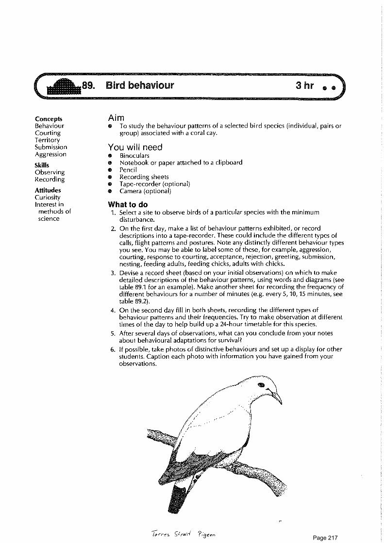
ConceptsBehaviourCourtingTerritorySubmissionAggression
SkillsObservingRecording
AttitudesCuriosityInterest inmethods ofscience
Aim• To study the behaviour patterns of a selected bird species (individual, pairs or
group) associated with a coral cay.
You will need• Binoculars• Notebook or paper attached to a clipboard• Pencil• Recording sheets• Tape-recorder (optional)• Camera (optional)
What to do1. Select a site to observe birds of a particular species with the minimum
disturbance.
2. On the first day, make a list of behaviour patterns exhibited, or recorddescriptions into a tape-recorder. These could include the different types ofcalls, flight patterns and postures. Note any distinctly different behaviour typesyou see. You may be able to label some of these, for example, aggression,courting, response to courting, acceptance, rejection, greeting, submission,nesting, feeding adults, feeding chicks, adults with chicks.
3. Devise a record sheet (based on your initial observations) on which to makedetailed descriptions of the behaviour patterns, using words and diagrams (seetable 89.1 for an example). Make another sheet for recording the frequency ofdifferent behaviours for a number of minutes (e.g. every 5, 10, 15 minutes, seetable 89.2).
4. On the second day fill in both sheets, recording the different types ofbehaviour patterns and their frequencies. Try to make observation at differentti mes of the day to help build up a 24-hour timetable for this species.
5. After several days of observations, what can you conclude from your notesabout behavioural adaptations for survival?
6. If possible, take photos of distinctive behaviours and set up a display for otherstudents. Caption each photo with information you have gained from yourobservations.
rres 9roa ?i3est,
Page 217

Table 89.1: Reef bird behaviour patterns (example only)
Date: Species:
Patternno
Description ofobserved pattern
Diagram Name forbehaviour pattern(if any)
1. Call (types)
2. Aggression
3. Courting
4. Courting reply
5. Acceptance
6. Rejection
7. Greeting
8. Submission
9. Food begging
10. Feeding
11. Nesting
12. Flight (types)
Table 89.2: Behaviour pattern frequencies of a reef bird (example only)
Time of commencement: Date: Species:
PatternNo
Behaviourpatterns
Frequency (record at 5 minute intervals)0 5 10 15 20 25 30 35 40 45 50 55 60
1. Call (types)
2. Aggression
3. Courting
4. Courting reply
5. Acceptance
6. Rejection
7. Greeting
Page 218

lag 90. Bird feeding techniques 1/2 hr •
ConceptsIdentificationEcological nicheFood web
Aim• To observe the feeding habits of different birds found on a reef and cay.
You will needAdaptation • Binoculars
Skills • Field sheet
Observing • Pencil
Recording • Map of island• Camera (optional)
Attitudes • Tape-recorder (optional)PerseverenceCuriosityInterest innatural world
What to do1. Walk around a coral island. Walk across the reef flat if possible. Make
observations at various times of day.
2. Observe the feeding habits of as many different species of birds as possible.
3. Record observations on a field sheet. (Use the headings shown below.) Leaveblanks where you don't have complete information.
4. Summarise the general feeding techniques and food required for the survivalof birds on a coral island.
5. Is there any recognisable relationship between beak form and feeding habit?Is there any recognisable relationship between diet and habitat?
FIELD SHEET
90. Bird feeding techniques
Bird Site Time Food Type Capturing method Beak form(draw)
Eating method
Page 219

4111691. Wrong song - bird calls 1'/2 hr
ConceptsAggressionTerritorialityCourting
behaviour
SkillsRecordingCommunicating
AttitudesCuriosityPerseverenceWillingness to
innovateInterest innaturalworld
Aim• To become aware of the diversity of bird calls, to record calls, and to
identify bird species by their calls.• To develop an understanding of the different functions of different calls by
the same species.You will need• Binoculars• Notebook• Bird field guide• Tape-recorder (optional)• Meter for recording sounds (optional)• Camera (optional)
What to do1. Focus on one species of bird to start with. Good examples are the black noddy
or mutton bird.
2. (a) Listen carefully to all the sounds your bird makes.(b) Record these sounds either with a tape-recorder or by code. Figure 91.1
shows one way of coding sounds. Devise your own code.(c) If using a tape-recorder, watch the sound-level monitor and become
familiar with the pattern for a particular call.(d) If you have a meter which can trace a graph of a sound pattern, use this to
distinguish calls.
3. Once you have distinguished different types of calls, observe the bird'sbehaviour at the same time. Can you find the reason behind the call type? Forexample, is the bird courting, feeding its mate, signalling territory limits, beingsubmissive to another bird?
4. Repeat these techniques for various bird species and present your results on achart for the information of others.
Fig. 91.1.
Ideas for further things to do5. You may wish to produce a slide/tape presentation of your work.
6. Test bird reactions when you play a tape-recording of calls back to them. Howdo they react when you play the "wrong song", e.g., a territory call tocourting birds. Do not persist with this activity if it disturbs the birds.
ReadingsPizzey, G., and Doyle, R. 1980. A field guide to the birds of Australia. Sydney:
Collins.Slater, P., Slater, P., and Slater, R. 1986. The Slater field guide to Australian birds.
Dee Why: Rigby.Serventy, D.L., Serventy, V., and Warham, J. 1971. The handbook of Australian
seabirds. Sydney: Reed.Frith, H.J., ed 1976 Complete book of Australian birds. Sydney: Reader's Digest.
Page 220

glide glide
ConceptsBird flightBird callsDiversity
SkillsObservingRecording
AttitudesCuriosityPerseverenceWillingness to
innovateInterest in
naturalworld
Aimts To observe and record flight patterns of reef birds.8 To use these records to identify birds in flight.
You will need• Binoculars (optional)O Field notebook and pencilO Bird field guide
What to do1. Observe birds flying and notice their different flight patterns.
2. Start with a slow flyer, watch carefully how the bird uses its wings, and try torecord this flight pattern. This is one way:
Fig. 92.1.
3. Record several birds of each species and see how the patterns relate.
4. Build up your records for at least five different species.
Questions to consider5. Is the flight pattern related to wing shape, wing size?
6. Does each species of bird have its own flight pattern?
ReferencesSlater, P., Slater, P., and Slater, R. 1986. The Slater field guide to Australian birds.
Dee Why: Rigby.Pizzey, G., and Doyle, R. A field guide to the birds of Australia. Sydney: Collins.Serventy, D.L., Serventy, V., and Warham, J. 1971. The handbook of Australian
seabirds. Sydney: Reed.
Page 221
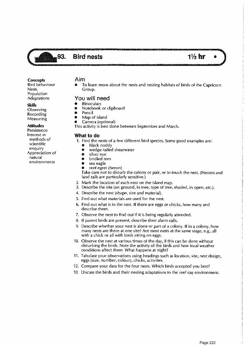
- 1MMISIMIIIMMn11n-
211693. Bird nests 11/2 hr
Concepts AimBird behaviour • To learn more about the nests and nesting habitats of birds of the CapricornNests Group.PopulationAdaptations You will needSkills • Binoculars
Observing • Notebook or clipboard
Recording • Pencil
Measuring • Map of island• Camera (optional)
Attitudes This activity is best done between September and March.PersistenceInterest in What to domethods of 1. Find the nests of a few different bird species. Some good examples are:scientific • black noddyenquiry • wedge-tailed shearwater
Appreciation of • silver eyenatural • bridled ternenvironments • sea eagle
• reef egret (heron)Take care not to disturb the colony or pair, or to touch the nest. (Herons andland rails are particularly sensitive.)
2. Mark the location of each nest on the island map.3. Describe the site (on ground, in tree, type of tree, shaded, in open, etc.).
4. Describe the nest (shape, size and material).
5. Find out what materials are used for the nest.
6. Find out what is in the nest. If there are eggs or chicks, how many anddescribe them.
7. Observe the nest to find out if it is being regularly attended.
8. If parent birds are present, describe their alarm calls.
9. Describe whether your nest is alone or part of a colony. If in a colony, howmany nests are there at one site? Are most nests at the same stage, e.g., allwith a chick or all with birds sitting on eggs.
10. Observe the nest at various times of the day, if this can be done withoutdisturbing the birds. Note the activity of the birds and how local weatherconditions affect them. What happens at night?
11. Tabulate your observations using headings such as location, site, nest design,eggs (size, number, colour), chicks, activities.
12. Compare your data for the four nests. Which birds accepted you best?
13. Discuss the birds and their nesting adaptations to the reef cay environment.
Page 222

94. Those magnificent birds in their flying machines 1 hr
ConceptsNesting e To learn more about mutton-birds, their nesting habits, and landing and take-behaviour off behaviour.
Bird movementInterrelationships
SkillsObservingMeasuring and
recordingTesting
hypothesesRecordingbird sounds
AttitudesPersistenceInterest in
bird life
Aim
• Pen, notebook; tape-recorder• Map of the island
You will need
Time needed• About 2 hours in daylight during the nesting season, from mid-October to
mid-April, for base data collection, and some observation time at night (about30 minutes at 7.00 p.m. and about 30 minutes at 4.30 a.m.).
What to do1. Select an area where burrows are present. (Be careful in site selection. Avoid
using an area of collapsing burrows. Take great care to avoid burying birds inburrows as you move about.)Record the general appearance of burrows. How can you tell if burrows areoccupied? (Footmarks? Debris at mouth of burrow? Noise?) Note and recordthe site of the burrows, e.g., near a building, near a tree, shaded or notshaded. Make a sketch of the sample area indicating these features.
2. When you have completed your observations, it might be possible to putforward some hypotheses about mutton-bird nests. Examples might includesuch statements as the following:• Most burrows occur in Pisonia forests.* Mutton-bird burrows occur beneath the nests of other bird species.• Mutton-bird nests occur in clusters.• Most used burrows are in shade.e Most occupied burrows are on the northern side of the island.
3. Make further observations. Do these support your hypotheses?
4. In the early evening, observe some mutton-bird burrows in which chicks arepresent. Watch carefully. At what times do the returning adults arrive at theburrow? How close to the burrows do they land? Do all adults arrive together?What happens when an adult approaches a burrow? What noises are made bythe adult, the chick, and the adult which stayed at home? Did one of theadults stay at home? (When the chick is partially grown, both adults fly to seato feed and collect food for the chick.) Make notes of your observations.
5. Using a tape-recorder, record the sound the adult makes at the burrow. Whathappens if you play the sound back to it? What happens if you play the soundat another burrow? Record what happens.
6. Early in the morning, about 4.30, the adults fly back to sea, taking off in certainareas often called runways. Locate one of these in daylight (identifiable usuallyas a path leading to the beach) and observe quietly what happens when theadults take off. How do they lift off? What happens when they are airborne?Where do they go? Are they together? Return to some burrows. Is it all peaceand quiet? Are chicks sitting outside burrows?
Page 223

Aim• To investigate the species of insects and spiders on the cay, and to develop
an understanding of these with their habitats.
You will need• Permit to collect insects and spiders
Skills • Field notebook, table, pencilObserving • Butterfly netRecording • Small collecting jars, or plastic bagsInterpreting • Identification books (e.g. Mather and Bennett 1984)
AttitudesCuriousity What to doPersistence 1. Read the summary of insects and spiders in Mather and Bennett and check
any reference books for identikits.
2. Draw up a table on paper or field slate, using headings such as these:DateSide of caySite descriptionHabitat (under bark, in trees, on rock, under earth, in air, in web or hole,
in or on leaf, etc.)Description of speciesAction while observedHow gets foodIdentification — name
3. According to Mather and Bennett, recordings of insects and spiders on mostof the cays are both spasmodic and incomplete. Therefore, any details youobtain of these species will be useful to the Queensland National Parks andWildlife Service. Keep your data carefully and be prepared to give it to theAuthority's database.
4. Select a suitable area for investigation of habitats of insects and spiders andexamine it carefully. Make recordings of what you see and hear (and feel?). Ifnecessary, collect your spider/insect in a jar/net/bag, and examine it closely.Attempt to return it alive to its own habitat area.
5. Make notes as to where you find the insects and spiders, their actions at theti me of your observation, and how they are collecting food. What are theyeating? What eats them?
6. You could also note their methods of home-making, locomotion, eating,defence, etc.
7. Attempt positive identification of some of your spiders/insects.
8. Are there any places on the cay where insects and spiders are found in greatabundance, or not found at all? Can you suggest why?
9. Apart from birds, insects and spiders, what are the main non-marine animalson the cays. If you had no other food, would you be able to eat them? Howwould you find out if they were safe to eat?
ReadingMather, P., and Bennett, I. 1984. A coral reef handbook (2nd ed.). Brisbane: Aust.
Coral Reef Society.
ConceptsBehaviourColour patternsHabitatInterrelationshipsDistribution
Page 224

96. Turtle watching 3 hr
Concepts AimLife history e To carry out a census of laying turtles and/or turtle hatchlings.Population • To discover as much as possible about turtle behaviour.
dynamicsPopulation You will need
monitoring • To have read information on turtles and know how not to disturb themWildlife research • Torch or caving helmet lightBehaviour e Notebook and pencilSurvival • Measuring tape
strategies • Outline map of island
Skills • To be prepared to share your knowledge with tourists
Observing This activity should be carried out for at least 3 hours over several different nights
Recording between November and March.
AttitudesPerseveranceWillingness tocommunicate
CuriosityInterest in
naturalenvironment
Interest inmethods ofscience
What to doAt some reef islands during November-January, turtles will be laying. InDecember-March, young turtles will be hatching.1. Contact staff of the National Parks and Wildlife Service at the island you are
visiting. If they are carrying out turtle studies on the island, it may be possibleto assist them with their work. If not, get permission to do your own studies.
2. Each night, walk around the island. Count the female turtles laying. Work outa system so you don't count a turtle twice. If the turtle is already laying andwon't be disturbed, note the tag number if tagged, measure across the curveof the carapace, and note any damage to flippers, occurrence of barnacles onshell, and date and time of nesting.
3. Plot nesting sites accurately on an outline map of the island. What patternscan you see? Can you explain them?
4. For several turtles each night, try to count the number of eggs and time takento lay.
5. Describe how the turtle digs the egg chamber and how she fills it in. Timedifferent actions.
6. Graph the number of turtles nesting each night for each species.
7. What is the proportion of tagged to untagged females?
8. What is the proportion of green turtles to loggerheads or other species?
Ideas for further things to do9. If there have been no National Parks rangers on the island, your records will
be valuable. Write up your results and send them to the Queensland NationalParks and Wildlife Service.
Page 225

Follow-up reading10. Find out more about what species are known to lay on your island. Which
species are most likely to be disturbed? What influence does the date of layinghave on the proportion of male to female young? Try to find out the mostrecent information on:(a) Where turtles go between hatching and maturity.(b) At what age a turtle reaches sexual maturity.(c) Whether turtles return to the same beach to lay each time.(d) Whether female turtles lay each year, or every two, three or four years.(e) Whether turtles return to lay on the same beach where they were born.(f) What each species feeds on.
11. Find out which species of turtles are considered endangered in Australianwaters and worldwide.
12. Propose conservation measures and write these up in a list which the NationalParks and Wildlife Service could pin up on notice boards.
13. Write an information leaflet on nesting turtles for tourists.
ReadingsBustard, H. Robert. 1972. Sea turtles: natural history and conservation. London:
Collins.Bustard, H. Robert. 1974. Barrier Reef sea turtle populations. Proceedings 2nd
International Coral Reef Symposium, vol. 1, pp. 227-34.Bustard, H. Robert. 1976. Turtles of coral reefs and coral islands. In Biology and
geology of coral reefs, ed. 0. A. Jones and R. Endean, New York: AcademicPress.
Limpus, C., Fleay, A., and Guinea, M. 1984. In The Capricornia section of the GreatBarrier Reef — past, present and future, ed. W. T. Ward and P. Saenger.Brisbane: Royal Society of Queensland and Australian Coral Reef Society. pp.61-78.
Seal, Vicki. 1981. The talk is all turtles, Australian Natural History 20 (5).Serventy, V., and Raymond, R. 1975. Marine turtle research. Australian Wildlife
Heritage 6 (80): 2536-41.
Page 226

Page 227

THE HUMAN DIMENSIONThe reef as human resource
97. Why people go where on holiday ........................................................................................... Island98. Tourist survey .................................................................................................................... Island99. Recreational fishing ........................................................................................................ Sea
100. Your trip by sea ................................................................................................................ Sea101. Reef quiz ............................................................................................................................ Base camp
Page 228

Page 229

97. Why people go where on holiday---7MEMINEMMUMMIIISMISS,-
ConceptsPerceptionsChoiceIndividualattractions
DifferencesWants
Aim• To assess visitor perceptions of the factors important to making a good holiday
at the reef.
You will need• Recording sheet and pen
Skills What to doRelating to others 1. Talk to 10 to 20 different visitors to find out what is important to them on a
Communicating holiday. Ask each person to number the holidays listed on the fieldsheet in
Interviewing order of importance to him or her. (Put a number 1 in the box alongside their
Analysing data first choice, a number 2 alongside their second choice, etc., down to number14 alongside their last choice.)
2. Analyse your results. Did you expect these results? How do the visitors' ideascompare with your own?
3. Was there a difference between the answers of males and females?
4. Was there a difference between age groups?
5. Would the facilities and features of the island provide for the visitors' wants?(For example, good shops, nice scenery?) If not, what do you think should bedone?
Further things to do6. You may be able to complete the more detailed "Tourist survey" in activity 98
to get more opinions.7. Contact the Queensland Tourist and Travel Corporation for their recent
surveys and reports.
AttitudesCuriosityInterest inothers
Appreciation ofmethods ofscientificenquiry
Page 230

Person no„ sex and approximate age group
No.: 1 (example) No.: No.: No.: No.: No.:Sex: Male Sex: Sex: Sex: Sex: Sex:Age: 25-34 Age: Age: Age: Age: Age:
Holidayattraction
Good food
Accommodation
Shows/entertainment
Nice scenery
New places
Learning new things
Good weather
Sea bathing/snorkelling
Making new friends
Sun bathing
The beach
Shopping
Fishing
The reef
12
14
13
6
7
11
4
1
5
10
3
9
8
2
FIELD SHEET
97. Why people go where on holiday
Recording sheet
Age groups: 15 yrs and under 45-5416-24 55-6425-34 65 and over35-44
Page 231

Tourist Survey
ConceptsPerceptionManagementTourism
SkillsData collecting • Duplicated copies of survey form
Evaluating • Pen
Communicating • If appropriate, permission from the resort manager or other tourist operatorto interview visitors
Attitudes This activity will take about 15 minutes for each survey.Tolerance
and respect What to dofor others 1. Before the trip, draw up a list of questions you would like to ask visitors, or
use the survey sheets as a guide.
2. Before starting your survey, your leader should obtain the tourist operator'spermission. You should discuss how the interviews are to be carried out.Decide how to select and approach visitors, how to explain the purpose of thesurvey, and how to avoid infringement of privacy.
3. After obtaining the data, you should attempt some correlation, e.g.• Do overseas visitors expect different scenery from Australians?• Do older people undertake activities different from younger groups?• What percentage of visitors knew who managed the Marine Park on a
day-to-day basis?
4. As a result of your data, do you want to recommend some action? To whom?
Ideas for further things to do5. Try these activities:
• "Why people go where on holiday" (activity 97)• "Perception of place" (activity 134)• "Showing off" (activity 147)
Aim• To interview tourists about their impressions and perceptions of an island to
find out whether their expectations of the island were met during a visit.
You will need
Page 232
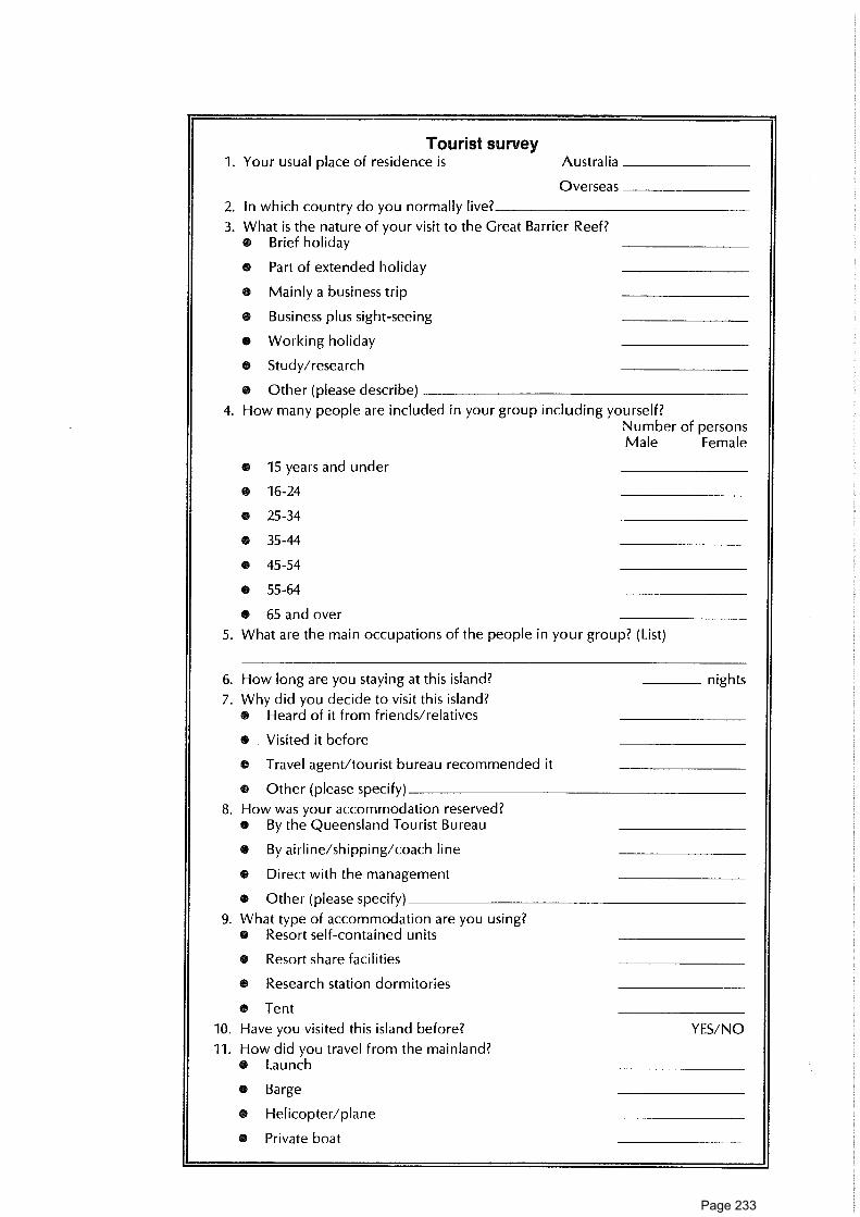
Tourist survey1. Your usual place of residence is Australia
Overseas
2. In which country do you normally live?
3. What is the nature of your visit to the Great Barrier Reef?• Brief holiday
• Part of extended holiday
• Mainly a business trip
• Business plus sight-seeing
• Working holiday
• Study/research
• Other (please describe)
4. How many people are included in your group including yourself?Number of personsMale Female
• 15 years and under
• 16-24
• 25-34
• 35-44
• 45-54
• 55-64
• 65 and over
5. What are the main occupations of the people in your group? (List)
6. How long are you staying at this island? nights
7. Why did you decide to visit this island?• Heard of it from friends/relatives
• Visited it before
• Travel agent/tourist bureau recommended it
• Other (please specify)
8. How was your accommodation reserved?• By the Queensland Tourist Bureau
• By airline/shipping/coach line
• Direct with the management
• Other (please specify)
9. What type of accommodation are you using?• Resort self-contained units
• Resort share facilities
• Research station dormitories
• Tent
10. Have you visited this island before? YES/NO
11. How did you travel from the mainland?• Launch
• Barge
• Helicopter/plane
• Private boat
Page 233

12. Have you ever visited other parts of the Great Barrier Reef? YES/NO
If yes, when
and where
13. Would you recommend that your friends visit this island and spend more orless time than you have?O Will suggest longer stay
• Will suggest shorter stay
• Will not recommend visit
• Don't knowWould you like to give your reasons for answering this question as youhave?
14. What natural features did you expect to find on this island (e.g. palm trees, alagoon, forest)?
15. What facilities did you expect to find on this island (e.g. tennis courts,shopping facilities)?
16. What have you been doing on the island during your stay?• Eating
• Swimming
• Other sports
• Walking on the island
• Coral walking/viewing
• Fishing
• Trips to other areas
• Scuba/snorkel diving
• Other (please specify)
17. What other activities would you have expected to do (but did not have theopportunity to do) on the island?
18. Is this island a national park? YES/NO
19. Did you know that the waters and reefs in the Great Barrier Reef area are partof a marine park? YES/NO
Who controls this marine park?
• The resorts
• University of Queensland
• Commonwealth Government
• Queensland National Parks and Wildlife Service
• Great Barrier Reef Marine Park Authority
• Queensland government
O Don't know
20. Who is responsible for the day-to-day management of the Great Barrier ReefMarine Park?
Page 234

21. What are some restrictions which apply under the terms of the Great BarrierReef Marine Park?
22. Do you think oil drilling should be permitted on theGreat Barrier Reef? YES/NO
23. Do you think scientific research on the Great Barrier Reefshould continue? YES/NO
24. Some researchers have recommended that reef walking should be bannedbecause of the damage to the coral. Do you agree?
If staying at a resort25. How do you find the resort meets with your expectations in terms of the
following?• Accommodation/food
• Facilities (pool, courts, etc)
• Recreational opportunities
• Educational programs
• Organisation/management
0 Suggestions for changes:
26. On this island, do you expect to use or participate in the following?• Walks on the reef
• Educational programs (guided)
0 Displays/museum
• National rangerpark
• Interpretive centre
• Poster, card, information books
• Tours to other islands/reefs
• Organised night entertainment
• Fishing trips
• Shopping facilities
• Televisions
• Baby sitting
• Other (please specify)
27. Do you like having landscaped areas around the resort YES/NO
28. Do you consider that water pollution would be a problem on the islands?Why?
29. Do you feel land/soil pollution is a problem? YES/NO
Why?
30. Did your visit meet your expectations? In what ways?
31. What changes, if any, would you recommend for this island?
Thank you for your assistance.
Page 235

99. Recreational fishing • • _711111n011-_
Concepts AimFisheries • To develop skills in interpreting the Great Barrier Reef Marine Park AuthorityManagement regulations on recreational fishing.Conservation • To follow the motto "Enough Fish for One Meal" while fishing.
Skills You will needCatching,
Using literature • Bait net (check if permit required)
preparing and • Boat and outboard motor complete with safety gear
cooking fish • Fishing gear (hand lines, sinkers, hooks, bait)
• Great Barrier Reef Marine Park zoning informationAttitudes • Fish identikit or field guideFishing ethics • A licenced boat driverSelf-reliance • Correct anchoring gear, e.g., reef pick
What to do1. Discuss how many fish you will need for one meal.
2. Find out about recreational fishing regulations at the reef you are visiting andread carefully the zoning information.
3. Check weather, tide, boat, gear and equipment.
SAFETY RULES• Do not go offshore further than 50 metres.O Do not go out in one boat alone.• Do not gut fish near snorkelling or swimming areas.• Do not keep fish that are unsafe to eat or that are the wrong size.O Do not stay out too long — 2 hours must be considered a maximum.
4. In choosing your spot, stay clear of areas prohibited for fishing and stay awayfrom popular snorkelling areas.
5. Tell someone where you are going and when you will be back. Watch thetides. Wear suitable clothing.
6. Go out and catch the number of fish you need. (If you catch a fish which isprotected or undersize, return it quickly.)
7. Clean and prepare your fish by gutting and filleting it.
8. Either pan fry or cook in alfoil.
Ideas for further things to do9. Discuss the zoning strategy for the reef you are visiting. Does it have a reef
appreciation area? Does it have a seasonal closure area? If so, why do youthink it has these? Why are some parts of the Great Barrier Reef Marine Parkset aside as "replenishment areas"?
10. Locate information about coral trout. Draw a diagram of a coral trout andmake notes on the habitat of coral trout. Seek information on coral troutsurveys carried out under the auspices of GBRMPA. Why are the surveys doneand what have been their findings and significance? Try to find out how manycoral trout are caught at the reef you are visiting. What about catches duringprevious trips by members of your group?
11. With other members of your group discuss and make a list of some reasonsfor and against going fishing at the Reef. How important are each of thesereasons in your view?
Page 236

12. Do you think that the principle of catching only "enough fish for one meal" isa worthwhile one? Why?
13. In some parts of Australia, there are legal limits, called bag limits, on howmany fish can be caught by a recreational fisherman in any one day. Do youthink that such bag limits should also apply in the Great Barrier Reef area?Why?
ReadingsGrant, E. M. 1982. Guide to fishes. Brisbane: Department of Harbours and Marine
( Use waterproof edition)Russell, B. C. 1983. Annotated checklist of the coral reef fishes in the Capricorn-
Bunker Group, Australia. Townsville: GBRMPA.
Page 237

100. Your trip by sea •
Concepts AimDistance 0 To record some of the main features of the boat you travel on, the conditionsDirection you experience and the things you see on your trip.HullCharter You will needSafety Pencil and notebookLife rafts This activity will require a total of about 3/4 of an hour at various times during yourWeather trip.SwellSea What to doNavigation Your trip
Skills 1. (a) What is your destination?
Observing (b) What is the date today?
Communicating (c) How far is your destination from the mainland port?(d) In what direction is your destination from the port?
Attitudes (e) How long is your trip expected to take?Enjoyment of
Finding out about the boatoutdoor
2. Find out the main features of the boat you are travelling on by talking withexperience
your group leader and/or the boat's skipper or crew.Interest in
(a) What is the boat's name?interrelatedness
(b) What are the main materials of which it is built?of people
(c) How long is it (metres)?and environment
(d) How many hulls does it have: one, two?Appreciation of
(e) What is the maximum speed it can travel (in knots)? How fast is one knot?i mportance of
(f) Is it designed for skimming over the water (planing) or travelling throughsafety procedures
the water (displacement)?
3. (a) Has your group chartered the boat or is this a regular service?(b) How many passengers is this boat allowed to carry out to sea?(c) What sort of work does this boat usually do?
4. Make a very rough plan showing a bird's-eye view of the boat.Label the following and mark anything else you think is interesting:bow (front end of boat); stern (back end of boat); starboard (boat's right-handside); port (boat's left-hand side); wheelhouse; cabin entrance (s).
5. Where is the engine located? You might be able to indicate this on yoursketch.
Safety on board6. How many life rafts does the boat have? Mark their locations on your
sketches.
7. Find out where the lifejackets are kept on the boat.
8. What are some safety precautions you have been asked to observe while onboard?
9. What are some procedures you have been asked to follow if there is anemergency?
The boat's equipment10. If possible, visit the wheelhouse of the boat:
(a) What is the skipper's name?(b) How many items of the following navigation and safety equipment can
you see?chart; radar; magnetic compass; echo sounder; pelorus; sextant; radiotransmitter; computer.
Page 238

(c) Which of the above is used to do each of the following jobs?• Measure the depth of the sea floor beneath the boat by using sound
waves?• Show the boat's heading or directional orientation relative to magnetic
north?• Enable a navigator to check distances from nearby land, and to "see" such
things as other ships at night and approaching rainsqualls in a radius ofabout 25 km.
• Provide a map which shows land and sea areas, depths to sea floor, andlocation of reefs, shoals, buoys and lights?
Weather and waves11. What weather has been forecast for winds and the state of the sea on the day
you are travelling?
12. When you are away from the mainland, look at the surface of the sea and tryto distinguish between swell and sea waves, using the following information.
The waves you see when you look at the surface of the ocean may be oftwo kinds: sea waves and swell waves.Sea waves are being produced in the local area you are in. They move inthe same direction as the wind you can feel blowing around you. Theyoften have a rather irregular appearance.Swell waves have been generated elsewhere and have travelled out of thearea in which they were produced. They have a more regular appearancethan sea waves. They travel in regular succession and in a well-defineddirection with rounded crests. They are not travelling in the samedirection as the local wind.
13. (a) Look at the swell waves. Try to estimate approximately how often a swellwave passes you and about how high the swell waves are.
(b) Look at table 100.1. Based on your observations, how would you classifythe swell your boat is experiencing? Ask others what they think.
14. Look at the sea waves and at table 100.2(a) About how high do you estimate the waves are? What is their general
appearance? Into what classification on table 100.2 would you place them?(b) Based on the appearance of these sea waves, what description would you
apply to the wind?(c) What number on the Beaufort Wind Scale would you apply to the wind
which is blowing?(d) According to the table, what is the maximum wind speed in knots?
Traffic15. When you are 20 minutes away from the mainland, start making a log of any
boats or aircraft which you see. Record the time you first spot it, and thedirection of its travel (towards or away from mainland). What kind of boat oraircraft does it appear to be? What kind of job does it seem to be doing? Doyou observe anyone aboard? If so, how many?
Wildlife16. When you have left the harbour, make a log of any wildlife you see on or in
the ocean.
Ideas for further things to do17. Write something on the following, and compare notes with your friends.
(a) Most enjoyable things about the trip.(b) Worst things about the trip.(c) Most interesting things about the trip.
Page 239

Table 100.1: State of swell
Period of swellwave (seconds)
Swell wavelength (metres)
Probable heightof swell waves
(metres)
Classification
Less than 11 0-200 0-2 Low swell of short oraverage length
Greater than 11 over 200 0-2 Long low swell
Less than 8 0-100 2-4 Short swell of moderateheight
Greater than 8Less than 11
100-200 2-4 Average swell ofmoderate height
Greater than 11 over 200 2-4 Long swell of moderateheight
Less than 8 0-100 over 4 Short heavy swell
Greater than 8Less than 11
100-200 over 4 Average length heavyswell
Greater than 11 over 200 over 4 Long heavy swell
Source: From Observing the Weather, p. 14.
ReferencesAustralia. Bureau of Meteorology. 1984. Observing the weather. Canberra: AGPS.Queensland Dept of Harbours and Marine, Official tide tables — coast of
Queensland, and notes on boating.
Page 240

kr, --1-Cs, =ry 0
- • -‹. 2.- --,T. .---7 r D
-'<-• 0-7,. *
-< 0 0-
c)gi w--.. B'5 c.c an•,, o_
.-< ,',-.. 0
-7P, fl.,'rD ..<
c•D v,0_ CD.
0
FCFri
•-•<
S4
D..,
o-Ln.5_a •
ac
a ,
O o,
< rn - 0 -c <kr7.
60., to
ro.< 0 rD A 2 m - •-•.& -, cro - 0 -,. r, •-<_., o , o- n- a'
•* * '..-e4 -.. F ,,t, rD a-
•Z
=
o- = -, 5 6-4 .
0 .-_.-* 0 :D cr' * 7 . C-tn -I ru < c., 0, 0"w 0 . — _ c 0
- *T:i F6 ...z• — o,T. „K ^ - •- D , .,.. • - , rr, 0 <
(7) = - < m- = *0 ro n 0 0.-_ = ty,
c.„ =-. 0- a-C . ,.,. -,rD ro (1,, 0- 0 rt, -• *a CL ,, D- D, .r, a -. crq - •
cD 0 0 ,., 0- ..9 a.Sc-in 0_ 0 -,.. ro _,0 ",:„"- ,... 0 n ,,i,., 0 0— i-, ,, 0- ,..., =0 a, a
,,, a•-•• rD •CD a — --• *CD
o* Lc, CD -, 0-.T o., 3 ' m-. <
5' < ,,, = 5 I). ., . 0., =, 2 NrD ....,rD . .:-.-. , < r, t
mHn (T, a, ".< D 3 c„. . „. . -•-,i3 - rD 7 C ::u A-• CIn ao ..J_ „, a, a (IT ,, =r 5 (D 0_ u, ,, l=, n
-• =- , -,t", CD N. 0,, c,, L-, roto .7, •-0 a
°- 3 0,- * crq a;CT C . r, , - 0-'CT M ° ='• - - S" H
* 1:1 3 r;:,1 (.7 g ro a-a 5 -a 0_ • a M0 - -, - . CCD <-
0
-. 0 3 ="'''' 1/270,, ,...,.r-8 ,r°
0 _,.-^ ..-Z-Ei . cr o., o. o--r, =- 0 ''' ...= EI 0 -•3 rp 0 3 . ',..Z = n a
-. ,r) 0. S - e7D' -7- ‘,f) '' - pa,'
ic.. ,,.. „.,--,.. •-i a-"6 0 o-• ro 3
* - M _,- •2.=-," co rt, =• -'a- ,... a ., =_. . P- 3,
.rD -
0 i-• ,s ac
,„< *,), c,
Cr 0ft, v,
cro- . 00_
c, --'r̀Sa
-c...-0FD,
„.- D,,.,-, r-C 036. a'riT w
m .0., 3a_ ,an A=
--.o m-< rDro-, 0_•4f, Ry f•:.)r-'" 5''` ay o
,-.< -'-'co 2-::",, rt,,-,rD *‹. 1.
in- •"o-L n=— 76-.7 .'-'1‘..
• .,-, n.rt, o 0
._, ,r, 0612 ,z C.
w
-0 C.,_ T--,, -, -<
-4 0-a= - ,. .0 ' a
H D.-* 0-
. 05 ,,,o_ a- <• cu ro
D ..,0
__crr,u -,5" 0.-p
07 .,5' (.1)* aqro -•- 7-
3 0a O.-, D
(D (.nO.u, o-, na, -0, (D
,..,.,, ,A0-. cr0 CD7 crq.=I S5 5'ro 0-
(76LU,-
5' 3 -, rori,"'11-,
. z., -0(-7 ul•-•m eup "05..- w
n0 0_0_-• *ris 07n 7-1.-. CD5 — o, 0,
.,-. 2- -,CD 00- ,* 35 . 0-0- FP• DL,,-
5'cra
*w<cou,0-o
ac,- •=,.,,ElCTrD0-0*a5
.
n<Ll.; as
D'" o,0, rDp ,— a-7:' a'-, 0,:,0 -.cr 0
2.7•-•< _,-,O
a
0
O' 3a ..-•.'
, S--0 a),0., *'5 C-
— .L..ro-'-.0
3nc-1-3ulL.,DJ
33ori,roxFriaa""(D
0' ° CL.co
f=") !=?.713 co
*u•-• D.,"' <3 m9., ,r,-,-.1- ';n - .0- 0,,, crca c.r) _a,0 O
(-13
6 -02 ..1rD a'
17- c
'. 20_c.7-
CM-6.,0'=
3co
*m-_.a',
D`'z-n=*<rDu,-CTmr)0B.7
D0
ETC
0.,Drt,-, .y-•'..Z'
3.0gC-*7-.7.(Do-o
l'3Y'
-ri? g.:3- 6,3D., rD13 *
<D, ri:,,..,. (IT-ci; .77," •c-Da nn* 7°2.7 7g o_
a- m0 CS•n CrD -,,, o.
0-
30.,z-Hocu30_otiritntn
`.<co
-o-0cu,o,7nCI'
la, kr.,-0 3V '''2 = *
z 0,<
rDc-o-a., *
7 ,,,cL -,,,, —._° —F:, -...,. o-,cr '''rii Cr
D„ c
•x.-
30.,co
-080
or)mn_
en(713ul
o-,a,<rom.,
ac,o....,u,,..<
0 0
vii
70 v,
• rD D,'0_ =rD 7L-Ln rt,* ,„.,-.^+ 2=- _
5' 'ro 9,0, •
.-32
.,D,ar",CDo
Len1:,rD,.,.,I:.
rE
3CD
o-F.,
4..,_0.-4.
o p.,
3nPD-'"-:
kr,rDc.,
C.Ft.;-.,.oz
-a
"--.1
...,co
L.., i:oVb
u-,in
4,...._, i0
_.,co
-a:_,
00-,
0i..)
0.....‘
DJ<(1)
„.. 2--J ,... o (D -0
II/ -.30 .."' .., 0::::,. rD - 0-......, =-. 0.) D'' EIJ rD < ro 0-
0 , co „,..,-.rD 0--...
-aTrDCO30Cc.,
CDr),.•
-o 7]a a-rD rDC ao 03 3rD 0C C_ c,,c., _
'Ai ,'Sz.) r).•
<(I).<a-
Fo'a-
16,-7-
<(D
-- '
2e.
a:.0--
700-
cma-
K0CLa,F.3F-D
L,07-G7
7--,
(i),.,,-,os._
surDCDF
ntu-3—
-_1 .-0-0ro0_
nDJ
3at,
C1J
,-.<
nEU
3as
OJ
-.<
Fp'C fS,,, C.v, •7rD .El,— 0
IC,7-1•
.ff.mrD
< (.,-,-.0r7,z,,,,6.
g
kr,-,oCac
C)r..,0
Z0...,
cr:7-‘7
cn,0D
o.cz.-7;rDN.co
,,-r3,D.-
o--;roNrip
K0,.c
,sCr,7
Na)
nm0=
a'cr7.1),rDNrt)
r-.... .,..,m--••o -
roNro
0a .
R:o,-•
n.3
3-, N""-0..-....o
00_ l'
_,IV
_, ....,_, CD ,C. Co --.1 CI u-, 4 LA., N., -a CD
COro Bt' C...._
3 9'--:: 2
.p.-!..4
ul coAcr, co6-, in(...) t.JI
-A
.1,NJ
LO.4.4,0
cn NJ0)
(.1.dLAJ
N.)P.)N.1
N,,J
In4-a
-an_,
C",
NJ,_,cm
4,O -,
_,(..,
r-
(1)
5'D
r-
§.S .
A- 0m
u,i' "Q
I'DCDQ.
2.)-1
CD
O
CDa)
O"
rDo.)
CD
CD_
C
0.)
ro
Page 241

All6a 101. Reef quiz % hr • •
ConceptsRecallIdentificationSelf-assessment
SkillsIdentifyingCommunicating
AttitudesInterest inreef environments
Desire toachieve
Aim• To test your recall of reef features on facts about the reef.You will need to do this activity near the end of your trip. A wet day or evening isa good time for this. Specimens may need to be collected beforehand.
You will need• One or more collecting permits (QNPWS, GBRMPA)• Specimens, objects and pictures to make up exhibits for a quiz (Note:
Specimens from reef or island should be collected only with permission ofyour leader and strictly in accordance with park collecting permits.)
• White cards or sheets of paper for presenting quiz questions• Pencil and paper for writing answers
What to doBeforehand
1. Divide into pairs. Each pair is to devise two items for a quiz. Each item shouldbe based on an exhibit of a specimen, object or picture of something youshould all have seen during your trip. After deciding what you want to do,consult with your leader to avoid duplication and to make sure that you planto collect only in accordance with your group's collecting permit.
2. Collect the needed specimens or select the required pictures for yourexhibits. Use a separate white card for each exhibit. On the front of the cardprint clearly one or more very simple questions about the exhibit, e.g. "Whatis this?" or "Where would you find this?" On the back of the card write theanswer(s).
3. Lay out the exhibits in a sequence at your base camp. Assign numbers to theexhibits. Make sure that living specimens are kept in appropriate containersand conditions, e.g. plenty of water.
Running the quiz4. All participants should walk past the exhibits, writing down answers to
questions.
5. When everyone has answered the questions, turn the cards over so that theanswers are visible. Now check your answers. How well did you score? Make atally of the total class scores on the board.
6. Turn the cards over again. Repeat the process of writing answers and checkingthem. Has your personal score improved? Has the class score improved?
7. If you want to, continue until total mastery by your whole group is achieved.You could make a graph showing the improvement.
8. Make sure all specimens are returned as quickly as possible to the reef orisland in accordance with your permit.
Ideas for further things to do9. Make up a set of reef question cards suitable for playing the game Trivial
Pursuit.
10. Conduct a quiz based on 35 mm slides. The questions can be read out as theslides are projected.
11. Make up a quiz based on touch rather than sight.
Page 242

Some suggested items for quiz• Corals: dead skeletons, e.g. staghorn, mushroom, organpipe, knobbly.• Algae: common species of both live and dead (from flotsam).• Sea stars: e.g. live specimens of blue Linckia.• Holothurians: e.g. live specimens of at least two species.• Sand pellets: cast by holothurians.• Beach rock: small piece that has broken naturally off the outcrop.• Mollusc: live specimen of red-lipped stromb. Pictures of chiton and clam.• Crabs: piece of dead crab skeleton; live specimen of other crab.• Landplants: e.g. Pisonia leaf; Casuarina foliage; fruit or seeds of Pisonia.• Birds: feathers, pictures of common species.• Turtles: pictures of turtles or their trails.
Page 243

Human impact
102. Effects of humans ......................................................................................................................................... Island103. Litter on the island ...................................................................................................................................... Island104. Waste disposal from a cay ....................................................................................................................... Island105. Trampling effects on a reef flat ............................................................................................................. Reef walking106. Effects of building projects ..................................................................................................................... Island107. Are you a perfect camper? ..................................................................................................................... Island108. Effects of boating ........................................................................................................................................... Snorkelling109. Wrecks .................................................................................................................................................................. Snorkelling
Page 244

Page 245

gag 102. Effects of humans
Concepts AimPollution 6 To assess the influence of humans on a reef area.EnvironmentHuman impact You will needChange 0 Recording materialsConservation This activity will require at least 11/2 hours at various times during your visit.
SkillsObservingRecording
AttitudesPerseverenceConcern forchanges madeby humans totheirenvironment
What to doKeep the following questions in mind all the time you are at the reef. Make notesof any evidence you observe yourself. Ask questions of other visitors or long-termresidents. Read literature concerning the effects of human activities at this reef.1. People activities
(a) Make a list of five human activities which occur here.(b) For each of these, suggest two or three possible effects on the island or
reef environment. Are these effects detrimental or beneficial to theenvironment?
2. Pollution(a) What forms of pollution occur here?(b) What evidence is there of pollution?(c) What human activities cause pollution here?(d) Do you observe any measures designed to control or minimise pollution?(e) How could pollution be further controlled here?(f) Is one part of the island (or reef) more polluted (e.g. by litter) than
another?(g) Summarise your findings using a map to show polluted areas and perhaps
a graph to show frequency of pollution over time (e.g. noise pollution bygenerators or oil discharge from boats) or by common items (e.g. cans orcigarette butts on beach).
3. Other effects of humansDiscuss these questions:(a) How might the following aspects of the island and reef have been
changed by people?O flora and fauna of the islandO life form of the reefO shape of the island and reef(b) What evidence can you see of such changes?
Page 246

411116103. Litter on the island ........)*
Concepts AimDistribution • To find the most littered sites on the island and draw up a plan to reduce
Association these.EnvironmentPlanning You will need
• Measuring tape or rule; paper for recording• Map of the island• Observation time of about 5 minutes for each site
What to do1. Find the places on the island which have the most use at, say, three set times a
day — you could try 9 a.m., noon, and 5 or 6 p.m.
2. Mark out a circle at each spot of, say, 20 metres.
3. At each site, count and record the amount and types of litter in the circle ateach of the three times in a day.
4. Repeat the counting and recording over several days.
5. Now summarise your results: Which is the most littered site? At which time ismost litter found? What is the main type of litter? Does one particular groupof people litter?
6. Think about what you could do about this litter. Would you recommend toisland authorities that more litter bins be provided? or that certain items berestricted in the shops? or that regular clean-ups of certain areas should beundertaken? or that litter fines be imposed? (Most of these types of actionsare available to owners or lessees of islands, and apply in any national park.)
7. On the other hand, do you think little can be done and that your findingswould be disregarded?
Ideas for further things to do8. Attempt some of the activities concerned with other aspects of human impact
on reef areas, e.g. "Waste disposal from a cay", activity 104.
SkillsObservationRecording
AttitudesConcern forthe environment
Acceptance thatpersonal actioncan beeffective
Page 247

104. Waste disposal from a cay 2 hr
ConceptsWaste disposalBiodegradibility
SkillsData collectionEvaluation
AttitudesPerseverenceCuriosityConcern forchanges madeby humans totheirenvironment
Aim• To investigate methods of disposing of waste from a cay.
You will need• Recording sheet and pen• Camera (if available)
What to do1. Observe and record methods of disposal of solid wastes, e.g. food, tins,
greases, plastic, drums, old machinery, roofing iron, bottles, paper.
2. Observe and record methods of disposal of human wastes, e.g. septic tanks,deep sinkers (i.e., pit toilets).
3. Observe the discharges from the desalination plants in resorts.
4. Assess the biodegradibility of materials released into the environment.
5. What improvements could be made to this waste disposal?
Ideas for further things to do6. Try activities 103, "Litter on the island", 102 "Effects of humans", 152 "Do the
right thing".
7. Find out the regulations which apply to waste disposal in the Great BarrierReef Marine Park.
Page 248

"LESSMINI=SOMMIL ---
105. Trampling effects on a reef flat 2 hr •
ConceptsEnvironmental
i mpactControlledexperiment
Coral growthform
SkillsObservingInterpretingDesigningexperiment
Thinking critically
AttitudesConcern for naturalenvironment
Aim• To observe some of the damage done by humans as they walk across a reef
flat.
You will need• Reef-walking gear• Recording sheet and pencil• A few metres of coloured plastic tape• Outline sketch map of reef-top (or air photo)• Magnetic compass and measuring cord or tape
What to do1. In a part of the reef-top popular with reef walkers, select three study areas
about 5 metres square on the outer reef flat. If possible, mark out the areas bytying small lengths of plastic tape to pieces of coral at each corner. Mark thelocation of your study areas on the map. (Obtaining bearings with a magneticcompass could help you to identify the location of your study plots.)
2. Make a map of each plot showing the areas covered by dead coral, live coraland sand. Use symbols to indicate the growth form of corals. Record signs ofdamage using symbols. Look for broken-off fragments, unhealed fractures,overturned colonies, ditches through strands of branching coral.
3. Visit the plots on subsequent days after reef walkers have visited the area. Arethere any signs of change? Plot fresh damage, if any, using symbols.
4. If evidence of damage is present in these study plots, can you be sure that reefwalkers caused it?
5. How could an experiment be designed to explore reef-walking damage toplots?
6. The next time you go walking on the reef, walk very carefully, and observethe results. Despite your care, were any colonies broken?
7. Consider your observations. Do some parts of the reef-top seem to be morevulnerable to damage than others? Are some coral growth forms morevulnerable than others to breakage?
8. Discuss with members of your class: How can damage from trampling beminimised?
Ideas for further things to do9. Find answers to the following: Is breakage of coral always detrimental? In
what way might breakage be of assistance to a coral species?
10. Read research publications on the effects of trampling on corals and on reef-walking management.
ReadingKay, A. M., and Liddle, M. J. 1985. Manual for assessment location and design of
reef-walking activities. Technical report of the Great Barrier Reef Marine ParkAuthority.
Page 249

4116106. Effects of building projects 1/2 day
ConceptsHuman i mpactManagementResourcesdevelopment
SkillsObservingRecording
AttitudesConcern for
maintenanceand improvementof environmentalquality
Aim• To observe and assess the effects of construction works taking place on an
island.
You will need• Recording materials• Camera (optional)
What to do1. You may see engineering and building projects going on around you.
Consider the following questions and make some detailed notes.(a) Where is the project?(b) What is its purpose?(c) Who is responsible for it?(d) How many workers are involved?(e) What happens to material removed from the site?(f) What appear to be the environment changes occuring?(g) Are flora and fauna being removed or damaged?(h) Does the final project meet requirements of the island management plan?(i) Is everything possible being done to minimise the effect of the project on
the environment of the island?(j) What recommendations would you make about safeguarding the
environment in the area where the project is taking place?
2. Compare your findings with others. Do you all agree?
Page 250

107. Are you a perfect camper? 2
ConceptsEnvironmentHuman impactExperimentControl
SkillsObservingMeasuringExperimenting
AttitudesInterest inscientificenquiry
Concern forchanges madeby humansto theirenvironment
Aim• To study the effects of camping damage on a coral island.
You will need• 8-10 metres of string or cotton• A camera• Recording materials
What to do1. Set up your campsite.
2. Accurately measure your camping area with string, i.e., the tent, your cookingarea, the spot where your sink is, your personal space.
3. Using the string, mark out a control area of approximately the same size in alocation adjacent to your camp site.
4. Mark this second area carefully with a sign:EXPERIMENT CONTROL AREA
PLEASE DO NOT ENTER
5. Photograph the two sites at the beginning of the camp. At the end of thecamp, when you have cleaned up your site, photograph both sites again.
6. Make a list of any changes which have occurred in each site. What changeshas camping caused?
7. Make a list or take photographs of other camping damage, and make aphotographic report on camping damage when you return home.
8. How could you have prevented this damage?
Ideas for further things to do9. Try to find out how many people camp at this island each year. Are limits
placed on the numbers of people who are allowed to camp here? Is itnecessary to obtain a permit to camp here? What restrictions are applied?
Page 251

Mg 108. Effects of boating71.---11111n1111111---
Aim• To study the effects of boating damage on a coral reef.
ConceptsManagement
Skills You will needObserving• Snorkelling equipment
Attitudes
•
Underwater camera (optional)Concern for • Underwater slate and pencilmaintenanceand improvement What to doof environmental 1. Select a study site and snorkel over the area looking for damage caused byquality boats.
2. You will need to look carefully for the effects of:• boat hulls hitting the reef• boat propellers• reef anchors and chains• fishing lines• sinkers• rubbish — cans, glass, etc.
3. If you can, take photographs or make descriptions of the area damaged.
4. Assemble all your evidence (photographs and/or sketches) and make a reportof the effects you have noticed. Your report should include:• description of the damage• notes on how the damage seems to be caused• your ideas on how such damage can be prevented.
Ideas for further things to do5. Find out about new ideas for mooring which are now being developed for
use in reef areas.
Page 252
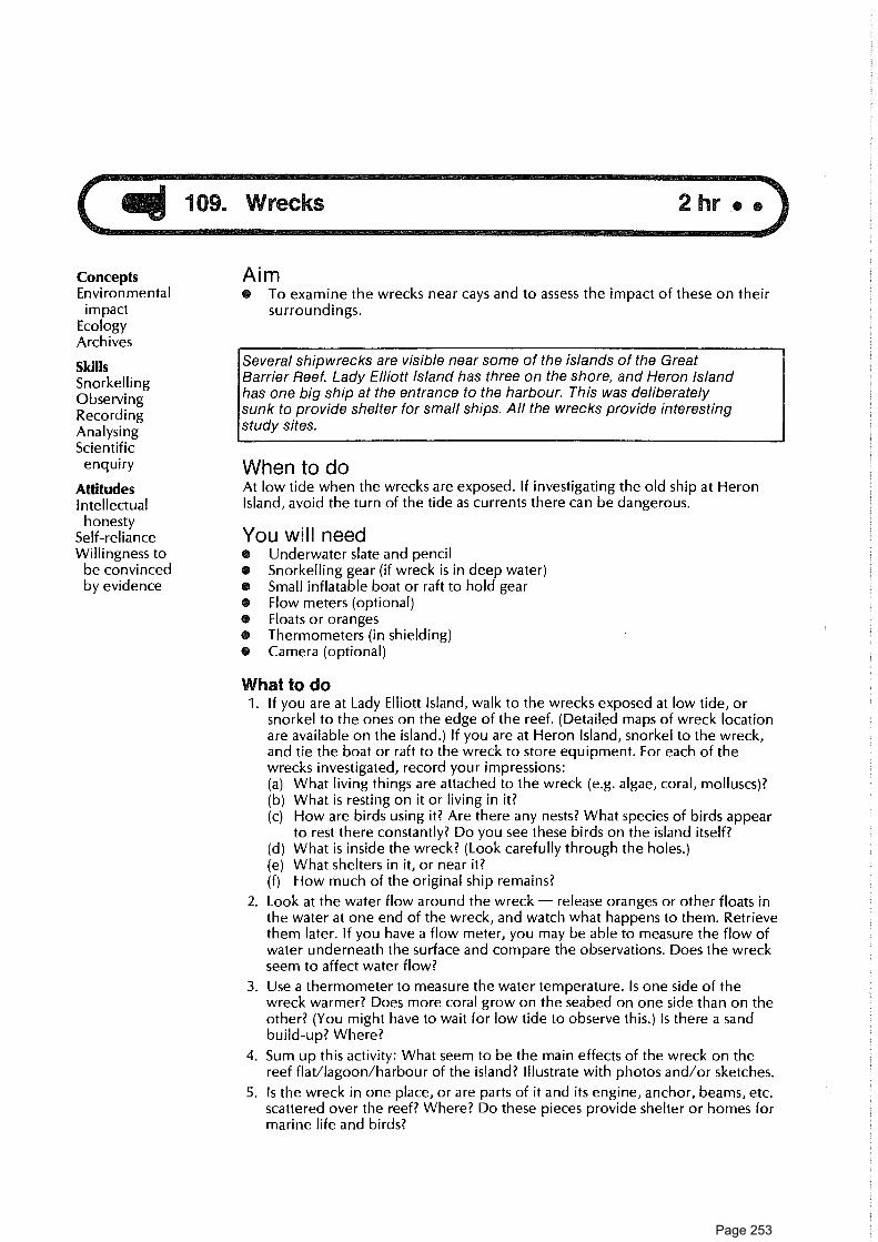
ConceptsEnvironmental
i mpactEcologyArchives
SkillsSnorkellingObservingRecordingAnalysingScientific
enquiry
AttitudesIntellectualhonesty
Self-relianceWillingness to
be convincedby evidence
Aim• To examine the wrecks near cays and to assess the impact of these on their
surroundings.
Several shipwrecks are visible near some of the islands of the GreatBarrier Reef. Lady Elliott Island has three on the shore, and Heron Islandhas one big ship at the entrance to the harbour. This was deliberatelysunk to provide shelter for small ships. All the wrecks provide interestingstudy sites.
When to doAt low tide when the wrecks are exposed. If investigating the old ship at HeronIsland, avoid the turn of the tide as currents there can be dangerous.
You will need• Underwater slate and pencil• Snorkelling gear (if wreck is in deep water)• Small inflatable boat or raft to hold gear• Flow meters (optional)• Floats or oranges• Thermometers (in shielding)• Camera (optional)
What to do1. If you are at Lady Elliott Island, walk to the wrecks exposed at low tide, or
snorkel to the ones on the edge of the reef. (Detailed maps of wreck locationare available on the island.) If you are at Heron Island, snorkel to the wreck,and tie the boat or raft to the wreck to store equipment. For each of thewrecks investigated, record your impressions:(a) What living things are attached to the wreck (e.g. algae, coral, molluscs)?(b) What is resting on it or living in it?(c) How are birds using it? Are there any nests? What species of birds appear
to rest there constantly? Do you see these birds on the island itself?(d) What is inside the wreck? (Look carefully through the holes.)(e) What shelters in it, or near it?(f) How much of the original ship remains?
2. Look at the water flow around the wreck — release oranges or other floats inthe water at one end of the wreck, and watch what happens to them. Retrievethem later. If you have a flow meter, you may be able to measure the flow ofwater underneath the surface and compare the observations. Does the wreckseem to affect water flow?
3. Use a thermometer to measure the water temperature. Is one side of thewreck warmer? Does more coral grow on the seabed on one side than on theother? (You might have to wait for low tide to observe this.) Is there a sandbuild-up? Where?
4. Sum up this activity: What seem to be the main effects of the wreck on thereef flat/lagoon/harbour of the island? Illustrate with photos and/or sketches.
5. Is the wreck in one place, or are parts of it and its engine, anchor, beams, etc.scattered over the reef? Where? Do these pieces provide shelter or homes formarine life and birds?
Page 253

Ideas for further things to do6. Go back to the wreck when tide conditions are different. Check conditions
around the wreck. Are there differences between your observations at highand low tide?
7. Research the history of the wreck. How old is it? What caused the shipwreck?Where did the ship come from? What should have been its destination?
8. Have there been attempts to preserve the wreck? Why do you think theAustralian government has now passed a law protecting all wrecks?
Further research9. There are investigations of various wrecks going on all round Australia. The
Great Barrier Reef Marine Park Authority publishes a Reef Note on wrecks.Wrecks can be investigated by referring to the readings or by research in yourlocal library or museum.
10. Make observations of the materials and construction methods used inbuilding the ship. What evidence is there of corrosion?
ReadingsBateson, C. 1972. Australian shipwrecks, vol. 1, 1622-1850. Sydney: Reed.Loney, J. 1980. Australian shipwrecks, vol. 2, 1851-1871. Sydney: Reed.
Page 254

Page 255

Human well-being
110. Keep cooking ................................................................................................................................................... School111. Safety on the reef ......................................................................................................................................... Base camp
112. Dangerous reef creatures .......................................................................................................................... School113. First aid at the reef ......................................................................................................................................... School114. Survival from trees ......................................................................................................................................... Island115. What would you do if ................................................................................................................................. Base camp116. Human comfort on a cay ............................................................................................................. Island117. Castaways on the reef .................................................................................................................... School
Page 256

Page 257

110. Keep cooking
ConceptsHygienePlanningNutrition
SkillsOrganising
AttitudesWillingness to
cooperateTolerance and
respect forothers
Aim• To cooperate as a group in organising the meals for your trip.
You will need• Writing materials• Information from the field-trip organiser about facilities which will be
available for cooking at the island and about arrangements already made (ifany) for food supplies.
What to do1. Discuss the roles each of you wishes to play in cooking, depending upon what
facilities you will have. This will depend on which island you are visiting.
2. Make a list of jobs.
3. Plan what food and equipment to take. How is the food going to bepurchased? You may need to get a list of food prices before you can makeyour plan.
4. Decide how you are going to transport food and equipment.
5. Decide how you are going to store food and equipment.
6. Submit a complete organisation plan for your group based on the following:• Food list (includes breakfast, dinner, lunch and snacks)e Cooking facilities required (gas, billy, water container, etc.)• Cooking roster (includes days, and names of those doing the preparing
and washing up, as well as those who will be cooking)• List of responsibilities (includes who buys food, who will supply particular
items).
Page 258

ConceptsSafety
SkillsDecision makingCooperatingCommunicating
AttitudesAppreciation of
importance ofhealth andsafetyprocedures
Aim• To become aware of the need for safety on the reef.
You will need• To work in a group• Paper and pencil• Blackboard
What to do1. Brainstorm in your group (maximum of six people) a list of unsafe situations
for your forthcoming trip. Appoint a leader and scribe. (5 minutes)
2. Reduce your list to the six most dangerous situations or places. Remember therules for brainstorming. (5 minutes)
3. Each group leader reports back to the class on the six most dangeroussituations or places. (5 minutes)
4. The class then decides what the six most dangerous situations or places areand why they are dangerous. (Class discussion)
5. Prepare an individual report on the need for safety on the reef.
RULES FOR BRAINSTORMING• No criticism of other people's ideas.n All ideas are written down, irrespective of whether you agree or not.o After brainstorming, criticism begins.
Page 259

112. Dangerous reef creatures 1 hr7."
ConceptsToxinVenomPolypStinging cellHydroidSafety
SkillsObserving What to doUsing literature 1. For each dangerous creature shown on worksheet A, select a name from the
list given and write the names in the spaces underneath the pictures. Usereference material to help you make your choices, and/or discuss with yourteacher.
2. Using reference books or slides on marine organisms, colour the main areasof each picture lightly so that its distinctive colour features are shown.
3. Answer each of the questions shown on worksheet B, using informationgiven.
4. Why do some reef animals produce toxic material and develop the ability toinject it?
5. How can visitors avoid injury from these creatures?
6. What are the dangerous effects of these creatures? What are the main first-aidtreatments for these?
ReadingsCovacevich, J., Davie, P., and Pearn, J., eds. 1987. Toxic plants and animals: a guide
for Australia. Brisbane: QId Museum.Edmonds, C. 1975. Dangerous marine animals of the Indo-Pacific region.
Melbourne: Wedneil Publications.Edmonds, C. 1984. Marine animal injuries to man. Sydney: Wedneil Publications.
Marsh, L., and Slack-Smith, S. 1986. Sea stingers. Perth: W. A. Museum.Saenger, P. 1977. The diver's guide. Brisbane: AUF.
Aim• To become more aware of some dangerous animals which can be met during
reef walks and snorkelling activities.
You will need• Coloured pencils• Reference books or slides on dangerous marine animals
Page 260

INFORMATION SHEET A
112. Dangerous reef creatures
Crown-of-thorns starfish (Acanthasterplanci)Colour: Blue-grey arms often with reddish-orange tips
Location:Description: Up to 60 cm in diameter andup to 16 arms covered with short, sharpspines. Spines can penetrate human skin.Venom may be injected. Slime on thestarfish can irritate human skin.
Sea-urchins with long spines (e.g. Diademasetosum, described below)Colour: Black
Location: On sandy bottoms or under rocksin reef-top pools or on reef slope.
Description: Have very slender needle-likespines about 25cm long. The spines are verybrittle and sharp. They can easily penetrateand break off in human skin.
Sea-cucumber (e.g. Holothuria leucospilota)Colour: Various colours, according tospecies
Location: Sandy bottoms.
Description: Sausage-shaped bodies. Whendisturbed, many species produce stickywhite threads from arms. Material fromthese may cause inflammation of humaneyes or skin.
Stonefish (e.g. Synanceia horrida, describedbelow)
Colour: Brownish; mottled
Location: Buried in mud, coral or rocks inshallow water.
Description: About 30 cm long. Lies quietlyconcealed on bottom. Strong spines alongthe back pierce human body if trodden onor touched. Venom is discharged intowound.
Bristle worm (e.g. Eurythoe complanata,described below)
Colour: Salmon pink
Location: Under boulders or in weed matson reefs.
Description: Body up to 14 cm long with apair of short hollow bristles on eachsegment. The bristles contain venom whichcauses painful injury if touched.
Butterfly cod (Pterois volitans)Colour: Red and white striped
Location: In reef-top lagoons and reef slopehabitats. often under ledges or in caves.Description: Up to 35 cm long. Brightlycoloured. Have long spines along the backand in the anal and pelvic areas. The spinescan pierce human flesh and venom passesalong the spine into the wound.
Page 261

INFORMATION SHEET A (cont.)
112. Dangerous reef creatures
Fire coral (Millepora) (sometimes calledstinging hydroids)Colour: Light brown with smooth, yellowishbranch tipsLocation: On outer reef flat and upper partsof reef slope.Description: Has a hard limey skeleton withs mooth stumpy branches. Looks like a truecoral but is a member of a related group, thehydrozoans. Has minute stinging polyps in itsbranches.
Cone shells (e.g. textile cone, Con us textile)Colour: Often have striking patterns ofvarious kinds. The textile cone pattern is oneexample.Location: On bottom of reef flat andelsewhere. Often buried or hidden.Description: Usually, but not always, coneshaped. Inject venom using a harpool in theirmobile proboscis. Easily confused withharmless types of shells, such as the red-li pped stromb. Beware!
Stingrays (e.g. blue-spotted ray, Taeniuralymma, described below)Colour: Bright blue spotsLocation: In shallow waters of reef-top. Mayshelter under ledges during day. May bepartly buried on bottom.Description: Flat disc-like body about 37cmin diameter. Long whip-like tail may inflictwound and discharge venom.
Box jellyfish (Chironex fleckeri) (sometimescalled sea wasp)Colour: Translucent; almost colourlessLocation: Often in shallow water in muddyinshore areas but can also be found in manyother kinds of locations.Description: Consists of round-topped, box-li ke bell (often 10-17cm) attached to manytentacles up to 2 metres long. Stinging cellsoccur on tentacles.
Stinging hydroid — "white" (Lytocarpusphillipinus)Colour: WhiteLocation: In deeper water than fireweed.Look out for this when snorkelling over theouterslope of a reef.Description: This is a more delicate hydroidthan fireweed. It has a feathery appearance;stems are brown; polyps are white.
Fireweed (Aglaeophenia cupressina)Colour: KhakiLocation: Reef flat, among coral in pools.Description: This looks like a clump of smallbrown fern but is actually a colony of smallanimals — hydroids. In each "frond" there isa central stalk and side branches along whichsmall stinging polyps occur.
Page 262
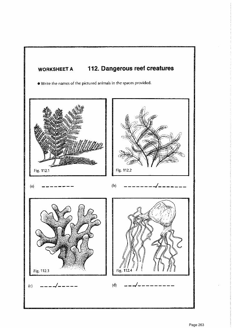
(a) (b)
(c) (d)—I
WORKSHEET A 112. Dangerous reef creatures
Write the names of the pictured animals in the spaces provided.
Page 263

112. DaLgerous reef creatures
Page 264

Page 265

WORKSHEET B
112. Dangerous reef creatures
• In each of the spaces below write an appropriate name from the range of animals illustrated onworksheet A.
(a) Molluscs which inject venom using a harpoon
(b) Red-and-white fish which sting using venomous spines
(c) Feathery white animals whose polyps contain stinging cells
(d) Hard brown-coloured colonies with yellow, smooth tips
(e) Bottom-dwelling fish with venomous barbs on whip-like tail
(f) Plagues of these echinoderms haveoccurred at some reefs
(g) Animals which dwell on the surface of the sea and which arehazardous in northern parts of the Great Barrier Reefarea in summer months
(h) Material from the slimy outside of these animalsmust not be allowed to get into your eyes
(i) These dull-coloured fish are well camouflaged.Wear stout shoes when reef-walking.
(j) Khaki animal colonies which look like brown clumps of fern
paamaJH (1) `Lisi}auols `saaciwnpro-eas (Li) `Lis!jAilar xog (S) `Lisuieis suJogi-}o-umoaD (j)`sAeiSups (a) leao3 (p) `sp!cupAq SUIS I1S (3) 'pop Aipaung (q) auoi (e)
)aatis>pom o) siamsuv
pop AuJaung (I) 'Llsgauols (1) 'AeAups (f) 'Hays auoj `Jaqwrona-eas (q) ‘qs!pels swoql-}o-umao (S)‘u!ipm-eas (j) `11.1JOM ailspg (a) `qs!}Ailar xog (p) 'lamp ()) `paipAq Su!Sups (q) `paamaqi (e)
laatis,pom o) siamsuv
-J
Page 266

113. First aid at the reef
ConceptsFirst aidSafety
SkillsUsing reference
materials
AttitudesSelf-relianceResponsibility
Aim• To become more acquainted with some first aid procedures on the reef.• To become familiar with the contents of the first aid kit being taken to the
reef.
WhenAfter your group leader has talked with your class about first aid and dangerousmarine creatures on the reef.
You will need• A first aid book or booklet• Some reference books (see below)
What to do1. Complete the first aid table using the information available in the reference
books.
2. Make sure you have your table checked by your group leader for accuracy.
3. Check the first aid kit list and decide whether the proposed kit would besufficiently stocked and complete to handle the injuries and complaints listed inthe table. What changes if any do you suggest?
Ideas for further things to do4. Look through an actual first aid kit so that you become familiar with the
contents and arrangement of the kit.
ReferencesThomas, R., and McKenzie, B. The divers' medical companion. Diving Medical
Centre Monograph, repr. 1986.Dunleavy, M. 1981. Stay alive. Canberra: AGPS.Edmonds, C. 1975. Dangerous marine animals of the Indo-Pacific region.
Melbourne: Wedneil Publications.Edmonds, C. 1984. Marine animal injuries to man. Sydney: Wedneil Publications.Saenger, P. 1977. The divers guide. Brisbane: AUF.St John's Ambulance Brigade First aid manual.
Page 267

First aid table
Injury or complaint Marine creatureinvolved (if any)
First aid
Severe sunburn
Coral cut to the ankle
Jellyfish sting to arm
Puncture wound from stonefish
Boiling water burn
Bite from a centipede
Bite from a wobbygong shark
Sea-sickness
Stepping on glass
Cramp while snorkelling
Asthma
Sore ears
Ulcers in the mouth
Diarrhoea
Broken ankle
Severe headache
Cone shell sting
Cut from a rusty peg in the ground
Page 268
ConceptsPhotosynthesisTranspiration
SkillsObserving • 5-6 clear plastic bags
Recording • Shoe lace
Measuring • String or rubber bandn Measuring cup
Attitudes You will need a total of about 1 1/2 hours spread over half a day.Self-confidenceTree-appreciation What to doSelf-reliance 1. Select a variety of trees — Argusia, Pisonia, she oak.
2. Carefully place a plastic bag over some leaves and seal the end.
3. Observe what happens over the next hour.
4. After 3-4 hours, collect the water and measure the volume.
5. How much water collected in each bag?
6. How many bags would you need to survive off each kind of tree?
Permit required - one group only to do this per trip.7. Before your trip, write for a permit to collect 50 Pisonia shoots.
8. If you received the permit, collect 50 fresh young Pisonia shoots. Wash them.Lightly cook in 50/50 salt/fresh water and serve with freshly cooked fish. Yum!
ReferenceCribb, A. B., and Cribb, J. W. 1976. Wild food in Australia. Melbourne: Collins.
Aime To acquaint students with survival techniques using trees.
You will need
Page 269

115. What would you do if ...? 3/4 hr •
Concepts AimHazard • To discuss what you would do if you had bad weather whilst on your reef trip.CycloneSurvival You will needSkills e An example of a cyclone warning pamphlet
DiscussingPlanning What to doDecision-making 1. With other members of your group discuss what you would do if:
Clarifying values
• a cyclone warning was given two days before your trip.• a cyclone watch was given two days before your trip.
Attitudes • it rained continually for the whole trip.Willingness to • strong winds and rain occurred for the whole of your trip.cooperate • a cyclone struck the island and you were unable to be evacuated.
Initiative • you were delayed by two days on the island owing to high seas.Appreciation of • transport fails to arrive and you have two extra unplanned-for days on the
i mportance of island.health and
2. Find out what the emergency procedures are for your area.safetyprocedures 3. Devise a plan among your group to prepare for each of these situations.
Page 270

jai 116. Human comfort on a cay
ConceptsClimateWeatherMicroclimateComfortPerceptionRelative humidity
SkillsMeasuringEvaluating
AttitudesI nterest ininterrelationshipbetween humansand theirenvironment
Aim• To collect data about the weather conditions at various places during your
visit to a cay and to use this to decide on the most comfortable spots on theisland.
You will need• A map of the island• Weather instruments: cup anemometer, ventimeter or other wind gauge,
compass, whirling psychrometer (wet and dry bulb thermometer)• 30-metre tape• Coloured tape to mark sites• Recording sheet• Watch• Pencil• Bureau of Meteorology records for your island or a nearby island (optional)This activity will take 5 minutes at each site selected around the island on severaldays.
What to do1. Select at least six monitoring sites on the island. Some should include the
beach front. Mark each site on the map. Identify the site with a piece ofcoloured tape with the site number marked on it. Visit each site on arotational basis. If there are enough instruments, simultaneous readings at,say, six sites could be recorded at one time.
2. Record wet and dry bulb temperatures using the whirling psychrometer.Record wind speed and direction. Repeat just above ground level. Record thecloud cover, time and general conditions. Then move to next site and repeat.
3. Record data on sheets.
4. Graph the results for each site.
5. Evaluate the data you have collected, and work out how the microclimate onone part of the island differs from that on another part. Decide on:• the warmest place on the island.O the most sheltered place if SE winds or NE winds are blowing.e the coolest place (if it is mid-summer).Make a map showing these areas.
6. Advise other people of the spot(s) on the island where you think conditionsare:• most favourable for sunbathing.• most likely to be cooler.
7. Discuss with others in your group: What weather factors affect out comfort? Isany one factor more important than another?
8. Is it possible to predict how comfortable we feel from measured data ontemperature, humidity, wind, etc.?
9. Devise a method to find out how people's feelings compare with themeasurements made using instruments.
ReferenceAustralia. Bureau of Meteorology. 1984. Observing the weather. Canberra: AGPS.
Page 271

Temperature Surface wind Present weather
Date Site Upper Gro and Dir- Upper Lower Cloud Remarksandtime
Drybulb
Wetbulb
Drybulb
Wetbulb
ection Km/h Km/h % cover
Weather recording sheet
Page 272

II 117. Castaways on the reef 11/2 hr • •
ConceptsSurvivalDecision makingValues
clarification
SkillsWorking in a
groupDecision makingAnalysing andevaluating
AttitudesCooperation
AimTo make group decisions for effective survival on a reef island.
What to do1. Form into groups of eight. Read the situation below and follow the
procedures.
2. Swap decisions with other groups.
3. Discuss your decision-making process. Was everyone's opinion taken intoaccount? Did you consider all the possibilities in making the decisions?
4. Would your decisions about the importance of the salvaged items have beendifferent if you had been considering their usefulness to a group staying onthe island? How?
SituationYou are one of eight members of a school group on a field trip to study a cay onthe reef. It is the last week in January. You are 8 hours out of port when, at10.40 a.m., your launch is overturned by a humpback whale and sinks. The driverand the teachers of the group are drowned. The rest of you are relativelyuninjured. You all swim to a nearby cay and land safely on the beach.You know that the mainland is approximately 70 kilometres west of where youare. When your launch does not report to its base that evening you will be missed.It is known generally where you are, but because of the nature of your outingpeople will not be able to pinpoint your exact whereabouts, and it may take atleast three or four days before a launch or plane spots you.The island is rather barren and very dry. You heard from a weather report beforeyou left that the temperature would reach 35 degrees, making the surfacetemperature 45°C on the beach. You are all dressed in lightweight, summerclothing and sandshoes. Before your launch sank, you were able to salvage thefollowing items.
Magnetic compass; large, light-blue canvas; book, Marine Animals of theReef; 1 hand mirror; 1 flashlight; flask of rum; 1 pocket knife; 1 cigarettelighter; 1 packet of sandwiches in a plastic bag; accurate chart of the sea,sealed with rubber band; 1 20 m length of rope; 1 litre bottle of vinegar; 4canteens, each containing 3 litres of water; 4 hats; 3 pairs of sunglasses; 2 pairsof fins; 1 dozen oranges; 1 packet of bread in a plastic bag; Zodiac inflatableraft (not a life raft).
Decisions to be madeThe group ultimately needs to decide whether to stay on the island or to try toboat out.But before making that decision, try to rank the salvaged items in order of theiri mportance to your future if you do decide to sail out. (Some items may have tobe left behind!) Each of you should, first of all, individually list the items accordingto their importance for survival in a boat: no discussion allowed! Then the wholegroup should discuss this and re-rank. Remember to use the ideas from all thegroup. Continue the process until you are all in fundamental agreement about thevalue of the salvaged items.Now, try to reach a consensus about your future actions. Decide if the wholegroup should try to boat out using a makeshift sail, or remain on the island andsurvive on what you have and can find. Or should the group split up and, if so,how should the salvaged items be allocated?
Page 273

Creative response118. Reef orchestra ................................................................................................................................................. Base camp
119. Art and the reef .............................................................................................................................................. School
120. Kite making ...................................................................................................................................................... Island
121. Projection art ................................................................................................................................................... Base camp
122. Art and photography ................................................................................................................................. Island
123. Fil m makers ..................................................................................................................................................... Island
124. Graffiti wall ........................................................................................................................................................ Base camp
Page 274

Page 275

118. Reef orchestra • •
ConceptsSoundToneRhythm
SkillsInterpreting
musical scoreMusicalperformance
Expressing
AttitudesWillingness to
interact andcooperate withothers in agroup
Enjoyment
Aim• To present a musical interpretation of the Great Barrier Reef using reef-
inspired instruments.
You will need• Some copies of the "music" in figure 118.1 (optional)• Instruments such as:
Large Pisonia leaf (a permit may be required to pick leaves)Bottles with sand and small pieces of dead coral in themStraw, basin of waterSmall water containersSmall branchSticks and some pieces of beach rockSome old coral piecesPieces of dead coral or shells hung from sticks
What to do1. Select your instrument and agree on the score.
2. (a) One person conducts each group of instruments.(b) Perform your piece, allowing individuals to express their feelings without
worrying too much about the music.Note: If you are in a national park, the "natural" component must be returned tothe site of collection afterwards.
= increase in volume
III V VII
.y W / .
."--ODId eohie.► .- C'eT 11Ii..., e;"t It
4:4007-1)so
fo•4, foilfie
or.- ncoo
-z.-- \\ ,
„--- ,. .„-_.-1..--___---. e.------- --".------ *"."-------
I 11 IIII
11 14 1 1 1 1111 1 1 1 1 11111 111 1 1 111 1 1 1 11
I 11 11 11 111 11 111 1 1 11 1 11 111 11111111111111 111
Blown tree leaf andsingle note whistling.
Shaking bottles filledwith sand and stones.
Blowing through astraw into a containerof water.
Water being pouredfrom one container toanother.
Rustling branch acrossfloor etc.
Tapping sticks on rocks.
Tapping coral pieces'together.
OC BOTTLES C>
STRING-BASS
Fig. 118.1.
Page 276

Concepts AimEnvironmentCreativityPerception
• To represent your impressions of the Great Barrier Reef in an artistic way.
You will need
ill 119. Art and the reef
Skills • Pencils, charcoal, crayons, paper
Expressing • Coloured or black paper
Craftwork • Cellophane
Modelling • Glue• Origami paper
Attitudes • Cotton gauzeAppreciating • Light card in several colours
aesthetic • 3 kg plaster of Parisqualities • A basin
Perseverence • A book on origami• Roll of self-adhesive Contact• Fabric paint in red/black• Stanley knife or razor blade• Permit (where appropriate)
What to doSelect from these suggestions to express your feelings:(a) Using paint, charcoal, pencil or other medium, depict the same scene at
sunrise, noon and sunset.(b) Do reverse pictures (black/white) of trees, shells, coral, etc.(c) Select a small portion of a large object or scene and draw the detail in a
"blow-up", using black or colour.(d) Try drawing an enlargement of a grass seed, the stamen of a flower, the
opening of a shell, the junction of a twig with a branch.(e) Using coloured or black paper, create a mosaic or picture or silhouette on
white paper to show some aspect of the reef.(f) Using scraps of coloured paper and a large sheet of butcher's paper, make a
collage inspired by a reef cross-section or a reef food web.(g) Make origami (paper folding) fish and suspend on a mobile.(h) Make a fish mobile, using fish shapes cut from paper or card, suspended by
cotton or fishing line, to be hung in the classroom. These can also be madefrom coloured cellophane or coloured tissue paper, with fine wire supports(florist's wire) to permit light to show through shapes.
(i) Make 3D replicas of fish, shells, sea stars or any other suitable living or deadreef organism using plaster of Paris, plasticine or clay (permit needed). If youuse plaster of Paris, you need about 1 kg of plaster in a basin with fresh waterto mix to a paste. Press the animal briefly into damp sand to form a mould.Return it to its original site. Then pour freshly mixed plaster into the mould,and wait till it is set. Dispose of waste plaster carefully.
(j) Design a logo suitable for using on the proposed field trip to the reef. Itshould be suitable for black and white reproduction.
(k) Design a poster showing dangerous marine organisms of the Capricorniagroup area. (This should preferably be in colour and have some type of scale.)This could be prepared beforehand and displayed on the field trip.
(I) Do spray painting of leaf shapes using a piece of gauze wire, toothbrush andwater/plastic paint (can be used for species identification).
(m) Make a "bark" painting on a card (postcard size).(n) Make a design on a T-shirt by making a stencil from a piece of self-adhesive
Contact and painting fabric paint over it with a brush. The design could be areef shape or symbol. Cut the design as an aperture in the plastic with a razorblade or Stanley knife. Place a wad of newspaper inside the T-shirt. Strip thebacking paper off the plastic, press the plastic on to the T-shirt and then painton the colour. Leave the shirt to dry. Iron the shirt before washing to set thepaint.
Page 277

120. Kite making //2 h
Concepts AimWind currents * To make and fly a kite on the reef in order to develop an understanding of wind
Skills currents over an island.
Making a kiteUsing wind You will needObserving • Large, green plastic garbage bag
Comparing • 2 thin pieces of dowel• Masking tape
Attitudes • StringI nitiative • Fishing lineAppreciation of • Scissors
qualities ofnatural What to doenvironment 1. Cut the bag to the pattern shown in figure 120.1
2. Place the dowel pieces parallel to each other as illustrated. Make 2 holes nobigger than 10 cm in diameter as shown.
3. Reinforce the corners of the kite with tape.
4. Join the edges with string, as shown.
5. Tie at least 30 m of fishing line to the centre of the string and fly the kite fromthe beach.
6. Use your kite to develop an understanding of wind currents over the island. Flyyour kite at different times of the day. Do wind currents change? Can youexplain why? Make diagrams to show most common flight patterns.
Ideas for further things to do7. Fly the same kite at home. What differences are there?
8. Make a traditional kite and compare the efficiency.
CONSERVATIONRetrieve your kite no matter where it lands.
Fig. 120.1.
Page 278

AilL 121. Projection art 1 hr • •
ConceptsCreativityIndividualityI mageSilhouetteTransparentOpaqueProjectionScale
SkillsManipulatingsmall objects
Clarifying visualconcepts
ExpressingCommunicatingDesigning
AttitudesAppreciation of
aesthetic qualitiesof naturalenvironments
Aim• To make and show some mini works of art which reflect feelings about reef
environments.
You will need• Scissors• Thin acetate sheeting• Mounts for making 35 nom projection slides• Small quantity of PVC glue (optional)• Some of the following:
tiny reef objects (permit needed)very fine overhead transparency marker penssmall pieces of coloured transparent plastic or cellophane
What to do1. Obtain cardboard or plastic mounts of the kind used in making 35 mm
photographic projection slides. (Boxes of these mounts can be purchasedfrom photographic suppliers. Plastic ones, e.g. AGFA brand, are better.)
2. Cut two matching rectangles in the thin acetate sheeting. These should be justa little larger than the rectanglar openings in the slide mount.
3. Now, on one of the acetate sheets, make up a mini work of art which reflectssome of your impressions of, or feelings about, the Great Barrier Reef. Thiswork should be just the right size to be framed by the edge of the opening inthe slide mount. Examples of things you could do are:• make a collage on the acetate sheet of some tiny natural objects (permit
needed). The objects should be transparent or translucent or haveinteresting silhouettes, for example: fragments or dried seaweed or leafskeleton, pieces of feather, dried leg of tiny shrimp.
• use small pieces of coloured cellophane or transparent plastic in a collage.• write or draw on the acetate sheet using very fine overhead transparency
marker pens — preferably permanent. (Plan this out on paper first.)• a combination of all of the above.
4. After you have finished your work, if it is a collage, place the second acetatesheet over the objects to hold them in place. Make a sandwich by securingthe edges of the sheeting with a little sticky tape. (As a precaution, a tinyspeck of PVC glue may be used to hold the collage pieces in place.)
5. Put the acetate into the slide mount and seal the mount. Make sure the wholething is about the same thickness as a regular 35 mm slide.
6. Now project your slide for all to see!
Ideas for further things to do7. A group could make a sequence of these slides to make an integrated showing,
perhaps on a theme. You could make an audiotape to go with your slides.
Page 279

122. Art and photogaphy • •
ConceptsEnvironmentSensory awarenessAesthetics
SkillsPlanningPhotographingDisplayingCooperating
AttitudesAppreciation of
aestheticqualities ofreef environment
Concern for thereef
Aim• To convey impressions of your visit using photography and other visual media.
You will need• Camera and film• Underwater paper and pencilO Plastic bag to keep camera inO Reef-walking gearThis activity will need to be done at various times during the trip.
What to do1. Select one or more of these ideas, and plan and take photographs to suit.
(a) Study elements within the environment that show harmony orarrangement or balance or emphasis or contrast or colour or unity.
(b) Try to convey the "feel" of corals.(c) Do a series of shots on one subject only; e.g., leaf patterns or leaf colours
from one site or a bird and its activities or a nest in a tree over a period ofti me.
Unless you are using a polaroid camera, you will need to assemble yourdeveloped photographs after you return to fit your selected topic.
2. People sometimes make "bark" rubbings of trees. With your underwaterpaper and pencil, make an underwater rubbing of a marine organism.
Page 280

ConceptsLandscapeVisual impactVisual evaluationSensory awareness
SkillsPhotographyScriptingProductionPlanningEditing
AttitudesAppreciation of
landscape
Aim• To plan, produce, film and edit a video film, or sequence of photography, on
part of the reef.
You will need• VHS camera and film• Porta-pak• Spare batteries• Tripod• Writing materials• Small blackboard• Battery charger (if electricity available)• Carry pack• Polaroid or underwater cameras
What to do1. After some initial activities on the island and reef have been followed,
"brainstorm" ideas about what you would like to put on film as a record ofyour visit.
2. Do you want to film specific places, or events, or a specific species in itshabitat? What is your audience? What is the purpose of filming? Somesuggested topics are:O Recreation on the Great Barrier ReefO Life on the Reef Flat• Transit across Island and Flat to RimO A Ranger's Life• Human Use and Impact on the Reef• Sea-cucumbers/Sea stars/Molluscs• Vegetation VariationsO Legs and Arms• Sounds and Scenes
3. Set up a production team; select suitable sites; write a script; work out shots(long shots, panning, close-ups, high or low angles; back or side lit —especially for still camera shots). Editing is time-consuming so you may have toreshoot scenes which have notable blunders. On video, sound can be dubbedin later, but try to include some sounds of the reef at the time of filming.Musical scores can be taped and used to back up a slide or photograph show.Practice first, especially if you are using voiceovers or interviews. Viewingprofessional videos on the reef should help you to know what is effective.
4. After your trip, edit your work and have a film show or slide display.
Page 281

Ai 124. Graffiti wall
ConceptsEnvironmentFeelingsIndividualdifferences
SkillsExpressingDrawingEvaluatingCreating
AttitudesToleranceConcern for
reef
Aim• To express your feelings about your reef visit.
You will need• Large white plastic garbage bags• Masking tape• Large felt-tipped pens (black and/or coloured)• Space to hang bagsThis activity can take place over the entire trip
What to do1. Split open the bags and stick them on to a convenient wall. Use pens to draw
pictures, cartoons, brief statements, comments on your observations, activitiesand feelings about your visit. Allow others to add to your graffiti display.
2. Use this graffiti wall to evaluate your trip and your group's feelings about thereef environment.
Page 282

Page 283

Human perceptions and perspectives
125. How do I feel? ................................................................................................................... Base camp126. Reefscape aesthetics ......................................................................................................... Island127. Arousal evaluation ............................................................................................................. Base camp128. Perspectives ....................................................................................................................... Island
29. Be a detective! ................................................................................................................... Island130. Guess the texture ............................................................................................................. Island131. Blindfold walk ................................................................................................................... Island132. A sound map ..................................................................................................................... Island133. Can we map it? ................................................................................................................. Base camp134. Perception of place............................................................................................................. Base camp135. The best place and the worst place ............................................................................... Base camp136. Me and the reef ................................................................................................................. Base camp137. I want to preserve my personal space! ......................................................................... Base camp138. I magine .............................................................................................................................. Island139. How are we satisfied? ....................................................................................................... Base camp
40. Shell jewellery ................................................................................................................... Island141. Decisions! Decisions! ....................................................................................................... Base camp
Page 284

Page 285

125. How do I feel? 20 min
Aim• To increase your awareness of your own feelings about reef landscapes.
You will need• Pencil
ConceptsEnvironmentIndividualdifferences
Perception
SkillsCommunicating What to do
1. Study the list of paired words and tick the dash which you feel matches yourAttitudes response to Reef scenery and happenings. For example, if you feel that theAppreciation of Reef is very complex, you would tick the dash nearest to the right on the firstenvironment line. If you have mixed feelings about a landscape, or no opinion, tick the
dash in the middle of the line between the two words.
Simple Complex
Bright Dull
I mpressive Unimpressive
Obvious Mysterious
Colourful Colourless
Distant views Limited views
Pleasant Unpleasant
Flat Hilly
Frightening Secure
Known Unknown
Orderly Chaotic
Varied Monotonous
Artificial Natural
Diverse vegetation Uniform vegetation
Idyllic Degraded
2. After you have placed a tick on each line, discuss your responses with severalpeople.
3. Compile the results of the entire group. Discuss.
Page 286

ConceptsPerceptionScenic valuesConservationAesthetics
SkillsEvaluating
landscapeDecision making
AttitudesAppreciation ofaestheticqualities ofreefenvironments
Aim• To establish the scenic quality of a reef landscape using a rating scale.
You will need• The word scale• Pen
What to do1. Sit down outside and look at the reefscape in front of you.
2. Use the word scale on and tick the space which you think is appropriate.
3. Now read the information and the MAST analysis given below, and rate the
reefscape.
Components of landscapeM =Majesty — the relative relief of the land system and the visibility or
distance of view.A = Artistic quality — the colour properties of the scenery, its shapes and
its forms.S = Serendipity — the ruggedness of the scenery and the element of
surprise. Do you know what is around the corner?T = Total atmosphere — lack of spoliation of the landscape.
4. Each of these factors has a total value of 5 points. Rate your landscape and totalthe points for each factor. The total is the MAST value.
5. Compare your value for this landscape with other students. View otherlandscapes and compare the scenic beauty of those.
6. Finally, consider this question:• If a reefscape has a high MAST value of, say, 18 out of 20, does this
automatically demand a high priority for conservation of that landscape?
(This activity was adapted from the work of Robin Simson, Queensland, and isused with permission.)
Page 287
126. Reefscape aesthetics
Word scale for landscape analysis
Majesty
(5) (4) (3) (2) (1)
Mountainous Flat
Spectacular Unspectacular
Great Small
I mpressive Unimpressive
Distant views No views
Serendipity
(5) (4) (3) (2) (1)
Complex Simple
Varied Monotonous
Mysterious Obvious
Rugged Smooth
Diverse vegetative cover Uniform vegetative cover
Artistic quality
( 5 ) (4) (3) (2) (1)
Bright Dull
Vivid Drab
Orderly Chaotic
Colourful Colourless
Attractive forms Unattractive forms
Atmosphere
( 5 ) (4) (3) (2) (1)
Pleasant Unpleasant
Tranquil Disturbed
Natural Artificial
Idyllic Degraded
Clean Polluted
Page 288

127. Arousal evaluation
ConceptsPerceptionIndividualdifferences
Self-awareness
SkillsEvaluatingGraphingInterpreting
AttitudesIntellectualhonesty
Appreciation ofenvironment
Aim• To provide an estimate of individual reactions to Reef experiences.
You will need• The word scales provided (worksheet A)• Pen and grid
What to do1. Read the discussion on worksheet A.
2. Complete the word scale for one activity, ticking how you feel next to eachpair of words.
3. Repeat for another activity.
4. Compile the data from all members of your group for two pairs of words (e.g.excited/bored and secure/insecure) for each activity. Plot this on the gridprovided on worksheet B using a different symbol for each activity.
5. Discuss your findings with the group. Is there much variation of responsewithin your group?
6. Overall, which of all the activities you were involved in at the reef gave youthe greatest emotional experience, i.e., caused the greatest feelings ofemotion in you?
Page 289

WORKSHEET A
127. Arousal evaluationOrganisations responsible for the management of the Great Barrier Reef are carrying out programs ofresearch into tourist attitudes. Visiting the Reef is centrally concerned with providing a rich and diverserange of experiences for people. Various activities for tourists appear to be different in the kind ofemotional experience provided.Some of the activities you have carried out at the reef are also used by tourists. It would be interesting toexplore your own response to these activities, and to compare your own response with those of othergroups who have been to the reef.Consider activities based on both the water and the island. Choose one water-based activity (e.g.snorkelling, chasing fish, reef-walking) and one land-based activity (e.g. island walk, bird study). Write theactivity at the top of the groups of word scales and assess your feelings for those activities in the threedimensions of Pleasure, Arousal and Dominance. For each pair of words, tick the space which best matchesyour response.
Activity 1 Activity 2
Pleasure Pleasure
Happy Unhappy - - - - - - - - - - - - - - - - - - - - - - - -Happy Unhappy
Satisfied Unsatisfied - - - - - - - - - - - - - - - - - - - - - Satisfied Unsatisfied
Hopeful Unhopeful - - - - - - - - - - - - - - - - - - - - - Hopeful Unhopeful
Pleased Annoyed - - - - - - - - - - - - - - - - - - - - - - - Pleased Annoyed
Contented Discontented Contented Discontented
Arousal Arousal
Stimulated Depressed Stimulated Depressed
Wideawake Sleepy - - - - - - - - - - - - - - - - - - - - - Wideawake Sleepy
Aroused Sluggish - - - - - - - - - - - - - - - - - - - - - - -Aroused Sluggish
Excited Bored - - - - - - - - - - - - - - - - - - - - - - - - - -Excited Bored
Frenzied Calm - - - - - - - - - - - - - - - - - - - - - - - - - Frenzied Calm
Dominance Dominance
Controlling Being controlled Controlling Being controlled
Influential Insignificant Influential Insignificant
I mportant Feeling submissive I mportant Feeling submissive
Being dominant Being awed Being dominant Being awed
Secure Insecure - - - - - - - - - - - - - - - - - - - - - - - Secure Insecure
Page 290

WORKSHEET B
127. Arousal evaluation
AROUSED
excited 5
4
1---z<z
.- 3
00I-0z
2
bored 1
2 3
NOT AROUSED
For one of the activities considered on Worksheet A, score the response to two pairs of words, "bored-excited" and "insecure-secure", on a rating scale of 1-5. Now work out an average value for the responseof your group to this activity and plot this as a point on the grid above. Repeat for other activities, using adifferent symbol for each activity.
4 5
E=U'3?,
Page 291

ConceptsPoetryIndividualdifferences
Perception
SkillsAnalysingEvaluation
AttitudesEmpathyAppreciation ofenvironment
AimTo compare your views with other people's, especially those of poets.
What to do1. In a quiet place on the reef, read the poetry extracts provided. Do you think
the poets are describing something they have seen? Do your own feelings andopinions match those of the poet? Why or why not?
2. Consider: If these poets had been given the responsibility for making up lawsand regulations concerning the Great Barrier Reef, what kinds of laws andregulations do you think they would have wanted? Would their laws andregulations be like the ones which now affect the Great Barrier Reef?
Poetry Extracts(a) The Pairing of Terns — Mark O'Connor
Human lovers know it only in dreamsthe wild mating flight of the terns:riding the weird and ungessable surf of the airthough flung round the compass they hold as one pair.Firm as if interlocked by invisible steelrigid and taut as their back-swept wingslike the sharp stretched skin of a pterodactyl.Now criss-crossing moon-high in an evening skynow outskimming the wind on the waves of a twilit baynow rising, now falling tumultuous heightsand cackling their random delirious laughter ...
... Their love is everything for which we have only metaphors,peaks and abysses, stallings and dizzying speedswild oceans of distance, and fethertip closenesses,and wingbeats that answer so swiftly none knowswhich struck first, which called and which answered ...
(b) The Killer — Mark O'ConnorMaster of two elements, the invulnerable gannetswivels his inquisitorial beak on highstudying the rocks and shoals below.
He can see all, clear as the murderous pilothefting his cargo of deth views the patternseated aloft, of ricefields and towns.
The wonder is the bird can make choiceamong such richness of life below,but he does, and thensuddenly plu-mmets, neverfailing tokill.
Page 292

(c) I am the Island — Jan Chee (unpub.)Surrounded by seaand currents in sinuous motionand ponds alive yet secretive.Surrounded, by the coralhome of the fish, the algae, the shells.Fringed by sandclothed with treessanctuary of the birds.And the wind moves continuouslyand the sun beats down.Then in walk the peoplewith machinesand feet tramp coraland bodies drift in water, head down in awe.I am the island.
ReferenceO'Connor, Mark. 1976 Reef poems. St Lucia: University of Queensland Press. By
permission.
Page 293

129. Be a detective! 20 min
ConceptsEnvironmentEcosystemPerceptionIndividualdifferences
Aim• To find examples of flora to match perceptions and descriptions.
You will need• Pencil
Skills What to doCollecting 1. Move around the island, shoreline and reef flat to locate an example that you
data can list next to each of the descriptions below.
Attitudes2. What problems are there in answering these questions?
Curiosity 3. Compare your list with those of other group members.
Appreciation ofqualities of Observation listisland • A living thing that makes its own foodenvironment • An animal that can't move from place to place
• A frightening thing• Something that is living on something else• Something beautiful• Something which can be removed without damage to the environment• Something that can't be touched• Something that's impossible to count• Something that can't be photographed• Something that has undergone change• Something that appears similar to something else• Something that was once alive
Page 294

gag 130. Guess the texture 1/2 hr- .7.7-211n7=—
ConceptsPerception 0 To examine varieties of textures found around the reefSensory awarenessDistribution You will needTexture 0 Paper, drawing materials, e.g. Pentel crayons and butcher paperIndividualdifferences What to do
Skills 1. Take a piece of paper about 10 centimetres square and make a small hole in it.
Observing Use the hole as a peephole through which to view textures of, say, trees,
Drawing beach rock, the ground, building materials.
Interviewing 2. Find one texture you like and draw it as realistically as possible.Recording 3. Ask five people to guess where the texture you drew came from. Record their
Attitudes responses.Appreciation ofaesthetic Ideas for further things to doqualities 4. Do "bark" rubbings of some of the textures and display for identification.
ctA7r=1.5 H
Aim
Page 295

131. Blindfctd walk 1/2 hr •
Concepts AimSensory awareness • To use various senses (other than sight) to learn about the environment.Environmental • To develop trust in others.
sti muli
SkillsCollecting dataWalking blindRecognisingdangers
AttitudesCuriosityAppreciation of
sightEmpathy
Idea for further things to do4. Try expressing your feelings through an art and craft activity or prepare a
"Sound Map".
You will need• A blindfold made from an old sheet or scarf• A partner with a recording sheet• Pen• Portable tape-recorder (optional)
What to do1. One partner wears a blindfold. The "sighted" person leads the other along a
track or suitable level area where the blindfolded person uses the othersenses, i.e., feeling both with hands and feet; smell; hearing; taste. As thecouple proceed, the blindfolded person comments on what he or she feels,smells, etc., and the sighted person records these comments on paper or tape.
Note: Watch safety — overhangs, slippery areas, traffic (people), and don'tgive your partner dangerous things to handle or taste. (But there's nothingwrong with mud, sand, bark, leaves, feathers, etc.)
2. After a while, swap places; choose another path so that the experiences aredifferent.
3. Consider what you both learned.
Page 296

1 132. A sound ma? 2 hr • •
ConceptsEnvironmentHuman impact
SkillsData collectionData presentation
AttitudesAppreciation ofenvironmentalqualities
Aim• To record and evaluate the sounds of a reef island.
You will need• A tape-recorder and tape• Map of island• Pen• Paper
What to do1. Using a tape-recorder, record the sounds of the island at several sites. You
could record at the same site at sunrise, noon and sunset. If you have adecibel or volume needle on the recorder, record the maximum level ofnoise.
2. Play back your tape and evaluate your sounds.(a) At any particular site, are there different sounds at different times of the
day?(b) What are the varieties of sounds which are heard on the island?(c) Do human-made sounds dominate?
3. Show your findings on a map.
Page 297
ConceptsAreaLocationAerial distributionDistanceScale
SkillsMapping
AttitudesCuriosityInterest ininteractionbetweenpeople andtheirenvironment
Aim• To recall routes frequently travelled on an island and to map them.
You will need• Piece of paper (e.g. butcher's paper) for each person.e Drawing materials• List of mapping symbols• CompassThis activity should take place at least three days after the trip commences.
What to do1. Your group should stay at base camp for this activity. Each student should
attempt to map from memory one commonly used route from the base campto a major feature in another place. You should use correct mapping symbols,with a key, a compass direction and a scale.
2. Display your maps. How accurate are they?
Page 298

134. Perception of place 1/2 his
ConceptsPerceptionLandscapeLocation
SkillsDrawing andmapping frommemory
Expressing
AttitudesAppreciation of
the Reef'scharacter
Interest inothers
Interest ininteractionbetweenpeople andtheirenvironment
Aim• To put your mental map of an island on to paper.
You will needO A group of people with a piece of paper (e.g. butcher's) each and a crayon,
felt pen or pencil eachYou should attempt this activity after you have spent at least a day on the island.
What to do1. Have each person map the island using the images they have formed. Don't
feel that everyone has to show the same things on each "map" — just putdown what is important to you.
2. Now print the word "Fear" on the map at the spot where you feel mostfrightened, and the word "Awe" at the place where you feel overwhelmed bythe beauty, the colour, the grandeur of it all.
3. (a) When everyone has finished, pin or tape the maps on to a wall as adisplay.
(b) Can you see similarities or differences between each map?(c) Did everyone draw the island from an overhead view or from side-on?(d) Was the whole island and reef shown or just a part of it?(e) Were natural and artificial features shown? Were some left out?(f) Were the "fearful" places in the water? Were the "awesome" places near
coral or sand or water?
Ideas for further things to do4. Compare the maps with the actual map of the island. Note the differences.
5. Express your feelings in other ways — painting, making up a poem, making upa song, a collage.
Page 299

135. The best place and the worst place 1/2 hr11111111•1111MIC---
ConceptsPerceptionPersonal geographyProblem solving
SkillsObservingCommunicating
AttitudesAppreciation ofenvironment
Tolerance
AimToTo evaluate places using your own opinions.
You will need• Pictures or photographs, postcards or actual visits to various places on a coral
island
What to do1. (a) Select the scene you like best.
(b) Explain to someone else why you like that place best.(c) Do other people also select your place as their best place?(d) If other people do not like your place, how would you change their
views?
2. (a) Repeat this activity for the place you hate or dislike the most.(b) How did you decide on that least-liked place?(c) What would make your disliked place a more liked place? Could you do
something about this?
Ideas for further things to do3. Try activity 134 "Perception of place"
4. Carry out a variety of field activities on the island and in the sea. These willgive you an opportunity to see places and form opinions about them.
5. Take photographs or draw scenes of the reef
Page 300

136. Me and the reef 10-60 min
Concepts AimIndividuality s To introduce group members to each other and provide opportunities forPersonal self-expression of one's position.preferences
Self-image You will needSkillsExpressingCommunicatingEmpathising
AttitudesAppreciation of
individualityToleranceInterest inothers
• Butcher's paper rectangles at least 30 cm x 20 cm• Crayons or felt pensThis activity should be undertaken at the beginning of the visit.
What to do1. Draw the way you see yourself now in relation to the reef. What do you
expect to be, or how do you imagine you will change, as a result of visitingthe reef?
2. Fix your papers to the wall. When all are ready, explain your drawings to thegroup, and how you expect to benefit (or not) from your visit.
Ideas for further things to do3. Try some other activities, such as no. 125, "How do I feel?" and no. 139, "How
are we satisfied?"
Page 301

137. I want to preserve my personal space! 1/2 hr •
Concepts AimIndividuality • To assess how much room individuals feel the need for.Personal spaceResources You will needSkills o Recording sheet and pen
ObservingGathering dataRecording
AttitudesAppreciation of
need for privacyTolerance
What to do1. Visit and observe the accommodation you are using. Note how each student
uses the space around his or her bed/sleeping bag.• How far do his or her belongings intrude into the space of others?• Are they neatly arranged?• On a surprise visit to the dormitory or tent, note if each student is sitting
on his or her own bed, or in the middle of the room, or on someoneelse's bed.
• At meal times, watch where students sit. Do they sit dose to one another,or do they try to keep as large a personal space as possible aroundthemselves?
2. Devise a method of showing the results of your observations.
3. Discuss the results with your group. Can you suggest ways to help peopleobtain privacy on camps?
Ideas for further things to do4. Repeat your survey at the end of the trip. Do you think that people's personal
space requirements have altered?
Page 302

138. Imagine
ConceptsSelf-awarenessPerceptionValues
SkillsEmpathisingPredictingEvaluating
AttitudesCuriosityTolerance
Aim• To put yourself in the island's place.
You will need• Writing materials
What to do1. Sit quietly somewhere on the island and imagine you are the island.
2. Consider these questions:(a) How do you feel about people walking over you?(b) How do you feel about people digging into you ... or burning you ... or
putting pipes into you? How do you feel about birds making burrows inyou?
(c) How do you want people's actions altered?(d) Would these changes be good for you ... and for people? How?
Page 303

139. How are we satisfied? 1/2 hr •
ConceptsHuman needsRecreationLifestylesPerception
SkillsAnalysingEvaluatingHypothesising
AttitudesAppreciation of
naturalenvironment
Aim• To evaluate perceptions of human needs on a reef island.
You will need• Writing materials
What to do1. Examine and discuss the basic human needs — food, water, shelter, leisure,
etc. How are these satisfied on the island?
2. If the supply boat did not arrive with the food, what foods could be obtainedfrom the island and reef?
3. Do the clothes that tourists wear on the island differ from clothes they wear athome? In what ways? Why are they different?
4. Do people behave differently in places like the reef than they do at home?How? Why?
5. In what ways might visitors' lifestyles be changed while they are staying on anisland?
6. Why are people prepared to live differently when they are on a holidayisland?
Page 304

ilift140. Shell jewellery 1/2 hr
Concepts AimAesthetics * To explore feelings about jewellery and ornaments made from sea life.
HarvestingEquity You will needConservation Notebook and pencilEconomics 0 Copy of the Great Barrier Reef Marine Park Authority regulations orDevelopment pamphlets describing activities permitted in the Marine Park.EthicsValues What to doSkills 1. Visit a shop in the area where souvenirs are sold.
Observing 2. Are any of the things on sale made from coral, shells or other marineDiscussing materials? What types of animals have produced the materials? What parts ofEvaluating the animals have been used? Have you seen animals like these on the GreatClarifying Barrier Reef? Does the material on sale come from Australia or an overseas
values country?
Attitudes 3. Would you like to buy any of these souvenirs for yourself or for someone
Empathy with else? Which, if any, of the items do you find appealing or unappealing? Why?
others Make some sketches.
Interest in 4. Would you be interested in trying your hand at making ornaments orconservation
jewellery from shells or other materials from the sea? What would you like tomake? Where would you be able to get the materials?
5. Find out about regulations concerning collecting of shells, coral and similarmaterial from the Great Barrier Reef Marine Park. Do you think it's a goodidea that collecting should be restricted? Why or why not? Should the existingrules be changes?
Some people think that all collecting of shells and live corals on the GreatBarrier Reef should stop. Others think that people should be given moreopportunity to collect. Some people think that the sale of ornaments andjewellery containing marine materials should be discouraged in the reefarea. Other people think it is all right providing the materials are notcollected from the Great Barrier Reef.
6. The following statements (a) to (g) relate to issues about the collecting andselling of shells and similar products. Read the statements and decide whetheryou agree or disagree with each. Take a group vote on each.(a) All collecting of shells and coral should be banned in the Marine Park.
AGREE/DISAGREE(b) Collecting in the Park should be restricted, as at present.
AGREE/DISAGREE(c) Restrictions on collecting in the Park should be relaxed so that tourists
and commercial collectors can collect more freely. AGREE/DISAGREE(d) Selling and buying jewellery and ornaments made from marine products
is all right provided the material does not come from the Great BarrierReef. AGREE/DISAGREE
(e) It's all right to buy and sell these things, no matter where the materialcomes from, provided it has been legally collected.
AGREE/DISAGREE(f) Once the creatures are already dead, it hardly matters what happens to
them. So we might as well let these things be bought and sold freely.AGREE/DISAGREE
(g) Sale of all these things should be discouraged, whether this materialcomes from Australia or overseas. AGREE/DISAGREE
Page 305

7. The following statements (a) to (I) are some facts and opinions related to theissues you have been considering. In small groups discuss each of thesestatements and think about their implications for the questions you have justvoted on in question 6;
Facts(a) Unrestricted shell collecting occurred on many reefs in the Great Barrier
Reef area in the past. This collecting was very detrimental and its effectscan still be seen today in the limited variety and small size of molluscs inplaces visited by many tourists at areas like Green Island and Heron Island.
(b) Much of the coral, shell and other marine material used in souvenirs soldin the Great Barrier Reef area comes from overseas, much of it beingcollected in reef areas in the Philippines. For many people in thePhilippines, collecting and processing such material is a major source ofincome. Many reefs in the Philippines, unprotected by conservation laws,are being badly damaged by this harvesting.
(c) The industry which collects Great Barrier Reef shells and coral and makesit into ornaments and souvenirs provides employment and income forsome people in Queensland.
(d) The sale of jewellery and ornaments made from overseas marine productsprovides some income for Australian retailers.
Opinions(e) For many people, part of their enjoyment of a reef visit is to take home a
reef souvenir.(f) Any sale of shells and marine products as ornaments and jewellery in
Australia might create a fashion which results in people wanting to collectmore from the Great Barrier Reef.
(g) Banning the sale of overseas shells, etc. here might deprive some peoplein developing countries of their livelihood.
(h) Banning the sale of overseas shells, etc. here might help reefs beconserved in other parts of the world.
(i) Australians should not exploit people of third world countries byencouraging them to sell us their shells and despoil their environmentwhen we have been able to protect our own reefs with conservation laws.
(j) If shell jewellery and coral is available for sale in souvenir shops in theGreat Barrier Reef area, it might stop people wanting to collect their ownshells from the reef.
(k) People who visit the reef should be encouraged to "Look, don't touch".(I) Encouraging people to take an interest in shell collecting might help reef
conservation by making the public more interested in marineenvironments.
8. Vote again on the seven statements in question 6. Has the voting changed?
9. What actions can be taken to help solve some of the problems raised in thisactivity?
Ideas for further things to do10. Find out what actions have been taken in the United States concerning the
i mport of kangaroo products into that country. What do you think of theseactions? Are they relevant to issues you have been considering in this activity?
11. How do you feel about killing reef wildlife? Consider these two acts:(a) Legally catching a reef fish to eat.(b) Legally killing a mollusc to make an ornament.
Are either or both of these actions right or wrong in your opinion. Why?
Page 306

vAki 141. Decisions! Decisions! 1 hr •RVE271=f1SMIMINIESIS
Concepts AimIndividual To clarify your own ideas about the reef and to compare them with those ofdifferences other people.
PerceptionValues What to doConservation 1. (a) At the beginning of your trip, read the following statements carefully andSelf-awareness then decide whether you strongly agree, mildly agree, midly disagree,
Skills strongly disagree, or have no opinion at all on each. Tick the appropriate
Analysing data column.
Clarifying values (b) When you have finished, arrange for all the results of your group to besummarised.
Attitudes 2. Repeat this at the end of your trip.EmpathyCuriosity 3. Discuss the results and their significance.
Interest insocial andenvironmentalissues
Page 307

StatementsStrongly
agreeMildlyagree
No opinion Mildlydisagree
Stronglydisagree
1. Access to the Great Barrier Reef should berestricted to those who have an interest instudying some aspect of it.
2. If scientists find a chemical in a rare form of coralwhich can cure cancer, they should not makeany attempt to extract the chemical for use bycancer patients.
3. If I study a good book about the Reef I can learnmore than when I go to the Reef, because at theReef I am unlikely to see all of the livingorganisms which I can see and read about in thebook.
4. I would like to return to this part of the GreatBarrier Reef after this trip.
5. Reef-walking should be banned, since it doessuch damage to coral.
6. Even if I could write down all of the facts which Iam learning from this field study, it would notdescribe what I feel I am gaining from the study.
7. Field studies such as this take a lot of time,money and effort. Equivalent or better results canbe achieved more efficiently by staying at homeand spending some of the money on havinggood quality films and using these as a basis fordiscussion.
8. The Great Barrier Reef provides a magnificentresource through which we can come to a betterunderstanding of the living world.
9. I feel that I have a responsibility to do somethingto help conserve the reef.
10. If world oil supplies run short it would beworthwhile exploring for petroleum in the GreatBarrier Reef area.
11. New tourist resorts should be established on theReef to give as many people as possible a chanceto enjoy the Reef.
12. In areas where fishing is allowed on the Reef,people fishing for recreation should be allowedto catch as many fish as they can.
Page 308

Page 309

Management and conservation
142. Compatible uses ............................................................................................................................ School
143. User roles and zoning game ...................................................................................................... School/Base camp
144. Develop an island! ........................................................................................................................ School
145. Under the influence ...................................................................................................................... School
146. Am I willing to be committed? .................................................................................................. School
147. Showing off ..................................................................................................................................... Base camp
148. Selecting a reef-walking area .................................................................................................... Reef walking
149. A quick-look reef-top survey .................................................................................................... Reef walking
150. Getting permits ............................................................................................................................... School
151. Following the rules ........................................................................................................................ Island
152. Do the right thing .......................................................................................................................... Base camp
153. Rangers' work ................................................................................................................................. Island
154. An island management plan ...................................................................................................... Island
155. Environmental impact statements ............................................................................................. School
156. What impact? ................................................................................................................................... School
Page 310

Page 311

142. Compatible uses
ConceptsInteractionEnvironmental
i mpactCompatibilityZonation
SkillsCommunicatingObservingAnalysing
AttitudesInterest ininterrelatednessof people andtheirenvironment
Aim• To consider how various human uses of reef environments affect one another.
You will need• Pictures or slides of people using reef environments (optional)• Grid sheet (see below)• Pencil and writing paper
What to do1. Look at some pictures which include people using the reef or effects of
human activity in the reef area (optional).
2. Through group discussion, build up a list of up to twenty different ways inwhich people use the Great Barrier Reef.
3. If you are visiting the reef, be sure to include the major reef-using activitieswhich occur at the place you're visiting.
4. Draw up a grid and write in the names of the activities or other uses alongboth the horizontal and vertical axes, as shown in table 142.1.
5. In small groups, talk about ways in which these uses interact with one another.If one type of activity takes place in an area, does it interfere with (i.e., is itincompatible with) another type of activity?
6. Use the symbols provided to show on the grid whether the activities mayinterfere with one another: only slightly (or not at all); moderately or strongly.
7. If some reef activities are incompatible with others, what can authoritiesresponsible for managing the reef do? What are some choices available?Should the activities be banned ... separated ... ?
8. For comparison, think about the situation in a school. What are two schoolactivities which would be incompatible with each other if carried out at thesame time in the same place in the school? How is this sort of interferenceprevented?
9. Look at a Great Barrier Reef Marine Park Zoning Plan. Why is the GreatBarrier Reef Marine Park called a multiple-use park? How does the planattempt to prevent uses interfering with one another? From your experienceor understanding of the Great Barrier Reef, do you think the plan is successfulas a way of preventing uses interfering with one another?
10. Find out about the way in which the locations of activities and developmentsin your home area are controlled by your local municipal or shire council. Arethere different zones for different purposes in your area? In what kind of zoneis your home? Are there limits on the kinds of buildings or activities which canoccur in this zone?
Page 312

Table 142.1: Compatible uses
Humanactivitiesin reefarea
toc—:.,-2co —ro
,-: c-4 ni .1: qi rs: 06 cr; e:i r: csi,— r
t.ar...
n:r-
c+6,
°'r-
dN
1.Reefwalking
2.
3.
4.
5.
6.
7.
8.
9.
10.
11.
12.
13.
14.
15.
16.
17.
18.
19.
20.
Interfere only0 slightly or
not at all
InterfereX slightly
InterfereXX strongly
Page 313

143. User roles and zoning game 2 + 2 hr • •
ConceptsResource useManagementPlanningRole playZoneIndividualdifferences
Perception
SkillsCommunicatingDecision makingAdopting a roleEmpathisingResolvingconflict
AttitudesToleranceWillingness towork in agroup
Willingness tocompromise
Aim• To play the roles of people attending a public meeting on zoning a reef area.
You will need• The role cards for the groups• Map of imaginary marine park area (see figure 143.1)• OHP sheet of map and pens• Large sheets of paper (attached to wall)• Felt pens• Some copies of existing Great Barrier Reef Marine Park zoning plans for
reference and Great Barrier Reef Marine Park Authority leaflets on zoning.• Basic reference books on the reefThis activity will require 2 hours one morning to set up the game and for rolegroups to plan; 2 hours one evening for the presentation and decision making; ashort debriefing session.
The Great Barrier Reef is a multiple-use park. To stop one type of useinterfering with another, different kinds of zones, for different purposes,are established within the park. The ideas and views of members of thepublic help in the making of decisions about where zones will be.Different people have different points of view about the way the parkshould be zoned.
This game investigates how people might put their points of view about parkzoning.
What to do1. Your leader will decide how many students will be in each role-play group
and prepare the role cards. You will draw your role card and group from arandom selection in a hat.
2. Each group then meets and decides on strategy, using the role cards andreference materials. You could also decide what dress will be appropriate forthe presentation.
3. The chairperson, following the role card, notifies your group of the order ofpresentation, the place and time. Each member may be given a limited time inwhich to speak, or one speaker may present the group decisions.
4. When the meeting is convened, each group, dressed according to their roles,presents their case about the zoning, referring either to the projected map orto a copy on paper. The secretary can record your points on large wall sheetsof paper or on a blackboard. The chairperson can allow heckling, be preparedfor a noisy session!
5. The Park Authority group will make a decision about the zoning andannounce it at the end of the presentation, or the following day, whichever ispossible. The reasoning behind the decision will be stated.
6. In your debriefing session discuss:(a) Your views on the zoning plan decided upon by the Authority group.(b) How you feel the zoning procedures were influenced by the
presentations.(c) The actual role-play game.
Page 314

Suggested group numbers for roles for 30 studentsThe Park Authority Group: Members of the public:Chairperson 1 ConservationistsSecretary 1 Professional fishermenArtist 1 Recreational fishermen
ScientistsIndigenous peopleTourist developersAlternative life-stylersReporters
4434334
1-2
Types of zones in a marine park
Zone What is allowed What is prohibited
General Use "A" Zone Trawling, trolling, line fishing, netting,boating, general recreational activities,non-manipulative research
General prohibitions apply: Mining, oildrilling, commercial spearfishing andspearfishing with scuba gear
General Use "B" Zone As for General Use "A", except for General prohibitions, plus trawling andtrawling, general commercial shippingand research
general commercial shipping
Marine National Park "A" Zone Holidaying, reef-walking, swimming,diving and limited recreational fishing
General prohibitions, plus collectingand commercial fishing
Marine National Park "B" Zone "Looking but not taking"; reef-walking,swimming, diving and photography
General prohibitions, plus collecting,and all fishing, tourist and educationalfacilities
Scientific Research Zone Research — only under permit General prohibitions, plus allnon-research activities (includingfishing and diving)
Preservation Zone Research only under special permit All other activities
(This activity is derived from material prepared by Brian Armour and others for theGBRMPA/TCAE kit "Encounters with the Reef")
Page 315

1. Conservationist GroupYour overall aim is to prevent damage to the natural environment and to reeflife by human activities. So you want to see a large PRESERVATION ZONEestablished.You realise, however, that people should be allowed to experience the beautyand wonder of the reef world but you emphasise that they must do this insuch a way that they do not destroy plants and animals and their habitats asthey do so. You are willing, therefore to support limited areas for recreationaluses.To prevent visitors from taking large numbers of fish and other animals likeshellfish and corals you want REEF APPRECIATION AREAS set up.You agree with scientists that research into reef life is important if we aregoing to find out how to protect and conserve reef life. You wish to supportscientists in the setting up of useful SCIENTIFIC RESEARCH ZONES (at leastfor non-manipulative research which does not lead to destruction of any reeflife.)You do not believe that setting up a tourist resort is in the interests ofconservation of the area since the buildings for hotels, accommodation units,water storage, and the need to dispose of human wastes will destroy plant lifeand animal habitats. You only support day-trips by tourists who return to themainland at night. You are not willing therefore, to see areas around islandsincluded in GENERAL USE "A" AND "B" ZONES or MARINE NATIONALPARK "A" ZONE because this may allow tourist facilities to be built in thefuture.You are not convinced that professional fishermen need access to MarinePark (Middle Section) because there are fishing grounds elsewhere that theycan use. You would be unhappy to see a large GENERAL USE "A" ZONE.The use of reef resources by the indigenous people or alternative life-stylersdoes not worry you because they have both been using them for many yearswithout destroying them.
2. Professional fishermenYou argue that your livelihood depends on access to the rich resources ofMarine Park (Middle Section) which is a valuable source of reef fish. A largeGENERAL USE "A" ZONE would suit you well.In general, you believe that no special laws are needed to make you conservefish stocks, because you only do yourself harm by overfishing.You know, however, that fish stocks can run low after a lot of fishing inli mited areas; so you are willing to support establishment of REPLENISHMENTAREAS especially where heavy fishing has already occurred. Sharkfin Shoalsand Hoof Reef have been heavily fished because they are so close to the portof Newhaven.You fear that setting up a tourist resort will bring more recreationalfishermen. You therefore support the conservationists in opposing theinclusion of areas around an island in any of the GENERAL USE "A" and "B"ZONES and the MARINE NATIONAL PARK "A" ZONE.You do not object to the indigenous people or hippies being given specialrights to catch fish and other animals for their own food; but you wouldobject to their using these rights to set up a profit-making fishing industry.You know that outsiders often object to you fishing the Reef, so you will tryto avoid antagonising other user groups; you also know that the Authorityhas, in the past, given you a good deal.
Page 316

3. Recreational fishermenIn general, you are not willing to let governments and their organisations tellyou where you can and cannot fish. Setting up of large zones which restrictyour freedom to fish where you want to is opposed by your group. Yourinterests are best served by a large GENERAL USE "B" ZONE since you wouldbe allowed to fish with rods, handlines, and spearguns and you would nothave to compete with trawlers.You point out that Marine Park (Middle Section) has, for a long time, been afavourite haunt of recreational fishermen. Your members have invested inmotorboats that are large enough and powerful enough to get to the reefs ofthis section from Newhaven Port. They are not really big enough to go furtherafield. Nor do you have much time during weekends and holidays to travel farto fishing grounds. You point out that professional fishermen have more timeand usually have boats that can go much further than those of recreationalfishermen.You object to most restrictions on the areas, and to the use of various reefs byconservationists, "alternative life-stylers" and indigenous people.
4. ScientistsIn the parts of Marine Park (Middle Section) which are furthest fromNewhaven, there are still areas that have not been affected very much byhuman activities. You would like to see PRESERVATION ZONES andSCIENTIFIC RESEARCH ZONES set up in these areas.Studies carried out by scientists have shown that large vessels (over 500tonnes) using the QId Shipping Lane have affected reefs and islands on bothsides of the lane mainly through oil spillage from their bilge pumps and fromwashing out their holds. You maintain that the Qld Shipping Lane should beplaced in at least a GENERAL USE "B" ZONE to prevent such shipping.Your research shows that(a) Muttonbird Island is an important nesting site for seabirds which lay eggs
around October and have chicks in the nest until March.(b) Turtle Islands are the only islands in Marine Park (Middle Section) where
turtles come to nest in large numbers from October to February. Theyoung turtles are all hatched by March.
You argue that it is important to protect these islands by making themCLOSURE AREAS.You have also found that the lagoon between Glory Islands and Three-treeIsland is a calm stretch of water where turtles mate in season. You would liketo see this become a SEASONAL CLOSURE AREA, too. At least you would beunhappy to see a tourist resort built on either Glory Island or Three-treeIsland as consequent boating and sea-plane movements would endanger theturtles.The anthropologists among you support the indigenous people in seeking aPRESERVATION ZONE at the south-western end of Three-tree Island.
Page 317

5. Indigenous peopleYour home islands are just to the south of Marine Park (Middle Section).You have for centuries travelled by canoe among the islands and reefs ofMarine Park (Middle Section) gathering eggs and catching birds, fish andturtles. These are still the main sources for your diet.You point out that a special state law allows your people to continuegathering and hunting anywhere in marine parks to provide food for theirown needs. You wish to take this opportunity to remind the public that thezoning system cannot legally take away that special right.Centuries ago, your people had used fish traps at the south-western end ofThree-tree Island. This is a site of particular historical value to you; so you wishto see a PRESERVATION ZONE set up there. You point out thatanthropologists also need this site preserved in order to study the traditionalfishing methods of your people.In general, you feel that both professional fishermen and recreationalfishermen are a threat to your traditional food supplies. You do not favourlarge areas being made into GENERAL USE "A" and "B" ZONES or a MARINENATIONAL PARK "A" ZONE unless there are plenty of Replenishment Areasor Seasonal Closure Areas set up in these zones.
6. Tourist resort developersYour case rests on two major arguments:(a) You wish to develop a tourist industry which will attract many tourists
from other states and from overseas. Thus you are bringing wealth to theregion.
(b) You are making it possible for many people to come and enjoy the gloryof the Great Barrier Reef without too much discomfort.
You argue that the international tourist, especially, is used to excellentfacilities for accommodation, eating, drinking and travel. These needs can bemet only by building a first-class resort on an island that is not far fromNewhaven (which has an international airport). It must have calm, deep waterclose at hand for a boat harbour and also for a sea-plane landing area. GloryIslands seem to meet all these requirements.You want access to some of the outer Reefs to take your visitors on snorkeltrips or to moor landing platforms.You would not be happy to have professional fishermen, spear fishermen,and shell collectors taking away the animals that make the area around yourresort so attractive to tourists.All your needs seem to be satisfied by having the reefs around the GloryIslands as part of a MARINE NATIONAL PARK "A" ZONE.If, however, these reefs are in one of the GENERAL USE ZONES, you wantREEF APPRECIATION AREAS to be established on them.
Page 318

7, Alternative life-stylersYour group lives on the mainland close to the area to be zoned; yousometimes take small boats out to the islands closest to the shore and fish,collect anything you think is artistic or useful from the flotsom washed up onthe sand, and go swimming. You cannot abide anything which restricts yourfreedom ... after all, you have set up your commune to escape from theregulations imposed by city and state governments further south.Your interest would be best served by a large GENERAL USE "B" ZONE asyou would then be able to continue fishing with rods, handlines (but youdon't need or want spearguns), and you would not have to compete withtrawlers or commercial fishermen — which you don't like. However, if the"B" zone is set up, you know you will have lots of tourists and other peoplecoming into the area and ruining your favourite places. So you point out thatyou want restrictions close in to shore, perhaps leaving the outer reefs andareas for people with bigger boats, or who are organised by tourist operators.You rather approve of the scientific zones, as it restricts people, and some ofyou are ex-scientists anyway. Your group thus has an awkward decision — doyou want to keep the area restricted to scientists and conservationists, orallow the free-for-all in a General use "B" Zone?
8. Chairperson of the meetingYou are a representative of the Park Authority which controls the Reef. Youare to run this meeting and, with others from the Authority, make a decisionabout the zoning at the end of the meeting.In general, you should:• Have firm control of the meeting.• Be seen as fair to all sides yet firm when you have made a decision.• Be quick-witted to act decisively before problems get out of control.• Be clear in your own mind (or have it written down before the meeting
begins) how the meeting should proceed.• Listen carefully to each case being put and ask questions to clear up
details that were not fully explained by any spokesperson.• Guide your Authority group to make the zoning decision.Start the meeting by saying something like this: "I declare the meeting open.The purpose of this public meeting is to listen to the points of view of groupsinterested in the zoning of Marine Park (Middle Section). The Authority willconsider these viewpoints when drawing up a proposed zoning plan and willthen invite further comment."Then remind each group of the order of presentation. (Decide for yourselfthe full order before the meeting and inform the groups.)When the turn of each group arrives call out the name of that group andinvite their spokesperson/s to come forward to present the case.After all cases have been presented and spokespeople questioned, close themeeting by saying, "I thank all those who have put their case today and theaudience, too, for their orderly behaviour. A public announcement will bemade when the proposed zoning plan is ready for your examination."Your Authority Group may then make its announcement, or wait until thefollowing day, and then explain your decisions.
Page 319

9. Secretary to the meetingYou are a representative of the Marine Park Authority at this meeting. Yourjob is to make sure that the main points of each interested group or personare recorded for consideration by the Authority Group.To help you do this you could:(a) Ask each spokesperson to provide a summary of main points for your use.(b) Add to this any further point you consider important or which comes out
in the questioning session following each speech.(c) Record all speeches via a microphone on to a cassette tape. To help thevarious groups, record the points on the chalkboard or an overheadtransparency as the speech proceeds. The groups can then revise the mainpoints using your record, when the speakers are finished.If any point is not clear, or you want more details, ask the speaker (throughthe chairperson) further questions.Your record of the main points will be required when the Authority Groupdraws up a zoning plan.You will be contributing to the Authority's decisions with your chairperson.
10. Graphic artist of the Authority GroupYou have four main responsibilities:
1. Drawing up a poster to announce the public meeting.2. Sketching various zoning ideas on the map of Marine Park (Middle
Section) at the meeting.3. Helping other members of the Authority Group to decide on zoning of
the area.4. Drawing up a map after the meeting showing the zones decided upon by
the Authority Group.The poster should give the following information:
NOTICE OF PUBLIC MEETINGThe Marine Park Authority invites members of the public to presentsubmissions and information relevant to the zoning of Marine Park(Middle Section). A PUBLIC MEETING will be held for this purpose at theTOWN HALL OF NEWHAVEN PORT on ....... (date) ....... beginning at....... (time) .......In zoning Marine Park (Middle Section) the Authority will be guided by itsaims as stated in the Great Barrier Reef Marine Park Act of 1975: "Theregulation of the use of the marine park so as to protect the Great BarrierReef while allowing the reasonable use of the Great Barrier Reef Region."
Page 320

11. Reporters (Radio and TV)You are interested in reporting:(a) The purpose of the meeting.(b) The general attitude of each group.(c) Only one or two of their main points.(d) Any interesting events at the public meeting.(e) Any clash of interests among groups.(f) What the "Authority" plans to do next.You may "broadcast" your report "live" from somewhere outside theclassroom or you may tape it for playback later, and/or record the meeting ona video camera.Your report will be made more interesting if you can capture short interviewswith several of the leading figures at the meeting.Learn how to use the tape-recorder and camera before you attempt to recordyour news broadcast. You should choose a recorder that has a Pause buttonand on which you can adjust the recording level by turning the volumecontrol. Start each section of your broadcast with the volume on zero. Thenrelease pause, fade up the volume to the required level, and record thesection. After recording the section, fade volume to zero quickly, then presspause. Repeat this procedure for each section. In this way you will avoidannoying clicks and groans between sections.Have someone else introduce your broadcast by saying: "This is (choose asuitable station name) News. We are now crossing to Newhaven Port for areport by our roving reporter (your name)."You could present a newspaper report after the meeting reporting on themain decisions. Display it on the wall.
Page 321

NEWHAVEN PORT
MUTTONBIRD IS.
OLD SHIPPING LANE
t ---.....___.: •nn
• \ THREE TREE IS. ) r---)11 '\ 1 •1 / 1
\
i k1 i1 k •• ln \ li \
LONG REEF i 1
LAGOON
n\ ,........./ l 1 .
I it1 %i I .
i 1)
(I/j/
/ Cs."-N•\•1 I
/QUARTER MOON REEF! )/ , •
/.....'
"--• TURTLE IS.
C3 ROCKY ISLAND GROUP
LEGEND
6 MARINE PARK —
MIDDLE SECTION
C3 ISLANDS
;SHOALS AND REEFS
REPLENISHMENT AREA
10 km 1:300,000
GENERAL USE "A"=A ZONE MARINE NATIONAL PARK=GENERAL USE "B" EMB SCIENTIFIC RESEARCH1-7----:
ZONE
MARI NE NATIONAL ••Telf1 PRESERVATION ZONE
PARK "A" ZONL
SEASONAL CLOSURE AREA PERIODIC RESTRICTED USE11:731
Fig. 143.1. Map of Marine Park Section to be zoned.
ZONES: (TO BE PLACED ON THE MAP BY THE "AUTHORITY")
Page 322

144. Develop the island!
ConceptsEvaluationDevelopmentRelationshipsEnvironmentPlanningSimulation
SkillsMappingExpressingDecision making
Aim• To participate in an evaluation of resort proposals for an island within the
Great Barrier Reef Marine Park.
You will need• A copy of the news report for each student• Copies of brochures from tourist authorities on Central Queensland resorts• General resources on the Great Barrier Reef, including Reefnotes: Fringing
Reefs (optional)• Pen and paper
What to do
Various islands along the Great Barrier Reef under the planning control ofthe Great Barrier Reef Marine Park Authority may be released for resortdevelopment leases. One such island is "South Island". The two proposalsare outlined in a news report from a local paper. Your task is to decidewhich of the proposals you would support. You will need to do someresearch into the facilities provided by various tourist resorts, and theeffects those resorts have on the marine environment. Then you will havethe opportunity of presenting your views.
There are three methods of using this simulation:(a) Working as individuals, research the two proposals for the island development
and reach a conclusion based on available evidence. Then cast a vote in asecret ballot as to the "best" development. The majority decision can then bediscussed in the classroom.
(b) Working as individuals, prepare and write two "Letters to the Editor"expressing different views about the two proposals for developing a resort.The letters should include sufficient detail to provide logical support for yourviews. The letters can then be displayed in the classroom to act as a focus forclass discussion.
(c) Groups of students can be allocated roles of various members of the publicinterested in the development of the proposed resort. Work in groups todraw up a case which can be presented to a panel in an open hearing. Theclass can then vote (in their roles) as to which proposal is preferred.Suggested roles include:• The director of the Safari Resort Company• The director of the Reef Hotel Pty Ltd• The director of the Wildlife Preservation Society• A representative of the local Parents and Friends Association; the
Commercial Fishermen's Association; the Retail and Associated TradesUnion; the local diving school; the Whitsunday Golf Club; WhitsundayTourist Association; Outward Bound Association of Australia
• A representative from the following businesses: the local builder, acharter boat company, a nursery supplying plants, a charter sailing boatcompany, a helicopter company
• A representative from a local school using the island for hiking• An officer from the Queensland National Parks and Wildlife Service; and
from the Marine Park Authority• The planning officer of the local shire council• The scientific officer from the Australian Institute of Marine Science• Local individuals (such as an artist, a potter, shopkeepers, waitresses,
tourists, "hippies").
Page 323

NEWS REPORTExtract from the Whitsunday Bulletin, 10 December 1987
NEW RESORT PROPOSED FOR SOUTH ISLANDby our Staff Reporter
It was announced today that two the locals out of their charter boatproposals for developing South Island businesses. We are not into the big-are being considered by the Shire time resort image."Council. Shire Chairman, Alderman The secretary of the local branch of theBrown, said that Reef Hotel Pty Ltd Preservation Society has stronglywanted to build a three-star hotel, with protested at the idea of a large land.eight lodges, accommodating over two "There are far too few good islands lefthundred guests and employing about in the Whitsunday Island Group," saidone hundred and fifty staff, near the site Mrs Lucy Teague. "Why can't we haveof the old jetty in Bauer Bay. some natural spots of reef left for all of
A spokesperson for the Safari Resort us to use?"
told our correspondent that his Paul Smith, secretary of the RSL, saidcompany wanted to put in twenty from his office in Shute Harbour thatpermanent tents with a central kitchen, his organisation was not prepared todining and bar area at Camp Bay. "We see any development by any companywill cause far less damage to the fragile with foreign interests, but he declinedfringing reefs and forests of the island to answer any further questions put tothan a large hotel," he said. "Where will him by our reporter.
a big resort get its water from? How is it The proposals are sure to create a lot ofgoing to stop the reef from being interest as South Island has not had anydestroyed? If what we hear is true, they permanent settlement on it since 1960propose to transport their guests from when the fishing huts burnt down in athe mainland in big helicopters, doing spectacular fire on Christmas Day.
ideas for further things to doIf you want to find out more about what really occurred on this island, you canread the real name below. You could use the appropriate tourist brochures to seewhat the resort is like.
•)ped ieuopeu e uSnaiul sre.0 Supliemsnalawnu pup `pad ialcloD!!au `asinop }log e 'Aeg Janeg u! Liosaa aSiel e anal saop
H •sAepunsHum alt us inoyeH ainqs ;Jo pup's! amoini iimos Alleal s! Puels!
Page 324

0 1 km
MID ISLAND
Bauer Bay
Old Jetty
Plankton Is.
SOUTHISLAND
Denman Is.
To Shute Harbour
NMAP OF SOUTH ISLAND
Key:
Contour line (VI =10m)
Coral fringing reef
Strong currents
Sand
Spot Height (m)
X4C1 Steep cliff
Scrub
Page 325

II 145. Under the influence 3/4 hr •
Concepts AimValues 0 To clarify your stance on an environmental issue.Decision making 0 To explore the ways in which people try to influence decision making ofSelf-awareness others.EmpathisingIssue You will needSkillsCommunicatingCooperating
AttitudesInterestin others
Interest ininteractionsbetweenpeople andtheirenvironment
• Self-adhesive labels (stickers)• Pens• Large sheet of paper or blackboard
What to do1. Identify two contrasting positions about a reef issue (e.g., should a new resort
be established; should commercial fishing be banned).2. Establish and record a basic list of factors for and against.3. Place yourself (either by choice or chance) into a "pro" or "con" group. Wear
a sticker designating your allegiance.4. Each pro or con group has a set time (say, 15 minutes) to influence as many as
possible of the other side to change sides (and stickers).5. Discuss with the group the methods which were used to persuade or coerce
people to change sides.6. Do you know of instances when these methods have been used in real life?
List some of these.
Page 326

146. Am I willing to be committed? 1/2 hr • •
Concepts AimEnvironment • To test your willingness to hold a particular point of view in a controversialInteraction issue related to the reef area you are visiting.Human impactChoice You will needValues • Writing materials
Skills 0 Reference materials if available
Decision making
AttitudesWillingness toconsider ownpoint of viewand evaluatealternatives
What to do1. Think about some controversial environmental issues related to the reef area
you are visiting. Some examples of issues you might think about are whetheror not there should be:• A ban introduced on an island of sale of items likely to cause litter, e.g.
cans, ice-creams on sticks.• A restriction placed on all island camping during the bird nesting season.• Expansion and upgrading of an existing island resort.• A ban on greater numbers of day trippers visiting an island and reef.• A ban introduced on all recreational fishing in the Marine Park.• Introduction of a fee for tourists using the Marine Park.• A limit introduced to the number of fish each recreational fisherman can
catch each day.• Lifting of bans on shell collecting by reef tourists.• Restrictions of tourist visits to an island where turtles are nesting.• Building of floating hotels on the outer reefs.• Greater restriction of visits by snorkelling groups to Reef areas.• Encouragement of big game fishing in the northern reef area.• Continuation of the ban on spear fishing with scuba.• Development of a beche-de-mer industry in the reef area.• Further restriction of reef-walking by tourists.• Progressive introduction of a ban on deliberate killing of reef creatures.• Reintroduction of petroleum industry exploration in the Great Barrier
Reef region.• Bans on all collecting of live specimens by student groups.• Bans placed on development of all new tourist resorts on islands in the
Reef region.• Catching in reef waters of whales and dolphins for dolphinariums.• Continuation of use (by large ships) of shipping channels between the
Great Barrier Reef and the mainland.• Government controls on the activities of professional fishermen.• Payment of a fee to the government by anyone who wants to run an
industry in reef waters.• Research and management of the Reef area.
Page 327

2. Write a brief statement of one of these, or another issue which interests you.Make a note of where you stand on the issue.
3. Work through the following seven points to test how committed you are, andhow strongly you really feel about the issue:(a) Have you made your choice freely, without help from others?(b) Have you considered alternative possibilities before deciding on your
present viewpoint? What is good about the choice you have made?(c) Have you thought over the consequences of adopting this view? Who will
benefit if the alternative you favour is adopted?(d) Does it personally matter to you? Are you proud of your decision?(e) Can you speak openly of your choice? Does your group agree .... or even
know about it?(f) How far are you willing to go? Can you do something about your
viewpoint? Are you considering joining others similarly inclined?(g) Do you consider your decision is consistent with your behaviour and
lifestyle? Or is this a whole new area to you?
(This activity is freely adapted from Values Clarification — A Handbook of PracticalStrategies for Teachers and Students by S. B. Simon (New York: A. & W. Publishers, 1978).
Page 328

AIL 147. Showing off 1-2 hr • •
ConceptsProgrammingTourist attitudesDecision makingHeritage
SkillsMappingPlanningEvaluating
AttitudesAppreciation of
reef qualitiesToleranceEmpathy
Aim• To select sites and activities on the Reef which could assist visitors to
appreciate the worth of the Reef and the Marine Park.
You will need• A map of the island and reef• Paper and penThis activity can be done at night or as a quiet activity after lunch.
The Great Barrier Reef Marine Park is unique in the world. It is the largestmarine park in the world, and is the largest park situated within onecountry. It has an immense variety of plants and animals.
What to do1. You are required to convince a group of visitors, e.g. Japanese, that the area
visited(a) is worthwhile keeping as a World Heritage area,(b) is contributing to the uniqueness of the Great Barrier Reef Marine Park.
2. Select at least three sites on and around the island you are visiting. You haveto plan for a two-day visit by ten overseas visitors, only five of whom speakgood English. Decide on the experiences you would provide for them. Wouldyou need to do any activities with them?
3. Write out your program, using a format similar to the one below:
High tide Place Activities
Day 1: 9.00 a.m.
Day 2: 10.00 a.m.
4. How could you find out what the visitors thought? Are their reactions likely tobe different from those of Australian visitors?
Page 329

Selecting a reef-walking area •
ConceptsEnvironmentalmanagement
CriterionEvaluationWeighting
SkillsEvaluatingCommunicating
AttitudesConcern for
maintenance ofenvironmentalquality
Aim• To consider ways in which areas for reef-walking can be selected.
You will need• Reef-walking gear• Waterproof recording sheet• Pencil and paper• Ruler• A map and/or aerial photograph of the reef-top you are visiting.For this activity you will need one or two low-tide periods on the reef-top, plusone hour for follow-up.
Reef-walking is a popular activity in many parts of the Great Barrier Reef.Tourists and students go reef-walking in groups of about 10-30 under theguidance of a tour operator or teacher. But reef-walking areas need to bechosen carefully.Everyone who goes reef-walking knows how easy it is to trample andbreak corals. The Great Barrier Reef is such a vast structure that humantrampling does not pose a major threat to its survival. But in small areasvisited by many people, the natural appearance of a reef-top can bespoiled very easily. Because of this, park management authoritiesrecommend that people who plan reef-walks should follow certainguidelines to avoid too much reef damage.
What to do1. Read the list below of reasons given for going reef-walking. Decide which of
the reasons seems important and rank the others in order of importance toyou. Compare your ratings with those of another person.A. Learning about reef environment.B. Appreciating the beauty of corals and other life forms.C. Communing with nature in an unusual setting.D. Carrying out research on reef environments.
2. (a) Obtain a map or aerial photo of the reef you are visiting. Visit two areas ofthe reef-top which you think might be suitable for reef-walking.
(b) Suppose you were a tourist activity officer trying to decide which of thesetwo areas would be better for tourists to visit. Compare the areas usingthe following yardsticks:• How accessible is the area?• How many people are already using it?• How easy it it to walk around?• What attractions does it contain that will satisfy the needs of
reef-walkers?• How damaged is it at present?
(c) Work with another member of your group to write a short report on eacharea, answering each of the above questions.
(d) Mark the location of each area roughly on a map. Give each a mark out of5 using the scale below:Accessibility Good 5 Poor 1Numbers of people now using Many 5 Few 1Ease of walking in it Easy 5 Hard 1Attractions for visitors Many 5 Few 1Present damage Great 5 Slight 1
(e) Decide which area you think is most suitable for a new reef-walk.(f) Have a group meeting. Choose someone to act as a chairperson, and try
to decide as a group which will be the new reef-walking area. Take a vote.
Page 330

(g) As you do this, consider the following questions:• Is each factor as important as the others? Do you think that some
factors are more important? Which? Should the marking scheme bealtered?
• Do you think that factors should be used other than the ones alreadyconsidered? Should, for example, the age and physical ability ofpeople be a factor?
• Do you think that more information about the areas is needed tomake a choice? If so, what kind of information would you like tohave?
Ideas for further things to do3. For more information on a proposed reef-walking area, carry out a quick-look
survey described in the activity no. 149, "A quick look reef-top survey".
ReadingKay, A., and Liddle, M.T. 1985. Manual for assessment, location and design of reef-
walking activities. Technical Report of GBRMPA.
Page 331

.-7:11MILSIBL-111111111W
149. A quick-look reef-top survey 2 hr
You will need• Reef-walking gear• Field sheet and pencilYou will need to do this activity at one low-tide period.
Imagine you are teachers or marine park rangers who want to find outabout various reef-top areas to try to decide which are good places totake students or tourists for reef walks. How can you collect someinformation to help you make your decision?
Concepts AimSurvey • To carry out a quick-look survey of a reef-top area to help decide whether it isManagement suitable as a place for reef-walking.EvaluationCriteria
SkillsObservingRecordingEvaluating
AttitudesAppreciation of
need for wisemanagement ofnatural resources
What to do1. In small groups, carry out a quick-look survey of one or more areas on the
reef-top, using the following method:Walk across the length and breadth of the proposed area at least once andrecord the following on the field sheet provided:(a) How many people seem to use the area?(b) What portion of the walk was:
• difficult to negotiate• spent on corals (and/or other surfaces) that broke underfoot?
(c) What proportion of the area do you estimate to be:O bare sand• sand dotted with isolated outcrops of living and dead coral and/or
boulders• patchwork of sand pools, channels and expanses of coral• scattered coral rubble, shingle and boulders• a solid level surface with or without coralsO continuous dead/live corals with/without sand pools?
(d) What kinds of coral growth forms are mainly present (staghorn, plates,encrusting, hemispheres, microatolls).
(e) What interesting mobile animals (seastars, fish, eels, crabs, etc.) did yousee and how abundant were they (rare, common, etc.)?
(f) If boulders were present, were there colourful or interesting animalsunderneath them?
(g) Were live corals rare, average, abundant?(h) What proportion of corals were brightly coloured?(i) Did you see any signs of recent physical damage such as newly broken
branches on colonies, live broken-off coral fragments or overturnedcolonies?
(j) Using a rough sketch map of the reef-top, show areas where you seeinteresting features such as pools surrounded by branching coral, densecover of finger-like corals and a flat pavement, extensive thickets of coral,etc.
2. Do you think the area is suitable as a reef-walking site for your groups? Why?
3. Compare your data with the data from other groups who have surveyed otherareas. How are the areas different? Which of the areas seems the mostsuitable? What criteria should you use to help you decide?
Page 332

FIELD SHEET
149. A quick-look reef-top survey
Site:
(a) Number of people in sight.
(b) Approximate proportion of walk
(c) Approximate proportion of area(give %)
(d) Coral growth forms.
• difficult to negotiate.
• breaking coral or other surfaces.
• bare sand:
• sand and coral clumps.
• patchwork coral/sand•
• rubble and boulders.
6 pavement.
• dead and live coral.
(e) Mobile animals:
(f) Underboulder communities.
(g) Live corals.
(h) Proportion of colourful corals:
(i) Recent physical damage:
(j) Rough sketch map:
Page 333

150. Getting permits 1 hr •
ConceptsZoningPermitCriteriaEvaluationDecision makingResourcemanagement
SkillsAnalysing data
AttitudesAppreciation of
need for wisemanagement ofnaturalresources
Aime To explore the permit system used in the Great Barrier Reef Marine Park.• To consider how park management authorities decide whether or not to grant
a permit to allow a particular activity to take place.
You will need6 Information provided8 Notebook and penO Copy of a Marine Park Zoning PlanO Copy of Marine Park permit application form
Most human activities which are reasonable are allowed to take place inthe Great Barrier Reef Marine Park. However, zoning plans for the Parkmean that certain activities can take place only in particular areas. In thecase of some kinds of activities, it is necessary to apply to parkmanagement authorities for a permit. Did you know that anyoneorganising an educational field trip has to get a permit?To obtain a permit, you must provide information about your proposedactivity to the Great Barrier Reef Marine Park Authority. You must abideby any special conditions laid down for your activity, and provide parkmanagement authorities with a written report about the activityafterwards.
What to do1. Read the information on the zoning plan for a section of the Great Barrier
Reef Marine Park. According to the zoning plan, what kinds of activitiesrequire a permit in this section of the Marine Park?
2. I magine you are planning to organise an educational program in this sectionof the Great Barrier Reef Marine Park. Use a copy of the permit applicationform to show how you would make an application for your permit.
When a permit application is made, officers of the Great Barrier ReefMarine Park Authority take into account certain criteria in decidingwhether to grant the permit. These criteria are listed in information sheetA.
3. How does the permit application you have written measure up against each ofthe criteria given in information sheet A? Exchange permit applications withanother member of your group. Read the application as if you were amember of the park authority staff trying to decide whether to grant thepermit. Write a list of brief comments about the application using the criteriain information sheet A as headings. Decide whether to grant the permit. Doyou feel you need more information? If you grant the permit, do you wish toapply any conditions to it?
4. How do you think that having a permit system might help the Great BarrierReef Marine Park Authority to conserve the Reef? Discuss with some othermembers of your group. Compare your ideas with the statements made bythe Authority (information sheet B).
5. Do you think that having a permit system in the Marine Park is a good idea?Are there any disadvantages in such a system? Can you think of an alternativesystem?
Page 334
Ideas for further things to do6. Find out about regulations which cover a land-based national park near your
home. Does a permit system apply? Would a permit system be useful there?
7. Look at a copy of a permit application form provided by the Great BarrierReef Marine Park Authority. Is it clear? Do you think any questions should beadded?
8. Obtain a copy of the report form which has to be filled out by people granteda permit to carry out an educational activity. How do you think theinformation gathered here might help the Marine Park Authority?
9. Because a number of government authorities work together in controlling theGreat Barrier Reef area, it may be necessary to get more than one permit toconduct an activity there. Find out which authority is responsible for grantinga permit to carry out the following:• Camping on an island national park in the Great Barrier Reef area.• Taking a party of students reef-walking and snorkelling in waters of the
Great Barrier Reef Marine Park.• Carrying out research in the waters of the Great Barrier Reef Marine Park.• Conducting a research project on birds in an island national park.
INFORMATION SHEET A
150. Getting permits
Criteria for assessing applications for permits to use or enter the Great Barrier Reef Marine ParkWhen an application for a permit is made, park authorities, in trying to decide whether to grant the permit,ask how the proposed activity fits with each of the following:
a) The objectives of the zone to be used or entered.
b) The orderly and proper management of the zone to be used or entered.
c) The conservation of the natural resources of the Marine Park.
d) The existing use and amenity, and the future or desirable use and amenity, of the area and adjacent areas.
e) The size, extent and location of the proposed use in relation to any nearby use.
f) The likely effects of the proposed use on adjoining and adjacent areas and any possible effects of theproposed use or entry on the environment.
g) The proposed means of access to, and egress from, any use and the adequacy of provisions for aircraft orvessel mooring, landing, parking, loading and unloading.
h) Where the purpose for which the permit is required is research in a Scientific Research Zone: (i) theenvironmental impact of the research; (ii) the need for long-term conservation of the Great Barrier Reef;and (iii) the needs of other researchers.
i) Where the purpose for use and entry is traditional hunting or fishing — special criteria, which areindicated in the park regulations.
Page 335

GREAT BARRIER REEF MARINE PARK REGULATIONS
L'ERMITPERMIT NO. G86/148
Permission(s) is/are granted for the use and entry of zones in the This/these permissionIsI remains in force, unless sooner revokedGreat Barrier Reef Marine Park in the following sections: for the period:
CAPRICORNIA SECTION. 2.77.SEP.,}36 ............
in act orflant e with the details sot out in Part A, anti t tot ()millions set out in Part B. See reverse side:
N... Mrs Janet OLIVERSt. Aidans School
PART A:
• Lune, and 10, .111011, to ,1.111d1 Ilse J R1111,1011. , applVh1O1)111,
MARINE NATIONAL PARK 'A' ZONE - Heron Island ReefMARINE NATIONAL PARK 'A' ZONE - Wistari Reef
• Purposes of use and entry authorised by perinission n s):
Conduct of an educational program - Senior environmental educationcamp at Heron Island Research Station
AddressP.O. Box 46CORINDAAUSTRALIA
QLD4075
Signature.Delegacy of the Cava( Barrier Reef Marine Park Authority
Date of Issue 'f/(k
INFORMATION SHEET B
150. C TANG PETAITS
Statement from the Great Barrier Reef Marine Park Authority on the reasons for the use of permitsThe Great Barrier Reef Marine Park Act 1975 provides for the establishment, control, care anddevelopment of a marine park in the Great Barrier Reef region. This is achieved by a number of methodsincluding zoning regulation, and the use of permits. The use of permits will help the Great Barrier ReefMarine Park Authority to ensure the conservation of the Great Barrier Reef. The permit system allows theAuthority to:• collect data on activities which may become damaging to the Reef;• i mpose, where necessary, limits on time and areas in which such activities may occur;• separate potentially conflicting activities; and• encourage responsible behaviour in all Reef users.
Page 336

151. Following the rules 1'/2 hr
Concepts AimEvaluation • To evaluate attempts by users of the Great Barrier Reef to minimise theirEnvironment i mpact by following Great Barrier Reef Marine Park and National ParkPreservation regulations.Management
SkillsObservingEvaluating
AttitudesResponsibility forconservation
Appreciation ofneed for wisemanagement ofnatural resources
You will needPark regulations for the reef and island you are visiting
What to do1. Review and make a list of regulations designed to contribute to the
conservation of the Great Barrier Reef and its islands, e.g.,• no collection of species from land and waterO no removal of vegetation* no discharge of rubbish or effluent• walking paths to be followed• no interference with biota• no litter dumping• no fires• no exotic animals or plants to be introduced
2. As you move around the island and reef, note whether visitors are followingthese regulations.
3. Discuss as a group what you should do if you see visitors breaking one of theregulations. What will you do about it? What if nobody else (e.g. a ranger,tourist operator or research personnel) is doing anything about this type ofsituation?
Page 337

2-4"-
illin11111n11411;;;1411
11111
ArAin!
Ili/ 11 a 111111
\„;,„„,%,,4„,
‘, a. •-•
0 0*a
152. Do the right tiling 1/2 hr •
Concepts AimHuman impact e To consider one's commitment to conservation of the reef environments.CommitmentValuesConservation
SkillsInterpretingApplyingValuing
AttitudesPerseverenceIntellectualhonesty
Appreciation ofenvironmentalqualities
You will needPencil and paper
What to do1. Make up a set of guidelines for behaviour which you think all visitors (tourists
and students) should be given on arrival at a cay. The guidelines could relateto the reef, the water, the island and the air above it. (An example of apossible rule: Don't use torches on beach at night in summer.)
2. List the reasons for each of the guidelines put forward (e.g. lights at nightdisturb nesting turtles).
3. Consider which of the guidelines should be compulsory for all to obey (i.e.,rules), and which should merely be suggestions.
4. Which of the guidelines are you prepared to enter into a contract about? (Trythe contract out for at least a day; amend if necessary.)
5. Think about the difficulties you encountered in adhering to the "rules" putforward (e.g. On a dark night, it's hard for visitors to find their way along thebeach.)
6. Rank the "rules" in order of importance to you. Which ones would be hardestto obey if the "rules" become law?
7. Should visitor behaviour be monitored at the Reef? If so, how? Should your"rules" be enforced?
Page 338

ConceptsManagementEfficiency
SkillsObservingInterviewingRecordingEvaluating
AttitudesToleranceAppreciation of
need for wisemanagement ofnaturalresources
Ai m• To observe day-to-day management activities carried out by the Marine Park
rangers.• To consider how these contribute to the aims of the Great Barrier Reef
Marine Park.
You will need• Fieldsheet• Pencil
Many of the coral cays found within the outer boundaries of the GreatBarrier Reef Marine Park are Queensland island national parks. Thewaters and reefs surrounding the islands up to low-water mark are part ofthe Great Barrier Reef Marine Park. Marine Park rangers employed by theQueensland National Parks and Wildlife Service carry out the day-to-daymanagement of the Great Barrier Reef Marine Park and the islandnational parks. Their activities include issuing permits for variousactivities, monitoring natural resources and human activities, andassisting people who visit the reefs and islands.
What to do1. While you are visiting the island and reef, note the activities you see these
rangers and officers undertaking. It may be possible for you to arrange to"follow a ranger" for a morning. Record your observations on the sheetprovided:
2. Consider what you have recorded. What did you most frequently observe?Check with the rangers themselves — is this pattern normal? Does it vary atdifferent times of the year? Do the rangers feel they should be doingsomething else or are they satisfied with their activities?
Ideas for further things to do3. Read information leaflets on the Great Barrier Reef Marine Park and island
national parks. Are the observed ranger activities matching the stated aims ofthe Great Barrier Reef Marine Park and of Queensland National Parks? Is theti me of rangers well spent, in your opinion? Compare notes with otherstudents to see what they think.
Page 339

FIELD SHEET
153. Rangers' work
Complete the table as you observe a ranger at work.
Activityexamples
Number ofrangersinvolved Place
Day andtime
Providing leaflets, etc.
Talking to the public
Issuing permits
Checking permits
Giving slide shows
Leading guided walks
Replanting trees
Taking people on boats
Aerial reconnaissance
Building paths, etc.
Clearing up rubbish
Looking after sick birds, etc
Doing research, e.g. tagging fish
Eradication of noxious plants,e.g. prickly pear
Eradication of feral animals,e.g. cats, goats, rats
Repairing equipment
Page 340

ConceptsManagement * If at Heron Island, to assess how a management plan for the island isEnvironmental working, or if at another island, to develop some ideas for future
Aim
conservation management of that island.Resourcemanagement You will need
Skills S Field sheets
Observing Pencil
RecordingWhat to doAnalysingIn 1983, the various organisations with an interest in Heron Island met together
Attitudes and drew up a management plan to provide guidelines for management of theInterest in island. Joint committees were later set up to implement the plan and toconservation coordinate the use and conservation of the island. Some of the guidelines and
policies included in the Heron Island Management Plan are listed on thefieldsheets.
1. Read the list of guidelines and policies on the fieldsheets.
2. As you walk around the island during your field trip, keep your eyes open foranything relevant to the list. If you are not at Heron Island, decide which ofthe suggestions listed on the fieldsheets could be applied to the island you arevisiting.
3. Which of the suggestions are actually being followed here? Which are beingviolated or ignored? Evaluate what you see.
4. If you are staying at Heron Island, decide how the management plan could bei mproved for Heron Island. Discuss with others.
5. If you are staying at another island, decide on some guidelines and policieswhich ought to be in a management plan for that island. Discuss with others.
?GI tiola a Us tec.:40 V' iul3
Page 341

FIELD SHEET
154. An island management plan
Standards for development on Heron Island
Design, landscapingand construction
Could thissuggestionbe appliedto the islandyou arevisiting?
Beingdone?
Not beingdone? Notes
A. Designs and styles(a) Materials and styles to be aesthetically
attractive in the island landscape.(b) Buildings to have external faces, finishes,
shape and colours designed to visuallybreak up massive features.
(c) With the exception of the navigation-communication tower, all built structuresto be of lower overall height than the treecanopy.
(d) In consultation with Q.NPWS, designs tobe modified wherever feasible to ensureminimum effects on the naturalenvironment or wildlife.
(e) All lamps to be installed with care, toensure minimal scatter of light.
(f) All lamps, other than those essential tonavigation, to be fitted with time switchesor screened completely to preventillumination of the tree canopy and theforeshore or beach.
B. Landscape and land use(a) All structural development be restricted to
Development Zone areas as identified inthe land-use zoning plan.
(b) All new and replacement buildings to behidden to viewing from the beach andreef flat.
(c) All new and replacement buildings to be30 metres inland from the mean high-water mark.
(d) All construction proposals to incorporatespecifications for surrounding landscapingand restoration works to be carried out.
(e) Aerials and external antennae to beunobtrusive wherever possible.
(f) Cable and pipe-runs between buildings tobe buried by soil to a minimum depth of60cm below local ground levels.
(g) New and replacement in-ground watertanks to be buried by soil apart fromsurface service manholes, to a minimumdepth of 60cm below local ground level.
(h) The "alienated" or "sterile" surround to abuilding to be kept to a minimum,consistent with pathways and hard-standng areas.
Page 342

FIELD SHEET
154. An island management plan (cont.)
Standards for development on Heron Island
Design, landscapingand construction
Could thissuggestionbe appliedto the islandyou arevisiting?
Beingdone?
Not beingdone? Notes
C. Construction work(a) No work involving potential interference
with bird nesting or turtle nesting to takeplace between 1 October to 30 April.
(b) All site work to be conducted with fullconsideration to minimising interferenceto the island's wildlife. Contractors to befully briefed, verbally and in writing, of thevarious safeguards to be applied.
(c) Site works to include restoration andlandscaping of the surrounds to a naturaluncompacted and vegetated state withdelimited pathways and open-groundareas, damaged soil rejuvenated andindigenous shrubs or trees planted.
D. Restoration — landscaping program(a) Demarcate tractor ways, footpaths, storage
areas.(b) Remove all waste materials from Natural
and Buffer Zone areas, including wherenecessary all items of buried junk, andreturn these materials to the mainland fordisposal.
(c) Clear all materials or equipment toappropriate areas.
(d) Pull down the bull-dozed piles of Pisonialogs and use in C (c), D (a) and (f).
(e) Construct suitable island-to-beach accesspaths.
(f) Block off to traffic all excess pathways,turning spaces and storage areas.
(g) Clean and dig over damaged soil areas.(h) Establish a nursery area of indigenous tree
and shrub cuttings and seedlings.Plant trees and shrubs in restoration areasfollowing D (b) and (c).Monitor changes in vegetation cover.Grass cuttings only allowed in theDevelopment Zone (Resort).Leaf litter to be removed from buildings,pathways and hard standing areas onlyaround resort.
ReferenceQueensland National Parks and Wildlife Service. 1983. Heron Island management
plan. Brisbane, September.
Page 343

You will need• Information sheets A and B• Any published environmental impact statement (optional)• Pencil
Suppose a new development is proposed in a sensitive area such as theGreat Barrier Reef. If it seems likely to have significant (or controversial)effects on the environment, a government authority may rule that a PublicEnvironmental Review (P.E.R.) or an Environmental Impact Statement(EIS) must be prepared. This can help in making a decision aboutwhether the project should be allowed to go ahead or not.An EIS is a report which consists basically of three parts: a description ofthe existing environment; an analysis of the proposed development; andan analysis of environmental impacts the proposed development willcause. The government authority which has to decide whether to allow aproposed project to go ahead is known as the determining authority. Itsdecision is made both by weighing up the material in an EIS and bytaking other factors into account. Encouraging public participation inplanning may be an important purpose of an EIS. Members of the publicare usually given the opportunity to comment on the contents of an EIS.The federal government and the governments of various states have lawswhich allow environmental impact statements to be requested for somedevelopment proposals.The Great Barrier Reef Marine Park is under the control of the federalgovernment. The law which gives this government the power to requestan EIS for new developments in the Great Barrier Reef Marine Park is theEnvironment Protection (Impact of Proposals) Act 1974. (Amended in1987).
(Note: In most cases, this law does not apply to development proposalsfor islands in the Great Barrier Reef area because most of these islandsare under the control of the Government of Queensland.)
155. Environmental impact statements 1 1/2 hr • •
AimConceptsEnvironmental
•
To consider some strengths and weaknesses in the way we usei mpact environmental impact statements to help maintain the quality of our
Environmental environment.i mpact statement
•
To explore the part which environmental impact statements can play inDecision making environmental decision making.DevelopmentPublicparticipation
Matrix
SkillsAnalysingdata
Applying dataEvaluating
AttitudesAppreciation of
need for wisemanagement ofnaturalresources
Interest insocial andenvironmentalissues
What to do1. Read information sheet A and answer the following questions:
(a) What was the proposed new development mentioned in this newspaperadvertisement, and where was it located?
(b) What do you think was the main purpose of the advertisement?(c) Which government authority had responsibility for determining whether
the proposed project would go ahead?(d) How could members of the public get more information about the
proposed project and make their views about the project known?(e) Think about, and discuss with others, possible reef development proposals
like the one mentioned in information sheet A. Make a list of somepossible consequences (benefits and/or problems) which you think thiskind of development might produce:• possible social/economic benefits for community• possible social/economic problems for community• possible problems for natural environment• possible benefits for natural environment
Page 344

2. Use information sheet B to help you answer the following questions aboutEnvironmental Impact Statements produced for consideration by federalbodies such as the Great Barrier Reef Marine Park Authority.(a) Federal authorities can request preparation of an EIS only for a proposal
which involves the Australian government in some way. A list of the maintypes of developments which concern the Australian government arelisted in paragraph 5 of information sheet B.• Of which type is the Great Barrier Reef tourist industry development
mentioned in the advertisement in information sheet A?• Why do you think that the construction of new buildings on most
resort islands in the Great Barrier Reef area does not requirepreparation of an EIS for federal authorities?
(b) Some people are surprised (or outraged!) to find that it is the person whoproposes a new project who is responsible for preparing anenvironmental impact statement for consideration by a governmentauthority.• What are possible advantages and disadvantages of making the
proponent responsible for preparing the EIS?O Can you see any alternative ways is which an EIS might be prepared?
(c) In some places overseas, an EIS is prepared after plans for a newdevelopment are completed. Under the system used in Australia, an EIS isusually prepared while the plans for the new development are beingformulated. Which of these two systems seem better to you? Why?
(d) The law which covers the preparation of environmental impact statementsfor the Australian government states that an EIS may be required in caseswhere a proposed development is thought likely to have a significanteffect on the environment. The use of the word "significant" is regardedby many people as a major weakness of the law. Why do you think thisword might pose problems?
3. Read paragraph 2 of information sheet B. (Any EIS related to the Great BarrierReef Marine Park must cover all the areas mentioned in this paragraph.)(a) Under the heading "Description of Existing Environment", what kinds of
features do you think ought to be described in the EIS? Make a list ofsome general subheadings which the writers of an EIS could use underthis main heading.
(b) How could the writers of an EIS get information for writing this section?What kinds of problems can you envisage in getting the necessaryinformation?
(c) The EIS is meant to deal with the expected effects (or impacts) on theexisting environment of the proposed development. Yet experts claimthat such predictions are difficult to make in many cases. Why might it behard to make predictions about the future effects of a proposed project?
(d) Why is it important that an EIS deal with alternatives to any proposedproject?
(e) What are some kinds of environmental safeguards which might beincluded in a proposed development project on the Great Barrier Reef?
4. Often, Environmental Impact Statements prepared under federal law are usedmainly to give members of the public some say in what is going to happen inan area.(a) Do you think public participation in planning is worth encouraging in this
way? Why?(b) How are members of the public given a chance to review an EIS? (See
information sheet B, paragraphs 8,9, and 10.)(c) Do you think that these provisions are enough? How could they be
i mproved?(d) Some people think that an EIS should be a large, highly technical
document containing as much relevant data as possible. Other peopleconsider that the document should be brief and not too technical. Whatare the advantages and disadvantages of each approach? How coulddifficulties be overcome?
Page 345

5. Read paragraphs 14 and 15 of information sheet B. This makes clear that theAustralian government does not always make environmental considerationsan overriding factor in making its decisions.(a) Do you think that environmental protection should be the overriding
consideration when a development proposal is made for the Great BarrierReef? Why?
(b) Could future changes of circumstances affect your point of view?
6. Try to obtain a published Environmental Impact Statement to look at.(a) Peruse the index of the EIS and the rest of its contents. How useful do you
think this material might be to members of the general community? Forexample, is it too technical or long? Is it detailed enough? (Old EISs areavailable from the Department of the Arts, Sport, the Environment,Tourism and Territories, or through state environment centres.)
(b) Compare the contents of the EIS with the points mentioned in paragraphs2 and 3 of information sheet B. Does your EIS contain all the necessaryinformation?
Page 346

INFORMATION SHEET A
155. Environmental impact statements
PROPOSED FLOATING RESORTFITZROY REEF OFF GLADSTONE, QLD.
Draft Environmental Impact StatementPublic comment invited
The proponent, Mr Colin Soars, proposes to construct a floatingresort and locate it in the lagoon at the Fitzroy Reef east ofGladstone. The resort will accommodate 3000 guests and 65 staffand will offer tourists a reef facility that will enable them to visitthe reef in a controlled manner. The resort, which will beconstructed in Bundaberg, will operate an underwater restaurantand two semi-submersibles as part of its activities.
In accordance with the provisions of the CommonwealthEnvironment Protection (I mpact of Proposals) Act, a draftenvironmental impact statement which describes the proposedfacility and its probable effects on the environment has beenprepared by Mr Soars.
This document will be available for public reviewbetween 27 January, 1988 and 23 March, 1988
Copies are available for examination from:
Department of the Arts, Sport, The Great Barrier Reef Marine Parkthe Environment, Tourism Authority, 61-71 Denham Street,and Territories Townsville, Qld. 48102nd Floor, Colonial Mutual Building
City Council offices at Gladstone,University Avenue, Canberra City, Rockhampton, BundabergACT 2601. Phone (062) 46 7358
AEnvironment Centres in: Australian Conservation
Rockhampton, Sydney, Melbourne, Foundation, 672B Glenferrie Road,
Brisbane, Adelaide, Perth, Hobart, Hawthorn, Vic.
Darwin State Libraries in Sydney,
Public Libraries in Gladstone, Melbourne, Brisbane, Adelaide,
Rockhampton and Bundaberg. Perth, Hobart, Darwin
Copies of the draft environmental impact statement may bepurchased for the sum of $20.00 (post included) from:
Johnson and Tennent BY POSTPublic Accountants Applied Design248 Musgrave Street Box 5752, Rockhampton MainN/Rockhampton, Old. 4700 Centre, N/Rockhampton,
Qld. 4702
Interested persons and organisations wishing to comment on theenvironmental impact of the proposals are invited to make writtensubmissions by 23rd March, 1988 to:
The SecretaryDepartment of the Arts, Sport, the Environment,Tourism and TerritoriesPO Box 787, Canberra City, ACT 2601
ATTENTION: Mrs J. Tomkins (062) 46 7411Environment Assessment Branch
The Commonwealth Government will undertake an environmentassessment of the proposal. All submissions will be forwarded tothe proponent to be taken in to account in the preparation of thefinal impact statement. Submissions will be treated as publicdocuments unless confidentiality is requested.
Source: Courier-Mail, January 1988.
Page 347

INFORMATION SHEET B
155. Environmental impact statements
Commonwealth EIS law and procedures
1. The Australian Environment Protection (Impact of Proposals) Act (1974) aims to makesure that environmental matters are thoroughly considered when the Australiangovernment makes decisions. Under this law, the Australian government can makeuse of ENVIRONMENTAL IMPACT STATEMENTS and/or it can set upENVIRONMENTAL ENQUIRIES.
2. What is an environmental impact statement (EIS)An EIS is a report which describes the likely environmental impact of a proposednew activity or development. An EIS first gives reasons for the new activity and thendescribes the activity, the existing environment, and the effects on this environmentexpected to result from the new activity. Alternatives to the proposed action(including the alternative of doing nothing) and their likely environmental effectsmust be put forward and compared. Finally, measures proposed to protect theexisting environment should be described in the EIS (these are called safeguards).
3. What environmental factors may be considered in an EIS?These include factors such as: Natural factors — air, water, land and minerals;animals, birds and fish; trees, plants and grasses. Material factors — buildings,machines and products. Social factors — health, employment, community, shelter,recreation and privacy.
4. In what cases is an EIS required?The Australian government requires that an EIS be written for any proposed newactivity which:(a) falls within the jurisdiction of the Australian government and which(b) is likely to have a significant or controversial effect upon the environment.
5. Can the Australian government require an EIS to be prepared for any proposal inAustralia?No. The Australian government can request an EIS only for proposals which comewithin its constitutional jurisdiction. Most of these are proposals which:(a) are to be completed by, or on behalf of, or in conjunction with the Australian
government, or(b) require the approval of the Australian government, or(c) involve the spending of Australian government funds.This means that most types of private development, and most local and stategovernment actions are not subject to Australian government EIS requirements.
6. What are some types of project proposals about which an EIS might have to beprepared for the Australian government?There are three main categories involved:(a) Construction projects — including buildings, bridges, roads, railways, regional
growth centres and redevelopment schemes, academic and researchinstitutions, airports, shipping facilities, and defence and sometimes industrialfacilities — where these are funded wholly or in part by the Australiangovernment.
(b) National policy initiatives — including the operation of supersonic transportaircraft into Australia, changes to taxes or subsidies, Australian participation ininternational agreements, and changes in levels of protection afforded differentindustries — where these are the constitutional responsibility to the Australiangovernment.
(c) Export and import proposals — including foreign capital, minerals, woodchipsand some other primary products — where these require Australiangovernment approvals.
7. Who prepares an EIS?The initiator of a proposal for development is responsible for preparing theenvironmental impact statement. In some cases, the proponent has suitably qualifiedstaff who can write impact statements. Often, however, the proponent uses theservices of specialist consultants, either to write the EIS, or to make expertcontributions to it.
Page 348

INFORMATION SHEET B (cont.)
155. Environmental impact staternen s. (cont.)
8. How is an EIS reviewed by the public?A draft EIS is prepared and then is usually made available for written comment bymembers of the public. Copies of the comments are supplied to the proponent, whothen has the opportunity to amend the original proposal by incorporating publiccomment, criticism, and suggestions. A final EIS is then produced, forwarded to thedepartment for assessment, and made available to the public. For a small proportionof EISs, the environmental impact will be sufficiently significant to warrant a publicenquiry being set up.
9. How do members of the public get to know that a draft EIS is available forcomment?When a draft EIS has been prepared an announcement is made in the Australiangovernment Gazette and in local, state, and national newspapers. The advertisementincludes a summary of the proposal, details of where the draft EIS can be obtainedand/or read, and an address to which comments should be sent.
10. How much time is the public given to comment on a Draft EIS?From the date of appearance of the first advertisement, at least four weeks has to beallowed for public comment.
11. What are the reasons for getting public comment if an EIS has been written by"experts"?• People who prepare impact statements often do not live in the area affected by
a proposal, or are not thoroughly familiar with it. Local residents can drawattention to factual errors in, and omissions from, an impact statement whichmay arise from this lack of direct local knowledge.
O Because many environmental assessments involve value judgements, an EIS mayalso contain judgements of local factors which do not reflect the views of localresidents.
• In addition, some technically expert members of the public may not agree withthe evaluations and assessments of the authors of an EIS.
• Any member of the public has a right to comment on environmental matters,whether or not that person has any technical qualifications.
12. What is the final environmental impact statement?A final EIS is a document which is prepared after comments on the draft EIS havebeen reviewed. The final EIS summarises the information and comments on theproposal which has been received through review of the draft EIS (and, whereapplicable, through a special public enquiry). The final EIS is released for publicinformation before a decision is taken on the particular proposal.
13. Who assesses the final EIS?It is usually the Department of Arts (or other responsible government authority)which assesses to final impact statement.
14. If an EIS has been prepared, does this mean that environmental quality will bemaintained?Not necessarily. Environmental considerations are not an overriding factor in themaking of Australian government decisions. In some circumstances environmentalconsiderations will be overriden by other factors which the Australian governmentconsiders more important.
15. How does the preparation of an EIS help protect the environment?Having to prepare an EIS forces the proponent to study and take environmentalfactors into account from the earliest stages in the designing of a new proposal. Thepreparation of an EIS also encourages a proponent to examine possible alternativesto the action proposed, and to compare the relative environmental impacts of thesealternatives (including the alternative of doing nothing.) A proponent must alsodevelop, where appropriate, environmenal safeguards. Because they are included inan EIS, these safeguards, including procedures and designs, are subject to publiccheck and criticism.In addition, an EIS presents the government with comprehensive information aboutenvironmental impact; this helps it to make a decision. It enables the public to arguea case publicly, to have that case published, and to force the government to justify itsdecisions.
Page 349

156. What impact?
ConceptsInteractionEnvironmental
i mpactLiabilityBenefitsMatrix
SkillsAnalysing
dataApplying
dataEvaluating
AttitudesAppreciationof need forwisemanagementof naturalresources
Interest insocial andenvironmentalissues
Aim• To prepare a statement of possible environmental impacts of a hypothetical
Great Barrier Reef tourist development.
You will need• General reference books which depict and describe Great Barrier Reef
environments (optional).• Pamphlets, booklets or other material which depict or describe tourist
activities and facilities in reef areas (optional)• Pencil and rough working paper
An environmental impact statement is a document which is prepared tohelp government bodies make decisions about whether a proposed newdevelopment such as a load, building, resort or harbour work should beallowed to go ahead. It describes the existing environment and analysesthe proposed development and environmental impacts it will cause.
What to do1. In some environmental impact statements, the impact of a proposed
development project has been summed up using a grid.
2. The grid is basically a checklist of all the possible interactions between:• the activities of the project, and• the factors of the environment which may be changed.
These interactions are the effects or impacts.
3. The worksheet briefly describes a hypothetical proposed tourist developmenton the reef. Make up a grid listing probable factors of the environment andactions of the proposed project. Mark the boxes on the grid to show possiblei mpacts of each "Project Action" on each "Environmental Factor". Discussyour ideas with others in small groups.
4. Discuss with others your assessment of the overall impact of the project. Onenvironmental grounds, do you think it should be allowed to go ahead? Arethere other considerations that should be taken into account? Whatinformation is needed to do this with a greater degree of accuracy?
ReadingsAustralian Conservation Foundation. 1975. The EIS technique Melbourne: ACF.Gilpin, A. 1980. Environmental policy in Australia. St Lucia: Univ. Queensland
Press.Great Barrier Reef Marine Park Authority. 1988. The Four Seasons Barrier Reef
floating resort: an information brief. Townsville, GBRMPA.Fisher, D.E. 1980. Environmental law in Australia. St Lucia: Univ. Queensland Press.Pigram, J.J., and Soles, C.V. 1976. Enviornmental impact analysis and resource
management. Australian Geographer 13(4): 255-64.
Page 350

WORKSHEET
156. What impact?
Imaginary proposed development on Great Barrier ReefI magine that a developer has proposed setting up a floating hotel to accommodate 20 people forweek-long diving and fishing holidays near an outer reef in the Great Barrier Reef Marine Park northof Cairns. The hotel will be serviced regularly by boat and by daily seaplane flights. It will be mooredabout 500 metres from an uninhabited sparsely vegetated cay which is frequented by birds and turtles.What will be its environmental impacts? The impacts can be shown on the matrix below.
Using the matrix to show impactsWhat kinds of actions will this proposed project involve? What are some of the existing characters ofthe environment? Discuss these questions with others. Then make lists of project actions andenvironmental characters along the top and side of a matrix. Using the symbols on the key, mark theboxes on the matrix to show possible impacts of each project action on each environmental character.I mpacts are interactions between actions and environmental characters. Show the impacts you thinkmost likely. (You'll have to use some guesswork!)
PROJECT ACTIVITIES
ENVIRONMENTALFACTORS
Key0 No interaction likely
Minor beneficial impact* *
Major beneficial impactMinor detrimental impact
= Major detrimental impact
Page 351

Scientific investigation157. Follow a scientist ............................................................................................................................................ Island158. Were you lucky enough? Sea159. Researching the research .......................................................................................................................... School
Page 352

Page 353

ConceptsScienceInvestigationResearchEcosystemPlace
SkillsObservationUsing research
methodologyCommunicatingEvaluating
AttitudesCuriosityInterest inscientific enquiry
Aim• To learn about research methods on the Great Barrier Reef.
You will need• A person carrying out scientific research• Pencil, notebook and paper• Camera (optional)
What to do1. If you are staying at an island where reef research is being carried out, contact
a scientist or research assistant and find out if he or she is agreeable to yourfollowing and observing him or her for about half a day. (At a research station,the arrangements should be made through station management personnel.)
2. Do some preliminary reading on the scientist's project, if available, and drawup a list of questions you want to have answered, e.g.,(a) What are the aims of the project?(b) How much field work needs to be done?(c) Who is providing funds to support the project?(d) What equipment is needed?
3. Observe the places visited, and note the activities at each.(a) Why are these sites selected?(b) Is the project an ongoing or short-term one?(c) Is it related to any topics you study?
4. If possible, take photos of aspects of field work or lab work carried out as partof the research project.
5. Describe the project as you see it.
Page 354

158. Were you lucky enough?
ConceptsIndividualresponsibility
SkillsObservingRecordingMapping
AttitudesResponsibilityInterest inscientificenquiry
Aim• To develop a feeling of responsibility for observations and to understand that
everyone's observations are needed to contribute to the scientific research inthis immense, unpopulated Reef region.
You will needO Notebook and camera at the ready.
This is an activity everyone can be involved in. Keep your eyes peeled allthe time you are visiting the Reef region and make careful observations ifyou come across any of the following. These observations are all vital tomarine research, so the better your observations, the more you arecontributing to posterity.
What to do1. Whale watch
Humpback whales migrate along the east coast of Queensland — north fromApril to September and south from September to December. Sightings ofhumpbacks have increased over recent years. It is important that all sightingsbe recorded in as much detail as possible. Sightings also have been recordedof the rare blue and southern white whales as well as the minke.Reports can be made in writing to:
Dr R. PatersonP.O. Box 160ANNERLEY QLD 4103
All reports will be acknowledged.
2. Crown-of-thornsThe crown-of-thorns starfish eats live coral polyps. During the last twentyyears there have been large increases in populations of crown-of-thornsstarfish in some areas of the reef. Where this has happened the starfish haveseriously affected the reef. There is still a great deal of argument as to whetherthis is a natural phenomenon or is caused indirectly by interference with thenatural system in some way. It is important to find out what is happening,where and why, so if you see any crown-of-thorns starfish on the reef, pleasesend reports to:
Great Barrier Reef Marine Park AuthorityP.O. BOX 1379TOWNSVILLE QLD 4810
Numbers, size, position and distribution should be included in your report.
3. Tagged fishThe Great Barrier Reef is zoned as a multiuse marine park. In certain areas,commercial fishing takes place, in others only recreational fishing is allowed,and there are also sections where no fishing at all is allowed. A continuingresearch program monitors fish populations in order to keep a constant checkthat areas are not being overfished. This program involves tagged fish.If you find a tagged fish, it is most important to return the tag to the addresson the tag or to:
Queensland National Parks and Wildlife ServiceP.O. Box 190NORTH QUAY QLD 4000
Please note the site the fish was caught, the date and the place, as well as fishmeasurements and weight.
Page 355

4. Turtle populationsTurtle populations are also carefully monitored and the Queensland NationalParks Turtle Research Team are working on the islands every summerrecording the number of female turtles laying, and tagging turtles. Throughthis research they hope to discover how often females lay, whether theyalways return to lay on the same island, and perhaps even where turtlesdisperse to during the maturing stage. If you are on an island where there areno turtle research staff, your records will be very important. Note the tagnumber of any tagged turtle you see. Wait until the female is laying her eggsbefore you try to get close enough to read the tag. Any other information youhave from this activity should also be enclosed. Send information to:
Turtle ResearchQueensland National Parks and Wildlife ServiceP.O. Box 190NORTH QUAY QLD 4000
5. Current drift cardsOceanographers are trying to determine the various currents in the region.One of their methods is to put out current drift cards. If you find one on abeach please return it to the address on the tag or to:
Queensland National Parks and Wildlife ServiceP.O. Box 190NORTH QUAY QLD 4000.
6. Introduced animalsCats, rats, goats, domestic birds. Some islands have some introduced animalsliving on them and the Queensland National Parks and Wildlife Service plansto cull these where possible. If you do see any introduced animals on islandsyou visit, please inform:
Queensland National Parks and Wildlife Service,212 Quay StreetROCKHAMPTON QLD 4700
Dt4.3.3 .1j
Page 356

ill 159. Research the research
ConceptsFundingResearchSciencePriorities
SkillsAnalysingEvaluating
AttitudesInterest inscience andsociety
Aim• To explore the following questions related to scientific research on the Great
Barrier Reef.• How is a research project carried out?• Who does the research?• How are research topics decided upon?• How do scientists communicate about their research to other scientists and to
members of the public?• Where does the money for research projects come from?• What are some current areas of reef research?• How can members of the public contribute to reef research?
You will need• Information sheets A to D• Pencil
e In recent years, the Great Barrier Reef has been the focus of intensescientific research. The immense size and exciting diversity andcomplexity of the reef system have enticed many research workers totake an interest in the area. Since research findings are needed tohelp in making decisions about marine park planning andmanagement, government funds have been made available for a widerange of research projects related to the reef.
• At the present time, many physical, chemical, biological andgeological features and processes of the Great Barrier Reef are beingexplored. Land and sea areas, and their living things, are beingstudied. Both present-day systems, and past events, are underinvestigation. Humans, as well as non-humans, are being scrutinised.How people use the Reef in such activities as recreation, tourism,shipping and fishing are being looked at and the effects of use arebeing monitored and appraised.
• One vital task for scientific researchers is finding money to supporttheir work. Since reef research often requires study in remotelocations, and since boats and high-technology equipment are oftenneeded, research may be very costly to carry out. So getting enoughmoney is of special significance for these kinds of studies. Scientificresearch of all kinds in Australia has, up until now, largely beensupported by funds from the public purse. But in recent years,government policies have placed steadily increasing pressures onresearch organisations such as universities to:
(a) concentrate on research projects which seem likely to make a clear-cut and rapid contribution to solving our community problems,
(b) add to research funds provided by government bodies by obtainingadditional money from other sources such as large corporations.
Although the second of these forces has not yet made itself felt to anyextent in reef research, the influence of the first can be seen clearly inlooking at the type of research being carried out today on reef topics.There is no doubt that science is an activity of immense importance forour society. By analysing reef research we can get an insight into ways inwhich scientists tend to go about,their work in other fields of science.Many factors which influence the way scientific research is conducted inAustralia today are illustrated by the pattern of research into reef areas.
Page 357

What to do1. Introducing some research projects
(a) Information sheet A is a copy of a leaflet distributed to visitors at HeronIsland Reef. It gives an outline of a research project being carried out onthe reef. Read the sheet to answer the following:• What is the problem being investigated in the project described in the
leaflet?• What do you think are the reasons this problem is being studied?• What experimentation or field work is being carried out here? What
type of data is being collected?• Why do you think information about this project is being made
available to members of the public?o Is information about the results of the project given in this leaflet?
Why is this the case, do you think?• To what organisation(s) do the researchers mentioned here belong?• Make a list of some of the things which might have to be paid for to
carry out a research project like this.• What do you know about the source of funds for this project?• What organisation(s) do you know to be involved in financially
supporting this project? Why might this support be given?(b) Information sheet B is part of a summary of another research project
concerning corals. Read the sheet and answer the following:• Do you think this summary is aimed at members of the general public
or at scientists?O How does the style and tone of language used in this summary differ
from the style and tone of language used in information sheet A?• What was the main aim of the research project summarised?• What were its main findings?• Why do you think the author has published this description of his
work?O Comparing the research studies dealt with in information sheets A
and B, which do you think would be more likely in the near future toinfluence procedures used in managing a coral reef?
• Could the study mentioned in information sheet B make acontribution to the planning or the managing of a coral reef marinepark? If so, how?
(c) Information sheet C is an article from the Sydney Morning Herald, 14March 1986, concerning a coral research project.• Compare the language styles and tones used in information sheets B
and C. Why are they different? Does the newspaper article attempt toshape readers' attitudes to the research? How?
• How do you think the research discussed in this article could make acontribution directly or indirectly to the planning or the managementof a coral reef marine park?
2. Supporting reef researchAlthough people have recognised for a long time how important theGreat Barrier Reef is, it was not until the 1970s that governmentmoney began to become available for large-scale research of the reef.A major factor in bringing about support for increased research wasthat members of the community became concerned that proposeddrilling for petroleum in the Reef area might damage the Reef throughpollution.The Australian government decided to set up the Great Barrier ReefMarine Park Authority and the Australian Institute of Marine Science,both with headquarters in Townsville. It set aside special funds formarine research. A high priority in allocating funds for marineresearch was given to the Great Barrier Reef..
Page 358

The Great Barrier Reef Marine Park Authority has the job of planningand managing the Great Barrier Reef as a marine park. Its aims are toconserve the Reef while allowing reasonable use to continue. Tomake decisions about the park, greater scientific understanding of theregion is needed. What kinds of human activities to allow, where andwhen are the kinds of questions which -must be answered. TheAuthority needs research fundings which allow it to:• understand the "normal" state of the Great Barrier Reef;• recognise changes from the "normal" state;• respond to changes which may occur as a result of natural or
human activities.The Authority is a major consumer of marine research. It makes useof the research findings produced by other government-fundedorganisations and uses its own funds to carry out research, or tosupport the research of others. By law, it is restricted in the kind ofresearch it can pay for: the research must be related to the care anddevelopment of the Great Barrier Reef Marine Park.
The Great Barrier Reef Marine Park Authority is interested in research in the fieldslisted in the table below. Look at information sheet D, an extract from an annualreport of the GBRMPA, and select an example of a research project which fitseach of the categories shown in the table. Insert in the table the names of theresearch projects and the organizations which carry them out.
3. Some issues to think aboutAn issue is a topic about which people have significantly different views. Thefollowing are some issues concerning scientific research in Australia. Discusssome of these with other people and make brief notes about yourconclusions.(a) Who should have the major say in deciding what scientific research is
carried out — scientists who carry out the research or those who providethe funds for the research? Think of some pros and cons for each idea.
(b) Should public funds be spent only on research which is clearly likely to beof benefit to our society? How does this issue relate to Reef research?
(c) In the case of the Great Barrier Reef, should all research efforts beconcentrated on projects which might rapidly provide informationneeded to solve management problems, or are there advantages in alsocarrying out other types of projects?
(d) In general, should science be subjected to controls or limits which directthe progress of scientific research, or should scientists be free frominterference or restriction in carrying out their work? (Control overfunding is one way of directing research in particular directions —think ofsome other ways.)
References and readingsBaker, J.T. 1983. Research for management. In Proceedings: Inaugural Great
Barrier Reef Conference, edited by J.T. Baker, pp. 473-74. Townsville, 28August to 2 Sept. Townsville: JCV Press.
Gilmour, A., and Craik, W. 1984. Research for management. In The Capricorniasection of the Great Barrier Reef — past, present and future, edited by W.Ward and P. Saenger, Roy. Soc. Qld. and Aust. Coral Reef Soc.
Page 359

Table 159.1
Example of relevant project in this area andResearch area of interest to GBRMPA organisation carrying it out (information sheet D)
1. Great Barrier Reef Oceanography(To describe the dynamics of the waters of theregion so that management can assess changes inprocesses and probable effects)
2. Marine Geology and Geomorphology(To understand the processes which formed theGreat Barrier Reef in order to place present-daychanges in perspective)
3. Marine Chemistry(To describe the chemistry of the waters of theregion)
4. Bathymetry and Survey(To provide detailed bathymetric charts and mapsof the region)
5. Marine Biology(To describe the ecosystems of the region inorder to establish parameters against whichdeviations can be evaluated)
6. I mpacts of Use(To define users of the region and their purposes,and to record the intensity and frequency ofusage)
7. Management Strategies(To evaluate current and alternative strategies formanagement, consistent with conservation)
8. Environmental Design(To specify uses of the region that are compatiblewith conservation of the resource)
9. Socio Economic Analysis(To evaluate social attitudes and economicdependency upon uses of the resources of theregion)
10. Great Barrier Reef Data Bank(The establishment of a data bank about theregion)
11. Mechanics of Information Transfer(To communicate information from the database)
Page 360
INFORMATION SHEET A
159. Researching the research
The zones of the ReefSand cays such as Heron Island have beenformed by the movement of wind and watercollecting sand at one point on a platformreef. The reef can be divided into a series ofzones between the shore and the reef edge.Those areas exposed at low tide have a widevariety of coral forms and are the naturalhabitat for many kinds of invertebrateanimals and fish.Natural forces may damage corals. Stormsand crashing waves break off branches, fishand seastars eat them and suddendownpours during a low spring tide may killthem. All these forces have been affectingthe corals on the Great Barrier Reef for manythousands of years and a dynamic state hasbeen achieved where the naturalregenerative processes are balanced againstthe destructive ones.Recently, however, tourists have beenvisiting the Great Barrier Reef in increasingnumbers. This is a new ecological force inthis habitat. Man is capable of breakingnumerous coral colonies when he walksacross a reef flat. However, no one reallyknows if the amount of damage caused by
reef walkers is significant when compared tonatural damage.What are the project study plots?Out on the reef flat opposite the resort arefour cordoned off plots. They are designed tokeep people from walking over certain areas.After several months or years, comparison ofthe coral within these plots with coral outsidewill tell us how the walkers are affecting thisarea of the reef.Man and the Reef projectMr Mike Liddle and Dr Alice Kay from theSchool of Australian Environmental Studies atGriffith University, Nathan, Brisbane areinvestigating the impacts of tourists on reefcorals. These plots are part of thatinvestigation. They are willing to talk aboutthe project to anyone who is interested. Theycan both be contacted at Griffity Universityor at the Heron Island Research Stationduring their field trips.This study is being financed by the GreatBarrier Reef Marine Park Authority and isbeing run with the cooperation of theQueensland Marine Park Authority.Help us by not walking on these markedplots.
Page 361

INFORMATION SHEET B
159. Researching the research
Geographic Patterns in Coral Growth Rates on theGreat Barrier Reef
Peter Isdale(Australian Institute of Marine Science, Townsville)
Abstract
The mean annual growth rates of 100colonies of the massive reef-building coralPorites from the Great Barrier Reef Provincewere measured using density band analysis.The corals were taken from two widelyspaced transects across the continental shelf.The northern transect was near Cooktown,and the southern transect was nearTownsville. Measurements were made onthree species of Porites which have beenshown to have similar growth rates. Allcolonies were collected from similarenvironments.Corals from the northern transect grewconsistently faster than those from thesouthern transect. Mean annual growth ratesdecreased with increasing distance from themainland.No continuous record of the growth ofpresently living organisms in a marineecosystem competes with that revealed by x-radiographic analysis in the skeletal densitypatterns of some massive scleractinians. In asmuch as these patterns are modified byenvironments in which the corals grew, thespatial variations of growth is then a record
Extract from Isdale, P. 1983. In Proceedings: InauguralTownsville. 28 Aug. to 2 Sept. Townsville: JCV Press.
of the distribution of the environmentalvariables which moderate growth.Differences in the growth rates of coralskeletons in response to some importantenvironmental variables have beeninvestigated locally (summary in Buddemeierand Kinzie) but studies at larger geographicscales are few. Most recently, Hudsonanalysed the skeletal growth records of 144colonies of Montastrea annularis frominshore, midshore, and offshore zones of theKey Largo Marine Sanctuary, Florida. Thatstudy showed that growth varied accordingto shelf locations: high growth occurred inmidshore areas, the next lowest in theinshore zones, and the lowest annualincrements in offshore locations. The widthof the shelf area studied was, however, lessthan 6 km in extent.The Great Barrier Reef Province is large andencompasses a wide range of climatic zonesand water qualities, which also vary on atemporal basis. Consequently, large-scale oraereal growth rate comparisons are possibleon contemparaneous corals. This paperreports such as analysis.
Great Barrier Reef conference, pp. 327 -30.
Page 362

INFORMATION SHEET C
159. Researching the research
Coral lets us look at weather of 1381
by Bob Beale
How many times did it rain in the Townsville area In Australian tropical waters the coral buildsin January 1381? Was the Burdekin River shrivelled domes to a height of 10 metres. Cores taken fromby drought or swollen by flood in 1720? these domes are up to 1000 years old at theirUntil now, Australian meteorologists and deepest point.historians would have laughed politely at such Dr Isdale found that the corals pick up decayedquestions: detailed weather records of that sort plant material carried out by coastal rivers, andjust haven't existed. incorporate it into their skeletal structure. UnderNext year, however, the answers should be readily ultra—violet light, these bands of materialavailable in unprecedented detail as a result of an fluoresce, and can be counted and measured,extraordinary discovery by Dr Peter Isdale and his indirectly revealing when and where rain fell.colleagues at the Australian Institute of Marine With the help of a recent $380000 grant, his teamScience. now expects by mid-1987 to be able to provideDr Isdale is confident that by then his team will be data for the whole of northern Australia,able to provide an amazing quantity and quality of specifying month by month what the coastal sea-information about northern Australia's recent surface temperatures and rainfall patterns were forclimatic past by "reading" about it in the skeletons the past 500 years, and the drought sequenceof the common dome-shaped Porites coral. going back 900 years."Using our technology, you can pick out a piece The new long-term data will have practicalof coral skeleton and know that you're dealing applications for such things as dam-building,with the third week in January 1381," Dr Isdale bushfire control, meteorology, agriculture andsaid yesterday. water conservation, to name just a few.To prove the point, he can say with certainty that Dr Isdale points out that Porites is the oldest-in 1750, long before Captain Cook reached the growing, has the finest internal skeleton, and hasAustralian east coast, the Burdekin River was in the widest distribution of all the corals. As such,the grip of an awesome drought that lasted 19 the benefits of the discovery will flow on to theyears. In the mid-1830s, the region experienced a many Third World nations in the world's tropicalterrible wet season, an event recorded in story belt.form by local Aborigines. He has found that the coral drought sequenceWhat Dr Isdale and his innovative technical team pattern correlates closely with so-called El Ninohave discovered is that the Porites coral faithfully events, the irregular outpouring of the warmrecords fluctuations in its environment. It does so South American El Nino ocean current that isin much greater detail than the more familiar thought to wreak climatic havoc in the Southgrowth rings in trees, which provide reliable Pacific.records only in temperate zones.
From Sydney Morning Herald, 14 March 1986, p3.
Page 363

I NFORMATION SHEET D
159. Researching the research
The program aims to evaluate the effectiveness ofcurrent and alternate strategies for themanagement of the Marine Park consistent withconservation of the resources of the area. Studiesinclude risk analysis of activities that occur in thepark such as shipping as well as reviews of thezoning plans to determine whetherobjectives arebeing met
217 *Reef walking capability assessmentPROJECT LEADERS: Dr A Kay, Dr M Liddle(Australian Environmental Studies, GriffithUniversity)
218 *Shipping risk analysisPROJECT LEADERS: Prof K Stark, Dr M KJames (Civil and Systems Engineering, James CookUniversity), Mr T Jenssen (Det Norske Veritas)
262 *Workshop on offshore effects ofcyclone WinifredPROJECT LEADER: Dr W Craik (GBRMPA)
263 The recreational usage of private boatsin the Whitsunday Islands+PROJECT LEADER: Ms W Goodburn (Geography,University of Sydney)SUPERVISOR: Mr B O'Rourke
264 The Great Barrier Reef Marine Park: anappropriate management, tool for theAustralian Fishing Zone?+PROJECT LEADER: Mr L Kriwoken (Centre forEnvironmental Studies, University of Tasmania)SUPERVISORS: Dr P Hay, Dr B Davis
265 Planning study of the CapricorniaSection, Great Barrier Reef Marine Park+PROJECT LEADER: Ms D J Rosier (Regional andTown Planning, University of Queensland)SUPERVISORS: Prof J Kozlowski, Dr G Hill
287 *Fringing Reefs WorkshopPROJECT LEADER: Ms C Baldwin (GBRMPA)
288 Fringing reef studies including fishstudyPROJECT LEADERS: Mr S Domm (Q.NPWS), Mr Rvan Woesik, Mr A Steven
289 Review of researchPROJECT LEADER: Ms K Watson (Consultant)
133, 293 Monitoring Replenishment Areas:Stages 1 and 2PROJECT LEADER: Mr K Beinssen (Q.NPWS)
312 Toward the development of a spatio -temporal atlas of the high island fringing reefsfor the southern sections of the MarinePark+PROJECT LEADER: Mr R van Woesik (James CookUniversity)
Chemical analysis of the Great Barrier Reefenvironment is necessary to determine thebackground concentrations and distributions ofpossible contaminants of the environment. Thisallows the assessment of impacts of pollutantssuch as organochlorine pesticides.
160 Analysis of soils from coral islands in theCapricornia Section of the Great Barrier ReefMarine Park+PROJECT LEADERS: Chemistry students (Cap-ricornia Institute of Advanced Education)SUPERVISORS: Dr G Pegg, Dr J Hughes
236 *Particulate matter as an indicator ofterrigenous and anthropogenic inputs tocorals of the Great Barrier Reef+PROJECT LEADER: Mr B Currie (Organic Chem-istry, University of Melbourne)SUPERVISOR: Dr R B Johns
282 *Investigation of the presence ofchlorinated hydrocarbon residues in GreatBarrier Reef birds+PROJECT LEADER: Mr N Waldron (AustralianEnvironmental Studies, Griffith University)SUPERVISOR: Dr D W Connell
300 Waste water disposal guidelinesPROJECT LEADERS: Dr P Bell, Dr P Greenfield(Griffith University), Dr D Connell (University ofQueensland)
There is a need for understanding of the processeswhich formed the Great Barrier Reef so thatcontemporary development and degradation canbe placed in perspective. The research includesanalysis of sediments, growth rates of reefs andstudy of the processes of degradation of senilereefs.
151 Biologic reef destruction - products,rates and causesPROJECT LEADERS: Dr P A Hutchings (AustralianMuseum), Dr P J Davies (Bureau of MineralResources), Mr W Kiene (Geology, AustralianNational University)
152 Coastal processes forming and main-taining the coral cays of the Great Barrier Reefand their implications for Marine ParkmanagementPROJECT LEADER: Dr M Gourlay (CivilEngineering, University of Queensland)
153 Stratigraphy of lagoon sediments andreef margins - Lady Musgrave IslandPROJECT LEADER: Assoc Prof C V G Phipps(Geology and Geophysics, University of Sydney)
70 Appendixes
Page 364

155 *Role of Acanthaster planci in reefdegradational processes - a preliminarystudyPROJECT LEADER: Assoc Prof R Henderson(Geology, James Cook University)
156 *Modern sediment dispersal at theBurdekin River mouth (Pilot Study)PROJECT LEADERS: Prof RM Carter, Dr D Johnsonand Ms A Way (Geology, James Cook Uni-versity)
193 Sedimentary setting of fringing reef atDonovan PointPROJECT LEADERS: Dr D Johnson, Prof R M Carter(Geology, James Cook University)
195 *Terrigenous sedimentation and changeon Low Isles since 1929+PROJECT LEADER: Ms C Rasmussen (Geography,James Cook University)SUPERVISOR: Assoc Prof D Hopley
196 Past, present and future changes in theCairns urban coastline+PROJECT LEADER: Ms J Spriggs (Geography,James Cook University)SUPERVISOR: Assoc Prof D Hopley
232 Coral recruitment on fringing reefs nearCape TribulationPROJECT LEADER: Mr D Fisk (Reef Research andInformation Services)
233 Monitoring of Cape Tribulation fringingreefsPROJECT LEADER: Dr A M Ayling (Sea Research)
234 Effects of disturbed rainforest catch-ments on adjacent fringing reefs - CapeTribulation+ +PROJECT LEADERS: Assoc Prof D Hopley, Mr DHoyal and Mr B Partain (James Cook University)
235 Townsville's urban coastline - past,present and future changes+PROJECT LEADER: Ms J Spriggs (Geography,James Cook University)SUPERVISOR: Assoc Prof D Hopley
314 The burrowing activities of Callianassasp: geological and ecological implications+PROJECT LEADER: Mr P Walbran (Geology, JamesCook University)SUPERVISOR: Assoc Prof R A Henderson
Studies of wave patterns, tides and currents in theRegion allow better understanding of theprocesses by which larvae and pollutants aredispersed throughout the Region. Modelling workwill allow better prediction of dispersal and theinter-connectivity of reefs.
119 Circulation and sediment movement onand around North Queensland bayheadfringing reefsPROJECT LEADERS: Assoc Prof D Hopley (SirGeorge Fisher Centre for Tropical Marine Studies,James Cook University), Mr K Parnell (Universityof Auckland)
150 Flow modelling in the central GreatBarrier Reef Region - a collaborative researchprojectPROJECT LEADERS: Dr J C Andrews (AustralianInstitute of Marine Science, Dr L Bode (Civil andSystems Engineering, James Cook University)
191b Installation of tide gauges: collab-orative researchPROJECT LEADERS: Dr J C Andrews (AustralianInstitute of Marine Science), Dr L Bode (Civil andSystems Engineering, James Cook University), MrT Savory (Bureau of Meteorology)
229 Establishment of remote weatherstations on the Great Barrier ReefPROJECT LEADER: Dr J C Andrews (AustralianInstitute of Marine Science)
230 Influence of coral reefs on waveattenuation and circulationPROJECT LEADER: Dr I Young (RMC Duntroon)
231 Vertical and cross-shelf velocity struc-ture of the tides of the central Great BarrierReef+PROJECT LEADER: Mr C Steinberg (Earth Sciences,Flinders University)SUPERVISORS: Prof G W Lennon (FlindersUniversity), Dr J C Andrews (Australian Institute ofMarine Science)
302 Physical oceanography reviewPROJECT LEADERS: Prof G Pickard, Dr J CAndrews (Australian Institute of Marine Science)
303 Coral spawning experiment (CO RSPEX)PROJECT LEADER: Dr E Wolanski (AustralianInstitute of Marine Science)
317 A LANDSAT approach to modellingsediment movement to determine the extentof influence on the Whitsunday fringing feefs+PROJECT LEADER: Mr A Hoffenberg (Geography,University of Queensland)SUPERVISOR: Prof K Lyons
The objective of these projects is to providedetailed charts and maps of the Great Barrier ReefRegion and to establish the ability of remotesensing to assist in classifying the area. Work hastaken place using both aerial and satellite surveymethods.
198 Spectrographic analysis of reef featuresPROJECT LEADERS: Dr D Jupp (CSIRO, Division ofWater and Land Resources), Dr D Kuchler (CSIRO,Davies Laboratories)
285 The Northeast Australian SatelliteI magery System (NASIS)PROJECT LEADERS: JCU, AIMS, GBRMPA, CSIRO,Qld Department of Mapping and Surveying
286 *Australian Survey Office Reef SurveyPROJECT LEADER: Australian Survey Office
Page 365

=====================-=---==== - -· -----===============;i
Appendix: REEF EDUCATION
Page 366

•
•
•
Page 367

REEF EDUCATION Why focus on the Reef? The Grf'at Barrier Red is a natural wonder of the world and one of the best known of Australia's scenic landscape features. Both a magnf't for over5eas tourists and a focus of pride and concern for Australians, it is now also being recognised as a powerful medium for education.
The outstanding a('sth12tic and scientific value of thP C rf'at Barrier Reef in itself makes the Reef worthwhile as a currirnlum topic. As wvll, the Reef can be used as a case study f'xemplifying many fundamental geographical, bio logi ca I and gpo logical concPp ts and p ri n ci pies. It can high I igh t iss u cs related to e nvi ro n men ta I impact of human activity, reconciliation of c:ornpeti ng demands for natural resources, strategies of resource management, and processes oi decision making and conflict resolution within the community at large.
A visit to the Reef can provide i rn me nse ly Sd ti sfy in g soc i a I, physical and aesthetic experiences for students and can help them dvvclop i rnportant ski I I~ and thinking abilities in tlw art'dS of enquiry, problem solving, creativity, social intt·raction, valuing and rnmrnunica!ing Fnvironmental awareness and sensitivity, feelings of concern for the environment and willir1gnPss to rarticipate in environmental improvement and protection can be promoted through activities at the Red.
I 11 a fil'ld setting, reef education can assist in the pursuit of many aims of existingschool syl !abuses, particularly those in science, geography, physical education and marine studies, but also those in areas such as history, art, music, English, IPgal studies, home econorn ics and matlwmatics.
An important contribution to environmental f'ducation can be made through reef experiences. Students can be helped lo acquire an av.'drf'ness ,md understanding of the functions of natural systems, to develop field skills in investigation, to gain insights into the effects of modifying the environment and to develop an appreciation of the need to m d n agf' n a tu r a I resources.
The I UO<'s \Vorld Conservation Stratq;y (1980) and the National Conservation Strategy for Australia (1984) were important land marks in the artic u L1tion of principles and objectives for living resource conservation. However, their conservation objectives can bt> <Khicvt'd only if thP bPhaviour of people towards the biosphere becomes transformf'd.
A new ethic, Pmbraclng plants and animals as well as people, i5 required for human societies to live in harmony with thf' natural world on which they depend for suNival and well being.
World Conservation Strategy, Section 13, 1980
[ nvi ron mental educatior1 has a vital 1d:ik lo rerform in building support for conservation by fostering attitudes and behdviour compatible with this ethic. A significant part in this task can be played by reef education.
Why a reef field trip? Although the f\pef can be brought into ,1 classroom using visual media, its ful I educational potential is realised only when qudents are given Uw opportu '1 ity to visit and explorP it themselves. Ask anyone who leads student field trips to the Reef. ThPre is something quite exceptional ahout the Reef as a learning environment. All the usual advantages of fieldvmrk in a natural setting are accentuated at thP Red, and an air of intense excitement and t'agl'rncss to learn pervades the whole group t•xpPrience.
Like field trips to many other areas, red trips can be beneficial in education in that they tend to:
• generate curiosity and enthusiasm among stud12nts
• help in cono'pt formation by providing opportunities for firq-hand experience
• hPlp students und('rsland. and develop skills in, ways in which environmental problems are investigated
• provide valuable social experiences as 'tudents share living and working together
• assist in development of phyw al recreation skills
• appeal to students' sense of adventure and exploration
Page 368

A reef visit has special advantages:
• The exceptional clearnPss of the water and the beauty of the underwater scenery can provide students with a totally new way of viewing th c world. Wonder, amazement and ex hi I a ration are almost i nevi ta bl y evoked. With ilppropriate supervision, even the most hesitant can find new self-awareness and confidence in snorkelling there. Attitudes of rcsponsibi I ity for the well-being of oneself and others can be fostered extremely effectively in that setting.
• Thf' abunddnte and diversity of animal life which present~ itself to a student is unparalleled. Movement and colour are everywhere. forms of life such as corals, sea-cucumbers and coral fish, which a student may never encounter elsewhere in a natural setting, can be seen. To swim among schools of reef fish; to live at dose quarters \Vi th nesting sea-bi rd s on a cay; to watch fascinated on a summer night as a sea tu rt I c lays her eggs in the sand; such intensdy moving experiences may await a student who visits the reef.
• The sense of clos<'ncss to the sea and remoteness which comes from visiting a reef island helps students feel strongly the interconnectedness of people and their ecosystem. Staying on a cay makes everyone highly conscious of the material inputs and outputs of everyday human I ife. The small size of the island and its vulnerability to human intervention are conspicuously apparent. The variety of demands which humans may make on a natural systf'm arc brought most clearly into focus. Students are faced with the immediate necessity of making decisions about their own activity and its impact on the surroundings. Formulating and putting into action their own code of conduct, com pa ti ble with conservation, seems an almost inevitable and intrinsic part of living at the reef for students on a wel I-planned excursion.
• The high profile adopted by the Great Barrier Reef tourist industry car> add to, rather than detract from, the usefu I ness of a reef visit as an environmental education expPrience. Students are at once aware of the high value society places on using the Keef for tourism ;md of the possible incompatibility of nature conservation and human activity.
Students of al I ages find enjoyment ·111 a reef visit. In a suitable location, with appropriate planning, a red experience can be provided even for young schoo I chi Id re n. Primary sch oo I p u pi Is can make day trips to some locations and secondary school groups can undertake both day trips and longer stays to somt> reef islands. Student activities t outlined in this handbook can he carriPrl out by Year 10-1 2 students, and wi 11 be useful for other groups such as those from adult education organisations, tertiary institutions and teacher professional development programs.
The Great Barrier Reef is a unique feature of the world and unique approaches arc being attempted in its management and conservation. As many students as possible should be givPn an opportunity to experience for themsPlves such an important part of Australia's heritage. A learning experience at the Reef now, in an educational group, with peers, may be more influential than a mf'rc holiday at the Reef. Moves have been made throughout Australia to increase the pa1iicipation of older adolescents in schooling, Great Barrier Reef visits have much potential to provide new and worthwhile kinds of educational experience for such students.
Achievement of the objectives of the National Conservation Strategy for Australia (1984) will demand an informed and sympathetic climate of community opinion. Reef fieldwork for students can make an important contribution to the building of such a climate.
•
)
Page 369

BUILDING A PROGRAM OF REEF EDUCATION Deciding upon aims for a reef education program ExpPri('nU'S which involw the Creat Barrier Reef can help in the pursuit of a wide range of educational aims. The four broad aims hdow are om·s towards which the teaching materials in this handbook can collectively contribute. Some areas in which ob1ectivc> might hf' developed are listed with each aim.
Aim 1 To assist !iludents to acquire an increased sense of self-awareness and to be more conscious of, and sensitive to, their surroundings. • Awareness of onPSf'lf and orw's own qualities • Awareness of and sensitivity to other people and their activities • AwarPness of ami sensitivity to natural environ rnPnts • Awarem-'5S of interactiom between hurn,ms and their environments
Aim 2 To enable students to develop greater knowledge and understanding of natural phenomena which occur in their environments and of various processes and outcomes of human/environment interaction.
Listed lwlow a re so 111 e a rcas in which know I Pdge might be extf' nded. These are elaborated upon in the conceptual framf'work given latf'r.
• Interactions between materials of th(' ocf'an's atmosphere and earth
• Distribution, structure and origi 11 of repfs as landforrn features
• Ecosystem structu w <1nd function
• Distinctive characteristics of tlw Creat Barrier Reef system
• Natural environ rnents as resources for humans
• Human impact on natural environments
• Influence of natural environ rnents in human affairs and histrny
• ! lurnan well-being in natural environments
,. Creative rc~pons<'S to natural environments
• Human perceptions, perspectives, values dnd ethics in relation to natural environments
• Managt:'mcnt, ronservalion and preservation of natural environments
• Sci Pn t1fic i nvesti gatio n of n al u r al e nvi ro 11 rne n ts
Page 370

Aim3 To provide opportunities for students to develop the skills and abilities needed to increase their environmental awareness, to identify and investigate problems in their environment, to function effectively in outdoor settings, to communicate with and relate successfully to other people, to respond creatively to their environments and to engage in outdoor leisure activities. Both p h ysi ca I and in te 1 l<'ctu al development a re involved he re. Thinking and physica I skills which can be fostered readily through Creal 13arrier Rt>ef studies include the following:
• ObseNing
• Collecting data
• Rf'cording and organising information
• I nterprt'\i ng and andlysi ng information
• Synthesising information
• Applying inforrniltion
• ldentifyi ng problems and issues
• Hypothesising
• Experimenting
• Controlling variables
• lnft'rring
• Predicting
• Making conclusions
• Devising exrlanatory models
• Thinking critically and evaluating information and ideas
• Valuing~ analysing, clarifying, developing and aprlying values
• Communicating
• Relating to others
• Using equipment
• Handling biological and geological specimens
• Functioning efficiently outdoors
• l_iving in remote locations
• SuNiving in emergencies
• Expressing creatively
• Participating in rf'creation activities
! ))
•
•
Page 371

Aim4 To assist students to develop feelings, interests, attitudes and values which are inherent in deriving enjoyment from encounters with natural environments, in acting responsibly and relating effectively to others in a group situation, in carrying out environmental investigations in a scientific manner and in being concerned for, and prepared to act in the cause of, the maintenance and improvement of environmental quality.
In te res ts, fee Ii n gs, attitudes and values which can be fos tcred th rough Great Barrier Reef studies in cl ude:
• Curiosity
• 'vVillingnPss to cooperate with others
• Acceptance of responsibility for one'<; own actions
• Self-reliance and seli-d iscipli rw
• PPrsistencc and perseverence in carrying out a task
• Confidence in one's own abilities
• Appreciation of the importance of health and safety procedures
• Tolerance and respect for the rights of others
• Interest in, and enjoymt'nt of, the compdny of others
• Intellectual honesty
• Desire to question and seek evidence or reasoned argument for claims
• Willingness to be convinced by evidence and to change one's mind
• vVillingncss to suspend judgment if evidence or reasoned argument is lacking
• Willingness to work with precision
• Interest in the mdhorls and prorl ucts of scientific enquiry
• Acceptance of the limitations of science
• Enjoyment of outdoor experiences
• Appreciation of the value of skills in outdoor pursuits for development of physical fitness and for recreation
• Appreciation of qualities of natural environ men ts
• A sense of national identity
• Pride in the heritage value of the Creal Barrier Reef
• Interest in the interrelatedness of humans and their environment
• Interest in soci a I and cnvi ro n nw n ta I issues
• Concern for the magnitude of changes made by humans to their environment
• Concern for the maintenance and improvement of environmental quality
• Appreciation of the need for wise managcrnent of natural resources
• Appreciation of the contribution scientific enquiry can make to increasing understanding of the natural world
• Appreciation of the contribution scientific enquiry can make to the solution of environmental and social problems
• Willingness to initiate and become involved in action on behalf of maintenance or improvement of environmental quality
Page 372

Selecting learning experiences for a reef education program
The FOUR Es of reef education A reef studies program with an (' nvi ron men ta I education e mph asi s can he bu i It around I earning experiences in four arPas: Pncou ntering, enquir"1 ng, evaluating and expressing.
~-----------------------------------~
Encountering Ex re rie n ces in which students meet with and become aware of their en vi ro nm en t. I deal ly t hcse expcri en ces i nvo I VP di rcct (firs t-h and) contact with the en vi ran men t, with opportunities to use all of the senses: sight, hearing, smell, touch, taste. Alternatively, or additionally, they may involve indirect (second-hand) experiences. Movement of the body and use of the kinaesthetic senses are usually part of the envi ran mental encounter_
Enquiring ExrX'riences in which students forrnulatf' questions, find answers to problems and draw conclusions for themselves. Enquiries can take many forms.
Evaluating Experiences in which students enquire into, clarify, develop and apply attitudes and va I u cs--pa rti cu I a ry those that rel a tP to the interrelationship of pea p le and their environment.
Expressing ! xpericnu.'s which involve students in translating their interest in, or concern for, environment into forms of expression or social action:
• Expressing for oneself
• Communicating vvith others (i.e., exrressing for the benefit of others)
• Taking social action
--------------- ------------------
Some student activities outlined in this handbook include elemE'nts from all four learning experience areas. But usually fewer areas are represented in any one activity_ A suitable balance and sequence of experiences within a program can be achieved by using a combination of contrasting kinds of student activities.
' )
•
Page 373

The four Es in action Encountering V·./e liccorm· a\vMt' of our Pnvironnwnt through touching, seeing, hearing, smelling, tasting and moving. The phenomena we meet with may hf' "n;1tural", "social", '\patial" or "built''. Our encounters may be first-hand, or filtered through pictLm·s music. literature or stories.
In ('flV iron men ta I ed u cation, z once rn for th c d('Vf' lop mf' n t of sPmoiy a ware n ess is evident in the widespread development of strategic' focused specifically on th is aspect of learning.
Sensory trai Is. touch tanks and blindfold 1.val ks are some rnmmonly used techniques which can be adapted for reef work. Increasingly, too, there· is f'mphasis in environrTwntal education on providing experiences which combine cognitive with affh tivf' learni rig. Efforts to fostf'r feeling, fantasy and intuition are part of this emphasis. In part, the powerfulness of red environ men ts as settings for ( ogn itive le<irning may spring from the strength of the emotional responses they f'voke. In cla~sroom settings, ,wsthetic support such as rnu5ic, art and literature is being used to bring kdings into play
\Vhen introducing students to thP Crc,it Barrier Reef. one rnajor challengf' is to find ways to help them use their scnsf's mor0 fu I ly and to grow in their pc'rn'ptual abilities. I il itially there may be some student~ who are apprehc'nsivt' of reef environrnt•n t'>. Some may be reluctant about deliberate mu lti-sensoiy exploration of their ~urroundings Some may lack confidence in the capacity of their o\vn senses to obtain val id data, and may be more inclined to accq1l information provided by others. Civen encouragement, support and suitable opportunities for practiu', hO\vever. such feeling can generally be overconw. Comiderablc cnhanccment of students' self-esteem and enjoymenl are possihll' outcomPs.
Five basic principles for sharing nature with children (Cornell 1975): • Teach less, and share more • Be receptive • Focus the child's attention without delay • Look and experience first; talk later • A sense of joy should permeate the experience.
L__ __ ~·
Many of the potential bf'nefits of a reef l'ricou nter ,stern from the richness of the sensory stimulation available and the sensory contrasts the reef ( ,rn provide with other environments previously met by the student. Underwater experiences may lw especially significant The wetness. buoydncy and increased pressure common to aquatic environments combine with less farnilidr dl'mcnts. These may include unexpected warmth and unusual light effects. L: ndcrv.· a tl' r see rie ry at th<' rcd can pro vi de con tr as ts i ri lex tu re, form, colour, movement and sea le and can be viewed in magnifiu·nt perspective because of the transparency of the water.
Nowlty of the kind experienn'd on the Creat Barrier Red can be an extremely powerful generator of exploratoiy drives. Even though thf'se drive5 r11dy somf'times interfere with structurf'd learning tasks which teachers might devise, they must be regard Pd as an extwnwly valuable factor in field studies.
The mc1Jority of student activi!ics sd out in this handbook are based on direct environmental encounters. Observation of some a5pert of the (;real Barrier Red s1·stem is inva1·iably cal led for and tactile encounters with water art· involved in many. Some activities which specify wid('r sensory exploration are listed below:
• Your first reef walk (No. 2J
• lntroductoiy nocturnal studiPs (No. SJ • Map an algae forest (No. 3 ·1)
• Getting to know an ddivf' r1·d c:watun' ·:No. )2)
• Cucumbers arc cute (No. S3:
• l_ow· a tree (No. 81 )
• Wrong song - bi rd call.s (No. <J1:
• Guess the texture (No. 1 ·io)
• Blindfold walk (No. 1.11)
• A sound map (No. 132)
Page 374

Enquiring Int rod uctio n
Many type~ of wf:f subject matter lend Uwmsdvcs to enquiry, both in field and classroom settings. Enquiry learning exp('riences can take many forms: the common factor is that students are focused on gathering and organising data with the aim of finding out an anS\\'L'r to a question. Ways in which enquiry learning experiences can differ include the following:
• Objective orientation vs subjective orientation of the enquiry method. Some methods of enquiry (such as those used in sci (' n ce l have an e rn p has is on striving for objectivity. They are concerned with investigation of a real world which is as ~u rnf'd to exist in dcpe nde n t of any observer. The gathf' ring off actu a I knowledge by di re ct observation of thP wal world has primacy of rlace in such enquiriPS. In contrast, enquiry with a subjective orif'n!d!ion is concerned \Vith personal knowledge hasf'd on subjective (i.e., an individual's) interpretation of experif'llC:f'. The t'rnphasi~ here is on imagination, feelings and values.
• Closed enquiry vs open enquiry. In closed (.'nquiry, the investigation is intended to lead to a single correct answf'r. In open cnqui ry, no particular correct answer is cal led for. The outcome may simply be, forf'xample, the best resolution ot a problem, arrived at through deliberation.
• Enquiry highly structured by the teacher vs enquiry designed mainly by the student. In some enquiry situation\ teachers maintain cons1fkrable control over the enquiry process. In other situations. tPachers will wish students to have a good deal of autonomy. Here the teacher's role is mainly to support and encourage.
In this handbook, tlw follcn.ving student activities exemplify these forms of enquiry learning experiences:
• Enquiry with ob jcct i ve ori en ta ti on - We a th er station (No. 16}
• Enquiry 1vith .;,ubjeelivc orientation - -- How do I fed' (No. ·12_5)
• ClosPd enquiry - Wind and waves I No. 17j
• Open Pnqu i ry - Shmvi ng oH (.\Jo 14 7:
• Enquiry mainly tr',tchcr-structured --- Red-top transf'C! (No. 73j
• Enquiry rnai nly studen t-designPd - Colour patterns in reef fishes (,'Jo. G2)
Examples of different enquiry learning strategies
• Science-oriented enquiries An enquiry 1,vith a science orientation might involve some of thP following processes:
ldPr1tif)'ing a problt'm or asking a quPstion (What? How' What for? How come?)
Formulating one or more hypotheses
Tf'sting a hypothesis This may take the form of simply gathering more data, testing by experiment or testing by prediction
Interpreting the results and formulating generalisations
Predicting some rvPnt or relationship not rreviously known on the basis of the tentative conclusion
Testing thf' validity of Uw prediction by further experiment.
HoweVPr, although such a ~equenu' is often put forward as the method routinely employed by scientists, this is a misleading notion. Practising 9ientists, in fact, attack problems in a variety of different ways. Nevertheless, some components of the sequcnn_' are widely ernployPd.
• Perception studies Perception studies are types of enquiry carried out by social scientists in an effort to determine how individuals pe rcf'ive their en vi ro n rnPn t and how these p12 ru 'P tio n s guide d ec is ion making. Perception studies can be usefu I in education because they rnay:
allow students to dt ·vdop greatf'r sdf-avvarcness
Pnable students to recognise that different individuals differ in their perceptions of a particular phPnornPnon or situation -
' :)
•
be linked with studi('s of values because of the way valuh interact with perception in determining how f individuals behave or milke decisions.
Page 375

• Behavioural map studies These are essentially human territoriality studies. One teaching technique involves finding several contrasting settings in which patterns of behaviour are considered likely to be different. Observations are made of people's behaviour in each setting. Resu Its are depict( 'd d~ maps which form the basis for discussion about themes such as difft.•rent uses of space, use of span' a<; d barrif'r, size and dimension of personal space.
• Cognitive (mental) map studies Cognitive mapping is an enquiry technique used by geographers who are interested in the mental images which people have of their environment. The "mental" map can be thought of as a representation of the environment which people somehow cariy within them as a store of information about the environment.
In mf'ntal mapping studies, an effort is made to externalise people's personal, cognitive maps. This can be done directly, asking people to draw free-hand sketch maps. The maps produced by an ind iv id u al, or set of ind iv id u als, can he an alys{ 'd. Ind i n'ct ml' n La I rnapp i ng mf'thods i nvo Ive an interviewer seeking verbal descriptions which are later placed on a mar. In other forms of mental mapping studies, writings such as newspapers or novels are used as the source of data from \Vh id1 maps arc constructed.
Examples of enquiry-based student activities
• Science-oriented enquiries How clear is the waler" (No. 8}
Monitoring tides (No. -1 Ji
Air photo i ntcrpretation (No. 18)
Sedimf'nt rain (No. 22j
Colour in invertebratPS ::,\o .. 16)
Microatolls (r-,;o. 4SI
Cucumber count (No. S4:1
Ecology of a reef pool (No. 7S)
Litter on the island (~o. 10.1 .'
• Perception studies Arousal evaluation (No. 127)
The best place and the worst place !No 135)
• Behavioural map studies I want to reserve my personal space! (No. 137)
• Cognitive map studies Cm we m,ip it? (No. 1.B)
Perception of place i,'\;o. ·t l4J
• Aesthetic enquiries Art and photography \,'Jo. 1 22)
Reefscape aesthetics \No. 12 bl
Page 376

Evaluating
I ntrod u cti on In Creat 1-l;mier Rl'l'f studit_'.,, studcnb ,1w dlrno< iricvitdhlv confronted with the <'nvironmental effects of actions that art' hasPd on rwoplf''i valU('S and 1,vith cnvironmcnt;~I issut>s in which valuPs an-. a significant fa( tor. These C':xperiences (an help qudcnb to bccorm' ciw-trc of the 1mport,int role values and attitudes play in shaping people's dec:ision,rnaking and other bf'haviour Students (an be provided with opportunities to clarify and develop their own values in relc1tion to crwi ronrnenta I rn,1t!r·rs and they can develop enhanced skills in cval uation, the thin king process in which v<llucs an' applied_
A direct focus on values dnd c1ttitudes can he sc't '11 as a critical part of any rcpf education program_ Many of the now widPly used strategics dlld \l'Ch n iques of vallH's education can bl' appl icd readily to lhe rf'cf systPrn. A repf program can work tmvards developing a particular Sf't of values and attitudes arid can highlight various rroc:esses which involve values. . .
Applying values - the process of evaluating In many red f'ducation activi\i('~, cvdlLMting 111,1y forrn a culminating part of l'nquiries which students carry out ~valuation of a thing, idea or 'ituallon involves making a judgmf'nt ahout its worth. In the making of such a judgment, \VC LN' criteria or slanciards a' yardsli r ks against which we compare llw phf'nomenon. The process of evaluation may thus i nvolvc liotil dr·vt'iopi r1)-; c11 idcntifyi ng the criteria vvhich are to be used as yardsticks and making qualitatiw or quanti!dliV(' judgmcnb <1iiout how closdy tlw phPnomenon meets the criteria_
In making evalu<1tion~, proc csses in 1,;,-·h id 1 your ~tucknts might he involved incl udc: judging a phenomenon; judging an idea; J ustityi ng ,1 poi ri l uf vww; di "cus!'ing evidence critic,dly; finding fallacy in an argument; and defending trwir position in a discussion.
Studenl activiti('' in th is book \vhil h l'xcrnplii-y the'(' proces~('s aw
• Judging phenomena .
Reef sea pe at'S t heti cs 1 ~ o. ·1 2 b :,
The best pl,Kc and the worst place l~'o. 1 :is:
Selecting a red walking dn-.a l~o- -148)
• Judging ideas Derisions' fJf'cisiom~ (No. 141 i
• Justifying point of view User roles and zoning gdrnt' (No ·14Ji
Arn I willing to be rnmrnittl'd? \No_ -145)
• Considering evidence critically
Trampling eHt·cts or1 a reef fl,11 (pa1t r~o. 105)
CucurnbPr count iNo. 'i4)
• Defending one's position in a discussion Under tlw influf'nU' ;,'Jo. -14'i.i
In ('ilquiril'~ which ildvC d sci('r1tifi< orit•nlation, criteria which ,rn' commonly explicitly invoked in making Pval u,1tions include, for example: in tt ·mal cri teri.1 sw h as accuracy, consi~tcncy and logic:, or PXtPmal critcriaderivl'd from major aueptPd thl'ories or procedun's of recognist·d e:xc el len< ( · In other typPs of Pnq ui ries (or in nonenq ui ry oriented <Kl1vity), d vdst rdngc of other< ri teria, both explicit ;ind irnpl ici t come into play when decisions are madC' for Pxarnple, crih'ri,i ust·ci might he ;w~tlwtic, legal, l'cor1orn1c or rf'latl'd to health and safety.
The ( ri leria wh i(h people tN' wh('n m<1ki ng dcci siom arc u lti mcJtl'iy related to tlw values they hold. (For examplP, people who apply the ( rit<>rion of logi( ality i 11 ( 'Vdiudti ng d n <1rgu rrwnt are indicating a respect for logic in their value system.) Th us, the decision-m,1ki rig prrn t'sq's of ,rn individual or int lw c omrn unity at large are inherently bound up with values. Viewed broadly, everything 1woplc do or say is d rdlPction of tht-ir values. When students are involved
•
in making or examining decisions. an explor,1tion of thf' values which underlie the decision making is highly f desirable_
Page 377
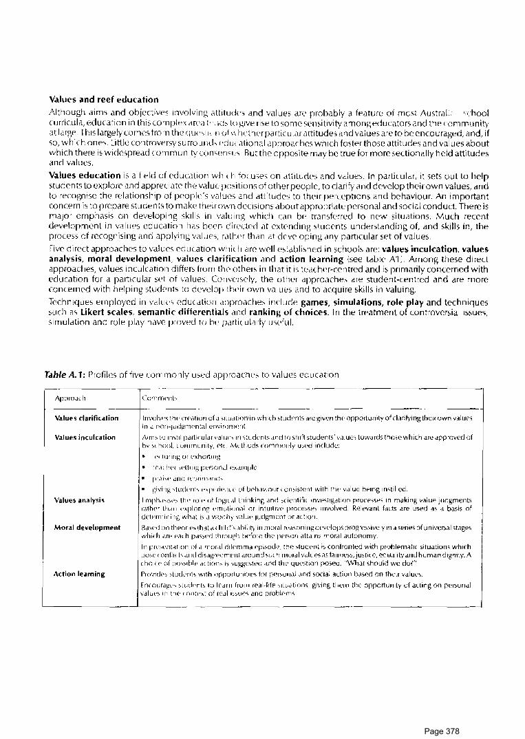
Values and reef education
Although aims and objectives involving dltitudcs and values ar(' probably a feature of mcst Austral:.· ,,-hool curricula, education in this complt>x area:· , Kb to i--:IVe rise to some sensitivity among educators and the community at large_ This largely corr1e.;, from the qucc,I ;1 -n of\\ 1 wlhcr particular attitudes and values are to be encouraged, and, if so, which on es. Li ttlc controversy s u rro u mb (·du ( a ti on a I approaches which foster those a tti tu des and v a I u es about which there is vvidespread corn mun i ty con st· n s th_ Butt he opposite may be true for more section a I ly he Id attitudes and values.
Values education is a field of education which focuses on attitudc•s and values. In particular, it sets out to help students to explore and appreciate tht· valut· positions of other people, to clarify and develop their own values, and to recognise the relationship of JX'Ople's valtH'S and attitudes to their perceptions and behaviour. An important con r:e rn is to prep a re students to make their own dee i si on s about appropriate pcrso nal and soci a I r:ond u ct. There is major emphasi.;, on developing skills in valuing which can bf' transferred to new situations. Much recent development in values education has been directed at extf'nding students understanding of, and skills in, the process of recognising and applying values, ratlwr than at dewloping any particular set of values.
five direct approaches to values education which are well established in schools are: values inculcation, values analysis, moral developmen I. values cl ari fie at ion and action learning {see tab le A 1 ) . Among these direct approaches, value.;, inculcation differs from lhf' others in that it is tcdchf'r-centred and is primarily concerned with education for a particular set of values. Coriversf'ly, the otlwr approaches are student-centred and are more concerned with helping studf'nts to develop thl'ir ovm values and to acquire skills in valuing.
Techniques employed in valuvs education approaches include games, simulations, role play and techniques such as Likert scales, semantic differentials and ranking of choices_ In the treatment of controversial issues, simulation and role play have proved to bt• particularly uv•ful.
T.able A. 1: Profi lcs of five corn rnon ly used approaches to values education
Approarh
Values clarification
Values inculcation
Values analysis
Moral development
Action learning
Comrrn•nh
I nvolv( 'o th<, u<"<>tion of a 01 l udt ior1'i n which 1 tutknts are given thf' opportunity of clarifying their own val urs i 11 d r1on-judgnwn tal er1vi roriwnt.
Aim' to ifl'>til p,1rtirnlar 1·aluc\ in studt'nl> and to shift >tudent<;' v.ilur> towdrdS thosr which are dpprovrd of by'' lwol, community·. Ptc Ml'thod> (ommonly u><.•d indude:
• 1(•1 luring or »xhortillg
• tp,i, lwr >dt111g personal Pxcunplc
1 • pr.ii''' and rqirirn,nl<h
• )iiving ;tud<"n1' •·x1wriPm <'of b0h,wiour < on1istent with th<' v.ilue bemg instilled.
I mph<1'"'" ttw fl.lit· of log1t,1I thinking .ind s<ientifi, mvhHg<ltion processes in making value judgments ratlwr ilun <'xploring t'rr1otior1al or intuitiVP proce>sl'> involved. Relevant fort<; are used as a basis of dl'tt>rrnining wh.il is d 1-vonh;.· 1-'<llll(' 1udgmrnt or action.
fl,1\• ,, I on tlwom» th al d' hi Irr·'> .ihil 1ty in moral wa-.on i ng d('wlops progrrssively ind o;eries of u nivc~al stages which .ir1· Pach p.iss<'rl th rough bdnrP tlw Pl'NJn attains mor,11 autonomy.
In pl<''>l'llldtio11 of ,1 mor,11 dilemma <'pi>odl'. th<' studt>nl is (Qn/ronted with problematic situation> which po>c ' 011 fl i1 h arn Id i-;.ign ''-'mt:nt ,iroun d 'LJ( h moral Vdlw•s "' fai rne>'>, justil e, cq u.11 i ty and human dignity_ A choi(" of prN;1blt' <1ditm> i,; .;ugge>ted ,1nd tlw question pmed, "What should we dol"
Prov1dr>s \tudPnb w•th opportunitoe<, for 1wroo11al <1nd social action b,isrd on tht>ir values.
fnrouragt·s 1tud•'nls lo lf'arn fro111 ff'<ll·lifP <;1tu,1tion>, giving them tlw opportunity of acting 011 persondl valut's in nw < ont1·xt of n'.il 11sur<, ,ind prohlPm<,.
Page 378

Values and environmental education The notion that education for the environment shou Id bf' a fundamental aspect of cnvi ronmental education has led to great interest in values education strategies among environmental educators. It is widely recognised that merely increasing a person's knowledge .about the environment is not sufficient to engender att;tudes of environmental concern or ensure appropriate action towards the environment. Something more is needed. As Caduto (1983a) notes, "Changes in en vi ronmcntal attitudes and behaviour are most effectively brought <lbout by ___ environmental education strategies that increase !not only] the learner's level of knowledge [but also the] amount of emotional involvement and experience in the area being addressed."
One goal of encouraging student visits to the Creat Barrier Reef is to foster opportunities for students to become emotionally engaged with reef environments. The enjoyment and exhilaration which can be derived from encounters with the Red can make a significant contribution towards developing students' sense of the worth of the Reef and of the importance of conseNing it.
In environmental education, values-education strategies which have attracted much recent attention have been those co nee rned exp Ii city with the valuing process rather than with any particular set of va I u es. Values clarification, in particular, has been very widely used. Many enviromental educators now urge that greater direct emphasis shou Id be given to cd ucation for particular conservation val ucs and to development of an enviroment.al ethic. In their view, valuf's clarification and similar methods are worthwhile components of environmf'ntal education programs, but in themselves arc inadequate; environmental educ:ition must also involve instilling a particular set of values. Although attempts to instil values are often avoided by teachers in environ mental education for fear of attracting the la be I ''in doctri nation'', the p roc:ess of i nsti 11 i ng is not rcga rded as a con trove rs i al one in the community when it involves values on which there is community consensus. Methodologies for teaching behavioural attitudes, such as work attitudes and willingness to cooperatl? with others, are known to eVPry school teacher, and mf'thodologies for teaching particular substantive values are already well established in moral education, for example.
With the publication of consensus statements such as the World Conservation Strategy and the National Conservation Strategy for Austra Ii a, it \Vi 11 perhaps be possible for tcache rs in the near future to id en ti fy mo re easily conseNation values which arc widely endorsed and which therefore seem appropriate to being instilled in the course of school education. t A reef field trip provides excellent opportunities for insti I ling conservation values. The example teachers set in their own interest and concern for the natural enviroment and the way teachers reinforce student behaviour are vital. Even teachers' interest in organising a trip to such a sensitive area and engaging in activities which focus on enviromental management strategics may act as a form of values inculcation. So may the experience of behaving in an cnviromental ly responsible manner during the field trip. In this handbook, a number of student activities stress the need for care when encountering reef and island environments. These arc all intended to help foster the development of positive attitudes towards environmental protection.
•
Page 379

Examples of value education activities Activities in this handbook which exemplify different values education ;1pproaches are listed below:
• Moral dilemma Slwll jcwf'llery {No_ 140, parti
following the rules (,"'o. 1 S1, part)
• Y.a/ues inculc.ation Were you lucky enough? l:\o. 1 'i8)
• Values .an.alysis Selecti rig a reef walking area (;'·~o- 148, part)
• Values c/.arification
Graffiti wall (No. 124)
Arousal pvaluation iNo. 127}
The best place and the v • .-mst place (r---.;o. 13'i)
Df'ci~iom! Decisionsl -:No_ -14-1 l
Under thf' influence (No -145}
Arn I wil Ii ng to be corn rn i ltcd? iNo. 146)
[)o the right thing (No. -1 s21
• Action /earning
\Vhale watch iNo. 68)
Activi\H'S exemplifying Jl<lrticu larval ues Pd ucdtion tech n iqucs are:
• Simul.ation UsPr roles and zoning ganw 1:-..:0. 143)
Showing off (No_ 1471
• Role play User roles ,md zoning game (~o -14 3)
• Likert sc.ale Dccisionsl [kcisions 1 U\o. 141 !
• Semantic differenti.JI I lmv do I fppl 1 \No. 12 S :·
Rcdscape aesthl'\ics :.-~o- 126)
Arousal evaluation 1No. 127.1
Expressing Student ff'spon ses to the n•d may he exp rt, s sed in a variety of ways. They may i nvo Ive, for example, use of spoken or written words, movement, sounds, pictures. They may take the form of communication of ideas, information or fr•C'lings to others, or they may simply involve expression for self-satisfaction. They may, or may not. entail a significant dPgreP of creativity. Prose, poetry, drama, music, art, craft and dance are some forms which expression may take. Ex pressing concern for thf' en vi ro n men t by taking soci a I action on he half of environ me nta I improvement is one form of l' xp ressio n strongly encouraged in environ men ta I education.
Examples of expressi\le acli\lities: RePf orchestra (No 118i
Film makers (No_ 123)
Craffiti wall (No. 124i
Me and the reef (No_ 1361
Page 380

Choosing content for a reef education program Some llldJorfat h, concepts, theories and principl('~ which <m' important for und('rstanding tht> Great flimiN Reef system <Hf' summarised hf' rt· ,1~ a cor1uT1tual frarnewo rk for r·cl'f studit>s_ Th is can assist with the planning of a rePf stud ic~ program by providrng some gu idelin( 'S for st·ll'cting u1ntPr1t and helping to interrelate different subject areas.
Summary of Project Reef Ed conceptual framework 1. The natural world
The Cr1'at Rarricr Rl·ef is a un iquf' arid com plt'x natural system whose com poncnts include an assemblage of ca lei urn carbonate rPefs bu i It up 111 mari nc cnvi rornents on tfw Qu('f'nsland continental shelf, the living comm u n itil'S they support the OChll1 w<1tc1-s and atmospherf' which surround tf1f'rn and the underlying and adjac('n\ sections of continental shelf and coastal margin.
1.1 Ocean, atmosplwre, earth ir1tt'r¥tion 1_2 Structure, dcvdopmcnt dnd distri ht1t ion of rC'Cfs -1 __ 1 Fcosy~tf'rn structure arid iunction 1.4 Comparison \vith otfo·r '':i"ll'lllS
2. The human dimension People are part of the Creat !),mil 'r Red sys tern. I l u man activity rl.r1rl wcl 1-bei ng are influenced by the functioning of other parts of the system, and the qualil)-' oi reef environments is affected by human activities.
2.1 The red as a rf'sou re(' for humans 2.2 1 luman impact 2 .1 The repf in human affairs ,rnd h i'lory 2 4 Hurnar1 well-being 2.) Creative response 2-6 Hum an percertioris, perspf•ctive~. va I uc~, ethics 2-7 McHldgl'rll!:'nt, conserv,01tion <md pn'~('l\ldlion f 2 8 Scientific inwstigation
Conceptual Framework for Reef Studies 1. The natural world
The Creal f3arrier Reef is a uniq Uf' and ( ornplcx dynamic natural system_ Its components include an assemblage of ca lei urn carbonate reefs bu i It up in mari nc l'nvi ronrnenh on the Quf'ensland continental shelf, the living com rnu n ities they support the se.1 ,rnd atmosphere which sunou nd ! ilf'rn anrl the u ndcrlying and nearby parts of the con ti rwnt,1 I ohdf
·1 .1 Oceanic and atmospheric components of the Great Barrier Reef system inter ad with each other and the solid earth and its surface materials and with the biota of the reef system
,\.1ovcm<'nh with 1 n t lw at rnosplwre and S('d ,rn' influ<'nrnl by tlw rotation and revolution of the earth, by its posi t1on i ri tlw solar <,ysl('ITl <1nd hy its topogr,1phy Current pdt!Prns are affectt>d by the earth's rotation and absorption of the solar energy; licks ws1Jlt from grav1tdlion,il foru's involving earth, moon and sun.
l:nergy is trdr1'k'rrt>d at interfan'\ he!wecn ocp,m V.«lt('r, <itrr1mphl'ff' and solids:
• /\trnosprwric 111ovt'rnl'n t<, g( •n( 'Id\\' 11 dl'l'S ,rnd "LJrfdcP currents in the sea • Topogr<iplw uf ('drth surf.-Kes is ~lidpcd by moving \V<l(('r and air • i\-1,ikridl i-, ( ,mit'CI ir1 solid <1nd/or dis.,olved forrn by moving water and air • The rr1c1ri rw f'nv1rcirrnwnt lwlps to stdhil i'!, the earth\ ( I 1 matc Materials .,uch ;i, ~ed 1 nwnt, fresh wa1N ,rnd mi rwral s ( arrit'd from land masses dll(l other eroding areas influence llH' ( lwm ic,il and pliy' i( al ll'atun's of the on'dn.
S('dinwnh <if(' dqmsited 1.-dH'n tr<1nspo11,1tion stop<;. \IV<1ler is r<'\ ycled through tlw atmospher·e and OU'dn.
Living thing" interact with mr·an ,rnd ,itmospfwr('_ Many f'IPnwnts dissolvl'd in sea 1v,1t('r ;irt' recycl('d th rough biologic<1I, geological and dwrnical (ycles.
SP.-i IPW'I ' h,11wps r ,rn 1 (''>IJ II from ( ',1 rl h rnovemf'n ts or cl im<1tic clldnge •
Page 381

1.2 Reefs in the system are calcium carbonate build ups. These have been produced, Oller a long period of time, by an interplay between biological and non-biological processes, in¥oMng both construdi¥e and destructive phenomena.
An essential part of calcium carhonatt> repf construction is the huilding of a rigid wave-resistant framework hy the growth of corals and certain algaP. The production of wave-resistant frameworks allows these organisms to modify their own environml'nl and diver5ify the physical conditions in which they exist
Local coral growth and the distribution of reefs are affected by water depth, temperature, salinity, ernersion, water turbulence, wave energy and the ilmount of sediment in water.
Non-framework-building organisms contribute their skeletal material to reef sediment Sediment is also derived from pre-existing reef material which has been broken down and, in some cases, from nonbiogenic sources.
Consolidation of reef material takes place by storm comp,Ktion, cementation and growth of encrusting organisms.
Breakdown of red material is achieved by biologic,ctl processes, such as boring, and non-biological processes, such as solution and ware actior1.
Water movement and gravity are important in scdinwnt transport on reefs.
Reefs typi ca 11 y display strong p hysir al zon a ti on, with ('le rn f' n ts such as reef slope, reef crest, reef flat, lagoon and cay commonly being distinguishable.
Clohal chang('s 1 n sea-level and subsidence and clcvalior1 of the rnnti nental shelf are important historical factors in reef development.
Reefs exist in d variety of forms, wd forms being rdatcd to stage of reef development and physical setting.
1.3 living things of the Gre.i t B.irrier Reef inter.ict in complex ecosystems with one another and with the non-living components of their environments. A reef ecosystem contain~ d diversity of I iving species.
A biotic factors of the cnvi ron ment atf Pc! living things of a reef ecosystem.
Living things of a reef ecosystem can modify tiiei r non-living environ mcnt.
Living things within a rpf'f ecosystem arc adapted lo particular environments through their structural, functional and behavoural characteristics. All species I ive in characteristics habitats.
Living things interact vvith one another in a reef ecosystf'rn. • In te racti o ns can occur between members of th c same species or different species
• Kinds of intPractions include· prt'dator/prey relationships; competition; symbiosis.
• Interactions can wlatf' to resources such as food. 5heltf'r, substrate, space.
Popu I a ti on s of I ivi ng things within a reef ernsys tc m are unevenly dis tri bu ted - the dis tri bu ti on and abundance of any one specie::. being affcc ted both by factors of the physical environment and by members of the same and other species in the ecosystem.
/\flow of energy occur~ with in a reef ern~ystt>m and materials are constantly being recycled. Food chains and food webs can be used to describe such flows: • Energy for maintenancl' of the ecmystern comes from the sun
• Green plants convert solar energy to food em·rgy through photosynthesis
• Organisms transfer enngy and matu1als through food webs
• Decomposing organisms. such as bdcteria, reduce organic materials to simpler forms.
Reef ecosystems change th rough time, such changes arising from processes occurring within the system or from external phenomena:
• A change in one part of an ecosystem can affect the system as a whole
• The stability of an ecosystem tends to be directly proportional to thf' diversity of its populations and the complexity of relationships among them.
All ecosystems in the biosphere are linked to one another through biogeochernical cycles and hence they affect one another.
Page 382

1.4 Many dttributes of the Great Barrier Reef system are common in naturdl ecosystems, but some are chardcteristic only of cord/ reef systems, or of this system in pdrliculdr.
All ecosystems have some structural and functional aspects in common.
Distinctive aspects of a coral reef ecosystem are high productivity, high diversity at all levels of organisation and complexity of linkages and flows within the ecosystem.
• High productivity makes a coral reef ecosystem distinctive among the marine ecosystems which surround it (like an "oasis in a desert")
• The productivity and d iwrs i ty of a cora I reef ecosystem a re com par ab I c to a ra info rest ecosystem in the terrestrial environment
Unique aspects of the Great Barrier Red system include its location, its extensiveness, and its geological history
2. The human dimension. Peo pie a re part of th c Great Barrier Reef system. Hu man activity and wel I-being cl.re influenced by the functioning of other parts of the system, and the quality of reef environ men ts is affected by human activities.
2.1 The Great Bdrrier Reef cdn provide many n.aturdl resources to meet humdn needs.
The Great Barrier Reef meets human needs by contributing to the maintf'nance of the earth's global lifesupport system, through its biogeochemical cycles and links with other ecosystems.
The Great Barrier Reef can meet human needs, present and future, hy acting as a source of genetic diversity through the sperics it contains.
The Great Barrier Reef providt'S biological resources such as fish, crustaceans and molluscs for food, substances for pharmaceutical pu rposcs and corals, shells and other mol 1 uses for ornamental use.
Deposits of minerals ":Vhich are exploited in other environments may be available in the Great Barrier Reef region (Limeston(', prosphate and grawl have been mined here in the rast; petroleum may occur here.}
The Great 8,mier Reef providt's opportunities for recreation, both passive and active in character. Such re ere at ion in cl u dl'S so rne which docs not take p I ace in the reef area but which i nvo Ives vie ari ou s experience of the re('f through, for example, red films and reef I iterature.
The Great Barrier Reef provides a sti rnulus for creative expression in music, art, literature, drama and debates.
The aesthetic qualities of the natural environments of the reef can contribute to a sense of wel 1-bei ng in humans.
Reef environmf'nts can provide people with physically, mentally and socially stimulating and challenging experiences which may lead to an increase in their feelings of enjoyment, satisfaction and achievement.
The Creat Barrier Reef system provirles resources for scientific enquiry and for education.
Tourist, fishing and other industries have been able to grow out of use of red rt'sources, and employment has been gt'nerated through thPm. ·
Reef waters act as transport routes for shirping.
Natura I n''>O u recs of the Red aw u n eve 11 I y d istri bu tPd. Their dis tri bu ti on and location in re I a ti on to human populations and to tPchnological ,1nd economic factors are critical to the way in which they may be used.
The perceived value of a ndtural environment is dependent on the goals, skills and way of I ifc of the people involved. Resources are culturally ddined. (See also 2.6.)
Many uses of the Reef are compdtible with one another, hut some may be temporarily or permanently incomp,itible.
Use of a natural resource on a sustainPd yit'ld basis ensu rt>s that supplies wi II be available for future needs.
Weather, sea conditions and climate (including hazards such as cydorw and storm surge) are important factors governing peopl<''s activities in the Reef area.
•
•
Page 383

2.2 Human activities may have many impacts on the natural systems of the Great Barrier Reef.
Humdn activities nhltP five m,1in kinds of direct impact: introduction of pollutants; physicdl damage; extraction of I ivi ng spr'cies; i nt('rfvrPnce with srccies; i ntrodudion of exotic species.
Direct impacts may arise through the following activities:
• tourism \dewlopnwnt of touri<.t faci I itif's; charter boat operators; red visits for diving, reef walking, boating waste dispmal from isla11d r('sorts)
• fishing (com nwrcial and rt'Cff'iltior1,d ii -;hing; ii i('gal podching by foreign fishing vessels; professional shell and aquariurn fish collecting)
• shipping (developmf'nt of shirpi ng ( hannels, harbours and a<.sociatPd works; shipwrecks: discharge of cargoes and fuel being carried by vessels passing th rough reef waters I
• air transport (building of f,1ciliti('s: traffic noise)
• coastal activities (df'vf'lopment of mainland and island coasts; generation of pollutants hy mainland and island activities)
• pxtraction of mi ncral rf'sOtHces_
Hum ans may affect red erosv~tcrns ind 1 rc'ctly as Wf'l I a~ directly.
Human impacts on one r)drt of a wef ecosystf'm will affect other parts of that ecosystem and other ('Cosystf'ms with which it ic, Ii nkcd.
2.3 The Great Barrier Reef has influenced human activities in the Reef region and has affected the course of local and Australian history.
Reef navigation routes haw· long hePn usPd in the dispersal of people and their goods but the Reef has also acted as a barrier to fref' movement.
Aboriginal communities have a long history of use of red environments.
Jam es Cook's Journey a Io r 1 g the north-east rna st of Aus tra I ia in 1 7 70 meant that th ere was aw are ness of the Great Barrier Reef frorn the ('drlivst days of European settlPment on this continent.
Reef resourc:Ps contribute suhsl,1ntially to thf' economic: foundation of many Queensland coastal communities and provide the wason for C'Xistence for some.
The Great Barrier Reef has been the catdlyst for significant political and IPgal events in the recent evolution of Commonwealth-State relations in Australia. '
2.4 Human enjoyment, comfort, satisfaction and well·being are attainable in reef environments and can be achieved in ways compatible with conservation of the Reef.
A group fie Id trip to a reef e nvi ro n men l rcq u ires dC'ta i I f'd p I an n i ng, espec:i a I ly when camping in an i so lated situation is involved
Potential cfangers to p('ople \vho visit rPd arf'as i nc:I ude encounters with dangerous marine organisms, boating and swim ming accidents, sunburn, ill-health and lyclom's; but suitable planning and know:edge of appropriate precautions and rem<'dies can minimise problems which these might pose.
Weather, sea conditions and climate (including hazards such as cyclone and storm surgeJ are important facto rs governing peop I e's activities in thP rl'ef area.
New skills and knowledgP may haw to he developed in preparation for a visit to the reef (e.g. snorkelling, boat handling, first aid, safety pn't autions1'·
Members of a group living together on a reef island need to co-operate and communicate effectively with one another lo tah' responsibility for their own actions, and to adopt a caring and responsible attitude towards the well-being of other members of the group.
One's awarf'ncss and und(•r\landing of one's own characteristics and qualities can be enhanced through t'xperiences in reef locations ·
enjoyment and improved physi( al ~kills and fitness can arise from physical activities carrif'd out at the Reef.
Improved skills in relating to others and in providing for our own day-to-day needs can result from the experience of living <1nd working .is a member of a group at the Reef.
A knowledge of survival techniqm·s can be useful to people who stay in wilderness locations such as reef islands.
Visitors to thf' Reef should adhere to the park regulations which are designed to contribute to conservation of the Reef, and should comciously attempt to minimise their impact on reef environments.
Page 384

fishing is enjoyed hy many people <ha wncation and limited fishing for subsist('nc c ·:.1n accordance with the stipulations of M,uirw l'ark zoning and fi~hcric~ rcguldtionsi mdy not be inimicable to reef conservation "Enough fish for one nw,11" is a policy which individuals might apply to limit their own fishing
0 bse rvi n g, photographing, d ra wing and being close to Ii vi n g things in th cir n a tu ra I cnvi ro n men ts are grca t sou rn's of plt'asu re to many people. In natural areas of grcdt heritage value such as the Reef, these kinds of recrPation activitiPs are more appropriate than those which i nvolvc harvesting or damage of living things or onwr natural materials_ '
Dcvelopi ng low· and r onrt>rn tor ttH' natural environ rncn t can be a source of plf'asurc and can lt'ad to people being \Vise in th i' i r use of n a lu ra I resources.
2.5 The Great Barrier Reef inspires creative responses in many people.
Creative forms of ('\flrcssion \.vh ich can be stimulated by rf'd environments include: music, painting, prose, poc try, c ra f \\.VO rk, d an ( ·p _
2.6 Perceptions of the Great Barrier Reef And values placed on the Reef differ widely among different people. l'coplc's behaviour ,md ,1ctions in relating to thC' Red arc closely rPlated to thf'ir values and 1wrceptions.
Decision making about tlw kP( 'f is i nflucnccd by people\ values.
There may be ,1 discrcp;mLy bc\Vl'l'l'n fJl'Opil''s verb<1l cxp1Visio11s of values and attitudes and thPir behaviours.
Value differench between individuals and grou1 is may lw ,J';su med to exist when diff Prcn t actions are taken in similar situations.
Conflicts involving diff_erl'llt v,llues may occur within an individual or group when a choice must bP made bc't\.vpen diffPrcn L actions.
l'eople's perceptiom ,1nd v.ilucs nf thP Rc'ef may bt> largt'IJ-' 1 onditionPd by tlwir cultural background.
Knowledge and u ndPrsta11d i 11g of tlw Red rwed not necessarily result i 11 fop Ii ngs of concern for the reef.
The valut>s \Vhich some people hold may be in conflict with strategif's aimed at protecting reef environ men ts_
Clar·ifyi11g one's own values and analysing the values of otfwrs in relation to environmental issues can be helpfu I in en,1bli 11g the governing role of v,1 I ues in human ,ictivity to be understood_
Contrasting ethical positions which may be disn'rnf'd in human rf'sponses to reef environments include:
• the pers1wctive that the RPef is a resou rcC' for humans whost' t>xistence is justified by the extent to which it meets human nePds now, or now and in the future
• the pcrsp('c\ivc thdt non-human entities, either living or non-living, haw an inherent right to exist, quite '1fMrt from the extPnt to which thPy st'lve humans.
Ethic1I consideration~ vvhich aw involved in human use of tlw RePf include:
• thC' issue of l'quitabl!' acn'ss <1mo11g the present gPrwration of hu m,ms to resources avai I able in reef en vi ronmenh
• thf' issue of ,1tf r>ss to red rcsou recs being available to future gener,1tions of humans, as well as those of the present day.
2 7 Management of a natural environment entails control of the environment for a specific purpose. Planning and management of marine areas of the Great Barrier Reef as a marine park are being undertaken with a view to protecting the Reef, while allowing reasonable human uses to occur. Decision-making processes concerning the Park involve attempts to predid the possible environmental consequences of certain actions and attempts to find compromises between the desires of different groups of people.
The Great Barrier Red Marine Park was established by thP Com monwt'dl th government in order to:
• conserve the Great Barrier Reef
• regulate the u~e of the Marine Park so as to protect the red while allowing reasonable use of the Great Barrier Reef region to take place
• rcgu late activities which exploit the resources of the Red region so as to minimise the effect of those activities on the Rt'd
)
•
•
Page 385

• reserve some areas of the Great Barrier RPef for appreciation and enjoyment of the public
• presc rve so me areas of the Red u nd i st u rhed hy humans except for sc ie nti fi c research.
The concept of consf'rvation expressed in t hl' management ohjectives of the C reat Barrier Reef Marine Park is compatible with the view of con· · rvat!o n ~et out in the World Conservation Strategy (of I UCN), i.e., that conservation is" management of hu rnan use of the biosphere so that it may yield the greatest sustainable benefit to present generations while maint,1ini ng its potential to meet the needs and aspiration of future generations''_
The main objectives of living r0smircP rn11servation, according to the World Conservation Strategy, are:
• maintenance of essential tXological processes and life-support systems
• prPservation of genetic diversity
• ensuring the sustainable usp of Sf)('Cies and ecosystems.
Sustainable usP is thP management of production, harvesting and other usage at levels which protect the living resourcf' base in pt'rpetuity. This ensures that human communitif's derive maximum long-term benefit. Without sustai n<lble use of I ivi ng wsources the living rcsou rce base is degraded and the options of rresent and future generations dre restrictnJ.
If development is regarded a~'· modificatior1 of thf' biosphere and the application of human, financial, living and non-living resources to satisfy human n(•f'ds and improve the quality of human life" 1\VCS). then the view may bf' taken (as in the \·Vorld Co11~nvation Strategyi that living resource conservation and sustainable deve lopm c n t a re in terd cpl' n dent. They a re fund a men ta I ly Ii n kf'd by their de pc ndence on I ivi ng resources -conservation providing for today\ m'cds and conservation providing the stock of living resources for tomorrow.
Establishment of the Crl'dt B,uriPr R('d Marine Park resultPd from political acceptance of widely expressed pub I ic concc'rn within Australia and overwas, lhat there was a need to protect lhe Reef. Four main areas of concern were:
• concern that one of the rnajor natural heritage areas of the world should he conserved and preserved for future generations
• concern at local deterioration in Rl'd areas
• concern at the possibility of over-exploitatio,n of the resources of the Reef
• concern at the effects of pol lutari ts_
f'ark planning and management can provide a meam of separating imcompatible USPS of the Reef, rcconci Ii n g the claims of competing u Sf' r demands and rcso lvi ng conflict which arises from such demands. Ad Jud ica ting betvvee n non-corn pa ti bl e uses involves options ranging from the banning of particular u scs to restricting uses to specific locations zoned for that purpose.
Decision making for effective management of a natural rcsou rce, such as the G real Barrier Reef, partly depends on sufficient knowlt>dge and skill being available to predict and evaluate the impact of a specific management polily.
• Prerequisites for a cornprf'iiensive managpment plan of the Reef to he developed might ideally have been: an inventory of the Reef; an u ndcrstandi ng of th(' direct impact of each form of usage upon the Reef and upon the rf'source heing exploited, a basal understanding of reef ecosystems to enable the interactive effects of individual and multiple usage to be predicted.
• Where inadequate information is available as a basis for management, the capacity to manage can be improved by monitoring the dfPcts of particular management policies and carrying out research programs on reef ecology and human usage.
Although decision making concerning the management of reef environments has an empirical basis, related to facts on the reef and its use, ultimately decisions arc founded upon people's values and ethics. (See section 2 6)
Political processes arc significant in decision making in relation to natural resources such as the Great Barrier Reef.
• Politicians, in dealing with the allocation of scarce natural resources, try to arrive at policy which not only reflects considered goals for the community as a whole, but which is also likely to maintain their support base.
• Politics often involves trade-offs between tvvo equally worthy goals and the adjustment of policy to maintain power.
Page 386

Many individuals and organisations share responsibility for Reef conservation.
• Commonwealth and State each have control over areas of the Reef province, Commonwealth jurisdiction mainly being Ii mitcd to marine environments. Management of the Great Barrier Reef Marine Park is in the hands of the Commonwealth's Great Barrier Reef Marine Park Authority but, through delegation, is carried out on a day-to-day basis by the Queensland National Parks and Wildlife Service.
• Community support is needed for implementation of Marine Park management plans.
• Public participation is involved in the establishment and planningofthe Marine Park, and in evaluation of its management regimes.
• Individuals may need to modify their lifestyles, and public and privatf' organisations their practices, to ensure Reef conservation.
• Community support for Reef conservation can be bu i It through community education and the provision of opportunities for community involvement in decision-making processes concerning the Reef.
To contribute effectively to decision-making about issues such as reef conservation, community members need to have as good an understanding as possible of the processes by which decisions are made. Awareness of the values which affect a decision and the persons and organisations who i nfluenc:ed decision making is important.
. )
'
Page 387

The Reef and environmental education
What are concerns of environmental education Envi ran mental education is con( errwd with 1 lw i r1tcrrcldtedness of people and their· en vi ronmen t <111d with the need for ski I led managerm '111 of natu ;·,ii rt·sourn·s_ It is based on concern for the quality of human I ife and seeks to encourag{' personal commitment to environmental conservation
According to a statement in Environmental Education for Schools (Curriculum Develorment Centre, Canberra, 1 980), en vi ro nm en ta I ed uca ti on aims:
• to help student~ acquire an awareness oi and sensitivity to lht> total environment
• to help students develop a basic understanding of the total environment and the interrelationship of humans and the environment
• to help students develop tht' skills llPCPssary for investigating the total environment and for identifying and so !vi ng environmental prob le ms
• to h('lp students acquire the motivation for actively participating in environmental improvement and protection
• to help students identify alternative approaches and m.ike informed decisions about the environment based on ecological, political, economic, social and aesthetic factors
• to providl' studcn ts with opportunities to be actively involved at al I I eve ls in working towards th c re solution of environmental problems.
Fnvi ronmental education is often portrayed as bci ng ('(lucAion in, about and for the environ rnent Fducation in the environment refers to direct, personal experiences of the environment such as those i nvolvcd in fieldwork. Education about the environment involves the development of kr1owlcdge and understanding of thecnvi ronment. Education for the environment involves developing atlitud( ·s and values which entail concern for environ mental conservation and willi ngnt'SS to participate activdy in working towards it. It is this latter dimension which is often seen as the cri lical distinguishing feature' of environ mental Pducation. Au:ordi ng to such a view, education in and about the environment makes d contribution to, but is not sufficient of itself to constitute environmental education.
Because of recognition among environmental educators that increasing knowledge and understanding about environmental problems and conservation do not necessarily or automatically lead to feelings of environmental concern, teaching approaches pdrticu larly directed a't affective outcomes arc adopted. Attitudes are emphasised as outcomes, on the assumption that the human behaviours v\/h ich environ mental education hopes to encourage are shaped by an interplay bctwePn people's knowledge and lhc feeling side of their make-up
In general. environmental education is not being implemented in Australian schools as d separate subwct In secondary schools, it is being taught in various traditional subject areas as an across-the-curriculum perspective. Science and the social sciences are the disciplirws which have mainly taken up the environmental education rhilosophy, though therf• is considerable poh'nli al for oUwr subwn areas to do so.
How can reef studies contribute to environmental education There is little doubt that reef learning experiences, particularly those which occur on a field trip, can assist significantly in the pursuit of envi ronm('ntal edu ration aims. Ideally, all programs for students who visit the reef will be constructed with generally accepted aims of environmental eduu1tion in mind. Environmental education can be provided either through use of an interdisciplinary theme or in the context of single discipline studies, e.g. geography, science or physi< al education. Desirably, all students will be offered at least some experiences which heighten their concern for their environment and \vhi ch int rease their wi 1 lingness to work towards environ mental improvement and wise use of natural resources.
Nevertheless, it is possible to design red programs which art> val udblc <'d ucational ly but whose main emphasis or orientation is not that of environ mental education Although r'duc<1lion in and about the environ rnr>nt may not, in itself. constitute environ mental education (in the now conventional sens(') it may serve quite val id educational objectives in other areas. ~or exdrnplt', a biology course of study with an emphasis on ecology (i.e., education about the environment) may not be sufficiently oriented towards education for the environment to be regarded as environmental Pduc.it1on, hut may be able to achieve widely acceptable objectives in areas of biological education
Although such arproaches to using the Red in education are provided for in thi_s material, it is suggested here that, no matter what its overall emphasis, every reef program should contain a nucleus of activities which cnahle the student to become more concerned about environmental issues and more skilled and inlvrcsted in working towards resolution of environmental problems.
Page 388

The Reef and science education
What are concerns of science education? Aims of science education general!).· f'mphasise: • the part science Pd ucation can play in maintaining and enhancing the lf'vel of scientific I iteracy and competence
in our community
• the role of science education in contributing to individual devdopmf'nt.
Most school science courses strongly emphasise the rrocesses of science - in particular its empirical modes of investigation, and the development of scientific attitudes among students. Many ( ou rses art' aimed at developing a knowledge of the impact of scicnu' on humans and their culture. Developing an intNest in the methods of scientists and in the application of ~cienc:e to personal, community, national and intf'rnational problems is also commonly an area of concern.
Australian scif'nce courses at the Year 7"1 U level are currently multidisciplinary, i ntergrated or "general". Such courses also exist in some states for Years ·11 ,md 12 students, but there are usually dlso courses in the separate sciences (such as physics, chf'mistry, biology and geology) at this level.
How can reef studies contribute to science education? Some ways in which reef study can hf' used in education in science are suggested here. Reef studies related to some major concerns of science education as set out in the Australian Science Education Project 1.197 4) are listed in table A 2. For each of some major brandws in scif'nce, examples are given of some relevant reef focus questions in table A. .1. So me further exam pl es represented in s tu cfrm t activities i 11 this handbook are indicated in tab le A.4. Major areas of some existing Australian school sciencf' syllabust's which can be related to reef topics or themes are identified in table A.5.
Table A.2: Aims of s<ien<c education dnd n'f'f study
Isome ~ajor concerns~---[--·---- .. __ --·---- -----·-i--·-----
1 sden:_educ~tion --. _ _ I .. E.~ample.sof re'.evan:ef~r:~~ -· ~ ;;:~~~~ess i~ft~fs~~~~l~~~~t s~udent--lJ ndnstancf 1 ng of humans. T L,nd01't<rnd1ng rPc1uirenwnt' for hum,111 I . ' .. tlwir Pnv1ron 11wnr ind 1 , 111 J . · I lum<1n < omlori 011 .i 'ay (No. 11 bJ _ .' . 1t d l dn{ 'iLifVivdj rn r('(lf c1r(\l:"
1. , • .
l 111l<>rper>on<1I rPlat1omhip>
11
1
11
1 \.·\md rlnrl wav0s '.f... o 171 lJndr.•rst<1nrling prn< ('>SP\ of mcltPri.11 and ('fl< ·rgy t r,insfr·r wh i, h on ur i 11 1 ht' I'< ·d D~ ng<'r<JLI\ "Tf < 11'd l LJrf"\ (No. 112 J
SY'h'm food W•·b of ,1 cor,11 <. <1y and re('f iNo. 7fll
UndPf't<111ding w.1v, in whir h P<'Oplt· ni,ikP ftft'C h of hum,m> ~- ...... u. 102)
-. _ . _ I dP< hron> whi<~fl~·-~p,•f <'rwironnwn!< l--- LI"'' ruir'·' and 1cmmg ganw fi',io. 14J:·
I ~krllsand a!i._tu{i<'>_ •mporl,rn! 11
Rt>.iding m<1p' «ll(I ,1ir photogr,1ph< uf '"('f I. Air pholD in!r•r1-1rt'L;li~i:t'<o rn1·
I or SttPnllfrc 1rwpst1g,1t1on I an.w; ,
R, ,, ·I dll(I 1 'I" n• I < ro1,-SP\ t ions -:'No. 1 g:1 ( )h,Prvmg. ilH'.t>t1ring ,md < <J1mti•lP, f«d 1 ' Cu< umlwr < ount \No. ~41
1 oq.~cHlr:_..n1.:.;.
1 I I lrll+'"''I in nw!hrnl' "nd prod1" lo of i,.v,.,,, you lurky <'rJ0l1ghl (No. 158;·
I S< 1<•11tifi, <'nqu1rv in r0d "'""' I
Undel'itdnding oi nJtur<'. sc01w and Ii mi Id I ion\ of
- r-· ·----1 I
s,_;('Jl( (' rn<'lhods Pmployed in m,iny ,\1''"' I rDl low <1 \lif'llt i'>! '~ (), 159j
scic:nce
l_;ndr!'it,mding of and c onu:rn lor, c:onsPquPn(·es of "' i\•rKe dnd tPrhnolot,'Y
ot 1<·!'! «nquiry
I D.tta g<11 rwd th rough s1.wntif1c Pnq u i ry 1<. orw j input H•lo rl0n11on nMkrng <"lhrnit CIJR j r('~OlJr{ PS
V\'""' )0<1 lurky t'noughl :No. 1581
R< '" ·.ir< hi ng the WI<' Ml h (No. 1 59j
L;"" rol .. s <1nd 1onin~ gam(' (No. 14.1:1
I l'<'opl<< v,\lup.; Mt' also important f,l( 1or; in I I dt'< 1"0" rn.iking ,1bout repf rPIOUH'f"\
.L - -- -------! Rt>Sf\m hing tlw "'SPMrh (No. 1 ~g1
[nvi1onnwntdl impdct Stdtf'tnl'nt.1 1:f--·o. 1 ~5:1
f ))
•
•
Page 389

Table A.3: Branches of scit>nce and rt'ef Pducation
Br;mches of science ham;:ks of rd·•.'Jfll ret>l locus questions Examples of some relevant student activities in this handbook
·-· . ----------- --------.- ----------··- -Biology \Vhat fom>'> of lift· un-u r 1r1 il w<'f
corn rnu 11 itvi
How M» ditfr" -,-i1 ~,r,. forms dHrih1m·rl on <1
[ppfl
\-Vh1d1 ,m· tlw prc)dl!cl"'r< anrl which <lW thP consunwrs in ,, r<·Pf c ommunityl
How ,in• r•o>d org,rni<;ms ad<1ph•rl tu tlwir pnvi HHl rnvnt.;;?
-~---------------r-----------
CPO logy
Physic>
\Vhal Ml' tlw 'i<'dmw11t«ry rnatt>ri,1ls ul " red tnMIP , ii, ,1 n rl h, J\V d" • tlwy d i,\r1hu t l·dl
\Vh,1: l)Lj ilding-111 > d r1rl brcaki nf;-down prorr·s'<'< .1r~' i rwulvcd in tlw rnaki ng of ,1 rppfl
I low· do IJving tlrn1g' < ontrihul<' lo tlw forn-hltio n of f•drt h n1d~eri .1b in \i ret \f ('IWI rorm1C'rl [I
11ow and 1vhv <IOP' th<• r•nvi ronrrw11t ('XP'-' '" ·m cli hy .1 d i1--c·r <1l d< ·pt h 'Ii ifrr fron1 th,1\ "'P<'rir·n, ,,d bv ,, ,wimrrn·r in >hallovwr \.\.\\h 1 t!
\ Vlwr<' riof'> "'°'"'" rdr ,j( !ion nl cur i 11 wd •·rwiro11nw1ll\ ""cl why hit 1m11ort,111l to wPf d<'VPlopnwnti
---------· -··-------- ·-----+---
Chemi;try
Marim' snr•nu.•
l. nv1ron rrwn t,il >l "-"" l'
··--~~ --·-------------
\\-'IHI ,m· :lw st'di1nt'n\My rn<1kr«lh uf ,1 repf n1<1dl' of ,md wh.il i; lhPir migi11'
Hn1, .. v {an U1P (~gti of ripef '.)Pdirr1t·n~ ht' d<'(Prmint>dl
\Vh,1 t are t ~w ' 11, · 1rn(,1I pro1wrt1''' oi ;<>d
Vi.later 1 n tl r< '{'' d rt ·,1 ~
\·Vhal <H<' 'una· < lwmic.il ch.ir<1cl»ri0Li<' ot Cd'/ <;oi[',I
\·Vh,it .HP tlw rn<11n dhtriLC_h·ri';ti< s of tidt"' I" .·1u'd.Ht'<tl
Ho"'' dW th•'' h.ir.H lf'riotic' of'\'" w.it<'r I '1V<»I i f;.l(r•d I
Wh1t .irr' th<· rn,o i rl form' of I if P v ... h i' h < >t < llf
in a "',.; 'ornmunityl
111 ,1 'ornmu11Lty '-'" ,\ red .. how dn living thing< inlPr<11 I w11 h orw ,inothprl
11 ow do tiw <1< t ivi ti f'' of h Lim ,111, il.ft<>ct wPI COll11Tl\Jfll1i<">I
\ Vh d.t ,1 w ":-Or rH • Vi.-'~i.vs i11 \vh L( h ")( i~\ntifi, Pnquiry ( dn l ontr1butf·· lo r1~,1nf1gf·nH-~nt of rPt'f arPil':i~
A111m,il roll cill 11'.o. Bi \Nho's who in the· fi>h families (No. 611
Red-top tra1N'tl IN0. 71i
Bouldt'r rnmmunitic> (~o- 74\
Ani rn,11 \ urviv,11 trilk. it'-> o. fl'il
C<"t ting down to !h <~ riitty gritty IN o. 21 i formation and df'H•lopnwnt of a c;n, f~o 2rn BPdch rock \No_ 2.S:
)t>dinwnt-organism interaction (f'.;o_ 241
How clear i> the water/ I No. 81
r Orn1alion ,rncJ rlPVl'inpn1E'nl Of d ( ay i,\Jo. 20i
--------- -·~--
C\'lting down to lhl' nillv gritty :No. 21:
Rr'd w,1[pr; - oxygen <1nd pH (No_ 101
Formation and lkwloµmcnt of a cay ii'.o. 20)
Red watprs - ten1pera1ur" (No. <J:
Monitoring tidc'S I \Jo. 1 3)
RPd Wdlers - !t'rllf)('fJlUH' INo. 'Ji
Coril.I polyp - MthitN.t of thP rPd ·:No. 41_:
Alg<1<' MP important (No lOi
1·ood W<'h of ,1 'or,11 c,1y and repf \No. 7fll
Ffkc ts of h'm i.rns t,\Jo_ 102:
R< '" ·,uc h 1 ng I he r('SE'an:h :No. -1 .'i<Jl
-----------------------
Page 390

Table A. 4: Rcf'f ed u ca ti on and key science concepts
Science i:oncepls Examples of relevant student activities in this handbook -·------~ ------------+--------- --------------- ------------
Cause dnd dfr·n
Chanw·
Cyde
Community
t1wrgy ,, nd mattfi
Force
lnterdction
Model
Organism
Population
Quantification
RPplication
Scale
Signific.-im f'
System
Validation
Wind and Will'<'' (i'," o 17:1
Retf-top !"1 n>C"ll \No_ 73i
T iditl ch angPs I" o_ 11 I
Boulder communities 1r-.:o. 74)
food web of nmil cJy and reef (No. 78)
Your trip by SP.J C°"o- 100)
form<ltion ,1nd dl'Vf'lopment of a cay (No 20i
Cetti ng to know an active reef c rC'ature IN o. 3 2)
Colour in inv<o>rtl•brates {No_ 36i
Cucumb('r rount ·:No. 541
How rlf'ar is !ht> water? \No. 81
On location !No 1 i
Red-top tr,rnscct {No 73)
Boulder communitie<; !No. 74)
rorrn<1tion and dE'velopment of .-i cay I No_ 20\
Cucumh€r count (No. 54)
'
•
•
Page 391

Table A.5: Reef education and sd10ol jtirnu' syll.ibuses--Great Barrier Reef studies are applicable to many content areas of existing scienct> syl idbuses. Examples in dude:
Science syllabus Syllabus content area ---··-··---------t-----------------------------------------1
Qld floMd of Seconddry Schools Junior Srllabu> in Srit'llct' (Draft, 19851
PLrnd l.arth
ThP ! i vi ng F nviron men!
Pf'nplv, Sfif'nrv dfld Socit'ty
Malh'r
Erll'Jb'Y The Hum,in r>udy
>------------·--------11-------·····----------------------------------i Qld Board of Secondary Srhool > SPn ior Syllabus in Biological Scienfe :oraft. 19851
Naturl' of Li IP
Phy;iology of Pl,rnts and Animal5
OrgM1i-.ms dnci Communities
Eco<;y<;tf'rn<
I lurnans Vv'ho L1w in fcmrstenl';
Outdoor StuciiP'i Classiiic ,1tion
Rf'product1on. Growth ,md Dt>velopment
lvolution
Population Ecology
Behaviour
Develop nwnt of Theori("; ,ind .lvtocic'ls
>----------------- - ·-·---+-·
Qld Bo;nd of Secondary Schools Senior Syllabus in Mu I tistranci Sci< ·nc e : Ora ft, 1'1841
Cow topics:
fcolnizy
M,ir1, R«s011 ru'' ,md Environ nwnt
Sci enc« for Re(wation
Pf'rvm.il Health
~.·lttm· of s, iPnn•
Sc it·nce. lt·chnology and Srn idv
Matter ,rnd ,\-1dtenal;
_____________________ ,__,. __ , _____ ·-·----------------------------------1 Qld flo,mi of .Secondary S<h ools Senior Syll,1bus in Chemi<;try \Draft, n86i
Part id" 1 hreory
Fnergy and C:ht'n11c:-al Ch,rnge
A(id< .inrl Bi!>l"'
An lmport,111t Suhsta.rire iwc1!Pr mily be u<;ed as an example)
>------------------ - --t------
Qld lloMd of S<"<ond.1ry S( hool~ Sr·nior Svll,ibu> in l'hysils ;L)rc1ft. l 'l8~:
l'hvs1cal ()u<i nt i ti<"
1\itid~U n 'rnf'J1 r fon "',ind Motion
Tilt ·rm .ii !'h~i'<ll > \V,ivi' ,\-\ot ion
ThP !'hysi < -, ()f Md t<"rials
~·----·-' -· ------ -·-~-+--------
Qld Bodnl of 5<'< ond.iry S<. hool> Senior Syl 1,i bm •n Li rth Sc iP nu· O:Dr art, 1 '181.1
Mirw1,1logy
i't'trology
f'h\-''IC,11 ( ,cnlogy
Ct'nl~·don1( '.--
S1ructur,1i (,1·olDg\-' and C1·olog1( rli Mdpping
l'.i!.u'u11lulof~V ,md CPologi( di TimP
Stra t 1gr .iphr Aotmr1'H11V
>------------·· -· -------------<>---·-·· - --
i\S\V Setond.•rv s, hooh floanl Sc ierit P Y<·,ir 7·10 .: 1 'J8 ~.i
liw Th111f'.' Around U;-Within and flf'yond Our Loul ExperiencP (life Forms; The Earth Around U'i;
Na1ur.il Ch,111~1» l(h,111ge> in tht' [,irth\ Atrno1phPrf'; Changes in the Eclrth's Crust; Changes in I.ii(' form, ,rnd l.ivmg Commun1t1t'>i
Ch,rng(» C<11 •>hi hy l'Popl e
Rd.it ion-.h ips !whNPf'n Living, Thi rig<; and I hP !-.uth
~--- .&-. -·-· ··-·--·---------------<>----
i\'SW llo.ird of SPnior Stu di<» Yf'ars 11 & 12, 2-unil rnur>e -Geolo!,'Y (1 'JOO)
C • m · Uni r 1 -- Su rfaft> Processes
(OH' Unit 6--CPology .md Sorif't)-'
F IP( t ive 2--Conte mpor ilJ)' Sediment,1ry ProressPs
Page 392

Sdence syllabus
NSW Bo<1rd of Senior School Studii.·<, Year<. 11 & 12, 2-unit rnursP-- Biology i 198bl
Syllabus conlent area
Cow S• 'cl ion I Frnl ogy
Core 5,., tion e- Diw1>ity and Lvolution
fl(" tivP A'i --Cla-;,ification ,rnd the Species Concept
flPctivP A3-- I iving on WatPr; living on Land
Flecti vp B 5 · Hu nMn L nvi mnment I mpacl
>-----------·-~---- ----+---------------------------- -----------------!
NS\V Board of Senior S< hool Studies y,_,ar; 11 & 12, 2-unir CUUN' -Physirs {197'lj
I\: S\V Board of Senior School Studies YPMS 11 & 12, 2-11 nit rnurs<: -- Ch•'m1stry {1'J7'Ji
Cor•· Unit I - \V,l\'t"
flt>rtivP 4- Phv>i<s in Techrmlot,'Y ie.g., Photography; Fluid Dynamic~)
UPctivc· U-Clwmi«try cind !hf' Fnvironment
Ul~liw C~-ThP Sol i<1I Dimension of Owmi<;\ry
,__________ ______________ --~ - ~ ~ -- --.
i"SVI/ Board of Senior School Studies YeM' 11 & 12, 'l/4 unit general cmw;e (1 <JBS I
Option B.l- -Er ology and Diversity in ar1 Austr,1lian Contnt
Option Cl -Surf<1< e Prou"»l'> and S!fatigraphy
Option Cl- c;,·ological Resources
Option C4- - Chemistry and the f nvironment
~---------------+------ ., -·-
NS\V Board of Sf'nior Srhool Studies Years 11 & 12, 2 ·Un it gC'n('ral course 1-1 'J82 I
~-------------- --· -
Su1vt'Y Unit I· Th•' Tc(hrlifJUP5 \VP Use to rxplore Our Surroundings
Survey Unit 4: N<1tural & Hum,ui Communities
Survey Unit 7· McHldgerne11t of Resources
Dr' pt h Study Al 7 Water
Depth Study B1 Biological Surcession
DPpth Studv Bl 3: Th(' Aquatic Environment
Depth Studv B8: P<·ople Dr'spoiling thP l.nvironm~'n!
D<>pth Study B(JC Linclform~ and Sn'nf'ry
Dq >ti i St ud1/ B 17 · The Science of Sport
Depth Study ll 12: Soil
)
•
Page 393

The Reef and geography education
What are the concerns of geography education? Ceography education draws upon the rndhods and imights of geography to provide Pxperiences which can contribute to the development of students. Students arc helped to achieve an understanding of our environment and thP way we interact vvith it; to develop rn;oppi ng. enquiry, social and decision-making ski I Is; to gain a dearer picture of thf'i r own values and to analysP those of others. One of the mmt practical outcomes of a study of geography is the contrihution it '<1n m,ikc tu planning ;rnd decision-making about the spatial dimensions of the world.
How can reef studies contribute to geography education? Some ways which reef studies can rnntri bute to geography education arf' suggested in tables A.6 to A.8. For each of some major questions asked by geography, diffewnl perspectives of geography, major concepts, and different methods of enquiry in gPogr ap h y, so nw l 'Xil n i pie" a re• given of e nq u i ri PS or focus q ues ti on s which might be used in a reef context. Additionally. somP rPlevar1 l st ud('nt activities in this handbook are listed.
Some major areas ofexistingAustralian school geography syllabuses which can fruitfully involve exploration of reef topics, are identified in table A9.
Table A.7: f'erspcctives in geography and repf education ----------------------------------·-·---------~
Perspecti"Ve5 in geogr.1phy Reef eJtamples Eumple5 of re/e..,an! 5tudent actil'ity in this h.1ndbook
-----Y·~··-·-·------·---4 --- _____________ ..____ _______________ _
Spatial organisMion p<:'rSf)l't(M'
\\'h<1t i' tlw diwc :ion ol pr("Vdiling w;11cb ,1lo11i:; liw C f>RI
How i, living <oral rlistrihutPd on tlw top of ,] fppjl
I I ow f cH is lhP (•dg<.> of I h<0 \ onlir1"nta I ,twit frorn th(• m,1i n l,u1(il
\Vind and waw<> INo. 17.:·
vVeather >tation iNo. 16)
Your fir>! rPef walk l,\Jo 2)
Your trip by sea (No 1001
On lo~ation iNo. 1 I
~-~--~~&--- ----------- ~ - ~ -· -------------------1--------------------l
>-------·----------
\Vhdl ,m· th(· cfatin< t1vt' \ har,1cters of tlw wd rr-gionl
\Vhat nmsPrv.it1ur1 m<"<l\UrP<; ,up lwing a1tl'n1plt·d in tlw rPPI arpal
I low do 1wople'\ a<"livitit>> aff!'d tht• Rt><"f n•gion?
On location (.\Jo 11
It's tropical {,\Jo 1 :;_:
RPnPational fishing fNo gg1
fffp( ts of human> \No. 102:
-------------------------+--------------------<
\VIMI .Jr<' !hf' plw;it Al 1011<'> ol d f('{"fl
\\·hH building' t•xi'1 at ,1 rt'>ortl
\Yhdl "tlw <htkrPll< (' lwl'Nf:Pfl d ( ,1y dfHI d
1( ontinPri1,1I i<l.imll
Reef and 1>land no>1-wctions !No. 1 Yl
Forn1dtion and development of a cay (No. 20)
--1 ···--·------+------------------!
; Hu"' do lnmi,rn, affPl t ollwr ilvirlf', thing<. in
lht· R"uf ""'"1 In red <'nvrrom1wflh. wh,1t org,mi~rn> di<'
prrnlti< ""' \-\-'lw d<' d!lim,11,; de1wnd on grt•t•n pl,1111,1
rff P< !> of h u ma 11> (No. 102)
Are you a perfect camper! .:No. 107)
rood wPh of a rnral cay and reef I No. 78)
r----------------__, ___________ ··~--~·------------+-------------~-·---!
f.nvimnrnPntal pNrPption and ht>havirn1r 1wr>pPctive
I-low dm" .in 111d1v•du,il p<'rtPiV<' ditlr•f<•nt p.irb of the wd arid t ,1y1
\Vhdl ¥P l""'P1,.-, rPadions to rppf ''xrwrir·nn .,1 I low rlo dilff•r••nt u1dividuc1h diffPr 111 tlwir
f'<·r\ qJt ion of place !No. 1 34i
Arousdl {'valuation \No. 12 7)
~--- ------~-------------·--···· perr »pt ion\ (->~n·d 1ilu·norrn·r~- ------· -----·· _____ _l _________ ,~~----------'
Page 394

Table A.6: Questions in geography and reef education ' ) -~-~~~
Questions geography asks Reef examples hamples of relevant sludl:'nt activiliH in I this handbook
-
What is there/ What are rlistinctiw features of a rnral reef Reef and island cross-sections (No_ 19) and cay! Your first reef walk (No_ 21 What is the CBR M<1rine Park! Tourist survey {No 98) What kind of tourist fJlilitil'> are located on r{'('f islands?
Where is it loc,1ted? Where is the GBR Marine P,1rk loc,itedl On location (No_ 1 I On what part of the sea fioor are reefs Your first cay walk (No. 4)
located in the GBR area? Wind and waves (No. 17) On which end of fl'l'h are sand c<Jys usually located?
-Why is it there/ VVhy are Loral reds found only in warm On location (No_ 1)
shallow spas/ How clear is the water/ (No_ 8) Why has tlw CBR Marine PMk f)f'('ll
established? Compatible ust.'s (No_ 142)
Why h<>w touri'1 facilities bCf'n dPveioped in th<' GBR arpal
What are the effects of it being What dfect has touri';m had on Heron Effects of humans (No_ 102) there? bland/ Recreational fishing (No_ 991
What dfect doe> the CBRMPA have on Tidal changes (No_ 11) people's activiti<";I
- What effect do reefs hilve on the movement of the w.iterl
•• What alternative should be Whdt altemativP patterns ol manne park [ nviron mental impact statements (No. 15 5) considered in making zoning might bl' used in an area? U 1er roles and zoning game (No_ 143) decisiom about its being Should new fioating hotels be pnmitted in there? the marine park or should further toun>ni be
disrouragedl
By whom and for whom M<' Who contributE>s to d('Cisions <Jbout zoning Compatible uses (No_ 142) decisions made about its of the Great flarrir>r Rr>d MMinc f\1rkl Environment,11 impact statements (No 155) being there? \A/ho i 1 responsi bl<' tor deciding whetlwr User roles and zoning game (No. 143)
new floating hotels should be eslahlishl•d in th(' Marirw Pdri<?
Who or what will ber1Pfit if lhr·s<" hold<, arf' established! Who or what will be harmed if the hotels Me established!
Enquiry with objective lnvestig,1ting variation in air temperi!turc dlld Weather station (No. 16) orientation humidity on a ray by taking regular Tourist survey (No. qfl)
measuremenh with instruments.
Investigating the agl' d nd SP~ cfotnbu ti on of visitors to i<;la nd using q uc<;tiormdi re
-~-~~-----
Enquiry with subj&tive rxploring people'<; views oi rPf'f Pf'fspeclives I No. 126) orientation t>nvi ronments as exprNsed in pod ry
Page 395

--·~ ---. .--
E"mpl.,_~I ••m• "'"'~' ,;,d•.:_J Concepts in geography Examples of some relevanl reef focus questions act1v1ties m t11s handbook
.,
Fnvironme11t \Vh<1t i> thf' cfon.11<· dt HPron lsl<1ndl Human comfort on a cay fNo. 11 r;, How d(Ji.'s to1Jw.m afk·n tlw rf'dl ArP \-'OU a perlect f amperl IN o. 107i
Ii ow does t lw wmtlwr i nfl uenf P artiviti<'s Trampling dfccts on a reef flat (No. 105j for tourists? LffP(ts of humans <No_ 102i
Wind and waws !No. 17i
. ·~~· -Interaction How do a deaned fish dnd wra.s<;e affpct Cleaner wr,w;e (No 721
carh other? \Vind and wave> <No. 17;' In what ways do Ow ou·,1n ,rncl dtrno;pf,,.r<:· Your trip by 5eil (No. 100) intf'raftl
-
Community liow are de(isions madt' about usP of this An i;larid rn,magemerit plan \No. 154) island'> fa< i I itiP>I K1·l•p cooking ~No. 11 o: What task> nPPd to lw camt'd out 111 (amp User roles and zoning game \No. 143) ca1Pring and vvho will do thcnil
How drt· delision, to hf' m,1dP .1hnut allo(,itior1 of red rPsrnun·sl
,_________ ---~· -· .. · ~
Laridscare Wh;,t arr tlw physical fmturP'> of thh rppfl Air photo i11trrprPtation 1r-..·o lB)
What trP<'< .in' locillt>d on thi,; '<iy! l.OVP ,1 trf'P (No fl 1 i
Vegetation distribution on a cay iNo. 87) ..... -· -
Pcr(ertion Hov..- can WP inwstigate pcoplc·s Tourist survey iNo. <)fl)
pPrU'fllions of tlw RC'd l'rlvironnwntl Perspt>ctives iNo. 120) I-low do vi' it ors cl i ff(·r in tlwi r pt'tt <'ptions of this \,iyl
·- ·~-~ - --- ·---· -
Pl;mning How is pl.mnjng of th(' Cf<',1t llarrit>r Reef L;ser rolPs and zoning gaml' {No. 143) Marin.• Park c,mi<>d out! Fnvironment.:il impact statement {No 155) b tht're a mdn.ig~·nH.>111 pl,1~ ror this i1l.ind1 An island managPmcnt plan (No_ 1541
- - --Sense of place How do you f<'r>I .i!Jout This pl arc on thf' Perception of pl,Kc I No. 1141
, ayl
---1--- ------ -- - -~---
5)-'Stf'm Is a cnr.il , .iy ,1 ck1'ed ;yc,t<•ml Food wdJ of a <()ral lilY and reel (No. 781 Ho1,.\· ii.. ~~rvirg~ .. ,r,nl~f.~rn~d !n f1 (ay ( on1 rli LJ 11 i ty?
- . >----- ·----- ---- - -1·--··---
Sp;itial just icP ! low' ,in w•• <'floLifl' th,11 difft'H'nt groups in Compdt•ble u>cs iNo. 14 2;• our sm L~·t1- "w given an opportunity to shar(' LI ser roles and zoning ga nw I No. 143) in uw of ,. .. ,,1 n·sourcesl
-·· -·~----~-
Culture I~ nJllW<' c1 f.t( :m whi(h ir1fluPrt< PS pPople\ Tuuri.,t survey \No. 981 pr'r\ <>p(1on of n:,.·f i·n~imnnwnl\I Showi rig off \No. 14 71
- - ' - --·
Page 396
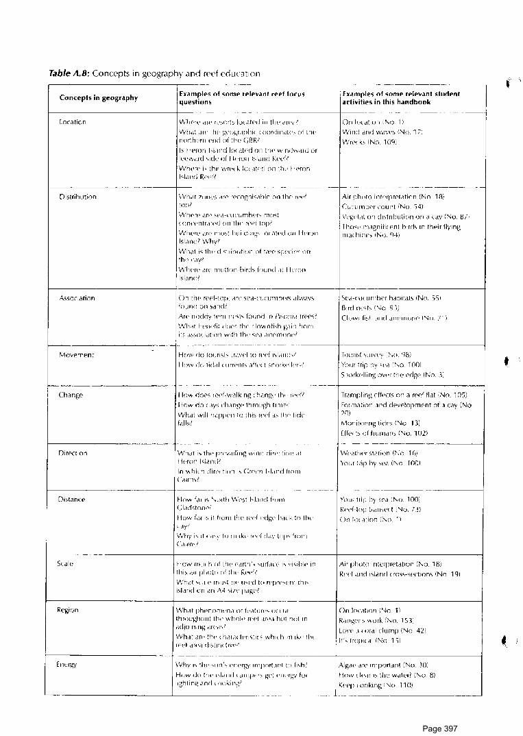
Table A.8: Concepts in geography and rPPf education
Concepts in geography
LorMion
Distribution
Examples of some relevanl reef focus questions
\Vhew d rP ,,.,ort 1 I rn atr« I i" t lw MPd'
VVh.i! .1w 1 lw g<·,,gr.rphi' 'rn1rdin.rn•,; uf thl' northr •rn Pnd oi llw C flf\I Is I I Pron hi,rnd locat<>d 011 tlw windw,ird or lr.'<.'W<lrd sid•• oi 11<.>ron bl.ind f.'.+.'l'fl
\Vlww is th<c• Wf\" k Joe dt< ·c I on th'• 11 ('ron l<Lmd R«<'ll
\Vh,it 1"11e<, MP r<Yogni-:.ihll' on tlw ,,.,.f top I
\.V~1c r~i arr~ ~ca-~·li ("Lj nlru.·r'=' mr)~~ \ (l!K\'11tr<1t«cl Ofl tlw r(Tl topl
\.Vlww <1re mo>I I' u ii di' ig' loc at• .,j 011 I j' •nJr' lsl.rndl Why'
\Vhdt i< tlw di '1 r il)Ljf iun nf t H'f' >pt·c i ,.., on tlwc,w'
\Vlwr<> .Jr(' m11:1on-bird,; found .it I k-rnn lsliLn<JI
Eumples of some relevanl student activities in this handbooli
On lo( <1tion iNo. 1 :.
\Njrirl <1nrl w,1ws 'No. 17:
\Vre1 b iNo_ 109i
Air phDIO intt'fprf'tation !No. 1 m I CL,cumlwr count iNo. '>4i 1 \'«gt'l,1 t1on cfo t ri huli on on ii < <1y (~o. B 7)
l h\N' m.ignifi( t>nl h1rd1 in their flying rn.i< hi"''' I l\o. 'l·fi
-·--· --------------------+-
As>ociation
>-----------~~~~~~~~~~~
Movement
I~ ar------"---·----
Change
>-----------~~-r~~·~~··-~~···
nirl'ction
On tlw r«t+top. MV c;r'<1-cucun1h~"' dlw.1y; f()und on 1dndl
A"' rlOddy l<'rn ,,,.q, found in Pi.>"ni.i trer .. ;I
\.\.'lut twndi: dur« tlw rlnwnfi.;h g,1in from its d~~o<. iatton wi: h t hr· ..;,c·d d nr· mon( ,~
How rlo t(llHi\b tr,wd to wd "l,HHh1
H mv d" I idc1I ' ""' •nf'. ,1f1,., \ < n "' k<'l I< .,,1
How doP<, rf'd-w.ilking chang" th•· r"dl
fl ow do ( .iv> ch ang<' th rough t111w 1
VVhat wil I h,1 flP<'rl to this rPd d' I h ,, I idP fill bl
\Vhdt i' tlw l""v,Hiiflg wind diro'< tirn• ,Ji
lj(·ron l1i,1ml'
In which din'• ti"n i, Cr<«'Pl hl,md fro111 C<11m\I
>----------r--•-1----·- ·------
Dist<Lnce Hnw far i<. '\rnth \V<'St l'Lmd irom Clad>!om'I
How fdr i<, ii fron1 tlw r(•d-»dg« h.l< k :n tlw ~ dY~
\Vhy i1 ;! """Y r" "'"k" wd d,rv trip' from Ca~rn..,!
5e<1-n1uuntwr hdbitab iNo. 55:1
Bird nt·ct' 1No. 9 ))
Ck>wfl fi,h d r>d d n• • rnonr> I '\i c i. 71)
Trn uist 'ii I r"l.'f')' : :-.o gs;i
Yow l r;p hv wa '"' o. 100!
<;roork1·lli ng owr the f'df;P I No. J:
Tr.1mplin~ f'ffpch on a red fl.it ·:.'\io_ 1051
Formation .inti devPlopmf'nt of a cay (No 201
Monitoring tidl'\ (No. 13i
Ufp< b uf hu111dn> i'\io. 102i
w,..itl"" <,t,ition 1::-.·o. 1 ri.:, Yow :rip hy st',1 iNo. 100!
YoLJr tri11 hy 1Pa !No. 100i
R«d-top lr.rnwn f'\io. 7:!,i
( )n Im ,it ion (No_ ·1 ·,
>----.---------------r------ -------------· -·------+-----------------------<
Ri:gion
Energy
flow m11<. h of ilw <.>dnh·, '<Jlld<'<" i' vi,chl<' in 1hi1 "" pholn of :fw R<•pfl
Vl/h,11 ".li<' rllll'i lw U'Pd ID "'P"'''"'t 1hi' isLrnci on .rn A4 ,;;,, p.igpl
Air photo interpwt<1t•on !No_ 18i
R•'<·f ,i11d i;ldml < ro><,-sectiom (No. 191
--·--·· - ·------+-------------------------<
VVh.<t phPnnm .. 11,1 or il'.lllir<'' <J(' IH
throughout 1 lw wlml\• wd .in•,1 b1•! n"t 111
Mljoining ,m.,1,1
\.Vh,1t M<' tlw 'h,11,H l<'ri1ti<' whi' h 111.1~" llw rfltlr d r~ ·a d1~l1 rH : 1v~ 1 '.
\Vh~· .... thP ';olJrl''?- l'lH.~~-~y 1n1pnr[\Hl! to fr1 .. h:
How do Ill!' .,J,rnd r ,lrllf'•·•rs gr•t """'bl-' for lighting ,1nd 'nc1king1
On lnc.il:on i.'\io_ 1:1
R<lng«r\ work ·:No_ 1 C,11
LovP ,1, or<1I dump 1:No. 42:1
It'' tropii<1I fNo. 15i
Alg.w Me 1n1portM1t (No. JOI
flow cit'.ir " th•• Wdtl'rl i I\ o. 8,1
l'•'"I' r •mkirig: 'Jo 11 rn .--- ------·----------------
•
Page 397

Table A.9: Reef education and school geography syllabus-Great Barrier Reef studies arc applicahle lo many content areas of existing geography syl I abuses. Examples include:
-----------~~~--------------------------
Geography syllabus Syllabus content area >------------------<-----------------------------------·~--·-··----··~-
Qu('cnsland BoMd ol Su ondary Schools Scni or C<'ngr.i.phy Syllabus \Reprintf'd 1q87i
Unit V: The iiving cnvironmf•nt
Unit II: People <lnd the environrnPnt
S('ction C: Rpgiondl ~tudi('S in Bing<Yigraphy
SPnion D: Human lr"1pacl
-----------------~ ·--·~ -~----·~ ~
SPr ti on B A rt> al Stud :e> of [ rwi ron rn(·nt,11 Impact
Srction C: Confiict 5tudif's
·-----------··---------------------t
lJ nit I Ceonm!]-ihology Unit 6 Coast,11 Pron'sses
Unit 8 Acti1,·itirs ol Mdn
Unit 9: M,1norPgion<d Study >-----------------------------------·-··T----.n-•·~
lJ nit IX: Phyw al G~'Dgraphy 1opic 1 Tlw Oct>ans - vvith applird options
>------------·--------------------
Unit 111: Austr,1lian Geographical lnquirie5 I Inquiry topics allow ;tudips of the Grf',1t Harrier Reef in Physic.11/L nvi ronmental/Social units).
---------------------------- ---·-·-·--···- -~-~--
LI nit VII Fco norni< gr•ogr<iphy Unit IV: Tertiary Ocu•p<1lio11s--Touri<,rn and Rec w,lt ion 5tu(I ies
--~-··~~~ ~·-------------->----------------~---.~~---- -~·-----~~------- -------------<
Qucensl,md Board of Sernndary Srhools Junior Geography Syllabus I Reprinted 1987i
Australici r,1 rt!'rn, of l_anrl in Aust rdlia
Cont.,mpora1y C<>ng•,1phiral l1>ues
>-----·--~----·~--~·-~·~----~-------------------------<
L<)(al arra Schools nPar reel could study reef a5 home area
>------------ ------+---------------------------·-· __ , ___ --· ---· -~-------·
New South Wales Secondary Schools Board, School CPrt1ficat1? Syllabm in GcogrJphy 1983
Communities <md Environments
Cont«rnpor<1ry l<,sucs and World Aff.1ir:.
Au<,tr<1li,m GPography
Pcnpl<' and Their Attiom rn Relation to [ach Otlwr and Globdl Erwironmer1t<,
---------·------------+---·----· ·--
New South Wales Board of Sc'wndary [duration Year:; 11 ,md T 2, Geogrciphy 11987i
Austr,1lid ~nd its \Vorld Context (Year 11) Topi\ 1 the Austr~lia< Environment Topic 1 Aust"1li.1ns ar d Their fljophy;icJI Frwironment
Option 2 Food dnd A~ri< uhuw (miriori
~~· ~~~~-----------
Topic 1 lJsf' and Mi>L ,;e of Natural Re>our<J.es Option 1 Fragile• [nvi,onmpnts
--------- --~----~----------- -- ------~~·-· ~ ~-· ···--- ~- -· --~-·-
Page 398

RESOURCES References and Resources about the Reef dre divided into the following categories: • Books and articles about the reef • Periodicals and mdgazines for dass use • GBRMPA publications • Audio visual teaching aids • Curriculum documents • Teacher readings on education and Prwironrnent • Organisations for further information
Books and articles about the Reef Barn es, D. ed. 1983. Perspectives on cor a I reefs. Canberra: Clo us ton/ Aust. Ins I. Marine Science. Bennett, Isobel. 1982. The Creal [farrier Reef. Sydney: Lansdowne. Carcasson, R. H. 1977. A field guide to reef fishe.s of tropical Australia and the Inda-Pacific region. London:
Collins. Clark, L, and Cook, B. J. 1983. Geological science: perspectives of the earth. Canberra: Aust. Academy of
Science. Coleman, N. 1983. Aus/ralian .sea fishes north of 30°5. Sydney: Doubleday. Cribb, A. B., and Cribb, J. \V. 1985. Plan/ life of the Creal Barrier Reef and adjacent 5hores. St Lucia: Univ.
Queensland Press. Deas, W., and Domm, S. 1976. Corals of thf' Great Barrier Reef. Sydney: Ure Smith. Endean, R. 1982. Aus1rali<1"i Crear Barrier Reef. St Lucia: Univ. Queensland Press. Frith, H. T. 1976. Reader\ Dige.sr complete book of Australian birds. Sydney: Reader's Digest. George, J. D. and George, J. J. 1979. Marine life - an illustrated encyclopedia of invertebrates in the sea.
Adelaide: Rigbv. Gareau, T. F., Goreau, N. I. and Gareau, T. J. 1979. Corals and coral reefs. Scientific American, August Grant, E. 1982. l.u1df' lo Fi.shes. Brisbane: Dept of Primary Industry. Great Barrier Reef Marine Park Authority·. 1981. Nornina(ion of rhe Great Barrier Reef for inclu5ion on the
World Heritage Lisi. Townwille: GBRMPA. Heatwole, H. 1981. A coral i-;land. Sydney: Col tins. Hughes, R., ed. 1985. Au1tralia ·.1 underwater wilderness. McMahon's Point: Weldon. Hopley, D. 1982. The geomorphology of the Great Barrier Reef New York: Wiley. Jones, 0. A., and Endean, R., eds. 1973-1977. Biology and geology of coral reef5. Vols 1 to 4. New York:
Academic Press. Mather, P., and Bennett, I. 1984. A coral reef handbook. Brisbane: Australian Coral Reef Society. Maxwell, W. G. H. 1968. Atfils of (fie Crear Barrier Reef. Amsterdam: Elsevier. Morgan, D. ed. 1981. Biological sricncf': th<' web of lifP. Canberra: Aust. Academy of Science. Pizzey, G. 1980. A field guide lo thf' hirds of Australia. Sydney: Collins. Queensland. Dept of Geographic Jn formation. 1988. Discovering coastal Queemland. St Lucia: Univ.
Queensland Press. Saenger, P. 1977. The divers guide Brisbane AUF. Sheppard, C. R. 1983. A naturill hi.'>lory of coral reefs. Poole, Dorset: Blandford Press. Short, J. W. and Potter, D. G. 1987. Shells of QuePmland and rhe Crea( Barrier Reef: marine ga5tropods.
Drummoyne, Golden Press. Slater, P. 1970. A field guide to Al/.\tralian birds - volume one non-passerines. Adelaide: Rigby. Talbot, f., ed. 1984. Reader\ Digest book of the Great Barrier Reef. Sydney: Reader's Digest. Veron, J. E. N. 1986. Corals of Australia and the Inda-Pacific region. North Ryde: Angus and Robertson. Ward, W. T. and Saenger, P. eds. 1984. The Capricomia seuion of the Creal Barrier Reef - past, pre5enl
and future. Brisbane: Royal Society of Queensland and Australian Coral Reef Society.
Page 399

Periodicals and magazines The following periodicals and series often contain popular articles which could be useful in reef education programs. • Australian Natural History (published by the Australian Museum} • [cos (published by CSIRO) • Habitat (published by the Australian Conservation Foundation) • Australian Fisheries (published by the Commonwealth Department of Primary Industry) • Oceanus (United States periodical. S11ecial !ssue on the GBR - Vol 29:2, 1986) • Underwater • Geo • Australian Geographic
Publications of the Great Barrier Reef Marine Park Authority • Reef ,l\.'olc5 Pamphlet series on Reef topics, titles include 'Coral polyp', 'The Soft Touch', 'Turtles',
'Seabirds', 'Coral cays', 'Trochus Shells', 'Captain Cook'_ • Reef/ections (newsletter) • Zoning plans and zoning maps for sections of the Great Barrier Reef Marine Park The GBRMPA also publishes a wide range of other material including research reports on topics such as tourism, fisheries and rcf'f management. Contact GBRMPA for information on currently available titles.
Audio visual teaching aids GBRMPA publishes a booklet of detailed reviews of some audio visual publications about coral reefs. GBRMPA's own productions include: • Encounters with the Red. (slidP - tape kit) • The Crown of Thorns Story_ (30 min video) • Reef Report (quarterly 20 min video news magazine)
Curriculum Documents NSW Board of Secondary Education. 1987. Syllabus, \-'.ears 11-12, geography. Sydney: BSE. NSW Board of Senior School Stud ics. 1979. Science syllabus, 2 unir course - physics, Years 11-12. Sydney:
BSSS. NSW Board of Senior School Studies. 1979_ Scieno• syllabus, 2 unit course - chemistry, Years 11-12.
Sydney: BSSS. NSW Board of Senior School Studies. 1980. Science sy/liibus, 2 unir course - geology, Years 11-12. Sydney:
BSSS. NSW Board of Senior School Studie'>. 1985. Science syllahu1, J/4 unit (general) course, Years 11-12_ Sydney:
BSSS. NSW Boa rd of Senior School Studies. 1986. Science syllabus, 2 unit rnune - biology, Years 11-12. Sydney:
BSSS. NSW Secondary School~ Board. 1985. Scienn' 1yllabus, Years 7-10_ Sydne~': SSB. NSW Secondary Schools Board. 1983. School cr>rtificate syllabus in geography. Sydney: SSB. Queensland Board of Secondary Schools. 1981. Senior syllahu'i in earth Kie nee (draft)- Brisb;ine: BSS. Queensland Board of Secondary Schools 1984. Senior .'>yllabus in multisrrand 5cicnce (draft). Brisbane: BSS. Queensland Board of Secondary Schook 1985. junior syllabus in science (draft). Brisbane: BSS. Queensland Board of Secondary Schools. 1985. Senior syllabus in biological science (draft). Brisbane: BSS. Queensland Board of Secondary Schools. 1985. Senior syllabus in chPmistry (draft). Brisbane: BSS. Queensland Board of Secondary Schools 1985_ Senior syllabu.1 in physics (draft)_ Hrisbane: BSS. Queensland Board of Secondary Schools. 1987. S(>nior geography syllabus (reprint). Brisbane: BSS. Queensland Board of Secondary Schools. 1987. junior gc•ography syllabu1 (reprint)_ Brisbane: BSS.
Page 400

Teacher readings on education and environment •Books
Anderson, H. 0., ed. 1969. Rf'ading<. in ffi('ncc cducaUon for the secondary school. New York: Macmillan. Ajzen, I., and Fishbein, M. 1980. Unduilanding atUtudes and predicting social hehaviour. Englewood Cliffs,
N. J.: Prentice Hal I. Alun Jones, P. 1968. Fieldwork in geography. London: Longmans. Australia. Dept Home Affairs and [nvironment. 1984. Na1ional conservalion strategy for Australia.
Canberra: AGPS. Australian Science Education Project. 1974. A guid(' IO A.S.E.P. (Introduction to A.S.E.P.). Melbourne: Govt
Printer. Barman, C. R., Rusch, J. J., and Cooney, T. M. 1981. Science and socii'la/ issues. Ames, Iowa: Iowa State
Un iversitv Press. BartlPtt, L, and Cox, B. 1982. Learning to teach geography. Brisbane: Wil('y. Bentley, Ian. 1984. R('<.C>arch invcsligarion. Melbourne: Nelson. Brumby, M. 1984. ls.1uC>s in biology Melbourne: Nelson. Cornell, J.B. 1979. Sharing nature wi//1 children. Nevada City, Calif.: Ananda. Curriculum Devf'ioprnent Centre: 1981.Environmenral education: A source book for secondary education.
Canberra: CDC. Fien, J., Gerber, R., and Wilson, P. 1984. ThP geography teachers guide lo the classroom. Melbourne:
Macmillan. Fien, /. 1988. Educalion for the Au.<.tralian environment. Bicentennial Auslra/ian Swdies Schools Project
Bul/e1in 3. Canberra: CDC. Fraenkel, J. 1973. Teaching studenb to think and valuP. Englewood Cliffs, N. J.: Prentice Hall. Great Barrier Reef Marine Park Authority. 1983. 'vVorkshop on northern sector of Great Barrier Reef Marine
Park. Townsville: GBRMPA. Green a 11. A. 1980. En vironrm.'nl al education for schoo/.1. Canberra: Curricul urn Development Centre. International Union for Conservation of Nature and Natural RPsources. 1980. World conservation strategy.
Gland, Swit1.: !UCN. Joseph, D. B., et al. 1976. Enquiry in science - a guide for teachers. Sydney: McGraw Hill. Kohl berg, L. 1976. Development and behaviour. New York: Holt. Linke, R. 1980. En vironmenral educa1 ion in Ausiralia. London: Allen & U nwi n. McAllister, Robert. 1982. Science proccs<.cs - their role in teaching and learning. in Guidelines series, Qld
Department Education, Curriculum Branch. Martin, M. 1972. Concepts of science education. Glenview 111.: Scott, Foresman & Co. NSW Department of Education, Personal Development Unit, Directorate of Special Programs. 1983. Ideas
for value1 education· Moral dilemma, values clarification. Sydney. Oates, C., et al. eds. 1980. Science education: Australian principle\ and practices. Canberra: CDC. Passmore, John. 1974. Man\ re.1ponsibility for nature - C>co/ogir:al problems and western tradition.
London: Duckworth. Raths, L. E., Harmin, M., and Simon, S. B. 1978. Values and reaching, working with values in the classroom
(2nd ed.). Columbus, Ohio: Merrill. . Romey, W. 0. 1968. Inquiry techniques for Kience teaching London: Prentice Ha!L S.A. Secondary Science Curriculum committee. 1977. The do ir yourself curriculum guide for junior
secondary science. Adelaide. Education Dept S. Australia. Saarinen, T. 1976. Environmental phmning: Perception and bdlaviour. Boston: Houghton-Mifflin. Sharpe, G. W. 1982. Interpreting the environnwnt. Toronto: Wiley. Simon, 5. B., Howe, L W., and Kirschenbaum, H. 1978. Va/up~ clarification - a handbook of practival
.strategies for teachN~ and students New York: A & W.
t ~.
Page 401

Simpson; R. D., ~nd Anderson, N. D. 1981. Science, .. srudents and school!;. New York: Wiley. Stapp,\/\-., and Cox, D. 1974. lnv1ronmenra/ education activities manual Michigan: Stapp & Cox. Superb, o,., et ~I. 1975: Values E'ducat1on: Approaches and materials. Boulder, Colorado: Social Sciences
Education Consortium, Inc · -
Sutton, C., and Haysom, J. 1974. The art of the science teacher~ Kience teacher education pro1ec1 London: McGraw-Hill. - ·
Swan, J., and_ Stapp, W. 1974. fnvironmrntal education - stra1cgi('_'i toward a more livable future. New York: Wiley.
Van Matre, S: 1972. Acc/imdlizaU011 - a .1ensory and conu'prua/ approach to ecological involvement Martinsville, Indiana. American Camping Assoc1at1on.
Van Matre, S.1974. Acc/in1a1izing. Martinsville, Indiana: American Camping Association. We1gand,.P.'. and Orrf'll, K., eds. 19il2. ,\'f'w lead-; 1n geogr.iphic;i/ ('ducation. Sheffield: Geographical
Assouat1on.
~heeler, K., and Waites, B: eds. 1976. E11viro11111('nral g<'ography. St Albans: Hart-Davis. Yi-Fu Tuan. 1974_ Topoph1/1a - a study of Pnvironmcnla/ p('rception, attitudes and values. Englewood
Cliffs, N. J.: Pn'nt1ce Hall.
•Articles AjLen, 1., and Fishbein, M. 1977. :\ttitude-behdviour relations: a theoretical analysis drld review of empirical
research. fJsychological Bullet in 84: 888-918. Birch, C. 1982. [cologica I ethic~ and economics. Habitat 10 (5): 13-14. Blachford, K. 1979. Morals and v<ilues in geographic education: toward a metaphysics of the environment.
CPogr. Ed. 3: 42.1-57. Brockmeyer, F_ M., Bowman, M. 1.., and Mullins, C. 19H2/l\J_ Se11sory versus nons<'nsory interpretation: a
~tudy of senior citizens' preferences. J. {nviron. Ed. 14 (2). Cad uto, M. 1983a. A revif'w of erwi ron mf'ntal values education. }. Environ. Ed. 14 (3): 1321. Caduto, M. (1983b). Toward a comprehensive strategy for environmental values education. f. Environ. Ed.
14 (4): 12-18. Elliot, R. 1978. Erhiu and rnnwrva/ior1. Ha bit at 6 (2): 9-13. Elliot. R. 1979. Should we prewrve .,;pecies. Hdbitat 7 (5): 9-10. Fensham, Peter J., and May, John fl. 1979. Servant not master - new role for science in a core of
environ nwnta I t·ducation. Au11 r,1 lia n Science T eaclwrs journal 25 (2): 15-24. Fien, T. 1980. Perception studies in human geography. In Ceographica/ is.1ues, edited by R. Gerber and D.
Biddle, pp 1-39. Brisbane: AGTA. f' ien, J ., and Slater, F. 1981. Four strategies for VJ I ues education in g<'ogr<1phy. Geo gr. Ed. 4: 39-52. Fox, W_ 1986 Approaching deep r>colofiy· a response lo Richard Sylvan'1 critique of deep ecology.
En viromnental Sturfie; Occaq·oru/ Paper ,...,'o. 20. University of Tasmania, Hobart: Centre for Environ mer11a I Studies.
Gerber, R., and BiddlP, D., eds. 1980. Ceographical issue1. Brisbane: ACTA Godfrey·Smith, \.V_ 1979. The value of wildemess. Environmental f'thics. 1: 309-19. Gough, N. P. 1979. Moral d1rnensiom oi <'nvironmental education. Unicorn 5 (2): 150-60. Huckle, J _ F. 19H3. Values cd ucdt ion I h rough geography: a radica I critique. j. Geo gr. { March-Apri I): 59-63. Knapp, C. E. 1983. A curriculum model for environmPntal values education. Dialogue 14 (3): 22-26. Lucas, A. M. 1980. The role of science education for the environment. f. Environ. Ed. 12(2): 33-37. Partington, G. 1983. Clarifying >1udl'nt\ values. Unicorn 9 (1): 34-Jfl. Perdue, R. R,, and Warder, D.S. 19tll Environment<1I education and attitude change.}. Environ. Ed. 12 (3):
25-28. Pluhar, E.G. 1981. The justification of an environment;il ethic. Environmental Ethio S (1): 47-62. Robottom, I. 1983. Science: J limited vd1ide for environrnf'ntal education. Au.sf. Sci. Teachers Journal 29
(1): 27-31. Schaer, G. 1979. Ari integrated apprnach to pupil-centred field studies in geography using multisensory
observational techniques. Geography Buller in 11 (2): 42·51. UNESCO. 1978. The Tbilisi declaration. Connect UNESCO-UN{: P Environmental New~letter 3 (1): 1-8. Young, R. A 1980. The relJtionshi p between information level~ and <'twi ronmental approval: the
wilderness issue. J_ Environ. hi. 11 (3): 25-30.
Page 402

Organisations for further Information Australian Institute of Marine Science PMB No. 3 Townsville, M.C. Qld. 4810
Australian Institute of Maritime Archeology cl-Western Australian Museum Cliff Street Fremantle, W.A. 6160
Australian Museum 6-8 College Street Sydney, N.S.W. 2000
CSIRO Marine Laboratories (astray Esplanade Hobart, Tas. 7000
Commonwealth Dept of Education Darwin Place Canberra City, A.CT. 2601
Great Barrier Reef Marine Park Authority GPO Box 1379 Townsville, Qld. 4810
Heron Island Research Station Heron Island via Gladstone, Qld. 4680
James Cook University Townsvi\le, Qld. 4811
Lizard Island Research Station PMB 37 Cairns, Qld. 4870
Marine Rec,ource'> Management Branch Min is try for Conservation, Forests and Lands P.O. Box 114 Queenscliff, Vic. 3225
National Parks and Wildlife Service Marine Parks Division P.O. Box 636 Canberra, A.CT. 2601
Queensland Fisheries Service P.O. Box 344 Fortitude Valley, Q!d. 4006
Queensland Museum P.O. Box 300 South Brisbane, Qld. 4101
Queensland National Parks & Wildlife Service Maritime Estate Management Branch P.O. Box 190 North Quay Brisbane, Q\d. 4000 (Regional Offices in Cairns, Townsville & Rockhampton)
,
Page 403

NATIONAL i lfil~ .. \.i<' ( l!' /\\_:<:,; l RAI ! ·'·
Page 404

Page 405