PROJECT FACT SHEET - PH-EITI Contracts Portal
328
Lichel Technologies, Inc. PROJECT FACT SHEET MARCVENTURES MINING AND DEVELOPMENT CORPORATIOM MMDC NICKEL PROJECT EIS 1 Figure 1 The Project MARCVENTURES MINING AND DEVELOPMENT Corporation (MMDC) assigned Lichel Technologies, Inc. (LTI) to conduct an Environmental Impact Assessment (EIA) for its proposed Nickel Mining Project (hereto referred as the “Project”). The Project will involve the extraction, sorting and drying of nickel ores at the project area, and the transport of the ores to the loading station in Lanuza Bay for shipment and refining to Japan, China or other places. The Project is situated in Barangay Cabangahan in the Municipality of Cantilan, Barangay Panikian in the Municipality of Carrascal, and Barangay Bayogo in the Municipality of Madrid which are all under the jurisdiction of Surigao del Sur Province (Figure 1). The Project has a total area of 4,799.00 hectares (ha) and is covered under the Mineral Production Sharing Agreement (MPSA) No. 016-93-XIII which was approved by the Mines and Geosciences Bureau (MGB) on 01 July 1993. Exploration within the project MPSA area identified three potential nickel laterite areas, namely: Area 3 at the northern part, Area 1 at the central part and Area 2 at the southern portion. From these identified laterite areas, mining will commence at Area 2 with an initial mine area of approximately 120 hectares. The estimated mine life at Area 2 is ten (10) years excluding the additional potential ore reserves that will be delineated by the on-going exploration drilling program. The estimated mine production is 600,000 wet metric tons (WMT) for the 1 st year of operation to a maximum of 1,500,000 WMT per year. The EIA Process The conduct of the EIA study follows the Implementing Rules and Regulations (IRR) of Philippine Environmental Impact Statement System (PEISS) which is contained under Department of Environment and Natural Resources (DENR) Administrative Order No. 30 Series of 2003 (DAO 03- 30). Under the PEISS, a resource extractive industry such as this Project is classified as an Environmentally Critical Project (ECP) and is required to conduct an EIA. Results of the EIA are contained in an Environmental Impact Statement (EIS) document which is submitted to the Environmental Management Bureau (EMB) for review and approval by the DENR through the issuance of an Environmental Compliance Certificate (ECC). The EIA commenced on 14 January 2008 with the submission of a Letter of Request for Scoping to the EMB. A public scoping meeting was held on 29 January 2008 at Barangay Cabangahan, Cantilan, Surigao del Sur. The meeting afforded the stakeholders the opportunity to discuss their concerns regarding the potential environmental and social impacts of the proposed Project. Following the Public Scoping, a separate Technical Scoping was held on 06 February 2008 at the Environmental Management Bureau (EMB) Central Office and was attended by the EIA consultants, who also represented the proponent, the EMB EIA case handlers, and the EIA Review Committee (EIARC). The purpose of the meeting was to finalize the items to be included in the EIS document and is contained in the signed Scoping Checklist. Primary and secondary data were gathered from surveys held between February 2008 and April 2008 to characterize the environmental baseline conditions at the project area. Primary data gathered include field measurements, sampling and observations to characterize the physical and biological environments. Systematic socio-economic and perception surveys as well as focus group discussions and key informant interview were conducted to determine the sentiments of the affected communities. A participatory and community-based approach was used in conducting the EIA for this
-
Upload
khangminh22 -
Category
Documents
-
view
2 -
download
0
Transcript of PROJECT FACT SHEET - PH-EITI Contracts Portal

Lichel Technologies, Inc.
PROJECT FACT SHEET MARCVENTURES MINING AND DEVELOPMENT CORPORATIOM MMDC NICKEL PROJECT EIS
1
Figure 1
The Project
MARCVENTURES MINING AND DEVELOPMENT Corporation (MMDC) assigned Lichel Technologies, Inc. (LTI) to conduct an Environmental Impact Assessment (EIA) for its proposed Nickel Mining Project (hereto referred as the “Project”). The Project will involve the extraction, sorting and drying of nickel ores at the project area, and the transport of the ores to the loading station in Lanuza Bay for shipment and refining to Japan, China or other places.
The Project is situated in Barangay Cabangahan in the Municipality of Cantilan, Barangay Panikian in the Municipality of Carrascal, and Barangay Bayogo in the Municipality of Madrid which are all under the jurisdiction of Surigao del Sur Province (Figure 1). The Project has a total area of 4,799.00 hectares (ha) and is covered under the Mineral Production Sharing Agreement (MPSA) No. 016-93-XIII which was approved by the Mines and Geosciences Bureau (MGB) on 01 July 1993.
Exploration within the project MPSA area identified three potential nickel laterite areas, namely: Area 3 at the northern part, Area 1 at the central part and Area 2 at the southern portion. From these identified laterite areas, mining will commence at Area 2 with an initial mine area of approximately 120 hectares. The estimated mine life at Area 2 is ten (10) years excluding the additional potential ore reserves that will be delineated by the on-going exploration drilling program. The estimated mine production is 600,000 wet metric tons (WMT) for the 1st year of operation to a maximum of 1,500,000 WMT per year.
The EIA Process
The conduct of the EIA study follows the Implementing Rules and Regulations (IRR) of Philippine Environmental Impact Statement System (PEISS) which is contained under Department of Environment and Natural Resources (DENR) Administrative Order No. 30 Series of 2003 (DAO 03-30). Under the PEISS, a resource extractive industry such as this Project is classified as an Environmentally Critical Project (ECP) and is required to conduct an EIA. Results of the EIA are contained in an Environmental Impact Statement (EIS) document which is submitted to the Environmental Management Bureau (EMB) for review and approval by the DENR through the issuance of an Environmental Compliance Certificate (ECC).
The EIA commenced on 14 January 2008 with the submission of a Letter of Request for Scoping to the EMB. A public scoping meeting was held on 29 January 2008 at Barangay Cabangahan, Cantilan, Surigao del Sur. The meeting afforded the stakeholders the opportunity to discuss their concerns regarding the potential environmental and social impacts of the proposed Project. Following the Public Scoping, a separate Technical Scoping was held on 06 February 2008 at the Environmental Management Bureau (EMB) Central Office and was attended by the EIA consultants, who also represented the proponent, the EMB EIA case handlers, and the EIA Review Committee (EIARC). The purpose of the meeting was to finalize the items to be included in the EIS document and is contained in the signed Scoping Checklist.
Primary and secondary data were gathered from surveys held between February 2008 and April 2008 to characterize the environmental baseline conditions at the project area. Primary data gathered include field measurements, sampling and observations to characterize the physical and biological environments. Systematic socio-economic and perception surveys as well as focus group discussions and key informant interview were conducted to determine the sentiments of the affected communities. A participatory and community-based approach was used in conducting the EIA for this

Lichel Technologies, Inc.
PROJECT FACT SHEET MARCVENTURES MINING AND DEVELOPMENT CORPORATIOM MMDC NICKEL PROJECT EIS
2
Project where the study team recruited some residents as field assistants. Secondary data on the Project area were gathered from both the national and local agencies, and other organizations.
The scope of the study included the assessment of the probable impacts of the Project on the land, water, air and noise environments of the study area. It also included perception and acceptability of the Project by the stakeholders and recommendation for the mitigation of the perceived adverse impacts and enhancement of the positive effects. Based on the impact assessment, mitigating and enhancement measures were recommended and environmental management and monitoring plans were prepared.
Environmental Baseline Profile
The project area exhibits hilly to mountainous terrain with elevations from 40 masl along the Carac-an floodplain and to as high as 750 masl at the southern portion of the project area. Ridges are generally broad with rounded peaks. The project area is underlain by ultramafic rocks and laterite, metavolcanics and schist. Soil overburden consists of clay to clay loam of low fertility.
The project area is dominated by secondary forest with dense undergrowths. Patches of corn are planted along the alluvial floodplain of Carac-an River at Barangay Cabangahan. Terrestrial wild fauna observed include 48 species of birds, 8 species of mammals and 6 species of herps.
The Carac-an, Alamio and Binoni River Systems drain the MPSA area; a small tributary of the Buyaan River drains the southern portion of the MPSA area. Downstream of the project area, the rivers are tap to irrigate the vast rice fields of Cantilan and Madrid. Groundwater potential is limited to weathered or fractured zones of massive rocks; groundwater recharge to aquifers is low due to presence of thick lateritic clay.
Off the coast at Barangay Consuelo, observed tides is generally a mixed diurnal-semi-diurnal type with a dominant diurnal character. The tidal amplitude in the area has an average value of about 0.59 m. Water depths in the proposed jetty are generally shallow with maximum depth of about 21 m. Observed currents at the time of visit ranged from 0.02 to 0.07 m/sec. However, currents in the area may become relatively strong during typhoon occurrence.
Surface freshwater quality is within the DENR Class D standards for irrigation water. However, a surface water used for domestic supply by the residents of Barangay Cabangahan tested positive for coliforms. Marine water quality ranged from DENR Class SC (Fishery Class II) to Class SD (Other Coastal Marine Waters).
The proposed jetty area is relatively poor in species of the usual coastal marine ecosystem (mangrove, seagrass/algal beds, and coral reefs and associated fish population and macroepifauna) due to poor fishing practices.
The project area is located in a region that possesses a Type II Climate characterized by the absence of a dry season and a pronounced maximum rain period. The wettest period of the year is between November and February. Annual rainfall estimated at the project area is at 4,100 mm.
Air quality is within the ambient standards while background noise levels were observed to be below the ambient noise standards for residential areas.
The project area administratively falls within the Municipalities of Cantilan, Carrascal and Madrid all of Surigao de Sur Province. Among the three municipalities, Cantilan has the highest number of population of 26,553 (NSO, 2007) representing 5.29% of the provincial population of Surigao del Sur. Madrid Municipality has a total population of 14,957 or 2.76% of the province’s population. Carrascal is the smallest municipality among the three municipalities under the study. It has a total population of 14,248 or 2.63% the total population of the province.
The Indigenous People (IP) in the project area is the Manobo Tribe; in Barangay Cabangahan, almost 100 percent of the population belongs to the Manobo tribe.

Lichel Technologies, Inc.
PROJECT FACT SHEET MARCVENTURES MINING AND DEVELOPMENT CORPORATIOM MMDC NICKEL PROJECT EIS
3
The socio-economic and cultural survey covered three areas categorized as follows: the MPSA Area, the Transport Route and the Jetty Area. The MPSA Area has 267 respondents from Barangay Cabangahan of Cantilan Municipality, Barangay Panikian of Carrascal Municipality, and Barangay Bayogo of Madrid Municipality. The Transport Route area has 42 respondents from Barangays Cabas-an and Parang both of Cantilan Municipality while the Jetty Area has 30 respondents from Barangay Consuelo also of Cantilan. Barangay Cabangahan was selected to have the highest number of respondents (100%) since it is the nearest community located some 1.5 km north of the initial mine area.
Respondents in all three areas have relatively low income of up to 5,000 pesos a month. The most common livelihood is farming. Several households depend on forest related activities such as collecting of firewood and some others are fishermen and laborers.
Majority of the respondents in all study area were aware of the existence of MMDC. 74% in MPSA Area, 64% along the Transport Route and 77% in the Jetty Area said that they knew MMDC.
The mostly perceived positive effect of the Project is the generation of employment and livelihood activities. On the other hand the respondents also agreed that the establishment of the Project can cause environmental pollution. .
The respondents from all three area categories were in favor for the establishment of the Project. In the MPSA Area, 72% strongly agreed and another 11% agreed with the establishment of the Project. Along the Transport Route, 36% respondents agreed and 25% strongly agreed with the establishment of the Project. Moreover, 66% respondents in Jetty Area strongly agreed and another 16% agreed in favor of the Project.
Despite the overwhelming support of the respondents towards the Project, the respondents also understood the vulnerability of their place to environmental damage. Majority of the respondents in all area category said that the Project could cause environmental damage and pollution. However, the respondents were also confident that the Project has enough mitigating mechanism to prevent the adverse environmental effects. They also agreed to the way the company dealt with complains and problems aired by the community. The survey results showed that the respondents were concern about the environmental issues. Majority of the respondents are willing to participate in all activities relating to the protection of the environment. A large majority of the respondents were willing to join and participate with different institutions in monitoring the activities of the Project to ensure that the environment is safe.
Key Environmental Measures
The most significant adverse impact of the Project to the environment is the potential siltation of water bodies of eroded sediments of bare areas, stripped overburden and stockpiles. Without erosion and siltation control measures, eroded sediments will clog waterways, pollute the water which then will affect aquatic life.
The National Irrigation Administration (NIA) maintains four irrigation systems downstream of the project area. Through the years of its operation, silt perpetually accumulates at the irrigation intake structures that required periodic desilting to optimize its design capacity.
The initial mining operation is approximately 4 to 5 km upstream of the irrigation intake structure. Considering that the initial mining will be for a period of ten (10) years, NIA had raised their opposition to the Project citing that the mining operation would aggravate the siltation of the intake structures.
To safeguard the foreseen and unforeseen effect particularly on sediment transport and siltation of rivers as a result of the mine operation, siltation control will be the primary objective of MMDC for environmental protection. The following mitigating measures are planned, designed and constructed within the mine area.
Lichel Technologies, Inc.
PROJECT FACT SHEET MARCVENTURES MINING AND DEVELOPMENT CORPORATIOM MMDC NICKEL PROJECT EIS
4
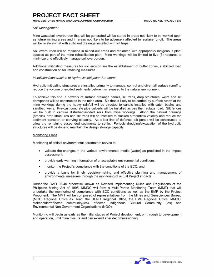
Soil Management
Mine waste/soil overburden that will be generated will be stored in areas not likely to be worked upon as future mining areas and in areas not likely to be adversely affected by surface runoff. The areas will be relatively flat with sufficient drainage installed with silt traps.
Soil overburden will be replaced in mined-out areas and replanted with appropriate/ indigenous plant species as part of the mine rehabilitation plan. Mine workings will be limited to five (5) hectares to minimize and effectively manage soil overburden.
Additional mitigating measures for soil erosion are the establishment of buffer zones, stabilized road and construction of soil retaining measures.
Installation/construction of Hydraulic Mitigation Structures
Hydraulic mitigating structures are installed primarily to manage, control and divert all surface runoff to reduce the volume of eroded sediments before it is released to the natural environment.
To achieve this end, a network of surface drainage canals, silt traps, drop structures, weirs and silt dam/ponds will be constructed in the mine area. Silt that is likely to be carried by surface runoff at the mine workings during the heavy rainfall will be directed to canals installed with catch basins and sandbag weirs. Pre-cast concrete pipe culverts will be installed across the haulage road. Silt fences will be built to capture disturbed/eroded soils from mine workings. Along the natural drainage (creeks), drop structures and silt traps will be installed to slacken streamflow velocity and reduce the sediment transport or carrying capacity. As a last line of defense, silt ponds will be constructed to allow the remaining suspended sediments to settle. Periodic dredging/excavation of the hydraulic structures will be done to maintain the design storage capacity.
Monitoring Plans
Monitoring of critical environmental parameters serves to:
• validate the changes in the various environmental media (water) as predicted in the impact assessment;
• provide early warning information of unacceptable environmental conditions;
• monitor the Project’s compliance with the conditions of the ECC; and
• provide a basis for timely decision-making and effective planning and management of environmental measures through the monitoring of actual Project impacts.
Under the DAO 96-40 otherwise known as Revised Implementing Rules and Regulations of the Philippine Mining Act of 1995, MMDC will form a Multi-Partite Monitoring Team (MMT) that will undertake the monitoring of compliance with ECC conditions as well as the EMP by the Project Proponent. The MMT will be composed of representatives from the Mines and Geosciences Bureau (MGB) Regional Office as Head, the DENR Regional Office, the EMB Regional Office, MMDC, stakeholder/affected community(ies), affected Indigenous Cultural Community (ies) and Environmental Non Government Organizations (NGO).
Monitoring will begin as early as the initial stages of Project development, on through to development and operation, until mine closure and can extend after decommissioning.

Lichel Technologies, Inc.
TABLE OF CONTENTS Marcventures Mining and Development Corporation MMDC Nickel Project EIS
I
EXECUTIVE SUMMARY 1 INTRODUCTION........................................................................................................................1-1
1.1 BASIC PROJECT INFORMATION..............................................................................................1-1 2 DESCRIPTION OF THE PROJECT’S EIA PROCESS ..............................................................2-1
2.1 THE EIA PROCESS ..............................................................................................................2-1 2.2 TERMS OF REFERENCE OF THE EIA STUDY............................................................................2-1 2.3 PURPOSE AND STRUCTURE OF THIS DOCUMENT ....................................................................2-2 2.4 EIA TEAM ...........................................................................................................................2-3 2.5 EIA STUDY SCHEDULE.........................................................................................................2-4 2.6 EIA STUDY AREA ................................................................................................................2-4 2.7 EIA METHODOLOGY.............................................................................................................2-4 2.8 PUBLIC PARTICIPATION ........................................................................................................2-8
3 PROJECT DESCRIPTION.........................................................................................................3-1 3.1 PROJECT LOCATION AND AREA.............................................................................................3-1 3.2 HISTORY OF MINING CLAIM...................................................................................................3-1 3.3 PROJECT RATIONALE ...........................................................................................................3-4 3.4 DESCRIPTION OF THE NICKEL RESOURCE AT THE PROJECT AREA............................................3-4 3.5 PROJECT NATURE AND SIZE .................................................................................................3-4 3.6 PROJECT ALTERNATIVES......................................................................................................3-6 3.7 PROJECT DEVELOPMENT PLAN, PROCESS/TECHNOLOGY OPTIONS AND PROJECT
COMPONENTS .....................................................................................................................3-6 3.7.1 Ores to be Produced ................................................................................................3-7 3.7.2 Ore Mining................................................................................................................3-7 3.7.3 Main Project Components ........................................................................................3-7 3.7.4 Planned Mine Capacity...........................................................................................3-14 3.7.5 Estimated Mine Life and Planned Mine Capacity....................................................3-14 3.7.6 Environmental Management Policy ........................................................................3-15
3.8 DESCRIPTION OF PROJECT PHASES ....................................................................................3-15 3.8.1 Pre-Construction Phase..........................................................................................3-15 3.8.2 Construction Phase ................................................................................................3-15 3.8.3 Operation Phase.....................................................................................................3-19 3.8.4 Abandonment Phase ..............................................................................................3-21
3.9 MINING EQUIPMENT ...........................................................................................................3-22 3.10 MANPOWER REQUIREMENTS ..............................................................................................3-22 3.11 CAPITAL INVESTMENT ........................................................................................................3-23 3.12 PROJECT DURATION AND SCHEDULE...................................................................................3-23
4 BASELINE ENVIRONMENTAL CONDITIONS, IMPACT ASSESSMENT AND MITIGATION ..4-1 4.1 THE LAND ...........................................................................................................................4-1
4.1.1 Land Use ..................................................................................................................4-1 4.1.2 Soil ...........................................................................................................................4-7 4.1.3 Geology ..................................................................................................................4-18 4.1.4 Terrestrial Biology...................................................................................................4-37
4.2 THE WATER ......................................................................................................................4-61 4.2.1 Hydrology ...............................................................................................................4-61 4.2.2 Hydrogeology .........................................................................................................4-67 4.2.3 Oceanography ........................................................................................................4-71 4.2.4 Water Quality..........................................................................................................4-76 4.2.5 Freshwater Biology.................................................................................................4-83 4.2.6 Marine Biology........................................................................................................4-94
4.3 THE AIR ..........................................................................................................................4-101 4.3.1 Meteorology..........................................................................................................4-101 4.3.2 Air Quality and Noise............................................................................................4-106
4.4 THE PEOPLE ...................................................................................................................4-108 4.4.1 Socio-Cultural, Economic and Political Environment ............................................4-108 4.4.2 Demography of the Project Area...........................................................................4-129 4.4.3 The Indigenous People – Manobo ........................................................................4-141 4.4.4 Perception Survey Results ...................................................................................4-143
4.5 IMPACT IDENTIFICATION AND ASSESSMENT ........................................................................4-160

Lichel Technologies, Inc.
TABLE OF CONTENTS Marcventures Mining and Development Corporation MMDC Nickel Project EIS
II
4.5.1 Impact Identification..............................................................................................4-161 4.5.2 Impact Assessment and Mitigation .......................................................................4-165
4.6 RESIDUAL AND UNAVOIDABLE IMPACTS .............................................................................4-187 4.6.1 Geology and Geomorphology...............................................................................4-187 4.6.2 Soil .......................................................................................................................4-187 4.6.3 Hydrology .............................................................................................................4-187 4.6.4 Solid Wastes.........................................................................................................4-188
4.7 FUTURE ENVIRONMENTAL CONDITIONS WITHOUT THE PROJECT..........................................4-188 4.7.1 Physical Environment ...........................................................................................4-188 4.7.2 Biological Environment .........................................................................................4-188 4.7.3 Socio-Economic Environment...............................................................................4-189
5 NATURAL HAZARD AND HEALTH RISK ASSESSMENT.......................................................5-1 5.1 NATURAL HAZARDS .............................................................................................................5-1
5.1.1 Geologic Hazards .....................................................................................................5-1 5.1.2 Hydrologic Hazards ..................................................................................................5-9
5.2 HEALTH RISK ASSESSMENT................................................................................................5-13 5.2.1 Introduction.............................................................................................................5-13 5.2.2 Approach and Methodology....................................................................................5-13 5.2.3 Baseline Health and Sanitation...............................................................................5-13 5.2.4 Project Development Phases .................................................................................5-13 5.2.5 Environmental Health Impact Process....................................................................5-13 5.2.6 Identification and Evaluation of Hazards and Its Potential Impacts .........................5-15 5.2.7 Identification of Impact Population or Receptors.....................................................5-19 5.2.8 Health Risk Assessment.........................................................................................5-20 5.2.9 Environmental Health Risk Management................................................................5-20
6 ENVIRONMENTAL MANAGEMENT PLAN...............................................................................6-1 6.1 IMPACTS MANAGEMENT PLAN...............................................................................................6-1
6.1.1 Geology and Geomorphology...................................................................................6-1 6.1.2 Soil and Land Use ....................................................................................................6-1 6.1.3 Hydrology .................................................................................................................6-2 6.1.4 Air Quality and Noise................................................................................................6-3 6.1.5 Terrestrial Ecology....................................................................................................6-4 6.1.6 Water Quality............................................................................................................6-4 6.1.7 Marine Ecology.........................................................................................................6-5 6.1.8 Archaeological Findings............................................................................................6-5
6.2 SOLID WASTE MANAGEMENT PLAN .....................................................................................6-10 6.2.1 Waste Segregation and Volume Reduction at Source ............................................6-10 6.2.2 Collection, Transport and Handling of Solid Wastes ...............................................6-10 6.2.3 Recycling Program .................................................................................................6-10
6.3 SOCIAL DEVELOPMENT FRAMEWORK ..................................................................................6-11 6.3.1 Social Development Management Plan Framework ...............................................6-11
6.4 IEC FRAMEWORK ..............................................................................................................6-16 6.5 EMERGENCY RESPONSE POLICY AND GENERIC GUIDELINES .................................................6-20 6.6 ENVIRONMENTAL AND OCCUPATIONAL HEALTH MANAGEMENT PLAN......................................6-31
6.6.1 Environmental and Occupational Health Policies....................................................6-31 6.6.2 Environmental and Occupational Health Organization, Resources, Manpower Training
and Documentation ................................................................................................6-31 6.6.3 Disaster/Emergency Management Program ...........................................................6-32 6.6.4 Environmental Health Risk Recording and Reporting System ................................6-32
6.7 ENVIRONMENTAL PROTECTION AND ENHANCEMENT PROGRAM .............................................6-32 6.8 ABANDONMENT/REHABILITATION POLICIES AND GENERIC GUIDELINES...................................6-32 6.9 ENVIRONMENTAL MONITORING PLAN...................................................................................6-32
6.9.1 Self-Monitoring Plan ...............................................................................................6-33 6.9.2 Multi-Sectoral Monitoring Framework .....................................................................6-33
6.10 CONTINGENT LIABILITY AND REHABILITATION FUND (CLRF)..................................................6-36 6.10.1 Proposed Amount for CLRF ...................................................................................6-36
6.11 INSTITUTIONAL PLAN FOR EMP IMPLEMENTATION ................................................................6-37 7 BIBLIOGRAPHY/REFERENCES ..............................................................................................7-1

Lichel Technologies, Inc.
TABLE OF CONTENTS Marcventures Mining and Development Corporation MMDC Nickel Project EIS
III
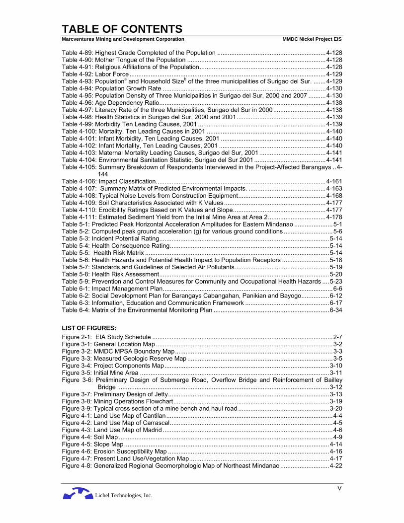
LIST OF TABLES: Table 2-1: Summary of the most significant issues during the Public Scoping ..................................2-1 Table 2-2: The EIA Team ..................................................................................................................2-3 Table 2-3: Methodologies Adopted for Each Component ..................................................................2-5 Table 2-4: Stakeholders’ Issues, Concerns, Recommendations and Proponent’s Responses during
the Public Scoping ........................................................................................................2-8 Table 3-1: Technical Description of the Project Area.........................................................................3-1 Table 3-2: Preliminary Project Components ......................................................................................3-6 Table 3-3: Water Consumption Scenario for the Project....................................................................3-9 Table 3-4: Summary of Project Phases, Issues and Associated Wastes.........................................3-16 Table 3-5: List of Mining Equipment ................................................................................................3-22 Table 3-6: Manpower Requirements ...............................................................................................3-22 Table 3-7: Breakdown of Capital Investment Cost...........................................................................3-23 Table 3-8: Estimated Duration of Project Phases ............................................................................3-24 Table 4-1: Land Use of Cantilan Municipality ....................................................................................4-1 Table 4-2: Land Use of Carrascal Municipality ..................................................................................4-2 Table 4-3: Land Use of Madrid Municipality.......................................................................................4-3 Table 4-4: Particle size distribution and soil textural grades, determined through Bouyoucos-
Hydrometer Method ......................................................................................................4-9 Table 4-5: The physico-chemical Properties and General Fertility of the Soils ................................4-10 Table 4-6: Levels of heavy metals per soil observation inside the mineral property ........................4-11 Table 4-7: Environmental Requirements of Selected Plants............................................................4-12 Table 4-8: Qualitative Suitability Classification ................................................................................4-12 Table 4-9: Erosion Susceptibility based on Rainfall .........................................................................4-13 Table 4-10: Erosion Susceptibility based on Soil Properties............................................................4-13 Table 4-11: Erosion Susceptibility based on Vegetation and Crops Grown .....................................4-13 Table 4-12: Erosion Susceptibility based on Slope..........................................................................4-15 Table 4-13: Composite Erosion Susceptibility Decision Rule...........................................................4-15 Table 4-14: Recurrence Interval for Earthquakes of a Given Magnitude Range..............................4-21 Table 4-15: General Stratigraphy of the Eastern Mindanao (BMG, 1982) .......................................4-26 Table 4-16: Chemical Analysis of Rock Sample ..............................................................................4-34 Table 4-17: The Fernando Biodiversity Scale (1998).......................................................................4-40 Table 4-18: Fauna GPS points where survey was conducted .........................................................4-51 Table 4-19: Species of birds observed and the number of individuals/species noted in 4 study sites..4-
52 Table 4-20: Species of mammals and the number of individuals observed in each survey site.......4-54 Table 4-21: Amphibians and reptiles observed during the survey with corresponding number of
individuals observed ...................................................................................................4-54 Table 4-22: Conservation status of species of birds observed in the present survey.......................4-58 Table 4-23: Conservation status of species of mammals observed during the present survey ........4-59 Table 4-24: List of herps observed and their conservation status....................................................4-60 Table 4-25: Summary of Discharge Measurements of Rivers at the Project Area ..........................4-62 Table 4-26: Mean Monthly flow in cubic meters per second (m3/sec) of Carac-an River and Boy-an
River ...........................................................................................................................4-64 Table 4-27: Estimated and Mean Monthly Flow in m3/sec of rivers at the Project area....................4-65 Table 4-28: Flood Peak Values (in m3/sec) of Boy-an and Carac-an Rivers....................................4-65 Table 4-29: Estimated Flood Peak Values (in m3/sec) with Return Periods of rivers in the Project Area
....................................................................................................................................4-66 Table 4-30: Status of Irrigation Systems Downstream of the Project Area ......................................4-67 Table 4-31: Estimated Significant Surface Wave Heights (m) in the Proposed Jetty .......................4-75 Table 4-32: Description of the Water Quality Sampling Stations .....................................................4-76 Table 4-33: DAO 34-90 Surface Water Classification Scheme........................................................4-77 Table 4-34: In-situ and laboratory analytical results for phyisco-chemical and bacteriological properties
of freshwater samples at the project area ...................................................................4-80 Table 4-35: Laboratory analytical results for metal content (in mg/L) of freshwater samples at the
project area.................................................................................................................4-80 Table 4-36: Location, Depth and Coordinates of Marine Sampling..................................................4-81 Table 4-37: Laboratory analytical results for phyisco-chemical properties of marine water samples4-82 Table 4-38: Laboratory analytical results for metal content of marine water samples ......................4-82

Lichel Technologies, Inc.
TABLE OF CONTENTS Marcventures Mining and Development Corporation MMDC Nickel Project EIS
IV
Table 4-39: Location and Description of the Sampling Stations.......................................................4-83 Table 4-40: Taxonomic Listing, Distribution and Relative Abundance of Freshwater Phytoplankton4-89 Table 4-41: Density of Freshwater Phytoplankton ...........................................................................4-90 Table 4-42: Species Diversity Index of Freshwater Plankton and Benthic Fauna Taxa ...................4-90 Table 4-43: Taxonomic Listing, Distribution and Relative Abundance of Freshwater Zooplankton ..4-91 Table 4-44: Taxonomic Listing, Distribution and Relative Abundance of Freshwater Benthic Fauna...4-
92 Table 4-45: Density of Freshwater Benthic Fauna...........................................................................4-92 Table 4-46: List of Fishery Resources Commonly Caught in the Rivers ..........................................4-93 Table 4-47: The top 10 species of plankton in terms of frequency and density................................4-94 Table 4-48: Barangay Consuelo sampling protocol showing physico-chemical parameters ............4-95 Table 4-49: Fish biomass of major fish categories in the proposed jetty at Barangay Consuelo,
Cantilan, Surigao del Sur ............................................................................................4-95 Table 4-50: Fish matrix of fish and juveniles in the proposed jetty, Barangay Consuelo, Cantilan,
Surigao del Sur ...........................................................................................................4-97 Table 4-51: Summary of life forms characterizing each dive stations in Brgy. Consuelo, Cantilan,
Surigao del Sur. (March 03, 2008) ..............................................................................4-97 Table 4-52: Summary of macroepifaunal groups, their number of species (in 100m2 area surveyed),
Mean abundance (ind/500 m2) and relative abundance (%) in the 2 stations in Brgy. Consuelo, Cantilan, Surigao del Sur ...........................................................................4-98
Table 4-53: Indices of Dominance (Simpson’s, C) and Diversity (Shannon-Weaver, H’) .................4-99 Table 4-54: Summary of macroepifaunal groups, their total number of species (in 100m2 area
surveyed), mean abundance (ind/500 m2), minimum and maximum counts of species in Brgy. Consuelo, Cantilan, Surigao del Sur ..................................................................4-99
Table 4-55: Total rating (scale of 1 - 5) using the Saito-Atobe method of Assessment of Seagrass-Algal bed...................................................................................................................4-100
Table 4-56: Climatological Normals for Surigao City, Surigao del Norte........................................4-101 Table 4-57: Climatological Extremes for Surigao City, Surigao del Norte ......................................4-101 Table 4-58: Estimated Mean Monthly Rainfall (mm) at Project Area..............................................4-102 Table 4-59: Air Quality Monitoring Sampling Methodologies .........................................................4-106 Table 4-60: Observed Ambient Air Quality ....................................................................................4-106 Table 4-61: Standards for Noise, dB(A).........................................................................................4-107 Table 4-62: Summary of Noise Readings dB(A)............................................................................4-108 Table 4-63: Historical Growth of Population ..................................................................................4-109 Table 4-64: Population Density by Barangay.................................................................................4-109 Table 4-65: Highest Education Attainment of 7 Years above Age Bracket ....................................4-111 Table 4-66: Leading Causes of Morbidity ......................................................................................4-111 Table 4-67: Leading Causes of Mortality .......................................................................................4-112 Table 4-68: List of Sitios/Puroks ....................................................................................................4-115 Table 4-69: Panikian Land Use Distribution...................................................................................4-116 Table 4-70: Land Tenurial Instrument Profile.................................................................................4-116 Table 4-71: Population and Household Size..................................................................................4-117 Table 4-72: Age ad Sex Distribution ..............................................................................................4-117 Table 4-73: Population Growth......................................................................................................4-118 Table 4-74: Population Density .....................................................................................................4-118 Table 4-75: Ethnic Groups.............................................................................................................4-118 Table 4-76: Non-Ethnic Groups.....................................................................................................4-118 Table 4-77: Health Service by Category........................................................................................4-119 Table 4-78: Morbidity and Mortality Cases ....................................................................................4-119 Table 4-79: Educational Facilities..................................................................................................4-120 Table 4-80: Historical Growth of Population Municipality of Cantilan .............................................4-122 Table 4-81: Population Household and Number of Household by Barangays ...............................4-122 Table 4-82: Built-up Density in Municipality of Cantilan .................................................................4-123 Table 4-83: Population Density by Barangays Municipality of Cantilan .........................................4-123 Table 4-84: Household Population by Age-Group, Sex (Municipality of Cantilan, 2000)................4-124 Table 4-85: Household Population by Religious Affiliation (Municipality of Cantilan, 2000) ...........4-125 Table 4-86: Population Growth in the Municipality of Madrid .........................................................4-126 Table 4-87: Household Population by Age Bracket .......................................................................4-127 Table 4-88: Marital Status of the Population..................................................................................4-127
Lichel Technologies, Inc.
TABLE OF CONTENTS Marcventures Mining and Development Corporation MMDC Nickel Project EIS
V
Table 4-89: Highest Grade Completed of the Population ..............................................................4-128 Table 4-90: Mother Tongue of the Population ...............................................................................4-128 Table 4-91: Religious Affiliations of the Population........................................................................4-128 Table 4-92: Labor Force ................................................................................................................4-129 Table 4-93: Populationa and Household Sizeb of the three municipalities of Surigao del Sur. .......4-129 Table 4-94: Population Growth Rate .............................................................................................4-130 Table 4-95: Population Density of Three Municipalities in Surigao del Sur, 2000 and 2007 ..........4-130 Table 4-96: Age Dependency Ratio...............................................................................................4-138 Table 4-97: Literacy Rate of the three Municipalities, Surigao del Sur in 2000..............................4-138 Table 4-98: Health Statistics in Surigao del Sur, 2000 and 2001...................................................4-139 Table 4-99: Morbidity Ten Leading Causes, 2001 .........................................................................4-139 Table 4-100: Mortality, Ten Leading Causes in 2001 ....................................................................4-140 Table 4-101: Infant Morbidity, Ten Leading Causes, 2001 ............................................................4-140 Table 4-102: Infant Mortality, Ten Leading Causes, 2001 .............................................................4-140 Table 4-103: Maternal Mortality Leading Causes, Surigao del Sur, 2001 ......................................4-141 Table 4-104: Environmental Sanitation Statistic, Surigao del Sur 2001 .........................................4-141 Table 4-105: Summary Breakdown of Respondents Interviewed in the Project-Affected Barangays ..4-
144 Table 4-106: Impact Classification.................................................................................................4-161 Table 4-107: Summary Matrix of Predicted Environmental Impacts. ............................................4-163 Table 4-108: Typical Noise Levels from Construction Equipment..................................................4-168 Table 4-109: Soil Characteristics Associated with K Values ..........................................................4-177 Table 4-110: Erodibility Ratings Based on K Values and Slope.....................................................4-177 Table 4-111: Estimated Sediment Yield from the Initial Mine Area at Area 2.................................4-178 Table 5-1: Predicted Peak Horizontal Acceleration Amplitudes for Eastern Mindanao ......................5-1 Table 5-2: Computed peak ground acceleration (g) for various ground conditions ............................5-6 Table 5-3: Incident Potential Rating.................................................................................................5-14 Table 5-4: Health Consequence Rating...........................................................................................5-14 Table 5-5: Health Risk Matrix .........................................................................................................5-14 Table 5-6: Health Hazards and Potential Health Impact to Population Receptors ...........................5-18 Table 5-7: Standards and Guidelines of Selected Air Pollutants......................................................5-19 Table 5-8: Health Risk Assessment.................................................................................................5-20 Table 5-9: Prevention and Control Measures for Community and Occupational Health Hazards ....5-23 Table 6-1: Impact Management Plan.................................................................................................6-6 Table 6-2: Social Development Plan for Barangays Cabangahan, Panikian and Bayogo................6-12 Table 6-3: Information, Education and Communication Framework ................................................6-17 Table 6-4: Matrix of the Environmental Monitoring Plan ..................................................................6-34 LIST OF FIGURES: Figure 2-1: EIA Study Schedule .......................................................................................................2-7 Figure 3-1: General Location Map.....................................................................................................3-2 Figure 3-2: MMDC MPSA Boundary Map..........................................................................................3-3 Figure 3-3: Measured Geologic Reserve Map ...................................................................................3-5 Figure 3-4: Project Components Map..............................................................................................3-10 Figure 3-5: Initial Mine Area ............................................................................................................3-11 Figure 3-6: Preliminary Design of Submerge Road, Overflow Bridge and Reinforcement of Bailley
Bridge .........................................................................................................................3-12 Figure 3-7: Preliminary Design of Jetty............................................................................................3-13 Figure 3-8: Mining Operations Flowchart.........................................................................................3-19 Figure 3-9: Typical cross section of a mine bench and haul road ....................................................3-20 Figure 4-1: Land Use Map of Cantilan...............................................................................................4-4 Figure 4-2: Land Use Map of Carrascal.............................................................................................4-5 Figure 4-3: Land Use Map of Madrid .................................................................................................4-6 Figure 4-4: Soil Map ..........................................................................................................................4-9 Figure 4-5: Slope Map.....................................................................................................................4-14 Figure 4-6: Erosion Susceptibility Map ............................................................................................4-16 Figure 4-7: Present Land Use/Vegetation Map................................................................................4-17 Figure 4-8: Generalized Regional Geomorphologic Map of Northeast Mindanao ............................4-22

Lichel Technologies, Inc.
TABLE OF CONTENTS Marcventures Mining and Development Corporation MMDC Nickel Project EIS
VI
Figure 4-9: Active Faults and Trenches in the Philippines ...............................................................4-23 Figure 4-10: Active Faults in Eastern Mindanao ..............................................................................4-24 Figure 4-11: Regional Seismicity Map .............................................................................................4-25 Figure 4-12: Generalized Regional Geologic Map of East Mindanao ..............................................4-30 Figure 4-13: Topographic and Drainage Map ..................................................................................4-31 Figure 4-14: Geologic Map of the Project Area................................................................................4-32 Figure 4-15: Geologic Cross Section of Area 2 Exploration Area ....................................................4-33 Figure 4-16: Laterite Profile at the Project Area...............................................................................4-37 Figure 4-17: Vegetation Cover Map.................................................................................................4-38 Figure 4-18: Sampling Location Map of Terrestrial Flora and Fauna Surveys .................................4-41 Figure 4-19: Comparison of the species diversity, richness and evenness of bird species in the survey
areas...........................................................................................................................4-55 Figure 4-20: Comparison of the species diversity, richness and evenness of mammalian species
observed .....................................................................................................................4-56 Figure 4-21: Comparison of the species diversity, richness and evenness of herps observed ........4-56 Figure 4-22: Comparison of the species diversity, richness and evenness of the 3 survey areas....4-57 Figure 4-23: Graph of species richness of birds observed in Area 2 sampled for 2 days.................4-57 Figure 4-24: Graph of species richness of mammals observed in Area 2 sampled for 2 days.........4-58 Figure 4-25: Catchment Areas ........................................................................................................4-63 Figure 4-26: Location of NIA Irrigation Intake Structures .................................................................4-69 Figure 4-27: Regional Hydrogeologic Map ......................................................................................4-70 Figure 4-28: Bathymetric Map of the Jetty Area ..............................................................................4-72 Figure 4-29: Proposed Jetty Location..............................................................................................4-74 Figure 4-30: Tidal Variation (heights given in m) within the Study Area...........................................4-76 Figure 4-31: Water and Air Quality Sampling Stations.....................................................................4-79 Figure 4-32: Freshwater Ecology Sampling Stations .......................................................................4-85 Figure 4-33: Location of Marine Ecology Sampling Stations............................................................4-96 Figure 4-34: Climate map of the Philippines ..................................................................................4-104 Figure 4-35: Wind Rose Diagram ..................................................................................................4-105 Figure 4-36: Settlement Map of Barangay Cabangahan, Cantilan.................................................4-132 Figure 4-37: Settlement Map of Barangay Cabas-an, Cantilan.....................................................4-133 Figure 4-38: Settlement Map of Barangay Parang, Cantilan..........................................................4-134 Figure 4-39: Settlement Map of Barangay Consuelo, Cantilan ......................................................4-135 Figure 4-40: Settlement Map of Barangay Panikian, Carrascal ....................................................4-136 Figure 4-41: Settlement Map of Barangay Bayogo, Madrid ..........................................................4-137 Figure 4-42: Delineated Primary and Secondary Impact Areas .....................................................4-162 Figure 4-43: Sediment Yield as Function of Mean Annual Rainfall ................................................4-176 Figure 4-44: Nomograph for K Values ...........................................................................................4-177 Figure 4-45: Diagram of silt-containing structure under construction .............................................4-183 Figure 4-46: Schematic illustration of the sediment morphological model .....................................4-185 Figure 5-1: Peak Horizontal Ground Acceleration (g) for Rock ..........................................................5-3 Figure 5-2: Peak Horizontal Ground Acceleration (g) for Medium Soil...............................................5-4 Figure 5-3: Peak Horizontal Ground Acceleration (g) for Soft Soil .....................................................5-5 Figure 5-4: Pacific Ring of Fire ..........................................................................................................5-7 Figure 5-5: Carac-an River Flow Constrictions Downstream of Barangay Cabangahan..................5-11 Figure 5-6: Tropical Cyclone Passage Frequency Map ...................................................................5-12 Figure 6-1: Proposed Environmental Management Section.............................................................6-38 LIST OF PLATES: Plate 3-1: Typical contour mining of nickel laterite in its early stage ..................................................3-7 Plate 4-1: Soil characterization through soil auger boring..................................................................4-7 Plate 4-2: Gathering of soil samples for physico- chemical analysis..................................................4-8 Plate 4-3: The forest cover of Area 1...............................................................................................4-17 Plate 4-4: The forest cover of Area 2 viewed from the alluvial flood plain (foreground) of Carac-an
River ...........................................................................................................................4-18 Plate 4-5: Peridotite outcrop at Dawas-Dawas Creek near the exploration camp at Area 2 ............4-35 Plate 4-6: Quartz-chlorite schists at the banks of Alamio River west of Area 3................................4-35 Plate 4-7: Limestone exposure at Carac-an River east of Area 2 ....................................................4-36

Lichel Technologies, Inc.
TABLE OF CONTENTS Marcventures Mining and Development Corporation MMDC Nickel Project EIS
VII
Plate 4-8: Alluvial deposits of the Carac-an River flood plain north of Area 2 ..................................4-36 Plate 4-9: Surface water source at Barangay Cabangahan.............................................................4-66 Plate 4-10: Newly constructed water reservoir at Barangay Cabangahan .......................................4-67 Plate 4-11: Drogue used in the field monitoring of currents in the study area..................................4-73 Plate 4-12: Freshwater biota sampling station (F1) at Carac-an River.............................................4-83 Plate 4-13: Freshwater biota sampling station (F2) at Anibongan Creek .........................................4-84 Plate 4-14: Freshwater biota sampling station (F3) at Pangihawan Creek ......................................4-84 Plate 4-15: Freshwater biota sampling station (F4) at Carac-an River.............................................4-84 Plate 4-16: A typical silt trap ..........................................................................................................4-180 Plate 4-17: Another example of silt traps and catch basin .............................................................4-181 Plate 4-18: An example of a silt dam.............................................................................................4-181 Plate 4-19: Silt-containing structures currently under construction at the project site, ...................4-184 Plate 4-20: Lowermost dam, looking across the breadth of the structure ......................................4-184 Plate 5-1: Landslide along roadside at Area 3 in Barangay Panikian.................................................5-8 Plate 5-2: Flood marks along the Carac-an riverbank......................................................................5-10 Plate 6-1: An example of a Mining Brochure ...................................................................................6-19 Plate 6-2: An example of a Mining Brochure ...................................................................................6-20 ANNEXES Annex A Scoping Checklist Annex B Original Sworn Accountability Statement of the Proponent Annex C Original Sworn Accountability Statement of the Preparer Annex D Proof of Public Participation Annex E Baseline Study Support Information Annex F PEMAPS


Lichel Technologies, Inc.
EXECUTIVE SUMMARY Marcventures Mining and Development Corporation MMDC Nickel Project EIS
ES-1
ES-1 BRIEF PROJECT DESCRIPTION
MARCVENTURES MINING AND DEVELOPMENT Corporation (MMDC) assigned Lichel Technologies, Inc. (LTI) to conduct an Environmental Impact Assessment (EIA) for its proposed Nickel Mining Project in the Municipalities of Cantilan, Carrascal and Madrid, all in the Province of Surigao del Sur (Figure ES-1). The proposed Nickel Mining Project (hereto referred to as the “Project”) will involve the development of nickel (Ni) within the 4,799-hectare MMDC mineral property. The Project will involve the extraction, sorting and drying of nickel ores at the project area, and the transport of the ores to the loading station in Lanuza Bay for shipment and refining to Japan, China or other places. The estimated mine production is 600,000 wet metric tons (WMT) for the 1st year of operation to a maximum of 1,500,000 WMT per year.
Figure ES-1: Project Regional Location Map
The Project

Lichel Technologies, Inc.
EXECUTIVE SUMMARY Marcventures Mining and Development Corporation MMDC Nickel Project EIS
ES-2
Project Location and Area
The Project is situated in Barangay Cabangahan in the Municipality of Cantilan, Barangay Panikian in the Municipality of Carrascal, and Barangay Bayogo in the Municipality of Madrid which are all under the jurisdiction of Surigao del Sur Province. The Project has a total area of 4,799.00 hectares (ha) and is covered under MPSA No. 016-93-XIII which was approved by the Mines and Geosciences Bureau (MGB) on 01 July 1993.
Project Rationale The Project is in lined with the Philippine government’s economic thrust of promoting environmentally sound mineral production project in the country. Mining industries are guided by Executive Order (EO) No. 270-A, amending EO No. 270, series of 2004, otherwise known as “National Policy Agenda on Revitalizing Mining in the Philippines”.
The project area is identified as one of the area in Surigao del Sur that has a great potential for nickel laterization. The Project will also address the unemployment problem in the locality and would generate much needed revenues for both the local and national government.
Project Nature and Size The Project aims to extract, sort, dry, resize, and deliver the nickel ore to interested buyers. Initial mining will commenced at Area two which is located south of Carac-an River. Based on drilling data obtained from more than 130 core drills and 70 test pits (drilling is still ongoing), the measured geologic reserves within a 400-hectare portion of Area 2 is as follows:
• Saprolite ore = 4,473,000 metric tonnes @ 2.1% Nickel (1.8% Ni cutoff); and
• Laterite ore = 19,080,000 metric tones @ 1.22% Nickel (0.8% Ni cutoff).
The inferred nickel ore resource is at least 53,000,000 metric tones with 1.2% Nickel.
Project Components MPSA Area. Exploration within the project MPSA area identified three potential nickel laterite areas, namely: Area 3 at the northern part, Area 1 at the central part and Area 2 at the southern portion. From these identified laterite areas, mining will commence at Area 2 with an initial mine area of approximately 120 hectares.
Stockyard Areas. The run-of-mine ore would be brought to a stockyard for drying, sorting and sizing. Three stockyard areas, one located at the close to the initial mine area, another located at Nangka, and the third at Barangay Consuelo near the jetty, are initially proposed to accommodate the estimated production capacity
Mine Ancillaries. The stockyard area at Sitio Nangka would also accommodate the mine ancillary facilities such as the administration office, assay laboratory, motorpool, staff houses and tree nursery.
Settling ponds/silt dams. Siltation of bare surface during the construction and operation of the Project which could result to excessive siltation of nearby water bodies shall be addressed properly by constructing properly designed drainages, silt traps, silt fence, silt dams and settling ponds along strategic location considering various factors such as amount water run-off, terrain of the area and concentration of mining activity among others.
Haul roads. The project will utilize, as much as possible, the existing logging and provincial roads to haul the produced ore from the mine site to the stockyards and ultimately to the barge loading station. However, the use of existing roads to transport the produced ore to the jetty may require some improvements like road widening and addition of sub base/base coarse materials to accommodate hauling trucks. An alternate haul road that traverse through Barangay Panikian of Carrascal Municipality, Surigao del Sur covering a distance of some 25 km is also considered. To transport the ore from the mine area to the stockyards would require crossing the Carac-an River. To this, MMDC would construct a reinforced submerge road and an overflow bridge to cross the river floodplain.

Lichel Technologies, Inc.
EXECUTIVE SUMMARY Marcventures Mining and Development Corporation MMDC Nickel Project EIS
ES-3
Sea Port. The ore mined will be loaded in barges for transfer to ships delivering the goods to its international market. MMDC will construct its own jetty which will be located at Sitio Bahang-bahang, Barangay Consuelo in Cantilan, Surigao de Sur some 700 m from the existing seaport.
Utilities. There are no springs and wells within the MPSA. Surface water is collected in a water impounding structure that was constructed by the Proponent to supply water for drinking, bathing, washing, cleaning, nursery, and plantations. Surface water will be used for road dust suppression. Commercial and water well would be optional sources of water supply especially for human consumption. No significant volume of water would be used in dry ore production and no water usage conflict is anticipated for the Project being located in unpopulated area. Surigao del Norte Electric Cooperative (SURNECO) would provide the Project’s power requirement during the Operations Phase. Back-up generators sets would also provide electricity requirement in the construction area.
Project Phases Pre-Construction Phase
Pre-Operation phase would involve acquisition of permits and other government approvals; entering into a Project financing agreements; negotiations and actual land acquisition and crop damage compensation; detailed follow-up survey, mapping and design for road routes, mining areas and other work sites; procurement and construction tendering; bidding of and award to contractors. There would be no major land disturbances in this phase of the Project, exempt for the trampling of the vegetation in the conduct of detailed surveys and mapping for access roads and other work areas.
Construction Phase
The Construction Phase activities would involve the following:
• improvement of the existing access road, as necessary; • access road construction within the operating areas for support facilities, as necessary; • land preparation for, and construction or installation of support infrastructure facilities (office complex, contractor’s equipment
pool, refueling station, material stockyard, warehouse, power supply house, personnel accommodation, unloading pad and lay on pad for heavy equipment);
• land preparation for, and construction of appropriate mitigating measures such as drainage, silt traps, catch basins, etc.; and • land preparation for and construction of production line facilities (such as initial haul roads, overflow bridge, stockyards and
jetty).
Operation Phase
The proponent will employ a contour mining system that involves several phases including the following:
• Land Clearing (Stripping) • Overburden Removal and Storage for Rehabilitation • Ore Mining (Extraction) • Progressive Rehabilitation • Ore Transport • Ore Stockyard Operation (Ore Piling and Drying) • Ore Delivery to Sea Craft

Lichel Technologies, Inc.
EXECUTIVE SUMMARY Marcventures Mining and Development Corporation MMDC Nickel Project EIS
ES-4
Land clearing would involve clearing, timber recovery or relocation (where required), chipping/mulching, and removal of humus (where possible). Bulldozers, front-end loaders, and trucks would be deployed to undertake this work. Waste stripping involves removal of all overburden material below the nominal cut-off grade.
The ore bodies would be excavated using an excavator in a backhoe mode. Mining operation will be by open pit with 3-meter mining bench height usually started by open trench at the foot of the slope. All segregated pre-piles ores will be hauled and piled at their designated stockyard. Progressive pit mining will be employed every five (5) hectares to avoid large volume of stockpiled waste/overburden.
The specified truck for both ore and waste handling is a 10-tonner, 10-wheeler truck. The haul road connecting the mine site to the stockyard will have an 8-meter wide travel surface.
For surface mined-out areas, a progressive mining rehabilitation program will be undertaken in compliance with mining regulations and environmental requirements. The overall objective is that at the completion of the mining operation, the significant features such as mined-out areas, waste dumps, and environmental control structures are decommissioned and developed into stable landforms.
At the stockyards, a front-end loader would prepare the ore into windrows where it repeatedly turned to allow the laterite to dry and expose the boulders in the limonite. The boulders would be scrapped back using the loader bucket.
At acceptable moisture content and quality, the ore at the stockyards would be transported using 10-ton trucks to the company’s jetty where it will be offloaded to barges which in turn would transport the ore to an awaiting ship at some offshore distance.
Abandonment Phase
The abandonment phase of the mining area shall entail reforestation and rehabilitation works as required in Section 69 and 71 of RA 7942. Another important option to consider in the abandonment of the mine is the post mining land use preferred by the community according to their use and needs. All areas mined out may therefore not need to be re-vegetated but have to be rehabilitated/prepared to make it suitable for any land use that the community will plan. For the entire Project, the abandonment shall include dismantling or turn-over of mine facilities to the concerned Local Government Unit.
Planned Mine Capacity and Mine Life
The planned annual mine production is from 600,000 to 1,500,000 Wet Metric Tons (WMT) of laterite ore with effective working days per year of 149 days. Refining of the ore to produce nickel metal will be done in countries such as Japan, China or in other places.
The estimated mine life at Area 2 is ten (10) years excluding the additional potential ore reserves that will be delineated by the on-going core drilling program.
Manpower and Capital Investment
The Project will require 242 personnel during operation. It will also generate indirect labor from its purchases of food, supplies, materials, equipment, and services. The estimated capital investment of the Project is estimated at PhP 252 Million Pesos.
Project Duration and Schedule
The Project is scheduled to start right after securing all government approvals with an initial construction phase of about a year. The initial Project operation was estimated to last for 10 years from a scenario of 11,600,000 WMT reserve and production rate of 600,000 WMT for the first year and increasing to 1,500,000 WMT starting on the 8th year.
Lichel Technologies, Inc.
EXECUTIVE SUMMARY Marcventures Mining and Development Corporation MMDC Nickel Project EIS
ES-5
ES-2 BRIEF SUMMARY OF PROJECT’S EIA PROCESS
An EIA is "a formal process of identifying and predicting the impacts of a proposed action on the environmental integrity and human welfare and communicating the information about such impacts to planners and decision-makers". The purpose of the EIA is to determine the likely environmental effects of a proposed Project or activity prior to implementation. The assessment is done to ensure that before decisions are made, full consideration is given to its potential environmental effects, both direct and indirect. The EIA is designed to provide those who are likely to be affected by the Project, the stakeholders, opportunities to be heard and their views taken into account.
The conduct of the EIA study follows the Implementing Rules and Regulations (IRR) of Philippine Environmental Impact Statement System (PEISS) which is contained under DENR Administrative Order No. 30 Series of 2003 (DAO 03-30). Resource extractive industries such as this Project are classified as Environmentally Critical Projects (ECP) under the PEISS. ECPs are required to conduct an EIA and submit an Environmental Impact Statement (EIS) for review and approval by the DENR through the Environmental Management Bureau (EMB) prior to the issuance of the Environmental Compliance Certificate (ECC).
ES-2.1 THE EIA METHOD
The EIA for the Project commenced on 14 January 2008 with the submission of a Letter of Request for Scoping to the EMB. Attacked to the letter request are supporting documents (Project Description, Screening Checklist, etc) which is required under the EMB Revised Procedural Manual for DAO 03-30.
A public scoping meeting held on 29 January 2008 at Barangay Cabangahan, Cantilan, Surigao del Sur. The meeting afforded the stakeholders the opportunity to discuss their concerns regarding the potential environmental and social impacts of the proposed Project.
A separate Technical Scoping was held on 06 February 2008 at the Environmental Management Bureau (EMB) Central Office and was attended by the EIA consultants, who also represented the proponent, the EMB EIA case handlers, and the EIA Review Committee (EIARC). The purpose of the meeting was to finalize the items to be included in the EIS document and is contained in the signed Scoping Checklist.
Primary and secondary data were gathered during surveys held between February 2008 and April 2008. Primary data gathered include sampling such as soil, water and air to characterize the baseline environmental conditions. The sampling methodologies for each study modules are provided in Section 2 of this document. Systematic socio-economic and perception surveys were conducted to determine the sentiments of the affected communities. A participatory and community-based approach was used in conducting the EIA for this Project. The bio-physical study team engaged the help and assistance of local guides during the data gathering for the baseline environmental conditions. In the conduct of the socioeconomic survey, enumerators were directly recruited from the community. Key informants among the local residents were selected and directly interviewed by the Project team. The study team also recruited some residents as field assistants and informal dialogues with them and with other resident groups were conducted. Secondary data on the Project area were gathered from both the national and local agencies, and other organizations.
The scope of the study included the assessment of the probable impacts of the Project on the land, water, air and noise environments of the study area. It also included and perception and acceptability of the Project by the stakeholders and recommendation for the mitigation of the perceived adverse impacts and enhancement of the positive effects. Based on the impact assessment, mitigating and enhancement measures were recommended and environmental management and monitoring plans were prepared.
ES-2.2 EIA STUDY TEAM
The key members of the multi-disciplinary team who conducted the EIA study and their fields of expertise are shown below.

Lichel Technologies, Inc.
EXECUTIVE SUMMARY Marcventures Mining and Development Corporation MMDC Nickel Project EIS
ES-6
Table ES-1: The EIA Team
Consultant Module Rachel A. Vasquez Project Director and Peer Reviewer
Anacleto Q. Suelto Jr. Project Manager/ Geology and Hydrogeology
Perfecto P. Evangelista Pedology
Isabelo A. Abellon Hydrology
Jorge C. de las Alas Water Quality, Meteorology and Air Quality
Paul C. Rivera Oceanography and Sediment Transport Modeling
Filiberto A. Pollisco Jr Terrestrial Flora
Judeline Dimalibot Terrestrial Fauna
Rodolfo P. Pagarigan Freshwater Ecology
Danilo Nojadera Freshwater Ecology
Nestor Yunque Marine Ecology
Quivido Origines Socio-Economics
ES-2.3 STUDY AREA
Environmental and social studies were focused on the whole MPSA area. The primary impact areas include the proposed mining area, the infrastructures including stockpile, settling ponds, satellite camps and roads for rehabilitation and construction, and the jetty. Administratively, the primary impact areas include the MPSA area within Barangay Cabangahan, Barangay Panikian and Barangay Bayogo, the transport route that would pass through Barangay Cabas-an and Barangay Parang, and jetty area at Barangay Consuelo.
The secondary impact area, on the other hand, generally refers to the influence area of the Project that could be indirectly affected by the proposed development. This could include areas in the vicinity of the MPSA, the downstream portion of the mining area such as the natural drainages (e.g. gullies, creeks, etc.) that serves as channelways for eroded sediments. The Carac-an River which is the main drainage or the receiving body of water of surface runoffs coming from initial mine area. The Carac-an River downstream of the Project (MPSA) area is where the NIA irrigation intake structure is situated. The irrigation system covers a potential service area of 2,500 hectares. Figure ES-2 illustrates the study area.
ES-2.4 SUMMARY OF PUBLIC PARTICIPATION
A summary of the environmental issues and concerns that were raised during the public scoping are given below.
Table ES-1: Stakeholders’ Issues, Concerns, Recommendations and Proponent’s Responses
STAKEHOLDER ISSUES AND CONCERNS RECOMMENDATIONS PROPONENT’S RESPONSE
Barangay Consuelo • Priority in employment • Health services
monitoring • Monitoring of concerned
agency (DENR) • Effect on marine water
and drinking water • Barangay share • Our roads will become
dusty • Road maintenance • Social development
• Increase in dust generation should be controlled
• Results of the monitoring should be presented to the barangay
• Road maintenance should be extended.
• Qualified local residents will be given priority in employment. However, if required manpower qualification is not available locally, the company will hire from neighboring localities.
• Monitoring of pollution control measures shall be conducted quarterly. An MMT shall be created

Lichel Technologies, Inc.
EXECUTIVE SUMMARY Marcventures Mining and Development Corporation MMDC Nickel Project EIS
ES-7
STAKEHOLDER ISSUES AND CONCERNS RECOMMENDATIONS PROPONENT’S RESPONSE
assistance of the company to the barangay
to monitor compliance to the ECC conditions.
• Social Development Assistance will be incorporated in Social Development and Management Plan (SDMP) to be prepared by the proponent and to be submitted to the Mines and Geosciences Bureau (MGB)
Barangay Cabangahan – Manobo Tribal Group
• We want responsible mining investors
• Peace and order situation in the barangay
• IPs must be given priority when it comes to employment
• Plans concerning the barangay
• Information on the MOA of mining applicants - have a copy furnish of every CTWG
• The ten tribal leaders and the council of elders are often ignored and bypassed in past negotiations
• Provide documents to NCIP of all relevant MOA/agreements reached with other line agencies;
• Information drive for IPs in affected communities on the updates of the project;
• Monthly meetings with barangays/communities affected
• Qualified local residents will be given priority in employment. However, if required manpower qualification is not available locally, the company will hire from neighboring localities.
• Provide necessary training of local residents to be job competitive.
• Monitoring of pollution control measures shall be conducted quarterly. An MMT shall be created to monitor compliance to the ECC conditions.
• Social Development Assistance will be incorporated in Social Development and Management Plan (SDMP) to be prepared by the proponent and to be submitted to the Mines and Geosciences Bureau (MGB)
Municipality of Madrid
• Agricultural farmers are against mining because of its effect to the irrigation system from Carac-an River
• Effect on the irrigation system-Bayogo
• Watershed Area SPISP • Landslide/Soil Erosion
problem • Priority employment for
the affected barangays • Information drive to the
concerned group of farmers
• Protection of Carac-an River
• Protection of Buyaan River (Bayogo)
• Protection of watershed area
• Construct necessary measures for protection from soil erosion
• Employees should be from the affected barangays
• Conduct scoping for the Municipality of Madrid
• Qualified local residents will be given priority in employment. However, if required manpower qualification is not available locally, the company will hire from neighboring localities.
• Proponent will construction erosion and siltation control structures to prevent eroded soils from reaching the irrigation system.
• MMDC is also willing to collaborate with Madrid stakeholders to determine if the 163-hectare area within Madrid is really part of the Madrid Watershed area, and if so, the area will be delineated and

Lichel Technologies, Inc.
EXECUTIVE SUMMARY Marcventures Mining and Development Corporation MMDC Nickel Project EIS
ES-8
STAKEHOLDER ISSUES AND CONCERNS RECOMMENDATIONS PROPONENT’S RESPONSE
shall not be mined. • Monitoring of pollution
control measures shall be conducted quarterly. An MMT shall be created to monitor compliance to the ECC conditions.
Southern Philippines Irrigation Sector Project – Watershed Management Sub-Sector (SPIS-WMS)
• Continuity/ security of SPIS projects
• Payment for timber that will be damaged
• Priority employment to barangay residents
• Scholarship grant from the company for deserving students
• Due compensation for affected farmlands
• Livelihood projects for residents not able to work or employed in the company
• Medical Assistance • Assistance to religious
groups of affected barangays
• Qualified local residents will be given priority in employment. However, if required manpower qualification is not available locally, the company will hire from neighboring localities.
• Monitoring of pollution control measures shall be conducted quarterly. An MMT shall be created to monitor compliance to the ECC conditions.
• Social Development Assistance will be incorporated in Social Development and Management Plan (SDMP) to be prepared by the proponent and to be submitted to the Mines and Geosciences Bureau (MGB)
A consultation meeting with the Barangay Council and Multi-Sectoral Groups of Barangay Panikian was held on 05 March 2008 at the Barangay Panikian Hall, Municipality of Carrascal. The meeting was held to present the Project and to solicit issues and concerns from the participants. MMDC explained that there are no immediate plans to develop a mine within their jurisdiction but would definitely consult with them if there will be any future developments. On their part the barangay council raised the following issues and concerns:
• siltation of rivers and their rice fields;
• employment opportunity;
• hazardous chemicals that could harm the environment; and
• livelihood, infrastructures, education, health, and peace and order.
Although concerns regarding the environment were raised during the meeting, the participants were supportive of the Project provided that MMDC advocates responsible mining.
In response to the EMB letter dated 13 March 2008, MMDC conducted a technical conference on 09 April 2008 to address the National Irrigation Administration’s issues and concerns regarding the potential impact of the proposed Project to NIA irrigation systems, particularly on the issue of siltation of the irrigation intake structure. The conference was held at the SSIT-SSPSC Campus in Cantilan, Surigao del Sur.
On 03 May 2008, MMDC was also invited to present the Project in the Conference Regarding Implementation of NIA Projects and Mining Activities in Surigao del Sur which was held at the residence of the Governor of Surigao del Sur in Tandag City.

Lichel Technologies, Inc.
EXECUTIVE SUMMARY Marcventures Mining and Development Corporation MMDC Nickel Project EIS
ES-9
MMDC is willing to execute a MOA with NIA and other government agencies concerned in its commitment to collaborate with them in the preventive/mitigating measures.

Lichel Technologies, Inc.
EXECUTIVE SUMMARY Marcventures Mining and Development Corporation MMDC Nickel Project EIS
ES-10
Figure ES-2: The Study Area

Lichel Technologies, Inc.
EXECUTIVE SUMMARY Marcventures Mining and Development Corporation MMDC Nickel Project EIS
ES-11
ES-3 SUMMARY OF BASELINE CHARACTERIZATION
Environmental Aspect Existing Condition Significance LAND Site Geomorphology Hilly to mountainous with elevations from 40 masl along the Carac-an floodplain and reaching to as
high as 750 masl towards the southern portion of the project area. Ridges are generally broad with rounded peaks.
Marginal
Site Geology The project site is underlain by mostly by ultramafic rocks and laterite; metavolcanics and schist occupy the northern and western portion of the project area; limestone on the northeast part and alluvial deposits confined along river channels and floodplain.
Marginal
Susceptible to ground shaking (0.15g to 0.35 g at Ms 7.5 earthquake generated by the Philippine Fault).
Marginal
Medium risk to tsunamis due to the presence of the Philippine Trench some 150 km to the east Marginal Categorized the as highly susceptible to landslides. Critical
Natural Hazards
At least one tropical cyclone passes through the region annually); coastal area may experience storm surge.
Marginal
Kabatohan Clay, Kabatohan Clay Loam and Kabatohan Sandy Clay Loam as existing at the Project area.
Marginal
Slightly to strongly acidic; low NPK; generally low fertility rating; High Fe, Cr and Ni typical in nikeliferous laterite area.
Marginal
Soils
Slightly to moderately susceptible to erosion Marginal Land Use Project site is dominated by secondary forest; patches of the alluvial floodplain of Carac-an River are
planted with corn (Barangay Cabangahan) Marginal
The vegetative cover is quite dense but this is due to the undergrowth and the intermediate layers being exposed to sunlight hence many sun-loving species have taken over the below-canopy strata.
Marginal Terrestrial Flora
Overall in the project site, there were 117 species recorded. Prominent species worthy of mentioning are the Yakal (S. astylosa), White Lauan (S. contorta), Dalindingan (H. foxwothyi), Apitong (D. grandiflorus) and Saplungan (Hopea plagata) of the Dipterocarpaceae. Per IUCN Red list, the dipterocarps are already in various stages of threat but they are mostly critically endangered. Other species that are in various stages of threat are the Molave (V. parviflora), Antipolo (A. blancoi), Rattan (Calamus sp), Mancono (X. verdugonianus), Pitcher Plant (Nepenthes sp), Ground Orchid (Dendrobium sp), Malaalmaciga (Podocarpus blumei), Kamagong (D. philippinensis) and the Cinnamomum species, which Mindanao harbors several species.
Critical species identified
The present survey observed and recorded 48 species of birds, 8 species of mammals and 6 species of herps or a total of 62 species of terrestrial wild fauna.
Terrestrial Fauna
Almost 95% of the bird species observed to be present in the are Endemic, 5 is Near Threatened, one is Vulnerable and one is Endangered (Mindanao Bleeding Heart). Widespread hunting and illegal trade are causing the decline of the population of the Common Palm Civet and the warty pigs in the country. Although the long-tailed macaque is widespread in Asia, it is
Critical species identified

Lichel Technologies, Inc.
EXECUTIVE SUMMARY Marcventures Mining and Development Corporation MMDC Nickel Project EIS
ES-12
Environmental Aspect Existing Condition Significance the only species of the taxon in the Philippines and is listed as CITES II. Of the 6 species of herps noted in the area, the sphenomorph is near threatened and, the monitor lizard is considered threatened in all its ranges in the Philippines because it is hunted heavily and is affected by forest degradation.
WATER MPSA area drain by three major river system: Carac-an, Alamio and Binoni; small tributary of the Buyaan River drains the southern portion of the MPSA area.
Marginal Hydrology
Barangay Cabangahan experiences flooding due to Carac-an River. Critical Hydrogeology Groundwater potential is limited to weathered or fractured zones of massive rocks; low groundwater
recharge to aquifers due to presence of thick laterite (clay). Marginal
Freshwater The pH, dissolved oxygen (DO), oil & grease and total dissolved solids (TDS) of the six surface water samples analyzed were within the DENR Class D standards. For the Cabangahan water supply, the pH, turbidity and TDS are within the PNSDW standards. Metal concentrations of the six surface water samples for metal parameters considered for analysis are within the DENR Class D standards. Metal concentrations tested on the water sample taken from the Cabangahan water supply source are within the PNSDW standards. Bacteriological test of the six surface water samples indicated positive for fecal coliform in samples taken at Carac-an, Anibugan, Dawas-dawas, Buyaaan and Alamio and Maitom Creek. No standard is given for fecal coliform for Class D surface water under the DAO-34. The fecal coliform count, at >16/100 ml, of the water sample taken from the Cabangahan water supply source did not meet the PNSDW standard of 0/100 ml.
Critical for potable water supply
Water Quality
Marine Water The oil & grease of the water samples (<0.05 to 1.4 mg/L) analyzed were within the DENR Class SC standard of 3 mg/L. No standards are prescribed for the other parameters considered. Copper, iron, and lead were detected in all four water samples. Detected lead from 0.211 mg/L to 0.546 mg/L is higher than the prescribed Class SC standard for lead at 0.05 mg/L. However, this standard for lead cannot be applied since the lead background concentrations were higher. Copper concentrations of the water samples (0.77 mg/L to 1.13 mg/L) were reported as total copper concentrations. The detected copper concentrations, however, cannot be compared with the DENR Class SC standard of 0.05 mg/L which is referred as dissolved copper. No DENR standard for iron is prescribed for Class SC water.
Marginal
The observed tide in the area is generally a mixed diurnal-semi-diurnal type with a dominant diurnal character. The tidal amplitude in the area has an average value of about 0.59 m
Marginal
Water depths in the jetty area are generally shallow; maximum depth is about 21 m located northeast of the proposed jetty
Critical
Oceanography
Observed currents in the vicinity of the jetty at the time of visit ranged from 0.02 to 0.07 m/sec. However, currents in the area may become relatively strong during typhoon occurrence.
Critical
Freshwater Ecology The phytoplankton population at the proposed study area was represented by the diatoms of both Marginal

Lichel Technologies, Inc.
EXECUTIVE SUMMARY Marcventures Mining and Development Corporation MMDC Nickel Project EIS
ES-13
Environmental Aspect Existing Condition Significance centric and pinnate forms. Rhizosolenia sp. and Fragillaria sp. were the dominant phytoplankton. On the other hand, a diverse assemblage of zooplankton was noted. The arthropods, molluscs and chordates were the zooplankton collected and identified. Insect nymphs and larvae were the dominant zooplankton. The benthic fauna community was represented by the molluscs and the arthropods.
Marine Ecology The area where the proposed jetty will be constructed can be characterized as relatively poor in species of the usual coastal marine ecosystem (mangrove, seagrass/algal beds, and coral reefs and associated fish population and macroepifauna) due to poor fishing practices.
Marginal
AIR Meteorology Project site belongs to Type II characterized by the absence of a dry season and a pronounced
maximum rain period. The wettest period of the year is between November and February. Annual rainfall estimated at the project area is at 4,100 mm.
Marginal
Air Quality The observed 24-hr sampling at Barangay Cabangahan and three 1-hour sampling stations along transport route for TSP concentrations were within the ambient standard set for TSP
Marginal
The observed 1-hr sampling at four sampling stations for NO2 and SO2 concentrations were within the ambient standard set for NO2 and SO2.
Marginal
Noise Background noise levels were observed to be below the ambient noise standards for residential areas
Marginal
PEOPLE The project area is situated in three municipalities: Cantilan, Carrascal and Madrid all of Surigao de Sur Province. Among the three municipalities, Cantilan has the highest number of population of 26,553 (NSO, 2007). Madrid Municipality has a total population of 14,957 while Carrascal is the smallest municipality among the three municipalities at 14,248.
Marginal
Cantilan and Madrid have the same literacy rate of 95%, a figure that is one percent higher than the literacy rate of the province. Carrascal has a lower literacy rate of 92%.
Marginal
In 2001, the leading cause of morbidity in Surigao del Sur is bronchitis while the leading cause of mortality is cardiovascular disease
Critical
The Indigenous People (IP) in the project area is the Manobo Tribe; in Barangay Cabangahan, almost 100 percent of the population belongs to the Manobo tribe.
Marginal
The survey area covered is divided into three categories: the MPSA Area, the Transport Route and the Jetty Area. The MPSA Area includes Barangay Cabangahan of Cantilan Municipality, Barangay Panikian of Carrascal Municipality, and Barangay Bayogo of Madrid Municipality. The Transport Route area is composed of Barangays of Cabas-an and Parang both of Cantilan Municipality. The Jetty Area covers only Barangay Consuelo of Cantilan.
Critical
Socio-Economic , Cultural and Political
In the MPSA Area, a total of 267 respondents were methodically sampled: 50 respondents from Panikian, 67 respondents from Bayogo and 150 from Cabangahan. Cabangahan has the highest number of respondents (100%) since it is the nearest community located some 1.5 km north of the initial mine area. The Transport Route had 42 respondents while that Jetty Area had 30 respondents.
Critical

Lichel Technologies, Inc.
EXECUTIVE SUMMARY Marcventures Mining and Development Corporation MMDC Nickel Project EIS
ES-14
Environmental Aspect Existing Condition Significance Respondents in all three areas were relatively low income earners with an income of up to only 5,000 pesos a month. The most common livelihood in all three areas is farming.
Critical
Majority of the respondents in all areas of the study were aware of the existence of MMDC. 74% in MPSA Area, 64% along the Transport Route and 77% in the Jetty Area said that they knew MMDC.
Critical
The primary positive effect of the Project is the generation of employment and livelihood activities. The proposed Project is perceived to increase economic activity growth in the Barangays.
Critical
Although most of the respondents in MPSA Area agreed with the establishment of the Project, most of them also believed that Project can cause environmental pollution.
Critical
The respondents from all three area categories were favorable with the establishment of the Project. In the MPSA Area, 72.28% strongly agreed with the establishment of the Project. Another 11.24% said they agreed. Along the Transport Route, 36.36% respondents agreed and 25% strongly agreed with the establishment of the Project. Moreover, 66.7% respondents in Jetty Area strongly agreed and another 16.7% agreed and were in favor for the establishment of the Project.
Critical
Despite the overwhelming support coming from the respondents for Project, it was clear that respondents also understand the vulnerability of their place to environmental damage. Majority of the respondents in all area category said that the Project could cause environmental damage and pollution. However, the respondents were also confident that the Project has enough mitigating mechanism to prevent such environmental effects. They also agreed to the way the company dealt with complains and problems brought out by the community. Majority of the respondents are willing to participate in all activities relating to the protection of the environment. There is also a large majority who are willing to join and participate with different institutions for monitoring the activities of the Project in order to ensure that the environment is safe.
Critical
ES-4 SUMMARY OF IMPACT ASSESSMENT AND ENVIRONMENTAL MANAGEMENT PLAN
Project Activity Environmental
Component Likely to be
Affected Potential Impact Options for Prevention or Mitigation or Enhancement
Terrestrial Biology
Trampling of vegetation.
Prior planning of survey areas to keep affected areas confined and limited to only what is necessary. Establish a nursery that will support the vegetation and seedling requirements of all replanting works including soil stabilization works that use vegetation as materials.
Field surveys for detailed engineering
People Development of apprehensions on possible dislocation and loss of livelihood.
Conduct IEC activities.

Lichel Technologies, Inc.
EXECUTIVE SUMMARY Marcventures Mining and Development Corporation MMDC Nickel Project EIS
ES-15
Project Activity Environmental
Component Likely to be
Affected Potential Impact Options for Prevention or Mitigation or Enhancement
Geology/ Pedology
Change of soil profile due to construction activities Soil erosion
Replacement of excavated soils. Establishment of erosion control structures such as appropriate drainage channels, fascines, mini-rock dams, silt traps, silt fences and sediment settling ponds. Construction of culverts and drainage that follows the natural contour of the area.
Terrestrial Biology
Loss of Vegetation Disturbance/displacement of wildlife Generation of construction and domestic wastes
Establishment of Nursery Encourage people to plant trees Implement “No Hunting Policy” Establishment of buffer zones along creeks, rivers, and bays Revegetation using indigenous and/or fast growing species along road networks, periphery of mine facilities
Hydrology and Water Quality
Obstruction of natural drainage waterways from construction/clearing activities. Increased turbidity and sedimentation of water bodies.
Establishment of erosion control structures such as appropriate drainage channels, fascines, mini-rock dams, silt traps, silt fences and sediment settling ponds
Freshwater/ Marine Ecology
Disturbance of aquatic flora and fauna due to increased water turbidity and siltation of water Sewage and wastewater generation Change in water quality of receiving body of waters ; contamination or pollution of water bodies due to mine wastes
Erosion control structures Provision of sanitary toilet facilities Implement waste management (segregation, recycling, and reuse) in all areas of operation Provision of appropriate solid waste disposal facilities
Air Quality and Noise
Increase TSP Increase noise levels
Proper Scheduling of vehicles entering the site Limit hauling during daytime Regular maintenance of equipment and vehicles
Site preparation/ construction of facilities
People Employment and other multiplier effects Increase in in-migration and settlements Disruption of occupational patterns Increase volume of traffic due to transport of personnel, materials and equipment; increase risk to vehicular accidents
Employment priority to residents of Impact Barangays Preparation and implementation of community development programs Posting of traffic signs along strategic areas i.e. access roads, mine facilities, etc. Strict implementation of traffic rules (speed limits)
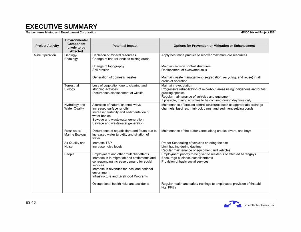
Lichel Technologies, Inc.
EXECUTIVE SUMMARY Marcventures Mining and Development Corporation MMDC Nickel Project EIS
ES-16
Project Activity Environmental
Component Likely to be
Affected Potential Impact Options for Prevention or Mitigation or Enhancement
Geology/ Pedology
Depletion of mineral resources Change of natural lands to mining areas Change of topography Soil erosion Generation of domestic wastes
Apply best mine practice to recover maximum ore resources Maintain erosion control structures Replacement of excavated soils Maintain waste management (segregation, recycling, and reuse) in all areas of operation
Terrestrial Biology
Loss of vegetation due to clearing and stripping activities Disturbance/displacement of wildlife
Maintain revegetation Progressive rehabilitation of mined-out areas using indigenous and/or fast growing species Regular maintenance of vehicles and equipment If possible, mining activities to be confined during day time only
Hydrology and Water Quality
Alteration of natural channel ways Increased surface runoffs Increased turbidity and sedimentation of water bodies Sewage and wastewater generation Sewage and wastewater generation
Maintenance of erosion control structures such as appropriate drainage channels, fascines, mini-rock dams, and sediment settling ponds
Freshwater/ Marine Ecology
Disturbance of aquatic flora and fauna due to increased water turbidity and siltation of water
Maintenance of the buffer zones along creeks, rivers, and bays
Air Quality and Noise
Increase TSP Increase noise levels
Proper Scheduling of vehicles entering the site Limit hauling during daytime Regular maintenance of equipment and vehicles
Mine Operation
People Employment and other multiplier effects Increase in in-migration and settlements and corresponding increase demand for social services Increase in revenues for local and national government Infrastructure and Livelihood Programs Occupational health risks and accidents
Employment priority to be given to residents of affected barangays Encourage business establishments Provision of basic social services Regular health and safety trainings to employees; provision of first aid kits; PPEs

Lichel Technologies, Inc.
EXECUTIVE SUMMARY Marcventures Mining and Development Corporation MMDC Nickel Project EIS
ES-17
Project Activity Environmental
Component Likely to be
Affected Potential Impact Options for Prevention or Mitigation or Enhancement
Increase volume of traffic due to transport of personnel, ore, materials and equipment
Posting of traffic signs along strategic areas i.e. access roads, mine facilities, etc. Strict implementation of traffic rules
Geology/ Geomorphology
Occurrence of high unstable slopes Erosion of newly replaced soils Establishment of vegetation and return of wildlife Occurrence of abandoned mine camps and facilities
Progressive rehabilitation using overburden materials and re-contouring to achieve stable slopes Newly restored areas to be equipped with proper drainage and soil erosion control structures Revegetation/ Re-greening of surface mined-out areas Maintenance of pollution control structures Transfer of mine facilities (camp, jetty, roads, etc) to local government
Mine decommissioning
People Reduction and eventual termination of employment
Promote alternative livelihood during Operation Phase

Lichel Technologies, Inc.
EXECUTIVE SUMMARY Marcventures Mining and Development Corporation MMDC Nickel Project EIS
ES-18
ES-4.1 SDP FRAMEWORK
The Social Development Plan Framework (SDPF) seeks to address the issues and concerns identified during the second level scoping meeting and the impacts through the recommendations of mitigating measures. The SDPF incorporates the proposed interventions of the Project Proponent in favor of the various stakeholders of the Project. As part of its social responsibility, the Proponent aims to empower the stakeholders, especially the affected residents as partners of development. As an active player in society, the Proponent seeks to alleviate the low standard of living of residents through programs that will harness their productive potentials to the fullest and reinforce their self-reliance and dignity as equal members of society.
ES-4.2 IEC FRAMEWORK
The Information, Education and Communication Plan (IEC) calls for transparency on the part of the Company in dealing with the stakeholders on environmental issues which affect stakeholders. Community relations will be proactive and social development activities will be institutionalized through the incorporation of a non-stock, non-profit foundation financially supported by the company but led by representatives from various sectors of the local communities.
Central to the IEC campaign of the company will be an environmental awareness program initially designed for workers but later adapted to various community members interested in environmental protection and enhancement. Topics that will be covered include mine rehabilitation, watershed management, water and air quality management, conservation of wildlife, and health and safety.
An ongoing component of the IEC plan will be regular public consultations which will allow the company to report on its environmental performance and at the same time solicit feedback and suggestions from community members on how to improve and enhance its environmental protection and enhancement activities. A public information and consultation program shall allow the company to address concerns, misgivings and misinformation on the Project.
ES-4.3 EMERGENCY RESPONSE POLICY
The designated Pollution Control Officer or Environment Officer or Safety Officer shall act as the Emergency Response Coordinator. The Coordinator shall ensure that a Contingency /Emergency Response Plan shall be formulated and implemented in cases of natural and man-made disasters. The Company shall ensure the creation of an Emergency Response Team headed by the Emergency Response Coordinator.
The plan shall include development of first-aid and medical emergency plan, the installation of medical clinic within the Project site, mechanisms for referrals and utilization of local health units and hospitals in the event of disasters, preparation of disaster management plan and a health risk communication plan for the affected communities.
A regular safety training program for employees to implement emergency response and mine safety and health plan will be undertaken by the Proponent.
Notice boards, lights signals and spotters shall be used to manage boat traffic within the Lanuza Bay. Fishermen will be instructed of boat trip frequencies, navigation routes, appropriate lights and signaling devices, and evacuation procedures during boat arrivals.
ES-4.4 ABANDONMENT POLICY
An abandonment plan is a set of guideline or procedures to ensure that appropriate measures are made upon abandonment of the undertaken Project. Surface mining leaves large scars that are hazardous to man and livestock as well as unpalatable aesthetically. Overburden materials shall be returned to the mine site to alleviate the situation. The topsoil should be salvaged and set aside to a separate stockpile so that it can be used for mine reclamation and rehabilitation. The topsoil can also be used for potting and seedling development of trees and grasses.

Lichel Technologies, Inc.
EXECUTIVE SUMMARY Marcventures Mining and Development Corporation MMDC Nickel Project EIS
ES-19
For the Project, rehabilitation of a mined-out area starts immediately after the depletion of the contained ore. The area is backfilled with waste either from the waste dump or the parcel currently being mined. The last material to be added is the topsoil. After grading to achieve the desired slope and ground features, the surface is deep ripped to open up the subsoil profile. Compost is spread on the surface. This will stimulate the soil organisms and at the same time provide the plants with nutrients necessary for rapid plant growth.
MMDC shall strictly implement the progressive mining-rehabilitation concept to support viable agricultural activities from previously marginal soil. It is also recommended that a reforestation project be implemented taking into consideration the planting of commercial fruit trees instead of timber species. This will enable the residents to partake of the benefits once the mining company has completed its operations. On the part of the residents, the annual harvest of fruits from the planted trees will greatly discourage the cutting of these trees for firewood because of the larger benefits that will be derived from the value of the fruits.

Lichel Technologies, Inc.
EXECUTIVE SUMMARY Marcventures Mining and Development Corporation MMDC Nickel Project EIS
ES-20
ES-5 SUMMARY OF ENVIRONMENTAL MONITORING PLAN Sampling and Measurement Plan Sample
Type Monitored
Project Activity Impact Monitored Parameters Monitored
Method Frequency Location
Responsible Party
Estimated Cost (PhP)
Construction and operations phases
Slope stability Visual inspection of slopes Visual inspection After periods of intense rainfall or flooding
Operations area
Proponent; contractor; consultant; MMT
Part of Project cost
Geology
Construction and operations phases
Siltation of rivers; impact of mining construction and operation
Visual inspection of drainage lines; silt dams; capacity of silt traps and TSS
Visual inspection Quarterly; and after periods of intense rainfall
Operations area
Proponent; contractor; MMT
Part of monitoring cost
Flora and fauna
Construction and operations phases
Impact on flora and fauna
Visual observation of patches of colonization in the mined out areas; density count; importance values; Shannon index
Visual observation, survey
Twice a year until Project completion
Operations area
Proponent; consultant; MMT
300,000
Water Quality Construction and operations phases
Siltation of rivers; impact of mining construction and operation
Temperature, DO, pH, BOD, TSS, oil and grease and heavy metals (Pb, Cd, Cr)
Grab sampling, RA 9275 lab analysis method
Monthly Streams outflowing to Carac-an River; Upstream/ downstream of outflows at Carac-an River; other major receiving bodies of water as needed
Proponent; MMT
50,000
Fishery resource
Construction and operations phases
Impact on freshwater fishes
Fishery resources Survey Annually Brgy. Consuelo
Proponent; consultant; MMT
80,000
Soil Quality Construction and operations phases
Soil contamination
Physical/chemical parameters
Grab sampling Semi-annually Operations area, Stockyard
Proponent; contractor; MMT
80,000 per year
Air Quality and Noise
Construction and operations phases
Dust and noise emissions
TSP and noise levels Noise meter, 1 hr air sampling
Quarterly Brgy. Cabangahan
Proponent; contractor; MMT
50,000

Lichel Technologies, Inc.
EXECUTIVE SUMMARY Marcventures Mining and Development Corporation MMDC Nickel Project EIS
ES-21
Sampling and Measurement Plan Sample Type
Monitored Project Activity Impact
Monitored Parameters Monitored Method Frequency Location
Responsible Party
Estimated Cost (PhP)
Construction and operations phases
Impact soft bottom benthos
Species composition, density, abundance and biomass
Bounce dive, Survey
Semi-annual (wet and dry season
Stations in near the Jetty at Lanuza Bay
Proponent; contractor; MMT
80,000 per year
Construction and operations phases
Impact on corals
% bottom cover, siltation rates
Bounce dive, Survey
Semi-annual (wet and dry season
Stations in near the Jetty at Lanuza Bay
Proponent; contractor; MMT
Part of monitoring cost
Construction and operations phases
Impact on reef fishes
Species composition, richness/diversity, abundance and biomass
Bounce dive, Survey
Semi-annual (wet and dry season
Stations near the Jetty at Lanuza Bay
Proponent; contractor; MMT
80,000 per year
Marine Ecology
Construction and operations phases
Impact on sea grass and seaweeds
Composition, dominance, species richness, density, abundance and biomass
Bounce dive, Survey
Semi-annual (wet and dry season
Stations near the Jetty at Lanuza Bay
Proponent; contractor; consultant; MMT
50,000 per year
Construction and operations phases
Health Community health profile Survey Quarterly Brgy. Cabangahan
Proponent; Part of monitoring cost
Health
Construction and operations phases
Health Sanitation profile Survey Semi-annual Brgy. Cabangahan
Proponent Part of monitoring cost
Terrestrial Ecology
Rehabilitation; Abandonment phase
Vegetation Number of planted seedlings; % survival; % mortality; number of community members trained
Survey Twice a year until complete pull out of equipment and personnel
Rehabilitated areas
Proponent; consultant; MMT
1M

Lichel Technologies, Inc.
EXECUTIVE SUMMARY Marcventures Mining and Development Corporation MMDC Nickel Project EIS
ES-22
ES-5.1 MULTI-SECTORAL MONITORING FRAMEWORK
As per DAO 05 Series of 2005, a Multi-Partite Monitoring team, which is tasked to undertake monitoring of compliance with ECC conditions as well as the EMP by the Project Proponent and is deputized by the MRF Committee shall be created composed of representatives of the following:
• MGB Regional Office as Head
• DENR Regional Office
• EMB Regional Office
• Proponent
• Stakeholder/affected community(ies)
• Affected Indigenous Cultural Community (ies), if any
• Environmental NGO ES-6 PROPOSED AMOUNT FOR CONTINGENT LIABILITY AND REHABILITATION
FUND (CLRF)
The CLRF, as stipulated in the DAO 96-40 is an environmental guarantee fund mechanism institutionalized to ensure just and timely compensation for damages and progressive and sustainable rehabilitation for any adverse effect a mining operation or activity may cause. The CLRF will be in the form of the Mine Rehabilitation Fund (MRF), the Mine Wastes and Tailings Fee (MWTF), and the Final Mine Rehabilitation and Decommissioning Fund (FMRDF) which is included under DAO 2005-07.
ES-6.1 MINE REHABILITATION FUND (MRF)
The MRF is established and maintained by each operating mine as a reasonable environmental deposit to ensure the availability of funds for the satisfactory compliance with the commitments under the EPEP. This will be used for the physical and social rehabilitation of areas affected by mining activities and for research on the social, technical, and preventive aspects of rehabilitation. There are two (2) forms of the MRF: the Monitoring Trust Fund (MTF) and the Rehabilitation Cash Fund (RCF).
MMDC will establish a MTF in the amount of PhP 150,000.00 in cash to be deposited in a mutually acceptable government depository bank and to be replenished annually. The MTF will cover the maintenance and other operating budget for the transportation and travel expenses, laboratory analysis, supplies and materials, communication services, consultancy work and other reasonable expenses incurred by the MMT. Only the designated representatives of the MRF Committee/ and the Contract/Permit Holder shall be given the authority to disburse the necessary funds from the MTF.
MMDC will also establish a RCF in the amount equivalent to ten percent (10%) of the total amount needed to implement the EPEP or five million pesos (PhP 5,000,000.00), whichever is lower. The RCF will be a thrust fund to ensure compliance with the approved rehabilitation activities and schedules for the specific mining phase including research as defined in the EPEP. This will be deposited in four (4) equal quarterly deposits within 15 days of each quarter at the first year following the approval of the EPEP. The Contractor/Permit Holder shall request withdrawal and disbursement from the MRF Committee, a copy of which is furnished to the CLRF Steering Committee. Upon written notification by the Contract/Permit Holder to the Chairperson of the MRF Committee that the mine has reached the end of its operating life, the RCF shall be terminated and all remaining amount returned to the Contractor/Permit Holder. From then on, the FMRDF shall be utilized for all rehabilitation and decommissioning works.
The ETF is contained in the Memorandum of Agreement (MOA) entered into by and among stakeholders to pay for mining-related compensable damages other than those caused by mine wastes and tailings. The ETF is pegged at a minimum of fifty thousand pesos (PhP 50,000.00).
Lichel Technologies, Inc.
EXECUTIVE SUMMARY Marcventures Mining and Development Corporation MMDC Nickel Project EIS
ES-23
ES-6.2 MINE WASTES AND TAILINGS FEE (MWTF)
These are fees collected semi-annually from each operating mining company based on the amount of mine wastes and tailings it generated for the said period to be used for payment for compensation for damages caused by any mining operations. The Proponent will be charged five centavos (PhP 0.05) per metric ton of mine waste that the operations will produce. Ten centavos (PhP 0.10) per metric ton is charged for the generation of mill tailings.
ES-6.3 FINAL MINE REHABILITATION AND DECOMMISSIONING FUND (FMRDF)
This is a mandatory requirement of the ECC and is integrated into the EPEP with a consideration that the rehabilitation and decommissioning activities are undertaken by a third party contractor over a ten-year post-mining period. This is in the form of a trust fund in which Annual Provision (= Total Cost × % required) is to be made within sixty (60) days from the approval of the FMRDF and every anniversary date. Withdrawal from the said fund is to be approved by the CLRF Committee upon the recommendations of the MRF Committee. This amount is subject to review or revision within two (2) years and every two (2) years thereafter.
The Contractor’s progress report is to be submitted to the MRF Committee within thirty (30) days from the end of the term. A Final Rehabilitation Report (FRR) conducted by a third party environmental auditor is to be submitted to the MRF and CLRF Committees for approval. The CLRF Committee will then issue a Certificate of Final Relinquishment signifying the approval of the FRR.
If any residual care is necessary, the Contractor/Permit Holder will submit a Site Management Plan.


Lichel Technologies, Inc.
SECTION ONE Basic Project Information Marcventures Mining and Development Corporation MMDC Nickel Project EIS
1-1
1 INTRODUCTION
Marcventures Mining and Development Corporation (MMDC) commissioned Lichel Technologies, Inc. (LTI), to conduct an Environmental Impact Assessment (EIA) for its proposed Nickel Mining Project in the Municipalities of Cantilan, Carrascal and Madrid, all in the Province of Surigao del Sur. The proposed Nickel Mining Project (hereinafter referred to as the “Project”) will involve the development of mineral resources, specifically nickel (Ni), within the 4,799-hectare MMDC mineral property. The proposed Project will involve the extraction, sorting and drying of nickel laterite ores at the project area, and the transport of the ores to the loading station in Lanuza Bay for shipment and refining to Japan, China or other places. The estimated mine production is 600,000 wet metric tons (WMT) for the 1st year of operation to a maximum of 1,500,000 WMT per year.
1.1 BASIC PROJECT INFORMATION
Marcventures Mining and Development, a Philippine-based mining company incorporated on 18 January 1995, plans to conduct nickel mining operations within its mineral property located in the Municipalities of Cantilan, Carrascal and Madrid, all in the Province of Surigao del Sur. The mineral property has an area of 4,799 hectares and is covered under a Mineral Production Sharing Agreement (MPSA) No. 016-93-XIII which was approved on 01 July 1993.
Name of Project : MMDC Nickel Mining Project Project Location : Barangay Cabangahan, Municipality of Cantilan, Barangay
Panikian, Municipality of Carrascal, and Barangay Bayogo, Municipality of Madrid, all in the Province of Surigao del Sur
Project Proponent : Marcventures Mining and Development Corporation
Proponent Address Corporate : Ortiz Street corner Arreza Street, Magosilum,
Cantilan, Surigao del Sur Mine Site : Barangay Cabangahan, Municipality of Cantilan and
Barangay Panikian, Municipality of Carrascal, both in the Province of Surigao del Sur
Contact Person : Mr. Mario G. Vijungco Chairman
Contact Number : (+6385) 815 3105 (Landline) (+63928) 505 8043 (Mobile)
EIS Report Preparer : Lichel Technologies, Inc. (LTI)
Address of Preparer : Unit 1403, Prestige Tower Condominium, F. Ortigas, Jr. Road, Ortigas Center, Pasig City
Contact Person : Ms. Rachel A. Vasquez, Managing Director Tel. No.: (+632) 637-8209 Fax No.: (+632) 633-0094


Lichel Technologies, Inc.
SECTION TWO Description of the Project’s EIA Process Marcventures Mining and Development Corporation MMDC Nickel Project EIS
2-1
2 DESCRIPTION OF THE PROJECT’S EIA PROCESS
2.1 THE EIA PROCESS
An EIA is "a formal process of identifying and predicting the impacts of a proposed action on the environmental integrity and human welfare and communicating the information about such impacts to planners and decision-makers". The purpose of the EIA is to determine the likely environmental effects of a proposed Project or activity prior to implementation. The assessment is done to ensure that before decisions are made, full consideration is given to its potential environmental effects, both direct and indirect. The EIA is designed to provide those who are likely to be affected by the Project, the stakeholders, opportunities to be heard and their views taken into account.
2.2 TERMS OF REFERENCE OF THE EIA STUDY
This EIA Study for the MMDC Nickel Mining Project is in line with the Department of Environment and Natural Resources (DENR) policy to ensure a rational balance between socio-economic development and environmental protection. This policy is embedded in the Presidential Decree (PD) No. 1586 which establishes the Philippine Environmental Impact Statement System (PEISS). The EIS System ensures that the initiatives pursued by the country towards national development are accompanied by genuine concerns for the environment. In implementing sustainable development, the welfare and interest of both the present and future generations should be incorporated in the evaluation of development projects.
The conduct of the EIA study follows the Implementing Rules and Regulations of PD No. 1586 which is contained under DENR Administrative Order No. 30 Series of 2003 (DAO 03-30). Resource extractive industries such as the proposed MMDC Nickel Mining Project are classified as Environmentally Critical Projects (ECP) under the PEISS. ECPs are required to conduct an EIA and submit an Environmental Impact Statement (EIS) for review and approval by the DENR through the Environmental Management Bureau (EMB) prior to the issuance of the Environmental Compliance Certificate (ECC).
A public scoping meeting held on 29 January 2008 at Barangay Cabangahan, Cantilan, Surigao del Sur. The meeting afforded the stakeholders the opportunity to discuss their concerns regarding the potential environmental and social impacts of the proposed Project. A summary of the most significant environmental issues that were raised during the public scoping and how these issues were addressed during the EIA is given below.
Table 2-1: Summary of the most significant issues during the Public Scoping
Issue EIA Response
• Potential sedimentation of main rivers (Carac-an, Alamio and Panikian Rivers) and siltation of irrigation intake structures which service the downstream agricultural lands of Cantilan, Carrascal and Madrid; Landslide/Soil erosion problem
• Conducted sediment yield analysis to estimate volume of eroded sediments resulting form the mine operation
• Proposed mitigating measures to prevent or minimize sediments from reaching the main bodies of water:
Soil Management Practice Hydraulic Mitigation Structures;
• MMDC is also willing to collaborate with Madrid stakeholders to determine if the 163-hectare area within Madrid is really part of the Madrid Watershed area, and if so, the area will be delineated and shall not be mined.
• Proposed Environmental Monitoring Plan (EMoP) to monitor Project’s compliance with the conditions that will be imposed ifever an Environmental Compliance Certificate (ECC) will be issued
• Creation of a Multi-Partite Monitoring Team (MMT) as required by the DENR that will undertake the

Lichel Technologies, Inc.
SECTION TWO Description of the Project’s EIA Process Marcventures Mining and Development Corporation MMDC Nickel Project EIS
2-2
Issue EIA Response
monitoring of compliance with the ECC and • Establishment of the Mine Rehabilitation Fund (MRF)
which consists of: (a) the Monitoring Trust Fund (MRF), and (b) Rehabilitation Cash Fund (RCF).
• Potential impact of the Project on the proposed Sipangpang Minihydroelectric Project
• Determine area coverage of the proposed minihydroelectric project in relation to the mine operation
• Coastal erosion resulting from the operation of the proposed jetty
• Coastal hydraulic modeling to determine the potential impacts of the proposed jetty in the adjacent coastal waters at Sitio Bahang-bahang, Barangay Consuelo, Cantilan Municipality
• Road maintenance • MMDC will shoulder road maintenance as part of its the operation
• Generation of dust from mine operation and passage of hauling trucks along the transport route
• Although the area experiences predominantly wet season, water sprinkling of roads during dry season will done to suppress dust
• Air quality monitoring • Priority in employment • Qualified local residents will be given priority for
employment. However, if required manpower qualification is not available locally, the company will hire from neighboring localities
• Provide skills training to enable local residents to qualify for specific jobs
• Social Development Assistance Health services Scholarship grant from the company for
deserving students Livelihood projects for residents not
able to work or employed in the company
Assistance to religious groups of affected barangays
• Social development assistance will be incorporated in Social Development and Management Plan (SDMP) to be prepared by the proponent and to be submitted to the Mines and Geosciences Bureau (MGB)
• Project information drive to the concerned group of farmers, stakeholders
• Information Education Communication (IEC) Plan based on PEISS Revised Procedural Manual guidelines on IEC Framework
A separate Technical Scoping was held on 06 February 2008 at the Environmental Management Bureau Central Office and was attended by the EIA consultants, who also represented the proponent, the EMB, and the EIA Review Committee (EIARC). The main agendum of the meeting was to finalize the terms of references to be included in this EIS document which is contained in the signed Scoping Checklist shown herewith as Annex A.
2.3 PURPOSE AND STRUCTURE OF THIS DOCUMENT
The objectives of this EIS are to:
• describe the key characteristics of the Project;
• describe the key environmental characteristics of the Project area;
• identify the potential impacts of the Project on the existing physico-chemical, biological and social environment of the Project Area;
• recommend environmental mitigating measures to address negative impacts and enhance positive impacts;

Lichel Technologies, Inc.
SECTION TWO Description of the Project’s EIA Process Marcventures Mining and Development Corporation MMDC Nickel Project EIS
2-3
• broadly define appropriate environmental management strategies/plans and procedures and environmental monitoring programs to be implemented during the construction and operation of the Project, and
• to provide environmental compliance commitments.
This document has been structured to address the key environmental issues associated with the Project to be identified and assessed. The environmental management strategies and procedures proposed for the mitigation and management of those issues are also discussed.
Section 3 of this EIS provides a description of the proposed mining operations. Section 4 describes the key biophysical and social characteristics of areas that may be impacted by the implementation of the proposed Project. This section also identifies and assesses the environmental impacts associated with the proposed Project, and presents mitigating measures to address adverse impacts. It also discusses the future environmental conditions of the Project site without the Project.
Section 5 presents the description and assessment of Natural Hazards and Health Risks conducted for the Project as an additional scope of the EIA. Section 6 describes the proposed environmental management strategies, social development framework, Contingent Liability and Rehabilitation Fund in lieu of the Environmental Guarantee Fund (EGF), and the Environmental Monitoring Plan. Section 7 lists the reports and other references used during the preparation of this document. Additional technical information and other documentation supporting this EIS are provided in the appendices.
2.4 EIA TEAM
The members of the multi-disciplinary team of researchers and experts who conducted the EIA study and their fields of expertise are shown below.
Table 2-2: The EIA Team
Consultant Module Rachel A. Vasquez Project Director and Peer Reviewer
Anacleto Q. Suelto Jr. Project Manager/ Geology and Hydrogeology
Perfecto P. Evangelista Pedology
Isabelo A. Abellon Hydrology
Jorge C. de las Alas Water Quality, Meteorology and Air Quality
Paul C. Rivera Oceanography and Sediment Transport Modeling
Filiberto A. Pollisco Jr Terrestrial Flora
Judeline Dimalibot Terrestrial Fauna
Rodolfo P. Pagarigan Freshwater Ecology
Danilo Nojadera Freshwater Ecology
Nestor Yunque Marine Ecology Team Leader
Quivido Origines Socio-Economics
Cherry Mie Tagocon Research Assistant
Alan Anida Research Assistant
Jan Paolo Pollisco Research Assistant
Nevong Puna Research Assistant
Emmanuel Cleofas Research Assistant
Mae Angeline Tajolosa Research Assistant
Jules Jason Asis Research Assistant

Lichel Technologies, Inc.
SECTION TWO Description of the Project’s EIA Process Marcventures Mining and Development Corporation MMDC Nickel Project EIS
2-4
Consultant Module Abner Barnuevo Research Assistant
Allen Grace Niego Research Assistant
Wilva Lin Deocades Technical Illustrator
2.5 EIA STUDY SCHEDULE
The EIA for the Project commenced on 14 January 2008 with the submission of a Letter of Request for Scoping to the EMB. Attached to the letter request are supporting documents (Project Description, Screening Checklist, etc) which is required under the EMB Revised Procedural Manual for DAO 03-30.
The duration of the baseline studies for the preparation of the EIS took four (4) months to complete and it is estimated the the review of the EIS will take another four (4) months. Figure 2-1 shows the EIA Study Schedule.
2.6 EIA STUDY AREA
The EIA study area covers the MPSA Area, the Transport Route and the Jetty Area. The MPSA Area includes Barangay Cabangahan of Cantilan Municipality, Barangay Panikian of Carrascal Municipality, and Barangay Bayogo of Madrid Municipality. The Transport Route traverses the two barangays of Cabas-an and Parang of the Cantilan Municipality while the Jetty Area covers Barangay Consuelo also of Cantilan Municipality. The MPSA is located on the eastern slopes of Mt. Mabaho and covers an area of 4,799 ha. The area is drained by two major river systems: the Carac-an River System and the Carrascal River System. The Carac-an River empties into Lanuza Bay while the Carrascal River discharges into the Carrascal Bay. Initially, the residents of Barangay Cabangahan are most likely to be affected by the Project.
2.7 EIA METHODOLOGY
Primary and secondary data were gathered during surveys held between February 2008 and April 2008. Primary data gathered include sampling such as soil, water and air to characterize the baseline environmental conditions. The sampling methodologies for each study modules are provided in Section 2 of this document. Systematic socio-economic and perception surveys were conducted to determine the sentiments of the affected communities. A participatory and community-based approach was used in conducting the EIA for this Project. The bio-physical study team engaged the help and assistance of local guides during the data gathering for the baseline environmental conditions. In the conduct of the socioeconomic survey, enumerators were directly recruited from the community. Key informants among the local residents were selected and directly interviewed by the Project team. The study team also recruited some residents as field assistants and informal dialogues with them and with other resident groups were conducted.
Secondary data on the Project area were gathered from both the national and local agencies, and other organizations, including:
• Bureau of Soils and Water Management (BSWM)
• Mines and Geosciences Bureau (MGB)
• Philippine Atmospheric, Geophysical and Astronomical Services Administration (PAGASA)
• Philippine Institute on Volcanology and Seismology (PHIVOLCS)
• National Water Resources Board (NWRB)
• Barangay Health Centers and Health Offices
• Municipal Planning and Development Offices

Lichel Technologies, Inc.
SECTION TWO Description of the Project’s EIA Process Marcventures Mining and Development Corporation MMDC Nickel Project EIS
2-5
Data gathering was done in a transparent, community-based manner and was subject to frequent feedback from various sectors. Table 2-3 presents the methodologies used for the different components.
Table 2-3: Methodologies Adopted for Each Component
Modules Methodologies Used for Assessment
Geology • Site Visit
• Laboratory geochemical analysis of rock sample (MGB)
• Secondary data gathering from different offices and institutions
• Review Pre-feasibility and Partial Feasibility Studies for the Project
• Review of Preliminary Geologic Resource Report (Arcilla, 2008)
• Review of EGGAR for the Project (Arcilla, 2008)
Soils • Sampling conducted by substratum • Properties analyzed include soil textural, physico-chemical and metal
properties Land Use • Secondary data gathering from Municipal Comprehensive Land Use Plan
(MCLUP) and Proponent • Site visit
Terrestrial Vegetation • Transect survey, plotless sampling • Literature research
Wildlife • Transect lines, use of live traps, mist nets • Tracks, signs, auditory cues • Interviews
Hydrology • Stream flow measurement (float method) • Secondary data gathering from different offices and institutions • Interviews • Flood analysis
Water Quality • Water sampling for analysis of pH, Temperature, salinity, conductivity, oil and grease, TSS, TDS, and heavy metals
• Samples were brought to EMB-accredited Laboratories • DAO-34 and PNSDW
Aquatic Ecology • Grab sampling for phytoplankton analysis using one (1) liter samples and fixing with 3% Bouin’s Solution
• Filtering 100 liters of water for zooplankton collection through a 56 µm plankton net and fixation with 5% buffered formalin solution
• Composite sediment sampling and fixation with 10% formalin and 5% Rose Bengal Solution.
Marine Ecology • In-situ analysis for temperature, pH and salinity • Water samples for physico-chemical and metal analyses • Sediment samples for grain size analysis • Plankton sampling through oblique tow technique • Quadrat sampling for seagrass assessment • Line-Intercept method and interviews for fishery analysis
Physical Oceanography • GPS/drogue for current velocity • Use of the 1998 Predicted Tides and Current Tables • Bathymetric maps • Current, transport, sediment erosion and accretion (PEERS)
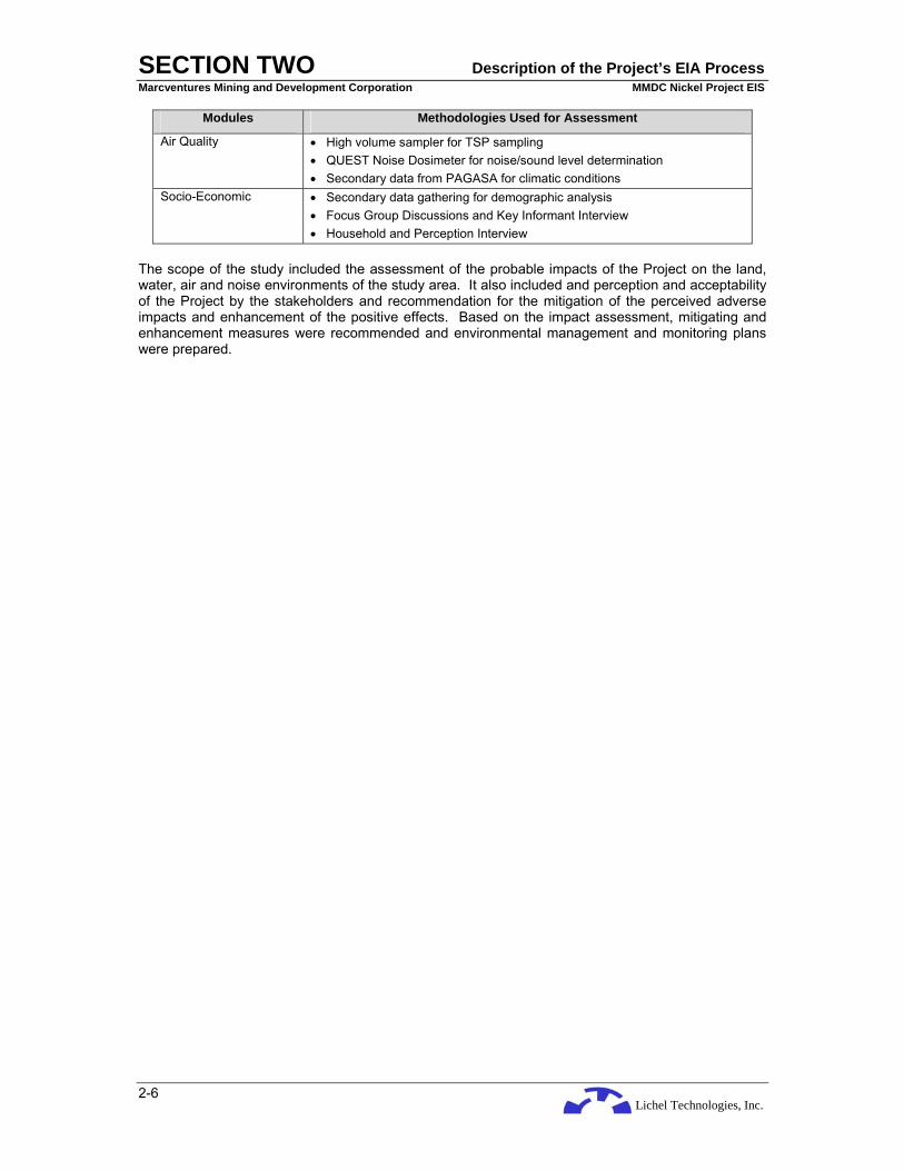
Lichel Technologies, Inc.
SECTION TWO Description of the Project’s EIA Process Marcventures Mining and Development Corporation MMDC Nickel Project EIS
2-6
Modules Methodologies Used for Assessment
Air Quality • High volume sampler for TSP sampling • QUEST Noise Dosimeter for noise/sound level determination • Secondary data from PAGASA for climatic conditions
Socio-Economic • Secondary data gathering for demographic analysis • Focus Group Discussions and Key Informant Interview • Household and Perception Interview
The scope of the study included the assessment of the probable impacts of the Project on the land, water, air and noise environments of the study area. It also included and perception and acceptability of the Project by the stakeholders and recommendation for the mitigation of the perceived adverse impacts and enhancement of the positive effects. Based on the impact assessment, mitigating and enhancement measures were recommended and environmental management and monitoring plans were prepared.

Lichel Technologies, Inc.
SECTION TWO Description of the Project’s EIA Process Marcventures Mining and Development Corporation MMDC Nickel Project EIS
2-7
Figure 2-1: EIA Study Schedule

Lichel Technologies, Inc.
SECTION TWO Description of the Project’s EIA Process Marcventures Mining and Development Corporation MMDC Nickel Project EIS
2-8
2.8 PUBLIC PARTICIPATION
A participatory and community-based approach was used in conducting the EIA for this Project. This strategy has become the standard practice in conducting an EIA. The bio-physical study team engaged the help and assistance of local guides during the data gathering for the baseline environmental conditions. In the conduct of the socio-economic survey, enumerators were directly recruited from the community. Key informants among the local residents were selected and directly interviewed by the Project team. The study team also recruited some residents as field assistants and conducted informal dialogues with them and with other resident groups.
A public scoping meeting held on 29 January 2008 at Barangay Cabangahan, Cantilan, Surigao del Sur. The meeting afforded the stakeholders the opportunity to discuss their concerns regarding the potential environmental and social impacts of the proposed Project. A summary of the environmental issues and concerns that were raised during the public scoping is given in Table 2-4. A filled-up Public Scoping Issues based on the Revised Procedural Manual, photographs taken during the public scoping and attendance sheets are attached as Annex D-1.
Table 2-4: Stakeholders’ Issues, Concerns, Recommendations and Proponent’s Responses during the Public Scoping
STAKEHOLDER ISSUES AND CONCERNS RECOMMENDATIONS PROPONENT’S RESPONSE
Barangay Consuelo • Priority in employment • Health services
monitoring • Monitoring of concerned
agency (DENR) • Effect on marine water
and drinking water • Barangay share • Our roads will become
dusty • Road maintenance • Social development
assistance of the company to the barangay
• Increase in dust generation should be controlled
• Results of the monitoring should be presented to the barangay
• Road maintenance should be extended.
• Qualified local residents will be given priority in employment. However, if required manpower qualification is not available locally, the company will hire from neighboring localities.
• Monitoring of pollution control measures shall be conducted quarterly. An MMT shall be created to monitor compliance to the ECC conditions.
• Social Development Assistance will be incorporated in Social Development and Management Plan (SDMP) to be prepared by the proponent and to be submitted to the Mines and Geosciences Bureau (MGB)
Barangay Cabangahan – Manobo Tribal Group
• We want responsible mining investors
• Peace and order situation in the barangay
• IPs must be given priority when it comes to employment
• Plans concerning the barangay
• Information on the MOA of mining applicants - have a copy furnish of every CTWG
• The ten tribal leaders and the council of elders are
• Provide documents to NCIP of all relevant MOA/agreements reached with other line agencies;
• Information drive for IPs in affected communities on the updates of the project;
• Monthly meetings with barangays/communities affected
• Qualified local residents will be given priority in employment. However, if required manpower qualification is not available locally, the company will hire from neighboring localities.
• Provide necessary training of local residents to be job competitive.
• Monitoring of pollution control measures shall be conducted quarterly. An MMT shall be created to monitor compliance to the

Lichel Technologies, Inc.
SECTION TWO Description of the Project’s EIA Process Marcventures Mining and Development Corporation MMDC Nickel Project EIS
2-9
STAKEHOLDER ISSUES AND CONCERNS RECOMMENDATIONS PROPONENT’S RESPONSE
often ignored and bypassed in past negotiations
ECC conditions. • Social Development
Assistance will be incorporated in Social Development and Management Plan (SDMP) to be prepared by the proponent and to be submitted to the Mines and Geosciences Bureau (MGB)
Municipality of Madrid
• Agricultural farmers are against mining because of its effect to the irrigation system from Carac-an River
• Effect on the irrigation system-Bayogo
• Watershed Area SPISP • Landslide/Soil Erosion
problem • Priority employment for
the affected barangays • Information drive to the
concerned group of farmers
• Protection of Carac-an River
• Protection of Buyaan River (Bayogo)
• Protection of watershed area
• Construct necessary measures for protection from soil erosion
• Employees should be from the affected barangays
• Conduct scoping for the Municipality of Madrid
• Qualified local residents will be given priority in employment. However, if required manpower qualification is not available locally, the company will hire from neighboring localities.
• Proponent will construction erosion and siltation control structures to prevent eroded soils from reaching the irrigation system.
• Monitoring of pollution control measures shall be conducted quarterly. An MMT shall be created to monitor compliance to the ECC conditions.
Southern Philippines Irrigation Sector Project – Watershed Management Sub-Sector (SPIS-WMS)
• Continuity/ security of SPIS projects
• Payment for timber that will be damaged
• Priority employment to barangay residents
• Scholarship grant from the company for deserving students
• Due compensation for affected farmlands
• Livelihood projects for residents not able to work or employed in the company
• Medical Assistance • Assistance to religious
groups of affected barangays
• Qualified local residents will be given priority in employment. However, if required manpower qualification is not available locally, the company will hire from neighboring localities.
• Monitoring of pollution control measures shall be conducted quarterly. An MMT shall be created to monitor compliance to the ECC conditions.
• Social Development Assistance will be incorporated in Social Development and Management Plan (SDMP) to be prepared by the proponent and to be submitted to the Mines and Geosciences Bureau (MGB)
A consultation meeting with the Barangay Council and Multi-Sectoral Groups of Barangay Panikian was held on 05 March 2008 at the Barangay Panikian Hall, Municipality of Carrascal. The meeting was held to present the Project and to solicit issues and concerns from the participants. MMDC explained that there are no immediate plans to develop a mine within their jurisdiction but would definitely consult with them if there will be any future developments. On their part the barangay council raised the following issues and concerns:
Lichel Technologies, Inc.
SECTION TWO Description of the Project’s EIA Process Marcventures Mining and Development Corporation MMDC Nickel Project EIS
2-10
• siltation of rivers and their rice fields; • employment opportunity; • hazardous chemicals that could harm the environment; and • livelihood, infrastructures, education, health, and peace and order.
Although the concerns regarding the environment were raised during the meeting, the participants were supportive of the Project provided that MMDC advocates responsible mining. A summary of the meeting, attendance sheet and pictures are attached in Annex D-2.
In response to the EMB letter dated 13 March 2008, MMDC conducted a technical conference on 09 April 2008 to address the National Irrigation Administration’s issues and concerns regarding the potential impact of the proposed Project to NIA irrigation systems, particularly on the issue of siltation of the irrigation intake structure. The conference was held at the SSIT-SSPSC Campus in Cantilan, Surigao del Sur. Copies of the NIA letter of opposition, EMB letter to MMDC, EMB and MGB replies to the NIA letter, minutes of the technical conference, attendance sheet and pictures are presented in Annex D-3.
On 03 May 2008, MMDC was also invited to present the Project in the Conference Regarding Implementation of NIA Projects and Mining Activities in Surigao del Sur which was held at the residence of the Governor of Surigao del Sur in Tandag City. Minutes of the conference and attendance sheet are attached as Annex D-4.

Lichel Technologies, Inc.
SECTION THREE Project Description Marcventures Mining and Development Corporation MMDC Nickel Project EIS
3-1
3 PROJECT DESCRIPTION
3.1 PROJECT LOCATION AND AREA
The Project is situated in Barangay Cabangahan in the Municipality of Cantilan, Barangay Panikian in the Municipality of Carrascal, and Barangay Bayogo in the Municipality of Madrid which are all under the jurisdiction of Surigao del Sur Province (Figure 3-1). The Project has a total area of 4,799.00 hectares (ha) and is covered under MPSA No. 016-93-XIII which was approved by the Mines and Geosciences Bureau (MGB) on 01 July 1993. Its boundaries are technically described in Table 3-1 and shown in Figure 3-2.
Table 3-1: Technical Description of the Project Area
Corner Latitude Longitude
1 9° 20’ 00” 125° 52’ 30”
2 9° 20’ 00” 125° 55’ 00”
3 9° 19’ 00” 125° 55’ 00”
4 9° 19’ 00” 125° 54’ 00”
5 9° 15’ 30” 125° 54’ 00”
6 9° 15’ 30” 125° 53’ 30”
7 9° 14’ 00” 125° 53’ 30”
8 9° 14’ 00” 125° 51’ 00”
9 9° 15’ 00” 125° 51’ 00”
10 9° 15’ 00” 125° 51’ 30”
11 9° 19’ 00” 125° 51’30”
12 9° 19’ 00” 125° 52’ 30”
The Project is accessible via the Surigao City-Tandag National Highway which traverses the eastern portions of Surigao del Norte and Surigao del Sur provinces that includes Cantilan township. From the town center, the project site can be reach by way of a 15-kilometer (km) barangay and dirt roads that skirts thru the mountain side up to Barangay Cabangahan; thence about 2 km up a logging road to the proposed mine site. Company owned four-wheel drive vehicles and motor bikes are used to transport workers and materials to and from the project site. Land travel time from Surigao City to Cantilan township takes about 2½ hours, and from Cantilan township to the project site takes another 1 hour.
3.2 HISTORY OF MINING CLAIM
In 1970, Gozon Development Corporation thru the MGB initiated the exploration of laterite in the area by conducting geologic mapping and auger drilling. Marcopper Mining Corporation did more intensive drilling and test pitting between 1991 to 1995. However, the results of the exploration were below economic grades of ore prevailing at that time. The property was then sold to Hinatuan Mining Corporation but insurgency problems forced the company to abandon the area. It was at this juncture that Ventura Timber Corporation, the predecessor of MMDC filed an MPSA application over the area. QNI Philippines also explored a portion of the area in 2000.

Lichel Technologies, Inc.
SECTION THREE Project Description Marcventures Mining and Development Corporation MMDC Nickel Project EIS
3-2
Figure 3-1: General Location Map

Lichel Technologies, Inc.
SECTION THREE Project Description Marcventures Mining and Development Corporation MMDC Nickel Project EIS
3-3
Figure 3-2: MMDC MPSA Boundary Map

Lichel Technologies, Inc.
SECTION THREE Project Description Marcventures Mining and Development Corporation MMDC Nickel Project EIS
3-4
3.3 PROJECT RATIONALE
The Philippine Government is actively promoting environmentally sound mineral production project in the country. As a result of the Supreme Court’s decision in December 2004 on the constitutionality of the Republic Act No. 7942, known as the “Philippine Mining Act of 1995,” the Department of Environment and Natural Resources (DENR) was given the green light by the President to operationalize the Minerals Action Plan, a comprehensive strategy involving all agencies of government and the stakeholders of the mineral industry that would revitalize mineral development in the country with due consideration to environmental protection, economic growth and social equity. Mining industries are guided by Executive Order (EO) No. 270-A, amending EO No. 270, series of 2004, otherwise known as “National Policy Agenda on Revitalizing Mining in the Philippines”.
Surigao del Sur is just one of so many areas in the country that is well endowed with mineral resources, particularly nickel. The project area is identified as one of the area in Surigao del Sur that has a great potential for nickel laterization.
The proposed mining project will also address the unemployment problem in the locality, which is consistent with the government’s thrust which is to revitalize the mining industry in order to generate much needed revenues for both the local and national government.
3.4 DESCRIPTION OF THE NICKEL RESOURCE AT THE PROJECT AREA
From the drilling data obtained from more than 130 core drills and 70 test pits (drilling is still ongoing), the measured geologic reserves within a 400-hectare portion of Area 2 (Figure 3-3) is as follows:
Saprolite ore = 4,473,000 metric tonnes @ 2.1% Nickel (1.8% Ni cutoff); and Laterite ore = 19,080,000 metric tones @ 1.22% Nickel (0.8% Ni cutoff).
Inferred ore resources were calculated using the Triangular Irregular Nerwork method (Arcilla, April 2008), which estimates the surface areas that have been covered partly by drilling data. The inferred Nickel ore resource in Area 2, based on the exploration so far conducted, is at least 53,000,000 metric tones with 1.2% Nickel.
There are two nickel-bearing horizons identified in the Area 2: a laterite nickel ore zone with >1% Nickel grades and a richer saprolite ore zone with grades >2% Nickel. These are being drilled in closer spacings in order to further quantify resources and ore reserves according to the Philippine Mining Reporting Code.
3.5 PROJECT NATURE AND SIZE
The proposed Project aims to develop the MMDC MPSA, and extract, sort, dry, resize, and deliver the nickel ore to interested buyers. At present, MMDC is yet to finalize the economic, engineering and environmental feasibility studies for the Project, such that the Project configuration are still open for development and selection. In addition, even during the Project implementation, the Project configuration plan would be progressively updated depending on various technical, social, market, political and other factors.
Nevertheless, for an environmental impact assessment study, a preliminary ten-year conceptual development plan was prepared for Area 2. This plan shows a scenario of the possible locations and scale of the operations, span of area to be opened up, as well as the corresponding impact zones, potential nature, scale and frequency of environmental impacts.

Lichel Technologies, Inc.
SECTION THREE Project Description Marcventures Mining and Development Corporation MMDC Nickel Project EIS
3-5
Figure 3-3: Measured Geologic Reserve Map

Lichel Technologies, Inc.
SECTION THREE Project Description Marcventures Mining and Development Corporation MMDC Nickel Project EIS
3-6
3.6 PROJECT ALTERNATIVES
No project alternatives are considered other than this proposed project. Not pursuing the Project is contrary to the government’s (specifically, DENR) objective of increasing indigenous mineral production to generate revenues for the country. Should MMDC not develop the Project, DENR-MGB can terminate the MPSA and invite other applicants to develop the area.
3.7 PROJECT DEVELOPMENT PLAN, PROCESS/TECHNOLOGY OPTIONS AND PROJECT COMPONENTS
The Project components have been identified and categorized into three, as follows: mineral production and delivery facilities, support facilities, and environmental facilities. An initial list and bulk estimates of the Project facilities is tabulated below.
Table 3-2: Preliminary Project Components
Facility Estimated size Probable Location A. Mineral Production Line and Handling Facilities 1 Area 2 (Initial Mining Area) 120 ha MPSA Contract Area 2 Haul roads Area 2 to Carac-an River
Crossing 1.5 km x 10 m = 1.5 ha MPSA Contract Area
3 Carac-an River overflow bridge and submerged road
120 m x 4m = 480 sq m MPSA Contract Area
4 Haul roads Barangay Cabangahan to proposed jetty (Repairs)
22 km Barangay Cabangahan, Barangay Parang, Provincial Road, Barangay Consuelo
5 Windrows turning 2 units 6 Ore Stockyard (Area 2) 5.0 ha MPSA Contract Area 7 Ore Stockyard (near existing port) 2.0 ha Barangay Consuelo 9 Ore Stockyard (near jetty) 3.3 ha Carrascal Coastal Plain B. Support Facilities
1 Project Central Complex 8.0 ha MPSA Entrance Boundary (Nangka Area)
Material Stockyard Administration Offices Clinic Equipment Wash Station Laboratory Motor Pool Power Generator Set Station Refueling Station Shops (Carpentry, Metal) Warehouse Water Tank Mining Area Office Base Camp
C. Environmental Facilities 1 Compost Pits 50 sq m Near Nursery 2 Nursery 0.2 ha Project Central Complex 3 Felled Timber Recovery Area 0.5 ha MPSA Area 4 Overburden Temporary Storage Area
(Area 2) 5.0 ha MPSA Area
5 Siltation Dikes (Area 2) 4 x 0.10 ha MPSA Area 6 Road Construction Spoils Disposal
Area To be located MPSA Area
7 Settling Pond (Area 2) 1 x 1.0 ha MPSA Area 8 Drainage System Along Access Road Site dependent Beside roads 9 Stormwater runoff drainage, silt traps,
catch basins Site dependent Ore stockyards, overburden
temporary storage area, mine area, project complex area

Lichel Technologies, Inc.
SECTION THREE Project Description Marcventures Mining and Development Corporation MMDC Nickel Project EIS
3-7
3.7.1 Ores to be Produced
The Project shall be produce nickeliferous laterite ore. The Project has an estimated partial indicated mineable resource of 11,600,000 Wet Metric Tons (WMT) @ 1.35% Ni and 38.13% Fe as the initial ore production in Area 2 for the fist ten (10) years. This is likely to increase substantially with further exploration, indicating that MMDC is still continuing its exploration activities in Area 2.
3.7.2 Ore Mining
The shallow location of the nickel laterite ore merits the adoption of a contour surface mining (Plate 3-1) method where the extraction of the mineral creates road-like benches around the ridges. In addition, the contour mining method would incorporate Progressive Mine Rehabilitation practice in which the overburden from the advancing bench is disposed of to the mined out bench for immediate application of soil erosion control measures. This practice would avoid additional cost for construction of larger overburden disposal area and hauling.
Plate 3-1: Typical contour mining of nickel laterite in its early stage (Source: GP Pamintuan)
Nickel laterite mining is a straightforward operation and does not involve any advanced or new technologies except for the use heavy equipments (dozers, excavators, loaders). To minimize the impact of soil erosion and siltation, mining will be staged in 5-hectare blocks and progressive mining rehabilitation will commence immediately in mine-out areas.
3.7.3 Main Project Components
The configuration of the main project components is shown in Figure 3-4.
3.7.3.1 Initial Mine Area
Exploration within the project MPSA area identified three potential nickel laterite areas, namely: Area 3 at the northern part, Area 1 at the central part and Area 2 at the southern portion. From these identified laterite areas, mining will commence at Area 2 with an initial mine area of approximately 120 hectares (Figure 3-5).

Lichel Technologies, Inc.
SECTION THREE Project Description Marcventures Mining and Development Corporation MMDC Nickel Project EIS
3-8
3.7.3.2 Stockyard area
The run-of-mine ore would be brought to a stockyard for drying, sorting and sizing. Three stockyard areas, one located at the close to the initial mine area, another located at Nangka, and the third at Barangay Consuelo near the proposed jetty, are initially proposed to accommodate the estimated production capacity. The stockyards will be on flat areas and have adequate drainage to manage run-offs. The stockpiles will have slopes of 30° or less to ensure stability.
3.7.3.3 Mine Ancillaries
The stockyard area at Sitio Nangka would also accommodate the mine ancillary facilities such as the administration office, assay laboratory, motorpool, staff houses and tree nursery.
3.7.3.4 Settling ponds/silt dams
Siltation of bare surface during the construction and operation of the Project which could result to excessive siltation of nearby water bodies shall be addressed properly by constructing properly designed drainages, silt traps, silt fence, silt dams and settling ponds along strategic location considering various factors such as amount water run-off, terrain of the area and concentration of mining activity among others.
3.7.3.5 Haul roads
The project will utilize, as much as possible, the existing logging and provincial roads to haul the produced ore from the mine site to the stockyards and ultimately to the barge loading station. This would minimize opening up of new areas which are susceptible to soil erosion. However, the use of existing roads to transport the produced ore to the jetty may require some improvements like road widening and addition of sub base/base coarse materials to handle loaded hauling/dump trucks. Opening up of new roads within the project (MPSA) area to shorten the distance and to have a cost effective mining operations may also be undertaken.
An alternate haul road that traverse through Barangay Panikian of Carrascal Municipality, Surigao del Sur covering a distance of some 25 km is also shown in Figure 3-4.
3.7.3.6 Submerge Road and Overflow Bridge
To transport the ore from the mine area to the stockyards would require crossing the Carac-an River. To this, MMDC would construct a reinforced submerge road and an overflow bridge to cross the river floodplain. The preliminary design of this engineered structure is shown in Figure 3-6.
3.7.3.7 Sea Port
The ore mined will be loaded in barges for transfer to ships delivering the goods to its international market. MMDC will construct its own jetty which will be located at Sitio Bahang-bahang, Barangay Consuelo in Cantilan, Surigao de Sur some 700 m from the existing seaport.
An all-weather jetty is designed based on an assumed wave height of 2.0 meters that can accommodate 4 LCT vessels each with a carrying capacity of 1,500 WMT. Boulders will be used to construct the jetty, with the base similar to rip rapping and protected by 1-2 tons of armor rock on all sides. The initial dimensions of the jetty are the following:
• Length (from coastline to beaching crest) - 225 m
• Access road width - 14 m
• Width of landing area (crest) - 32 m x 109 m
About 3.3 hectares of the coastal area will be used for jetty construction using boulders from Barangay Bahang-bahang adjacent to the proposed jetty. During shipment operation, a 24-hour
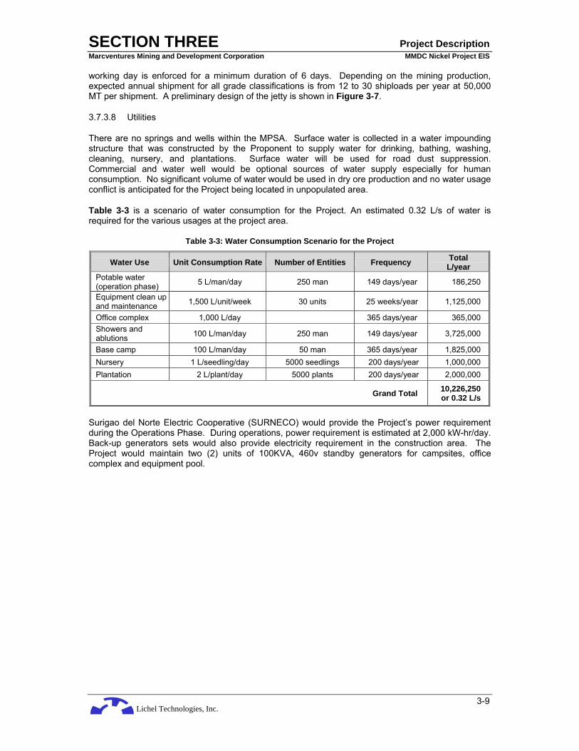
Lichel Technologies, Inc.
SECTION THREE Project Description Marcventures Mining and Development Corporation MMDC Nickel Project EIS
3-9
working day is enforced for a minimum duration of 6 days. Depending on the mining production, expected annual shipment for all grade classifications is from 12 to 30 shiploads per year at 50,000 MT per shipment. A preliminary design of the jetty is shown in Figure 3-7.
3.7.3.8 Utilities
There are no springs and wells within the MPSA. Surface water is collected in a water impounding structure that was constructed by the Proponent to supply water for drinking, bathing, washing, cleaning, nursery, and plantations. Surface water will be used for road dust suppression. Commercial and water well would be optional sources of water supply especially for human consumption. No significant volume of water would be used in dry ore production and no water usage conflict is anticipated for the Project being located in unpopulated area.
Table 3-3 is a scenario of water consumption for the Project. An estimated 0.32 L/s of water is required for the various usages at the project area.
Table 3-3: Water Consumption Scenario for the Project
Water Use Unit Consumption Rate Number of Entities Frequency Total L/year
Potable water (operation phase) 5 L/man/day 250 man 149 days/year 186,250
Equipment clean up and maintenance 1,500 L/unit/week 30 units 25 weeks/year 1,125,000
Office complex 1,000 L/day 365 days/year 365,000 Showers and ablutions 100 L/man/day 250 man 149 days/year 3,725,000
Base camp 100 L/man/day 50 man 365 days/year 1,825,000 Nursery 1 L/seedling/day 5000 seedlings 200 days/year 1,000,000 Plantation 2 L/plant/day 5000 plants 200 days/year 2,000,000
Grand Total 10,226,250 or 0.32 L/s
Surigao del Norte Electric Cooperative (SURNECO) would provide the Project’s power requirement during the Operations Phase. During operations, power requirement is estimated at 2,000 kW-hr/day. Back-up generators sets would also provide electricity requirement in the construction area. The Project would maintain two (2) units of 100KVA, 460v standby generators for campsites, office complex and equipment pool.

Lichel Technologies, Inc.
SECTION THREE Project Description Marcventures Mining and Development Corporation MMDC Nickel Project EIS
3-10
Figure 3-4: Project Components Map

Lichel Technologies, Inc.
SECTION THREE Project Description Marcventures Mining and Development Corporation MMDC Nickel Project EIS
3-11
Figure 3-5: Initial Mine Area

Lichel Technologies, Inc.
SECTION THREE Project Description Marcventures Mining and Development Corporation MMDC Nickel Project EIS
3-12
Figure 3-6: Preliminary Design of Submerge Road, Overflow Bridge and Reinforcement of Bailley Bridge

Lichel Technologies, Inc.
SECTION THREE Project Description Marcventures Mining and Development Corporation MMDC Nickel Project EIS
3-13
Figure 3-7: Preliminary Design of Jetty

Lichel Technologies, Inc.
SECTION THREE Project Description Marcventures Mining and Development Corporation MMDC Nickel Project EIS
3-14
3.7.3.9 Project Wastes
The Project would generate various wastes of varying quantities and at the different Project phases. The more important wastes from the Project are the cut trees, overburden, construction material wastes, equipment maintenance (used spare parts), equipment used oil, solid wastes, and sewage. The overburden and open up areas would generate secondary impacts in the form of eroded soil and silt-bearing run-off during rainy periods, and air-borne dust during the dry periods. The Project would generate about 2.4 million cubic meters of overburden in the first ten years of waste stripping.
Wastes will be classified according to source such as industrial, office, and domestic; according to form such as solid, liquid, or gaseous; according to utility such as reusable, recyclable and non-recyclable; and biodegradability such as biodegradable and non-biodegradable. The principle of reduce, reuse, and recycle would be adopted.
Cut trees would be covered, as necessary, by Tree-Cutting Permit (PD 705, Revised Forestry Code of the Philippines."), while the rest of the wastes would be covered, at source, by DENR AO 99-32 on overburden or mine waste; RA 9003 on solid waste; RA 6969 on waste oil; PD 856 (Sanitation Code), PD 1096 (National Building Code) on sewage; RA 9275 (Clean Water Act) and PD 984 (National Pollution Control Law of 1976) on industrial waste water.
3.7.4 Planned Mine Capacity
The planned annual mine production is from 600,000 to 1,500,000 Wet Metric Tons (WMT) of laterite ore with effective working days per year of 149 days.
The current design of the Project calls for drying, sorting, and sizing of the nickel laterite ore. Refining of the ore to produce nickel metal will be done in countries such as Japan, China or in other places.
It is often argued that for higher value added, processing of ores must be continued up to refining on site. However, this quest for higher value is counter-balanced by other factors such as adequacy of ore supply to sustain the refinery beyond the break-even point, availability of capital investments, and the ability of the market to absorb the production and return a profit to the investments. The perceived risks attached to the project were also considered, thus the success of the planned mining operation will be an important factor for future consideration that will lead to any new business development for higher value added projects such as front-end refining of ores.
The delimitation of processing to beneficiation provides significant environmental advantages. Firstly, it avoids the use of chemicals. Secondly, it does away with the generation of mine tailings and gaseous and liquid effluents.
3.7.5 Estimated Mine Life and Planned Mine Capacity
The estimated mine life at Area 2 is ten (10) years excluding the additional potential ore reserves that will be delineated by the on-going core drilling program. The planned mine capacity is as follows:
Year Mine Capacity (WMT)
1 600,000
2 800,000
3 900,000
4-7 1,200,000
8-10 1,500,000
Total 11,600,000

Lichel Technologies, Inc.
SECTION THREE Project Description Marcventures Mining and Development Corporation MMDC Nickel Project EIS
3-15
3.7.6 Environmental Management Policy
The Project would be implemented in compliance with the environmental standards and management requirements of the Philippine Mining Act of 1995, other environmental laws, and the MPSA.
3.8 DESCRIPTION OF PROJECT PHASES
Table 3-4 presents the activities, associated wastes, other social and environmental issues and built-in pollution control measures during the project construction and operation phases. Project activities during pre-operation phase would not produce significant wastes and would not create social and environmental issues and were therefore excluded in the summary table.
3.8.1 Pre-Construction Phase
Pre-Operation phase would involve acquisition of permits and other government approvals; entering into a Project financing agreements; negotiations and actual land acquisition and crop damage compensation; detailed follow-up survey, mapping and design for road routes, mining areas and other work sites; procurement and construction tendering; bidding of and award to contractors. There would be no major land disturbances in this phase of the Project, exempt for the trampling of the vegetation in the conduct of detailed surveys and mapping for access roads and other work areas.
3.8.2 Construction Phase
The initial Construction Phase (or site development) aims to allow the mining operator to establish itself and its resources in the area, and prepare the area for the initial mining at the designated priority mining area. The activities would involve the following:
• improvement of the existing access road, as necessary;
• access road construction within the operating areas for support facilities, as necessary;
• land preparation for, and construction or installation of support infrastructure facilities (office complex, contractor’s equipment pool, refueling station, material stockyard, warehouse, power supply house, personnel accommodation, unloading pad and lay on pad for heavy equipment);
• land preparation for, and construction of appropriate mitigating measures such as drainage, silt traps, catch basins, etc.; and
• land preparation for and construction of production line facilities (such as initial haul roads, overflow bridge, stockyards and jetty).
The construction phase of the succeeding mining areas would require additional haul roads and environmental facilities.
Land preparation would generally involve clearing and grubbing, excavation/leveling, hauling of soils and drainage installation. The design of the drainage system would be dependent on the topography and existing gullies in the area.
Mine haul roads would be developed in mining areas initially on natural topographic surface. The roads will be constructed with appropriate road base to allow safe and efficient traffic management.
Setting of all facilities would consider the occurrence of natural hazards, minimization of surface and groundwater hydrological alterations, control of siltation to within allowable standard, minimization of major terrestrial ecological impacts, and avoidance as much as possible of socio-economic dislocations such as resettlement, right of way or crop damages. These criteria would be applied to Technical/Engineering options and economic objectives of the Project.
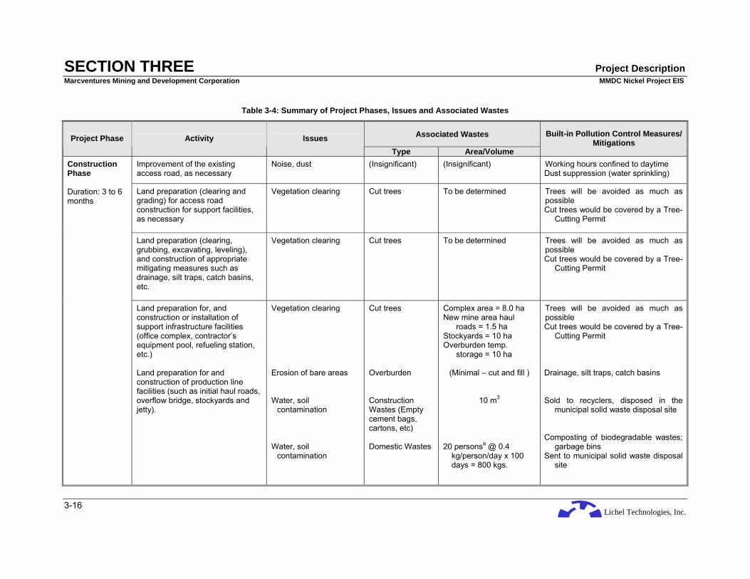
Lichel Technologies, Inc.
SECTION THREE Project Description Marcventures Mining and Development Corporation MMDC Nickel Project EIS
3-16
Table 3-4: Summary of Project Phases, Issues and Associated Wastes
Associated Wastes Project Phase Activity Issues Type Area/Volume
Built-in Pollution Control Measures/ Mitigations
Improvement of the existing access road, as necessary
Noise, dust (Insignificant) (Insignificant) Working hours confined to daytime Dust suppression (water sprinkling)
Land preparation (clearing and grading) for access road construction for support facilities, as necessary
Vegetation clearing
Cut trees To be determined Trees will be avoided as much as possible Cut trees would be covered by a Tree-
Cutting Permit
Land preparation (clearing, grubbing, excavating, leveling), and construction of appropriate mitigating measures such as drainage, silt traps, catch basins, etc.
Vegetation clearing
Cut trees To be determined Trees will be avoided as much as possible Cut trees would be covered by a Tree-
Cutting Permit
Construction Phase Duration: 3 to 6 months
Land preparation for, and construction or installation of support infrastructure facilities (office complex, contractor’s equipment pool, refueling station, etc.) Land preparation for and construction of production line facilities (such as initial haul roads, overflow bridge, stockyards and jetty).
Vegetation clearing Erosion of bare areas Water, soil
contamination Water, soil
contamination
Cut trees Overburden Construction Wastes (Empty cement bags, cartons, etc) Domestic Wastes
Complex area = 8.0 ha New mine area haul
roads = 1.5 ha Stockyards = 10 ha Overburden temp.
storage = 10 ha
(Minimal – cut and fill )
10 m3
20 personsa @ 0.4 kg/person/day x 100 days = 800 kgs.
Trees will be avoided as much as possible Cut trees would be covered by a Tree-
Cutting Permit Drainage, silt traps, catch basins Sold to recyclers, disposed in the
municipal solid waste disposal site Composting of biodegradable wastes;
garbage bins Sent to municipal solid waste disposal
site

Lichel Technologies, Inc.
SECTION THREE Project Description Marcventures Mining and Development Corporation MMDC Nickel Project EIS
3-17
Associated Wastes Project Phase Activity Issues Type Area/Volume
Built-in Pollution Control Measures/ Mitigations
Water, soil
contamination
Wastewater and sewage
2.0 m3/per day
Provision of septic tanks
Land Clearing (Stripping) Overburden Removal and Storage
for Rehabilitation Ore Mining (Extraction)
Vegetation clearing Erosion of bare
areas/siltation Water, soil
contamination Generation of dust
Cut trees, stumps, undergrowths Suspended
sediments Overburden Suspended
particulates
Initial mine area = 120 ha Overburden temp.
storage = 10 ha
1,449 m3/ha/year
2.4 million m3
Cut trees would be covered by a Tree-Cutting Permit Stumps will be collected and placed in
well-protected, stable areas, Drainage, silt traps, silt dams, siltation
pond, catch basins Temporary overburden storage area Water spraying
Progressive Rehabilitation (After every 5 ha of mined-out
area)
Erosion of newly rehabilitated area
Suspended sediments
1,449 m3/ha/year Existing drainage, silt traps, silt dams, siltation pond, catch basins Overburden will be re-placed in mined
out areas followed by rehabilitation
Ore Transport Generation of dust
Suspended particulates
Covering of ore during transport
Water spraying
Ore Stockyard Operation (Ore Piling and Drying)
Water, soil contamination
Eroded stockpiles Existing drainage, silt traps, catch basins
Operation Phase Initial Mining duration (Area 2): 10 years
Ore Delivery to Sea Craft No significant Issues

Lichel Technologies, Inc.
SECTION THREE Project Description Marcventures Mining and Development Corporation MMDC Nickel Project EIS
3-18
Associated Wastes Project Phase Activity Issues Type Area/Volume
Built-in Pollution Control Measures/ Mitigations
Administrative activities Water, soil contamination
Domestic Wastes Wastewater and sewage
Office Waste Used oil
50 personsa @ 0.4 kg/person/day x 300 days = 6000 kg/yr.
4.2 m3/per day To be determined To be determined
Sold to recyclers, disposed in the municipal solid waste disposal site
Composting of biodegradable wastes; garbage bins
Sent to municipal solid waste disposal site
Septic tanks Sold to recyclers; send to municipal solid waste disposal site Sent to DENR accredited hazardous
waste transporter/handler
Abandonment Phase
Final reclamation Dismantling/ removal of infrastructure
In reclaimed areas: - reduced sediment level
in stream - restored soil
productivity In areas of dismantling/
removal of infrastructure:
- increased sediment loads in stream
- sedimentation, scouring and decreased soil thickness through erosion.
Dismantled mine facilities
To be determined
Some mine facilities can be transferred/donated to the host communities
Dismantled materials from mine facilities can be sold to recyclers
a Estimated number of persons who will stay in the complex

Lichel Technologies, Inc.
SECTION THREE Project Description Marcventures Mining and Development Corporation MMDC Nickel Project EIS
3-19
3.8.3 Operation Phase
The company will employ a contour mining system that involves several phases including the following:
• Land Clearing (Stripping)
• Overburden Removal and Storage for Rehabilitation
• Ore Mining (Extraction)
• Progressive Rehabilitation
• Ore Transport
• Ore Stockyard Operation (Ore Piling and Drying)
• Ore Delivery to Sea Craft
Figure 3-8 below is a mining operations flowchart.
Figure 3-8: Mining Operations Flowchart (Source: RN Santos)
3.8.3.1 Land Clearing
Land clearing would involve clearing, timber recovery or relocation (where required), chipping/mulching, and removal of humus (where possible). Bulldozers, front-end loaders, and trucks would be deployed to undertake this work. Stockpiling of the removed materials at designated areas for future re-use would preserve the mulched vegetation and the topsoil.
3.8.3.2 Overburden Removal
Waste stripping involves removal of all overburden material below the nominal cut-off grade established by Grade Control Engineer and/or Mine Planning Engineer in accordance to the approved pit design with benches 3 m high to maintain grade control and geotechnical integrity. Waste materials shall be hauled to designated waste dump areas for future utilization. Cross section of a typical mine bench is shown in Figure 3-9.

Lichel Technologies, Inc.
SECTION THREE Project Description Marcventures Mining and Development Corporation MMDC Nickel Project EIS
3-20
Figure 3-9: Typical cross section of a mine bench and haul road
3.8.3.3 Ore Mining
After removing the overburden material below the nominal cut-off grade, the established benches will be sampled by channel (vertical) sampling at an interval of 3 to 5 meters. Samples will be analyzed by the company laboratory. Extraction at the benches will proceed only when ore grade are already known for proper ore stockpiling.
The ore bodies would be excavated using an excavator in a backhoe mode with a bucket capacity of 0.8 – 1.0 m3. Mining operation will be by open pit with 3-meter mining bench height usually started by open trench at the foot of the slope. All segregated pre-piles ores will be hauled and piled at their designated stockyard. Oversized ore segregated will be reduced to marketable size of 75 mm by employing manual breaking and stockpiled for shipment purposes.
Progressive pit mining will be employed every five (5) hectares to avoid large volume of stockpiled waste/overburden.
3.8.3.4 Ore Transport
The specified truck for both ore and waste handling is a 10-tonner, 10-wheeler truck. The haul road connecting the mine site to the stockyard will have an 8-meter wide travel surface, about three times the width of the haul truck.
Trucks will be loaded on the bench that is being mined with the excavator stationed on the bench above. On the average, ten (10) swings will be required to fill the truck. This includes a percentage of dead swings resulting from boulder removal. The ore excavators will exclude most large boulders for windrow formation.
3.8.3.5 Progressive Rehabilitation
For surface mined-out areas, a progressive mining rehabilitation program will be undertaken in compliance with mining regulations and environmental requirements. The overall objective is that at the completion of the mining operation, the significant features such as mined-out areas, waste dumps, and environmental control structures are decommissioned and developed into stable landforms. These landforms will be re-vegetated using endemic and fast-growing tree species.
Mine Bench
Limonite Ore Deposit
Drainage Ditch
Haul Road
3 meters
5 to 8 meters

Lichel Technologies, Inc.
SECTION THREE Project Description Marcventures Mining and Development Corporation MMDC Nickel Project EIS
3-21
To achieve the practice of Progressive Mining Rehabilitation, ideally, mining would start from the lowest bench progressing upwards whenever justified by grade requirements and economics. Waste from the upper benches would be backfilled onto the lower mined out benches for early rehabilitation works.
At the initial benching operation, two benches are prepared, a lower bench and an upper bench. The lower bench would serve as the location of the hauling trucks to be loaded with ore or waste extracted from the upper active bench where an excavator is located. Once mined, the upper bench becomes the lower bench of a new upper bench, and so on.
3.8.3.6 Ore Stockyard Operations
The stockyard would serve to:
• receive run-of-mine (RoM) ore;
• remove boulders; and
• dry the ore to shipping moisture content;
At the stockyard floor, a front-end loader would prepare the ore into 2-m high windrows, spaced 6 m apart, and turn the windrows repeatedly to allow the laterite to dry and expose the boulders of +200 mm (in the limonite). The boulders would be scrapped back using the loader bucket. Once a day, scrapped boulders would be loaded into a truck and transported to an area at the mining area for storage and later use such as for erosion control.
Air-drying of ore would continue using a modified hydraulic shovel to turn the windrows. In one action, the shovel would scrap approximately 300 mm of ore from one side of the windrow to the other. The shovel machine would move along the complete length of the windrows carrying out this action twice during day shift. The drying rate could average 0.5% moisture reduction per day, based on the study on the laterite operation in the Philippines.
The drying routines aim to produce an ore product that is dry enough for shipping purposes. This must have less than 34% moisture but not dry enough to cause excessive dust emissions. The contract could specify a minimum value of 28% moisture (based on fine limonite ore).
Limonite ore and saprolite ore would require varying air-drying periods within the windrows, depending on the moisture content of the rock. Limonite having higher moisture at 40% would require longer air-drying period, about 15 days; while saprolite, which has less moisture, would require about 10 days. In addition, the time available for drying and rock removal would be restricted by space limitations at the stockyard. Once dried, the ore would be pushed or hauled to the stockpile area.
3.8.3.7 Ore Delivery to Sea Craft
At acceptable moisture content and quality, the ore at the stockyards would be transported using 10-ton trucks to the company’s sea port where it will be offloaded to barges which in turn would transport the ore to an awaiting ship at some offshore distance.
3.8.4 Abandonment Phase
The abandonment phase of the mining area shall entail reforestation and rehabilitation works as required in Section 69 and 71 of RA 7942. Another important option to consider in the abandonment of the mine is the post mining land use preferred by the community according to their use and needs. All areas mined out may therefore not need to be re-vegetated but have to be rehabilitated/prepared to make it suitable for any land use that the community will plan. For the entire Project, the abandonment shall include dismantling or turn-over of mine facilities to the concerned Local Government Unit.

Lichel Technologies, Inc.
SECTION THREE Project Description Marcventures Mining and Development Corporation MMDC Nickel Project EIS
3-22
3.9 MINING EQUIPMENT
Table 3-5 is a list of equipment, including acquisition cost, which will be needed to operate the mine.
Table 3-5: List of Mining Equipment
Equipment Nos. Acquisition Cost (PhP)
D7 CAT Dozer 3 35,000,000
Track Mounted Backhoe 4 24,000,000
Wheel Loader 4 6,000,000
Dump Truck (10-tonner) 10 14,000,000
Shop tools 1 lot 1,000,000
Generator Set (75 KVA) 1 3,000,000
Mine Generator Set (25 KVA) 2 2,000,000
Service Pick-up 5 6,000,000
Laboratory Equipment 1 unit 4,000,000
Total Acquisition Cost 96,000,000
3.10 MANPOWER REQUIREMENTS
The Project will require 242 personnel. It will also generate indirect labor from its purchases of food, supplies, materials, equipment, and services. The estimated manpower requirements are shown Table 3-6.
Table 3-6: Manpower Requirements
CONSTRUCTION PHASE
1. Managerial 17 Persons
a. Officers 7
b. Non-Officers & staff (Chief Accountant, Mine Manager, Admin Manager, Chief Geologist, etc.)
10
2. Technical (Chemist, Geologist, Mining Engineer, etc.) 10 Persons
3. Non-Technical (Drivers of different types of equipment, helpers, miners, mechanics, etc.)
100 Persons
Total Staff 127 Persons
OPERATION PHASE
1. Managerial 22 Persons
a. Officers 7
b. Non-Officers & staff (Chief Accountant, Mine Managers, Chief Chemist, Admin Manager, Chief Geologist, etc.)
15
2. Technical (Chemist, Geologist, Mining Engineer, etc.) 20 Persons
3. Non-Technical (Drivers of different types of equipment, helpers, miners, mechanics, etc.)
200 Persons
Total Staff 242 Persons
The hiring of qualified personnel will come from the following sources prioritized as follows:

Lichel Technologies, Inc.
SECTION THREE Project Description Marcventures Mining and Development Corporation MMDC Nickel Project EIS
3-23
• Host communities
• Neighboring LGUs
• Outside
Hiring of workersfrom the host communities will not only alleviate unemployment and poverty but would also limit the influx of outside workers which would in turn require additional basic services such as housing, utilities, health services, etc.
Non-technical positions such as miners and helpers can easily be filled-up by local residents. To fully mazimized the involvement of the host communities with the Project, MMDC will offer training courses/scholarships to deserving local residents to upgrade their skills and enable them to qualify for higher employment positions.
It cannot be denied that mining operations are dominated by men for obvious reason that the majority of the workers are miners, helpers, equipment operators. To promote gender sensitiveness, jobs that can be perform by women such as community relation officers, administrative support staff, cooks, cleaners, etc will be offered to qualified women.
3.11 CAPITAL INVESTMENT
The estimated capital investment of the Project is estimated at PhP 252 Million Pesos broken down as follows:
Table 3-7: Breakdown of Capital Investment Cost
1. Mining Permits, Marine Study and ECC PhP 12,000,000
2. Exploration costs PhP 15,000,000
3. Equipment Investments
a. Mobile Equipment PhP 86,000,000
b. Fixed Equipment 10,000,000
4. Infrastructure Investment
a. Road repairs (about 22 km) PhP 52,000,000
b. Overflow Bridge 10,000,000
c. Office laboratory building and bunkhouse
10,000,000
d. Stockyard acquisition (pier area) 5,000,000
e. Pier Construction 32,000,000
f. Siltation pond, silt dams, silt traps 20,000,000
TOTAL PhP 252,000,000
3.12 PROJECT DURATION AND SCHEDULE
The Project is scheduled to start right after securing all government approvals with an initial construction phase of about a year. The initial Project operation was estimated to last for 10 years from a scenario of 11,600,000 WMT reserve and production rate of 600,000 WMT for the first year and increasing to 1,500,000 WMT starting on the 8th year.

Lichel Technologies, Inc.
SECTION THREE Project Description Marcventures Mining and Development Corporation MMDC Nickel Project EIS
3-24
Table 3-8: Estimated Duration of Project Phases
Activity Year 0 Year 1 Year 2-6 Year 7-11 Year 12 1. Environment Impact Statement
Preparation 2. ECC Approval 3. Exploration and detailed
Drilling 4. Construction of Facilities 5. Stripping and Development 6. Production 7. Decommissioning

Lichel Technologies, Inc.
SECTION FOUR Baseline Conditions & Impact Assessment Marcventures Mining and Development Corporation MMDC Nickel Project EIS
4-1
4 BASELINE ENVIRONMENTAL CONDITIONS, IMPACT ASSESSMENT AND MITIGATION
This Section presents the results of the baseline studies conducted between February and April 2008 on the physical, biological and socio-economic environmental conditions at the Project area using both primary and secondary data gathered.
4.1 THE LAND
4.1.1 Land Use
4.1.1.1 Cantilan
The existing land use of Cantilan reflects a predominantly forested character, which accounts for approximately 72 per cent of its total land area. Major portion of the areas in the Barangays of Cabangahan, Lobo, Buntalid and Cabas-an are forests, leaving only a minimal part for other land uses. A considerable portion of these forest areas has been denuded by indiscriminate Kaingin practices causing distruption of the ecological balance. A total of 5,265 has or 22 per cent of the total area of the municipality are devoted to agricultural use. Of this, 2,332 hectares are planted to coconuts, 970 has are devoted to other crops and 1,963 has are planted to palay in which 1,225 has are irrigated and 738 non-irrigated
Based on topographic condition, Cantilan is very suitable to rice production. The expansions of irrigation facilities however, will likely double its rice production. Notably, 70 per cent of its total rice lands are irrigated. Areas extensively planted to palays are the barangays of Parang, Palasao, and Calagda-an. Coconuts are also widely grown in the municipality, especially in coastal baranagays.
Cantilan has an aggregate built-up area of 206.21 has representing about 0.86 per cent of its total area. Among the 17 barangays, Poblacion Linintian and Magosilom have the biggest built-up area followed by Pag-antayan, Baybay I, Consuelo and Parang
A total of 137 has is devoted to fishpond operations. Barangays along the coast depend largely on fish farming as one of their major sources of income. Yields from the area are not only for local consumption. There are no fishponds near the proposed jetty in Bahang-bahang, Consuelo. However, undeveloped fishponds were observed in the vicinity about six (6) kilometers from the proposed jetty. Size, ownership and productivity have yet to be determined. There are marshes, swamplands and mangroves which support to fish culture in the area. However, some of these marshes and swamplands have been converted into fishponds, leaving only 522.44 has. The remaining 676.35 has are accounted for pasturelands/open grasslands, open water spaces shoreline, roads and irrigation canals. The overall land utilization of the municipality is summarized below. A land use map of Cantilan is shown in Figure 4-1
Table 4-1: Land Use of Cantilan Municipality
Land Uses LAND AREA
(in Hectares) % Total Land Area
Built-Up Areas 206.21 0.86
Pasture Land/Open Grassland 150.00 0.62
Agriculture 5,264.00 21.92
Forest Land 17,168.00 71.50
Inland Water/Open Water Sources
329.07 1.37

Lichel Technologies, Inc.
SECTION FOUR Baseline Conditions & Impact Assessment Marcventures Mining and Development Corporation MMDC Nickel Project EIS
4-2
Land Uses LAND AREA
(in Hectares) % Total Land Area
Swamps, marshes and mangroves
522.44 2.18
Fishponds 173.00 0.72
Beach/shoreline 123.00 0.52
Roads 44.10 0.18
Irrigation canals 30.18 0.13
TOTAL 24,010.00 100.00
4.1.1.2 Carrascal
The Municipality of Carrascal has a total land area of 37,872 hectares. It is composed of fourteen (14) barangays, the biggest of which is Pantukan with an area of 13,990 ha. The following table shows the details of the land use in the municipality.
Table 4-2: Land Use of Carrascal Municipality
Land Use Area (Ha) Percentage
Built-up area 150.0 0.40
Agriculture 3,053.0 8.06
Industrial (Urban) 4.0 0.01
Forest/Mineral Reserve 33,377.0 88.13
Open Grassland 305.0 0.80
Swamp/Marshes/Mangroves 220.0 0.58
Fishpond 12.0 0.03
Inland Water/Open Space 298.5 0.79
Beach/Shoreline/Tourism 400.5 1.06
Roads 52.0 0.14
Total 37,872.0 100.00 Sources: MDS, Carrascal, BFD, Tandag, DA
Carrascal has prevalently forest character. Of the 37,872 ha, about 88% or 33, 377 ha are forestlands. This situation may be attributed to the municipality’s topography and slope characteristics. These are largely concentrated in barangays Pantukan, Panikian and Babuyan. Dominant species found therein areas are red and white lauan, tangile, mayapis, almon and bagtikan. There is also presence of minor forest products such as rattan which is utilized for small business establishments within and in the neighboring municipalities.
There are four main rivers traversing the municipality, namely: Bon-ot, Gamuton, Panikian and Carrascal Rivers with several creeks and other open water spaces that occupy about 298.5 ha.
On the other hand, the total beach/shoreline area is estimated at 400 ha. Open grass land is estimated at 305 ha while an aggregate area of 220 ha swamplands/mangroves are found in Barangays. Bon-ot, Adlay and Gamuton. Their built up area is estimated at 150 ha. A land use map of Carrascal is shown in Figure 4-2.

Lichel Technologies, Inc.
SECTION FOUR Baseline Conditions & Impact Assessment Marcventures Mining and Development Corporation MMDC Nickel Project EIS
4-3
4.1.1.3 Madrid
Madrid is classified into three (3) general land uses that determined the existing socio-economic activity in the area. About 6,270 hectare of land is considered as Alienable and Disposable, a meager 60-hectare of land is utilized for built-up and infrastructure uses to include major road networks. Much of the built-up and infrastructure purposes are concentrated in the two (2) urban barangays of Linibunan and Quirino. These Barangays are considered the most settled area because of the presence of commercial establishments, government center and other major infrastructure uses. Not all land area of the two (2) urban barangays is utilized for urban purposes but only those areas traversed by the national highway and those locating major economic activities. The rest of the areas are still cultivated for agricultural purposes. The rest of the rural barangays do have barangay site where the development and settlements are concentrated but remain to be sparse.
Cultivated agricultural land is about 5,453 hectares considered productive because of the presence of irrigation system. Facilities can be increased in the near future because of the presence of Carac-an River whose tributaries passes strategically in every point areas of Madrid. Livestock and fishery development are included in with a very limited activity. Livestock raising in the areas is considered small scale and mostly backyard specifically for consumption purposes only. Fishery development is confined only on coastal fishing while presence of fishpond development is not yet fully developed due to limited presence of inputs such as fingerlings and fry.
Forestland of the municipality, particularly on the concession area of Ventura Timber Company (VTC), is already denuded due to the presence of timber poachers or illegal cutters. This activity greatly affects the agricultural production in the lowland areas due to the occurrence of soil erosion during rainy season. A total of 7,852 hectare of forest land is located at the outskirts of the town which is bounded on the west by Agusan del Norte. Likewise the coastal area also remained to be endangered due to the presence of squatters encroaching the coastal barangays. Figure 4-3 is a land use map of Madrid
Table 4-3: Land Use of Madrid Municipality
Land Uses Area (Has.) % to Total Land Area 1. Built-up 150.00 1.06 2. Agriculture 5,453.00 38.62 3. Forest Land 7,852.00 55.60 3.1 Production Forest 3,760.00 26.62 3.2 Protection Forest 4,092.00 28.98 4. Fishpond 78.00 0.55 5. Rivers 589.00 4.17
TOTAL 14,122.00 100.00 Source: CLUP, Madrid (2001-2010)

Lichel Technologies, Inc.
SECTION FOUR Baseline Conditions & Impact Assessment Marcventures Mining and Development Corporation MMDC Nickel Project EIS
4-4
Figure 4-1: Land Use Map of Cantilan

Lichel Technologies, Inc.
SECTION FOUR Baseline Conditions & Impact Assessment Marcventures Mining and Development Corporation MMDC Nickel Project EIS
4-5
Figure 4-2: Land Use Map of Carrascal

Lichel Technologies, Inc.
SECTION FOUR Baseline Conditions & Impact Assessment Marcventures Mining and Development Corporation MMDC Nickel Project EIS
4-6
Figure 4-3: Land Use Map of Madrid
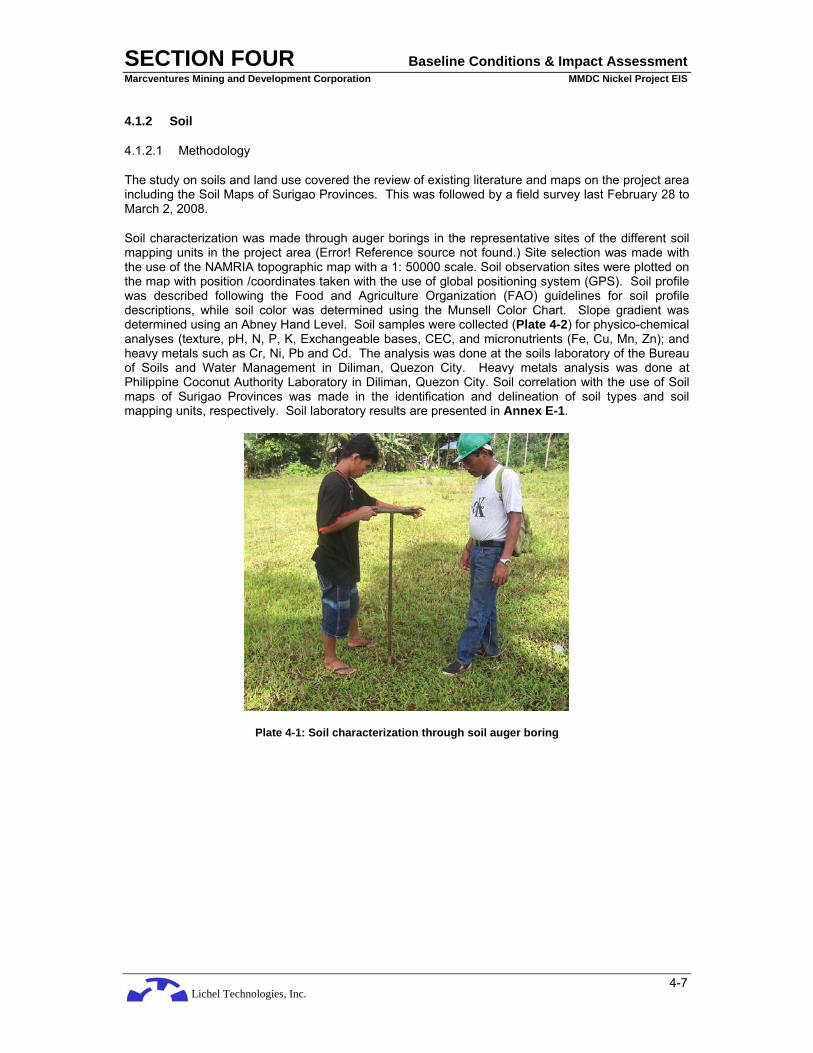
Lichel Technologies, Inc.
SECTION FOUR Baseline Conditions & Impact Assessment Marcventures Mining and Development Corporation MMDC Nickel Project EIS
4-7
4.1.2 Soil
4.1.2.1 Methodology
The study on soils and land use covered the review of existing literature and maps on the project area including the Soil Maps of Surigao Provinces. This was followed by a field survey last February 28 to March 2, 2008.
Soil characterization was made through auger borings in the representative sites of the different soil mapping units in the project area (Error! Reference source not found.) Site selection was made with the use of the NAMRIA topographic map with a 1: 50000 scale. Soil observation sites were plotted on the map with position /coordinates taken with the use of global positioning system (GPS). Soil profile was described following the Food and Agriculture Organization (FAO) guidelines for soil profile descriptions, while soil color was determined using the Munsell Color Chart. Slope gradient was determined using an Abney Hand Level. Soil samples were collected (Plate 4-2) for physico-chemical analyses (texture, pH, N, P, K, Exchangeable bases, CEC, and micronutrients (Fe, Cu, Mn, Zn); and heavy metals such as Cr, Ni, Pb and Cd. The analysis was done at the soils laboratory of the Bureau of Soils and Water Management in Diliman, Quezon City. Heavy metals analysis was done at Philippine Coconut Authority Laboratory in Diliman, Quezon City. Soil correlation with the use of Soil maps of Surigao Provinces was made in the identification and delineation of soil types and soil mapping units, respectively. Soil laboratory results are presented in Annex E-1.
Plate 4-1: Soil characterization through soil auger boring

Lichel Technologies, Inc.
SECTION FOUR Baseline Conditions & Impact Assessment Marcventures Mining and Development Corporation MMDC Nickel Project EIS
4-8
Plate 4-2: Gathering of soil samples for physico- chemical analysis
Existing land uses were identified, described and represented on a map. Land suitability classification was done for the various existing and envisaged vegetation/crops for the project area. Soil erosion susceptibility of the project area was mapped using the soil mapping units generated. For each soil unit, erosion susceptibility was assessed based on a contributing factor taken at a time. The individual susceptibility assessments were then aggregated to form a composite erosion susceptibility score for the soil unit. The contributing factors include rainfall, soil erodibility, vegetation or land use and slope. Impact of the project on soil and vegetation/land use was assessed and mitigation measures were given.
4.1.2.2 Soils of the Project Area
Two soil series with four soil types and soil mapping units were identified and characterized in the project area.
The soil types or soil mapping units are the Kabatohan clay loam, Kabatohan sandy clay loam, Kabatohan clay and San Manuel loam. The Kabatohan soils are the soils of the uplands (hills and mountains) which developed from the weathering of ultramafic rocks, while San Manuel loam is the soil that occur on the alluvial valley/plain which developed from the weathering of alluvial (river) deposits. The Center of Barangay Cabangahan is located on this soil. Figure 4-4 shows the different soil mapping units (SMUs) and location of soil observation points.

Lichel Technologies, Inc.
SECTION FOUR Baseline Conditions & Impact Assessment Marcventures Mining and Development Corporation MMDC Nickel Project EIS
4-9
Figure 4-4: Soil Map (Source: Bureau of Soils and Water Management (BSWM))
Legend : Mapping Symbol Description
KaCL Kabatohan Clay Loam Ka SCL Kabatohan Sandy Clay Loam KaC Kabatohan Clay SnML San Manuel Loam SnMSiL San Manuel Silt Loam
• Obs. Soil Observation Point • Cb Check Boring
Unc. Unclassified/ Not Included in the study
Kabatohan clay loam occurs on the southern mountainous part of the project area. Carac-an river serves as natural soil boundary of this soil type from San Manuel loam and Kabatohan sandy clay loam on the north. Kabatohan clay loam has a clay loam surface horizon over sandy clay loam lower horizons (Table 4-4 and Table 4-5). This soil is well drained with slope ranging from 8 to 18 %. It has a slightly acidic soil reaction (pH 6.1), with low nitrogen, phosphorus and potassium content with 0.03 %, 0.03 parts per million (ppm), and 19.5 ppm, respectively. Cation exchange capacity is very low with only 3.6 milliequivalent per 100 gram (meq/ 100g) soil. Copper and manganese are low with 0.9 and 10.57 ppm, respectively, while zinc and iron are medium with 2.02 and 23.2 ppm, respectively. The natural fertility of this soil is low.
Table 4-4: Particle size distribution and soil textural grades, determined through Bouyoucos-Hydrometer Method
SMU/ location Depth (cm) % Sand % Silt % Clay Textural Grade
KaCl (Obs.1; Area 2)
0-20 20-50
40.6 60.6
28.0 16.0
31.4 23.4
Clay Loam Sandy Clay
Loam
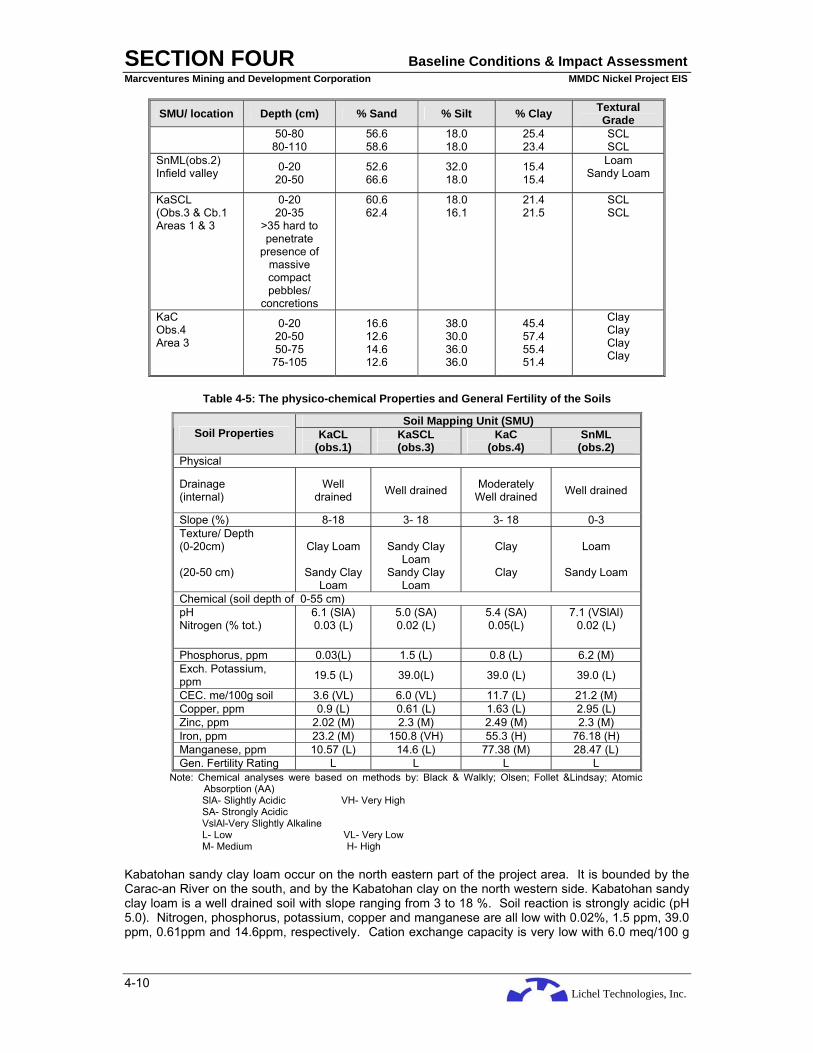
Lichel Technologies, Inc.
SECTION FOUR Baseline Conditions & Impact Assessment Marcventures Mining and Development Corporation MMDC Nickel Project EIS
4-10
SMU/ location Depth (cm) % Sand % Silt % Clay Textural Grade
50-80 80-110
56.6 58.6
18.0 18.0
25.4 23.4
SCL SCL
SnML(obs.2) Infield valley 0-20
20-50 52.6 66.6
32.0 18.0
15.4 15.4
Loam Sandy Loam
KaSCL (Obs.3 & Cb.1 Areas 1 & 3
0-20 20-35
>35 hard to penetrate
presence of massive compact pebbles/
concretions
60.6 62.4
18.0 16.1
21.4 21.5
SCL SCL
KaC Obs.4 Area 3
0-20 20-50 50-75 75-105
16.6 12.6 14.6 12.6
38.0 30.0 36.0 36.0
45.4 57.4 55.4 51.4
Clay Clay Clay Clay
Table 4-5: The physico-chemical Properties and General Fertility of the Soils
Soil Mapping Unit (SMU) Soil Properties KaCL
(obs.1) KaSCL (obs.3)
KaC (obs.4)
SnML (obs.2)
Physical
Drainage (internal)
Well drained Well drained Moderately
Well drained Well drained
Slope (%) 8-18 3- 18 3- 18 0-3 Texture/ Depth (0-20cm) (20-50 cm)
Clay Loam
Sandy Clay
Loam
Sandy Clay
Loam Sandy Clay
Loam
Clay
Clay
Loam
Sandy Loam
Chemical (soil depth of 0-55 cm) pH Nitrogen (% tot.)
6.1 (SlA) 0.03 (L)
5.0 (SA) 0.02 (L)
5.4 (SA) 0.05(L)
7.1 (VSlAl) 0.02 (L)
Phosphorus, ppm 0.03(L) 1.5 (L) 0.8 (L) 6.2 (M) Exch. Potassium, ppm 19.5 (L) 39.0(L) 39.0 (L) 39.0 (L)
CEC. me/100g soil 3.6 (VL) 6.0 (VL) 11.7 (L) 21.2 (M) Copper, ppm 0.9 (L) 0.61 (L) 1.63 (L) 2.95 (L) Zinc, ppm 2.02 (M) 2.3 (M) 2.49 (M) 2.3 (M) Iron, ppm 23.2 (M) 150.8 (VH) 55.3 (H) 76.18 (H) Manganese, ppm 10.57 (L) 14.6 (L) 77.38 (M) 28.47 (L) Gen. Fertility Rating L L L L
Note: Chemical analyses were based on methods by: Black & Walkly; Olsen; Follet &Lindsay; Atomic Absorption (AA) SlA- Slightly Acidic VH- Very High SA- Strongly Acidic VslAl-Very Slightly Alkaline L- Low VL- Very Low M- Medium H- High
Kabatohan sandy clay loam occur on the north eastern part of the project area. It is bounded by the Carac-an River on the south, and by the Kabatohan clay on the north western side. Kabatohan sandy clay loam is a well drained soil with slope ranging from 3 to 18 %. Soil reaction is strongly acidic (pH 5.0). Nitrogen, phosphorus, potassium, copper and manganese are all low with 0.02%, 1.5 ppm, 39.0 ppm, 0.61ppm and 14.6ppm, respectively. Cation exchange capacity is very low with 6.0 meq/100 g
Lichel Technologies, Inc.
SECTION FOUR Baseline Conditions & Impact Assessment Marcventures Mining and Development Corporation MMDC Nickel Project EIS
4-11
soil. Zinc is medium with 2.3 ppm, while iron is very high with 150.8 ppm. The natural fertility of this soil is low.
Kabatohan clay occurs on the north western part of the project area. It is bounded in the north eastern side by the Kabatohan sandy clay loam. Kabatohan clay is a moderately well drained soil with slope ranging from 3 to 18%. Soil reaction is strongly acidic (pH 5.4). Nitrogen, phosphorus, potassium, cation exchange capacity, and copper are all low with 0.5%, 0.8 ppm, 39.0 ppm, 11.7 meq/100 g soil and 1.63 ppm, respectively. Zinc and manganese are medium with 2.49 and 77.38 ppm, respectively. Iron is high with 55.3 ppm. The natural fertility of this soil is low.
San Manuel loam which occurs on the alluvial plain is a very slightly alkaline soil with pH of 7.1. Nitrogen, potassium, copper, and manganese are all low with 0.02%, 39.0 meq., 2.95 ppm and 28.47ppm, respectively. Phosphorus, cation exchange capacity and zinc are medium with 6.2 ppm, 21.2 meq/100 g soil, and 2.3 ppm, respectively. Iron is high with 76.18ppm. The natural fertility of this soil is low.
4.1.2.3 Heavy Metals in Soils
Presence of heavy metals - lead (Pb), cadmium (Cd), chromium (Cr) and nickel (Ni) in the soils were analyzed and the results are presented in Table 4-6. The level of environmental impact is determined by using the Dutch soil standards in the absence of Philippine soil standards.
Table 4-6: Levels of heavy metals per soil observation inside the mineral property
Total Concentration (ppm)- oven dry basis Dutch Soil Standards (DSS) Heavy Metal
Element KaCL Obs.1
0-50 cm
KaSCL Obs.3
0-35 cm
KaC Obs.4
0-50 cm
SnML Obs.2
0-50 cm
Target Value (TV), ppm
Intervention Value (IV),
ppm Lead (Pb) 14.9 <LLD*
(0.008) 25.4 44.1 85 530
Cadmium (Cd) 2.8 2.5 <LLD* (0.002)
2.7 08 12
Chromium (Cr) 10,413.5 65.7 56.9 285.6 100 380 Nickel (Ni) 7,235.8 1,894.6 139.5 679.8 35 210
Note: Method of analysis--- ICP-AES (Inductively-Coupled Plasma Atomic Emission (Spectrometry) *-- <LLD (lesser than the Lower Limit of Detection) Dutch Soil Standards (DSS)
Source: Swarjes, F.A. 1999. Risk-based Assessment of Soil and Groundwater Quality in the Netherlands: Standards and Remediation Urgency. Risk Analysis 19(6): 1235- 1249. Available in http.//www.tiem.utk. edu/~sada/helpv4/ dutch_intervention.html. The Dutch standards are especially applied to soil amelioration work, with two sets of values called the target value (TV) and the intervention value (IV). Site concentrations less than TVs indicate no restrictions necessary; concentration between TVs and IVs suggest further investigation or restrictions may be warranted. Site concentrations exceeding the IV indicate remediation is necessary. Site-specific values based on percent clay and organic matter for metals and percent organic matter for organic compounds may be derived. Target values for soil are related to negligible risk for ecosystem. This is assumed to be 1% of the Maximal Permissible Risk (MPR) level for ecosystem, where MPR is the concentration expected to be hazardous for 5% of the species in the ecosystem, or the 95% protection level. For metals, background concentrations are taken into account in arriving at a value. The relationship between soil concentration and irreparable damage to terrestrial species composition and the relationship between soil concentration and adverse effects on microbial and enzymatic processes were derived to quantify the ecotoxicological effects on ecosystems. The ecological Intervention Value is the concentration expected to be hazardous to 50% of the species in the ecosystem. It cannot be assumed that sensitive species will be protected at the intervention levels.
The results of heavy metal analysis showed that Pb and Cd concentrations of the soils in the project area are lower than the standard values or considered as safe for the ecosystem. Whereas, Cr content in Kabatohan clay loam (obs.1) exceeds more than 100 times the target value (TV) and 26 times more than the intervention value (IV) of the Dutch Soil Standards (DSS); Ni is 206 and 34 times as much of the DSS TV and IV values, respectively. Kabatohan sandy clay loam (obs.3) is also with considerable Ni concentration 50 times greater than the TV and eight (8) times more than the IV. Moreover, Ni concentration in San Manuel loam on the alluvial plain (obs.2) exceeds the TV by 18

Lichel Technologies, Inc.
SECTION FOUR Baseline Conditions & Impact Assessment Marcventures Mining and Development Corporation MMDC Nickel Project EIS
4-12
times and three (3) times more the IV. The Cr and Ni content in Kabatohan clay (obs. 4) is below the TV and IV of the DSS.
4.1.2.4 Soil Suitability Classification
A qualitative suitability classification was made by comparing the plants environmental requirements (Table 4-7) with the physico-chemical properties of the soil units.
Table 4-7: Environmental Requirements of Selected Plants
Plant Slope (%)
Soil Depth (cm) Drainage Soil
pH Soil
Texture Soil
Fertility
Forest tree species >50 > 75 Moderately well to
well drained 5.0–7.5 Loamy to clayey Low to medium
Coconut 0-30 > 75 Moderately well to well drained 5.0–8.0 Loamy to clayey Low to
medium
Banana 0–18 > 75 Moderately well to well drained 5.0–7.0 Sandy loam to clay
loam Medium
Cassava / Sweet Potato 0–18 50 Moderately well to
well drained 5.0–7.5 Loamy to clay Medium to high
Corn 0– 8 > 75 Moderately well to well drained 5.0–7.0 Sandy loam to clay
loam Medium to
high
Paddy rice 0-3 50 Somewhat poorly drained to poorly
drained 5.0-7.5 Sandy clay loam to
clay Medium
Results (Table 4-8) showed that the forest tree species are suitable in all the soils in the project area. All the agricultural crops including coconut and banana are not suitable in all the Kabatohan soils. Appropriate farm inputs should also be provided to attain the desired growth and yield of agricultural crops (corn, cassava and sweet potato) in San Manuel loam.
Corn should be planted during the time of lesser rainfall, that is, during the months of May to September.
Table 4-8: Qualitative Suitability Classification
Plant KaCL (Obsv.1)
KaSCL (Obsv.3)
KaC (Obsv. 4)
SnML (Obsv. 2)
Forest tree Species S S S S
Coconut NS NS NS S*
Banana NS NS NS S*
Cassava / Sweet Potato NS NS NS S*
Corn** NS NS NS S*
Paddy rice NS NS NS S*
Note: S – suitable S* – suitable but needs to apply appropriate farm inputs (fertilizer) to attain
desired growth and yield. Metal toxicity might be a limitation. NS – not suitable ** Should be planted with lesser amount of rainfall (May to September
4.1.2.5 Soil Erosion Susceptibility of the Project Area
The four contributing factors to erosion include rainfall, soil erodibility, vegetation/ land use and slope. To determine the extent of erosion susceptibility within the study area, three (3) degrees of

Lichel Technologies, Inc.
SECTION FOUR Baseline Conditions & Impact Assessment Marcventures Mining and Development Corporation MMDC Nickel Project EIS
4-13
susceptibility are defined for each of the four contributing factors. These are “slightly susceptible” “moderately susceptible” and “highly susceptible”.
Rainfall
For rainfall, the degree rating is shown in Table 4-9. The estimated rainfall in the project area (See Table 4-58) shows that there are seven wet months (more than 200 mm/mo) with December and January having 590 and 676 mm of monthly rainfall, respectively. Based on these rainfall data, the erosion susceptibility rating for the whole project area is “high”.
Table 4-9: Erosion Susceptibility based on Rainfall
Degree of Susceptibility Rainfall Type
Slight Areas with 5 to 6 dry months and 3 to 4 wet months
Areas with 5 to 6 dry months and 5 to 6 wet months Moderate
Areas with 2 to 4 dry months and 5 to 6 wet months Areas with 5 to 6 dry months and 3 to 4 wet months with one or more months of 500mm or more rainfall per month Highl Areas with 5 to 6 dry months and 5 to 6 wet months with one or more months of 500mm or more rainfall per month
Soil Properties
For soil type, the susceptibility score is shown in (Table 4-10). The criteria that were used are the soil depth and clay-silt fraction (See Table 4-1). Based on these criteria, the erosion susceptibility rating for all the soil units in the project area is “slight”.
Table 4-10: Erosion Susceptibility based on Soil Properties
Degree of Susceptibility Soil Depth and Texture
Areas with 50 to 100cm solum and 60 to 100% clay-silt fraction Areas with greater than 100cm solum and 0 to 60 percent clay-silt fraction Slight Unclassified soils of the mountain Areas with 50 to 100cm solum and 0 to 60% clay-silt fraction
Moderate Areas with greater than 100cm solum and 60 to 100% clay-silt fraction
High Areas with less than 50cm solum and 0 to 100% clay-silt fraction
Notes: Solum is made up of surface soil and subsoil. Clay-silt fraction is percent total of clay and silt particles determined through mechanical analysis of topsoil.
Source: Bruce
Vegetation / Land Use
For vegetation/land use, the degree rating is given in Table 4-11, and is shown by vegetation/land use map of the project area (Figure 4-7). There are two types of land cover identified: dense forest, and the subsistence agriculture (corn) on the alluvial plain. The dense forest and the corn farming on flat land (alluvial plain) are slightly susceptible to erosion.
Table 4-11: Erosion Susceptibility based on Vegetation and Crops Grown
Degree of Susceptibility Type of Crops/Ground Cover Areas grown to paddy rice Areas permanently planted to coconut, mixed orchard, fruit trees, etc. Slightly Areas covered with dense forest, tall grasses and pine trees Areas grown to sugar cane Open grassland Moderately Areas with thin growth of deciduous forest with scattered kaingin

Lichel Technologies, Inc.
SECTION FOUR Baseline Conditions & Impact Assessment Marcventures Mining and Development Corporation MMDC Nickel Project EIS
4-14
Degree of Susceptibility Type of Crops/Ground Cover clearings Areas, sloping planted to coconut or fruit trees intercropped with upland row crops (corn, cassava, sweet potato, etc.) Areas of diversified upland row crops – corn, upland rice, mungbean, pineapple, etc. Areas planted to tobacco Highly
Areas with thin growth of short grasses with patches of kaingin clearings Source: Bruce
Slope
As shown by the slope map (Figure 4-5), and based on Table 4-12, Kabatohan soils with less than 8% slope are slightly susceptible to erosion. The ones with slope ranging from 8 to 18% are moderately susceptible to erosion, and the Kabatohan soils with more than 18% slope are highly susceptible to erosion. The San Manuel loam on alluvial plain with 0 to 1% slope is slightly susceptible to erosion.
Figure 4-5: Slope Map Mapping Symbol Slope Range (%) Description
M 0-3 Level to nearly level N 3-8 Gently Sloping to Undulating O 8-18 Undulating to rolling P 18-30 Rolling to moderately steep Q 30-50 Steep R >50 Very steep Unc. --- Unclassified

Lichel Technologies, Inc.
SECTION FOUR Baseline Conditions & Impact Assessment Marcventures Mining and Development Corporation MMDC Nickel Project EIS
4-15
Table 4-12: Erosion Susceptibility based on Slope
Degree of Susceptibility Slope Range
Slight Areas with slope between 0 and 8%
Moderate Areas with slope between 8 and 18%
High Areas with slope greater than 18% Source: Bruce
4.1.2.6 Final Erosion Susceptibility Rating
The four (4) erosion susceptibility ratings of each soil unit are aggregated to form the final rating consistent with Table 4-13, which shows the decision rule on the composite or final erosion susceptibility index. The Soil Erosion Susceptibility Map (Figure 4-6) displays the result of erosion susceptibility ratings.
As shown by the Erosion Susceptibility Map, all the areas with less than 8% slope in all the soil mapping units are slightly susceptible to erosion. Other areas with more than 8% slope are moderately susceptible to erosion. The dense growth of forest reduced the risk of the upland to erosion.
Table 4-13: Composite Erosion Susceptibility Decision Rule
Individual Susceptibilities (Rainfall – land use – slope – soil) Final Degree of Erosion Susceptibility
S – S – S – S Slightly
M – M – M – M Moderately
H – H – H – H Highly
H – M – H – H Highly
H – S – M – M Moderately
H – M – M – H Moderately Note: S is slightly susceptible, M- moderately susceptible, and H- highly susceptible. Source: Bruce.

Lichel Technologies, Inc.
SECTION FOUR Baseline Conditions & Impact Assessment Marcventures Mining and Development Corporation MMDC Nickel Project EIS
4-16
Figure 4-6: Erosion Susceptibility Map Mapping Symbol Description
Ss Slightly susceptible Ms Moderately susceptible Unc. Unclassified
4.1.2.7 Present Vegetation / Land Use of the Project Area
The project area is dominantly covered with dense forests (residual/ secondary) of various tree species (such as Mangkono, Paguspus, Mountain Agoho and Bunia Pines) (Figure 4-7 and Plate 4-3 and Plate 4-4); with few patches of shrubs, and open grassland (i.e. talahib and cogon). Giant ferns are also present inside the forest area. The San Manuel loam on the alluvial plain is being used for corn and other vegetables when water is available, i.e., during rainy season. Irrigated paddy rice occupies the broad alluvial plain outside the project area, with some portions planted to coconut and other agricultural crops. Alamio and Carac-an rivers are the primary sources of irrigation water for the rice fields of Cantilan and Madrid.

Lichel Technologies, Inc.
SECTION FOUR Baseline Conditions & Impact Assessment Marcventures Mining and Development Corporation MMDC Nickel Project EIS
4-17
Figure 4-7: Present Land Use/Vegetation Map (Source: BSWM)
Mapping Symbol Description Forest Residual/Secondary
C/V Corn/ Vegetable Area
Plate 4-3: The forest cover of Area 1
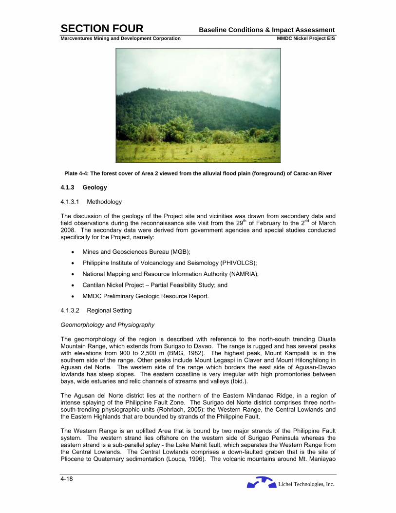
Lichel Technologies, Inc.
SECTION FOUR Baseline Conditions & Impact Assessment Marcventures Mining and Development Corporation MMDC Nickel Project EIS
4-18
Plate 4-4: The forest cover of Area 2 viewed from the alluvial flood plain (foreground) of Carac-an River
4.1.3 Geology
4.1.3.1 Methodology
The discussion of the geology of the Project site and vicinities was drawn from secondary data and field observations during the reconnaissance site visit from the 29th of February to the 2nd of March 2008. The secondary data were derived from government agencies and special studies conducted specifically for the Project, namely:
• Mines and Geosciences Bureau (MGB);
• Philippine Institute of Volcanology and Seismology (PHIVOLCS);
• National Mapping and Resource Information Authority (NAMRIA);
• Cantilan Nickel Project – Partial Feasibility Study; and
• MMDC Preliminary Geologic Resource Report.
4.1.3.2 Regional Setting
Geomorphology and Physiography
The geomorphology of the region is described with reference to the north-south trending Diuata Mountain Range, which extends from Surigao to Davao. The range is rugged and has several peaks with elevations from 900 to 2,500 m (BMG, 1982). The highest peak, Mount Kampalili is in the southern side of the range. Other peaks include Mount Legaspi in Claver and Mount Hilonghilong in Agusan del Norte. The western side of the range which borders the east side of Agusan-Davao lowlands has steep slopes. The eastern coastline is very irregular with high promontories between bays, wide estuaries and relic channels of streams and valleys (Ibid.).
The Agusan del Norte district lies at the northern of the Eastern Mindanao Ridge, in a region of intense splaying of the Philippine Fault Zone. The Surigao del Norte district comprises three north-south-trending physiographic units (Rohrlach, 2005): the Western Range, the Central Lowlands and the Eastern Highlands that are bounded by strands of the Philippine Fault.
The Western Range is an uplifted Area that is bound by two major strands of the Philippine Fault system. The western strand lies offshore on the western side of Surigao Peninsula whereas the eastern strand is a sub-parallel splay - the Lake Mainit fault, which separates the Western Range from the Central Lowlands. The Central Lowlands comprises a down-faulted graben that is the site of Pliocene to Quaternary sedimentation (Louca, 1996). The volcanic mountains around Mt. Maniayao

Lichel Technologies, Inc.
SECTION FOUR Baseline Conditions & Impact Assessment Marcventures Mining and Development Corporation MMDC Nickel Project EIS
4-19
(an andesitic dome) separate the Central Lowland strip into two sub-units, Lake Mainit in the south and the Lowlands to the north (UNDP, 1987). Lake Mainit drains to the south along the Tubay River. The river follows the Lake Mainit Fault on the western margin. The Eastern Highlands comprise the northern end of the Diuata Range which extends southward along the East Mindanao Ridge.
The project area is situated on the eastern edge of the Diuata Mountain Range and is principally drained by the Carac-an and Alamio Rivers that form the Carrascal-Cantilan lowlands.
There is no published regional geomorphologic map, hence, the geomorphological units described in are indicated in a relief map and is shown in Figure 4-8 which only covers Northeast Mindanao, and therefore, the southern portion of Diuata Mountain Range where Mt. Kampalili is located is not shown.
Tectonic Setting
The Project is located in Northeastern Mindanao Island. Mindanao is the largest island in the southern Philippine Archipelago. It is a composite of at least two terrains: the western Mindanao that has a Eurasian affinity, and the eastern Mindanao that belongs to the Philippine Mobile Belt (PMB) of Philippine Sea Plate affinity. The Eurasian Area basement includes metamorphosed sedimentary rocks of continental origin exposed only in the Zamboanga peninsula. The PMB basement consists of ophiolitic rocks and greenschist metavolcanics of supposed Cretaceous – Paleogene age (Sajona et al., 1993 and 1994).
The major tectonic features in Mindanao are the four subduction zones, namely: the Philippine Trench to the east; the Sulu Trench to the northwest; the Cotabato Trench to the southwest; and the Davao Trench to the south. Figure 4-9 shows the location of the trenches.
The Philippine Trench lies along the eastern edge of the Philippine Islands. The depth of the trench floor averages 10,000 m. At 9°22’ N, a depth of 10,100 m is recorded, making the trench among the deepest in the world (Lallemand, S.E. et al., 1998). The Philippine Trench is the result of westward underthrusting of the Philippine Sea Plate. Associated with this underthrusting are shallow and intermediate depth earthquakes, to a depth of about 200 km, and active volcanism (Acharya, 1980). Subduction along the Philippine Trench probably started around four million years ago. The convergence rates as accommodated by the Philippine Trench decrease northward from about 80 mm/yr at 10°N latitude to 65 mm/yr north of Luzon (Thenhaus, 1994).
The Sulu Trench is located west of Mindanao Island. Little seismic activity can be attributed to this Trench. The historical volcanism of Budajo is believed to be due to the south-eastward subduction from the Trench (Mangao et al., 1994).
Located southwest of Mindanao, the Cotabato Trench is a depression which is approximately four kilometers deep at the northeastern edge of the Celebes Sea basin. Together with the Daguma Range, the Trench comprises the Cotabato Trench-Arc System (Ibid.).
The Davao Trench is a narrow depression more than 2 km deep. Its southern tip connects with the Gorontalo Basin between the northern and southern portions of Sulawesi. Its northern portion connects with the Davao Gulf which in turn is linked with the Agusan-Davao Basin. Under the Sangihe Islands, the seismic zone dips to about 55°. It dips to about 65° in Mindanao (Ibid.).
Traversing the PMB is the 1,600-km long Philippine Fault. This sinistral strike-slip wrench fault starts from Lingayen Gulf in Pangasinan, north Luzon to the offshore Pujada Peninsula in the southeastern Mindanao. The faults and splay comprising the zones are characterized by fault-line scarps, fault troughs and valleys, side hill ridges, fault sags, sag ponds and stream offsets (Ibid.)
Nickel laterites are the product of lateritization of magnesium-rich or ultramafic rocks such as dunites, harzburgites and peridotites which is a suite of an ophiolite complex. In the regional tectonic context, the East Mindanao ophiolite belt which is the backbone of the East Mindanao ridge and where the project area is situated was formed as a result of the emplacement of ophiolitic sheets on an older volcanosedimentary arc terrane during late Cretaceous to possibly Eocene times. Uplift and subsequent weathering of the ultramafic rocks produced the laterite deposit.

Lichel Technologies, Inc.
SECTION FOUR Baseline Conditions & Impact Assessment Marcventures Mining and Development Corporation MMDC Nickel Project EIS
4-20
Seismicity
The active subduction zones and faults are also the earthquake generators in the Philippines as shown in Figure 4-10 which focuses on Eastern Mindanao and shows in finer detail the active faults in the region area.
The Southeast Asia Association of Seismology and Earthquake Engineering (SEASEE, 1985) identified six generators of earthquakes in Mindanao. These are:
• Philippine Trench – This is the most seismically active generator in the Philippines. It marks the trace of westward subduction of the Eocene oceanic crust of the west Philippine Basin beneath the Philippine arc. The Trench accounts for most of the seismic events that hit eastern Mindanao. Examples are the earthquakes of 1921, 1924, 1929, 1952, 1989, and 1992 (Mangao et al., 1994; Manahan et al., 1995).
• Philippine Fault Zone - The left lateral Philippine Fault Zone (PFZ) is about 1,600 km long, extending from Lingayen Gulf in Western Luzon and through the offshore Pujada Peninsula (Mangao, et al., 1994). At the project region, PFZ can be traced from the east side of the Malimono Ridge or west Lake Mainit and traverses the Agusan Valley floor in a NW direction. Another fault west of the ridge parallels the main trace and becomes indistinct in the town of Cabadbaran.
Some of the earthquake events associated with the Philippine fault are the 1879 Surigao earthquake, 1911 Agusan Valley earthquake, 1924 earthquake with Ms 7.9 in Mati, and 1990 earthquake in Agusan del Norte (Ibid., 1994; Manahan et al., 1995). The displacement along the Philippine Fault Zone decouples the northwestward movement of the Pacific plate and the southeastward movement of the Eurasian plate (Rimando, 1994).
A branch of the main PFZ splays near the Bayugan Township (Agusan del Sur) and swerves into the southeast towards the coastal town of Lianga some 70 kilometers south of the project area. An Ms 5.1 earthquake originating near the splay occurred on 07 June 1999 damaged Bayugan. After two days in June 9, an aftershock occurred and damaged the town of Talacogon also in Agusan del Sur.
An earthquake registering Ms 4.2 originating from the Lianga Fault was recorded on 13 May 2000 (PHIVOLCS). No damage was recorded during this event.
• Cotabato Trench – Together with the Daguma Range, the Cotabato Trench comprises the Cotabato Trench-Arc System. It is a depression which is approximately 4km deep at the northeastern edge of the Celebes Sea basin.
• Davao Trench – A narrow depression more than 2 km deep, this Trench has a southern tip that connects with the Gorontalo Basin between the northern and southern portions of Sulawesi. Its northern portion connects with the Davao Gulf which in turn is linked with the Agusan-Davao Basin. Under the Sangihe Islands, the seismic zone dips to about 55°. It dips to about 65° in Mindanao. Aside from a 71 km deep event, there were no deep-focus quakes beneath Central Mindanao.
• Sulu Trench – Little seismic activity can be attributed to the Sulu Trench though the historical volcanism of Budajo may be attributed to the south-eastward subduction from the Trench.
• Mindanao Fault – This is one of the major lineaments in the country. Physically traced to approximately 400 km, it is a NW-SE trending fault extending from northern Zamboanga Peninsula to eastern Cotabato.
The distribution of historical earthquakes in the region with magnitudes of Ms 5 and above and covering the period 1973 to present (NEIC) is shown in Figure 4-11. Seven hundred twenty-eight (728) earthquakes of magnitude > Ms 5 occurred in the region with the latest event (Ms 5.2) recorded to have occurred on 26 February 2008 in the Pacific Ocean some 120 km southeast of the project area. Seismic events with moderate to deep (>150 km) foci suggest association with active convergence along the Davao Trench and the Philippine Trench. Shallow (<70 km) seismic events appear to have originated from movement associated with the Philippine Fault and its major splays.

Lichel Technologies, Inc.
SECTION FOUR Baseline Conditions & Impact Assessment Marcventures Mining and Development Corporation MMDC Nickel Project EIS
4-21
Estimates of the recurrence interval for earthquakes of a given range of magnitude (Ms) were calculated using the annual rates of earthquake activity values derived by Thenhaus et al (1994). For zones within the Project area, results are summarized in .
Table 4-14.
Table 4-14: Recurrence Interval for Earthquakes of a Given Magnitude Range
Seismic Source Region 3 (southern segment of the
Philippine Fault) Seismic Source Region 17 (Philippine
Trench) Magnitude, Ms
Annual Rates (Frequency/yr)
Interval (years)
Annual Rates (Frequency/yr) Interval (years)
5.8 to < 6.4 0.19863 5 0.30990 3
6.4 to < 7.0 0.07444 13 0.10646 9
7.0 to < 7.3 0.0.2791 36 0.03658 27
7.3 to < 8.2 0.01946 51 0.01256 80

Lichel Technologies, Inc.
SECTION FOUR Baseline Conditions & Impact Assessment Marcventures Mining and Development Corporation MMDC Nickel Project EIS
4-22
Figure 4-8: Generalized Regional Geomorphologic Map of Northeast Mindanao

Lichel Technologies, Inc.
SECTION FOUR Baseline Conditions & Impact Assessment Marcventures Mining and Development Corporation MMDC Nickel Project EIS
4-23
Figure 4-9: Active Faults and Trenches in the Philippines

Lichel Technologies, Inc.
SECTION FOUR Baseline Conditions & Impact Assessment Marcventures Mining and Development Corporation MMDC Nickel Project EIS
4-24
Figure 4-10: Active Faults in Eastern Mindanao

Lichel Technologies, Inc.
SECTION FOUR Baseline Conditions & Impact Assessment Marcventures Mining and Development Corporation MMDC Nickel Project EIS
4-25
Figure 4-11: Regional Seismicity Map

Lichel Technologies, Inc.
SECTION FOUR Baseline Conditions & Impact Assessment Marcventures Mining and Development Corporation MMDC Nickel Project EIS
4-26
Lithology and Stratigraphy
This section adopts the stratigraphic nomenclature used in the geological studies by BMG (1981) on the Northern Diuata Range. The stratigraphic nomenclature is shown in Table 4-15.
The oldest rocks in the region are the basement rocks composed of greenschist and amphibolite schist, and including metasedimentary and metavolcanic rocks (Sohotan Formation) of Cretaceous age. The basement sequence is over-thrust by basalts and imbricated ophiolite slabs that occupy a NNW-SSE-trending zone along the coastal fringe of the Eastern Highlands including the islands of Buca Grande, Hinatuan, Nonoc and Dinagat (Louca, 1996). The thrusted ultramafic rocks which include serpentinized peridotites (harzburgite) and dunites are overlain in Surigao del Norte by calcareous conglomerates of the Madanlog Formation of Upper Eocene age. The ultramafic emplacement probably took place during Late Cretaceous time.
During the Oligocene through to Lower Miocene, a mixed volcano-sedimentary assemblage of basaltic flows and breccias, limestones, limestone conglomerates, wackes, siltstones, and muddy limestones of the Bacuag Formation were deposited in the Surigao District. The Siana Formation which hosts the carbonate-replacement mineralization in the Siana mine form part of the Bacuag Formation.
The Bacuag Formation in Surigao is overlain by a Lower to Upper Miocene turbidites comprising a basal limestone conglomerate, and overlying turbidite wackes, siltstones, calcsiltites, marls, and local pebble conglomerates. It reaches a maximum thickness of 700 meters (UNDP, 1987).
During the Pliocene, andesitic and minor dacitic pyroclastic eruptions and lava flows occurred throughout much of the Surigao district and were largely re-deposited as a thick epiclastic mass flow sequence below sea-level, but with some deposited in fluviatile environments (Ibid.). Known as the Mabuhay Clastics, this formation consists of boulder beds, calcareous rocks, pyroclastics, conglomerates and minor lava flows and intrusions.
During the Upper Pliocene to Lower Quaternary, the Mabuhay Clastics were overlain by the Hinatigan Marl and the massive coralline and algal Timamana Limestone. The limestone is commonly unconformable on older Bacuag Formation and turbidites. The Upper Quaternary Tugunan Formation in the Surigao district comprises clastic sedimentary rocks that are intruded by biotite-hornblende andesites of the Mt. Maniayao Andesite. Unconformably overlying the Tugunan and the Maniayao is the moderately dipping Mainint Formation of Santos et al. which consists of conglomerate, sandstone and shale. It is dated Pleistocene
The youngest lithological unit of Holocene Age consists of alluvial deposits that occupy floodplains, alluvial fans, and river and beach deposits. The nickeliferous laterites which are residual products developed in-situ during the tropical chemical weathering of the serpentinized ultramafic rocks and are also dated Holocene.
Table 4-15: General Stratigraphy of the Eastern Mindanao (BMG, 1982)
Age Lithologic Unit / Description
Holocene (youngest)
Quaternary Alluvium and Corals - Clay and silty soil; flood plain, alluvial fans, river and beach sand and gravel; swamp deposits, and coral reefs composed of recent deposits.
Terrace Gravel – These recent gravels are widespread at the northern end of Surigao del Norte, mostly boulder with sand and clay.
Nickeliferous Laterite Deposits.

Lichel Technologies, Inc.
SECTION FOUR Baseline Conditions & Impact Assessment Marcventures Mining and Development Corporation MMDC Nickel Project EIS
4-27
Age Lithologic Unit / Description
Pleistocene Placer Conglomerate – This is named after the conglomerates with lenses of shale and sandstone in Placer, Surigao del Norte. The clasts of the conglomerate range from angular to subangular and granular to boulder size. Sorting is poor and beddings become apparent only where there are lenses of sandstone and shale. It is approximately 100 m thick.
Mainit Formation – Conglomerate, sandstone, and shale
Pliocene Maniayao Andesite – Prominent andesitic dome north of Lake Mainit. Tugunan Formation – Highly folded tuffaceous sediments ranging from shale to
poorly sorted sandstone and conglomerate.
Miocene Mabuhay Andesite - Lies in the eastern highlands along the east coast of Surigao Peninsula.
Timamana Limestone - It extends as a continuous belt from Timamana, Surigao del Norte to the Surigao-Agusan del Norte boundary and may also extend to Agusan del Sur.
Mabuhay Formation – Interbedded shales, sandstones, and arkosic limestone. Bacuag Formation - It consists of clastics and basalt flows and agglomerates.
These clastics are made up of conglomerate, sandstone and shale with lenses of limestone. Thickness is over 1,000 m. It was deposited in a shallow to moderately deep neritic sea.
Oligocene Siana - The formation consists of light gray to black, massive limestone with cherty lenses and greenish gray or black shale.
Cretaceous Sohotan Formation - The metavolcanic rocks are interbedded with metasedimentary rocks which are composed of marble, conglomerate, sandstone and shale.
Cretaceous (oldest)
Ultramafics - The ultramafic rocks of various phases almost make up the greater portion of Surigao Peninsula and the islands north of it. The serpentinized peridotite, pyroxenite, dunite and serpentinite with gabbro comprise the mafic-ultramafic suite. The ultramafic intrusion in Surigao took place during the Late Cretaceous.
Amphibolite schist/ Greenschist
A regional geologic map of Eastern Mindanao by Rohrlach (2005) which shows the distribution of the major rock units is shown in Figure 4-12.
Structures
The regional geologic structures also shown in Figure 4-12 are the north-south to NNW-SSE-trending strike-slip faults of the Philippine Fault system. Its morphologic expressions are fault scarps, sag ponds and compressive ridges. The exact delineation and character of the Philippine Fault in Mindanao are up to present very controversial (Aurelio, 2000). Field studies coupled with remote sensing data (Pubellier et al., 1991) show that the fault bounds the eastern flank of the Agusan-Davao Basin. In Surigao, the fault strikes N10-20 degrees west.
4.1.3.3 Local Setting
Topography and Drainage
Figure 4-13 is a NAMRIA topographic map of the project site. The project area possesses a moderate to rugged mountainous topography characterized by steep slopes, deeply incised valleys, ridges and peaks. Elevation range from about 40 meters above sea level (masl) along the flood plains of major rivers to as high as 750 masl at the southern portion of the project area. Ridges are generally broad with rounded peaks which are at higher elevations towards the south.

Lichel Technologies, Inc.
SECTION FOUR Baseline Conditions & Impact Assessment Marcventures Mining and Development Corporation MMDC Nickel Project EIS
4-28
Three major river systems drain the project area, namely: the Carac-an River, the Alamio River and the Binoni River. The eastward flowing Carac-an River is the largest river system that drains the central and southern part of the project area. At Barangay Cabangahan, the Carac-an River floodplain broadens to over one kilometer. The Alamio River drains the northern section while the Binoni River drains a small northeast corner of the project area. Tributaries form a dendritic to rectangular patterns suggesting structural control over the project area.
Stratigraphy
The geology of the project area is represented by four rock units. As shown in Figure 4-14, these rock units are presented in descending geologic age as follows: Quaternary alluvium, Oligocene-Miocene Limestone, Cretaceous metavolcanics and Cretaceous-Paleogene ultramafics. Geologic cross sections of Area 2 exploration area are shown in Figure 4-15.
Quaternary Alluvium
The Quaternary alluvium is made up of unconsolidated sand and gravel deposited by the fluvial systems along the valley floor and alluvial plains. The gravel deposits are polymic and polymodal. The gravel fragments reflect the bedrock of the highland source with the individual rock fragments mainly subrounded to rounded. The sands are mainly course to medium gained comprising of well rounded lithic fragments and mafic mineral.
Along the footslopes and margins of the valley floor, the alluvial deposits associate with the colluvial debris. Sedimentary components are subangular with coarse gravel to bounder-sized fragments predominant.
Oligocene-Miocene Limestone
Residual hills at the eastern peripheries of the project area are underlain by the thick massive reefal limestone that has been dated Oligocene-Miocene in age. The limestone is dense, buff to yellowish in color and is usually fossiliferous containing foraminiferas and corals.
Cretaceous Metavolcanics
Generally massive, fine to medium grained andesitic metavolcanics are locally exposed within the project area. The rocks have generally undergone deep weathering, and when fresh, it exhibit chloritization as the most dominant alteration.
Cretaceous-Paleogene Ultramafics
The ultramafics consisted mainly of peridotite of predominantly dunite to harzburgite composition exposed on the eastern edge of MPSA area. Schist forms a thin fringe along the western margin of the peridotite and occurs parallel to the thrust faults.
The peridotite roughly forms an elongated Area trending northeasterly. It conforms to the directions of the thrust and normal faults. It forms a major Area of the ultramafic belt in the project area. It is cut by major fault zone where the Carac-an River flows towards Madrid Municipality in the east-southeast.
Structures
The dominant structural features in the project area are thrust, normal and strike-slip faults (Figure 4-14). The thrust faults have general northeast-southwest orientation and are dissected by the younger normal and strike-slip faults.
Within the project area, the occurrence of thrust faults serves as geological contact between the ultramafics and metavolcanics. The emplacement of the ultramafics, as commonly observed in other ultramafic belts, occurs with the development of the thrust faulting in the area.

Lichel Technologies, Inc.
SECTION FOUR Baseline Conditions & Impact Assessment Marcventures Mining and Development Corporation MMDC Nickel Project EIS
4-29
Normal faulting in the project area appears consistent with those found in the Surigao Provinces. It consists of northwest-southeast and northeast-southwest systems of parallel and steeply dipping faults.
A northeast-southwest trending strike-slip fault crosses the project area. This fault is associated with fractures zones which trend generally perpendicular. The fracture zones are interpreted to be tensional cracks of the major structural lines.

Lichel Technologies, Inc.
SECTION FOUR Baseline Conditions & Impact Assessment Marcventures Mining and Development Corporation MMDC Nickel Project EIS
4-30
Figure 4-12: Generalized Regional Geologic Map of East Mindanao

Lichel Technologies, Inc.
SECTION FOUR Baseline Conditions & Impact Assessment Marcventures Mining and Development Corporation MMDC Nickel Project EIS
4-31
Figure 4-13: Topographic and Drainage Map

Lichel Technologies, Inc.
SECTION FOUR Baseline Conditions & Impact Assessment Marcventures Mining and Development Corporation MMDC Nickel Project EIS
4-32
Figure 4-14: Geologic Map of the Project Area

Lichel Technologies, Inc.
SECTION FOUR Baseline Conditions & Impact Assessment Marcventures Mining and Development Corporation MMDC Nickel Project EIS
4-33
Figure 4-15: Geologic Cross Section of Area 2 Exploration Area

Lichel Technologies, Inc.
SECTION FOUR Baseline Conditions & Impact Assessment Marcventures Mining and Development Corporation MMDC Nickel Project EIS
4-34
Detailed Geology
The following discussion on detailed geology is taken from the Geologic Report prepared by Tomas Malihan (1997) for MMDC.
The oldest rock unit in the project area is the dunite, which is exposed at the north-central, northeastern and southwestern sector of Area-1 (see Figure 4-14). It has a greenish black to dark gray color with fine to medium grained equigranular texture. It is chiefly composed of olivine with minor amounts of medium grained crystals of orthopyroxene and clinopyroxene locally creating a porphyritic texture. Magnetite and chromite occur as accessory minerals. Serpentinization ranges from weak to strong. Floats of dunite are common in Area-2 although no dunite outcrops were observed.
Stratigraphically, the peridotite is the most dominant lithology in the project area. It has a dark gray to greenish gray color, has fine to coarse-grained equigranular texture and exhibits moderate to total serpentinization. A specimen of peridotite was collected in Area 2 (Plate 4-5) during the fieldwork conducted on 02 March 2008 and was taken to the MGB Petrolab for chemical analysis (Annex E-2). The results of the analysis are given below.
Table 4-16: Chemical Analysis of Rock Sample
Parameter Unit Concentration Method of Analysis
SiO2 % 39.26 Gravimetric
Al2O3 % 11.48 Gravimetric
FeT % 6.13 Flame Atomic Absorption Spectrometer
MgO % 10.63 Gravimetric
Mn ppm 895 Flame Atomic Absorption Spectrometer
Zn ppm 37 Flame Atomic Absorption Spectrometer
Pb ppm <10 Flame Atomic Absorption Spectrometer
Ni ppm 3545 Flame Atomic Absorption Spectrometer
Cr ppm 320 Flame Atomic Absorption Spectrometer
A unit of quartz-chlorite schist is exposed locally along the bank of Alamio River (Plate 4-6) and Kauyangan Creek at the northwestern part of Area 1. The schist is blue green, notably hard and has well pronounced schistocity that strikes N50°W and has a vertical dip. The schist marks the transition of the lithology from peridotite to metavolcanics in the northwestern part of Area 1.
The metavolcanics are chiefly composed of regionally metamorphosed andesite which is fine to medium grained and locally porphyritic texture. It contains relic phenocrysts of plagioclase and hornblende in a fine-grained chloritized groundmass.

Lichel Technologies, Inc.
SECTION FOUR Baseline Conditions & Impact Assessment Marcventures Mining and Development Corporation MMDC Nickel Project EIS
4-35
Plate 4-5: Peridotite outcrop at Dawas-Dawas Creek near the exploration camp at Area 2
Plate 4-6: Quartz-chlorite schists at the banks of Alamio River west of Area 3
East of Area 1, the peridotite is in contact with limestone which forms prominent ridges. The limestone is pink and typically recrystallized with medium grained calcite crystals. Fossils of mollusks and foraminifera are locally recognizable. The same limestone was encountered along Carac-an River outside the eastern boundary of Area 2 (Plate 4-7).
Alluvium consisting of unconsolidated silt, cobbles and boulders is extensively deposited along the flood plains and channels of Carac-an (Plate 4-8) and Alamio Rivers. The alluvium deposits of Carac-an River have been periodically panned for placer gold.
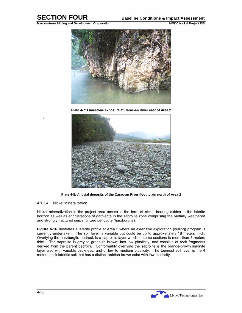
Lichel Technologies, Inc.
SECTION FOUR Baseline Conditions & Impact Assessment Marcventures Mining and Development Corporation MMDC Nickel Project EIS
4-36
Plate 4-7: Limestone exposure at Carac-an River east of Area 2
Plate 4-8: Alluvial deposits of the Carac-an River flood plain north of Area 2
4.1.3.4 Nickel Mineralization
Nickel mineralization in the project area occurs in the form of nickel bearing oxides in the laterite horizon as well as encrustations of garnierite in the saprolite zone comprising the partially weathered and strongly fractured serpentinized peridotite (harzburgite).
Figure 4-16 illustrates a laterite profile at Area 2 where an extensive exploration (drilling) program is currently undertaken. The soil layer is variable but could be up to approximately 18 meters thick. Overlying the harzburgite bedrock is a saprolitic layer which in some sections is more than 8 meters thick. The saprolite is grey to greenish brown; has low plasticity, and consists of rock fragments derived from the parent bedrock. Conformably overlying the saprolite is the orange-brown limonite layer also with variable thickness, and of low to medium plasticity. The topmost soil layer is the 4 meters thick lateritic soil that has a distinct reddish brown color with low plasticity.
.
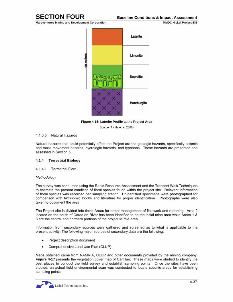
Lichel Technologies, Inc.
SECTION FOUR Baseline Conditions & Impact Assessment Marcventures Mining and Development Corporation MMDC Nickel Project EIS
4-37
Figure 4-16: Laterite Profile at the Project Area Source (Arcilla et al, 2008)
4.1.3.5 Natural Hazards
Natural hazards that could potentially affect the Project are the geologic hazards, specifically seismic and mass movement hazards, hydrologic hazards, and typhoons. These hazards are presented and assessed in Section 5.
4.1.4 Terrestrial Biology
4.1.4.1 Terrestrial Flora
Methodology
The survey was conducted using the Rapid Resource Assessment and the Transect Walk Techniques to estimate the present condition of floral species found within the project site. Relevant information of floral species was recorded per sampling station. Unidentified specimens were photographed for comparison with taxonomic books and literature for proper identification. Photographs were also taken to document the area.
The Project site is divided into three Areas for better management of fieldwork and reporting. Area 2 located on the south of Carac-an River has been identified to be the initial mine area while Areas 1 & 3 are the central and northern portions of the project MPSA area.
Information from secondary sources were gathered and screened as to what is applicable to the present activity. The following major sources of secondary data are the following:
• Project description document
• Comprehensive Land Use Plan (CLUP)
Maps obtained came from NAMRIA, CLUP and other documents provided by the mining company. Figure 4-17 presents the vegetation cover map of Cantilan. These maps were studied to identify the best places to conduct the field survey and establish sampling points. Once the sites have been studied, an actual field environmental scan was conducted to locate specific areas for establishing sampling points.

Lichel Technologies, Inc.
SECTION FOUR Baseline Conditions & Impact Assessment Marcventures Mining and Development Corporation MMDC Nickel Project EIS
4-38
Figure 4-17: Vegetation Cover Map

Lichel Technologies, Inc.
SECTION FOUR Baseline Conditions & Impact Assessment Marcventures Mining and Development Corporation MMDC Nickel Project EIS
4-39
Sampling was done through random sampling and establishing sampling points along the transects, which are basically the trail system of the area. Existing trail systems were used as transects because it would not require the destruction of vegetation if a true transect line was established, and the trail system would facilitate the traversing of the project site in terms of time. The abundance of species found therein were taken / recorded through counting of individuals per species. The locations of the sampling points and transects are shown in Figure 4-18.
One way of sampling the sites to get an indicative picture of the landscape in terms of vegetation composition is the TRANSECT WALK. The transect walk is a rapid biodiversity assessment technique that employs a hike, recording of species and physical attributes, and no sampling plots. In other words, it is a “walk through” sampling.
The technique starts out as a hike through the area following the access roads and pathways around and within the site. Species are listed down as the team traverses the area. No replicate of species are recorded. This way, species not included in the sampling points may still be included in the overall description/characterization of the site.
Sampling points are distributed within the project site as follows (Refer to Figure 4-18):
• Area 2 (initial mine area): Sampling stations 1, 2, 3 and 4
• Area 1: Sampling stations 5, 6, 7 and 8
• Area 3: Sampling stations 9 and 10 (Carrascal Jurisdiction)
• Proposed Jetty: Sampling station 11
The following parameters were taken and computed for the importance values. The importance values would determine the ranks of the species within the sampled ecosystem and would identify which of them would be exerting the most influence to the ecosystem in terms of nutrient cycling, energy transfer, and micro-climatic effects. The following parameters and their respective formulae are as follows:
Abundance = total no. of individuals in a species per sampling point
Frequency (Freq) = Number of times the species occurred in all points x 100 Number of points
Relative Abundance (RAbun) = Abundance X 100 Total Abundance
Relative Frequency (RFreq) = Freq X 100 Total Freq
Importance Value (IV) = Rden + Rfreq 2
Field Analysis and Observation
Primary method in the field is the ocular observation and enumeration / counting of individuals around the established sampling points. Abundance measures are taken without the benefit of confined space, in other words, it is a plotless sampling technique, which is used here.
Obtained abundance values are run in the BD Pro Beta 2 (McAleece et al 1998) software to determine diversity and evenness indices such as the following:
Shannon-Weiner Index (H’). It is a measure of the average degree of “uncertainty” in predicting to what species an individual chosen at random from a collection of S species and N individuals will belong (Magurran 1988).

Lichel Technologies, Inc.
SECTION FOUR Baseline Conditions & Impact Assessment Marcventures Mining and Development Corporation MMDC Nickel Project EIS
4-40
s H’ = - Σ [(ni / N) ln (ni / N)] i = 1
Pielou’s Evenness Index (J’) - expresses H’ relative to the maximum value that H’ can obtain when all of the species in the sample are perfectly even with one individual per species (Magurran 1988).
J’ = H' ln (S)
Obtained results / values are then compared to the Fernando Biodiversity Scale (1998) shown in Table 4-17.
Table 4-17: The Fernando Biodiversity Scale (1998)
Relative Values
Shannon (H’) Index
Pielou (J’) Evenness Index
Very High 3.5 and above 0.75-1.00 High 3.0-3.49 0.50-0.74
Moderate 2.5-2.99 0.25-0.49 Low 2.0-2.49 0.15-0.24
Very Low 1.9 & below 0.05-0.14

Lichel Technologies, Inc.
SECTION FOUR Baseline Conditions & Impact Assessment Marcventures Mining and Development Corporation MMDC Nickel Project EIS
4-41
Figure 4-18: Sampling Location Map of Terrestrial Flora and Fauna Surveys

Lichel Technologies, Inc.
SECTION FOUR Baseline Conditions & Impact Assessment Marcventures Mining and Development Corporation MMDC Nickel Project EIS
4-42
Results and Discussion
Historical Background of the Forest and Forest Lands of the Barangays1
1. Barangay Lobo
Barangay Lobo is the second largest barangay of Cantilan in terms of land area, which is about 5,428 ha. It is located at the southwest end of Poblacion Cantilan, bounded in the east by Barangay Cabangahan, in the west by Agusan del Sur Province and in the south by the Municipality of Madrid (FLUP 2007).
In the 50’s, the barangay could still be characterized as a virgin forested barangay with dipterocarp vegetation and bountiful wildlife. The Cantilan Logging Company started its operations in 1973 – 1980. The company was sold to the Adgawan Timber Company that lasted up to the early 1990’s. Integrated Social Forestry (ISF) projects were started in the barangay whereby Falcata became the dominant crop even until today. The year 2000 marked the continuous harvest of Falcata coming from the area (FLUP 2007).
Gold mining continues its operations until today (FLUP 2007).
2. Barangay Cabangahan
This barangay is the largest barangay in Cantilan out of the 17 barangays of the municipality and it is here where the project site is located. Like its neighbor Barangay Lobo, it is also an upland community pre-dominated by forested areas and potential mining sites of precious metals primarily of gold. The 1950’s marked the presence of precious wildlife like the Philippine Eagle since most of its forests remain intact. The barangay was also part of the logging concession of the Cantilan Lumber Company. In the 1980’s, observations like the decrease in sightings of wildlife and the shallowing of rivers and streams were felt ((FLUP 2007). The 1997’s marked the beginning of uncontrollable floods due to continuous logging. The VTC continues to operate its logging concession to this date (FLUP 2007).
3. Barangay Cabas-an
The barangay has a land area of 1,113.94 ha. It is located adjacent to barangays Cabangahan in the west, Parang in the east, and Buntalid in the north and the Municipality of Madrid in the south. The forests were still intact in the 1950’s. However, in the 70s carabao logging became a major economic activity of the people. Wildlife was still abundant during this period (FLUP 2007).
4. Barangay Buntalid
Buntalid has a land area of 936.627 ha, bounded to the north by Barangay Tigabong, Barangay Parang in the east, Barangay Cabas-an in the south and Barangay Cabangahan to the west. The 1950’s marked the start of cutting of the trees manually (de mano method). In the 1960s, some of the forestlands were converted into coconut land and in the 70’s, carabao logging became a major economic activity of the people. The 1980’s saw the barangay enter into the modern age with the installation of modern conveniences like electricity and health centers. This also marked the era of the use of the chainsaws which accelerated the cutting of the trees. In the 1990’s, a Barangay Water System Administration was established to manage the water supply of the barangay. By the year 2000, several major projects were implemented by donor agencies. These projects are the IFAD-NMCRIMP, CBRMP, and SSPISP of which most are still ongoing (FLUP 2007).
1 Discussions in pages 4-38 to 4-41 were culled from the 2007 Forest Land Use Plan (FLUP) of the Municipality of Cantilan
Lichel Technologies, Inc.
SECTION FOUR Baseline Conditions & Impact Assessment Marcventures Mining and Development Corporation MMDC Nickel Project EIS
4-43
5. Barangay Tigabong
Barangay Tigabong has a land area of 1,235.8 ha. It is adjacent to Barangay Buntalid to the south, Barangay Cabangahan to the east, Barangay Calagdaan in the west, and to the north is the Municipality of Carrascal. In the 1960’s the forests were still intact but it was during this period that carabao logging became an economic activity and the “de mano” method of logging was the way to log. By the 1970’s, there was a noticeable decrease in the wildlife due to these activities aggravated by kaingin farming. By the 1980’s, the forests were degraded due to more kaingin farming and the presence of chainsaws. In the year 2000, only monkeys and kalaws can be seen and the streamflow in the rivers became faster during rain and dries up in drought season (FLUP 2007).
As shown in Figure 4-18, all surface runoffs drain into the Lanuza and Carrascal Bays.
General Ecological Conditions
Upland Ecosystem
The terrestrial area occupies approximately 24,000 ha. It dictates the future productivity of the lowland and urban ecosystems including the near-shore areas. Illegal logging in the upper watershed is observed due to the feeding of the food needs of the upland dwellers. In any elevation, hillside agriculture is prevalent, they are marginal, and the soils are unproductive due to non-environment friendly and nutrient depleting agricultural practices (non-suitable cropping).
Marginal unproductive uplands in Cantilan Municipality is approximately 3,000 ha with 50% located in Cabas-an, Buntalid, and the rest are located in the other three upland barangays. The up-trend in economic activities for households continually drives them to intensively farm their farm lots. They open new areas and cut down the forest to gain capital inputs in their farming activities (FLUP 2007).
Agricultural Ecosystem
Majority of the areas in Cantilan comprises wide expanse of rice fields. This is also the same as the other six barangays although Barangays Lobo and Cabangahan have smaller areas suitable for upland rice production. In Barangays Cabas-an, Buntalid and Tigabong, rice (Oryza sativa) rank as the number one economic crop. Two cropping seasons can be done due to the availability of irrigation facilities provided by Carac-an and Alamio Rivers. Corn fields are also observed in the rice – producing barangays. Small farm lots are planted to other cash crops like Camote (I. batatas), Kalibre (Manihot esculenta), Okra (Abelmoschus esculentus), String Beans (Phaseolus sp.), Talong (Solanum melongena), Mongo and several others. The coastal, hilly and some mountainous parts are planted to Coconut (C.nocifera) (FLUP 2007).
Natural Resource / Biological Condition
The Municipality of Cantilan is blessed with a typical intermingling of ecozones of the upland, lowland and coastal areas. These are interconnected by two major rivers – the Carac-an and the Alamio Rivers- and the minor rivers of Cantilan and the Abacahan. Of these river systems, the Alamio River crisscrosses the barangays of Buntalid, Carac-an, and Magasang. The Abacahan River interconnects the ecosystems in Barangays Magasang, San Pedro, and Consuelo. Barangay General Island however is affected by the activities in the land-based barangays since the island barangay is located off the river outlets (FLUP 2007).
There are several ecosystem types in the target barangays. These are 1) mixed dipterocarp seasonal forest, 2) mangrove swamp ecosystem, 3) forest cove limestone (karst forest), 4) agricultural ecosystem, 5) plantation ecosystem, and 6) coastal / marine ecosystem (FLUP 2007).
Mixed Dipterocarp Seasonal Forest Ecosystem
This type of forest dominate the uplands of Barangays Cabas-an and Buntalid. Although this forest looks well-vegetated in the distance, closer scrutiny would show a disturbed ecosystem characterized

Lichel Technologies, Inc.
SECTION FOUR Baseline Conditions & Impact Assessment Marcventures Mining and Development Corporation MMDC Nickel Project EIS
4-44
by thick undergrowth and evidences of disturbance like presence of stumps and kaingin activities. Remnants of dipterocarps like White Lauan (Shorea contorta), Mayapis (Shorea squamosa), Apitong (dipterocarpus grandiflorus), and Yakal (Shorea astylosa) were still observed in the area. Molave (Vitex parviflora), Narra (Pterocarpus indicus) and Lingo-lingo (Vitex turczaninowii) provided a seasonal species mix in the area (FLUP 2007).
The presence of natural vegetation is mostly confined at the ridges or top-most parts of the uplands especially in Mt. Lumuton bordering the Barangays Cabas-an, Butalid, and a portion of Barangay Tigabong. The middle to the lower parts of the mountain gives way to kaingin farm lots and coconut lands (FLUP 2007).
Illegally cut lumber was observed in Barangay Cabas-an, evidence of increasing pressure to the forests by the nearby population areas (FLUP 2007).
Sources of potable water are also located within these forests and the effects of the forest destruction were foreseen to affect the water quality and quantity of the springs (FLUP 2007).
Mangrove Swamp Forest
The mangrove swamp ecosystems are located in the adjacent barangays of Magasang, San Pedro and Consuelo plus a small portion in Barangay General Island. Mostly fishponds now occupy the once mangrove swamps that were traversed by the Cantilan River and the Carac-an River.
The swamp areas dominated by Nipa (Nipa fruticans) are located at the landward part of the mangrove swamp where the water is mildly brackish. Claims of ownership in these areas were mentioned although the records in the local DENR generally classified these as public forests. Exploitation in terms of shingles and wine production are prevalent in these areas (FLUP 2007).
The more brackish and seaward side of the ecosystem are colonized by the Bakauan (Rhizophora sp.), Api-api (Avicennia officinales), Pedada (Sonneratia caseolaris), and Tangal (Ceriops tagal) associations. A big portion of the mangroves in Barangay Magasang is apparently intact and slightly disturbed although those in Barangays Consuelo and San Pedro are already fishponds. The presence of crustaceans such as the Talaba (Crassostea sp.), Tipay (Placuna sp.), Tipono (a kind of mussel), which are still abundant indicate an unpolluted river (FLUP 2007).
Forest over Limestone or Karst
This type of forest dominates the small mountain traversing the Magasang – Consuelo boundaries and the mountainous terrain of the General Island mainland. This type of forest is generally made up of thin soil and the dominant limestone material covered by unique vegetation uncommon in other parts of Cantilan. The naturally growing vegetation is concentrated in the upper parts, the middle and lower portion are now planted to coconut and interspersed by occasional patches of kaingin farms. Occasional species of Yakal (S. astylosa) and White Lauan (S. contorta) were observed, majority of the plants are of the sturdy pioneer s and associated species like Alagasi (Leukosyke capitellata), Antipolo (Artocarpus blancoi), Lipang kalabaw (Laportea sp.), Niog-niogan (Ficus pseudopalma), Malapapaya (Polysias nodosa), Anabiong (Trema orientalis), Binunga (Macaranga tanarius) and several Ficus species. The dominance of these flora indicates the continuous disturbance brought about by slash and burn method of hill farming.
Bago (Gnetum gnemon), Salago (Wikstroemia lanceolata), and Payospos (L. flavescens) were also noted in the more rocky parts of the mountain although in lesser density. The vegetation in the islands and islets are of this type but in addition are Pleomele (Pleomele multiflora), Pitogo (Cycas sp.), Suausua (Triphasia sp), and various clinging vines and epiphytes including several species of Pitcher Plants (Nepenthes sp.) and Orchids (Phalaeonopsis and Dendrobiums) (FLUP 2007).
Coastal Ecosystems
The dominant vegetation along the coastal areas of Barangays San Pedro and Consuelo are made up of beach type forest such as the Talisay (Terminalia catapa), Bani (Pongamia pinnata), Botong
Lichel Technologies, Inc.
SECTION FOUR Baseline Conditions & Impact Assessment Marcventures Mining and Development Corporation MMDC Nickel Project EIS
4-45
(Baringtonia asiatica), Pandan laut (Pandanus tinctorius), Tara-tara (Epicharis cumingiana) and the beach vine Morning Glory (Ipomoea pes-caprae). However, the coast is already under private ownership and most are converted into resorts planted with Coconut (Cocos nucifera) (FLUP 2007).
River Ecosystems
The vegetation found along the banks of the Alamio River include Dao (Dracontomelon dao), Tan-ag (Kleinhovia hospital), kawayan Kiling (Bambusa vulgaris), Malugai (Pometia pinnata), Alagau (Viticipremna odorata), Salingkugi (Albizzia saponaria), Antipolo (Artocarpus blancoi), Kandiis (Garcinia rubra), Kaliantan (Leea philippinensis), Gumihan (Artocarpus sericicarpus), Kalantas (Toona calantas), Balanti (Homalanthus populneus), Anislag (Securonega flexuosa), and Talisay (T. catapa), to name a few. Planted trees include Gmelina (Gmelina arborea), Mangium (Acacia mangium), Japanese Acacia (A. auriculiformis) and Narra (P.indicus). Other plants include Coconut (C.nucifera), Corn (Zea mays), Camote (Ipomoea batatas) and other vegetables. Grasses include Talahib (Saccharum spontaneum), Cogon (Imerata cylinddrica), Agingay (Rottboelia cristata), Tambo (Arundo donax), and several species of bamboo (FLUP 2007).
Results/Findings from Primary Data Gathering in the Project Site
The project area is located in the interior from the coast of Barangay Consuelo. From Figure 4-18, the project area is situated in a north-south orientation where it traverses the watershed of the barangay. As shown, the initial mining area is adjacent to and south of Carac-an River, a major tributary of the watershed.
As discussed earlier, the Project site is divided into 3 areas: Area 1 is composed of sampling stations 5, 6, 7 and 8 located just north of the Carac-an River. Area 2 is the initial mining site located south of the Carac-an River and is composed of sampling stations 1, 2, 3, and 4. Area 3 which located at the extreme north of the project area and is within the jurisdiction of Carrascal Municipality is where sampling stations 9 and 10 are located. Sampling station 11 is located at the coast where a proposed Jetty (loading station) will be constructed. Annex E-3, Table 1 show the species found in the project area and their ecological importance.
Overall Plant Composition and Biodiversity of the Site
Overall in the project area, there were 117 species recorded. Prominent species worthy of mentioning are the Yakal (S. astylosa), White Lauan (S. contorta), Dalindingan (H. foxwothyi), Apitong (D. grandiflorus) and Saplungan (Hopea plagata) of the Dipterocarpaceae. Per IUCN Redlist, the dipterocarps are already in various stages of threat but they are mostly critically endangered. Other species that are in various stages of threat are the Molave (V. parviflora), Antipolo (A. blancoi), Rattan (Calamus sp), Mancono (X. verdugonianus), Pitcher Plant (Nepenthes sp), Ground Orchid (Dendrobium sp), Malaalmaciga (Podocarpus blumei), Kamagong (D. philippinensis) and the Cinnamomum species, which Mindanao harbors several species.
Plant composition and their biodiversity are discussed according to strata in the following sections.
Canopy Layer Plant Composition and Distribution
Overall, there are 35 species recorded. However, the number of species recorded in each sampling point is quite low that the software for computing the biodiversity index refuses to operate. As such, only the number of species, or species richness, can only be discussed in this layer.
The average number of species that could be recorded in the area is 4.4. This means that species richness of the project site is quite low in this stratum. The highest number of species recorded is in sampling point 2 of Area 1 and sampling point 8 of Area 2 (Annex E-3 Table 2) where both have 7 tree species recorded. The number of recorded tree species in the rest of the areas range from zero, as in sampling point 5 where it is grassland, to 5 species. Such low number indicates a very low diversity of the Canopy Layer.

Lichel Technologies, Inc.
SECTION FOUR Baseline Conditions & Impact Assessment Marcventures Mining and Development Corporation MMDC Nickel Project EIS
4-46
This verifies the statement found in the FLUP 2007 that “the area looks to be densely vegetated from afar but is actually quite disturbed upon close up”.
Coconut (Cocos nucifera) dominates the area in this stratum with 500 individuals recorded. This is followed by Yakal (S. astylosa) and Katmon (Dillenia philippinensis). White Lauan (S.contorta) and Mancono (X. verdugonianus) follow in ranking.
Plantation species are also found in the area. These are the Moluccan Sau (Albizzia falcataria) or the Falcata, and the Gmelina (Gmelina arborea).
Computed overall diversity is 1.05 with a distribution index of 0.299. Both values are extremely low indicating a very disturbed ecosystem. This could be verified in the FLUP report (2007) where logging has been done to the area even back in 1960s. As expected, the distribution of canopy layer species are highly clustered also indicating a highly fragmented landscape. Such fragmentation implies disrupted ecological processes such as seed dispersal and nutrient cycling.
Endangered Species in the Canopy Layer
The canopy layer also harbors endangered species. According to the Convention on International Trade in Endangered Species of Wild Flora and Fauna (CITES) List (PAWB 2004) and the International Union for the Conservation of Nature (IUCN) RED List (2004), the following species are in various stages of threat from vulnerable to critically endangered:
Yakal (Shorea astylosa) – critically endangered
White Lauan (Shorea contorta) – critically endangered
Mancono (Xanthostemon verdugonianus) - vulnerable
Molave (Vitex parviflora) – vulnerable
Endemicity in the Canopy Layer
The number of endemics found in the area is about 20 species out of the 34 species recorded. This translates to a high 60% endemicity for the canopy layer.
Intermediate Layer Plant Composition and Distribution
The intermediate layer is more diverse in terms of species richness and diversity index as shown in the species recorded (Annex E-3 Table 2). Total species recorded number 53 as compared to the 35 in the Canopy Layer. Species recorded at each point or station did not go over 10 species indicating low species richness.
Again the Coconut (C.nucifera) dominates this layer and throughout the landscape since this discussion covers the whole Areas 1, 2, & 3. Matang Araw (Melicope triphylla) ranks 2 in dominance followed by Tibig (Ficus septa), Kamagong (D. philippinensis) and Bitaog (Calophyllum inophyllum). Other species can be found according to rank in Annex E-3 Table 3.
Diversity index shows a high biodiversity at 3.15 with a distribution index of 0.79. Both values indicate a good vegetative cover since distribution is more or less even.
Except in sampling points 6 and 11, the number of species recorded in the sampling stations throughout the area is not far from each other ranging between a low 7 and a high 9. Average number of species throughout the area is about 8 species.
Still, species richness is rather low indicating a disturbed landscape. An indicator of this is the presence of coconut since this dominates the area and is usually indicative of human activities such as farming and resource extraction.
Lichel Technologies, Inc.
SECTION FOUR Baseline Conditions & Impact Assessment Marcventures Mining and Development Corporation MMDC Nickel Project EIS
4-47
Endangered Species in the Intermediate Stratum
Seven species are identified to be in various stages of threat as listed in the IUCN REDList and the CITES list in the Philippines. These species are the following:
Antipolo (Artocarpus blancoi) - depleted Yakal (Shorea astylosa) – critically endangered Kalingag (Cinnamomum mercadoi) - depleted Rattan (Calamus sp) - threatened Dalingdingan (Hopea foxworthyi) – critically endangered Apitong (Dipterocarpus grandiflorus) - critically endangered Kamagong (Diospyros philippinensis) – depleted
Endemicity in the Intermediate Stratum
Of the 53 species recorded, 31 are indigenous or endemic. This translates into a very high 51% endemicity. In other words, half of the recorded species are either indigenous or endemic to the Philippines. However, in relation to the national figure, the area has an endemicity level of 0.51% which is very low.
Undergrowth Plant Composition and Distribution
There are 51 species recorded in this stratum and its difference from the intermediate layer is very narrow such that it is almost as diverse in species richness as the intermediate layer. However, upon computation, the diversity index shows it is 1.62 as compared to the 3.15 of the intermediate layer. The difference lies in the distribution of the plants. In the undergrowth, the distribution index is 0.41 whereas in the intermediate layer, it is 0.79. The undergrowth vegetation is highly clustered whereas the intermediate vegetation is more evenly distributed.
The undergrowth vegetation is dominated by the Kilob fern (Dicranopteris linearis) followed by the cogon (Imperata cylindrical) grass. These two are followed by the herbaceous vines (Uoko, Mikania cordata,) and other herbaceous plants. Annex E-3 Table 4 shows the species recorded and their respective rankings.
Endangered Species in the Undergrowth Vegetation
There are 9 species considered as endangered. Being in the undergrowth strata, they are in the seedling / wildling stage. These are the following:
Niog-niogan (Ficus pseudopalma) – common but IUCN listed Mancono (X.verdugonianus) - vulnerable Rattan (Calamus sp) - threatened Kamagong (D. philippinensis) - depleted Saplungan (H. plagata) – critically endangered Antipolo (A. blancoi) - depleted Dalingdingan (H. foxworthyi)- critically endangered Ground Orchid (Dendrobium sp.) - depleted Molave (V.parviflora) – vulnerable
Endemicity in the Undergrowth Vegetation
Of the total 51 species recorded, endemicity is computed be at 76%, which is quite high. The remaining species are exotics such as the San Francisco (Codiaeum variegatum), cogon (I.cylindrica), Uoko (Mikania cordata), Malatungaw (Melastoma malabathricum), Makahiya (Mimosa pudica), and some others.
Plant Composition and Distribution in Area 1
Canopy Layer

Lichel Technologies, Inc.
SECTION FOUR Baseline Conditions & Impact Assessment Marcventures Mining and Development Corporation MMDC Nickel Project EIS
4-48
Eighteen species (18) have been recorded in this area. The diversity index indicates a low diversity at 2.55 but an even distribution of the plants having a 0.86 index. The area is dominated by Mancono, a species considered to be already vulnerable in the wild. Although eastern Mindanao is its naïve habitat, it is not exempted from its being vulnerable due to habitat destruction through logging and kaingin.
Four endangered species have been identified in this layer. These are:
Mancono (X. verdugonianus) Yakal (S. astylosa) Molave (V.parviflora) Katmon (D. philippinensis)
Intermediate Layer
The area is dominated by coconut (C. nucifera) with some endemics thriving alongside them. These endemics are the Bitaog, Talisay gubat, Kanapai. The rest are indigenous. There are 23 species recorded in this layer. The diversity is low at 2.09 and a distribution of 0.66. With these figures, the plant distribution is quite clumped in the area meaning they are aggregated in clusters / patches.
Only two endangered species have been identified in this layer and both belong to the dipterocarpaceae family. These are Yakal (S. astylosa) and Apitong (D. grandiflorus). Both are considered as critically endangered by the IUCN (2004).
Undergrowth Layer
There are 27 species recorded in this stratum. This stratum has the highest number of species compared to the other strata. It may have the highest species richness but its diversity index is 1.25 with a distribution index of 0.37. Both values are considered very low and are indicative of a disturbed ecosystem.
The dominant vegetation is the Kilob Fern (Dicranopteris linearis) and the Cogon grass (I.cylindrica). Both are indicators of high acid soils, which ultramafic soils are. In addition, both are sun-loving indicating an open canopy of the ecosystem, which it is, as discussed in the previous section.
Five endangered species have been identified, suggesting that there is a next generation of tree species ready to be included (recruitment) in the intermediate layer. These are the Molave (V.parviflora), Rattan (Calamus sp), Antipolo (A. blancoi), Ground Orchid (not a tree), and the Mancono (X.verdugonianus).
Shrubs and vines make up the other dense vegetation of the undergrowth.
Plant Composition and Distribution in Area 2
Canopy Layer
Thirteen species have been identified in this Area. It has a diversity index of 2.3 which is still considered low. It has a distribution index of 0.93 which is quite high suggesting an even distribution of species. The area is dominated by Yakal (S.astylosa), a dipterocarp species and considered endangered by the IUCN. Ranked number 2 for dominance is katmon (D.philippinensis) also a threatened species (IUCN 2004).
Although Pandan may have the most number of individuals based on the sampling, its frequency or appearance in the sampling and ultimately its importance value made it to rank 3. Another species to be noticed is the White Lauan (S. contorta). It also is a dipterocarp, therefore an endangered species.
Intermediate Layer
Lichel Technologies, Inc.
SECTION FOUR Baseline Conditions & Impact Assessment Marcventures Mining and Development Corporation MMDC Nickel Project EIS
4-49
Having 28 species recorded, this layer is more diverse than the canopy layer in terms of species richness. This translates also to a high species diversity with an index of 2.92. The distribution index is very high at 0.89 making it an even distribution of species and individuals. With high species richness and an even distribution, these values verify the high density vegetative cover of the target mining site.
However, on a per sampling point basis, the diversity indices have low values ranging from 1.62 in point 2 to 1.74 in point 4. However, the distribution indices tell a story of high evenness ranging from 0.77 to 0.91. Again this makes the site very dense in vegetative cover.
Dominant species per computation of its importance value is the kamagong (D.philippinensis). This is also considered a threatened species being depleted in the wild (IUCN 2004). Second ranked is the pandan (Pandanus sp) followed by a dipterocarp Dalingdingan (H.foxworthyi), another critically endangered species. Other species that have the “threatened” trademark are the rattan (Calamus sp), Katmon (D. philippinensis) and Apitong (D. grandiflorus).
Undergrowth Layer
Wildlings of many endangered species are recorded in this layer. Seven species of threatened species are found in here. These are the Pitcher Plant (Nepenthes sp), Saplungan (H.plagata), White Lauan (S.contorta), Dalingdingan (H. foxworthyi), Rattan (Calamus sp), Almaciga (Agathis philippinensis), and Kamagong (D.philippinensis).
The area is dominated by the Kilob Fern (D. linearis), especially in open areas where there is lots of sunlight. The other wildlings of tree species are in the lower ranked positions in the ecosystems.
At 26 species recorded, it is almost the same number as that of the intermediate layer. However, the diversity index of this stratum is only 1.92 with a distribution of 0.589 which indicates a clumped distribution. This is verified by the open canopy of the upper strata where there are patches of sunlight filtering through the canopy of the intermediate layer.
On a per station basis, the diversity is quite low.
Plant Composition and Distribution in Area 3
Canopy Layer
In this area, there were only 7 species recorded. The dominant tree species in the area is the Moluccan Sau (A.falcataria) suggesting that this area has been under tree farming or industrial tree plantation (ITP) management since the falcate is an industrial tree plantation species. Gmelina (G.arborea) is also recorded strengthening further the idea that the area is under tree farming or ITP management.
Only one threatened species has been recorded and that is the Katmon (D.philippinensis). The low number of species constrained the calculation of the diversity indices hence the species richness is the considered in this situation of low number of species.
Intermediate Layer
The intermediate layer yielded only 11 species, much less than the same layer in Area 2. However, the classified endangered species are ever present anywhere in the mining concession. These threatened species are the Tree Fern (Cyathea sp.), Katmon (D.philippinensis), and the Antipolo (A. blancoi).
The diversity index is calculated to be only 1.72 while the distribution index is 0.72. both values indicate a low diversity with a clustered distribution. However, there were 128 individuals recorded around that sampling point, which makes the area densely covered with vegetation.

Lichel Technologies, Inc.
SECTION FOUR Baseline Conditions & Impact Assessment Marcventures Mining and Development Corporation MMDC Nickel Project EIS
4-50
Undergrowth Stratum
Only 9 species were recorded in this layer. No endangered species were identified. The undergrowth is dominated by the Cogon Grass (I.cylindrica). Cogon is a sun-loving grass and it thrives in acidic soil. Its presence indicates that the area was disturbed enough that the cogon grass were able to colonize the undergrowth.
Diversity is 1.12 with a distribution of 0.51. The values indicate a patchy pattern in the area.
Plant Composition and Distribution in the Coastal Area near the proposed Jetty
The area near the proposed jetty is covered by coconut with 500 individuals counted in the area alone. However, the Niog-niogan (Ficus pseudopalma) is the only species identified to be of threatened category.
The intermediate layer yielded only 3 species recorded while the undergrowth has 8 species. Vines dominate the undergrowth and two were identified – Uoko (M.cordata) and the “Pukinggan baging” (Centrosema ternatea).
Considering that this is a coconut-based ecosystem, it is not surprising to find very few species in this area.
Conclusions:
• The Project Site has been logged over since the 1950s. Coconut has become the dominant vegetation in some areas indicating the high presence of human activities such as kaingin farming and illegal logging.
• Endangered species has been identified
• Most important species are the Mancono and the dipterocarps since the forest is trying to re-establish itself by having recruits of the primary species in the intermediate and undergrowth strata.
• The vegetative cover is quite dense as seen in the pictures. But this is due to the undergrowth and the intermediate layers being exposed to sunlight hence many sun-loving species have taken over the below-canopy strata.
• Due to this dense vegetation, water quality in the tributaries is relatively clear with minimal indication of siltation.
4.1.4.2 Terrestrial Fauna
Methodology
The survey and assessment of wild fauna at the area applied for mining by the proponent in the Municipalities of Cantilan, Madrid and Carrascal, was conducted with the following objectives:
1. To assess the faunal resources in the mineable area applied for by the proponent; 2. To determine the diversity, abundance and conservation status of species of wild fauna in
the area; and, 3. To assist the EIA team in formulating plans for mitigation of the possible harmful effects of
mining to wild fauna resources.
The field survey was conducted on March 5-9, 2008.
Selection of Survey Sites
The fauna survey was conducted in the areas parallel or near the sites where the flora team conducted their study. The coordinates are presented in Table 4-18 below. Transects 1and 2 are in

Lichel Technologies, Inc.
SECTION FOUR Baseline Conditions & Impact Assessment Marcventures Mining and Development Corporation MMDC Nickel Project EIS
4-51
Cabangahan which is the mine site, Transect 3 is in Nangka, (both barangays are in Cantilan) and Transect 4 is in Panikian which is a barangay of Carrascal. In the application for MPSA, Area 1 is in Nangka, Area 2 in Cabangahan and Area 4 is in Panikian. The reason why there were two transects established in Cabangahan is because according to the owners, it is the main area where mining activities will be conducted for the first 10 years of operations.
Table 4-18: Fauna GPS points where survey was conducted
Transect Number Site Starting Point Endpoint
1 Cabangahan N: 09015’49.2” E:1250 53’24.4”
N: 09015’02.4” E: 1250 52’48.9”
2 Cabangahan N: 09015’48.9” E:1250 53’23.0”
N: 09015’25.4” E: 1250 53’11.1”
3 Nangka N: 09016’42.1” E:1250 53’53.5”
N: 09017’37.8” E: 1250 53’11.1”
4 Panikian N: 09019’01.5” E:1250 53’04.7”
N: 09019’11.7” E: 1250 53’34.0”
The weather was rainy the whole time during the survey thus; data gathering was limited to very few hours for each site. Faunal survey transect lines are also shown in Figure 4-18.
Field survey equipment, instruments and materials.
Field equipment and materials included the following: binoculars, GPS, digital camera, 3m x 10m nylon mist nets, live traps, flashlights, bird bags, and field notebooks.
Field data gathering techniques
All opportunities for gathering information on terrestrial vertebrate fauna were considered, including observations using the senses, and use of instruments such as binoculars and camera to facilitate identification of wild fauna.
A combination of standardized field methods and procedures were used in the conduct of the fauna survey. Direct and indirect transect identification such as tracks, signs and auditory cues, trapping and mist-netting were used. Microhabitat searches were also done in the immediate vicinities of the transect line to ascertain the presence of small wildlife species including reptiles and amphibians. The fauna survey was focused on four (4) terrestrial vertebrate groups of Philippine wild fauna (mammals, birds, reptiles and amphibians). The methods and sampling techniques used are discussed in more detail below.
Birds
Direct observations while doing the transect walk coupled with mist netting were employed to observe birds. Transect walks were done in 4 survey sites. GPS readings were taken in every transect established. If possible, a 2- kilometers transect walk was done to observe birds or other taxon encountered and observed. Whenever possible, transects were walked from 6:00 AM to 10:00 AM.
Mist nets were used to confirm species occurrence and distribution as well as identification of cryptic species. Mist nets used for volant mammals were also used for birds. Nets were set during early afternoon and checked before dusk and the morning of the next day.
Identification, nomenclature, classification and conservation status were determined based on the following references: updated version of Kennedy et al., 2000 by Hospodarsky et.al., (2007,unpublished) and Philippine Red Data Book (1997).
Mammals

Lichel Technologies, Inc.
SECTION FOUR Baseline Conditions & Impact Assessment Marcventures Mining and Development Corporation MMDC Nickel Project EIS
4-52
Methods used included mist netting for volant or flying species (e.g., bats). Nets were located and positioned in strategic points of the sampling sites (e.g., flyways, across established trails and watercourse, forest edges, openings and forest interior). The nets were set at 1600H and were checked at 1900H and early in the morning of the next day at 0600H. Bats were retrieved from the nets and identified before setting them free.
Live traps, tracks and sign identification (e.g. droppings, wallowing areas, dens) and direct sighting techniques were used for terrestrial and arboreal (but non-volant) species. Live traps were used for rodents and other small mammals to verify presence and confirm identification of the species. Traps with roasted coconut laced with peanut butter as bait were laid for a minimum of one night. Baited traps were laid near where the mist nets were set. Traps were checked for any capture early in the morning of the next day. Direct observation was used to record similar information for larger mammal species (e.g. Philippine long-tailed macaque, squirrels, etc.).
Identification, nomenclature, classification and conservation status were determined based on Heaney et al. (1998) and Philippine Red Data Book (1997).
Reptiles and Amphibians (Herps)
The Visual Encounter Survey was used in the inventory of herps while passing through established transect lines. Observation was done along the banks of rivers and other water bodies such as creeks and streams to record occurrence, distribution and habitat use of these taxa. Visual and auditory cues along water bodies (e.g., rivers, streams, creeks, ponds) and other microhabitats in the sampling sites were searched and recorded.
Identification, nomenclature, classification and conservation status were determined based on the following references: Brown and Alcala (1978, 1980), Philippine Red Data Book (1997) and the website for Philippine Herps, www.herpwatch.org.
Analysis of Data
Species diversity. richness and evenness (Equitability J) were computed using the PAleontological STatistics (PAST), ver. 1.42 by Hammer, Harper and Ryan (2006).
Results and Discussion
Species Abundance and Composition
The present survey observed and recorded 48 species of birds, 8 species of mammals and 6 species of herps or a total of 62 species of terrestrial wild fauna. Among the four sites, Site 1 had the most number of species with 37 while the other 3 sites had the same number of species at 25.
The species of birds observed are presented in Table 4-19 including the number of individuals recorded for each. It can be observed that there are 36 species recorded from the two transects in Cabangahan combined, 18 in Nangka and 24 from Panikian. The most dominant species because they are found in all survey sites are; Colasisi (Loriculus philippinensis), white-eared brown dove (Phapitreron leucotis), amethyst brown dove (Phapitereron amethystine) and, guiabero (Bolbopsittacus lunulatus).
Table 4-19: Species of birds observed and the number of individuals/species noted in 4 study sites
TRANSECTS Species Common Name Cabangahan
1 Cabangahan
2 Nangka Panikian
Hypsipetes rufigularis Zamboanga Bulbul 9 8 9
Dicaeum austral australe Red-keeled Flowerpecker 8 9 8
Hypothymis helenae helenae Short-crested Monarch 2 1

Lichel Technologies, Inc.
SECTION FOUR Baseline Conditions & Impact Assessment Marcventures Mining and Development Corporation MMDC Nickel Project EIS
4-53
TRANSECTS Species Common Name Cabangahan
1 Cabangahan
2 Nangka Panikian
Orthotomus cinereiceps cinereiceps White-eared Tailorbird 7
Buceros hydrodorax Rufous Hornbill 2
Loriculus philippinensis Colasisi 8 4 7 7
Pynonotus spp. Yellowish Bulbul 4 14 23 Macronus striaticeps mindanensis Brown tit Babbler 6 3
Micromeronus leytensis Pygmy Babbler 4 4
Phapitreron leucotis White-eared Brown Dove 9 6 5 4 Rhipidura superciliaris superciliaris Blue Fantail 3 2
Ptilinopus leclancheri leclancheri Black Chinned Fruit Dove 1
Phapitreron amethystina Amethyst Brown Dove 4 2 3 3 Dicaeum pygmaeum salomonsi Pygmy Flowerpecker 3 7 6
Dicaeum nigrilore nigrilore Olive-backed Flowerpecker 13 7
Bolbopsittacus lunulatus Guaibero 7 3 5 2 Surniculus velutinus chalybaeus Drongo Cuckoo 1 1 1
Colocalia mearnsi Philippine Swiftlet 12
Parus elegans Elegant Tit 3 Aethopyga pulcherrima pulcherrima Metallic Winged Sunbird 14 7 9
Ceyx lepidus Variable Dwarf Kingfisher 1 Pachycephala philippinensis philippinensis Yellow-bellied Whistler 3 4 3
Colocalia troglodytes Pygmy Swiftlet 8 16 13
Zosterops everetti Everett's white-eye 1 3
Lanius cristatus Brown Shrike 2 3 4
Hypothymis azurea azurea Black-naped Monarch 3 3
Gallus gallus Red Jungle Fowl 2 1
Megalaima haemacephala White-eared Tailorbird 4 6
Nectarinia jugularis Olive-backed Sunbird
Hypsipetes philippinus Philippine Bulbul 3
Dicaeum trigonostigma Orange-bellied flowerpecker 14
Glossy Swiftlet 12 12
Aethopyga shelleyi Lovely Sunbird 2
Dicaeum hypoleucum Buzzing Flowerpecker 8 14
Cacomantis merulinus Plaintive Cuckoo 1 1 3
Parus semilarvatus White-fronted Tit 3 Ptilinopus melanospila bangueyensis Black-naped Fruit Dove 1
Terpsiphone cinnamomea Rufous Paradise Flycatcher 2
Golden Bellied Flycatcher 1
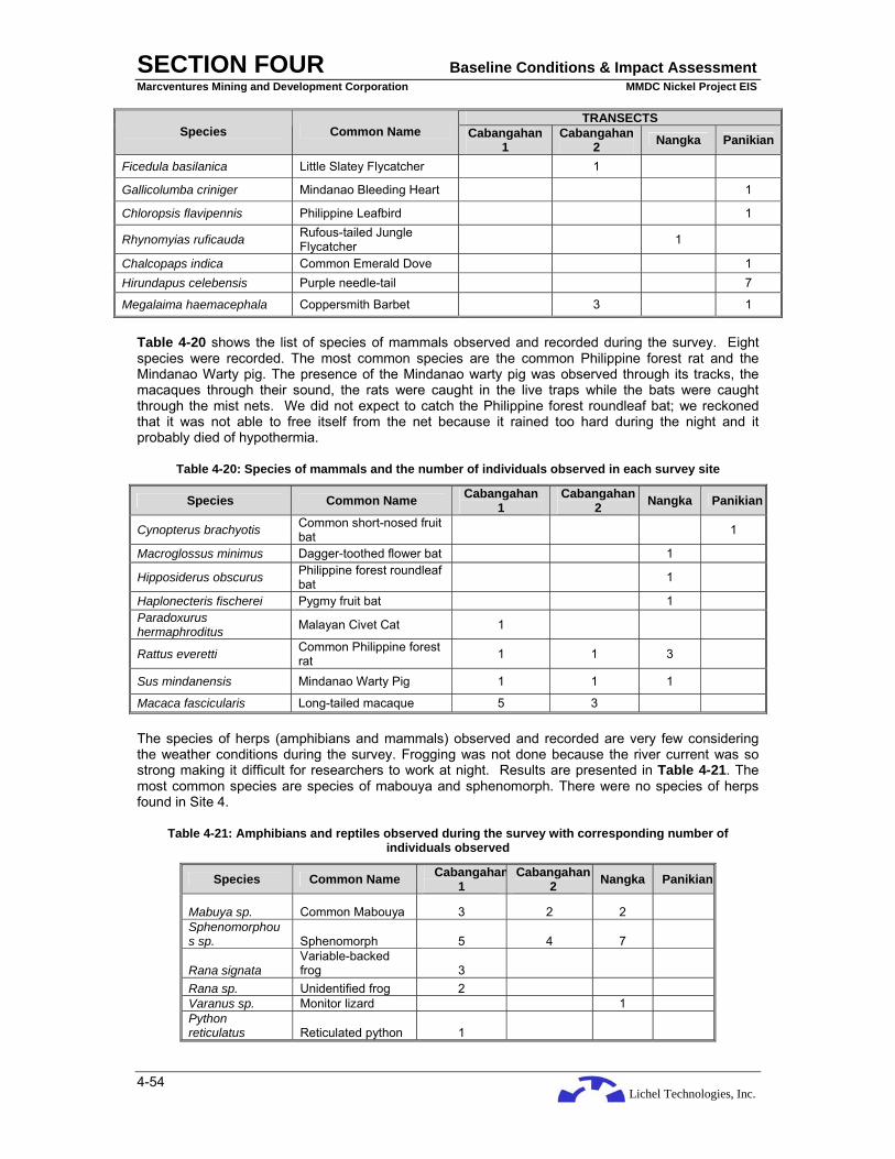
Lichel Technologies, Inc.
SECTION FOUR Baseline Conditions & Impact Assessment Marcventures Mining and Development Corporation MMDC Nickel Project EIS
4-54
TRANSECTS Species Common Name Cabangahan
1 Cabangahan
2 Nangka Panikian
Ficedula basilanica Little Slatey Flycatcher 1
Gallicolumba criniger Mindanao Bleeding Heart 1
Chloropsis flavipennis Philippine Leafbird 1
Rhynomyias ruficauda Rufous-tailed Jungle Flycatcher 1
Chalcopaps indica Common Emerald Dove 1 Hirundapus celebensis Purple needle-tail 7
Megalaima haemacephala Coppersmith Barbet 3 1
Table 4-20 shows the list of species of mammals observed and recorded during the survey. Eight species were recorded. The most common species are the common Philippine forest rat and the Mindanao Warty pig. The presence of the Mindanao warty pig was observed through its tracks, the macaques through their sound, the rats were caught in the live traps while the bats were caught through the mist nets. We did not expect to catch the Philippine forest roundleaf bat; we reckoned that it was not able to free itself from the net because it rained too hard during the night and it probably died of hypothermia.
Table 4-20: Species of mammals and the number of individuals observed in each survey site
Species Common Name Cabangahan 1
Cabangahan 2 Nangka Panikian
Cynopterus brachyotis Common short-nosed fruit bat 1
Macroglossus minimus Dagger-toothed flower bat 1
Hipposiderus obscurus Philippine forest roundleaf bat 1
Haplonecteris fischerei Pygmy fruit bat 1 Paradoxurus hermaphroditus Malayan Civet Cat 1
Rattus everetti Common Philippine forest rat 1 1 3
Sus mindanensis Mindanao Warty Pig 1 1 1
Macaca fascicularis Long-tailed macaque 5 3
The species of herps (amphibians and mammals) observed and recorded are very few considering the weather conditions during the survey. Frogging was not done because the river current was so strong making it difficult for researchers to work at night. Results are presented in Table 4-21. The most common species are species of mabouya and sphenomorph. There were no species of herps found in Site 4.
Table 4-21: Amphibians and reptiles observed during the survey with corresponding number of individuals observed
Species Common Name Cabangahan1
Cabangahan2 Nangka Panikian
Mabuya sp. Common Mabouya 3 2 2 Sphenomorphous sp. Sphenomorph 5 4 7
Rana signata Variable-backed frog 3
Rana sp. Unidentified frog 2 Varanus sp. Monitor lizard 1 Python reticulatus Reticulated python 1
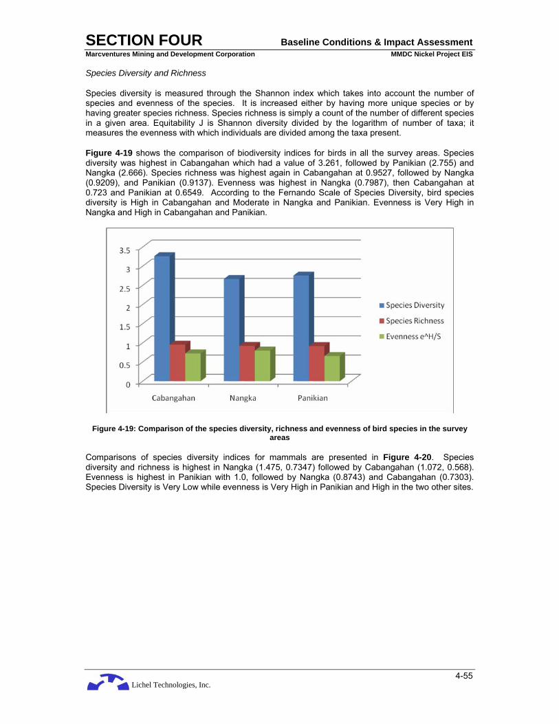
Lichel Technologies, Inc.
SECTION FOUR Baseline Conditions & Impact Assessment Marcventures Mining and Development Corporation MMDC Nickel Project EIS
4-55
Species Diversity and Richness
Species diversity is measured through the Shannon index which takes into account the number of species and evenness of the species. It is increased either by having more unique species or by having greater species richness. Species richness is simply a count of the number of different species in a given area. Equitability J is Shannon diversity divided by the logarithm of number of taxa; it measures the evenness with which individuals are divided among the taxa present.
Figure 4-19 shows the comparison of biodiversity indices for birds in all the survey areas. Species diversity was highest in Cabangahan which had a value of 3.261, followed by Panikian (2.755) and Nangka (2.666). Species richness was highest again in Cabangahan at 0.9527, followed by Nangka (0.9209), and Panikian (0.9137). Evenness was highest in Nangka (0.7987), then Cabangahan at 0.723 and Panikian at 0.6549. According to the Fernando Scale of Species Diversity, bird species diversity is High in Cabangahan and Moderate in Nangka and Panikian. Evenness is Very High in Nangka and High in Cabangahan and Panikian.
Figure 4-19: Comparison of the species diversity, richness and evenness of bird species in the survey areas
Comparisons of species diversity indices for mammals are presented in Figure 4-20. Species diversity and richness is highest in Nangka (1.475, 0.7347) followed by Cabangahan (1.072, 0.568). Evenness is highest in Panikian with 1.0, followed by Nangka (0.8743) and Cabangahan (0.7303). Species Diversity is Very Low while evenness is Very High in Panikian and High in the two other sites.

Lichel Technologies, Inc.
SECTION FOUR Baseline Conditions & Impact Assessment Marcventures Mining and Development Corporation MMDC Nickel Project EIS
4-56
Figure 4-20: Comparison of the species diversity, richness and evenness of mammalian species observed
Comparison of the indices of biodiversity for reptiles and amphibians are presented in Figure 4-21. Species diversity is highest in Cabangahan (1.494), followed by Panikian (0.8018) and Nangka (0.6365). Species richness is highest in Cabanahan and lowest in Nangka while evenness is highest in Nangka and lowest in Panikian. Species Diversity is very low for herps in all the survey sites/areas.
Figure 4-21: Comparison of the species diversity, richness and evenness of herps observed
The over-all species biodiversity indices of the survey site s were also compared and are presented in Figure 4-22. It shows that Cabangahan was highest in species diversity, richness and evenness and lowest in Panikian. Following Fernando’s Scale of Biodivsersity, species diversity is High in Cabangahan. This may be because observation was done in two transects as compared with only one each for the other sites/areas.

Lichel Technologies, Inc.
SECTION FOUR Baseline Conditions & Impact Assessment Marcventures Mining and Development Corporation MMDC Nickel Project EIS
4-57
Figure 4-22: Comparison of the species diversity, richness and evenness of the 3 survey areas
To further assess the species richness of Area 2 (Cabangahan), the number of species (species richness) of birds and mammals is plotted against the number of sampling days (sampling effort). Figure 4-23 and Figure 4-24 show that after two sampling days, the number of species of birds and mammals increased. A plateau in the graph is not reached which means that there are still species in the area not recorded and listed.
Figure 4-23: Graph of species richness of birds observed in Area 2 sampled for 2 days
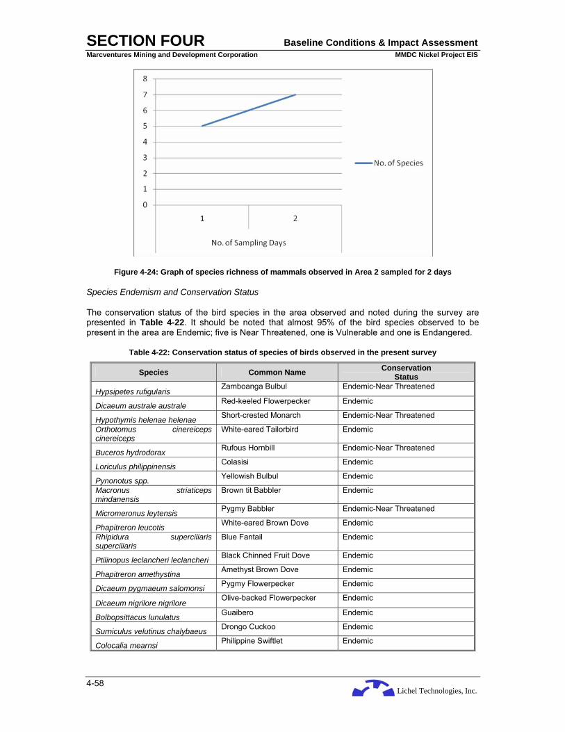
Lichel Technologies, Inc.
SECTION FOUR Baseline Conditions & Impact Assessment Marcventures Mining and Development Corporation MMDC Nickel Project EIS
4-58
Figure 4-24: Graph of species richness of mammals observed in Area 2 sampled for 2 days
Species Endemism and Conservation Status
The conservation status of the bird species in the area observed and noted during the survey are presented in Table 4-22. It should be noted that almost 95% of the bird species observed to be present in the area are Endemic; five is Near Threatened, one is Vulnerable and one is Endangered.
Table 4-22: Conservation status of species of birds observed in the present survey
Species Common Name Conservation Status
Hypsipetes rufigularis Zamboanga Bulbul Endemic-Near Threatened
Dicaeum australe australe Red-keeled Flowerpecker Endemic
Hypothymis helenae helenae Short-crested Monarch Endemic-Near Threatened
Orthotomus cinereiceps cinereiceps
White-eared Tailorbird Endemic
Buceros hydrodorax Rufous Hornbill Endemic-Near Threatened
Loriculus philippinensis Colasisi Endemic
Pynonotus spp. Yellowish Bulbul Endemic
Macronus striaticeps mindanensis
Brown tit Babbler Endemic
Micromeronus leytensis Pygmy Babbler Endemic-Near Threatened
Phapitreron leucotis White-eared Brown Dove Endemic
Rhipidura superciliaris superciliaris
Blue Fantail Endemic
Ptilinopus leclancheri leclancheri Black Chinned Fruit Dove Endemic
Phapitreron amethystina Amethyst Brown Dove Endemic
Dicaeum pygmaeum salomonsi Pygmy Flowerpecker Endemic
Dicaeum nigrilore nigrilore Olive-backed Flowerpecker Endemic
Bolbopsittacus lunulatus Guaibero Endemic
Surniculus velutinus chalybaeus Drongo Cuckoo Endemic
Colocalia mearnsi Philippine Swiftlet Endemic

Lichel Technologies, Inc.
SECTION FOUR Baseline Conditions & Impact Assessment Marcventures Mining and Development Corporation MMDC Nickel Project EIS
4-59
Species Common Name Conservation Status
Parus elegans Elegant Tit Endemic
Aethopyga pulcherrima pulcherrima
Metallic Winged Sunbird Endemic
Ceyx lepidus Variable Dwarf Kingfisher Resident
Pachycephala philippinensis philippinensis
Yellow-bellied Whistler Endemic
Colocalia troglodytes Pygmy Swiftlet Endemic
Zosterops everetti Everett's white-eye Resident
Lanius cristatus Brown Shrike Migrant
Hypothymis azurea azurea Black-naped Monarch REsident
Gallus gallus Red Jungle Fowl Common
Megalaima haemacephala White-eared Tailorbird Endemic
Nectarinia jugularis Olive-backed Sunbird Resident
Hypsipetes philippinus Philippine Bulbul Endemic
Dicaeum trigonostigma Orange-bellied flowerpecker Resident
Collocalia esculenta Glossy Swiftlet Resident
Aethopyga shelleyi Lovely Sunbird Endemic
Dicaeum hypoleucum Buzzing Flowerpecker Endemic
Cacomantis merulinus Plaintive Cuckoo Endemic
Parus semilarvatus White-fronted Tit Endemic-Near Threatened
Ptilinopus melanospila bangueyensis Black-naped Fruit Dove
Endemic Resident
Rhynumias ruficauda Rufous Tailed Jungle Flycatcher Resident
Golden Bellied Flycatcher Endemic
Tersiphone cinnamomea Rufous Paradise Flycatcher REsident
Ficedula basilanica Little Slaty Flycatcher Endemic
Gallicolumba criniger Mindanao Bleeding Heart Endemic-Endangered
Chloropsis flavipennis Philippine Leafbird Endemic-Vulnerable
Chalcopaps indica Common Emerald Dove REsident
Hirundapus celebensis Purple needle-tail Resident
Megalaima haemacephala Coppersmith Barbet Resident
As for the mammals, all the species are forest dependents. The common Philippine forest rat thrives in primary forests and although abundant in the areas where they were trapped, the IPs hunts them for food thus adding to the threat to the species. Widespread hunting and illegal trade are causing the decline of the population of the Common Palm Civet and the warty pigs in the country. Although the long-tailed macaque is widespread in Asia, it is the only species of the taxon in the Philippines and is listed as CITES II.
Table 4-23: Conservation status of species of mammals observed during the present survey
Species Common Name Conservation Status
Cynopterus brachyotis Common short-nosed fruit bat Common
Macroglossus minimus Dagger-toothed flower bat Abundant and widespread

Lichel Technologies, Inc.
SECTION FOUR Baseline Conditions & Impact Assessment Marcventures Mining and Development Corporation MMDC Nickel Project EIS
4-60
Species Common Name Conservation Status
Hipposiderus obscurus Philippine forest roundleaf bat Widespread
Haplonecteris fischerei Pygmy fruit bat IUCN: vulnerable Paradoxurus hermaphroditus Malayan Civet Cat Common
Rattus everetti Common Philippine forest rat Abundant
Sus mindanensis Mindanao Warty Pig Threatened
Macaca fascicularis Long-tailed macaque Widespread in Asia; CITES II
Of the 6 species of herps noted in the area, the sphenomorph is near threatened and, the monitor lizard is considered threatened in all its ranges in the Philippines because it is hunted heavily and is affected by forest degradation. There is not much to be said about frogs in the present survey because it was limited by the weather, it is expected that a thorough field survey in good climatic conditions will yield more species of amphibians.
Table 4-24: List of herps observed and their conservation status
Species Common Name Conservation Status
Mabuya sp. Common Mabouya Common
Sphenomorphous
mindanensis Sphenomorph Near Threatened
Rana signata Variable-backed frog common
Rana sp. Unidentified ?
Varanus sp. Monitor Lizard Threatened
Python reticulatus Reticulated python Least Concern
Conclusions/Recommendations
As per the results of the survey, the area applied for by the proponent for its mining operations, is a habitat of a number of endemic and threatened species of birds, mammals and herps. As a consequence of future mining activities, destruction of the habitat of wild fauna and flora is inevitable.
It is therefore recommended that a portion (50-100 hectares) of the mineable area be retained to serve as habitat or a reserve for wild fauna. Mitigating measures to lessen the effect of mining in the area should be implemented, e.g., habitat restoration as soon as an area has been abandoned after mining activities. To come up with a more satisfactory data on the fauna of the area, monitoring should be done at least twice a year (bi-annual) by an independent wildlife biologist and quarterly by the company.

Lichel Technologies, Inc.
SECTION FOUR Baseline Conditions & Impact Assessment Marcventures Mining and Development Corporation MMDC Nickel Project EIS
4-61
4.2 THE WATER
4.2.1 Hydrology
The morphology of the drainage systems where the project is located was characterized by through the use of NAMRIA topographic maps, verified in the fieldwork from 8 to 9 March 2008, and supported by secondary information. Determination of spot stream flow, monthly stream flow and flood peaks are discussed in the following sections.
4.2.1.1 Catchment Morphometry
The Project is located within four (4) catchment areas: the Carac-an Catchment, the Alamio Catchment, the Binoni (Panikian) Catchment and the a subcatchment of the Buyaan River. Figure 4-25 shows the location of the MPSA project area in relation to the catchment areas.
The Carac-an River Catchment is one of the major river basin of Surigao del Sur. Reckoned from final discharge point at Lanuza Bay, the river drains an area of about 447 square kilometers (sq km). It has a level area of about 19 sq km and an estimated runoff of about 894 Million Cubic Meters (MCM). The headwaters of the river originate from Mount Mabaho at 1860 masl where it flows generally in an easterly direction until it reaches Barangay Cabangahan where it changes to a southeast direction. At Barangay Antao, the river shifts its course to northeast passing towards Barangay Union in Madrid Municipality before emptying into Lanuza Bay. Referred at the proposed overflow bridge crossing (haulage road) at Barangay Cabangahan, the catchment has an area of about 230 sq. km.
Other river systems that drain project area are Alamio, Binoni and Buyaan Rivers. The Alamio River is located about 3 km northeast from the initial mine site. Its headwaters originate in the mountains of Cantilan and flow generally in southerly direction before shifting northeast direction at Barangay Cabas-an. It merges with the Binoni River near Cantilan-Carrascal Road about 2.0 km south of the municipality of Carrascal (Carrascal River) before discharging into Carrascal Bay. Reckoned at Barangay Cabas-an, the river has a drainage area of about 78 sq km. The river has no historical streamflow records.
The headwaters of Binoni River on the other hand originate from the mountains of Carrascal about 12 km of the said municipality. The river flows southeast towards Barangay Babuyan and then changes its course to northeast at Barangay Panikian before merging with Alamio River. Referred at Barangay Panikian, the catchment area of Binoni River is about 72 sq km. The river has a different name as it goes upstream. At Barangay Babuyan the river is named Cabadianagan at the downstream of this barangay and Babuyan River at the upstream side.
The unnamed creek which is located south of the mine area is flows south towards Buyaan River. Reckoned at the confluence with the Buyaan River, the unnamed creek has a catchment area of about 6 sq km.
The rivers and creeks in the project area, except for Carac-an River, are ungauged and therefore historical streamflow records are unavailable. However the Carac-an River gauging station which was installed by the defunct Bureau of Public Works (BPW) sometime in 1950 was abandoned in the late 1970. The station is located some 3.5 km southwest of Barangay Parang or some 1.5 km downstream of existing Cantilan River Irrigation System. The gauging station was abandoned probably due to unstable river banks which yielded unreliable streamflow data.
Binoni and Carac-an Rivers, like most of the major rivers, are sources of sand and gravel for construction materials of nearby areas.
4.2.1.2 Stream Discharge Measurements
A spot discharge measurement was conducted last October 20, 2006 on Binoni River at Barangay Panikian, Carrascal. The weather condition at the time of measurement was fair. A float–area method or float velocity method was used in the conduct of streamflow measurements which is a generally accepted method in taking the velocity of water flowing in a river channel. Discharge measurement by

Lichel Technologies, Inc.
SECTION FOUR Baseline Conditions & Impact Assessment Marcventures Mining and Development Corporation MMDC Nickel Project EIS
4-62
wading using an improvised calibrated stake to determine the depth of the river subsections was employed during flow determination. Most appropriate sites where flow is laminar were selected to attain high accuracy measurements. A tagline was laid across the river to determine the exact width of the river and also to serve as a guide to obtain the depth of each subsections. The width of each section depends on the total width of the river channel. A distance parallel to the center line of the stream was measured and marked along the bank. Specially prepared improvised floats were used to measure the velocity. Two (2) locally hired laborers which serve as and the time elapsed for the float to travel to the downstream station was taken. Five trial measurements were conducted at uniform interval across the width of the stream. The measured time was averaged by dividing the number of trials. Then surface velocity is obtained by dividing the total distance with the average time the float traveled from the upstream observer to the downstream observer as shown below:
Vave = Distance, in meters / t1 + t2 + t3…tn, = in meters/sec
Then the total area of the channel (measuring stations) was obtained by summing up the total area of the sub-section as reflected below:
AT = A1 + A2 + A3 +. . . . An
Since the surface of the stream is moving faster than the average velocity at the vertical, the float velocity is multiplied by .85 to give the average at the vertical. The discharge is then computed by using the formula:
Qave = Vave x AT x 0.85
The actual streamflow measurements obtained last October 20, 2006 was considered for this assessment since there was a weather disturbance during the field investigation conducted last March 8, 2008 at the project area. The area was experiencing rainfall abnormalities for almost a week which disrupted major activities of the municipality and the project. Rains during the time of investigation were intermittent but most of the river systems were swollen and, therefore, measurement by wading or any other method cannot be applied. A modified Float Method approach of measurement was used to at least obtain a rough estimate of the rate of flow and other hydraulic parameters of Carac-an and Alamio Rivers. Local residents residing near the rivers were interviewed regarding the behavior of the rivers during inclement weather conditions, and the history and frequency of flooding of the area. The same procedure of float method was employed except that the width and depth of the rivers were only estimated based on actual physical geometric configurations at the measuring sites at the time of measurements and as per account from the local folks. Nevertheless, the results of the actual measurements when compared with the results of correlation on abnormalities or extreme events during weather disturbances with nearby gauged rivers were found to be satisfactory or within the acceptable limits of discharge values based on transposed values of ungauged rivers. The summary of discharge measurements is shown below. The location of discharge measurements is also shown in Figure 4-25.
Table 4-25: Summary of Discharge Measurements of Rivers at the Project Area
Discharge Measurement
No. River Name/
Location Date River Width (m)
Area (sq m)
Mean Velocity (m/sec)
Discharge (m3/sec)
1
Binoni River, Barangay Panikian, Carrascal
10-20-2006 10 1.88 .88 1.5
2
Carac-an River,
Cabangahan, Cantilan
3-08-2008 120 180 1.4 214.2
3 Alamio River,
Cabas-an, Cantilan
3-08-2008 50 46 1.5 59.0

Lichel Technologies, Inc.
SECTION FOUR Baseline Conditions & Impact Assessment Marcventures Mining and Development Corporation MMDC Nickel Project EIS
4-63
Figure 4-25: Catchment Areas

Lichel Technologies, Inc.
SECTION FOUR Baseline Conditions & Impact Assessment Marcventures Mining and Development Corporation MMDC Nickel Project EIS
4-64
4.2.1.3 Mean Monthly Flow
As mentioned in the preceding section, the rivers/creeks located near or within the project area have no streamflow monitoring station except for Carac-an River. To estimate the mean monthly streamflows, the rivers at the project area were correlated with nearby gauged rivers to generate synthetic streamflow data. The following gauged rivers were selected for the analysis:
• Boy-an River at Lisob, Madrid, Surigao del Sur; Drainage Area (D.A.) = 33 sq km; 15 years of records (fragmentary)
• Carac-an River at Parang, Cantilan, Surigao del Sur; D.A.= 240 sq km; 13 years of records (fragmentary)
The abovementioned gauging station was abandoned sometime in the 70’s probably due to unstable river banks, erratic behavior and shifting of river course.
To estimate the mean monthly flow of the ungauged rivers near or within the mine site, two methods were adopted: the Basin–Ratio Factor Method and the Reciprocal–Distance Method of interpolation. The Basin–Factor Method takes the form:
Q1 / D.A.1 = Q2 / D.A.2, where:
Q1 = unknown mean monthly flow in cubic meters per second (m3/sec) of ungauged river
D.A.1 = drainage are in square kilometers (sq km) of ungauged river
Q2 = mean monthly flow of gauged river in m3/sec
D.A.2 = drainage area in sq km of gauged river
Likewise, the Reciprocal–Distance Method of interpolation can be expressed as follows:
Qx = Q1 (1/d1) + Q2 (1/d2) + …. Qn (1/dn) , where: 1/d1 + 1/d2 + …. 1/dn
Qx = the unknown mean monthly streamflow value at the point of interest
Q1, Q2, Qn = the mean monthly stream flow value of gauged river stations
d1, d2, dn = the distance of the gauged river station to the ungauged rivers.
The mean monthly streamflows of the two gauged rivers are shown in Table 4-26.
Table 4-26: Mean Monthly flow in cubic meters per second (m3/sec) of Carac-an River and Boy-an River
Month Carac-an River, Parang,
Cantilan, Surigao del Sur D.A. = 240 sq km
Boy-an River, Lisob, Madrid, Surigao del Sur D.A. = 33 sq km
January 111.42 16.72 February 86.57 9.73 March 70.70 8.85 April 32.26 .70 May 28.38 .67 June 24.15 .67 July 23.45 2.42 August 13.06 0.77 September 12.31 0.87 October 11.86 0.71 November 19.86 1.78 December 84.76 5.47
Source: BRS_DPWH, Philippine Water Resource Summary Data Volume I and II, 1980 and 1991.

Lichel Technologies, Inc.
SECTION FOUR Baseline Conditions & Impact Assessment Marcventures Mining and Development Corporation MMDC Nickel Project EIS
4-65
The result of the analysis is shown below.
Table 4-27: Estimated and Mean Monthly Flow in m3/sec of rivers at the Project area
Month River Name/ Location Jan. Feb. Mar Apr May Jun Jul Aug Sep Oct Nov Dec
Binoni River, Panikian, Carrascal
36.48 21.2 19.3 1.50 1.46 1.40 5.30 1.68 1.90 1.55 3.90 12.0
Carac-an River, Cabangahan, Cantilan
107.0 83.0 68.0 31.0 27.0 23.0 22.5 12.5 12.0 11.4 19.0 81.0
Alamio River Cabas-an, Cantilan
39.5 23.0 21.0 1.65 1.58 1.58 5.7 1.8 2.0 1.7 4.2 13.0
Unnamed Creek, Madrid 3.00 1.75 1.60 0.13 0.12 0.12 0.44 0.14 0.16 0.13 0.32 1.00
4.2.1.4 Flood Peak and Volume
Two methods were applied In order to estimate flood peaks and corresponding return periods of the rivers in the project area. The first method is the use of Regional Flood Frequency Analysis utilizing the historical peak flows of all gauged rivers of Surigao del Sur and Surigao del Norte. The Regionalization Method utilizes statistical methods to establish flood distribution. The catchments with similar flood response and climate were grouped together. This method consists of two (2) stages: the estimation of Mean Annual Flood (MAF), and estimation of Flood Peak. The resulting prediction equation is:
MAF = 11.5A0.502
Where: A is the drainage area of the river of interest expressed in square kilometers. To estimate flood values with corresponding return periods, the MAF will be multiplied by the factors obtained from the Regional Flood Frequency Curves which is a function of the size of the catchments area. The resulting equation will be:
Qtr = qtr MAF, where:
Qtr = flood discharge with the required return period
qtr = factors of the required return period of a watershed area
MAF = Mean Annual Flood
An additional 20% were added to the MAF values to account for land use change.
Another method of estimating flood peak values is by Basin–Factor Ratio Method. The approach is linearly proportioned the basin size and the peak flows with corresponding return period of the gauged rivers to the ungauged rivers with generally the same geology, rainfall pattern, basin shape, land use, among others. The historical annual peak flows of Carac-an and Boy-an Rivers were subjected to Point–Flood Frequency Analysis using Extreme Gumbel Type I distribution. The result of the analysis of the two rivers is shown below.
Table 4-28: Flood Peak Values (in m3/sec) of Boy-an and Carac-an Rivers
Return Period, yr River Name/ Location
Drainage Area
(sq km)
Mean Annual
Flood (MAF) 10 25 50 100
1. Carac-an River Barangay Parang, Cantilan, Surigao del
240 1250 1700 2150 2500 2700

Lichel Technologies, Inc.
SECTION FOUR Baseline Conditions & Impact Assessment Marcventures Mining and Development Corporation MMDC Nickel Project EIS
4-66
Return Period, yr River Name/ Location
Drainage Area
(sq km)
Mean Annual
Flood (MAF) 10 25 50 100
Sur
2. Boy-an River Lisob, Madrid, Surigao del Sur
33 150 270 360 460 570
Considering the proximity of the gauged rivers to the mine site, the Basin – Factor Ratio Method is preferred in estimating peak flows of ungauged rivers. The results are shown below.
Table 4-29: Estimated Flood Peak Values (in m3/sec) with Return Periods of rivers in the Project Area
Return Period, yr River Name/ Location
Drainage Area
(sq km) Mean Annual Flood (MAF)
10 25 50 100
1. Binoni River, Panikian, Carrascal
72 372 589 785 1,000 1,243
2. Carac-an River, Cabangahan, Cantilan
230 1,200 1,632 2,064 2,400 2,592
3.Alamio River, Cabas-an, Cantilan
78 402 636 848 1,080 1,342
4. Unnamed Creek, Madrid 6 27 49 66 84 104
4.2.1.5 River Usage
Within the project area, surface water is used by residents of Barangay Cabangahan. The water source is located in an unnamed creek some one kilometer north of the Barangay proper. Surface water is tapped by a 3-inch diameter steel pipe and directed to a newly constructed concrete reservoir donated by MMDC (Plate 4-9 and Plate 4-10). From the reservoir water is piped to the barangay for distribution.
Plate 4-9: Surface water source at Barangay Cabangahan

Lichel Technologies, Inc.
SECTION FOUR Baseline Conditions & Impact Assessment Marcventures Mining and Development Corporation MMDC Nickel Project EIS
4-67
Plate 4-10: Newly constructed water reservoir at Barangay Cabangahan
Downstream of the project area are four irrigation systems of the National Irrigation Administration (NIA), namely: the Cantilan National Irrigation System (NIS), the Cabas-an Communal Irrigation System (CIS), the Panikian CIS and the Buyaan CIS. Figure 4-26 shows the location of the NIA intake structures in relation to the project area. The planned and existing service areas are shown below.
Table 4-30: Status of Irrigation Systems Downstream of the Project Area
Irrigation System Planned Service Area (ha)
Existing Service Area (ha) (as of December 2007)
Cantilan NIS 2,500 1,785 Cabas-an CIS 150 150 Panikian CIS 480 480 Buyaan CIS 225 225 Source: NIA
4.2.2 Hydrogeology
The geologic map of the project area was referred to and validated in the field for the hydrogeological units in the study area. Groundwater recharge at the study area was roughly estimated through a water balance.
4.2.2.1 Hydrogeologic units
The hydrogeologic units in the project area are classified according to the occurrence and movement of ground water as: (1) aquifers where ground water movement is intergranular; (2) aquifers where ground water movement is through fractures; and (3) aquifers where ground-water movement is through solution channels.
Aquifers where ground-water movement is intergranular are associated with unconsolidated to semi-consolidated alluvial deposits. This ground-water potential of this aquifer is dependent on the extent, sorting and degree of consolidation of the sedimentary deposits. The Quaternary Alluvium of the river flood plain deposits are hosts to these aquifers.
Ground water in massive igneous and metamorphic rocks occurs in highly fractured zones or sufficiently leached or weathered zones. In the project area, this aquifer is hosted by the Cretaceous Metavolcanics and the Cretaceous to Paleogene Ultramafics.

Lichel Technologies, Inc.
SECTION FOUR Baseline Conditions & Impact Assessment Marcventures Mining and Development Corporation MMDC Nickel Project EIS
4-68
Carbonate rocks are aquifers where ground-water movement is through secondary structures such as fractures and solution channels. The productivity of wells tapping these aquifers depends largely whether these structures are interconnected. The Oligocene to Miocene Limestone represents this aquifer in the project area.
Ultramafic and metavolcanic rocks dominate the Project area. These rocks are massive or thickly layered and also occur as dykes. Based on the Groundwater Availability Map of the Mines and Geosciences Bureau (1997), these rocks are classified as rocks with limited potential and low to moderate permeability (Figure 4-27). These rocks are impermeable except in weathered, significantly leached and or fractured or thrust zones.
Scanline survey in every critical slope, both natural and artificial, to determine the frequencies, sizes and characteristics of discontinuities was not performed as it was deemed unnecessary at this stage.
Massive crystalline ultramafic and metamorphosed rockis are practically impermeable. It is only through fractures that groundwater can be stored in these rocks. The only other storage areas in hard rock are the lava tubes that occur in volcanic rocks and the solution and openings that occur in limestone. Permeability in these rocks depends on:
• size and location of the fractures; • interconnection of the fractures; and • amount of material that may be clogging the fractures.
The volume of water stored in fractured hard rocks near the surface is estimated to total less than 2 percent of the rock volume. This ratio decreases with depth as fractures become narrower and farther apart. As indicated in the published MGB Regional Hydrogeologic Map (Figure 4-27), the Cretaceous ultramafic and metamorphic rocks in the project area were classified as rocks with limited potential.

Lichel Technologies, Inc.
SECTION FOUR Baseline Conditions & Impact Assessment Marcventures Mining and Development Corporation MMDC Nickel Project EIS
4-69
Figure 4-26: Location of NIA Irrigation Intake Structures

Lichel Technologies, Inc.
SECTION FOUR Baseline Conditions & Impact Assessment Marcventures Mining and Development Corporation MMDC Nickel Project EIS
4-70
Figure 4-27: Regional Hydrogeologic Map

Lichel Technologies, Inc.
SECTION FOUR Baseline Conditions & Impact Assessment Marcventures Mining and Development Corporation MMDC Nickel Project EIS
4-71
4.2.2.2 Spring and Well Inventory
Except for a hand-pump well (approximately 3 meters deep) located near the Barangay Cabangan Center which is sparingly used, no other groundwater source is developed for domestic use. The 150 households of the barangay depend entirely on the surface water system recently constructed by the proponent. There are no springs and wells within the MPSA. Surface water is collected in a water impounding structure to supply water at the MMDC base camp for their exploration crew.
4.2.2.3 Water Balance
The hydrologic budget or water balance is a quantitative statement of the balance between the total gains and losses of an area or basins, for period of time. The water balance for an annual period would take the form:
P = Q + Et + Gs
Where P is the annual precipitation, Q is the runoff depth, Et is the evapotranspiration and Gs the groundwater storage. Units are expressed in millimeters (mm).
The mean annual rainfall of the mine area is about 3,800 mm obtained using the reciprocal distance method of interpolation utilizing the available nearby rainfall stations.
Q, at 2,350 mm, was commuted by transposing annual runoff of nearby gauged rivers to estimate the synthetic stream flow data at the project site.
Et the evapotranspiration equivalent to 1,380 mm which was computed using the Blaney Criddle method, utilizing the available temperature data from the climatic station in Surigao city.
Gs the groundwater storage which is part of the rainfall that percolates into the groundwater reservoir through fractured zones of the area. From the water balance equation Gs is computed as:
Gs = P – (Q + Et)
Gs = 3,800 mm – (2,350 mm + 1,380 mm)
= 70 mm
The water balance analysis represents the crude approximation of the hydrologic regime of the mine area. The groundwater storage which represents 1.8% of the rainfall is the balance of rainfall that may seep or percolate into either the fractured or weathered zones of the massive ultramafic rocks or thin lenses of unconsolidated sediments. These form springs and shallow aquifers in low lying areas which are tapped by the communities for domestic water. It must be emphasized that the Project area exhibits low potential groundwater with limited groundwater yields. Laterites are clay sediments which are considered as poor aquifers. The bedrock is usually massive with groundwater limited to weathered or fractured zones.
4.2.3 Oceanography
The proposed MMDC jetty is a small-scale coastal area development project along the eastern coast of Cantilan, Surigao del Sur that is intended to be used as loading facility for nickel ore. The proposed location of the planned jetty is shown in Figure 4-29.
4.2.3.1 Bathymetry
The bathymetry of the jetty area was taken from the C-MAP nautical chart and those from NAMRIA. The depth contours especially in areas where there are no recorded data in the NAMRIA map were also taken from C-MAP. The depths were digitized using a grid distance of 25 meters resulting in a network of about 60 x 51 grid points. Figure 4-28 is a bathymetric map of the jetty area. As shown

Lichel Technologies, Inc.
SECTION FOUR Baseline Conditions & Impact Assessment Marcventures Mining and Development Corporation MMDC Nickel Project EIS
4-72
from the figure, the water depths in the area are generally very shallow. The maximum depth is about 21 meters and is located northeast of the proposed jetty.
0.0 5.0 10.0 15.0 20.0 25.0 30.0 35.0 40.0 45.0 50.0 55.0 60.0N-S Distance (x 25 m)
0.0
10.0
20.0
30.0
40.0
50.0
E-W
Dis
tanc
e (x
25
m)
Consuelo
Figure 4-28: Bathymetric Map of the Jetty Area
4.2.3.2 Currents
Measurement of currents in the area was performed on 07 March 2008 using fabricated drogues and a handheld Geographical Positioning System (Garmin Etrex GPS). A picture of the drogue used in the current measurement and the deployment done in the waters of Cantilan Bay is shown Plate 4-11. During the period of measurement, there was a strong rain episode but the prevailing wind was predominantly weak (about 3 m/sec) and the observed currents were relatively weak. The observed currents in the vicinity of the proposed jetty ranged from 0.02-0.07 m/sec. These are common in coastal embayment which is protected or sheltered from strong winds. However, as the area is no longer protected from easterly winds during the arrival of storms, currents in the area may become relatively strong during typhoon occurrence.

Lichel Technologies, Inc.
SECTION FOUR Baseline Conditions & Impact Assessment Marcventures Mining and Development Corporation MMDC Nickel Project EIS
4-73
Plate 4-11: Drogue used in the field monitoring of currents in the study area

Lichel Technologies, Inc.
SECTION FOUR Baseline Conditions & Impact Assessment Marcventures Mining and Development Corporation MMDC Nickel Project EIS
4-74
Figure 4-29: Proposed Jetty Location
Lichel Technologies, Inc.
SECTION FOUR Baseline Conditions & Impact Assessment Marcventures Mining and Development Corporation MMDC Nickel Project EIS
4-75
4.2.3.3 Waves and Tides
Waves which are generally induced by the wind acting over the sea surface are dependent on the speed of the wind, the fetch length and the water depth. The wind speed is normally measured at anemometer level (i.e. 10 m above mean sea level) while the fetch length is measured in terms of the area of wind generation as it blows in a sustained manner from the open sea. Here, the coastline is a natural boundary where the fetch length ends and therefore limits the wave propagation. The effect of the water depth is such that wind-induced waves have a limited height due to frictional dissipation of wave energy caused by the sediment bed. It is therefore evident that wind-induced waves can grow higher in deeper waters than in shallow waters. Visual observations during moderate to strong winds confirm the strong tendency of the waves to be depth-limited.
Measurement of wind-generated waves is not usually undertaken due to practical reasons such as the lack of reliable sensors that can be bought at reasonable prices. Wave instruments are generally very expensive. It is therefore the practice of many countries to estimate the waves using the well-known wave relations of the Coastal Engineering Research Center (CERC) of the U.S. Army Corps of Engineers. These wave formulations are semi-empirical in nature and usually give good estimates of the significant wave heights, period and length. By definition, a significant wave height is the average height of the highest third of the waves.
The estimation of the significant wave height, which is the most important factor to consider in many applications, follows the general relation given by:
where Hs is the significant wave height, W is the surface wind speed measured at anemometer level, F is the fetch length, g is the gravitational acceleration and h is the mean water depth. Table 4-31 is the estimated significant wave heights at different wind speeds and water depths in the study area.
Table 4-31: Estimated Significant Surface Wave Heights (m) in the Proposed Jetty
Surface Wind Speed (m/sec) Depth (m) 1-5 6-9 10-15 16-20
2 0.03-0.24 0.28-0.39 0.41-0.53 0.55-0.63 5 0.02-0.46 0.57-0.83 0.90-1.17 1.21-1.38 10 0.02-0.51 0.66-1.08 1.20-1.72 1.81-2.13
Due to its shallow depth, the significant waves in the area could not grow high enough. Significant wave heights of less that 2.0 m could be expected during stormy conditions. During ordinary wind conditions, however, significant wave heights of about half a meter would be expected in the area.
Concerning tides, the tidal observations by NAMRIA characterized the area as having a mixed tide but predominantly diurnal. The semi-diurnal constituents involved are the M2 and S2 tides with periods of 12.4 h and 12.0 h respectively, and the diurnal components are the O1 and K1 tides with periods of 25.8 and 23.9 h respectively. Based from available tidal information provided by NAMRIA, the ratio of the diurnal to the semi-diurnal tides (K1 + O1) / (M2 + S2) is about 3.64, which further confirms the observation that the existing tide in the area is a mixed type with a predominantly diurnal character. The tidal amplitude in the area has an average value of about 0.59 m. Figure 4-30 shows the tidal variation within the study area. The numerical data for that period is published by the National Mapping and Resource Information Authority (NAMRIA).

Lichel Technologies, Inc.
SECTION FOUR Baseline Conditions & Impact Assessment Marcventures Mining and Development Corporation MMDC Nickel Project EIS
4-76
Figure 4-30: Tidal Variation (heights given in m) within the Study Area
4.2.4 Water Quality
4.2.4.1 Freshwater Quality
Location of Sampling Stations
Sampling and in situ water quality analyses were conducted from the different sampling stations in Carac-an River, Anibungan Creek, Dawas-dawas Creek, Maitom Creek, Buyaan River, Panikian River and the Adlaso/Swimming Pool (Barangay Cabangahan water supply) on February 22 and 23, 2008, and on March 11, 2008 to determine baseline conditions of freshwater bodies in the proposed Project area. Figure 4-31 shows the freshwater sampling stations.
Methodology
Grab water samples were taken using half gallon plastic containers for physico-chemical analyses (dissolved oxygen, conductivity, turbidity, total suspended solids, total dissolved solids) while 500 milliliter (mL) wide-mouthed bottles were used for oil & greases analysis. The samples were stored in an ice chest for preservation during transportation to the laboratory analyses. Inasmuch as the travel time from the sampling sites to the laboratory exceeds the maximum holding time of samples, bacteriological analysis was not undertaken.
One (1) liter plastic bottles were utilized for metal analyses (arsenic, cadmium, chromium, copper, iron, lead, mercury, nickel and zinc) and the samples were preserved with 2 mL concentrated HNO3. The Aqua-Check® Water Analyzer was used for in situ measurements of temperature, pH, and dissolved oxygen. Table 4-32 presents the description of the sampling sites. Table 4-34 shows the results of in-situ, physico-chemical and bacteriological analyses, and Table 4-35 presents the results of the metal analyses. Official water quality laboratory results are presented in Annex E-4.
The physico-chemical and heavy metal analyses of the samples were performed by Mach (Union) Water Laboratory located in Las Piñas City, Metro Manila. Bacteriological tests of samples were done at the Surigao Metropolitan Water District in Surigao City to minimize holding time.
Table 4-32: Description of the Water Quality Sampling Stations
GPS Coordinates Station
I.D. Location North Latitude
East Longitude
Date of Sampling Weather Remarks
Fwg 1 Carac-an River 09° 15' 30" 125° 54' 09" 02/22/08 Cloudy clear
-0.4
-0.2
0.0
0.2
0.4
0.6
0.8
1.0
1.2
1.4
1.6
7/1
7/2
7/3
7/5
7/6
7/7
7/9
7/10
7/12
7/13
7/14
7/16
7/17
7/18
7/20
7/21
7/23
7/24
7/25
7/27
7/28
7/29
7/31
Date
Tide
(m)

Lichel Technologies, Inc.
SECTION FOUR Baseline Conditions & Impact Assessment Marcventures Mining and Development Corporation MMDC Nickel Project EIS
4-77
GPS Coordinates Station
I.D. Location North Latitude
East Longitude
Date of Sampling Weather Remarks
Fwg 2 Anibungan. 09° 15' 33" 125° 53' 56" 02/22/08 Cloudy clear
Fwg 3 Dawas – dawas Creek 09° 16' 14" 125° 53' 19" 02/22/08 Cloudy clear
Fwg 4 Adlaso/ Swimming pool 09° 16' 55" 125° 53' 04" 02/22/08 Cloudy clear
Fwg 5 Maitom 09° 16' 32" 125° 52' 33" 02/22/08 Cloudy clear
Fwg 6 Buyaan 09° 13' 07" 125° 54' 59" 02/23/08 Cloudy Silted (after heavy rain)
Fwg 7 Alamio River 09° 19' 35" 125° 52' 10" 02/23/08 Partly cloudy Silted (after heavy rain)
Water Quality Assessment
Results of the water quality analyses were assessed using DENR Administrative Order (DAO) 34 Series 1990 and the Philippine National Standards for Drinking Water (PNSDW). The DAO-34 Series 1990 which classifies surface water bodies according to its beneficial use, is presented below.
Table 4-33: DAO 34-90 Surface Water Classification Scheme
Class Beneficial Use A. Freshwater Class AA • Public Water Supply Class I, uninhabited and otherwise protected and which require
only approved disinfection in order to meet the Philippine National Standards for Drinking Water (PNSDW).
Class A • Public Water Supply Class II For sources of water supply that will require complete treatment
Class B • Recreational Water Class I. For primary contact recreation Class C • Fishery, Recreational Water Class II (boating, etc), industrial water supply Class I
(manufacturing processes after treatment) Class D • For Agriculture, Industrial Water Supply Class II (e.g. cooling) B. Marine Water Class SA • Waters suitable for the propagation, survival and harvesting of shellfish for commercial
purposes; • Tourist zones and national marine parks and reserves established under Presidential
Proclamation No. 1801; existing laws and/or declared as such by appropriate government agency.
• Coral reef parks and reserves designated by law and concerned authorities Class SB • Recreational Water Class I (Areas regularly used by the public for bathing, swimming,
skin diving, etc.); • Fishery Water Class I (Spawning areas for Chanos chanos or "Bangus" and similar
species). Class SC • Recreational Water Class II (e.g. boating, etc.);
Fishery Water Class II (Commercial and sustenance fishing); • Marshy and/or mangrove areas declared as fish and wildlife sanctuaries
Class SD • Industrial Water Supply Class II (e.g. cooling, etc.); • Other coastal and marine waters, by their quality, belong to this classification.
Since the Carac-an River is used downstream for irrigation, a Class D (Agriculture) classification criterion is selected for the assessment of the water quality in the project area. For the Cabangahan water supply, the PNSDW standards were adopted.

Lichel Technologies, Inc.
SECTION FOUR Baseline Conditions & Impact Assessment Marcventures Mining and Development Corporation MMDC Nickel Project EIS
4-78
Results and Discussion
Physico-chemical Parameters
The pH, dissolved oxygen (DO), oil & grease and total dissolved solids (TDS) of the six surface water samples analyzed were within the DENR Class D standards. No standards are prescribed for conductivity and turbidity. For the Cabangahan water supply, the pH, turbidity and TDS are within the PNSDW standards. No standards are prescribed for the other parameters that were analyzed.
Metals
Metal concentrations of the six surface water samples for metal parameters considered for analysis are within the DENR Class D standards. Metal concentrations tested on the water sample taken from the Cabangahan water supply source are within the PNSDW standards.
Bacteriological
Fecal coliform test of the six surface water samples indicated >16/100 ml for water samples taken at Carac-an (Fwg 1), Anibugan (Fwg 2), Dawas-dawas (Fwg 3), Buyaan (Fwg 6) and Alamio (Fwg 7). Fecal coliform count at Maitom Creek was <2.2/100 ml. No standard is given for fecal coliform for Class D surface water under the DAO-34.
The fecal coliform count, at >16/100 ml, of the water sample taken from the Cabangahan water supply source (Fwg 4 – Adlaso) did not conform to the PNSDW standard of 0/100 ml.

Lichel Technologies, Inc.
SECTION FOUR Baseline Conditions & Impact Assessment Marcventures Mining and Development Corporation MMDC Nickel Project EIS
4-79
Figure 4-31: Water and Air Quality Sampling Stations
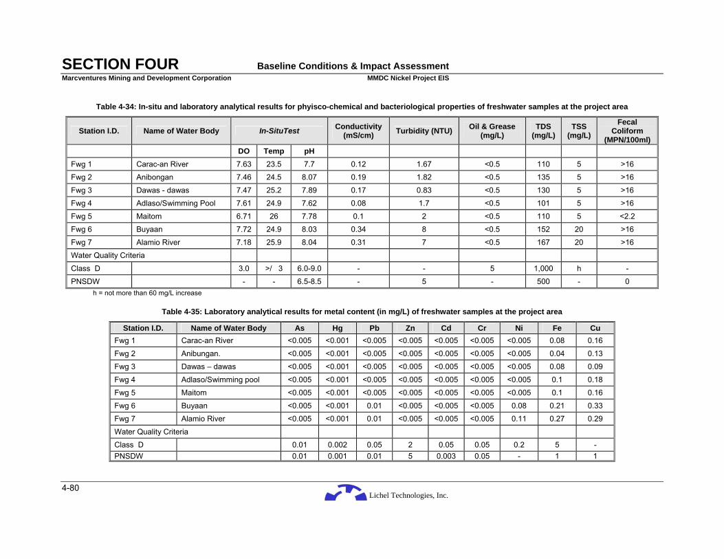
Lichel Technologies, Inc.
SECTION FOUR Baseline Conditions & Impact Assessment Marcventures Mining and Development Corporation MMDC Nickel Project EIS
4-80
Table 4-34: In-situ and laboratory analytical results for phyisco-chemical and bacteriological properties of freshwater samples at the project area
Station I.D. Name of Water Body In-SituTest Conductivity (mS/cm) Turbidity (NTU) Oil & Grease
(mg/L) TDS
(mg/L) TSS
(mg/L) Fecal
Coliform (MPN/100ml)
DO Temp pH
Fwg 1 Carac-an River 7.63 23.5 7.7 0.12 1.67 <0.5 110 5 >16
Fwg 2 Anibongan 7.46 24.5 8.07 0.19 1.82 <0.5 135 5 >16
Fwg 3 Dawas - dawas 7.47 25.2 7.89 0.17 0.83 <0.5 130 5 >16
Fwg 4 Adlaso/Swimming Pool 7.61 24.9 7.62 0.08 1.7 <0.5 101 5 >16
Fwg 5 Maitom 6.71 26 7.78 0.1 2 <0.5 110 5 <2.2
Fwg 6 Buyaan 7.72 24.9 8.03 0.34 8 <0.5 152 20 >16
Fwg 7 Alamio River 7.18 25.9 8.04 0.31 7 <0.5 167 20 >16
Water Quality Criteria
Class D 3.0 >/ 3 6.0-9.0 - - 5 1,000 h -
PNSDW - - 6.5-8.5 - 5 - 500 - 0 h = not more than 60 mg/L increase
Table 4-35: Laboratory analytical results for metal content (in mg/L) of freshwater samples at the project area
Station I.D. Name of Water Body As Hg Pb Zn Cd Cr Ni Fe Cu Fwg 1 Carac-an River <0.005 <0.001 <0.005 <0.005 <0.005 <0.005 <0.005 0.08 0.16
Fwg 2 Anibungan. <0.005 <0.001 <0.005 <0.005 <0.005 <0.005 <0.005 0.04 0.13
Fwg 3 Dawas – dawas <0.005 <0.001 <0.005 <0.005 <0.005 <0.005 <0.005 0.08 0.09
Fwg 4 Adlaso/Swimming pool <0.005 <0.001 <0.005 <0.005 <0.005 <0.005 <0.005 0.1 0.18
Fwg 5 Maitom <0.005 <0.001 <0.005 <0.005 <0.005 <0.005 <0.005 0.1 0.16
Fwg 6 Buyaan <0.005 <0.001 0.01 <0.005 <0.005 <0.005 0.08 0.21 0.33
Fwg 7 Alamio River <0.005 <0.001 0.01 <0.005 <0.005 <0.005 0.11 0.27 0.29
Water Quality Criteria
Class D 0.01 0.002 0.05 2 0.05 0.05 0.2 5 - PNSDW 0.01 0.001 0.01 5 0.003 0.05 - 1 1
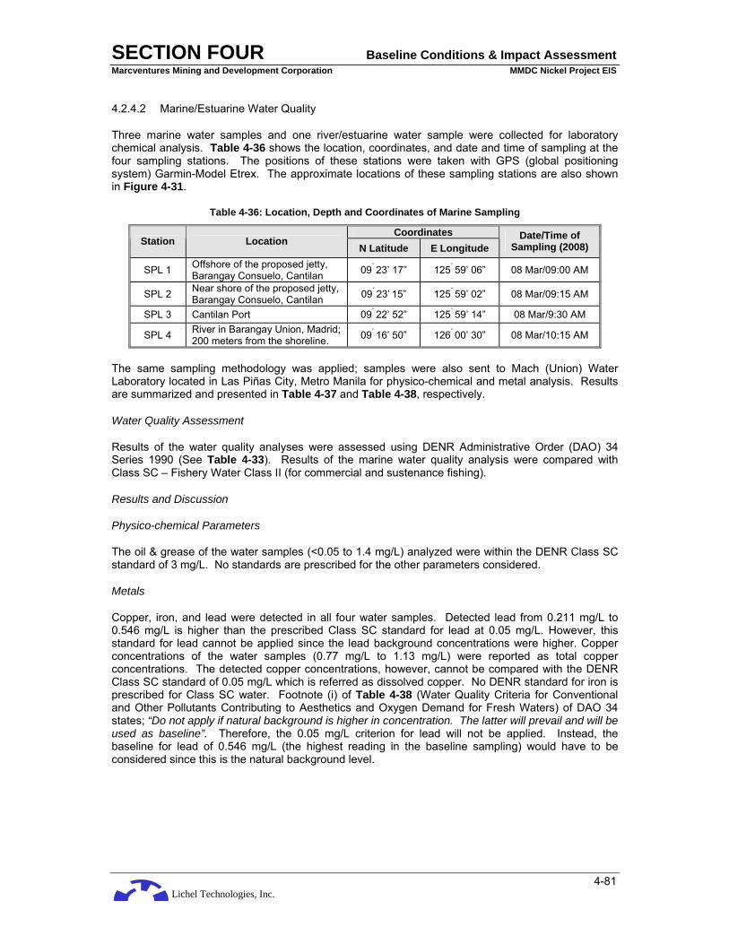
Lichel Technologies, Inc.
SECTION FOUR Baseline Conditions & Impact Assessment Marcventures Mining and Development Corporation MMDC Nickel Project EIS
4-81
4.2.4.2 Marine/Estuarine Water Quality
Three marine water samples and one river/estuarine water sample were collected for laboratory chemical analysis. Table 4-36 shows the location, coordinates, and date and time of sampling at the four sampling stations. The positions of these stations were taken with GPS (global positioning system) Garmin-Model Etrex. The approximate locations of these sampling stations are also shown in Figure 4-31.
Table 4-36: Location, Depth and Coordinates of Marine Sampling
Coordinates Station Location
N Latitude E Longitude Date/Time of
Sampling (2008)
SPL 1 Offshore of the proposed jetty, Barangay Consuelo, Cantilan 09˚ 23’ 17” 125˚ 59’ 06” 08 Mar/09:00 AM
SPL 2 Near shore of the proposed jetty, Barangay Consuelo, Cantilan 09˚ 23’ 15” 125˚ 59’ 02” 08 Mar/09:15 AM
SPL 3 Cantilan Port 09˚ 22’ 52” 125˚ 59’ 14” 08 Mar/9:30 AM
SPL 4 River in Barangay Union, Madrid; 200 meters from the shoreline. 09˚ 16’ 50” 126˚ 00’ 30” 08 Mar/10:15 AM
The same sampling methodology was applied; samples were also sent to Mach (Union) Water Laboratory located in Las Piñas City, Metro Manila for physico-chemical and metal analysis. Results are summarized and presented in Table 4-37 and Table 4-38, respectively.
Water Quality Assessment
Results of the water quality analyses were assessed using DENR Administrative Order (DAO) 34 Series 1990 (See Table 4-33). Results of the marine water quality analysis were compared with Class SC – Fishery Water Class II (for commercial and sustenance fishing).
Results and Discussion
Physico-chemical Parameters
The oil & grease of the water samples (<0.05 to 1.4 mg/L) analyzed were within the DENR Class SC standard of 3 mg/L. No standards are prescribed for the other parameters considered.
Metals
Copper, iron, and lead were detected in all four water samples. Detected lead from 0.211 mg/L to 0.546 mg/L is higher than the prescribed Class SC standard for lead at 0.05 mg/L. However, this standard for lead cannot be applied since the lead background concentrations were higher. Copper concentrations of the water samples (0.77 mg/L to 1.13 mg/L) were reported as total copper concentrations. The detected copper concentrations, however, cannot be compared with the DENR Class SC standard of 0.05 mg/L which is referred as dissolved copper. No DENR standard for iron is prescribed for Class SC water. Footnote (i) of Table 4-38 (Water Quality Criteria for Conventional and Other Pollutants Contributing to Aesthetics and Oxygen Demand for Fresh Waters) of DAO 34 states; “Do not apply if natural background is higher in concentration. The latter will prevail and will be used as baseline”. Therefore, the 0.05 mg/L criterion for lead will not be applied. Instead, the baseline for lead of 0.546 mg/L (the highest reading in the baseline sampling) would have to be considered since this is the natural background level.

Lichel Technologies, Inc.
SECTION FOUR Baseline Conditions & Impact Assessment Marcventures Mining and Development Corporation MMDC Nickel Project EIS
4-82
Table 4-37: Laboratory analytical results for phyisco-chemical properties of marine water samples
Station I.D. Name of Water Body Conductivity (mS/cm) Turbidity (NTU) Oil & Grease
(mg/L) TDS
(mg/L) TSS
(mg/L)
SPL 1 Jetty offshore 76.9 8 <0.5 >10000 20
SPL 2 Jetty nearshore 76.9 9 <0.5 >10000 20
SPL 3 Cantilan Port 76.89 8 1.4 >10000 20
SPL 4 River at Barangay Union, Madrid 1.12 8 0.87 856 20
Water Quality Criteria
Class SC - - 3 - g g = not more than 30 mg/L increase
Table 4-38: Laboratory analytical results for metal content of marine water samples
Station I.D. Name of Water Body As (mg/L)
Hg (mg/L)
Pb (mg/L)
Zn (mg/L)
Cd (mg/L)
Cr (mg/L)
Ni (mg/L)
Fe (mg/L) Cu (mg/L)
SPL 1 Jetty offshore <0.005 <0.001 0.211 <0.005 <0.005 <0.005 <0.005 0.76 0.771
SPL 2 Jetty nearshore <0.005 <0.001 0.241 <0.005 <0.005 <0.005 <0.005 0.794 0.783
SPL 3 Cantilan Port <0.005 <0.001 0.298 <0.005 <0.005 <0.005 <0.005 0.807 0.879
SPL 4 River at Barangay Union, Madrid <0.005 <0.001 0.546 <0.005 <0.005 <0.005 <0.005 1.12 1.13
Water Quality
Class SC Criteria 0.05 0.002 0.05 (i) - 0.01 0.10 - - 0.05 (o) o = Refers to dissolved copper i = Do not apply if natural background is higher in concentration. The latter will prevail and will be used as baseline.
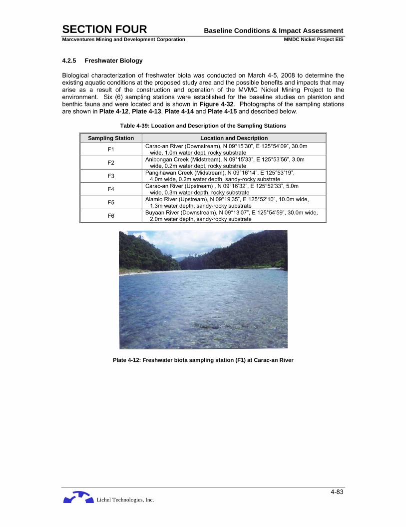
Lichel Technologies, Inc.
SECTION FOUR Baseline Conditions & Impact Assessment Marcventures Mining and Development Corporation MMDC Nickel Project EIS
4-83
4.2.5 Freshwater Biology
Biological characterization of freshwater biota was conducted on March 4-5, 2008 to determine the existing aquatic conditions at the proposed study area and the possible benefits and impacts that may arise as a result of the construction and operation of the MVMC Nickel Mining Project to the environment. Six (6) sampling stations were established for the baseline studies on plankton and benthic fauna and were located and is shown in Figure 4-32. Photographs of the sampling stations are shown in Plate 4-12, Plate 4-13, Plate 4-14 and Plate 4-15 and described below.
Table 4-39: Location and Description of the Sampling Stations
Sampling Station Location and Description
F1 Carac-an River (Downstream), N 09°15’30”, E 125°54’09”, 30.0m wide, 1.0m water dept, rocky substrate
F2 Anibongan Creek (Midstream), N 09°15’33”, E 125°53’56”, 3.0m wide, 0.2m water dept, rocky substrate
F3 Pangihawan Creek (Midstream), N 09°16’14”, E 125°53’19”, 4.0m wide, 0.2m water depth, sandy-rocky substrate
F4 Carac-an River (Upstream) , N 09°16’32”, E 125°52’33”, 5.0m wide, 0.3m water depth, rocky substrate
F5 Alamio River (Upstream), N 09°19’35”, E 125°52’10”, 10.0m wide, 1.3m water depth, sandy-rocky substrate
F6 Buyaan River (Downstream), N 09°13’07”, E 125°54’59”, 30.0m wide, 2.0m water depth, sandy-rocky substrate
Plate 4-12: Freshwater biota sampling station (F1) at Carac-an River

Lichel Technologies, Inc.
SECTION FOUR Baseline Conditions & Impact Assessment Marcventures Mining and Development Corporation MMDC Nickel Project EIS
4-84
Plate 4-13: Freshwater biota sampling station (F2) at Anibongan Creek
Plate 4-14: Freshwater biota sampling station (F3) at Pangihawan Creek
Plate 4-15: Freshwater biota sampling station (F4) at Carac-an River

Lichel Technologies, Inc.
SECTION FOUR Baseline Conditions & Impact Assessment Marcventures Mining and Development Corporation MMDC Nickel Project EIS
4-85
Figure 4-32: Freshwater Ecology Sampling Stations

Lichel Technologies, Inc.
SECTION FOUR Baseline Conditions & Impact Assessment Marcventures Mining and Development Corporation MMDC Nickel Project EIS
4-86
4.2.5.1 Methodology
Phytoplankton
Phytoplanktons were collected by slowly submerging a half-gallon container towards the current until it is filled-up. Samples were preserved with 4% formalin and were brought to the laboratory where the samples were allowed to settle in their original container for 4-7 days. After settling, the supernatant was siphoned-off and the samples were transferred to a shallow container. They were again allowed to settle for 3-7 days and after settling, the final concentrate of 100 ml aliquot sample was examined using the Sedgewick-Rafter (S-R) counting cell under a compound microscope (10X magnification, 10 field). The phytoplankton samples were then identified to the lowest practicable taxonomic level and counted. Their density (D) and relative abundance index (RAI) were calculated using the following formula:
N x Vc x 1000 D = cell/l L x d x W x S x Vs
where:
D = Density, cells/l N = Number of cells counted L = Length of each strip (S-R cell, length), mm d = Depth of a strip (S-R, width), mm W = Width of a strip (Whipple grid range, width), mm S = Number of strips counted Vc = Volume of concentrate, ml Vs = Volume of original sample, ml
and:
S RAI = x 100 T
where:
RAI = Relative Abundance Index (%) S = Total number of organisms per species T = Total number of organisms of all species
To differentiate species diversities among the sampling stations, the species richness or variety indices (Odum, 1971) were calculated using the formula:
S – 1 d = log N
where:
d = Species richness of variety index S = Total number of species/taxa N = Total number of organisms

Lichel Technologies, Inc.
SECTION FOUR Baseline Conditions & Impact Assessment Marcventures Mining and Development Corporation MMDC Nickel Project EIS
4-87
Zooplankton
Using a fine mesh 0.33 plankton net with a 0.5 m mouth opening, zooplankton samples were collected from the established sampling stations. Collection was done for five (5) minutes in each station by submerging the plankton net positioned towards the current. The plankton net was thoroughly rinsed with water to remove all attached organisms in the net and collected samples were then transferred in a plastic container. A 4% formalin was added to preserve the collected samples. Counting and identification of specimens were made using a zooplankton counting wheel and dissecting stereozoom microscope, respectively. The Relative Abundance Index (RAI) and Species Diversity Index (d) of zooplankton samples were calculated using the standard formula.
Benthic Fauna
Freshwater benthic fauna were collected by means of a Surber Square Foot Sampler. Samples taken at each station were placed in properly labeled plastic containers and preserved with 4% formalin. In the laboratory, the benthic samples were sieved through a 500 micron mesh screen. Bioresidues (which may contain meiofauna) which passed through the 500 micron mesh were also examined.
Organisms were counted and identified to the lowest practicable taxonomic level using a dissecting stereozoom microscope. The Relative Abundance Index (RAI) and Species Diversity Index (d) were calculated using the standard formula. Density (D) of benthic organisms was calculated using the formula:
number of organisms D = organisms/sq m 0.093
Gathering of secondary biological data from government institutions was also carried out to supplement information vital to the study.
4.2.5.2 Results and Discussion
Phytoplankton
Phytoplankton compose a major portion of the food-chain base in the aquatic environment. These unicellular algae constitute a major portion of the diets of zooplankton, juvenile fish and macro-invertebrates. They are of very great importance in all sizeable bodies of water, but they are relatively especially important in the open sea. Table 4-40 and Table 4-41 present the taxonomic listing, distribution, relative abundance and density of the freshwater phytoplankton organisms collected and identified during the biological sampling conducted at the six (6) sampling stations.
Eight (8) phytoplankton taxa belonging to only one (1) group, Phylum Chrysophyta (diatoms), were represented in the samples. With the possible exception of the insufficiently known nannoplankters, the microplanktonic diatoms are the most significant and basic plants in freshwater. Their importance lies not in their size as individuals, for they are all microscopic with the largest being barely visible to the naked eye but in their enormous abundance and their widespread occurrence provided there is sufficient light to maintain their photosynthetic activities (Davis, 1955). Among the diatoms represented, the centric Rhizosolenia sp. and the pennate Fragillaria sp. were the most conspicuous with their corresponding abundances of 37.2 percent (24.2 cells/l) and 20.5 percent (13.3 cells/l). They were also the commonly occurring taxa as they were present in all sampling stations. On the contrary, Synedra sp. of the pennate group was the least represented phytoplankton in the samples.
Phytoplankton associated with clean, aerated water system were Navicula sp., Pinnularia sp. and Surirella sp. They were collected and identified in all sampling stations except in STN F5 (Alamio River).
In relation to station distribution, STN F6 (Buyaan River) was the most prominent in terms of phytoplankton abundance with 90 cells/l and was represented by five (5) taxa (Tables 2 and 3). In contrast, STNs F1 (Carac-an River) and F2 (Anibongan Creek) were the least with 35 cells/l. In

Lichel Technologies, Inc.
SECTION FOUR Baseline Conditions & Impact Assessment Marcventures Mining and Development Corporation MMDC Nickel Project EIS
4-88
relation to species richness, STN F3 (Pangihawan Creek) yielded the highest Species Diversity Index with 4.1 while STN F2 registered the lowest at 2.4 (Table 4-42). Diversity index is often used as an indication in a body of water. This index takes into consideration the number of species (richness) in the community and their relative proportion (evenness).
Zooplankton
Zooplanktons are assemblage of organisms whose distribution and dispersal is at the mercy of the water current. They occupy a very important portion in the trophic level being the primary consumers of phytoplankton.
As presented in Table 4-43, a total of eight (8) taxa belonging to three (3) phyla represented the zooplankton assemblage. The three (3) groups detected were the arthropods (Phylum Arthropoda), chordates (Phylum Chordata) and the molluscs (Phylum Mollusca). Of these, the arthropods predominated with 92 percent of the total samples. The molluscs and the chordates comprised the remaining 8 percent with their corresponding abundances of 4.3 percent and 3.7 percent.
Insect nymphs and larvae were the most numerous zooplankton with dragonfly nymphs predominating. They accounted for 67.1 percent of the total samples. They were likewise collected and identified in all the sampling stations along with mayfly nymphs. Mayfly nymphs were the only zooplankton indicator of clean water system. Insect nymphs and larvae become temporary members of the plankton community because they become suspended due to the stirring action of the current. Sometimes, they may be considered as an artifact because of the limitation in sampling techniques.
In relation to station distribution, STN F5 (Alamio River) recoded the highest taxa count with seven (7) identified taxa while the least was in STN F3 (Pangihawan Creek) with 2 taxa (Table 4-43). STN 2 recorded the highest SDI with 3.7 while the lowest recorded SDI was noted at STN F3 with 1.4 (Table 4-42). The variations in the abundance and diversity of zooplankton among the sampling stations could be affected by factors such as current flow, seasonal migration, depth, grazing, among others and availability of food.
The impoverished population of phytoplankton and the diverse assemblage of zooplankton could be explained by two (2) theories which explained the apparent relationship that exists between these plankton. The Theory of Grazing proposed by Harvey (Davis, 1955) explained that in those places where the zooplankton population is greater to begin with (perhaps because of swarming in the breeding season, etc.), the consumption of the phytoplankton takes place at such a rate that they are not able to build up numbers. Whereas, in those places where the initial population of the zooplankton is lower, the phytoplankton have a chance to multiply rapidly, and this results in a great local phytoplankton population.
Moreover, the Theory of Animal Exclusion by Hardy and Gunther could further explain the relationship that exists between the phytoplankton and zooplankton (Davis, 1955). Phytoplanktons simply find it difficult to make headway in the desired direction because of the close proximity of the zooplankton to each other. Phytoplankton will therefore be eventually found far from the mass of the zooplankton and then they can migrate to the surface without hindrance.

Lichel Technologies, Inc.
SECTION FOUR Baseline Conditions & Impact Assessment Marcventures Mining and Development Corporation MMDC Nickel Project EIS
4-89
Table 4-40: Taxonomic Listing, Distribution and Relative Abundance of Freshwater Phytoplankton
Frequency (no.) Relative Abundance (5) T A X A F1 F2 F3 F4 F5 F6 Total F1 F2 F3 F4 F5 F6 Ave.
PHYLUM CHRYSOPHYTA Class Bacillariophyceae Order Centrales SubOrder Rhizosolenineae Family Rhizosoleniaceae Rhizosolenia sp. SubOder Coscinodiscineae Family Coscinodiscaceae Melosira sp. Order Pennales SubOrder Fragillarineae Family Fragillariaceae Fragillaria sp. Synedra sp. SubOrder Naviculineae Family Naviculaceae Navicula sp. Pinnularia sp. Pleurosigma sp. SubOrder Surirellineae Family Surirellaceae Surirella sp.
3
1
1
2
3 2 2
5
2
3
2 2 3
4 3 4 2
6 3 4 3
8
2
3
2
3
29
7
16 3
5 4 9
5
42.8
14.3
14.3
28.6
42.8
28.6
28.6
29.4
11.8
17.6
11.8 11.8 17.6
30.8
23.1
30.8
15.4
37.5
18.8
25.0 18.8
44.4
11.1
16.7
11.1
16.7
37.2
9.0
20.5 3.9
6.4 5.1 11.5
6.4
Total No. of Organisms Total No. of Taxa Total No. of Phylum
7 4 1
7 3 1
17 6 1
13 4 1
16 4 1
18 5 1
78 8 1
Source: Biological Sampling, March, 2008
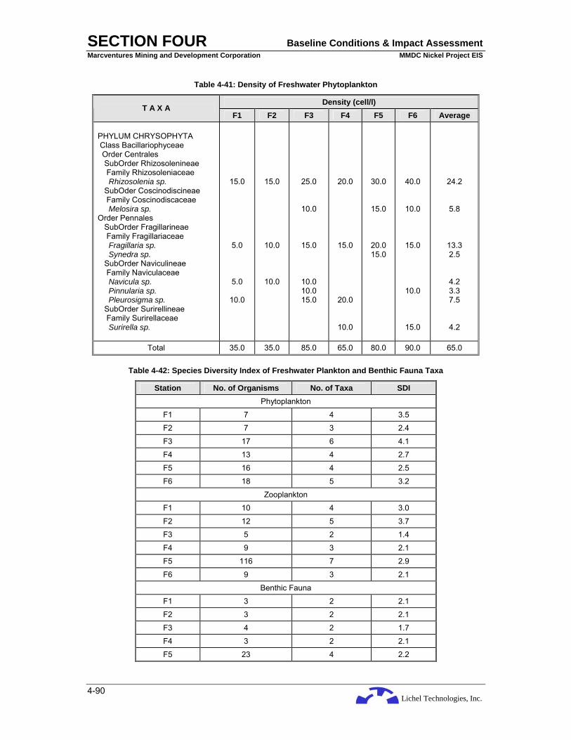
Lichel Technologies, Inc.
SECTION FOUR Baseline Conditions & Impact Assessment Marcventures Mining and Development Corporation MMDC Nickel Project EIS
4-90
Table 4-41: Density of Freshwater Phytoplankton
Density (cell/l) T A X A
F1 F2 F3 F4 F5 F6 Average PHYLUM CHRYSOPHYTA Class Bacillariophyceae Order Centrales SubOrder Rhizosolenineae Family Rhizosoleniaceae Rhizosolenia sp. SubOder Coscinodiscineae Family Coscinodiscaceae Melosira sp. Order Pennales SubOrder Fragillarineae Family Fragillariaceae Fragillaria sp. Synedra sp. SubOrder Naviculineae Family Naviculaceae Navicula sp. Pinnularia sp. Pleurosigma sp. SubOrder Surirellineae Family Surirellaceae Surirella sp.
15.0
5.0
5.0
10.0
15.0
10.0
10.0
25.0
10.0
15.0
10.0 10.0 15.0
20.0
15.0
20.0
10.0
30.0
15.0
20.0 15.0
40.0
10.0
15.0
10.0
15.0
24.2
5.8
13.3 2.5
4.2 3.3 7.5
4.2
Total 35.0 35.0 85.0 65.0 80.0 90.0 65.0
Table 4-42: Species Diversity Index of Freshwater Plankton and Benthic Fauna Taxa
Station No. of Organisms No. of Taxa SDI Phytoplankton
F1 7 4 3.5
F2 7 3 2.4
F3 17 6 4.1
F4 13 4 2.7
F5 16 4 2.5
F6 18 5 3.2
Zooplankton
F1 10 4 3.0
F2 12 5 3.7
F3 5 2 1.4
F4 9 3 2.1
F5 116 7 2.9
F6 9 3 2.1
Benthic Fauna
F1 3 2 2.1
F2 3 2 2.1
F3 4 2 1.7
F4 3 2 2.1
F5 23 4 2.2

Lichel Technologies, Inc.
SECTION FOUR Baseline Conditions & Impact Assessment Marcventures Mining and Development Corporation MMDC Nickel Project EIS
4-91
Station No. of Organisms No. of Taxa SDI F6 29 4 2.0
Table 4-43: Taxonomic Listing, Distribution and Relative Abundance of Freshwater Zooplankton
Frequency (no.) Relative Abundance (5) T A X A
F1 F2 F3 F4 F5 F6 Total F1 F2 F3 F4 F5 F6 Ave
. PHYLUM ARTHROPODA Class Arachnida Order Acarina Water mite Class Crustacea SubClass Copepoda Order Calanoida Calanoid copepods Class Insecta Order Ephemeroptera Mayfly nymphs Order Odonata Dragonfly nymphs Order Trichoptera Caddisfly larvae PHYLUM CHORDATA Class Pisces Fish eggs PHYLUM MOLLUSCA Class Bivalvia Bivalve larvae Class Gastropoda Gastropod larvae
2 3 3 2
1 2 3 4 2
2 3
3
2
4
3 7
89 8 4 2 3
2
5
2
1
8
18
108
13
6
2
5
20.0
30.0
30.0
20.0
8.3
16.7
25.0
33.3
16.7
40.0
60.0
33.3
22.2
44.4
2.6
6.0
76.7
6.9
3.5
1.7
2.6
22.2
55.6
22.2
0.6
5.0
11.2
67.1
8.1
3.7
1.2
3.1
Total No. of Organisms Total No. of Taxa Total No. of Phyla
10 4 2
12 5 2
5 2 1
9 3 1
116 7 3
9 3 1
161 8 3
Source: Biological Sampling, March, 2008
Benthic Fauna
Benthos are organisms which inhabit the bottom regions of an aquatic ecosystem. They may be found attached to or roaming freely over rocks, organic debris and other substrate during all or part of their life cycle.
The benthic fauna collected and identified at the proposed study area was composed of the molluscs (Phylum Mollusca) and the arthropods (Phylum Arthropoda) as shown in Table 4-44 and Table 4-45. Of these, the molluscs predominated with 50.7 percent (68.1 organisms/sq m) of the total samples while the arthropods accounted for the remaining 49.3 percent (66.3 organisms/sq m). Of the seven (7) benthic fauna taxa identified, Melanoides sp. dominated with 48 percent (64.5 organisms/sq m). They were mostly identified at STN F6 (Buyaan River). Others like Palaemonetes sp., and dragonfly nymphs were likewise numerous with 29.3 percent (39.4 organisms/sq m) and 13.3 percent (17.9 organisms/sq m), respectively.
Comparing the density of the sampling stations, STN F6 recorded the highest at 419.4 organisms/sq m while the lowest was recorded at STNs F1, F2 and F3, each with 32.3 organisms/sq m (Table 4-45). However, there is a slight difference as far as the recorded SDI is concerned. The highest SDI was recorded at STN F5 with 2.2 while the lowest was at STN F3 with 1.7 (Table 4-42).

Lichel Technologies, Inc.
SECTION FOUR Baseline Conditions & Impact Assessment Marcventures Mining and Development Corporation MMDC Nickel Project EIS
4-92
Table 4-44: Taxonomic Listing, Distribution and Relative Abundance of Freshwater Benthic Fauna
Frequency (no.) Relative Abundance (5) T A X A F1 F2 F3 F4 F5 F6 Total F1 F2 F3 F4 F5 F6 Ave.
PHYLUM ARTHROPODA Class Crustacea SubClass Malacostraca Order Decapoda Varuna sp. (freshwater crab) Family Palaemonidae Palaemonetes sp. Class Insecta Order Odonata Dragonfly nymphs Order Ephemeroptera Mayfly nymphs Order Coleoptera Beetle larvae PHYLUM MOLLUSCA Class Gastropoda SubClass Prosobranchia Order Mesogastropoda SubOrder Taenioglossa SuperFamily Cerithiacea Family Thiaridae Melanoides sp. Thiara sp.
2 1
2 1
3 1
2 1
1
16 2 4
1 4
32 2
2
22
10 2 1
36 2
66.7
33.3
66.7
33.3
75.0
25.0
66.7
33.3
4.3
69.5
8.7
17.4
2.6
10.2
82.0 5.1
2.7
29.3
13.3
2.7
1.3
48.0 2.7
Total No. of Organisms Total No. of Taxa Total No. of Phyla
3 2 1
3 2 1
4 2 1
3 2 1
23 4 2
39 4 2
75 7 2
Source: Biological Sampling, March, 2008
Table 4-45: Density of Freshwater Benthic Fauna
Density (organisms/sq m) T A X A F1 F2 F3 F4 F5 F6 Average
PHYLUM ARTHROPODA Class Crustacea SubClass Malacostraca Order Decapoda Varuna sp. (freshwater crab) Family Palaemonidae Palaemonetes sp. Class Insecta Order Odonata Dragonfly nymphs Order Ephemeroptera Mayfly nymphs Order Coleoptera Beetle larvae PHYLUM MOLLUSCA Class Gastropoda SubClass Prosobranchia Order Mesogastropoda SubOrder Taenioglossa SuperFamily Cerithiacea Family Thiaridae Melanoides sp. Thiara sp.
21.5
10.8
21.5
10.8
32.3
10.8
21.5
10.8
10.8
172.0
21.5
43.0
10.8
43.0
344.1 21.5
3.6
39.4
17.9
3.6
1.8
64.5 3.6
Total 32.3 32.3 43.1 32.3 247.3 419.4 134.4

Lichel Technologies, Inc.
SECTION FOUR Baseline Conditions & Impact Assessment Marcventures Mining and Development Corporation MMDC Nickel Project EIS
4-93
Freshwater Fisheries
There are three (3) main streams that are sources of the fishery resources in the area. These are the Carac-an, Habigjan and Alamio rivers. The Rivers during the time of visit were clear with relatively lean flows. Substrate consists predominantly of gravel and sand.
Based on the interview of the most senior resident in the area, fish resources constitute a large part of the Manobo Tribe diet in Barangay Cabangahan. Freshwater fish are caught for sustenance only and not for commercial purposes. Traditional fishing gears used are composed of spear fishing (sibat or pana), hook and line fishing, gillnetting (pukot), and bamboo traps (bantak). It is worthy to note that the Manobo tribe never uses poisons and electro-shock for riverine fishing. Table 4-46 presents the commonly caught freshwater fishery resources, namely: Tilapia sp (tilapia, Ophicephalusd spp (dalag), and Anguilla spp. (eel). Also caught are species of freshwater shrimp (Paleamonetes spp) and freshwater crabs (Macrobrachium spp) and gobies locally called “gabot”.
Since the 1940’s up to the present, the source of fish diet for the Manobo tribe comes from the three main rivers and their intermittent creeks. In the earlier years, the fishermen in the area caught 20- 25 kilograms of mixed catch using their traditional gears but at the later years 2-5 kilograms of mixed catch are only produced. Frogs are strive in the rivers and are also eaten as part of the Manobo tribe’s diet. Freshwater turtles are also seldom caught and were also eaten and are consider as a delicacy. Forest lizards commonly known as “bayawak” and locally known as “ibid” lay their eggs in the river banks. The eggs and the lizards are also eaten by the tribe.
Below are list of the commonly caught fishes in Carac-an and Habigjan rivers.
Table 4-46: List of Fishery Resources Commonly Caught in the Rivers
Species Common Name Local Name
Tilapia sp Tilapia Tilapia
Anguilla mauritania Freshwater ell kasili
Ophicephalus striatus Snakehead murrel Dalag
Paleamonetes spp Freshwater shrimp Ulang
Macrobrachium spp Freshwater crab crablets
Goby Gabot Gabot
Traditional Fishing Gears/Methods Used
The fishing gears and the methods used are all locally manufactured. Some were introduced in the area by the low-land residents.
Gillnet (pukot). This refers to the ordinary gillnet and the scoop net. Both are made up of fine mesh fishing net. In gillnetting, fishes try to swim through deliberately sized mesh openings but are unable to squeeze through swimming forward. Once in this position, they are prevented from backing out due to the tendency for their gills to become caught. This effectively traps them. A scoop net, as the name implies, is used to scoop fish from the rivers. Fish caught with these gears include mostly the Tilapia species.
Spear (pana and sibat). A local spear and arrow to catch big species of fish.
Hook and Line. This is the ordinary hook and line used by all fishermen. Baits used include all kinds of innards of animals found in the forest. Fish commonly caught with this method include eels and snakeheads.

Lichel Technologies, Inc.
SECTION FOUR Baseline Conditions & Impact Assessment Marcventures Mining and Development Corporation MMDC Nickel Project EIS
4-94
Macrophytes and macrofaunas
The most common macrophytes found in al the rivers are ferns and the rock moss. In two rivers, “lab-lab” a freshwater algae commonly found in fish ponds is also present but in small proportions. Juvenile shrimps and juvenile fingerlings of gobies, and crablets form part of the macrofaunas that were observed.
4.2.6 Marine Biology
4.2.6.1 Methodology
Methodologies used in this study are discussed separately for each section. Figure 4-33 shows the location of transect lines, sampling stations.
4.2.6.2 Results and Discussions
Plankton
Plankton samples were collected along 2 transect lines in the coastal area of Barangay Consuelo, Cantilan, Surigao del Sur where the proposed jetty of MMDC is to be constructed. Collection was done using the phytoplankton net and the bucket system while on board a motorized boat with outriggers.
The most frequently found plankton with 100% frequency were Beroe, Guinardia, Hemialus, Melosira, Rhizosolenia, and Synedra while those with 75% frequency were Atlanta, Campylodiscus, Cyclotella, and Dactyliosolen. In terms of density, Atlanta (153) ranks 1st followed by Dactyliosolen (101), Rhizosolenia (97), Cyclotella (88), Guinardia (78), Thalassiotrix (69), Nereis (49), Campylodiscus (48), Hemialus (47), and Nitzschia (46). Except for the larvae of Nereis which is an Annelid, the rest were phytoplankters considered to be important planktonic species serving as food for the marine aquatic organisms occupying higher trophic levels.
Table 4-47: The top 10 species of plankton in terms of frequency and density
Species number Species Frequency (out of
4 samples) Equivalent %
Frequency Density (no. of
Individuals per liter) Frequency
1 Beroe 4 100 33 2 Guinardia 4 100 78 3 Hemialus 4 100 47 4 Melosira 4 100 16 5 Rhizosolenia 4 100 97 6 Synedra 4 100 44 7 Atlanta 3 75 153 8 Campylodiscus 3 75 48 9 Cyclotella 3 75 88
10 Dactyliosolen 3 75 101 Density 1 Atlanta 3 75 153 2 Dactyliosolen 3 75 101 3 Rhizosolenia 4 100 97 4 Cyclotella 3 75 88 5 Guinardia 4 100 78 6 Thalassiotrix 3 75 69 7 Nereis 3 75 49 8 Campylodiscus 3 75 48 9 Hemialus 4 100 47
10 Nitzschia 3 75 46
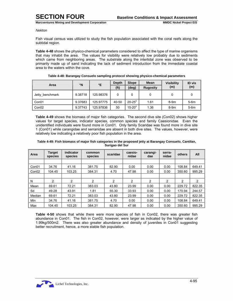
Lichel Technologies, Inc.
SECTION FOUR Baseline Conditions & Impact Assessment Marcventures Mining and Development Corporation MMDC Nickel Project EIS
4-95
Nekton
Fish visual census was utilized to study the fish population associated with the coral reefs along the subtidal region.
Table 4-48 shows the physico-chemical parameters considered to affect the type of marine organisms that may inhabit the area. The values for visibility were relatively low probably due to sediments which came from neighboring areas. The substrate along the intertidal zone was observed to be primarily made up of sand indicating the lack of sediment introduction from the immediate coastal area to the waters within the cove.
Table 4-48: Barangay Consuelo sampling protocol showing physico-chemical parameters
Depth Slope Mean Area °N °E (ft) (deg) Rugosity
Visibility (m)
ID vis (m)
Jetty_benchmark 9.38718 125.98376 0 0 0 0 0
Con01 9.37683 125.97775 40-50 20-25o 1.61 8-9m 5-6m
Con02 9.37743 125.97836 50 15-20o 1.36 8-9m 5-6m
Table 4-49 shows the biomass of major fish categories. The second dive site (Con02) shows higher values for target species, indicator species, common species and family Caesionidae. Even the unidentified individuals were found more in Con01. Only family Scaridae was found more in dive site 1 (Con01) while carangidae and serranidae are absent in both dive sites. The values, however, were relatively low indicating a relatively poor fish population in the area.
Table 4-49: Fish biomass of major fish categories in the proposed jetty at Barangay Consuelo, Cantilan, Surigao del Sur
Area Target species
indicator species
common species scaridae caesio-
nidae carangi-
dae serra-nidae others All
Con01 34.76 41.16 381.75 82.90 0.00 0.00 0.00 108.84 649.41 Con02 104.45 103.25 384.31 4.70 47.98 0.00 0.00 350.60 995.29 N 2 2 2 2 2 2 2 2 2 Mean 69.61 72.21 383.03 43.80 23.99 0.00 0.00 229.72 822.35 Sd 49.28 43.91 1.81 55.30 33.93 0.00 0.00 170.94 244.57 Median 69.61 72.21 383.03 43.80 23.99 0.00 0.00 229.72 822.35 Min 34.76 41.16 381.75 4.70 0.00 0.00 0.00 108.84 649.41 Max 104.45 103.25 384.31 82.90 47.98 0.00 0.00 350.60 995.29
Table 4-50 shows that while there were more species of fish in Con02, there was greater fish abundance in Con01. The fish in Con02, however, were larger as indicated by the higher value of 1.99kg/500m2. There was also greater abundance and density of juveniles in Con01 suggesting better recruitment, hence, a more stable fish population.

Lichel Technologies, Inc.
SECTION FOUR Baseline Conditions & Impact Assessment Marcventures Mining and Development Corporation MMDC Nickel Project EIS
4-96
Figure 4-33: Location of Marine Ecology Sampling Stations

Lichel Technologies, Inc.
SECTION FOUR Baseline Conditions & Impact Assessment Marcventures Mining and Development Corporation MMDC Nickel Project EIS
4-97
Table 4-50: Fish matrix of fish and juveniles in the proposed jetty, Barangay Consuelo, Cantilan, Surigao del Sur
Area no
. sp
p
(w/in
500
m2)
no. f
amili
es (
w/in
50
0m2)
Fish
den
sity
(in
d/m
2)
Fish
abu
ndan
ce
(ind/
500m
2)
Fish
bio
- mas
s
(g
/m2)
Fish
bio
mas
s2
(kg/
500m
2)
Juv
dens
ity
(in
d/m
2)
Juv
abun
danc
e
(ind/
500m
2)
aver
age
biom
ass2
(k
g/50
0m2)
Mea
n in
d w
t (g
/ind/
m2)
Con01 36 11 0.73 366 2.60 1.30 0.20 100.00 0.01 3.55 Con02 49 15 0.51 254 3.98 1.99 0.00 3.00 0.02 7.84 N 2 2 2 2 2 2 2 2 2 2 Mean 42.50 13.00 0.62 310.00 3.29 1.64 0.10 51.50 0.02 5.69 Sd 9.19 2.83 0.16 79.20 0.98 0.49 0.14 68.59 0.00 3.03 Median 42.5 13 0.62 310 3.29 1.64 0.10 51.5 0.02 5.69 Min 36 11 0.51 254 2.60 1.30 0.00 3 0.01 3.55 Max 49 15 0.73 366 3.98 1.99 0.20 100 0.02 7.84
Benthos
In studying the benthos found in the coral reefs, the Line-Intercept Transect method was utilized. Table 4-51 shows a comparison of life forms in the two dive sites.
Dive site 1 (Consuelo 1) showed more branching and massive types of corals while dive site 2 (Consuelo 2) was dominated by digitate and table type of corals. In both dive sites, there were a high percentage of dead corals with algae growing on them. This indicates that the area could have been subjected to destruction not too recently. Based on interviews, the fishermen in the area confirmed illegal methods of fishing, such as with the use of dynamite, prevalent in the area before. They also complained about poor catches compared to a decade or two ago. This, however, they attribute not only to illegal methods of fishing done by artisanal fishermen but by commercial fishermen who use big boats and illegal methods of fishing such as “hulbot-hulbot” even at present.
Table 4-51: Summary of life forms characterizing each dive stations in Brgy. Consuelo, Cantilan, Surigao del Sur. (March 03, 2008)
Station Life form Consuelo 1 Consuelo 2
Coral branching (CB) 11.26 5.60 Coral digitate (CD) 0.00 17.74 Coral encrusting (CE) 6.40 0.60 Coral foliose (CF) 3.40 0.60 Coral massive (CM) 13.72 7.76 Coral mushroom (CMR) 0.38 1.60 Coral submassive (CSM) 0.90 0.00 Coral tabulate (CT) 3.40 12.32 Dead coral with algae (DCA) 27.28 24.90 Macro algae (MA) 2.44 8.18 Other Biotic (OT) 6.06 1.50 Abiotic 24.76 19.20
Total 100.00 100.00

Lichel Technologies, Inc.
SECTION FOUR Baseline Conditions & Impact Assessment Marcventures Mining and Development Corporation MMDC Nickel Project EIS
4-98
Table 4-52 shows the different groups of macroepifauna and their number of species and relative abundance. Tunicates (67.68%) dominated the population of macroepifauna, most especially Didemnum molle, followed by the echinoderms (13.54%) composed by sea urchins. The least abundant groups include crustaceans, cephalopods and nudibranchs.
Table 4-53 shows value for Index of Diversity and a very low value for the Index of Dominance suggesting high level of biodiversity. However, there were only 11 species. Thus, while there could be some stability in the population of macroepifauna, the area is still species poor.
Table 4-52: Summary of macroepifaunal groups, their number of species (in 100m2 area surveyed), Mean abundance (ind/500 m2) and relative abundance (%) in the 2 stations in Brgy. Consuelo, Cantilan, Surigao
del Sur
Station Consuelo 01 Consuelo 02 ind/m2 % No. spps Taxa Tunicates Clavellina spp 0.00 250.00 125.00 13.81 Didemnum molle 125.00 850.00 487.50 53.87 Total 125.00 1100.00 612.50 67.68 2 Bivalve Pedum spondyloideum 35.00 95.00 65.00 7.18 Total 35.00 95.00 65.00 7.18 1 Echinoderms Diadema savignyi 75.00 155.00 115.00 12.71 Echinotrix spp 5.00 10.00 7.50 0.83 Total 80.00 165.00 122.50 13.54 2 Asteroid Linckia laevigata 0.00 10.00 5.00 0.55 Total 0.00 10.00 5.00 0.55 1 Gastropod Nassarius spp 35.00 0.00 17.50 1.93 Total 35.00 0.00 17.50 1.93 1 Polychaete Sabellid 55.00 95.00 75.00 8.29 Total 55.00 95.00 75.00 8.29 1 Cephalopod Sepia spp. 5.00 0.00 2.50 0.28 Total 5.00 0.00 2.50 0.28 1 Nudibranchs Phyllidia spp 0.00 5.00 2.50 0.28 Total 0.00 5.00 2.50 0.28 1 Crustacea Harpiosquilla spp 0.00 5.00 2.50 0.28 Total 0.00 5.00 2.50 0.28 1

Lichel Technologies, Inc.
SECTION FOUR Baseline Conditions & Impact Assessment Marcventures Mining and Development Corporation MMDC Nickel Project EIS
4-99
Grand total 905.00 100.00 11
Table 4-53: Indices of Dominance (Simpson’s, C) and Diversity (Shannon-Weaver, H’)
ni ni / N (ni/N) (ni/N) log ni/N (ni/N) log
(ni/N)
ind/m2 1 Didemnum molle 30 0.058594 0.003433 -1.23215 -0.0722 2 Oxycorynia spp 12.5 0.024414 0.000596 -1.61236 -0.03936 3 Polycarpa aurata 25 0.048828 0.002384 -1.31133 -0.06403 4 Barnacle 10 0.019531 0.000381 -1.70927 -0.03338 5 Pedum spondyloideum 142.5 0.27832 0.077462 -0.55546 -0.15459 6 Lopha spp 57.5 0.112305 0.012612 -0.9496 -0.10664 7 Spondylus spp 15 0.029297 0.000858 -1.53318 -0.04492 8 Pinna spp 7.5 0.014648 0.000215 -1.83421 -0.02687 9 Diadema savignyi 80 0.15625 0.024414 -0.80618 -0.12597
10 Echinotrix spp 20 0.039063 0.001526 -1.40824 -0.05501 11 Linckia laevigata 17.5 0.03418 0.001168 -1.46623 -0.05012 12 Ophiotrix spp 15 0.029297 0.000858 -1.53318 -0.04492 13 Bohadschia spp 2.5 0.004883 2.38E-05 -2.31133 -0.01129 14 Chicoreus spp 2.5 0.004883 2.38E-05 -2.31133 -0.01129 15 Cypraea spp 2.5 0.004883 2.38E-05 -2.31133 -0.01129 16 Sabellid 27.5 0.053711 0.002885 -1.26994 -0.06821 17 Spirobranchus 20 0.039063 0.001526 -1.40824 -0.05501 18 Phyllidia spp 25 0.048828 0.002384 -1.31133 -0.06403 'N = 512.5 C = 0.132775 -H' = -1.03911
Table 4-54 shows the estimated number of individuals per 500 m2 with the tunicates (1225) being dominant followed by the echinoderms.
Table 4-54: Summary of macroepifaunal groups, their total number of species (in 100m2 area surveyed), mean abundance (ind/500 m2), minimum and maximum counts of species in Brgy. Consuelo, Cantilan,
Surigao del Sur
Station Tunicates Bivalve Echino- derms Asteroid Gastro-
pod Poly-
chaete Cepha- lopod
Nudi- branchs Crustacea
Consuelo 01 125.00 35.00 80.00 0.00 35.00 55.00 5.00 0.00 0.00
Consuelo 02 1100.00 95.00 165.00 10.00 0.00 95.00 0.00 5.00 5.00
N 1225.00 130.00 245.00 10.00 35.00 150.00 5.00 5.00 5.00
Mean 612.50 65.00 122.50 5.00 17.50 75.00 2.50 2.50 2.50
Sd 689.43 42.43 60.10 7.07 24.75 28.28 3.54 3.54 3.54
Median 612.50 65.00 122.50 5.00 17.50 75.00 2.50 2.50 2.50
Min 125.00 35.00 80.00 0.00 0.00 55.00 0.00 0.00 0.00
Max 1100.00 95.00 165.00 10.00 35.00 95.00 5.00 5.00 5.00

Lichel Technologies, Inc.
SECTION FOUR Baseline Conditions & Impact Assessment Marcventures Mining and Development Corporation MMDC Nickel Project EIS
4-100
Sea grass-Algae
The sea grass/algal beds were studied using the Saito-Atobe technique of cover assessment. Two transect lines were laid out from the shoreline to the edge of the intertidal area, and 3 quadrats for one line and 2 quadrats for the other line were studied. The area was relatively homogenous with Cymodacea dominating the whole area.
Table 4-55 shows that Transect Line 1 (T1) contains more of the sea grass Cymodacea which incidentally was the only species of sea grass present along the transect line. Transect Line 2 (T2) contaied both Cymodacea and Thalassia. Algae present included only Gracilaria and Sargassum and was in very low quantity. The average of 63 represented the rating given to Cymodacea (out of the maximum rating of 125 in one quadrat [0.5m X 0.5m]) while the corresponding value of 2.52 was its equivalence in the Saito-Atobe rating of 1 – 5. The average percentage value for 2.52 is a sea grass cover of 15.75% only. A value of 5 is equivalent to 75% cover with a range of 50-75% cover. Thus, while the area is dominated by Cymodacea, the percentage cover was still very low. Thalassia, when present was found only near edge of the intertidal zone.
Table 4-55: Total rating (scale of 1 - 5) using the Saito-Atobe method of Assessment of Seagrass-Algal bed
T1Q1 (10m)
T1Q2 (50m)
T1Q3 (90m)
T2Q1 (25m)
T2Q2 (75m) Average Ave per
Grid Average
% Seagrass Cymodacea 68 76 67 50 54 63 63 = 2.52 15.7500 54.40% 60.80% 53.60% 40% 43.20% 50.40% Thallassia 10 16 16 = 0.64 3.0000 8% 12.80% Algae Gracilaria 1 1 1 = 0.04 0.1875 0.80% 0.80% 9 9 Sargassum 7.20% 7.20% 9 = 0.36 1.6875
Mangrove
Mangroves are absent along the coastline of Barangay Consuelo. This is probably due to the absence of stream opening up directly on the cove where the jetty is proposed to be constructed. The lack of freshwater inflow which is supposed to carry silt and clay and other nutrients which could support a mangrove population must be the primary reason why mangroves are absent in the area.
4.2.6.3 Summary
The area for the proposed MMDC jetty at Barangay Consuelo can be characterized as relatively poor in species of the usual coastal marine ecosystem (mangrove, seagrass/algal beds, and coral reefs and associated fish population and macroepifauna) due to poor fishing practices. Thus, the construction of the jetty will most likely not result into further degradation of the said coastal marine ecosystem if sediments from the ores stockpiled or moved through the jetty are contained.
As it is, the water has a relatively poor visibility caused by sediments. For this, rainwater which may wash and carry the sediments from the stockpiled ore should have proper drainage installed with silt traps before the said rainwater is allowed to move into the coastal marine waters. This will also minimize leaching of materials attached to the ores, some of which could be toxic to the marine organisms and human beings who may consume contaminated marine products from the area.
The presence of the jetty may also help minimize the scouring effect of big waves during the northeast monsoon and occurrence of typhoons. This could lead to better growth of seagrass and algae in the area, hence, increase productivity.
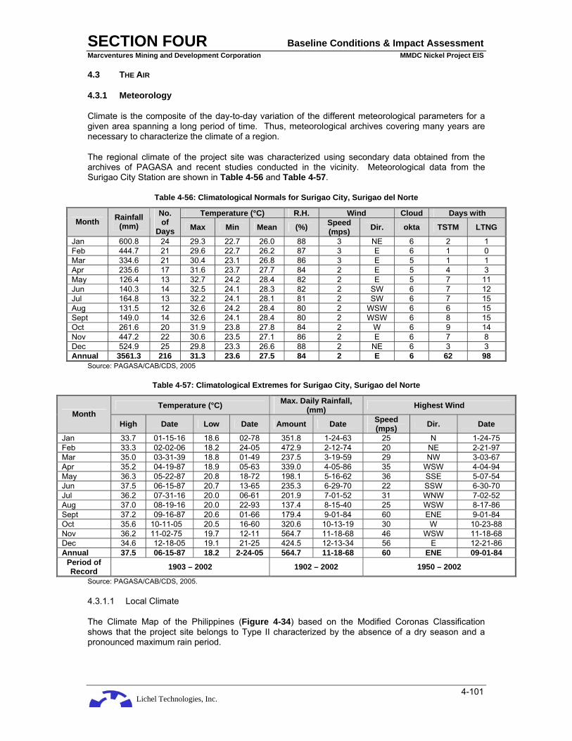
Lichel Technologies, Inc.
SECTION FOUR Baseline Conditions & Impact Assessment Marcventures Mining and Development Corporation MMDC Nickel Project EIS
4-101
4.3 THE AIR
4.3.1 Meteorology
Climate is the composite of the day-to-day variation of the different meteorological parameters for a given area spanning a long period of time. Thus, meteorological archives covering many years are necessary to characterize the climate of a region.
The regional climate of the project site was characterized using secondary data obtained from the archives of PAGASA and recent studies conducted in the vicinity. Meteorological data from the Surigao City Station are shown in Table 4-56 and Table 4-57.
Table 4-56: Climatological Normals for Surigao City, Surigao del Norte
Temperature (°C) R.H. Wind Cloud Days with Month Rainfall
(mm) No. of
Days Max Min Mean (%) Speed (mps) Dir. okta TSTM LTNG
Jan 600.8 24 29.3 22.7 26.0 88 3 NE 6 2 1 Feb 444.7 21 29.6 22.7 26.2 87 3 E 6 1 0 Mar 334.6 21 30.4 23.1 26.8 86 3 E 5 1 1 Apr 235.6 17 31.6 23.7 27.7 84 2 E 5 4 3 May 126.4 13 32.7 24.2 28.4 82 2 E 5 7 11 Jun 140.3 14 32.5 24.1 28.3 82 2 SW 6 7 12 Jul 164.8 13 32.2 24.1 28.1 81 2 SW 6 7 15 Aug 131.5 12 32.6 24.2 28.4 80 2 WSW 6 6 15 Sept 149.0 14 32.6 24.1 28.4 80 2 WSW 6 8 15 Oct 261.6 20 31.9 23.8 27.8 84 2 W 6 9 14 Nov 447.2 22 30.6 23.5 27.1 86 2 E 6 7 8 Dec 524.9 25 29.8 23.3 26.6 88 2 NE 6 3 3 Annual 3561.3 216 31.3 23.6 27.5 84 2 E 6 62 98
Source: PAGASA/CAB/CDS, 2005
Table 4-57: Climatological Extremes for Surigao City, Surigao del Norte
Temperature (°C) Max. Daily Rainfall, (mm) Highest Wind
Month High Date Low Date Amount Date Speed
(mps) Dir. Date
Jan 33.7 01-15-16 18.6 02-78 351.8 1-24-63 25 N 1-24-75 Feb 33.3 02-02-06 18.2 24-05 472.9 2-12-74 20 NE 2-21-97 Mar 35.0 03-31-39 18.8 01-49 237.5 3-19-59 29 NW 3-03-67 Apr 35.2 04-19-87 18.9 05-63 339.0 4-05-86 35 WSW 4-04-94 May 36.3 05-22-87 20.8 18-72 198.1 5-16-62 36 SSE 5-07-54 Jun 37.5 06-15-87 20.7 13-65 235.3 6-29-70 22 SSW 6-30-70 Jul 36.2 07-31-16 20.0 06-61 201.9 7-01-52 31 WNW 7-02-52 Aug 37.0 08-19-16 20.0 22-93 137.4 8-15-40 25 WSW 8-17-86 Sept 37.2 09-16-87 20.6 01-66 179.4 9-01-84 60 ENE 9-01-84 Oct 35.6 10-11-05 20.5 16-60 320.6 10-13-19 30 W 10-23-88 Nov 36.2 11-02-75 19.7 12-11 564.7 11-18-68 46 WSW 11-18-68 Dec 34.6 12-18-05 19.1 21-25 424.5 12-13-34 56 E 12-21-86 Annual 37.5 06-15-87 18.2 2-24-05 564.7 11-18-68 60 ENE 09-01-84
Period of Record 1903 – 2002 1902 – 2002 1950 – 2002
Source: PAGASA/CAB/CDS, 2005.
4.3.1.1 Local Climate
The Climate Map of the Philippines (Figure 4-34) based on the Modified Coronas Classification shows that the project site belongs to Type II characterized by the absence of a dry season and a pronounced maximum rain period.
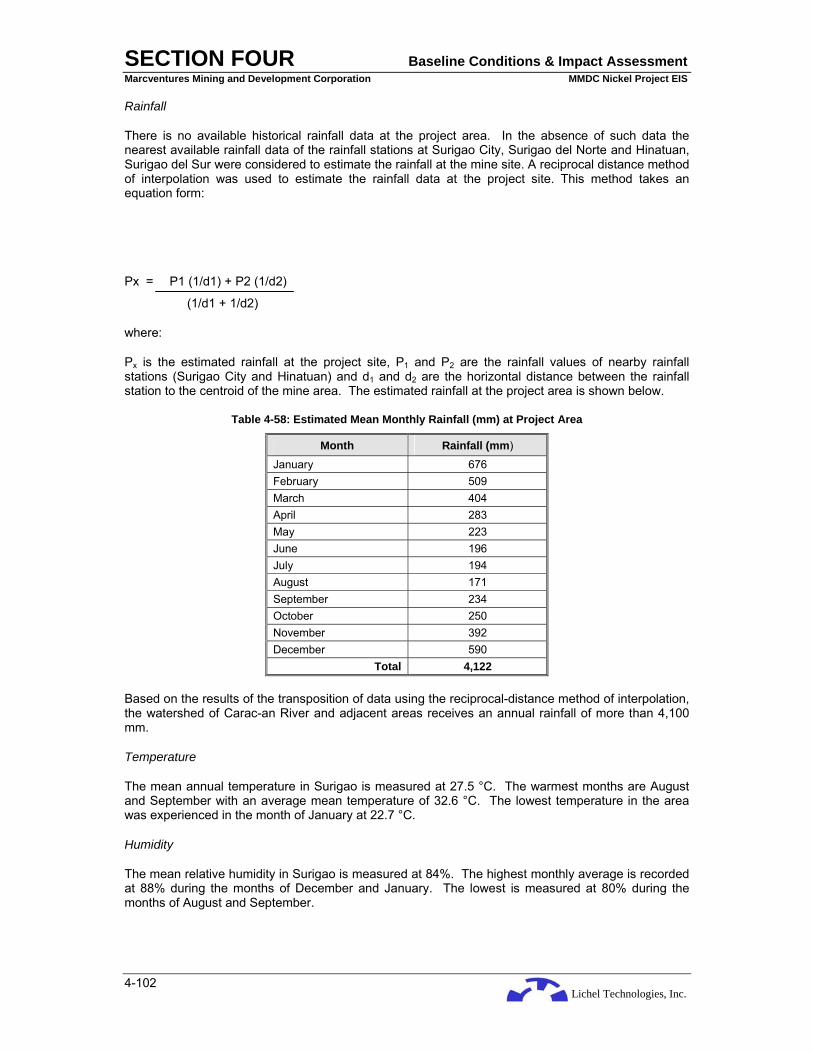
Lichel Technologies, Inc.
SECTION FOUR Baseline Conditions & Impact Assessment Marcventures Mining and Development Corporation MMDC Nickel Project EIS
4-102
Rainfall
There is no available historical rainfall data at the project area. In the absence of such data the nearest available rainfall data of the rainfall stations at Surigao City, Surigao del Norte and Hinatuan, Surigao del Sur were considered to estimate the rainfall at the mine site. A reciprocal distance method of interpolation was used to estimate the rainfall data at the project site. This method takes an equation form:
Px = P1 (1/d1) + P2 (1/d2)
(1/d1 + 1/d2)
where:
Px is the estimated rainfall at the project site, P1 and P2 are the rainfall values of nearby rainfall stations (Surigao City and Hinatuan) and d1 and d2 are the horizontal distance between the rainfall station to the centroid of the mine area. The estimated rainfall at the project area is shown below.
Table 4-58: Estimated Mean Monthly Rainfall (mm) at Project Area
Month Rainfall (mm)
January 676 February 509 March 404 April 283 May 223 June 196 July 194 August 171 September 234 October 250 November 392 December 590
Total 4,122
Based on the results of the transposition of data using the reciprocal-distance method of interpolation, the watershed of Carac-an River and adjacent areas receives an annual rainfall of more than 4,100 mm.
Temperature
The mean annual temperature in Surigao is measured at 27.5 °C. The warmest months are August and September with an average mean temperature of 32.6 °C. The lowest temperature in the area was experienced in the month of January at 22.7 °C.
Humidity
The mean relative humidity in Surigao is measured at 84%. The highest monthly average is recorded at 88% during the months of December and January. The lowest is measured at 80% during the months of August and September.

Lichel Technologies, Inc.
SECTION FOUR Baseline Conditions & Impact Assessment Marcventures Mining and Development Corporation MMDC Nickel Project EIS
4-103
Wind Speed and Direction
From November to May, the northeastern winds prevail over the area. The North Pacific trade winds prevail in May. The average speed of wind that passes through the area is measured at 2 m/sec (Figure 4-35).

Lichel Technologies, Inc.
SECTION FOUR Baseline Conditions & Impact Assessment Marcventures Mining and Development Corporation MMDC Nickel Project EIS
4-104
Figure 4-34: Climate map of the Philippines

Lichel Technologies, Inc.
SECTION FOUR Baseline Conditions & Impact Assessment Marcventures Mining and Development Corporation MMDC Nickel Project EIS
4-105
Figure 4-35: Wind Rose Diagram

Lichel Technologies, Inc.
SECTION FOUR Baseline Conditions & Impact Assessment Marcventures Mining and Development Corporation MMDC Nickel Project EIS
4-106
4.3.2 Air Quality and Noise
4.3.2.1 Ambient Air Quality
Ambient air quality with respect to Total Suspended Particles (TSP), Sulfur Dioxide (SO2) and Nitrogen Dioxide (NO2) was measured notwithstanding the nature of the proposed Project, which is not expected to generate significant amounts of by-products of combustion such as NO2 and SO2.
Methodology and Establishment of Sampling Stations
The following instruments and methodologies were employed in determining the ambient air quality and noise levels within and around the project site (Table 4-59).
Table 4-59: Air Quality Monitoring Sampling Methodologies
Parameters Methodology
Total Suspended Particulates (TSP) High Volume Sampler-Gravimetric Method
Sulfur Dioxide (SO2) Impinger-Pararosaniline Method
Nitrogen Dioxide (NO2) Impinger-Griess Saltzman Reaction
Noise Level Sound Level Meter
Air samples were obtained from four (4) stations based on the dominant wind direction, which are primarily northeasterly and the potential receptors downwind from the proposed operations area. The dominant land use of the immediate vicinity of the initial mine area is forest lands and the nearest population center is at Barangay Cabangahan (Station A24-1) which is about 1.5 km away. Three other sampling sites were chosen, namely: Station A1 at Barangay Cabas-an; Station A2 at Barangay Parang and Station A3 at Barangay Consuelo. The sampling stations at Barangay Cabas-an and at Barangay Parang are located along the existing barangay road that MMDC intends to use as hauling access while the sampling station at Barangay Consuelo is near the proposed stockyard and jetty. The 24-hour sampling site at the settlement in Barangay Cabangahan was selected particularly for its proximity to the mining area.
Figure 4-31 also shows the location of ambient air quality and noise sampling stations.
Ambient air quality sampling for Total Suspended Particulates (TSP), Sulfur Dioxide (SO2) and Nitrogen Dioxide (NO2) concentrations was done at four (4) sites. Sites were selected based on their location relative to the proposed operations area and the dominant wind directions. Ambient air quality results for 1-hour sampling on March 2, 2008 indicated TSP concentrations to be relatively low (154.9 to 197.9 µg/Ncm) compared to the NAAQS (300 µg/Ncm). Ambient SO2 concentrations at all sampling stations were below 1.7 µg/Ncm, while ambient NO2 concentrations ranged from 0.7 to 2.7 µg/Ncm. The results of the 24-hour sampling conducted on March 1-2, 2008 at Brgy. Cabangahan showed concentrations of TSP, SO2 and NO2 to be 75.2 µg/Ncm, 0.09 µg/Ncm and 2.1 µg/Ncm, respectively (Table 4-60).
Table 4-60: Observed Ambient Air Quality
Sta. No. Location Date/Time of Sampling
Ave. Temp.
(°C) Wind
Direction TSP
(µg/Ncm) SO2
(µg/Ncm) NO2
(µg/Ncm)
A1 Brgy. Cabas-an 1130H March 2, 2008 – 900H March 2, 2008 29.5 NE 197.9 <1.7 2.5
A2 Brgy. Parang 1300H March 2, 2008 – 1400H March 2, 2008 31.5 NE 196.1 <1.7 2.7
A3 Brgy. Consuelo 1600H March 2, 2008 – 1700H March 2, 2008 30.0 NE 154.9 <1.7 0.7
A24-1 Brgy. Cabangahan 1000H March 1, 2008 – 28.5 NE 75.2 0.09 2.1

Lichel Technologies, Inc.
SECTION FOUR Baseline Conditions & Impact Assessment Marcventures Mining and Development Corporation MMDC Nickel Project EIS
4-107
Sta. No. Location Date/Time of Sampling
Ave. Temp.
(°C) Wind
Direction TSP
(µg/Ncm) SO2
(µg/Ncm) NO2
(µg/Ncm)
1000H March 2, 2008 DENR National Ambient Air Quality Guideline (NAAQG - 24 hours sampling) 230 180 150
DENR National Ambient Air Quality Standards (NAAQS – 1 hr sampling) 300 340 260
TSP
TSP measurements at Barangay Cabas-an yielded the highest readings partly due to its relative proximity to the road compared to the other sites. TSP levels at all the sampling sites were found to be within the standards for ambient air quality as stipulated in DAO 14, although a slight increase may be expected in the future due to planned mine development activities. The relatively low concentrations of TSP in the area typify rural settings such as that of the project site.
SO2 and NO2
Ambient SO2 concentrations at all sampling stations were below 1.7 µg/Ncm. Relatively low ambient NO2 concentrations ranged from 0.7 to 2.7 µg/Ncm. The characteristically rural setting of the area typifies the relatively few number of SO2 and NO2 emission generators. Vehicle volume is typically small and traffic is very light, thus the low ground level concentrations.
In summary, the observed parameters are within the standards and ambient air quality in the vicinity could be classified as “good” when compared with the air quality indices provided by the DENR. The proposed Project will have insignificant impacts with respect to SO2 and NO2 emissions.
4.3.2.2 Noise
Noise may be defined as unwanted sound and is recognized as a form of pollution, which is measured in terms of its intensity and expressed in decibel units (dB). For comparison, a whisper would register an intensity of 20 dB(A) while a jet aircraft taking off nearby would register 140 dB(A), which exceeds the human threshold of 120 dB(A). Similarly, 150 dB (A) can rupture the eardrums.
The maximum allowable noise level for a certain area is dependent on two factors, namely a) category of the area, e.g. residential, commercial, industrial, etc. and b) division of twenty-four hour period, e.g. morning, daytime, evening, etc. Table 4-61 below shows the Standards for Noise.
Table 4-61: Standards for Noise, dB(A)
Daytime (0900 to 1800H)
Morning (0500 to 0900H) and Evening (1800 to
2200H)
Nighttime (2200 to 0500H)
Class AA (Areas 100 m away from schools, hospitals, playgrounds, etc.) 50 45 40
Class A (Residential purposes) 55 50 45 Class B (Commercial areas) 65 60 55 Class C (Light industrial areas) 70 65 60
Class D (Heavy industrial areas) 75 70 65 Source: 1978 NPCC Rules and Regulations Implementing PD 984
Ambient noise measurements were done on March 1, 2008 to determine the existing noise levels in the area. Noise sampling stations coincided with those for air quality sampling. Measurements for each station were conducted by getting a total of 50 readings, wherein the median of the seven maximum-recorded noise levels gives the noise level comparable to the standard (NPCC Memorandum Circular 002, 1980). Noise measurements for all the stations were obtained during daytime (between 0900H and 1800H).

Lichel Technologies, Inc.
SECTION FOUR Baseline Conditions & Impact Assessment Marcventures Mining and Development Corporation MMDC Nickel Project EIS
4-108
Based on the results of the noise level readings (Table 4-62), ambient noise in all stations were observed to be within the prescribed standards for residential areas (the dominant land-use in the vicinity of the project). The ambient noise level measurements are typical of rural setting with noise emanating mostly from residents, livestock and vehicular traffic.
Table 4-62: Summary of Noise Readings dB(A)
Sta. No. Location Date of Sampling Noise Level
N1 Barangay Cabas-an March 1, 2008 52 N2 Barangay Parang March 1, 2008 53 N3 Barangay Consuelo March 1, 2008 51 N4 Barangay Cabangahan March 1, 2008 50
NPCC Standard for Class a (Residential purposes) 55
Laboratory results of the ambient air quality sampling report are presented in Annex E-5.
4.4 THE PEOPLE
4.4.1 Socio-Cultural, Economic and Political Environment
4.4.1.1 Background of Surigao del Sur
Surigao del Sur is located in the northeastern coast of Mindanao facing the Pacific Ocean between 125°40’ to 126°20’ east longitude and 7°55’ and 9°20’ north latitude. It is bounded on the northwest by the Province of Surigao del Norte, Davao Oriental on the southeast, the Pacific Ocean on the east, and the Provinces of Agusan del Norte and Agusan del Sur on the west and southwest.
Surigao del Sur has 2 cities and 17 municipalities. Most of these are located in the coastal areas. Tandag is the capital and seat of the provincial government. The municipalities are subdivided into 309 barangays and are covered by two congressional districts. Currently, there are several boundary disputes between Surigao del Sur and the adjoining provinces of Surigao del Norte, Agusan del Norte, and Davao Oriental. In particular, Carrascal and Claver have a boundary dispute involving approximately 50 square kilometers.
As of August 1, 2007, Surigao del Sur had a population of 541,347 persons. Population increased by 7.88% over 7.25 years or an annual average growth of 1.05%. Among the 17 municipalities and two cities, Bislig City had the highest population, corresponding to 20% in 2000 and 18.8% in 2007 of the province’s residents. Bayabas recorded the least population of 7,439 in 2007. San Agustin registered the highest growth rate of 32% from 2000 to 2007. Lingig and Bayabas were the only municipalities that registered a population decrease at -10% and -3%, respectively.
4.4.1.2 Socio-Demographic Profile of the Three Municipalities and One Barangay
Carrascal, Surigao del Sur
The Municipality of Carrascal belongs to Region 13 presently known as CARAGA Region. It is located in the northeastern portion of Surigao del Sur. It is bounded in the north by municipality of Claver, Surigao del Norte, in the south by Cantilan, Surigao del Sur; east by Pacific Ocean and west by Agusan del Norte. Barangay Embarcadero (Poblacion) the seat of local governance is some 70 km from Tandag City, the provincial capital of Surigao del Sur.
The name Carrascal originated in folklore involving three Boholano adventurers/fishermen who, in mid 19th century, used to “caras” (scrape) fish close to the bay shoreline. Carrascal is a fourth class Municipality created on 10 December 1918 by virtue of Governor Francis Burton Harrison’s Executive Order No. 50 signed by Charles Yeater. Formerly, Carrascal was only a barrio of Cantilan.
Lichel Technologies, Inc.
SECTION FOUR Baseline Conditions & Impact Assessment Marcventures Mining and Development Corporation MMDC Nickel Project EIS
4-109
Demography
Historical Population Growth
In the 1903 census, the population of Carrascal was 2,489 inhabitants. The population increased to 5,557 persons in 1939 or an average growth rate of a 2.25 percent. The population of Carrascal continued to grow until it reached its highest population in 1980 with 12,180 inhabitants or an average growth rate of 6.67 percent. From 1980, the population decreased due out-migration of people to other towns and provinces to seek better economic opportunities. In the 2007 National Statistics Office (NSO) census Carrascal had a total of 14,283 persons with an average growth rate of 1.1 percent. The details are shown below.
Table 4-63: Historical Growth of Population
Year Population Average Growth Rate
1903 2489 -
1918 - -
1939 5557 0.0225
1948 5988 0.0083
1960 7898 0.0233
1970 8240 0.0042
1975 9230 0.0229
1980 12810 0.0677
1990 12693 (0.0009)
1995 12018 (0.010)
2000 13157 0.018
2007 14283 0.011 Source: NSO
Population and Number of Households
Barangay Adlay registered the biggest population with 2,978 persons in 2007 population census. It was followed by Barangay Panikian with 1,951 persons. Barangay Caglayag had the least population of 302 persons.
In the NSO 2000 census, Carrascal has 2,756 households with an average household size of 4.77 persons. This is smaller than the average household size in Surigao del Sur and Caraga Region of 5.33 and 5.32, respectively. It however, approximates the Philippine average of 4.99 persons per household. Pantukan has the highest average household size of 5.86 while Baybay has the lowest of 4.39.
Population Density
Carrascal has a population density of 49 persons per square kilometer. The barangay with the highest population density is Doyos, a poblacion barangay with 16,244 persons per sq km. Barangay Panikian has 78 persons per sq km.
Table 4-64: Population Density by Barangay
Barangay Land Area (sq km)
2007 Population Census Population Density
Adlay 28.74 2,387 104 Babuyan 30.201 443 14

Lichel Technologies, Inc.
SECTION FOUR Baseline Conditions & Impact Assessment Marcventures Mining and Development Corporation MMDC Nickel Project EIS
4-110
Barangay Land Area (sq km)
2007 Population Census Population Density
Bacolod 22.301 740 34 Baybay 0.16 1,254 8,100 Bon-ot 23.201 878 47 Caglayag 24.602 315 12 Dahican 26.6 449 19 Doyos 0.09 1,417 16,244 Embarcadero 0.10 664 6,630 Gamuton 24.501 967 47 Panikian 25.121 1,970 78 Pantukan 35.911 510 14 Saca 0.15 773 5,140 Tag-anito 24.122 390 17 TOTAL 265.8 13,157 104
Source: CLUP Carrascal / NSO
Age Structure and Gender
The productive age population (15 – 65 years old) accounted for 56% of the total population while the dependent age groups (below 15 years and above 65 years old) accounted for 44% of the total population. There are more than 39 percent of the total household population ages 1 to 14 years old. The male to female ratio was 98 males for every 100 females.
Marital Status
Forty-seven percent of the total household population ages 10 years and above are married, 46% are single, and the remaining 7% are either widowed, separated, or their marital status is unaccounted. For those that are married, more than 50% are females. For those that are single, more than 51% are males.
Mother Tongue
Nine thousand seven hundred seventy-four (74%) of the total population are Cebuano speaking individuals. Binisaya came second with 1,054 individuals while Surigaonon came only third with 972 individuals. One thousand three hundred fifty-five spoke other dialects at home.
Religious Affiliation
More than 88% of the total population is affiliated with the Roman Catholic Church. Other religious affiliations are UCCP, Assemblies of God and other protestant denominations.
Migration Pattern
About 96 percent of the total population ages 5 years old and above resided in Carrascal for the last 5 years. Entrants from other towns and provinces accounted for the balance of 4 percent.
Education
Educational Facilities. Carrascal has of 15 elementary schools: 7 schools are complete elementary schools; 6 are complete primary schools; and 2 are incomplete primary schools. It has a total of 99 teaching and non-teaching personnel. As of school year 2001-2002, it has a total population of 2, 192 students.
The Municipality has three existing National High Schools: the Carrascal National High School (CNHS) which is located at Nocot, Barangay Saca; the Panikian National High School (PNHS); and the Adlay National High School.

Lichel Technologies, Inc.
SECTION FOUR Baseline Conditions & Impact Assessment Marcventures Mining and Development Corporation MMDC Nickel Project EIS
4-111
Presently, Carrascal National High School has the largest number of enrolment since it is considered as the center for secondary education in the municipality. Panikian National High School has 320 students for school year 2001-2002 while Adlay National High School has 187 enrolled students with seven (7) full time teachers. For the teachers and pupils aspects, the ratio is one teacher for every 26 pupils and one classroom for every 32 pupils. The textbook -pupil ratio ranges from 1:3 to 1:4.
Sacred Heart School of Arts & Technology Foundation, Inc. is a private school, which offers college courses for high school graduates of the municipality. The school is currently offering 12 courses and also special courses for computer related subjects.
Literacy Rate. Carrascal has a 92 percent literacy rate. This means that 92 % of the total population in the 10 year old and above age bracket is capable of reading and writing. Illiterate accounted for around 8% of the population in the same age bracket. In terms of gender more than 51 % literate people are females while there are more illiterates in the rural barangays.
Education Attainment. There are 4,195 persons who have elementary education of the total of 7,082 persons ages 7 years old and above, but only 47 % reach the highest elementary grade. There are 1,573 persons who have high school education but only 37 % completed their secondary course. There are 98 individuals who have post secondary education. There are 409 persons who have some college education. Only 252 individuals in the area have academic degrees. Three hundred twenty-two persons do not have any education. In conclusion, only 3.5 % in the area are college graduates.
Table 4-65: Highest Education Attainment of 7 Years above Age Bracket
Highest Education Attainment Population
No Grade Completed 322
Pre-School 169
Elementary 4195
High School 1573
Post Secondary 98
College Undergraduates 406
Academic Degree Holder 252
No Stated 67
TOTAL 7082 Source: CLUP Carrascal
Health
Fertility Indices. There are 270 registered live births in Carrascal and current crude rate is estimated 20 live births per 1,000 populations. There are 2,789 females in the 15-44, the child bearing age of females. Considering the current registered live birth, the total fertility rate of Carrascal is estimated at 97 live births per 1,000 female populations between 15-44 years old.
Causes of Morbidity. Table 4-66 shows the ten leading causes of morbidity from 1997 to 2001. The leading causes were still predominantly due to communicable cases like pneumonia, bronchitis and colds (no pneumonia) which are all respiratory tract diseases. Wounds, asthma, URTI, anemia, UTI, abscesses (skin infections) complete the list.
Table 4-66: Leading Causes of Morbidity
1997 1998 1999 2000 2001 Cause No. Cause No. Cause No. Cause No. Cause No.
No Pneumonia
750
No Pneumonia
327
Pneumonia
476
Pneumonia
400
Pneumonia
311

Lichel Technologies, Inc.
SECTION FOUR Baseline Conditions & Impact Assessment Marcventures Mining and Development Corporation MMDC Nickel Project EIS
4-112
1997 1998 1999 2000 2001 Cause No. Cause No. Cause No. Cause No. Cause No.
Pneumonia 745 Pneumonia 282 No Pneumonia
273
No Pneumonia
358
Bronchitis
267
Bronchitis 318 Bronchitis 221 Bronchitis 213 Bronchitis 199 No Pneumonia
237
Anemia 250 Influenza 183 URTI 164 URTI 165 Wounds 150 Influenza 217 Anemia 120 UTI 126 Anemia 150 Asthma 145
UTI 186 UTI 102 Skin Disorder
102
Skin Disorder
124
UTI
144
Parasitism 185 Parasitism 101 Anemia 124 Influenza 94 Anemia 121 Skin Disorder 125 Wounds 98 Wounds 96 UTI 93 UTI 106
Hypertension 95 Asthma 83 Asthma 81 Asthma 85 Abscess 96 Wounds 85 Abscess 79 Influenza 76 Wounds 80 Impetigo 81 Source: CLUP Carrascal
Causes of Mortality. The leading causes of mortality among the population in 2001 on the other hand are not anymore due to communicable diseases which predominate the previous years (Table 4-67) but due to lifestyle diseases manifested by hypertensive cardio vascular disease, cancer and coronary artery disease. The trend now is shifting from communicable to non-communicable diseases.
Table 4-67: Leading Causes of Mortality
1997 1998 1999 2000 2001 Cause No. Cause No. Cause No. Cause No. Cause No. PTB 8 Pneumonia 1 Pneumonia 15 HCVD 13 HCVD 10 CVA Hemorrhage
6 Cancer 1 CVA 9 Cancer 8 Cancer 8
Pneumonia 6 Drowning 5 Sepsis 9 Accidents 6 COPD 7 Anemia 5 Anemia 4 Cancer 8 CAD 5 CAD 5 Septicemia 4 Acute ML 3 CAD 7 Pneumonia 5 Asthmatic 3 Severe Disease
3
CVA Sepsis 3 COPD 6 Peptic
Ulcer 5 Diabetes 3
CHF 2 Sepsis 3 Accidents 4 COPD 4 Prematurity 3 Meningitis 2 PTB 3 Asthmaticus 4 PTB 4 Anemia 3 Accident 1 Peptic Ulcer 2 PTB 3 Anemia 2 Beeding pur 3 Asthmaticus 1 Asthmaticus Renal Failure 3 Diabetes 2 Pneumonia 2
Source: CLUP Carrascal
Rate of Malnutrition. The 2001 Operation Timbang shows that out of the 1,936 children weighed, 15 (0.77%) were severely malnourished (3rd degree) children, 125 children (6.45%) were moderately underweight (2nd degree), and 596 were mildly underweight or first degree malnourished children. Forty eight percent were of normal weight and 29 children were overweight.
Health Resources, Facilities and Services. The three (3) barangay health stations located in Adlay, Panikian and Babuyan are representing primary level of health service manned by a midwife capable of providing health education, giving immunization, rendering MCH and family planning, advising on nutrition, treating communicable illnesses and supplying essential drugs.
Poblacion proper has the main health center and it serves the 14 barangays. It delivers the same services with addition on doing minor surgeries and simple laboratory examinations. It has 5- bed infirmary which caters to serve the populace needing consultations and serves also as a venue for patients who are to be referred to bigger hospitals. It is headed by the municipal health officer, a nurse, medical technician, driver and utility man.
Agriculture
Crop Production. The Municipality has the agricultural area of 3, 053 ha or 8.06% of its total land area. It is devoted to the cultivation of rice, corn, coconut, root crops, vegetables and others.
Lichel Technologies, Inc.
SECTION FOUR Baseline Conditions & Impact Assessment Marcventures Mining and Development Corporation MMDC Nickel Project EIS
4-113
Barangays Panikian, Tag-anito, Bacolod, Tabon-Tabon and Gamuton are the leading rice producers in the municipality. Rice production averages 1,417.5 MT of rice which is equivalent to 12.6 M for the irrigated areas and 441 MT valuing to about 3.15M for the non-irrigated in one cropping season. Pantukan, Babuyan, Adlay and Panikian are concentrating on vegetables, root and other tuber crops which are also grown in almost all barangays.
Livestock. All the 14 barangays in the Municipality with special focus in 3 Barangays Tag-anito, Bon-ot and Adlay devote to livestock farming activities. Livestock farmers engage in backyard farming of small and large ruminant animals. Production on livestock and poultry ranges from small to medium scale produce an average employment of 2 persons.
Fishing. The average fish catch of the fishermen of Carrascal is 3-5 kg/day with 20 fishing trips for a ten (10) month fishing operations. Fish catch are sold at about PhP 40.00 to PhP 60.00 per kilo. These data show the low income derived by the fisherfolk from their primary source of income.
Industry and Commerce
Since the Ventura Timber Corporation in Sitio Ban-Ban, Barangay Panikian, Carrascal, Surigao del Sur ceased to operate, the Municipality of Carrascal has no existing major industry. In 2006 a mining company started operating in Barangay Adlay and this is the only industry in the municipality. Small industries such as rice mills, welding shop, bakery and other small businesses do exist in the Municipality.
These are mostly sari-sari stores which provide many families with extra income. However, big purchases are done either in Surigao City or Tandag where big commercial establishments offer more extensive goods at lower prices. In 2001, there are 171 establishments compared to 120 establishments in the year 2000.
Housing Information
Carrascal had a total of 2756 housing units in 2002. All housing units are occupied by a household. Almost all (2,750) of the houses are single detached units. Cogon/Anahaw is used by 2,170 housing units while 387 units have galvanized iron or aluminum roofing. Around 1,930 housing units were constructed more than 20 years ago. Around 2,584 housing units are owned by the occupants. About 1,938 households owned the lot where their houses are built.
Water Supply
Water supply level I is present to 51.88%, households, level II for 24.92% of total households while level III is present for 7.22% of total households. Around 16% of households have partial access to water. Out of 51.88% households being served by level I water supply, 18.03% have direct access to water by shallow wells and 1.74% have direct access to water by electric pumps.
Solid Waste Management
The Municipality has also its dumpsite strategically located four (4) kilometers away from the town proper in Sitio Kayawyawan, Barangay Bon-ot, Carrascal, Surigao del Sur. The usual manner of disposing waste is through burning followed by collection by service garbage truck which is provided by the municipality. Other methods are composting and burying.
Other Sectors
Social Welfare Services. Carrascal has more or less 2,587 households with an estimated population of 13,157 persons and 30% of this or about 3,947 people are living below the poverty line. The Local Social Welfare and Development provided social welfare programs and services to this sector. This sector is composed families and women in especially difficult circumstances (35%), communities in especially difficult circumstances (15%) children and youths (40%) and 10% senior citizens and persons with disabilities (10%).

Lichel Technologies, Inc.
SECTION FOUR Baseline Conditions & Impact Assessment Marcventures Mining and Development Corporation MMDC Nickel Project EIS
4-114
Transportation. Carrascal has the total road network of 64.17987 kilometers. Out of this total, 38.40% is classified as national roads, 32.72% is provincial roads; 14.15% municipal urban roads and 14.73% as barangay roads. Only 12.09% of the total roads length is paved and the rest remained unpaved/ of gravel type but poorly maintained.
The common main transport is “Habal-habal” motorcycles. They transport from inner barangays and farmlands to the poblacion. Motorized trisikads are plying the low elevated barangays via the secondary coastal road to the poblacion. Transport utilized by commuters going to Surigao City to the north or Tandag to the south are buses, PUJs and vans. The Municipality has a terminal located at the back of the public market which serves as parking area to buses, PUJs and vans. Commuters on the coastal barangays used fishing boats and pump boats in going to the poblacion, nearby towns and barangays.
Communications. A telecommunication office is available to serve the needs of the residents. Many residents of Claver have already acquired cellular and mobile phones and utilized the services offered by SMART® and GLOBE® telephone companies to compensate for the poor service of the telecommunication office.
Postal Service. Postal Services Office manned by 2 personnel handles the mails and parcels of the municipality. The local post office is located at the municipal building. It has a money order machine and local mails are sent through the postal system. It has a mailing station outside the poblacion for the convenience of the mailing public.
Power Supply. Carrascal avails its electric power from SURSECO II whose source comes from the National Power Corporation based in Iligan City and distributed among 1,669 households. Of the 14 barangays in Carrascal only 1 isolated barangay has no electricity. Although 13 barangays have accessed to electric power supply, only 60 percent of the total number of households has actually connected and the rest remained utilizing other forms of fuel for lighting. More than 89% of the total number of connection in Carrascal is of domestic use with an average assumption of 20 kilowatt hour per month while streetlights for public places consumed an average of 3,592 kilowatt hour per month.
Fuel for Cooking. Only 49% of the total number of households use electricity, kerosene and LPG for cooking while the rest of the households utilized charcoal, wood and others.
Protective Services. Carrascal PNP Headquarters has a two (2) storey semi-permanent building located besides the municipal hall. Carrascal Police Station is located along Trugillo St. and has a total strength of twenty-six (26) PNP personnel composed of one (1) Officer with the rank of INSPECTOR and twenty-five (25) PNCOs with one policewoman detailed as Women’s and Children’s Desk (WCD) PNCO. The present police force is augmented by 185 Civilian Volunteer Organization (CVO) members/Tanods in all fourteen (14) Barangays and a CAFGU Detachment located at Barangay Panikian.
Political Sector
The Municipality of Carrascal, like its neighboring municipalities, has a typical political structure. The chief executive is the mayor, duly elected by the voters every three years. The mayor can only serve a total of three consecutive terms.
The Municipal council (Sangguniang Bayan) is composed of the vice-mayor as the presiding officer and the councilors as members. The head of the association of barangay chairmen (ABC) and the representative of the Sangguniang Kabataan also sit as members of the council.
The Mayor is empowered by the Local Government Code (LGC) to enforce all laws and ordinances relative to the governance of the municipality; initiates and maximizes the generation of resources and revenues and applies the same to the implementation of development plans, programs, objectives and priorities; and ensures the delivery of basic services and the provision of adequate facilities (Section 444, LGC).

Lichel Technologies, Inc.
SECTION FOUR Baseline Conditions & Impact Assessment Marcventures Mining and Development Corporation MMDC Nickel Project EIS
4-115
The Municipal Council shall approve ordinances and pass resolutions necessary for an efficient and effective municipal government and in this connection (vi) Protect the environment and impose appropriate penalties for acts which endanger the environment such as dynamite fishing and other forms of destructive fishing, illegal logging and smuggling of logs, smuggling of natural resources products and of endangered species of flora and fauna, slash and burn farming and such activities which result in pollution, acceleration of euthrophication of rivers and lakes or of ecological imbalance (Section 447 LGC).
The barangay is the basic political unit in the Philippines. It is headed by the barangay chairman (punong barangay) who is duly elected by his constituents. There is also a barangay council presided by the chairman. The barangay chairman functions as an executive and legislative head at the same time.
In pursuant to the general welfare clause, the barangay chairman is specifically mandated to enforce all laws and ordinances which are applicable to the barangay; maintain public order; enforce all laws and regulations relating to pollution control and protection of the environment; and ensure the delivery of basic services (Section 389 LGC).
The barangay has its own revenue making power through the enactment of ordinances. In addition, it receives a share of the national taxes which is called the internal revenue allotment (IRA). The computation of the IRA is based on three factors namely, land area, population and equal sharing. There is also the share on the national wealth, a tax levied by the national government for the utilization of the natural resources in a given area.
Barangay Panikian, Carrascal, Surigao del Sur
General Information
Barangay Panikian is one of the 14 barangays of Carrascal Municipality which is approximately 115 km from Surigao City, Suriagao del Norte and 70 km to Tandag, Surigao del Sur. Barangay Panikian was created in 1910 by Cabeza Joseph Loren, through a resolution sent to the Municipality of Carrascal, province of Surigao del Sur. It is bounded on the north by barangay Tabon-tabon, on the south by barangay Babuyan, on the east by barangay Tag-anito and on the west by barangay Gamuton. It is 3 km away from the Municipal Poblacion of Carrascal, Surigao del Sur. Its total land area is 2,511 has comprising of 6 puroks and 3 sitios.
Table 4-68: List of Sitios/Puroks
Land Area Distance (in km) Names of Sitio/ Purok Hectares Percent Municipal
Poblacion Markets Commercial Areas
Agro Processing Center
Purok 1 301.32 12 8.5 8.5 8.5 15.5
Purok 2 251.10 10 7.0 7.0 7.0 14.0
Purok 3 200.88 8 7.0 7.0 7.0 14.0
Purok 4 175.77 7 7.0 7.0 7.0 14.0
Purok 5 150.66 6 7.0 7.0 7.0 14.0
Purok 6 401.76 16 8.0 8.0 8.0 16.0
Purok 7 225.99 9 7.0 7.0 7.0 14.0
Purok 8 301.32 12 6.0 6.0 6.0 12.0
Purok 9 502.20 20 11.0 11.0 11.0 22.0
TOTAL 2511 100% Source of data: QNI, DA, KII (April 2005)
Lichel Technologies, Inc.
SECTION FOUR Baseline Conditions & Impact Assessment Marcventures Mining and Development Corporation MMDC Nickel Project EIS
4-116
Physical Features
Panikian’s total land area of 2511 ha, which is 9.44% of the total land area of Carrascal (26,580 hectares), is predominated by its land assets: agricultural cropland (1510.74 ha or 60.16%), forestland 603.26 ha, and its mineral land of 30 ha. The residential and commercial space takes up 353 ha (14.06%). It has one of the many scenic spots of Carrascal which is the Dinayhugan River.
Land Use and Tenurial Profile.
Table 4-69: Panikian Land Use Distribution
Area (in Has.) Land Use Category Alienable &
Disposable Forestal % Total
Land
Residential 350 13.94
Commercial 3.0 0.12
Industrial 5.0 0.20
Institutional 9.0 0.36
Agricultural 1510.74 60.16
Cropland 392.68 15.64
Irrigated 377.56 15.03
Non-irrigated 302.04 12.03
Fishpond (backyard) .50 0.02
Ranch/Pastureland 437.96 17.44
Watershed Area 30.0 1.19 Permanent/Protection Forest 418.26 16.66
Production Forest Agro-forestry 70.0
85.0 2.79 3.39
Mineral Land 30.0 1.19
Total 1877.74 633.26 100% Source of data: QNI, Assessor’s Office, KII (April 2005)
These areas, 1,137 ha and 62.3363 ha, were included in the declared area as alienable and disposable under proclamation no. 454.
Table 4-70: Land Tenurial Instrument Profile
CLOA Emancipation Patent
Homestead Patent
Leasehold Contract
CADC, CALT, CADT
Names of Sitio / Purok
No.
of
Ben
efic
iari
es
Num
ber o
f H
ecta
res
No.
of
Ben
efic
iari
es
Num
ber o
f H
ecta
res
No.
of
Ben
efic
iari
es
Num
ber o
f H
ecta
res
No.
of
Ben
efic
iari
es
Num
ber o
f H
ecta
res
No.
of
Ben
efic
iari
es
Num
ber o
f H
ecta
res
848 1,137 17 62.34
Total 848 1,137 17 62.34
% 40.25 45.28 0.81 2.48 Source of data: CLUP Table 51 p. 82

Lichel Technologies, Inc.
SECTION FOUR Baseline Conditions & Impact Assessment Marcventures Mining and Development Corporation MMDC Nickel Project EIS
4-117
Topography, Elevation & Slope Classification. Thirteen percent (326.43 ha) of the barangay is rolling/hilly; 57% (1431.27 ha) is classified as plain/flat wherein agricultural production is prevailing. Fifty-two percent or 1305.72 ha of the land are above 1000 masl. Thirty percent of the area have slopes from 0 to 30%; 15% with slopes between 30% to 50%; and 55 % (1381.05 ha) of the barangay total land area of 2511 ha have slopes of more than 50%.
Demography
Population & Household Size. Barangay Panikian has a total population of 4,107 comprising 407 households with an average household size of 4. Out the total number of households, 30 households are headed by women who are single parent and widows. The barangay constituents mostly originated from the provinces of Surigao and some came from Leyte. Yet, it is also populated with ethnic group of 45 HHs Manobo. The predominant dialect spoken in the area is Surigaonon.
Table 4-71: Population and Household Size
Population Distribution Sitio/Purok
Male Female Total % Number of
Households Average
Households
*Purok 1 167 169 336 15.95 56 4
Purok 2 171 167 338 16.04 67 4
Purok 3 79 77 156 7.40 39 4
Purok 4 115 110 225 10.68 45 4
Purok 5 151 143 294 13.98 49 4
*Purok 6 121 114 235 11.15 47 4
Purok 7 119 121 240 11.39 40 4
Purok 8 75 73 148 7.03 37 4
*Purok 9 72 63 135 6.41 27 4
Total 1070 1037 2107 100 407 4 Source of data: BHW, Rural Health Midwife (April 2005)
Age Structure and Sex Distribution. There are 1070 males and 1037 females at varying age groups. The population has a large young group and significant group of child bearing age.
Table 4-72: Age ad Sex Distribution
Age Group Male Female Total
0-11 12 9 21
1-4 149 140 289
5-14 232 185 417
15-49 496 520 1016
50-64 101 98 199
65+ 80 85 165
Total 1070 1037 2107 Source of data: Rural Health Midwife (April 2005)
Population Growth. Growth rate is placed at 0.07% which is high population growth rate compared to the annual barangay growth rate because of transferees and biological growth.

Lichel Technologies, Inc.
SECTION FOUR Baseline Conditions & Impact Assessment Marcventures Mining and Development Corporation MMDC Nickel Project EIS
4-118
Table 4-73: Population Growth
Year Population Average Growth Rate
1999 1515 2000 1601 0.05 2001 1696 0.06 2002 1819 0.07 2003 1896 0.04 2004 2006 0.05 2005 2107 0.05
Source of data: BHW’s (April 2005)
Population Density and Migration Pattern. For the five-year period 2000-2004, all puroks experience an increasing population density mainly brought by biological reasons. It can be noted that there is a large young population.
Table 4-74: Population Density
Population Density Names of Sitio/Purok
Land Area (Ha) 2000 2005 2000 2005
*1 301.32 289 336 1.04 0.90 2 251.10 292 338 0.86 0.74 3 200.88 91 156 2.21 1.29 4 175.77 181 235 0.97 0.97 5 150.66 221 294 0.68 0.68 *6 401.76 181 235 2.22 2.22 7 225.99 179 240 1.26 1.26 8 301.32 81 148 3.72 2.06 *9 502.20 86 135 5.84 3.72
Total 2511 1601 2107 1.57 1.19 Source of data: KII Villanueva Ocura (April 2005)
Ethnicity. The Manobo is the predominant ethic tribe residing in the area.
Table 4-75: Ethnic Groups
Population Name of Ethnic Group
Mal
e
Fem
ale
Tota
l
Number of Households
Dialect Spoken
Ave Farm Landholdings
(Has)
Average HH
income per
annum
Manobo 122 113 235 45 Manobo/ Bisaya 10 P18,000
Total 122 113 235 45 Source of data: KII Villanueva Ocura (April 2005)
Non-Ethnic Groups/Non-Indigenous People
Table 4-76: Non-Ethnic Groups
Population
Non-Ethnic Group
Mal
e
Fem
ale
Tota
l Number of Households
Dialect Spoken
Ave Farm Landholdings
Average HH income per Annum
Upland Farmer 239 232 471 83 Bisaya 30 P18,000
Lichel Technologies, Inc.
SECTION FOUR Baseline Conditions & Impact Assessment Marcventures Mining and Development Corporation MMDC Nickel Project EIS
4-119
Population
Non-Ethnic Group
Mal
e
Fem
ale
Tota
l Number of Households
Dialect Spoken
Ave Farm Landholdings
Average HH income per Annum
Fisher folks ARB’s 831 805 1636 324 Bisaya 71.78 P30,000 Others, specify
Total 1070 1037 2107 407 Source of data: BHW”s, COV’s (April 2005)
Social Condition
Health Facilities and Services. The Barangay Health Station is located outside the Barangay Hall with no complete facilities. It is operated by a midwife supervising 10 Barangay Health Workers (BHW’s) and 1 Barangay Nutrition Scholar (BNS). The entire personnel provides services such as census of newborn infants, immunization assistance, blood pressure monitoring, health education, providing first aid, weighing of children, feeding of malnourished children, and providing medical outreach. The health worker-barangay population ratio is one midwife and 10 barangay health workers for 2,107 residents or 11:2,107. There is no permanent physician in the area; serious cases are referred to the five-bed infirmary located in the poblacion, which also has no permanent physician.
Table 4-77: Health Service by Category
Services Rendered Name of Health
Facilities
Condition of
Facility
Type (Public/ Private)
Location (Sitio) /
Distance to Center
Number/ Type of
Personnel Type Frequency No. of
Patents Served
Barangay Health Station
Good/ Active
Public Brgy. Proper /3 km to
Municipal Health Center
(1) Midwife
(10) BHW
(1) BNS
Prenatal care
EPI
FP
Monthly
Monthly
Monthly
10
23
Salter Weighing Scale
Good
Public
BHS
For weighing children
Monthly
222
Source of data: BHW’s, Rural Health Midwife (April 2005)
Morbidity and Mortality. In 2001, Barangay Panikian has reported two cases of infant death and none among adults. Eleven adults died in 2002 but no infant death reported the same year. In the recent years the top killers in Panikian (2003-2004) had been upper respiratory track diseases: pneumonia and PTB followed by cardio vascular ailment, cancer and diabetes mellitus. These diseases had claimed 15 lives in the span of 2 years, thus, putting the mortality rate for 2004 on 0.19% and morbidity rate on 0.15%.
As reported, there had been other cause of death namely: Bronchitis, accident, asthma and peptic ulcer.
Table 4-78: Morbidity and Mortality Cases
2001 2002 Indicator
Male Female Total Male Female Total Infant Mortality rate (IMR, per 1000) 0 1 1 0 0 0
Mortality rate (all ages, per 1000) 9 6 15 4 7 11
Source of data: Rural Health Midwife:/BHW/ (April 2005)

Lichel Technologies, Inc.
SECTION FOUR Baseline Conditions & Impact Assessment Marcventures Mining and Development Corporation MMDC Nickel Project EIS
4-120
Flu, cough and fever are the common illnesses due to sudden change of climate that leads to infectious case of pneumonia and other respiratory infections, like tuberculosis and bronchial asthma. Hypertensions and hyperacidity are common especially among adults due to improper eating habits as testified by the Midwife and BHW’s.
Education
Barangay Panikian has three (3) day care centers under the supervision of 3 teachers with 46 enrollees for a teacher-pupil ratio to 1:16, which is tolerated in the Philippines. It has an elementary school with a population of 377 pupils and 14 teachers handling grade 1 to grade 6. Its school building has 14 classrooms. The only high school is under the supervision of 9 teachers handling first year to fourth year, and staff. Current enrolment is 338 students. Its school building has 10 classrooms. With a large young population below elementary and high school ages, these elementary and secondary schools need additional classrooms.
Table 4-79: Educational Facilities
Umber of Pupils, Teachers and Classrooms Name of Educational
Institution & Location Type
(Private or Public) Pupils Teachers Classrooms
Condition of Facilities (good, for
repair) 1. Pre-school D CC Public 46 3 3 For repair 2. Elementary Grade 1-Grade 5 Public 377 14 14 Good for
repair
3. High School Public 338 9 10 Good for repair
Total 761 26 27 Source of data: Key Informants Interview (April 2005)
Cantilan, Surigao del Sur
Cantilan is a settlement established by the Spaniards at the “Daeng Lungsod” (old town) in the early 1700s and was included in the Spanish administration of Tandag as early as 1709 until its separation in 1791 when Christianity and government headed by priests where introduced by the Spaniards in the locality. Prior to the Spaniards, Bancayan and Bagani Sandigan people whose origin can be traced from the Malay immigrants inhabited Cantilan.
The morning of October 15, 1856 was fateful to the protomorphic town, which was the Daang Lungsod, of Cantilan. On this day, a disastrous typhoon described as “hurricane from the north” hit the area. Its devastating winds with a series of tidal waves roll over and swept the town destroying almost all except one (1) of its houses and killing around (30) people. This ended Daang Lungsod. (Remnants of “Daang Lungsod” can still be seen on the other bank of Cantilan River.
Before the typhoon, a woman named “Tilang” lived on the other bank of the river. She used to sell fish in the area. People frequently went there to buy fish from her. When asked where they were going, they replied “Adto kan Tilang”. Eventually, the area was known as “Kantilang” which the Spaniards called Cantilan.
Cantilan is the mother municipality of Carrascal, Madrid, Carmen and Lanuza. This is presently known as the CarCanMadCarLan area.
Cantilan remains primarily an agricultural and fishing municipality, but its residents are well known for their high standard of education as evidence by a large number of professionals.
In more recent time, logging and timber industry has had an impact in Cantilan, with a veneer manufacturing plant operating in Cantilan. Cantilan also has a potential for mining, although no large-scale operation has yet been undertaken. Cantilan remains an interesting and beautiful place blessed with natural resources and a rich history.

Lichel Technologies, Inc.
SECTION FOUR Baseline Conditions & Impact Assessment Marcventures Mining and Development Corporation MMDC Nickel Project EIS
4-121
Cantilan presently is identified as a growth center of the CarCanMadCarLanTan alliance (Carrascal, Cantilan, Madrid, Carmen, Lanuza, Cortes and Tandag)
Physical Features
Geographic Location
The Municipality of Cantilan is located on the northeastern part of Mindanao. It is the second town from the common boundary of two Surigao Provinces. It is located at 9° 11’ to 9° 26’ north latitudes and at 125° 39’ to 126° 04’ east longitudes. It is bounded on the north by the Pacific Ocean; on the east by the Municipality of Carrascal; on the south by the Municipality of Madrid; and on the west by the Province of Agusan del Norte. It is located about 65 kilometers north from Tandag, the Capital town of Surigao del Sur. It has total land area of 4,010 ha by which 72% constituted the forestlands and only 28% is classified as alienable and disposable.
Topography
A number of isolated hills and uneven distribution of lowland characterize Cantilan. Coastal plains and swamplands that have considerable economic potentials if properly harnessed are found in Cantilan. The southwest portion of the municipality is generally mountainous and covered with forest. The highest point, which is 1,134 masl, is located near the border of Agusan Province. Two major surface waterways, the Cantilan and Bacahan rivers empty to the sea within the Cantilan boundaries. The Carac-an River, on the other hand, flows through the Barangay of Cabangahan.
Soil
The soil cover in Cantilan consists mainly of several types of clay loam; and most of the soil found in the flat areas of Cantilan is suitable for rice culture, especially if the land is irrigated.
Slope
Approximately 5,504 ha of the land area of Cantilan fall under 0 to 3% slope; 75 ha under 3% to 5% percent; 255 ha under 5% to 8%; 486 ha under 8 % to 15%; 1,715 ha under 15% to 18%; and 15,975 ha fall above 18%. Barangay Cabangahan, Buntilad and General Islands are generally mountainous.
Surface Drainage
The Cantilan River Bacahan River is the main water ways of all water from the rice fields and urban drainage, belch to the sea which is the major outlet of water throughout the poblacion and Barangay Pag-antayan.
The Carac-an River and Alamio River are the main waterways of all major tributaries from the rice field, spring, creek and drainage canal in the barangay. The Carac-an River is being tapped by the NIA for Cantilan Irrigation System and the Alamio River is also tapped for the Cabas-an Irrigation System.
Demography
Historical Population Growth
Cantilan is considered as one of the oldest towns of Surigao del Sur Province. Settlement in the area started as early as the 18th century. During the conduct of the first census in the Philippines on March 2, 1903, Cantilan was the most settled area of the province with a population of 7,481. The population continued to increase from therein to almost 1.48 percent in the next census. The increased in population toned down to a stable growth rate of 6.25. Although population fluctuated between 1939 and 1960, it has easily recouped its counts in later years. In 1995 the municipality experienced a decrease in population showing an average growth rate of (-0.65). However in year 2000, the population has gone up to 26,553.

Lichel Technologies, Inc.
SECTION FOUR Baseline Conditions & Impact Assessment Marcventures Mining and Development Corporation MMDC Nickel Project EIS
4-122
Urban-Rural Household Population
The Municipality of Cantilan is predominantly rural. About 8,130 or 33% of the total municipal population in 2000 is residing in the urban area and about 15,931 or 66% of the total municipal population settled in the rural barangays.
Table 4-80: Historical Growth of Population Municipality of Cantilan
Year Population Average Growth Rate
1903 7,481
1918 18,594 6.25
1939 18,408 -0.04
1948 20,519 1.21
1960 11,793 -4.50
1970 16,617 3.48
1975 18,192 1.82
1980 20,889 2.8
1990 24,868 3.5
1995 24,061 -0.65
2000 26,553 0.66
2007 28,659 1.05 (-) negative growth rate indicates decrease in population Source: 2000 and 2007 NSO Population Census of Surigao del Sur
Urbanization
Barangay Lininti-an and Magosilom are the two urban barangays. There are also two barangays which are urbanizable, namely, Barangays Parang and Pag-antayan where economic opportunities in these areas are increasing due to its geographical situation. The urbanization level of the municipality at 33.7% is a bit lower compared to the 39.50% of the entire province of Surigao del Sur.
Table 4-81: Population Household and Number of Household by Barangays
Municipality of Cantilan
Population Barangay Number of Household
A. Urban Barangays 1. Lininti-an 4,114 759 2. Magosilom 4,699 969 Sub total 8,813 1,728 B. Rural Barangays 1. Bugsukan 484 98 2. Buntalid 933 237 3. Cabangahan 794 137 4. Cabas-an 1,122 216 5. Calagda-an 1,456 298 6. Consuelo 1,183 261 7. Gen Island 1,058 201 8. Lubo 638 106

Lichel Technologies, Inc.
SECTION FOUR Baseline Conditions & Impact Assessment Marcventures Mining and Development Corporation MMDC Nickel Project EIS
4-123
Municipality of Cantilan
Population Barangay Number of Household
9. Magasang 963 211 10. Pag-antayan 2,008 372 11. Palasao 1,104 251 12. Parang 3,270 684 13. San Pedro 1,476 314 14. Tapi 570 115 15. Tigabong 681 149 Sub Total 17,740 3,650
Total 26,553 5,378 Source: 2000 NSO Population and Housing Census, Surigao del Sur
Built-up Density
Urban barangays has a lower average built-up density at 127 persons/ha compared with rural barangays average of 193 persons/ha. High density barangays are Lininti-an and Magosilom which are located at the administrative center of the municipality with limited land area. Gross density of Cantilan is one (1) person per square kilometer.
Table 4-82: Built-up Density in Municipality of Cantilan
Municipality Built-up Area (Ha)
Built-up Population
Built-up Density Person/Ha
Urban Barangays 1. Lininti-an 29.80 4,114 138.05 2. Magosilom 39.33 4,699 119.47 Sub Total 69.13 8,813 127.48 Rural Barangays 1. Bugsukan 6.00 484 80.67 2. Buntilad 5.00 933 186.6 3. Cabangahan 4.00 794 198.5 4. Cabas-an 8.00 1,122 140.25 5. Calagda-an 3.00 1,456 485.33 6. Consuelo 10.00 1,183 118.3 7. Gen. Island 6.00 1,058 176.33 8. Lubo 3.00 638 212.67 9. Magasang 7.00 963 137.57 10. Pag-antayan 46.50 2,008 43.18 11. Palasao 7.00 1,104 157.71 12. Parang 15.00 3,270 218 13. San Pedro 7.00 1,426 210.85 14. Tapi 3.00 570 190 15. Tigabong 7.00 681 97.28 Sub Total 137.50 261,553 193.11
Source: NSO 2000 Population Census, Surigao del Sur
Table 4-83: Population Density by Barangays Municipality of Cantilan
Barangays Population Area in Hectares
Density (person/sq km)
Urban 1. Lininti-an 4,114 76 54.13 2. Magosilom 4,699 403 11.67 Sub Total 8,813 479 18.4 Rural 1. Bugsukan 484 384 1.3
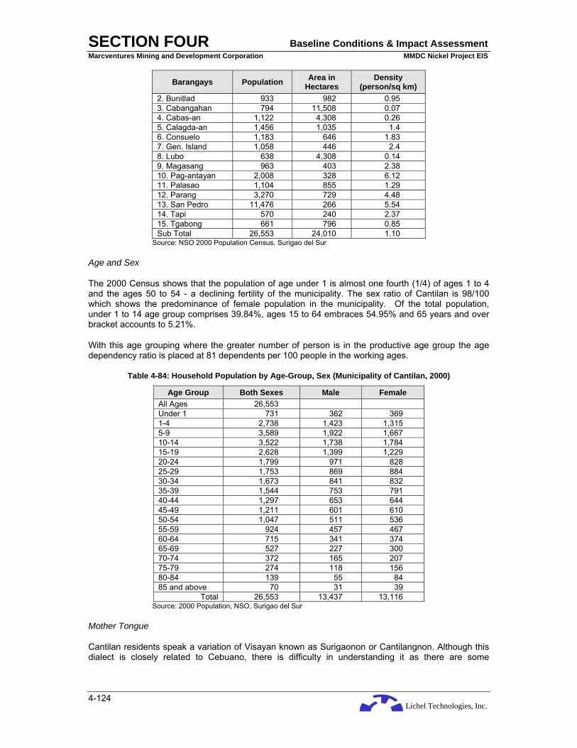
Lichel Technologies, Inc.
SECTION FOUR Baseline Conditions & Impact Assessment Marcventures Mining and Development Corporation MMDC Nickel Project EIS
4-124
Barangays Population Area in Hectares
Density (person/sq km)
2. Bunitlad 933 982 0.95 3. Cabangahan 794 11,508 0.07 4. Cabas-an 1,122 4,308 0.26 5. Calagda-an 1,456 1,035 1.4 6. Consuelo 1,183 646 1.83 7. Gen. Island 1,058 446 2.4 8. Lubo 638 4,308 0.14 9. Magasang 963 403 2.38 10. Pag-antayan 2,008 328 6.12 11. Palasao 1,104 855 1.29 12. Parang 3,270 729 4.48 13. San Pedro 11,476 266 5.54 14. Tapi 570 240 2.37 15. Tgabong 661 796 0.85 Sub Total 26,553 24,010 1.10
Source: NSO 2000 Population Census, Surigao del Sur
Age and Sex
The 2000 Census shows that the population of age under 1 is almost one fourth (1/4) of ages 1 to 4 and the ages 50 to 54 - a declining fertility of the municipality. The sex ratio of Cantilan is 98/100 which shows the predominance of female population in the municipality. Of the total population, under 1 to 14 age group comprises 39.84%, ages 15 to 64 embraces 54.95% and 65 years and over bracket accounts to 5.21%.
With this age grouping where the greater number of person is in the productive age group the age dependency ratio is placed at 81 dependents per 100 people in the working ages.
Table 4-84: Household Population by Age-Group, Sex (Municipality of Cantilan, 2000)
Age Group Both Sexes Male Female All Ages 26,553 Under 1 731 362 369 1-4 2,738 1,423 1,315 5-9 3,589 1,922 1,667 10-14 3,522 1,738 1,784 15-19 2,628 1,399 1,229 20-24 1,799 971 828 25-29 1,753 869 884 30-34 1,673 841 832 35-39 1,544 753 791 40-44 1,297 653 644 45-49 1,211 601 610 50-54 1,047 511 536 55-59 924 457 467 60-64 715 341 374 65-69 527 227 300 70-74 372 165 207 75-79 274 118 156 80-84 139 55 84 85 and above 70 31 39
Total 26,553 13,437 13,116 Source: 2000 Population, NSO, Surigao del Sur
Mother Tongue
Cantilan residents speak a variation of Visayan known as Surigaonon or Cantilangnon. Although this dialect is closely related to Cebuano, there is difficulty in understanding it as there are some

Lichel Technologies, Inc.
SECTION FOUR Baseline Conditions & Impact Assessment Marcventures Mining and Development Corporation MMDC Nickel Project EIS
4-125
significant differences. The spoken language also has Boholano, Manobo, Waray, and Spanish influences. Formal business and written communication are accomplished in Cebuano or English.
Religious Affiliation of the Population
Catholic is the dominant religion at 85%. The two Manobo barangays: Cabangahan and Lobo, show a different pattern of religion: some are Catholic, others are Protestant and some traditional pre-Christian beliefs.
Protestant accounted to 7% while Pentecostal, Iglesia Ni Kristo and Jehovah’s Witnesses constitute 2% respectively.
Table 4-85: Household Population by Religious Affiliation (Municipality of Cantilan, 2000)
Religion Number % to Total Catholic 21,412 85% Protestant 1,766 7% Pentecostal 533 2% Iglesia Ni Kristo 522 2% Jehovah’s Witness 193 2% Muslim 262 1% Philippines Benevolent 501 2%
Source: NSO 2000 Population Census, Surigao del Sur.
Projected Population
Based on the average growth rate of 1.05%, the town of Cantilan is projected to have a population of 30,200 in the next five years and 31,820 in the next ten years. Barangay Magosilom, Lininti-an and Parang will be most settled areas while Barangay Bugsukan will be the least settled area of Cantilan.
Barangay Cabangahan, Cantilan, Surigao del Sur
There is no available profile for Barangay Cabangan.
Madrid, Surigao del Sur
Madrid became a municipality on February 2, 1953 by virtue of Executive Order 561. However, there was some kind of controversy as to who will be the first mayor and after a long protracted legal battle, and the courts settled the controversy and proclaimed Guillermo Arpilleda as the first mayor of Madrid.
Madrid today has fourteen (14) barangays and a population of around 15,000 people. Classified as the 5th class municipality, it is the commercial hub of the CarCanMadCarLan area. Many fascinating events happened before “she” was able to attain “her” preset image as it is known today. Under the strong and dynamic leadership of Mayor Herculano A. Arpilleda, Sr. and with the all-out support of the different Barangay Captains, Madrid and its people are moving on towards greater heights of progress.
Physical Features
Geographical Location
The Municipality of Madrid, Surigao del Sur lies on the northern part of the province, in the cluster known as CarCanMadCarLan area. It is bounded in the east by the Pacific Ocean, the Diuata Mountain in the west, the Municipality of Cantilan in the north and Carmen in the south. It is about fifty six kilometers from the capital town of Tandag, the seat of the provincial government of Surigao del

Lichel Technologies, Inc.
SECTION FOUR Baseline Conditions & Impact Assessment Marcventures Mining and Development Corporation MMDC Nickel Project EIS
4-126
Sur. Madrid is a narrow land along the coast of Surigao del Sur with an area of 14,122 ha, representing 3.17% of the province total land area of 445,216 ha.
Soil Type
Madrid has four kinds of soil type. Of the total land area, undifferentiated mountain soil comprises 9,413 ha or 66.65%; San Manuel silt loam covers 4,617 ha or 32.69%; Matho loam has an area of 62 ha and Kabatohan loam underlies 30 ha.
Slope
Approximately 5,210 ha or 36.89% of total lad area is classified under 0 to 3% slope; 406 ha or 2.87% at 3 to 5%; 1,009 ha or 7.15% falls under 5 to 8%; and 1,283 ha or 9.09% falls under 18% and above slope classification.
Demography
Population Trend
As early as 1950’s, Madrid was so vibrant that it was separated from Cantilan. Data show that upon the conduct of 1960 census, the town posted 8,198 people. The population grew at the average growth rate of 3.038% last 1970 census with a total of 11,059 people. A sudden drop of population was experienced in 1975 posting 10,627 people at a very low growth rate which is the lowest among the censuses been conducted. The decrease in population was attributed to the insurgency problem experienced especially in the hinterland barangays of Madrid. Peace and order were slightly stabilized in 1980’s resulting to the sudden increase in population at 3.329% of average growth rate with a numerical value of 12,518 people. The decade of 80’s considered as the productive decade of the town wherein agricultural activities made a brighter future of the town. From then on, the municipality experienced an increase in population, however, it went down slowly due to out-migration were people especially the young ones went to big cities to seek better academic pursuits. The current average growth rate leveled at 0.85% and the high population count marked at 14,957 inhabitants.
Table 4-86: Population Growth in the Municipality of Madrid
Year Population Average Growth Rate
1960 8,198 - 1970 11,059 3.038 1975 10,627 -0.793 1980 12,518 3.329 1990 12,977 0.360 1995 12,992 0.023 2000 14,066 1.601 2007 14,957 0.850 Source: 2007 and 2000 NSO Population Census.
Age and Sex Structure
The town is slightly dominated by a productive population. More than 53% of the total municipal population belonged to the age bracket of 15 to 64 years old. A rough estimate of more than 40% of the total population belonged to the young age population between 1 to 14 years old. This group also constitutes the young dependent population of the town. Population is slightly concentrated at the age bracket between 5 to 9 years old. The old population, aged 65 years and above, constitutes merely 5% against the total municipal population. Females outnumbered males by 135. The sex ratio of the town constitutes 97 males against 100 females using the prevailing trend of 1995 census.

Lichel Technologies, Inc.
SECTION FOUR Baseline Conditions & Impact Assessment Marcventures Mining and Development Corporation MMDC Nickel Project EIS
4-127
Table 4-87: Household Population by Age Bracket
Age Bracket Population Under 1 393 1-4 1,512 5-9 1,897 10-14 1,830 15-19 1,593 20-24 1,087 25-29 933 30-34 827 35-39 764 40-44 629 45-49 657 50-54 530 55-59 413 60-64 365 65-69 261 70-74 198 75-79 115 80 & over 60 Total 14,066
Source: NSO, 1995
Marital Status
Seventy-two percent of the total municipal population is more than 10 years old. More than 53% of the household population ages more than 10 years old are legally married. It can be noted that there were more 51 females who are legally married than the males. Married population is concentrated between the age bracket of 25 to 34 years old which indicates a higher fertility and an expected population growth. On the other hand, single individuals comprised 41% of the total population. For the 3,880 single individuals, males dominated this status than the females. Single population group is concentrated between the ages 10 to 19 years old and is slowly declining towards 20 years and above. About 6% of the remaining population ages are widows/widowers, separated/divorce and common law/live-in and others.
Table 4-88: Marital Status of the Population
Marital Status Actual Figure Population by Percentage Single 5,771 41.03 Legally Married 7,343 52.20 Others 952 6.77 Source: NSO, 1995
Highest Grade Completed
More than 95% of the town’s household population above 10 years old is literate. For a total of 11,023 population aged more than 5 years old, it was noted that 2.8% of the population do not have ay grade completed. Another 1.9% has completed pre-school and more than 56% completed elementary education. Twenty-five percent of the population had high school education and only 48% of that completed their high school education. There are 287 individuals who have a post secondary education and only 6% of them are still undergrads. There are 763 individuals who are college undergrads and 496 are academic degree holders. With the data reflected in the table below, it can be said that the town does have a good educational background - a town’s strength for having a pool of educated population.
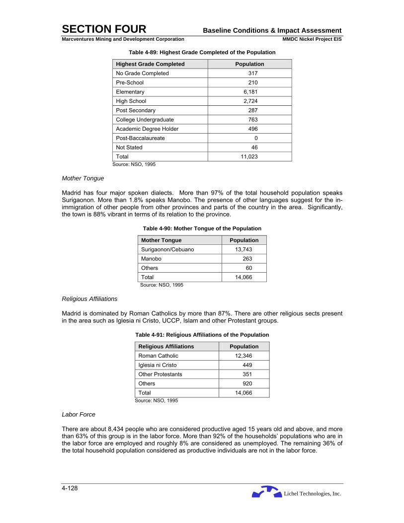
Lichel Technologies, Inc.
SECTION FOUR Baseline Conditions & Impact Assessment Marcventures Mining and Development Corporation MMDC Nickel Project EIS
4-128
Table 4-89: Highest Grade Completed of the Population
Highest Grade Completed Population No Grade Completed 317 Pre-School 210 Elementary 6,181 High School 2,724 Post Secondary 287 College Undergraduate 763 Academic Degree Holder 496 Post-Baccalaureate 0 Not Stated 46 Total 11,023
Source: NSO, 1995
Mother Tongue
Madrid has four major spoken dialects. More than 97% of the total household population speaks Surigaonon. More than 1.8% speaks Manobo. The presence of other languages suggest for the in-immigration of other people from other provinces and parts of the country in the area. Significantly, the town is 88% vibrant in terms of its relation to the province.
Table 4-90: Mother Tongue of the Population
Mother Tongue Population Surigaonon/Cebuano 13,743 Manobo 263
Others 60 Total 14,066 Source: NSO, 1995
Religious Affiliations
Madrid is dominated by Roman Catholics by more than 87%. There are other religious sects present in the area such as Iglesia ni Cristo, UCCP, Islam and other Protestant groups.
Table 4-91: Religious Affiliations of the Population
Religious Affiliations Population Roman Catholic 12,346 Iglesia ni Cristo 449 Other Protestants 351 Others 920 Total 14,066
Source: NSO, 1995
Labor Force
There are about 8,434 people who are considered productive aged 15 years old and above, and more than 63% of this group is in the labor force. More than 92% of the households’ populations who are in the labor force are employed and roughly 8% are considered as unemployed. The remaining 36% of the total household population considered as productive individuals are not in the labor force.
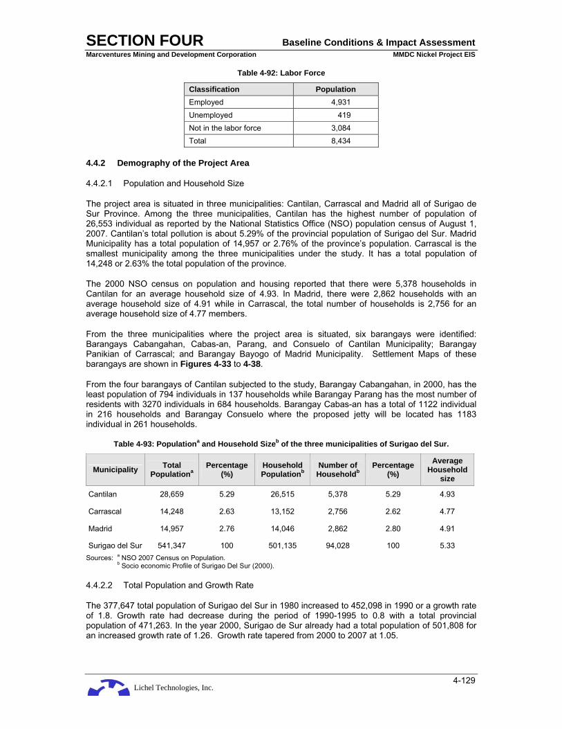
Lichel Technologies, Inc.
SECTION FOUR Baseline Conditions & Impact Assessment Marcventures Mining and Development Corporation MMDC Nickel Project EIS
4-129
Table 4-92: Labor Force
Classification Population Employed 4,931 Unemployed 419 Not in the labor force 3,084 Total 8,434
4.4.2 Demography of the Project Area
4.4.2.1 Population and Household Size
The project area is situated in three municipalities: Cantilan, Carrascal and Madrid all of Surigao de Sur Province. Among the three municipalities, Cantilan has the highest number of population of 26,553 individual as reported by the National Statistics Office (NSO) population census of August 1, 2007. Cantilan’s total pollution is about 5.29% of the provincial population of Surigao del Sur. Madrid Municipality has a total population of 14,957 or 2.76% of the province’s population. Carrascal is the smallest municipality among the three municipalities under the study. It has a total population of 14,248 or 2.63% the total population of the province.
The 2000 NSO census on population and housing reported that there were 5,378 households in Cantilan for an average household size of 4.93. In Madrid, there were 2,862 households with an average household size of 4.91 while in Carrascal, the total number of households is 2,756 for an average household size of 4.77 members.
From the three municipalities where the project area is situated, six barangays were identified: Barangays Cabangahan, Cabas-an, Parang, and Consuelo of Cantilan Municipality; Barangay Panikian of Carrascal; and Barangay Bayogo of Madrid Municipality. Settlement Maps of these barangays are shown in Figures 4-33 to 4-38.
From the four barangays of Cantilan subjected to the study, Barangay Cabangahan, in 2000, has the least population of 794 individuals in 137 households while Barangay Parang has the most number of residents with 3270 individuals in 684 households. Barangay Cabas-an has a total of 1122 individual in 216 households and Barangay Consuelo where the proposed jetty will be located has 1183 individual in 261 households.
Table 4-93: Populationa and Household Sizeb of the three municipalities of Surigao del Sur.
Municipality Total Populationa
Percentage (%)
Household Populationb
Number of Householdb
Percentage (%)
Average Household
size
Cantilan 28,659 5.29 26,515 5,378 5.29 4.93
Carrascal 14,248 2.63 13,152 2,756 2.62 4.77
Madrid 14,957 2.76 14,046 2,862 2.80 4.91
Surigao del Sur 541,347 100 501,135 94,028 100 5.33 Sources: a NSO 2007 Census on Population.
b Socio economic Profile of Surigao Del Sur (2000).
4.4.2.2 Total Population and Growth Rate
The 377,647 total population of Surigao del Sur in 1980 increased to 452,098 in 1990 or a growth rate of 1.8. Growth rate had decrease during the period of 1990-1995 to 0.8 with a total provincial population of 471,263. In the year 2000, Surigao de Sur already had a total population of 501,808 for an increased growth rate of 1.26. Growth rate tapered from 2000 to 2007 at 1.05.

Lichel Technologies, Inc.
SECTION FOUR Baseline Conditions & Impact Assessment Marcventures Mining and Development Corporation MMDC Nickel Project EIS
4-130
Among the three municipalities covered by the study, only Madrid exhibited a constant increase of population from the period of 1980-2007. The highest growth rate Madrid posted was from 1995 to 2000 at 1.60 increasing the population to 14,066 in 2000. Cantilan is the most populous among the three municipalities. It has a total population of 20,889 in 1980 and 24,868 in 1990 with a growth rate of 1.76. Cantilan experience a decline of population from the period of 1990 to 1995 having a population of 24,061 in 1995 and a growth rate of -0.7. It had a population of 26,553 in 2000 that reversed the trend into a high population growth rate of 1.99. A growth rate of 1.05 was posted from 2000 to 2007. Carrascal also experienced a decline of population from 12,810 in 1980 to 12,693 in 1990 having a -0.10 growth rate. The decline in population continued in 1995, when it had a population of only 12,018 posting a -1.1 growth rate. It only experience population growth during the recent years, from 1995 to 2000 and from 2000 to 2007.
Table 4-94: Population Growth Rate
Population Growth Rate Municipality
1980 1990 1995 2000 2007 1980 – 1990
1990 – 1995
1995 – 2000
2000 – 2007
Cantilan 20,889 24,868 24,061 26,553 28,659 1.76 -0.7 1.99 1.05
Carrascal 12,810 12,693 12,018 13,157 14,248 -0.10 -1.1 1.83 1.10
Madrid 12,518 12,977 12,992 14,066 14,957 0.36 0.02 1.60 0.85
Surigao del Sur 377,647 452,098 471,263 501,808 541,347 1.8 0.8 1.26 1.05 Cited by Surigao del Sur (Socio- Economic Profiling) Sources: NSO, Tandag, Surigao del Sur; 2007 NSO Population Census
4.4.2.3 Population Density
Surigao del Sur is still one of the most sparsely populated province in the country. It had an area of 4,552.16 sq km and a population of only 541,347 (2007 NSO Census). On the average, the province has a population density of 119 persons per sq km. Bislig remains to be the most densely populated at 294 persons per square kilometer even twice higher than the province's population density. Lanuza has the lowest population density with only 34.61 persons per square kilometer. (http/www.surigaodelsur.net)
The three municipalities of the where the project area is situated could still be considered as sparsely populated areas. Only Madrid has a population density higher than that of the province. It had 138.11 persons per square kilometer. Cantilan’s population density of 119.36 persons per square kilometer is very close to the provincial population density while Carrascal is the most sparsely populated with an average of only 53.61 persons per square kilometer. Surigao del Sur (Socio- Economic Profiling).
The barangays covered by the study showed a different population density ratio than that of the provincial and municipal level. Barangays Parang of Cantilan showed the highest population density ratio of all the barangays studied with 4.48 persons/sq km while Cabangahan has the lowest population density ratio of all barangays studied with 0.07 persons/sq km. Barangay Cabas-an has a ratio of 0.26 persons/sq km and Consuelo has 1.83 persons/sq km. Barangay Panikian of Carrascal has a population density ratio of 1.19 persons/sq km.
Table 4-95: Population Density of Three Municipalities in Surigao del Sur, 2000 and 2007
Population Density Municipality
2000 2007
Local Area (Sq Km)
2000 2007
Cantilan 26,553 28,659 240.10 110.59 119.36
Carrascal 13,157 14,248 265.80 49.50 53.61
Madrid 14,066 14,957 108.30 129.88 138.11

Lichel Technologies, Inc.
SECTION FOUR Baseline Conditions & Impact Assessment Marcventures Mining and Development Corporation MMDC Nickel Project EIS
4-131
Population Density Municipality
2000 2007
Local Area (Sq Km)
2000 2007
Surigao del Sur 501,808 541,347 4,552.16 110.23 118.92 Sources: Surigao del Sur (Socio- Economic Profiling-2000); NSO, 2007.

Lichel Technologies, Inc.
SECTION FOUR Baseline Conditions & Impact Assessment Marcventures Mining and Development Corporation MMDC Nickel Project EIS
4-132
Figure 4-36: Settlement Map of Barangay Cabangahan, Cantilan

Lichel Technologies, Inc.
SECTION FOUR Baseline Conditions & Impact Assessment Marcventures Mining and Development Corporation MMDC Nickel Project EIS
4-133
Figure 4-37: Settlement Map of Barangay Cabas-an, Cantilan

Lichel Technologies, Inc.
SECTION FOUR Baseline Conditions & Impact Assessment Marcventures Mining and Development Corporation MMDC Nickel Project EIS
4-134
Figure 4-38: Settlement Map of Barangay Parang, Cantilan

Lichel Technologies, Inc.
SECTION FOUR Baseline Conditions & Impact Assessment Marcventures Mining and Development Corporation MMDC Nickel Project EIS
4-135
Figure 4-39: Settlement Map of Barangay Consuelo, Cantilan

Lichel Technologies, Inc.
SECTION FOUR Baseline Conditions & Impact Assessment Marcventures Mining and Development Corporation MMDC Nickel Project EIS
4-136
Figure 4-40: Settlement Map of Barangay Panikian, Carrascal

Lichel Technologies, Inc.
SECTION FOUR Baseline Conditions & Impact Assessment Marcventures Mining and Development Corporation MMDC Nickel Project EIS
4-137
Figure 4-41: Settlement Map of Barangay Bayogo, Madrid
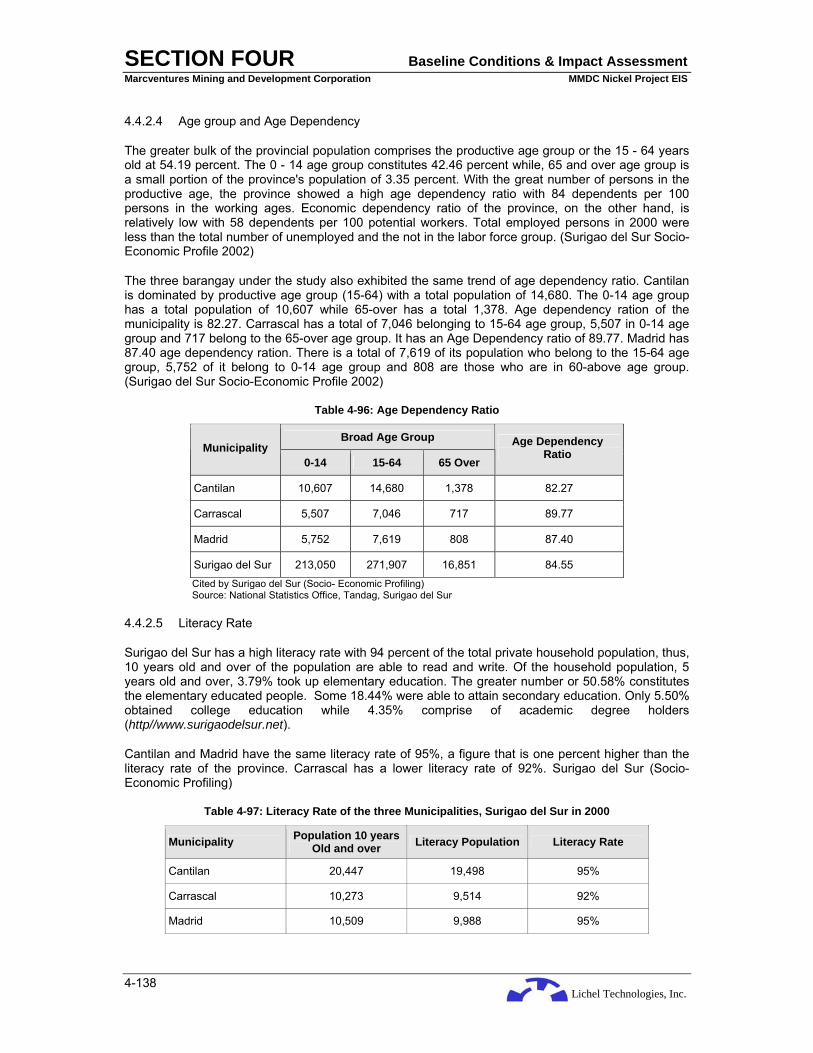
Lichel Technologies, Inc.
SECTION FOUR Baseline Conditions & Impact Assessment Marcventures Mining and Development Corporation MMDC Nickel Project EIS
4-138
4.4.2.4 Age group and Age Dependency
The greater bulk of the provincial population comprises the productive age group or the 15 - 64 years old at 54.19 percent. The 0 - 14 age group constitutes 42.46 percent while, 65 and over age group is a small portion of the province's population of 3.35 percent. With the great number of persons in the productive age, the province showed a high age dependency ratio with 84 dependents per 100 persons in the working ages. Economic dependency ratio of the province, on the other hand, is relatively low with 58 dependents per 100 potential workers. Total employed persons in 2000 were less than the total number of unemployed and the not in the labor force group. (Surigao del Sur Socio-Economic Profile 2002)
The three barangay under the study also exhibited the same trend of age dependency ratio. Cantilan is dominated by productive age group (15-64) with a total population of 14,680. The 0-14 age group has a total population of 10,607 while 65-over has a total 1,378. Age dependency ration of the municipality is 82.27. Carrascal has a total of 7,046 belonging to 15-64 age group, 5,507 in 0-14 age group and 717 belong to the 65-over age group. It has an Age Dependency ratio of 89.77. Madrid has 87.40 age dependency ration. There is a total of 7,619 of its population who belong to the 15-64 age group, 5,752 of it belong to 0-14 age group and 808 are those who are in 60-above age group. (Surigao del Sur Socio-Economic Profile 2002)
Table 4-96: Age Dependency Ratio
Broad Age Group Municipality
0-14 15-64 65 Over
Age Dependency Ratio
Cantilan 10,607 14,680 1,378 82.27
Carrascal 5,507 7,046 717 89.77
Madrid 5,752 7,619 808 87.40
Surigao del Sur 213,050 271,907 16,851 84.55 Cited by Surigao del Sur (Socio- Economic Profiling) Source: National Statistics Office, Tandag, Surigao del Sur
4.4.2.5 Literacy Rate
Surigao del Sur has a high literacy rate with 94 percent of the total private household population, thus, 10 years old and over of the population are able to read and write. Of the household population, 5 years old and over, 3.79% took up elementary education. The greater number or 50.58% constitutes the elementary educated people. Some 18.44% were able to attain secondary education. Only 5.50% obtained college education while 4.35% comprise of academic degree holders (http//www.surigaodelsur.net).
Cantilan and Madrid have the same literacy rate of 95%, a figure that is one percent higher than the literacy rate of the province. Carrascal has a lower literacy rate of 92%. Surigao del Sur (Socio- Economic Profiling)
Table 4-97: Literacy Rate of the three Municipalities, Surigao del Sur in 2000
Municipality Population 10 years Old and over Literacy Population Literacy Rate
Cantilan 20,447 19,498 95%
Carrascal 10,273 9,514 92%
Madrid 10,509 9,988 95%

Lichel Technologies, Inc.
SECTION FOUR Baseline Conditions & Impact Assessment Marcventures Mining and Development Corporation MMDC Nickel Project EIS
4-139
Municipality Population 10 years Old and over Literacy Population Literacy Rate
Surigao del Sur 354,804 332,624 94% Sources: 1990 Census Population and Housing, NSO (Base Data)
Provincial Planning and Development Office, Surigao del Sur
4.4.2.6 Health
Table 4-98: Health Statistics in Surigao del Sur, 2000 and 2001
2000 2001 Index
No. Rate No. Rate
% Increase (Decrease)
Crude Birth Rate 10,211 19.93 9,375 18.46 (8.19)
Crude Death Rate 1,684 3.29 1,714 3.37 1.78
Infant Mortality Rate 96 9.4 134 14.29 39.58
Maternal Mortality Rate 16 1.56 15 1.6 (6.25)
Mortality by Age Group
Under 1 Year 122 7.2 134 7.8 9.83
1-4 56 3.3 55 3.2 (1.78)
5-14 69 4.1 68 4.0% (1.44)
15-49 401 23.9 370 21.6% (7.73)
50-64 365 21.6 380 22.2% 4.10
65 and over 669 39.7 707 41.2% 5.68 Source: Surigao del Sur Socio-Economic Profile 2002 Provincial Health Office, Tandag, Surigao del Sur
Table 4-99: Morbidity Ten Leading Causes, 2001
Disease No. of Cases Rate Population (X 100,000)
1. Bronchitis 9,188 1814.1
2. ARI 8,153 1609.7
3. Pneumonia 6,686 1320.1
4. Diarrhea 5,392 1064.6
5. Hypertension 3,062 604.6
6. Injuries 3,045 601.2
7. Influenza 2,368 467.5
8. Skin Disease 1,356 267.7
9. TB Respiratory 1,274 246.2
10. Malaria 936 184.8

Lichel Technologies, Inc.
SECTION FOUR Baseline Conditions & Impact Assessment Marcventures Mining and Development Corporation MMDC Nickel Project EIS
4-140
Table 4-100: Mortality, Ten Leading Causes in 2001
Disease No. of Cases Rate Population (X 100,000)
1. CVA/ Hypertensive Vas. Disease 415 81.9
2. Pneumonia 200 39.4
3. Cancer 117 23.1
4. Tuberculosis 108 21.3
5. Wounds all form 82 16.2
6. Renal Failure 64 12.6
7. Accidents 51 10.1
8. Bleeding Peptic Ulcer 45 8.9
9. Diarrhea with severe dehydration 35 6.9
Table 4-101: Infant Morbidity, Ten Leading Causes, 2001
Disease No. of Cases Rate Population (X 100,000)
1. Pneumonia 1921 205 2. ARI 1479 158 3. Diarrhea 1190 127 4. Bronchitis 843 90 5. Skin Disease 192 20 6. Influenza 113 12 7. Injuries 40 4 8. Conjunctivities 38 4 9. Parasitism 25 3 10. Measles 22 2
Table 4-102: Infant Mortality, Ten Leading Causes, 2001
Disease No. of Cases Rate Population (X 100,000)
1. Pneumonia 24 2.6 2. Prematurity Septecemia 13 1.4 3. Asphyxia 11 1.2 4. Diarrhea with severe
dehydration 10 1.06
5. Congenital Anomaly 9 0.96 6. Meningitis Hypoxia 3 0.32 7. Post Mature Malnutrition 2 0.21 8. Measles Birth Injury 1 0.11
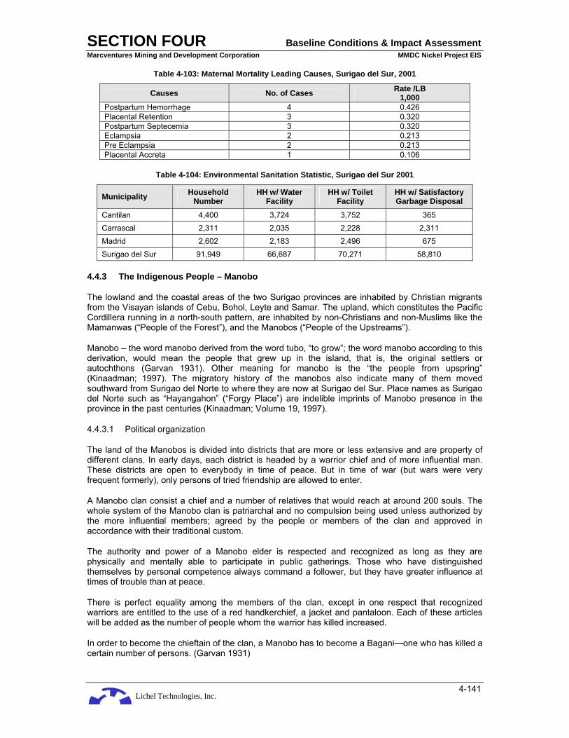
Lichel Technologies, Inc.
SECTION FOUR Baseline Conditions & Impact Assessment Marcventures Mining and Development Corporation MMDC Nickel Project EIS
4-141
Table 4-103: Maternal Mortality Leading Causes, Surigao del Sur, 2001
Causes No. of Cases Rate /LB 1,000
Postpartum Hemorrhage 4 0.426 Placental Retention 3 0.320 Postpartum Septecemia 3 0.320 Eclampsia 2 0.213 Pre Eclampsia 2 0.213 Placental Accreta 1 0.106
Table 4-104: Environmental Sanitation Statistic, Surigao del Sur 2001
Municipality Household Number
HH w/ Water Facility
HH w/ Toilet Facility
HH w/ Satisfactory Garbage Disposal
Cantilan 4,400 3,724 3,752 365 Carrascal 2,311 2,035 2,228 2,311 Madrid 2,602 2,183 2,496 675 Surigao del Sur 91,949 66,687 70,271 58,810
4.4.3 The Indigenous People – Manobo
The lowland and the coastal areas of the two Surigao provinces are inhabited by Christian migrants from the Visayan islands of Cebu, Bohol, Leyte and Samar. The upland, which constitutes the Pacific Cordillera running in a north-south pattern, are inhabited by non-Christians and non-Muslims like the Mamanwas (“People of the Forest”), and the Manobos (“People of the Upstreams”).
Manobo – the word manobo derived from the word tubo, “to grow”; the word manobo according to this derivation, would mean the people that grew up in the island, that is, the original settlers or autochthons (Garvan 1931). Other meaning for manobo is the “the people from upspring” (Kinaadman; 1997). The migratory history of the manobos also indicate many of them moved southward from Surigao del Norte to where they are now at Surigao del Sur. Place names as Surigao del Norte such as “Hayangahon” (“Forgy Place”) are indelible imprints of Manobo presence in the province in the past centuries (Kinaadman; Volume 19, 1997).
4.4.3.1 Political organization
The land of the Manobos is divided into districts that are more or less extensive and are property of different clans. In early days, each district is headed by a warrior chief and of more influential man. These districts are open to everybody in time of peace. But in time of war (but wars were very frequent formerly), only persons of tried friendship are allowed to enter.
A Manobo clan consist a chief and a number of relatives that would reach at around 200 souls. The whole system of the Manobo clan is patriarchal and no compulsion being used unless authorized by the more influential members; agreed by the people or members of the clan and approved in accordance with their traditional custom.
The authority and power of a Manobo elder is respected and recognized as long as they are physically and mentally able to participate in public gatherings. Those who have distinguished themselves by personal competence always command a follower, but they have greater influence at times of trouble than at peace.
There is perfect equality among the members of the clan, except in one respect that recognized warriors are entitled to the use of a red handkerchief, a jacket and pantaloon. Each of these articles will be added as the number of people whom the warrior has killed increased.
In order to become the chieftain of the clan, a Manobo has to become a Bagani—one who has killed a certain number of persons. (Garvan 1931)

Lichel Technologies, Inc.
SECTION FOUR Baseline Conditions & Impact Assessment Marcventures Mining and Development Corporation MMDC Nickel Project EIS
4-142
The chieftainship naturally falls to one whom has attained the rank of bagani – that is, to one who has killed a certain number of persons – provided he is otherwise sufficiently influential to attract a following. His duties consist of lending his influence to settle disputes and in redressing the wrongs of those who care to appeal to him. As a priest he is thought to be under the protection of a war god whose desire for blood he must satisfy. (Garvan 1931)
The bagani also acts as a medicine man, for he is reputed to have certain magic powers both for good and evil.
4.4.3.2 Concepts of Justice and Conflict Resolution
While fighting is way of life for the Manobo, settling conflict is also a favorable option that prevents bloodshed and forms alliances. The person tasked in settling conflicts is the Datu; he facilitates the resolution of conflicts that happens within or outside the community. In some instances, the Mingaon or baylan can also settle minor conflicts that happen inside the community.
While outside alliances between groups of different kinship can only be forged by the Datus of both aspiring communities, most alliances were being forged by neighboring community to facilitate economic and security advantages.
The concept of justice for the Manobo could be as “kunag begatawon ta pusod” which could be translated as “do not cut the umbilical cord”. The principle that governs this law is, whatever situation, one always finds ways and means not to break the brotherhood and bond that connects every Manobo, which would symbolized as the pusod (umbilical cord) and belonging to one mother, or one tribe.
Accordingly, even at the present time, it is easier to settle conflicts that involved both Manobo than conflicts that involves a migrant. A conflict involving both Manobo would be easily resolved when being intervened by the Datu because they put high regards on maintaining a working relationship with their fellow Manobo. The emphasis of conflict resolution is not to convict and punish a person but to strengthen the weakened bond that is threatening to break in the face of conflict.
4.4.3.3 Relation to barangay Governance
The Manobo community now faces dual governance in their communities, the rule of the traditional leaders and the governance of the formal government organization. This dual institution gives both advantages and disadvantages for the natives. The advantage of such set up of governance in the view of the Manobo, is that they are being recognized and respected in the national level as having a unique culture and should be allowed to practice their culture and belief system. However, the disadvantage of this, on their part, is that the budget allotted for them to be used to alleviate their economic situation, seldom reached the community. This makes them think that the politicians are making money out of them.
4.4.3.4 Religious belief and practices
There is no supreme being of the Manobo pantheon, though there are two principal classes of beneficent divinities. Little is known of one of these classes beyond its supposed existence.
There is another category of spirits, of a slightly different, whose desire is blood. These are the war divinities that select certain individuals for their champions and urge them on to deeds of valor, with the hope procuring blood.
In contradiction to above divinities and others of a malignant or dangerous character, Chief among them are the busau, black hideous spirits that dwell in dark, desolate places and who are for the most part imp0lacable enemies of man.
The Tagbanua are a class of local spirits that reign over the forest tracts and mountains. They are not of an unkindly nature as long as certain amount of respect is paid them. Hence, the practice of making offering during the hunting and other forest occupations.
Lichel Technologies, Inc.
SECTION FOUR Baseline Conditions & Impact Assessment Marcventures Mining and Development Corporation MMDC Nickel Project EIS
4-143
4.4.3.5 Economic Organization
Agriculture
It is true that most of Christianized Manobos that live in river settlements have a few hundred abaca plants each, yet the care of them is left practically to nature, their productivity depending upon the soil. But the true mountaineer Manobos plant nothing except their mostly needed crop which are rice and camote, some taro (Colocasia antiquorum), some sugarcane, corn and a little ginger and other spices.
The Manobo’s system of agriculture is in perfect adaptation with their social and political institutions. Living in a state of eternal vigilance, and knowing that the first death in the house or an unlucky combinations of omens or the menaces of their enemies may drive them from their homes and their farm, they are contented with a small clearing. They build no embankments, no irrigation ditches and no terraces. They have no plows, nor drafts animals. They select virgin forests every year and clear and cultivate the land with a bolo and a clear axe. For a permanent crop, they keep their camote patches, on which they may plant a few bananas and also invariably a sprinkling of sugarcane. There were some wild native tomatoes and a few ginger plants used for food seasoning that were scattered around the Manobo farm.
Fishing
The Manobo fishes more than he hunts, yet he can by no manner of means be said to be an incessant fisherman. They also catch fish using hook and line.
In shooting fish an arrow that has a detachable head is used. The fisherman conceals himself in a tree or on the bank of a stream or lake, and upon spying the fish lets fly a two-pronged arrow which has steel or iron point.
This method is in universal use in the lake region of the Agusan Valley and in rivers which are too deep for other methods, especially during floods, when the fish roam around over the inundated land. It is ordinarily not attended with great success, three or four fish being an average day’s catch. The common catfish, called dalag in Manila, is the ordinary victim, other species being rare victims to the arrow (Garvan, 1931).
Hunting
The Manobos are excellent hunters, keen, clever, determined, and enduring but by no means incessant. In fact, it is only under the stress of hunger or when a few of them rally together that they start off with hunting spears and dogs. Occasionally one meets the trophies of wild-boar tusks may observe a professional who takes pride in the business, as and jaws hung in his house (Garvan, 1931).
4.4.4 Perception Survey Results
4.4.4.1 Methodology
The perception surveys for the proposed Project were conducted on February 18-23, 2008. These were carried out in six (6) barangays, namely: Cabangahan, Cabas-an, Consuelo, Parang, Panikian, and Bayogo.
The survey area covered is divided into three categories: the MPSA Area, the Transport Route and the Jetty Area. The MPSA Area includes Barangay Cabangahan of Cantilan Municipality, Barangay Panikian of Carrascal Municipality, and Barangay Bayogo of Madrid Municipality. The Transport Route area is composed of the two Barangays of Cabas-an and Parang both of Cantilan Municipality. The Jetty Area covers only Barangay Consuelo of Cantilan.
In the MPSA Area, a total of 267 respondents were methodically sampled: 50 respondents from Panikian, 67 respondents from Bayogo and 150 from Cabangahan. Cabangahan has the highest number of respondents (100%) since it is the nearest community located some 1.5 km north of the

Lichel Technologies, Inc.
SECTION FOUR Baseline Conditions & Impact Assessment Marcventures Mining and Development Corporation MMDC Nickel Project EIS
4-144
initial mine area. The Transport Route covers two Barangays: Barangays Cabas-an and Parang with 22 and 20 respondents, respectively. There are 30 respondents subjected to the study in Jetty or Barangay Consuelo.
In the conduct of the survey, a random sampling method was used to understand and determine the socio-economic situation in the study area and the social acceptability of the proposed Project. Along the transport route at Barangays Cabas-an and Parang down to the jetty at Barangay Consuelo, aside from survey questionnaire conducted by the researcher, there were also in-depth interviews done. Every tenth house is identified as respondent of the survey which are the potentially affected residents by the proposed road rehabilitation and ore transport route. There were also a focused group discussions held in Barangays Cabangahan and Panikian. Since there was peace and order problem during the fieldwork, Barangay Bayogo was no longer visited for focused group discussion and in-depth interviews; only survey questionnaires were administered to 67 respondents.
The household sample size in each barangay was based on the National Statistic Office (NSO) Population Survey of 2000. Respondents (one for each household) considered to be interviewed are household heads, spouses of household heads, sons or daughters of household heads who are at least 18 years old, and other household members who are also at least 18 years of age.
A sample of the perception survey questionnaire is presented in Annex E-6. The result of the survey was assessed cumulatively, tabulated and presented in Annex E-7.
Public Participation
Various venues for public participation in the conduct of these studies were provided for the different stakeholders in the barangays. These include the conduct of key informant interviews, focused group discussions and public consultations (second level scoping). Discussed in the public consultations and focus group discussions were the possible environmental and social impacts, and the identification of positive and negative effects of the proposed Project. The results of the discussions became the basis in the formulation of mitigating measures that would minimize the adverse socio-economic and environmental impacts of the Project.
Secondary Data Gathering
Secondary data were also gathered and analyzed as part of the studies conducted in these areas. These data were also used to understand and determine the socio-economic situation in the study area.
Distribution of Respondents by Barangay
A total of 339 respondents from the six (6) barangays were interviewed. Table 4-105 provides the summary breakdown of respondents interviewed.
Table 4-105: Summary Breakdown of Respondents Interviewed in the Project-Affected Barangays
Barangays Population (2000)
No. of Households
No of Households Interviewed
Cabangahan 794 137 150 Cabas-an 1122 216 22 Consuelo 1133 261 30 Parang 3270 684 20 Panikian 1970 500 50 Bayogo 510 670 67
Total 8799 2468 339

Lichel Technologies, Inc.
SECTION FOUR Baseline Conditions & Impact Assessment Marcventures Mining and Development Corporation MMDC Nickel Project EIS
4-145
4.4.4.2 The Survey Areas
In MPSA Area, a total of 267 respondents were methodically sampled: 150 respondents from Cabangahan, 50 respondents from Panikian and 67 respondents from Bayogo. Cabangahan has the highest number of respondents because of its ethnic group characteristic. The study interviewed 100% of the Manobo ethnic group as respondents where most of them belong to Barangay Cabangahan increasing the number of respondents in the said barangay. Transport Route covers two Barangays, Barangay Cabas-an and Parang with 22 and 20 respondents, respectively. There are 30 Respondents subjected to the study in jetty area at Barangay Consuelo. (Annex E-7, Table 1).
4.4.4.3 Profile of Respondents
Age and Sex of Respondents
All of the respondents in MPSA Area are adults with 25 years old as the youngest and few were 60 years old and above. Majority of the respondents were from 25-39 age group with 112 (41.95%) respondents followed by and 40-59 years old group with 104 (38.95%). The least number of respondents were from the 60 and above age groups. (Annex E-7, Tables 2 and 3)
In the barangays along the Transport Route, 17 (40.48%) of the 42 respondents belonging to the 25-39 age group and 13 were from 40-59 age group and 11 were from 60 and above age-group.
Majority of the respondents at the jetty area were also adults. There are 17 out of 30 (56%) of the respondents who are of 40 to 59 years old. The respondents in jetty area are a little bit older than those in MPSA Area and Transport Route where majority of the Respondents were at the 25-39. Only 6 respondents in jetty area belong to the 25-39 age groups and there are 4 respondents who belong to the 60 and above age group.
There was a large gap between male and female respondents in the MPSA Area. Most of the respondents were male totaling to 212 or 79.40% of the respondents. Female respondents were only 52 respondents or 19.48%. There is almost an even number of male and female respondents in the Transport Route. There were 20 (47.62 %) male respondents and 21 (50.00%) female respondents. Contrary to the case of MPSA Area and slightly different from Transport Route, respondents at jetty area are predominantly female with 20 (66.67%).
Civil Status of Respondents
The MPSA Area has many 229 (85.77%) married respondents. There was also a significant number (18 or 6.74%) who are widows and mere 8 respondents or 3% were single. Almost the same figure came out with the respondents along the Transport Route. There were 31 (73.81%) respondents who were married and only 2 (4.76%) were single. There were 5 (11.90%) widow respondents and 4 (9.52%) respondents who were separated. (Annex E-7, Table 4)
At the Jetty area in Barangay Consuelo, there was also an overwhelming married respondents compared with the single respondents. There were 29 (96.67%) married respondents as compared to only 1 (3.33%) single respondent. However, there was no widow or separated respondent.
Sex and Age Distribution of Respondents’ Household
There was a very slim gap separating the total number of male and female household members of respondents in MPSA Area. Male slightly dominated the female by a very slim margin of 1.004:1. Respondents’ household members along Transport Route were also slightly dominated by male members with a slight higher margin than that of MPSA Area having a 1.102:1 ratio. The case of Jetty Area is different. Respondent households were dominated by females. There were only 72 males as compared to 77 female household members or a ratio of 0.935:1. (Annex E-7, Tables 5, 6)
The Population of respondents in MPSA Area is slightly dominated by young population. There were 42.68% of household members within the 0-14 years of age, 23.42% belonged to the 15-26 age group and 33.88% belonged to 26 and above age group. (Annex E-7, Tables 7A, 7B, 7C)

Lichel Technologies, Inc.
SECTION FOUR Baseline Conditions & Impact Assessment Marcventures Mining and Development Corporation MMDC Nickel Project EIS
4-146
On the other hand, Transport Route respondents’ population was slightly dominated by older age group. About 43.35% of respondent household population belonged to above-26 age group. This group was followed by the young generation or the 0-14 age group with 31.21%. The age group with smallest population was 15-26 with 25.43% of the total population. It is a similar case in Jetty Area where 42.85% of the respondent population belonged to above-26 age group followed by 0-14 age group with 32.65% of the total population. Age group of 15-26 had the smallest (24.48%) population.
Household Size of Respondents
The average household size of respondents in the three different areas of the study was from 5 to 6 members. The average household size of the respondents from MPSA Area is 5.59. There were only 2 (0.75%) respondents having a single member. On the other hand, biggest household among the respondents was 13. There were also 2 (0.75%) respondents who had 13 members. Transport Route respondents had a slightly lower household membership. The average household size of Transport Route respondents was 5.41. There were 3 (7.14%) respondents having the smallest household with two members while only 1 (2.38%) respondent had the biggest household of 10 members. The Jetty Area had the smallest average household size with 5.10 members. There were also 3 respondents (10%) who had only 2 members while only one had 11 members. (Annex E-7, Table 8)
Religion of Respondents
Almost all of the respondents in MPSA Area belonged to different denominations of Christianity. There were only 2 of 267 respondents professing Islam as their religion. The MPSA Area is predominantly of Pentecostal denomination with 137 respondents or 51%. This was followed by the Roman Catholic group with 72 (26.97%) respondents. The least among these Christian denominations was the Seventh Day Adventist or locally called the Sabadista with only 3 (1.12%) respondents. (Annex E-7, Table 9)
All of the respondents along the Transport Route were Christians. Unlike the MPSA Area, respondents along the Transport Route are predominantly Roman Catholics. Half (50.00%) of the respondents along the Transport Route wee Roman Catholics while 16 (38.10%) belonged to the Pentecostal denomination. The same with the Transport Route, respondents in Jetty Area were predominantly Roman Catholics with 25 or 83.33% respondents; 3 respondents were Christians and 2 were Protestants.
Occupation of Respondents
The respondents in MPSA Area belonged to the farming or agricultural sector of the society. There were 93 (34.83%) respondents who are engaged in farm related activities. Timber related occupation such as firewood gathering was second to farming with 24 (8.99%) respondents claiming it as their occupation. Laborer/Helper and driver were third and fourth occupational activities with 11 (4.12%) and 10 (3.75%) respondents respectively. (Annex E-7, Table 10)
Respondents along the Transport Route do not seem to be interested in telling about their occupation. Most (80.95%) of the respondents did not give any answer to the question on occupation. However, farming was still the most common occupation for those who provided answers with only 4 (9.52%). This was followed by the storeowners/storekeepers with 2 respondents or 4.76%.
There were 9 (30%) respondents in Barangay Consuelo who are farmers, 7 (23.33%) are laborers and another 7 (23.33%) are fishermen. There were 2 (6.67%) who are blacksmiths and another 2 respondents are repairmen. There was only one respondent who is an employee and the remaining 2 respondents did not answer.
Income of Respondents
Respondents in all three areas were relatively earning low income. In the MPSA Area, there were 198 household respondents having an income of up to only 5,000 pesos a month while there wee only 41 households who earn more than 5,000 pesos a month. Household incomes of respondents along the Transport Route and in Jetty Area also had a similar situation with those in MPSA Area. Twenty-

Lichel Technologies, Inc.
SECTION FOUR Baseline Conditions & Impact Assessment Marcventures Mining and Development Corporation MMDC Nickel Project EIS
4-147
five respondents along the Transport Route had household income of 5,000 pesos and below while only 4 household respondents earn higher than 5,000 pesos. In Jetty Area, a high number (27) of respondents earn 5,000 pesos a month or below while only 2 respondents had a household income of over 5,000 pesos. (Annex E-7, Table 11)
Occupation of Household Head
The MPSA Barangays could be considered as a farming community. A total of 149 or 55.81% of the respondents considered farming as the main occupation of their household head. Twenty-three (8.61%) respondent household heads are employees of MMDC and 16 (5.99%) are chainsaw operators. The lack of work or economic activity is prevalent since 38 respondents or 14.23 % have no work or occupation. Respondents along the Transport Route are also predominantly farmers. Twenty-five (59.52%) of 42 respondents are farmers while 5 (11.90%) are pastors and 4 (9.52%) are drivers. This is also the case of the household heads of most respondents in the Jetty Area. There are 11 (36.67%) respondents who are farmers. The slight difference at Barangay Consuelo is the significant number of fishermen and laborers. There are 8 (26.67%) respondents who are fishermen and 7 are laborers. The rest of the four respondents are carpenter/mason, pastor, self-employed and store owner. (Annex E-7, Table 12)
Most of the respondent household heads in MPSA Area have only one occupation. This is evident since there were 239 (89.51%) respondents who did not give any other sources of income or work of the household heads. This shows that there is a limited source of income or economic activity in the area. Only 7 (2.62%) respondents identified farming as the other source of income of the household. (Annex E-7, Table 13)
There were only 8 respondents along the Transport Route who had other source of income as compared to 34 (80.95%) who did not have any other source of income. Three respondents (7.14%) said that farming is their other source of income while storekeepers and government employees had 2 (4.76%) respondents.
It seems that single source of income is also prevalent in Jetty. There were 18 (60.00%) respondents who did not give any other source of income. There were 4 (13.33%) respondents whose other source of income is labor. There were 2 (6.67%) who are storekeepers/owners and another 2 who are employees as their other sources of income. The rest have driving, farming, and government employment as other sources of income.
Ethnic Origin and Dialect Spoken
The MPSA Barangays are predominantly indigenous people. This is especially true with Barangay Cabangahan where almost 100 percent of the population belongs to the Manobo tribe. A large majority (169) or 63.30% of the respondents in these three barangays claim to be Manobo. There are 28 (10.49%) respondents who belong to the Filipino mainstream culture and a small number of 15 (5.62%) who have Visayan ethnic origin. (Annex E-7, Table 14)
In contrast, the people along the Transport Route predominantly came from the mainstream ethnicity. Twenty-two (52.38%) out of 42 respondents are Cantilanon referring to the municipality they are residing. Three respondents (7.14%) belong to the Manobo tribe - the indigenous people of the area. One respondent is a lumad meaning indigenous people (Manobo). Two are Boholanos referring to an island province in Visayas and another two respondents came from Visayan Island.
The same is true of respondents in the Jetty Area who did not claim any particular regional ethnicity. There were 23 (76.67%) respondents who belong to the Filipino mainstream culture. There were 7 respondents who did not give any answer.
Majority of the respondents in MPSA Area belong to the Indigenous People of the area (Manobo). The previous data on ethnicity above was reinforced by the language spoken within and among the households. A very high (128) 47.94% of the respondents said that they communicate through the use of Manobo as their main language spoken. Cebuano is secondly used since there are 98

Lichel Technologies, Inc.
SECTION FOUR Baseline Conditions & Impact Assessment Marcventures Mining and Development Corporation MMDC Nickel Project EIS
4-148
(36.70%) respondents who said to have Cebuano as the main language. There are 13 (4.87%) who speak Surigaonon and only two respondents are Ilonggo speaking. (Annex E-7, Table 15)
Although most of the respondents along the Transport Route considered themselves as Cantilanon, most (19) or 45.24% of them said that they speak the Cebuano dialect, 6 or 14.29% speak Surigaonon, three (7.14%) speak Ilonggo, only one speak Manobo and another one speak Tagalong as dialect.
Respondents in Barangay Consuelo speak Surigaonon dialect. There were 29 (96.67%) respondents who said that Surigaonon is their spoken dialect. The remaining one respondent did not give any answer.
Length of Stay
Since most of the respondents in MPSA Area were members of the indigenous tribe of the area, most of them have lived within the area since their birth. There is a very high majority (191) or 71.54% of the respondents who lived in the area for more than 20 years. This figure is followed by 37 respondents (13.89%) who stayed in the area for 5-20 years. No respondent in the MPSA Area have stayed lesser than 5 years. Similarly, twenty-two or more than half (52.38%) of the respondents along the Transport Route have stayed in area for more than 20 years; some of them since birth. There were also 10 (23.81%) respondents who had lived within the area for 5-20 years. The slight difference is that there are 7 (16.67%) who had stayed in the area below 5 years. For the Jetty Area at Barangay Consuelo, 19 or 63.33% of the respondents had stayed in the area more than 20 years, 7 (23.33%) had resided for 5-20 years and only one reported to had stayed in the area for less than five years. The remaining 3 respondents did not give any answer. (Annex E-7, Table 16)
Reason for Migration
Marriage is the main reason for migration into the MPSA Area. There were 6 (2.25 %) who said to have migrated due to their marriage and 5 (1.87%) who said they came into the area because of their spouses. This sums to 11 or 4.12% of the respondents who stated marriage or living with the family of their spouses as reasons for migration. (Annex E-7, Table 17)
Most (24 or 57.14%) of the respondents along the Transport Route had lived in the area since birth. The three major reasons for migration according to the respondents are; for education, marriage and choosing the area due to its better location. There are 4 respondents (9.52%) for each of these reasons given.
Few respondents could give concrete reason for their migration into Barangay Consuelo. Twenty-three respondents considered the question as not applicable while one said that his/her reason for coming into the area is to return to her/his birth place. Another respondent did not give any answer to the question. There were respondents who said that owning a land made them stayed in the area. The remaining three respondents migrated into the area because of lack of work at their original place, coming with spouse, and because of their relatives who already staying in Consuelo.
Educational Attainment
In MPSA Area, there is a low educational level of attainment among respondents. Majority or 167 respondents (62.55%) reached elementary level of education while 54 (20.22%) got high school education. Only 12 (4.49%) respondents were able to finish or graduate from college education and 4 (3.37%) got post graduate education. (Annex E-7, Table 18)
Respondents at the Transport Route have slightly lower educational attainment as compared with the respondents at the MPSA Area. There were 19 of the 42 respondents (45.24%) who reached high school level of formal education. This was followed by 17 respondents (40.48%) who reached elementary level. There was only one respondent who finished college education while two attained post graduate level.

Lichel Technologies, Inc.
SECTION FOUR Baseline Conditions & Impact Assessment Marcventures Mining and Development Corporation MMDC Nickel Project EIS
4-149
Although respondents with elementary education is high (11 respondents or 36.67%) in Jetty Area, 9 respondents (30%) got high school education and another 9 respondents graduated from college. One respondent did not have formal education.
Ownership of House
Majority (257) or 96.25% of the respondents in MPSA Area owned the house their household presently inhabits. Only a mere 1.5% (6) of the respondents said that they did not own the house where they lived. The same is true with respondents along the Transport Route where there are 39 (92.86%) owners of their houses and only one respondent who is not the owner of the house. Two respondents did not give any answer. There is a very slight difference with respondents in the Jetty Area. While house ownership (25) was also high at 83.33%, five or 16.67% of respondents do not own the house they inhabit. (Annex E-7, Table 19)
Area of House
Most of the houses of the respondents in MPSA Area had an area of 50 square meters (sq m) or below. There were 104 (38.95%) of respondents who estimated their house area at below 50 sq m; 58 (21.95%) respondents have house area of about 50 sq m to 79 sq m. There is only one respondent or 0.37% whose house area is more than 600 sq m. (Annex E-7, Table 20)
Respondents’ houses along the Transport Route ranged from 100-400 sq m area which is bigger than those houses in MPSA Area. Nine (21.43%) have house area of 150-199 sq m, 8 (19.05%) have house area of 200-399 sq m and 6 (14.29%) respondents have 100-149 sq m. There was one (2.23%) respondent who has a house area of more than 600 sq m.
Most of the houses of the respondents in the Jetty Area were relatively smaller than those respondents along the Transport Route and MPSA Area. Most of the respondents (17 or 56.67%) estimated their house area to be lesser than 50 sq m. There were 4 (13.33%) respondents who have house area between 200-399 sq m, 3 (10%) respondents have 100-149 sq m house area and 2 (6.67%) have 150-199 sq m house area. There were also 2 respondents who have 400-599 sq m house area and only one with more than 600 sq m house area. One respondent has 50-79 sq m house area.
4.4.4.4 Knowledge and Level of Awareness
Knowledge of the MMDC
Majority of the respondents in all areas of the study were aware of the existence of MMDC. In the MPSA Area, 199 or 74.53% of the respondents said to have knowledge about MMDC. Only a very small number at 25 (9.36%) respondents said that they do not have any knowledge of MMDC. Also, majority or 27 (64.29%) respondents along the Transport Route said that they knew MMDC whereas only one (2.38%) respondent did not know. However, 14 (33.33%) respondents did not give any answer. In the Jetty Area at Barangay Consuelo, a high 76.67% or 23 respondents said that they had knowledge of MMDC. There were only 6 (20%) respondents who are unaware that MMDC exists, and one respondent who did not give any answer. (Annex E-7, Table 21)
There is a high level of awareness among respondents in MPSA Area about the MMDC activities than those respondents from Transport Route and Jetty Area. There were 139 (52.06%) respondents who said the MMDC is doing mining in the area. There were also 8 (3%) respondents who said that the company came here because of the nickel resource of the area. These statements would still be considered as the same knowledge towards mining activity of the company as with the majority. (Annex E-7, Table 22)
Although majority of the respondents along the Transport Route said that they have knowledge about the MMDC, most of them have very little or no knowledge about its activities. There are 27 (64.29%) respondents along the Transport Route who did not give any clue as to what they know about the MMDC and its operation and 6 (14.29%) respondents who simply said that it is good. There were only 4 (9.52%) respondents who said that the MMDC activities could help improve the income of the

Lichel Technologies, Inc.
SECTION FOUR Baseline Conditions & Impact Assessment Marcventures Mining and Development Corporation MMDC Nickel Project EIS
4-150
barangay. There were 5 respondents who seem to oppose the Project citing different negative perceptions: harmful effect to the livelihood; no more place to plant crop; and fear that it could destroy crops and the environment.
With regards to the type of information they learned about MMDC’s activities, respondents from the Jetty Area gave slightly different responses. While 12 (40%) of the respondents did not give any answer, 6 (20%) respondents said that they knew that the MMDC activities could increase the income of the Barangay. There were also 6 (20%) respondents who said that it could provide employment to the people and another 6 (20%) respondents who said that they knew that there is a nickel mining operation in the area. A high 60% of the respondents have substantial knowledge as to the MMDC activities.
Sources of Information
The main sources of information of the respondents in MPSA Area are the community leaders and the community gatherings. There were 113 (42.32%) respondents who said that they got the information from the local officials. Eighty-two (30.71%) respondents also said that they got the information on community meetings such as PTA meeting and Barangay assembly. However, there is a significant number (31) of respondents (11.61%) who did not provide answer. (Annex E-7, Table 23)
On the other hand, there were 11 (26.19%) respondents along the Transport Route who said that their sources of information about MMDC came from the employees and workers of the company. There were 8 respondents (19.05%) who said they get information from officials and another 8 (19.05%) said that they learned it from PTA meeting and general assembly meeting of the barangay. Other sources such as television/radio, parish priest, and hearsay were cited by one respondent for each source.
Jetty Area respondents have relatively the same information source with MPSA Area respondents. The sources of information for the respondents at Barangay Consuelo were from the barangay officials, PTA meetings and parish priest. Nine (30%) respondents got information about MMDC from the local officials and 8 (26.67%) respondents got the information from the PTA/Barangay assembly meetings. There were 5 (16.67%) respondents who said they got their information from the parish priest, one respondent heard it from radio/TV and another one through the information drive. The remaining 6 respondents did not give any answer.
4.4.4.5 Attitude Towards the Project
All figures discussed in this part of the study were taken from the Tables 24A, 24B and 24C of Annex E-7 where perception questions are represented in columns (e.g. D1a, D1b, etc) and responses are in rows.
Establishment of Project
The respondents from all three area categories were favorable with the establishment of the Project. In the MPSA Area, 193 of the 267 respondents or 72.28% strongly agreed with the establishment of the Project. Another 30 (11.24%) said they agreed while 13 (4.87%) respondents disagreed. Only one (0.37%) of the 267 respondents strongly disagreed with the establishment of the Project. Also along the Transport Route, 16 (36.36%) respondents agreed and 11 (25%) strongly agreed with the establishment of the Project. There were only 7 (15.91%) respondents who disagreed and none strongly disagreed. Moreover, 20 (66.7%) respondents in Barangay Consuelo strongly agreed and another 5 (16.7%) agreed and were in favor for the establishment of the Project. There were only 4 (13.3%) of the 30 respondents who disagreed with it. (D1f)
Presently, respondents have a strong support with the activities of the Project. This is true with all three areas of the study where there is an overwhelming support for the Project operation.
When respondents in MPSA Area were asked whether they supported the activities of Project, 112 respondents (41.95%) said that they strongly agreed with the statement while another 96 (41.95%) agreed with it. There were 16 (5.99%) respondents who disagreed and only one strongly disagreed
Lichel Technologies, Inc.
SECTION FOUR Baseline Conditions & Impact Assessment Marcventures Mining and Development Corporation MMDC Nickel Project EIS
4-151
with the statement. This means that out of 267 respondents in MPSA Area, 208 respondents presently supported the activities and operation of Project while 16 (5.99%) respondents did not give their support. Respondents along the Transport Route also agreed with the statement and supported Project operation. There were 16 (36.36%) respondents who agreed and another 11 (25%) who strongly agreed that they supported activities of Project. There were only 8 (18.18%) respondents who disagreed with the statement and none strongly disagreed. The respondents in Barangay Consuelo (jetty area) reinforced their support for Project. There were 12 (40%) respondents who said that they strongly agreed and another 11 (36.7%) agreed that they supported the activities of Project. There were seven (23.3%) respondents who disagreed. It could be surmised that there were 23 out of 30 respondents who are in favor for the establishment of the Project and seven (23.3%) respondents were not in favor. (D1l)
Perceived Effects to People and the Community
Majority of the respondents in the study area believed that the Project could bring more benefits than negative effects to the lives of the people. There were 153 (57.30%) respondents in MPSA Areas who said that they strongly agreed to the statement that Project could bring more benefits than ill-effects. There were also 76 (28.46%) respondents who agreed while 11 (4.12%) respondents disagreed and only two respondents who strongly disagree. (D1a)
There were 17 (38.64%) respondents along the Transport Route who agreed and 12 (27.27%) others who strongly agreed that Project would bring good things than bad things in their lives. There were only 8 (18.18%) respondents who believed otherwise and disagreed while none of them strongly disagreed. The same responses were given in Barangay Consuelo where 19 (63.3%) of the 30 respondents agreed and 5 (16.7%) strongly agreed that the Project could bring more benefit than harm to their lives. Only 6 (20%) respondents disagreed and none of them strongly disagreed.
Most of the respondents of all areas also believed that Project will have a positive impact to the community as a whole. In MPSA Area, 124 (46.44%) respondents strongly agreed that the Project could bring benefits to the community than negative effects. Ninety-nine (37.08%) respondents said they agreed. Sixteen (5.99%) respondents disagreed and two respondents strongly disagreed with the statement. (D1b)
Respondents at the Transport Route also believed that the Project would bring benefits to their community. However, there was a slight reduction of number of respondents who agreed and those who strongly agreed. Only 14 (31.82%) strongly agreed and 13 (29.55%) agreed that the Project would bring benefits to their community while the number of those who disagreed slightly increase to 10 (22.73%) respondents but none strongly disagreed.
Moreover, in Barangay Consuelo, 19 (63.3%) respondents strongly agreed and 5 (16.7%) agreed that Project would bring more benefit than harm to the community while 6 (20%) respondents disagreed and none of them strongly disagreed.
Majority of the respondents in all three study areas believed that the Project would not bring any harm to the health of the people in the community. There were 151 (56.55%) respondents who agreed. Those who merely agree and those who disagree were even at 42 (15.73%) respondents each. There was one (0.37%) respondent who strongly disagreed. There were 16 (36.36%) respondents along the Transport Route who agreed and 14 (31.82%) who strongly agreed that the Project will not cause any harm to the health of the people. There were 6 (13.64%) respondents who disagreed and none strongly disagreed. In Jetty Area, 17 (56.7%) respondents agreed and 3 (10%) respondents strongly agreed. Nine (30%) respondents disagreed and one expressed strong disagreement. (D1o)
Perceived Effects to Economy of the Community
In terms of economic activities in the community, 190 (71.16%) respondents in MPSA Area strongly agreed that Project could help improve the business and economic activities in the area. There were 43 (16.10%) respondents who agreed and 8 (3.00%) who disagreed. (D1h)

Lichel Technologies, Inc.
SECTION FOUR Baseline Conditions & Impact Assessment Marcventures Mining and Development Corporation MMDC Nickel Project EIS
4-152
The same thing was perceived by the respondents along the Transport Route. Fifteen (34.09%) respondents agreed and 12 (27.27%) strongly agreed that Project would provide additional economic activities and improvement to their place. There were nine (20.45%) respondents who disagreed, none of them strongly disagreed and there were 6 respondents who did not give any answer. It is more apparent in Barangay Consuelo that the Project would bring in more businesses and help improve the community than the two other areas of the study. Twenty out of 30 or 66.7% of the respondents strongly agreed and another five (16.7%) agreed. There were four (13.3) respondents who disagreed and none strongly disagreed.
Improvement with the economy and business seemed to be manifested with increase in the number of livelihood and businesses in the area. Majority of the respondents in the three areas of the study believed that the coming or the establishment of the Project would be a catalyst for brining in diverse livelihood and business to their community.
A high number of respondents in all three areas strongly believed that Project would bring in more livelihood and businesses into the community. There are 152 (56.93%) respondents in MPSA Area who strongly agreed and another 79 (29.59%) respondents agreed that the Project would bring in more businesses and livelihood to the community. There were 8 (3%) respondents who disagreed and none strongly disagree with the statement that Project would bring more livelihood and businesses to the community. The same was true with the respondents along the Transport Route where 15 (34.09%) respondents agreed and 14 (31.82%) strongly agreed. Seven (15.91%) respondents disagreed and therefore did not believe that Project will bring in livelihood and businesses. There was also a similar response with respondents in Barangay Consuelo. There were 24 out of 30 or 80% of the respondents strongly agreed and another 3 (10%) agreed that the Project will bring more livelihood and business into that community. There were 3 (10%) respondents who disagreed. (D1r)
Perceived Impact on Employment
A very high majority of respondents in MPSA Area believed that Project will hire people from their community. There were almost equal numbers of respondents who strongly agree (101 or 37.83%) and those who agree (120 or 44.94%) that Project will be hire people from their community. Eighteen (6.74%) respondents disagreed with the statement while 2 (0.75%) respondents strongly disagreed. (D1c)
There were 13 (29.55%) respondents along the Transport Route who agreed and also an even number who disagreed with the statement that Project will hire workers from their place. However, there were 10 (22.73%) respondents strongly agreed and none of them strongly disagreed. This showed that 23 out of 42 respondents believed that Project will hire people from their community.
Respondents at Barangay Consuelo agreed that Project will hire many people from their place to work for the company. Twenty-two (73.3%) respondents strongly agreed and 4 (13.3%) agreed that the company will hire many people from their place while 4 (13.3%) respondents disagreed and none of them strongly disagreed.
It seemed apparent that the Project was perceived by three surveyed areas to bring employment. There were 156 (58.43%) respondents in MPSA Area who said that they strongly agreed and another 71 (26.59%) respondents said they agreed that Project promised to provide employment for the local people in the community. Ten (3.75%) respondents said that they disagreed with the statement and one (0.37%) said to have strongly disagreed. There was also an overwhelming agreement among the respondents along the Transport Route that the Project promised to hire people from their place. Sixteen (36.36%) respondents agreed and another 12 (27.27%) strongly agreed that the Project promise to hire them with employment. Eight (18.18%) respondents disagreed and none strongly disagreed with the statement. Respondents in Jetty Area also agreed that the Project would employ the people from their community. Twenty-two (73.3%) respondents strongly agreed and 4 (13.3%) agreed that the Project could provide employment for the people in the barangay. There were 4 (13.3%) who thought otherwise. (D1j)
Lichel Technologies, Inc.
SECTION FOUR Baseline Conditions & Impact Assessment Marcventures Mining and Development Corporation MMDC Nickel Project EIS
4-153
To affirm the data that communities within the three area categories expected employment, a high majority agreed that Project will give employment priority to local people in the study areas. In the MPSA Areas, 167 (62.55%) of 267 respondents strongly agreed and 65 (24.34%) respondents simply agreed that the Project will give opportunity for local people should they have the qualification needed by the company. Seven (2.62%) respondents disagreed and nobody strongly disagreed with the statement. This is the same with respondents along the Transport Route where 16 (36.36%) of 42 respondents agreed and 12 (27.27%) strongly agreed, while 8 (18.18%) respondents disagreed and none strongly disagreed. Respondents in Barangay Consuelo also agreed with the respondents from the two other study areas. Twenty-five (83.3%) out of 30 respondents strongly agreed and 2 (6.67%) respondents agreed with the statement while 3 (10%) disagreed and none strongly disagree. (D1k)
Nevertheless, respondents in all three areas also considered that the Project will also hire people from outside their community.
There was a little difference between those who agreed and disagreed in MPSA Area with the statement that there are more people from outside the community who would be hired into Project operation. There were 91 (34.08%) of 267 who said that they agreed with the statement while 65 (24.34%) disagreed. While there were 44 (16.48%) respondents who said they strongly agreed, there are on the other hand 24 (8.99) respondents who said they strongly disagreed with the statement. (D1i)
It was a different scenario with the respondents along the Transport Route. There were 15 (34.09%) out of 42 respondents who agreed and another 11 (25%) who strongly agreed that the Project will hire more people from other places than from their area. There were 10 (22.73) who disagreed and believed that Project would hire them rather than those from other places.
Contrary to the MPSA Area and more apparent than the Transport Route Area, the Jetty Area respondents disagreed that the Project will hire people from other places than those who are residing in their barangay. Half (50%) of 30 respondents disagreed to the statement and another 11 (36.7%) strongly disagreed while there were 2 (6.67%) respondents who agreed and one (3.33%) who strongly disagreed. This means that 26 of 30 respondents believed that Project will hire more people from their place than from outside their community.
Information from the Media and Others Sources
The respondents in MPSA Area were aware that the media would not be favorable to the Project and they will get more negative than positive comments from the media. There were 135 (50.56%) of the 267 respondents who agreed and another 28 (10.49%) strongly agreed that they will hear more negative than positive comments from the media. There were 64 (23.97%) who disagreed and 8 (3%) respondents who strongly disagreed with the statement. For the 42 respondents along the Transport Route, 17 (38.64%) agreed and 7 (15.91%) strongly agreed while 12 (27.27%) disagreed and none strongly disagreed. (D1d)
In the Jetty Area, there is a slight difference between those who agreed and disagreed with the statement that they will get more negative comments than positive comments from the media about the Project. Seventeen (56.7%) of 30 respondents agreed and 10 (33.3%) respondents said they disagreed while 2 (6.67%) respondents strongly agreed with the statement.
The respondents on three areas of the study also believed that they will get information from other sources about the Project. There were 124 (46.44%) of the 267 respondents in the MPSA Area who agreed and 38 (14.23%) who strongly agree that they would get more negative than positive comment from relative, neighboring community and friend about Project. There were 66 (24.72%) respondents who disagreed and 13 (4.87%) strongly disagreed with the statement. The same is true with respondents along the Transport Route where 17 (38.64%) out of 42 respondents agreed and 8 (18.18%) strongly agreed. On the other hand, there were 9 (20.45%) respondents believed otherwise and disagreed with the statement. None of them strongly disagreed. Most respondents of Barangay Consuelo also tend to believe the same with two the other study areas. Sixteen (53.3%) respondents agreed and 2 (6.67%) strongly agreed. However, the difference with Barangay Consuelo compared

Lichel Technologies, Inc.
SECTION FOUR Baseline Conditions & Impact Assessment Marcventures Mining and Development Corporation MMDC Nickel Project EIS
4-154
with the two other areas is the high number (11 or 36.7%) respondents who disagreed that they will hear negative comments from relative, friends and acquaintances. (D1e)
Participation on Activities Opposing Project
It was evident that the respondents in the MPSA Area and in the Transport Route have at least once participated or supported activities that opposed the Project. Although majority of the respondents agreed with the establishment Project, a significant number admitted that in one way or another, they had participated with activities that opposed it.
In MPSA Area, there was a slim difference between those who had participated with activities against the Project and those who did not. There were 78 (29.21%) of 267 respondents who agreed and another 30 (11.24%) strongly agreed with the statement. However, there was also a large number who strongly disagreed 63 (23.60%) and 46 (17.23%) who simply disagreed with the statement. There were therefore 109 respondents in MPSA Area who did not participated with any activities opposing Project while 108 respondents participated with such activities.
It was the same case with the respondents along the Transport Route. There were 19 (43.18%) respondents who agreed and another 10 (22.73) who strongly agreed with the statement that they participated with activities that opposed the Project. Seven (15.91%) respondents have not experienced participating in any activities that opposed Project.
The case was different at the Jetty Area where more respondents disagreed when they were asked whether they participated with the activities opposing the Project. Eighteen (60%) respondents disagreed to the statement, 5 (16.7%) strongly agreed while 6 (20%) respondents agreed. This means that majority (23 of 30) of the respondents never participated with activities that opposed that Project. On the other hand there were 11 respondents who said to have participated with activities that opposed the Project. One respondent remained neutral and did not give any answer.
Effect to the Environment
Although most of the respondents in MPSA Area agreed with the establishment of the Project, most of them also believed that Project can cause environmental pollution. One hundred two (38.20%) respondents agreed and another 51 (19.10%) respondents strongly agreed that Project could cause environmental pollution. There were 79 (29.59%) respondents who disagreed and 9 (3.37) respondents strongly disagreed. Therefore there are 153 respondents in MPSA Areas who believed that the Project cause of environmental damage and pollution while only 88 respondents believed that the Project can not cause pollution and environmental damage. (D1g)
In the Transport Route, 11 (25%) respondents strongly agreed and another 11 (25%) agreed that Project can cause pollution and environmental damage. However there were also 11 (25%) respondents who disagreed meaning they believed that the Project can not the cause pollution and environmental damage. None of them strongly disagreed and there were 9 (20.45%) respondents who did not give their answer.
The response at the Jetty Area was almost the same with those along the Transport Route. Thirteen (43.3%) out of 30 respondents agreed, and an even number disagreed that the Project can cause of pollution to the environment. There were 3 (10%) who strongly agreed while no respondent strongly disagreed. Just like the MPSA Area and Transport Route, there were still more people who believed that Project can cause pollution and environmental damage.
However, respondents in all three subject areas believed that the Project will be able to complete and comply with the processes and document necessary for its operation. There were 150 (56.18%) respondents in MPSA Area who strongly agreed while 85 (31.84%) respondents agreed that the company complied and completed the necessary document required for operation. Five (1.87%) respondents disagreed with the statement and none strongly disagreed. Respondents along the Transport Route also believed the same. Nineteen (43.18%) of 42 respondents agreed and 12 (27.27%) strongly agreed that the Project will be able to comply, while 5 (11.36%) respondents disagreed and none strongly disagreed. In Barangay Consuelo, there were 22 (73.3%) out of 30

Lichel Technologies, Inc.
SECTION FOUR Baseline Conditions & Impact Assessment Marcventures Mining and Development Corporation MMDC Nickel Project EIS
4-155
respondents who strongly agreed and 6 (20%) who agreed, while there were two (6.67%) respondents who disagreed. (D1n)
Addressing Complaints and Issues
With regards with the problems and complains of the community, the respondents were ask whether they approve the way that the MMDC responded to the problems and complains of the community. In MPSA Area, a 146 (54.68%) respondents strongly agreed and another 79 (29.59%) agreed with the statement. This means that a total of 225 of 267 respondents agreed and strongly approved the way MMDC responded to the problems and complains of the community. There were only 6 (2.25%) respondents who disagree and one (0.37%) who strongly disagreed with the way the company dealt with the problems and complains of the community. There was also an approval from the respondents along the Transport Route about the way the MMDC responds to the problems and complains of the community. Twenty (45.45%) out of 42 respondents agreed and another 10 (22.73%) strongly agreed, while there were 6 (13.64%) respondents who disagreed and none who strongly disagreed. Respondents in Barangay Consuelo also favorably perceived the way the MMDC responds to problems and complains of the people from the barangay. There were 22 (73.3%) out of 30 respondents who strongly agreed with the statement that they like the way the MMDC deals with the problems and complains and another 4 (13.3) respondents who simply agreed. There were 4 (13.3) respondents who disagreed. (D1m)
Environmental Awareness
Majority of the respondent in all three study areas were willing to participate and join with different organizations to monitor the operation of Project to prevent the company from causing environmental harm. Within the MPSA Area, 121 (45.32%) respondents strongly agreed and another 96 (35.96%) agreed to participate with such activity. There were 15 (5.62%) respondents who disagree and one (0.37%) respondent who strongly disagreed. Along the Transport Route, 15 (34.09) respondents agreed and another 14 (31.82) respondents strongly agreed thus expressing willingness to watch over the activities of the company and preventing it from causing environmental damage. There were 7 (15.91) respondents who disagreed and none strongly disagreed. A similar case is seen in Barangay Consuelo where 17 (56.7%) respondents strongly agreed, another 8 (26.7%) agreed, while there were 5 (16.7%) respondents who disagreed. (D1p)
Most of the respondents in the three areas that were surveyed were willing to participate in any activities relating to the protection of the environment just as they are willing to join groups who will monitor the Project to prevent it from doing harm to the environment. In MPSA Area, 150 (56.18%) of the 267 respondents agreed and 70 (26.22%) more respondents strongly agreed to participate with any activities relating to the protection of the environment. Only 13 (4.87%) respondents disagreed and none of them strongly disagreed. There were 16 (36.36%) respondents along Transport Route who agreed and another 14 (31.82%) respondents who strongly agreed to participate in any kind of activities for the protection of the environment. Six (13.64%) respondents disagreed and none strongly disagreed. For respondents in the Jetty Area, 23 (76.7%) out of 30 strongly agreed and another 4 (13.3%) agreed, while only 3 (10%) respondents disagreed to join such activities. (D1q)
4.4.4.6 Involvement
Participation Prior to the Establishment
Participation of the respondents with the consultation before the establishment of the Project was high. This was shown in the survey results where a majority (173) or 64.79% in MPSA Area said that they participated in the consultations regarding the Project as compared to 11 respondents (4.12%) who said that they did not attend any consultation. Respondents said that they listen intently with the presentation and discussion of the consultation. There were 102 respondents (38.20%) who said that they listen and found the presentation to be good, another 3 (1.2%) who said that they listen and approved the entry of the Project. However, there are also those (at least 2 respondents) who said that there was no consultation done regarding the Project yet. There were also 13 respondents (4.87%) who said that they listen and opposed the entry of Project. Some respondents went further in

Lichel Technologies, Inc.
SECTION FOUR Baseline Conditions & Impact Assessment Marcventures Mining and Development Corporation MMDC Nickel Project EIS
4-156
saying that he/she opposed the entry of Project because it will destroy their land. (Annex E-7, Tables 25, 26)
Respondents in Transport Route seemed to be passive with the consultation activities of the Project. This is shown by a majority (64.29%) who did not answer whether they participated with any consultations. There were 13 (30.95%) respondents, however, who said that they participated and only 2 (4.76%) who said that they did not participate with any consultation activities. Those who attended consultation listen intently to the explanation of the Project and some express their opposition to some issues.
The respondents in Barangay Consuelo affirmed their participation with the consultation regarding the Project. Eighteen (60%) out of 30 respondents said that they attended consultation while 12 (40%) respondents said that they did not participate with the consultation. Respondents in Barangay Consuelo asked questions in order to get more information and listen to the explanation of the speakers. There are 8 respondents (26.67%) who said that they asked questions to get more information during the consultation. Four (13.33%) respondents said that they just listen to the explanation about the Project. However, there were a significant number of respondents (14 or 46.67%) who did not give any answer.
The respondents seemed to support the establishment of the Project since the period of consultation. Most (71.53%) of the respondents at the MPSA Area said that they supported the Project during the consultation in the past while 21 (7.86%) said that they did not support the Project during the consultation. Employment was the main reason for supporting the Project during this time. There were 90 (33.71%) respondents who gave employment as the main reason for their support during the consultation and another 11 (4.12%) respondents said they believed it would be good to let the Project proceed. Conversely, those who did not support the Project during consultation did so because of the doubt that the operation of Project would bring in adverse effect to the area based on the stories that were circulated. There was another respondent who said that the operation of Project would do harm to their place and another respondent opposed because of the lack of knowledge about Project. (Annex E-7, Tables 27, 27A, 27B)
Respondents along the Transport Route were undecided about their support for Project during consultation. Twenty-nine (69%) of the respondents did not answer the question, 12 (28.57%) supported Project while only 1 (2.38%) did not support Project during the consultation. The leading reason for the support is the expected benefits that they may get from the operation of Project. Others said to support the Project during the consultation so they could help explain important information to others.
On the contrary, a large number of respondents in Barangay Consuelo said that they did not support the Project during the time of the consultations. There were 19 (63.33%) respondents who said they did not support the Project during the initial consultation in their area. There were only 10 (33.33%) respondents who said that they supported the Project during the consultation period and one respondent did not answer. For those who favor the entry of the Project, they cited employment and benefit of its operation as the reason for favoring the entry of the Project. There were 3 respondents (10%) who said that they favor Project because of the opportunity of employment and another three respondents said that it would be good if Project operates. Two (6.67) respondents said that Project could increase the income of the people. For those who were against the Project during the period of consultations, 15 (50%) cited that they were against it because it was not operational then. One respondent said that he/she did not know it yet and another said that he/she was not able to work with the company.
Present Level of Participation
The results of the survey showed that there was high participation among respondents in all three areas of the study on different consultation and meetings conducted for Project during its operation. (Annex E-7, Tables 28A, 28B, 28C)
Of the 267 respondents in MPSA Area, 145 agreed (54.31%) and 61 (22.85%) strongly agreed that they attended or participated with consultations and meetings about the Project. There were 7

Lichel Technologies, Inc.
SECTION FOUR Baseline Conditions & Impact Assessment Marcventures Mining and Development Corporation MMDC Nickel Project EIS
4-157
(2.62%) respondents who said to disagree and none strongly disagreed. Respondents along the Transport Route also actively participated with these consultations and meetings. There were 14 (31.82%) who agreed and another 2 (4.55%) strongly agreed to have participated and attended consultations and meetings. Three (6.82%) of the respondents did not attend. The most apparent high participation was among the respondents in barangay Consuelo where 19 (63.3) respondents agreed and 5 (16.7%) strongly agreed that they participated with different consultation regarding Project. There were 6 respondents who disagreed with the statement and therefore 6 (20%) of 30 respondents did not join any consultation. (E1a)
The willingness to participate and gain more information was also apparent among respondents in all three areas. Respondents said that they asked and investigated important matters about the Project especially those confusing issues coming from the media and informal discussions.
There were 152 (56.93%) of 267 respondents in the MPSA who agreed and 50 (18.73%) more who strongly agreed that they asked questions and investigated the Project especially on confusing issues from the media and informal conversation. There were 8 (3%) respondents who disagreed and none strongly disagreed. Transport Route respondents were also involved with the discussions and investigation at a lesser degree. Fifteen (34.09%) out of 42 respondents agreed and 2 (4.55%) others strongly agreed that they asked questions and investigated, while 2 (4.55%) respondents disagreed. In Barangay Consuelo, 19 (63.3%) out of 30 respondents agreed with the statement and 1 (3.33%) strongly agreed to have asked question regarding important issues about Project. There were 9 (30%) who disagreed with it. (E1b)
One of the reasons for the respondents’ participation on different consultation that came out during the study is for them to be able to explain the issues to others. Respondents in all three areas proved to be actively involved with discussion and in explaining important information and issues to their neighbors and friends.
There were 101 (37.83%) respondents in the MPSA Area who agreed and 92 (34.46%) more who strongly agreed that they helped in explaining about the Project to their neighbors, friends and acquaintances. There were 6 (2.25%) respondents who disagreed and only 3 (1.12%) respondents who strongly disagreed. This means that there were 9 out of 267 respondents who did not help in explaining about Project to neighbors, friends and acquaintances. More than half of the respondents (52.27%) along the Transport Route did not give any answer to the question. There were 10 (22.73%) respondents who agreed and 5 (11.36) respondents who strongly agreed with the statement that they help in explaining about Project. Four (9.09%) of the respondents disagreed. (E1d)
Like in the MPSA Area, respondents in Jetty Area said that they help explain about Project to their neighbors, friends and acquaintances. Twenty (66.7%) out of 30 agreed and 4 (13.3%) strongly agreed that they help explain about Project to others while 6 (20%) respondents disagreed.
First hand Information
There were 90 (33.71%) respondents in MPSA Area who said that they strongly agree to the statement that they visited the area where Project is located and another 90 (33.71%) said that they agree with the statement. Five (1.87%) of 267 respondents disagreed and only one said to have strongly disagreed. This means that of the 267 respondents, only 6 (2.25%) respondents were not able to visit the area where the Project is located or operating. (E1c)
Most of the respondents from along the Transport Route were not able to visit the location of Project. There were only 13 (43.3%) of the 42 respondents who were able to visit the location while there were 5 (11.36%) respondents said that they were not able to visit the place and a large number of respondents 24 (54.55%) who did not give any answer.
Majority of the respondent in Barangay Consuelo were able to visit the area where Project is located. There were 19 (63.3%) of 30 respondents who agreed and 3 (10%) who strongly agreed to have visited the area while there wee 6 (20%) respondents who disagreed.

Lichel Technologies, Inc.
SECTION FOUR Baseline Conditions & Impact Assessment Marcventures Mining and Development Corporation MMDC Nickel Project EIS
4-158
The survey results again showed the respondents’ interest to acquire more information about Project. In MPSA Area, 108 (40.45%) among respondents strongly agreed and another 91 (34.08%) respondents agreed that they seek means to learn about the Project. Five (1.87%) respondents disagreed meaning they did not seek ways to learn about Project. Although there were several respondents (23 or 52.27%) along the Transport Route who did not give any answer, there were still a number of respondents who seek information about Project. There were 9 (20.45%) of 30 respondents who agreed and 8 (18.18%) strongly agreed to have actively find ways to learn about Project. Two (4.55%) respondents along the Transport Route disagreed. The same with the other two areas of the study, Barangay Consuelo respondents also seek means to learn about the Project. There were 13 (43.3%) respondents who agreed and 12 (40%) who strongly agreed that they looked for means to learn about the Project while there were 4 (13.3%) who disagreed. (E1e)
Association with Project
There were 119 (44.57%) respondents in MPSA Area who agreed and 73 (27.34%) more respondents who strongly agreed that they get along with people who were connected with the Project while there were 9 (3.37%) who said they did not go along with the people connected with Project. Most respondents along the Transport Route were silent about their association with the people connected with Project. Only 9 respondents agreed and 8 strongly agreed that they associated with people connected with Project. Respondents in Barangay Consuelo agreed that they get along well with people connected to the Project. There were 17 (56.7%) of 30 respondents who strongly agreed and another 8 (26.7%) respondents who agreed that they mingle with people connected with Project. Four (13.3%) respondents disagreed and one respondent did not give any answer. (E1f)
Present Level of Support
There were 196 (73.41%) out of the 267 respondents who presently support Project while there were 12 (4.49%) respondents who oppose the Project. Again the present support for the Project stemmed from the hope of the respondents to find employment through the entry of the Project. There were 107 (40.07%) of those respondents who support the Project did so because they believed that it could provide work and help them alleviate poverty and 9 (3.37%) respondents said that it could provide jobs. Another 4 (1.5%) respondents said that they are themselves are employees and 6 (2.25%) more respondents said that the operation of Project is good for everyone. The reason for those who oppose the operation of the Project was that it would cause environmental problems. This would then deprive the future generation of a better environment. (Annex E-7, Tables 29, 29A, 29B)
There is also a favorable support from the respondents of Barangay Consuelo. Twenty-four (80%) respondents said that they presently support the Project while there were 6 (20%) of the respondents who did not support the Project. Employment was the main reason why respondents in Barangay Consuelo supported the Project. Eighteen (60%) respondents said that they supported Project so that people in their community would be employed. Others said that they showed support for Project so that the company could start its operation. Most of the respondents who said to have not supported the Project did not give any reason for their choice and only two gave their reason. One said he/she did not support the company because he/she did not know anything about it while the other cited the effects that the Project would cause the environment.
4.4.4.7 Expected Impacts
To the Environment
In the MPSA Area, 172 (64.42%) respondents said that the establishment of Project could not cause any environmental damage at present whereas 47 (17.60%) respondents said that the establishment could result into environmental harm at present. Those who said that the Project could cause environmental damage at present cited the environmental damage that the Project operation would cause. Some said that the Project would be good during the early operation but it will cause environmental damage in the long run. Those who said that the Project could not cause present environmental damage put their trust to the Project. Respondents said that the Project have mitigating measures or solutions to the environmental problem that would occur. (Annex E-7, Tables 30, 30A, 30B)

Lichel Technologies, Inc.
SECTION FOUR Baseline Conditions & Impact Assessment Marcventures Mining and Development Corporation MMDC Nickel Project EIS
4-159
Respondents from Barangay Consuelo were divided in terms of the potential effects of the Project to the environment. There were 15 (50%) respondents who said that based on their knowledge, the Project would result to environmental problem while 14 (46.67%) respondents believed that it would not cause any environmental problem. There was one respondent who did not give any answer to the question. For those in Barangay Consuelo who said that it can cause environmental damage, 5 (16.67%) respondents sited that the Project activities could cause pollution of the sea, 4 (13.33%) said that it could cause any kind of environmental damage. Others were not clear as to the kind of environmental damage that Project would cause. Those who said that Project would not cause any pollution or environmental problem cited different solutions or mitigating measures that would emanate from the operation of Project. There were 3 (10%) of the respondents who said that the stock is enough so it would not cause any pollution and another 3 (10%) said that there were people or groups who will solve any problems emanating from the activity. The rest said that there were means to prevent environmental damage and pollution and that there is a plan that is being followed and there are people who will watch over it.
To the Household Economy
The MPSA Area respondents expected that the Project would provide employment. Sixty-six (24.72%) respondents said that they were expecting to land a job in Project while another 70 (26.22%) respondents said that Project can help alleviate poverty. Some of the respondents also believed that the Project could improve their barangay and others believed that it could help them send their children to school and help them improved economically. A high number of respondents along the Transport Route did not answer the question. Nevertheless, employment is still the top expected benefit of the respondents followed by the improvement of the community. The increase of income of the community members from the operation of the Project is also the main expectation of the respondents in Barangay Consuelo. Nine (30%) respondents said that the Project would increase the income of the people and another 7 (23.33%) respondents expected to get employed and 3 respondents who said that it would be good for the workers. (Annex E-7, Tables 31)
Most of the respondents in the area of the study believed that the benefit of employment they would get from the operation of the Project would really improve their lives. Sixty-three (23.60%) respondents in MPSA Area said that it could really help their life should they land a job in Project and another 52 (19.48%) respondents said that they believed that employment at the Project would greatly help their family. There were 32 (11.99%) respondents who said that the operation of Project could help improve their family in whatever way. The respondents of Barangay Consuelo affirmed this expectation of employment. They said that the benefit they would derive from the Project is employment, better livelihood and increase in income for their family. There were 20 (66.67%) respondents who said that Project could help their family, another 4 (13.33%) said that their employment at the company would help their family and another 3 (10%) said that employment to the company could improve their livelihood. (Annex E-7, Table 31A)
To the Community
Majority of the respondents believed that the establishment and operation of Project would greatly help improve their community, the cities and contribute to the development of the country. A number of respondents 110 (41.20%) in MPSA Area said that the entry of the Project could increase the income of the city and the local government, thus, helps improve their barangay and cities. A number also said that the Project could help improve and build road in the area. Respondents in Barangay Consuelo also believed that the Project could help improve and develop the barangay and the city. (Annex E-7, Table 31B)
4.4.4.8 Summary and Conclusions
The study area included three different categories. These were: the MPSA Area, Transport Route and Jetty Area. Respondents of the study were mostly married adults belonging to 25-39 age groups. Households of respondents had almost equal male and female members and majority of its members belonged to the productive age of 15-59 years of age. Most of the respondents were originally coming from the same area of their present habitation. This was more apparent in MPSA Area and Jetty where majority of the respondents considered their present community as their original place. All the

Lichel Technologies, Inc.
SECTION FOUR Baseline Conditions & Impact Assessment Marcventures Mining and Development Corporation MMDC Nickel Project EIS
4-160
three areas were predominantly Christian community with different sect or denominations. The two leading denominations were the Pentecostal and Roman Catholic.
The most common livelihood in all three areas was farming. Most of the respondents identified farming as a source of income of the household heads as well as the occupation of the respondents. Several households also depended on forest related activities such as collecting of firewood while others are fishermen and laborers. Single livelihood or occupation was common in all three areas where households depended only in one source of income. Most of the respondents earned a monthly income of 5,000 pesos and below.
The study showed that the respondents in all three areas had high level of information and knowledge about the Project. It was more apparent in MPSA Area and in the Jetty Area. Sources of information vary from the informal discussions to consultations and mass media. The most common sources of information the respondents get came from local leaders and community activities. Very few respondents identified media, the company and other sources as common sources of information.
Most of the respondents in all study areas favored the establishment of the Project. The promise of employment and availability of other sources of better income were the main reasons for the respondent’s acceptance and support for Project. A significant majority of respondents also perceived that the entry of the Project would bring in more businesses and other economic activities into their area. This was seen to improve the whole economy of the community and alleviate poverty and lack of income sources.
Despite the overwhelming support of the respondents towards the Project, the respondents also understood the vulnerability of their place to environmental damage. Majority of the respondents in all area categories said that the Project could cause environmental damage and pollution. However, the respondents were also confident that the Project has enough mitigating mechanism to prevent the adverse environmental effects. They also agreed to the way the company dealt with complains and problems aired by the community. The survey results showed that the respondents were concern about the environmental issues. Majority of the respondents were willing to participate in all activities relating to the protection of the environment. A large majority of the respondents were willing to join and participate with different institutions in monitoring the activities of the Project to ensure that the environment is safe.
It was also evident in the survey results that the respondents were involved with most of the activities conducted for and by the Project during the consultation and operation. Respondents said that they were involved with different activities and they asked question, discussed among them, and help explain to others their knowledge about the Project. Majority of the respondents also were eager and were willing to seek for more information about the Project.
It is very apparent that employment was the main reason behind the support for Project from the respondent community. Majority of the respondents said that the Project promised employment for the people in their places. Most of the respondents also believed that the Project will give priority to the local people in hiring their employees. With the operation of the Project, the communities were expecting that it would provide them with more jobs and better livelihood. Business and other economic activities were also expected to come into the area due to the entry of the Project thus improving the local economy of the community and the adjacent municipal centers and cities.
4.5 IMPACT IDENTIFICATION AND ASSESSMENT
Based on the established existing environmental conditions in the Project area, the assessment and the prediction of the impacts that may consequently result granting the project pushes through can be made using models. This section, which is divided into three main parts, describes in detail the assessment of potential environmental impacts of the proposed Project. The first part presents how these impacts are classified and how the Project and the surrounding areas were delineated into potential impact zones. The second part predicts and evaluates the environmental impacts of the Project on the environment at different phases from the exploration/pre-development, development, operation, and abandonment phase. It also discusses how these potential impacts are to be mitigated

Lichel Technologies, Inc.
SECTION FOUR Baseline Conditions & Impact Assessment Marcventures Mining and Development Corporation MMDC Nickel Project EIS
4-161
in order to eliminate, if not, reduce the adverse effects. Lastly, this section will present the residual and unavoidable impacts of the Project to the environment.
4.5.1 Impact Identification
Specific environmental impacts are assessed and evaluated using the impact matrix shown as follows:
Table 4-106: Impact Classification
Time Element Short-term – transitory effect; will last for a certain period only
Long-term – effect will last within a considerable period of time
Nature Primary – direct effect of the Project Secondary – indirect effect of the Project
Type Beneficial – positive effect Adverse – negative effect
Degree Significant – the effect is important Insignificant – the effect is negligible
From the Procedural Manual for DAO 2003-30, the impact zones of a given Project are the areas that are most likely to be directly or indirectly affected by the proposed Project or undertaking. It comprises of the direct or primary impact area and the secondary impact area. The regional impact zone is also determined in general.
The Direct Impact Area (DIA) generally refers to areas where the project facilities or infrastructures are to be located or traversed such as buildings or structures, drainage and other utility areas, mine sites, access roads and others to be set up during the construction and operation phases. For the Project, the DIA will be the entire 4,799-hectare MPSA Area although initially, mining operation will commence at Area 2. Other DIA includes the proposed jetty and stockyards at Barangay Consuelo. Basis for identifying the DIA are:
• soil erosion, sedimentation and siltation would occur mostly in the mine area;
• increase TSS of water bodies within the MPSA area;
• increase TSS of marine waters during construction of the jetty;
• possible erosion of nickel laterite stockpiles at the stockyards; and
• priority employment opportunities for qualified residents of the DIA (Barangay Cabangahan)
Soil erosion, sedimentation and siltation would occur mostly in the DIA. Included in this zone is the downstream portion of the mining area such as the natural drainage (e.g. gullies, creeks, etc.), which serves as channel ways for eroded sediments. The Barangay Cabangan community is located within the MPSA project area. MMDC envisioned that this community would benefit employment opportunities and social development assistance from the the project operations.
The Indirect Impact Area (IIA), on the other hand, generally refers to the influence area of the Project that could be indirectly affected by the proposed development. Included in this zone are the main rivers downstream of the MPSA. The Carac-an River downstream of the Project (MPSA) area is where the NIA irrigation intake structure is situated. The irrigation system covers a potential service area of 2,500 hectares. Other main rivers downstream of the MPSA area where NIA intake structures are located include the Alamio River, the Binoni River and the Buyaan River.
Households residing within 50-meters on both sides of the hauling route which traverses through Barangays Cabangahan, Cabas-an, Parang and Consuelo are also included in the IIA. Impacts likely to be felt along the transport route include dust generation from the passage of haul trucks and increase traffic volume resulting to potential risk to road accidents.
The delineated DIA and IIA are shown in Figure 4-42. A summary of predicted environmental impacts are presented in Table 4-107. These impacts are assessed and evaluated using the impact classification shown in Table 4-106.

Lichel Technologies, Inc.
SECTION FOUR Baseline Conditions & Impact Assessment Marcventures Mining and Development Corporation MMDC Nickel Project EIS
4-162
Figure 4-42: Delineated Primary and Secondary Impact Areas

Lichel Technologies, Inc.
SECTION FOUR Baseline Conditions & Impact Assessment Marcventures Mining and Development Corporation MMDC Nickel Project EIS
4-163
Table 4-107: Summary Matrix of Predicted Environmental Impacts.
Phase Environment Predicted Impacts Type Nature Time Element Degree
Biological Trampling of vegetation A P ST I Pre-Construction (detailed follow-up survey, mapping and design for road routes, mining areas and other work sites; procurement and construction tendering; bidding of and award to contractors)
Socio-economic Public apprehensions due to lack of prior project information A P,S ST I
Change of actual land use from forest, agricultural to either built-up area (roads) or industrial (mine site and facilities) A/B P LT S
Disturbance and potential contamination of soil due to construction activities A P ST I
Erosion, increase suspended solids, siltation and associated impacts A P ST I Increased surface water runoff A P ST I Potential contamination of water from domestic and sanitary wastes. A P ST I Generation of construction and domestic waste A P ST I Generation of dust and other emissions from equipment A P ST I Noise disturbance A P ST I
Physical
Enhance drainage due to installation of soil erosion mitigative structures B P LT S Temporary loss of vegetation and wildlife habitat A P ST I Biological Effect on water ecology due to increased water turbidity and siltation of water A P/S ST I
Employment and livelihood opportunities B P, S ST S In-migration A P, S ST I Additional income and benefits to the local government unit B P LT S Increase health and sanitation needs of workers especially in-migrants A P ST I
Construction (improvement of the existing access road, construction of new access roads; land preparation for, and construction or installation of support infrastructure facilities; land preparation for, and construction of appropriate mitigating measures; land preparation for and construction of production line facilities)
Socio-economic
Heightened expectations of the residents of the host barangays A P ST I
Lichel Technologies, Inc.
SECTION FOUR Baseline Conditions & Impact Assessment Marcventures Mining and Development Corporation MMDC Nickel Project EIS
4-164
Phase Environment Predicted Impacts Type Nature Time Element Degree
Depletion of mineral resources A P LT S
Disturbance of soil profile due to surface mining A P LT S Generation of waste rock from mining A P LT S Erosion, siltation and turbidity and associated impacts S P, S LT S
Soil contamination and sedimentation S P ST S Reduced infiltration capacity of soils and reduced channel capacity of rivers due to sedimentation A P ST S
Continued generation of suspended paticulates, gas emissions from equipment A P.S LT S
Potential contamination of water A P ST S Continued noise disturbance A P ST I Increase in solid waste generation A P LT S
Physical
Coastal erosion and accretion A P,S LT I Loss of vegetation due to surface mining and including waste rock dump A P LT S Biological Effect on water ecology due to increased water turbidity and siltation of water including marine sediment dispersion A P, S LT S
Employment and livelihood opportunities B P, S LT S Additional revenue to the Municipality and host barangay from excise taxes, occupation fees, royalties, mine waste and tailings fee
B P, S LT S
Improved delivery of basic services such as education, health, road maintenance, water supply, police services
B P, S LT S
Change of livelihood B P, S LT S
Operation (Land clearing; overburden removal; Ore Extraction; progressive mine rehabilitation; ore transport; ore stockpiling and drying, ore delivery to sea craft)
Socio-economic
Health and safety risks A P, S LT S
Physical Return to natural environment B P LT S Biological Re-vegetation and return of wildlife B P LT S
Contraction of employment A P, S LT S
Rehabilitation /Abandonment
Socio-economic
Termination of employment A P, S LT S
Lichel Technologies, Inc.
SECTION FOUR Baseline Conditions & Impact Assessment Marcventures Mining and Development Corporation MMDC Nickel Project EIS
4-165
4.5.2 Impact Assessment and Mitigation
4.5.2.1 Pre-Construction Phase
Pre-Operation phase would involve acquisition of permits and other government approvals; entering into a project financing agreements; negotiations and actual land acquisition and crop damage compensation; detailed follow-up survey, mapping and design for road routes, mining areas and other work sites; procurement and construction tendering; bidding of and award to contractors.
Physical and Biological Environment
There would be no major land disturbances in this phase of the Project, except for the trampling of the vegetation in the conduct of detailed surveys and mapping for access roads and other work areas. Since the impacts of the pre-construction phase of the Project area is considered negligible, no mitigative measures is necessary
Socio-economic Environment
Public’s apprehensions due to lack of prior project information
The lack of or unsustained Information Education and Communication (IEC) on the Project area and environs can significantly fuel misconceptions about the Project, even if the Municipality and Barangays are exposed to nickel mining operations for more than half a decade. What is important is accurate and updated information on the Project itself.
4.5.2.2 Construction Phase
Activities during the construction phase are the following:
• improvement of the existing access road, as necessary;
• access road construction within the operating areas for support facilities, as necessary;
• land preparation for, and construction or installation of support infrastructure facilities (office complex, contractor’s equipment pool, refueling station, material stockyard, warehouse, power supply house, personnel accommodation, unloading pad and lay on pad for heavy equipment);
• land preparation for, and construction of appropriate mitigating measures such as drainage, silt traps, catch basins, etc.; and
• land preparation for and construction of production line facilities (such as initial haul roads, overflow bridge, stockyards, waste dumps, and jetty).
Physical Environment
Change of land use
This impact is expected to occur only in the primary impact areas where facilities will be constructed or where mining operations will be undertaken in the subsequent stages of the Project. The impact can be both adverse and beneficial. Adverse in the sense that small portion of forest land will be cleared to give way to mine facilities. On the other hand, idle lands will be put to use or even be reforested through the initiative of the proponent as part of its commitment to protect the environment. This impact is unavoidable, will be long-term extending even beyond the duration of the Project.
Disturbance and potential contamination of soil
The construction stage of the Project will entail excavation, movement, and deposition of earth materials for the access and haulage roads, administration building, contractors’ quarters, and staff

Lichel Technologies, Inc.
SECTION FOUR Baseline Conditions & Impact Assessment Marcventures Mining and Development Corporation MMDC Nickel Project EIS
4-166
houses. Filling and leveling of the stockyards, sedimentation ponds and basins, and foundation and drainage works for the starter waste dumps will be conducted as well. The consequences of these activities are potential disturbance of soil profile which will depend of the area footprint of facilities and the depth of preparatory works or foundations.
This impact is considered minimal since these facilities will cover relatively small areas compared with the total area which is presently forested. Moreover, this impact is temporary and reversible.
Construction of staff houses, offices, storage areas, stockpile yards, waste rock/overburden yards and machine service/parking area can lead to creation of construction and fuel, oil and grease leakages from machineries used. Regular maintenance of machineries will eliminate oil and grease leaks. Servicing of vehicles will be done in designated areas with appropriate containment for oil and grease leaks.
Erosion, increase suspended solids, siltation and associated impacts
Construction activities such as construction of new haulage road will expose soils that are susceptible to erosion (refer to Section 4.1.1.6 on soil susceptibility). Some areas are prone to erosion even without the Project. However, natural erosion could be induced or accelerated with the arrival of the Project. Subsequent to erosion is the potential siltation of nearby water bodies. The mitigating measures to control erosion and associated impacts include:
• proper slope design (benching, contoured, slope angles);
• immediate restoration of bare (unused) areas by planting quick growing vegetative cover;
• installation of soil erosion control structures such as fiber mulches, jute or wire netting;
• installation siltation control structures such as catch basins, silt traps, silt dams; and
• slope stabilization measures such as rock slope protection, gabions.
Slope stabilization measures are subdivided into four categories as follows (Orense, 2003):
• change slope geometry; • control surface water infiltration to reduce seepage forces; • control internal seepage; and • retention.
Depending on the orientation, frequency and characteristics of discontinuity, and nature of failure and trigger mechanisms, the following slope stabilization measure shall be implemented:
1. For high slopes underlain by hard and massive rocks with random joint patterns and no seepage acting along joints, remedial measure by modifying slope geometry should maintain critical slope angle not exceeding 70°. In the event that joints, shears or bedding representing major discontinuities dipping downslope are excavated along the dip of discontinuity, unstable slabs or rock blocks must be retained with rock bolts.
2. Other mitigation measures for stabilization of slopes are well established and include grading
of road side-cuts to stable slope conditions, re-vegetation, and emplacement of slope stabilization and retaining structures. The retaining structure may consist of gabion or a grouted riprap to avoid embankment failure. Alternatively, benching of the slopes may also be appropriate.
3. In order to reduce or prevent infiltration of surface water into the cracks or discontinuities,
properly designed drainage system is important. Also known as interceptor drains, these

Lichel Technologies, Inc.
SECTION FOUR Baseline Conditions & Impact Assessment Marcventures Mining and Development Corporation MMDC Nickel Project EIS
4-167
structures must be lined with non-erodible materials, free of cracks and other openings, and discharge all concentrated run-off to discharge off slope. Other measures to reduce surface water infiltration are planting the slope with thick, fast growing native vegetation to strengthen loose materials with root systems and prevent desiccation that causes fissuring. And lastly, a more direct measure is by sealing cracks and fissures with asphalt or soil cement.
4. Measures to mitigate the adverse consequence of internal drainage include the installation of
any of the following practical dewatering devices (Hunt, 1984): sub-horizontal drains (weep- or bleed-holes); interceptor trench drains; relief trenches or injection of quicklime slurry into predrilled holes.
One should make a comparative analysis which method is the most economical and at the same can give adequate safety factor. In areas where the ground stability is in suspect, geotechnical slope test must be undertaken to identify appropriate mitigation measures.
Finally, retaining hard rock slopes may be accomplished as necessary while preventing catastrophic disaster of varying magnitudes to downslope settlers or passers-by. Depending on rock block sizes to be retained, Hunt (1984) recommended the following measures: concrete pedestal, rock bolts, concrete straps and rock bolts, wire meshes, concrete impact walls, shotcrete and gunite. Bioengineering system may be used to supplement these engineering interventions to reinforce infrastructures and aesthetic purposes.
During the construction of the jetty, increase of suspended sediments around the construction site and the potential transport of the sediments in sensitive marine organisms may occur. This can be mitigated by using silt curtains that will serve as a protection around the construction area.
Increased surface water runoff
Vegetation which promotes infiltration of rainwater through the soil horizons reduces surface water runoff. Inversely, the removal of vegetative cover, attendant to project construction activities not only increases soil erosion potential, but it also increases surface water run-off during heavy rains. Soil compaction due to passage of heavy equipments could result to less groundwater infiltration and increase in surface water run-off.
Surface water runoff can be minimized by immediately restoring the bare or worked-over areas with quick growing vegetative cover.
Potential contamination of soil water from generated domestic and sanitary wastes
The construction activities will require the deployment of personnel in the project site. These workers, especially the migrant ones, will generate additional source of domestic and sanitary wastes, which if not properly managed could contaminate soil water.
This adverse impact can be mitigated by providing workers with temporary toilets or septic tanks. Domestic wastes of workers can be managed by providing garbage bins in the workers camp. Hiring of local residents will minimize entry of migrant workers, thus, reducing the sources of wastes.
Generation of solid wastes
Solid wastes generated during this phase will consist of earth spoils and vegetation spoils from clearing, grubbing and excavation. Additional wastes, although minimal will come from construction supplies such as cement bags, discarded wood frames, etc. and from the workers’ wastes.
The proponent or the contractor will implement proper disposal of construction spoils to designated waste disposal site. Undisposed wastes will be temporarily located in a safe and secluded area while awaiting transport disposal.
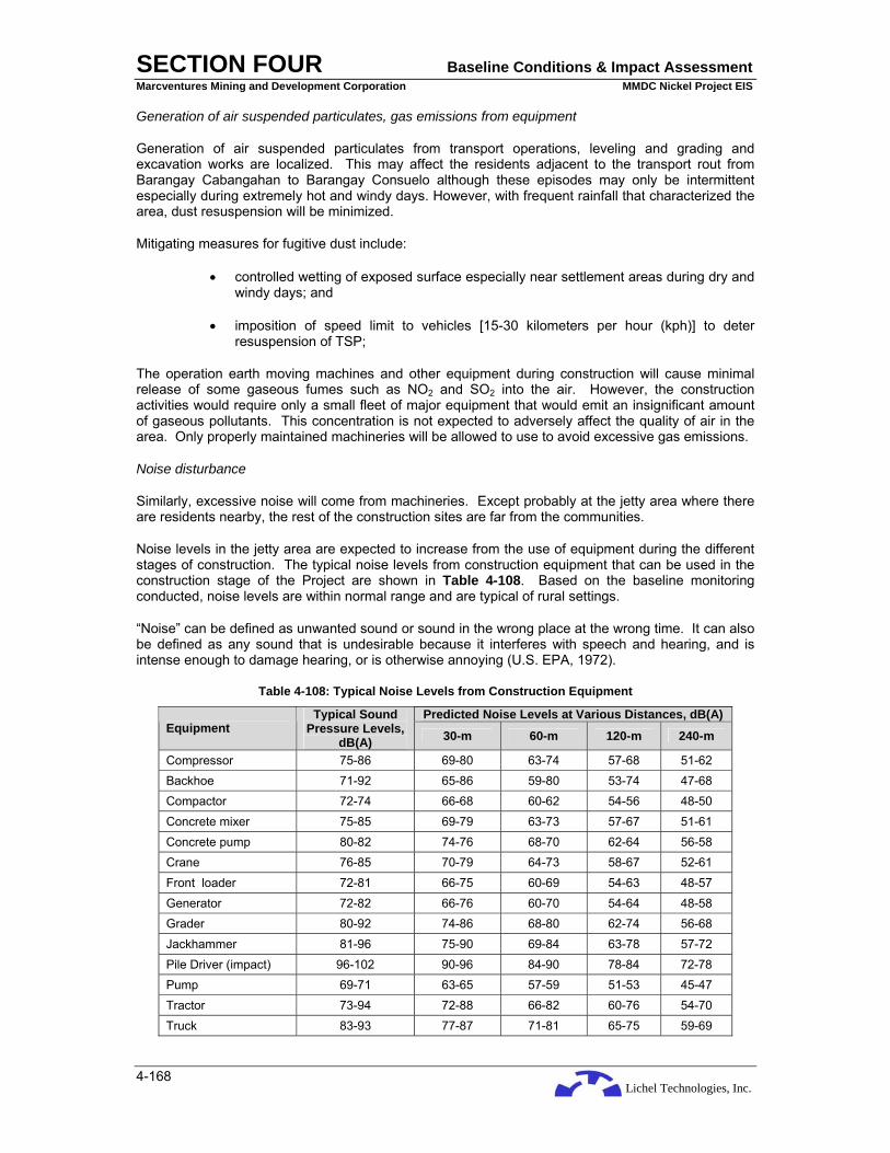
Lichel Technologies, Inc.
SECTION FOUR Baseline Conditions & Impact Assessment Marcventures Mining and Development Corporation MMDC Nickel Project EIS
4-168
Generation of air suspended particulates, gas emissions from equipment
Generation of air suspended particulates from transport operations, leveling and grading and excavation works are localized. This may affect the residents adjacent to the transport rout from Barangay Cabangahan to Barangay Consuelo although these episodes may only be intermittent especially during extremely hot and windy days. However, with frequent rainfall that characterized the area, dust resuspension will be minimized.
Mitigating measures for fugitive dust include:
• controlled wetting of exposed surface especially near settlement areas during dry and windy days; and
• imposition of speed limit to vehicles [15-30 kilometers per hour (kph)] to deter resuspension of TSP;
The operation earth moving machines and other equipment during construction will cause minimal release of some gaseous fumes such as NO2 and SO2 into the air. However, the construction activities would require only a small fleet of major equipment that would emit an insignificant amount of gaseous pollutants. This concentration is not expected to adversely affect the quality of air in the area. Only properly maintained machineries will be allowed to use to avoid excessive gas emissions.
Noise disturbance
Similarly, excessive noise will come from machineries. Except probably at the jetty area where there are residents nearby, the rest of the construction sites are far from the communities.
Noise levels in the jetty area are expected to increase from the use of equipment during the different stages of construction. The typical noise levels from construction equipment that can be used in the construction stage of the Project are shown in Table 4-108. Based on the baseline monitoring conducted, noise levels are within normal range and are typical of rural settings.
“Noise” can be defined as unwanted sound or sound in the wrong place at the wrong time. It can also be defined as any sound that is undesirable because it interferes with speech and hearing, and is intense enough to damage hearing, or is otherwise annoying (U.S. EPA, 1972).
Table 4-108: Typical Noise Levels from Construction Equipment
Predicted Noise Levels at Various Distances, dB(A) Equipment
Typical Sound Pressure Levels,
dB(A) 30-m 60-m 120-m 240-m
Compressor 75-86 69-80 63-74 57-68 51-62 Backhoe 71-92 65-86 59-80 53-74 47-68 Compactor 72-74 66-68 60-62 54-56 48-50 Concrete mixer 75-85 69-79 63-73 57-67 51-61 Concrete pump 80-82 74-76 68-70 62-64 56-58 Crane 76-85 70-79 64-73 58-67 52-61 Front loader 72-81 66-75 60-69 54-63 48-57 Generator 72-82 66-76 60-70 54-64 48-58 Grader 80-92 74-86 68-80 62-74 56-68 Jackhammer 81-96 75-90 69-84 63-78 57-72 Pile Driver (impact) 96-102 90-96 84-90 78-84 72-78 Pump 69-71 63-65 57-59 51-53 45-47 Tractor 73-94 72-88 66-82 60-76 54-70 Truck 83-93 77-87 71-81 65-75 59-69

Lichel Technologies, Inc.
SECTION FOUR Baseline Conditions & Impact Assessment Marcventures Mining and Development Corporation MMDC Nickel Project EIS
4-169
Predicted Noise Levels at Various Distances, dB(A) Equipment
Typical Sound Pressure Levels,
dB(A) 30-m 60-m 120-m 240-m
Vibrator 68-81 62-75 56-69 50-63 45-57 Source: Canter, 1996
Management of excessive noise during this phase is by proper maintenance of vehicles and equipment. Noisy construction activities shall be conducted as much as possible during day-time.
Biological Environment
Loss of vegetation and wildlife habitat
Construction of new access/haulage roads will entail cutting of vegetation. But this shall be kept to a minimum. If proposed road falls within forest lands, this activity will have a negative impact on wildlife. This impact may come in the form of displacement or habitat loss. Furthermore, the new road will potentially serve as access for in-migration of villagers who would wish to settle and establish farmlands. In-flux of human population, may an adverse and long-term effect as this would pave the way for reduction of original forest cover due to the increased pace of kaingin-establishment. Such reduction in forest cover will result to a long-term and adverse effect on wildlife due to displacement, loss of habitat and possibly hunting by settlers. In addition, heavy equipment and vehicles will be needed during road rehabilitation. If not handled very well, erosion will ensue and consequently will also lead to sedimentation and increased turbidity in near bodies of water. This impact will be adverse especially during the rainy season. Such increase in soil erosion may hasten the cause of landslides. This will potentially have an adverse effect on wildlife if the road will bisect forested lands. Noise generated by heavy equipment and vehicles will have an adverse but short-term effect on wildlife as these activities are temporary and short in duration.
Site preparation and construction of mine facilities, mine utilities, jetty, and pollution control facilities will entail clearing of vegetation and would have an adverse and long-term impact on wildlife if done on forested areas. Effects on wildlife will come in the form of displacement and outright mortality due to habitat loss. Erosion and, if near bodies of water, sedimentation will also likely occur during these activities. This would have adverse effects on wildlife that is associated with riparian habitats.
Although the impact is reversible, it cannot be avoided. Wildlife could easily move on to neighboring areas that are undisturbed for their need of shelter, water, food and other requirements. The strict no hunting policy will be enforced to all personnel and laborers not only during this phase but also during the entire project duration.
Effect on marine water ecology due to increased water turbidity
The proposed jetty area can be characterized as relatively poor in species of the usual coastal marine ecosystem (mangrove, seagrass/algal beds, and coral reefs and associated fish population and macroepifauna) due to poor fishing practices. Thus, the construction of the jetty will most likely not result into further degradation of the said coastal marine ecosystem if sediments from the ores stockpiled or moved through the jetty are contained.
As it is, the water has a relatively poor visibility caused by sediments. For this, surface runoff which may wash and carry the sediments from the stockyards should be directed towards catch basins constructed in the periphery of the stockyards to allow sediments to settle before the said rainwater is allowed to move into the coastal marine waters. This will also minimize potential leaching of materials attached to the ores, some of which could be toxic to the marine organisms and human beings who may consume contaminated marine resources from the area.

Lichel Technologies, Inc.
SECTION FOUR Baseline Conditions & Impact Assessment Marcventures Mining and Development Corporation MMDC Nickel Project EIS
4-170
Socio-Economic Environment
Generation of Employment and Livelihood Opportunities
Construction activities will hire workers and personnel. It will offer employment of skilled workers such as engineers, office personnel, dump truck drivers, heavy equipment operators, electricians, utility workers and laborers. Most of these positions may easily be filled in with local residents.
During the construction phase, the project offers limited direct work opportunities to women. This is because most work available is physically demanding. They may, however, be employed in commercial activities. Examples are food establishments, lodging facilities and to certain extent, transportation. The operation phase offers a variety of direct and indirect work opportunities. The impact in terms of enabling women to earn their own money, ability to support their family and instilling a sense of efficacy will be accomplished.
Increase commercial activities to the host barangay
Opportunities in livelihood and economic advancement in support of the construction activities will be created in advance of the actual mining operation. Requirements of the employees and the proponent such as supply of basic commodities, eateries, tailoring, laundry services, and personal grooming services will be provided by the residents because of the increased demands. Residents engaged in these activities are expected to improve their standards of living because of additional income to their families. The fulfillment of these needs is a good opportunity for the existing businesses in the municipality to expand their operations to the host barangays.
In effect, there will be more money in circulation because of the salaries and other benefits of the workers and the proponent and the support service establishments; there will, in turn, be more income generating activities. Residents will improve their living facilities and would be encouraged buying clothes, appliances and beauty products. When not available in the barangay, initially the residents will buy in the poblacion. However, enterprising businesspersons will start to transport such goods to the project site. Hence, additional demand for transportation will be developed and filled up by the residents of the municipality. Commercial activities will increase because of greater demand of the residents for the goods and services.
In-migration
The Project would attract migrants to the employment and livelihood opportunities and would be desirous to participate and earn income. The influx of migrants will create additional demands not only for basic commodities and services, but also for housing facilities. The outside workers will most likely live near their place of work. This means that the number of housing structures around the project site will increase. The existing sanitation level that is already low may further deteriorate. The occupants of these new structures may compete for such resources as water and land with the local population. This problem will be avoided or much reduced if the workers are recruited from among local people. The accessibility of the area from city’s downtown area will most likely reduce the need for people to live near their place of work but will not erase the possibility of high housing demand.
Landowners may construct additional housing facilities to accommodate these migrants and in effect earned more income. Overall, the increased commercial activities in the area will benefit the residents by providing them additional income for their families.
Additional income and benefits to the local government unit
Initially, the Province of Surigao del Sur, Municipalities of Cantilan, Carrascal and Madrid and the host Barangays, Cabangahan, Panikian and Bayogo will directly benefit from the Project during the construction phase, since MMDC shall continue to pay an occupation fee based on the area of the mining claim. This fee shall be shared among the province, municipality and the host barangays. In addition, the proponent shall also pay local taxes and licenses in operating a business in the municipality.

Lichel Technologies, Inc.
SECTION FOUR Baseline Conditions & Impact Assessment Marcventures Mining and Development Corporation MMDC Nickel Project EIS
4-171
This additional revenue will be shared by the municipality and the host barangays and may be appropriated to improve the delivery of basic services such as education, health, road maintenance, water supply and police services.
The LGUs (barangays, municipality and province) will also increase their yearly revenue because of the corresponding increase in commercial activities in their respective jurisdictions. Additional revenues from the licenses and permits required will be realized because of the establishment of new businesses in the municipality. It is also expected that new construction and occupation permits will be issued because of the anticipated development in the host Barangays.
Health and Sanitation
There are two types of individuals that could be affected during the construction phase: the workers in the construction site and the persons in the host community. For resident employees (workers from the host barangays), it is most likely that this is the first time that they will be exposed to the new work environment. It is most likely that construction workers will be exposed to the masculo-skeletal stress, injuries due to accidents and excessive exposures to the elements.
Like the various project proponents, it is possible that air emissions by trucks and heavy equipment during the construction phase may pose health hazards to surrounding communities. The incidence of respiratory diseases and allergies may increase as a result of these activities.
The presence of workers and personnel during the construction phase will demand an increase for water supply and access to sanitation and waste disposal facilities. Workers will also generate solid waste from their personal and construction activities. The proponent should provide access to sanitation.
Lifestyle and Culture
It must be noted that the presence of the mining company in Barangay Taganito, Claver and the recently opened mining operations in Barangay Adlay has heightened the expectations of the residents of the host barangays. They have high expectations from the project; some have friends and relatives who are employed these mining companies and they have observed their improved economic conditions. This is advantageous to the Proponent because it increases significantly the Project’s chances for success. However, the people’s expectations need to be managed and tempered. The people must know the limitations and realities of the Project. The limitations are that the Project cannot be an all-provider of benefits and it has a limited life in their communities. This idea was clearly discussed in group meetings, particularly during Barangay council meetings. The reality is that the problems may surface at various stages of the project.
4.5.2.3 Operation Phase
Activities during the operation this phase is centered to on the contour (surface) mining method that involves the following activities:
• Land Clearing (Stripping)
• Overburden Removal and Storage for Rehabilitation
• Ore Mining (Extraction)
• Progressive Rehabilitation
• Ore Transport
• Ore Stockyard Operation (Ore Piling and Drying)
• Ore Delivery to Sea Craft

Lichel Technologies, Inc.
SECTION FOUR Baseline Conditions & Impact Assessment Marcventures Mining and Development Corporation MMDC Nickel Project EIS
4-172
Physical Environment
Erosion, siltation and turbidity and associated impacts
This impact is similar in nature and has the same receptors as described above in the Construction Phase. However, impacts during this phase are expected to be more extensive due to the number of openings and volume of soil to be moved.
A detailed assessment and mitigation of the potential impact of siltation to the NIA irrigation system is discussed separately and presented in Section 4.5.2.4.
In addition, the potential impact of the proposed jetty on the on the coastal hydraulics, sediment transport and sediment morphology of the coastal area of Barangay Consuelo is also presented in Section 4.5.2.5.
Continued potential contamination of soil water from generated domestic and sanitary wastes
The potential treat of soil and water contamination will persist during the operation phase. A more concrete or permanent mitigative measures should be in place such as three- chambered septic tanks, or an adequate sanitary landfill could be considered. Continued preference for hiring qualified local residents will minimize entry of migrant workers, thus, maintaining the volume of domestic and sanitary wastes generated.
Generation of solid wastes
Solid wastes generated during this phase will consist of earth spoils and vegetation spoils from clearing, grubbing and excavation. Additional wastes, although minimal will come from offices and assay laboratory.
The proponent will implement solid waste management plan to ensure that solid wastes are handled and disposed of accordingly. Hazardous wastes such as used oil from the maintenance of vehicles and machineries will be managed in accordance with Republic Act 6969 otherwise known as the Toxic Substances, Hazardous and Nuclear Wastes Control Act of 1990. Undisposed wastes will be temporarily located in a safe and secluded area while awaiting transport disposal.
Generation of air suspended particulates, gas emissions and noise from equipment
This is an impact in the immediate vicinity of the mine areas, haul roads and open dumpsites. The ore stockpiles will be covered with tarpaulins thus are not expected to cause a significant concern. The opened areas are possible sources of dust. However, while dust generation may persist during the lifetime of the Project, the events are episodic, only during the dry months when there are operations. On gaseous emissions, the generators will only be used for back up. The electric cooperative of the province will be the main source of power for the Project. Movement of truck, excavators and other heavy equipment are expected to be of more concern if the maintenance and quality control for these are not properly and regularly undertaken. Similarly, excessive noise will come from machineries.
The proponent shall continue to implement the existing mitigation measures applied during the construction phase. The ore transported and stockpiled will be covered with tarpaulins so as not to produce dust.
Potential treat to the proposed Mini Hydroelectric Power
The Municipality of Cantilan has recently been granted a 60M-peso funding to develop the Sipangpang Falls as a Multi-purpose mini hydroelectric power/water supply and eco-tourism build a mini hydroelectric power. An impact assessment of the Project on the proposed mini hydroelectric power is discussed separately in Section 4.5.2.6.
Lichel Technologies, Inc.
SECTION FOUR Baseline Conditions & Impact Assessment Marcventures Mining and Development Corporation MMDC Nickel Project EIS
4-173
Biological Environment
Loss of vegetation and wildlife habitat
As in all mining operations, land clearing and scraping of minerals would entail a very high negative impact to all vegetation in the project site. Depending on the locations of the mining activities, it is expected that some patches of vegetation would still remain due to low mineral content of the substrate, which will not be of interest to the project. On the other hand, the removal of vegetation would expose the soil to the natural elements and mining activities would further loosen the soil thus making it very much vulnerable to erosion.
To minimize this condition, a band or belt of vegetation fronting the Carac-an River should not be removed. A width of 15 – 20 m would suffice to protect the River from siltation but this is not a 100% proof measure. Not only would it protect the River but it would also serve as the area’s habitat of endangered, endemic and indigenous species.
Surface mining will definitely result to tree cutting to expose the overburden and eventually to allow extraction of the ore. This will be done within the guidance of the ECC, within the other regulations of the DENR, e.g. Tree Cutting Permits for regulated species, and within the Mine Development Plan to be approved by the DENR-MGB. The footprint of surface development will be kept to a minimum as much as possible to lessen openings while accessing as much ore as possible. Careful environmentally conscientious planning and strategic engineering can achieve these objectives.
Some of the stripped vegetation will be used for erosion control or, as part of the proponent’s progressive rehabilitation policy, be re-planted in other areas that are not directly affected by the Project.
Fauna displacement is also inevitable with the removal of vegetation. Buffer vegetation will be accessible in the immediate vicinity of the mine sites and reforestation will be undertaken so that the fauna will not suffer any physiological impacts (e.g. changes in feeding and breeding habits), dislocation or disorientation.
Socio-economic Environment
Population/Settlement/Migration
The Project will hire approximately 242 personnel and workers during the operation phase. It will offer employment of skilled workers such as engineers, office personnel, dump truck drivers, heavy equipment operators, electricians, utility workers and laborers. Most of these positions may easily be filled in with local residents.
During the construction phase, the project offers limited direct work opportunities to women. This is because most work available is physically demanding. They may, however, be employed in commercial activities. Examples are food establishments, lodging facilities and to certain extent, transportation. The operation phase offers a variety of direct and indirect work opportunities. The impact in terms of enabling women to earn their own money, ability to support their family and instilling a sense of efficacy will be accomplished.
There will be none, if not, minimum social impact in the social demography of the area if the employees to be hired would come from the local communities. There are now few individuals who are relatives of the residents who want to reside back in the community. The host barangays will create strict mechanisms to prevent outsiders to move in and live in the area. Nevertheless, increased economic activities in the area will attract migrants who are seeking better employment and livelihood opportunities.
It cannot be denied that informal settlements may develop along river banks, sidewalks and vacant areas because of the increased livelihood opportunities in the area. The demand for the basic social services will be strained to meet these additional demands. These areas may have unsanitary conditions if the lack of adequate sanitation facilities is not addressed.
Lichel Technologies, Inc.
SECTION FOUR Baseline Conditions & Impact Assessment Marcventures Mining and Development Corporation MMDC Nickel Project EIS
4-174
Employment/Livelihood
As pointed out in the survey, the primary positive effect of the Project is the generation of employment and livelihood opportunities. Residents are expecting that members of their families and other relatives will be able to work in the company. Other residents expressed their hopes that some kind of business may derive from mining the operations. Failure of the proponent to adequately address the high expectations of the residents regarding employment and livelihood will have serious repercussions in its relations with the communities.
There is apprehension that women will not have a fair chance of getting a decent employment in the Company considering the traditional biases against women. Flesh trade and other vices may proliferate and may be detrimental to the women sector due to the increase income of male workers.
Additional Revenues to the Local Government Units
The host barangays, municipality and the province will directly benefit from the Project through additional financial resources provided by the Mining Act of 1995 and the Local Government Code. It is expected that the LGUs will share in the excise taxes, occupation fees, royalties, mine waste, and tailing fees. These are in addition to the normal taxes being levied by the LGUs on the corporations or partnerships. This additional revenue may be appropriated to the delivery of basic services such as education, health, road maintenance, water supply and police services.
Lifestyle and Culture
The Project will change the lives of the employees and their families because of increase in income. It is expected that the standard of living will improve and spending on education, health, appliance, good food, and clothes are expected to increase.
Money may also bring vices such as gambling, drinking and womanizing. Consequently, the peace and stability of the family will be threatened. Social conditions may deteriorate at the detriment of the family if no positive interventions are mounted to mitigate the negative effects of larger income.
The project will change the lives of the employees and their families because of bigger disposable income. It is expected that the standard of living will improve and spending on education, health, appliance, good food, and clothes are expected to increase.
Resource Use Competition
Presently, the area is uninhabited and vegetation is of marginal economic value because of the high mineral content of the soil. Marginal farming and fire wooding gathering activities are present in some parts of the mining claim.
The development of the mine in the area will enhance the value of the land because of the high mineral deposits present in the area that will be extracted by the company. Land which was previously of little economic value will become productive and may sustain agricultural crops for the residents.
4.5.2.4 Impact Assessment and Mitigation of Potential Siltation of the NIA Irrigation System
Background
The 4,799-hectare MMDC Nickel Project is situated within the watersheds of Carac-an, Alamio, Binoni and a sub-catchment of Buyaan Rivers. MMDC will initially mine about 120 ha at Area 2 located on the southern part of the project area and within the Carac-an watershed. The mine area is located about 1.5 km north of Barangay Cabangan Proper at elevations between 200 - 400 masl.
The National Irrigation Administration (NIA) has four irrigation systems located downstream of the project area (See Figure 4-26). One of these irrigation systems, the Cantilan National Irrigation System (NIS), is located along the Carac-an River approximately five kilometers downstream of the

Lichel Technologies, Inc.
SECTION FOUR Baseline Conditions & Impact Assessment Marcventures Mining and Development Corporation MMDC Nickel Project EIS
4-175
mine area. The irrigation system draws water from Carac-an River at diversion rate of about 6.0 cubic meters per second (CMS) that serves the towns of Cantilan and Madrid with an initial total firmed-up service area of 1,785 ha. The 2.8-million peso irrigation system operated in 1971 but was rehabilitated in 1982 at a cost of 11 million pesos due to siltation of the intake structure and main canals. Currently, the system is undergoing another rehabilitation program under the auspices of the Southern Philippines Irrigation Sector Project (SPISP) funded by Asian Development Bank (ADB) in the amount of 197.2 million pesos.
This section consists of three parts: the first part discusses the potential effect of siltation of Carac-an River which could affect the downstream irrigation facilities; the second part formulates mitigation measures to address this adverse impact; and lastly, the third part presents the proposed siltation mitigating measures for the initial mine area at Area 2.
Potential Siltation of Carac-an River
The initial mining operation is approximately 4 to 5 km upstream of the irrigation intake structure. Considering that the initial mining will be for a period of ten (10) years, the NIA had raised their concerns that siltation of the intake structure will be aggravated once the mining commences. Although the project area mostly lies within the watersheds of Carac-an, Alamio and Binoni Rivers, the assessment of the siltation/sedimentation impact will be focused on Carac-an River since initial mine operation could impact the said river.
As stated in the preceding section, the diversion intake of Cantilan NIS is within the Carac-an River watershed. The intake structure is located in a transition zone of the river between the sediment transport zone and the sediment depositional zone. In the transition zone, the velocity of the streamflow diminishes due to the reduction of the river gradient. The river, in turn, reduces its carrying power and deposits its sediment load.
Through the years of its operation, silt accumulated at the intake structure that required desilting to optimize the design capacity of the intake. This is evident through the rehabilitation and improvement of the intake structure and main canals in 1982, and currently under the SPISP. It can be said that siltation of the irrigation intake structure has been occurring without any human activities upstream of the system. Generally, the types of sediments deposited at the intake are composed of silt (0.0039 to 0.0625 mm diameter) and sand (0.0625 – 2.0 mm diameter). The parent material of the sediments is the lateritic soils which conspicuously observed during the occurrence of flood events where flood waters are very turbid and it has a reddish color. Usually, the types of sediments transported are mixture of suspended or wash load and bed load.
Estimation of Sediment Yield
Methodology Used in this Study
Sediment discharge in storage dams is estimated using direct correlation from observed sedimentation rates in the country where the constant of proportionality is the catchment area.
A number of basins has been studied around the world and a curve was constructed which relates annual sediment production per unit area to mean annual rainfall (Figure 4-43).
These studies present the maximum production rates for areas with little protective vegetal cover occur at about 300 mm of mean annual rainfall. With heavier rainfall, vegetation cover is most likely denser hence reduces the erosion, and with lesser rainfalls, the erosion also decreases2.
In the absence of poor correlation e.g. watershed attributes are not similar; the Universal Soil Loss Equation (USLE) 3 is commonly employed to determine erosion rates. The USLE is an erosion model that was originally designed to predict the longtime average soil losses in runoff from specific field
2 Langbein, W.B and S.A. Schumm. 1958 3 Wischmeier and Smith (1978).

Lichel Technologies, Inc.
SECTION FOUR Baseline Conditions & Impact Assessment Marcventures Mining and Development Corporation MMDC Nickel Project EIS
4-176
areas in specified cropping and management systems. In its evolvement, it was made applicable for such non-agricultural conditions and construction sites.
Figure 4-43: Sediment Yield as Function of Mean Annual Rainfall (Langbein and Schumm, Trans.Am,. Geophys Union,Vol. 39, pp.1076-1084)
The procedure is founded on an empirical equation that is believed to be applicable wherever numerical values of its factors are available. The term "an empirical soil loss equation" suggests that the equation and its factors are based on observations of erosion and erosion processes rather than theoretically derived relationships.
USLE is represented by the equation:
A = RKLSCP
where “A” is the computed soil loss per unit area and is expressed as an average in tons/ha/year. Other parameters of the equation are explained below.
The R factor is described as a rainfall and runoff factor and is computed as the product of rainfall storm energy (E) and the maximum 30-min rainfall intensity (I30). Total energy refers to raindrop detachment, and peak intensity refers to the peak rate of runoff.
The energy parameter can be computed from rainfall intensity data using:
E = 0.119 + 0.0873Log10(I) I<= 76 mm/h
E = 0.283 I > 76 mm/h
where E is kinetic energy in megajoule per hectare per millimeter of rainfall (MJ/ha • mm), and I is rainfall intensity in mm/h.
An approximate equation to estimate R is:
R = 0.417P2.17
where R is an estimate of the average annual rainfall erosion index in MJ • mm/ha • h • y, and P is the 2-y, 6-h rainfall amount in millimeters. For this project, the rainfall data of Surigao City was used for the value of 2-y, 6-h rainfall which is 140 mm.
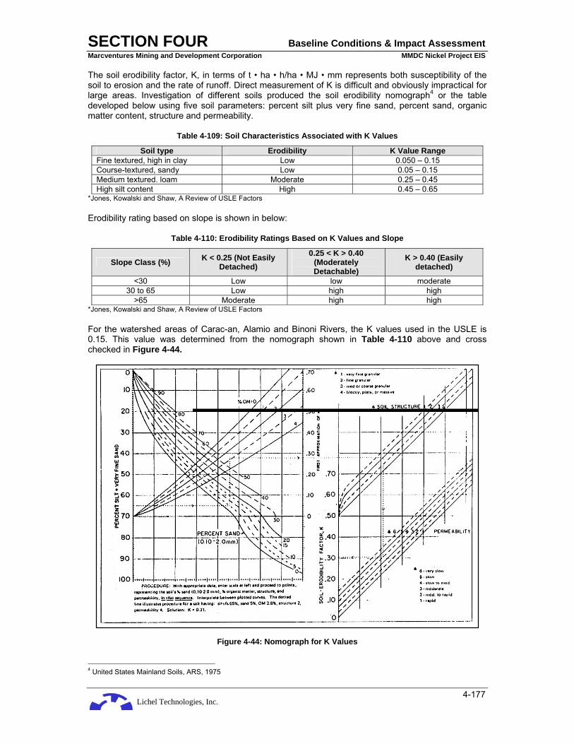
Lichel Technologies, Inc.
SECTION FOUR Baseline Conditions & Impact Assessment Marcventures Mining and Development Corporation MMDC Nickel Project EIS
4-177
The soil erodibility factor, K, in terms of t • ha • h/ha • MJ • mm represents both susceptibility of the soil to erosion and the rate of runoff. Direct measurement of K is difficult and obviously impractical for large areas. Investigation of different soils produced the soil erodibility nomograph4 or the table developed below using five soil parameters: percent silt plus very fine sand, percent sand, organic matter content, structure and permeability.
Table 4-109: Soil Characteristics Associated with K Values
Soil type Erodibility K Value Range Fine textured, high in clay Low 0.050 – 0.15 Course-textured, sandy Low 0.05 – 0.15 Medium textured. loam Moderate 0.25 – 0.45 High silt content High 0.45 – 0.65
*Jones, Kowalski and Shaw, A Review of USLE Factors
Erodibility rating based on slope is shown in below:
Table 4-110: Erodibility Ratings Based on K Values and Slope
Slope Class (%) K < 0.25 (Not Easily Detached)
0.25 < K > 0.40 (Moderately Detachable)
K > 0.40 (Easily detached)
<30 Low low moderate 30 to 65 Low high high
>65 Moderate high high *Jones, Kowalski and Shaw, A Review of USLE Factors
For the watershed areas of Carac-an, Alamio and Binoni Rivers, the K values used in the USLE is 0.15. This value was determined from the nomograph shown in Table 4-110 above and cross checked in Figure 4-44.
Figure 4-44: Nomograph for K Values
4 United States Mainland Soils, ARS, 1975

Lichel Technologies, Inc.
SECTION FOUR Baseline Conditions & Impact Assessment Marcventures Mining and Development Corporation MMDC Nickel Project EIS
4-178
LS is the expected ratio of soil loss per unit area from a field slope to that from a 22.1 meter length of uniform 9% slope under otherwise identical condition. This ratio for specified combinations of field slope lengths and uniform gradient is obtained directly from slope-effect chart. For example, a 22.1 meter uniform slope at 9% would have an LS value of 1.0. or uniform slope length of 7.6 m would have an LS value of 0.06 for 0.2% slope and a value of 2.0 for 20% slope or greater steepness. Within these limits, LS values range from a low of about 0.2 to a high of about 6. For the watersheds mentioned above, LS value used is 1.0.
Factor “C” in the soil loss equation is the ratio of soil loss from vegetated land under specified condition to the corresponding loss from clean tilled continuous fallow. This factor measures the combined effect of all the interrelated cover and management variables.
The cover and management factor, C, is dimensionless and is determined over time (cover and management practices take time to implement, and their combined and interactive influences may take years to stabilize and on a mostly empirical basis. Further, because vegetative cover develops over time, as controlled by plant physiology, climate and weather, management, soil characteristics, etc., it is highly dynamic and highly variable. Thus, the C factor lumps an enormous amount of information on biological, physical, and land use or management-induced variability into a single coefficient. Under these conditions, its specification involves a great deal of judgment based upon empirical data and experience. Moreover, the reliability of C factor estimates is a function of all these interactive and ill-defined relationships, so that true measures of its variability are impossible in the objective sense. Good judgment appears to be the best option.
Values range from .01 to 1.40, representing soil loss ratios of from 1 to 140% of the soil loss. These C values were derived based on upland and cropped plots where erosion is expected to be high. Obviously, it would be much lower for forested areas. For the watersheds under study, vegetation cover consists mostly of primary and secondary growth and the C value used for existing condition is 0.03 and 1 for stripped condition e.g. during mining operation.
By definition, factor P in the USLE is the ratio of soil loss with specific support practice to the corresponding loss with up-and-down-slope culture. Improved soil conservation practices and implementation of the Watershed Management Plan contribute materially to erosion control. The P value used is 0.5 under existing condition and 1 for condition during mining operation.
It is anticipated that error in this estimation can occur because the USLE is an empirical equation that does not mathematically represent the physical processes of soil erosion. The equation predicts the amount of erosion but due to deposition, the actual amount of sediment reaching a given point may be less. Many of the values used to calculate erosion are assumed or estimated.
Results of Study
Using USLE, the estimated annual sediment yield per square kilometer of catchment area at existing condition is about 2,898 cubic meter (m3) whereas the annual sediment yield during mining operation e.g. stripping and extraction is 144,900 m3/sq km or 1,449 m3/ha.
Table 4-111 presents the estimated sediment yield from the initial mine area as compared with the remaining area of the watershed.
Table 4-111: Estimated Sediment Yield from the Initial Mine Area at Area 2
Stripped (Mining) areas Unstripped areas within the Watershed Year
Area Cubic Meters Tons Cubic Meters Tons 1 12 17,388 34,080 686,478 1,345,497 2 24 34,776 68,161 686,130 1,344,816 3 36 52,164 102,241 685,783 1,344,134 4 48 69,552 136,322 685,435 1,343,453 5 60 86,940 170,402 685,087 1,342,771
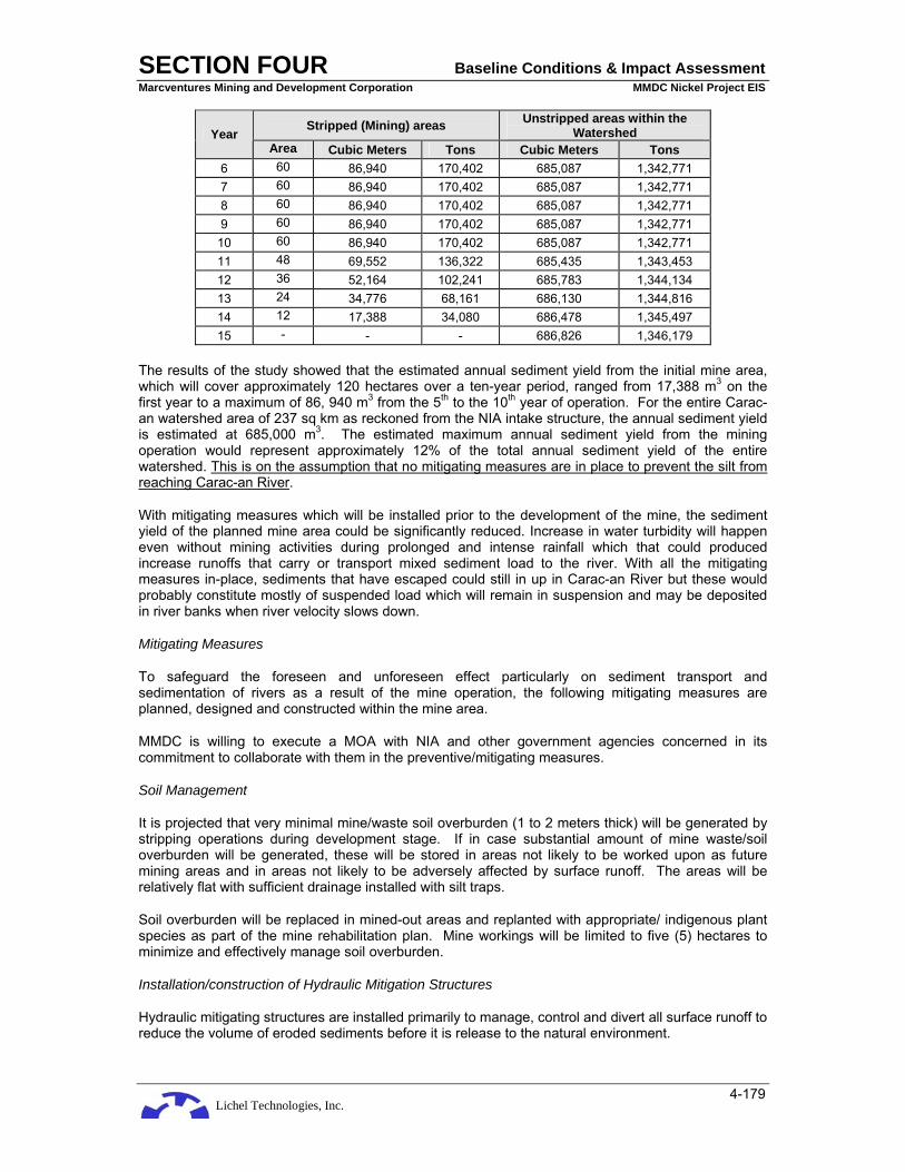
Lichel Technologies, Inc.
SECTION FOUR Baseline Conditions & Impact Assessment Marcventures Mining and Development Corporation MMDC Nickel Project EIS
4-179
Stripped (Mining) areas Unstripped areas within the Watershed Year
Area Cubic Meters Tons Cubic Meters Tons 6 60 86,940 170,402 685,087 1,342,771 7 60 86,940 170,402 685,087 1,342,771 8 60 86,940 170,402 685,087 1,342,771 9 60 86,940 170,402 685,087 1,342,771 10 60 86,940 170,402 685,087 1,342,771 11 48 69,552 136,322 685,435 1,343,453 12 36 52,164 102,241 685,783 1,344,134 13 24 34,776 68,161 686,130 1,344,816 14 12 17,388 34,080 686,478 1,345,497 15 - - - 686,826 1,346,179
The results of the study showed that the estimated annual sediment yield from the initial mine area, which will cover approximately 120 hectares over a ten-year period, ranged from 17,388 m3 on the first year to a maximum of 86, 940 m3 from the 5th to the 10th year of operation. For the entire Carac-an watershed area of 237 sq km as reckoned from the NIA intake structure, the annual sediment yield is estimated at 685,000 m3. The estimated maximum annual sediment yield from the mining operation would represent approximately 12% of the total annual sediment yield of the entire watershed. This is on the assumption that no mitigating measures are in place to prevent the silt from reaching Carac-an River.
With mitigating measures which will be installed prior to the development of the mine, the sediment yield of the planned mine area could be significantly reduced. Increase in water turbidity will happen even without mining activities during prolonged and intense rainfall which that could produced increase runoffs that carry or transport mixed sediment load to the river. With all the mitigating measures in-place, sediments that have escaped could still in up in Carac-an River but these would probably constitute mostly of suspended load which will remain in suspension and may be deposited in river banks when river velocity slows down.
Mitigating Measures
To safeguard the foreseen and unforeseen effect particularly on sediment transport and sedimentation of rivers as a result of the mine operation, the following mitigating measures are planned, designed and constructed within the mine area.
MMDC is willing to execute a MOA with NIA and other government agencies concerned in its commitment to collaborate with them in the preventive/mitigating measures.
Soil Management
It is projected that very minimal mine/waste soil overburden (1 to 2 meters thick) will be generated by stripping operations during development stage. If in case substantial amount of mine waste/soil overburden will be generated, these will be stored in areas not likely to be worked upon as future mining areas and in areas not likely to be adversely affected by surface runoff. The areas will be relatively flat with sufficient drainage installed with silt traps.
Soil overburden will be replaced in mined-out areas and replanted with appropriate/ indigenous plant species as part of the mine rehabilitation plan. Mine workings will be limited to five (5) hectares to minimize and effectively manage soil overburden.
Installation/construction of Hydraulic Mitigation Structures
Hydraulic mitigating structures are installed primarily to manage, control and divert all surface runoff to reduce the volume of eroded sediments before it is release to the natural environment.

Lichel Technologies, Inc.
SECTION FOUR Baseline Conditions & Impact Assessment Marcventures Mining and Development Corporation MMDC Nickel Project EIS
4-180
To achieve this end, a network of surface drainage canals, silt traps, drop structures, weirs and silt dam/ponds will be constructed in the mine area. Silt that is likely to be carried by surface runoff at the mine workings during the heavy rainfall will be directed to canals installed with catch basins and sandbag weirs. Pre-cast concrete pipe culverts will be installed across the haulage road. Silt fences will be built to capture disturbed/eroded soils from mine workings. Along the natural drainage (creeks), drop structures and silt traps will be installed to slacken streamflow velocity and reduce the sediment transport or carrying capacity. As a last line of defense, silt ponds will be constructed to allow the remaining suspended sediments to settle. Clear decant water from the ponds may be allowed to flow to the river. Periodic dredging/excavation of the hydraulic structures will be done to maintain the design storage capacity. Excavated silt materials will be used as filling materials for road projects, donations to the barangays and municipalities, if found to be feasible.
Proposed Mitigating Measures in Area 2
To manage impacts of the project due to siltation, various structures will be built to mitigate said siltation. It can be noted that the initial production Areas in Area 2 of will be in proximity to the Carac-an River which lies directly north of the area, swinging from the west heading south-southeast; the management of siltation requires utmost attention and every preventive measure must be considered to prevent silt from reaching said body of water.
Four settling ponds have been planned to the north of the area: two at the northeast which will take care of the silt that will flow to the east and northeast, one due north, and one to the northwest corner of Area 2 (Please refer to Figure 3-4: Project Components Map).
Silt traps. Numerous silt traps will be constructed in perhaps every level of production. These will be constructed alongside main roads and will be parallel to the drain ditches; they are practically widened lengths of the ditch, perhaps up to six (6) meters deep and up to five (5) meters wide to provide space for silt to collect upon transport by runoff waters. De-silting will be done periodically to provide space for more silt. (A picture taken from another nickel project, showing a typical silt trap, is shown below.)
Plate 4-16: A typical silt trap (Source: GPPamintuan)

Lichel Technologies, Inc.
SECTION FOUR Baseline Conditions & Impact Assessment Marcventures Mining and Development Corporation MMDC Nickel Project EIS
4-181
Plate 4-17: Another example of silt traps and catch basin
Silt dams and settling ponds. Silt that is not captured from the series of silt traps are led to silt dams and settling ponds, of much larger capacity than silt traps and which provide volume for surges during strong and/or sustained rains. These will be the final structure to contain silt and decant silt-containing water; they can also be connected in series to provide more containment and surge capacity. (Examples of silt dams from another nickel project are shown below.)
Plate 4-18: An example of a silt dam (Source: GPPamintuan)

Lichel Technologies, Inc.
SECTION FOUR Baseline Conditions & Impact Assessment Marcventures Mining and Development Corporation MMDC Nickel Project EIS
4-182
Plates 4-18. Another example of a silt dam.
(Source: GPPamintuan)
Structures at the project site. Currently, a silt-containing structure has been under construction at the project site as part of MMDC environmental work program for their exploration activities. The structure is composed of a series of three dams that will capture silt from the eastern portions of the proposed initial mine area. This will be an initial mitigating measure to manage siltation at the start of the project; several more of these will be constructed as the project progresses (Figure 4-45).
It can be seen that the areas downstream of the planned sedimentation pond and settling dams provide more space for the construction of more and larger structures if said dams will be inadequate. MMDC will be monitoring rainfall volumes and will study the need for additional structures before full production commences.
The details of the final design of these structures will be presented and contained in the Environmental Protection and Enhancement Plan (EPEP) that will be submitted to the MGB.
Similar mitigating measures will be applied in future mining areas where mineable reserves are established.

Lichel Technologies, Inc.
SECTION FOUR Baseline Conditions & Impact Assessment Marcventures Mining and Development Corporation MMDC Nickel Project EIS
4-183
Figure 4-45: Diagram of silt-containing structure under construction

Lichel Technologies, Inc.
SECTION FOUR Baseline Conditions & Impact Assessment Marcventures Mining and Development Corporation MMDC Nickel Project EIS
4-184
Plate 4-19: Silt-containing structures currently under construction at the project site, Note: Looking upstream; the lowermost dam is seen in the foreground while the two others can be seen in the upper right quadrant of the picture. (Source: GPPamintuan)
Plate 4-20: Lowermost dam, looking across the breadth of the structure (Source: GPPamintuan)
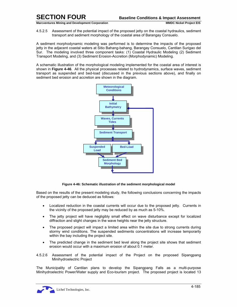
Lichel Technologies, Inc.
SECTION FOUR Baseline Conditions & Impact Assessment Marcventures Mining and Development Corporation MMDC Nickel Project EIS
4-185
4.5.2.5 Assessment of the potential impact of the proposed jetty on the coastal hydraulics, sediment transport and sediment morphology of the coastal area of Barangay Consuelo.
A sediment morphodynamic modeling was performed is to determine the impacts of the proposed jetty in the adjacent coastal waters at Sitio Bahang-bahang, Barangay Consuelo, Cantilan Surigao del Sur. The modeling involved three component tasks: (1) Coastal Hydraulic Modeling (2) Sediment Transport Modeling, and (3) Sediment Erosion-Accretion (Morphodynamic) Modeling.
A schematic illustration of the morphological modeling implemented for the coastal area of interest is shown in Figure 4-46. All the physical processes related to hydrodynamics, surface waves, sediment transport as suspended and bed-load (discussed in the previous sections above), and finally on sediment bed erosion and accretion are shown in the diagram.
Figure 4-46: Schematic illustration of the sediment morphological model
Based on the results of the present modeling study, the following conclusions concerning the impacts of the proposed jetty can be deduced as follows:
• Localized reduction in the coastal currents will occur due to the proposed jetty. Currents in the vicinity of the proposed jetty may be reduced by as much as 5-10%.
• The jetty project will have negligibly small effect on wave disturbance except for localized diffraction and slight changes in the wave heights near the jetty structure.
• The proposed project will impact a limited area within the site due to strong currents during stormy wind conditions. The suspended sediments concentrations will increase temporarily within the bay including the project site.
• The predicted change in the sediment bed level along the project site shows that sediment erosion would occur with a maximum erosion of about 0.1 meter.
4.5.2.6 Assessment of the potential impact of the Project on the proposed Sipangpang Minihydroelectric Project
The Municipality of Cantilan plans to develop the Sipangpang Falls as a multi-purpose Minihydroelectric Power/Water supply and Eco-tourism project. The proposed project is located 13
Suspended Load
Bed-Load
Sediment Transport
Waves, Currents Tides
Sediment Bed Morphology
Initial Bathymetry
Meteorological Conditions
Lichel Technologies, Inc.
SECTION FOUR Baseline Conditions & Impact Assessment Marcventures Mining and Development Corporation MMDC Nickel Project EIS
4-186
km from Barangay Parang along the National Highway or 7 km from the junction of the barangay road leading to Barangay Cabangahan proper.
The approximate position of the proposed minihydroelectric project area in relation to the Project area is shown in Figure 4-26. Based on the map figure, the proposed hydroelectric project is within the MPSA area specifically within the Alamio drainage catchment area. The initial mine, on the other hand, is located within the Carac-an drainage catchment area. It is therefore improbable that the initial mining operation would affect the operation of the proposed hydroelectric power.
If the Project pushes through, MMDC also has a plan to build a hydroelectric plant that could provide power not only for its operation but also for the benefit of the community. Operating a hydroelectric plant would require some degree of watershed management and protection to sustain optimum power generation.
4.5.2.7 Abandonment Phase
Physical Environment
The mine area, waste dump, if left as is at the cessation of mining, may pose a safety hazard. However, the proponent will implement a mine rehabilitation and closure plan designed to stabilize these structures. Closure of the mine will result in abandonment of the facilities. If effective closure is not achieved, the following could happen:
• the slopes, particularly the open and steep ones, will be vulnerable to failure or mass movement;
• uncontrolled surface runoff down the slopes will erode the earth materials.
Five years before the end of mine life, a plan for the final decommissioning program shall be submitted to the MGB. At the end of the mine life, open slopes will remain at the open pit area. The areas of the ROM pad and waste dump currently being worked on will require to be rehabilitated. Other areas disturbed during construction such as the slopes of road cuts, road sides, and the surroundings of buildings and facilities will have been re-vegetated during the operational phase as a result of the progressive rehabilitation policy of the proponent. Open areas will result once the facilities such as crusher, equipment, buildings, and storage areas are removed from the site. The open slopes and areas will be vulnerable to soil erosion. The decommissioning program will address all this, and mitigating measures put in place.
During abandonment, the long-term stability of the drainage canals, culverts, and spillways will be ensured by means of sound engineering design for these structures and a rehabilitation plan to minimize scouring, collapse, and clogging of the waterways through soil erosion and build up of sediment in these structures.
Biological Environment
With the progressive rehabilitation program of the proponent prior to abandonment, the open and disturbed areas in the site should have been re-vegetated.
Wildlife disturbance will cease during abandonment. The open pit and the dumpsites are permanent disturbances on the landscape of the area; however, the proponent’s rehabilitation program will provide alternative habitats for the wildlife making use of these features.
Socio-economic Environment
Contraction/Termination of employment
This is a major impact to several hundreds of employees and their families who will be laid off with the closure of the Project. Community assistance/livelihood programs to be developed by Project management as part of the Social Development Management Program (SDMP) will play a significant

Lichel Technologies, Inc.
SECTION FOUR Baseline Conditions & Impact Assessment Marcventures Mining and Development Corporation MMDC Nickel Project EIS
4-187
role in preparing the workers and families to have alternative and ready livelihoods for a smooth transition when this phase of the Project is reached.
Termination of local government revenues
This is another major loss to the LGUs, which cannot be avoided as the mineral resource is finite. This is an expected event and can be prepared for through regular coordination of Project management with the concerned local government officials and the communities during the Project’s operation phase.
Decrease of downstream businesses and other job opportunities
For affected businessmen, this economic situation is considered significant. However, this impact is to be expected and can be prepared through timely and regular communication with the local business sector. Other mine projects in the nearby barangays and municipalities are much bigger than this Project, thus, the impact can be buffered with the continued mine operations of other mining companies.
Drastic reduction in buying capacity of workers and families
This comes with the loss of direct employment with the Project, but can be buffered through alternative livelihoods, which the Project can help with in its SDMP.
Sustained high prices of local commodities and services even after termination of nickel mining operations
Ongoing and concurrent operations of other mine operations will sustain the elevated prices of local commodities due to continued high demand for supplies and services. This is a situation where the Project will have no control of and where the proper government agencies and LGUs have to exercise their jurisdiction for the protection of the consumer public.
4.6 RESIDUAL AND UNAVOIDABLE IMPACTS
4.6.1 Geology and Geomorphology
The depletion of the natural resources and modification in topography are unavoidable impacts of the project. An initial 11.6 million wet metric tons of nickel laterite ore will be extracted at Area 2. An inevitable alteration of the topography of approximately 120 ha is to be expected from the contour mining. This is buffered and kept to within environmentally safe and acceptable limits by the requirement of DENR-MGB of detailed mine development plans to ensure alterations are only those necessary to meet business objectives and to address environmental consequences of such landform changes.
4.6.2 Soil
This is also a residual and expected impact due to the excavations that have to be done to extract the nickel ore. However, mitigating measures can be put in place to ensure top soils are properly set aside and reused in vegetative stabilization and other reforestation activities.
4.6.3 Hydrology
The natural drainage at the mine area will be altered during the construction of siltation mitigating structures such as silt dams and sedimentation ponds.
Loss of overburden and weathered zones in the mine area will reduce groundwater storage. However, the impact will be insignificant since groundwater recharge to aquifer is minimal due to the relatively low permeability of the lateritic (clay) soils.

Lichel Technologies, Inc.
SECTION FOUR Baseline Conditions & Impact Assessment Marcventures Mining and Development Corporation MMDC Nickel Project EIS
4-188
4.6.4 Solid Wastes
With increased population in the project area during the construction and operation phases, there would be a corresponding increase in domestic and sanitary wastes. These wastes are to be collected and manage properly.
4.7 FUTURE ENVIRONMENTAL CONDITIONS WITHOUT THE PROJECT
4.7.1 Physical Environment
4.7.1.1 Geology
Without the implementation of the Project, geologic hazards in the area are expected to generally remain at present baseline levels barring the sudden occurrence of large-scale geologic processes that may upset current landscape denudation rates. Population pressure, however, will eventually result in continued and increased human intervention in the area.
The areas are prone to erosion and slope stability problems even without mining. The rock materials are prone to rockslides and rockfalls while the soil materials are prone to gully erosion and landslides. Hand in hand with the problems of erosion and slope stability are the problems of siltation to the downstream areas.
4.7.1.2 Pedology and Land Use
Without the project, there will be no striping of the soil, thus, no disturbance of the soil profile will take place. Soil erosion will continue in bare areas and at the exploration site, along access roads and drill pads. Without the project, land use patterns will remain essentially the same. Minimal development on agricultural production will continue due to generally poor soil conditions.
4.7.1.3 Hydrology
The flow of the natural drainage systems and its seasonal variation will persist. Runoff will either increase or decrease depending on the vegetation cover in the project area. Eroded sediments from bare areas will find its way to the streams. Total suspended solids are likewise expected to increase due to enhanced erosion during storm events.
4.7.1.4 Air and Noise Quality
The air quality in the area may remain the same without the Project. There are no possible locators aside from mining firms that are interested to invest in the area. Without the Project, back ground noise levels will remain the same.
4.7.2 Biological Environment
4.7.2.1 Terrestrial Flora
No stripping of vegetation cover would take place without the Project. Thus, no loss of vegetation-covered habitat types will occur. On the other hand, the few remaining secondary forests will continue to be threatened with increasing demand for forest products and land clearing by slush and burn method (kaingin) to accommodate subsistence farming.
4.7.2.2 Terrestrial Fauna
Wildlife species are dependent on their habitats for food and shelter. Most observed species are transitory from one forested area to another.
Lichel Technologies, Inc.
SECTION FOUR Baseline Conditions & Impact Assessment Marcventures Mining and Development Corporation MMDC Nickel Project EIS
4-189
4.7.2.3 Freshwater and Marine Environment
The riverine habitats and coastal marine resources would more or less retain their existing condition and health in a without Project scenario. However, there is a danger that the corals may suffer from continued destructive fishing activities (i.e., blast fishing) and overexploitation of reef fisheries and invertebrates.
4.7.3 Socio-Economic Environment
Subsistence farming will continue to be the main source of livelihood in Barangays Cabangahan, Panikian and Bayogo. The income they derive from their harvest is not enough to sustain their lives because of ever increasing prices of fertilizer and pesticide. Even without the project, it has already been observed that water pollution is increasing because of erosion and flood plains from the mountains and depositing the silt into the rivers.
The presence of the mineral deposits limits the tending of land for agricultural development. Areas for tree cutting for firewood are becoming far and uneconomical to exploit. More than one half of the population used charcoal as their fuel for lighting and almost all used wood as their housing material. This exacerbates the tremendous pressures on the remaining forest areas. Without the project, the erosion and water pollution will increase because the remaining trees are being cut for housing and fuel.
Barangay Taganito in Claver and Barangay Adlay in Carrascal mining operation can only accommodate a few residents from Barangays Cabangahan, Panikian, and Bayogo as employees or contractors because of the priority on the residents in these three barangays. The diminishing natural resources in marine and forestry and the absence of any alternative employment and livelihood opportunities will compel the residents to accelerate the harvesting of the remaining forest products and marine resources either legally or otherwise.
Populace in Carrascal, Cantilan, and Madrid will continue to experience limited financial resources and would hinder their capability to provide basic services to their constituents. Barangays will continue to depend on the very low and limited internal revenue allotment to finance their governance.
The exploration activities have absorbed some 80 laborers from Barangay Cabangahan. In the absence of employment with the company, no alternative income generating activities are available in the area, other than the intermittent to continuous resource exploiting activities such as farming and fishing which can no longer support even the subsistence needs of the communities.
Community programs for the barangays, which have been initiated by the company, would practically stop. No alternative employment or means of livelihood for the said barangays are forthcoming from the government effort. Without the Project and with the termination of the exploration activities, the people will revert back to its previous income generating activities putting more pressure to the limited agricultural and remaining forestry resources of the barangay. Without external economic injections, the communities will be trapped in the vicious cycle of poverty.


Lichel Technologies, Inc.
SECTION FIVE Natural Hazard and Health Risk Assessment Marcventures Mining and Development Corporation MMDC Nickel Project EIS
5-1
5 NATURAL HAZARD AND HEALTH RISK ASSESSMENT
As an additional scope of the EIA, this section is divided into two parts:
• the first part presents and assesses the relevant natural hazards that may affect the project during its lifetime and presents the corresponding mitigating measures to minimize the effects of these hazards; and
• the second part provides qualitative assessment of the environmental hazards and its potential impact on the workers and community health, and health risk management and control measures.
5.1 NATURAL HAZARDS
Natural hazards identified at the project area consist of geologic hazards in the form of seismic and mass movement hazards, hydrologic hazards such as flooding and stream erosion.
5.1.1 Geologic Hazards
5.1.1.1 Seismic Hazards
The seismicity of the Project region was presented in the preceding environmental baseline conditions (see page 4-17). The project area is within a seismically active region that is susceptible to earthquake-related hazards. Earthquake hazards related to the project site is associated with ground shaking, tsunami, and landslide. Landslide is discussed under mass movement hazards.
Ground Shaking
Ground shaking refers to the disrupting up-down and sideways motion attendant to an earthquake event. An earthquake disperses its seismic energy on the surrounding country and causes ground vibration with varying intensities depending on the present lithology. The intensity of ground shaking is magnitude-dependent, decreasing with distance from the source, and ground condition.
The intensity of ground shaking for various ground conditions, using the classification scheme of Fukushima and Tanaka (1991), were calculated by Thenhaus and others (1994) for a hypothetical earthquake of Ms 8.2, and subsequently adopted in this study. Site conditions as defined by Fukushima and Tanaka (1991) are as follows:
1. Hard Soil refers to either ground older than Tertiary (older than approximately 65 million years) or thickness of Pleistocene deposit (deposit is younger than about 2 million years) above bedrock is less than 10 m.
2. Medium soil has Pleistocene deposit above the bedrock more than 10 m thick or the thickness of Holocene deposit (deposit is younger than about 10,000 years) above bedrock is less than 10 m or the thickness of Holocene deposit is less than 25 m and the thickness of soft deposit is less than 5 m.
3. Soft soil refers to any other soft ground such as reclaimed land.
The peak horizontal acceleration amplitudes estimated for eastern Mindanao where the project area is situated are summarized below and are shown in Figure 5-1 to Figure 5-3.
Table 5-1: Predicted Peak Horizontal Acceleration Amplitudes for Eastern Mindanao
Type of Ground Estimated Horizontal Ground Acceleration based on the Ground Motion Hazard Map (g)
Rock 0.25 to 0.29 Medium soil 0.40 to 0.56

Lichel Technologies, Inc.
SECTION FOUR Baseline Conditions & Impact Assessment Marcventures Mining and Development Corporation MMDC Nickel Project EIS
5-2
Type of Ground Estimated Horizontal Ground Acceleration based on the Ground Motion Hazard Map (g)
Soft soil 0.70 to 0.80 Source: Thenhaus et al., 1994.

Lichel Technologies, Inc.
SECTION FIVE Natural Hazard and Health Risk Assessment Marcventures Mining and Development Corporation MMDC Nickel Project EIS
5-3
Figure 5-1: Peak Horizontal Ground Acceleration (g) for Rock

Lichel Technologies, Inc.
SECTION FOUR Baseline Conditions & Impact Assessment Marcventures Mining and Development Corporation MMDC Nickel Project EIS
5-4
Figure 5-2: Peak Horizontal Ground Acceleration (g) for Medium Soil

Lichel Technologies, Inc.
SECTION FIVE Natural Hazard and Health Risk Assessment Marcventures Mining and Development Corporation MMDC Nickel Project EIS
5-5
Figure 5-3: Peak Horizontal Ground Acceleration (g) for Soft Soil

Lichel Technologies, Inc.
SECTION FOUR Baseline Conditions & Impact Assessment Marcventures Mining and Development Corporation MMDC Nickel Project EIS
5-6
Fukushima and Tanaka (1990) formulated a deterministic approach for estimating peak horizontal ground acceleration using the attenuation relation. The attenuation equation is as follows:
Log10A = 0.41M – Log10 (R + 0.032 x 100.41M) – 0.003R + 1.30
Wherein A is mean peak acceleration in cm/sec2, R is the shortest distance between the site and fault rupture, and M is surface-wave magnitude.
Adopting Ms 7.5 as the maximum probable earthquake generated by the nearest earthquake generator, which in this case, is the Philippine Fault, Table 5-2 shows the estimated peak horizontal ground accelerations for various soil conditions.
Table 5-2: Computed peak ground acceleration (g) for various ground conditions
M R g hard soil
medium soil rock soft
soil 7.5 35 0.25 0.27 0.22 0.15 0.35
Intense ground shaking would momentarily halt operations. More so, it can cause structural failures. Structural failures or breaches especially on water retaining structures can result to accidental release of sediments which could affect downstream communities. Based on the location of the proposed sedimentation ponds, the most likely areas to be affected in the event of accidental release are those located near Carac-an River.
The estimated peak horizontal ground acceleration (g-factor) values should be integrated in the safety design factor for infrastructures depending on what ground conditions these structures will be built. Particular emphasis should be considered on water retaining structures such as sedimentation ponds and the jetty. Inspection of mine structures, critical slopes and slope stabilization measures should be conducted immediately following an earthquake.
Liquefaction
Liquefaction may occur in saturated granular soils during seismic disturbances. Cyclic loading in such material causes reorientation of shearing stress which produces steadily increasing transient pore water pressure. When pore pressure reaches the confining pressure, the soil loses almost all its strength and behaves like fluid. The result may lead to cracks and fissures, sand boils, excessive subsidence, uplift of submerged tanks, and foundation failures.
The coastal areas of Cantilan east of the project area which is characterized by loose sand with the static water level near the surface ground level, is a typical subsurface susceptible to liquefaction. Project structures (e.g. the jetty, stockyard) if built on this formation should conduct geotechnical (soil) investigation to determine liquefaction potential so that the appropriate engineered designs that safety factor for earthquake loading conditions are developed.
Tsunami
Tsunamis are long sea waves generated by sudden displacements under water, commonly along a submarine fault associated with an earthquake. Less important sources of oceanic tsunamis are submarine landslides, avalanches into bays, and volcanic eruptions. The crests of these waves may exceed heights of 25 m.
Tsunamis can be generated along faults extending into the sea, provided that the earthquake originated at the shallow depths, and its magnitude is sufficiently high (e.g., 7.0 magnitude). In the Manila Observatory Project - Mapping Philippine Vulnerability to Environmental Disaster Project (1994), the entire coastline of Surigao del Norte and Surigao del Sur where the jetty which will be built is at medium risk to tsunamis due to the presence of the Philippine Trench some 150 km to the east. Other possible tsunami generators are active trenches located in the Pacific Ring of Fire shown in Figure 5-4 below.

Lichel Technologies, Inc.
SECTION FIVE Natural Hazard and Health Risk Assessment Marcventures Mining and Development Corporation MMDC Nickel Project EIS
5-7
Source: http://earthquake.usgs.gov/learning/glossary.php?term=Ring+of+Fire, 2008
Figure 5-4: Pacific Ring of Fire
Huge tidal waves generated by these earthquake generators could destroy properties in nearshore areas of Cantilan. For the Project, the proposed jetty at Barangay Consuelo for the ship loading of ores is vulnerable to tsunamis.
There are no other practical sites in the area to build a jetty which are free from tsunamis. One can only emphasize the risk to project personnel involved during the construction and operation of the jetty in case a tsunami occurs. The approach of a tsunami is marked by either a drawdown of water along the coast that exposes a wide expanse of beach, or the first water movement may be a rise. It is very important to realize the danger is not past after the arrival of the first wave. A series of waves that may equal or be even more damaging will follow the first arrival. Thus, the early detection of an approaching tsunami could prevent loss of lives. Close coordination with the national (e.g. PHIVOLCS) or local agencies that are tasked to monitor tsunamis should be constantly maintained.
Differential Settlement
Non-uniform settlement could result in damage to the structure or its foundation is impaired. The compressibility of the underlying foundation material maybe considered an environmental hazard, more specifically, a geologic hazard.
Soil investigations are conducted to determine whether the foundation soil will have sufficient strength to support the proposed structure, and the magnitude and rate of settlement which will result from structure load. Settlement can be reduced:
• by the correct design of foundation structure, which may include larger or deeper foundation;
• if the site is preloaded or surcharged prior to construction; or
• if the soil is subjected to dynamic compaction or vibro-compaction.

Lichel Technologies, Inc.
SECTION FOUR Baseline Conditions & Impact Assessment Marcventures Mining and Development Corporation MMDC Nickel Project EIS
5-8
The lateritic soil in the project area (mine site) is fairly homogeneous; moreover, there are no sensitive engineering structures to be built. Thus the potential risk associated with differential settlement is insignificant.
5.1.1.2 Mass Movement Hazards
Mass movement or mass wasting refers to a broad range of geologic processes involving the transport of soil and rock debris with the spread ranging from fast to barely perceptible. These includes, topples, creep, falls, slides, flows, avalanches and slumps of soil, rocks, sediments or a mixture of all three. Falls and topples are frequently associated with rock slopes while the latter three are related to soil slopes (Plate 5-1).
Plate 5-1: Landslide along roadside at Area 3 in Barangay Panikian
Slope failure which produces mass movements is caused by a number of factors relating to the physical properties of the material and the subsequent history of crustal movements, erosion, and weathering processes. Some factors that lead to slope instability are:
• Removal of lateral or underlying support
• Lateral pressure
• Inherent weak material
• Planar features such as faults, joints, bedding planes, foliation, cleavage
• Orientation of slope
• Amount of weathering
• Changes in intergranular forces
Construction of facilities in areas susceptible to mass movements should be avoided. Field identification of landslide-prone areas includes:
• Topography (steep slopes)
• Existing landslide
Lichel Technologies, Inc.
SECTION FIVE Natural Hazard and Health Risk Assessment Marcventures Mining and Development Corporation MMDC Nickel Project EIS
5-9
• Scars or deposits from previous landslides
• Depth, type, and clay content in soils
• Vegetation or the lack of it
• Presence and amount of water
• Wildfire potential which results in slopes exposed to rapid runoff and the resulting mud and debris flows
The area has relatively steep and exposed slopes. Excavating this will enhance mass movements. Some of the mitigation measures for unstable slopes include:
• Flatten the slope angles
• Bench the slopes and provide adequate debris catchment areas at grade
• Surface drainage control designed to keep water from entering the unstable area
• Complete or partial removal of unstable material and re-slope
• Buttress the toe of slopes
• Erosion control (interceptor ditches, horizontal drains, etc)
• Rock reinforcement such as shotcrete, rock bolts, etc.
5.1.2 Hydrologic Hazards
5.1.2.1 Flooding and Stream Erosion
Barangay Cabangahan is located in the floodplain of Carac-an River where some parts of the flood plain are always subject to annual flooding particularly during the rainy months of November to February. As per account of the local residents during interviews the largest flood that they have experienced occurred sometime in 1964 where flood levels rose to about 1.2 meters above the natural ground (equivalent to hip-high of an average person). A similar event occurred sometime in 2006 (Plate 5-2).
During ordinary period the Carac-an River as it traverses the barangay is braided with island bars which are formed either on the river banks or at the middle of the cross-section of the active river channel. During prolonged heavy rains, island bars are filled or submerged with flood waters. The flood waters as it rise will submerge some parts of the flood plain which includes entire barangay at a certain depth and may recede depending on the channel control downstream.
Flooding at Barangay Cabangan is a natural event and is unavoidable. As observed during the visit to the community, most, if not, all of the houses are built on posts high enough to be above the anticipated flood levels. This practice may momentarily protect their houses and their belongings from rampaging floods but certainly will still pose a risk to their lives. It might be necessary to relocate the community to safer grounds.
Historically, there have been no severe flooding events reportedly caused by the Alamio and Binoni River systems, which is the reason why these river systems were no longer discussed in the flooding hazard section. The drainage areas of these rivers are comparatively smaller than that of Carac-an River, thus their potentials to cause severe flooding are correspondingly lower.

Lichel Technologies, Inc.
SECTION FOUR Baseline Conditions & Impact Assessment Marcventures Mining and Development Corporation MMDC Nickel Project EIS
5-10
Plate 5-2: Flood marks along the Carac-an riverbank
The channel geometry of the river immediately beside the flood plain may affect the behavior of flooding in the barangay area due to uneven distribution of depth of the flood sections. At shallow depth the flood waters tends to compensate the volume which cannot be occupied by spreading laterally. The most critical control during major flood events is the geometric configuration of the river downstream. Figure 5-5 shows two choke points which are located some 1.5 and 2.5 km downstream of the barangay proper. The two sections constrict the natural flow of flood waters which create a backwater effect. The tail of backwater will move upstream towards the barangay and will spread laterally on the flood prone areas.
5.1.2.2 Typhoons and Storm Surges
The Tropical Cyclone Passage Frequency Map (Figure 5-6) shows that at least one (1) tropical cyclone passes through the region each year. It has been observed that the cyclones pass through the area between the months of December and January.
Hazards from typhoons include strong winds, storm surges and intense rainfall that may lead to floods and induce landslides. The hazards associated with storm surges include inundation and flooding of coastal areas due to an abnormal rise in sea level arising from wave pile-up during the passage of a typhoon.
Soil and talus deposits observed along portions of riverbanks may accumulate in volumes capable of obstructing stream flow sufficient to initiate debris flows during inclement weather conditions. This can be avoided by instituting proper slope maintenance that would limit talus accumulations and adherence to appropriate setback limits along the river course.
Close coordination with the national (e.g. PAGASA) or local agencies that are tasked to monitor typhoons should be constantly maintained to minimize risk to personnel and properties.

Lichel Technologies, Inc.
SECTION FIVE Natural Hazard and Health Risk Assessment Marcventures Mining and Development Corporation MMDC Nickel Project EIS
5-11
Figure 5-5: Carac-an River Flow Constrictions Downstream of Barangay Cabangahan

Lichel Technologies, Inc.
SECTION FOUR Baseline Conditions & Impact Assessment Marcventures Mining and Development Corporation MMDC Nickel Project EIS
5-12
Figure 5-6: Tropical Cyclone Passage Frequency Map

Lichel Technologies, Inc.
SECTION FIVE Natural Hazard and Health Risk Assessment Marcventures Mining and Development Corporation MMDC Nickel Project EIS
5-13
5.2 HEALTH RISK ASSESSMENT
5.2.1 Introduction
In 1997, the Department of Health developed Environmental Health Impact Assessment (EHIA) guidelines/framework to guide stakeholders in the assessment of the potential impacts of the proposed developmental activities on health and environment. EHIA is the process of evaluating the consequence on health of an environmental agent caused by some action or inaction.
The EHIA study for this project provides qualitative assessment of the potential impacts of the proposed project on the company’s workers and personnel as well as to the community living within the project area. The study includes the following: identification of environmental hazards and its potential impact on health; identification of impact population; health risk assessment, health risk management and control measures, and; environmental and occupational health management plan.
In addition, establishment and analysis of the available environmental health and sanitation profile of the project host barangays were conducted. This baseline information will serve as control or reference in monitoring the operation of the project.
5.2.2 Approach and Methodology
As mentioned in the previous section, evaluation of the existing community and environmental health profile of the project host barangays was conducted. The risks due to exposure the identified hazards were also assessed and ranked according to its risks level. And literature review relative to international standards was also conducted.
The results of this study are mainly indicative and not conclusive.
5.2.3 Baseline Health and Sanitation
Baseline health and sanitation information are presented in Section 4.4 under the socio-economic baseline conditions. This includes the following:
• Demographic Profile
• Morbidity and Mortality
• Local Health Resources
• Water Supply and Sanitation Profile
• Solid Waste Management
5.2.4 Project Development Phases
Project development phases are also presented in Section 3.8 under Description of Project Phases.
5.2.5 Environmental Health Impact Process
A qualitative health risk assessment was conducted in this study using the incident potential rating technique, health consequence rating and health risk assessment matrix as provided for in the Philippine National Framework and Guidelines for EHIA (DOH, 1997).
5.2.5.1 Incident Exposure Rating
Incident potential rating involves the review of historical incidence or occurrence of events leading to environmental health hazard exposure of workers or impact communities or to the release of the hazard into the environment. In this strategy, review on available records and information’s of past

Lichel Technologies, Inc.
SECTION FIVE Natural Hazard and Health Risk Assessment Marcventures Mining and Development Corporation MMDC Nickel Project EIS
5-14
events in the country where the development project is being constructed or somewhere else in the world where a similar project is already in-place and operational is done.
Table 5-3: Incident Potential Rating
Incident Potential Rating Definition Very Low (A) Unlikely to happen Low (B) Theoretically possible to happen but no report of its occurrence is
available locally or abroad Medium ( C ) Has happened once in the Philippines or abroad in an industry or
development quite similar to the project being proposed High (D) Has happened more than once in the Philippines or abroad in an
industry or development quite similar to the project being proposed Very High (E) Has happened during the operation of similar development owned
and operated by the project proponent in other parts of the Philippines or abroad.
5.2.5.2 Health Consequence Rating
The severity of the potential ill health is based on the hazardous properties of the agent and adverse health impacts on the workers and community residents (receptors). A health consequence rating is given to adverse situations during the construction, operation or decommissioning of development projects, which lead to the release of environmental hazards and the exposure of vulnerable receptors.
Table 5-4: Health Consequence Rating
Consequence Rating Definition (In terms of potential to cause harm to people)
1 SLIGHT INJURY/ILLNESS: Not affecting work performance or activities of daily living, nor cause disabilities or morbidities to members of the community. - agents not hazardous to health
2 MINOR INJURY/ILLNESS: Affecting work performance (restricted work case) or activities of daily living (schooling, cooking, washing clothes) or a need to take a few days off to fully recover the activities of daily living. - agents with limited health effects which are reversible (e.g. skin irritants, food poisoning bacteria)
3 MAJOR INJURY/ILLNESS: Resulting in a permanent partial disability or affecting work performance or activities of daily living of vulnerable members of the community in the long term. - agents of irreversible damage without serious disability (e.g. noise, ergonomic hazards)
4 PERMANENT TOTAL DISABILITY OR FATALITY (small exposed population): - agents capable of irreversible damage with serious disability or death both to workers and vulnerable members of the community (e.g. acids and alkalis in the laboratory, chemical with known human carcinogen released to the environment)
5 MULTIPLE FATALITIES (large exposed population): - agents with potential to cause multiple fatalities (e.g. chemicals with toxic effects and known human carcinogens especially if released into the air, soil and water media, like H2S gas, heavy metals, pesticides)
5.2.5.3 Health Risk Matrix
This matrix is an integration of the health consequence rating with the incident potential rating being used in prioritizing environmental health hazards for immediate action.
Table 5-5: Health Risk Matrix
Incident Potential Rating Consequence Rating Harm to People Very Low
(A) Low (B)
Medium ( C ) High (D) Very High
(E) 1 Slight injury/illness 9 8 7 6 5

Lichel Technologies, Inc.
SECTION FIVE Natural Hazard and Health Risk Assessment Marcventures Mining and Development Corporation MMDC Nickel Project EIS
5-15
Incident Potential Rating Consequence Rating Harm to People Very Low
(A) Low (B)
Medium ( C ) High (D) Very High
(E) 2 Minor injury/illness 8 7 6 5 4 3 Major injury/illness 7 6 5 4 3
4 Permanent total disability/fatality 6 5 4 3 2
5 Multiple fatalities 5 4 3 2 1
5.2.6 Identification and Evaluation of Hazards and Its Potential Impacts
The impacts associated with the implementation of the proposed nickel mining were identified and analyzed. There are three major phases of development of the project, namely, pre-operation, operation (mine extraction and processing) and abandonment phase. However, the degree of impact on human health (workers and the community) to these hazards depends on the duration of exposure and amount or concentration of contaminants (hazards) in the environment where they are exposed. The effect could be acute or chronic.
5.2.6.1 Pre Construction
During pre-operation, the identified activity will only involve detailed surveys and mapping for access roads and other work areas. Thus, there are no significant impacts that need to be addressed during this project stage.
5.2.6.2 Construction and Operation Phase
Land clearing, overburden removal and storage for rehabilitation, mining, transport and stockpiling of mineral ores are activities involved during mining operation. Implementation of these activities will pose hazards to the health of the workers and to some extent to the community. In this stage, various types of health hazards (physical and ergonomics) are identified during the ore extraction, transport and gold processing. The exposure pathway, potential receptors and the adverse health impact of each hazard are presented in Table 5-6 while Table 5-7 shows standards and guidelines for exposure to some selected pollutants.
Air Quality and Noise
The sources of air pollution are dust or suspended particulates and exhaust/emission of gases i.e. oxides of nitrogen, sulfur, carbon, (See Annex E-8: List of Emission Hazards) from equipment and vehicles operating within the project area. Soil stripping, removal and stockpiling or deposits of overburden will results to the generation of these hazards. Similar hazards are also expected during ore extraction, transport and stockpiling activities.
Any dust that is present in excessive quantities and inhaled for sufficiently long time can cause physiological damage. Factors that determine the harmfulness of dust are its composition, particle size, concentration, exposure time and susceptibility of the exposed individual. As presented in matrix, exposure to this hazard might results to exacerbation of respiratory symptoms and diseases.
Health Effects of Air Pollutants and Noise
The human health effects of poor air quality are far reaching, but principally affect the body’s respiratory system and the cardiovascular system. Individual reactions to air pollutants depend on the type of pollutant a person is exposed to, the degree of exposure, the individual’s health status and genetics.
The health effects caused by air pollutants may range from subtle biochemical and physiological changes to difficulty breathing, wheezing, coughing and aggravation of existing respiratory and cardiac conditions. This health effects can result in increased medication use, increased doctor or emergency room visits, more hospital admissions and even premature death.
Lichel Technologies, Inc.
SECTION FIVE Natural Hazard and Health Risk Assessment Marcventures Mining and Development Corporation MMDC Nickel Project EIS
5-16
The health of our lungs and the entire respiratory system is affected by the quality of the air we breathe. Discuss hereunder are the health effects due to exposure to each air pollutant and other hazards.
Carbon Monoxide: Carbon monoxide is a by-product of incomplete combustion of diesel fuel and exposure to this may produce adverse health effects by its influence on the oxygen-carrying capacity of the blood. Continuous inhaling could weaken the heart’s contractions and lower the amount of oxygen carried by the blood. It is dangerous for people with chronic heart disease. It can also cause nausea, dizziness, headaches and even death, when it is very concentrated. When this pollutant reaches unhealthy level, people with heart disease are most at risk.
Sulfur Dioxide: Another by-product of the incomplete combustion of diesel fuel, sulfur dioxide is a heavy colorless gas with a characteristic of suffocating odor. It is readily soluble in water it interacts with sunlight, moisture and oxidant to produce sulfuric acid subsequently acid rain. Though the amount is not significant, acid rain may affect acidity of freshwater and the aquatic animals living there. It will indirectly affect the livelihood of the downstream community who uses this water system.
Exposure to SO2 emission may aggravate existing lung diseases, especially bronchitis. It may also constrict the breathing passages especially in asthmatic people. It causes wheezing, shortness of breath and coughing. Long-term exposures to SO2 may leads to higher rates of respiratory illness. When it reaches unhealthy levels, people with asthma are most at risk.
Acute Effects Chronic Effects Coughing and wheezing Decrease lung function performance in non-
smoking individuals Decrease performance on lung function tests Increased risk of lung cancer in non-smokers Increased hospital admissions in individual with pre-existing heart and lung disease
Increase risk of emergency room visits for asthma
Oxides of Nitrogen: Exposure to oxides of nitrogen may aggravate the existing respiratory and cardiovascular condition of workers or community suffering from asthma. Exposed population may increase susceptibility to bacterial infections of the lung. NO like CO can bind to haemoglobin and reduce the oxygen carrying capacity of the blood. NO oxidizes to NO2 can cause respiratory disorders, cause corrosion of structures, contribute to acid rain, damage vegetation and result in the formation of smog.
Particulate Matter: Exposures to particulate matter can aggravate existing heart and lung diseases, changes the body’s defenses against inhaled materials, and damages lung tissue. The elderly, children and those with chronic lung or heart disease are most sensitive. Lung impairment can persist for 2 to 3 weeks after exposure to high levels of particulate matter. Very fine particulates i.e. PM2.5 can be inhaled deeply into the lungs. When PM2.5 reaches unhealthy levels, people with respiratory disease, the elderly and children are most at risk.
Acute Effects Chronic Effects Coughing and wheezing Decrease lung function performance in otherwise
healthy individuals Decrease performance on lung function tests Increased risk of lung cancer in non-smokers Increased hospital admissions in individual with pre-existing heart and lung disease
Increase risk of emergency room visits for pneumonia
Increased emergency room visits for asthma Worsening respiratory symptoms in individuals with asthma
Increased overall death rates in the population, especially among individuals with pre-existing hearth or lung disease
Noise: Noiseof high intensity and prolonged duration can cause reduction in hearing and eventual hearing impairment.
Lichel Technologies, Inc.
SECTION FIVE Natural Hazard and Health Risk Assessment Marcventures Mining and Development Corporation MMDC Nickel Project EIS
5-17
Water Quality
Workers and personnel engaged in the implementation of the project would generate solid and domestic sewage. Improper management of these wastes might affect the water environment i.e. river system, marine water etc.
During land clearing, stripping, removal and stockpiling of overburden, soil erosion and siltation cannot be avoided, especially during rainy season unless proper mitigating measures have been applied. Siltation may affect photosynthetic activities and eventually affect the primary sources of food in the food chain. This impact could indirectly affect the supply of food to the community. In addition, deposition of silts on the riverbed will cause stagnation of water subsequently causing the breeding sites for disease-carrying insects i.e. malaria, dengue.
On the other hand, surface and ground water contaminated with harmful microorganisms and nutrients from domestic sewage will also affect the health of the people directly exposed in this (water) environment.
Health Effects of Water Contaminants:
Pathogens: Domestic sewage may contain harmful microorganisms that may cause illnesses to human via water and food ingestion, skin contact and absorption. The health effects are diarrhea, parasitism, typhoid fever, etc.
Moreover, aquatic plants and animals in the receiving river water system, which serve as food supply, might be affected due to water contamination. Downstream communities who are dependent on these foods might be affected subsequently affecting their nutritional values, which in the end will affect their health (malnutrition). Likewise, bathing and washing in a contaminated river water system might also cause skin diseases and ingestion of this might cause diarrhea.
Occupational Health and Safety
Hazards on occupational health and safety are those that could put workers and the environment at risks. During exploration and ore extraction, activities such as drilling and excavation, workers may expose to injury or accident. Noise is also considered as occupational health hazards.
Workers may experience safety hazards i.e. fall, slips and other accidents during mining operation. Job related accidents maybe in the form of burns, injuries or may result to death.
Work Related Health Impacts:
Noise: Workers at the mining site and/or stockyard are exposed to high noise level due to the operation of equipment. Continuous exposure to high noise intensity can cause hearing impairment, which is irreversible.
Dust or airborne particulates: Workers in the mining site and stockyard maybe exposed to dust. Road dust and fine particulate materials can cause common colds to asthmatic symptoms among workers.
Heat Stress: Workers can be exposed to heat stress when conditions exceed deep body temperature of 38oC. Exposure may result in heat exhaustion, heat cramps, and disorders including dehydration, skin rashes, heat edema and loss of physical and mental capacity.
Sharp Objects: Workers exposed to sharp objects can suffer from cuts that may results in lacerations, loss of blood, and if not properly treated could lead to tetanus complications or even death.
Lubricants and Fuels: used lubricants and fuels may be spilled into the ground at the mine site due to improper handling. Spilled surfaces become very slippery as such serious accidents, slips, or collision of personnel or equipment could happen within the working area. These materials could also affect surface and ground water which indirectly affect the community re: drinking water supply and use of inland water.

Lichel Technologies, Inc.
SECTION FIVE Natural Hazard and Health Risk Assessment Marcventures Mining and Development Corporation MMDC Nickel Project EIS
5-18
Fire from hydrocarbon fuels: Fuels are needed at the mining area for the operation of equipment and hauling vehicles. As the location of the project site is far from gasoline/diesel fuel service stations, temporary oil and fuel depots will be installed near or within the mining area. Accidents near and around the fuel storage areas involving vehicles, equipment and people can be a source of fire. Fire may destroy properties and death from explosion caused by fire.
Soil/Sediment Erosion
Soil or sediment erosion is unavoidable during the implementation of this project. Land clearing, grading of soils and removal of vegetation will result to expose soil which is prone to erosion during heavy rains. Siltation of riverbed will affects all aquatic plants and animals present in the river system.
Soil erosion could cause turbidity of water supplies and flash flood that could pose direct danger to the health and safety of the downstream community. Possible effects would include experiencing increased turbidity in the domestic water sources and possible inconvenience or drowning of people due to the sudden gush of water.
Health Effects to the Community:
Indirect health hazards to the community may include economic disclosure, social services inadequacy and disruption, and community disintegration as a consequence of the mining project. These are often caused by a variety of factors that include immigration into the community of workers and residents in search of work and other opportunities. The demand may increase for limited community health resources and other services as a result of the increasing migrant population, increasing rate of social problems and general social disintegration. Effects on health are indirect but pervasive.
Occupational and environmental health hazards generated by the mining project may be classified into either direct or indirect health hazards. Direct health hazards can be further classified into physical, chemical, biological and ergonomic health hazards.
5.2.6.3 Abandonment Phase
Abandonment of the mined out area will require adequate plans to ensure that protection of the environment and human health are considered. Abandoning of the area without specific guidelines or plan may result to environmental problems particularly on the river system within the primary impacted area. The downstream community/population utilizing such water sources are at risks.
Table 5-6: Health Hazards and Potential Health Impact to Population Receptors
Health Hazard Exposure pathway and Potential Receptors Adverse Health Impact
Noise Workers’ exposure is experienced from equipment/vehicular noise, human, exploration and mining activities
Nuisance and annoyance problem to workers/personnel and to the nearest downwind community Transient and permanent noise-induced hearing loss to workers at site
Dust Community and workers exposure will be experience during this stage through road dust, vehicular emissions, burning of garbage Exposure pathways are through inhalation and skin contact.
Nuisance and annoyance Exacerbation of respiratory symptoms and diseases: cough, asthma
Heat Workers exposure to heat from boilers and steam generator
Heat stress and heat stroke
Oxides of Nitrogen and Sulfur
Workers and community (children and elderly and those suffering from asthma) exposure to vehicles and equipment emission
Increased susceptibility to bacterial infectious of lungs. This may aggravate existing respiratory and cardiovascular condition. Irritation of the respiratory tract e.g.

Lichel Technologies, Inc.
SECTION FIVE Natural Hazard and Health Risk Assessment Marcventures Mining and Development Corporation MMDC Nickel Project EIS
5-19
Health Hazard Exposure pathway and Potential Receptors Adverse Health Impact
coughing Particulates (PM10, TSP)
Workers and community exposure to minute particles from hauling vehicles and equipment emissions.
Exposure may cause irritation of eyes, skin, throat, or may affect respiratory system
Carbon Monoxide Workers and community exposure to CO emission from diesel hauling vehicles and equipment emissions
May affect central nervous system, lungs, blood and cardiovascular system. Acute carbon monoxide poisoning (headache, dizziness, drowsiness, nausea, vomiting, collapse, coma and death).
Oil and Grease Workers involved in the repairs and maintenance of equipment and vehicles will be exposed through skin contact
Contact may cause skin irritation/dermatitis
Ergonomic Hazards:
Mine workers are exposed to these hazards
Low back pain Shoulder, point and muscle pain Boredom (repetitive motion)
Safety hazards: Fall, slips and other accidents
Mine workers are largely affected by these hazards by means of contact with skin and eyes or physical contact with hard and heavy objects
Fatalities Burns Injuries in any parts of the body
Changing socio-demographic profile (migration patter, lifestyle changes, growth of small business)
The local community is primarily affected.
Introduction (possible) of new health problems i.e. STD, alcoholism Increase demand of health services (burden on local health resources) Violence
Table 5-7: Standards and Guidelines of Selected Air Pollutants
Pollutants Standards and Guidelines OSHA PEL 50ppm (8-hour time weighted average conc) NIOSH REL 35 ppm (8-hour time weighted average conc)
200 ppm ceiling ACGIH TLV 225 ppm (8 hour workday)
Carbon Monoxide
Acute REL 2.3x10⁴ mg/m3 (one-hr exposure) OSHA PEL 5000 ppm (averaged over an 8-hour work shift) NIOSH REL 5000 ppm IDLH 40000 ppm
Carbon Dioxide
ACGIH 5000 ppm (averaged over an 8-hour work shift) OSHA PEL 5ppm (averaged over an 8-hour work shift) NIOSH IDLH 100 ppm
Sulfur Dioxide
Acute REL 6.6 2.3x10⁴ mg/m3 (one-hr exposure) OSHA PEL 25 ppm (averaged over an 8-hour work shift) Nitrous Oxide NIOSH IDLH 100 ppm
Nitrogen Dioxide Acute REL 6.6 x10² mg/m3 (one-hr exposure) PEL – Permissible Exposure Level REL – Recommended Exposure Level IDLH – Immediately Dangerous to Life or Health NIOSH – The National Institute for Occupational Safety and Health ACGIH – The American Conference of Governmental Industrial Hygienists
5.2.7 Identification of Impact Population or Receptors
The population groups who have high probability of exposure to the identified hazards in each stage of the project are the following:
• The populations at risks are the workers and personnel engaged in the land clearing, removal and stockpiling of overburden, ore mining and transport and stockpiling and mine site rehabilitation.
• The community living in the downwind and downstream area of the project area.

Lichel Technologies, Inc.
SECTION FIVE Natural Hazard and Health Risk Assessment Marcventures Mining and Development Corporation MMDC Nickel Project EIS
5-20
5.2.8 Health Risk Assessment
There are three major components of the qualitative health risks assessment made for the operation of the project. These are the identified occupational and environmental health hazards, the potential receptor population group, the severity of health consequences, the potential incident rating which describes the potential degree of exposure of receptors and the qualitative assessment of major health risks that requires priority attention or immediate action. As presented in Table 5-8, occupational and safety hazards is the priority hazard that needs to be addressed. OHS has a health consequence and priority rating of 3 and 4, respectively. However, other hazards such as: noise, dust, heat, SO2 and NO2, ergonomic hazards, safety hazards, industrial wastes, used oils and lubricants, are also need to be addressed.
Table 5-8: Health Risk Assessment
Hazard Population Receptor
Incident Potential Rating
Health Consequence
Rating Priority Rating
Community Low (B) 2 7 Noise Workers Medium (C) 3 5 Community Low (B) 2 7 Dust Workers Medium (C) 3 6
Heat Workers Medium (C) 3 5 Community Low (B) 3 6 SOx and NOx Workers Medium (C) 3 5
Ergonomic Hazards
Workers Medium (C) 3 4
Safety Hazards Workers Medium (C) 3 4 Community Low (B) 3 6 Oil and Grease Workers Medium (C) 3 5 Community Low (B) 3 6 Biological
Contamination Workers Medium (C) 3 5 Exposure Rating Health Consequence Rating
A 1 – Slight injuries/illness B 2 – Minor injuries/illness C 3 – major injuries/illness D 4 – Permanent total disability or fatalities E 5 – Multiple fatalities
5.2.9 Environmental Health Risk Management
Risk management is the process of forming and implementing strategy for accepting or mitigating identified hazards or risks. Risks brought about by the hazards have been evaluated and the following control or mitigating measures should be applied to prevent or at least eliminate its adverse health effect on the community and workers.
Table 5-9 illustrates the prevention and control measures for community and occupational health hazards.
5.2.9.1 Reduction of Community Health Risks
The potential health risks to the community may result from the emissions of transportation/hauling vehicles, exposure to elevated noise level from the operation of equipment, hauling vehicles and human activities, exposure from minute particulate matter (dusts), and indirect exposure from contamination of surface and drinking water sources.
Noise
Noise nuisance will be generated during the exploration and operation stages of the project. The sources will be from the operation of equipment, transport vehicles and human activities. However,
Lichel Technologies, Inc.
SECTION FIVE Natural Hazard and Health Risk Assessment Marcventures Mining and Development Corporation MMDC Nickel Project EIS
5-21
the health consequence is minor as noise takes to form of nuisance annoyance problem only to person or individual that has low tolerance of noise.
To minimize its impact to the community, the management shall institute measures such as proper scheduling of vehicular and equipment movement. Attenuation of noise could also be done through planting of trees along the peripheral roads especially along the prevailing wind direction.
Dust/Particulate Matter:
This hazard occurs during exploration and mining extraction, operation of equipment and transport vehicles and open burning of garbage and other wastes. The community exposure from this hazard can be controlled through application of mitigating measures such as, watering of all exposed areas especially the service road; efficient operation and maintenance of equipment and vehicles, and planting of trees.
Burning of garbage should be prohibited in the community and within the project site. Watering of all exposed areas and service road shall also be done regularly. Tree planting program shall be implemented in the local level to address such hazard emanated from the above sources.
Combustion Gases (CO, NOx and SOx):
The identified combustion gases are sulfur and nitrogen dioxides. These gases are generated from the operation of equipment and hauling vehicles. Community exposure to these hazards may cause adverse health effect depending on the amount of contaminants and duration of exposure.
To address these problems, the proponent or management shall implement proper maintenance of equipment and vehicles.
Lubricant and Fuel (Used Oil):
Used oils when not properly disposed will contaminate water supply sources in the area. Although the probability is low, once these water sources are contaminated, the community is indirectly affected through ingestion of drinking water contaminated with such pollutants.
To prevent this to happen, the management shall collect, stored and disposed properly all used oils. Orientation with all concerned staff should also be done.
Water Pollution
Domestic sewage generated by workers and personnel will be collected and conveyed for treatment into septic tanks approved by the Local Health Office/Building Officials of the Municipality of Carrascal. The design and capacity of the septic tank/s will be based on the number of workers and personnel.
With regards to siltation and run-off, a siltation pond will be constructed to hold and treat run-off and washed-water. The pond will serves as sedimentation process to separate solids from clear water prior to the release into the receiving bodies of water.
5.2.9.2 Reduction of Occupational Health Risks
The major sources of health risks to workers are safety hazards, accidents or hazards from the exploration, operation and abandonment phases of the project, noise and ergonomic hazards. The other hazards will be from combustion gases and contamination of water supply sources.
Noise
Workers are directly exposed to noise nuisance generated during the exploration and operation Stages of the project. This will be from the operation of construction equipment and transport vehicles.

Lichel Technologies, Inc.
SECTION FIVE Natural Hazard and Health Risk Assessment Marcventures Mining and Development Corporation MMDC Nickel Project EIS
5-22
Workers and personnel will be required to wear earplugs or mufflers in areas where noise level is high.
The management must implement hearing conservation program and should minimize workers exposure to noise level higher that 85 dBA. Hearing examination must also be done regularly to personnel assigned in areas of higher decibels to monitor the hearing impact of noise.
Dust
Exposure of workers in this hazard is slightly considered as a problem. However, all sources of dust (i.e. service roads and open areas) must be controlled through regular water spraying. All equipment and hauling vehicles shall be maintained and checked-up regularly. In addition, workers will be provided with appropriate PPE.
The project proponent shall also plant trees and will prohibit burning of garbage and other wastes generated within the project area.
Safety Hazards
Implementation of industrial safety program, occupational and health safety training, provision of warning devices and control equipment can control the occurrence of work accidents. Appropriate personal protective equipment i.e. gloves, cover-all, boots, goggles, hard hat, etc. shall be provided to workers and required them to wear at the job site.
Ergonomic Hazards
Implementation of the project might expose the workers to ergonomic hazards. The impact of this hazard can be minimized by administrative measures such as provision of appropriate tools and equipment to workers, allowing more rest periods or longer breaks. Job rotation must also be observed, training of workers and medical treatment of body pains. Regular check-up of workers must be done.
Combustion Gases (NOx and SO2)
The identified combustion gases are sulfur dioxide and nitrogen dioxide. These gases are generated from the operation of equipment and hauling vehicles. Workers are exposed to these hazards and may possibly cause adverse health effect. To address these problems, the proponent or management shall maintain all equipment and vehicles in good condition.
Water Pollution
Domestic sewage generated by workers and personnel will be collected and conveyed for treatment into septic tanks approved by the Local Health Office/Building Officials of the Municipality of Carrascal. The design and capacity of the septic tank/s will be based on the number of workers and personnel.
With regards to siltation and run-off, a siltation pond will be constructed to hold and treat run-off and washed-water. The pond will serves as sedimentation process to separate solids from clear water prior to the release into the receiving bodies of water.
Changing Socio-Demographic Profile
With the introduction of the project and the current development in the region/area, changes on social and demographic are expected to happen. In-migration will be prominent during the operation of the project and will diminish towards abandonment phase. Changes in lifestyles in the community is likely to happen and to minimize the impact of these changes, the proponent must assist the local government officials and the communities in addressing changes in community health needs. Health program must be included in the social development plan of the affected area.

Lichel Technologies, Inc.
SECTION FIVE Natural Hazard and Health Risk Assessment Marcventures Mining and Development Corporation MMDC Nickel Project EIS
5-23
Table 5-9: Prevention and Control Measures for Community and Occupational Health Hazards
Health Hazard Prevention and Control Measures to Reduce Community and Occupational Health Risks
Noise Proper scheduling of vehicular and equipment movement during exploration, operation and abandonment of the project Planting of trees to attenuate sound or noise level Provision of hearing protection devices to workers during construction and operation stages of the project i.e. ear plugs or ear mufflers.
Dust (Minute Particulates)
Watering of all exposed areas particularly the service roads including the stockyard Proper maintenance of equipment and vehicles Planting of trees Pavement of service roads Prohibition of burning of garbage and other solid wastes from mining activities
Heat Proper orientation of workers regarding occupational health and safety Job rotation, increased breaks and rest periods
SOx and NOx Proper maintenance of equipment and vehicles. Use of appropriate PPE
Ergonomic Hazards Provision of appropriate tools and equipment More rest periods and longer breaks Job rotation Training of workers Medical treatment of body pains
Oil and Grease Proper storage, collection and disposal of used oil and grease Training of workers and provision of PPE Efficient operations and proper maintenance of equipment and hauling vehicles
Safety Hazards Development of an industrial accident preparedness plan Development and implementation of safety plan/program Installation of appropriate warning systems and early warning devices Training of workers on occupational health and safety Use of appropriate PPE
Biological hazards: Contamination of food and water supply sources
Provision of adequate and safe water for drinking and other purposes Provision of safe food and healthy eating places for the workers Training of workers re: proper sanitation and hygienic practices
Chemical Hazards Proper treatment of washed water and domestic sewage Provision of PPE
Changes in socio-demographic profile
The proponent to assist LGUS in monitoring and evaluating socio-demographic changes as well as the increasing demand for health services/resources Proponents develop community development plan


Lichel Technologies, Inc.
SECTION SIX Environmental Management Plan Marcventures Mining and Development Corporation MMDC Nickel Project EIS
6-1
6 ENVIRONMENTAL MANAGEMENT PLAN
This Section presents the recommended Environmental Management Plan (EMP) and Environmental Monitoring Plan (EMoP) in compliance with DENR Administrative Order 03-30 to ensure that the proposed Project will not cause undue adverse impacts on the environment, but shall also contribute to social and economic development of the affected area and the country as a whole.
6.1 IMPACTS MANAGEMENT PLAN
The mitigation/enhancement plans provide detailed activities aimed at eliminating, reducing or controlling the adverse environmental impacts of the proposed Project. It also details the proposed measures to enhance the positive impacts. These plans consist of ecological, scientific or engineering options that the Proponent may consider.
6.1.1 Geology and Geomorphology
6.1.1.1 Mineral Resources
Best practice mining practices shall be applied in order to maximize the resource used. Proper planning, integration and site selection for the various mine infrastructure facilities shall be undertaken at an early stage so as to limit land development and use to that which is necessary. This will minimize and reduce costs for future rehabilitation and restoration works.
6.1.1.2 Landslides, Rockfalls, Rockslides, Debris Flows, Gully Erosion, Siltation
These related geo-hazards can be mitigated by addressing the slope geometry and by progressive rehabilitation. Structural measures such as gabions may be used depending on the availability of construction material. The surface and subsurface drainages have to be managed. Subsurface drains need to be installed in case seepages are encountered underneath proposed stockpile areas. Silt dams or silt traps have to be constructed to arrest siltation. Earthmoving activities should be avoided during rainy days.
6.1.1.3 Ground Acceleration
The peak ground acceleration that the sites may actually experience in case of a major earthquake will probably be less than 0.30. Fortunately, there will be no critical structures that may be sensitive to seismic loading. If ever, depending on loading scheme, the structures most sensitive to seismic loading may be the jetty and overflow bridge. These structures should be designed to withstand seismic loading.
6.1.2 Soil and Land Use
6.1.2.1 Soil Erosion and Sedimentation
Soil management will be the primary objective of the company for environmental protection. It is projected that minimal disturbance will be made during site preparation. If in case substantial amount of soil overburden will be generated, these will be stored in areas not likely to be adversely affected by surface runoff. These storage/dumps will be vegetated with appropriate/indigenous tree/plant species for conservation and future rehabilitation efforts of the mine company. Where possible, soil overburden materials may be placed in the areas where scarcity or thin layer of soil materials, and then later on planted with appropriate/indigenous tree/plant species.
A network of surface drainage facilities, sedimentation ponds/basins will be provided in the periphery of the mine site and the soil burden dumps to take care of surface runoff. Silt likely to be carried by surface runoff during the heavy rainfall will be directed by the drainage to the siltation ponds. In the settling ponds, suspended silt will be retained to allow settlement. Clear decant water from the ponds may be allowed to flow to the nearby natural bodies of water.

Lichel Technologies, Inc.
SECTION SIX Environmental Management Plan Marcventures Mining and Development Corporation MMDC Nickel Project EIS
6-2
Additional mitigating measures for soil erosion are the establishment of buffer zones, stabilized road and construction of soil retaining measures. Buffer zones are vegetated strips of land used to decrease the velocity of storm water runoff, thereby minimizing soil erosion. It can be an area of vegetation or newly-planted vegetative strip. It is particularly effective on floodplains, next to wetlands, along stream banks, and on steep, unstable slopes. Soil retaining measures are structures or vegetative stabilization practices used to hold soil firmly to its original place or to confine as much as possible within the site boundary. Examples are skeleton sheeting and permanent retaining walls.
Stabilized roads are roads built to provide a means for heavy equipment to move around the site without causing significant erosion. It is designed to be well-drained so that water does not puddle or flood the road during wet season. It has swale along one or both sides of the road to collect and carry away runoff. Stabilized roads should have a layer of crushed stone or gravel which will cover and protect the soil below from erosion. Engineering measures to be implemented include sediment and erosion controls that divert storm water flows away from exposed areas, convey runoff, prevent sediments from moving offsite, and can also reduce the erosive forces of runoff waters. These measures are more complicated and expensive but once implemented can complement vegetative controls and provide additional protection. Some of these include earth dike, drainage swale, filter berm and check dams. Earth dike is a ridge and channel combination used to protect work areas from upslope runoff and to divert sediment-laden water to appropriate traps or stable outlets. The dike consists of compacted soil and stone, riprap, or vegetation to stabilize the channel. A drainage swale is a channel with a lining of vegetation, riprap, asphalt, concrete, or other material. It is used to convey runoff from the bottom or top of a slope by intercepting and diverting the flow to a suitable outlet. A filter berm is a temporary ridge constructed of loose gravel, stone or crushed rock. It slows and filters flow, diverting it from an exposed traffic area. A check dam is a small, temporary or permanent dam constructed across a drainage ditch, swale, or channel to lower the speed of concentrated flows. Reduced runoff speed reduces erosion and gullying in the channel and allows sediments to settle out.
Planting and cultivation of dense vegetative covers of grass and weeds, shrubs, vines, or trees is often a very effective and inexpensive method of preventing erosion on steep slopes and along drainage pathways.
6.1.2.2 Soil Contamination
To mitigate soil contamination, contractors shall be advised to be cautious in handing and disposal of spoils. The contractor must also provide appropriate sanitation facilities for its workers. Lastly, all oil and grease to be used for the maintenance of all heavy equipments during the construction must be confined in a safe place. Disposal should be in accordance with R.A. 6969.
6.1.3 Hydrology
6.1.3.1 Stormwater Management
Stormwater and runoff management will be undertaken to route the stormwater safely across the catchment. The routing is guided by two principles, namely, diversion of runoff away from the disturbed soil and keeping the runoff velocities low. The latter is achieved by using gentle drainage grades, lining erodible soils with rough surfaces such as vegetation, riprap, and brush; construction of check dams in ditches to break the flow momentum and reduce the velocities; flattening the steepness of a slope and creating roughness in the water flow path, and sizing the ditches to handle the expected runoff from precipitation.
The general channelling of the water from benches and mine roads will be toward areas with space and elevation adequate for settling ponds or sumps. These ponds and sumps are positioned as close as possible to the disturbed area. Together with a drain that diverts clean water away from dirty water, this scheme minimizes the catchment of the sediment structure.
Keeping the runoff away from the disturbed areas will prevent the erosion of sediment. It will also minimize the dissolution of heavy metals. Thus, sediments are kept away from the water bodies and the downstream ecosystems.

Lichel Technologies, Inc.
SECTION SIX Environmental Management Plan Marcventures Mining and Development Corporation MMDC Nickel Project EIS
6-3
A critical element of the stormwater and runoff management is the maintenance of the drains and sediment retention structures. This entails periodic unloading of sediment load, proper disposal of the sediment so that they do not get eroded into the creeks, and replacement of liners, flow retarders, and clogged risers.
The progressive rehabilitation scheme will minimize the extent of disturbance and the time of exposure of disturbed areas. This will be complemented by mulching of disturbed areas and covering of dried ore in the stockyard area.
6.1.3.2 Oceanography
The use of silt curtains to prevent the negative impact on important marine resources nearby may also be established if significant sediment discharge is unavoidable. This is normally undertaken when considerable increase in water turbidity is noticed adjacent to marine protected areas (MPAs) where sensitive organisms can be found.
6.1.4 Air Quality and Noise
The company shall also institute mitigation measures to address the identified impacts on air quality and enhance air quality in the Project area.
6.1.4.1 TSP/Dust
There are various activities that may be adopted in order to decrease or eliminate the level of dust generation in the construction area. This involves the integration of remedial measures into the work practices or dust control device or enclosure into the dust-prone facility. Among these are:
• Phasing of mining activities to minimize exposed areas ;
• Controlled wetting of exposed surface especially near settlement areas. This is expected to be only during dry and windy days and is expected to be minimal since precipitation is almost daily ;
• Haul roads will be properly designed and suitably maintained to minimize dust pollution ;
• Imposition of speed limit to vehicles (15-30 kph) to deter re-suspension of TSP;
• Covering of hauling trucks with tarpaulin or similar material ;
• Proper maintenance of vehicles and equipment
• Reforestation and afforestation Projects will be implemented
Fume hoods shall be installed in the company laboratory to mitigate the acid emissions.
6.1.4.2 Noise
Noise-generating equipment is normally operated intermittently. The impact of noise to the neighbouring areas can be reduced considerably limiting operating hours of the equipment to the daytime. The movement of vehicles should also be regulated. As much as possible, the vehicles should maximize their movements during the day and less during the night. The following are major ways to minimize the noise generated by trucks and other equipment:
• Limiting of hauling and other noisy construction activities during day-time
• The most basic is the provision of appropriate mufflers on all vehicles and generators
• Provision of at least 500 m buffer zone (with trees) between the mine site and the nearest settlement area
• Planting vegetation buffers around the operations area
• Proper maintenance of vehicles and equipment

Lichel Technologies, Inc.
SECTION SIX Environmental Management Plan Marcventures Mining and Development Corporation MMDC Nickel Project EIS
6-4
• Enclosures of equipment emitting high level noise
• Implementation of reforestation and afforestation Projects
• Benching techniques in mining will be undertaken to partially suppress noise in the area. Proper benching in the mining area will help sequester the noise in the site and at the same time deflect the noise away from the nearby communities
6.1.5 Terrestrial Ecology
6.1.5.1 Terrestrial Flora
Foremost of the activities with direct impact to vegetation is the land clearing and scraping of the top soil to get to the minerals to be mined out. With this activity, the impact to vegetation is “very high negative”. This impact is inevitable due to the nature of mining activities, thus, to retain some vegetation especially those classified as “endangered” and to minimize the siltation of the river system, bands or belts of vegetation 15 – 20 m wide should be left along the river banks. This would serve as barriers to soil erosion that, without it, would find its way to the river and eventually to the sea where fishery productivity would decline due to heavy siltation of fishing waters. The bands of vegetation would also serve as habitat for the wildlife and the endangered species.
Although this would decrease the “mining area”, the effort of establishing such measures would be worth it compared to environmental and social costs to be incurred if without it.
According to the operation phase activities, the mining would be done according in parcels (5 ha) or by sections of the Project site. Hence, once a parcel or section is mined out, rehabilitation should immediately commence so that there would be a shorter time frame in the abandonment and rehabilitation phase.
Many activities are required prior to reforestation. Staking or marking the areas to be planted should be done, digging holes for planting, raising the species in the nursery for out-planting, etc. are also part of the whole reforestation / rehabilitation activity. However, before planting, backfilling of mined out areas should be done first to put a proper substrate for the plants to establish themselves. Without the top soil, reforestation would just be an exercise in futility.
During the rehabilitation of the areas, the beneficiary communities should already be involved and organized so that by the end of the abandonment time frame, the communities are ready to take over the responsibility with the local DENR.
6.1.5.2 Terrestrial Fauna
Mitigating measures for such activities should involve restriction of entry of local people (not hired by the Project) within the Project area. As such, diligent monitoring must be emplaced. It is desired that access road should be built on areas where there is minimal or no forest cover.
In order to mitigate impact due to illegal logging, timber requirements for the operation shall be purchased from legitimate lumber dealers and suppliers only. As such, the Proponent should avoid purchasing of native species.
6.1.6 Water Quality
Mine and other solid wastes will be properly stockpiled and disposed in permanent stable locations away from any water body and drainage system in the project area. Thus, said wastes are kept away from the water bodies and the downstream ecosystem. Further, these waste disposal areas will be maintained in safe and non-polluting conditions. The Proponent will likewise establish stricter company rules and regulations on prohibitions of dumping of all forms of wastes into bodies of water.
Stormwater/runoff and solid waste management mainly to prevent water bodies from siltation, sedimentation, oil leaks and other forms of waste that could likewise find its way to the creeks and

Lichel Technologies, Inc.
SECTION SIX Environmental Management Plan Marcventures Mining and Development Corporation MMDC Nickel Project EIS
6-5
coastal waters thus affecting water resources. The general objective of the system is to rout the storm water safely across the catchment. The plan will include effective drainage construction and maintenance, construction of adequate settling ponds/silt traps/drop structure to lessen the pollutants being carried out by run-off that may find its way to the bodies of water. These ponds are positioned as close as possible to the disturbed area. Together with a drain that diverts clean water away from dirty water, this scheme minimizes the catchment of the sediment structure.
Good housekeeping, periodic inspection, adequate and effective testing and maintenance and adherence to the standard operating procedures will be carried out. Personnel will be properly trained and motivated to maintain safety and precision at the Project area at all times.
6.1.7 Marine Ecology
To mitigate the impact of siltation/sedimentation on nearshore coastal communities and habitats, Project construction (i.e., earth-moving activities shall be done during the dry months. The use of geotextile silt curtains may also be employed to minimize turbidity effects or to reduce the spread of turbid waters from the construction site that could adversely affect marine life.
It is essential that these activities are monitored vigorously and comprehensively to provide effective feedback to future engineering and management decisions and to provide guidance for developing or refining appropriate corrective measures.
Considering the current uses of Lanuza Bay as fishing grounds shared by seven coastal barangays, efforts should be taken to protect the bay to arrest its deterioration, mitigate negative impacts and sustain its productivity. It is, therefore timely that this mining Project should participate in preparing an Integrated Coastal Management (ICM) Plan for the bay. The ICM plan will collectively address the protection and management of the resources of Lanuza Bay. The ICM is a management framework that addresses multiple and overlapping issues in the utilization, protection and management of marine and coastal resources. Specifically ICM refers to the holistic, integrative approach in the development and administration of policy and management interventions to regulate human behavior and activities in the coastal areas. Thus, ICM will bring together all the stakeholders to determine how best to manage the bay collectively, which shall be the embodiment of the ICM Plan.
Additionally, the ICM Plan will include an analysis of existing livelihood activities in the area to identify sustainable livelihood options, which can be strengthened to help stakeholders enhance a balanced development approach in the bay region by addressing poverty reduction and environmental management. Addressing livelihood issues in making resource management plans could spell the success for the ICM Plan and its implementation because it addresses human welfare vis-à-vis resources conservation.
6.1.8 Archaeological Findings
In the event of accidental archaeological findings resulting from earth-moving activities, the MMDC management must make an effort to preserve a potential archaeological site by reporting it immediately to the National Museum. The National Museum will appraise the site to protect a potential national patrimony. The Project management will receive guidance from the National Museum on how to manage such site during the construction phase.

Lichel Technologies, Inc.
SECTION SIX Environmental Management Plan Marcventures Mining and Development Corporation MMDC Nickel Project EIS
6-6
Table 6-1: Impact Management Plan
Project Activities Environmental
Component Likely to be
Affected Potential Impact Options for Prevention or
Mitigation or Enhancement Responsible
Entity Cost (PhP)
Guarantees/Financial Arrangement
Land Terrestrial Biology
Trampling of vegetation during field surveys for detailed engineering.
Prior planning of survey areas to keep affected areas confined and limited to only what is necessary. Establish a nursery that will support the vegetation and seedling requirements of all replanting works including soil stabilization works that use vegetation as materials.
MMDC Part of standard
operating cost of MMDC
EMP,EPEP, EMoP
People
Pre-Construction
Development of apprehensions on possible dislocation and loss of livelihood.
Conduct IEC activities. MMDC 200,000.00
IEC
Land Construction Phase Geology/Pedolo
gy Terrestrial Biology
Change of soil profile due to construction activities Soil erosion Loss of Vegetation Disturbance/displacement of wildlife Generation of construction and domestic wastes
Replacement of excavated soils Establishment of erosion control structures such as appropriate drainage channels, fascines, mini-rock dams, and sediment settling ponds Construction of culverts and drainage that follows the natural contour of the area Establishment of Nursery Implement “No Hunting Policy” Establishment of buffer zones along creeks, rivers, and bays Revegetation using indigenous and/or fast growing species along road networks, periphery of mine facilities
MMDC
20,000,000.00
1,000,000.00
EMP, EPEP, EMoP,CLRF

Lichel Technologies, Inc.
SECTION SIX Environmental Management Plan Marcventures Mining and Development Corporation MMDC Nickel Project EIS
6-7
Project Activities Environmental
Component Likely to be
Affected Potential Impact Options for Prevention or
Mitigation or Enhancement Responsible
Entity Cost (PhP)
Guarantees/Financial Arrangement
Water Hydrology and Water Quality Freshwater/Marine Ecology
Obstruction of natural drainage waterways from construction/clearing activities Increased turbidity and sedimentation of water bodies. Disturbance of aquatic flora and fauna due to increased water turbidity and siltation of water Sewage and wastewater generation Change in water quality of receiving body of waters ; contamination or pollution of water bodies due to mine wastes
Establishment of erosion control structures such as appropriate drainage channels, fascines, mini-rock dams, and sediment settling ponds Provision of sanitary toilet facilities Implement waste management (segregation, recycling, and reuse) in all areas of operation Provision of appropriate solid waste disposal facilities
MMDC 20,000,000.00
Part of construction
cost
EMP, EPEP, EMoP, CLRF
Air Increase TSP
Increase noise levels
Proper Scheduling of vehicles entering the site Limit hauling during daytime Regular maintenance of equipment and vehicles
MMDC/ Contractors
LGUs
Part of operating and maintenance
cost
EMP, EPEP, EMoP, CLRF
People
Construction Phase
Employment and other multiplier effects Increase in in-migration and settlements Disruption of occupational patterns Increase volume of traffic due to transport of personnel, materials and equipment; increase risk to vehicular accidents
Employment priority to residents of Impact Barangays Preparation and implementation of community development programs Posting of traffic signs along strategic areas i.e. access roads, mine facilities, etc. Strict implementation of traffic rules (speed limits)
MMDC/ Contractors
MMDC/ LGUs
Part of operating cost
EMP, EPEP, EMoP, CLRF Social Development and Management Program (SDMP)
Operation Phase Land

Lichel Technologies, Inc.
SECTION SIX Environmental Management Plan Marcventures Mining and Development Corporation MMDC Nickel Project EIS
6-8
Project Activities Environmental
Component Likely to be
Affected Potential Impact Options for Prevention or
Mitigation or Enhancement Responsible
Entity Cost (PhP)
Guarantees/Financial Arrangement
Geology/Pedology Terrestrial Biology
Depletion of mineral resources Change of natural lands to mining areas Change of topography Soil erosion Generation of domestic wastes Loss of vegetation due to clearing and stripping activities Disturbance/displacement of wildlife
Apply best mine practice to recover maximum ore resources Maintain erosion control structures such as appropriate drainage channels, fascines, mini-rock dams, and sediment settling ponds Replacement of excavated soils Maintain waste management (segregation, recycling, and reuse) in all areas of operation Maintain revegetation Progressive rehabilitation of mined-out areas using indigenous and/or fast growing species Regular maintenance of vehicles and equipment If possible, mining activities to be confined during day time only
MMDC Part of operating cost
1,000,000.00
(annually)
EMP, EPEP, EMoP, CLRF Mine Rehabilitation Plan
Water Hydrology and Water Quality Freshwater/Marine Ecology
Alteration of natural channel ways Increased surface runoffs Increased turbidity and sedimentation of water bodies Sewage and wastewater generation Sewage and wastewater generation Disturbance of aquatic flora and fauna due to increased water turbidity and siltation of water
Maintenance of erosion control structures such as appropriate drainage channels, fascines, mini-rock dams, and sediment settling ponds Maintenance of the buffer zones along creeks, rivers, and bays
MMDC/ Contractors
Part of operating cost
EMP, EPEP, EMoP, CLRF Mine Rehabilitation Plan
Air Air Quality and Noise
Increase TSP Increase noise levels
Proper Scheduling of vehicles entering the site Limit hauling during daytime Regular maintenance of equipment and vehicles
MMDC/ Contractors
LGUs
Part of operating and maintenance
cost
EMP, EPEP, EMoP, CLRF

Lichel Technologies, Inc.
SECTION SIX Environmental Management Plan Marcventures Mining and Development Corporation MMDC Nickel Project EIS
6-9
Project Activities Environmental
Component Likely to be
Affected Potential Impact Options for Prevention or
Mitigation or Enhancement Responsible
Entity Cost (PhP)
Guarantees/Financial Arrangement
People Employment and other multiplier effects
Increase in in-migration and settlements and corresponding increase demand for social services Increase in revenues for local and national government Infrastructure and Livelihood Programs Occupational health risks and accidents Increase volume of traffic due to transport of personnel, ore, materials and equipment
Employment priority to be given to residents of affected barangays Encourage business establishments Provision of basic social services Regular health and safety trainings to employees; provision of first aid kits; PPEs Posting of traffic signs along strategic areas i.e. access roads, mine facilities, etc. Strict implementation of traffic rules (speed limits)
MMDC MMDC / LGUs
Part of operating cost
EMP, EPEP, EMoP, CLRF Mine Health and Safety, SDMP
Land Geology/ Geomorphology
Occurrence of high unstable slopes Erosion of newly replaced soils Establishment of vegetation and return of wildlife Occurrence of abandoned mine camps and facilities
Progressive rehabilitation using overburden materials and re-contouring to achieve stable slopes Newly restored areas to be equipped with proper drainage and soil erosion control structures Revegetation/ Re-greening of surface mined-out areas Maintenance of pollution control structures Transfer of mine facilities (camp, jetty, roads, etc) to local government
MMDC Part of mine rehabilitation
cost
10-Year Mine Decommissioning Plan EMP/EMoP
People
Abandonment Phase
Reduction and eventual termination of employment
Promote alternative livelihood during Operation Phase
MMDC To be determined
10-Year Mine Decommissioning Plan; SDMP

Lichel Technologies, Inc.
SECTION SIX Environmental Management Plan Marcventures Mining and Development Corporation MMDC Nickel Project EIS
6-10
6.2 SOLID WASTE MANAGEMENT PLAN
The Proponent will pursue a solid waste management plan as recommended by DENR DAO 2001-34, Implementing Rules and Regulations (IRR) of RA 9003 or the Philippine Ecological Solid Waste Management Act of 2000.
6.2.1 Waste Segregation and Volume Reduction at Source
All employees and contractors shall actively promote waste minimization generated at source. Each employee shall be responsible for sorting and segregating of biodegradable and non-biodegradable wastes. DAO 2001-34 sets the minimum requirements for segregation and storage of solid waste pending collection. These can be the following:
• There shall be a separate container for each type of waste from all sources. For bulky waste, it will suffice that the same be collected and placed in a separate container and in designated areas; and
• The solid waste container depending on its use shall be properly marked or identified for on-site collection as “compostable,” “recyclable” or “special waste” or any other classification as may be determined by the Environmental Officer (EO)/Pollution Control Officer (PCO).
6.2.2 Collection, Transport and Handling of Solid Wastes
Based on DAO 2001-34, the following shall be the minimum standards and requirements for the collection, transport and handling of solid waste:
• All collectors and other personnel directly dealing with collection of solid waste shall be equipped with personal protective equipment and paraphernalia such as, but not limited to gloves, masks and safety boots, to protect them from the hazards of handling solid wastes.
• The proponent, through its EO/PCO and with the assistance of the Municipal Health Officer shall provide necessary training to the collectors and personnel to ensure that the solid wastes are handled properly in accordance with the guidelines set forth by the law.
Collection points of solid wastes shall be established within the Project Site and proper sorting and segregation of wastes will be implemented.
6.2.3 Recycling Program
The proponent will ensure that the recycling program will follow the guidelines provided in DAO 2001-34. Recycling/reuse of several wastes (i.e. papers, cardboards) generated in the office shall be implemented. Other recyclable wastes such as plastic bottles, metals should be placed in containers that will be picked up by recyclers/municipal collector trucks. Other biodegradable wastes shall be disposed in proper containers. The company should install composting pits and utilize compost as soil conditioners to be utilized in the Project’s Reforestation Program.
The law cites that the proponent shall:
• Identify potential purchasers of the recovered material and will be given accreditation by the EO/PCO.
Directly contact buyers and determine transportation agreements.

Lichel Technologies, Inc.
SECTION SIX Environmental Management Plan Marcventures Mining and Development Corporation MMDC Nickel Project EIS
6-11
6.3 SOCIAL DEVELOPMENT FRAMEWORK
6.3.1 Social Development Management Plan Framework
The Social Development Plan Framework (SDPF) seeks to address the issues and concerns identified during the second level scoping meeting and the impacts through the recommendations of mitigating measures. The SDPF incorporates the proposed interventions of the Project Proponent in favor of the various stakeholders of the Project. As part of its social responsibility, the Proponent aims to empower the stakeholders, especially the affected residents as partners of development. As an active player in society, the Proponent seeks to alleviate the low standard of living of residents through programs that will harness their productive potentials to the fullest and reinforce their self-reliance and dignity as equal members of society.
6.3.1.1 Social Development Planning
The Community-based Social Development Planning (SDP) was done through consultation of the project affected barangay, the Barangay Council Local Government Units (LGUs) represented by the Barangay Captain, women representative and Community Relation Officer of MMDC. This meeting was called by the consultant upon learning that the host Barangay has no Social Development Plan.
For Barangay Cabangahan, Cantilan
Sector Date of Consultation
IPs March 04, 2008
Women March 04, 2008
LGU March 04, 2008
For Barangay Panikian, Carrascal
Sector Date of Consultation
IPs March 05, 2008
Women March 05, 2008
LGU March 05, 2008
For Barangay Bayogo, MADRID
Sector Date of Consultation
Women May 03, 2008 Barangay Captain May 03, 2008
The objectives of the meeting were to:
• identify the basic needs and welfare of the community as basis for the framework of social development program of the affected Barangay within the MMDC project area ;
• prepare a sustainable plan based on the Barangay Development Plans and the mandated support of MMDC; and
• establish a working relation with MMDC and the various community stakeholders with the goal of improving the quality of life of the project affected community by enabling them to become self reliant.
The SDP also provides an opportunity for identifying the following:

Lichel Technologies, Inc.
SECTION SIX Environmental Management Plan Marcventures Mining and Development Corporation MMDC Nickel Project EIS
6-12
• address key issues and concerns by the various stakeholders, including those were raised during the public scoping;
• identify and designing the recommended measures in response to the issues and concerns that were raised;
• identify the lead agency or organization responsible in implementing the measures; and
• Set timelines to implement these measures that consist of the plans and programs of the lead agencies.
It is expected that in the long term, the economic benefits from tax revenues, the funds from the mandated services of the inter-agencies and the socio-economic benefits from the Mining Law will be the main source of funds to sustain the implementation of the MMDC Mining Project with the continuing support of the LGUs and surrounding communities.
The information collected from the perception survey will also form part of the SDP that mainly address the following issues:
• perceived fears of environmental “destruction” or degradation due to pollution of land, air, water and health risks;
• possibility of losing their homes and farmlands; and
• possibility of losing their source of livelihood.
Thus, the overall focus of the SDP is to mitigate major impacts which include health and safety programs, environmental preservation and alternatives to livelihood programs of the affected communities. MMDC will take the local needs in making strategic partnerships with all concerned stakeholders that include the local government units, non-government organizations, and people’s organizations.
6.3.1.2 Methodology
The process was to identify and design specific and appropriate community-based development programs that would be implemented once the Project becomes fully operational. The various programs identified were in the areas of health and safety, education, peace and order, and environment and sanitation including spiritualization. Multi-sectoral representatives were the Inter-agency Government Offices (MSWD, DA, MPDO/ENRO, MHO, PNP) from the youth, senor citizens, people’s organizations, church/ religious organizations, farmers & fishing groups, and the LGUs. The Social Development Plan was conceptualized by the Inter-agency representatives (MSWD, DA, MPDO/ ENRO, MHO, PNP) in consideration of their mandate to deliver services to the Barangays in coordination with the LGU. The process considered the Barangay Development Plans to maximize the resources with the MMDC’s Socio-economic commitments as mandated by law. For sustainability, the Social Development Technical Working Group sits as Ad hoc Committee n coordination with MMDC Community Relations Officer to oversee the implementation of the SDP and make their report to the Multi-partite Monitoring Team. Following are the details of the major programs and summary of proposed activities below.
Table 6-2: Social Development Plan for Barangays Cabangahan, Panikian and Bayogo
Concern Responsible Community
Member / Beneficiary
Government Agency/ Non-
government Agency and Services
PROPONENT Indicative Timeline
Source of fund
LGU • Land Purchase • MPSA • 25 years
contract • Easily flooded
LGU EMB – DENR MMDC Legal Officer
• 1993-2018 MMDC and future foreign investors
Gender Association • LGU Municipal MMDC • Pre- LGU –
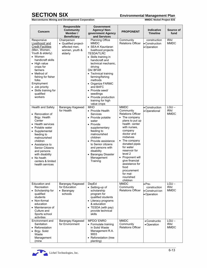
Lichel Technologies, Inc.
SECTION SIX Environmental Management Plan Marcventures Mining and Development Corporation MMDC Nickel Project EIS
6-13
Concern Responsible Community
Member / Beneficiary
Government Agency/ Non-
government Agency and Services
PROPONENT Indicative Timeline
Source of fund
Responsive Livelihood/ and Credit Facilities (Men, Women, Youth & elderly) • Women
handicraft skills • High value
crops for farmers
• Method of fishing for fisher folks
Employment • Job priority • Skills training for
qualified workers
Chairperson • Qualified project-
affected men, women, youth & elderly
Planning Office MMDC
• SEA-K Kaunlaran livelihood projects
TESDA/TLRC • Skills training in
handicraft and technical mechanic, driving
DA/ BFAR • Technical training
farming/fishing methods
• Organize FARMC and BAFC
• Provide seed/ seedlings
• Provide production training for high value crops
Community Relations Officer
construction • Construction • Operation
IRA/ MMDC
Health and Safety • Renovation of
Brgy. Health Center
• Health services • Potable water • Supplemental
feeding to malnourished children
• Assistance to Senior Citizens and persons with disability
• No heath centers & limited health services
Barangay Kagawad for Health
MHO • Provide Health
Services • Provide potable
water • Provide
supplementary feeding to malnourished children
• Provide assistance to Senior citizens and persons with disability
• Barangay Disaster Management Training
MMDC Community Relations Officer • The company
plans to put up health center with nurses, company doctor and midwives
• The company donated pipes for water reservoir for level 2
• Proponent will give financial assistance for food procurement for mal-nourished children
• Construction • Operational
LGU – IRA/ MMDC
Education and Recreation
• Scholarship for qualified students
• Non-formal education
• Maintenance of Culture and Sports school activities
Barangay Kagawad for Education • Barangay
schools
DepEd • Setting-up of
scholarship program for qualified students
• Literacy programs & education
• TESDA (with pay) provide technical skills
MMDC Community Relations Officer
• Pre-construction
• Construct-ion • Operation
LGU – IRA/ MMDC
Environment and Sanitation
• Reforestation • Brgy. Solid
Waste Management (mine
Barangay Kagawad for Environment
MPDO/ ENRO • Formulate training
in Solid Waste Management R.A. 9003
• Reforestation (tree planting)
MMDC Community Relations Officer
• Constructio • Operation
LGU – IRA/ MMDC

Lichel Technologies, Inc.
SECTION SIX Environmental Management Plan Marcventures Mining and Development Corporation MMDC Nickel Project EIS
6-14
Concern Responsible Community
Member / Beneficiary
Government Agency/ Non-
government Agency and Services
PROPONENT Indicative Timeline
Source of fund
rehabilitation program) Plan
• Water sealed toilets
• Establishment forest nurseries
• Environmental monitoring-training
MHO • Health programs • Provide water
sealed toilets Peace and Order • Barangay
Tanods to maintain peace & order
Barangay Kagawad for Peace ad Order
LGU/PNP • Capacitate &
Strengthen Barangay tanods in peace keeping, peace building and peace making
• Curfew for minors: 9pm – 4am
MMDC Chief Security Officer
• Construction • Operation
LGU-IRA / MMDC
Spiritual Barangay Assigned Catholic Priest, Pastor of different denomination
• Parish Priest • Pastor
MMDC Community Relations Officer
• Constructin • Operation
Company gives financial support
IPs Relocation shall be done by the MMDC following Sec. 7c of R.A. 8371 & Rule III, Part II, Section 4(a),(b) and (c) of the IRR
Gender Responsiveness: Sec.3 of FPIC Livelihood and Credit Facilitates (Men, Women, Youth & Elderly) -weaving of rattan & mat making , handicrafts -backyard livestock & vegetable production Sec.4 FPIC Employment Opportunities -mechanics, drivers & other technical jobs
Manobo Datu & Council of Elders IP Affected Men, Women, Youth & Elderly
• NCIP- coordinate • MSMWD -SEA KAUNLARAN
credit facilities • TESDA/TLRC -Technical training for
drivers, mechanics & other technical jobs
-Training for new handicraft designs
• DA -Training for livestock & vegetable production
MMDC lead implementor coordinated by Community Relations Officer
• Pre-construction
• Construction • Operation
MMDC FPIC 1% ICC/IPs 1% ICC/IPs
Health and Safety: Sec.3. FPIC -Health services -Disaster Management
Manobo Datu & Council of Elders Barangay Kagawad for Health
• NCIP coordinating • MHO - Assign health
worker - Provide medical
supplies • Barangay Disaster • Management
training
MMDC lead implementor coordinated by Community Relations Officer
• Pre-construction
• Construction • Operation
MMDC FPIC 1% ICC/IPs 1% ICC/IPs
Education and Manobo Datu & • NCIP coordinating MMDC lead • Pre- MMDC

Lichel Technologies, Inc.
SECTION SIX Environmental Management Plan Marcventures Mining and Development Corporation MMDC Nickel Project EIS
6-15
Concern Responsible Community
Member / Beneficiary
Government Agency/ Non-
government Agency and Services
PROPONENT Indicative Timeline
Source of fund
Recreation • School Building:
Sec.5. FPIC • Scholarships:
Sec.6. FPIC
Council of Elders, Barangay Kagawad for Education
• DepEd - Basic Non- formal
Education for the adult & elderly
- Formal education for children
implementor coordinated by Community Relations Officer
construction • Construction • Operation
FPIC 1% ICC/IPs 1% ICC/IPs
Environment and sanitation: Sec.12. FPIC Environmental Protection and enhancement - Solid Waste Management
Manobo Datu & Council of Elders, Barangay Kagawad for Environment
• NCIP coordinating • MPDO/ENRO - contextual training
of solid waste management
• MHO - training in sanitary
practices •
MMDC lead implementor coordinated by Community Relations Officer
• Pre-construction
• Construction • Operation
MMDC FPIC
Peace and order: Sec.9 & 10 FPIC - ICC rights and interest
Manobo Datu & Council of Elders, Barangay Kagawad for Peace and Order
• LGU - Municipal NCIP Monitors the
implementation of Sec. 9 & 10 of the FPIC
• PNP - - coordinates with • Municipal NCIP
MMDC lead implementor coordinated by Community Relations Officer
• Pre-construction
• Construction • Operation
MMDC
Culture: Sec. 33 R.A. 8731/ FPIC Sec. 10 Respect & protection of ICC culture
Manobo Datu & Elders
• Municipal NCIP Monitors the
implementation of Sec.10 of the FPIC
MMDC lead implementor coordinated by Community Relations Officer
• Pre-construction
• Construction • Operation
MMDC
* The Indigenous People Social Development Plan (IPSDP) for the Manobo of Barangay Cabangahan, Municipality of Cantilan, Barangay Panikian, Municipality of Caracal, Barangay Bayogo, Municipality of Madrid
* In as much as the MPSA of MMDC is within the Ancestral Domain of the same Manobo Tribe, each has their own Certificate of Pre-condition which binds them of the conditions. The recommended IPSDP of MMDC addresses the Pre-conditions set-forth by their Compliance Certificate)
6.3.1.3 Indigenous People Development Plan for affected Manobo in the host barangays: Cabangahan, Panikian and Bayogo.
There are no awarded/proclaimed IP Ancestral Domain Titles/Claims (CADT/CADC) in the area. However, there are three (3) IP communities located in Barangays Cabangahan, Panikian and Bayogo.
Objectives and Rationale
This IPDP operationalizes the Government’s MTIP-DP following the Indigenous Peoples’ Rights Act of 1997 (Republic Act 8371) which is the cornerstone of national policy on indigenous peoples. The IPRA concretizes the constitutional mandate to recognize, protect and promote the rights of indigenous peoples within the context of national unity and development, specially their rights to their ancestral lands and domain, to the reservation and development of their cultures, traditions and institutions, and to their human rights and freedom as mandated in the 1987 Constitution.
The IPDP is drafted to address the issues of IPs, in cooperation with the National Commission on Indigenous Peoples (NCIP) as the Institution that facilitates the planning and implementation of programs in coordination with the Local Government. The importance of the IPs/ ICCs protection and development is recognized by the National Government such that it enshrined its commitment in the Medium-Term Philippine Development Plan for 2001 – 2004, Chapter 13 – Protecting Vulnerable Groups – Assistance to specific vulnerable groups – of which the Manobo of the host barangays are a part of. The government in coordination with the Local government and MMDC would have to provide

Lichel Technologies, Inc.
SECTION SIX Environmental Management Plan Marcventures Mining and Development Corporation MMDC Nickel Project EIS
6-16
economic opportunities to uplift majority of them from poverty. The implementation of the Social Development Plan shall thus be guided according to the MTIP-DP as follows.
Social Justice and Human Rights
Convergence Projects Role of NCIP (as main implementing/ facilitating agency) Roles of other stakeholders
Equalizing access of IPs to social and economic opportunities in the Barangays where they have settled.
• NCIP lead role in NAPC’s interagency work
• KALAHI
• LGU, GOs, Pos to assist in monitoring
• Government agencies NAPC/ KALAHI programs
Preservation and Protection of Indigenous Culture, Traditions and Institutions
Convergence Projects Role of NCIP (as main implementing/ facilitating agency) Role of other stakeholders
Documentation of customary laws
Lead/ launch projects for documentation of customary laws
• LGUs, GOs, and NGOs to provide put and technical assistance
• Pos/ Communities as primary sources/ active participants
Revision of curriculum for public education
Lead in dialogue with DepEd and CHED
• LGUs, GOs, and NGOs to provide input and technical assistance
• Pos/ Communities as primary sources/ active participants
Basic Services
IP Sensitive Projects Role of NCIP (as main
implementing/ facilitating agency)
Role of other stakeholders
• Heath and Nutrition • Education • Road & water supply
Lead/ launch project implementing schemes
• LGUs, GOs, and NGOs to provide input and technical assistance
• Pos/Communities as primary sources/ active participants
Open windows for convergence of services for indigenous peoples.
Lead/ launch convergence mechanisms
• LGUs, GOs, NGOs to monitor • Pos/ Communities to assist in lobbying
and advocacy • Other government agencies to participate
convergence through NAPC/ KALAHI programs
Sustained Growth with Equity
Need IP Sector Agenda Strategies and Targets • Create opportunities for the IPs of
the Municipality to address their most basic asset in growth ad development – land and resources within ancestral domains
• Equity among the men ad women IPs of access control of economic opportunities
• Fully implement IPRA in the identified communities where IPs are settled
• Improve capability of IPs to access economic activities in the context of their indigenous knowledge and skills
• Development Community Micro-finance Facilities MSWD, TESDA, DA
• Product and Marketing/ Marketing Information System Development
• Traditional livelihood development: Peoples, MSWD
• Livelihood support for sustainable Agriculture/ Aquaculture Development: At least 1 agri-based livelihood activity implemented by each IP family.
6.4 IEC FRAMEWORK
The Revised Procedural Manual lists the following guidelines on the conduct of Information, Education and Communication (IEC):

Lichel Technologies, Inc.
SECTION SIX Environmental Management Plan Marcventures Mining and Development Corporation MMDC Nickel Project EIS
6-17
1. The objective of conducting IEC is to inform through the process of education using the communication mediums. The communication processes shall provide feedbacks to the preparer and the proponent about the stakeholders’ understanding of the EIA process and project, the issues and concerns about the project, as well as their suggestions and other inputs.
2. IEC methods may include the following:
a) Individual methods, e.g. home visits, personal letters, focus interviews
b) Group methods, e.g. meetings, study tours, group workshops, Focus Group Discussions
c) Multi- media, e.g. newspaper publication, radio broadcast, web posting
3. The proponent or preparer may use any or all kinds of information materials in conducting IEC campaigns. These may be in print (e.g. flyers, pamphlets, comics, posters, newspapers, banners) or in other forms, such as video, film, and sound slides.
4. These materials should be:
a) Prepared in a manner and language that can be easily understood by everybody and should contain balanced and complete information. The information material on EIA should, as much as practical, be in the local language or dialect.
b) Contain sufficient information including a description of the proposed project, the proponent, the EIA process, and the expected outputs. It shall also include such appropriate studies as evaluation of public health, environment, population, gender, socio-economic, and cultural impacts of the project or undertaking and the appropriate mitigation and enhancement measures.
5. The information drive should at the same time inculcate value formation by making the members of the community aware of their responsibilities as stakeholders.
6. In the conduct of IEC, it is beneficial to the proponent to engage the services of locally-based Communication or Language Teachers or Community Organizers in planning, implementing, assessing and documenting the conduct of IEC.
Table 6-3 is an IEC framework for the Project. An example of a mining brochure prepared for the project is shown in Plate 6-1 and Plate 6-2.
Table 6-3: Information, Education and Communication Framework
Target Sector Identified as
Needing Project IEC
Major Topic/s of concern in Relation to
Project
IEC Scheme / Strategy / Methods
Information Medium Indicative
Timelines and Frequency
Indicative Cost
1. Host Communities
2. LGU 3. POs 4. NGOs 5. Schools
• Project description & status
• EIA findings • Performance
against ECC / EMP
• Actual
Impacts & Measure
• Sustainable
Fisheries and Agriculture
• Proper
nutrition
• Individual methods
• Group
methods • Multi-media
• Invitation letters • Focus Interviews • Authority figures & Key
Informant Interviews • Focus Group Interviews • Focus Group Discussion • Multi -sectoral Cluster
Meetings • Hand-outs • Audio-visual presentations
Comics on EIA in local language
• Illustrative primer about the project
• News paper publication • Radio broadcast • Posters • Flyers
• PD and EIA findings at least one month prior to start of project construction
• Performance against ECC/EMP during construction and operation phase or annually
• During construction and operation phase
• Project expected number of attendees
• Cost of meals
• Cost of venue
• Cost of IEC Materials

Lichel Technologies, Inc.
SECTION SIX Environmental Management Plan Marcventures Mining and Development Corporation MMDC Nickel Project EIS
6-18
Target Sector Identified as
Needing Project IEC
Major Topic/s of concern in Relation to
Project
IEC Scheme / Strategy / Methods
Information Medium Indicative
Timelines and Frequency
Indicative Cost
• Breastfeeding
and neonatal care
• Herbal and
supplemental medicine
• Hygiene and
sanitation • Disaster
Prepared-ness

Lichel Technologies, Inc.
SECTION SIX Environmental Management Plan Marcventures Mining and Development Corporation MMDC Nickel Project EIS
6-19
Plate 6-1: An example of a Mining Brochure

Lichel Technologies, Inc.
SECTION SIX Environmental Management Plan Marcventures Mining and Development Corporation MMDC Nickel Project EIS
6-20
Plate 6-2: An example of a Mining Brochure
6.5 EMERGENCY RESPONSE POLICY AND GENERIC GUIDELINES
The designated Environment, Health and Safety (EHS) Officer shall act as the Emergency Response Coordinator. The Coordinator shall ensure that a Contingency /Emergency Response Plan shall be formulated and implemented in cases of natural and man-made disasters. The company shall ensure the creation of an Emergency Response Team headed by the Emergency Response Coordinator.

Lichel Technologies, Inc.
SECTION SIX Environmental Management Plan Marcventures Mining and Development Corporation MMDC Nickel Project EIS
6-21
The plan shall include development of first-aid and medical emergency plan, the installation of medical clinic within the Project site, mechanisms for referrals and utilization of local health units and hospitals in the event of disasters, preparation of disaster management plan and a health risk communication plan for the affected communities.
A regular safety training program for employees to implement emergency response and mine safety and health plan will be undertaken by the company.
Notice boards, lights signals and spotters will be used to manage boat traffic within the Lanuza Bay. Fishermen will be instructed of boat trip frequencies, navigation routes, appropriate lights and signalling devices, and evacuation procedures during boat arrivals.
An Emergency Response Progam is outlined below.
1.0 OBJECTIVE
The primary objective is to ensure the protection and preservation of life, property and environment in the event of disasters such as floods, typhoons, earthquakes, tsunamis, flashflood and man-made disasters through the effective and efficient execution of the Emergency Response Plan.
2.0 CONCEPT
This Plan embraces all conceivable contingencies, making use of all available resources. It also develops self-reliance by promoting and encouraging the spirit of self-help and mutual assistance among the members of the organization. This includes the concerted effort by the involved agencies, public or private, to provide emergency assistance or relief to persons who are victims of disasters or calamities, and in the restoration of essential public activities and facilities. While emergency preparedness is a main responsibility of management, its effectiveness will depend largely on the skills and resources and the involvement of personnel in the area of disasters. Regular exercises and drills will be conducted at all levels to enhance the people's reaction capability and ensure precision and spontaneity in responding to emergencies.
3.0 PREPAREDNESS
Pre-disaster actions and measures shall be undertaken to avert or minimize loss of lives and properties, such as, but not limited to, staffing, training, planning, equipping, stockpiling, hazard identification and public information and education initiatives.
• Plans - contingency plans, fire and earthquake plans, etc • Information - personnel awareness, information dissemination through corporate
communications, office memoranda, coordination with the local disaster coordinating councils, etc.
• Resources - available response units, capabilities, equipment, manpower, location, contact member and persons, etc
• Education & Training - training of executives, management staff, organic personnel, etc.
4.0 ORGANIZATION
This relationship shall be maintained within the organization down the line to the rank and file. A Central Coordinating Body (CCB) shall be established composed of the following:
• Operations Manager - Chairman • Resident Manager - Vice Chairman • Safety Superintendent - Member

Lichel Technologies, Inc.
SECTION SIX Environmental Management Plan Marcventures Mining and Development Corporation MMDC Nickel Project EIS
6-22
• All Division Managers - Member • Head of Security - Member
The CCB shall be the advisory group to the various units in carrying out their respective disaster plans in a concerted effort to facilitate priority actions, namely:
• Damage Assessment and Needs Analysis Unit; • Emergency Management Information Service Unit; • Plans and Operations Unit; and • Medical Unit;
The CCB shall make representation with top management to provide for the following:
• Communication, Transportation and Early Warning Service; • Medical Service; • Auxiliary Fire Service; and • Rescue, Evacuation and Engineering Service
5.0 EMERGENCY SCENARIOS 5.1 FLOODING 5.1.1 Reporting of Incident This discussion details the reporting and documentation requirements in case of flooding within the site of the Project. Such reporting contains the following information: 5.1.2 Purpose This outlines the procedures for the reporting and documentation of flood events. In addition, this defines which floods are reportable and who is responsible for preparing written documentation of the event. 5.1.3 Reasons for Reporting Floods must be reported: • to bring the potentially dangerous situation to the attention of management • to initiate action against the possible clogging of the hydraulic structures and possible
consequences such as overtopping of the siltation ponds and washing out of the mining site • to initiate action to ensure the safety of both personnel and equipment (e.g. evacuation) • to enable the local government authorities (local disaster coordinating councils) to initiate the
necessary emergency response to the situation (e.g. evacuation, relief) 5.1.4 Definitions A reportable flood is: • a flood that cannot be accommodated by the diversion canals due to its volume • a flood that cannot be accommodated by the diversion canals due to clogging by debris 5.1.5 Contingency Plans 5.1.5.1 Construction Phase

Lichel Technologies, Inc.
SECTION SIX Environmental Management Plan Marcventures Mining and Development Corporation MMDC Nickel Project EIS
6-23
Issue: During construction, a major flood can carry with it, uprooted trees, branches and other debris and cause the clogging of the diversion canals. This can then result in the overtopping of the siltation ponds and the washing out of the mining site. Recommended Precautionary Action: The following measures are recommended. • Keep informed of daily weather condition • Familiarize oneself on designated evacuation areas • Keep a stock of food which requires little cooking and refrigeration; electric power may be
interrupted • Keep a transistorized radio and flashlight with spare batteries, emergency cooking
equipment, candles, matches and first aid kit handy in case of emergency • Store supplies and other effects above expected flood water level Recommended Action: The following measures are recommended. • Monitor the river especially during periods of intense and prolonged rainfall within the
catchment area • Immediately evacuate the construction site of personnel and equipment • Maintain access to the inlet of the diversion canals as much as possible • Mobilize personnel and equipment to the inlet of the diversion canals for declogging
operations without having to compromise the safety of the personnel • Construct log barriers upstream of the inlet of the diversion canals if technically feasible • Immediately inform the community downstream of the impending flood • Maintain alternative forms of communication (e.g. radio, telephone, cellphone, messenger) to
ensure transmittal of the warning to the community downstream • Consider the impact of a power failure on the mode of communication • Immediately inform the proper government authorities (local disaster coordinating councils) of
the impending flood so as to implement the necessary emergency response (e.g. evacuation, relief)
5.1.5.2 Operations Phase Issue: During the operations phase, a major flood can carry with it, uprooted trees, branches and other debris and cause the clogging of the headrace and spillway. This can then result in the overtopping of the siltation ponds. Recommended Precautionary Action: The following measures are recommended. • Keep informed of daily weather condition • Familiarize oneself on designated evacuation areas • Keep a stock of food which requires little cooking and refrigeration; electric power may be
interrupted • Keep a transistorized radio and flashlight with spare batteries, emergency cooking
equipment, candles, matches and first aid kit handy in case of emergency • Store supplies and other effects above expected flood water level Recommended Action: The following measures are recommended. • Monitor the river especially during periods of intense and prolonged rainfall within the
catchment area • Maintain access to the spillway inlet as much as possible • Mobilize personnel and equipment to the diversion canal inlet for declogging operations
without having to compromise the safety of the personnel • Construct log barriers upstream of the diversion canal inlet if technically feasible • Immediately inform the community downstream of the impending flood • Maintain alternative forms of communication (e.g. radio, telephone, cellphone, messenger) to
ensure transmittal of the warning to the community downstream

Lichel Technologies, Inc.
SECTION SIX Environmental Management Plan Marcventures Mining and Development Corporation MMDC Nickel Project EIS
6-24
• Consider the impact of a power failure on the mode of communication • Immediately inform the proper government authorities (municipal or barangay disaster
coordinating councils) of the impending flood so as to implement the necessary emergency response (e.g. evacuation, relief)
5.2 FIRE 5.2.1 Reporting of Incident This discussion details the reporting and documentation requirements in case of fire within the power plant. Such reporting contains the following information: 5.2.2 Purpose This outlines the procedures for the reporting and documentation on incidents of fires. In addition, this defines which fires are reportable and who is responsible for preparing written documentation of the event. 5.2.3 Reasons for Reporting Fires must be reported: • Bring the potentially dangerous situation to the attention of Management • Initiate action to contain and put out the fire • Investigate the cause of the fire and take corrective action to prevent its recurrence 5.2.4 Definitions A reportable fire is a fire that results in death, injury or substantial damage to property. 5.2.5 Reporting Responsibilities Each reportable fire shall be documented by the preparation of the form “Fire Incident Report”. The responsibility for completing the form rests with the Supervisor of the Facility from which the fire originated. The completed form should be routed to the appropriate Manager for comments, signature and distribution. Signed copies of the report should be distributed 10 working days after the incident to the following: Operations Manager, Resident Manager, Facility Supervisor, Safety Department and Accounting Department. The safety manager and facility supervisor from which the fire originated are responsible for maintaining a file of all “Fire Incident Report” documents prepared. 5.2.6 Contingency Plans Issue: Fires can result in the destruction of property, injury, loss of lives or damage to the environment. Fires can have secondary effects such as power failures. Recommended Action: A system of alarms will be set up. Escape routes will be identified. Fire brigades will be set up led by a fire marshal (Plant Manager) and a deputy fire marshal (safety officer). Fire fighting and evacuation teams will be formed. Upon notification of knowledge of the occurrence of a fire, the fire fighting team shall rush to the fire scene and initiate fire control measures using all available but appropriate fire fighting equipment. The equipment to be used shall be determined by the type of fire involved. The team shall control and put out the fire and take proper steps to minimize damage to property. The evacuation team, on the other hand, should provide the necessary action to prevent injury to personnel. It should ensure that everyone gets out of the fire scene if the fire becomes out of control, or if the fire fighter’s escape route is blocked by debris or dense smoke.

Lichel Technologies, Inc.
SECTION SIX Environmental Management Plan Marcventures Mining and Development Corporation MMDC Nickel Project EIS
6-25
5.3 EARTHQUAKE 5.3.1 Reporting of Incident This discussion details the reporting and documentation requirements in case an earthquake strikes the site of the Project. Such reporting contains the following information: 5.3.2 Purpose This outlines the procedures for the reporting and documentation in case an earthquake hits the Project area. In addition, this defines which earthquakes are reportable and who is responsible for preparing written documentation of the event. 5.3.3 Reasons for Reporting The earthquake must be reported: • Bring the potentially dangerous situation to the attention of Management • Initiate action towards making an assessment of the extent of damage to the appurtenant
structures • Initiate action in making the appropriate repairs to the damaged structures 5.3.4 Definitions A reportable earthquake is any perceptible earthquake whether or not it results in damage to the appurtenant structures. The rationale in reporting an earthquake even in the absence of serious damage is that it serves as a confidence-building measure with the general public as to the stability or integrity of the structures. 5.3.5 Contingency Plans 5.3.5.1 Construction Phase Issue: Earthquake occurs without warning and affects large areas. It is the duty of all employees to familiarize himself with the precautionary measures. Recommended Precautionary Action: • Familiarize yourself with your place of work • Identify relatively strong parts of the building like door jambs, sturdy tables, where one can
take refuge during an earthquake • Learn to use fire extinguishers, first aid kits, alarms and emergency exits. These should be
accessible/conveniently located, and prominently marked • Prepare one’s place of work for the event • Strap heavy furniture/cabinets to the wall to prevent sliding or toppling • Breakable items, harmful chemicals and flammable materials should be stored in the
lowermost shelves and secured firmly • Most causes of injuries during earthquakes are from falling objects. Heavy materials should
be kept in lower shelves. Check the stability of hanging objects which may break loose and fall during earthquakes
• Prepare and maintain an earthquake survival kit consisting of a battery powered radio, flashing, first aid kit, potable water, candles, ready-to-eat food, whistle and dust mask
During an earthquake: • If you are inside a structurally sound building, stay there!

Lichel Technologies, Inc.
SECTION SIX Environmental Management Plan Marcventures Mining and Development Corporation MMDC Nickel Project EIS
6-26
• Protect your body from falling debris by bracing yourself in a doorway or by getting under a sturdy desk or table
• If you are outside, move to an open area • Get away from power lines, posts walls and other structures • Stay away from buildings with glass panes • If you are on a mountain or near a steep hill slope, move away from steep escarpments which
may be affected by landslides • When driving a vehicle, pull to the side of the road and stop. Park away from bridges,
overpasses, overhead wires, post and similar things which may fall on the vehicles • If you are along the shore and you feel a very strong earthquake, strong enough to make
standing difficult, it is always safest to assume that a tsunami (giant sea waves) has been triggered. Run away from the shore toward higher ground
• Do not listen to rumors. Heed instructions of authorities After an earthquake: Generally, initial shock of an earthquake may last a few seconds or a few
minutes and may be followed by aftershocks which are generally lesser in intensity than the initial shock. Aftershocks may come in rapid succession immediately after the initial shock or may vary from a few minutes to several hours or days.
• If you are inside an old, weak structure, take the fastest and safest way out! • Do not rush to the exit; get out calmly in an orderly manner • Do not use elevators, use the stairs • Check yourself and others for injuries • Check your surroundings • Clean-up chemical spills, toxic and flammable materials to avoid any chain of unwanted
events • Check for fire and if any, have it controlled • Check your water and electrical lines for defects. If any damage is suspected, turn the
system off in the main valve or switch • Help reduce the number of casualties from the earthquake:
o Don't enter partially damaged buildings, strong aftershocks may cause these to collapse o Gather information and disaster prevention instruction and from battery-operated radios o Obey public safety precautions
• Unless you need emergency help: o Do not use your telephone to call relatives and friends. Disaster prevention authorities
may need the lines for emergency communications o Do not use your car and drive around areas of damage. Rescue and relief operations
need the roads for mobility o If you must evacuate your station, leave a message stating where you are going o Take with you your earthquake survival kit which should contain all necessary items for
your protection and comfort Issue: The ground shaking caused by an earthquake can result in structural damage to the silt impounding structures and its appurtenant structures. The construction schedule and safety of the structures might be affected. Recommended Action: Site specific seismic design parameters have been estimated in the Seismic Risk Assessment. These should be incorporated into the design of the structures. However, although this might not result in the total failure of the structures, these can still suffer from damages that do not necessarily threaten the integrity of the structures if immediately addressed. The following measures are therefore recommended in case of a seismic event: • Conduct an ocular inspection immediately after a seismic event (e.g. cracks, slumping,
structural damage) • Determine the extent of the damage • Make the appropriate repairs to the damages incurred
Lichel Technologies, Inc.
SECTION SIX Environmental Management Plan Marcventures Mining and Development Corporation MMDC Nickel Project EIS
6-27
Issue: The ground shaking caused by an earthquake can trigger earthquake-induced landslides or rockfalls. The construction schedule and safety of the structures might be affected. Recommended Precautionary Action: In the Risk Assessment, it was indicated that, considering the nature of the geologic material, there is little probability of rockfalls or landslides. • Plan ground cover on slopes • In mudflow areas, construct channels to divert mudflows away • Re-plant damaged land to help both in short-term and long-term recovery. • In places where landslides or mudflows occur repeatedly, dredge rivers and waterways to
minimize flooding. • Apply the necessary mitigation measures taking into consideration the type of material
involved and the peculiarities of the slide • Stabilize the slopes around the critical structures so that these should no longer be cause for
alarm during the operations phase Recommended Action: However, in case these do occur, the following measures are recommended: • If you are warned of impending landslide or mudflow, evacuate at once. • If you are in a building during a landslide, stay inside and seek refuge under furniture. • If you are caught outside and cannot get inside a building, stay away from the path of the
landslide materials, or seek refuge behind a sturdy tree of boulder. Curl into a tight ball and protect your head.
• If you are in the valley, get out as soon as possible once you hear rumbling sounds from upstream or feel the ground tremble.
• If caught in the mudflow, try grabbing on to a large rock, tree or anything being carried by the flowing mud.
• Conduct an ocular inspection immediately after a seismic event • Immediately clear any debris so as to guarantee safety and access as long as the clearing
operation will not further cause any destabilization Issue: Actual displacement along three faults can result in damage to the headrace or the penstock. The construction schedule and safety of the structures might be affected. Recommended Action: The proponent can opt to incorporate seismic data into the design of the structures or simply accept the risk taking into consideration the probabilities involved. 5.3.5.2 Operations Phase Issue: The ground shaking caused by an earthquake can result in damage to the drainage structures. The safety and operations of the structures might be affected. Recommended Action: Site specific seismic design parameters should be incorporated into the design of the structures. However, although this might not result in the total failure of the structures, these can still suffer from damages that do not necessarily threaten the integrity of the structures, if immediately addressed. The following measures are therefore recommended in case of a seismic event:

Lichel Technologies, Inc.
SECTION SIX Environmental Management Plan Marcventures Mining and Development Corporation MMDC Nickel Project EIS
6-28
• Conduct an ocular inspection immediately after a seismic event (e.g. cracks, seepages, slumping, structural damage)
• Determine the extent of the damage • Immediately suspend operations, if necessary • Make the appropriate repairs to the damages incurred 5.4 STORMS AND TYPHOONS 5.4.1 Reporting of Incident This discussion details the reporting and documentation requirements in the event that a storm or typhoon hits the site of the Project. Such reporting contains the following information: 5.4.2 Purpose This outlines the procedures for the reporting and documentation in the event that a storm or typhoon hits the Project area. In addition, this defines the different levels of storm signals. 5.4.3 Reasons for Reporting The incoming storm or typhoon must be reported: • to bring the potentially dangerous situation to the attention of management • to initiate action towards making an assessment of the extent of damage the weir and its
appurtenant structures • to initiate action in making the appropriate repairs to the damaged structures • to initiate action to ensure the safety of both personnel and equipment (e.g. evacuation) • to enable the local government authorities (local disaster coordinating councils) to initiate the
necessary emergency response to the situation (e.g. evacuation, relief) Issue: Storms and typhoons may occur at any phase of Project development and will potentially affect large areas. It is the duty of all personnel to familiarize themselves with the public storm warnings, advisories and precautionary measures. Precautionary Measures: Before the storm comes...
Reinforce your place to withstand wind and flooding. Learn about typhoon and other disturbances, their signs and warning, effects and dangers,
and how to protect your personnel, yourself and your property. Educate your personnel on preparedness and protection from tropical cyclones. Re-check your roof for leaks and loose roofing material or GI sheets and other needed
repairs. Ensure that the main structural elements of your roof are secured to the top beams of your buildings.
Store adequate supply of food and drinking water. Prepare flashlights, batteries, matches, kerosene lamps or candles in anticipation of power
failure. During the emergency, keep your radio on and listen to the latest report and PAGASA
bulletin and announcement. When a typhoon, tropical depression or tropical storm strikes, stay indoors and do not go
near windows. Check on everything that may be blown away or turned loose. Flying objects become
dangerous during typhoons. If the "eye" of the storm passes over your place, there may be a lull lasting for a few minutes
to half an hour. Stay in safe place. Make emergency repairs if necessary, but remember the wind will blow suddenly from the opposite direction, frequently with even greater violence.
Cut off loose tree branches and excessive foliage or leaves. Severe flooding may follow typhoon. Stay away from river banks and streams.

Lichel Technologies, Inc.
SECTION SIX Environmental Management Plan Marcventures Mining and Development Corporation MMDC Nickel Project EIS
6-29
If your building is not safe, move to a designated evacuation center and stay there until the storm has completely subsided.
Slightly open a window or door at the side of the building opposite from where the wind comes from to avoid pressure build up.
Be calm. Your ability to meet the emergency will inspire and help others. 5.4.3 Definitions 5.4.3.1 Public Storm Signal No. 1 Meteorological Conditions:
A tropical cyclone will affect the locality. Winds of 30 - 60 kph may be expected in at least 36 hours.
Impact of the Winds:
Twigs and branches of small trees may be broken. Some banana plants may tilt or flat on the ground. Some houses of very light material (nipa and cogon) may be partially unroofed. Very light or no damage at all may be sustained by the exposed community. Rice flowering stage may suffer significant damage.
Precautionary Measures: People are advised to listen to the latest Severe Weather Bulletin issued by PAGASA every six hours 5:00 a.m., 11:00 a.m., 5:00 p.m., 11:00 p.m. General Note: Business may be carried out as usual. When the tropical cyclone is strong, intensifying or is moving closer, this signal may be gradually increased. 5.4.3.2 Public Storm Signal No. 2 Meteorological Conditions:
A moderate tropical cyclone will affect the locality. Winds of greater than 60 kph to 100 kph may be expected in at least 24 hours.
Impact of the Winds:
Some coconut trees may be tilted with the few others broken. Few big trees maybe uprooted. Many banana plants maybe destroyed. Rice and corn maybe adversely affected. Large nipa and cogon houses maybe partially or totally unroofed. Some old galvanized iron roofings may roll off. Light to moderate damage to palay in flowering stage.
Precautionary Measures:
The sea and coastal waters are dangerous to smaller sea crafts. Avoid necessary risks. Traveling by sea or air is risky. Stay indoors. Secure properties.
General Note:

Lichel Technologies, Inc.
SECTION SIX Environmental Management Plan Marcventures Mining and Development Corporation MMDC Nickel Project EIS
6-30
Special attention should be given to the latest position, direction and speed of movement and intensity of the tropical cyclone as it may intensify and move towards the locality. 5.4.3.3 Public Storm Signal No. 3 Meteorological Conditions:
A strong tropical cyclone will affect the locality. Winds of greater than 100 kph to 185 kph may be expected in at least 18 hours.
Impact of the Winds:
Almost all banana plant may be destroyed and a large number of trees maybe uprooted. Rice and corn crops may suffer heavy damage. Majority nipa and cogon houses maybe uprooted or destroyed and there may be considerable damage to structures of light to medium construction.
There maybe widespread disruption of electrical power and communication services. In general, moderate to heavy damage may be expected in both the agricultural and industrial sectors.
Travel by sea and by air is very risky. Sea and coastal waters will be dangerous to all sea crafts.
Precautionary Measures:
People are advised to evacuate and stay in strong buildings. Stay away from coasts and river banks. Watch out for the passage of the "eye" do not venture away from the shelter. Suspend outdoor activities and make sure personnel stay in the safety of strong buildings.
General Note: The disturbance is dangerous to threatened or affected communities. The passage of the "eye" of the typhoon is indicated by a sudden change from bad to fair weather. Fair weather may last for one or two hours after which the worst weather will resume with very strong winds generally coming from the opposite direction. 5.4.3.4 Public Storm Signal No. 4 Meteorological Conditions:
A very intense typhoon will affect the locality. Very strong winds of more than 185 kph may be expected in at least 12 hours.
Impact of the Winds:
Coconut plantation may suffer extensive damage. Many large trees may be uprooted. Rice and corn plantation may suffer severe damage, most residential and institutional buildings of mixed construction may be severely damaged.
Electric power distribution and communication service may be disrupted. Damage to affected communities can be very heavy.
Precautionary Measures:
Cancel all travel and other outdoor activities. Stay in safety of buildings or evacuation centers.
General Note:
Lichel Technologies, Inc.
SECTION SIX Environmental Management Plan Marcventures Mining and Development Corporation MMDC Nickel Project EIS
6-31
The situation is potentially very destructive to the community. EVACUATION TO SAFER SHELTERS SHOULD HAVE BEEN DONE DURING PSS NO. 3 NOT NOW! IT IS TOO LATE TO EVACUATE NOW.
6.5.1.1 Information Network
The Emergency Response Coordinator shall establish an information network and shall make use of this in an emergency situation. The basic information network shall include the contact numbers and contact persons in the following offices/institutions:
• Fire Brigade
• Police
• Ambulance and Medical Services
• Local Government Unit officials, including barangay captains
• Schools, Hospitals
• National Government (i.e. DENR, Department of Health, National Disaster Coordinating Council (NDCC) )
6.5.1.2 Emergency Response Equipment and Evacuation Procedure
Adequate Personnel Protective Equipment (PPE) shall be used by the Emergency Response Team in handling emergency responses. The company shall ensure that adequate PPE and equipment shall be procured for use of the Emergency Response Team. Showers/ sprinklers shall be installed and fire extinguishers shall be placed in designated areas within the site.
During emergencies, an evacuation procedure shall be shown in visible areas or should be directed by the emergency response team to the workers affected.
6.6 ENVIRONMENTAL AND OCCUPATIONAL HEALTH MANAGEMENT PLAN
The proponent shall be fully committed to institute the following measures to protect and promote workers’ health and the community within the project area.
6.6.1 Environmental and Occupational Health Policies
The proponent shall formulate/establish its company’s’ vision statement, policies, business principles and other corporate documents pertaining to environment, health and safety duly signed by its highest official. The company would set-up an organization that would oversee the implementation of these policies, establish safety, health and environmental targets and performance indicators to include monitoring and audit results in its annual assessment reports.
6.6.2 Environmental and Occupational Health Organization, Resources, Manpower Training and Documentation
Mine Safety and Health Plan
The proponent shall comply with all the rules and regulations of the Mine Safety Rules and Regulations under MAO-MRD-51, Series of 1991. It will submit a “Safety and Health Program” before the start of the calendar year that will embody the following:
• Management and employee training
• Good housekeeping
• Health control and services
• Provisions for PPE

Lichel Technologies, Inc.
SECTION SIX Environmental Management Plan Marcventures Mining and Development Corporation MMDC Nickel Project EIS
6-32
• Systems of monitoring and reporting
• Emergency Response program
6.6.3 Disaster/Emergency Management Program
The proponent shall put/develop disaster management program in coordination with the local government representatives. The program shall include development of first-aid and medical emergency plan, the installation of medical clinic within the project site, mechanisms for referrals and utilization of local health units and hospitals in the event of disasters, preparation of disaster management plan and a health risk communication plan for the affected communities.
6.6.4 Environmental Health Risk Recording and Reporting System
The proponent through the safety, health and environmental organization shall develop and implement recording and reporting system for results of monitoring, conduct consultative meetings with stakeholders in resolving issues and conflicts regarding safety, health and environment.
6.7 ENVIRONMENTAL PROTECTION AND ENHANCEMENT PROGRAM
Pursuant to Section 169 of the Revised Implementing Rules and Regulations (DAO 96-40) of Republic Act No. 7942 otherwise known as the Philippine Mining Act of 1995, an Environmental Protection and Enhancement Program (EPEP) shall be required of the Proponent/MPSA Holders to provide the link between the environmental protection and enhancement commitments under these implementing rules and regulations, as well as those stipulated in the ECC, and the contractor's plan of mining operation. The submission of the EPEP shall complement and not substitute for the requirement for an ECC. The EPEP is submitted to the Mines and Geosciences Bureau.
6.8 ABANDONMENT/REHABILITATION POLICIES AND GENERIC GUIDELINES
An abandonment plan is a set of guideline or procedures to ensure that appropriate measures are made upon abandonment of the undertaken Project. Surface mining leaves large scars that are hazardous to man and livestock as well as unpalatable aesthetically.
The Proponent shall strictly implement the progressive mining-rehabilitation concept to support viable agricultural activities from previously marginal soil. It is also recommended that a reforestation project be implemented taking into consideration the planting of commercial fruit trees instead of timber species. This will enable the residents to partake of the benefits once the mining company has completed its operations. On the part of the residents, the annual harvest of fruits from the planted trees will greatly discourage the cutting of these trees for firewood because of the larger benefits that will be derived from the value of the fruits.
For the Project, rehabilitation of a mined-out area starts immediately after the depletion of the contained ore. The area is backfilled with waste either from the waste dump or the parcel currently being mined. The last material to be added is the topsoil. After grading to achieve the desired slope and ground features, the surface is deep ripped to open up the subsoil profile. Compost is spread on the surface. This will stimulate the soil organisms and at the same time provide the plants with nutrients necessary for rapid plant growth.
6.9 ENVIRONMENTAL MONITORING PLAN
The Environmental Monitoring Plan (EMoP) is formulated to:
• validate the changes in the various environmental media (water) as predicted in the impact assessment;
• provide early warning information of unacceptable environmental conditions;
• monitor the Project’s compliance with the conditions that will be set in the Environmental Compliance Certificate (ECC);

Lichel Technologies, Inc.
SECTION SIX Environmental Management Plan Marcventures Mining and Development Corporation MMDC Nickel Project EIS
6-33
• monitor specific parameters identified; and
• provide a basis for timely decision-making and effective planning and management of environmental measures through the monitoring of actual Project impacts.
Table 6-4 presents the proposed Matrix of the Environmental Monitoring Plan (EMoP) for the Project during the construction and operation phases. At the initial stage, the number and location of the monitoring stations to be used during the first year shall be those identified in the EIS. Socio-economic and cultural monitoring shall involve taxes, employment, income and the like. Baseline data have already been gathered and documented and will serve as the basis for future sampling results. These baseline stations are recommended as the monitoring points.
Environmental monitoring during the development and operation of the Project will be the responsibility of the Multi-sectoral Monitoring Team. However, this does not preclude the Proponent to conduct self-monitoring. Financial responsibility for all the monitoring activities and costs will be shouldered by the Proponent. The cost only covers analysis of samples and is exclusive of sampling, transportation and delivery expenses.
6.9.1 Self-Monitoring Plan
Post-ECC multi-sectoral validation of a Proponent’s self-monitoring results is instituted for PEIS/EIS-based projects. On the side of the EMB, through its Project Environmental Monitoring and Audit Prioritization Scheme (PEMAPS), a mechanism is provided for determination of EMB monitoring strategy and EMB monitoring priority rank a project will be assigned to, which provides guidance to the public on the applicable monitoring schemes for the project. A filled-up PEMAPS for the Project is attached as Annex F.
6.9.2 Multi-Sectoral Monitoring Framework
As per DAO-05 Series of 2005, a Multi-Partite Monitoring team, which is tasked to undertake monitoring of compliance with ECC conditions as well as the EMP by the Project Proponent and is deputized by the MRF Committee shall be created composed of representatives of the following:
• MGB Regional Office as Head • DENR Regional Office • EMB Regional Office • Proponent • Stakeholder/affected community(ies) • Affected Indigenous Cultural Community (ies), if any • Environmental NGO
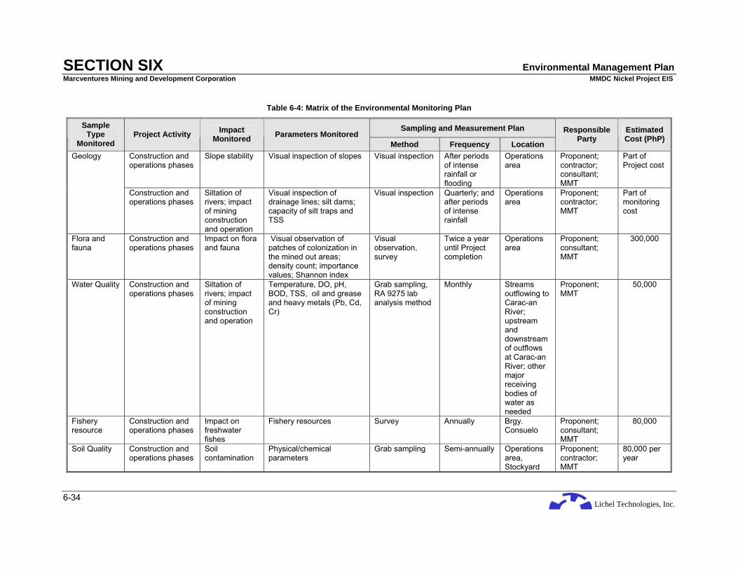
Lichel Technologies, Inc.
SECTION SIX Environmental Management Plan Marcventures Mining and Development Corporation MMDC Nickel Project EIS
6-34
Table 6-4: Matrix of the Environmental Monitoring Plan
Sampling and Measurement Plan Sample Type
Monitored Project Activity Impact
Monitored Parameters Monitored Method Frequency Location
Responsible Party
Estimated Cost (PhP)
Construction and operations phases
Slope stability Visual inspection of slopes Visual inspection After periods of intense rainfall or flooding
Operations area
Proponent; contractor; consultant; MMT
Part of Project cost
Geology
Construction and operations phases
Siltation of rivers; impact of mining construction and operation
Visual inspection of drainage lines; silt dams; capacity of silt traps and TSS
Visual inspection Quarterly; and after periods of intense rainfall
Operations area
Proponent; contractor; MMT
Part of monitoring cost
Flora and fauna
Construction and operations phases
Impact on flora and fauna
Visual observation of patches of colonization in the mined out areas; density count; importance values; Shannon index
Visual observation, survey
Twice a year until Project completion
Operations area
Proponent; consultant; MMT
300,000
Water Quality Construction and operations phases
Siltation of rivers; impact of mining construction and operation
Temperature, DO, pH, BOD, TSS, oil and grease and heavy metals (Pb, Cd, Cr)
Grab sampling, RA 9275 lab analysis method
Monthly Streams outflowing to Carac-an River; upstream and downstream of outflows at Carac-an River; other major receiving bodies of water as needed
Proponent; MMT
50,000
Fishery resource
Construction and operations phases
Impact on freshwater fishes
Fishery resources Survey Annually Brgy. Consuelo
Proponent; consultant; MMT
80,000
Soil Quality Construction and operations phases
Soil contamination
Physical/chemical parameters
Grab sampling Semi-annually Operations area, Stockyard
Proponent; contractor; MMT
80,000 per year
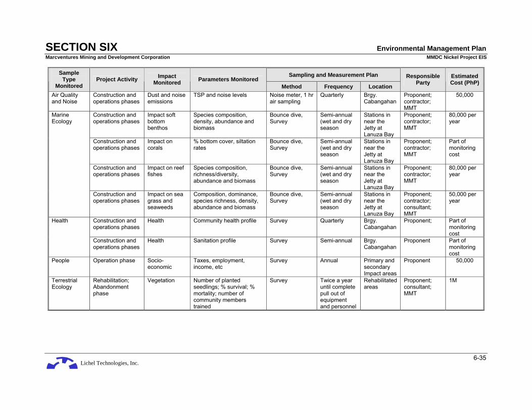
Lichel Technologies, Inc.
SECTION SIX Environmental Management Plan Marcventures Mining and Development Corporation MMDC Nickel Project EIS
6-35
Sampling and Measurement Plan Sample Type
Monitored Project Activity Impact
Monitored Parameters Monitored Method Frequency Location
Responsible Party
Estimated Cost (PhP)
Air Quality and Noise
Construction and operations phases
Dust and noise emissions
TSP and noise levels Noise meter, 1 hr air sampling
Quarterly Brgy. Cabangahan
Proponent; contractor; MMT
50,000
Construction and operations phases
Impact soft bottom benthos
Species composition, density, abundance and biomass
Bounce dive, Survey
Semi-annual (wet and dry season
Stations in near the Jetty at Lanuza Bay
Proponent; contractor; MMT
80,000 per year
Construction and operations phases
Impact on corals
% bottom cover, siltation rates
Bounce dive, Survey
Semi-annual (wet and dry season
Stations in near the Jetty at Lanuza Bay
Proponent; contractor; MMT
Part of monitoring cost
Construction and operations phases
Impact on reef fishes
Species composition, richness/diversity, abundance and biomass
Bounce dive, Survey
Semi-annual (wet and dry season
Stations in near the Jetty at Lanuza Bay
Proponent; contractor; MMT
80,000 per year
Marine Ecology
Construction and operations phases
Impact on sea grass and seaweeds
Composition, dominance, species richness, density, abundance and biomass
Bounce dive, Survey
Semi-annual (wet and dry season
Stations in near the Jetty at Lanuza Bay
Proponent; contractor; consultant; MMT
50,000 per year
Construction and operations phases
Health Community health profile Survey Quarterly Brgy. Cabangahan
Proponent; Part of monitoring cost
Health
Construction and operations phases
Health Sanitation profile Survey Semi-annual Brgy. Cabangahan
Proponent Part of monitoring cost
People Operation phase Socio-economic
Taxes, employment, income, etc
Survey Annual Primary and secondary Impact areas
Proponent 50,000
Terrestrial Ecology
Rehabilitation; Abandonment phase
Vegetation Number of planted seedlings; % survival; % mortality; number of community members trained
Survey Twice a year until complete pull out of equipment and personnel
Rehabilitated areas
Proponent; consultant; MMT
1M

Lichel Technologies, Inc.
SECTION SIX Environmental Management Plan Marcventures Mining and Development Corporation MMDC Nickel Project EIS
6-36
6.10 CONTINGENT LIABILITY AND REHABILITATION FUND (CLRF)
The CLRF, as stipulated in the DAO 96-40 is an environmental guarantee fund mechanism institutionalized to ensure just and timely compensation for damages and progressive and sustainable rehabilitation for any adverse effect a mining operation or activity may cause. The CLRF will be in the form of the Mine Rehabilitation Fund (MRF), the Mine Wastes and Tailings Fee (MWTF), and the Final Mine Rehabilitation and Decommissioning Fund (FMRDF) which is included under DAO 2005-07.
6.10.1 Proposed Amount for CLRF
6.10.1.1 Mine Rehabilitation Fund (MRF)
The MRF is established and maintained by each operating mine as a reasonable environmental deposit to ensure the availability of funds for the satisfactory compliance with the commitments under the EPEP. This will be used for the physical and social rehabilitation of areas affected by mining activities and for research on the social, technical, and preventive aspects of rehabilitation. There are two (2) forms of the MRF: the Monitoring Trust Fund (MTF) and the Rehabilitation Cash Fund (RCF).
MMDC will establish a MTF in the amount of PhP 150,000.00 in cash to be deposited in a mutually acceptable government depository bank and to be replenished annually. The MTF will cover the maintenance and other operating budget for the transportation and travel expenses, laboratory analysis, supplies and materials, communication services, consultancy work and other reasonable expenses incurred by the MMT. Only the designated representatives of the MRF Committee/ and the Contract/Permit Holder shall be given the authority to disburse the necessary funds from the MTF.
MMDC will also establish a RCF in the amount equivalent to ten percent (10%) of the total amount needed to implement the EPEP or five million pesos (PhP 5,000,000.00), whichever is lower. The RCF will be a thrust fund to ensure compliance with the approved rehabilitation activities and schedules for the specific mining phase including research as defined in the EPEP. This will be deposited in four (4) equal quarterly deposits within 15 days of each quarter at the first year following the approval of the EPEP. The Contractor/Permit Holder shall request withdrawal and disbursement from the MRF Committee, a copy of which is furnished to the CLRF Steering Committee. Upon written notification by the Contract/Permit Holder to the Chairperson of the MRF Committee that the mine has reached the end of its operating life, the RCF shall be terminated and all remaining amount returned to the Contractor/Permit Holder. From then on, the FMRDF shall be utilized for all rehabilitation and decommissioning works.
The ETF is contained in the Memorandum of Agreement (MOA) entered into by and among stakeholders to pay for mining-related compensable damages other than those caused by mine wastes and tailings. The ETF is pegged at a minimum of fifty thousand pesos (PhP 50,000.00).
6.10.1.2 Mine Wastes and Tailings Fee (MWTF)
These are fees collected semi-annually from each operating mining company based on the amount of mine wastes and tailings it generated for the said period to be used for payment for compensation for damages caused by any mining operations. The Proponent will be charged five centavos (PhP 0.05) per metric ton of mine waste that the operations will produce. Ten centavos (PhP 0.10) per metric ton is charged for the generation of mill tailings.
6.10.1.3 Final Mine Rehabilitation and Decommissioning Fund (FMRDF)
This is a mandatory requirement of the ECC and is integrated into the EPEP with a consideration that the rehabilitation and decommissioning activities are undertaken by a third party contractor over a ten-year post-mining period. This is in the form of a trust fund in which Annual Provision (= Total Cost × % required) is to be made within sixty (60) days from the approval of the FMRDF and every anniversary date. Withdrawal from the said fund is to be approved by the CLRF Committee upon the
Lichel Technologies, Inc.
SECTION SIX Environmental Management Plan Marcventures Mining and Development Corporation MMDC Nickel Project EIS
6-37
recommendations of the MRF Committee. This amount is subject to review or revision within two (2) years and every two (2) years thereafter.
The Contractor’s progress report is to be submitted to the MRF Committee within thirty (30) days from the end of the term. A Final Rehabilitation Report (FRR) conducted by a third party environmental auditor is to be submitted to the MRF and CLRF Committees for approval. The CLRF Committee will then issue a Certificate of Final Relinquishment signifying the approval of the FRR.
If any residual care is necessary, the Contractor/Permit Holder will submit a Site Management Plan.
6.11 INSTITUTIONAL PLAN FOR EMP IMPLEMENTATION
MMDC shall be responsible for implementing the EMP while DENR-EMB for review and approval of the plan. In line with their regulatory function, EMB personnel may conduct environmental monitoring at the mining site. Environmental protection and health and safety is the responsibility of all employees and contractors employed by MMDC.
An Environmental Management Section (EMS) headed by an Environmental Manager will be organized to implement the environmental management plan. A Senior Environmental Officer/Pollution Control Officer (PCO) will be appointed to oversee the pollution control program of the company. The environmental section shall have the following tasks and responsibilities:
a. Environmental Impact and Management
The environmental commitments of the Proponent will be thoroughly documented in the Environmental Compliance Certificate and the final mine rehabilitation and/or decommissioning plans. These environmental commitments will serve as the minimum basis for monitoring activities by any interested party on the environmental performance of the Proponent.
Management of impacts involves the implementation of measures to mitigate impacts and possibly, the conduct of trend and time series studies to assess the effectiveness and integrity of the mitigating measures being implemented or if at all possible, eliminate the adverse impacts of the different activities of the Project. It will also manage the Project’s liquid, gaseous, and solid residuals. Waste management guidelines will be set with a view of ensuring an effective safe and sanitary disposal of waste.
b. Environmental Monitoring
This will involve the implementation of the monitoring program. The group will also assess and modify the plan in accordance to the needs of the Project.
Structurally, monitoring is effected at the following levels:
• Internally to the mining operation through the Environment Department.
• Host and neighboring communities, through a community representative to the Multipartite Monitoring Team (MMT);
• Environmental NGOs, through a representative to the MMT;
• Local government, through a representative in the MMT, and through such structures like the LGU parallel of environment and natural resource offices (ENRO);
• Regional, through actual Department of Environment and Natural Resources (DENR) and Mines and Geocscience Bureau (MGB) monitoring and enforcement of regulations and commitments, through DENR regional office representatives in the MMT, and through regional NGOs and people's organizations;
• National, through the DENR and concerned bureaus like EMB, EMB Regional Offices, Forest Management Bureau (FMB), Protected Areas and Wildlife Bureau (PAWB) and Land Management Bureau (LMB), through other agencies, and through national NGOs and POs.
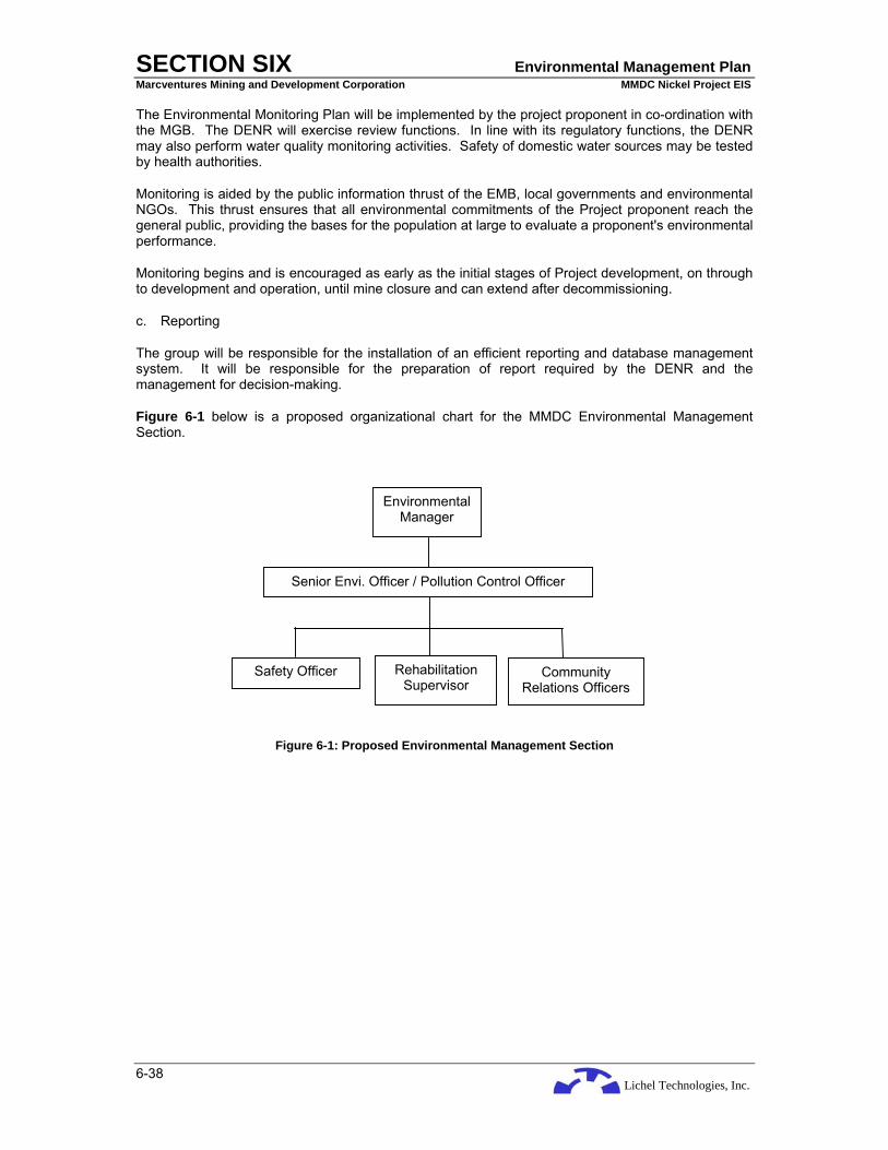
Lichel Technologies, Inc.
SECTION SIX Environmental Management Plan Marcventures Mining and Development Corporation MMDC Nickel Project EIS
6-38
The Environmental Monitoring Plan will be implemented by the project proponent in co-ordination with the MGB. The DENR will exercise review functions. In line with its regulatory functions, the DENR may also perform water quality monitoring activities. Safety of domestic water sources may be tested by health authorities.
Monitoring is aided by the public information thrust of the EMB, local governments and environmental NGOs. This thrust ensures that all environmental commitments of the Project proponent reach the general public, providing the bases for the population at large to evaluate a proponent's environmental performance.
Monitoring begins and is encouraged as early as the initial stages of Project development, on through to development and operation, until mine closure and can extend after decommissioning.
c. Reporting
The group will be responsible for the installation of an efficient reporting and database management system. It will be responsible for the preparation of report required by the DENR and the management for decision-making.
Figure 6-1 below is a proposed organizational chart for the MMDC Environmental Management Section.
Figure 6-1: Proposed Environmental Management Section
Senior Envi. Officer / Pollution Control Officer
Safety Officer Rehabilitation Supervisor
Community Relations Officers
Environmental Manager

Lichel Technologies, Inc.
SECTION SEVEN Bibliography and References Marcventures Mining and Development Corporation MMDC Nickel Project EIS
7-1
7 BIBLIOGRAPHY/REFERENCES
Acharya, H.K. and Y.P. Aggarwal, 1980. Seismicity and Tectonics of the Philippine Islands: Journal of Geophysical Research. V. 85 No. B6 pp. 3-239 – 3-250
Arcilla, Carlo A., Engielle R. Paguican, Maria Lanie E. Frogoso, Marynelle D. Boticario, Antonio V. Duran Jr, 2008. Engineering Geological and Geohazard Assessment Report (EGGAR) of the Proposed Mining Site of Marcventures Mining and Development Corporation.
Aurelio, M., 2000. Tectonics of the Philippines revisited. Journal of the Geological Society of the Philippines, 55, 3-4, 119-183, Bureau of Mines and Geo-sciences ((BMG), 1982. Geology and Mineral Resources of the Philippines: Volume 1 – Geology, BMG Press, Manila, 406 p.
Blair, Thomas A. and Robert C. Fite, 1965. Weather Elements: A Text in Elementary Meteorology, Fifth Edition. Prentice-Hall Inc., Englewood Cliffs, New Jersey.
BMP Environment & Community Care, Inc., 2003. Environmental Impact Statement for the Proposed ACT Project, Main Report. Surigao Integrated Resources Corporation.
Bruce, R.C., 1982. Soil Susceptibility of Batangas, Cebu and La Union Provinces in Proceedings of the Regional Training Course on Soil Erosion Control Management.
Bureau of Research and Standards (BRS)-DPWH; Philippine Water Data Summary, 1991.
Bureau of Soils and Water Management, 1988. Micronutrient Status of Some Philippine Soils. Soils and Water Technical Bulletin, Volume II.
Bureau of Soils, 19__. Soil Maps of Surigao Provinces, Philippine
Canter, L.W, 1996. Environmental Impact Assessment, Second Edition. Mc Graw-Hill, New York.
Carballo, Jose Luis, Lucille Gregorio, Norma A. Villanueva, Rozalinda Villavicencio. 1983. Guide to Grassland Plants. A Resource Material for Biology Teachers: Pundasyun sa pagpapaunlad ng kaalaman sa pagtuturo ng Agham 1pk. SEC. UP NRMC, Ministry of national Resources and UP p.176
Case Studies of Five CADC Areas in the Caraga Region. Research Institute for Mindanao Culture (RIMCU), Xavier University, Cagayan de Oro City
Comprehensive Land Use Plan. Cantilan, Surigao del Sur.
Comprehensive Land Use Plan. (2000-2010). Carrascal, Surigao del Sur.
De Guzman, Enriquito D., Ricardo M. Umali, Malians D. Sotalbo. 1986. Guide to Philippines Flora and Fauna Vol.111 Dipterocarps and Non Dipterocarps, p.414
De Nevers, Noel, 1995. Air Pollution Control Engineering: International Editions 1995. McGraw-Hill, Inc, New York.
DENR- Penro, RI 3-D, Surigao del Sur (2002).
Department of Health, 1997. Philippine National Framework and Guidelines for Environmental Health Impact Assessment.
Dune T. and Leopold L., 1978. Water in Environmental Planning, W.H. Freeman and Company.
Evangelista, P.P., 1993. Land Suitability Manual for Researchers and Agricultural Extension Workers, D.A. 2nd Palawan Integrated Area Development Project ADB loan.
Fernandez, Jose, Fe Fernandez, Edna /Imelda (1975, 2002) Palawan Flora and Fauna PTFPPPCSDS – EU p.75
Fernandez, Jose, Fe Fernandez and Edna Imelda Fernandez – Legaspi. 1995. Palawan Flora and Fauna. Palawan Tropical Forestry Protection Programme
Fernando, E.S. et.al. 2004. Flowering Plants and Ferns of Mt. Makiling. ASEAN-Korea Environmental Cooperation Unit

Lichel Technologies, Inc.
SECTION SEVEN Bibliography and References Marcventures Mining and Development Corporation MMDC Nickel Project EIS
7-2
Fernando, E.S. 2000. Checklist of Species in FBS 21 6th Ed. UPLB CFNR
___________. 1998. Resource Inventory and Assessment of Biodiversity in the Lowland Forest of the Subic Bay metropolitan Authority. Terminal Report. UPLB CFNR and DOST – PCARRD
Food and Fertilizer Technology Center 2006 Dutch Standards for Soil Contamination assessment, in terms of total concentration of Heavy Metals in Soil.
Forest Land Use Plan of Cantilan Municipality, 2007.
Fukushima, Y., and Tanaka, T. 1990. A new attenuation relation for peak horizontal acceleration of strong earthquake ground motion in Japan. Seismological Society of America Bulletin. 757-783.Garvan, M. John, 1931. Manobo of Mindanao. United States Government Printing Office.
GAIA South, Inc., Makati. 1998. Environmental Impact Statement for the Proposed Masbate Gold Operations, Main Report. Base Metals Mineral Resources Corporation.
Garvan, M. John, 1931. Manobo of Mindanao. United States Government Printing Office.
Handbook of Toxic and Hazardous Chemicals and Carcinogens.
Hanna, Steven R.; Gary A. Briggs and Rayford P. Hosker, Jr, 1982. Handbook on Atmospheric Diffusion. Technical Information Center, U.S. Department of Energy.
Jongman, R.H.G., C.J.F. ter Braak and O.F.R. van Tongeren. Eds. 1987. Data Analysis in Community and Landscape Ecology. Pudoc Wageningen. Pp. 174 – 206
Kent, Martin and Paddy Coker. 1992. Vegetation Description and Analysis: A Practical Approach. CRC Press, Belhaven Press London.
Krebs, C.J. 1989. Ecological Methodology. Harper Collins Publishers. Pp. 293 – 327
Lallemand, S.E., Popoff, M., Cadet, J.-P. et al., 1998. Genetic relations between the central and southern Philippine Trench and Sangihe Trench. Journal of Geophysical Research B103, 933–50.
Linsley R. and Franzini J. 1979. Water-Resources Engineering, 2nd ed., Mc-Graw Hill Book Company.
Louca, K., 1992. The Geology and Mineral Resources of Dinagat Island, Philippines. Unpublished, UNRFNRE Technical Report, Surigao City, Philippines.
Ludwig, John A. and J.F. Reynolds, 1988. Statistical Ecology: A primer on methods and computing. John Wiley and Sons. New York Chichester Brisbane Toronto Singapore.
Madulid, Domingo A. 2000. A Pictorial Cyclopedia of Philippine Ornamental Plants p .388
Madulid, Domingo A. 2002. A Pictorial Guide to the Noteworthy Plants of Palawan. Palawan Tropical Forestry Protection Programme
_____________. 1995. A Pictorial Cyclopedia of Philippine Ornamental Plants. Bookmark Inc.
Magurran, Anne E. 1988. Ecosystems Diversity and Its Measurements. Princeton University Press
Manahan, J.S. and M.P. Lasala, 1995. Destructive Earthquakes in the Philippines 1983-1995.
Mangao, E.A., R.S.G. Gonzales and O.R. Tesoro, 1994. Seismicity of Mindanao. Proceedings of the National Conference on Natural Disaster Mitigation, Quezon City, Philippines, pp. 39-44.
Manihan, Tomas D., 1997. Geologic Report of the Marcventures Mining and Development Corporation Nickel Laterite Project.
McAleece, Neil, PJD Lampshead, GLJ Patterson, JD Gage. BD Professional ver. 2. 1998. Free software from the internet.
Moody, K., C.E.Munroe, R.T.Lubigan and E.C. Paller, Jr. 1984. Major Weeds of the Philippines. Weed Science Society of the Philippines.
Lichel Technologies, Inc.
SECTION SEVEN Bibliography and References Marcventures Mining and Development Corporation MMDC Nickel Project EIS
7-3
Mueller-Dumbois, Dieter and Heinz Ellenberg. 1974. Aims and Methods of Vegetation Ecology. John Wiley & Sons. New York Chichester Brisbane Toronto
National Water Resources Council (NWRC), Philippine Water Data Summary, 1980.
Northern Mindanao Community Initiative and Resource Management Project, Barangay Profile of Panikian (2005).
NPCC Memorandum Circular 002, 1980
NPCC 1978 NPCC Rules and Regulations Implementing PD 984
Odijk, A.H.Van, M.S.C. History of Christianization of Dioceses of Surigao and Butuan.
Odum, Eugene P. 1971. Fundamentals of Ecology. W.B. Saunders Company. Philadelphia London Toronto
PAGASA, 2005. Compilation of Climatological Normals and Extremes.
PAWB – DENR. 2000. Statistics on Philippine Protected Areas and Wildlife Resources
PCARRD DOST. 1987. Manual on Vegetational Analysis for Grassland and Forest Ecosystems. Book Series No. 50
Presidential Decree 1566 dated June 1978 National Calamities and Disaster Preparedness Plan, Revised Edition, 24 August 1988
Research Institute for Mindanao Culture (RIMCU), Xavier University, Cagayan de Oro City. Case Studies of Five CADC Areas in the Caraga Region.
Rimando, R.E., 1994. The Philippine Fault Zone and Hazards due to Faulting, in Proceedings of the Natural Disaster Mitigation in the Philippines. DOSTPHIVOLCS, pp. 61-69.Rojo, JP. 1999. Revised Lexicon of Philippine Trees. FPRDI DOST.
Rojo, Justo P., Cristina A. Roxas, Fernando C. Pitargue, Jr. & Cristina A. Britas. 2000. Philippine Erect Bamboos: A Field Identification Guide. FPRDI – DOST. p. 161
Rojo, Justo P., Eustaquio G. Aragones, Jr. 1997. Philippine Dipterocarps: Botanical Identification Handbook. FPRDI – DOST. p 97
Rohrlach, Bruce D, 2005. MRL Gold Philippines Inc. and Panoro Minerals Ltd: Independent Geological Report on the Surigao Property Group, Northern Mindanao, Philippines.
Sajona, F.G., Bellon, H., Maury, R.C., Pubellier, M., Cotton, J. and Rangin, C., 1994. Magmatic response to abrupt changes in geodynamic settings: Pliocene-Quaternary calc-alkaline and Nb-enriched lavas from Mindanao (Philippines). Tectonophysics, 237(1-2), pp. 47-72.
Salvosa, F.M. 1963. Lexicon of Philippine Trees. FPRDI.
Santos, Jose V., Enriquito D. De Guzman, Edwino S. Fernando. 1986. Guide to Philippine Flora and Fauna Vol. I: Bamboos, Grasses and Palms. p. 255
Seeber, G., H.J. Weidelt, and V.S. Banaag. 1979. Dendrological Characters of Important Forest Trees from Eastern Mindanao. GTZ Eschborn Philippine - German Rainforest Development Project.
Seidenschwarz, Franz. 1994. Plant World of the Philippines. An illustrated Dictionary of Visayan Plant Names with their Scientific, Tagalog and English Equivalents, University of San Carlos, Cebu City Palawan p. 368
Socio-Economic Profile of Surigao del Sur (2000).
Southeast Asian Association of Seismology and Earthquake Engineering (SEASEE), 1985. Series in Seismology, Vol. 4, Philippines.
Thenhaus, P.C., Hanson, S., Algermissen, S., Bautista, B., Bautista, M.L., Punongbayan, B., Rasdas, A. Nillos, J., and R.S. Punongbayan, 1994. Estimates of Regional Ground Motion Hazard in the Philippines. Proceedings of the National Conference on Natural Disaster Mitigation, Quezon City, Philippines, pp. 45-60.

Lichel Technologies, Inc.
SECTION SEVEN Bibliography and References Marcventures Mining and Development Corporation MMDC Nickel Project EIS
7-4
Toxicology: The Basic Science of Poisons, 5th Edition, 1996
UNDP, 1987. Geology and Gold Mineralisation of Surigao Del Norte. United Nations Technical Report No. 4, DP/UN/PHI-85-001/4, New York, 60p.
United States Geological Survey – National Earthquake Information Center (USGS-NEIC), 2006. Catalogue of Earthquakes
Ven Te Chow; Handbook of Applied Hydrology, Mc Graw Hill-Book Comp., 1964.
Whitmore, T.C. 1990. An Introduction to the Tropical Rain Forests. Clarendon Press Oxford
Wildlife Conservation Society of the Philippines. 1997. The Philippine Red Data Book. Bookmark Inc.
Wilson, Edward O. 1992. The Diversity of Life. Penguin Books. London England
Zamora, Precillano M. and Leonardo Co. 1986. Guide to Philippine Flora and Fauna Vol. II: Economic Ferns, Endemic Ferns and Gymnosperms. p 273.
Web Sites:
http://www.atsdr.cdc.gov/MHMI/mmg116.html
http://www.atsdr.cdc.gov/MHMI/mmg175.html
http://www.dep/state.pa.us/dep/deputate/airwaste/aq/aqm/pollutants.htm
http://www.dnr.state.wi.us/org/aw/air/health/carbon.htm
http://www.hc-sc.gc.ca/ewh-semt/air/out-ext/effe/health_effects-effets_sante_e.html
http://www.oehha.ca.gov/air/acute_rels/allAcRELs.html
http://www.phivolcs.dost.gov.ph/Earthquake/1999BayuganEQ/bayugan99.htm
http://www.sph.emory.edu/PEHSU/html/exposure/outdoorair.htm
http://www.state.nj.us/dep/airmon/heappage.htm
http://www.state.nj.us/health/eoh/odisweb